

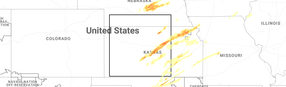
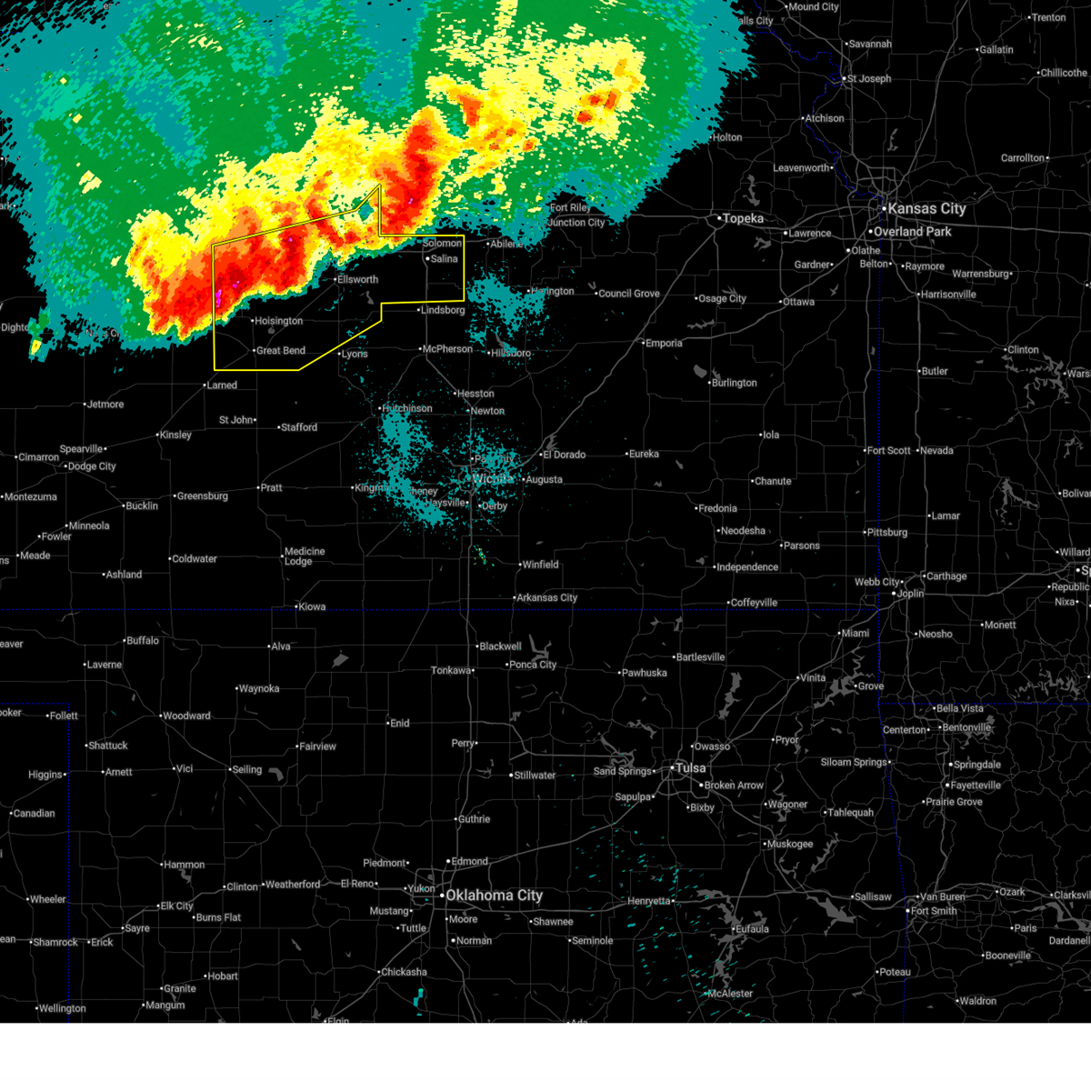
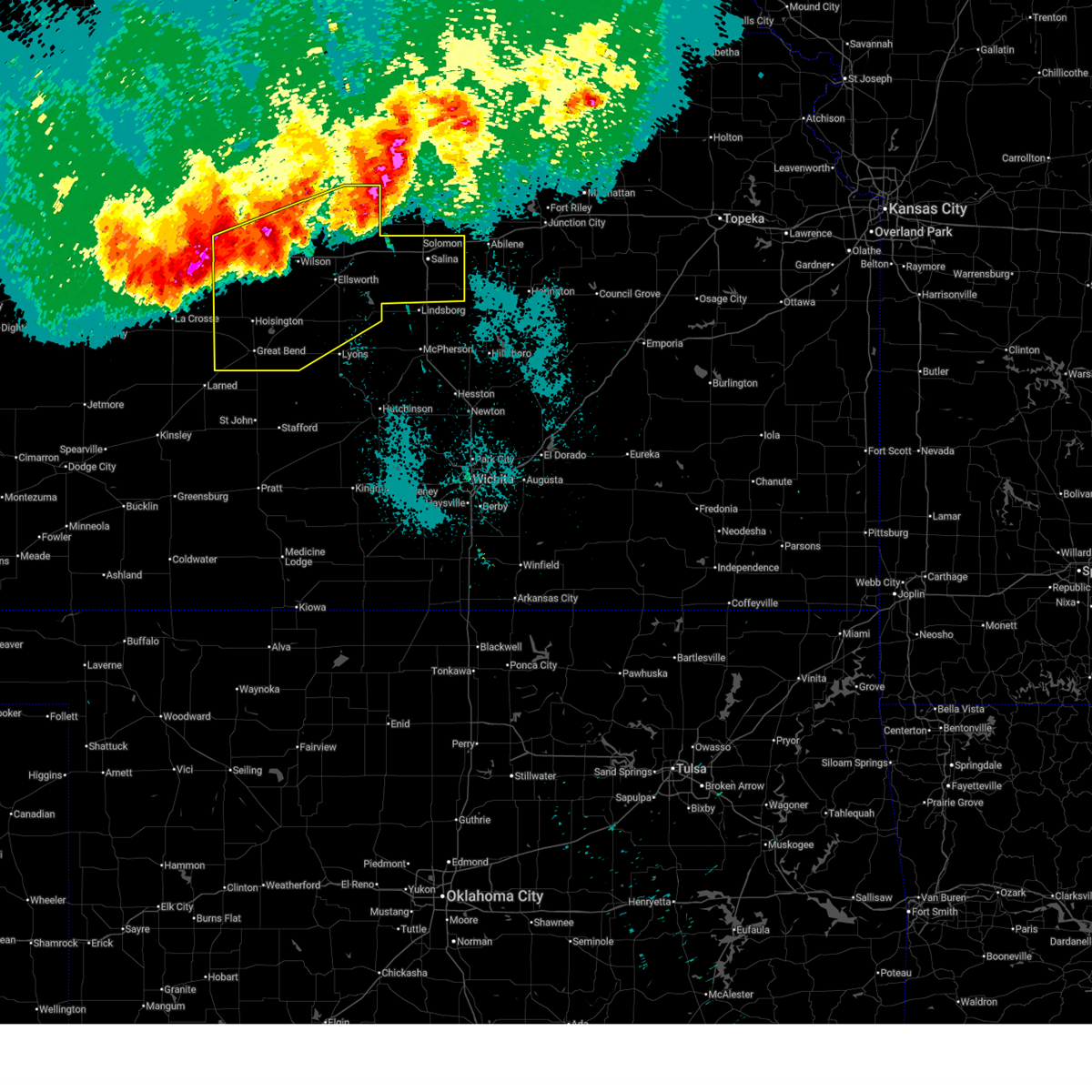
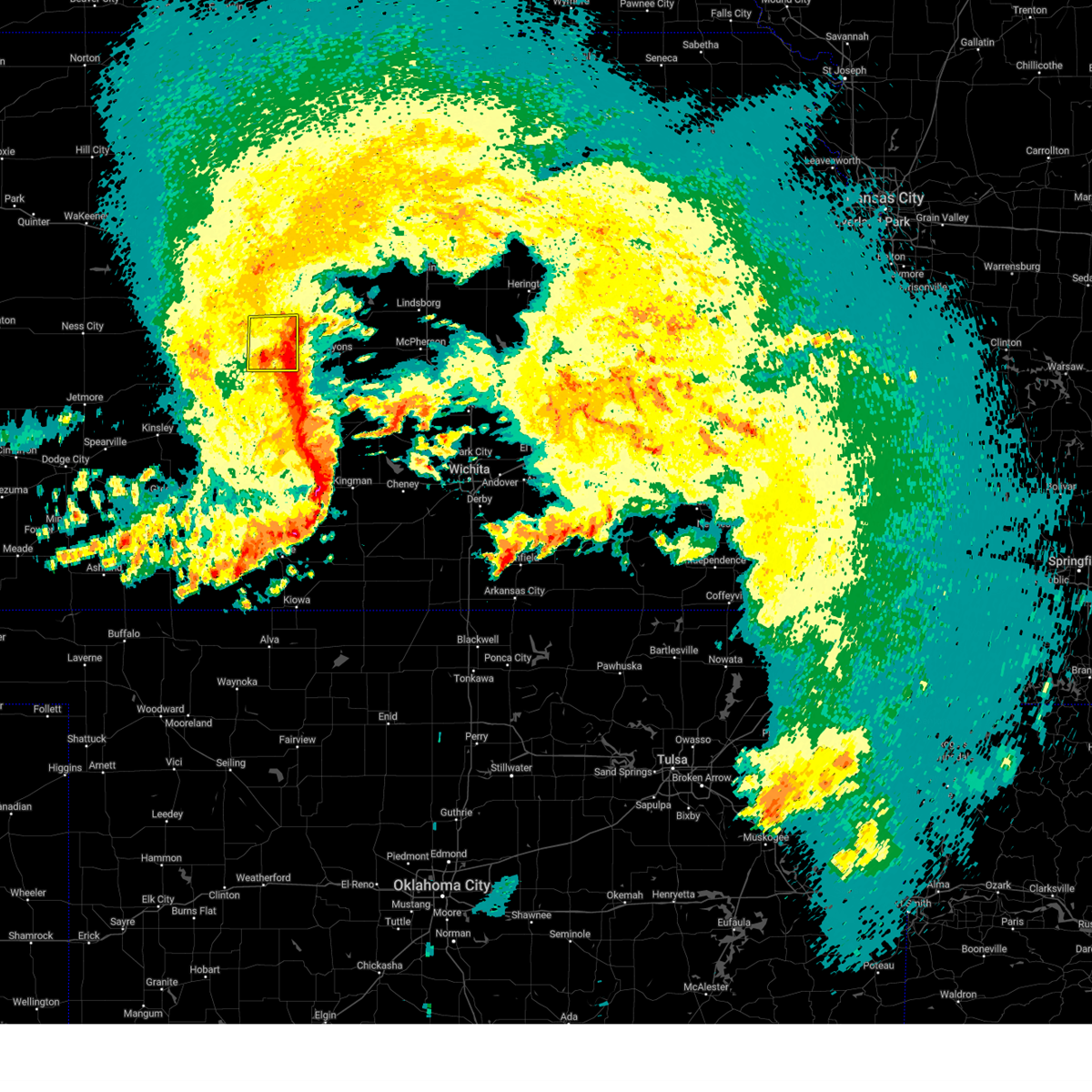
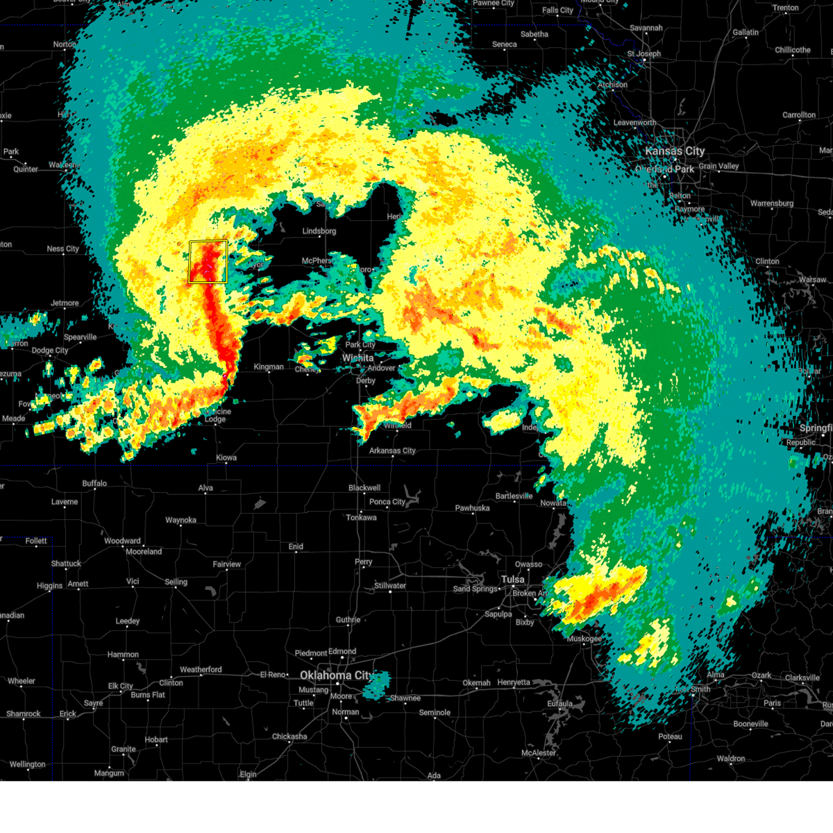
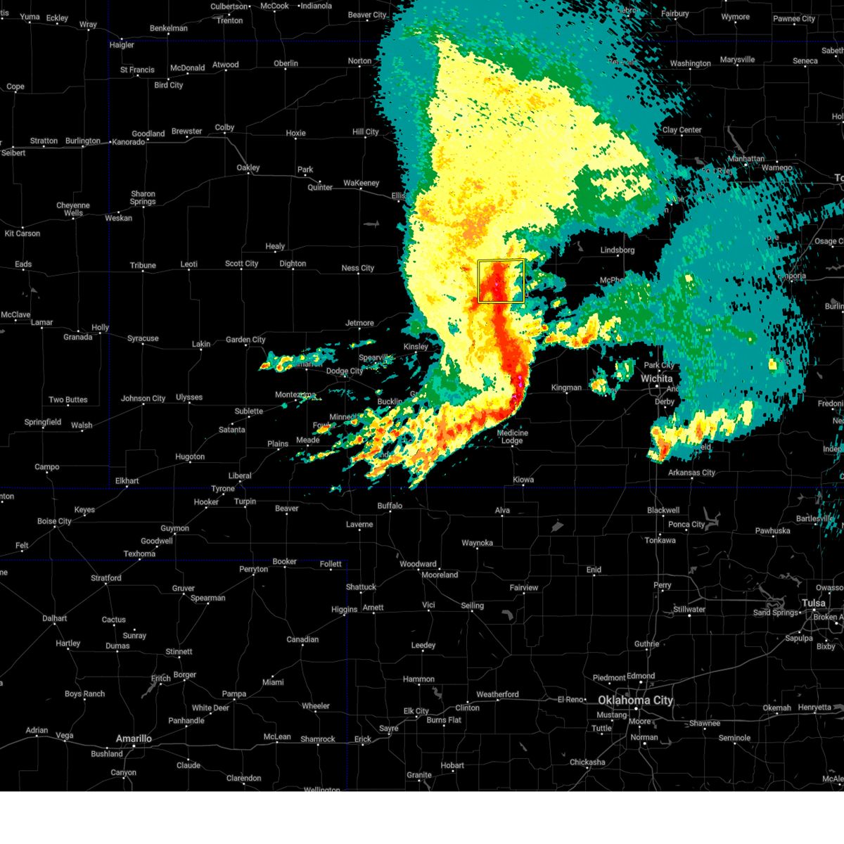
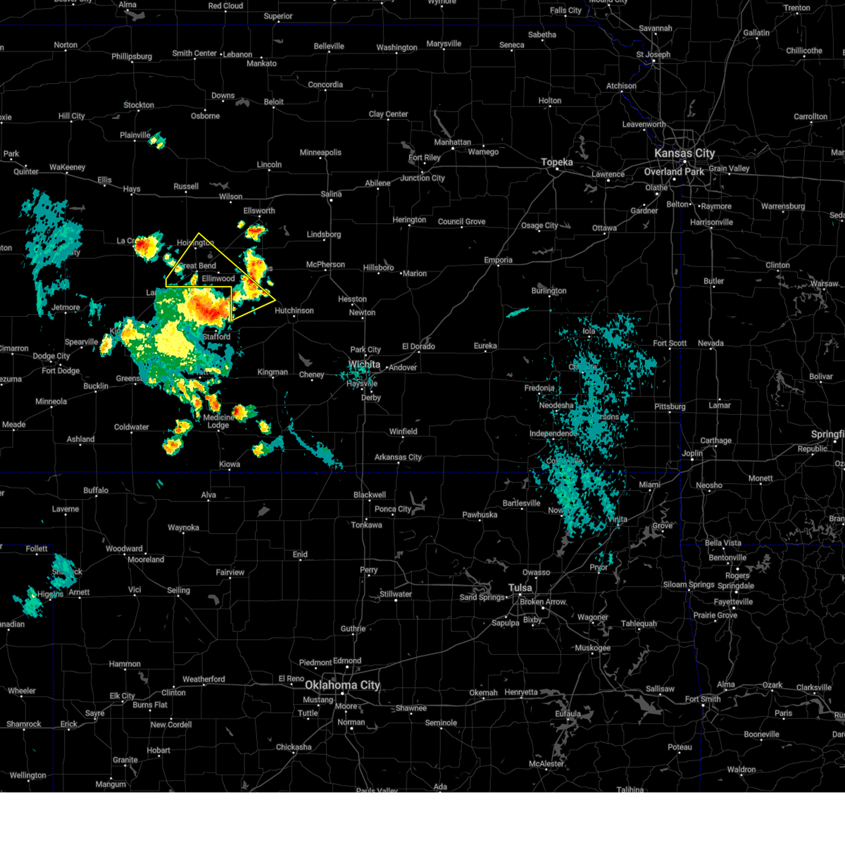
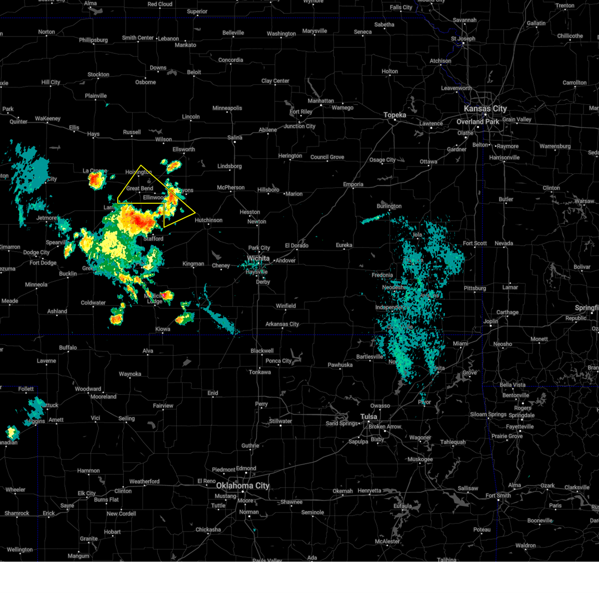
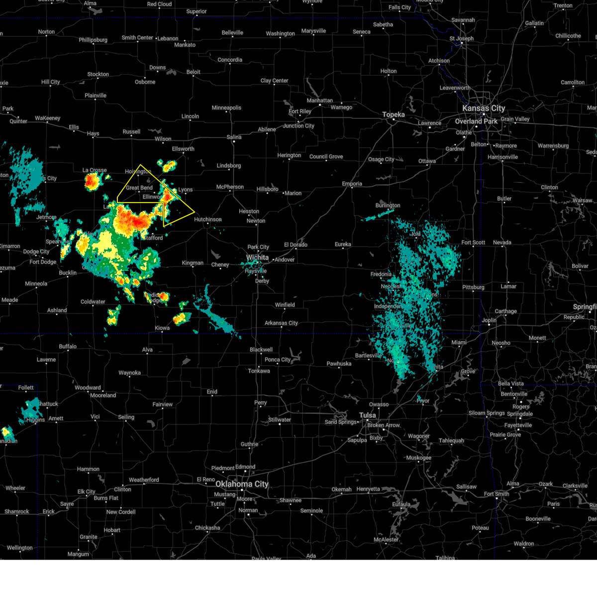
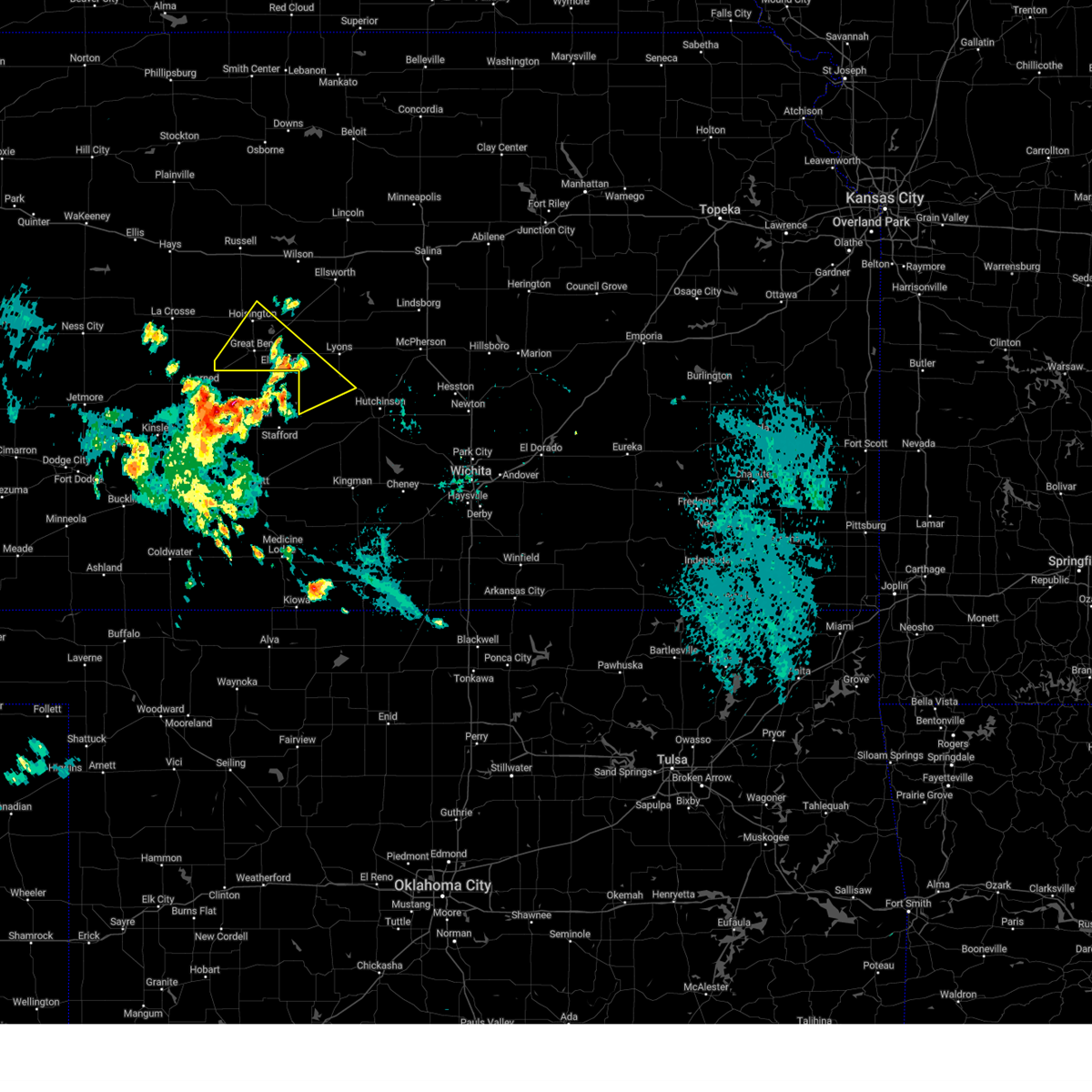
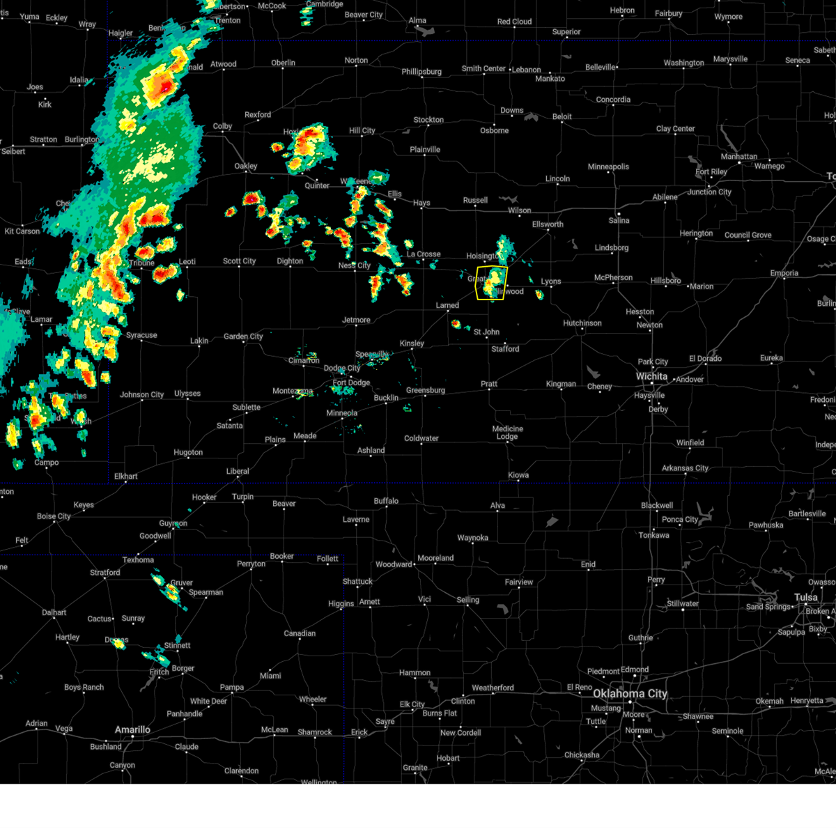
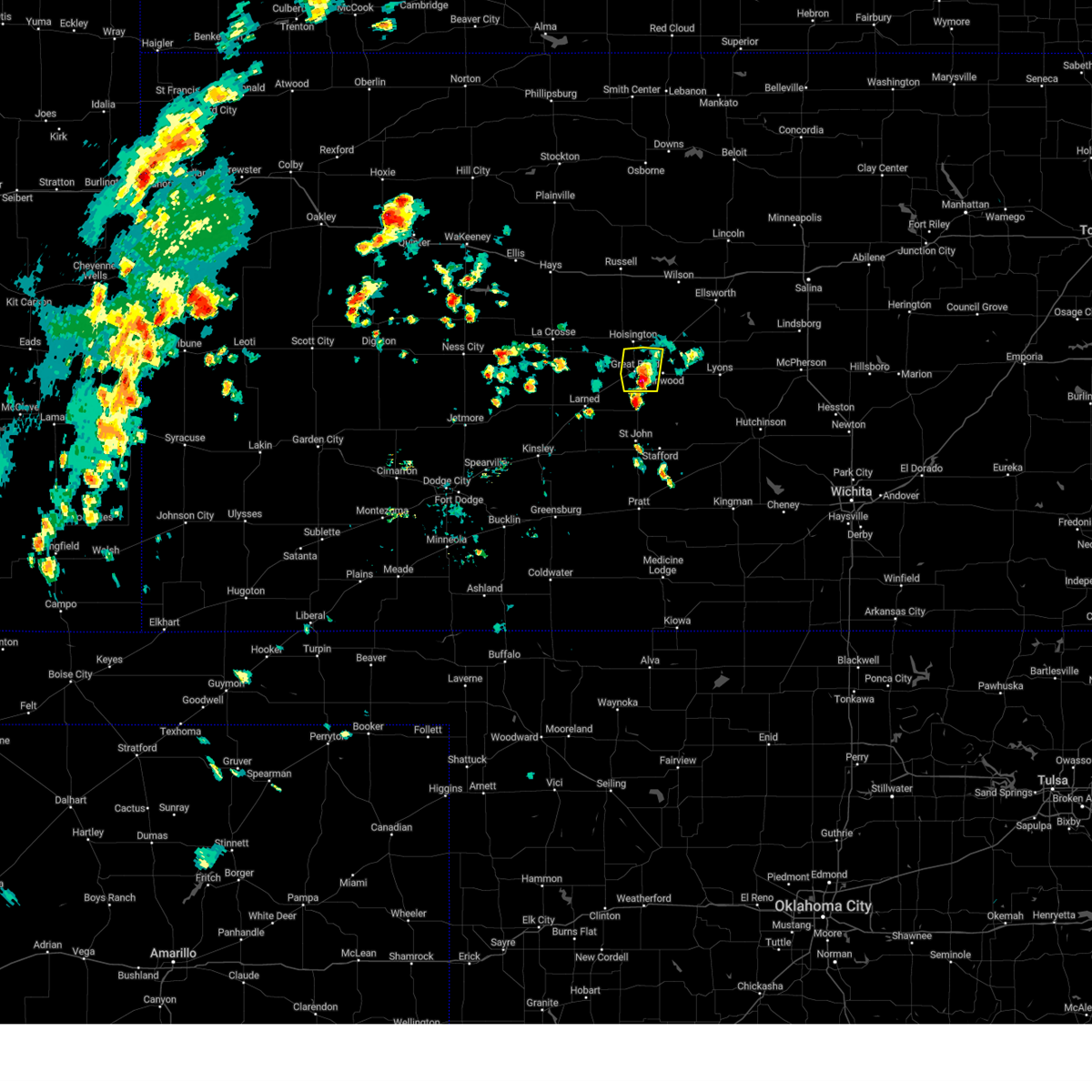
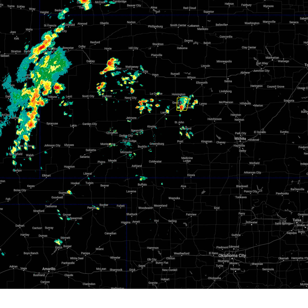
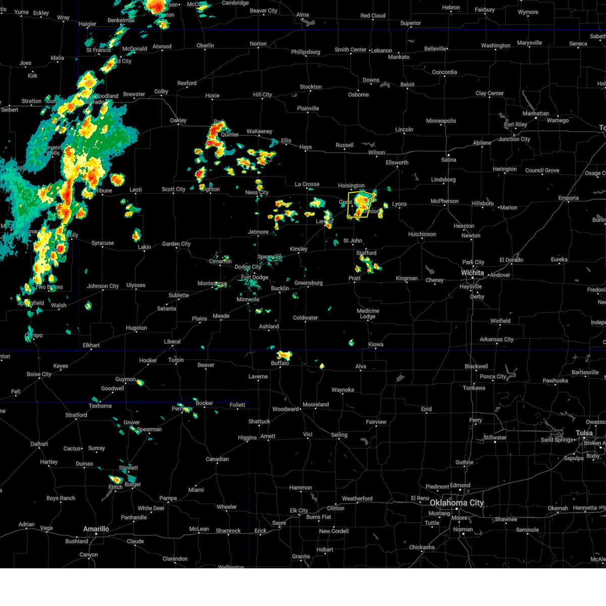
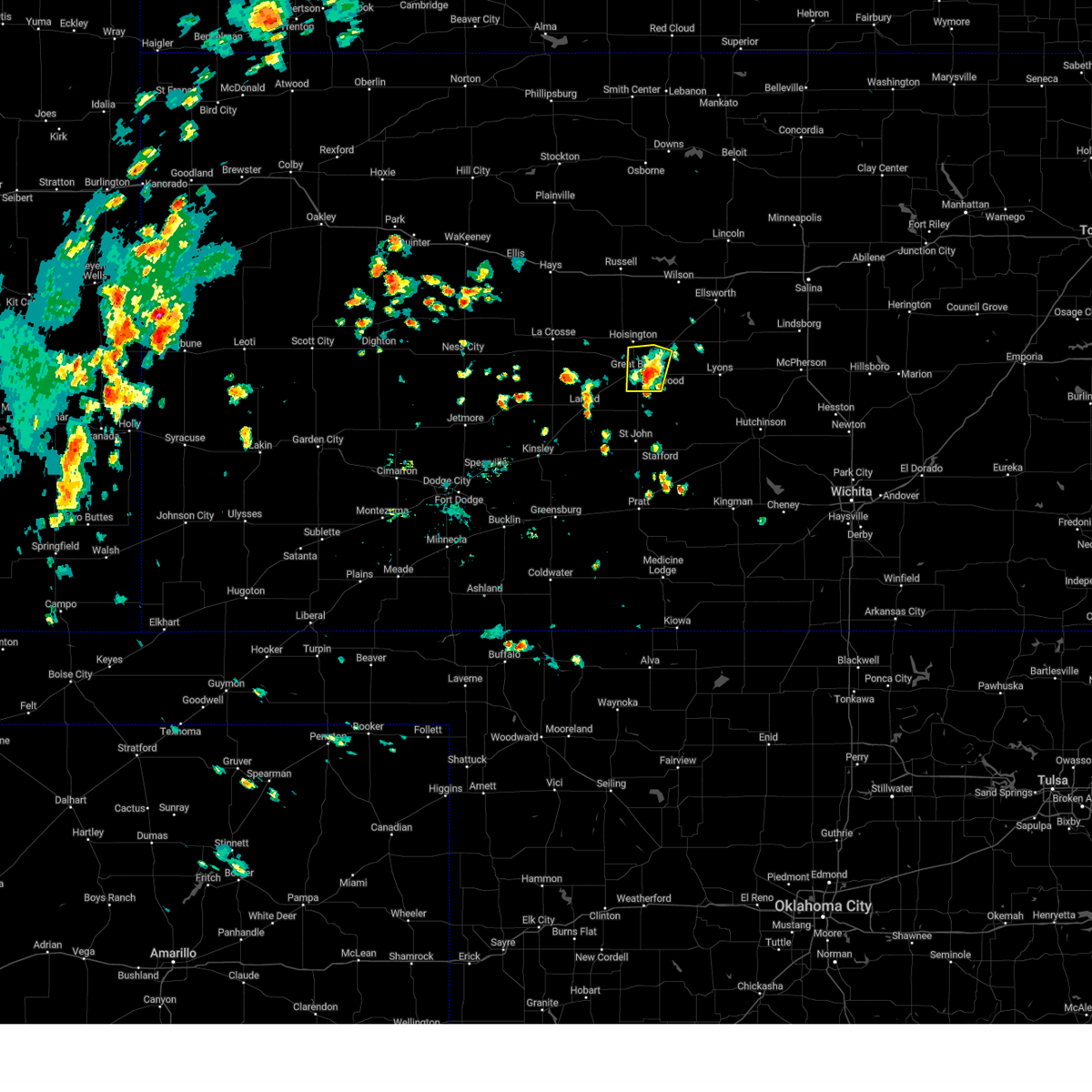
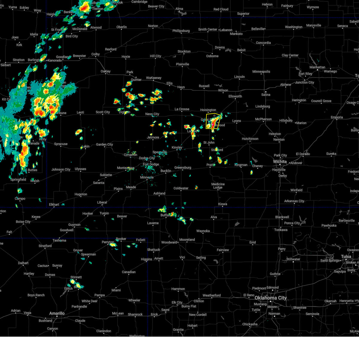
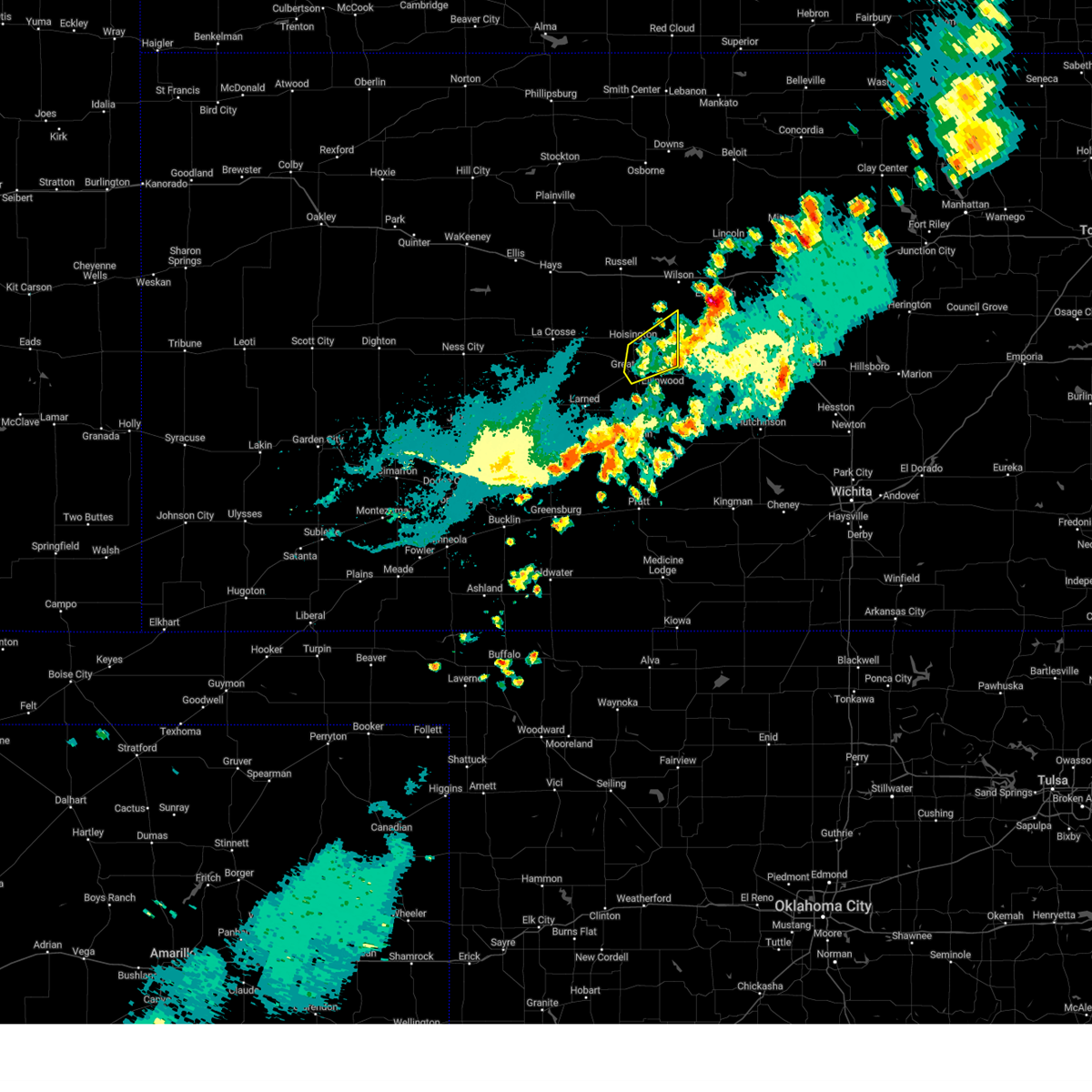
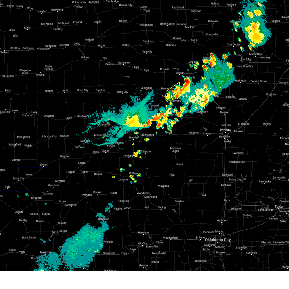
Hail Map for Great Bend, KS
The Great Bend, KS area has had 76 reports of on-the-ground hail by trained spotters, and has been under severe weather warnings 44 times during the past 12 months. Doppler radar has detected hail at or near Great Bend, KS on 129 occasions, including 9 occasions during the past year.
| Name: | Great Bend, KS |
| Where Located: | 46.8 miles SE of Hays, KS |
| Map: | Google Map for Great Bend, KS |
| Population: | 15995 |
| Housing Units: | 7113 |
| More Info: | Search Google for Great Bend, KS |
1
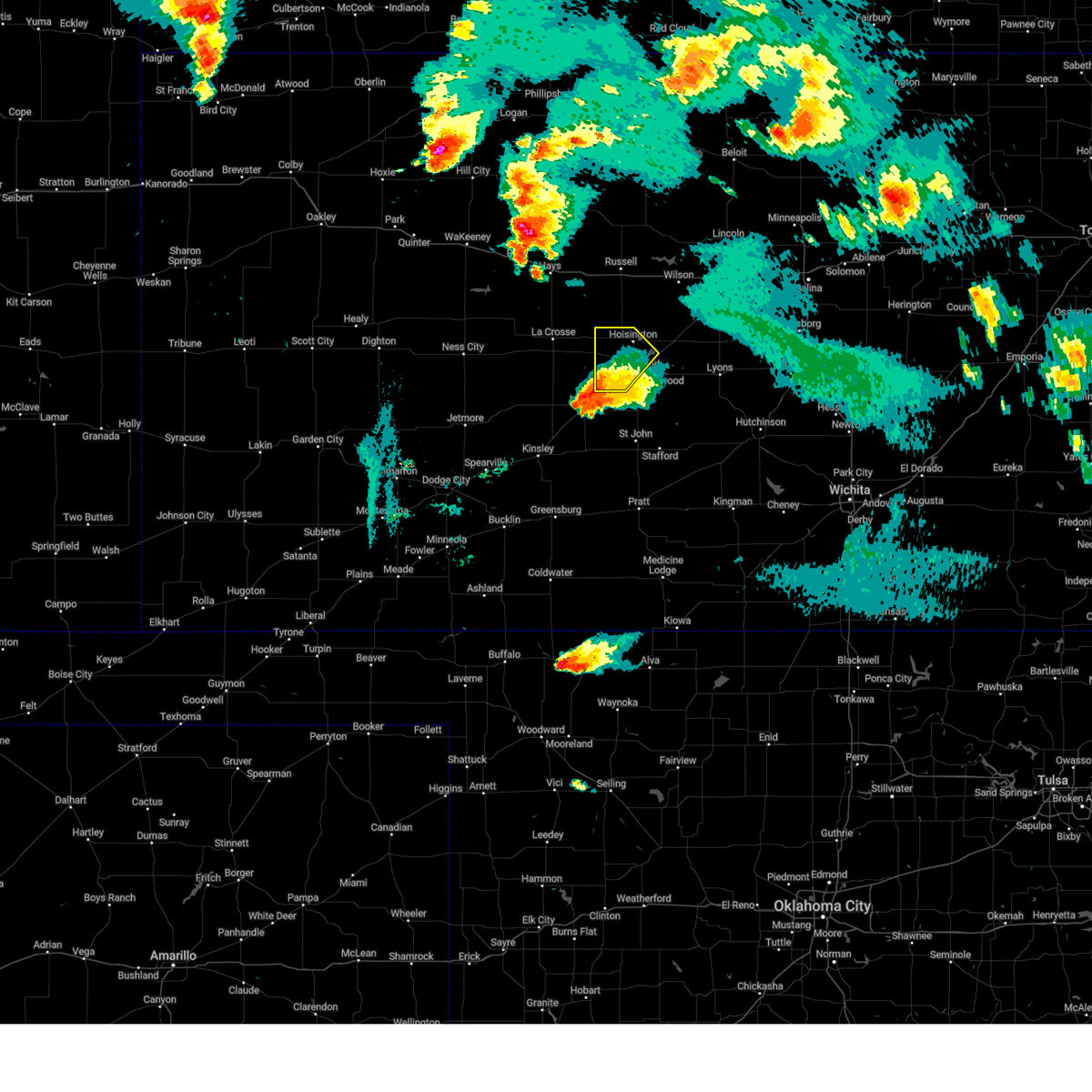
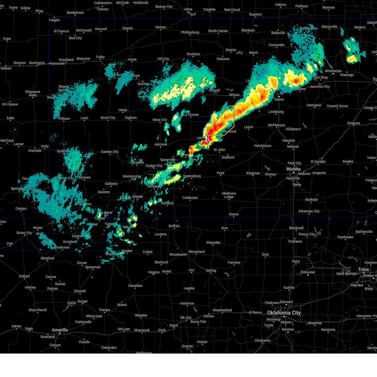
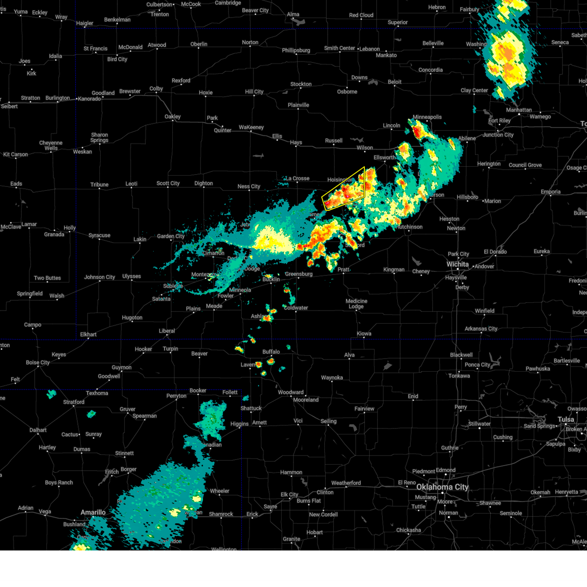
The Top Recent Hail Date for Great Bend, KS is Tuesday, April 1, 2025 (29th out of 129)
Hail and Wind Damage Spotted near Great Bend, KS
| Date / Time | Report Details |
|---|---|
| 6/17/2025 2:41 AM CDT |
 Svrict the national weather service in wichita has issued a * severe thunderstorm warning for, mcpherson county in central kansas, reno county in south central kansas, western harvey county in south central kansas, rice county in central kansas, ellsworth county in central kansas, northwestern marion county in central kansas, southern barton county in central kansas, saline county in central kansas, * until 345 am cdt. * at 240 am cdt, severe thunderstorms were located along a line extending from 7 miles east of kanopolis to near bushton to near pawnee rock, moving southeast at 45 mph (weather station observed). Hazards include 60 mph wind gusts. expect damage to roofs, siding, and trees Svrict the national weather service in wichita has issued a * severe thunderstorm warning for, mcpherson county in central kansas, reno county in south central kansas, western harvey county in south central kansas, rice county in central kansas, ellsworth county in central kansas, northwestern marion county in central kansas, southern barton county in central kansas, saline county in central kansas, * until 345 am cdt. * at 240 am cdt, severe thunderstorms were located along a line extending from 7 miles east of kanopolis to near bushton to near pawnee rock, moving southeast at 45 mph (weather station observed). Hazards include 60 mph wind gusts. expect damage to roofs, siding, and trees
|
| 6/17/2025 2:30 AM CDT |
 the severe thunderstorm warning has been cancelled and is no longer in effect the severe thunderstorm warning has been cancelled and is no longer in effect
|
| 6/17/2025 2:30 AM CDT |
 At 230 am cdt, severe thunderstorms were located along a line extending from near new cambria to 5 miles southwest of ellsworth to 5 miles southwest of great bend, moving southeast at 35 mph (radar indicated). Hazards include 70 mph wind gusts. Expect considerable tree damage. damage is likely to mobile homes, roofs, and outbuildings. locations impacted include, salina, great bend, ellsworth, hoisington, ellinwood, wilson, claflin, kanopolis, chase, holyrood, assaria, gypsum, bushton, geneseo, brookville, pawnee rock, smolan, albert, lorraine, and new cambria. this includes the following highways, interstate 135 between mile markers 78 and 95. Interstate 70 between mile markers 207 and 228, and between mile markers 237 and 266. At 230 am cdt, severe thunderstorms were located along a line extending from near new cambria to 5 miles southwest of ellsworth to 5 miles southwest of great bend, moving southeast at 35 mph (radar indicated). Hazards include 70 mph wind gusts. Expect considerable tree damage. damage is likely to mobile homes, roofs, and outbuildings. locations impacted include, salina, great bend, ellsworth, hoisington, ellinwood, wilson, claflin, kanopolis, chase, holyrood, assaria, gypsum, bushton, geneseo, brookville, pawnee rock, smolan, albert, lorraine, and new cambria. this includes the following highways, interstate 135 between mile markers 78 and 95. Interstate 70 between mile markers 207 and 228, and between mile markers 237 and 266.
|
| 6/17/2025 2:08 AM CDT |
 At 208 am cdt, severe thunderstorms were located along a line extending from near tescott to 6 miles south of milberger, moving southeast at 35 mph (radar indicated). Hazards include 70 mph wind gusts. Expect considerable tree damage. damage is likely to mobile homes, roofs, and outbuildings. locations impacted include, salina, great bend, ellsworth, hoisington, ellinwood, wilson, claflin, kanopolis, chase, holyrood, assaria, gypsum, bushton, geneseo, brookville, pawnee rock, smolan, dorrance, albert, and lorraine. this includes the following highways, interstate 135 between mile markers 78 and 95. Interstate 70 between mile markers 197 and 266. At 208 am cdt, severe thunderstorms were located along a line extending from near tescott to 6 miles south of milberger, moving southeast at 35 mph (radar indicated). Hazards include 70 mph wind gusts. Expect considerable tree damage. damage is likely to mobile homes, roofs, and outbuildings. locations impacted include, salina, great bend, ellsworth, hoisington, ellinwood, wilson, claflin, kanopolis, chase, holyrood, assaria, gypsum, bushton, geneseo, brookville, pawnee rock, smolan, dorrance, albert, and lorraine. this includes the following highways, interstate 135 between mile markers 78 and 95. Interstate 70 between mile markers 197 and 266.
|
| 6/17/2025 2:00 AM CDT |
 At 200 am cdt, severe thunderstorms were located along a line extending from near beverly to 5 miles southwest of milberger, moving southeast at 30 mph (radar indicated). Hazards include 70 mph wind gusts. Expect considerable tree damage. damage is likely to mobile homes, roofs, and outbuildings. locations impacted include, salina, great bend, russell, ellsworth, hoisington, ellinwood, wilson, claflin, kanopolis, lincoln, chase, holyrood, assaria, gypsum, gorham, bushton, sylvan grove, geneseo, brookville, and pawnee rock. this includes the following highways, interstate 135 between mile markers 78 and 95. Interstate 70 between mile markers 175 and 266. At 200 am cdt, severe thunderstorms were located along a line extending from near beverly to 5 miles southwest of milberger, moving southeast at 30 mph (radar indicated). Hazards include 70 mph wind gusts. Expect considerable tree damage. damage is likely to mobile homes, roofs, and outbuildings. locations impacted include, salina, great bend, russell, ellsworth, hoisington, ellinwood, wilson, claflin, kanopolis, lincoln, chase, holyrood, assaria, gypsum, gorham, bushton, sylvan grove, geneseo, brookville, and pawnee rock. this includes the following highways, interstate 135 between mile markers 78 and 95. Interstate 70 between mile markers 175 and 266.
|
| 6/17/2025 1:41 AM CDT |
 Svrict the national weather service in wichita has issued a * severe thunderstorm warning for, lincoln county in central kansas, northern rice county in central kansas, ellsworth county in central kansas, russell county in central kansas, barton county in central kansas, saline county in central kansas, * until 245 am cdt. * at 140 am cdt, severe thunderstorms were located along a line extending from near tescott to near milberger, moving southeast at 35 mph (several weather stations and trained weather spotter reports). Hazards include 70 mph wind gusts. Expect considerable tree damage. Damage is likely to mobile homes, roofs, and outbuildings. Svrict the national weather service in wichita has issued a * severe thunderstorm warning for, lincoln county in central kansas, northern rice county in central kansas, ellsworth county in central kansas, russell county in central kansas, barton county in central kansas, saline county in central kansas, * until 245 am cdt. * at 140 am cdt, severe thunderstorms were located along a line extending from near tescott to near milberger, moving southeast at 35 mph (several weather stations and trained weather spotter reports). Hazards include 70 mph wind gusts. Expect considerable tree damage. Damage is likely to mobile homes, roofs, and outbuildings.
|
| 5/25/2025 6:43 AM CDT |
 The storms which prompted the warning have weakened below severe limits, and no longer pose an immediate threat to life or property. therefore, the warning will be allowed to expire. however, gusty winds and heavy rain are still possible with these thunderstorms. a severe thunderstorm watch remains in effect until 900 am cdt for central kansas. The storms which prompted the warning have weakened below severe limits, and no longer pose an immediate threat to life or property. therefore, the warning will be allowed to expire. however, gusty winds and heavy rain are still possible with these thunderstorms. a severe thunderstorm watch remains in effect until 900 am cdt for central kansas.
|
| 5/25/2025 6:33 AM CDT |
 At 632 am cdt, severe thunderstorms were located along a line extending from near claflin to 6 miles south of ellinwood, moving east at 40 mph (radar indicated). Hazards include 60 mph wind gusts and penny size hail. Expect damage to roofs, siding, and trees. Locations impacted include, great bend, hoisington, ellinwood, claflin, and cheyenne bottoms. At 632 am cdt, severe thunderstorms were located along a line extending from near claflin to 6 miles south of ellinwood, moving east at 40 mph (radar indicated). Hazards include 60 mph wind gusts and penny size hail. Expect damage to roofs, siding, and trees. Locations impacted include, great bend, hoisington, ellinwood, claflin, and cheyenne bottoms.
|
| 5/25/2025 6:27 AM CDT |
 At 627 am cdt, severe thunderstorms were located along a line extending from near claflin to 6 miles south of ellinwood, moving east at 50 mph (radar indicated). Hazards include 60 mph wind gusts and penny size hail. Expect damage to roofs, siding, and trees. Locations impacted include, great bend, hoisington, ellinwood, claflin, great bend airport, and cheyenne bottoms. At 627 am cdt, severe thunderstorms were located along a line extending from near claflin to 6 miles south of ellinwood, moving east at 50 mph (radar indicated). Hazards include 60 mph wind gusts and penny size hail. Expect damage to roofs, siding, and trees. Locations impacted include, great bend, hoisington, ellinwood, claflin, great bend airport, and cheyenne bottoms.
|
| 5/25/2025 6:17 AM CDT |
 At 617 am cdt, severe thunderstorms were located along a line extending from near hoisington to 6 miles southeast of great bend, moving east at 30 mph (radar indicated). Hazards include 60 mph wind gusts and penny size hail. Expect damage to roofs, siding, and trees. Locations impacted include, great bend, hoisington, ellinwood, claflin, olmitz, great bend airport, and cheyenne bottoms. At 617 am cdt, severe thunderstorms were located along a line extending from near hoisington to 6 miles southeast of great bend, moving east at 30 mph (radar indicated). Hazards include 60 mph wind gusts and penny size hail. Expect damage to roofs, siding, and trees. Locations impacted include, great bend, hoisington, ellinwood, claflin, olmitz, great bend airport, and cheyenne bottoms.
|
| 5/25/2025 6:06 AM CDT |
 At 605 am cdt, severe thunderstorms were located along a line extending from 5 miles southwest of hoisington to st. john to 5 miles northwest of pratt to near wellsford, moving east at 50 mph (radar indicated). Hazards include 60 mph wind gusts and penny size hail. Expect damage to roofs, siding, and trees. Locations impacted include, great bend, hoisington, ellinwood, claflin, pawnee rock, albert, olmitz, great bend airport, and cheyenne bottoms. At 605 am cdt, severe thunderstorms were located along a line extending from 5 miles southwest of hoisington to st. john to 5 miles northwest of pratt to near wellsford, moving east at 50 mph (radar indicated). Hazards include 60 mph wind gusts and penny size hail. Expect damage to roofs, siding, and trees. Locations impacted include, great bend, hoisington, ellinwood, claflin, pawnee rock, albert, olmitz, great bend airport, and cheyenne bottoms.
|
| 5/25/2025 5:47 AM CDT |
 Svrict the national weather service in wichita has issued a * severe thunderstorm warning for, barton county in central kansas, * until 645 am cdt. * at 547 am cdt, severe thunderstorms were located along a line extending from near albert to near zook to near trousdale to near greensburg, moving east at 50 mph (radar indicated). Hazards include 60 mph wind gusts and penny size hail. expect damage to roofs, siding, and trees Svrict the national weather service in wichita has issued a * severe thunderstorm warning for, barton county in central kansas, * until 645 am cdt. * at 547 am cdt, severe thunderstorms were located along a line extending from near albert to near zook to near trousdale to near greensburg, moving east at 50 mph (radar indicated). Hazards include 60 mph wind gusts and penny size hail. expect damage to roofs, siding, and trees
|
| 5/18/2025 8:57 PM CDT | The tornado threat has diminished and the tornado warning has been cancelled. however, large hail and damaging winds remain likely and a severe thunderstorm warning remains in effect for the area. a tornado watch also remains in effect until 100 am cdt for central kansas. remember, a severe thunderstorm warning still remains in effect for central barton county until 915 pm cdt. |
| 5/18/2025 8:46 PM CDT | At 846 pm cdt, a severe thunderstorm capable of producing a tornado was located 6 miles northwest of great bend, moving northeast at 35 mph (weather spotters reported a funnel cloud). Hazards include tornado and ping pong ball size hail. Flying debris will be dangerous to those caught without shelter. mobile homes will be damaged or destroyed. damage to roofs, windows, and vehicles will occur. tree damage is likely. this dangerous storm will be near, hoisington around 855 pm cdt. Other locations impacted by this tornadic thunderstorm include great bend airport. |
| 5/18/2025 8:45 PM CDT | At 844 pm cdt, a severe thunderstorm capable of producing a tornado was located near great bend, moving northeast at 35 mph (radar indicated rotation). Hazards include tornado. Flying debris will be dangerous to those caught without shelter. mobile homes will be damaged or destroyed. damage to roofs, windows, and vehicles will occur. tree damage is likely. this dangerous storm will be near, hoisington around 855 pm cdt. Other locations impacted by this tornadic thunderstorm include great bend airport. |
| 5/18/2025 8:37 PM CDT | Torict the national weather service in wichita has issued a * tornado warning for, southwestern barton county in central kansas, * until 900 pm cdt. * at 836 pm cdt, a severe thunderstorm capable of producing a tornado was located 6 miles north of pawnee rock, or 8 miles west of great bend, moving northeast at 35 mph (radar indicated rotation). Hazards include tornado. Flying debris will be dangerous to those caught without shelter. mobile homes will be damaged or destroyed. damage to roofs, windows, and vehicles will occur. tree damage is likely. this dangerous storm will be near, hoisington around 855 pm cdt. Other locations impacted by this tornadic thunderstorm include great bend airport. |
| 5/18/2025 8:15 PM CDT |
 Svrict the national weather service in wichita has issued a * severe thunderstorm warning for, southwestern barton county in central kansas, * until 915 pm cdt. * at 814 pm cdt, a severe thunderstorm was located near larned, moving northeast at 30 mph (radar indicated). Hazards include ping pong ball size hail. People and animals outdoors will be injured. Expect damage to roofs, siding, windows, and vehicles. Svrict the national weather service in wichita has issued a * severe thunderstorm warning for, southwestern barton county in central kansas, * until 915 pm cdt. * at 814 pm cdt, a severe thunderstorm was located near larned, moving northeast at 30 mph (radar indicated). Hazards include ping pong ball size hail. People and animals outdoors will be injured. Expect damage to roofs, siding, windows, and vehicles.
|
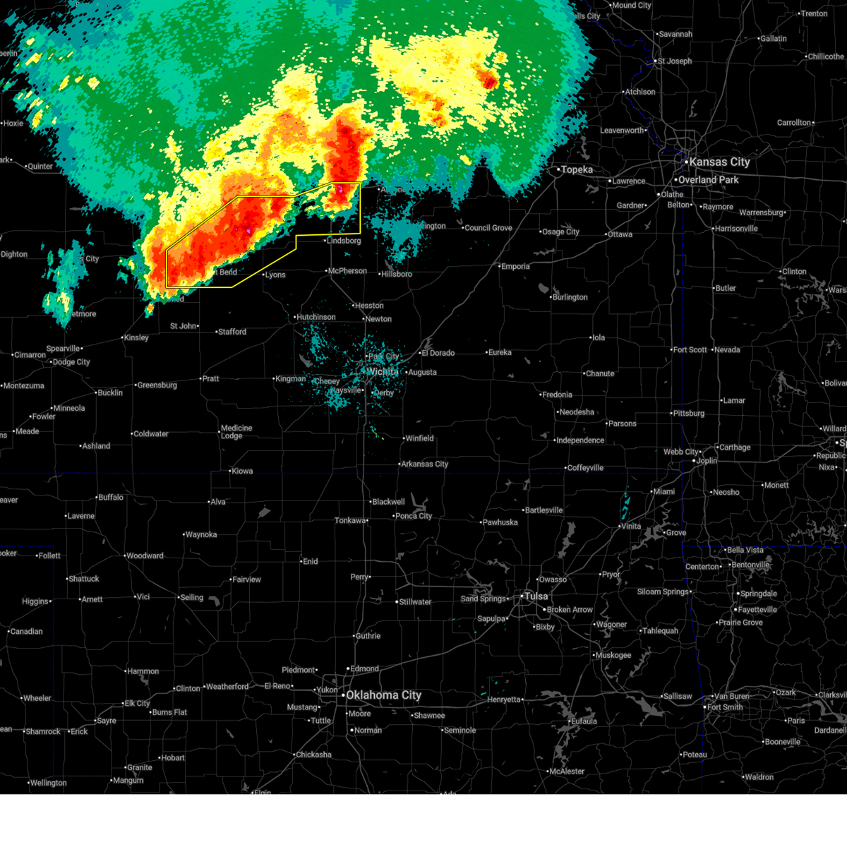
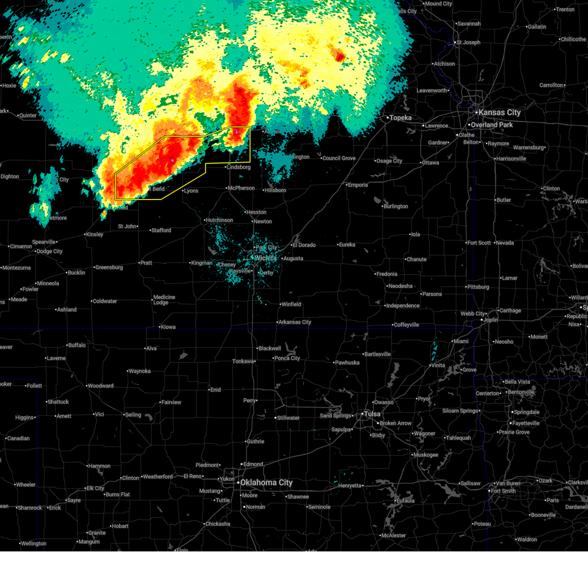
| 4/1/2025 11:24 PM CDT |
 Svrict the national weather service in wichita has issued a * severe thunderstorm warning for, rice county in central kansas, southeastern barton county in central kansas, * until 1230 am cdt. * at 1124 pm cdt, a severe thunderstorm was located near ellinwood, moving east at 55 mph (radar indicated). Hazards include ping pong ball size hail and 60 mph wind gusts. People and animals outdoors will be injured. expect hail damage to roofs, siding, windows, and vehicles. Expect wind damage to roofs, siding, and trees. Svrict the national weather service in wichita has issued a * severe thunderstorm warning for, rice county in central kansas, southeastern barton county in central kansas, * until 1230 am cdt. * at 1124 pm cdt, a severe thunderstorm was located near ellinwood, moving east at 55 mph (radar indicated). Hazards include ping pong ball size hail and 60 mph wind gusts. People and animals outdoors will be injured. expect hail damage to roofs, siding, windows, and vehicles. Expect wind damage to roofs, siding, and trees.
|
| 4/1/2025 11:22 PM CDT |
 At 1122 pm cdt, a severe thunderstorm was located near ellinwood, moving northeast at 50 mph (radar indicated). Hazards include 60 mph wind gusts and half dollar size hail. Hail damage to vehicles is expected. expect wind damage to roofs, siding, and trees. Locations impacted include, ellinwood and great bend. At 1122 pm cdt, a severe thunderstorm was located near ellinwood, moving northeast at 50 mph (radar indicated). Hazards include 60 mph wind gusts and half dollar size hail. Hail damage to vehicles is expected. expect wind damage to roofs, siding, and trees. Locations impacted include, ellinwood and great bend.
|
| 4/1/2025 11:14 PM CDT |
 At 1114 pm cdt, a severe thunderstorm was located over great bend, moving northeast at 50 mph (radar indicated). Hazards include half dollar size hail. Damage to vehicles is expected. Locations impacted include, claflin, great bend, ellinwood, great bend airport, cheyenne bottoms, odin, and hoisington. At 1114 pm cdt, a severe thunderstorm was located over great bend, moving northeast at 50 mph (radar indicated). Hazards include half dollar size hail. Damage to vehicles is expected. Locations impacted include, claflin, great bend, ellinwood, great bend airport, cheyenne bottoms, odin, and hoisington.
|
| 4/1/2025 11:05 PM CDT |
 The storms which prompted the warning have weakened below severe limits, and no longer pose an immediate threat to life or property. therefore, the warning will be allowed to expire. however, small hail and gusty winds are still possible with these thunderstorms. a severe thunderstorm watch remains in effect until 300 am cdt for central kansas. remember, a severe thunderstorm warning still remains in effect for much of barton county. The storms which prompted the warning have weakened below severe limits, and no longer pose an immediate threat to life or property. therefore, the warning will be allowed to expire. however, small hail and gusty winds are still possible with these thunderstorms. a severe thunderstorm watch remains in effect until 300 am cdt for central kansas. remember, a severe thunderstorm warning still remains in effect for much of barton county.
|
| 4/1/2025 11:04 PM CDT |
 Svrict the national weather service in wichita has issued a * severe thunderstorm warning for, central barton county in central kansas, * until 1145 pm cdt. * at 1103 pm cdt, a severe thunderstorm was located near pawnee rock, or 6 miles southwest of great bend, moving northeast at 50 mph (radar indicated). Hazards include half dollar size hail. damage to vehicles is expected Svrict the national weather service in wichita has issued a * severe thunderstorm warning for, central barton county in central kansas, * until 1145 pm cdt. * at 1103 pm cdt, a severe thunderstorm was located near pawnee rock, or 6 miles southwest of great bend, moving northeast at 50 mph (radar indicated). Hazards include half dollar size hail. damage to vehicles is expected
|
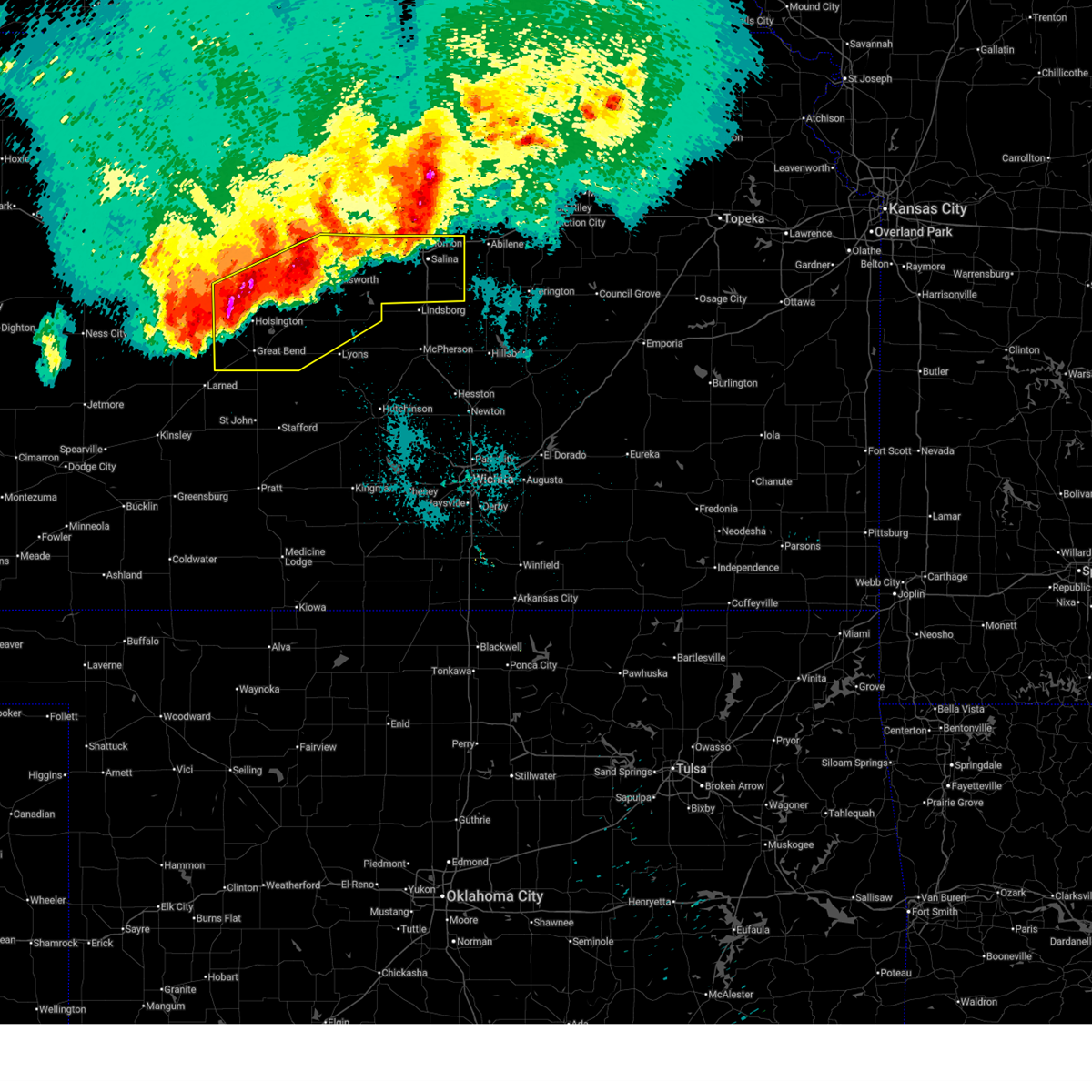
| 4/1/2025 10:42 PM CDT |
 At 1042 pm cdt, severe thunderstorms were located along a line extending from 5 miles east of kanopolis to near great bend, moving northeast at 40 mph (radar indicated). Hazards include ping pong ball size hail and 60 mph wind gusts. People and animals outdoors will be injured. expect hail damage to roofs, siding, windows, and vehicles. expect wind damage to roofs, siding, and trees. Locations impacted include, frederick, ellsworth airport, great bend airport, lorraine, bushton, silica, cheyenne bottoms, claflin, ellsworth, kanopolis lake, great bend, ellinwood, kanopolis, holyrood, kanopolis state park, and geneseo. At 1042 pm cdt, severe thunderstorms were located along a line extending from 5 miles east of kanopolis to near great bend, moving northeast at 40 mph (radar indicated). Hazards include ping pong ball size hail and 60 mph wind gusts. People and animals outdoors will be injured. expect hail damage to roofs, siding, windows, and vehicles. expect wind damage to roofs, siding, and trees. Locations impacted include, frederick, ellsworth airport, great bend airport, lorraine, bushton, silica, cheyenne bottoms, claflin, ellsworth, kanopolis lake, great bend, ellinwood, kanopolis, holyrood, kanopolis state park, and geneseo.
|
| 4/1/2025 10:16 PM CDT |
 Svrict the national weather service in wichita has issued a * severe thunderstorm warning for, northern rice county in central kansas, ellsworth county in central kansas, southern barton county in central kansas, * until 1115 pm cdt. * at 1015 pm cdt, severe thunderstorms were located along a line extending from near kanopolis to near great bend, moving northeast at 25 mph (radar indicated). Hazards include 60 mph wind gusts and quarter size hail. Hail damage to vehicles is expected. Expect wind damage to roofs, siding, and trees. Svrict the national weather service in wichita has issued a * severe thunderstorm warning for, northern rice county in central kansas, ellsworth county in central kansas, southern barton county in central kansas, * until 1115 pm cdt. * at 1015 pm cdt, severe thunderstorms were located along a line extending from near kanopolis to near great bend, moving northeast at 25 mph (radar indicated). Hazards include 60 mph wind gusts and quarter size hail. Hail damage to vehicles is expected. Expect wind damage to roofs, siding, and trees.
|
| 9/20/2024 6:05 PM CDT |
 At 604 pm cdt, severe thunderstorms were located along a line extending from 5 miles south of hoisington to 6 miles southwest of alden to near sylvia, moving northeast at 40 mph (radar indicated). Hazards include 60 mph wind gusts and nickel size hail. Expect damage to roofs, siding, and trees. Locations impacted include, great bend, hoisington, sterling, ellinwood, alden, raymond, silica, and cheyenne bottoms. At 604 pm cdt, severe thunderstorms were located along a line extending from 5 miles south of hoisington to 6 miles southwest of alden to near sylvia, moving northeast at 40 mph (radar indicated). Hazards include 60 mph wind gusts and nickel size hail. Expect damage to roofs, siding, and trees. Locations impacted include, great bend, hoisington, sterling, ellinwood, alden, raymond, silica, and cheyenne bottoms.
|
| 9/20/2024 5:56 PM CDT |
 At 556 pm cdt, severe thunderstorms were located along a line extending from near great bend to 10 miles north of sylvia, moving northeast at 35 mph (radar indicated). Hazards include 60 mph wind gusts and nickel size hail. Expect damage to roofs, siding, and trees. Locations impacted include, great bend, hoisington, sterling, ellinwood, pawnee rock, alden, raymond, great bend airport, silica, and cheyenne bottoms. At 556 pm cdt, severe thunderstorms were located along a line extending from near great bend to 10 miles north of sylvia, moving northeast at 35 mph (radar indicated). Hazards include 60 mph wind gusts and nickel size hail. Expect damage to roofs, siding, and trees. Locations impacted include, great bend, hoisington, sterling, ellinwood, pawnee rock, alden, raymond, great bend airport, silica, and cheyenne bottoms.
|
| 9/20/2024 5:47 PM CDT |
 At 546 pm cdt, severe thunderstorms were located along a line extending from near great bend to 8 miles north of zenith, moving northeast at 40 mph (at 543 pm, a 62 mph wind gust was measured at the great bend airport). Hazards include 60 mph wind gusts and quarter size hail. Hail damage to vehicles is expected. expect wind damage to roofs, siding, and trees. Locations impacted include, great bend, hoisington, sterling, ellinwood, pawnee rock, alden, raymond, great bend airport, silica, and cheyenne bottoms. At 546 pm cdt, severe thunderstorms were located along a line extending from near great bend to 8 miles north of zenith, moving northeast at 40 mph (at 543 pm, a 62 mph wind gust was measured at the great bend airport). Hazards include 60 mph wind gusts and quarter size hail. Hail damage to vehicles is expected. expect wind damage to roofs, siding, and trees. Locations impacted include, great bend, hoisington, sterling, ellinwood, pawnee rock, alden, raymond, great bend airport, silica, and cheyenne bottoms.
|
| 9/20/2024 5:43 PM CDT | Storm damage reported in barton county KS, 5.5 miles E of Great Bend, KS |
| 9/20/2024 5:40 PM CDT |
 At 539 pm cdt, severe thunderstorms were located along a line extending from near radium to hudson, moving northeast at 35 mph (radar indicated). Hazards include 60 mph wind gusts and quarter size hail. Hail damage to vehicles is expected. expect wind damage to roofs, siding, and trees. Locations impacted include, great bend, hoisington, sterling, ellinwood, pawnee rock, alden, raymond, great bend airport, silica, and cheyenne bottoms. At 539 pm cdt, severe thunderstorms were located along a line extending from near radium to hudson, moving northeast at 35 mph (radar indicated). Hazards include 60 mph wind gusts and quarter size hail. Hail damage to vehicles is expected. expect wind damage to roofs, siding, and trees. Locations impacted include, great bend, hoisington, sterling, ellinwood, pawnee rock, alden, raymond, great bend airport, silica, and cheyenne bottoms.
|
| 9/20/2024 5:28 PM CDT |
 Svrict the national weather service in wichita has issued a * severe thunderstorm warning for, northwestern reno county in south central kansas, southwestern rice county in central kansas, southeastern barton county in central kansas, * until 630 pm cdt. * at 528 pm cdt, severe thunderstorms were located along a line extending from near radium to st. john, moving northeast at 35 mph (radar indicated). Hazards include 60 mph wind gusts and nickel size hail. expect damage to roofs, siding, and trees Svrict the national weather service in wichita has issued a * severe thunderstorm warning for, northwestern reno county in south central kansas, southwestern rice county in central kansas, southeastern barton county in central kansas, * until 630 pm cdt. * at 528 pm cdt, severe thunderstorms were located along a line extending from near radium to st. john, moving northeast at 35 mph (radar indicated). Hazards include 60 mph wind gusts and nickel size hail. expect damage to roofs, siding, and trees
|
| 8/26/2024 6:25 PM CDT |
 the severe thunderstorm warning has been cancelled and is no longer in effect the severe thunderstorm warning has been cancelled and is no longer in effect
|
| 8/26/2024 6:20 PM CDT |
 At 619 pm cdt, a severe thunderstorm was located near great bend, moving north at 10 mph (radar indicated). Hazards include up to 60 mph wind gusts. Expect damage to roofs, siding, and trees. Locations impacted include, great bend, great bend airport, and cheyenne bottoms. At 619 pm cdt, a severe thunderstorm was located near great bend, moving north at 10 mph (radar indicated). Hazards include up to 60 mph wind gusts. Expect damage to roofs, siding, and trees. Locations impacted include, great bend, great bend airport, and cheyenne bottoms.
|
| 8/26/2024 6:04 PM CDT | Power lines downe in barton county KS, 3.3 miles WNW of Great Bend, KS |
| 8/26/2024 6:00 PM CDT |
 Svrict the national weather service in wichita has issued a * severe thunderstorm warning for, southeastern barton county in central kansas, * until 645 pm cdt. * at 600 pm cdt, a severe thunderstorm was located just southeast of great bend, moving north at 10 mph (radar indicated). Hazards include 60 mph wind gusts and nickel size hail. expect damage to roofs, siding, and trees Svrict the national weather service in wichita has issued a * severe thunderstorm warning for, southeastern barton county in central kansas, * until 645 pm cdt. * at 600 pm cdt, a severe thunderstorm was located just southeast of great bend, moving north at 10 mph (radar indicated). Hazards include 60 mph wind gusts and nickel size hail. expect damage to roofs, siding, and trees
|
| 8/26/2024 5:49 PM CDT |
 At 548 pm cdt, a severe thunderstorm was located just southeast of great bend, moving north at 15 mph (radar indicated). Hazards include 60 mph wind gusts and penny size hail. Expect damage to roofs, siding, and trees. Locations impacted include, great bend, ellinwood, and cheyenne bottoms. At 548 pm cdt, a severe thunderstorm was located just southeast of great bend, moving north at 15 mph (radar indicated). Hazards include 60 mph wind gusts and penny size hail. Expect damage to roofs, siding, and trees. Locations impacted include, great bend, ellinwood, and cheyenne bottoms.
|
| 8/26/2024 5:38 PM CDT |
 At 536 pm cdt, another severe thunderstorm has developed 6 miles southeast of great bend, moving north at 15 mph (radar indicated). Hazards include 60 mph wind gusts and penny size hail. Expect damage to roofs, siding, and trees. Locations impacted include, great bend, ellinwood, and cheyenne bottoms. At 536 pm cdt, another severe thunderstorm has developed 6 miles southeast of great bend, moving north at 15 mph (radar indicated). Hazards include 60 mph wind gusts and penny size hail. Expect damage to roofs, siding, and trees. Locations impacted include, great bend, ellinwood, and cheyenne bottoms.
|
| 8/26/2024 5:22 PM CDT |
 At 521 pm cdt, a severe thunderstorm was located between ellinwood and great bend, moving north at 10 mph (radar indicated). Hazards include 60 mph wind gusts. Expect damage to roofs, siding, and trees. Locations impacted include, great bend, ellinwood, and cheyenne bottoms. At 521 pm cdt, a severe thunderstorm was located between ellinwood and great bend, moving north at 10 mph (radar indicated). Hazards include 60 mph wind gusts. Expect damage to roofs, siding, and trees. Locations impacted include, great bend, ellinwood, and cheyenne bottoms.
|
| 8/26/2024 5:10 PM CDT |
 Svrict the national weather service in wichita has issued a * severe thunderstorm warning for, southeastern barton county in central kansas, * until 600 pm cdt. * at 510 pm cdt, a severe thunderstorm was located between ellinwood and great bend, moving north at 10 mph (radar indicated). Hazards include 60 mph wind gusts and penny size hail. expect damage to roofs, siding, and trees Svrict the national weather service in wichita has issued a * severe thunderstorm warning for, southeastern barton county in central kansas, * until 600 pm cdt. * at 510 pm cdt, a severe thunderstorm was located between ellinwood and great bend, moving north at 10 mph (radar indicated). Hazards include 60 mph wind gusts and penny size hail. expect damage to roofs, siding, and trees
|
| 8/14/2024 7:19 PM CDT |
 the severe thunderstorm warning has been cancelled and is no longer in effect the severe thunderstorm warning has been cancelled and is no longer in effect
|
| 8/14/2024 7:14 PM CDT |
 At 713 pm cdt, a severe thunderstorm was located just west of claflin, moving northeast at 15 mph (radar indicated). Hazards include 60 mph wind gusts and penny size hail. Expect damage to roofs, siding, and trees. Locations impacted include, great bend, hoisington, ellinwood, claflin, cheyenne bottoms, and odin. At 713 pm cdt, a severe thunderstorm was located just west of claflin, moving northeast at 15 mph (radar indicated). Hazards include 60 mph wind gusts and penny size hail. Expect damage to roofs, siding, and trees. Locations impacted include, great bend, hoisington, ellinwood, claflin, cheyenne bottoms, and odin.
|
| 8/14/2024 7:05 PM CDT |
 At 704 pm cdt, a severe thunderstorm was located 6 miles east of hoisington, moving northeast at 20 mph. another strong to severe storm was indicated just west of great bend (radar indicated). Hazards include 60 mph wind gusts and nickel size hail. Expect damage to roofs, siding, and trees. Locations impacted include, great bend, hoisington, ellinwood, claflin, great bend airport, cheyenne bottoms, and odin. At 704 pm cdt, a severe thunderstorm was located 6 miles east of hoisington, moving northeast at 20 mph. another strong to severe storm was indicated just west of great bend (radar indicated). Hazards include 60 mph wind gusts and nickel size hail. Expect damage to roofs, siding, and trees. Locations impacted include, great bend, hoisington, ellinwood, claflin, great bend airport, cheyenne bottoms, and odin.
|
| 8/14/2024 6:57 PM CDT |
 Svrict the national weather service in wichita has issued a * severe thunderstorm warning for, central barton county in central kansas, * until 745 pm cdt. * at 657 pm cdt, a severe thunderstorm was located near hoisington, moving northeast at 15 mph. another severe storm was indicated just west of great bend (radar indicated). Hazards include 60 mph wind gusts and nickel size hail. expect damage to roofs, siding, and trees Svrict the national weather service in wichita has issued a * severe thunderstorm warning for, central barton county in central kansas, * until 745 pm cdt. * at 657 pm cdt, a severe thunderstorm was located near hoisington, moving northeast at 15 mph. another severe storm was indicated just west of great bend (radar indicated). Hazards include 60 mph wind gusts and nickel size hail. expect damage to roofs, siding, and trees
|
| 7/31/2024 8:24 PM CDT |
 At 824 pm cdt, severe thunderstorms were located along a line extending from 11 miles northwest of claflin to 5 miles northeast of great bend to 6 miles north of seward, moving east at 40 mph (great bend municipal airport). Hazards include 60 mph wind gusts and penny size hail. Expect damage to roofs, siding, and trees. Locations impacted include, great bend, hoisington, ellinwood, claflin, pawnee rock, albert, olmitz, galatia, susank, great bend airport, cheyenne bottoms, and odin. At 824 pm cdt, severe thunderstorms were located along a line extending from 11 miles northwest of claflin to 5 miles northeast of great bend to 6 miles north of seward, moving east at 40 mph (great bend municipal airport). Hazards include 60 mph wind gusts and penny size hail. Expect damage to roofs, siding, and trees. Locations impacted include, great bend, hoisington, ellinwood, claflin, pawnee rock, albert, olmitz, galatia, susank, great bend airport, cheyenne bottoms, and odin.
|
| 7/31/2024 8:23 PM CDT | Storm damage reported in barton county KS, 4.8 miles E of Great Bend, KS |
| 7/31/2024 8:15 PM CDT |
 the severe thunderstorm warning has been cancelled and is no longer in effect the severe thunderstorm warning has been cancelled and is no longer in effect
|
| 7/31/2024 8:15 PM CDT |
 At 815 pm cdt, severe thunderstorms were located along a line extending from 11 miles east of milberger to near great bend to near ash valley, moving east at 40 mph (radar indicated). Hazards include 60 mph wind gusts and nickel size hail. Expect damage to roofs, siding, and trees. Locations impacted include, great bend, hoisington, ellinwood, claflin, pawnee rock, albert, olmitz, galatia, susank, great bend airport, cheyenne bottoms, and odin. At 815 pm cdt, severe thunderstorms were located along a line extending from 11 miles east of milberger to near great bend to near ash valley, moving east at 40 mph (radar indicated). Hazards include 60 mph wind gusts and nickel size hail. Expect damage to roofs, siding, and trees. Locations impacted include, great bend, hoisington, ellinwood, claflin, pawnee rock, albert, olmitz, galatia, susank, great bend airport, cheyenne bottoms, and odin.
|
| 7/31/2024 7:55 PM CDT | Spotter is estimating a few gusts near 60 mp in barton county KS, 9.2 miles SE of Great Bend, KS |
| 7/31/2024 7:39 PM CDT | Svrict the national weather service in wichita has issued a * severe thunderstorm warning for, southern russell county in central kansas, barton county in central kansas, * until 845 pm cdt. * at 738 pm cdt, severe thunderstorms were located along a line extending from walker to timken to 7 miles south of bazine, moving east at 40 mph (radar indicated). Hazards include 60 mph wind gusts and quarter size hail. Hail damage to vehicles is expected. Expect wind damage to roofs, siding, and trees. |
| 6/18/2024 8:12 PM CDT |
 At 812 pm cdt, severe thunderstorms were located along a line extending from near bushton to 8 miles northeast of seward, moving east at 30 mph (radar indicated). Hazards include 60 mph wind gusts and penny size hail. Expect damage to roofs, siding, and trees. Locations impacted include, great bend, hoisington, ellinwood, chase, bushton, raymond, frederick, great bend airport, silica, and cheyenne bottoms. At 812 pm cdt, severe thunderstorms were located along a line extending from near bushton to 8 miles northeast of seward, moving east at 30 mph (radar indicated). Hazards include 60 mph wind gusts and penny size hail. Expect damage to roofs, siding, and trees. Locations impacted include, great bend, hoisington, ellinwood, chase, bushton, raymond, frederick, great bend airport, silica, and cheyenne bottoms.
|
| 6/18/2024 7:57 PM CDT |
 Svrict the national weather service in wichita has issued a * severe thunderstorm warning for, northwestern rice county in central kansas, southeastern barton county in central kansas, * until 845 pm cdt. * at 756 pm cdt, severe thunderstorms were located along a line extending from near claflin to 5 miles east of pawnee rock, moving east at 30 mph (radar indicated). Hazards include 60 mph wind gusts and penny size hail. expect damage to roofs, siding, and trees Svrict the national weather service in wichita has issued a * severe thunderstorm warning for, northwestern rice county in central kansas, southeastern barton county in central kansas, * until 845 pm cdt. * at 756 pm cdt, severe thunderstorms were located along a line extending from near claflin to 5 miles east of pawnee rock, moving east at 30 mph (radar indicated). Hazards include 60 mph wind gusts and penny size hail. expect damage to roofs, siding, and trees
|
| 6/18/2024 7:39 PM CDT |
 At 738 pm cdt, severe thunderstorms were located along a line extending from 8 miles southwest of dorrance to near olmitz to pawnee rock, moving east at 35 mph (radar indicated). Hazards include 70 mph wind gusts and nickel size hail. Expect considerable tree damage. damage is likely to mobile homes, roofs, and outbuildings. Locations impacted include, great bend, hoisington, pawnee rock, albert, olmitz, milberger, galatia, susank, great bend airport, cheyenne bottoms, and odin. At 738 pm cdt, severe thunderstorms were located along a line extending from 8 miles southwest of dorrance to near olmitz to pawnee rock, moving east at 35 mph (radar indicated). Hazards include 70 mph wind gusts and nickel size hail. Expect considerable tree damage. damage is likely to mobile homes, roofs, and outbuildings. Locations impacted include, great bend, hoisington, pawnee rock, albert, olmitz, milberger, galatia, susank, great bend airport, cheyenne bottoms, and odin.
|
| 6/18/2024 7:24 PM CDT |
 At 724 pm cdt, severe thunderstorms were located along a line extending from 5 miles east of milberger to near shaffer to near larned, moving east at 30 mph (radar indicated). Hazards include 70 mph wind gusts and quarter size hail. Hail damage to vehicles is expected. expect considerable tree damage. wind damage is also likely to mobile homes, roofs, and outbuildings. Locations impacted include, great bend, hoisington, pawnee rock, albert, olmitz, milberger, galatia, susank, great bend airport, cheyenne bottoms, and odin. At 724 pm cdt, severe thunderstorms were located along a line extending from 5 miles east of milberger to near shaffer to near larned, moving east at 30 mph (radar indicated). Hazards include 70 mph wind gusts and quarter size hail. Hail damage to vehicles is expected. expect considerable tree damage. wind damage is also likely to mobile homes, roofs, and outbuildings. Locations impacted include, great bend, hoisington, pawnee rock, albert, olmitz, milberger, galatia, susank, great bend airport, cheyenne bottoms, and odin.
|
| 6/18/2024 7:12 PM CDT |
 At 712 pm cdt, severe thunderstorms were located along a line extending from near milberger to just east of ash valley, moving east at 30 mph (radar indicated). Hazards include 70 mph wind gusts and quarter size hail. Hail damage to vehicles is expected. expect considerable tree damage. wind damage is also likely to mobile homes, roofs, and outbuildings. Locations impacted include, great bend, hoisington, pawnee rock, albert, olmitz, milberger, galatia, susank, great bend airport, cheyenne bottoms, and odin. At 712 pm cdt, severe thunderstorms were located along a line extending from near milberger to just east of ash valley, moving east at 30 mph (radar indicated). Hazards include 70 mph wind gusts and quarter size hail. Hail damage to vehicles is expected. expect considerable tree damage. wind damage is also likely to mobile homes, roofs, and outbuildings. Locations impacted include, great bend, hoisington, pawnee rock, albert, olmitz, milberger, galatia, susank, great bend airport, cheyenne bottoms, and odin.
|
| 6/18/2024 6:58 PM CDT |
 Svrict the national weather service in wichita has issued a * severe thunderstorm warning for, southern russell county in central kansas, barton county in central kansas, * until 800 pm cdt. * at 658 pm cdt, severe thunderstorms were located along a line extending from 6 miles west of milberger to ash valley, moving east at 35 mph (radar indicated). Hazards include 70 mph wind gusts and quarter size hail. Hail damage to vehicles is expected. expect considerable tree damage. Wind damage is also likely to mobile homes, roofs, and outbuildings. Svrict the national weather service in wichita has issued a * severe thunderstorm warning for, southern russell county in central kansas, barton county in central kansas, * until 800 pm cdt. * at 658 pm cdt, severe thunderstorms were located along a line extending from 6 miles west of milberger to ash valley, moving east at 35 mph (radar indicated). Hazards include 70 mph wind gusts and quarter size hail. Hail damage to vehicles is expected. expect considerable tree damage. Wind damage is also likely to mobile homes, roofs, and outbuildings.
|
| 6/13/2024 6:58 PM CDT |
 the severe thunderstorm warning has been cancelled and is no longer in effect the severe thunderstorm warning has been cancelled and is no longer in effect
|
| 6/13/2024 6:50 PM CDT |
 At 650 pm cdt, a severe thunderstorm was located near great bend, moving southeast at 15 mph (radar indicated). Hazards include 60 mph wind gusts. Expect damage to roofs, siding, and trees. Locations impacted include, great bend, pawnee rock, and great bend airport. At 650 pm cdt, a severe thunderstorm was located near great bend, moving southeast at 15 mph (radar indicated). Hazards include 60 mph wind gusts. Expect damage to roofs, siding, and trees. Locations impacted include, great bend, pawnee rock, and great bend airport.
|
| 6/13/2024 6:27 PM CDT |
 Svrict the national weather service in wichita has issued a * severe thunderstorm warning for, southwestern barton county in central kansas, * until 730 pm cdt. * at 627 pm cdt, a severe thunderstorm was located near albert, or 7 miles northwest of great bend, moving southeast at 15 mph (radar indicated). Hazards include 60 mph wind gusts and quarter size hail. Hail damage to vehicles is expected. Expect wind damage to roofs, siding, and trees. Svrict the national weather service in wichita has issued a * severe thunderstorm warning for, southwestern barton county in central kansas, * until 730 pm cdt. * at 627 pm cdt, a severe thunderstorm was located near albert, or 7 miles northwest of great bend, moving southeast at 15 mph (radar indicated). Hazards include 60 mph wind gusts and quarter size hail. Hail damage to vehicles is expected. Expect wind damage to roofs, siding, and trees.
|
| 6/4/2024 2:24 PM CDT |
 The storm which prompted the warning has weakened below severe limits, and has exited the warned area. therefore, the warning will be allowed to expire. however, small hail, gusty winds and heavy rain are still possible with this thunderstorm. a severe thunderstorm watch remains in effect until 900 pm cdt for central kansas. The storm which prompted the warning has weakened below severe limits, and has exited the warned area. therefore, the warning will be allowed to expire. however, small hail, gusty winds and heavy rain are still possible with this thunderstorm. a severe thunderstorm watch remains in effect until 900 pm cdt for central kansas.
|
| 6/4/2024 2:03 PM CDT |
 Svrict the national weather service in wichita has issued a * severe thunderstorm warning for, northwestern rice county in central kansas, southeastern barton county in central kansas, * until 230 pm cdt. * at 203 pm cdt, a severe thunderstorm was located over claflin, moving east at 25 mph (radar indicated). Hazards include ping pong ball size hail. People and animals outdoors will be injured. Expect damage to roofs, siding, windows, and vehicles. Svrict the national weather service in wichita has issued a * severe thunderstorm warning for, northwestern rice county in central kansas, southeastern barton county in central kansas, * until 230 pm cdt. * at 203 pm cdt, a severe thunderstorm was located over claflin, moving east at 25 mph (radar indicated). Hazards include ping pong ball size hail. People and animals outdoors will be injured. Expect damage to roofs, siding, windows, and vehicles.
|
| 5/19/2024 7:08 PM CDT |
 At 707 pm cdt, severe thunderstorms were located along a line extending from 6 miles southeast of wilson to near lorraine to near raymond, moving east at 65 mph (radar indicated). Hazards include 60 mph wind gusts and quarter size hail. Hail damage to vehicles is expected. expect wind damage to roofs, siding, and trees. Locations impacted include, great bend, lyons, ellsworth, hoisington, sterling, ellinwood, wilson, claflin, kanopolis, little river, chase, holyrood, bushton, geneseo, pawnee rock, dorrance, albert, alden, lorraine, and olmitz. At 707 pm cdt, severe thunderstorms were located along a line extending from 6 miles southeast of wilson to near lorraine to near raymond, moving east at 65 mph (radar indicated). Hazards include 60 mph wind gusts and quarter size hail. Hail damage to vehicles is expected. expect wind damage to roofs, siding, and trees. Locations impacted include, great bend, lyons, ellsworth, hoisington, sterling, ellinwood, wilson, claflin, kanopolis, little river, chase, holyrood, bushton, geneseo, pawnee rock, dorrance, albert, alden, lorraine, and olmitz.
|
| 5/19/2024 6:49 PM CDT | Storm damage reported in barton county KS, 5.4 miles E of Great Bend, KS |
| 5/19/2024 6:46 PM CDT |
 Svrict the national weather service in wichita has issued a * severe thunderstorm warning for, rice county in central kansas, ellsworth county in central kansas, southern russell county in central kansas, barton county in central kansas, * until 745 pm cdt. * at 646 pm cdt, severe thunderstorms were located along a line extending from near milberger to near olmitz to near pawnee rock, moving northeast at 40 mph (radar indicated). Hazards include 70 mph wind gusts and quarter size hail. Hail damage to vehicles is expected. expect considerable tree damage. Wind damage is also likely to mobile homes, roofs, and outbuildings. Svrict the national weather service in wichita has issued a * severe thunderstorm warning for, rice county in central kansas, ellsworth county in central kansas, southern russell county in central kansas, barton county in central kansas, * until 745 pm cdt. * at 646 pm cdt, severe thunderstorms were located along a line extending from near milberger to near olmitz to near pawnee rock, moving northeast at 40 mph (radar indicated). Hazards include 70 mph wind gusts and quarter size hail. Hail damage to vehicles is expected. expect considerable tree damage. Wind damage is also likely to mobile homes, roofs, and outbuildings.
|
| 5/19/2024 6:45 PM CDT | Storm damage reported in barton county KS, 1.2 miles SSE of Great Bend, KS |
| 5/6/2024 4:28 PM CDT |
 The storm which prompted the warning has weakened below severe limits, and no longer poses an immediate threat to life or property. therefore, the warning will be allowed to expire. however, small hail, gusty winds and heavy rain are still possible with this thunderstorm. a tornado watch remains in effect until 700 pm cdt for central kansas. remember, a severe thunderstorm warning still remains in effect for northeast barton county until 500 pm. The storm which prompted the warning has weakened below severe limits, and no longer poses an immediate threat to life or property. therefore, the warning will be allowed to expire. however, small hail, gusty winds and heavy rain are still possible with this thunderstorm. a tornado watch remains in effect until 700 pm cdt for central kansas. remember, a severe thunderstorm warning still remains in effect for northeast barton county until 500 pm.
|
| 5/6/2024 4:27 PM CDT |
 The storm which prompted the warning has weakened below severe limits, and has exited the warned area. therefore, the warning will be allowed to expire. a tornado watch remains in effect until 700 pm cdt for central kansas. remember, a severe thunderstorm warning still remains in effect for northeast barton county. The storm which prompted the warning has weakened below severe limits, and has exited the warned area. therefore, the warning will be allowed to expire. a tornado watch remains in effect until 700 pm cdt for central kansas. remember, a severe thunderstorm warning still remains in effect for northeast barton county.
|
| 5/6/2024 4:22 PM CDT |
 At 422 pm cdt, a severe thunderstorm was located over great bend, moving northeast at 45 mph (radar indicated). Hazards include 70 mph wind gusts and ping pong ball size hail. People and animals outdoors will be injured. expect hail damage to roofs, siding, windows, and vehicles. expect considerable tree damage. wind damage is also likely to mobile homes, roofs, and outbuildings. Locations impacted include, great bend and great bend airport. At 422 pm cdt, a severe thunderstorm was located over great bend, moving northeast at 45 mph (radar indicated). Hazards include 70 mph wind gusts and ping pong ball size hail. People and animals outdoors will be injured. expect hail damage to roofs, siding, windows, and vehicles. expect considerable tree damage. wind damage is also likely to mobile homes, roofs, and outbuildings. Locations impacted include, great bend and great bend airport.
|
| 5/6/2024 4:17 PM CDT |
 At 417 pm cdt, a severe thunderstorm was located near great bend, moving northeast at 50 mph (radar indicated). Hazards include golf ball size hail and 70 mph wind gusts. People and animals outdoors will be injured. expect hail damage to roofs, siding, windows, and vehicles. expect considerable tree damage. wind damage is also likely to mobile homes, roofs, and outbuildings. Locations impacted include, great bend. At 417 pm cdt, a severe thunderstorm was located near great bend, moving northeast at 50 mph (radar indicated). Hazards include golf ball size hail and 70 mph wind gusts. People and animals outdoors will be injured. expect hail damage to roofs, siding, windows, and vehicles. expect considerable tree damage. wind damage is also likely to mobile homes, roofs, and outbuildings. Locations impacted include, great bend.
|
| 5/6/2024 4:16 PM CDT |
 At 416 pm cdt, a severe thunderstorm was located near pawnee rock, or 7 miles southwest of great bend, moving northeast at 45 mph (radar indicated). Hazards include golf ball size hail and 70 mph wind gusts. People and animals outdoors will be injured. expect hail damage to roofs, siding, windows, and vehicles. expect considerable tree damage. wind damage is also likely to mobile homes, roofs, and outbuildings. Locations impacted include, great bend, pawnee rock, and great bend airport. At 416 pm cdt, a severe thunderstorm was located near pawnee rock, or 7 miles southwest of great bend, moving northeast at 45 mph (radar indicated). Hazards include golf ball size hail and 70 mph wind gusts. People and animals outdoors will be injured. expect hail damage to roofs, siding, windows, and vehicles. expect considerable tree damage. wind damage is also likely to mobile homes, roofs, and outbuildings. Locations impacted include, great bend, pawnee rock, and great bend airport.
|
| 5/6/2024 4:04 PM CDT |
 At 403 pm cdt, a severe thunderstorm was located near great bend, moving northeast at 30 mph (radar indicated). Hazards include golf ball size hail and 70 mph wind gusts. People and animals outdoors will be injured. expect hail damage to roofs, siding, windows, and vehicles. expect considerable tree damage. wind damage is also likely to mobile homes, roofs, and outbuildings. Locations impacted include, great bend. At 403 pm cdt, a severe thunderstorm was located near great bend, moving northeast at 30 mph (radar indicated). Hazards include golf ball size hail and 70 mph wind gusts. People and animals outdoors will be injured. expect hail damage to roofs, siding, windows, and vehicles. expect considerable tree damage. wind damage is also likely to mobile homes, roofs, and outbuildings. Locations impacted include, great bend.
|
| 5/6/2024 3:59 PM CDT |
 Svrict the national weather service in wichita has issued a * severe thunderstorm warning for, southwestern barton county in central kansas, * until 430 pm cdt. * at 359 pm cdt, a severe thunderstorm was located near larned, moving northeast at 45 mph (radar indicated). Hazards include two inch hail and 70 mph wind gusts. People and animals outdoors will be injured. expect hail damage to roofs, siding, windows, and vehicles. expect considerable tree damage. Wind damage is also likely to mobile homes, roofs, and outbuildings. Svrict the national weather service in wichita has issued a * severe thunderstorm warning for, southwestern barton county in central kansas, * until 430 pm cdt. * at 359 pm cdt, a severe thunderstorm was located near larned, moving northeast at 45 mph (radar indicated). Hazards include two inch hail and 70 mph wind gusts. People and animals outdoors will be injured. expect hail damage to roofs, siding, windows, and vehicles. expect considerable tree damage. Wind damage is also likely to mobile homes, roofs, and outbuildings.
|
| 5/6/2024 3:56 PM CDT |
 At 356 pm cdt, a severe thunderstorm was located over great bend, moving northeast at 30 mph (radar indicated). Hazards include golf ball size hail and 70 mph wind gusts. People and animals outdoors will be injured. expect hail damage to roofs, siding, windows, and vehicles. expect considerable tree damage. wind damage is also likely to mobile homes, roofs, and outbuildings. Locations impacted include, great bend and great bend airport. At 356 pm cdt, a severe thunderstorm was located over great bend, moving northeast at 30 mph (radar indicated). Hazards include golf ball size hail and 70 mph wind gusts. People and animals outdoors will be injured. expect hail damage to roofs, siding, windows, and vehicles. expect considerable tree damage. wind damage is also likely to mobile homes, roofs, and outbuildings. Locations impacted include, great bend and great bend airport.
|
| 5/6/2024 3:53 PM CDT |
 At 352 pm cdt, a severe thunderstorm was located near great bend, moving northeast at 30 mph (radar indicated). Hazards include golf ball size hail and 70 mph wind gusts. People and animals outdoors will be injured. expect hail damage to roofs, siding, windows, and vehicles. expect considerable tree damage. wind damage is also likely to mobile homes, roofs, and outbuildings. Locations impacted include, great bend, ellinwood, and great bend airport. At 352 pm cdt, a severe thunderstorm was located near great bend, moving northeast at 30 mph (radar indicated). Hazards include golf ball size hail and 70 mph wind gusts. People and animals outdoors will be injured. expect hail damage to roofs, siding, windows, and vehicles. expect considerable tree damage. wind damage is also likely to mobile homes, roofs, and outbuildings. Locations impacted include, great bend, ellinwood, and great bend airport.
|
| 5/6/2024 3:47 PM CDT |
 At 346 pm cdt, a severe thunderstorm was located near pawnee rock, or 7 miles southwest of great bend, moving northeast at 30 mph (radar indicated). Hazards include golf ball size hail and 70 mph wind gusts. People and animals outdoors will be injured. expect hail damage to roofs, siding, windows, and vehicles. expect considerable tree damage. wind damage is also likely to mobile homes, roofs, and outbuildings. Locations impacted include, great bend, ellinwood, pawnee rock, and great bend airport. At 346 pm cdt, a severe thunderstorm was located near pawnee rock, or 7 miles southwest of great bend, moving northeast at 30 mph (radar indicated). Hazards include golf ball size hail and 70 mph wind gusts. People and animals outdoors will be injured. expect hail damage to roofs, siding, windows, and vehicles. expect considerable tree damage. wind damage is also likely to mobile homes, roofs, and outbuildings. Locations impacted include, great bend, ellinwood, pawnee rock, and great bend airport.
|
| 5/6/2024 3:42 PM CDT |
 Svrict the national weather service in wichita has issued a * severe thunderstorm warning for, southern barton county in central kansas, * until 430 pm cdt. * at 342 pm cdt, a severe thunderstorm was located over pawnee rock, or 7 miles northwest of radium, moving northeast at 35 mph (radar indicated). Hazards include golf ball size hail and 70 mph wind gusts. People and animals outdoors will be injured. expect hail damage to roofs, siding, windows, and vehicles. expect considerable tree damage. Wind damage is also likely to mobile homes, roofs, and outbuildings. Svrict the national weather service in wichita has issued a * severe thunderstorm warning for, southern barton county in central kansas, * until 430 pm cdt. * at 342 pm cdt, a severe thunderstorm was located over pawnee rock, or 7 miles northwest of radium, moving northeast at 35 mph (radar indicated). Hazards include golf ball size hail and 70 mph wind gusts. People and animals outdoors will be injured. expect hail damage to roofs, siding, windows, and vehicles. expect considerable tree damage. Wind damage is also likely to mobile homes, roofs, and outbuildings.
|
| 5/6/2024 3:33 PM CDT |
 At 333 pm cdt, a severe thunderstorm was located near pawnee rock, or 8 miles southwest of great bend, moving northeast at 40 mph (radar indicated). Hazards include golf ball size hail and 60 mph wind gusts. People and animals outdoors will be injured. expect hail damage to roofs, siding, windows, and vehicles. expect wind damage to roofs, siding, and trees. Locations impacted include, great bend, pawnee rock, and great bend airport. At 333 pm cdt, a severe thunderstorm was located near pawnee rock, or 8 miles southwest of great bend, moving northeast at 40 mph (radar indicated). Hazards include golf ball size hail and 60 mph wind gusts. People and animals outdoors will be injured. expect hail damage to roofs, siding, windows, and vehicles. expect wind damage to roofs, siding, and trees. Locations impacted include, great bend, pawnee rock, and great bend airport.
|
| 5/6/2024 3:22 PM CDT |
 At 321 pm cdt, a severe thunderstorm was located near larned, moving northeast at 40 mph (radar indicated). Hazards include golf ball size hail and 60 mph wind gusts. People and animals outdoors will be injured. expect hail damage to roofs, siding, windows, and vehicles. expect wind damage to roofs, siding, and trees. Locations impacted include, great bend, pawnee rock, and great bend airport. At 321 pm cdt, a severe thunderstorm was located near larned, moving northeast at 40 mph (radar indicated). Hazards include golf ball size hail and 60 mph wind gusts. People and animals outdoors will be injured. expect hail damage to roofs, siding, windows, and vehicles. expect wind damage to roofs, siding, and trees. Locations impacted include, great bend, pawnee rock, and great bend airport.
|
| 5/6/2024 3:15 PM CDT |
 At 315 pm cdt, a severe thunderstorm was located over larned, moving northeast at 40 mph (radar indicated). Hazards include golf ball size hail and 60 mph wind gusts. People and animals outdoors will be injured. expect hail damage to roofs, siding, windows, and vehicles. expect wind damage to roofs, siding, and trees. Locations impacted include, great bend, pawnee rock, and great bend airport. At 315 pm cdt, a severe thunderstorm was located over larned, moving northeast at 40 mph (radar indicated). Hazards include golf ball size hail and 60 mph wind gusts. People and animals outdoors will be injured. expect hail damage to roofs, siding, windows, and vehicles. expect wind damage to roofs, siding, and trees. Locations impacted include, great bend, pawnee rock, and great bend airport.
|
| 5/6/2024 3:07 PM CDT |
 Svrict the national weather service in wichita has issued a * severe thunderstorm warning for, southwestern barton county in central kansas, * until 345 pm cdt. * at 307 pm cdt, a severe thunderstorm was located near garfield, moving northeast at 40 mph (radar indicated). Hazards include golf ball size hail and 60 mph wind gusts. People and animals outdoors will be injured. expect hail damage to roofs, siding, windows, and vehicles. Expect wind damage to roofs, siding, and trees. Svrict the national weather service in wichita has issued a * severe thunderstorm warning for, southwestern barton county in central kansas, * until 345 pm cdt. * at 307 pm cdt, a severe thunderstorm was located near garfield, moving northeast at 40 mph (radar indicated). Hazards include golf ball size hail and 60 mph wind gusts. People and animals outdoors will be injured. expect hail damage to roofs, siding, windows, and vehicles. Expect wind damage to roofs, siding, and trees.
|
| 10/3/2023 6:38 PM CDT |
 At 638 pm cdt, a severe thunderstorm was located near hoisington, moving northeast at 60 mph (radar indicated). Hazards include 60 mph wind gusts and half dollar size hail. Hail damage to vehicles is expected. expect wind damage to roofs, siding, and trees. locations impacted include, great bend, albert, and olmitz. hail threat, radar indicated max hail size, 1. 25 in wind threat, radar indicated max wind gust, 60 mph. At 638 pm cdt, a severe thunderstorm was located near hoisington, moving northeast at 60 mph (radar indicated). Hazards include 60 mph wind gusts and half dollar size hail. Hail damage to vehicles is expected. expect wind damage to roofs, siding, and trees. locations impacted include, great bend, albert, and olmitz. hail threat, radar indicated max hail size, 1. 25 in wind threat, radar indicated max wind gust, 60 mph.
|
| 10/3/2023 6:35 PM CDT |
 At 634 pm cdt, a severe thunderstorm was located near great bend, moving northeast at 60 mph (trained weather spotters reported golf ball size hail 4 miles west of great bend at 630 pm). Hazards include golf ball size hail and 60 mph wind gusts. People and animals outdoors will be injured. expect hail damage to roofs, siding, windows, and vehicles. expect wind damage to roofs, siding, and trees. locations impacted include, great bend, pawnee rock, albert, olmitz, and great bend airport. thunderstorm damage threat, considerable hail threat, radar indicated max hail size, 1. 75 in wind threat, radar indicated max wind gust, 60 mph. At 634 pm cdt, a severe thunderstorm was located near great bend, moving northeast at 60 mph (trained weather spotters reported golf ball size hail 4 miles west of great bend at 630 pm). Hazards include golf ball size hail and 60 mph wind gusts. People and animals outdoors will be injured. expect hail damage to roofs, siding, windows, and vehicles. expect wind damage to roofs, siding, and trees. locations impacted include, great bend, pawnee rock, albert, olmitz, and great bend airport. thunderstorm damage threat, considerable hail threat, radar indicated max hail size, 1. 75 in wind threat, radar indicated max wind gust, 60 mph.
|
| 10/3/2023 6:30 PM CDT | Golf Ball sized hail reported 7 miles E of Great Bend, KS, 1.5 to 1.75 hail. |
| 10/3/2023 6:26 PM CDT |
 At 625 pm cdt, a severe thunderstorm was located over pawnee rock, or 9 miles northwest of radium, moving northeast at 65 mph. this is a destructive storm for southwest barton county (trained weather spotters). Hazards include baseball size hail and 60 mph wind gusts. People and animals outdoors will be severely injured. expect shattered windows, extensive damage to roofs, siding, and vehicles. locations impacted include, great bend, pawnee rock, albert, olmitz, and great bend airport. thunderstorm damage threat, destructive hail threat, radar indicated max hail size, 2. 75 in wind threat, radar indicated max wind gust, 60 mph. At 625 pm cdt, a severe thunderstorm was located over pawnee rock, or 9 miles northwest of radium, moving northeast at 65 mph. this is a destructive storm for southwest barton county (trained weather spotters). Hazards include baseball size hail and 60 mph wind gusts. People and animals outdoors will be severely injured. expect shattered windows, extensive damage to roofs, siding, and vehicles. locations impacted include, great bend, pawnee rock, albert, olmitz, and great bend airport. thunderstorm damage threat, destructive hail threat, radar indicated max hail size, 2. 75 in wind threat, radar indicated max wind gust, 60 mph.
|
| 10/3/2023 6:20 PM CDT |
 At 618 pm cdt, a severe thunderstorm was located near larned, moving northeast at 60 mph. this is a destructive storm for portions of southwest barton county (trained spotters reported baseball size hail in larned at 617 pm). Hazards include baseball size hail and 60 mph wind gusts. People and animals outdoors will be severely injured. expect shattered windows, extensive damage to roofs, siding, and vehicles. locations impacted include, great bend, pawnee rock, albert, olmitz, and great bend airport. thunderstorm damage threat, destructive hail threat, radar indicated max hail size, 2. 75 in wind threat, radar indicated max wind gust, 60 mph. At 618 pm cdt, a severe thunderstorm was located near larned, moving northeast at 60 mph. this is a destructive storm for portions of southwest barton county (trained spotters reported baseball size hail in larned at 617 pm). Hazards include baseball size hail and 60 mph wind gusts. People and animals outdoors will be severely injured. expect shattered windows, extensive damage to roofs, siding, and vehicles. locations impacted include, great bend, pawnee rock, albert, olmitz, and great bend airport. thunderstorm damage threat, destructive hail threat, radar indicated max hail size, 2. 75 in wind threat, radar indicated max wind gust, 60 mph.
|
| 10/3/2023 6:14 PM CDT |
 At 613 pm cdt, a severe thunderstorm was located near larned, moving northeast at 60 mph (radar indicated). Hazards include two inch hail and 60 mph wind gusts. People and animals outdoors will be injured. expect hail damage to roofs, siding, windows, and vehicles. expect wind damage to roofs, siding, and trees. locations impacted include, great bend, pawnee rock, albert, olmitz, and great bend airport. thunderstorm damage threat, considerable hail threat, radar indicated max hail size, 2. 00 in wind threat, radar indicated max wind gust, 60 mph. At 613 pm cdt, a severe thunderstorm was located near larned, moving northeast at 60 mph (radar indicated). Hazards include two inch hail and 60 mph wind gusts. People and animals outdoors will be injured. expect hail damage to roofs, siding, windows, and vehicles. expect wind damage to roofs, siding, and trees. locations impacted include, great bend, pawnee rock, albert, olmitz, and great bend airport. thunderstorm damage threat, considerable hail threat, radar indicated max hail size, 2. 00 in wind threat, radar indicated max wind gust, 60 mph.
|
| 10/3/2023 6:09 PM CDT |
 At 609 pm cdt, a severe thunderstorm was located over zook, moving northeast at 60 mph (radar indicated). Hazards include two inch hail and 60 mph wind gusts. People and animals outdoors will be injured. expect hail damage to roofs, siding, windows, and vehicles. Expect wind damage to roofs, siding, and trees. At 609 pm cdt, a severe thunderstorm was located over zook, moving northeast at 60 mph (radar indicated). Hazards include two inch hail and 60 mph wind gusts. People and animals outdoors will be injured. expect hail damage to roofs, siding, windows, and vehicles. Expect wind damage to roofs, siding, and trees.
|
| 8/9/2023 3:59 AM CDT |
 At 358 am cdt, severe thunderstorms were located along a line extending from near lyons to 5 miles east of great bend, moving east at 20 mph (radar indicated). Hazards include 60 mph wind gusts and quarter size hail. Hail damage to vehicles is expected. expect wind damage to roofs, siding, and trees. locations impacted include, great bend, lyons, hoisington, sterling, ellinwood, claflin, little river, chase, bushton, geneseo, alden, raymond, frederick, great bend airport, cheyenne bottoms, and silica. hail threat, radar indicated max hail size, 1. 00 in wind threat, observed max wind gust, 60 mph. At 358 am cdt, severe thunderstorms were located along a line extending from near lyons to 5 miles east of great bend, moving east at 20 mph (radar indicated). Hazards include 60 mph wind gusts and quarter size hail. Hail damage to vehicles is expected. expect wind damage to roofs, siding, and trees. locations impacted include, great bend, lyons, hoisington, sterling, ellinwood, claflin, little river, chase, bushton, geneseo, alden, raymond, frederick, great bend airport, cheyenne bottoms, and silica. hail threat, radar indicated max hail size, 1. 00 in wind threat, observed max wind gust, 60 mph.
|
| 8/9/2023 3:22 AM CDT |
 At 322 am cdt, severe thunderstorms were located along a line extending from near chase to 6 miles west of great bend, moving east at 20 mph (radar indicated). Hazards include 60 mph wind gusts and quarter size hail. Hail damage to vehicles is expected. Expect wind damage to roofs, siding, and trees. At 322 am cdt, severe thunderstorms were located along a line extending from near chase to 6 miles west of great bend, moving east at 20 mph (radar indicated). Hazards include 60 mph wind gusts and quarter size hail. Hail damage to vehicles is expected. Expect wind damage to roofs, siding, and trees.
|
| 8/9/2023 2:39 AM CDT |
 At 238 am cdt, a severe thunderstorm was located near hoisington, moving east at 25 mph (radar indicated). Hazards include 60 mph wind gusts and half dollar size hail. Hail damage to vehicles is expected. expect wind damage to roofs, siding, and trees. locations impacted include, great bend, hoisington, ellinwood, claflin, pawnee rock, albert, olmitz, galatia, susank, great bend airport, cheyenne bottoms, and odin. hail threat, radar indicated max hail size, 1. 25 in wind threat, radar indicated max wind gust, 60 mph. At 238 am cdt, a severe thunderstorm was located near hoisington, moving east at 25 mph (radar indicated). Hazards include 60 mph wind gusts and half dollar size hail. Hail damage to vehicles is expected. expect wind damage to roofs, siding, and trees. locations impacted include, great bend, hoisington, ellinwood, claflin, pawnee rock, albert, olmitz, galatia, susank, great bend airport, cheyenne bottoms, and odin. hail threat, radar indicated max hail size, 1. 25 in wind threat, radar indicated max wind gust, 60 mph.
|
| 8/9/2023 2:38 AM CDT |
 At 237 am cdt, a severe thunderstorm was located near hoisington, moving east at 25 mph (radar indicated). Hazards include 60 mph wind gusts and half dollar size hail. Hail damage to vehicles is expected. expect wind damage to roofs, siding, and trees. locations impacted include, great bend, hoisington, ellinwood, claflin, pawnee rock, albert, olmitz, galatia, susank, great bend airport, cheyenne bottoms, and odin. hail threat, radar indicated max hail size, 1. 25 in wind threat, radar indicated max wind gust, 60 mph. At 237 am cdt, a severe thunderstorm was located near hoisington, moving east at 25 mph (radar indicated). Hazards include 60 mph wind gusts and half dollar size hail. Hail damage to vehicles is expected. expect wind damage to roofs, siding, and trees. locations impacted include, great bend, hoisington, ellinwood, claflin, pawnee rock, albert, olmitz, galatia, susank, great bend airport, cheyenne bottoms, and odin. hail threat, radar indicated max hail size, 1. 25 in wind threat, radar indicated max wind gust, 60 mph.
|
| 8/9/2023 2:11 AM CDT |
 At 210 am cdt, a severe thunderstorm was located near olmitz, or near hoisington, moving east at 20 mph (radar indicated). Hazards include two inch hail and 70 mph wind gusts. People and animals outdoors will be injured. expect hail damage to roofs, siding, windows, and vehicles. expect considerable tree damage. wind damage is also likely to mobile homes, roofs, and outbuildings. locations impacted include, great bend, hoisington, ellinwood, claflin, pawnee rock, albert, olmitz, milberger, galatia, susank, great bend airport, cheyenne bottoms, and odin. thunderstorm damage threat, considerable hail threat, radar indicated max hail size, 2. 00 in wind threat, radar indicated max wind gust, 70 mph. At 210 am cdt, a severe thunderstorm was located near olmitz, or near hoisington, moving east at 20 mph (radar indicated). Hazards include two inch hail and 70 mph wind gusts. People and animals outdoors will be injured. expect hail damage to roofs, siding, windows, and vehicles. expect considerable tree damage. wind damage is also likely to mobile homes, roofs, and outbuildings. locations impacted include, great bend, hoisington, ellinwood, claflin, pawnee rock, albert, olmitz, milberger, galatia, susank, great bend airport, cheyenne bottoms, and odin. thunderstorm damage threat, considerable hail threat, radar indicated max hail size, 2. 00 in wind threat, radar indicated max wind gust, 70 mph.
|
| 8/9/2023 2:04 AM CDT |
 At 203 am cdt, a severe thunderstorm was located near olmitz, or 8 miles northwest of hoisington, moving east at 30 mph (radar indicated). Hazards include two inch hail and 70 mph wind gusts. People and animals outdoors will be injured. expect hail damage to roofs, siding, windows, and vehicles. expect considerable tree damage. Wind damage is also likely to mobile homes, roofs, and outbuildings. At 203 am cdt, a severe thunderstorm was located near olmitz, or 8 miles northwest of hoisington, moving east at 30 mph (radar indicated). Hazards include two inch hail and 70 mph wind gusts. People and animals outdoors will be injured. expect hail damage to roofs, siding, windows, and vehicles. expect considerable tree damage. Wind damage is also likely to mobile homes, roofs, and outbuildings.
|
| 8/9/2023 1:45 AM CDT |
 At 145 am cdt, a severe thunderstorm was located near loretta, moving east at 15 mph (radar indicated). Hazards include ping pong ball size hail and 60 mph wind gusts. People and animals outdoors will be injured. expect hail damage to roofs, siding, windows, and vehicles. Expect wind damage to roofs, siding, and trees. At 145 am cdt, a severe thunderstorm was located near loretta, moving east at 15 mph (radar indicated). Hazards include ping pong ball size hail and 60 mph wind gusts. People and animals outdoors will be injured. expect hail damage to roofs, siding, windows, and vehicles. Expect wind damage to roofs, siding, and trees.
|
| 8/7/2023 9:37 PM CDT |
 At 937 pm cdt, a severe thunderstorm was located near olmitz, or 7 miles northwest of great bend, moving southeast at 35 mph (public). Hazards include 60 mph wind gusts. expect damage to roofs, siding, and trees At 937 pm cdt, a severe thunderstorm was located near olmitz, or 7 miles northwest of great bend, moving southeast at 35 mph (public). Hazards include 60 mph wind gusts. expect damage to roofs, siding, and trees
|
| 8/7/2023 9:16 PM CDT |
 At 916 pm cdt, a severe thunderstorm was located near shaffer, moving southeast at 40 mph (radar indicated). Hazards include 60 mph wind gusts and penny size hail. expect damage to roofs, siding, and trees At 916 pm cdt, a severe thunderstorm was located near shaffer, moving southeast at 40 mph (radar indicated). Hazards include 60 mph wind gusts and penny size hail. expect damage to roofs, siding, and trees
|
| 8/5/2023 10:51 PM CDT |
 The severe thunderstorm warning for northwestern ellsworth and eastern barton counties will expire at 1100 pm cdt, the storms which prompted the warning have moved out of the area. therefore, the warning will be allowed to expire. however gusty winds are still possible with these thunderstorms. a severe thunderstorm watch remains in effect until 300 am cdt for central kansas. The severe thunderstorm warning for northwestern ellsworth and eastern barton counties will expire at 1100 pm cdt, the storms which prompted the warning have moved out of the area. therefore, the warning will be allowed to expire. however gusty winds are still possible with these thunderstorms. a severe thunderstorm watch remains in effect until 300 am cdt for central kansas.
|
| 8/5/2023 10:36 PM CDT |
 At 1036 pm cdt, severe thunderstorms were located along a line extending from 7 miles southeast of wilson to 6 miles south of ellinwood, moving east at 45 mph (radar indicated). Hazards include 60 mph wind gusts and nickel size hail. Expect damage to roofs, siding, and trees. locations impacted include, great bend, hoisington, ellinwood, wilson, claflin, cheyenne bottoms and odin. hail threat, radar indicated max hail size, 0. 88 in wind threat, radar indicated max wind gust, 60 mph. At 1036 pm cdt, severe thunderstorms were located along a line extending from 7 miles southeast of wilson to 6 miles south of ellinwood, moving east at 45 mph (radar indicated). Hazards include 60 mph wind gusts and nickel size hail. Expect damage to roofs, siding, and trees. locations impacted include, great bend, hoisington, ellinwood, wilson, claflin, cheyenne bottoms and odin. hail threat, radar indicated max hail size, 0. 88 in wind threat, radar indicated max wind gust, 60 mph.
|
| 8/5/2023 10:27 PM CDT |
 At 1025 pm cdt, severe thunderstorms were located along a line extending from near wilson to near great bend, moving east at 45 mph. these storms produced wind gusts around 60 mph at hoisington and the great bend airport (radar indicated). Hazards include 60 mph wind gusts and nickel size hail. Expect damage to roofs, siding, and trees. locations impacted include, great bend, hoisington, ellinwood, wilson, claflin, pawnee rock, dorrance, albert, olmitz, milberger, galatia, susank, great bend airport, cheyenne bottoms and odin. hail threat, radar indicated max hail size, 0. 88 in wind threat, radar indicated max wind gust, 60 mph. At 1025 pm cdt, severe thunderstorms were located along a line extending from near wilson to near great bend, moving east at 45 mph. these storms produced wind gusts around 60 mph at hoisington and the great bend airport (radar indicated). Hazards include 60 mph wind gusts and nickel size hail. Expect damage to roofs, siding, and trees. locations impacted include, great bend, hoisington, ellinwood, wilson, claflin, pawnee rock, dorrance, albert, olmitz, milberger, galatia, susank, great bend airport, cheyenne bottoms and odin. hail threat, radar indicated max hail size, 0. 88 in wind threat, radar indicated max wind gust, 60 mph.
|
| 8/5/2023 10:17 PM CDT | Storm damage reported in barton county KS, 4.3 miles E of Great Bend, KS |
| 8/5/2023 10:10 PM CDT |
 At 1010 pm cdt, a severe thunderstorm was located near olmitz, or 7 miles northwest of hoisington, moving east at 35 mph (radar indicated). Hazards include 60 mph wind gusts and quarter size hail. Hail damage to vehicles is expected. Expect wind damage to roofs, siding, and trees. At 1010 pm cdt, a severe thunderstorm was located near olmitz, or 7 miles northwest of hoisington, moving east at 35 mph (radar indicated). Hazards include 60 mph wind gusts and quarter size hail. Hail damage to vehicles is expected. Expect wind damage to roofs, siding, and trees.
|
| 7/16/2023 6:37 PM CDT |
 At 636 pm cdt, a severe thunderstorm was located just east of pawnee rock, or 7 miles southwest of great bend, moving southeast at 25 mph (radar indicated). Hazards include 60 mph wind gusts and half dollar size hail. Hail damage to vehicles is expected. expect wind damage to roofs, siding, and trees. locations impacted include, great bend, ellinwood, pawnee rock, albert and great bend airport. hail threat, radar indicated max hail size, 1. 25 in wind threat, radar indicated max wind gust, 60 mph. At 636 pm cdt, a severe thunderstorm was located just east of pawnee rock, or 7 miles southwest of great bend, moving southeast at 25 mph (radar indicated). Hazards include 60 mph wind gusts and half dollar size hail. Hail damage to vehicles is expected. expect wind damage to roofs, siding, and trees. locations impacted include, great bend, ellinwood, pawnee rock, albert and great bend airport. hail threat, radar indicated max hail size, 1. 25 in wind threat, radar indicated max wind gust, 60 mph.
|
| 7/16/2023 6:30 PM CDT | Report from mping: 3-inch tree limbs broken; power poles broke in barton county KS, 1.5 miles SE of Great Bend, KS |
| 7/16/2023 6:23 PM CDT |
 At 622 pm cdt, a severe thunderstorm was located 6 miles north of pawnee rock, or 8 miles west of great bend, moving southeast at 25 mph (radar indicated). Hazards include two inch hail and 70 mph wind gusts. People and animals outdoors will be injured. expect hail damage to roofs, siding, windows, and vehicles. expect considerable tree damage. Wind damage is also likely to mobile homes, roofs, and outbuildings. At 622 pm cdt, a severe thunderstorm was located 6 miles north of pawnee rock, or 8 miles west of great bend, moving southeast at 25 mph (radar indicated). Hazards include two inch hail and 70 mph wind gusts. People and animals outdoors will be injured. expect hail damage to roofs, siding, windows, and vehicles. expect considerable tree damage. Wind damage is also likely to mobile homes, roofs, and outbuildings.
|
| 7/16/2023 6:21 PM CDT |
 The tornado warning for south central barton county will expire at 630 pm cdt, the tornado threat has diminished and the tornado warning has been cancelled. however, large hail and damaging winds remain likely and a severe thunderstorm warning remains in effect for the area until 630 pm. a severe thunderstorm watch remains in effect until 1000 pm cdt for central kansas. The tornado warning for south central barton county will expire at 630 pm cdt, the tornado threat has diminished and the tornado warning has been cancelled. however, large hail and damaging winds remain likely and a severe thunderstorm warning remains in effect for the area until 630 pm. a severe thunderstorm watch remains in effect until 1000 pm cdt for central kansas.
|
| 7/16/2023 6:15 PM CDT | Grapefruit sized hail reported 4.4 miles ENE of Great Bend, KS, report sent via twitter of baseball sized hail with one softball sized piece of hail in the yard. time is based on radar. |
| 7/16/2023 6:13 PM CDT | Tennis Ball sized hail reported 1.5 miles SE of Great Bend, KS, hen egg to tennis ball size at eisenhower school. |
| 7/16/2023 6:12 PM CDT |
 At 611 pm cdt, a severe thunderstorm capable of producing a tornado was located over great bend, moving south at 20 mph. besides a possible tornado, this storm is producing destructive winds in excess of 70 mph and golf ball size hail! (radar indicated rotation). Hazards include tornado and golf ball size hail. Flying debris will be dangerous to those caught without shelter. mobile homes will be damaged or destroyed. damage to roofs, windows, and vehicles will occur. tree damage is likely. Locations impacted include, great bend and great bend airport. At 611 pm cdt, a severe thunderstorm capable of producing a tornado was located over great bend, moving south at 20 mph. besides a possible tornado, this storm is producing destructive winds in excess of 70 mph and golf ball size hail! (radar indicated rotation). Hazards include tornado and golf ball size hail. Flying debris will be dangerous to those caught without shelter. mobile homes will be damaged or destroyed. damage to roofs, windows, and vehicles will occur. tree damage is likely. Locations impacted include, great bend and great bend airport.
|
| 7/16/2023 6:08 PM CDT | Report from mping of trees uprooted or snapped. roof was blown of in barton county KS, 1.8 miles SSE of Great Bend, KS |
| 7/16/2023 6:08 PM CDT | Large trees down. 6 inch tree down. also... reported quarter size hai in barton county KS, 1.7 miles WSW of Great Bend, KS |
| 7/16/2023 6:08 PM CDT | Part of the roof of a church was torn off in town according to a public report relayed via kake and ksn. time is based on other report in barton county KS, 1.2 miles SSE of Great Bend, KS |
| 7/16/2023 6:03 PM CDT |
 At 602 pm cdt, a severe thunderstorm capable of producing a tornado was located just northwest of great bend, moving south at 25 mph (radar indicated rotation). Hazards include tornado and golf ball size hail. Flying debris will be dangerous to those caught without shelter. mobile homes will be damaged or destroyed. damage to roofs, windows, and vehicles will occur. tree damage is likely. This tornadic thunderstorm will remain over mainly rural areas of south central barton county, including the following locations, great bend airport. At 602 pm cdt, a severe thunderstorm capable of producing a tornado was located just northwest of great bend, moving south at 25 mph (radar indicated rotation). Hazards include tornado and golf ball size hail. Flying debris will be dangerous to those caught without shelter. mobile homes will be damaged or destroyed. damage to roofs, windows, and vehicles will occur. tree damage is likely. This tornadic thunderstorm will remain over mainly rural areas of south central barton county, including the following locations, great bend airport.
|
| 7/16/2023 6:02 PM CDT | Golf Ball sized hail reported 1.8 miles SSE of Great Bend, KS, report from mping: golf ball (1.75 in.). |
| 7/16/2023 6:01 PM CDT | Golf Ball sized hail reported 1.9 miles SE of Great Bend, KS, report from mping: golf ball (1.75 in.). |
| 7/16/2023 6:01 PM CDT | Golf Ball sized hail reported 1.1 miles S of Great Bend, KS |
| 7/16/2023 5:59 PM CDT | Golf Ball sized hail reported 1.8 miles SSE of Great Bend, KS, report from mping: golf ball (1.75 in.). |
| 7/16/2023 5:59 PM CDT |
 At 556 pm cdt, a severe thunderstorm capable of producing a tornado was located 3 miles southeast of hoisington, moving south at 25 mph. another possible tornado was just northwest of great bend (radar indicated rotation). Hazards include tornado. Flying debris will be dangerous to those caught without shelter. mobile homes will be damaged or destroyed. damage to roofs, windows, and vehicles will occur. tree damage is likely. this dangerous storm will be near, ellinwood around 615 pm cdt. great bend around 610 pm cdt. Other locations impacted by this tornadic thunderstorm include cheyenne bottoms. At 556 pm cdt, a severe thunderstorm capable of producing a tornado was located 3 miles southeast of hoisington, moving south at 25 mph. another possible tornado was just northwest of great bend (radar indicated rotation). Hazards include tornado. Flying debris will be dangerous to those caught without shelter. mobile homes will be damaged or destroyed. damage to roofs, windows, and vehicles will occur. tree damage is likely. this dangerous storm will be near, ellinwood around 615 pm cdt. great bend around 610 pm cdt. Other locations impacted by this tornadic thunderstorm include cheyenne bottoms.
|
| 7/16/2023 5:58 PM CDT | Quarter sized hail reported 1.1 miles S of Great Bend, KS, 600 block of coolidge. |
| 7/16/2023 5:49 PM CDT |
 At 548 pm cdt, a severe thunderstorm was located 5 miles west of claflin, moving south-southeast at 30 mph. another severe storm was located just north of great bend. this is a destructive storm for winds to 80 mph and two inch diameter hail (radar indicated). Hazards include 80 mph wind gusts and two inch hail. Flying debris will be dangerous to those caught without shelter. mobile homes will be heavily damaged. expect considerable damage to roofs, windows, and vehicles. extensive tree damage and power outages are likely. Locations impacted include, great bend, hoisington, ellinwood, claflin, chase, holyrood, bushton, raymond, susank, great bend airport, cheyenne bottoms, silica and odin. At 548 pm cdt, a severe thunderstorm was located 5 miles west of claflin, moving south-southeast at 30 mph. another severe storm was located just north of great bend. this is a destructive storm for winds to 80 mph and two inch diameter hail (radar indicated). Hazards include 80 mph wind gusts and two inch hail. Flying debris will be dangerous to those caught without shelter. mobile homes will be heavily damaged. expect considerable damage to roofs, windows, and vehicles. extensive tree damage and power outages are likely. Locations impacted include, great bend, hoisington, ellinwood, claflin, chase, holyrood, bushton, raymond, susank, great bend airport, cheyenne bottoms, silica and odin.
|
| 7/16/2023 5:36 PM CDT |
 At 535 pm cdt, a severe thunderstorm was located 5 miles northwest of claflin, moving southeast at 30 mph. this is a destructive storm for winds to 80 mph and two inch diameter hail (radar indicated). Hazards include 80 mph wind gusts and two inch hail. Flying debris will be dangerous to those caught without shelter. mobile homes will be heavily damaged. expect considerable damage to roofs, windows, and vehicles. Extensive tree damage and power outages are likely. At 535 pm cdt, a severe thunderstorm was located 5 miles northwest of claflin, moving southeast at 30 mph. this is a destructive storm for winds to 80 mph and two inch diameter hail (radar indicated). Hazards include 80 mph wind gusts and two inch hail. Flying debris will be dangerous to those caught without shelter. mobile homes will be heavily damaged. expect considerable damage to roofs, windows, and vehicles. Extensive tree damage and power outages are likely.
|
| 7/14/2023 2:26 PM CDT |
 At 226 pm cdt, a severe thunderstorm was located 6 miles south of ellinwood, moving east at 25 mph (radar indicated). Hazards include 70 mph wind gusts and nickel size hail. Expect considerable tree damage. damage is likely to mobile homes, roofs, and outbuildings. locations impacted include, great bend, ellinwood, chase, raymond and silica. thunderstorm damage threat, considerable hail threat, radar indicated max hail size, 0. 88 in wind threat, observed max wind gust, 70 mph. At 226 pm cdt, a severe thunderstorm was located 6 miles south of ellinwood, moving east at 25 mph (radar indicated). Hazards include 70 mph wind gusts and nickel size hail. Expect considerable tree damage. damage is likely to mobile homes, roofs, and outbuildings. locations impacted include, great bend, ellinwood, chase, raymond and silica. thunderstorm damage threat, considerable hail threat, radar indicated max hail size, 0. 88 in wind threat, observed max wind gust, 70 mph.
|
| 7/14/2023 2:16 PM CDT |
 At 215 pm cdt, a severe thunderstorm was located near ellinwood, moving east at 25 mph (radar indicated). Hazards include 70 mph wind gusts and nickel size hail. Expect considerable tree damage. damage is likely to mobile homes, roofs, and outbuildings. locations impacted include, great bend, ellinwood, chase, raymond, great bend airport and silica. thunderstorm damage threat, considerable hail threat, radar indicated max hail size, 0. 88 in wind threat, observed max wind gust, 70 mph. At 215 pm cdt, a severe thunderstorm was located near ellinwood, moving east at 25 mph (radar indicated). Hazards include 70 mph wind gusts and nickel size hail. Expect considerable tree damage. damage is likely to mobile homes, roofs, and outbuildings. locations impacted include, great bend, ellinwood, chase, raymond, great bend airport and silica. thunderstorm damage threat, considerable hail threat, radar indicated max hail size, 0. 88 in wind threat, observed max wind gust, 70 mph.
|
| 7/14/2023 2:14 PM CDT | Quarter sized hail reported 6.6 miles W of Great Bend, KS |
| 7/14/2023 2:14 PM CDT | 60 to 70 mph wind in barton county KS, 6.6 miles W of Great Bend, KS |
| 7/14/2023 2:06 PM CDT |
 At 205 pm cdt, a severe thunderstorm was located 6 miles southeast of great bend, moving east at 25 mph (radar indicated). Hazards include 60 mph wind gusts and quarter size hail. Hail damage to vehicles is expected. expect wind damage to roofs, siding, and trees. locations impacted include, great bend, ellinwood, chase, pawnee rock, raymond, great bend airport and silica. hail threat, radar indicated max hail size, 1. 00 in wind threat, observed max wind gust, 60 mph. At 205 pm cdt, a severe thunderstorm was located 6 miles southeast of great bend, moving east at 25 mph (radar indicated). Hazards include 60 mph wind gusts and quarter size hail. Hail damage to vehicles is expected. expect wind damage to roofs, siding, and trees. locations impacted include, great bend, ellinwood, chase, pawnee rock, raymond, great bend airport and silica. hail threat, radar indicated max hail size, 1. 00 in wind threat, observed max wind gust, 60 mph.
|
| 7/14/2023 2:02 PM CDT | Storm damage reported in barton county KS, 4.3 miles E of Great Bend, KS |
| 7/14/2023 1:52 PM CDT |
 At 152 pm cdt, a severe thunderstorm was located over great bend, moving east at 25 mph (radar indicated). Hazards include 60 mph wind gusts and quarter size hail. Hail damage to vehicles is expected. Expect wind damage to roofs, siding, and trees. At 152 pm cdt, a severe thunderstorm was located over great bend, moving east at 25 mph (radar indicated). Hazards include 60 mph wind gusts and quarter size hail. Hail damage to vehicles is expected. Expect wind damage to roofs, siding, and trees.
|
| 7/10/2023 11:37 PM CDT |
 At 1136 pm cdt, a severe thunderstorm was located 9 miles northeast of hudson, moving south at 40 mph (radar indicated). Hazards include 60 mph wind gusts and penny size hail. Expect damage to roofs, siding, and trees. locations impacted include, lyons, ellinwood, chase, alden, raymond and silica. hail threat, radar indicated max hail size, 0. 75 in wind threat, radar indicated max wind gust, 60 mph. At 1136 pm cdt, a severe thunderstorm was located 9 miles northeast of hudson, moving south at 40 mph (radar indicated). Hazards include 60 mph wind gusts and penny size hail. Expect damage to roofs, siding, and trees. locations impacted include, lyons, ellinwood, chase, alden, raymond and silica. hail threat, radar indicated max hail size, 0. 75 in wind threat, radar indicated max wind gust, 60 mph.
|
| 7/10/2023 11:22 PM CDT |
 At 1122 pm cdt, a severe thunderstorm was located near ellinwood, moving southeast at 30 mph (radar indicated). Hazards include 60 mph wind gusts and quarter size hail. Hail damage to vehicles is expected. expect wind damage to roofs, siding, and trees. locations impacted include, great bend, lyons, ellinwood, chase, alden, raymond, great bend airport, cheyenne bottoms and silica. hail threat, radar indicated max hail size, 1. 00 in wind threat, radar indicated max wind gust, 60 mph. At 1122 pm cdt, a severe thunderstorm was located near ellinwood, moving southeast at 30 mph (radar indicated). Hazards include 60 mph wind gusts and quarter size hail. Hail damage to vehicles is expected. expect wind damage to roofs, siding, and trees. locations impacted include, great bend, lyons, ellinwood, chase, alden, raymond, great bend airport, cheyenne bottoms and silica. hail threat, radar indicated max hail size, 1. 00 in wind threat, radar indicated max wind gust, 60 mph.
|
| 7/10/2023 11:14 PM CDT |
 At 1113 pm cdt, a severe thunderstorm was located 6 miles southeast of hoisington, moving southeast at 30 mph (radar indicated). Hazards include 60 mph wind gusts and nickel size hail. expect damage to roofs, siding, and trees At 1113 pm cdt, a severe thunderstorm was located 6 miles southeast of hoisington, moving southeast at 30 mph (radar indicated). Hazards include 60 mph wind gusts and nickel size hail. expect damage to roofs, siding, and trees
|
| 6/17/2023 9:35 PM CDT |
 At 935 pm cdt, a severe thunderstorm was located near great bend, moving north at 20 mph (radar indicated). Hazards include 60 mph wind gusts and quarter size hail. Hail damage to vehicles is expected. Expect wind damage to roofs, siding, and trees. At 935 pm cdt, a severe thunderstorm was located near great bend, moving north at 20 mph (radar indicated). Hazards include 60 mph wind gusts and quarter size hail. Hail damage to vehicles is expected. Expect wind damage to roofs, siding, and trees.
|
| 6/17/2023 3:27 AM CDT |
 At 325 am cdt, a severe thunderstorm was located 6 miles northwest of ellinwood, moving northeast at 30 mph (radar indicated). Hazards include 60 mph wind gusts and nickel size hail. Expect damage to roofs, siding, and trees. locations impacted include, great bend, hoisington, ellinwood, claflin, cheyenne bottoms and odin. hail threat, radar indicated max hail size, 0. 88 in wind threat, radar indicated max wind gust, 60 mph. At 325 am cdt, a severe thunderstorm was located 6 miles northwest of ellinwood, moving northeast at 30 mph (radar indicated). Hazards include 60 mph wind gusts and nickel size hail. Expect damage to roofs, siding, and trees. locations impacted include, great bend, hoisington, ellinwood, claflin, cheyenne bottoms and odin. hail threat, radar indicated max hail size, 0. 88 in wind threat, radar indicated max wind gust, 60 mph.
|
| 6/17/2023 3:11 AM CDT |
 At 311 am cdt, a severe thunderstorm was located over great bend, moving northeast at 25 mph (radar indicated). Hazards include 60 mph wind gusts and nickel size hail. expect damage to roofs, siding, and trees At 311 am cdt, a severe thunderstorm was located over great bend, moving northeast at 25 mph (radar indicated). Hazards include 60 mph wind gusts and nickel size hail. expect damage to roofs, siding, and trees
|
| 6/11/2023 12:14 AM CDT |
 At 1214 am cdt, a severe thunderstorm was located near ellinwood, moving southeast at 15 mph (radar indicated). Hazards include 60 mph wind gusts and quarter size hail. Hail damage to vehicles is expected. expect wind damage to roofs, siding, and trees. locations impacted include, great bend and ellinwood. hail threat, radar indicated max hail size, 1. 00 in wind threat, radar indicated max wind gust, 60 mph. At 1214 am cdt, a severe thunderstorm was located near ellinwood, moving southeast at 15 mph (radar indicated). Hazards include 60 mph wind gusts and quarter size hail. Hail damage to vehicles is expected. expect wind damage to roofs, siding, and trees. locations impacted include, great bend and ellinwood. hail threat, radar indicated max hail size, 1. 00 in wind threat, radar indicated max wind gust, 60 mph.
|
| 6/10/2023 11:58 PM CDT |
 At 1158 pm cdt, a severe thunderstorm was located near great bend, moving southeast at 25 mph (radar indicated). Hazards include 60 mph wind gusts and quarter size hail. Hail damage to vehicles is expected. Expect wind damage to roofs, siding, and trees. At 1158 pm cdt, a severe thunderstorm was located near great bend, moving southeast at 25 mph (radar indicated). Hazards include 60 mph wind gusts and quarter size hail. Hail damage to vehicles is expected. Expect wind damage to roofs, siding, and trees.
|
| 5/9/2023 5:13 PM CDT |
 At 513 pm cdt, a severe thunderstorm was located over great bend, moving east at 10 mph (radar indicated). Hazards include 60 mph wind gusts and nickel size hail. Expect damage to roofs, siding, and trees. locations impacted include, great bend and ellinwood. hail threat, radar indicated max hail size, 0. 88 in wind threat, radar indicated max wind gust, 60 mph. At 513 pm cdt, a severe thunderstorm was located over great bend, moving east at 10 mph (radar indicated). Hazards include 60 mph wind gusts and nickel size hail. Expect damage to roofs, siding, and trees. locations impacted include, great bend and ellinwood. hail threat, radar indicated max hail size, 0. 88 in wind threat, radar indicated max wind gust, 60 mph.
|
| 5/9/2023 5:08 PM CDT |
 At 508 pm cdt, a severe thunderstorm was located over great bend, moving east at 10 mph (radar indicated). Hazards include 60 mph wind gusts and half dollar size hail. Hail damage to vehicles is expected. expect wind damage to roofs, siding, and trees. locations impacted include, great bend, ellinwood and great bend airport. hail threat, radar indicated max hail size, 1. 25 in wind threat, radar indicated max wind gust, 60 mph. At 508 pm cdt, a severe thunderstorm was located over great bend, moving east at 10 mph (radar indicated). Hazards include 60 mph wind gusts and half dollar size hail. Hail damage to vehicles is expected. expect wind damage to roofs, siding, and trees. locations impacted include, great bend, ellinwood and great bend airport. hail threat, radar indicated max hail size, 1. 25 in wind threat, radar indicated max wind gust, 60 mph.
|
| 5/9/2023 4:38 PM CDT | Quarter sized hail reported 9.2 miles E of Great Bend, KS, spotter id: bt124. |
| 5/9/2023 4:27 PM CDT |
 At 427 pm cdt, a severe thunderstorm was located near great bend, moving east at 15 mph (radar indicated). Hazards include two inch hail and 60 mph wind gusts. People and animals outdoors will be injured. expect hail damage to roofs, siding, windows, and vehicles. Expect wind damage to roofs, siding, and trees. At 427 pm cdt, a severe thunderstorm was located near great bend, moving east at 15 mph (radar indicated). Hazards include two inch hail and 60 mph wind gusts. People and animals outdoors will be injured. expect hail damage to roofs, siding, windows, and vehicles. Expect wind damage to roofs, siding, and trees.
|
| 5/9/2023 4:22 PM CDT |
 At 422 pm cdt, a severe thunderstorm was located 6 miles west of great bend, moving southeast at 15 mph (radar indicated). Hazards include two inch hail and 60 mph wind gusts. People and animals outdoors will be injured. expect hail damage to roofs, siding, windows, and vehicles. expect wind damage to roofs, siding, and trees. locations impacted include, great bend, pawnee rock and great bend airport. thunderstorm damage threat, considerable hail threat, radar indicated max hail size, 2. 00 in wind threat, radar indicated max wind gust, 60 mph. At 422 pm cdt, a severe thunderstorm was located 6 miles west of great bend, moving southeast at 15 mph (radar indicated). Hazards include two inch hail and 60 mph wind gusts. People and animals outdoors will be injured. expect hail damage to roofs, siding, windows, and vehicles. expect wind damage to roofs, siding, and trees. locations impacted include, great bend, pawnee rock and great bend airport. thunderstorm damage threat, considerable hail threat, radar indicated max hail size, 2. 00 in wind threat, radar indicated max wind gust, 60 mph.
|
| 5/9/2023 3:42 PM CDT |
 At 341 pm cdt, a severe thunderstorm was located over albert, or near shaffer, moving southeast at 20 mph (radar indicated). Hazards include two inch hail and 60 mph wind gusts. People and animals outdoors will be injured. expect hail damage to roofs, siding, windows, and vehicles. Expect wind damage to roofs, siding, and trees. At 341 pm cdt, a severe thunderstorm was located over albert, or near shaffer, moving southeast at 20 mph (radar indicated). Hazards include two inch hail and 60 mph wind gusts. People and animals outdoors will be injured. expect hail damage to roofs, siding, windows, and vehicles. Expect wind damage to roofs, siding, and trees.
|
| 4/20/2023 1:53 AM CDT |
 At 153 am cdt, severe thunderstorms were located along a line extending from 6 miles northeast of kanopolis to near ellinwood, moving east-northeast at 40 mph (trained weather spotters). Hazards include 60 mph wind gusts and half dollar size hail. Hail damage to vehicles is expected. expect wind damage to roofs, siding, and trees. locations impacted include, great bend, ellsworth, hoisington, ellinwood, claflin, kanopolis, chase, holyrood, bushton, geneseo, lorraine, frederick, westfall, ellsworth airport, cheyenne bottoms, silica, kanopolis lake, kanopolis state park and odin. hail threat, radar indicated max hail size, 1. 25 in wind threat, radar indicated max wind gust, 60 mph. At 153 am cdt, severe thunderstorms were located along a line extending from 6 miles northeast of kanopolis to near ellinwood, moving east-northeast at 40 mph (trained weather spotters). Hazards include 60 mph wind gusts and half dollar size hail. Hail damage to vehicles is expected. expect wind damage to roofs, siding, and trees. locations impacted include, great bend, ellsworth, hoisington, ellinwood, claflin, kanopolis, chase, holyrood, bushton, geneseo, lorraine, frederick, westfall, ellsworth airport, cheyenne bottoms, silica, kanopolis lake, kanopolis state park and odin. hail threat, radar indicated max hail size, 1. 25 in wind threat, radar indicated max wind gust, 60 mph.
|
| 4/20/2023 1:45 AM CDT |
 At 145 am cdt, severe thunderstorms were located along a line extending from near ellsworth to great bend, moving east-northeast at 35 mph (trained weather spotters). Hazards include 60 mph wind gusts and quarter size hail. Hail damage to vehicles is expected. expect wind damage to roofs, siding, and trees. locations impacted include, great bend, ellsworth, hoisington, ellinwood, wilson, claflin, kanopolis, chase, holyrood, bushton, geneseo, pawnee rock, lorraine, frederick, westfall, great bend airport, ellsworth airport, cheyenne bottoms, silica and kanopolis lake. hail threat, radar indicated max hail size, 1. 00 in wind threat, radar indicated max wind gust, 60 mph. At 145 am cdt, severe thunderstorms were located along a line extending from near ellsworth to great bend, moving east-northeast at 35 mph (trained weather spotters). Hazards include 60 mph wind gusts and quarter size hail. Hail damage to vehicles is expected. expect wind damage to roofs, siding, and trees. locations impacted include, great bend, ellsworth, hoisington, ellinwood, wilson, claflin, kanopolis, chase, holyrood, bushton, geneseo, pawnee rock, lorraine, frederick, westfall, great bend airport, ellsworth airport, cheyenne bottoms, silica and kanopolis lake. hail threat, radar indicated max hail size, 1. 00 in wind threat, radar indicated max wind gust, 60 mph.
|
| 4/20/2023 1:30 AM CDT |
 At 130 am cdt, severe thunderstorms were located along a line extending from just northwest of ellsworth to 5 miles northeast of pawnee rock, moving east at 35 mph (radar indicated). Hazards include 60 mph wind gusts and quarter size hail. Hail damage to vehicles is expected. Expect wind damage to roofs, siding, and trees. At 130 am cdt, severe thunderstorms were located along a line extending from just northwest of ellsworth to 5 miles northeast of pawnee rock, moving east at 35 mph (radar indicated). Hazards include 60 mph wind gusts and quarter size hail. Hail damage to vehicles is expected. Expect wind damage to roofs, siding, and trees.
|
| 9/1/2022 8:06 PM CDT |
 The severe thunderstorm warning for south central barton county will expire at 815 pm cdt, the storm which prompted the warning has moved out of the area. therefore, the warning will be allowed to expire. however gusty winds are still possible with this thunderstorm. The severe thunderstorm warning for south central barton county will expire at 815 pm cdt, the storm which prompted the warning has moved out of the area. therefore, the warning will be allowed to expire. however gusty winds are still possible with this thunderstorm.
|
| 9/1/2022 7:45 PM CDT |
 At 744 pm cdt, a severe thunderstorm was located over great bend, moving south at 5 mph (radar indicated). Hazards include 60 mph wind gusts and penny size hail. Expect damage to roofs, siding, and trees. locations impacted include, great bend and great bend airport. hail threat, radar indicated max hail size, 0. 75 in wind threat, radar indicated max wind gust, 60 mph. At 744 pm cdt, a severe thunderstorm was located over great bend, moving south at 5 mph (radar indicated). Hazards include 60 mph wind gusts and penny size hail. Expect damage to roofs, siding, and trees. locations impacted include, great bend and great bend airport. hail threat, radar indicated max hail size, 0. 75 in wind threat, radar indicated max wind gust, 60 mph.
|
| 9/1/2022 7:35 PM CDT | Several large tree limbs down in tow in barton county KS, 1.5 miles SE of Great Bend, KS |
| 9/1/2022 7:35 PM CDT | Ksn tv reports... rv campers were rolled over by damaging winds. delayed repor in barton county KS, 1.2 miles WSW of Great Bend, KS |
| 9/1/2022 7:32 PM CDT |
 At 732 pm cdt, a severe thunderstorm was located over great bend, moving south at 10 mph (radar indicated). Hazards include 60 mph wind gusts and quarter size hail. Hail damage to vehicles is expected. Expect wind damage to roofs, siding, and trees. At 732 pm cdt, a severe thunderstorm was located over great bend, moving south at 10 mph (radar indicated). Hazards include 60 mph wind gusts and quarter size hail. Hail damage to vehicles is expected. Expect wind damage to roofs, siding, and trees.
|
| 7/6/2022 6:11 PM CDT |
 At 610 pm cdt, a severe thunderstorm was located near ellinwood, moving southeast at 25 mph (radar indicated). Hazards include golf ball size hail and 70 mph wind gusts. People and animals outdoors will be injured. expect hail damage to roofs, siding, windows, and vehicles. expect considerable tree damage. wind damage is also likely to mobile homes, roofs, and outbuildings. Locations impacted include, great bend, hoisington, ellinwood, claflin, great bend airport and cheyenne bottoms. At 610 pm cdt, a severe thunderstorm was located near ellinwood, moving southeast at 25 mph (radar indicated). Hazards include golf ball size hail and 70 mph wind gusts. People and animals outdoors will be injured. expect hail damage to roofs, siding, windows, and vehicles. expect considerable tree damage. wind damage is also likely to mobile homes, roofs, and outbuildings. Locations impacted include, great bend, hoisington, ellinwood, claflin, great bend airport and cheyenne bottoms.
|
| 7/6/2022 5:55 PM CDT |
 At 555 pm cdt, a severe thunderstorm was located near ellinwood, moving southeast at 25 mph (radar indicated). Hazards include 70 mph wind gusts and quarter size hail. Hail damage to vehicles is expected. expect considerable tree damage. wind damage is also likely to mobile homes, roofs, and outbuildings. Locations impacted include, great bend, hoisington, ellinwood, claflin, great bend airport and cheyenne bottoms. At 555 pm cdt, a severe thunderstorm was located near ellinwood, moving southeast at 25 mph (radar indicated). Hazards include 70 mph wind gusts and quarter size hail. Hail damage to vehicles is expected. expect considerable tree damage. wind damage is also likely to mobile homes, roofs, and outbuildings. Locations impacted include, great bend, hoisington, ellinwood, claflin, great bend airport and cheyenne bottoms.
|
| 7/6/2022 5:48 PM CDT | Awos station kgbd great bend municipal airp in barton county KS, 5.4 miles E of Great Bend, KS |
| 7/6/2022 5:30 PM CDT |
 At 530 pm cdt, a severe thunderstorm was located near great bend, moving southeast at 25 mph (radar indicated). Hazards include 60 mph wind gusts and quarter size hail. Hail damage to vehicles is expected. Expect wind damage to roofs, siding, and trees. At 530 pm cdt, a severe thunderstorm was located near great bend, moving southeast at 25 mph (radar indicated). Hazards include 60 mph wind gusts and quarter size hail. Hail damage to vehicles is expected. Expect wind damage to roofs, siding, and trees.
|
| 7/6/2022 5:29 PM CDT | Storm damage reported in barton county KS, 4.3 miles E of Great Bend, KS |
| 6/5/2022 1:38 AM CDT |
 The severe thunderstorm warning for western rice, southwestern ellsworth, southern russell and barton counties will expire at 145 am cdt, the storms which prompted the warning have weakened below severe limits, and have exited the warned area. therefore, the warning will be allowed to expire. however gusty winds are still possible with these thunderstorms. a severe thunderstorm watch remains in effect until 300 am cdt for central kansas. The severe thunderstorm warning for western rice, southwestern ellsworth, southern russell and barton counties will expire at 145 am cdt, the storms which prompted the warning have weakened below severe limits, and have exited the warned area. therefore, the warning will be allowed to expire. however gusty winds are still possible with these thunderstorms. a severe thunderstorm watch remains in effect until 300 am cdt for central kansas.
|
| 6/5/2022 1:03 AM CDT |
 At 103 am cdt, severe thunderstorms were located along a line extending from 7 miles east of milberger to near great bend to near frizell, moving southeast at 35 mph (radar indicated). Hazards include 70 mph wind gusts and quarter size hail. Hail damage to vehicles is expected. expect considerable tree damage. wind damage is also likely to mobile homes, roofs, and outbuildings. locations impacted include, great bend, russell, lyons, ellsworth, hoisington, ellinwood, wilson, claflin, kanopolis, chase, holyrood, gorham, bushton, geneseo, pawnee rock, dorrance, albert, alden, lorraine and olmitz. thunderstorm damage threat, considerable hail threat, radar indicated max hail size, 1. 00 in wind threat, radar indicated max wind gust, 70 mph. At 103 am cdt, severe thunderstorms were located along a line extending from 7 miles east of milberger to near great bend to near frizell, moving southeast at 35 mph (radar indicated). Hazards include 70 mph wind gusts and quarter size hail. Hail damage to vehicles is expected. expect considerable tree damage. wind damage is also likely to mobile homes, roofs, and outbuildings. locations impacted include, great bend, russell, lyons, ellsworth, hoisington, ellinwood, wilson, claflin, kanopolis, chase, holyrood, gorham, bushton, geneseo, pawnee rock, dorrance, albert, alden, lorraine and olmitz. thunderstorm damage threat, considerable hail threat, radar indicated max hail size, 1. 00 in wind threat, radar indicated max wind gust, 70 mph.
|
| 6/5/2022 12:36 AM CDT |
 At 1236 am cdt, severe thunderstorms were located along a line extending from near gorham to otis to 6 miles south of nekoma, moving southeast at 35 mph (radar indicated). Hazards include 70 mph wind gusts and quarter size hail. Hail damage to vehicles is expected. expect considerable tree damage. Wind damage is also likely to mobile homes, roofs, and outbuildings. At 1236 am cdt, severe thunderstorms were located along a line extending from near gorham to otis to 6 miles south of nekoma, moving southeast at 35 mph (radar indicated). Hazards include 70 mph wind gusts and quarter size hail. Hail damage to vehicles is expected. expect considerable tree damage. Wind damage is also likely to mobile homes, roofs, and outbuildings.
|
| 5/17/2022 10:50 PM CDT |
 At 1050 pm cdt, a severe thunderstorm was located 6 miles south of ellinwood, moving southeast at 35 mph (64 mph winds have been reported at the great bend airport). Hazards include 60 mph wind gusts and quarter size hail. Hail damage to vehicles is expected. expect wind damage to roofs, siding, and trees. locations impacted include, ellinwood and claflin. hail threat, radar indicated max hail size, 1. 00 in wind threat, observed max wind gust, 60 mph. At 1050 pm cdt, a severe thunderstorm was located 6 miles south of ellinwood, moving southeast at 35 mph (64 mph winds have been reported at the great bend airport). Hazards include 60 mph wind gusts and quarter size hail. Hail damage to vehicles is expected. expect wind damage to roofs, siding, and trees. locations impacted include, ellinwood and claflin. hail threat, radar indicated max hail size, 1. 00 in wind threat, observed max wind gust, 60 mph.
|
| 5/17/2022 10:34 PM CDT |
 At 1034 pm cdt, a severe thunderstorm was located near ellinwood, moving southeast at 40 mph (62 mph winds have been reported at the great bend airport). Hazards include 60 mph wind gusts and quarter size hail. Hail damage to vehicles is expected. expect wind damage to roofs, siding, and trees. locations impacted include, great bend, hoisington, ellinwood, claflin, pawnee rock, great bend airport, cheyenne bottoms and odin. hail threat, radar indicated max hail size, 1. 00 in wind threat, observed max wind gust, 60 mph. At 1034 pm cdt, a severe thunderstorm was located near ellinwood, moving southeast at 40 mph (62 mph winds have been reported at the great bend airport). Hazards include 60 mph wind gusts and quarter size hail. Hail damage to vehicles is expected. expect wind damage to roofs, siding, and trees. locations impacted include, great bend, hoisington, ellinwood, claflin, pawnee rock, great bend airport, cheyenne bottoms and odin. hail threat, radar indicated max hail size, 1. 00 in wind threat, observed max wind gust, 60 mph.
|
| 5/17/2022 10:31 PM CDT | Measured from kgbd awo in barton county KS, 4.8 miles E of Great Bend, KS |
| 5/17/2022 10:26 PM CDT | Storm damage reported in barton county KS, 4.3 miles E of Great Bend, KS |
| 5/17/2022 10:21 PM CDT |
 At 1021 pm cdt, a severe thunderstorm was located over hoisington, moving southeast at 25 mph (radar indicated). Hazards include 60 mph wind gusts and quarter size hail. Hail damage to vehicles is expected. expect wind damage to roofs, siding, and trees. locations impacted include, great bend, hoisington, ellinwood, claflin, pawnee rock, albert, olmitz, galatia, susank, great bend airport, cheyenne bottoms and odin. hail threat, radar indicated max hail size, 1. 00 in wind threat, radar indicated max wind gust, 60 mph. At 1021 pm cdt, a severe thunderstorm was located over hoisington, moving southeast at 25 mph (radar indicated). Hazards include 60 mph wind gusts and quarter size hail. Hail damage to vehicles is expected. expect wind damage to roofs, siding, and trees. locations impacted include, great bend, hoisington, ellinwood, claflin, pawnee rock, albert, olmitz, galatia, susank, great bend airport, cheyenne bottoms and odin. hail threat, radar indicated max hail size, 1. 00 in wind threat, radar indicated max wind gust, 60 mph.
|
| 5/17/2022 10:10 PM CDT |
 At 1010 pm cdt, a severe thunderstorm was located over otis, moving southeast at 40 mph (radar indicated). Hazards include 60 mph wind gusts and nickel size hail. expect damage to roofs, siding, and trees At 1010 pm cdt, a severe thunderstorm was located over otis, moving southeast at 40 mph (radar indicated). Hazards include 60 mph wind gusts and nickel size hail. expect damage to roofs, siding, and trees
|
| 4/23/2022 4:42 AM CDT |
 The severe thunderstorm warning for barton county will expire at 445 am cdt, the storm which prompted the warning has weakened below severe limits, and has exited the warned area. therefore, the warning will be allowed to expire. however gusty winds and heavy rain are still possible with this thunderstorm. a severe thunderstorm watch remains in effect until 500 am cdt for central kansas. The severe thunderstorm warning for barton county will expire at 445 am cdt, the storm which prompted the warning has weakened below severe limits, and has exited the warned area. therefore, the warning will be allowed to expire. however gusty winds and heavy rain are still possible with this thunderstorm. a severe thunderstorm watch remains in effect until 500 am cdt for central kansas.
|
| 4/23/2022 4:19 AM CDT |
 At 419 am cdt, a severe thunderstorm was located 6 miles northwest of pawnee rock, or 7 miles east of ash valley, moving northeast at 85 mph (radar indicated). Hazards include 70 mph wind gusts. Expect considerable tree damage. Damage is likely to mobile homes, roofs, and outbuildings. At 419 am cdt, a severe thunderstorm was located 6 miles northwest of pawnee rock, or 7 miles east of ash valley, moving northeast at 85 mph (radar indicated). Hazards include 70 mph wind gusts. Expect considerable tree damage. Damage is likely to mobile homes, roofs, and outbuildings.
|
| 4/23/2022 3:40 AM CDT |
 At 340 am cdt, severe thunderstorms were located along a line extending from near natoma to 5 miles northeast of pfeifer to 7 miles southwest of rush center, moving east at 45 mph (radar indicated). Hazards include 60 mph wind gusts. Expect damage to roofs, siding, and trees. locations impacted include, great bend, russell, hoisington, gorham, pawnee rock, luray, dorrance, albert, olmitz, milberger, bunker hill, paradise, galatia, susank, waldo, great bend airport, russell airport, cheyenne bottoms, wilson lake and odin. hail threat, radar indicated max hail size, <. 75 in wind threat, radar indicated max wind gust, 60 mph. At 340 am cdt, severe thunderstorms were located along a line extending from near natoma to 5 miles northeast of pfeifer to 7 miles southwest of rush center, moving east at 45 mph (radar indicated). Hazards include 60 mph wind gusts. Expect damage to roofs, siding, and trees. locations impacted include, great bend, russell, hoisington, gorham, pawnee rock, luray, dorrance, albert, olmitz, milberger, bunker hill, paradise, galatia, susank, waldo, great bend airport, russell airport, cheyenne bottoms, wilson lake and odin. hail threat, radar indicated max hail size, <. 75 in wind threat, radar indicated max wind gust, 60 mph.
|
| 4/23/2022 3:31 AM CDT |
 At 330 am cdt, severe thunderstorms were located along a line extending from near codell to near pfeifer to 8 miles south of alexander, moving east at 45 mph (radar indicated). Hazards include 60 to 70 mph wind gusts. Expect considerable tree damage. Damage is likely to mobile homes, roofs, and outbuildings. At 330 am cdt, severe thunderstorms were located along a line extending from near codell to near pfeifer to 8 miles south of alexander, moving east at 45 mph (radar indicated). Hazards include 60 to 70 mph wind gusts. Expect considerable tree damage. Damage is likely to mobile homes, roofs, and outbuildings.
|
| 4/21/2022 8:52 PM CDT |
 At 852 pm cdt, a severe thunderstorm was located over albert, or near shaffer, moving northeast at 25 mph (radar indicated). Hazards include 60 mph wind gusts and half dollar size hail. Hail damage to vehicles is expected. expect wind damage to roofs, siding, and trees. locations impacted include, great bend, albert, olmitz and great bend airport. hail threat, radar indicated max hail size, 1. 25 in wind threat, radar indicated max wind gust, 60 mph. At 852 pm cdt, a severe thunderstorm was located over albert, or near shaffer, moving northeast at 25 mph (radar indicated). Hazards include 60 mph wind gusts and half dollar size hail. Hail damage to vehicles is expected. expect wind damage to roofs, siding, and trees. locations impacted include, great bend, albert, olmitz and great bend airport. hail threat, radar indicated max hail size, 1. 25 in wind threat, radar indicated max wind gust, 60 mph.
|
| 4/21/2022 8:38 PM CDT |
 At 838 pm cdt, a severe thunderstorm was located 6 miles north of pawnee rock, or 9 miles southeast of shaffer, moving northeast at 20 mph (radar indicated). Hazards include 60 mph wind gusts and half dollar size hail. Hail damage to vehicles is expected. expect wind damage to roofs, siding, and trees. locations impacted include, great bend, pawnee rock, albert, olmitz and great bend airport. hail threat, radar indicated max hail size, 1. 25 in wind threat, radar indicated max wind gust, 60 mph. At 838 pm cdt, a severe thunderstorm was located 6 miles north of pawnee rock, or 9 miles southeast of shaffer, moving northeast at 20 mph (radar indicated). Hazards include 60 mph wind gusts and half dollar size hail. Hail damage to vehicles is expected. expect wind damage to roofs, siding, and trees. locations impacted include, great bend, pawnee rock, albert, olmitz and great bend airport. hail threat, radar indicated max hail size, 1. 25 in wind threat, radar indicated max wind gust, 60 mph.
|
| 4/21/2022 8:13 PM CDT |
 At 813 pm cdt, a severe thunderstorm was located near larned, moving northeast at 25 mph (radar indicated). Hazards include 60 mph wind gusts and half dollar size hail. Hail damage to vehicles is expected. Expect wind damage to roofs, siding, and trees. At 813 pm cdt, a severe thunderstorm was located near larned, moving northeast at 25 mph (radar indicated). Hazards include 60 mph wind gusts and half dollar size hail. Hail damage to vehicles is expected. Expect wind damage to roofs, siding, and trees.
|
| 12/15/2021 1:51 PM CST |
 At 150 pm cst, severe thunderstorms were located along a line extending from 5 miles south of hunter to near ellinwood, moving east at 45 mph. these are destructive storms! (radar indicated). Hazards include 80 to 90 mph wind gusts. You are in a life-threatening situation. flying debris may be deadly to those caught without shelter. mobile homes will be heavily damaged or destroyed. homes and businesses will have substantial roof and window damage. expect extensive tree damage and power outages. locations impacted include, great bend, russell, lyons, ellsworth, hoisington, sterling, ellinwood, wilson, claflin, kanopolis, lincoln, little river, chase, holyrood, lucas, gorham, bushton, sylvan grove, geneseo and pawnee rock. thunderstorm damage threat, destructive hail threat, radar indicated max hail size, <. 75 in wind threat, radar indicated max wind gust, 90 mph. At 150 pm cst, severe thunderstorms were located along a line extending from 5 miles south of hunter to near ellinwood, moving east at 45 mph. these are destructive storms! (radar indicated). Hazards include 80 to 90 mph wind gusts. You are in a life-threatening situation. flying debris may be deadly to those caught without shelter. mobile homes will be heavily damaged or destroyed. homes and businesses will have substantial roof and window damage. expect extensive tree damage and power outages. locations impacted include, great bend, russell, lyons, ellsworth, hoisington, sterling, ellinwood, wilson, claflin, kanopolis, lincoln, little river, chase, holyrood, lucas, gorham, bushton, sylvan grove, geneseo and pawnee rock. thunderstorm damage threat, destructive hail threat, radar indicated max hail size, <. 75 in wind threat, radar indicated max wind gust, 90 mph.
|
| 12/15/2021 1:33 PM CST |
 At 131 pm cst, severe thunderstorms were located along a line extending from near luray to near great bend, moving northeast at 50 mph. this line of storms is producing destructive winds! (radar indicated). Hazards include 80 to 90 mph wind gusts. You are in a life-threatening situation. flying debris may be deadly to those caught without shelter. mobile homes will be heavily damaged or destroyed. homes and businesses will have substantial roof and window damage. Expect extensive tree damage and power outages. At 131 pm cst, severe thunderstorms were located along a line extending from near luray to near great bend, moving northeast at 50 mph. this line of storms is producing destructive winds! (radar indicated). Hazards include 80 to 90 mph wind gusts. You are in a life-threatening situation. flying debris may be deadly to those caught without shelter. mobile homes will be heavily damaged or destroyed. homes and businesses will have substantial roof and window damage. Expect extensive tree damage and power outages.
|
| 10/13/2021 12:24 AM CDT |
 The severe thunderstorm warning for russell and barton counties will expire at 1230 am cdt, the storms which prompted the warning have weakened below severe limits, and no longer pose an immediate threat to life or property. therefore, the warning will be allowed to expire. however gusty winds of 45 to 55 mph are still possible with these thunderstorms. a tornado watch remains in effect until 500 am cdt for central kansas. The severe thunderstorm warning for russell and barton counties will expire at 1230 am cdt, the storms which prompted the warning have weakened below severe limits, and no longer pose an immediate threat to life or property. therefore, the warning will be allowed to expire. however gusty winds of 45 to 55 mph are still possible with these thunderstorms. a tornado watch remains in effect until 500 am cdt for central kansas.
|
| 10/12/2021 11:49 PM CDT |
 At 1148 pm cdt, severe thunderstorms were located along a line extending from 9 miles southeast of natoma to 6 miles north of olmitz to 5 miles east of larned, moving east at 30 mph (radar indicated). Hazards include 70 mph wind gusts and quarter size hail. Hail damage to vehicles is expected. expect considerable tree damage. wind damage is also likely to mobile homes, roofs, and outbuildings. Locations impacted include, great bend, russell, hoisington, ellinwood, wilson, claflin, lucas, gorham, pawnee rock, luray, dorrance, albert, olmitz, milberger, bunker hill, paradise, galatia, susank, waldo and great bend airport. At 1148 pm cdt, severe thunderstorms were located along a line extending from 9 miles southeast of natoma to 6 miles north of olmitz to 5 miles east of larned, moving east at 30 mph (radar indicated). Hazards include 70 mph wind gusts and quarter size hail. Hail damage to vehicles is expected. expect considerable tree damage. wind damage is also likely to mobile homes, roofs, and outbuildings. Locations impacted include, great bend, russell, hoisington, ellinwood, wilson, claflin, lucas, gorham, pawnee rock, luray, dorrance, albert, olmitz, milberger, bunker hill, paradise, galatia, susank, waldo and great bend airport.
|
| 10/12/2021 11:20 PM CDT |
 At 1119 pm cdt, severe thunderstorms were located along a line extending from 7 miles south of codell to near loretta to near frizell, moving east at 45 mph (radar indicated). Hazards include 70 mph wind gusts and quarter size hail. Hail damage to vehicles is expected. expect considerable tree damage. Wind damage is also likely to mobile homes, roofs, and outbuildings. At 1119 pm cdt, severe thunderstorms were located along a line extending from 7 miles south of codell to near loretta to near frizell, moving east at 45 mph (radar indicated). Hazards include 70 mph wind gusts and quarter size hail. Hail damage to vehicles is expected. expect considerable tree damage. Wind damage is also likely to mobile homes, roofs, and outbuildings.
|
| 9/14/2021 8:39 PM CDT |
 At 838 pm cdt, a severe thunderstorm was located near hoisington, moving northeast at 30 mph (radar indicated). Hazards include ping pong ball size hail and 60 mph wind gusts. People and animals outdoors will be injured. expect hail damage to roofs, siding, windows, and vehicles. expect wind damage to roofs, siding, and trees. locations impacted include, great bend, hoisington, ellinwood, claflin, holyrood, bushton, albert, lorraine, olmitz, galatia, susank, cheyenne bottoms, silica and odin. hail threat, radar indicated max hail size, 1. 50 in wind threat, radar indicated max wind gust, 60 mph. At 838 pm cdt, a severe thunderstorm was located near hoisington, moving northeast at 30 mph (radar indicated). Hazards include ping pong ball size hail and 60 mph wind gusts. People and animals outdoors will be injured. expect hail damage to roofs, siding, windows, and vehicles. expect wind damage to roofs, siding, and trees. locations impacted include, great bend, hoisington, ellinwood, claflin, holyrood, bushton, albert, lorraine, olmitz, galatia, susank, cheyenne bottoms, silica and odin. hail threat, radar indicated max hail size, 1. 50 in wind threat, radar indicated max wind gust, 60 mph.
|
| 9/14/2021 8:20 PM CDT |
 At 820 pm cdt, severe thunderstorms were located along a line extending from 6 miles northwest of great bend to 5 miles west of ellinwood, moving east at 25 mph (radar indicated). Hazards include 60 mph wind gusts and half dollar size hail. Hail damage to vehicles is expected. Expect wind damage to roofs, siding, and trees. At 820 pm cdt, severe thunderstorms were located along a line extending from 6 miles northwest of great bend to 5 miles west of ellinwood, moving east at 25 mph (radar indicated). Hazards include 60 mph wind gusts and half dollar size hail. Hail damage to vehicles is expected. Expect wind damage to roofs, siding, and trees.
|
| 9/14/2021 8:16 PM CDT | Half Dollar sized hail reported 1.1 miles ESE of Great Bend, KS, quarter to half dollar size. |
| 9/14/2021 8:10 PM CDT | Hen Egg sized hail reported 0.7 miles WSW of Great Bend, KS, delayed report. received via social media from ksn tv. |
| 8/7/2021 8:39 PM CDT |
 At 838 pm cdt, severe thunderstorms were located along a line extending from near ada to 10 miles east of kanopolis to 5 miles west of raymond, moving east at 45 mph (radar indicated). Hazards include 70 mph wind gusts and nickel size hail. Expect considerable tree damage. damage is likely to mobile homes, roofs, and outbuildings. locations impacted include, salina, great bend, lyons, lindsborg, ellsworth, ellinwood, claflin, kanopolis, lincoln, marquette, little river, chase, holyrood, assaria, gypsum, bushton, geneseo, brookville, smolan and beverly. thunderstorm damage threat, considerable hail threat, radar indicated max hail size, 0. 88 in wind threat, radar indicated max wind gust, 70 mph. At 838 pm cdt, severe thunderstorms were located along a line extending from near ada to 10 miles east of kanopolis to 5 miles west of raymond, moving east at 45 mph (radar indicated). Hazards include 70 mph wind gusts and nickel size hail. Expect considerable tree damage. damage is likely to mobile homes, roofs, and outbuildings. locations impacted include, salina, great bend, lyons, lindsborg, ellsworth, ellinwood, claflin, kanopolis, lincoln, marquette, little river, chase, holyrood, assaria, gypsum, bushton, geneseo, brookville, smolan and beverly. thunderstorm damage threat, considerable hail threat, radar indicated max hail size, 0. 88 in wind threat, radar indicated max wind gust, 70 mph.
|
| 8/7/2021 8:25 PM CDT |
 At 823 pm cdt, severe thunderstorms were located along a line extending from near barnard to near ellsworth to 6 miles south of great bend, moving east at 35 mph (radar indicated). Hazards include 70 mph wind gusts and nickel size hail. Expect considerable tree damage. Damage is likely to mobile homes, roofs, and outbuildings. At 823 pm cdt, severe thunderstorms were located along a line extending from near barnard to near ellsworth to 6 miles south of great bend, moving east at 35 mph (radar indicated). Hazards include 70 mph wind gusts and nickel size hail. Expect considerable tree damage. Damage is likely to mobile homes, roofs, and outbuildings.
|
| 8/7/2021 8:15 PM CDT |
 At 814 pm cdt, severe thunderstorms were located along a line extending from near barnard to 5 miles north of ellsworth to great bend, moving east at 40 mph (radar indicated). Hazards include 70 mph wind gusts and nickel size hail. Expect considerable tree damage. damage is likely to mobile homes, roofs, and outbuildings. locations impacted include, great bend, ellsworth, hoisington, ellinwood, wilson, claflin, kanopolis, lincoln, holyrood, sylvan grove, bushton, pawnee rock, beverly, lorraine, olmitz, barnard, galatia, susank, ash grove and westfall. thunderstorm damage threat, considerable hail threat, radar indicated max hail size, 0. 88 in wind threat, radar indicated max wind gust, 70 mph. At 814 pm cdt, severe thunderstorms were located along a line extending from near barnard to 5 miles north of ellsworth to great bend, moving east at 40 mph (radar indicated). Hazards include 70 mph wind gusts and nickel size hail. Expect considerable tree damage. damage is likely to mobile homes, roofs, and outbuildings. locations impacted include, great bend, ellsworth, hoisington, ellinwood, wilson, claflin, kanopolis, lincoln, holyrood, sylvan grove, bushton, pawnee rock, beverly, lorraine, olmitz, barnard, galatia, susank, ash grove and westfall. thunderstorm damage threat, considerable hail threat, radar indicated max hail size, 0. 88 in wind threat, radar indicated max wind gust, 70 mph.
|
| 8/7/2021 7:54 PM CDT |
 At 753 pm cdt, severe thunderstorms were located along a line extending from 7 miles southeast of hunter to near wilson to 5 miles northwest of pawnee rock, moving east-northeast at 45 mph (radar indicated). Hazards include 70 mph wind gusts and quarter size hail. Hail damage to vehicles is expected. expect considerable tree damage. wind damage is also likely to mobile homes, roofs, and outbuildings. locations impacted include, great bend, russell, ellsworth, hoisington, ellinwood, wilson, claflin, kanopolis, lincoln, holyrood, lucas, bushton, sylvan grove, pawnee rock, luray, dorrance, albert, beverly, lorraine and olmitz. thunderstorm damage threat, considerable hail threat, radar indicated max hail size, 1. 00 in wind threat, radar indicated max wind gust, 70 mph. At 753 pm cdt, severe thunderstorms were located along a line extending from 7 miles southeast of hunter to near wilson to 5 miles northwest of pawnee rock, moving east-northeast at 45 mph (radar indicated). Hazards include 70 mph wind gusts and quarter size hail. Hail damage to vehicles is expected. expect considerable tree damage. wind damage is also likely to mobile homes, roofs, and outbuildings. locations impacted include, great bend, russell, ellsworth, hoisington, ellinwood, wilson, claflin, kanopolis, lincoln, holyrood, lucas, bushton, sylvan grove, pawnee rock, luray, dorrance, albert, beverly, lorraine and olmitz. thunderstorm damage threat, considerable hail threat, radar indicated max hail size, 1. 00 in wind threat, radar indicated max wind gust, 70 mph.
|
| 8/7/2021 7:33 PM CDT |
 At 732 pm cdt, severe thunderstorms were located along a line extending from near luray to near milberger to near ash valley, moving east-northeast at 40 mph (radar indicated). Hazards include 70 mph wind gusts and quarter size hail. Hail damage to vehicles is expected. expect considerable tree damage. Wind damage is also likely to mobile homes, roofs, and outbuildings. At 732 pm cdt, severe thunderstorms were located along a line extending from near luray to near milberger to near ash valley, moving east-northeast at 40 mph (radar indicated). Hazards include 70 mph wind gusts and quarter size hail. Hail damage to vehicles is expected. expect considerable tree damage. Wind damage is also likely to mobile homes, roofs, and outbuildings.
|
| 5/16/2021 6:18 PM CDT |
 At 618 pm cdt, a severe thunderstorm was located near hoisington, moving southwest at 15 mph (radar indicated). Hazards include 60 mph wind gusts and quarter size hail. Hail damage to vehicles is expected. expect wind damage to roofs, siding, and trees. Locations impacted include, great bend and great bend airport. At 618 pm cdt, a severe thunderstorm was located near hoisington, moving southwest at 15 mph (radar indicated). Hazards include 60 mph wind gusts and quarter size hail. Hail damage to vehicles is expected. expect wind damage to roofs, siding, and trees. Locations impacted include, great bend and great bend airport.
|
| 5/16/2021 6:04 PM CDT |
 At 603 pm cdt, a severe thunderstorm was located over hoisington, moving southwest at 15 mph (trained weather spotters). Hazards include 60 mph wind gusts and half dollar size hail. Hail damage to vehicles is expected. Expect wind damage to roofs, siding, and trees. At 603 pm cdt, a severe thunderstorm was located over hoisington, moving southwest at 15 mph (trained weather spotters). Hazards include 60 mph wind gusts and half dollar size hail. Hail damage to vehicles is expected. Expect wind damage to roofs, siding, and trees.
|
| 5/2/2021 11:16 PM CDT |
 At 1115 pm cdt, severe thunderstorms were located along a line extending from near lucas to 5 miles east of wilson to bushton to near ellinwood, moving east to southeast at 40 mph (radar indicated). Hazards include 60 mph wind gusts. Expect damage to roofs, siding, and trees. locations impacted include, great bend, russell, lyons, ellsworth, hoisington, sterling, ellinwood, wilson, claflin, kanopolis, lincoln, little river, chase, holyrood, lucas, gorham, bushton, sylvan grove, geneseo and pawnee rock. This storm has a history of producing damaging winds. At 1115 pm cdt, severe thunderstorms were located along a line extending from near lucas to 5 miles east of wilson to bushton to near ellinwood, moving east to southeast at 40 mph (radar indicated). Hazards include 60 mph wind gusts. Expect damage to roofs, siding, and trees. locations impacted include, great bend, russell, lyons, ellsworth, hoisington, sterling, ellinwood, wilson, claflin, kanopolis, lincoln, little river, chase, holyrood, lucas, gorham, bushton, sylvan grove, geneseo and pawnee rock. This storm has a history of producing damaging winds.
|
| 5/2/2021 10:59 PM CDT |
 At 1057 pm cdt, severe thunderstorms were located along a line extending from luray to near wilson to near claflin to near great bend, moving east to southeast at 40 mph (radar indicated). Hazards include 60 to 70 mph wind gusts. Expect considerable tree damage. Damage is likely to mobile homes, roofs, and outbuildings. At 1057 pm cdt, severe thunderstorms were located along a line extending from luray to near wilson to near claflin to near great bend, moving east to southeast at 40 mph (radar indicated). Hazards include 60 to 70 mph wind gusts. Expect considerable tree damage. Damage is likely to mobile homes, roofs, and outbuildings.
|
| 5/2/2021 10:43 PM CDT |
 At 1043 pm cdt, severe thunderstorms were located along a line extending from 5 miles southwest of luray to 6 miles southwest of dorrance to 5 miles southeast of olmitz to 5 miles east of ash valley, moving east to southeast at 45 mph (radar indicated). Hazards include 70 mph wind gusts. Expect considerable tree damage. damage is likely to mobile homes, roofs, and outbuildings. Locations impacted include, great bend, russell, hoisington, ellinwood, wilson, claflin, lucas, gorham, pawnee rock, luray, dorrance, albert, olmitz, milberger, bunker hill, paradise, galatia, susank, waldo and great bend airport. At 1043 pm cdt, severe thunderstorms were located along a line extending from 5 miles southwest of luray to 6 miles southwest of dorrance to 5 miles southeast of olmitz to 5 miles east of ash valley, moving east to southeast at 45 mph (radar indicated). Hazards include 70 mph wind gusts. Expect considerable tree damage. damage is likely to mobile homes, roofs, and outbuildings. Locations impacted include, great bend, russell, hoisington, ellinwood, wilson, claflin, lucas, gorham, pawnee rock, luray, dorrance, albert, olmitz, milberger, bunker hill, paradise, galatia, susank, waldo and great bend airport.
|
| 5/2/2021 10:31 PM CDT |
 At 1031 pm cdt, severe thunderstorms were located along a line extending from 8 miles southeast of natoma, to 5 miles southeast of russell, to near olmitz, to near ash valley, moving southeast at 45 mph (radar indicated). Hazards include 60 mph wind gusts. Expect damage to roofs, siding, and trees. Locations impacted include, great bend, russell, hoisington, ellinwood, wilson, claflin, lucas, gorham, pawnee rock, luray, dorrance, albert, olmitz, milberger, bunker hill, paradise, galatia, susank, waldo and great bend airport. At 1031 pm cdt, severe thunderstorms were located along a line extending from 8 miles southeast of natoma, to 5 miles southeast of russell, to near olmitz, to near ash valley, moving southeast at 45 mph (radar indicated). Hazards include 60 mph wind gusts. Expect damage to roofs, siding, and trees. Locations impacted include, great bend, russell, hoisington, ellinwood, wilson, claflin, lucas, gorham, pawnee rock, luray, dorrance, albert, olmitz, milberger, bunker hill, paradise, galatia, susank, waldo and great bend airport.
|
| 5/2/2021 10:01 PM CDT |
 At 1000 pm cdt, severe thunderstorms were located along a line extending from near emmeram to hargrave to 8 miles southeast of ness city, moving southeast at 45 mph (radar indicated). Hazards include 60 mph wind gusts. expect damage to roofs, siding, and trees At 1000 pm cdt, severe thunderstorms were located along a line extending from near emmeram to hargrave to 8 miles southeast of ness city, moving southeast at 45 mph (radar indicated). Hazards include 60 mph wind gusts. expect damage to roofs, siding, and trees
|
| 4/6/2021 10:39 PM CDT |
 At 1038 pm cdt, a severe thunderstorm was located over ellinwood, moving east at 30 mph (trained weather spotters have reported one inch hail in ellinwood). Hazards include 60 mph wind gusts and quarter size hail. Hail damage to vehicles is expected. expect wind damage to roofs, siding, and trees. Locations impacted include, ellinwood, chase, bushton, raymond and silica. At 1038 pm cdt, a severe thunderstorm was located over ellinwood, moving east at 30 mph (trained weather spotters have reported one inch hail in ellinwood). Hazards include 60 mph wind gusts and quarter size hail. Hail damage to vehicles is expected. expect wind damage to roofs, siding, and trees. Locations impacted include, ellinwood, chase, bushton, raymond and silica.
|
| 4/6/2021 10:35 PM CDT |
 At 1034 pm cdt, a severe thunderstorm was located over ellinwood, moving east at 30 mph. this storm has moved out of great bend (trained weather spotters). Hazards include 60 mph wind gusts and quarter size hail. Hail damage to vehicles is expected. expect wind damage to roofs, siding, and trees. Locations impacted include, great bend, ellinwood, chase, bushton, raymond and silica. At 1034 pm cdt, a severe thunderstorm was located over ellinwood, moving east at 30 mph. this storm has moved out of great bend (trained weather spotters). Hazards include 60 mph wind gusts and quarter size hail. Hail damage to vehicles is expected. expect wind damage to roofs, siding, and trees. Locations impacted include, great bend, ellinwood, chase, bushton, raymond and silica.
|
| 4/6/2021 10:31 PM CDT |
 At 1031 pm cdt, a severe thunderstorm was located near ellinwood, moving east at 30 mph (trained weather spotters). Hazards include 60 mph wind gusts and quarter size hail. Hail damage to vehicles is expected. Expect wind damage to roofs, siding, and trees. At 1031 pm cdt, a severe thunderstorm was located near ellinwood, moving east at 30 mph (trained weather spotters). Hazards include 60 mph wind gusts and quarter size hail. Hail damage to vehicles is expected. Expect wind damage to roofs, siding, and trees.
|
| 4/6/2021 10:15 PM CDT | Quarter sized hail reported 2.7 miles SE of Great Bend, KS |
| 4/6/2021 10:13 PM CDT |
 At 1012 pm cdt, a severe thunderstorm was located over great bend, moving northeast at 15 mph (storm spotters reported half dollar sized hail just south of great bend). Hazards include 60 mph wind gusts and half dollar size hail. Hail damage to vehicles is expected. Expect wind damage to roofs, siding, and trees. At 1012 pm cdt, a severe thunderstorm was located over great bend, moving northeast at 15 mph (storm spotters reported half dollar sized hail just south of great bend). Hazards include 60 mph wind gusts and half dollar size hail. Hail damage to vehicles is expected. Expect wind damage to roofs, siding, and trees.
|
| 4/6/2021 10:03 PM CDT | Quarter sized hail reported 1.1 miles ESE of Great Bend, KS, report from mping: quarter (1.00 in.). |
| 4/6/2021 9:49 PM CDT | Quarter sized hail reported 3.3 miles W of Great Bend, KS |
| 4/6/2021 9:47 PM CDT |
 At 946 pm cdt, a severe thunderstorm was located near ellinwood, moving northeast at 35 mph (public. this storm has a history of producing hail up to golf ball size hail. even larger hail is possible). Hazards include two inch hail and 70 mph wind gusts. People and animals outdoors will be injured. expect hail damage to roofs, siding, windows, and vehicles. expect considerable tree damage. wind damage is also likely to mobile homes, roofs, and outbuildings. Locations impacted include, great bend, ellinwood and great bend airport. At 946 pm cdt, a severe thunderstorm was located near ellinwood, moving northeast at 35 mph (public. this storm has a history of producing hail up to golf ball size hail. even larger hail is possible). Hazards include two inch hail and 70 mph wind gusts. People and animals outdoors will be injured. expect hail damage to roofs, siding, windows, and vehicles. expect considerable tree damage. wind damage is also likely to mobile homes, roofs, and outbuildings. Locations impacted include, great bend, ellinwood and great bend airport.
|
| 4/6/2021 9:45 PM CDT | Ping Pong Ball sized hail reported 4.5 miles N of Great Bend, KS |
| 4/6/2021 9:35 PM CDT |
 At 935 pm cdt, a severe thunderstorm was located 6 miles southeast of great bend, moving northeast at 35 mph (radar indicated). Hazards include 60 mph wind gusts and half dollar size hail. Hail damage to vehicles is expected. Expect wind damage to roofs, siding, and trees. At 935 pm cdt, a severe thunderstorm was located 6 miles southeast of great bend, moving northeast at 35 mph (radar indicated). Hazards include 60 mph wind gusts and half dollar size hail. Hail damage to vehicles is expected. Expect wind damage to roofs, siding, and trees.
|
| 4/6/2021 9:11 PM CDT |
 The severe thunderstorm warning for barton county will expire at 915 pm cdt, the storm which prompted the warning has weakened below severe limits, and no longer poses an immediate threat to life or property. therefore, the warning will be allowed to expire. however small hail, gusty winds and heavy rain are still possible with this thunderstorm. a severe thunderstorm watch remains in effect until 1100 pm cdt for central kansas. to report severe weather, contact your nearest law enforcement agency. they will relay your report to the national weather service wichita. The severe thunderstorm warning for barton county will expire at 915 pm cdt, the storm which prompted the warning has weakened below severe limits, and no longer poses an immediate threat to life or property. therefore, the warning will be allowed to expire. however small hail, gusty winds and heavy rain are still possible with this thunderstorm. a severe thunderstorm watch remains in effect until 1100 pm cdt for central kansas. to report severe weather, contact your nearest law enforcement agency. they will relay your report to the national weather service wichita.
|
| 4/6/2021 8:57 PM CDT |
 At 835 pm cdt, a severe thunderstorm was located 6 miles northeast of pawnee rock, or 6 miles west of great bend, moving northeast at 20 mph (trained weather spotters have reported half dollar sized hail in pawnee rock). Hazards include 60 mph wind gusts and half dollar size hail. Hail damage to vehicles is expected. expect wind damage to roofs, siding, and trees. Locations impacted include, great bend, hoisington, ellinwood, claflin, pawnee rock, albert, olmitz, susank, great bend airport, cheyenne bottoms and odin. At 835 pm cdt, a severe thunderstorm was located 6 miles northeast of pawnee rock, or 6 miles west of great bend, moving northeast at 20 mph (trained weather spotters have reported half dollar sized hail in pawnee rock). Hazards include 60 mph wind gusts and half dollar size hail. Hail damage to vehicles is expected. expect wind damage to roofs, siding, and trees. Locations impacted include, great bend, hoisington, ellinwood, claflin, pawnee rock, albert, olmitz, susank, great bend airport, cheyenne bottoms and odin.
|
| 4/6/2021 8:35 PM CDT |
 At 835 pm cdt, a severe thunderstorm was located 6 miles northeast of pawnee rock, or 6 miles west of great bend, moving northeast at 20 mph (trained weather spotters have reported half dollar sized hail in pawnee rock). Hazards include 60 mph wind gusts and half dollar size hail. Hail damage to vehicles is expected. expect wind damage to roofs, siding, and trees. Locations impacted include, great bend, hoisington, ellinwood, claflin, pawnee rock, albert, olmitz, susank, great bend airport, cheyenne bottoms and odin. At 835 pm cdt, a severe thunderstorm was located 6 miles northeast of pawnee rock, or 6 miles west of great bend, moving northeast at 20 mph (trained weather spotters have reported half dollar sized hail in pawnee rock). Hazards include 60 mph wind gusts and half dollar size hail. Hail damage to vehicles is expected. expect wind damage to roofs, siding, and trees. Locations impacted include, great bend, hoisington, ellinwood, claflin, pawnee rock, albert, olmitz, susank, great bend airport, cheyenne bottoms and odin.
|
| 4/6/2021 8:21 PM CDT |
 At 821 pm cdt, a severe thunderstorm was located over pawnee rock, or 9 miles northeast of larned, moving northeast at 20 mph (radar indicated). Hazards include 60 mph wind gusts and quarter size hail. Hail damage to vehicles is expected. Expect wind damage to roofs, siding, and trees. At 821 pm cdt, a severe thunderstorm was located over pawnee rock, or 9 miles northeast of larned, moving northeast at 20 mph (radar indicated). Hazards include 60 mph wind gusts and quarter size hail. Hail damage to vehicles is expected. Expect wind damage to roofs, siding, and trees.
|
| 4/6/2021 8:01 PM CDT |
 At 737 pm cdt, a severe thunderstorm was located over olmitz, or 7 miles west of hoisington, moving northeast at 40 mph (trained weather spotters have reported nickel hail with this storm. wind threat remains the greatest threat with this storm). Hazards include 60 mph wind gusts and nickel size hail. Expect damage to roofs, siding, and trees. Locations impacted include, great bend, russell, hoisington, wilson, claflin, lucas, pawnee rock, dorrance, albert, olmitz, milberger, bunker hill, galatia, susank, great bend airport, russell airport, cheyenne bottoms, wilson state park, wilson lake and odin. At 737 pm cdt, a severe thunderstorm was located over olmitz, or 7 miles west of hoisington, moving northeast at 40 mph (trained weather spotters have reported nickel hail with this storm. wind threat remains the greatest threat with this storm). Hazards include 60 mph wind gusts and nickel size hail. Expect damage to roofs, siding, and trees. Locations impacted include, great bend, russell, hoisington, wilson, claflin, lucas, pawnee rock, dorrance, albert, olmitz, milberger, bunker hill, galatia, susank, great bend airport, russell airport, cheyenne bottoms, wilson state park, wilson lake and odin.
|
| 4/6/2021 7:38 PM CDT |
 At 737 pm cdt, a severe thunderstorm was located over olmitz, or 7 miles west of hoisington, moving northeast at 40 mph (trained weather spotters have reported nickel hail with this storm. wind threat remains the greatest threat with this storm). Hazards include 60 mph wind gusts and nickel size hail. Expect damage to roofs, siding, and trees. Locations impacted include, great bend, russell, hoisington, wilson, claflin, lucas, pawnee rock, dorrance, albert, olmitz, milberger, bunker hill, galatia, susank, great bend airport, russell airport, cheyenne bottoms, wilson state park, wilson lake and odin. At 737 pm cdt, a severe thunderstorm was located over olmitz, or 7 miles west of hoisington, moving northeast at 40 mph (trained weather spotters have reported nickel hail with this storm. wind threat remains the greatest threat with this storm). Hazards include 60 mph wind gusts and nickel size hail. Expect damage to roofs, siding, and trees. Locations impacted include, great bend, russell, hoisington, wilson, claflin, lucas, pawnee rock, dorrance, albert, olmitz, milberger, bunker hill, galatia, susank, great bend airport, russell airport, cheyenne bottoms, wilson state park, wilson lake and odin.
|
| 4/6/2021 7:21 PM CDT |
 At 720 pm cdt, a severe thunderstorm was located over bison, moving northeast at 25 mph (quarter sized hail has been report in ash grove in rush county with this storm). Hazards include 60 mph wind gusts and quarter size hail. Hail damage to vehicles is expected. Expect wind damage to roofs, siding, and trees. At 720 pm cdt, a severe thunderstorm was located over bison, moving northeast at 25 mph (quarter sized hail has been report in ash grove in rush county with this storm). Hazards include 60 mph wind gusts and quarter size hail. Hail damage to vehicles is expected. Expect wind damage to roofs, siding, and trees.
|
| 8/29/2020 4:06 AM CDT |
 At 406 am cdt, a severe thunderstorm was located over claflin, moving northeast at 40 mph (radar indicated). Hazards include 60 mph wind gusts and penny size hail. Expect damage to roofs, siding, and trees. Locations impacted include, great bend, lyons, ellsworth, hoisington, ellinwood, claflin, chase, holyrood, bushton, lorraine, raymond, susank, frederick, ellsworth airport, cheyenne bottoms, silica and odin. At 406 am cdt, a severe thunderstorm was located over claflin, moving northeast at 40 mph (radar indicated). Hazards include 60 mph wind gusts and penny size hail. Expect damage to roofs, siding, and trees. Locations impacted include, great bend, lyons, ellsworth, hoisington, ellinwood, claflin, chase, holyrood, bushton, lorraine, raymond, susank, frederick, ellsworth airport, cheyenne bottoms, silica and odin.
|
| 8/29/2020 3:45 AM CDT |
 At 345 am cdt, a severe thunderstorm was located near great bend, moving northeast at 40 mph (radar indicated). Hazards include 60 mph wind gusts and penny size hail. expect damage to roofs, siding, and trees At 345 am cdt, a severe thunderstorm was located near great bend, moving northeast at 40 mph (radar indicated). Hazards include 60 mph wind gusts and penny size hail. expect damage to roofs, siding, and trees
|
| 8/29/2020 3:42 AM CDT | Storm damage reported in barton county KS, 4.8 miles E of Great Bend, KS |
| 8/14/2020 10:59 PM CDT |
 At 1058 pm cdt, a severe thunderstorm was located 7 miles south of dorrance, or 10 miles southwest of wilson, moving south at 20 mph (radar indicated). Hazards include golf ball size hail and 70 mph wind gusts. People and animals outdoors will be injured. expect hail damage to roofs, siding, windows, and vehicles. expect considerable tree damage. Wind damage is also likely to mobile homes, roofs, and outbuildings. At 1058 pm cdt, a severe thunderstorm was located 7 miles south of dorrance, or 10 miles southwest of wilson, moving south at 20 mph (radar indicated). Hazards include golf ball size hail and 70 mph wind gusts. People and animals outdoors will be injured. expect hail damage to roofs, siding, windows, and vehicles. expect considerable tree damage. Wind damage is also likely to mobile homes, roofs, and outbuildings.
|
| 7/29/2020 8:43 PM CDT |
 The severe thunderstorm warning for russell and barton counties will expire at 845 pm cdt, the storms which prompted the warning have weakened below severe limits, and no longer pose an immediate threat to life or property. therefore, the warning will be allowed to expire. however gusty winds are still possible with these thunderstorms. The severe thunderstorm warning for russell and barton counties will expire at 845 pm cdt, the storms which prompted the warning have weakened below severe limits, and no longer pose an immediate threat to life or property. therefore, the warning will be allowed to expire. however gusty winds are still possible with these thunderstorms.
|
| 7/29/2020 8:22 PM CDT |
 At 822 pm cdt, severe thunderstorms were located along a line extending from 6 miles west of dorrance to olmitz to 9 miles south of alexander, moving southeast at 30 mph (radar indicated). Hazards include 60 mph wind gusts and penny size hail. Expect damage to roofs, siding, and trees. Locations impacted include, great bend, russell, hoisington, ellinwood, claflin, lucas, gorham, pawnee rock, luray, dorrance, albert, olmitz, milberger, bunker hill, paradise, galatia, susank, waldo, great bend airport and russell airport. At 822 pm cdt, severe thunderstorms were located along a line extending from 6 miles west of dorrance to olmitz to 9 miles south of alexander, moving southeast at 30 mph (radar indicated). Hazards include 60 mph wind gusts and penny size hail. Expect damage to roofs, siding, and trees. Locations impacted include, great bend, russell, hoisington, ellinwood, claflin, lucas, gorham, pawnee rock, luray, dorrance, albert, olmitz, milberger, bunker hill, paradise, galatia, susank, waldo, great bend airport and russell airport.
|
| 7/29/2020 7:43 PM CDT |
 At 743 pm cdt, severe thunderstorms were located along a line extending from 7 miles southeast of codell to near pfeifer to 5 miles northwest of bazine, moving southeast at 30 mph (radar indicated). Hazards include 60 mph wind gusts and penny size hail. expect damage to roofs, siding, and trees At 743 pm cdt, severe thunderstorms were located along a line extending from 7 miles southeast of codell to near pfeifer to 5 miles northwest of bazine, moving southeast at 30 mph (radar indicated). Hazards include 60 mph wind gusts and penny size hail. expect damage to roofs, siding, and trees
|
| 7/14/2020 3:36 AM CDT |
 At 336 am cdt, severe thunderstorms were located along a line extending from 5 miles northwest of holyrood to near ellinwood, moving east at 40 mph (radar indicated). Hazards include 70 mph wind gusts and penny size hail. Expect considerable tree damage. damage is likely to mobile homes, roofs, and outbuildings. Locations impacted include, great bend, hoisington, ellinwood, claflin, cheyenne bottoms and odin. At 336 am cdt, severe thunderstorms were located along a line extending from 5 miles northwest of holyrood to near ellinwood, moving east at 40 mph (radar indicated). Hazards include 70 mph wind gusts and penny size hail. Expect considerable tree damage. damage is likely to mobile homes, roofs, and outbuildings. Locations impacted include, great bend, hoisington, ellinwood, claflin, cheyenne bottoms and odin.
|
| 7/14/2020 3:18 AM CDT | Storm damage reported in barton county KS, 5.6 miles SSE of Great Bend, KS |
| 7/14/2020 3:17 AM CDT |
 At 317 am cdt, severe thunderstorms were located along a line extending from 11 miles northwest of claflin to 5 miles southeast of great bend, moving east at 40 mph (radar indicated). Hazards include 70 mph wind gusts and penny size hail. Expect considerable tree damage. damage is likely to mobile homes, roofs, and outbuildings. Locations impacted include, great bend, hoisington, ellinwood, claflin, pawnee rock, albert, olmitz, galatia, susank, great bend airport, cheyenne bottoms and odin. At 317 am cdt, severe thunderstorms were located along a line extending from 11 miles northwest of claflin to 5 miles southeast of great bend, moving east at 40 mph (radar indicated). Hazards include 70 mph wind gusts and penny size hail. Expect considerable tree damage. damage is likely to mobile homes, roofs, and outbuildings. Locations impacted include, great bend, hoisington, ellinwood, claflin, pawnee rock, albert, olmitz, galatia, susank, great bend airport, cheyenne bottoms and odin.
|
| 7/14/2020 2:55 AM CDT |
 At 255 am cdt, severe thunderstorms were located along a line extending from near milberger to 6 miles south of albert, moving east at 40 mph (radar indicated). Hazards include 60 mph wind gusts and penny size hail. expect damage to roofs, siding, and trees At 255 am cdt, severe thunderstorms were located along a line extending from near milberger to 6 miles south of albert, moving east at 40 mph (radar indicated). Hazards include 60 mph wind gusts and penny size hail. expect damage to roofs, siding, and trees
|
| 7/2/2020 10:45 PM CDT |
 At 1044 pm cdt, a severe thunderstorm was located near great bend, moving southeast at 20 mph (radar indicated). Hazards include 60 mph wind gusts and penny size hail. expect damage to roofs, siding, and trees At 1044 pm cdt, a severe thunderstorm was located near great bend, moving southeast at 20 mph (radar indicated). Hazards include 60 mph wind gusts and penny size hail. expect damage to roofs, siding, and trees
|
| 7/2/2020 8:19 PM CDT |
 At 819 pm cdt, a severe thunderstorm was located near great bend, moving northwest at 10 mph (radar indicated). Hazards include 60 mph wind gusts and quarter size hail. Hail damage to vehicles is expected. Expect wind damage to roofs, siding, and trees. At 819 pm cdt, a severe thunderstorm was located near great bend, moving northwest at 10 mph (radar indicated). Hazards include 60 mph wind gusts and quarter size hail. Hail damage to vehicles is expected. Expect wind damage to roofs, siding, and trees.
|
| 6/24/2020 5:09 PM CDT |
 At 509 pm cdt, a severe thunderstorm was located near pawnee rock, or 9 miles northeast of larned, moving south at 10 mph (radar indicated). Hazards include 60 mph wind gusts and half dollar size hail. Hail damage to vehicles is expected. expect wind damage to roofs, siding, and trees. Locations impacted include, great bend, pawnee rock, albert and great bend airport. At 509 pm cdt, a severe thunderstorm was located near pawnee rock, or 9 miles northeast of larned, moving south at 10 mph (radar indicated). Hazards include 60 mph wind gusts and half dollar size hail. Hail damage to vehicles is expected. expect wind damage to roofs, siding, and trees. Locations impacted include, great bend, pawnee rock, albert and great bend airport.
|
| 6/24/2020 4:59 PM CDT |
 At 458 pm cdt, a severe thunderstorm was located just north of pawnee rock, or 10 miles west of great bend, moving south at 10 mph (radar indicated). Hazards include 60 mph wind gusts and half dollar size hail. Hail damage to vehicles is expected. expect wind damage to roofs, siding, and trees. Locations impacted include, great bend, pawnee rock, albert and great bend airport. At 458 pm cdt, a severe thunderstorm was located just north of pawnee rock, or 10 miles west of great bend, moving south at 10 mph (radar indicated). Hazards include 60 mph wind gusts and half dollar size hail. Hail damage to vehicles is expected. expect wind damage to roofs, siding, and trees. Locations impacted include, great bend, pawnee rock, albert and great bend airport.
|
| 6/24/2020 4:47 PM CDT |
 At 445 pm cdt, a severe thunderstorm was located 6 miles south of albert, or 8 miles southeast of shaffer, and was moving very slowly southeast at around 5 mph (radar indicated). Hazards include ping pong ball size hail and 60 mph wind gusts. People and animals outdoors will be injured. expect hail damage to roofs, siding, windows, and vehicles. expect wind damage to roofs, siding, and trees. Locations impacted include, great bend, pawnee rock, albert, olmitz and great bend airport. At 445 pm cdt, a severe thunderstorm was located 6 miles south of albert, or 8 miles southeast of shaffer, and was moving very slowly southeast at around 5 mph (radar indicated). Hazards include ping pong ball size hail and 60 mph wind gusts. People and animals outdoors will be injured. expect hail damage to roofs, siding, windows, and vehicles. expect wind damage to roofs, siding, and trees. Locations impacted include, great bend, pawnee rock, albert, olmitz and great bend airport.
|
| 6/24/2020 4:30 PM CDT |
 At 430 pm cdt, a severe thunderstorm was located just west of albert, moving south at 10 mph (radar indicated). Hazards include ping pong ball size hail and 60 mph wind gusts. People and animals outdoors will be injured. expect hail damage to roofs, siding, windows, and vehicles. Expect wind damage to roofs, siding, and trees. At 430 pm cdt, a severe thunderstorm was located just west of albert, moving south at 10 mph (radar indicated). Hazards include ping pong ball size hail and 60 mph wind gusts. People and animals outdoors will be injured. expect hail damage to roofs, siding, windows, and vehicles. Expect wind damage to roofs, siding, and trees.
|
| 6/24/2020 4:17 PM CDT |
 At 416 pm cdt, a severe thunderstorm was located just southeast of otis, moving southeast at 10 mph (radar indicated). Hazards include golf ball size hail and 60 mph wind gusts. People and animals outdoors will be injured. expect hail damage to roofs, siding, windows, and vehicles. expect wind damage to roofs, siding, and trees. Locations impacted include, great bend airport, pawnee rock, albert and olmitz. At 416 pm cdt, a severe thunderstorm was located just southeast of otis, moving southeast at 10 mph (radar indicated). Hazards include golf ball size hail and 60 mph wind gusts. People and animals outdoors will be injured. expect hail damage to roofs, siding, windows, and vehicles. expect wind damage to roofs, siding, and trees. Locations impacted include, great bend airport, pawnee rock, albert and olmitz.
|
| 6/24/2020 4:10 PM CDT |
 At 410 pm cdt, a severe thunderstorm was located over otis, moving southeast at 10 mph (radar indicated). Hazards include ping pong ball size hail and 60 mph wind gusts. People and animals outdoors will be injured. expect hail damage to roofs, siding, windows, and vehicles. expect wind damage to roofs, siding, and trees. Locations impacted include, great bend airport, pawnee rock, albert, olmitz and galatia. At 410 pm cdt, a severe thunderstorm was located over otis, moving southeast at 10 mph (radar indicated). Hazards include ping pong ball size hail and 60 mph wind gusts. People and animals outdoors will be injured. expect hail damage to roofs, siding, windows, and vehicles. expect wind damage to roofs, siding, and trees. Locations impacted include, great bend airport, pawnee rock, albert, olmitz and galatia.
|
| 6/24/2020 4:02 PM CDT |
 At 402 pm cdt, a severe thunderstorm was located over otis, moving southeast at 10 mph (radar indicated). Hazards include 60 mph wind gusts and quarter size hail. Hail damage to vehicles is expected. Expect wind damage to roofs, siding, and trees. At 402 pm cdt, a severe thunderstorm was located over otis, moving southeast at 10 mph (radar indicated). Hazards include 60 mph wind gusts and quarter size hail. Hail damage to vehicles is expected. Expect wind damage to roofs, siding, and trees.
|
| 6/21/2020 7:40 PM CDT |
 At 740 pm cdt, severe thunderstorms were located along a line extending from near nickerson to 7 miles south of kingman, moving southeast at 45 mph. these are very dangerous storms (trained weather spotters). Hazards include 80 mph wind gusts and penny size hail. Flying debris will be dangerous to those caught without shelter. mobile homes will be heavily damaged. expect considerable damage to roofs, windows, and vehicles. extensive tree damage and power outages are likely. Locations impacted include, hutchinson, lyons, kingman, south hutchinson, sterling, ellinwood, cheney, inman, buhler, haven, nickerson, pretty prairie, little river, chase, arlington, cunningham, turon, partridge, sylvia and alden. At 740 pm cdt, severe thunderstorms were located along a line extending from near nickerson to 7 miles south of kingman, moving southeast at 45 mph. these are very dangerous storms (trained weather spotters). Hazards include 80 mph wind gusts and penny size hail. Flying debris will be dangerous to those caught without shelter. mobile homes will be heavily damaged. expect considerable damage to roofs, windows, and vehicles. extensive tree damage and power outages are likely. Locations impacted include, hutchinson, lyons, kingman, south hutchinson, sterling, ellinwood, cheney, inman, buhler, haven, nickerson, pretty prairie, little river, chase, arlington, cunningham, turon, partridge, sylvia and alden.
|
| 6/21/2020 7:25 PM CDT |
 At 724 pm cdt, severe thunderstorms were located along a line extending from near sterling to 8 miles west of kingman, moving east at 35 mph. these are very dangerous storms (radar indicated). Hazards include 80 mph wind gusts and penny size hail. Flying debris will be dangerous to those caught without shelter. mobile homes will be heavily damaged. expect considerable damage to roofs, windows, and vehicles. extensive tree damage and power outages are likely. Locations impacted include, hutchinson, lyons, kingman, south hutchinson, sterling, ellinwood, cheney, inman, buhler, haven, nickerson, pretty prairie, little river, chase, arlington, cunningham, turon, partridge, sylvia and alden. At 724 pm cdt, severe thunderstorms were located along a line extending from near sterling to 8 miles west of kingman, moving east at 35 mph. these are very dangerous storms (radar indicated). Hazards include 80 mph wind gusts and penny size hail. Flying debris will be dangerous to those caught without shelter. mobile homes will be heavily damaged. expect considerable damage to roofs, windows, and vehicles. extensive tree damage and power outages are likely. Locations impacted include, hutchinson, lyons, kingman, south hutchinson, sterling, ellinwood, cheney, inman, buhler, haven, nickerson, pretty prairie, little river, chase, arlington, cunningham, turon, partridge, sylvia and alden.
|
| 6/21/2020 6:53 PM CDT |
 At 652 pm cdt, severe thunderstorms were located along a line extending from raymond to cunningham, moving southeast at 45 mph. these are very dangerous storms (radar indicated). Hazards include 80 mph wind gusts and quarter size hail. Flying debris will be dangerous to those caught without shelter. mobile homes will be heavily damaged. expect considerable damage to roofs, windows, and vehicles. extensive tree damage and power outages are likely. Locations impacted include, hutchinson, lyons, kingman, south hutchinson, sterling, ellinwood, cheney, inman, buhler, haven, nickerson, pretty prairie, little river, chase, arlington, cunningham, turon, partridge, sylvia and alden. At 652 pm cdt, severe thunderstorms were located along a line extending from raymond to cunningham, moving southeast at 45 mph. these are very dangerous storms (radar indicated). Hazards include 80 mph wind gusts and quarter size hail. Flying debris will be dangerous to those caught without shelter. mobile homes will be heavily damaged. expect considerable damage to roofs, windows, and vehicles. extensive tree damage and power outages are likely. Locations impacted include, hutchinson, lyons, kingman, south hutchinson, sterling, ellinwood, cheney, inman, buhler, haven, nickerson, pretty prairie, little river, chase, arlington, cunningham, turon, partridge, sylvia and alden.
|
| 6/21/2020 6:42 PM CDT |
 At 640 pm cdt, severe thunderstorms were located along a line extending from near ellinwood to near cairo, moving southeast at 45 mph. these are very dangerous storms (radar indicated). Hazards include 80 mph wind gusts and quarter size hail. Flying debris will be dangerous to those caught without shelter. mobile homes will be heavily damaged. expect considerable damage to roofs, windows, and vehicles. Extensive tree damage and power outages are likely. At 640 pm cdt, severe thunderstorms were located along a line extending from near ellinwood to near cairo, moving southeast at 45 mph. these are very dangerous storms (radar indicated). Hazards include 80 mph wind gusts and quarter size hail. Flying debris will be dangerous to those caught without shelter. mobile homes will be heavily damaged. expect considerable damage to roofs, windows, and vehicles. Extensive tree damage and power outages are likely.
|
| 6/21/2020 6:41 PM CDT |
 The severe thunderstorm warning for western rice, southwestern lincoln, western ellsworth, southern russell and barton counties will expire at 645 pm cdt, the storms which prompted the warning have weakened below severe limits, and no longer pose an immediate threat to life or property. therefore, the warning will be allowed to expire. a severe thunderstorm watch remains in effect until 1000 pm cdt for central and south central kansas. The severe thunderstorm warning for western rice, southwestern lincoln, western ellsworth, southern russell and barton counties will expire at 645 pm cdt, the storms which prompted the warning have weakened below severe limits, and no longer pose an immediate threat to life or property. therefore, the warning will be allowed to expire. a severe thunderstorm watch remains in effect until 1000 pm cdt for central and south central kansas.
|
| 6/21/2020 6:09 PM CDT | Widespread tree damage across town. lots of large trees blown over. one such tree fell on a vehicle crushing it. via social medi in barton county KS, 2.1 miles E of Great Bend, KS |
| 6/21/2020 6:07 PM CDT | Roof was peeled from an apartment complex. via social medi in barton county KS, 2.1 miles E of Great Bend, KS |
| 6/21/2020 6:04 PM CDT | Storm damage reported in barton county KS, 2.1 miles E of Great Bend, KS |
| 6/21/2020 6:04 PM CDT | Storm damage reported in barton county KS, 2.1 miles E of Great Bend, KS |
| 6/21/2020 6:03 PM CDT | 8 inch tree limbs dow in barton county KS, 2.1 miles E of Great Bend, KS |
| 6/21/2020 6:02 PM CDT | Corrected for time in barton county KS, 2.1 miles E of Great Bend, KS |
| 6/21/2020 6:02 PM CDT |
 At 601 pm cdt, severe thunderstorms were located along a line extending from 8 miles southeast of milberger to near great bend, moving southeast at 15 mph. multiple reports of 80 mph winds with this storm. these are very dangerous storms (public). Hazards include 80 mph wind gusts and quarter size hail. Flying debris will be dangerous to those caught without shelter. mobile homes will be heavily damaged. expect considerable damage to roofs, windows, and vehicles. extensive tree damage and power outages are likely. Locations impacted include, great bend, ellsworth, hoisington, ellinwood, wilson, claflin, chase, holyrood, bushton, pawnee rock, dorrance, albert, alden, lorraine, olmitz, raymond, milberger, bunker hill, galatia and susank. At 601 pm cdt, severe thunderstorms were located along a line extending from 8 miles southeast of milberger to near great bend, moving southeast at 15 mph. multiple reports of 80 mph winds with this storm. these are very dangerous storms (public). Hazards include 80 mph wind gusts and quarter size hail. Flying debris will be dangerous to those caught without shelter. mobile homes will be heavily damaged. expect considerable damage to roofs, windows, and vehicles. extensive tree damage and power outages are likely. Locations impacted include, great bend, ellsworth, hoisington, ellinwood, wilson, claflin, chase, holyrood, bushton, pawnee rock, dorrance, albert, alden, lorraine, olmitz, raymond, milberger, bunker hill, galatia and susank.
|
| 6/21/2020 5:49 PM CDT |
 At 549 pm cdt, severe thunderstorms were located along a line extending from near milberger to near great bend, moving southeast at 15 mph (radar indicated). Hazards include 60 mph wind gusts and quarter size hail. Hail damage to vehicles is expected. Expect wind damage to roofs, siding, and trees. At 549 pm cdt, severe thunderstorms were located along a line extending from near milberger to near great bend, moving southeast at 15 mph (radar indicated). Hazards include 60 mph wind gusts and quarter size hail. Hail damage to vehicles is expected. Expect wind damage to roofs, siding, and trees.
|
| 6/21/2020 4:33 PM CDT | Storm damage reported in barton county KS, 2.1 miles E of Great Bend, KS |
| 5/24/2020 11:08 PM CDT |
 The severe thunderstorm warning for western barton county will expire at 1115 pm cdt, the storm which prompted the warning has weakened below severe limits, and has exited the warned area. therefore, the warning will be allowed to expire. however small hail, gusty winds and heavy rain are still possible with this thunderstorm. a severe thunderstorm watch remains in effect until midnight cdt for central kansas. The severe thunderstorm warning for western barton county will expire at 1115 pm cdt, the storm which prompted the warning has weakened below severe limits, and has exited the warned area. therefore, the warning will be allowed to expire. however small hail, gusty winds and heavy rain are still possible with this thunderstorm. a severe thunderstorm watch remains in effect until midnight cdt for central kansas.
|
| 5/24/2020 10:51 PM CDT |
 At 1051 pm cdt, a severe thunderstorm was located over hoisington, moving northeast at 45 mph (radar indicated). Hazards include 60 mph wind gusts and half dollar size hail. Hail damage to vehicles is expected. expect wind damage to roofs, siding, and trees. Locations impacted include, great bend, hoisington, albert, olmitz, galatia, susank, great bend airport and cheyenne bottoms. At 1051 pm cdt, a severe thunderstorm was located over hoisington, moving northeast at 45 mph (radar indicated). Hazards include 60 mph wind gusts and half dollar size hail. Hail damage to vehicles is expected. expect wind damage to roofs, siding, and trees. Locations impacted include, great bend, hoisington, albert, olmitz, galatia, susank, great bend airport and cheyenne bottoms.
|
| 5/24/2020 10:17 PM CDT | Half Dollar sized hail reported 2.1 miles E of Great Bend, KS |
| 5/24/2020 10:12 PM CDT | Quarter sized hail reported 2.1 miles E of Great Bend, KS |
| 5/24/2020 10:11 PM CDT | Quarter sized hail reported 2.4 miles ESE of Great Bend, KS, report from mping: quarter (1.00 in.). |
| 5/24/2020 10:11 PM CDT | Quarter sized hail reported 1.8 miles SSE of Great Bend, KS, report from mping: quarter (1.00 in.). |
| 5/24/2020 10:11 PM CDT |
 At 1011 pm cdt, a severe thunderstorm was located over great bend, moving north at 25 mph (radar indicated). Hazards include 60 mph wind gusts and half dollar size hail. Hail damage to vehicles is expected. Expect wind damage to roofs, siding, and trees. At 1011 pm cdt, a severe thunderstorm was located over great bend, moving north at 25 mph (radar indicated). Hazards include 60 mph wind gusts and half dollar size hail. Hail damage to vehicles is expected. Expect wind damage to roofs, siding, and trees.
|
| 5/24/2020 7:12 PM CDT |
 The severe thunderstorm warning for northwestern rice, southwestern ellsworth and eastern barton counties will expire at 715 pm cdt, the storm which prompted the warning has weakened below severe limits, and has exited the warned area. therefore, the warning will be allowed to expire. a severe thunderstorm watch remains in effect until midnight cdt for central kansas. The severe thunderstorm warning for northwestern rice, southwestern ellsworth and eastern barton counties will expire at 715 pm cdt, the storm which prompted the warning has weakened below severe limits, and has exited the warned area. therefore, the warning will be allowed to expire. a severe thunderstorm watch remains in effect until midnight cdt for central kansas.
|
| 5/24/2020 6:38 PM CDT |
 At 637 pm cdt, a severe thunderstorm was located near ellinwood, moving northeast at 25 mph. an additional storm was located north of hudson (radar indicated). Hazards include ping pong ball size hail and 60 mph wind gusts. People and animals outdoors will be injured. expect hail damage to roofs, siding, windows, and vehicles. expect wind damage to roofs, siding, and trees. Locations impacted include, great bend, ellinwood, claflin, holyrood, bushton, cheyenne bottoms, silica and odin. At 637 pm cdt, a severe thunderstorm was located near ellinwood, moving northeast at 25 mph. an additional storm was located north of hudson (radar indicated). Hazards include ping pong ball size hail and 60 mph wind gusts. People and animals outdoors will be injured. expect hail damage to roofs, siding, windows, and vehicles. expect wind damage to roofs, siding, and trees. Locations impacted include, great bend, ellinwood, claflin, holyrood, bushton, cheyenne bottoms, silica and odin.
|
| 5/24/2020 6:16 PM CDT |
 At 615 pm cdt, a severe thunderstorm was located near claflin, moving north at 30 mph. a second storm was located north of hudson or east of seward (radar indicated). Hazards include ping pong ball size hail and 60 mph wind gusts. People and animals outdoors will be injured. expect hail damage to roofs, siding, windows, and vehicles. Expect wind damage to roofs, siding, and trees. At 615 pm cdt, a severe thunderstorm was located near claflin, moving north at 30 mph. a second storm was located north of hudson or east of seward (radar indicated). Hazards include ping pong ball size hail and 60 mph wind gusts. People and animals outdoors will be injured. expect hail damage to roofs, siding, windows, and vehicles. Expect wind damage to roofs, siding, and trees.
|
| 8/29/2019 11:23 PM CDT |
 The severe thunderstorm warning for southeastern barton county will expire at 1130 pm cdt, the storm which prompted the warning has moved out of the area. therefore, the warning will be allowed to expire. however gusty winds and heavy rain are still possible with this thunderstorm. a severe thunderstorm watch remains in effect until 300 am cdt for central kansas. The severe thunderstorm warning for southeastern barton county will expire at 1130 pm cdt, the storm which prompted the warning has moved out of the area. therefore, the warning will be allowed to expire. however gusty winds and heavy rain are still possible with this thunderstorm. a severe thunderstorm watch remains in effect until 300 am cdt for central kansas.
|
| 8/29/2019 11:18 PM CDT |
 A severe thunderstorm warning remains in effect until 1130 pm cdt for southeastern barton county. at 1118 pm cdt, a severe thunderstorm was located near raymond, or 12 miles southeast of ellinwood, moving southeast at 45 mph. hazard. 60 mph wind gusts and quarter size hail. source. Radar indicated. A severe thunderstorm warning remains in effect until 1130 pm cdt for southeastern barton county. at 1118 pm cdt, a severe thunderstorm was located near raymond, or 12 miles southeast of ellinwood, moving southeast at 45 mph. hazard. 60 mph wind gusts and quarter size hail. source. Radar indicated.
|
| 8/29/2019 10:54 PM CDT |
 At 1054 pm cdt, a severe thunderstorm was located near ellinwood, moving southeast at 40 mph (radar indicated). Hazards include 70 mph wind gusts and quarter size hail. Hail damage to vehicles is expected. expect considerable tree damage. Wind damage is also likely to mobile homes, roofs, and outbuildings. At 1054 pm cdt, a severe thunderstorm was located near ellinwood, moving southeast at 40 mph (radar indicated). Hazards include 70 mph wind gusts and quarter size hail. Hail damage to vehicles is expected. expect considerable tree damage. Wind damage is also likely to mobile homes, roofs, and outbuildings.
|
| 8/29/2019 10:49 PM CDT | 70 mph winds reported with widespread power outage in barton county KS, 2.1 miles E of Great Bend, KS |
| 8/29/2019 10:43 PM CDT |
 At 1042 pm cdt, severe thunderstorms were located along a line extending from near lincoln to near ellsworth to near hoisington, moving southeast at 45 mph (radar indicated). Hazards include 70 mph wind gusts and quarter size hail. Hail damage to vehicles is expected. expect considerable tree damage. wind damage is also likely to mobile homes, roofs, and outbuildings. Locations impacted include, great bend, ellsworth, hoisington, ellinwood, claflin, lincoln, holyrood, sylvan grove, pawnee rock, albert, beverly, olmitz, barnard, galatia, susank, westfall, great bend airport, ellsworth airport, cheyenne bottoms and odin. At 1042 pm cdt, severe thunderstorms were located along a line extending from near lincoln to near ellsworth to near hoisington, moving southeast at 45 mph (radar indicated). Hazards include 70 mph wind gusts and quarter size hail. Hail damage to vehicles is expected. expect considerable tree damage. wind damage is also likely to mobile homes, roofs, and outbuildings. Locations impacted include, great bend, ellsworth, hoisington, ellinwood, claflin, lincoln, holyrood, sylvan grove, pawnee rock, albert, beverly, olmitz, barnard, galatia, susank, westfall, great bend airport, ellsworth airport, cheyenne bottoms and odin.
|
| 8/29/2019 10:36 PM CDT |
 At 1036 pm cdt, severe thunderstorms were located along a line extending from 7 miles west of lincoln to 5 miles west of ellsworth to near hoisington, moving southeast at 40 mph (radar indicated). Hazards include 70 mph wind gusts and quarter size hail. Hail damage to vehicles is expected. expect considerable tree damage. wind damage is also likely to mobile homes, roofs, and outbuildings. Locations impacted include, great bend, ellsworth, hoisington, ellinwood, wilson, claflin, lincoln, holyrood, sylvan grove, pawnee rock, dorrance, albert, beverly, olmitz, barnard, milberger, galatia, susank, great bend airport and wilson state park. At 1036 pm cdt, severe thunderstorms were located along a line extending from 7 miles west of lincoln to 5 miles west of ellsworth to near hoisington, moving southeast at 40 mph (radar indicated). Hazards include 70 mph wind gusts and quarter size hail. Hail damage to vehicles is expected. expect considerable tree damage. wind damage is also likely to mobile homes, roofs, and outbuildings. Locations impacted include, great bend, ellsworth, hoisington, ellinwood, wilson, claflin, lincoln, holyrood, sylvan grove, pawnee rock, dorrance, albert, beverly, olmitz, barnard, milberger, galatia, susank, great bend airport and wilson state park.
|
| 8/29/2019 10:24 PM CDT |
 At 1023 pm cdt, severe thunderstorms were located along a line extending from 7 miles south of hunter to near wilson to near olmitz, moving southeast at 40 mph (radar indicated). Hazards include 70 mph wind gusts and quarter size hail. Hail damage to vehicles is expected. expect considerable tree damage. wind damage is also likely to mobile homes, roofs, and outbuildings. Locations impacted include, great bend, russell, ellsworth, hoisington, ellinwood, wilson, claflin, lincoln, holyrood, lucas, gorham, sylvan grove, pawnee rock, luray, dorrance, albert, beverly, olmitz, barnard and milberger. At 1023 pm cdt, severe thunderstorms were located along a line extending from 7 miles south of hunter to near wilson to near olmitz, moving southeast at 40 mph (radar indicated). Hazards include 70 mph wind gusts and quarter size hail. Hail damage to vehicles is expected. expect considerable tree damage. wind damage is also likely to mobile homes, roofs, and outbuildings. Locations impacted include, great bend, russell, ellsworth, hoisington, ellinwood, wilson, claflin, lincoln, holyrood, lucas, gorham, sylvan grove, pawnee rock, luray, dorrance, albert, beverly, olmitz, barnard and milberger.
|
| 8/29/2019 9:37 PM CDT |
 At 936 pm cdt, severe thunderstorms were located along a line extending from near natoma to near hays, moving southeast at 40 mph (radar indicated). Hazards include 70 mph wind gusts and quarter size hail. Hail damage to vehicles is expected. expect considerable tree damage. Wind damage is also likely to mobile homes, roofs, and outbuildings. At 936 pm cdt, severe thunderstorms were located along a line extending from near natoma to near hays, moving southeast at 40 mph (radar indicated). Hazards include 70 mph wind gusts and quarter size hail. Hail damage to vehicles is expected. expect considerable tree damage. Wind damage is also likely to mobile homes, roofs, and outbuildings.
|
| 8/25/2019 12:16 AM CDT |
 At 1215 am cdt, severe thunderstorms were located along a line extending from 6 miles east of wilson to 5 miles west of claflin to near shaffer, moving southeast at 40 mph (radar indicated). Hazards include 70 mph wind gusts and nickel size hail. Expect considerable tree damage. damage is likely to mobile homes, roofs, and outbuildings. Locations impacted include, great bend, lyons, ellsworth, hoisington, ellinwood, wilson, claflin, kanopolis, lincoln, chase, holyrood, bushton, geneseo, pawnee rock, albert, lorraine, olmitz, raymond, frederick and great bend airport. At 1215 am cdt, severe thunderstorms were located along a line extending from 6 miles east of wilson to 5 miles west of claflin to near shaffer, moving southeast at 40 mph (radar indicated). Hazards include 70 mph wind gusts and nickel size hail. Expect considerable tree damage. damage is likely to mobile homes, roofs, and outbuildings. Locations impacted include, great bend, lyons, ellsworth, hoisington, ellinwood, wilson, claflin, kanopolis, lincoln, chase, holyrood, bushton, geneseo, pawnee rock, albert, lorraine, olmitz, raymond, frederick and great bend airport.
|
| 8/24/2019 11:58 PM CDT |
 At 1158 pm cdt, severe thunderstorms were located along a line extending from near sylvan grove to 10 miles east of milberger to bison, moving southeast at 35 mph (radar indicated). Hazards include 70 mph wind gusts and nickel size hail. Expect considerable tree damage. Damage is likely to mobile homes, roofs, and outbuildings. At 1158 pm cdt, severe thunderstorms were located along a line extending from near sylvan grove to 10 miles east of milberger to bison, moving southeast at 35 mph (radar indicated). Hazards include 70 mph wind gusts and nickel size hail. Expect considerable tree damage. Damage is likely to mobile homes, roofs, and outbuildings.
|
| 8/20/2019 8:54 PM CDT |
 At 759 pm cdt, a severe thunderstorm was located near claflin, moving north at 10 mph. this warning replaces the previous warning that was in effect for rice, ellsworth and barton counties (radar indicated). Hazards include 70 mph wind gusts and quarter size hail. Hail damage to vehicles is expected. expect considerable tree damage. Wind damage is also likely to mobile homes, roofs, and outbuildings. At 759 pm cdt, a severe thunderstorm was located near claflin, moving north at 10 mph. this warning replaces the previous warning that was in effect for rice, ellsworth and barton counties (radar indicated). Hazards include 70 mph wind gusts and quarter size hail. Hail damage to vehicles is expected. expect considerable tree damage. Wind damage is also likely to mobile homes, roofs, and outbuildings.
|
| 8/20/2019 8:00 PM CDT |
 At 759 pm cdt, a severe thunderstorm was located near claflin, moving north at 10 mph. this warning replaces the previous warning that was in effect for rice, ellsworth and barton counties (radar indicated). Hazards include 70 mph wind gusts and quarter size hail. Hail damage to vehicles is expected. expect considerable tree damage. Wind damage is also likely to mobile homes, roofs, and outbuildings. At 759 pm cdt, a severe thunderstorm was located near claflin, moving north at 10 mph. this warning replaces the previous warning that was in effect for rice, ellsworth and barton counties (radar indicated). Hazards include 70 mph wind gusts and quarter size hail. Hail damage to vehicles is expected. expect considerable tree damage. Wind damage is also likely to mobile homes, roofs, and outbuildings.
|
| 8/18/2019 1:44 AM CDT |
 At 144 am cdt, a severe thunderstorm was located 6 miles southeast of hoisington, moving east at 40 mph (radar indicated). Hazards include 60 mph wind gusts and quarter size hail. Hail damage to vehicles is expected. expect wind damage to roofs, siding, and trees. Locations impacted include, great bend, hoisington, ellinwood, claflin, cheyenne bottoms and odin. At 144 am cdt, a severe thunderstorm was located 6 miles southeast of hoisington, moving east at 40 mph (radar indicated). Hazards include 60 mph wind gusts and quarter size hail. Hail damage to vehicles is expected. expect wind damage to roofs, siding, and trees. Locations impacted include, great bend, hoisington, ellinwood, claflin, cheyenne bottoms and odin.
|
| 8/18/2019 1:22 AM CDT |
 At 121 am cdt, a severe thunderstorm was located near otis, moving east at 30 mph (radar indicated). Hazards include 70 mph wind gusts and penny size hail. Expect considerable tree damage. Damage is likely to mobile homes, roofs, and outbuildings. At 121 am cdt, a severe thunderstorm was located near otis, moving east at 30 mph (radar indicated). Hazards include 70 mph wind gusts and penny size hail. Expect considerable tree damage. Damage is likely to mobile homes, roofs, and outbuildings.
|
| 8/13/2019 9:45 PM CDT | Mesonet station k5gtb us-56 - great ben in barton county KS, 4.6 miles ENE of Great Bend, KS |
| 8/13/2019 9:45 PM CDT |
 At 942 pm cdt, severe thunderstorms were located along a line extending from near hoisington to near ellinwood to 9 miles north of hudson moving east at 30 mph (radar indicated). Hazards include 70 mph wind gusts and penny size hail. Expect considerable tree damage. damage is likely to mobile homes, roofs, and outbuildings. Locations impacted include, great bend, hoisington, ellinwood, claflin, pawnee rock, albert, olmitz, galatia, susank, great bend airport, cheyenne bottoms and odin. At 942 pm cdt, severe thunderstorms were located along a line extending from near hoisington to near ellinwood to 9 miles north of hudson moving east at 30 mph (radar indicated). Hazards include 70 mph wind gusts and penny size hail. Expect considerable tree damage. damage is likely to mobile homes, roofs, and outbuildings. Locations impacted include, great bend, hoisington, ellinwood, claflin, pawnee rock, albert, olmitz, galatia, susank, great bend airport, cheyenne bottoms and odin.
|
| 8/13/2019 9:35 PM CDT | Delayed report. report of wind damage via mping (3 inch tree limbs down and/or power poles down). time estimated based on earlier report in barton county KS, 1.1 miles S of Great Bend, KS |
| 8/13/2019 9:35 PM CDT | Also reported power was out in parts of tow in barton county KS, 1.6 miles ESE of Great Bend, KS |
| 8/13/2019 9:30 PM CDT | Delayed report. 2 inch diameter tree branches blown down south of great ben in barton county KS, 1.7 miles N of Great Bend, KS |
| 8/13/2019 9:30 PM CDT | Semi blown over on hwy 281 6 miles south of great bend. report relayed via nws dodge cit in barton county KS, 5.9 miles N of Great Bend, KS |
| 8/13/2019 9:25 PM CDT |
 At 923 pm cdt, severe thunderstorms were located along a line extending from 5 miles north of olmitz to near great bend to 5 miles north of seward, moving east at 20 mph (radar indicated). Hazards include 60 mph wind gusts and penny size hail. Expect damage to roofs, siding, and trees. Locations impacted include, great bend, hoisington, ellinwood, claflin, pawnee rock, albert, olmitz, galatia, susank, great bend airport, cheyenne bottoms and odin. At 923 pm cdt, severe thunderstorms were located along a line extending from 5 miles north of olmitz to near great bend to 5 miles north of seward, moving east at 20 mph (radar indicated). Hazards include 60 mph wind gusts and penny size hail. Expect damage to roofs, siding, and trees. Locations impacted include, great bend, hoisington, ellinwood, claflin, pawnee rock, albert, olmitz, galatia, susank, great bend airport, cheyenne bottoms and odin.
|
| 8/13/2019 9:03 PM CDT |
 At 902 pm cdt, a severe thunderstorm was located near hoisington, moving east at 30 mph (radar indicated). Hazards include 70 mph wind gusts and penny size hail. Expect considerable tree damage. Damage is likely to mobile homes, roofs, and outbuildings. At 902 pm cdt, a severe thunderstorm was located near hoisington, moving east at 30 mph (radar indicated). Hazards include 70 mph wind gusts and penny size hail. Expect considerable tree damage. Damage is likely to mobile homes, roofs, and outbuildings.
|
| 7/31/2019 8:38 PM CDT |
 At 837 pm cdt, severe thunderstorms were located along a line extending from near claflin to near great bend to near pawnee rock, moving east at 20 mph (trained weather spotters. this storm has a history of producing 60 to 65 mph wind gusts in the city of great bend. power has been reported out in parts of great bend and hoisington). Hazards include 60 mph wind gusts and quarter size hail. Expect wind damage to roofs, siding, and trees. Locations impacted include, great bend, hoisington, ellinwood, claflin, holyrood, bushton, pawnee rock, albert, olmitz, susank, frederick, great bend airport, cheyenne bottoms, silica and odin. At 837 pm cdt, severe thunderstorms were located along a line extending from near claflin to near great bend to near pawnee rock, moving east at 20 mph (trained weather spotters. this storm has a history of producing 60 to 65 mph wind gusts in the city of great bend. power has been reported out in parts of great bend and hoisington). Hazards include 60 mph wind gusts and quarter size hail. Expect wind damage to roofs, siding, and trees. Locations impacted include, great bend, hoisington, ellinwood, claflin, holyrood, bushton, pawnee rock, albert, olmitz, susank, frederick, great bend airport, cheyenne bottoms, silica and odin.
|
| 7/31/2019 8:33 PM CDT | Delayed report. spotter measured a 64 mph gust at his residence. large tree branches down and outdoor furniture blown 10 feet across the yar in barton county KS, 2.3 miles W of Great Bend, KS |
| 7/31/2019 8:31 PM CDT | Peak gust at the great bend airpor in barton county KS, 4.8 miles E of Great Bend, KS |
| 7/31/2019 8:14 PM CDT | Delayed report. north highway 281 is blocked by power poles down about 5 miles north of great bend. time estimated based on rada in barton county KS, 5.6 miles SSE of Great Bend, KS |
| 7/31/2019 7:56 PM CDT |
 The national weather service in wichita has issued a * severe thunderstorm warning for. northwestern rice county in central kansas. southwestern ellsworth county in central kansas. barton county in central kansas. Until 900 pm cdt. The national weather service in wichita has issued a * severe thunderstorm warning for. northwestern rice county in central kansas. southwestern ellsworth county in central kansas. barton county in central kansas. Until 900 pm cdt.
|
| 7/5/2019 10:08 PM CDT |
 At 1007 pm cdt, severe thunderstorms were located along a line extending from just west of claflin to 8 miles northeast of seward, moving southeast at 20 mph (radar indicated). Hazards include 60 mph wind gusts. Expect damage to roofs, siding, and trees. Locations impacted include, great bend, hoisington, ellinwood, claflin, pawnee rock, olmitz, susank, great bend airport, cheyenne bottoms and odin. At 1007 pm cdt, severe thunderstorms were located along a line extending from just west of claflin to 8 miles northeast of seward, moving southeast at 20 mph (radar indicated). Hazards include 60 mph wind gusts. Expect damage to roofs, siding, and trees. Locations impacted include, great bend, hoisington, ellinwood, claflin, pawnee rock, olmitz, susank, great bend airport, cheyenne bottoms and odin.
|
| 7/5/2019 9:46 PM CDT |
 At 946 pm cdt, severe thunderstorms were located along a line extending from 8 miles northwest of claflin to 6 miles east of pawnee rock, moving southeast at 20 mph (radar indicated). Hazards include 60 mph wind gusts and penny size hail. Expect damage to roofs, siding, and trees. Locations impacted include, great bend, hoisington, ellinwood, claflin, pawnee rock, olmitz, susank, great bend airport, cheyenne bottoms and odin. At 946 pm cdt, severe thunderstorms were located along a line extending from 8 miles northwest of claflin to 6 miles east of pawnee rock, moving southeast at 20 mph (radar indicated). Hazards include 60 mph wind gusts and penny size hail. Expect damage to roofs, siding, and trees. Locations impacted include, great bend, hoisington, ellinwood, claflin, pawnee rock, olmitz, susank, great bend airport, cheyenne bottoms and odin.
|
| 7/5/2019 9:30 PM CDT |
 At 930 pm cdt, severe thunderstorms were located along a line extending from 12 miles south of dorrance to pawnee rock, moving southeast at 20 mph (radar indicated). Hazards include 60 mph wind gusts and penny size hail. expect damage to roofs, siding, and trees At 930 pm cdt, severe thunderstorms were located along a line extending from 12 miles south of dorrance to pawnee rock, moving southeast at 20 mph (radar indicated). Hazards include 60 mph wind gusts and penny size hail. expect damage to roofs, siding, and trees
|
| 7/5/2019 9:19 PM CDT | Spotter estimated 50 to 60 mph wind gusts and torrential rai in barton county KS, 7 miles E of Great Bend, KS |
| 7/5/2019 9:15 PM CDT |
 At 914 pm cdt, severe thunderstorms were located along a line extending from 8 miles north of hoisington to 5 miles north of pawnee rock, moving southeast at 15 mph (radar indicated). Hazards include 60 mph wind gusts and nickel size hail. Expect damage to roofs, siding, and trees. Locations impacted include, great bend, hoisington, pawnee rock, albert, olmitz, galatia, susank and great bend airport. At 914 pm cdt, severe thunderstorms were located along a line extending from 8 miles north of hoisington to 5 miles north of pawnee rock, moving southeast at 15 mph (radar indicated). Hazards include 60 mph wind gusts and nickel size hail. Expect damage to roofs, siding, and trees. Locations impacted include, great bend, hoisington, pawnee rock, albert, olmitz, galatia, susank and great bend airport.
|
| 7/5/2019 9:04 PM CDT |
 At 904 pm cdt, severe thunderstorms were located along a line extending from 7 miles southeast of milberger to just south of albert, moving southeast at 15 mph (radar indicated). Hazards include 60 mph wind gusts and nickel size hail. Expect damage to roofs, siding, and trees. Locations impacted include, great bend, hoisington, pawnee rock, albert, olmitz, galatia, susank and great bend airport. At 904 pm cdt, severe thunderstorms were located along a line extending from 7 miles southeast of milberger to just south of albert, moving southeast at 15 mph (radar indicated). Hazards include 60 mph wind gusts and nickel size hail. Expect damage to roofs, siding, and trees. Locations impacted include, great bend, hoisington, pawnee rock, albert, olmitz, galatia, susank and great bend airport.
|
| 7/5/2019 8:53 PM CDT |
 At 852 pm cdt, severe thunderstorms were located along a line extending from 5 miles southeast of milberger to near albert, moving southeast at 15 mph (radar indicated). Hazards include 60 mph wind gusts and nickel size hail. expect damage to roofs, siding, and trees At 852 pm cdt, severe thunderstorms were located along a line extending from 5 miles southeast of milberger to near albert, moving southeast at 15 mph (radar indicated). Hazards include 60 mph wind gusts and nickel size hail. expect damage to roofs, siding, and trees
|
| 6/14/2019 11:03 PM CDT |
 At 1103 pm cdt, severe thunderstorms were located along a line extending from 7 miles southeast of sylvan grove to holyrood to near ellinwood, moving east at 40 mph (radar indicated). Hazards include 60 mph wind gusts and penny size hail. Expect damage to roofs, siding, and trees. Locations impacted include, great bend, ellinwood, claflin, pawnee rock, susank, great bend airport, cheyenne bottoms and odin. At 1103 pm cdt, severe thunderstorms were located along a line extending from 7 miles southeast of sylvan grove to holyrood to near ellinwood, moving east at 40 mph (radar indicated). Hazards include 60 mph wind gusts and penny size hail. Expect damage to roofs, siding, and trees. Locations impacted include, great bend, ellinwood, claflin, pawnee rock, susank, great bend airport, cheyenne bottoms and odin.
|
| 6/14/2019 10:32 PM CDT |
 At 1032 pm cdt, severe thunderstorms were located along a line extending from 8 miles northwest of dorrance to 8 miles north of hoisington to near pawnee rock, moving east at 40 mph (radar indicated). Hazards include 60 mph wind gusts and quarter size hail. Hail damage to vehicles is expected. expect wind damage to roofs, siding, and trees. Locations impacted include, great bend, russell, hoisington, ellinwood, claflin, lucas, pawnee rock, dorrance, albert, olmitz, milberger, bunker hill, galatia, susank, great bend airport, russell airport, cheyenne bottoms, wilson state park, wilson lake and odin. At 1032 pm cdt, severe thunderstorms were located along a line extending from 8 miles northwest of dorrance to 8 miles north of hoisington to near pawnee rock, moving east at 40 mph (radar indicated). Hazards include 60 mph wind gusts and quarter size hail. Hail damage to vehicles is expected. expect wind damage to roofs, siding, and trees. Locations impacted include, great bend, russell, hoisington, ellinwood, claflin, lucas, pawnee rock, dorrance, albert, olmitz, milberger, bunker hill, galatia, susank, great bend airport, russell airport, cheyenne bottoms, wilson state park, wilson lake and odin.
|
| 6/14/2019 10:12 PM CDT |
 At 1012 pm cdt, severe thunderstorms were located along a line extending from 6 miles northeast of emmeram to 5 miles southwest of milberger to 6 miles south of shaffer, moving east at 40 mph (radar indicated). Hazards include 60 mph wind gusts and quarter size hail. Hail damage to vehicles is expected. Expect wind damage to roofs, siding, and trees. At 1012 pm cdt, severe thunderstorms were located along a line extending from 6 miles northeast of emmeram to 5 miles southwest of milberger to 6 miles south of shaffer, moving east at 40 mph (radar indicated). Hazards include 60 mph wind gusts and quarter size hail. Hail damage to vehicles is expected. Expect wind damage to roofs, siding, and trees.
|
| 6/11/2019 7:59 PM CDT |
 At 759 pm cdt, a severe thunderstorm was located near ellinwood, moving east at 30 mph (radar indicated). Hazards include ping pong ball size hail and 60 mph wind gusts. People and animals outdoors will be injured. expect hail damage to roofs, siding, windows, and vehicles. Expect wind damage to roofs, siding, and trees. At 759 pm cdt, a severe thunderstorm was located near ellinwood, moving east at 30 mph (radar indicated). Hazards include ping pong ball size hail and 60 mph wind gusts. People and animals outdoors will be injured. expect hail damage to roofs, siding, windows, and vehicles. Expect wind damage to roofs, siding, and trees.
|
| 6/11/2019 7:55 PM CDT | Golf Ball sized hail reported 3.1 miles N of Great Bend, KS |
| 6/11/2019 7:43 PM CDT |
 At 743 pm cdt, a severe thunderstorm was located near great bend, moving east at 35 mph (radar indicated). Hazards include 60 mph wind gusts and half dollar size hail. Hail damage to vehicles is expected. expect wind damage to roofs, siding, and trees. Locations impacted include, great bend. At 743 pm cdt, a severe thunderstorm was located near great bend, moving east at 35 mph (radar indicated). Hazards include 60 mph wind gusts and half dollar size hail. Hail damage to vehicles is expected. expect wind damage to roofs, siding, and trees. Locations impacted include, great bend.
|
| 6/11/2019 7:41 PM CDT | Quarter sized hail reported 7.7 miles ENE of Great Bend, KS |
| 6/11/2019 7:24 PM CDT |
 At 724 pm cdt, a severe thunderstorm was located over pawnee rock, or 7 miles northeast of larned, moving east at 20 mph (radar indicated). Hazards include ping pong ball size hail and 60 mph wind gusts. People and animals outdoors will be injured. expect hail damage to roofs, siding, windows, and vehicles. Expect wind damage to roofs, siding, and trees. At 724 pm cdt, a severe thunderstorm was located over pawnee rock, or 7 miles northeast of larned, moving east at 20 mph (radar indicated). Hazards include ping pong ball size hail and 60 mph wind gusts. People and animals outdoors will be injured. expect hail damage to roofs, siding, windows, and vehicles. Expect wind damage to roofs, siding, and trees.
|
| 6/9/2019 2:20 AM CDT |
 At 218 am cdt, severe thunderstorms were located along a line extending from near dorrance to claflin to near ellinwood to near radium, moving southeast at 50 mph (public and asos reported 60 mph wind gusts). Hazards include 60 mph wind gusts and quarter size hail. Hail damage to vehicles is expected. expect wind damage to roofs, siding, and trees. Locations impacted include, great bend, russell, lyons, ellsworth, hoisington, ellinwood, wilson, claflin, kanopolis, chase, holyrood, gorham, bushton, geneseo, pawnee rock, dorrance, albert, alden, lorraine and olmitz. At 218 am cdt, severe thunderstorms were located along a line extending from near dorrance to claflin to near ellinwood to near radium, moving southeast at 50 mph (public and asos reported 60 mph wind gusts). Hazards include 60 mph wind gusts and quarter size hail. Hail damage to vehicles is expected. expect wind damage to roofs, siding, and trees. Locations impacted include, great bend, russell, lyons, ellsworth, hoisington, ellinwood, wilson, claflin, kanopolis, chase, holyrood, gorham, bushton, geneseo, pawnee rock, dorrance, albert, alden, lorraine and olmitz.
|
| 6/9/2019 1:57 AM CDT |
 At 157 am cdt, severe thunderstorms were located along a line extending from near russell to 7 miles northwest of hoisington to near albert to near ash valley, moving southeast at 45 mph (radar indicated). Hazards include 60 mph wind gusts and quarter size hail. Hail damage to vehicles is expected. expect wind damage to roofs, siding, and trees. Locations impacted include, great bend, russell, lyons, ellsworth, hoisington, ellinwood, wilson, claflin, kanopolis, chase, holyrood, gorham, bushton, geneseo, pawnee rock, dorrance, albert, alden, lorraine and olmitz. At 157 am cdt, severe thunderstorms were located along a line extending from near russell to 7 miles northwest of hoisington to near albert to near ash valley, moving southeast at 45 mph (radar indicated). Hazards include 60 mph wind gusts and quarter size hail. Hail damage to vehicles is expected. expect wind damage to roofs, siding, and trees. Locations impacted include, great bend, russell, lyons, ellsworth, hoisington, ellinwood, wilson, claflin, kanopolis, chase, holyrood, gorham, bushton, geneseo, pawnee rock, dorrance, albert, alden, lorraine and olmitz.
|
| 6/9/2019 1:31 AM CDT |
 At 130 am cdt, severe thunderstorms were located along a line extending from 7 miles south of codell to victoria to near liebenthal to near bazine, moving east at 45 mph (radar indicated). Hazards include 60 mph wind gusts and quarter size hail. Hail damage to vehicles is expected. Expect wind damage to roofs, siding, and trees. At 130 am cdt, severe thunderstorms were located along a line extending from 7 miles south of codell to victoria to near liebenthal to near bazine, moving east at 45 mph (radar indicated). Hazards include 60 mph wind gusts and quarter size hail. Hail damage to vehicles is expected. Expect wind damage to roofs, siding, and trees.
|
| 5/27/2019 12:19 AM CDT |
 At 1219 am cdt, severe thunderstorms were located along a line extending from 5 miles northeast of milberger to 8 miles southwest of raymond to near cairo, moving northeast at 60 mph (radar indicated). Hazards include 70 mph wind gusts and nickel size hail. Expect considerable tree damage. damage is likely to mobile homes, roofs, and outbuildings. Locations impacted include, hutchinson, great bend, russell, lyons, ellsworth, hoisington, south hutchinson, sterling, ellinwood, inman, buhler, haven, nickerson, wilson, pretty prairie, claflin, kanopolis, little river, chase and arlington. At 1219 am cdt, severe thunderstorms were located along a line extending from 5 miles northeast of milberger to 8 miles southwest of raymond to near cairo, moving northeast at 60 mph (radar indicated). Hazards include 70 mph wind gusts and nickel size hail. Expect considerable tree damage. damage is likely to mobile homes, roofs, and outbuildings. Locations impacted include, hutchinson, great bend, russell, lyons, ellsworth, hoisington, south hutchinson, sterling, ellinwood, inman, buhler, haven, nickerson, wilson, pretty prairie, claflin, kanopolis, little river, chase and arlington.
|
| 5/27/2019 12:15 AM CDT | Storm damage reported in barton county KS, 2.1 miles E of Great Bend, KS |
| 5/26/2019 11:40 PM CDT |
 At 1139 pm cdt, severe thunderstorms were located along a line extending from near nekoma to near lewis to near wilmore, moving northeast at 60 mph (radar indicated). Hazards include 70 mph wind gusts and quarter size hail. Hail damage to vehicles is expected. expect considerable tree damage. Wind damage is also likely to mobile homes, roofs, and outbuildings. At 1139 pm cdt, severe thunderstorms were located along a line extending from near nekoma to near lewis to near wilmore, moving northeast at 60 mph (radar indicated). Hazards include 70 mph wind gusts and quarter size hail. Hail damage to vehicles is expected. expect considerable tree damage. Wind damage is also likely to mobile homes, roofs, and outbuildings.
|
| 5/26/2019 8:04 PM CDT |
 At 804 pm cdt, a severe thunderstorm was located over claflin, moving northeast at 55 mph (radar indicated). Hazards include 60 mph wind gusts and half dollar size hail. Hail damage to vehicles is expected. expect wind damage to roofs, siding, and trees. Locations impacted include, great bend, hoisington, ellinwood, claflin, cheyenne bottoms and odin. At 804 pm cdt, a severe thunderstorm was located over claflin, moving northeast at 55 mph (radar indicated). Hazards include 60 mph wind gusts and half dollar size hail. Hail damage to vehicles is expected. expect wind damage to roofs, siding, and trees. Locations impacted include, great bend, hoisington, ellinwood, claflin, cheyenne bottoms and odin.
|
| 5/26/2019 7:58 PM CDT |
 At 758 pm cdt, a severe thunderstorm was located 7 miles northwest of ellinwood, moving northeast at 50 mph (radar indicated). Hazards include 60 mph wind gusts and half dollar size hail. Hail damage to vehicles is expected. expect wind damage to roofs, siding, and trees. Locations impacted include, great bend, hoisington, ellinwood, claflin, susank, great bend airport, cheyenne bottoms and odin. At 758 pm cdt, a severe thunderstorm was located 7 miles northwest of ellinwood, moving northeast at 50 mph (radar indicated). Hazards include 60 mph wind gusts and half dollar size hail. Hail damage to vehicles is expected. expect wind damage to roofs, siding, and trees. Locations impacted include, great bend, hoisington, ellinwood, claflin, susank, great bend airport, cheyenne bottoms and odin.
|
| 5/26/2019 7:54 PM CDT |
 At 754 pm cdt, a severe thunderstorm was located 7 miles northwest of ellinwood, moving northeast at 45 mph (trained weather spotters). Hazards include 60 mph wind gusts and quarter size hail. Hail damage to vehicles is expected. expect wind damage to roofs, siding, and trees. Locations impacted include, great bend, hoisington, ellinwood, claflin, susank, great bend airport, cheyenne bottoms and odin. At 754 pm cdt, a severe thunderstorm was located 7 miles northwest of ellinwood, moving northeast at 45 mph (trained weather spotters). Hazards include 60 mph wind gusts and quarter size hail. Hail damage to vehicles is expected. expect wind damage to roofs, siding, and trees. Locations impacted include, great bend, hoisington, ellinwood, claflin, susank, great bend airport, cheyenne bottoms and odin.
|
| 5/26/2019 7:53 PM CDT | Quarter sized hail reported 2.1 miles E of Great Bend, KS, copious amounts of quarter size hail in great bend. |
| 5/26/2019 7:38 PM CDT |
 At 738 pm cdt, a severe thunderstorm was located near great bend, moving northeast at 55 mph (radar indicated). Hazards include 60 mph wind gusts and quarter size hail. Hail damage to vehicles is expected. Expect wind damage to roofs, siding, and trees. At 738 pm cdt, a severe thunderstorm was located near great bend, moving northeast at 55 mph (radar indicated). Hazards include 60 mph wind gusts and quarter size hail. Hail damage to vehicles is expected. Expect wind damage to roofs, siding, and trees.
|
| 5/23/2019 5:59 PM CDT |
 At 559 pm cdt, a severe thunderstorm was located near albert, or 7 miles northwest of great bend, moving northeast at 45 mph (radar indicated). Hazards include 60 mph wind gusts and half dollar size hail. Hail damage to vehicles is expected. expect wind damage to roofs, siding, and trees. Locations impacted include, great bend, hoisington, pawnee rock, albert, olmitz, galatia, susank, great bend airport, cheyenne bottoms and odin. At 559 pm cdt, a severe thunderstorm was located near albert, or 7 miles northwest of great bend, moving northeast at 45 mph (radar indicated). Hazards include 60 mph wind gusts and half dollar size hail. Hail damage to vehicles is expected. expect wind damage to roofs, siding, and trees. Locations impacted include, great bend, hoisington, pawnee rock, albert, olmitz, galatia, susank, great bend airport, cheyenne bottoms and odin.
|
| 5/23/2019 5:50 PM CDT |
 At 550 pm cdt, a severe thunderstorm was located near pawnee rock, or 10 miles west of great bend, moving northeast at 45 mph (radar indicated). Hazards include 60 mph wind gusts and half dollar size hail. Hail damage to vehicles is expected. Expect wind damage to roofs, siding, and trees. At 550 pm cdt, a severe thunderstorm was located near pawnee rock, or 10 miles west of great bend, moving northeast at 45 mph (radar indicated). Hazards include 60 mph wind gusts and half dollar size hail. Hail damage to vehicles is expected. Expect wind damage to roofs, siding, and trees.
|
| 5/17/2019 11:52 PM CDT |
 A severe thunderstorm warning remains in effect until 1245 am cdt for eastern barton county. at 1152 pm cdt, a severe thunderstorm was located near claflin, moving northeast at 35 mph. hazard. 60 mph wind gusts and quarter size hail. source. Radar indicated. A severe thunderstorm warning remains in effect until 1245 am cdt for eastern barton county. at 1152 pm cdt, a severe thunderstorm was located near claflin, moving northeast at 35 mph. hazard. 60 mph wind gusts and quarter size hail. source. Radar indicated.
|
| 5/17/2019 11:44 PM CDT |
 At 1143 pm cdt, a severe thunderstorm was located 6 miles northwest of ellinwood, moving northeast at 35 mph (radar indicated. this storm has a history of producing large hail around great bend). Hazards include 60 mph wind gusts and quarter size hail. Hail damage to vehicles is expected. Expect wind damage to roofs, siding, and trees. At 1143 pm cdt, a severe thunderstorm was located 6 miles northwest of ellinwood, moving northeast at 35 mph (radar indicated. this storm has a history of producing large hail around great bend). Hazards include 60 mph wind gusts and quarter size hail. Hail damage to vehicles is expected. Expect wind damage to roofs, siding, and trees.
|
| 5/17/2019 11:39 PM CDT |
 The tornado warning for southern barton county will expire at 1145 pm cdt, the tornado threat has diminished and the tornado warning has been cancelled. however, large hail and damaging winds remain likely and a severe thunderstorm warning will be issued shortly. a tornado watch remains in effect until midnight cdt for central kansas. The tornado warning for southern barton county will expire at 1145 pm cdt, the tornado threat has diminished and the tornado warning has been cancelled. however, large hail and damaging winds remain likely and a severe thunderstorm warning will be issued shortly. a tornado watch remains in effect until midnight cdt for central kansas.
|
| 5/17/2019 11:38 PM CDT | Quarter sized hail reported 1.7 miles WSW of Great Bend, KS |
| 5/17/2019 11:12 PM CDT | 50 to 60 mph winds and quarter size hai in barton county KS, 2.1 miles E of Great Bend, KS |
| 5/17/2019 11:12 PM CDT | Quarter sized hail reported 2.1 miles E of Great Bend, KS, 50 to 60 mph winds as well. |
| 5/17/2019 11:09 PM CDT |
 At 1109 pm cdt, a severe thunderstorm capable of producing a tornado was located near great bend, moving northeast at 45 mph (radar indicated rotation). Hazards include tornado and half dollar size hail. Flying debris will be dangerous to those caught without shelter. mobile homes will be damaged or destroyed. damage to roofs, windows, and vehicles will occur. tree damage is likely. Locations impacted include, great bend, ellinwood, claflin, pawnee rock, great bend airport and cheyenne bottoms. At 1109 pm cdt, a severe thunderstorm capable of producing a tornado was located near great bend, moving northeast at 45 mph (radar indicated rotation). Hazards include tornado and half dollar size hail. Flying debris will be dangerous to those caught without shelter. mobile homes will be damaged or destroyed. damage to roofs, windows, and vehicles will occur. tree damage is likely. Locations impacted include, great bend, ellinwood, claflin, pawnee rock, great bend airport and cheyenne bottoms.
|
| 5/17/2019 10:55 PM CDT |
 The national weather service in wichita has issued a * tornado warning for. southern barton county in central kansas. until 1145 pm cdt. At 1054 pm cdt, a severe thunderstorm capable of producing a tornado was located over radium, moving northeast at 45 mph. The national weather service in wichita has issued a * tornado warning for. southern barton county in central kansas. until 1145 pm cdt. At 1054 pm cdt, a severe thunderstorm capable of producing a tornado was located over radium, moving northeast at 45 mph.
|
| 5/6/2019 11:23 PM CDT |
 At 1122 pm cdt, severe thunderstorms were located along a line extending from 6 miles south of rush center to near radium to near byers, moving northeast at 60 mph (radar indicated). Hazards include 70 mph wind gusts and nickel size hail. Expect considerable tree damage. Damage is likely to mobile homes, roofs, and outbuildings. At 1122 pm cdt, severe thunderstorms were located along a line extending from 6 miles south of rush center to near radium to near byers, moving northeast at 60 mph (radar indicated). Hazards include 70 mph wind gusts and nickel size hail. Expect considerable tree damage. Damage is likely to mobile homes, roofs, and outbuildings.
|
| 5/6/2019 8:09 PM CDT |
 The severe thunderstorm warning for southeastern barton county will expire at 815 pm cdt, the storm which prompted the warning has weakened below severe limits, and has exited the warned area. therefore, the warning will be allowed to expire. a tornado watch remains in effect until 100 am cdt for central kansas. The severe thunderstorm warning for southeastern barton county will expire at 815 pm cdt, the storm which prompted the warning has weakened below severe limits, and has exited the warned area. therefore, the warning will be allowed to expire. a tornado watch remains in effect until 100 am cdt for central kansas.
|
| 5/6/2019 7:31 PM CDT |
 At 731 pm cdt, a severe thunderstorm was located 6 miles southeast of great bend, moving northeast at 20 mph (radar indicated). Hazards include 60 mph wind gusts and half dollar size hail. Hail damage to vehicles is expected. expect wind damage to roofs, siding, and trees. Locations impacted include, great bend, ellinwood, claflin, great bend airport and cheyenne bottoms. At 731 pm cdt, a severe thunderstorm was located 6 miles southeast of great bend, moving northeast at 20 mph (radar indicated). Hazards include 60 mph wind gusts and half dollar size hail. Hail damage to vehicles is expected. expect wind damage to roofs, siding, and trees. Locations impacted include, great bend, ellinwood, claflin, great bend airport and cheyenne bottoms.
|
| 5/6/2019 7:19 PM CDT | Ping Pong Ball sized hail reported 5.9 miles N of Great Bend, KS |
| 5/6/2019 7:12 PM CDT | Quarter sized hail reported 1.1 miles ESE of Great Bend, KS |
| 5/6/2019 7:11 PM CDT |
 At 711 pm cdt, a severe thunderstorm was located near great bend, moving northeast at 50 mph (radar indicated). Hazards include ping pong ball size hail and 60 mph wind gusts. People and animals outdoors will be injured. expect hail damage to roofs, siding, windows, and vehicles. Expect wind damage to roofs, siding, and trees. At 711 pm cdt, a severe thunderstorm was located near great bend, moving northeast at 50 mph (radar indicated). Hazards include ping pong ball size hail and 60 mph wind gusts. People and animals outdoors will be injured. expect hail damage to roofs, siding, windows, and vehicles. Expect wind damage to roofs, siding, and trees.
|
| 5/6/2019 7:10 PM CDT | Ping Pong Ball sized hail reported 1.1 miles ESE of Great Bend, KS |
| 5/5/2019 7:00 PM CDT |
 At 700 pm cdt, a severe thunderstorm was located 7 miles southeast of hoisington, moving east at 20 mph (radar indicated). Hazards include golf ball size hail and 60 mph wind gusts. People and animals outdoors will be injured. expect hail damage to roofs, siding, windows, and vehicles. Expect wind damage to roofs, siding, and trees. At 700 pm cdt, a severe thunderstorm was located 7 miles southeast of hoisington, moving east at 20 mph (radar indicated). Hazards include golf ball size hail and 60 mph wind gusts. People and animals outdoors will be injured. expect hail damage to roofs, siding, windows, and vehicles. Expect wind damage to roofs, siding, and trees.
|
| 5/5/2019 6:44 PM CDT |
 At 637 pm cdt, a confirmed tornado was located near raymond, moving southeast at 20 mph (emergency management confirmed tornado). Hazards include damaging tornado and golf ball size hail. Flying debris will be dangerous to those caught without shelter. mobile homes will be damaged or destroyed. damage to roofs, windows, and vehicles will occur. tree damage is likely. Locations impacted include, great bend, ellinwood, chase, alden, raymond, cheyenne bottoms and silica. At 637 pm cdt, a confirmed tornado was located near raymond, moving southeast at 20 mph (emergency management confirmed tornado). Hazards include damaging tornado and golf ball size hail. Flying debris will be dangerous to those caught without shelter. mobile homes will be damaged or destroyed. damage to roofs, windows, and vehicles will occur. tree damage is likely. Locations impacted include, great bend, ellinwood, chase, alden, raymond, cheyenne bottoms and silica.
|
| 5/5/2019 6:35 PM CDT |
 At 632 pm cdt, a confirmed tornado was located 3 wsw of raymond, and is moving southeast at 15mph. several funnel cloud reports have also been received just north of great bend (weather spotters confirmed tornado). Hazards include damaging tornado and golf ball size hail. Flying debris will be dangerous to those caught without shelter. mobile homes will be damaged or destroyed. damage to roofs, windows, and vehicles will occur. tree damage is likely. Locations impacted include, great bend, ellinwood, chase, alden, raymond, cheyenne bottoms and silica. At 632 pm cdt, a confirmed tornado was located 3 wsw of raymond, and is moving southeast at 15mph. several funnel cloud reports have also been received just north of great bend (weather spotters confirmed tornado). Hazards include damaging tornado and golf ball size hail. Flying debris will be dangerous to those caught without shelter. mobile homes will be damaged or destroyed. damage to roofs, windows, and vehicles will occur. tree damage is likely. Locations impacted include, great bend, ellinwood, chase, alden, raymond, cheyenne bottoms and silica.
|
| 5/5/2019 6:21 PM CDT |
 At 620 pm cdt, a severe thunderstorm capable of producing a tornado was located near great bend, moving southeast at 20 mph. a second area of rotation has been indicated by radar southeast of ellinwood (radar indicated rotation). Hazards include tornado and golf ball size hail. Flying debris will be dangerous to those caught without shelter. mobile homes will be damaged or destroyed. damage to roofs, windows, and vehicles will occur. Tree damage is likely. At 620 pm cdt, a severe thunderstorm capable of producing a tornado was located near great bend, moving southeast at 20 mph. a second area of rotation has been indicated by radar southeast of ellinwood (radar indicated rotation). Hazards include tornado and golf ball size hail. Flying debris will be dangerous to those caught without shelter. mobile homes will be damaged or destroyed. damage to roofs, windows, and vehicles will occur. Tree damage is likely.
|
| 4/29/2019 1:26 AM CDT |
 The severe thunderstorm warning for southeastern barton county will expire at 130 am cdt, the storm which prompted the warning has moved out of the area. therefore, the warning will be allowed to expire. a severe thunderstorm watch remains in effect until 300 am cdt for central kansas. The severe thunderstorm warning for southeastern barton county will expire at 130 am cdt, the storm which prompted the warning has moved out of the area. therefore, the warning will be allowed to expire. a severe thunderstorm watch remains in effect until 300 am cdt for central kansas.
|
| 4/29/2019 1:08 AM CDT |
 At 106 am cdt, a severe thunderstorm was located near ellinwood, moving east at 45 mph (law enforcement had reported one in hail in albert earlier). Hazards include 60 mph wind gusts and quarter size hail. Hail damage to vehicles is expected. expect wind damage to roofs, siding, and trees. Locations impacted include, great bend, hoisington, ellinwood, claflin and cheyenne bottoms. At 106 am cdt, a severe thunderstorm was located near ellinwood, moving east at 45 mph (law enforcement had reported one in hail in albert earlier). Hazards include 60 mph wind gusts and quarter size hail. Hail damage to vehicles is expected. expect wind damage to roofs, siding, and trees. Locations impacted include, great bend, hoisington, ellinwood, claflin and cheyenne bottoms.
|
| 4/29/2019 12:51 AM CDT |
 At 1250 am cdt, a severe thunderstorm was located near great bend, moving east at 45 mph (law enforcement has reported 1 inch hail just south of albert. additionally, spotters have reported ping pong sized hail just south of the barton county line). Hazards include 60 mph wind gusts and half dollar size hail. Hail damage to vehicles is expected. expect wind damage to roofs, siding, and trees. Locations impacted include, great bend, hoisington, ellinwood, claflin, pawnee rock, albert, olmitz, great bend airport, cheyenne bottoms and odin. At 1250 am cdt, a severe thunderstorm was located near great bend, moving east at 45 mph (law enforcement has reported 1 inch hail just south of albert. additionally, spotters have reported ping pong sized hail just south of the barton county line). Hazards include 60 mph wind gusts and half dollar size hail. Hail damage to vehicles is expected. expect wind damage to roofs, siding, and trees. Locations impacted include, great bend, hoisington, ellinwood, claflin, pawnee rock, albert, olmitz, great bend airport, cheyenne bottoms and odin.
|
| 4/29/2019 12:34 AM CDT |
 At 1233 am cdt, a severe thunderstorm was located near shaffer, moving east at 45 mph (radar indicated). Hazards include 60 mph wind gusts and half dollar size hail. Hail damage to vehicles is expected. Expect wind damage to roofs, siding, and trees. At 1233 am cdt, a severe thunderstorm was located near shaffer, moving east at 45 mph (radar indicated). Hazards include 60 mph wind gusts and half dollar size hail. Hail damage to vehicles is expected. Expect wind damage to roofs, siding, and trees.
|
| 4/28/2019 11:33 PM CDT |
 At 1132 pm cdt, severe thunderstorms were located along a line extending from 7 miles southwest of geneseo to near alden to 8 miles north of zenith, moving east at 35 mph (radar indicated). Hazards include two inch hail and 70 mph wind gusts. People and animals outdoors will be injured. expect hail damage to roofs, siding, windows, and vehicles. expect considerable tree damage. wind damage is also likely to mobile homes, roofs, and outbuildings. Locations impacted include, great bend, lyons, sterling, ellinwood, chase, bushton, geneseo, sylvia, alden, plevna, raymond, frederick, cheyenne bottoms and silica. At 1132 pm cdt, severe thunderstorms were located along a line extending from 7 miles southwest of geneseo to near alden to 8 miles north of zenith, moving east at 35 mph (radar indicated). Hazards include two inch hail and 70 mph wind gusts. People and animals outdoors will be injured. expect hail damage to roofs, siding, windows, and vehicles. expect considerable tree damage. wind damage is also likely to mobile homes, roofs, and outbuildings. Locations impacted include, great bend, lyons, sterling, ellinwood, chase, bushton, geneseo, sylvia, alden, plevna, raymond, frederick, cheyenne bottoms and silica.
|
| 4/28/2019 11:23 PM CDT |
 At 1122 pm cdt, severe thunderstorms were located along a line extending from near bushton to 5 miles southwest of raymond to near hudson, moving east at 35 mph. these are very dangerous storms (radar indicated). Hazards include 80 mph wind gusts and ping pong ball size hail. Flying debris will be dangerous to those caught without shelter. mobile homes will be heavily damaged. expect considerable damage to roofs, windows, and vehicles. extensive tree damage and power outages are likely. Locations impacted include, great bend, lyons, hoisington, sterling, ellinwood, claflin, chase, bushton, geneseo, pawnee rock, sylvia, albert, alden, plevna, raymond, frederick, great bend airport, cheyenne bottoms and silica. At 1122 pm cdt, severe thunderstorms were located along a line extending from near bushton to 5 miles southwest of raymond to near hudson, moving east at 35 mph. these are very dangerous storms (radar indicated). Hazards include 80 mph wind gusts and ping pong ball size hail. Flying debris will be dangerous to those caught without shelter. mobile homes will be heavily damaged. expect considerable damage to roofs, windows, and vehicles. extensive tree damage and power outages are likely. Locations impacted include, great bend, lyons, hoisington, sterling, ellinwood, claflin, chase, bushton, geneseo, pawnee rock, sylvia, albert, alden, plevna, raymond, frederick, great bend airport, cheyenne bottoms and silica.
|
| 4/28/2019 11:05 PM CDT | Quarter sized hail reported 6.2 miles ENE of Great Bend, KS, at se 50 road and se 60 ave. |
| 4/28/2019 11:01 PM CDT |
 At 1101 pm cdt, severe thunderstorms were located along a line extending from 6 miles north of claflin to 5 miles southwest of ellinwood to near radium, moving east at 40 mph. these are very dangerous storms (radar indicated). Hazards include 80 mph wind gusts and ping pong ball size hail. Flying debris will be dangerous to those caught without shelter. mobile homes will be heavily damaged. expect considerable damage to roofs, windows, and vehicles. extensive tree damage and power outages are likely. Locations impacted include, great bend, lyons, hoisington, sterling, ellinwood, claflin, chase, bushton, geneseo, pawnee rock, sylvia, albert, alden, plevna, raymond, frederick, great bend airport, cheyenne bottoms and silica. At 1101 pm cdt, severe thunderstorms were located along a line extending from 6 miles north of claflin to 5 miles southwest of ellinwood to near radium, moving east at 40 mph. these are very dangerous storms (radar indicated). Hazards include 80 mph wind gusts and ping pong ball size hail. Flying debris will be dangerous to those caught without shelter. mobile homes will be heavily damaged. expect considerable damage to roofs, windows, and vehicles. extensive tree damage and power outages are likely. Locations impacted include, great bend, lyons, hoisington, sterling, ellinwood, claflin, chase, bushton, geneseo, pawnee rock, sylvia, albert, alden, plevna, raymond, frederick, great bend airport, cheyenne bottoms and silica.
|
| 4/28/2019 10:58 PM CDT |
 At 1058 pm cdt, severe thunderstorms were located along a line extending from 7 miles northwest of claflin to 7 miles southwest of ellinwood to near radium, moving east at 40 mph (radar indicated). Hazards include 70 mph wind gusts and ping pong ball size hail. People and animals outdoors will be injured. expect hail damage to roofs, siding, windows, and vehicles. expect considerable tree damage. Wind damage is also likely to mobile homes, roofs, and outbuildings. At 1058 pm cdt, severe thunderstorms were located along a line extending from 7 miles northwest of claflin to 7 miles southwest of ellinwood to near radium, moving east at 40 mph (radar indicated). Hazards include 70 mph wind gusts and ping pong ball size hail. People and animals outdoors will be injured. expect hail damage to roofs, siding, windows, and vehicles. expect considerable tree damage. Wind damage is also likely to mobile homes, roofs, and outbuildings.
|
| 4/28/2019 10:56 PM CDT | Storm damage reported in barton county KS, 4.3 miles E of Great Bend, KS |
| 4/28/2019 10:55 PM CDT | Quarter sized hail reported 3.2 miles E of Great Bend, KS, west side of town. |
| 4/28/2019 10:55 PM CDT | Storm damage reported in barton county KS, 4.3 miles E of Great Bend, KS |
| 4/28/2019 10:50 PM CDT | Ping Pong Ball sized hail reported 3.9 miles ENE of Great Bend, KS, at west 56 highway and sw 40 ave. |
| 4/28/2019 10:48 PM CDT |
 At 1048 pm cdt, severe thunderstorms were located along a line extending from near dorrance to near great bend to near radium, moving southeast at 45 mph (radar indicated). Hazards include 70 mph wind gusts and half dollar size hail. Hail damage to vehicles is expected. expect considerable tree damage. wind damage is also likely to mobile homes, roofs, and outbuildings. Locations impacted include, great bend, russell, hoisington, ellinwood, wilson, claflin, gorham, pawnee rock, dorrance, albert, olmitz, milberger, bunker hill, galatia, susank, great bend airport, russell airport, cheyenne bottoms, wilson state park and wilson lake. At 1048 pm cdt, severe thunderstorms were located along a line extending from near dorrance to near great bend to near radium, moving southeast at 45 mph (radar indicated). Hazards include 70 mph wind gusts and half dollar size hail. Hail damage to vehicles is expected. expect considerable tree damage. wind damage is also likely to mobile homes, roofs, and outbuildings. Locations impacted include, great bend, russell, hoisington, ellinwood, wilson, claflin, gorham, pawnee rock, dorrance, albert, olmitz, milberger, bunker hill, galatia, susank, great bend airport, russell airport, cheyenne bottoms, wilson state park and wilson lake.
|
| 4/28/2019 10:22 PM CDT |
 At 1022 pm cdt, severe thunderstorms were located along a line extending from near milberger to 6 miles south of olmitz to near larned, moving east at 35 mph. these are very dangerous storms (radar indicated). Hazards include 80 mph wind gusts and ping pong ball size hail. Flying debris will be dangerous to those caught without shelter. mobile homes will be heavily damaged. expect considerable damage to roofs, windows, and vehicles. extensive tree damage and power outages are likely. Locations impacted include, great bend, russell, hoisington, ellinwood, wilson, claflin, gorham, pawnee rock, dorrance, albert, olmitz, milberger, bunker hill, galatia, susank, great bend airport, russell airport, cheyenne bottoms, wilson state park and wilson lake. At 1022 pm cdt, severe thunderstorms were located along a line extending from near milberger to 6 miles south of olmitz to near larned, moving east at 35 mph. these are very dangerous storms (radar indicated). Hazards include 80 mph wind gusts and ping pong ball size hail. Flying debris will be dangerous to those caught without shelter. mobile homes will be heavily damaged. expect considerable damage to roofs, windows, and vehicles. extensive tree damage and power outages are likely. Locations impacted include, great bend, russell, hoisington, ellinwood, wilson, claflin, gorham, pawnee rock, dorrance, albert, olmitz, milberger, bunker hill, galatia, susank, great bend airport, russell airport, cheyenne bottoms, wilson state park and wilson lake.
|
| 4/28/2019 10:00 PM CDT |
 At 1000 pm cdt, severe thunderstorms were located along a line extending from pfeifer to near timken to near sanford, moving east at 40 mph. these are very dangerous storms (radar indicated). Hazards include 80 mph wind gusts and ping pong ball size hail. Flying debris will be dangerous to those caught without shelter. mobile homes will be heavily damaged. expect considerable damage to roofs, windows, and vehicles. Extensive tree damage and power outages are likely. At 1000 pm cdt, severe thunderstorms were located along a line extending from pfeifer to near timken to near sanford, moving east at 40 mph. these are very dangerous storms (radar indicated). Hazards include 80 mph wind gusts and ping pong ball size hail. Flying debris will be dangerous to those caught without shelter. mobile homes will be heavily damaged. expect considerable damage to roofs, windows, and vehicles. Extensive tree damage and power outages are likely.
|
| 4/21/2019 9:27 PM CDT |
 The severe thunderstorm warning for barton county will expire at 930 pm cdt. the storm which prompted the warning has weakened below severe limits, and no longer poses an immediate threat to life or property. Therefore, the warning will be allowed to expire. The severe thunderstorm warning for barton county will expire at 930 pm cdt. the storm which prompted the warning has weakened below severe limits, and no longer poses an immediate threat to life or property. Therefore, the warning will be allowed to expire.
|
| 4/21/2019 9:09 PM CDT | Quarter sized hail reported 2.1 miles E of Great Bend, KS, relayed via mping. |
| 4/21/2019 9:00 PM CDT |
 At 900 pm cdt, a severe thunderstorm was located over hoisington, moving east at 35 mph (radar indicated). Hazards include 60 mph wind gusts and quarter size hail. Hail damage to vehicles is expected. expect wind damage to roofs, siding, and trees. Locations impacted include, great bend, hoisington, ellinwood, claflin, pawnee rock, albert, olmitz, galatia, susank, great bend airport, cheyenne bottoms and odin. At 900 pm cdt, a severe thunderstorm was located over hoisington, moving east at 35 mph (radar indicated). Hazards include 60 mph wind gusts and quarter size hail. Hail damage to vehicles is expected. expect wind damage to roofs, siding, and trees. Locations impacted include, great bend, hoisington, ellinwood, claflin, pawnee rock, albert, olmitz, galatia, susank, great bend airport, cheyenne bottoms and odin.
|
| 4/21/2019 8:27 PM CDT |
 At 827 pm cdt, a severe thunderstorm was located over shaffer, moving east at 35 mph (radar indicated). Hazards include 60 mph wind gusts and quarter size hail. Hail damage to vehicles is expected. Expect wind damage to roofs, siding, and trees. At 827 pm cdt, a severe thunderstorm was located over shaffer, moving east at 35 mph (radar indicated). Hazards include 60 mph wind gusts and quarter size hail. Hail damage to vehicles is expected. Expect wind damage to roofs, siding, and trees.
|
| 10/5/2018 8:53 PM CDT |
 At 853 pm cdt, a severe thunderstorm was located near hoisington, moving east at 40 mph (radar indicated). Hazards include 60 mph wind gusts and nickel size hail. Expect damage to roofs, siding, and trees. Locations impacted include, great bend, hoisington, olmitz and cheyenne bottoms. At 853 pm cdt, a severe thunderstorm was located near hoisington, moving east at 40 mph (radar indicated). Hazards include 60 mph wind gusts and nickel size hail. Expect damage to roofs, siding, and trees. Locations impacted include, great bend, hoisington, olmitz and cheyenne bottoms.
|
| 10/5/2018 8:39 PM CDT |
 At 838 pm cdt, a severe thunderstorm was located over albert, moving east at 30 mph (radar indicated). Hazards include 60 mph wind gusts and quarter size hail. Hail damage to vehicles is expected. Expect wind damage to roofs, siding, and trees. At 838 pm cdt, a severe thunderstorm was located over albert, moving east at 30 mph (radar indicated). Hazards include 60 mph wind gusts and quarter size hail. Hail damage to vehicles is expected. Expect wind damage to roofs, siding, and trees.
|
| 8/19/2018 7:48 PM CDT |
 At 748 pm cdt, severe thunderstorms were located along a line extending from 10 miles east of milberger to near hoisington to 6 miles southeast of olmitz, moving southeast at 35 mph (radar indicated). Hazards include 60 mph wind gusts and penny size hail. expect damage to roofs, siding, and trees At 748 pm cdt, severe thunderstorms were located along a line extending from 10 miles east of milberger to near hoisington to 6 miles southeast of olmitz, moving southeast at 35 mph (radar indicated). Hazards include 60 mph wind gusts and penny size hail. expect damage to roofs, siding, and trees
|
| 8/16/2018 8:08 PM CDT |
 The severe thunderstorm warning for southern barton county will expire at 815 pm cdt, the storm which prompted the warning has weakened below severe limits, and no longer poses an immediate threat to life or property. therefore, the warning will be allowed to expire. however heavy rain is still possible with this thunderstorm. a severe thunderstorm watch remains in effect until 1100 pm cdt for central kansas. The severe thunderstorm warning for southern barton county will expire at 815 pm cdt, the storm which prompted the warning has weakened below severe limits, and no longer poses an immediate threat to life or property. therefore, the warning will be allowed to expire. however heavy rain is still possible with this thunderstorm. a severe thunderstorm watch remains in effect until 1100 pm cdt for central kansas.
|
| 8/16/2018 7:15 PM CDT |
 At 715 pm cdt, a severe thunderstorm was located 6 miles southeast of albert, or 7 miles west of great bend, moving southeast at 10 mph (radar indicated). Hazards include 60 mph wind gusts and quarter size hail. Hail damage to vehicles is expected. Expect wind damage to roofs, siding, and trees. At 715 pm cdt, a severe thunderstorm was located 6 miles southeast of albert, or 7 miles west of great bend, moving southeast at 10 mph (radar indicated). Hazards include 60 mph wind gusts and quarter size hail. Hail damage to vehicles is expected. Expect wind damage to roofs, siding, and trees.
|
| 7/29/2018 1:52 AM CDT |
 At 151 am cdt, a severe thunderstorm was located near ellinwood, moving southeast at 50 mph (radar indicated). Hazards include 70 mph wind gusts and quarter size hail. Hail damage to vehicles is expected. expect considerable tree damage. Wind damage is also likely to mobile homes, roofs, and outbuildings. At 151 am cdt, a severe thunderstorm was located near ellinwood, moving southeast at 50 mph (radar indicated). Hazards include 70 mph wind gusts and quarter size hail. Hail damage to vehicles is expected. expect considerable tree damage. Wind damage is also likely to mobile homes, roofs, and outbuildings.
|
| 7/29/2018 1:44 AM CDT | Storm damage reported in barton county KS, 4.8 miles E of Great Bend, KS |
| 6/30/2018 11:57 PM CDT |
 At 1144 pm cdt, severe thunderstorms were located along a line extending from near milberger to near olmitz to shaffer, moving southeast at 40 mph (radar indicated). Hazards include 60 to 70 mph winds and penny size hail. Expect considerable tree damage. damage is likely to mobile homes, roofs, and outbuildings. Locations impacted include, great bend, hoisington, ellinwood, claflin, holyrood, albert, olmitz, galatia, susank, great bend airport, cheyenne bottoms and odin. At 1144 pm cdt, severe thunderstorms were located along a line extending from near milberger to near olmitz to shaffer, moving southeast at 40 mph (radar indicated). Hazards include 60 to 70 mph winds and penny size hail. Expect considerable tree damage. damage is likely to mobile homes, roofs, and outbuildings. Locations impacted include, great bend, hoisington, ellinwood, claflin, holyrood, albert, olmitz, galatia, susank, great bend airport, cheyenne bottoms and odin.
|
| 6/30/2018 11:45 PM CDT |
 At 1144 pm cdt, severe thunderstorms were located along a line extending from near milberger to near olmitz to shaffer, moving southeast at 40 mph (radar indicated). Hazards include 60 to 70 mph winds and penny size hail. Expect considerable tree damage. damage is likely to mobile homes, roofs, and outbuildings. Locations impacted include, great bend, hoisington, ellinwood, claflin, holyrood, albert, olmitz, galatia, susank, great bend airport, cheyenne bottoms and odin. At 1144 pm cdt, severe thunderstorms were located along a line extending from near milberger to near olmitz to shaffer, moving southeast at 40 mph (radar indicated). Hazards include 60 to 70 mph winds and penny size hail. Expect considerable tree damage. damage is likely to mobile homes, roofs, and outbuildings. Locations impacted include, great bend, hoisington, ellinwood, claflin, holyrood, albert, olmitz, galatia, susank, great bend airport, cheyenne bottoms and odin.
|
| 6/30/2018 11:30 PM CDT |
 At 1128 pm cdt, a severe thunderstorm was located near otis, moving southeast at 40 mph (radar indicated). Hazards include 70 mph winds and penny size hail. Expect considerable tree damage. Damage is likely to mobile homes, roofs, and outbuildings. At 1128 pm cdt, a severe thunderstorm was located near otis, moving southeast at 40 mph (radar indicated). Hazards include 70 mph winds and penny size hail. Expect considerable tree damage. Damage is likely to mobile homes, roofs, and outbuildings.
|
| 6/26/2018 10:05 AM CDT |
 The severe thunderstorm warning for southeastern barton county will expire at 1015 am cdt, the storm which prompted the warning has weakened below severe limits, and no longer poses an immediate threat to life or property. therefore, the warning will be allowed to expire. however heavy rain is still possible with this thunderstorm. a severe thunderstorm watch remains in effect until 400 pm cdt for central kansas. The severe thunderstorm warning for southeastern barton county will expire at 1015 am cdt, the storm which prompted the warning has weakened below severe limits, and no longer poses an immediate threat to life or property. therefore, the warning will be allowed to expire. however heavy rain is still possible with this thunderstorm. a severe thunderstorm watch remains in effect until 400 pm cdt for central kansas.
|
| 6/26/2018 9:47 AM CDT |
 At 947 am cdt, a severe thunderstorm was located near ellinwood, moving southeast at 25 mph (radar indicated). Hazards include 60 mph wind gusts and nickel size hail. Expect damage to roofs, siding, and trees. Locations impacted include, great bend, hoisington, ellinwood, claflin, olmitz, galatia, susank, great bend airport, cheyenne bottoms and odin. At 947 am cdt, a severe thunderstorm was located near ellinwood, moving southeast at 25 mph (radar indicated). Hazards include 60 mph wind gusts and nickel size hail. Expect damage to roofs, siding, and trees. Locations impacted include, great bend, hoisington, ellinwood, claflin, olmitz, galatia, susank, great bend airport, cheyenne bottoms and odin.
|
| 6/26/2018 9:33 AM CDT |
 At 932 am cdt, a severe thunderstorm was located over ellinwood, moving southeast at 25 mph (trained weather spotters have reported golf ball sized hail south of the great bend airport). Hazards include 60 mph wind gusts and half dollar size hail. Hail damage to vehicles is expected. expect wind damage to roofs, siding, and trees. Locations impacted include, great bend, hoisington, ellinwood, claflin, olmitz, galatia, susank, great bend airport, cheyenne bottoms and odin. At 932 am cdt, a severe thunderstorm was located over ellinwood, moving southeast at 25 mph (trained weather spotters have reported golf ball sized hail south of the great bend airport). Hazards include 60 mph wind gusts and half dollar size hail. Hail damage to vehicles is expected. expect wind damage to roofs, siding, and trees. Locations impacted include, great bend, hoisington, ellinwood, claflin, olmitz, galatia, susank, great bend airport, cheyenne bottoms and odin.
|
| 6/26/2018 9:12 AM CDT |
 At 911 am cdt, a severe thunderstorm was located near great bend, moving southeast at 25 mph (trained weather spotters have reported golf ball sized hail south of the great bend airport). Hazards include 60 mph wind gusts and half dollar size hail. Hail damage to vehicles is expected. Expect wind damage to roofs, siding, and trees. At 911 am cdt, a severe thunderstorm was located near great bend, moving southeast at 25 mph (trained weather spotters have reported golf ball sized hail south of the great bend airport). Hazards include 60 mph wind gusts and half dollar size hail. Hail damage to vehicles is expected. Expect wind damage to roofs, siding, and trees.
|
| 6/26/2018 9:04 AM CDT |
 At 903 am cdt, a severe thunderstorm was located 6 miles southeast of olmitz, or 6 miles northwest of great bend, moving east at 15 mph (law enforcement has reported golf ball sized hail just south of the great bend airport). Hazards include golf ball size hail and 60 mph wind gusts. People and animals outdoors will be injured. expect hail damage to roofs, siding, windows, and vehicles. expect wind damage to roofs, siding, and trees. Locations impacted include, great bend, ellinwood, pawnee rock, albert, great bend airport and cheyenne bottoms. At 903 am cdt, a severe thunderstorm was located 6 miles southeast of olmitz, or 6 miles northwest of great bend, moving east at 15 mph (law enforcement has reported golf ball sized hail just south of the great bend airport). Hazards include golf ball size hail and 60 mph wind gusts. People and animals outdoors will be injured. expect hail damage to roofs, siding, windows, and vehicles. expect wind damage to roofs, siding, and trees. Locations impacted include, great bend, ellinwood, pawnee rock, albert, great bend airport and cheyenne bottoms.
|
| 6/26/2018 8:55 AM CDT | Golf Ball sized hail reported 5.8 miles NE of Great Bend, KS |
| 6/26/2018 8:47 AM CDT |
 At 846 am cdt, a severe thunderstorm was located over albert, or 6 miles southeast of shaffer, moving east at 15 mph (radar indicated). Hazards include 60 mph wind gusts and half dollar size hail. Hail damage to vehicles is expected. expect wind damage to roofs, siding, and trees. Locations impacted include, great bend, ellinwood, pawnee rock, albert, great bend airport and cheyenne bottoms. At 846 am cdt, a severe thunderstorm was located over albert, or 6 miles southeast of shaffer, moving east at 15 mph (radar indicated). Hazards include 60 mph wind gusts and half dollar size hail. Hail damage to vehicles is expected. expect wind damage to roofs, siding, and trees. Locations impacted include, great bend, ellinwood, pawnee rock, albert, great bend airport and cheyenne bottoms.
|
| 6/26/2018 8:29 AM CDT |
 At 829 am cdt, a severe thunderstorm was located near albert, or near shaffer, moving east at 15 mph (radar indicated). Hazards include 60 mph wind gusts and half dollar size hail. Hail damage to vehicles is expected. Expect wind damage to roofs, siding, and trees. At 829 am cdt, a severe thunderstorm was located near albert, or near shaffer, moving east at 15 mph (radar indicated). Hazards include 60 mph wind gusts and half dollar size hail. Hail damage to vehicles is expected. Expect wind damage to roofs, siding, and trees.
|
| 6/19/2018 11:59 PM CDT |
 At 1157 pm cdt, severe thunderstorms were located along a line extending from near dorrance, to near claflin, to 5 miles south of ellinwood, moving east to southeast at 40 mph (radar indicated. this storm has a history of producing damaging winds). Hazards include 60 mph wind gusts. expect damage to roofs, siding, and trees At 1157 pm cdt, severe thunderstorms were located along a line extending from near dorrance, to near claflin, to 5 miles south of ellinwood, moving east to southeast at 40 mph (radar indicated. this storm has a history of producing damaging winds). Hazards include 60 mph wind gusts. expect damage to roofs, siding, and trees
|
| 6/19/2018 11:49 PM CDT |
 At 1149 pm cdt, severe thunderstorms were located along a line extending from near dorrance, to near claflin, to near seward, moving east to southeast at 40 mph (radar indicated. the storm has a history of producing damaging winds). Hazards include 60 mph wind gusts. Expect damage to roofs, siding, and trees. Locations impacted include, great bend, russell, hoisington, ellinwood, wilson, claflin, lucas, gorham, pawnee rock, luray, dorrance, albert, olmitz, milberger, bunker hill, paradise, galatia, susank, waldo and great bend airport. At 1149 pm cdt, severe thunderstorms were located along a line extending from near dorrance, to near claflin, to near seward, moving east to southeast at 40 mph (radar indicated. the storm has a history of producing damaging winds). Hazards include 60 mph wind gusts. Expect damage to roofs, siding, and trees. Locations impacted include, great bend, russell, hoisington, ellinwood, wilson, claflin, lucas, gorham, pawnee rock, luray, dorrance, albert, olmitz, milberger, bunker hill, paradise, galatia, susank, waldo and great bend airport.
|
| 6/19/2018 11:23 PM CDT |
 At 1122 pm cdt, severe thunderstorms were located along a line extending from near gorham, to near olmitz, to near pawnee rock, moving east to southeast at 40 mph (radar indicated. this storm has a history of producing damaging winds). Hazards include 60 mph wind gusts and penny size hail. Expect damage to roofs, siding, and trees. Locations impacted include, great bend, russell, hoisington, ellinwood, wilson, claflin, lucas, gorham, pawnee rock, luray, dorrance, albert, olmitz, milberger, bunker hill, paradise, galatia, susank, waldo and great bend airport. At 1122 pm cdt, severe thunderstorms were located along a line extending from near gorham, to near olmitz, to near pawnee rock, moving east to southeast at 40 mph (radar indicated. this storm has a history of producing damaging winds). Hazards include 60 mph wind gusts and penny size hail. Expect damage to roofs, siding, and trees. Locations impacted include, great bend, russell, hoisington, ellinwood, wilson, claflin, lucas, gorham, pawnee rock, luray, dorrance, albert, olmitz, milberger, bunker hill, paradise, galatia, susank, waldo and great bend airport.
|
| 6/19/2018 11:01 PM CDT |
 At 1059 pm cdt, severe thunderstorms were located along a line extending from 6 miles north of emmeram, to near loretta, to near ash valley, moving east at 40 mph (radar indicated. this storm has a history of producing damaging winds). Hazards include 60 mph wind gusts. expect damage to roofs, siding, and trees At 1059 pm cdt, severe thunderstorms were located along a line extending from 6 miles north of emmeram, to near loretta, to near ash valley, moving east at 40 mph (radar indicated. this storm has a history of producing damaging winds). Hazards include 60 mph wind gusts. expect damage to roofs, siding, and trees
|
| 6/12/2018 7:47 PM CDT |
 At 747 pm cdt, a severe thunderstorm was located 6 miles northwest of ellinwood, moving northeast at 15 mph (radar indicated). Hazards include 60 mph wind gusts and quarter size hail. Hail damage to vehicles is expected. expect wind damage to roofs, siding, and trees. Locations impacted include, great bend, ellinwood and cheyenne bottoms. At 747 pm cdt, a severe thunderstorm was located 6 miles northwest of ellinwood, moving northeast at 15 mph (radar indicated). Hazards include 60 mph wind gusts and quarter size hail. Hail damage to vehicles is expected. expect wind damage to roofs, siding, and trees. Locations impacted include, great bend, ellinwood and cheyenne bottoms.
|
| 6/12/2018 7:33 PM CDT | Hen Egg sized hail reported 1.2 miles SSE of Great Bend, KS, estimated from picture next to a baseball on social media. |
| 6/12/2018 7:24 PM CDT |
 At 724 pm cdt, a severe thunderstorm was located near great bend, moving east at 20 mph (radar indicated). Hazards include ping pong ball size hail and 60 mph wind gusts. People and animals outdoors will be injured. expect hail damage to roofs, siding, windows, and vehicles. Expect wind damage to roofs, siding, and trees. At 724 pm cdt, a severe thunderstorm was located near great bend, moving east at 20 mph (radar indicated). Hazards include ping pong ball size hail and 60 mph wind gusts. People and animals outdoors will be injured. expect hail damage to roofs, siding, windows, and vehicles. Expect wind damage to roofs, siding, and trees.
|
| 6/12/2018 7:17 PM CDT | Golf Ball sized hail reported 2.9 miles ESE of Great Bend, KS, predominately nickel hail but some golf ball sized hail present. |
| 6/12/2018 7:15 PM CDT | Golf Ball sized hail reported 2.1 miles E of Great Bend, KS, measured 1.8 inches in town. report via spc. |
| 6/12/2018 6:58 PM CDT |
 At 658 pm cdt, a severe thunderstorm was located near great bend, moving east at 20 mph (radar indicated). Hazards include ping pong ball size hail and 60 mph wind gusts. People and animals outdoors will be injured. expect hail damage to roofs, siding, windows, and vehicles. expect wind damage to roofs, siding, and trees. Locations impacted include, great bend, pawnee rock and great bend airport. At 658 pm cdt, a severe thunderstorm was located near great bend, moving east at 20 mph (radar indicated). Hazards include ping pong ball size hail and 60 mph wind gusts. People and animals outdoors will be injured. expect hail damage to roofs, siding, windows, and vehicles. expect wind damage to roofs, siding, and trees. Locations impacted include, great bend, pawnee rock and great bend airport.
|
| 6/12/2018 6:40 PM CDT |
 At 640 pm cdt, a severe thunderstorm was located near pawnee rock, or 7 miles north of radium, moving southeast at 25 mph (radar indicated). Hazards include ping pong ball size hail and 60 mph wind gusts. People and animals outdoors will be injured. expect hail damage to roofs, siding, windows, and vehicles. expect wind damage to roofs, siding, and trees. Locations impacted include, great bend, pawnee rock and great bend airport. At 640 pm cdt, a severe thunderstorm was located near pawnee rock, or 7 miles north of radium, moving southeast at 25 mph (radar indicated). Hazards include ping pong ball size hail and 60 mph wind gusts. People and animals outdoors will be injured. expect hail damage to roofs, siding, windows, and vehicles. expect wind damage to roofs, siding, and trees. Locations impacted include, great bend, pawnee rock and great bend airport.
|
| 6/12/2018 6:33 PM CDT |
 At 633 pm cdt, a severe thunderstorm was located over pawnee rock, or 7 miles north of radium, moving southeast at 30 mph (radar indicated). Hazards include 60 mph wind gusts and quarter size hail. Hail damage to vehicles is expected. Expect wind damage to roofs, siding, and trees. At 633 pm cdt, a severe thunderstorm was located over pawnee rock, or 7 miles north of radium, moving southeast at 30 mph (radar indicated). Hazards include 60 mph wind gusts and quarter size hail. Hail damage to vehicles is expected. Expect wind damage to roofs, siding, and trees.
|
| 5/29/2018 6:45 PM CDT |
 At 645 pm cdt, a severe thunderstorm was located 6 miles southwest of bushton, or 8 miles southeast of claflin, moving northeast at 20 mph (trained weather spotters). Hazards include 60 mph wind gusts and half dollar size hail. Hail damage to vehicles is expected. Expect wind damage to roofs, siding, and trees. At 645 pm cdt, a severe thunderstorm was located 6 miles southwest of bushton, or 8 miles southeast of claflin, moving northeast at 20 mph (trained weather spotters). Hazards include 60 mph wind gusts and half dollar size hail. Hail damage to vehicles is expected. Expect wind damage to roofs, siding, and trees.
|
| 5/29/2018 6:25 PM CDT |
 At 623 pm cdt, a severe thunderstorm was located near ellinwood, moving northeast at 25 mph. multiple trained spotters have reportd half dollar to golf ball size hail with this storm near ellinwood (trained weather spotters). Hazards include golf ball size hail and 60 mph wind gusts. People and animals outdoors will be injured. expect hail damage to roofs, siding, windows, and vehicles. expect wind damage to roofs, siding, and trees. Locations impacted include, great bend, ellinwood, claflin, chase, holyrood, bushton, geneseo, lorraine, raymond, frederick, great bend airport, cheyenne bottoms, silica and odin. At 623 pm cdt, a severe thunderstorm was located near ellinwood, moving northeast at 25 mph. multiple trained spotters have reportd half dollar to golf ball size hail with this storm near ellinwood (trained weather spotters). Hazards include golf ball size hail and 60 mph wind gusts. People and animals outdoors will be injured. expect hail damage to roofs, siding, windows, and vehicles. expect wind damage to roofs, siding, and trees. Locations impacted include, great bend, ellinwood, claflin, chase, holyrood, bushton, geneseo, lorraine, raymond, frederick, great bend airport, cheyenne bottoms, silica and odin.
|
| 5/29/2018 6:15 PM CDT | Half Dollar sized hail reported 6.8 miles WSW of Great Bend, KS |
| 5/29/2018 6:12 PM CDT |
 At 612 pm cdt, a severe thunderstorm was located near claflin, moving northeast at 30 mph. law enforcement has reported golf ball size hail occurring in this storm (trained weather spotters). Hazards include golf ball size hail and 60 mph wind gusts. People and animals outdoors will be injured. expect hail damage to roofs, siding, windows, and vehicles. expect wind damage to roofs, siding, and trees. Locations impacted include, great bend, ellinwood, claflin, chase, holyrood, bushton, geneseo, lorraine, raymond, frederick, great bend airport, cheyenne bottoms, silica and odin. At 612 pm cdt, a severe thunderstorm was located near claflin, moving northeast at 30 mph. law enforcement has reported golf ball size hail occurring in this storm (trained weather spotters). Hazards include golf ball size hail and 60 mph wind gusts. People and animals outdoors will be injured. expect hail damage to roofs, siding, windows, and vehicles. expect wind damage to roofs, siding, and trees. Locations impacted include, great bend, ellinwood, claflin, chase, holyrood, bushton, geneseo, lorraine, raymond, frederick, great bend airport, cheyenne bottoms, silica and odin.
|
| 5/29/2018 5:44 PM CDT |
 At 544 pm cdt, a severe thunderstorm was located near ellinwood, moving northeast at 30 mph (radar indicated). Hazards include 60 mph wind gusts and half dollar size hail. Hail damage to vehicles is expected. Expect wind damage to roofs, siding, and trees. At 544 pm cdt, a severe thunderstorm was located near ellinwood, moving northeast at 30 mph (radar indicated). Hazards include 60 mph wind gusts and half dollar size hail. Hail damage to vehicles is expected. Expect wind damage to roofs, siding, and trees.
|
| 5/28/2018 10:10 PM CDT |
 The severe thunderstorm warning for russell and barton counties will expire at 1015 pm cdt, the storm which prompted the warning has weakened below severe limits, and no longer poses an immediate threat to life or property. therefore the warning will be allowed to expire. however gusty winds are still possible with this thunderstorm. The severe thunderstorm warning for russell and barton counties will expire at 1015 pm cdt, the storm which prompted the warning has weakened below severe limits, and no longer poses an immediate threat to life or property. therefore the warning will be allowed to expire. however gusty winds are still possible with this thunderstorm.
|
| 5/28/2018 9:11 PM CDT |
 At 910 pm cdt, a severe thunderstorm was located near bison, moving northeast at 40 mph (radar indicated). Hazards include 60 mph wind gusts and penny size hail. expect damage to roofs, siding, and trees At 910 pm cdt, a severe thunderstorm was located near bison, moving northeast at 40 mph (radar indicated). Hazards include 60 mph wind gusts and penny size hail. expect damage to roofs, siding, and trees
|
| 5/25/2018 1:02 AM CDT |
 At 102 am cdt, a severe thunderstorm was located just west of ellinwood, moving east at 40 mph (radar indicated). Hazards include 60 mph wind gusts and nickel size hail. Expect damage to roofs, siding, and trees. Locations impacted include, great bend, lyons, hoisington, ellinwood, claflin, chase, bushton, geneseo, raymond, frederick, cheyenne bottoms and silica. At 102 am cdt, a severe thunderstorm was located just west of ellinwood, moving east at 40 mph (radar indicated). Hazards include 60 mph wind gusts and nickel size hail. Expect damage to roofs, siding, and trees. Locations impacted include, great bend, lyons, hoisington, ellinwood, claflin, chase, bushton, geneseo, raymond, frederick, cheyenne bottoms and silica.
|
| 5/25/2018 12:44 AM CDT |
 At 1244 am cdt, a severe thunderstorm was located near great bend, moving east at 40 mph (radar indicated). Hazards include 60 mph wind gusts and nickel size hail. expect damage to roofs, siding, and trees At 1244 am cdt, a severe thunderstorm was located near great bend, moving east at 40 mph (radar indicated). Hazards include 60 mph wind gusts and nickel size hail. expect damage to roofs, siding, and trees
|
| 5/18/2018 10:11 PM CDT |
 The severe thunderstorm warning for barton county will expire at 1015 pm cdt, the storm which prompted the warning has weakened below severe limits, and has exited the warned area. therefore, the warning will be allowed to expire. however small hail, gusty winds and heavy rain are still possible with this thunderstorm. a severe thunderstorm watch remains in effect until 200 am cdt for central kansas. The severe thunderstorm warning for barton county will expire at 1015 pm cdt, the storm which prompted the warning has weakened below severe limits, and has exited the warned area. therefore, the warning will be allowed to expire. however small hail, gusty winds and heavy rain are still possible with this thunderstorm. a severe thunderstorm watch remains in effect until 200 am cdt for central kansas.
|
| 5/18/2018 9:48 PM CDT |
 At 948 pm cdt, a severe thunderstorm was located 7 miles northeast of great bend, moving northeast at 35 mph (radar indicated). Hazards include 60 mph wind gusts and penny size hail. Expect damage to roofs, siding, and trees. Locations impacted include, great bend, hoisington, ellinwood, claflin, pawnee rock, albert, olmitz, galatia, susank, great bend airport, cheyenne bottoms and odin. At 948 pm cdt, a severe thunderstorm was located 7 miles northeast of great bend, moving northeast at 35 mph (radar indicated). Hazards include 60 mph wind gusts and penny size hail. Expect damage to roofs, siding, and trees. Locations impacted include, great bend, hoisington, ellinwood, claflin, pawnee rock, albert, olmitz, galatia, susank, great bend airport, cheyenne bottoms and odin.
|
| 5/18/2018 9:19 PM CDT |
 At 919 pm cdt, a severe thunderstorm was located over pawnee rock, or 8 miles northwest of radium, moving northeast at 35 mph (radar indicated). Hazards include 60 mph wind gusts and penny size hail. expect damage to roofs, siding, and trees At 919 pm cdt, a severe thunderstorm was located over pawnee rock, or 8 miles northwest of radium, moving northeast at 35 mph (radar indicated). Hazards include 60 mph wind gusts and penny size hail. expect damage to roofs, siding, and trees
|
| 5/2/2018 3:33 PM CDT |
 At 333 pm cdt, a severe thunderstorm was located near ellinwood, moving northeast at 40 mph (radar indicated). Hazards include 60 mph wind gusts and quarter size hail. Hail damage to vehicles is expected. expect wind damage to roofs, siding, and trees. locations impacted include, great bend, hoisington and cheyenne bottoms. A tornado watch remains in effect until 1000 pm cdt for central kansas. At 333 pm cdt, a severe thunderstorm was located near ellinwood, moving northeast at 40 mph (radar indicated). Hazards include 60 mph wind gusts and quarter size hail. Hail damage to vehicles is expected. expect wind damage to roofs, siding, and trees. locations impacted include, great bend, hoisington and cheyenne bottoms. A tornado watch remains in effect until 1000 pm cdt for central kansas.
|
| 5/2/2018 3:13 PM CDT | 3 inch diameter tree limbs dow in barton county KS, 5.9 miles N of Great Bend, KS |
| 5/2/2018 2:55 PM CDT |
 At 255 pm cdt, a severe thunderstorm was located over great bend, moving northeast at 40 mph (radar indicated). Hazards include 60 mph wind gusts and quarter size hail. Hail damage to vehicles is expected. expect wind damage to roofs, siding, and trees. locations impacted include, great bend, hoisington, pawnee rock, albert, olmitz, galatia, susank, great bend airport and cheyenne bottoms. A tornado watch remains in effect until 1000 pm cdt for central kansas. At 255 pm cdt, a severe thunderstorm was located over great bend, moving northeast at 40 mph (radar indicated). Hazards include 60 mph wind gusts and quarter size hail. Hail damage to vehicles is expected. expect wind damage to roofs, siding, and trees. locations impacted include, great bend, hoisington, pawnee rock, albert, olmitz, galatia, susank, great bend airport and cheyenne bottoms. A tornado watch remains in effect until 1000 pm cdt for central kansas.
|
| 5/2/2018 2:33 PM CDT |
 At 232 pm cdt, a severe thunderstorm was located near pawnee rock, or 6 miles north of larned, moving northeast at 35 mph (radar indicated). Hazards include 70 mph wind gusts and half dollar size hail. Hail damage to vehicles is expected. expect considerable tree damage. Wind damage is also likely to mobile homes, roofs, and outbuildings. At 232 pm cdt, a severe thunderstorm was located near pawnee rock, or 6 miles north of larned, moving northeast at 35 mph (radar indicated). Hazards include 70 mph wind gusts and half dollar size hail. Hail damage to vehicles is expected. expect considerable tree damage. Wind damage is also likely to mobile homes, roofs, and outbuildings.
|
| 5/1/2018 5:54 PM CDT |
 At 554 pm cdt, a severe thunderstorm was located near hoisington, moving northeast at 60 mph (radar indicated). Hazards include 60 mph wind gusts and quarter size hail. Hail damage to vehicles is expected. Expect wind damage to roofs, siding, and trees. At 554 pm cdt, a severe thunderstorm was located near hoisington, moving northeast at 60 mph (radar indicated). Hazards include 60 mph wind gusts and quarter size hail. Hail damage to vehicles is expected. Expect wind damage to roofs, siding, and trees.
|
| 10/6/2017 7:00 PM CDT | Multiple poles snapped and blocking hwy 56 in barton county KS, 8.6 miles WSW of Great Bend, KS |
| 10/6/2017 6:25 PM CDT | Golf Ball sized hail reported 2.1 miles E of Great Bend, KS, spotter reported up to golf ball size hail on the far east side of great bend. heavy rain and street flooding has also been reported. |
| 10/6/2017 6:21 PM CDT | Quarter sized hail reported 2.1 miles E of Great Bend, KS, nickel to quarter reported |
| 10/6/2017 6:18 PM CDT |
 At 616 pm cdt, a severe thunderstorm was located near great bend, moving northeast at 40 mph. this is a very dangerous thunderstorm! (radar indicated). Hazards include three inch hail and 70 mph wind gusts. People and animals outdoors will be severely injured. expect shattered windows, extensive damage to roofs, siding, and vehicles. Locations impacted include, great bend, hoisington, ellinwood, pawnee rock, albert, olmitz, great bend airport and cheyenne bottoms. At 616 pm cdt, a severe thunderstorm was located near great bend, moving northeast at 40 mph. this is a very dangerous thunderstorm! (radar indicated). Hazards include three inch hail and 70 mph wind gusts. People and animals outdoors will be severely injured. expect shattered windows, extensive damage to roofs, siding, and vehicles. Locations impacted include, great bend, hoisington, ellinwood, pawnee rock, albert, olmitz, great bend airport and cheyenne bottoms.
|
| 10/6/2017 6:17 PM CDT | Quarter sized hail reported 2.1 miles E of Great Bend, KS |
| 10/6/2017 6:17 PM CDT | Ping Pong Ball sized hail reported 0.4 miles S of Great Bend, KS |
| 10/6/2017 6:10 PM CDT |
 At 609 pm cdt, a severe thunderstorm was located over great bend, moving east at 45 mph (radar indicated). Hazards include tennis ball size hail and 70 mph wind gusts. People and animals outdoors will be injured. expect hail damage to roofs, siding, windows, and vehicles. expect considerable tree damage. wind damage is also likely to mobile homes, roofs, and outbuildings. Locations impacted include, great bend, hoisington, ellinwood, pawnee rock, albert, olmitz, great bend airport and cheyenne bottoms. At 609 pm cdt, a severe thunderstorm was located over great bend, moving east at 45 mph (radar indicated). Hazards include tennis ball size hail and 70 mph wind gusts. People and animals outdoors will be injured. expect hail damage to roofs, siding, windows, and vehicles. expect considerable tree damage. wind damage is also likely to mobile homes, roofs, and outbuildings. Locations impacted include, great bend, hoisington, ellinwood, pawnee rock, albert, olmitz, great bend airport and cheyenne bottoms.
|
| 10/6/2017 6:07 PM CDT |
 At 606 pm cdt, a severe thunderstorm was located near great bend, moving northeast at 40 mph (radar indicated). Hazards include tennis ball size hail and 70 mph wind gusts. People and animals outdoors will be injured. expect hail damage to roofs, siding, windows, and vehicles. expect considerable tree damage. wind damage is also likely to mobile homes, roofs, and outbuildings. Locations impacted include, great bend, hoisington, ellinwood, pawnee rock, albert, olmitz, great bend airport and cheyenne bottoms. At 606 pm cdt, a severe thunderstorm was located near great bend, moving northeast at 40 mph (radar indicated). Hazards include tennis ball size hail and 70 mph wind gusts. People and animals outdoors will be injured. expect hail damage to roofs, siding, windows, and vehicles. expect considerable tree damage. wind damage is also likely to mobile homes, roofs, and outbuildings. Locations impacted include, great bend, hoisington, ellinwood, pawnee rock, albert, olmitz, great bend airport and cheyenne bottoms.
|
| 10/6/2017 6:05 PM CDT | Tennis Ball sized hail reported 7.5 miles ENE of Great Bend, KS |
| 10/6/2017 5:59 PM CDT |
 At 558 pm cdt, a severe thunderstorm was located near pawnee rock, or 9 miles west of great bend, moving northeast at 40 mph (radar indicated). Hazards include two inch hail and 70 mph wind gusts. People and animals outdoors will be injured. expect hail damage to roofs, siding, windows, and vehicles. expect considerable tree damage. wind damage is also likely to mobile homes, roofs, and outbuildings. Locations impacted include, great bend, hoisington, ellinwood, pawnee rock, albert, olmitz, great bend airport and cheyenne bottoms. At 558 pm cdt, a severe thunderstorm was located near pawnee rock, or 9 miles west of great bend, moving northeast at 40 mph (radar indicated). Hazards include two inch hail and 70 mph wind gusts. People and animals outdoors will be injured. expect hail damage to roofs, siding, windows, and vehicles. expect considerable tree damage. wind damage is also likely to mobile homes, roofs, and outbuildings. Locations impacted include, great bend, hoisington, ellinwood, pawnee rock, albert, olmitz, great bend airport and cheyenne bottoms.
|
| 10/6/2017 5:47 PM CDT |
 At 546 pm cdt, a severe thunderstorm was located near ash valley, moving northeast at 40 mph (radar indicated). Hazards include golf ball size hail and 70 mph wind gusts. People and animals outdoors will be injured. expect hail damage to roofs, siding, windows, and vehicles. expect considerable tree damage. Wind damage is also likely to mobile homes, roofs, and outbuildings. At 546 pm cdt, a severe thunderstorm was located near ash valley, moving northeast at 40 mph (radar indicated). Hazards include golf ball size hail and 70 mph wind gusts. People and animals outdoors will be injured. expect hail damage to roofs, siding, windows, and vehicles. expect considerable tree damage. Wind damage is also likely to mobile homes, roofs, and outbuildings.
|
| 8/16/2017 5:02 AM CDT |
 The national weather service in wichita has issued a * severe thunderstorm warning for. northwestern rice county in central kansas. ellsworth county in central kansas. barton county in central kansas. Until 600 am cdt. The national weather service in wichita has issued a * severe thunderstorm warning for. northwestern rice county in central kansas. ellsworth county in central kansas. barton county in central kansas. Until 600 am cdt.
|
| 8/10/2017 4:52 PM CDT |
 At 452 pm cdt, a severe thunderstorm was located over pawnee rock, or 6 miles north of radium, moving southeast at 35 mph (radar indicated). Hazards include 60 mph wind gusts and half dollar size hail. Hail damage to vehicles is expected. expect wind damage to roofs, siding, and trees. Locations impacted include, great bend, ellinwood, pawnee rock, albert, olmitz, great bend airport and cheyenne bottoms. At 452 pm cdt, a severe thunderstorm was located over pawnee rock, or 6 miles north of radium, moving southeast at 35 mph (radar indicated). Hazards include 60 mph wind gusts and half dollar size hail. Hail damage to vehicles is expected. expect wind damage to roofs, siding, and trees. Locations impacted include, great bend, ellinwood, pawnee rock, albert, olmitz, great bend airport and cheyenne bottoms.
|
| 8/10/2017 4:43 PM CDT |
 At 442 pm cdt, a severe thunderstorm was located near pawnee rock, or 8 miles west of great bend, moving southeast at 35 mph (radar indicated). Hazards include 60 mph wind gusts and half dollar size hail. Hail damage to vehicles is expected. expect wind damage to roofs, siding, and trees. Locations impacted include, great bend, ellinwood, pawnee rock, albert, olmitz, great bend airport and cheyenne bottoms. At 442 pm cdt, a severe thunderstorm was located near pawnee rock, or 8 miles west of great bend, moving southeast at 35 mph (radar indicated). Hazards include 60 mph wind gusts and half dollar size hail. Hail damage to vehicles is expected. expect wind damage to roofs, siding, and trees. Locations impacted include, great bend, ellinwood, pawnee rock, albert, olmitz, great bend airport and cheyenne bottoms.
|
| 8/10/2017 4:28 PM CDT |
 At 428 pm cdt, a severe thunderstorm was located over shaffer, moving southeast at 35 mph (radar indicated). Hazards include 60 mph wind gusts and half dollar size hail. Hail damage to vehicles is expected. Expect wind damage to roofs, siding, and trees. At 428 pm cdt, a severe thunderstorm was located over shaffer, moving southeast at 35 mph (radar indicated). Hazards include 60 mph wind gusts and half dollar size hail. Hail damage to vehicles is expected. Expect wind damage to roofs, siding, and trees.
|
| 8/9/2017 5:27 PM CDT |
 The severe thunderstorm warning for southern barton county will expire at 530 pm cdt, the storm which prompted the warning has moved out of the area. therefore the warning will be allowed to expire. The severe thunderstorm warning for southern barton county will expire at 530 pm cdt, the storm which prompted the warning has moved out of the area. therefore the warning will be allowed to expire.
|
| 8/9/2017 5:13 PM CDT |
 At 512 pm cdt, a severe thunderstorm was located near great bend, moving southeast at 30 mph (radar indicated). Hazards include 60 mph wind gusts and half dollar size hail. Hail damage to vehicles is expected. expect wind damage to roofs, siding, and trees. Locations impacted include, great bend, ellinwood, pawnee rock, great bend airport and cheyenne bottoms. At 512 pm cdt, a severe thunderstorm was located near great bend, moving southeast at 30 mph (radar indicated). Hazards include 60 mph wind gusts and half dollar size hail. Hail damage to vehicles is expected. expect wind damage to roofs, siding, and trees. Locations impacted include, great bend, ellinwood, pawnee rock, great bend airport and cheyenne bottoms.
|
| 8/9/2017 4:59 PM CDT |
 At 458 pm cdt, a severe thunderstorm was located near great bend, moving southeast at 25 mph. this replaces the previous warning for barton county (radar indicated). Hazards include golf ball size hail and 60 mph wind gusts. People and animals outdoors will be injured. expect hail damage to roofs, siding, windows, and vehicles. Expect wind damage to roofs, siding, and trees. At 458 pm cdt, a severe thunderstorm was located near great bend, moving southeast at 25 mph. this replaces the previous warning for barton county (radar indicated). Hazards include golf ball size hail and 60 mph wind gusts. People and animals outdoors will be injured. expect hail damage to roofs, siding, windows, and vehicles. Expect wind damage to roofs, siding, and trees.
|
| 8/9/2017 4:49 PM CDT |
 At 449 pm cdt, a severe thunderstorm was located 6 miles west of great bend, moving southeast at 20 mph (radar indicated). Hazards include 60 mph wind gusts and quarter size hail. Hail damage to vehicles is expected. expect wind damage to roofs, siding, and trees. Locations impacted include, great bend, hoisington, ellinwood, claflin, pawnee rock, albert, olmitz, galatia, great bend airport, cheyenne bottoms and odin. At 449 pm cdt, a severe thunderstorm was located 6 miles west of great bend, moving southeast at 20 mph (radar indicated). Hazards include 60 mph wind gusts and quarter size hail. Hail damage to vehicles is expected. expect wind damage to roofs, siding, and trees. Locations impacted include, great bend, hoisington, ellinwood, claflin, pawnee rock, albert, olmitz, galatia, great bend airport, cheyenne bottoms and odin.
|
| 8/9/2017 4:19 PM CDT |
 At 418 pm cdt, a severe thunderstorm was located near olmitz, or near otis, moving southeast at 30 mph. this warning replaces the previous warning in effect for northern barton county (radar indicated). Hazards include 60 mph wind gusts and quarter size hail. Hail damage to vehicles is expected. Expect wind damage to roofs, siding, and trees. At 418 pm cdt, a severe thunderstorm was located near olmitz, or near otis, moving southeast at 30 mph. this warning replaces the previous warning in effect for northern barton county (radar indicated). Hazards include 60 mph wind gusts and quarter size hail. Hail damage to vehicles is expected. Expect wind damage to roofs, siding, and trees.
|
| 6/15/2017 5:54 PM CDT |
 The severe thunderstorm warning for barton county will expire at 600 pm cdt, the storm which prompted the warning has moved out of the area. therefore the warning will be allowed to expire. however small hail and gusty winds are still possible with this thunderstorm. a severe thunderstorm watch remains in effect until 700 pm cdt for central kansas. The severe thunderstorm warning for barton county will expire at 600 pm cdt, the storm which prompted the warning has moved out of the area. therefore the warning will be allowed to expire. however small hail and gusty winds are still possible with this thunderstorm. a severe thunderstorm watch remains in effect until 700 pm cdt for central kansas.
|
| 6/15/2017 5:33 PM CDT |
 At 532 pm cdt, a severe thunderstorm was located 6 miles east of great bend, moving southeast at 25 mph (law enforcement). Hazards include 70 mph wind gusts and half dollar size hail. Hail damage to vehicles is expected. expect considerable tree damage. wind damage is also likely to mobile homes, roofs, and outbuildings. Locations impacted include, great bend, hoisington, ellinwood, claflin, pawnee rock, great bend airport, cheyenne bottoms and odin. At 532 pm cdt, a severe thunderstorm was located 6 miles east of great bend, moving southeast at 25 mph (law enforcement). Hazards include 70 mph wind gusts and half dollar size hail. Hail damage to vehicles is expected. expect considerable tree damage. wind damage is also likely to mobile homes, roofs, and outbuildings. Locations impacted include, great bend, hoisington, ellinwood, claflin, pawnee rock, great bend airport, cheyenne bottoms and odin.
|
| 6/15/2017 5:25 PM CDT | Storm damage reported in barton county KS, 1.1 miles ESE of Great Bend, KS |
| 6/15/2017 5:15 PM CDT |
 At 513 pm cdt, a severe thunderstorm was located near great bend, moving southeast at 25 mph. this is a very dangerous storm (law enforcement). Hazards include 80 mph wind gusts and ping pong ball size hail. 70 mph winds have already been reported in pawnee rock. Flying debris will be dangerous to those caught without shelter. mobile homes will be heavily damaged. expect considerable damage to roofs, windows, and vehicles. extensive tree damage and power outages are likely. Locations impacted include, great bend, hoisington, ellinwood, claflin, pawnee rock, albert, olmitz, galatia, susank, great bend airport, cheyenne bottoms and odin. At 513 pm cdt, a severe thunderstorm was located near great bend, moving southeast at 25 mph. this is a very dangerous storm (law enforcement). Hazards include 80 mph wind gusts and ping pong ball size hail. 70 mph winds have already been reported in pawnee rock. Flying debris will be dangerous to those caught without shelter. mobile homes will be heavily damaged. expect considerable damage to roofs, windows, and vehicles. extensive tree damage and power outages are likely. Locations impacted include, great bend, hoisington, ellinwood, claflin, pawnee rock, albert, olmitz, galatia, susank, great bend airport, cheyenne bottoms and odin.
|
| 6/15/2017 5:12 PM CDT | Storm damage reported in barton county KS, 4.3 miles E of Great Bend, KS |
| 6/15/2017 5:11 PM CDT | Half Dollar sized hail reported 6.4 miles SE of Great Bend, KS |
| 6/15/2017 5:07 PM CDT |
 At 457 pm cdt, a severe thunderstorm was located near albert, or 7 miles southeast of otis, moving southeast at 25 mph. this is a very dangerous storm (radar indicated). Hazards include 80 mph wind gusts and ping pong ball size hail. Flying debris will be dangerous to those caught without shelter. mobile homes will be heavily damaged. expect considerable damage to roofs, windows, and vehicles. extensive tree damage and power outages are likely. This warning will replace the previous warning in effect for the same area. At 457 pm cdt, a severe thunderstorm was located near albert, or 7 miles southeast of otis, moving southeast at 25 mph. this is a very dangerous storm (radar indicated). Hazards include 80 mph wind gusts and ping pong ball size hail. Flying debris will be dangerous to those caught without shelter. mobile homes will be heavily damaged. expect considerable damage to roofs, windows, and vehicles. extensive tree damage and power outages are likely. This warning will replace the previous warning in effect for the same area.
|
| 6/15/2017 4:58 PM CDT |
 At 457 pm cdt, a severe thunderstorm was located near albert, or 7 miles southeast of otis, moving southeast at 25 mph. this is a very dangerous storm (radar indicated). Hazards include 80 mph wind gusts and ping pong ball size hail. Flying debris will be dangerous to those caught without shelter. mobile homes will be heavily damaged. expect considerable damage to roofs, windows, and vehicles. extensive tree damage and power outages are likely. This warning will replace the previous warning in effect for the same area. At 457 pm cdt, a severe thunderstorm was located near albert, or 7 miles southeast of otis, moving southeast at 25 mph. this is a very dangerous storm (radar indicated). Hazards include 80 mph wind gusts and ping pong ball size hail. Flying debris will be dangerous to those caught without shelter. mobile homes will be heavily damaged. expect considerable damage to roofs, windows, and vehicles. extensive tree damage and power outages are likely. This warning will replace the previous warning in effect for the same area.
|
| 6/15/2017 4:47 PM CDT |
 At 444 pm cdt, a severe thunderstorm was located over otis, moving southeast at 15 mph (trained spotters have reported 60 mph in olmitz). Hazards include 60 mph wind gusts and quarter size hail. Hail damage to vehicles is expected. expect wind damage to roofs, siding, and trees. Locations impacted include, hoisington, albert, olmitz, galatia and susank. At 444 pm cdt, a severe thunderstorm was located over otis, moving southeast at 15 mph (trained spotters have reported 60 mph in olmitz). Hazards include 60 mph wind gusts and quarter size hail. Hail damage to vehicles is expected. expect wind damage to roofs, siding, and trees. Locations impacted include, hoisington, albert, olmitz, galatia and susank.
|
| 6/15/2017 4:26 PM CDT |
 At 425 pm cdt, a severe thunderstorm was located near otis, moving southeast at 10 mph (radar indicated). Hazards include 60 mph wind gusts and quarter size hail. Hail damage to vehicles is expected. Expect wind damage to roofs, siding, and trees. At 425 pm cdt, a severe thunderstorm was located near otis, moving southeast at 10 mph (radar indicated). Hazards include 60 mph wind gusts and quarter size hail. Hail damage to vehicles is expected. Expect wind damage to roofs, siding, and trees.
|
| 5/27/2017 12:27 PM CDT |
 At 1226 pm cdt, a severe thunderstorm was located over ellinwood, moving east at 35 mph (radar indicated). Hazards include 60 mph wind gusts and quarter size hail. Hail damage to vehicles is expected. expect wind damage to roofs, siding, and trees. Locations impacted include, great bend, ellinwood, claflin and cheyenne bottoms. At 1226 pm cdt, a severe thunderstorm was located over ellinwood, moving east at 35 mph (radar indicated). Hazards include 60 mph wind gusts and quarter size hail. Hail damage to vehicles is expected. expect wind damage to roofs, siding, and trees. Locations impacted include, great bend, ellinwood, claflin and cheyenne bottoms.
|
| 5/27/2017 12:10 PM CDT |
 At 1209 pm cdt, a severe thunderstorm was located over great bend, moving east at 30 mph (radar indicated). Hazards include 60 mph wind gusts and quarter size hail. Hail damage to vehicles is expected. Expect wind damage to roofs, siding, and trees. At 1209 pm cdt, a severe thunderstorm was located over great bend, moving east at 30 mph (radar indicated). Hazards include 60 mph wind gusts and quarter size hail. Hail damage to vehicles is expected. Expect wind damage to roofs, siding, and trees.
|
| 5/18/2017 6:06 PM CDT |
 At 606 pm cdt, a severe thunderstorm capable of producing a tornado was located northeast of hoisington, moving northeast at 35 mph (radar indicated rotation). Hazards include tornado and quarter size hail. Flying debris will be dangerous to those caught without shelter. mobile homes will be damaged or destroyed. damage to roofs, windows, and vehicles will occur. tree damage is likely. Locations impacted include, great bend, hoisington, ellinwood, claflin, susank, cheyenne bottoms and odin. At 606 pm cdt, a severe thunderstorm capable of producing a tornado was located northeast of hoisington, moving northeast at 35 mph (radar indicated rotation). Hazards include tornado and quarter size hail. Flying debris will be dangerous to those caught without shelter. mobile homes will be damaged or destroyed. damage to roofs, windows, and vehicles will occur. tree damage is likely. Locations impacted include, great bend, hoisington, ellinwood, claflin, susank, cheyenne bottoms and odin.
|
| 5/18/2017 5:54 PM CDT |
 At 554 pm cdt, a severe thunderstorm capable of producing a tornado was located over hoisington, moving northeast at 25 mph (radar indicated rotation). Hazards include tornado and quarter size hail. Flying debris will be dangerous to those caught without shelter. mobile homes will be damaged or destroyed. damage to roofs, windows, and vehicles will occur. tree damage is likely. This tornadic thunderstorm will remain over mainly rural areas of barton county, including the following locations: great bend airport, galatia, susank, cheyenne bottoms and odin. At 554 pm cdt, a severe thunderstorm capable of producing a tornado was located over hoisington, moving northeast at 25 mph (radar indicated rotation). Hazards include tornado and quarter size hail. Flying debris will be dangerous to those caught without shelter. mobile homes will be damaged or destroyed. damage to roofs, windows, and vehicles will occur. tree damage is likely. This tornadic thunderstorm will remain over mainly rural areas of barton county, including the following locations: great bend airport, galatia, susank, cheyenne bottoms and odin.
|
| 5/18/2017 5:45 PM CDT |
 At 545 pm cdt, a severe thunderstorm capable of producing a tornado was located near great bend, moving northeast at 20 mph (radar indicated rotation). Hazards include tornado and golf ball size hail. Flying debris will be dangerous to those caught without shelter. mobile homes will be damaged or destroyed. damage to roofs, windows, and vehicles will occur. tree damage is likely. this dangerous storm will be near, olmitz around 555 pm cdt. hoisington around 605 pm cdt. other locations impacted by this tornadic thunderstorm include great bend airport, galatia, susank, cheyenne bottoms and odin. This storm has a history of producing tornadoes. At 545 pm cdt, a severe thunderstorm capable of producing a tornado was located near great bend, moving northeast at 20 mph (radar indicated rotation). Hazards include tornado and golf ball size hail. Flying debris will be dangerous to those caught without shelter. mobile homes will be damaged or destroyed. damage to roofs, windows, and vehicles will occur. tree damage is likely. this dangerous storm will be near, olmitz around 555 pm cdt. hoisington around 605 pm cdt. other locations impacted by this tornadic thunderstorm include great bend airport, galatia, susank, cheyenne bottoms and odin. This storm has a history of producing tornadoes.
|
| 5/18/2017 5:29 PM CDT |
 At 523 pm cdt, a confirmed tornado was located 6 miles southeast of albert, or 6 miles northwest of great bend, moving northeast at 30 mph (weather spotters confirmed tornado). Hazards include damaging tornado and ping pong ball size hail. Flying debris will be dangerous to those caught without shelter. mobile homes will be damaged or destroyed. damage to roofs, windows, and vehicles will occur. tree damage is likely. this tornado will be near, olmitz around 535 pm cdt. Other locations impacted by this tornadic thunderstorm include galatia and great bend airport. At 523 pm cdt, a confirmed tornado was located 6 miles southeast of albert, or 6 miles northwest of great bend, moving northeast at 30 mph (weather spotters confirmed tornado). Hazards include damaging tornado and ping pong ball size hail. Flying debris will be dangerous to those caught without shelter. mobile homes will be damaged or destroyed. damage to roofs, windows, and vehicles will occur. tree damage is likely. this tornado will be near, olmitz around 535 pm cdt. Other locations impacted by this tornadic thunderstorm include galatia and great bend airport.
|
| 5/18/2017 5:17 PM CDT |
 At 516 pm cdt, a severe thunderstorm capable of producing a tornado was located over albert, or near shaffer, moving northeast at 35 mph (radar indicated rotation). Hazards include tornado and two inch hail. Flying debris will be dangerous to those caught without shelter. mobile homes will be damaged or destroyed. damage to roofs, windows, and vehicles will occur. tree damage is likely. this dangerous storm will be near, olmitz around 530 pm cdt. Other locations impacted by this tornadic thunderstorm include galatia and great bend airport. At 516 pm cdt, a severe thunderstorm capable of producing a tornado was located over albert, or near shaffer, moving northeast at 35 mph (radar indicated rotation). Hazards include tornado and two inch hail. Flying debris will be dangerous to those caught without shelter. mobile homes will be damaged or destroyed. damage to roofs, windows, and vehicles will occur. tree damage is likely. this dangerous storm will be near, olmitz around 530 pm cdt. Other locations impacted by this tornadic thunderstorm include galatia and great bend airport.
|
| 5/18/2017 5:07 PM CDT |
 At 507 pm cdt, a severe thunderstorm capable of producing a tornado was located 6 miles south of albert, or 8 miles south of shaffer, moving northeast at 25 mph (radar indicated rotation). Hazards include tornado and two inch hail. Flying debris will be dangerous to those caught without shelter. mobile homes will be damaged or destroyed. damage to roofs, windows, and vehicles will occur. tree damage is likely. this dangerous storm will be near, albert around 520 pm cdt. great bend around 525 pm cdt. olmitz around 535 pm cdt. Other locations impacted by this tornadic thunderstorm include galatia and great bend airport. At 507 pm cdt, a severe thunderstorm capable of producing a tornado was located 6 miles south of albert, or 8 miles south of shaffer, moving northeast at 25 mph (radar indicated rotation). Hazards include tornado and two inch hail. Flying debris will be dangerous to those caught without shelter. mobile homes will be damaged or destroyed. damage to roofs, windows, and vehicles will occur. tree damage is likely. this dangerous storm will be near, albert around 520 pm cdt. great bend around 525 pm cdt. olmitz around 535 pm cdt. Other locations impacted by this tornadic thunderstorm include galatia and great bend airport.
|
| 5/18/2017 5:04 PM CDT |
 At 503 pm cdt, a severe thunderstorm capable of producing a tornado was located 7 miles southeast of hoisington, moving north at 25 mph (radar indicated rotation). Hazards include tornado and quarter size hail. Flying debris will be dangerous to those caught without shelter. mobile homes will be damaged or destroyed. damage to roofs, windows, and vehicles will occur. tree damage is likely. This tornadic thunderstorm will remain over mainly rural areas of central barton county, including the following locations: cheyenne bottoms and susank. At 503 pm cdt, a severe thunderstorm capable of producing a tornado was located 7 miles southeast of hoisington, moving north at 25 mph (radar indicated rotation). Hazards include tornado and quarter size hail. Flying debris will be dangerous to those caught without shelter. mobile homes will be damaged or destroyed. damage to roofs, windows, and vehicles will occur. tree damage is likely. This tornadic thunderstorm will remain over mainly rural areas of central barton county, including the following locations: cheyenne bottoms and susank.
|
| 5/18/2017 5:01 PM CDT |
 At 500 pm cdt, a severe thunderstorm capable of producing a tornado was located near pawnee rock, or 8 miles north of larned, moving north at 30 mph (radar indicated rotation). Hazards include tornado and hail up to two inches in diameter. Flying debris will be dangerous to those caught without shelter. mobile homes will be damaged or destroyed. damage to roofs, windows, and vehicles will occur. tree damage is likely. this dangerous storm will be near, albert around 520 pm cdt. other locations impacted by this tornadic thunderstorm include galatia and great bend airport. At 500 pm cdt, a severe thunderstorm capable of producing a tornado was located near pawnee rock, or 8 miles north of larned, moving north at 30 mph (radar indicated rotation). Hazards include tornado and hail up to two inches in diameter. Flying debris will be dangerous to those caught without shelter. mobile homes will be damaged or destroyed. damage to roofs, windows, and vehicles will occur. tree damage is likely. this dangerous storm will be near, albert around 520 pm cdt. other locations impacted by this tornadic thunderstorm include galatia and great bend airport.
|
| 5/18/2017 4:53 PM CDT |
 At 453 pm cdt, a confirmed tornado was located near great bend, moving north at 30 mph (law enforcement confirmed tornado). Hazards include damaging tornado and golf ball size hail. Flying debris will be dangerous to those caught without shelter. mobile homes will be damaged or destroyed. damage to roofs, windows, and vehicles will occur. tree damage is likely. the tornado will be near, hoisington around 505 pm cdt. other locations impacted by this tornadic thunderstorm include cheyenne bottoms and susank. At 453 pm cdt, a confirmed tornado was located near great bend, moving north at 30 mph (law enforcement confirmed tornado). Hazards include damaging tornado and golf ball size hail. Flying debris will be dangerous to those caught without shelter. mobile homes will be damaged or destroyed. damage to roofs, windows, and vehicles will occur. tree damage is likely. the tornado will be near, hoisington around 505 pm cdt. other locations impacted by this tornadic thunderstorm include cheyenne bottoms and susank.
|
| 5/18/2017 4:43 PM CDT | Quarter sized hail reported 2.1 miles E of Great Bend, KS |
| 5/18/2017 4:42 PM CDT |
 At 442 pm cdt, a severe thunderstorm was located near great bend, moving north at 25 mph (radar indicated). Hazards include two inch hail and 60 mph wind gusts. People and animals outdoors will be injured. expect hail damage to roofs, siding, windows, and vehicles. expect wind damage to roofs, siding, and trees. locations impacted include, great bend, hoisington, ellinwood, claflin, pawnee rock, albert, olmitz, great bend airport, cheyenne bottoms and odin. A tornado watch remains in effect until 1100 pm cdt for central kansas. At 442 pm cdt, a severe thunderstorm was located near great bend, moving north at 25 mph (radar indicated). Hazards include two inch hail and 60 mph wind gusts. People and animals outdoors will be injured. expect hail damage to roofs, siding, windows, and vehicles. expect wind damage to roofs, siding, and trees. locations impacted include, great bend, hoisington, ellinwood, claflin, pawnee rock, albert, olmitz, great bend airport, cheyenne bottoms and odin. A tornado watch remains in effect until 1100 pm cdt for central kansas.
|
| 5/18/2017 4:41 PM CDT | Half Dollar sized hail reported 2.1 miles E of Great Bend, KS |
| 5/18/2017 4:38 PM CDT | Golf Ball sized hail reported 2.1 miles E of Great Bend, KS, ping pong to golf ball sized hail |
| 5/18/2017 4:29 PM CDT |
 At 428 pm cdt, severe thunderstorms were located along a line extending from 6 miles south of albert to near ellinwood, moving north at 30 mph (radar indicated). Hazards include 70 mph wind gusts and ping pong ball size hail. People and animals outdoors will be injured. expect hail damage to roofs, siding, windows, and vehicles. expect considerable tree damage. wind damage is also likely to mobile homes, roofs, and outbuildings. locations impacted include, great bend, hoisington, ellinwood, claflin, pawnee rock, albert, olmitz, great bend airport, cheyenne bottoms and odin. A tornado watch remains in effect until 1100 pm cdt for central kansas. At 428 pm cdt, severe thunderstorms were located along a line extending from 6 miles south of albert to near ellinwood, moving north at 30 mph (radar indicated). Hazards include 70 mph wind gusts and ping pong ball size hail. People and animals outdoors will be injured. expect hail damage to roofs, siding, windows, and vehicles. expect considerable tree damage. wind damage is also likely to mobile homes, roofs, and outbuildings. locations impacted include, great bend, hoisington, ellinwood, claflin, pawnee rock, albert, olmitz, great bend airport, cheyenne bottoms and odin. A tornado watch remains in effect until 1100 pm cdt for central kansas.
|
| 5/18/2017 4:17 PM CDT |
 At 417 pm cdt, a severe thunderstorm was located 6 miles northwest of seward, moving north at 50 mph (radar indicated). Hazards include golf ball size hail and 70 mph wind gusts. People and animals outdoors will be injured. expect hail damage to roofs, siding, windows, and vehicles. expect considerable tree damage. Wind damage is also likely to mobile homes, roofs, and outbuildings. At 417 pm cdt, a severe thunderstorm was located 6 miles northwest of seward, moving north at 50 mph (radar indicated). Hazards include golf ball size hail and 70 mph wind gusts. People and animals outdoors will be injured. expect hail damage to roofs, siding, windows, and vehicles. expect considerable tree damage. Wind damage is also likely to mobile homes, roofs, and outbuildings.
|
| 5/16/2017 11:13 PM CDT |
 At 1112 pm cdt, severe thunderstorms were located along a line extending from near milberger to 5 miles north of hudson, moving northeast at 55 mph (radar indicated). Hazards include 60 mph wind gusts and nickel size hail. expect damage to roofs, siding, and trees At 1112 pm cdt, severe thunderstorms were located along a line extending from near milberger to 5 miles north of hudson, moving northeast at 55 mph (radar indicated). Hazards include 60 mph wind gusts and nickel size hail. expect damage to roofs, siding, and trees
|
| 5/16/2017 8:15 PM CDT |
 At 814 pm cdt, a confirmed tornado was located near pawnee rock, or 7 miles west of great bend, moving northeast at 40 mph (weather spotters confirmed tornado). Hazards include damaging tornado and half dollar size hail. Flying debris will be dangerous to those caught without shelter. mobile homes will be damaged or destroyed. damage to roofs, windows, and vehicles will occur. tree damage is likely. this tornado will be near, areas just north and west of great bend around 820 pm cdt. Other locations impacted by this tornadic thunderstorm include great bend airport. At 814 pm cdt, a confirmed tornado was located near pawnee rock, or 7 miles west of great bend, moving northeast at 40 mph (weather spotters confirmed tornado). Hazards include damaging tornado and half dollar size hail. Flying debris will be dangerous to those caught without shelter. mobile homes will be damaged or destroyed. damage to roofs, windows, and vehicles will occur. tree damage is likely. this tornado will be near, areas just north and west of great bend around 820 pm cdt. Other locations impacted by this tornadic thunderstorm include great bend airport.
|
| 5/16/2017 8:10 PM CDT |
 At 810 pm cdt, a severe thunderstorm capable of producing a tornado was located near pawnee rock, or 9 miles northwest of radium, moving northeast at 40 mph (radar indicated rotation). Hazards include tornado and half dollar size hail. Flying debris will be dangerous to those caught without shelter. mobile homes will be damaged or destroyed. damage to roofs, windows, and vehicles will occur. tree damage is likely. this dangerous storm will be near, great bend around 820 pm cdt. Other locations impacted by this tornadic thunderstorm include great bend airport. At 810 pm cdt, a severe thunderstorm capable of producing a tornado was located near pawnee rock, or 9 miles northwest of radium, moving northeast at 40 mph (radar indicated rotation). Hazards include tornado and half dollar size hail. Flying debris will be dangerous to those caught without shelter. mobile homes will be damaged or destroyed. damage to roofs, windows, and vehicles will occur. tree damage is likely. this dangerous storm will be near, great bend around 820 pm cdt. Other locations impacted by this tornadic thunderstorm include great bend airport.
|
| 5/16/2017 8:01 PM CDT |
 At 801 pm cdt, a severe thunderstorm capable of producing a tornado was located near larned, moving northeast at 40 mph (radar indicated rotation). Hazards include tornado and half dollar size hail. Flying debris will be dangerous to those caught without shelter. mobile homes will be damaged or destroyed. damage to roofs, windows, and vehicles will occur. tree damage is likely. this dangerous storm will be near, pawnee rock around 810 pm cdt. great bend around 825 pm cdt. other locations impacted by this tornadic thunderstorm include great bend airport. At 801 pm cdt, a severe thunderstorm capable of producing a tornado was located near larned, moving northeast at 40 mph (radar indicated rotation). Hazards include tornado and half dollar size hail. Flying debris will be dangerous to those caught without shelter. mobile homes will be damaged or destroyed. damage to roofs, windows, and vehicles will occur. tree damage is likely. this dangerous storm will be near, pawnee rock around 810 pm cdt. great bend around 825 pm cdt. other locations impacted by this tornadic thunderstorm include great bend airport.
|
| 5/16/2017 6:28 PM CDT |
 The severe thunderstorm warning for southern russell and barton counties will expire at 630 pm cdt, the storm which prompted the warning has weakened below severe limits, and no longer poses an immediate threat to life or property. therefore the warning will be allowed to expire. however gusty winds are still possible with this thunderstorm. a tornado watch remains in effect until 1000 pm cdt. The severe thunderstorm warning for southern russell and barton counties will expire at 630 pm cdt, the storm which prompted the warning has weakened below severe limits, and no longer poses an immediate threat to life or property. therefore the warning will be allowed to expire. however gusty winds are still possible with this thunderstorm. a tornado watch remains in effect until 1000 pm cdt.
|
| 5/16/2017 6:18 PM CDT |
 At 617 pm cdt, a severe thunderstorm was located just west of hoisington, moving northeast at 50 mph (radar indicated). Hazards include 60 mph wind gusts and quarter size hail. Hail damage to vehicles is expected. expect wind damage to roofs, siding, and trees. locations impacted include, russell, hoisington, wilson, gorham, dorrance, albert, olmitz, milberger, bunker hill, galatia, susank, russell airport, wilson state park, odin and wilson lake. A tornado watch remains in effect until 1000 pm cdt for central kansas. At 617 pm cdt, a severe thunderstorm was located just west of hoisington, moving northeast at 50 mph (radar indicated). Hazards include 60 mph wind gusts and quarter size hail. Hail damage to vehicles is expected. expect wind damage to roofs, siding, and trees. locations impacted include, russell, hoisington, wilson, gorham, dorrance, albert, olmitz, milberger, bunker hill, galatia, susank, russell airport, wilson state park, odin and wilson lake. A tornado watch remains in effect until 1000 pm cdt for central kansas.
|
| 5/16/2017 6:06 PM CDT |
 At 605 pm cdt, a severe thunderstorm was located near albert, or 8 miles southeast of shaffer, moving northeast at 40 mph. another severe storm was located 5 miles southwest of russell (radar indicated). Hazards include 70 mph wind gusts and half dollar size hail. Hail damage to vehicles is expected. expect considerable tree damage. wind damage is also likely to mobile homes, roofs, and outbuildings. locations impacted include, russell, hoisington, wilson, gorham, dorrance, albert, olmitz, milberger, bunker hill, galatia, susank, russell airport, wilson state park, odin and wilson lake. A tornado watch remains in effect until 1000 pm cdt for central kansas. At 605 pm cdt, a severe thunderstorm was located near albert, or 8 miles southeast of shaffer, moving northeast at 40 mph. another severe storm was located 5 miles southwest of russell (radar indicated). Hazards include 70 mph wind gusts and half dollar size hail. Hail damage to vehicles is expected. expect considerable tree damage. wind damage is also likely to mobile homes, roofs, and outbuildings. locations impacted include, russell, hoisington, wilson, gorham, dorrance, albert, olmitz, milberger, bunker hill, galatia, susank, russell airport, wilson state park, odin and wilson lake. A tornado watch remains in effect until 1000 pm cdt for central kansas.
|
| 5/16/2017 5:58 PM CDT |
 At 558 pm cdt, severe thunderstorms were located along a line extending from near milberger to 5 miles north of pawnee rock, moving northeast at 45 mph (radar indicated). Hazards include 60 mph wind gusts and quarter size hail. Hail damage to vehicles is expected. expect wind damage to roofs, siding, and trees. locations impacted include, russell, hoisington, wilson, gorham, dorrance, albert, olmitz, milberger, bunker hill, galatia, susank, russell airport, wilson state park, odin and wilson lake. A tornado watch remains in effect until 1000 pm cdt for central kansas. At 558 pm cdt, severe thunderstorms were located along a line extending from near milberger to 5 miles north of pawnee rock, moving northeast at 45 mph (radar indicated). Hazards include 60 mph wind gusts and quarter size hail. Hail damage to vehicles is expected. expect wind damage to roofs, siding, and trees. locations impacted include, russell, hoisington, wilson, gorham, dorrance, albert, olmitz, milberger, bunker hill, galatia, susank, russell airport, wilson state park, odin and wilson lake. A tornado watch remains in effect until 1000 pm cdt for central kansas.
|
| 5/16/2017 5:50 PM CDT |
 At 550 pm cdt, a severe thunderstorm was located near otis, moving northeast at 60 mph (radar indicated). Hazards include 70 mph wind gusts and half dollar size hail. Hail damage to vehicles is expected. expect considerable tree damage. wind damage is also likely to mobile homes, roofs, and outbuildings. locations impacted include, russell, hoisington, wilson, gorham, dorrance, albert, olmitz, milberger, bunker hill, galatia, susank, russell airport, wilson state park, odin and wilson lake. A tornado watch remains in effect until 1000 pm cdt for central kansas. At 550 pm cdt, a severe thunderstorm was located near otis, moving northeast at 60 mph (radar indicated). Hazards include 70 mph wind gusts and half dollar size hail. Hail damage to vehicles is expected. expect considerable tree damage. wind damage is also likely to mobile homes, roofs, and outbuildings. locations impacted include, russell, hoisington, wilson, gorham, dorrance, albert, olmitz, milberger, bunker hill, galatia, susank, russell airport, wilson state park, odin and wilson lake. A tornado watch remains in effect until 1000 pm cdt for central kansas.
|
| 5/16/2017 5:42 PM CDT |
 At 542 pm cdt, a severe thunderstorm was located over shaffer, moving northeast at 60 mph (radar indicated). Hazards include 70 mph wind gusts and half dollar size hail. Hail damage to vehicles is expected. expect considerable tree damage. wind damage is also likely to mobile homes, roofs, and outbuildings. locations impacted include, russell, hoisington, wilson, gorham, dorrance, albert, olmitz, milberger, bunker hill, galatia, susank, russell airport, wilson state park, odin and wilson lake. A tornado watch remains in effect until 1000 pm cdt for central kansas. At 542 pm cdt, a severe thunderstorm was located over shaffer, moving northeast at 60 mph (radar indicated). Hazards include 70 mph wind gusts and half dollar size hail. Hail damage to vehicles is expected. expect considerable tree damage. wind damage is also likely to mobile homes, roofs, and outbuildings. locations impacted include, russell, hoisington, wilson, gorham, dorrance, albert, olmitz, milberger, bunker hill, galatia, susank, russell airport, wilson state park, odin and wilson lake. A tornado watch remains in effect until 1000 pm cdt for central kansas.
|
| 5/16/2017 5:32 PM CDT |
 At 531 pm cdt, a severe thunderstorm was located over ash valley, moving northeast at 55 mph (radar indicated). Hazards include 70 mph wind gusts and half dollar size hail. Hail damage to vehicles is expected. expect considerable tree damage. Wind damage is also likely to mobile homes, roofs, and outbuildings. At 531 pm cdt, a severe thunderstorm was located over ash valley, moving northeast at 55 mph (radar indicated). Hazards include 70 mph wind gusts and half dollar size hail. Hail damage to vehicles is expected. expect considerable tree damage. Wind damage is also likely to mobile homes, roofs, and outbuildings.
|
| 4/19/2017 8:00 PM CDT |
 At 759 pm cdt, a severe thunderstorm was located 6 miles southwest of bushton, or 8 miles southeast of claflin, moving east at 30 mph (trained weather spotters). Hazards include 60 mph wind gusts and quarter size hail. Hail damage to vehicles is expected. expect wind damage to roofs, siding, and trees. Locations impacted include, great bend, lyons, sterling, ellinwood, claflin, little river, chase, holyrood, bushton, geneseo, alden, lorraine, raymond, frederick, cheyenne bottoms and silica. At 759 pm cdt, a severe thunderstorm was located 6 miles southwest of bushton, or 8 miles southeast of claflin, moving east at 30 mph (trained weather spotters). Hazards include 60 mph wind gusts and quarter size hail. Hail damage to vehicles is expected. expect wind damage to roofs, siding, and trees. Locations impacted include, great bend, lyons, sterling, ellinwood, claflin, little river, chase, holyrood, bushton, geneseo, alden, lorraine, raymond, frederick, cheyenne bottoms and silica.
|
| 4/19/2017 7:48 PM CDT |
 At 747 pm cdt, a severe thunderstorm was located near ellinwood, moving east at 30 mph (trained weather spotters). Hazards include 60 mph wind gusts and quarter size hail. Hail damage to vehicles is expected. Expect wind damage to roofs, siding, and trees. At 747 pm cdt, a severe thunderstorm was located near ellinwood, moving east at 30 mph (trained weather spotters). Hazards include 60 mph wind gusts and quarter size hail. Hail damage to vehicles is expected. Expect wind damage to roofs, siding, and trees.
|
| 4/19/2017 7:31 PM CDT | Quarter sized hail reported 2.6 miles SSE of Great Bend, KS |
| 4/19/2017 7:31 PM CDT |
 At 730 pm cdt, severe thunderstorms were located along a line extending from near lorraine to 6 miles southeast of great bend, moving southeast at 35 mph (radar indicated). Hazards include 60 mph wind gusts and half dollar size hail. Hail damage to vehicles is expected. expect wind damage to roofs, siding, and trees. Locations impacted include, great bend, hoisington, ellinwood, claflin, holyrood, bushton, pawnee rock, lorraine, great bend airport, cheyenne bottoms, silica and odin. At 730 pm cdt, severe thunderstorms were located along a line extending from near lorraine to 6 miles southeast of great bend, moving southeast at 35 mph (radar indicated). Hazards include 60 mph wind gusts and half dollar size hail. Hail damage to vehicles is expected. expect wind damage to roofs, siding, and trees. Locations impacted include, great bend, hoisington, ellinwood, claflin, holyrood, bushton, pawnee rock, lorraine, great bend airport, cheyenne bottoms, silica and odin.
|
| 4/19/2017 7:06 PM CDT |
 At 706 pm cdt, severe thunderstorms were located along a line extending from 6 miles northwest of holyrood to near albert, moving southeast at 35 mph (radar indicated). Hazards include 60 mph wind gusts and half dollar size hail. Hail damage to vehicles is expected. Expect wind damage to roofs, siding, and trees. At 706 pm cdt, severe thunderstorms were located along a line extending from 6 miles northwest of holyrood to near albert, moving southeast at 35 mph (radar indicated). Hazards include 60 mph wind gusts and half dollar size hail. Hail damage to vehicles is expected. Expect wind damage to roofs, siding, and trees.
|
| 4/15/2017 10:50 PM CDT |
 The severe thunderstorm warning for southwestern barton county will expire at 1100 pm cdt, the storm which prompted the warning has weakened below severe limits, and no longer pose an immediate threat to life or property. therefore, the warning will be allowed to expire. however small hail and heavy rain are still possible with this thunderstorm. a severe thunderstorm watch remains in effect until 1100 pm cdt for central kansas. The severe thunderstorm warning for southwestern barton county will expire at 1100 pm cdt, the storm which prompted the warning has weakened below severe limits, and no longer pose an immediate threat to life or property. therefore, the warning will be allowed to expire. however small hail and heavy rain are still possible with this thunderstorm. a severe thunderstorm watch remains in effect until 1100 pm cdt for central kansas.
|
| 4/15/2017 10:39 PM CDT |
 At 1039 pm cdt, a severe thunderstorm was located near great bend, moving east at 15 mph (radar indicated). Hazards include quarter size hail. Damage to vehicles is expected. Locations impacted include, great bend, pawnee rock and great bend airport. At 1039 pm cdt, a severe thunderstorm was located near great bend, moving east at 15 mph (radar indicated). Hazards include quarter size hail. Damage to vehicles is expected. Locations impacted include, great bend, pawnee rock and great bend airport.
|
| 4/15/2017 10:19 PM CDT |
 At 1018 pm cdt, a severe thunderstorm was located near pawnee rock, or 8 miles west of great bend, moving east at 10 mph (radar indicated). Hazards include 60 mph wind gusts and quarter size hail. Hail damage to vehicles is expected. expect wind damage to roofs, siding, and trees. Locations impacted include, great bend, pawnee rock and great bend airport. At 1018 pm cdt, a severe thunderstorm was located near pawnee rock, or 8 miles west of great bend, moving east at 10 mph (radar indicated). Hazards include 60 mph wind gusts and quarter size hail. Hail damage to vehicles is expected. expect wind damage to roofs, siding, and trees. Locations impacted include, great bend, pawnee rock and great bend airport.
|
| 4/15/2017 10:03 PM CDT |
 At 1003 pm cdt, a severe thunderstorm was located near pawnee rock, or 10 miles southeast of shaffer, moving east at 10 mph (radar indicated). Hazards include 60 mph wind gusts and quarter size hail. Hail damage to vehicles is expected. Expect wind damage to roofs, siding, and trees. At 1003 pm cdt, a severe thunderstorm was located near pawnee rock, or 10 miles southeast of shaffer, moving east at 10 mph (radar indicated). Hazards include 60 mph wind gusts and quarter size hail. Hail damage to vehicles is expected. Expect wind damage to roofs, siding, and trees.
|
| 4/15/2017 9:40 PM CDT |
 The severe thunderstorm warning for southeastern barton county will expire at 945 pm cdt, the storm which prompted the warning has weakened below severe limits, and have exited the warned area. therefore, the warning will be allowed to expire. however small hail, gusty winds and heavy rain are still possible with this thunderstorm. a severe thunderstorm watch remains in effect until 1100 pm cdt for central kansas. The severe thunderstorm warning for southeastern barton county will expire at 945 pm cdt, the storm which prompted the warning has weakened below severe limits, and have exited the warned area. therefore, the warning will be allowed to expire. however small hail, gusty winds and heavy rain are still possible with this thunderstorm. a severe thunderstorm watch remains in effect until 1100 pm cdt for central kansas.
|
| 4/15/2017 9:19 PM CDT |
 At 919 pm cdt, a severe thunderstorm was located over ellinwood, moving east at 25 mph (radar indicated). Hazards include 60 mph wind gusts and quarter size hail. Hail damage to vehicles is expected. expect wind damage to roofs, siding, and trees. Locations impacted include, ellinwood and cheyenne bottoms. At 919 pm cdt, a severe thunderstorm was located over ellinwood, moving east at 25 mph (radar indicated). Hazards include 60 mph wind gusts and quarter size hail. Hail damage to vehicles is expected. expect wind damage to roofs, siding, and trees. Locations impacted include, ellinwood and cheyenne bottoms.
|
| 4/15/2017 9:05 PM CDT | Quarter sized hail reported 1.1 miles ESE of Great Bend, KS, trained spotter reports pea to quarter sized hail for the past few minutes. |
| 4/15/2017 8:59 PM CDT |
 At 859 pm cdt, a severe thunderstorm was located over great bend, moving southeast at 15 mph (radar indicated). Hazards include ping pong ball size hail and 60 mph wind gusts. People and animals outdoors will be injured. expect hail damage to roofs, siding, windows, and vehicles. expect wind damage to roofs, siding, and trees. Locations impacted include, great bend, ellinwood, great bend airport and cheyenne bottoms. At 859 pm cdt, a severe thunderstorm was located over great bend, moving southeast at 15 mph (radar indicated). Hazards include ping pong ball size hail and 60 mph wind gusts. People and animals outdoors will be injured. expect hail damage to roofs, siding, windows, and vehicles. expect wind damage to roofs, siding, and trees. Locations impacted include, great bend, ellinwood, great bend airport and cheyenne bottoms.
|
| 4/15/2017 8:44 PM CDT |
 At 844 pm cdt, a severe thunderstorm was located over great bend, moving southeast at 15 mph (radar indicated). Hazards include ping pong ball size hail and 60 mph wind gusts. People and animals outdoors will be injured. expect hail damage to roofs, siding, windows, and vehicles. Expect wind damage to roofs, siding, and trees. At 844 pm cdt, a severe thunderstorm was located over great bend, moving southeast at 15 mph (radar indicated). Hazards include ping pong ball size hail and 60 mph wind gusts. People and animals outdoors will be injured. expect hail damage to roofs, siding, windows, and vehicles. Expect wind damage to roofs, siding, and trees.
|
| 8/11/2016 5:50 PM CDT |
 At 548 pm cdt, a severe thunderstorm was located near milberger, or 12 miles south of russell, moving northeast at 40 mph (radar indicated). Hazards include 60 mph wind gusts and quarter size hail. Hail damage to vehicles is expected. expect wind damage to roofs, siding, and trees. Locations impacted include, great bend, hoisington, ellinwood, claflin, pawnee rock, dorrance, albert, olmitz, milberger, bunker hill, galatia, susank, wilson state park, wilson lake, odin, great bend airport and cheyenne bottoms. At 548 pm cdt, a severe thunderstorm was located near milberger, or 12 miles south of russell, moving northeast at 40 mph (radar indicated). Hazards include 60 mph wind gusts and quarter size hail. Hail damage to vehicles is expected. expect wind damage to roofs, siding, and trees. Locations impacted include, great bend, hoisington, ellinwood, claflin, pawnee rock, dorrance, albert, olmitz, milberger, bunker hill, galatia, susank, wilson state park, wilson lake, odin, great bend airport and cheyenne bottoms.
|
| 8/11/2016 5:37 PM CDT |
 At 537 pm cdt, a severe thunderstorm was located 6 miles south of milberger, or 9 miles northeast of otis, moving northeast at 40 mph (radar indicated). Hazards include 60 mph wind gusts and quarter size hail. Hail damage to vehicles is expected. Expect wind damage to roofs, siding, and trees. At 537 pm cdt, a severe thunderstorm was located 6 miles south of milberger, or 9 miles northeast of otis, moving northeast at 40 mph (radar indicated). Hazards include 60 mph wind gusts and quarter size hail. Hail damage to vehicles is expected. Expect wind damage to roofs, siding, and trees.
|
| 7/13/2016 7:06 AM CDT |
 The severe thunderstorm warning for barton and russell counties will expire at 715 am cdt, the storms which prompted the warning have moved out of the area. therefore the warning will be allowed to expire. however gusty north winds of 40 to 50 mph are still possible on the back side of these thunderstorms. a severe thunderstorm watch remains in effect until 1000 am cdt for central kansas. The severe thunderstorm warning for barton and russell counties will expire at 715 am cdt, the storms which prompted the warning have moved out of the area. therefore the warning will be allowed to expire. however gusty north winds of 40 to 50 mph are still possible on the back side of these thunderstorms. a severe thunderstorm watch remains in effect until 1000 am cdt for central kansas.
|
| 7/13/2016 6:55 AM CDT |
 At 654 am cdt, severe thunderstorms were located along a line extending from near sylvan grove to near wilson to near claflin, moving east at 45 mph (radar indicated). Hazards include 60 mph wind gusts are still occurring on the backside of these storms across the warned area. Expect damage to roofs. siding. and trees. Locations impacted include, great bend, russell, hoisington, ellinwood, wilson, claflin, lucas, gorham, pawnee rock, luray, dorrance, albert, olmitz, milberger, bunker hill, paradise, galatia, susank, waldo and wilson state park. At 654 am cdt, severe thunderstorms were located along a line extending from near sylvan grove to near wilson to near claflin, moving east at 45 mph (radar indicated). Hazards include 60 mph wind gusts are still occurring on the backside of these storms across the warned area. Expect damage to roofs. siding. and trees. Locations impacted include, great bend, russell, hoisington, ellinwood, wilson, claflin, lucas, gorham, pawnee rock, luray, dorrance, albert, olmitz, milberger, bunker hill, paradise, galatia, susank, waldo and wilson state park.
|
| 7/13/2016 6:25 AM CDT |
 At 624 am cdt, severe thunderstorms were located along a line extending from 5 miles north of russell to 8 miles west of dorrance to olmitz, moving east at 40 mph. these are very dangerous storms (radar indicated). Hazards include 80 mph wind gusts and penny size hail. Flying debris will be dangerous to those caught without shelter. mobile homes will be heavily damaged. expect considerable damage to roofs, windows, and vehicles. extensive tree damage and power outages are likely. Locations impacted include, great bend, russell, hoisington, ellinwood, wilson, claflin, lucas, gorham, pawnee rock, luray, dorrance, albert, olmitz, milberger, bunker hill, paradise, galatia, susank, waldo and wilson state park. At 624 am cdt, severe thunderstorms were located along a line extending from 5 miles north of russell to 8 miles west of dorrance to olmitz, moving east at 40 mph. these are very dangerous storms (radar indicated). Hazards include 80 mph wind gusts and penny size hail. Flying debris will be dangerous to those caught without shelter. mobile homes will be heavily damaged. expect considerable damage to roofs, windows, and vehicles. extensive tree damage and power outages are likely. Locations impacted include, great bend, russell, hoisington, ellinwood, wilson, claflin, lucas, gorham, pawnee rock, luray, dorrance, albert, olmitz, milberger, bunker hill, paradise, galatia, susank, waldo and wilson state park.
|
| 7/13/2016 6:16 AM CDT |
 At 616 am cdt, severe thunderstorms were located along a line extending from 6 miles northwest of russell to 7 miles northeast of milberger to near albert, moving east at 45 mph (radar indicated). Hazards include 70 mph wind gusts and penny size hail. Expect considerable tree damage. damage is likely to mobile homes, roofs, and outbuildings. Locations impacted include, great bend, russell, hoisington, ellinwood, wilson, claflin, lucas, gorham, pawnee rock, luray, dorrance, albert, olmitz, milberger, bunker hill, paradise, galatia, susank, waldo and wilson state park. At 616 am cdt, severe thunderstorms were located along a line extending from 6 miles northwest of russell to 7 miles northeast of milberger to near albert, moving east at 45 mph (radar indicated). Hazards include 70 mph wind gusts and penny size hail. Expect considerable tree damage. damage is likely to mobile homes, roofs, and outbuildings. Locations impacted include, great bend, russell, hoisington, ellinwood, wilson, claflin, lucas, gorham, pawnee rock, luray, dorrance, albert, olmitz, milberger, bunker hill, paradise, galatia, susank, waldo and wilson state park.
|
| 7/13/2016 5:55 AM CDT |
 At 554 am cdt, severe thunderstorms were located along a line extending from near catherine to near la crosse, moving east at 40 mph (radar indicated). Hazards include 60 to 70 mph wind gusts. Expect considerable tree damage. Damage is likely to mobile homes, roofs, and outbuildings. At 554 am cdt, severe thunderstorms were located along a line extending from near catherine to near la crosse, moving east at 40 mph (radar indicated). Hazards include 60 to 70 mph wind gusts. Expect considerable tree damage. Damage is likely to mobile homes, roofs, and outbuildings.
|
| 7/12/2016 1:04 AM CDT |
 At 104 am cdt, a severe thunderstorm was located over claflin, moving east at 30 mph (radar indicated). Hazards include 60 mph wind gusts and quarter size hail. Hail damage to vehicles is expected. expect wind damage to roofs, siding, and trees. Locations impacted include, ellinwood, claflin, holyrood, bushton, silica, odin and cheyenne bottoms. At 104 am cdt, a severe thunderstorm was located over claflin, moving east at 30 mph (radar indicated). Hazards include 60 mph wind gusts and quarter size hail. Hail damage to vehicles is expected. expect wind damage to roofs, siding, and trees. Locations impacted include, ellinwood, claflin, holyrood, bushton, silica, odin and cheyenne bottoms.
|
| 7/12/2016 12:51 AM CDT |
 At 1251 am cdt, a severe thunderstorm was located 7 miles northwest of ellinwood, moving east at 30 mph (radar indicated). Hazards include 60 mph wind gusts and quarter size hail. Hail damage to vehicles is expected. Expect wind damage to roofs, siding, and trees. At 1251 am cdt, a severe thunderstorm was located 7 miles northwest of ellinwood, moving east at 30 mph (radar indicated). Hazards include 60 mph wind gusts and quarter size hail. Hail damage to vehicles is expected. Expect wind damage to roofs, siding, and trees.
|
| 7/6/2016 1:21 AM CDT |
 The severe thunderstorm warning for barton county will expire at 130 am cdt, the storm which prompted the warning has moved out of the area. therefore the warning will be allowed to expire. however gusty winds are still possible with this thunderstorm. a severe thunderstorm watch remains in effect until 400 am cdt for central kansas. The severe thunderstorm warning for barton county will expire at 130 am cdt, the storm which prompted the warning has moved out of the area. therefore the warning will be allowed to expire. however gusty winds are still possible with this thunderstorm. a severe thunderstorm watch remains in effect until 400 am cdt for central kansas.
|
| 7/6/2016 12:57 AM CDT |
 At 1256 am cdt, a severe thunderstorm was located 9 miles northwest of claflin, moving east at 60 mph (radar indicated). Hazards include 70 mph wind gusts and quarter size hail. Hail damage to vehicles is expected. expect considerable tree damage. wind damage is also likely to mobile homes, roofs, and outbuildings. Locations impacted include, great bend, hoisington, ellinwood, claflin, pawnee rock, albert, olmitz, galatia, susank, odin, great bend airport and cheyenne bottoms. At 1256 am cdt, a severe thunderstorm was located 9 miles northwest of claflin, moving east at 60 mph (radar indicated). Hazards include 70 mph wind gusts and quarter size hail. Hail damage to vehicles is expected. expect considerable tree damage. wind damage is also likely to mobile homes, roofs, and outbuildings. Locations impacted include, great bend, hoisington, ellinwood, claflin, pawnee rock, albert, olmitz, galatia, susank, odin, great bend airport and cheyenne bottoms.
|
| 7/6/2016 12:38 AM CDT |
 At 1237 am cdt, severe thunderstorms were located along a line extending from near milberger to near shaffer, moving southeast at 35 mph (radar indicated). Hazards include 70 mph wind gusts and quarter size hail. Hail damage to vehicles is expected. expect considerable tree damage. Wind damage is also likely to mobile homes, roofs, and outbuildings. At 1237 am cdt, severe thunderstorms were located along a line extending from near milberger to near shaffer, moving southeast at 35 mph (radar indicated). Hazards include 70 mph wind gusts and quarter size hail. Hail damage to vehicles is expected. expect considerable tree damage. Wind damage is also likely to mobile homes, roofs, and outbuildings.
|
| 7/6/2016 12:27 AM CDT |
 At 1227 am cdt, severe thunderstorms were located along a line extending from near olmitz to near seward to macksville, moving east at 50 mph (radar indicated). Hazards include 70 mph wind gusts and quarter size hail. Hail damage to vehicles is expected. expect considerable tree damage. wind damage is also likely to mobile homes, roofs, and outbuildings. Locations impacted include, great bend, hoisington, ellinwood, claflin, pawnee rock, albert, olmitz, great bend airport and cheyenne bottoms. At 1227 am cdt, severe thunderstorms were located along a line extending from near olmitz to near seward to macksville, moving east at 50 mph (radar indicated). Hazards include 70 mph wind gusts and quarter size hail. Hail damage to vehicles is expected. expect considerable tree damage. wind damage is also likely to mobile homes, roofs, and outbuildings. Locations impacted include, great bend, hoisington, ellinwood, claflin, pawnee rock, albert, olmitz, great bend airport and cheyenne bottoms.
|
| 7/6/2016 12:10 AM CDT |
 At 1210 am cdt, severe thunderstorms were located along a line extending from near otis to near larned to near lewis, moving east at 55 mph. these are very dangerous storms (radar indicated). Hazards include 80 mph wind gusts and half dollar size hail. Flying debris will be dangerous to those caught without shelter. mobile homes will be heavily damaged. expect considerable damage to roofs, windows, and vehicles. extensive tree damage and power outages are likely. Locations impacted include, great bend, hoisington, ellinwood, claflin, pawnee rock, albert, olmitz, great bend airport and cheyenne bottoms. At 1210 am cdt, severe thunderstorms were located along a line extending from near otis to near larned to near lewis, moving east at 55 mph. these are very dangerous storms (radar indicated). Hazards include 80 mph wind gusts and half dollar size hail. Flying debris will be dangerous to those caught without shelter. mobile homes will be heavily damaged. expect considerable damage to roofs, windows, and vehicles. extensive tree damage and power outages are likely. Locations impacted include, great bend, hoisington, ellinwood, claflin, pawnee rock, albert, olmitz, great bend airport and cheyenne bottoms.
|
| 7/6/2016 12:00 AM CDT |
 At 1159 pm cdt, severe thunderstorms were located along a line extending from near la crosse to near ash valley to 5 miles north of bellefont, moving east at 50 mph (radar indicated). Hazards include 70 mph wind gusts and half dollar size hail. Hail damage to vehicles is expected. expect considerable tree damage. Wind damage is also likely to mobile homes, roofs, and outbuildings. At 1159 pm cdt, severe thunderstorms were located along a line extending from near la crosse to near ash valley to 5 miles north of bellefont, moving east at 50 mph (radar indicated). Hazards include 70 mph wind gusts and half dollar size hail. Hail damage to vehicles is expected. expect considerable tree damage. Wind damage is also likely to mobile homes, roofs, and outbuildings.
|
| 7/2/2016 8:32 PM CDT |
 At 832 pm cdt, severe thunderstorms were located along a line extending from 5 miles southwest of claflin to 5 miles south of ellinwood, moving southeast at 30 mph (radar indicated). Hazards include 70 mph wind gusts. Expect considerable tree damage. damage is likely to mobile homes, roofs, and outbuildings. Locations impacted include, great bend, hoisington, ellinwood, claflin, odin, great bend airport and cheyenne bottoms. At 832 pm cdt, severe thunderstorms were located along a line extending from 5 miles southwest of claflin to 5 miles south of ellinwood, moving southeast at 30 mph (radar indicated). Hazards include 70 mph wind gusts. Expect considerable tree damage. damage is likely to mobile homes, roofs, and outbuildings. Locations impacted include, great bend, hoisington, ellinwood, claflin, odin, great bend airport and cheyenne bottoms.
|
| 7/2/2016 8:23 PM CDT |
 At 823 pm cdt, severe thunderstorms were located along a line extending from 10 miles south of dorrance to 7 miles southeast of great bend, moving east at 20 mph (radar indicated). Hazards include 60 mph wind gusts and penny size hail. Expect damage to roofs. siding. and trees. Locations impacted include, great bend, hoisington, ellinwood, claflin, pawnee rock, albert, olmitz, galatia, susank, odin, great bend airport and cheyenne bottoms. At 823 pm cdt, severe thunderstorms were located along a line extending from 10 miles south of dorrance to 7 miles southeast of great bend, moving east at 20 mph (radar indicated). Hazards include 60 mph wind gusts and penny size hail. Expect damage to roofs. siding. and trees. Locations impacted include, great bend, hoisington, ellinwood, claflin, pawnee rock, albert, olmitz, galatia, susank, odin, great bend airport and cheyenne bottoms.
|
| 7/2/2016 7:56 PM CDT |
 At 756 pm cdt, severe thunderstorms were located along a line extending from 7 miles north of hoisington to near great bend to near pawnee rock, moving east at 30 mph (radar indicated). Hazards include 70 mph wind gusts and quarter size hail. Hail damage to vehicles is expected. expect considerable tree damage. wind damage is also likely to mobile homes, roofs, and outbuildings. Locations impacted include, great bend, hoisington, ellinwood, claflin, pawnee rock, albert, olmitz, galatia, susank, odin, great bend airport and cheyenne bottoms. At 756 pm cdt, severe thunderstorms were located along a line extending from 7 miles north of hoisington to near great bend to near pawnee rock, moving east at 30 mph (radar indicated). Hazards include 70 mph wind gusts and quarter size hail. Hail damage to vehicles is expected. expect considerable tree damage. wind damage is also likely to mobile homes, roofs, and outbuildings. Locations impacted include, great bend, hoisington, ellinwood, claflin, pawnee rock, albert, olmitz, galatia, susank, odin, great bend airport and cheyenne bottoms.
|
| 7/2/2016 7:39 PM CDT |
 At 739 pm cdt, a severe thunderstorm was located over olmitz, or near otis, moving east at 30 mph (radar indicated). Hazards include golf ball size hail and 70 mph wind gusts. People and animals outdoors will be injured. expect hail damage to roofs, siding, windows, and vehicles. expect considerable tree damage. Wind damage is also likely to mobile homes, roofs, and outbuildings. At 739 pm cdt, a severe thunderstorm was located over olmitz, or near otis, moving east at 30 mph (radar indicated). Hazards include golf ball size hail and 70 mph wind gusts. People and animals outdoors will be injured. expect hail damage to roofs, siding, windows, and vehicles. expect considerable tree damage. Wind damage is also likely to mobile homes, roofs, and outbuildings.
|
| 6/17/2016 10:39 PM CDT | The severe thunderstorm warning for western barton county will expire at 1045 pm cdt, the storm which prompted the warning has weakened below severe limits, and no longer pose an immediate threat to life or property. therefore the warning will be allowed to expire. however heavy rain is still possible with this thunderstorm. |
| 6/17/2016 10:26 PM CDT |
 At 1025 pm cdt, a severe thunderstorm was located near lucas, or 11 miles north of wilson, and is nearly stationary (radar indicated). Hazards include 60 mph wind gusts, penny sized hail and very heavy rainfall. Expect damage to roofs. siding. and trees. Locations impacted include, great bend, hoisington, pawnee rock, albert, olmitz, galatia, susank and great bend airport. At 1025 pm cdt, a severe thunderstorm was located near lucas, or 11 miles north of wilson, and is nearly stationary (radar indicated). Hazards include 60 mph wind gusts, penny sized hail and very heavy rainfall. Expect damage to roofs. siding. and trees. Locations impacted include, great bend, hoisington, pawnee rock, albert, olmitz, galatia, susank and great bend airport.
|
| 6/17/2016 10:09 PM CDT |
 At 1007 pm cdt, a severe thunderstorm was located over olmitz and is moving east at 10 mph (radar indicated). Hazards include golf ball size hail and 60 mph wind gusts. People and animals outdoors will be injured. expect hail damage to roofs, siding, windows, and vehicles. expect wind damage to roofs, siding, and trees. Locations impacted include, great bend, hoisington, pawnee rock, albert, olmitz, galatia, susank and great bend airport. At 1007 pm cdt, a severe thunderstorm was located over olmitz and is moving east at 10 mph (radar indicated). Hazards include golf ball size hail and 60 mph wind gusts. People and animals outdoors will be injured. expect hail damage to roofs, siding, windows, and vehicles. expect wind damage to roofs, siding, and trees. Locations impacted include, great bend, hoisington, pawnee rock, albert, olmitz, galatia, susank and great bend airport.
|
| 6/17/2016 9:50 PM CDT |
 At 946 pm cdt, a severe thunderstorm was located over otis, and is nearly stationary. this cluster of thunderstorms is slowly moving east into barton and russell counties. high winds, hail and very heavy rain is likely with these storms (radar indicated). Hazards include golf ball size hail and 60 mph wind gusts. People and animals outdoors will be injured. expect hail damage to roofs, siding, windows, and vehicles. expect wind damage to roofs, siding, and trees. Locations impacted include, great bend, russell, hoisington, gorham, pawnee rock, albert, olmitz, milberger, galatia, susank, russell airport and great bend airport. At 946 pm cdt, a severe thunderstorm was located over otis, and is nearly stationary. this cluster of thunderstorms is slowly moving east into barton and russell counties. high winds, hail and very heavy rain is likely with these storms (radar indicated). Hazards include golf ball size hail and 60 mph wind gusts. People and animals outdoors will be injured. expect hail damage to roofs, siding, windows, and vehicles. expect wind damage to roofs, siding, and trees. Locations impacted include, great bend, russell, hoisington, gorham, pawnee rock, albert, olmitz, milberger, galatia, susank, russell airport and great bend airport.
|
| 6/17/2016 9:22 PM CDT |
 At 922 pm cdt, a severe thunderstorm was located near shaffer, moving northeast at 15 mph (radar indicated). Hazards include golf ball size hail and 60 mph wind gusts. People and animals outdoors will be injured. expect hail damage to roofs, siding, windows, and vehicles. Expect wind damage to roofs, siding, and trees. At 922 pm cdt, a severe thunderstorm was located near shaffer, moving northeast at 15 mph (radar indicated). Hazards include golf ball size hail and 60 mph wind gusts. People and animals outdoors will be injured. expect hail damage to roofs, siding, windows, and vehicles. Expect wind damage to roofs, siding, and trees.
|
| 5/26/2016 8:31 PM CDT |
 At 831 pm cdt, severe thunderstorms were located along a line extending from 7 miles southeast of hoisington to near ellinwood to 5 miles southwest of raymond to 14 miles northwest of sylvia, moving northeast at 35 mph (radar indicated). Hazards include 70 mph wind gusts and nickel size hail. Expect considerable tree damage. damage is likely to mobile homes, roofs, and outbuildings. locations impacted include, lyons, sterling, ellinwood, claflin, chase, holyrood, bushton, alden, lorraine, raymond, odin, frederick, silica and cheyenne bottoms. A tornado watch remains in effect until 1000 pm cdt for south central kansas. At 831 pm cdt, severe thunderstorms were located along a line extending from 7 miles southeast of hoisington to near ellinwood to 5 miles southwest of raymond to 14 miles northwest of sylvia, moving northeast at 35 mph (radar indicated). Hazards include 70 mph wind gusts and nickel size hail. Expect considerable tree damage. damage is likely to mobile homes, roofs, and outbuildings. locations impacted include, lyons, sterling, ellinwood, claflin, chase, holyrood, bushton, alden, lorraine, raymond, odin, frederick, silica and cheyenne bottoms. A tornado watch remains in effect until 1000 pm cdt for south central kansas.
|
| 5/26/2016 8:22 PM CDT |
 At 822 pm cdt, severe thunderstorms were located along a line extending from near great bend to near ellinwood to 9 miles southwest of raymond to 15 miles northwest of sylvia, moving northeast at 35 mph (radar indicated). Hazards include 70 mph wind gusts and nickel size hail. Expect considerable tree damage. damage is likely to mobile homes, roofs, and outbuildings. locations impacted include, great bend, lyons, hoisington, sterling, ellinwood, claflin, chase, holyrood, bushton, alden, lorraine, raymond, odin, susank, frederick, silica, cheyenne bottoms and great bend airport. A tornado watch remains in effect until 1000 pm cdt for south central kansas. At 822 pm cdt, severe thunderstorms were located along a line extending from near great bend to near ellinwood to 9 miles southwest of raymond to 15 miles northwest of sylvia, moving northeast at 35 mph (radar indicated). Hazards include 70 mph wind gusts and nickel size hail. Expect considerable tree damage. damage is likely to mobile homes, roofs, and outbuildings. locations impacted include, great bend, lyons, hoisington, sterling, ellinwood, claflin, chase, holyrood, bushton, alden, lorraine, raymond, odin, susank, frederick, silica, cheyenne bottoms and great bend airport. A tornado watch remains in effect until 1000 pm cdt for south central kansas.
|
| 5/26/2016 8:10 PM CDT |
 At 809 pm cdt, severe thunderstorms were located along a line extending from 5 miles northeast of pawnee rock to 10 miles southeast of great bend to 19 miles west of sylvia, moving northeast at 40 mph (radar indicated). Hazards include 70 mph wind gusts and nickel size hail. Expect tree damage. damage is likely to mobile homes, roofs, and outbuildings. locations impacted include, great bend, lyons, hoisington, sterling, ellinwood, claflin, chase, holyrood, bushton, pawnee rock, alden, lorraine, raymond, odin, susank, frederick, silica, cheyenne bottoms and great bend airport. A tornado watch remains in effect until 1000 pm cdt for south central kansas. At 809 pm cdt, severe thunderstorms were located along a line extending from 5 miles northeast of pawnee rock to 10 miles southeast of great bend to 19 miles west of sylvia, moving northeast at 40 mph (radar indicated). Hazards include 70 mph wind gusts and nickel size hail. Expect tree damage. damage is likely to mobile homes, roofs, and outbuildings. locations impacted include, great bend, lyons, hoisington, sterling, ellinwood, claflin, chase, holyrood, bushton, pawnee rock, alden, lorraine, raymond, odin, susank, frederick, silica, cheyenne bottoms and great bend airport. A tornado watch remains in effect until 1000 pm cdt for south central kansas.
|
| 5/26/2016 7:56 PM CDT |
 At 755 pm cdt, severe thunderstorms were located along a line extending from near pawnee rock to 23 miles west of sylvia, moving northeast at 30 mph (radar indicated). Hazards include 70 mph wind gusts and nickel size hail. Expect considerable tree damage. Damage is likely to mobile homes, roofs, and outbuildings. At 755 pm cdt, severe thunderstorms were located along a line extending from near pawnee rock to 23 miles west of sylvia, moving northeast at 30 mph (radar indicated). Hazards include 70 mph wind gusts and nickel size hail. Expect considerable tree damage. Damage is likely to mobile homes, roofs, and outbuildings.
|
| 5/24/2016 8:08 PM CDT |
 At 807 pm cdt, severe thunderstorms were located along a line extending from gorham to 8 miles south of russell to 7 miles northwest of ellinwood, moving northeast at 45 mph (radar indicated). Hazards include 60 mph wind gusts and quarter size hail. Hail damage to vehicles is expected. expect wind damage to roofs, siding, and trees. locations impacted include, great bend, russell, hoisington, lucas, gorham, luray, dorrance, albert, olmitz, odin, bunker hill, paradise, galatia, susank, waldo, cheyenne bottoms, great bend airport, milberger, wilson lake and russell airport. A tornado watch remains in effect until 200 am cdt for central kansas. At 807 pm cdt, severe thunderstorms were located along a line extending from gorham to 8 miles south of russell to 7 miles northwest of ellinwood, moving northeast at 45 mph (radar indicated). Hazards include 60 mph wind gusts and quarter size hail. Hail damage to vehicles is expected. expect wind damage to roofs, siding, and trees. locations impacted include, great bend, russell, hoisington, lucas, gorham, luray, dorrance, albert, olmitz, odin, bunker hill, paradise, galatia, susank, waldo, cheyenne bottoms, great bend airport, milberger, wilson lake and russell airport. A tornado watch remains in effect until 200 am cdt for central kansas.
|
| 5/8/2016 7:09 PM CDT |
 At 709 pm cdt, a severe thunderstorm was located over great bend, moving north at 45 mph (radar indicated). Hazards include 60 mph wind gusts and quarter size hail. Hail damage to vehicles is expected. expect wind damage to roofs, siding, and trees. locations impacted include, great bend, hoisington, pawnee rock, albert, olmitz, odin, galatia, susank, great bend airport and cheyenne bottoms. A tornado watch remains in effect until 1000 pm cdt for central kansas. At 709 pm cdt, a severe thunderstorm was located over great bend, moving north at 45 mph (radar indicated). Hazards include 60 mph wind gusts and quarter size hail. Hail damage to vehicles is expected. expect wind damage to roofs, siding, and trees. locations impacted include, great bend, hoisington, pawnee rock, albert, olmitz, odin, galatia, susank, great bend airport and cheyenne bottoms. A tornado watch remains in effect until 1000 pm cdt for central kansas.
|
| 5/8/2016 6:56 PM CDT |
 At 656 pm cdt, a severe thunderstorm was located near pawnee rock, or 11 miles southwest of great bend, moving north at 55 mph (radar indicated). Hazards include 60 mph wind gusts and half dollar size hail. Hail damage to vehicles is expected. Expect wind damage to roofs, siding, and trees. At 656 pm cdt, a severe thunderstorm was located near pawnee rock, or 11 miles southwest of great bend, moving north at 55 mph (radar indicated). Hazards include 60 mph wind gusts and half dollar size hail. Hail damage to vehicles is expected. Expect wind damage to roofs, siding, and trees.
|
| 4/24/2016 3:29 PM CDT | Golf Ball sized hail reported 1.7 miles S of Great Bend, KS |
| 9/10/2015 8:30 PM CDT |
 At 830 pm cdt, severe thunderstorms were located along a line extending from near ellinwood to 10 miles southeast of great bend, moving southeast at 40 mph. these are very dangerous storms (radar indicated). Hazards include 80 mph wind gusts and golf ball size hail. Flying debris will be dangerous to those caught without shelter. mobile homes will be heavily damaged. expect considerable damage to roofs, windows and vehicles. extensive tree damage and power outages are likely. Locations impacted include, great bend, hoisington, ellinwood, claflin, odin, cheyenne bottoms and great bend airport. At 830 pm cdt, severe thunderstorms were located along a line extending from near ellinwood to 10 miles southeast of great bend, moving southeast at 40 mph. these are very dangerous storms (radar indicated). Hazards include 80 mph wind gusts and golf ball size hail. Flying debris will be dangerous to those caught without shelter. mobile homes will be heavily damaged. expect considerable damage to roofs, windows and vehicles. extensive tree damage and power outages are likely. Locations impacted include, great bend, hoisington, ellinwood, claflin, odin, cheyenne bottoms and great bend airport.
|
| 9/10/2015 8:25 PM CDT | Measured at barton county landfill from a davis weather statio in barton county KS, 2.4 miles S of Great Bend, KS |
| 9/10/2015 8:25 PM CDT | Golf Ball sized hail reported 1.2 miles WSW of Great Bend, KS, described as golf ball or larger. storm chaster lost windshield with estimated wind of 70+ mph |
| 9/10/2015 8:22 PM CDT | Tree limbs down along with quarter size hai in barton county KS, 1.7 miles WSW of Great Bend, KS |
| 9/10/2015 8:22 PM CDT | Half Dollar sized hail reported 1.7 miles WSW of Great Bend, KS, quarter to half dollar size hail. |
| 9/10/2015 8:20 PM CDT | Multiple reports of power outages across great bend. power poles and trees down across the city as wel in barton county KS, 2.1 miles E of Great Bend, KS |
| 9/10/2015 8:19 PM CDT | Trained spotter reported multiple 3 to 4 inch tree limbs down along with large trees around the great bend area. time radar estimate in barton county KS, 2.1 miles E of Great Bend, KS |
| 9/10/2015 8:19 PM CDT | Roof damage to a nursing home on the north side of tow in barton county KS, 2.7 miles SE of Great Bend, KS |
| 9/10/2015 8:19 PM CDT | 80 percent of the roof was blown off the gymnasium of lincoln elementar in barton county KS, 3.2 miles E of Great Bend, KS |
| 9/10/2015 8:19 PM CDT | Estimated 65 to 70 mph winds with pea to dime size hai in barton county KS, 1.8 miles SSE of Great Bend, KS |
| 9/10/2015 8:12 PM CDT |
 At 812 pm cdt, severe thunderstorms were located along a line extending from 5 miles northeast of hoisington to near great bend, moving southeast at 35 mph (radar indicated). Hazards include 60 mph wind gusts and quarter size hail. Hail damage to vehicles is expected. Expect wind damage to roofs, siding and trees. At 812 pm cdt, severe thunderstorms were located along a line extending from 5 miles northeast of hoisington to near great bend, moving southeast at 35 mph (radar indicated). Hazards include 60 mph wind gusts and quarter size hail. Hail damage to vehicles is expected. Expect wind damage to roofs, siding and trees.
|
| 7/17/2015 7:26 PM CDT |
 The severe thunderstorm warning for southwestern barton county will expire at 730 pm cdt, the storm which prompted the warning has weakened below severe limits, and no longer pose an immediate threat to life or property. therefore the warning will be allowed to expire. however locally heavy rain is still possible with this thunderstorm. The severe thunderstorm warning for southwestern barton county will expire at 730 pm cdt, the storm which prompted the warning has weakened below severe limits, and no longer pose an immediate threat to life or property. therefore the warning will be allowed to expire. however locally heavy rain is still possible with this thunderstorm.
|
| 7/17/2015 7:08 PM CDT |
 At 707 pm cdt, a severe thunderstorm was located near hoisington, moving northeast at 25 mph (radar indicated). Hazards include 60 mph wind gusts and quarter size hail. Hail damage to vehicles is expected. expect wind damage to roofs, siding and trees. Locations impacted include, great bend, hoisington and great bend airport. At 707 pm cdt, a severe thunderstorm was located near hoisington, moving northeast at 25 mph (radar indicated). Hazards include 60 mph wind gusts and quarter size hail. Hail damage to vehicles is expected. expect wind damage to roofs, siding and trees. Locations impacted include, great bend, hoisington and great bend airport.
|
| 7/17/2015 6:55 PM CDT | Quarter sized hail reported 10 miles ESE of Great Bend, KS |
| 7/17/2015 6:52 PM CDT |
 At 651 pm cdt, a severe thunderstorm was located near albert, or 7 miles west of great bend, moving east at 10 mph (radar indicated). Hazards include 60 mph wind gusts and quarter size hail. Hail damage to vehicles is expected. expect wind damage to roofs, siding and trees. Locations impacted include, great bend, hoisington, albert and great bend airport. At 651 pm cdt, a severe thunderstorm was located near albert, or 7 miles west of great bend, moving east at 10 mph (radar indicated). Hazards include 60 mph wind gusts and quarter size hail. Hail damage to vehicles is expected. expect wind damage to roofs, siding and trees. Locations impacted include, great bend, hoisington, albert and great bend airport.
|
| 7/17/2015 6:34 PM CDT |
 At 634 pm cdt, a severe thunderstorm was located near albert, or 7 miles southeast of shaffer, moving east at 15 mph (radar indicated). Hazards include 60 mph wind gusts and quarter size hail. Hail damage to vehicles is expected. Expect wind damage to roofs, siding and trees. At 634 pm cdt, a severe thunderstorm was located near albert, or 7 miles southeast of shaffer, moving east at 15 mph (radar indicated). Hazards include 60 mph wind gusts and quarter size hail. Hail damage to vehicles is expected. Expect wind damage to roofs, siding and trees.
|
| 7/14/2015 3:13 AM CDT | The severe thunderstorm warning for southeastern barton county will expire at 315 am cdt, the storm which prompted the warning has weakened below severe limits, and no longer pose an immediate threat to life or property. therefore the warning will be allowed to expire. however small hail is still possible with this thunderstorm. |
| 7/14/2015 2:56 AM CDT |
 At 256 am cdt, a severe thunderstorm was located near ellinwood, moving northeast at 30 mph (radar indicated). Hazards include 60 mph wind gusts and quarter size hail. Hail damage to vehicles is expected. expect wind damage to roofs, siding and trees. Locations impacted include, great bend, ellinwood, claflin and cheyenne bottoms. At 256 am cdt, a severe thunderstorm was located near ellinwood, moving northeast at 30 mph (radar indicated). Hazards include 60 mph wind gusts and quarter size hail. Hail damage to vehicles is expected. expect wind damage to roofs, siding and trees. Locations impacted include, great bend, ellinwood, claflin and cheyenne bottoms.
|
| 7/14/2015 2:45 AM CDT |
 At 245 am cdt, a severe thunderstorm was located 6 miles southwest of ellinwood, moving northeast at 35 mph (radar indicated). Hazards include 60 mph wind gusts and quarter size hail. Hail damage to vehicles is expected. Expect wind damage to roofs, siding and trees. At 245 am cdt, a severe thunderstorm was located 6 miles southwest of ellinwood, moving northeast at 35 mph (radar indicated). Hazards include 60 mph wind gusts and quarter size hail. Hail damage to vehicles is expected. Expect wind damage to roofs, siding and trees.
|
| 6/25/2015 11:36 PM CDT |
 At 1136 pm cdt, a severe thunderstorm was located near olmitz, or 7 miles southwest of hoisington, moving southeast at 20 mph (radar indicated). Hazards include 60 mph wind gusts and quarter size hail. Hail damage to vehicles is expected. expect wind damage to roofs, siding and trees. Locations impacted include, great bend, hoisington, ellinwood, albert, olmitz, great bend airport and cheyenne bottoms. At 1136 pm cdt, a severe thunderstorm was located near olmitz, or 7 miles southwest of hoisington, moving southeast at 20 mph (radar indicated). Hazards include 60 mph wind gusts and quarter size hail. Hail damage to vehicles is expected. expect wind damage to roofs, siding and trees. Locations impacted include, great bend, hoisington, ellinwood, albert, olmitz, great bend airport and cheyenne bottoms.
|
| 6/25/2015 11:26 PM CDT |
 At 1126 pm cdt, a severe thunderstorm was located near great bend, moving southeast at 30 mph (radar indicated). Hazards include 60 mph wind gusts and half dollar size hail. Hail damage to vehicles is expected. expect wind damage to roofs, siding and trees. Locations impacted include, great bend, hoisington, ellinwood, pawnee rock, albert, olmitz, galatia, great bend airport and cheyenne bottoms. At 1126 pm cdt, a severe thunderstorm was located near great bend, moving southeast at 30 mph (radar indicated). Hazards include 60 mph wind gusts and half dollar size hail. Hail damage to vehicles is expected. expect wind damage to roofs, siding and trees. Locations impacted include, great bend, hoisington, ellinwood, pawnee rock, albert, olmitz, galatia, great bend airport and cheyenne bottoms.
|
| 6/25/2015 11:09 PM CDT |
 At 1109 pm cdt, a severe thunderstorm was located over albert, or near otis, moving southeast at 25 mph (radar indicated). Hazards include 60 mph wind gusts and quarter size hail. Hail damage to vehicles is expected. Expect wind damage to roofs, siding and trees. At 1109 pm cdt, a severe thunderstorm was located over albert, or near otis, moving southeast at 25 mph (radar indicated). Hazards include 60 mph wind gusts and quarter size hail. Hail damage to vehicles is expected. Expect wind damage to roofs, siding and trees.
|
| 6/25/2015 8:20 PM CDT |
 At 820 pm cdt, a severe thunderstorm was located 7 miles northwest of pawnee rock, or 7 miles east of ash valley, moving southeast at 20 mph (radar indicated). Hazards include ping pong ball size hail and 60 mph wind gusts. People and animals outdoors will be injured. expect hail damage to roofs, siding, windows and vehicles. Expect wind damage to roofs, siding and trees. At 820 pm cdt, a severe thunderstorm was located 7 miles northwest of pawnee rock, or 7 miles east of ash valley, moving southeast at 20 mph (radar indicated). Hazards include ping pong ball size hail and 60 mph wind gusts. People and animals outdoors will be injured. expect hail damage to roofs, siding, windows and vehicles. Expect wind damage to roofs, siding and trees.
|
| 6/25/2015 7:56 PM CDT |
 At 755 pm cdt, a severe thunderstorm was located 6 miles southwest of claflin, moving southeast at 20 mph (radar indicated). Hazards include 70 mph wind gusts and half dollar size hail. Hail damage to vehicles is expected. expect considerable tree damage. wind damage is also likely to mobile homes, roofs and outbuildings. Locations impacted include, great bend, hoisington, ellinwood, claflin, bushton, frederick, silica, odin and cheyenne bottoms. At 755 pm cdt, a severe thunderstorm was located 6 miles southwest of claflin, moving southeast at 20 mph (radar indicated). Hazards include 70 mph wind gusts and half dollar size hail. Hail damage to vehicles is expected. expect considerable tree damage. wind damage is also likely to mobile homes, roofs and outbuildings. Locations impacted include, great bend, hoisington, ellinwood, claflin, bushton, frederick, silica, odin and cheyenne bottoms.
|
| 6/25/2015 7:52 PM CDT |
 At 752 pm cdt, a severe thunderstorm was located 6 miles southwest of claflin, moving southeast at 25 mph (radar indicated). Hazards include 70 mph wind gusts and half dollar size hail. Hail damage to vehicles is expected. expect considerable tree damage. wind damage is also likely to mobile homes, roofs and outbuildings. Locations impacted include, great bend, hoisington, ellinwood, claflin, holyrood, bushton, pawnee rock, frederick, silica, odin, great bend airport and cheyenne bottoms. At 752 pm cdt, a severe thunderstorm was located 6 miles southwest of claflin, moving southeast at 25 mph (radar indicated). Hazards include 70 mph wind gusts and half dollar size hail. Hail damage to vehicles is expected. expect considerable tree damage. wind damage is also likely to mobile homes, roofs and outbuildings. Locations impacted include, great bend, hoisington, ellinwood, claflin, holyrood, bushton, pawnee rock, frederick, silica, odin, great bend airport and cheyenne bottoms.
|
| 6/25/2015 7:43 PM CDT |
 At 743 pm cdt, a severe thunderstorm was located over hoisington, moving southeast at 15 mph (radar indicated). Hazards include 70 mph wind gusts and half dollar size hail. Hail damage to vehicles is expected. expect considerable tree damage. wind damage is also likely to mobile homes, roofs and outbuildings. Locations impacted include, great bend, hoisington, ellinwood, claflin, holyrood, bushton, pawnee rock, frederick, silica, odin, great bend airport and cheyenne bottoms. At 743 pm cdt, a severe thunderstorm was located over hoisington, moving southeast at 15 mph (radar indicated). Hazards include 70 mph wind gusts and half dollar size hail. Hail damage to vehicles is expected. expect considerable tree damage. wind damage is also likely to mobile homes, roofs and outbuildings. Locations impacted include, great bend, hoisington, ellinwood, claflin, holyrood, bushton, pawnee rock, frederick, silica, odin, great bend airport and cheyenne bottoms.
|
| 6/25/2015 7:31 PM CDT |
 At 731 pm cdt, severe thunderstorms were located along a line extending from 6 miles northwest of claflin to near pawnee rock, moving southeast at 20 mph (radar indicated). Hazards include 60 mph wind gusts and half dollar size hail. Hail damage to vehicles is expected. Expect wind damage to roofs, siding and trees. At 731 pm cdt, severe thunderstorms were located along a line extending from 6 miles northwest of claflin to near pawnee rock, moving southeast at 20 mph (radar indicated). Hazards include 60 mph wind gusts and half dollar size hail. Hail damage to vehicles is expected. Expect wind damage to roofs, siding and trees.
|
| 6/25/2015 7:26 PM CDT | Law enforcement reports 60 to 70 mph winds with tree limbs breaking in heize in barton county KS, 8.7 miles SE of Great Bend, KS |
| 6/25/2015 7:18 PM CDT |
 At 718 pm cdt, severe thunderstorms were located along a line extending from 7 miles east of ash valley to 7 miles northeast of hoisington, moving east at 25 mph (radar indicated). Hazards include 70 mph wind gusts and half dollar size hail. Hail damage to vehicles is expected. expect considerable tree damage. wind damage is also likely to mobile homes, roofs and outbuildings. Locations impacted include, great bend, hoisington, ellinwood, claflin, pawnee rock, albert, olmitz, susank, odin, great bend airport and cheyenne bottoms. At 718 pm cdt, severe thunderstorms were located along a line extending from 7 miles east of ash valley to 7 miles northeast of hoisington, moving east at 25 mph (radar indicated). Hazards include 70 mph wind gusts and half dollar size hail. Hail damage to vehicles is expected. expect considerable tree damage. wind damage is also likely to mobile homes, roofs and outbuildings. Locations impacted include, great bend, hoisington, ellinwood, claflin, pawnee rock, albert, olmitz, susank, odin, great bend airport and cheyenne bottoms.
|
| 6/25/2015 6:50 PM CDT |
 At 650 pm cdt, a severe thunderstorm was located near albert, or 7 miles southeast of shaffer, moving northeast at 20 mph (radar indicated). Hazards include 70 mph wind gusts and half dollar size hail. Hail damage to vehicles is expected. expect considerable tree damage. Wind damage is also likely to mobile homes, roofs and outbuildings. At 650 pm cdt, a severe thunderstorm was located near albert, or 7 miles southeast of shaffer, moving northeast at 20 mph (radar indicated). Hazards include 70 mph wind gusts and half dollar size hail. Hail damage to vehicles is expected. expect considerable tree damage. Wind damage is also likely to mobile homes, roofs and outbuildings.
|
| 5/28/2015 8:41 PM CDT | At 841 pm cdt, severe thunderstorms were located along a line extending from 6 miles northwest of dorrance to near hoisington, moving east at 30 mph (radar indicated). Hazards include 60 mph wind gusts and dime size hail. Expect damage to roofs. siding and trees. Locations impacted include, great bend, russell, hoisington, ellinwood, wilson, claflin, lucas, gorham, pawnee rock, dorrance, albert, olmitz, milberger, bunker hill, galatia, susank, wilson state park, wilson lake, odin and great bend airport. |
| 5/28/2015 8:26 PM CDT | At 825 pm cdt, severe thunderstorms were located along a line extending from russell to near olmitz, moving northeast at 35 mph (radar indicated). Hazards include 60 mph wind gusts and penny size hail. Expect damage to roofs. Siding and trees. |
| 5/9/2015 10:58 PM CDT | At 1058 pm cdt, a severe thunderstorm was located near ellinwood, moving northeast at 45 mph (radar indicated). Hazards include 60 mph wind gusts. Expect damage to roofs. siding and trees. locations impacted include, great bend, lyons, ellinwood, chase, bushton, raymond, frederick, silica and cheyenne bottoms. 75in. |
| 5/9/2015 10:47 PM CDT | At 1046 pm cdt, a severe thunderstorm was located near hudson, moving northeast at 50 mph (radar indicated). Hazards include 70 mph wind gusts and penny size hail. Expect considerable tree damage. Damage is likely to mobile homes, roofs and outbuildings. |
| 4/18/2015 3:08 PM CDT | The severe thunderstorm warning for southern barton county will expire at 315 pm cdt, the storm which prompted the warning has weakened below severe limits, and no longer pose an immediate threat to life or property. therefore the warning will be allowed to expire. however small. |
| 4/18/2015 3:03 PM CDT | At 303 pm cdt, a severe thunderstorm was located near great bend, moving north at 15 mph (radar indicated). Hazards include half dollar size hail. Damage to vehicles is expected. locations impacted include, great bend, hoisington, great bend airport and cheyenne bottoms. 1. 25in. |
| 4/18/2015 2:58 PM CDT | Ping Pong Ball sized hail reported 1.1 miles ESE of Great Bend, KS, trained spotter reported half dollar to ping pong ball size hail. |
| 4/18/2015 2:54 PM CDT | At 253 pm cdt, a severe thunderstorm was located over great bend, moving north at 15 mph (radar indicated). Hazards include half dollar size hail. damage to vehicles is expected |
| 4/18/2015 2:52 PM CDT | Ping Pong Ball sized hail reported 2.1 miles E of Great Bend, KS, trained spotter reported quarter to ping pong ball size hail. |
| 4/18/2015 2:45 PM CDT | Golf Ball sized hail reported 2.1 miles E of Great Bend, KS, delayed report of golf ball size hail. time estimated. |
| 4/12/2015 2:15 AM CDT | Storm damage reported in barton county KS, 2.1 miles E of Great Bend, KS |
| 4/2/2015 10:12 PM CST | Quarter sized hail reported 2.1 miles E of Great Bend, KS, trained spotter reports quarter size hail falling in great bend on the east side of town which was piling up like snow. |
| 4/2/2015 11:06 PM CDT | A severe thunderstorm warning remains in effect until 1115 pm cdt for barton county. at 1106 pm cdt. severe thunderstorms were located along a line extending from near ellinwood to 8 miles north of iuka. moving east at 70 mph. hazard. Quarter size hail and 60 mph wind gusts. |
| 4/2/2015 10:25 PM CDT | The national weather service in wichita has issued a * severe thunderstorm warning for. barton county in central kansas. until 1115 pm cdt * at 1024 pm cdt. a severe thunderstorm was located near ash valley. Moving east at 65 mph. |
| 8/31/2014 8:35 PM CDT | Storm damage reported in barton county KS, 4.3 miles E of Great Bend, KS |
| 8/31/2014 7:18 PM CDT | Estimated 55 to 60 mp in barton county KS, 10 miles ESE of Great Bend, KS |
| 6/18/2014 8:50 PM CDT | Speeds ranging from 50 to 60 mph downed half inch to 1 inch diameter limb in barton county KS, 5.9 miles S of Great Bend, KS |
| 6/18/2014 8:45 PM CDT | The speeds ranged from 50 to 60 mp in barton county KS, 7.5 miles ENE of Great Bend, KS |
| 6/11/2014 10:45 PM CDT | Storm damage reported in barton county KS, 2.1 miles E of Great Bend, KS |
| 6/11/2014 10:35 PM CDT | Storm damage reported in barton county KS, 4.3 miles E of Great Bend, KS |
| 6/5/2014 4:55 AM CDT | Golf Ball sized hail reported 3.2 miles SE of Great Bend, KS, law enforcement estimates quarter to golf ball sized hail and 50 to 60 mph winds. |
| 6/5/2014 4:55 AM CDT | Law enforcement estimates 50 to 60 mph winds and as large as golf ball sized hail. time is estimated from rada in barton county KS, 3.2 miles SE of Great Bend, KS |
| 6/1/2014 7:35 PM CDT | Storm damage reported in barton county KS, 1.1 miles ESE of Great Bend, KS |
| 5/11/2014 7:58 PM CDT | Tea Cup sized hail reported 2.6 miles NNE of Great Bend, KS, a picture was sent to dispatch of a hail stone which was approximately 3 inches in diameter. time is estimated from radar. |
| 5/11/2014 7:55 PM CDT | Hen Egg sized hail reported 2.1 miles E of Great Bend, KS |
| 5/11/2014 7:53 PM CDT | Quarter sized hail reported 2.1 miles E of Great Bend, KS |
| 5/11/2014 7:53 PM CDT | Golf Ball sized hail reported 2.1 miles E of Great Bend, KS |
| 5/11/2014 7:43 PM CDT | Golf Ball sized hail reported 5.3 miles NE of Great Bend, KS |
| 5/11/2014 6:58 PM CDT | Quarter sized hail reported 6.6 miles S of Great Bend, KS |
| 5/11/2014 6:55 PM CDT | Quarter sized hail reported 5.6 miles SSE of Great Bend, KS |
| 5/11/2014 6:55 PM CDT | Individual also reported quarter sized hai in barton county KS, 5.6 miles SSE of Great Bend, KS |
| 4/23/2014 8:15 PM CDT | Storm damage reported in barton county KS, 6.7 miles ENE of Great Bend, KS |
| 6/27/2013 5:00 PM CDT | Tree damage on the east side of tow in barton county KS, 1.1 miles ESE of Great Bend, KS |
| 5/7/2013 11:53 PM CDT | Powerlines and homes damaged northwest of great bend. mass power outage as wel in barton county KS, 2.9 miles ESE of Great Bend, KS |
| 4/7/2013 7:34 PM CDT | Quarter sized hail reported 6.6 miles S of Great Bend, KS |
| 4/7/2013 6:38 PM CDT | Ping Pong Ball sized hail reported 5.9 miles S of Great Bend, KS |
| 5/19/2012 3:45 PM CDT | Hen Egg sized hail reported 2.1 miles E of Great Bend, KS |
| 5/19/2012 3:42 PM CDT | Quarter sized hail reported 2.1 miles E of Great Bend, KS |
| 5/19/2012 3:38 PM CDT | Quarter sized hail reported 2.1 miles E of Great Bend, KS |
| 5/19/2012 3:35 PM CDT | Hen Egg sized hail reported 4.3 miles E of Great Bend, KS |
| 4/14/2012 9:42 PM CDT | Quarter sized hail reported 2.1 miles E of Great Bend, KS |
| 1/1/0001 12:00 AM | 50 to 60 mph wind gust in barton county KS, 2.1 miles E of Great Bend, KS |
| 1/1/0001 12:00 AM | Storm damage reported in barton county KS, 7 miles SSW of Great Bend, KS |
| 1/1/0001 12:00 AM | Storm damage reported in barton county KS, 4.3 miles E of Great Bend, KS |
| 1/1/0001 12:00 AM | Quarter sized hail reported 8.3 miles ENE of Great Bend, KS |
| 1/1/0001 12:00 AM | Law enforcement reports a roof was blown off of a buildin in barton county KS, 2.1 miles E of Great Bend, KS |
| 1/1/0001 12:00 AM | Storm damage reported in barton county KS, 4.3 miles E of Great Bend, KS |
| 1/1/0001 12:00 AM | Amateur radio reports 18 to 20 inch diameter trees down north of k19 and 28 in barton county KS, 4.9 miles NNE of Great Bend, KS |
| 1/1/0001 12:00 AM | Quarter sized hail reported 2.1 miles E of Great Bend, KS, amateur radio reports some quarter sized hail but mostly dime or smaller. |
| 1/1/0001 12:00 AM | Golf Ball sized hail reported 7.3 miles N of Great Bend, KS |
| 1/1/0001 12:00 AM | Storm damage reported in barton county KS, 6.7 miles ENE of Great Bend, KS |
| 1/1/0001 12:00 AM | Quarter sized hail reported 2.1 miles E of Great Bend, KS, delayed report |
| 1/1/0001 12:00 AM | Golf Ball sized hail reported 2.1 miles E of Great Bend, KS |
Hail Maps for Great Bend, KS

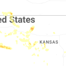

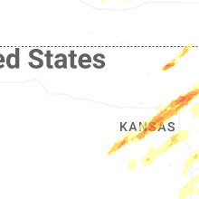
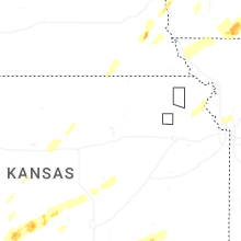


Connect with Interactive Hail Maps