

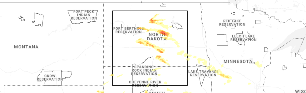
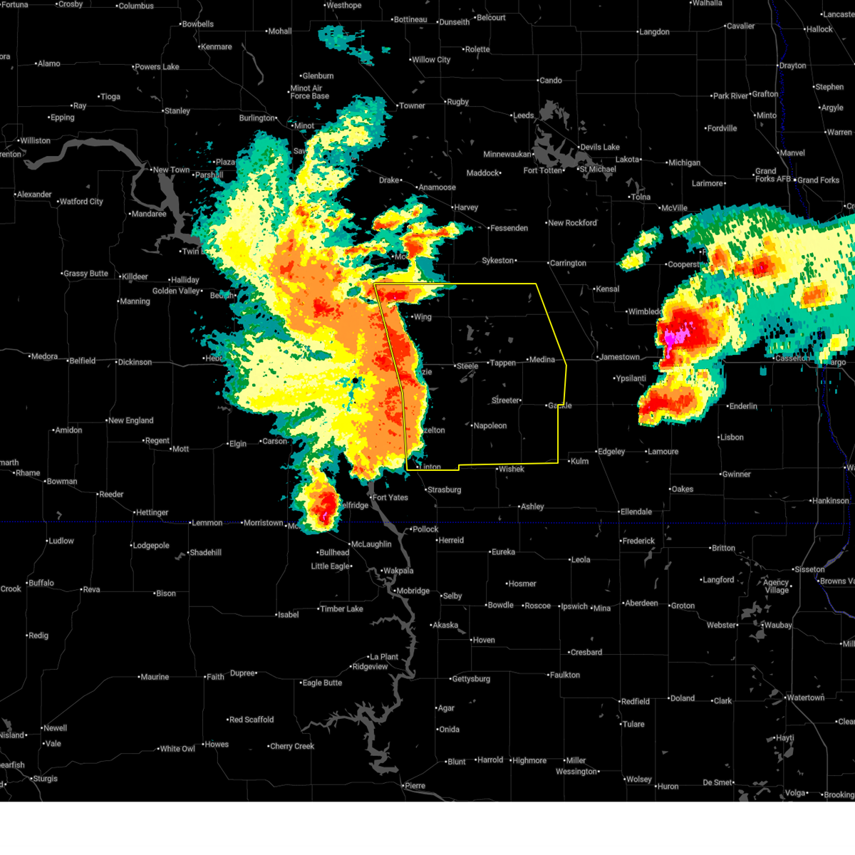
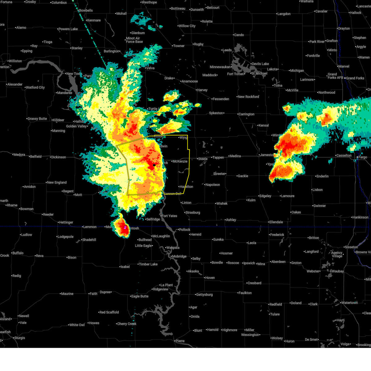
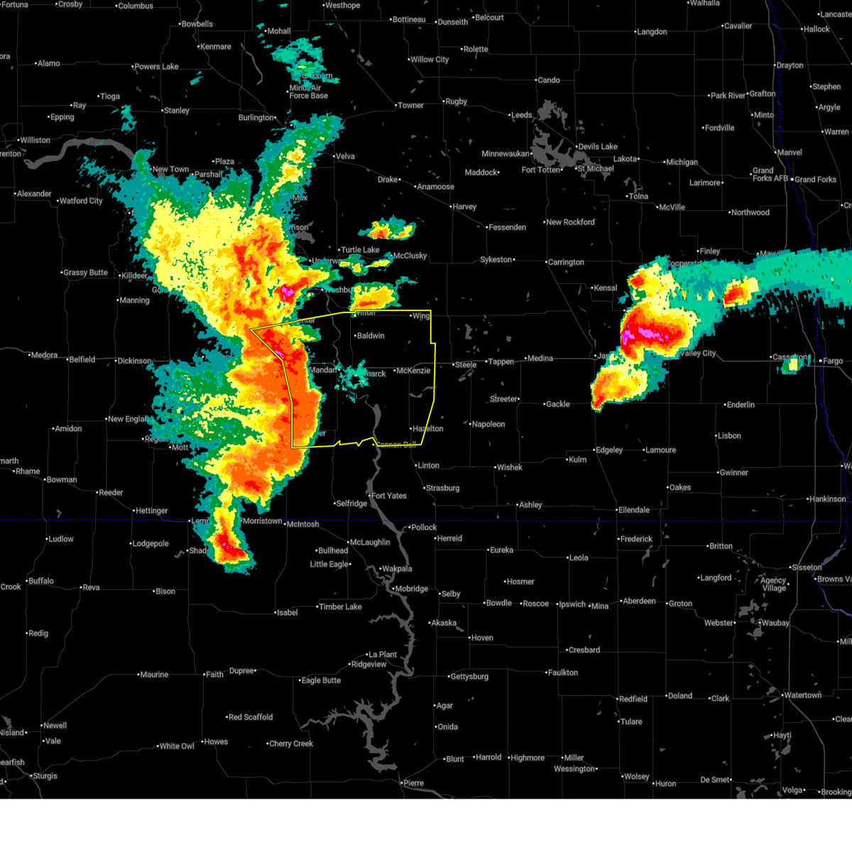
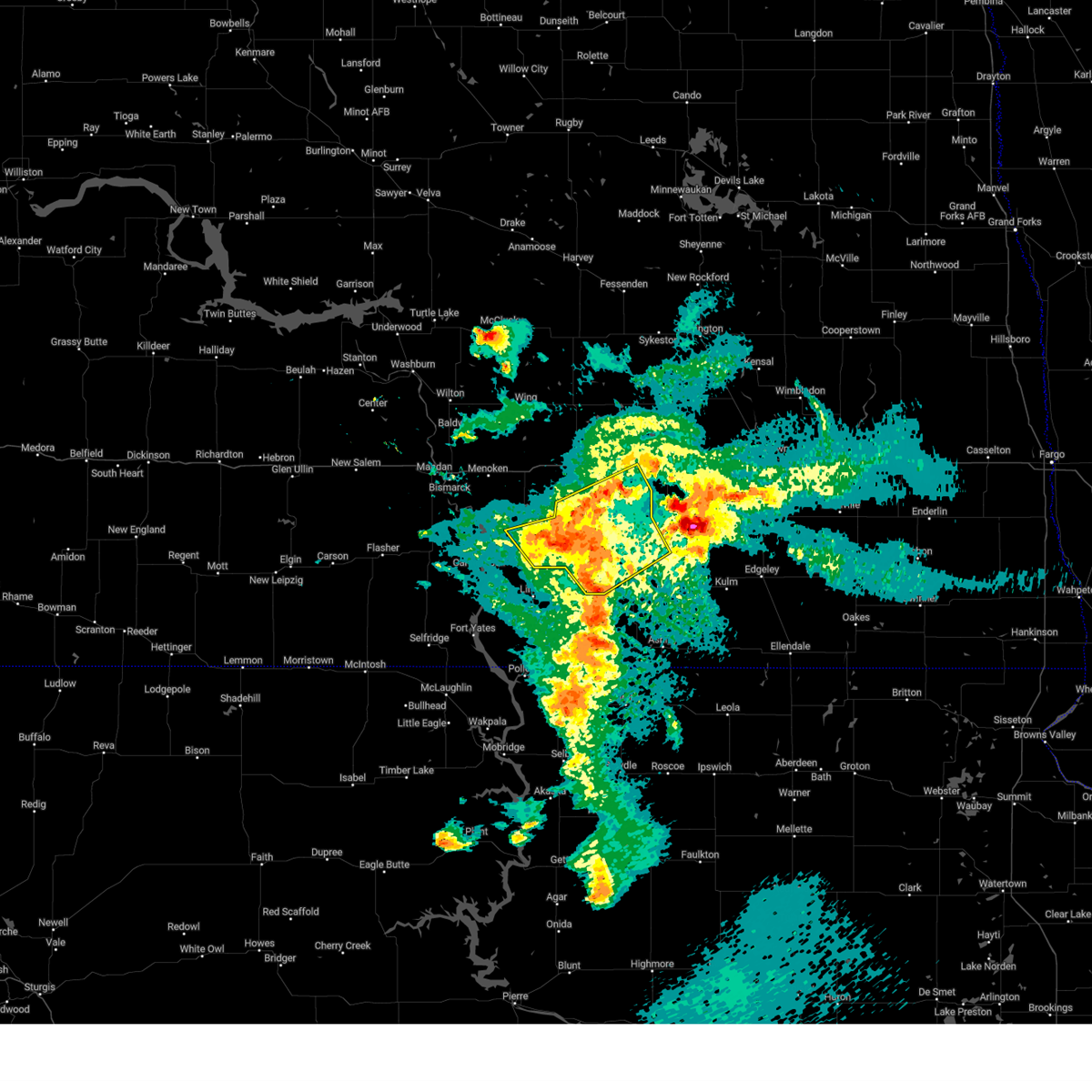
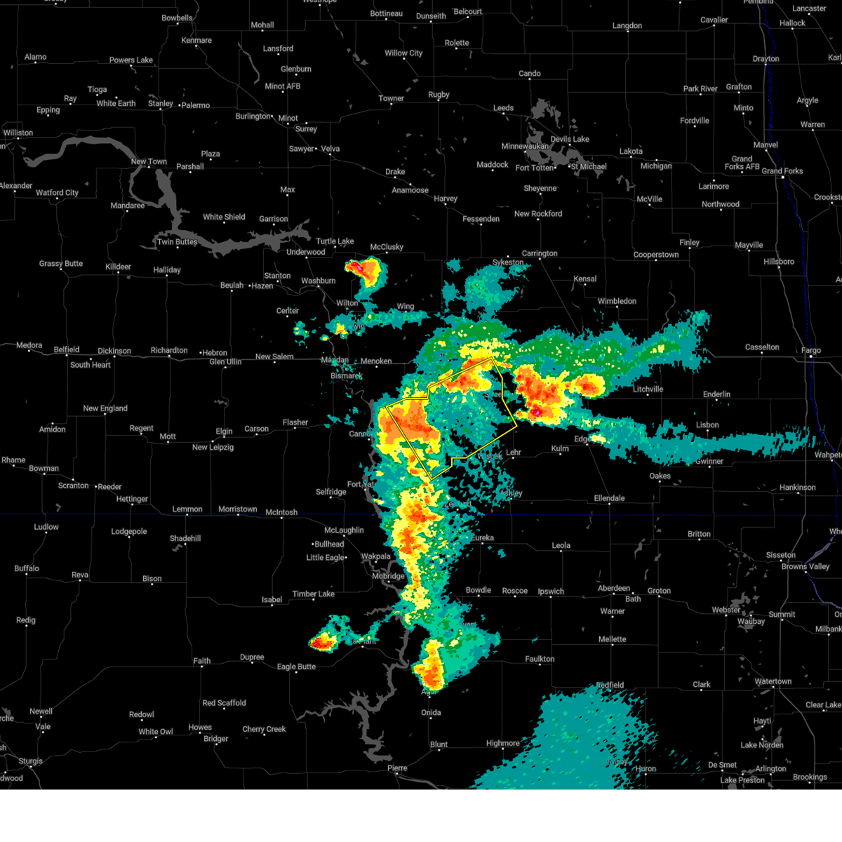
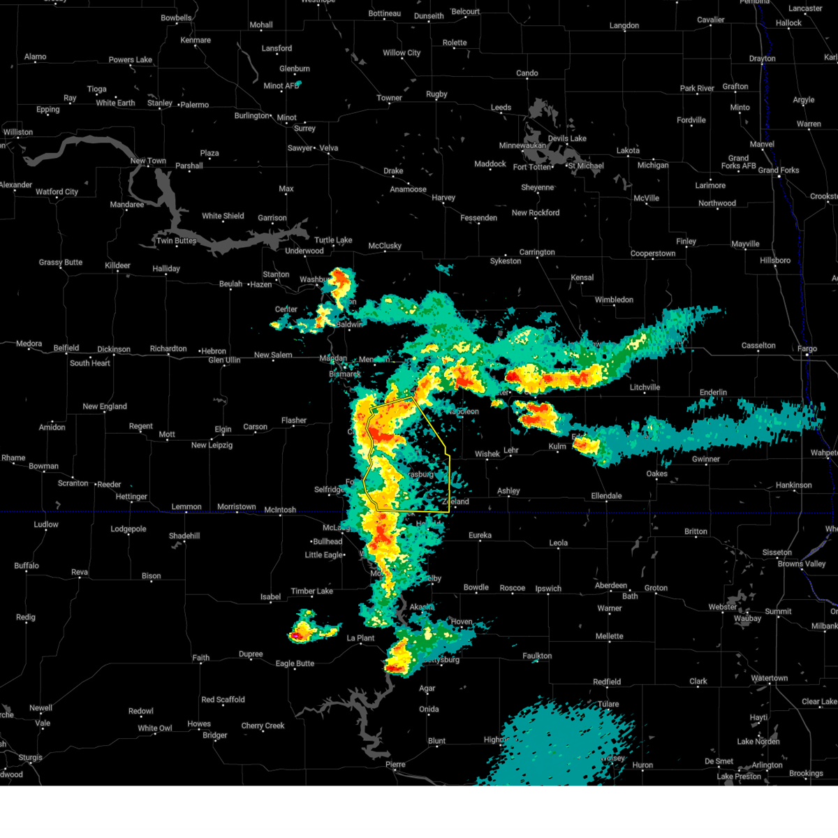
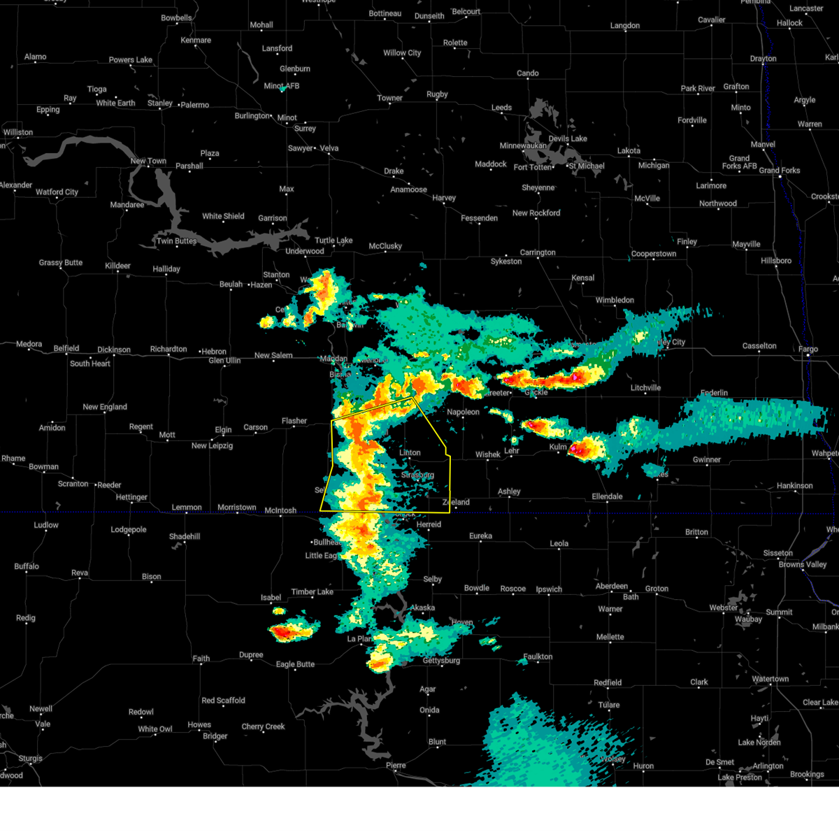
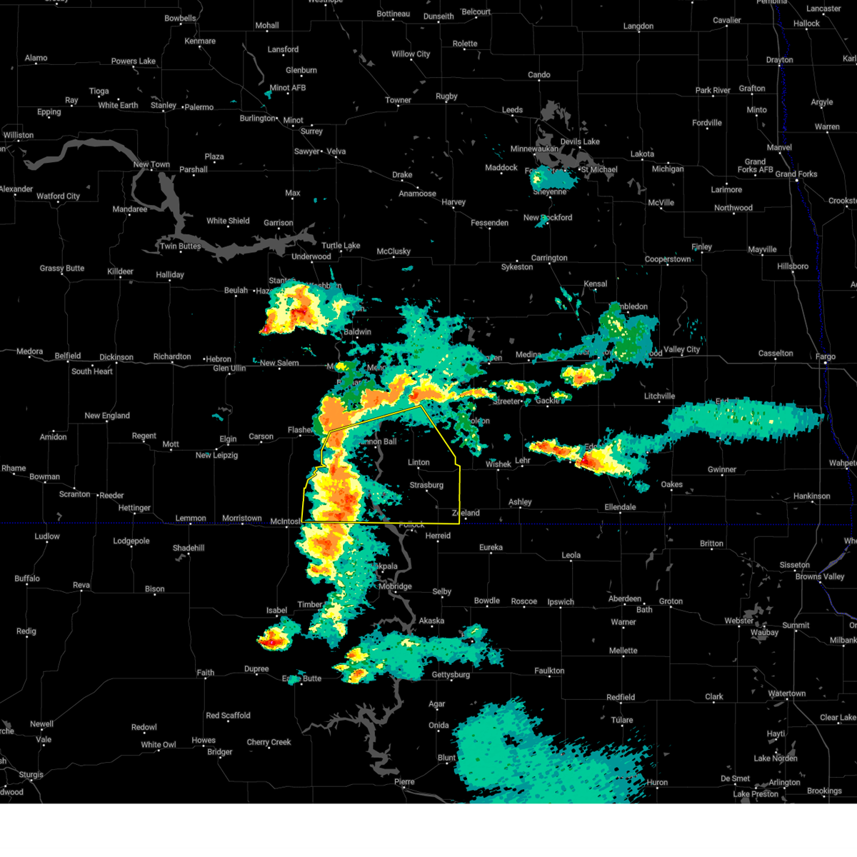
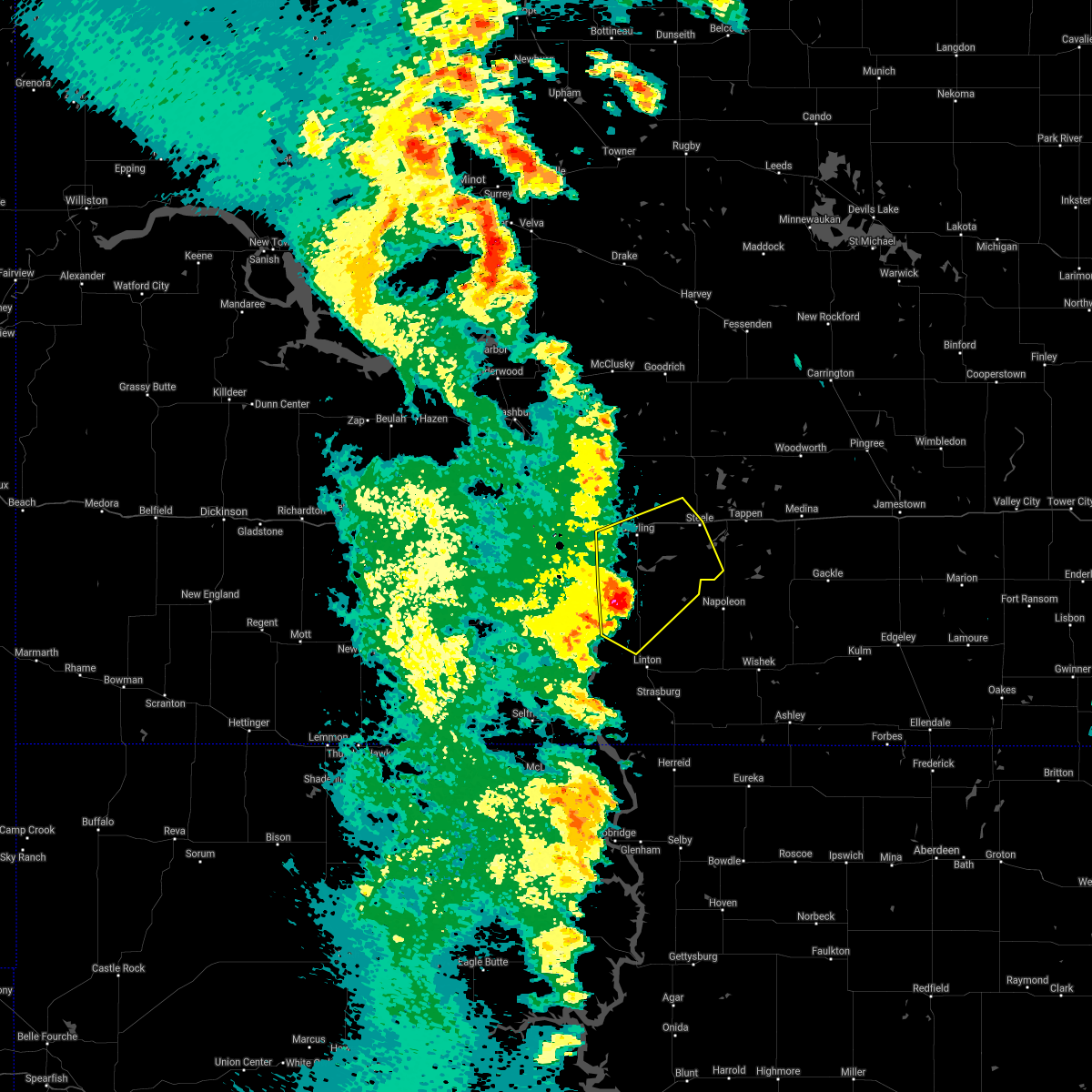
Hail Map for Hazelton, ND
The Hazelton, ND area has had 8 reports of on-the-ground hail by trained spotters, and has been under severe weather warnings 13 times during the past 12 months. Doppler radar has detected hail at or near Hazelton, ND on 52 occasions, including 2 occasions during the past year.
| Name: | Hazelton, ND |
| Where Located: | 32.5 miles SE of Bismarck, ND |
| Map: | Google Map for Hazelton, ND |
| Population: | 235 |
| Housing Units: | 126 |
| More Info: | Search Google for Hazelton, ND |
2
The Top Recent Hail Date for Hazelton, ND is Friday, June 27, 2025 (19th out of 52)
Hail and Wind Damage Spotted near Hazelton, ND
| Date / Time | Report Details |
|---|---|
| 6/27/2025 11:43 PM CDT |
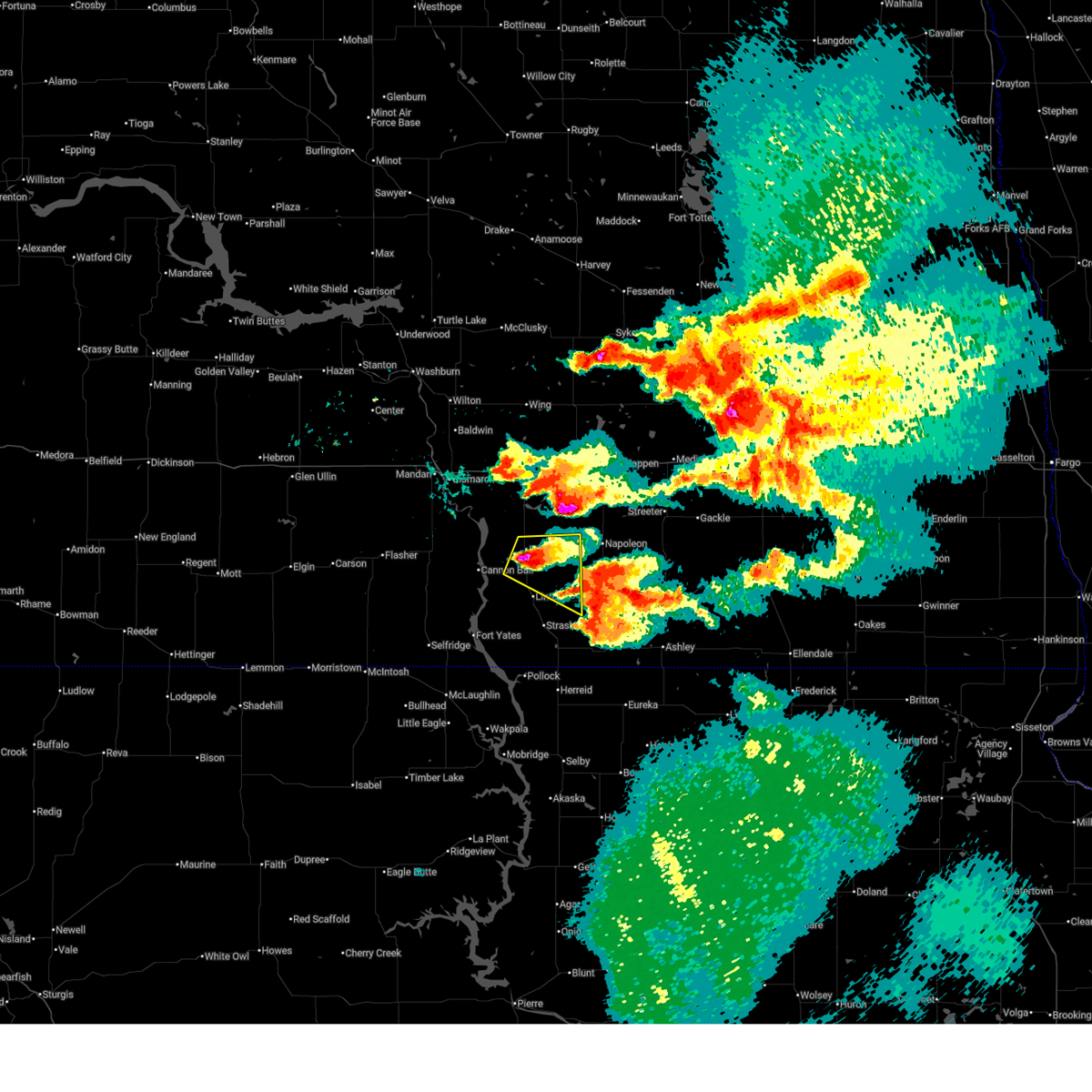 Svrbis the national weather service in bismarck has issued a * severe thunderstorm warning for, northeastern emmons county in south central north dakota, * until 1245 am cdt. * at 1143 pm cdt, a severe thunderstorm was located near hazelton, or 11 miles north of linton, moving east at 15 mph (radar indicated). Hazards include golf ball size hail and 60 mph wind gusts. People and animals outdoors will be injured. expect hail damage to roofs, siding, windows, and vehicles. Expect wind damage to roofs, siding, and trees. Svrbis the national weather service in bismarck has issued a * severe thunderstorm warning for, northeastern emmons county in south central north dakota, * until 1245 am cdt. * at 1143 pm cdt, a severe thunderstorm was located near hazelton, or 11 miles north of linton, moving east at 15 mph (radar indicated). Hazards include golf ball size hail and 60 mph wind gusts. People and animals outdoors will be injured. expect hail damage to roofs, siding, windows, and vehicles. Expect wind damage to roofs, siding, and trees.
|
| 6/27/2025 9:48 PM CDT |
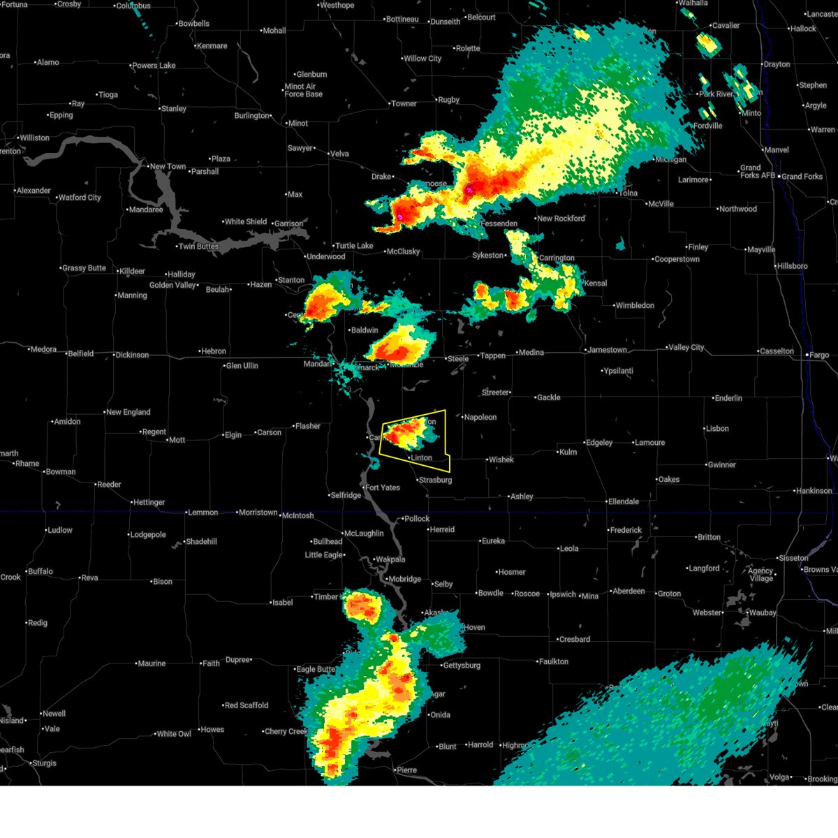 Svrbis the national weather service in bismarck has issued a * severe thunderstorm warning for, central emmons county in south central north dakota, * until 1045 pm cdt. * at 948 pm cdt, a severe thunderstorm was located 8 miles southwest of hazelton, or 9 miles northwest of linton, moving east at 20 mph (radar indicated). Hazards include two inch hail and 60 mph wind gusts. People and animals outdoors will be injured. expect hail damage to roofs, siding, windows, and vehicles. Expect wind damage to roofs, siding, and trees. Svrbis the national weather service in bismarck has issued a * severe thunderstorm warning for, central emmons county in south central north dakota, * until 1045 pm cdt. * at 948 pm cdt, a severe thunderstorm was located 8 miles southwest of hazelton, or 9 miles northwest of linton, moving east at 20 mph (radar indicated). Hazards include two inch hail and 60 mph wind gusts. People and animals outdoors will be injured. expect hail damage to roofs, siding, windows, and vehicles. Expect wind damage to roofs, siding, and trees.
|
| 6/20/2025 9:40 PM CDT | Hazelton nddot site measured wind gus in emmons county ND, 1.5 miles SE of Hazelton, ND |
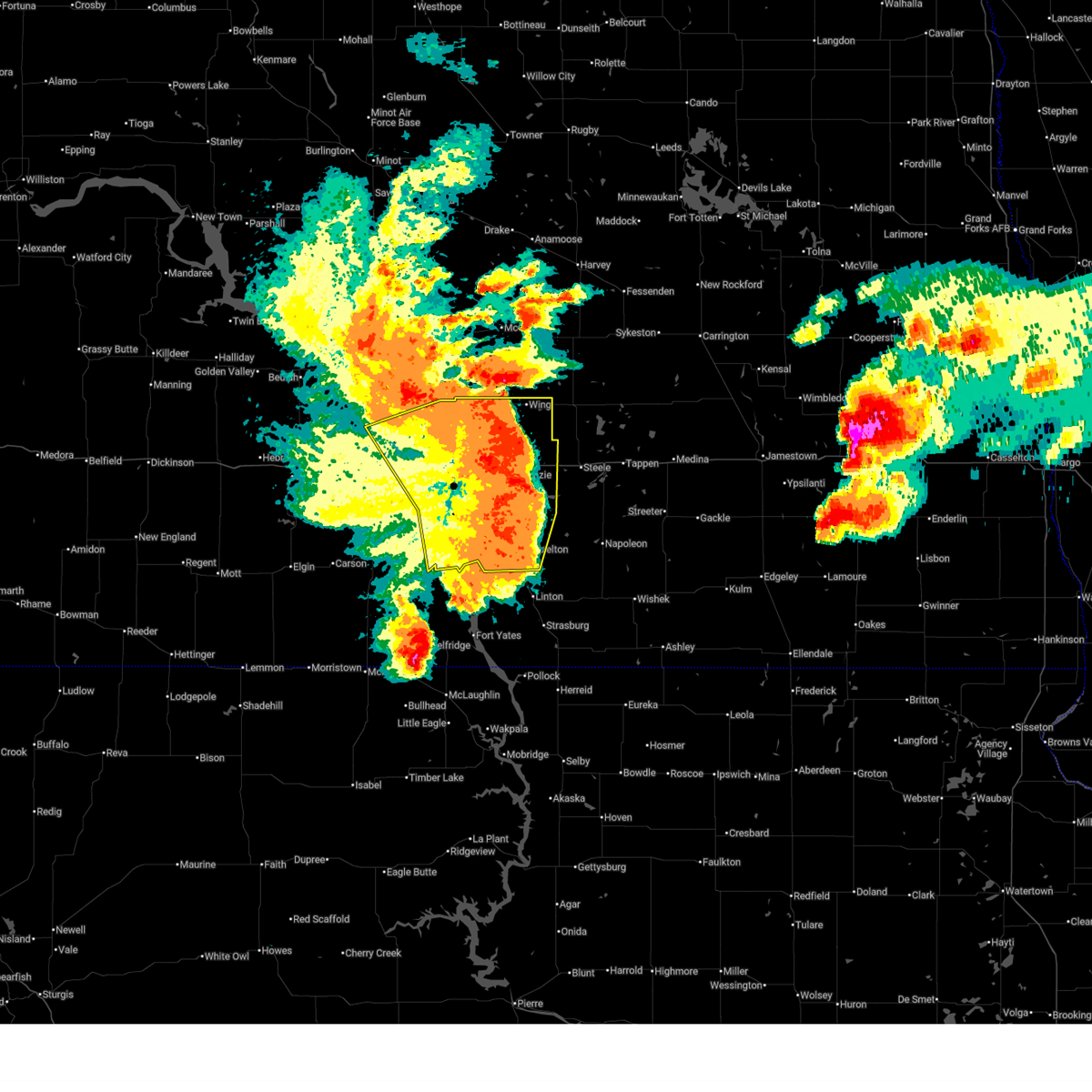
| 6/20/2025 9:40 PM CDT |
 Svrbis the national weather service in bismarck has issued a * severe thunderstorm warning for, kidder county in south central north dakota, eastern burleigh county in south central north dakota, logan county in southeastern north dakota, northeastern emmons county in south central north dakota, western stutsman county in southeastern north dakota, * until 1030 pm cdt. * at 940 pm cdt, severe thunderstorms were located along a line extending from 7 miles southwest of wing to 8 miles southeast of sterling to 7 miles southeast of hazelton, moving east at 60 mph. these are destructive storms! (radar indicated). Hazards include 90 mph wind gusts and quarter size hail. You are in a life-threatening situation. flying debris may be deadly to those caught without shelter. mobile homes will be heavily damaged or destroyed. homes and businesses will have substantial roof and window damage. Expect extensive tree damage and power outages. Svrbis the national weather service in bismarck has issued a * severe thunderstorm warning for, kidder county in south central north dakota, eastern burleigh county in south central north dakota, logan county in southeastern north dakota, northeastern emmons county in south central north dakota, western stutsman county in southeastern north dakota, * until 1030 pm cdt. * at 940 pm cdt, severe thunderstorms were located along a line extending from 7 miles southwest of wing to 8 miles southeast of sterling to 7 miles southeast of hazelton, moving east at 60 mph. these are destructive storms! (radar indicated). Hazards include 90 mph wind gusts and quarter size hail. You are in a life-threatening situation. flying debris may be deadly to those caught without shelter. mobile homes will be heavily damaged or destroyed. homes and businesses will have substantial roof and window damage. Expect extensive tree damage and power outages.
|
| 6/20/2025 9:39 PM CDT |
 At 939 pm cdt, severe thunderstorms were located along a line extending from near regan to 7 miles south of wing to 10 miles east of sterling to 6 miles south of braddock, moving east at 70 mph. these are destructive storms for (radar indicated). Hazards include 90 mph wind gusts and quarter size hail. You are in a life-threatening situation. flying debris may be deadly to those caught without shelter. mobile homes will be heavily damaged or destroyed. homes and businesses will have substantial roof and window damage. expect extensive tree damage and power outages. locations impacted include, bismarck, mandan, lincoln, wilton, hazelton, menoken, wing, sterling, regan, st. Anthony, driscoll, mckenzie, baldwin, hazelton recreation area, university of mary, huff, crown butte lake, moffit, lake harmon, and mcdowell dam recreation area. At 939 pm cdt, severe thunderstorms were located along a line extending from near regan to 7 miles south of wing to 10 miles east of sterling to 6 miles south of braddock, moving east at 70 mph. these are destructive storms for (radar indicated). Hazards include 90 mph wind gusts and quarter size hail. You are in a life-threatening situation. flying debris may be deadly to those caught without shelter. mobile homes will be heavily damaged or destroyed. homes and businesses will have substantial roof and window damage. expect extensive tree damage and power outages. locations impacted include, bismarck, mandan, lincoln, wilton, hazelton, menoken, wing, sterling, regan, st. Anthony, driscoll, mckenzie, baldwin, hazelton recreation area, university of mary, huff, crown butte lake, moffit, lake harmon, and mcdowell dam recreation area.
|
| 6/20/2025 9:36 PM CDT |
 Svrbis the national weather service in bismarck has issued a * severe thunderstorm warning for, kidder county in south central north dakota, eastern burleigh county in south central north dakota, logan county in southeastern north dakota, northeastern emmons county in south central north dakota, western stutsman county in southeastern north dakota, * until 1030 pm cdt. * at 935 pm cdt, severe thunderstorms were located along a line extending from 8 miles southeast of regan to 7 miles south of sterling to 6 miles southeast of hazelton, moving east at 60 mph. these are destructive storms! (radar indicated). Hazards include 80 mph wind gusts and quarter size hail. Flying debris will be dangerous to those caught without shelter. mobile homes will be heavily damaged. expect considerable damage to roofs, windows, and vehicles. Extensive tree damage and power outages are likely. Svrbis the national weather service in bismarck has issued a * severe thunderstorm warning for, kidder county in south central north dakota, eastern burleigh county in south central north dakota, logan county in southeastern north dakota, northeastern emmons county in south central north dakota, western stutsman county in southeastern north dakota, * until 1030 pm cdt. * at 935 pm cdt, severe thunderstorms were located along a line extending from 8 miles southeast of regan to 7 miles south of sterling to 6 miles southeast of hazelton, moving east at 60 mph. these are destructive storms! (radar indicated). Hazards include 80 mph wind gusts and quarter size hail. Flying debris will be dangerous to those caught without shelter. mobile homes will be heavily damaged. expect considerable damage to roofs, windows, and vehicles. Extensive tree damage and power outages are likely.
|
| 6/20/2025 9:23 PM CDT |
 At 922 pm cdt, severe thunderstorms were located along a line extending from wilton to 11 miles south of regan to 8 miles southeast of menoken to 6 miles northeast of cannon ball, moving east at 70 mph. these are destructive storms for south central north dakota, including bismarck and mandan (radar indicated). Hazards include 80 mph wind gusts and quarter size hail. Flying debris will be dangerous to those caught without shelter. mobile homes will be heavily damaged. expect considerable damage to roofs, windows, and vehicles. extensive tree damage and power outages are likely. locations impacted include, bismarck, mandan, lincoln, wilton, hazelton, flasher, menoken, wing, sterling, regan, st. Anthony, driscoll, judson, mckenzie, baldwin, hazelton recreation area, university of mary, huff, crown butte lake, and moffit. At 922 pm cdt, severe thunderstorms were located along a line extending from wilton to 11 miles south of regan to 8 miles southeast of menoken to 6 miles northeast of cannon ball, moving east at 70 mph. these are destructive storms for south central north dakota, including bismarck and mandan (radar indicated). Hazards include 80 mph wind gusts and quarter size hail. Flying debris will be dangerous to those caught without shelter. mobile homes will be heavily damaged. expect considerable damage to roofs, windows, and vehicles. extensive tree damage and power outages are likely. locations impacted include, bismarck, mandan, lincoln, wilton, hazelton, flasher, menoken, wing, sterling, regan, st. Anthony, driscoll, judson, mckenzie, baldwin, hazelton recreation area, university of mary, huff, crown butte lake, and moffit.
|
| 6/20/2025 9:20 PM CDT | 10 meter wind gust ndawn livona 5 in emmons county ND, 14.2 miles ENE of Hazelton, ND |
| 6/20/2025 8:58 PM CDT |
 Svrbis the national weather service in bismarck has issued a * severe thunderstorm warning for, burleigh county in south central north dakota, morton county in south central north dakota, southern oliver county in south central north dakota, northwestern emmons county in south central north dakota, * until 1000 pm cdt. * at 857 pm cdt, severe thunderstorms were located along a line extending from near center to 13 miles northwest of mandan to near st. anthony to 9 miles west of solen, moving east at 70 mph. these are destructive storms for south central north dakota, including bismarck and mandan (radar indicated). Hazards include 80 mph wind gusts and quarter size hail. Flying debris will be dangerous to those caught without shelter. mobile homes will be heavily damaged. expect considerable damage to roofs, windows, and vehicles. Extensive tree damage and power outages are likely. Svrbis the national weather service in bismarck has issued a * severe thunderstorm warning for, burleigh county in south central north dakota, morton county in south central north dakota, southern oliver county in south central north dakota, northwestern emmons county in south central north dakota, * until 1000 pm cdt. * at 857 pm cdt, severe thunderstorms were located along a line extending from near center to 13 miles northwest of mandan to near st. anthony to 9 miles west of solen, moving east at 70 mph. these are destructive storms for south central north dakota, including bismarck and mandan (radar indicated). Hazards include 80 mph wind gusts and quarter size hail. Flying debris will be dangerous to those caught without shelter. mobile homes will be heavily damaged. expect considerable damage to roofs, windows, and vehicles. Extensive tree damage and power outages are likely.
|
| 7/29/2024 9:15 PM CDT |
 At 915 pm cdt, a severe thunderstorm was located 6 miles northeast of napoleon, or 34 miles northeast of linton, moving northeast at 45 mph (radar indicated). Hazards include 60 mph wind gusts. Expect damage to roofs, siding, and trees. Locations impacted include, napoleon, hazelton, braddock, burnstad, kintyre, beaver lake state park, and streeter memorial. At 915 pm cdt, a severe thunderstorm was located 6 miles northeast of napoleon, or 34 miles northeast of linton, moving northeast at 45 mph (radar indicated). Hazards include 60 mph wind gusts. Expect damage to roofs, siding, and trees. Locations impacted include, napoleon, hazelton, braddock, burnstad, kintyre, beaver lake state park, and streeter memorial.
|
| 7/29/2024 8:58 PM CDT |
 Svrbis the national weather service in bismarck has issued a * severe thunderstorm warning for, southern kidder county in south central north dakota, western logan county in southeastern north dakota, northeastern emmons county in south central north dakota, * until 945 pm cdt. * at 857 pm cdt, a severe thunderstorm was located 6 miles west of napoleon, or 21 miles northeast of linton, moving northeast at 45 mph (radar indicated). Hazards include 60 mph wind gusts. expect damage to roofs, siding, and trees Svrbis the national weather service in bismarck has issued a * severe thunderstorm warning for, southern kidder county in south central north dakota, western logan county in southeastern north dakota, northeastern emmons county in south central north dakota, * until 945 pm cdt. * at 857 pm cdt, a severe thunderstorm was located 6 miles west of napoleon, or 21 miles northeast of linton, moving northeast at 45 mph (radar indicated). Hazards include 60 mph wind gusts. expect damage to roofs, siding, and trees
|
| 7/29/2024 8:49 PM CDT | Personal weather station measured wind gus in emmons county ND, 7.6 miles WNW of Hazelton, ND |
| 7/29/2024 8:38 PM CDT |
 At 838 pm cdt, severe thunderstorms were located along a line extending from hazelton to 6 miles northeast of strasburg to 6 miles southwest of hague, moving east at 40 mph (radar indicated). Hazards include 60 mph wind gusts and penny size hail. Expect damage to roofs, siding, and trees. Locations impacted include, linton, strasburg, hazelton, hague, westfield, temvik, cattail recreation area, beaver bay recreation area, and hull. At 838 pm cdt, severe thunderstorms were located along a line extending from hazelton to 6 miles northeast of strasburg to 6 miles southwest of hague, moving east at 40 mph (radar indicated). Hazards include 60 mph wind gusts and penny size hail. Expect damage to roofs, siding, and trees. Locations impacted include, linton, strasburg, hazelton, hague, westfield, temvik, cattail recreation area, beaver bay recreation area, and hull.
|
| 7/29/2024 8:38 PM CDT |
 the severe thunderstorm warning has been cancelled and is no longer in effect the severe thunderstorm warning has been cancelled and is no longer in effect
|
| 7/29/2024 8:25 PM CDT |
 At 825 pm cdt, severe thunderstorms were located along a line extending from 6 miles northeast of cannon ball to 5 miles south of linton to near pollock, moving east at 45 mph (radar indicated). Hazards include 60 mph wind gusts. Expect damage to roofs, siding, and trees. Locations impacted include, linton, strasburg, hazelton, fort yates, selfridge, solen, hague, westfield, cannon ball, prairie knights resort, temvik, hazelton recreation area, hull, fort rice, cattail recreation area, and beaver bay recreation area. At 825 pm cdt, severe thunderstorms were located along a line extending from 6 miles northeast of cannon ball to 5 miles south of linton to near pollock, moving east at 45 mph (radar indicated). Hazards include 60 mph wind gusts. Expect damage to roofs, siding, and trees. Locations impacted include, linton, strasburg, hazelton, fort yates, selfridge, solen, hague, westfield, cannon ball, prairie knights resort, temvik, hazelton recreation area, hull, fort rice, cattail recreation area, and beaver bay recreation area.
|
| 7/29/2024 8:02 PM CDT |
 Svrbis the national weather service in bismarck has issued a * severe thunderstorm warning for, sioux county in south central north dakota, southeastern morton county in south central north dakota, emmons county in south central north dakota, * until 900 pm cdt. * at 802 pm cdt, severe thunderstorms were located along a line extending from near solen to 4 miles north of fort yates to 11 miles northeast of mclaughlin, moving east at 40 mph (radar indicated). Hazards include 60 mph wind gusts. expect damage to roofs, siding, and trees Svrbis the national weather service in bismarck has issued a * severe thunderstorm warning for, sioux county in south central north dakota, southeastern morton county in south central north dakota, emmons county in south central north dakota, * until 900 pm cdt. * at 802 pm cdt, severe thunderstorms were located along a line extending from near solen to 4 miles north of fort yates to 11 miles northeast of mclaughlin, moving east at 40 mph (radar indicated). Hazards include 60 mph wind gusts. expect damage to roofs, siding, and trees
|
| 9/4/2023 9:03 PM CDT |
 At 903 pm cdt, severe thunderstorms were located along a line extending from 13 miles southeast of center to 4 miles southwest of regan to 6 miles northwest of steele to 5 miles southeast of braddock, moving northeast at 40 mph (radar indicated). Hazards include 60 mph wind gusts and nickel size hail. Expect damage to roofs, siding, and trees. these severe storms will be near, steele, wilton, wing and regan around 910 pm cdt. tuttle and dawson around 920 pm cdt. robinson and lake isabel around 925 pm cdt. tappen around 935 pm cdt. goodrich and hurdsfield around 945 pm cdt. other locations impacted by these severe thunderstorms include driscoll, kintyre, university of mary, huff, hoffer lake, chaseley, crown butte lake, moffit, fish creek dam and lake harmon. hail threat, radar indicated max hail size, 0. 88 in wind threat, radar indicated max wind gust, 60 mph. At 903 pm cdt, severe thunderstorms were located along a line extending from 13 miles southeast of center to 4 miles southwest of regan to 6 miles northwest of steele to 5 miles southeast of braddock, moving northeast at 40 mph (radar indicated). Hazards include 60 mph wind gusts and nickel size hail. Expect damage to roofs, siding, and trees. these severe storms will be near, steele, wilton, wing and regan around 910 pm cdt. tuttle and dawson around 920 pm cdt. robinson and lake isabel around 925 pm cdt. tappen around 935 pm cdt. goodrich and hurdsfield around 945 pm cdt. other locations impacted by these severe thunderstorms include driscoll, kintyre, university of mary, huff, hoffer lake, chaseley, crown butte lake, moffit, fish creek dam and lake harmon. hail threat, radar indicated max hail size, 0. 88 in wind threat, radar indicated max wind gust, 60 mph.
|
| 9/4/2023 8:46 PM CDT |
 At 846 pm cdt, severe thunderstorms were located along a line extending from 5 miles east of new salem to 10 miles north of bismarck to near sterling to 7 miles north of linton, moving northeast at 45 mph (radar indicated). Hazards include 70 mph wind gusts and quarter size hail. Hail damage to vehicles is expected. expect considerable tree damage. wind damage is also likely to mobile homes, roofs, and outbuildings. severe thunderstorms will be near, sterling and braddock around 850 pm cdt. regan around 900 pm cdt. wilton and wing around 905 pm cdt. steele around 915 pm cdt. tuttle around 920 pm cdt. dawson and lake isabel around 935 pm cdt. other locations impacted by these severe thunderstorms include driscoll, temvik, kintyre, hazelton recreation area, university of mary, huff, hoffer lake, chaseley, crown butte lake and moffit. thunderstorm damage threat, considerable hail threat, radar indicated max hail size, 1. 00 in wind threat, radar indicated max wind gust, 70 mph. At 846 pm cdt, severe thunderstorms were located along a line extending from 5 miles east of new salem to 10 miles north of bismarck to near sterling to 7 miles north of linton, moving northeast at 45 mph (radar indicated). Hazards include 70 mph wind gusts and quarter size hail. Hail damage to vehicles is expected. expect considerable tree damage. wind damage is also likely to mobile homes, roofs, and outbuildings. severe thunderstorms will be near, sterling and braddock around 850 pm cdt. regan around 900 pm cdt. wilton and wing around 905 pm cdt. steele around 915 pm cdt. tuttle around 920 pm cdt. dawson and lake isabel around 935 pm cdt. other locations impacted by these severe thunderstorms include driscoll, temvik, kintyre, hazelton recreation area, university of mary, huff, hoffer lake, chaseley, crown butte lake and moffit. thunderstorm damage threat, considerable hail threat, radar indicated max hail size, 1. 00 in wind threat, radar indicated max wind gust, 70 mph.
|
| 9/4/2023 8:37 PM CDT |
 At 836 pm cdt/736 pm mdt/, severe thunderstorms were located along a line extending from near new salem to 9 miles northwest of mandan to near menoken to 6 miles north of linton, moving northeast at 65 mph (radar indicated). Hazards include 70 mph wind gusts and quarter size hail. Hail damage to vehicles is expected. expect considerable tree damage. wind damage is also likely to mobile homes, roofs, and outbuildings. these severe storms will be near, hazelton and sterling around 840 pm cdt. braddock around 845 pm cdt. other locations impacted by these severe thunderstorms include double ditch indian village, mckenzie, temvik, baldwin, hazelton recreation area, university of mary, stumpf state natural area, huff, price and fort rice. thunderstorm damage threat, considerable hail threat, radar indicated max hail size, 1. 00 in wind threat, radar indicated max wind gust, 70 mph. At 836 pm cdt/736 pm mdt/, severe thunderstorms were located along a line extending from near new salem to 9 miles northwest of mandan to near menoken to 6 miles north of linton, moving northeast at 65 mph (radar indicated). Hazards include 70 mph wind gusts and quarter size hail. Hail damage to vehicles is expected. expect considerable tree damage. wind damage is also likely to mobile homes, roofs, and outbuildings. these severe storms will be near, hazelton and sterling around 840 pm cdt. braddock around 845 pm cdt. other locations impacted by these severe thunderstorms include double ditch indian village, mckenzie, temvik, baldwin, hazelton recreation area, university of mary, stumpf state natural area, huff, price and fort rice. thunderstorm damage threat, considerable hail threat, radar indicated max hail size, 1. 00 in wind threat, radar indicated max wind gust, 70 mph.
|
| 9/4/2023 8:22 PM CDT |
 At 820 pm cdt/720 pm mdt/, severe thunderstorms were located along a line extending from 6 miles northeast of heart butte dam to 5 miles west of mandan to 12 miles southeast of lincoln to 7 miles southwest of linton, moving northeast at 50 mph (radar indicated). Hazards include 70 mph wind gusts and quarter size hail. Hail damage to vehicles is expected. expect considerable tree damage. wind damage is also likely to mobile homes, roofs, and outbuildings. these severe storms will be near, bismarck, mandan, linton, lincoln, new salem and almont around 825 pm cdt. hazelton and menoken around 830 pm cdt. sterling around 840 pm cdt. braddock around 845 pm cdt. other locations impacted by these severe thunderstorms include temvik, hazelton recreation area, university of mary, huff, crown butte lake, moffit, fish creek dam, beaver bay recreation area, lake harmon and mcdowell dam recreation area. thunderstorm damage threat, considerable hail threat, radar indicated max hail size, 1. 00 in wind threat, radar indicated max wind gust, 70 mph. At 820 pm cdt/720 pm mdt/, severe thunderstorms were located along a line extending from 6 miles northeast of heart butte dam to 5 miles west of mandan to 12 miles southeast of lincoln to 7 miles southwest of linton, moving northeast at 50 mph (radar indicated). Hazards include 70 mph wind gusts and quarter size hail. Hail damage to vehicles is expected. expect considerable tree damage. wind damage is also likely to mobile homes, roofs, and outbuildings. these severe storms will be near, bismarck, mandan, linton, lincoln, new salem and almont around 825 pm cdt. hazelton and menoken around 830 pm cdt. sterling around 840 pm cdt. braddock around 845 pm cdt. other locations impacted by these severe thunderstorms include temvik, hazelton recreation area, university of mary, huff, crown butte lake, moffit, fish creek dam, beaver bay recreation area, lake harmon and mcdowell dam recreation area. thunderstorm damage threat, considerable hail threat, radar indicated max hail size, 1. 00 in wind threat, radar indicated max wind gust, 70 mph.
|
| 9/4/2023 8:06 PM CDT |
 At 804 pm cdt/704 pm mdt/, severe thunderstorms were located along a line extending from 7 miles southwest of heart butte dam to 13 miles north of flasher to near solen to 6 miles southeast of fort yates, moving north at 45 mph (radar indicated). Hazards include 70 mph wind gusts. Expect considerable tree damage. damage is likely to mobile homes, roofs, and outbuildings. severe thunderstorms will be near, almont, cannon ball, st. anthony and prairie knights resort around 810 pm cdt. heart butte dam around 710 pm mdt. bismarck, mandan and new salem around 820 pm cdt. lincoln around 825 pm cdt. menoken around 835 pm cdt. hazelton around 840 pm cdt. other locations impacted by these severe thunderstorms include temvik, hazelton recreation area, university of mary, huff, st. gertrude, crown butte lake, standing rock, moffit, fish creek dam and beaver bay recreation area. thunderstorm damage threat, considerable hail threat, radar indicated max hail size, <. 75 in wind threat, radar indicated max wind gust, 70 mph. At 804 pm cdt/704 pm mdt/, severe thunderstorms were located along a line extending from 7 miles southwest of heart butte dam to 13 miles north of flasher to near solen to 6 miles southeast of fort yates, moving north at 45 mph (radar indicated). Hazards include 70 mph wind gusts. Expect considerable tree damage. damage is likely to mobile homes, roofs, and outbuildings. severe thunderstorms will be near, almont, cannon ball, st. anthony and prairie knights resort around 810 pm cdt. heart butte dam around 710 pm mdt. bismarck, mandan and new salem around 820 pm cdt. lincoln around 825 pm cdt. menoken around 835 pm cdt. hazelton around 840 pm cdt. other locations impacted by these severe thunderstorms include temvik, hazelton recreation area, university of mary, huff, st. gertrude, crown butte lake, standing rock, moffit, fish creek dam and beaver bay recreation area. thunderstorm damage threat, considerable hail threat, radar indicated max hail size, <. 75 in wind threat, radar indicated max wind gust, 70 mph.
|
| 8/23/2022 8:01 PM CDT | At 800 pm cdt, a severe thunderstorm was located 9 miles southeast of lincoln, or 14 miles southeast of bismarck, moving south at 35 mph (radar indicated). Hazards include 60 mph wind gusts and quarter size hail. Hail damage to vehicles is expected. expect wind damage to roofs, siding, and trees. this severe thunderstorm will remain over mainly rural areas of south central burleigh, east central morton and northwestern emmons counties, including the following locations, hazelton recreation area, fort rice, temvik, university of mary and huff. hail threat, radar indicated max hail size, 1. 00 in wind threat, radar indicated max wind gust, 60 mph. |
| 8/23/2022 7:34 PM CDT | At 733 pm cdt, a severe thunderstorm was located over lincoln, or 7 miles southeast of bismarck, moving south at 45 mph (radar indicated). Hazards include 60 mph wind gusts and quarter size hail. Hail damage to vehicles is expected. expect wind damage to roofs, siding, and trees. this severe thunderstorm will impact the following locations, hazelton recreation area, fort rice, temvik, beaver bay recreation area and huff. hail threat, radar indicated max hail size, 1. 00 in wind threat, radar indicated max wind gust, 60 mph. |
| 7/21/2022 6:19 PM CDT |
 At 619 pm cdt, a severe thunderstorm was located 6 miles southeast of cannon ball, or 12 miles northwest of linton, moving southeast at 40 mph (radar indicated). Hazards include golf ball size hail and 60 mph wind gusts. People and animals outdoors will be injured. expect hail damage to roofs, siding, windows, and vehicles. Expect wind damage to roofs, siding, and trees. At 619 pm cdt, a severe thunderstorm was located 6 miles southeast of cannon ball, or 12 miles northwest of linton, moving southeast at 40 mph (radar indicated). Hazards include golf ball size hail and 60 mph wind gusts. People and animals outdoors will be injured. expect hail damage to roofs, siding, windows, and vehicles. Expect wind damage to roofs, siding, and trees.
|
| 7/21/2022 5:20 PM CDT |
 At 519 pm cdt, a severe thunderstorm was located over braddock, or 15 miles west of napoleon, moving southeast at 30 mph (radar indicated). Hazards include 60 mph wind gusts and quarter size hail. Hail damage to vehicles is expected. expect wind damage to roofs, siding, and trees. locations impacted include, hazelton, braddock, moffit and kintyre. hail threat, radar indicated max hail size, 1. 00 in wind threat, radar indicated max wind gust, 60 mph. At 519 pm cdt, a severe thunderstorm was located over braddock, or 15 miles west of napoleon, moving southeast at 30 mph (radar indicated). Hazards include 60 mph wind gusts and quarter size hail. Hail damage to vehicles is expected. expect wind damage to roofs, siding, and trees. locations impacted include, hazelton, braddock, moffit and kintyre. hail threat, radar indicated max hail size, 1. 00 in wind threat, radar indicated max wind gust, 60 mph.
|
| 7/21/2022 5:03 PM CDT |
 At 502 pm cdt, a severe thunderstorm was located 7 miles west of braddock, or 23 miles north of linton, moving southeast at 30 mph (radar indicated). Hazards include 60 mph wind gusts and half dollar size hail. Hail damage to vehicles is expected. expect wind damage to roofs, siding, and trees. locations impacted include, hazelton, sterling, braddock, moffit and kintyre. hail threat, radar indicated max hail size, 1. 25 in wind threat, radar indicated max wind gust, 60 mph. At 502 pm cdt, a severe thunderstorm was located 7 miles west of braddock, or 23 miles north of linton, moving southeast at 30 mph (radar indicated). Hazards include 60 mph wind gusts and half dollar size hail. Hail damage to vehicles is expected. expect wind damage to roofs, siding, and trees. locations impacted include, hazelton, sterling, braddock, moffit and kintyre. hail threat, radar indicated max hail size, 1. 25 in wind threat, radar indicated max wind gust, 60 mph.
|
| 7/21/2022 4:33 PM CDT |
 At 432 pm cdt, a severe thunderstorm was located 6 miles south of menoken, or 13 miles east of bismarck, moving southeast at 30 mph (radar indicated). Hazards include 60 mph wind gusts and half dollar size hail. Hail damage to vehicles is expected. Expect wind damage to roofs, siding, and trees. At 432 pm cdt, a severe thunderstorm was located 6 miles south of menoken, or 13 miles east of bismarck, moving southeast at 30 mph (radar indicated). Hazards include 60 mph wind gusts and half dollar size hail. Hail damage to vehicles is expected. Expect wind damage to roofs, siding, and trees.
|
| 7/10/2022 5:58 AM CDT |
 At 558 am cdt, a severe thunderstorm was located 7 miles southwest of napoleon, moving east at 50 mph (radar indicated). Hazards include 60 mph wind gusts and quarter size hail. Hail damage to vehicles is expected. expect wind damage to roofs, siding, and trees. locations impacted include, napoleon and beaver lake state park. hail threat, radar indicated max hail size, 1. 00 in wind threat, radar indicated max wind gust, 60 mph. At 558 am cdt, a severe thunderstorm was located 7 miles southwest of napoleon, moving east at 50 mph (radar indicated). Hazards include 60 mph wind gusts and quarter size hail. Hail damage to vehicles is expected. expect wind damage to roofs, siding, and trees. locations impacted include, napoleon and beaver lake state park. hail threat, radar indicated max hail size, 1. 00 in wind threat, radar indicated max wind gust, 60 mph.
|
| 7/10/2022 5:27 AM CDT |
 At 527 am cdt, a severe thunderstorm was located 5 miles west of hazelton, or 14 miles northwest of linton, moving east at 55 mph (radar indicated). Hazards include 70 mph wind gusts and half dollar size hail. Hail damage to vehicles is expected. expect considerable tree damage. wind damage is also likely to mobile homes, roofs, and outbuildings. this severe thunderstorm will be near, hazelton around 530 am cdt. braddock around 545 am cdt. other locations in the path of this severe thunderstorm include napoleon. thunderstorm damage threat, considerable hail threat, radar indicated max hail size, 1. 25 in wind threat, radar indicated max wind gust, 70 mph. At 527 am cdt, a severe thunderstorm was located 5 miles west of hazelton, or 14 miles northwest of linton, moving east at 55 mph (radar indicated). Hazards include 70 mph wind gusts and half dollar size hail. Hail damage to vehicles is expected. expect considerable tree damage. wind damage is also likely to mobile homes, roofs, and outbuildings. this severe thunderstorm will be near, hazelton around 530 am cdt. braddock around 545 am cdt. other locations in the path of this severe thunderstorm include napoleon. thunderstorm damage threat, considerable hail threat, radar indicated max hail size, 1. 25 in wind threat, radar indicated max wind gust, 70 mph.
|
| 7/9/2022 11:49 AM CDT | Quarter sized hail reported 6.5 miles SW of Hazelton, ND, relayed through social media. report of dime to quarter size hail. |
| 7/9/2022 11:43 AM CDT |
 At 1142 am cdt, a severe thunderstorm was located 5 miles north of hazelton, or 20 miles north of linton, moving east at 35 mph (radar indicated). Hazards include ping pong ball size hail and 60 mph wind gusts. People and animals outdoors will be injured. expect hail damage to roofs, siding, windows, and vehicles. expect wind damage to roofs, siding, and trees. locations impacted include, hazelton, braddock and moffit. hail threat, radar indicated max hail size, 1. 50 in wind threat, radar indicated max wind gust, 60 mph. At 1142 am cdt, a severe thunderstorm was located 5 miles north of hazelton, or 20 miles north of linton, moving east at 35 mph (radar indicated). Hazards include ping pong ball size hail and 60 mph wind gusts. People and animals outdoors will be injured. expect hail damage to roofs, siding, windows, and vehicles. expect wind damage to roofs, siding, and trees. locations impacted include, hazelton, braddock and moffit. hail threat, radar indicated max hail size, 1. 50 in wind threat, radar indicated max wind gust, 60 mph.
|
| 7/9/2022 11:40 AM CDT | Estimated 60 mph winds with estimated penny size hail... although spotter noted it was hard to tell hail size due to heavy rain. reported crop damage as wel in emmons county ND, 6.2 miles SSE of Hazelton, ND |
| 7/9/2022 11:31 AM CDT |
 At 1130 am cdt, a severe thunderstorm was located 11 miles northwest of hazelton, or 21 miles southeast of bismarck, moving east at 35 mph (radar indicated). Hazards include ping pong ball size hail and 60 mph wind gusts. People and animals outdoors will be injured. expect hail damage to roofs, siding, windows, and vehicles. expect wind damage to roofs, siding, and trees. locations impacted include, hazelton, braddock, moffit and hazelton recreation area. hail threat, radar indicated max hail size, 1. 50 in wind threat, radar indicated max wind gust, 60 mph. At 1130 am cdt, a severe thunderstorm was located 11 miles northwest of hazelton, or 21 miles southeast of bismarck, moving east at 35 mph (radar indicated). Hazards include ping pong ball size hail and 60 mph wind gusts. People and animals outdoors will be injured. expect hail damage to roofs, siding, windows, and vehicles. expect wind damage to roofs, siding, and trees. locations impacted include, hazelton, braddock, moffit and hazelton recreation area. hail threat, radar indicated max hail size, 1. 50 in wind threat, radar indicated max wind gust, 60 mph.
|
| 7/9/2022 11:14 AM CDT |
 At 1114 am cdt, a severe thunderstorm was located 6 miles southeast of lincoln, or 11 miles southeast of bismarck, moving east at 30 mph (radar indicated). Hazards include ping pong ball size hail and 60 mph wind gusts. People and animals outdoors will be injured. expect hail damage to roofs, siding, windows, and vehicles. Expect wind damage to roofs, siding, and trees. At 1114 am cdt, a severe thunderstorm was located 6 miles southeast of lincoln, or 11 miles southeast of bismarck, moving east at 30 mph (radar indicated). Hazards include ping pong ball size hail and 60 mph wind gusts. People and animals outdoors will be injured. expect hail damage to roofs, siding, windows, and vehicles. Expect wind damage to roofs, siding, and trees.
|
| 6/29/2022 10:16 PM CDT |
 At 1015 pm cdt, a severe thunderstorm was located 14 miles southwest of napoleon, moving northeast at 40 mph (radar indicated). Hazards include 70 mph wind gusts and penny size hail. Expect considerable tree damage. damage is likely to mobile homes, roofs, and outbuildings. locations impacted include, napoleon, wishek, hazelton, burnstad, temvik, kintyre and beaver lake state park. thunderstorm damage threat, considerable hail threat, radar indicated max hail size, 0. 75 in wind threat, radar indicated max wind gust, 70 mph. At 1015 pm cdt, a severe thunderstorm was located 14 miles southwest of napoleon, moving northeast at 40 mph (radar indicated). Hazards include 70 mph wind gusts and penny size hail. Expect considerable tree damage. damage is likely to mobile homes, roofs, and outbuildings. locations impacted include, napoleon, wishek, hazelton, burnstad, temvik, kintyre and beaver lake state park. thunderstorm damage threat, considerable hail threat, radar indicated max hail size, 0. 75 in wind threat, radar indicated max wind gust, 70 mph.
|
| 6/29/2022 9:56 PM CDT |
 At 956 pm cdt, a severe thunderstorm was located near linton, moving northeast at 40 mph (radar indicated). Hazards include 60 mph wind gusts and penny size hail. Expect damage to roofs, siding, and trees. this severe thunderstorm will remain over mainly rural areas of southwestern logan, northwestern mcintosh and central emmons counties, including the following locations, burnstad, kintyre, beaver lake state park and temvik. hail threat, radar indicated max hail size, 0. 75 in wind threat, radar indicated max wind gust, 60 mph. At 956 pm cdt, a severe thunderstorm was located near linton, moving northeast at 40 mph (radar indicated). Hazards include 60 mph wind gusts and penny size hail. Expect damage to roofs, siding, and trees. this severe thunderstorm will remain over mainly rural areas of southwestern logan, northwestern mcintosh and central emmons counties, including the following locations, burnstad, kintyre, beaver lake state park and temvik. hail threat, radar indicated max hail size, 0. 75 in wind threat, radar indicated max wind gust, 60 mph.
|
| 6/11/2021 2:21 AM CDT |
 At 221 am cdt, a severe thunderstorm was located 8 miles northwest of braddock, or 21 miles southwest of steele, moving northeast at 20 mph (radar indicated). Hazards include 60 mph wind gusts and nickel size hail. Expect damage to roofs, siding, and trees. Locations impacted include, steele, hazelton, sterling, braddock, driscoll, mckenzie, moffit and kintyre. At 221 am cdt, a severe thunderstorm was located 8 miles northwest of braddock, or 21 miles southwest of steele, moving northeast at 20 mph (radar indicated). Hazards include 60 mph wind gusts and nickel size hail. Expect damage to roofs, siding, and trees. Locations impacted include, steele, hazelton, sterling, braddock, driscoll, mckenzie, moffit and kintyre.
|
| 6/11/2021 2:00 AM CDT |
 At 159 am cdt, a severe thunderstorm was located 7 miles northwest of hazelton, or 22 miles north of linton, moving northeast at 20 mph (radar indicated). Hazards include 60 mph wind gusts and quarter size hail. Hail damage to vehicles is expected. Expect wind damage to roofs, siding, and trees. At 159 am cdt, a severe thunderstorm was located 7 miles northwest of hazelton, or 22 miles north of linton, moving northeast at 20 mph (radar indicated). Hazards include 60 mph wind gusts and quarter size hail. Hail damage to vehicles is expected. Expect wind damage to roofs, siding, and trees.
|
| 6/8/2021 1:03 PM CDT |
 At 103 pm cdt, severe thunderstorms were located along a line extending from 9 miles northeast of braddock to 4 miles south of hazelton, and are nearly stationary (radar indicated). Hazards include 60 mph wind gusts and quarter size hail. Hail damage to vehicles is expected. expect wind damage to roofs, siding, and trees. Locations impacted include, hazelton, braddock, kintyre, and temvik. At 103 pm cdt, severe thunderstorms were located along a line extending from 9 miles northeast of braddock to 4 miles south of hazelton, and are nearly stationary (radar indicated). Hazards include 60 mph wind gusts and quarter size hail. Hail damage to vehicles is expected. expect wind damage to roofs, siding, and trees. Locations impacted include, hazelton, braddock, kintyre, and temvik.
|
| 6/8/2021 12:46 PM CDT |
 At 1246 pm cdt, severe thunderstorms were located along a line extending from 10 miles north of braddock to near hazelton, and are nearly stationary (radar indicated). Hazards include 60 mph wind gusts and quarter size hail. Hail damage to vehicles is expected. expect wind damage to roofs, siding, and trees. Locations impacted include, hazelton, braddock, kintyre, and temvik. At 1246 pm cdt, severe thunderstorms were located along a line extending from 10 miles north of braddock to near hazelton, and are nearly stationary (radar indicated). Hazards include 60 mph wind gusts and quarter size hail. Hail damage to vehicles is expected. expect wind damage to roofs, siding, and trees. Locations impacted include, hazelton, braddock, kintyre, and temvik.
|
| 6/8/2021 12:23 PM CDT |
 At 1223 pm cdt, severe thunderstorms were located along a line extending from 9 miles north of braddock to near hazelton, moving north at 5 mph (radar indicated). Hazards include 60 mph wind gusts and quarter size hail. Hail damage to vehicles is expected. expect wind damage to roofs, siding, and trees. These severe thunderstorms will remain over mainly rural areas of southwestern kidder, southeastern burleigh and northern emmons counties, including the following locations, hazelton, kintyre, and temvik. At 1223 pm cdt, severe thunderstorms were located along a line extending from 9 miles north of braddock to near hazelton, moving north at 5 mph (radar indicated). Hazards include 60 mph wind gusts and quarter size hail. Hail damage to vehicles is expected. expect wind damage to roofs, siding, and trees. These severe thunderstorms will remain over mainly rural areas of southwestern kidder, southeastern burleigh and northern emmons counties, including the following locations, hazelton, kintyre, and temvik.
|
| 6/8/2021 11:46 AM CDT |
 At 1146 am cdt, a severe thunderstorm was located 5 miles west of braddock, or 20 miles north of linton, and is nearly stationary (radar indicated). Hazards include 60 mph wind gusts and quarter size hail. Hail damage to vehicles is expected. expect wind damage to roofs, siding, and trees. Locations impacted include, hazelton, braddock, and temvik. At 1146 am cdt, a severe thunderstorm was located 5 miles west of braddock, or 20 miles north of linton, and is nearly stationary (radar indicated). Hazards include 60 mph wind gusts and quarter size hail. Hail damage to vehicles is expected. expect wind damage to roofs, siding, and trees. Locations impacted include, hazelton, braddock, and temvik.
|
| 6/8/2021 11:45 AM CDT | Ping Pong Ball sized hail reported 2.3 miles SW of Hazelton, ND, hail was accompanied by a few wind gusts to 60 mph. measured 4 inches of rain as of 1145 am and it was still raining. |
| 6/8/2021 11:27 AM CDT |
 At 1127 am cdt, a severe thunderstorm was located near hazelton, or 18 miles north of linton, and is nearly stationary (radar indicated). Hazards include 60 mph wind gusts and quarter size hail. Hail damage to vehicles is expected. Expect wind damage to roofs, siding, and trees. At 1127 am cdt, a severe thunderstorm was located near hazelton, or 18 miles north of linton, and is nearly stationary (radar indicated). Hazards include 60 mph wind gusts and quarter size hail. Hail damage to vehicles is expected. Expect wind damage to roofs, siding, and trees.
|
| 8/14/2020 6:21 AM CDT |
 At 620 am cdt, severe thunderstorms were located along a line extending from near lincoln to 4 miles northwest of braddock to 9 miles east of linton, moving northeast at 50 mph (radar indicated). Hazards include 70 mph wind gusts and quarter size hail. Hail damage to vehicles is expected. expect considerable tree damage. wind damage is also likely to mobile homes, roofs, and outbuildings. these severe storms will be near, braddock around 625 am cdt. sterling around 640 am cdt. Other locations impacted by these severe thunderstorms include driscoll, moffit, kintyre, and temvik. At 620 am cdt, severe thunderstorms were located along a line extending from near lincoln to 4 miles northwest of braddock to 9 miles east of linton, moving northeast at 50 mph (radar indicated). Hazards include 70 mph wind gusts and quarter size hail. Hail damage to vehicles is expected. expect considerable tree damage. wind damage is also likely to mobile homes, roofs, and outbuildings. these severe storms will be near, braddock around 625 am cdt. sterling around 640 am cdt. Other locations impacted by these severe thunderstorms include driscoll, moffit, kintyre, and temvik.
|
| 8/14/2020 6:04 AM CDT |
 At 603 am cdt, severe thunderstorms were located along a line extending from st. anthony to 7 miles west of hazelton to 6 miles southwest of linton, moving northeast at 50 mph (radar indicated). Hazards include 60 mph wind gusts and quarter size hail. Hail damage to vehicles is expected. expect wind damage to roofs, siding, and trees. these severe storms will be near, linton and hazelton around 610 am cdt. braddock around 625 am cdt. sterling around 645 am cdt. Other locations impacted by these severe thunderstorms include driscoll, fort rice, temvik, moffit, kintyre, hazelton recreation area, university of mary, beaver bay recreation area, and huff. At 603 am cdt, severe thunderstorms were located along a line extending from st. anthony to 7 miles west of hazelton to 6 miles southwest of linton, moving northeast at 50 mph (radar indicated). Hazards include 60 mph wind gusts and quarter size hail. Hail damage to vehicles is expected. expect wind damage to roofs, siding, and trees. these severe storms will be near, linton and hazelton around 610 am cdt. braddock around 625 am cdt. sterling around 645 am cdt. Other locations impacted by these severe thunderstorms include driscoll, fort rice, temvik, moffit, kintyre, hazelton recreation area, university of mary, beaver bay recreation area, and huff.
|
| 8/14/2020 5:46 AM CDT |
 At 545 am cdt, severe thunderstorms were located along a line extending from 5 miles north of flasher to near solen to near fort yates, moving northeast at 45 mph (radar indicated). Hazards include 70 mph wind gusts and quarter size hail. Hail damage to vehicles is expected. expect considerable tree damage. wind damage is also likely to mobile homes, roofs, and outbuildings. severe thunderstorms will be near, fort yates around 550 am cdt. cannon ball around 555 am cdt. st. anthony around 610 am cdt. linton and hazelton around 615 am cdt. braddock around 630 am cdt. sterling around 645 am cdt. Other locations impacted by these severe thunderstorms include driscoll, fort rice, temvik, breien, moffit, kintyre, hazelton recreation area, university of mary, cattail recreation area, and beaver bay recreation area. At 545 am cdt, severe thunderstorms were located along a line extending from 5 miles north of flasher to near solen to near fort yates, moving northeast at 45 mph (radar indicated). Hazards include 70 mph wind gusts and quarter size hail. Hail damage to vehicles is expected. expect considerable tree damage. wind damage is also likely to mobile homes, roofs, and outbuildings. severe thunderstorms will be near, fort yates around 550 am cdt. cannon ball around 555 am cdt. st. anthony around 610 am cdt. linton and hazelton around 615 am cdt. braddock around 630 am cdt. sterling around 645 am cdt. Other locations impacted by these severe thunderstorms include driscoll, fort rice, temvik, breien, moffit, kintyre, hazelton recreation area, university of mary, cattail recreation area, and beaver bay recreation area.
|
| 8/14/2020 4:41 AM CDT |
 At 441 am cdt, a severe thunderstorm was located 5 miles south of braddock, or 13 miles west of napoleon, moving northeast at 45 mph (radar indicated). Hazards include 60 mph wind gusts and quarter size hail. Hail damage to vehicles is expected. expect wind damage to roofs, siding, and trees. this severe thunderstorm will be near, napoleon around 500 am cdt. Other locations impacted by this severe thunderstorm include kintyre. At 441 am cdt, a severe thunderstorm was located 5 miles south of braddock, or 13 miles west of napoleon, moving northeast at 45 mph (radar indicated). Hazards include 60 mph wind gusts and quarter size hail. Hail damage to vehicles is expected. expect wind damage to roofs, siding, and trees. this severe thunderstorm will be near, napoleon around 500 am cdt. Other locations impacted by this severe thunderstorm include kintyre.
|
| 7/25/2020 8:09 PM CDT |
 The national weather service in bismarck has issued a * severe thunderstorm warning for. western logan county in southeastern north dakota. western mcintosh county in southeastern north dakota. eastern emmons county in south central north dakota. Until 900 pm cdt. The national weather service in bismarck has issued a * severe thunderstorm warning for. western logan county in southeastern north dakota. western mcintosh county in southeastern north dakota. eastern emmons county in south central north dakota. Until 900 pm cdt.
|
| 9/20/2019 4:49 PM CDT |
 At 449 pm cdt, a severe thunderstorm was located 6 miles southeast of hazelton, or 10 miles north of linton, moving north at 30 mph (trained weather spotters). Hazards include 60 mph wind gusts and quarter size hail. Hail damage to vehicles is expected. expect wind damage to roofs, siding, and trees. this severe storm will be near, hazelton around 500 pm cdt. braddock around 510 pm cdt. Other locations impacted by this severe thunderstorm include kintyre and temvik. At 449 pm cdt, a severe thunderstorm was located 6 miles southeast of hazelton, or 10 miles north of linton, moving north at 30 mph (trained weather spotters). Hazards include 60 mph wind gusts and quarter size hail. Hail damage to vehicles is expected. expect wind damage to roofs, siding, and trees. this severe storm will be near, hazelton around 500 pm cdt. braddock around 510 pm cdt. Other locations impacted by this severe thunderstorm include kintyre and temvik.
|
| 9/20/2019 4:35 PM CDT |
 At 435 pm cdt, a severe thunderstorm was located near linton, moving north at 30 mph (trained weather spotters). Hazards include 60 mph wind gusts and quarter size hail. Hail damage to vehicles is expected. expect wind damage to roofs, siding, and trees. this severe thunderstorm will be near, hazelton around 500 pm cdt. braddock around 515 pm cdt. Other locations impacted by this severe thunderstorm include kintyre and temvik. At 435 pm cdt, a severe thunderstorm was located near linton, moving north at 30 mph (trained weather spotters). Hazards include 60 mph wind gusts and quarter size hail. Hail damage to vehicles is expected. expect wind damage to roofs, siding, and trees. this severe thunderstorm will be near, hazelton around 500 pm cdt. braddock around 515 pm cdt. Other locations impacted by this severe thunderstorm include kintyre and temvik.
|
| 8/6/2019 5:23 PM CDT |
 At 522 pm cdt, a severe thunderstorm was located over hazelton, or 16 miles north of linton, moving southeast at 35 mph (radar indicated). Hazards include ping pong ball size hail and 60 mph wind gusts. People and animals outdoors will be injured. expect hail damage to roofs, siding, windows, and vehicles. expect wind damage to roofs, siding, and trees. This severe thunderstorm will remain over mainly rural areas of north central emmons county. At 522 pm cdt, a severe thunderstorm was located over hazelton, or 16 miles north of linton, moving southeast at 35 mph (radar indicated). Hazards include ping pong ball size hail and 60 mph wind gusts. People and animals outdoors will be injured. expect hail damage to roofs, siding, windows, and vehicles. expect wind damage to roofs, siding, and trees. This severe thunderstorm will remain over mainly rural areas of north central emmons county.
|
| 8/6/2019 5:15 PM CDT |
 At 515 pm cdt, a severe thunderstorm was located 6 miles northwest of hazelton, or 20 miles north of linton, moving southeast at 45 mph (radar indicated). Hazards include ping pong ball size hail and 60 mph wind gusts. People and animals outdoors will be injured. expect hail damage to roofs, siding, windows, and vehicles. expect wind damage to roofs, siding, and trees. this severe storm will be near, hazelton around 525 pm cdt. Other locations impacted by this severe thunderstorm include moffit. At 515 pm cdt, a severe thunderstorm was located 6 miles northwest of hazelton, or 20 miles north of linton, moving southeast at 45 mph (radar indicated). Hazards include ping pong ball size hail and 60 mph wind gusts. People and animals outdoors will be injured. expect hail damage to roofs, siding, windows, and vehicles. expect wind damage to roofs, siding, and trees. this severe storm will be near, hazelton around 525 pm cdt. Other locations impacted by this severe thunderstorm include moffit.
|
| 8/6/2019 5:01 PM CDT |
 At 501 pm cdt, a severe thunderstorm was located 10 miles southeast of lincoln, or 15 miles southeast of bismarck, moving southeast at 35 mph (radar indicated). Hazards include 70 mph wind gusts and ping pong ball size hail. People and animals outdoors will be injured. expect hail damage to roofs, siding, windows, and vehicles. expect considerable tree damage. wind damage is also likely to mobile homes, roofs, and outbuildings. this severe storm will be near, hazelton around 530 pm cdt. Other locations impacted by this severe thunderstorm include moffit, hazelton recreation area, mckenzie, fort rice, beaver bay recreation area and huff. At 501 pm cdt, a severe thunderstorm was located 10 miles southeast of lincoln, or 15 miles southeast of bismarck, moving southeast at 35 mph (radar indicated). Hazards include 70 mph wind gusts and ping pong ball size hail. People and animals outdoors will be injured. expect hail damage to roofs, siding, windows, and vehicles. expect considerable tree damage. wind damage is also likely to mobile homes, roofs, and outbuildings. this severe storm will be near, hazelton around 530 pm cdt. Other locations impacted by this severe thunderstorm include moffit, hazelton recreation area, mckenzie, fort rice, beaver bay recreation area and huff.
|
| 8/6/2019 4:50 PM CDT |
 At 449 pm cdt, a severe thunderstorm was located near lincoln, or 8 miles southeast of bismarck, moving southeast at 40 mph (radar indicated). Hazards include 70 mph wind gusts and quarter size hail. Hail damage to vehicles is expected. expect considerable tree damage. wind damage is also likely to mobile homes, roofs, and outbuildings. this severe storm will be near, hazelton around 525 pm cdt. Other locations impacted by this severe thunderstorm include mckenzie, fort rice, fort abraham lincoln state park, moffit, hazelton recreation area, university of mary, beaver bay recreation area and huff. At 449 pm cdt, a severe thunderstorm was located near lincoln, or 8 miles southeast of bismarck, moving southeast at 40 mph (radar indicated). Hazards include 70 mph wind gusts and quarter size hail. Hail damage to vehicles is expected. expect considerable tree damage. wind damage is also likely to mobile homes, roofs, and outbuildings. this severe storm will be near, hazelton around 525 pm cdt. Other locations impacted by this severe thunderstorm include mckenzie, fort rice, fort abraham lincoln state park, moffit, hazelton recreation area, university of mary, beaver bay recreation area and huff.
|
| 8/6/2019 4:38 PM CDT |
 At 438 pm cdt, a severe thunderstorm was located near bismarck, moving southeast at 35 mph (radar indicated). Hazards include tennis ball size hail and 70 mph wind gusts. People and animals outdoors will be injured. expect hail damage to roofs, siding, windows, and vehicles. expect considerable tree damage. wind damage is also likely to mobile homes, roofs, and outbuildings. this severe thunderstorm will be near, lincoln around 445 pm cdt. cannon ball around 525 pm cdt. Other locations impacted by this severe thunderstorm include mckenzie, fort rice, fort abraham lincoln state park, moffit, hazelton recreation area, university of mary, beaver bay recreation area and huff. At 438 pm cdt, a severe thunderstorm was located near bismarck, moving southeast at 35 mph (radar indicated). Hazards include tennis ball size hail and 70 mph wind gusts. People and animals outdoors will be injured. expect hail damage to roofs, siding, windows, and vehicles. expect considerable tree damage. wind damage is also likely to mobile homes, roofs, and outbuildings. this severe thunderstorm will be near, lincoln around 445 pm cdt. cannon ball around 525 pm cdt. Other locations impacted by this severe thunderstorm include mckenzie, fort rice, fort abraham lincoln state park, moffit, hazelton recreation area, university of mary, beaver bay recreation area and huff.
|
| 7/15/2019 3:27 AM CDT |
 The severe thunderstorm warning for northeastern sioux, southeastern mclean, burleigh, morton, oliver and northwestern emmons counties will expire at 330 am cdt, the storms which prompted the warning have weakened below severe limits, and no longer pose an immediate threat to life or property. therefore, the warning will be allowed to expire. however gusty winds are still possible with these thunderstorms. The severe thunderstorm warning for northeastern sioux, southeastern mclean, burleigh, morton, oliver and northwestern emmons counties will expire at 330 am cdt, the storms which prompted the warning have weakened below severe limits, and no longer pose an immediate threat to life or property. therefore, the warning will be allowed to expire. however gusty winds are still possible with these thunderstorms.
|
| 7/15/2019 3:12 AM CDT |
 At 312 am cdt, severe thunderstorms were located along a line extending from 7 miles northwest of regan to near menoken to cannon ball, moving east at 50 mph (radar indicated). Hazards include 60 mph wind gusts. Expect damage to roofs, siding, and trees. these severe storms will be near, menoken and regan around 315 am cdt. sterling around 325 am cdt. hazelton and wing around 330 am cdt. Other locations impacted by these severe thunderstorms include double ditch indian village, mckenzie, temvik, baldwin, breien, hensler, fort clark, hazelton recreation area, university of mary and huff. At 312 am cdt, severe thunderstorms were located along a line extending from 7 miles northwest of regan to near menoken to cannon ball, moving east at 50 mph (radar indicated). Hazards include 60 mph wind gusts. Expect damage to roofs, siding, and trees. these severe storms will be near, menoken and regan around 315 am cdt. sterling around 325 am cdt. hazelton and wing around 330 am cdt. Other locations impacted by these severe thunderstorms include double ditch indian village, mckenzie, temvik, baldwin, breien, hensler, fort clark, hazelton recreation area, university of mary and huff.
|
| 7/15/2019 2:48 AM CDT |
 At 248 am cdt/148 am mdt/, severe thunderstorms were located along a line extending from near cross ranch state park to 4 miles southwest of mandan to 10 miles west of solen, moving east at 45 mph (radar indicated). Hazards include 70 mph wind gusts and penny size hail. Expect considerable tree damage. damage is likely to mobile homes, roofs, and outbuildings. these severe storms will be near, bismarck and wilton around 300 am cdt. lincoln, solen and mcdowell dam recreation area around 305 am cdt. menoken and cannon ball around 315 am cdt. regan around 320 am cdt. hazelton, wing and sterling around 330 am cdt. Other locations impacted by these severe thunderstorms include double ditch indian village, heil, raleigh, mckenzie, temvik, baldwin, breien, hensler, lark and fort clark. At 248 am cdt/148 am mdt/, severe thunderstorms were located along a line extending from near cross ranch state park to 4 miles southwest of mandan to 10 miles west of solen, moving east at 45 mph (radar indicated). Hazards include 70 mph wind gusts and penny size hail. Expect considerable tree damage. damage is likely to mobile homes, roofs, and outbuildings. these severe storms will be near, bismarck and wilton around 300 am cdt. lincoln, solen and mcdowell dam recreation area around 305 am cdt. menoken and cannon ball around 315 am cdt. regan around 320 am cdt. hazelton, wing and sterling around 330 am cdt. Other locations impacted by these severe thunderstorms include double ditch indian village, heil, raleigh, mckenzie, temvik, baldwin, breien, hensler, lark and fort clark.
|
| 7/15/2019 2:27 AM CDT |
 The national weather service in bismarck has issued a * severe thunderstorm warning for. northeastern sioux county in south central north dakota. southeastern mclean county in south central north dakota. burleigh county in south central north dakota. Morton county in south central north dakota. The national weather service in bismarck has issued a * severe thunderstorm warning for. northeastern sioux county in south central north dakota. southeastern mclean county in south central north dakota. burleigh county in south central north dakota. Morton county in south central north dakota.
|
| 7/2/2019 11:28 PM CDT |
 At 1127 pm cdt, severe thunderstorms were located along a line extending from 8 miles northwest of braddock to 13 miles east of linton, moving northeast at 40 mph (radar indicated). Hazards include 60 mph wind gusts. Expect damage to roofs, siding, and trees. These severe thunderstorms will remain over mainly rural areas of northeastern emmons county, including the following locations, kintyre and temvik. At 1127 pm cdt, severe thunderstorms were located along a line extending from 8 miles northwest of braddock to 13 miles east of linton, moving northeast at 40 mph (radar indicated). Hazards include 60 mph wind gusts. Expect damage to roofs, siding, and trees. These severe thunderstorms will remain over mainly rural areas of northeastern emmons county, including the following locations, kintyre and temvik.
|
| 7/2/2019 11:14 PM CDT |
 At 1112 pm cdt, severe thunderstorms were located along a line extending from 6 miles northwest of braddock to 5 miles east of linton, moving northeast at 50 mph (radar indicated. at 1104 pm cdt a 56 mph wind gust was reported at linton). Hazards include 60 mph wind gusts. Expect damage to roofs, siding, and trees. these severe storms will be near, braddock around 1120 pm cdt. Other locations impacted by these severe thunderstorms include kintyre and temvik. At 1112 pm cdt, severe thunderstorms were located along a line extending from 6 miles northwest of braddock to 5 miles east of linton, moving northeast at 50 mph (radar indicated. at 1104 pm cdt a 56 mph wind gust was reported at linton). Hazards include 60 mph wind gusts. Expect damage to roofs, siding, and trees. these severe storms will be near, braddock around 1120 pm cdt. Other locations impacted by these severe thunderstorms include kintyre and temvik.
|
| 7/2/2019 10:55 PM CDT |
 At 1055 pm cdt, severe thunderstorms were located along a line extending from 8 miles northeast of cannon ball to 9 miles west of strasburg, moving northeast at 40 mph (radar indicated). Hazards include 60 mph wind gusts. Expect damage to roofs, siding, and trees. severe thunderstorms will be near, strasburg and hazelton around 1105 pm cdt. linton around 1115 pm cdt. Other locations impacted by these severe thunderstorms include kintyre and temvik. At 1055 pm cdt, severe thunderstorms were located along a line extending from 8 miles northeast of cannon ball to 9 miles west of strasburg, moving northeast at 40 mph (radar indicated). Hazards include 60 mph wind gusts. Expect damage to roofs, siding, and trees. severe thunderstorms will be near, strasburg and hazelton around 1105 pm cdt. linton around 1115 pm cdt. Other locations impacted by these severe thunderstorms include kintyre and temvik.
|
| 7/2/2019 7:21 PM CDT |
 The severe thunderstorm warning for northeastern emmons county will expire at 730 pm cdt, the storm which prompted the warning has weakened below severe limits, and no longer poses an immediate threat to life or property. therefore, the warning will be allowed to expire. however small hail is still possible with this thunderstorm. a severe thunderstorm watch remains in effect until midnight cdt for south central north dakota. The severe thunderstorm warning for northeastern emmons county will expire at 730 pm cdt, the storm which prompted the warning has weakened below severe limits, and no longer poses an immediate threat to life or property. therefore, the warning will be allowed to expire. however small hail is still possible with this thunderstorm. a severe thunderstorm watch remains in effect until midnight cdt for south central north dakota.
|
| 7/2/2019 7:11 PM CDT |
 At 711 pm cdt, a severe thunderstorm was located 7 miles west of hazelton, or 19 miles northwest of linton, moving northeast at 15 mph (radar indicated). Hazards include 60 mph wind gusts and quarter size hail. Hail damage to vehicles is expected. expect wind damage to roofs, siding, and trees. This severe storm will be near, hazelton around 715 pm cdt. At 711 pm cdt, a severe thunderstorm was located 7 miles west of hazelton, or 19 miles northwest of linton, moving northeast at 15 mph (radar indicated). Hazards include 60 mph wind gusts and quarter size hail. Hail damage to vehicles is expected. expect wind damage to roofs, siding, and trees. This severe storm will be near, hazelton around 715 pm cdt.
|
| 7/2/2019 6:57 PM CDT |
 At 657 pm cdt, a severe thunderstorm was located 7 miles west of hazelton, or 15 miles northwest of linton, moving northeast at 25 mph (radar indicated). Hazards include ping pong ball size hail and 60 mph wind gusts. People and animals outdoors will be injured. expect hail damage to roofs, siding, windows, and vehicles. expect wind damage to roofs, siding, and trees. this severe thunderstorm will be near, hazelton around 715 pm cdt. Other locations impacted by this severe thunderstorm include temvik. At 657 pm cdt, a severe thunderstorm was located 7 miles west of hazelton, or 15 miles northwest of linton, moving northeast at 25 mph (radar indicated). Hazards include ping pong ball size hail and 60 mph wind gusts. People and animals outdoors will be injured. expect hail damage to roofs, siding, windows, and vehicles. expect wind damage to roofs, siding, and trees. this severe thunderstorm will be near, hazelton around 715 pm cdt. Other locations impacted by this severe thunderstorm include temvik.
|
| 7/2/2019 6:35 PM CDT |
 At 635 pm cdt, a severe thunderstorm was located over hazelton, or 14 miles north of linton, moving east at 5 mph (radar indicated). Hazards include golf ball size hail and 60 mph wind gusts. People and animals outdoors will be injured. expect hail damage to roofs, siding, windows, and vehicles. expect wind damage to roofs, siding, and trees. This severe storm will be near, braddock around 730 pm cdt. At 635 pm cdt, a severe thunderstorm was located over hazelton, or 14 miles north of linton, moving east at 5 mph (radar indicated). Hazards include golf ball size hail and 60 mph wind gusts. People and animals outdoors will be injured. expect hail damage to roofs, siding, windows, and vehicles. expect wind damage to roofs, siding, and trees. This severe storm will be near, braddock around 730 pm cdt.
|
| 7/2/2019 6:29 PM CDT |
 At 629 pm cdt, a severe thunderstorm was located over hazelton, or 14 miles north of linton, and is nearly stationary (radar indicated). Hazards include ping pong ball size hail and 60 mph wind gusts. People and animals outdoors will be injured. expect hail damage to roofs, siding, windows, and vehicles. expect wind damage to roofs, siding, and trees. This severe thunderstorm will be near, hazelton around 640 pm cdt. At 629 pm cdt, a severe thunderstorm was located over hazelton, or 14 miles north of linton, and is nearly stationary (radar indicated). Hazards include ping pong ball size hail and 60 mph wind gusts. People and animals outdoors will be injured. expect hail damage to roofs, siding, windows, and vehicles. expect wind damage to roofs, siding, and trees. This severe thunderstorm will be near, hazelton around 640 pm cdt.
|
| 6/28/2019 9:15 AM CDT |
 At 915 am cdt, a severe thunderstorm was located 10 miles east of linton, moving east at 45 mph (radar indicated). Hazards include ping pong ball size hail and 60 mph wind gusts. People and animals outdoors will be injured. expect hail damage to roofs, siding, windows, and vehicles. expect wind damage to roofs, siding, and trees. This severe thunderstorm will remain over mainly rural areas of southwestern logan, western mcintosh and emmons counties, including the following locations, burnstad, beaver lake state park, temvik and hull. At 915 am cdt, a severe thunderstorm was located 10 miles east of linton, moving east at 45 mph (radar indicated). Hazards include ping pong ball size hail and 60 mph wind gusts. People and animals outdoors will be injured. expect hail damage to roofs, siding, windows, and vehicles. expect wind damage to roofs, siding, and trees. This severe thunderstorm will remain over mainly rural areas of southwestern logan, western mcintosh and emmons counties, including the following locations, burnstad, beaver lake state park, temvik and hull.
|
| 6/28/2019 8:53 AM CDT |
 At 852 am cdt, a severe thunderstorm was located 7 miles northwest of linton, moving east at 45 mph (radar indicated). Hazards include ping pong ball size hail and 60 mph wind gusts. People and animals outdoors will be injured. expect hail damage to roofs, siding, windows, and vehicles. expect wind damage to roofs, siding, and trees. this severe thunderstorm will be near, linton around 900 am cdt. Other locations impacted by this severe thunderstorm include burnstad, beaver lake state park, temvik, beaver bay recreation area and hull. At 852 am cdt, a severe thunderstorm was located 7 miles northwest of linton, moving east at 45 mph (radar indicated). Hazards include ping pong ball size hail and 60 mph wind gusts. People and animals outdoors will be injured. expect hail damage to roofs, siding, windows, and vehicles. expect wind damage to roofs, siding, and trees. this severe thunderstorm will be near, linton around 900 am cdt. Other locations impacted by this severe thunderstorm include burnstad, beaver lake state park, temvik, beaver bay recreation area and hull.
|
| 5/15/2019 7:24 PM CDT |
 The severe thunderstorm warning for northeastern emmons county will expire at 730 pm cdt, the severe thunderstorm which prompted the warning has weakened. therefore, the warning will be allowed to expire. however small hail and gusty winds are still possible with this thunderstorm. a severe thunderstorm watch remains in effect until 1000 pm cdt for south central and southeastern north dakota. The severe thunderstorm warning for northeastern emmons county will expire at 730 pm cdt, the severe thunderstorm which prompted the warning has weakened. therefore, the warning will be allowed to expire. however small hail and gusty winds are still possible with this thunderstorm. a severe thunderstorm watch remains in effect until 1000 pm cdt for south central and southeastern north dakota.
|
| 5/15/2019 6:53 PM CDT |
 At 653 pm cdt, a severe thunderstorm was located 9 miles south of braddock, or 12 miles northeast of linton, moving southeast at 30 mph (trained weather spotters). Hazards include golf ball size hail and 60 mph wind gusts. People and animals outdoors will be injured. expect hail damage to roofs, siding, windows, and vehicles. expect wind damage to roofs, siding, and trees. Locations impacted include, hazelton, braddock and temvik. At 653 pm cdt, a severe thunderstorm was located 9 miles south of braddock, or 12 miles northeast of linton, moving southeast at 30 mph (trained weather spotters). Hazards include golf ball size hail and 60 mph wind gusts. People and animals outdoors will be injured. expect hail damage to roofs, siding, windows, and vehicles. expect wind damage to roofs, siding, and trees. Locations impacted include, hazelton, braddock and temvik.
|
| 5/15/2019 6:40 PM CDT | Ping Pong Ball sized hail reported 0.4 miles S of Hazelton, ND, twitter report. |
| 5/15/2019 6:36 PM CDT |
 At 635 pm cdt, a severe thunderstorm was located over hazelton, or 15 miles north of linton, moving southeast at 35 mph (trained weather spotters). Hazards include golf ball size hail and 60 mph wind gusts. People and animals outdoors will be injured. expect hail damage to roofs, siding, windows, and vehicles. expect wind damage to roofs, siding, and trees. This severe thunderstorm will remain over mainly rural areas of northeastern emmons county, including the following locations, temvik. At 635 pm cdt, a severe thunderstorm was located over hazelton, or 15 miles north of linton, moving southeast at 35 mph (trained weather spotters). Hazards include golf ball size hail and 60 mph wind gusts. People and animals outdoors will be injured. expect hail damage to roofs, siding, windows, and vehicles. expect wind damage to roofs, siding, and trees. This severe thunderstorm will remain over mainly rural areas of northeastern emmons county, including the following locations, temvik.
|
| 5/15/2019 6:34 PM CDT | Quarter sized hail reported 0.4 miles S of Hazelton, ND, ongoing at this time. |
| 5/15/2019 6:25 PM CDT | Quarter sized hail reported 4.3 miles SE of Hazelton, ND, ongoing at this time. ground is getting covered. |
| 5/15/2019 6:24 PM CDT |
 At 623 pm cdt, a severe thunderstorm was located 6 miles northwest of hazelton, or 19 miles northwest of linton, moving southeast at 30 mph (radar indicated). Hazards include ping pong ball size hail and 60 mph wind gusts. People and animals outdoors will be injured. expect hail damage to roofs, siding, windows, and vehicles. expect wind damage to roofs, siding, and trees. this severe thunderstorm will be near, hazelton around 640 pm cdt. Other locations impacted by this severe thunderstorm include temvik. At 623 pm cdt, a severe thunderstorm was located 6 miles northwest of hazelton, or 19 miles northwest of linton, moving southeast at 30 mph (radar indicated). Hazards include ping pong ball size hail and 60 mph wind gusts. People and animals outdoors will be injured. expect hail damage to roofs, siding, windows, and vehicles. expect wind damage to roofs, siding, and trees. this severe thunderstorm will be near, hazelton around 640 pm cdt. Other locations impacted by this severe thunderstorm include temvik.
|
| 5/15/2019 6:15 PM CDT | Quarter sized hail reported 12.9 miles ESE of Hazelton, ND |
| 7/4/2018 12:46 AM CDT |
 At 1246 am cdt, severe thunderstorms were located along a line extending from 6 miles north of braddock to 6 miles east of linton, moving east at 60 mph (radar indicated). Hazards include 60 mph wind gusts. Expect damage to roofs, siding, and trees. These severe thunderstorms will remain over mainly rural areas of western logan and northeastern emmons counties, including the following locations, burnstad, kintyre, beaver lake state park and temvik. At 1246 am cdt, severe thunderstorms were located along a line extending from 6 miles north of braddock to 6 miles east of linton, moving east at 60 mph (radar indicated). Hazards include 60 mph wind gusts. Expect damage to roofs, siding, and trees. These severe thunderstorms will remain over mainly rural areas of western logan and northeastern emmons counties, including the following locations, burnstad, kintyre, beaver lake state park and temvik.
|
| 7/3/2018 5:43 AM CDT |
 At 541 am cdt, severe thunderstorms were located along a line extending from near steele to 7 miles southwest of napoleon to 15 miles southeast of braddock to 4 miles southeast of strasburg, moving east at 60 mph. these are very dangerous storms (radar indicated). Hazards include 80 mph wind gusts and quarter size hail. Flying debris will be dangerous to those caught without shelter. mobile homes will be heavily damaged. expect considerable damage to roofs, windows, and vehicles. extensive tree damage and power outages are likely. Locations impacted include, linton, fort yates, selfridge, strasburg, hazelton, menoken, sterling, hague, westfield, cannon ball, braddock, prairie knights resort, mcdowell dam recreation area, driscoll, mckenzie, temvik, and kintyre. At 541 am cdt, severe thunderstorms were located along a line extending from near steele to 7 miles southwest of napoleon to 15 miles southeast of braddock to 4 miles southeast of strasburg, moving east at 60 mph. these are very dangerous storms (radar indicated). Hazards include 80 mph wind gusts and quarter size hail. Flying debris will be dangerous to those caught without shelter. mobile homes will be heavily damaged. expect considerable damage to roofs, windows, and vehicles. extensive tree damage and power outages are likely. Locations impacted include, linton, fort yates, selfridge, strasburg, hazelton, menoken, sterling, hague, westfield, cannon ball, braddock, prairie knights resort, mcdowell dam recreation area, driscoll, mckenzie, temvik, and kintyre.
|
| 7/3/2018 5:26 AM CDT |
 At 523 am cdt/423 am mdt/, severe thunderstorms were located along a line extending from 5 miles north of sterling to 4 miles southeast of hazelton to 8 miles north of linton to 9 miles east of fort yates, moving east at 60 mph. these are very dangerous storms (radar indicated. at the bismarck airport a wind gust to 62 mph was observed at 514 am cdt and a gust to 66 mph was observed at the mandan airport). Hazards include 80 mph wind gusts and half dollar size hail. Flying debris will be dangerous to those caught without shelter. mobile homes will be heavily damaged. expect considerable damage to roofs, windows, and vehicles. extensive tree damage and power outages are likely. locations impacted include, bismarck, mandan, linton, fort yates, selfridge, lincoln, strasburg, hazelton, menoken, sterling, solen, hague, westfield, cannon ball, braddock, st. Anthony, shields, prairie knights resort, lake harmon and mcdowell dam recreation area. At 523 am cdt/423 am mdt/, severe thunderstorms were located along a line extending from 5 miles north of sterling to 4 miles southeast of hazelton to 8 miles north of linton to 9 miles east of fort yates, moving east at 60 mph. these are very dangerous storms (radar indicated. at the bismarck airport a wind gust to 62 mph was observed at 514 am cdt and a gust to 66 mph was observed at the mandan airport). Hazards include 80 mph wind gusts and half dollar size hail. Flying debris will be dangerous to those caught without shelter. mobile homes will be heavily damaged. expect considerable damage to roofs, windows, and vehicles. extensive tree damage and power outages are likely. locations impacted include, bismarck, mandan, linton, fort yates, selfridge, lincoln, strasburg, hazelton, menoken, sterling, solen, hague, westfield, cannon ball, braddock, st. Anthony, shields, prairie knights resort, lake harmon and mcdowell dam recreation area.
|
| 7/3/2018 5:03 AM CDT |
 The national weather service in bismarck has issued a * severe thunderstorm warning for. sioux county in south central north dakota. southern burleigh county in south central north dakota. eastern morton county in south central north dakota. Southeastern grant county in south central north dakota. The national weather service in bismarck has issued a * severe thunderstorm warning for. sioux county in south central north dakota. southern burleigh county in south central north dakota. eastern morton county in south central north dakota. Southeastern grant county in south central north dakota.
|
| 6/29/2018 1:51 AM CDT |
 At 150 am cdt, severe thunderstorms were located along a line extending from 4 miles northwest of braddock to 6 miles west of linton to 4 miles southeast of selfridge, moving east at 60 mph (radar indicated). Hazards include 60 mph wind gusts. Expect damage to roofs, siding, and trees. these severe storms will be near, linton and braddock around 155 am cdt. strasburg around 200 am cdt. Other locations impacted by these severe thunderstorms include kintyre, temvik, cattail recreation area, beaver bay recreation area and hull. At 150 am cdt, severe thunderstorms were located along a line extending from 4 miles northwest of braddock to 6 miles west of linton to 4 miles southeast of selfridge, moving east at 60 mph (radar indicated). Hazards include 60 mph wind gusts. Expect damage to roofs, siding, and trees. these severe storms will be near, linton and braddock around 155 am cdt. strasburg around 200 am cdt. Other locations impacted by these severe thunderstorms include kintyre, temvik, cattail recreation area, beaver bay recreation area and hull.
|
| 6/29/2018 1:38 AM CDT |
 At 137 am cdt, severe thunderstorms were located along a line extending from 11 miles northwest of hazelton to prairie knights resort to 7 miles west of selfridge, moving east at 50 mph (radar indicated). Hazards include 60 mph wind gusts. Expect damage to roofs, siding, and trees. these severe storms will be near, braddock around 155 am cdt. linton around 200 am cdt. fort yates around 205 am cdt. Other locations impacted by these severe thunderstorms include fort rice, temvik, breien, kintyre, hazelton recreation area, cattail recreation area, beaver bay recreation area, hull and huff. At 137 am cdt, severe thunderstorms were located along a line extending from 11 miles northwest of hazelton to prairie knights resort to 7 miles west of selfridge, moving east at 50 mph (radar indicated). Hazards include 60 mph wind gusts. Expect damage to roofs, siding, and trees. these severe storms will be near, braddock around 155 am cdt. linton around 200 am cdt. fort yates around 205 am cdt. Other locations impacted by these severe thunderstorms include fort rice, temvik, breien, kintyre, hazelton recreation area, cattail recreation area, beaver bay recreation area, hull and huff.
|
| 6/29/2018 1:14 AM CDT |
 At 114 am cdt/1214 am mdt/, severe thunderstorms were located along a line extending from near st. anthony to 6 miles northwest of shields to 10 miles north of keldron, moving southeast at 60 mph (radar indicated). Hazards include 60 mph wind gusts. Expect damage to roofs, siding, and trees. severe thunderstorms will be near, shields and st. anthony around 1220 am mdt. cannon ball around 140 am cdt. fort yates around 145 am cdt. hazelton around 150 am cdt. westfield around 205 am cdt. hague around 215 am cdt. other locations impacted by these severe thunderstorms include raleigh, temvik, breien, lark, kintyre, hazelton recreation area, hull, huff, st. Gertrude and fort rice. At 114 am cdt/1214 am mdt/, severe thunderstorms were located along a line extending from near st. anthony to 6 miles northwest of shields to 10 miles north of keldron, moving southeast at 60 mph (radar indicated). Hazards include 60 mph wind gusts. Expect damage to roofs, siding, and trees. severe thunderstorms will be near, shields and st. anthony around 1220 am mdt. cannon ball around 140 am cdt. fort yates around 145 am cdt. hazelton around 150 am cdt. westfield around 205 am cdt. hague around 215 am cdt. other locations impacted by these severe thunderstorms include raleigh, temvik, breien, lark, kintyre, hazelton recreation area, hull, huff, st. Gertrude and fort rice.
|
| 6/14/2018 9:42 PM CDT |
 At 942 pm cdt, a severe thunderstorm was located over hazelton, or 16 miles north of linton, moving northeast at 45 mph (radar indicated). Hazards include 60 mph wind gusts and quarter size hail. Hail damage to vehicles is expected. expect wind damage to roofs, siding, and trees. this severe storm will be near, braddock around 955 pm cdt. Other locations impacted by this severe thunderstorm include kintyre and temvik. At 942 pm cdt, a severe thunderstorm was located over hazelton, or 16 miles north of linton, moving northeast at 45 mph (radar indicated). Hazards include 60 mph wind gusts and quarter size hail. Hail damage to vehicles is expected. expect wind damage to roofs, siding, and trees. this severe storm will be near, braddock around 955 pm cdt. Other locations impacted by this severe thunderstorm include kintyre and temvik.
|
| 6/14/2018 9:24 PM CDT |
 At 923 pm cdt, a severe thunderstorm was located 5 miles east of cannon ball, or 14 miles northwest of linton, moving northeast at 45 mph (radar indicated). Hazards include 60 mph wind gusts and quarter size hail. Hail damage to vehicles is expected. expect wind damage to roofs, siding, and trees. this severe thunderstorm will be near, hazelton around 940 pm cdt. braddock around 955 pm cdt. Other locations impacted by this severe thunderstorm include kintyre and temvik. At 923 pm cdt, a severe thunderstorm was located 5 miles east of cannon ball, or 14 miles northwest of linton, moving northeast at 45 mph (radar indicated). Hazards include 60 mph wind gusts and quarter size hail. Hail damage to vehicles is expected. expect wind damage to roofs, siding, and trees. this severe thunderstorm will be near, hazelton around 940 pm cdt. braddock around 955 pm cdt. Other locations impacted by this severe thunderstorm include kintyre and temvik.
|
| 7/21/2017 11:38 PM CDT |
 At 1138 pm cdt, a severe thunderstorm was located 8 miles northeast of linton, moving southeast at 35 mph (radar indicated). Hazards include 70 mph wind gusts and quarter size hail. Hail damage to vehicles is expected. expect considerable tree damage. wind damage is also likely to mobile homes, roofs, and outbuildings. This severe thunderstorm will remain over mainly rural areas of southeastern burleigh and northern emmons counties, including the following locations: kintyre and temvik. At 1138 pm cdt, a severe thunderstorm was located 8 miles northeast of linton, moving southeast at 35 mph (radar indicated). Hazards include 70 mph wind gusts and quarter size hail. Hail damage to vehicles is expected. expect considerable tree damage. wind damage is also likely to mobile homes, roofs, and outbuildings. This severe thunderstorm will remain over mainly rural areas of southeastern burleigh and northern emmons counties, including the following locations: kintyre and temvik.
|
| 7/21/2017 11:15 PM CDT |
 At 1115 pm cdt, a severe thunderstorm was located near hazelton, or 18 miles north of linton, moving southeast at 35 mph (radar indicated). Hazards include golf ball size hail and 70 mph wind gusts. People and animals outdoors will be injured. expect hail damage to roofs, siding, windows, and vehicles. expect considerable tree damage. wind damage is also likely to mobile homes, roofs, and outbuildings. this severe storm will be near, hazelton around 1125 pm cdt. Other locations impacted by this severe thunderstorm include kintyre, hazelton recreation area, fort rice and temvik. At 1115 pm cdt, a severe thunderstorm was located near hazelton, or 18 miles north of linton, moving southeast at 35 mph (radar indicated). Hazards include golf ball size hail and 70 mph wind gusts. People and animals outdoors will be injured. expect hail damage to roofs, siding, windows, and vehicles. expect considerable tree damage. wind damage is also likely to mobile homes, roofs, and outbuildings. this severe storm will be near, hazelton around 1125 pm cdt. Other locations impacted by this severe thunderstorm include kintyre, hazelton recreation area, fort rice and temvik.
|
| 7/21/2017 10:52 PM CDT |
 At 1052 pm cdt, a severe thunderstorm was located 12 miles southeast of lincoln, or 17 miles southeast of bismarck, moving southeast at 35 mph (radar indicated). Hazards include golf ball size hail and 70 mph wind gusts. People and animals outdoors will be injured. expect hail damage to roofs, siding, windows, and vehicles. expect considerable tree damage. wind damage is also likely to mobile homes, roofs, and outbuildings. this severe thunderstorm will be near, hazelton around 1120 pm cdt. linton around 1140 pm cdt. Other locations impacted by this severe thunderstorm include kintyre, hazelton recreation area, fort rice, temvik and huff. At 1052 pm cdt, a severe thunderstorm was located 12 miles southeast of lincoln, or 17 miles southeast of bismarck, moving southeast at 35 mph (radar indicated). Hazards include golf ball size hail and 70 mph wind gusts. People and animals outdoors will be injured. expect hail damage to roofs, siding, windows, and vehicles. expect considerable tree damage. wind damage is also likely to mobile homes, roofs, and outbuildings. this severe thunderstorm will be near, hazelton around 1120 pm cdt. linton around 1140 pm cdt. Other locations impacted by this severe thunderstorm include kintyre, hazelton recreation area, fort rice, temvik and huff.
|
| 6/27/2017 5:24 PM CDT |
 At 1021 pm cdt, severe thunderstorms were located along a line extending from 4 miles southeast of sterling to 7 miles northwest of linton, moving northeast at 35 mph (radar indicated). Hazards include 60 mph wind gusts and quarter size hail. Hail damage to vehicles is expected. expect wind damage to roofs, siding, and trees. Locations impacted include, hazelton, braddock, driscoll, moffit and temvik. At 1021 pm cdt, severe thunderstorms were located along a line extending from 4 miles southeast of sterling to 7 miles northwest of linton, moving northeast at 35 mph (radar indicated). Hazards include 60 mph wind gusts and quarter size hail. Hail damage to vehicles is expected. expect wind damage to roofs, siding, and trees. Locations impacted include, hazelton, braddock, driscoll, moffit and temvik.
|
| 6/27/2017 4:54 PM CDT |
 At 953 pm cdt, severe thunderstorms were located along a line extending from 13 miles south of menoken to 5 miles southeast of prairie knights resort, moving northeast at 35 mph (radar indicated). Hazards include golf ball size hail and 60 mph wind gusts. People and animals outdoors will be injured. expect hail damage to roofs, siding, windows, and vehicles. Expect wind damage to roofs, siding, and trees. At 953 pm cdt, severe thunderstorms were located along a line extending from 13 miles south of menoken to 5 miles southeast of prairie knights resort, moving northeast at 35 mph (radar indicated). Hazards include golf ball size hail and 60 mph wind gusts. People and animals outdoors will be injured. expect hail damage to roofs, siding, windows, and vehicles. Expect wind damage to roofs, siding, and trees.
|
| 8/10/2016 12:30 AM CDT |
 At 1228 am cdt, severe thunderstorms were located along a line extending from 7 miles southwest of lake isabel to 6 miles northeast of linton to 5 miles south of hague, moving southeast at 50 mph. these are very dangerous storms (linton mesonet site reports 74 mph winds). Hazards include 80 mph wind gusts and quarter size hail. Flying debris will be dangerous to those caught without shelter. mobile homes will be heavily damaged. expect considerable damage to roofs, windows, and vehicles. extensive tree damage and power outages are likely. These severe thunderstorms will remain over mainly rural areas of southern kidder, southeastern burleigh, western logan, eastern sioux and emmons counties, including the following locations: cattail recreation area, moffit, kintyre, beaver bay recreation area, temvik and hull. At 1228 am cdt, severe thunderstorms were located along a line extending from 7 miles southwest of lake isabel to 6 miles northeast of linton to 5 miles south of hague, moving southeast at 50 mph. these are very dangerous storms (linton mesonet site reports 74 mph winds). Hazards include 80 mph wind gusts and quarter size hail. Flying debris will be dangerous to those caught without shelter. mobile homes will be heavily damaged. expect considerable damage to roofs, windows, and vehicles. extensive tree damage and power outages are likely. These severe thunderstorms will remain over mainly rural areas of southern kidder, southeastern burleigh, western logan, eastern sioux and emmons counties, including the following locations: cattail recreation area, moffit, kintyre, beaver bay recreation area, temvik and hull.
|
| 8/10/2016 12:15 AM CDT | Winds ongoing at time of repor in emmons county ND, 0.3 miles N of Hazelton, ND |
| 8/10/2016 12:15 AM CDT |
 At 1215 am cdt, severe thunderstorms were located along a line extending from 7 miles southwest of steele to 8 miles south of hazelton to near pollock, moving east at 45 mph (radar indicated). Hazards include 70 mph wind gusts and quarter size hail. Hail damage to vehicles is expected. expect considerable tree damage. wind damage is also likely to mobile homes, roofs, and outbuildings. these severe storms will be near, westfield around 1220 am cdt. Other locations impacted by these severe thunderstorms include cattail recreation area, moffit, kintyre, fort rice, hazelton recreation area, hull, beaver bay recreation area and temvik. At 1215 am cdt, severe thunderstorms were located along a line extending from 7 miles southwest of steele to 8 miles south of hazelton to near pollock, moving east at 45 mph (radar indicated). Hazards include 70 mph wind gusts and quarter size hail. Hail damage to vehicles is expected. expect considerable tree damage. wind damage is also likely to mobile homes, roofs, and outbuildings. these severe storms will be near, westfield around 1220 am cdt. Other locations impacted by these severe thunderstorms include cattail recreation area, moffit, kintyre, fort rice, hazelton recreation area, hull, beaver bay recreation area and temvik.
|
| 8/10/2016 12:01 AM CDT |
 At 1201 am cdt, severe thunderstorms were located along a line extending from 7 miles southwest of steele to 4 miles east of cannon ball to 8 miles northwest of kenel, moving east at 40 mph (radar indicated). Hazards include 70 mph wind gusts and quarter size hail. Hail damage to vehicles is expected. expect considerable tree damage. wind damage is also likely to mobile homes, roofs, and outbuildings. these severe storms will be near, linton around 1220 am cdt. Other locations impacted by these severe thunderstorms include cattail recreation area, moffit, kintyre, fort rice, breien, hazelton recreation area, hull, huff, mckenzie and beaver bay recreation area. At 1201 am cdt, severe thunderstorms were located along a line extending from 7 miles southwest of steele to 4 miles east of cannon ball to 8 miles northwest of kenel, moving east at 40 mph (radar indicated). Hazards include 70 mph wind gusts and quarter size hail. Hail damage to vehicles is expected. expect considerable tree damage. wind damage is also likely to mobile homes, roofs, and outbuildings. these severe storms will be near, linton around 1220 am cdt. Other locations impacted by these severe thunderstorms include cattail recreation area, moffit, kintyre, fort rice, breien, hazelton recreation area, hull, huff, mckenzie and beaver bay recreation area.
|
| 8/9/2016 11:43 PM CDT |
 At 1143 pm cdt/1043 pm mdt/, severe thunderstorms were located along a line extending from near sterling to near solen to 7 miles south of selfridge, moving southeast at 45 mph (radar indicated). Hazards include 60 mph wind gusts and quarter size hail. Hail damage to vehicles is expected. expect wind damage to roofs, siding, and trees. severe thunderstorms will be near, sterling around 1150 pm cdt. linton around 1215 am cdt. strasburg around 1225 am cdt. Other locations impacted by these severe thunderstorms include cattail recreation area, moffit, porcupine, kintyre, fort rice, breien, hazelton recreation area, hull, huff and mckenzie. At 1143 pm cdt/1043 pm mdt/, severe thunderstorms were located along a line extending from near sterling to near solen to 7 miles south of selfridge, moving southeast at 45 mph (radar indicated). Hazards include 60 mph wind gusts and quarter size hail. Hail damage to vehicles is expected. expect wind damage to roofs, siding, and trees. severe thunderstorms will be near, sterling around 1150 pm cdt. linton around 1215 am cdt. strasburg around 1225 am cdt. Other locations impacted by these severe thunderstorms include cattail recreation area, moffit, porcupine, kintyre, fort rice, breien, hazelton recreation area, hull, huff and mckenzie.
|
| 7/16/2016 4:51 PM CDT | Quarter sized hail reported 10.1 miles S of Hazelton, ND |
| 7/16/2016 4:47 PM CDT |
 At 446 pm cdt, a severe thunderstorm was located over cannon ball, or 18 miles northwest of linton, moving east at 25 mph (radar indicated). Hazards include 60 mph wind gusts and quarter size hail. Hail damage to vehicles is expected. expect wind damage to roofs, siding, and trees. this severe storm will be near, hazelton around 515 pm cdt. Other locations impacted by this severe thunderstorm include hazelton recreation area, temvik and fort rice. At 446 pm cdt, a severe thunderstorm was located over cannon ball, or 18 miles northwest of linton, moving east at 25 mph (radar indicated). Hazards include 60 mph wind gusts and quarter size hail. Hail damage to vehicles is expected. expect wind damage to roofs, siding, and trees. this severe storm will be near, hazelton around 515 pm cdt. Other locations impacted by this severe thunderstorm include hazelton recreation area, temvik and fort rice.
|
| 7/16/2016 4:35 PM CDT |
 At 434 pm cdt, a severe thunderstorm was located near cannon ball, or 21 miles north of fort yates, moving east at 25 mph (radar indicated). Hazards include 60 mph wind gusts and quarter size hail. Hail damage to vehicles is expected. expect wind damage to roofs, siding, and trees. this severe storm will be near, cannon ball around 445 pm cdt. hazelton around 515 pm cdt. Other locations impacted by this severe thunderstorm include hazelton recreation area, temvik and fort rice. At 434 pm cdt, a severe thunderstorm was located near cannon ball, or 21 miles north of fort yates, moving east at 25 mph (radar indicated). Hazards include 60 mph wind gusts and quarter size hail. Hail damage to vehicles is expected. expect wind damage to roofs, siding, and trees. this severe storm will be near, cannon ball around 445 pm cdt. hazelton around 515 pm cdt. Other locations impacted by this severe thunderstorm include hazelton recreation area, temvik and fort rice.
|
| 7/16/2016 4:15 PM CDT |
 At 415 pm cdt, a severe thunderstorm was located over solen, or 24 miles north of fort yates, moving east at 25 mph (radar indicated). Hazards include 60 mph wind gusts and half dollar size hail. Hail damage to vehicles is expected. expect wind damage to roofs, siding, and trees. this severe thunderstorm will be near, cannon ball around 440 pm cdt. hazelton around 515 pm cdt. Other locations impacted by this severe thunderstorm include hazelton recreation area, temvik and fort rice. At 415 pm cdt, a severe thunderstorm was located over solen, or 24 miles north of fort yates, moving east at 25 mph (radar indicated). Hazards include 60 mph wind gusts and half dollar size hail. Hail damage to vehicles is expected. expect wind damage to roofs, siding, and trees. this severe thunderstorm will be near, cannon ball around 440 pm cdt. hazelton around 515 pm cdt. Other locations impacted by this severe thunderstorm include hazelton recreation area, temvik and fort rice.
|
| 7/11/2016 2:20 AM CDT |
 At 220 am cdt, a severe thunderstorm was located 8 miles northwest of linton, moving east at 25 mph (radar indicated). Hazards include 60 mph wind gusts and half dollar size hail. Hail damage to vehicles is expected. expect wind damage to roofs, siding, and trees. this severe storm will be near, linton around 240 am cdt. Other locations impacted by this severe thunderstorm include beaver bay recreation area, temvik and kintyre. At 220 am cdt, a severe thunderstorm was located 8 miles northwest of linton, moving east at 25 mph (radar indicated). Hazards include 60 mph wind gusts and half dollar size hail. Hail damage to vehicles is expected. expect wind damage to roofs, siding, and trees. this severe storm will be near, linton around 240 am cdt. Other locations impacted by this severe thunderstorm include beaver bay recreation area, temvik and kintyre.
|
| 7/11/2016 2:03 AM CDT |
 At 203 am cdt, a severe thunderstorm was located 7 miles south of hazelton, or 8 miles north of linton, moving northeast at 30 mph (radar indicated). Hazards include 60 mph wind gusts and half dollar size hail. Hail damage to vehicles is expected. expect wind damage to roofs, siding, and trees. this severe storm will be near, hazelton around 215 am cdt. braddock around 235 am cdt. Other locations impacted by this severe thunderstorm include beaver bay recreation area, temvik and kintyre. At 203 am cdt, a severe thunderstorm was located 7 miles south of hazelton, or 8 miles north of linton, moving northeast at 30 mph (radar indicated). Hazards include 60 mph wind gusts and half dollar size hail. Hail damage to vehicles is expected. expect wind damage to roofs, siding, and trees. this severe storm will be near, hazelton around 215 am cdt. braddock around 235 am cdt. Other locations impacted by this severe thunderstorm include beaver bay recreation area, temvik and kintyre.
|
| 7/11/2016 1:50 AM CDT |
 At 149 am cdt, a severe thunderstorm was located 8 miles west of linton, moving northeast at 25 mph (radar indicated). Hazards include 60 mph wind gusts and half dollar size hail. Hail damage to vehicles is expected. expect wind damage to roofs, siding, and trees. this severe thunderstorm will be near, linton around 210 am cdt. braddock around 245 am cdt. Other locations impacted by this severe thunderstorm include beaver bay recreation area, temvik and kintyre. At 149 am cdt, a severe thunderstorm was located 8 miles west of linton, moving northeast at 25 mph (radar indicated). Hazards include 60 mph wind gusts and half dollar size hail. Hail damage to vehicles is expected. expect wind damage to roofs, siding, and trees. this severe thunderstorm will be near, linton around 210 am cdt. braddock around 245 am cdt. Other locations impacted by this severe thunderstorm include beaver bay recreation area, temvik and kintyre.
|
| 7/10/2016 10:17 PM CDT |
 At 1016 pm cdt, severe thunderstorms were located along a line extending from 7 miles north of dawson to 4 miles north of pollock, moving east at 25 mph (radar indicated). Hazards include 60 mph wind gusts and nickel size hail. Expect damage to roofs. siding. and trees. locations impacted include, linton, napoleon, steele, strasburg, hazelton, tappen, zeeland, tuttle, hague, pettibone, dawson, westfield, robinson, braddock, lake isabel, driscoll, lake williams, hull, horsehead lake and moffit. torrential rain is occurring with these storms, and may lead to flooding on streets, creeks, and culverts. Do not drive your vehicle through flooded roadways. At 1016 pm cdt, severe thunderstorms were located along a line extending from 7 miles north of dawson to 4 miles north of pollock, moving east at 25 mph (radar indicated). Hazards include 60 mph wind gusts and nickel size hail. Expect damage to roofs. siding. and trees. locations impacted include, linton, napoleon, steele, strasburg, hazelton, tappen, zeeland, tuttle, hague, pettibone, dawson, westfield, robinson, braddock, lake isabel, driscoll, lake williams, hull, horsehead lake and moffit. torrential rain is occurring with these storms, and may lead to flooding on streets, creeks, and culverts. Do not drive your vehicle through flooded roadways.
|
| 7/10/2016 9:52 PM CDT |
 At 949 pm cdt, severe thunderstorms were located along a line extending from wing to fort yates, moving east at 50 mph (radar indicated). Hazards include 60 mph wind gusts and nickel size hail. Expect damage to roofs. siding. and trees. these severe storms will be near, steele around 955 pm cdt. dawson around 1005 pm cdt. tappen and westfield around 1010 pm cdt. hague around 1020 pm cdt. zeeland around 1030 pm cdt. other locations impacted by these severe thunderstorms include, robinson, steele, sterling, napoleon, temvik and strasburg. continuous lightning and very heavy rain are also going to occur with these storms. Flooding of streets and ditches will occur. At 949 pm cdt, severe thunderstorms were located along a line extending from wing to fort yates, moving east at 50 mph (radar indicated). Hazards include 60 mph wind gusts and nickel size hail. Expect damage to roofs. siding. and trees. these severe storms will be near, steele around 955 pm cdt. dawson around 1005 pm cdt. tappen and westfield around 1010 pm cdt. hague around 1020 pm cdt. zeeland around 1030 pm cdt. other locations impacted by these severe thunderstorms include, robinson, steele, sterling, napoleon, temvik and strasburg. continuous lightning and very heavy rain are also going to occur with these storms. Flooding of streets and ditches will occur.
|
| 7/10/2016 9:34 PM CDT |
 At 930 pm cdt, severe thunderstorms were located along a line extending from 10 miles south of wing to 5 miles south of selfridge, moving east at 25 mph (radar indicated). Hazards include 70 mph wind gusts and quarter size hail. Hail damage to vehicles is expected. expect considerable tree damage. wind damage is also likely to mobile homes, roofs, and outbuildings. towns in the path of these thunderstorms include, mandan, bismarck, porcupine, fort rice, driscoll, hull, horsehead lake, beaver bay recreation area, moffit kintyre and napoleon. very heavy rain will flood streets and ditches. Do not drive into the water. At 930 pm cdt, severe thunderstorms were located along a line extending from 10 miles south of wing to 5 miles south of selfridge, moving east at 25 mph (radar indicated). Hazards include 70 mph wind gusts and quarter size hail. Hail damage to vehicles is expected. expect considerable tree damage. wind damage is also likely to mobile homes, roofs, and outbuildings. towns in the path of these thunderstorms include, mandan, bismarck, porcupine, fort rice, driscoll, hull, horsehead lake, beaver bay recreation area, moffit kintyre and napoleon. very heavy rain will flood streets and ditches. Do not drive into the water.
|
| 7/10/2016 8:56 PM CDT |
 At 855 pm cdt/755 pm mdt/, severe thunderstorms were located along a line extending from 11 miles east of lake harmon to 9 miles northwest of walker, moving east at 40 mph (radar indicated). Hazards include 70 mph wind gusts and quarter size hail. Hail damage to vehicles is expected. expect considerable tree damage. wind damage is also likely to mobile homes, roofs, and outbuildings. these severe storms will be near, selfridge around 915 pm cdt. fort yates around 930 pm cdt. Other locations impacted by these severe thunderstorms include cattail recreation area, porcupine, fort rice, crown butte lake, beaver bay recreation area, double ditch indian village, moffit and fort abraham lincoln state park. At 855 pm cdt/755 pm mdt/, severe thunderstorms were located along a line extending from 11 miles east of lake harmon to 9 miles northwest of walker, moving east at 40 mph (radar indicated). Hazards include 70 mph wind gusts and quarter size hail. Hail damage to vehicles is expected. expect considerable tree damage. wind damage is also likely to mobile homes, roofs, and outbuildings. these severe storms will be near, selfridge around 915 pm cdt. fort yates around 930 pm cdt. Other locations impacted by these severe thunderstorms include cattail recreation area, porcupine, fort rice, crown butte lake, beaver bay recreation area, double ditch indian village, moffit and fort abraham lincoln state park.
|
| 7/10/2016 8:28 PM CDT |
 At 826 pm cdt/726 pm mdt/, severe thunderstorms were located along a line extending from 7 miles west of lake harmon to 5 miles north of watauga, moving east at 40 mph (radar indicated). Hazards include 60 mph wind gusts and quarter size hail. Hail damage to vehicles is expected. expect wind damage to roofs, siding, and trees. severe thunderstorms will be near, mandan and lake harmon around 835 pm cdt. selfridge around 915 pm cdt. fort yates around 930 pm cdt. other locations impacted by these severe thunderstorms include cattail recreation area, porcupine, sweet briar lake, fort rice, raleigh, judson, driscoll, crown butte lake, lark and beaver bay recreation area. torrential rain is occurring with these storms, and may lead to flooding of streets, creeks, and culverts. Do not drive your vehicle through flooded roadways. At 826 pm cdt/726 pm mdt/, severe thunderstorms were located along a line extending from 7 miles west of lake harmon to 5 miles north of watauga, moving east at 40 mph (radar indicated). Hazards include 60 mph wind gusts and quarter size hail. Hail damage to vehicles is expected. expect wind damage to roofs, siding, and trees. severe thunderstorms will be near, mandan and lake harmon around 835 pm cdt. selfridge around 915 pm cdt. fort yates around 930 pm cdt. other locations impacted by these severe thunderstorms include cattail recreation area, porcupine, sweet briar lake, fort rice, raleigh, judson, driscoll, crown butte lake, lark and beaver bay recreation area. torrential rain is occurring with these storms, and may lead to flooding of streets, creeks, and culverts. Do not drive your vehicle through flooded roadways.
|
| 7/6/2016 9:28 PM CDT |
 The severe thunderstorm warning for southeastern grant, sioux, western emmons and southeastern morton counties will expire at 930 pm cdt/830 pm mdt/, the storms which prompted the warning have weakened below severe limits, and no longer pose an immediate threat to life or property. therefore the warning will be allowed to expire. however gusty winds to 55 mph are still possible with these thunderstorms. a severe thunderstorm watch remains in effect until 1000 pm cdt/900 pm mdt/ for south central north dakota. The severe thunderstorm warning for southeastern grant, sioux, western emmons and southeastern morton counties will expire at 930 pm cdt/830 pm mdt/, the storms which prompted the warning have weakened below severe limits, and no longer pose an immediate threat to life or property. therefore the warning will be allowed to expire. however gusty winds to 55 mph are still possible with these thunderstorms. a severe thunderstorm watch remains in effect until 1000 pm cdt/900 pm mdt/ for south central north dakota.
|
| 7/6/2016 9:02 PM CDT |
 At 900 pm cdt/800 pm mdt/, severe thunderstorms were located along a line extending from 6 miles north of solen to 4 miles southwest of prairie knights resort to 4 miles south of selfridge, moving east at 40 mph (trained weather spotters). Hazards include 60 mph wind gusts. Expect damage to roofs. siding. and trees. locations impacted include, linton, fort yates, selfridge, hazelton, flasher, solen, cannon ball, prairie knights resort, shields, and st. Anthony. At 900 pm cdt/800 pm mdt/, severe thunderstorms were located along a line extending from 6 miles north of solen to 4 miles southwest of prairie knights resort to 4 miles south of selfridge, moving east at 40 mph (trained weather spotters). Hazards include 60 mph wind gusts. Expect damage to roofs. siding. and trees. locations impacted include, linton, fort yates, selfridge, hazelton, flasher, solen, cannon ball, prairie knights resort, shields, and st. Anthony.
|
| 7/6/2016 8:42 PM CDT |
 At 841 pm cdt/741 pm mdt/, severe thunderstorms were located along a line extending from 7 miles east of flasher to 8 miles east of shields to 7 miles northwest of walker, moving east at 40 mph (trained weather spotters). Hazards include 60 mph wind gusts. Expect damage to roofs. siding. and trees. locations impacted include, linton, fort yates, selfridge, hazelton, flasher, solen, cannon ball, prairie knights resort, shields, st. Anthony, lark, and raleigh. At 841 pm cdt/741 pm mdt/, severe thunderstorms were located along a line extending from 7 miles east of flasher to 8 miles east of shields to 7 miles northwest of walker, moving east at 40 mph (trained weather spotters). Hazards include 60 mph wind gusts. Expect damage to roofs. siding. and trees. locations impacted include, linton, fort yates, selfridge, hazelton, flasher, solen, cannon ball, prairie knights resort, shields, st. Anthony, lark, and raleigh.
|
| 7/6/2016 8:28 PM CDT |
 At 826 pm cdt/726 pm mdt/, severe thunderstorms were located along a line extending from near flasher to shields to 5 miles north of mcintosh, moving east at 45 mph (trained weather spotters). Hazards include 60 mph wind gusts. Expect damage to roofs. siding. and trees. severe thunderstorms will be near, shields around 730 pm mdt. selfridge and solen around 855 pm cdt. prairie knights resort around 900 pm cdt. cannon ball around 910 pm cdt. linton and hazelton around 925 pm cdt. Other locations impacted by these severe thunderstorms include cattail recreation area, porcupine, fort rice, raleigh, breien, hazelton recreation area and huff. At 826 pm cdt/726 pm mdt/, severe thunderstorms were located along a line extending from near flasher to shields to 5 miles north of mcintosh, moving east at 45 mph (trained weather spotters). Hazards include 60 mph wind gusts. Expect damage to roofs. siding. and trees. severe thunderstorms will be near, shields around 730 pm mdt. selfridge and solen around 855 pm cdt. prairie knights resort around 900 pm cdt. cannon ball around 910 pm cdt. linton and hazelton around 925 pm cdt. Other locations impacted by these severe thunderstorms include cattail recreation area, porcupine, fort rice, raleigh, breien, hazelton recreation area and huff.
|
| 6/22/2016 1:32 AM CDT |
 At 131 am cdt, severe thunderstorms were located along a line extending from 10 miles north of napoleon to 7 miles west of linton, moving east at 55 mph (radar indicated). Hazards include 60 mph wind gusts and penny size hail. Expect damage to roofs. siding. and trees. severe thunderstorms will be near, gackle around 205 am cdt. venturia around 220 am cdt. ashley around 225 am cdt. Other locations impacted by these severe thunderstorms include beaver lake state park, kintyre, fredonia, burnstad, danzig, temvik and green lake. At 131 am cdt, severe thunderstorms were located along a line extending from 10 miles north of napoleon to 7 miles west of linton, moving east at 55 mph (radar indicated). Hazards include 60 mph wind gusts and penny size hail. Expect damage to roofs. siding. and trees. severe thunderstorms will be near, gackle around 205 am cdt. venturia around 220 am cdt. ashley around 225 am cdt. Other locations impacted by these severe thunderstorms include beaver lake state park, kintyre, fredonia, burnstad, danzig, temvik and green lake.
|
| 6/22/2016 1:12 AM CDT |
 At 112 am cdt, severe thunderstorms were located along a line extending from 4 miles northwest of steele to 6 miles northwest of cannon ball, moving east at 55 mph (public). Hazards include 70 mph wind gusts and quarter size hail. Hail damage to vehicles is expected. expect considerable tree damage. wind damage is also likely to mobile homes, roofs, and outbuildings. these severe storms will be near, steele around 115 am cdt. dawson and lake isabel around 125 am cdt. tappen around 130 am cdt. Other locations impacted by these severe thunderstorms include moffit, kintyre, fort rice, hazelton recreation area, driscoll, huff, mckenzie and temvik. At 112 am cdt, severe thunderstorms were located along a line extending from 4 miles northwest of steele to 6 miles northwest of cannon ball, moving east at 55 mph (public). Hazards include 70 mph wind gusts and quarter size hail. Hail damage to vehicles is expected. expect considerable tree damage. wind damage is also likely to mobile homes, roofs, and outbuildings. these severe storms will be near, steele around 115 am cdt. dawson and lake isabel around 125 am cdt. tappen around 130 am cdt. Other locations impacted by these severe thunderstorms include moffit, kintyre, fort rice, hazelton recreation area, driscoll, huff, mckenzie and temvik.
|
| 6/22/2016 12:58 AM CDT |
 At 1257 am cdt, severe thunderstorms were located along a line extending from 10 miles north of sterling to 6 miles southwest of st. anthony, moving southeast at 55 mph (public reported 75 mph 6 miles north of bismarck). Hazards include 70 mph wind gusts and quarter size hail. Hail damage to vehicles is expected. expect considerable tree damage. wind damage is also likely to mobile homes, roofs, and outbuildings. these severe storms will be near, steele and cannon ball around 120 am cdt. dawson around 125 am cdt. lake isabel around 130 am cdt. Other locations impacted by these severe thunderstorms include moffit, kintyre, fort abraham lincoln state park, fort rice, hazelton recreation area, driscoll, huff, mckenzie, temvik and university of mary. At 1257 am cdt, severe thunderstorms were located along a line extending from 10 miles north of sterling to 6 miles southwest of st. anthony, moving southeast at 55 mph (public reported 75 mph 6 miles north of bismarck). Hazards include 70 mph wind gusts and quarter size hail. Hail damage to vehicles is expected. expect considerable tree damage. wind damage is also likely to mobile homes, roofs, and outbuildings. these severe storms will be near, steele and cannon ball around 120 am cdt. dawson around 125 am cdt. lake isabel around 130 am cdt. Other locations impacted by these severe thunderstorms include moffit, kintyre, fort abraham lincoln state park, fort rice, hazelton recreation area, driscoll, huff, mckenzie, temvik and university of mary.
|
| 6/22/2016 12:40 AM CDT |
 At 1238 am cdt, severe thunderstorms were located along a line extending from 6 miles southwest of regan to 5 miles south of fish creek dam, moving southeast at 45 mph (radar indicated). Hazards include 70 mph wind gusts and quarter size hail. Hail damage to vehicles is expected. expect considerable tree damage. wind damage is also likely to mobile homes, roofs, and outbuildings. these severe storms will be near, bismarck and mandan around 1245 am cdt. regan around 1245 am cdt. st. anthony around 100 am cdt. steele and cannon ball around 125 am cdt. dawson and lake isabel around 130 am cdt. Other locations impacted by these severe thunderstorms include fort rice, driscoll, crown butte lake, double ditch indian village, kintyre, moffit, fort abraham lincoln state park, baldwin, hazelton recreation area and huff. At 1238 am cdt, severe thunderstorms were located along a line extending from 6 miles southwest of regan to 5 miles south of fish creek dam, moving southeast at 45 mph (radar indicated). Hazards include 70 mph wind gusts and quarter size hail. Hail damage to vehicles is expected. expect considerable tree damage. wind damage is also likely to mobile homes, roofs, and outbuildings. these severe storms will be near, bismarck and mandan around 1245 am cdt. regan around 1245 am cdt. st. anthony around 100 am cdt. steele and cannon ball around 125 am cdt. dawson and lake isabel around 130 am cdt. Other locations impacted by these severe thunderstorms include fort rice, driscoll, crown butte lake, double ditch indian village, kintyre, moffit, fort abraham lincoln state park, baldwin, hazelton recreation area and huff.
|
| 6/22/2016 12:30 AM CDT |
 At 1230 am cdt, severe thunderstorms were located along a line extending from 4 miles southeast of wilton to 6 miles southwest of fish creek dam, moving southeast at 45 mph (radar indicated). Hazards include 70 mph wind gusts and quarter size hail. Hail damage to vehicles is expected. expect considerable tree damage. wind damage is also likely to mobile homes, roofs, and outbuildings. severe thunderstorms will be near, regan around 1240 am cdt. st. anthony around 100 am cdt. steele and cannon ball around 125 am cdt. dawson and lake isabel around 130 am cdt. Other locations impacted by these severe thunderstorms include fort rice, driscoll, crown butte lake, double ditch indian village, kintyre, moffit, fort abraham lincoln state park, baldwin, hazelton recreation area and huff. At 1230 am cdt, severe thunderstorms were located along a line extending from 4 miles southeast of wilton to 6 miles southwest of fish creek dam, moving southeast at 45 mph (radar indicated). Hazards include 70 mph wind gusts and quarter size hail. Hail damage to vehicles is expected. expect considerable tree damage. wind damage is also likely to mobile homes, roofs, and outbuildings. severe thunderstorms will be near, regan around 1240 am cdt. st. anthony around 100 am cdt. steele and cannon ball around 125 am cdt. dawson and lake isabel around 130 am cdt. Other locations impacted by these severe thunderstorms include fort rice, driscoll, crown butte lake, double ditch indian village, kintyre, moffit, fort abraham lincoln state park, baldwin, hazelton recreation area and huff.
|
| 6/17/2016 4:35 AM CDT | At 435 am cdt, severe thunderstorms were located along a line extending from wilton to near menoken to 6 miles northeast of solen, moving east at 50 mph (trained weather spotters. around 430 am cdt...golf ball to two inch diameter hail and 70 mph wind gusts were reported by spotters in north bismarck). Hazards include two inch hail and 70 mph wind gusts. People and animals outdoors will be injured. expect hail damage to roofs, siding, windows, and vehicles. expect considerable tree damage. wind damage is also likely to mobile homes, roofs, and outbuildings. these severe storms will be near, menoken around 440 am cdt. sterling and regan around 450 am cdt. hazelton and wing around 500 am cdt. Other locations impacted by these severe thunderstorms include fort rice, driscoll, crown butte lake, double ditch indian village, moffit, fort abraham lincoln state park, baldwin, hazelton recreation area, nelson lake and arena. |
| 6/17/2016 4:28 AM CDT | At 428 am cdt, severe thunderstorms were located along a line extending from 5 miles southwest of wilton to lincoln to 4 miles northwest of solen, moving east at 50 mph (radar indicated. at 423 am cdt...58 mph wind gusts were recorded at the bismarck airport). Hazards include 70 mph wind gusts and half dollar size hail. Hail damage to vehicles is expected. expect considerable tree damage. wind damage is also likely to mobile homes, roofs, and outbuildings. these severe storms will be near, lincoln and mcdowell dam recreation area around 430 am cdt. wilton and menoken around 435 am cdt. sterling and regan around 450 am cdt. hazelton and wing around 500 am cdt. Other locations impacted by these severe thunderstorms include fort rice, driscoll, crown butte lake, double ditch indian village, moffit, fort abraham lincoln state park, baldwin, breien, hazelton recreation area and nelson lake. |
| 6/17/2016 4:15 AM CDT | At 415 am cdt, severe thunderstorms were located along a line extending from 8 miles south of cross ranch state park to 6 miles southwest of bismarck to 9 miles west of solen, moving east at 45 mph (radar indicated). Hazards include 70 mph wind gusts and half dollar size hail. Hail damage to vehicles is expected. expect considerable tree damage. wind damage is also likely to mobile homes, roofs, and outbuildings. these severe storms will be near, bismarck and lincoln around 425 am cdt. wilton and mcdowell dam recreation area around 430 am cdt. menoken around 435 am cdt. sterling and regan around 450 am cdt. hazelton and wing around 500 am cdt. Other locations impacted by these severe thunderstorms include fort rice, driscoll, crown butte lake, double ditch indian village, moffit, fort abraham lincoln state park, baldwin, breien, hazelton recreation area and nelson lake. |
| 6/17/2016 3:58 AM CDT | At 358 am cdt, severe thunderstorms were located along a line extending from 4 miles south of center to 7 miles east of fish creek dam to 7 miles south of flasher, moving east at 50 mph (radar indicated). Hazards include 70 mph wind gusts and half dollar size hail. Hail damage to vehicles is expected. expect considerable tree damage. wind damage is also likely to mobile homes, roofs, and outbuildings. severe thunderstorms will be near, st. anthony around 405 am cdt. bismarck and lincoln around 420 am cdt. solen and mcdowell dam recreation area around 425 am cdt. wilton and menoken around 430 am cdt. regan around 440 am cdt. sterling around 445 am cdt. hazelton and wing around 455 am cdt. braddock around 500 am cdt. Other locations impacted by these severe thunderstorms include fort rice, driscoll, crown butte lake, double ditch indian village, moffit, fort abraham lincoln state park, baldwin, breien, hazelton recreation area and nelson lake. |
| 5/25/2016 5:58 PM CDT |
 At 557 pm cdt, severe thunderstorms were located along a line extending from 12 miles northwest of hazelton to near linton, moving east at 20 mph. these storms will also effect highway 83 (radar indicated). Hazards include 60 mph wind gusts and quarter size hail. Hail damage to vehicles is expected. expect wind damage to roofs, siding, and trees. Locations impacted include, hazelton, braddock, beaver bay recreation area and temvik. At 557 pm cdt, severe thunderstorms were located along a line extending from 12 miles northwest of hazelton to near linton, moving east at 20 mph. these storms will also effect highway 83 (radar indicated). Hazards include 60 mph wind gusts and quarter size hail. Hail damage to vehicles is expected. expect wind damage to roofs, siding, and trees. Locations impacted include, hazelton, braddock, beaver bay recreation area and temvik.
|
| 5/25/2016 5:36 PM CDT |
 At 535 pm cdt, severe thunderstorms were located along a line extending from 11 miles north of cannon ball to 7 miles west of linton, moving northeast at 25 mph (radar indicated). Hazards include 60 mph wind gusts and quarter size hail. Hail damage to vehicles is expected. expect wind damage to roofs, siding, and trees. These severe thunderstorms will remain over mainly rural areas of northeastern sioux, northern emmons and east central morton counties, including the following locations: kintyre, fort rice, beaver bay recreation area, hazelton recreation area and temvik. At 535 pm cdt, severe thunderstorms were located along a line extending from 11 miles north of cannon ball to 7 miles west of linton, moving northeast at 25 mph (radar indicated). Hazards include 60 mph wind gusts and quarter size hail. Hail damage to vehicles is expected. expect wind damage to roofs, siding, and trees. These severe thunderstorms will remain over mainly rural areas of northeastern sioux, northern emmons and east central morton counties, including the following locations: kintyre, fort rice, beaver bay recreation area, hazelton recreation area and temvik.
|
| 7/27/2015 11:04 PM CDT |
 At 1103 pm cdt, severe thunderstorms were located along a line extending from 7 miles east of lake harmon to 12 miles southeast of menoken to 6 miles northeast of herreid, moving east at 40 mph (radar indicated). Hazards include 60 mph wind gusts. Expect damage to roofs. siding and trees. locations impacted include, bismarck, mandan, linton, fort yates, lincoln, strasburg, hazelton, menoken, sterling, solen, hague, westfield, cannon ball, braddock, mcdowell dam recreation area, st. Anthony, lake harmon, prairie knights resort, mckenzie and cattail recreation area. At 1103 pm cdt, severe thunderstorms were located along a line extending from 7 miles east of lake harmon to 12 miles southeast of menoken to 6 miles northeast of herreid, moving east at 40 mph (radar indicated). Hazards include 60 mph wind gusts. Expect damage to roofs. siding and trees. locations impacted include, bismarck, mandan, linton, fort yates, lincoln, strasburg, hazelton, menoken, sterling, solen, hague, westfield, cannon ball, braddock, mcdowell dam recreation area, st. Anthony, lake harmon, prairie knights resort, mckenzie and cattail recreation area.
|
| 7/27/2015 10:45 PM CDT |
 At 1044 pm cdt /944 pm mdt/, severe thunderstorms were located along a line extending from 4 miles west of lake harmon to 7 miles south of lincoln to near pollock, moving east at 35 mph (radar indicated). Hazards include 60 mph wind gusts. Expect damage to roofs. siding and trees. locations impacted include, bismarck, mandan, linton, fort yates, selfridge, lincoln, strasburg, hazelton, menoken, sterling, solen, hague, westfield, cannon ball, braddock, shields, mcdowell dam recreation area, st. Anthony, lake harmon and prairie knights resort. At 1044 pm cdt /944 pm mdt/, severe thunderstorms were located along a line extending from 4 miles west of lake harmon to 7 miles south of lincoln to near pollock, moving east at 35 mph (radar indicated). Hazards include 60 mph wind gusts. Expect damage to roofs. siding and trees. locations impacted include, bismarck, mandan, linton, fort yates, selfridge, lincoln, strasburg, hazelton, menoken, sterling, solen, hague, westfield, cannon ball, braddock, shields, mcdowell dam recreation area, st. Anthony, lake harmon and prairie knights resort.
|
| 7/27/2015 10:27 PM CDT |
 At 1026 pm cdt /926 pm mdt/, severe thunderstorms were located along a line extending from 10 miles south of center to near st. anthony to 4 miles northeast of kenel, moving east at 40 mph (radar indicated). Hazards include 60 mph wind gusts. Expect damage to roofs. Siding and trees. At 1026 pm cdt /926 pm mdt/, severe thunderstorms were located along a line extending from 10 miles south of center to near st. anthony to 4 miles northeast of kenel, moving east at 40 mph (radar indicated). Hazards include 60 mph wind gusts. Expect damage to roofs. Siding and trees.
|
| 7/14/2015 5:29 PM CDT |
 At 529 pm cdt, a severe thunderstorm was located near hazelton, or 11 miles north of linton, moving southeast at 15 mph (radar indicated). Hazards include 60 mph wind gusts and quarter size hail. Hail damage to vehicles is expected. expect wind damage to roofs, siding and trees. this severe storm will be near, linton around 555 pm cdt. Other locations impacted by this severe thunderstorm include temvik. At 529 pm cdt, a severe thunderstorm was located near hazelton, or 11 miles north of linton, moving southeast at 15 mph (radar indicated). Hazards include 60 mph wind gusts and quarter size hail. Hail damage to vehicles is expected. expect wind damage to roofs, siding and trees. this severe storm will be near, linton around 555 pm cdt. Other locations impacted by this severe thunderstorm include temvik.
|
| 7/14/2015 5:04 PM CDT |
 At 503 pm cdt, a severe thunderstorm was located 8 miles west of hazelton, or 19 miles northwest of linton, moving southeast at 15 mph (radar indicated). Hazards include 60 mph wind gusts and quarter size hail. Hail damage to vehicles is expected. expect wind damage to roofs, siding and trees. this severe thunderstorm will be near, hazelton around 535 pm cdt. Other locations impacted by this severe thunderstorm include temvik. At 503 pm cdt, a severe thunderstorm was located 8 miles west of hazelton, or 19 miles northwest of linton, moving southeast at 15 mph (radar indicated). Hazards include 60 mph wind gusts and quarter size hail. Hail damage to vehicles is expected. expect wind damage to roofs, siding and trees. this severe thunderstorm will be near, hazelton around 535 pm cdt. Other locations impacted by this severe thunderstorm include temvik.
|
| 6/21/2015 9:52 PM CDT |
 At 951 pm cdt, a severe thunderstorm was located over linton, moving southeast at 50 mph (radar indicated). Hazards include 60 mph wind gusts and nickel size hail. Expect damage to roofs. siding and trees. this severe storm will be near, strasburg around 1000 pm cdt. other locations impacted by this severe thunderstorm include kintyre, temvik, hull and beaver bay recreation area. A tornado watch remains in effect until 1100 pm cdt for southeastern north dakota. At 951 pm cdt, a severe thunderstorm was located over linton, moving southeast at 50 mph (radar indicated). Hazards include 60 mph wind gusts and nickel size hail. Expect damage to roofs. siding and trees. this severe storm will be near, strasburg around 1000 pm cdt. other locations impacted by this severe thunderstorm include kintyre, temvik, hull and beaver bay recreation area. A tornado watch remains in effect until 1100 pm cdt for southeastern north dakota.
|
| 6/21/2015 9:34 PM CDT |
 At 933 pm cdt, a severe thunderstorm was located 8 miles southwest of hazelton, or 13 miles northwest of linton, moving east at 45 mph (radar indicated). Hazards include 70 mph wind gusts and nickel size hail. Expect considerable tree damage. damage is likely to mobile homes, roofs and outbuildings. this severe storm will be near, hazelton around 940 pm cdt. linton around 950 pm cdt. other locations impacted by this severe thunderstorm include kintyre, fort rice, hazelton recreation area, hull, huff, beaver bay recreation area and temvik. A tornado watch remains in effect until 1100 pm cdt for southeastern north dakota. At 933 pm cdt, a severe thunderstorm was located 8 miles southwest of hazelton, or 13 miles northwest of linton, moving east at 45 mph (radar indicated). Hazards include 70 mph wind gusts and nickel size hail. Expect considerable tree damage. damage is likely to mobile homes, roofs and outbuildings. this severe storm will be near, hazelton around 940 pm cdt. linton around 950 pm cdt. other locations impacted by this severe thunderstorm include kintyre, fort rice, hazelton recreation area, hull, huff, beaver bay recreation area and temvik. A tornado watch remains in effect until 1100 pm cdt for southeastern north dakota.
|
| 6/21/2015 9:11 PM CDT |
 At 911 pm cdt, a severe thunderstorm was located 8 miles northeast of solen, or 21 miles south of bismarck, moving southeast at 45 mph (radar indicated). Hazards include 60 mph wind gusts and nickel size hail. Expect damage to roofs. siding and trees. this severe thunderstorm will be near, cannon ball around 925 pm cdt. hazelton around 940 pm cdt. linton around 950 pm cdt. other locations impacted by this severe thunderstorm include kintyre, fort rice, breien, hazelton recreation area, hull, huff, beaver bay recreation area and temvik. A tornado watch remains in effect until 1100 pm cdt for southeastern north dakota. At 911 pm cdt, a severe thunderstorm was located 8 miles northeast of solen, or 21 miles south of bismarck, moving southeast at 45 mph (radar indicated). Hazards include 60 mph wind gusts and nickel size hail. Expect damage to roofs. siding and trees. this severe thunderstorm will be near, cannon ball around 925 pm cdt. hazelton around 940 pm cdt. linton around 950 pm cdt. other locations impacted by this severe thunderstorm include kintyre, fort rice, breien, hazelton recreation area, hull, huff, beaver bay recreation area and temvik. A tornado watch remains in effect until 1100 pm cdt for southeastern north dakota.
|
| 6/19/2015 10:03 PM CDT |
 At 1001 pm cdt, severe thunderstorms were located along a line extending from 9 miles north of steele to linton, moving southeast at 65 mph (radar indicated). Hazards include 70 mph wind gusts and nickel size hail. Expect considerable tree damage. damage is likely to mobile homes, roofs and outbuildings. Locations impacted include, linton, napoleon, ashley, steele, medina, wishek, gackle, hazelton, tappen, streeter, sterling, cleveland, lehr, dawson, braddock, lake isabel, driscoll, eldridge, mckenzie and windsor. At 1001 pm cdt, severe thunderstorms were located along a line extending from 9 miles north of steele to linton, moving southeast at 65 mph (radar indicated). Hazards include 70 mph wind gusts and nickel size hail. Expect considerable tree damage. damage is likely to mobile homes, roofs and outbuildings. Locations impacted include, linton, napoleon, ashley, steele, medina, wishek, gackle, hazelton, tappen, streeter, sterling, cleveland, lehr, dawson, braddock, lake isabel, driscoll, eldridge, mckenzie and windsor.
|
| 6/19/2015 9:45 PM CDT |
 At 944 pm cdt, severe thunderstorms were located along a line extending from 10 miles south of hurdsfield to 6 miles northwest of linton, moving east at 55 mph. these are very dangerous storms (radar indicated. these storms have a history of producing winds as high as 85 mph in bismarck and mandan). Hazards include 80 mph wind gusts and nickel size hail. Flying debris will be dangerous to those caught without shelter. mobile homes will be heavily damaged. expect considerable damage to roofs, windows and vehicles. Extensive tree damage and power outages are likely. At 944 pm cdt, severe thunderstorms were located along a line extending from 10 miles south of hurdsfield to 6 miles northwest of linton, moving east at 55 mph. these are very dangerous storms (radar indicated. these storms have a history of producing winds as high as 85 mph in bismarck and mandan). Hazards include 80 mph wind gusts and nickel size hail. Flying debris will be dangerous to those caught without shelter. mobile homes will be heavily damaged. expect considerable damage to roofs, windows and vehicles. Extensive tree damage and power outages are likely.
|
| 6/19/2015 9:15 PM CDT |
 At 912 pm cdt, a severe thunderstorm was located 11 miles northwest of hazelton, or 20 miles southeast of bismarck, moving east at 75 mph. this is a very dangerous storm (radar indicated. these storms have a history of producing winds up to 85 mph in mandan and bismarck). Hazards include 80 mph wind gusts and nickel size hail. Flying debris will be dangerous to those caught without shelter. mobile homes will be heavily damaged. expect considerable damage to roofs, windows and vehicles. extensive tree damage and power outages are likely. this severe thunderstorm will be near, hazelton around 920 pm cdt. braddock around 925 pm cdt. napoleon around 940 pm cdt. Other locations impacted by this severe thunderstorm include huff, kintyre, burnstad, fort rice, temvik and hazelton recreation area. At 912 pm cdt, a severe thunderstorm was located 11 miles northwest of hazelton, or 20 miles southeast of bismarck, moving east at 75 mph. this is a very dangerous storm (radar indicated. these storms have a history of producing winds up to 85 mph in mandan and bismarck). Hazards include 80 mph wind gusts and nickel size hail. Flying debris will be dangerous to those caught without shelter. mobile homes will be heavily damaged. expect considerable damage to roofs, windows and vehicles. extensive tree damage and power outages are likely. this severe thunderstorm will be near, hazelton around 920 pm cdt. braddock around 925 pm cdt. napoleon around 940 pm cdt. Other locations impacted by this severe thunderstorm include huff, kintyre, burnstad, fort rice, temvik and hazelton recreation area.
|
| 3/28/2015 8:57 PM CDT | A severe thunderstorm warning remains in effect for eastern sioux. southeastern morton. western mcintosh. western logan and emmons counties until 930 pm cdt. at 854 pm cdt. severe thunderstorms were located along a line extending from braddock to 10 miles west of kenel. Moving east at 45 mph. |
| 3/28/2015 8:40 PM CDT | The national weather service in bismarck has issued a * severe thunderstorm warning for. emmons county in south central north dakota. western logan county in southeast north dakota. western mcintosh county in southeast north dakota. Southeastern morton county in south central north dakota. |
| 3/28/2015 8:19 PM CDT | A severe thunderstorm warning remains in effect for sioux. southeastern morton. eastern grant and western emmons counties until 845 pm cdt/745 pm mdt/. at 817 pm cdt/717 pm mdt/. severe thunderstorms were located along a line extending from st. anthony to 14 miles southwest of selfridge. Moving east at 60 mph. |
| 3/28/2015 7:58 PM CDT | The national weather service in bismarck has issued a * severe thunderstorm warning for. western emmons county in south central north dakota. grant county in south central north dakota. southern morton county in south central north dakota. Sioux county in south central north dakota. |
| 6/20/2013 6:02 PM CDT | Quarter sized hail reported 7.2 miles W of Hazelton, ND |
| 1/1/0001 12:00 AM | Extensive tree branch damage in hazelton. three inch to six inch in diameter branches blown off of trees. gas station on the west side of town had damage to the roof ov in emmons county ND, 0.3 miles N of Hazelton, ND |
| 1/1/0001 12:00 AM | Minor damage to farmstead. shingles blown off of trailer home and small building blown over. winds estimated at 70 mp in emmons county ND, 5.7 miles SSW of Hazelton, ND |
| 1/1/0001 12:00 AM | Double poled wood transmission lines snapped in half. heavy ranch sign with three foot concrete anchors ripped out of the ground. camper flipped off of the highway and in emmons county ND, 9.4 miles S of Hazelton, ND |
| 1/1/0001 12:00 AM | Relayed by media. measured with home anemomete in emmons county ND, 0.3 miles N of Hazelton, ND |
| 1/1/0001 12:00 AM | Double power lines are snapped about 2 miles south of moffit road on 262nd st s in burleigh county ND, 11.8 miles SSE of Hazelton, ND |
| 1/1/0001 12:00 AM | Storm damage reported in emmons county ND, 4.3 miles SE of Hazelton, ND |
Hail Maps for Hazelton, ND
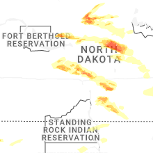
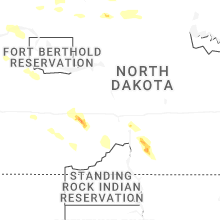


Connect with Interactive Hail Maps