

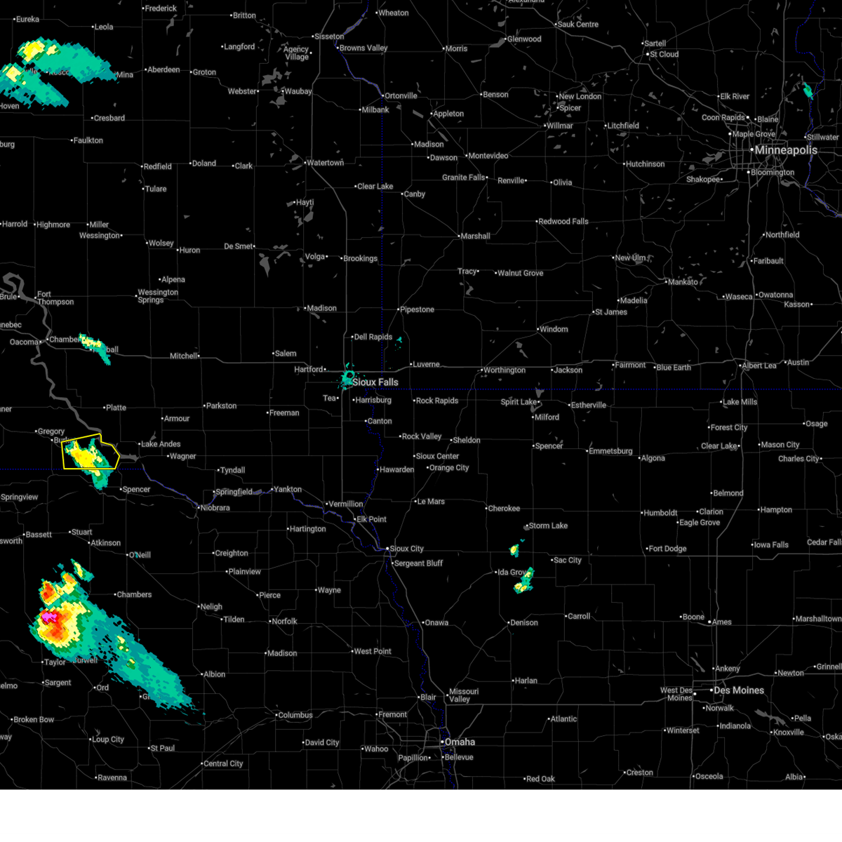
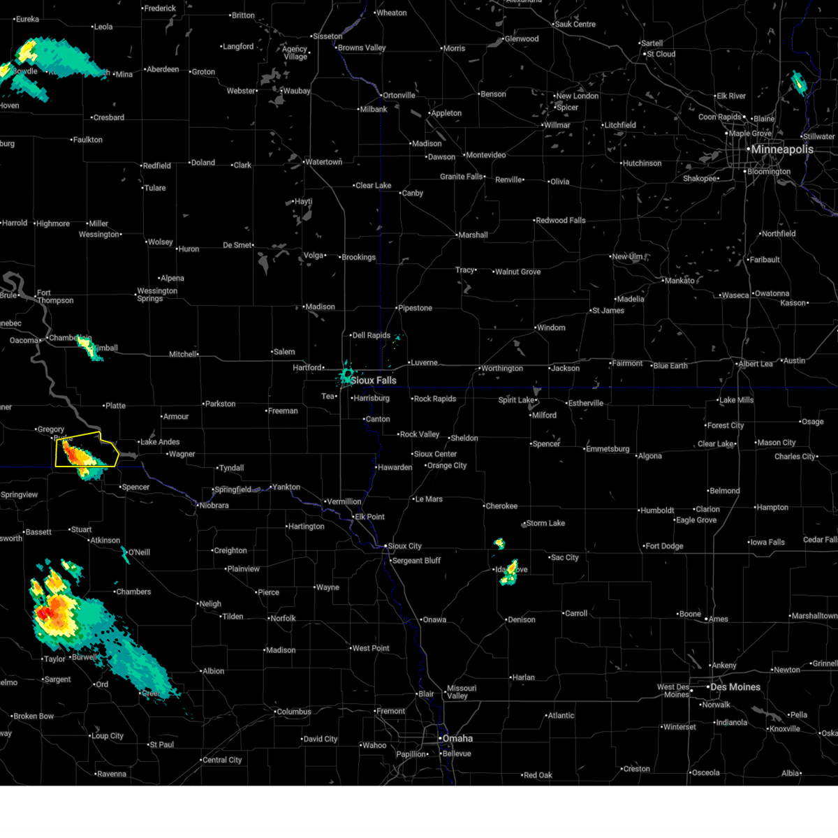
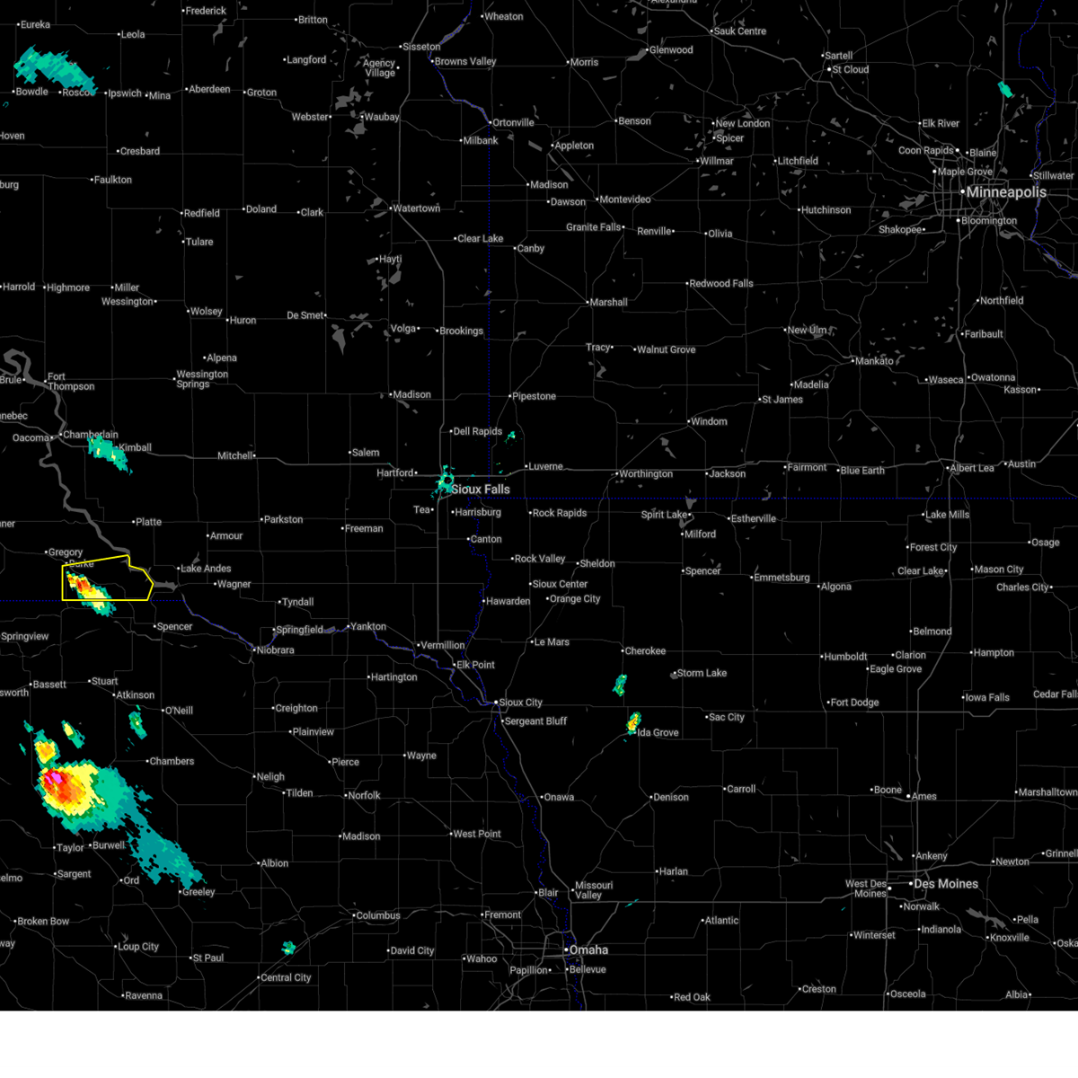
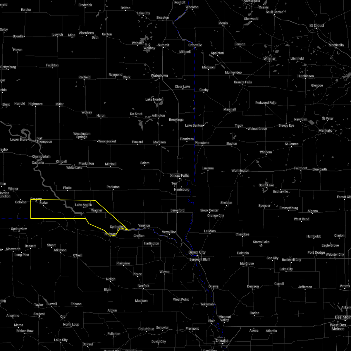
Hail Map for Herrick, SD
The Herrick, SD area has had 2 reports of on-the-ground hail by trained spotters, and has been under severe weather warnings 32 times during the past 12 months. Doppler radar has detected hail at or near Herrick, SD on 63 occasions, including 5 occasions during the past year.
| Name: | Herrick, SD |
| Where Located: | 53 miles NNW of Oneill, NE |
| Map: | Google Map for Herrick, SD |
| Population: | 105 |
| Housing Units: | 58 |
| More Info: | Search Google for Herrick, SD |
1
The Top Recent Hail Date for Herrick, SD is Wednesday, July 31, 2024 (4th out of 63)

Hail and Wind Damage Spotted near Herrick, SD
| Date / Time | Report Details |
|---|---|
| 6/28/2025 11:26 PM CDT |
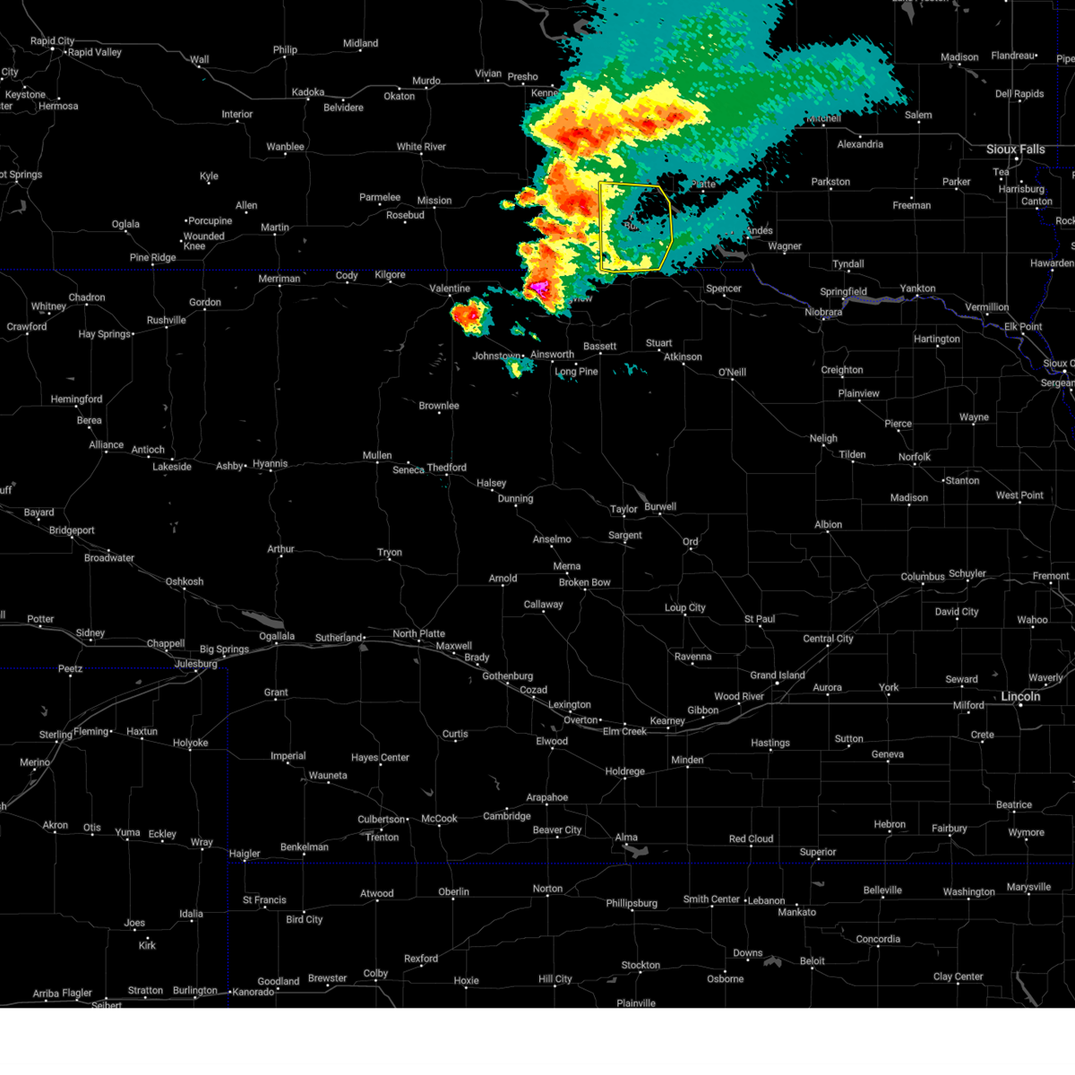
 The storms which prompted the warning have weakened below severe limits, and no longer pose an immediate threat to life or property. therefore, the warning will be allowed to expire. a severe thunderstorm watch remains in effect until 500 am cdt for south central south dakota. to report severe weather, contact your nearest law enforcement agency. they will relay your report to the national weather service sioux falls. The storms which prompted the warning have weakened below severe limits, and no longer pose an immediate threat to life or property. therefore, the warning will be allowed to expire. a severe thunderstorm watch remains in effect until 500 am cdt for south central south dakota. to report severe weather, contact your nearest law enforcement agency. they will relay your report to the national weather service sioux falls.
|
| 6/28/2025 10:57 PM CDT |
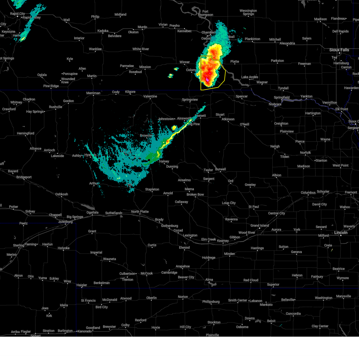
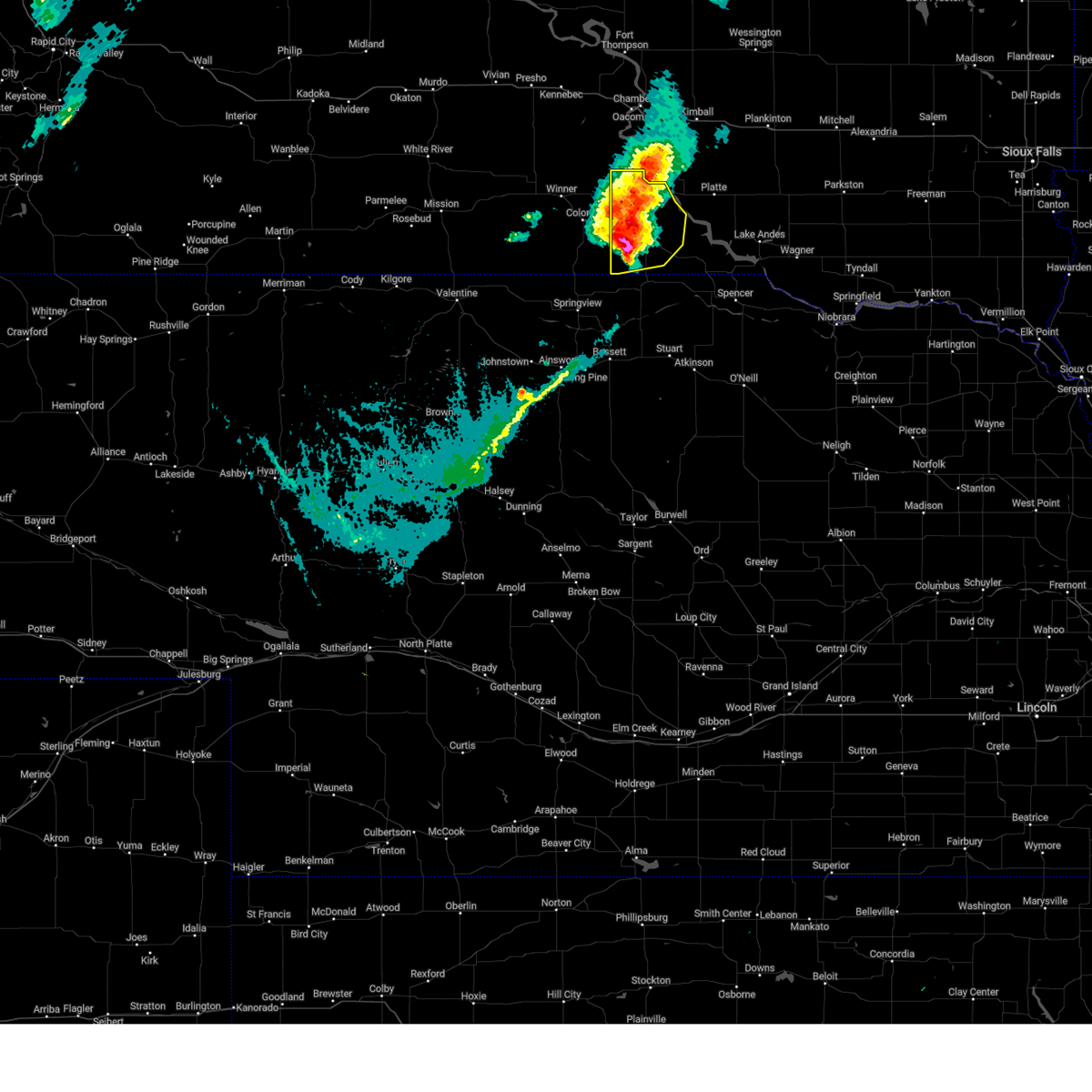
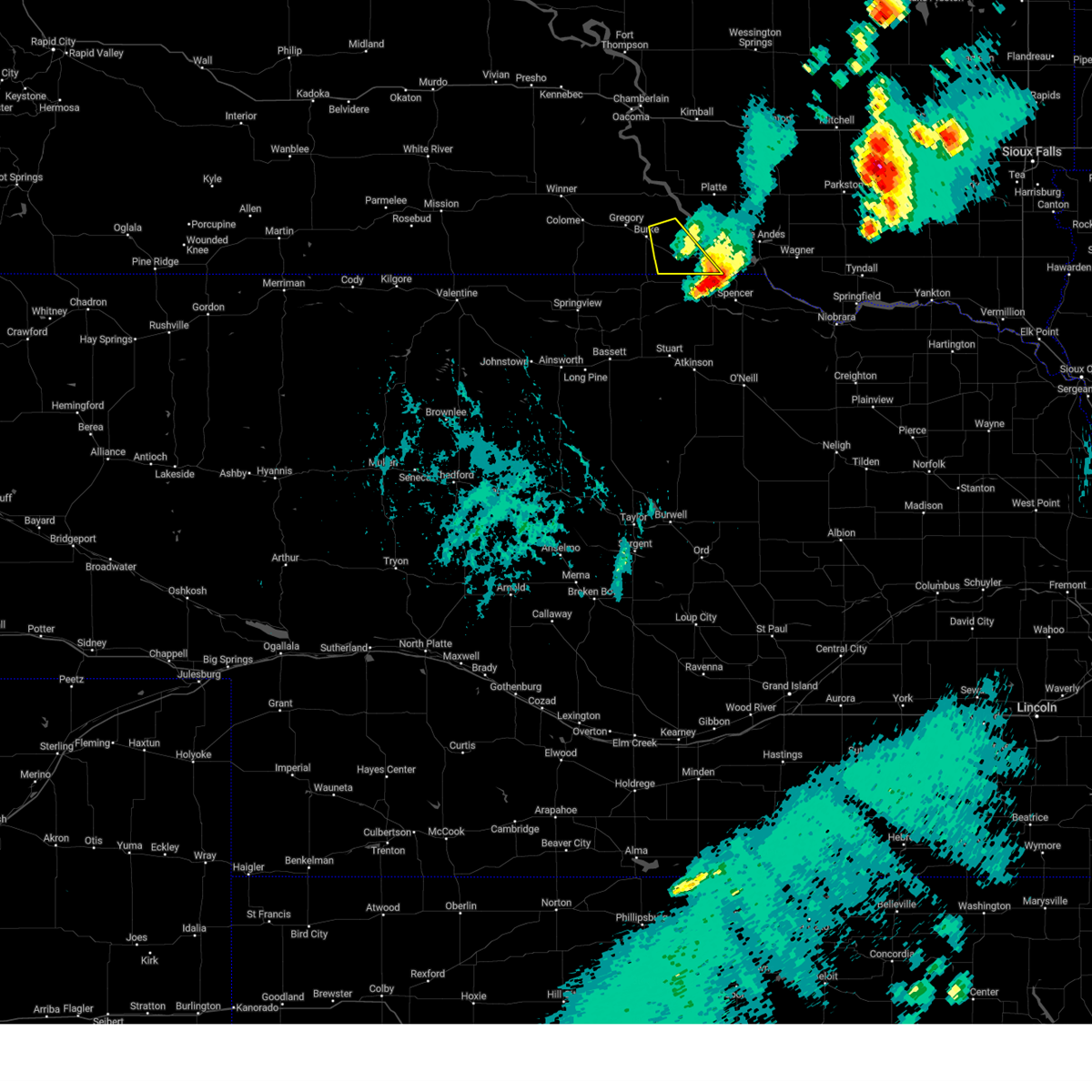
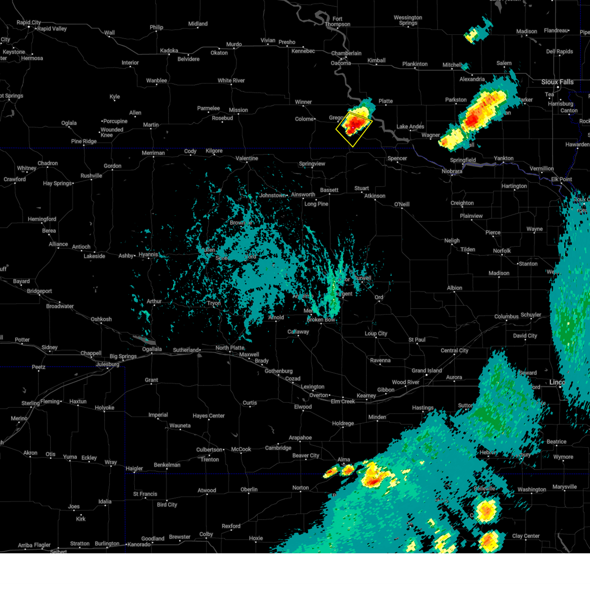
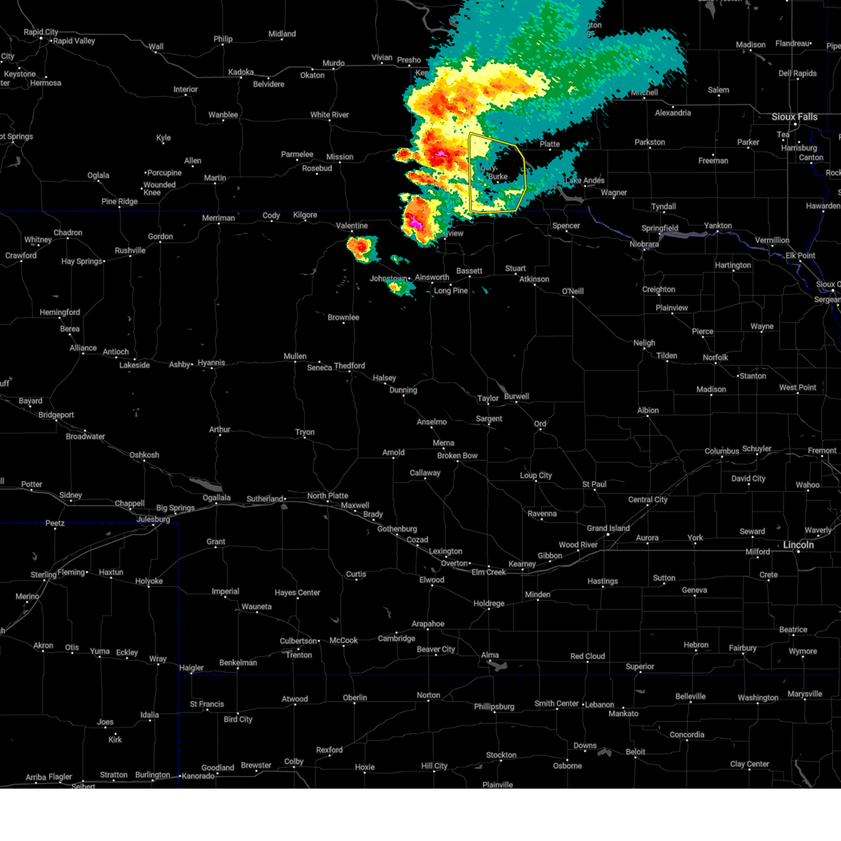
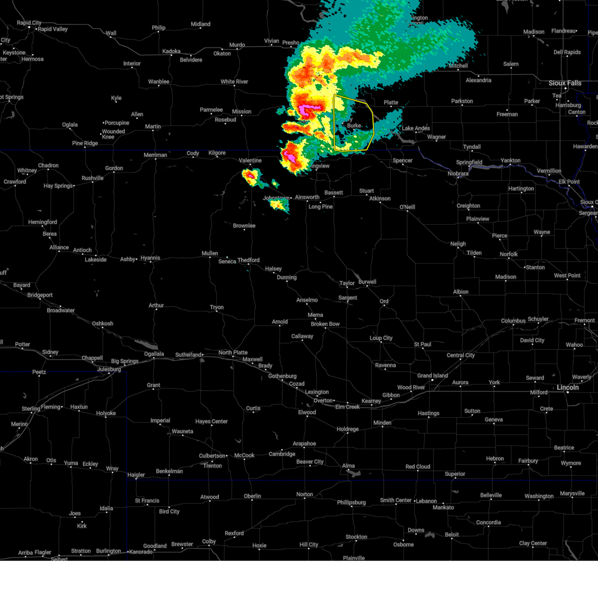
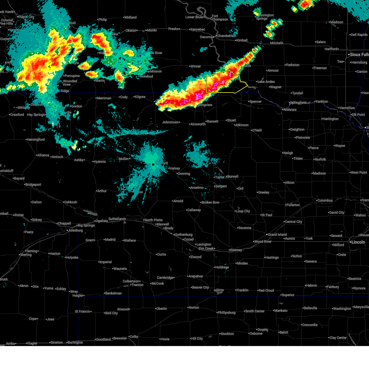 At 1056 pm cdt, severe thunderstorms were located along a line extending from 11 miles north of bonesteel to near herrick to 13 miles southwest of burke, moving southeast at 20 mph (radar indicated). Hazards include ping pong ball size hail and 60 mph wind gusts. People and animals outdoors will be injured. expect hail damage to roofs, siding, windows, and vehicles. expect wind damage to roofs, siding, and trees. locations impacted include, herrick, st. Charles and bonesteel. At 1056 pm cdt, severe thunderstorms were located along a line extending from 11 miles north of bonesteel to near herrick to 13 miles southwest of burke, moving southeast at 20 mph (radar indicated). Hazards include ping pong ball size hail and 60 mph wind gusts. People and animals outdoors will be injured. expect hail damage to roofs, siding, windows, and vehicles. expect wind damage to roofs, siding, and trees. locations impacted include, herrick, st. Charles and bonesteel.
|
| 6/28/2025 10:30 PM CDT |
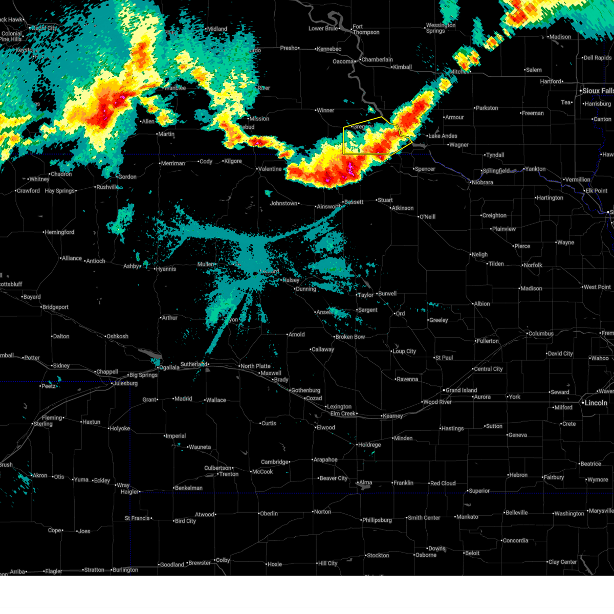
 Svrfsd the national weather service in sioux falls has issued a * severe thunderstorm warning for, gregory county in south central south dakota, * until 1130 pm cdt. * at 1030 pm cdt, severe thunderstorms were located along a line extending from 12 miles north of herrick to near burke to 10 miles northeast of wewela, moving southeast at 20 mph (radar indicated). Hazards include 60 mph wind gusts and half dollar size hail. Hail damage to vehicles is expected. expect wind damage to roofs, siding, and trees. severe thunderstorms will be near, burke around 1035 pm cdt. herrick around 1045 pm cdt. other locations in the path of these severe thunderstorms include st. Charles. Svrfsd the national weather service in sioux falls has issued a * severe thunderstorm warning for, gregory county in south central south dakota, * until 1130 pm cdt. * at 1030 pm cdt, severe thunderstorms were located along a line extending from 12 miles north of herrick to near burke to 10 miles northeast of wewela, moving southeast at 20 mph (radar indicated). Hazards include 60 mph wind gusts and half dollar size hail. Hail damage to vehicles is expected. expect wind damage to roofs, siding, and trees. severe thunderstorms will be near, burke around 1035 pm cdt. herrick around 1045 pm cdt. other locations in the path of these severe thunderstorms include st. Charles.
|
| 6/19/2025 7:07 PM CDT |
 The storm which prompted the warning has weakened below severe limits, and no longer poses an immediate threat to life or property. therefore, the warning will be allowed to expire. however, gusty winds up to 50 mph are still possible with this thunderstorm. to report severe weather, contact your nearest law enforcement agency. they will relay your report to the national weather service sioux falls. The storm which prompted the warning has weakened below severe limits, and no longer poses an immediate threat to life or property. therefore, the warning will be allowed to expire. however, gusty winds up to 50 mph are still possible with this thunderstorm. to report severe weather, contact your nearest law enforcement agency. they will relay your report to the national weather service sioux falls.
|
| 6/19/2025 6:53 PM CDT |
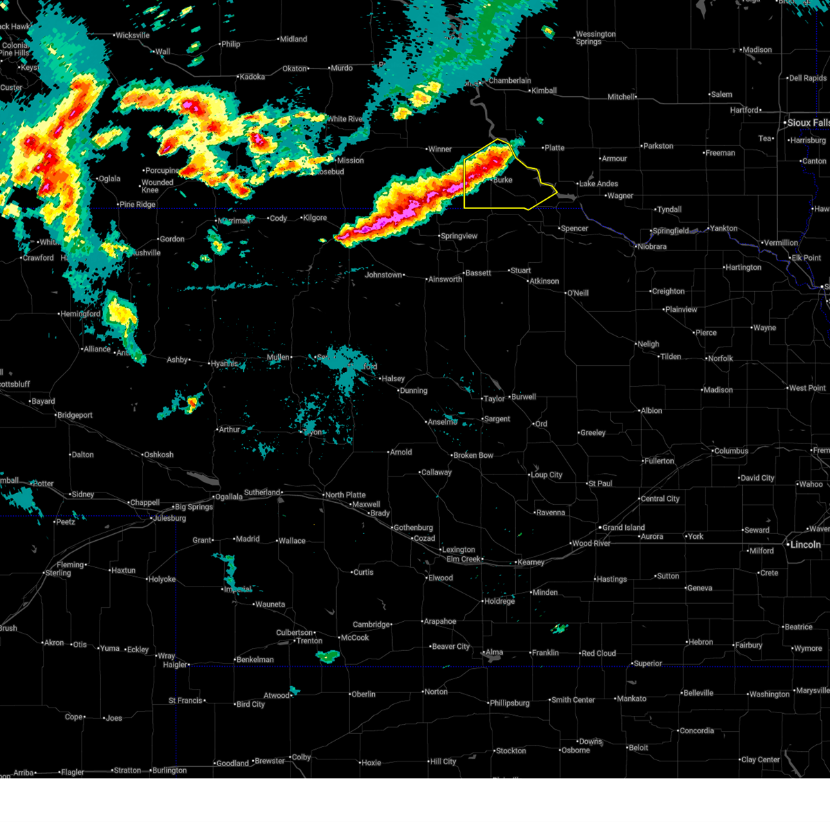
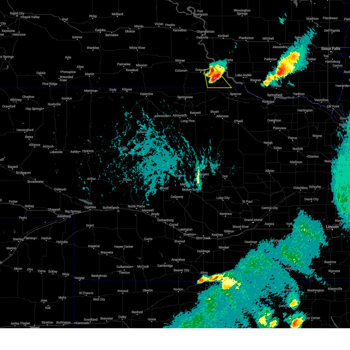
 At 652 pm cdt, a severe thunderstorm was located over st. charles, or 21 miles northwest of spencer, moving east at 30 mph (trained weather spotters. at 640 pm, quarter size hail was reported near herrick). Hazards include 60 mph wind gusts and nickel size hail. Expect damage to roofs, siding, and trees. This severe storm will be near, bonesteel around 700 pm cdt. At 652 pm cdt, a severe thunderstorm was located over st. charles, or 21 miles northwest of spencer, moving east at 30 mph (trained weather spotters. at 640 pm, quarter size hail was reported near herrick). Hazards include 60 mph wind gusts and nickel size hail. Expect damage to roofs, siding, and trees. This severe storm will be near, bonesteel around 700 pm cdt.
|
| 6/19/2025 6:43 PM CDT |
 At 642 pm cdt, a severe thunderstorm was located over st. charles, or 24 miles northwest of spencer, moving east at 30 mph (trained weather spotters. at 640 pm, quarter size hail was reported near herrick). Hazards include 60 mph wind gusts and half dollar size hail. Hail damage to vehicles is expected. expect wind damage to roofs, siding, and trees. this severe storm will be near, bonesteel and st. Charles around 645 pm cdt. At 642 pm cdt, a severe thunderstorm was located over st. charles, or 24 miles northwest of spencer, moving east at 30 mph (trained weather spotters. at 640 pm, quarter size hail was reported near herrick). Hazards include 60 mph wind gusts and half dollar size hail. Hail damage to vehicles is expected. expect wind damage to roofs, siding, and trees. this severe storm will be near, bonesteel and st. Charles around 645 pm cdt.
|
| 6/19/2025 6:40 PM CDT | Quarter sized hail reported 1.9 miles SE of Herrick, SD, dime to quarter-sized hail falling near herrick. |
| 6/19/2025 6:34 PM CDT |
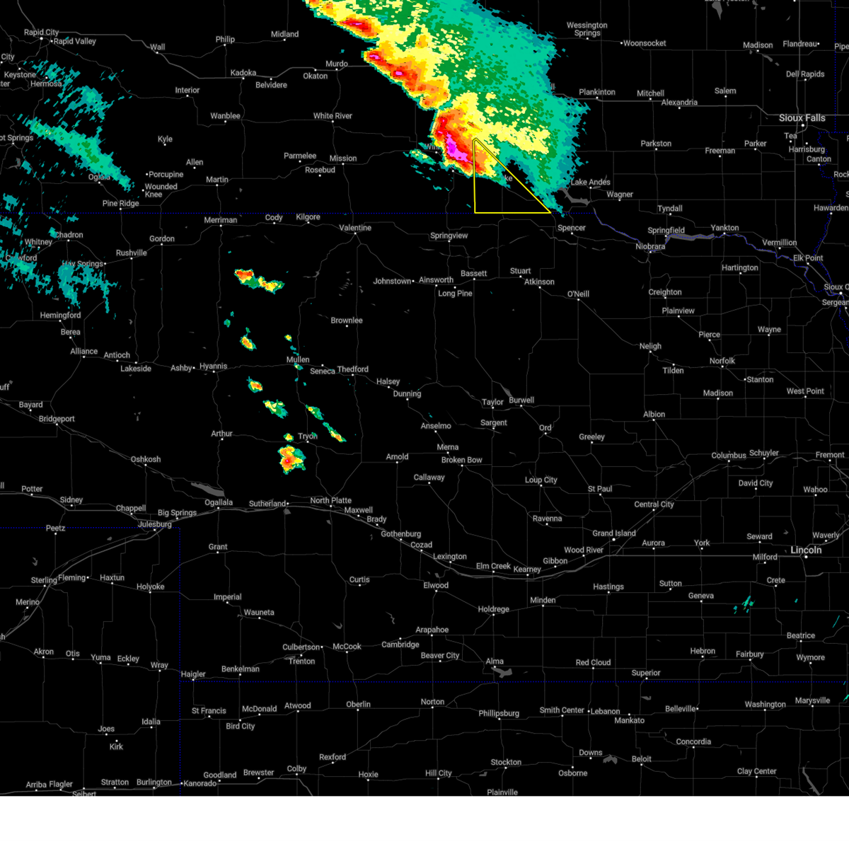
 Svrfsd the national weather service in sioux falls has issued a * severe thunderstorm warning for, southwestern gregory county in south central south dakota, * until 715 pm cdt. * at 634 pm cdt, a severe thunderstorm was located over herrick, or 28 miles northwest of spencer, moving east at 30 mph (radar indicated). Hazards include 60 mph wind gusts and half dollar size hail. Hail damage to vehicles is expected. expect wind damage to roofs, siding, and trees. this severe thunderstorm will be near, st. charles around 640 pm cdt. Bonesteel around 645 pm cdt. Svrfsd the national weather service in sioux falls has issued a * severe thunderstorm warning for, southwestern gregory county in south central south dakota, * until 715 pm cdt. * at 634 pm cdt, a severe thunderstorm was located over herrick, or 28 miles northwest of spencer, moving east at 30 mph (radar indicated). Hazards include 60 mph wind gusts and half dollar size hail. Hail damage to vehicles is expected. expect wind damage to roofs, siding, and trees. this severe thunderstorm will be near, st. charles around 640 pm cdt. Bonesteel around 645 pm cdt.
|
| 8/25/2024 7:12 PM CDT | Personal weather station ksdherri in gregory county SD, 6.3 miles SW of Herrick, SD |
| 8/25/2024 7:07 PM CDT |
 At 705 pm cdt, a severe thunderstorm was located over burke, or 33 miles northeast of springview, moving northeast at 25 mph (public. at 657 pm, quarter sized hail was reported 3 miles west-southwest of burke). Hazards include half dollar size hail. Damage to vehicles is expected. This severe storm will be near, herrick around 710 pm cdt. At 705 pm cdt, a severe thunderstorm was located over burke, or 33 miles northeast of springview, moving northeast at 25 mph (public. at 657 pm, quarter sized hail was reported 3 miles west-southwest of burke). Hazards include half dollar size hail. Damage to vehicles is expected. This severe storm will be near, herrick around 710 pm cdt.
|
| 8/25/2024 6:50 PM CDT |
 At 649 pm cdt, a severe thunderstorm was located near burke, or 27 miles northeast of springview, moving northeast at 20 mph (radar indicated). Hazards include two inch hail. People and animals outdoors will be injured. expect damage to roofs, siding, windows, and vehicles. this severe storm will be near, gregory and burke around 655 pm cdt. Other locations in the path of this severe thunderstorm include herrick. At 649 pm cdt, a severe thunderstorm was located near burke, or 27 miles northeast of springview, moving northeast at 20 mph (radar indicated). Hazards include two inch hail. People and animals outdoors will be injured. expect damage to roofs, siding, windows, and vehicles. this severe storm will be near, gregory and burke around 655 pm cdt. Other locations in the path of this severe thunderstorm include herrick.
|
| 8/25/2024 6:41 PM CDT |
 Svrfsd the national weather service in sioux falls has issued a * severe thunderstorm warning for, gregory county in south central south dakota, * until 745 pm cdt. * at 641 pm cdt, severe thunderstorms were located along a line extending from 7 miles southeast of iona to 6 miles northeast of gregory to 6 miles southwest of burke, moving northeast at 25 mph (radar indicated). Hazards include quarter size hail. Damage to vehicles is expected. severe thunderstorms will be near, burke around 645 pm cdt. Herrick around 650 pm cdt. Svrfsd the national weather service in sioux falls has issued a * severe thunderstorm warning for, gregory county in south central south dakota, * until 745 pm cdt. * at 641 pm cdt, severe thunderstorms were located along a line extending from 7 miles southeast of iona to 6 miles northeast of gregory to 6 miles southwest of burke, moving northeast at 25 mph (radar indicated). Hazards include quarter size hail. Damage to vehicles is expected. severe thunderstorms will be near, burke around 645 pm cdt. Herrick around 650 pm cdt.
|
| 8/18/2024 4:54 AM CDT |
 At 453 am cdt, a severe thunderstorm was located 7 miles southwest of burke, or 26 miles northeast of springview, moving southeast at 35 mph (radar indicated). Hazards include two inch hail and 70 mph wind gusts. People and animals outdoors will be injured. expect hail damage to roofs, siding, windows, and vehicles. expect considerable tree damage. wind damage is also likely to mobile homes, roofs, and outbuildings. Locations impacted include, gregory, burke, dallas, and herrick. At 453 am cdt, a severe thunderstorm was located 7 miles southwest of burke, or 26 miles northeast of springview, moving southeast at 35 mph (radar indicated). Hazards include two inch hail and 70 mph wind gusts. People and animals outdoors will be injured. expect hail damage to roofs, siding, windows, and vehicles. expect considerable tree damage. wind damage is also likely to mobile homes, roofs, and outbuildings. Locations impacted include, gregory, burke, dallas, and herrick.
|
| 8/18/2024 4:31 AM CDT |
 At 431 am cdt, a severe thunderstorm was located over dallas, or 16 miles southeast of winner, moving southeast at 35 mph (radar indicated). Hazards include two inch hail and 70 mph wind gusts. People and animals outdoors will be injured. expect hail damage to roofs, siding, windows, and vehicles. expect considerable tree damage. wind damage is also likely to mobile homes, roofs, and outbuildings. Locations impacted include, gregory, dallas, burke and herrick. At 431 am cdt, a severe thunderstorm was located over dallas, or 16 miles southeast of winner, moving southeast at 35 mph (radar indicated). Hazards include two inch hail and 70 mph wind gusts. People and animals outdoors will be injured. expect hail damage to roofs, siding, windows, and vehicles. expect considerable tree damage. wind damage is also likely to mobile homes, roofs, and outbuildings. Locations impacted include, gregory, dallas, burke and herrick.
|
| 8/18/2024 4:13 AM CDT |
 Svrfsd the national weather service in sioux falls has issued a * severe thunderstorm warning for, southwestern gregory county in south central south dakota, * until 530 am cdt. * at 412 am cdt, a severe thunderstorm was located near ideal south housing, or 7 miles east of winner, moving southeast at 30 mph (radar indicated). Hazards include two inch hail and 70 mph wind gusts. People and animals outdoors will be injured. expect hail damage to roofs, siding, windows, and vehicles. expect considerable tree damage. wind damage is also likely to mobile homes, roofs, and outbuildings. this severe thunderstorm will be near, dallas around 420 am cdt. gregory around 430 am cdt. other locations in the path of this severe thunderstorm include burke, herrick and st. Charles. Svrfsd the national weather service in sioux falls has issued a * severe thunderstorm warning for, southwestern gregory county in south central south dakota, * until 530 am cdt. * at 412 am cdt, a severe thunderstorm was located near ideal south housing, or 7 miles east of winner, moving southeast at 30 mph (radar indicated). Hazards include two inch hail and 70 mph wind gusts. People and animals outdoors will be injured. expect hail damage to roofs, siding, windows, and vehicles. expect considerable tree damage. wind damage is also likely to mobile homes, roofs, and outbuildings. this severe thunderstorm will be near, dallas around 420 am cdt. gregory around 430 am cdt. other locations in the path of this severe thunderstorm include burke, herrick and st. Charles.
|
| 7/31/2024 7:37 PM CDT |
 The storm which prompted the warning has moved out of the area. therefore, the warning will be allowed to expire. however, gusty winds are still possible with this thunderstorm. a severe thunderstorm watch remains in effect until midnight cdt for south central south dakota. to report severe weather, contact your nearest law enforcement agency. they will relay your report to the national weather service sioux falls. The storm which prompted the warning has moved out of the area. therefore, the warning will be allowed to expire. however, gusty winds are still possible with this thunderstorm. a severe thunderstorm watch remains in effect until midnight cdt for south central south dakota. to report severe weather, contact your nearest law enforcement agency. they will relay your report to the national weather service sioux falls.
|
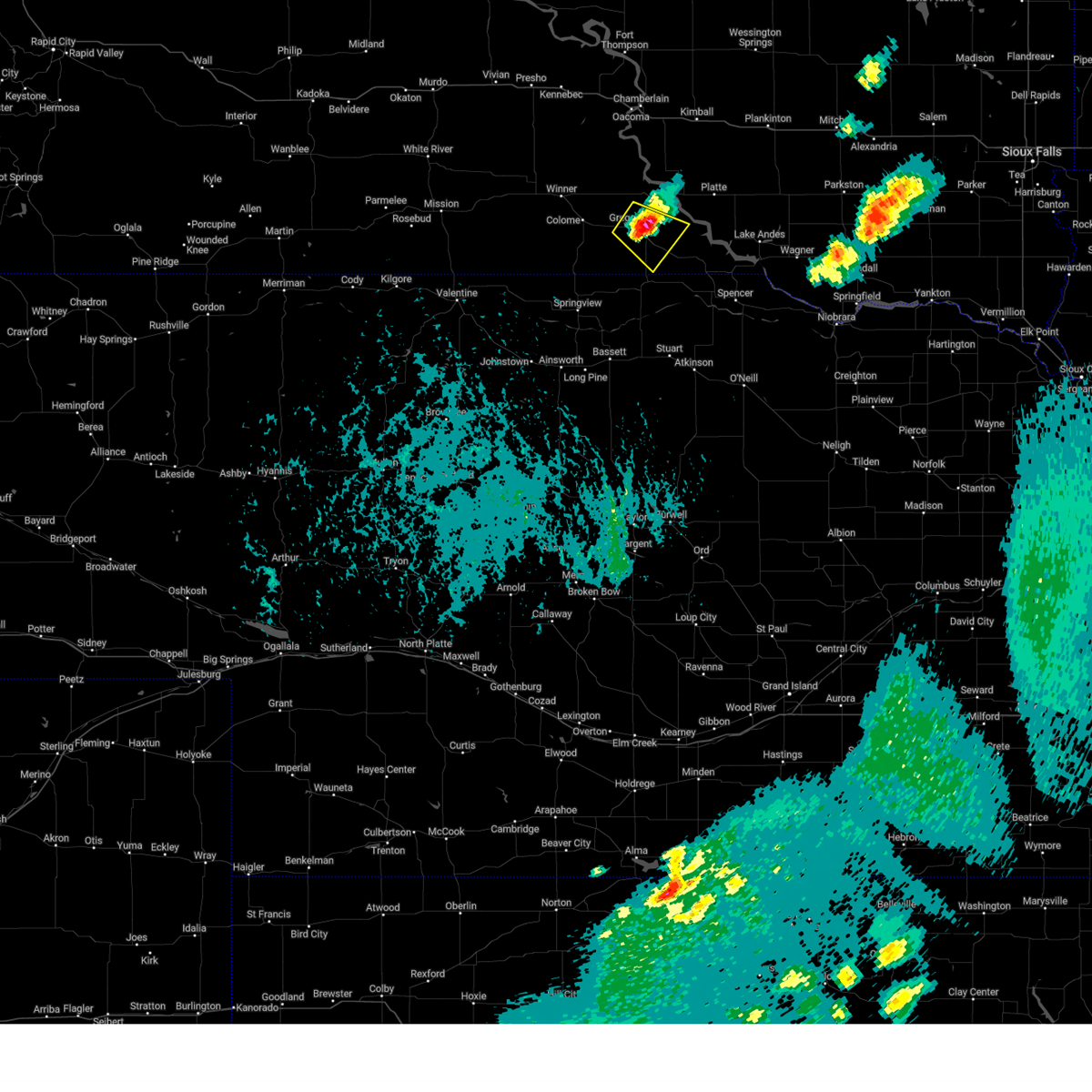
| 7/31/2024 7:18 PM CDT | At 717 pm cdt, a severe thunderstorm was located near bonesteel, or 20 miles northwest of spencer, moving southeast at 25 mph (radar indicated). Hazards include 60 mph wind gusts and quarter size hail. Hail damage to vehicles is expected. expect wind damage to roofs, siding, and trees. Locations impacted include, bonesteel. |
| 7/31/2024 6:57 PM CDT |
 Svrfsd the national weather service in sioux falls has issued a * severe thunderstorm warning for, southwestern gregory county in south central south dakota, * until 745 pm cdt. * at 656 pm cdt, a severe thunderstorm was located near herrick, or 29 miles northwest of spencer, moving southeast at 25 mph (radar indicated). Hazards include 60 mph wind gusts and quarter size hail. Hail damage to vehicles is expected. expect wind damage to roofs, siding, and trees. this severe thunderstorm will be near, herrick and st. charles around 700 pm cdt. Bonesteel around 705 pm cdt. Svrfsd the national weather service in sioux falls has issued a * severe thunderstorm warning for, southwestern gregory county in south central south dakota, * until 745 pm cdt. * at 656 pm cdt, a severe thunderstorm was located near herrick, or 29 miles northwest of spencer, moving southeast at 25 mph (radar indicated). Hazards include 60 mph wind gusts and quarter size hail. Hail damage to vehicles is expected. expect wind damage to roofs, siding, and trees. this severe thunderstorm will be near, herrick and st. charles around 700 pm cdt. Bonesteel around 705 pm cdt.
|
| 7/31/2024 6:49 PM CDT |
 At 648 pm cdt, a severe thunderstorm was located over burke, or 33 miles southeast of winner, moving southeast at 25 mph (law enforcement. at 642 pm, quarter sized hail was reported in burke). Hazards include 60 mph wind gusts and half dollar size hail. Hail damage to vehicles is expected. expect wind damage to roofs, siding, and trees. This severe thunderstorm will remain over mainly rural areas of southwestern gregory county. At 648 pm cdt, a severe thunderstorm was located over burke, or 33 miles southeast of winner, moving southeast at 25 mph (law enforcement. at 642 pm, quarter sized hail was reported in burke). Hazards include 60 mph wind gusts and half dollar size hail. Hail damage to vehicles is expected. expect wind damage to roofs, siding, and trees. This severe thunderstorm will remain over mainly rural areas of southwestern gregory county.
|
| 7/31/2024 6:46 PM CDT |
 At 645 pm cdt, a severe thunderstorm was located over burke, or 32 miles southeast of winner, moving southeast at 25 mph (radar indicated). Hazards include 60 mph wind gusts and half dollar size hail. Hail damage to vehicles is expected. expect wind damage to roofs, siding, and trees. This severe storm will be near, herrick around 650 pm cdt. At 645 pm cdt, a severe thunderstorm was located over burke, or 32 miles southeast of winner, moving southeast at 25 mph (radar indicated). Hazards include 60 mph wind gusts and half dollar size hail. Hail damage to vehicles is expected. expect wind damage to roofs, siding, and trees. This severe storm will be near, herrick around 650 pm cdt.
|
| 7/31/2024 6:36 PM CDT |
 Svrfsd the national weather service in sioux falls has issued a * severe thunderstorm warning for, southwestern gregory county in south central south dakota, * until 700 pm cdt. * at 636 pm cdt, a severe thunderstorm was located near burke, or 29 miles east of winner, moving southeast at 20 mph (radar indicated). Hazards include 60 mph wind gusts and quarter size hail. Hail damage to vehicles is expected. expect wind damage to roofs, siding, and trees. This severe thunderstorm will be near, burke around 640 pm cdt. Svrfsd the national weather service in sioux falls has issued a * severe thunderstorm warning for, southwestern gregory county in south central south dakota, * until 700 pm cdt. * at 636 pm cdt, a severe thunderstorm was located near burke, or 29 miles east of winner, moving southeast at 20 mph (radar indicated). Hazards include 60 mph wind gusts and quarter size hail. Hail damage to vehicles is expected. expect wind damage to roofs, siding, and trees. This severe thunderstorm will be near, burke around 640 pm cdt.
|
| 7/29/2024 8:23 PM CDT |
 The storm which prompted the warning has weakened below severe limits, and no longer poses an immediate threat to life or property. therefore, the warning will be allowed to expire. however, gusty winds to 50 mph are still possible with this thunderstorm. a severe thunderstorm watch remains in effect until midnight cdt for south central south dakota. to report severe weather, contact your nearest law enforcement agency. they will relay your report to the national weather service sioux falls. The storm which prompted the warning has weakened below severe limits, and no longer poses an immediate threat to life or property. therefore, the warning will be allowed to expire. however, gusty winds to 50 mph are still possible with this thunderstorm. a severe thunderstorm watch remains in effect until midnight cdt for south central south dakota. to report severe weather, contact your nearest law enforcement agency. they will relay your report to the national weather service sioux falls.
|
| 7/29/2024 8:11 PM CDT |
 At 810 pm cdt, a severe thunderstorm was located 8 miles south of dallas, or 22 miles northeast of springview, moving east at 45 mph (trained weather spotters). Hazards include 60 mph wind gusts and quarter size hail. at 755 pm cdt a 61 mph wind gust was reported 4 miles north northeast of tripp. Hail damage to vehicles is expected. expect wind damage to roofs, siding, and trees. this severe storm will be near, gregory and dallas around 815 pm cdt. other locations in the path of this severe thunderstorm include burke, herrick and st. Charles. At 810 pm cdt, a severe thunderstorm was located 8 miles south of dallas, or 22 miles northeast of springview, moving east at 45 mph (trained weather spotters). Hazards include 60 mph wind gusts and quarter size hail. at 755 pm cdt a 61 mph wind gust was reported 4 miles north northeast of tripp. Hail damage to vehicles is expected. expect wind damage to roofs, siding, and trees. this severe storm will be near, gregory and dallas around 815 pm cdt. other locations in the path of this severe thunderstorm include burke, herrick and st. Charles.
|
| 7/29/2024 7:58 PM CDT |
 At 756 pm cdt, a severe thunderstorm was located near dallas, or 14 miles southeast of winner, moving east at 45 mph (trained weather spotters). Hazards include 70 mph wind gusts and quarter size hail. at 727 pm cdt, an 84 mph wind was reported south east of witten. Hail damage to vehicles is expected. expect considerable tree damage. wind damage is also likely to mobile homes, roofs, and outbuildings. this severe storm will be near, gregory and dallas around 800 pm cdt. other locations in the path of this severe thunderstorm include burke, herrick and st. Charles. At 756 pm cdt, a severe thunderstorm was located near dallas, or 14 miles southeast of winner, moving east at 45 mph (trained weather spotters). Hazards include 70 mph wind gusts and quarter size hail. at 727 pm cdt, an 84 mph wind was reported south east of witten. Hail damage to vehicles is expected. expect considerable tree damage. wind damage is also likely to mobile homes, roofs, and outbuildings. this severe storm will be near, gregory and dallas around 800 pm cdt. other locations in the path of this severe thunderstorm include burke, herrick and st. Charles.
|
| 7/29/2024 7:46 PM CDT |
 Svrfsd the national weather service in sioux falls has issued a * severe thunderstorm warning for, gregory county in south central south dakota, * until 830 pm cdt. * at 745 pm cdt, a severe thunderstorm was located near colome, or 7 miles southeast of winner, moving east at 45 mph. this is a destructive storm for burke, gregory, and dallas (trained weather spotters). Hazards include 80 mph wind gusts and ping pong ball size hail. at 727 pm cdt an 84 mph wind gust was reported in witten. Flying debris will be dangerous to those caught without shelter. mobile homes will be heavily damaged. expect considerable damage to roofs, windows, and vehicles. extensive tree damage and power outages are likely. this severe thunderstorm will be near, dallas around 750 pm cdt. gregory around 755 pm cdt. Other locations in the path of this severe thunderstorm include burke and herrick. Svrfsd the national weather service in sioux falls has issued a * severe thunderstorm warning for, gregory county in south central south dakota, * until 830 pm cdt. * at 745 pm cdt, a severe thunderstorm was located near colome, or 7 miles southeast of winner, moving east at 45 mph. this is a destructive storm for burke, gregory, and dallas (trained weather spotters). Hazards include 80 mph wind gusts and ping pong ball size hail. at 727 pm cdt an 84 mph wind gust was reported in witten. Flying debris will be dangerous to those caught without shelter. mobile homes will be heavily damaged. expect considerable damage to roofs, windows, and vehicles. extensive tree damage and power outages are likely. this severe thunderstorm will be near, dallas around 750 pm cdt. gregory around 755 pm cdt. Other locations in the path of this severe thunderstorm include burke and herrick.
|
| 7/29/2024 7:44 PM CDT |
 Svrfsd the national weather service in sioux falls has issued a * severe thunderstorm warning for, gregory county in south central south dakota, * until 830 pm cdt. * at 743 pm cdt, a severe thunderstorm was located near ideal south housing, or near winner, moving east at 45 mph. this is a destructive storm for gregory, burke, and dallas (trained weather spotters). Hazards include 80 mph wind gusts and ping pong ball size hail. at 727 pm mdt an 84 mph wind was reported near witten. Flying debris will be dangerous to those caught without shelter. mobile homes will be heavily damaged. expect considerable damage to roofs, windows, and vehicles. extensive tree damage and power outages are likely. this severe thunderstorm will be near, dallas around 750 pm cdt. gregory around 755 pm cdt. Other locations in the path of this severe thunderstorm include burke and herrick. Svrfsd the national weather service in sioux falls has issued a * severe thunderstorm warning for, gregory county in south central south dakota, * until 830 pm cdt. * at 743 pm cdt, a severe thunderstorm was located near ideal south housing, or near winner, moving east at 45 mph. this is a destructive storm for gregory, burke, and dallas (trained weather spotters). Hazards include 80 mph wind gusts and ping pong ball size hail. at 727 pm mdt an 84 mph wind was reported near witten. Flying debris will be dangerous to those caught without shelter. mobile homes will be heavily damaged. expect considerable damage to roofs, windows, and vehicles. extensive tree damage and power outages are likely. this severe thunderstorm will be near, dallas around 750 pm cdt. gregory around 755 pm cdt. Other locations in the path of this severe thunderstorm include burke and herrick.
|
| 7/29/2024 2:25 AM CDT |
 At 225 am cdt, severe thunderstorms were located along a line extending from 8 miles south of grass ranch colony to near platte to near st. charles, moving east at 45 mph (radar indicated). Hazards include 60 mph wind gusts and quarter size hail. Hail damage to vehicles is expected. expect wind damage to roofs, siding, and trees. these severe storms will be near, platte, bonesteel, geddes, and st. charles around 230 am cdt. new holland around 235 am cdt. aurora center around 240 am cdt. harrison around 245 am cdt. lake andes around 250 am cdt. Other locations impacted by these severe thunderstorms include fairfax and northwestern yankton sioux tribal nation. At 225 am cdt, severe thunderstorms were located along a line extending from 8 miles south of grass ranch colony to near platte to near st. charles, moving east at 45 mph (radar indicated). Hazards include 60 mph wind gusts and quarter size hail. Hail damage to vehicles is expected. expect wind damage to roofs, siding, and trees. these severe storms will be near, platte, bonesteel, geddes, and st. charles around 230 am cdt. new holland around 235 am cdt. aurora center around 240 am cdt. harrison around 245 am cdt. lake andes around 250 am cdt. Other locations impacted by these severe thunderstorms include fairfax and northwestern yankton sioux tribal nation.
|
| 7/29/2024 1:56 AM CDT |
 Svrfsd the national weather service in sioux falls has issued a * severe thunderstorm warning for, southwestern aurora county in south central south dakota, northwestern charles mix county in south central south dakota, gregory county in south central south dakota, northwestern douglas county in south central south dakota, southern brule county in south central south dakota, * until 300 am cdt. * at 155 am cdt, severe thunderstorms were located along a line extending from near iona to 9 miles north of burke to 7 miles south of gregory, moving east at 40 mph (radar indicated). Hazards include 60 mph wind gusts and quarter size hail. Hail damage to vehicles is expected. expect wind damage to roofs, siding, and trees. severe thunderstorms will be near, burke around 200 am cdt. herrick around 205 am cdt. platte and st. charles around 215 am cdt. Other locations in the path of these severe thunderstorms include bonesteel, geddes, new holland, harrison, aurora center and lake andes. Svrfsd the national weather service in sioux falls has issued a * severe thunderstorm warning for, southwestern aurora county in south central south dakota, northwestern charles mix county in south central south dakota, gregory county in south central south dakota, northwestern douglas county in south central south dakota, southern brule county in south central south dakota, * until 300 am cdt. * at 155 am cdt, severe thunderstorms were located along a line extending from near iona to 9 miles north of burke to 7 miles south of gregory, moving east at 40 mph (radar indicated). Hazards include 60 mph wind gusts and quarter size hail. Hail damage to vehicles is expected. expect wind damage to roofs, siding, and trees. severe thunderstorms will be near, burke around 200 am cdt. herrick around 205 am cdt. platte and st. charles around 215 am cdt. Other locations in the path of these severe thunderstorms include bonesteel, geddes, new holland, harrison, aurora center and lake andes.
|
| 7/14/2024 4:15 AM CDT |
 The storms which prompted the warning have weakened below severe limits, and no longer pose an immediate threat to life or property. therefore, the warning will be allowed to expire. however, gusty winds and heavy rain are still possible with these thunderstorms. a severe thunderstorm watch remains in effect until 800 am cdt for south central and southeastern south dakota. The storms which prompted the warning have weakened below severe limits, and no longer pose an immediate threat to life or property. therefore, the warning will be allowed to expire. however, gusty winds and heavy rain are still possible with these thunderstorms. a severe thunderstorm watch remains in effect until 800 am cdt for south central and southeastern south dakota.
|
| 7/14/2024 4:04 AM CDT |
 At 402 am cdt, severe thunderstorms were located along a line extending from mount vernon to near armour to near lynch, moving east at 55 mph (trained weather spotters. at 333 am, the sddot site at the platte-winner bridge recorded a 68 mph wind gust). Hazards include 60 mph wind gusts. Expect damage to roofs, siding, and trees. Locations impacted include, wagner, marty, delmont, dante, parkston, dimock, tripp, avon, kaylor, milltown, tyndall, springfield, scotland and clayton. At 402 am cdt, severe thunderstorms were located along a line extending from mount vernon to near armour to near lynch, moving east at 55 mph (trained weather spotters. at 333 am, the sddot site at the platte-winner bridge recorded a 68 mph wind gust). Hazards include 60 mph wind gusts. Expect damage to roofs, siding, and trees. Locations impacted include, wagner, marty, delmont, dante, parkston, dimock, tripp, avon, kaylor, milltown, tyndall, springfield, scotland and clayton.
|
| 7/14/2024 3:28 AM CDT |
 Svrfsd the national weather service in sioux falls has issued a * severe thunderstorm warning for, charles mix county in south central south dakota, gregory county in south central south dakota, bon homme county in southeastern south dakota, douglas county in south central south dakota, yankton county in southeastern south dakota, turner county in southeastern south dakota, hutchinson county in southeastern south dakota, * until 415 am cdt. * at 328 am cdt, severe thunderstorms were located along a line extending from alexandria to near tripp to near verdel, moving east at 65 mph (radar indicated). Hazards include 60 mph wind gusts. Expect damage to roofs, siding, and trees. severe thunderstorms will be near, tyndall, springfield, scotland, menno, kaylor, and clayton around 335 am cdt. freeman, tabor, and dolton around 345 am cdt. Other locations in the path of these severe thunderstorms include lewis and clark state recreation area, marion, utica, yankton, parker, mayfield, monroe, viborg, irene, hurley, mission hill, chancellor, volin and davis. Svrfsd the national weather service in sioux falls has issued a * severe thunderstorm warning for, charles mix county in south central south dakota, gregory county in south central south dakota, bon homme county in southeastern south dakota, douglas county in south central south dakota, yankton county in southeastern south dakota, turner county in southeastern south dakota, hutchinson county in southeastern south dakota, * until 415 am cdt. * at 328 am cdt, severe thunderstorms were located along a line extending from alexandria to near tripp to near verdel, moving east at 65 mph (radar indicated). Hazards include 60 mph wind gusts. Expect damage to roofs, siding, and trees. severe thunderstorms will be near, tyndall, springfield, scotland, menno, kaylor, and clayton around 335 am cdt. freeman, tabor, and dolton around 345 am cdt. Other locations in the path of these severe thunderstorms include lewis and clark state recreation area, marion, utica, yankton, parker, mayfield, monroe, viborg, irene, hurley, mission hill, chancellor, volin and davis.
|
| 7/14/2024 3:11 AM CDT |
 At 310 am cdt, severe thunderstorms were located along a line extending from 6 miles northeast of white lake to near new holland to near naper, moving southeast at 60 mph (trained weather spotters. at 248 am, the dixon mesonet recorded a 64 mph wind gust). Hazards include 60 mph wind gusts. Expect damage to roofs, siding, and trees. locations impacted include, lake andes, pickstown, wagner, gregory, platte, armour, burke, corsica, marty, bonesteel, delmont, geddes, dallas, herrick, dante, new holland, ravinia, harrison, st. Charles, and fairfax. At 310 am cdt, severe thunderstorms were located along a line extending from 6 miles northeast of white lake to near new holland to near naper, moving southeast at 60 mph (trained weather spotters. at 248 am, the dixon mesonet recorded a 64 mph wind gust). Hazards include 60 mph wind gusts. Expect damage to roofs, siding, and trees. locations impacted include, lake andes, pickstown, wagner, gregory, platte, armour, burke, corsica, marty, bonesteel, delmont, geddes, dallas, herrick, dante, new holland, ravinia, harrison, st. Charles, and fairfax.
|
| 7/14/2024 2:38 AM CDT |
 At 236 am cdt, severe thunderstorms were located along a line extending from near shelby to 11 miles east of iona to near ideal south housing, moving east at 40 mph (trained weather spotters. at 220 am, the gregory north mesonet recorded a 61 mph wind gust). Hazards include 60 mph wind gusts. Expect damage to roofs, siding, and trees. locations impacted include, lake andes, pickstown, wagner, gregory, platte, armour, burke, corsica, marty, bonesteel, delmont, geddes, dallas, herrick, dante, new holland, ravinia, harrison, st. Charles, and fairfax. At 236 am cdt, severe thunderstorms were located along a line extending from near shelby to 11 miles east of iona to near ideal south housing, moving east at 40 mph (trained weather spotters. at 220 am, the gregory north mesonet recorded a 61 mph wind gust). Hazards include 60 mph wind gusts. Expect damage to roofs, siding, and trees. locations impacted include, lake andes, pickstown, wagner, gregory, platte, armour, burke, corsica, marty, bonesteel, delmont, geddes, dallas, herrick, dante, new holland, ravinia, harrison, st. Charles, and fairfax.
|
| 7/14/2024 2:20 AM CDT |
 Svrfsd the national weather service in sioux falls has issued a * severe thunderstorm warning for, southwestern davison county in southeastern south dakota, southern aurora county in south central south dakota, charles mix county in south central south dakota, gregory county in south central south dakota, douglas county in south central south dakota, southeastern brule county in south central south dakota, * until 330 am cdt. * at 219 am cdt, severe thunderstorms were located along a line extending from lees corner to 7 miles south of lake francis case to 6 miles southeast of witten, moving southeast at 40 mph (radar indicated). Hazards include 60 mph wind gusts. expect damage to roofs, siding, and trees Svrfsd the national weather service in sioux falls has issued a * severe thunderstorm warning for, southwestern davison county in southeastern south dakota, southern aurora county in south central south dakota, charles mix county in south central south dakota, gregory county in south central south dakota, douglas county in south central south dakota, southeastern brule county in south central south dakota, * until 330 am cdt. * at 219 am cdt, severe thunderstorms were located along a line extending from lees corner to 7 miles south of lake francis case to 6 miles southeast of witten, moving southeast at 40 mph (radar indicated). Hazards include 60 mph wind gusts. expect damage to roofs, siding, and trees
|
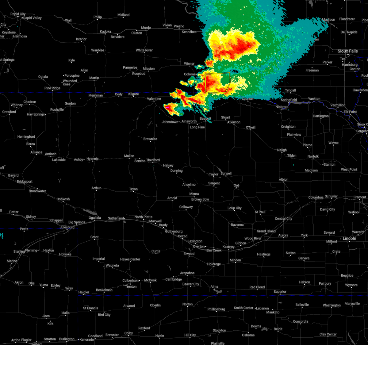
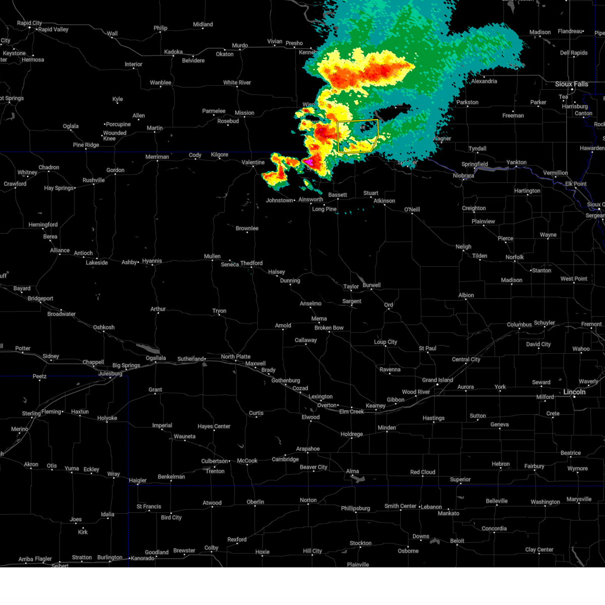
| 6/16/2024 10:55 PM CDT |
 The storm which prompted the warning has weakened below severe limits, and no longer poses an immediate threat to life or property. therefore, the warning will be allowed to expire. however, heavy rain and small hail are still possible with this thunderstorm. a severe thunderstorm watch remains in effect until 600 am cdt for south central south dakota. to report severe weather, contact your nearest law enforcement agency. they will relay your report to the national weather service sioux falls. The storm which prompted the warning has weakened below severe limits, and no longer poses an immediate threat to life or property. therefore, the warning will be allowed to expire. however, heavy rain and small hail are still possible with this thunderstorm. a severe thunderstorm watch remains in effect until 600 am cdt for south central south dakota. to report severe weather, contact your nearest law enforcement agency. they will relay your report to the national weather service sioux falls.
|
| 6/16/2024 10:45 PM CDT |
 At 1045 pm cdt, a severe thunderstorm was located 9 miles south of gregory, or 23 miles northeast of springview, moving northeast at 40 mph (radar indicated). Hazards include 60 mph wind gusts and quarter size hail. Hail damage to vehicles is expected. expect wind damage to roofs, siding, and trees. locations impacted include, gregory, platte, burke, bonesteel, geddes, dallas, herrick, st. Charles, and northwestern yankton sioux tribal nation. At 1045 pm cdt, a severe thunderstorm was located 9 miles south of gregory, or 23 miles northeast of springview, moving northeast at 40 mph (radar indicated). Hazards include 60 mph wind gusts and quarter size hail. Hail damage to vehicles is expected. expect wind damage to roofs, siding, and trees. locations impacted include, gregory, platte, burke, bonesteel, geddes, dallas, herrick, st. Charles, and northwestern yankton sioux tribal nation.
|
| 6/16/2024 10:13 PM CDT |
 Svrfsd the national weather service in sioux falls has issued a * severe thunderstorm warning for, northwestern charles mix county in south central south dakota, gregory county in south central south dakota, * until 1100 pm cdt. * at 1013 pm cdt, a severe thunderstorm was located over herrick, or 31 miles northwest of spencer, moving northeast at 35 mph (radar indicated). Hazards include 60 mph wind gusts and quarter size hail. Hail damage to vehicles is expected. expect wind damage to roofs, siding, and trees. this severe thunderstorm will be near, st. charles around 1020 pm cdt. platte around 1045 pm cdt. Other locations impacted by this severe thunderstorm include northwestern yankton sioux tribal nation. Svrfsd the national weather service in sioux falls has issued a * severe thunderstorm warning for, northwestern charles mix county in south central south dakota, gregory county in south central south dakota, * until 1100 pm cdt. * at 1013 pm cdt, a severe thunderstorm was located over herrick, or 31 miles northwest of spencer, moving northeast at 35 mph (radar indicated). Hazards include 60 mph wind gusts and quarter size hail. Hail damage to vehicles is expected. expect wind damage to roofs, siding, and trees. this severe thunderstorm will be near, st. charles around 1020 pm cdt. platte around 1045 pm cdt. Other locations impacted by this severe thunderstorm include northwestern yankton sioux tribal nation.
|
| 7/18/2023 10:39 PM CDT |
 The severe thunderstorm warning for central charles mix and gregory counties will expire at 1045 pm cdt, the storm which prompted the warning has exited the warned area. therefore, the warning will be allowed to expire. a severe thunderstorm watch remains in effect until 200 am cdt for south central south dakota. to report severe weather, contact your nearest law enforcement agency. they will relay your report to the national weather service sioux falls. The severe thunderstorm warning for central charles mix and gregory counties will expire at 1045 pm cdt, the storm which prompted the warning has exited the warned area. therefore, the warning will be allowed to expire. a severe thunderstorm watch remains in effect until 200 am cdt for south central south dakota. to report severe weather, contact your nearest law enforcement agency. they will relay your report to the national weather service sioux falls.
|
| 7/18/2023 10:20 PM CDT |
 At 1019 pm cdt, a severe thunderstorm was located near pickstown, moving southeast at 45 mph (south dakota mesonet station near gregory reported a 59 mph wind gust at 1015 pm cdt). Hazards include ping pong ball size hail and 60 mph wind gusts. People and animals outdoors will be injured. expect hail damage to roofs, siding, windows, and vehicles. expect wind damage to roofs, siding, and trees. locations impacted include, lake andes, pickstown, gregory, burke, bonesteel, geddes, herrick, st. charles, fairfax and southwestern yankton sioux tribal nation. hail threat, radar indicated max hail size, 1. 50 in wind threat, observed max wind gust, 60 mph. At 1019 pm cdt, a severe thunderstorm was located near pickstown, moving southeast at 45 mph (south dakota mesonet station near gregory reported a 59 mph wind gust at 1015 pm cdt). Hazards include ping pong ball size hail and 60 mph wind gusts. People and animals outdoors will be injured. expect hail damage to roofs, siding, windows, and vehicles. expect wind damage to roofs, siding, and trees. locations impacted include, lake andes, pickstown, gregory, burke, bonesteel, geddes, herrick, st. charles, fairfax and southwestern yankton sioux tribal nation. hail threat, radar indicated max hail size, 1. 50 in wind threat, observed max wind gust, 60 mph.
|
| 7/18/2023 10:15 PM CDT |
 At 1014 pm cdt, a severe thunderstorm was located near pickstown, moving southeast at 45 mph (radar indicated). Hazards include ping pong ball size hail and 60 mph wind gusts. People and animals outdoors will be injured. expect hail damage to roofs, siding, windows, and vehicles. Expect wind damage to roofs, siding, and trees. At 1014 pm cdt, a severe thunderstorm was located near pickstown, moving southeast at 45 mph (radar indicated). Hazards include ping pong ball size hail and 60 mph wind gusts. People and animals outdoors will be injured. expect hail damage to roofs, siding, windows, and vehicles. Expect wind damage to roofs, siding, and trees.
|
| 7/18/2023 9:53 PM CDT |
 At 951 pm cdt, a severe thunderstorm was located 10 miles west of geddes, or 18 miles west of lake andes, moving southeast at 40 mph (mesonet site reported a 57 mph wind gust 14 miles west of platte, sd around 928 pm cdt). Hazards include 60 mph wind gusts and quarter size hail. Hail damage to vehicles is expected. expect wind damage to roofs, siding, and trees. locations impacted include, lake andes, pickstown, gregory, platte, burke, bonesteel, geddes, dallas, herrick, st. charles, fairfax, dixon in gregory county and southwestern yankton sioux tribal nation. hail threat, radar indicated max hail size, 1. 00 in wind threat, observed max wind gust, 60 mph. At 951 pm cdt, a severe thunderstorm was located 10 miles west of geddes, or 18 miles west of lake andes, moving southeast at 40 mph (mesonet site reported a 57 mph wind gust 14 miles west of platte, sd around 928 pm cdt). Hazards include 60 mph wind gusts and quarter size hail. Hail damage to vehicles is expected. expect wind damage to roofs, siding, and trees. locations impacted include, lake andes, pickstown, gregory, platte, burke, bonesteel, geddes, dallas, herrick, st. charles, fairfax, dixon in gregory county and southwestern yankton sioux tribal nation. hail threat, radar indicated max hail size, 1. 00 in wind threat, observed max wind gust, 60 mph.
|
| 7/18/2023 9:33 PM CDT |
 At 932 pm cdt, a severe thunderstorm was located 12 miles west of platte, or 29 miles south of kimball, moving southeast at 45 mph (radar indicated). Hazards include 60 mph wind gusts and quarter size hail. Hail damage to vehicles is expected. Expect wind damage to roofs, siding, and trees. At 932 pm cdt, a severe thunderstorm was located 12 miles west of platte, or 29 miles south of kimball, moving southeast at 45 mph (radar indicated). Hazards include 60 mph wind gusts and quarter size hail. Hail damage to vehicles is expected. Expect wind damage to roofs, siding, and trees.
|
| 7/12/2023 3:05 AM CDT |
 At 302 am cdt, severe thunderstorms were located along a line extending from 10 miles west of platte to 14 miles northeast of springview, moving east at 60 mph (radar indicated). Hazards include 60 mph wind gusts. Expect damage to roofs, siding, and trees. these severe storms will be near, bonesteel around 315 am cdt. geddes around 320 am cdt. lake andes around 330 am cdt. other locations impacted by these severe thunderstorms include fairfax and northwestern yankton sioux tribal nation. wind gusts to 55 mph were measured by south dakota road weather information sites near dallas and 53 mph near dixon before 3 am. hail threat, radar indicated max hail size, <. 75 in wind threat, radar indicated max wind gust, 60 mph. At 302 am cdt, severe thunderstorms were located along a line extending from 10 miles west of platte to 14 miles northeast of springview, moving east at 60 mph (radar indicated). Hazards include 60 mph wind gusts. Expect damage to roofs, siding, and trees. these severe storms will be near, bonesteel around 315 am cdt. geddes around 320 am cdt. lake andes around 330 am cdt. other locations impacted by these severe thunderstorms include fairfax and northwestern yankton sioux tribal nation. wind gusts to 55 mph were measured by south dakota road weather information sites near dallas and 53 mph near dixon before 3 am. hail threat, radar indicated max hail size, <. 75 in wind threat, radar indicated max wind gust, 60 mph.
|
| 7/12/2023 2:43 AM CDT |
 At 242 am cdt, severe thunderstorms were located along a line extending from 9 miles south of iona to near wewela, moving east at 55 mph (radar indicated). Hazards include 60 mph wind gusts. Expect damage to roofs, siding, and trees. severe thunderstorms will be near, gregory around 250 am cdt. burke around 255 am cdt. herrick around 305 am cdt. st. charles around 310 am cdt. bonesteel around 315 am cdt. geddes around 325 am cdt. lake andes around 330 am cdt. other locations impacted by these severe thunderstorms include dixon in gregory county, fairfax and northwestern yankton sioux tribal nation. hail threat, radar indicated max hail size, <. 75 in wind threat, radar indicated max wind gust, 60 mph. At 242 am cdt, severe thunderstorms were located along a line extending from 9 miles south of iona to near wewela, moving east at 55 mph (radar indicated). Hazards include 60 mph wind gusts. Expect damage to roofs, siding, and trees. severe thunderstorms will be near, gregory around 250 am cdt. burke around 255 am cdt. herrick around 305 am cdt. st. charles around 310 am cdt. bonesteel around 315 am cdt. geddes around 325 am cdt. lake andes around 330 am cdt. other locations impacted by these severe thunderstorms include dixon in gregory county, fairfax and northwestern yankton sioux tribal nation. hail threat, radar indicated max hail size, <. 75 in wind threat, radar indicated max wind gust, 60 mph.
|
| 7/5/2022 2:36 PM CDT |
 At 236 pm cdt, severe thunderstorms were located along a line extending from near armour to 7 miles northwest of gross to 8 miles south of naper, moving southeast at 45 mph (trained weather spotters. at 224 pm cdt, a 67 mph wind gust was reported at fort randall dam). Hazards include 70 mph wind gusts. Expect considerable tree damage. damage is likely to mobile homes, roofs, and outbuildings. these severe storms will be near, pickstown and ravinia around 240 pm cdt. wagner and marty around 250 pm cdt. other locations impacted by these severe thunderstorms include fairfax and yankton sioux tribal nation. thunderstorm damage threat, considerable hail threat, radar indicated max hail size, <. 75 in wind threat, radar indicated max wind gust, 70 mph. At 236 pm cdt, severe thunderstorms were located along a line extending from near armour to 7 miles northwest of gross to 8 miles south of naper, moving southeast at 45 mph (trained weather spotters. at 224 pm cdt, a 67 mph wind gust was reported at fort randall dam). Hazards include 70 mph wind gusts. Expect considerable tree damage. damage is likely to mobile homes, roofs, and outbuildings. these severe storms will be near, pickstown and ravinia around 240 pm cdt. wagner and marty around 250 pm cdt. other locations impacted by these severe thunderstorms include fairfax and yankton sioux tribal nation. thunderstorm damage threat, considerable hail threat, radar indicated max hail size, <. 75 in wind threat, radar indicated max wind gust, 70 mph.
|
| 7/5/2022 2:18 PM CDT |
 At 217 pm cdt, severe thunderstorms were located along a line extending from near harrison to near bonesteel to 7 miles west of naper, moving southeast at 45 mph (radar indicated). Hazards include 60 mph wind gusts. Expect damage to roofs, siding, and trees. these severe storms will be near, armour around 230 pm cdt. lake andes around 235 pm cdt. pickstown and ravinia around 240 pm cdt. wagner and marty around 250 pm cdt. other locations impacted by these severe thunderstorms include fairfax and yankton sioux tribal nation. hail threat, radar indicated max hail size, <. 75 in wind threat, radar indicated max wind gust, 60 mph. At 217 pm cdt, severe thunderstorms were located along a line extending from near harrison to near bonesteel to 7 miles west of naper, moving southeast at 45 mph (radar indicated). Hazards include 60 mph wind gusts. Expect damage to roofs, siding, and trees. these severe storms will be near, armour around 230 pm cdt. lake andes around 235 pm cdt. pickstown and ravinia around 240 pm cdt. wagner and marty around 250 pm cdt. other locations impacted by these severe thunderstorms include fairfax and yankton sioux tribal nation. hail threat, radar indicated max hail size, <. 75 in wind threat, radar indicated max wind gust, 60 mph.
|
| 7/5/2022 1:54 PM CDT |
 At 152 pm cdt, severe thunderstorms were located along a line extending from 6 miles southeast of grass ranch colony to 13 miles west of platte to near dallas, moving southeast at 45 mph (radar indicated. at 142 pm cdt, a 63 mph wind gust was reported 14 miles west of platte). Hazards include 70 mph wind gusts. Expect considerable tree damage. damage is likely to mobile homes, roofs, and outbuildings. severe thunderstorms will be near, platte around 200 pm cdt. herrick and new holland around 210 pm cdt. st. charles around 215 pm cdt. bonesteel and geddes around 220 pm cdt. armour around 230 pm cdt. lake andes around 235 pm cdt. pickstown and ravinia around 240 pm cdt. wagner and marty around 250 pm cdt. other locations impacted by these severe thunderstorms include fairfax and yankton sioux tribal nation. thunderstorm damage threat, considerable hail threat, radar indicated max hail size, <. 75 in wind threat, radar indicated max wind gust, 70 mph. At 152 pm cdt, severe thunderstorms were located along a line extending from 6 miles southeast of grass ranch colony to 13 miles west of platte to near dallas, moving southeast at 45 mph (radar indicated. at 142 pm cdt, a 63 mph wind gust was reported 14 miles west of platte). Hazards include 70 mph wind gusts. Expect considerable tree damage. damage is likely to mobile homes, roofs, and outbuildings. severe thunderstorms will be near, platte around 200 pm cdt. herrick and new holland around 210 pm cdt. st. charles around 215 pm cdt. bonesteel and geddes around 220 pm cdt. armour around 230 pm cdt. lake andes around 235 pm cdt. pickstown and ravinia around 240 pm cdt. wagner and marty around 250 pm cdt. other locations impacted by these severe thunderstorms include fairfax and yankton sioux tribal nation. thunderstorm damage threat, considerable hail threat, radar indicated max hail size, <. 75 in wind threat, radar indicated max wind gust, 70 mph.
|
| 6/29/2022 7:18 PM CDT |
 At 718 pm cdt, severe thunderstorms were located along a line extending from near ideal south housing to near wewela to springview, moving northeast at 50 mph (radar indicated). Hazards include 60 mph wind gusts and penny size hail. expect damage to roofs, siding, and trees At 718 pm cdt, severe thunderstorms were located along a line extending from near ideal south housing to near wewela to springview, moving northeast at 50 mph (radar indicated). Hazards include 60 mph wind gusts and penny size hail. expect damage to roofs, siding, and trees
|
| 6/13/2022 12:05 AM CDT |
 At 1204 am cdt, severe thunderstorms were located along a line extending from 8 miles southeast of iona to near burke to 12 miles southwest of herrick, moving east at 40 mph (radar indicated). Hazards include 70 mph wind gusts and quarter size hail. Hail damage to vehicles is expected. expect considerable tree damage. wind damage is also likely to mobile homes, roofs, and outbuildings. locations impacted include, st. charles, platte, bonesteel, geddes and pickstown. thunderstorm damage threat, considerable hail threat, radar indicated max hail size, 1. 00 in wind threat, radar indicated max wind gust, 70 mph. At 1204 am cdt, severe thunderstorms were located along a line extending from 8 miles southeast of iona to near burke to 12 miles southwest of herrick, moving east at 40 mph (radar indicated). Hazards include 70 mph wind gusts and quarter size hail. Hail damage to vehicles is expected. expect considerable tree damage. wind damage is also likely to mobile homes, roofs, and outbuildings. locations impacted include, st. charles, platte, bonesteel, geddes and pickstown. thunderstorm damage threat, considerable hail threat, radar indicated max hail size, 1. 00 in wind threat, radar indicated max wind gust, 70 mph.
|
| 6/12/2022 11:40 PM CDT |
 At 1139 pm cdt, severe thunderstorms were located along a line extending from 6 miles north of colome to near wewela to springview, moving east at 45 mph (radar indicated). Hazards include 60 mph wind gusts and quarter size hail. Hail damage to vehicles is expected. expect wind damage to roofs, siding, and trees. severe thunderstorms will be near, dallas around 1155 pm cdt. other locations in the path of these severe thunderstorms include gregory, burke, herrick, st. charles, bonesteel, platte, pickstown and geddes. hail threat, radar indicated max hail size, 1. 00 in wind threat, radar indicated max wind gust, 60 mph. At 1139 pm cdt, severe thunderstorms were located along a line extending from 6 miles north of colome to near wewela to springview, moving east at 45 mph (radar indicated). Hazards include 60 mph wind gusts and quarter size hail. Hail damage to vehicles is expected. expect wind damage to roofs, siding, and trees. severe thunderstorms will be near, dallas around 1155 pm cdt. other locations in the path of these severe thunderstorms include gregory, burke, herrick, st. charles, bonesteel, platte, pickstown and geddes. hail threat, radar indicated max hail size, 1. 00 in wind threat, radar indicated max wind gust, 60 mph.
|
| 5/29/2022 11:40 PM CDT |
 At 1139 pm cdt, severe thunderstorms were located along a line extending from near gregory to near st. charles to 7 miles south of butte, moving northeast at 50 mph (radar indicated). Hazards include 60 mph wind gusts and quarter size hail. Hail damage to vehicles is expected. expect wind damage to roofs, siding, and trees. these severe storms will be near, bonesteel around 1145 pm cdt. other locations impacted by these severe thunderstorms include fairfax. hail threat, radar indicated max hail size, 1. 00 in wind threat, radar indicated max wind gust, 60 mph. At 1139 pm cdt, severe thunderstorms were located along a line extending from near gregory to near st. charles to 7 miles south of butte, moving northeast at 50 mph (radar indicated). Hazards include 60 mph wind gusts and quarter size hail. Hail damage to vehicles is expected. expect wind damage to roofs, siding, and trees. these severe storms will be near, bonesteel around 1145 pm cdt. other locations impacted by these severe thunderstorms include fairfax. hail threat, radar indicated max hail size, 1. 00 in wind threat, radar indicated max wind gust, 60 mph.
|
| 5/29/2022 11:16 PM CDT |
 At 1115 pm cdt, severe thunderstorms were located along a line extending from 8 miles east of wewela to 12 miles southwest of naper to near stuart, moving northeast at 50 mph (radar indicated). Hazards include 60 mph wind gusts and quarter size hail. Hail damage to vehicles is expected. expect wind damage to roofs, siding, and trees. severe thunderstorms will be near, gregory and st. charles around 1135 pm cdt. burke and herrick around 1140 pm cdt. bonesteel around 1145 pm cdt. other locations impacted by these severe thunderstorms include fairfax. hail threat, radar indicated max hail size, 1. 00 in wind threat, radar indicated max wind gust, 60 mph. At 1115 pm cdt, severe thunderstorms were located along a line extending from 8 miles east of wewela to 12 miles southwest of naper to near stuart, moving northeast at 50 mph (radar indicated). Hazards include 60 mph wind gusts and quarter size hail. Hail damage to vehicles is expected. expect wind damage to roofs, siding, and trees. severe thunderstorms will be near, gregory and st. charles around 1135 pm cdt. burke and herrick around 1140 pm cdt. bonesteel around 1145 pm cdt. other locations impacted by these severe thunderstorms include fairfax. hail threat, radar indicated max hail size, 1. 00 in wind threat, radar indicated max wind gust, 60 mph.
|
| 5/12/2022 3:33 PM CDT |
 At 333 pm cdt, a severe thunderstorm was located near st. charles, or 26 miles west of lake andes, moving north at 50 mph (radar indicated). Hazards include 60 mph wind gusts and half dollar size hail. Hail damage to vehicles is expected. expect wind damage to roofs, siding, and trees. this severe thunderstorm will remain over mainly rural areas of northwestern charles mix and central gregory counties. hail threat, radar indicated max hail size, 1. 25 in wind threat, radar indicated max wind gust, 60 mph. At 333 pm cdt, a severe thunderstorm was located near st. charles, or 26 miles west of lake andes, moving north at 50 mph (radar indicated). Hazards include 60 mph wind gusts and half dollar size hail. Hail damage to vehicles is expected. expect wind damage to roofs, siding, and trees. this severe thunderstorm will remain over mainly rural areas of northwestern charles mix and central gregory counties. hail threat, radar indicated max hail size, 1. 25 in wind threat, radar indicated max wind gust, 60 mph.
|
| 5/12/2022 3:16 PM CDT |
 At 316 pm cdt, a severe thunderstorm was located near naper, or 27 miles east of springview, moving north at 50 mph (radar indicated). Hazards include ping pong ball size hail and 60 mph wind gusts. People and animals outdoors will be injured. expect hail damage to roofs, siding, windows, and vehicles. expect wind damage to roofs, siding, and trees. this severe thunderstorm will be near, herrick and st. charles around 330 pm cdt. burke around 335 pm cdt. hail threat, radar indicated max hail size, 1. 50 in wind threat, radar indicated max wind gust, 60 mph. At 316 pm cdt, a severe thunderstorm was located near naper, or 27 miles east of springview, moving north at 50 mph (radar indicated). Hazards include ping pong ball size hail and 60 mph wind gusts. People and animals outdoors will be injured. expect hail damage to roofs, siding, windows, and vehicles. expect wind damage to roofs, siding, and trees. this severe thunderstorm will be near, herrick and st. charles around 330 pm cdt. burke around 335 pm cdt. hail threat, radar indicated max hail size, 1. 50 in wind threat, radar indicated max wind gust, 60 mph.
|
| 5/9/2022 3:58 AM CDT |
 At 358 am cdt, severe thunderstorms were located along a line extending from near gregory to near st. charles to naper, moving northeast at 50 mph (radar indicated). Hazards include 60 mph wind gusts and quarter size hail. Hail damage to vehicles is expected. expect wind damage to roofs, siding, and trees. locations impacted include, gregory, burke, bonesteel, dallas, herrick, st. charles and fairfax. hail threat, radar indicated max hail size, 1. 00 in wind threat, radar indicated max wind gust, 60 mph. At 358 am cdt, severe thunderstorms were located along a line extending from near gregory to near st. charles to naper, moving northeast at 50 mph (radar indicated). Hazards include 60 mph wind gusts and quarter size hail. Hail damage to vehicles is expected. expect wind damage to roofs, siding, and trees. locations impacted include, gregory, burke, bonesteel, dallas, herrick, st. charles and fairfax. hail threat, radar indicated max hail size, 1. 00 in wind threat, radar indicated max wind gust, 60 mph.
|
| 5/9/2022 3:40 AM CDT |
 At 340 am cdt, severe thunderstorms were located along a line extending from 12 miles south of dallas to 11 miles southwest of herrick to 11 miles southwest of naper, moving northeast at 50 mph (radar indicated). Hazards include 70 mph wind gusts and quarter size hail. Hail damage to vehicles is expected. expect considerable tree damage. wind damage is also likely to mobile homes, roofs, and outbuildings. locations impacted include, gregory, burke, bonesteel, dallas, herrick, st. charles and fairfax. thunderstorm damage threat, considerable hail threat, radar indicated max hail size, 1. 00 in wind threat, radar indicated max wind gust, 70 mph. At 340 am cdt, severe thunderstorms were located along a line extending from 12 miles south of dallas to 11 miles southwest of herrick to 11 miles southwest of naper, moving northeast at 50 mph (radar indicated). Hazards include 70 mph wind gusts and quarter size hail. Hail damage to vehicles is expected. expect considerable tree damage. wind damage is also likely to mobile homes, roofs, and outbuildings. locations impacted include, gregory, burke, bonesteel, dallas, herrick, st. charles and fairfax. thunderstorm damage threat, considerable hail threat, radar indicated max hail size, 1. 00 in wind threat, radar indicated max wind gust, 70 mph.
|
| 5/9/2022 3:25 AM CDT |
 At 324 am cdt, severe thunderstorms were located along a line extending from near wewela to 12 miles northeast of springview to 15 miles northwest of newport, moving northeast at 50 mph (radar indicated). Hazards include 70 mph wind gusts and nickel size hail. Expect considerable tree damage. Damage is likely to mobile homes, roofs, and outbuildings. At 324 am cdt, severe thunderstorms were located along a line extending from near wewela to 12 miles northeast of springview to 15 miles northwest of newport, moving northeast at 50 mph (radar indicated). Hazards include 70 mph wind gusts and nickel size hail. Expect considerable tree damage. Damage is likely to mobile homes, roofs, and outbuildings.
|
| 5/7/2022 7:56 PM CDT |
 The severe thunderstorm warning for northwestern charles mix and gregory counties will expire at 800 pm cdt, the storms which prompted the warning have weakened below severe limits, and no longer pose an immediate threat to life or property. therefore, the warning will be allowed to expire. however gusty winds are still possible with these thunderstorms. a severe thunderstorm watch remains in effect until 1100 pm cdt for south central south dakota. The severe thunderstorm warning for northwestern charles mix and gregory counties will expire at 800 pm cdt, the storms which prompted the warning have weakened below severe limits, and no longer pose an immediate threat to life or property. therefore, the warning will be allowed to expire. however gusty winds are still possible with these thunderstorms. a severe thunderstorm watch remains in effect until 1100 pm cdt for south central south dakota.
|
| 5/7/2022 7:41 PM CDT |
 At 741 pm cdt, severe thunderstorms were located along a line extending from 13 miles southeast of iona to near naper, moving east at 50 mph (radar indicated). Hazards include 60 mph wind gusts and quarter size hail. Hail damage to vehicles is expected. expect wind damage to roofs, siding, and trees. locations impacted include, bonesteel and platte. hail threat, radar indicated max hail size, 1. 00 in wind threat, radar indicated max wind gust, 60 mph. At 741 pm cdt, severe thunderstorms were located along a line extending from 13 miles southeast of iona to near naper, moving east at 50 mph (radar indicated). Hazards include 60 mph wind gusts and quarter size hail. Hail damage to vehicles is expected. expect wind damage to roofs, siding, and trees. locations impacted include, bonesteel and platte. hail threat, radar indicated max hail size, 1. 00 in wind threat, radar indicated max wind gust, 60 mph.
|
| 5/7/2022 7:19 PM CDT |
 At 719 pm cdt, severe thunderstorms were located along a line extending from 9 miles southwest of iona to 14 miles east of wewela, moving east at 55 mph (radar indicated). Hazards include 60 mph wind gusts and quarter size hail. Hail damage to vehicles is expected. expect wind damage to roofs, siding, and trees. severe thunderstorms will be near, burke around 730 pm cdt. herrick around 735 pm cdt. other locations in the path of these severe thunderstorms include st. charles, bonesteel and platte. hail threat, radar indicated max hail size, 1. 00 in wind threat, radar indicated max wind gust, 60 mph. At 719 pm cdt, severe thunderstorms were located along a line extending from 9 miles southwest of iona to 14 miles east of wewela, moving east at 55 mph (radar indicated). Hazards include 60 mph wind gusts and quarter size hail. Hail damage to vehicles is expected. expect wind damage to roofs, siding, and trees. severe thunderstorms will be near, burke around 730 pm cdt. herrick around 735 pm cdt. other locations in the path of these severe thunderstorms include st. charles, bonesteel and platte. hail threat, radar indicated max hail size, 1. 00 in wind threat, radar indicated max wind gust, 60 mph.
|
| 9/16/2021 10:27 PM CDT |
 At 1027 pm cdt, a severe thunderstorm was located over burke, or 31 miles southeast of winner, moving east at 45 mph (radar indicated). Hazards include ping pong ball size hail and 60 mph wind gusts. People and animals outdoors will be injured. expect hail damage to roofs, siding, windows, and vehicles. expect wind damage to roofs, siding, and trees. this severe thunderstorm will remain over mainly rural areas of northwestern charles mix and gregory counties. hail threat, radar indicated max hail size, 1. 50 in wind threat, radar indicated max wind gust, 60 mph. At 1027 pm cdt, a severe thunderstorm was located over burke, or 31 miles southeast of winner, moving east at 45 mph (radar indicated). Hazards include ping pong ball size hail and 60 mph wind gusts. People and animals outdoors will be injured. expect hail damage to roofs, siding, windows, and vehicles. expect wind damage to roofs, siding, and trees. this severe thunderstorm will remain over mainly rural areas of northwestern charles mix and gregory counties. hail threat, radar indicated max hail size, 1. 50 in wind threat, radar indicated max wind gust, 60 mph.
|
| 9/16/2021 10:20 PM CDT |
 At 1020 pm cdt, a severe thunderstorm was located near gregory, or 27 miles southeast of winner, moving east at 40 mph (radar indicated). Hazards include 60 mph wind gusts and quarter size hail. Hail damage to vehicles is expected. expect wind damage to roofs, siding, and trees. this severe thunderstorm will be near, burke around 1030 pm cdt. herrick around 1035 pm cdt. other locations impacted by this severe thunderstorm include dixon in gregory county. hail threat, radar indicated max hail size, 1. 00 in wind threat, radar indicated max wind gust, 60 mph. At 1020 pm cdt, a severe thunderstorm was located near gregory, or 27 miles southeast of winner, moving east at 40 mph (radar indicated). Hazards include 60 mph wind gusts and quarter size hail. Hail damage to vehicles is expected. expect wind damage to roofs, siding, and trees. this severe thunderstorm will be near, burke around 1030 pm cdt. herrick around 1035 pm cdt. other locations impacted by this severe thunderstorm include dixon in gregory county. hail threat, radar indicated max hail size, 1. 00 in wind threat, radar indicated max wind gust, 60 mph.
|
| 8/31/2021 1:26 AM CDT |
 At 125 am cdt, severe thunderstorms were located along a line extending from 6 miles north of ravinia to 8 miles north of bonesteel to near gregory, moving southeast at 40 mph (radar indicated). Hazards include 60 mph wind gusts and quarter size hail. Hail damage to vehicles is expected. expect wind damage to roofs, siding, and trees. severe thunderstorms will be near, lake andes and ravinia around 130 am cdt. bonesteel around 135 am cdt. wagner and herrick around 145 am cdt. dante and st. charles around 150 am cdt. pickstown around 155 am cdt. avon around 200 am cdt. springfield around 215 am cdt. other locations impacted by these severe thunderstorms include fairfax and yankton sioux tribal nation. hail threat, radar indicated max hail size, 1. 00 in wind threat, radar indicated max wind gust, 60 mph. At 125 am cdt, severe thunderstorms were located along a line extending from 6 miles north of ravinia to 8 miles north of bonesteel to near gregory, moving southeast at 40 mph (radar indicated). Hazards include 60 mph wind gusts and quarter size hail. Hail damage to vehicles is expected. expect wind damage to roofs, siding, and trees. severe thunderstorms will be near, lake andes and ravinia around 130 am cdt. bonesteel around 135 am cdt. wagner and herrick around 145 am cdt. dante and st. charles around 150 am cdt. pickstown around 155 am cdt. avon around 200 am cdt. springfield around 215 am cdt. other locations impacted by these severe thunderstorms include fairfax and yankton sioux tribal nation. hail threat, radar indicated max hail size, 1. 00 in wind threat, radar indicated max wind gust, 60 mph.
|
| 6/23/2021 7:37 PM CDT |
 At 736 pm cdt, a severe thunderstorm was located near burke, or 33 miles west of lake andes, moving east at 45 mph (radar indicated). Hazards include 60 mph wind gusts and quarter size hail. Hail damage to vehicles is expected. expect wind damage to roofs, siding, and trees. This severe thunderstorm will remain over mainly rural areas of northwestern charles mix and southwestern gregory counties, including the following locations, fairfax. At 736 pm cdt, a severe thunderstorm was located near burke, or 33 miles west of lake andes, moving east at 45 mph (radar indicated). Hazards include 60 mph wind gusts and quarter size hail. Hail damage to vehicles is expected. expect wind damage to roofs, siding, and trees. This severe thunderstorm will remain over mainly rural areas of northwestern charles mix and southwestern gregory counties, including the following locations, fairfax.
|
| 6/23/2021 7:12 PM CDT |
 At 712 pm cdt, a severe thunderstorm was located near dallas, or 20 miles southeast of winner, moving east at 35 mph (radar indicated). Hazards include 60 mph wind gusts and half dollar size hail. Hail damage to vehicles is expected. expect wind damage to roofs, siding, and trees. this severe thunderstorm will be near, dallas around 715 pm cdt. gregory around 725 pm cdt. burke around 735 pm cdt. herrick around 745 pm cdt. Other locations impacted by this severe thunderstorm include fairfax. At 712 pm cdt, a severe thunderstorm was located near dallas, or 20 miles southeast of winner, moving east at 35 mph (radar indicated). Hazards include 60 mph wind gusts and half dollar size hail. Hail damage to vehicles is expected. expect wind damage to roofs, siding, and trees. this severe thunderstorm will be near, dallas around 715 pm cdt. gregory around 725 pm cdt. burke around 735 pm cdt. herrick around 745 pm cdt. Other locations impacted by this severe thunderstorm include fairfax.
|
| 6/11/2021 3:45 AM CDT |
 At 345 am cdt, severe thunderstorms were located along a line extending from 11 miles northeast of gann valley to near kimball to burke, moving east at 45 mph (radar indicated). Hazards include 60 mph wind gusts. Expect damage to roofs, siding, and trees. These severe thunderstorms will remain over mainly rural areas of northwestern charles mix, gregory and brule counties, including the following locations, pukwana. At 345 am cdt, severe thunderstorms were located along a line extending from 11 miles northeast of gann valley to near kimball to burke, moving east at 45 mph (radar indicated). Hazards include 60 mph wind gusts. Expect damage to roofs, siding, and trees. These severe thunderstorms will remain over mainly rural areas of northwestern charles mix, gregory and brule counties, including the following locations, pukwana.
|
| 6/11/2021 3:28 AM CDT |
 At 328 am cdt, severe thunderstorms were located along a line extending from 6 miles northeast of etbauer hill to 8 miles west of kimball to near dallas, moving east at 45 mph (radar indicated. at 315 am cdt, a 62 mph wind gust was reported at the airport in chamberlain). Hazards include 60 mph wind gusts. Expect damage to roofs, siding, and trees. these severe storms will be near, kimball around 340 am cdt. herrick around 350 am cdt. Other locations impacted by these severe thunderstorms include dixon in gregory county and pukwana. At 328 am cdt, severe thunderstorms were located along a line extending from 6 miles northeast of etbauer hill to 8 miles west of kimball to near dallas, moving east at 45 mph (radar indicated. at 315 am cdt, a 62 mph wind gust was reported at the airport in chamberlain). Hazards include 60 mph wind gusts. Expect damage to roofs, siding, and trees. these severe storms will be near, kimball around 340 am cdt. herrick around 350 am cdt. Other locations impacted by these severe thunderstorms include dixon in gregory county and pukwana.
|
| 6/11/2021 3:13 AM CDT |
 At 312 am cdt, severe thunderstorms were located along a line extending from near lees corner to lake francis case to 6 miles southwest of colome, moving east at 45 mph (radar indicated). Hazards include 60 mph wind gusts. Expect damage to roofs, siding, and trees. severe thunderstorms will be near, chamberlain around 320 am cdt. gregory around 335 am cdt. kimball around 340 am cdt. burke around 345 am cdt. herrick around 350 am cdt. st. charles around 355 am cdt. Other locations impacted by these severe thunderstorms include dixon in gregory county and pukwana. At 312 am cdt, severe thunderstorms were located along a line extending from near lees corner to lake francis case to 6 miles southwest of colome, moving east at 45 mph (radar indicated). Hazards include 60 mph wind gusts. Expect damage to roofs, siding, and trees. severe thunderstorms will be near, chamberlain around 320 am cdt. gregory around 335 am cdt. kimball around 340 am cdt. burke around 345 am cdt. herrick around 350 am cdt. st. charles around 355 am cdt. Other locations impacted by these severe thunderstorms include dixon in gregory county and pukwana.
|
| 8/10/2020 5:04 AM CDT |
 At 503 am cdt, a severe thunderstorm was located 12 miles north of st. charles, or 26 miles west of lake andes, moving east at 40 mph (public. hen egg size hail was reported in gregory at 433 am). Hazards include ping pong ball size hail and 60 mph wind gusts. People and animals outdoors will be injured. expect hail damage to roofs, siding, windows, and vehicles. expect wind damage to roofs, siding, and trees. this severe storm will be near, platte around 520 am cdt. Geddes around 530 am cdt. At 503 am cdt, a severe thunderstorm was located 12 miles north of st. charles, or 26 miles west of lake andes, moving east at 40 mph (public. hen egg size hail was reported in gregory at 433 am). Hazards include ping pong ball size hail and 60 mph wind gusts. People and animals outdoors will be injured. expect hail damage to roofs, siding, windows, and vehicles. expect wind damage to roofs, siding, and trees. this severe storm will be near, platte around 520 am cdt. Geddes around 530 am cdt.
|
| 8/10/2020 4:49 AM CDT |
 At 449 am cdt, a severe thunderstorm was located 7 miles northeast of burke, or 33 miles west of lake andes, moving east at 45 mph (radar indicated). Hazards include ping pong ball size hail and 60 mph wind gusts. People and animals outdoors will be injured. expect hail damage to roofs, siding, windows, and vehicles. expect wind damage to roofs, siding, and trees. this severe thunderstorm will be near, platte around 515 am cdt. Geddes around 520 am cdt. At 449 am cdt, a severe thunderstorm was located 7 miles northeast of burke, or 33 miles west of lake andes, moving east at 45 mph (radar indicated). Hazards include ping pong ball size hail and 60 mph wind gusts. People and animals outdoors will be injured. expect hail damage to roofs, siding, windows, and vehicles. expect wind damage to roofs, siding, and trees. this severe thunderstorm will be near, platte around 515 am cdt. Geddes around 520 am cdt.
|
| 8/10/2020 4:37 AM CDT |
 At 437 am cdt, a severe thunderstorm was located over gregory, or 24 miles east of winner, moving east at 30 mph (radar indicated). Hazards include golf ball size hail and 60 mph wind gusts. People and animals outdoors will be injured. expect hail damage to roofs, siding, windows, and vehicles. expect wind damage to roofs, siding, and trees. this severe storm will be near, burke around 450 am cdt. herrick around 505 am cdt. Other locations impacted by this severe thunderstorm include dixon in gregory county. At 437 am cdt, a severe thunderstorm was located over gregory, or 24 miles east of winner, moving east at 30 mph (radar indicated). Hazards include golf ball size hail and 60 mph wind gusts. People and animals outdoors will be injured. expect hail damage to roofs, siding, windows, and vehicles. expect wind damage to roofs, siding, and trees. this severe storm will be near, burke around 450 am cdt. herrick around 505 am cdt. Other locations impacted by this severe thunderstorm include dixon in gregory county.
|
| 8/10/2020 4:22 AM CDT |
 At 422 am cdt, a severe thunderstorm was located over dallas, or 17 miles southeast of winner, moving east at 20 mph (radar indicated). Hazards include 60 mph wind gusts and half dollar size hail. Hail damage to vehicles is expected. expect wind damage to roofs, siding, and trees. this severe thunderstorm will be near, dallas around 425 am cdt. gregory around 440 am cdt. burke around 500 am cdt. Other locations impacted by this severe thunderstorm include dixon in gregory county. At 422 am cdt, a severe thunderstorm was located over dallas, or 17 miles southeast of winner, moving east at 20 mph (radar indicated). Hazards include 60 mph wind gusts and half dollar size hail. Hail damage to vehicles is expected. expect wind damage to roofs, siding, and trees. this severe thunderstorm will be near, dallas around 425 am cdt. gregory around 440 am cdt. burke around 500 am cdt. Other locations impacted by this severe thunderstorm include dixon in gregory county.
|
| 8/8/2020 11:38 PM CDT |
 At 1137 pm cdt, severe thunderstorms were located along a line extending from near iona to 6 miles northeast of burke to 10 miles south of naper, moving east at 50 mph (radar indicated). Hazards include 60 mph wind gusts. Expect damage to roofs, siding, and trees. these severe storms will be near, platte around 1200 am cdt. Other locations impacted by these severe thunderstorms include dixon in gregory county and fairfax. At 1137 pm cdt, severe thunderstorms were located along a line extending from near iona to 6 miles northeast of burke to 10 miles south of naper, moving east at 50 mph (radar indicated). Hazards include 60 mph wind gusts. Expect damage to roofs, siding, and trees. these severe storms will be near, platte around 1200 am cdt. Other locations impacted by these severe thunderstorms include dixon in gregory county and fairfax.
|
| 8/8/2020 11:18 PM CDT |
 At 1118 pm cdt, severe thunderstorms were located along a line extending from near ideal to near dallas to 11 miles north of newport, moving east at 50 mph (radar indicated). Hazards include 60 mph wind gusts. Expect damage to roofs, siding, and trees. severe thunderstorms will be near, gregory around 1125 pm cdt. burke around 1130 pm cdt. herrick around 1135 pm cdt. Other locations impacted by these severe thunderstorms include dixon in gregory county and fairfax. At 1118 pm cdt, severe thunderstorms were located along a line extending from near ideal to near dallas to 11 miles north of newport, moving east at 50 mph (radar indicated). Hazards include 60 mph wind gusts. Expect damage to roofs, siding, and trees. severe thunderstorms will be near, gregory around 1125 pm cdt. burke around 1130 pm cdt. herrick around 1135 pm cdt. Other locations impacted by these severe thunderstorms include dixon in gregory county and fairfax.
|
| 7/7/2020 12:56 AM CDT |
 At 1253 am cdt, severe thunderstorms were located along a line extending from near shelby to 14 miles northeast of burke to 14 miles northeast of springview, moving east at 50 mph (radar indicated). Hazards include 70 mph wind gusts. Expect considerable tree damage. damage is likely to mobile homes, roofs, and outbuildings. these severe storms will be near, kimball and platte around 110 am cdt. Other locations impacted by these severe thunderstorms include dixon and burke in gregory county, and pukwana. At 1253 am cdt, severe thunderstorms were located along a line extending from near shelby to 14 miles northeast of burke to 14 miles northeast of springview, moving east at 50 mph (radar indicated). Hazards include 70 mph wind gusts. Expect considerable tree damage. damage is likely to mobile homes, roofs, and outbuildings. these severe storms will be near, kimball and platte around 110 am cdt. Other locations impacted by these severe thunderstorms include dixon and burke in gregory county, and pukwana.
|
| 7/7/2020 12:28 AM CDT |
 At 1227 am cdt, severe thunderstorms were located along a line extending from near counselor creek boat access area to 7 miles southwest of iona to near wewela, moving east at 50 mph (radar indicated). Hazards include 70 mph wind gusts. Expect considerable tree damage. damage is likely to mobile homes, roofs, and outbuildings. severe thunderstorms will be near, kimball around 105 am cdt. platte around 110 am cdt. Other locations impacted by these severe thunderstorms include dixon in gregory county and pukwana. At 1227 am cdt, severe thunderstorms were located along a line extending from near counselor creek boat access area to 7 miles southwest of iona to near wewela, moving east at 50 mph (radar indicated). Hazards include 70 mph wind gusts. Expect considerable tree damage. damage is likely to mobile homes, roofs, and outbuildings. severe thunderstorms will be near, kimball around 105 am cdt. platte around 110 am cdt. Other locations impacted by these severe thunderstorms include dixon in gregory county and pukwana.
|
| 6/30/2020 10:56 PM CDT |
 At 1055 pm cdt, a severe thunderstorm was located over herrick, or 27 miles northwest of spencer, moving north at 35 mph. at this time, the storm does appear to be weakening but remains severe (radar indicated). Hazards include 60 mph wind gusts and quarter size hail. Hail damage to vehicles is expected. expect wind damage to roofs, siding, and trees. This severe thunderstorm will remain over mainly rural areas of western gregory county. At 1055 pm cdt, a severe thunderstorm was located over herrick, or 27 miles northwest of spencer, moving north at 35 mph. at this time, the storm does appear to be weakening but remains severe (radar indicated). Hazards include 60 mph wind gusts and quarter size hail. Hail damage to vehicles is expected. expect wind damage to roofs, siding, and trees. This severe thunderstorm will remain over mainly rural areas of western gregory county.
|
| 6/30/2020 10:43 PM CDT |
 At 1043 pm cdt, a severe thunderstorm was located near naper, or 26 miles west of spencer, moving north at 35 mph (radar indicated). Hazards include 60 mph wind gusts and quarter size hail. Hail damage to vehicles is expected. expect wind damage to roofs, siding, and trees. this severe thunderstorm will be near, st. charles around 1055 pm cdt. Herrick around 1100 pm cdt. At 1043 pm cdt, a severe thunderstorm was located near naper, or 26 miles west of spencer, moving north at 35 mph (radar indicated). Hazards include 60 mph wind gusts and quarter size hail. Hail damage to vehicles is expected. expect wind damage to roofs, siding, and trees. this severe thunderstorm will be near, st. charles around 1055 pm cdt. Herrick around 1100 pm cdt.
|
| 6/6/2020 11:41 PM CDT |
 The severe thunderstorm warning for western aurora, northwestern charles mix, western jerauld, gregory and brule counties will expire at 1145 pm cdt, the storms which prompted the warning have weakened below severe limits, and no longer pose an immediate threat to life or property. therefore, the warning will be allowed to expire. however small hail and gusty winds are still possible with these thunderstorms. a severe thunderstorm watch remains in effect until 100 am cdt for south central south dakota. a severe thunderstorm watch also remains in effect until 400 am cdt for central and east central south dakota. to report severe weather, contact your nearest law enforcement agency. they will relay your report to the national weather service sioux falls. The severe thunderstorm warning for western aurora, northwestern charles mix, western jerauld, gregory and brule counties will expire at 1145 pm cdt, the storms which prompted the warning have weakened below severe limits, and no longer pose an immediate threat to life or property. therefore, the warning will be allowed to expire. however small hail and gusty winds are still possible with these thunderstorms. a severe thunderstorm watch remains in effect until 100 am cdt for south central south dakota. a severe thunderstorm watch also remains in effect until 400 am cdt for central and east central south dakota. to report severe weather, contact your nearest law enforcement agency. they will relay your report to the national weather service sioux falls.
|
| 6/6/2020 11:35 PM CDT |
 At 1134 pm cdt, severe thunderstorms were located along a line extending from near etbauer hill to 10 miles east of iona to 15 miles southwest of naper, moving northeast at 55 mph (radar indicated). Hazards include 60 mph wind gusts and penny size hail. Expect damage to roofs, siding, and trees. locations impacted include, chamberlain, kimball, gregory, platte, burke, white lake, bonesteel, dallas, herrick, st. Charles, grass ranch colony, lake francis case, pukwana, fairfax and dixon in gregory county. At 1134 pm cdt, severe thunderstorms were located along a line extending from near etbauer hill to 10 miles east of iona to 15 miles southwest of naper, moving northeast at 55 mph (radar indicated). Hazards include 60 mph wind gusts and penny size hail. Expect damage to roofs, siding, and trees. locations impacted include, chamberlain, kimball, gregory, platte, burke, white lake, bonesteel, dallas, herrick, st. Charles, grass ranch colony, lake francis case, pukwana, fairfax and dixon in gregory county.
|
| 6/6/2020 10:46 PM CDT |
 At 1046 pm cdt, severe thunderstorms were located along a line extending from lower brule to near hamill to near wewela, moving northeast at 70 mph (radar indicated). Hazards include 60 mph wind gusts and penny size hail. Expect damage to roofs, siding, and trees. severe thunderstorms will be near, lake francis case around 1055 pm cdt. chamberlain and dallas around 1100 pm cdt. gregory and burke around 1105 pm cdt. grass ranch colony around 1135 pm cdt. kimball around 1140 pm cdt. white lake around 1145 pm cdt. Other locations impacted by these severe thunderstorms include dixon in gregory county, fairfax and pukwana. At 1046 pm cdt, severe thunderstorms were located along a line extending from lower brule to near hamill to near wewela, moving northeast at 70 mph (radar indicated). Hazards include 60 mph wind gusts and penny size hail. Expect damage to roofs, siding, and trees. severe thunderstorms will be near, lake francis case around 1055 pm cdt. chamberlain and dallas around 1100 pm cdt. gregory and burke around 1105 pm cdt. grass ranch colony around 1135 pm cdt. kimball around 1140 pm cdt. white lake around 1145 pm cdt. Other locations impacted by these severe thunderstorms include dixon in gregory county, fairfax and pukwana.
|
| 9/10/2019 7:43 PM CDT |
 At 743 pm cdt, severe thunderstorms were located along a line extending from near kimball to 6 miles north of platte to 6 miles north of st. charles, moving east at 25 mph (radar indicated). Hazards include golf ball size hail and 60 mph wind gusts. People and animals outdoors will be injured. expect hail damage to roofs, siding, windows, and vehicles. expect wind damage to roofs, siding, and trees. these severe storms will be near, grass ranch colony around 750 pm cdt. White lake and aurora center around 800 pm cdt. At 743 pm cdt, severe thunderstorms were located along a line extending from near kimball to 6 miles north of platte to 6 miles north of st. charles, moving east at 25 mph (radar indicated). Hazards include golf ball size hail and 60 mph wind gusts. People and animals outdoors will be injured. expect hail damage to roofs, siding, windows, and vehicles. expect wind damage to roofs, siding, and trees. these severe storms will be near, grass ranch colony around 750 pm cdt. White lake and aurora center around 800 pm cdt.
|
| 9/10/2019 7:24 PM CDT |
 At 724 pm cdt, severe thunderstorms were located along a line extending from near kimball to 9 miles northwest of platte to near herrick, moving east at 25 mph (radar indicated). Hazards include golf ball size hail and 60 mph wind gusts. People and animals outdoors will be injured. expect hail damage to roofs, siding, windows, and vehicles. expect wind damage to roofs, siding, and trees. severe thunderstorms will be near, kimball and grass ranch colony around 735 pm cdt. platte around 740 pm cdt. White lake and aurora center around 800 pm cdt. At 724 pm cdt, severe thunderstorms were located along a line extending from near kimball to 9 miles northwest of platte to near herrick, moving east at 25 mph (radar indicated). Hazards include golf ball size hail and 60 mph wind gusts. People and animals outdoors will be injured. expect hail damage to roofs, siding, windows, and vehicles. expect wind damage to roofs, siding, and trees. severe thunderstorms will be near, kimball and grass ranch colony around 735 pm cdt. platte around 740 pm cdt. White lake and aurora center around 800 pm cdt.
|
| 9/10/2019 7:15 PM CDT |
 At 656 pm cdt, severe thunderstorms were located along a line extending from 10 miles east of iona to 13 miles north of burke to 9 miles south of gregory, moving east at 30 mph (radar indicated). Hazards include ping pong ball size hail and 60 mph wind gusts. People and animals outdoors will be injured. expect hail damage to roofs, siding, windows, and vehicles. expect wind damage to roofs, siding, and trees. severe thunderstorms will be near, burke around 715 pm cdt. herrick around 725 pm cdt. platte, st. Charles and grass ranch colony around 730 pm cdt. At 656 pm cdt, severe thunderstorms were located along a line extending from 10 miles east of iona to 13 miles north of burke to 9 miles south of gregory, moving east at 30 mph (radar indicated). Hazards include ping pong ball size hail and 60 mph wind gusts. People and animals outdoors will be injured. expect hail damage to roofs, siding, windows, and vehicles. expect wind damage to roofs, siding, and trees. severe thunderstorms will be near, burke around 715 pm cdt. herrick around 725 pm cdt. platte, st. Charles and grass ranch colony around 730 pm cdt.
|
| 9/10/2019 6:56 PM CDT |
 At 656 pm cdt, severe thunderstorms were located along a line extending from 10 miles east of iona to 13 miles north of burke to 9 miles south of gregory, moving east at 30 mph (radar indicated). Hazards include ping pong ball size hail and 60 mph wind gusts. People and animals outdoors will be injured. expect hail damage to roofs, siding, windows, and vehicles. expect wind damage to roofs, siding, and trees. severe thunderstorms will be near, burke around 715 pm cdt. herrick around 725 pm cdt. platte, st. Charles and grass ranch colony around 730 pm cdt. At 656 pm cdt, severe thunderstorms were located along a line extending from 10 miles east of iona to 13 miles north of burke to 9 miles south of gregory, moving east at 30 mph (radar indicated). Hazards include ping pong ball size hail and 60 mph wind gusts. People and animals outdoors will be injured. expect hail damage to roofs, siding, windows, and vehicles. expect wind damage to roofs, siding, and trees. severe thunderstorms will be near, burke around 715 pm cdt. herrick around 725 pm cdt. platte, st. Charles and grass ranch colony around 730 pm cdt.
|
| 8/9/2019 8:23 PM CDT |
 The severe thunderstorm warning for central charles mix, southern gregory and southeastern douglas counties will expire at 830 pm cdt, the storms which prompted the warning have weakened below severe limits, and no longer pose an immediate threat to life or property. therefore, the warning will be allowed to expire. however heavy rain is still possible with these thunderstorms. a tornado watch remains in effect until 900 pm cdt for south central south dakota. remember, a severe thunderstorm warning still remains in effect for far southwestern gregory county in south central south dakota until 845 pm cdt. The severe thunderstorm warning for central charles mix, southern gregory and southeastern douglas counties will expire at 830 pm cdt, the storms which prompted the warning have weakened below severe limits, and no longer pose an immediate threat to life or property. therefore, the warning will be allowed to expire. however heavy rain is still possible with these thunderstorms. a tornado watch remains in effect until 900 pm cdt for south central south dakota. remember, a severe thunderstorm warning still remains in effect for far southwestern gregory county in south central south dakota until 845 pm cdt.
|
| 8/9/2019 8:07 PM CDT |
 A severe thunderstorm warning remains in effect until 830 pm cdt for central charles mix. southern gregory and southeastern douglas counties. At 806 pm cdt, severe thunderstorms were located along a line extending from near ravinia to 6 miles south of spencer, moving southeast at 30 mph. A severe thunderstorm warning remains in effect until 830 pm cdt for central charles mix. southern gregory and southeastern douglas counties. At 806 pm cdt, severe thunderstorms were located along a line extending from near ravinia to 6 miles south of spencer, moving southeast at 30 mph.
|
| 8/9/2019 7:38 PM CDT |
 At 738 pm cdt, severe thunderstorms were located along a line extending from 8 miles west of armour to butte, moving southeast at 25 mph (radar indicated). Hazards include golf ball size hail and 60 mph wind gusts. People and animals outdoors will be injured. expect hail damage to roofs, siding, windows, and vehicles. expect wind damage to roofs, siding, and trees. severe thunderstorms will be near, armour around 750 pm cdt. ravinia around 810 pm cdt. wagner around 825 pm cdt. Other locations impacted by these severe thunderstorms include fairfax. At 738 pm cdt, severe thunderstorms were located along a line extending from 8 miles west of armour to butte, moving southeast at 25 mph (radar indicated). Hazards include golf ball size hail and 60 mph wind gusts. People and animals outdoors will be injured. expect hail damage to roofs, siding, windows, and vehicles. expect wind damage to roofs, siding, and trees. severe thunderstorms will be near, armour around 750 pm cdt. ravinia around 810 pm cdt. wagner around 825 pm cdt. Other locations impacted by these severe thunderstorms include fairfax.
|
| 8/9/2019 7:22 PM CDT |
 At 721 pm cdt, a severe thunderstorm capable of producing a tornado was now located 7 miles south of gregory, or 25 miles northeast of springview, moving southeast at 30 mph (radar indicated rotation). Hazards include tornado and golf ball size hail. Flying debris will be dangerous to those caught without shelter. mobile homes will be damaged or destroyed. damage to roofs, windows, and vehicles will occur. tree damage is likely. This tornadic thunderstorm will remain over mainly rural areas of southwestern gregory county. At 721 pm cdt, a severe thunderstorm capable of producing a tornado was now located 7 miles south of gregory, or 25 miles northeast of springview, moving southeast at 30 mph (radar indicated rotation). Hazards include tornado and golf ball size hail. Flying debris will be dangerous to those caught without shelter. mobile homes will be damaged or destroyed. damage to roofs, windows, and vehicles will occur. tree damage is likely. This tornadic thunderstorm will remain over mainly rural areas of southwestern gregory county.
|
| 8/9/2019 7:17 PM CDT |
 At 714 pm cdt, severe thunderstorms were located along a line extending from near mount vernon to near butte, moving east at 35 mph (at 6:59 pm cdt 60 mph wind gust was reported 14 miles west of platte via mesonet observations). Hazards include 60 mph wind gusts. Expect damage to roofs, siding, and trees. locations impacted include, lake andes, pickstown, gregory, platte, armour, burke, corsica, marty, bonesteel, geddes, dallas, herrick, new holland, ravinia, harrison, st. Charles, aurora center, fairfax and dixon in gregory county. At 714 pm cdt, severe thunderstorms were located along a line extending from near mount vernon to near butte, moving east at 35 mph (at 6:59 pm cdt 60 mph wind gust was reported 14 miles west of platte via mesonet observations). Hazards include 60 mph wind gusts. Expect damage to roofs, siding, and trees. locations impacted include, lake andes, pickstown, gregory, platte, armour, burke, corsica, marty, bonesteel, geddes, dallas, herrick, new holland, ravinia, harrison, st. Charles, aurora center, fairfax and dixon in gregory county.
|
| 8/9/2019 7:15 PM CDT |
 At 711 pm cdt, a confirmed tornado was located near gregory, or 24 miles southeast of winner, moving southeast at 20 mph. radar also indicated that a second tornado was forming 5 miles south dallas also moving southeast at 20 mph (law enforcement confirmed tornado). Hazards include damaging tornado and half dollar size hail. Flying debris will be dangerous to those caught without shelter. mobile homes will be damaged or destroyed. damage to roofs, windows, and vehicles will occur. tree damage is likely. this tornado will be near, burke around 720 pm cdt. Herrick around 725 pm cdt. At 711 pm cdt, a confirmed tornado was located near gregory, or 24 miles southeast of winner, moving southeast at 20 mph. radar also indicated that a second tornado was forming 5 miles south dallas also moving southeast at 20 mph (law enforcement confirmed tornado). Hazards include damaging tornado and half dollar size hail. Flying debris will be dangerous to those caught without shelter. mobile homes will be damaged or destroyed. damage to roofs, windows, and vehicles will occur. tree damage is likely. this tornado will be near, burke around 720 pm cdt. Herrick around 725 pm cdt.
|
| 8/9/2019 7:08 PM CDT |
 At 707 pm cdt, a confirmed tornado was located near dallas, or 20 miles southeast of winner, moving southeast at 25 mph (law enforcement confirmed tornado). Hazards include damaging tornado and half dollar size hail. Flying debris will be dangerous to those caught without shelter. mobile homes will be damaged or destroyed. damage to roofs, windows, and vehicles will occur. tree damage is likely. this tornado will be near, gregory around 715 pm cdt. burke around 730 pm cdt. At 704 pm cdt, gregory county dispatch reported a tornado between dallas and gregory. At 707 pm cdt, a confirmed tornado was located near dallas, or 20 miles southeast of winner, moving southeast at 25 mph (law enforcement confirmed tornado). Hazards include damaging tornado and half dollar size hail. Flying debris will be dangerous to those caught without shelter. mobile homes will be damaged or destroyed. damage to roofs, windows, and vehicles will occur. tree damage is likely. this tornado will be near, gregory around 715 pm cdt. burke around 730 pm cdt. At 704 pm cdt, gregory county dispatch reported a tornado between dallas and gregory.
|
| 8/9/2019 7:03 PM CDT |
 At 702 pm cdt, a severe thunderstorm capable of producing a tornado was located near dallas, or 23 miles southeast of winner, moving southeast at 30 mph (weather spotters reported funnel cloud). Hazards include tornado and half dollar size hail. Flying debris will be dangerous to those caught without shelter. mobile homes will be damaged or destroyed. damage to roofs, windows, and vehicles will occur. tree damage is likely. this dangerous storm will be near, gregory around 715 pm cdt burke around 720 pm cdt. Herrick around 730 pm cdt. At 702 pm cdt, a severe thunderstorm capable of producing a tornado was located near dallas, or 23 miles southeast of winner, moving southeast at 30 mph (weather spotters reported funnel cloud). Hazards include tornado and half dollar size hail. Flying debris will be dangerous to those caught without shelter. mobile homes will be damaged or destroyed. damage to roofs, windows, and vehicles will occur. tree damage is likely. this dangerous storm will be near, gregory around 715 pm cdt burke around 720 pm cdt. Herrick around 730 pm cdt.
|
| 8/9/2019 6:57 PM CDT |
 At 657 pm cdt, severe thunderstorms were located along a line extending from plankinton to near bonesteel, moving east at 35 mph (radar indicated). Hazards include 60 mph wind gusts. Expect damage to roofs, siding, and trees. These severe thunderstorms will remain over mainly rural areas of southern davison, southern aurora, charles mix, gregory, douglas and southern brule counties, including the following locations, dixon in gregory county and fairfax. At 657 pm cdt, severe thunderstorms were located along a line extending from plankinton to near bonesteel, moving east at 35 mph (radar indicated). Hazards include 60 mph wind gusts. Expect damage to roofs, siding, and trees. These severe thunderstorms will remain over mainly rural areas of southern davison, southern aurora, charles mix, gregory, douglas and southern brule counties, including the following locations, dixon in gregory county and fairfax.
|
| 8/6/2019 11:11 PM CDT |
 The severe thunderstorm warning for southwestern gregory county will expire at 1115 pm cdt, the storm which prompted the warning has weakened below severe limits, and no longer poses an immediate threat to life or property. therefore, the warning will be allowed to expire. however small hail, gusty winds and heavy rain are still possible with this thunderstorm. a severe thunderstorm watch remains in effect until 300 am cdt for south central south dakota. The severe thunderstorm warning for southwestern gregory county will expire at 1115 pm cdt, the storm which prompted the warning has weakened below severe limits, and no longer poses an immediate threat to life or property. therefore, the warning will be allowed to expire. however small hail, gusty winds and heavy rain are still possible with this thunderstorm. a severe thunderstorm watch remains in effect until 300 am cdt for south central south dakota.
|
| 8/6/2019 11:03 PM CDT |
 At 1102 pm cdt, a severe thunderstorm was located 7 miles southwest of herrick, or 27 miles northeast of springview, moving south at 40 mph (law enforcement). Hazards include 60 mph wind gusts and half dollar size hail. Hail damage to vehicles is expected. expect wind damage to roofs, siding, and trees. locations impacted include, burke, herrick and st. Charles. At 1102 pm cdt, a severe thunderstorm was located 7 miles southwest of herrick, or 27 miles northeast of springview, moving south at 40 mph (law enforcement). Hazards include 60 mph wind gusts and half dollar size hail. Hail damage to vehicles is expected. expect wind damage to roofs, siding, and trees. locations impacted include, burke, herrick and st. Charles.
|
| 8/6/2019 10:51 PM CDT |
 At 1048 pm cdt, a severe thunderstorm was located near herrick, or 26 miles northwest of spencer, moving south at 40 mph (law enforcement. at 1030 pm cdt tree branches were blown down and power outages were reported by law enforcement in burke, sd). Hazards include two inch hail and 70 mph wind gusts. People and animals outdoors will be injured. expect hail damage to roofs, siding, windows, and vehicles. expect considerable tree damage. wind damage is also likely to mobile homes, roofs, and outbuildings. This severe thunderstorm will remain over mainly rural areas of southwestern gregory county, including the following locations, fairfax. At 1048 pm cdt, a severe thunderstorm was located near herrick, or 26 miles northwest of spencer, moving south at 40 mph (law enforcement. at 1030 pm cdt tree branches were blown down and power outages were reported by law enforcement in burke, sd). Hazards include two inch hail and 70 mph wind gusts. People and animals outdoors will be injured. expect hail damage to roofs, siding, windows, and vehicles. expect considerable tree damage. wind damage is also likely to mobile homes, roofs, and outbuildings. This severe thunderstorm will remain over mainly rural areas of southwestern gregory county, including the following locations, fairfax.
|
| 8/6/2019 10:42 PM CDT |
 The severe thunderstorm warning for southwestern gregory county will expire at 1045 pm cdt, this severe thunderstorm warning has expired. however, another severe thunderstorm warning still remains in effect for gregory county. a severe thunderstorm watch remains in effect until 300 am cdt for south central south dakota. The severe thunderstorm warning for southwestern gregory county will expire at 1045 pm cdt, this severe thunderstorm warning has expired. however, another severe thunderstorm warning still remains in effect for gregory county. a severe thunderstorm watch remains in effect until 300 am cdt for south central south dakota.
|
| 8/6/2019 10:34 PM CDT |
 At 1034 pm cdt, a severe thunderstorm was located near herrick, or 32 miles west of lake andes, moving southeast at 45 mph. this is a very dangerous storm (public). Hazards include baseball size hail and 70 mph wind gusts. People and animals outdoors will be severely injured. expect shattered windows, extensive damage to roofs, siding, and vehicles. This severe thunderstorm will remain over mainly rural areas of southwestern gregory county. At 1034 pm cdt, a severe thunderstorm was located near herrick, or 32 miles west of lake andes, moving southeast at 45 mph. this is a very dangerous storm (public). Hazards include baseball size hail and 70 mph wind gusts. People and animals outdoors will be severely injured. expect shattered windows, extensive damage to roofs, siding, and vehicles. This severe thunderstorm will remain over mainly rural areas of southwestern gregory county.
|
| 8/6/2019 10:33 PM CDT |
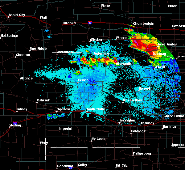 At 1032 pm cdt, a severe thunderstorm was located near burke, or 32 miles east of winner, moving south at 40 mph. this is a very dangerous storm (public). Hazards include baseball size hail and 70 mph wind gusts. People and animals outdoors will be severely injured. expect shattered windows, extensive damage to roofs, siding, and vehicles. this severe thunderstorm will be near, herrick around 1045 pm cdt. st. charles around 1050 pm cdt. Other locations impacted by this severe thunderstorm include fairfax. At 1032 pm cdt, a severe thunderstorm was located near burke, or 32 miles east of winner, moving south at 40 mph. this is a very dangerous storm (public). Hazards include baseball size hail and 70 mph wind gusts. People and animals outdoors will be severely injured. expect shattered windows, extensive damage to roofs, siding, and vehicles. this severe thunderstorm will be near, herrick around 1045 pm cdt. st. charles around 1050 pm cdt. Other locations impacted by this severe thunderstorm include fairfax.
|
| 8/6/2019 10:27 PM CDT |
 At 1025 pm cdt, a severe thunderstorm was located near burke, or 31 miles east of winner, moving southeast at 45 mph. this is a very dangerous storm (public. at 1010 pm cdt, baseball sized hail destroyed a vehicle windshield 4 miles south of iona, sd). Hazards include baseball size hail and 70 mph wind gusts. People and animals outdoors will be severely injured. expect shattered windows, extensive damage to roofs, siding, and vehicles. this severe storm will be near, burke around 1030 pm cdt. herrick around 1040 pm cdt. Other locations impacted by this severe thunderstorm include dixon in gregory county. At 1025 pm cdt, a severe thunderstorm was located near burke, or 31 miles east of winner, moving southeast at 45 mph. this is a very dangerous storm (public. at 1010 pm cdt, baseball sized hail destroyed a vehicle windshield 4 miles south of iona, sd). Hazards include baseball size hail and 70 mph wind gusts. People and animals outdoors will be severely injured. expect shattered windows, extensive damage to roofs, siding, and vehicles. this severe storm will be near, burke around 1030 pm cdt. herrick around 1040 pm cdt. Other locations impacted by this severe thunderstorm include dixon in gregory county.
|
| 8/6/2019 10:21 PM CDT |
 At 1020 pm cdt, a severe thunderstorm was located 10 miles northeast of gregory, or 29 miles east of winner, moving southeast at 45 mph (radar indicated). Hazards include tennis ball size hail and 70 mph wind gusts. People and animals outdoors will be injured. expect hail damage to roofs, siding, windows, and vehicles. expect considerable tree damage. wind damage is also likely to mobile homes, roofs, and outbuildings. this severe storm will be near, burke around 1030 pm cdt. herrick around 1040 pm cdt. Other locations impacted by this severe thunderstorm include dixon in gregory county. At 1020 pm cdt, a severe thunderstorm was located 10 miles northeast of gregory, or 29 miles east of winner, moving southeast at 45 mph (radar indicated). Hazards include tennis ball size hail and 70 mph wind gusts. People and animals outdoors will be injured. expect hail damage to roofs, siding, windows, and vehicles. expect considerable tree damage. wind damage is also likely to mobile homes, roofs, and outbuildings. this severe storm will be near, burke around 1030 pm cdt. herrick around 1040 pm cdt. Other locations impacted by this severe thunderstorm include dixon in gregory county.
|
| 8/6/2019 10:09 PM CDT |
 At 1008 pm cdt, a severe thunderstorm was located 7 miles southeast of iona, or 25 miles south of chamberlain, moving southeast at 40 mph (radar indicated). Hazards include tennis ball size hail and 70 mph wind gusts. People and animals outdoors will be injured. expect hail damage to roofs, siding, windows, and vehicles. expect considerable tree damage. wind damage is also likely to mobile homes, roofs, and outbuildings. this severe storm will be near, burke around 1035 pm cdt. herrick around 1045 pm cdt. Other locations impacted by this severe thunderstorm include dixon in gregory county. At 1008 pm cdt, a severe thunderstorm was located 7 miles southeast of iona, or 25 miles south of chamberlain, moving southeast at 40 mph (radar indicated). Hazards include tennis ball size hail and 70 mph wind gusts. People and animals outdoors will be injured. expect hail damage to roofs, siding, windows, and vehicles. expect considerable tree damage. wind damage is also likely to mobile homes, roofs, and outbuildings. this severe storm will be near, burke around 1035 pm cdt. herrick around 1045 pm cdt. Other locations impacted by this severe thunderstorm include dixon in gregory county.
|
| 8/6/2019 10:04 PM CDT |
 At 1003 pm cdt, a severe thunderstorm was located near iona, or 21 miles south of chamberlain, moving southeast at 45 mph (radar indicated). Hazards include two inch hail and 70 mph wind gusts. People and animals outdoors will be injured. expect hail damage to roofs, siding, windows, and vehicles. expect considerable tree damage. wind damage is also likely to mobile homes, roofs, and outbuildings. this severe thunderstorm will be near, burke around 1030 pm cdt. herrick around 1040 pm cdt. Other locations impacted by this severe thunderstorm include dixon in gregory county. At 1003 pm cdt, a severe thunderstorm was located near iona, or 21 miles south of chamberlain, moving southeast at 45 mph (radar indicated). Hazards include two inch hail and 70 mph wind gusts. People and animals outdoors will be injured. expect hail damage to roofs, siding, windows, and vehicles. expect considerable tree damage. wind damage is also likely to mobile homes, roofs, and outbuildings. this severe thunderstorm will be near, burke around 1030 pm cdt. herrick around 1040 pm cdt. Other locations impacted by this severe thunderstorm include dixon in gregory county.
|
| 8/6/2019 10:00 PM CDT |
 At 1000 pm cdt, a severe thunderstorm was located 9 miles north of st. charles, or 25 miles west of lake andes, moving southeast at 35 mph (radar indicated). Hazards include 70 mph wind gusts and ping pong ball size hail. People and animals outdoors will be injured. expect hail damage to roofs, siding, windows, and vehicles. expect considerable tree damage. wind damage is also likely to mobile homes, roofs, and outbuildings. this severe storm will be near, bonesteel around 1020 pm cdt. Other locations impacted by this severe thunderstorm include fairfax. At 1000 pm cdt, a severe thunderstorm was located 9 miles north of st. charles, or 25 miles west of lake andes, moving southeast at 35 mph (radar indicated). Hazards include 70 mph wind gusts and ping pong ball size hail. People and animals outdoors will be injured. expect hail damage to roofs, siding, windows, and vehicles. expect considerable tree damage. wind damage is also likely to mobile homes, roofs, and outbuildings. this severe storm will be near, bonesteel around 1020 pm cdt. Other locations impacted by this severe thunderstorm include fairfax.
|
| 8/6/2019 9:53 PM CDT |
 At 938 pm cdt, a severe thunderstorm was located 15 miles northeast of burke, or 27 miles south of kimball, moving southeast at 35 mph (radar indicated). Hazards include 60 mph wind gusts and half dollar size hail. Hail damage to vehicles is expected. expect wind damage to roofs, siding, and trees. this severe thunderstorm will be near, bonesteel around 1015 pm cdt. Other locations impacted by this severe thunderstorm include fairfax. At 938 pm cdt, a severe thunderstorm was located 15 miles northeast of burke, or 27 miles south of kimball, moving southeast at 35 mph (radar indicated). Hazards include 60 mph wind gusts and half dollar size hail. Hail damage to vehicles is expected. expect wind damage to roofs, siding, and trees. this severe thunderstorm will be near, bonesteel around 1015 pm cdt. Other locations impacted by this severe thunderstorm include fairfax.
|
| 8/6/2019 9:38 PM CDT |
 At 938 pm cdt, a severe thunderstorm was located 15 miles northeast of burke, or 27 miles south of kimball, moving southeast at 35 mph (radar indicated). Hazards include 60 mph wind gusts and half dollar size hail. Hail damage to vehicles is expected. expect wind damage to roofs, siding, and trees. this severe thunderstorm will be near, bonesteel around 1015 pm cdt. Other locations impacted by this severe thunderstorm include fairfax. At 938 pm cdt, a severe thunderstorm was located 15 miles northeast of burke, or 27 miles south of kimball, moving southeast at 35 mph (radar indicated). Hazards include 60 mph wind gusts and half dollar size hail. Hail damage to vehicles is expected. expect wind damage to roofs, siding, and trees. this severe thunderstorm will be near, bonesteel around 1015 pm cdt. Other locations impacted by this severe thunderstorm include fairfax.
|
| 7/17/2019 4:58 AM CDT |
 The severe thunderstorm warning for southern aurora, northwestern charles mix, southeastern gregory, northwestern douglas and southeastern brule counties will expire at 500 am cdt, the storms which prompted the warning have moved out of the area. therefore, the warning will be allowed to expire. however gusty winds are still possible with these thunderstorms. a severe thunderstorm watch remains in effect until 1000 am cdt for south central south dakota. The severe thunderstorm warning for southern aurora, northwestern charles mix, southeastern gregory, northwestern douglas and southeastern brule counties will expire at 500 am cdt, the storms which prompted the warning have moved out of the area. therefore, the warning will be allowed to expire. however gusty winds are still possible with these thunderstorms. a severe thunderstorm watch remains in effect until 1000 am cdt for south central south dakota.
|
| 7/17/2019 4:38 AM CDT |
 At 437 am cdt, severe thunderstorms were located along a line extending from 6 miles southeast of white lake to 6 miles north of bonesteel, moving east at 40 mph. these are very dangerous storms (radar indicated). Hazards include 80 mph wind gusts and quarter size hail. Flying debris will be dangerous to those caught without shelter. mobile homes will be heavily damaged. expect considerable damage to roofs, windows, and vehicles. extensive tree damage and power outages are likely. these severe storms will be near, plankinton around 450 am cdt. stickney and geddes around 455 am cdt. lake andes around 500 am cdt. Other locations impacted by these severe thunderstorms include fairfax. At 437 am cdt, severe thunderstorms were located along a line extending from 6 miles southeast of white lake to 6 miles north of bonesteel, moving east at 40 mph. these are very dangerous storms (radar indicated). Hazards include 80 mph wind gusts and quarter size hail. Flying debris will be dangerous to those caught without shelter. mobile homes will be heavily damaged. expect considerable damage to roofs, windows, and vehicles. extensive tree damage and power outages are likely. these severe storms will be near, plankinton around 450 am cdt. stickney and geddes around 455 am cdt. lake andes around 500 am cdt. Other locations impacted by these severe thunderstorms include fairfax.
|
| 7/17/2019 4:32 AM CDT |
 At 432 am cdt, severe thunderstorms were located along a line extending from near white lake to 6 miles northeast of st. charles, moving east at 40 mph (radar indicated). Hazards include 70 mph wind gusts and quarter size hail. Hail damage to vehicles is expected. expect considerable tree damage. wind damage is also likely to mobile homes, roofs, and outbuildings. severe thunderstorms will be near, plankinton around 445 am cdt. stickney around 450 am cdt. geddes around 455 am cdt. lake andes around 500 am cdt. Other locations impacted by these severe thunderstorms include fairfax. At 432 am cdt, severe thunderstorms were located along a line extending from near white lake to 6 miles northeast of st. charles, moving east at 40 mph (radar indicated). Hazards include 70 mph wind gusts and quarter size hail. Hail damage to vehicles is expected. expect considerable tree damage. wind damage is also likely to mobile homes, roofs, and outbuildings. severe thunderstorms will be near, plankinton around 445 am cdt. stickney around 450 am cdt. geddes around 455 am cdt. lake andes around 500 am cdt. Other locations impacted by these severe thunderstorms include fairfax.
|
| 7/9/2019 8:53 PM CDT |
 The severe thunderstorm warning for gregory county will expire at 900 pm cdt, the storm which prompted the warning has weakened below severe limits, and no longer poses an immediate threat to life or property. therefore, the warning will be allowed to expire. however gusty winds are still possible with this thunderstorm. The severe thunderstorm warning for gregory county will expire at 900 pm cdt, the storm which prompted the warning has weakened below severe limits, and no longer poses an immediate threat to life or property. therefore, the warning will be allowed to expire. however gusty winds are still possible with this thunderstorm.
|
| 7/9/2019 8:43 PM CDT |
 At 842 pm cdt, a severe thunderstorm was located 12 miles east of wewela, or 16 miles northeast of springview, moving east at 55 mph. a second storm was located north of burke (radar indicated). Hazards include 60 mph wind gusts and quarter size hail. Hail damage to vehicles is expected. expect wind damage to roofs, siding, and trees. This severe thunderstorm will remain over mainly rural areas of gregory county, including the following locations, fairfax. At 842 pm cdt, a severe thunderstorm was located 12 miles east of wewela, or 16 miles northeast of springview, moving east at 55 mph. a second storm was located north of burke (radar indicated). Hazards include 60 mph wind gusts and quarter size hail. Hail damage to vehicles is expected. expect wind damage to roofs, siding, and trees. This severe thunderstorm will remain over mainly rural areas of gregory county, including the following locations, fairfax.
|
| 7/9/2019 8:25 PM CDT |
 At 824 pm cdt, a severe thunderstorm was located near gregory, or 23 miles east of winner, moving east at 55 mph. a second storm was located east of millboro (radar indicated). Hazards include 70 mph wind gusts and quarter size hail. Hail damage to vehicles is expected. expect considerable tree damage. wind damage is also likely to mobile homes, roofs, and outbuildings. this severe storm will be near, burke around 830 pm cdt. Other locations impacted by this severe thunderstorm include dixon in gregory county and fairfax. At 824 pm cdt, a severe thunderstorm was located near gregory, or 23 miles east of winner, moving east at 55 mph. a second storm was located east of millboro (radar indicated). Hazards include 70 mph wind gusts and quarter size hail. Hail damage to vehicles is expected. expect considerable tree damage. wind damage is also likely to mobile homes, roofs, and outbuildings. this severe storm will be near, burke around 830 pm cdt. Other locations impacted by this severe thunderstorm include dixon in gregory county and fairfax.
|
| 7/9/2019 8:08 PM CDT |
 At 807 pm cdt, a severe thunderstorm was located near colome, or 7 miles southeast of winner, moving east at 60 mph (radar indicated). Hazards include ping pong ball size hail and 60 mph wind gusts. People and animals outdoors will be injured. expect hail damage to roofs, siding, windows, and vehicles. expect wind damage to roofs, siding, and trees. this severe thunderstorm will be near, dallas around 820 pm cdt. gregory around 825 pm cdt. burke around 830 pm cdt. Other locations impacted by this severe thunderstorm include dixon in gregory county and fairfax. At 807 pm cdt, a severe thunderstorm was located near colome, or 7 miles southeast of winner, moving east at 60 mph (radar indicated). Hazards include ping pong ball size hail and 60 mph wind gusts. People and animals outdoors will be injured. expect hail damage to roofs, siding, windows, and vehicles. expect wind damage to roofs, siding, and trees. this severe thunderstorm will be near, dallas around 820 pm cdt. gregory around 825 pm cdt. burke around 830 pm cdt. Other locations impacted by this severe thunderstorm include dixon in gregory county and fairfax.
|
| 7/3/2019 11:40 PM CDT |
 The severe thunderstorm warning for northwestern charles mix and gregory counties will expire at 1145 pm cdt, the storms which prompted the warning have weakened below severe limits, and no longer pose an immediate threat to life or property. therefore, the warning will be allowed to expire. a severe thunderstorm watch remains in effect until 200 am cdt for south central south dakota. The severe thunderstorm warning for northwestern charles mix and gregory counties will expire at 1145 pm cdt, the storms which prompted the warning have weakened below severe limits, and no longer pose an immediate threat to life or property. therefore, the warning will be allowed to expire. a severe thunderstorm watch remains in effect until 200 am cdt for south central south dakota.
|
| 7/3/2019 11:34 PM CDT |
 At 1134 pm cdt, severe thunderstorms were located along a line extending from 8 miles northwest of platte to near naper, moving east at 40 mph (radar indicated). Hazards include 60 mph wind gusts. Expect damage to roofs, siding, and trees. these severe storms will be near, platte around 1140 pm cdt. Other locations impacted by these severe thunderstorms include fairfax. At 1134 pm cdt, severe thunderstorms were located along a line extending from 8 miles northwest of platte to near naper, moving east at 40 mph (radar indicated). Hazards include 60 mph wind gusts. Expect damage to roofs, siding, and trees. these severe storms will be near, platte around 1140 pm cdt. Other locations impacted by these severe thunderstorms include fairfax.
|
| 7/3/2019 11:08 PM CDT |
 At 1106 pm cdt, severe thunderstorms were located along a line extending from 12 miles southeast of iona to 12 miles southwest of naper, moving east at 40 mph (radar indicated). Hazards include 60 mph wind gusts and nickel size hail. Expect damage to roofs, siding, and trees. these severe storms will be near, platte around 1135 pm cdt. Other locations impacted by these severe thunderstorms include dixon in gregory county and fairfax. At 1106 pm cdt, severe thunderstorms were located along a line extending from 12 miles southeast of iona to 12 miles southwest of naper, moving east at 40 mph (radar indicated). Hazards include 60 mph wind gusts and nickel size hail. Expect damage to roofs, siding, and trees. these severe storms will be near, platte around 1135 pm cdt. Other locations impacted by these severe thunderstorms include dixon in gregory county and fairfax.
|
| 7/3/2019 10:52 PM CDT |
 At 1052 pm cdt, severe thunderstorms were located along a line extending from 8 miles north of dallas to 10 miles east of springview, moving east at 40 mph (radar indicated). Hazards include 60 mph wind gusts and nickel size hail. Expect damage to roofs, siding, and trees. severe thunderstorms will be near, bonesteel around 1145 pm cdt. Other locations impacted by these severe thunderstorms include dixon in gregory county and fairfax. At 1052 pm cdt, severe thunderstorms were located along a line extending from 8 miles north of dallas to 10 miles east of springview, moving east at 40 mph (radar indicated). Hazards include 60 mph wind gusts and nickel size hail. Expect damage to roofs, siding, and trees. severe thunderstorms will be near, bonesteel around 1145 pm cdt. Other locations impacted by these severe thunderstorms include dixon in gregory county and fairfax.
|
| 7/3/2019 10:36 PM CDT |
 At 1036 pm cdt, severe thunderstorms were located along a line extending from 7 miles south of iona to near wewela, moving east at 40 mph (radar indicated). Hazards include 60 mph wind gusts and nickel size hail. Expect damage to roofs, siding, and trees. locations impacted include, gregory, burke, dallas, herrick, st. Charles and dixon in gregory county. At 1036 pm cdt, severe thunderstorms were located along a line extending from 7 miles south of iona to near wewela, moving east at 40 mph (radar indicated). Hazards include 60 mph wind gusts and nickel size hail. Expect damage to roofs, siding, and trees. locations impacted include, gregory, burke, dallas, herrick, st. Charles and dixon in gregory county.
|
| 7/3/2019 10:14 PM CDT |
 At 1013 pm cdt, severe thunderstorms were located along a line extending from 12 miles south of hamill to 7 miles northeast of norden, moving east at 40 mph (radar indicated). Hazards include 60 mph wind gusts and nickel size hail. Expect damage to roofs, siding, and trees. These severe thunderstorms will remain over mainly rural areas of gregory county, including the following locations, dixon in gregory county. At 1013 pm cdt, severe thunderstorms were located along a line extending from 12 miles south of hamill to 7 miles northeast of norden, moving east at 40 mph (radar indicated). Hazards include 60 mph wind gusts and nickel size hail. Expect damage to roofs, siding, and trees. These severe thunderstorms will remain over mainly rural areas of gregory county, including the following locations, dixon in gregory county.
|
| 6/13/2018 3:10 PM CDT |
 At 309 pm cdt, a severe thunderstorm was located 2 miles north of burke, or 33 miles east of winner, moving east at 40 mph (radar indicated). Hazards include 60 mph wind gusts and quarter size hail. Hail damage to vehicles is expected. expect wind damage to roofs, siding, and trees. This severe thunderstorm will remain over mainly rural areas of gregory county, including the following locations, fairfax. At 309 pm cdt, a severe thunderstorm was located 2 miles north of burke, or 33 miles east of winner, moving east at 40 mph (radar indicated). Hazards include 60 mph wind gusts and quarter size hail. Hail damage to vehicles is expected. expect wind damage to roofs, siding, and trees. This severe thunderstorm will remain over mainly rural areas of gregory county, including the following locations, fairfax.
|
| 6/13/2018 2:56 PM CDT |
 At 255 pm cdt, a severe thunderstorm was located over gregory, or 24 miles east of winner, moving east at 45 mph (radar indicated). Hazards include 60 mph wind gusts and quarter size hail. Hail damage to vehicles is expected. expect wind damage to roofs, siding, and trees. this severe thunderstorm will be near, burke around 300 pm cdt. Other locations impacted by this severe thunderstorm include fairfax. At 255 pm cdt, a severe thunderstorm was located over gregory, or 24 miles east of winner, moving east at 45 mph (radar indicated). Hazards include 60 mph wind gusts and quarter size hail. Hail damage to vehicles is expected. expect wind damage to roofs, siding, and trees. this severe thunderstorm will be near, burke around 300 pm cdt. Other locations impacted by this severe thunderstorm include fairfax.
|
| 6/13/2018 2:46 PM CDT |
 At 245 pm cdt, a severe thunderstorm was located near burke, or 28 miles east of winner, moving east at 50 mph (trained weather spotters. quarter size hail was reported one mile south of gregory at 240 pm). Hazards include 60 mph wind gusts and quarter size hail. Hail damage to vehicles is expected. expect wind damage to roofs, siding, and trees. This severe thunderstorm will remain over mainly rural areas of gregory county, including the following locations, dixon in gregory county. At 245 pm cdt, a severe thunderstorm was located near burke, or 28 miles east of winner, moving east at 50 mph (trained weather spotters. quarter size hail was reported one mile south of gregory at 240 pm). Hazards include 60 mph wind gusts and quarter size hail. Hail damage to vehicles is expected. expect wind damage to roofs, siding, and trees. This severe thunderstorm will remain over mainly rural areas of gregory county, including the following locations, dixon in gregory county.
|
| 6/13/2018 2:29 PM CDT |
 The national weather service in sioux falls has issued a * severe thunderstorm warning for. gregory county in south central south dakota. until 300 pm cdt. At 228 pm cdt, a severe thunderstorm was located near dallas, or 15 miles southeast of winner, moving east at 50 mph. The national weather service in sioux falls has issued a * severe thunderstorm warning for. gregory county in south central south dakota. until 300 pm cdt. At 228 pm cdt, a severe thunderstorm was located near dallas, or 15 miles southeast of winner, moving east at 50 mph.
|
| 6/8/2018 9:49 PM CDT |
 At 947 pm cdt, severe thunderstorms were located along a line extending from near shelby to 12 miles east of iona to near wewela, moving east at 40 mph (emergency management. at 938 pm cdt, 65 mph winds and damaged garage doors were reported in chamberlain). Hazards include 70 mph wind gusts. Expect considerable tree damage. damage is likely to mobile homes, roofs, and outbuildings. these severe storms will be near, kimball around 1010 pm cdt. Other locations impacted by these severe thunderstorms include dixon in gregory county and pukwana. At 947 pm cdt, severe thunderstorms were located along a line extending from near shelby to 12 miles east of iona to near wewela, moving east at 40 mph (emergency management. at 938 pm cdt, 65 mph winds and damaged garage doors were reported in chamberlain). Hazards include 70 mph wind gusts. Expect considerable tree damage. damage is likely to mobile homes, roofs, and outbuildings. these severe storms will be near, kimball around 1010 pm cdt. Other locations impacted by these severe thunderstorms include dixon in gregory county and pukwana.
|
| 6/8/2018 9:18 PM CDT |
 At 918 pm cdt, severe thunderstorms were located along a line extending from near reliance to 7 miles west of iona to near keyapaha, moving east at 40 mph (radar indicated). Hazards include 70 mph wind gusts. Expect considerable tree damage. damage is likely to mobile homes, roofs, and outbuildings. severe thunderstorms will be near, chamberlain around 935 pm cdt. kimball around 1005 pm cdt. Other locations impacted by these severe thunderstorms include dixon in gregory county and pukwana. At 918 pm cdt, severe thunderstorms were located along a line extending from near reliance to 7 miles west of iona to near keyapaha, moving east at 40 mph (radar indicated). Hazards include 70 mph wind gusts. Expect considerable tree damage. damage is likely to mobile homes, roofs, and outbuildings. severe thunderstorms will be near, chamberlain around 935 pm cdt. kimball around 1005 pm cdt. Other locations impacted by these severe thunderstorms include dixon in gregory county and pukwana.
|
| 6/1/2018 6:52 PM CDT |
 At 650 pm cdt, severe thunderstorms were located along a line extending from near grass ranch colony to 6 miles northeast of bonesteel, moving east at 50 mph (radar indicated. trained spotters reported trees down in the town of gregory around 620 pm). Hazards include 60 mph wind gusts and penny size hail. Expect damage to roofs, siding, and trees. these severe storms will be near, grass ranch colony around 655 pm cdt. Other locations impacted by these severe thunderstorms include fairfax. At 650 pm cdt, severe thunderstorms were located along a line extending from near grass ranch colony to 6 miles northeast of bonesteel, moving east at 50 mph (radar indicated. trained spotters reported trees down in the town of gregory around 620 pm). Hazards include 60 mph wind gusts and penny size hail. Expect damage to roofs, siding, and trees. these severe storms will be near, grass ranch colony around 655 pm cdt. Other locations impacted by these severe thunderstorms include fairfax.
|
| 6/1/2018 6:26 PM CDT |
 At 625 pm cdt, severe thunderstorms were located along a line extending from 9 miles east of iona to near herrick, moving east at 45 mph (trained weather spotters. trees were reported down in gregory). Hazards include 60 mph wind gusts and penny size hail. Expect damage to roofs, siding, and trees. severe thunderstorms will be near, bonesteel around 645 pm cdt. kimball and grass ranch colony around 650 pm cdt. Other locations impacted by these severe thunderstorms include fairfax. At 625 pm cdt, severe thunderstorms were located along a line extending from 9 miles east of iona to near herrick, moving east at 45 mph (trained weather spotters. trees were reported down in gregory). Hazards include 60 mph wind gusts and penny size hail. Expect damage to roofs, siding, and trees. severe thunderstorms will be near, bonesteel around 645 pm cdt. kimball and grass ranch colony around 650 pm cdt. Other locations impacted by these severe thunderstorms include fairfax.
|
| 5/17/2018 11:02 PM CDT |
 At 1101 pm cdt, severe thunderstorms were located along a line extending from near lower brule to near clearfield, moving east at 45 mph (radar indicated). Hazards include 60 mph wind gusts and nickel size hail. Expect damage to roofs, siding, and trees. locations impacted include, chamberlain, kimball, gregory, burke, bonesteel, dallas, herrick, st. Charles, grass ranch colony, lake francis case, pukwana and dixon in gregory county. At 1101 pm cdt, severe thunderstorms were located along a line extending from near lower brule to near clearfield, moving east at 45 mph (radar indicated). Hazards include 60 mph wind gusts and nickel size hail. Expect damage to roofs, siding, and trees. locations impacted include, chamberlain, kimball, gregory, burke, bonesteel, dallas, herrick, st. Charles, grass ranch colony, lake francis case, pukwana and dixon in gregory county.
|
| 5/17/2018 10:50 PM CDT |
 At 1049 pm cdt, severe thunderstorms were located along a line extending from 7 miles south of joe creek rec area to near keyapaha, moving east at 45 mph (radar indicated). Hazards include 60 mph wind gusts and nickel size hail. Expect damage to roofs, siding, and trees. These severe thunderstorms will remain over mainly rural areas of northwestern charles mix, gregory and brule counties, including the following locations, dixon in gregory county and pukwana. At 1049 pm cdt, severe thunderstorms were located along a line extending from 7 miles south of joe creek rec area to near keyapaha, moving east at 45 mph (radar indicated). Hazards include 60 mph wind gusts and nickel size hail. Expect damage to roofs, siding, and trees. These severe thunderstorms will remain over mainly rural areas of northwestern charles mix, gregory and brule counties, including the following locations, dixon in gregory county and pukwana.
|
| 9/19/2017 9:36 PM CDT |
 The severe thunderstorm warning for south central gregory county will expire at 945 pm cdt, the storm which prompted the warning has moved out of the area. therefore the warning will be allowed to expire. a tornado watch remains in effect until midnight cdt for south central south dakota. to report severe weather, contact your nearest law enforcement agency. they will relay your report to the national weather service sioux falls. The severe thunderstorm warning for south central gregory county will expire at 945 pm cdt, the storm which prompted the warning has moved out of the area. therefore the warning will be allowed to expire. a tornado watch remains in effect until midnight cdt for south central south dakota. to report severe weather, contact your nearest law enforcement agency. they will relay your report to the national weather service sioux falls.
|
| 9/19/2017 9:20 PM CDT |
 At 919 pm cdt, a severe thunderstorm was located near herrick, or 29 miles northeast of springview, moving east at 50 mph (radar indicated). Hazards include 60 mph wind gusts and quarter size hail. Hail damage to vehicles is expected. expect wind damage to roofs, siding, and trees. this severe storm will be near, st. charles around 930 pm cdt. A tornado watch remains in effect until midnight cdt for south central south dakota. At 919 pm cdt, a severe thunderstorm was located near herrick, or 29 miles northeast of springview, moving east at 50 mph (radar indicated). Hazards include 60 mph wind gusts and quarter size hail. Hail damage to vehicles is expected. expect wind damage to roofs, siding, and trees. this severe storm will be near, st. charles around 930 pm cdt. A tornado watch remains in effect until midnight cdt for south central south dakota.
|
| 9/19/2017 8:57 PM CDT |
 At 857 pm cdt, a severe thunderstorm was located 13 miles east of wewela, or 15 miles northeast of springview, moving east at 30 mph (radar indicated). Hazards include two inch hail. People and animals outdoors will be injured. expect damage to roofs, siding, windows, and vehicles. this severe thunderstorm will be near, herrick around 935 pm cdt. st. charles around 945 pm cdt. A tornado watch remains in effect until midnight cdt for south central south dakota. At 857 pm cdt, a severe thunderstorm was located 13 miles east of wewela, or 15 miles northeast of springview, moving east at 30 mph (radar indicated). Hazards include two inch hail. People and animals outdoors will be injured. expect damage to roofs, siding, windows, and vehicles. this severe thunderstorm will be near, herrick around 935 pm cdt. st. charles around 945 pm cdt. A tornado watch remains in effect until midnight cdt for south central south dakota.
|
| 8/21/2017 11:52 AM CDT |
 At 1151 am cdt, severe thunderstorms were located along a line extending from near aurora center to 7 miles north of bonesteel, moving east at 40 mph. these are very dangerous storms (radar indicated). Hazards include three inch hail and 70 mph wind gusts. People and animals outdoors will be severely injured. expect shattered windows, extensive damage to roofs, siding, and vehicles. these severe storms will be near, new holland and aurora center around 1200 pm cdt. harrison around 1205 pm cdt. geddes around 1210 pm cdt. corsica around 1215 pm cdt. Other locations impacted by these severe thunderstorms include fairfax. At 1151 am cdt, severe thunderstorms were located along a line extending from near aurora center to 7 miles north of bonesteel, moving east at 40 mph. these are very dangerous storms (radar indicated). Hazards include three inch hail and 70 mph wind gusts. People and animals outdoors will be severely injured. expect shattered windows, extensive damage to roofs, siding, and vehicles. these severe storms will be near, new holland and aurora center around 1200 pm cdt. harrison around 1205 pm cdt. geddes around 1210 pm cdt. corsica around 1215 pm cdt. Other locations impacted by these severe thunderstorms include fairfax.
|
| 8/21/2017 11:41 AM CDT |
 At 1141 am cdt, severe thunderstorms were located along a line extending from 7 miles north of platte to 7 miles north of herrick, moving east at 50 mph. these are very dangerous storms (radar indicated). Hazards include three inch hail and 60 mph wind gusts. People and animals outdoors will be severely injured. expect shattered windows, extensive damage to roofs, siding, and vehicles. these severe storms will be near, platte around 1145 am cdt. bonesteel, new holland and aurora center around 1155 am cdt. harrison around 1200 pm cdt. corsica around 1205 pm cdt. lake andes and armour around 1215 pm cdt. Other locations impacted by these severe thunderstorms include fairfax. At 1141 am cdt, severe thunderstorms were located along a line extending from 7 miles north of platte to 7 miles north of herrick, moving east at 50 mph. these are very dangerous storms (radar indicated). Hazards include three inch hail and 60 mph wind gusts. People and animals outdoors will be severely injured. expect shattered windows, extensive damage to roofs, siding, and vehicles. these severe storms will be near, platte around 1145 am cdt. bonesteel, new holland and aurora center around 1155 am cdt. harrison around 1200 pm cdt. corsica around 1205 pm cdt. lake andes and armour around 1215 pm cdt. Other locations impacted by these severe thunderstorms include fairfax.
|
| 8/21/2017 11:23 AM CDT |
 At 1122 am cdt, severe thunderstorms were located along a line extending from 12 miles southwest of grass ranch colony to near gregory, moving southeast at 40 mph (radar indicated). Hazards include tennis ball size hail and 60 mph wind gusts. People and animals outdoors will be injured. expect hail damage to roofs, siding, windows, and vehicles. expect wind damage to roofs, siding, and trees. severe thunderstorms will be near, herrick around 1140 am cdt. platte and st. charles around 1145 am cdt. bonesteel around 1155 am cdt. new holland and harrison around 1200 pm cdt. armour around 1215 pm cdt. Other locations impacted by these severe thunderstorms include fairfax. At 1122 am cdt, severe thunderstorms were located along a line extending from 12 miles southwest of grass ranch colony to near gregory, moving southeast at 40 mph (radar indicated). Hazards include tennis ball size hail and 60 mph wind gusts. People and animals outdoors will be injured. expect hail damage to roofs, siding, windows, and vehicles. expect wind damage to roofs, siding, and trees. severe thunderstorms will be near, herrick around 1140 am cdt. platte and st. charles around 1145 am cdt. bonesteel around 1155 am cdt. new holland and harrison around 1200 pm cdt. armour around 1215 pm cdt. Other locations impacted by these severe thunderstorms include fairfax.
|
| 7/19/2017 4:27 PM CDT |
 At 426 pm cdt, a severe thunderstorm was located near burke, or 29 miles southeast of winner, moving east at 30 mph (radar indicated). Hazards include 60 mph wind gusts and quarter size hail. Hail damage to vehicles is expected. expect wind damage to roofs, siding, and trees. this severe storm will be near, burke around 430 pm cdt. herrick around 440 pm cdt. st. Charles around 450 pm cdt. At 426 pm cdt, a severe thunderstorm was located near burke, or 29 miles southeast of winner, moving east at 30 mph (radar indicated). Hazards include 60 mph wind gusts and quarter size hail. Hail damage to vehicles is expected. expect wind damage to roofs, siding, and trees. this severe storm will be near, burke around 430 pm cdt. herrick around 440 pm cdt. st. Charles around 450 pm cdt.
|
| 7/19/2017 4:20 PM CDT |
 At 419 pm cdt, a severe thunderstorm was located near gregory, or 25 miles southeast of winner, moving east at 25 mph (radar indicated). Hazards include 60 mph wind gusts and quarter size hail. Hail damage to vehicles is expected. expect wind damage to roofs, siding, and trees. this severe storm will be near, burke around 430 pm cdt. herrick around 445 pm cdt. st. charles around 455 pm cdt. At 415 pm, the public reported quarter sized hail 3 miles southwest of gregory. At 419 pm cdt, a severe thunderstorm was located near gregory, or 25 miles southeast of winner, moving east at 25 mph (radar indicated). Hazards include 60 mph wind gusts and quarter size hail. Hail damage to vehicles is expected. expect wind damage to roofs, siding, and trees. this severe storm will be near, burke around 430 pm cdt. herrick around 445 pm cdt. st. charles around 455 pm cdt. At 415 pm, the public reported quarter sized hail 3 miles southwest of gregory.
|
| 7/19/2017 4:07 PM CDT |
 At 407 pm cdt, a severe thunderstorm was located over dallas, or 20 miles southeast of winner, moving east at 25 mph (radar indicated). Hazards include 60 mph wind gusts and quarter size hail. Hail damage to vehicles is expected. expect wind damage to roofs, siding, and trees. this severe thunderstorm will be near, gregory around 415 pm cdt. burke around 430 pm cdt. herrick around 445 pm cdt. st. Charles around 455 pm cdt. At 407 pm cdt, a severe thunderstorm was located over dallas, or 20 miles southeast of winner, moving east at 25 mph (radar indicated). Hazards include 60 mph wind gusts and quarter size hail. Hail damage to vehicles is expected. expect wind damage to roofs, siding, and trees. this severe thunderstorm will be near, gregory around 415 pm cdt. burke around 430 pm cdt. herrick around 445 pm cdt. st. Charles around 455 pm cdt.
|
| 7/11/2017 7:52 PM CDT | A few 3 to 4 inch diameter branches down around the yar in gregory county SD, 8.2 miles WSW of Herrick, SD |
| 6/13/2017 5:13 PM CDT |
 At 513 pm cdt, a severe thunderstorm was located over st. charles, or 24 miles northwest of spencer, moving northeast at 60 mph (radar indicated). Hazards include golf ball size hail and 60 mph wind gusts. People and animals outdoors will be injured. expect hail damage to roofs, siding, windows, and vehicles. expect wind damage to roofs, siding, and trees. this severe thunderstorm will be near, platte around 540 pm cdt. A tornado watch remains in effect until 1000 pm cdt for south central south dakota. At 513 pm cdt, a severe thunderstorm was located over st. charles, or 24 miles northwest of spencer, moving northeast at 60 mph (radar indicated). Hazards include golf ball size hail and 60 mph wind gusts. People and animals outdoors will be injured. expect hail damage to roofs, siding, windows, and vehicles. expect wind damage to roofs, siding, and trees. this severe thunderstorm will be near, platte around 540 pm cdt. A tornado watch remains in effect until 1000 pm cdt for south central south dakota.
|
| 6/13/2017 4:19 PM CDT |
 At 419 pm cdt, severe thunderstorms were located along a line extending from 13 miles east of wewela to 11 miles west of naper, moving north at 40 mph (radar indicated). Hazards include golf ball size hail and 60 mph wind gusts. People and animals outdoors will be injured. expect hail damage to roofs, siding, windows, and vehicles. expect wind damage to roofs, siding, and trees. severe thunderstorms will be near, herrick and st. charles around 440 pm cdt. burke and dallas around 445 pm cdt. gregory around 450 pm cdt. A tornado watch remains in effect until 1000 pm cdt for south central south dakota. At 419 pm cdt, severe thunderstorms were located along a line extending from 13 miles east of wewela to 11 miles west of naper, moving north at 40 mph (radar indicated). Hazards include golf ball size hail and 60 mph wind gusts. People and animals outdoors will be injured. expect hail damage to roofs, siding, windows, and vehicles. expect wind damage to roofs, siding, and trees. severe thunderstorms will be near, herrick and st. charles around 440 pm cdt. burke and dallas around 445 pm cdt. gregory around 450 pm cdt. A tornado watch remains in effect until 1000 pm cdt for south central south dakota.
|
| 6/13/2017 4:08 PM CDT |
 At 408 pm cdt, severe thunderstorms were located along a line extending from 9 miles southeast of iona to 12 miles northeast of burke, moving north at 45 mph (radar indicated). Hazards include two inch hail and 60 mph wind gusts. People and animals outdoors will be injured. expect hail damage to roofs, siding, windows, and vehicles. expect wind damage to roofs, siding, and trees. locations impacted include, gregory, burke, herrick and lake francis case. A tornado watch remains in effect until 1000 pm cdt for south central south dakota. At 408 pm cdt, severe thunderstorms were located along a line extending from 9 miles southeast of iona to 12 miles northeast of burke, moving north at 45 mph (radar indicated). Hazards include two inch hail and 60 mph wind gusts. People and animals outdoors will be injured. expect hail damage to roofs, siding, windows, and vehicles. expect wind damage to roofs, siding, and trees. locations impacted include, gregory, burke, herrick and lake francis case. A tornado watch remains in effect until 1000 pm cdt for south central south dakota.
|
| 6/13/2017 3:59 PM CDT |
 At 359 pm cdt, a confirmed tornado was located 8 miles northeast of burke, or 32 miles west of lake andes, moving northeast at 25 mph (law enforcement confirmed tornado). Hazards include damaging tornado and two inch hail. Flying debris will be dangerous to those caught without shelter. mobile homes will be damaged or destroyed. damage to roofs, windows, and vehicles will occur. tree damage is likely. Locations impacted include, burke and herrick. At 359 pm cdt, a confirmed tornado was located 8 miles northeast of burke, or 32 miles west of lake andes, moving northeast at 25 mph (law enforcement confirmed tornado). Hazards include damaging tornado and two inch hail. Flying debris will be dangerous to those caught without shelter. mobile homes will be damaged or destroyed. damage to roofs, windows, and vehicles will occur. tree damage is likely. Locations impacted include, burke and herrick.
|
| 6/13/2017 3:56 PM CDT |
 At 355 pm cdt, there were two severe thunderstorms. the first severe thunderstorms was located near gregory. the second severe thunderstorm was 6 miles southwest of burke, moving north at 45 mph (radar indicated). Hazards include two inch hail. People and animals outdoors will be injured. expect damage to roofs, siding, windows, and vehicles. these severe thunderstorms will remain over mainly rural areas of northwestern charles mix, western gregory and southern brule counties. A tornado watch remains in effect until 1000 pm cdt for south central south dakota. At 355 pm cdt, there were two severe thunderstorms. the first severe thunderstorms was located near gregory. the second severe thunderstorm was 6 miles southwest of burke, moving north at 45 mph (radar indicated). Hazards include two inch hail. People and animals outdoors will be injured. expect damage to roofs, siding, windows, and vehicles. these severe thunderstorms will remain over mainly rural areas of northwestern charles mix, western gregory and southern brule counties. A tornado watch remains in effect until 1000 pm cdt for south central south dakota.
|
| 6/13/2017 3:51 PM CDT |
 At 351 pm cdt, a severe thunderstorm was located 9 miles northeast of burke, or 32 miles south of kimball, moving northeast at 40 mph (radar indicated). Hazards include ping pong ball size hail. People and animals outdoors will be injured. expect damage to roofs, siding, windows, and vehicles. at 345 pm, 1. 5 inch hail was reported in burke by the local fire department. this severe thunderstorm will remain over mainly rural areas of western gregory county. A tornado watch remains in effect until 1000 pm cdt for south central south dakota. At 351 pm cdt, a severe thunderstorm was located 9 miles northeast of burke, or 32 miles south of kimball, moving northeast at 40 mph (radar indicated). Hazards include ping pong ball size hail. People and animals outdoors will be injured. expect damage to roofs, siding, windows, and vehicles. at 345 pm, 1. 5 inch hail was reported in burke by the local fire department. this severe thunderstorm will remain over mainly rural areas of western gregory county. A tornado watch remains in effect until 1000 pm cdt for south central south dakota.
|
| 6/13/2017 3:46 PM CDT |
 At 345 pm cdt, a confirmed tornado was located near burke, or 34 miles east of winner, moving north at 35 mph (law enforcement confirmed tornado). Hazards include damaging tornado and ping pong ball size hail. Flying debris will be dangerous to those caught without shelter. mobile homes will be damaged or destroyed. damage to roofs, windows, and vehicles will occur. tree damage is likely. This tornadic thunderstorm will remain over mainly rural areas of northwestern charles mix and western gregory counties. At 345 pm cdt, a confirmed tornado was located near burke, or 34 miles east of winner, moving north at 35 mph (law enforcement confirmed tornado). Hazards include damaging tornado and ping pong ball size hail. Flying debris will be dangerous to those caught without shelter. mobile homes will be damaged or destroyed. damage to roofs, windows, and vehicles will occur. tree damage is likely. This tornadic thunderstorm will remain over mainly rural areas of northwestern charles mix and western gregory counties.
|
| 6/13/2017 3:26 PM CDT |
 At 325 pm cdt, a severe thunderstorm was located 7 miles southwest of herrick, or 27 miles northeast of springview, moving northeast at 40 mph (radar indicated). Hazards include ping pong ball size hail. People and animals outdoors will be injured. expect damage to roofs, siding, windows, and vehicles. this severe thunderstorm will be near, herrick around 335 pm cdt. burke around 340 pm cdt. A tornado watch remains in effect until 1000 pm cdt for south central south dakota. At 325 pm cdt, a severe thunderstorm was located 7 miles southwest of herrick, or 27 miles northeast of springview, moving northeast at 40 mph (radar indicated). Hazards include ping pong ball size hail. People and animals outdoors will be injured. expect damage to roofs, siding, windows, and vehicles. this severe thunderstorm will be near, herrick around 335 pm cdt. burke around 340 pm cdt. A tornado watch remains in effect until 1000 pm cdt for south central south dakota.
|
| 9/4/2016 10:40 PM CDT |
 The severe thunderstorm warning for gregory county will expire at 1045 pm cdt, the storm which prompted the warning has weakened below severe limits, and no longer pose an immediate threat to life or property. therefore, the warning will be allowed to expire. however gusty winds are still possible with this thunderstorm. a severe thunderstorm watch remains in effect until midnight cdt for south central south dakota. a severe thunderstorm watch also remains in effect until 400 am cdt for south central south dakota. The severe thunderstorm warning for gregory county will expire at 1045 pm cdt, the storm which prompted the warning has weakened below severe limits, and no longer pose an immediate threat to life or property. therefore, the warning will be allowed to expire. however gusty winds are still possible with this thunderstorm. a severe thunderstorm watch remains in effect until midnight cdt for south central south dakota. a severe thunderstorm watch also remains in effect until 400 am cdt for south central south dakota.
|
| 9/4/2016 10:13 PM CDT |
 At 1013 pm cdt, a severe thunderstorm was located near burke, or 29 miles northeast of springview, moving east at 40 mph (radar indicated). Hazards include 60 mph wind gusts. Expect damage to roofs. siding. and trees. this severe storm will be near, herrick around 1025 pm cdt. st. charles around 1030 pm cdt. bonesteel around 1040 pm cdt. Other locations impacted by this severe thunderstorm include fairfax. At 1013 pm cdt, a severe thunderstorm was located near burke, or 29 miles northeast of springview, moving east at 40 mph (radar indicated). Hazards include 60 mph wind gusts. Expect damage to roofs. siding. and trees. this severe storm will be near, herrick around 1025 pm cdt. st. charles around 1030 pm cdt. bonesteel around 1040 pm cdt. Other locations impacted by this severe thunderstorm include fairfax.
|
| 9/4/2016 9:49 PM CDT |
 At 948 pm cdt, a severe thunderstorm was located 9 miles northeast of wewela, or 18 miles northeast of springview, moving east at 55 mph (radar indicated). Hazards include 60 mph wind gusts. Expect damage to roofs. siding. and trees. this severe thunderstorm will be near, burke around 1005 pm cdt. herrick around 1010 pm cdt. st. charles around 1015 pm cdt. bonesteel around 1025 pm cdt. Other locations impacted by this severe thunderstorm include fairfax. At 948 pm cdt, a severe thunderstorm was located 9 miles northeast of wewela, or 18 miles northeast of springview, moving east at 55 mph (radar indicated). Hazards include 60 mph wind gusts. Expect damage to roofs. siding. and trees. this severe thunderstorm will be near, burke around 1005 pm cdt. herrick around 1010 pm cdt. st. charles around 1015 pm cdt. bonesteel around 1025 pm cdt. Other locations impacted by this severe thunderstorm include fairfax.
|
| 6/29/2016 10:09 PM CDT |
 The severe thunderstorm warning for central charles mix and gregory counties will expire at 1015 pm cdt, the storm which prompted the warning has weakened below severe limits, and no longer pose an immediate threat to life or property. therefore, the warning will be allowed to expire. however gusty winds to 40 mph are still possible with this thunderstorm. to report severe weather, contact your nearest law enforcement agency. they will relay your report to the national weather service sioux falls. The severe thunderstorm warning for central charles mix and gregory counties will expire at 1015 pm cdt, the storm which prompted the warning has weakened below severe limits, and no longer pose an immediate threat to life or property. therefore, the warning will be allowed to expire. however gusty winds to 40 mph are still possible with this thunderstorm. to report severe weather, contact your nearest law enforcement agency. they will relay your report to the national weather service sioux falls.
|
| 6/29/2016 9:41 PM CDT |
 At 941 pm cdt, a severe thunderstorm was located 8 miles south of gregory, or 24 miles northeast of springview, moving southeast at 45 mph (radar indicated). Hazards include 60 mph wind gusts. Expect damage to roofs. siding. and trees. this severe storm will be near, herrick around 1000 pm cdt. st. charles around 1005 pm cdt. Other locations impacted by this severe thunderstorm include dixon in gregory county and fairfax. At 941 pm cdt, a severe thunderstorm was located 8 miles south of gregory, or 24 miles northeast of springview, moving southeast at 45 mph (radar indicated). Hazards include 60 mph wind gusts. Expect damage to roofs. siding. and trees. this severe storm will be near, herrick around 1000 pm cdt. st. charles around 1005 pm cdt. Other locations impacted by this severe thunderstorm include dixon in gregory county and fairfax.
|
| 6/29/2016 9:17 PM CDT |
 At 916 pm cdt, a severe thunderstorm was located near colome, or 10 miles south of winner, moving southeast at 45 mph (trained weather spotters. at 9pm cdt a 61 mph wind gust was reported at winner). Hazards include 60 mph wind gusts. Expect damage to roofs. siding. and trees. this severe thunderstorm will be near, dallas around 935 pm cdt. herrick around 1000 pm cdt. st. charles around 1010 pm cdt. Other locations impacted by this severe thunderstorm include dixon in gregory county and fairfax. At 916 pm cdt, a severe thunderstorm was located near colome, or 10 miles south of winner, moving southeast at 45 mph (trained weather spotters. at 9pm cdt a 61 mph wind gust was reported at winner). Hazards include 60 mph wind gusts. Expect damage to roofs. siding. and trees. this severe thunderstorm will be near, dallas around 935 pm cdt. herrick around 1000 pm cdt. st. charles around 1010 pm cdt. Other locations impacted by this severe thunderstorm include dixon in gregory county and fairfax.
|
| 6/17/2016 11:11 PM CDT | The severe thunderstorm warning for southwestern gregory county will expire at 1115 pm cdt, the storm which prompted the warning has weakened below severe limits, and no longer pose an immediate threat to life or property. therefore, the warning will be allowed to expire. however gusty winds up to 50 mph and heavy rain are still possible with this thunderstorm. to report severe weather, contact your nearest law enforcement agency. they will relay your report to the national weather service sioux falls. |
| 6/17/2016 11:02 PM CDT |
 At 1102 pm cdt, a severe thunderstorm was located near burke, or 31 miles northeast of springview, moving northeast at 25 mph (radar indicated). Hazards include 60 mph wind gusts and quarter size hail. Hail damage to vehicles is expected. expect wind damage to roofs, siding, and trees. This severe storm will be near, burke and herrick around 1110 pm cdt. At 1102 pm cdt, a severe thunderstorm was located near burke, or 31 miles northeast of springview, moving northeast at 25 mph (radar indicated). Hazards include 60 mph wind gusts and quarter size hail. Hail damage to vehicles is expected. expect wind damage to roofs, siding, and trees. This severe storm will be near, burke and herrick around 1110 pm cdt.
|
| 6/17/2016 10:33 PM CDT |
 At 1033 pm cdt, a severe thunderstorm was located 14 miles southwest of herrick, or 20 miles northeast of springview, moving northeast at 25 mph (radar indicated). Hazards include 60 mph wind gusts and quarter size hail. Hail damage to vehicles is expected. expect wind damage to roofs, siding, and trees. This severe thunderstorm will be near, burke and herrick around 1110 pm cdt. At 1033 pm cdt, a severe thunderstorm was located 14 miles southwest of herrick, or 20 miles northeast of springview, moving northeast at 25 mph (radar indicated). Hazards include 60 mph wind gusts and quarter size hail. Hail damage to vehicles is expected. expect wind damage to roofs, siding, and trees. This severe thunderstorm will be near, burke and herrick around 1110 pm cdt.
|
| 5/25/2016 6:39 PM CDT |
 At 639 pm cdt, a severe thunderstorm was located near st. charles, or 23 miles northwest of spencer, moving east at 45 mph (radar indicated). Hazards include 60 mph wind gusts and quarter size hail. Hail damage to vehicles is expected. expect wind damage to roofs, siding, and trees. this severe thunderstorm will be near, bonesteel around 650 pm cdt. geddes around 710 pm cdt. pickstown around 715 pm cdt. lake andes around 720 pm cdt. Other locations impacted by this severe thunderstorm include fairfax. At 639 pm cdt, a severe thunderstorm was located near st. charles, or 23 miles northwest of spencer, moving east at 45 mph (radar indicated). Hazards include 60 mph wind gusts and quarter size hail. Hail damage to vehicles is expected. expect wind damage to roofs, siding, and trees. this severe thunderstorm will be near, bonesteel around 650 pm cdt. geddes around 710 pm cdt. pickstown around 715 pm cdt. lake andes around 720 pm cdt. Other locations impacted by this severe thunderstorm include fairfax.
|
| 5/22/2016 10:25 PM CDT | A severe thunderstorm warning remains in effect until 1045 pm cdt for western gregory county. at 1025 pm cdt. a severe thunderstorm was located over burke. or 31 miles southeast of winner. moving northeast at 35 mph. hazard. 60 mph wind gusts and quarter size hail. source. Radar indicated. |
| 5/22/2016 8:53 PM CDT | A severe thunderstorm warning remains in effect until 915 pm cdt for western gregory and northwestern charles mix counties. at 852 pm cdt. a severe thunderstorm was located near dallas. or 19 miles east of winner. moving northeast at 40 mph. hazard. 60 mph wind gusts and quarter size hail. source. Radar indicated. |
| 9/7/2015 10:27 PM CDT |
 At 1026 pm cdt, a severe thunderstorm was located near burke, or 30 miles east of winner, moving east at 30 mph. at 1025 pm cdt, quarter size hail was reported 8 miles northeast gregory (trained weather spotters). Hazards include 60 mph wind gusts and half dollar size hail. Hail damage to vehicles is expected. expect wind damage to roofs, siding and trees. This severe thunderstorm will be near, bonesteel around 1110 pm cdt. At 1026 pm cdt, a severe thunderstorm was located near burke, or 30 miles east of winner, moving east at 30 mph. at 1025 pm cdt, quarter size hail was reported 8 miles northeast gregory (trained weather spotters). Hazards include 60 mph wind gusts and half dollar size hail. Hail damage to vehicles is expected. expect wind damage to roofs, siding and trees. This severe thunderstorm will be near, bonesteel around 1110 pm cdt.
|
| 8/18/2015 4:54 AM CDT |
 At 453 am cdt, severe thunderstorms were located along a line extending from 8 miles south of iona to 6 miles northeast of burke to near naper, moving east at 45 mph. at 435 am, an automated weather gauge in gregory reported a 60 mph wind gust with this storm (public). Hazards include 60 mph wind gusts. Expect damage to roofs. siding and trees. these severe storms will be near, bonesteel around 500 am cdt. platte around 520 am cdt. pickstown and geddes around 525 am cdt. Other locations impacted by these severe thunderstorms include fairfax. At 453 am cdt, severe thunderstorms were located along a line extending from 8 miles south of iona to 6 miles northeast of burke to near naper, moving east at 45 mph. at 435 am, an automated weather gauge in gregory reported a 60 mph wind gust with this storm (public). Hazards include 60 mph wind gusts. Expect damage to roofs. siding and trees. these severe storms will be near, bonesteel around 500 am cdt. platte around 520 am cdt. pickstown and geddes around 525 am cdt. Other locations impacted by these severe thunderstorms include fairfax.
|
| 8/18/2015 4:41 AM CDT |
 At 441 am cdt, severe thunderstorms were located along a line extending from 10 miles north of dallas to near gregory to 6 miles northeast of mariaville, moving east at 45 mph (radar indicated). Hazards include 60 mph wind gusts. Expect damage to roofs. siding and trees. severe thunderstorms will be near, burke around 445 am cdt. herrick around 450 am cdt. platte around 520 am cdt. geddes around 525 am cdt. pickstown around 530 am cdt. Other locations impacted by these severe thunderstorms include dixon in gregory county and fairfax. At 441 am cdt, severe thunderstorms were located along a line extending from 10 miles north of dallas to near gregory to 6 miles northeast of mariaville, moving east at 45 mph (radar indicated). Hazards include 60 mph wind gusts. Expect damage to roofs. siding and trees. severe thunderstorms will be near, burke around 445 am cdt. herrick around 450 am cdt. platte around 520 am cdt. geddes around 525 am cdt. pickstown around 530 am cdt. Other locations impacted by these severe thunderstorms include dixon in gregory county and fairfax.
|
| 8/6/2015 4:11 PM CDT |
 At 411 pm cdt, a severe thunderstorm was located over herrick, or 30 miles northwest of spencer, moving east at 35 mph (radar indicated). Hazards include 60 mph wind gusts and quarter size hail. Hail damage to vehicles is expected. expect wind damage to roofs, siding and trees. this severe storm will be near, st. charles around 420 pm cdt. bonesteel around 430 pm cdt. Other locations impacted by this severe thunderstorm include fairfax. At 411 pm cdt, a severe thunderstorm was located over herrick, or 30 miles northwest of spencer, moving east at 35 mph (radar indicated). Hazards include 60 mph wind gusts and quarter size hail. Hail damage to vehicles is expected. expect wind damage to roofs, siding and trees. this severe storm will be near, st. charles around 420 pm cdt. bonesteel around 430 pm cdt. Other locations impacted by this severe thunderstorm include fairfax.
|
| 8/6/2015 4:05 PM CDT |
 At 405 pm cdt, a severe thunderstorm was located near burke, or 32 miles northeast of springview, moving east at 35 mph (radar indicated). Hazards include 60 mph wind gusts and quarter size hail. Hail damage to vehicles is expected. expect wind damage to roofs, siding and trees. this severe storm will be near, herrick around 410 pm cdt. st. charles around 420 pm cdt. bonesteel around 430 pm cdt. Other locations impacted by this severe thunderstorm include fairfax. At 405 pm cdt, a severe thunderstorm was located near burke, or 32 miles northeast of springview, moving east at 35 mph (radar indicated). Hazards include 60 mph wind gusts and quarter size hail. Hail damage to vehicles is expected. expect wind damage to roofs, siding and trees. this severe storm will be near, herrick around 410 pm cdt. st. charles around 420 pm cdt. bonesteel around 430 pm cdt. Other locations impacted by this severe thunderstorm include fairfax.
|
| 8/6/2015 3:57 PM CDT |
 At 356 pm cdt, a severe thunderstorm was located near gregory, or 26 miles southeast of winner, moving east at 40 mph (radar indicated). Hazards include 60 mph wind gusts and quarter size hail. Hail damage to vehicles is expected. expect wind damage to roofs, siding and trees. this severe thunderstorm will be near, burke around 405 pm cdt. herrick around 415 pm cdt. st. charles around 420 pm cdt. bonesteel around 435 pm cdt. Other locations impacted by this severe thunderstorm include fairfax. At 356 pm cdt, a severe thunderstorm was located near gregory, or 26 miles southeast of winner, moving east at 40 mph (radar indicated). Hazards include 60 mph wind gusts and quarter size hail. Hail damage to vehicles is expected. expect wind damage to roofs, siding and trees. this severe thunderstorm will be near, burke around 405 pm cdt. herrick around 415 pm cdt. st. charles around 420 pm cdt. bonesteel around 435 pm cdt. Other locations impacted by this severe thunderstorm include fairfax.
|
| 6/20/2015 2:05 AM CDT |
 At 204 am cdt, severe thunderstorms were located along a line extending from 10 miles west of aurora center to near new holland to 7 miles north of brocksburg, moving east at 55 mph (radar indicated). Hazards include 70 mph wind gusts. Expect considerable tree damage. damage is likely to mobile homes, roofs and outbuildings. these severe storms will be near, new holland around 210 am cdt. corsica, bonesteel and harrison around 215 am cdt. Other locations impacted by these severe thunderstorms include dixon in gregory county and fairfax. At 204 am cdt, severe thunderstorms were located along a line extending from 10 miles west of aurora center to near new holland to 7 miles north of brocksburg, moving east at 55 mph (radar indicated). Hazards include 70 mph wind gusts. Expect considerable tree damage. damage is likely to mobile homes, roofs and outbuildings. these severe storms will be near, new holland around 210 am cdt. corsica, bonesteel and harrison around 215 am cdt. Other locations impacted by these severe thunderstorms include dixon in gregory county and fairfax.
|
| 6/20/2015 1:48 AM CDT |
 At 147 am cdt, severe thunderstorms were located along a line extending from near kimball to 11 miles northeast of burke to near springview, moving east at 50 mph (radar indicated). Hazards include 70 mph wind gusts. Expect considerable tree damage. damage is likely to mobile homes, roofs and outbuildings. severe thunderstorms will be near, geddes around 210 am cdt. Other locations impacted by these severe thunderstorms include dixon in gregory county and fairfax. At 147 am cdt, severe thunderstorms were located along a line extending from near kimball to 11 miles northeast of burke to near springview, moving east at 50 mph (radar indicated). Hazards include 70 mph wind gusts. Expect considerable tree damage. damage is likely to mobile homes, roofs and outbuildings. severe thunderstorms will be near, geddes around 210 am cdt. Other locations impacted by these severe thunderstorms include dixon in gregory county and fairfax.
|
| 1/1/0001 12:00 AM | Quarter sized hail reported 7.2 miles N of Herrick, SD |
Hail Maps for Herrick, SD
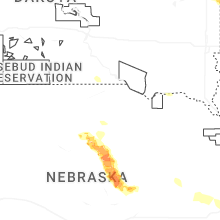


Connect with Interactive Hail Maps