

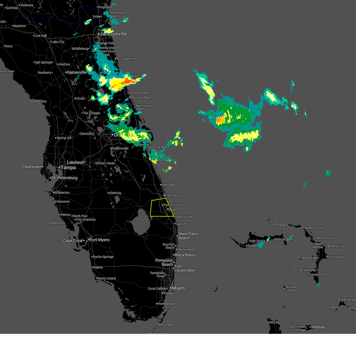
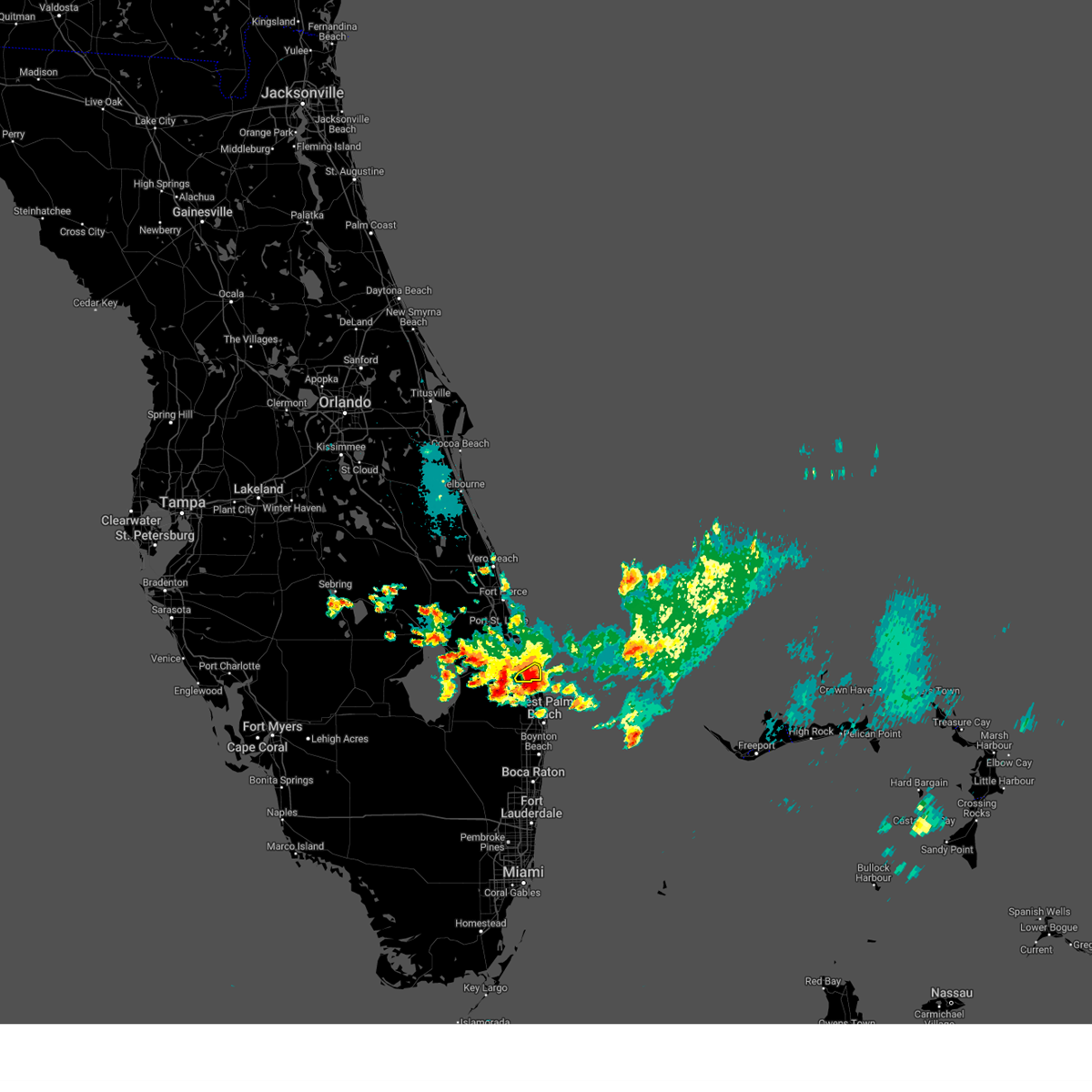
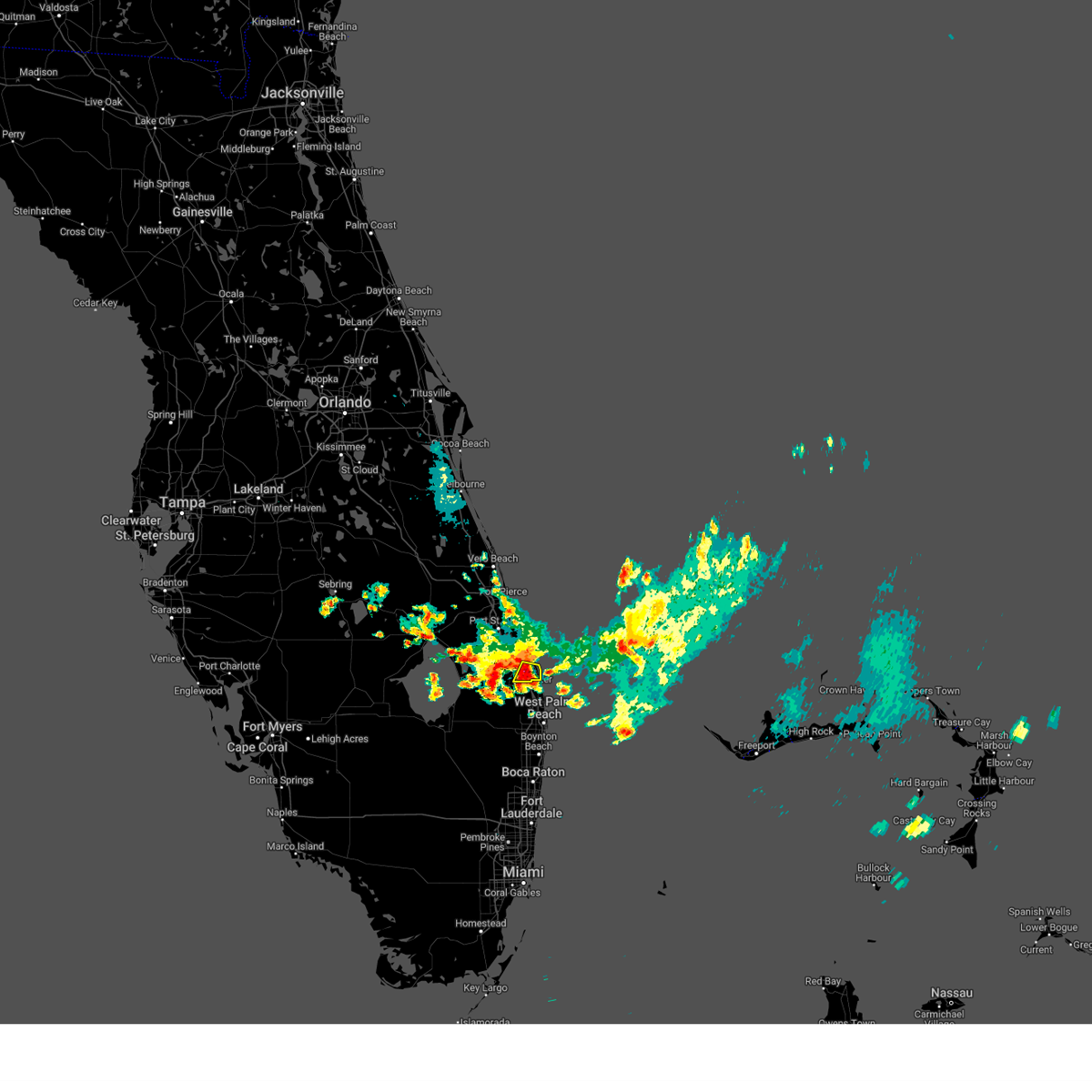
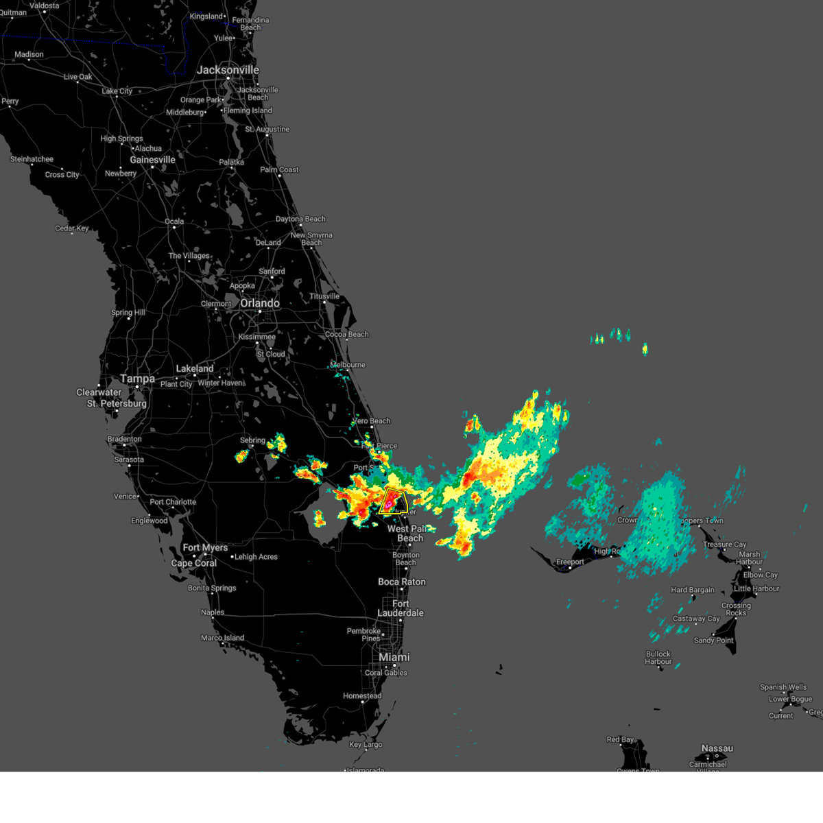
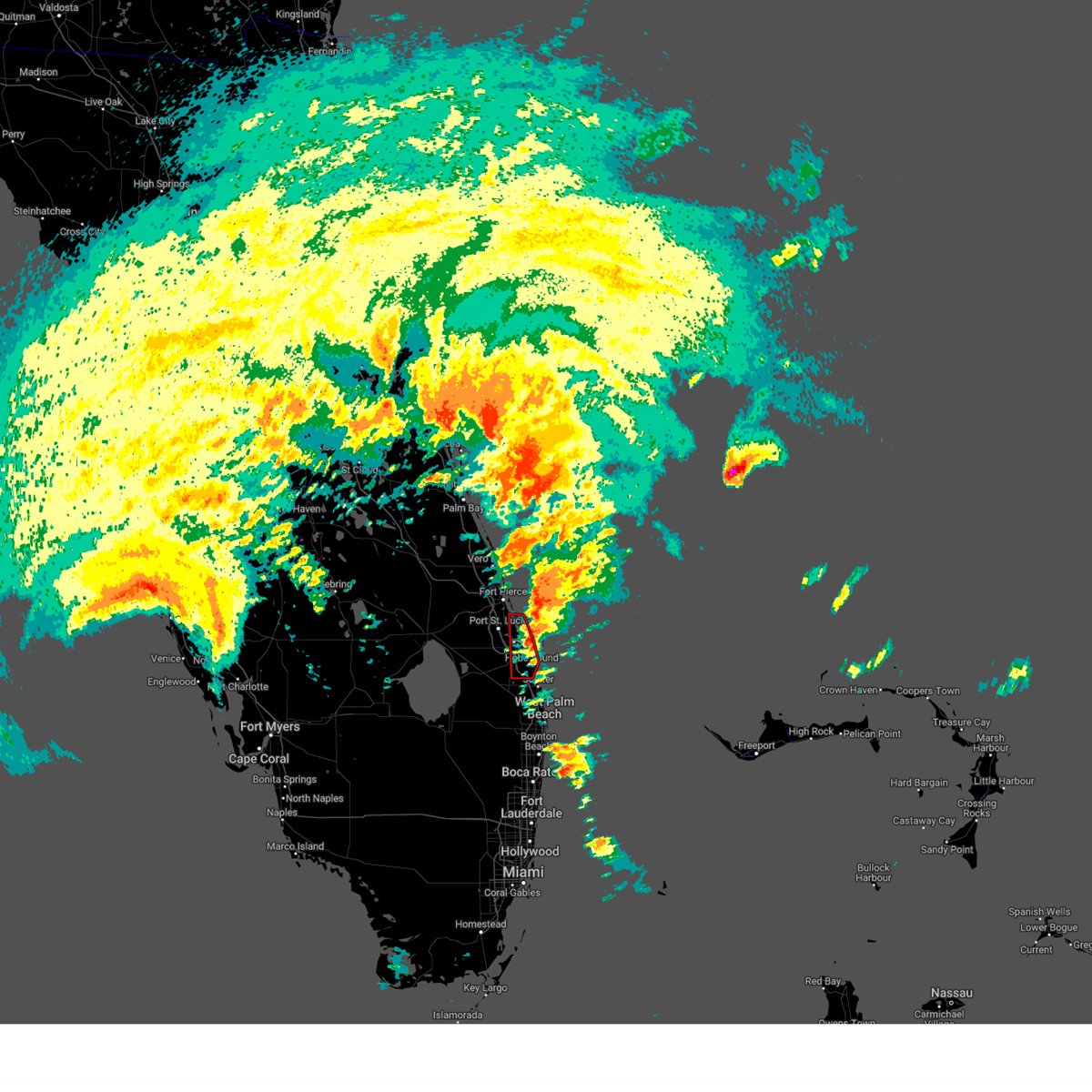
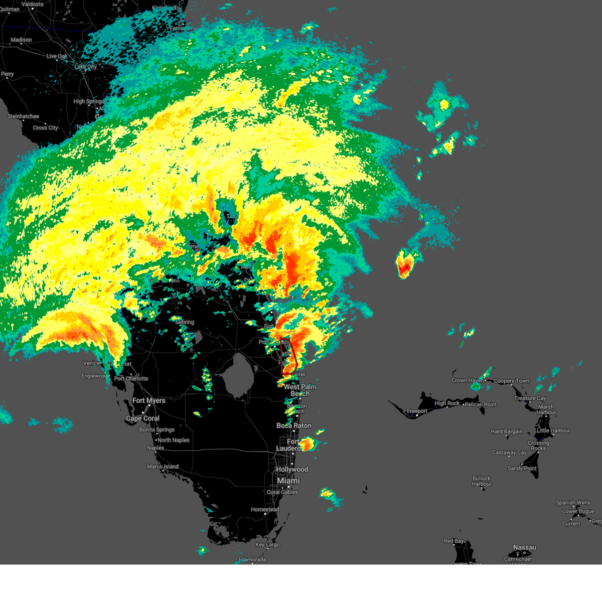
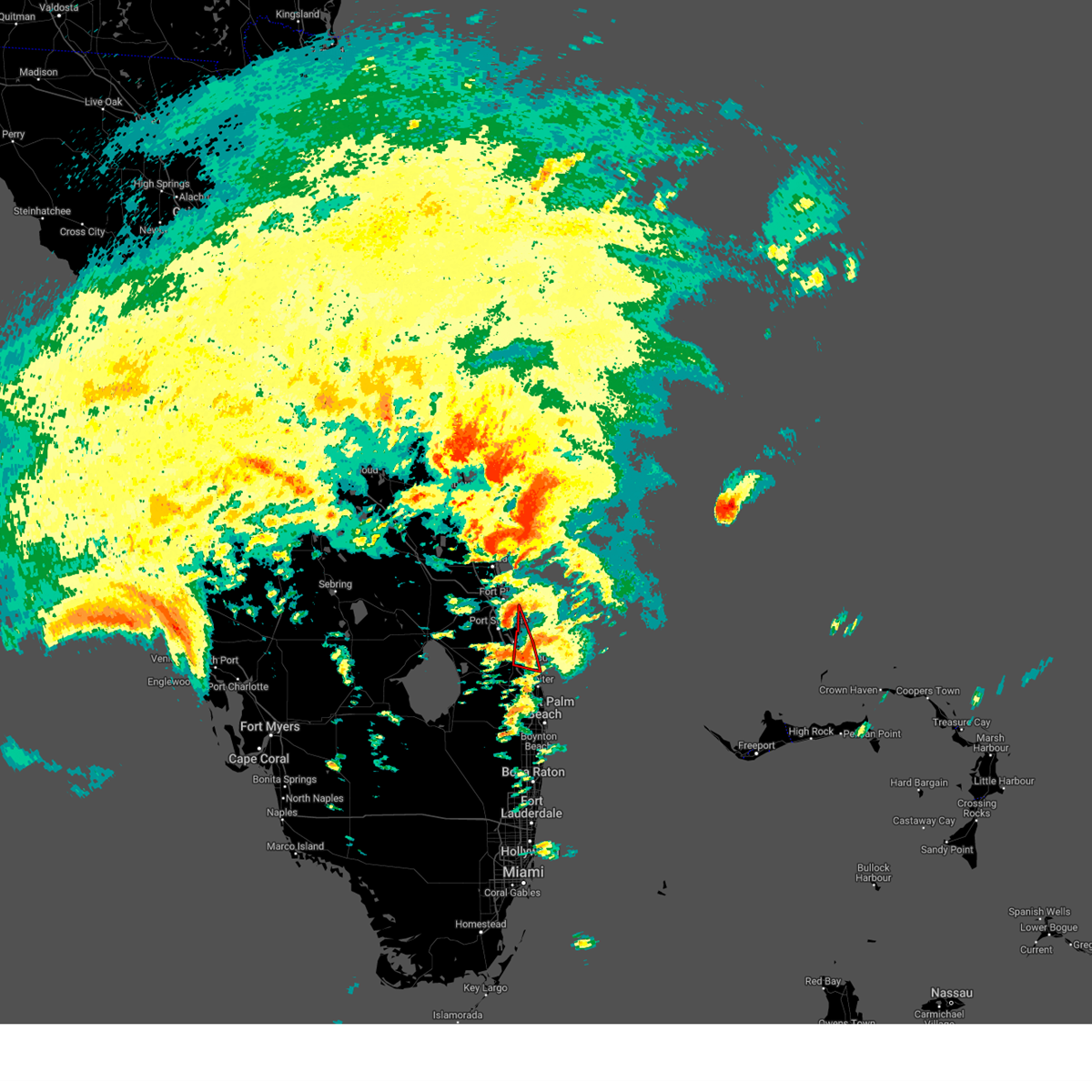
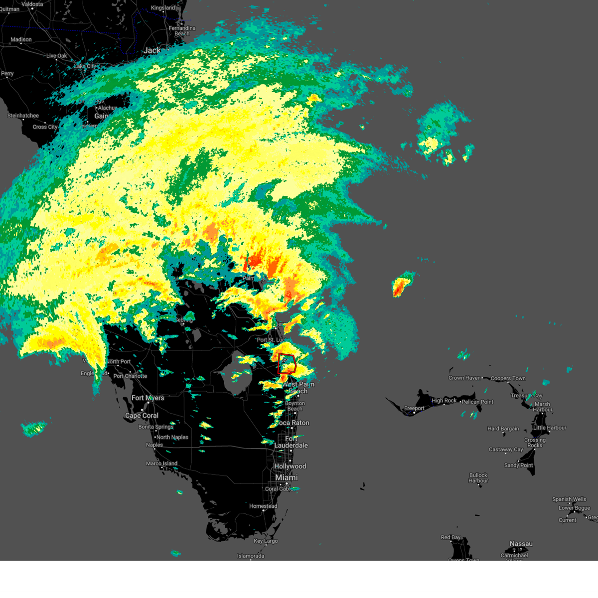
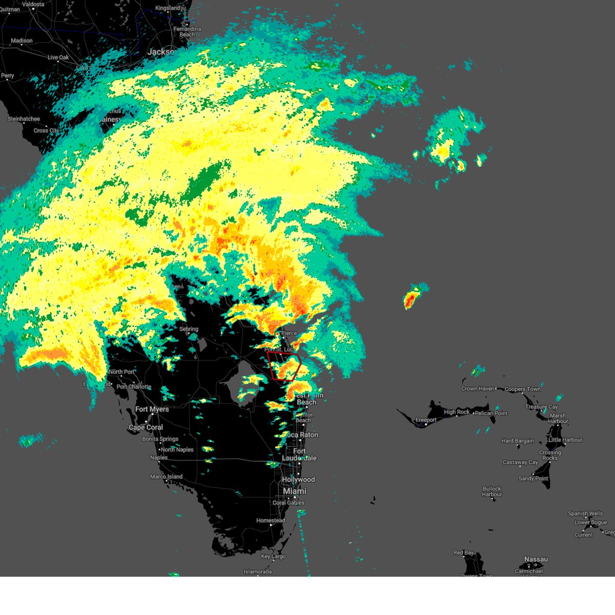
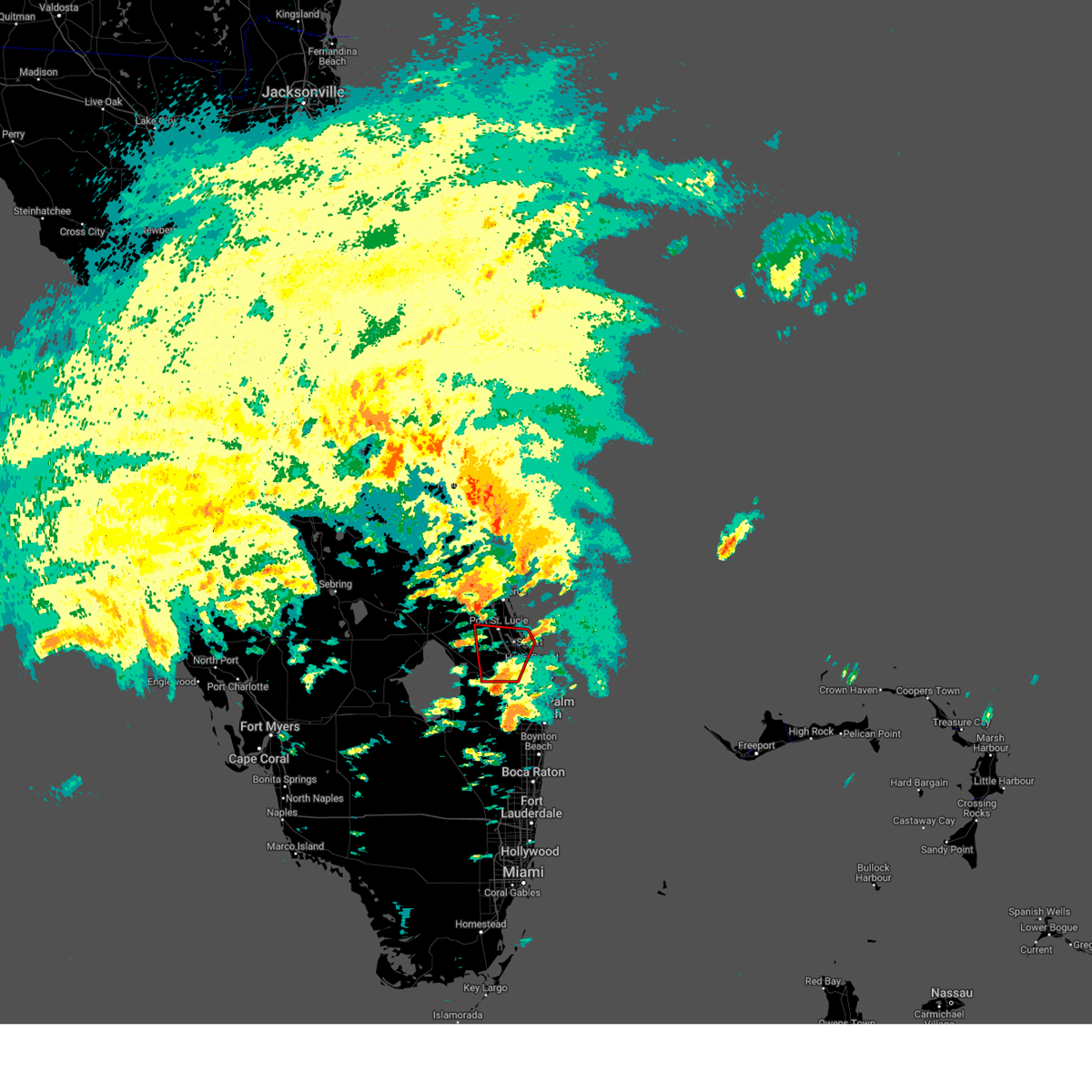
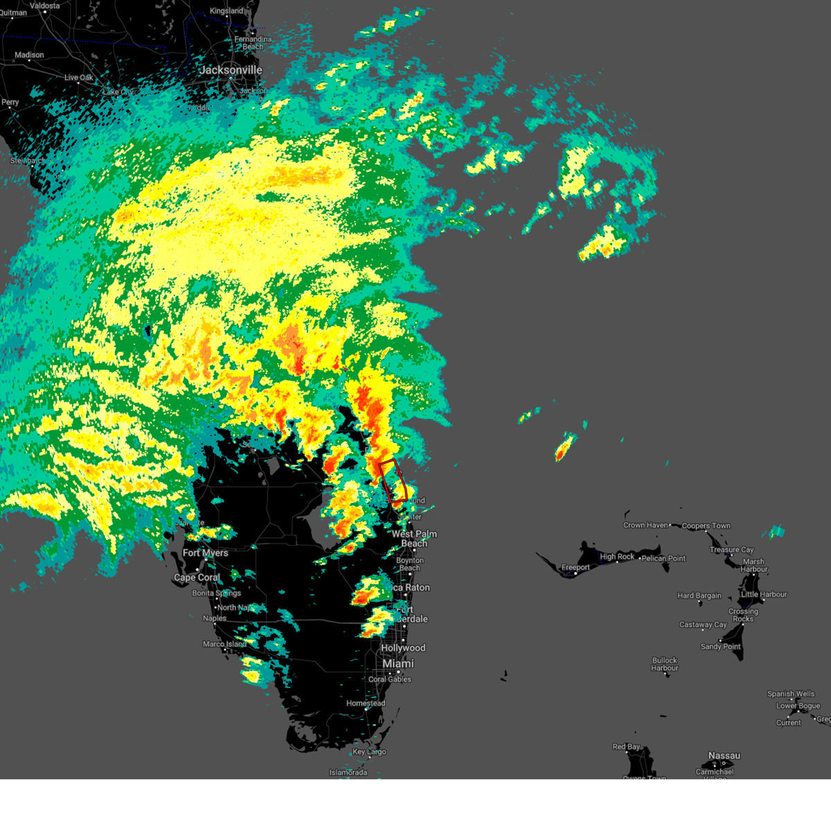
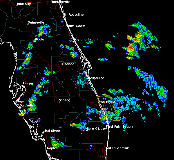
Hail Map for Hobe Sound, FL
The Hobe Sound, FL area has had 5 reports of on-the-ground hail by trained spotters, and has been under severe weather warnings 13 times during the past 12 months. Doppler radar has detected hail at or near Hobe Sound, FL on 39 occasions, including 2 occasions during the past year.
| Name: | Hobe Sound, FL |
| Where Located: | 19.1 miles SE of Port Saint Lucie, FL |
| Map: | Google Map for Hobe Sound, FL |
| Population: | 11521 |
| Housing Units: | 6523 |
| More Info: | Search Google for Hobe Sound, FL |
1
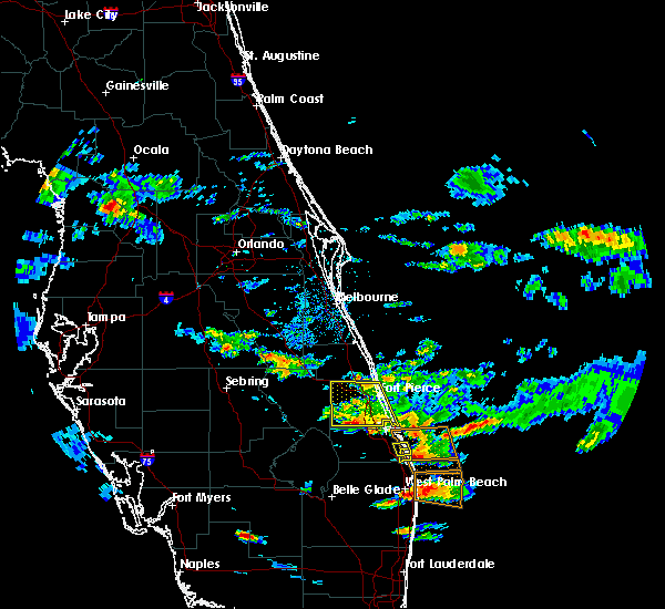
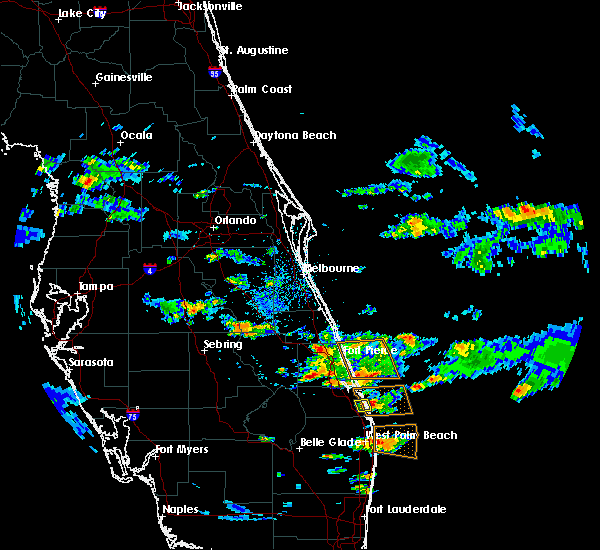
The Top Recent Hail Date for Hobe Sound, FL is Tuesday, March 25, 2025 (17th out of 39)

Hail and Wind Damage Spotted near Hobe Sound, FL
| Date / Time | Report Details |
|---|---|
| 7/13/2025 6:31 PM EDT |
 Svrmlb the national weather service in melbourne has issued a * severe thunderstorm warning for, southern st. lucie county in east central florida, central martin county in east central florida, * until 700 pm edt. * at 630 pm edt, a severe thunderstorm was located over tradition, or near port saint lucie, moving south at 20 mph (radar indicated). Hazards include 60 mph wind gusts and penny size hail. expect damage to roofs, siding, and trees Svrmlb the national weather service in melbourne has issued a * severe thunderstorm warning for, southern st. lucie county in east central florida, central martin county in east central florida, * until 700 pm edt. * at 630 pm edt, a severe thunderstorm was located over tradition, or near port saint lucie, moving south at 20 mph (radar indicated). Hazards include 60 mph wind gusts and penny size hail. expect damage to roofs, siding, and trees
|
| 3/25/2025 8:22 PM EDT |
 The storm which prompted the warning has moved out of the area. therefore, the warning will be allowed to expire. however small hail and gusty winds are still possible with this thunderstorm. The storm which prompted the warning has moved out of the area. therefore, the warning will be allowed to expire. however small hail and gusty winds are still possible with this thunderstorm.
|
| 3/25/2025 8:16 PM EDT |
 At 816 pm edt, a severe thunderstorm was located near tequesta, moving southeast at 25 mph (radar indicated). Hazards include 60 mph wind gusts and quarter size hail. Hail damage to vehicles is expected. expect wind damage to roofs, siding, and trees. Locations impacted include, jupiter island, hobe sound beach, jonathan dickinson state park, tequesta, and hobe sound. At 816 pm edt, a severe thunderstorm was located near tequesta, moving southeast at 25 mph (radar indicated). Hazards include 60 mph wind gusts and quarter size hail. Hail damage to vehicles is expected. expect wind damage to roofs, siding, and trees. Locations impacted include, jupiter island, hobe sound beach, jonathan dickinson state park, tequesta, and hobe sound.
|
| 3/25/2025 8:06 PM EDT |
 At 806 pm edt, a severe thunderstorm was located near jonathan dickinson state park, or near jupiter island, moving southeast at 20 mph (radar indicated). Hazards include 60 mph wind gusts and quarter size hail. Hail damage to vehicles is expected. expect wind damage to roofs, siding, and trees. Locations impacted include, jupiter island, jonathan dickinson state park, hobe sound beach, hobe sound, and tequesta. At 806 pm edt, a severe thunderstorm was located near jonathan dickinson state park, or near jupiter island, moving southeast at 20 mph (radar indicated). Hazards include 60 mph wind gusts and quarter size hail. Hail damage to vehicles is expected. expect wind damage to roofs, siding, and trees. Locations impacted include, jupiter island, jonathan dickinson state park, hobe sound beach, hobe sound, and tequesta.
|
| 3/25/2025 7:52 PM EDT |
 Svrmlb the national weather service in melbourne has issued a * severe thunderstorm warning for, southeastern martin county in east central florida, * until 830 pm edt. * at 752 pm edt, a severe thunderstorm was located near hobe sound, moving southeast at 15 mph (radar indicated). Hazards include 60 mph wind gusts and quarter size hail. Hail damage to vehicles is expected. Expect wind damage to roofs, siding, and trees. Svrmlb the national weather service in melbourne has issued a * severe thunderstorm warning for, southeastern martin county in east central florida, * until 830 pm edt. * at 752 pm edt, a severe thunderstorm was located near hobe sound, moving southeast at 15 mph (radar indicated). Hazards include 60 mph wind gusts and quarter size hail. Hail damage to vehicles is expected. Expect wind damage to roofs, siding, and trees.
|
| 10/9/2024 6:20 PM EDT |
 The storm which prompted the warning has moved out of the area. therefore, the warning will be allowed to expire. a tornado watch remains in effect until 900 pm edt for east central florida. The storm which prompted the warning has moved out of the area. therefore, the warning will be allowed to expire. a tornado watch remains in effect until 900 pm edt for east central florida.
|
| 10/9/2024 6:01 PM EDT |
 Tormlb the national weather service in melbourne has issued a * tornado warning for, east central st. lucie county in east central florida, eastern martin county in east central florida, * until 630 pm edt. * at 601 pm edt, a severe thunderstorm capable of producing a tornado was located near hobe sound, moving north at 45 mph (radar indicated rotation). Hazards include tornado. Flying debris will be dangerous to those caught without shelter. mobile homes will be damaged or destroyed. damage to roofs, windows, and vehicles will occur. tree damage is likely. this dangerous storm will be near, stuart, jupiter island, and palm city around 610 pm edt. nettles island around 620 pm edt. Other locations impacted by this tornadic thunderstorm include rio. Tormlb the national weather service in melbourne has issued a * tornado warning for, east central st. lucie county in east central florida, eastern martin county in east central florida, * until 630 pm edt. * at 601 pm edt, a severe thunderstorm capable of producing a tornado was located near hobe sound, moving north at 45 mph (radar indicated rotation). Hazards include tornado. Flying debris will be dangerous to those caught without shelter. mobile homes will be damaged or destroyed. damage to roofs, windows, and vehicles will occur. tree damage is likely. this dangerous storm will be near, stuart, jupiter island, and palm city around 610 pm edt. nettles island around 620 pm edt. Other locations impacted by this tornadic thunderstorm include rio.
|
| 10/9/2024 5:40 PM EDT |
 Tormlb the national weather service in melbourne has issued a * tornado warning for, northeastern martin county in east central florida, * until 615 pm edt. * at 540 pm edt, a severe thunderstorm capable of producing a tornado was located over port salerno, moving north at 30 mph (radar indicated rotation). Hazards include tornado. Flying debris will be dangerous to those caught without shelter. mobile homes will be damaged or destroyed. damage to roofs, windows, and vehicles will occur. tree damage is likely. this dangerous storm will be near, stuart, jensen beach, and port salerno around 550 pm edt. nettles island around 600 pm edt. Other locations impacted by this tornadic thunderstorm include rio. Tormlb the national weather service in melbourne has issued a * tornado warning for, northeastern martin county in east central florida, * until 615 pm edt. * at 540 pm edt, a severe thunderstorm capable of producing a tornado was located over port salerno, moving north at 30 mph (radar indicated rotation). Hazards include tornado. Flying debris will be dangerous to those caught without shelter. mobile homes will be damaged or destroyed. damage to roofs, windows, and vehicles will occur. tree damage is likely. this dangerous storm will be near, stuart, jensen beach, and port salerno around 550 pm edt. nettles island around 600 pm edt. Other locations impacted by this tornadic thunderstorm include rio.
|
| 10/9/2024 5:20 PM EDT |
 At 519 pm edt, a confirmed tornado was located near north county airport, or near jupiter, moving north at 40 mph (radar confirmed tornado). Hazards include damaging tornado. Flying debris will be dangerous to those caught without shelter. mobile homes will be damaged or destroyed. damage to roofs, windows, and vehicles will occur. tree damage is likely. this tornado will be near, jupiter around 520 pm edt. jupiter island, port salerno, and hobe sound around 530 pm edt. stuart around 540 pm edt. Other locations impacted by this tornadic thunderstorm include hobe sound wildlife refuge. At 519 pm edt, a confirmed tornado was located near north county airport, or near jupiter, moving north at 40 mph (radar confirmed tornado). Hazards include damaging tornado. Flying debris will be dangerous to those caught without shelter. mobile homes will be damaged or destroyed. damage to roofs, windows, and vehicles will occur. tree damage is likely. this tornado will be near, jupiter around 520 pm edt. jupiter island, port salerno, and hobe sound around 530 pm edt. stuart around 540 pm edt. Other locations impacted by this tornadic thunderstorm include hobe sound wildlife refuge.
|
| 10/9/2024 5:16 PM EDT |
 Tormlb the national weather service in melbourne has issued a * tornado warning for, southeastern martin county in east central florida, * until 545 pm edt. * at 515 pm edt, a severe thunderstorm capable of producing a tornado was located over north county airport, or near palm beach gardens, moving north at 40 mph (radar indicated rotation). Hazards include tornado. Flying debris will be dangerous to those caught without shelter. mobile homes will be damaged or destroyed. damage to roofs, windows, and vehicles will occur. tree damage is likely. this dangerous storm will be near, jupiter around 520 pm edt. jupiter island, port salerno, and hobe sound around 530 pm edt. stuart around 540 pm edt. Other locations impacted by this tornadic thunderstorm include hobe sound wildlife refuge. Tormlb the national weather service in melbourne has issued a * tornado warning for, southeastern martin county in east central florida, * until 545 pm edt. * at 515 pm edt, a severe thunderstorm capable of producing a tornado was located over north county airport, or near palm beach gardens, moving north at 40 mph (radar indicated rotation). Hazards include tornado. Flying debris will be dangerous to those caught without shelter. mobile homes will be damaged or destroyed. damage to roofs, windows, and vehicles will occur. tree damage is likely. this dangerous storm will be near, jupiter around 520 pm edt. jupiter island, port salerno, and hobe sound around 530 pm edt. stuart around 540 pm edt. Other locations impacted by this tornadic thunderstorm include hobe sound wildlife refuge.
|
| 10/9/2024 5:13 PM EDT |
 At 513 pm edt, a confirmed tornado was located near palm city, moving north at 40 mph (radar confirmed tornado). Hazards include damaging tornado. Flying debris will be dangerous to those caught without shelter. mobile homes will be damaged or destroyed. damage to roofs, windows, and vehicles will occur. tree damage is likely. this tornado will be near, stuart, palm city, and jensen beach around 520 pm edt. port saint lucie around 530 pm edt. Other locations impacted by this tornadic thunderstorm include rio. At 513 pm edt, a confirmed tornado was located near palm city, moving north at 40 mph (radar confirmed tornado). Hazards include damaging tornado. Flying debris will be dangerous to those caught without shelter. mobile homes will be damaged or destroyed. damage to roofs, windows, and vehicles will occur. tree damage is likely. this tornado will be near, stuart, palm city, and jensen beach around 520 pm edt. port saint lucie around 530 pm edt. Other locations impacted by this tornadic thunderstorm include rio.
|
| 10/9/2024 4:59 PM EDT |
 Tormlb the national weather service in melbourne has issued a * tornado warning for, southeastern st. lucie county in east central florida, central martin county in east central florida, * until 530 pm edt. * at 458 pm edt, a severe thunderstorm capable of producing a tornado was located 8 miles southeast of indiantown, moving north at 40 mph (radar indicated rotation). Hazards include tornado. Flying debris will be dangerous to those caught without shelter. mobile homes will be damaged or destroyed. damage to roofs, windows, and vehicles will occur. tree damage is likely. this dangerous storm will be near, palm city around 510 pm edt. stuart, jensen beach, and north river shores around 520 pm edt. port saint lucie around 530 pm edt. Other locations impacted by this tornadic thunderstorm include rio. Tormlb the national weather service in melbourne has issued a * tornado warning for, southeastern st. lucie county in east central florida, central martin county in east central florida, * until 530 pm edt. * at 458 pm edt, a severe thunderstorm capable of producing a tornado was located 8 miles southeast of indiantown, moving north at 40 mph (radar indicated rotation). Hazards include tornado. Flying debris will be dangerous to those caught without shelter. mobile homes will be damaged or destroyed. damage to roofs, windows, and vehicles will occur. tree damage is likely. this dangerous storm will be near, palm city around 510 pm edt. stuart, jensen beach, and north river shores around 520 pm edt. port saint lucie around 530 pm edt. Other locations impacted by this tornadic thunderstorm include rio.
|
| 10/9/2024 4:07 PM EDT |
 Tormlb the national weather service in melbourne has issued a * tornado warning for, southeastern st. lucie county in east central florida, northeastern martin county in east central florida, * until 445 pm edt. * at 407 pm edt, a severe thunderstorm capable of producing a tornado was located over witham field, or over stuart, moving north at 40 mph (radar indicated rotation). Hazards include tornado. Flying debris will be dangerous to those caught without shelter. mobile homes will be damaged or destroyed. damage to roofs, windows, and vehicles will occur. tree damage is likely. this dangerous storm will be near, walton, stuart, and palm city around 410 pm edt. fort pierce, saint lucie nuclear power plant, and white city around 420 pm edt. Other locations impacted by this tornadic thunderstorm include rio. Tormlb the national weather service in melbourne has issued a * tornado warning for, southeastern st. lucie county in east central florida, northeastern martin county in east central florida, * until 445 pm edt. * at 407 pm edt, a severe thunderstorm capable of producing a tornado was located over witham field, or over stuart, moving north at 40 mph (radar indicated rotation). Hazards include tornado. Flying debris will be dangerous to those caught without shelter. mobile homes will be damaged or destroyed. damage to roofs, windows, and vehicles will occur. tree damage is likely. this dangerous storm will be near, walton, stuart, and palm city around 410 pm edt. fort pierce, saint lucie nuclear power plant, and white city around 420 pm edt. Other locations impacted by this tornadic thunderstorm include rio.
|
| 6/12/2024 10:50 AM EDT |
 the tornado warning has been cancelled and is no longer in effect the tornado warning has been cancelled and is no longer in effect
|
| 6/12/2024 10:44 AM EDT |
 At 1044 am edt, a severe thunderstorm capable of producing a tornado was located over hobe sound beach, or near hobe sound, moving northeast at 15 mph (radar indicated rotation). Hazards include tornado. Flying debris will be dangerous to those caught without shelter. mobile homes will be damaged or destroyed. damage to roofs, windows, and vehicles will occur. tree damage is likely. This tornadic thunderstorm will remain over mainly rural areas of southeastern martin county, including the following locations, hobe sound wildlife refuge. At 1044 am edt, a severe thunderstorm capable of producing a tornado was located over hobe sound beach, or near hobe sound, moving northeast at 15 mph (radar indicated rotation). Hazards include tornado. Flying debris will be dangerous to those caught without shelter. mobile homes will be damaged or destroyed. damage to roofs, windows, and vehicles will occur. tree damage is likely. This tornadic thunderstorm will remain over mainly rural areas of southeastern martin county, including the following locations, hobe sound wildlife refuge.
|
| 6/12/2024 10:40 AM EDT | A possible tornado near bridge road and us-1 in hobe sound led to reports of damage to trees and vegetation as well as some minor structural damage. images shared via s in martin county FL, 1.5 miles NNW of Hobe Sound, FL |
| 6/12/2024 10:32 AM EDT |
 Tormlb the national weather service in melbourne has issued a * tornado warning for, southeastern martin county in east central florida, * until 1100 am edt. * at 1032 am edt, a severe thunderstorm capable of producing a tornado was located over hobe sound, moving northeast at 15 mph (radar indicated rotation). Hazards include tornado. Flying debris will be dangerous to those caught without shelter. mobile homes will be damaged or destroyed. damage to roofs, windows, and vehicles will occur. tree damage is likely. this dangerous storm will be near, jupiter island, hobe sound, and hobe sound beach around 1040 am edt. Other locations impacted by this tornadic thunderstorm include hobe sound wildlife refuge. Tormlb the national weather service in melbourne has issued a * tornado warning for, southeastern martin county in east central florida, * until 1100 am edt. * at 1032 am edt, a severe thunderstorm capable of producing a tornado was located over hobe sound, moving northeast at 15 mph (radar indicated rotation). Hazards include tornado. Flying debris will be dangerous to those caught without shelter. mobile homes will be damaged or destroyed. damage to roofs, windows, and vehicles will occur. tree damage is likely. this dangerous storm will be near, jupiter island, hobe sound, and hobe sound beach around 1040 am edt. Other locations impacted by this tornadic thunderstorm include hobe sound wildlife refuge.
|
| 5/28/2024 5:57 PM EDT |
 The storm which prompted the warning has weakened below severe limits, and no longer poses an immediate threat to life or property. therefore, the warning will be allowed to expire. however gusty winds are still possible with this thunderstorm. to report severe weather, contact your nearest law enforcement agency. they will relay your report to the national weather service melbourne. The storm which prompted the warning has weakened below severe limits, and no longer poses an immediate threat to life or property. therefore, the warning will be allowed to expire. however gusty winds are still possible with this thunderstorm. to report severe weather, contact your nearest law enforcement agency. they will relay your report to the national weather service melbourne.
|
| 5/28/2024 5:41 PM EDT |
 At 541 pm edt, a severe thunderstorm was located near palm city, moving southeast at 25 mph (radar indicated). Hazards include 60 mph wind gusts and nickel size hail. Expect damage to roofs, siding, and trees. Locations impacted include, stuart, palm city, port salerno, jensen beach, and hobe sound. At 541 pm edt, a severe thunderstorm was located near palm city, moving southeast at 25 mph (radar indicated). Hazards include 60 mph wind gusts and nickel size hail. Expect damage to roofs, siding, and trees. Locations impacted include, stuart, palm city, port salerno, jensen beach, and hobe sound.
|
| 5/28/2024 5:41 PM EDT |
 the severe thunderstorm warning has been cancelled and is no longer in effect the severe thunderstorm warning has been cancelled and is no longer in effect
|
| 5/28/2024 5:33 PM EDT |
 At 532 pm edt, a severe thunderstorm was located near palm city, moving southeast at 25 mph (radar indicated). Hazards include 60 mph wind gusts and half dollar size hail. Hail damage to vehicles is expected. expect wind damage to roofs, siding, and trees. Locations impacted include, stuart, palm city, port salerno, hobe sound, and sewall's point. At 532 pm edt, a severe thunderstorm was located near palm city, moving southeast at 25 mph (radar indicated). Hazards include 60 mph wind gusts and half dollar size hail. Hail damage to vehicles is expected. expect wind damage to roofs, siding, and trees. Locations impacted include, stuart, palm city, port salerno, hobe sound, and sewall's point.
|
| 5/28/2024 5:30 PM EDT |
 At 530 pm edt, a severe thunderstorm was located near palm city, moving southeast at 25 mph (radar indicated). Hazards include 60 mph wind gusts and nickel size hail. Expect damage to roofs, siding, and trees. Locations impacted include, stuart, palm city, port salerno, hobe sound, and sewall's point. At 530 pm edt, a severe thunderstorm was located near palm city, moving southeast at 25 mph (radar indicated). Hazards include 60 mph wind gusts and nickel size hail. Expect damage to roofs, siding, and trees. Locations impacted include, stuart, palm city, port salerno, hobe sound, and sewall's point.
|
| 5/28/2024 5:25 PM EDT |
 Svrmlb the national weather service in melbourne has issued a * severe thunderstorm warning for, south central st. lucie county in east central florida, central martin county in east central florida, * until 600 pm edt. * at 524 pm edt, a severe thunderstorm was located near palm city, moving southeast at 25 mph (radar indicated). Hazards include 60 mph wind gusts. expect damage to roofs, siding, and trees Svrmlb the national weather service in melbourne has issued a * severe thunderstorm warning for, south central st. lucie county in east central florida, central martin county in east central florida, * until 600 pm edt. * at 524 pm edt, a severe thunderstorm was located near palm city, moving southeast at 25 mph (radar indicated). Hazards include 60 mph wind gusts. expect damage to roofs, siding, and trees
|
| 5/19/2024 6:45 PM EDT |
 At 643 pm edt, a severe thunderstorm was located over witham field, or over stuart, moving northeast at 35 mph (radar indicated). Hazards include golf ball size hail and 60 mph wind gusts. People and animals outdoors will be injured. expect hail damage to roofs, siding, windows, and vehicles. expect wind damage to roofs, siding, and trees. Locations impacted include, stuart, port salerno, jensen beach, palm city, and hobe sound. At 643 pm edt, a severe thunderstorm was located over witham field, or over stuart, moving northeast at 35 mph (radar indicated). Hazards include golf ball size hail and 60 mph wind gusts. People and animals outdoors will be injured. expect hail damage to roofs, siding, windows, and vehicles. expect wind damage to roofs, siding, and trees. Locations impacted include, stuart, port salerno, jensen beach, palm city, and hobe sound.
|
| 5/19/2024 6:45 PM EDT |
 the severe thunderstorm warning has been cancelled and is no longer in effect the severe thunderstorm warning has been cancelled and is no longer in effect
|
| 5/19/2024 6:35 PM EDT |
 At 635 pm edt, a severe thunderstorm was located over palm city, moving northeast at 30 mph (radar indicated). Hazards include golf ball size hail and 60 mph wind gusts. People and animals outdoors will be injured. expect hail damage to roofs, siding, windows, and vehicles. expect wind damage to roofs, siding, and trees. Locations impacted include, walton, stuart, jupiter island, palm city, and saint lucie nuclear power plant. At 635 pm edt, a severe thunderstorm was located over palm city, moving northeast at 30 mph (radar indicated). Hazards include golf ball size hail and 60 mph wind gusts. People and animals outdoors will be injured. expect hail damage to roofs, siding, windows, and vehicles. expect wind damage to roofs, siding, and trees. Locations impacted include, walton, stuart, jupiter island, palm city, and saint lucie nuclear power plant.
|
| 5/19/2024 6:23 PM EDT |
 Svrmlb the national weather service in melbourne has issued a * severe thunderstorm warning for, southeastern st. lucie county in east central florida, eastern martin county in east central florida, * until 715 pm edt. * at 623 pm edt, a severe thunderstorm was located 7 miles south of palm city, moving northeast at 30 mph (radar indicated). Hazards include ping pong ball size hail and 60 mph wind gusts. People and animals outdoors will be injured. expect hail damage to roofs, siding, windows, and vehicles. Expect wind damage to roofs, siding, and trees. Svrmlb the national weather service in melbourne has issued a * severe thunderstorm warning for, southeastern st. lucie county in east central florida, eastern martin county in east central florida, * until 715 pm edt. * at 623 pm edt, a severe thunderstorm was located 7 miles south of palm city, moving northeast at 30 mph (radar indicated). Hazards include ping pong ball size hail and 60 mph wind gusts. People and animals outdoors will be injured. expect hail damage to roofs, siding, windows, and vehicles. Expect wind damage to roofs, siding, and trees.
|
| 5/19/2024 3:34 PM EDT |
 the severe thunderstorm warning has been cancelled and is no longer in effect the severe thunderstorm warning has been cancelled and is no longer in effect
|
| 5/19/2024 3:25 PM EDT |
 At 324 pm edt, a severe thunderstorm was located near sewall's point, or near jensen beach, moving east at 35 mph (radar indicated. ping pong ball sized hail was reported near port st lucie and just north of stuart with this storm moments ago!). Hazards include 60 mph wind gusts and half dollar size hail. Hail damage to vehicles is expected. expect wind damage to roofs, siding, and trees. Locations impacted include, walton, stuart, palm city, port salerno, and jensen beach. At 324 pm edt, a severe thunderstorm was located near sewall's point, or near jensen beach, moving east at 35 mph (radar indicated. ping pong ball sized hail was reported near port st lucie and just north of stuart with this storm moments ago!). Hazards include 60 mph wind gusts and half dollar size hail. Hail damage to vehicles is expected. expect wind damage to roofs, siding, and trees. Locations impacted include, walton, stuart, palm city, port salerno, and jensen beach.
|
| 5/19/2024 3:08 PM EDT |
 Svrmlb the national weather service in melbourne has issued a * severe thunderstorm warning for, southeastern st. lucie county in east central florida, central martin county in east central florida, * until 345 pm edt. * at 308 pm edt, a severe thunderstorm was located over palm city, moving east at 35 mph (radar indicated). Hazards include 60 mph wind gusts and quarter size hail. Hail damage to vehicles is expected. Expect wind damage to roofs, siding, and trees. Svrmlb the national weather service in melbourne has issued a * severe thunderstorm warning for, southeastern st. lucie county in east central florida, central martin county in east central florida, * until 345 pm edt. * at 308 pm edt, a severe thunderstorm was located over palm city, moving east at 35 mph (radar indicated). Hazards include 60 mph wind gusts and quarter size hail. Hail damage to vehicles is expected. Expect wind damage to roofs, siding, and trees.
|
| 1/9/2024 9:20 PM EST |
 At 919 pm est, severe thunderstorms were located along a line extending from 7 miles east of fort pierce inlet to 6 miles southwest of palm city, moving east at 40 mph (radar indicated). Hazards include 60 mph wind gusts. Expect damage to roofs, siding, and trees. locations impacted include, port saint lucie, walton, fort pierce, stuart, and jupiter island. hail threat, radar indicated max hail size, <. 75 in wind threat, radar indicated max wind gust, 60 mph. At 919 pm est, severe thunderstorms were located along a line extending from 7 miles east of fort pierce inlet to 6 miles southwest of palm city, moving east at 40 mph (radar indicated). Hazards include 60 mph wind gusts. Expect damage to roofs, siding, and trees. locations impacted include, port saint lucie, walton, fort pierce, stuart, and jupiter island. hail threat, radar indicated max hail size, <. 75 in wind threat, radar indicated max wind gust, 60 mph.
|
| 1/9/2024 9:07 PM EST |
 At 905 pm est, severe thunderstorms were located along a line extending from near fort pierce inlet, moving northeast at 70 mph (radar indicated). Hazards include 60 mph wind gusts. Expect damage to roofs, siding, and trees. Locations impacted include, port saint lucie, walton, fort pierce, stuart, and indiantown. At 905 pm est, severe thunderstorms were located along a line extending from near fort pierce inlet, moving northeast at 70 mph (radar indicated). Hazards include 60 mph wind gusts. Expect damage to roofs, siding, and trees. Locations impacted include, port saint lucie, walton, fort pierce, stuart, and indiantown.
|
| 1/9/2024 8:34 PM EST |
 At 833 pm est, severe thunderstorms were located along a line extending from pointe west to near treasure island, moving northeast at 70 mph (radar indicated). Hazards include 60 mph wind gusts. expect damage to roofs, siding, and trees At 833 pm est, severe thunderstorms were located along a line extending from pointe west to near treasure island, moving northeast at 70 mph (radar indicated). Hazards include 60 mph wind gusts. expect damage to roofs, siding, and trees
|
| 1/6/2024 2:10 PM EST |
 At 210 pm est, a severe thunderstorm capable of producing a tornado was located near indiantown, moving east at 30 mph (radar indicated rotation). Hazards include tornado. Flying debris will be dangerous to those caught without shelter. mobile homes will be damaged or destroyed. damage to roofs, windows, and vehicles will occur. tree damage is likely. this dangerous storm will be near, stuart and palm city around 220 pm est. jensen beach, port salerno, and sewall`s point around 230 pm est. Other locations impacted by this tornadic thunderstorm include rio. At 210 pm est, a severe thunderstorm capable of producing a tornado was located near indiantown, moving east at 30 mph (radar indicated rotation). Hazards include tornado. Flying debris will be dangerous to those caught without shelter. mobile homes will be damaged or destroyed. damage to roofs, windows, and vehicles will occur. tree damage is likely. this dangerous storm will be near, stuart and palm city around 220 pm est. jensen beach, port salerno, and sewall`s point around 230 pm est. Other locations impacted by this tornadic thunderstorm include rio.
|
| 7/31/2023 4:39 PM EDT |
 The severe thunderstorm warning for southeastern st. lucie and northeastern martin counties will expire at 445 pm edt, the storm which prompted the warning has weakened below severe limits, and no longer poses an immediate threat to life or property. therefore, the warning will be allowed to expire. however gusty winds and heavy rain are still possible with this thunderstorm. The severe thunderstorm warning for southeastern st. lucie and northeastern martin counties will expire at 445 pm edt, the storm which prompted the warning has weakened below severe limits, and no longer poses an immediate threat to life or property. therefore, the warning will be allowed to expire. however gusty winds and heavy rain are still possible with this thunderstorm.
|
| 7/31/2023 4:22 PM EDT |
 At 422 pm edt, a severe thunderstorm was located over witham field, or over stuart, moving north at 10 mph (radar indicated). Hazards include 60 mph wind gusts and penny size hail. expect damage to roofs, siding, and trees At 422 pm edt, a severe thunderstorm was located over witham field, or over stuart, moving north at 10 mph (radar indicated). Hazards include 60 mph wind gusts and penny size hail. expect damage to roofs, siding, and trees
|
| 7/16/2023 5:05 PM EDT |
 At 504 pm edt, a severe thunderstorm was located over tequesta, moving east at 15 mph (radar indicated). Hazards include 60 mph wind gusts. Expect damage to roofs, siding, and trees. locations impacted include, tequesta, jupiter island, hobe sound, port salerno and hobe sound beach. hail threat, radar indicated max hail size, <. 75 in wind threat, radar indicated max wind gust, 60 mph. At 504 pm edt, a severe thunderstorm was located over tequesta, moving east at 15 mph (radar indicated). Hazards include 60 mph wind gusts. Expect damage to roofs, siding, and trees. locations impacted include, tequesta, jupiter island, hobe sound, port salerno and hobe sound beach. hail threat, radar indicated max hail size, <. 75 in wind threat, radar indicated max wind gust, 60 mph.
|
| 7/16/2023 4:46 PM EDT |
 At 446 pm edt, a severe thunderstorm was located over jonathan dickinson state park, or near jupiter island, moving east at 10 mph (radar indicated). Hazards include 60 mph wind gusts. expect damage to roofs, siding, and trees At 446 pm edt, a severe thunderstorm was located over jonathan dickinson state park, or near jupiter island, moving east at 10 mph (radar indicated). Hazards include 60 mph wind gusts. expect damage to roofs, siding, and trees
|
| 6/11/2023 5:42 PM EDT |
 The severe thunderstorm warning for southeastern martin county will expire at 545 pm edt, the storm which prompted the warning has weakened below severe limits, and no longer poses an immediate threat to life or property. therefore, the warning will be allowed to expire. however gusty winds, heavy rain, and a funnel cloud, are still possible with this thunderstorm. The severe thunderstorm warning for southeastern martin county will expire at 545 pm edt, the storm which prompted the warning has weakened below severe limits, and no longer poses an immediate threat to life or property. therefore, the warning will be allowed to expire. however gusty winds, heavy rain, and a funnel cloud, are still possible with this thunderstorm.
|
| 6/11/2023 5:28 PM EDT |
 At 528 pm edt, a severe thunderstorm was located over tequesta, moving east at 10 mph (radar indicated). Hazards include 60 mph wind gusts and quarter size hail. Hail damage to vehicles is expected. expect wind damage to roofs, siding, and trees. Locations impacted include, tequesta, jupiter island, hobe sound and jonathan dickinson state park. At 528 pm edt, a severe thunderstorm was located over tequesta, moving east at 10 mph (radar indicated). Hazards include 60 mph wind gusts and quarter size hail. Hail damage to vehicles is expected. expect wind damage to roofs, siding, and trees. Locations impacted include, tequesta, jupiter island, hobe sound and jonathan dickinson state park.
|
| 6/11/2023 5:10 PM EDT |
 At 510 pm edt, a severe thunderstorm was located over jonathan dickinson state park, or over jupiter island, moving northeast at 5 mph (radar indicated). Hazards include 60 mph wind gusts and quarter size hail. Hail damage to vehicles is expected. Expect wind damage to roofs, siding, and trees. At 510 pm edt, a severe thunderstorm was located over jonathan dickinson state park, or over jupiter island, moving northeast at 5 mph (radar indicated). Hazards include 60 mph wind gusts and quarter size hail. Hail damage to vehicles is expected. Expect wind damage to roofs, siding, and trees.
|
| 6/1/2023 4:08 PM EDT |
 The severe thunderstorm warning for southeastern martin county will expire at 415 pm edt, the storm which prompted the warning is moving offshore. therefore, the warning will be allowed to expire. however heavy rain is still possible with this thunderstorm. to report severe weather, contact your nearest law enforcement agency. they will relay your report to the national weather service melbourne. The severe thunderstorm warning for southeastern martin county will expire at 415 pm edt, the storm which prompted the warning is moving offshore. therefore, the warning will be allowed to expire. however heavy rain is still possible with this thunderstorm. to report severe weather, contact your nearest law enforcement agency. they will relay your report to the national weather service melbourne.
|
| 6/1/2023 4:04 PM EDT |
 At 403 pm edt, a severe thunderstorm was located over tequesta, moving east at 20 mph (radar indicated). Hazards include 60 mph wind gusts. Expect damage to roofs, siding, and trees. locations impacted include, tequesta, jupiter island, hobe sound, hobe sound beach and jonathan dickinson state park. hail threat, radar indicated max hail size, <. 75 in wind threat, radar indicated max wind gust, 60 mph. At 403 pm edt, a severe thunderstorm was located over tequesta, moving east at 20 mph (radar indicated). Hazards include 60 mph wind gusts. Expect damage to roofs, siding, and trees. locations impacted include, tequesta, jupiter island, hobe sound, hobe sound beach and jonathan dickinson state park. hail threat, radar indicated max hail size, <. 75 in wind threat, radar indicated max wind gust, 60 mph.
|
| 6/1/2023 3:54 PM EDT |
 At 354 pm edt, a severe thunderstorm was located over jonathan dickinson state park, or near jupiter island, moving east at 15 mph (radar indicated). Hazards include 60 mph wind gusts. expect damage to roofs, siding, and trees At 354 pm edt, a severe thunderstorm was located over jonathan dickinson state park, or near jupiter island, moving east at 15 mph (radar indicated). Hazards include 60 mph wind gusts. expect damage to roofs, siding, and trees
|
| 4/29/2023 4:48 PM EDT |
 At 448 pm edt, a severe thunderstorm was located near jupiter, moving northeast at 30 mph (radar indicated). Hazards include 60 mph wind gusts and quarter size hail. Hail damage to vehicles is expected. Expect wind damage to roofs, siding, and trees. At 448 pm edt, a severe thunderstorm was located near jupiter, moving northeast at 30 mph (radar indicated). Hazards include 60 mph wind gusts and quarter size hail. Hail damage to vehicles is expected. Expect wind damage to roofs, siding, and trees.
|
| 4/28/2023 7:53 PM EDT |
 The severe thunderstorm warning for eastern martin county will expire at 800 pm edt, the storm which prompted the warning has weakened below severe limits, and has exited the warned area. therefore, the warning will be allowed to expire. however gusty winds and heavy rain are still possible with this thunderstorm. The severe thunderstorm warning for eastern martin county will expire at 800 pm edt, the storm which prompted the warning has weakened below severe limits, and has exited the warned area. therefore, the warning will be allowed to expire. however gusty winds and heavy rain are still possible with this thunderstorm.
|
| 4/28/2023 7:39 PM EDT |
 At 739 pm edt, a severe thunderstorm was located near port salerno, moving east at 35 mph (radar indicated). Hazards include 60 mph wind gusts and quarter size hail. Hail damage to vehicles is expected. Expect wind damage to roofs, siding, and trees. At 739 pm edt, a severe thunderstorm was located near port salerno, moving east at 35 mph (radar indicated). Hazards include 60 mph wind gusts and quarter size hail. Hail damage to vehicles is expected. Expect wind damage to roofs, siding, and trees.
|
| 4/26/2023 5:38 PM EDT |
 At 537 pm edt, a severe thunderstorm was located over sewall`s point, or near stuart, moving southeast at 30 mph (radar indicated). Hazards include 60 mph wind gusts and quarter size hail. Hail damage to vehicles is expected. Expect wind damage to roofs, siding, and trees. At 537 pm edt, a severe thunderstorm was located over sewall`s point, or near stuart, moving southeast at 30 mph (radar indicated). Hazards include 60 mph wind gusts and quarter size hail. Hail damage to vehicles is expected. Expect wind damage to roofs, siding, and trees.
|
| 4/13/2023 5:09 PM EDT |
 At 508 pm edt, a severe thunderstorm was located over port salerno, moving northeast at 25 mph (radar indicated). Hazards include 60 mph wind gusts and quarter size hail. Hail damage to vehicles is expected. Expect wind damage to roofs, siding, and trees. At 508 pm edt, a severe thunderstorm was located over port salerno, moving northeast at 25 mph (radar indicated). Hazards include 60 mph wind gusts and quarter size hail. Hail damage to vehicles is expected. Expect wind damage to roofs, siding, and trees.
|
| 5/20/2022 2:20 PM EDT |
 At 219 pm edt, a severe thunderstorm was located over palm city, moving northeast at 30 mph (radar indicated). Hazards include 60 mph wind gusts and quarter size hail. Hail damage to vehicles is expected. expect wind damage to roofs, siding, and trees. locations impacted include, port saint lucie, stuart, tequesta, jupiter island and palm city. hail threat, radar indicated max hail size, 1. 00 in wind threat, radar indicated max wind gust, 60 mph. At 219 pm edt, a severe thunderstorm was located over palm city, moving northeast at 30 mph (radar indicated). Hazards include 60 mph wind gusts and quarter size hail. Hail damage to vehicles is expected. expect wind damage to roofs, siding, and trees. locations impacted include, port saint lucie, stuart, tequesta, jupiter island and palm city. hail threat, radar indicated max hail size, 1. 00 in wind threat, radar indicated max wind gust, 60 mph.
|
| 5/20/2022 2:05 PM EDT |
 At 205 pm edt, a severe thunderstorm was located 8 miles east of indiantown, moving northeast at 20 mph (radar indicated). Hazards include 60 mph wind gusts and quarter size hail. Hail damage to vehicles is expected. Expect wind damage to roofs, siding, and trees. At 205 pm edt, a severe thunderstorm was located 8 miles east of indiantown, moving northeast at 20 mph (radar indicated). Hazards include 60 mph wind gusts and quarter size hail. Hail damage to vehicles is expected. Expect wind damage to roofs, siding, and trees.
|
| 4/6/2022 3:38 PM EDT |
 The severe thunderstorm warning for southeastern st. lucie and northeastern martin counties will expire at 345 pm edt, the storm which prompted the warning has weakened below severe limits and has exited the warned area. therefore, the warning will be allowed to expire. The severe thunderstorm warning for southeastern st. lucie and northeastern martin counties will expire at 345 pm edt, the storm which prompted the warning has weakened below severe limits and has exited the warned area. therefore, the warning will be allowed to expire.
|
| 4/6/2022 3:25 PM EDT |
 At 325 pm edt, a severe thunderstorm was located over palm city, moving northeast at 30 mph (radar indicated). Hazards include 60 mph wind gusts and quarter size hail. Hail damage to vehicles is expected. expect wind damage to roofs, siding, and trees. locations impacted include, walton, stuart, jupiter island, palm city and saint lucie nuclear power plant. hail threat, radar indicated max hail size, 1. 00 in wind threat, radar indicated max wind gust, 60 mph. At 325 pm edt, a severe thunderstorm was located over palm city, moving northeast at 30 mph (radar indicated). Hazards include 60 mph wind gusts and quarter size hail. Hail damage to vehicles is expected. expect wind damage to roofs, siding, and trees. locations impacted include, walton, stuart, jupiter island, palm city and saint lucie nuclear power plant. hail threat, radar indicated max hail size, 1. 00 in wind threat, radar indicated max wind gust, 60 mph.
|
| 4/6/2022 3:08 PM EDT |
 At 308 pm edt, a severe thunderstorm was located 7 miles southwest of palm city, moving northeast at 30 mph (radar indicated). Hazards include 60 mph wind gusts and quarter size hail. Hail damage to vehicles is expected. Expect wind damage to roofs, siding, and trees. At 308 pm edt, a severe thunderstorm was located 7 miles southwest of palm city, moving northeast at 30 mph (radar indicated). Hazards include 60 mph wind gusts and quarter size hail. Hail damage to vehicles is expected. Expect wind damage to roofs, siding, and trees.
|
| 3/16/2022 3:55 PM EDT |
 The severe thunderstorm warning for eastern martin county will expire at 400 pm edt, the storm which prompted the warning has weakened below severe limits, and no longer poses an immediate threat to life or property. therefore, the warning will be allowed to expire. however gusty winds are still possible with this thunderstorm. a severe thunderstorm watch remains in effect until 800 pm edt for east central florida. The severe thunderstorm warning for eastern martin county will expire at 400 pm edt, the storm which prompted the warning has weakened below severe limits, and no longer poses an immediate threat to life or property. therefore, the warning will be allowed to expire. however gusty winds are still possible with this thunderstorm. a severe thunderstorm watch remains in effect until 800 pm edt for east central florida.
|
| 3/16/2022 3:34 PM EDT |
 At 334 pm edt, a severe thunderstorm was located near palm city, moving northeast at 35 mph (radar indicated). Hazards include 60 mph wind gusts and quarter size hail. Hail damage to vehicles is expected. expect wind damage to roofs, siding, and trees. locations impacted include, stuart, tequesta, jupiter island, palm city and hobe sound. hail threat, radar indicated max hail size, 1. 00 in wind threat, radar indicated max wind gust, 60 mph. At 334 pm edt, a severe thunderstorm was located near palm city, moving northeast at 35 mph (radar indicated). Hazards include 60 mph wind gusts and quarter size hail. Hail damage to vehicles is expected. expect wind damage to roofs, siding, and trees. locations impacted include, stuart, tequesta, jupiter island, palm city and hobe sound. hail threat, radar indicated max hail size, 1. 00 in wind threat, radar indicated max wind gust, 60 mph.
|
| 3/16/2022 3:16 PM EDT |
 At 315 pm edt, a severe thunderstorm was located 8 miles southeast of indiantown, moving northeast at 35 mph (radar indicated). Hazards include 60 mph wind gusts and quarter size hail. Hail damage to vehicles is expected. Expect wind damage to roofs, siding, and trees. At 315 pm edt, a severe thunderstorm was located 8 miles southeast of indiantown, moving northeast at 35 mph (radar indicated). Hazards include 60 mph wind gusts and quarter size hail. Hail damage to vehicles is expected. Expect wind damage to roofs, siding, and trees.
|
| 4/11/2021 3:10 PM EDT |
 The severe thunderstorm warning for st. lucie, southeastern okeechobee and martin counties will expire at 315 pm edt, the storm which prompted the warning has moved out of the area. therefore, the warning will be allowed to expire. however gusty winds over 40 mph are still occurring with this thunderstorm. a severe thunderstorm watch remains in effect until 400 pm edt for east central florida. to report severe weather, contact your nearest law enforcement agency. they will relay your report to the national weather service melbourne. The severe thunderstorm warning for st. lucie, southeastern okeechobee and martin counties will expire at 315 pm edt, the storm which prompted the warning has moved out of the area. therefore, the warning will be allowed to expire. however gusty winds over 40 mph are still occurring with this thunderstorm. a severe thunderstorm watch remains in effect until 400 pm edt for east central florida. to report severe weather, contact your nearest law enforcement agency. they will relay your report to the national weather service melbourne.
|
| 4/11/2021 3:06 PM EDT | Quarter sized hail reported 2.2 miles SE of Hobe Sound, FL, trained spotter reports quarter sized hail in hobe sound. |
| 4/11/2021 3:03 PM EDT | Golf Ball sized hail reported 1.3 miles N of Hobe Sound, FL, local broadcast media reports golf ball sized hail in hobe sound. |
| 4/11/2021 2:56 PM EDT | Local media reports a large tree was downed across se duncan street and se flamingo drive in hobe sound... blocking the roa in martin county FL, 2.1 miles NNW of Hobe Sound, FL |
| 4/11/2021 2:56 PM EDT |
 At 256 pm edt, a severe thunderstorm was located near palm city, moving southeast at 45 mph (radar indicated). Hazards include 70 mph wind gusts and quarter size hail. Hail damage to vehicles is expected. expect considerable tree damage. wind damage is also likely to mobile homes, roofs, and outbuildings. Locations impacted include, port saint lucie, jupiter, walton, fort pierce and stuart. At 256 pm edt, a severe thunderstorm was located near palm city, moving southeast at 45 mph (radar indicated). Hazards include 70 mph wind gusts and quarter size hail. Hail damage to vehicles is expected. expect considerable tree damage. wind damage is also likely to mobile homes, roofs, and outbuildings. Locations impacted include, port saint lucie, jupiter, walton, fort pierce and stuart.
|
| 4/11/2021 2:51 PM EDT | Weatherflow site xhob at hobe sound measured a peak wind gust of 71mph/62kt. a second peak gust of 64mph/56kt was observed at 256p in martin county FL, 2.6 miles NE of Hobe Sound, FL |
| 4/11/2021 2:17 PM EDT |
 At 217 pm edt, a severe thunderstorm was located 10 miles west of treasure coast airport, or 11 miles southwest of indrio, moving southeast at 45 mph (radar indicated). Hazards include 70 mph wind gusts. Expect considerable tree damage. Damage is likely to mobile homes, roofs, and outbuildings. At 217 pm edt, a severe thunderstorm was located 10 miles west of treasure coast airport, or 11 miles southwest of indrio, moving southeast at 45 mph (radar indicated). Hazards include 70 mph wind gusts. Expect considerable tree damage. Damage is likely to mobile homes, roofs, and outbuildings.
|
| 4/11/2021 2:09 PM EDT | Quarter sized hail reported 2.2 miles SE of Hobe Sound, FL, trained spotter reports quarter sized hail in hobe sound. |
| 8/18/2020 7:01 PM EDT |
 At 641 pm edt, a severe thunderstorm was located near palm city, and is nearly stationary. additional severe storms are developing along a line from fort pierce south to stuart (radar indicated). Hazards include 60 mph wind gusts and quarter size hail. Hail damage to vehicles is expected. Expect wind damage to roofs, siding, and trees. At 641 pm edt, a severe thunderstorm was located near palm city, and is nearly stationary. additional severe storms are developing along a line from fort pierce south to stuart (radar indicated). Hazards include 60 mph wind gusts and quarter size hail. Hail damage to vehicles is expected. Expect wind damage to roofs, siding, and trees.
|
| 8/18/2020 6:42 PM EDT |
 At 641 pm edt, a severe thunderstorm was located near palm city, and is nearly stationary. additional severe storms are developing along a line from fort pierce south to stuart (radar indicated). Hazards include 60 mph wind gusts and quarter size hail. Hail damage to vehicles is expected. Expect wind damage to roofs, siding, and trees. At 641 pm edt, a severe thunderstorm was located near palm city, and is nearly stationary. additional severe storms are developing along a line from fort pierce south to stuart (radar indicated). Hazards include 60 mph wind gusts and quarter size hail. Hail damage to vehicles is expected. Expect wind damage to roofs, siding, and trees.
|
| 8/17/2020 4:09 PM EDT |
 At 408 pm edt, a severe thunderstorm was located near palm city, and is nearly stationary (radar indicated). Hazards include 60 mph wind gusts and quarter size hail. Hail damage to vehicles is expected. expect wind damage to roofs, siding, and trees. Locations impacted include, stuart, jupiter island, palm city, hobe sound and port salerno. At 408 pm edt, a severe thunderstorm was located near palm city, and is nearly stationary (radar indicated). Hazards include 60 mph wind gusts and quarter size hail. Hail damage to vehicles is expected. expect wind damage to roofs, siding, and trees. Locations impacted include, stuart, jupiter island, palm city, hobe sound and port salerno.
|
| 8/17/2020 3:53 PM EDT |
 At 353 pm edt, a severe thunderstorm was located near palm city, and is nearly stationary (radar indicated). Hazards include 60 mph wind gusts and quarter size hail. Hail damage to vehicles is expected. Expect wind damage to roofs, siding, and trees. At 353 pm edt, a severe thunderstorm was located near palm city, and is nearly stationary (radar indicated). Hazards include 60 mph wind gusts and quarter size hail. Hail damage to vehicles is expected. Expect wind damage to roofs, siding, and trees.
|
| 7/4/2020 7:53 PM EDT |
 The severe thunderstorm warning for eastern st. lucie and eastern martin counties will expire at 800 pm edt, the storm which prompted the warning has weakened below severe limits, and no longer poses an immediate threat to life or property. therefore, the warning will be allowed to expire. however gusty winds and heavy rain are still possible with this thunderstorm. The severe thunderstorm warning for eastern st. lucie and eastern martin counties will expire at 800 pm edt, the storm which prompted the warning has weakened below severe limits, and no longer poses an immediate threat to life or property. therefore, the warning will be allowed to expire. however gusty winds and heavy rain are still possible with this thunderstorm.
|
| 7/4/2020 7:25 PM EDT |
 At 724 pm edt, a severe thunderstorm was located over north river shores, or over jensen beach, moving east at 15 mph (radar indicated). Hazards include 60 mph wind gusts. expect damage to roofs, siding, and trees At 724 pm edt, a severe thunderstorm was located over north river shores, or over jensen beach, moving east at 15 mph (radar indicated). Hazards include 60 mph wind gusts. expect damage to roofs, siding, and trees
|
| 5/27/2020 4:06 PM EDT |
 At 406 pm edt, a severe thunderstorm was located over nettles island, or over walton, moving east at 25 mph (radar indicated). Hazards include 60 mph wind gusts and nickel size hail. expect damage to roofs, siding, and trees At 406 pm edt, a severe thunderstorm was located over nettles island, or over walton, moving east at 25 mph (radar indicated). Hazards include 60 mph wind gusts and nickel size hail. expect damage to roofs, siding, and trees
|
| 4/20/2020 5:36 PM EDT |
 At 535 pm edt, a severe thunderstorm capable of producing a tornado was located over palm city, moving east at 45 mph (radar indicated rotation). Hazards include tornado and quarter size hail. Flying debris will be dangerous to those caught without shelter. mobile homes will be damaged or destroyed. damage to roofs, windows, and vehicles will occur. tree damage is likely. this dangerous storm will be near, hobe sound around 540 pm edt. Other locations impacted by this tornadic thunderstorm include hobe sound wildlife refuge. At 535 pm edt, a severe thunderstorm capable of producing a tornado was located over palm city, moving east at 45 mph (radar indicated rotation). Hazards include tornado and quarter size hail. Flying debris will be dangerous to those caught without shelter. mobile homes will be damaged or destroyed. damage to roofs, windows, and vehicles will occur. tree damage is likely. this dangerous storm will be near, hobe sound around 540 pm edt. Other locations impacted by this tornadic thunderstorm include hobe sound wildlife refuge.
|
| 4/20/2020 5:32 PM EDT |
 At 532 pm edt, a severe thunderstorm was located over north river shores, or over stuart, moving east at 45 mph (radar indicated). Hazards include 60 mph wind gusts and quarter size hail. Hail damage to vehicles is expected. expect wind damage to roofs, siding, and trees. Locations impacted include, walton, stuart, palm city, port salerno and jensen beach. At 532 pm edt, a severe thunderstorm was located over north river shores, or over stuart, moving east at 45 mph (radar indicated). Hazards include 60 mph wind gusts and quarter size hail. Hail damage to vehicles is expected. expect wind damage to roofs, siding, and trees. Locations impacted include, walton, stuart, palm city, port salerno and jensen beach.
|
| 4/20/2020 5:21 PM EDT |
 At 520 pm edt, a severe thunderstorm capable of producing a tornado was located 7 miles south of tradition, or 9 miles southwest of port saint lucie, moving east at 40 mph (radar indicated rotation). Hazards include tornado. Flying debris will be dangerous to those caught without shelter. mobile homes will be damaged or destroyed. damage to roofs, windows, and vehicles will occur. tree damage is likely. this dangerous storm will be near, palm city and north river shores around 530 pm edt. stuart, port salerno and sewall`s point around 540 pm edt. Other locations impacted by this tornadic thunderstorm include rio. At 520 pm edt, a severe thunderstorm capable of producing a tornado was located 7 miles south of tradition, or 9 miles southwest of port saint lucie, moving east at 40 mph (radar indicated rotation). Hazards include tornado. Flying debris will be dangerous to those caught without shelter. mobile homes will be damaged or destroyed. damage to roofs, windows, and vehicles will occur. tree damage is likely. this dangerous storm will be near, palm city and north river shores around 530 pm edt. stuart, port salerno and sewall`s point around 540 pm edt. Other locations impacted by this tornadic thunderstorm include rio.
|
| 4/20/2020 5:16 PM EDT |
 At 515 pm edt, a severe thunderstorm was located 8 miles south of tradition, or 9 miles north of indiantown, moving east at 45 mph (radar indicated). Hazards include 60 mph wind gusts. expect damage to roofs, siding, and trees At 515 pm edt, a severe thunderstorm was located 8 miles south of tradition, or 9 miles north of indiantown, moving east at 45 mph (radar indicated). Hazards include 60 mph wind gusts. expect damage to roofs, siding, and trees
|
| 10/19/2019 6:05 PM EDT |
 At 605 pm edt, a severe thunderstorm was located near hobe sound, moving northeast at 20 mph (radar indicated). Hazards include 60 mph wind gusts. Expect damage to roofs, siding, and trees. Locations impacted include, jupiter island, hobe sound, hobe sound beach and hobe sound wildlife refuge. At 605 pm edt, a severe thunderstorm was located near hobe sound, moving northeast at 20 mph (radar indicated). Hazards include 60 mph wind gusts. Expect damage to roofs, siding, and trees. Locations impacted include, jupiter island, hobe sound, hobe sound beach and hobe sound wildlife refuge.
|
| 10/19/2019 5:50 PM EDT |
 At 549 pm edt, a severe thunderstorm was located west of jonathan dickinson state park, or 8 miles southwest of hobe sound, moving northeast at 25 mph (radar indicated). Hazards include 60 mph wind gusts. expect damage to roofs, siding, and trees At 549 pm edt, a severe thunderstorm was located west of jonathan dickinson state park, or 8 miles southwest of hobe sound, moving northeast at 25 mph (radar indicated). Hazards include 60 mph wind gusts. expect damage to roofs, siding, and trees
|
| 7/11/2019 1:24 PM EDT |
 At 123 pm edt, a severe thunderstorm was located over hobe sound, moving north at 25 mph (radar indicated). Hazards include 60 mph wind gusts. expect damage to roofs, siding, and trees At 123 pm edt, a severe thunderstorm was located over hobe sound, moving north at 25 mph (radar indicated). Hazards include 60 mph wind gusts. expect damage to roofs, siding, and trees
|
| 6/12/2019 5:31 PM EDT |
 The national weather service in melbourne has issued a * severe thunderstorm warning for. southeastern martin county in east central florida. until 615 pm edt. At 531 pm edt, a severe thunderstorm was located near hobe sound, moving northeast at 30 mph. The national weather service in melbourne has issued a * severe thunderstorm warning for. southeastern martin county in east central florida. until 615 pm edt. At 531 pm edt, a severe thunderstorm was located near hobe sound, moving northeast at 30 mph.
|
| 5/13/2019 4:40 PM EDT |
 The severe thunderstorm warning for southeastern martin county will expire at 445 pm edt, the storm which prompted the warning has moved out of the area. therefore, the warning will be allowed to expire. to report severe weather, contact your nearest law enforcement agency. they will relay your report to the national weather service melbourne. The severe thunderstorm warning for southeastern martin county will expire at 445 pm edt, the storm which prompted the warning has moved out of the area. therefore, the warning will be allowed to expire. to report severe weather, contact your nearest law enforcement agency. they will relay your report to the national weather service melbourne.
|
| 5/13/2019 4:32 PM EDT |
 At 432 pm edt, a severe thunderstorm was located over jupiter island, moving northeast at 25 mph (radar indicated). Hazards include 60 mph wind gusts. Expect damage to roofs, siding, and trees. Locations impacted include, tequesta, jupiter island, hobe sound, hobe sound beach and jonathan dickinson state park. At 432 pm edt, a severe thunderstorm was located over jupiter island, moving northeast at 25 mph (radar indicated). Hazards include 60 mph wind gusts. Expect damage to roofs, siding, and trees. Locations impacted include, tequesta, jupiter island, hobe sound, hobe sound beach and jonathan dickinson state park.
|
| 5/13/2019 4:27 PM EDT |
 At 427 pm edt, a severe thunderstorm was located over jupiter island, moving northeast at 30 mph (radar indicated). Hazards include 60 mph wind gusts. expect damage to roofs, siding, and trees At 427 pm edt, a severe thunderstorm was located over jupiter island, moving northeast at 30 mph (radar indicated). Hazards include 60 mph wind gusts. expect damage to roofs, siding, and trees
|
| 4/5/2019 5:02 PM EDT |
 At 502 pm edt, a severe thunderstorm was located over north river shores, or near port saint lucie, moving southeast at 15 mph (radar indicated). Hazards include 60 mph wind gusts and quarter size hail. Hail damage to vehicles is expected. Expect wind damage to roofs, siding, and trees. At 502 pm edt, a severe thunderstorm was located over north river shores, or near port saint lucie, moving southeast at 15 mph (radar indicated). Hazards include 60 mph wind gusts and quarter size hail. Hail damage to vehicles is expected. Expect wind damage to roofs, siding, and trees.
|
| 5/27/2018 5:52 PM EDT |
 At 551 pm edt, a severe thunderstorm was located near palm city, moving north at 30 mph (radar indicated). Hazards include 60 mph wind gusts. Expect damage to roofs, siding, and trees. Locations impacted include, stuart, palm city, port salerno, jensen beach and hobe sound. At 551 pm edt, a severe thunderstorm was located near palm city, moving north at 30 mph (radar indicated). Hazards include 60 mph wind gusts. Expect damage to roofs, siding, and trees. Locations impacted include, stuart, palm city, port salerno, jensen beach and hobe sound.
|
| 5/27/2018 5:32 PM EDT |
 At 532 pm edt, a severe thunderstorm was located 8 miles northwest of north county airport, or 12 miles southeast of indiantown, moving north at 30 mph (radar indicated). Hazards include 60 mph wind gusts. expect damage to roofs, siding, and trees At 532 pm edt, a severe thunderstorm was located 8 miles northwest of north county airport, or 12 miles southeast of indiantown, moving north at 30 mph (radar indicated). Hazards include 60 mph wind gusts. expect damage to roofs, siding, and trees
|
| 4/24/2018 3:21 PM EDT |
 At 240 pm edt, a severe thunderstorm was located 7 miles west of jonathan dickinson state park, or 7 miles southwest of hobe sound, moving east to northeast at 15 mph (radar indicated). Hazards include 60 mph wind gusts and quarter size hail. Hail damage to vehicles is expected. Expect wind damage to roofs, siding, and trees. At 240 pm edt, a severe thunderstorm was located 7 miles west of jonathan dickinson state park, or 7 miles southwest of hobe sound, moving east to northeast at 15 mph (radar indicated). Hazards include 60 mph wind gusts and quarter size hail. Hail damage to vehicles is expected. Expect wind damage to roofs, siding, and trees.
|
| 4/24/2018 2:40 PM EDT |
 At 240 pm edt, a severe thunderstorm was located 7 miles west of jonathan dickinson state park, or 7 miles southwest of hobe sound, moving east to northeast at 15 mph (radar indicated). Hazards include 60 mph wind gusts and quarter size hail. Hail damage to vehicles is expected. Expect wind damage to roofs, siding, and trees. At 240 pm edt, a severe thunderstorm was located 7 miles west of jonathan dickinson state park, or 7 miles southwest of hobe sound, moving east to northeast at 15 mph (radar indicated). Hazards include 60 mph wind gusts and quarter size hail. Hail damage to vehicles is expected. Expect wind damage to roofs, siding, and trees.
|
| 4/24/2018 2:25 PM EDT | Quarter sized hail reported 0.6 miles NNW of Hobe Sound, FL, trained spotter reported quarter size and larger hail in hobe sound. |
| 4/24/2018 2:20 PM EDT |
 At 219 pm edt, a severe thunderstorm was located over hobe sound beach, or over hobe sound, moving northeast at 25 mph (radar indicated). Hazards include 60 mph wind gusts and half dollar size hail. Hail damage to vehicles is expected. expect wind damage to roofs, siding, and trees. Locations impacted include, tequesta, jupiter island, hobe sound, port salerno and hobe sound beach. At 219 pm edt, a severe thunderstorm was located over hobe sound beach, or over hobe sound, moving northeast at 25 mph (radar indicated). Hazards include 60 mph wind gusts and half dollar size hail. Hail damage to vehicles is expected. expect wind damage to roofs, siding, and trees. Locations impacted include, tequesta, jupiter island, hobe sound, port salerno and hobe sound beach.
|
| 4/24/2018 2:07 PM EDT |
 At 206 pm edt, a severe thunderstorm was located near jonathan dickinson state park, or near hobe sound, moving northeast at 20 mph (radar indicated). Hazards include 60 mph wind gusts and quarter size hail. Hail damage to vehicles is expected. expect wind damage to roofs, siding, and trees. Locations impacted include, tequesta, jupiter island, hobe sound, port salerno and hobe sound beach. At 206 pm edt, a severe thunderstorm was located near jonathan dickinson state park, or near hobe sound, moving northeast at 20 mph (radar indicated). Hazards include 60 mph wind gusts and quarter size hail. Hail damage to vehicles is expected. expect wind damage to roofs, siding, and trees. Locations impacted include, tequesta, jupiter island, hobe sound, port salerno and hobe sound beach.
|
| 4/24/2018 1:55 PM EDT |
 At 154 pm edt, a severe thunderstorm was located 8 miles north of north county airport, or 10 miles southwest of hobe sound, moving northeast at 20 mph (radar indicated). Hazards include 60 mph wind gusts and nickel size hail. expect damage to roofs, siding, and trees At 154 pm edt, a severe thunderstorm was located 8 miles north of north county airport, or 10 miles southwest of hobe sound, moving northeast at 20 mph (radar indicated). Hazards include 60 mph wind gusts and nickel size hail. expect damage to roofs, siding, and trees
|
| 3/20/2018 8:13 PM EDT |
 At 813 pm edt, a severe thunderstorm was located 7 miles west of jonathan dickinson state park, or 7 miles southwest of hobe sound, moving east at 55 mph (radar indicated). Hazards include 60 mph wind gusts and quarter size hail. Hail damage to vehicles is expected. Expect wind damage to roofs, siding, and trees. At 813 pm edt, a severe thunderstorm was located 7 miles west of jonathan dickinson state park, or 7 miles southwest of hobe sound, moving east at 55 mph (radar indicated). Hazards include 60 mph wind gusts and quarter size hail. Hail damage to vehicles is expected. Expect wind damage to roofs, siding, and trees.
|
| 9/10/2017 1:45 PM EDT |
 At 145 pm edt, a severe thunderstorm capable of producing a tornado was located over port salerno, moving northwest at 60 mph (radar indicated rotation). Hazards include tornado. Flying debris will be dangerous to those caught without shelter. mobile homes will be damaged or destroyed. damage to roofs, windows, and vehicles will occur. tree damage is likely. Locations impacted include, port saint lucie, fort pierce, stuart, jupiter island and palm city. At 145 pm edt, a severe thunderstorm capable of producing a tornado was located over port salerno, moving northwest at 60 mph (radar indicated rotation). Hazards include tornado. Flying debris will be dangerous to those caught without shelter. mobile homes will be damaged or destroyed. damage to roofs, windows, and vehicles will occur. tree damage is likely. Locations impacted include, port saint lucie, fort pierce, stuart, jupiter island and palm city.
|
| 9/10/2017 1:42 PM EDT |
 At 142 pm edt, a severe thunderstorm capable of producing a tornado was located over port saint lucie, moving northwest at 50 mph (radar indicated rotation). Hazards include tornado. Flying debris will be dangerous to those caught without shelter. mobile homes will be damaged or destroyed. damage to roofs, windows, and vehicles will occur. tree damage is likely. this tornadic thunderstorm will remain over mainly rural areas of central st. Lucie and eastern martin counties, including the following locations: rio. At 142 pm edt, a severe thunderstorm capable of producing a tornado was located over port saint lucie, moving northwest at 50 mph (radar indicated rotation). Hazards include tornado. Flying debris will be dangerous to those caught without shelter. mobile homes will be damaged or destroyed. damage to roofs, windows, and vehicles will occur. tree damage is likely. this tornadic thunderstorm will remain over mainly rural areas of central st. Lucie and eastern martin counties, including the following locations: rio.
|
| 7/21/2017 2:19 PM EDT |
 At 217 pm edt, a severe thunderstorm was located over port salerno, moving north at 10 mph (radar indicated). Hazards include 60 mph wind gusts and quarter size hail. Hail damage to vehicles is expected. expect wind damage to roofs, siding, and trees. Locations impacted include, stuart, jupiter island, palm city, hobe sound and port salerno. At 217 pm edt, a severe thunderstorm was located over port salerno, moving north at 10 mph (radar indicated). Hazards include 60 mph wind gusts and quarter size hail. Hail damage to vehicles is expected. expect wind damage to roofs, siding, and trees. Locations impacted include, stuart, jupiter island, palm city, hobe sound and port salerno.
|
| 7/21/2017 2:01 PM EDT |
 At 201 pm edt, a severe thunderstorm was located over hobe sound, moving north at 10 mph (radar indicated). Hazards include 60 mph wind gusts and quarter size hail. Hail damage to vehicles is expected. Expect wind damage to roofs, siding, and trees. At 201 pm edt, a severe thunderstorm was located over hobe sound, moving north at 10 mph (radar indicated). Hazards include 60 mph wind gusts and quarter size hail. Hail damage to vehicles is expected. Expect wind damage to roofs, siding, and trees.
|
| 4/15/2016 5:08 PM EDT |
 At 506 pm edt, a severe thunderstorm was located near tradition, or 10 miles southwest of port saint lucie, moving east-southeast at 25 mph (radar indicated). Hazards include 60 mph wind gusts and quarter size hail. Hail damage to vehicles is expected. Expect wind damage to roofs, siding, and trees. At 506 pm edt, a severe thunderstorm was located near tradition, or 10 miles southwest of port saint lucie, moving east-southeast at 25 mph (radar indicated). Hazards include 60 mph wind gusts and quarter size hail. Hail damage to vehicles is expected. Expect wind damage to roofs, siding, and trees.
|
| 4/15/2016 4:59 PM EDT |
 At 457 pm edt, a severe thunderstorm was located 7 miles east of hobe sound beach, or 8 miles northeast of jupiter island, moving east at 15 mph (radar indicated). Hazards include 60 mph wind gusts and quarter size hail. Hail damage to vehicles is expected. expect wind damage to roofs, siding, and trees. locations impacted include, jupiter island, hobe sound and jonathan dickinson state park. An additional severe thunderstorms warning is in effect for far southeastern martin county through 530 pm. At 457 pm edt, a severe thunderstorm was located 7 miles east of hobe sound beach, or 8 miles northeast of jupiter island, moving east at 15 mph (radar indicated). Hazards include 60 mph wind gusts and quarter size hail. Hail damage to vehicles is expected. expect wind damage to roofs, siding, and trees. locations impacted include, jupiter island, hobe sound and jonathan dickinson state park. An additional severe thunderstorms warning is in effect for far southeastern martin county through 530 pm.
|
| 4/15/2016 4:55 PM EDT |
 At 454 pm edt, a severe thunderstorm was located over jupiter island, moving east at 10 mph (radar indicated). Hazards include 60 mph wind gusts and quarter size hail. Hail damage to vehicles is expected. Expect wind damage to roofs, siding, and trees. At 454 pm edt, a severe thunderstorm was located over jupiter island, moving east at 10 mph (radar indicated). Hazards include 60 mph wind gusts and quarter size hail. Hail damage to vehicles is expected. Expect wind damage to roofs, siding, and trees.
|
| 4/15/2016 4:39 PM EDT |
 At 439 pm edt, a severe thunderstorm was located over hobe sound beach, or over hobe sound, moving east at 25 mph (radar indicated). Hazards include 60 mph wind gusts and quarter size hail. Hail damage to vehicles is expected. Expect wind damage to roofs, siding, and trees. At 439 pm edt, a severe thunderstorm was located over hobe sound beach, or over hobe sound, moving east at 25 mph (radar indicated). Hazards include 60 mph wind gusts and quarter size hail. Hail damage to vehicles is expected. Expect wind damage to roofs, siding, and trees.
|
| 1/17/2016 7:11 AM EST |
 At 709 am est, a severe thunderstorm capable of producing a tornado was located near jonathan dickinson state park, or near hobe sound, moving east at 55 mph (radar indicated rotation). Hazards include tornado. Flying debris will be dangerous to those caught without shelter. mobile homes will be damaged or destroyed. damage to roofs, windows and vehicles will occur. tree damage is likely. This dangerous storm will be near, jupiter island and jonathan dickinson state park around 720 am est. At 709 am est, a severe thunderstorm capable of producing a tornado was located near jonathan dickinson state park, or near hobe sound, moving east at 55 mph (radar indicated rotation). Hazards include tornado. Flying debris will be dangerous to those caught without shelter. mobile homes will be damaged or destroyed. damage to roofs, windows and vehicles will occur. tree damage is likely. This dangerous storm will be near, jupiter island and jonathan dickinson state park around 720 am est.
|
| 1/17/2016 7:03 AM EST |
 At 703 am est, a severe thunderstorm capable of producing a tornado was located 10 miles east of indiantown, moving east at 55 mph (radar indicated rotation). Hazards include tornado. Flying debris will be dangerous to those caught without shelter. mobile homes will be damaged or destroyed. damage to roofs, windows and vehicles will occur. tree damage is likely. This dangerous storm will be near, jupiter island and jonathan dickinson state park around 720 am est. At 703 am est, a severe thunderstorm capable of producing a tornado was located 10 miles east of indiantown, moving east at 55 mph (radar indicated rotation). Hazards include tornado. Flying debris will be dangerous to those caught without shelter. mobile homes will be damaged or destroyed. damage to roofs, windows and vehicles will occur. tree damage is likely. This dangerous storm will be near, jupiter island and jonathan dickinson state park around 720 am est.
|
| 6/10/2015 4:58 PM EDT | The tornado warning for southeastern martin county will expire at 500 pm edt, the storm which prompted the warning has moved offshore. therefore the warning will be allowed to expire. |
| 6/10/2015 4:39 PM EDT |
 At 439 pm edt, doppler radar indicated a severe thunderstorm capable of producing a tornado. this dangerous storm was located over tequesta, and moving northeast at 15 mph. At 439 pm edt, doppler radar indicated a severe thunderstorm capable of producing a tornado. this dangerous storm was located over tequesta, and moving northeast at 15 mph.
|
| 4/28/2015 1:42 PM EDT | The tornado warning for southeastern martin county will expire at 145 pm edt, the storms which prompted the tornado warning and previous severe thunderstorm warning have moved offshore of martin and saint lucie counties. therefore related warnings will be allowed to expire. however gusty winds are still possible and a special marine warning remains in effect for the nearshore coastal waters of these two counties until 215 pm. |
| 4/28/2015 1:27 PM EDT | At 125 pm edt, doppler radar indicated severe thunderstorms still capable of producing tornadoes. these dangerous storms were located very near jonathan dickinson state park, and near jupiter island, moving east at 30 mph. remain covered inside safe shelter! locations impacted include, tequesta, jupiter island, hobe sound, port salerno and jonathan dickinson state park. |
| 4/28/2015 1:03 PM EDT | At 103 pm edt, doppler radar indicated a severe thunderstorm capable of producing a tornado. this dangerous storm was located 8 miles east of indiantown, and moving east at 30 mph. |
| 4/28/2015 12:59 PM EDT | At 1256 pm edt, doppler radar indicated severe thunderstorms capable of producing damaging winds in excess of 60 mph. these storms were just east of indiantown and near palm city. these storms were moving east at 35 to 40 mph toward the coast. locations impacted include, port saint lucie, walton, stuart, indiantown, hobe sound, and tequesta. |
| 4/28/2015 12:43 PM EDT | At 1240 pm edt, doppler radar indicated severe thunderstorms capable of producing damaging winds in excess of 60 mph. these storms were located near j and s fish camp, and just west of port saint lucie, moving east at 40 mph. |
| 4/27/2015 7:09 PM EDT | The severe thunderstorm warning for eastern martin county will expire at 715 pm edt, the storm which prompted the warning has moved out of the area across the atlantic waters. therefore the warning will be allowed to expire. |
| 4/27/2015 6:55 PM EDT | At 652 pm edt, doppler radar indicated a severe thunderstorm capable of producing quarter size hail and damaging winds in excess of 60 mph. this storm was located 10 miles west of jonathan dickinson state park moving east at 45 mph. locations impacted include, jonathan dickinson state park, port salerno, hobe sound and palm city. |
| 4/27/2015 6:40 PM EDT | Quarter sized hail reported 1.8 miles SE of Hobe Sound, FL, quarter-sized hail reported near the intersection of se osprey st. and se federal hwy us-1 in hobe sound. |
| 4/27/2015 6:28 PM EDT | At 625 pm edt, doppler radar indicated a severe thunderstorm capable of producing quarter size hail and damaging winds in excess of 60 mph. this storm was located 5 miles northwest of indiantown, and moving east at 50 mph. another severe storm was 5 miles west of stuart and also moving east at 50 mph. |
| 4/27/2015 6:15 PM EDT | At 613 pm edt, doppler radar indicated a severe thunderstorm capable of producing quarter size hail and damaging winds in excess of 60 mph. this storm was located 15 miles north of indiantown, moving east at 50 mph. an additional severe storm was near j and s fish camp moving east at 50 mph. locations impacted include, port saint lucie, stuart, jensen beach and port salerno. |
| 4/27/2015 5:27 PM EDT | At 526 pm edt, doppler radar indicated a severe thunderstorm capable of producing damaging winds in excess of 58 mph. this storm was located over okeechobee, and moving east at 50 mph. penny size hail may also accompany the damaging winds. |
| 4/15/2013 4:45 PM EDT | A storm spotter in hobe sound estimated wind gusts of 60 mph at 445pm local. pea-sized hail was also observed during this observatio in martin county FL, 0.6 miles NNW of Hobe Sound, FL |
| 1/1/0001 12:00 AM | Martin county sheriff relayed report of trees down on roadway near dixie highway north of pettway s in martin county FL, 0.2 miles WSW of Hobe Sound, FL |
| 1/1/0001 12:00 AM | Martin county sheriff relayed report of trees down on roadway near dixie highway north of pettway st. time estimated based on radar. possible tornad in martin county FL, 0.2 miles WSW of Hobe Sound, FL |
| 1/1/0001 12:00 AM | Roofs blown off carports on osprey street east of highway us in ridgeway mobile home park. time estimated based on radar. possible tornad in martin county FL, 1.5 miles SSE of Hobe Sound, FL |
| 1/1/0001 12:00 AM | Carport d in martin county FL, 1.8 miles SE of Hobe Sound, FL |
| 1/1/0001 12:00 AM | Martin county sheriff relayed report of carports tor in martin county FL, 1.8 miles SE of Hobe Sound, FL |
| 1/1/0001 12:00 AM | Martin county sheriff relayed report of home lost roof on amendment st. time estiamted based on radar. possible tornad in martin county FL, 2.4 miles SSE of Hobe Sound, FL |
| 1/1/0001 12:00 AM | Martin county sheriff relayed report of property damage near intersection of skylark ave. and swallow terrace. time estimated based on radar. possible tornad in martin county FL, 2.4 miles SSE of Hobe Sound, FL |
| 1/1/0001 12:00 AM | Martin county sheriff relayed report of awnings on residence torn off and power poles down near gomez ave and loblolly bay drive. time estimated based on radar. possibl in martin county FL, 2.2 miles SSE of Hobe Sound, FL |
Hail Maps for Hobe Sound, FL


Connect with Interactive Hail Maps