

Hail Map for Homer, MI
The Homer, MI area has had 0 reports of on-the-ground hail by trained spotters, and has been under severe weather warnings 21 times during the past 12 months. Doppler radar has detected hail at or near Homer, MI on 23 occasions.
| Name: | Homer, MI |
| Where Located: | 71.7 miles SE of Grand Rapids, MI |
| Map: | Google Map for Homer, MI |
| Population: | 1668 |
| Housing Units: | 722 |
| More Info: | Search Google for Homer, MI |
0
The Top Recent Hail Date for Homer, MI is Tuesday, May 7, 2024 (23rd out of 23)

Hail and Wind Damage Spotted near Homer, MI
| Date / Time | Report Details |
|---|---|
| 6/26/2025 1:32 PM EDT |
 At 132 pm edt, a severe thunderstorm was located 6 miles east of homer, or 9 miles south of albion, moving east at 25 mph (radar indicated). Hazards include 60 mph wind gusts. Expect damage to roofs, siding, and trees. Locations impacted include, homer, pulaski, concord, hanover,. At 132 pm edt, a severe thunderstorm was located 6 miles east of homer, or 9 miles south of albion, moving east at 25 mph (radar indicated). Hazards include 60 mph wind gusts. Expect damage to roofs, siding, and trees. Locations impacted include, homer, pulaski, concord, hanover,.
|
| 6/26/2025 1:11 PM EDT |
 Svrgrr the national weather service in grand rapids has issued a * severe thunderstorm warning for, southeastern calhoun county in south central michigan, southwestern jackson county in south central michigan, * until 145 pm edt. * at 111 pm edt, a severe thunderstorm was located near homer, or 9 miles southeast of marshall, moving east at 25 mph (radar indicated). Hazards include 60 mph wind gusts. expect damage to roofs, siding, and trees Svrgrr the national weather service in grand rapids has issued a * severe thunderstorm warning for, southeastern calhoun county in south central michigan, southwestern jackson county in south central michigan, * until 145 pm edt. * at 111 pm edt, a severe thunderstorm was located near homer, or 9 miles southeast of marshall, moving east at 25 mph (radar indicated). Hazards include 60 mph wind gusts. expect damage to roofs, siding, and trees
|
| 6/18/2025 6:23 PM EDT | The storms which prompted the warning have moved out of the area. therefore, the warning will be allowed to expire. however, gusty winds are still possible with these thunderstorms. a severe thunderstorm watch remains in effect until 1000 pm edt for south central michigan. |
| 6/18/2025 6:07 PM EDT |
 At 607 pm edt, severe thunderstorms were located along a line extending from near brownlee park to near marshall to near homer, moving northeast at 45 mph (radar indicated). Hazards include 60 mph wind gusts. Expect damage to roofs, siding, and trees. Locations impacted include, albion, marshall, battle creek, homer, brownlee park, marengo, ceresco, duck lake,. At 607 pm edt, severe thunderstorms were located along a line extending from near brownlee park to near marshall to near homer, moving northeast at 45 mph (radar indicated). Hazards include 60 mph wind gusts. Expect damage to roofs, siding, and trees. Locations impacted include, albion, marshall, battle creek, homer, brownlee park, marengo, ceresco, duck lake,.
|
| 6/18/2025 5:57 PM EDT |
 At 557 pm edt, severe thunderstorms were located along a line extending from near battle creek to 6 miles south of homer, moving northeast at 50 mph (radar indicated). Hazards include 60 mph wind gusts. Expect damage to roofs, siding, and trees. Locations impacted include, marshall, battle creek, homer, brownlee park and albion. At 557 pm edt, severe thunderstorms were located along a line extending from near battle creek to 6 miles south of homer, moving northeast at 50 mph (radar indicated). Hazards include 60 mph wind gusts. Expect damage to roofs, siding, and trees. Locations impacted include, marshall, battle creek, homer, brownlee park and albion.
|
| 6/18/2025 5:37 PM EDT | Svrgrr the national weather service in grand rapids has issued a * severe thunderstorm warning for, calhoun county in south central michigan, * until 630 pm edt. * at 537 pm edt, severe thunderstorms were located along a line extending from 7 miles north of colon to 6 miles west of coldwater to near coldwater lake, moving northeast at 45 mph (radar indicated). Hazards include 60 mph wind gusts. Expect damage to roofs, siding, and trees. severe thunderstorms will be near, burlington around 545 pm edt. homer around 555 pm edt. marshall around 600 pm edt. albion around 605 pm edt. Other locations impacted by these severe thunderstorms include pine creek, athens, ceresco, duck lake, marengo, and tekonsha. |
| 5/15/2025 11:33 PM EDT |
 At 1132 pm edt, tornado producing storms were located along a line extending from 8 miles northwest of albion to near marshall, moving east at 55 mph (radar confirmed tornado). Hazards include damaging tornado. Flying debris will be dangerous to those caught without shelter. mobile homes will be damaged or destroyed. damage to roofs, windows, and vehicles will occur. tree damage is likely. Locations impacted include, albion. At 1132 pm edt, tornado producing storms were located along a line extending from 8 miles northwest of albion to near marshall, moving east at 55 mph (radar confirmed tornado). Hazards include damaging tornado. Flying debris will be dangerous to those caught without shelter. mobile homes will be damaged or destroyed. damage to roofs, windows, and vehicles will occur. tree damage is likely. Locations impacted include, albion.
|
| 5/15/2025 11:12 PM EDT |
 the tornado warning has been cancelled and is no longer in effect the tornado warning has been cancelled and is no longer in effect
|
| 5/15/2025 11:12 PM EDT |
 At 1111 pm edt, tornado producing storms were located along a line extending from near brownlee park to near battle creek, moving east at 60 mph (radar confirmed tornado). Hazards include damaging tornado. Flying debris will be dangerous to those caught without shelter. mobile homes will be damaged or destroyed. damage to roofs, windows, and vehicles will occur. tree damage is likely. these tornadic storms will be near, battle creek and brownlee park around 1115 pm edt. marshall around 1120 pm edt. Other locations in the path of these tornadic storms include albion. At 1111 pm edt, tornado producing storms were located along a line extending from near brownlee park to near battle creek, moving east at 60 mph (radar confirmed tornado). Hazards include damaging tornado. Flying debris will be dangerous to those caught without shelter. mobile homes will be damaged or destroyed. damage to roofs, windows, and vehicles will occur. tree damage is likely. these tornadic storms will be near, battle creek and brownlee park around 1115 pm edt. marshall around 1120 pm edt. Other locations in the path of these tornadic storms include albion.
|
| 5/15/2025 11:02 PM EDT |
 Torgrr the national weather service in grand rapids has issued a * tornado warning for, calhoun county in south central michigan, northeastern kalamazoo county in southwestern michigan, * until 1145 pm edt. * at 1102 pm edt, severe thunderstorms capable of producing both tornadoes and extensive straight line wind damage were located along a line extending from near gull lake to galesburg, moving east at 55 mph (radar indicated rotation). Hazards include tornado. Flying debris will be dangerous to those caught without shelter. mobile homes will be damaged or destroyed. damage to roofs, windows, and vehicles will occur. tree damage is likely. these dangerous storms will be near, battle creek and climax around 1105 pm edt. brownlee park around 1110 pm edt. marshall around 1120 pm edt. Other locations in the path of these tornadic storms include albion. Torgrr the national weather service in grand rapids has issued a * tornado warning for, calhoun county in south central michigan, northeastern kalamazoo county in southwestern michigan, * until 1145 pm edt. * at 1102 pm edt, severe thunderstorms capable of producing both tornadoes and extensive straight line wind damage were located along a line extending from near gull lake to galesburg, moving east at 55 mph (radar indicated rotation). Hazards include tornado. Flying debris will be dangerous to those caught without shelter. mobile homes will be damaged or destroyed. damage to roofs, windows, and vehicles will occur. tree damage is likely. these dangerous storms will be near, battle creek and climax around 1105 pm edt. brownlee park around 1110 pm edt. marshall around 1120 pm edt. Other locations in the path of these tornadic storms include albion.
|
| 5/15/2025 11:01 PM EDT |
 Svrgrr the national weather service in grand rapids has issued a * severe thunderstorm warning for, calhoun county in south central michigan, * until midnight edt. * at 1101 pm edt, severe thunderstorms were located along a line extending from near freeport to near gull lake to vicksburg, moving east at 50 mph (radar indicated). Hazards include 60 mph wind gusts. expect damage to roofs, siding, and trees Svrgrr the national weather service in grand rapids has issued a * severe thunderstorm warning for, calhoun county in south central michigan, * until midnight edt. * at 1101 pm edt, severe thunderstorms were located along a line extending from near freeport to near gull lake to vicksburg, moving east at 50 mph (radar indicated). Hazards include 60 mph wind gusts. expect damage to roofs, siding, and trees
|
| 4/2/2025 8:55 PM EDT |
 Svrgrr the national weather service in grand rapids has issued a * severe thunderstorm warning for, southeastern calhoun county in south central michigan, jackson county in south central michigan, * until 945 pm edt. * at 855 pm edt, severe thunderstorms were located along a line extending from 6 miles south of union city to near coldwater to near fremont, moving northeast at 70 mph (radar indicated). Hazards include 70 mph wind gusts. Expect considerable tree damage. Damage is likely to mobile homes, roofs, and outbuildings. Svrgrr the national weather service in grand rapids has issued a * severe thunderstorm warning for, southeastern calhoun county in south central michigan, jackson county in south central michigan, * until 945 pm edt. * at 855 pm edt, severe thunderstorms were located along a line extending from 6 miles south of union city to near coldwater to near fremont, moving northeast at 70 mph (radar indicated). Hazards include 70 mph wind gusts. Expect considerable tree damage. Damage is likely to mobile homes, roofs, and outbuildings.
|
| 3/30/2025 5:56 PM EDT | At 554 pm edt, severe thunderstorms were located along a line extending from near sparta to 7 miles southwest of hastings to near marshall, moving northeast at 60 mph. these are destructive storms for southwest michigan (at 5:50 pm grand rapids asos reported 80 mph winds). Hazards include 80 mph wind gusts and penny size hail. Flying debris will be dangerous to those caught without shelter. mobile homes will be heavily damaged. expect considerable damage to roofs, windows, and vehicles. extensive tree damage and power outages are likely. Locations impacted include, cutlerville, wyoming, battle creek, belmont, grandville, duck lake, yankee springs, hickory corners, grattan, alto, brownlee park, dutton, sparta, banfield, comstock park, walker, marshall, nashville, athens, tekonsha,. |
| 3/30/2025 5:48 PM EDT | At 547 pm edt, severe thunderstorms were located along a line extending from 6 miles southwest of sparta to 5 miles east of martin to near burlington, moving northeast at 60 mph (radar indicated). Hazards include 70 mph wind gusts and penny size hail. Expect considerable tree damage. damage is likely to mobile homes, roofs, and outbuildings. Locations impacted include, cutlerville, wyoming, battle creek, belmont, grandville, duck lake, yankee springs, hickory corners, grattan, alto, brownlee park, dutton, sparta, banfield, comstock park, walker, marshall, nashville, athens, tekonsha,. |
| 3/30/2025 5:24 PM EDT | Svrgrr the national weather service in grand rapids has issued a * severe thunderstorm warning for, calhoun county in south central michigan, kent county in southwestern michigan, barry county in southwestern michigan, * until 630 pm edt. * at 523 pm edt, severe thunderstorms were located along a line extending from near beechwood to near schoolcraft, moving northeast at 65 mph (radar indicated). Hazards include 70 mph wind gusts and penny size hail. Expect considerable tree damage. Damage is likely to mobile homes, roofs, and outbuildings. |
| 8/27/2024 5:32 PM EDT |
 the severe thunderstorm warning has been cancelled and is no longer in effect the severe thunderstorm warning has been cancelled and is no longer in effect
|
| 8/27/2024 5:17 PM EDT |
 At 517 pm edt, severe thunderstorms were located along a line extending from 8 miles southwest of leslie to near albion, moving east at 45 mph (radar indicated). Hazards include 60 mph wind gusts and penny size hail. Expect damage to roofs, siding, and trees. Locations impacted include, albion, homer, tekonsha,. At 517 pm edt, severe thunderstorms were located along a line extending from 8 miles southwest of leslie to near albion, moving east at 45 mph (radar indicated). Hazards include 60 mph wind gusts and penny size hail. Expect damage to roofs, siding, and trees. Locations impacted include, albion, homer, tekonsha,.
|
| 8/27/2024 5:12 PM EDT |
 At 512 pm edt, severe thunderstorms were located along a line extending from 8 miles south of eaton rapids to near marshall, moving east at 50 mph (radar indicated). Hazards include 60 mph wind gusts and penny size hail. Expect damage to roofs, siding, and trees. Locations impacted include, albion, marshall, homer, union city, burlington, marengo, athens, tekonsha, ceresco, duck lake,. At 512 pm edt, severe thunderstorms were located along a line extending from 8 miles south of eaton rapids to near marshall, moving east at 50 mph (radar indicated). Hazards include 60 mph wind gusts and penny size hail. Expect damage to roofs, siding, and trees. Locations impacted include, albion, marshall, homer, union city, burlington, marengo, athens, tekonsha, ceresco, duck lake,.
|
| 8/27/2024 4:50 PM EDT |
 Svrgrr the national weather service in grand rapids has issued a * severe thunderstorm warning for, calhoun county in south central michigan, * until 545 pm edt. * at 449 pm edt, severe thunderstorms were located along a line extending from bellevue to near climax, moving east at 45 mph. other scattered strong cells were developing out ahead of this line (radar indicated). Hazards include 60 mph wind gusts and penny size hail. expect damage to roofs, siding, and trees Svrgrr the national weather service in grand rapids has issued a * severe thunderstorm warning for, calhoun county in south central michigan, * until 545 pm edt. * at 449 pm edt, severe thunderstorms were located along a line extending from bellevue to near climax, moving east at 45 mph. other scattered strong cells were developing out ahead of this line (radar indicated). Hazards include 60 mph wind gusts and penny size hail. expect damage to roofs, siding, and trees
|
| 7/16/2024 1:11 AM EDT |
 At 110 am edt, severe thunderstorms were located along a line extending from marshall to tekonsha, moving east at 25 mph. additional thunderstorms were located near jackson (radar indicated. at 1253 am edt, a wind gust of 52 mph was reported at jackson county airport). Hazards include 60 mph wind gusts. Expect damage to roofs, siding, and trees. Locations impacted include, jackson, albion, marshall, homer, brooklyn, grass lake, burlington, vandercook lake, leoni, spring arbor, napoleon, sandstone, norvell, marengo, pulaski, concord, horton, springport, parma, tekonsha,. At 110 am edt, severe thunderstorms were located along a line extending from marshall to tekonsha, moving east at 25 mph. additional thunderstorms were located near jackson (radar indicated. at 1253 am edt, a wind gust of 52 mph was reported at jackson county airport). Hazards include 60 mph wind gusts. Expect damage to roofs, siding, and trees. Locations impacted include, jackson, albion, marshall, homer, brooklyn, grass lake, burlington, vandercook lake, leoni, spring arbor, napoleon, sandstone, norvell, marengo, pulaski, concord, horton, springport, parma, tekonsha,.
|
| 7/16/2024 12:31 AM EDT |
 Svrgrr the national weather service in grand rapids has issued a * severe thunderstorm warning for, calhoun county in south central michigan, jackson county in south central michigan, * until 200 am edt. * at 1230 am edt, severe thunderstorms were located along a line extending from near marshall to homer to near coldwater, moving northeast at 35 mph (radar indicated). Hazards include 60 mph wind gusts. expect damage to roofs, siding, and trees Svrgrr the national weather service in grand rapids has issued a * severe thunderstorm warning for, calhoun county in south central michigan, jackson county in south central michigan, * until 200 am edt. * at 1230 am edt, severe thunderstorms were located along a line extending from near marshall to homer to near coldwater, moving northeast at 35 mph (radar indicated). Hazards include 60 mph wind gusts. expect damage to roofs, siding, and trees
|
| 6/25/2024 8:24 AM EDT | 1 foot diameter tree covering roa in calhoun county MI, 4.4 miles S of Homer, MI |
| 6/25/2024 8:09 AM EDT |
 The storms which prompted the warning were moving out of the area. therefore, the warning will be allowed to expire. a severe thunderstorm watch remains in effect until 900 am edt for south central and southwestern michigan. The storms which prompted the warning were moving out of the area. therefore, the warning will be allowed to expire. a severe thunderstorm watch remains in effect until 900 am edt for south central and southwestern michigan.
|
| 6/25/2024 8:03 AM EDT | At 801 am edt, severe thunderstorms were located along a line extending from 5 miles south of schoolcraft to near union city to near albion, moving southeast at 40 mph (radar indicated. at 735 am, battle creek executive airport the wind gusted to 60 mph.). Hazards include 60 mph wind gusts. Expect damage to roofs, siding, and trees. Locations impacted include, portage, albion, marshall, vicksburg, homer, union city, schoolcraft, burlington, fulton, athens, tekonsha, pine creek,. |
| 6/25/2024 7:51 AM EDT |
 At 751 am edt, severe thunderstorms were located along a line extending from near schoolcraft to near climax to near albion, moving southeast at 35 mph (radar indicated). Hazards include 60 mph wind gusts. Expect damage to roofs, siding, and trees. Locations impacted include, kalamazoo, portage, albion, marshall, battle creek, vicksburg, galesburg, homer, union city, schoolcraft, climax, burlington, westwood, brownlee park, comstock northwest, fulton, marengo, athens, augusta, tekonsha,. At 751 am edt, severe thunderstorms were located along a line extending from near schoolcraft to near climax to near albion, moving southeast at 35 mph (radar indicated). Hazards include 60 mph wind gusts. Expect damage to roofs, siding, and trees. Locations impacted include, kalamazoo, portage, albion, marshall, battle creek, vicksburg, galesburg, homer, union city, schoolcraft, climax, burlington, westwood, brownlee park, comstock northwest, fulton, marengo, athens, augusta, tekonsha,.
|
| 6/25/2024 7:27 AM EDT |
 Svrgrr the national weather service in grand rapids has issued a * severe thunderstorm warning for, calhoun county in south central michigan, kalamazoo county in southwestern michigan, * until 815 am edt. * at 726 am edt, severe thunderstorms were located along a line extending from near westwood to near bellevue, moving southeast at 40 mph (radar indicated). Hazards include 60 mph wind gusts. expect damage to roofs, siding, and trees Svrgrr the national weather service in grand rapids has issued a * severe thunderstorm warning for, calhoun county in south central michigan, kalamazoo county in southwestern michigan, * until 815 am edt. * at 726 am edt, severe thunderstorms were located along a line extending from near westwood to near bellevue, moving southeast at 40 mph (radar indicated). Hazards include 60 mph wind gusts. expect damage to roofs, siding, and trees
|
| 6/16/2024 11:59 PM EDT |
 The storms which prompted the warning have weakened below severe limits, and no longer pose an immediate threat to life or property. therefore, the warning will be allowed to expire. The storms which prompted the warning have weakened below severe limits, and no longer pose an immediate threat to life or property. therefore, the warning will be allowed to expire.
|
| 6/16/2024 11:21 PM EDT |
 Svrgrr the national weather service in grand rapids has issued a * severe thunderstorm warning for, calhoun county in south central michigan, jackson county in south central michigan, southern ingham county in south central michigan, southeastern eaton county in south central michigan, * until midnight edt. * at 1121 pm edt, severe thunderstorms were located along a line extending from 6 miles west of eaton rapids to near homer, moving east at 35 mph (radar indicated). Hazards include 60 mph wind gusts. expect damage to roofs, siding, and trees Svrgrr the national weather service in grand rapids has issued a * severe thunderstorm warning for, calhoun county in south central michigan, jackson county in south central michigan, southern ingham county in south central michigan, southeastern eaton county in south central michigan, * until midnight edt. * at 1121 pm edt, severe thunderstorms were located along a line extending from 6 miles west of eaton rapids to near homer, moving east at 35 mph (radar indicated). Hazards include 60 mph wind gusts. expect damage to roofs, siding, and trees
|
| 6/16/2024 10:23 PM EDT |
 Svrgrr the national weather service in grand rapids has issued a * severe thunderstorm warning for, calhoun county in south central michigan, eaton county in south central michigan, * until 1130 pm edt. * at 1022 pm edt, severe thunderstorms were located along a line extending from 5 miles east of lake odessa to near vicksburg, moving east at 35 mph (radar indicated). Hazards include 60 mph wind gusts and penny size hail. expect damage to roofs, siding, and trees Svrgrr the national weather service in grand rapids has issued a * severe thunderstorm warning for, calhoun county in south central michigan, eaton county in south central michigan, * until 1130 pm edt. * at 1022 pm edt, severe thunderstorms were located along a line extending from 5 miles east of lake odessa to near vicksburg, moving east at 35 mph (radar indicated). Hazards include 60 mph wind gusts and penny size hail. expect damage to roofs, siding, and trees
|
| 5/7/2024 8:48 PM EDT |
 the severe thunderstorm warning has been cancelled and is no longer in effect the severe thunderstorm warning has been cancelled and is no longer in effect
|
| 5/7/2024 8:34 PM EDT |
 At 834 pm edt, a severe thunderstorm was located over homer, or 7 miles south of albion, moving east at 25 mph (radar indicated). Hazards include 60 mph wind gusts and quarter size hail. Hail damage to vehicles is expected. expect wind damage to roofs, siding, and trees. Locations impacted include, albion, marshall, homer, union city, burlington, marengo, tekonsha,. At 834 pm edt, a severe thunderstorm was located over homer, or 7 miles south of albion, moving east at 25 mph (radar indicated). Hazards include 60 mph wind gusts and quarter size hail. Hail damage to vehicles is expected. expect wind damage to roofs, siding, and trees. Locations impacted include, albion, marshall, homer, union city, burlington, marengo, tekonsha,.
|
| 5/7/2024 8:26 PM EDT |
 At 826 pm edt, a severe thunderstorm was located over homer, or 8 miles southwest of albion, moving east at 40 mph (radar indicated). Hazards include 60 mph wind gusts and quarter size hail. Hail damage to vehicles is expected. expect wind damage to roofs, siding, and trees. Locations impacted include, albion, marshall, battle creek, homer, union city, burlington, brownlee park, marengo, athens, tekonsha, duck lake, pine creek, ceresco,. At 826 pm edt, a severe thunderstorm was located over homer, or 8 miles southwest of albion, moving east at 40 mph (radar indicated). Hazards include 60 mph wind gusts and quarter size hail. Hail damage to vehicles is expected. expect wind damage to roofs, siding, and trees. Locations impacted include, albion, marshall, battle creek, homer, union city, burlington, brownlee park, marengo, athens, tekonsha, duck lake, pine creek, ceresco,.
|
| 5/7/2024 8:13 PM EDT |
 At 813 pm edt, a severe thunderstorm was located over marshall, moving northeast at 25 mph (radar indicated). Hazards include 60 mph wind gusts and quarter size hail. Hail damage to vehicles is expected. expect wind damage to roofs, siding, and trees. Locations impacted include, albion, marshall, battle creek, homer, union city, burlington, brownlee park, marengo, athens, tekonsha, duck lake, pine creek, bedford, ceresco,. At 813 pm edt, a severe thunderstorm was located over marshall, moving northeast at 25 mph (radar indicated). Hazards include 60 mph wind gusts and quarter size hail. Hail damage to vehicles is expected. expect wind damage to roofs, siding, and trees. Locations impacted include, albion, marshall, battle creek, homer, union city, burlington, brownlee park, marengo, athens, tekonsha, duck lake, pine creek, bedford, ceresco,.
|
| 5/7/2024 8:00 PM EDT |
 the tornado warning has been cancelled and is no longer in effect the tornado warning has been cancelled and is no longer in effect
|
| 5/7/2024 7:51 PM EDT |
 At 750 pm edt, a severe thunderstorm capable of producing a tornado was located over brownlee park, or near battle creek, moving northeast at 40 mph (radar indicated rotation). Hazards include tornado and quarter size hail. Flying debris will be dangerous to those caught without shelter. mobile homes will be damaged or destroyed. damage to roofs, windows, and vehicles will occur. tree damage is likely. This tornadic thunderstorm will track through northern parts of calhoun county impacting the following locations, pine creek, bedford, ceresco, duck lake, and marengo. At 750 pm edt, a severe thunderstorm capable of producing a tornado was located over brownlee park, or near battle creek, moving northeast at 40 mph (radar indicated rotation). Hazards include tornado and quarter size hail. Flying debris will be dangerous to those caught without shelter. mobile homes will be damaged or destroyed. damage to roofs, windows, and vehicles will occur. tree damage is likely. This tornadic thunderstorm will track through northern parts of calhoun county impacting the following locations, pine creek, bedford, ceresco, duck lake, and marengo.
|
| 5/7/2024 7:44 PM EDT |
 At 743 pm edt, a confirmed tornado was located over battle creek, moving northeast at 40 mph (weather spotters earlier confirmed tornado just west of battle creek near galesburg). Hazards include damaging tornado and quarter size hail. Flying debris will be dangerous to those caught without shelter. mobile homes will be damaged or destroyed. damage to roofs, windows, and vehicles will occur. tree damage is likely. this tornado will be near, battle creek and brownlee park around 750 pm edt. Other locations impacted by this tornadic thunderstorm include pine creek, bedford, ceresco, duck lake, and marengo. At 743 pm edt, a confirmed tornado was located over battle creek, moving northeast at 40 mph (weather spotters earlier confirmed tornado just west of battle creek near galesburg). Hazards include damaging tornado and quarter size hail. Flying debris will be dangerous to those caught without shelter. mobile homes will be damaged or destroyed. damage to roofs, windows, and vehicles will occur. tree damage is likely. this tornado will be near, battle creek and brownlee park around 750 pm edt. Other locations impacted by this tornadic thunderstorm include pine creek, bedford, ceresco, duck lake, and marengo.
|
| 5/7/2024 7:35 PM EDT |
 Torgrr the national weather service in grand rapids has issued a * tornado warning for, calhoun county in south central michigan, * until 830 pm edt. * at 735 pm edt, a confirmed large and extremely dangerous tornado was located near climax, or near battle creek, moving northeast at 45 mph. this is a particularly dangerous situation. take cover now! (weather spotters confirmed tornado). Hazards include damaging tornado. You are in a life-threatening situation. flying debris may be deadly to those caught without shelter. mobile homes will be destroyed. considerable damage to homes, businesses, and vehicles is likely and complete destruction is possible. the tornado will be near, battle creek and brownlee park around 740 pm edt. Other locations impacted by this tornadic thunderstorm include pine creek, bedford, ceresco, duck lake, and marengo. Torgrr the national weather service in grand rapids has issued a * tornado warning for, calhoun county in south central michigan, * until 830 pm edt. * at 735 pm edt, a confirmed large and extremely dangerous tornado was located near climax, or near battle creek, moving northeast at 45 mph. this is a particularly dangerous situation. take cover now! (weather spotters confirmed tornado). Hazards include damaging tornado. You are in a life-threatening situation. flying debris may be deadly to those caught without shelter. mobile homes will be destroyed. considerable damage to homes, businesses, and vehicles is likely and complete destruction is possible. the tornado will be near, battle creek and brownlee park around 740 pm edt. Other locations impacted by this tornadic thunderstorm include pine creek, bedford, ceresco, duck lake, and marengo.
|
| 5/7/2024 7:26 PM EDT |
 Svrgrr the national weather service in grand rapids has issued a * severe thunderstorm warning for, calhoun county in south central michigan, * until 900 pm edt. * at 725 pm edt, a severe thunderstorm was located near burlington, or 7 miles north of coldwater, moving northeast at 25 mph (radar indicated). Hazards include 60 mph wind gusts and quarter size hail. Hail damage to vehicles is expected. Expect wind damage to roofs, siding, and trees. Svrgrr the national weather service in grand rapids has issued a * severe thunderstorm warning for, calhoun county in south central michigan, * until 900 pm edt. * at 725 pm edt, a severe thunderstorm was located near burlington, or 7 miles north of coldwater, moving northeast at 25 mph (radar indicated). Hazards include 60 mph wind gusts and quarter size hail. Hail damage to vehicles is expected. Expect wind damage to roofs, siding, and trees.
|
| 5/7/2024 7:15 PM EDT |
 At 715 pm edt, a severe thunderstorm was located near homer, or 10 miles southeast of marshall, moving northeast at 30 mph (radar indicated). Hazards include 70 mph wind gusts and quarter size hail. Hail damage to vehicles is expected. expect considerable tree damage. wind damage is also likely to mobile homes, roofs, and outbuildings. this severe storm will be near, homer around 720 pm edt. albion around 730 pm edt. Other locations impacted by this severe thunderstorm include marengo and tekonsha. At 715 pm edt, a severe thunderstorm was located near homer, or 10 miles southeast of marshall, moving northeast at 30 mph (radar indicated). Hazards include 70 mph wind gusts and quarter size hail. Hail damage to vehicles is expected. expect considerable tree damage. wind damage is also likely to mobile homes, roofs, and outbuildings. this severe storm will be near, homer around 720 pm edt. albion around 730 pm edt. Other locations impacted by this severe thunderstorm include marengo and tekonsha.
|
| 5/7/2024 7:14 PM EDT |
 The storms which prompted the tornado warning had weakened slightly. a severe thunderstorm warning does remain in effect for calhoun county. residents should monitor the latest severe weather warnings closely. a tornado watch remains in effect until 1100 pm edt for south central michigan. remember, a severe thunderstorm warning still remains in effect for for calhoun county. The storms which prompted the tornado warning had weakened slightly. a severe thunderstorm warning does remain in effect for calhoun county. residents should monitor the latest severe weather warnings closely. a tornado watch remains in effect until 1100 pm edt for south central michigan. remember, a severe thunderstorm warning still remains in effect for for calhoun county.
|
| 5/7/2024 7:03 PM EDT |
 At 702 pm edt, a severe thunderstorm capable of producing a tornado was located near burlington, or 8 miles south of marshall, moving east at 30 mph (radar indicated rotation). Hazards include tornado and quarter size hail. Flying debris will be dangerous to those caught without shelter. mobile homes will be damaged or destroyed. damage to roofs, windows, and vehicles will occur. tree damage is likely. this dangerous storm will be near, homer around 715 pm edt. albion around 725 pm edt. Other locations impacted by this tornadic thunderstorm include ceresco, duck lake, marengo, and tekonsha. At 702 pm edt, a severe thunderstorm capable of producing a tornado was located near burlington, or 8 miles south of marshall, moving east at 30 mph (radar indicated rotation). Hazards include tornado and quarter size hail. Flying debris will be dangerous to those caught without shelter. mobile homes will be damaged or destroyed. damage to roofs, windows, and vehicles will occur. tree damage is likely. this dangerous storm will be near, homer around 715 pm edt. albion around 725 pm edt. Other locations impacted by this tornadic thunderstorm include ceresco, duck lake, marengo, and tekonsha.
|
| 5/7/2024 6:50 PM EDT |
 At 648 pm edt, a severe thunderstorm capable of producing a tornado was located over brownlee park, or northeast of battle creek, moving northeast at 25 mph. a second severe thunderstorm south of albion was also capable of producing a tornado. both of the storms have had a history of producing damaging tornadoes (radar indicated rotation). Hazards include tornado and quarter size hail. Flying debris will be dangerous to those caught without shelter. mobile homes will be damaged or destroyed. damage to roofs, windows, and vehicles will occur. tree damage is likely. This tornadic thunderstorm will remain over mainly rural areas of calhoun county, including the following locations, ceresco, duck lake, marengo, and tekonsha. At 648 pm edt, a severe thunderstorm capable of producing a tornado was located over brownlee park, or northeast of battle creek, moving northeast at 25 mph. a second severe thunderstorm south of albion was also capable of producing a tornado. both of the storms have had a history of producing damaging tornadoes (radar indicated rotation). Hazards include tornado and quarter size hail. Flying debris will be dangerous to those caught without shelter. mobile homes will be damaged or destroyed. damage to roofs, windows, and vehicles will occur. tree damage is likely. This tornadic thunderstorm will remain over mainly rural areas of calhoun county, including the following locations, ceresco, duck lake, marengo, and tekonsha.
|
| 5/7/2024 6:35 PM EDT |
 At 633 pm edt, a severe thunderstorm capable of producing a tornado was located near battle creek, moving northeast at 30 mph. a second severe thunderstorm in south central calhoun county was approaching homer. both of these storms have had a history of producing damaging tornadoes (radar indicated rotation). Hazards include tornado and golf ball size hail. Flying debris will be dangerous to those caught without shelter. mobile homes will be damaged or destroyed. damage to roofs, windows, and vehicles will occur. tree damage is likely. this dangerous storm will be near, battle creek and brownlee park around 640 pm edt. Other locations impacted by this tornadic thunderstorm include pine creek, marengo, bedford, athens, ceresco, duck lake, and tekonsha. At 633 pm edt, a severe thunderstorm capable of producing a tornado was located near battle creek, moving northeast at 30 mph. a second severe thunderstorm in south central calhoun county was approaching homer. both of these storms have had a history of producing damaging tornadoes (radar indicated rotation). Hazards include tornado and golf ball size hail. Flying debris will be dangerous to those caught without shelter. mobile homes will be damaged or destroyed. damage to roofs, windows, and vehicles will occur. tree damage is likely. this dangerous storm will be near, battle creek and brownlee park around 640 pm edt. Other locations impacted by this tornadic thunderstorm include pine creek, marengo, bedford, athens, ceresco, duck lake, and tekonsha.
|
| 5/7/2024 6:22 PM EDT |
 At 620 pm edt, a confirmed large and extremely dangerous tornado was located near burlington, or 11 miles south of marshall, moving northeast at 40 mph. this is a particularly dangerous situation. take cover now! (radar confirmed tornado). Hazards include damaging tornado. You are in a life-threatening situation. flying debris may be deadly to those caught without shelter. mobile homes will be destroyed. considerable damage to homes, businesses, and vehicles is likely and complete destruction is possible. the tornado will be near, albion, tekonsha and homer around 635 pm edt. Other locations impacted by this tornadic thunderstorm include pine creek, marengo, bedford, athens, ceresco, duck lake, and tekonsha. At 620 pm edt, a confirmed large and extremely dangerous tornado was located near burlington, or 11 miles south of marshall, moving northeast at 40 mph. this is a particularly dangerous situation. take cover now! (radar confirmed tornado). Hazards include damaging tornado. You are in a life-threatening situation. flying debris may be deadly to those caught without shelter. mobile homes will be destroyed. considerable damage to homes, businesses, and vehicles is likely and complete destruction is possible. the tornado will be near, albion, tekonsha and homer around 635 pm edt. Other locations impacted by this tornadic thunderstorm include pine creek, marengo, bedford, athens, ceresco, duck lake, and tekonsha.
|
| 5/7/2024 6:13 PM EDT |
 Torgrr the national weather service in grand rapids has issued a * tornado warning for, calhoun county in south central michigan, * until 715 pm edt. * at 613 pm edt, a confirmed large and extremely dangerous tornado was located near burlington, or 9 miles northwest of coldwater, moving northeast at 45 mph. this is a particularly dangerous situation. take cover now! (radar confirmed tornado). Hazards include damaging tornado. You are in a life-threatening situation. flying debris may be deadly to those caught without shelter. mobile homes will be destroyed. considerable damage to homes, businesses, and vehicles is likely and complete destruction is possible. the tornado will be near, homer around 630 pm edt. albion around 635 pm edt. Other locations impacted by this tornadic thunderstorm include pine creek, marengo, bedford, athens, ceresco, duck lake, and tekonsha. Torgrr the national weather service in grand rapids has issued a * tornado warning for, calhoun county in south central michigan, * until 715 pm edt. * at 613 pm edt, a confirmed large and extremely dangerous tornado was located near burlington, or 9 miles northwest of coldwater, moving northeast at 45 mph. this is a particularly dangerous situation. take cover now! (radar confirmed tornado). Hazards include damaging tornado. You are in a life-threatening situation. flying debris may be deadly to those caught without shelter. mobile homes will be destroyed. considerable damage to homes, businesses, and vehicles is likely and complete destruction is possible. the tornado will be near, homer around 630 pm edt. albion around 635 pm edt. Other locations impacted by this tornadic thunderstorm include pine creek, marengo, bedford, athens, ceresco, duck lake, and tekonsha.
|
| 5/7/2024 5:55 PM EDT |
 Svrgrr the national weather service in grand rapids has issued a * severe thunderstorm warning for, calhoun county in south central michigan, * until 730 pm edt. * at 555 pm edt, a severe thunderstorm was located near union city, or 14 miles south of battle creek, moving northeast at 55 mph (radar indicated). Hazards include golf ball size hail and 60 mph wind gusts. People and animals outdoors will be injured. expect hail damage to roofs, siding, windows, and vehicles. Expect wind damage to roofs, siding, and trees. Svrgrr the national weather service in grand rapids has issued a * severe thunderstorm warning for, calhoun county in south central michigan, * until 730 pm edt. * at 555 pm edt, a severe thunderstorm was located near union city, or 14 miles south of battle creek, moving northeast at 55 mph (radar indicated). Hazards include golf ball size hail and 60 mph wind gusts. People and animals outdoors will be injured. expect hail damage to roofs, siding, windows, and vehicles. Expect wind damage to roofs, siding, and trees.
|
| 7/26/2023 6:48 PM EDT | Multiple power outages per consumers energy outage ma in calhoun county MI, 2.8 miles WSW of Homer, MI |
| 7/26/2023 6:42 PM EDT |
 At 642 pm edt, a severe thunderstorm was located over homer, or 6 miles southwest of albion, moving east at 40 mph (radar indicated). Hazards include 60 mph wind gusts. expect damage to roofs, siding, and trees At 642 pm edt, a severe thunderstorm was located over homer, or 6 miles southwest of albion, moving east at 40 mph (radar indicated). Hazards include 60 mph wind gusts. expect damage to roofs, siding, and trees
|
| 7/26/2023 6:28 PM EDT |
 At 627 pm edt, a severe thunderstorm was located near burlington, or 10 miles north of coldwater, moving east at 40 mph (radar indicated). Hazards include 60 mph wind gusts and penny size hail. Expect damage to roofs, siding, and trees. Locations impacted include, albion, marshall, homer, union city, burlington, marengo, athens, tekonsha,. At 627 pm edt, a severe thunderstorm was located near burlington, or 10 miles north of coldwater, moving east at 40 mph (radar indicated). Hazards include 60 mph wind gusts and penny size hail. Expect damage to roofs, siding, and trees. Locations impacted include, albion, marshall, homer, union city, burlington, marengo, athens, tekonsha,.
|
| 7/26/2023 6:06 PM EDT |
 At 606 pm edt, a severe thunderstorm was located 8 miles west of union city, or 16 miles southeast of portage, moving east at 40 mph (radar indicated). Hazards include 60 mph wind gusts. expect damage to roofs, siding, and trees At 606 pm edt, a severe thunderstorm was located 8 miles west of union city, or 16 miles southeast of portage, moving east at 40 mph (radar indicated). Hazards include 60 mph wind gusts. expect damage to roofs, siding, and trees
|
| 6/25/2023 4:55 PM EDT | 911 call center reports tree limbs and wires dow in calhoun county MI, 3.8 miles S of Homer, MI |
| 6/3/2023 6:12 PM EDT |
 At 611 pm edt, a severe thunderstorm was located near marshall, moving southwest at 15 mph (radar indicated). Hazards include 60 mph wind gusts and quarter size hail. Hail damage to vehicles is expected. expect wind damage to roofs, siding, and trees. locations impacted include, albion, marshall, homer, union city, burlington, fulton, marengo, athens, tekonsha, pine creek, ceresco, hail threat, radar indicated max hail size, 1. 00 in wind threat, radar indicated max wind gust, 60 mph. At 611 pm edt, a severe thunderstorm was located near marshall, moving southwest at 15 mph (radar indicated). Hazards include 60 mph wind gusts and quarter size hail. Hail damage to vehicles is expected. expect wind damage to roofs, siding, and trees. locations impacted include, albion, marshall, homer, union city, burlington, fulton, marengo, athens, tekonsha, pine creek, ceresco, hail threat, radar indicated max hail size, 1. 00 in wind threat, radar indicated max wind gust, 60 mph.
|
| 6/3/2023 5:50 PM EDT |
 At 549 pm edt, an area of severe thunderstorm was located near marshall and albion, moving southwest at 10 mph (radar indicated). Hazards include 60 mph wind gusts and quarter size hail. Hail damage to vehicles is expected. Expect wind damage to roofs, siding, and trees. At 549 pm edt, an area of severe thunderstorm was located near marshall and albion, moving southwest at 10 mph (radar indicated). Hazards include 60 mph wind gusts and quarter size hail. Hail damage to vehicles is expected. Expect wind damage to roofs, siding, and trees.
|
| 4/5/2023 11:50 AM EDT |
 At 1150 am edt, severe thunderstorms were located along a line extending from near union city to 7 miles north of albion, moving northeast at 55 mph (radar indicated). Hazards include 60 mph wind gusts. Expect damage to roofs, siding, and trees. locations impacted include, albion, marshall, homer, union city, burlington, marengo, athens, tekonsha, hail threat, radar indicated max hail size, <. 75 in wind threat, radar indicated max wind gust, 60 mph. At 1150 am edt, severe thunderstorms were located along a line extending from near union city to 7 miles north of albion, moving northeast at 55 mph (radar indicated). Hazards include 60 mph wind gusts. Expect damage to roofs, siding, and trees. locations impacted include, albion, marshall, homer, union city, burlington, marengo, athens, tekonsha, hail threat, radar indicated max hail size, <. 75 in wind threat, radar indicated max wind gust, 60 mph.
|
| 4/5/2023 11:26 AM EDT |
 At 1126 am edt, severe thunderstorms were located along a line extending from 5 miles southwest of climax to 8 miles northwest of union city to 7 miles northwest of colon, moving northeast at 60 mph (radar indicated). Hazards include 60 mph wind gusts. expect damage to roofs, siding, and trees At 1126 am edt, severe thunderstorms were located along a line extending from 5 miles southwest of climax to 8 miles northwest of union city to 7 miles northwest of colon, moving northeast at 60 mph (radar indicated). Hazards include 60 mph wind gusts. expect damage to roofs, siding, and trees
|
| 8/29/2022 4:55 PM EDT |
 At 453 pm edt, severe thunderstorms were located along a line extending from near mason to near litchfield, moving east at 60 mph (radar indicated. these storms have a history of producing damaging winds and power outages). Hazards include 60 mph wind gusts and penny size hail. Expect damage to roofs, siding, and trees. locations impacted include, jackson, charlotte, albion, mason, eaton rapids, leslie, homer, stockbridge, brooklyn, grass lake, vandercook lake, leoni, spring arbor, napoleon, sandstone, aurelius, onondaga, norvell, marengo, bunker hill, hail threat, radar indicated max hail size, 0. 75 in wind threat, observed max wind gust, 60 mph. At 453 pm edt, severe thunderstorms were located along a line extending from near mason to near litchfield, moving east at 60 mph (radar indicated. these storms have a history of producing damaging winds and power outages). Hazards include 60 mph wind gusts and penny size hail. Expect damage to roofs, siding, and trees. locations impacted include, jackson, charlotte, albion, mason, eaton rapids, leslie, homer, stockbridge, brooklyn, grass lake, vandercook lake, leoni, spring arbor, napoleon, sandstone, aurelius, onondaga, norvell, marengo, bunker hill, hail threat, radar indicated max hail size, 0. 75 in wind threat, observed max wind gust, 60 mph.
|
| 8/29/2022 4:15 PM EDT |
 At 413 pm edt, severe thunderstorms were located along a line extending from near nashville to 9 miles north of colon, moving east at 50 mph. these storms have a history of producing damaging winds and power outages (trained weather spotters. airport observations have also indicated wind gusts of 55 to 60 mph with these storms). Hazards include 60 mph wind gusts and penny size hail. expect damage to roofs, siding, and trees At 413 pm edt, severe thunderstorms were located along a line extending from near nashville to 9 miles north of colon, moving east at 50 mph. these storms have a history of producing damaging winds and power outages (trained weather spotters. airport observations have also indicated wind gusts of 55 to 60 mph with these storms). Hazards include 60 mph wind gusts and penny size hail. expect damage to roofs, siding, and trees
|
| 8/3/2022 5:47 PM EDT |
 At 546 pm edt, a severe thunderstorm was located near leslie, or 10 miles southeast of eaton rapids, moving east at 60 mph (radar indicated). Hazards include 60 mph wind gusts. Expect damage to roofs, siding, and trees. locations impacted include, albion, marshall, homer, union city, burlington, marengo, athens, tekonsha, hail threat, radar indicated max hail size, <. 75 in wind threat, radar indicated max wind gust, 60 mph. At 546 pm edt, a severe thunderstorm was located near leslie, or 10 miles southeast of eaton rapids, moving east at 60 mph (radar indicated). Hazards include 60 mph wind gusts. Expect damage to roofs, siding, and trees. locations impacted include, albion, marshall, homer, union city, burlington, marengo, athens, tekonsha, hail threat, radar indicated max hail size, <. 75 in wind threat, radar indicated max wind gust, 60 mph.
|
| 8/3/2022 5:05 PM EDT |
 At 505 pm edt, a severe thunderstorm was located near climax, or near battle creek, moving east at 60 mph (radar indicated). Hazards include 60 mph wind gusts. expect damage to roofs, siding, and trees At 505 pm edt, a severe thunderstorm was located near climax, or near battle creek, moving east at 60 mph (radar indicated). Hazards include 60 mph wind gusts. expect damage to roofs, siding, and trees
|
| 6/14/2022 12:54 AM EDT |
 At 1253 am edt, severe thunderstorms were located along a line extending from near albion to 8 miles south of climax to near hartford, moving east at 35 mph (radar indicated). Hazards include 60 mph wind gusts and quarter size hail. Hail damage to vehicles is expected. expect wind damage to roofs, siding, and trees. locations impacted include, portage, paw paw, vicksburg, hartford, mattawan, lawton, decatur, homer, union city, schoolcraft, burlington, fulton, keeler, athens, lawrence, tekonsha, pine creek, scotts, hail threat, radar indicated max hail size, 1. 00 in wind threat, radar indicated max wind gust, 60 mph. At 1253 am edt, severe thunderstorms were located along a line extending from near albion to 8 miles south of climax to near hartford, moving east at 35 mph (radar indicated). Hazards include 60 mph wind gusts and quarter size hail. Hail damage to vehicles is expected. expect wind damage to roofs, siding, and trees. locations impacted include, portage, paw paw, vicksburg, hartford, mattawan, lawton, decatur, homer, union city, schoolcraft, burlington, fulton, keeler, athens, lawrence, tekonsha, pine creek, scotts, hail threat, radar indicated max hail size, 1. 00 in wind threat, radar indicated max wind gust, 60 mph.
|
| 6/14/2022 12:33 AM EDT |
 At 1233 am edt, severe thunderstorms were located along a line extending from 5 miles southeast of bellevue to near galesburg to near paw paw lake, moving east at 40 mph (radar indicated). Hazards include 60 mph wind gusts and quarter size hail. Hail damage to vehicles is expected. expect wind damage to roofs, siding, and trees. locations impacted include, kalamazoo, portage, albion, marshall, battle creek, paw paw, vicksburg, hartford, galesburg, mattawan, lawton, bangor, decatur, homer, union city, schoolcraft, climax, richland, burlington, brownlee park, hail threat, radar indicated max hail size, 1. 00 in wind threat, radar indicated max wind gust, 60 mph. At 1233 am edt, severe thunderstorms were located along a line extending from 5 miles southeast of bellevue to near galesburg to near paw paw lake, moving east at 40 mph (radar indicated). Hazards include 60 mph wind gusts and quarter size hail. Hail damage to vehicles is expected. expect wind damage to roofs, siding, and trees. locations impacted include, kalamazoo, portage, albion, marshall, battle creek, paw paw, vicksburg, hartford, galesburg, mattawan, lawton, bangor, decatur, homer, union city, schoolcraft, climax, richland, burlington, brownlee park, hail threat, radar indicated max hail size, 1. 00 in wind threat, radar indicated max wind gust, 60 mph.
|
| 6/14/2022 12:21 AM EDT |
 At 1221 am edt, severe thunderstorms were located along a line extending from near bellevue to near galesburg to near van buren sp, moving southeast at 35 mph (radar indicated). Hazards include 60 mph wind gusts and quarter size hail. Hail damage to vehicles is expected. Expect wind damage to roofs, siding, and trees. At 1221 am edt, severe thunderstorms were located along a line extending from near bellevue to near galesburg to near van buren sp, moving southeast at 35 mph (radar indicated). Hazards include 60 mph wind gusts and quarter size hail. Hail damage to vehicles is expected. Expect wind damage to roofs, siding, and trees.
|
| 9/7/2021 5:41 PM EDT |
 At 540 pm edt, severe thunderstorms were located along a line extending from 7 miles south of charlotte to 6 miles southwest of homer, moving east at 60 mph. battle creek gusted to 66 mph (radar indicated). Hazards include 70 mph wind gusts. Expect damage to roofs, siding, and trees. locations impacted include, charlotte, albion, marshall, eaton rapids, homer, bellevue, burlington, brownlee park, marengo, kalamo, olivet, brookfield, tekonsha, ceresco, hail threat, radar indicated max hail size, <. 75 in wind threat, observed max wind gust, 60 mph. At 540 pm edt, severe thunderstorms were located along a line extending from 7 miles south of charlotte to 6 miles southwest of homer, moving east at 60 mph. battle creek gusted to 66 mph (radar indicated). Hazards include 70 mph wind gusts. Expect damage to roofs, siding, and trees. locations impacted include, charlotte, albion, marshall, eaton rapids, homer, bellevue, burlington, brownlee park, marengo, kalamo, olivet, brookfield, tekonsha, ceresco, hail threat, radar indicated max hail size, <. 75 in wind threat, observed max wind gust, 60 mph.
|
| 9/7/2021 5:13 PM EDT |
 At 512 pm edt, severe thunderstorms were located along a line extending from 5 miles northeast of gull lake to 5 miles southeast of vicksburg, moving east at 60 mph (radar indicated). Hazards include 60 mph wind gusts. expect damage to roofs, siding, and trees At 512 pm edt, severe thunderstorms were located along a line extending from 5 miles northeast of gull lake to 5 miles southeast of vicksburg, moving east at 60 mph (radar indicated). Hazards include 60 mph wind gusts. expect damage to roofs, siding, and trees
|
| 8/24/2021 8:37 PM EDT |
 At 837 pm edt, a severe thunderstorm was located near climax, or 8 miles east of portage, moving east at 35 mph (radar indicated). Hazards include 60 mph wind gusts. expect damage to roofs, siding, and trees At 837 pm edt, a severe thunderstorm was located near climax, or 8 miles east of portage, moving east at 35 mph (radar indicated). Hazards include 60 mph wind gusts. expect damage to roofs, siding, and trees
|
| 8/12/2021 6:15 AM EDT |
 At 610 am edt, a severe thunderstorm was located near quincy, or 7 miles northeast of coldwater, moving northeast at 65 mph (radar indicated). Hazards include 60 mph wind gusts. expect damage to roofs, siding, and trees At 610 am edt, a severe thunderstorm was located near quincy, or 7 miles northeast of coldwater, moving northeast at 65 mph (radar indicated). Hazards include 60 mph wind gusts. expect damage to roofs, siding, and trees
|
| 8/11/2021 2:24 PM EDT |
 At 223 pm edt, severe thunderstorms were located along a line extending from albion to near tekonsha, moving northeast at 40 mph (radar indicated). Hazards include 60 mph wind gusts. Expect damage to roofs, siding, and trees. locations impacted include, albion, homer, marengo, tekonsha, hail threat, radar indicated max hail size, <. 75 in wind threat, radar indicated max wind gust, 60 mph. At 223 pm edt, severe thunderstorms were located along a line extending from albion to near tekonsha, moving northeast at 40 mph (radar indicated). Hazards include 60 mph wind gusts. Expect damage to roofs, siding, and trees. locations impacted include, albion, homer, marengo, tekonsha, hail threat, radar indicated max hail size, <. 75 in wind threat, radar indicated max wind gust, 60 mph.
|
| 8/11/2021 1:56 PM EDT |
 At 155 pm edt, a severe thunderstorm was located over burlington, or 11 miles north of coldwater, moving northeast at 35 mph (radar indicated). Hazards include 60 mph wind gusts. Expect damage to roofs, siding, and trees. this severe thunderstorm will be near, marshall around 215 pm edt. other locations in the path of this severe thunderstorm include homer and albion. hail threat, radar indicated max hail size, <. 75 in wind threat, radar indicated max wind gust, 60 mph. At 155 pm edt, a severe thunderstorm was located over burlington, or 11 miles north of coldwater, moving northeast at 35 mph (radar indicated). Hazards include 60 mph wind gusts. Expect damage to roofs, siding, and trees. this severe thunderstorm will be near, marshall around 215 pm edt. other locations in the path of this severe thunderstorm include homer and albion. hail threat, radar indicated max hail size, <. 75 in wind threat, radar indicated max wind gust, 60 mph.
|
| 8/10/2021 11:35 PM EDT |
 The severe thunderstorm warning for calhoun, ionia, osceola, eaton, mecosta and montcalm counties will expire at 1145 pm edt, the storms which prompted the warning have moved out of the area. therefore, the warning will be allowed to expire. a severe thunderstorm watch remains in effect until 300 am edt for south central, central and southwestern michigan. The severe thunderstorm warning for calhoun, ionia, osceola, eaton, mecosta and montcalm counties will expire at 1145 pm edt, the storms which prompted the warning have moved out of the area. therefore, the warning will be allowed to expire. a severe thunderstorm watch remains in effect until 300 am edt for south central, central and southwestern michigan.
|
| 8/10/2021 10:41 PM EDT |
 At 1040 pm edt, severe thunderstorms were located along a line extending from near copemish to near reed city to near rockford to middleville to portage, moving east at 55 mph (radar indicated). Hazards include 60 mph wind gusts. expect damage to roofs, siding, and trees At 1040 pm edt, severe thunderstorms were located along a line extending from near copemish to near reed city to near rockford to middleville to portage, moving east at 55 mph (radar indicated). Hazards include 60 mph wind gusts. expect damage to roofs, siding, and trees
|
| 7/24/2021 8:25 PM EDT |
 At 825 pm edt, a severe thunderstorm was located near homer, or 8 miles south of marshall, moving east at 35 mph (radar indicated). Hazards include 60 mph wind gusts. Expect damage to roofs, siding, and trees. Locations impacted include, albion, marshall, homer, union city, burlington, athens, tekonsha, pine creek,. At 825 pm edt, a severe thunderstorm was located near homer, or 8 miles south of marshall, moving east at 35 mph (radar indicated). Hazards include 60 mph wind gusts. Expect damage to roofs, siding, and trees. Locations impacted include, albion, marshall, homer, union city, burlington, athens, tekonsha, pine creek,.
|
| 7/24/2021 8:07 PM EDT |
 At 806 pm edt, a severe thunderstorm was located 7 miles north of burlington, or 8 miles southwest of marshall, moving east at 30 mph (radar indicated). Hazards include 60 mph wind gusts. expect damage to roofs, siding, and trees At 806 pm edt, a severe thunderstorm was located 7 miles north of burlington, or 8 miles southwest of marshall, moving east at 30 mph (radar indicated). Hazards include 60 mph wind gusts. expect damage to roofs, siding, and trees
|
| 7/7/2021 4:03 PM EDT |
 At 402 pm edt, severe thunderstorms were located along a line extending from near pinckney to 6 miles west of chelsea to near jackson to near homer, moving east at 25 mph (radar indicated). Hazards include 60 mph wind gusts and quarter size hail. Hail damage to vehicles is expected. expect wind damage to roofs, siding, and trees. Locations impacted include, jackson, albion, homer, brooklyn, grass lake, vandercook lake, leoni, spring arbor, napoleon, sandstone, norvell, pulaski, concord, horton, parma, tekonsha, hanover, oak point, sunset beach, michigan center,. At 402 pm edt, severe thunderstorms were located along a line extending from near pinckney to 6 miles west of chelsea to near jackson to near homer, moving east at 25 mph (radar indicated). Hazards include 60 mph wind gusts and quarter size hail. Hail damage to vehicles is expected. expect wind damage to roofs, siding, and trees. Locations impacted include, jackson, albion, homer, brooklyn, grass lake, vandercook lake, leoni, spring arbor, napoleon, sandstone, norvell, pulaski, concord, horton, parma, tekonsha, hanover, oak point, sunset beach, michigan center,.
|
| 7/7/2021 3:35 PM EDT |
 At 334 pm edt, severe thunderstorms were located along a line extending from 8 miles northwest of stockbridge to 7 miles southeast of leslie to 6 miles east of albion to near burlington, moving northeast at 30 mph (radar indicated). Hazards include 60 mph wind gusts and quarter size hail. Hail damage to vehicles is expected. expect wind damage to roofs, siding, and trees. Locations impacted include, jackson, albion, williamston, leslie, homer, stockbridge, brooklyn, grass lake, burlington, vandercook lake, leoni, spring arbor, napoleon, sandstone, norvell, bunker hill, pulaski, webberville, concord, horton,. At 334 pm edt, severe thunderstorms were located along a line extending from 8 miles northwest of stockbridge to 7 miles southeast of leslie to 6 miles east of albion to near burlington, moving northeast at 30 mph (radar indicated). Hazards include 60 mph wind gusts and quarter size hail. Hail damage to vehicles is expected. expect wind damage to roofs, siding, and trees. Locations impacted include, jackson, albion, williamston, leslie, homer, stockbridge, brooklyn, grass lake, burlington, vandercook lake, leoni, spring arbor, napoleon, sandstone, norvell, bunker hill, pulaski, webberville, concord, horton,.
|
| 7/7/2021 3:16 PM EDT |
 At 316 pm edt, severe thunderstorms were located along a line extending from near mason to near leslie to 6 miles east of burlington, moving east at 30 mph (radar indicated). Hazards include 60 mph wind gusts and quarter size hail. Hail damage to vehicles is expected. expect wind damage to roofs, siding, and trees. Locations impacted include, jackson, albion, mason, williamston, leslie, homer, stockbridge, brooklyn, grass lake, burlington, vandercook lake, leoni, spring arbor, napoleon, sandstone, aurelius, onondaga, norvell, bunker hill, pulaski,. At 316 pm edt, severe thunderstorms were located along a line extending from near mason to near leslie to 6 miles east of burlington, moving east at 30 mph (radar indicated). Hazards include 60 mph wind gusts and quarter size hail. Hail damage to vehicles is expected. expect wind damage to roofs, siding, and trees. Locations impacted include, jackson, albion, mason, williamston, leslie, homer, stockbridge, brooklyn, grass lake, burlington, vandercook lake, leoni, spring arbor, napoleon, sandstone, aurelius, onondaga, norvell, bunker hill, pulaski,.
|
| 7/7/2021 2:59 PM EDT |
 At 259 pm edt, severe thunderstorms were located along a line extending from near mason to 10 miles south of eaton rapids to near burlington, moving east at 30 mph (radar indicated). Hazards include 60 mph wind gusts and quarter size hail. Hail damage to vehicles is expected. Expect wind damage to roofs, siding, and trees. At 259 pm edt, severe thunderstorms were located along a line extending from near mason to 10 miles south of eaton rapids to near burlington, moving east at 30 mph (radar indicated). Hazards include 60 mph wind gusts and quarter size hail. Hail damage to vehicles is expected. Expect wind damage to roofs, siding, and trees.
|
| 6/26/2021 7:14 PM EDT |
 At 714 pm edt, severe thunderstorms were located along a line extending from near stockbridge to near homer, moving northeast at 35 mph (radar indicated). Hazards include 60 mph wind gusts. expect damage to roofs, siding, and trees At 714 pm edt, severe thunderstorms were located along a line extending from near stockbridge to near homer, moving northeast at 35 mph (radar indicated). Hazards include 60 mph wind gusts. expect damage to roofs, siding, and trees
|
| 6/26/2021 4:55 PM EDT |
 At 454 pm edt, severe thunderstorms were located along a line extending from 8 miles southwest of portland to near vicksburg, moving northeast at 35 mph. another severe storm was located just northeast of battle creek (radar indicated). Hazards include 60 mph wind gusts. expect damage to roofs, siding, and trees At 454 pm edt, severe thunderstorms were located along a line extending from 8 miles southwest of portland to near vicksburg, moving northeast at 35 mph. another severe storm was located just northeast of battle creek (radar indicated). Hazards include 60 mph wind gusts. expect damage to roofs, siding, and trees
|
| 6/21/2021 2:27 AM EDT |
 The severe thunderstorm warning for calhoun county will expire at 230 am edt, the storm which prompted the warning has weakened below severe limits, and no longer poses an immediate threat to life or property. therefore, the warning will be allowed to expire. a severe thunderstorm watch remains in effect until 600 am edt for south central michigan. The severe thunderstorm warning for calhoun county will expire at 230 am edt, the storm which prompted the warning has weakened below severe limits, and no longer poses an immediate threat to life or property. therefore, the warning will be allowed to expire. a severe thunderstorm watch remains in effect until 600 am edt for south central michigan.
|
| 6/21/2021 1:44 AM EDT |
 At 144 am edt, a severe thunderstorm was located near burlington, or 12 miles southwest of marshall, moving east at 30 mph (radar indicated). Hazards include 60 mph wind gusts. Expect damage to roofs, siding, and trees. Locations impacted include, albion, marshall, battle creek, homer, union city, burlington, marengo, athens, tekonsha, pine creek, ceresco,. At 144 am edt, a severe thunderstorm was located near burlington, or 12 miles southwest of marshall, moving east at 30 mph (radar indicated). Hazards include 60 mph wind gusts. Expect damage to roofs, siding, and trees. Locations impacted include, albion, marshall, battle creek, homer, union city, burlington, marengo, athens, tekonsha, pine creek, ceresco,.
|
| 6/21/2021 1:33 AM EDT |
 At 133 am edt, a severe thunderstorm was located near union city, or 15 miles south of battle creek, moving east at 30 mph (radar indicated). Hazards include 60 mph wind gusts. expect damage to roofs, siding, and trees At 133 am edt, a severe thunderstorm was located near union city, or 15 miles south of battle creek, moving east at 30 mph (radar indicated). Hazards include 60 mph wind gusts. expect damage to roofs, siding, and trees
|
| 6/20/2021 8:44 PM EDT |
 At 843 pm edt, severe thunderstorms were located along a line extending from near wayland to 7 miles northeast of level park-oak park to near marshall, moving northeast at 45 mph (radar indicated). Hazards include 60 mph wind gusts and quarter size hail. Hail damage to vehicles is expected. expect wind damage to roofs, siding, and trees. Locations impacted include, albion, hastings, marshall, battle creek, homer, burlington, brownlee park, level park-oak park, orangeville, marengo, assyria, tekonsha, delton, banfield, gun lake, yankee springs, prairieville, hickory corners, dowling, pine lake,. At 843 pm edt, severe thunderstorms were located along a line extending from near wayland to 7 miles northeast of level park-oak park to near marshall, moving northeast at 45 mph (radar indicated). Hazards include 60 mph wind gusts and quarter size hail. Hail damage to vehicles is expected. expect wind damage to roofs, siding, and trees. Locations impacted include, albion, hastings, marshall, battle creek, homer, burlington, brownlee park, level park-oak park, orangeville, marengo, assyria, tekonsha, delton, banfield, gun lake, yankee springs, prairieville, hickory corners, dowling, pine lake,.
|
| 6/20/2021 8:42 PM EDT |
 At 841 pm edt, severe thunderstorms were located along a line extending from near brownlee park to 5 miles east of marshall to near litchfield, moving northeast at 45 mph (radar indicated). Hazards include 60 mph wind gusts and penny size hail. expect damage to roofs, siding, and trees At 841 pm edt, severe thunderstorms were located along a line extending from near brownlee park to 5 miles east of marshall to near litchfield, moving northeast at 45 mph (radar indicated). Hazards include 60 mph wind gusts and penny size hail. expect damage to roofs, siding, and trees
|
| 6/20/2021 8:24 PM EDT |
 At 824 pm edt, severe thunderstorms were located along a line extending from near allegan to near comstock northwest to near union city, moving northeast at 40 mph (radar indicated). Hazards include 60 mph wind gusts and quarter size hail. Hail damage to vehicles is expected. expect wind damage to roofs, siding, and trees. Locations impacted include, kalamazoo, portage, albion, hastings, marshall, battle creek, allegan, wayland, otsego, plainwell, galesburg, homer, union city, fennville, climax, richland, martin, burlington, brownlee park, comstock northwest,. At 824 pm edt, severe thunderstorms were located along a line extending from near allegan to near comstock northwest to near union city, moving northeast at 40 mph (radar indicated). Hazards include 60 mph wind gusts and quarter size hail. Hail damage to vehicles is expected. expect wind damage to roofs, siding, and trees. Locations impacted include, kalamazoo, portage, albion, hastings, marshall, battle creek, allegan, wayland, otsego, plainwell, galesburg, homer, union city, fennville, climax, richland, martin, burlington, brownlee park, comstock northwest,.
|
| 6/20/2021 7:56 PM EDT |
 At 755 pm edt, severe thunderstorms were located along a line extending from near south haven to near mattawan to 5 miles northeast of centreville, moving northeast at 35 mph (radar indicated). Hazards include 60 mph wind gusts and quarter size hail. Hail damage to vehicles is expected. Expect wind damage to roofs, siding, and trees. At 755 pm edt, severe thunderstorms were located along a line extending from near south haven to near mattawan to 5 miles northeast of centreville, moving northeast at 35 mph (radar indicated). Hazards include 60 mph wind gusts and quarter size hail. Hail damage to vehicles is expected. Expect wind damage to roofs, siding, and trees.
|
| 10/23/2020 2:20 PM EDT |
 At 219 pm edt, severe thunderstorms were located along a line extending from homer to near litchfield to near quincy, moving northeast at 45 mph (radar indicated). Hazards include 60 mph wind gusts and penny size hail. expect damage to roofs, siding, and trees At 219 pm edt, severe thunderstorms were located along a line extending from homer to near litchfield to near quincy, moving northeast at 45 mph (radar indicated). Hazards include 60 mph wind gusts and penny size hail. expect damage to roofs, siding, and trees
|
| 8/28/2020 11:53 PM EDT |
 At 1153 pm edt, severe thunderstorms were located along a line extending from near albion to 5 miles south of marshall to 6 miles northwest of union city, moving southeast at 35 mph (radar indicated). Hazards include 60 mph wind gusts and penny size hail. Expect damage to roofs, siding, and trees. Locations impacted include, albion, marshall, battle creek, homer, union city, burlington, marengo, athens, tekonsha, pine creek, ceresco,. At 1153 pm edt, severe thunderstorms were located along a line extending from near albion to 5 miles south of marshall to 6 miles northwest of union city, moving southeast at 35 mph (radar indicated). Hazards include 60 mph wind gusts and penny size hail. Expect damage to roofs, siding, and trees. Locations impacted include, albion, marshall, battle creek, homer, union city, burlington, marengo, athens, tekonsha, pine creek, ceresco,.
|
| 8/28/2020 11:25 PM EDT |
 At 1125 pm edt, severe thunderstorms were located along a line extending from near brownlee park to near battle creek to near kalamazoo, moving southeast at 40 mph (radar indicated). Hazards include 60 mph wind gusts and penny size hail. expect damage to roofs, siding, and trees At 1125 pm edt, severe thunderstorms were located along a line extending from near brownlee park to near battle creek to near kalamazoo, moving southeast at 40 mph (radar indicated). Hazards include 60 mph wind gusts and penny size hail. expect damage to roofs, siding, and trees
|
| 6/26/2020 10:58 PM EDT |
 The severe thunderstorm warning for northeastern calhoun county will expire at 1100 pm edt, the storm which prompted the warning has moved out of the area. therefore, the warning will be allowed to expire. a severe thunderstorm watch remains in effect until 500 am edt for south central michigan. The severe thunderstorm warning for northeastern calhoun county will expire at 1100 pm edt, the storm which prompted the warning has moved out of the area. therefore, the warning will be allowed to expire. a severe thunderstorm watch remains in effect until 500 am edt for south central michigan.
|
| 6/26/2020 10:46 PM EDT |
 At 1045 pm edt, a severe thunderstorm was located 9 miles northwest of jackson, moving east at 50 mph (radar indicated). Hazards include 60 mph wind gusts. Expect damage to roofs, siding, and trees. Locations impacted include, albion, marshall, homer, marengo,. At 1045 pm edt, a severe thunderstorm was located 9 miles northwest of jackson, moving east at 50 mph (radar indicated). Hazards include 60 mph wind gusts. Expect damage to roofs, siding, and trees. Locations impacted include, albion, marshall, homer, marengo,.
|
| 6/26/2020 10:20 PM EDT |
 At 1019 pm edt, a severe thunderstorm was located near marshall, moving east at 50 mph (radar indicated). Hazards include 60 mph wind gusts. Expect damage to roofs, siding, and trees. Locations impacted include, albion, marshall, battle creek, homer, brownlee park, marengo, ceresco,. At 1019 pm edt, a severe thunderstorm was located near marshall, moving east at 50 mph (radar indicated). Hazards include 60 mph wind gusts. Expect damage to roofs, siding, and trees. Locations impacted include, albion, marshall, battle creek, homer, brownlee park, marengo, ceresco,.
|
| 6/26/2020 9:54 PM EDT |
 At 953 pm edt, a severe thunderstorm was located near galesburg, or 9 miles east of kalamazoo, moving east at 50 mph (radar indicated). Hazards include 60 mph wind gusts. expect damage to roofs, siding, and trees At 953 pm edt, a severe thunderstorm was located near galesburg, or 9 miles east of kalamazoo, moving east at 50 mph (radar indicated). Hazards include 60 mph wind gusts. expect damage to roofs, siding, and trees
|
| 6/10/2020 2:43 PM EDT |
 At 242 pm edt, a severe thunderstorm was located near marshall, moving northeast at 65 mph. this is a very dangerous storm (radar indicated). Hazards include 85 mph wind gusts and quarter size hail. You are in a life-threatening situation. flying debris may be deadly to those caught without shelter. mobile homes will be heavily damaged or destroyed. homes and businesses will have substantial roof and window damage. expect extensive tree damage and power outages. Locations impacted include, albion, marshall, battle creek, homer, union city, burlington, brownlee park, marengo, concord, athens, springport, parma, tekonsha, tompkins, ceresco,. At 242 pm edt, a severe thunderstorm was located near marshall, moving northeast at 65 mph. this is a very dangerous storm (radar indicated). Hazards include 85 mph wind gusts and quarter size hail. You are in a life-threatening situation. flying debris may be deadly to those caught without shelter. mobile homes will be heavily damaged or destroyed. homes and businesses will have substantial roof and window damage. expect extensive tree damage and power outages. Locations impacted include, albion, marshall, battle creek, homer, union city, burlington, brownlee park, marengo, concord, athens, springport, parma, tekonsha, tompkins, ceresco,.
|
| 6/10/2020 2:25 PM EDT |
 At 225 pm edt, a severe thunderstorm was located near coldwater, moving northeast at 50 mph. this is a very dangerous storm (radar indicated). Hazards include 85 mph wind gusts. You are in a life-threatening situation. flying debris may be deadly to those caught without shelter. mobile homes will be heavily damaged or destroyed. homes and businesses will have substantial roof and window damage. Expect extensive tree damage and power outages. At 225 pm edt, a severe thunderstorm was located near coldwater, moving northeast at 50 mph. this is a very dangerous storm (radar indicated). Hazards include 85 mph wind gusts. You are in a life-threatening situation. flying debris may be deadly to those caught without shelter. mobile homes will be heavily damaged or destroyed. homes and businesses will have substantial roof and window damage. Expect extensive tree damage and power outages.
|
| 4/7/2020 10:13 PM EDT |
 At 1012 pm edt, a severe thunderstorm was located near tekonsha, or 10 miles south of marshall, moving southeast at 35 mph (radar indicated). Hazards include quarter size hail. Damage to vehicles is expected. Locations impacted include, homer, burlington, tekonsha,. At 1012 pm edt, a severe thunderstorm was located near tekonsha, or 10 miles south of marshall, moving southeast at 35 mph (radar indicated). Hazards include quarter size hail. Damage to vehicles is expected. Locations impacted include, homer, burlington, tekonsha,.
|
| 4/7/2020 9:54 PM EDT |
 At 954 pm edt, severe thunderstorms were located along a line extending from near albion to near burlington, moving southeast at 45 mph (radar indicated). Hazards include 60 mph wind gusts and quarter size hail. Hail damage to vehicles is expected. expect wind damage to roofs, siding, and trees. Locations impacted include, albion, marshall, homer, union city, burlington, marengo, tekonsha, ceresco,. At 954 pm edt, severe thunderstorms were located along a line extending from near albion to near burlington, moving southeast at 45 mph (radar indicated). Hazards include 60 mph wind gusts and quarter size hail. Hail damage to vehicles is expected. expect wind damage to roofs, siding, and trees. Locations impacted include, albion, marshall, homer, union city, burlington, marengo, tekonsha, ceresco,.
|
| 4/7/2020 9:44 PM EDT |
 At 943 pm edt, severe thunderstorms were located along a line extending from 5 miles north of marshall to 5 miles west of athens, moving southeast at 55 mph (radar indicated). Hazards include 60 mph wind gusts and quarter size hail. Hail damage to vehicles is expected. expect wind damage to roofs, siding, and trees. Locations impacted include, albion, marshall, battle creek, homer, union city, climax, burlington, brownlee park, fulton, marengo, athens, tekonsha, pine creek, ceresco,. At 943 pm edt, severe thunderstorms were located along a line extending from 5 miles north of marshall to 5 miles west of athens, moving southeast at 55 mph (radar indicated). Hazards include 60 mph wind gusts and quarter size hail. Hail damage to vehicles is expected. expect wind damage to roofs, siding, and trees. Locations impacted include, albion, marshall, battle creek, homer, union city, climax, burlington, brownlee park, fulton, marengo, athens, tekonsha, pine creek, ceresco,.
|
| 4/7/2020 9:29 PM EDT |
 At 927 pm edt, severe thunderstorms were located along a line extending from north of battle creek, to richland, to schoolcraft, moving southeast at 40 mph (radar indicated). Hazards include golf ball size hail and 60 mph wind gusts. People and animals outdoors will be injured. expect hail damage to roofs, siding, windows, and vehicles. expect wind damage to roofs, siding, and trees. Locations impacted include, kalamazoo, portage, albion, marshall, westwood, battle creek, vicksburg, galesburg, homer, union city, schoolcraft, climax, richland, burlington, brownlee park, comstock northwest, level park-oak park, south gull lake, fulton, marengo,. At 927 pm edt, severe thunderstorms were located along a line extending from north of battle creek, to richland, to schoolcraft, moving southeast at 40 mph (radar indicated). Hazards include golf ball size hail and 60 mph wind gusts. People and animals outdoors will be injured. expect hail damage to roofs, siding, windows, and vehicles. expect wind damage to roofs, siding, and trees. Locations impacted include, kalamazoo, portage, albion, marshall, westwood, battle creek, vicksburg, galesburg, homer, union city, schoolcraft, climax, richland, burlington, brownlee park, comstock northwest, level park-oak park, south gull lake, fulton, marengo,.
|
| 4/7/2020 9:13 PM EDT |
 At 913 pm edt, severe thunderstorms were located along a line extending from near hastings to 7 miles north of paw paw, moving southeast at 40 mph (radar indicated). Hazards include golf ball size hail and 60 mph wind gusts. People and animals outdoors will be injured. expect hail damage to roofs, siding, windows, and vehicles. Expect wind damage to roofs, siding, and trees. At 913 pm edt, severe thunderstorms were located along a line extending from near hastings to 7 miles north of paw paw, moving southeast at 40 mph (radar indicated). Hazards include golf ball size hail and 60 mph wind gusts. People and animals outdoors will be injured. expect hail damage to roofs, siding, windows, and vehicles. Expect wind damage to roofs, siding, and trees.
|
| 7/20/2019 3:26 AM EDT |
 The severe thunderstorm warning for calhoun, van buren, kalamazoo and southern eaton counties will expire at 330 am edt, the storms which prompted the warning have moved out of the area. therefore, the warning will be allowed to expire. The severe thunderstorm warning for calhoun, van buren, kalamazoo and southern eaton counties will expire at 330 am edt, the storms which prompted the warning have moved out of the area. therefore, the warning will be allowed to expire.
|
| 7/20/2019 2:58 AM EDT |
 At 257 am edt, severe thunderstorms were located along a line extending from 5 miles northwest of leslie to near dowagiac, moving southeast at 45 mph (mesonets and numerous reports of tree damage. a 57 mph wind gust was measured in kalamazoo. additionally, a large tree branch fell on a house in eaton rapids. you may not hear thunder with these damaging winds). Hazards include 60 mph wind gusts. Expect damage to roofs, siding, and trees. Locations impacted include, kalamazoo, portage, charlotte, albion, marshall, eaton rapids, south haven, paw paw, van buren sp, westwood, battle creek, vicksburg, hartford, galesburg, mattawan, lawton, bangor, decatur, homer, union city,. At 257 am edt, severe thunderstorms were located along a line extending from 5 miles northwest of leslie to near dowagiac, moving southeast at 45 mph (mesonets and numerous reports of tree damage. a 57 mph wind gust was measured in kalamazoo. additionally, a large tree branch fell on a house in eaton rapids. you may not hear thunder with these damaging winds). Hazards include 60 mph wind gusts. Expect damage to roofs, siding, and trees. Locations impacted include, kalamazoo, portage, charlotte, albion, marshall, eaton rapids, south haven, paw paw, van buren sp, westwood, battle creek, vicksburg, hartford, galesburg, mattawan, lawton, bangor, decatur, homer, union city,.
|
| 7/20/2019 2:39 AM EDT |
 At 238 am edt, severe thunderstorms were located along a line extending from near waverly to near hartford, moving southeast at 45 mph (radar indicated. there are numerous power outages across allegan and barry counties likely due to downed tree limbs on power lines). Hazards include 60 mph wind gusts. Expect damage to roofs, siding, and trees. Locations impacted include, lansing, kalamazoo, portage, charlotte, albion, marshall, eaton rapids, south haven, paw paw, waverly, van buren sp, westwood, grand ledge, battle creek, vicksburg, hartford, potterville, galesburg, mattawan, lawton,. At 238 am edt, severe thunderstorms were located along a line extending from near waverly to near hartford, moving southeast at 45 mph (radar indicated. there are numerous power outages across allegan and barry counties likely due to downed tree limbs on power lines). Hazards include 60 mph wind gusts. Expect damage to roofs, siding, and trees. Locations impacted include, lansing, kalamazoo, portage, charlotte, albion, marshall, eaton rapids, south haven, paw paw, waverly, van buren sp, westwood, grand ledge, battle creek, vicksburg, hartford, potterville, galesburg, mattawan, lawton,.
|
| 7/20/2019 2:05 AM EDT |
 At 203 am edt, severe thunderstorms were located along a line extending from 10 miles north of portland to 8 miles northwest of south haven, moving southeast at 45 mph (radar indicated). Hazards include 60 mph wind gusts. expect damage to roofs, siding, and trees At 203 am edt, severe thunderstorms were located along a line extending from 10 miles north of portland to 8 miles northwest of south haven, moving southeast at 45 mph (radar indicated). Hazards include 60 mph wind gusts. expect damage to roofs, siding, and trees
|
| 6/1/2019 8:00 PM EDT |
 At 759 pm edt, severe thunderstorms were located along a line extending from 10 miles west of vandercook lake to near burlington, moving east at 20 mph (radar indicated). Hazards include 60 mph wind gusts and penny size hail. Expect damage to roofs, siding, and trees. Locations impacted include, albion, marshall, homer, union city, burlington, spring arbor, sandstone, pulaski, concord, horton, parma, tekonsha, hanover,. At 759 pm edt, severe thunderstorms were located along a line extending from 10 miles west of vandercook lake to near burlington, moving east at 20 mph (radar indicated). Hazards include 60 mph wind gusts and penny size hail. Expect damage to roofs, siding, and trees. Locations impacted include, albion, marshall, homer, union city, burlington, spring arbor, sandstone, pulaski, concord, horton, parma, tekonsha, hanover,.
|
| 6/1/2019 7:24 PM EDT |
 At 721 pm edt, severe thunderstorms were located along a line extending from near albion to near burlington, moving east at 20 mph (radar indicated). Hazards include golf ball size hail and 60 mph wind gusts. People and animals outdoors will be injured. expect hail damage to roofs, siding, windows, and vehicles. Expect wind damage to roofs, siding, and trees. At 721 pm edt, severe thunderstorms were located along a line extending from near albion to near burlington, moving east at 20 mph (radar indicated). Hazards include golf ball size hail and 60 mph wind gusts. People and animals outdoors will be injured. expect hail damage to roofs, siding, windows, and vehicles. Expect wind damage to roofs, siding, and trees.
|
| 5/16/2019 9:53 PM EDT |
 At 953 pm edt, a severe thunderstorm was located 6 miles northwest of burlington, or 11 miles southwest of marshall, moving east at 45 mph (radar indicated). Hazards include quarter size hail. damage to vehicles is expected At 953 pm edt, a severe thunderstorm was located 6 miles northwest of burlington, or 11 miles southwest of marshall, moving east at 45 mph (radar indicated). Hazards include quarter size hail. damage to vehicles is expected
|
| 3/14/2019 6:36 PM EDT |
 At 635 pm edt, severe thunderstorms were located along a line extending from 9 miles southwest of eaton rapids to near albion to near homer, moving east at 45 mph (radar indicated). Hazards include 60 mph wind gusts and penny size hail. expect damage to roofs, siding, and trees At 635 pm edt, severe thunderstorms were located along a line extending from 9 miles southwest of eaton rapids to near albion to near homer, moving east at 45 mph (radar indicated). Hazards include 60 mph wind gusts and penny size hail. expect damage to roofs, siding, and trees
|
| 2/24/2019 3:28 AM EST |
 At 327 am est, a line of showers with embedded thunderstorms were located along a line extending from 9 miles west of grand ledge to near litchfield, moving east at 50 mph (official observations). Hazards include 60 mph wind gusts. expect damage to roofs, siding, and trees At 327 am est, a line of showers with embedded thunderstorms were located along a line extending from 9 miles west of grand ledge to near litchfield, moving east at 50 mph (official observations). Hazards include 60 mph wind gusts. expect damage to roofs, siding, and trees
|
| 9/1/2018 8:01 PM EDT |
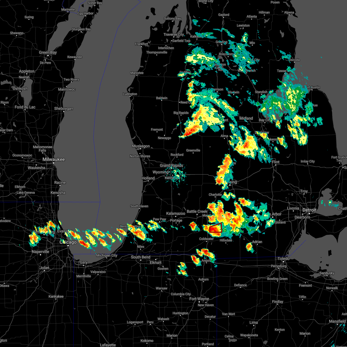 At 801 pm edt, a severe thunderstorm capable of producing a tornado was located 6 miles southwest of homer, or 11 miles northeast of coldwater, moving east at 20 mph (radar indicated rotation). Hazards include tornado. Flying debris will be dangerous to those caught without shelter. mobile homes will be damaged or destroyed. damage to roofs, windows, and vehicles will occur. tree damage is likely. This dangerous storm will be near, homer around 815 pm edt. At 801 pm edt, a severe thunderstorm capable of producing a tornado was located 6 miles southwest of homer, or 11 miles northeast of coldwater, moving east at 20 mph (radar indicated rotation). Hazards include tornado. Flying debris will be dangerous to those caught without shelter. mobile homes will be damaged or destroyed. damage to roofs, windows, and vehicles will occur. tree damage is likely. This dangerous storm will be near, homer around 815 pm edt.
|
| 9/1/2018 7:40 PM EDT |
 At 739 pm edt, a severe thunderstorm capable of producing a tornado was located near burlington, or 10 miles north of coldwater, moving east at 25 mph (radar indicated rotation). Hazards include tornado and quarter size hail. Flying debris will be dangerous to those caught without shelter. mobile homes will be damaged or destroyed. damage to roofs, windows, and vehicles will occur. tree damage is likely. this dangerous storm will be near, tekonsha around 745 pm edt. homer around 810 pm edt. Albion around 815 pm edt. At 739 pm edt, a severe thunderstorm capable of producing a tornado was located near burlington, or 10 miles north of coldwater, moving east at 25 mph (radar indicated rotation). Hazards include tornado and quarter size hail. Flying debris will be dangerous to those caught without shelter. mobile homes will be damaged or destroyed. damage to roofs, windows, and vehicles will occur. tree damage is likely. this dangerous storm will be near, tekonsha around 745 pm edt. homer around 810 pm edt. Albion around 815 pm edt.
|
| 9/1/2018 7:27 PM EDT |
 At 727 pm edt, a severe thunderstorm capable of producing a tornado was located over union city, or 12 miles northwest of coldwater, moving east at 20 mph (radar indicated rotation). Hazards include tornado and quarter size hail. Flying debris will be dangerous to those caught without shelter. mobile homes will be damaged or destroyed. damage to roofs, windows, and vehicles will occur. tree damage is likely. this dangerous storm will be near, burlington around 735 pm edt. tekonsha around 750 pm edt. Albion and homer around 815 pm edt. At 727 pm edt, a severe thunderstorm capable of producing a tornado was located over union city, or 12 miles northwest of coldwater, moving east at 20 mph (radar indicated rotation). Hazards include tornado and quarter size hail. Flying debris will be dangerous to those caught without shelter. mobile homes will be damaged or destroyed. damage to roofs, windows, and vehicles will occur. tree damage is likely. this dangerous storm will be near, burlington around 735 pm edt. tekonsha around 750 pm edt. Albion and homer around 815 pm edt.
|
| 9/1/2018 7:21 PM EDT |
 At 721 pm edt, a severe thunderstorm was located over union city, or 10 miles northwest of coldwater, moving east at 25 mph (radar indicated). Hazards include 60 mph wind gusts and quarter size hail. Hail damage to vehicles is expected. Expect wind damage to roofs, siding, and trees. At 721 pm edt, a severe thunderstorm was located over union city, or 10 miles northwest of coldwater, moving east at 25 mph (radar indicated). Hazards include 60 mph wind gusts and quarter size hail. Hail damage to vehicles is expected. Expect wind damage to roofs, siding, and trees.
|
| 8/8/2018 12:06 AM EDT |
 The severe thunderstorm warning for eastern calhoun county will expire at 1215 am edt, the storm which prompted the warning has weakened below severe limits, and no longer poses an immediate threat to life or property. therefore, the warning will be allowed to expire. The severe thunderstorm warning for eastern calhoun county will expire at 1215 am edt, the storm which prompted the warning has weakened below severe limits, and no longer poses an immediate threat to life or property. therefore, the warning will be allowed to expire.
|
| 8/7/2018 11:52 PM EDT |
 At 1152 pm edt, a severe thunderstorm was located near brownlee park, or near marshall, moving east at 20 mph (radar indicated). Hazards include 60 mph wind gusts. Expect damage to roofs, siding, and trees. Locations impacted include, albion, marshall, homer, marengo,. At 1152 pm edt, a severe thunderstorm was located near brownlee park, or near marshall, moving east at 20 mph (radar indicated). Hazards include 60 mph wind gusts. Expect damage to roofs, siding, and trees. Locations impacted include, albion, marshall, homer, marengo,.
|
| 8/7/2018 11:37 PM EDT |
 At 1136 pm edt, a severe thunderstorm was located near brownlee park, or 10 miles west of marshall, moving east at 20 mph (radar indicated). Hazards include 60 mph wind gusts. Expect damage to roofs, siding, and trees. Locations impacted include, albion, marshall, battle creek, homer, brownlee park, marengo, ceresco,. At 1136 pm edt, a severe thunderstorm was located near brownlee park, or 10 miles west of marshall, moving east at 20 mph (radar indicated). Hazards include 60 mph wind gusts. Expect damage to roofs, siding, and trees. Locations impacted include, albion, marshall, battle creek, homer, brownlee park, marengo, ceresco,.
|
| 8/7/2018 11:17 PM EDT |
 At 1116 pm edt, a severe thunderstorm was located over climax, or 14 miles east of kalamazoo, moving east at 20 mph (radar indicated). Hazards include 60 mph wind gusts. expect damage to roofs, siding, and trees At 1116 pm edt, a severe thunderstorm was located over climax, or 14 miles east of kalamazoo, moving east at 20 mph (radar indicated). Hazards include 60 mph wind gusts. expect damage to roofs, siding, and trees
|
| 8/6/2018 2:43 PM EDT |
 The severe thunderstorm warning for southeastern calhoun county will expire at 245 pm edt, the storm which prompted the warning is moving out of calhoun county. therefore, the warning will be allowed to expire. to report severe weather, contact your nearest law enforcement agency. they will relay your report to the national weather service grand rapids. The severe thunderstorm warning for southeastern calhoun county will expire at 245 pm edt, the storm which prompted the warning is moving out of calhoun county. therefore, the warning will be allowed to expire. to report severe weather, contact your nearest law enforcement agency. they will relay your report to the national weather service grand rapids.
|
| 8/6/2018 2:25 PM EDT |
 The severe thunderstorm warning for eastern calhoun county will expire at 230 pm edt, the storms which prompted the warning have moved out of the area. therefore, the warning will be allowed to expire. to report severe weather, contact your nearest law enforcement agency. they will relay your report to the national weather service grand rapids. a severe thunderstorm warning remains in effect for southeastern calhoun county until 2:45 pm. The severe thunderstorm warning for eastern calhoun county will expire at 230 pm edt, the storms which prompted the warning have moved out of the area. therefore, the warning will be allowed to expire. to report severe weather, contact your nearest law enforcement agency. they will relay your report to the national weather service grand rapids. a severe thunderstorm warning remains in effect for southeastern calhoun county until 2:45 pm.
|
| 8/6/2018 2:19 PM EDT |
 At 219 pm edt, severe thunderstorms were located along a line extending from albion to 7 miles southwest of homer, moving east at 35 mph (radar indicated). Hazards include 60 mph wind gusts. Expect damage to roofs, siding, and trees. Locations impacted include, albion, homer,. At 219 pm edt, severe thunderstorms were located along a line extending from albion to 7 miles southwest of homer, moving east at 35 mph (radar indicated). Hazards include 60 mph wind gusts. Expect damage to roofs, siding, and trees. Locations impacted include, albion, homer,.
|
| 8/6/2018 2:02 PM EDT |
 At 201 pm edt, a severe thunderstorm was located over burlington, or 10 miles north of coldwater, moving east at 35 mph (radar indicated). Hazards include 60 mph wind gusts and penny size hail. expect damage to roofs, siding, and trees At 201 pm edt, a severe thunderstorm was located over burlington, or 10 miles north of coldwater, moving east at 35 mph (radar indicated). Hazards include 60 mph wind gusts and penny size hail. expect damage to roofs, siding, and trees
|
| 8/6/2018 1:56 PM EDT |
 At 156 pm edt, severe thunderstorms were located along a line extending from 8 miles east of bellevue to near marshall, moving east at 30 mph (radar indicated). Hazards include 60 mph wind gusts and quarter size hail. Hail damage to vehicles is expected. expect wind damage to roofs, siding, and trees. Locations impacted include, albion, marshall, homer, marengo,. At 156 pm edt, severe thunderstorms were located along a line extending from 8 miles east of bellevue to near marshall, moving east at 30 mph (radar indicated). Hazards include 60 mph wind gusts and quarter size hail. Hail damage to vehicles is expected. expect wind damage to roofs, siding, and trees. Locations impacted include, albion, marshall, homer, marengo,.
|
| 8/6/2018 1:40 PM EDT |
 At 139 pm edt, severe thunderstorms were located along a line extending from near bellevue to 6 miles south of brownlee park, moving east at 30 mph (radar indicated). Hazards include 60 mph wind gusts and quarter size hail. Hail damage to vehicles is expected. expect wind damage to roofs, siding, and trees. Locations impacted include, albion, marshall, homer, marengo, ceresco,. At 139 pm edt, severe thunderstorms were located along a line extending from near bellevue to 6 miles south of brownlee park, moving east at 30 mph (radar indicated). Hazards include 60 mph wind gusts and quarter size hail. Hail damage to vehicles is expected. expect wind damage to roofs, siding, and trees. Locations impacted include, albion, marshall, homer, marengo, ceresco,.
|
| 8/6/2018 1:26 PM EDT |
 The national weather service in grand rapids has issued a * severe thunderstorm warning for. calhoun county in south central michigan. until 230 pm edt. At 124 pm edt, severe thunderstorms were located along a line extending from near brownlee park to 5 miles east of climax, moving. The national weather service in grand rapids has issued a * severe thunderstorm warning for. calhoun county in south central michigan. until 230 pm edt. At 124 pm edt, severe thunderstorms were located along a line extending from near brownlee park to 5 miles east of climax, moving.
|
| 5/2/2018 9:18 PM EDT |
 At 918 pm edt, severe thunderstorms were located along a line extending from near leslie to near coldwater, moving east at 50 mph (radar indicated). Hazards include 60 mph wind gusts and penny size hail. expect damage to roofs, siding, and trees At 918 pm edt, severe thunderstorms were located along a line extending from near leslie to near coldwater, moving east at 50 mph (radar indicated). Hazards include 60 mph wind gusts and penny size hail. expect damage to roofs, siding, and trees
|
| 7/7/2017 4:35 AM EDT |
 At 434 am edt, severe thunderstorms were located along a line extending from 7 miles northwest of stockbridge to 8 miles east of albion, moving east at 55 mph (law enforcement). Hazards include 60 mph wind gusts and penny size hail. Expect damage to roofs, siding, and trees. Locations impacted include, jackson, albion, mason, marshall, vandercook lake, leslie, homer, stockbridge, brooklyn, grass lake, leoni, spring arbor, napoleon, sandstone, aurelius, onondaga, norvell, marengo, bunker hill, pulaski,. At 434 am edt, severe thunderstorms were located along a line extending from 7 miles northwest of stockbridge to 8 miles east of albion, moving east at 55 mph (law enforcement). Hazards include 60 mph wind gusts and penny size hail. Expect damage to roofs, siding, and trees. Locations impacted include, jackson, albion, mason, marshall, vandercook lake, leslie, homer, stockbridge, brooklyn, grass lake, leoni, spring arbor, napoleon, sandstone, aurelius, onondaga, norvell, marengo, bunker hill, pulaski,.
|
| 7/7/2017 4:10 AM EDT |
 At 410 am edt, severe thunderstorms were located along a line extending from near potterville to near brownlee park, moving east at 55 mph (law enforcement). Hazards include 60 mph wind gusts and penny size hail. expect damage to roofs, siding, and trees At 410 am edt, severe thunderstorms were located along a line extending from near potterville to near brownlee park, moving east at 55 mph (law enforcement). Hazards include 60 mph wind gusts and penny size hail. expect damage to roofs, siding, and trees
|
| 4/20/2017 2:53 PM EDT |
 At 252 pm edt, a severe thunderstorm was located near homer, moving east at 40 mph. this storm is expected to gradually weaken through 300 pm edt (radar indicated). Hazards include quarter size hail. Damage to vehicles is expected. Locations impacted include, albion, homer,. At 252 pm edt, a severe thunderstorm was located near homer, moving east at 40 mph. this storm is expected to gradually weaken through 300 pm edt (radar indicated). Hazards include quarter size hail. Damage to vehicles is expected. Locations impacted include, albion, homer,.
|
| 4/20/2017 2:34 PM EDT |
 At 233 pm edt, a severe thunderstorm was located near homer, moving east at 40 mph. this storm had weakened somewhat but is still capable of producing penny sized hail, with some quarter size hail possible as well (radar indicated). Hazards include quarter size hail. Damage to vehicles is expected. Locations impacted include, albion, marshall, homer, union city, burlington, marengo, tekonsha,. At 233 pm edt, a severe thunderstorm was located near homer, moving east at 40 mph. this storm had weakened somewhat but is still capable of producing penny sized hail, with some quarter size hail possible as well (radar indicated). Hazards include quarter size hail. Damage to vehicles is expected. Locations impacted include, albion, marshall, homer, union city, burlington, marengo, tekonsha,.
|
| 4/20/2017 2:16 PM EDT |
 At 215 pm edt, a severe thunderstorm was located near burlington, moving east at 35 mph. this storm had already produced quarter sized hail around east leroy (trained weather spotters). Hazards include quarter size hail. Damage to vehicles is expected. Locations impacted include, albion, marshall, homer, union city, burlington, marengo, athens, tekonsha, pine creek,. At 215 pm edt, a severe thunderstorm was located near burlington, moving east at 35 mph. this storm had already produced quarter sized hail around east leroy (trained weather spotters). Hazards include quarter size hail. Damage to vehicles is expected. Locations impacted include, albion, marshall, homer, union city, burlington, marengo, athens, tekonsha, pine creek,.
|
| 4/20/2017 1:54 PM EDT |
 At 154 pm edt, a severe thunderstorm was located near climax, moving east at 40 mph (radar indicated). Hazards include quarter size hail. damage to vehicles is expected At 154 pm edt, a severe thunderstorm was located near climax, moving east at 40 mph (radar indicated). Hazards include quarter size hail. damage to vehicles is expected
|
| 2/28/2017 10:27 PM EST |
 The severe thunderstorm warning for eastern calhoun county will expire at 1030 pm est, the storm which prompted the warning has weakened below severe limits, and no longer pose an immediate threat to life or property. therefore the warning will be allowed to expire. however wind gusts to 55 mph, heavy rain, and frequent lightning will remain possible with thunderstorms in the area. a severe thunderstorm watch remains in effect until 400 am est for south central michigan. The severe thunderstorm warning for eastern calhoun county will expire at 1030 pm est, the storm which prompted the warning has weakened below severe limits, and no longer pose an immediate threat to life or property. therefore the warning will be allowed to expire. however wind gusts to 55 mph, heavy rain, and frequent lightning will remain possible with thunderstorms in the area. a severe thunderstorm watch remains in effect until 400 am est for south central michigan.
|
| 2/28/2017 10:15 PM EST |
 At 1014 pm est, a severe thunderstorm was located 7 miles north of albion, moving northeast at 55 mph. although the storm had weakened slightly it will still be capable of damaging wind gusts through 1030 pm est (radar indicated). Hazards include 60 mph wind gusts. Expect damage to roofs, siding, and trees. Locations impacted include, albion, marshall, homer, marengo,. At 1014 pm est, a severe thunderstorm was located 7 miles north of albion, moving northeast at 55 mph. although the storm had weakened slightly it will still be capable of damaging wind gusts through 1030 pm est (radar indicated). Hazards include 60 mph wind gusts. Expect damage to roofs, siding, and trees. Locations impacted include, albion, marshall, homer, marengo,.
|
| 2/28/2017 10:05 PM EST |
 At 1004 pm est, a severe thunderstorm was located over marshall, moving northeast at 60 mph. the marshall, marengo, and albion areas are at greatest risk for damaging winds (radar indicated). Hazards include 60 mph wind gusts. Expect damage to roofs, siding, and trees. Locations impacted include, albion, marshall, battle creek, homer, union city, burlington, brownlee park, marengo, athens, tekonsha, pine creek, ceresco,. At 1004 pm est, a severe thunderstorm was located over marshall, moving northeast at 60 mph. the marshall, marengo, and albion areas are at greatest risk for damaging winds (radar indicated). Hazards include 60 mph wind gusts. Expect damage to roofs, siding, and trees. Locations impacted include, albion, marshall, battle creek, homer, union city, burlington, brownlee park, marengo, athens, tekonsha, pine creek, ceresco,.
|
| 2/28/2017 9:50 PM EST |
 At 950 pm est, a severe thunderstorm was located near climax, moving northeast at 55 mph (radar indicated). Hazards include 60 mph wind gusts. expect damage to roofs, siding, and trees At 950 pm est, a severe thunderstorm was located near climax, moving northeast at 55 mph (radar indicated). Hazards include 60 mph wind gusts. expect damage to roofs, siding, and trees
|
| 6/22/2015 3:32 PM EDT |
 At 332 pm edt, severe thunderstorms were located along a line extending from near albion to 7 miles southwest of homer, moving east at 60 mph (radar indicated). Hazards include 60 mph wind gusts and quarter size hail. Hail damage to vehicles is expected. expect wind damage to roofs, siding and trees. Locations impacted include, albion, homer, marengo, tekonsha,. At 332 pm edt, severe thunderstorms were located along a line extending from near albion to 7 miles southwest of homer, moving east at 60 mph (radar indicated). Hazards include 60 mph wind gusts and quarter size hail. Hail damage to vehicles is expected. expect wind damage to roofs, siding and trees. Locations impacted include, albion, homer, marengo, tekonsha,.
|
| 6/22/2015 3:11 PM EDT |
 At 310 pm edt, severe thunderstorms were located along a line extending from 9 miles north of albion to near union city, moving east at 40 mph (radar indicated). Hazards include 60 mph wind gusts and quarter size hail. Hail damage to vehicles is expected. expect wind damage to roofs, siding and trees. Locations impacted include, albion, marshall, homer, burlington, marengo, athens, tekonsha, pine creek, ceresco,. At 310 pm edt, severe thunderstorms were located along a line extending from 9 miles north of albion to near union city, moving east at 40 mph (radar indicated). Hazards include 60 mph wind gusts and quarter size hail. Hail damage to vehicles is expected. expect wind damage to roofs, siding and trees. Locations impacted include, albion, marshall, homer, burlington, marengo, athens, tekonsha, pine creek, ceresco,.
|
| 6/22/2015 2:59 PM EDT |
 At 258 pm edt, severe thunderstorms were located along a line extending from 7 miles southeast of bellevue to 8 miles north of colon, moving east at 40 mph. the strongest storm was near fulton (radar indicated). Hazards include 60 mph wind gusts. Expect damage to roofs. Siding and trees. At 258 pm edt, severe thunderstorms were located along a line extending from 7 miles southeast of bellevue to 8 miles north of colon, moving east at 40 mph. the strongest storm was near fulton (radar indicated). Hazards include 60 mph wind gusts. Expect damage to roofs. Siding and trees.
|
| 6/13/2015 10:08 PM EDT |
 The severe thunderstorm warning for southern calhoun county will expire at 1015 pm edt, the storm which prompted the warning has weakened below severe limits, and no longer pose an immediate threat to life or property. therefore the warning will be allowed to expire. however gusty winds and heavy rain are still possible with this thunderstorm. The severe thunderstorm warning for southern calhoun county will expire at 1015 pm edt, the storm which prompted the warning has weakened below severe limits, and no longer pose an immediate threat to life or property. therefore the warning will be allowed to expire. however gusty winds and heavy rain are still possible with this thunderstorm.
|
| 6/13/2015 9:53 PM EDT |
 At 952 pm edt, a severe thunderstorm was located near burlington, moving east at 25 mph (radar indicated). Hazards include 60 mph wind gusts. Expect damage to roofs. siding and trees. Locations impacted include, albion, marshall, homer, burlington, athens, tekonsha, pine creek,. At 952 pm edt, a severe thunderstorm was located near burlington, moving east at 25 mph (radar indicated). Hazards include 60 mph wind gusts. Expect damage to roofs. siding and trees. Locations impacted include, albion, marshall, homer, burlington, athens, tekonsha, pine creek,.
|
| 6/13/2015 9:30 PM EDT |
 At 929 pm edt, a severe thunderstorm was located near burlington, moving east at 5 mph (radar indicated). Hazards include 60 mph wind gusts. Expect damage to roofs. siding and trees. Locations impacted include, southern battle cree, albion, marshall, homer, burlington, marengo, athens, tekonsha, pine creek, ceresco,. At 929 pm edt, a severe thunderstorm was located near burlington, moving east at 5 mph (radar indicated). Hazards include 60 mph wind gusts. Expect damage to roofs. siding and trees. Locations impacted include, southern battle cree, albion, marshall, homer, burlington, marengo, athens, tekonsha, pine creek, ceresco,.
|
| 6/13/2015 9:13 PM EDT |
 At 913 pm edt, a severe thunderstorm was located near burlington, moving east at 25 mph (radar indicated). Hazards include 60 mph wind gusts and quarter size hail. Hail damage to vehicles is expected. Expect wind damage to roofs, siding and trees. At 913 pm edt, a severe thunderstorm was located near burlington, moving east at 25 mph (radar indicated). Hazards include 60 mph wind gusts and quarter size hail. Hail damage to vehicles is expected. Expect wind damage to roofs, siding and trees.
|
| 5/27/2015 1:44 PM EDT | At 144 pm edt, a severe thunderstorm was located over marshall, moving east at 35 mph (radar indicated). Hazards include 60 mph wind gusts and quarter size hail. Hail damage to vehicles is expected. Expect wind damage to roofs, siding and trees. |
Hail Maps for Homer, MI


Connect with Interactive Hail Maps