

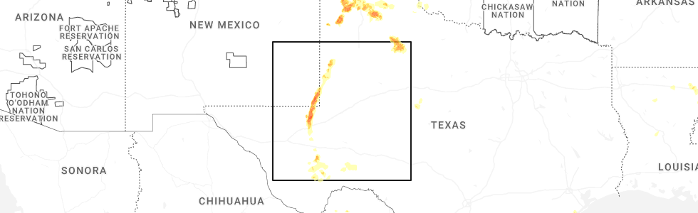
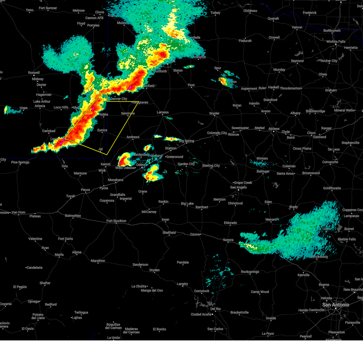
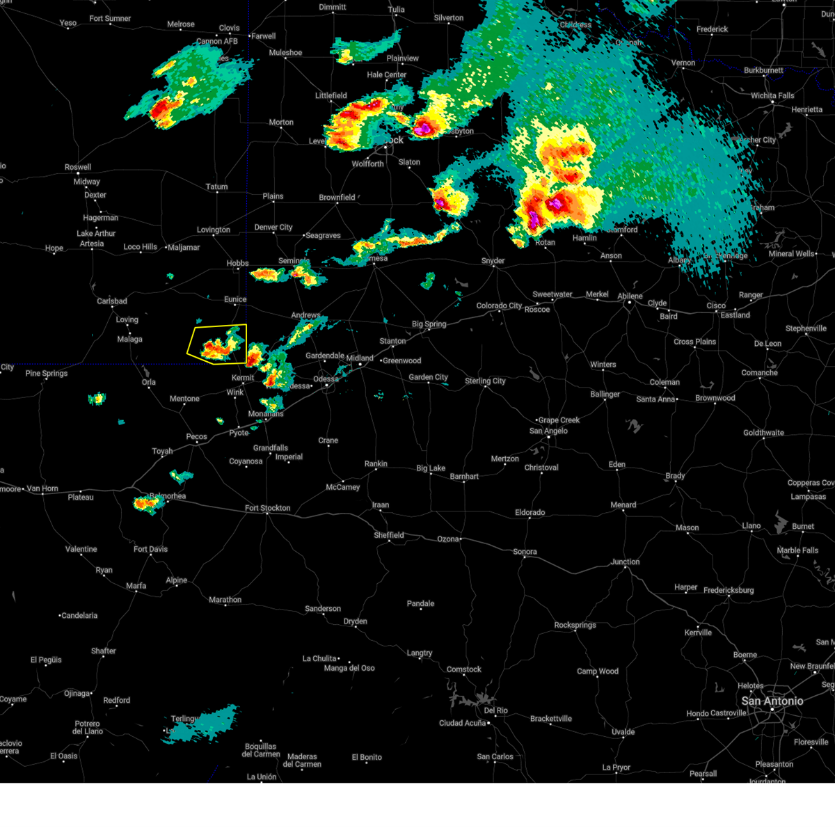
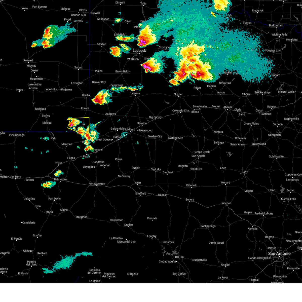
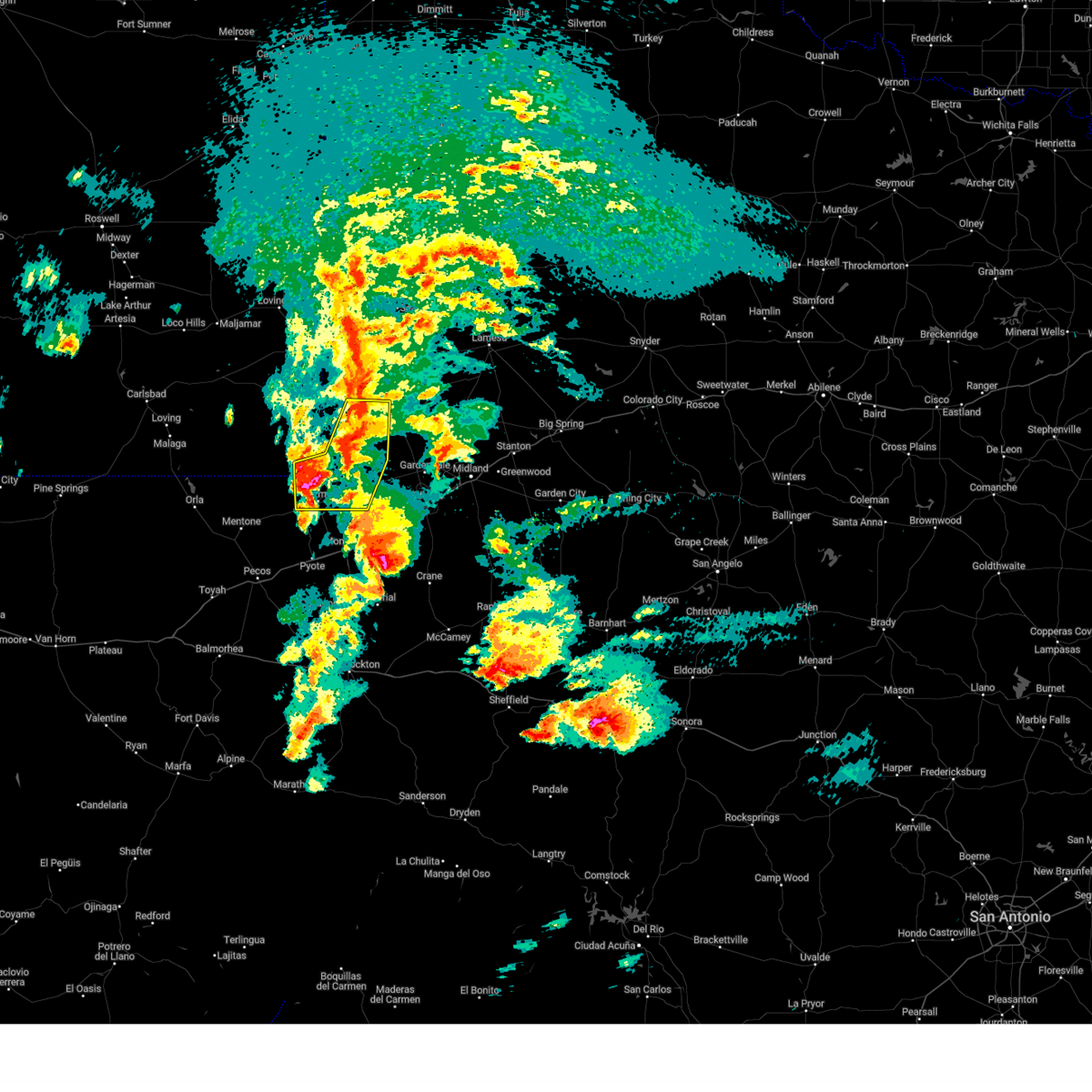
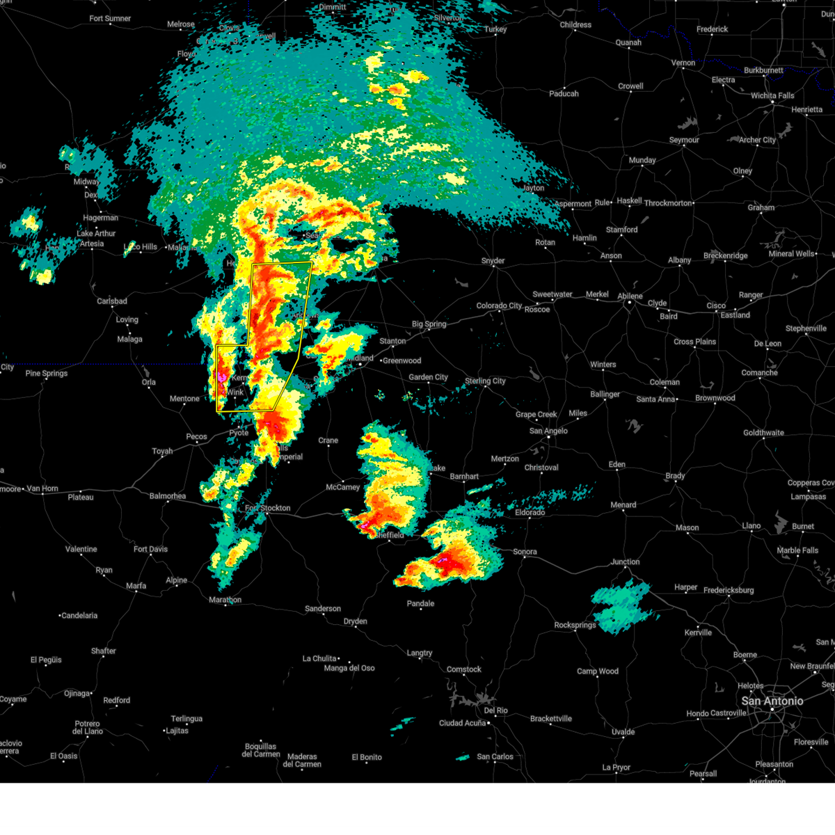
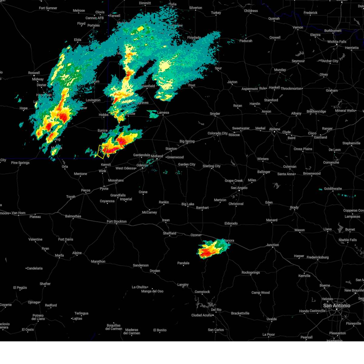
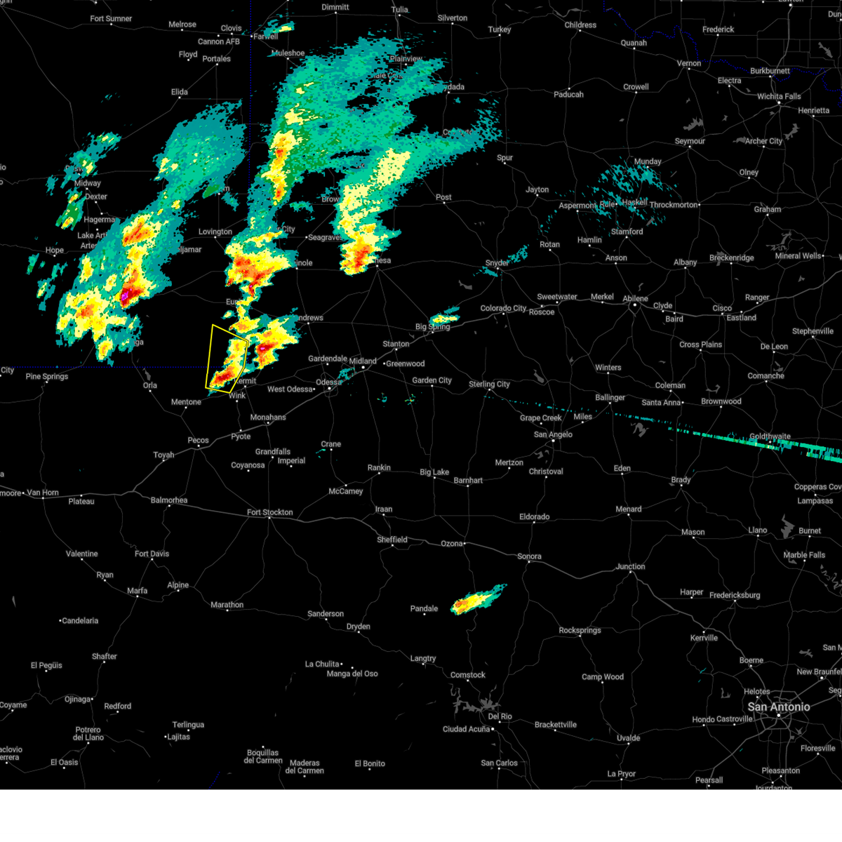
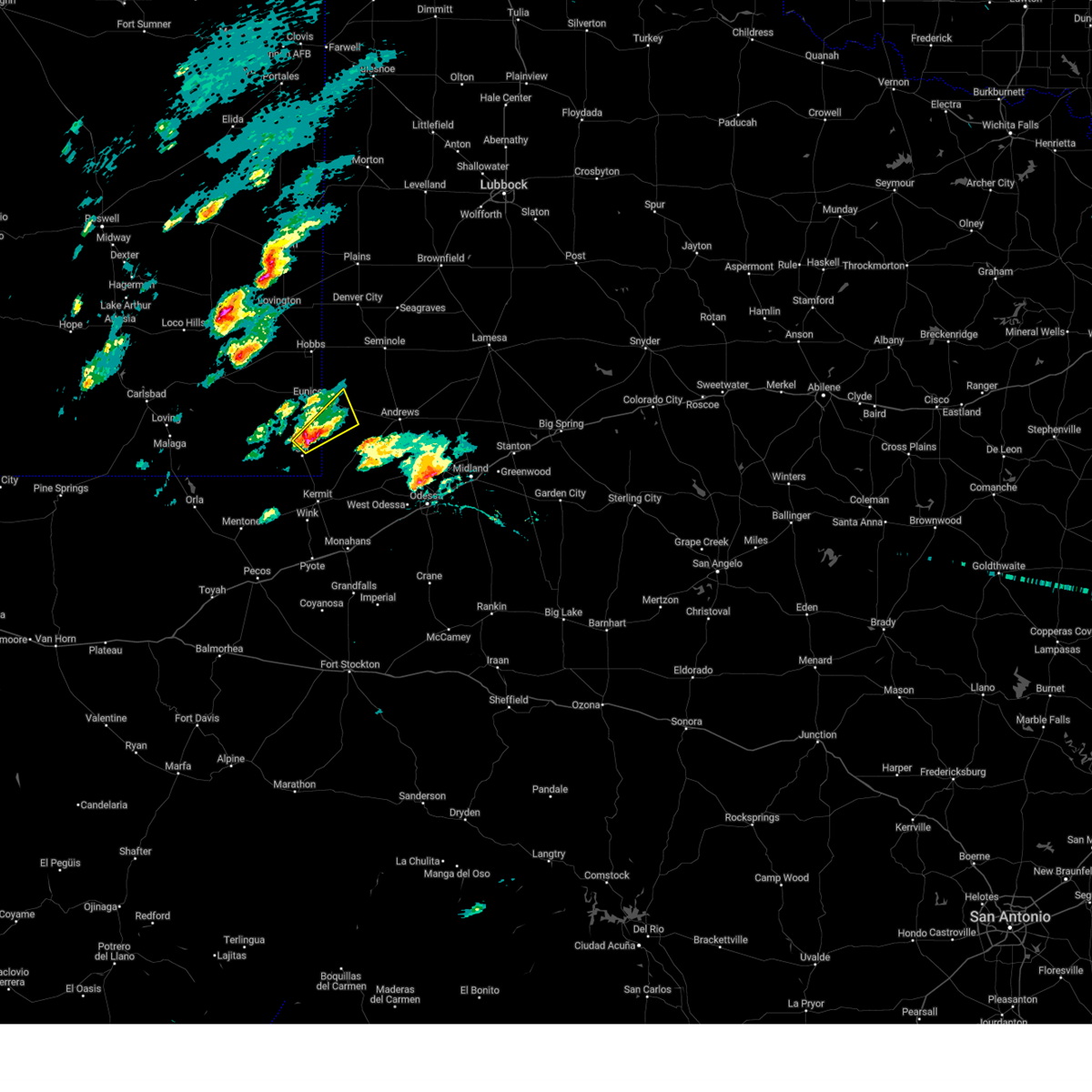
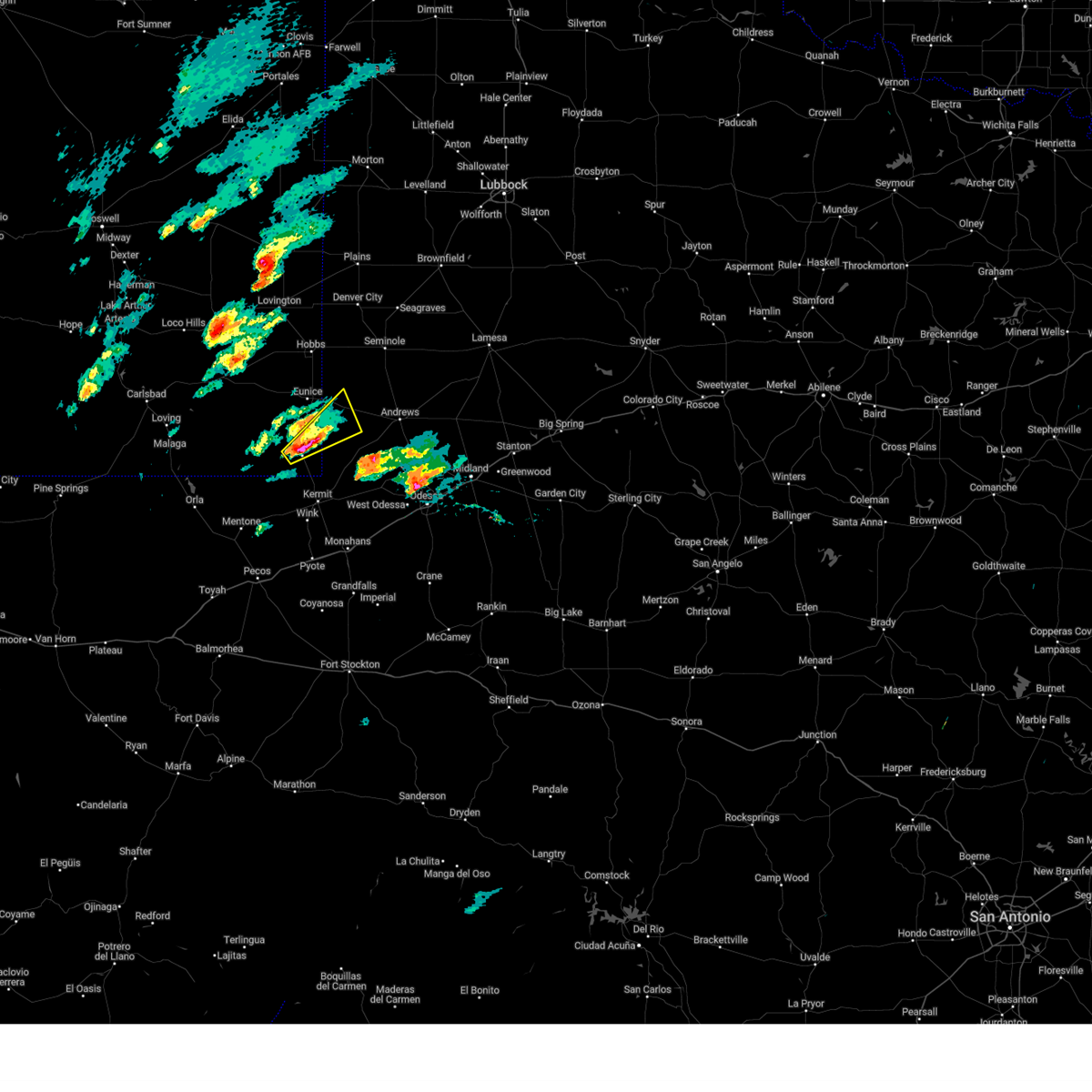
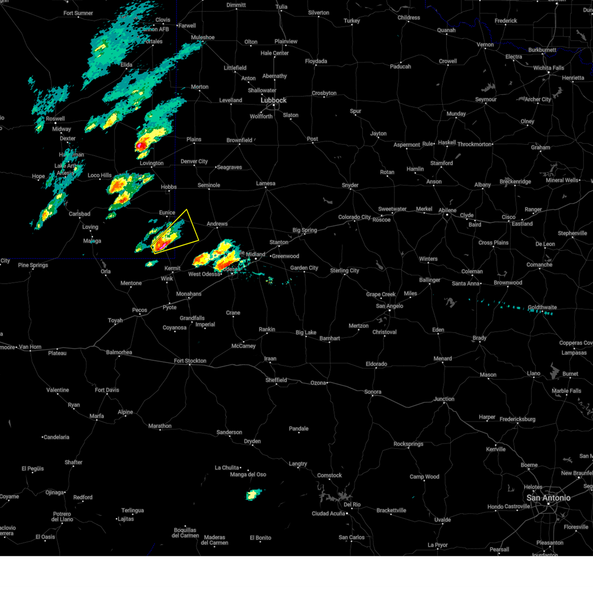
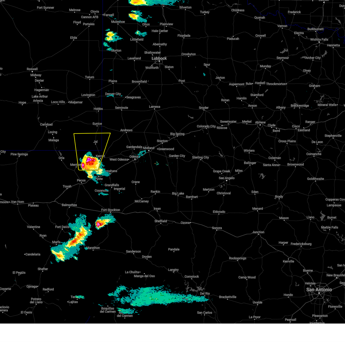
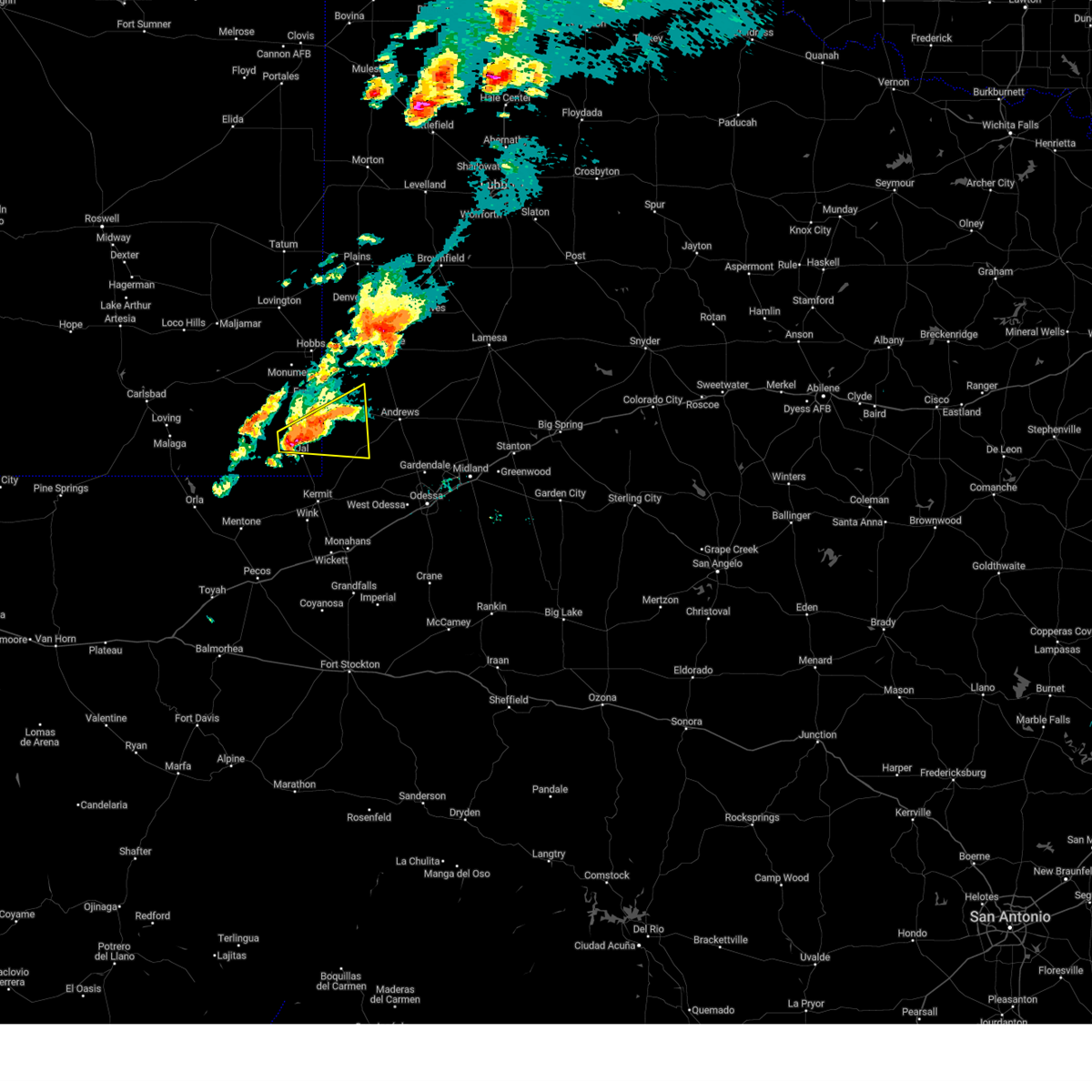
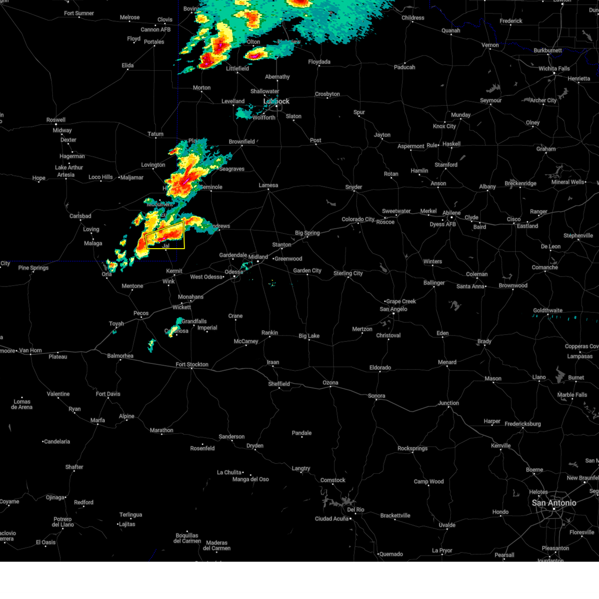
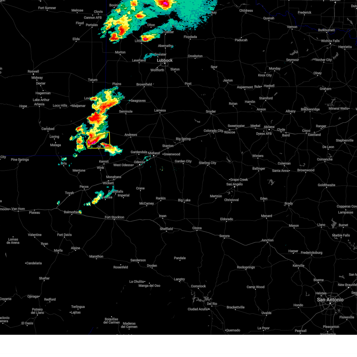
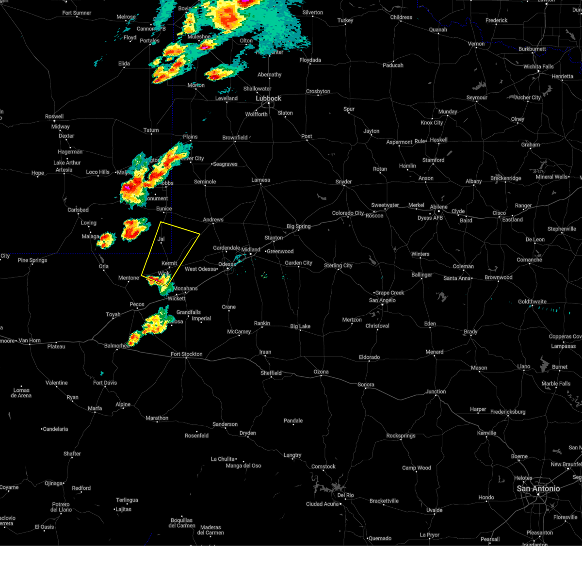
Hail Map for Jal, NM
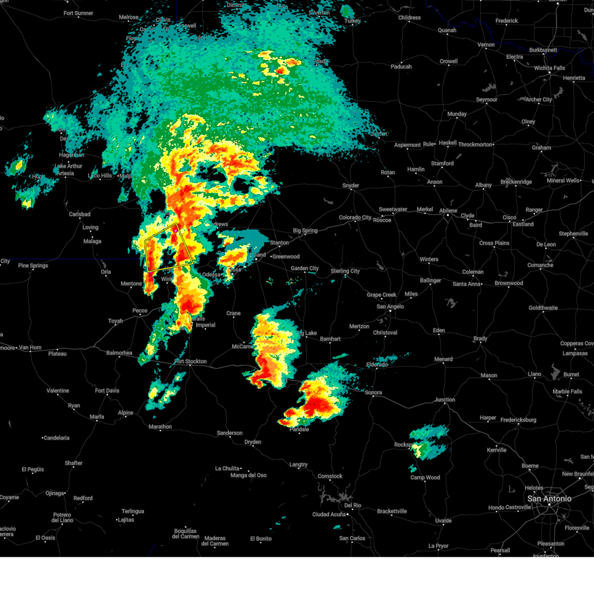
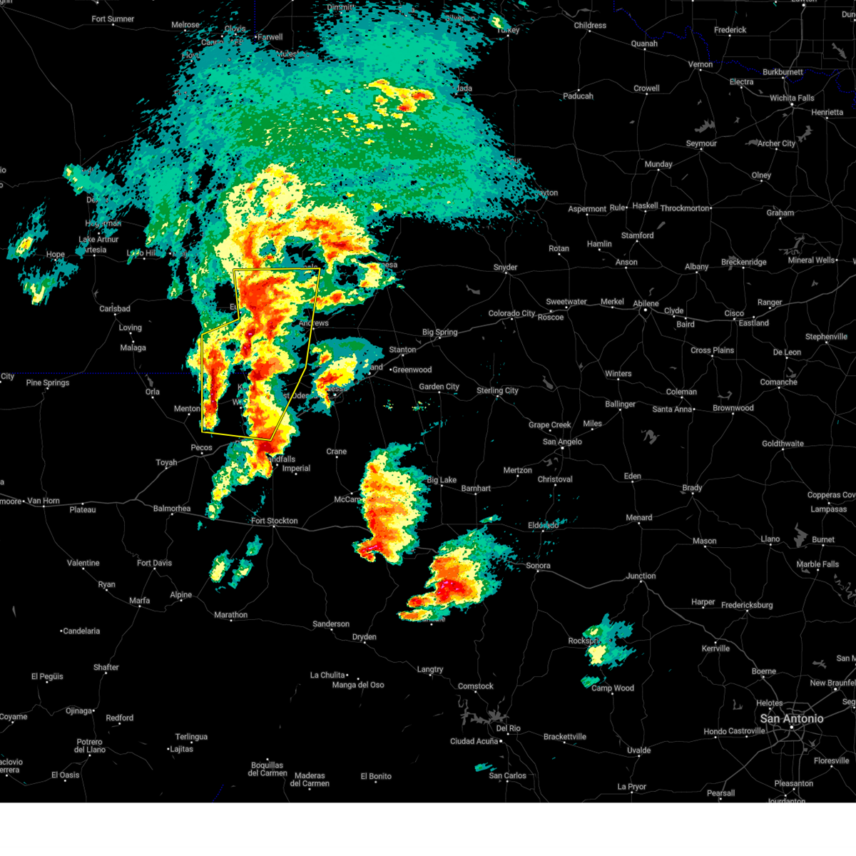
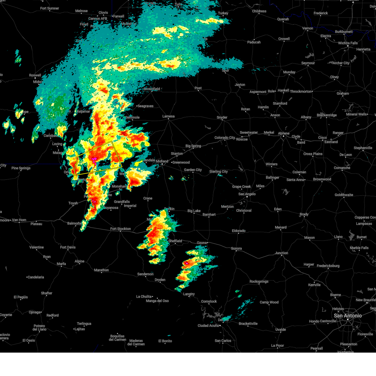
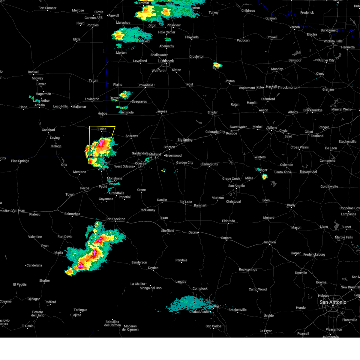
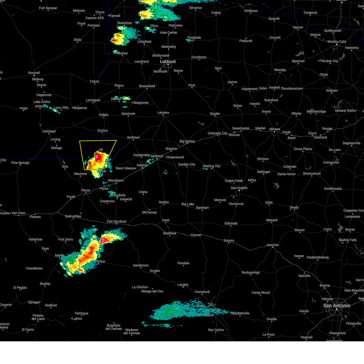
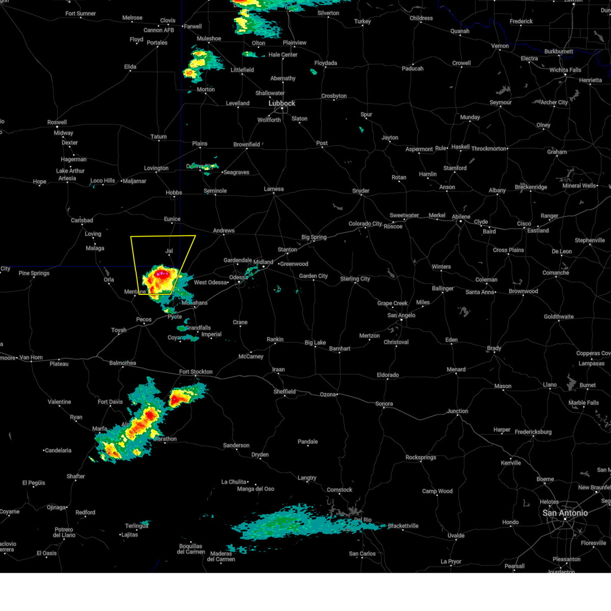
The Jal, NM area has had 17 reports of on-the-ground hail by trained spotters, and has been under severe weather warnings 46 times during the past 12 months. Doppler radar has detected hail at or near Jal, NM on 60 occasions, including 8 occasions during the past year.
| Name: | Jal, NM |
| Where Located: | 51 miles WNW of Odessa, TX |
| Map: | Google Map for Jal, NM |
| Population: | 2047 |
| Housing Units: | 1009 |
| More Info: | Search Google for Jal, NM |
2
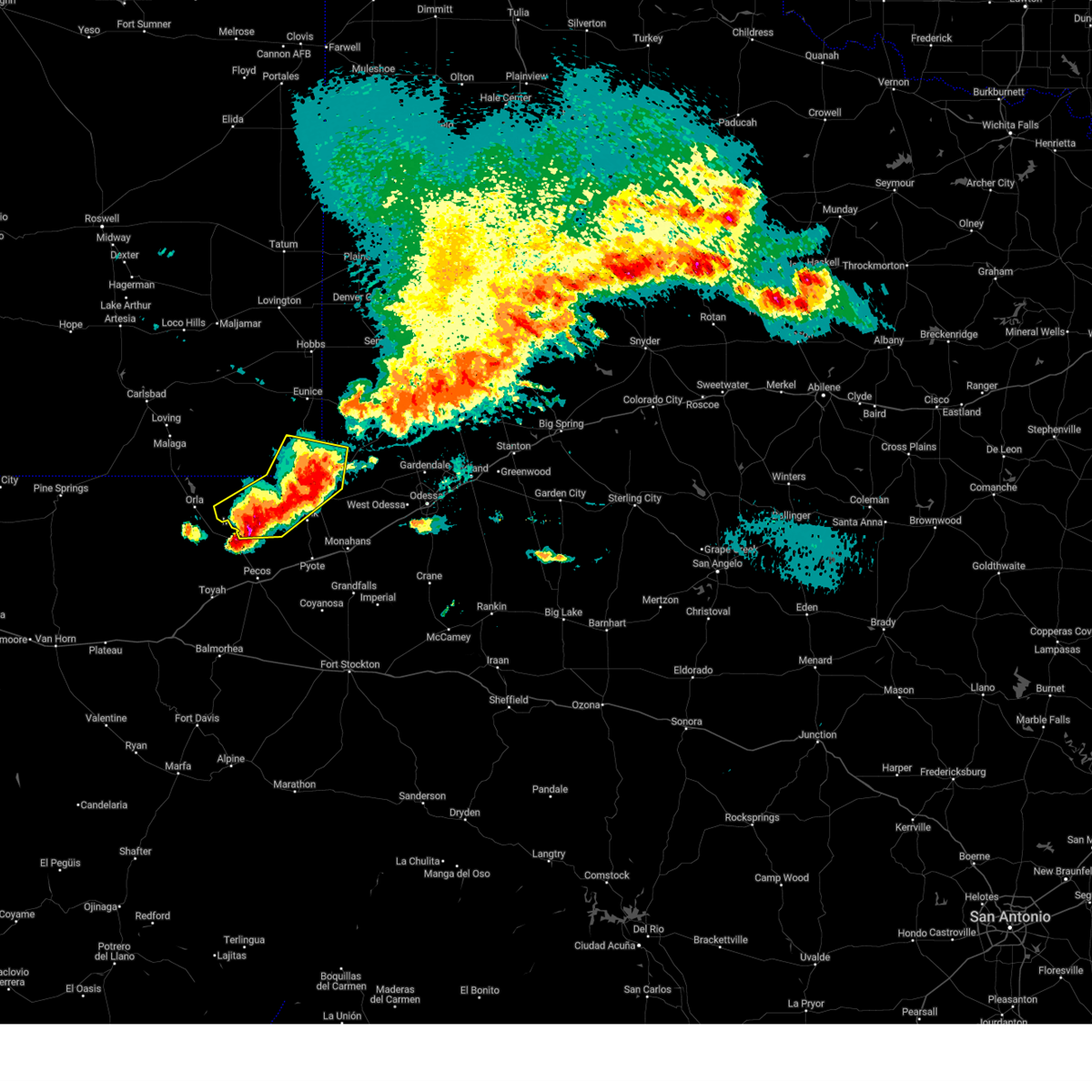
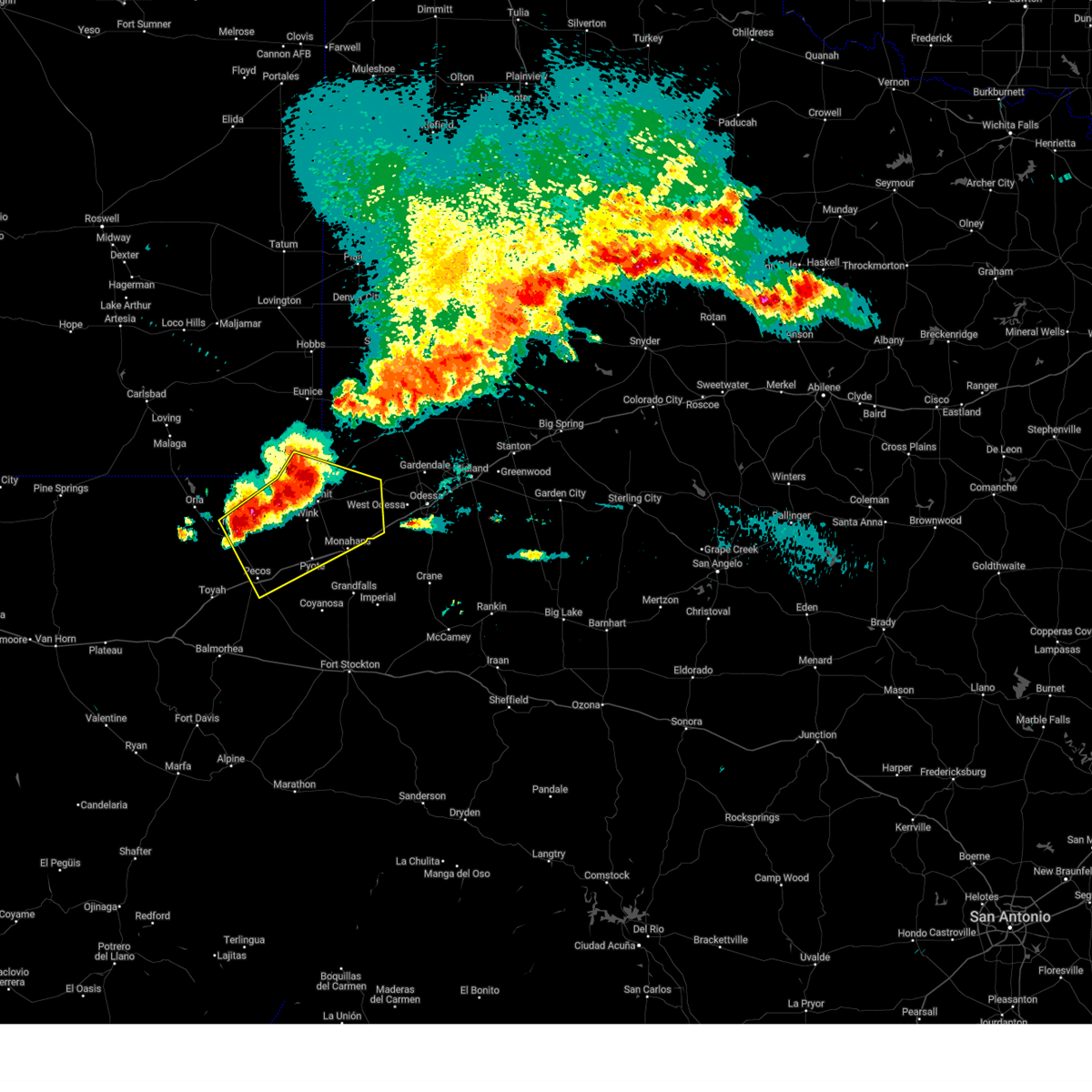
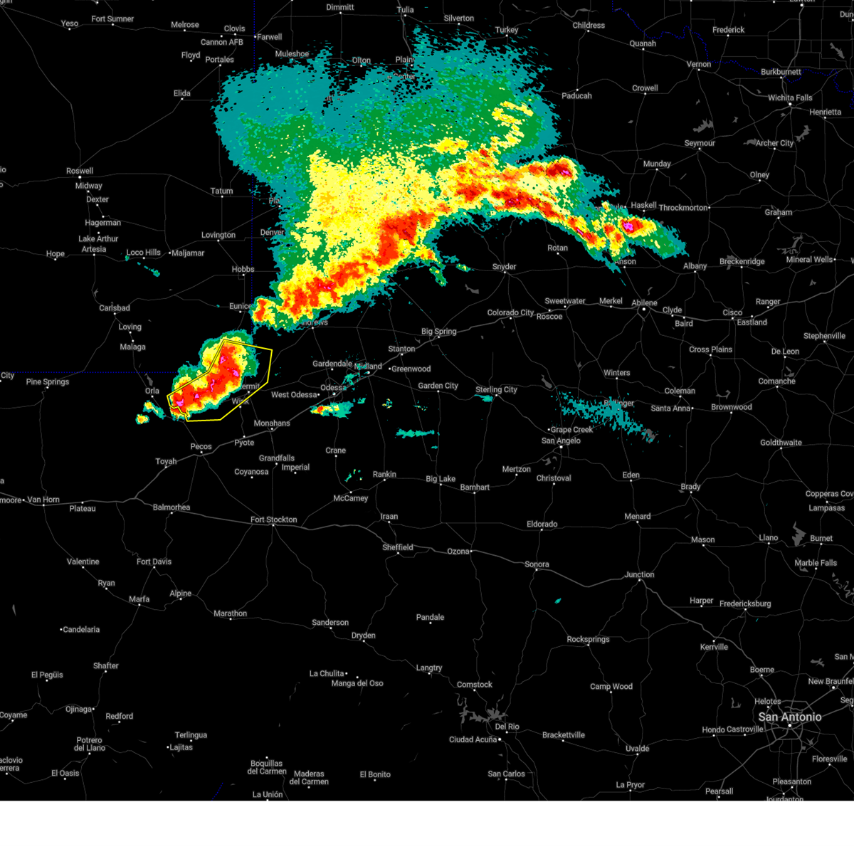
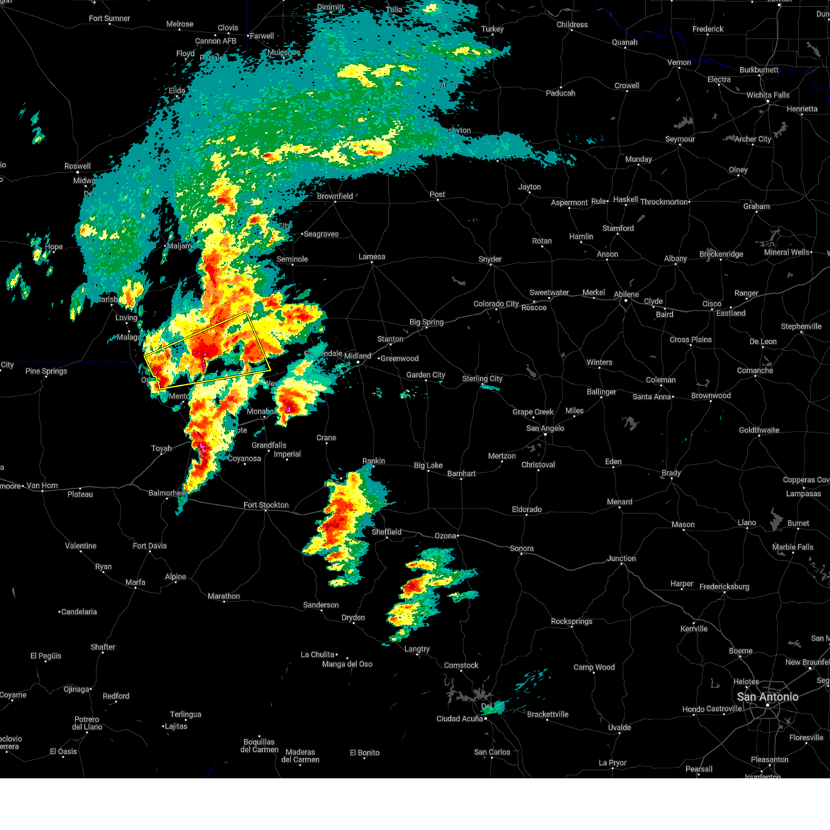
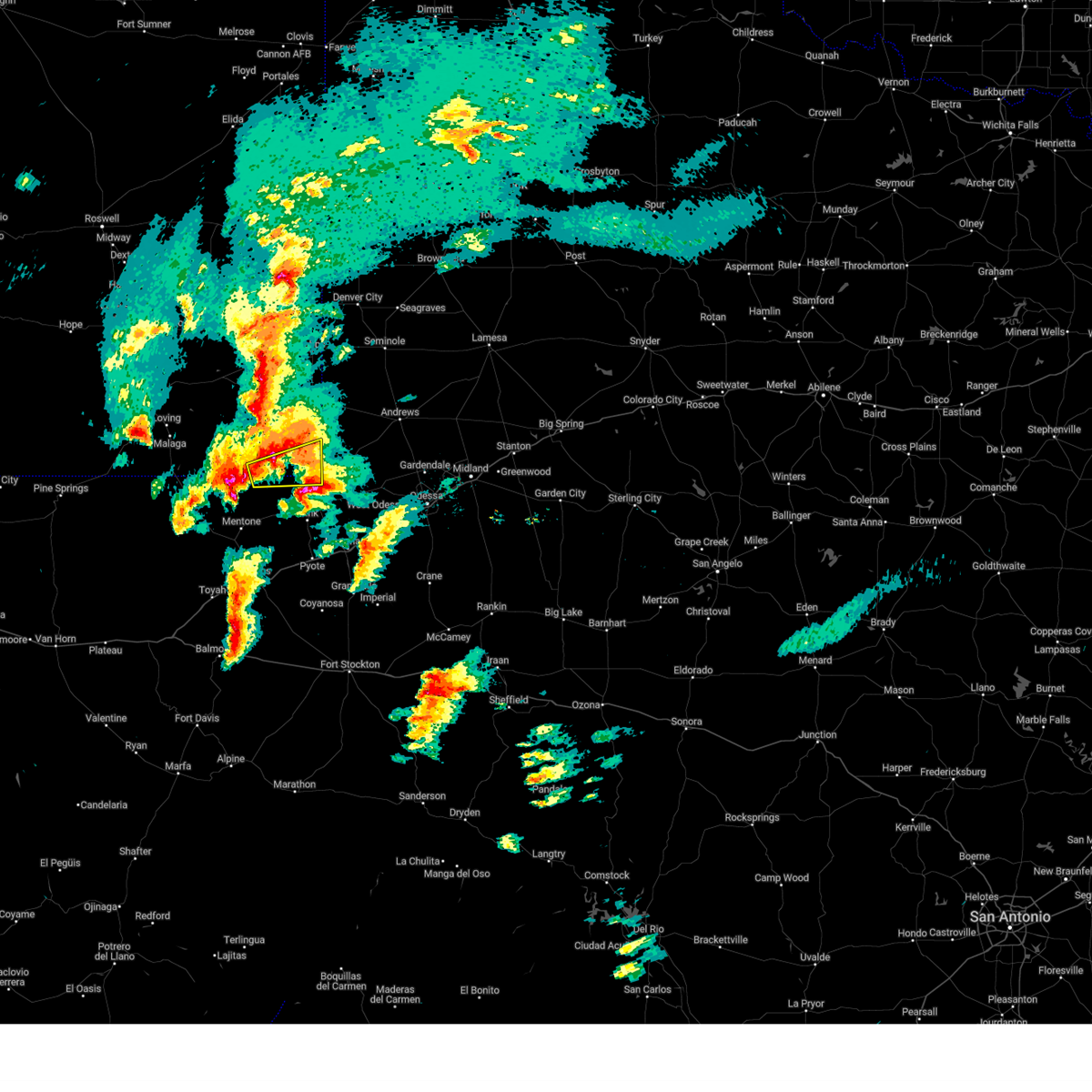
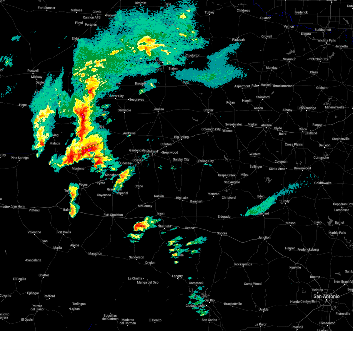
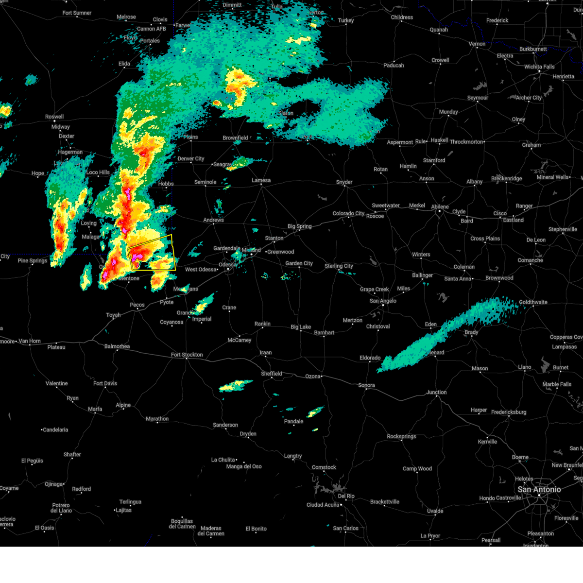
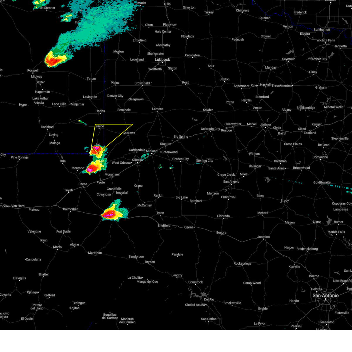
The Top Recent Hail Date for Jal, NM is Wednesday, April 23, 2025 (2nd out of 60)
Hail and Wind Damage Spotted near Jal, NM
| Date / Time | Report Details |
|---|---|
| 6/10/2025 2:07 AM CDT |
 The storms which prompted the warning have moved out of the area. therefore, the warning has been allowed to expire. The storms which prompted the warning have moved out of the area. therefore, the warning has been allowed to expire.
|
| 6/10/2025 1:55 AM CDT |
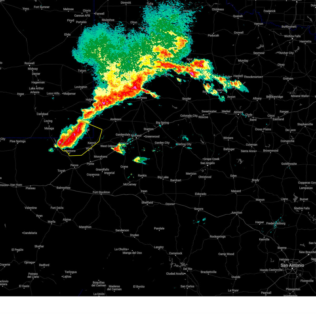
 Svrmaf the national weather service in midland has issued a * severe thunderstorm warning for, southeastern lea county in southeastern new mexico, southwestern ector county in western texas, central reeves county in southwestern texas, northern ward county in western texas, winkler county in western texas, eastern loving county in western texas, * until 300 am cdt/200 am mdt/. * at 155 am cdt/1255 am mdt/, severe thunderstorms were located along a line extending from near jal airport to near kermit to mentone, moving southeast at 25 mph (radar indicated). Hazards include 60 mph wind gusts and quarter size hail. Hail damage to vehicles is expected. Expect wind damage to roofs, siding, and trees. Svrmaf the national weather service in midland has issued a * severe thunderstorm warning for, southeastern lea county in southeastern new mexico, southwestern ector county in western texas, central reeves county in southwestern texas, northern ward county in western texas, winkler county in western texas, eastern loving county in western texas, * until 300 am cdt/200 am mdt/. * at 155 am cdt/1255 am mdt/, severe thunderstorms were located along a line extending from near jal airport to near kermit to mentone, moving southeast at 25 mph (radar indicated). Hazards include 60 mph wind gusts and quarter size hail. Hail damage to vehicles is expected. Expect wind damage to roofs, siding, and trees.
|
| 6/10/2025 1:45 AM CDT |
 At 145 am cdt/1245 am mdt/, severe thunderstorms were located along a line extending from near jal airport to 8 miles northwest of kermit to mentone, moving southeast at 35 mph (radar indicated). Hazards include 70 mph wind gusts and quarter size hail. Hail damage to vehicles is expected. expect considerable tree damage. wind damage is also likely to mobile homes, roofs, and outbuildings. Locations impacted include, kermit, jal, mentone, jal airport, bennett, slash ranch, and winkler county airport. At 145 am cdt/1245 am mdt/, severe thunderstorms were located along a line extending from near jal airport to 8 miles northwest of kermit to mentone, moving southeast at 35 mph (radar indicated). Hazards include 70 mph wind gusts and quarter size hail. Hail damage to vehicles is expected. expect considerable tree damage. wind damage is also likely to mobile homes, roofs, and outbuildings. Locations impacted include, kermit, jal, mentone, jal airport, bennett, slash ranch, and winkler county airport.
|
| 6/10/2025 1:22 AM CDT |
 the severe thunderstorm warning has been cancelled and is no longer in effect the severe thunderstorm warning has been cancelled and is no longer in effect
|
| 6/10/2025 1:22 AM CDT |
 At 121 am cdt/1221 am mdt/, severe thunderstorms were located along a line extending from 11 miles northwest of jal airport to 13 miles southwest of jal to 8 miles northwest of mentone, moving southeast at 25 mph (a mesonet station in southern lea county measured a wind gust of 70 mph). Hazards include 70 mph wind gusts and quarter size hail. Hail damage to vehicles is expected. expect considerable tree damage. wind damage is also likely to mobile homes, roofs, and outbuildings. Locations impacted include, kermit, jal, mentone, jal airport, bennett, slash ranch, and winkler county airport. At 121 am cdt/1221 am mdt/, severe thunderstorms were located along a line extending from 11 miles northwest of jal airport to 13 miles southwest of jal to 8 miles northwest of mentone, moving southeast at 25 mph (a mesonet station in southern lea county measured a wind gust of 70 mph). Hazards include 70 mph wind gusts and quarter size hail. Hail damage to vehicles is expected. expect considerable tree damage. wind damage is also likely to mobile homes, roofs, and outbuildings. Locations impacted include, kermit, jal, mentone, jal airport, bennett, slash ranch, and winkler county airport.
|
| 6/10/2025 1:06 AM CDT |
 Svrmaf the national weather service in midland has issued a * severe thunderstorm warning for, southeastern lea county in southeastern new mexico, southwestern andrews county in western texas, north central reeves county in southwestern texas, northwestern winkler county in western texas, loving county in western texas, * until 200 am cdt/100 am mdt/. * at 106 am cdt/1206 am mdt/, severe thunderstorms were located along a line extending from 9 miles southwest of eunice airport to 15 miles west of jal to 9 miles east of orla, moving southeast at 25 mph (radar indicated). Hazards include 60 mph wind gusts and quarter size hail. Hail damage to vehicles is expected. Expect wind damage to roofs, siding, and trees. Svrmaf the national weather service in midland has issued a * severe thunderstorm warning for, southeastern lea county in southeastern new mexico, southwestern andrews county in western texas, north central reeves county in southwestern texas, northwestern winkler county in western texas, loving county in western texas, * until 200 am cdt/100 am mdt/. * at 106 am cdt/1206 am mdt/, severe thunderstorms were located along a line extending from 9 miles southwest of eunice airport to 15 miles west of jal to 9 miles east of orla, moving southeast at 25 mph (radar indicated). Hazards include 60 mph wind gusts and quarter size hail. Hail damage to vehicles is expected. Expect wind damage to roofs, siding, and trees.
|
| 6/10/2025 12:00 AM MDT | Mesonet station fw9688 ja in lea county NM, 23 miles E of Jal, NM |
| 6/10/2025 12:50 AM CDT |
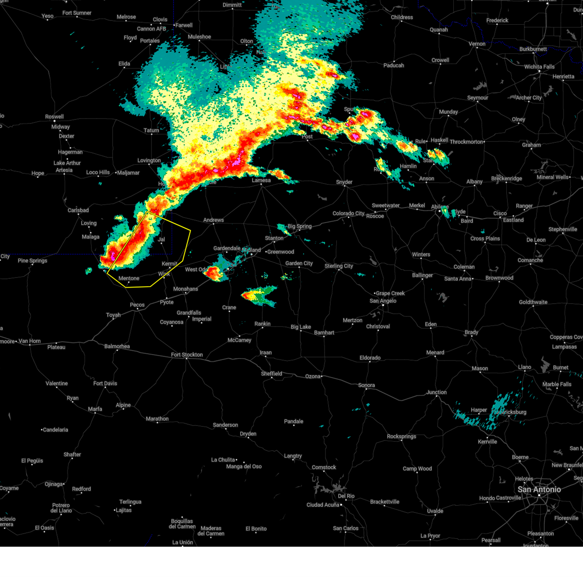
 At 1249 am cdt/1149 pm mdt/, severe thunderstorms were located along a line extending from 6 miles southwest of denver city to 16 miles northwest of jal, moving southeast at 35 mph (seagraves mesonet reported a wind gust of 60 mph). Hazards include 60 mph wind gusts and quarter size hail. Hail damage to vehicles is expected. expect wind damage to roofs, siding, and trees. Locations impacted include, hobbs, seminole, eunice, seagraves, jal, monument, seagraves airport, eunice airport, jal airport, nadine, gaines county airport, knowles, lea county regional airport, industrial airpark, oil center, paynes corner, higginbotham, and gaines county park. At 1249 am cdt/1149 pm mdt/, severe thunderstorms were located along a line extending from 6 miles southwest of denver city to 16 miles northwest of jal, moving southeast at 35 mph (seagraves mesonet reported a wind gust of 60 mph). Hazards include 60 mph wind gusts and quarter size hail. Hail damage to vehicles is expected. expect wind damage to roofs, siding, and trees. Locations impacted include, hobbs, seminole, eunice, seagraves, jal, monument, seagraves airport, eunice airport, jal airport, nadine, gaines county airport, knowles, lea county regional airport, industrial airpark, oil center, paynes corner, higginbotham, and gaines county park.
|
| 6/9/2025 11:30 PM MDT |
 the severe thunderstorm warning has been cancelled and is no longer in effect the severe thunderstorm warning has been cancelled and is no longer in effect
|
| 6/9/2025 11:30 PM MDT |
 At 1230 am cdt/1130 pm mdt/, severe thunderstorms were located along a line extending from 11 miles west of denver city to 22 miles southwest of eunice airport, moving southeast at 35 mph (radar indicated). Hazards include 60 mph wind gusts and quarter size hail. Hail damage to vehicles is expected. expect wind damage to roofs, siding, and trees. Locations impacted include, hobbs, seminole, eunice, seagraves, jal, monument, seagraves airport, humble city, eunice airport, jal airport, nadine, gaines county airport, knowles, lea county regional airport, industrial airpark, oil center, paynes corner, higginbotham, and gaines county park. At 1230 am cdt/1130 pm mdt/, severe thunderstorms were located along a line extending from 11 miles west of denver city to 22 miles southwest of eunice airport, moving southeast at 35 mph (radar indicated). Hazards include 60 mph wind gusts and quarter size hail. Hail damage to vehicles is expected. expect wind damage to roofs, siding, and trees. Locations impacted include, hobbs, seminole, eunice, seagraves, jal, monument, seagraves airport, humble city, eunice airport, jal airport, nadine, gaines county airport, knowles, lea county regional airport, industrial airpark, oil center, paynes corner, higginbotham, and gaines county park.
|
| 6/9/2025 11:13 PM MDT |
 Svrmaf the national weather service in midland has issued a * severe thunderstorm warning for, east central eddy county in southeastern new mexico, southern lea county in southeastern new mexico, western andrews county in western texas, western gaines county in western texas, * until 115 am cdt/1215 am mdt/. * at 1213 am cdt/1113 pm mdt/, severe thunderstorms were located along a line extending from 11 miles east of lovington to 22 miles northeast of malaga, moving southeast at 35 mph (radar indicated). Hazards include 60 mph wind gusts and quarter size hail. Hail damage to vehicles is expected. Expect wind damage to roofs, siding, and trees. Svrmaf the national weather service in midland has issued a * severe thunderstorm warning for, east central eddy county in southeastern new mexico, southern lea county in southeastern new mexico, western andrews county in western texas, western gaines county in western texas, * until 115 am cdt/1215 am mdt/. * at 1213 am cdt/1113 pm mdt/, severe thunderstorms were located along a line extending from 11 miles east of lovington to 22 miles northeast of malaga, moving southeast at 35 mph (radar indicated). Hazards include 60 mph wind gusts and quarter size hail. Hail damage to vehicles is expected. Expect wind damage to roofs, siding, and trees.
|
| 6/6/2025 8:23 PM MDT |
 the severe thunderstorm warning has been cancelled and is no longer in effect the severe thunderstorm warning has been cancelled and is no longer in effect
|
| 6/6/2025 7:48 PM MDT |
 Svrmaf the national weather service in midland has issued a * severe thunderstorm warning for, southeastern lea county in southeastern new mexico, * until 845 pm mdt. * at 747 pm mdt, severe thunderstorms were located from 16 miles west of jal to 11 miles southwest of jal, moving east at 30 mph (radar indicated). Hazards include 60 mph wind gusts and quarter size hail. Hail damage to vehicles is expected. Expect wind damage to roofs, siding, and trees. Svrmaf the national weather service in midland has issued a * severe thunderstorm warning for, southeastern lea county in southeastern new mexico, * until 845 pm mdt. * at 747 pm mdt, severe thunderstorms were located from 16 miles west of jal to 11 miles southwest of jal, moving east at 30 mph (radar indicated). Hazards include 60 mph wind gusts and quarter size hail. Hail damage to vehicles is expected. Expect wind damage to roofs, siding, and trees.
|
| 6/6/2025 7:53 PM CDT | Quarter sized hail reported 16.4 miles ENE of Jal, NM |
| 6/2/2025 5:07 PM MDT | Power lines down at mile markers 53-55 on highway 128 east of jal. time estimated by rada in lea county NM, 1.6 miles WNW of Jal, NM |
| 5/6/2025 1:08 AM CDT |
 the severe thunderstorm warning has been cancelled and is no longer in effect the severe thunderstorm warning has been cancelled and is no longer in effect
|
| 5/6/2025 1:08 AM CDT |
 At 108 am cdt/1208 am mdt/, a severe thunderstorm was located 8 miles north of kermit, moving northeast at 30 mph (radar indicated). Hazards include 60 mph wind gusts and quarter size hail. Hail damage to vehicles is expected. expect wind damage to roofs, siding, and trees. Locations impacted include, kermit, notrees, bennett, and frankel city. At 108 am cdt/1208 am mdt/, a severe thunderstorm was located 8 miles north of kermit, moving northeast at 30 mph (radar indicated). Hazards include 60 mph wind gusts and quarter size hail. Hail damage to vehicles is expected. expect wind damage to roofs, siding, and trees. Locations impacted include, kermit, notrees, bennett, and frankel city.
|
| 5/6/2025 12:55 AM CDT |
 At 1255 am cdt/1155 pm mdt/, severe thunderstorms were located along a line extending from 13 miles west of gaines county airport to 13 miles southeast of jal airport to 9 miles southwest of wink, moving east at 40 mph (radar indicated). Hazards include 60 mph wind gusts and quarter size hail. Hail damage to vehicles is expected. expect wind damage to roofs, siding, and trees. Locations impacted include, andrews, seminole, kermit, jal, wink, jal airport, gaines county airport, florey, notrees, bennett, frankel city, paynes corner, winkler county airport, and monahans sandhills state park. At 1255 am cdt/1155 pm mdt/, severe thunderstorms were located along a line extending from 13 miles west of gaines county airport to 13 miles southeast of jal airport to 9 miles southwest of wink, moving east at 40 mph (radar indicated). Hazards include 60 mph wind gusts and quarter size hail. Hail damage to vehicles is expected. expect wind damage to roofs, siding, and trees. Locations impacted include, andrews, seminole, kermit, jal, wink, jal airport, gaines county airport, florey, notrees, bennett, frankel city, paynes corner, winkler county airport, and monahans sandhills state park.
|
| 5/6/2025 12:55 AM CDT |
 the severe thunderstorm warning has been cancelled and is no longer in effect the severe thunderstorm warning has been cancelled and is no longer in effect
|
| 5/5/2025 11:46 PM MDT |
 At 1246 am cdt/1146 pm mdt/, a severe thunderstorm was located near jal, moving northeast at 40 mph (radar indicated). Hazards include 60 mph wind gusts and quarter size hail. Hail damage to vehicles is expected. expect wind damage to roofs, siding, and trees. Locations impacted include, jal, jal airport, and bennett. At 1246 am cdt/1146 pm mdt/, a severe thunderstorm was located near jal, moving northeast at 40 mph (radar indicated). Hazards include 60 mph wind gusts and quarter size hail. Hail damage to vehicles is expected. expect wind damage to roofs, siding, and trees. Locations impacted include, jal, jal airport, and bennett.
|
| 5/6/2025 12:39 AM CDT |
 Svrmaf the national weather service in midland has issued a * severe thunderstorm warning for, southeastern lea county in southeastern new mexico, northwestern ector county in western texas, western andrews county in western texas, northern ward county in western texas, southwestern gaines county in western texas, winkler county in western texas, eastern loving county in western texas, * until 145 am cdt/1245 am mdt/. * at 1239 am cdt/1139 pm mdt/, severe thunderstorms were located along a line extending from near nadine to near jal to 9 miles north of barstow, moving east at 20 mph (radar indicated). Hazards include 60 mph wind gusts and quarter size hail. Hail damage to vehicles is expected. Expect wind damage to roofs, siding, and trees. Svrmaf the national weather service in midland has issued a * severe thunderstorm warning for, southeastern lea county in southeastern new mexico, northwestern ector county in western texas, western andrews county in western texas, northern ward county in western texas, southwestern gaines county in western texas, winkler county in western texas, eastern loving county in western texas, * until 145 am cdt/1245 am mdt/. * at 1239 am cdt/1139 pm mdt/, severe thunderstorms were located along a line extending from near nadine to near jal to 9 miles north of barstow, moving east at 20 mph (radar indicated). Hazards include 60 mph wind gusts and quarter size hail. Hail damage to vehicles is expected. Expect wind damage to roofs, siding, and trees.
|
| 5/5/2025 11:02 PM MDT |
 At 1202 am cdt/1102 pm mdt/, a severe thunderstorm was located 15 miles east of red bluff reservoir, or 16 miles north of mentone, moving northeast at 40 mph (radar indicated). Hazards include ping pong ball size hail and 60 mph wind gusts. People and animals outdoors will be injured. expect hail damage to roofs, siding, windows, and vehicles. expect wind damage to roofs, siding, and trees. Locations impacted include, jal, jal airport, and bennett. At 1202 am cdt/1102 pm mdt/, a severe thunderstorm was located 15 miles east of red bluff reservoir, or 16 miles north of mentone, moving northeast at 40 mph (radar indicated). Hazards include ping pong ball size hail and 60 mph wind gusts. People and animals outdoors will be injured. expect hail damage to roofs, siding, windows, and vehicles. expect wind damage to roofs, siding, and trees. Locations impacted include, jal, jal airport, and bennett.
|
| 5/5/2025 11:02 PM MDT |
 the severe thunderstorm warning has been cancelled and is no longer in effect the severe thunderstorm warning has been cancelled and is no longer in effect
|
| 5/5/2025 11:54 PM CDT |
 Svrmaf the national weather service in midland has issued a * severe thunderstorm warning for, southeastern eddy county in southeastern new mexico, southeastern lea county in southeastern new mexico, southwestern andrews county in western texas, northern winkler county in western texas, northern loving county in western texas, * until 100 am cdt/midnight mdt/. * at 1154 pm cdt/1054 pm mdt/, a severe thunderstorm was located 10 miles northeast of orla, or 16 miles northwest of mentone, moving northeast at 40 mph (radar indicated). Hazards include ping pong ball size hail and 60 mph wind gusts. People and animals outdoors will be injured. expect hail damage to roofs, siding, windows, and vehicles. Expect wind damage to roofs, siding, and trees. Svrmaf the national weather service in midland has issued a * severe thunderstorm warning for, southeastern eddy county in southeastern new mexico, southeastern lea county in southeastern new mexico, southwestern andrews county in western texas, northern winkler county in western texas, northern loving county in western texas, * until 100 am cdt/midnight mdt/. * at 1154 pm cdt/1054 pm mdt/, a severe thunderstorm was located 10 miles northeast of orla, or 16 miles northwest of mentone, moving northeast at 40 mph (radar indicated). Hazards include ping pong ball size hail and 60 mph wind gusts. People and animals outdoors will be injured. expect hail damage to roofs, siding, windows, and vehicles. Expect wind damage to roofs, siding, and trees.
|
| 5/5/2025 10:33 PM MDT |
 the severe thunderstorm warning has been cancelled and is no longer in effect the severe thunderstorm warning has been cancelled and is no longer in effect
|
| 5/5/2025 10:24 PM MDT | Quarter sized hail reported 5.8 miles ESE of Jal, NM, report from mping: quarter (1.00 in.). |
| 5/5/2025 10:21 PM MDT |
 At 1121 pm cdt/1021 pm mdt/, a severe thunderstorm was located 12 miles southwest of jal, moving northeast at 30 mph (radar indicated). Hazards include ping pong ball size hail and 60 mph wind gusts. People and animals outdoors will be injured. expect hail damage to roofs, siding, windows, and vehicles. expect wind damage to roofs, siding, and trees. Locations impacted include, jal, jal airport, and bennett. At 1121 pm cdt/1021 pm mdt/, a severe thunderstorm was located 12 miles southwest of jal, moving northeast at 30 mph (radar indicated). Hazards include ping pong ball size hail and 60 mph wind gusts. People and animals outdoors will be injured. expect hail damage to roofs, siding, windows, and vehicles. expect wind damage to roofs, siding, and trees. Locations impacted include, jal, jal airport, and bennett.
|
| 5/5/2025 10:03 PM MDT |
 Svrmaf the national weather service in midland has issued a * severe thunderstorm warning for, southeastern lea county in southeastern new mexico, northwestern winkler county in western texas, northeastern loving county in western texas, * until midnight cdt/1100 pm mdt/. * at 1103 pm cdt/1003 pm mdt/, a severe thunderstorm was located 17 miles north of mentone, moving east at 20 mph (radar indicated). Hazards include golf ball size hail and 70 mph wind gusts. People and animals outdoors will be injured. expect hail damage to roofs, siding, windows, and vehicles. expect considerable tree damage. Wind damage is also likely to mobile homes, roofs, and outbuildings. Svrmaf the national weather service in midland has issued a * severe thunderstorm warning for, southeastern lea county in southeastern new mexico, northwestern winkler county in western texas, northeastern loving county in western texas, * until midnight cdt/1100 pm mdt/. * at 1103 pm cdt/1003 pm mdt/, a severe thunderstorm was located 17 miles north of mentone, moving east at 20 mph (radar indicated). Hazards include golf ball size hail and 70 mph wind gusts. People and animals outdoors will be injured. expect hail damage to roofs, siding, windows, and vehicles. expect considerable tree damage. Wind damage is also likely to mobile homes, roofs, and outbuildings.
|
| 5/5/2025 8:08 PM MDT |
 The storm which prompted the warning has moved out of the area. therefore, the warning will be allowed to expire. a tornado watch remains in effect until 300 am mdt for southeastern new mexico, and western texas. The storm which prompted the warning has moved out of the area. therefore, the warning will be allowed to expire. a tornado watch remains in effect until 300 am mdt for southeastern new mexico, and western texas.
|
| 5/5/2025 8:58 PM CDT |
 Svrmaf the national weather service in midland has issued a * severe thunderstorm warning for, southeastern lea county in southeastern new mexico, southwestern andrews county in western texas, northern winkler county in western texas, * until 945 pm cdt/845 pm mdt/. * at 858 pm cdt/758 pm mdt/, a severe thunderstorm was located near jal airport, or near jal, moving northeast at 25 mph (radar indicated). Hazards include ping pong ball size hail and 60 mph wind gusts. People and animals outdoors will be injured. expect hail damage to roofs, siding, windows, and vehicles. Expect wind damage to roofs, siding, and trees. Svrmaf the national weather service in midland has issued a * severe thunderstorm warning for, southeastern lea county in southeastern new mexico, southwestern andrews county in western texas, northern winkler county in western texas, * until 945 pm cdt/845 pm mdt/. * at 858 pm cdt/758 pm mdt/, a severe thunderstorm was located near jal airport, or near jal, moving northeast at 25 mph (radar indicated). Hazards include ping pong ball size hail and 60 mph wind gusts. People and animals outdoors will be injured. expect hail damage to roofs, siding, windows, and vehicles. Expect wind damage to roofs, siding, and trees.
|
| 5/5/2025 7:53 PM MDT |
 At 753 pm mdt, a severe thunderstorm was located over jal, moving northeast at 20 mph (radar indicated). Hazards include ping pong ball size hail and 60 mph wind gusts. People and animals outdoors will be injured. expect hail damage to roofs, siding, windows, and vehicles. expect wind damage to roofs, siding, and trees. Locations impacted include, jal, jal airport, and bennett. At 753 pm mdt, a severe thunderstorm was located over jal, moving northeast at 20 mph (radar indicated). Hazards include ping pong ball size hail and 60 mph wind gusts. People and animals outdoors will be injured. expect hail damage to roofs, siding, windows, and vehicles. expect wind damage to roofs, siding, and trees. Locations impacted include, jal, jal airport, and bennett.
|
| 5/5/2025 7:43 PM MDT |
 the severe thunderstorm warning has been cancelled and is no longer in effect the severe thunderstorm warning has been cancelled and is no longer in effect
|
| 5/5/2025 7:43 PM MDT |
 At 743 pm mdt, a severe thunderstorm was located over jal, moving north at 40 mph (radar indicated). Hazards include 60 mph wind gusts and half dollar size hail. Hail damage to vehicles is expected. expect wind damage to roofs, siding, and trees. Locations impacted include, jal, jal airport, and bennett. At 743 pm mdt, a severe thunderstorm was located over jal, moving north at 40 mph (radar indicated). Hazards include 60 mph wind gusts and half dollar size hail. Hail damage to vehicles is expected. expect wind damage to roofs, siding, and trees. Locations impacted include, jal, jal airport, and bennett.
|
| 5/5/2025 7:24 PM MDT |
 Svrmaf the national weather service in midland has issued a * severe thunderstorm warning for, southeastern lea county in southeastern new mexico, northwestern winkler county in western texas, northeastern loving county in western texas, * until 915 pm cdt/815 pm mdt/. * at 824 pm cdt/724 pm mdt/, a severe thunderstorm was located 13 miles west of kermit, moving north at 30 mph (radar indicated). Hazards include 60 mph wind gusts and half dollar size hail. Hail damage to vehicles is expected. Expect wind damage to roofs, siding, and trees. Svrmaf the national weather service in midland has issued a * severe thunderstorm warning for, southeastern lea county in southeastern new mexico, northwestern winkler county in western texas, northeastern loving county in western texas, * until 915 pm cdt/815 pm mdt/. * at 824 pm cdt/724 pm mdt/, a severe thunderstorm was located 13 miles west of kermit, moving north at 30 mph (radar indicated). Hazards include 60 mph wind gusts and half dollar size hail. Hail damage to vehicles is expected. Expect wind damage to roofs, siding, and trees.
|
| 5/5/2025 5:15 PM CDT |
 At 515 pm cdt/415 pm mdt/, a severe thunderstorm was located near jal airport, or 8 miles northeast of jal, moving northeast at 25 mph (radar indicated). Hazards include 60 mph wind gusts and quarter size hail. Hail damage to vehicles is expected. expect wind damage to roofs, siding, and trees. This severe thunderstorm will remain over mainly rural areas of southeastern lea and northwestern andrews counties. At 515 pm cdt/415 pm mdt/, a severe thunderstorm was located near jal airport, or 8 miles northeast of jal, moving northeast at 25 mph (radar indicated). Hazards include 60 mph wind gusts and quarter size hail. Hail damage to vehicles is expected. expect wind damage to roofs, siding, and trees. This severe thunderstorm will remain over mainly rural areas of southeastern lea and northwestern andrews counties.
|
| 5/5/2025 4:05 PM MDT |
 At 505 pm cdt/405 pm mdt/, a severe thunderstorm was located over jal airport, or near jal, moving northeast at 25 mph (trained weather spotters). Hazards include ping pong ball size hail and 60 mph wind gusts. People and animals outdoors will be injured. expect hail damage to roofs, siding, windows, and vehicles. expect wind damage to roofs, siding, and trees. Locations impacted include, jal and jal airport. At 505 pm cdt/405 pm mdt/, a severe thunderstorm was located over jal airport, or near jal, moving northeast at 25 mph (trained weather spotters). Hazards include ping pong ball size hail and 60 mph wind gusts. People and animals outdoors will be injured. expect hail damage to roofs, siding, windows, and vehicles. expect wind damage to roofs, siding, and trees. Locations impacted include, jal and jal airport.
|
| 5/5/2025 3:59 PM MDT |
 At 459 pm cdt/359 pm mdt/, a severe thunderstorm was located over jal airport, or over jal, moving northeast at 20 mph (trained weather spotters). Hazards include 60 mph wind gusts and quarter size hail. Hail damage to vehicles is expected. expect wind damage to roofs, siding, and trees. Locations impacted include, jal and jal airport. At 459 pm cdt/359 pm mdt/, a severe thunderstorm was located over jal airport, or over jal, moving northeast at 20 mph (trained weather spotters). Hazards include 60 mph wind gusts and quarter size hail. Hail damage to vehicles is expected. expect wind damage to roofs, siding, and trees. Locations impacted include, jal and jal airport.
|
| 5/5/2025 3:57 PM MDT | Quarter sized hail reported 2 miles E of Jal, NM, dime to quarter size hail reported by storm chaser. |
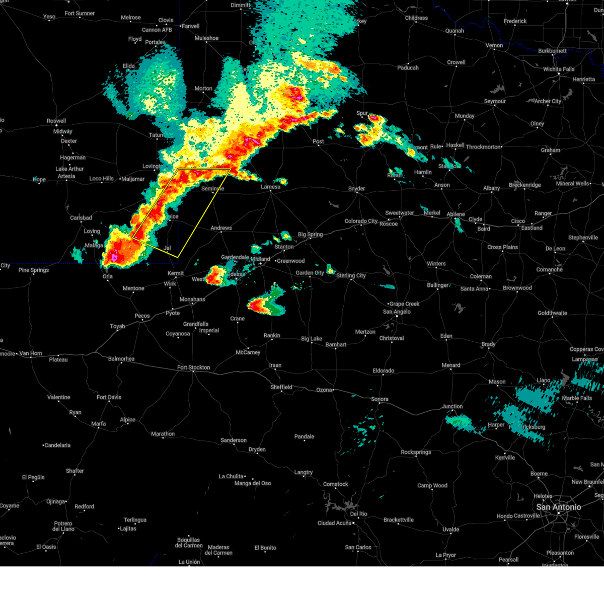
| 5/5/2025 4:48 PM CDT | Svrmaf the national weather service in midland has issued a * severe thunderstorm warning for, southeastern lea county in southeastern new mexico, western andrews county in western texas, * until 545 pm cdt/445 pm mdt/. * at 448 pm cdt/348 pm mdt/, a severe thunderstorm was located over jal, moving northeast at 25 mph (radar indicated). Hazards include 60 mph wind gusts and quarter size hail. Hail damage to vehicles is expected. Expect wind damage to roofs, siding, and trees. |
| 4/26/2025 6:32 PM MDT | Half Dollar sized hail reported 5.9 miles S of Jal, NM, trained spotter reported half dollar sized hail 6 miles north of jal... nm at 00:32z. |
| 4/26/2025 6:21 PM MDT | Quarter sized hail reported 0.4 miles NE of Jal, NM, a trained spotter reported quarter sized hail in jal... nm at 00:21z. |
| 4/26/2025 7:21 PM CDT |
 Svrmaf the national weather service in midland has issued a * severe thunderstorm warning for, southeastern lea county in southeastern new mexico, western andrews county in western texas, * until 815 pm cdt/715 pm mdt/. * at 721 pm cdt/621 pm mdt/, a severe thunderstorm was located over jal, moving northeast at 40 mph (radar indicated). Hazards include 60 mph wind gusts and half dollar size hail. Hail damage to vehicles is expected. Expect wind damage to roofs, siding, and trees. Svrmaf the national weather service in midland has issued a * severe thunderstorm warning for, southeastern lea county in southeastern new mexico, western andrews county in western texas, * until 815 pm cdt/715 pm mdt/. * at 721 pm cdt/621 pm mdt/, a severe thunderstorm was located over jal, moving northeast at 40 mph (radar indicated). Hazards include 60 mph wind gusts and half dollar size hail. Hail damage to vehicles is expected. Expect wind damage to roofs, siding, and trees.
|
| 4/23/2025 6:20 PM MDT | Golf Ball sized hail reported 3.8 miles S of Jal, NM |
| 4/23/2025 6:09 PM MDT | Quarter sized hail reported 6.6 miles S of Jal, NM |
| 4/23/2025 6:03 PM MDT |
 At 702 pm cdt/602 pm mdt/, a severe thunderstorm was located 7 miles south of eunice, moving north at 35 mph (radar indicated). Hazards include two inch hail and 70 mph wind gusts. People and animals outdoors will be injured. expect hail damage to roofs, siding, windows, and vehicles. expect considerable tree damage. wind damage is also likely to mobile homes, roofs, and outbuildings. Locations impacted include, jal airport, oil center, eunice airport, jal, bennett, and eunice. At 702 pm cdt/602 pm mdt/, a severe thunderstorm was located 7 miles south of eunice, moving north at 35 mph (radar indicated). Hazards include two inch hail and 70 mph wind gusts. People and animals outdoors will be injured. expect hail damage to roofs, siding, windows, and vehicles. expect considerable tree damage. wind damage is also likely to mobile homes, roofs, and outbuildings. Locations impacted include, jal airport, oil center, eunice airport, jal, bennett, and eunice.
|
| 4/23/2025 5:50 PM MDT | Golf Ball sized hail reported 3.8 miles S of Jal, NM, corrects timing of previous hail report from 4 n jal. |
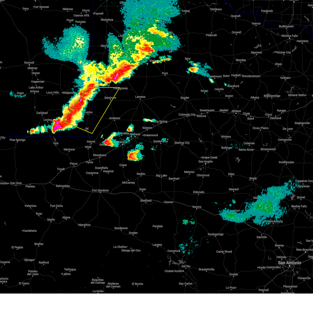
| 4/23/2025 5:41 PM MDT | Svrmaf the national weather service in midland has issued a * severe thunderstorm warning for, southeastern lea county in southeastern new mexico, western andrews county in western texas, * until 730 pm cdt/630 pm mdt/. * at 639 pm cdt/539 pm mdt/, a severe thunderstorm was located near jal, moving north at 35 mph (radar indicated). Hazards include two inch hail and 70 mph wind gusts. People and animals outdoors will be injured. expect hail damage to roofs, siding, windows, and vehicles. expect considerable tree damage. Wind damage is also likely to mobile homes, roofs, and outbuildings. |
| 4/23/2025 5:32 PM MDT |
 At 631 pm cdt/531 pm mdt/, a severe thunderstorm was located near jal, moving north at 35 mph (radar indicated). Hazards include golf ball size hail and 70 mph wind gusts. People and animals outdoors will be injured. expect hail damage to roofs, siding, windows, and vehicles. expect considerable tree damage. wind damage is also likely to mobile homes, roofs, and outbuildings. Locations impacted include, jal airport, jal, and bennett. At 631 pm cdt/531 pm mdt/, a severe thunderstorm was located near jal, moving north at 35 mph (radar indicated). Hazards include golf ball size hail and 70 mph wind gusts. People and animals outdoors will be injured. expect hail damage to roofs, siding, windows, and vehicles. expect considerable tree damage. wind damage is also likely to mobile homes, roofs, and outbuildings. Locations impacted include, jal airport, jal, and bennett.
|
| 4/23/2025 5:30 PM MDT | Storm damage reported in lea county NM, 4.9 miles E of Jal, NM |
| 4/23/2025 5:21 PM MDT |
 At 620 pm cdt/520 pm mdt/, a severe thunderstorm was located 8 miles southwest of jal, moving north at 40 mph (radar indicated). Hazards include golf ball size hail and 70 mph wind gusts. People and animals outdoors will be injured. expect hail damage to roofs, siding, windows, and vehicles. expect considerable tree damage. wind damage is also likely to mobile homes, roofs, and outbuildings. Locations impacted include, jal airport, jal, bennett, winkler county airport, and wink. At 620 pm cdt/520 pm mdt/, a severe thunderstorm was located 8 miles southwest of jal, moving north at 40 mph (radar indicated). Hazards include golf ball size hail and 70 mph wind gusts. People and animals outdoors will be injured. expect hail damage to roofs, siding, windows, and vehicles. expect considerable tree damage. wind damage is also likely to mobile homes, roofs, and outbuildings. Locations impacted include, jal airport, jal, bennett, winkler county airport, and wink.
|
| 4/23/2025 6:04 PM CDT |
 Svrmaf the national weather service in midland has issued a * severe thunderstorm warning for, southeastern lea county in southeastern new mexico, southwestern andrews county in western texas, western winkler county in western texas, eastern loving county in western texas, * until 645 pm cdt/545 pm mdt/. * at 603 pm cdt/503 pm mdt/, a severe thunderstorm was located 10 miles northwest of wink, moving north at 40 mph (radar indicated). Hazards include tennis ball size hail and 70 mph wind gusts. People and animals outdoors will be injured. expect hail damage to roofs, siding, windows, and vehicles. expect considerable tree damage. Wind damage is also likely to mobile homes, roofs, and outbuildings. Svrmaf the national weather service in midland has issued a * severe thunderstorm warning for, southeastern lea county in southeastern new mexico, southwestern andrews county in western texas, western winkler county in western texas, eastern loving county in western texas, * until 645 pm cdt/545 pm mdt/. * at 603 pm cdt/503 pm mdt/, a severe thunderstorm was located 10 miles northwest of wink, moving north at 40 mph (radar indicated). Hazards include tennis ball size hail and 70 mph wind gusts. People and animals outdoors will be injured. expect hail damage to roofs, siding, windows, and vehicles. expect considerable tree damage. Wind damage is also likely to mobile homes, roofs, and outbuildings.
|
| 9/21/2024 8:27 PM CDT |
 Svrmaf the national weather service in midland has issued a * severe thunderstorm warning for, southeastern lea county in southeastern new mexico, western andrews county in western texas, * until 930 pm cdt/830 pm mdt/. * at 827 pm cdt/727 pm mdt/, severe thunderstorms were located along a line extending from 12 miles southeast of eunice to 8 miles northwest of jal, moving east at 20 mph (radar indicated). Hazards include two inch hail and 60 mph wind gusts. People and animals outdoors will be injured. expect hail damage to roofs, siding, windows, and vehicles. Expect wind damage to roofs, siding, and trees. Svrmaf the national weather service in midland has issued a * severe thunderstorm warning for, southeastern lea county in southeastern new mexico, western andrews county in western texas, * until 930 pm cdt/830 pm mdt/. * at 827 pm cdt/727 pm mdt/, severe thunderstorms were located along a line extending from 12 miles southeast of eunice to 8 miles northwest of jal, moving east at 20 mph (radar indicated). Hazards include two inch hail and 60 mph wind gusts. People and animals outdoors will be injured. expect hail damage to roofs, siding, windows, and vehicles. Expect wind damage to roofs, siding, and trees.
|
| 9/21/2024 6:56 PM MDT |
 At 756 pm cdt/656 pm mdt/, a severe thunderstorm was located near jal airport, or 7 miles northeast of jal, moving east at 20 mph (radar indicated). Hazards include two inch hail and 60 mph wind gusts. People and animals outdoors will be injured. expect hail damage to roofs, siding, windows, and vehicles. expect wind damage to roofs, siding, and trees. Locations impacted include, jal and jal airport. At 756 pm cdt/656 pm mdt/, a severe thunderstorm was located near jal airport, or 7 miles northeast of jal, moving east at 20 mph (radar indicated). Hazards include two inch hail and 60 mph wind gusts. People and animals outdoors will be injured. expect hail damage to roofs, siding, windows, and vehicles. expect wind damage to roofs, siding, and trees. Locations impacted include, jal and jal airport.
|
| 9/21/2024 6:28 PM MDT |
 Svrmaf the national weather service in midland has issued a * severe thunderstorm warning for, southeastern lea county in southeastern new mexico, southwestern andrews county in western texas, * until 830 pm cdt/730 pm mdt/. * at 728 pm cdt/628 pm mdt/, a severe thunderstorm was located 10 miles northwest of jal, moving east at 20 mph (radar indicated). Hazards include tennis ball size hail and 60 mph wind gusts. People and animals outdoors will be injured. expect hail damage to roofs, siding, windows, and vehicles. Expect wind damage to roofs, siding, and trees. Svrmaf the national weather service in midland has issued a * severe thunderstorm warning for, southeastern lea county in southeastern new mexico, southwestern andrews county in western texas, * until 830 pm cdt/730 pm mdt/. * at 728 pm cdt/628 pm mdt/, a severe thunderstorm was located 10 miles northwest of jal, moving east at 20 mph (radar indicated). Hazards include tennis ball size hail and 60 mph wind gusts. People and animals outdoors will be injured. expect hail damage to roofs, siding, windows, and vehicles. Expect wind damage to roofs, siding, and trees.
|
| 9/21/2024 7:18 PM CDT | At 717 pm cdt/617 pm mdt/, a severe thunderstorm was located 7 miles southeast of jal airport, or 8 miles east of jal, moving northeast at 45 mph (radar indicated). Hazards include 60 mph wind gusts and half dollar size hail. Hail damage to vehicles is expected. expect wind damage to roofs, siding, and trees. Locations impacted include, jal, jal airport, and bennett. |
| 9/21/2024 7:18 PM CDT | the severe thunderstorm warning has been cancelled and is no longer in effect |
| 9/21/2024 6:50 PM CDT |
 Svrmaf the national weather service in midland has issued a * severe thunderstorm warning for, southeastern lea county in southeastern new mexico, southwestern andrews county in western texas, winkler county in western texas, northeastern loving county in western texas, * until 745 pm cdt/645 pm mdt/. * at 649 pm cdt/549 pm mdt/, a severe thunderstorm was located 7 miles west of wink, moving northeast at 45 mph (radar indicated). Hazards include 60 mph wind gusts and half dollar size hail. Hail damage to vehicles is expected. Expect wind damage to roofs, siding, and trees. Svrmaf the national weather service in midland has issued a * severe thunderstorm warning for, southeastern lea county in southeastern new mexico, southwestern andrews county in western texas, winkler county in western texas, northeastern loving county in western texas, * until 745 pm cdt/645 pm mdt/. * at 649 pm cdt/549 pm mdt/, a severe thunderstorm was located 7 miles west of wink, moving northeast at 45 mph (radar indicated). Hazards include 60 mph wind gusts and half dollar size hail. Hail damage to vehicles is expected. Expect wind damage to roofs, siding, and trees.
|
| 5/16/2024 4:39 PM CDT |
 Svrmaf the national weather service in midland has issued a * severe thunderstorm warning for, southeastern lea county in southeastern new mexico, northwestern ector county in western texas, southwestern andrews county in western texas, northeastern winkler county in western texas, * until 545 pm cdt/445 pm mdt/. * at 439 pm cdt/339 pm mdt/, a severe thunderstorm was located 7 miles southeast of jal airport, or 9 miles east of jal, moving east at 15 mph (radar indicated). Hazards include ping pong ball size hail and 60 mph wind gusts. People and animals outdoors will be injured. expect hail damage to roofs, siding, windows, and vehicles. Expect wind damage to roofs, siding, and trees. Svrmaf the national weather service in midland has issued a * severe thunderstorm warning for, southeastern lea county in southeastern new mexico, northwestern ector county in western texas, southwestern andrews county in western texas, northeastern winkler county in western texas, * until 545 pm cdt/445 pm mdt/. * at 439 pm cdt/339 pm mdt/, a severe thunderstorm was located 7 miles southeast of jal airport, or 9 miles east of jal, moving east at 15 mph (radar indicated). Hazards include ping pong ball size hail and 60 mph wind gusts. People and animals outdoors will be injured. expect hail damage to roofs, siding, windows, and vehicles. Expect wind damage to roofs, siding, and trees.
|
| 5/16/2024 3:10 PM MDT |
 Svrmaf the national weather service in midland has issued a * severe thunderstorm warning for, southeastern lea county in southeastern new mexico, southwestern andrews county in western texas, * until 515 pm cdt/415 pm mdt/. * at 410 pm cdt/310 pm mdt/, a severe thunderstorm was located over jal, moving east at 15 mph (radar indicated). Hazards include 60 mph wind gusts and quarter size hail. Hail damage to vehicles is expected. Expect wind damage to roofs, siding, and trees. Svrmaf the national weather service in midland has issued a * severe thunderstorm warning for, southeastern lea county in southeastern new mexico, southwestern andrews county in western texas, * until 515 pm cdt/415 pm mdt/. * at 410 pm cdt/310 pm mdt/, a severe thunderstorm was located over jal, moving east at 15 mph (radar indicated). Hazards include 60 mph wind gusts and quarter size hail. Hail damage to vehicles is expected. Expect wind damage to roofs, siding, and trees.
|
| 5/4/2024 4:00 PM CDT |
 Svrmaf the national weather service in midland has issued a * severe thunderstorm warning for, southeastern lea county in southeastern new mexico, western andrews county in western texas, northern winkler county in western texas, * until 500 pm cdt/400 pm mdt/. * at 400 pm cdt/300 pm mdt/, a severe thunderstorm was located near jal airport, or near jal, moving northeast at 25 mph (radar indicated). Hazards include 60 mph wind gusts and quarter size hail. Hail damage to vehicles is expected. Expect wind damage to roofs, siding, and trees. Svrmaf the national weather service in midland has issued a * severe thunderstorm warning for, southeastern lea county in southeastern new mexico, western andrews county in western texas, northern winkler county in western texas, * until 500 pm cdt/400 pm mdt/. * at 400 pm cdt/300 pm mdt/, a severe thunderstorm was located near jal airport, or near jal, moving northeast at 25 mph (radar indicated). Hazards include 60 mph wind gusts and quarter size hail. Hail damage to vehicles is expected. Expect wind damage to roofs, siding, and trees.
|
| 10/2/2023 8:49 PM MDT |
 At 949 pm cdt/849 pm mdt/, a severe thunderstorm was located 8 miles northwest of jal, moving east at 25 mph (radar indicated). Hazards include ping pong ball size hail and 60 mph wind gusts. People and animals outdoors will be injured. expect hail damage to roofs, siding, windows, and vehicles. Expect wind damage to roofs, siding, and trees. At 949 pm cdt/849 pm mdt/, a severe thunderstorm was located 8 miles northwest of jal, moving east at 25 mph (radar indicated). Hazards include ping pong ball size hail and 60 mph wind gusts. People and animals outdoors will be injured. expect hail damage to roofs, siding, windows, and vehicles. Expect wind damage to roofs, siding, and trees.
|
| 10/2/2023 7:17 PM CDT |
 At 716 pm cdt/616 pm mdt/, a severe thunderstorm was located 9 miles northwest of mentone, moving northeast at 35 mph (radar indicated). Hazards include two inch hail and 70 mph wind gusts. People and animals outdoors will be injured. expect hail damage to roofs, siding, windows, and vehicles. expect considerable tree damage. wind damage is also likely to mobile homes, roofs, and outbuildings. locations impacted include, slash ranch. thunderstorm damage threat, considerable hail threat, radar indicated max hail size, 2. 00 in wind threat, radar indicated max wind gust, 70 mph. At 716 pm cdt/616 pm mdt/, a severe thunderstorm was located 9 miles northwest of mentone, moving northeast at 35 mph (radar indicated). Hazards include two inch hail and 70 mph wind gusts. People and animals outdoors will be injured. expect hail damage to roofs, siding, windows, and vehicles. expect considerable tree damage. wind damage is also likely to mobile homes, roofs, and outbuildings. locations impacted include, slash ranch. thunderstorm damage threat, considerable hail threat, radar indicated max hail size, 2. 00 in wind threat, radar indicated max wind gust, 70 mph.
|
| 10/2/2023 7:05 PM CDT |
 At 704 pm cdt/604 pm mdt/, a severe thunderstorm was located 11 miles west of mentone, moving northeast at 35 mph (radar indicated). Hazards include 60 mph wind gusts and quarter size hail. Hail damage to vehicles is expected. Expect wind damage to roofs, siding, and trees. At 704 pm cdt/604 pm mdt/, a severe thunderstorm was located 11 miles west of mentone, moving northeast at 35 mph (radar indicated). Hazards include 60 mph wind gusts and quarter size hail. Hail damage to vehicles is expected. Expect wind damage to roofs, siding, and trees.
|
| 10/2/2023 4:30 PM MDT | Mesonet station fw9688 ja in lea county NM, 23 miles E of Jal, NM |
| 9/11/2023 7:42 PM MDT |
 At 841 pm cdt/741 pm mdt/ strong thunderstorms with damaging wind were located along a line extending from near eunice to 17 miles east of malaga to 11 miles southeast of whites city, moving southeast at 40 mph (72 mph winds were measured by the asos in carlsbad). Hazards include 70 mph wind gusts and penny size hail. Expect considerable tree damage. damage is likely to mobile homes, roofs, and outbuildings. locations impacted include, eunice, jal, jal airport, eunice airport, red bluff reservoir, orla, bennett, oil center, and red bluff. thunderstorm damage threat, considerable hail threat, radar indicated max hail size, 0. 75 in wind threat, observed max wind gust, 70 mph. At 841 pm cdt/741 pm mdt/ strong thunderstorms with damaging wind were located along a line extending from near eunice to 17 miles east of malaga to 11 miles southeast of whites city, moving southeast at 40 mph (72 mph winds were measured by the asos in carlsbad). Hazards include 70 mph wind gusts and penny size hail. Expect considerable tree damage. damage is likely to mobile homes, roofs, and outbuildings. locations impacted include, eunice, jal, jal airport, eunice airport, red bluff reservoir, orla, bennett, oil center, and red bluff. thunderstorm damage threat, considerable hail threat, radar indicated max hail size, 0. 75 in wind threat, observed max wind gust, 70 mph.
|
| 9/11/2023 7:11 PM MDT |
 At 810 pm cdt/710 pm mdt/, severe thunderstorms were located along a line extending from 6 miles northwest of monument to 10 miles northeast of loving to 8 miles north of whites city, moving east at 50 mph (asos measured 66 mph wind gusts in carlsbad). Hazards include 70 mph wind gusts and penny size hail, as well as blowing dust reducing visibility. Expect considerable tree damage. Damage is likely to mobile homes, roofs, and outbuildings. At 810 pm cdt/710 pm mdt/, severe thunderstorms were located along a line extending from 6 miles northwest of monument to 10 miles northeast of loving to 8 miles north of whites city, moving east at 50 mph (asos measured 66 mph wind gusts in carlsbad). Hazards include 70 mph wind gusts and penny size hail, as well as blowing dust reducing visibility. Expect considerable tree damage. Damage is likely to mobile homes, roofs, and outbuildings.
|
| 7/1/2023 5:16 PM MDT |
 At 615 pm cdt/515 pm mdt/, a severe thunderstorm was located 7 miles north of jal airport, or 9 miles north of jal, moving northeast at 10 mph (radar indicated). Hazards include 60 mph wind gusts and quarter size hail. Hail damage to vehicles is expected. expect wind damage to roofs, siding, and trees. locations impacted include, jal and jal airport. hail threat, radar indicated max hail size, 1. 00 in wind threat, radar indicated max wind gust, 60 mph. At 615 pm cdt/515 pm mdt/, a severe thunderstorm was located 7 miles north of jal airport, or 9 miles north of jal, moving northeast at 10 mph (radar indicated). Hazards include 60 mph wind gusts and quarter size hail. Hail damage to vehicles is expected. expect wind damage to roofs, siding, and trees. locations impacted include, jal and jal airport. hail threat, radar indicated max hail size, 1. 00 in wind threat, radar indicated max wind gust, 60 mph.
|
| 7/1/2023 4:53 PM MDT |
 At 552 pm cdt/452 pm mdt/, a severe thunderstorm was located over jal airport, or near jal, moving east at 10 mph (radar indicated). Hazards include 60 mph wind gusts and quarter size hail. Hail damage to vehicles is expected. Expect wind damage to roofs, siding, and trees. At 552 pm cdt/452 pm mdt/, a severe thunderstorm was located over jal airport, or near jal, moving east at 10 mph (radar indicated). Hazards include 60 mph wind gusts and quarter size hail. Hail damage to vehicles is expected. Expect wind damage to roofs, siding, and trees.
|
| 7/1/2023 5:31 PM CDT |
 At 531 pm cdt/431 pm mdt/, a severe thunderstorm was located 13 miles southwest of jal, moving northeast at 5 mph (radar indicated). Hazards include 60 mph wind gusts and quarter size hail. Hail damage to vehicles is expected. expect wind damage to roofs, siding, and trees. locations impacted include, bennett. hail threat, radar indicated max hail size, 1. 00 in wind threat, radar indicated max wind gust, 60 mph. At 531 pm cdt/431 pm mdt/, a severe thunderstorm was located 13 miles southwest of jal, moving northeast at 5 mph (radar indicated). Hazards include 60 mph wind gusts and quarter size hail. Hail damage to vehicles is expected. expect wind damage to roofs, siding, and trees. locations impacted include, bennett. hail threat, radar indicated max hail size, 1. 00 in wind threat, radar indicated max wind gust, 60 mph.
|
| 7/1/2023 5:14 PM CDT |
 At 514 pm cdt/414 pm mdt/, a severe thunderstorm was located 17 miles southwest of jal, and is nearly stationary (radar indicated). Hazards include 70 mph wind gusts and half dollar size hail. Hail damage to vehicles is expected. expect considerable tree damage. Wind damage is also likely to mobile homes, roofs, and outbuildings. At 514 pm cdt/414 pm mdt/, a severe thunderstorm was located 17 miles southwest of jal, and is nearly stationary (radar indicated). Hazards include 70 mph wind gusts and half dollar size hail. Hail damage to vehicles is expected. expect considerable tree damage. Wind damage is also likely to mobile homes, roofs, and outbuildings.
|
| 6/7/2023 8:53 PM CDT |
 At 853 pm cdt/753 pm mdt/, a severe thunderstorm was located 10 miles east of jal airport, or 11 miles east of jal, moving northeast at 40 mph (radar indicated). Hazards include 60 mph wind gusts and quarter size hail. Hail damage to vehicles is expected. expect wind damage to roofs, siding, and trees. locations impacted include, jal, goldsmith, jal airport and bennett. hail threat, radar indicated max hail size, 1. 00 in wind threat, radar indicated max wind gust, 60 mph. At 853 pm cdt/753 pm mdt/, a severe thunderstorm was located 10 miles east of jal airport, or 11 miles east of jal, moving northeast at 40 mph (radar indicated). Hazards include 60 mph wind gusts and quarter size hail. Hail damage to vehicles is expected. expect wind damage to roofs, siding, and trees. locations impacted include, jal, goldsmith, jal airport and bennett. hail threat, radar indicated max hail size, 1. 00 in wind threat, radar indicated max wind gust, 60 mph.
|
| 6/7/2023 8:51 PM CDT |
 At 851 pm cdt/751 pm mdt/, severe thunderstorms were located along a line extending from 9 miles northwest of seminole to 9 miles east of jal airport, moving east at 40 mph (radar indicated). Hazards include 60 mph wind gusts and quarter size hail. Hail damage to vehicles is expected. Expect wind damage to roofs, siding, and trees. At 851 pm cdt/751 pm mdt/, severe thunderstorms were located along a line extending from 9 miles northwest of seminole to 9 miles east of jal airport, moving east at 40 mph (radar indicated). Hazards include 60 mph wind gusts and quarter size hail. Hail damage to vehicles is expected. Expect wind damage to roofs, siding, and trees.
|
| 6/7/2023 7:30 PM MDT |
 At 730 pm mdt, severe thunderstorms were located along a line extending from near eunice airport to near jal, moving east at 30 mph (radar indicated). Hazards include 60 mph wind gusts and quarter size hail. Hail damage to vehicles is expected. expect wind damage to roofs, siding, and trees. locations impacted include, eunice, jal, eunice airport and bennett. hail threat, radar indicated max hail size, 1. 00 in wind threat, radar indicated max wind gust, 60 mph. At 730 pm mdt, severe thunderstorms were located along a line extending from near eunice airport to near jal, moving east at 30 mph (radar indicated). Hazards include 60 mph wind gusts and quarter size hail. Hail damage to vehicles is expected. expect wind damage to roofs, siding, and trees. locations impacted include, eunice, jal, eunice airport and bennett. hail threat, radar indicated max hail size, 1. 00 in wind threat, radar indicated max wind gust, 60 mph.
|
| 6/7/2023 8:25 PM CDT |
 At 825 pm cdt/725 pm mdt/, a severe thunderstorm was located 10 miles southwest of jal, moving northeast at 40 mph (radar indicated). Hazards include 60 mph wind gusts and half dollar size hail. Hail damage to vehicles is expected. Expect wind damage to roofs, siding, and trees. At 825 pm cdt/725 pm mdt/, a severe thunderstorm was located 10 miles southwest of jal, moving northeast at 40 mph (radar indicated). Hazards include 60 mph wind gusts and half dollar size hail. Hail damage to vehicles is expected. Expect wind damage to roofs, siding, and trees.
|
| 6/7/2023 7:13 PM MDT |
 At 712 pm mdt, severe thunderstorms were located along a line extending from 12 miles west of eunice airport to 16 miles west of jal, moving east at 30 mph (radar indicated). Hazards include 60 mph wind gusts and quarter size hail. Hail damage to vehicles is expected. expect wind damage to roofs, siding, and trees. locations impacted include, eunice, jal, eunice airport and bennett. hail threat, radar indicated max hail size, 1. 00 in wind threat, radar indicated max wind gust, 60 mph. At 712 pm mdt, severe thunderstorms were located along a line extending from 12 miles west of eunice airport to 16 miles west of jal, moving east at 30 mph (radar indicated). Hazards include 60 mph wind gusts and quarter size hail. Hail damage to vehicles is expected. expect wind damage to roofs, siding, and trees. locations impacted include, eunice, jal, eunice airport and bennett. hail threat, radar indicated max hail size, 1. 00 in wind threat, radar indicated max wind gust, 60 mph.
|
| 6/7/2023 6:41 PM MDT |
 At 641 pm mdt, severe thunderstorms were located along a line extending from 20 miles east of loving to 16 miles northeast of red bluff reservoir, moving east at 25 mph (radar indicated). Hazards include 60 mph wind gusts and quarter size hail. Hail damage to vehicles is expected. Expect wind damage to roofs, siding, and trees. At 641 pm mdt, severe thunderstorms were located along a line extending from 20 miles east of loving to 16 miles northeast of red bluff reservoir, moving east at 25 mph (radar indicated). Hazards include 60 mph wind gusts and quarter size hail. Hail damage to vehicles is expected. Expect wind damage to roofs, siding, and trees.
|
| 6/2/2023 12:27 PM MDT |
 At 127 pm cdt/1227 pm mdt/, a severe thunderstorm was located 14 miles west of jal, moving northeast at 20 mph (radar indicated). Hazards include 60 mph wind gusts and quarter size hail. Hail damage to vehicles is expected. Expect wind damage to roofs, siding, and trees. At 127 pm cdt/1227 pm mdt/, a severe thunderstorm was located 14 miles west of jal, moving northeast at 20 mph (radar indicated). Hazards include 60 mph wind gusts and quarter size hail. Hail damage to vehicles is expected. Expect wind damage to roofs, siding, and trees.
|
| 5/31/2023 3:30 PM MDT | Mesonet station fw9690 ja in lea county NM, 19.7 miles ESE of Jal, NM |
| 5/19/2023 7:35 PM MDT |
 At 735 pm mdt, a severe thunderstorm was located 15 miles west of jal, moving north at 10 mph (radar indicated). Hazards include 60 mph wind gusts and quarter size hail. Hail damage to vehicles is expected. expect wind damage to roofs, siding, and trees. locations impacted include, jal and bennett. hail threat, radar indicated max hail size, 1. 00 in wind threat, radar indicated max wind gust, 60 mph. At 735 pm mdt, a severe thunderstorm was located 15 miles west of jal, moving north at 10 mph (radar indicated). Hazards include 60 mph wind gusts and quarter size hail. Hail damage to vehicles is expected. expect wind damage to roofs, siding, and trees. locations impacted include, jal and bennett. hail threat, radar indicated max hail size, 1. 00 in wind threat, radar indicated max wind gust, 60 mph.
|
| 5/19/2023 7:01 PM MDT |
 At 801 pm cdt/701 pm mdt/, a severe thunderstorm was located 18 miles northeast of mentone, moving north at 10 mph (radar indicated). Hazards include 60 mph wind gusts and quarter size hail. Hail damage to vehicles is expected. expect wind damage to roofs, siding, and trees. locations impacted include, jal and bennett. hail threat, radar indicated max hail size, 1. 00 in wind threat, radar indicated max wind gust, 60 mph. At 801 pm cdt/701 pm mdt/, a severe thunderstorm was located 18 miles northeast of mentone, moving north at 10 mph (radar indicated). Hazards include 60 mph wind gusts and quarter size hail. Hail damage to vehicles is expected. expect wind damage to roofs, siding, and trees. locations impacted include, jal and bennett. hail threat, radar indicated max hail size, 1. 00 in wind threat, radar indicated max wind gust, 60 mph.
|
| 5/19/2023 7:45 PM CDT |
 At 744 pm cdt/644 pm mdt/, a severe thunderstorm was located 15 miles northeast of mentone, moving north at 10 mph (radar indicated). Hazards include 60 mph wind gusts and quarter size hail. Hail damage to vehicles is expected. Expect wind damage to roofs, siding, and trees. At 744 pm cdt/644 pm mdt/, a severe thunderstorm was located 15 miles northeast of mentone, moving north at 10 mph (radar indicated). Hazards include 60 mph wind gusts and quarter size hail. Hail damage to vehicles is expected. Expect wind damage to roofs, siding, and trees.
|
| 6/3/2022 7:00 PM MDT |
 At 800 pm cdt/700 pm mdt/, a severe thunderstorm was located 13 miles west of jal, moving southeast at 30 mph (radar indicated). Hazards include golf ball size hail and 60 mph wind gusts. People and animals outdoors will be injured. expect hail damage to roofs, siding, windows, and vehicles. expect wind damage to roofs, siding, and trees. Locations impacted include, jal and bennett. At 800 pm cdt/700 pm mdt/, a severe thunderstorm was located 13 miles west of jal, moving southeast at 30 mph (radar indicated). Hazards include golf ball size hail and 60 mph wind gusts. People and animals outdoors will be injured. expect hail damage to roofs, siding, windows, and vehicles. expect wind damage to roofs, siding, and trees. Locations impacted include, jal and bennett.
|
| 6/3/2022 6:37 PM MDT |
 At 737 pm cdt/637 pm mdt/, a severe thunderstorm was located 20 miles west of jal, moving southeast at 30 mph (radar indicated). Hazards include ping pong ball size hail and 60 mph wind gusts. People and animals outdoors will be injured. expect hail damage to roofs, siding, windows, and vehicles. Expect wind damage to roofs, siding, and trees. At 737 pm cdt/637 pm mdt/, a severe thunderstorm was located 20 miles west of jal, moving southeast at 30 mph (radar indicated). Hazards include ping pong ball size hail and 60 mph wind gusts. People and animals outdoors will be injured. expect hail damage to roofs, siding, windows, and vehicles. Expect wind damage to roofs, siding, and trees.
|
| 6/3/2022 1:07 AM MDT |
 At 207 am cdt/107 am mdt/, a severe thunderstorm was located 18 miles east of jal airport, or 19 miles southwest of andrews, moving east at 15 mph (radar indicated). Hazards include 60 mph wind gusts and quarter size hail. Hail damage to vehicles is expected. expect wind damage to roofs, siding, and trees. locations impacted include, jal and jal airport. hail threat, radar indicated max hail size, 1. 00 in wind threat, radar indicated max wind gust, 60 mph. At 207 am cdt/107 am mdt/, a severe thunderstorm was located 18 miles east of jal airport, or 19 miles southwest of andrews, moving east at 15 mph (radar indicated). Hazards include 60 mph wind gusts and quarter size hail. Hail damage to vehicles is expected. expect wind damage to roofs, siding, and trees. locations impacted include, jal and jal airport. hail threat, radar indicated max hail size, 1. 00 in wind threat, radar indicated max wind gust, 60 mph.
|
| 6/3/2022 12:31 AM MDT |
 At 130 am cdt/1230 am mdt/, a severe thunderstorm was located 21 miles west of jal, moving east at 25 mph (radar indicated). Hazards include 60 mph wind gusts and half dollar size hail. Hail damage to vehicles is expected. Expect wind damage to roofs, siding, and trees. At 130 am cdt/1230 am mdt/, a severe thunderstorm was located 21 miles west of jal, moving east at 25 mph (radar indicated). Hazards include 60 mph wind gusts and half dollar size hail. Hail damage to vehicles is expected. Expect wind damage to roofs, siding, and trees.
|
| 6/2/2022 11:33 PM MDT |
 At 1132 pm mdt, a severe thunderstorm was located 16 miles west of eunice airport, or 21 miles west of eunice, moving east at 20 mph (radar indicated). Hazards include 60 mph wind gusts and quarter size hail. Hail damage to vehicles is expected. expect wind damage to roofs, siding, and trees. locations impacted include, hobbs, eunice, jal, jal airport, monument, nadine, eunice airport, bennett, lea county regional airport and oil center. hail threat, radar indicated max hail size, 1. 00 in wind threat, radar indicated max wind gust, 60 mph. At 1132 pm mdt, a severe thunderstorm was located 16 miles west of eunice airport, or 21 miles west of eunice, moving east at 20 mph (radar indicated). Hazards include 60 mph wind gusts and quarter size hail. Hail damage to vehicles is expected. expect wind damage to roofs, siding, and trees. locations impacted include, hobbs, eunice, jal, jal airport, monument, nadine, eunice airport, bennett, lea county regional airport and oil center. hail threat, radar indicated max hail size, 1. 00 in wind threat, radar indicated max wind gust, 60 mph.
|
| 6/2/2022 11:11 PM MDT |
 At 1111 pm mdt, a severe thunderstorm was located 23 miles west of monument, or 28 miles west of eunice, moving east at 20 mph (radar indicated). Hazards include 60 mph wind gusts and quarter size hail. Hail damage to vehicles is expected. Expect wind damage to roofs, siding, and trees. At 1111 pm mdt, a severe thunderstorm was located 23 miles west of monument, or 28 miles west of eunice, moving east at 20 mph (radar indicated). Hazards include 60 mph wind gusts and quarter size hail. Hail damage to vehicles is expected. Expect wind damage to roofs, siding, and trees.
|
| 6/1/2022 5:27 PM MDT | Recorded by vehicle mounted anemomete in lea county NM, 6.6 miles S of Jal, NM |
| 6/1/2022 6:12 PM CDT |
 At 612 pm cdt/512 pm mdt/, a severe thunderstorm was located 9 miles north of kermit, moving southeast at 30 mph (radar indicated). Hazards include 70 mph wind gusts and ping pong ball size hail. People and animals outdoors will be injured. expect hail damage to roofs, siding, windows, and vehicles. expect considerable tree damage. wind damage is also likely to mobile homes, roofs, and outbuildings. locations impacted include, kermit, jal, jal airport, notrees and bennett. thunderstorm damage threat, considerable hail threat, radar indicated max hail size, 1. 50 in wind threat, radar indicated max wind gust, 70 mph. At 612 pm cdt/512 pm mdt/, a severe thunderstorm was located 9 miles north of kermit, moving southeast at 30 mph (radar indicated). Hazards include 70 mph wind gusts and ping pong ball size hail. People and animals outdoors will be injured. expect hail damage to roofs, siding, windows, and vehicles. expect considerable tree damage. wind damage is also likely to mobile homes, roofs, and outbuildings. locations impacted include, kermit, jal, jal airport, notrees and bennett. thunderstorm damage threat, considerable hail threat, radar indicated max hail size, 1. 50 in wind threat, radar indicated max wind gust, 70 mph.
|
| 6/1/2022 5:43 PM CDT |
 At 542 pm cdt/442 pm mdt/, a severe thunderstorm was located 7 miles west of jal, moving southeast at 30 mph (radar indicated). Hazards include tennis ball size hail and 70 mph wind gusts. People and animals outdoors will be injured. expect hail damage to roofs, siding, windows, and vehicles. expect considerable tree damage. Wind damage is also likely to mobile homes, roofs, and outbuildings. At 542 pm cdt/442 pm mdt/, a severe thunderstorm was located 7 miles west of jal, moving southeast at 30 mph (radar indicated). Hazards include tennis ball size hail and 70 mph wind gusts. People and animals outdoors will be injured. expect hail damage to roofs, siding, windows, and vehicles. expect considerable tree damage. Wind damage is also likely to mobile homes, roofs, and outbuildings.
|
| 6/1/2022 3:53 PM MDT |
 At 453 pm cdt/353 pm mdt/, a severe thunderstorm was located 19 miles southwest of eunice airport, or 22 miles northwest of jal, moving east at 30 mph (radar indicated). Hazards include tennis ball size hail and 70 mph wind gusts. People and animals outdoors will be injured. expect hail damage to roofs, siding, windows, and vehicles. expect considerable tree damage. wind damage is also likely to mobile homes, roofs, and outbuildings. Locations impacted include, jal, jal airport and bennett. At 453 pm cdt/353 pm mdt/, a severe thunderstorm was located 19 miles southwest of eunice airport, or 22 miles northwest of jal, moving east at 30 mph (radar indicated). Hazards include tennis ball size hail and 70 mph wind gusts. People and animals outdoors will be injured. expect hail damage to roofs, siding, windows, and vehicles. expect considerable tree damage. wind damage is also likely to mobile homes, roofs, and outbuildings. Locations impacted include, jal, jal airport and bennett.
|
| 6/2/2021 7:00 PM MDT | Storm damage reported in lea county NM, 14.1 miles ENE of Jal, NM |
| 6/2/2021 6:31 PM MDT |
 At 731 pm cdt/631 pm mdt/, a severe thunderstorm was located near jal, moving east at 10 mph (radar indicated). Hazards include two inch hail and 60 mph wind gusts. People and animals outdoors will be injured. expect hail damage to roofs, siding, windows, and vehicles. expect wind damage to roofs, siding, and trees. Locations impacted include, jal, jal airport and bennett. At 731 pm cdt/631 pm mdt/, a severe thunderstorm was located near jal, moving east at 10 mph (radar indicated). Hazards include two inch hail and 60 mph wind gusts. People and animals outdoors will be injured. expect hail damage to roofs, siding, windows, and vehicles. expect wind damage to roofs, siding, and trees. Locations impacted include, jal, jal airport and bennett.
|
| 6/2/2021 6:20 PM MDT |
 At 720 pm cdt/620 pm mdt/, a severe thunderstorm was located near jal, moving east at 10 mph (radar indicated). Hazards include ping pong ball size hail and 60 mph wind gusts. People and animals outdoors will be injured. expect hail damage to roofs, siding, windows, and vehicles. expect wind damage to roofs, siding, and trees. Locations impacted include, jal, jal airport and bennett. At 720 pm cdt/620 pm mdt/, a severe thunderstorm was located near jal, moving east at 10 mph (radar indicated). Hazards include ping pong ball size hail and 60 mph wind gusts. People and animals outdoors will be injured. expect hail damage to roofs, siding, windows, and vehicles. expect wind damage to roofs, siding, and trees. Locations impacted include, jal, jal airport and bennett.
|
| 6/2/2021 6:12 PM MDT |
 At 712 pm cdt/612 pm mdt/, a severe thunderstorm was located near jal, moving east at 10 mph (radar indicated). Hazards include 60 mph wind gusts and quarter size hail. Hail damage to vehicles is expected. Expect wind damage to roofs, siding, and trees. At 712 pm cdt/612 pm mdt/, a severe thunderstorm was located near jal, moving east at 10 mph (radar indicated). Hazards include 60 mph wind gusts and quarter size hail. Hail damage to vehicles is expected. Expect wind damage to roofs, siding, and trees.
|
| 5/28/2021 11:27 PM CDT |
 At 1127 pm cdt/1027 pm mdt/, a severe thunderstorm was located 12 miles west of red bluff reservoir, or 33 miles west of mentone, moving south at 25 mph (radar indicated). Hazards include ping pong ball size hail and 60 mph wind gusts. People and animals outdoors will be injured. expect hail damage to roofs, siding, windows, and vehicles. expect wind damage to roofs, siding, and trees. Locations impacted include, kermit, eunice, jal, wink, mentone, loving, malaga, jal airport, red bluff reservoir, orla, whites city, carlsbad caverns national park, slash ranch, bennett, red bluff and winkler county airport. At 1127 pm cdt/1027 pm mdt/, a severe thunderstorm was located 12 miles west of red bluff reservoir, or 33 miles west of mentone, moving south at 25 mph (radar indicated). Hazards include ping pong ball size hail and 60 mph wind gusts. People and animals outdoors will be injured. expect hail damage to roofs, siding, windows, and vehicles. expect wind damage to roofs, siding, and trees. Locations impacted include, kermit, eunice, jal, wink, mentone, loving, malaga, jal airport, red bluff reservoir, orla, whites city, carlsbad caverns national park, slash ranch, bennett, red bluff and winkler county airport.
|
| 5/28/2021 11:14 PM CDT |
 At 1114 pm cdt/1014 pm mdt/, a severe thunderstorm was located 11 miles west of red bluff reservoir, or 30 miles south of carlsbad, moving southeast at 20 mph (radar indicated). Hazards include 60 mph wind gusts and half dollar size hail. Hail damage to vehicles is expected. expect wind damage to roofs, siding, and trees. Locations impacted include, kermit, eunice, jal, wink, mentone, loving, malaga, jal airport, red bluff reservoir, orla, whites city, carlsbad caverns national park, slash ranch, bennett, red bluff and winkler county airport. At 1114 pm cdt/1014 pm mdt/, a severe thunderstorm was located 11 miles west of red bluff reservoir, or 30 miles south of carlsbad, moving southeast at 20 mph (radar indicated). Hazards include 60 mph wind gusts and half dollar size hail. Hail damage to vehicles is expected. expect wind damage to roofs, siding, and trees. Locations impacted include, kermit, eunice, jal, wink, mentone, loving, malaga, jal airport, red bluff reservoir, orla, whites city, carlsbad caverns national park, slash ranch, bennett, red bluff and winkler county airport.
|
| 5/28/2021 9:40 PM MDT |
 At 1039 pm cdt/939 pm mdt/, a severe thunderstorm was located over loving, or 9 miles southeast of carlsbad, moving southeast at 25 mph (radar indicated). Hazards include 60 mph wind gusts and half dollar size hail. Hail damage to vehicles is expected. Expect wind damage to roofs, siding, and trees. At 1039 pm cdt/939 pm mdt/, a severe thunderstorm was located over loving, or 9 miles southeast of carlsbad, moving southeast at 25 mph (radar indicated). Hazards include 60 mph wind gusts and half dollar size hail. Hail damage to vehicles is expected. Expect wind damage to roofs, siding, and trees.
|
| 5/28/2021 10:27 PM CDT |
 At 1026 pm cdt/926 pm mdt/, severe thunderstorms were located along a line extending from near welch to 15 miles east of gaines county airport to 12 miles northwest of andrews to 9 miles east of eunice to 14 miles southwest of eunice airport to 21 miles east of malaga, moving southeast at 50 mph (radar indicated). Hazards include 60 mph wind gusts and quarter size hail. Hail damage to vehicles is expected. expect wind damage to roofs, siding, and trees. Locations impacted include, hobbs, andrews, seminole, eunice, jal, monument, eunice airport, nadine, gaines county airport, welch, loop, florey, mckenzie lake, halfway, frankel city, lea county regional airport, oil center, paynes corner, gaines county park and andrews county airport. At 1026 pm cdt/926 pm mdt/, severe thunderstorms were located along a line extending from near welch to 15 miles east of gaines county airport to 12 miles northwest of andrews to 9 miles east of eunice to 14 miles southwest of eunice airport to 21 miles east of malaga, moving southeast at 50 mph (radar indicated). Hazards include 60 mph wind gusts and quarter size hail. Hail damage to vehicles is expected. expect wind damage to roofs, siding, and trees. Locations impacted include, hobbs, andrews, seminole, eunice, jal, monument, eunice airport, nadine, gaines county airport, welch, loop, florey, mckenzie lake, halfway, frankel city, lea county regional airport, oil center, paynes corner, gaines county park and andrews county airport.
|
| 5/28/2021 9:50 PM CDT |
 At 950 pm cdt/850 pm mdt/, severe thunderstorms were located along a line extending from 7 miles northwest of seagraves to 9 miles south of denver city to nadine to 20 miles south of maljamar, moving south at 35 mph (radar indicated). Hazards include 60 mph wind gusts and half dollar size hail. Hail damage to vehicles is expected. Expect wind damage to roofs, siding, and trees. At 950 pm cdt/850 pm mdt/, severe thunderstorms were located along a line extending from 7 miles northwest of seagraves to 9 miles south of denver city to nadine to 20 miles south of maljamar, moving south at 35 mph (radar indicated). Hazards include 60 mph wind gusts and half dollar size hail. Hail damage to vehicles is expected. Expect wind damage to roofs, siding, and trees.
|
| 5/28/2021 6:14 PM MDT |
 At 713 pm cdt/613 pm mdt/, a severe thunderstorm was located 13 miles west of wink, moving southeast at 20 mph. a second severe storm was located 17 miles northwest of jal (radar indicated). Hazards include tennis ball size hail and 70 mph wind gusts. People and animals outdoors will be injured. expect hail damage to roofs, siding, windows, and vehicles. expect considerable tree damage. wind damage is also likely to mobile homes, roofs, and outbuildings. Locations impacted include, eunice, jal, wink, mentone, jal airport, wickett, bennett, slash ranch and winkler county airport. At 713 pm cdt/613 pm mdt/, a severe thunderstorm was located 13 miles west of wink, moving southeast at 20 mph. a second severe storm was located 17 miles northwest of jal (radar indicated). Hazards include tennis ball size hail and 70 mph wind gusts. People and animals outdoors will be injured. expect hail damage to roofs, siding, windows, and vehicles. expect considerable tree damage. wind damage is also likely to mobile homes, roofs, and outbuildings. Locations impacted include, eunice, jal, wink, mentone, jal airport, wickett, bennett, slash ranch and winkler county airport.
|
| 5/28/2021 5:58 PM MDT |
 At 657 pm cdt/557 pm mdt/, a severe thunderstorm was located 10 miles northeast of mentone, moving southeast at 20 mph (radar indicated). Hazards include golf ball size hail and 70 mph wind gusts. People and animals outdoors will be injured. expect hail damage to roofs, siding, windows, and vehicles. expect considerable tree damage. wind damage is also likely to mobile homes, roofs, and outbuildings. Locations impacted include, kermit, eunice, jal, wink, mentone, jal airport, wickett, bennett, slash ranch and winkler county airport. At 657 pm cdt/557 pm mdt/, a severe thunderstorm was located 10 miles northeast of mentone, moving southeast at 20 mph (radar indicated). Hazards include golf ball size hail and 70 mph wind gusts. People and animals outdoors will be injured. expect hail damage to roofs, siding, windows, and vehicles. expect considerable tree damage. wind damage is also likely to mobile homes, roofs, and outbuildings. Locations impacted include, kermit, eunice, jal, wink, mentone, jal airport, wickett, bennett, slash ranch and winkler county airport.
|
| 5/28/2021 5:32 PM MDT |
 At 632 pm cdt/532 pm mdt/, a severe thunderstorm was located 23 miles west of jal, moving east at 30 mph (radar indicated). Hazards include 60 mph wind gusts and half dollar size hail. Hail damage to vehicles is expected. Expect wind damage to roofs, siding, and trees. At 632 pm cdt/532 pm mdt/, a severe thunderstorm was located 23 miles west of jal, moving east at 30 mph (radar indicated). Hazards include 60 mph wind gusts and half dollar size hail. Hail damage to vehicles is expected. Expect wind damage to roofs, siding, and trees.
|
| 5/26/2021 4:44 PM MDT |
 At 543 pm cdt/443 pm mdt/, a severe thunderstorm was located 14 miles northwest of jal, moving north at 40 mph (radar indicated). Hazards include 60 mph wind gusts and half dollar size hail. Hail damage to vehicles is expected. Expect wind damage to roofs, siding, and trees. At 543 pm cdt/443 pm mdt/, a severe thunderstorm was located 14 miles northwest of jal, moving north at 40 mph (radar indicated). Hazards include 60 mph wind gusts and half dollar size hail. Hail damage to vehicles is expected. Expect wind damage to roofs, siding, and trees.
|
| 5/24/2021 9:26 PM CDT |
 At 926 pm cdt/826 pm mdt/, severe thunderstorms were located along a line extending from 12 miles northwest of jal airport to jal to 14 miles northwest of wink, moving northeast at 30 mph (radar indicated). Hazards include 60 mph wind gusts and nickel size hail. Expect damage to roofs, siding, and trees. Locations impacted include, kermit, jal, wink, mentone, jal airport, bennett and winkler county airport. At 926 pm cdt/826 pm mdt/, severe thunderstorms were located along a line extending from 12 miles northwest of jal airport to jal to 14 miles northwest of wink, moving northeast at 30 mph (radar indicated). Hazards include 60 mph wind gusts and nickel size hail. Expect damage to roofs, siding, and trees. Locations impacted include, kermit, jal, wink, mentone, jal airport, bennett and winkler county airport.
|
| 5/24/2021 9:09 PM CDT |
 At 909 pm cdt/809 pm mdt/, severe thunderstorms were located along a line extending from 19 miles west of jal airport to 10 miles southwest of jal to 6 miles northeast of mentone, moving east at 25 mph (radar indicated). Hazards include 70 mph wind gusts and quarter size hail. Hail damage to vehicles is expected. expect considerable tree damage. Wind damage is also likely to mobile homes, roofs, and outbuildings. At 909 pm cdt/809 pm mdt/, severe thunderstorms were located along a line extending from 19 miles west of jal airport to 10 miles southwest of jal to 6 miles northeast of mentone, moving east at 25 mph (radar indicated). Hazards include 70 mph wind gusts and quarter size hail. Hail damage to vehicles is expected. expect considerable tree damage. Wind damage is also likely to mobile homes, roofs, and outbuildings.
|
| 9/8/2020 5:31 PM MDT |
 At 631 pm cdt/531 pm mdt/, a severe thunderstorm was located near jal, moving east at 25 mph (radar indicated). Hazards include 60 mph wind gusts and penny size hail. Expect damage to roofs, siding, and trees. Locations impacted include, jal, jal airport and bennett. At 631 pm cdt/531 pm mdt/, a severe thunderstorm was located near jal, moving east at 25 mph (radar indicated). Hazards include 60 mph wind gusts and penny size hail. Expect damage to roofs, siding, and trees. Locations impacted include, jal, jal airport and bennett.
|
| 9/8/2020 5:13 PM MDT |
 At 612 pm cdt/512 pm mdt/, a severe thunderstorm capable of producing a tornado was located over jal, moving east at 25 mph (radar indicated rotation). Hazards include tornado. Flying debris will be dangerous to those caught without shelter. mobile homes will be damaged or destroyed. damage to roofs, windows, and vehicles will occur. tree damage is likely. this dangerous storm will be near, jal airport around 520 pm mdt. Other locations impacted by this tornadic thunderstorm include bennett. At 612 pm cdt/512 pm mdt/, a severe thunderstorm capable of producing a tornado was located over jal, moving east at 25 mph (radar indicated rotation). Hazards include tornado. Flying debris will be dangerous to those caught without shelter. mobile homes will be damaged or destroyed. damage to roofs, windows, and vehicles will occur. tree damage is likely. this dangerous storm will be near, jal airport around 520 pm mdt. Other locations impacted by this tornadic thunderstorm include bennett.
|
| 9/8/2020 5:01 PM MDT |
 At 601 pm cdt/501 pm mdt/, a severe thunderstorm was located 13 miles west of jal, moving east at 25 mph (radar indicated). Hazards include 60 mph wind gusts and penny size hail. expect damage to roofs, siding, and trees At 601 pm cdt/501 pm mdt/, a severe thunderstorm was located 13 miles west of jal, moving east at 25 mph (radar indicated). Hazards include 60 mph wind gusts and penny size hail. expect damage to roofs, siding, and trees
|
| 9/29/2019 5:54 PM CDT |
 At 550 pm cdt/450 pm mdt/, a severe thunderstorm was located 7 miles northwest of kermit, moving northeast at 30 mph. at 544 pm cdt, the winkler county airport recorded a 66 mph wind gust (winkler county airport asos). Hazards include ping pong ball size hail and 60 mph wind gusts. People and animals outdoors will be injured. expect hail damage to roofs, siding, windows, and vehicles. expect wind damage to roofs, siding, and trees. Locations impacted include, kermit, jal, jal airport, bennett and winkler county airport. At 550 pm cdt/450 pm mdt/, a severe thunderstorm was located 7 miles northwest of kermit, moving northeast at 30 mph. at 544 pm cdt, the winkler county airport recorded a 66 mph wind gust (winkler county airport asos). Hazards include ping pong ball size hail and 60 mph wind gusts. People and animals outdoors will be injured. expect hail damage to roofs, siding, windows, and vehicles. expect wind damage to roofs, siding, and trees. Locations impacted include, kermit, jal, jal airport, bennett and winkler county airport.
|
| 9/29/2019 5:41 PM CDT |
 At 540 pm cdt/440 pm mdt/, a severe thunderstorm was located near kermit, moving northeast at 25 mph (radar indicated). Hazards include ping pong ball size hail and 60 mph wind gusts. People and animals outdoors will be injured. expect hail damage to roofs, siding, windows, and vehicles. expect wind damage to roofs, siding, and trees. Locations impacted include, kermit, jal, jal airport, bennett and winkler county airport. At 540 pm cdt/440 pm mdt/, a severe thunderstorm was located near kermit, moving northeast at 25 mph (radar indicated). Hazards include ping pong ball size hail and 60 mph wind gusts. People and animals outdoors will be injured. expect hail damage to roofs, siding, windows, and vehicles. expect wind damage to roofs, siding, and trees. Locations impacted include, kermit, jal, jal airport, bennett and winkler county airport.
|
| 9/29/2019 5:30 PM CDT |
 At 530 pm cdt/430 pm mdt/, a severe thunderstorm was located 8 miles west of kermit, moving northeast at 30 mph (radar indicated). Hazards include 60 mph wind gusts and quarter size hail. Hail damage to vehicles is expected. expect wind damage to roofs, siding, and trees. Locations impacted include, kermit, jal, jal airport, bennett and winkler county airport. At 530 pm cdt/430 pm mdt/, a severe thunderstorm was located 8 miles west of kermit, moving northeast at 30 mph (radar indicated). Hazards include 60 mph wind gusts and quarter size hail. Hail damage to vehicles is expected. expect wind damage to roofs, siding, and trees. Locations impacted include, kermit, jal, jal airport, bennett and winkler county airport.
|
| 9/29/2019 5:09 PM CDT |
 At 508 pm cdt/408 pm mdt/, a severe thunderstorm was located 12 miles west of wink, moving northeast at 30 mph (radar indicated). Hazards include 60 mph wind gusts and quarter size hail. Hail damage to vehicles is expected. Expect wind damage to roofs, siding, and trees. At 508 pm cdt/408 pm mdt/, a severe thunderstorm was located 12 miles west of wink, moving northeast at 30 mph (radar indicated). Hazards include 60 mph wind gusts and quarter size hail. Hail damage to vehicles is expected. Expect wind damage to roofs, siding, and trees.
|
| 9/28/2019 5:11 PM MDT |
 At 510 pm mdt, a severe thunderstorm was located near jal airport, or near jal, moving north at 40 mph (radar indicated). Hazards include 60 mph wind gusts and quarter size hail. Hail damage to vehicles is expected. expect wind damage to roofs, siding, and trees. Locations impacted include, eunice, jal, jal airport and eunice airport. At 510 pm mdt, a severe thunderstorm was located near jal airport, or near jal, moving north at 40 mph (radar indicated). Hazards include 60 mph wind gusts and quarter size hail. Hail damage to vehicles is expected. expect wind damage to roofs, siding, and trees. Locations impacted include, eunice, jal, jal airport and eunice airport.
|
| 9/28/2019 4:53 PM MDT |
 At 453 pm mdt, a severe thunderstorm was located near jal, moving north at 40 mph (radar indicated). Hazards include 60 mph wind gusts and quarter size hail. Hail damage to vehicles is expected. Expect wind damage to roofs, siding, and trees. At 453 pm mdt, a severe thunderstorm was located near jal, moving north at 40 mph (radar indicated). Hazards include 60 mph wind gusts and quarter size hail. Hail damage to vehicles is expected. Expect wind damage to roofs, siding, and trees.
|
| 8/27/2019 7:54 PM MDT |
 At 754 pm mdt, a severe thunderstorm was located 18 miles northeast of red bluff reservoir, or 24 miles north of mentone, moving south at 10 mph (radar indicated). Hazards include 60 mph wind gusts and quarter size hail. Hail damage to vehicles is expected. expect wind damage to roofs, siding, and trees. Locations impacted include, jal. At 754 pm mdt, a severe thunderstorm was located 18 miles northeast of red bluff reservoir, or 24 miles north of mentone, moving south at 10 mph (radar indicated). Hazards include 60 mph wind gusts and quarter size hail. Hail damage to vehicles is expected. expect wind damage to roofs, siding, and trees. Locations impacted include, jal.
|
| 8/27/2019 7:38 PM MDT |
 At 738 pm mdt, a severe thunderstorm was located 21 miles northeast of red bluff reservoir, or 25 miles west of jal, moving south at 10 mph (radar indicated). Hazards include 60 mph wind gusts and quarter size hail. Hail damage to vehicles is expected. Expect wind damage to roofs, siding, and trees. At 738 pm mdt, a severe thunderstorm was located 21 miles northeast of red bluff reservoir, or 25 miles west of jal, moving south at 10 mph (radar indicated). Hazards include 60 mph wind gusts and quarter size hail. Hail damage to vehicles is expected. Expect wind damage to roofs, siding, and trees.
|
| 7/3/2019 7:42 PM MDT |
 At 742 pm mdt, a severe thunderstorm was located 13 miles northwest of jal, moving east at 10 mph (radar indicated). Hazards include 60 mph wind gusts and quarter size hail. Hail damage to vehicles is expected. expect wind damage to roofs, siding, and trees. Locations impacted include, jal, jal airport and bennett. At 742 pm mdt, a severe thunderstorm was located 13 miles northwest of jal, moving east at 10 mph (radar indicated). Hazards include 60 mph wind gusts and quarter size hail. Hail damage to vehicles is expected. expect wind damage to roofs, siding, and trees. Locations impacted include, jal, jal airport and bennett.
|
| 7/3/2019 7:13 PM MDT |
 At 713 pm mdt, a severe thunderstorm was located 19 miles west of jal, moving east at 10 mph (radar indicated). Hazards include 60 mph wind gusts and quarter size hail. Hail damage to vehicles is expected. Expect wind damage to roofs, siding, and trees. At 713 pm mdt, a severe thunderstorm was located 19 miles west of jal, moving east at 10 mph (radar indicated). Hazards include 60 mph wind gusts and quarter size hail. Hail damage to vehicles is expected. Expect wind damage to roofs, siding, and trees.
|
| 5/31/2019 9:24 PM MDT |
 The severe thunderstorm warning for southeastern lea and west central andrews counties will expire at 1030 pm cdt/930 pm mdt/, the storm which prompted the warning has weakened below severe limits, and no longer poses an immediate threat to life or property. therefore, the warning will be allowed to expire. The severe thunderstorm warning for southeastern lea and west central andrews counties will expire at 1030 pm cdt/930 pm mdt/, the storm which prompted the warning has weakened below severe limits, and no longer poses an immediate threat to life or property. therefore, the warning will be allowed to expire.
|
| 5/31/2019 9:14 PM MDT |
 At 1014 pm cdt/914 pm mdt/, a severe thunderstorm was located near jal airport, or near jal, moving northeast at 20 mph (radar indicated). Hazards include 60 mph wind gusts and quarter size hail. Hail damage to vehicles is expected. expect wind damage to roofs, siding, and trees. Locations impacted include, jal and jal airport. At 1014 pm cdt/914 pm mdt/, a severe thunderstorm was located near jal airport, or near jal, moving northeast at 20 mph (radar indicated). Hazards include 60 mph wind gusts and quarter size hail. Hail damage to vehicles is expected. expect wind damage to roofs, siding, and trees. Locations impacted include, jal and jal airport.
|
| 5/31/2019 9:00 PM MDT |
 At 1000 pm cdt/900 pm mdt/, a severe thunderstorm was located over jal, moving north at 20 mph (radar indicated). Hazards include 60 mph wind gusts and quarter size hail. Hail damage to vehicles is expected. expect wind damage to roofs, siding, and trees. Locations impacted include, jal, jal airport and bennett. At 1000 pm cdt/900 pm mdt/, a severe thunderstorm was located over jal, moving north at 20 mph (radar indicated). Hazards include 60 mph wind gusts and quarter size hail. Hail damage to vehicles is expected. expect wind damage to roofs, siding, and trees. Locations impacted include, jal, jal airport and bennett.
|
| 5/31/2019 8:50 PM MDT |
 At 950 pm cdt/850 pm mdt/, a severe thunderstorm was located over jal, moving northeast at 40 mph (radar indicated). Hazards include 60 mph wind gusts and quarter size hail. Hail damage to vehicles is expected. Expect wind damage to roofs, siding, and trees. At 950 pm cdt/850 pm mdt/, a severe thunderstorm was located over jal, moving northeast at 40 mph (radar indicated). Hazards include 60 mph wind gusts and quarter size hail. Hail damage to vehicles is expected. Expect wind damage to roofs, siding, and trees.
|
| 5/25/2019 2:30 PM MDT | Hen Egg sized hail reported 0.4 miles NE of Jal, NM, hail lasted from 325-330 pm cdt. mostly golfball sized hail with some a little bigger. |
| 5/25/2019 2:18 PM MDT | Ping Pong Ball sized hail reported 0.4 miles NE of Jal, NM |
| 5/25/2019 2:16 PM MDT |
 At 316 pm cdt/216 pm mdt/, a severe thunderstorm was located over jal, moving north at 45 mph (radar indicated). Hazards include two inch hail and 60 mph wind gusts. People and animals outdoors will be injured. expect hail damage to roofs, siding, windows, and vehicles. expect wind damage to roofs, siding, and trees. Locations impacted include, kermit, eunice, jal, wink, nadine, jal airport, monument, eunice airport, bennett, frankel city, oil center and winkler county airport. At 316 pm cdt/216 pm mdt/, a severe thunderstorm was located over jal, moving north at 45 mph (radar indicated). Hazards include two inch hail and 60 mph wind gusts. People and animals outdoors will be injured. expect hail damage to roofs, siding, windows, and vehicles. expect wind damage to roofs, siding, and trees. Locations impacted include, kermit, eunice, jal, wink, nadine, jal airport, monument, eunice airport, bennett, frankel city, oil center and winkler county airport.
|
| 5/25/2019 1:51 PM MDT |
 At 250 pm cdt/150 pm mdt/, a severe thunderstorm was located near wink, moving north at 40 mph (radar indicated). Hazards include golf ball size hail and 60 mph wind gusts. People and animals outdoors will be injured. expect hail damage to roofs, siding, windows, and vehicles. Expect wind damage to roofs, siding, and trees. At 250 pm cdt/150 pm mdt/, a severe thunderstorm was located near wink, moving north at 40 mph (radar indicated). Hazards include golf ball size hail and 60 mph wind gusts. People and animals outdoors will be injured. expect hail damage to roofs, siding, windows, and vehicles. Expect wind damage to roofs, siding, and trees.
|
| 5/5/2019 4:10 PM MDT |
 At 509 pm cdt/409 pm mdt/, a severe thunderstorm was located 17 miles southeast of jal airport, or 18 miles southeast of jal, moving northeast at 25 mph (radar indicated). Hazards include 60 mph wind gusts and quarter size hail. Hail damage to vehicles is expected. expect wind damage to roofs, siding, and trees. Locations impacted include, kermit, jal, jal airport and bennett. At 509 pm cdt/409 pm mdt/, a severe thunderstorm was located 17 miles southeast of jal airport, or 18 miles southeast of jal, moving northeast at 25 mph (radar indicated). Hazards include 60 mph wind gusts and quarter size hail. Hail damage to vehicles is expected. expect wind damage to roofs, siding, and trees. Locations impacted include, kermit, jal, jal airport and bennett.
|
| 5/5/2019 3:52 PM MDT |
 At 452 pm cdt/352 pm mdt/, a severe thunderstorm was located 8 miles north of kermit, moving northeast at 25 mph (radar indicated). Hazards include 60 mph wind gusts and quarter size hail. Hail damage to vehicles is expected. expect wind damage to roofs, siding, and trees. Locations impacted include, kermit, jal, jal airport and bennett. At 452 pm cdt/352 pm mdt/, a severe thunderstorm was located 8 miles north of kermit, moving northeast at 25 mph (radar indicated). Hazards include 60 mph wind gusts and quarter size hail. Hail damage to vehicles is expected. expect wind damage to roofs, siding, and trees. Locations impacted include, kermit, jal, jal airport and bennett.
|
| 5/5/2019 3:40 PM MDT |
 At 439 pm cdt/339 pm mdt/, a severe thunderstorm was located near kermit, moving northeast at 25 mph (radar indicated). Hazards include 60 mph wind gusts and quarter size hail. Hail damage to vehicles is expected. Expect wind damage to roofs, siding, and trees. At 439 pm cdt/339 pm mdt/, a severe thunderstorm was located near kermit, moving northeast at 25 mph (radar indicated). Hazards include 60 mph wind gusts and quarter size hail. Hail damage to vehicles is expected. Expect wind damage to roofs, siding, and trees.
|
| 4/23/2019 12:18 AM CDT |
 At 1217 am cdt/1117 pm mdt/, a severe thunderstorm was located near jal airport, or near jal, moving east at 30 mph (radar indicated). Hazards include ping pong ball size hail and 60 mph wind gusts. People and animals outdoors will be injured. expect hail damage to roofs, siding, windows, and vehicles. expect wind damage to roofs, siding, and trees. Locations impacted include, jal and jal airport. At 1217 am cdt/1117 pm mdt/, a severe thunderstorm was located near jal airport, or near jal, moving east at 30 mph (radar indicated). Hazards include ping pong ball size hail and 60 mph wind gusts. People and animals outdoors will be injured. expect hail damage to roofs, siding, windows, and vehicles. expect wind damage to roofs, siding, and trees. Locations impacted include, jal and jal airport.
|
| 4/22/2019 11:15 PM MDT | Golf Ball sized hail reported 0.4 miles NE of Jal, NM |
| 4/22/2019 11:05 PM MDT | Quarter sized hail reported 0.4 miles NE of Jal, NM, at the jal police department. |
| 4/22/2019 11:59 PM CDT |
 At 1159 pm cdt/1059 pm mdt/, a severe thunderstorm was located near jal, moving east at 30 mph (radar indicated). Hazards include ping pong ball size hail and 60 mph wind gusts. People and animals outdoors will be injured. expect hail damage to roofs, siding, windows, and vehicles. Expect wind damage to roofs, siding, and trees. At 1159 pm cdt/1059 pm mdt/, a severe thunderstorm was located near jal, moving east at 30 mph (radar indicated). Hazards include ping pong ball size hail and 60 mph wind gusts. People and animals outdoors will be injured. expect hail damage to roofs, siding, windows, and vehicles. Expect wind damage to roofs, siding, and trees.
|
| 3/12/2019 8:10 PM MDT |
 At 910 pm cdt/810 pm mdt/, a severe thunderstorm was located 9 miles southeast of eunice, moving east at 25 mph (radar indicated). Hazards include 60 mph wind gusts and quarter size hail. Hail damage to vehicles is expected. expect wind damage to roofs, siding, and trees. locations impacted include, hobbs, lovington, eunice, jal, monument, humble city, eunice airport, nadine, knowles, lea county regional airport, oil center, industrial airpark and higginbotham. A tornado watch remains in effect until 1100 pm cdt/1000 pm mdt/ for southeastern new mexico, and western texas. At 910 pm cdt/810 pm mdt/, a severe thunderstorm was located 9 miles southeast of eunice, moving east at 25 mph (radar indicated). Hazards include 60 mph wind gusts and quarter size hail. Hail damage to vehicles is expected. expect wind damage to roofs, siding, and trees. locations impacted include, hobbs, lovington, eunice, jal, monument, humble city, eunice airport, nadine, knowles, lea county regional airport, oil center, industrial airpark and higginbotham. A tornado watch remains in effect until 1100 pm cdt/1000 pm mdt/ for southeastern new mexico, and western texas.
|
| 3/12/2019 7:56 PM MDT |
 At 855 pm cdt/755 pm mdt/, a severe squall line capable of producing both tornadoes and extensive straight line wind damage was located near kermit, and is moving moving northeast at 50 mph (radar indicated rotation). Hazards include tornado and baseball size hail. Flying debris will be dangerous to those caught without shelter. mobile homes will be damaged or destroyed. damage to roofs, windows, and vehicles will occur. tree damage is likely. these dangerous storms will be near, jal airport around 915 pm cdt. Other locations impacted by this tornadic thunderstorm include bennett. At 855 pm cdt/755 pm mdt/, a severe squall line capable of producing both tornadoes and extensive straight line wind damage was located near kermit, and is moving moving northeast at 50 mph (radar indicated rotation). Hazards include tornado and baseball size hail. Flying debris will be dangerous to those caught without shelter. mobile homes will be damaged or destroyed. damage to roofs, windows, and vehicles will occur. tree damage is likely. these dangerous storms will be near, jal airport around 915 pm cdt. Other locations impacted by this tornadic thunderstorm include bennett.
|
| 3/12/2019 7:45 PM MDT |
 At 844 pm cdt/744 pm mdt/, a severe thunderstorm was located 10 miles south of eunice, moving east at 25 mph (radar indicated). Hazards include 60 mph wind gusts and quarter size hail. Hail damage to vehicles is expected. Expect wind damage to roofs, siding, and trees. At 844 pm cdt/744 pm mdt/, a severe thunderstorm was located 10 miles south of eunice, moving east at 25 mph (radar indicated). Hazards include 60 mph wind gusts and quarter size hail. Hail damage to vehicles is expected. Expect wind damage to roofs, siding, and trees.
|
| 3/12/2019 8:39 PM CDT |
 At 839 pm cdt/739 pm mdt/, severe thunderstorms capable of producing both tornadoes and extensive straight line wind damage were located 7 miles west of wink, moving northeast at 50 mph (radar indicated rotation). Hazards include tornado and baseball size hail. Flying debris will be dangerous to those caught without shelter. mobile homes will be damaged or destroyed. damage to roofs, windows, and vehicles will occur. tree damage is likely. these dangerous storms will be near, kermit around 855 pm cdt. Other locations impacted by this tornadic thunderstorm include bennett and winkler county airport. At 839 pm cdt/739 pm mdt/, severe thunderstorms capable of producing both tornadoes and extensive straight line wind damage were located 7 miles west of wink, moving northeast at 50 mph (radar indicated rotation). Hazards include tornado and baseball size hail. Flying debris will be dangerous to those caught without shelter. mobile homes will be damaged or destroyed. damage to roofs, windows, and vehicles will occur. tree damage is likely. these dangerous storms will be near, kermit around 855 pm cdt. Other locations impacted by this tornadic thunderstorm include bennett and winkler county airport.
|
| 3/12/2019 7:33 PM MDT |
 At 833 pm cdt/733 pm mdt/, a severe thunderstorm was located 7 miles northwest of jal, moving northeast at 45 mph (radar indicated). Hazards include 60 mph wind gusts and quarter size hail. Hail damage to vehicles is expected. expect wind damage to roofs, siding, and trees. locations impacted include, kermit, eunice, jal, mentone, jal airport, eunice airport, bennett and slash ranch. A tornado watch remains in effect until 1100 pm cdt/1000 pm mdt/ for southeastern new mexico, and western and southwestern texas. At 833 pm cdt/733 pm mdt/, a severe thunderstorm was located 7 miles northwest of jal, moving northeast at 45 mph (radar indicated). Hazards include 60 mph wind gusts and quarter size hail. Hail damage to vehicles is expected. expect wind damage to roofs, siding, and trees. locations impacted include, kermit, eunice, jal, mentone, jal airport, eunice airport, bennett and slash ranch. A tornado watch remains in effect until 1100 pm cdt/1000 pm mdt/ for southeastern new mexico, and western and southwestern texas.
|
| 3/12/2019 7:05 PM MDT |
 At 804 pm cdt/704 pm mdt/, a severe thunderstorm was located 15 miles north of mentone, moving east at 40 mph (radar indicated). Hazards include 60 mph wind gusts and quarter size hail. Hail damage to vehicles is expected. Expect wind damage to roofs, siding, and trees. At 804 pm cdt/704 pm mdt/, a severe thunderstorm was located 15 miles north of mentone, moving east at 40 mph (radar indicated). Hazards include 60 mph wind gusts and quarter size hail. Hail damage to vehicles is expected. Expect wind damage to roofs, siding, and trees.
|
| 6/16/2018 3:41 PM MDT |
 At 441 pm cdt/341 pm mdt/, a severe thunderstorm was located 9 miles northwest of kermit, moving northeast at 20 mph (radar indicated). Hazards include 70 mph wind gusts and quarter size hail. Hail damage to vehicles is expected. expect considerable tree damage. wind damage is also likely to mobile homes, roofs, and outbuildings. Locations impacted include, jal, jal airport and bennett. At 441 pm cdt/341 pm mdt/, a severe thunderstorm was located 9 miles northwest of kermit, moving northeast at 20 mph (radar indicated). Hazards include 70 mph wind gusts and quarter size hail. Hail damage to vehicles is expected. expect considerable tree damage. wind damage is also likely to mobile homes, roofs, and outbuildings. Locations impacted include, jal, jal airport and bennett.
|
| 6/16/2018 3:12 PM MDT |
 At 412 pm cdt/312 pm mdt/, a severe thunderstorm was located 15 miles southwest of jal, moving northeast at 30 mph (radar indicated). Hazards include 70 mph wind gusts and quarter size hail. Hail damage to vehicles is expected. expect considerable tree damage. Wind damage is also likely to mobile homes, roofs, and outbuildings. At 412 pm cdt/312 pm mdt/, a severe thunderstorm was located 15 miles southwest of jal, moving northeast at 30 mph (radar indicated). Hazards include 70 mph wind gusts and quarter size hail. Hail damage to vehicles is expected. expect considerable tree damage. Wind damage is also likely to mobile homes, roofs, and outbuildings.
|
| 6/16/2018 2:49 PM MDT |
 At 349 pm cdt/249 pm mdt/, severe thunderstorms were located along a line extending from 22 miles south of maljamar to 9 miles east of mentone, moving northeast at 15 mph (radar indicated). Hazards include 70 mph wind gusts and half dollar size hail. Hail damage to vehicles is expected. expect considerable tree damage. wind damage is also likely to mobile homes, roofs, and outbuildings. Locations impacted include, eunice, jal, jal airport, monument, maljamar, eunice airport, bennett, halfway, slash ranch and oil center. At 349 pm cdt/249 pm mdt/, severe thunderstorms were located along a line extending from 22 miles south of maljamar to 9 miles east of mentone, moving northeast at 15 mph (radar indicated). Hazards include 70 mph wind gusts and half dollar size hail. Hail damage to vehicles is expected. expect considerable tree damage. wind damage is also likely to mobile homes, roofs, and outbuildings. Locations impacted include, eunice, jal, jal airport, monument, maljamar, eunice airport, bennett, halfway, slash ranch and oil center.
|
| 6/16/2018 2:22 PM MDT |
 At 322 pm cdt/222 pm mdt/, severe thunderstorms were located along a line extending from 16 miles east of loving to 11 miles northeast of mentone, moving north at 15 mph (radar indicated). Hazards include 60 mph wind gusts and quarter size hail. Hail damage to vehicles is expected. Expect wind damage to roofs, siding, and trees. At 322 pm cdt/222 pm mdt/, severe thunderstorms were located along a line extending from 16 miles east of loving to 11 miles northeast of mentone, moving north at 15 mph (radar indicated). Hazards include 60 mph wind gusts and quarter size hail. Hail damage to vehicles is expected. Expect wind damage to roofs, siding, and trees.
|
| 6/3/2018 10:59 PM CDT |
 At 1040 pm cdt/940 pm mdt/, severe thunderstorms were located along a line extending from 6 miles northeast of humble city to 11 miles east of eunice to 15 miles east of jal airport to near kermit, moving east at 40 mph (trained weather spotters). Hazards include 70 mph wind gusts and half dollar size hail. Hail damage to vehicles is expected. expect considerable tree damage. Wind damage is also likely to mobile homes, roofs, and outbuildings. At 1040 pm cdt/940 pm mdt/, severe thunderstorms were located along a line extending from 6 miles northeast of humble city to 11 miles east of eunice to 15 miles east of jal airport to near kermit, moving east at 40 mph (trained weather spotters). Hazards include 70 mph wind gusts and half dollar size hail. Hail damage to vehicles is expected. expect considerable tree damage. Wind damage is also likely to mobile homes, roofs, and outbuildings.
|
| 6/3/2018 10:59 PM CDT |
 At 1058 pm cdt/958 pm mdt/, severe thunderstorms were located along a line extending from near denver city to 7 miles south of gaines county airport to 8 miles south of andrews, moving northeast at 40 mph (trained weather spotters). Hazards include 70 mph wind gusts and half dollar size hail. Hail damage to vehicles is expected. expect considerable tree damage. wind damage is also likely to mobile homes, roofs, and outbuildings. Locations impacted include, hobbs, andrews, seminole, kermit, eunice, wink, goldsmith, monument, humble city, nadine, jal airport, gaines county airport, west odessa, florey, knowles, notrees, frankel city, lea county regional airport, industrial airpark and paynes corner. At 1058 pm cdt/958 pm mdt/, severe thunderstorms were located along a line extending from near denver city to 7 miles south of gaines county airport to 8 miles south of andrews, moving northeast at 40 mph (trained weather spotters). Hazards include 70 mph wind gusts and half dollar size hail. Hail damage to vehicles is expected. expect considerable tree damage. wind damage is also likely to mobile homes, roofs, and outbuildings. Locations impacted include, hobbs, andrews, seminole, kermit, eunice, wink, goldsmith, monument, humble city, nadine, jal airport, gaines county airport, west odessa, florey, knowles, notrees, frankel city, lea county regional airport, industrial airpark and paynes corner.
|
| 6/3/2018 10:40 PM CDT |
 At 1040 pm cdt/940 pm mdt/, severe thunderstorms were located along a line extending from 6 miles northeast of humble city to 11 miles east of eunice to 15 miles east of jal airport to near kermit, moving east at 40 mph (trained weather spotters). Hazards include 70 mph wind gusts and half dollar size hail. Hail damage to vehicles is expected. expect considerable tree damage. Wind damage is also likely to mobile homes, roofs, and outbuildings. At 1040 pm cdt/940 pm mdt/, severe thunderstorms were located along a line extending from 6 miles northeast of humble city to 11 miles east of eunice to 15 miles east of jal airport to near kermit, moving east at 40 mph (trained weather spotters). Hazards include 70 mph wind gusts and half dollar size hail. Hail damage to vehicles is expected. expect considerable tree damage. Wind damage is also likely to mobile homes, roofs, and outbuildings.
|
| 6/3/2018 9:22 PM MDT |
 At 1022 pm cdt/922 pm mdt/, severe thunderstorms were located along a line extending from 13 miles west of mcdonald to near monument to 6 miles northeast of jal airport to 12 miles west of wink, moving east at 35 mph (radar indicated). Hazards include 70 mph wind gusts and half dollar size hail. Hail damage to vehicles is expected. expect considerable tree damage. wind damage is also likely to mobile homes, roofs, and outbuildings. Locations impacted include, hobbs, lovington, eunice, jal, tatum, monument, humble city, maljamar, eunice airport, mcdonald, nadine, jal airport, tatum airport, knowles, bennett, lea county regional airport, oil center and industrial airpark. At 1022 pm cdt/922 pm mdt/, severe thunderstorms were located along a line extending from 13 miles west of mcdonald to near monument to 6 miles northeast of jal airport to 12 miles west of wink, moving east at 35 mph (radar indicated). Hazards include 70 mph wind gusts and half dollar size hail. Hail damage to vehicles is expected. expect considerable tree damage. wind damage is also likely to mobile homes, roofs, and outbuildings. Locations impacted include, hobbs, lovington, eunice, jal, tatum, monument, humble city, maljamar, eunice airport, mcdonald, nadine, jal airport, tatum airport, knowles, bennett, lea county regional airport, oil center and industrial airpark.
|
| 6/3/2018 8:59 PM MDT |
 The national weather service in midland has issued a * severe thunderstorm warning for. lea county in southeastern new mexico. northwestern ector county in western texas. western andrews county in western texas. Western gaines county in western texas. The national weather service in midland has issued a * severe thunderstorm warning for. lea county in southeastern new mexico. northwestern ector county in western texas. western andrews county in western texas. Western gaines county in western texas.
|
| 6/3/2018 8:51 PM MDT | Davis vantage pro2 report at 2051 mdt in lea county NM, 21.1 miles ESE of Jal, NM |
| 5/17/2018 3:54 PM MDT |
 At 453 pm cdt/353 pm mdt/, a severe thunderstorm was located near jal airport, or 8 miles northeast of jal, moving northeast at 35 mph (radar indicated). Hazards include 60 mph wind gusts and quarter size hail. Hail damage to vehicles is expected. expect wind damage to roofs, siding, and trees. Locations impacted include, jal and jal airport. At 453 pm cdt/353 pm mdt/, a severe thunderstorm was located near jal airport, or 8 miles northeast of jal, moving northeast at 35 mph (radar indicated). Hazards include 60 mph wind gusts and quarter size hail. Hail damage to vehicles is expected. expect wind damage to roofs, siding, and trees. Locations impacted include, jal and jal airport.
|
| 5/17/2018 3:31 PM MDT |
 At 431 pm cdt/331 pm mdt/, a severe thunderstorm was located near jal, moving east at 20 mph (radar indicated). Hazards include 60 mph wind gusts and half dollar size hail. Hail damage to vehicles is expected. Expect wind damage to roofs, siding, and trees. At 431 pm cdt/331 pm mdt/, a severe thunderstorm was located near jal, moving east at 20 mph (radar indicated). Hazards include 60 mph wind gusts and half dollar size hail. Hail damage to vehicles is expected. Expect wind damage to roofs, siding, and trees.
|
| 5/17/2018 2:16 PM MDT |
 At 215 pm mdt, a severe thunderstorm was located 12 miles northeast of malaga, or 21 miles east of carlsbad, moving east at 25 mph (radar indicated). Hazards include 60 mph wind gusts and quarter size hail. Hail damage to vehicles is expected. Expect wind damage to roofs, siding, and trees. At 215 pm mdt, a severe thunderstorm was located 12 miles northeast of malaga, or 21 miles east of carlsbad, moving east at 25 mph (radar indicated). Hazards include 60 mph wind gusts and quarter size hail. Hail damage to vehicles is expected. Expect wind damage to roofs, siding, and trees.
|
| 7/4/2017 10:38 PM CDT |
 At 1035 pm cdt/935 pm mdt/, doppler radar was tracking a large gust front from near mesquite, patricia, andrews west to eunice. the gust front was moving to the south at 60 mph (radar indicated). Hazards include 60 mph wind gusts. Expect damage to roofs, siding, and trees. locations impacted include, big spring, andrews, lamesa, eunice, stanton, jal, ackerly, gail, los ybanez, flower grove, patricia, hancock, lenorah, eunice airport, jal airport, vealmoor, luther, sparenberg, lamesa municipal airport and frankel city. This includes interstate 20 between mile markers 156 and 158, and between mile markers 160 and 182. At 1035 pm cdt/935 pm mdt/, doppler radar was tracking a large gust front from near mesquite, patricia, andrews west to eunice. the gust front was moving to the south at 60 mph (radar indicated). Hazards include 60 mph wind gusts. Expect damage to roofs, siding, and trees. locations impacted include, big spring, andrews, lamesa, eunice, stanton, jal, ackerly, gail, los ybanez, flower grove, patricia, hancock, lenorah, eunice airport, jal airport, vealmoor, luther, sparenberg, lamesa municipal airport and frankel city. This includes interstate 20 between mile markers 156 and 158, and between mile markers 160 and 182.
|
| 7/4/2017 10:20 PM CDT |
 At 1017 pm cdt/917 pm mdt/, at 1005 pm cdt/905 pm mdt/, doppler radar was tracking a large gust front ahead of a line of strong thunderstorms from near welch to seagraves to denver city. the gust front was moving to the south at 60 mph (radar indicated). Hazards include 60 mph wind gusts. expect damage to roofs, siding, and trees At 1017 pm cdt/917 pm mdt/, at 1005 pm cdt/905 pm mdt/, doppler radar was tracking a large gust front ahead of a line of strong thunderstorms from near welch to seagraves to denver city. the gust front was moving to the south at 60 mph (radar indicated). Hazards include 60 mph wind gusts. expect damage to roofs, siding, and trees
|
| 6/23/2017 6:11 PM CDT |
 At 611 pm cdt/511 pm mdt/, a severe thunderstorm was located 10 miles southwest of notrees, or 11 miles east of kermit, moving south at 20 mph (radar indicated). Hazards include 70 mph wind gusts and quarter size hail. Hail damage to vehicles is expected. expect considerable tree damage. wind damage is also likely to mobile homes, roofs, and outbuildings. Locations impacted include, kermit, jal, wink, jal airport, notrees, winkler county airport, monahans sandhills state park and bennett. At 611 pm cdt/511 pm mdt/, a severe thunderstorm was located 10 miles southwest of notrees, or 11 miles east of kermit, moving south at 20 mph (radar indicated). Hazards include 70 mph wind gusts and quarter size hail. Hail damage to vehicles is expected. expect considerable tree damage. wind damage is also likely to mobile homes, roofs, and outbuildings. Locations impacted include, kermit, jal, wink, jal airport, notrees, winkler county airport, monahans sandhills state park and bennett.
|
| 6/23/2017 5:51 PM CDT |
 At 550 pm cdt/450 pm mdt/, a severe thunderstorm was located 8 miles west of notrees, or 12 miles northeast of kermit, moving south at 20 mph (radar indicated). Hazards include 70 mph wind gusts and quarter size hail. Hail damage to vehicles is expected. expect considerable tree damage. Wind damage is also likely to mobile homes, roofs, and outbuildings. At 550 pm cdt/450 pm mdt/, a severe thunderstorm was located 8 miles west of notrees, or 12 miles northeast of kermit, moving south at 20 mph (radar indicated). Hazards include 70 mph wind gusts and quarter size hail. Hail damage to vehicles is expected. expect considerable tree damage. Wind damage is also likely to mobile homes, roofs, and outbuildings.
|
| 5/31/2017 7:53 PM MDT |
 At 751 pm mdt, a severe thunderstorm was located 21 miles south of halfway, or 27 miles west of jal, moving southeast at 10 mph (radar indicated). Hazards include 60 mph wind gusts and quarter size hail. Hail damage to vehicles is expected. Expect wind damage to roofs, siding, and trees. At 751 pm mdt, a severe thunderstorm was located 21 miles south of halfway, or 27 miles west of jal, moving southeast at 10 mph (radar indicated). Hazards include 60 mph wind gusts and quarter size hail. Hail damage to vehicles is expected. Expect wind damage to roofs, siding, and trees.
|
| 5/22/2017 7:22 PM MDT |
 At 720 pm mdt, a severe thunderstorm was located 11 miles west of jal, moving southeast at 20 mph. Hazards include 70 mph wind gusts and quarter size hail. Hail damage to vehicles is expected. expect considerable tree damage. wind damage is also likely to mobile homes, roofs, and outbuildings. Locations impacted include, jal, jal airport and bennett. At 720 pm mdt, a severe thunderstorm was located 11 miles west of jal, moving southeast at 20 mph. Hazards include 70 mph wind gusts and quarter size hail. Hail damage to vehicles is expected. expect considerable tree damage. wind damage is also likely to mobile homes, roofs, and outbuildings. Locations impacted include, jal, jal airport and bennett.
|
| 5/22/2017 7:05 PM MDT |
 At 704 pm mdt, a severe thunderstorm was located 15 miles northwest of jal, moving southeast at 20 mph (radar indicated). Hazards include 70 mph wind gusts and quarter size hail. Hail damage to vehicles is expected. expect considerable tree damage. wind damage is also likely to mobile homes, roofs, and outbuildings. Locations impacted include, eunice, jal, jal airport, oil center, eunice airport and bennett. At 704 pm mdt, a severe thunderstorm was located 15 miles northwest of jal, moving southeast at 20 mph (radar indicated). Hazards include 70 mph wind gusts and quarter size hail. Hail damage to vehicles is expected. expect considerable tree damage. wind damage is also likely to mobile homes, roofs, and outbuildings. Locations impacted include, eunice, jal, jal airport, oil center, eunice airport and bennett.
|
| 5/22/2017 6:52 PM MDT |
 At 651 pm mdt, a severe thunderstorm was located 18 miles northwest of jal, moving southeast at 20 mph. this is a very dangerous storm (trained weather spotter reported 77 mph wind gust 22 miles wnw of jal). Hazards include 80 mph wind gusts and quarter size hail. Flying debris will be dangerous to those caught without shelter. mobile homes will be heavily damaged. expect considerable damage to roofs, windows, and vehicles. extensive tree damage and power outages are likely. Locations impacted include, eunice, jal, jal airport, oil center, eunice airport and bennett. At 651 pm mdt, a severe thunderstorm was located 18 miles northwest of jal, moving southeast at 20 mph. this is a very dangerous storm (trained weather spotter reported 77 mph wind gust 22 miles wnw of jal). Hazards include 80 mph wind gusts and quarter size hail. Flying debris will be dangerous to those caught without shelter. mobile homes will be heavily damaged. expect considerable damage to roofs, windows, and vehicles. extensive tree damage and power outages are likely. Locations impacted include, eunice, jal, jal airport, oil center, eunice airport and bennett.
|
| 5/22/2017 6:45 PM MDT | A trained spotter measured a 77 mph thunderstorm wind gust which snapped 2 power pole in lea county NM, 22.2 miles ESE of Jal, NM |
| 5/22/2017 6:45 PM MDT |
 At 643 pm mdt, a severe thunderstorm was located 18 miles southwest of eunice airport, or 21 miles northwest of jal, moving southeast at 20 mph (radar indicated). Hazards include 60 mph wind gusts and quarter size hail. Hail damage to vehicles is expected. Expect wind damage to roofs, siding, and trees. At 643 pm mdt, a severe thunderstorm was located 18 miles southwest of eunice airport, or 21 miles northwest of jal, moving southeast at 20 mph (radar indicated). Hazards include 60 mph wind gusts and quarter size hail. Hail damage to vehicles is expected. Expect wind damage to roofs, siding, and trees.
|
| 3/11/2017 7:01 PM MDT |
 At 700 pm cst/600 pm mst/, a severe thunderstorm was located 21 miles west of jal, moving south at 35 mph (radar indicated). Hazards include two inch hail and 60 mph wind gusts. People and animals outdoors will be injured. expect hail damage to roofs, siding, windows, and vehicles. expect wind damage to roofs, siding, and trees. Locations impacted include, jal, jal airport and bennett. At 700 pm cst/600 pm mst/, a severe thunderstorm was located 21 miles west of jal, moving south at 35 mph (radar indicated). Hazards include two inch hail and 60 mph wind gusts. People and animals outdoors will be injured. expect hail damage to roofs, siding, windows, and vehicles. expect wind damage to roofs, siding, and trees. Locations impacted include, jal, jal airport and bennett.
|
| 3/11/2017 6:31 PM MDT |
 At 631 pm cst/531 pm mst/, a severe thunderstorm was located 10 miles southwest of eunice airport, or 13 miles west of eunice, moving south at 25 mph. two inch hail has been reported with this storm (radar indicated). Hazards include two inch hail and 60 mph wind gusts. People and animals outdoors will be injured. expect hail damage to roofs, siding, windows, and vehicles. Expect wind damage to roofs, siding, and trees. At 631 pm cst/531 pm mst/, a severe thunderstorm was located 10 miles southwest of eunice airport, or 13 miles west of eunice, moving south at 25 mph. two inch hail has been reported with this storm (radar indicated). Hazards include two inch hail and 60 mph wind gusts. People and animals outdoors will be injured. expect hail damage to roofs, siding, windows, and vehicles. Expect wind damage to roofs, siding, and trees.
|
| 1/1/2017 7:52 PM CST |
 At 751 pm cst/651 pm mst/, severe thunderstorms were located along a line extending from 10 miles north of bronco to near denver city to near winkler county airport, moving northeast at 65 mph (69 mph wind gust reported at lea county regional airport). Hazards include 70 mph wind gusts and penny size hail. Expect considerable tree damage. damage is likely to mobile homes, roofs, and outbuildings. Locations impacted include, hobbs, andrews, seminole, kermit, denver city, eunice, seagraves, jal, seagraves airport, nadine, jal airport, gaines county airport, welch, gaines county park, winkler county airport, loop, knowles, frankel city, higginbotham and cedar lake. At 751 pm cst/651 pm mst/, severe thunderstorms were located along a line extending from 10 miles north of bronco to near denver city to near winkler county airport, moving northeast at 65 mph (69 mph wind gust reported at lea county regional airport). Hazards include 70 mph wind gusts and penny size hail. Expect considerable tree damage. damage is likely to mobile homes, roofs, and outbuildings. Locations impacted include, hobbs, andrews, seminole, kermit, denver city, eunice, seagraves, jal, seagraves airport, nadine, jal airport, gaines county airport, welch, gaines county park, winkler county airport, loop, knowles, frankel city, higginbotham and cedar lake.
|
| 1/1/2017 7:28 PM CST |
 At 728 pm cst/628 pm mst/, severe thunderstorms were located along a line extending from near tatum to near hobbs to 6 miles south of mentone, moving northeast at 65 mph (radar indicated). Hazards include 60 mph wind gusts and penny size hail. expect damage to roofs, siding, and trees At 728 pm cst/628 pm mst/, severe thunderstorms were located along a line extending from near tatum to near hobbs to 6 miles south of mentone, moving northeast at 65 mph (radar indicated). Hazards include 60 mph wind gusts and penny size hail. expect damage to roofs, siding, and trees
|
| 1/1/2017 6:05 PM MST |
 At 704 pm cst/604 pm mst/, severe thunderstorms were located along a line extending from near buckeye to 13 miles east of red bluff reservoir to 14 miles northwest of balmorhea, moving east at 45 mph (radar indicated). Hazards include 60 mph wind gusts and penny size hail. Expect damage to roofs, siding, and trees. locations impacted include, hobbs, lovington, pecos, eunice, jal, wink, tatum, toyah, orla, mentone, barstow, monument, humble city, maljamar, eunice airport, nadine, jal airport, mcdonald, buckeye and halfway. this includes the following highways, interstate 10 between mile markers 186 and 189. Interstate 20 between mile markers 0 and 63. At 704 pm cst/604 pm mst/, severe thunderstorms were located along a line extending from near buckeye to 13 miles east of red bluff reservoir to 14 miles northwest of balmorhea, moving east at 45 mph (radar indicated). Hazards include 60 mph wind gusts and penny size hail. Expect damage to roofs, siding, and trees. locations impacted include, hobbs, lovington, pecos, eunice, jal, wink, tatum, toyah, orla, mentone, barstow, monument, humble city, maljamar, eunice airport, nadine, jal airport, mcdonald, buckeye and halfway. this includes the following highways, interstate 10 between mile markers 186 and 189. Interstate 20 between mile markers 0 and 63.
|
| 1/1/2017 5:43 PM MST |
 At 642 pm cst/542 pm mst/, severe thunderstorms were located along a line extending from near loco hills to near red bluff reservoir to kent, moving east at 55 mph (radar indicated). Hazards include 60 mph wind gusts and penny size hail. expect damage to roofs, siding, and trees At 642 pm cst/542 pm mst/, severe thunderstorms were located along a line extending from near loco hills to near red bluff reservoir to kent, moving east at 55 mph (radar indicated). Hazards include 60 mph wind gusts and penny size hail. expect damage to roofs, siding, and trees
|
| 9/17/2016 7:49 PM MDT |
 At 748 pm mdt, a severe thunderstorm capable of producing a tornado was located near jal airport, or near jal, moving east at 40 mph (radar indicated rotation). Hazards include tornado and golf ball size hail. Flying debris will be dangerous to those caught without shelter. mobile homes will be damaged or destroyed. damage to roofs, windows, and vehicles will occur. tree damage is likely. This tornadic thunderstorm will remain over mainly rural areas of southeastern lea county, including the following locations: bennett. At 748 pm mdt, a severe thunderstorm capable of producing a tornado was located near jal airport, or near jal, moving east at 40 mph (radar indicated rotation). Hazards include tornado and golf ball size hail. Flying debris will be dangerous to those caught without shelter. mobile homes will be damaged or destroyed. damage to roofs, windows, and vehicles will occur. tree damage is likely. This tornadic thunderstorm will remain over mainly rural areas of southeastern lea county, including the following locations: bennett.
|
| 9/17/2016 7:45 PM MDT | Tennis Ball sized hail reported 0.4 miles NE of Jal, NM, 745 mdt... person lost a skylight. |
| 9/17/2016 7:45 PM MDT | Golf Ball sized hail reported 0.4 miles NE of Jal, NM, large hail broke windows in buildings in jal. hail estimated to be golf ball size. |
| 9/17/2016 7:45 PM MDT | Golf Ball sized hail reported 10 miles S of Jal, NM, motorist reported hail broke windshield on his car... estimated to be golf ball size. |
| 9/17/2016 7:45 PM MDT |
 At 844 pm cdt/744 pm mdt/, a severe thunderstorm was located over jal airport, or over jal, moving southeast at 30 mph (radar indicated). Hazards include two inch hail and 60 mph wind gusts. People and animals outdoors will be injured. expect hail damage to roofs, siding, windows, and vehicles. expect wind damage to roofs, siding, and trees. Locations impacted include, kermit, jal, jal airport and bennett. At 844 pm cdt/744 pm mdt/, a severe thunderstorm was located over jal airport, or over jal, moving southeast at 30 mph (radar indicated). Hazards include two inch hail and 60 mph wind gusts. People and animals outdoors will be injured. expect hail damage to roofs, siding, windows, and vehicles. expect wind damage to roofs, siding, and trees. Locations impacted include, kermit, jal, jal airport and bennett.
|
| 9/17/2016 7:27 PM MDT |
 At 727 pm mdt, a severe thunderstorm capable of producing a tornado was located 7 miles northwest of jal, moving southeast at 45 mph (radar indicated rotation). Hazards include tornado and golf ball size hail. Flying debris will be dangerous to those caught without shelter. mobile homes will be damaged or destroyed. damage to roofs, windows, and vehicles will occur. tree damage is likely. this dangerous storm will be near, jal and jal airport around 740 pm mdt. Other locations impacted by this tornadic thunderstorm include bennett. At 727 pm mdt, a severe thunderstorm capable of producing a tornado was located 7 miles northwest of jal, moving southeast at 45 mph (radar indicated rotation). Hazards include tornado and golf ball size hail. Flying debris will be dangerous to those caught without shelter. mobile homes will be damaged or destroyed. damage to roofs, windows, and vehicles will occur. tree damage is likely. this dangerous storm will be near, jal and jal airport around 740 pm mdt. Other locations impacted by this tornadic thunderstorm include bennett.
|
| 9/17/2016 7:15 PM MDT |
 At 815 pm cdt/715 pm mdt/, a severe thunderstorm was located 8 miles northwest of jal, moving southeast at 25 mph (radar indicated). Hazards include two inch hail and 60 mph wind gusts. People and animals outdoors will be injured. expect hail damage to roofs, siding, windows, and vehicles. Expect wind damage to roofs, siding, and trees. At 815 pm cdt/715 pm mdt/, a severe thunderstorm was located 8 miles northwest of jal, moving southeast at 25 mph (radar indicated). Hazards include two inch hail and 60 mph wind gusts. People and animals outdoors will be injured. expect hail damage to roofs, siding, windows, and vehicles. Expect wind damage to roofs, siding, and trees.
|
| 5/21/2016 8:14 PM CDT | The national weather service in midland has issued a * severe thunderstorm warning for. southeastern lea county in southeastern new mexico. southwestern andrews county in western texas. until 900 pm cdt/800 pm mdt/ * at 814 pm cdt/714 pm mdt/. A severe thunderstorm was located 7. |
| 5/21/2016 8:14 PM CDT | The national weather service in midland has issued a * severe thunderstorm warning for. southeastern lea county in southeastern new mexico. southwestern andrews county in western texas. until 900 pm cdt/800 pm mdt/ * at 814 pm cdt/714 pm mdt/. A severe thunderstorm was located 7. |
| 10/22/2015 12:10 AM CDT |
 At 1209 am cdt/1109 pm mdt/, severe thunderstorms were located along a line extending from 8 miles southwest of paynes corner to 6 miles north of kermit, moving northeast at 35 mph (radar indicated). Hazards include 60 mph wind gusts and quarter size hail. Hail damage to vehicles is expected. expect wind damage to roofs, siding and trees. locations impacted include, andrews, kermit, west odessa, eunice, jal, wink, goldsmith, andrews county airport, winkler county airport, frankel city, florey, penwell, notrees, oil center, north cowden, jal airport, eunice airport and bennett. This includes interstate 20 between mile markers 100 and 111. At 1209 am cdt/1109 pm mdt/, severe thunderstorms were located along a line extending from 8 miles southwest of paynes corner to 6 miles north of kermit, moving northeast at 35 mph (radar indicated). Hazards include 60 mph wind gusts and quarter size hail. Hail damage to vehicles is expected. expect wind damage to roofs, siding and trees. locations impacted include, andrews, kermit, west odessa, eunice, jal, wink, goldsmith, andrews county airport, winkler county airport, frankel city, florey, penwell, notrees, oil center, north cowden, jal airport, eunice airport and bennett. This includes interstate 20 between mile markers 100 and 111.
|
| 10/21/2015 10:39 PM MDT |
 At 1138 pm cdt/1038 pm mdt/, doppler radar indicated a line of severe thunderstorms capable of producing quarter size hail and damaging winds in excess of 60 mph. these storms were located along a line extending from near eunice to 7 miles west of winkler county airport, and moving northeast at 35 mph. At 1138 pm cdt/1038 pm mdt/, doppler radar indicated a line of severe thunderstorms capable of producing quarter size hail and damaging winds in excess of 60 mph. these storms were located along a line extending from near eunice to 7 miles west of winkler county airport, and moving northeast at 35 mph.
|
| 10/21/2015 8:52 PM MDT |
 At 851 pm mdt, a severe thunderstorm capable of producing a tornado was located near jal, or 19 miles northwest of kermit, moving east at 30 mph (radar indicated rotation). Hazards include tornado and quarter size hail. Flying debris will be dangerous to those caught without shelter. mobile homes will be damaged or destroyed. damage to roofs, windows and vehicles will occur. tree damage is likely. this dangerous storm will be near, jal around 905 pm mdt. Other locations impacted by this tornadic thunderstorm include bennett and jal airport. At 851 pm mdt, a severe thunderstorm capable of producing a tornado was located near jal, or 19 miles northwest of kermit, moving east at 30 mph (radar indicated rotation). Hazards include tornado and quarter size hail. Flying debris will be dangerous to those caught without shelter. mobile homes will be damaged or destroyed. damage to roofs, windows and vehicles will occur. tree damage is likely. this dangerous storm will be near, jal around 905 pm mdt. Other locations impacted by this tornadic thunderstorm include bennett and jal airport.
|
| 10/21/2015 8:04 PM MDT |
 At 803 pm mdt, a severe thunderstorm was located 11 miles north of slash ranch, or 19 miles north of mentone, moving northeast at 30 mph (radar indicated). Hazards include ping pong ball size hail. People and animals outdoors will be injured. Expect damage to roofs, siding, windows and vehicles. At 803 pm mdt, a severe thunderstorm was located 11 miles north of slash ranch, or 19 miles north of mentone, moving northeast at 30 mph (radar indicated). Hazards include ping pong ball size hail. People and animals outdoors will be injured. Expect damage to roofs, siding, windows and vehicles.
|
| 5/15/2015 8:56 PM MDT | At 853 pm mdt, a severe thunderstorm was located 9 miles west of jal, and moving northeast at 35 mph. this storm will impact sh 18 (radar indicated). Hazards include 60 mph wind gusts and half dollar size hail. Hail damage to vehicles is expected. Expect wind damage to roofs, siding and trees. |
| 5/15/2015 8:56 PM MDT | At 853 pm mdt, a severe thunderstorm was located 9 miles west of jal, and moving northeast at 35 mph. this storm will impact sh 18 (radar indicated). Hazards include 60 mph wind gusts and half dollar size hail. Hail damage to vehicles is expected. Expect wind damage to roofs, siding and trees. |
| 5/14/2015 6:18 PM CDT | At 516 pm mdt, a severe thunderstorm was located 10 miles north of jal, and moving northeast at 20 mph (radar indicated). Hazards include 60 mph wind gusts and half dollar size hail. Hail damage to vehicles is expected. expect wind damage to roofs, siding and trees. locations impacted include, hobbs, seminole, eunice, oil center, nadine, monument, lea county regional airport, humble city, paynes corner, knowles, gaines county airport, higginbotham, fairview in gaines county, fairview, gaines county park, eunice airport and industrial airpark. 1. 25in. |
| 5/14/2015 6:18 PM CDT | At 516 pm mdt, a severe thunderstorm was located 10 miles north of jal, and moving northeast at 20 mph (radar indicated). Hazards include 60 mph wind gusts and half dollar size hail. Hail damage to vehicles is expected. expect wind damage to roofs, siding and trees. locations impacted include, hobbs, seminole, eunice, oil center, nadine, monument, lea county regional airport, humble city, paynes corner, knowles, gaines county airport, higginbotham, fairview in gaines county, fairview, gaines county park, eunice airport and industrial airpark. 1. 25in. |
| 5/14/2015 5:46 PM CDT | At 544 pm cdt, a severe thunderstorm was located 8 miles southeast of eunice, and moving north at 35 mph (radar indicated). Hazards include 60 mph wind gusts and half dollar size hail. Hail damage to vehicles is expected. Expect wind damage to roofs, siding and trees. |
| 5/14/2015 5:46 PM CDT | At 544 pm cdt, a severe thunderstorm was located 8 miles southeast of eunice, and moving north at 35 mph (radar indicated). Hazards include 60 mph wind gusts and half dollar size hail. Hail damage to vehicles is expected. Expect wind damage to roofs, siding and trees. |
| 5/14/2015 5:04 PM CDT | At 403 pm mdt, a severe thunderstorm was located 9 miles southeast of jal, and moving north at 35 mph (radar indicated). Hazards include golf ball size hail and 60 mph wind gusts. People and animals outdoors will be injured. expect hail damage to roofs, siding, windows and vehicles. Expect wind damage to roofs, siding and trees. |
| 5/14/2015 5:04 PM CDT | At 403 pm mdt, a severe thunderstorm was located 9 miles southeast of jal, and moving north at 35 mph (radar indicated). Hazards include golf ball size hail and 60 mph wind gusts. People and animals outdoors will be injured. expect hail damage to roofs, siding, windows and vehicles. Expect wind damage to roofs, siding and trees. |
| 5/14/2015 3:17 PM MDT | At 314 pm mdt, a severe thunderstorm was located 9 miles northwest of jal, and moving north at 25 mph (radar indicated). Hazards include 60 mph wind gusts and half dollar size hail. Hail damage to vehicles is expected. Expect wind damage to roofs, siding and trees. |
| 5/14/2015 3:14 PM MDT | Golf Ball sized hail reported 0.4 miles NE of Jal, NM |
| 6/16/2013 5:21 PM MDT | Quarter sized hail reported 21.9 miles E of Jal, NM, along state highway 128. |
Hail Maps for Jal, NM
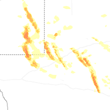

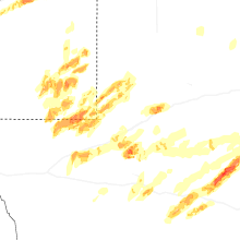
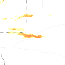
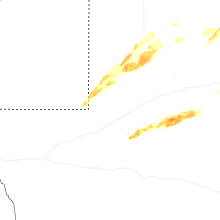
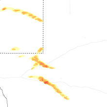
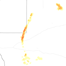


Connect with Interactive Hail Maps