

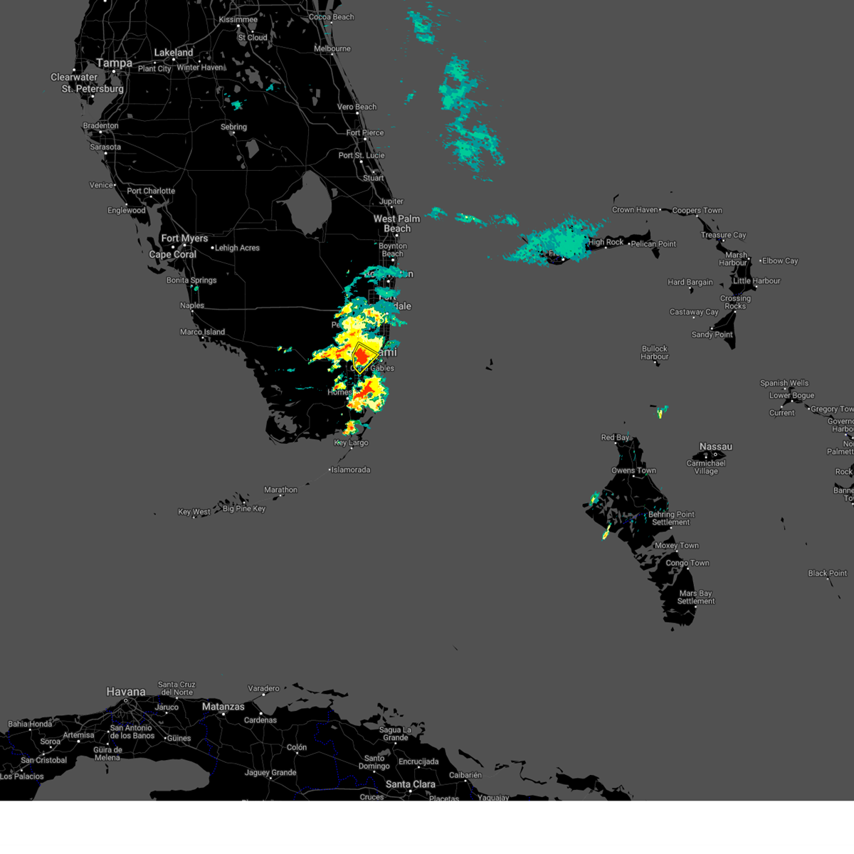
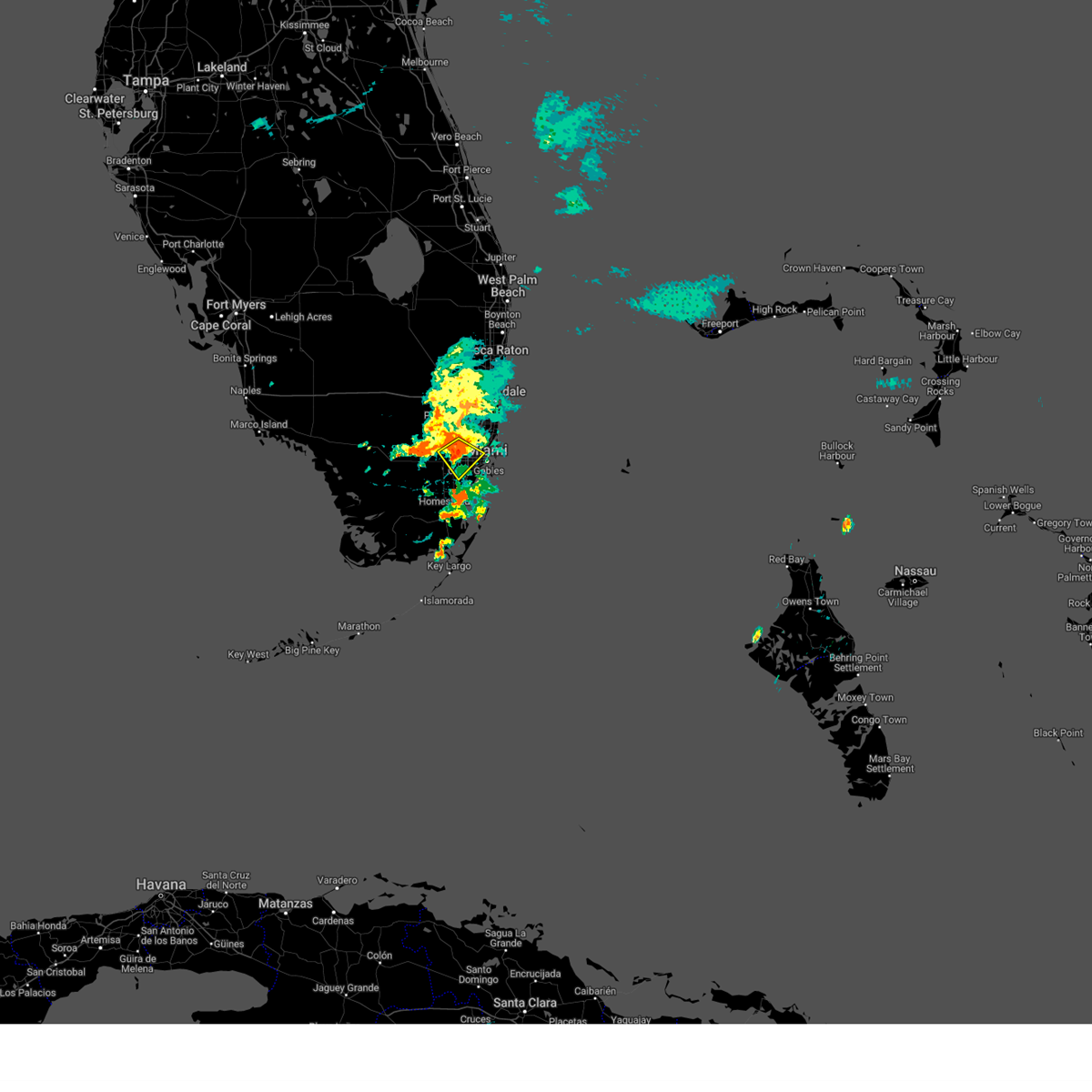
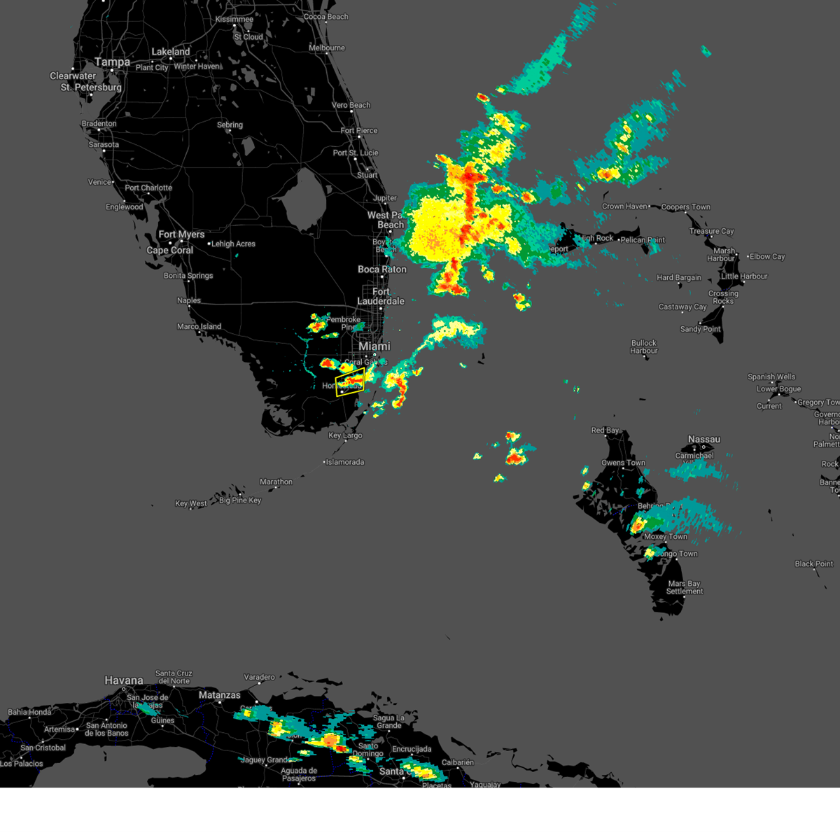
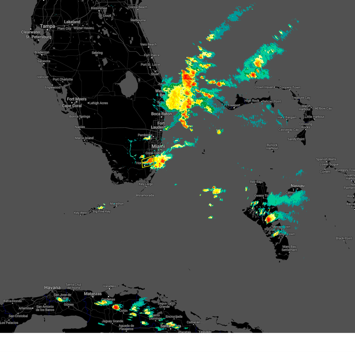
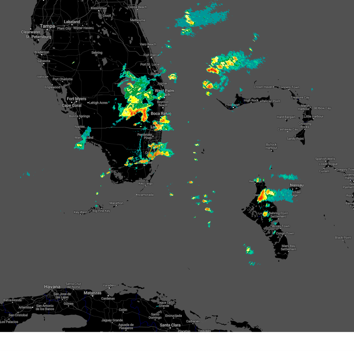
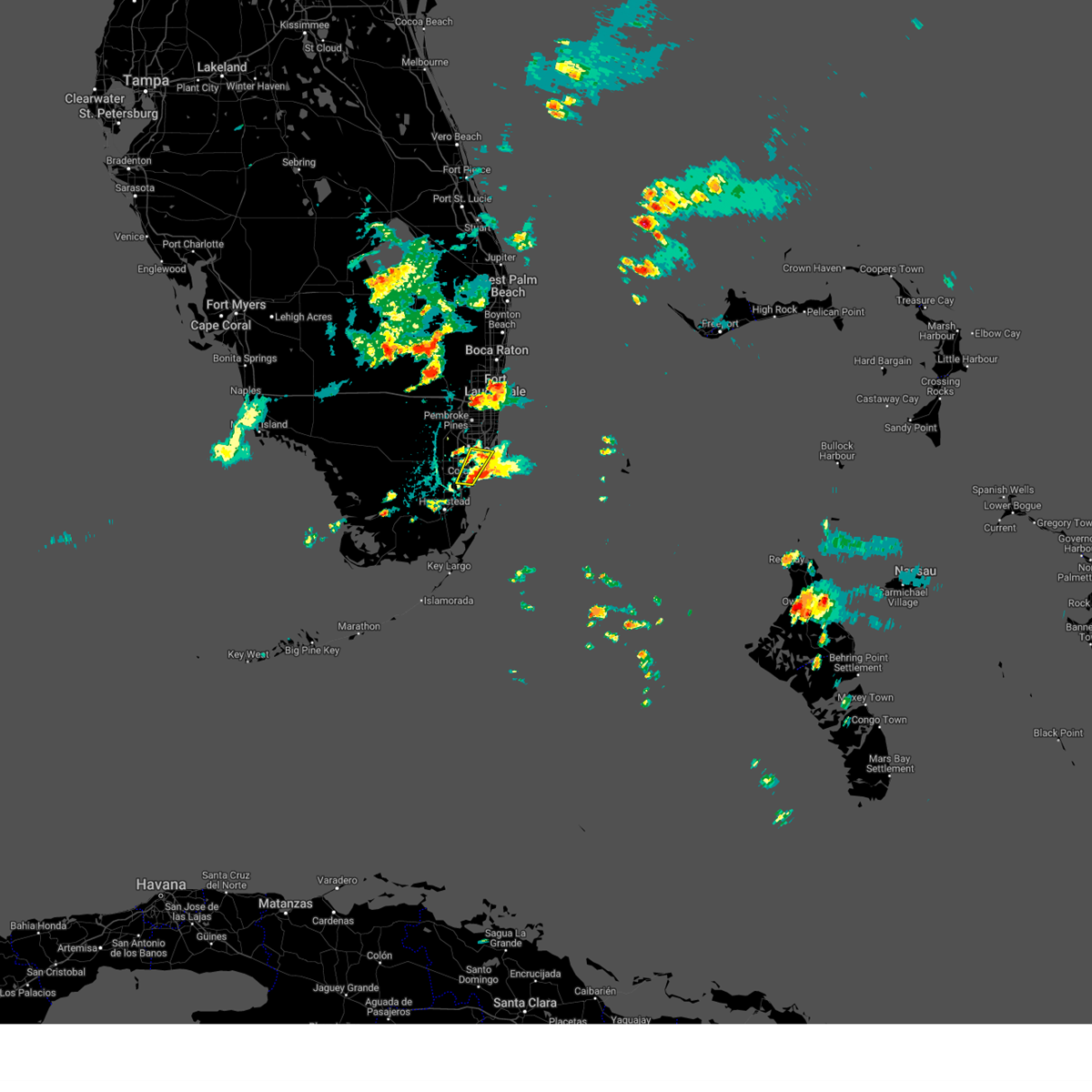
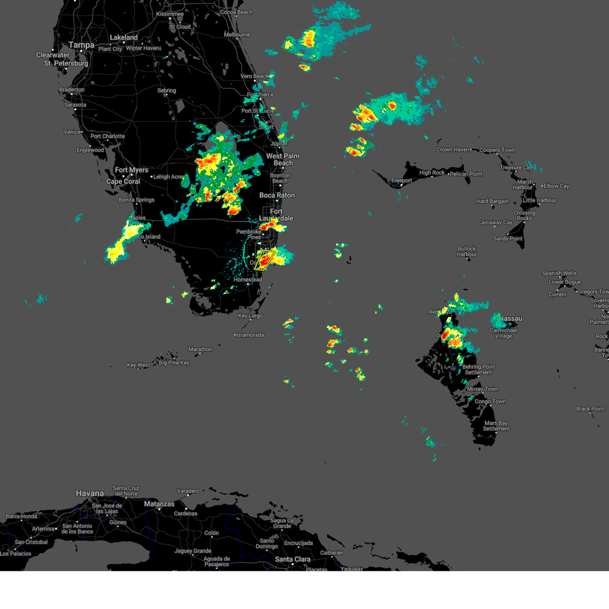
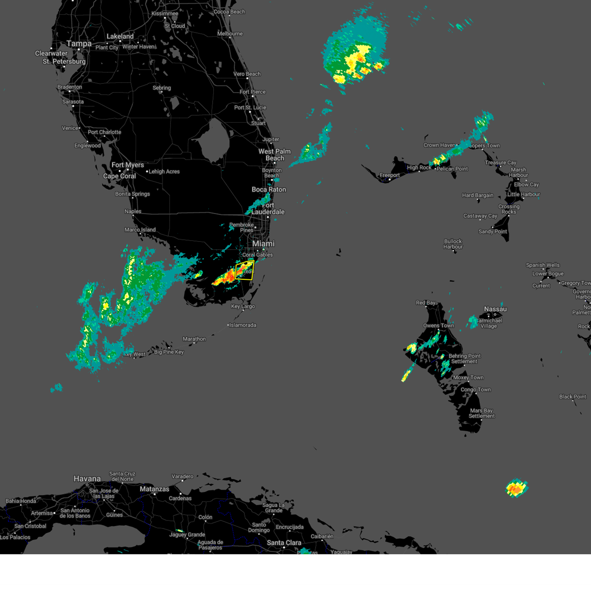
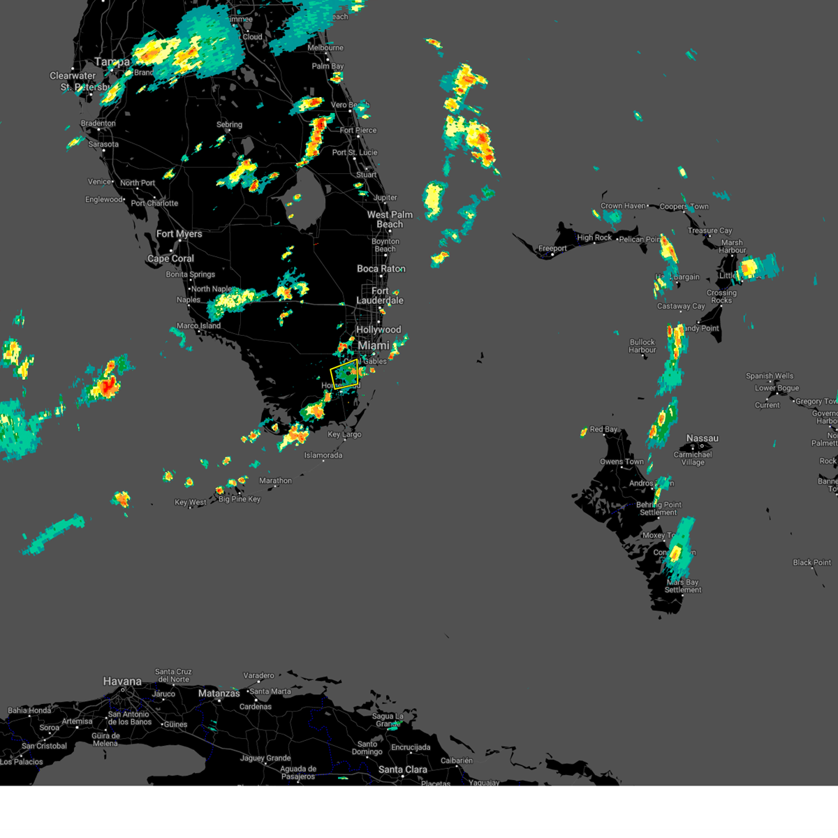
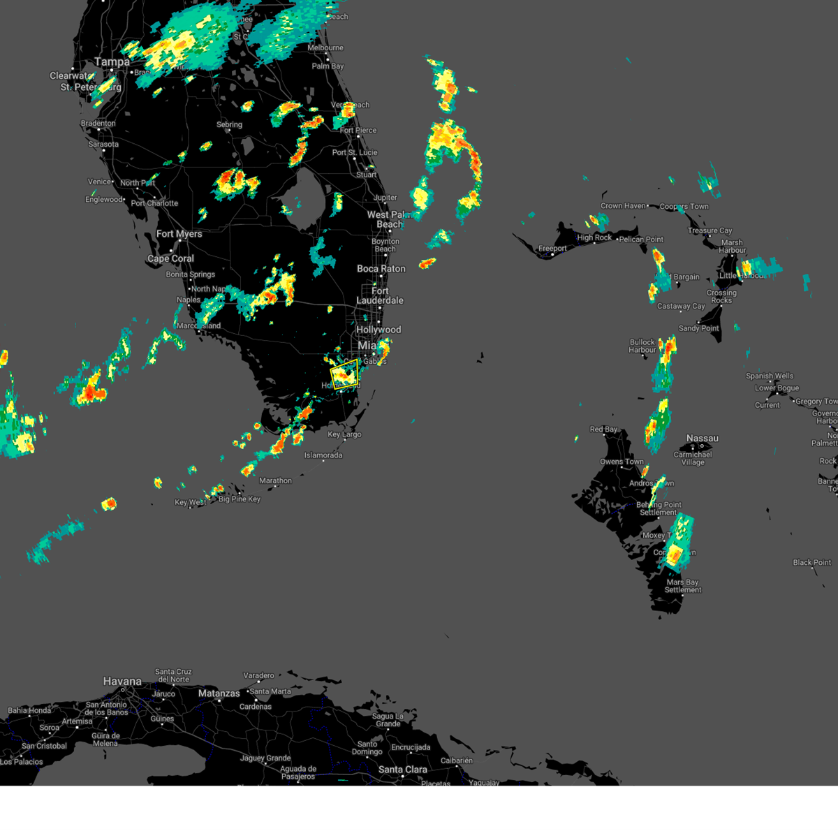
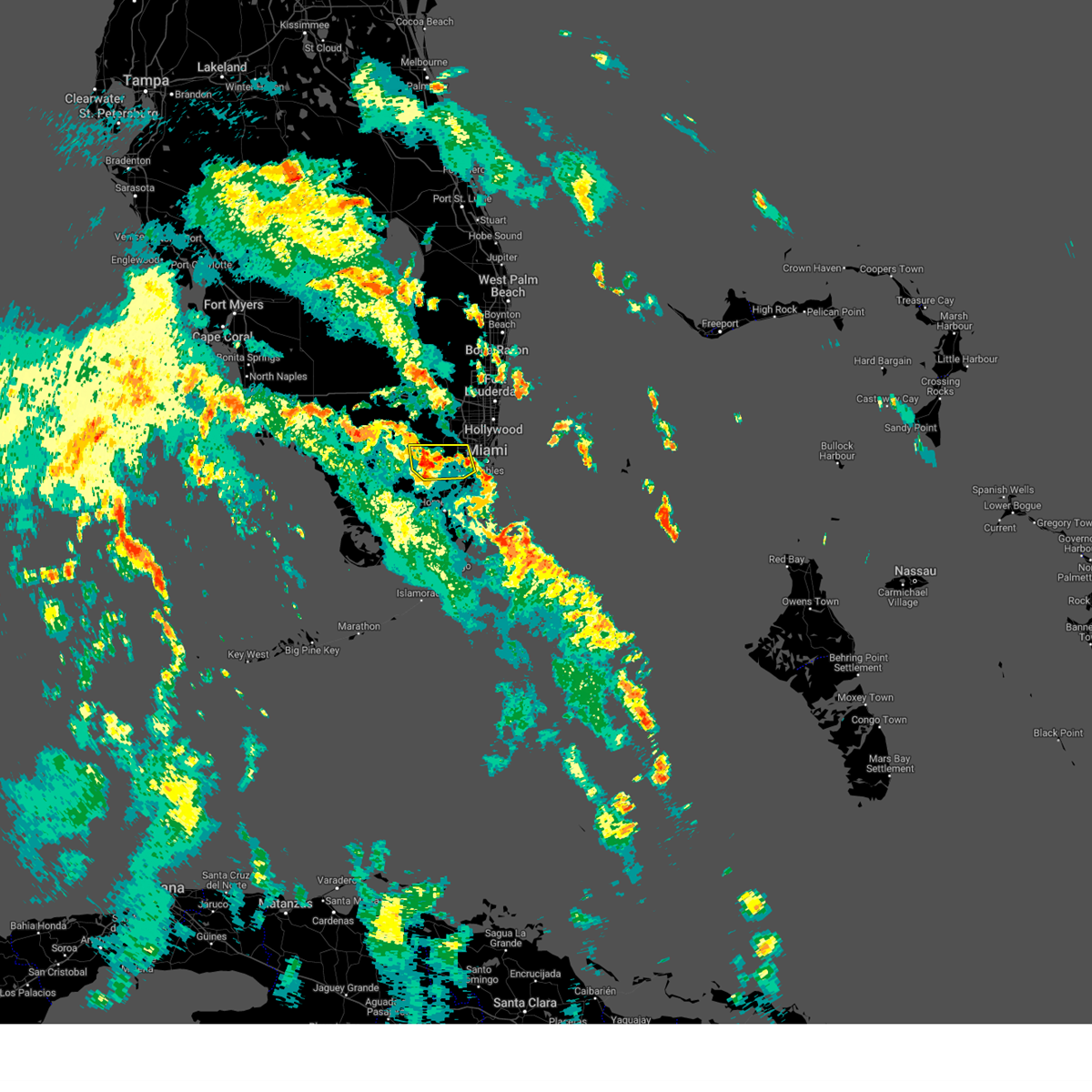
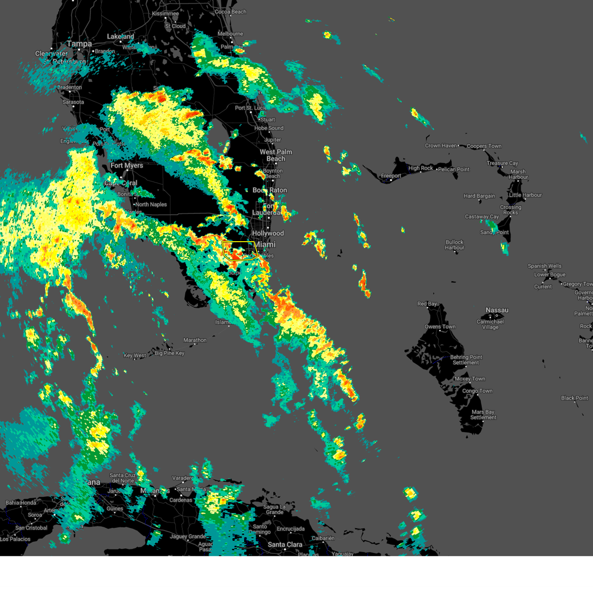
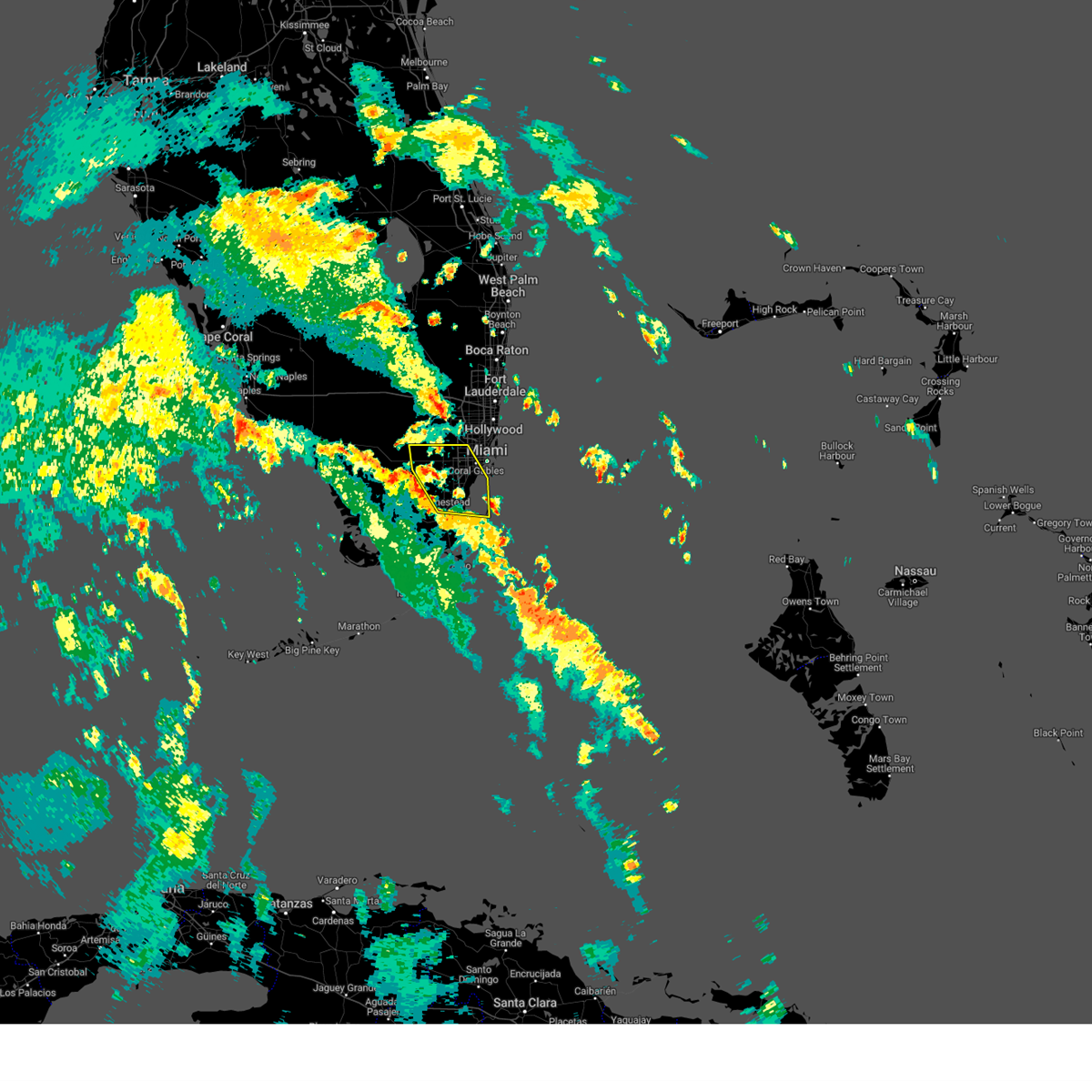
Hail Map for Kendall, FL
The Kendall, FL area has had 0 reports of on-the-ground hail by trained spotters, and has been under severe weather warnings 20 times during the past 12 months. Doppler radar has detected hail at or near Kendall, FL on 44 occasions, including 3 occasions during the past year.
| Name: | Kendall, FL |
| Where Located: | 8.1 miles WSW of Miami, FL |
| Map: | Google Map for Kendall, FL |
| Population: | 75371 |
| Housing Units: | 31899 |
| More Info: | Search Google for Kendall, FL |
0
The Top Recent Hail Date for Kendall, FL is Thursday, May 22, 2025 (44th out of 44)

Hail and Wind Damage Spotted near Kendall, FL
| Date / Time | Report Details |
|---|---|
| 5/22/2025 8:06 PM EDT |
 The storm which prompted the warning has weakened below severe limits, and no longer poses an immediate threat to life or property. therefore, the warning will be allowed to expire. however, heavy rain is still possible with this thunderstorm. The storm which prompted the warning has weakened below severe limits, and no longer poses an immediate threat to life or property. therefore, the warning will be allowed to expire. however, heavy rain is still possible with this thunderstorm.
|
| 5/22/2025 8:00 PM EDT |
 At 800 pm edt, a severe thunderstorm was located over westchester, or near south miami, moving southeast at 15 mph (radar indicated). Hazards include 60 mph wind gusts and quarter size hail. Hail damage to vehicles is expected. expect wind damage to roofs, siding, and trees. Locations impacted include, miami, hialeah, coral gables, south miami, kendall, doral, hialeah gardens, miami springs, sweetwater, west miami, medley, westchester, fountainbleau, kendale lakes, pennsuco, coral terrace, olympia heights, sunset, miami international airport, and tamiami. At 800 pm edt, a severe thunderstorm was located over westchester, or near south miami, moving southeast at 15 mph (radar indicated). Hazards include 60 mph wind gusts and quarter size hail. Hail damage to vehicles is expected. expect wind damage to roofs, siding, and trees. Locations impacted include, miami, hialeah, coral gables, south miami, kendall, doral, hialeah gardens, miami springs, sweetwater, west miami, medley, westchester, fountainbleau, kendale lakes, pennsuco, coral terrace, olympia heights, sunset, miami international airport, and tamiami.
|
| 5/22/2025 7:45 PM EDT |
 Svrmfl the national weather service in miami has issued a * severe thunderstorm warning for, northern miami-dade county in southeastern florida, * until 815 pm edt. * at 745 pm edt, a severe thunderstorm was located over sweetwater, or near south miami, moving southeast at 15 mph (radar indicated). Hazards include 60 mph wind gusts and quarter size hail. Hail damage to vehicles is expected. Expect wind damage to roofs, siding, and trees. Svrmfl the national weather service in miami has issued a * severe thunderstorm warning for, northern miami-dade county in southeastern florida, * until 815 pm edt. * at 745 pm edt, a severe thunderstorm was located over sweetwater, or near south miami, moving southeast at 15 mph (radar indicated). Hazards include 60 mph wind gusts and quarter size hail. Hail damage to vehicles is expected. Expect wind damage to roofs, siding, and trees.
|
| 5/4/2025 4:38 PM EDT |
 The storm which prompted the warning has weakened below severe limits, and no longer poses an immediate threat to life or property. therefore, the warning will be allowed to expire. however, small hail, gusty winds and heavy rain are still possible with this thunderstorm. to report severe weather, contact your nearest law enforcement agency. they will relay your report to the national weather service miami. you can also share your report with nws miami on facebook and twitter. The storm which prompted the warning has weakened below severe limits, and no longer poses an immediate threat to life or property. therefore, the warning will be allowed to expire. however, small hail, gusty winds and heavy rain are still possible with this thunderstorm. to report severe weather, contact your nearest law enforcement agency. they will relay your report to the national weather service miami. you can also share your report with nws miami on facebook and twitter.
|
| 5/4/2025 4:18 PM EDT |
 Svrmfl the national weather service in miami has issued a * severe thunderstorm warning for, southeast miami-dade county in southeastern florida, * until 445 pm edt. * at 418 pm edt, a severe thunderstorm was located over goulds, or near black point, and is nearly stationary (radar indicated). Hazards include 60 mph wind gusts and penny size hail. expect damage to roofs, siding, and trees Svrmfl the national weather service in miami has issued a * severe thunderstorm warning for, southeast miami-dade county in southeastern florida, * until 445 pm edt. * at 418 pm edt, a severe thunderstorm was located over goulds, or near black point, and is nearly stationary (radar indicated). Hazards include 60 mph wind gusts and penny size hail. expect damage to roofs, siding, and trees
|
| 5/4/2025 2:24 PM EDT |
 The storms which prompted the warning have moved out of the area and into biscayne bay waters. therefore, the warning will be allowed to expire. however, small hail, gusty winds and heavy rain are still possible with these thunderstorms. to report severe weather, contact your nearest law enforcement agency. they will relay your report to the national weather service miami. you can also share your report with nws miami on facebook and twitter. The storms which prompted the warning have moved out of the area and into biscayne bay waters. therefore, the warning will be allowed to expire. however, small hail, gusty winds and heavy rain are still possible with these thunderstorms. to report severe weather, contact your nearest law enforcement agency. they will relay your report to the national weather service miami. you can also share your report with nws miami on facebook and twitter.
|
| 5/4/2025 2:11 PM EDT |
 At 209 pm edt, severe thunderstorms were located along a line extending from marlins park to pinecrest moving slowly east into biscayne bay. there is also another area of strong thunderstorms near sweetwater that could become severe with hail, frequent lightning, and strong winds that will be moving slowly eastward (radar indicated). Hazards include 60 mph wind gusts and quarter size hail. Hail damage to vehicles is expected. expect wind damage to roofs, siding, and trees. Locations impacted include, miami, hialeah, miami beach, coral gables, south miami, kendall, doral, pinecrest, miami springs, west miami, westchester, glenvar heights, richmond heights, university of miami, downtown miami, coconut grove, coral terrace, olympia heights, sunset, and marlins park. At 209 pm edt, severe thunderstorms were located along a line extending from marlins park to pinecrest moving slowly east into biscayne bay. there is also another area of strong thunderstorms near sweetwater that could become severe with hail, frequent lightning, and strong winds that will be moving slowly eastward (radar indicated). Hazards include 60 mph wind gusts and quarter size hail. Hail damage to vehicles is expected. expect wind damage to roofs, siding, and trees. Locations impacted include, miami, hialeah, miami beach, coral gables, south miami, kendall, doral, pinecrest, miami springs, west miami, westchester, glenvar heights, richmond heights, university of miami, downtown miami, coconut grove, coral terrace, olympia heights, sunset, and marlins park.
|
| 5/4/2025 1:52 PM EDT |
 Svrmfl the national weather service in miami has issued a * severe thunderstorm warning for, central east miami-dade county in southeastern florida, * until 230 pm edt. * at 152 pm edt, severe thunderstorms were located along a line extending from miami to kendall, moving slowly east (radar indicated). Hazards include 60 mph wind gusts and quarter size hail. Hail damage to vehicles is expected. Expect wind damage to roofs, siding, and trees. Svrmfl the national weather service in miami has issued a * severe thunderstorm warning for, central east miami-dade county in southeastern florida, * until 230 pm edt. * at 152 pm edt, severe thunderstorms were located along a line extending from miami to kendall, moving slowly east (radar indicated). Hazards include 60 mph wind gusts and quarter size hail. Hail damage to vehicles is expected. Expect wind damage to roofs, siding, and trees.
|
| 3/25/2025 1:33 PM EDT |
 Svrmfl the national weather service in miami has issued a * severe thunderstorm warning for, central miami-dade county in southeastern florida, * until 200 pm edt. * at 133 pm edt, a severe thunderstorm was located over the redland, moving east at 15 mph (radar indicated). Hazards include 60 mph wind gusts and half dollar size hail. Hail damage to vehicles is expected. Expect wind damage to roofs, siding, and trees. Svrmfl the national weather service in miami has issued a * severe thunderstorm warning for, central miami-dade county in southeastern florida, * until 200 pm edt. * at 133 pm edt, a severe thunderstorm was located over the redland, moving east at 15 mph (radar indicated). Hazards include 60 mph wind gusts and half dollar size hail. Hail damage to vehicles is expected. Expect wind damage to roofs, siding, and trees.
|
| 8/20/2024 2:57 PM EDT |
 The storm which prompted the warning has moved out of the area. therefore, the warning will be allowed to expire. The storm which prompted the warning has moved out of the area. therefore, the warning will be allowed to expire.
|
| 8/20/2024 2:34 PM EDT |
 Svrmfl the national weather service in miami has issued a * severe thunderstorm warning for, central miami-dade county in southeastern florida, * until 300 pm edt. * at 233 pm edt, a severe thunderstorm was located over richmond west, or near the redland, moving east at 25 mph (radar indicated). Hazards include 60 mph wind gusts. expect damage to roofs, siding, and trees Svrmfl the national weather service in miami has issued a * severe thunderstorm warning for, central miami-dade county in southeastern florida, * until 300 pm edt. * at 233 pm edt, a severe thunderstorm was located over richmond west, or near the redland, moving east at 25 mph (radar indicated). Hazards include 60 mph wind gusts. expect damage to roofs, siding, and trees
|
| 8/3/2024 8:24 PM EDT |
 The storm which prompted the warning has weakened below severe limits, and no longer poses an immediate threat to life or property. therefore, the warning will be allowed to expire. however, gusty winds are still possible with this thunderstorm. The storm which prompted the warning has weakened below severe limits, and no longer poses an immediate threat to life or property. therefore, the warning will be allowed to expire. however, gusty winds are still possible with this thunderstorm.
|
| 8/3/2024 8:16 PM EDT |
 At 816 pm edt, a severe thunderstorm was located over kendale lakes, or near kendall, moving northwest at 45 mph (radar indicated). Hazards include 60 mph wind gusts. Expect damage to roofs, siding, and trees. Locations impacted include, miami, coral gables, south miami, kendall, doral, hialeah gardens, pinecrest, sweetwater, west miami, medley, westchester, glenvar heights, fountainbleau, kendale lakes, university of miami, the hammocks, coral terrace, olympia heights, west kendall, and intersection krome and kendall drive. At 816 pm edt, a severe thunderstorm was located over kendale lakes, or near kendall, moving northwest at 45 mph (radar indicated). Hazards include 60 mph wind gusts. Expect damage to roofs, siding, and trees. Locations impacted include, miami, coral gables, south miami, kendall, doral, hialeah gardens, pinecrest, sweetwater, west miami, medley, westchester, glenvar heights, fountainbleau, kendale lakes, university of miami, the hammocks, coral terrace, olympia heights, west kendall, and intersection krome and kendall drive.
|
| 8/3/2024 7:55 PM EDT |
 Svrmfl the national weather service in miami has issued a * severe thunderstorm warning for, northern miami-dade county in southeastern florida, * until 830 pm edt. * at 755 pm edt, a severe thunderstorm was located over homestead bayfront park, or near black point, moving northwest at 45 mph (radar indicated). Hazards include 60 mph wind gusts. expect damage to roofs, siding, and trees Svrmfl the national weather service in miami has issued a * severe thunderstorm warning for, northern miami-dade county in southeastern florida, * until 830 pm edt. * at 755 pm edt, a severe thunderstorm was located over homestead bayfront park, or near black point, moving northwest at 45 mph (radar indicated). Hazards include 60 mph wind gusts. expect damage to roofs, siding, and trees
|
| 8/3/2024 5:45 PM EDT |
 the severe thunderstorm warning has been cancelled and is no longer in effect the severe thunderstorm warning has been cancelled and is no longer in effect
|
| 8/3/2024 5:39 PM EDT | At 539 pm edt, a severe thunderstorm was located over goulds, or near black point, moving north at 45 mph (radar indicated). Hazards include 60 mph wind gusts. Expect damage to roofs, siding, and trees. Locations impacted include, homestead, black point, the redland, kendall, pinecrest, florida city, homestead base, naranja, richmond west, richmond heights, country walk, kendale lakes, leisure city, palmetto bay, cutler bay, zoo miami, goulds, the hammocks, west perrine, and princeton. |
| 8/3/2024 5:27 PM EDT | Svrmfl the national weather service in miami has issued a * severe thunderstorm warning for, central miami-dade county in southeastern florida, * until 600 pm edt. * at 527 pm edt, a severe thunderstorm was located over homestead bayfront park, or near homestead miami speedway, moving north at 40 mph (radar indicated). Hazards include 60 mph wind gusts. expect damage to roofs, siding, and trees |
| 8/3/2024 4:25 PM EDT |
 The severe thunderstorm which prompted the warning has moved out of the warned area. therefore, the warning will be allowed to expire. however, gusty winds are still possible with this thunderstorm. The severe thunderstorm which prompted the warning has moved out of the warned area. therefore, the warning will be allowed to expire. however, gusty winds are still possible with this thunderstorm.
|
| 8/3/2024 4:11 PM EDT | At 411 pm edt, a severe thunderstorm was located over homestead base, or over homestead miami speedway, moving north at 25 mph (radar indicated). Hazards include 60 mph wind gusts. Expect damage to roofs, siding, and trees. Locations impacted include, homestead, homestead miami speedway, the redland, florida city, homestead base, naranja, princeton, richmond west, country walk, leisure city, west kendall, zoo miami, the crossings, goulds, the hammocks, west perrine, kendale lakes, richmond heights, cutler bay, and kendall west. |
| 8/3/2024 3:57 PM EDT |
 Svrmfl the national weather service in miami has issued a * severe thunderstorm warning for, central miami-dade county in southeastern florida, * until 430 pm edt. * at 357 pm edt, a severe thunderstorm was located over turkey point, moving north at 25 mph (radar indicated). Hazards include 60 mph wind gusts. expect damage to roofs, siding, and trees Svrmfl the national weather service in miami has issued a * severe thunderstorm warning for, central miami-dade county in southeastern florida, * until 430 pm edt. * at 357 pm edt, a severe thunderstorm was located over turkey point, moving north at 25 mph (radar indicated). Hazards include 60 mph wind gusts. expect damage to roofs, siding, and trees
|
| 6/12/2024 5:42 PM EDT |
 Svrmfl the national weather service in miami has issued a * severe thunderstorm warning for, southern miami-dade county in southeastern florida, * until 630 pm edt. * at 542 pm edt, a severe thunderstorm was located near homestead general airport, moving east at 20 mph (radar indicated). Hazards include 60 mph wind gusts. expect damage to roofs, siding, and trees Svrmfl the national weather service in miami has issued a * severe thunderstorm warning for, southern miami-dade county in southeastern florida, * until 630 pm edt. * at 542 pm edt, a severe thunderstorm was located near homestead general airport, moving east at 20 mph (radar indicated). Hazards include 60 mph wind gusts. expect damage to roofs, siding, and trees
|
| 6/12/2024 4:59 PM EDT |
 The storm which prompted the warning has weakened below severe limits, and no longer poses an immediate threat to life or property. therefore, the warning will be allowed to expire. The storm which prompted the warning has weakened below severe limits, and no longer poses an immediate threat to life or property. therefore, the warning will be allowed to expire.
|
| 6/12/2024 4:49 PM EDT |
 At 449 pm edt, a severe thunderstorm was located over liberty city, or over miami, moving east at 25 mph (radar indicated). Hazards include 60 mph wind gusts. Expect damage to roofs, siding, and trees. Locations impacted include, miami, hialeah, miramar, miami beach, coral gables, key biscayne, south miami, surfside, miami gardens, virginia key, kendall, north miami, doral, north miami beach, aventura, miami lakes, hialeah gardens, sunny isles beach, pinecrest, and opa-locka. At 449 pm edt, a severe thunderstorm was located over liberty city, or over miami, moving east at 25 mph (radar indicated). Hazards include 60 mph wind gusts. Expect damage to roofs, siding, and trees. Locations impacted include, miami, hialeah, miramar, miami beach, coral gables, key biscayne, south miami, surfside, miami gardens, virginia key, kendall, north miami, doral, north miami beach, aventura, miami lakes, hialeah gardens, sunny isles beach, pinecrest, and opa-locka.
|
| 6/12/2024 4:13 PM EDT |
 Svrmfl the national weather service in miami has issued a * severe thunderstorm warning for, northern miami-dade county in southeastern florida, * until 500 pm edt. * at 413 pm edt, a severe thunderstorm was located over miccosukee resort, or 11 miles northwest of kendall, moving east at 20 mph (radar indicated). Hazards include 60 mph wind gusts. expect damage to roofs, siding, and trees Svrmfl the national weather service in miami has issued a * severe thunderstorm warning for, northern miami-dade county in southeastern florida, * until 500 pm edt. * at 413 pm edt, a severe thunderstorm was located over miccosukee resort, or 11 miles northwest of kendall, moving east at 20 mph (radar indicated). Hazards include 60 mph wind gusts. expect damage to roofs, siding, and trees
|
| 5/30/2024 2:57 PM EDT |
 The storm which prompted the warning has weakened below severe limits, and has exited the warned area. therefore, the warning will be allowed to expire. The storm which prompted the warning has weakened below severe limits, and has exited the warned area. therefore, the warning will be allowed to expire.
|
| 5/30/2024 2:47 PM EDT |
 At 246 pm edt, a severe thunderstorm was located over west miami, or near south miami, moving south at 10 mph (radar indicated). Hazards include 60 mph wind gusts and penny size hail. Expect damage to roofs, siding, and trees. Locations impacted include, miami, coral gables, south miami, kendall, pinecrest, west miami, westchester, coral terrace, glenvar heights, palmetto bay, olympia heights, university of miami, coconut grove, miami international airport, sunset, fountainbleau, the falls, coral way village, and allapattah. At 246 pm edt, a severe thunderstorm was located over west miami, or near south miami, moving south at 10 mph (radar indicated). Hazards include 60 mph wind gusts and penny size hail. Expect damage to roofs, siding, and trees. Locations impacted include, miami, coral gables, south miami, kendall, pinecrest, west miami, westchester, coral terrace, glenvar heights, palmetto bay, olympia heights, university of miami, coconut grove, miami international airport, sunset, fountainbleau, the falls, coral way village, and allapattah.
|
| 5/30/2024 2:28 PM EDT |
 Svrmfl the national weather service in miami has issued a * severe thunderstorm warning for, northern miami-dade county in southeastern florida, * until 300 pm edt. * at 228 pm edt, a severe thunderstorm was located over miami springs, or over hialeah, moving south at 10 mph (radar indicated). Hazards include 60 mph wind gusts and quarter size hail. Hail damage to vehicles is expected. Expect wind damage to roofs, siding, and trees. Svrmfl the national weather service in miami has issued a * severe thunderstorm warning for, northern miami-dade county in southeastern florida, * until 300 pm edt. * at 228 pm edt, a severe thunderstorm was located over miami springs, or over hialeah, moving south at 10 mph (radar indicated). Hazards include 60 mph wind gusts and quarter size hail. Hail damage to vehicles is expected. Expect wind damage to roofs, siding, and trees.
|
| 5/21/2024 4:11 PM EDT |
 The storm which prompted the warning has weakened below severe limits, and no longer poses an immediate threat to life or property. therefore, the warning will be allowed to expire. however, small hail, gusty winds and heavy rain are still possible with this thunderstorm. to report severe weather, contact your nearest law enforcement agency. they will relay your report to the national weather service miami. you can also share your report with nws miami on facebook and twitter. The storm which prompted the warning has weakened below severe limits, and no longer poses an immediate threat to life or property. therefore, the warning will be allowed to expire. however, small hail, gusty winds and heavy rain are still possible with this thunderstorm. to report severe weather, contact your nearest law enforcement agency. they will relay your report to the national weather service miami. you can also share your report with nws miami on facebook and twitter.
|
| 5/21/2024 4:04 PM EDT |
 At 403 pm edt, a severe thunderstorm was located over coconut grove, or over coral gables, moving east at 10 mph (radar indicated). Hazards include 60 mph wind gusts and quarter size hail. Hail damage to vehicles is expected. expect wind damage to roofs, siding, and trees. Locations impacted include, miami, miami beach, coral gables, key biscayne, south miami, black point, virginia key, kendall, pinecrest, west miami, westchester, glenvar heights, palmetto bay, cutler bay, port of miami, university of miami, downtown miami, coconut grove, coral terrace, and olympia heights. At 403 pm edt, a severe thunderstorm was located over coconut grove, or over coral gables, moving east at 10 mph (radar indicated). Hazards include 60 mph wind gusts and quarter size hail. Hail damage to vehicles is expected. expect wind damage to roofs, siding, and trees. Locations impacted include, miami, miami beach, coral gables, key biscayne, south miami, black point, virginia key, kendall, pinecrest, west miami, westchester, glenvar heights, palmetto bay, cutler bay, port of miami, university of miami, downtown miami, coconut grove, coral terrace, and olympia heights.
|
| 5/21/2024 3:45 PM EDT |
 At 344 pm edt, a severe thunderstorm was located over south miami, moving northeast at 15 mph (radar indicated). Hazards include 60 mph wind gusts and quarter size hail. Hail damage to vehicles is expected. expect wind damage to roofs, siding, and trees. Locations impacted include, miami, miami beach, homestead, coral gables, key biscayne, south miami, homestead miami speedway, black point, virginia key, kendall, the redland, pinecrest, west miami, westchester, naranja, glenvar heights, palmetto bay, university of miami, zoo miami, and goulds. At 344 pm edt, a severe thunderstorm was located over south miami, moving northeast at 15 mph (radar indicated). Hazards include 60 mph wind gusts and quarter size hail. Hail damage to vehicles is expected. expect wind damage to roofs, siding, and trees. Locations impacted include, miami, miami beach, homestead, coral gables, key biscayne, south miami, homestead miami speedway, black point, virginia key, kendall, the redland, pinecrest, west miami, westchester, naranja, glenvar heights, palmetto bay, university of miami, zoo miami, and goulds.
|
| 5/21/2024 3:38 PM EDT |
 At 338 pm edt, a severe thunderstorm was located over palmetto bay, or over kendall, moving east at 10 mph (radar indicated). Hazards include 60 mph wind gusts and quarter size hail. Hail damage to vehicles is expected. expect wind damage to roofs, siding, and trees. Locations impacted include, miami, miami beach, homestead, coral gables, key biscayne, south miami, homestead miami speedway, black point, virginia key, kendall, the redland, pinecrest, west miami, westchester, naranja, glenvar heights, palmetto bay, university of miami, zoo miami, and goulds. At 338 pm edt, a severe thunderstorm was located over palmetto bay, or over kendall, moving east at 10 mph (radar indicated). Hazards include 60 mph wind gusts and quarter size hail. Hail damage to vehicles is expected. expect wind damage to roofs, siding, and trees. Locations impacted include, miami, miami beach, homestead, coral gables, key biscayne, south miami, homestead miami speedway, black point, virginia key, kendall, the redland, pinecrest, west miami, westchester, naranja, glenvar heights, palmetto bay, university of miami, zoo miami, and goulds.
|
| 5/21/2024 3:32 PM EDT |
 Svrmfl the national weather service in miami has issued a * severe thunderstorm warning for, central miami-dade county in southeastern florida, * until 415 pm edt. * at 332 pm edt, a severe thunderstorm was located over palmetto bay, or near kendall, moving east at 10 mph (radar indicated). Hazards include 60 mph wind gusts and quarter size hail. Hail damage to vehicles is expected. Expect wind damage to roofs, siding, and trees. Svrmfl the national weather service in miami has issued a * severe thunderstorm warning for, central miami-dade county in southeastern florida, * until 415 pm edt. * at 332 pm edt, a severe thunderstorm was located over palmetto bay, or near kendall, moving east at 10 mph (radar indicated). Hazards include 60 mph wind gusts and quarter size hail. Hail damage to vehicles is expected. Expect wind damage to roofs, siding, and trees.
|
| 3/6/2024 5:52 AM EST |
 The storm which prompted the warning has weakened below severe limits, and no longer poses an immediate threat to life or property. therefore, the warning will be allowed to expire. however, gusty winds and heavy rain are still possible with this thunderstorm. to report severe weather, contact your nearest law enforcement agency. they will relay your report to the national weather service miami. you can also share your report with nws miami on facebook and twitter. The storm which prompted the warning has weakened below severe limits, and no longer poses an immediate threat to life or property. therefore, the warning will be allowed to expire. however, gusty winds and heavy rain are still possible with this thunderstorm. to report severe weather, contact your nearest law enforcement agency. they will relay your report to the national weather service miami. you can also share your report with nws miami on facebook and twitter.
|
| 3/6/2024 5:34 AM EST |
 Svrmfl the national weather service in miami has issued a * severe thunderstorm warning for, northern miami-dade county in southeastern florida, southern broward county in southeastern florida, * until 600 am est. * at 534 am est, a severe thunderstorm was located over west miami, or over south miami, moving northeast at 30 mph (radar indicated). Hazards include 60 mph wind gusts and penny size hail. expect damage to roofs, siding, and trees Svrmfl the national weather service in miami has issued a * severe thunderstorm warning for, northern miami-dade county in southeastern florida, southern broward county in southeastern florida, * until 600 am est. * at 534 am est, a severe thunderstorm was located over west miami, or over south miami, moving northeast at 30 mph (radar indicated). Hazards include 60 mph wind gusts and penny size hail. expect damage to roofs, siding, and trees
|
| 2/4/2024 11:21 AM EST |
 At 1120 am est, a severe thunderstorm was located over virginia key, moving northeast at 40 mph (radar indicated). Hazards include 60 mph wind gusts. expect damage to roofs, siding, and trees At 1120 am est, a severe thunderstorm was located over virginia key, moving northeast at 40 mph (radar indicated). Hazards include 60 mph wind gusts. expect damage to roofs, siding, and trees
|
| 2/4/2024 11:21 AM EST |
 The tornado warning for northern miami-dade county will expire at 1130 am est, the storm which prompted the warning has moved out of the area. therefore, the warning will be allowed to expire. a tornado watch remains in effect until 200 pm est for southeastern florida. remember, a severe thunderstorm warning still remains in effect. The tornado warning for northern miami-dade county will expire at 1130 am est, the storm which prompted the warning has moved out of the area. therefore, the warning will be allowed to expire. a tornado watch remains in effect until 200 pm est for southeastern florida. remember, a severe thunderstorm warning still remains in effect.
|
| 2/4/2024 11:18 AM EST |
 At 1117 am est, severe thunderstorms were located along a line extending from miramar to near coconut grove to near black point, moving east at 40 mph (radar indicated). Hazards include 60 mph wind gusts and penny size hail. Expect damage to roofs, siding, and trees. Locations impacted include, miami, hialeah, miramar, miami beach, homestead, coral gables, south miami, surfside, hallandale, homestead miami speedway, black point, miami gardens, turkey point, kendall, north miami, doral, north miami beach, aventura, miami lakes, and hialeah gardens. At 1117 am est, severe thunderstorms were located along a line extending from miramar to near coconut grove to near black point, moving east at 40 mph (radar indicated). Hazards include 60 mph wind gusts and penny size hail. Expect damage to roofs, siding, and trees. Locations impacted include, miami, hialeah, miramar, miami beach, homestead, coral gables, south miami, surfside, hallandale, homestead miami speedway, black point, miami gardens, turkey point, kendall, north miami, doral, north miami beach, aventura, miami lakes, and hialeah gardens.
|
| 2/4/2024 11:03 AM EST |
 At 1103 am est, a severe thunderstorm capable of producing a tornado was located over coconut grove, or near miami, moving northeast at 40 mph (radar indicated rotation). Hazards include tornado. Flying debris will be dangerous to those caught without shelter. mobile homes will be damaged or destroyed. damage to roofs, windows, and vehicles will occur. Tree damage is likely. At 1103 am est, a severe thunderstorm capable of producing a tornado was located over coconut grove, or near miami, moving northeast at 40 mph (radar indicated rotation). Hazards include tornado. Flying debris will be dangerous to those caught without shelter. mobile homes will be damaged or destroyed. damage to roofs, windows, and vehicles will occur. Tree damage is likely.
|
| 2/4/2024 10:52 AM EST |
 At 1051 am est, a severe thunderstorm capable of producing a tornado was located over intersection krome and kendall drive, or 7 miles west of kendall, moving northeast at 35 mph (radar indicated rotation). Hazards include tornado. Flying debris will be dangerous to those caught without shelter. mobile homes will be damaged or destroyed. damage to roofs, windows, and vehicles will occur. Tree damage is likely. At 1051 am est, a severe thunderstorm capable of producing a tornado was located over intersection krome and kendall drive, or 7 miles west of kendall, moving northeast at 35 mph (radar indicated rotation). Hazards include tornado. Flying debris will be dangerous to those caught without shelter. mobile homes will be damaged or destroyed. damage to roofs, windows, and vehicles will occur. Tree damage is likely.
|
| 2/4/2024 10:50 AM EST |
 At 1049 am est, severe thunderstorms were located along a line extending from 10 miles northwest of miccosukee resort to near country walk to near royal palm ranger, moving east at 40 mph (radar indicated). Hazards include 60 mph wind gusts and penny size hail. expect damage to roofs, siding, and trees At 1049 am est, severe thunderstorms were located along a line extending from 10 miles northwest of miccosukee resort to near country walk to near royal palm ranger, moving east at 40 mph (radar indicated). Hazards include 60 mph wind gusts and penny size hail. expect damage to roofs, siding, and trees
|
| 2/4/2024 10:26 AM EST |
 At 1026 am est, a severe thunderstorm was located near shark valley obs tower, or 12 miles northwest of homestead general airport, moving east at 40 mph (radar indicated). Hazards include 60 mph wind gusts. expect damage to roofs, siding, and trees At 1026 am est, a severe thunderstorm was located near shark valley obs tower, or 12 miles northwest of homestead general airport, moving east at 40 mph (radar indicated). Hazards include 60 mph wind gusts. expect damage to roofs, siding, and trees
|
| 9/25/2023 12:02 AM EDT |
 At 1201 am edt, a severe thunderstorm was located over the hammocks, or near the redland, moving northeast at 30 mph (radar indicated). Hazards include 60 mph wind gusts. expect damage to roofs, siding, and trees At 1201 am edt, a severe thunderstorm was located over the hammocks, or near the redland, moving northeast at 30 mph (radar indicated). Hazards include 60 mph wind gusts. expect damage to roofs, siding, and trees
|
| 9/19/2023 8:11 PM EDT |
 The severe thunderstorm warning for north central miami-dade and southern broward counties will expire at 815 pm edt, the storm which prompted the warning has weakened below severe limits, and no longer poses an immediate threat to life or property. therefore, the warning will be allowed to expire. The severe thunderstorm warning for north central miami-dade and southern broward counties will expire at 815 pm edt, the storm which prompted the warning has weakened below severe limits, and no longer poses an immediate threat to life or property. therefore, the warning will be allowed to expire.
|
| 9/19/2023 7:44 PM EDT |
 At 744 pm edt, a severe thunderstorm was located near miccosukee resort, or 13 miles west of hialeah, moving east at 15 mph (radar indicated). Hazards include 60 mph wind gusts. expect damage to roofs, siding, and trees At 744 pm edt, a severe thunderstorm was located near miccosukee resort, or 13 miles west of hialeah, moving east at 15 mph (radar indicated). Hazards include 60 mph wind gusts. expect damage to roofs, siding, and trees
|
| 9/19/2023 7:13 PM EDT |
 At 713 pm edt, severe thunderstorms were located along a line extending from near east toll gate on alligator alley to 8 miles west of intersection krome and u.s. 27 to 6 miles east of shark valley obs tower, moving east at 15 mph (radar indicated). Hazards include 70 mph wind gusts. Expect considerable tree damage. Damage is likely to mobile homes, roofs, and outbuildings. At 713 pm edt, severe thunderstorms were located along a line extending from near east toll gate on alligator alley to 8 miles west of intersection krome and u.s. 27 to 6 miles east of shark valley obs tower, moving east at 15 mph (radar indicated). Hazards include 70 mph wind gusts. Expect considerable tree damage. Damage is likely to mobile homes, roofs, and outbuildings.
|
| 9/19/2023 7:07 PM EDT |
 At 707 pm edt, severe thunderstorms were located along a line extending from near east toll gate on alligator alley to 9 miles west of intersection krome and u.s. 27 to near shark valley obs tower, moving east at 15 mph (radar indicated). Hazards include 60 mph wind gusts. expect damage to roofs, siding, and trees At 707 pm edt, severe thunderstorms were located along a line extending from near east toll gate on alligator alley to 9 miles west of intersection krome and u.s. 27 to near shark valley obs tower, moving east at 15 mph (radar indicated). Hazards include 60 mph wind gusts. expect damage to roofs, siding, and trees
|
| 8/29/2023 5:22 PM EDT |
 The severe thunderstorm warning for northern miami-dade county will expire at 530 pm edt, the storms which prompted the warning have weakened below severe limits, and no longer pose an immediate threat to life or property. therefore, the warning will be allowed to expire. however gusty winds are still possible with these thunderstorms. to report severe weather, contact your nearest law enforcement agency. they will relay your report to the national weather service miami. you can also share your report with nws miami on facebook and twitter. The severe thunderstorm warning for northern miami-dade county will expire at 530 pm edt, the storms which prompted the warning have weakened below severe limits, and no longer pose an immediate threat to life or property. therefore, the warning will be allowed to expire. however gusty winds are still possible with these thunderstorms. to report severe weather, contact your nearest law enforcement agency. they will relay your report to the national weather service miami. you can also share your report with nws miami on facebook and twitter.
|
| 8/29/2023 5:10 PM EDT |
 At 510 pm edt, severe thunderstorms were located along a line extending from 10 miles west of intersection krome and u.s. 27 to near black point, moving north at 35 to 40 mph (radar indicated). Hazards include 60 mph wind gusts. Expect damage to roofs, siding, and trees. Locations impacted include, miami, hialeah, miramar, miami beach and coral gables. At 510 pm edt, severe thunderstorms were located along a line extending from 10 miles west of intersection krome and u.s. 27 to near black point, moving north at 35 to 40 mph (radar indicated). Hazards include 60 mph wind gusts. Expect damage to roofs, siding, and trees. Locations impacted include, miami, hialeah, miramar, miami beach and coral gables.
|
| 8/29/2023 5:03 PM EDT |
 At 502 pm edt, severe thunderstorms were located along a line extending from 9 miles northwest of miccosukee resort to near black point, moving north at 40 mph (radar indicated). Hazards include 60 mph wind gusts. Expect damage to roofs, siding, and trees. Locations impacted include, miami, hialeah, miramar, miami beach and coral gables. At 502 pm edt, severe thunderstorms were located along a line extending from 9 miles northwest of miccosukee resort to near black point, moving north at 40 mph (radar indicated). Hazards include 60 mph wind gusts. Expect damage to roofs, siding, and trees. Locations impacted include, miami, hialeah, miramar, miami beach and coral gables.
|
| 8/29/2023 4:55 PM EDT |
 At 454 pm edt, severe thunderstorms were located along a line extending from 10 miles west of miccosukee resort to homestead bayfront park, moving north at 40 mph (radar indicated). Hazards include 70 mph wind gusts. Expect considerable tree damage. damage is likely to mobile homes, roofs, and outbuildings. Locations impacted include, miami, hialeah, miramar, miami beach and homestead. At 454 pm edt, severe thunderstorms were located along a line extending from 10 miles west of miccosukee resort to homestead bayfront park, moving north at 40 mph (radar indicated). Hazards include 70 mph wind gusts. Expect considerable tree damage. damage is likely to mobile homes, roofs, and outbuildings. Locations impacted include, miami, hialeah, miramar, miami beach and homestead.
|
| 8/29/2023 4:42 PM EDT |
 At 442 pm edt, severe thunderstorms were located along a line extending from near shark valley obs tower to near ocean reef, moving north at 35 mph (radar indicated). Hazards include 70 mph wind gusts. Expect considerable tree damage. Damage is likely to mobile homes, roofs, and outbuildings. At 442 pm edt, severe thunderstorms were located along a line extending from near shark valley obs tower to near ocean reef, moving north at 35 mph (radar indicated). Hazards include 70 mph wind gusts. Expect considerable tree damage. Damage is likely to mobile homes, roofs, and outbuildings.
|
| 8/29/2023 4:36 PM EDT |
 At 436 pm edt, severe thunderstorms were located along a line extending from 8 miles northwest of homestead general airport to 6 miles southwest of turkey point, moving north at 35 to 40 mph (radar indicated). Hazards include 60 mph wind gusts. Expect damage to roofs, siding, and trees. Locations impacted include, homestead, homestead miami speedway, black point, homestead general airport and the redland. At 436 pm edt, severe thunderstorms were located along a line extending from 8 miles northwest of homestead general airport to 6 miles southwest of turkey point, moving north at 35 to 40 mph (radar indicated). Hazards include 60 mph wind gusts. Expect damage to roofs, siding, and trees. Locations impacted include, homestead, homestead miami speedway, black point, homestead general airport and the redland.
|
| 8/29/2023 4:22 PM EDT |
 At 421 pm edt, severe thunderstorms were located along a line extending from near royal palm ranger to near jewfish creek bridge, moving northeast at 25 mph (radar indicated). Hazards include 60 mph wind gusts. expect damage to roofs, siding, and trees At 421 pm edt, severe thunderstorms were located along a line extending from near royal palm ranger to near jewfish creek bridge, moving northeast at 25 mph (radar indicated). Hazards include 60 mph wind gusts. expect damage to roofs, siding, and trees
|
| 7/28/2023 12:12 PM EDT |
 The severe thunderstorm warning for central miami-dade county will expire at 1215 pm edt, the storm which prompted the warning has weakened below severe limits, and no longer poses an immediate threat to life or property. therefore, the warning will be allowed to expire. however gusty winds are still possible with this thunderstorm. The severe thunderstorm warning for central miami-dade county will expire at 1215 pm edt, the storm which prompted the warning has weakened below severe limits, and no longer poses an immediate threat to life or property. therefore, the warning will be allowed to expire. however gusty winds are still possible with this thunderstorm.
|
| 7/28/2023 11:58 AM EDT |
 At 1157 am edt, a severe thunderstorm was located near the redland, moving north at 25 mph (radar indicated). Hazards include 60 mph wind gusts. Expect damage to roofs, siding, and trees. locations impacted include, homestead, homestead general airport, kendall, the redland and florida city. hail threat, radar indicated max hail size, <. 75 in wind threat, radar indicated max wind gust, 60 mph. At 1157 am edt, a severe thunderstorm was located near the redland, moving north at 25 mph (radar indicated). Hazards include 60 mph wind gusts. Expect damage to roofs, siding, and trees. locations impacted include, homestead, homestead general airport, kendall, the redland and florida city. hail threat, radar indicated max hail size, <. 75 in wind threat, radar indicated max wind gust, 60 mph.
|
| 7/28/2023 11:44 AM EDT |
 At 1144 am edt, a severe thunderstorm was located over homestead general airport, moving north at 25 mph (radar indicated). Hazards include 60 mph wind gusts. expect damage to roofs, siding, and trees At 1144 am edt, a severe thunderstorm was located over homestead general airport, moving north at 25 mph (radar indicated). Hazards include 60 mph wind gusts. expect damage to roofs, siding, and trees
|
| 7/16/2023 5:27 PM EDT |
 The severe thunderstorm warning for northern miami-dade county will expire at 530 pm edt, the storm which prompted the warning has weakened below severe limits, and no longer poses an immediate threat to life or property. therefore, the warning will be allowed to expire. however gusty winds are still possible with this thunderstorm. The severe thunderstorm warning for northern miami-dade county will expire at 530 pm edt, the storm which prompted the warning has weakened below severe limits, and no longer poses an immediate threat to life or property. therefore, the warning will be allowed to expire. however gusty winds are still possible with this thunderstorm.
|
| 7/16/2023 5:04 PM EDT |
 At 504 pm edt, a severe thunderstorm was located near intersection krome and kendall drive, or 10 miles north of the redland, moving east at 10 mph (radar indicated). Hazards include 60 mph wind gusts. expect damage to roofs, siding, and trees At 504 pm edt, a severe thunderstorm was located near intersection krome and kendall drive, or 10 miles north of the redland, moving east at 10 mph (radar indicated). Hazards include 60 mph wind gusts. expect damage to roofs, siding, and trees
|
| 6/19/2023 3:47 PM EDT |
 At 347 pm edt, a severe thunderstorm was located over the crossings, or near kendall, moving southeast at 10 mph (radar indicated). Hazards include 60 mph wind gusts and quarter size hail. Hail damage to vehicles is expected. Expect wind damage to roofs, siding, and trees. At 347 pm edt, a severe thunderstorm was located over the crossings, or near kendall, moving southeast at 10 mph (radar indicated). Hazards include 60 mph wind gusts and quarter size hail. Hail damage to vehicles is expected. Expect wind damage to roofs, siding, and trees.
|
| 6/19/2023 3:14 PM EDT |
 At 314 pm edt, a severe thunderstorm was located over sweetwater, or near kendall, and is nearly stationary (radar indicated). Hazards include 60 mph wind gusts and quarter size hail. Hail damage to vehicles is expected. Expect wind damage to roofs, siding, and trees. At 314 pm edt, a severe thunderstorm was located over sweetwater, or near kendall, and is nearly stationary (radar indicated). Hazards include 60 mph wind gusts and quarter size hail. Hail damage to vehicles is expected. Expect wind damage to roofs, siding, and trees.
|
| 6/19/2023 3:01 PM EDT |
 At 301 pm edt, a severe thunderstorm was located over olympia heights, or near south miami, moving east at 5 mph (radar indicated). Hazards include 60 mph wind gusts and quarter size hail. Hail damage to vehicles is expected. Expect wind damage to roofs, siding, and trees. At 301 pm edt, a severe thunderstorm was located over olympia heights, or near south miami, moving east at 5 mph (radar indicated). Hazards include 60 mph wind gusts and quarter size hail. Hail damage to vehicles is expected. Expect wind damage to roofs, siding, and trees.
|
| 6/19/2023 2:44 PM EDT |
 At 244 pm edt, a severe thunderstorm was located over university of miami, or over coral gables, moving southeast at 15 mph (radar indicated). Hazards include 60 mph wind gusts and quarter size hail. Hail damage to vehicles is expected. Expect wind damage to roofs, siding, and trees. At 244 pm edt, a severe thunderstorm was located over university of miami, or over coral gables, moving southeast at 15 mph (radar indicated). Hazards include 60 mph wind gusts and quarter size hail. Hail damage to vehicles is expected. Expect wind damage to roofs, siding, and trees.
|
| 5/26/2023 1:42 PM EDT |
 At 142 pm edt, a severe thunderstorm was located over zoo miami, or near kendall, and is nearly stationary (radar indicated). Hazards include 60 mph wind gusts and quarter size hail. Hail damage to vehicles is expected. expect wind damage to roofs, siding, and trees. Locations impacted include, kendall, the redland, pinecrest, richmond west and richmond heights. At 142 pm edt, a severe thunderstorm was located over zoo miami, or near kendall, and is nearly stationary (radar indicated). Hazards include 60 mph wind gusts and quarter size hail. Hail damage to vehicles is expected. expect wind damage to roofs, siding, and trees. Locations impacted include, kendall, the redland, pinecrest, richmond west and richmond heights.
|
| 5/26/2023 1:28 PM EDT |
 At 128 pm edt, a severe thunderstorm was located over zoo miami, or near kendall, and is nearly stationary (radar indicated). Hazards include 60 mph wind gusts and quarter size hail. Hail damage to vehicles is expected. Expect wind damage to roofs, siding, and trees. At 128 pm edt, a severe thunderstorm was located over zoo miami, or near kendall, and is nearly stationary (radar indicated). Hazards include 60 mph wind gusts and quarter size hail. Hail damage to vehicles is expected. Expect wind damage to roofs, siding, and trees.
|
| 5/18/2023 3:23 PM EDT |
 The severe thunderstorm warning for south miami-dade county will expire at 330 pm edt, the storm which prompted the warning has weakened below severe limits, and no longer poses an immediate threat to life or property. therefore, the warning will be allowed to expire. however gusty winds and heavy rain are still possible with this thunderstorm. to report severe weather, contact your nearest law enforcement agency. they will relay your report to the national weather service miami. you can also share your report with nws miami on facebook and twitter. The severe thunderstorm warning for south miami-dade county will expire at 330 pm edt, the storm which prompted the warning has weakened below severe limits, and no longer poses an immediate threat to life or property. therefore, the warning will be allowed to expire. however gusty winds and heavy rain are still possible with this thunderstorm. to report severe weather, contact your nearest law enforcement agency. they will relay your report to the national weather service miami. you can also share your report with nws miami on facebook and twitter.
|
| 5/18/2023 3:08 PM EDT |
 At 308 pm edt, a severe thunderstorm was located over homestead air reserve base, or near black point, moving east at 5 mph (radar indicated). Hazards include 60 mph wind gusts and penny size hail. Expect damage to roofs, siding, and trees. Locations impacted include, homestead, coral gables, black point, the redland and kendall. At 308 pm edt, a severe thunderstorm was located over homestead air reserve base, or near black point, moving east at 5 mph (radar indicated). Hazards include 60 mph wind gusts and penny size hail. Expect damage to roofs, siding, and trees. Locations impacted include, homestead, coral gables, black point, the redland and kendall.
|
| 5/18/2023 3:03 PM EDT |
 At 302 pm edt, a severe thunderstorm was located over homestead base, or near black point, moving east at 10 mph (radar indicated). Hazards include 60 mph wind gusts and quarter size hail. Hail damage to vehicles is expected. expect wind damage to roofs, siding, and trees. Locations impacted include, homestead, coral gables, south miami, black point and the redland. At 302 pm edt, a severe thunderstorm was located over homestead base, or near black point, moving east at 10 mph (radar indicated). Hazards include 60 mph wind gusts and quarter size hail. Hail damage to vehicles is expected. expect wind damage to roofs, siding, and trees. Locations impacted include, homestead, coral gables, south miami, black point and the redland.
|
| 5/18/2023 2:45 PM EDT |
 At 244 pm edt, a severe thunderstorm was located over zoo miami, or near kendall, moving east at 5 mph (radar indicated). Hazards include 60 mph wind gusts and quarter size hail. Hail damage to vehicles is expected. expect wind damage to roofs, siding, and trees. Locations impacted include, homestead, coral gables, south miami, black point and the redland. At 244 pm edt, a severe thunderstorm was located over zoo miami, or near kendall, moving east at 5 mph (radar indicated). Hazards include 60 mph wind gusts and quarter size hail. Hail damage to vehicles is expected. expect wind damage to roofs, siding, and trees. Locations impacted include, homestead, coral gables, south miami, black point and the redland.
|
| 5/18/2023 2:43 PM EDT |
 The severe thunderstorm warning for northern miami-dade county will expire at 245 pm edt, the storm which prompted the warning has weakened below severe limits, and has exited the warned area. therefore, the warning will be allowed to expire. however gusty winds and heavy rain are still possible with this thunderstorm. to report severe weather, contact your nearest law enforcement agency. they will relay your report to the national weather service miami. you can also share your report with nws miami on facebook and twitter. remember, a severe thunderstorm warning still remains in effect for southern miami-dade county. The severe thunderstorm warning for northern miami-dade county will expire at 245 pm edt, the storm which prompted the warning has weakened below severe limits, and has exited the warned area. therefore, the warning will be allowed to expire. however gusty winds and heavy rain are still possible with this thunderstorm. to report severe weather, contact your nearest law enforcement agency. they will relay your report to the national weather service miami. you can also share your report with nws miami on facebook and twitter. remember, a severe thunderstorm warning still remains in effect for southern miami-dade county.
|
| 5/18/2023 2:38 PM EDT |
 At 238 pm edt, a severe thunderstorm was located over zoo miami, or near kendall, moving east at 5 mph (radar indicated). Hazards include 60 mph wind gusts and quarter size hail. Hail damage to vehicles is expected. Expect wind damage to roofs, siding, and trees. At 238 pm edt, a severe thunderstorm was located over zoo miami, or near kendall, moving east at 5 mph (radar indicated). Hazards include 60 mph wind gusts and quarter size hail. Hail damage to vehicles is expected. Expect wind damage to roofs, siding, and trees.
|
| 5/18/2023 2:18 PM EDT |
 At 218 pm edt, a severe thunderstorm was located over sweetwater, or near south miami, moving northeast at 10 mph (radar indicated). Hazards include 60 mph wind gusts and quarter size hail. Hail damage to vehicles is expected. Expect wind damage to roofs, siding, and trees. At 218 pm edt, a severe thunderstorm was located over sweetwater, or near south miami, moving northeast at 10 mph (radar indicated). Hazards include 60 mph wind gusts and quarter size hail. Hail damage to vehicles is expected. Expect wind damage to roofs, siding, and trees.
|
| 4/17/2023 3:25 AM EDT |
 The severe thunderstorm warning for central miami-dade county will expire at 330 am edt, the storms which prompted the warning have weakened below severe limits, and no longer pose an immediate threat to life or property. therefore, the warning will be allowed to expire. The severe thunderstorm warning for central miami-dade county will expire at 330 am edt, the storms which prompted the warning have weakened below severe limits, and no longer pose an immediate threat to life or property. therefore, the warning will be allowed to expire.
|
| 4/17/2023 2:54 AM EDT |
 At 253 am edt, severe thunderstorms were located along a line extending from near fortymile bend to near the redland to near turkey point, moving northeast at 35 mph (radar indicated). Hazards include 60 mph wind gusts. expect damage to roofs, siding, and trees At 253 am edt, severe thunderstorms were located along a line extending from near fortymile bend to near the redland to near turkey point, moving northeast at 35 mph (radar indicated). Hazards include 60 mph wind gusts. expect damage to roofs, siding, and trees
|
| 4/14/2023 5:05 PM EDT |
 The severe thunderstorm warning for northern miami-dade county will expire at 515 pm edt, the storm which prompted the warning has weakened below severe limits, and no longer poses an immediate threat to life or property. therefore, the warning will be allowed to expire. however heavy rain is still possible with this thunderstorm. to report severe weather, contact your nearest law enforcement agency. they will relay your report to the national weather service miami. you can also share your report with nws miami on facebook and twitter. The severe thunderstorm warning for northern miami-dade county will expire at 515 pm edt, the storm which prompted the warning has weakened below severe limits, and no longer poses an immediate threat to life or property. therefore, the warning will be allowed to expire. however heavy rain is still possible with this thunderstorm. to report severe weather, contact your nearest law enforcement agency. they will relay your report to the national weather service miami. you can also share your report with nws miami on facebook and twitter.
|
| 4/14/2023 4:55 PM EDT |
 At 455 pm edt, a severe thunderstorm was located over coral terrace, or over south miami, moving east at 10 mph (radar indicated). Hazards include 60 mph wind gusts. Expect damage to roofs, siding, and trees. locations impacted include, miami, coral gables, south miami, kendall and doral. hail threat, radar indicated max hail size, <. 75 in wind threat, radar indicated max wind gust, 60 mph. At 455 pm edt, a severe thunderstorm was located over coral terrace, or over south miami, moving east at 10 mph (radar indicated). Hazards include 60 mph wind gusts. Expect damage to roofs, siding, and trees. locations impacted include, miami, coral gables, south miami, kendall and doral. hail threat, radar indicated max hail size, <. 75 in wind threat, radar indicated max wind gust, 60 mph.
|
| 4/14/2023 4:28 PM EDT |
 At 428 pm edt, a severe thunderstorm was located over sweetwater, or near kendall, moving east at 10 mph (radar indicated). Hazards include 60 mph wind gusts and penny size hail. expect damage to roofs, siding, and trees At 428 pm edt, a severe thunderstorm was located over sweetwater, or near kendall, moving east at 10 mph (radar indicated). Hazards include 60 mph wind gusts and penny size hail. expect damage to roofs, siding, and trees
|
| 6/1/2022 6:09 PM EDT |
 At 609 pm edt, a severe thunderstorm was located over university park, or near kendall, and is nearly stationary (radar indicated). Hazards include 60 mph wind gusts and quarter size hail. Hail damage to vehicles is expected. Expect wind damage to roofs, siding, and trees. At 609 pm edt, a severe thunderstorm was located over university park, or near kendall, and is nearly stationary (radar indicated). Hazards include 60 mph wind gusts and quarter size hail. Hail damage to vehicles is expected. Expect wind damage to roofs, siding, and trees.
|
| 4/3/2022 6:41 PM EDT |
 At 640 pm edt, a severe thunderstorm was located over kendall, moving northeast at 20 mph (radar indicated). Hazards include 60 mph wind gusts and quarter size hail. Hail damage to vehicles is expected. Expect wind damage to roofs, siding, and trees. At 640 pm edt, a severe thunderstorm was located over kendall, moving northeast at 20 mph (radar indicated). Hazards include 60 mph wind gusts and quarter size hail. Hail damage to vehicles is expected. Expect wind damage to roofs, siding, and trees.
|
| 4/3/2022 6:20 PM EDT |
 At 619 pm edt, a severe thunderstorm was located over richmond west, or near kendall, moving northeast at 20 mph (radar indicated). Hazards include 60 mph wind gusts and quarter size hail. Hail damage to vehicles is expected. Expect wind damage to roofs, siding, and trees. At 619 pm edt, a severe thunderstorm was located over richmond west, or near kendall, moving northeast at 20 mph (radar indicated). Hazards include 60 mph wind gusts and quarter size hail. Hail damage to vehicles is expected. Expect wind damage to roofs, siding, and trees.
|
| 1/16/2022 12:26 PM EST |
 At 1226 pm est, severe thunderstorms were located along a line extending from 11 miles west of intersection krome and u.s. 27 to near leisure city to 7 miles northwest of plantation, moving east at 50 mph (radar indicated). Hazards include 60 mph wind gusts. expect damage to roofs, siding, and trees At 1226 pm est, severe thunderstorms were located along a line extending from 11 miles west of intersection krome and u.s. 27 to near leisure city to 7 miles northwest of plantation, moving east at 50 mph (radar indicated). Hazards include 60 mph wind gusts. expect damage to roofs, siding, and trees
|
| 1/16/2022 11:56 AM EST |
 At 1156 am est, severe thunderstorms were located along a line extending from near big cypress national preserve to near everglades national park to 6 miles northeast of east cape sable, moving east at 50 mph (radar indicated). Hazards include 60 mph wind gusts. expect damage to roofs, siding, and trees At 1156 am est, severe thunderstorms were located along a line extending from near big cypress national preserve to near everglades national park to 6 miles northeast of east cape sable, moving east at 50 mph (radar indicated). Hazards include 60 mph wind gusts. expect damage to roofs, siding, and trees
|
| 9/6/2021 6:07 PM EDT |
 At 606 pm edt, a severe thunderstorm was located over west perrine, or near kendall, moving southeast at 15 mph (radar indicated). Hazards include 60 mph wind gusts and penny size hail. Expect damage to roofs, siding, and trees. locations impacted include, the redland, richmond west, the crossings, country walk and the hammocks. hail threat, radar indicated max hail size, 0. 75 in wind threat, radar indicated max wind gust, 60 mph. At 606 pm edt, a severe thunderstorm was located over west perrine, or near kendall, moving southeast at 15 mph (radar indicated). Hazards include 60 mph wind gusts and penny size hail. Expect damage to roofs, siding, and trees. locations impacted include, the redland, richmond west, the crossings, country walk and the hammocks. hail threat, radar indicated max hail size, 0. 75 in wind threat, radar indicated max wind gust, 60 mph.
|
| 9/6/2021 5:59 PM EDT |
 At 559 pm edt, a severe thunderstorm was located over richmond heights, or over kendall, moving southeast at 15 mph (radar indicated). Hazards include 60 mph wind gusts and penny size hail. Expect damage to roofs, siding, and trees. locations impacted include, the redland, kendall, richmond west, country walk and kendale lakes. hail threat, radar indicated max hail size, 0. 75 in wind threat, radar indicated max wind gust, 60 mph. At 559 pm edt, a severe thunderstorm was located over richmond heights, or over kendall, moving southeast at 15 mph (radar indicated). Hazards include 60 mph wind gusts and penny size hail. Expect damage to roofs, siding, and trees. locations impacted include, the redland, kendall, richmond west, country walk and kendale lakes. hail threat, radar indicated max hail size, 0. 75 in wind threat, radar indicated max wind gust, 60 mph.
|
| 9/6/2021 5:48 PM EDT |
 At 547 pm edt, a severe thunderstorm was located over country walk, or near kendall, moving southeast at 15 mph (radar indicated). Hazards include 60 mph wind gusts and penny size hail. expect damage to roofs, siding, and trees At 547 pm edt, a severe thunderstorm was located over country walk, or near kendall, moving southeast at 15 mph (radar indicated). Hazards include 60 mph wind gusts and penny size hail. expect damage to roofs, siding, and trees
|
| 8/25/2021 6:35 AM EDT |
 The severe thunderstorm warning for eastern miami-dade county will expire at 645 am edt, the storm which prompted the warning has weakened below severe limits, and no longer poses an immediate threat to life or property. therefore, the warning will be allowed to expire. however gusty winds and heavy rain are still possible with this thunderstorm. to report severe weather, contact your nearest law enforcement agency. they will relay your report to the national weather service miami. you can also share your report with nws miami on facebook and twitter. The severe thunderstorm warning for eastern miami-dade county will expire at 645 am edt, the storm which prompted the warning has weakened below severe limits, and no longer poses an immediate threat to life or property. therefore, the warning will be allowed to expire. however gusty winds and heavy rain are still possible with this thunderstorm. to report severe weather, contact your nearest law enforcement agency. they will relay your report to the national weather service miami. you can also share your report with nws miami on facebook and twitter.
|
| 8/25/2021 6:33 AM EDT |
 At 632 am edt, a severe thunderstorm was located over glenvar heights, or over south miami, moving west at 20 mph (radar indicated). Hazards include 60 mph wind gusts. Expect damage to roofs, siding, and trees. Locations impacted include, miami, coral gables, south miami, kendall and the redland. At 632 am edt, a severe thunderstorm was located over glenvar heights, or over south miami, moving west at 20 mph (radar indicated). Hazards include 60 mph wind gusts. Expect damage to roofs, siding, and trees. Locations impacted include, miami, coral gables, south miami, kendall and the redland.
|
| 8/25/2021 6:16 AM EDT |
 At 615 am edt, a severe thunderstorm was located over key biscayne, moving west at 30 mph (radar indicated). Hazards include 60 mph wind gusts. Expect damage to roofs, siding, and trees. Locations impacted include, miami, miami beach, coral gables, key biscayne and south miami. At 615 am edt, a severe thunderstorm was located over key biscayne, moving west at 30 mph (radar indicated). Hazards include 60 mph wind gusts. Expect damage to roofs, siding, and trees. Locations impacted include, miami, miami beach, coral gables, key biscayne and south miami.
|
| 8/25/2021 6:12 AM EDT |
 At 612 am edt, a severe thunderstorm was located near key biscayne, moving west at 30 mph (radar indicated). Hazards include 60 mph wind gusts. expect damage to roofs, siding, and trees At 612 am edt, a severe thunderstorm was located near key biscayne, moving west at 30 mph (radar indicated). Hazards include 60 mph wind gusts. expect damage to roofs, siding, and trees
|
| 8/3/2021 8:06 PM EDT |
 The severe thunderstorm warning for northern miami-dade and broward counties will expire at 815 pm edt, the storms which prompted the warning have weakened below severe limits, and no longer pose an immediate threat to life or property. therefore, the warning will be allowed to expire. however gusty winds and heavy rain are still possible with these thunderstorms. The severe thunderstorm warning for northern miami-dade and broward counties will expire at 815 pm edt, the storms which prompted the warning have weakened below severe limits, and no longer pose an immediate threat to life or property. therefore, the warning will be allowed to expire. however gusty winds and heavy rain are still possible with these thunderstorms.
|
| 8/3/2021 7:43 PM EDT |
 At 743 pm edt, severe thunderstorms were located along a line extending from coconut creek to miami springs, moving east at 20 mph (radar indicated). Hazards include 60 mph wind gusts. expect damage to roofs, siding, and trees At 743 pm edt, severe thunderstorms were located along a line extending from coconut creek to miami springs, moving east at 20 mph (radar indicated). Hazards include 60 mph wind gusts. expect damage to roofs, siding, and trees
|
| 8/3/2021 7:36 PM EDT |
 At 736 pm edt, severe thunderstorms were located along a line extending from margate to doral, moving east at 30 mph (radar indicated). Hazards include 60 mph wind gusts and penny size hail. Expect damage to roofs, siding, and trees. Locations impacted include, miami, hialeah, fort lauderdale, pembroke pines and hollywood. At 736 pm edt, severe thunderstorms were located along a line extending from margate to doral, moving east at 30 mph (radar indicated). Hazards include 60 mph wind gusts and penny size hail. Expect damage to roofs, siding, and trees. Locations impacted include, miami, hialeah, fort lauderdale, pembroke pines and hollywood.
|
| 8/3/2021 7:05 PM EDT |
 At 705 pm edt, severe thunderstorms were located along a line extending from 6 miles north of intersection i-75 and u.s. 27 to near miccosukee resort, moving east at 30 mph (radar indicated). Hazards include 60 mph wind gusts and penny size hail. expect damage to roofs, siding, and trees At 705 pm edt, severe thunderstorms were located along a line extending from 6 miles north of intersection i-75 and u.s. 27 to near miccosukee resort, moving east at 30 mph (radar indicated). Hazards include 60 mph wind gusts and penny size hail. expect damage to roofs, siding, and trees
|
| 7/12/2021 8:42 PM EDT |
 At 842 pm edt, severe thunderstorms were located along a line extending from opa-locka to sweetwater to princeton, moving west at 30 mph (radar indicated). Hazards include 60 mph wind gusts. Expect damage to roofs, siding, and trees. Locations impacted include, miami, hialeah, miramar, south miami and miami gardens. At 842 pm edt, severe thunderstorms were located along a line extending from opa-locka to sweetwater to princeton, moving west at 30 mph (radar indicated). Hazards include 60 mph wind gusts. Expect damage to roofs, siding, and trees. Locations impacted include, miami, hialeah, miramar, south miami and miami gardens.
|
| 7/12/2021 8:35 PM EDT |
 At 835 pm edt, severe thunderstorms were located along a line extending from golden glades to near black point, moving west at 25 mph (radar indicated). Hazards include 60 mph wind gusts. expect damage to roofs, siding, and trees At 835 pm edt, severe thunderstorms were located along a line extending from golden glades to near black point, moving west at 25 mph (radar indicated). Hazards include 60 mph wind gusts. expect damage to roofs, siding, and trees
|
| 7/5/2021 3:56 PM EDT |
 The severe thunderstorm warning for northern miami-dade county will expire at 400 pm edt, the storms which prompted the warning have weakened below severe limits, and no longer pose an immediate threat to life or property. therefore, the warning will be allowed to expire. however gusty winds and heavy rain are still possible with these thunderstorms. to report severe weather, contact your nearest law enforcement agency. they will relay your report to the national weather service miami. The severe thunderstorm warning for northern miami-dade county will expire at 400 pm edt, the storms which prompted the warning have weakened below severe limits, and no longer pose an immediate threat to life or property. therefore, the warning will be allowed to expire. however gusty winds and heavy rain are still possible with these thunderstorms. to report severe weather, contact your nearest law enforcement agency. they will relay your report to the national weather service miami.
|
| 7/5/2021 3:35 PM EDT |
 At 335 pm edt, severe thunderstorms were located along a line extending from 8 miles east of fisher island to coconut grove, moving northwest at 30 mph (radar indicated). Hazards include 60 mph wind gusts. Expect damage to roofs, siding, and trees. Locations impacted include, miami, hialeah, miami beach, coral gables and key biscayne. At 335 pm edt, severe thunderstorms were located along a line extending from 8 miles east of fisher island to coconut grove, moving northwest at 30 mph (radar indicated). Hazards include 60 mph wind gusts. Expect damage to roofs, siding, and trees. Locations impacted include, miami, hialeah, miami beach, coral gables and key biscayne.
|
| 7/5/2021 3:08 PM EDT |
 At 307 pm edt, severe thunderstorms were located along a line extending from 16 miles east of key biscayne to 9 miles east of black point, moving north at 30 mph (radar indicated). Hazards include 60 mph wind gusts. expect damage to roofs, siding, and trees At 307 pm edt, severe thunderstorms were located along a line extending from 16 miles east of key biscayne to 9 miles east of black point, moving north at 30 mph (radar indicated). Hazards include 60 mph wind gusts. expect damage to roofs, siding, and trees
|
| 6/29/2021 5:40 PM EDT |
 At 539 pm edt, a severe thunderstorm was located over miami, moving northwest at 15 mph (radar indicated). Hazards include 60 mph wind gusts. Expect damage to roofs, siding, and trees. Locations impacted include, miami, hialeah, coral gables, south miami and doral. At 539 pm edt, a severe thunderstorm was located over miami, moving northwest at 15 mph (radar indicated). Hazards include 60 mph wind gusts. Expect damage to roofs, siding, and trees. Locations impacted include, miami, hialeah, coral gables, south miami and doral.
|
| 6/29/2021 5:26 PM EDT |
 At 526 pm edt, a severe thunderstorm was located over downtown miami, or over virginia key, moving northwest at 15 mph (radar indicated). Hazards include 60 mph wind gusts. expect damage to roofs, siding, and trees At 526 pm edt, a severe thunderstorm was located over downtown miami, or over virginia key, moving northwest at 15 mph (radar indicated). Hazards include 60 mph wind gusts. expect damage to roofs, siding, and trees
|
| 4/11/2021 6:09 PM EDT |
 At 608 pm edt, a severe thunderstorm was located over homestead base, or near black point, moving southeast at 25 mph (radar indicated). Hazards include 60 mph wind gusts and quarter size hail. Hail damage to vehicles is expected. Expect wind damage to roofs, siding, and trees. At 608 pm edt, a severe thunderstorm was located over homestead base, or near black point, moving southeast at 25 mph (radar indicated). Hazards include 60 mph wind gusts and quarter size hail. Hail damage to vehicles is expected. Expect wind damage to roofs, siding, and trees.
|
| 11/11/2020 5:25 PM EST |
 At 524 pm est, severe thunderstorms were located along a line extending from 8 miles northeast of shark valley obs tower to near homestead general airport to 7 miles southwest of royal palm ranger, moving north at 45 mph (radar indicated). Hazards include 60 mph wind gusts. expect damage to roofs, siding, and trees At 524 pm est, severe thunderstorms were located along a line extending from 8 miles northeast of shark valley obs tower to near homestead general airport to 7 miles southwest of royal palm ranger, moving north at 45 mph (radar indicated). Hazards include 60 mph wind gusts. expect damage to roofs, siding, and trees
|
| 9/12/2020 2:51 AM EDT |
 At 251 am edt, a severe thunderstorm was located over goulds, or near black point, moving west at 15 mph (radar indicated). Hazards include 60 mph wind gusts. Expect damage to roofs, siding, and trees. Locations impacted include, homestead, coral gables, homestead miami speedway, black point and the redland. At 251 am edt, a severe thunderstorm was located over goulds, or near black point, moving west at 15 mph (radar indicated). Hazards include 60 mph wind gusts. Expect damage to roofs, siding, and trees. Locations impacted include, homestead, coral gables, homestead miami speedway, black point and the redland.
|
| 9/12/2020 2:22 AM EDT |
 At 222 am edt, a severe thunderstorm was located near black point, moving west at 15 mph (radar indicated). Hazards include 60 mph wind gusts. expect damage to roofs, siding, and trees At 222 am edt, a severe thunderstorm was located near black point, moving west at 15 mph (radar indicated). Hazards include 60 mph wind gusts. expect damage to roofs, siding, and trees
|
| 8/24/2020 2:26 PM EDT |
 The severe thunderstorm warning for northern miami-dade county will expire at 230 pm edt, the storms which prompted the warning have weakened below severe limits, and no longer pose an immediate threat to life or property. therefore, the warning will be allowed to expire. however gusty winds are still possible with these thunderstorms. The severe thunderstorm warning for northern miami-dade county will expire at 230 pm edt, the storms which prompted the warning have weakened below severe limits, and no longer pose an immediate threat to life or property. therefore, the warning will be allowed to expire. however gusty winds are still possible with these thunderstorms.
|
| 8/24/2020 2:14 PM EDT |
 At 213 pm edt, severe thunderstorms were located along a line extending from 13 miles east of miami beach to tamiami, moving northwest at 45 mph (radar indicated). Hazards include 60 mph wind gusts. Expect damage to roofs, siding, and trees. Locations impacted include, miami, hialeah, miramar, miami beach and coral gables. At 213 pm edt, severe thunderstorms were located along a line extending from 13 miles east of miami beach to tamiami, moving northwest at 45 mph (radar indicated). Hazards include 60 mph wind gusts. Expect damage to roofs, siding, and trees. Locations impacted include, miami, hialeah, miramar, miami beach and coral gables.
|
| 8/24/2020 1:50 PM EDT |
 At 149 pm edt, severe thunderstorms were located along a line extending from 25 miles southeast of key biscayne to near black point, moving northwest at 55 mph (radar indicated). Hazards include 60 mph wind gusts. expect damage to roofs, siding, and trees At 149 pm edt, severe thunderstorms were located along a line extending from 25 miles southeast of key biscayne to near black point, moving northwest at 55 mph (radar indicated). Hazards include 60 mph wind gusts. expect damage to roofs, siding, and trees
|
| 5/21/2020 1:58 PM EDT |
 At 158 pm edt, severe thunderstorms were located along a line extending from 6 miles southwest of intersection krome and u.s. 27 to near intersection krome and kendall drive, moving east at 10 mph (radar indicated). Hazards include 60 mph wind gusts and quarter size hail. Hail damage to vehicles is expected. Expect wind damage to roofs, siding, and trees. At 158 pm edt, severe thunderstorms were located along a line extending from 6 miles southwest of intersection krome and u.s. 27 to near intersection krome and kendall drive, moving east at 10 mph (radar indicated). Hazards include 60 mph wind gusts and quarter size hail. Hail damage to vehicles is expected. Expect wind damage to roofs, siding, and trees.
|
| 5/18/2020 8:10 PM EDT |
 At 810 pm edt, a severe thunderstorm was located over coral gables, moving east at 30 mph (radar indicated). Hazards include 60 mph wind gusts and penny size hail. expect damage to roofs, siding, and trees At 810 pm edt, a severe thunderstorm was located over coral gables, moving east at 30 mph (radar indicated). Hazards include 60 mph wind gusts and penny size hail. expect damage to roofs, siding, and trees
|
| 5/17/2020 4:22 PM EDT |
 At 422 pm edt, a severe thunderstorm was located over palmetto bay, or near kendall, moving south at 10 mph (radar indicated). Hazards include 60 mph wind gusts and nickel size hail. Expect damage to roofs, siding, and trees. Locations impacted include, miami, miami beach, coral gables, key biscayne and south miami. At 422 pm edt, a severe thunderstorm was located over palmetto bay, or near kendall, moving south at 10 mph (radar indicated). Hazards include 60 mph wind gusts and nickel size hail. Expect damage to roofs, siding, and trees. Locations impacted include, miami, miami beach, coral gables, key biscayne and south miami.
|
| 5/17/2020 3:59 PM EDT |
 At 359 pm edt, a severe thunderstorm was located over university of miami, or over south miami, moving east at 5 mph (radar indicated). Hazards include 60 mph wind gusts and nickel size hail. expect damage to roofs, siding, and trees At 359 pm edt, a severe thunderstorm was located over university of miami, or over south miami, moving east at 5 mph (radar indicated). Hazards include 60 mph wind gusts and nickel size hail. expect damage to roofs, siding, and trees
|
| 4/30/2020 2:07 PM EDT |
 At 207 pm edt, severe thunderstorms were located along a line extending from miramar parkway and university drive to coconut grove to near black point, moving east at 20 mph. winds in excess of 60 mph are ongoing (national weather service employee). Hazards include 70 mph wind gusts and penny size hail. Expect considerable tree damage. damage is likely to mobile homes, roofs, and outbuildings. Locations impacted include, miami, hialeah, pembroke pines, hollywood and miramar. At 207 pm edt, severe thunderstorms were located along a line extending from miramar parkway and university drive to coconut grove to near black point, moving east at 20 mph. winds in excess of 60 mph are ongoing (national weather service employee). Hazards include 70 mph wind gusts and penny size hail. Expect considerable tree damage. damage is likely to mobile homes, roofs, and outbuildings. Locations impacted include, miami, hialeah, pembroke pines, hollywood and miramar.
|
| 4/30/2020 1:50 PM EDT |
 At 150 pm edt, severe thunderstorms were located along a line extending from near pembroke pines to doral to country walk, moving east at 35 mph (radar indicated). Hazards include 60 mph wind gusts and penny size hail. Expect damage to roofs, siding, and trees. Locations impacted include, miami, hialeah, miramar, coral gables and south miami. At 150 pm edt, severe thunderstorms were located along a line extending from near pembroke pines to doral to country walk, moving east at 35 mph (radar indicated). Hazards include 60 mph wind gusts and penny size hail. Expect damage to roofs, siding, and trees. Locations impacted include, miami, hialeah, miramar, coral gables and south miami.
|
| 4/30/2020 1:42 PM EDT |
 At 142 pm edt, severe thunderstorms were located along a line extending from near intersection krome and u.s. 27 to near tamiami to the redland, moving east at 35 mph (radar indicated). Hazards include 70 mph wind gusts and penny size hail. Expect considerable tree damage. Damage is likely to mobile homes, roofs, and outbuildings. At 142 pm edt, severe thunderstorms were located along a line extending from near intersection krome and u.s. 27 to near tamiami to the redland, moving east at 35 mph (radar indicated). Hazards include 70 mph wind gusts and penny size hail. Expect considerable tree damage. Damage is likely to mobile homes, roofs, and outbuildings.
|
| 4/30/2020 1:31 PM EDT |
 At 131 pm edt, severe thunderstorms were located along a line extending from 7 miles west of intersection krome and u.s. 27 to miccosukee resort to 6 miles northwest of homestead general airport, moving east at 35 mph (radar indicated). Hazards include 70 mph wind gusts and penny size hail. Expect considerable tree damage. damage is likely to mobile homes, roofs, and outbuildings. Locations impacted include, miami, hialeah, miramar, coral gables and south miami. At 131 pm edt, severe thunderstorms were located along a line extending from 7 miles west of intersection krome and u.s. 27 to miccosukee resort to 6 miles northwest of homestead general airport, moving east at 35 mph (radar indicated). Hazards include 70 mph wind gusts and penny size hail. Expect considerable tree damage. damage is likely to mobile homes, roofs, and outbuildings. Locations impacted include, miami, hialeah, miramar, coral gables and south miami.
|
| 4/30/2020 1:20 PM EDT |
 At 120 pm edt, severe thunderstorms were located along a line extending from 13 miles west of intersection krome and u.s. 27 to 8 miles west of miccosukee resort to 8 miles southeast of shark valley obs tower, moving east at 35 mph (radar indicated). Hazards include 60 mph wind gusts and penny size hail. expect damage to roofs, siding, and trees At 120 pm edt, severe thunderstorms were located along a line extending from 13 miles west of intersection krome and u.s. 27 to 8 miles west of miccosukee resort to 8 miles southeast of shark valley obs tower, moving east at 35 mph (radar indicated). Hazards include 60 mph wind gusts and penny size hail. expect damage to roofs, siding, and trees
|
| 4/18/2020 3:49 PM EDT |
 At 347 pm edt, thunderstorms were located along a line extending from 13 miles northwest of miccosukee resort to 12 miles east of hallandale, moving south at 20 mph. this activity has weakened during the past 15 to 20 minutes. however, radar and satellite imagery indicate potential thunderstorms redeveloping over northern miami-dade county, and this activity could intensify to severe levels during the duration of the severe thunderstorm warning. as a result, the warning remains in effect (radar indicated). Hazards include 60 mph wind gusts and quarter size hail. Hail damage to vehicles is expected. expect wind damage to roofs, siding, and trees. Locations impacted include, miami, hialeah, miramar, miami beach and coral gables. At 347 pm edt, thunderstorms were located along a line extending from 13 miles northwest of miccosukee resort to 12 miles east of hallandale, moving south at 20 mph. this activity has weakened during the past 15 to 20 minutes. however, radar and satellite imagery indicate potential thunderstorms redeveloping over northern miami-dade county, and this activity could intensify to severe levels during the duration of the severe thunderstorm warning. as a result, the warning remains in effect (radar indicated). Hazards include 60 mph wind gusts and quarter size hail. Hail damage to vehicles is expected. expect wind damage to roofs, siding, and trees. Locations impacted include, miami, hialeah, miramar, miami beach and coral gables.
|
| 4/18/2020 3:38 PM EDT |
 At 338 pm edt, severe thunderstorms were located along a line extending from near intersection krome and u.s. 27 to 11 miles east of hallandale, moving southeast at 30 mph (radar indicated). Hazards include 60 mph wind gusts and quarter size hail. Hail damage to vehicles is expected. expect wind damage to roofs, siding, and trees. Locations impacted include, miami, hialeah, miramar, miami beach and coral gables. At 338 pm edt, severe thunderstorms were located along a line extending from near intersection krome and u.s. 27 to 11 miles east of hallandale, moving southeast at 30 mph (radar indicated). Hazards include 60 mph wind gusts and quarter size hail. Hail damage to vehicles is expected. expect wind damage to roofs, siding, and trees. Locations impacted include, miami, hialeah, miramar, miami beach and coral gables.
|
| 4/18/2020 3:23 PM EDT |
 At 323 pm edt, severe thunderstorms were located along a line extending from 13 miles northwest of miccosukee resort to 8 miles east of hollywood, moving southeast at 25 mph (radar indicated). Hazards include 60 mph wind gusts and quarter size hail. Hail damage to vehicles is expected. expect wind damage to roofs, siding, and trees. Locations impacted include, miami, hialeah, pembroke pines, hollywood and miramar. At 323 pm edt, severe thunderstorms were located along a line extending from 13 miles northwest of miccosukee resort to 8 miles east of hollywood, moving southeast at 25 mph (radar indicated). Hazards include 60 mph wind gusts and quarter size hail. Hail damage to vehicles is expected. expect wind damage to roofs, siding, and trees. Locations impacted include, miami, hialeah, pembroke pines, hollywood and miramar.
|
| 4/18/2020 3:08 PM EDT |
 At 308 pm edt, severe thunderstorms were located along a line extending from 13 miles south of intersection alligator alley and miami canal to near lauderdale-by-the-sea, moving southeast at 25 mph (radar indicated). Hazards include 60 mph wind gusts and quarter size hail. Hail damage to vehicles is expected. Expect wind damage to roofs, siding, and trees. At 308 pm edt, severe thunderstorms were located along a line extending from 13 miles south of intersection alligator alley and miami canal to near lauderdale-by-the-sea, moving southeast at 25 mph (radar indicated). Hazards include 60 mph wind gusts and quarter size hail. Hail damage to vehicles is expected. Expect wind damage to roofs, siding, and trees.
|
| 3/6/2020 9:08 AM EST |
 The severe thunderstorm warning for central miami-dade county will expire at 915 am est, the storm which prompted the warning has moved out of the area. therefore, the warning will be allowed to expire. The severe thunderstorm warning for central miami-dade county will expire at 915 am est, the storm which prompted the warning has moved out of the area. therefore, the warning will be allowed to expire.
|
| 3/6/2020 8:41 AM EST |
 At 841 am est, a severe thunderstorm was located over richmond heights, or near kendall, moving east at 30 mph (radar indicated). Hazards include 60 mph wind gusts. expect damage to roofs, siding, and trees At 841 am est, a severe thunderstorm was located over richmond heights, or near kendall, moving east at 30 mph (radar indicated). Hazards include 60 mph wind gusts. expect damage to roofs, siding, and trees
|
| 2/1/2020 12:01 AM EST |
 At 1200 am est, severe thunderstorms were located along a line extending from west miami to 8 miles south of key biscayne to 13 miles east of turkey point, moving northeast at 50 mph (radar indicated). Hazards include 70 mph wind gusts. Expect considerable tree damage. damage is likely to mobile homes, roofs, and outbuildings. Locations impacted include, miami, hialeah, miami beach, coral gables and key biscayne. At 1200 am est, severe thunderstorms were located along a line extending from west miami to 8 miles south of key biscayne to 13 miles east of turkey point, moving northeast at 50 mph (radar indicated). Hazards include 70 mph wind gusts. Expect considerable tree damage. damage is likely to mobile homes, roofs, and outbuildings. Locations impacted include, miami, hialeah, miami beach, coral gables and key biscayne.
|
| 1/31/2020 11:47 PM EST |
 At 1147 pm est, severe thunderstorms were located along a line extending from fountainbleau to 8 miles east of black point to 6 miles east of ocean reef to 12 miles southeast of route 1/card sound, moving east at 40 mph (radar indicated). Hazards include 70 mph wind gusts. Expect considerable tree damage. damage is likely to mobile homes, roofs, and outbuildings. Locations impacted include, miami, hialeah, miami beach, coral gables and key biscayne. At 1147 pm est, severe thunderstorms were located along a line extending from fountainbleau to 8 miles east of black point to 6 miles east of ocean reef to 12 miles southeast of route 1/card sound, moving east at 40 mph (radar indicated). Hazards include 70 mph wind gusts. Expect considerable tree damage. damage is likely to mobile homes, roofs, and outbuildings. Locations impacted include, miami, hialeah, miami beach, coral gables and key biscayne.
|
| 1/31/2020 11:25 PM EST |
 At 1123 pm est, severe thunderstorms were located along a line extending from 6 miles southeast of shark valley obs tower to homestead miami speedway to 7 miles west of ocean reef to 6 miles west of jewfish creek bridge, moving east at 50 mph (radar indicated). Hazards include 70 mph wind gusts. Expect considerable tree damage. damage is likely to mobile homes, roofs, and outbuildings. Locations impacted include, miami, hialeah, miami beach, homestead and coral gables. At 1123 pm est, severe thunderstorms were located along a line extending from 6 miles southeast of shark valley obs tower to homestead miami speedway to 7 miles west of ocean reef to 6 miles west of jewfish creek bridge, moving east at 50 mph (radar indicated). Hazards include 70 mph wind gusts. Expect considerable tree damage. damage is likely to mobile homes, roofs, and outbuildings. Locations impacted include, miami, hialeah, miami beach, homestead and coral gables.
|
| 1/31/2020 11:09 PM EST |
 The national weather service in miami has issued a * severe thunderstorm warning for. central miami-dade county in southeastern florida. until 1245 am est. At 1108 pm est, severe thunderstorms were located along a line extending from 8 miles southwest of shark valley obs tower to royal. The national weather service in miami has issued a * severe thunderstorm warning for. central miami-dade county in southeastern florida. until 1245 am est. At 1108 pm est, severe thunderstorms were located along a line extending from 8 miles southwest of shark valley obs tower to royal.
|
| 10/8/2019 10:03 AM EDT |
 At 1003 am edt, severe thunderstorms were located along a line extending from near everglades national park to palmetto bay, moving southeast at 10 mph (radar indicated). Hazards include 60 mph wind gusts. Expect damage to roofs, siding, and trees. Locations impacted include, homestead, coral gables, turkey point, homestead miami speedway and black point. At 1003 am edt, severe thunderstorms were located along a line extending from near everglades national park to palmetto bay, moving southeast at 10 mph (radar indicated). Hazards include 60 mph wind gusts. Expect damage to roofs, siding, and trees. Locations impacted include, homestead, coral gables, turkey point, homestead miami speedway and black point.
|
| 10/8/2019 9:19 AM EDT |
 At 919 am edt, a severe thunderstorm was located over everglades national park, or near homestead general airport, moving northeast at 20 mph (radar indicated). Hazards include 60 mph wind gusts. expect damage to roofs, siding, and trees At 919 am edt, a severe thunderstorm was located over everglades national park, or near homestead general airport, moving northeast at 20 mph (radar indicated). Hazards include 60 mph wind gusts. expect damage to roofs, siding, and trees
|
| 5/6/2019 4:05 PM EDT |
 The severe thunderstorm warning for central miami-dade county will expire at 415 pm edt, the storms which prompted the warning have weakened below severe limits, and no longer pose an immediate threat to life or property. therefore, the warning will be allowed to expire. however gusty winds and heavy rain are still possible with these thunderstorms. The severe thunderstorm warning for central miami-dade county will expire at 415 pm edt, the storms which prompted the warning have weakened below severe limits, and no longer pose an immediate threat to life or property. therefore, the warning will be allowed to expire. however gusty winds and heavy rain are still possible with these thunderstorms.
|
| 5/6/2019 3:45 PM EDT |
 At 345 pm edt, severe thunderstorms were located along a line extending from palmetto bay to near homestead general airport, moving east at 10 mph (radar indicated). Hazards include 60 mph wind gusts. Expect damage to roofs, siding, and trees. Locations impacted include, coral gables, key biscayne, south miami, black point and the redland. At 345 pm edt, severe thunderstorms were located along a line extending from palmetto bay to near homestead general airport, moving east at 10 mph (radar indicated). Hazards include 60 mph wind gusts. Expect damage to roofs, siding, and trees. Locations impacted include, coral gables, key biscayne, south miami, black point and the redland.
|
| 5/6/2019 3:31 PM EDT |
 At 320 pm edt, severe thunderstorms were located along a line extending from coral gables to near the redland, moving east at 25 mph (radar indicated). Hazards include 60 mph wind gusts. Expect damage to roofs, siding, and trees. Locations impacted include, miami, miami beach, coral gables, key biscayne and south miami. At 320 pm edt, severe thunderstorms were located along a line extending from coral gables to near the redland, moving east at 25 mph (radar indicated). Hazards include 60 mph wind gusts. Expect damage to roofs, siding, and trees. Locations impacted include, miami, miami beach, coral gables, key biscayne and south miami.
|
| 5/6/2019 3:20 PM EDT |
 At 320 pm edt, severe thunderstorms were located along a line extending from coral gables to near the redland, moving east at 25 mph (radar indicated). Hazards include 60 mph wind gusts. Expect damage to roofs, siding, and trees. Locations impacted include, miami, miami beach, coral gables, key biscayne and south miami. At 320 pm edt, severe thunderstorms were located along a line extending from coral gables to near the redland, moving east at 25 mph (radar indicated). Hazards include 60 mph wind gusts. Expect damage to roofs, siding, and trees. Locations impacted include, miami, miami beach, coral gables, key biscayne and south miami.
|
| 5/6/2019 3:10 PM EDT |
 At 310 pm edt, severe thunderstorms were located along a line extending from westchester to country walk, moving east at 30 mph (radar indicated). Hazards include 60 mph wind gusts. expect damage to roofs, siding, and trees At 310 pm edt, severe thunderstorms were located along a line extending from westchester to country walk, moving east at 30 mph (radar indicated). Hazards include 60 mph wind gusts. expect damage to roofs, siding, and trees
|
| 4/9/2019 12:42 PM EDT |
 At 1241 pm edt, a severe thunderstorm was located over homestead, moving east at 20 mph (radar indicated). Hazards include 60 mph wind gusts. Expect damage to roofs, siding, and trees. Locations impacted include, homestead, coral gables, south miami, homestead miami speedway and black point. At 1241 pm edt, a severe thunderstorm was located over homestead, moving east at 20 mph (radar indicated). Hazards include 60 mph wind gusts. Expect damage to roofs, siding, and trees. Locations impacted include, homestead, coral gables, south miami, homestead miami speedway and black point.
|
| 4/9/2019 12:21 PM EDT |
 At 1220 pm edt, a severe thunderstorm was located over homestead general airport, moving east at 25 mph (radar indicated). Hazards include 60 mph wind gusts. expect damage to roofs, siding, and trees At 1220 pm edt, a severe thunderstorm was located over homestead general airport, moving east at 25 mph (radar indicated). Hazards include 60 mph wind gusts. expect damage to roofs, siding, and trees
|
| 8/10/2018 5:55 PM EDT |
 The severe thunderstorm warning for central miami-dade county will expire at 600 pm edt, the storm which prompted the warning has weakened below severe limits, and no longer poses an immediate threat to life or property. therefore, the warning will be allowed to expire. however gusty winds and heavy rain are still possible with this thunderstorm. The severe thunderstorm warning for central miami-dade county will expire at 600 pm edt, the storm which prompted the warning has weakened below severe limits, and no longer poses an immediate threat to life or property. therefore, the warning will be allowed to expire. however gusty winds and heavy rain are still possible with this thunderstorm.
|
| 8/10/2018 5:35 PM EDT |
 At 534 pm edt, a severe thunderstorm was located 8 miles east of shark valley obs tower, or 14 miles northwest of homestead general airport, moving south at 10 mph (radar indicated). Hazards include 60 mph wind gusts and quarter size hail. Hail damage to vehicles is expected. Expect wind damage to roofs, siding, and trees. At 534 pm edt, a severe thunderstorm was located 8 miles east of shark valley obs tower, or 14 miles northwest of homestead general airport, moving south at 10 mph (radar indicated). Hazards include 60 mph wind gusts and quarter size hail. Hail damage to vehicles is expected. Expect wind damage to roofs, siding, and trees.
|
| 7/23/2018 4:36 PM EDT |
 The severe thunderstorm warning for central miami-dade county will expire at 445 pm edt, the storm which prompted the warning has weakened below severe limits. therefore, the warning will be allowed to expire. however gusty winds and heavy rain are still possible with this thunderstorm. The severe thunderstorm warning for central miami-dade county will expire at 445 pm edt, the storm which prompted the warning has weakened below severe limits. therefore, the warning will be allowed to expire. however gusty winds and heavy rain are still possible with this thunderstorm.
|
| 7/23/2018 4:29 PM EDT |
 At 429 pm edt, a severe thunderstorm was located over palmetto bay, or near kendall, moving northeast at 35 mph (radar indicated). Hazards include 60 mph wind gusts. Expect damage to roofs, siding, and trees. Locations impacted include, coral gables, kendall, pinecrest, richmond heights and palmetto bay. At 429 pm edt, a severe thunderstorm was located over palmetto bay, or near kendall, moving northeast at 35 mph (radar indicated). Hazards include 60 mph wind gusts. Expect damage to roofs, siding, and trees. Locations impacted include, coral gables, kendall, pinecrest, richmond heights and palmetto bay.
|
| 7/23/2018 4:13 PM EDT |
 At 412 pm edt, a severe thunderstorm was located over the redland, moving northeast at 35 mph (radar indicated). Hazards include 60 mph wind gusts. expect damage to roofs, siding, and trees At 412 pm edt, a severe thunderstorm was located over the redland, moving northeast at 35 mph (radar indicated). Hazards include 60 mph wind gusts. expect damage to roofs, siding, and trees
|
| 6/23/2018 5:36 PM EDT |
 The severe thunderstorm warning for northern miami-dade county will expire at 545 pm edt, the storm which prompted the warning has weakened below severe limits, and no longer poses an immediate threat to life or property. therefore, the warning will be allowed to expire. however small hail, gusty winds and heavy rain are still possible with this thunderstorm. to report severe weather, contact your nearest law enforcement agency. they will relay your report to the national weather service miami. The severe thunderstorm warning for northern miami-dade county will expire at 545 pm edt, the storm which prompted the warning has weakened below severe limits, and no longer poses an immediate threat to life or property. therefore, the warning will be allowed to expire. however small hail, gusty winds and heavy rain are still possible with this thunderstorm. to report severe weather, contact your nearest law enforcement agency. they will relay your report to the national weather service miami.
|
| 6/23/2018 5:29 PM EDT |
 At 528 pm edt, a severe thunderstorm was located over coconut grove, or over coral gables, moving south at 10 mph (radar indicated). Hazards include 60 mph wind gusts and quarter size hail. Hail damage to vehicles is expected. expect wind damage to roofs, siding, and trees. Locations impacted include, miami, hialeah, miami beach, coral gables and key biscayne. At 528 pm edt, a severe thunderstorm was located over coconut grove, or over coral gables, moving south at 10 mph (radar indicated). Hazards include 60 mph wind gusts and quarter size hail. Hail damage to vehicles is expected. expect wind damage to roofs, siding, and trees. Locations impacted include, miami, hialeah, miami beach, coral gables and key biscayne.
|
| 6/23/2018 5:14 PM EDT |
 At 514 pm edt, a severe thunderstorm was located over marlins park, or over miami, moving south at 15 mph (radar indicated). Hazards include 60 mph wind gusts and quarter size hail. Hail damage to vehicles is expected. Expect wind damage to roofs, siding, and trees. At 514 pm edt, a severe thunderstorm was located over marlins park, or over miami, moving south at 15 mph (radar indicated). Hazards include 60 mph wind gusts and quarter size hail. Hail damage to vehicles is expected. Expect wind damage to roofs, siding, and trees.
|
| 5/27/2018 8:35 AM EDT |
 At 823 am edt, a severe thunderstorm capable of producing a tornado was located over palmetto bay, or near black point, moving north at 25 mph (radar indicated rotation). Hazards include tornado. Expect damage to mobile homes, roofs, and vehicles. Tree damage is likely. At 823 am edt, a severe thunderstorm capable of producing a tornado was located over palmetto bay, or near black point, moving north at 25 mph (radar indicated rotation). Hazards include tornado. Expect damage to mobile homes, roofs, and vehicles. Tree damage is likely.
|
| 5/27/2018 8:23 AM EDT |
 At 823 am edt, a severe thunderstorm capable of producing a tornado was located over palmetto bay, or near black point, moving north at 25 mph (radar indicated rotation). Hazards include tornado. Expect damage to mobile homes, roofs, and vehicles. Tree damage is likely. At 823 am edt, a severe thunderstorm capable of producing a tornado was located over palmetto bay, or near black point, moving north at 25 mph (radar indicated rotation). Hazards include tornado. Expect damage to mobile homes, roofs, and vehicles. Tree damage is likely.
|
| 9/9/2017 7:49 PM EDT |
 At 749 pm edt, a severe thunderstorm capable of producing a tornado was located near shark valley obs tower, or 11 miles northwest of homestead general airport, moving west at 30 mph (radar indicated rotation). Hazards include tornado. Flying debris will be dangerous to those caught without shelter. mobile homes will be damaged or destroyed. damage to roofs, windows, and vehicles will occur. tree damage is likely. Locations impacted include, kendall, the redland, richmond heights, country walk and intersection krome and kendall drive. At 749 pm edt, a severe thunderstorm capable of producing a tornado was located near shark valley obs tower, or 11 miles northwest of homestead general airport, moving west at 30 mph (radar indicated rotation). Hazards include tornado. Flying debris will be dangerous to those caught without shelter. mobile homes will be damaged or destroyed. damage to roofs, windows, and vehicles will occur. tree damage is likely. Locations impacted include, kendall, the redland, richmond heights, country walk and intersection krome and kendall drive.
|
| 9/9/2017 7:29 PM EDT |
 At 729 pm edt, a severe thunderstorm capable of producing a tornado was located near the redland, moving west at 35 mph (radar indicated rotation). Hazards include tornado. Flying debris will be dangerous to those caught without shelter. mobile homes will be damaged or destroyed. damage to roofs, windows, and vehicles will occur. tree damage is likely. This tornadic thunderstorm will remain over mainly rural areas of central miami-dade county, including the following locations: south miami heights, howard, palmetto estates, inlikita and three lakes. At 729 pm edt, a severe thunderstorm capable of producing a tornado was located near the redland, moving west at 35 mph (radar indicated rotation). Hazards include tornado. Flying debris will be dangerous to those caught without shelter. mobile homes will be damaged or destroyed. damage to roofs, windows, and vehicles will occur. tree damage is likely. This tornadic thunderstorm will remain over mainly rural areas of central miami-dade county, including the following locations: south miami heights, howard, palmetto estates, inlikita and three lakes.
|
| 6/8/2017 3:15 PM EDT |
 At 314 pm edt, a severe thunderstorm was located over fountainbleau, or near south miami, moving east at 25 mph (radar indicated). Hazards include 60 mph wind gusts and penny size hail. expect damage to roofs, siding, and trees At 314 pm edt, a severe thunderstorm was located over fountainbleau, or near south miami, moving east at 25 mph (radar indicated). Hazards include 60 mph wind gusts and penny size hail. expect damage to roofs, siding, and trees
|
| 1/23/2017 3:35 AM EST |
 At 335 am est, severe thunderstorms were located along a line extending from west park to 8 miles northeast of pa-hay-okee overlook to near flamingo, moving east at 45 mph (radar indicated). Hazards include 60 mph wind gusts. expect damage to roofs, siding, and trees At 335 am est, severe thunderstorms were located along a line extending from west park to 8 miles northeast of pa-hay-okee overlook to near flamingo, moving east at 45 mph (radar indicated). Hazards include 60 mph wind gusts. expect damage to roofs, siding, and trees
|
| 9/20/2016 2:55 PM EDT |
 The severe thunderstorm warning for northeastern miami-dade county will expire at 300 pm edt, the storm which prompted the warning has weakened below severe limits, and no longer pose an immediate threat to life or property. therefore the warning will be allowed to expire. however heavy rain is still possible with this thunderstorm. The severe thunderstorm warning for northeastern miami-dade county will expire at 300 pm edt, the storm which prompted the warning has weakened below severe limits, and no longer pose an immediate threat to life or property. therefore the warning will be allowed to expire. however heavy rain is still possible with this thunderstorm.
|
| 9/20/2016 2:36 PM EDT |
 At 235 pm edt, a severe thunderstorm was located over miami international airport, or near south miami, and is nearly stationary (radar indicated). Hazards include 60 mph wind gusts and quarter size hail. Hail damage to vehicles is expected. expect wind damage to roofs, siding, and trees. Locations impacted include, miami, hialeah, coral gables, south miami and kendall. At 235 pm edt, a severe thunderstorm was located over miami international airport, or near south miami, and is nearly stationary (radar indicated). Hazards include 60 mph wind gusts and quarter size hail. Hail damage to vehicles is expected. expect wind damage to roofs, siding, and trees. Locations impacted include, miami, hialeah, coral gables, south miami and kendall.
|
| 9/20/2016 2:05 PM EDT |
 At 204 pm edt, a severe thunderstorm was located over miami international airport, or near hialeah, and is nearly stationary (radar indicated). Hazards include 60 mph wind gusts and quarter size hail. Hail damage to vehicles is expected. Expect wind damage to roofs, siding, and trees. At 204 pm edt, a severe thunderstorm was located over miami international airport, or near hialeah, and is nearly stationary (radar indicated). Hazards include 60 mph wind gusts and quarter size hail. Hail damage to vehicles is expected. Expect wind damage to roofs, siding, and trees.
|
| 9/20/2016 1:52 PM EDT |
 At 152 pm edt, a severe thunderstorm was located over west perrine, or near kendall, and is nearly stationary (radar indicated). Hazards include 60 mph wind gusts. Expect damage to roofs. siding. And trees. At 152 pm edt, a severe thunderstorm was located over west perrine, or near kendall, and is nearly stationary (radar indicated). Hazards include 60 mph wind gusts. Expect damage to roofs. siding. And trees.
|
| 8/9/2016 7:18 PM EDT |
 At 718 pm edt, a severe thunderstorm was located over marlins park, or near miami, moving east at 10 mph (radar indicated). Hazards include 60 mph wind gusts. Expect damage to roofs. siding. And trees. At 718 pm edt, a severe thunderstorm was located over marlins park, or near miami, moving east at 10 mph (radar indicated). Hazards include 60 mph wind gusts. Expect damage to roofs. siding. And trees.
|
| 6/18/2016 6:14 PM EDT |
 At 613 pm edt, severe thunderstorms were located along a line extending from north bay village to near key biscayne, moving east at 25 mph. numerous wind gusts between 50 and 60 mph have been reported over central miami (radar indicated). Hazards include 60 mph wind gusts and penny size hail. Expect damage to roofs. siding. and trees. Locations impacted include, miami, hialeah, miami beach, coral gables and key biscayne. At 613 pm edt, severe thunderstorms were located along a line extending from north bay village to near key biscayne, moving east at 25 mph. numerous wind gusts between 50 and 60 mph have been reported over central miami (radar indicated). Hazards include 60 mph wind gusts and penny size hail. Expect damage to roofs. siding. and trees. Locations impacted include, miami, hialeah, miami beach, coral gables and key biscayne.
|
| 6/18/2016 5:58 PM EDT |
 At 558 pm edt, a severe thunderstorm was located over miami springs, or near hialeah, moving northeast at 25 mph (radar indicated). Hazards include 60 mph wind gusts and penny size hail. Expect damage to roofs. siding. And trees. At 558 pm edt, a severe thunderstorm was located over miami springs, or near hialeah, moving northeast at 25 mph (radar indicated). Hazards include 60 mph wind gusts and penny size hail. Expect damage to roofs. siding. And trees.
|
| 5/24/2016 10:16 AM EDT | A severe thunderstorm warning remains in effect until 430 pm edt for northeastern miami-dade county. at 414 pm edt. a severe thunderstorm was located over kendall. moving southwest at 10 mph. hazard. 60 mph wind gusts and quarter size hail. source. trained weather spotters. at 410 pm edt. Quarter size hail. |
| 4/15/2016 8:35 PM EDT |
 The severe thunderstorm warning for northeastern miami-dade county will expire at 845 pm edt, the storms which prompted the warning have moved out of the area. therefore the warning will be allowed to expire. however heavy rain is still possible with these thunderstorms. a severe thunderstorm watch remains in effect until 1000 pm edt for southeastern florida. The severe thunderstorm warning for northeastern miami-dade county will expire at 845 pm edt, the storms which prompted the warning have moved out of the area. therefore the warning will be allowed to expire. however heavy rain is still possible with these thunderstorms. a severe thunderstorm watch remains in effect until 1000 pm edt for southeastern florida.
|
| 4/15/2016 8:15 PM EDT |
 At 814 pm edt, severe thunderstorms were located along a line extending from , moving southeast at 15 mph (radar indicated). Hazards include 60 mph wind gusts and half dollar size hail. Hail damage to vehicles is expected. expect wind damage to roofs, siding, and trees. Locations impacted include, miami, hialeah, miami beach, coral gables and key biscayne. At 814 pm edt, severe thunderstorms were located along a line extending from , moving southeast at 15 mph (radar indicated). Hazards include 60 mph wind gusts and half dollar size hail. Hail damage to vehicles is expected. expect wind damage to roofs, siding, and trees. Locations impacted include, miami, hialeah, miami beach, coral gables and key biscayne.
|
| 4/15/2016 7:59 PM EDT |
 At 759 pm edt, severe thunderstorms were located along a line extending from , moving southeast at 20 mph (radar indicated). Hazards include 60 mph wind gusts and half dollar size hail. Hail damage to vehicles is expected. Expect wind damage to roofs, siding, and trees. At 759 pm edt, severe thunderstorms were located along a line extending from , moving southeast at 20 mph (radar indicated). Hazards include 60 mph wind gusts and half dollar size hail. Hail damage to vehicles is expected. Expect wind damage to roofs, siding, and trees.
|
| 9/5/2015 2:52 PM EDT | Large branch blocking northbound sw 112th avenue at sw 96th st on north side of miami dade college kendall campu in miami-dade county FL, 1.6 miles E of Kendall, FL |
| 9/5/2015 2:52 PM EDT | Large tree uprooted near sw 106th ave and 99th s in miami-dade county FL, 1 miles E of Kendall, FL |
| 9/5/2015 2:51 PM EDT | Measured at miami dade college in miami-dade county FL, 1.7 miles ENE of Kendall, FL |
| 9/5/2015 2:51 PM EDT |
 At 251 pm edt, doppler radar indicated a severe thunderstorm capable of producing damaging winds in excess of 60 mph. this storm was located over kendall. this storm was nearly stationary. At 251 pm edt, doppler radar indicated a severe thunderstorm capable of producing damaging winds in excess of 60 mph. this storm was located over kendall. this storm was nearly stationary.
|
| 9/5/2015 2:50 PM EDT | Measured at miami dade college in miami-dade county FL, 1.7 miles ENE of Kendall, FL |
| 7/31/2015 5:05 PM EDT | Several downed tree limbs 3-4 inches in diameter near the interchange of fl874 and sw 104th stree in miami-dade county FL, 1.1 miles ENE of Kendall, FL |
| 6/29/2015 4:36 PM EDT |
 At 436 pm edt, doppler radar indicated a severe thunderstorm capable of producing damaging winds in excess of 60 mph. this storm was located over fountainbleau, or near south miami, and moving northeast at 15 mph. penny size hail may also accompany the damaging winds. At 436 pm edt, doppler radar indicated a severe thunderstorm capable of producing damaging winds in excess of 60 mph. this storm was located over fountainbleau, or near south miami, and moving northeast at 15 mph. penny size hail may also accompany the damaging winds.
|
| 6/6/2012 8:34 AM EDT | A member of the public estimated wind gusts to 60 mph in west kendall...near the intersection of southwest 120th street and the florida turnpike at 834 am ed in miami-dade county FL, 0.9 miles W of Kendall, FL |
Hail Maps for Kendall, FL
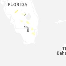


Connect with Interactive Hail Maps