

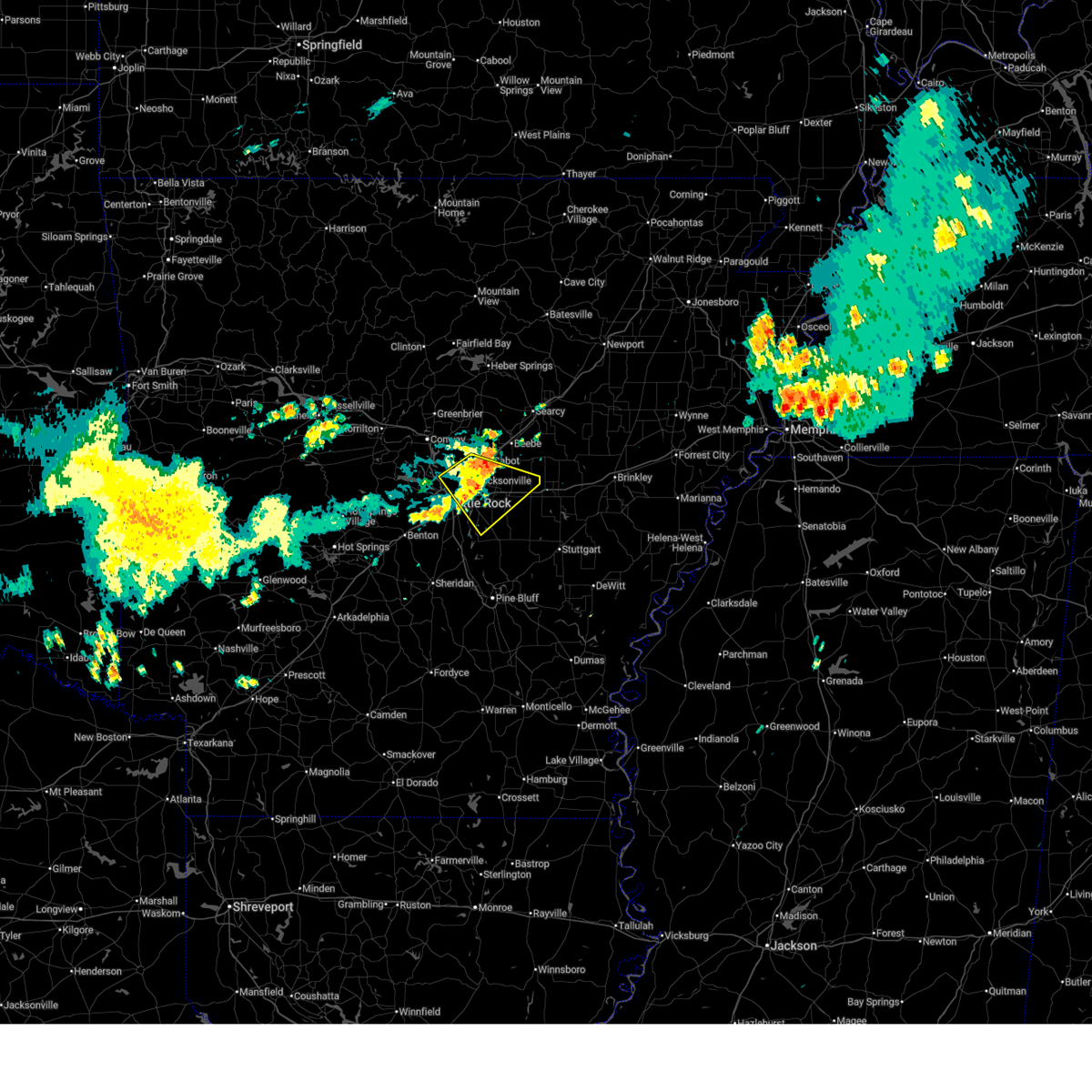
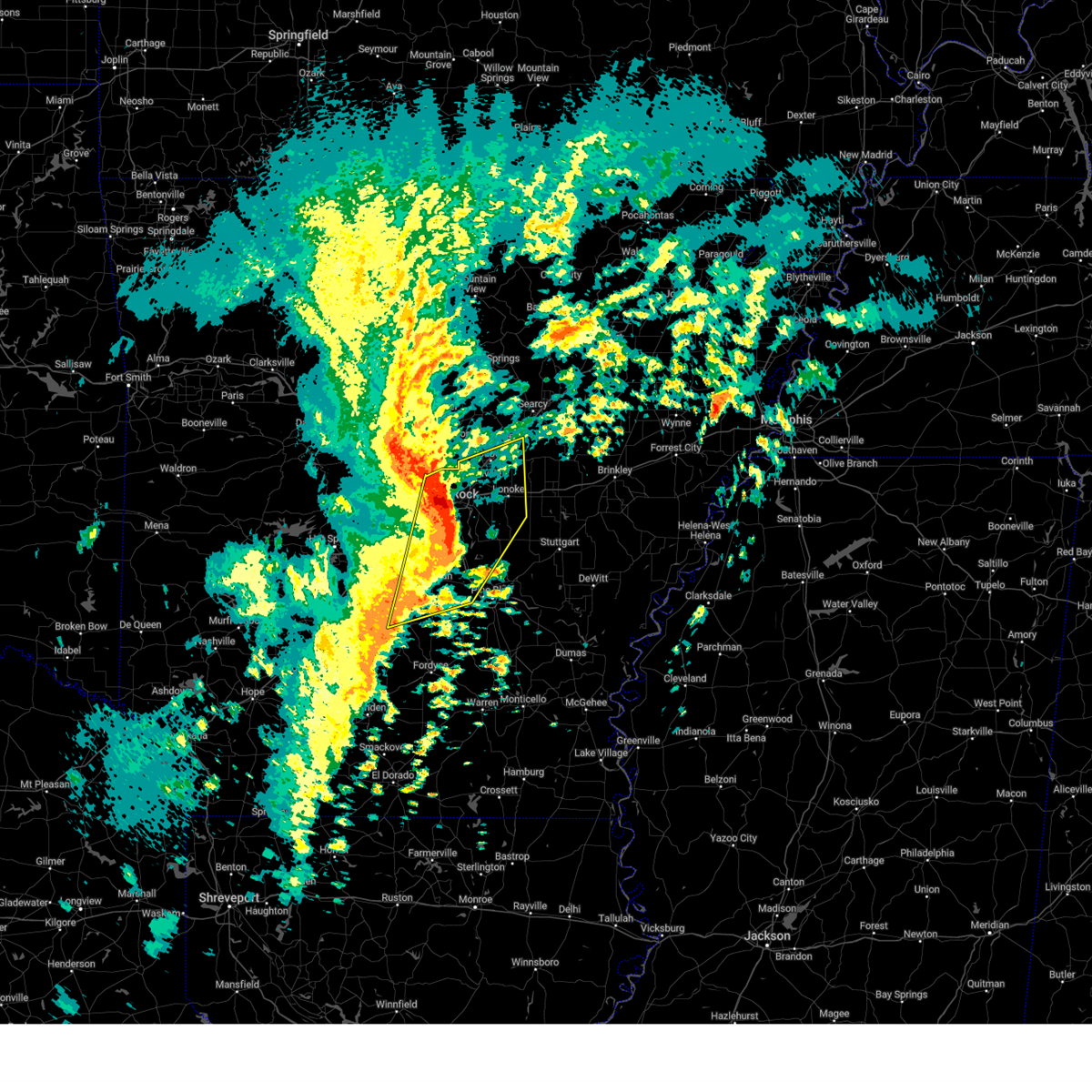
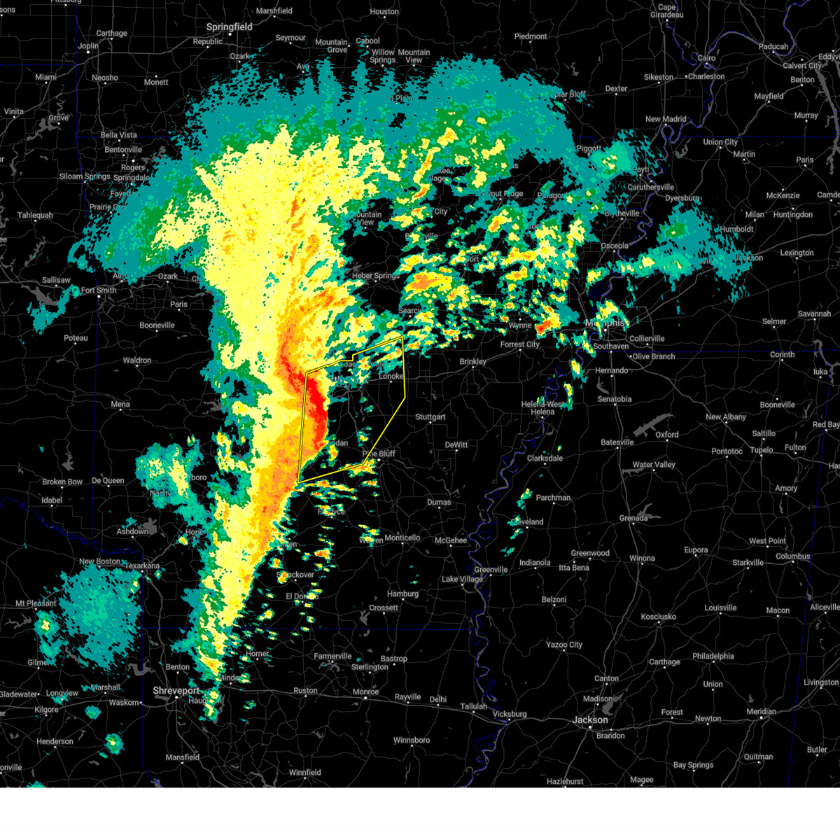
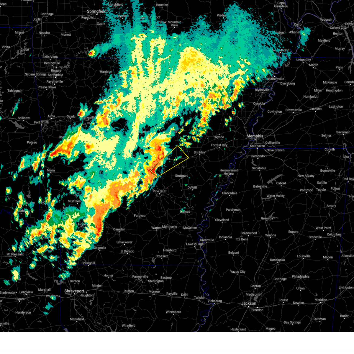
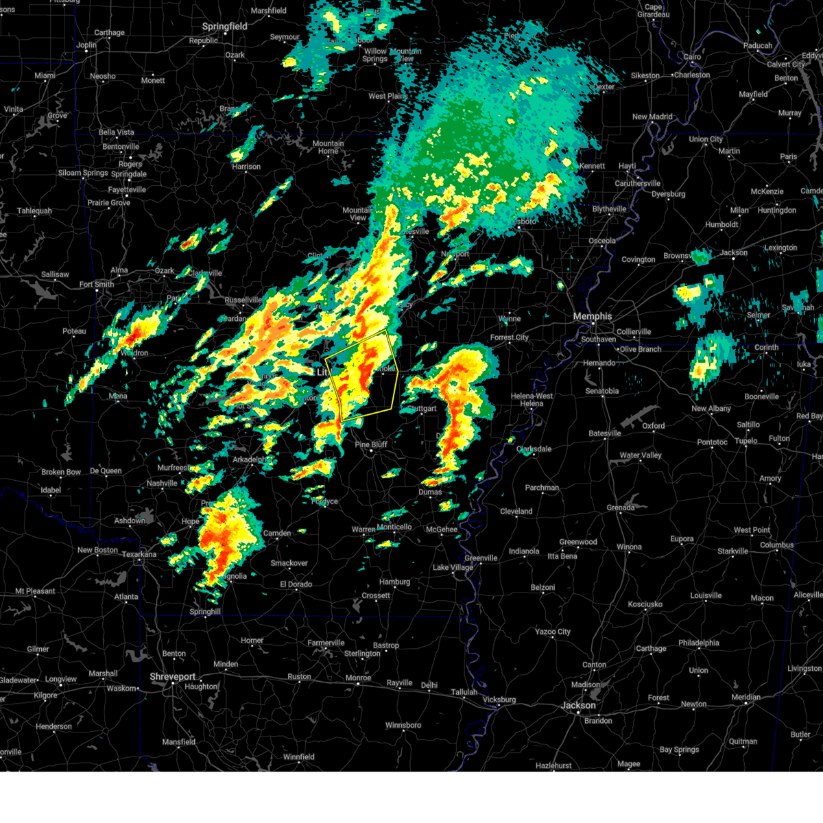
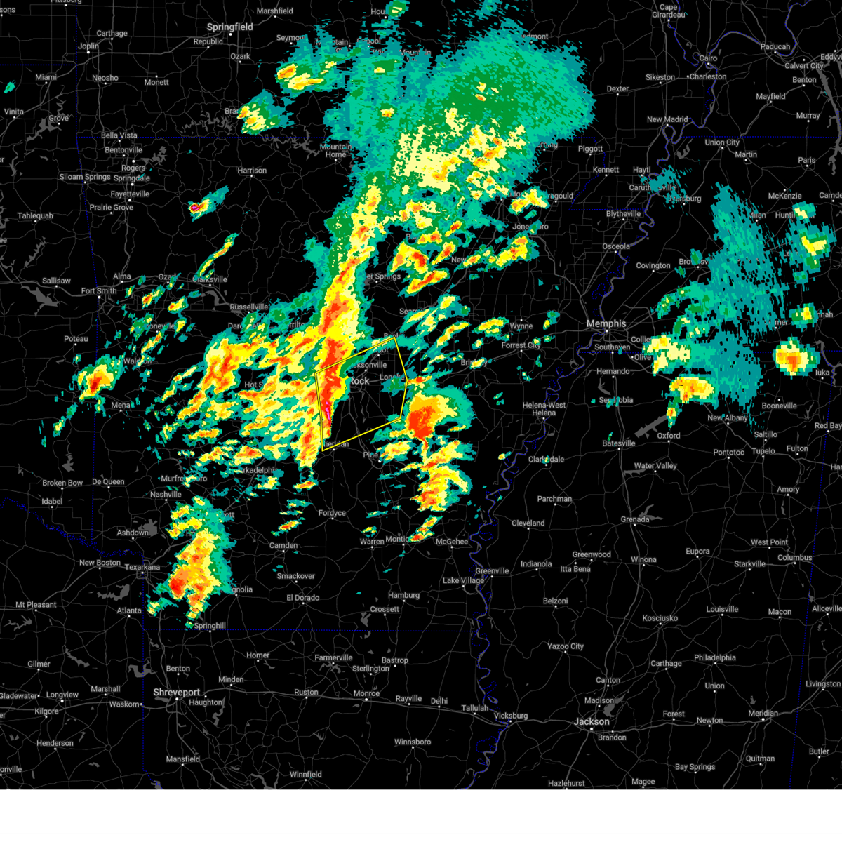
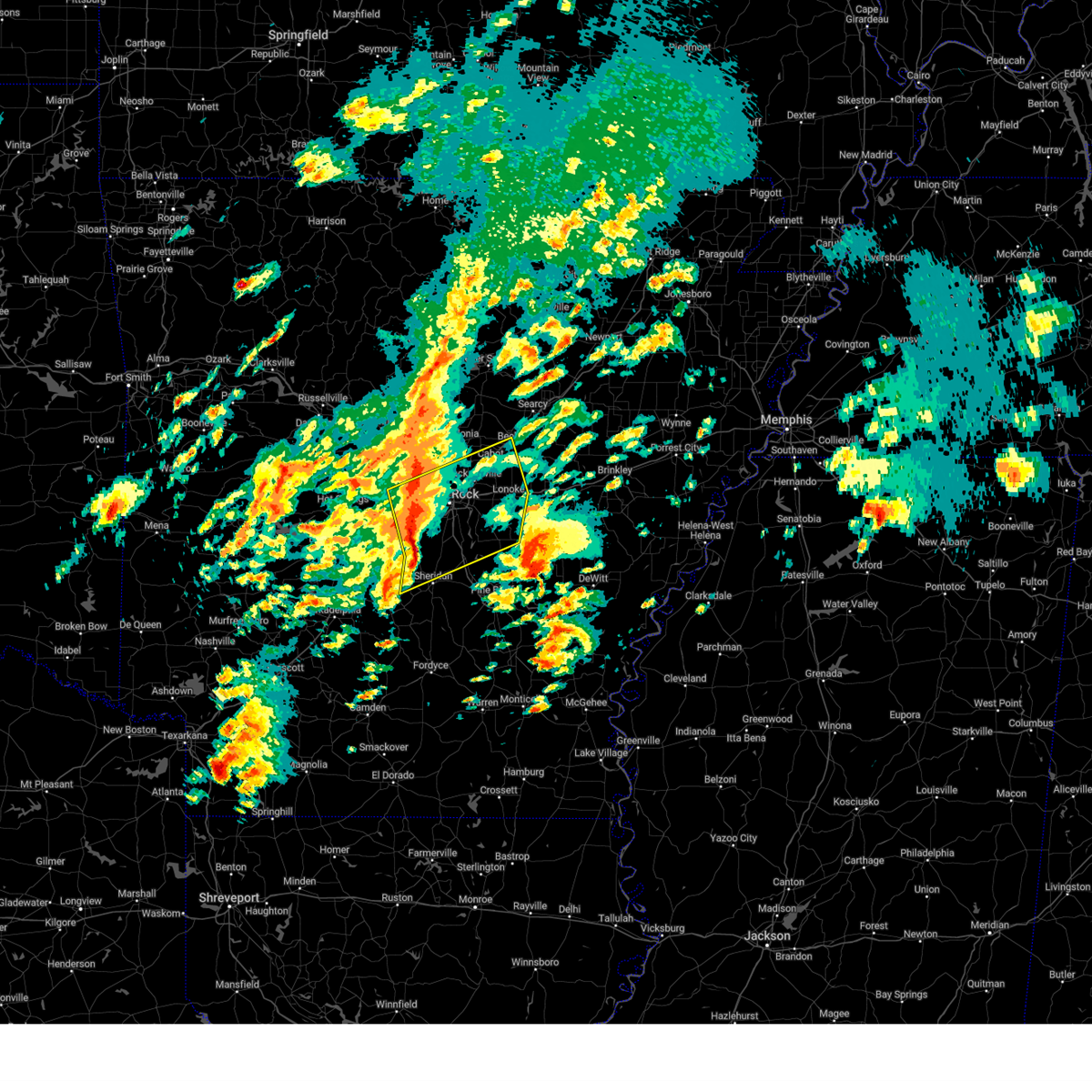
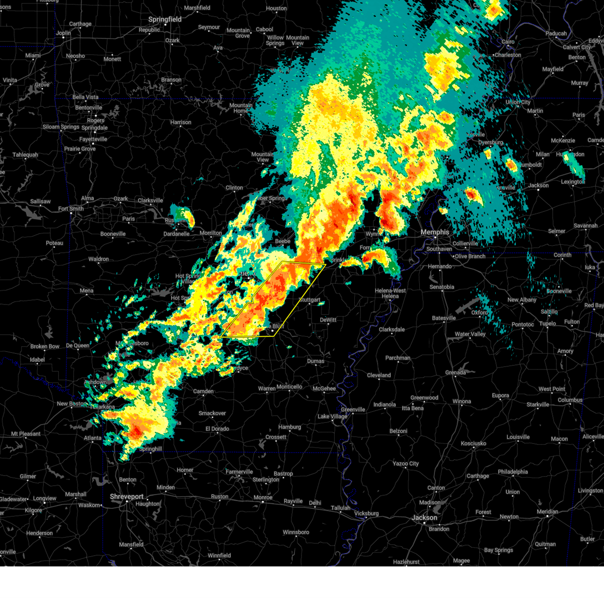
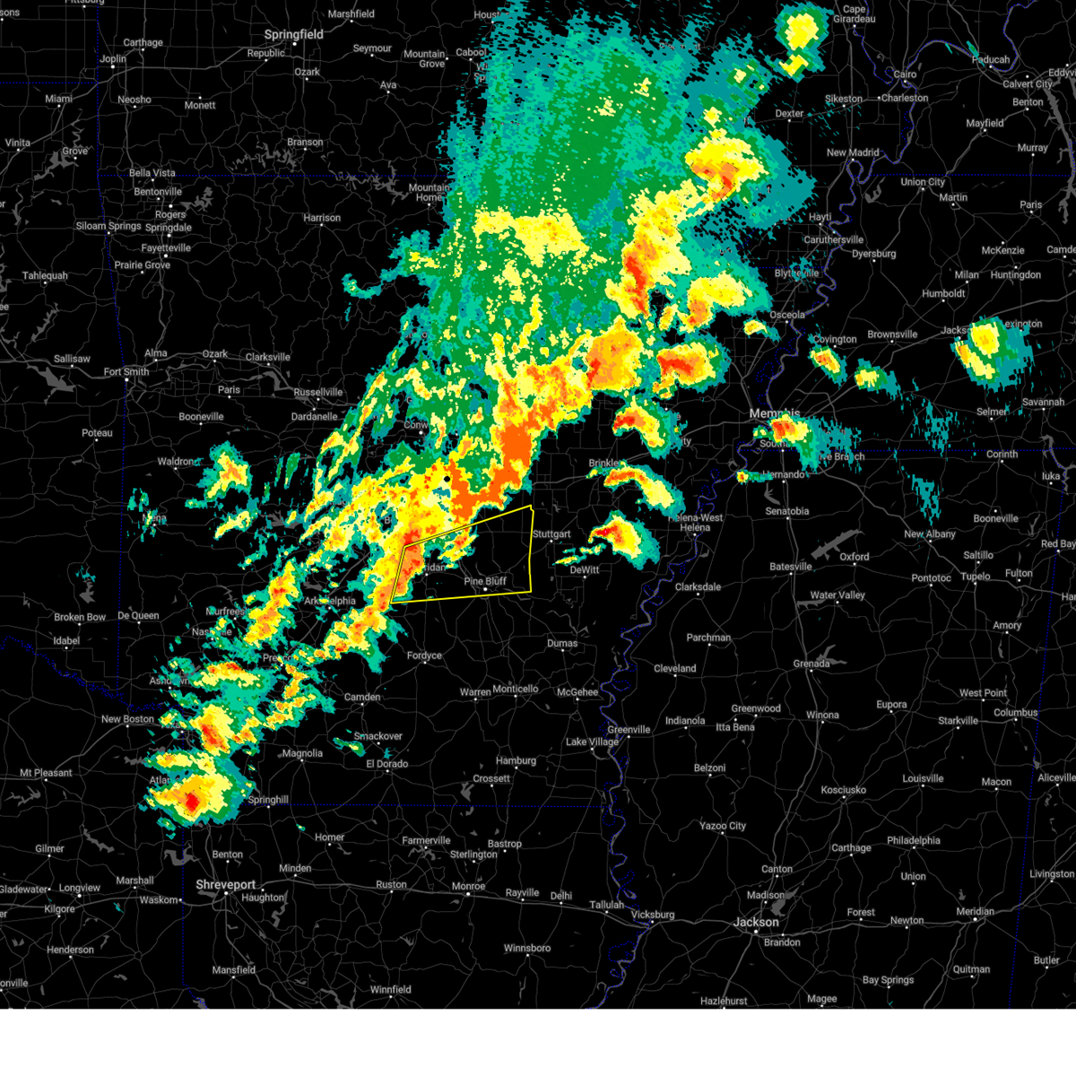
Hail Map for Keo, AR
The Keo, AR area has had 1 report of on-the-ground hail by trained spotters, and has been under severe weather warnings 53 times during the past 12 months. Doppler radar has detected hail at or near Keo, AR on 65 occasions, including 5 occasions during the past year.
| Name: | Keo, AR |
| Where Located: | 17.6 miles ESE of Little Rock, AR |
| Map: | Google Map for Keo, AR |
| Population: | 256 |
| Housing Units: | 116 |
| More Info: | Search Google for Keo, AR |
2
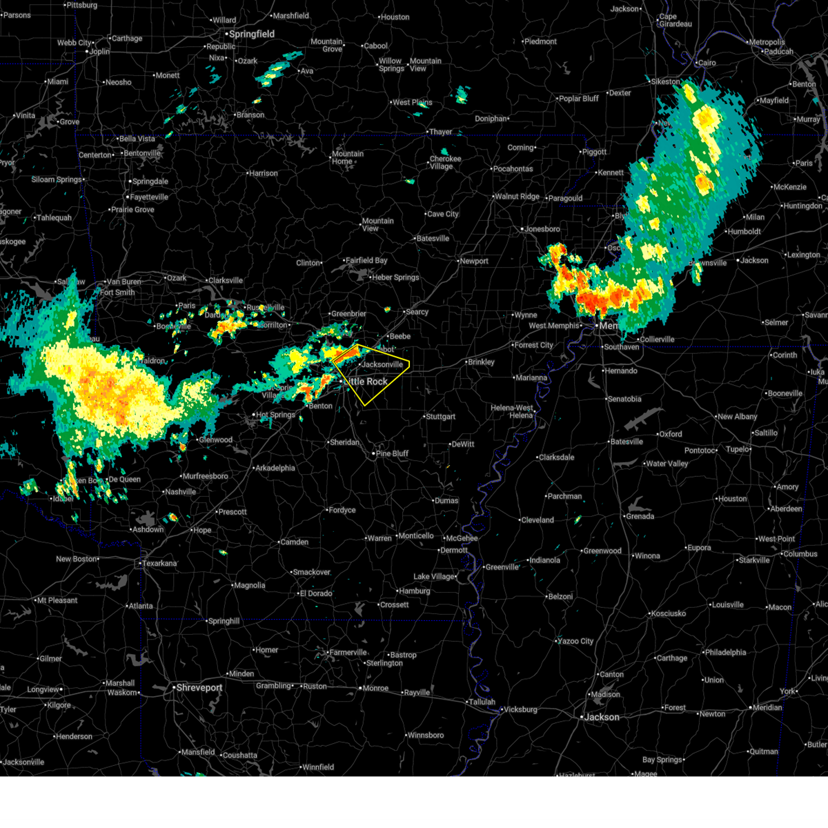
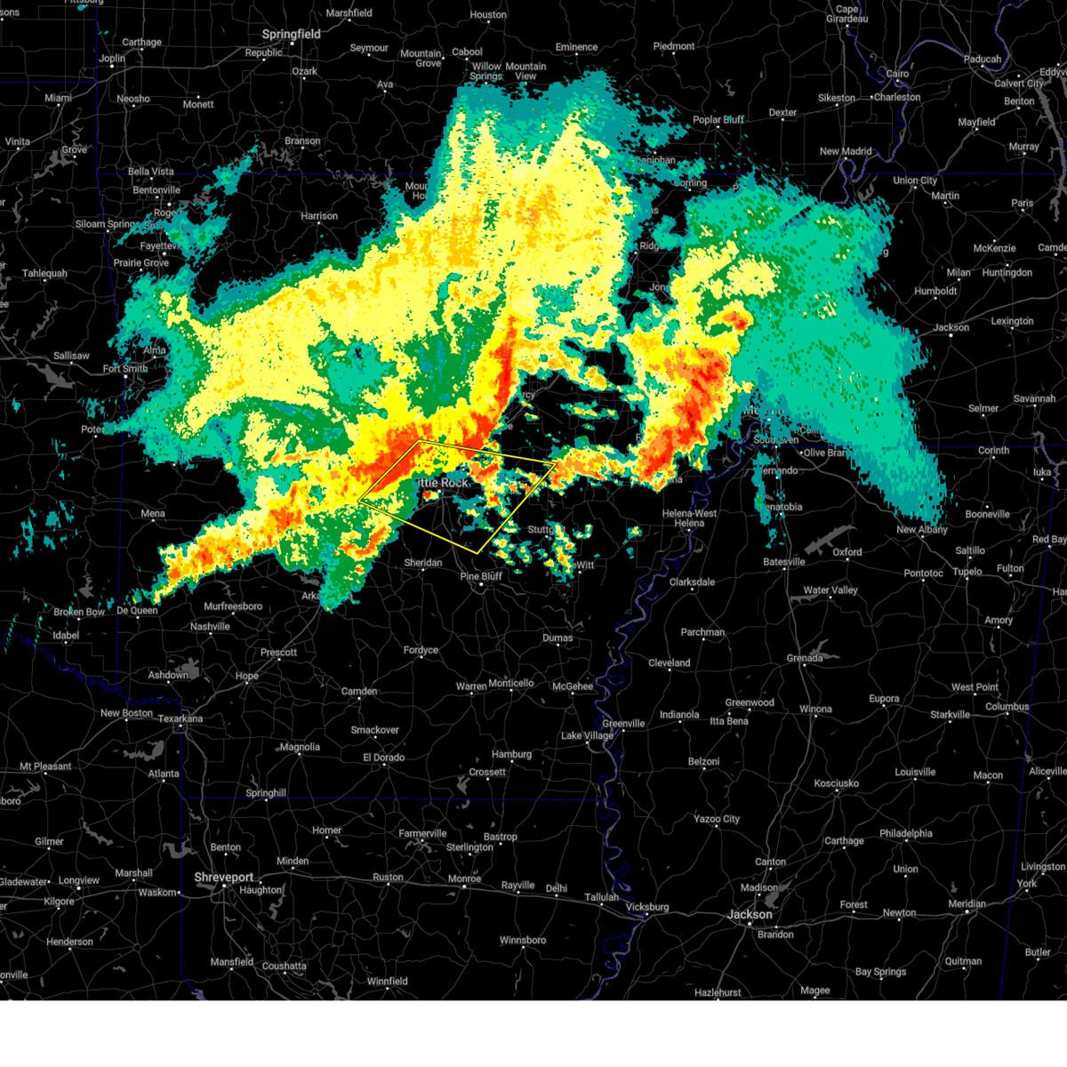
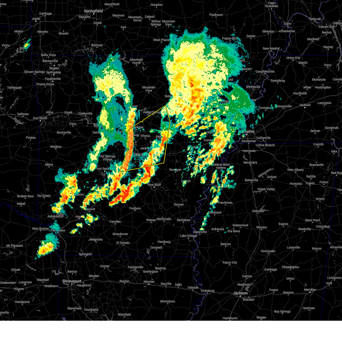
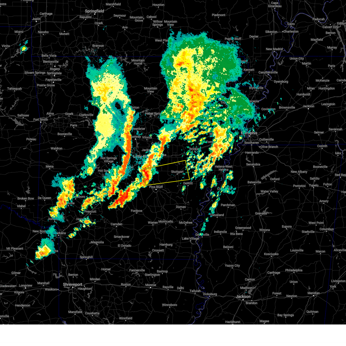
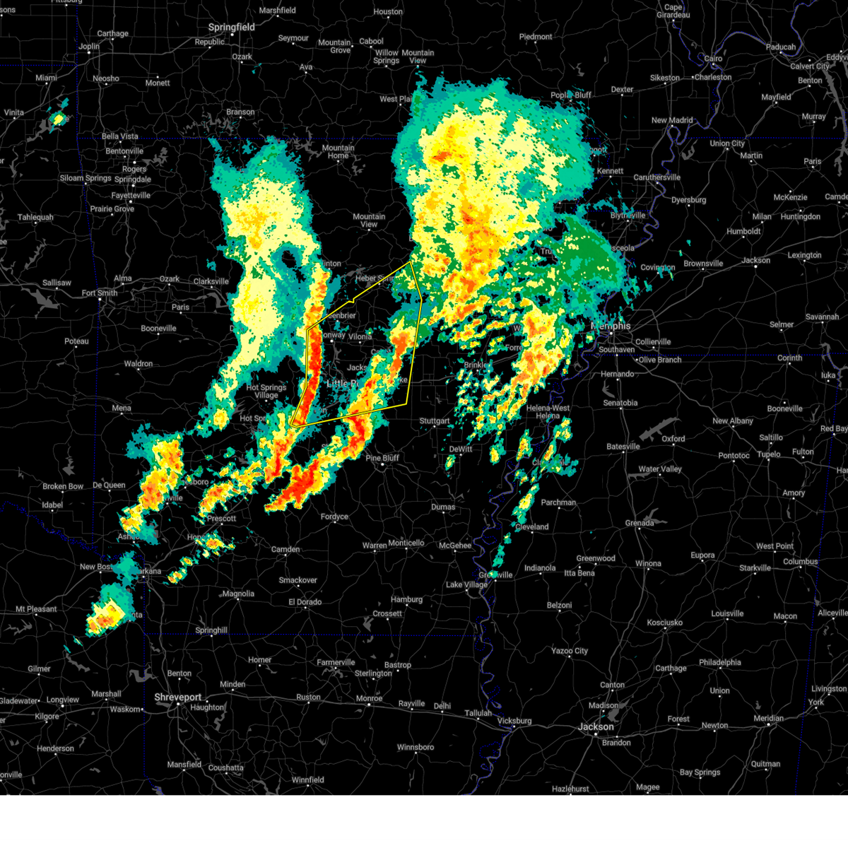
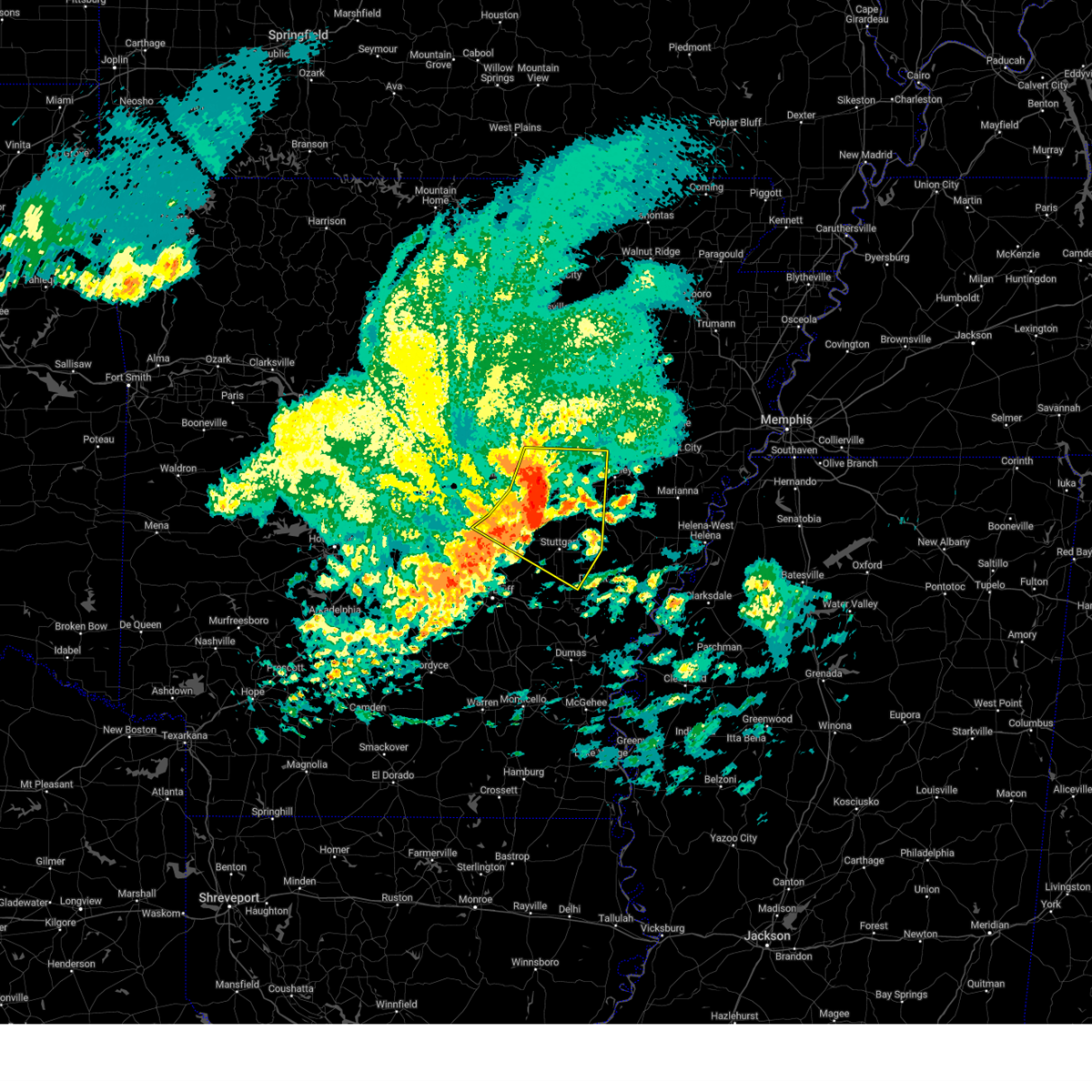
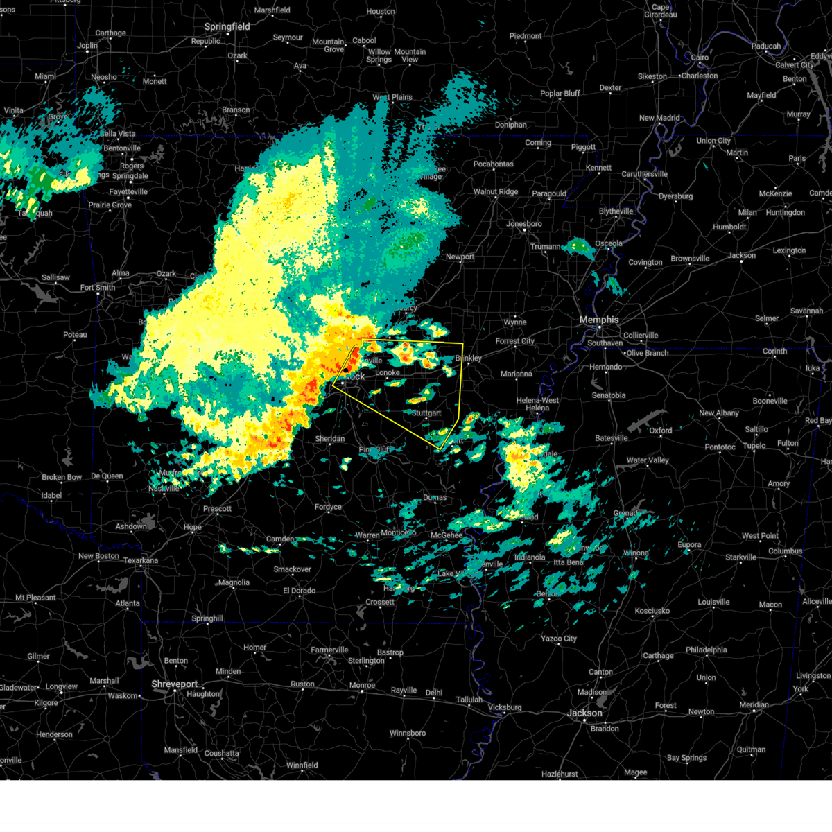
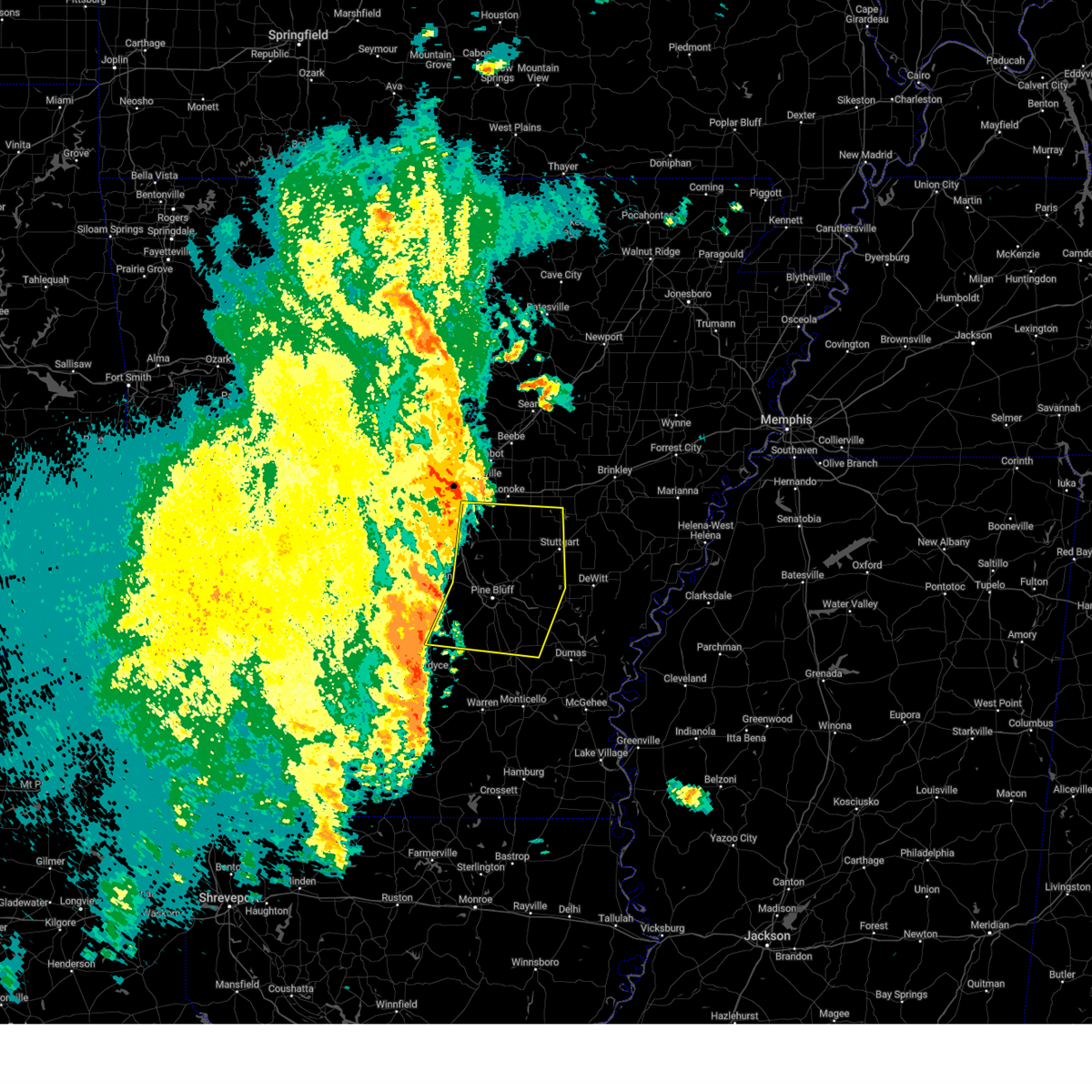
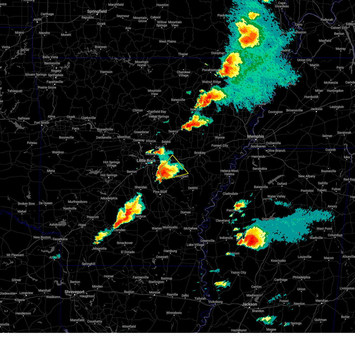
The Top Recent Hail Date for Keo, AR is Wednesday, April 2, 2025 (5th out of 65)

Hail and Wind Damage Spotted near Keo, AR
| Date / Time | Report Details |
|---|---|
| 6/30/2025 11:21 PM CDT |
 the severe thunderstorm warning has been cancelled and is no longer in effect the severe thunderstorm warning has been cancelled and is no longer in effect
|
| 6/30/2025 11:02 PM CDT |
 Svrlzk the national weather service in little rock has issued a * severe thunderstorm warning for, northern lonoke county in central arkansas, south central faulkner county in central arkansas, northeastern pulaski county in central arkansas, * until 1145 pm cdt. * at 1102 pm cdt, a severe thunderstorm was located over gibson, or near little rock afb, moving southeast at 25 mph (radar indicated). Hazards include 60 mph wind gusts and penny size hail. expect damage to roofs, siding, and trees Svrlzk the national weather service in little rock has issued a * severe thunderstorm warning for, northern lonoke county in central arkansas, south central faulkner county in central arkansas, northeastern pulaski county in central arkansas, * until 1145 pm cdt. * at 1102 pm cdt, a severe thunderstorm was located over gibson, or near little rock afb, moving southeast at 25 mph (radar indicated). Hazards include 60 mph wind gusts and penny size hail. expect damage to roofs, siding, and trees
|
| 6/7/2025 9:25 AM CDT |
 Svrlzk the national weather service in little rock has issued a * severe thunderstorm warning for, southern woodruff county in eastern arkansas, eastern prairie county in central arkansas, southern lonoke county in central arkansas, monroe county in eastern arkansas, jefferson county in southeastern arkansas, northeastern lincoln county in southeastern arkansas, southeastern pulaski county in central arkansas, arkansas county in southeastern arkansas, * until 1015 am cdt. * at 925 am cdt, severe thunderstorms were located along a line extending from 10 miles southeast of hurricane lake wma to near hazen to near estes, moving southeast at 55 mph (radar indicated). Hazards include 60 mph wind gusts and quarter size hail. Hail damage to vehicles is expected. Expect wind damage to roofs, siding, and trees. Svrlzk the national weather service in little rock has issued a * severe thunderstorm warning for, southern woodruff county in eastern arkansas, eastern prairie county in central arkansas, southern lonoke county in central arkansas, monroe county in eastern arkansas, jefferson county in southeastern arkansas, northeastern lincoln county in southeastern arkansas, southeastern pulaski county in central arkansas, arkansas county in southeastern arkansas, * until 1015 am cdt. * at 925 am cdt, severe thunderstorms were located along a line extending from 10 miles southeast of hurricane lake wma to near hazen to near estes, moving southeast at 55 mph (radar indicated). Hazards include 60 mph wind gusts and quarter size hail. Hail damage to vehicles is expected. Expect wind damage to roofs, siding, and trees.
|
| 6/7/2025 9:14 AM CDT |
 At 913 am cdt, severe thunderstorms were located along a line extending from near mccreanor to near shannon hills, moving southeast at 55 mph (radar indicated). Hazards include 60 mph wind gusts and quarter size hail. Hail damage to vehicles is expected. expect wind damage to roofs, siding, and trees. Locations impacted include, park hill, otter creek, england, furlow, parnell, college station, carlisle, north little rock, gravel ridge, ironton, quapaw quarter, estes, hillcrest neighborhood, meto, kerr, parkers-iron springs, jacksonville, bevis corner, blakemore, olmstead,. At 913 am cdt, severe thunderstorms were located along a line extending from near mccreanor to near shannon hills, moving southeast at 55 mph (radar indicated). Hazards include 60 mph wind gusts and quarter size hail. Hail damage to vehicles is expected. expect wind damage to roofs, siding, and trees. Locations impacted include, park hill, otter creek, england, furlow, parnell, college station, carlisle, north little rock, gravel ridge, ironton, quapaw quarter, estes, hillcrest neighborhood, meto, kerr, parkers-iron springs, jacksonville, bevis corner, blakemore, olmstead,.
|
| 6/7/2025 8:53 AM CDT |
 Svrlzk the national weather service in little rock has issued a * severe thunderstorm warning for, west central prairie county in central arkansas, lonoke county in central arkansas, northeastern grant county in central arkansas, southwestern faulkner county in central arkansas, northwestern jefferson county in southeastern arkansas, central saline county in central arkansas, pulaski county in central arkansas, * until 945 am cdt. * at 853 am cdt, severe thunderstorms were located along a line extending from 6 miles northwest of olmstead to 11 miles northwest of salem in saline county, moving southeast at 50 mph (radar indicated). Hazards include 60 mph wind gusts and quarter size hail. Hail damage to vehicles is expected. Expect wind damage to roofs, siding, and trees. Svrlzk the national weather service in little rock has issued a * severe thunderstorm warning for, west central prairie county in central arkansas, lonoke county in central arkansas, northeastern grant county in central arkansas, southwestern faulkner county in central arkansas, northwestern jefferson county in southeastern arkansas, central saline county in central arkansas, pulaski county in central arkansas, * until 945 am cdt. * at 853 am cdt, severe thunderstorms were located along a line extending from 6 miles northwest of olmstead to 11 miles northwest of salem in saline county, moving southeast at 50 mph (radar indicated). Hazards include 60 mph wind gusts and quarter size hail. Hail damage to vehicles is expected. Expect wind damage to roofs, siding, and trees.
|
| 5/20/2025 4:28 AM CDT |
 The storms which prompted the warning have weakened below severe limits, and no longer pose an immediate threat to life or property. therefore, the warning will be allowed to expire. however gusty winds and heavy rain are still possible with these thunderstorms. a severe thunderstorm watch remains in effect until 800 am cdt for central and north central arkansas. The storms which prompted the warning have weakened below severe limits, and no longer pose an immediate threat to life or property. therefore, the warning will be allowed to expire. however gusty winds and heavy rain are still possible with these thunderstorms. a severe thunderstorm watch remains in effect until 800 am cdt for central and north central arkansas.
|
| 5/20/2025 4:13 AM CDT |
 the severe thunderstorm warning has been cancelled and is no longer in effect the severe thunderstorm warning has been cancelled and is no longer in effect
|
| 5/20/2025 4:13 AM CDT |
 At 412 am cdt, severe thunderstorms were located along a line extending from near woolly hollow state park to near enola to olmstead to downtown little rock, moving northeast at 60 mph (radar indicated). Hazards include 60 mph wind gusts. Expect damage to roofs, siding, and trees. Locations impacted include, park hill, wilburn, otter creek, old austin, furlow, antioch in white county, pearson, ironton, quapaw quarter, hillcrest neighborhood, meto, kerr, floyd, vilonia, olmstead, thurman, mccreanor, providence, macon, the heights,. At 412 am cdt, severe thunderstorms were located along a line extending from near woolly hollow state park to near enola to olmstead to downtown little rock, moving northeast at 60 mph (radar indicated). Hazards include 60 mph wind gusts. Expect damage to roofs, siding, and trees. Locations impacted include, park hill, wilburn, otter creek, old austin, furlow, antioch in white county, pearson, ironton, quapaw quarter, hillcrest neighborhood, meto, kerr, floyd, vilonia, olmstead, thurman, mccreanor, providence, macon, the heights,.
|
| 5/20/2025 3:58 AM CDT |
 At 357 am cdt, severe thunderstorms were located along a line extending from wooster to near pickles gap to maumelle to near bryant, moving northeast at 55 mph (radar indicated). Hazards include 60 mph wind gusts and penny size hail. Expect damage to roofs, siding, and trees. Locations impacted include, park hill, wilburn, otter creek, old austin, furlow, palarm, antioch in white county, mayflower, pearson, ironton, quapaw quarter, hillcrest neighborhood, meto, haskell, kerr, floyd, vilonia, olmstead, bryant, thurman,. At 357 am cdt, severe thunderstorms were located along a line extending from wooster to near pickles gap to maumelle to near bryant, moving northeast at 55 mph (radar indicated). Hazards include 60 mph wind gusts and penny size hail. Expect damage to roofs, siding, and trees. Locations impacted include, park hill, wilburn, otter creek, old austin, furlow, palarm, antioch in white county, mayflower, pearson, ironton, quapaw quarter, hillcrest neighborhood, meto, haskell, kerr, floyd, vilonia, olmstead, bryant, thurman,.
|
| 5/20/2025 3:54 AM CDT |
 Svrlzk the national weather service in little rock has issued a * severe thunderstorm warning for, southeastern prairie county in central arkansas, southern lonoke county in central arkansas, northeastern grant county in central arkansas, west central monroe county in eastern arkansas, northwestern jefferson county in southeastern arkansas, southeastern saline county in central arkansas, southeastern pulaski county in central arkansas, northwestern arkansas county in southeastern arkansas, * until 445 am cdt. * at 353 am cdt, a severe thunderstorm was located over hensley island, or 15 miles north of pine bluff, moving east at 50 mph (radar indicated). Hazards include 60 mph wind gusts and penny size hail. expect damage to roofs, siding, and trees Svrlzk the national weather service in little rock has issued a * severe thunderstorm warning for, southeastern prairie county in central arkansas, southern lonoke county in central arkansas, northeastern grant county in central arkansas, west central monroe county in eastern arkansas, northwestern jefferson county in southeastern arkansas, southeastern saline county in central arkansas, southeastern pulaski county in central arkansas, northwestern arkansas county in southeastern arkansas, * until 445 am cdt. * at 353 am cdt, a severe thunderstorm was located over hensley island, or 15 miles north of pine bluff, moving east at 50 mph (radar indicated). Hazards include 60 mph wind gusts and penny size hail. expect damage to roofs, siding, and trees
|
| 5/20/2025 3:48 AM CDT |
 Svrlzk the national weather service in little rock has issued a * severe thunderstorm warning for, southwestern independence county in north central arkansas, northeastern perry county in central arkansas, northwestern prairie county in central arkansas, southern cleburne county in north central arkansas, lonoke county in central arkansas, southeastern conway county in central arkansas, faulkner county in central arkansas, western white county in central arkansas, central saline county in central arkansas, pulaski county in central arkansas, * until 430 am cdt. * at 347 am cdt, severe thunderstorms were located along a line extending from menifee to near toad suck to 6 miles west of chenal valley to near benton, moving northeast at 60 mph (radar indicated). Hazards include 60 mph wind gusts and quarter size hail. Hail damage to vehicles is expected. Expect wind damage to roofs, siding, and trees. Svrlzk the national weather service in little rock has issued a * severe thunderstorm warning for, southwestern independence county in north central arkansas, northeastern perry county in central arkansas, northwestern prairie county in central arkansas, southern cleburne county in north central arkansas, lonoke county in central arkansas, southeastern conway county in central arkansas, faulkner county in central arkansas, western white county in central arkansas, central saline county in central arkansas, pulaski county in central arkansas, * until 430 am cdt. * at 347 am cdt, severe thunderstorms were located along a line extending from menifee to near toad suck to 6 miles west of chenal valley to near benton, moving northeast at 60 mph (radar indicated). Hazards include 60 mph wind gusts and quarter size hail. Hail damage to vehicles is expected. Expect wind damage to roofs, siding, and trees.
|
| 5/18/2025 7:32 AM CDT |
 At 731 am cdt, severe thunderstorms were located along a line extending from near des arc to near hazen to near humnoke, moving east at 55 mph (radar indicated). Hazards include 60 mph wind gusts and quarter size hail. Hail damage to vehicles is expected. expect wind damage to roofs, siding, and trees. Locations impacted include, dobbs landing, slovak, aberdeen, almyra airport, england, casscoe, carlisle, estes, ulm, seaton, blakemore, thurman, screeton, mccreanor, humnoke, sand hill, humphrey, plum bayou mounds sp, roe, brasfield,. At 731 am cdt, severe thunderstorms were located along a line extending from near des arc to near hazen to near humnoke, moving east at 55 mph (radar indicated). Hazards include 60 mph wind gusts and quarter size hail. Hail damage to vehicles is expected. expect wind damage to roofs, siding, and trees. Locations impacted include, dobbs landing, slovak, aberdeen, almyra airport, england, casscoe, carlisle, estes, ulm, seaton, blakemore, thurman, screeton, mccreanor, humnoke, sand hill, humphrey, plum bayou mounds sp, roe, brasfield,.
|
| 5/18/2025 6:53 AM CDT |
 Svrlzk the national weather service in little rock has issued a * severe thunderstorm warning for, south central woodruff county in eastern arkansas, prairie county in central arkansas, lonoke county in central arkansas, northwestern monroe county in eastern arkansas, south central white county in central arkansas, north central jefferson county in southeastern arkansas, northeastern pulaski county in central arkansas, northwestern arkansas county in southeastern arkansas, * until 745 am cdt. * at 652 am cdt, severe thunderstorms were located along a line extending from near cabot to south bend to near scott, moving southeast at 55 mph (radar indicated). Hazards include 60 mph wind gusts. expect damage to roofs, siding, and trees Svrlzk the national weather service in little rock has issued a * severe thunderstorm warning for, south central woodruff county in eastern arkansas, prairie county in central arkansas, lonoke county in central arkansas, northwestern monroe county in eastern arkansas, south central white county in central arkansas, north central jefferson county in southeastern arkansas, northeastern pulaski county in central arkansas, northwestern arkansas county in southeastern arkansas, * until 745 am cdt. * at 652 am cdt, severe thunderstorms were located along a line extending from near cabot to south bend to near scott, moving southeast at 55 mph (radar indicated). Hazards include 60 mph wind gusts. expect damage to roofs, siding, and trees
|
| 5/18/2025 6:35 AM CDT |
 the severe thunderstorm warning has been cancelled and is no longer in effect the severe thunderstorm warning has been cancelled and is no longer in effect
|
| 5/18/2025 6:35 AM CDT |
 At 634 am cdt, severe thunderstorms were located along a line extending from near pickles gap to near olmstead to maumelle, moving southeast at 60 mph (radar indicated). Hazards include 60 mph wind gusts and quarter size hail. Hail damage to vehicles is expected. expect wind damage to roofs, siding, and trees. Locations impacted include, park hill, old austin, little italy, furlow, parnell, college station, natural steps, palarm, north little rock, antioch in white county, mayflower, gravel ridge, mount vernon, quapaw quarter, hillcrest neighborhood, meto, kerr, floyd, austin in lonoke county, vilonia,. At 634 am cdt, severe thunderstorms were located along a line extending from near pickles gap to near olmstead to maumelle, moving southeast at 60 mph (radar indicated). Hazards include 60 mph wind gusts and quarter size hail. Hail damage to vehicles is expected. expect wind damage to roofs, siding, and trees. Locations impacted include, park hill, old austin, little italy, furlow, parnell, college station, natural steps, palarm, north little rock, antioch in white county, mayflower, gravel ridge, mount vernon, quapaw quarter, hillcrest neighborhood, meto, kerr, floyd, austin in lonoke county, vilonia,.
|
| 5/18/2025 6:24 AM CDT |
 At 623 am cdt, severe thunderstorms were located along a line extending from bethlehem to near toad suck to near little italy to 10 miles south of williams junction, moving east at 55 mph (radar indicated). Hazards include 70 mph wind gusts and quarter size hail. Hail damage to vehicles is expected. expect considerable tree damage. wind damage is also likely to mobile homes, roofs, and outbuildings. Locations impacted include, park hill, otter creek, hill creek, old austin, furlow, palarm, antioch in white county, mayflower, oak grove in perry county, twin groves, ironton, quapaw quarter, hillcrest neighborhood, meto, haskell, kerr, floyd, vilonia, olmstead, bryant,. At 623 am cdt, severe thunderstorms were located along a line extending from bethlehem to near toad suck to near little italy to 10 miles south of williams junction, moving east at 55 mph (radar indicated). Hazards include 70 mph wind gusts and quarter size hail. Hail damage to vehicles is expected. expect considerable tree damage. wind damage is also likely to mobile homes, roofs, and outbuildings. Locations impacted include, park hill, otter creek, hill creek, old austin, furlow, palarm, antioch in white county, mayflower, oak grove in perry county, twin groves, ironton, quapaw quarter, hillcrest neighborhood, meto, haskell, kerr, floyd, vilonia, olmstead, bryant,.
|
| 5/18/2025 6:24 AM CDT |
 the severe thunderstorm warning has been cancelled and is no longer in effect the severe thunderstorm warning has been cancelled and is no longer in effect
|
| 5/18/2025 6:14 AM CDT |
 At 614 am cdt, severe thunderstorms were located along a line extending from blick to near morrilton to near williams junction to hot springs national park, moving east at 55 mph (radar indicated). Hazards include 70 mph wind gusts and quarter size hail. Hail damage to vehicles is expected. expect considerable tree damage. wind damage is also likely to mobile homes, roofs, and outbuildings. Locations impacted include, park hill, otter creek, oaklawn racetrack, old austin, traskwood, palarm, antioch in white county, mayflower, twin groves, meto, vilonia, bryant, perryville, the heights, bethlehem, aplin, lake ouachita state park, congo, blick, sylvan hills,. At 614 am cdt, severe thunderstorms were located along a line extending from blick to near morrilton to near williams junction to hot springs national park, moving east at 55 mph (radar indicated). Hazards include 70 mph wind gusts and quarter size hail. Hail damage to vehicles is expected. expect considerable tree damage. wind damage is also likely to mobile homes, roofs, and outbuildings. Locations impacted include, park hill, otter creek, oaklawn racetrack, old austin, traskwood, palarm, antioch in white county, mayflower, twin groves, meto, vilonia, bryant, perryville, the heights, bethlehem, aplin, lake ouachita state park, congo, blick, sylvan hills,.
|
| 5/18/2025 6:14 AM CDT |
 the severe thunderstorm warning has been cancelled and is no longer in effect the severe thunderstorm warning has been cancelled and is no longer in effect
|
| 5/18/2025 5:57 AM CDT |
 Svrlzk the national weather service in little rock has issued a * severe thunderstorm warning for, perry county in central arkansas, northwestern lonoke county in central arkansas, northern grant county in central arkansas, conway county in central arkansas, faulkner county in central arkansas, southwestern white county in central arkansas, garland county in central arkansas, saline county in central arkansas, northeastern yell county in central arkansas, northeastern hot spring county in southwestern arkansas, pulaski county in central arkansas, southeastern pope county in central arkansas, * until 700 am cdt. * at 556 am cdt, severe thunderstorms were located along a line extending from broomfield to pottsville to near ola to 13 miles southeast of muddy creek wma, moving east at 70 mph (radar indicated). Hazards include 70 mph wind gusts and quarter size hail. Hail damage to vehicles is expected. expect considerable tree damage. Wind damage is also likely to mobile homes, roofs, and outbuildings. Svrlzk the national weather service in little rock has issued a * severe thunderstorm warning for, perry county in central arkansas, northwestern lonoke county in central arkansas, northern grant county in central arkansas, conway county in central arkansas, faulkner county in central arkansas, southwestern white county in central arkansas, garland county in central arkansas, saline county in central arkansas, northeastern yell county in central arkansas, northeastern hot spring county in southwestern arkansas, pulaski county in central arkansas, southeastern pope county in central arkansas, * until 700 am cdt. * at 556 am cdt, severe thunderstorms were located along a line extending from broomfield to pottsville to near ola to 13 miles southeast of muddy creek wma, moving east at 70 mph (radar indicated). Hazards include 70 mph wind gusts and quarter size hail. Hail damage to vehicles is expected. expect considerable tree damage. Wind damage is also likely to mobile homes, roofs, and outbuildings.
|
| 4/30/2025 5:55 PM CDT |
 Svrlzk the national weather service in little rock has issued a * severe thunderstorm warning for, northern cleveland county in southeastern arkansas, south central prairie county in central arkansas, southern lonoke county in central arkansas, eastern grant county in central arkansas, northeastern dallas county in southwestern arkansas, jefferson county in southeastern arkansas, northwestern lincoln county in southeastern arkansas, southeastern pulaski county in central arkansas, northwestern arkansas county in southeastern arkansas, * until 645 pm cdt. * at 554 pm cdt, severe thunderstorms were located along a line extending from near scott to 6 miles west of white hall to 7 miles northwest of kingsland, moving east at 40 mph (radar indicated). Hazards include 60 mph wind gusts. expect damage to roofs, siding, and trees Svrlzk the national weather service in little rock has issued a * severe thunderstorm warning for, northern cleveland county in southeastern arkansas, south central prairie county in central arkansas, southern lonoke county in central arkansas, eastern grant county in central arkansas, northeastern dallas county in southwestern arkansas, jefferson county in southeastern arkansas, northwestern lincoln county in southeastern arkansas, southeastern pulaski county in central arkansas, northwestern arkansas county in southeastern arkansas, * until 645 pm cdt. * at 554 pm cdt, severe thunderstorms were located along a line extending from near scott to 6 miles west of white hall to 7 miles northwest of kingsland, moving east at 40 mph (radar indicated). Hazards include 60 mph wind gusts. expect damage to roofs, siding, and trees
|
| 4/5/2025 11:47 AM CDT |
 At 1147 am cdt, severe thunderstorms were located along a line extending from near crosby to 6 miles south of west point to near prairie center, moving northeast at 65 mph (radar indicated). Hazards include 70 mph wind gusts and quarter size hail. Hail damage to vehicles is expected. expect considerable tree damage. wind damage is also likely to mobile homes, roofs, and outbuildings. Locations impacted include, hickory flat, wilburn, old austin, crosby, searcy, heffington, england, furlow, parnell, carlisle, antioch in white county, judsonia, worden, estes, kensett, meto, pickens in white county, floyd, austin in lonoke county, velvet ridge,. At 1147 am cdt, severe thunderstorms were located along a line extending from near crosby to 6 miles south of west point to near prairie center, moving northeast at 65 mph (radar indicated). Hazards include 70 mph wind gusts and quarter size hail. Hail damage to vehicles is expected. expect considerable tree damage. wind damage is also likely to mobile homes, roofs, and outbuildings. Locations impacted include, hickory flat, wilburn, old austin, crosby, searcy, heffington, england, furlow, parnell, carlisle, antioch in white county, judsonia, worden, estes, kensett, meto, pickens in white county, floyd, austin in lonoke county, velvet ridge,.
|
| 4/5/2025 11:47 AM CDT |
 the severe thunderstorm warning has been cancelled and is no longer in effect the severe thunderstorm warning has been cancelled and is no longer in effect
|
| 4/5/2025 11:38 AM CDT |
 At 1137 am cdt, severe thunderstorms were located along a line extending from near thurman to 6 miles west of parkers corner to near hensley island, moving northeast at 60 mph (trained weather spotters). Hazards include 70 mph wind gusts and quarter size hail. Hail damage to vehicles is expected. expect considerable tree damage. wind damage is also likely to mobile homes, roofs, and outbuildings. Locations impacted include, park hill, otter creek, pastoria, old austin, england, furlow, jenkins ferry state park, ironton, quapaw quarter, hillcrest neighborhood, meto, hardin, kerr, dexter, olmstead, bryant, mccreanor, macon, the heights, protho junction,. At 1137 am cdt, severe thunderstorms were located along a line extending from near thurman to 6 miles west of parkers corner to near hensley island, moving northeast at 60 mph (trained weather spotters). Hazards include 70 mph wind gusts and quarter size hail. Hail damage to vehicles is expected. expect considerable tree damage. wind damage is also likely to mobile homes, roofs, and outbuildings. Locations impacted include, park hill, otter creek, pastoria, old austin, england, furlow, jenkins ferry state park, ironton, quapaw quarter, hillcrest neighborhood, meto, hardin, kerr, dexter, olmstead, bryant, mccreanor, macon, the heights, protho junction,.
|
| 4/5/2025 11:25 AM CDT |
 Svrlzk the national weather service in little rock has issued a * severe thunderstorm warning for, southwestern independence county in north central arkansas, northwestern prairie county in central arkansas, southwestern jackson county in eastern arkansas, southeastern cleburne county in north central arkansas, lonoke county in central arkansas, southeastern faulkner county in central arkansas, white county in central arkansas, northwestern jefferson county in southeastern arkansas, eastern pulaski county in central arkansas, * until noon cdt. * at 1124 am cdt, severe thunderstorms were located along a line extending from vilonia to parnell to near england, moving northeast at 85 mph (radar indicated). Hazards include 70 mph wind gusts and quarter size hail. Hail damage to vehicles is expected. expect considerable tree damage. Wind damage is also likely to mobile homes, roofs, and outbuildings. Svrlzk the national weather service in little rock has issued a * severe thunderstorm warning for, southwestern independence county in north central arkansas, northwestern prairie county in central arkansas, southwestern jackson county in eastern arkansas, southeastern cleburne county in north central arkansas, lonoke county in central arkansas, southeastern faulkner county in central arkansas, white county in central arkansas, northwestern jefferson county in southeastern arkansas, eastern pulaski county in central arkansas, * until noon cdt. * at 1124 am cdt, severe thunderstorms were located along a line extending from vilonia to parnell to near england, moving northeast at 85 mph (radar indicated). Hazards include 70 mph wind gusts and quarter size hail. Hail damage to vehicles is expected. expect considerable tree damage. Wind damage is also likely to mobile homes, roofs, and outbuildings.
|
| 4/5/2025 11:14 AM CDT |
 At 1114 am cdt, severe thunderstorms were located along a line extending from near camp robinson to orion to near sheridan, moving northeast at 55 mph (radar indicated). Hazards include 70 mph wind gusts and quarter size hail. Hail damage to vehicles is expected. expect considerable tree damage. wind damage is also likely to mobile homes, roofs, and outbuildings. Locations impacted include, park hill, otter creek, pastoria, old austin, england, furlow, jenkins ferry state park, ironton, quapaw quarter, hillcrest neighborhood, meto, hardin, kerr, dexter, olmstead, bryant, mccreanor, macon, the heights, protho junction,. At 1114 am cdt, severe thunderstorms were located along a line extending from near camp robinson to orion to near sheridan, moving northeast at 55 mph (radar indicated). Hazards include 70 mph wind gusts and quarter size hail. Hail damage to vehicles is expected. expect considerable tree damage. wind damage is also likely to mobile homes, roofs, and outbuildings. Locations impacted include, park hill, otter creek, pastoria, old austin, england, furlow, jenkins ferry state park, ironton, quapaw quarter, hillcrest neighborhood, meto, hardin, kerr, dexter, olmstead, bryant, mccreanor, macon, the heights, protho junction,.
|
| 4/5/2025 11:14 AM CDT |
 the severe thunderstorm warning has been cancelled and is no longer in effect the severe thunderstorm warning has been cancelled and is no longer in effect
|
| 4/5/2025 10:58 AM CDT |
 Svrlzk the national weather service in little rock has issued a * severe thunderstorm warning for, western prairie county in central arkansas, lonoke county in central arkansas, grant county in central arkansas, north central dallas county in southwestern arkansas, south central white county in central arkansas, northwestern jefferson county in southeastern arkansas, eastern saline county in central arkansas, southeastern hot spring county in southwestern arkansas, pulaski county in central arkansas, * until 1145 am cdt. * at 1058 am cdt, severe thunderstorms were located along a line extending from near chenal valley to 6 miles northeast of prattsville to near leola, moving northeast at 55 mph (radar indicated). Hazards include 60 mph wind gusts and nickel size hail. expect damage to roofs, siding, and trees Svrlzk the national weather service in little rock has issued a * severe thunderstorm warning for, western prairie county in central arkansas, lonoke county in central arkansas, grant county in central arkansas, north central dallas county in southwestern arkansas, south central white county in central arkansas, northwestern jefferson county in southeastern arkansas, eastern saline county in central arkansas, southeastern hot spring county in southwestern arkansas, pulaski county in central arkansas, * until 1145 am cdt. * at 1058 am cdt, severe thunderstorms were located along a line extending from near chenal valley to 6 miles northeast of prattsville to near leola, moving northeast at 55 mph (radar indicated). Hazards include 60 mph wind gusts and nickel size hail. expect damage to roofs, siding, and trees
|
| 4/4/2025 11:52 PM CDT |
 Svrlzk the national weather service in little rock has issued a * severe thunderstorm warning for, central prairie county in central arkansas, central lonoke county in central arkansas, southeastern white county in central arkansas, southeastern pulaski county in central arkansas, * until 1230 am cdt. * at 1152 pm cdt, a severe thunderstorm was located over estes, or 15 miles southeast of downtown little rock, moving northeast at 50 mph (radar indicated). Hazards include 60 mph wind gusts and penny size hail. expect damage to roofs, siding, and trees Svrlzk the national weather service in little rock has issued a * severe thunderstorm warning for, central prairie county in central arkansas, central lonoke county in central arkansas, southeastern white county in central arkansas, southeastern pulaski county in central arkansas, * until 1230 am cdt. * at 1152 pm cdt, a severe thunderstorm was located over estes, or 15 miles southeast of downtown little rock, moving northeast at 50 mph (radar indicated). Hazards include 60 mph wind gusts and penny size hail. expect damage to roofs, siding, and trees
|
| 4/3/2025 5:13 PM CDT |
 The storms which prompted the warning have weakened below severe limits, and no longer pose an immediate threat to life or property. therefore, the warning will be allowed to expire. however small hail and gusty winds are still possible with these thunderstorms. a tornado watch remains in effect until 1000 pm cdt for southeastern arkansas. a severe thunderstorm watch remains in effect until 1000 pm cdt for central arkansas. The storms which prompted the warning have weakened below severe limits, and no longer pose an immediate threat to life or property. therefore, the warning will be allowed to expire. however small hail and gusty winds are still possible with these thunderstorms. a tornado watch remains in effect until 1000 pm cdt for southeastern arkansas. a severe thunderstorm watch remains in effect until 1000 pm cdt for central arkansas.
|
| 4/3/2025 4:58 PM CDT | At 458 pm cdt, severe thunderstorms were located along a line extending from otter creek to near cane creek to near sheridan, moving northeast at 60 mph (radar indicated). Hazards include 60 mph wind gusts. Expect damage to roofs, siding, and trees. Locations impacted include, park hill, old austin, england, furlow, parnell, college station, north little rock, gravel ridge, ironton, quapaw quarter, estes, hillcrest neighborhood, meto, kerr, austin in lonoke county, jacksonville, bevis corner, blakemore, olmstead, mccreanor,. |
| 4/3/2025 4:45 PM CDT |
 At 445 pm cdt, severe thunderstorms were located along a line extending from near otter creek to near east end to near sheridan, moving northeast at 55 mph (radar indicated). Hazards include 60 mph wind gusts. Expect damage to roofs, siding, and trees. Locations impacted include, park hill, otter creek, old austin, england, furlow, ironton, quapaw quarter, hillcrest neighborhood, meto, kerr, olmstead, bryant, mccreanor, macon, the heights, protho junction, baseline, woodlawn, keo, sylvan hills,. At 445 pm cdt, severe thunderstorms were located along a line extending from near otter creek to near east end to near sheridan, moving northeast at 55 mph (radar indicated). Hazards include 60 mph wind gusts. Expect damage to roofs, siding, and trees. Locations impacted include, park hill, otter creek, old austin, england, furlow, ironton, quapaw quarter, hillcrest neighborhood, meto, kerr, olmstead, bryant, mccreanor, macon, the heights, protho junction, baseline, woodlawn, keo, sylvan hills,.
|
| 4/3/2025 4:37 PM CDT |
 Svrlzk the national weather service in little rock has issued a * severe thunderstorm warning for, lonoke county in central arkansas, northern grant county in central arkansas, southeastern faulkner county in central arkansas, southwestern white county in central arkansas, northwestern jefferson county in southeastern arkansas, eastern saline county in central arkansas, pulaski county in central arkansas, * until 515 pm cdt. * at 436 pm cdt, severe thunderstorms were located along a line extending from bryant to 6 miles west of cane creek to near dogwood, moving northeast at 60 mph (radar indicated). Hazards include 60 mph wind gusts. expect damage to roofs, siding, and trees Svrlzk the national weather service in little rock has issued a * severe thunderstorm warning for, lonoke county in central arkansas, northern grant county in central arkansas, southeastern faulkner county in central arkansas, southwestern white county in central arkansas, northwestern jefferson county in southeastern arkansas, eastern saline county in central arkansas, pulaski county in central arkansas, * until 515 pm cdt. * at 436 pm cdt, severe thunderstorms were located along a line extending from bryant to 6 miles west of cane creek to near dogwood, moving northeast at 60 mph (radar indicated). Hazards include 60 mph wind gusts. expect damage to roofs, siding, and trees
|
| 4/2/2025 7:45 PM CDT | At 745 pm cdt, severe thunderstorms were located along a line extending from stuttgart municipal airport to near pine bluff, moving east at 25 mph (radar indicated). Hazards include 60 mph wind gusts and quarter size hail. Hail damage to vehicles is expected. expect wind damage to roofs, siding, and trees. Locations impacted include, slovak, pastoria, sherrill, england, carlisle, lock and dam 5 park, hardin, dexter, seaton, blakemore, screeton, mccreanor, humnoke, bredlow corner, ain, prague, pine bluff, keo, samples, hensley island,. |
| 4/2/2025 7:13 PM CDT |
 Svrlzk the national weather service in little rock has issued a * severe thunderstorm warning for, central prairie county in central arkansas, lonoke county in central arkansas, northern grant county in central arkansas, northwestern jefferson county in southeastern arkansas, southeastern pulaski county in central arkansas, * until 800 pm cdt. * at 712 pm cdt, severe thunderstorms were located along a line extending from near humnoke to 6 miles northwest of lamont, moving east at 35 mph (radar indicated). Hazards include 60 mph wind gusts and quarter size hail. Hail damage to vehicles is expected. Expect wind damage to roofs, siding, and trees. Svrlzk the national weather service in little rock has issued a * severe thunderstorm warning for, central prairie county in central arkansas, lonoke county in central arkansas, northern grant county in central arkansas, northwestern jefferson county in southeastern arkansas, southeastern pulaski county in central arkansas, * until 800 pm cdt. * at 712 pm cdt, severe thunderstorms were located along a line extending from near humnoke to 6 miles northwest of lamont, moving east at 35 mph (radar indicated). Hazards include 60 mph wind gusts and quarter size hail. Hail damage to vehicles is expected. Expect wind damage to roofs, siding, and trees.
|
| 4/2/2025 6:31 PM CDT |
 Svrlzk the national weather service in little rock has issued a * severe thunderstorm warning for, southern lonoke county in central arkansas, grant county in central arkansas, jefferson county in southeastern arkansas, southeastern saline county in central arkansas, southeastern pulaski county in central arkansas, * until 715 pm cdt. * at 630 pm cdt, a severe thunderstorm was located near sheridan, moving east at 60 mph (radar indicated). Hazards include 60 mph wind gusts and quarter size hail. Hail damage to vehicles is expected. Expect wind damage to roofs, siding, and trees. Svrlzk the national weather service in little rock has issued a * severe thunderstorm warning for, southern lonoke county in central arkansas, grant county in central arkansas, jefferson county in southeastern arkansas, southeastern saline county in central arkansas, southeastern pulaski county in central arkansas, * until 715 pm cdt. * at 630 pm cdt, a severe thunderstorm was located near sheridan, moving east at 60 mph (radar indicated). Hazards include 60 mph wind gusts and quarter size hail. Hail damage to vehicles is expected. Expect wind damage to roofs, siding, and trees.
|
| 4/2/2025 6:16 PM CDT | Svrlzk the national weather service in little rock has issued a * severe thunderstorm warning for, northwestern prairie county in central arkansas, central lonoke county in central arkansas, south central white county in central arkansas, east central pulaski county in central arkansas, * until 700 pm cdt. * at 616 pm cdt, a severe thunderstorm was located over plum bayou mounds sp, or 11 miles southwest of lonoke, moving northeast at 40 mph (radar indicated). Hazards include 60 mph wind gusts and quarter size hail. Hail damage to vehicles is expected. Expect wind damage to roofs, siding, and trees. |
| 3/14/2025 11:51 PM CDT |
 At 1151 pm cdt, a severe thunderstorm was located over england, or 14 miles south of lonoke, moving northeast at 50 mph (radar indicated). Hazards include 60 mph wind gusts and quarter size hail. Hail damage to vehicles is expected. expect wind damage to roofs, siding, and trees. Locations impacted include, screeton, mccreanor, humnoke, slovak, allport, culler, england, tomberlin, brummitt, coy, carlisle, prairie center, sisemore, keo, parkers corner, ulm, stuttgart municipal airport, pettus, seaton, blakemore,. At 1151 pm cdt, a severe thunderstorm was located over england, or 14 miles south of lonoke, moving northeast at 50 mph (radar indicated). Hazards include 60 mph wind gusts and quarter size hail. Hail damage to vehicles is expected. expect wind damage to roofs, siding, and trees. Locations impacted include, screeton, mccreanor, humnoke, slovak, allport, culler, england, tomberlin, brummitt, coy, carlisle, prairie center, sisemore, keo, parkers corner, ulm, stuttgart municipal airport, pettus, seaton, blakemore,.
|
| 3/14/2025 11:51 PM CDT |
 the severe thunderstorm warning has been cancelled and is no longer in effect the severe thunderstorm warning has been cancelled and is no longer in effect
|
| 3/14/2025 11:38 PM CDT | Svrlzk the national weather service in little rock has issued a * severe thunderstorm warning for, south central prairie county in central arkansas, southern lonoke county in central arkansas, northwestern jefferson county in southeastern arkansas, southeastern pulaski county in central arkansas, northern arkansas county in southeastern arkansas, * until 1230 am cdt. * at 1138 pm cdt, a severe thunderstorm was located near redfield, or 18 miles southeast of downtown little rock, moving northeast at 50 mph (radar indicated). Hazards include 60 mph wind gusts and quarter size hail. Hail damage to vehicles is expected. Expect wind damage to roofs, siding, and trees. |
| 8/18/2024 9:29 PM CDT |
 Svrlzk the national weather service in little rock has issued a * severe thunderstorm warning for, cleveland county in southeastern arkansas, clark county in southwestern arkansas, southwestern lonoke county in central arkansas, grant county in central arkansas, northern calhoun county in southwestern arkansas, dallas county in southwestern arkansas, northern ouachita county in southwestern arkansas, jefferson county in southeastern arkansas, southeastern saline county in central arkansas, northern lincoln county in southeastern arkansas, southern hot spring county in southwestern arkansas, southeastern pulaski county in central arkansas, * until 1015 pm cdt. * at 928 pm cdt, severe thunderstorms were located along a line extending from near hensley island to near redfield to near sheridan to near leola to near gum springs in clark county, moving southeast at 45 mph (radar indicated). Hazards include 60 mph wind gusts and nickel size hail. expect damage to roofs, siding, and trees Svrlzk the national weather service in little rock has issued a * severe thunderstorm warning for, cleveland county in southeastern arkansas, clark county in southwestern arkansas, southwestern lonoke county in central arkansas, grant county in central arkansas, northern calhoun county in southwestern arkansas, dallas county in southwestern arkansas, northern ouachita county in southwestern arkansas, jefferson county in southeastern arkansas, southeastern saline county in central arkansas, northern lincoln county in southeastern arkansas, southern hot spring county in southwestern arkansas, southeastern pulaski county in central arkansas, * until 1015 pm cdt. * at 928 pm cdt, severe thunderstorms were located along a line extending from near hensley island to near redfield to near sheridan to near leola to near gum springs in clark county, moving southeast at 45 mph (radar indicated). Hazards include 60 mph wind gusts and nickel size hail. expect damage to roofs, siding, and trees
|
| 8/18/2024 9:19 PM CDT |
 At 919 pm cdt, severe thunderstorms were located along a line extending from near england to near estes to near orion, moving southeast at 45 mph (radar indicated). Hazards include 60 mph wind gusts and nickel size hail. Expect damage to roofs, siding, and trees. Locations impacted include, little rock, north little rock, lonoke, southwest little rock, shannon hills, england, wrightsville, redfield, humnoke, keo, ironton, estes, east end, plum bayou mounds sp, orion, geyer springs, mabelvale, hensley island, parkers corner, sweet home,. At 919 pm cdt, severe thunderstorms were located along a line extending from near england to near estes to near orion, moving southeast at 45 mph (radar indicated). Hazards include 60 mph wind gusts and nickel size hail. Expect damage to roofs, siding, and trees. Locations impacted include, little rock, north little rock, lonoke, southwest little rock, shannon hills, england, wrightsville, redfield, humnoke, keo, ironton, estes, east end, plum bayou mounds sp, orion, geyer springs, mabelvale, hensley island, parkers corner, sweet home,.
|
| 8/18/2024 9:11 PM CDT |
 At 910 pm cdt, severe thunderstorms were located along a line extending from 6 miles northeast of keo to plum bayou mounds sp to near east end, moving southeast at 55 mph (radar indicated). Hazards include 60 mph wind gusts and nickel size hail. Expect damage to roofs, siding, and trees. Locations impacted include, little rock, north little rock, sherwood, jacksonville, cabot, west little rock, maumelle, downtown little rock, lonoke, north little rock airport, little rock afb, southwest little rock, shannon hills, england, wrightsville, argenta, redfield, humnoke, keo, parnell,. At 910 pm cdt, severe thunderstorms were located along a line extending from 6 miles northeast of keo to plum bayou mounds sp to near east end, moving southeast at 55 mph (radar indicated). Hazards include 60 mph wind gusts and nickel size hail. Expect damage to roofs, siding, and trees. Locations impacted include, little rock, north little rock, sherwood, jacksonville, cabot, west little rock, maumelle, downtown little rock, lonoke, north little rock airport, little rock afb, southwest little rock, shannon hills, england, wrightsville, argenta, redfield, humnoke, keo, parnell,.
|
| 8/18/2024 9:11 PM CDT |
 the severe thunderstorm warning has been cancelled and is no longer in effect the severe thunderstorm warning has been cancelled and is no longer in effect
|
| 8/18/2024 8:44 PM CDT |
 Svrlzk the national weather service in little rock has issued a * severe thunderstorm warning for, lonoke county in central arkansas, northeastern grant county in central arkansas, central faulkner county in central arkansas, northwestern jefferson county in southeastern arkansas, east central saline county in central arkansas, pulaski county in central arkansas, * until 930 pm cdt. * at 844 pm cdt, severe thunderstorms were located along a line extending from near olmstead to marche to near chenal valley, moving southeast at 55 mph (radar indicated). Hazards include 60 mph wind gusts and nickel size hail. expect damage to roofs, siding, and trees Svrlzk the national weather service in little rock has issued a * severe thunderstorm warning for, lonoke county in central arkansas, northeastern grant county in central arkansas, central faulkner county in central arkansas, northwestern jefferson county in southeastern arkansas, east central saline county in central arkansas, pulaski county in central arkansas, * until 930 pm cdt. * at 844 pm cdt, severe thunderstorms were located along a line extending from near olmstead to marche to near chenal valley, moving southeast at 55 mph (radar indicated). Hazards include 60 mph wind gusts and nickel size hail. expect damage to roofs, siding, and trees
|
| 7/8/2024 11:32 PM CDT |
 the tornado warning has been cancelled and is no longer in effect the tornado warning has been cancelled and is no longer in effect
|
| 7/8/2024 11:27 PM CDT |
 At 1126 pm cdt, a severe thunderstorm capable of producing a tornado was located near england, or 20 miles north of pine bluff, moving north at 20 mph (radar indicated rotation). Hazards include tornado. Flying debris will be dangerous to those caught without shelter. mobile homes will be damaged or destroyed. damage to roofs, windows, and vehicles will occur. tree damage is likely. Locations impacted include, england, keo, allport, coy, tucker, culler, tomberlin, ferda, pettus, seaton, blakemore,. At 1126 pm cdt, a severe thunderstorm capable of producing a tornado was located near england, or 20 miles north of pine bluff, moving north at 20 mph (radar indicated rotation). Hazards include tornado. Flying debris will be dangerous to those caught without shelter. mobile homes will be damaged or destroyed. damage to roofs, windows, and vehicles will occur. tree damage is likely. Locations impacted include, england, keo, allport, coy, tucker, culler, tomberlin, ferda, pettus, seaton, blakemore,.
|
| 7/8/2024 11:18 PM CDT |
 Torlzk the national weather service in little rock has issued a * tornado warning for, southwestern lonoke county in central arkansas, north central jefferson county in southeastern arkansas, * until 1145 pm cdt. * at 1118 pm cdt, a severe thunderstorm capable of producing a tornado was located 7 miles southeast of england, or 18 miles northeast of pine bluff, moving north at 25 mph (radar indicated rotation). Hazards include tornado. Flying debris will be dangerous to those caught without shelter. mobile homes will be damaged or destroyed. damage to roofs, windows, and vehicles will occur. Tree damage is likely. Torlzk the national weather service in little rock has issued a * tornado warning for, southwestern lonoke county in central arkansas, north central jefferson county in southeastern arkansas, * until 1145 pm cdt. * at 1118 pm cdt, a severe thunderstorm capable of producing a tornado was located 7 miles southeast of england, or 18 miles northeast of pine bluff, moving north at 25 mph (radar indicated rotation). Hazards include tornado. Flying debris will be dangerous to those caught without shelter. mobile homes will be damaged or destroyed. damage to roofs, windows, and vehicles will occur. Tree damage is likely.
|
| 7/8/2024 11:13 PM CDT |
 the tornado warning has been cancelled and is no longer in effect the tornado warning has been cancelled and is no longer in effect
|
| 7/8/2024 11:08 PM CDT |
 the tornado warning has been cancelled and is no longer in effect the tornado warning has been cancelled and is no longer in effect
|
| 7/8/2024 11:08 PM CDT |
 At 1107 pm cdt, a confirmed tornado was located over hensley island, or 14 miles north of pine bluff, moving north at 30 mph (radar confirmed tornado). Hazards include damaging tornado. Flying debris will be dangerous to those caught without shelter. mobile homes will be damaged or destroyed. damage to roofs, windows, and vehicles will occur. tree damage is likely. Locations impacted include, keo, hensley island, wright, tar camp park, bredlow corner, lock and dam 5 park,. At 1107 pm cdt, a confirmed tornado was located over hensley island, or 14 miles north of pine bluff, moving north at 30 mph (radar confirmed tornado). Hazards include damaging tornado. Flying debris will be dangerous to those caught without shelter. mobile homes will be damaged or destroyed. damage to roofs, windows, and vehicles will occur. tree damage is likely. Locations impacted include, keo, hensley island, wright, tar camp park, bredlow corner, lock and dam 5 park,.
|
| 7/8/2024 10:59 PM CDT |
 At 1059 pm cdt, a confirmed tornado was located near pine bluff arsenal, or 11 miles north of pine bluff, moving north at 25 mph (radar confirmed tornado). Hazards include damaging tornado. Flying debris will be dangerous to those caught without shelter. mobile homes will be damaged or destroyed. damage to roofs, windows, and vehicles will occur. tree damage is likely. locations impacted include, white hall, redfield, keo, pine bluff arsenal, estes, hensley island, orion, east end, hensley, pastoria, bredlow corner, jefferson, wright, lock and dam 5 park, kearney, tar camp park, samples, woodson, dexter, f. b. Baugh recreation area,. At 1059 pm cdt, a confirmed tornado was located near pine bluff arsenal, or 11 miles north of pine bluff, moving north at 25 mph (radar confirmed tornado). Hazards include damaging tornado. Flying debris will be dangerous to those caught without shelter. mobile homes will be damaged or destroyed. damage to roofs, windows, and vehicles will occur. tree damage is likely. locations impacted include, white hall, redfield, keo, pine bluff arsenal, estes, hensley island, orion, east end, hensley, pastoria, bredlow corner, jefferson, wright, lock and dam 5 park, kearney, tar camp park, samples, woodson, dexter, f. b. Baugh recreation area,.
|
| 7/8/2024 10:56 PM CDT |
 Torlzk the national weather service in little rock has issued a * tornado warning for, southwestern lonoke county in central arkansas, northeastern grant county in central arkansas, northwestern jefferson county in southeastern arkansas, southeastern saline county in central arkansas, southeastern pulaski county in central arkansas, * until 1130 pm cdt. * at 1056 pm cdt, a severe thunderstorm capable of producing a tornado was located over pine bluff arsenal, or 9 miles north of pine bluff, moving north at 25 mph (radar indicated rotation). Hazards include tornado. Flying debris will be dangerous to those caught without shelter. mobile homes will be damaged or destroyed. damage to roofs, windows, and vehicles will occur. Tree damage is likely. Torlzk the national weather service in little rock has issued a * tornado warning for, southwestern lonoke county in central arkansas, northeastern grant county in central arkansas, northwestern jefferson county in southeastern arkansas, southeastern saline county in central arkansas, southeastern pulaski county in central arkansas, * until 1130 pm cdt. * at 1056 pm cdt, a severe thunderstorm capable of producing a tornado was located over pine bluff arsenal, or 9 miles north of pine bluff, moving north at 25 mph (radar indicated rotation). Hazards include tornado. Flying debris will be dangerous to those caught without shelter. mobile homes will be damaged or destroyed. damage to roofs, windows, and vehicles will occur. Tree damage is likely.
|
| 6/9/2024 6:43 PM CDT | the severe thunderstorm warning has been cancelled and is no longer in effect |
| 6/9/2024 6:34 PM CDT |
 At 634 pm cdt, a severe thunderstorm was located over scott, or 9 miles southeast of north little rock, moving southeast at 30 mph (radar indicated). Hazards include 60 mph wind gusts and quarter size hail. Hail damage to vehicles is expected. expect wind damage to roofs, siding, and trees. Locations impacted include, little rock, north little rock, sherwood, lonoke, keo, protho junction, plum bayou mounds sp, estes, meto, mcalmont, scott, baucum, bevis corner, willow beach, toltec, rose city, kerr, pettus, terry lock and dam, galloway,. At 634 pm cdt, a severe thunderstorm was located over scott, or 9 miles southeast of north little rock, moving southeast at 30 mph (radar indicated). Hazards include 60 mph wind gusts and quarter size hail. Hail damage to vehicles is expected. expect wind damage to roofs, siding, and trees. Locations impacted include, little rock, north little rock, sherwood, lonoke, keo, protho junction, plum bayou mounds sp, estes, meto, mcalmont, scott, baucum, bevis corner, willow beach, toltec, rose city, kerr, pettus, terry lock and dam, galloway,.
|
| 6/9/2024 6:20 PM CDT |
 Svrlzk the national weather service in little rock has issued a * severe thunderstorm warning for, southwestern lonoke county in central arkansas, east central pulaski county in central arkansas, * until 700 pm cdt. * at 620 pm cdt, a severe thunderstorm was located over mcalmont, or near north little rock, moving southeast at 30 mph (radar indicated). Hazards include 60 mph wind gusts and quarter size hail. Hail damage to vehicles is expected. Expect wind damage to roofs, siding, and trees. Svrlzk the national weather service in little rock has issued a * severe thunderstorm warning for, southwestern lonoke county in central arkansas, east central pulaski county in central arkansas, * until 700 pm cdt. * at 620 pm cdt, a severe thunderstorm was located over mcalmont, or near north little rock, moving southeast at 30 mph (radar indicated). Hazards include 60 mph wind gusts and quarter size hail. Hail damage to vehicles is expected. Expect wind damage to roofs, siding, and trees.
|
| 5/24/2024 10:23 PM CDT |
 The storms which prompted the warning have weakened below severe limits, and no longer pose an immediate threat to life or property. therefore, the warning will be allowed to expire. however gusty winds and heavy rain are still possible with these thunderstorms. a severe thunderstorm watch remains in effect until midnight cdt for central arkansas. a severe thunderstorm watch also remains in effect until 1100 pm cdt for central and southeastern arkansas. The storms which prompted the warning have weakened below severe limits, and no longer pose an immediate threat to life or property. therefore, the warning will be allowed to expire. however gusty winds and heavy rain are still possible with these thunderstorms. a severe thunderstorm watch remains in effect until midnight cdt for central arkansas. a severe thunderstorm watch also remains in effect until 1100 pm cdt for central and southeastern arkansas.
|
| 5/24/2024 10:15 PM CDT |
 At 1015 pm cdt, severe thunderstorms were located along a line extending from near roland in pulaski county to state fairgrounds to near estes to white hall, moving east at 40 mph (radar indicated). Hazards include 60 mph wind gusts and quarter size hail. Hail damage to vehicles is expected. expect wind damage to roofs, siding, and trees. Locations impacted include, little rock, north little rock, conway, pine bluff, benton, sherwood, jacksonville, west little rock, maumelle, bryant, downtown little rock, lonoke, north little rock airport, little rock afb, southwest little rock, white hall, shannon hills, england, mayflower, wrightsville,. At 1015 pm cdt, severe thunderstorms were located along a line extending from near roland in pulaski county to state fairgrounds to near estes to white hall, moving east at 40 mph (radar indicated). Hazards include 60 mph wind gusts and quarter size hail. Hail damage to vehicles is expected. expect wind damage to roofs, siding, and trees. Locations impacted include, little rock, north little rock, conway, pine bluff, benton, sherwood, jacksonville, west little rock, maumelle, bryant, downtown little rock, lonoke, north little rock airport, little rock afb, southwest little rock, white hall, shannon hills, england, mayflower, wrightsville,.
|
| 5/24/2024 9:52 PM CDT |
 Svrlzk the national weather service in little rock has issued a * severe thunderstorm warning for, eastern perry county in central arkansas, southwestern lonoke county in central arkansas, grant county in central arkansas, southwestern faulkner county in central arkansas, jefferson county in southeastern arkansas, saline county in central arkansas, pulaski county in central arkansas, * until 1030 pm cdt. * at 951 pm cdt, severe thunderstorms were located along a line extending from 6 miles south of williams junction to near salem in saline county to cane creek to 7 miles north of lamont, moving east at 40 mph (radar indicated). Hazards include 60 mph wind gusts and half dollar size hail. Hail damage to vehicles is expected. Expect wind damage to roofs, siding, and trees. Svrlzk the national weather service in little rock has issued a * severe thunderstorm warning for, eastern perry county in central arkansas, southwestern lonoke county in central arkansas, grant county in central arkansas, southwestern faulkner county in central arkansas, jefferson county in southeastern arkansas, saline county in central arkansas, pulaski county in central arkansas, * until 1030 pm cdt. * at 951 pm cdt, severe thunderstorms were located along a line extending from 6 miles south of williams junction to near salem in saline county to cane creek to 7 miles north of lamont, moving east at 40 mph (radar indicated). Hazards include 60 mph wind gusts and half dollar size hail. Hail damage to vehicles is expected. Expect wind damage to roofs, siding, and trees.
|
| 5/24/2024 4:22 PM CDT |
 the severe thunderstorm warning has been cancelled and is no longer in effect the severe thunderstorm warning has been cancelled and is no longer in effect
|
| 5/24/2024 4:03 PM CDT |
 Svrlzk the national weather service in little rock has issued a * severe thunderstorm warning for, southern lonoke county in central arkansas, southeastern pulaski county in central arkansas, * until 445 pm cdt. * at 402 pm cdt, a severe thunderstorm was located near scott, or 7 miles southeast of downtown little rock, moving east at 30 mph (radar indicated). Hazards include 60 mph wind gusts and quarter size hail. Hail damage to vehicles is expected. Expect wind damage to roofs, siding, and trees. Svrlzk the national weather service in little rock has issued a * severe thunderstorm warning for, southern lonoke county in central arkansas, southeastern pulaski county in central arkansas, * until 445 pm cdt. * at 402 pm cdt, a severe thunderstorm was located near scott, or 7 miles southeast of downtown little rock, moving east at 30 mph (radar indicated). Hazards include 60 mph wind gusts and quarter size hail. Hail damage to vehicles is expected. Expect wind damage to roofs, siding, and trees.
|
| 5/22/2024 12:30 AM CDT |
 At 1230 am cdt, a severe thunderstorm was located over keo, or 14 miles south of lonoke, moving east at 30 mph (radar indicated). Hazards include 60 mph wind gusts and half dollar size hail. Hail damage to vehicles is expected. expect wind damage to roofs, siding, and trees. Locations impacted include, lonoke, hazen, england, carlisle, wrightsville, humphrey, humnoke, keo, brummitt, prairie center, estes, parkers corner, mccreanor, plum bayou mounds sp, sisemore, scott, allport, coy, bevis corner, culler,. At 1230 am cdt, a severe thunderstorm was located over keo, or 14 miles south of lonoke, moving east at 30 mph (radar indicated). Hazards include 60 mph wind gusts and half dollar size hail. Hail damage to vehicles is expected. expect wind damage to roofs, siding, and trees. Locations impacted include, lonoke, hazen, england, carlisle, wrightsville, humphrey, humnoke, keo, brummitt, prairie center, estes, parkers corner, mccreanor, plum bayou mounds sp, sisemore, scott, allport, coy, bevis corner, culler,.
|
| 5/22/2024 12:09 AM CDT |
 Svrlzk the national weather service in little rock has issued a * severe thunderstorm warning for, south central prairie county in central arkansas, southern lonoke county in central arkansas, north central jefferson county in southeastern arkansas, southeastern pulaski county in central arkansas, northwestern arkansas county in southeastern arkansas, * until 100 am cdt. * at 1208 am cdt, a severe thunderstorm was located over estes, or 11 miles southeast of downtown little rock, moving east at 35 mph (radar indicated). Hazards include 60 mph wind gusts and quarter size hail. Hail damage to vehicles is expected. Expect wind damage to roofs, siding, and trees. Svrlzk the national weather service in little rock has issued a * severe thunderstorm warning for, south central prairie county in central arkansas, southern lonoke county in central arkansas, north central jefferson county in southeastern arkansas, southeastern pulaski county in central arkansas, northwestern arkansas county in southeastern arkansas, * until 100 am cdt. * at 1208 am cdt, a severe thunderstorm was located over estes, or 11 miles southeast of downtown little rock, moving east at 35 mph (radar indicated). Hazards include 60 mph wind gusts and quarter size hail. Hail damage to vehicles is expected. Expect wind damage to roofs, siding, and trees.
|
| 5/22/2024 12:02 AM CDT |
 At 1201 am cdt, a severe thunderstorm was located over wrightsville, or 9 miles south of downtown little rock, moving east at 30 mph (radar indicated). Hazards include 60 mph wind gusts and quarter size hail. Hail damage to vehicles is expected. expect wind damage to roofs, siding, and trees. Locations impacted include, little rock, north little rock, sherwood, downtown little rock, wrightsville, argenta, keo, ironton, estes, protho junction, plum bayou mounds sp, sweet home, mcalmont, south bend, scott, lakewood, east end, baucum, higgins, college station,. At 1201 am cdt, a severe thunderstorm was located over wrightsville, or 9 miles south of downtown little rock, moving east at 30 mph (radar indicated). Hazards include 60 mph wind gusts and quarter size hail. Hail damage to vehicles is expected. expect wind damage to roofs, siding, and trees. Locations impacted include, little rock, north little rock, sherwood, downtown little rock, wrightsville, argenta, keo, ironton, estes, protho junction, plum bayou mounds sp, sweet home, mcalmont, south bend, scott, lakewood, east end, baucum, higgins, college station,.
|
| 5/22/2024 12:02 AM CDT |
 the severe thunderstorm warning has been cancelled and is no longer in effect the severe thunderstorm warning has been cancelled and is no longer in effect
|
| 5/21/2024 11:50 PM CDT |
 At 1150 pm cdt, a severe thunderstorm was located over east end, or 7 miles south of southwest little rock, moving east at 30 mph (radar indicated). Hazards include 60 mph wind gusts and quarter size hail. Hail damage to vehicles is expected. expect wind damage to roofs, siding, and trees. Locations impacted include, little rock, north little rock, sherwood, jacksonville, west little rock, downtown little rock, southwest little rock, shannon hills, wrightsville, argenta, redfield, keo, otter creek, ironton, estes, east end, protho junction, plum bayou mounds sp, lakewood, geyer springs,. At 1150 pm cdt, a severe thunderstorm was located over east end, or 7 miles south of southwest little rock, moving east at 30 mph (radar indicated). Hazards include 60 mph wind gusts and quarter size hail. Hail damage to vehicles is expected. expect wind damage to roofs, siding, and trees. Locations impacted include, little rock, north little rock, sherwood, jacksonville, west little rock, downtown little rock, southwest little rock, shannon hills, wrightsville, argenta, redfield, keo, otter creek, ironton, estes, east end, protho junction, plum bayou mounds sp, lakewood, geyer springs,.
|
| 5/21/2024 11:27 PM CDT |
 Svrlzk the national weather service in little rock has issued a * severe thunderstorm warning for, southwestern lonoke county in central arkansas, northeastern grant county in central arkansas, northwestern jefferson county in southeastern arkansas, eastern saline county in central arkansas, pulaski county in central arkansas, * until 1215 am cdt. * at 1127 pm cdt, a severe thunderstorm was located near otter creek, or near bryant, moving east at 35 mph (radar indicated). Hazards include 60 mph wind gusts and quarter size hail. Hail damage to vehicles is expected. Expect wind damage to roofs, siding, and trees. Svrlzk the national weather service in little rock has issued a * severe thunderstorm warning for, southwestern lonoke county in central arkansas, northeastern grant county in central arkansas, northwestern jefferson county in southeastern arkansas, eastern saline county in central arkansas, pulaski county in central arkansas, * until 1215 am cdt. * at 1127 pm cdt, a severe thunderstorm was located near otter creek, or near bryant, moving east at 35 mph (radar indicated). Hazards include 60 mph wind gusts and quarter size hail. Hail damage to vehicles is expected. Expect wind damage to roofs, siding, and trees.
|
| 5/8/2024 3:07 AM CDT |
 the severe thunderstorm warning has been cancelled and is no longer in effect the severe thunderstorm warning has been cancelled and is no longer in effect
|
| 5/8/2024 3:07 AM CDT |
 At 307 am cdt, severe thunderstorms were located along a line extending from meto to 6 miles east of toltec mounds state park to near keo, moving east at 45 mph (radar indicated). Hazards include golf ball size hail and 60 mph wind gusts. People and animals outdoors will be injured. expect hail damage to roofs, siding, windows, and vehicles. expect wind damage to roofs, siding, and trees. Locations impacted include, lonoke, hazen, england, carlisle, redfield, humphrey, humnoke, keo, barrettsville, brummitt, prairie center, meto, parkers corner, toltec mounds state park, mccreanor, sisemore, hensley island, south bend, allport, coy,. At 307 am cdt, severe thunderstorms were located along a line extending from meto to 6 miles east of toltec mounds state park to near keo, moving east at 45 mph (radar indicated). Hazards include golf ball size hail and 60 mph wind gusts. People and animals outdoors will be injured. expect hail damage to roofs, siding, windows, and vehicles. expect wind damage to roofs, siding, and trees. Locations impacted include, lonoke, hazen, england, carlisle, redfield, humphrey, humnoke, keo, barrettsville, brummitt, prairie center, meto, parkers corner, toltec mounds state park, mccreanor, sisemore, hensley island, south bend, allport, coy,.
|
| 5/8/2024 3:01 AM CDT |
 Torlzk the national weather service in little rock has issued a * tornado warning for, central lonoke county in central arkansas, * until 330 am cdt. * at 300 am cdt, a severe thunderstorm capable of producing a tornado was located near toltec mounds state park, or 9 miles southwest of lonoke, moving east at 35 mph (radar indicated rotation). Hazards include tornado. Flying debris will be dangerous to those caught without shelter. mobile homes will be damaged or destroyed. damage to roofs, windows, and vehicles will occur. Tree damage is likely. Torlzk the national weather service in little rock has issued a * tornado warning for, central lonoke county in central arkansas, * until 330 am cdt. * at 300 am cdt, a severe thunderstorm capable of producing a tornado was located near toltec mounds state park, or 9 miles southwest of lonoke, moving east at 35 mph (radar indicated rotation). Hazards include tornado. Flying debris will be dangerous to those caught without shelter. mobile homes will be damaged or destroyed. damage to roofs, windows, and vehicles will occur. Tree damage is likely.
|
| 5/8/2024 2:53 AM CDT |
 Svrlzk the national weather service in little rock has issued a * severe thunderstorm warning for, central prairie county in central arkansas, lonoke county in central arkansas, northeastern grant county in central arkansas, northwestern jefferson county in southeastern arkansas, southeastern pulaski county in central arkansas, northwestern arkansas county in southeastern arkansas, * until 345 am cdt. * at 253 am cdt, severe thunderstorms were located along a line extending from near protho junction to near estes to near orion, moving east at 30 mph (radar indicated). Hazards include golf ball size hail and 60 mph wind gusts. People and animals outdoors will be injured. expect hail damage to roofs, siding, windows, and vehicles. Expect wind damage to roofs, siding, and trees. Svrlzk the national weather service in little rock has issued a * severe thunderstorm warning for, central prairie county in central arkansas, lonoke county in central arkansas, northeastern grant county in central arkansas, northwestern jefferson county in southeastern arkansas, southeastern pulaski county in central arkansas, northwestern arkansas county in southeastern arkansas, * until 345 am cdt. * at 253 am cdt, severe thunderstorms were located along a line extending from near protho junction to near estes to near orion, moving east at 30 mph (radar indicated). Hazards include golf ball size hail and 60 mph wind gusts. People and animals outdoors will be injured. expect hail damage to roofs, siding, windows, and vehicles. Expect wind damage to roofs, siding, and trees.
|
| 5/8/2024 2:48 AM CDT |
 At 248 am cdt, a severe thunderstorm was located near scott, or 8 miles southeast of downtown little rock, moving east at 40 mph (radar indicated). Hazards include golf ball size hail and 60 mph wind gusts. People and animals outdoors will be injured. expect hail damage to roofs, siding, windows, and vehicles. expect wind damage to roofs, siding, and trees. Locations impacted include, little rock, north little rock, sherwood, jacksonville, little rock afb, wrightsville, keo, estes, meto, toltec mounds state park, protho junction, sweet home, mcalmont, south bend, scott, lakewood, east end, baucum, bevis corner, higgins,. At 248 am cdt, a severe thunderstorm was located near scott, or 8 miles southeast of downtown little rock, moving east at 40 mph (radar indicated). Hazards include golf ball size hail and 60 mph wind gusts. People and animals outdoors will be injured. expect hail damage to roofs, siding, windows, and vehicles. expect wind damage to roofs, siding, and trees. Locations impacted include, little rock, north little rock, sherwood, jacksonville, little rock afb, wrightsville, keo, estes, meto, toltec mounds state park, protho junction, sweet home, mcalmont, south bend, scott, lakewood, east end, baucum, bevis corner, higgins,.
|
| 5/8/2024 2:48 AM CDT |
 the severe thunderstorm warning has been cancelled and is no longer in effect the severe thunderstorm warning has been cancelled and is no longer in effect
|
| 5/8/2024 2:42 AM CDT |
 At 242 am cdt, a severe thunderstorm was located near protho junction, or near downtown little rock, moving east at 35 mph (radar indicated). Hazards include ping pong ball size hail and 60 mph wind gusts. People and animals outdoors will be injured. expect hail damage to roofs, siding, windows, and vehicles. expect wind damage to roofs, siding, and trees. Locations impacted include, little rock, north little rock, sherwood, jacksonville, downtown little rock, north little rock airport, little rock afb, southwest little rock, wrightsville, argenta, keo, gravel ridge, ironton, estes, meto, toltec mounds state park, olmstead, east end, protho junction, lakewood,. At 242 am cdt, a severe thunderstorm was located near protho junction, or near downtown little rock, moving east at 35 mph (radar indicated). Hazards include ping pong ball size hail and 60 mph wind gusts. People and animals outdoors will be injured. expect hail damage to roofs, siding, windows, and vehicles. expect wind damage to roofs, siding, and trees. Locations impacted include, little rock, north little rock, sherwood, jacksonville, downtown little rock, north little rock airport, little rock afb, southwest little rock, wrightsville, argenta, keo, gravel ridge, ironton, estes, meto, toltec mounds state park, olmstead, east end, protho junction, lakewood,.
|
| 5/8/2024 2:14 AM CDT |
 Svrlzk the national weather service in little rock has issued a * severe thunderstorm warning for, southwestern lonoke county in central arkansas, southeastern faulkner county in central arkansas, northeastern saline county in central arkansas, pulaski county in central arkansas, * until 300 am cdt. * at 213 am cdt, a severe thunderstorm was located over bryant, moving east at 40 mph (radar indicated). Hazards include ping pong ball size hail and 60 mph wind gusts. People and animals outdoors will be injured. expect hail damage to roofs, siding, windows, and vehicles. Expect wind damage to roofs, siding, and trees. Svrlzk the national weather service in little rock has issued a * severe thunderstorm warning for, southwestern lonoke county in central arkansas, southeastern faulkner county in central arkansas, northeastern saline county in central arkansas, pulaski county in central arkansas, * until 300 am cdt. * at 213 am cdt, a severe thunderstorm was located over bryant, moving east at 40 mph (radar indicated). Hazards include ping pong ball size hail and 60 mph wind gusts. People and animals outdoors will be injured. expect hail damage to roofs, siding, windows, and vehicles. Expect wind damage to roofs, siding, and trees.
|
| 5/4/2024 3:08 PM CDT |
 Svrlzk the national weather service in little rock has issued a * severe thunderstorm warning for, southwestern lonoke county in central arkansas, northeastern grant county in central arkansas, northwestern jefferson county in southeastern arkansas, southeastern saline county in central arkansas, southeastern pulaski county in central arkansas, * until 345 pm cdt. * at 308 pm cdt, a severe thunderstorm was located over orion, or 14 miles southeast of southwest little rock, moving east at 10 mph (radar indicated). Hazards include 60 mph wind gusts and quarter size hail. Hail damage to vehicles is expected. Expect wind damage to roofs, siding, and trees. Svrlzk the national weather service in little rock has issued a * severe thunderstorm warning for, southwestern lonoke county in central arkansas, northeastern grant county in central arkansas, northwestern jefferson county in southeastern arkansas, southeastern saline county in central arkansas, southeastern pulaski county in central arkansas, * until 345 pm cdt. * at 308 pm cdt, a severe thunderstorm was located over orion, or 14 miles southeast of southwest little rock, moving east at 10 mph (radar indicated). Hazards include 60 mph wind gusts and quarter size hail. Hail damage to vehicles is expected. Expect wind damage to roofs, siding, and trees.
|
| 4/26/2024 7:50 PM CDT |
 The storms which prompted the warning have moved out of the area. therefore, the warning will be allowed to expire. however small hail and gusty winds are still possible with these thunderstorms. a tornado watch remains in effect until 1100 pm cdt for central and southeastern arkansas. The storms which prompted the warning have moved out of the area. therefore, the warning will be allowed to expire. however small hail and gusty winds are still possible with these thunderstorms. a tornado watch remains in effect until 1100 pm cdt for central and southeastern arkansas.
|
| 4/26/2024 7:41 PM CDT |
 Svrlzk the national weather service in little rock has issued a * severe thunderstorm warning for, northwestern prairie county in central arkansas, lonoke county in central arkansas, east central faulkner county in central arkansas, southwestern white county in central arkansas, northeastern pulaski county in central arkansas, * until 830 pm cdt. * at 740 pm cdt, severe thunderstorms were located along a line extending from near gibson to sherwood to near wrightsville to near orion, moving northeast at 65 mph (radar indicated). Hazards include 60 mph wind gusts and quarter size hail. Hail damage to vehicles is expected. Expect wind damage to roofs, siding, and trees. Svrlzk the national weather service in little rock has issued a * severe thunderstorm warning for, northwestern prairie county in central arkansas, lonoke county in central arkansas, east central faulkner county in central arkansas, southwestern white county in central arkansas, northeastern pulaski county in central arkansas, * until 830 pm cdt. * at 740 pm cdt, severe thunderstorms were located along a line extending from near gibson to sherwood to near wrightsville to near orion, moving northeast at 65 mph (radar indicated). Hazards include 60 mph wind gusts and quarter size hail. Hail damage to vehicles is expected. Expect wind damage to roofs, siding, and trees.
|
| 4/26/2024 7:39 PM CDT |
 the severe thunderstorm warning has been cancelled and is no longer in effect the severe thunderstorm warning has been cancelled and is no longer in effect
|
| 4/26/2024 7:39 PM CDT |
 At 739 pm cdt, severe thunderstorms were located along a line extending from near vilonia to east end, moving northeast at 35 mph (radar indicated). Hazards include 60 mph wind gusts and quarter size hail. Hail damage to vehicles is expected. expect wind damage to roofs, siding, and trees. Locations impacted include, little rock, north little rock, conway, sherwood, jacksonville, cabot, little rock afb, vilonia, wrightsville, enola, keo, mount vernon, pickles gap, gravel ridge, estes, toltec mounds state park, olmstead, protho junction, orion, gibson,. At 739 pm cdt, severe thunderstorms were located along a line extending from near vilonia to east end, moving northeast at 35 mph (radar indicated). Hazards include 60 mph wind gusts and quarter size hail. Hail damage to vehicles is expected. expect wind damage to roofs, siding, and trees. Locations impacted include, little rock, north little rock, conway, sherwood, jacksonville, cabot, little rock afb, vilonia, wrightsville, enola, keo, mount vernon, pickles gap, gravel ridge, estes, toltec mounds state park, olmstead, protho junction, orion, gibson,.
|
| 4/26/2024 7:32 PM CDT |
 At 731 pm cdt, severe thunderstorms were located along a line extending from near pickles gap to near cane creek, moving northeast at 35 mph (radar indicated). Hazards include 60 mph wind gusts and quarter size hail. Hail damage to vehicles is expected. expect wind damage to roofs, siding, and trees. Locations impacted include, little rock, north little rock, conway, sherwood, jacksonville, cabot, west little rock, maumelle, downtown little rock, north little rock airport, little rock afb, southwest little rock, vilonia, shannon hills, mayflower, wrightsville, argenta, redfield, enola, keo,. At 731 pm cdt, severe thunderstorms were located along a line extending from near pickles gap to near cane creek, moving northeast at 35 mph (radar indicated). Hazards include 60 mph wind gusts and quarter size hail. Hail damage to vehicles is expected. expect wind damage to roofs, siding, and trees. Locations impacted include, little rock, north little rock, conway, sherwood, jacksonville, cabot, west little rock, maumelle, downtown little rock, north little rock airport, little rock afb, southwest little rock, vilonia, shannon hills, mayflower, wrightsville, argenta, redfield, enola, keo,.
|
| 4/26/2024 7:32 PM CDT |
 the severe thunderstorm warning has been cancelled and is no longer in effect the severe thunderstorm warning has been cancelled and is no longer in effect
|
| 4/26/2024 7:10 PM CDT |
 Svrlzk the national weather service in little rock has issued a * severe thunderstorm warning for, east central perry county in central arkansas, western lonoke county in central arkansas, northern grant county in central arkansas, central faulkner county in central arkansas, southwestern white county in central arkansas, northwestern jefferson county in southeastern arkansas, eastern saline county in central arkansas, pulaski county in central arkansas, * until 800 pm cdt. * at 709 pm cdt, severe thunderstorms were located along a line extending from near roland in pulaski county to near prattsville, moving northeast at 35 mph (radar indicated). Hazards include 60 mph wind gusts and quarter size hail. Hail damage to vehicles is expected. Expect wind damage to roofs, siding, and trees. Svrlzk the national weather service in little rock has issued a * severe thunderstorm warning for, east central perry county in central arkansas, western lonoke county in central arkansas, northern grant county in central arkansas, central faulkner county in central arkansas, southwestern white county in central arkansas, northwestern jefferson county in southeastern arkansas, eastern saline county in central arkansas, pulaski county in central arkansas, * until 800 pm cdt. * at 709 pm cdt, severe thunderstorms were located along a line extending from near roland in pulaski county to near prattsville, moving northeast at 35 mph (radar indicated). Hazards include 60 mph wind gusts and quarter size hail. Hail damage to vehicles is expected. Expect wind damage to roofs, siding, and trees.
|
| 4/19/2024 1:55 AM CDT |
 At 155 am cdt, a severe thunderstorm was located over ironton, or 9 miles southeast of southwest little rock, moving southeast at 25 mph (radar indicated). Hazards include 60 mph wind gusts and quarter size hail. Hail damage to vehicles is expected. expect wind damage to roofs, siding, and trees. Locations impacted include, little rock, bryant, southwest little rock, shannon hills, england, wrightsville, redfield, keo, ironton, estes, east end, sweet home, mabelvale, hensley island, geyer springs, alexander, baseline, higgins, tar camp park, vimy ridge,. At 155 am cdt, a severe thunderstorm was located over ironton, or 9 miles southeast of southwest little rock, moving southeast at 25 mph (radar indicated). Hazards include 60 mph wind gusts and quarter size hail. Hail damage to vehicles is expected. expect wind damage to roofs, siding, and trees. Locations impacted include, little rock, bryant, southwest little rock, shannon hills, england, wrightsville, redfield, keo, ironton, estes, east end, sweet home, mabelvale, hensley island, geyer springs, alexander, baseline, higgins, tar camp park, vimy ridge,.
|
| 4/19/2024 1:47 AM CDT |
 At 146 am cdt, a severe thunderstorm was located over ironton, or near southwest little rock, moving southeast at 25 mph (radar indicated). Hazards include 60 mph wind gusts and quarter size hail. Hail damage to vehicles is expected. expect wind damage to roofs, siding, and trees. Locations impacted include, little rock, north little rock, bryant, downtown little rock, southwest little rock, shannon hills, england, wrightsville, redfield, keo, otter creek, ironton, estes, toltec mounds state park, east end, sweet home, geyer springs, mabelvale, hensley island, state fairgrounds,. At 146 am cdt, a severe thunderstorm was located over ironton, or near southwest little rock, moving southeast at 25 mph (radar indicated). Hazards include 60 mph wind gusts and quarter size hail. Hail damage to vehicles is expected. expect wind damage to roofs, siding, and trees. Locations impacted include, little rock, north little rock, bryant, downtown little rock, southwest little rock, shannon hills, england, wrightsville, redfield, keo, otter creek, ironton, estes, toltec mounds state park, east end, sweet home, geyer springs, mabelvale, hensley island, state fairgrounds,.
|
| 4/19/2024 1:31 AM CDT |
 Svrlzk the national weather service in little rock has issued a * severe thunderstorm warning for, southwestern lonoke county in central arkansas, northwestern jefferson county in southeastern arkansas, east central saline county in central arkansas, southeastern pulaski county in central arkansas, * until 215 am cdt. * at 131 am cdt, a severe thunderstorm was located over southwest little rock, moving southeast at 35 mph (radar indicated). Hazards include 60 mph wind gusts and quarter size hail. Hail damage to vehicles is expected. Expect wind damage to roofs, siding, and trees. Svrlzk the national weather service in little rock has issued a * severe thunderstorm warning for, southwestern lonoke county in central arkansas, northwestern jefferson county in southeastern arkansas, east central saline county in central arkansas, southeastern pulaski county in central arkansas, * until 215 am cdt. * at 131 am cdt, a severe thunderstorm was located over southwest little rock, moving southeast at 35 mph (radar indicated). Hazards include 60 mph wind gusts and quarter size hail. Hail damage to vehicles is expected. Expect wind damage to roofs, siding, and trees.
|
| 2/9/2024 7:22 PM CST |
 At 722 pm cst, a severe thunderstorm capable of producing a tornado was located over estes, or 13 miles southeast of downtown little rock, moving east at 15 mph (radar indicated rotation). Hazards include tornado. Flying debris will be dangerous to those caught without shelter. mobile homes will be damaged or destroyed. damage to roofs, windows, and vehicles will occur. tree damage is likely. Locations impacted include, keo, estes, toltec mounds state park, pettus, toltec, blakemore,. At 722 pm cst, a severe thunderstorm capable of producing a tornado was located over estes, or 13 miles southeast of downtown little rock, moving east at 15 mph (radar indicated rotation). Hazards include tornado. Flying debris will be dangerous to those caught without shelter. mobile homes will be damaged or destroyed. damage to roofs, windows, and vehicles will occur. tree damage is likely. Locations impacted include, keo, estes, toltec mounds state park, pettus, toltec, blakemore,.
|
| 2/9/2024 7:17 PM CST |
 At 716 pm cst, a severe thunderstorm capable of producing a tornado was located over estes, or 13 miles southeast of downtown little rock, moving east at 15 mph (radar indicated rotation). Hazards include tornado. Flying debris will be dangerous to those caught without shelter. mobile homes will be damaged or destroyed. damage to roofs, windows, and vehicles will occur. Tree damage is likely. At 716 pm cst, a severe thunderstorm capable of producing a tornado was located over estes, or 13 miles southeast of downtown little rock, moving east at 15 mph (radar indicated rotation). Hazards include tornado. Flying debris will be dangerous to those caught without shelter. mobile homes will be damaged or destroyed. damage to roofs, windows, and vehicles will occur. Tree damage is likely.
|
| 2/9/2024 7:08 PM CST |
 At 708 pm cst, a severe thunderstorm was located over estes, or 12 miles southeast of downtown little rock, moving east at 35 mph (radar indicated). Hazards include 60 mph wind gusts and quarter size hail. Hail damage to vehicles is expected. expect wind damage to roofs, siding, and trees. locations impacted include, little rock, north little rock, england, wrightsville, keo, sweet home, ironton, estes, toltec mounds state park, scott, east end, baucum, bevis corner, higgins, bredlow corner, willow beach, toltec, woodson, terry lock and dam, kerr, hail threat, radar indicated max hail size, 1. 00 in wind threat, radar indicated max wind gust, 60 mph. At 708 pm cst, a severe thunderstorm was located over estes, or 12 miles southeast of downtown little rock, moving east at 35 mph (radar indicated). Hazards include 60 mph wind gusts and quarter size hail. Hail damage to vehicles is expected. expect wind damage to roofs, siding, and trees. locations impacted include, little rock, north little rock, england, wrightsville, keo, sweet home, ironton, estes, toltec mounds state park, scott, east end, baucum, bevis corner, higgins, bredlow corner, willow beach, toltec, woodson, terry lock and dam, kerr, hail threat, radar indicated max hail size, 1. 00 in wind threat, radar indicated max wind gust, 60 mph.
|
| 2/9/2024 7:06 PM CST |
 The tornado warning for southwestern lonoke, southeastern saline and southeastern pulaski counties will expire at 715 pm cst, the tornado threat has diminished and the tornado warning has been cancelled. however, large hail and damaging winds remain likely and a severe thunderstorm warning remains in effect for the area. The tornado warning for southwestern lonoke, southeastern saline and southeastern pulaski counties will expire at 715 pm cst, the tornado threat has diminished and the tornado warning has been cancelled. however, large hail and damaging winds remain likely and a severe thunderstorm warning remains in effect for the area.
|
| 2/9/2024 6:46 PM CST |
 At 646 pm cst, a severe thunderstorm capable of producing a tornado was located over east end, or 9 miles southeast of bryant, moving east at 45 mph (radar indicated rotation). Hazards include tornado. Flying debris will be dangerous to those caught without shelter. mobile homes will be damaged or destroyed. damage to roofs, windows, and vehicles will occur. Tree damage is likely. At 646 pm cst, a severe thunderstorm capable of producing a tornado was located over east end, or 9 miles southeast of bryant, moving east at 45 mph (radar indicated rotation). Hazards include tornado. Flying debris will be dangerous to those caught without shelter. mobile homes will be damaged or destroyed. damage to roofs, windows, and vehicles will occur. Tree damage is likely.
|
| 2/9/2024 6:38 PM CST |
 At 638 pm cst, a severe thunderstorm was located near shannon hills, or near bryant, moving east at 35 mph (radar indicated). Hazards include 60 mph wind gusts and quarter size hail. Hail damage to vehicles is expected. Expect wind damage to roofs, siding, and trees. At 638 pm cst, a severe thunderstorm was located near shannon hills, or near bryant, moving east at 35 mph (radar indicated). Hazards include 60 mph wind gusts and quarter size hail. Hail damage to vehicles is expected. Expect wind damage to roofs, siding, and trees.
|
| 1/12/2024 4:04 AM CST |
 At 404 am cst, a severe thunderstorm was located over estes, or 11 miles southeast of downtown little rock, moving northeast at 60 mph (radar indicated). Hazards include 60 mph wind gusts and quarter size hail. Hail damage to vehicles is expected. expect wind damage to roofs, siding, and trees. locations impacted include, little rock, north little rock, wrightsville, keo, estes, toltec mounds state park, scott, baucum, bevis corner, willow beach, toltec, terry lock and dam, galloway, higgins, pettus, hail threat, radar indicated max hail size, 1. 00 in wind threat, radar indicated max wind gust, 60 mph. At 404 am cst, a severe thunderstorm was located over estes, or 11 miles southeast of downtown little rock, moving northeast at 60 mph (radar indicated). Hazards include 60 mph wind gusts and quarter size hail. Hail damage to vehicles is expected. expect wind damage to roofs, siding, and trees. locations impacted include, little rock, north little rock, wrightsville, keo, estes, toltec mounds state park, scott, baucum, bevis corner, willow beach, toltec, terry lock and dam, galloway, higgins, pettus, hail threat, radar indicated max hail size, 1. 00 in wind threat, radar indicated max wind gust, 60 mph.
|
| 1/12/2024 3:55 AM CST |
 At 355 am cst, a severe thunderstorm was located near wrightsville, or 12 miles southeast of southwest little rock, moving northeast at 50 mph (radar indicated). Hazards include 60 mph wind gusts and quarter size hail. Hail damage to vehicles is expected. expect wind damage to roofs, siding, and trees. locations impacted include, little rock, north little rock, wrightsville, keo, east end, estes, toltec mounds state park, scott, sweet home, baucum, bevis corner, higgins, willow beach, toltec, woodson, terry lock and dam, galloway, hail threat, radar indicated max hail size, 1. 00 in wind threat, radar indicated max wind gust, 60 mph. At 355 am cst, a severe thunderstorm was located near wrightsville, or 12 miles southeast of southwest little rock, moving northeast at 50 mph (radar indicated). Hazards include 60 mph wind gusts and quarter size hail. Hail damage to vehicles is expected. expect wind damage to roofs, siding, and trees. locations impacted include, little rock, north little rock, wrightsville, keo, east end, estes, toltec mounds state park, scott, sweet home, baucum, bevis corner, higgins, willow beach, toltec, woodson, terry lock and dam, galloway, hail threat, radar indicated max hail size, 1. 00 in wind threat, radar indicated max wind gust, 60 mph.
|
| 1/12/2024 3:45 AM CST |
 At 345 am cst, a severe thunderstorm was located near east end, or 11 miles southeast of bryant, moving northeast at 60 mph (radar indicated). Hazards include 60 mph wind gusts and quarter size hail. Hail damage to vehicles is expected. Expect wind damage to roofs, siding, and trees. At 345 am cst, a severe thunderstorm was located near east end, or 11 miles southeast of bryant, moving northeast at 60 mph (radar indicated). Hazards include 60 mph wind gusts and quarter size hail. Hail damage to vehicles is expected. Expect wind damage to roofs, siding, and trees.
|
| 1/12/2024 12:18 AM CST |
 A tornado warning remains in effect until 1245 am cst for southwestern lonoke. east central saline and southeastern pulaski counties. at 1218 am cst, a severe thunderstorm capable of producing a tornado was located over bryant, moving northeast at 45 mph. hazard. Tornado and golf ball size hail. A tornado warning remains in effect until 1245 am cst for southwestern lonoke. east central saline and southeastern pulaski counties. at 1218 am cst, a severe thunderstorm capable of producing a tornado was located over bryant, moving northeast at 45 mph. hazard. Tornado and golf ball size hail.
|
| 1/12/2024 12:14 AM CST |
 At 1213 am cst, a severe thunderstorm capable of producing a tornado was located over benton, moving northeast at 50 mph (radar indicated rotation). Hazards include tornado and half dollar size hail. Flying debris will be dangerous to those caught without shelter. mobile homes will be damaged or destroyed. damage to roofs, windows, and vehicles will occur. Tree damage is likely. At 1213 am cst, a severe thunderstorm capable of producing a tornado was located over benton, moving northeast at 50 mph (radar indicated rotation). Hazards include tornado and half dollar size hail. Flying debris will be dangerous to those caught without shelter. mobile homes will be damaged or destroyed. damage to roofs, windows, and vehicles will occur. Tree damage is likely.
|
| 9/4/2023 4:58 PM CDT |
 At 458 pm cdt, a severe thunderstorm was located over humnoke, or 13 miles west of stuttgart, moving northwest at 25 mph (radar indicated). Hazards include 60 mph wind gusts and penny size hail. expect damage to roofs, siding, and trees At 458 pm cdt, a severe thunderstorm was located over humnoke, or 13 miles west of stuttgart, moving northwest at 25 mph (radar indicated). Hazards include 60 mph wind gusts and penny size hail. expect damage to roofs, siding, and trees
|
| 7/14/2023 11:52 PM CDT |
 At 1152 pm cdt, severe thunderstorms were located along a line extending from near lonoke to near sweet home to geyer springs, moving south at 35 mph (radar indicated). Hazards include 60 mph wind gusts and penny size hail. expect damage to roofs, siding, and trees At 1152 pm cdt, severe thunderstorms were located along a line extending from near lonoke to near sweet home to geyer springs, moving south at 35 mph (radar indicated). Hazards include 60 mph wind gusts and penny size hail. expect damage to roofs, siding, and trees
|
| 7/3/2023 2:55 PM CDT |
 At 254 pm cdt, a severe thunderstorm was located 2 miles northeast of keo, or 11 miles south of lonoke, moving northeast at 10 mph (radar indicated). Hazards include 60 mph wind gusts and quarter size hail. Hail damage to vehicles is expected. expect wind damage to roofs, siding, and trees. locations impacted include, england, keo, pettus, blakemore, hail threat, radar indicated max hail size, 1. 00 in wind threat, radar indicated max wind gust, 60 mph. At 254 pm cdt, a severe thunderstorm was located 2 miles northeast of keo, or 11 miles south of lonoke, moving northeast at 10 mph (radar indicated). Hazards include 60 mph wind gusts and quarter size hail. Hail damage to vehicles is expected. expect wind damage to roofs, siding, and trees. locations impacted include, england, keo, pettus, blakemore, hail threat, radar indicated max hail size, 1. 00 in wind threat, radar indicated max wind gust, 60 mph.
|
| 7/3/2023 2:40 PM CDT |
 At 240 pm cdt, a severe thunderstorm was located over estes, or 13 miles southeast of downtown little rock, moving southeast at 10 mph (radar indicated). Hazards include 60 mph wind gusts and quarter size hail. Hail damage to vehicles is expected. expect wind damage to roofs, siding, and trees. locations impacted include, keo, toltec mounds state park, estes, scott, toltec, terry lock and dam, hail threat, radar indicated max hail size, 1. 00 in wind threat, radar indicated max wind gust, 60 mph. At 240 pm cdt, a severe thunderstorm was located over estes, or 13 miles southeast of downtown little rock, moving southeast at 10 mph (radar indicated). Hazards include 60 mph wind gusts and quarter size hail. Hail damage to vehicles is expected. expect wind damage to roofs, siding, and trees. locations impacted include, keo, toltec mounds state park, estes, scott, toltec, terry lock and dam, hail threat, radar indicated max hail size, 1. 00 in wind threat, radar indicated max wind gust, 60 mph.
|
| 7/3/2023 2:36 PM CDT |
 At 236 pm cdt, a severe thunderstorm was located over keo, or 14 miles south of lonoke, moving northeast at 5 mph (radar indicated). Hazards include 60 mph wind gusts and quarter size hail. Hail damage to vehicles is expected. Expect wind damage to roofs, siding, and trees. At 236 pm cdt, a severe thunderstorm was located over keo, or 14 miles south of lonoke, moving northeast at 5 mph (radar indicated). Hazards include 60 mph wind gusts and quarter size hail. Hail damage to vehicles is expected. Expect wind damage to roofs, siding, and trees.
|
| 7/3/2023 2:28 PM CDT |
 At 227 pm cdt, a severe thunderstorm was located near scott, or 10 miles southeast of downtown little rock, and is moving northeast at 5 mph (radar indicated). Hazards include 60 mph wind gusts and quarter size hail. Hail damage to vehicles is expected. Expect wind damage to roofs, siding, and trees. At 227 pm cdt, a severe thunderstorm was located near scott, or 10 miles southeast of downtown little rock, and is moving northeast at 5 mph (radar indicated). Hazards include 60 mph wind gusts and quarter size hail. Hail damage to vehicles is expected. Expect wind damage to roofs, siding, and trees.
|
| 6/25/2023 6:29 PM CDT |
 At 628 pm cdt, severe thunderstorms were located along a line extending from near stuttgart municipal airport to near brummitt to near humphrey, moving southeast at 50 mph (radar indicated). Hazards include 70 mph wind gusts and nickel size hail. Expect considerable tree damage. damage is likely to mobile homes, roofs, and outbuildings. locations impacted include, pine bluff, stuttgart, lonoke, star city, clarendon, hazen, de valls bluff, white hall, england, carlisle, wrightsville, redfield, altheimer, holly grove, humphrey, grady, fredonia, humnoke, almyra, keo, thunderstorm damage threat, considerable hail threat, radar indicated max hail size, 0. 88 in wind threat, radar indicated max wind gust, 70 mph. At 628 pm cdt, severe thunderstorms were located along a line extending from near stuttgart municipal airport to near brummitt to near humphrey, moving southeast at 50 mph (radar indicated). Hazards include 70 mph wind gusts and nickel size hail. Expect considerable tree damage. damage is likely to mobile homes, roofs, and outbuildings. locations impacted include, pine bluff, stuttgart, lonoke, star city, clarendon, hazen, de valls bluff, white hall, england, carlisle, wrightsville, redfield, altheimer, holly grove, humphrey, grady, fredonia, humnoke, almyra, keo, thunderstorm damage threat, considerable hail threat, radar indicated max hail size, 0. 88 in wind threat, radar indicated max wind gust, 70 mph.
|
| 6/25/2023 6:07 PM CDT |
 At 605 pm cdt, severe thunderstorms were located along a line extending from near barrettsville to near lonoke to near keo, moving southeast at 50 mph. these are destructive storms for england and humnoke (radar indicated). Hazards include 80 mph wind gusts and nickel size hail. Flying debris will be dangerous to those caught without shelter. mobile homes will be heavily damaged. expect considerable damage to roofs, windows, and vehicles. Extensive tree damage and power outages are likely. At 605 pm cdt, severe thunderstorms were located along a line extending from near barrettsville to near lonoke to near keo, moving southeast at 50 mph. these are destructive storms for england and humnoke (radar indicated). Hazards include 80 mph wind gusts and nickel size hail. Flying debris will be dangerous to those caught without shelter. mobile homes will be heavily damaged. expect considerable damage to roofs, windows, and vehicles. Extensive tree damage and power outages are likely.
|
| 6/25/2023 5:51 PM CDT |
 At 550 pm cdt, severe thunderstorms were located along a line extending from near ward to parnell to near protho junction, moving southeast at 40 mph. these are destructive storms for lonoke, woodlawn and scott (radar indicated). Hazards include 80 mph wind gusts and nickel size hail. Flying debris will be dangerous to those caught without shelter. mobile homes will be heavily damaged. expect considerable damage to roofs, windows, and vehicles. extensive tree damage and power outages are likely. Locations impacted include, little rock, north little rock, sherwood, jacksonville, cabot, west little rock, maumelle, downtown little rock, lonoke, hazen, de valls bluff, north little rock airport, little rock afb, southwest little rock, beebe, ward, shannon hills, england, carlisle, wrightsville,. At 550 pm cdt, severe thunderstorms were located along a line extending from near ward to parnell to near protho junction, moving southeast at 40 mph. these are destructive storms for lonoke, woodlawn and scott (radar indicated). Hazards include 80 mph wind gusts and nickel size hail. Flying debris will be dangerous to those caught without shelter. mobile homes will be heavily damaged. expect considerable damage to roofs, windows, and vehicles. extensive tree damage and power outages are likely. Locations impacted include, little rock, north little rock, sherwood, jacksonville, cabot, west little rock, maumelle, downtown little rock, lonoke, hazen, de valls bluff, north little rock airport, little rock afb, southwest little rock, beebe, ward, shannon hills, england, carlisle, wrightsville,.
|
| 6/25/2023 5:35 PM CDT |
 At 533 pm cdt, severe thunderstorms were located along a line extending from 6 miles northwest of ward to near vilonia to near olmstead, moving southeast at 40 mph. these are destructive storms for cato, cabot, jacksonville and sherwood (radar indicated). Hazards include 80 mph wind gusts and half dollar size hail. Flying debris will be dangerous to those caught without shelter. mobile homes will be heavily damaged. expect considerable damage to roofs, windows, and vehicles. Extensive tree damage and power outages are likely. At 533 pm cdt, severe thunderstorms were located along a line extending from 6 miles northwest of ward to near vilonia to near olmstead, moving southeast at 40 mph. these are destructive storms for cato, cabot, jacksonville and sherwood (radar indicated). Hazards include 80 mph wind gusts and half dollar size hail. Flying debris will be dangerous to those caught without shelter. mobile homes will be heavily damaged. expect considerable damage to roofs, windows, and vehicles. Extensive tree damage and power outages are likely.
|
| 6/18/2023 2:26 AM CDT |
 At 226 am cdt, severe thunderstorms were located along a line extending from near mayflower to oak grove in pulaski county to near scott to near hensley island, moving northeast at 45 mph (radar indicated). Hazards include 60 mph wind gusts and penny size hail. Expect damage to roofs, siding, and trees. locations impacted include, little rock, north little rock, conway, pine bluff, sherwood, jacksonville, west little rock, maumelle, downtown little rock, north little rock airport, little rock afb, southwest little rock, white hall, england, mayflower, wrightsville, argenta, redfield, altheimer, keo, hail threat, radar indicated max hail size, 0. 75 in wind threat, radar indicated max wind gust, 60 mph. At 226 am cdt, severe thunderstorms were located along a line extending from near mayflower to oak grove in pulaski county to near scott to near hensley island, moving northeast at 45 mph (radar indicated). Hazards include 60 mph wind gusts and penny size hail. Expect damage to roofs, siding, and trees. locations impacted include, little rock, north little rock, conway, pine bluff, sherwood, jacksonville, west little rock, maumelle, downtown little rock, north little rock airport, little rock afb, southwest little rock, white hall, england, mayflower, wrightsville, argenta, redfield, altheimer, keo, hail threat, radar indicated max hail size, 0. 75 in wind threat, radar indicated max wind gust, 60 mph.
|
| 6/18/2023 2:08 AM CDT |
 At 208 am cdt, severe thunderstorms were located along a line extending from near little italy to near pinnacle mountain state park to near east end to near orion, moving northeast at 45 mph (radar indicated). Hazards include 60 mph wind gusts and penny size hail. Expect damage to roofs, siding, and trees. locations impacted include, little rock, north little rock, conway, pine bluff, benton, sherwood, jacksonville, west little rock, maumelle, bryant, downtown little rock, sheridan, north little rock airport, southwest little rock, little rock afb, white hall, shannon hills, england, mayflower, wrightsville, hail threat, radar indicated max hail size, 0. 75 in wind threat, radar indicated max wind gust, 60 mph. At 208 am cdt, severe thunderstorms were located along a line extending from near little italy to near pinnacle mountain state park to near east end to near orion, moving northeast at 45 mph (radar indicated). Hazards include 60 mph wind gusts and penny size hail. Expect damage to roofs, siding, and trees. locations impacted include, little rock, north little rock, conway, pine bluff, benton, sherwood, jacksonville, west little rock, maumelle, bryant, downtown little rock, sheridan, north little rock airport, southwest little rock, little rock afb, white hall, shannon hills, england, mayflower, wrightsville, hail threat, radar indicated max hail size, 0. 75 in wind threat, radar indicated max wind gust, 60 mph.
|
| 6/18/2023 1:54 AM CDT |
 At 153 am cdt, severe thunderstorms were located along a line extending from near perryville to 10 miles south of williams junction to near benton to near sheridan, moving east at 30 mph (radar indicated). Hazards include 60 mph wind gusts and quarter size hail. Hail damage to vehicles is expected. Expect wind damage to roofs, siding, and trees. At 153 am cdt, severe thunderstorms were located along a line extending from near perryville to 10 miles south of williams junction to near benton to near sheridan, moving east at 30 mph (radar indicated). Hazards include 60 mph wind gusts and quarter size hail. Hail damage to vehicles is expected. Expect wind damage to roofs, siding, and trees.
|
| 6/11/2023 4:14 PM CDT |
 At 414 pm cdt, a severe thunderstorm was located over england, or 18 miles south of lonoke, moving east at 20 mph (radar indicated). Hazards include 60 mph wind gusts and quarter size hail. Hail damage to vehicles is expected. expect wind damage to roofs, siding, and trees. locations impacted include, england, keo, coy, tomberlin, blakemore, hail threat, radar indicated max hail size, 1. 00 in wind threat, radar indicated max wind gust, 60 mph. At 414 pm cdt, a severe thunderstorm was located over england, or 18 miles south of lonoke, moving east at 20 mph (radar indicated). Hazards include 60 mph wind gusts and quarter size hail. Hail damage to vehicles is expected. expect wind damage to roofs, siding, and trees. locations impacted include, england, keo, coy, tomberlin, blakemore, hail threat, radar indicated max hail size, 1. 00 in wind threat, radar indicated max wind gust, 60 mph.
|
| 6/11/2023 4:05 PM CDT |
 At 404 pm cdt, a severe thunderstorm was located near england, or 19 miles southeast of downtown little rock, moving east at 25 mph (radar indicated). Hazards include 60 mph wind gusts and quarter size hail. Hail damage to vehicles is expected. expect wind damage to roofs, siding, and trees. locations impacted include, england, keo, estes, toltec mounds state park, coy, bredlow corner, toltec, tomberlin, pettus, blakemore, hail threat, radar indicated max hail size, 1. 00 in wind threat, radar indicated max wind gust, 60 mph. At 404 pm cdt, a severe thunderstorm was located near england, or 19 miles southeast of downtown little rock, moving east at 25 mph (radar indicated). Hazards include 60 mph wind gusts and quarter size hail. Hail damage to vehicles is expected. expect wind damage to roofs, siding, and trees. locations impacted include, england, keo, estes, toltec mounds state park, coy, bredlow corner, toltec, tomberlin, pettus, blakemore, hail threat, radar indicated max hail size, 1. 00 in wind threat, radar indicated max wind gust, 60 mph.
|
| 6/11/2023 3:51 PM CDT |
 At 351 pm cdt, a severe thunderstorm was located over wrightsville, or 12 miles southeast of downtown little rock, moving east at 20 mph (radar indicated). Hazards include 60 mph wind gusts and quarter size hail. Hail damage to vehicles is expected. expect wind damage to roofs, siding, and trees. locations impacted include, england, wrightsville, keo, estes, toltec mounds state park, coy, hensley, bredlow corner, toltec, tomberlin, woodson, pettus, terry lock and dam, blakemore, hail threat, radar indicated max hail size, 1. 00 in wind threat, radar indicated max wind gust, 60 mph. At 351 pm cdt, a severe thunderstorm was located over wrightsville, or 12 miles southeast of downtown little rock, moving east at 20 mph (radar indicated). Hazards include 60 mph wind gusts and quarter size hail. Hail damage to vehicles is expected. expect wind damage to roofs, siding, and trees. locations impacted include, england, wrightsville, keo, estes, toltec mounds state park, coy, hensley, bredlow corner, toltec, tomberlin, woodson, pettus, terry lock and dam, blakemore, hail threat, radar indicated max hail size, 1. 00 in wind threat, radar indicated max wind gust, 60 mph.
|
| 6/11/2023 3:38 PM CDT |
 At 338 pm cdt, a severe thunderstorm was located near wrightsville, or 10 miles southeast of southwest little rock, moving east at 20 mph (radar indicated). Hazards include 60 mph wind gusts and quarter size hail. Hail damage to vehicles is expected. Expect wind damage to roofs, siding, and trees. At 338 pm cdt, a severe thunderstorm was located near wrightsville, or 10 miles southeast of southwest little rock, moving east at 20 mph (radar indicated). Hazards include 60 mph wind gusts and quarter size hail. Hail damage to vehicles is expected. Expect wind damage to roofs, siding, and trees.
|
| 5/7/2023 6:07 PM CDT |
 At 607 pm cdt, a severe thunderstorm was located near humphrey, or 10 miles west of stuttgart, moving northeast at 35 mph (radar indicated). Hazards include 60 mph wind gusts and quarter size hail. Hail damage to vehicles is expected. Expect wind damage to roofs, siding, and trees. At 607 pm cdt, a severe thunderstorm was located near humphrey, or 10 miles west of stuttgart, moving northeast at 35 mph (radar indicated). Hazards include 60 mph wind gusts and quarter size hail. Hail damage to vehicles is expected. Expect wind damage to roofs, siding, and trees.
|
| 4/27/2023 5:49 PM CDT |
 At 548 pm cdt, a severe thunderstorm was located over east end, or 9 miles south of southwest little rock, moving east at 35 mph (radar indicated). Hazards include 60 mph wind gusts and quarter size hail. Hail damage to vehicles is expected. expect wind damage to roofs, siding, and trees. locations impacted include, shannon hills, england, wrightsville, keo, east end, ironton, estes, toltec mounds state park, scott, sweet home, higgins, bredlow corner, willow beach, toltec, woodson, parkers-iron springs, terry lock and dam, hensley, hail threat, radar indicated max hail size, 1. 00 in wind threat, radar indicated max wind gust, 60 mph. At 548 pm cdt, a severe thunderstorm was located over east end, or 9 miles south of southwest little rock, moving east at 35 mph (radar indicated). Hazards include 60 mph wind gusts and quarter size hail. Hail damage to vehicles is expected. expect wind damage to roofs, siding, and trees. locations impacted include, shannon hills, england, wrightsville, keo, east end, ironton, estes, toltec mounds state park, scott, sweet home, higgins, bredlow corner, willow beach, toltec, woodson, parkers-iron springs, terry lock and dam, hensley, hail threat, radar indicated max hail size, 1. 00 in wind threat, radar indicated max wind gust, 60 mph.
|
| 4/27/2023 5:41 PM CDT |
 At 541 pm cdt, a severe thunderstorm was located near east end, or 7 miles southeast of bryant, moving east at 40 mph (radar indicated). Hazards include 60 mph wind gusts and quarter size hail. Hail damage to vehicles is expected. expect wind damage to roofs, siding, and trees. locations impacted include, shannon hills, england, wrightsville, keo, east end, ironton, estes, toltec mounds state park, scott, sweet home, hensley, sardis, higgins, bredlow corner, willow beach, toltec, vimy ridge, woodson, parkers-iron springs, terry lock and dam, hail threat, radar indicated max hail size, 1. 00 in wind threat, radar indicated max wind gust, 60 mph. At 541 pm cdt, a severe thunderstorm was located near east end, or 7 miles southeast of bryant, moving east at 40 mph (radar indicated). Hazards include 60 mph wind gusts and quarter size hail. Hail damage to vehicles is expected. expect wind damage to roofs, siding, and trees. locations impacted include, shannon hills, england, wrightsville, keo, east end, ironton, estes, toltec mounds state park, scott, sweet home, hensley, sardis, higgins, bredlow corner, willow beach, toltec, vimy ridge, woodson, parkers-iron springs, terry lock and dam, hail threat, radar indicated max hail size, 1. 00 in wind threat, radar indicated max wind gust, 60 mph.
|
| 4/27/2023 5:32 PM CDT |
 At 532 pm cdt, a severe thunderstorm was located near bryant, moving east at 40 mph (radar indicated). Hazards include 60 mph wind gusts and quarter size hail. Hail damage to vehicles is expected. Expect wind damage to roofs, siding, and trees. At 532 pm cdt, a severe thunderstorm was located near bryant, moving east at 40 mph (radar indicated). Hazards include 60 mph wind gusts and quarter size hail. Hail damage to vehicles is expected. Expect wind damage to roofs, siding, and trees.
|
| 4/27/2023 5:23 PM CDT |
 At 522 pm cdt, a severe thunderstorm was located near england, or 15 miles south of lonoke, moving east at 20 mph (public). Hazards include 60 mph wind gusts and half dollar size hail. quarter size hail was recently observed in england. Hail damage to vehicles is expected. expect wind damage to roofs, siding, and trees. locations impacted include, england, humnoke, keo, parkers corner, allport, coy, culler, tomberlin, seaton, blakemore, hail threat, observed max hail size, 1. 25 in wind threat, radar indicated max wind gust, 60 mph. At 522 pm cdt, a severe thunderstorm was located near england, or 15 miles south of lonoke, moving east at 20 mph (public). Hazards include 60 mph wind gusts and half dollar size hail. quarter size hail was recently observed in england. Hail damage to vehicles is expected. expect wind damage to roofs, siding, and trees. locations impacted include, england, humnoke, keo, parkers corner, allport, coy, culler, tomberlin, seaton, blakemore, hail threat, observed max hail size, 1. 25 in wind threat, radar indicated max wind gust, 60 mph.
|
| 4/27/2023 5:17 PM CDT |
 At 517 pm cdt, a severe thunderstorm was located near england, or 14 miles south of lonoke, moving east at 20 mph (radar indicated). Hazards include 60 mph wind gusts and quarter size hail. Hail damage to vehicles is expected. Expect wind damage to roofs, siding, and trees. At 517 pm cdt, a severe thunderstorm was located near england, or 14 miles south of lonoke, moving east at 20 mph (radar indicated). Hazards include 60 mph wind gusts and quarter size hail. Hail damage to vehicles is expected. Expect wind damage to roofs, siding, and trees.
|
| 4/15/2023 7:49 PM CDT |
 At 748 pm cdt, severe thunderstorms were located along a line extending from near hallsville to near hazen to near stuttgart municipal airport to near parkers corner, moving east at 55 mph (radar indicated). Hazards include 60 mph wind gusts and quarter size hail. Hail damage to vehicles is expected. expect wind damage to roofs, siding, and trees. locations impacted include, stuttgart, lonoke, clarendon, hazen, de valls bluff, carlisle, fredonia, humnoke, keo, ulm, roe, barrettsville, dobbs landing, peppers landing, brummitt, prairie center, parkers corner, mccreanor, sisemore, stuttgart municipal airport, hail threat, radar indicated max hail size, 1. 00 in wind threat, radar indicated max wind gust, 60 mph. At 748 pm cdt, severe thunderstorms were located along a line extending from near hallsville to near hazen to near stuttgart municipal airport to near parkers corner, moving east at 55 mph (radar indicated). Hazards include 60 mph wind gusts and quarter size hail. Hail damage to vehicles is expected. expect wind damage to roofs, siding, and trees. locations impacted include, stuttgart, lonoke, clarendon, hazen, de valls bluff, carlisle, fredonia, humnoke, keo, ulm, roe, barrettsville, dobbs landing, peppers landing, brummitt, prairie center, parkers corner, mccreanor, sisemore, stuttgart municipal airport, hail threat, radar indicated max hail size, 1. 00 in wind threat, radar indicated max wind gust, 60 mph.
|
| 4/15/2023 7:15 PM CDT |
 At 715 pm cdt, severe thunderstorms were located along a line extending from near jacksonville to near scott to near sweet home to ironton, moving east at 55 mph (radar indicated). Hazards include 60 mph wind gusts and quarter size hail. Hail damage to vehicles is expected. Expect wind damage to roofs, siding, and trees. At 715 pm cdt, severe thunderstorms were located along a line extending from near jacksonville to near scott to near sweet home to ironton, moving east at 55 mph (radar indicated). Hazards include 60 mph wind gusts and quarter size hail. Hail damage to vehicles is expected. Expect wind damage to roofs, siding, and trees.
|
| 4/15/2023 6:45 PM CDT |
 At 644 pm cdt, a severe thunderstorm was located near cane creek, or 8 miles north of sheridan, moving northeast at 40 mph (radar indicated). Hazards include 60 mph wind gusts and quarter size hail. Hail damage to vehicles is expected. Expect wind damage to roofs, siding, and trees. At 644 pm cdt, a severe thunderstorm was located near cane creek, or 8 miles north of sheridan, moving northeast at 40 mph (radar indicated). Hazards include 60 mph wind gusts and quarter size hail. Hail damage to vehicles is expected. Expect wind damage to roofs, siding, and trees.
|
| 4/5/2023 10:47 AM CDT |
 At 1047 am cdt, a severe thunderstorm was located near east end, or 11 miles southeast of southwest little rock, moving northeast at 55 mph (radar indicated). Hazards include 60 mph wind gusts. expect damage to roofs, siding, and trees At 1047 am cdt, a severe thunderstorm was located near east end, or 11 miles southeast of southwest little rock, moving northeast at 55 mph (radar indicated). Hazards include 60 mph wind gusts. expect damage to roofs, siding, and trees
|
| 3/24/2023 5:32 PM CDT |
 At 532 pm cdt, a severe thunderstorm was located near east end, or 10 miles southeast of southwest little rock, moving east at 55 mph (radar indicated). Hazards include 60 mph wind gusts and quarter size hail. Hail damage to vehicles is expected. Expect wind damage to roofs, siding, and trees. At 532 pm cdt, a severe thunderstorm was located near east end, or 10 miles southeast of southwest little rock, moving east at 55 mph (radar indicated). Hazards include 60 mph wind gusts and quarter size hail. Hail damage to vehicles is expected. Expect wind damage to roofs, siding, and trees.
|
| 3/1/2023 7:31 PM CST |
 At 731 pm cst, a severe thunderstorm was located over humnoke, or 11 miles west of stuttgart, moving east at 70 mph (radar indicated). Hazards include ping pong ball size hail and 60 mph wind gusts. People and animals outdoors will be injured. expect hail damage to roofs, siding, windows, and vehicles. Expect wind damage to roofs, siding, and trees. At 731 pm cst, a severe thunderstorm was located over humnoke, or 11 miles west of stuttgart, moving east at 70 mph (radar indicated). Hazards include ping pong ball size hail and 60 mph wind gusts. People and animals outdoors will be injured. expect hail damage to roofs, siding, windows, and vehicles. Expect wind damage to roofs, siding, and trees.
|
| 11/4/2022 11:40 PM CDT |
 The severe thunderstorm warning for western lonoke, southern faulkner, southwestern white, east central saline and pulaski counties will expire at 1145 pm cdt, the storms which prompted the warning have moved out of the area. therefore, the warning will be allowed to expire. a new severe thunderstorm warning has been issued for parts of white and lonoke county. a tornado watch remains in effect until midnight cdt for central arkansas. a tornado watch also remains in effect until 400 am cdt for central arkansas. The severe thunderstorm warning for western lonoke, southern faulkner, southwestern white, east central saline and pulaski counties will expire at 1145 pm cdt, the storms which prompted the warning have moved out of the area. therefore, the warning will be allowed to expire. a new severe thunderstorm warning has been issued for parts of white and lonoke county. a tornado watch remains in effect until midnight cdt for central arkansas. a tornado watch also remains in effect until 400 am cdt for central arkansas.
|
| 11/4/2022 11:28 PM CDT |
 At 1127 pm cdt, a severe thunderstorm was located 7 miles northwest of altheimer, or 14 miles north of pine bluff, moving east at 45 mph (radar indicated). Hazards include 60 mph wind gusts. Expect damage to roofs, siding, and trees. locations impacted include, pine bluff, stuttgart, white hall, england, altheimer, humphrey, humnoke, keo, brummitt, pine bluff arsenal, estes, parkers corner, madding, warbritton, richardson, stuttgart municipal airport, hensley island, sulphur springs, wabbaseka, allport, hail threat, radar indicated max hail size, <. 75 in wind threat, radar indicated max wind gust, 60 mph. At 1127 pm cdt, a severe thunderstorm was located 7 miles northwest of altheimer, or 14 miles north of pine bluff, moving east at 45 mph (radar indicated). Hazards include 60 mph wind gusts. Expect damage to roofs, siding, and trees. locations impacted include, pine bluff, stuttgart, white hall, england, altheimer, humphrey, humnoke, keo, brummitt, pine bluff arsenal, estes, parkers corner, madding, warbritton, richardson, stuttgart municipal airport, hensley island, sulphur springs, wabbaseka, allport, hail threat, radar indicated max hail size, <. 75 in wind threat, radar indicated max wind gust, 60 mph.
|
| 11/4/2022 11:05 PM CDT |
 At 1104 pm cdt, a severe thunderstorm was located near pine bluff arsenal, or 11 miles east of sheridan, moving east at 45 mph (radar indicated). Hazards include 60 mph wind gusts. expect damage to roofs, siding, and trees At 1104 pm cdt, a severe thunderstorm was located near pine bluff arsenal, or 11 miles east of sheridan, moving east at 45 mph (radar indicated). Hazards include 60 mph wind gusts. expect damage to roofs, siding, and trees
|
| 11/4/2022 10:57 PM CDT |
 At 1057 pm cdt, severe thunderstorms were located along a line extending from near maumelle to west little rock to near benton, moving east at 40 mph (radar indicated). Hazards include 60 mph wind gusts. expect damage to roofs, siding, and trees At 1057 pm cdt, severe thunderstorms were located along a line extending from near maumelle to west little rock to near benton, moving east at 40 mph (radar indicated). Hazards include 60 mph wind gusts. expect damage to roofs, siding, and trees
|
| 10/15/2022 10:16 PM CDT |
 At 1016 pm cdt, a severe thunderstorm was located over keo, or 15 miles southwest of lonoke, moving east at 20 mph (radar indicated). Hazards include 60 mph wind gusts and quarter size hail. Hail damage to vehicles is expected. expect wind damage to roofs, siding, and trees. locations impacted include, england, keo, toltec mounds state park, tucker, bredlow corner, toltec, wright, ferda, hail threat, radar indicated max hail size, 1. 00 in wind threat, radar indicated max wind gust, 60 mph. At 1016 pm cdt, a severe thunderstorm was located over keo, or 15 miles southwest of lonoke, moving east at 20 mph (radar indicated). Hazards include 60 mph wind gusts and quarter size hail. Hail damage to vehicles is expected. expect wind damage to roofs, siding, and trees. locations impacted include, england, keo, toltec mounds state park, tucker, bredlow corner, toltec, wright, ferda, hail threat, radar indicated max hail size, 1. 00 in wind threat, radar indicated max wind gust, 60 mph.
|
| 10/15/2022 10:04 PM CDT |
 At 1004 pm cdt, a severe thunderstorm was located over estes, or 14 miles southeast of downtown little rock, moving east at 20 mph (radar indicated). Hazards include 60 mph wind gusts and quarter size hail. Hail damage to vehicles is expected. expect wind damage to roofs, siding, and trees. locations impacted include, england, keo, estes, toltec mounds state park, tucker, bredlow corner, toltec, wright, ferda, hail threat, radar indicated max hail size, 1. 00 in wind threat, radar indicated max wind gust, 60 mph. At 1004 pm cdt, a severe thunderstorm was located over estes, or 14 miles southeast of downtown little rock, moving east at 20 mph (radar indicated). Hazards include 60 mph wind gusts and quarter size hail. Hail damage to vehicles is expected. expect wind damage to roofs, siding, and trees. locations impacted include, england, keo, estes, toltec mounds state park, tucker, bredlow corner, toltec, wright, ferda, hail threat, radar indicated max hail size, 1. 00 in wind threat, radar indicated max wind gust, 60 mph.
|
| 10/15/2022 9:56 PM CDT |
 At 955 pm cdt, a severe thunderstorm was located over estes, or 12 miles southeast of downtown little rock, moving east at 20 mph (radar indicated). Hazards include 60 mph wind gusts and quarter size hail. Hail damage to vehicles is expected. Expect wind damage to roofs, siding, and trees. At 955 pm cdt, a severe thunderstorm was located over estes, or 12 miles southeast of downtown little rock, moving east at 20 mph (radar indicated). Hazards include 60 mph wind gusts and quarter size hail. Hail damage to vehicles is expected. Expect wind damage to roofs, siding, and trees.
|
| 9/24/2022 4:21 PM CDT |
 At 420 pm cdt, a severe thunderstorm was located over southwest little rock, moving east at 30 mph (radar indicated). Hazards include 60 mph wind gusts and penny size hail. expect damage to roofs, siding, and trees At 420 pm cdt, a severe thunderstorm was located over southwest little rock, moving east at 30 mph (radar indicated). Hazards include 60 mph wind gusts and penny size hail. expect damage to roofs, siding, and trees
|
| 7/28/2022 3:05 PM CDT |
 At 304 pm cdt, a severe thunderstorm was located over estes, or 13 miles southeast of downtown little rock, moving east at 10 mph (radar indicated). Hazards include 60 mph wind gusts and quarter size hail. Hail damage to vehicles is expected. expect wind damage to roofs, siding, and trees. locations impacted include, little rock, north little rock, england, wrightsville, keo, sweet home, estes, meto, toltec mounds state park, scott, baucum, bevis corner, higgins, bredlow corner, willow beach, toltec, woodson, kerr, terry lock and dam, college station, this includes the following highways, interstate 40 between mile markers 166 and 168. interstate 530 between mile markers 3 and 5. interstate 440 between mile markers 5 and 6. hail threat, radar indicated max hail size, 1. 00 in wind threat, radar indicated max wind gust, 60 mph. At 304 pm cdt, a severe thunderstorm was located over estes, or 13 miles southeast of downtown little rock, moving east at 10 mph (radar indicated). Hazards include 60 mph wind gusts and quarter size hail. Hail damage to vehicles is expected. expect wind damage to roofs, siding, and trees. locations impacted include, little rock, north little rock, england, wrightsville, keo, sweet home, estes, meto, toltec mounds state park, scott, baucum, bevis corner, higgins, bredlow corner, willow beach, toltec, woodson, kerr, terry lock and dam, college station, this includes the following highways, interstate 40 between mile markers 166 and 168. interstate 530 between mile markers 3 and 5. interstate 440 between mile markers 5 and 6. hail threat, radar indicated max hail size, 1. 00 in wind threat, radar indicated max wind gust, 60 mph.
|
| 7/28/2022 2:44 PM CDT |
 At 244 pm cdt, a severe thunderstorm was located near estes, or 9 miles southeast of downtown little rock, moving east at 10 mph (radar indicated). Hazards include 60 mph wind gusts and quarter size hail. Hail damage to vehicles is expected. Expect wind damage to roofs, siding, and trees. At 244 pm cdt, a severe thunderstorm was located near estes, or 9 miles southeast of downtown little rock, moving east at 10 mph (radar indicated). Hazards include 60 mph wind gusts and quarter size hail. Hail damage to vehicles is expected. Expect wind damage to roofs, siding, and trees.
|
| 7/18/2022 2:13 AM CDT |
 At 212 am cdt, a severe thunderstorm was located near hensley island, or 17 miles north of pine bluff, moving southeast at 40 mph (radar indicated). Hazards include 60 mph wind gusts. expect damage to roofs, siding, and trees At 212 am cdt, a severe thunderstorm was located near hensley island, or 17 miles north of pine bluff, moving southeast at 40 mph (radar indicated). Hazards include 60 mph wind gusts. expect damage to roofs, siding, and trees
|
| 7/12/2022 6:27 PM CDT |
 At 626 pm cdt, severe thunderstorms were located along a line extending from mayflower to gibson to near parnell, moving south at 20 mph this complex of storms has a history of producing 50 to 60 mph wind gusts, most recently, south of vilonia (radar indicated). Hazards include 60 mph wind gusts and quarter size hail. Hail damage to vehicles is expected. Expect wind damage to roofs, siding, and trees. At 626 pm cdt, severe thunderstorms were located along a line extending from mayflower to gibson to near parnell, moving south at 20 mph this complex of storms has a history of producing 50 to 60 mph wind gusts, most recently, south of vilonia (radar indicated). Hazards include 60 mph wind gusts and quarter size hail. Hail damage to vehicles is expected. Expect wind damage to roofs, siding, and trees.
|
| 5/24/2022 5:49 PM CDT |
 At 548 pm cdt, a severe thunderstorm was located near scott, or 8 miles southwest of lonoke, moving northeast at 25 mph. while the storm continues to weaken, there remains a threat of hail, as well as 60 mph wind gusts (radar indicated). Hazards include 60 mph wind gusts and penny size hail. Expect damage to roofs, siding, and trees. locations impacted include, little rock, north little rock, keo, meto, toltec mounds state park, scott, baucum, bevis corner, willow beach, toltec, kerr, galloway, this includes the following highways, interstate 40 between mile markers 160 and 167. interstate 440 between mile markers 6 and 8. hail threat, radar indicated max hail size, 0. 75 in wind threat, radar indicated max wind gust, 60 mph. At 548 pm cdt, a severe thunderstorm was located near scott, or 8 miles southwest of lonoke, moving northeast at 25 mph. while the storm continues to weaken, there remains a threat of hail, as well as 60 mph wind gusts (radar indicated). Hazards include 60 mph wind gusts and penny size hail. Expect damage to roofs, siding, and trees. locations impacted include, little rock, north little rock, keo, meto, toltec mounds state park, scott, baucum, bevis corner, willow beach, toltec, kerr, galloway, this includes the following highways, interstate 40 between mile markers 160 and 167. interstate 440 between mile markers 6 and 8. hail threat, radar indicated max hail size, 0. 75 in wind threat, radar indicated max wind gust, 60 mph.
|
| 5/24/2022 5:31 PM CDT |
 At 531 pm cdt, a severe thunderstorm was located over estes, or 11 miles southeast of downtown little rock, moving northeast at 15 mph (radar indicated). Hazards include 60 mph wind gusts and half dollar size hail. Hail damage to vehicles is expected. expect wind damage to roofs, siding, and trees. locations impacted include, little rock, north little rock, jacksonville, wrightsville, keo, estes, meto, toltec mounds state park, protho junction, scott, sweet home, mcalmont, baucum, bevis corner, higgins, college station, kerr, bredlow corner, willow beach, toltec, this includes the following highways, interstate 40 between mile markers 157 and 168. interstate 440 between mile markers 4 and 14. us highway 67 between mile markers 6 and 8. hail threat, radar indicated max hail size, 1. 25 in wind threat, radar indicated max wind gust, 60 mph. At 531 pm cdt, a severe thunderstorm was located over estes, or 11 miles southeast of downtown little rock, moving northeast at 15 mph (radar indicated). Hazards include 60 mph wind gusts and half dollar size hail. Hail damage to vehicles is expected. expect wind damage to roofs, siding, and trees. locations impacted include, little rock, north little rock, jacksonville, wrightsville, keo, estes, meto, toltec mounds state park, protho junction, scott, sweet home, mcalmont, baucum, bevis corner, higgins, college station, kerr, bredlow corner, willow beach, toltec, this includes the following highways, interstate 40 between mile markers 157 and 168. interstate 440 between mile markers 4 and 14. us highway 67 between mile markers 6 and 8. hail threat, radar indicated max hail size, 1. 25 in wind threat, radar indicated max wind gust, 60 mph.
|
| 5/24/2022 5:12 PM CDT |
 At 512 pm cdt, a severe thunderstorm was located near wrightsville, or 13 miles southeast of downtown little rock, moving northeast at 15 mph (radar indicated). Hazards include 60 mph wind gusts and quarter size hail. Hail damage to vehicles is expected. Expect wind damage to roofs, siding, and trees. At 512 pm cdt, a severe thunderstorm was located near wrightsville, or 13 miles southeast of downtown little rock, moving northeast at 15 mph (radar indicated). Hazards include 60 mph wind gusts and quarter size hail. Hail damage to vehicles is expected. Expect wind damage to roofs, siding, and trees.
|
| 5/21/2022 9:40 PM CDT |
 At 940 pm cdt, severe thunderstorms were located along a line extending from near lonoke to tull, moving southeast at 35 mph (radar indicated). Hazards include 60 mph wind gusts and quarter size hail. Hail damage to vehicles is expected. Expect wind damage to roofs, siding, and trees. At 940 pm cdt, severe thunderstorms were located along a line extending from near lonoke to tull, moving southeast at 35 mph (radar indicated). Hazards include 60 mph wind gusts and quarter size hail. Hail damage to vehicles is expected. Expect wind damage to roofs, siding, and trees.
|
| 5/21/2022 8:57 PM CDT |
 At 856 pm cdt, severe thunderstorms were located along a line extending from burns park to near benton, moving east at 35 mph (radar indicated). Hazards include 60 mph wind gusts and quarter size hail. Hail damage to vehicles is expected. Expect wind damage to roofs, siding, and trees. At 856 pm cdt, severe thunderstorms were located along a line extending from burns park to near benton, moving east at 35 mph (radar indicated). Hazards include 60 mph wind gusts and quarter size hail. Hail damage to vehicles is expected. Expect wind damage to roofs, siding, and trees.
|
| 5/16/2022 1:28 AM CDT |
 At 127 am cdt, a severe thunderstorm was located over ironton, or near southwest little rock, moving east at 20 mph (radar indicated). Hazards include 60 mph wind gusts and quarter size hail. Hail damage to vehicles is expected. Expect wind damage to roofs, siding, and trees. At 127 am cdt, a severe thunderstorm was located over ironton, or near southwest little rock, moving east at 20 mph (radar indicated). Hazards include 60 mph wind gusts and quarter size hail. Hail damage to vehicles is expected. Expect wind damage to roofs, siding, and trees.
|
| 5/15/2022 4:42 PM CDT |
 At 441 pm cdt, severe thunderstorms were located along a line extending from near fair oaks to near hazen to tull, moving southeast at 45 mph (emergency management). Hazards include 60 mph wind gusts and quarter size hail. Hail damage to vehicles is expected. expect wind damage to roofs, siding, and trees. locations impacted include, pine bluff, benton, stuttgart, sheridan, brinkley, clarendon, hazen, de valls bluff, white hall, haskell, england, carlisle, wrightsville, redfield, altheimer, humphrey, tull, fredonia, humnoke, keo, this includes the following highways, interstate 40 between mile markers 183 and 218. interstate 530 between mile markers 6 and 35. hail threat, radar indicated max hail size, 1. 00 in wind threat, observed max wind gust, 60 mph. At 441 pm cdt, severe thunderstorms were located along a line extending from near fair oaks to near hazen to tull, moving southeast at 45 mph (emergency management). Hazards include 60 mph wind gusts and quarter size hail. Hail damage to vehicles is expected. expect wind damage to roofs, siding, and trees. locations impacted include, pine bluff, benton, stuttgart, sheridan, brinkley, clarendon, hazen, de valls bluff, white hall, haskell, england, carlisle, wrightsville, redfield, altheimer, humphrey, tull, fredonia, humnoke, keo, this includes the following highways, interstate 40 between mile markers 183 and 218. interstate 530 between mile markers 6 and 35. hail threat, radar indicated max hail size, 1. 00 in wind threat, observed max wind gust, 60 mph.
|
| 5/15/2022 4:18 PM CDT |
 At 417 pm cdt, severe thunderstorms were located along a line extending from near tupelo to near thurman to near lonsdale, moving southeast at 40 mph (emergency management). Hazards include 60 mph wind gusts and quarter size hail. Hail damage to vehicles is expected. Expect wind damage to roofs, siding, and trees. At 417 pm cdt, severe thunderstorms were located along a line extending from near tupelo to near thurman to near lonsdale, moving southeast at 40 mph (emergency management). Hazards include 60 mph wind gusts and quarter size hail. Hail damage to vehicles is expected. Expect wind damage to roofs, siding, and trees.
|
| 5/5/2022 11:49 AM CDT |
 At 1149 am cdt, a severe thunderstorm was located over hensley island, or 13 miles north of pine bluff, moving east at 40 mph (radar indicated). Hazards include 60 mph wind gusts and penny size hail. expect damage to roofs, siding, and trees At 1149 am cdt, a severe thunderstorm was located over hensley island, or 13 miles north of pine bluff, moving east at 40 mph (radar indicated). Hazards include 60 mph wind gusts and penny size hail. expect damage to roofs, siding, and trees
|
| 4/12/2022 11:37 PM CDT |
 The severe thunderstorm warning for prairie, central lonoke and southeastern white counties will expire at 1145 pm cdt, the storms which prompted the warning have weakened below severe limits, and no longer pose an immediate threat to life or property. therefore, the warning will be allowed to expire. however gusty winds and heavy rain are still possible with these thunderstorms. The severe thunderstorm warning for prairie, central lonoke and southeastern white counties will expire at 1145 pm cdt, the storms which prompted the warning have weakened below severe limits, and no longer pose an immediate threat to life or property. therefore, the warning will be allowed to expire. however gusty winds and heavy rain are still possible with these thunderstorms.
|
| 4/12/2022 11:13 PM CDT |
 At 1113 pm cdt, severe thunderstorms were located along a line extending from near barrettsville to sisemore to near keo, moving northeast at 35 mph (radar indicated). Hazards include 60 mph wind gusts and quarter size hail. Hail damage to vehicles is expected. expect wind damage to roofs, siding, and trees. locations impacted include, lonoke, des arc, hazen, de valls bluff, england, carlisle, fredonia, humnoke, keo, barrettsville, peppers landing, prairie center, parkers corner, thurman, mccreanor, sisemore, stuttgart municipal airport, hallsville, allport, coy, this includes interstate 40 between mile markers 171 and 204. hail threat, radar indicated max hail size, 1. 00 in wind threat, radar indicated max wind gust, 60 mph. At 1113 pm cdt, severe thunderstorms were located along a line extending from near barrettsville to sisemore to near keo, moving northeast at 35 mph (radar indicated). Hazards include 60 mph wind gusts and quarter size hail. Hail damage to vehicles is expected. expect wind damage to roofs, siding, and trees. locations impacted include, lonoke, des arc, hazen, de valls bluff, england, carlisle, fredonia, humnoke, keo, barrettsville, peppers landing, prairie center, parkers corner, thurman, mccreanor, sisemore, stuttgart municipal airport, hallsville, allport, coy, this includes interstate 40 between mile markers 171 and 204. hail threat, radar indicated max hail size, 1. 00 in wind threat, radar indicated max wind gust, 60 mph.
|
| 4/12/2022 10:53 PM CDT |
 At 1053 pm cdt, severe thunderstorms were located along a line extending from 7 miles northeast of thurman to near mccreanor to near england to near redfield, moving east at 45 mph (radar indicated). Hazards include 60 mph wind gusts and quarter size hail. Hail damage to vehicles is expected. Expect wind damage to roofs, siding, and trees. At 1053 pm cdt, severe thunderstorms were located along a line extending from 7 miles northeast of thurman to near mccreanor to near england to near redfield, moving east at 45 mph (radar indicated). Hazards include 60 mph wind gusts and quarter size hail. Hail damage to vehicles is expected. Expect wind damage to roofs, siding, and trees.
|
| 10/15/2021 4:25 PM CDT |
 At 425 pm cdt, a severe thunderstorm was located 7 miles south of sisemore, or 7 miles south of lonoke, moving east at 60 mph (radar indicated). Hazards include 60 mph wind gusts and quarter size hail. Hail damage to vehicles is expected. Expect wind damage to roofs, siding, and trees. At 425 pm cdt, a severe thunderstorm was located 7 miles south of sisemore, or 7 miles south of lonoke, moving east at 60 mph (radar indicated). Hazards include 60 mph wind gusts and quarter size hail. Hail damage to vehicles is expected. Expect wind damage to roofs, siding, and trees.
|
| 7/11/2021 12:43 AM CDT |
 At 1243 am cdt, a severe thunderstorm was located near england, or 17 miles south of lonoke, moving east at 45 mph (radar indicated). Hazards include 60 mph wind gusts. Expect damage to roofs, siding, and trees. Locations impacted include, stuttgart, england, humphrey, humnoke, almyra, keo, ulm, roe, brummitt, parkers corner, stuttgart municipal airport, allport, coy, aberdeen, slovak, almyra airport, culler, tomberlin, pettus, seaton,. At 1243 am cdt, a severe thunderstorm was located near england, or 17 miles south of lonoke, moving east at 45 mph (radar indicated). Hazards include 60 mph wind gusts. Expect damage to roofs, siding, and trees. Locations impacted include, stuttgart, england, humphrey, humnoke, almyra, keo, ulm, roe, brummitt, parkers corner, stuttgart municipal airport, allport, coy, aberdeen, slovak, almyra airport, culler, tomberlin, pettus, seaton,.
|
| 7/11/2021 12:32 AM CDT |
 At 1232 am cdt, a severe thunderstorm was located over keo, or 16 miles southwest of lonoke, moving east at 45 mph (radar indicated). Hazards include 60 mph wind gusts and penny size hail. expect damage to roofs, siding, and trees At 1232 am cdt, a severe thunderstorm was located over keo, or 16 miles southwest of lonoke, moving east at 45 mph (radar indicated). Hazards include 60 mph wind gusts and penny size hail. expect damage to roofs, siding, and trees
|
| 6/9/2021 8:04 PM CDT |
 At 804 pm cdt, a severe thunderstorm was located near wrightsville, or 14 miles southeast of downtown little rock, moving south at 20 mph (radar indicated). Hazards include 60 mph wind gusts and quarter size hail. Hail damage to vehicles is expected. expect wind damage to roofs, siding, and trees. locations impacted include, england, wrightsville, redfield, keo, orion, estes, hensley island, east end, hensley, bredlow corner, wright, tar camp park, woodson, f. b. Baugh recreation area, this includes interstate 530 between mile markers 10 and 19. At 804 pm cdt, a severe thunderstorm was located near wrightsville, or 14 miles southeast of downtown little rock, moving south at 20 mph (radar indicated). Hazards include 60 mph wind gusts and quarter size hail. Hail damage to vehicles is expected. expect wind damage to roofs, siding, and trees. locations impacted include, england, wrightsville, redfield, keo, orion, estes, hensley island, east end, hensley, bredlow corner, wright, tar camp park, woodson, f. b. Baugh recreation area, this includes interstate 530 between mile markers 10 and 19.
|
| 6/9/2021 8:03 PM CDT |
 At 803 pm cdt, a severe thunderstorm capable of producing a tornado was located near england, or 18 miles southwest of lonoke, moving southeast at 10 mph (radar indicated rotation). Hazards include tornado. Flying debris will be dangerous to those caught without shelter. mobile homes will be damaged or destroyed. damage to roofs, windows, and vehicles will occur. Tree damage is likely. At 803 pm cdt, a severe thunderstorm capable of producing a tornado was located near england, or 18 miles southwest of lonoke, moving southeast at 10 mph (radar indicated rotation). Hazards include tornado. Flying debris will be dangerous to those caught without shelter. mobile homes will be damaged or destroyed. damage to roofs, windows, and vehicles will occur. Tree damage is likely.
|
| 6/9/2021 7:40 PM CDT |
 At 739 pm cdt, a severe thunderstorm was located over sweet home, moving south at 10 mph (radar indicated). Hazards include 60 mph wind gusts and quarter size hail. Hail damage to vehicles is expected. Expect wind damage to roofs, siding, and trees. At 739 pm cdt, a severe thunderstorm was located over sweet home, moving south at 10 mph (radar indicated). Hazards include 60 mph wind gusts and quarter size hail. Hail damage to vehicles is expected. Expect wind damage to roofs, siding, and trees.
|
| 6/9/2021 7:22 PM CDT |
 At 721 pm cdt, severe thunderstorms were located along a line extending from near sweet home to near toltec mounds state park, moving south at 10 mph (radar indicated). Hazards include 60 mph wind gusts and quarter size hail. Hail damage to vehicles is expected. Expect wind damage to roofs, siding, and trees. At 721 pm cdt, severe thunderstorms were located along a line extending from near sweet home to near toltec mounds state park, moving south at 10 mph (radar indicated). Hazards include 60 mph wind gusts and quarter size hail. Hail damage to vehicles is expected. Expect wind damage to roofs, siding, and trees.
|
| 5/9/2021 4:37 PM CDT |
 At 437 pm cdt, a severe thunderstorm was located near east end, or 11 miles southeast of bryant, moving east at 20 mph (radar indicated). Hazards include 60 mph wind gusts and quarter size hail. Hail damage to vehicles is expected. expect wind damage to roofs, siding, and trees. Locations impacted include, pine bluff, england, wrightsville, redfield, keo, cane creek, ironton, pine bluff arsenal, estes, warbritton, east end, orion, hensley island, coy, sherrill, tucker, pastoria, wright, tomberlin, lock and dam 5 park, this includes interstate 530 between mile markers 6 and 28. At 437 pm cdt, a severe thunderstorm was located near east end, or 11 miles southeast of bryant, moving east at 20 mph (radar indicated). Hazards include 60 mph wind gusts and quarter size hail. Hail damage to vehicles is expected. expect wind damage to roofs, siding, and trees. Locations impacted include, pine bluff, england, wrightsville, redfield, keo, cane creek, ironton, pine bluff arsenal, estes, warbritton, east end, orion, hensley island, coy, sherrill, tucker, pastoria, wright, tomberlin, lock and dam 5 park, this includes interstate 530 between mile markers 6 and 28.
|
| 5/9/2021 4:27 PM CDT |
 At 426 pm cdt, a severe thunderstorm was located near east end, or 7 miles southeast of bryant, moving east at 30 mph (radar indicated). Hazards include 60 mph wind gusts and quarter size hail. Hail damage to vehicles is expected. Expect wind damage to roofs, siding, and trees. At 426 pm cdt, a severe thunderstorm was located near east end, or 7 miles southeast of bryant, moving east at 30 mph (radar indicated). Hazards include 60 mph wind gusts and quarter size hail. Hail damage to vehicles is expected. Expect wind damage to roofs, siding, and trees.
|
| 5/4/2021 2:41 AM CDT |
 A severe thunderstorm warning remains in effect until 300 am cdt for northwestern lonoke. eastern faulkner. southwestern white. east central saline and eastern pulaski counties. At 241 am cdt, severe thunderstorms were located along a line extending from near rose bud to 6 miles east of vilonia to near sweet home, moving northeast at 60 mph. A severe thunderstorm warning remains in effect until 300 am cdt for northwestern lonoke. eastern faulkner. southwestern white. east central saline and eastern pulaski counties. At 241 am cdt, severe thunderstorms were located along a line extending from near rose bud to 6 miles east of vilonia to near sweet home, moving northeast at 60 mph.
|
| 5/4/2021 2:27 AM CDT |
 At 226 am cdt, severe thunderstorms were located along a line extending from near oppelo to near wye mountain to near traskwood, moving northeast at 60 mph. quarter size hail was reported in conway recently. additionally, damaging winds have occurred with these storms (public). Hazards include 60 mph wind gusts and quarter size hail. Hail damage to vehicles is expected. expect wind damage to roofs, siding, and trees. locations impacted include, little rock, north little rock, conway, sherwood, jacksonville, cabot, west little rock, maumelle, downtown little rock, north little rock airport, little rock afb, southwest little rock, greenbrier, ward, vilonia, shannon hills, wrightsville, austin in lonoke county, argenta, wooster, this includes the following highways, interstate 30 between mile markers 128 and 142. interstate 40 between mile markers 143 and 169. interstate 430 between mile markers 1 and 12. interstate 530 between mile markers 1 and 10. interstate 630 between mile markers 1 and 7. interstate 440 between mile markers 1 and 14. Us highway 67 between mile markers 1 and 26. At 226 am cdt, severe thunderstorms were located along a line extending from near oppelo to near wye mountain to near traskwood, moving northeast at 60 mph. quarter size hail was reported in conway recently. additionally, damaging winds have occurred with these storms (public). Hazards include 60 mph wind gusts and quarter size hail. Hail damage to vehicles is expected. expect wind damage to roofs, siding, and trees. locations impacted include, little rock, north little rock, conway, sherwood, jacksonville, cabot, west little rock, maumelle, downtown little rock, north little rock airport, little rock afb, southwest little rock, greenbrier, ward, vilonia, shannon hills, wrightsville, austin in lonoke county, argenta, wooster, this includes the following highways, interstate 30 between mile markers 128 and 142. interstate 40 between mile markers 143 and 169. interstate 430 between mile markers 1 and 12. interstate 530 between mile markers 1 and 10. interstate 630 between mile markers 1 and 7. interstate 440 between mile markers 1 and 14. Us highway 67 between mile markers 1 and 26.
|
| 5/4/2021 2:18 AM CDT |
 At 218 am cdt, severe thunderstorms were located along a line extending from near perry to near williams junction to near rockport, moving northeast at 60 mph (radar indicated). Hazards include 60 mph wind gusts and quarter size hail. Hail damage to vehicles is expected. Expect wind damage to roofs, siding, and trees. At 218 am cdt, severe thunderstorms were located along a line extending from near perry to near williams junction to near rockport, moving northeast at 60 mph (radar indicated). Hazards include 60 mph wind gusts and quarter size hail. Hail damage to vehicles is expected. Expect wind damage to roofs, siding, and trees.
|
| 4/14/2021 5:56 AM CDT |
 At 556 am cdt, a severe thunderstorm was located over sheridan, moving northeast at 60 mph (radar indicated). Hazards include quarter size hail. damage to vehicles is expected At 556 am cdt, a severe thunderstorm was located over sheridan, moving northeast at 60 mph (radar indicated). Hazards include quarter size hail. damage to vehicles is expected
|
| 4/7/2021 4:00 PM CDT |
 At 400 pm cdt, a severe thunderstorm was located near meto, or near lonoke, moving northeast at 50 mph (radar indicated). Hazards include 60 mph wind gusts and quarter size hail. Hail damage to vehicles is expected. expect wind damage to roofs, siding, and trees. Locations impacted include, lonoke, carlisle, keo, barrettsville, mccreanor, prairie center, sisemore, meto, bevis corner, screeton, center point, fairview in lonoke county, pettus, woodlawn, this includes interstate 40 between mile markers 170 and 191. At 400 pm cdt, a severe thunderstorm was located near meto, or near lonoke, moving northeast at 50 mph (radar indicated). Hazards include 60 mph wind gusts and quarter size hail. Hail damage to vehicles is expected. expect wind damage to roofs, siding, and trees. Locations impacted include, lonoke, carlisle, keo, barrettsville, mccreanor, prairie center, sisemore, meto, bevis corner, screeton, center point, fairview in lonoke county, pettus, woodlawn, this includes interstate 40 between mile markers 170 and 191.
|
| 4/7/2021 3:33 PM CDT |
 At 333 pm cdt, a severe thunderstorm was located over estes, or 14 miles southeast of downtown little rock, moving northeast at 50 mph (radar indicated). Hazards include 60 mph wind gusts and quarter size hail. Hail damage to vehicles is expected. Expect wind damage to roofs, siding, and trees. At 333 pm cdt, a severe thunderstorm was located over estes, or 14 miles southeast of downtown little rock, moving northeast at 50 mph (radar indicated). Hazards include 60 mph wind gusts and quarter size hail. Hail damage to vehicles is expected. Expect wind damage to roofs, siding, and trees.
|
| 3/27/2021 6:13 PM CDT |
 At 613 pm cdt, a severe thunderstorm was located over scott, or 9 miles southeast of downtown little rock, moving northeast at 45 mph (radar indicated). Hazards include two inch hail and 60 mph wind gusts. People and animals outdoors will be injured. expect hail damage to roofs, siding, windows, and vehicles. expect wind damage to roofs, siding, and trees. Locations impacted include, little rock, north little rock, wrightsville, protho junction, estes, toltec mounds state park, scott, sweet home, baucum, bevis corner, higgins, willow beach, toltec, rose city, terry lock and dam, college station, this includes interstate 440 between mile markers 4 and 8. At 613 pm cdt, a severe thunderstorm was located over scott, or 9 miles southeast of downtown little rock, moving northeast at 45 mph (radar indicated). Hazards include two inch hail and 60 mph wind gusts. People and animals outdoors will be injured. expect hail damage to roofs, siding, windows, and vehicles. expect wind damage to roofs, siding, and trees. Locations impacted include, little rock, north little rock, wrightsville, protho junction, estes, toltec mounds state park, scott, sweet home, baucum, bevis corner, higgins, willow beach, toltec, rose city, terry lock and dam, college station, this includes interstate 440 between mile markers 4 and 8.
|
| 3/27/2021 6:01 PM CDT |
 At 601 pm cdt, a severe thunderstorm was located over wrightsville, or 12 miles southeast of southwest little rock, moving northeast at 40 mph (radar indicated). Hazards include tennis ball size hail and 60 mph wind gusts. People and animals outdoors will be injured. expect hail damage to roofs, siding, windows, and vehicles. expect wind damage to roofs, siding, and trees. locations impacted include, little rock, north little rock, downtown little rock, wrightsville, argenta, ironton, estes, toltec mounds state park, protho junction, sweet home, scott, east end, levy, lakewood, baucum, bevis corner, park hill, higgins, college station, quapaw quarter, this includes the following highways, interstate 30 between mile markers 137 and 142. interstate 40 between mile markers 153 and 155. interstate 530 between mile markers 1 and 16. Interstate 440 between mile markers 1 and 8. At 601 pm cdt, a severe thunderstorm was located over wrightsville, or 12 miles southeast of southwest little rock, moving northeast at 40 mph (radar indicated). Hazards include tennis ball size hail and 60 mph wind gusts. People and animals outdoors will be injured. expect hail damage to roofs, siding, windows, and vehicles. expect wind damage to roofs, siding, and trees. locations impacted include, little rock, north little rock, downtown little rock, wrightsville, argenta, ironton, estes, toltec mounds state park, protho junction, sweet home, scott, east end, levy, lakewood, baucum, bevis corner, park hill, higgins, college station, quapaw quarter, this includes the following highways, interstate 30 between mile markers 137 and 142. interstate 40 between mile markers 153 and 155. interstate 530 between mile markers 1 and 16. Interstate 440 between mile markers 1 and 8.
|
| 3/27/2021 5:50 PM CDT |
 At 550 pm cdt, a severe thunderstorm was located near orion, or 12 miles northeast of sheridan, moving northeast at 40 mph (radar indicated). Hazards include golf ball size hail and 60 mph wind gusts. People and animals outdoors will be injured. expect hail damage to roofs, siding, windows, and vehicles. expect wind damage to roofs, siding, and trees. locations impacted include, little rock, north little rock, downtown little rock, southwest little rock, wrightsville, argenta, burns park, cane creek, ironton, estes, toltec mounds state park, east end, protho junction, orion, sweet home, geyer springs, levy, state fairgrounds, scott, lakewood, this includes the following highways, interstate 30 between mile markers 133 and 142. interstate 40 between mile markers 150 and 155. interstate 530 between mile markers 1 and 16. interstate 630 between mile markers 1 and 4. Interstate 440 between mile markers 1 and 9. At 550 pm cdt, a severe thunderstorm was located near orion, or 12 miles northeast of sheridan, moving northeast at 40 mph (radar indicated). Hazards include golf ball size hail and 60 mph wind gusts. People and animals outdoors will be injured. expect hail damage to roofs, siding, windows, and vehicles. expect wind damage to roofs, siding, and trees. locations impacted include, little rock, north little rock, downtown little rock, southwest little rock, wrightsville, argenta, burns park, cane creek, ironton, estes, toltec mounds state park, east end, protho junction, orion, sweet home, geyer springs, levy, state fairgrounds, scott, lakewood, this includes the following highways, interstate 30 between mile markers 133 and 142. interstate 40 between mile markers 150 and 155. interstate 530 between mile markers 1 and 16. interstate 630 between mile markers 1 and 4. Interstate 440 between mile markers 1 and 9.
|
| 3/27/2021 5:37 PM CDT |
 At 537 pm cdt, a severe thunderstorm was located near sheridan, moving northeast at 35 mph (radar indicated). Hazards include ping pong ball size hail and 60 mph wind gusts. People and animals outdoors will be injured. expect hail damage to roofs, siding, windows, and vehicles. Expect wind damage to roofs, siding, and trees. At 537 pm cdt, a severe thunderstorm was located near sheridan, moving northeast at 35 mph (radar indicated). Hazards include ping pong ball size hail and 60 mph wind gusts. People and animals outdoors will be injured. expect hail damage to roofs, siding, windows, and vehicles. Expect wind damage to roofs, siding, and trees.
|
| 3/27/2021 5:17 PM CDT |
 At 517 pm cdt, a severe thunderstorm was located over toltec mounds state park, or 10 miles southwest of lonoke, moving northeast at 40 mph (radar indicated). Hazards include 60 mph wind gusts and quarter size hail. Hail damage to vehicles is expected. expect wind damage to roofs, siding, and trees. Locations impacted include, lonoke, carlisle, keo, barrettsville, thurman, mccreanor, sisemore, meto, toltec mounds state park, scott, bevis corner, toltec, pettus, fairview in lonoke county, woodlawn, this includes interstate 40 between mile markers 169 and 185. At 517 pm cdt, a severe thunderstorm was located over toltec mounds state park, or 10 miles southwest of lonoke, moving northeast at 40 mph (radar indicated). Hazards include 60 mph wind gusts and quarter size hail. Hail damage to vehicles is expected. expect wind damage to roofs, siding, and trees. Locations impacted include, lonoke, carlisle, keo, barrettsville, thurman, mccreanor, sisemore, meto, toltec mounds state park, scott, bevis corner, toltec, pettus, fairview in lonoke county, woodlawn, this includes interstate 40 between mile markers 169 and 185.
|
| 3/27/2021 5:08 PM CDT |
 At 507 pm cdt, a severe thunderstorm was located over keo, or 13 miles southwest of lonoke, moving northeast at 50 mph. an additional strong storm was located near carlisle and may also be capable of large hail (radar indicated). Hazards include 60 mph wind gusts and quarter size hail. Hail damage to vehicles is expected. Expect wind damage to roofs, siding, and trees. At 507 pm cdt, a severe thunderstorm was located over keo, or 13 miles southwest of lonoke, moving northeast at 50 mph. an additional strong storm was located near carlisle and may also be capable of large hail (radar indicated). Hazards include 60 mph wind gusts and quarter size hail. Hail damage to vehicles is expected. Expect wind damage to roofs, siding, and trees.
|
| 9/1/2020 4:13 PM CDT |
 At 413 pm cdt, a severe thunderstorm was located over england, or 14 miles south of lonoke, moving northeast at 35 mph (radar indicated). Hazards include 60 mph wind gusts and quarter size hail. Hail damage to vehicles is expected. Expect wind damage to roofs, siding, and trees. At 413 pm cdt, a severe thunderstorm was located over england, or 14 miles south of lonoke, moving northeast at 35 mph (radar indicated). Hazards include 60 mph wind gusts and quarter size hail. Hail damage to vehicles is expected. Expect wind damage to roofs, siding, and trees.
|
| 9/1/2020 4:00 PM CDT |
 A severe thunderstorm warning remains in effect until 430 pm cdt for southwestern lonoke. north central jefferson and southeastern pulaski counties. at 359 pm cdt, a severe thunderstorm was located near estes, or 16 miles southeast of downtown little rock, moving northeast at 30 mph. hazard. 60 mph wind gusts and half dollar size hail. A severe thunderstorm warning remains in effect until 430 pm cdt for southwestern lonoke. north central jefferson and southeastern pulaski counties. at 359 pm cdt, a severe thunderstorm was located near estes, or 16 miles southeast of downtown little rock, moving northeast at 30 mph. hazard. 60 mph wind gusts and half dollar size hail.
|
| 9/1/2020 3:39 PM CDT |
 At 339 pm cdt, a severe thunderstorm was located over orion, or 14 miles northeast of sheridan, moving northeast at 30 mph (radar indicated). Hazards include 60 mph wind gusts and half dollar size hail. Hail damage to vehicles is expected. Expect wind damage to roofs, siding, and trees. At 339 pm cdt, a severe thunderstorm was located over orion, or 14 miles northeast of sheridan, moving northeast at 30 mph (radar indicated). Hazards include 60 mph wind gusts and half dollar size hail. Hail damage to vehicles is expected. Expect wind damage to roofs, siding, and trees.
|
| 8/29/2020 4:11 PM CDT |
 At 410 pm cdt, a severe thunderstorm was located near keo, or 10 miles south of lonoke, moving east at 20 mph (radar indicated). Hazards include 60 mph wind gusts and quarter size hail. Hail damage to vehicles is expected. expect wind damage to roofs, siding, and trees. Locations impacted include, england, humnoke, keo, toltec mounds state park, scott, allport, coy, sherrill, bevis corner, tucker, gethsemane, toltec, culler, tomberlin, ferda, pettus, seaton, blakemore,. At 410 pm cdt, a severe thunderstorm was located near keo, or 10 miles south of lonoke, moving east at 20 mph (radar indicated). Hazards include 60 mph wind gusts and quarter size hail. Hail damage to vehicles is expected. expect wind damage to roofs, siding, and trees. Locations impacted include, england, humnoke, keo, toltec mounds state park, scott, allport, coy, sherrill, bevis corner, tucker, gethsemane, toltec, culler, tomberlin, ferda, pettus, seaton, blakemore,.
|
| 8/29/2020 3:57 PM CDT |
 At 357 pm cdt, a severe thunderstorm was located near keo, or 10 miles southwest of lonoke, moving southeast at 25 mph (radar indicated). Hazards include 60 mph wind gusts and quarter size hail. Hail damage to vehicles is expected. Expect wind damage to roofs, siding, and trees. At 357 pm cdt, a severe thunderstorm was located near keo, or 10 miles southwest of lonoke, moving southeast at 25 mph (radar indicated). Hazards include 60 mph wind gusts and quarter size hail. Hail damage to vehicles is expected. Expect wind damage to roofs, siding, and trees.
|
| 6/5/2020 8:53 PM CDT |
 At 852 pm cdt, a severe thunderstorm was located over keo, or 12 miles southwest of lonoke. another severe storm was 4 miles southwest of lonoke. both storms were moving south at 15 mph (radar indicated). Hazards include golf ball size hail and 60 mph wind gusts. People and animals outdoors will be injured. expect hail damage to roofs, siding, windows, and vehicles. expect wind damage to roofs, siding, and trees. Locations impacted include, lonoke, england, keo, toltec mounds state park, bevis corner, toltec, pettus,. At 852 pm cdt, a severe thunderstorm was located over keo, or 12 miles southwest of lonoke. another severe storm was 4 miles southwest of lonoke. both storms were moving south at 15 mph (radar indicated). Hazards include golf ball size hail and 60 mph wind gusts. People and animals outdoors will be injured. expect hail damage to roofs, siding, windows, and vehicles. expect wind damage to roofs, siding, and trees. Locations impacted include, lonoke, england, keo, toltec mounds state park, bevis corner, toltec, pettus,.
|
| 6/5/2020 8:35 PM CDT |
 At 834 pm cdt, a severe thunderstorm was located 5 miles northeast of keo, or 8 miles southwest of lonoke, moving south at 15 mph (radar indicated). Hazards include golf ball size hail and 60 mph wind gusts. People and animals outdoors will be injured. expect hail damage to roofs, siding, windows, and vehicles. expect wind damage to roofs, siding, and trees. Locations impacted include, lonoke, england, keo, toltec mounds state park, coy, bevis corner, toltec, pettus, blakemore,. At 834 pm cdt, a severe thunderstorm was located 5 miles northeast of keo, or 8 miles southwest of lonoke, moving south at 15 mph (radar indicated). Hazards include golf ball size hail and 60 mph wind gusts. People and animals outdoors will be injured. expect hail damage to roofs, siding, windows, and vehicles. expect wind damage to roofs, siding, and trees. Locations impacted include, lonoke, england, keo, toltec mounds state park, coy, bevis corner, toltec, pettus, blakemore,.
|
| 6/5/2020 8:25 PM CDT |
 At 824 pm cdt, a severe thunderstorm was located 5 miles southwest of lonoke, moving south at 15 mph (radar indicated). Hazards include 60 mph wind gusts and half dollar size hail. Hail damage to vehicles is expected. Expect wind damage to roofs, siding, and trees. At 824 pm cdt, a severe thunderstorm was located 5 miles southwest of lonoke, moving south at 15 mph (radar indicated). Hazards include 60 mph wind gusts and half dollar size hail. Hail damage to vehicles is expected. Expect wind damage to roofs, siding, and trees.
|
| 5/25/2020 10:22 PM CDT |
 At 1022 pm cdt, a severe thunderstorm was located near altheimer, or 16 miles northeast of pine bluff, moving northwest at 50 mph (radar indicated). Hazards include 60 mph wind gusts. expect damage to roofs, siding, and trees At 1022 pm cdt, a severe thunderstorm was located near altheimer, or 16 miles northeast of pine bluff, moving northwest at 50 mph (radar indicated). Hazards include 60 mph wind gusts. expect damage to roofs, siding, and trees
|
| 5/25/2020 8:00 PM CDT |
 At 800 pm cdt, a severe thunderstorm was located over toltec mounds state park, or 12 miles southeast of downtown little rock, moving northwest at 45 mph (radar indicated). Hazards include 60 mph wind gusts. Expect damage to roofs, siding, and trees. locations impacted include, little rock, north little rock, wrightsville, keo, sweet home, estes, meto, toltec mounds state park, scott, south bend, baucum, bevis corner, higgins, bredlow corner, willow beach, toltec, college station, kerr, terry lock and dam, galloway, this includes the following highways, interstate 40 between mile markers 161 and 169. interstate 530 between mile markers 1 and 4. Interstate 440 between mile markers 2 and 9. At 800 pm cdt, a severe thunderstorm was located over toltec mounds state park, or 12 miles southeast of downtown little rock, moving northwest at 45 mph (radar indicated). Hazards include 60 mph wind gusts. Expect damage to roofs, siding, and trees. locations impacted include, little rock, north little rock, wrightsville, keo, sweet home, estes, meto, toltec mounds state park, scott, south bend, baucum, bevis corner, higgins, bredlow corner, willow beach, toltec, college station, kerr, terry lock and dam, galloway, this includes the following highways, interstate 40 between mile markers 161 and 169. interstate 530 between mile markers 1 and 4. Interstate 440 between mile markers 2 and 9.
|
| 5/25/2020 7:44 PM CDT |
 At 743 pm cdt, a severe thunderstorm was located over england, or 18 miles south of lonoke, moving northwest at 45 mph (radar indicated). Hazards include 60 mph wind gusts. expect damage to roofs, siding, and trees At 743 pm cdt, a severe thunderstorm was located over england, or 18 miles south of lonoke, moving northwest at 45 mph (radar indicated). Hazards include 60 mph wind gusts. expect damage to roofs, siding, and trees
|
| 5/22/2020 3:18 AM CDT |
 At 318 am cdt, a severe thunderstorm was located near england, or 17 miles south of lonoke, moving east at 20 mph (radar indicated). Hazards include 60 mph wind gusts and quarter size hail. Hail damage to vehicles is expected. Expect wind damage to roofs, siding, and trees. At 318 am cdt, a severe thunderstorm was located near england, or 17 miles south of lonoke, moving east at 20 mph (radar indicated). Hazards include 60 mph wind gusts and quarter size hail. Hail damage to vehicles is expected. Expect wind damage to roofs, siding, and trees.
|
| 4/28/2020 11:24 PM CDT |
 At 1124 pm cdt, severe thunderstorms were located along a line extending from near carlisle to near parkers corner to england to near pine bluff arsenal, moving southeast at 55 mph (radar indicated). Hazards include 60 mph wind gusts and quarter size hail. Hail damage to vehicles is expected. Expect wind damage to roofs, siding, and trees. At 1124 pm cdt, severe thunderstorms were located along a line extending from near carlisle to near parkers corner to england to near pine bluff arsenal, moving southeast at 55 mph (radar indicated). Hazards include 60 mph wind gusts and quarter size hail. Hail damage to vehicles is expected. Expect wind damage to roofs, siding, and trees.
|
| 4/28/2020 11:14 PM CDT |
 At 1114 pm cdt, severe thunderstorms were located along a line extending from near sylvania to lonoke to near scott to near cane creek, moving southeast at 50 mph (radar indicated). Hazards include 60 mph wind gusts and quarter size hail. Hail damage to vehicles is expected. expect wind damage to roofs, siding, and trees. locations impacted include, little rock, north little rock, pine bluff, sherwood, jacksonville, cabot, downtown little rock, lonoke, hazen, southwest little rock, little rock afb, white hall, ward, shannon hills, england, carlisle, wrightsville, austin in lonoke county, argenta, redfield, this includes the following highways, interstate 30 between mile markers 129 and 142. interstate 40 between mile markers 152 and 199. interstate 530 between mile markers 1 and 35. interstate 630 between mile markers 1 and 3. interstate 440 between mile markers 1 and 14. Us highway 67 between mile markers 1 and 24. At 1114 pm cdt, severe thunderstorms were located along a line extending from near sylvania to lonoke to near scott to near cane creek, moving southeast at 50 mph (radar indicated). Hazards include 60 mph wind gusts and quarter size hail. Hail damage to vehicles is expected. expect wind damage to roofs, siding, and trees. locations impacted include, little rock, north little rock, pine bluff, sherwood, jacksonville, cabot, downtown little rock, lonoke, hazen, southwest little rock, little rock afb, white hall, ward, shannon hills, england, carlisle, wrightsville, austin in lonoke county, argenta, redfield, this includes the following highways, interstate 30 between mile markers 129 and 142. interstate 40 between mile markers 152 and 199. interstate 530 between mile markers 1 and 35. interstate 630 between mile markers 1 and 3. interstate 440 between mile markers 1 and 14. Us highway 67 between mile markers 1 and 24.
|
| 4/28/2020 10:46 PM CDT |
 At 1045 pm cdt, severe thunderstorms were located along a line extending from near vilonia to near olmstead to maumelle to near benton, moving southeast at 50 mph (radar indicated). Hazards include 60 mph wind gusts and quarter size hail. Hail damage to vehicles is expected. Expect wind damage to roofs, siding, and trees. At 1045 pm cdt, severe thunderstorms were located along a line extending from near vilonia to near olmstead to maumelle to near benton, moving southeast at 50 mph (radar indicated). Hazards include 60 mph wind gusts and quarter size hail. Hail damage to vehicles is expected. Expect wind damage to roofs, siding, and trees.
|
| 4/12/2020 8:28 PM CDT |
 At 827 pm cdt, severe thunderstorms were located along a line extending from estes to 7 miles northwest of altheimer to near cottondale to near feenyville to 6 miles east of herbine to near warren, moving east at 65 mph (radar indicated). Hazards include 70 mph wind gusts and quarter size hail. Hail damage to vehicles is expected. expect considerable tree damage. Wind damage is also likely to mobile homes, roofs, and outbuildings. At 827 pm cdt, severe thunderstorms were located along a line extending from estes to 7 miles northwest of altheimer to near cottondale to near feenyville to 6 miles east of herbine to near warren, moving east at 65 mph (radar indicated). Hazards include 70 mph wind gusts and quarter size hail. Hail damage to vehicles is expected. expect considerable tree damage. Wind damage is also likely to mobile homes, roofs, and outbuildings.
|
| 4/12/2020 8:15 PM CDT |
 At 815 pm cdt, severe thunderstorms were located along a line extending from near ironton to near pine bluff arsenal to near white hall to kedron to kingsland, moving east at 70 mph (radar indicated). Hazards include 70 mph wind gusts and quarter size hail. Hail damage to vehicles is expected. expect considerable tree damage. wind damage is also likely to mobile homes, roofs, and outbuildings. locations impacted include, little rock, pine bluff, bryant, sheridan, star city, rison, white hall, shannon hills, england, wrightsville, redfield, altheimer, humphrey, kingsland, humnoke, keo, whitefield, ironton, hensley island, herbine, this includes the following highways, interstate 30 between mile markers 123 and 127. Interstate 530 between mile markers 5 and 46. At 815 pm cdt, severe thunderstorms were located along a line extending from near ironton to near pine bluff arsenal to near white hall to kedron to kingsland, moving east at 70 mph (radar indicated). Hazards include 70 mph wind gusts and quarter size hail. Hail damage to vehicles is expected. expect considerable tree damage. wind damage is also likely to mobile homes, roofs, and outbuildings. locations impacted include, little rock, pine bluff, bryant, sheridan, star city, rison, white hall, shannon hills, england, wrightsville, redfield, altheimer, humphrey, kingsland, humnoke, keo, whitefield, ironton, hensley island, herbine, this includes the following highways, interstate 30 between mile markers 123 and 127. Interstate 530 between mile markers 5 and 46.
|
| 4/12/2020 7:55 PM CDT |
 At 754 pm cdt, severe thunderstorms were located along a line extending from near salem in saline county to near tull to dogwood to near carthage to 10 miles north of harlow, moving east at 70 mph (radar indicated). Hazards include 70 mph wind gusts and quarter size hail. Hail damage to vehicles is expected. expect considerable tree damage. wind damage is also likely to mobile homes, roofs, and outbuildings. locations impacted include, little rock, pine bluff, benton, bryant, sheridan, star city, rison, white hall, shannon hills, england, wrightsville, redfield, altheimer, humphrey, leola, tull, kingsland, carthage, prattsville, humnoke, this includes the following highways, interstate 30 between mile markers 117 and 127. Interstate 530 between mile markers 5 and 46. At 754 pm cdt, severe thunderstorms were located along a line extending from near salem in saline county to near tull to dogwood to near carthage to 10 miles north of harlow, moving east at 70 mph (radar indicated). Hazards include 70 mph wind gusts and quarter size hail. Hail damage to vehicles is expected. expect considerable tree damage. wind damage is also likely to mobile homes, roofs, and outbuildings. locations impacted include, little rock, pine bluff, benton, bryant, sheridan, star city, rison, white hall, shannon hills, england, wrightsville, redfield, altheimer, humphrey, leola, tull, kingsland, carthage, prattsville, humnoke, this includes the following highways, interstate 30 between mile markers 117 and 127. Interstate 530 between mile markers 5 and 46.
|
| 4/12/2020 7:45 PM CDT |
 At 744 pm cdt, severe thunderstorms were located along a line extending from 8 miles northeast of lonsdale to near traskwood to jenkins ferry state park to near carthage to near sparkman, moving east at 80 mph (radar indicated). Hazards include 60 mph wind gusts and quarter size hail. Hail damage to vehicles is expected. Expect wind damage to roofs, siding, and trees. At 744 pm cdt, severe thunderstorms were located along a line extending from 8 miles northeast of lonsdale to near traskwood to jenkins ferry state park to near carthage to near sparkman, moving east at 80 mph (radar indicated). Hazards include 60 mph wind gusts and quarter size hail. Hail damage to vehicles is expected. Expect wind damage to roofs, siding, and trees.
|
| 1/11/2020 12:39 AM CST |
 At 1238 am cst, severe thunderstorms were located along a line extending from meto to near estes to 6 miles west of white hall to 6 miles west of lamont, moving east at 30 mph (radar indicated). Hazards include 60 mph wind gusts. expect damage to roofs, siding, and trees At 1238 am cst, severe thunderstorms were located along a line extending from meto to near estes to 6 miles west of white hall to 6 miles west of lamont, moving east at 30 mph (radar indicated). Hazards include 60 mph wind gusts. expect damage to roofs, siding, and trees
|
| 10/21/2019 4:56 AM CDT |
 The severe thunderstorm warning for west central woodruff, northwestern prairie, central lonoke, southeastern white and southeastern pulaski counties will expire at 500 am cdt, the storms which prompted the warning have moved out of the area. therefore, the warning will be allowed to expire. a tornado watch remains in effect until 600 am cdt for central and eastern arkansas. The severe thunderstorm warning for west central woodruff, northwestern prairie, central lonoke, southeastern white and southeastern pulaski counties will expire at 500 am cdt, the storms which prompted the warning have moved out of the area. therefore, the warning will be allowed to expire. a tornado watch remains in effect until 600 am cdt for central and eastern arkansas.
|
| 10/21/2019 4:33 AM CDT |
 At 433 am cdt, severe thunderstorms were located along a line extending from near mcrae to near mccreanor to 6 miles northeast of keo, moving northeast at 65 mph (radar indicated). Hazards include 60 mph wind gusts. Expect damage to roofs, siding, and trees. Locations impacted include, lonoke, des arc, england, carlisle, keo, barrettsville, thurman, mccreanor, prairie center, sisemore, parkers corner, screeton, culler, hayley, childers, hickory plains, jasmine, center point, pettus, seaton, this includes interstate 40 between mile markers 176 and 192. At 433 am cdt, severe thunderstorms were located along a line extending from near mcrae to near mccreanor to 6 miles northeast of keo, moving northeast at 65 mph (radar indicated). Hazards include 60 mph wind gusts. Expect damage to roofs, siding, and trees. Locations impacted include, lonoke, des arc, england, carlisle, keo, barrettsville, thurman, mccreanor, prairie center, sisemore, parkers corner, screeton, culler, hayley, childers, hickory plains, jasmine, center point, pettus, seaton, this includes interstate 40 between mile markers 176 and 192.
|
| 10/21/2019 4:14 AM CDT |
 At 414 am cdt, severe thunderstorms were located along a line extending from cabot to scott to near wrightsville, moving northeast at 55 mph (radar indicated). Hazards include 60 mph wind gusts. expect damage to roofs, siding, and trees At 414 am cdt, severe thunderstorms were located along a line extending from cabot to scott to near wrightsville, moving northeast at 55 mph (radar indicated). Hazards include 60 mph wind gusts. expect damage to roofs, siding, and trees
|
| 10/21/2019 3:04 AM CDT |
 At 304 am cdt, severe thunderstorms were located along a line extending from near higginson to redfield, moving northeast at 55 mph (radar indicated). Hazards include 60 mph wind gusts and quarter size hail. Hail damage to vehicles is expected. Expect wind damage to roofs, siding, and trees. At 304 am cdt, severe thunderstorms were located along a line extending from near higginson to redfield, moving northeast at 55 mph (radar indicated). Hazards include 60 mph wind gusts and quarter size hail. Hail damage to vehicles is expected. Expect wind damage to roofs, siding, and trees.
|
| 10/21/2019 2:52 AM CDT |
 At 252 am cdt, severe thunderstorms were located along a line extending from meto to near cane creek, moving northeast at 45 mph (radar indicated). Hazards include 60 mph wind gusts and quarter size hail. Hail damage to vehicles is expected. expect wind damage to roofs, siding, and trees. locations impacted include, little rock, north little rock, downtown little rock, lonoke, england, wrightsville, redfield, keo, cane creek, ironton, estes, meto, toltec mounds state park, east end, protho junction, orion, hensley island, pine bluff arsenal, sweet home, sisemore, this includes the following highways, interstate 30 between mile markers 137 and 140. interstate 40 between mile markers 157 and 180. interstate 530 between mile markers 1 and 28. Interstate 440 between mile markers 1 and 10. At 252 am cdt, severe thunderstorms were located along a line extending from meto to near cane creek, moving northeast at 45 mph (radar indicated). Hazards include 60 mph wind gusts and quarter size hail. Hail damage to vehicles is expected. expect wind damage to roofs, siding, and trees. locations impacted include, little rock, north little rock, downtown little rock, lonoke, england, wrightsville, redfield, keo, cane creek, ironton, estes, meto, toltec mounds state park, east end, protho junction, orion, hensley island, pine bluff arsenal, sweet home, sisemore, this includes the following highways, interstate 30 between mile markers 137 and 140. interstate 40 between mile markers 157 and 180. interstate 530 between mile markers 1 and 28. Interstate 440 between mile markers 1 and 10.
|
| 10/21/2019 2:37 AM CDT |
 The national weather service in little rock has issued a * severe thunderstorm warning for. southern lonoke county in central arkansas. northern grant county in central arkansas. northwestern jefferson county in southeastern arkansas. Southeastern saline county in central arkansas. The national weather service in little rock has issued a * severe thunderstorm warning for. southern lonoke county in central arkansas. northern grant county in central arkansas. northwestern jefferson county in southeastern arkansas. Southeastern saline county in central arkansas.
|
| 6/25/2019 6:25 PM CDT |
 At 624 pm cdt, severe thunderstorms were located along a line extending from near stuttgart municipal airport to near humnoke, moving northeast at 10 mph (radar indicated). Hazards include 60 mph wind gusts and quarter size hail. Hail damage to vehicles is expected. expect wind damage to roofs, siding, and trees. Locations impacted include, stuttgart, clarendon, de valls bluff, england, holly grove, humphrey, humnoke, keo, ulm, roe, dobbs landing, peppers landing, brummitt, parkers corner, stuttgart municipal airport, scott, allport, coy, aberdeen, bevis corner,. At 624 pm cdt, severe thunderstorms were located along a line extending from near stuttgart municipal airport to near humnoke, moving northeast at 10 mph (radar indicated). Hazards include 60 mph wind gusts and quarter size hail. Hail damage to vehicles is expected. expect wind damage to roofs, siding, and trees. Locations impacted include, stuttgart, clarendon, de valls bluff, england, holly grove, humphrey, humnoke, keo, ulm, roe, dobbs landing, peppers landing, brummitt, parkers corner, stuttgart municipal airport, scott, allport, coy, aberdeen, bevis corner,.
|
| 6/25/2019 6:04 PM CDT |
 At 604 pm cdt, severe thunderstorms were located along a line extending from 6 miles southwest of holly grove to near brummitt to 6 miles south of england, moving northwest at 15 mph (radar indicated). Hazards include 60 mph wind gusts and quarter size hail. Hail damage to vehicles is expected. Expect wind damage to roofs, siding, and trees. At 604 pm cdt, severe thunderstorms were located along a line extending from 6 miles southwest of holly grove to near brummitt to 6 miles south of england, moving northwest at 15 mph (radar indicated). Hazards include 60 mph wind gusts and quarter size hail. Hail damage to vehicles is expected. Expect wind damage to roofs, siding, and trees.
|
| 6/23/2019 3:29 PM CDT |
 At 329 pm cdt, severe thunderstorms were located along a line extending from meto to benton to mountain pine, moving south at 35 mph (radar indicated). Hazards include 60 mph wind gusts and penny size hail. expect damage to roofs, siding, and trees At 329 pm cdt, severe thunderstorms were located along a line extending from meto to benton to mountain pine, moving south at 35 mph (radar indicated). Hazards include 60 mph wind gusts and penny size hail. expect damage to roofs, siding, and trees
|
| 6/19/2019 9:31 PM CDT |
 At 930 pm cdt, severe thunderstorms were located along a line extending from little rock afb to near scott to near orion, moving east at 55 mph (radar indicated). Hazards include 70 mph wind gusts and nickel size hail. Expect considerable tree damage. Damage is likely to mobile homes, roofs, and outbuildings. At 930 pm cdt, severe thunderstorms were located along a line extending from little rock afb to near scott to near orion, moving east at 55 mph (radar indicated). Hazards include 70 mph wind gusts and nickel size hail. Expect considerable tree damage. Damage is likely to mobile homes, roofs, and outbuildings.
|
| 6/19/2019 9:30 PM CDT |
 At 930 pm cdt, severe thunderstorms were located along a line extending from olmstead to near south bend to near scott to estes, moving northeast at 65 mph (radar indicated). Hazards include 70 mph wind gusts and nickel size hail. Expect considerable tree damage. damage is likely to mobile homes, roofs, and outbuildings. locations impacted include, little rock, north little rock, sherwood, jacksonville, cabot, west little rock, maumelle, downtown little rock, north little rock airport, little rock afb, southwest little rock, shannon hills, england, mayflower, wrightsville, argenta, keo, gravel ridge, ironton, estes, this includes the following highways, interstate 30 between mile markers 129 and 142. interstate 40 between mile markers 137 and 171. interstate 430 between mile markers 1 and 12. interstate 530 between mile markers 1 and 16. interstate 630 between mile markers 1 and 7. interstate 440 between mile markers 1 and 14. Us highway 67 between mile markers 1 and 16. At 930 pm cdt, severe thunderstorms were located along a line extending from olmstead to near south bend to near scott to estes, moving northeast at 65 mph (radar indicated). Hazards include 70 mph wind gusts and nickel size hail. Expect considerable tree damage. damage is likely to mobile homes, roofs, and outbuildings. locations impacted include, little rock, north little rock, sherwood, jacksonville, cabot, west little rock, maumelle, downtown little rock, north little rock airport, little rock afb, southwest little rock, shannon hills, england, mayflower, wrightsville, argenta, keo, gravel ridge, ironton, estes, this includes the following highways, interstate 30 between mile markers 129 and 142. interstate 40 between mile markers 137 and 171. interstate 430 between mile markers 1 and 12. interstate 530 between mile markers 1 and 16. interstate 630 between mile markers 1 and 7. interstate 440 between mile markers 1 and 14. Us highway 67 between mile markers 1 and 16.
|
| 6/19/2019 9:19 PM CDT |
 At 913 pm cdt, severe thunderstorms were located along a line extending from near pinnacle mountain state park to cammack village to near east end, moving east at 50 mph (radar indicated). Hazards include 70 mph wind gusts and nickel size hail. Expect considerable tree damage. damage is likely to mobile homes, roofs, and outbuildings. locations impacted include, little rock, north little rock, benton, sherwood, jacksonville, cabot, west little rock, maumelle, bryant, downtown little rock, north little rock airport, little rock afb, southwest little rock, haskell, vilonia, shannon hills, england, mayflower, wrightsville, argenta, this includes the following highways, interstate 30 between mile markers 110 and 142. interstate 40 between mile markers 133 and 171. interstate 430 between mile markers 1 and 12. interstate 530 between mile markers 1 and 16. interstate 630 between mile markers 1 and 7. interstate 440 between mile markers 1 and 14. Us highway 67 between mile markers 1 and 16. At 913 pm cdt, severe thunderstorms were located along a line extending from near pinnacle mountain state park to cammack village to near east end, moving east at 50 mph (radar indicated). Hazards include 70 mph wind gusts and nickel size hail. Expect considerable tree damage. damage is likely to mobile homes, roofs, and outbuildings. locations impacted include, little rock, north little rock, benton, sherwood, jacksonville, cabot, west little rock, maumelle, bryant, downtown little rock, north little rock airport, little rock afb, southwest little rock, haskell, vilonia, shannon hills, england, mayflower, wrightsville, argenta, this includes the following highways, interstate 30 between mile markers 110 and 142. interstate 40 between mile markers 133 and 171. interstate 430 between mile markers 1 and 12. interstate 530 between mile markers 1 and 16. interstate 630 between mile markers 1 and 7. interstate 440 between mile markers 1 and 14. Us highway 67 between mile markers 1 and 16.
|
| 6/19/2019 9:14 PM CDT |
 At 913 pm cdt, severe thunderstorms were located along a line extending from near pinnacle mountain state park to cammack village to near east end, moving east at 50 mph (radar indicated). Hazards include 70 mph wind gusts and nickel size hail. Expect considerable tree damage. damage is likely to mobile homes, roofs, and outbuildings. locations impacted include, little rock, north little rock, benton, sherwood, jacksonville, cabot, west little rock, maumelle, bryant, downtown little rock, north little rock airport, little rock afb, southwest little rock, haskell, vilonia, shannon hills, england, mayflower, wrightsville, argenta, this includes the following highways, interstate 30 between mile markers 110 and 142. interstate 40 between mile markers 133 and 171. interstate 430 between mile markers 1 and 12. interstate 530 between mile markers 1 and 16. interstate 630 between mile markers 1 and 7. interstate 440 between mile markers 1 and 14. Us highway 67 between mile markers 1 and 16. At 913 pm cdt, severe thunderstorms were located along a line extending from near pinnacle mountain state park to cammack village to near east end, moving east at 50 mph (radar indicated). Hazards include 70 mph wind gusts and nickel size hail. Expect considerable tree damage. damage is likely to mobile homes, roofs, and outbuildings. locations impacted include, little rock, north little rock, benton, sherwood, jacksonville, cabot, west little rock, maumelle, bryant, downtown little rock, north little rock airport, little rock afb, southwest little rock, haskell, vilonia, shannon hills, england, mayflower, wrightsville, argenta, this includes the following highways, interstate 30 between mile markers 110 and 142. interstate 40 between mile markers 133 and 171. interstate 430 between mile markers 1 and 12. interstate 530 between mile markers 1 and 16. interstate 630 between mile markers 1 and 7. interstate 440 between mile markers 1 and 14. Us highway 67 between mile markers 1 and 16.
|
| 6/19/2019 8:51 PM CDT |
 At 851 pm cdt, severe thunderstorms were located along a line extending from near williams junction to near salem in saline county to near tull, moving northeast at 50 mph (radar indicated). Hazards include 70 mph wind gusts and nickel size hail. Expect considerable tree damage. Damage is likely to mobile homes, roofs, and outbuildings. At 851 pm cdt, severe thunderstorms were located along a line extending from near williams junction to near salem in saline county to near tull, moving northeast at 50 mph (radar indicated). Hazards include 70 mph wind gusts and nickel size hail. Expect considerable tree damage. Damage is likely to mobile homes, roofs, and outbuildings.
|
| 5/18/2019 5:32 PM CDT |
 At 531 pm cdt, severe thunderstorms were located along a line extending from meto to near england to near hensley island, moving east at 45 mph (radar indicated). Hazards include 70 mph wind gusts. Expect considerable tree damage. Damage is likely to mobile homes, roofs, and outbuildings. At 531 pm cdt, severe thunderstorms were located along a line extending from meto to near england to near hensley island, moving east at 45 mph (radar indicated). Hazards include 70 mph wind gusts. Expect considerable tree damage. Damage is likely to mobile homes, roofs, and outbuildings.
|
| 5/2/2019 1:07 PM CDT |
 At 107 pm cdt, a severe thunderstorm was located near protho junction, or near north little rock, moving north at 25 mph (radar indicated). Hazards include 70 mph wind gusts. Expect considerable tree damage. Damage is likely to mobile homes, roofs, and outbuildings. At 107 pm cdt, a severe thunderstorm was located near protho junction, or near north little rock, moving north at 25 mph (radar indicated). Hazards include 70 mph wind gusts. Expect considerable tree damage. Damage is likely to mobile homes, roofs, and outbuildings.
|
| 3/14/2019 5:55 AM CDT |
 At 555 am cdt, a severe thunderstorm was located over england, or 15 miles south of lonoke, moving northeast at 50 mph (radar indicated). Hazards include 60 mph wind gusts and nickel size hail. expect damage to roofs, siding, and trees At 555 am cdt, a severe thunderstorm was located over england, or 15 miles south of lonoke, moving northeast at 50 mph (radar indicated). Hazards include 60 mph wind gusts and nickel size hail. expect damage to roofs, siding, and trees
|
| 3/14/2019 5:26 AM CDT |
 At 526 am cdt, a severe thunderstorm was located over keo, or 11 miles southwest of lonoke, moving northeast at 55 mph (radar indicated). Hazards include 60 mph wind gusts and quarter size hail. Hail damage to vehicles is expected. expect wind damage to roofs, siding, and trees. locations impacted include, lonoke, des arc, hazen, england, carlisle, keo, barrettsville, mccreanor, prairie center, sisemore, toltec mounds state park, scott, bevis corner, screeton, sand hill, toltec, culler, hayley, childers, jasmine, this includes interstate 40 between mile markers 172 and 195. A tornado watch remains in effect until noon cdt for central and eastern arkansas. At 526 am cdt, a severe thunderstorm was located over keo, or 11 miles southwest of lonoke, moving northeast at 55 mph (radar indicated). Hazards include 60 mph wind gusts and quarter size hail. Hail damage to vehicles is expected. expect wind damage to roofs, siding, and trees. locations impacted include, lonoke, des arc, hazen, england, carlisle, keo, barrettsville, mccreanor, prairie center, sisemore, toltec mounds state park, scott, bevis corner, screeton, sand hill, toltec, culler, hayley, childers, jasmine, this includes interstate 40 between mile markers 172 and 195. A tornado watch remains in effect until noon cdt for central and eastern arkansas.
|
| 3/14/2019 5:24 AM CDT |
 At 524 am cdt, a severe thunderstorm was located over keo, or 13 miles southwest of lonoke, moving northeast at 55 mph (radar indicated). Hazards include 60 mph wind gusts and quarter size hail. Hail damage to vehicles is expected. Expect wind damage to roofs, siding, and trees. At 524 am cdt, a severe thunderstorm was located over keo, or 13 miles southwest of lonoke, moving northeast at 55 mph (radar indicated). Hazards include 60 mph wind gusts and quarter size hail. Hail damage to vehicles is expected. Expect wind damage to roofs, siding, and trees.
|
| 3/14/2019 4:52 AM CDT |
 At 452 am cdt, a severe thunderstorm was located near sheridan, moving northeast at 55 mph (radar indicated). Hazards include 60 mph wind gusts and penny size hail. Expect damage to roofs, siding, and trees. Locations impacted include, sheridan, england, redfield, keo, orion, cane creek, estes, hensley island, toltec mounds state park, pine bluff arsenal, tucker, hensley, bredlow corner, toltec, jefferson, wright, lock and dam 5 park, kearney, tar camp park, ico, this includes interstate 530 between mile markers 14 and 26. At 452 am cdt, a severe thunderstorm was located near sheridan, moving northeast at 55 mph (radar indicated). Hazards include 60 mph wind gusts and penny size hail. Expect damage to roofs, siding, and trees. Locations impacted include, sheridan, england, redfield, keo, orion, cane creek, estes, hensley island, toltec mounds state park, pine bluff arsenal, tucker, hensley, bredlow corner, toltec, jefferson, wright, lock and dam 5 park, kearney, tar camp park, ico, this includes interstate 530 between mile markers 14 and 26.
|
| 3/14/2019 4:40 AM CDT |
 At 440 am cdt, a severe thunderstorm was located over dogwood, or 8 miles southwest of sheridan, moving northeast at 55 mph (radar indicated). Hazards include 60 mph wind gusts and penny size hail. Expect damage to roofs, siding, and trees. Locations impacted include, sheridan, white hall, england, redfield, leola, prattsville, keo, cane creek, jenkins ferry state park, pine bluff arsenal, estes, orion, thiel, hensley island, dogwood, toltec mounds state park, sherrill, tucker, pastoria, wright, this includes interstate 530 between mile markers 14 and 31. At 440 am cdt, a severe thunderstorm was located over dogwood, or 8 miles southwest of sheridan, moving northeast at 55 mph (radar indicated). Hazards include 60 mph wind gusts and penny size hail. Expect damage to roofs, siding, and trees. Locations impacted include, sheridan, white hall, england, redfield, leola, prattsville, keo, cane creek, jenkins ferry state park, pine bluff arsenal, estes, orion, thiel, hensley island, dogwood, toltec mounds state park, sherrill, tucker, pastoria, wright, this includes interstate 530 between mile markers 14 and 31.
|
| 3/14/2019 4:27 AM CDT |
 At 427 am cdt, a severe thunderstorm was located near leola, or 16 miles southeast of malvern, moving northeast at 60 mph (radar indicated). Hazards include 60 mph wind gusts and quarter size hail. Hail damage to vehicles is expected. Expect wind damage to roofs, siding, and trees. At 427 am cdt, a severe thunderstorm was located near leola, or 16 miles southeast of malvern, moving northeast at 60 mph (radar indicated). Hazards include 60 mph wind gusts and quarter size hail. Hail damage to vehicles is expected. Expect wind damage to roofs, siding, and trees.
|
| 3/9/2019 10:45 AM CST |
 At 1044 am cst, severe thunderstorms were located along a line extending from near lonoke to near england to 8 miles southeast of sheridan, moving east at 40 mph (radar indicated). Hazards include 60 mph wind gusts and quarter size hail. Hail damage to vehicles is expected. expect wind damage to roofs, siding, and trees. locations impacted include, pine bluff, sheridan, lonoke, des arc, hazen, white hall, england, carlisle, altheimer, humphrey, humnoke, keo, barrettsville, thurman, mccreanor, stuttgart municipal airport, hensley island, brummitt, prairie center, pine bluff arsenal, this includes the following highways, interstate 40 between mile markers 170 and 196. interstate 530 between mile markers 22 and 38. A tornado watch remains in effect until 500 pm cst for central and southeastern arkansas. At 1044 am cst, severe thunderstorms were located along a line extending from near lonoke to near england to 8 miles southeast of sheridan, moving east at 40 mph (radar indicated). Hazards include 60 mph wind gusts and quarter size hail. Hail damage to vehicles is expected. expect wind damage to roofs, siding, and trees. locations impacted include, pine bluff, sheridan, lonoke, des arc, hazen, white hall, england, carlisle, altheimer, humphrey, humnoke, keo, barrettsville, thurman, mccreanor, stuttgart municipal airport, hensley island, brummitt, prairie center, pine bluff arsenal, this includes the following highways, interstate 40 between mile markers 170 and 196. interstate 530 between mile markers 22 and 38. A tornado watch remains in effect until 500 pm cst for central and southeastern arkansas.
|
| 3/9/2019 10:26 AM CST |
 At 1026 am cst, a severe thunderstorm capable of producing a tornado was located over estes, or 13 miles southeast of downtown little rock, moving east at 45 mph (radar indicated rotation). Hazards include tornado and quarter size hail. Flying debris will be dangerous to those caught without shelter. mobile homes will be damaged or destroyed. damage to roofs, windows, and vehicles will occur. Tree damage is likely. At 1026 am cst, a severe thunderstorm capable of producing a tornado was located over estes, or 13 miles southeast of downtown little rock, moving east at 45 mph (radar indicated rotation). Hazards include tornado and quarter size hail. Flying debris will be dangerous to those caught without shelter. mobile homes will be damaged or destroyed. damage to roofs, windows, and vehicles will occur. Tree damage is likely.
|
| 3/9/2019 10:19 AM CST |
 At 1018 am cst, severe thunderstorms were located along a line extending from gravel ridge to orion to jenkins ferry state park, moving east at 40 mph (radar indicated). Hazards include 60 mph wind gusts. expect damage to roofs, siding, and trees At 1018 am cst, severe thunderstorms were located along a line extending from gravel ridge to orion to jenkins ferry state park, moving east at 40 mph (radar indicated). Hazards include 60 mph wind gusts. expect damage to roofs, siding, and trees
|
| 9/21/2018 10:08 PM CDT |
 The severe thunderstorm warning for southwestern lonoke and southeastern pulaski counties will expire at 1015 pm cdt, the storm which prompted the warning has weakened below severe limits, and no longer poses an immediate threat to life or property. therefore, the warning will be allowed to expire. however heavy rain is expected with this thunderstorm and the threat for flash flooding will continue. The severe thunderstorm warning for southwestern lonoke and southeastern pulaski counties will expire at 1015 pm cdt, the storm which prompted the warning has weakened below severe limits, and no longer poses an immediate threat to life or property. therefore, the warning will be allowed to expire. however heavy rain is expected with this thunderstorm and the threat for flash flooding will continue.
|
| 9/21/2018 10:03 PM CDT |
 A severe thunderstorm warning remains in effect until 1015 pm cdt for southwestern lonoke and southeastern pulaski counties. at 1002 pm cdt, a severe thunderstorm was located near keo, or 11 miles south of lonoke, moving north at 30 mph. hazard. 60 mph wind gusts and penny size hail. source. Radar indicated. A severe thunderstorm warning remains in effect until 1015 pm cdt for southwestern lonoke and southeastern pulaski counties. at 1002 pm cdt, a severe thunderstorm was located near keo, or 11 miles south of lonoke, moving north at 30 mph. hazard. 60 mph wind gusts and penny size hail. source. Radar indicated.
|
| 9/21/2018 9:44 PM CDT |
 At 944 pm cdt, a severe thunderstorm was located near england, or 18 miles north of pine bluff, moving north at 30 mph (radar indicated). Hazards include 60 mph wind gusts and penny size hail. expect damage to roofs, siding, and trees At 944 pm cdt, a severe thunderstorm was located near england, or 18 miles north of pine bluff, moving north at 30 mph (radar indicated). Hazards include 60 mph wind gusts and penny size hail. expect damage to roofs, siding, and trees
|
| 8/6/2018 4:12 PM CDT |
 The severe thunderstorm warning for northwestern lonoke and northeastern pulaski counties will expire at 415 pm cdt, the storm which prompted the warning has weakened below severe limits, and no longer poses an immediate threat to life or property. therefore, the warning will be allowed to expire. however gusty winds are still possible with this thunderstorm. The severe thunderstorm warning for northwestern lonoke and northeastern pulaski counties will expire at 415 pm cdt, the storm which prompted the warning has weakened below severe limits, and no longer poses an immediate threat to life or property. therefore, the warning will be allowed to expire. however gusty winds are still possible with this thunderstorm.
|
| 8/6/2018 3:31 PM CDT |
 At 331 pm cdt, a severe thunderstorm was located near mcalmont, or near jacksonville, moving southeast at 10 mph (radar indicated). Hazards include 60 mph wind gusts. expect damage to roofs, siding, and trees At 331 pm cdt, a severe thunderstorm was located near mcalmont, or near jacksonville, moving southeast at 10 mph (radar indicated). Hazards include 60 mph wind gusts. expect damage to roofs, siding, and trees
|
| 7/21/2018 3:39 AM CDT |
 At 339 am cdt, severe thunderstorms were located along a line extending from protho junction to wrightsville to near cane creek, moving southeast at 50 mph (radar indicated). Hazards include 70 mph wind gusts and penny size hail. Expect considerable tree damage. Damage is likely to mobile homes, roofs, and outbuildings. At 339 am cdt, severe thunderstorms were located along a line extending from protho junction to wrightsville to near cane creek, moving southeast at 50 mph (radar indicated). Hazards include 70 mph wind gusts and penny size hail. Expect considerable tree damage. Damage is likely to mobile homes, roofs, and outbuildings.
|
| 7/20/2018 10:27 PM CDT |
 At 1027 pm cdt, a severe thunderstorm was located over north little rock, moving southeast at 30 mph (radar indicated). Hazards include quarter size hail. damage to vehicles is expected At 1027 pm cdt, a severe thunderstorm was located over north little rock, moving southeast at 30 mph (radar indicated). Hazards include quarter size hail. damage to vehicles is expected
|
| 7/20/2018 9:57 PM CDT |
 At 944 pm cdt, a severe thunderstorm was located over sylvan hills, or over sherwood, moving southeast at 35 mph (radar indicated). Hazards include quarter size hail. damage to vehicles is expected At 944 pm cdt, a severe thunderstorm was located over sylvan hills, or over sherwood, moving southeast at 35 mph (radar indicated). Hazards include quarter size hail. damage to vehicles is expected
|
| 7/20/2018 9:44 PM CDT |
 At 944 pm cdt, a severe thunderstorm was located over sylvan hills, or over sherwood, moving southeast at 35 mph (radar indicated). Hazards include quarter size hail. damage to vehicles is expected At 944 pm cdt, a severe thunderstorm was located over sylvan hills, or over sherwood, moving southeast at 35 mph (radar indicated). Hazards include quarter size hail. damage to vehicles is expected
|
| 6/23/2018 5:25 AM CDT |
 The national weather service in little rock has issued a * severe thunderstorm warning for. prairie county in central arkansas. lonoke county in central arkansas. southeastern faulkner county in central arkansas. Southern white county in central arkansas. The national weather service in little rock has issued a * severe thunderstorm warning for. prairie county in central arkansas. lonoke county in central arkansas. southeastern faulkner county in central arkansas. Southern white county in central arkansas.
|
| 4/13/2018 10:21 PM CDT |
 At 1021 pm cdt, severe thunderstorms were located along a line extending from gravel ridge to little rock to bryant, moving east at 40 mph (radar indicated). Hazards include 60 mph wind gusts. Expect damage to roofs, siding, and trees. Locations impacted include, little rock, north little rock, benton, sherwood, jacksonville, west little rock, maumelle, bryant, downtown little rock, lonoke, north little rock airport, southwest little rock, little rock afb, haskell, shannon hills, england, carlisle, wrightsville, argenta, redfield, a tornado watch remains in effect until 600 am cdt for central and southeastern arkansas. At 1021 pm cdt, severe thunderstorms were located along a line extending from gravel ridge to little rock to bryant, moving east at 40 mph (radar indicated). Hazards include 60 mph wind gusts. Expect damage to roofs, siding, and trees. Locations impacted include, little rock, north little rock, benton, sherwood, jacksonville, west little rock, maumelle, bryant, downtown little rock, lonoke, north little rock airport, southwest little rock, little rock afb, haskell, shannon hills, england, carlisle, wrightsville, argenta, redfield, a tornado watch remains in effect until 600 am cdt for central and southeastern arkansas.
|
| 4/13/2018 10:00 PM CDT |
 At 1000 pm cdt, severe thunderstorms were located along a line extending from maumelle to 6 miles southwest of chenal valley to 6 miles northeast of lonsdale, moving east at 40 mph (radar indicated). Hazards include 60 mph wind gusts. expect damage to roofs, siding, and trees At 1000 pm cdt, severe thunderstorms were located along a line extending from maumelle to 6 miles southwest of chenal valley to 6 miles northeast of lonsdale, moving east at 40 mph (radar indicated). Hazards include 60 mph wind gusts. expect damage to roofs, siding, and trees
|
| 3/10/2018 9:30 PM CDT |
 At 830 pm cst, a severe thunderstorm was located near sweet home, or 8 miles southeast of downtown little rock, moving east at 20 mph (radar indicated). Hazards include quarter size hail. Damage to vehicles is expected. Locations impacted include, little rock, north little rock, england, wrightsville, keo, protho junction, sweet home, estes, toltec mounds state park, scott, ironton, baucum, bevis corner, higgins, willow beach, toltec, college station, rose city, pettus, terry lock and dam,. At 830 pm cst, a severe thunderstorm was located near sweet home, or 8 miles southeast of downtown little rock, moving east at 20 mph (radar indicated). Hazards include quarter size hail. Damage to vehicles is expected. Locations impacted include, little rock, north little rock, england, wrightsville, keo, protho junction, sweet home, estes, toltec mounds state park, scott, ironton, baucum, bevis corner, higgins, willow beach, toltec, college station, rose city, pettus, terry lock and dam,.
|
| 3/10/2018 9:11 PM CDT |
 At 811 pm cst, a severe thunderstorm was located over state fairgrounds, or near downtown little rock, moving east at 20 mph (radar indicated). Hazards include quarter size hail. damage to vehicles is expected At 811 pm cst, a severe thunderstorm was located over state fairgrounds, or near downtown little rock, moving east at 20 mph (radar indicated). Hazards include quarter size hail. damage to vehicles is expected
|
| 3/10/2018 8:52 PM CDT |
 A severe thunderstorm warning remains in effect until 815 pm cst for southwestern lonoke. northern grant. northwestern jefferson. southeastern saline and southeastern pulaski counties. At 752 pm cst, severe thunderstorms were located along a line extending from haskell to near east end to near wrightsville to near redfield, moving east at 15 mph. A severe thunderstorm warning remains in effect until 815 pm cst for southwestern lonoke. northern grant. northwestern jefferson. southeastern saline and southeastern pulaski counties. At 752 pm cst, severe thunderstorms were located along a line extending from haskell to near east end to near wrightsville to near redfield, moving east at 15 mph.
|
| 3/10/2018 8:35 PM CDT |
 At 735 pm cst, severe thunderstorms were located along a line extending from near lonsdale to near bryant to near ironton to cane creek, moving east at 15 mph (radar indicated). Hazards include golf ball size hail and 60 mph wind gusts. People and animals outdoors will be injured. expect hail damage to roofs, siding, windows, and vehicles. expect wind damage to roofs, siding, and trees. Locations impacted include, little rock, benton, bryant, hot springs village, southwest little rock, white hall, haskell, shannon hills, england, wrightsville, redfield, traskwood, tull, keo, lonsdale, otter creek, cane creek, ironton, estes, toltec mounds state park,. At 735 pm cst, severe thunderstorms were located along a line extending from near lonsdale to near bryant to near ironton to cane creek, moving east at 15 mph (radar indicated). Hazards include golf ball size hail and 60 mph wind gusts. People and animals outdoors will be injured. expect hail damage to roofs, siding, windows, and vehicles. expect wind damage to roofs, siding, and trees. Locations impacted include, little rock, benton, bryant, hot springs village, southwest little rock, white hall, haskell, shannon hills, england, wrightsville, redfield, traskwood, tull, keo, lonsdale, otter creek, cane creek, ironton, estes, toltec mounds state park,.
|
| 3/10/2018 8:24 PM CDT |
 At 724 pm cst, a cluster of severe thunderstorms were located from lonsdale to benton to shannon hills to near cane creek, moving east at 15 mph (radar indicated). Hazards include 60 mph wind gusts and quarter size hail. Hail damage to vehicles is expected. Expect wind damage to roofs, siding, and trees. At 724 pm cst, a cluster of severe thunderstorms were located from lonsdale to benton to shannon hills to near cane creek, moving east at 15 mph (radar indicated). Hazards include 60 mph wind gusts and quarter size hail. Hail damage to vehicles is expected. Expect wind damage to roofs, siding, and trees.
|
| 8/18/2017 11:20 PM CDT |
 At 1120 pm cdt, a severe thunderstorm was located near sisemore, or near lonoke, moving east at 30 mph (radar indicated). Hazards include 60 mph wind gusts. Expect damage to roofs, siding, and trees. Locations impacted include, lonoke, keo, sisemore, meto, toltec mounds state park, scott, bevis corner, toltec, kerr, pettus, this includes interstate 40 between mile markers 164 and 179. At 1120 pm cdt, a severe thunderstorm was located near sisemore, or near lonoke, moving east at 30 mph (radar indicated). Hazards include 60 mph wind gusts. Expect damage to roofs, siding, and trees. Locations impacted include, lonoke, keo, sisemore, meto, toltec mounds state park, scott, bevis corner, toltec, kerr, pettus, this includes interstate 40 between mile markers 164 and 179.
|
| 8/18/2017 11:17 PM CDT |
 At 1117 pm cdt, a severe thunderstorm was located near keo, or 8 miles south of lonoke, moving southeast at 30 mph (radar indicated). Hazards include 60 mph wind gusts and penny size hail. expect damage to roofs, siding, and trees At 1117 pm cdt, a severe thunderstorm was located near keo, or 8 miles south of lonoke, moving southeast at 30 mph (radar indicated). Hazards include 60 mph wind gusts and penny size hail. expect damage to roofs, siding, and trees
|
| 8/18/2017 10:51 PM CDT |
 At 1050 pm cdt, a severe thunderstorm was located near protho junction, or near sherwood, moving east at 30 mph (radar indicated). Hazards include 60 mph wind gusts. expect damage to roofs, siding, and trees At 1050 pm cdt, a severe thunderstorm was located near protho junction, or near sherwood, moving east at 30 mph (radar indicated). Hazards include 60 mph wind gusts. expect damage to roofs, siding, and trees
|
| 5/28/2017 1:35 AM CDT |
 At 135 am cdt, severe thunderstorms were located along a line extending from near enola to near conway to houston, moving southeast at 55 mph (radar indicated). Hazards include 60 mph wind gusts. Expect damage to roofs, siding, and trees. locations impacted include, little rock, north little rock, conway, benton, sherwood, jacksonville, cabot, west little rock, maumelle, bryant, downtown little rock, morrilton, lonoke, des arc, hazen, perryville, north little rock airport, little rock afb, southwest little rock, beebe, this includes the following highways, interstate 30 between mile markers 118 and 142. interstate 40 between mile markers 103 and 196. interstate 430 between mile markers 1 and 12. interstate 530 between mile markers 1 and 23. interstate 630 between mile markers 1 and 7. interstate 440 between mile markers 1 and 14. Us highway 67 between mile markers 1 and 41. At 135 am cdt, severe thunderstorms were located along a line extending from near enola to near conway to houston, moving southeast at 55 mph (radar indicated). Hazards include 60 mph wind gusts. Expect damage to roofs, siding, and trees. locations impacted include, little rock, north little rock, conway, benton, sherwood, jacksonville, cabot, west little rock, maumelle, bryant, downtown little rock, morrilton, lonoke, des arc, hazen, perryville, north little rock airport, little rock afb, southwest little rock, beebe, this includes the following highways, interstate 30 between mile markers 118 and 142. interstate 40 between mile markers 103 and 196. interstate 430 between mile markers 1 and 12. interstate 530 between mile markers 1 and 23. interstate 630 between mile markers 1 and 7. interstate 440 between mile markers 1 and 14. Us highway 67 between mile markers 1 and 41.
|
| 5/28/2017 1:24 AM CDT |
 At 124 am cdt, severe thunderstorms were located along a line extending from near greenbrier to near toad suck to near adona, moving southeast at 70 mph (radar indicated). Hazards include 70 mph wind gusts. Expect considerable tree damage. Damage is likely to mobile homes, roofs, and outbuildings. At 124 am cdt, severe thunderstorms were located along a line extending from near greenbrier to near toad suck to near adona, moving southeast at 70 mph (radar indicated). Hazards include 70 mph wind gusts. Expect considerable tree damage. Damage is likely to mobile homes, roofs, and outbuildings.
|
| 5/19/2017 5:57 PM CDT |
 At 557 pm cdt, a severe thunderstorm was located near scott, or 9 miles southeast of downtown little rock, moving north at 25 mph (radar indicated). Hazards include 60 mph wind gusts and quarter size hail. Hail damage to vehicles is expected. Expect wind damage to roofs, siding, and trees. At 557 pm cdt, a severe thunderstorm was located near scott, or 9 miles southeast of downtown little rock, moving north at 25 mph (radar indicated). Hazards include 60 mph wind gusts and quarter size hail. Hail damage to vehicles is expected. Expect wind damage to roofs, siding, and trees.
|
| 4/21/2017 11:55 PM CDT |
 At 1154 pm cdt, a severe thunderstorm was located near humnoke, or 15 miles south of lonoke, moving east at 25 mph (radar indicated). Hazards include quarter size hail. Damage to vehicles is expected. Locations impacted include, stuttgart, england, humnoke, keo, ulm, brummitt, parkers corner, stuttgart municipal airport, allport, coy, slovak, tollville, culler, tomberlin, seaton, blakemore,. At 1154 pm cdt, a severe thunderstorm was located near humnoke, or 15 miles south of lonoke, moving east at 25 mph (radar indicated). Hazards include quarter size hail. Damage to vehicles is expected. Locations impacted include, stuttgart, england, humnoke, keo, ulm, brummitt, parkers corner, stuttgart municipal airport, allport, coy, slovak, tollville, culler, tomberlin, seaton, blakemore,.
|
| 4/21/2017 11:42 PM CDT |
 At 1141 pm cdt, a severe thunderstorm was located over england, or 16 miles south of lonoke, moving east at 25 mph (radar indicated). Hazards include quarter size hail. damage to vehicles is expected At 1141 pm cdt, a severe thunderstorm was located over england, or 16 miles south of lonoke, moving east at 25 mph (radar indicated). Hazards include quarter size hail. damage to vehicles is expected
|
| 2/7/2017 5:28 AM CST |
 At 527 am cst, a severe thunderstorm was located over sweet home, moving east at 45 mph (radar indicated). Hazards include 60 mph wind gusts and quarter size hail. Hail damage to vehicles is expected. Expect wind damage to roofs, siding, and trees. At 527 am cst, a severe thunderstorm was located over sweet home, moving east at 45 mph (radar indicated). Hazards include 60 mph wind gusts and quarter size hail. Hail damage to vehicles is expected. Expect wind damage to roofs, siding, and trees.
|
| 7/29/2016 4:41 PM CDT |
 At 439 pm cdt, a severe thunderstorm was located near mccreanor, or near lonoke, moving east at 25 mph (radar indicated). Hazards include 60 mph wind gusts and penny size hail. Expect damage to roofs. siding. and trees. Locations impacted include, lonoke, hazen, carlisle, keo, barrettsville, parkers corner, prairie center, sisemore, mccreanor, stuttgart municipal airport, bevis corner, slovak, seaton, blakemore, culler, screeton, childers, pettus, center point, tollville,. At 439 pm cdt, a severe thunderstorm was located near mccreanor, or near lonoke, moving east at 25 mph (radar indicated). Hazards include 60 mph wind gusts and penny size hail. Expect damage to roofs. siding. and trees. Locations impacted include, lonoke, hazen, carlisle, keo, barrettsville, parkers corner, prairie center, sisemore, mccreanor, stuttgart municipal airport, bevis corner, slovak, seaton, blakemore, culler, screeton, childers, pettus, center point, tollville,.
|
| 7/29/2016 4:21 PM CDT |
 At 419 pm cdt, a severe thunderstorm was located over meto, or near lonoke, moving east at 15 mph (radar indicated). Hazards include 70 mph wind gusts and penny size hail. Expect considerable tree damage. damage is likely to mobile homes, roofs, and outbuildings. Locations impacted include, cabot, lonoke, des arc, hazen, ward, carlisle, austin in lonoke county, keo, barrettsville, toltec mounds state park, parkers corner, south bend, thurman, stuttgart municipal airport, old austin, meto, prairie center, sisemore, parnell, mccreanor,. At 419 pm cdt, a severe thunderstorm was located over meto, or near lonoke, moving east at 15 mph (radar indicated). Hazards include 70 mph wind gusts and penny size hail. Expect considerable tree damage. damage is likely to mobile homes, roofs, and outbuildings. Locations impacted include, cabot, lonoke, des arc, hazen, ward, carlisle, austin in lonoke county, keo, barrettsville, toltec mounds state park, parkers corner, south bend, thurman, stuttgart municipal airport, old austin, meto, prairie center, sisemore, parnell, mccreanor,.
|
| 7/29/2016 4:10 PM CDT |
 At 409 pm cdt, a severe thunderstorm was located over meto, or near lonoke, moving east at 15 mph (radar indicated). Hazards include 60 mph wind gusts and penny size hail. Expect damage to roofs. siding. And trees. At 409 pm cdt, a severe thunderstorm was located over meto, or near lonoke, moving east at 15 mph (radar indicated). Hazards include 60 mph wind gusts and penny size hail. Expect damage to roofs. siding. And trees.
|
| 7/14/2016 6:50 PM CDT | Tree reported dow in lonoke county AR, 0.8 miles NNW of Keo, AR |
| 7/14/2016 6:47 PM CDT |
 At 646 pm cdt, a severe thunderstorm was located over mccreanor, or near lonoke, moving east at 35 mph (trained weather spotters). Hazards include 60 to 70 mph wind gusts. Expect damage to roofs. siding. And trees. At 646 pm cdt, a severe thunderstorm was located over mccreanor, or near lonoke, moving east at 35 mph (trained weather spotters). Hazards include 60 to 70 mph wind gusts. Expect damage to roofs. siding. And trees.
|
| 7/14/2016 6:20 PM CDT |
 At 620 pm cdt, a severe thunderstorm was located near meto, or 7 miles southeast of jacksonville, moving east at 40 mph (automated weather station observation). Hazards include 70 mph wind gusts. Expect considerable tree damage. damage is likely to mobile homes, roofs, and outbuildings. Locations impacted include, little rock, north little rock, sherwood, jacksonville, cabot, west little rock, maumelle, downtown little rock, lonoke, little rock afb, southwest little rock, north little rock airport, ward, vilonia, shannon hills, england, mayflower, wrightsville, austin in lonoke county, argenta,. At 620 pm cdt, a severe thunderstorm was located near meto, or 7 miles southeast of jacksonville, moving east at 40 mph (automated weather station observation). Hazards include 70 mph wind gusts. Expect considerable tree damage. damage is likely to mobile homes, roofs, and outbuildings. Locations impacted include, little rock, north little rock, sherwood, jacksonville, cabot, west little rock, maumelle, downtown little rock, lonoke, little rock afb, southwest little rock, north little rock airport, ward, vilonia, shannon hills, england, mayflower, wrightsville, austin in lonoke county, argenta,.
|
| 7/14/2016 5:56 PM CDT |
 At 555 pm cdt, a severe thunderstorm was located over west little rock, moving east at 30 mph (radar indicated). Hazards include 70 mph wind gusts and quarter size hail. Hail damage to vehicles is expected. expect considerable tree damage. Wind damage is also likely to mobile homes, roofs, and outbuildings. At 555 pm cdt, a severe thunderstorm was located over west little rock, moving east at 30 mph (radar indicated). Hazards include 70 mph wind gusts and quarter size hail. Hail damage to vehicles is expected. expect considerable tree damage. Wind damage is also likely to mobile homes, roofs, and outbuildings.
|
| 5/29/2016 3:57 PM CDT |
 At 356 pm cdt, severe thunderstorms were located along a line extending from wrightsville to near redfield, moving southast at 25 mph (radar indicated). Hazards include 60 mph wind gusts and quarter size hail. Hail damage to vehicles is expected. expect wind damage to roofs, siding, and trees. Locations impacted include, england, wrightsville, redfield, estes, hensley island, orion, pine bluff arsenal, sherrill, jefferson, wright, hensley, pastoria, bredlow corner, kearney, tucker, ferda, woodson, lock and dam 5 park, tar camp park,. At 356 pm cdt, severe thunderstorms were located along a line extending from wrightsville to near redfield, moving southast at 25 mph (radar indicated). Hazards include 60 mph wind gusts and quarter size hail. Hail damage to vehicles is expected. expect wind damage to roofs, siding, and trees. Locations impacted include, england, wrightsville, redfield, estes, hensley island, orion, pine bluff arsenal, sherrill, jefferson, wright, hensley, pastoria, bredlow corner, kearney, tucker, ferda, woodson, lock and dam 5 park, tar camp park,.
|
| 5/29/2016 3:30 PM CDT |
 At 328 pm cdt, a cluster of severe thunderstorms was located between east end and ico, or 5 miles southeast of bryant, moving southeast at 25 mph (radar indicated). Hazards include 60 mph wind gusts and quarter size hail. Hail damage to vehicles is expected. Expect wind damage to roofs, siding, and trees. At 328 pm cdt, a cluster of severe thunderstorms was located between east end and ico, or 5 miles southeast of bryant, moving southeast at 25 mph (radar indicated). Hazards include 60 mph wind gusts and quarter size hail. Hail damage to vehicles is expected. Expect wind damage to roofs, siding, and trees.
|
| 5/9/2016 11:32 PM CDT |
 At 1131 pm cdt, severe thunderstorms were located along a line extending from near crosby to near sylvania to toltec mounds state park, moving east at 55 mph (radar indicated). Hazards include 60 mph wind gusts and penny size hail. Expect damage to roofs. siding. and trees. Locations impacted include, north little rock, jacksonville, cabot, searcy, lonoke, beebe, ward, bald knob, carlisle, austin in lonoke cou, judsonia, kensett, higginson, keo, west point, barrettsville, toltec mounds state , crosby, mcrae, sisemore, a tornado watch remains in effect until 200 am cdt for central arkansas. At 1131 pm cdt, severe thunderstorms were located along a line extending from near crosby to near sylvania to toltec mounds state park, moving east at 55 mph (radar indicated). Hazards include 60 mph wind gusts and penny size hail. Expect damage to roofs. siding. and trees. Locations impacted include, north little rock, jacksonville, cabot, searcy, lonoke, beebe, ward, bald knob, carlisle, austin in lonoke cou, judsonia, kensett, higginson, keo, west point, barrettsville, toltec mounds state , crosby, mcrae, sisemore, a tornado watch remains in effect until 200 am cdt for central arkansas.
|
| 5/9/2016 11:30 PM CDT |
 A severe thunderstorm warning remains in effect until midnight cdt for eastern pulaski. lonoke. east central faulkner. southwestern white and northwestern prairie counties. at 1128 pm cdt. severe thunderstorms were located along a line extending from floyd to cabot to near toltec mounds state park. Moving east at 45 mph. A severe thunderstorm warning remains in effect until midnight cdt for eastern pulaski. lonoke. east central faulkner. southwestern white and northwestern prairie counties. at 1128 pm cdt. severe thunderstorms were located along a line extending from floyd to cabot to near toltec mounds state park. Moving east at 45 mph.
|
| 5/9/2016 11:06 PM CDT |
 At 1104 pm cdt, severe thunderstorms were located along a line extending from enola to north little rock to shannon hills, moving east at 45 mph (radar indicated). Hazards include 60 mph wind gusts and nickel size hail. Expect damage to roofs. siding. And trees. At 1104 pm cdt, severe thunderstorms were located along a line extending from enola to north little rock to shannon hills, moving east at 45 mph (radar indicated). Hazards include 60 mph wind gusts and nickel size hail. Expect damage to roofs. siding. And trees.
|
| 3/13/2016 6:41 PM CDT |
 At 641 pm cdt, a confirmed tornado was located over england, or 17 miles south of lonoke, moving northeast at 30 mph (weather spotters confirmed tornado). Hazards include damaging tornado and ping pong ball size hail. Flying debris will be dangerous to those caught without shelter. mobile homes will be damaged or destroyed. damage to roofs, windows, and vehicles will occur. tree damage is likely. the tornado will be near, humnoke around 700 pm cdt. parkers corner around 710 pm cdt. mccreanor around 715 pm cdt. carlisle and prairie center around 720 pm cdt. other locations impacted by this tornadic thunderstorm include coy, seaton, blakemore, culler, allport, tomberlin and pettus. This includes interstate 40 between mile markers 180 and 185. At 641 pm cdt, a confirmed tornado was located over england, or 17 miles south of lonoke, moving northeast at 30 mph (weather spotters confirmed tornado). Hazards include damaging tornado and ping pong ball size hail. Flying debris will be dangerous to those caught without shelter. mobile homes will be damaged or destroyed. damage to roofs, windows, and vehicles will occur. tree damage is likely. the tornado will be near, humnoke around 700 pm cdt. parkers corner around 710 pm cdt. mccreanor around 715 pm cdt. carlisle and prairie center around 720 pm cdt. other locations impacted by this tornadic thunderstorm include coy, seaton, blakemore, culler, allport, tomberlin and pettus. This includes interstate 40 between mile markers 180 and 185.
|
| 3/13/2016 6:27 PM CDT |
 At 627 pm cdt, a severe thunderstorm was located near hensley island, or 19 miles north of pine bluff, moving northeast at 40 mph (radar indicated). Hazards include ping pong ball size hail and 60 mph wind gusts. People and animals outdoors will be injured. expect hail damage to roofs, siding, windows, and vehicles. Expect wind damage to roofs, siding, and trees. At 627 pm cdt, a severe thunderstorm was located near hensley island, or 19 miles north of pine bluff, moving northeast at 40 mph (radar indicated). Hazards include ping pong ball size hail and 60 mph wind gusts. People and animals outdoors will be injured. expect hail damage to roofs, siding, windows, and vehicles. Expect wind damage to roofs, siding, and trees.
|
| 3/13/2016 6:05 PM CDT |
 At 604 pm cdt, a severe thunderstorm capable of producing a tornado was located over keo, or 10 miles southwest of lonoke, moving northeast at 35 mph (radar indicated rotation). Hazards include tornado and golf ball size hail. Flying debris will be dangerous to those caught without shelter. mobile homes will be damaged or destroyed. damage to roofs, windows, and vehicles will occur. tree damage is likely. this dangerous storm will be near, lonoke, sisemore and parkers corner around 625 pm cdt. mccreanor around 630 pm cdt. carlisle and prairie center around 635 pm cdt. other locations impacted by this tornadic thunderstorm include seaton, blakemore, toltec, culler, bevis corner and pettus. This includes interstate 40 between mile markers 173 and 185. At 604 pm cdt, a severe thunderstorm capable of producing a tornado was located over keo, or 10 miles southwest of lonoke, moving northeast at 35 mph (radar indicated rotation). Hazards include tornado and golf ball size hail. Flying debris will be dangerous to those caught without shelter. mobile homes will be damaged or destroyed. damage to roofs, windows, and vehicles will occur. tree damage is likely. this dangerous storm will be near, lonoke, sisemore and parkers corner around 625 pm cdt. mccreanor around 630 pm cdt. carlisle and prairie center around 635 pm cdt. other locations impacted by this tornadic thunderstorm include seaton, blakemore, toltec, culler, bevis corner and pettus. This includes interstate 40 between mile markers 173 and 185.
|
| 3/13/2016 5:58 PM CDT |
 At 557 pm cdt, a severe thunderstorm was located over estes, or 11 miles southeast of downtown little rock, moving northeast at 40 mph (radar indicated). Hazards include 70 mph wind gusts and ping pong ball size hail. People and animals outdoors will be injured. expect hail damage to roofs, siding, windows, and vehicles. expect considerable tree damage. Wind damage is also likely to mobile homes, roofs, and outbuildings. At 557 pm cdt, a severe thunderstorm was located over estes, or 11 miles southeast of downtown little rock, moving northeast at 40 mph (radar indicated). Hazards include 70 mph wind gusts and ping pong ball size hail. People and animals outdoors will be injured. expect hail damage to roofs, siding, windows, and vehicles. expect considerable tree damage. Wind damage is also likely to mobile homes, roofs, and outbuildings.
|
| 12/23/2015 1:18 PM CST | At 115 pm cst, a severe thunderstorm was located near mccreanor, or near lonoke, moving northeast at 55 mph. another severe thunderstorm was located just west of england and also moving off to the northeast (radar indicated). Hazards include 60 mph wind gusts and quarter size hail. Hail damage to vehicles is expected. expect wind damage to roofs, siding, and trees. locations impacted include, lonoke, hazen, england, carlisle, wrightsville, redfield, keo, barrettsville, toltec mounds state park, parkers corner, estes, prairie center, sisemore, mccreanor, scott, bevis corner, toltec, bredlow corner, f. b. baugh recreation area and hensley. A tornado watch remains in effect until 800 pm cst for southeastern arkansas. |
| 12/23/2015 12:52 PM CST | At 1252 pm cst, a severe thunderstorm was located near estes, or 14 miles southeast of downtown little rock, moving northeast at 55 mph (radar indicated). Hazards include 60 mph wind gusts and quarter size hail. Hail damage to vehicles is expected. Expect wind damage to roofs, siding, and trees. |
| 12/23/2015 11:24 AM CST | At 1124 am cst, severe thunderstorms were located along a line extending from near austin in lonoke county to near meto to wrightsville, moving northeast at 60 mph (radar indicated). Hazards include 60 mph wind gusts and quarter size hail. Hail damage to vehicles is expected. expect wind damage to roofs, siding, and trees. locations impacted include, little rock, north little rock, sherwood, jacksonville, cabot, downtown little rock, lonoke, little rock afb, beebe, ward, england, wrightsville, austin in lonoke county, keo, sweet home, toltec mounds state park, estes, gravel ridge, protho junction and south bend. A tornado watch remains in effect until 100 pm cst for central arkansas. |
| 12/23/2015 11:00 AM CST | At 1059 am cst, severe thunderstorms were located along a line extending from near maumelle to shannon hills to near tull, moving northeast at 50 mph (radar indicated). Hazards include 60 mph wind gusts and quarter size hail. Hail damage to vehicles is expected. Expect wind damage to roofs, siding, and trees. |
| 11/17/2015 2:35 PM CST |
 At 234 pm cst, severe thunderstorms were located along a line extending from near south bend to near toltec mounds state park to england to near warbritton to near pine bluff, moving northeast at 35 mph (radar indicated). Hazards include 60 mph wind gusts. Expect damage to roofs. siding and trees. locations impacted include, little rock, north little rock, pine bluff, sherwood, jacksonville, cabot, lonoke, little rock afb, white hall, england, altheimer, keo, toltec mounds state park, estes, pine bluff arsenal, madding, hensley island, linwood, protho junction and south bend. A tornado watch remains in effect until 600 pm cst for southeastern arkansas. At 234 pm cst, severe thunderstorms were located along a line extending from near south bend to near toltec mounds state park to england to near warbritton to near pine bluff, moving northeast at 35 mph (radar indicated). Hazards include 60 mph wind gusts. Expect damage to roofs. siding and trees. locations impacted include, little rock, north little rock, pine bluff, sherwood, jacksonville, cabot, lonoke, little rock afb, white hall, england, altheimer, keo, toltec mounds state park, estes, pine bluff arsenal, madding, hensley island, linwood, protho junction and south bend. A tornado watch remains in effect until 600 pm cst for southeastern arkansas.
|
| 11/17/2015 2:13 PM CST |
 At 213 pm cst, severe thunderstorms were located along a line extending from sweet home to near estes to hensley island to near white hall to near kedron, moving northeast at 40 mph (radar indicated). Hazards include 60 mph wind gusts. Expect damage to roofs. siding and trees. locations impacted include, little rock, north little rock, pine bluff, sherwood, jacksonville, cabot, downtown little rock, lonoke, little rock afb, white hall, england, wrightsville, argenta, redfield, altheimer, keo, sweet home, toltec mounds state park, estes and pine bluff arsenal. A tornado watch remains in effect until 600 pm cst for southeastern arkansas. At 213 pm cst, severe thunderstorms were located along a line extending from sweet home to near estes to hensley island to near white hall to near kedron, moving northeast at 40 mph (radar indicated). Hazards include 60 mph wind gusts. Expect damage to roofs. siding and trees. locations impacted include, little rock, north little rock, pine bluff, sherwood, jacksonville, cabot, downtown little rock, lonoke, little rock afb, white hall, england, wrightsville, argenta, redfield, altheimer, keo, sweet home, toltec mounds state park, estes and pine bluff arsenal. A tornado watch remains in effect until 600 pm cst for southeastern arkansas.
|
| 11/17/2015 2:00 PM CST |
 At 159 pm cst, severe thunderstorms were located along a line extending from mabelvale to near orion to 6 miles southwest of redfield to 9 miles southwest of white hall to near lamont, moving northeast at 40 mph (radar indicated). Hazards include 60 mph wind gusts. Expect damage to roofs. Siding and trees. At 159 pm cst, severe thunderstorms were located along a line extending from mabelvale to near orion to 6 miles southwest of redfield to 9 miles southwest of white hall to near lamont, moving northeast at 40 mph (radar indicated). Hazards include 60 mph wind gusts. Expect damage to roofs. Siding and trees.
|
| 6/26/2015 7:36 PM CDT | At 732 pm cdt, severe thunderstorms were located along a line extending from butlerville to lonoke to wrightsville, and moving east at 35 mph (radar indicated). Hazards include 60 mph wind gusts and nickel size hail. Expect damage to roofs. Siding and trees. |
| 6/26/2015 7:12 PM CDT | At 710 pm cdt, severe thunderstorms were located along a line extending from vilonia to mcalmont to otter creek, and moving east at 35 mph (radar indicated). Hazards include 60 mph wind gusts and quarter size hail. Hail damage to vehicles is expected. Expect wind damage to roofs, siding and trees. |
| 5/25/2015 9:00 PM CDT | At 855 pm cdt, severe thunderstorms were located along a line extending from lake conway to redfield, and moving east at 50 mph (radar indicated). Hazards include 60 mph wind gusts and nickel size hail. Expect damage to roofs. Siding and trees. |
| 5/25/2015 8:45 PM CDT | At 841 pm cdt, severe thunderstorms were located along a line extending from mayflower to east end and ivan, and moving east at 50 mph (radar indicated). Hazards include 70 mph wind gusts and nickel size hail. Expect considerable tree damage. Damage is likely to mobile homes, roofs and outbuildings. |
| 5/25/2015 8:17 PM CDT | At 814 pm cdt, severe thunderstorms were located along a line extending from williams junction to tull to 9 miles southeast of sparkman, and moving east at 50 mph (radar indicated). Hazards include 70 mph wind gusts and nickel size hail. Expect considerable tree damage. Damage is likely to mobile homes, roofs and outbuildings. |
| 5/24/2015 4:30 PM CDT | At 428 pm cdt, severe thunderstorms were located along a line extending from estes to 7 miles southwest of star city, and moving northeast at 45 mph (radar indicated). Hazards include 60 mph wind gusts. Expect damage to roofs. Siding and trees. |
| 5/24/2015 4:23 PM CDT | At 414 pm cdt, severe thunderstorms were located along a line extending from geyer springs to chenal valley to estes, and moving northeast at 50 mph (radar indicated). Hazards include 70 mph wind gusts. Expect considerable tree damage. Damage is likely to mobile homes, roofs and outbuildings. |
| 5/24/2015 3:59 PM CDT | At 358 pm cdt, severe thunderstorms were located along a line extending from bryant to east end, and moving northeast at 50 mph (radar indicated). Hazards include 70 mph wind gusts. Expect considerable tree damage. Damage is likely to mobile homes, roofs and outbuildings. |
| 5/24/2015 3:59 PM CDT | At 358 pm cdt, severe thunderstorms were located along a line extending from bryant to east end, and moving northeast at 50 mph (radar indicated). Hazards include 70 mph wind gusts. Expect considerable tree damage. Damage is likely to mobile homes, roofs and outbuildings. |
| 5/24/2015 3:59 PM CDT | At 358 pm cdt, severe thunderstorms were located along a line extending from bryant to east end, and moving northeast at 50 mph (radar indicated). Hazards include 70 mph wind gusts. Expect considerable tree damage. Damage is likely to mobile homes, roofs and outbuildings. |
| 5/24/2015 3:41 PM CDT | At 339 pm cdt, severe thunderstorms were located along a line extending from prattsville to sheridan to 5 miles south of sheridan to lamont, and moving northeast at 45 mph (radar indicated). Hazards include 60 mph wind gusts. Expect damage to roofs. Siding and trees. |
| 4/19/2015 7:04 PM CDT | Half Dollar sized hail reported 3.4 miles SE of Keo, AR |
| 4/19/2015 6:59 PM CDT | The national weather service in little rock has issued a * severe thunderstorm warning for. central lonoke county in central arkansas. central prairie county in central arkansas. southeastern pulaski county in central arkansas. Until 745 pm cdt. |
| 4/1/2015 9:07 PM CDT | The severe thunderstorm warning for southeastern saline. southeastern pulaski. west central lonoke and northeastern grant counties will expire at 915 pm cdt. the storm which prompted the warning has weakened below severe limits. and no longer poses an immediate threat to life or property. however. Gusty winds up to 40 to 50 mph are still possible with. |
| 4/1/2015 8:36 PM CDT | The national weather service in little rock has issued a * severe thunderstorm warning for. northeastern grant county in central arkansas. west central lonoke county in central arkansas. southeastern pulaski county in central arkansas. Southeastern saline county in central arkansas. |
| 3/31/2015 1:05 PM CDT | A severe thunderstorm warning remains in effect for east central saline. southeastern pulaski. northwestern jefferson and extreme northeastern grant counties until 115 pm cdt. at 100 pm cdt. national weather service meteorologists continued to track a severe thunderstorm capable of producing quarter to golf ball size hail. this storm was located near hensley. Moving. |
| 3/31/2015 12:50 PM CDT | A severe thunderstorm warning remains in effect for east central saline. southeastern pulaski. northwestern jefferson and extreme northeastern grant counties until 115 pm cdt. at 1248 pm cdt. national weather service doppler radar continued to indicate a severe thunderstorm capable of producing quarter to golf ball size hail. This storm was located 2 miles north of east. |
| 3/31/2015 12:26 PM CDT | The national weather service in little rock has issued a * severe thunderstorm warning for. northeastern grant county in central arkansas. northwestern jefferson county in southeast arkansas. southern pulaski county in central arkansas. East central saline county in central arkansas. |
| 1/1/0001 12:00 AM | Trees down and blocking parts of hwy 161. a trailed has been damaged and fire and resuce is on the scene. there are several trapped occupant in pulaski county AR, 4.9 miles E of Keo, AR |
| 1/1/0001 12:00 AM | Trres down and blocking parts of hwy 161. a trailed has been damaged and fire and resuce is on the scene. there are several trapped occupant in pulaski county AR, 4.9 miles E of Keo, AR |
| 1/1/0001 12:00 AM | Power poles were snapped in half near the intersection of highway 232 and templeton roa in lonoke county AR, 0.9 miles E of Keo, AR |
Hail Maps for Keo, AR
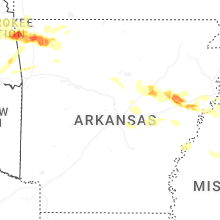

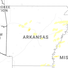


Connect with Interactive Hail Maps