

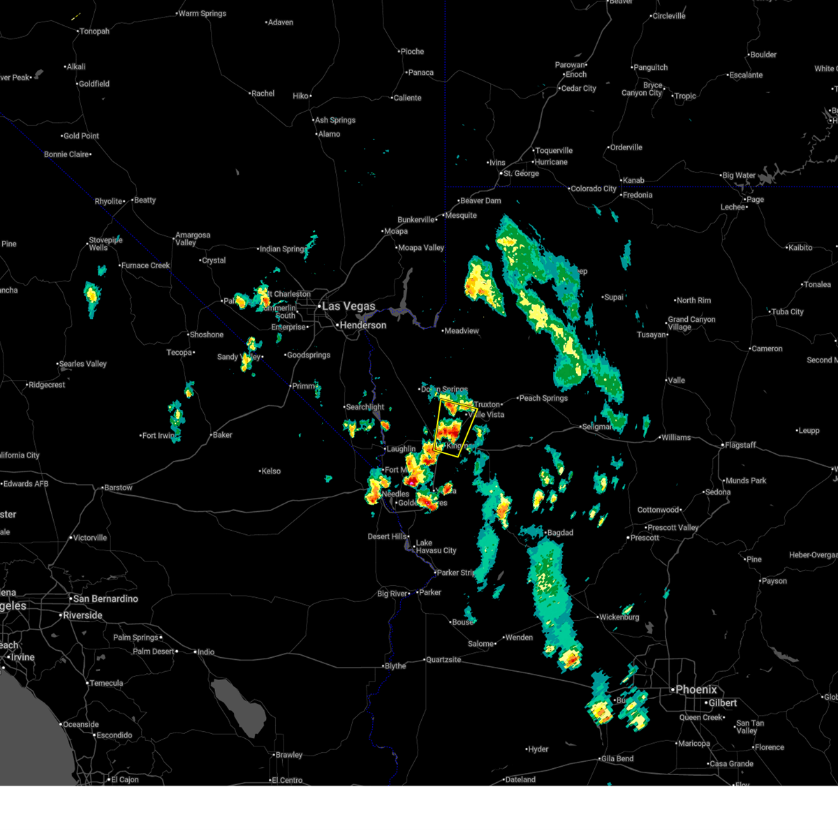
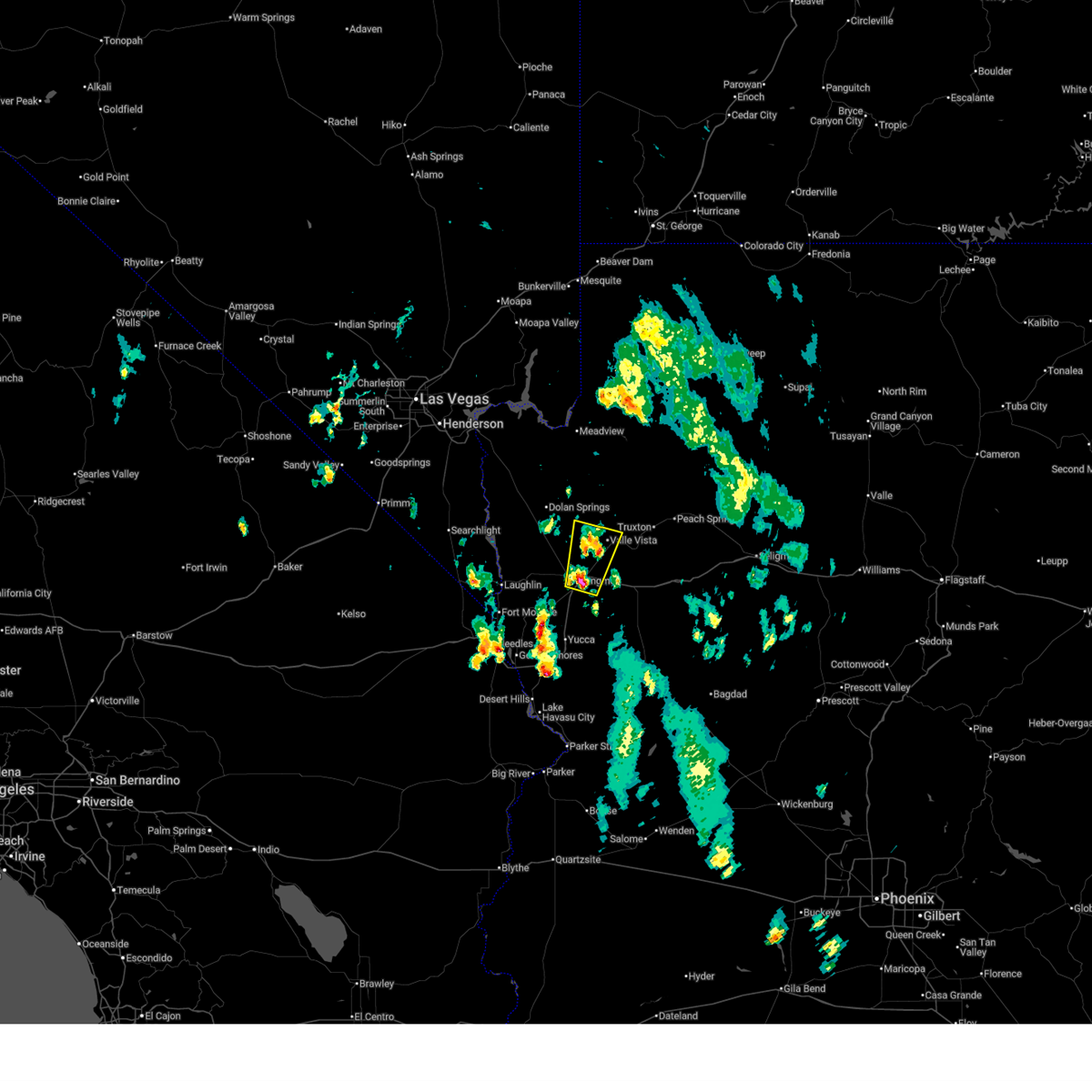
Hail Map for Kingman, AZ
The Kingman, AZ area has had 4 reports of on-the-ground hail by trained spotters, and has been under severe weather warnings 5 times during the past 12 months. Doppler radar has detected hail at or near Kingman, AZ on 35 occasions.
| Name: | Kingman, AZ |
| Where Located: | 55.2 miles NNE of Lake Havasu City, AZ |
| Map: | Google Map for Kingman, AZ |
| Population: | 28068 |
| Housing Units: | 12724 |
| More Info: | Search Google for Kingman, AZ |
0
The Top Recent Hail Date for Kingman, AZ is Monday, July 15, 2024 (23rd out of 35)

Hail and Wind Damage Spotted near Kingman, AZ
| Date / Time | Report Details |
|---|---|
| 7/2/2025 7:40 PM MST |
 the severe thunderstorm warning has been cancelled and is no longer in effect the severe thunderstorm warning has been cancelled and is no longer in effect
|
| 7/2/2025 7:22 PM MST |
 Svrvef the national weather service in las vegas has issued a * severe thunderstorm warning for, central mohave county in northwestern arizona, * until 800 pm mst. * at 722 pm mst, a severe thunderstorm was located over kingman, moving north at 20 mph (radar indicated). Hazards include 60 mph wind gusts and quarter size hail. Hail damage to vehicles is expected. Expect wind damage to roofs and trees. Svrvef the national weather service in las vegas has issued a * severe thunderstorm warning for, central mohave county in northwestern arizona, * until 800 pm mst. * at 722 pm mst, a severe thunderstorm was located over kingman, moving north at 20 mph (radar indicated). Hazards include 60 mph wind gusts and quarter size hail. Hail damage to vehicles is expected. Expect wind damage to roofs and trees.
|
| 9/8/2024 6:44 PM MST | Kingman airport asos measured a peak gust of 61 mph from 1844 to 1851 from a nearby thunderstor in mohave county AZ, 5.4 miles WSW of Kingman, AZ |
| 7/22/2024 7:09 PM MST | Kingman airport gusted to 59 mph at 1909 and again at 1912 due to a nearby thunderstor in mohave county AZ, 5.4 miles WSW of Kingman, AZ |
| 7/22/2024 6:27 PM MST |
 The storm which prompted the warning has weakened, and no longer poses an immediate threat to life or property. therefore, the warning will be allowed to expire. The storm which prompted the warning has weakened, and no longer poses an immediate threat to life or property. therefore, the warning will be allowed to expire.
|
| 7/22/2024 6:08 PM MST |
 At 607 pm mst, a severe thunderstorm was located near kingman, moving southwest at 5 mph (radar indicated). Hazards include 60 mph wind gusts. Expect damage to roofs and trees. locations impacted include, kingman, hualapai mountain park, new kingman-butler, and hualapai peak. this includes the following roads, interstate 40 in arizona between mile markers 34 and 56. highway 93 in mohave county near mile marker 70. Hualapai mountain road between mile markers 1 and 12. At 607 pm mst, a severe thunderstorm was located near kingman, moving southwest at 5 mph (radar indicated). Hazards include 60 mph wind gusts. Expect damage to roofs and trees. locations impacted include, kingman, hualapai mountain park, new kingman-butler, and hualapai peak. this includes the following roads, interstate 40 in arizona between mile markers 34 and 56. highway 93 in mohave county near mile marker 70. Hualapai mountain road between mile markers 1 and 12.
|
| 7/22/2024 5:43 PM MST |
 Svrvef the national weather service in las vegas has issued a * severe thunderstorm warning for, west central mohave county in northwestern arizona, * until 630 pm mst. * at 542 pm mst, a severe thunderstorm was located near kingman, moving southwest at 5 mph (radar indicated). Hazards include 60 mph wind gusts. expect damage to roofs and trees Svrvef the national weather service in las vegas has issued a * severe thunderstorm warning for, west central mohave county in northwestern arizona, * until 630 pm mst. * at 542 pm mst, a severe thunderstorm was located near kingman, moving southwest at 5 mph (radar indicated). Hazards include 60 mph wind gusts. expect damage to roofs and trees
|
| 7/12/2024 5:57 PM MST |
 The storm near kingman which prompted the warning has weakened, and no longer poses an immediate threat to life or property. therefore, the warning will be allowed to expire. The storm near kingman which prompted the warning has weakened, and no longer poses an immediate threat to life or property. therefore, the warning will be allowed to expire.
|
| 7/12/2024 5:48 PM MST |
 At 545 pm mst, a severe thunderstorm was located near new kingman-butler, or near kingman, moving northwest at 10 mph (radar indicated). Hazards include 60 mph wind gusts. Expect damage to roofs and trees. locations impacted include, kingman, new kingman-butler, hualapai mountain park, and golden valley. this includes the following roads, interstate 40 in arizona between mile markers 39 and 66. highway 93 in mohave county between mile markers 64 and 70. Stockton hill road between mile markers 1 and 16. At 545 pm mst, a severe thunderstorm was located near new kingman-butler, or near kingman, moving northwest at 10 mph (radar indicated). Hazards include 60 mph wind gusts. Expect damage to roofs and trees. locations impacted include, kingman, new kingman-butler, hualapai mountain park, and golden valley. this includes the following roads, interstate 40 in arizona between mile markers 39 and 66. highway 93 in mohave county between mile markers 64 and 70. Stockton hill road between mile markers 1 and 16.
|
| 7/12/2024 5:19 PM MST |
 Svrvef the national weather service in las vegas has issued a * severe thunderstorm warning for, central mohave county in northwestern arizona, * until 600 pm mst. * at 517 pm mst, a severe thunderstorm was located near kingman, moving west at 10 mph (radar indicated). Hazards include 60 mph wind gusts. expect damage to roofs and trees Svrvef the national weather service in las vegas has issued a * severe thunderstorm warning for, central mohave county in northwestern arizona, * until 600 pm mst. * at 517 pm mst, a severe thunderstorm was located near kingman, moving west at 10 mph (radar indicated). Hazards include 60 mph wind gusts. expect damage to roofs and trees
|
| 7/11/2024 6:58 PM MST |
 The storm which prompted the warning has weakened, and no longer poses an immediate threat to life or property. therefore, the warning will be allowed to expire. however, gusty winds up to 45 mph are still possible across parts of southwest kingman and golden valley before they diminish. The storm which prompted the warning has weakened, and no longer poses an immediate threat to life or property. therefore, the warning will be allowed to expire. however, gusty winds up to 45 mph are still possible across parts of southwest kingman and golden valley before they diminish.
|
| 7/11/2024 6:49 PM MST |
 At 647 pm mst, a severe thunderstorm was located east of kingman and was dissipating. a gust of 77 mph was observed at kingman airport at 626 pm and these winds will continue pushing toward the southwest (radar indicated). Hazards include 70 mph wind gusts. Expect considerable tree damage. damage is likely to mobile homes, roofs, and outbuildings. locations impacted include, kingman, new kingman-butler, and golden valley. this includes the following roads, interstate 40 in arizona between mile markers 32 and 64. Highway 93 in mohave county between mile markers 60 and 70. At 647 pm mst, a severe thunderstorm was located east of kingman and was dissipating. a gust of 77 mph was observed at kingman airport at 626 pm and these winds will continue pushing toward the southwest (radar indicated). Hazards include 70 mph wind gusts. Expect considerable tree damage. damage is likely to mobile homes, roofs, and outbuildings. locations impacted include, kingman, new kingman-butler, and golden valley. this includes the following roads, interstate 40 in arizona between mile markers 32 and 64. Highway 93 in mohave county between mile markers 60 and 70.
|
| 7/11/2024 6:36 PM MST |
 Svrvef the national weather service in las vegas has issued a * severe thunderstorm warning for, west central mohave county in northwestern arizona, * until 700 pm mst. * at 634 pm mst, a severe thunderstorm was located near kingman, moving southwest at 10 mph (radar indicated). Hazards include 70 mph wind gusts. Expect considerable tree damage. Damage is likely to mobile homes, roofs, and outbuildings. Svrvef the national weather service in las vegas has issued a * severe thunderstorm warning for, west central mohave county in northwestern arizona, * until 700 pm mst. * at 634 pm mst, a severe thunderstorm was located near kingman, moving southwest at 10 mph (radar indicated). Hazards include 70 mph wind gusts. Expect considerable tree damage. Damage is likely to mobile homes, roofs, and outbuildings.
|
| 7/11/2024 6:23 PM MST | A peak wind gust of 77 mph was measured by the kingman airport asos. radar and lightning data indicated a thunderstorm close to the airport at the tim in mohave county AZ, 4.9 miles WSW of Kingman, AZ |
| 9/1/2023 2:09 AM MST |
 The severe thunderstorm warning for west central mohave county will expire at 215 am mst, the storm which prompted the warning has weakened below severe limits, and no longer poses an immediate threat to life or property. therefore, the warning will be allowed to expire. however gusty winds are still possible with this thunderstorm. The severe thunderstorm warning for west central mohave county will expire at 215 am mst, the storm which prompted the warning has weakened below severe limits, and no longer poses an immediate threat to life or property. therefore, the warning will be allowed to expire. however gusty winds are still possible with this thunderstorm.
|
| 9/1/2023 1:53 AM MST |
 At 153 am mst, a severe thunderstorm was located near new kingman-butler, or 8 miles north of kingman, moving north at 20 mph (radar indicated). Hazards include 60 mph wind gusts. Expect damage to roofs and trees. locations impacted include, kingman, windy point campground, dw ranch road, packsaddle campground, chloride, new kingman-butler, blake ranch road, golden valley and dolan springs. this includes the following roads, interstate 40 in arizona between mile markers 39 and 68. highway 93 in mohave county between mile markers 41 and 70. state route 68 in mohave county between mile markers 13 and 28. hail threat, radar indicated max hail size, <. 75 in wind threat, radar indicated max wind gust, 60 mph. At 153 am mst, a severe thunderstorm was located near new kingman-butler, or 8 miles north of kingman, moving north at 20 mph (radar indicated). Hazards include 60 mph wind gusts. Expect damage to roofs and trees. locations impacted include, kingman, windy point campground, dw ranch road, packsaddle campground, chloride, new kingman-butler, blake ranch road, golden valley and dolan springs. this includes the following roads, interstate 40 in arizona between mile markers 39 and 68. highway 93 in mohave county between mile markers 41 and 70. state route 68 in mohave county between mile markers 13 and 28. hail threat, radar indicated max hail size, <. 75 in wind threat, radar indicated max wind gust, 60 mph.
|
| 9/1/2023 1:18 AM MST |
 At 118 am mst, a severe thunderstorm was located over new kingman-butler, or near kingman, moving north at 20 mph (radar indicated). Hazards include 60 mph wind gusts. expect damage to roofs and trees At 118 am mst, a severe thunderstorm was located over new kingman-butler, or near kingman, moving north at 20 mph (radar indicated). Hazards include 60 mph wind gusts. expect damage to roofs and trees
|
| 9/1/2023 1:11 AM MST | Winds of 58 mph or more lasted from 0109-0122 ms in mohave county AZ, 5.4 miles WSW of Kingman, AZ |
| 8/18/2023 6:03 PM MST | Trained spotter reports thunderstorm wind damage. a 16 foot by 8 foot aluminum canopy was flipped up and on top of the building... completely destroying the canopy. spo in mohave county AZ, 2.1 miles SE of Kingman, AZ |
| 8/2/2023 11:24 AM MST |
 At 1122 am mst, a severe thunderstorm was located near chloride, or 14 miles northwest of kingman, moving southeast at 25 mph (radar indicated). Hazards include 60 mph wind gusts and quarter size hail. Hail damage to vehicles is expected. expect wind damage to roofs and trees. Strong winds along highway 93 moving southeast toward golden valley and kingman. At 1122 am mst, a severe thunderstorm was located near chloride, or 14 miles northwest of kingman, moving southeast at 25 mph (radar indicated). Hazards include 60 mph wind gusts and quarter size hail. Hail damage to vehicles is expected. expect wind damage to roofs and trees. Strong winds along highway 93 moving southeast toward golden valley and kingman.
|
| 10/3/2022 12:55 PM MST |
 The severe thunderstorm warning for central mohave county will expire at 100 pm mst, the storm which prompted the warning near kingman has weakened below severe limits, and no longer poses an immediate threat to life or property. therefore, the warning will be allowed to expire. The severe thunderstorm warning for central mohave county will expire at 100 pm mst, the storm which prompted the warning near kingman has weakened below severe limits, and no longer poses an immediate threat to life or property. therefore, the warning will be allowed to expire.
|
| 10/3/2022 12:38 PM MST |
 At 1237 pm mst, a severe thunderstorm was located near kingman, moving southeast at 10 mph (radar indicated). Hazards include 60 mph wind gusts and quarter size hail. Hail damage to vehicles is expected. expect wind damage to roofs and trees. locations impacted include, kingman, wild cow campground, dw ranch road, new kingman-butler, blake ranch road, hualapai mountain park and hualapai peak. this includes interstate 40 in arizona between mile markers 43 and 78. hail threat, radar indicated max hail size, 1. 00 in wind threat, radar indicated max wind gust, 60 mph. At 1237 pm mst, a severe thunderstorm was located near kingman, moving southeast at 10 mph (radar indicated). Hazards include 60 mph wind gusts and quarter size hail. Hail damage to vehicles is expected. expect wind damage to roofs and trees. locations impacted include, kingman, wild cow campground, dw ranch road, new kingman-butler, blake ranch road, hualapai mountain park and hualapai peak. this includes interstate 40 in arizona between mile markers 43 and 78. hail threat, radar indicated max hail size, 1. 00 in wind threat, radar indicated max wind gust, 60 mph.
|
| 10/3/2022 12:16 PM MST |
 At 1216 pm mst, a severe thunderstorm was located over kingman, moving southeast at 15 mph (radar indicated). Hazards include 60 mph wind gusts and quarter size hail. Hail damage to vehicles is expected. Expect wind damage to roofs and trees. At 1216 pm mst, a severe thunderstorm was located over kingman, moving southeast at 15 mph (radar indicated). Hazards include 60 mph wind gusts and quarter size hail. Hail damage to vehicles is expected. Expect wind damage to roofs and trees.
|
| 9/8/2022 8:42 PM MST |
 The severe thunderstorm warning for west central mohave county will expire at 845 pm mst, the storm which prompted the warning has weakened below severe limits, and no longer poses an immediate threat to life or property. therefore, the warning will be allowed to expire. The severe thunderstorm warning for west central mohave county will expire at 845 pm mst, the storm which prompted the warning has weakened below severe limits, and no longer poses an immediate threat to life or property. therefore, the warning will be allowed to expire.
|
| 9/8/2022 7:50 PM MST |
 At 747 pm mst, a severe thunderstorm was located 15 miles northwest of dolan springs, or 25 miles southeast of boulder city, moving west at 35 mph (radar indicated). Hazards include 60 mph wind gusts across west-central mohave county... 45 mph wind gusts at lake mead recreation area. Expect damage to roofs and trees. locations impacted include, katherine landing, windy point campground, pierce ferry and antares roads, meadview, hoover dam, packsaddle campground, chloride, new kingman-butler, lake mead national recreation area, temple bar campground, dolan springs, south cove, golden valley and temple bar. hail threat, radar indicated max hail size, <. 75 in wind threat, radar indicated max wind gust, 60 mph. At 747 pm mst, a severe thunderstorm was located 15 miles northwest of dolan springs, or 25 miles southeast of boulder city, moving west at 35 mph (radar indicated). Hazards include 60 mph wind gusts across west-central mohave county... 45 mph wind gusts at lake mead recreation area. Expect damage to roofs and trees. locations impacted include, katherine landing, windy point campground, pierce ferry and antares roads, meadview, hoover dam, packsaddle campground, chloride, new kingman-butler, lake mead national recreation area, temple bar campground, dolan springs, south cove, golden valley and temple bar. hail threat, radar indicated max hail size, <. 75 in wind threat, radar indicated max wind gust, 60 mph.
|
| 9/8/2022 7:32 PM MST |
 At 731 pm mst, a severe thunderstorm was located 8 miles northwest of dolan springs, or 32 miles southeast of boulder city, moving west at 35 mph (radar indicated). Hazards include 60 mph wind gusts. expect damage to roofs and trees At 731 pm mst, a severe thunderstorm was located 8 miles northwest of dolan springs, or 32 miles southeast of boulder city, moving west at 35 mph (radar indicated). Hazards include 60 mph wind gusts. expect damage to roofs and trees
|
| 9/4/2022 6:22 PM MST |
 The severe thunderstorm warning for west central mohave county will expire at 630 pm mst, the storm near dolan springs has weakened and no longer poses an immediate threat to life or property. therefore, the warning will be allowed to expire. The severe thunderstorm warning for west central mohave county will expire at 630 pm mst, the storm near dolan springs has weakened and no longer poses an immediate threat to life or property. therefore, the warning will be allowed to expire.
|
| 9/4/2022 6:05 PM MST |
 At 604 pm mst, severe thunderstorms were located along a line extending from 6 miles southeast of dolan springs to 8 miles east of katherine landing, moving west at 20 mph (radar indicated). Hazards include 60 mph wind gusts and quarter size hail. Hail damage to vehicles is expected. expect wind damage to roofs and trees. locations impacted include, bullhead city, katherine landing, windy point campground, packsaddle campground, chloride, dolan springs, golden valley and new kingman-butler. hail threat, radar indicated max hail size, 1. 00 in wind threat, radar indicated max wind gust, 60 mph. At 604 pm mst, severe thunderstorms were located along a line extending from 6 miles southeast of dolan springs to 8 miles east of katherine landing, moving west at 20 mph (radar indicated). Hazards include 60 mph wind gusts and quarter size hail. Hail damage to vehicles is expected. expect wind damage to roofs and trees. locations impacted include, bullhead city, katherine landing, windy point campground, packsaddle campground, chloride, dolan springs, golden valley and new kingman-butler. hail threat, radar indicated max hail size, 1. 00 in wind threat, radar indicated max wind gust, 60 mph.
|
| 9/4/2022 5:41 PM MST |
 At 540 pm mst, severe thunderstorms were located along a line extending from 9 miles northeast of packsaddle campground to near golden valley, moving west at 30 mph (radar indicated). Hazards include 60 mph wind gusts and quarter size hail. Hail damage to vehicles is expected. Expect wind damage to roofs and trees. At 540 pm mst, severe thunderstorms were located along a line extending from 9 miles northeast of packsaddle campground to near golden valley, moving west at 30 mph (radar indicated). Hazards include 60 mph wind gusts and quarter size hail. Hail damage to vehicles is expected. Expect wind damage to roofs and trees.
|
| 9/4/2022 5:21 PM MST |
 At 520 pm mst, a severe thunderstorm was located over new kingman- butler, or near kingman, moving west at 35 mph. at 506 pm mst, winds gusted to 60 mph at the kingman airport (radar indicated). Hazards include 60 mph wind gusts and quarter size hail. Hail damage to vehicles is expected. expect wind damage to roofs and trees. locations impacted include, kingman, new kingman-butler and golden valley. this includes interstate 40 in arizona between mile markers 44 and 59. hail threat, radar indicated max hail size, 1. 00 in wind threat, radar indicated max wind gust, 60 mph. At 520 pm mst, a severe thunderstorm was located over new kingman- butler, or near kingman, moving west at 35 mph. at 506 pm mst, winds gusted to 60 mph at the kingman airport (radar indicated). Hazards include 60 mph wind gusts and quarter size hail. Hail damage to vehicles is expected. expect wind damage to roofs and trees. locations impacted include, kingman, new kingman-butler and golden valley. this includes interstate 40 in arizona between mile markers 44 and 59. hail threat, radar indicated max hail size, 1. 00 in wind threat, radar indicated max wind gust, 60 mph.
|
| 9/4/2022 5:19 PM MST | A gust to 75 mph was recorded at kingman airport at 519 pm mst. gusts initially reached 60 mph at 507 pm then dropped below 58 mph by 525 p in mohave county AZ, 5.4 miles WSW of Kingman, AZ |
| 9/4/2022 5:01 PM MST |
 At 501 pm mst, a severe thunderstorm was located 10 miles north of blake ranch road, or 12 miles northeast of kingman, moving west at 35 mph (radar indicated). Hazards include 60 mph wind gusts and quarter size hail. Hail damage to vehicles is expected. Expect wind damage to roofs and trees. At 501 pm mst, a severe thunderstorm was located 10 miles north of blake ranch road, or 12 miles northeast of kingman, moving west at 35 mph (radar indicated). Hazards include 60 mph wind gusts and quarter size hail. Hail damage to vehicles is expected. Expect wind damage to roofs and trees.
|
| 9/2/2022 4:25 PM MST |
 The severe thunderstorm warning for central mohave county will expire at 430 pm mst, this warning has been replaced by a new warning for golden valley until 500 pm mst. a severe thunderstorm watch remains in effect until 1100 pm mst for northwestern arizona. The severe thunderstorm warning for central mohave county will expire at 430 pm mst, this warning has been replaced by a new warning for golden valley until 500 pm mst. a severe thunderstorm watch remains in effect until 1100 pm mst for northwestern arizona.
|
| 9/2/2022 4:20 PM MST | Report of power outages and power poles down due to thunderstorm related wind gusts in new kingman-butle in mohave county AZ, 4 miles SW of Kingman, AZ |
| 9/2/2022 3:56 PM MST |
 At 356 pm mst, a severe thunderstorm was located over new kingman-butler, or near kingman, moving southwest at 10 mph (radar indicated). Hazards include 60 mph wind gusts and quarter size hail. Hail damage to vehicles is expected. expect wind damage to roofs and trees. locations impacted include, kingman, new kingman-butler and golden valley. this includes interstate 40 in arizona between mile markers 39 and 59. hail threat, radar indicated max hail size, 1. 00 in wind threat, radar indicated max wind gust, 60 mph. At 356 pm mst, a severe thunderstorm was located over new kingman-butler, or near kingman, moving southwest at 10 mph (radar indicated). Hazards include 60 mph wind gusts and quarter size hail. Hail damage to vehicles is expected. expect wind damage to roofs and trees. locations impacted include, kingman, new kingman-butler and golden valley. this includes interstate 40 in arizona between mile markers 39 and 59. hail threat, radar indicated max hail size, 1. 00 in wind threat, radar indicated max wind gust, 60 mph.
|
| 9/2/2022 3:41 PM MST |
 At 341 pm mst, a severe thunderstorm was located over new kingman-butler, or near kingman, moving southwest at 15 mph (radar indicated). Hazards include 60 mph wind gusts and quarter size hail. Hail damage to vehicles is expected. Expect wind damage to roofs and trees. At 341 pm mst, a severe thunderstorm was located over new kingman-butler, or near kingman, moving southwest at 15 mph (radar indicated). Hazards include 60 mph wind gusts and quarter size hail. Hail damage to vehicles is expected. Expect wind damage to roofs and trees.
|
| 8/21/2022 9:39 PM MST | At 939 pm mst, a severe thunderstorm was located 7 miles south of kingman, moving south at 25 mph. numerous reports of dime sized hail have been recieved near golden valley and kingman, with hail of quarter sized or larger possible (radar indicated). Hazards include 60 mph wind gusts and quarter size hail. Hail damage to vehicles is expected. expect wind damage to roofs and trees. locations impacted include, bullhead city, kingman, laughlin, yucca, katherine landing, wild cow campground, oatman, blake ranch road, golden valley, mesquite creek, dw ranch road, new kingman-butler, hualapai mountain park, mohave valley and hualapai peak. this includes interstate 40 in arizona between mile markers 15 and 74. hail threat, radar indicated max hail size, 1. 00 in wind threat, radar indicated max wind gust, 60 mph. |
| 8/21/2022 9:10 PM MST | At 909 pm mst, a severe thunderstorm was located near new kingman-butler, or near kingman, moving south at 25 mph (radar indicated). Hazards include 60 mph wind gusts and quarter size hail. Hail damage to vehicles is expected. Expect wind damage to roofs and trees. |
| 8/21/2022 8:33 PM MST | At 831 pm mst, severe thunderstorms were located along a line extending from dolan springs to near diamond m ranch, moving south at 30 mph. strong winds and hail will be approaching kingman by 9pm (radar indicated). Hazards include 60 mph wind gusts and quarter size hail. Hail damage to vehicles is expected. expect wind damage to roofs and trees. locations impacted include, kingman, katherine landing, windy point campground, wild cow campground, diamond m ranch, blake ranch road, golden valley, dw ranch road, packsaddle campground, chloride, new kingman-butler, valentine, dolan springs, hualapai mountain park, hualapai peak and peach springs. this includes interstate 40 in arizona between mile markers 40 and 93. hail threat, radar indicated max hail size, 1. 00 in wind threat, radar indicated max wind gust, 60 mph. |
| 8/21/2022 7:54 PM MST | At 754 pm mst, severe thunderstorms were located along a line extending from 12 miles southeast of boulder city to 13 miles south of diamond creek campground, moving south at 25 mph. this storm will impact dolan springs imminently and kingman by 9 pm (radar indicated). Hazards include 60 mph wind gusts and quarter size hail. Hail damage to vehicles is expected. Expect wind damage to roofs and trees. |
| 8/17/2022 6:07 PM MST |
 The severe thunderstorm warning for southwestern mohave, east central san bernardino and south central clark counties will expire at 615 pm pdt/615 pm mst/, the storm which prompted the warning has weakened below severe limits, and no longer poses an immediate threat to life or property. therefore, the warning will be allowed to expire. however gusty winds are still possible with this thunderstorm. The severe thunderstorm warning for southwestern mohave, east central san bernardino and south central clark counties will expire at 615 pm pdt/615 pm mst/, the storm which prompted the warning has weakened below severe limits, and no longer poses an immediate threat to life or property. therefore, the warning will be allowed to expire. however gusty winds are still possible with this thunderstorm.
|
| 8/17/2022 5:45 PM MST |
 At 543 pm pdt/543 pm mst/, a severe thunderstorm was located near kingman, moving east at 25 mph (radar indicated). Hazards include 60 mph wind gusts. Expect damage to roofs and trees. wind gusts over 60 mph have been reported at needles. locations impacted include, bullhead city, kingman, laughlin, topock, yucca, katherine landing, needles, wild cow campground, oatman, mojave ranch estates, mohave valley, big bend rec area, golden valley, highway 95 and i-40, mesquite creek, dw ranch road, new kingman-butler, arizona village, hualapai mountain park and willow valley. this includes the following highways, interstate 40 in arizona between mile markers 0 and 8, and between mile markers 18 and 63. interstate 40 in california between mile markers 131 and 155. hail threat, radar indicated max hail size, <. 75 in wind threat, radar indicated max wind gust, 60 mph. At 543 pm pdt/543 pm mst/, a severe thunderstorm was located near kingman, moving east at 25 mph (radar indicated). Hazards include 60 mph wind gusts. Expect damage to roofs and trees. wind gusts over 60 mph have been reported at needles. locations impacted include, bullhead city, kingman, laughlin, topock, yucca, katherine landing, needles, wild cow campground, oatman, mojave ranch estates, mohave valley, big bend rec area, golden valley, highway 95 and i-40, mesquite creek, dw ranch road, new kingman-butler, arizona village, hualapai mountain park and willow valley. this includes the following highways, interstate 40 in arizona between mile markers 0 and 8, and between mile markers 18 and 63. interstate 40 in california between mile markers 131 and 155. hail threat, radar indicated max hail size, <. 75 in wind threat, radar indicated max wind gust, 60 mph.
|
| 8/17/2022 5:11 PM MST |
 At 510 pm pdt/510 pm mst/, a severe thunderstorm was located 7 miles north of oatman, or 11 miles east of bullhead city, moving east at 25 mph (radar indicated). Hazards include 60 mph wind gusts. expect damage to roofs and trees At 510 pm pdt/510 pm mst/, a severe thunderstorm was located 7 miles north of oatman, or 11 miles east of bullhead city, moving east at 25 mph (radar indicated). Hazards include 60 mph wind gusts. expect damage to roofs and trees
|
| 8/13/2022 4:10 PM MST | Spotter reported numerous trees down and one tree split as a result of thunderstorm related wind gusts in kingman on andy devine by interstate 4 in mohave county AZ, 1.2 miles NNW of Kingman, AZ |
| 8/11/2022 4:39 PM MST |
 The severe thunderstorm warning for central mohave county will expire at 445 pm mst, the storm over kingman has weakened slightly, and no longer poses an immediate threat to life or property. therefore, the warning will be allowed to expire. however, heavy rain is still falling from this thunderstorm and a flash flood warning remains in effect until 715 pm mst. The severe thunderstorm warning for central mohave county will expire at 445 pm mst, the storm over kingman has weakened slightly, and no longer poses an immediate threat to life or property. therefore, the warning will be allowed to expire. however, heavy rain is still falling from this thunderstorm and a flash flood warning remains in effect until 715 pm mst.
|
| 8/11/2022 4:26 PM MST |
 At 425 pm mst, a severe thunderstorm was located over kingman, moving south at 15 mph. the kingman airport reported wind gusts to 41 mph at 419 pm pst (radar indicated). Hazards include 60 mph wind gusts and quarter size hail. Hail damage to vehicles is expected. expect wind damage to roofs and trees. locations impacted include, kingman, wild cow campground, new kingman-butler, hualapai mountain park and hualapai peak. this includes interstate 40 in arizona between mile markers 38 and 61. hail threat, radar indicated max hail size, 1. 00 in wind threat, radar indicated max wind gust, 60 mph. At 425 pm mst, a severe thunderstorm was located over kingman, moving south at 15 mph. the kingman airport reported wind gusts to 41 mph at 419 pm pst (radar indicated). Hazards include 60 mph wind gusts and quarter size hail. Hail damage to vehicles is expected. expect wind damage to roofs and trees. locations impacted include, kingman, wild cow campground, new kingman-butler, hualapai mountain park and hualapai peak. this includes interstate 40 in arizona between mile markers 38 and 61. hail threat, radar indicated max hail size, 1. 00 in wind threat, radar indicated max wind gust, 60 mph.
|
| 8/11/2022 4:10 PM MST |
 At 410 pm mst, a severe thunderstorm was located over kingman, moving south at 10 mph (radar indicated). Hazards include 60 mph wind gusts and quarter size hail. Hail damage to vehicles is expected. Expect wind damage to roofs and trees. At 410 pm mst, a severe thunderstorm was located over kingman, moving south at 10 mph (radar indicated). Hazards include 60 mph wind gusts and quarter size hail. Hail damage to vehicles is expected. Expect wind damage to roofs and trees.
|
| 8/3/2022 4:07 PM MST |
 The severe thunderstorm warning for central mohave county will expire at 415 pm mst, the storm which prompted the warning has weakened below severe limits, and no longer poses an immediate threat to life or property. therefore, the warning will be allowed to expire. The severe thunderstorm warning for central mohave county will expire at 415 pm mst, the storm which prompted the warning has weakened below severe limits, and no longer poses an immediate threat to life or property. therefore, the warning will be allowed to expire.
|
| 8/3/2022 3:28 PM MST |
 At 327 pm mst, a severe thunderstorm was located over blake ranch road, or 11 miles east of kingman, moving west at 10 mph (radar indicated). Hazards include 60 mph wind gusts and quarter size hail. Hail damage to vehicles is expected. Expect wind damage to roofs and trees. At 327 pm mst, a severe thunderstorm was located over blake ranch road, or 11 miles east of kingman, moving west at 10 mph (radar indicated). Hazards include 60 mph wind gusts and quarter size hail. Hail damage to vehicles is expected. Expect wind damage to roofs and trees.
|
| 7/28/2022 3:30 PM MST | Emergency management reports power outage affecting 3000 customers in kingman due to wind damage at the blake ranch power station. time estimated by rada in mohave county AZ, 13.7 miles WNW of Kingman, AZ |
| 10/5/2021 11:01 AM MST |
 At 1101 am mst, severe thunderstorms were located along a line extending from near diamond m ranch to 11 miles west of chloride, moving northeast at 30 mph. at 1051 am, 68 mph wind gusts were recorded at kingman airport (radar indicated). Hazards include 70 mph wind gusts. Expect considerable tree damage. damage is likely to mobile homes, roofs, and outbuildings. locations impacted include, kingman, windy point campground, grand canyon skywalk, diamond creek campground, pierce ferry and antares roads, diamond m ranch, blake ranch road, golden valley, dw ranch road, packsaddle campground, chloride, grand canyon ranch, new kingman-butler, valentine, dolan springs, lake mead national recreation area and peach springs. this includes interstate 40 in arizona between mile markers 45 and 93. thunderstorm damage threat, considerable hail threat, radar indicated max hail size, <. 75 in wind threat, radar indicated max wind gust, 70 mph. At 1101 am mst, severe thunderstorms were located along a line extending from near diamond m ranch to 11 miles west of chloride, moving northeast at 30 mph. at 1051 am, 68 mph wind gusts were recorded at kingman airport (radar indicated). Hazards include 70 mph wind gusts. Expect considerable tree damage. damage is likely to mobile homes, roofs, and outbuildings. locations impacted include, kingman, windy point campground, grand canyon skywalk, diamond creek campground, pierce ferry and antares roads, diamond m ranch, blake ranch road, golden valley, dw ranch road, packsaddle campground, chloride, grand canyon ranch, new kingman-butler, valentine, dolan springs, lake mead national recreation area and peach springs. this includes interstate 40 in arizona between mile markers 45 and 93. thunderstorm damage threat, considerable hail threat, radar indicated max hail size, <. 75 in wind threat, radar indicated max wind gust, 70 mph.
|
| 10/5/2021 10:55 AM MST |
 At 1054 am mst, severe thunderstorms were located along a line extending from near diamond m ranch to 12 miles northeast of katherine landing, moving northeast at 30 mph. strong winds exceeding 50 mph have been reported near kingman (radar indicated). Hazards include 60 mph wind gusts. expect damage to roofs and trees At 1054 am mst, severe thunderstorms were located along a line extending from near diamond m ranch to 12 miles northeast of katherine landing, moving northeast at 30 mph. strong winds exceeding 50 mph have been reported near kingman (radar indicated). Hazards include 60 mph wind gusts. expect damage to roofs and trees
|
| 10/5/2021 10:50 AM MST | Trees and powerlines down across the city of kingman as reported by emergency manager. time estimated from rada in mohave county AZ, 3.2 miles NE of Kingman, AZ |
| 10/5/2021 10:48 AM MST | Kingman asos (kigm) reported thunderstorm wind gusts to 68 mph between 10:48 and 10:51 a in mohave county AZ, 4.9 miles WSW of Kingman, AZ |
| 10/5/2021 10:48 AM MST | Winds in excess of 58 mph began at kingman airport at 1048 and continue to gust above severe thresholds. peak wind gust 68 mp in mohave county AZ, 5.4 miles WSW of Kingman, AZ |
| 7/25/2021 5:39 PM MST |
 At 537 pm mst, severe thunderstorms were located along a line extending from near dolan springs to 10 miles southeast of golden valley, moving west at 25 mph. several observations have measured wind gusts over 60 mph as well as a wall of dust (radar indicated and surface observations). Hazards include 70 mph wind gusts. Expect considerable tree damage. damage is likely to mobile homes, roofs, and outbuildings. locations impacted include, bullhead city, kingman, laughlin, katherine landing, windy point campground, oatman, golden valley, mesquite creek, dw ranch road, packsaddle campground, chloride, new kingman-butler, dolan springs, and willow valley. This includes interstate 40 in arizona between mile markers 36 and 71. At 537 pm mst, severe thunderstorms were located along a line extending from near dolan springs to 10 miles southeast of golden valley, moving west at 25 mph. several observations have measured wind gusts over 60 mph as well as a wall of dust (radar indicated and surface observations). Hazards include 70 mph wind gusts. Expect considerable tree damage. damage is likely to mobile homes, roofs, and outbuildings. locations impacted include, bullhead city, kingman, laughlin, katherine landing, windy point campground, oatman, golden valley, mesquite creek, dw ranch road, packsaddle campground, chloride, new kingman-butler, dolan springs, and willow valley. This includes interstate 40 in arizona between mile markers 36 and 71.
|
| 7/25/2021 5:23 PM MST | Kingman airport asos reported a gust of 66 mph at 1723. gusts above 58 mph began at 1657 and ended at 173 in mohave county AZ, 5.4 miles WSW of Kingman, AZ |
| 7/25/2021 5:06 PM MST |
 At 505 pm mst, severe thunderstorms were located along a line extending from 18 miles west of diamond creek campground to 13 miles east of blake ranch road, moving west at 30 mph (radar indicated). Hazards include 60 mph wind gusts. expect damage to roofs and trees At 505 pm mst, severe thunderstorms were located along a line extending from 18 miles west of diamond creek campground to 13 miles east of blake ranch road, moving west at 30 mph (radar indicated). Hazards include 60 mph wind gusts. expect damage to roofs and trees
|
| 7/21/2021 5:24 PM MST | Several reports of downed power lines across the new kingman-butler are in mohave county AZ, 2.4 miles SSE of Kingman, AZ |
| 7/13/2021 6:25 AM MST | High winds lasted from approximately 0625 to 0720... and the peak gust occurred at 0645. a spotter also reported a downed tree at the fairgrounds. this is believed to h in mohave county AZ, 5.4 miles WSW of Kingman, AZ |
| 6/17/2021 8:11 PM MST |
 The severe thunderstorm warning for west central mohave county will expire at 815 pm mst, the storm which prompted the warning produced a 70 mph wind gust at the kingman airport, and has since weakened. no other reports of severe wind have been received, but drivers on interstate 40, highway 68, and highway 93 should be prepared for strong winds and blowing dust reducing visibility through 9 pm mst. The severe thunderstorm warning for west central mohave county will expire at 815 pm mst, the storm which prompted the warning produced a 70 mph wind gust at the kingman airport, and has since weakened. no other reports of severe wind have been received, but drivers on interstate 40, highway 68, and highway 93 should be prepared for strong winds and blowing dust reducing visibility through 9 pm mst.
|
| 6/17/2021 7:50 PM MST |
 At 749 pm mst, a severe thunderstorm was located over kingman, moving northwest at 30 mph (radar indicated). Hazards include 70 mph wind gusts. Expect considerable tree damage. Damage is likely to mobile homes, roofs, and outbuildings. At 749 pm mst, a severe thunderstorm was located over kingman, moving northwest at 30 mph (radar indicated). Hazards include 70 mph wind gusts. Expect considerable tree damage. Damage is likely to mobile homes, roofs, and outbuildings.
|
| 6/17/2021 7:36 PM MST | High winds lasted from 736 to 751 p in mohave county AZ, 4.9 miles WSW of Kingman, AZ |
| 8/18/2020 4:57 PM MST |
 The severe thunderstorm warning for west central mohave county will expire at 500 pm mst, the storm which prompted the warning has moved out of the area. therefore, the warning will be allowed to expire. however small hail and gusty winds are still possible with this thunderstorm. The severe thunderstorm warning for west central mohave county will expire at 500 pm mst, the storm which prompted the warning has moved out of the area. therefore, the warning will be allowed to expire. however small hail and gusty winds are still possible with this thunderstorm.
|
| 8/18/2020 4:56 PM MST |
 At 455 pm mst, a line of severe thunderstorms were located along a line extending from near chloride to near kingman to hualapai mountain park, moving southwest at 30 mph (radar indicated). Hazards include 60 mph wind gusts and quarter size hail. Hail damage to vehicles is expected. Expect wind damage to roofs and trees as well as hazardous crosswinds. At 455 pm mst, a line of severe thunderstorms were located along a line extending from near chloride to near kingman to hualapai mountain park, moving southwest at 30 mph (radar indicated). Hazards include 60 mph wind gusts and quarter size hail. Hail damage to vehicles is expected. Expect wind damage to roofs and trees as well as hazardous crosswinds.
|
| 8/18/2020 4:39 PM MST |
 At 438 pm mst, a severe thunderstorm capable of gusty outflow winds was located 10 miles northeast of new kingman-butler, or 13 miles northeast of kingman, moving northeast at 10 mph (radar indicated). Hazards include 60 mph wind gusts and quarter size hail. Hail damage to vehicles is expected. expect wind damage to roofs and trees as well as hazardous crosswinds. locations impacted include, kingman, windy point campground, packsaddle campground, chloride, golden valley and new kingman-butler. This includes interstate 40 in arizona between mile markers 47 and 59. At 438 pm mst, a severe thunderstorm capable of gusty outflow winds was located 10 miles northeast of new kingman-butler, or 13 miles northeast of kingman, moving northeast at 10 mph (radar indicated). Hazards include 60 mph wind gusts and quarter size hail. Hail damage to vehicles is expected. expect wind damage to roofs and trees as well as hazardous crosswinds. locations impacted include, kingman, windy point campground, packsaddle campground, chloride, golden valley and new kingman-butler. This includes interstate 40 in arizona between mile markers 47 and 59.
|
| 8/18/2020 4:10 PM MST |
 At 409 pm mst, a severe thunderstorm was located near new kingman- butler, or 10 miles north of kingman, moving northeast at 10 mph (radar indicated). Hazards include 60 mph wind gusts and quarter size hail. Hail damage to vehicles is expected. Expect wind damage to roofs and trees. At 409 pm mst, a severe thunderstorm was located near new kingman- butler, or 10 miles north of kingman, moving northeast at 10 mph (radar indicated). Hazards include 60 mph wind gusts and quarter size hail. Hail damage to vehicles is expected. Expect wind damage to roofs and trees.
|
| 8/16/2020 4:36 PM MST |
 The severe thunderstorm warning for west central mohave county will expire at 445 pm mst, the storm which prompted the warning has weakened below severe limits, and no longer poses an immediate threat to life or property. therefore, the warning will be allowed to expire. The severe thunderstorm warning for west central mohave county will expire at 445 pm mst, the storm which prompted the warning has weakened below severe limits, and no longer poses an immediate threat to life or property. therefore, the warning will be allowed to expire.
|
| 8/16/2020 4:08 PM MST |
 At 405 pm mst, a severe thunderstorm was located over new kingman- butler, or near kingman, moving southwest at 15 mph has produced gusts to 55 mph and blowing dust (radar indicated). Hazards include 60 mph wind gusts and quarter size hail. Hail damage to vehicles is expected. expect wind damage to roofs and trees. locations impacted include, kingman, golden valley and new kingman-butler. This includes interstate 40 in arizona between mile markers 40 and 59. At 405 pm mst, a severe thunderstorm was located over new kingman- butler, or near kingman, moving southwest at 15 mph has produced gusts to 55 mph and blowing dust (radar indicated). Hazards include 60 mph wind gusts and quarter size hail. Hail damage to vehicles is expected. expect wind damage to roofs and trees. locations impacted include, kingman, golden valley and new kingman-butler. This includes interstate 40 in arizona between mile markers 40 and 59.
|
| 8/16/2020 3:57 PM MST |
 At 356 pm mst, a severe thunderstorm was located near new kingman-butler, or 7 miles northeast of kingman, moving southwest at 15 mph (radar indicated). Hazards include 60 mph wind gusts and quarter size hail. Hail damage to vehicles is expected. Expect wind damage to roofs and trees. At 356 pm mst, a severe thunderstorm was located near new kingman-butler, or 7 miles northeast of kingman, moving southwest at 15 mph (radar indicated). Hazards include 60 mph wind gusts and quarter size hail. Hail damage to vehicles is expected. Expect wind damage to roofs and trees.
|
| 8/8/2019 9:24 PM MST |
 The severe thunderstorm warning for west central mohave county will expire at 930 pm mst, the storm which prompted the warning has weakened below severe limits, and will no longer poses an immediate threat to life or property. therefore, the warning will be allowed to expire. however gusty winds are still possible with this thunderstorm as it continues northeastward towards golden valley. The severe thunderstorm warning for west central mohave county will expire at 930 pm mst, the storm which prompted the warning has weakened below severe limits, and will no longer poses an immediate threat to life or property. therefore, the warning will be allowed to expire. however gusty winds are still possible with this thunderstorm as it continues northeastward towards golden valley.
|
| 8/8/2019 8:52 PM MST |
 At 851 pm mst, a severe thunderstorm was located near oatman, or 14 miles southeast of bullhead city, moving northeast at 30 mph (radar indicated). Hazards include 60 mph wind gusts. expect damage to roofs and trees At 851 pm mst, a severe thunderstorm was located near oatman, or 14 miles southeast of bullhead city, moving northeast at 30 mph (radar indicated). Hazards include 60 mph wind gusts. expect damage to roofs and trees
|
| 8/9/2018 7:41 PM MST |
 The severe thunderstorm warning for south central mohave county will expire at 745 pm mst, the storm which prompted the warning has weakened below severe limits, and no longer poses an immediate threat to life or property. therefore, the warning will be allowed to expire. however gusty winds and heavy rain are still possible with this thunderstorm. The severe thunderstorm warning for south central mohave county will expire at 745 pm mst, the storm which prompted the warning has weakened below severe limits, and no longer poses an immediate threat to life or property. therefore, the warning will be allowed to expire. however gusty winds and heavy rain are still possible with this thunderstorm.
|
| 8/9/2018 6:48 PM MST |
 At 648 pm mst, a severe thunderstorm was located 9 miles south of valentine, or 22 miles east of kingman, moving southwest at 25 mph (radar indicated). Hazards include 60 mph wind gusts and quarter size hail. Hail damage to vehicles is expected. Expect wind damage to roofs and trees. At 648 pm mst, a severe thunderstorm was located 9 miles south of valentine, or 22 miles east of kingman, moving southwest at 25 mph (radar indicated). Hazards include 60 mph wind gusts and quarter size hail. Hail damage to vehicles is expected. Expect wind damage to roofs and trees.
|
| 7/30/2018 5:24 PM MST |
 The severe thunderstorm warning for south central mohave county will expire at 530 pm mst, the storms which prompted the warning have weakened below severe limits, and no longer pose an immediate threat to life or property. therefore, the warning will be allowed to expire. however small hail, gusty winds and heavy rain are still possible with these thunderstorms. The severe thunderstorm warning for south central mohave county will expire at 530 pm mst, the storms which prompted the warning have weakened below severe limits, and no longer pose an immediate threat to life or property. therefore, the warning will be allowed to expire. however small hail, gusty winds and heavy rain are still possible with these thunderstorms.
|
| 7/30/2018 4:57 PM MST |
 At 457 pm mst, severe thunderstorms were located along a line extending from 8 miles north of new kingman-butler to near kingman to 7 miles east of yucca, moving west at 5 mph (radar indicated). Hazards include 60 mph wind gusts. Expect damage to roofs and trees. locations impacted include, kingman, yucca, windy point campground, wild cow campground, packsaddle campground, chloride, new kingman-butler, golden valley, hualapai mountain park and hualapai peak. This includes interstate 40 in arizona between mile markers 24 and 63. At 457 pm mst, severe thunderstorms were located along a line extending from 8 miles north of new kingman-butler to near kingman to 7 miles east of yucca, moving west at 5 mph (radar indicated). Hazards include 60 mph wind gusts. Expect damage to roofs and trees. locations impacted include, kingman, yucca, windy point campground, wild cow campground, packsaddle campground, chloride, new kingman-butler, golden valley, hualapai mountain park and hualapai peak. This includes interstate 40 in arizona between mile markers 24 and 63.
|
| 7/30/2018 4:37 PM MST |
 At 436 pm mst, severe thunderstorms were located along a line extending from 9 miles northeast of new kingman-butler to near kingman to 9 miles east of yucca, moving west at 5 mph (radar indicated). Hazards include 60 mph wind gusts. expect damage to roofs and trees At 436 pm mst, severe thunderstorms were located along a line extending from 9 miles northeast of new kingman-butler to near kingman to 9 miles east of yucca, moving west at 5 mph (radar indicated). Hazards include 60 mph wind gusts. expect damage to roofs and trees
|
| 7/30/2018 4:35 PM MST | Trained spotter reported that the roof has been damaged of hilcrest motel. tree limbs cover the roadways. newly planted pine trees have been uproote in mohave county AZ, 2 miles NNE of Kingman, AZ |
| 7/18/2018 5:21 PM MST | Quarter sized hail reported 12.7 miles WNW of Kingman, AZ, spotter estimated quarter size hail when driving westbound on i40 near mm 66. |
| 7/16/2018 2:12 PM MST |
 At 212 pm mst, severe thunderstorms were located along a line extending from near valentine to 14 miles east of blake ranch road, moving west at 20 mph (radar indicated). Hazards include 70 mph wind gusts. Expect considerable tree damage. Damage is likely to mobile homes, roofs, and outbuildings. At 212 pm mst, severe thunderstorms were located along a line extending from near valentine to 14 miles east of blake ranch road, moving west at 20 mph (radar indicated). Hazards include 70 mph wind gusts. Expect considerable tree damage. Damage is likely to mobile homes, roofs, and outbuildings.
|
| 7/9/2018 6:24 PM MST |
 The severe thunderstorm warning for west central mohave county will expire at 630 pm mst, the thunderstorms which prompted the warning have weakened below severe limits, and no longer pose an immediate threat to life or property. therefore, the warning will be allowed to expire. however gusty winds to 50 mph are still possible until 7 pm mst around kingman, chloride, golden valley and dolan springs. The severe thunderstorm warning for west central mohave county will expire at 630 pm mst, the thunderstorms which prompted the warning have weakened below severe limits, and no longer pose an immediate threat to life or property. therefore, the warning will be allowed to expire. however gusty winds to 50 mph are still possible until 7 pm mst around kingman, chloride, golden valley and dolan springs.
|
| 7/9/2018 6:14 PM MST |
 At 612 pm mst, severe thunderstorms were located between chloride and kingman, moving west at 20 mph (radar indicated). Hazards include 60 mph wind gusts. Expect damage to roofs and trees. locations impacted include, bullhead city, kingman, chloride, new kingman-butler, lake mead national recreation area, dolan springs, pierce ferry and antares roads, golden valley and temple bar. This includes interstate 40 in arizona between mile markers 53 and 61 and also highway 93 between kingman and willow beach. At 612 pm mst, severe thunderstorms were located between chloride and kingman, moving west at 20 mph (radar indicated). Hazards include 60 mph wind gusts. Expect damage to roofs and trees. locations impacted include, bullhead city, kingman, chloride, new kingman-butler, lake mead national recreation area, dolan springs, pierce ferry and antares roads, golden valley and temple bar. This includes interstate 40 in arizona between mile markers 53 and 61 and also highway 93 between kingman and willow beach.
|
| 7/9/2018 5:54 PM MST |
 At 551 pm mst, severe thunderstorms were located over the area from kingman airport to near red lake, moving west at 30 mph (radar indicated). Hazards include 60 mph wind gusts. expect damage to roofs and trees At 551 pm mst, severe thunderstorms were located over the area from kingman airport to near red lake, moving west at 30 mph (radar indicated). Hazards include 60 mph wind gusts. expect damage to roofs and trees
|
| 9/5/2017 7:28 PM MST |
 The severe thunderstorm warning for southwestern mohave and south central clark counties will expire at 730 pm pdt/730 pm mst/, the storms which prompted the warning have moved out of the area. therefore the warning will be allowed to expire. however gusty winds are still possible with these thunderstorms. remember, a severe thunderstorm warning still remains in effect for mohave county along the colorado river valley from lake mead to mohave valley. The severe thunderstorm warning for southwestern mohave and south central clark counties will expire at 730 pm pdt/730 pm mst/, the storms which prompted the warning have moved out of the area. therefore the warning will be allowed to expire. however gusty winds are still possible with these thunderstorms. remember, a severe thunderstorm warning still remains in effect for mohave county along the colorado river valley from lake mead to mohave valley.
|
| 9/5/2017 6:23 PM MST | Approximately 12000 customers have lost power in the kingman area due to stronger wind in mohave county AZ, 3.2 miles NE of Kingman, AZ |
| 9/5/2017 6:17 PM MST |
 At 611 pm pdt/611 pm mst/, severe thunderstorms were located along a line extending from near pierce ferry and antares roads to near new kingman-butler to 11 miles south of wild cow campground, moving west at 15 to 20 mph (radar indicated). Hazards include 60 mph wind gusts. Expect damage to roofs, siding, and trees. winds ahead of the storms may cause damage and significant waves on lake mohave. in addition, areas of blowing dust and low visibility may create dangerous driving conditions in the area. locations impacted include, kingman, bullhead city, oatman, golden valley, chloride, dolan springs, hualapai mountain park, hualapai peak, lake mead national recreation area including lake mohave, cottonwood cove, katherine landing, and willow beach. this includes the following roads, interstate 40 in arizona between mile markers 26 and 63. Highway 93 between kingman and willow beach, pierce ferry road, antares road, and dw ranch road. At 611 pm pdt/611 pm mst/, severe thunderstorms were located along a line extending from near pierce ferry and antares roads to near new kingman-butler to 11 miles south of wild cow campground, moving west at 15 to 20 mph (radar indicated). Hazards include 60 mph wind gusts. Expect damage to roofs, siding, and trees. winds ahead of the storms may cause damage and significant waves on lake mohave. in addition, areas of blowing dust and low visibility may create dangerous driving conditions in the area. locations impacted include, kingman, bullhead city, oatman, golden valley, chloride, dolan springs, hualapai mountain park, hualapai peak, lake mead national recreation area including lake mohave, cottonwood cove, katherine landing, and willow beach. this includes the following roads, interstate 40 in arizona between mile markers 26 and 63. Highway 93 between kingman and willow beach, pierce ferry road, antares road, and dw ranch road.
|
| 9/5/2017 6:15 PM MST | Time estimated. trained spotter reported one power pole down near n third st and beale st in downtown kingma in mohave county AZ, 3.2 miles NE of Kingman, AZ |
| 9/5/2017 6:02 PM MST |
 At 601 pm pdt/601 pm mst/, severe thunderstorms were located along a line extending from near pierce ferry and antares roads to 6 miles northwest of new kingman-butler to near wild cow campground, moving west at 20 mph (radar indicated). Hazards include 60 mph wind gusts. expect damage to roofs, siding, and trees At 601 pm pdt/601 pm mst/, severe thunderstorms were located along a line extending from near pierce ferry and antares roads to 6 miles northwest of new kingman-butler to near wild cow campground, moving west at 20 mph (radar indicated). Hazards include 60 mph wind gusts. expect damage to roofs, siding, and trees
|
| 9/3/2017 2:56 PM MST |
 At 255 pm mst, a severe thunderstorm was located 10 miles west of valentine, or 14 miles northeast of kingman, moving west at 10 mph (radar indicated). Hazards include 60 mph wind gusts. Expect damage to roofs, siding, and trees. locations impacted include, kingman, windy point campground, packsaddle campground, chloride, new kingman-butler, sr-66, golden valley and dolan springs. This includes interstate 40 in arizona between mile markers 53 and 58. At 255 pm mst, a severe thunderstorm was located 10 miles west of valentine, or 14 miles northeast of kingman, moving west at 10 mph (radar indicated). Hazards include 60 mph wind gusts. Expect damage to roofs, siding, and trees. locations impacted include, kingman, windy point campground, packsaddle campground, chloride, new kingman-butler, sr-66, golden valley and dolan springs. This includes interstate 40 in arizona between mile markers 53 and 58.
|
| 9/3/2017 2:42 PM MST |
 At 240 pm mst, a severe thunderstorm was located 7 miles west of valentine, or 16 miles northeast of kingman, moving west at 10 mph (radar indicated). Hazards include 60 mph wind gusts and quarter size hail. Hail damage to vehicles is expected. Expect wind damage to roofs, siding, and trees. At 240 pm mst, a severe thunderstorm was located 7 miles west of valentine, or 16 miles northeast of kingman, moving west at 10 mph (radar indicated). Hazards include 60 mph wind gusts and quarter size hail. Hail damage to vehicles is expected. Expect wind damage to roofs, siding, and trees.
|
| 9/2/2017 6:40 PM MST |
 At 636 pm mst, winds to near 60 mph were reported at kingman airport and outflow winds from thunderstorms in the area continue to push east to west across the warning area. storms were located from north of dolan springs to kingman and moving southwest at 25 mph (radar indicated). Hazards include 60 mph wind gusts. Expect damage to roofs, siding, and trees. Locations impacted include, bullhead city, windy point campground, packsaddle campground, chloride, golden valley and dolan springs. At 636 pm mst, winds to near 60 mph were reported at kingman airport and outflow winds from thunderstorms in the area continue to push east to west across the warning area. storms were located from north of dolan springs to kingman and moving southwest at 25 mph (radar indicated). Hazards include 60 mph wind gusts. Expect damage to roofs, siding, and trees. Locations impacted include, bullhead city, windy point campground, packsaddle campground, chloride, golden valley and dolan springs.
|
| 9/2/2017 6:18 PM MST |
 At 617 pm mst, a severe thunderstorm was located near chloride, or 11 miles northwest of kingman, moving southwest at 25 mph (radar indicated). Hazards include 60 mph wind gusts. expect damage to roofs, siding, and trees At 617 pm mst, a severe thunderstorm was located near chloride, or 11 miles northwest of kingman, moving southwest at 25 mph (radar indicated). Hazards include 60 mph wind gusts. expect damage to roofs, siding, and trees
|
| 9/2/2017 6:10 PM MST | Asos station igm... kingman airpor in mohave county AZ, 4.9 miles WSW of Kingman, AZ |
| 8/12/2017 3:09 PM MST |
 The severe thunderstorm warning for west central mohave and south central clark counties will expire at 315 pm pdt/315 pm mst/, the storm which prompted the warning has weakened below severe limits, and no longer poses an immediate threat to life or property. therefore the warning will be allowed to expire. however heavy rain is still possible with this thunderstorm. a flash flood warning remains in effect for areas near dolan springs. The severe thunderstorm warning for west central mohave and south central clark counties will expire at 315 pm pdt/315 pm mst/, the storm which prompted the warning has weakened below severe limits, and no longer poses an immediate threat to life or property. therefore the warning will be allowed to expire. however heavy rain is still possible with this thunderstorm. a flash flood warning remains in effect for areas near dolan springs.
|
| 8/12/2017 3:03 PM MST |
 At 303 pm pdt/303 pm mst/, a severe thunderstorm was located 10 miles southeast of pierce ferry and antares roads, or 33 miles north of kingman, moving east at 25 mph (radar indicated). Hazards include 60 mph wind gusts and penny size hail. Expect damage to roofs, siding, and trees. Locations impacted include, windy point campground, packsaddle campground, chloride, grand canyon ranch, dolan springs, cottonwood cove, pierce ferry and antares roads, new kingman-butler and lake mead national recreation area. At 303 pm pdt/303 pm mst/, a severe thunderstorm was located 10 miles southeast of pierce ferry and antares roads, or 33 miles north of kingman, moving east at 25 mph (radar indicated). Hazards include 60 mph wind gusts and penny size hail. Expect damage to roofs, siding, and trees. Locations impacted include, windy point campground, packsaddle campground, chloride, grand canyon ranch, dolan springs, cottonwood cove, pierce ferry and antares roads, new kingman-butler and lake mead national recreation area.
|
| 8/12/2017 2:38 PM MST |
 At 237 pm pdt/237 pm mst/, a severe thunderstorm was located 7 miles northeast of dolan springs, or 32 miles north of kingman, and is nearly stationary (radar indicated). Hazards include 60 mph wind gusts and nickel size hail. Expect damage to roofs, siding, and trees. Locations impacted include, windy point campground, pierce ferry and antares roads, meadview, packsaddle campground, chloride, grand canyon ranch, lake mead national recreation area, temple bar campground, dolan springs, cottonwood cove, south cove, new kingman-butler and temple bar. At 237 pm pdt/237 pm mst/, a severe thunderstorm was located 7 miles northeast of dolan springs, or 32 miles north of kingman, and is nearly stationary (radar indicated). Hazards include 60 mph wind gusts and nickel size hail. Expect damage to roofs, siding, and trees. Locations impacted include, windy point campground, pierce ferry and antares roads, meadview, packsaddle campground, chloride, grand canyon ranch, lake mead national recreation area, temple bar campground, dolan springs, cottonwood cove, south cove, new kingman-butler and temple bar.
|
| 8/12/2017 2:27 PM MST |
 At 226 pm pdt/226 pm mst/, a severe thunderstorm was located near dolan springs, or 32 miles north of kingman, moving east at 25 mph (radar indicated). Hazards include golf ball size hail and 60 mph wind gusts. People and animals outdoors will be injured. expect hail damage to roofs, siding, windows, and vehicles. Expect wind damage to roofs, siding, and trees. At 226 pm pdt/226 pm mst/, a severe thunderstorm was located near dolan springs, or 32 miles north of kingman, moving east at 25 mph (radar indicated). Hazards include golf ball size hail and 60 mph wind gusts. People and animals outdoors will be injured. expect hail damage to roofs, siding, windows, and vehicles. Expect wind damage to roofs, siding, and trees.
|
| 8/12/2017 1:59 PM MST |
 At 158 pm pdt/158 pm mst/, a severe thunderstorm was located 10 miles west of dolan springs, or 28 miles east of searchlight, and is nearly stationary (radar indicated). Hazards include 60 mph wind gusts and half dollar size hail. Hail damage to vehicles is expected. expect wind damage to roofs, siding, and trees. Locations impacted include, windy point campground, highway 93 between mile marker 30 and 45, packsaddle campground, chloride, lake mead national recreation area, temple bar campground, dolan springs, cottonwood cove, pierce ferry and antares roads, new kingman-butler and temple bar. At 158 pm pdt/158 pm mst/, a severe thunderstorm was located 10 miles west of dolan springs, or 28 miles east of searchlight, and is nearly stationary (radar indicated). Hazards include 60 mph wind gusts and half dollar size hail. Hail damage to vehicles is expected. expect wind damage to roofs, siding, and trees. Locations impacted include, windy point campground, highway 93 between mile marker 30 and 45, packsaddle campground, chloride, lake mead national recreation area, temple bar campground, dolan springs, cottonwood cove, pierce ferry and antares roads, new kingman-butler and temple bar.
|
| 8/12/2017 1:50 PM MST |
 At 149 pm pdt/149 pm mst/, a severe thunderstorm was located 11 miles northeast of cottonwood cove, or 23 miles east of searchlight, moving east at 25 mph (radar indicated). Hazards include 60 mph wind gusts and quarter size hail. Hail damage to vehicles is expected. Expect wind damage to roofs, siding, and trees. At 149 pm pdt/149 pm mst/, a severe thunderstorm was located 11 miles northeast of cottonwood cove, or 23 miles east of searchlight, moving east at 25 mph (radar indicated). Hazards include 60 mph wind gusts and quarter size hail. Hail damage to vehicles is expected. Expect wind damage to roofs, siding, and trees.
|
| 8/2/2017 4:59 PM MST |
 At 457 pm mst, severe thunderstorms were located along a line extending from new kingman-butler to 10 miles north of dolan springs, moving west at 20 mph (trained weather spotters estimated gusts to 60 mph in valle vista along with small tree limbs and downed stop signs). Hazards include 60 mph wind gusts. Expect damage to roofs, siding, and trees. locations impacted include, kingman, windy point campground, packsaddle campground, chloride, grand canyon ranch, new kingman-butler, dolan springs, pierce ferry and antares roads and golden valley. This includes interstate 40 in arizona between mile markers 45 and 60. At 457 pm mst, severe thunderstorms were located along a line extending from new kingman-butler to 10 miles north of dolan springs, moving west at 20 mph (trained weather spotters estimated gusts to 60 mph in valle vista along with small tree limbs and downed stop signs). Hazards include 60 mph wind gusts. Expect damage to roofs, siding, and trees. locations impacted include, kingman, windy point campground, packsaddle campground, chloride, grand canyon ranch, new kingman-butler, dolan springs, pierce ferry and antares roads and golden valley. This includes interstate 40 in arizona between mile markers 45 and 60.
|
| 8/2/2017 4:50 PM MST | Trained spotter reported small limbs down and street signs down near valle vist in mohave county AZ, 15.4 miles SW of Kingman, AZ |
| 8/2/2017 4:38 PM MST |
 At 437 pm mst, a severe thunderstorm was located 10 miles east of windy point campground, or 15 miles north of kingman, moving southwest at 20 mph (trained weather spotters in valle vista). Hazards include 60 mph wind gusts. expect damage to roofs, siding, and trees At 437 pm mst, a severe thunderstorm was located 10 miles east of windy point campground, or 15 miles north of kingman, moving southwest at 20 mph (trained weather spotters in valle vista). Hazards include 60 mph wind gusts. expect damage to roofs, siding, and trees
|
| 8/2/2017 4:32 PM MST | Spotter in valle vista area reported estimated wind gust of 60 mph and blowing dust with quarter mile visibilit in mohave county AZ, 14.1 miles SW of Kingman, AZ |
| 7/18/2017 2:30 PM MST | Quarter sized hail reported 36.8 miles W of Kingman, AZ |
| 4/3/2017 4:14 PM MST |
 At 411 pm pdt/411 pm mst/, damaging winds in excess of 60 mph remain possible along an outflow boundary as it pushes south down the lower colorado river valley and southern mohave county. locations impacted include, lake havasu city, bullhead city, kingman, laughlin, topock, yucca, needles, wild cow campground, oatman, desert hills, mojave ranch estates, mohave valley, diamond m ranch, blake ranch road, golden valley, mesquite creek, dw ranch road, new kingman-butler, valentine and arizona village. At 411 pm pdt/411 pm mst/, damaging winds in excess of 60 mph remain possible along an outflow boundary as it pushes south down the lower colorado river valley and southern mohave county. locations impacted include, lake havasu city, bullhead city, kingman, laughlin, topock, yucca, needles, wild cow campground, oatman, desert hills, mojave ranch estates, mohave valley, diamond m ranch, blake ranch road, golden valley, mesquite creek, dw ranch road, new kingman-butler, valentine and arizona village.
|
| 4/3/2017 3:40 PM MST |
 At 337 pm pdt/337 pm mst/, the radar detected a line of strong winds from thunderstorms pushing south through the colorado river valley and southern mohave county. public reported visibility less than a quarter mile to near zero visibility at time in the mohave valley and around kingman. damaging winds in excess of 60 mph are possible. these storms were located along a line extending from 8 miles southeast of valentine to arizona village, and moving southeast at 35 mph. At 337 pm pdt/337 pm mst/, the radar detected a line of strong winds from thunderstorms pushing south through the colorado river valley and southern mohave county. public reported visibility less than a quarter mile to near zero visibility at time in the mohave valley and around kingman. damaging winds in excess of 60 mph are possible. these storms were located along a line extending from 8 miles southeast of valentine to arizona village, and moving southeast at 35 mph.
|
| 4/3/2017 3:28 PM MST | Kingman asos reported a peak wind gust of 64 mp in mohave county AZ, 5.4 miles WSW of Kingman, AZ |
| 11/21/2016 4:52 AM MST |
 The severe thunderstorm warning for west central mohave county will expire at 500 am mst, the storm which prompted the warning was crossing highway 93 south of chloride and has weakened. therefore the warning will be allowed to expire. however gusty winds and torrential rain are still possible with this thunderstorm. a flash flood warning is in effect until 745 am mst. The severe thunderstorm warning for west central mohave county will expire at 500 am mst, the storm which prompted the warning was crossing highway 93 south of chloride and has weakened. therefore the warning will be allowed to expire. however gusty winds and torrential rain are still possible with this thunderstorm. a flash flood warning is in effect until 745 am mst.
|
| 11/21/2016 4:37 AM MST |
 At 436 am mst, doppler radar indicated a severe thunderstorm capable of producing quarter size hail and damaging winds in excess of 60 mph. this storm was located over golden valley, or 11 miles west of kingman, moving northeast at 30 mph. locations impacted include, kingman, chloride, packsaddle campground, golden valley, windy point campground and new kingman-butler. At 436 am mst, doppler radar indicated a severe thunderstorm capable of producing quarter size hail and damaging winds in excess of 60 mph. this storm was located over golden valley, or 11 miles west of kingman, moving northeast at 30 mph. locations impacted include, kingman, chloride, packsaddle campground, golden valley, windy point campground and new kingman-butler.
|
| 11/21/2016 4:26 AM MST |
 At 425 am mst, doppler radar indicated a severe thunderstorm capable of producing quarter size hail and damaging winds in excess of 60 mph. this storm was near golden valley, and moving northeast at 30 mph. At 425 am mst, doppler radar indicated a severe thunderstorm capable of producing quarter size hail and damaging winds in excess of 60 mph. this storm was near golden valley, and moving northeast at 30 mph.
|
| 8/26/2016 11:05 PM MST |
 At 1105 pm mst, doppler radar indicated a severe thunderstorm capable of producing quarter size hail and damaging winds in excess of 60 mph. this storm was located near golden valley, or 12 miles west of kingman, moving northeast at 30 mph. locations impacted include, golden valley. At 1105 pm mst, doppler radar indicated a severe thunderstorm capable of producing quarter size hail and damaging winds in excess of 60 mph. this storm was located near golden valley, or 12 miles west of kingman, moving northeast at 30 mph. locations impacted include, golden valley.
|
| 8/26/2016 10:43 PM MST |
 At 1041 pm mst, doppler radar indicated a severe thunderstorm capable of producing quarter size hail and damaging winds in excess of 60 mph. this storm was located over oatman, or 13 miles southeast of bullhead city, and moving northeast at 30 mph. a second severe storm was located near bullhead city, also moving northeast at 30 mph. At 1041 pm mst, doppler radar indicated a severe thunderstorm capable of producing quarter size hail and damaging winds in excess of 60 mph. this storm was located over oatman, or 13 miles southeast of bullhead city, and moving northeast at 30 mph. a second severe storm was located near bullhead city, also moving northeast at 30 mph.
|
| 7/30/2016 1:44 AM MST |
 At 141 am pdt/141 am mst/, doppler radar indicated a severe thunderstorm capable of producing quarter size hail and damaging winds in excess of 60 mph. this storm was located near golden valley, moving east at 25 mph. strong thunderstorm winds continue to impact the surrounding areas, especially near bullhead city and laughlin. locations impacted include, bullhead city, kingman, laughlin, katherine landing, yucca, topock, needles, oatman, chloride, cottonwood cove campground, hualapai mountain park, new kingman-butler, and highway 95 and i-40. At 141 am pdt/141 am mst/, doppler radar indicated a severe thunderstorm capable of producing quarter size hail and damaging winds in excess of 60 mph. this storm was located near golden valley, moving east at 25 mph. strong thunderstorm winds continue to impact the surrounding areas, especially near bullhead city and laughlin. locations impacted include, bullhead city, kingman, laughlin, katherine landing, yucca, topock, needles, oatman, chloride, cottonwood cove campground, hualapai mountain park, new kingman-butler, and highway 95 and i-40.
|
| 7/30/2016 12:50 AM MST |
 At 1248 am pdt/1248 am mst/, doppler radar indicated severe thunderstorms capable of producing quarter size hail and damaging winds in excess of 60 mph. these storms were located near golden valley, or 15 miles west of kingman, and moving east at 35 mph. several other storms were developing in the areas nearby and may become severe shortly. At 1248 am pdt/1248 am mst/, doppler radar indicated severe thunderstorms capable of producing quarter size hail and damaging winds in excess of 60 mph. these storms were located near golden valley, or 15 miles west of kingman, and moving east at 35 mph. several other storms were developing in the areas nearby and may become severe shortly.
|
| 7/27/2016 4:26 PM MST | The severe thunderstorm warning for west central mohave county will expire at 430 pm mst, the storm which prompted the warning has weakened below severe limits, and no longer poses an immediate threat to life or property. therefore the warning will be allowed to expire. however gusty winds to 50 mph are still possible with this thunderstorm. |
| 7/27/2016 3:59 PM MST |
 At 357 pm mst, doppler radar indicated a severe thunderstorm capable of producing quarter size hail and damaging winds in excess of 60 mph along with significant blowing dust and reduced visibility. this storm was located near new kingman-butler, or near kingman, moving southwest at 15 mph. locations impacted include, kingman, new kingman-butler, chloride, packsaddle campground, golden valley and windy point campground. this includes u.s. highway 93 between chloride and kingman as well as interstate 40 between kingman and yucca. At 357 pm mst, doppler radar indicated a severe thunderstorm capable of producing quarter size hail and damaging winds in excess of 60 mph along with significant blowing dust and reduced visibility. this storm was located near new kingman-butler, or near kingman, moving southwest at 15 mph. locations impacted include, kingman, new kingman-butler, chloride, packsaddle campground, golden valley and windy point campground. this includes u.s. highway 93 between chloride and kingman as well as interstate 40 between kingman and yucca.
|
| 7/27/2016 3:55 PM MST | Reported at cerbat elementary schoo in mohave county AZ, 3.6 miles SSE of Kingman, AZ |
| 7/27/2016 3:35 PM MST |
 At 334 pm mst, doppler radar indicated a severe thunderstorm capable of producing quarter size hail and damaging winds in excess of 60 mph. this storm will also produce significant blowing dust and low visibility. this storm was located near new kingman- butler, or 9 miles north of kingman, and moving southwest at 25 mph. At 334 pm mst, doppler radar indicated a severe thunderstorm capable of producing quarter size hail and damaging winds in excess of 60 mph. this storm will also produce significant blowing dust and low visibility. this storm was located near new kingman- butler, or 9 miles north of kingman, and moving southwest at 25 mph.
|
| 7/27/2016 3:33 PM MST | Measured at mile marker 11 on stockton hill roa in mohave county AZ, 5.9 miles SSE of Kingman, AZ |
| 7/2/2016 2:39 AM MST |
 The severe thunderstorm warning for southwestern mohave county will expire at 245 am mst, the storm which prompted the warning has weakened below severe limits, and no longer poses an immediate threat to life or property. therefore the warning will be allowed to expire. a flash flood warning remains in effect for much of central mohave county through 430 am mst. The severe thunderstorm warning for southwestern mohave county will expire at 245 am mst, the storm which prompted the warning has weakened below severe limits, and no longer poses an immediate threat to life or property. therefore the warning will be allowed to expire. a flash flood warning remains in effect for much of central mohave county through 430 am mst.
|
| 7/2/2016 2:14 AM MST |
 At 214 am mst, doppler radar indicated a severe thunderstorm capable of producing damaging winds in excess of 60 mph. this storm was located 10 miles northeast of new kingman-butler, or 13 miles northeast of kingman, moving northeast at 40 mph. locations impacted include, kingman, yucca, new kingman-butler, wild cow campground, golden valley, hualapai mountain park, blake ranch road, dw ranch road and hualapai peak. At 214 am mst, doppler radar indicated a severe thunderstorm capable of producing damaging winds in excess of 60 mph. this storm was located 10 miles northeast of new kingman-butler, or 13 miles northeast of kingman, moving northeast at 40 mph. locations impacted include, kingman, yucca, new kingman-butler, wild cow campground, golden valley, hualapai mountain park, blake ranch road, dw ranch road and hualapai peak.
|
| 7/2/2016 1:52 AM MST |
 At 152 am mst, doppler radar indicated a severe thunderstorm capable of producing damaging winds in excess of 60 mph. this storm was located near new kingman-butler, or near kingman, and moving east at 30 mph. At 152 am mst, doppler radar indicated a severe thunderstorm capable of producing damaging winds in excess of 60 mph. this storm was located near new kingman-butler, or near kingman, and moving east at 30 mph.
|
| 6/30/2016 3:25 PM MST |
 The severe thunderstorm warning for central mohave county will expire at 330 pm mst, the storm which prompted the warning has weakened slightly to just below severe limits, and no longer poses an immediate threat to life or property. therefore the warning will be allowed to expire. however small hail, gusty winds and heavy rain are still possible with this thunderstorm. The severe thunderstorm warning for central mohave county will expire at 330 pm mst, the storm which prompted the warning has weakened slightly to just below severe limits, and no longer poses an immediate threat to life or property. therefore the warning will be allowed to expire. however small hail, gusty winds and heavy rain are still possible with this thunderstorm.
|
| 6/30/2016 3:13 PM MST |
 At 312 pm mst, doppler radar indicated a severe thunderstorm capable of producing quarter size hail and damaging winds in excess of 60 mph. this storm was located 8 miles west of valentine, or 15 miles northeast of kingman, moving north at 15 mph. locations impacted include, blake ranch road, dw ranch road and valentine. At 312 pm mst, doppler radar indicated a severe thunderstorm capable of producing quarter size hail and damaging winds in excess of 60 mph. this storm was located 8 miles west of valentine, or 15 miles northeast of kingman, moving north at 15 mph. locations impacted include, blake ranch road, dw ranch road and valentine.
|
| 6/30/2016 2:58 PM MST |
 At 257 pm mst, doppler radar indicated a severe thunderstorm capable of producing quarter size hail and damaging winds in excess of 60 mph. this storm was located 7 miles northwest of blake ranch road, or 11 miles northeast of kingman, and moving north at 15 mph. At 257 pm mst, doppler radar indicated a severe thunderstorm capable of producing quarter size hail and damaging winds in excess of 60 mph. this storm was located 7 miles northwest of blake ranch road, or 11 miles northeast of kingman, and moving north at 15 mph.
|
| 6/27/2016 4:29 PM MST | Asos station kingman airport /igm in mohave county AZ, 4.9 miles WSW of Kingman, AZ |
| 10/18/2015 8:13 PM MST |
 At 812 pm mst, doppler radar indicated a severe thunderstorm capable of producing large damaging hail up to ping pong ball size and destructive winds in excess of 70 mph. this storm was located near chloride, or 11 miles north of kingman, and moving northeast at 55 mph. At 812 pm mst, doppler radar indicated a severe thunderstorm capable of producing large damaging hail up to ping pong ball size and destructive winds in excess of 70 mph. this storm was located near chloride, or 11 miles north of kingman, and moving northeast at 55 mph.
|
| 10/18/2015 8:01 PM MST |
 At 759 pm pdt /759 pm mst/, doppler radar continues to indicate a severe thunderstorm capable of producing quarter size hail and destructive winds in excess of 70 mph. this storm was located over golden valley, or 10 miles west of kingman, moving northeast at 45 mph. locations impacted include, bullhead city, kingman, laughlin, katherine landing, new kingman-butler, oatman, packsaddle campground, golden valley, chloride and windy point campground. this includes interstate 40 in arizona between mile markers 43 and 59. At 759 pm pdt /759 pm mst/, doppler radar continues to indicate a severe thunderstorm capable of producing quarter size hail and destructive winds in excess of 70 mph. this storm was located over golden valley, or 10 miles west of kingman, moving northeast at 45 mph. locations impacted include, bullhead city, kingman, laughlin, katherine landing, new kingman-butler, oatman, packsaddle campground, golden valley, chloride and windy point campground. this includes interstate 40 in arizona between mile markers 43 and 59.
|
| 10/18/2015 7:45 PM MST |
 At 744 pm pdt /744 pm mst/, doppler radar indicated a severe thunderstorm capable of producing quarter size hail and destructive winds in excess of 70 mph. this storm was located 8 miles north of oatman, or 8 miles east of bullhead city, and moving northeast at 40 mph. At 744 pm pdt /744 pm mst/, doppler radar indicated a severe thunderstorm capable of producing quarter size hail and destructive winds in excess of 70 mph. this storm was located 8 miles north of oatman, or 8 miles east of bullhead city, and moving northeast at 40 mph.
|
| 8/7/2015 8:24 AM MST |
 The severe thunderstorm warning for central mohave county will expire at 830 am mst, the storm which prompted the warning has weakened below severe limits and continues to move out of the kingman area. it no longer poses an immediate threat to life or property, therefore the warning will be allowed to expire. The severe thunderstorm warning for central mohave county will expire at 830 am mst, the storm which prompted the warning has weakened below severe limits and continues to move out of the kingman area. it no longer poses an immediate threat to life or property, therefore the warning will be allowed to expire.
|
| 8/7/2015 8:13 AM MST |
 At 812 am mst, doppler radar indicated a severe thunderstorm capable of producing damaging winds in excess of 60 mph. this storm was located over kingman, moving northeast at 30 mph. locations impacted include, kingman and new kingman-butler. this includes interstate 40 in arizona between mile markers 42 and 63. At 812 am mst, doppler radar indicated a severe thunderstorm capable of producing damaging winds in excess of 60 mph. this storm was located over kingman, moving northeast at 30 mph. locations impacted include, kingman and new kingman-butler. this includes interstate 40 in arizona between mile markers 42 and 63.
|
| 8/7/2015 7:57 AM MST | The severe thunderstorm warning for west central mohave county will expire at 800 am mst, the severe thunderstorm which prompted the warning continues and has been replaced by a new severe thunderstorm warning. |
| 8/7/2015 7:55 AM MST |
 At 755 am mst, doppler radar indicated a severe thunderstorm capable of producing damaging winds in excess of 60 mph. this storm was located near kingman, and moving northeast at 30 mph. At 755 am mst, doppler radar indicated a severe thunderstorm capable of producing damaging winds in excess of 60 mph. this storm was located near kingman, and moving northeast at 30 mph.
|
| 8/7/2015 7:46 AM MST |
 At 746 am mst, doppler radar indicated a severe thunderstorm capable of producing quarter size hail and damaging winds in excess of 60 mph. this storm was located near golden valley, or 10 miles west of kingman, moving northeast at 35 mph. locations impacted include, kingman, new kingman-butler and golden valley. this includes interstate 40 in arizona between mile markers 39 and 47. At 746 am mst, doppler radar indicated a severe thunderstorm capable of producing quarter size hail and damaging winds in excess of 60 mph. this storm was located near golden valley, or 10 miles west of kingman, moving northeast at 35 mph. locations impacted include, kingman, new kingman-butler and golden valley. this includes interstate 40 in arizona between mile markers 39 and 47.
|
| 8/7/2015 7:30 AM MST |
 At 729 am mst, doppler radar indicated a severe thunderstorm capable of producing quarter size hail and damaging winds in excess of 60 mph. this storm was located near oatman, or 14 miles northwest of yucca, and moving northeast at 35 mph. At 729 am mst, doppler radar indicated a severe thunderstorm capable of producing quarter size hail and damaging winds in excess of 60 mph. this storm was located near oatman, or 14 miles northwest of yucca, and moving northeast at 35 mph.
|
| 6/28/2015 3:39 PM MST |
 The severe thunderstorm warning for central mohave county will expire at 345 pm mst, the storm which prompted the warning has weakened below severe limits, and no longer poses an immediate threat to life or property. therefore the warning will be allowed to expire. The severe thunderstorm warning for central mohave county will expire at 345 pm mst, the storm which prompted the warning has weakened below severe limits, and no longer poses an immediate threat to life or property. therefore the warning will be allowed to expire.
|
| 6/28/2015 3:34 PM MST |
 At 333 pm mst, doppler radar continued to indicate a severe thunderstorm capable of producing damaging winds in excess of 60 mph. this storm was located 10 miles west of valentine, or 15 miles northeast of kingman, moving west at 20 mph. locations impacted include, valentine and new kingman-butler. At 333 pm mst, doppler radar continued to indicate a severe thunderstorm capable of producing damaging winds in excess of 60 mph. this storm was located 10 miles west of valentine, or 15 miles northeast of kingman, moving west at 20 mph. locations impacted include, valentine and new kingman-butler.
|
| 6/28/2015 3:10 PM MST |
 At 309 pm mst, doppler radar indicated a severe thunderstorm capable of producing damaging winds in excess of 60 mph. this storm was located near valentine, or 19 miles northeast of kingman, and moving west at 20 mph. At 309 pm mst, doppler radar indicated a severe thunderstorm capable of producing damaging winds in excess of 60 mph. this storm was located near valentine, or 19 miles northeast of kingman, and moving west at 20 mph.
|
| 7/14/2014 7:35 PM MST | A roof was blown off a shed and power lines were downed on christy drive in kingma in mohave county AZ, 3 miles SE of Kingman, AZ |
| 7/14/2014 7:30 PM MST | The mohave county sheriff reported power lines down in kingma in mohave county AZ, 1.4 miles NE of Kingman, AZ |
| 7/27/2013 5:10 PM MST | Spotter reports 2-4 inch tree limbs down from wind gust in mohave county AZ, 1 miles WNW of Kingman, AZ |
| 7/20/2013 9:35 PM MST | Storm damage reported in mohave county AZ, 5.4 miles WSW of Kingman, AZ |
| 7/18/2013 4:16 PM MST | Thunderstorm outflow produced a 60 mph wind gust from the southeast at the kingman airpor in mohave county AZ, 5.4 miles WSW of Kingman, AZ |
| 7/1/2013 1:00 AM MST | Thunderstorm winds tore an awning off a mobile hom in mohave county AZ, 1.4 miles NE of Kingman, AZ |
| 9/7/2012 3:00 PM MST | Trained spotter reported 10 foot tree uprooted near stockton hill road and beverly ave. one half of a business sign damaged. three trees estimated 4-8 inches in diamete in mohave county AZ, 1.4 miles ENE of Kingman, AZ |
| 8/20/2012 10:35 PM MST | Several trees were uprooted in kingman by thunderstorm winds. power lines and cable lines were also knocked down. the event time is an estimat in mohave county AZ, 1.4 miles NE of Kingman, AZ |
| 8/20/2012 2:25 PM MST | Quarter sized hail reported 14.9 miles SW of Kingman, AZ |
| 8/20/2012 2:20 PM MST | Half Dollar sized hail reported 14.3 miles SW of Kingman, AZ, hail fell for 10 minutes starting at 1420. |
| 8/11/2012 7:47 PM MST | Report of two trees down across sidewalk and partially in the roadway near airway and heathe in mohave county AZ, 1.6 miles WNW of Kingman, AZ |
| 8/9/2012 7:00 PM MST | Power was knocked out in downtown kingma in mohave county AZ, 1.4 miles NE of Kingman, AZ |
Hail Maps for Kingman, AZ


Connect with Interactive Hail Maps