

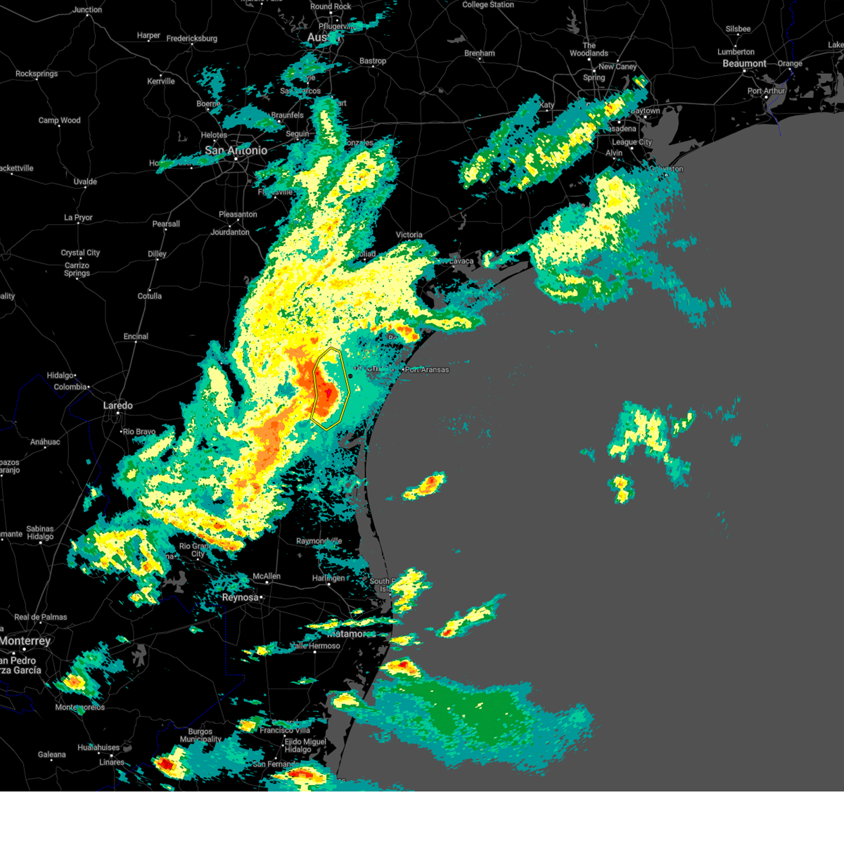
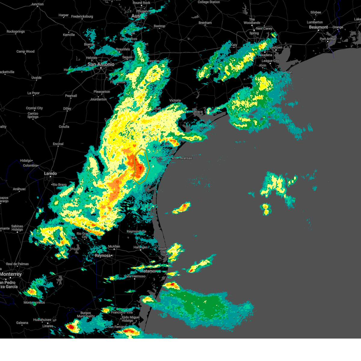
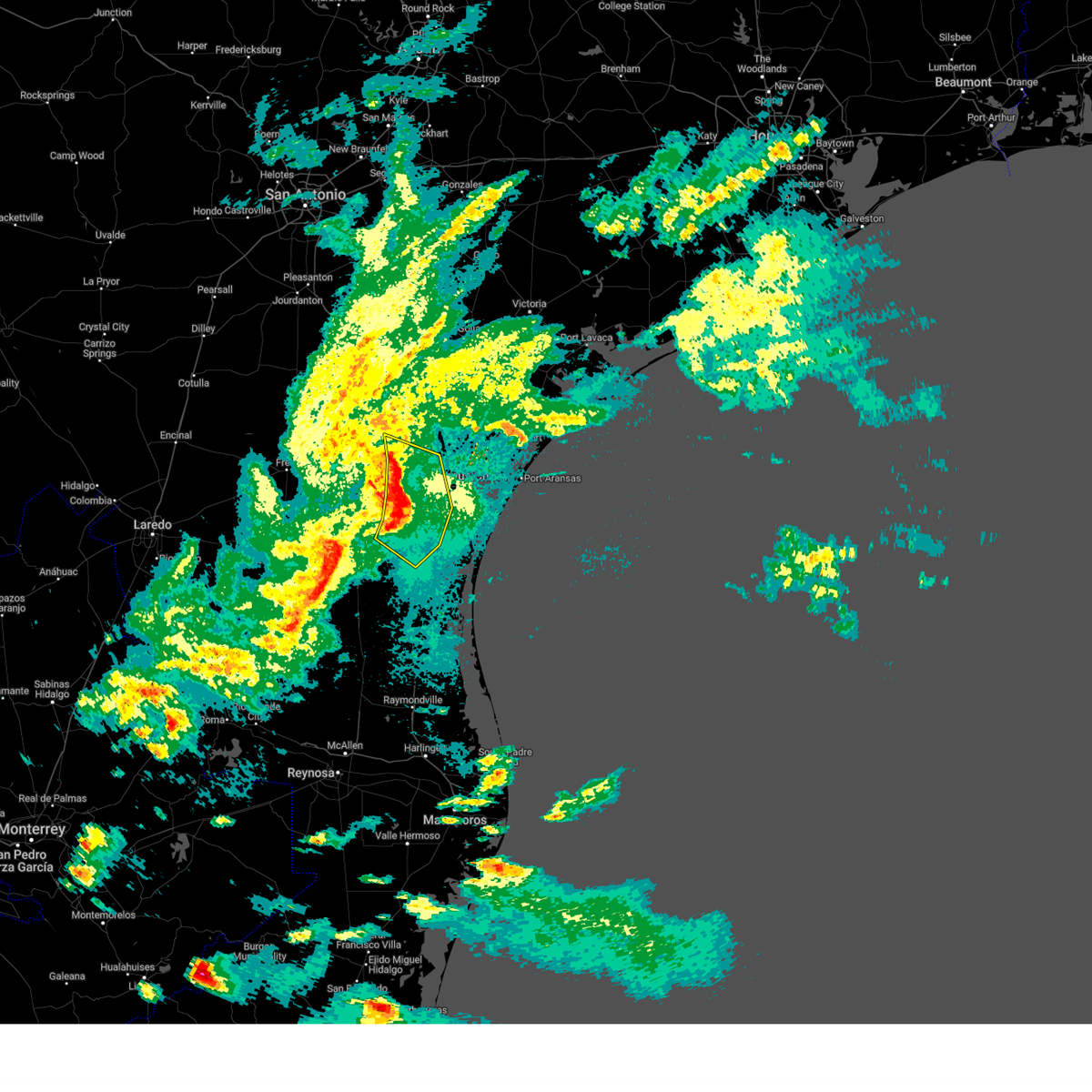
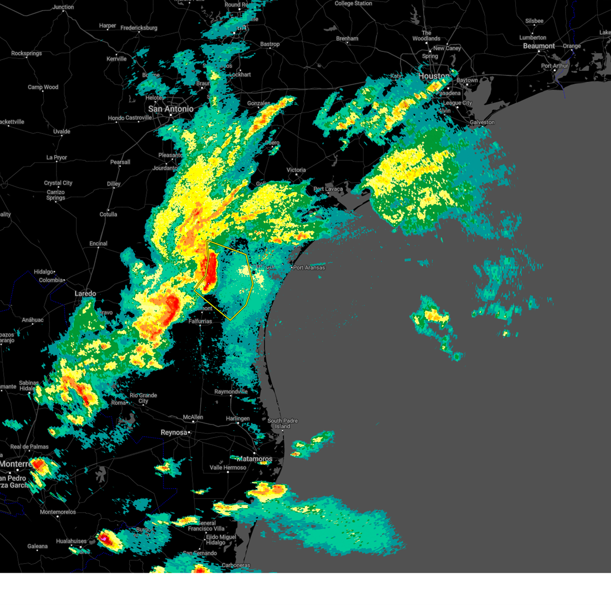
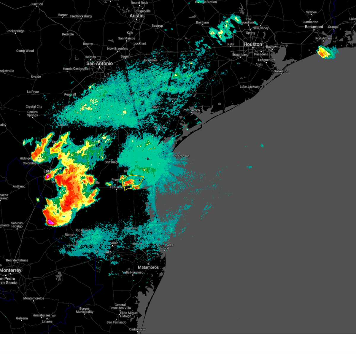
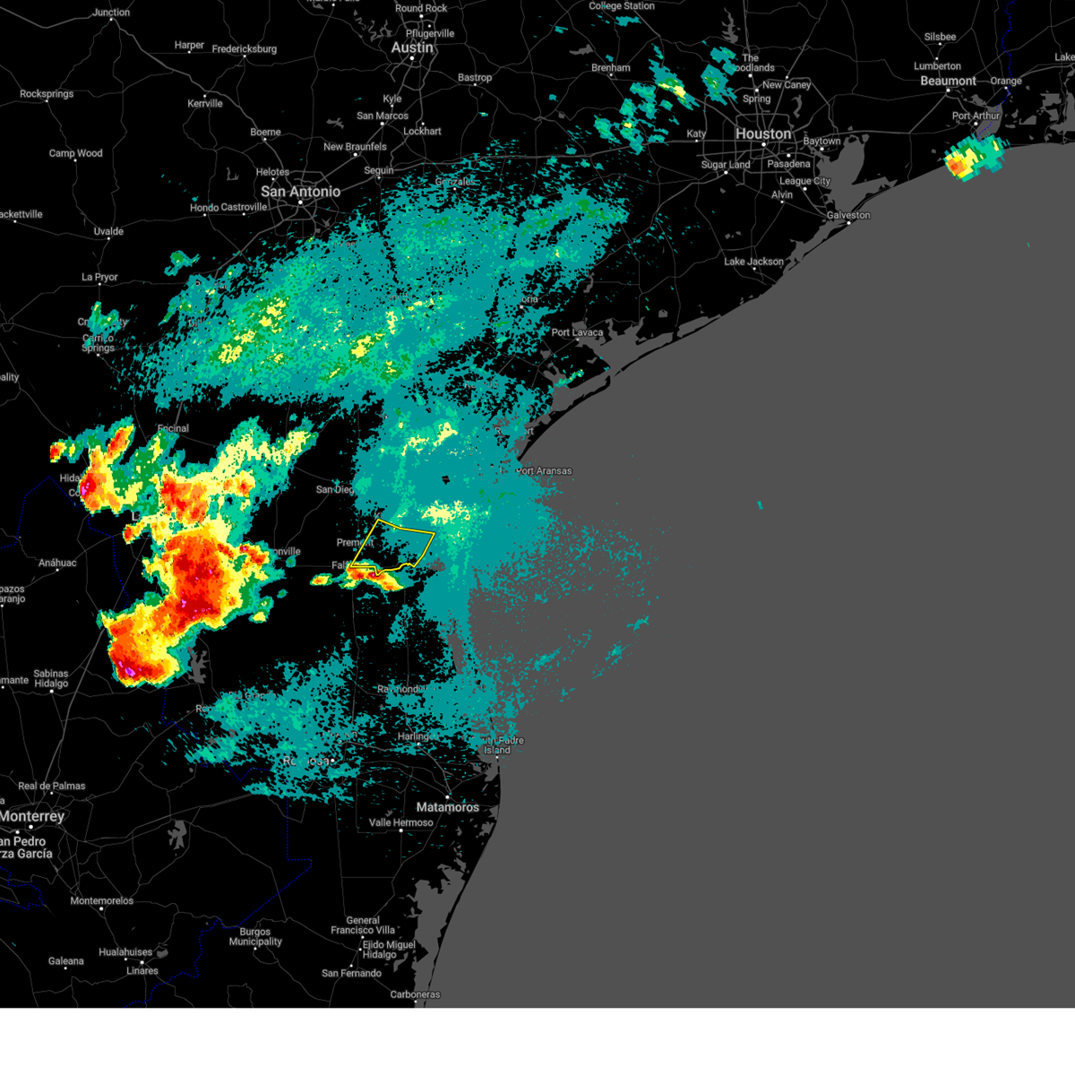
Hail Map for Kingsville, TX
The Kingsville, TX area has had 11 reports of on-the-ground hail by trained spotters, and has been under severe weather warnings 8 times during the past 12 months. Doppler radar has detected hail at or near Kingsville, TX on 29 occasions, including 2 occasions during the past year.
| Name: | Kingsville, TX |
| Where Located: | 34.2 miles SW of Corpus Christi, TX |
| Map: | Google Map for Kingsville, TX |
| Population: | 26213 |
| Housing Units: | 10354 |
| More Info: | Search Google for Kingsville, TX |
0
The Top Recent Hail Date for Kingsville, TX is Thursday, May 8, 2025 (13th out of 29)

Hail and Wind Damage Spotted near Kingsville, TX
| Date / Time | Report Details |
|---|---|
| 5/8/2025 10:07 PM CDT |
 At 1006 pm cdt, severe thunderstorms were located along a line extending from near robstown to near driscoll to near kingsville naval air station to ricardo, moving southeast at 35 mph (emergency management). Hazards include 70 mph wind gusts and nickel size hail. Expect considerable tree damage. damage is likely to mobile homes, roofs, and outbuildings. locations impacted include, corpus christi, kingsville, robstown, driscoll, bishop, odem, edroy, bluntzer, banquete, annaville, calallen, kingsville naval air station, petronila, and north san pedro. this includes the following highways, interstate 37 between mile markers 12 and 24. Us highway 77 between mile markers 656 and 688. At 1006 pm cdt, severe thunderstorms were located along a line extending from near robstown to near driscoll to near kingsville naval air station to ricardo, moving southeast at 35 mph (emergency management). Hazards include 70 mph wind gusts and nickel size hail. Expect considerable tree damage. damage is likely to mobile homes, roofs, and outbuildings. locations impacted include, corpus christi, kingsville, robstown, driscoll, bishop, odem, edroy, bluntzer, banquete, annaville, calallen, kingsville naval air station, petronila, and north san pedro. this includes the following highways, interstate 37 between mile markers 12 and 24. Us highway 77 between mile markers 656 and 688.
|
| 5/8/2025 10:07 PM CDT |
 the severe thunderstorm warning has been cancelled and is no longer in effect the severe thunderstorm warning has been cancelled and is no longer in effect
|
| 5/8/2025 9:46 PM CDT |
 At 945 pm cdt, severe thunderstorms were located along a line extending from near bluntzer to banquete to near bishop to 7 miles west of kingsville, moving southeast at 35 mph (emergency management). Hazards include 70 mph wind gusts and nickel size hail. Expect considerable tree damage. damage is likely to mobile homes, roofs, and outbuildings. locations impacted include, corpus christi, kingsville, robstown, driscoll, bishop, odem, orange grove, san patricio, ricardo, edroy, bluntzer, banquete, sandia, annaville, calallen, kingsville naval air station, alfred-south la paloma, agua dulce, petronila, and north san pedro. this includes the following highways, interstate 37 between mile markers 12 and 25. Us highway 77 between mile markers 656 and 702. At 945 pm cdt, severe thunderstorms were located along a line extending from near bluntzer to banquete to near bishop to 7 miles west of kingsville, moving southeast at 35 mph (emergency management). Hazards include 70 mph wind gusts and nickel size hail. Expect considerable tree damage. damage is likely to mobile homes, roofs, and outbuildings. locations impacted include, corpus christi, kingsville, robstown, driscoll, bishop, odem, orange grove, san patricio, ricardo, edroy, bluntzer, banquete, sandia, annaville, calallen, kingsville naval air station, alfred-south la paloma, agua dulce, petronila, and north san pedro. this includes the following highways, interstate 37 between mile markers 12 and 25. Us highway 77 between mile markers 656 and 702.
|
| 5/8/2025 9:25 PM CDT |
 Svrcrp the national weather service in corpus christi has issued a * severe thunderstorm warning for, nueces county in south central texas, southwestern san patricio county in south central texas, northern jim wells county in south central texas, southeastern live oak county in south central texas, western kleberg county in south central texas, * until 1015 pm cdt. * at 924 pm cdt, severe thunderstorms were located along a line extending from near westdale to alfred-south la paloma to near ben bolt to near palito blanco, moving southeast at 35 mph (radar indicated. wind observed by kali). Hazards include 70 mph wind gusts and quarter size hail. Hail damage to vehicles is expected. expect considerable tree damage. Wind damage is also likely to mobile homes, roofs, and outbuildings. Svrcrp the national weather service in corpus christi has issued a * severe thunderstorm warning for, nueces county in south central texas, southwestern san patricio county in south central texas, northern jim wells county in south central texas, southeastern live oak county in south central texas, western kleberg county in south central texas, * until 1015 pm cdt. * at 924 pm cdt, severe thunderstorms were located along a line extending from near westdale to alfred-south la paloma to near ben bolt to near palito blanco, moving southeast at 35 mph (radar indicated. wind observed by kali). Hazards include 70 mph wind gusts and quarter size hail. Hail damage to vehicles is expected. expect considerable tree damage. Wind damage is also likely to mobile homes, roofs, and outbuildings.
|
| 5/7/2025 3:07 AM CDT |
 The storm which prompted the warning has moved out of the area. therefore, the warning will be allowed to expire. however, small hail is still possible with this thunderstorm. a severe thunderstorm watch remains in effect until 800 am cdt for south central texas. remember, a severe thunderstorm warning still remains in effect for loyola beach and eastward through 3:30am. The storm which prompted the warning has moved out of the area. therefore, the warning will be allowed to expire. however, small hail is still possible with this thunderstorm. a severe thunderstorm watch remains in effect until 800 am cdt for south central texas. remember, a severe thunderstorm warning still remains in effect for loyola beach and eastward through 3:30am.
|
| 5/7/2025 3:00 AM CDT |
 the severe thunderstorm warning has been cancelled and is no longer in effect the severe thunderstorm warning has been cancelled and is no longer in effect
|
| 5/7/2025 3:00 AM CDT |
 At 300 am cdt, a severe thunderstorm was located over ricardo, or 7 miles south of kingsville, moving northeast at 45 mph (radar indicated). Hazards include 60 mph wind gusts and quarter size hail. Hail damage to vehicles is expected. expect wind damage to roofs, siding, and trees. locations impacted include, kingsville, riviera, ricardo, and loyola beach. This includes us highway 77 between mile markers 696 and 708. At 300 am cdt, a severe thunderstorm was located over ricardo, or 7 miles south of kingsville, moving northeast at 45 mph (radar indicated). Hazards include 60 mph wind gusts and quarter size hail. Hail damage to vehicles is expected. expect wind damage to roofs, siding, and trees. locations impacted include, kingsville, riviera, ricardo, and loyola beach. This includes us highway 77 between mile markers 696 and 708.
|
| 5/7/2025 2:39 AM CDT |
 Svrcrp the national weather service in corpus christi has issued a * severe thunderstorm warning for, south central jim wells county in south central texas, southwestern kleberg county in south central texas, * until 315 am cdt. * at 239 am cdt, a severe thunderstorm was located near airport road addition, or 9 miles east of falfurrias, moving northeast at 45 mph (radar indicated). Hazards include 60 mph wind gusts and quarter size hail. Hail damage to vehicles is expected. Expect wind damage to roofs, siding, and trees. Svrcrp the national weather service in corpus christi has issued a * severe thunderstorm warning for, south central jim wells county in south central texas, southwestern kleberg county in south central texas, * until 315 am cdt. * at 239 am cdt, a severe thunderstorm was located near airport road addition, or 9 miles east of falfurrias, moving northeast at 45 mph (radar indicated). Hazards include 60 mph wind gusts and quarter size hail. Hail damage to vehicles is expected. Expect wind damage to roofs, siding, and trees.
|
| 5/13/2024 5:35 PM CDT | Quarter sized hail reported 0.4 miles SE of Kingsville, TX, nickel to quarter sized hail near st. gertrudes catholic church. |
| 5/5/2024 6:14 PM CDT |
 At 613 pm cdt, a severe thunderstorm was located near premont, moving southeast at 40 mph (radar indicated). Hazards include 60 mph wind gusts and quarter size hail. Hail damage to vehicles is expected. expect wind damage to roofs, siding, and trees. locations impacted include, kingsville, premont, concepcion, palito blanco, realitos, la gloria, cruz calle, ramirez, rios, kingsville naval air station, and san jose. this includes the following highways, us highway 281 between mile markers 686 and 708. Us highway 77 between mile markers 694 and 698. At 613 pm cdt, a severe thunderstorm was located near premont, moving southeast at 40 mph (radar indicated). Hazards include 60 mph wind gusts and quarter size hail. Hail damage to vehicles is expected. expect wind damage to roofs, siding, and trees. locations impacted include, kingsville, premont, concepcion, palito blanco, realitos, la gloria, cruz calle, ramirez, rios, kingsville naval air station, and san jose. this includes the following highways, us highway 281 between mile markers 686 and 708. Us highway 77 between mile markers 694 and 698.
|
| 5/5/2024 5:43 PM CDT |
 Svrcrp the national weather service in corpus christi has issued a * severe thunderstorm warning for, southern duval county in south central texas, southwestern jim wells county in south central texas, west central kleberg county in south central texas, * until 630 pm cdt. * at 542 pm cdt, a severe thunderstorm was located near rios, or 10 miles southeast of benavides, moving southeast at 40 mph (radar indicated). Hazards include 60 mph wind gusts and quarter size hail. Hail damage to vehicles is expected. Expect wind damage to roofs, siding, and trees. Svrcrp the national weather service in corpus christi has issued a * severe thunderstorm warning for, southern duval county in south central texas, southwestern jim wells county in south central texas, west central kleberg county in south central texas, * until 630 pm cdt. * at 542 pm cdt, a severe thunderstorm was located near rios, or 10 miles southeast of benavides, moving southeast at 40 mph (radar indicated). Hazards include 60 mph wind gusts and quarter size hail. Hail damage to vehicles is expected. Expect wind damage to roofs, siding, and trees.
|
| 5/9/2023 8:51 PM CDT |
 The severe thunderstorm warning for central jim wells and northwestern kleberg counties will expire at 900 pm cdt, the storm which prompted the warning has weakened below severe limits, and no longer poses an immediate threat to life or property. therefore, the warning will be allowed to expire. The severe thunderstorm warning for central jim wells and northwestern kleberg counties will expire at 900 pm cdt, the storm which prompted the warning has weakened below severe limits, and no longer poses an immediate threat to life or property. therefore, the warning will be allowed to expire.
|
| 5/9/2023 8:29 PM CDT |
 At 828 pm cdt, a severe thunderstorm was located near ben bolt, or 10 miles northwest of kingsville, moving southeast at 15 mph (radar indicated). Hazards include quarter size hail. Damage to vehicles is expected. locations impacted include, kingsville and ben bolt. this includes us highway 281 between mile markers 678 and 684. hail threat, radar indicated max hail size, 1. 00 in wind threat, radar indicated max wind gust, <50 mph. At 828 pm cdt, a severe thunderstorm was located near ben bolt, or 10 miles northwest of kingsville, moving southeast at 15 mph (radar indicated). Hazards include quarter size hail. Damage to vehicles is expected. locations impacted include, kingsville and ben bolt. this includes us highway 281 between mile markers 678 and 684. hail threat, radar indicated max hail size, 1. 00 in wind threat, radar indicated max wind gust, <50 mph.
|
| 5/9/2023 8:08 PM CDT |
 At 807 pm cdt, a severe thunderstorm was located over ben bolt, or 7 miles south of alice, moving southeast at 20 mph (radar indicated). Hazards include 60 mph wind gusts and quarter size hail. Hail damage to vehicles is expected. Expect wind damage to roofs, siding, and trees. At 807 pm cdt, a severe thunderstorm was located over ben bolt, or 7 miles south of alice, moving southeast at 20 mph (radar indicated). Hazards include 60 mph wind gusts and quarter size hail. Hail damage to vehicles is expected. Expect wind damage to roofs, siding, and trees.
|
| 4/23/2023 11:02 AM CDT |
 At 1102 am cdt, severe thunderstorms were located along a line extending from 9 miles west of malaquite beach to 6 miles east of riviera beach to near kenedy county sheriffs office, moving east at 50 mph (radar indicated). Hazards include 60 mph wind gusts and penny size hail. expect damage to roofs, siding, and trees At 1102 am cdt, severe thunderstorms were located along a line extending from 9 miles west of malaquite beach to 6 miles east of riviera beach to near kenedy county sheriffs office, moving east at 50 mph (radar indicated). Hazards include 60 mph wind gusts and penny size hail. expect damage to roofs, siding, and trees
|
| 4/23/2023 10:55 AM CDT |
 At 1055 am cdt, severe thunderstorms were located along a line extending from near key allegro to near port aransas to near south texas botanical gardens, moving east at 45 mph (trained weather spotters). Hazards include 60 mph wind gusts and half dollar size hail. Hail damage to vehicles is expected. expect wind damage to roofs, siding, and trees. locations impacted include, corpus christi, kingsville, portland, robstown, rockport, port aransas, driscoll, corpus christi international airport, ingleside, aransas pass, bishop, gregory, ingleside on the bay, flour bluff, palm harbor, corpus christi north beach, kings crossing subdivision, padre balli park, bay area medical center and spohn hospital south. this includes the following highways, interstate 37 between mile markers 1 and 15. us highway 181 between mile markers 636 and 648. us highway 77 between mile markers 672 and 694. hail threat, radar indicated max hail size, 1. 25 in wind threat, observed max wind gust, 60 mph. At 1055 am cdt, severe thunderstorms were located along a line extending from near key allegro to near port aransas to near south texas botanical gardens, moving east at 45 mph (trained weather spotters). Hazards include 60 mph wind gusts and half dollar size hail. Hail damage to vehicles is expected. expect wind damage to roofs, siding, and trees. locations impacted include, corpus christi, kingsville, portland, robstown, rockport, port aransas, driscoll, corpus christi international airport, ingleside, aransas pass, bishop, gregory, ingleside on the bay, flour bluff, palm harbor, corpus christi north beach, kings crossing subdivision, padre balli park, bay area medical center and spohn hospital south. this includes the following highways, interstate 37 between mile markers 1 and 15. us highway 181 between mile markers 636 and 648. us highway 77 between mile markers 672 and 694. hail threat, radar indicated max hail size, 1. 25 in wind threat, observed max wind gust, 60 mph.
|
| 4/23/2023 10:48 AM CDT | Awos station knqi kingsville na in kleberg county TX, 2.2 miles W of Kingsville, TX |
| 4/23/2023 10:33 AM CDT |
 At 1033 am cdt, severe thunderstorms were located along a line extending from near bayside to near ingleside on the bay to 7 miles southeast of driscoll, moving east at 45 mph (radar indicated). Hazards include 60 mph wind gusts and half dollar size hail. Hail damage to vehicles is expected. Expect wind damage to roofs, siding, and trees. At 1033 am cdt, severe thunderstorms were located along a line extending from near bayside to near ingleside on the bay to 7 miles southeast of driscoll, moving east at 45 mph (radar indicated). Hazards include 60 mph wind gusts and half dollar size hail. Hail damage to vehicles is expected. Expect wind damage to roofs, siding, and trees.
|
| 11/11/2022 7:41 PM CST |
 At 740 pm cst, a severe thunderstorm was located 12 miles north of riviera beach, or 15 miles east of kingsville, moving southeast at 25 mph (radar indicated). Hazards include 60 mph wind gusts and quarter size hail. Hail damage to vehicles is expected. Expect wind damage to roofs, siding, and trees. At 740 pm cst, a severe thunderstorm was located 12 miles north of riviera beach, or 15 miles east of kingsville, moving southeast at 25 mph (radar indicated). Hazards include 60 mph wind gusts and quarter size hail. Hail damage to vehicles is expected. Expect wind damage to roofs, siding, and trees.
|
| 11/1/2022 9:50 AM CDT |
 At 950 am cdt, a severe thunderstorm was located near bishop, or near driscoll, moving northeast at 25 mph (radar indicated). Hazards include 60 mph wind gusts. Expect damage to roofs, siding, and trees. locations impacted include, kingsville, driscoll, bishop, kingsville naval air station, petronila and chapman ranch. this includes us highway 77 between mile markers 676 and 690. hail threat, radar indicated max hail size, <. 75 in wind threat, observed max wind gust, 60 mph. At 950 am cdt, a severe thunderstorm was located near bishop, or near driscoll, moving northeast at 25 mph (radar indicated). Hazards include 60 mph wind gusts. Expect damage to roofs, siding, and trees. locations impacted include, kingsville, driscoll, bishop, kingsville naval air station, petronila and chapman ranch. this includes us highway 77 between mile markers 676 and 690. hail threat, radar indicated max hail size, <. 75 in wind threat, observed max wind gust, 60 mph.
|
| 11/1/2022 9:36 AM CDT |
 At 936 am cdt, a severe thunderstorm was located over kingsville naval air station, or near kingsville, moving northeast at 25 mph (radar indicated). Hazards include 60 mph wind gusts. expect damage to roofs, siding, and trees At 936 am cdt, a severe thunderstorm was located over kingsville naval air station, or near kingsville, moving northeast at 25 mph (radar indicated). Hazards include 60 mph wind gusts. expect damage to roofs, siding, and trees
|
| 7/1/2022 6:49 PM CDT |
 At 648 pm cdt, severe thunderstorms were located along a line extending from banquete to near driscoll to near kingsville naval air station, moving east at 20 mph (radar indicated). Hazards include 60 mph wind gusts. Expect damage to roofs, siding, and trees. locations impacted include, kingsville, robstown, driscoll, bishop, banquete, kingsville naval air station, petronila and north san pedro. this includes us highway 77 between mile markers 672 and 698. hail threat, radar indicated max hail size, <. 75 in wind threat, radar indicated max wind gust, 60 mph. At 648 pm cdt, severe thunderstorms were located along a line extending from banquete to near driscoll to near kingsville naval air station, moving east at 20 mph (radar indicated). Hazards include 60 mph wind gusts. Expect damage to roofs, siding, and trees. locations impacted include, kingsville, robstown, driscoll, bishop, banquete, kingsville naval air station, petronila and north san pedro. this includes us highway 77 between mile markers 672 and 698. hail threat, radar indicated max hail size, <. 75 in wind threat, radar indicated max wind gust, 60 mph.
|
| 7/1/2022 6:32 PM CDT |
 At 632 pm cdt, severe thunderstorms were located along a line extending from near banquete to near bishop to ricardo, moving east at 20 mph (radar indicated). Hazards include 60 mph wind gusts. expect damage to roofs, siding, and trees At 632 pm cdt, severe thunderstorms were located along a line extending from near banquete to near bishop to ricardo, moving east at 20 mph (radar indicated). Hazards include 60 mph wind gusts. expect damage to roofs, siding, and trees
|
| 7/1/2022 6:16 PM CDT |
 At 616 pm cdt, severe thunderstorms were located along a line extending from banquete to near bishop to near ricardo, moving east at 30 mph (radar indicated). Hazards include 60 mph wind gusts and penny size hail. Expect damage to roofs, siding, and trees. locations impacted include, kingsville, alice, robstown, driscoll, bishop, ben bolt, palito blanco, alice acres, banquete, kingsville naval air station, agua dulce and petronila. this includes the following highways, us highway 281 between mile markers 676 and 696. us highway 77 between mile markers 672 and 698. hail threat, radar indicated max hail size, 0. 75 in wind threat, radar indicated max wind gust, 60 mph. At 616 pm cdt, severe thunderstorms were located along a line extending from banquete to near bishop to near ricardo, moving east at 30 mph (radar indicated). Hazards include 60 mph wind gusts and penny size hail. Expect damage to roofs, siding, and trees. locations impacted include, kingsville, alice, robstown, driscoll, bishop, ben bolt, palito blanco, alice acres, banquete, kingsville naval air station, agua dulce and petronila. this includes the following highways, us highway 281 between mile markers 676 and 696. us highway 77 between mile markers 672 and 698. hail threat, radar indicated max hail size, 0. 75 in wind threat, radar indicated max wind gust, 60 mph.
|
| 7/1/2022 5:59 PM CDT |
 At 559 pm cdt, severe thunderstorms were located along a line extending from 6 miles south of alfred to near bishop to near ricardo, moving east at 30 mph (radar indicated). Hazards include 60 mph wind gusts and penny size hail. expect damage to roofs, siding, and trees At 559 pm cdt, severe thunderstorms were located along a line extending from 6 miles south of alfred to near bishop to near ricardo, moving east at 30 mph (radar indicated). Hazards include 60 mph wind gusts and penny size hail. expect damage to roofs, siding, and trees
|
| 5/22/2022 8:27 AM CDT |
 The severe thunderstorm warning for southwestern nueces, south central jim wells and western kleberg counties will expire at 830 am cdt, the storms which prompted the warning have weakened below severe limits, and no longer pose an immediate threat to life or property. therefore, the warning will be allowed to expire. however small hail and gusty winds are still possible with these thunderstorms. The severe thunderstorm warning for southwestern nueces, south central jim wells and western kleberg counties will expire at 830 am cdt, the storms which prompted the warning have weakened below severe limits, and no longer pose an immediate threat to life or property. therefore, the warning will be allowed to expire. however small hail and gusty winds are still possible with these thunderstorms.
|
| 5/22/2022 8:15 AM CDT |
 At 814 am cdt, severe thunderstorms were located along a line extending from 7 miles east of bishop to near riviera to 8 miles west of sarita, moving east at 25 mph (radar indicated). Hazards include 60 mph wind gusts and quarter size hail. Hail damage to vehicles is expected. expect wind damage to roofs, siding, and trees. locations impacted include, kingsville, bishop, riviera, ricardo, kingsville naval air station and loyola beach. this includes us highway 77 between mile markers 684 and 708. hail threat, radar indicated max hail size, 1. 00 in wind threat, radar indicated max wind gust, 60 mph. At 814 am cdt, severe thunderstorms were located along a line extending from 7 miles east of bishop to near riviera to 8 miles west of sarita, moving east at 25 mph (radar indicated). Hazards include 60 mph wind gusts and quarter size hail. Hail damage to vehicles is expected. expect wind damage to roofs, siding, and trees. locations impacted include, kingsville, bishop, riviera, ricardo, kingsville naval air station and loyola beach. this includes us highway 77 between mile markers 684 and 708. hail threat, radar indicated max hail size, 1. 00 in wind threat, radar indicated max wind gust, 60 mph.
|
| 5/22/2022 8:00 AM CDT |
 At 800 am cdt, severe thunderstorms were located along a line extending from bishop to near ricardo to near airport road addition, moving southeast at 20 mph (radar indicated). Hazards include 60 mph wind gusts and penny size hail. Expect damage to roofs, siding, and trees. locations impacted include, kingsville, premont, bishop, riviera, la gloria, ricardo, kingsville naval air station and loyola beach. this includes the following highways, us highway 281 between mile markers 688 and 708. us highway 77 between mile markers 682 and 708. hail threat, radar indicated max hail size, 0. 75 in wind threat, radar indicated max wind gust, 60 mph. At 800 am cdt, severe thunderstorms were located along a line extending from bishop to near ricardo to near airport road addition, moving southeast at 20 mph (radar indicated). Hazards include 60 mph wind gusts and penny size hail. Expect damage to roofs, siding, and trees. locations impacted include, kingsville, premont, bishop, riviera, la gloria, ricardo, kingsville naval air station and loyola beach. this includes the following highways, us highway 281 between mile markers 688 and 708. us highway 77 between mile markers 682 and 708. hail threat, radar indicated max hail size, 0. 75 in wind threat, radar indicated max wind gust, 60 mph.
|
| 5/22/2022 7:40 AM CDT |
 At 740 am cdt, severe thunderstorms were located along a line extending from 6 miles west of driscoll to premont, moving southeast at 15 mph (radar indicated). Hazards include 60 mph wind gusts and quarter size hail. Hail damage to vehicles is expected. Expect wind damage to roofs, siding, and trees. At 740 am cdt, severe thunderstorms were located along a line extending from 6 miles west of driscoll to premont, moving southeast at 15 mph (radar indicated). Hazards include 60 mph wind gusts and quarter size hail. Hail damage to vehicles is expected. Expect wind damage to roofs, siding, and trees.
|
| 6/14/2021 8:16 PM CDT |
 At 816 pm cdt, a severe thunderstorm was located 9 miles northwest of bishop, or 10 miles northwest of kingsville, moving southwest at 25 mph (radar indicated). Hazards include 60 mph wind gusts and nickel size hail. expect damage to roofs, siding, and trees At 816 pm cdt, a severe thunderstorm was located 9 miles northwest of bishop, or 10 miles northwest of kingsville, moving southwest at 25 mph (radar indicated). Hazards include 60 mph wind gusts and nickel size hail. expect damage to roofs, siding, and trees
|
| 6/14/2021 7:50 PM CDT |
 At 750 pm cdt, a severe thunderstorm was located over banquete, or 9 miles west of robstown, moving southwest at 10 mph (radar indicated). Hazards include 60 mph wind gusts and nickel size hail. expect damage to roofs, siding, and trees At 750 pm cdt, a severe thunderstorm was located over banquete, or 9 miles west of robstown, moving southwest at 10 mph (radar indicated). Hazards include 60 mph wind gusts and nickel size hail. expect damage to roofs, siding, and trees
|
| 5/18/2021 1:43 AM CDT |
 At 143 am cdt, severe thunderstorms were located along a line extending from near tecalote to kingsville naval air station to riviera beach, moving east at 50 mph (radar indicated). Hazards include 70 mph wind gusts and penny size hail. Expect considerable tree damage. damage is likely to mobile homes, roofs, and outbuildings. severe thunderstorms will be near, riviera beach around 150 am cdt. alfred-south la paloma around 200 am cdt. banquete around 210 am cdt. other locations impacted by these severe thunderstorms include loyola beach, pernitas point, agua dulce, lake alice and petronila. this includes the following highways, us highway 281 between mile markers 656 and 708. Us highway 77 between mile markers 674 and 708. At 143 am cdt, severe thunderstorms were located along a line extending from near tecalote to kingsville naval air station to riviera beach, moving east at 50 mph (radar indicated). Hazards include 70 mph wind gusts and penny size hail. Expect considerable tree damage. damage is likely to mobile homes, roofs, and outbuildings. severe thunderstorms will be near, riviera beach around 150 am cdt. alfred-south la paloma around 200 am cdt. banquete around 210 am cdt. other locations impacted by these severe thunderstorms include loyola beach, pernitas point, agua dulce, lake alice and petronila. this includes the following highways, us highway 281 between mile markers 656 and 708. Us highway 77 between mile markers 674 and 708.
|
| 5/18/2021 1:21 AM CDT |
 At 121 am cdt, severe thunderstorms were located along a line extending from 6 miles southwest of san diego to 7 miles northeast of premont to 7 miles west of sarita, moving east at 45 mph (radar indicated). Hazards include 60 mph wind gusts and nickel size hail. Expect damage to roofs, siding, and trees. these severe storms will be near, riviera around 130 am cdt. kingsville and ricardo around 135 am cdt. alice acres and ben bolt around 140 am cdt. alice around 145 am cdt. other locations impacted by these severe thunderstorms include lake alice. this includes the following highways, us highway 281 between mile markers 670 and 708. Us highway 77 between mile markers 696 and 708. At 121 am cdt, severe thunderstorms were located along a line extending from 6 miles southwest of san diego to 7 miles northeast of premont to 7 miles west of sarita, moving east at 45 mph (radar indicated). Hazards include 60 mph wind gusts and nickel size hail. Expect damage to roofs, siding, and trees. these severe storms will be near, riviera around 130 am cdt. kingsville and ricardo around 135 am cdt. alice acres and ben bolt around 140 am cdt. alice around 145 am cdt. other locations impacted by these severe thunderstorms include lake alice. this includes the following highways, us highway 281 between mile markers 670 and 708. Us highway 77 between mile markers 696 and 708.
|
| 5/18/2021 12:57 AM CDT |
 The national weather service in corpus christi has issued a * severe thunderstorm warning for. southeastern duval county in south central texas. southwestern jim wells county in south central texas. western kleberg county in south central texas. Until 145 am cdt. The national weather service in corpus christi has issued a * severe thunderstorm warning for. southeastern duval county in south central texas. southwestern jim wells county in south central texas. western kleberg county in south central texas. Until 145 am cdt.
|
| 5/11/2021 11:07 PM CDT |
 At 1105 pm cdt, a severe thunderstorm was located over premont, moving east at 20 mph (radar indicated). Hazards include 60 mph wind gusts and quarter size hail. Hail damage to vehicles is expected. expect wind damage to roofs, siding, and trees. locations impacted include, kingsville, premont and la gloria. this includes the following highways, us highway 281 between mile markers 690 and 708. Us highway 77 between mile markers 696 and 698. At 1105 pm cdt, a severe thunderstorm was located over premont, moving east at 20 mph (radar indicated). Hazards include 60 mph wind gusts and quarter size hail. Hail damage to vehicles is expected. expect wind damage to roofs, siding, and trees. locations impacted include, kingsville, premont and la gloria. this includes the following highways, us highway 281 between mile markers 690 and 708. Us highway 77 between mile markers 696 and 698.
|
| 5/11/2021 10:45 PM CDT |
 At 1045 pm cdt, a severe thunderstorm was located near cruz calle, or near premont, moving east at 20 mph (radar indicated). Hazards include 60 mph wind gusts and quarter size hail. Hail damage to vehicles is expected. Expect wind damage to roofs, siding, and trees. At 1045 pm cdt, a severe thunderstorm was located near cruz calle, or near premont, moving east at 20 mph (radar indicated). Hazards include 60 mph wind gusts and quarter size hail. Hail damage to vehicles is expected. Expect wind damage to roofs, siding, and trees.
|
| 5/11/2021 10:37 PM CDT |
 At 1036 pm cdt, severe thunderstorms were located along a line extending from 9 miles southeast of ben bolt to la gloria, moving east at 25 mph (radar indicated). Hazards include 60 mph wind gusts and quarter size hail. Hail damage to vehicles is expected. expect wind damage to roofs, siding, and trees. locations impacted include, kingsville, premont, la gloria, ricardo and kingsville naval air station. this includes the following highways, us highway 281 between mile markers 686 and 706. Us highway 77 between mile markers 690 and 702. At 1036 pm cdt, severe thunderstorms were located along a line extending from 9 miles southeast of ben bolt to la gloria, moving east at 25 mph (radar indicated). Hazards include 60 mph wind gusts and quarter size hail. Hail damage to vehicles is expected. expect wind damage to roofs, siding, and trees. locations impacted include, kingsville, premont, la gloria, ricardo and kingsville naval air station. this includes the following highways, us highway 281 between mile markers 686 and 706. Us highway 77 between mile markers 690 and 702.
|
| 5/11/2021 10:23 PM CDT |
 At 1022 pm cdt, a severe thunderstorm was located near bishop, or near kingsville, moving east at 20 mph (radar indicated). Hazards include 60 mph wind gusts and quarter size hail. Hail damage to vehicles is expected. expect wind damage to roofs, siding, and trees. this severe storm will be near, kingsville around 1030 pm cdt. other locations impacted by this severe thunderstorm include agua dulce and lake alice. This includes us highway 281 between mile markers 670 and 688. At 1022 pm cdt, a severe thunderstorm was located near bishop, or near kingsville, moving east at 20 mph (radar indicated). Hazards include 60 mph wind gusts and quarter size hail. Hail damage to vehicles is expected. expect wind damage to roofs, siding, and trees. this severe storm will be near, kingsville around 1030 pm cdt. other locations impacted by this severe thunderstorm include agua dulce and lake alice. This includes us highway 281 between mile markers 670 and 688.
|
| 5/11/2021 10:13 PM CDT |
 At 1012 pm cdt, severe thunderstorms were located along a line extending from near palito blanco to 11 miles southwest of falfurrias junior high school, moving east at 20 mph (radar indicated). Hazards include 60 mph wind gusts and quarter size hail. Hail damage to vehicles is expected. Expect wind damage to roofs, siding, and trees. At 1012 pm cdt, severe thunderstorms were located along a line extending from near palito blanco to 11 miles southwest of falfurrias junior high school, moving east at 20 mph (radar indicated). Hazards include 60 mph wind gusts and quarter size hail. Hail damage to vehicles is expected. Expect wind damage to roofs, siding, and trees.
|
| 5/11/2021 9:38 PM CDT |
 At 937 pm cdt, a severe thunderstorm was located over alice acres, or near alice, moving east at 20 mph (radar indicated). Hazards include 60 mph wind gusts and quarter size hail. Hail damage to vehicles is expected. expect wind damage to roofs, siding, and trees. this severe thunderstorm will be near, ben bolt around 945 pm cdt. kingsville around 1030 pm cdt. other locations impacted by this severe thunderstorm include agua dulce and lake alice. This includes us highway 281 between mile markers 670 and 688. At 937 pm cdt, a severe thunderstorm was located over alice acres, or near alice, moving east at 20 mph (radar indicated). Hazards include 60 mph wind gusts and quarter size hail. Hail damage to vehicles is expected. expect wind damage to roofs, siding, and trees. this severe thunderstorm will be near, ben bolt around 945 pm cdt. kingsville around 1030 pm cdt. other locations impacted by this severe thunderstorm include agua dulce and lake alice. This includes us highway 281 between mile markers 670 and 688.
|
| 8/20/2020 6:44 PM CDT |
 At 643 pm cdt, a severe thunderstorm was located over palito blanco, or 12 miles south of san diego, moving southeast at 25 mph (radar indicated). Hazards include 60 mph wind gusts and quarter size hail. Hail damage to vehicles is expected. Expect wind damage to roofs, siding, and trees. At 643 pm cdt, a severe thunderstorm was located over palito blanco, or 12 miles south of san diego, moving southeast at 25 mph (radar indicated). Hazards include 60 mph wind gusts and quarter size hail. Hail damage to vehicles is expected. Expect wind damage to roofs, siding, and trees.
|
| 8/18/2020 7:02 PM CDT |
 At 702 pm cdt, severe thunderstorms were located along a line extending from 7 miles east of ben bolt to near driscoll, moving southwest at 10 mph (radar indicated). Hazards include 60 mph wind gusts and quarter size hail. Hail damage to vehicles is expected. expect wind damage to roofs, siding, and trees. Locations impacted include, kingsville, alice, robstown, driscoll, bishop, ben bolt, kingsville naval air station, alice acres and petronila. At 702 pm cdt, severe thunderstorms were located along a line extending from 7 miles east of ben bolt to near driscoll, moving southwest at 10 mph (radar indicated). Hazards include 60 mph wind gusts and quarter size hail. Hail damage to vehicles is expected. expect wind damage to roofs, siding, and trees. Locations impacted include, kingsville, alice, robstown, driscoll, bishop, ben bolt, kingsville naval air station, alice acres and petronila.
|
| 8/18/2020 6:26 PM CDT |
 At 626 pm cdt, severe thunderstorms were located along a line extending from 9 miles southwest of banquete to near driscoll, moving southwest at 10 mph (radar indicated). Hazards include 60 mph wind gusts and quarter size hail. Hail damage to vehicles is expected. Expect wind damage to roofs, siding, and trees. At 626 pm cdt, severe thunderstorms were located along a line extending from 9 miles southwest of banquete to near driscoll, moving southwest at 10 mph (radar indicated). Hazards include 60 mph wind gusts and quarter size hail. Hail damage to vehicles is expected. Expect wind damage to roofs, siding, and trees.
|
| 8/18/2020 6:00 PM CDT |
 At 600 pm cdt, severe thunderstorms were located along a line extending from near annaville to near clarkwood to near driscoll, moving south at 40 mph (radar indicated). Hazards include 60 mph wind gusts and quarter size hail. Hail damage to vehicles is expected. Expect wind damage to roofs, siding, and trees. At 600 pm cdt, severe thunderstorms were located along a line extending from near annaville to near clarkwood to near driscoll, moving south at 40 mph (radar indicated). Hazards include 60 mph wind gusts and quarter size hail. Hail damage to vehicles is expected. Expect wind damage to roofs, siding, and trees.
|
| 7/25/2020 7:33 PM CDT |
 At 732 pm cdt, a severe thunderstorm capable of producing a tornado was located near palito blanco, or 12 miles north of premont, moving southwest at 40 mph (radar indicated rotation). Hazards include tornado. Flying debris will be dangerous to those caught without shelter. mobile homes will be damaged or destroyed. damage to roofs, windows, and vehicles will occur. tree damage is likely. Locations impacted include, kingsville and bishop. At 732 pm cdt, a severe thunderstorm capable of producing a tornado was located near palito blanco, or 12 miles north of premont, moving southwest at 40 mph (radar indicated rotation). Hazards include tornado. Flying debris will be dangerous to those caught without shelter. mobile homes will be damaged or destroyed. damage to roofs, windows, and vehicles will occur. tree damage is likely. Locations impacted include, kingsville and bishop.
|
| 7/25/2020 7:08 PM CDT |
 At 708 pm cdt, a severe thunderstorm capable of producing a tornado was located near bishop, or 7 miles north of kingsville, moving west at 40 mph (radar indicated rotation). Hazards include tornado. Flying debris will be dangerous to those caught without shelter. mobile homes will be damaged or destroyed. damage to roofs, windows, and vehicles will occur. tree damage is likely. This tornadic thunderstorm will remain over mainly rural areas of southwestern nueces, southwestern jim wells and northwestern kleberg counties. At 708 pm cdt, a severe thunderstorm capable of producing a tornado was located near bishop, or 7 miles north of kingsville, moving west at 40 mph (radar indicated rotation). Hazards include tornado. Flying debris will be dangerous to those caught without shelter. mobile homes will be damaged or destroyed. damage to roofs, windows, and vehicles will occur. tree damage is likely. This tornadic thunderstorm will remain over mainly rural areas of southwestern nueces, southwestern jim wells and northwestern kleberg counties.
|
| 5/16/2020 1:37 AM CDT |
 At 137 am cdt, severe thunderstorms were located along a line extending from 6 miles southwest of woodsboro to near kingsville, moving east at 45 mph (radar indicated). Hazards include 60 mph wind gusts and penny size hail. expect damage to roofs, siding, and trees At 137 am cdt, severe thunderstorms were located along a line extending from 6 miles southwest of woodsboro to near kingsville, moving east at 45 mph (radar indicated). Hazards include 60 mph wind gusts and penny size hail. expect damage to roofs, siding, and trees
|
| 6/6/2019 7:49 PM CDT |
 At 735 pm cdt, a severe thunderstorm capable of producing a tornado was located near ricardo, or 8 miles southeast of kingsville, moving southeast at 30 mph (radar indicated rotation). Hazards include tornado and ping pong ball size hail. Flying debris will be dangerous to those caught without shelter. mobile homes will be damaged or destroyed. damage to roofs, windows, and vehicles will occur. tree damage is likely. This tornadic thunderstorm will remain over mainly rural areas of central kleberg county, including the following locations, loyola beach. At 735 pm cdt, a severe thunderstorm capable of producing a tornado was located near ricardo, or 8 miles southeast of kingsville, moving southeast at 30 mph (radar indicated rotation). Hazards include tornado and ping pong ball size hail. Flying debris will be dangerous to those caught without shelter. mobile homes will be damaged or destroyed. damage to roofs, windows, and vehicles will occur. tree damage is likely. This tornadic thunderstorm will remain over mainly rural areas of central kleberg county, including the following locations, loyola beach.
|
| 6/6/2019 7:43 PM CDT | Structural damage to some homes on northwest side of kingsville...such as shingles missing and porches remove in kleberg county TX, 0.4 miles SE of Kingsville, TX |
| 6/6/2019 7:39 PM CDT |
 At 738 pm cdt, a severe thunderstorm was located 12 miles southwest of kings crossing golf course, or 12 miles southeast of driscoll, moving east at 25 mph. this is a very dangerous storm (radar indicated). Hazards include 80 mph wind gusts and ping pong ball size hail. Flying debris will be dangerous to those caught without shelter. mobile homes will be heavily damaged. expect considerable damage to roofs, windows, and vehicles. extensive tree damage and power outages are likely. Locations impacted include, corpus christi, kingsville, driscoll, bishop, riviera beach, ricardo, malaquite beach, kingsville naval air station, petronila, loyola beach and chapman ranch. At 738 pm cdt, a severe thunderstorm was located 12 miles southwest of kings crossing golf course, or 12 miles southeast of driscoll, moving east at 25 mph. this is a very dangerous storm (radar indicated). Hazards include 80 mph wind gusts and ping pong ball size hail. Flying debris will be dangerous to those caught without shelter. mobile homes will be heavily damaged. expect considerable damage to roofs, windows, and vehicles. extensive tree damage and power outages are likely. Locations impacted include, corpus christi, kingsville, driscoll, bishop, riviera beach, ricardo, malaquite beach, kingsville naval air station, petronila, loyola beach and chapman ranch.
|
| 6/6/2019 7:35 PM CDT |
 At 735 pm cdt, a severe thunderstorm capable of producing a tornado was located near ricardo, or 8 miles southeast of kingsville, moving southeast at 30 mph (radar indicated rotation). Hazards include tornado and ping pong ball size hail. Flying debris will be dangerous to those caught without shelter. mobile homes will be damaged or destroyed. damage to roofs, windows, and vehicles will occur. tree damage is likely. This tornadic thunderstorm will remain over mainly rural areas of central kleberg county, including the following locations, loyola beach. At 735 pm cdt, a severe thunderstorm capable of producing a tornado was located near ricardo, or 8 miles southeast of kingsville, moving southeast at 30 mph (radar indicated rotation). Hazards include tornado and ping pong ball size hail. Flying debris will be dangerous to those caught without shelter. mobile homes will be damaged or destroyed. damage to roofs, windows, and vehicles will occur. tree damage is likely. This tornadic thunderstorm will remain over mainly rural areas of central kleberg county, including the following locations, loyola beach.
|
| 6/6/2019 7:34 PM CDT | Kingsville naval air station measured a gust to 67 knot in kleberg county TX, 2.9 miles W of Kingsville, TX |
| 6/6/2019 7:29 PM CDT | Quarter sized hail reported 0.4 miles SE of Kingsville, TX, near texas am kingsville campus |
| 6/6/2019 7:29 PM CDT | Near texas am kingsville campus in kleberg county TX, 0.4 miles SE of Kingsville, TX |
| 6/6/2019 7:26 PM CDT |
 At 725 pm cdt, a severe thunderstorm was located 7 miles southeast of driscoll, moving east at 25 mph (radar indicated). Hazards include ping pong ball size hail and 60 mph wind gusts. People and animals outdoors will be injured. expect hail damage to roofs, siding, windows, and vehicles. expect wind damage to roofs, siding, and trees. Locations impacted include, corpus christi, kingsville, driscoll, bishop, riviera beach, ricardo, malaquite beach, kingsville naval air station, petronila, loyola beach and chapman ranch. At 725 pm cdt, a severe thunderstorm was located 7 miles southeast of driscoll, moving east at 25 mph (radar indicated). Hazards include ping pong ball size hail and 60 mph wind gusts. People and animals outdoors will be injured. expect hail damage to roofs, siding, windows, and vehicles. expect wind damage to roofs, siding, and trees. Locations impacted include, corpus christi, kingsville, driscoll, bishop, riviera beach, ricardo, malaquite beach, kingsville naval air station, petronila, loyola beach and chapman ranch.
|
| 6/6/2019 7:13 PM CDT |
 At 712 pm cdt, a severe thunderstorm was located near driscoll, moving east at 25 mph (radar indicated). Hazards include 60 mph wind gusts and quarter size hail. Hail damage to vehicles is expected. Expect wind damage to roofs, siding, and trees. At 712 pm cdt, a severe thunderstorm was located near driscoll, moving east at 25 mph (radar indicated). Hazards include 60 mph wind gusts and quarter size hail. Hail damage to vehicles is expected. Expect wind damage to roofs, siding, and trees.
|
| 6/6/2019 7:06 PM CDT |
 At 705 pm cdt, a severe thunderstorm was located near driscoll, moving east at 35 mph (radar indicated). Hazards include 60 mph wind gusts and half dollar size hail. Hail damage to vehicles is expected. expect wind damage to roofs, siding, and trees. Locations impacted include, kingsville, alice, robstown, driscoll, bishop, ben bolt, alice acres, agua dulce, petronila and lake alice. At 705 pm cdt, a severe thunderstorm was located near driscoll, moving east at 35 mph (radar indicated). Hazards include 60 mph wind gusts and half dollar size hail. Hail damage to vehicles is expected. expect wind damage to roofs, siding, and trees. Locations impacted include, kingsville, alice, robstown, driscoll, bishop, ben bolt, alice acres, agua dulce, petronila and lake alice.
|
| 6/6/2019 6:44 PM CDT |
 At 643 pm cdt, a severe thunderstorm was located 8 miles west of driscoll, moving east at 35 mph (radar indicated). Hazards include 60 mph wind gusts and half dollar size hail. Hail damage to vehicles is expected. Expect wind damage to roofs, siding, and trees. At 643 pm cdt, a severe thunderstorm was located 8 miles west of driscoll, moving east at 35 mph (radar indicated). Hazards include 60 mph wind gusts and half dollar size hail. Hail damage to vehicles is expected. Expect wind damage to roofs, siding, and trees.
|
| 5/6/2019 12:27 PM CDT |
 The severe thunderstorm warning for southern nueces, south central jim wells and kleberg counties will expire at 1230 pm cdt, the storms which prompted the warning have weakened below severe limits, and have exited the warned area. therefore, the warning will be allowed to expire. however gusty winds are still possible with these thunderstorms. remember, a severe thunderstorm warning still remains in effect for nueces and san patricio counties. The severe thunderstorm warning for southern nueces, south central jim wells and kleberg counties will expire at 1230 pm cdt, the storms which prompted the warning have weakened below severe limits, and have exited the warned area. therefore, the warning will be allowed to expire. however gusty winds are still possible with these thunderstorms. remember, a severe thunderstorm warning still remains in effect for nueces and san patricio counties.
|
| 5/6/2019 11:56 AM CDT | Large tree limbs down at the intersection of coral ave. and 6th s in kleberg county TX, 1.7 miles S of Kingsville, TX |
| 5/6/2019 11:50 AM CDT |
 At 1150 am cdt, severe thunderstorms were located along a line extending from near ben bolt to ricardo to 8 miles southwest of sarita, moving east at 40 mph (radar indicated). Hazards include 60 mph wind gusts and penny size hail. expect damage to roofs, siding, and trees At 1150 am cdt, severe thunderstorms were located along a line extending from near ben bolt to ricardo to 8 miles southwest of sarita, moving east at 40 mph (radar indicated). Hazards include 60 mph wind gusts and penny size hail. expect damage to roofs, siding, and trees
|
| 5/6/2019 11:49 AM CDT | Large tree down at intersection of cr 1026 and cr 218 in kleberg county TX, 7.4 miles NNE of Kingsville, TX |
| 5/6/2019 11:37 AM CDT |
 At 1137 am cdt, severe thunderstorms were located along a line extending from near rios to 6 miles east of la gloria to 8 miles southeast of airport road addition, moving northeast at 45 mph (radar indicated). Hazards include 60 mph wind gusts and penny size hail. Expect damage to roofs, siding, and trees. Locations impacted include, kingsville, premont, la gloria, rios and cruz calle. At 1137 am cdt, severe thunderstorms were located along a line extending from near rios to 6 miles east of la gloria to 8 miles southeast of airport road addition, moving northeast at 45 mph (radar indicated). Hazards include 60 mph wind gusts and penny size hail. Expect damage to roofs, siding, and trees. Locations impacted include, kingsville, premont, la gloria, rios and cruz calle.
|
| 5/6/2019 11:19 AM CDT |
 At 1118 am cdt, severe thunderstorms were located along a line extending from ramirez to near falfurrias junior high school to 9 miles northwest of encino, moving northeast at 45 mph (radar indicated). Hazards include 60 mph wind gusts and penny size hail. expect damage to roofs, siding, and trees At 1118 am cdt, severe thunderstorms were located along a line extending from ramirez to near falfurrias junior high school to 9 miles northwest of encino, moving northeast at 45 mph (radar indicated). Hazards include 60 mph wind gusts and penny size hail. expect damage to roofs, siding, and trees
|
| 5/6/2019 10:56 AM CDT | Large tree limbs down at the intersection of coral ave. and 6th s in kleberg county TX, 1.7 miles S of Kingsville, TX |
| 5/3/2019 9:02 AM CDT |
 At 902 am cdt, a severe thunderstorm was located over annaville, or near robstown, moving northeast at 40 mph (radar indicated). Hazards include 70 mph wind gusts. Expect considerable tree damage. damage is likely to mobile homes, roofs, and outbuildings. locations impacted include, corpus christi, kingsville, alice, portland, robstown, sinton, mathis, port aransas, taft, driscoll, corpus christi international airport, skidmore, ingleside, aransas pass, bishop, odem, gregory, orange grove, st. Paul and ingleside on the bay. At 902 am cdt, a severe thunderstorm was located over annaville, or near robstown, moving northeast at 40 mph (radar indicated). Hazards include 70 mph wind gusts. Expect considerable tree damage. damage is likely to mobile homes, roofs, and outbuildings. locations impacted include, corpus christi, kingsville, alice, portland, robstown, sinton, mathis, port aransas, taft, driscoll, corpus christi international airport, skidmore, ingleside, aransas pass, bishop, odem, gregory, orange grove, st. Paul and ingleside on the bay.
|
| 5/3/2019 8:26 AM CDT |
 At 825 am cdt, a severe thunderstorm was located 8 miles southeast of alice, moving northeast at 40 mph. this is a very dangerous storm (radar indicated). Hazards include 80 mph wind gusts. Flying debris will be dangerous to those caught without shelter. mobile homes will be heavily damaged. expect considerable damage to roofs, windows, and vehicles. Extensive tree damage and power outages are likely. At 825 am cdt, a severe thunderstorm was located 8 miles southeast of alice, moving northeast at 40 mph. this is a very dangerous storm (radar indicated). Hazards include 80 mph wind gusts. Flying debris will be dangerous to those caught without shelter. mobile homes will be heavily damaged. expect considerable damage to roofs, windows, and vehicles. Extensive tree damage and power outages are likely.
|
| 5/3/2019 8:20 AM CDT |
 At 820 am cdt, a severe thunderstorm was located over alice acres, or over alice, moving eastnortheast at 40 mph. this is a very dangerous storm (radar indicated). Hazards include 80 mph wind gusts. Flying debris will be dangerous to those caught without shelter. mobile homes will be heavily damaged. expect considerable damage to roofs, windows, and vehicles. extensive tree damage and power outages are likely. Locations impacted include, kingsville, alice, san diego, benavides, midway, alfred-south la paloma, san jose, ben bolt, concepcion, palito blanco, tecalote, cruz calle, alice acres, alfred, rios, rosita, westdale, agua dulce and lake alice. At 820 am cdt, a severe thunderstorm was located over alice acres, or over alice, moving eastnortheast at 40 mph. this is a very dangerous storm (radar indicated). Hazards include 80 mph wind gusts. Flying debris will be dangerous to those caught without shelter. mobile homes will be heavily damaged. expect considerable damage to roofs, windows, and vehicles. extensive tree damage and power outages are likely. Locations impacted include, kingsville, alice, san diego, benavides, midway, alfred-south la paloma, san jose, ben bolt, concepcion, palito blanco, tecalote, cruz calle, alice acres, alfred, rios, rosita, westdale, agua dulce and lake alice.
|
| 5/3/2019 8:13 AM CDT |
 At 812 am cdt, a severe thunderstorm was located over alice acres, or near alice, moving eastnortheast at 40 mph. this is a very dangerous storm (radar indicated). Hazards include 80 mph wind gusts and quarter size hail. Flying debris will be dangerous to those caught without shelter. mobile homes will be heavily damaged. expect considerable damage to roofs, windows, and vehicles. extensive tree damage and power outages are likely. Locations impacted include, kingsville, alice, san diego, benavides, midway, alfred-south la paloma, ramirez, san jose, ben bolt, concepcion, palito blanco, tecalote, realitos, cruz calle, alice acres, alfred, rios, rosita, westdale and agua dulce. At 812 am cdt, a severe thunderstorm was located over alice acres, or near alice, moving eastnortheast at 40 mph. this is a very dangerous storm (radar indicated). Hazards include 80 mph wind gusts and quarter size hail. Flying debris will be dangerous to those caught without shelter. mobile homes will be heavily damaged. expect considerable damage to roofs, windows, and vehicles. extensive tree damage and power outages are likely. Locations impacted include, kingsville, alice, san diego, benavides, midway, alfred-south la paloma, ramirez, san jose, ben bolt, concepcion, palito blanco, tecalote, realitos, cruz calle, alice acres, alfred, rios, rosita, westdale and agua dulce.
|
| 5/3/2019 7:41 AM CDT |
 At 741 am cdt, a severe thunderstorm was located over benavides, moving eastnortheast at 40 mph. this is a very dangerous storm (radar indicated). Hazards include 80 mph wind gusts and quarter size hail. Flying debris will be dangerous to those caught without shelter. mobile homes will be heavily damaged. expect considerable damage to roofs, windows, and vehicles. Extensive tree damage and power outages are likely. At 741 am cdt, a severe thunderstorm was located over benavides, moving eastnortheast at 40 mph. this is a very dangerous storm (radar indicated). Hazards include 80 mph wind gusts and quarter size hail. Flying debris will be dangerous to those caught without shelter. mobile homes will be heavily damaged. expect considerable damage to roofs, windows, and vehicles. Extensive tree damage and power outages are likely.
|
| 4/7/2019 7:14 AM CDT |
 At 713 am cdt, severe thunderstorms were located along a line extending from argenta to 6 miles east of alice to premont, moving east at 40 mph (radar indicated). Hazards include 70 mph wind gusts and quarter size hail. Hail damage to vehicles is expected. expect considerable tree damage. wind damage is also likely to mobile homes, roofs, and outbuildings. Locations impacted include, kingsville, alice, robstown, mathis, san diego, premont, george west, driscoll, skidmore, bishop, orange grove, lake city, san patricio, midway, edroy, river creek acres, banquete, tynan, san jose and sandia. At 713 am cdt, severe thunderstorms were located along a line extending from argenta to 6 miles east of alice to premont, moving east at 40 mph (radar indicated). Hazards include 70 mph wind gusts and quarter size hail. Hail damage to vehicles is expected. expect considerable tree damage. wind damage is also likely to mobile homes, roofs, and outbuildings. Locations impacted include, kingsville, alice, robstown, mathis, san diego, premont, george west, driscoll, skidmore, bishop, orange grove, lake city, san patricio, midway, edroy, river creek acres, banquete, tynan, san jose and sandia.
|
| 4/7/2019 6:51 AM CDT |
 At 650 am cdt, severe thunderstorms were located along a line extending from near river creek acres to near tecalote to rios, moving east at 45 mph (radar indicated). Hazards include 60 mph wind gusts and nickel size hail. expect damage to roofs, siding, and trees At 650 am cdt, severe thunderstorms were located along a line extending from near river creek acres to near tecalote to rios, moving east at 45 mph (radar indicated). Hazards include 60 mph wind gusts and nickel size hail. expect damage to roofs, siding, and trees
|
| 4/14/2018 2:09 AM CDT |
 At 208 am cdt, severe thunderstorms were located along a line extending from edroy to near ben bolt, moving southeast at 50 mph (radar indicated). Hazards include 60 mph wind gusts. Expect damage to roofs, siding, and trees. Locations impacted include, corpus christi, kingsville, alice, portland, robstown, mathis, port aransas, driscoll, corpus christi international airport, ingleside, aransas pass, bishop, odem, gregory, orange grove, ingleside on the bay, san patricio, christus spohn hospital south, corpus christi north beach and bay area medical center. At 208 am cdt, severe thunderstorms were located along a line extending from edroy to near ben bolt, moving southeast at 50 mph (radar indicated). Hazards include 60 mph wind gusts. Expect damage to roofs, siding, and trees. Locations impacted include, corpus christi, kingsville, alice, portland, robstown, mathis, port aransas, driscoll, corpus christi international airport, ingleside, aransas pass, bishop, odem, gregory, orange grove, ingleside on the bay, san patricio, christus spohn hospital south, corpus christi north beach and bay area medical center.
|
| 4/14/2018 1:58 AM CDT |
 At 157 am cdt, severe thunderstorms were located along a line extending from near west sinton to near alice acres, moving southeast at 50 mph (radar indicated). Hazards include 60 mph wind gusts. expect damage to roofs, siding, and trees At 157 am cdt, severe thunderstorms were located along a line extending from near west sinton to near alice acres, moving southeast at 50 mph (radar indicated). Hazards include 60 mph wind gusts. expect damage to roofs, siding, and trees
|
| 3/18/2018 6:14 PM CDT |
 At 613 pm cdt, a severe thunderstorm was located 7 miles southwest of kingsville, moving southeast at 20 mph (radar indicated). Hazards include golf ball size hail and 60 mph wind gusts. People and animals outdoors will be injured. expect hail damage to roofs, siding, windows, and vehicles. expect wind damage to roofs, siding, and trees. Locations impacted include, kingsville and kingsville naval air station. At 613 pm cdt, a severe thunderstorm was located 7 miles southwest of kingsville, moving southeast at 20 mph (radar indicated). Hazards include golf ball size hail and 60 mph wind gusts. People and animals outdoors will be injured. expect hail damage to roofs, siding, windows, and vehicles. expect wind damage to roofs, siding, and trees. Locations impacted include, kingsville and kingsville naval air station.
|
| 3/18/2018 6:03 PM CDT |
 The national weather service in corpus christi has issued a * severe thunderstorm warning for. southwestern jim wells county in south central texas. western kleberg county in south central texas. Until 645 pm cdt * at 602 pm cdt, a severe thunderstorm was located 10 miles west of. The national weather service in corpus christi has issued a * severe thunderstorm warning for. southwestern jim wells county in south central texas. western kleberg county in south central texas. Until 645 pm cdt * at 602 pm cdt, a severe thunderstorm was located 10 miles west of.
|
| 5/29/2017 2:44 AM CDT |
 At 243 am cdt, a severe thunderstorm was located near edroy, or 8 miles north of robstown, moving northeast at 50 mph (radar indicated). Hazards include 70 mph wind gusts. Expect considerable tree damage. damage is likely to mobile homes, roofs, and outbuildings. Locations impacted include, kingsville, alice, robstown, driscoll, bishop, riviera beach, ricardo, alfred-south la paloma, bluntzer, banquete, ben bolt, riviera, tecalote, alice acres, alfred, kingsville naval air station, agua dulce, petronila, loyola beach and north san pedro. At 243 am cdt, a severe thunderstorm was located near edroy, or 8 miles north of robstown, moving northeast at 50 mph (radar indicated). Hazards include 70 mph wind gusts. Expect considerable tree damage. damage is likely to mobile homes, roofs, and outbuildings. Locations impacted include, kingsville, alice, robstown, driscoll, bishop, riviera beach, ricardo, alfred-south la paloma, bluntzer, banquete, ben bolt, riviera, tecalote, alice acres, alfred, kingsville naval air station, agua dulce, petronila, loyola beach and north san pedro.
|
| 5/29/2017 2:19 AM CDT |
 At 218 am cdt, a severe thunderstorm was located near alfred, or near alice, moving northeast at 50 mph (radar indicated). Hazards include 70 mph wind gusts. Expect considerable tree damage. Damage is likely to mobile homes, roofs, and outbuildings. At 218 am cdt, a severe thunderstorm was located near alfred, or near alice, moving northeast at 50 mph (radar indicated). Hazards include 70 mph wind gusts. Expect considerable tree damage. Damage is likely to mobile homes, roofs, and outbuildings.
|
| 4/17/2017 4:30 AM CDT |
 At 430 am cdt, severe thunderstorms were located along a line extending from near alfred to la gloria, moving east at 50 mph (radar indicated). Hazards include 60 mph wind gusts and penny size hail. Expect damage to roofs, siding, and trees. Locations impacted include, kingsville, alice, san diego, premont, benavides, bishop, ricardo, alfred-south la paloma, ramirez, bluntzer, banquete, san jose, ben bolt, concepcion, tecalote, palito blanco, la gloria, cruz calle, alice acres and alfred. At 430 am cdt, severe thunderstorms were located along a line extending from near alfred to la gloria, moving east at 50 mph (radar indicated). Hazards include 60 mph wind gusts and penny size hail. Expect damage to roofs, siding, and trees. Locations impacted include, kingsville, alice, san diego, premont, benavides, bishop, ricardo, alfred-south la paloma, ramirez, bluntzer, banquete, san jose, ben bolt, concepcion, tecalote, palito blanco, la gloria, cruz calle, alice acres and alfred.
|
| 4/17/2017 4:01 AM CDT |
 At 400 am cdt, severe thunderstorms were located along a line extending from 8 miles southeast of seven sisters to 7 miles west of ramirez, moving east at 50 mph (radar indicated). Hazards include 60 mph wind gusts and penny size hail. expect damage to roofs, siding, and trees At 400 am cdt, severe thunderstorms were located along a line extending from 8 miles southeast of seven sisters to 7 miles west of ramirez, moving east at 50 mph (radar indicated). Hazards include 60 mph wind gusts and penny size hail. expect damage to roofs, siding, and trees
|
| 10/20/2016 5:09 PM CDT | Storm damage reported in kleberg county TX, 4.6 miles N of Kingsville, TX |
| 10/20/2016 5:03 PM CDT |
 At 502 pm cdt, a severe thunderstorm was located over kingsville naval air station, or near kingsville, moving southwest at 30 mph (radar indicated). Hazards include 60 mph wind gusts and penny size hail. Expect damage to roofs. siding. and trees. Locations impacted include, kingsville, ricardo, riviera and kingsville naval air station. At 502 pm cdt, a severe thunderstorm was located over kingsville naval air station, or near kingsville, moving southwest at 30 mph (radar indicated). Hazards include 60 mph wind gusts and penny size hail. Expect damage to roofs. siding. and trees. Locations impacted include, kingsville, ricardo, riviera and kingsville naval air station.
|
| 10/20/2016 4:49 PM CDT |
 At 448 pm cdt, a severe thunderstorm was located near bishop, or near driscoll, moving southwest at 30 mph (radar indicated). Hazards include 60 mph wind gusts and penny size hail. Expect damage to roofs. siding. And trees. At 448 pm cdt, a severe thunderstorm was located near bishop, or near driscoll, moving southwest at 30 mph (radar indicated). Hazards include 60 mph wind gusts and penny size hail. Expect damage to roofs. siding. And trees.
|
| 5/31/2016 7:53 PM CDT |
 At 753 pm cdt, a severe thunderstorm was located over ricardo, or 7 miles south of kingsville, moving east at 5 mph (radar indicated). Hazards include ping pong ball size hail and 60 mph wind gusts. People and animals outdoors will be injured. expect hail damage to roofs, siding, windows, and vehicles. expect wind damage to roofs, siding, and trees. Locations impacted include, kingsville, ricardo, kingsville naval air station, riviera and loyola beach. At 753 pm cdt, a severe thunderstorm was located over ricardo, or 7 miles south of kingsville, moving east at 5 mph (radar indicated). Hazards include ping pong ball size hail and 60 mph wind gusts. People and animals outdoors will be injured. expect hail damage to roofs, siding, windows, and vehicles. expect wind damage to roofs, siding, and trees. Locations impacted include, kingsville, ricardo, kingsville naval air station, riviera and loyola beach.
|
| 5/31/2016 7:44 PM CDT | Quarter sized hail reported 0.4 miles SE of Kingsville, TX |
| 5/31/2016 7:31 PM CDT |
 At 731 pm cdt, a severe thunderstorm was located over ricardo, or near kingsville, moving east at 5 mph (radar indicated). Hazards include ping pong ball size hail and 60 mph wind gusts. People and animals outdoors will be injured. expect hail damage to roofs, siding, windows, and vehicles. Expect wind damage to roofs, siding, and trees. At 731 pm cdt, a severe thunderstorm was located over ricardo, or near kingsville, moving east at 5 mph (radar indicated). Hazards include ping pong ball size hail and 60 mph wind gusts. People and animals outdoors will be injured. expect hail damage to roofs, siding, windows, and vehicles. Expect wind damage to roofs, siding, and trees.
|
| 5/31/2016 7:14 PM CDT |
 At 713 pm cdt, a severe thunderstorm capable of producing a tornado was located over ricardo, or near kingsville, moving northeast at 10 mph (radar indicated rotation). Hazards include tornado and baseball size hail. Flying debris will be dangerous to those caught without shelter. mobile homes will be damaged or destroyed. damage to roofs, windows, and vehicles will occur. tree damage is likely. this dangerous storm will be near, ricardo around 720 pm cdt. Kingsville around 745 pm cdt. At 713 pm cdt, a severe thunderstorm capable of producing a tornado was located over ricardo, or near kingsville, moving northeast at 10 mph (radar indicated rotation). Hazards include tornado and baseball size hail. Flying debris will be dangerous to those caught without shelter. mobile homes will be damaged or destroyed. damage to roofs, windows, and vehicles will occur. tree damage is likely. this dangerous storm will be near, ricardo around 720 pm cdt. Kingsville around 745 pm cdt.
|
| 5/31/2016 7:07 PM CDT | Baseball sized hail reported 5.9 miles N of Kingsville, TX, pictures of baseball size hail received in real time. |
| 5/31/2016 6:51 PM CDT |
 At 651 pm cdt, a severe thunderstorm capable of producing a tornado was located near ricardo, or 8 miles south of kingsville, moving northeast at 20 mph (radar indicated rotation). Hazards include tornado and hail up to two inches in diameter. Flying debris will be dangerous to those caught without shelter. mobile homes will be damaged or destroyed. damage to roofs, windows, and vehicles will occur. tree damage is likely. this dangerous storm will be near, ricardo around 700 pm cdt. kingsville around 710 pm cdt. Kingsville naval air station around 715 pm cdt. At 651 pm cdt, a severe thunderstorm capable of producing a tornado was located near ricardo, or 8 miles south of kingsville, moving northeast at 20 mph (radar indicated rotation). Hazards include tornado and hail up to two inches in diameter. Flying debris will be dangerous to those caught without shelter. mobile homes will be damaged or destroyed. damage to roofs, windows, and vehicles will occur. tree damage is likely. this dangerous storm will be near, ricardo around 700 pm cdt. kingsville around 710 pm cdt. Kingsville naval air station around 715 pm cdt.
|
| 5/31/2016 6:42 PM CDT | Hen Egg sized hail reported 5.9 miles N of Kingsville, TX, picture submitted of large hail that fell near ricardo. |
| 5/31/2016 6:40 PM CDT |
 At 640 pm cdt, a severe thunderstorm was located over ricardo, or near kingsville, moving east at 5 mph (radar indicated). Hazards include two inch hail and 60 mph wind gusts. People and animals outdoors will be injured. expect hail damage to roofs, siding, windows, and vehicles. Expect wind damage to roofs, siding, and trees. At 640 pm cdt, a severe thunderstorm was located over ricardo, or near kingsville, moving east at 5 mph (radar indicated). Hazards include two inch hail and 60 mph wind gusts. People and animals outdoors will be injured. expect hail damage to roofs, siding, windows, and vehicles. Expect wind damage to roofs, siding, and trees.
|
| 5/31/2016 6:39 PM CDT | Quarter sized hail reported 5.9 miles N of Kingsville, TX, social media video submitted of hail falling in ricardo. |
| 5/31/2016 6:33 PM CDT |
 At 632 pm cdt, a severe thunderstorm capable of producing a tornado was located just south of kingsville, moving northeast at 15 mph. another severe thunderstorm 5 miles southwest of ricardo was showing signs of strengthening rotation also (radar indicated rotation). Hazards include tornado and quarter size hail. Flying debris will be dangerous to those caught without shelter. mobile homes will be damaged or destroyed. damage to roofs, windows, and vehicles will occur. tree damage is likely. this dangerous storm will be near, kingsville around 635 pm cdt. Kingsville naval air station around 645 pm cdt. At 632 pm cdt, a severe thunderstorm capable of producing a tornado was located just south of kingsville, moving northeast at 15 mph. another severe thunderstorm 5 miles southwest of ricardo was showing signs of strengthening rotation also (radar indicated rotation). Hazards include tornado and quarter size hail. Flying debris will be dangerous to those caught without shelter. mobile homes will be damaged or destroyed. damage to roofs, windows, and vehicles will occur. tree damage is likely. this dangerous storm will be near, kingsville around 635 pm cdt. Kingsville naval air station around 645 pm cdt.
|
| 5/31/2016 6:19 PM CDT |
 At 618 pm cdt, a severe thunderstorm capable of producing a tornado was located 5 miles southwest of kingsville, moving northeast at 15 mph (radar indicated rotation). Hazards include tornado and quarter size hail. Flying debris will be dangerous to those caught without shelter. mobile homes will be damaged or destroyed. damage to roofs, windows, and vehicles will occur. tree damage is likely. this dangerous storm will be near, kingsville around 635 pm cdt. Kingsville naval air station around 645 pm cdt. At 618 pm cdt, a severe thunderstorm capable of producing a tornado was located 5 miles southwest of kingsville, moving northeast at 15 mph (radar indicated rotation). Hazards include tornado and quarter size hail. Flying debris will be dangerous to those caught without shelter. mobile homes will be damaged or destroyed. damage to roofs, windows, and vehicles will occur. tree damage is likely. this dangerous storm will be near, kingsville around 635 pm cdt. Kingsville naval air station around 645 pm cdt.
|
| 5/31/2016 6:18 PM CDT |
 At 617 pm cdt, a severe thunderstorm was located near kingsville, moving east at 5 mph (radar indicated). Hazards include 60 mph wind gusts and quarter size hail. Hail damage to vehicles is expected. expect wind damage to roofs, siding, and trees. Locations impacted include, kingsville, riviera beach, ricardo, kingsville naval air station and loyola beach. At 617 pm cdt, a severe thunderstorm was located near kingsville, moving east at 5 mph (radar indicated). Hazards include 60 mph wind gusts and quarter size hail. Hail damage to vehicles is expected. expect wind damage to roofs, siding, and trees. Locations impacted include, kingsville, riviera beach, ricardo, kingsville naval air station and loyola beach.
|
| 5/31/2016 6:17 PM CDT | Quarter sized hail reported 0.4 miles SE of Kingsville, TX |
| 5/31/2016 5:58 PM CDT |
 At 558 pm cdt, a severe thunderstorm was located near kingsville, moving east at 5 mph (radar indicated). Hazards include 60 mph wind gusts and quarter size hail. Hail damage to vehicles is expected. Expect wind damage to roofs, siding, and trees. At 558 pm cdt, a severe thunderstorm was located near kingsville, moving east at 5 mph (radar indicated). Hazards include 60 mph wind gusts and quarter size hail. Hail damage to vehicles is expected. Expect wind damage to roofs, siding, and trees.
|
| 5/31/2016 5:32 PM CDT |
 At 531 pm cdt, a severe thunderstorm was located near bishop, or 7 miles north of kingsville, moving east at 15 mph (radar indicated). Hazards include ping pong ball size hail and 60 mph wind gusts. People and animals outdoors will be injured. expect hail damage to roofs, siding, windows, and vehicles. expect wind damage to roofs, siding, and trees. Locations impacted include, kingsville, driscoll, bishop and kingsville naval air station. At 531 pm cdt, a severe thunderstorm was located near bishop, or 7 miles north of kingsville, moving east at 15 mph (radar indicated). Hazards include ping pong ball size hail and 60 mph wind gusts. People and animals outdoors will be injured. expect hail damage to roofs, siding, windows, and vehicles. expect wind damage to roofs, siding, and trees. Locations impacted include, kingsville, driscoll, bishop and kingsville naval air station.
|
| 5/31/2016 5:17 PM CDT |
 At 516 pm cdt, a severe thunderstorm was located 8 miles east of ben bolt, or 10 miles northwest of kingsville, moving east at 15 mph (radar indicated). Hazards include 60 mph wind gusts and quarter size hail. Hail damage to vehicles is expected. Expect wind damage to roofs, siding, and trees. At 516 pm cdt, a severe thunderstorm was located 8 miles east of ben bolt, or 10 miles northwest of kingsville, moving east at 15 mph (radar indicated). Hazards include 60 mph wind gusts and quarter size hail. Hail damage to vehicles is expected. Expect wind damage to roofs, siding, and trees.
|
| 4/18/2016 5:05 PM CDT |
 At 505 pm cdt, a severe thunderstorm was located near alice, moving east at 20 mph (radar indicated). Hazards include quarter size hail. damage to vehicles is expected At 505 pm cdt, a severe thunderstorm was located near alice, moving east at 20 mph (radar indicated). Hazards include quarter size hail. damage to vehicles is expected
|
| 3/19/2016 12:45 AM CDT |
 At 1244 am cdt, severe thunderstorms were located along a line extending from clarkwood to naval air station cabaniss field to 12 miles northeast of riviera beach, moving east at 40 mph. this storm produced 68 mph winds as it moved into corpus christi airport (radar indicated). Hazards include 70 mph wind gusts and quarter size hail. Hail damage to vehicles is expected. expect considerable tree damage. Wind damage is also likely to mobile homes, roofs, and outbuildings. At 1244 am cdt, severe thunderstorms were located along a line extending from clarkwood to naval air station cabaniss field to 12 miles northeast of riviera beach, moving east at 40 mph. this storm produced 68 mph winds as it moved into corpus christi airport (radar indicated). Hazards include 70 mph wind gusts and quarter size hail. Hail damage to vehicles is expected. expect considerable tree damage. Wind damage is also likely to mobile homes, roofs, and outbuildings.
|
| 3/19/2016 12:39 AM CDT |
 The severe thunderstorm warning for western nueces, jim wells and western kleberg counties will expire at 1245 am cdt, the storms which prompted the warning have moved out of the area. therefore the warning will be allowed to expire. a severe thunderstorm watch remains in effect until 400 am cdt for central texas. The severe thunderstorm warning for western nueces, jim wells and western kleberg counties will expire at 1245 am cdt, the storms which prompted the warning have moved out of the area. therefore the warning will be allowed to expire. a severe thunderstorm watch remains in effect until 400 am cdt for central texas.
|
| 3/19/2016 12:14 AM CDT |
 At 1213 am cdt, severe thunderstorms were located along a line extending from 9 miles east of alice to near kingsville to 9 miles east of premont, moving southeast at 45 mph. these storms have produced wind gusts of 64 mph in alice (radar indicated). Hazards include 60 mph wind gusts and nickel size hail. Expect damage to roofs. siding. And trees. At 1213 am cdt, severe thunderstorms were located along a line extending from 9 miles east of alice to near kingsville to 9 miles east of premont, moving southeast at 45 mph. these storms have produced wind gusts of 64 mph in alice (radar indicated). Hazards include 60 mph wind gusts and nickel size hail. Expect damage to roofs. siding. And trees.
|
| 3/19/2016 12:04 AM CDT |
 At 1203 am cdt, severe thunderstorms were located along a line extending from near alfred to 8 miles west of ricardo, moving east at 45 mph (radar indicated). Hazards include 60 mph wind gusts and quarter size hail. Hail damage to vehicles is expected. Expect wind damage to roofs, siding, and trees. At 1203 am cdt, severe thunderstorms were located along a line extending from near alfred to 8 miles west of ricardo, moving east at 45 mph (radar indicated). Hazards include 60 mph wind gusts and quarter size hail. Hail damage to vehicles is expected. Expect wind damage to roofs, siding, and trees.
|
| 3/18/2016 11:37 PM CDT |
 At 1137 pm cdt, severe thunderstorms were located along a line extending from near rosita to near san jose to near ramirez, moving southeast at 45 mph (radar indicated). Hazards include 60 to 70 mph wind gusts and quarter size hail. Hail damage to vehicles is expected. expect considerable tree damage. Wind damage is also likely to mobile homes, roofs, and outbuildings. At 1137 pm cdt, severe thunderstorms were located along a line extending from near rosita to near san jose to near ramirez, moving southeast at 45 mph (radar indicated). Hazards include 60 to 70 mph wind gusts and quarter size hail. Hail damage to vehicles is expected. expect considerable tree damage. Wind damage is also likely to mobile homes, roofs, and outbuildings.
|
| 10/24/2015 12:55 PM CDT |
 At 1252 pm cdt, severe thunderstorms were located along a line extending from near alfred to near aguilares, moving south at 25 mph (trained weather spotters). Hazards include 60 mph wind gusts. Expect damage to roofs. Siding and trees. At 1252 pm cdt, severe thunderstorms were located along a line extending from near alfred to near aguilares, moving south at 25 mph (trained weather spotters). Hazards include 60 mph wind gusts. Expect damage to roofs. Siding and trees.
|
| 6/27/2015 6:06 PM CDT |
 At 605 pm cdt, doppler radar indicated a severe thunderstorm capable of producing quarter size hail and damaging winds in excess of 60 mph. this storm was located 8 miles southwest of ricardo, or 10 miles east of premont, and moving north at 10 mph. At 605 pm cdt, doppler radar indicated a severe thunderstorm capable of producing quarter size hail and damaging winds in excess of 60 mph. this storm was located 8 miles southwest of ricardo, or 10 miles east of premont, and moving north at 10 mph.
|
| 6/17/2015 7:45 PM CDT |
 At 744 pm cdt, doppler radar indicated a severe thunderstorm capable of producing damaging winds in excess of 60 mph. this storm was located near premont, and moving east at 20 mph. At 744 pm cdt, doppler radar indicated a severe thunderstorm capable of producing damaging winds in excess of 60 mph. this storm was located near premont, and moving east at 20 mph.
|
| 5/29/2015 5:17 AM CDT | At 516 am cdt, doppler radar indicated a line of severe thunderstorms capable of producing damaging winds in excess of 60 mph. these storms were located along a line extending from near mustang island state park to near ricardo, moving southeast at 30 mph. locations impacted include, corpus christi, kingsville, port aransas, driscoll, corpus christi international airport, ingleside, aransas pass, bishop, ingleside on the bay, flour bluff, ingleside--aransas pass, corpus christi country club, riviera beach, kings crossing golf course, christus spohn hospital south, mustang island state park, driscoll childrens hospital, corpus christi north beach, cole park and downtown corpus christi. |
| 5/29/2015 4:57 AM CDT | At 456 am cdt, doppler radar indicated a line of severe thunderstorms capable of producing damaging winds in excess of 60 mph. these storms were located along a line extending from near palm harbor to near bishop, and moving southeast at 30 mph. |
| 5/24/2015 1:27 AM CDT | The severe thunderstorm warning for southwestern nueces and central kleberg counties will expire at 130 am cdt, the storm which prompted the warning has weakened below severe limits and exited the warned area. therefore the warning will be allowed to expire. however heavy rain is still possible with this thunderstorm. remember, an additional severe thunderstorm warning still remains in effect for central nueces county. |
| 5/24/2015 1:15 AM CDT | At 114 am cdt, doppler radar indicated a severe thunderstorm capable of producing damaging winds in excess of 60 mph. this storm was located near bishop, or 9 miles south of driscoll, moving northeast at 40 mph. locations impacted include, kingsville, driscoll, bishop and kingsville naval air station. |
| 5/24/2015 1:02 AM CDT | At 101 am cdt, doppler radar indicated a severe thunderstorm capable of producing damaging winds in excess of 60 mph. this storm was located over driscoll, moving northeast at 40 mph. locations impacted include, kingsville, driscoll, bishop, ricardo, kingsville naval air station and riviera. |
| 5/24/2015 12:44 AM CDT | At 1243 am cdt, doppler radar indicated a severe thunderstorm capable of producing damaging winds in excess of 60 mph. this storm was located over kingsville, and moving northeast at 40 mph. |
| 5/21/2015 5:01 PM CDT | At 500 pm cdt, doppler radar indicated a severe thunderstorm capable of producing a tornado. this dangerous storm was located over bishop, or near kingsville, and moving southeast at 10 mph. * this dangerous storm will be near, kingsville around 510 pm cdt. kingsville naval air station around 525 pm cdt. |
| 4/14/2015 6:40 AM CDT | The national weather service in corpus christi has issued a * severe thunderstorm warning for. south central nueces county in south central texas. kleberg county in south central texas. until 715 am cdt * at 639 am cdt. Doppler radar indicated a line of severe. |
| 4/12/2015 11:18 PM CDT | The national weather service in corpus christi has issued a * severe thunderstorm warning for. nueces county in south central texas. central san patricio county in south central texas. southwestern aransas county in south central texas. Northern jim wells county in south central texas. |
| 4/12/2015 11:05 PM CDT | Power out across much of the city for about 10 minutes. widespread power lines down. time of event estimated by rada in kleberg county TX, 0.4 miles SE of Kingsville, TX |
| 4/12/2015 10:58 PM CDT | A severe thunderstorm warning remains in effect until 1115 pm cdt for western nueces. jim wells. western kleberg and eastern duval counties. at 1057 pm cdt. doppler radar indicated a line of severe thunderstorms capable of producing quarter size hail and damaging winds in excess of 60 mph. These storms were located along a line. |
| 4/12/2015 10:30 PM CDT | The national weather service in corpus christi has issued a * severe thunderstorm warning for. western nueces county in south central texas. jim wells county in south central texas. western kleberg county in south central texas. Eastern duval county in south central texas. |
| 11/22/2014 7:16 PM CST | Kingsville police reported a couple trees down in the cit in kleberg county TX, 0.4 miles SE of Kingsville, TX |
| 11/3/2012 5:30 PM CDT | Quarter sized hail reported 6.1 miles NNE of Kingsville, TX |
| 5/10/2012 12:45 PM CDT | Quarter sized hail reported 0.4 miles SE of Kingsville, TX, hail at kingsville high school |
| 5/10/2012 12:42 PM CDT | Quarter sized hail reported 0.4 miles SE of Kingsville, TX, 6th and king street |
| 4/20/2012 4:42 PM CDT | Quarter sized hail reported 5.9 miles N of Kingsville, TX, em office reported quarter size hail in ricardo area. |
Hail Maps for Kingsville, TX


Connect with Interactive Hail Maps