

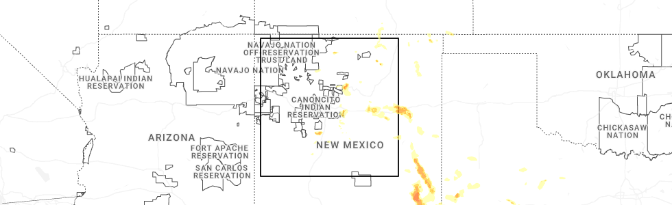
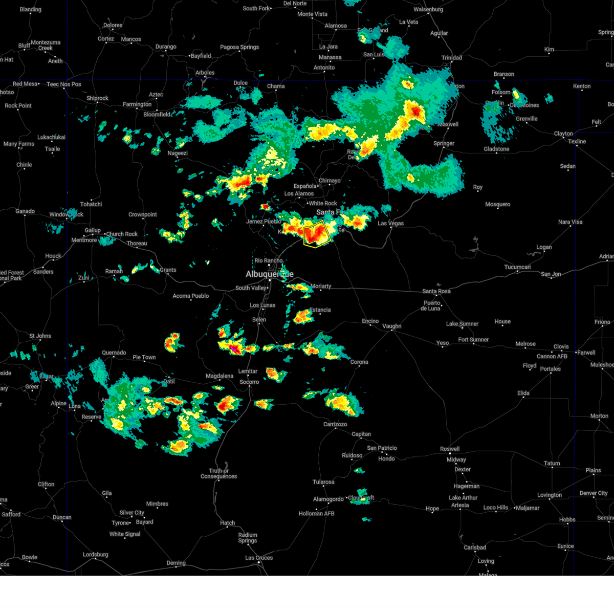
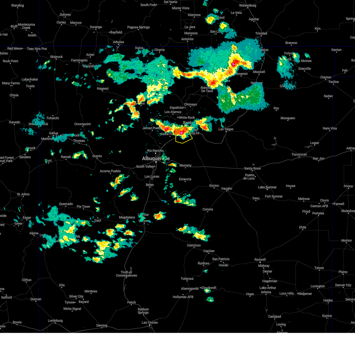
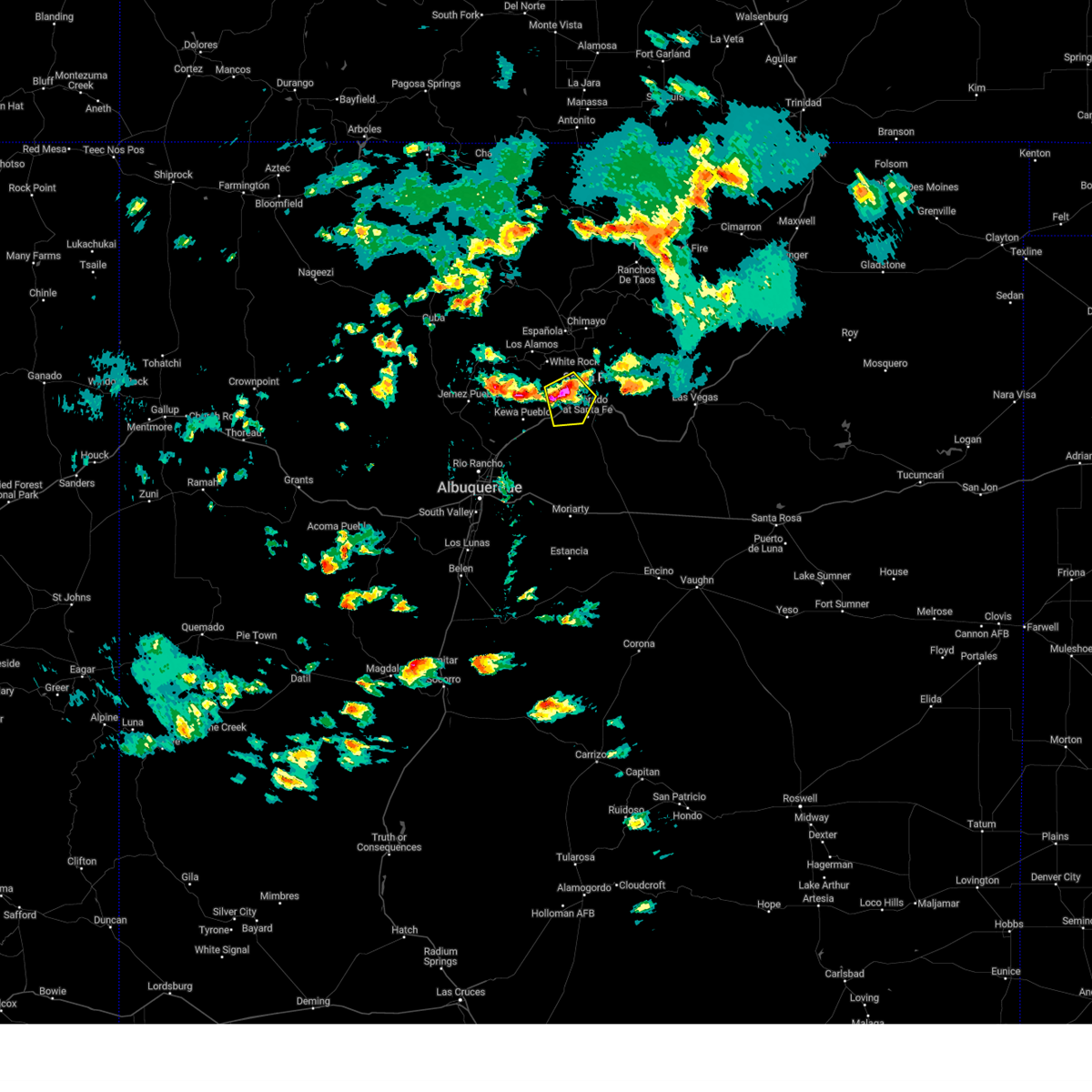
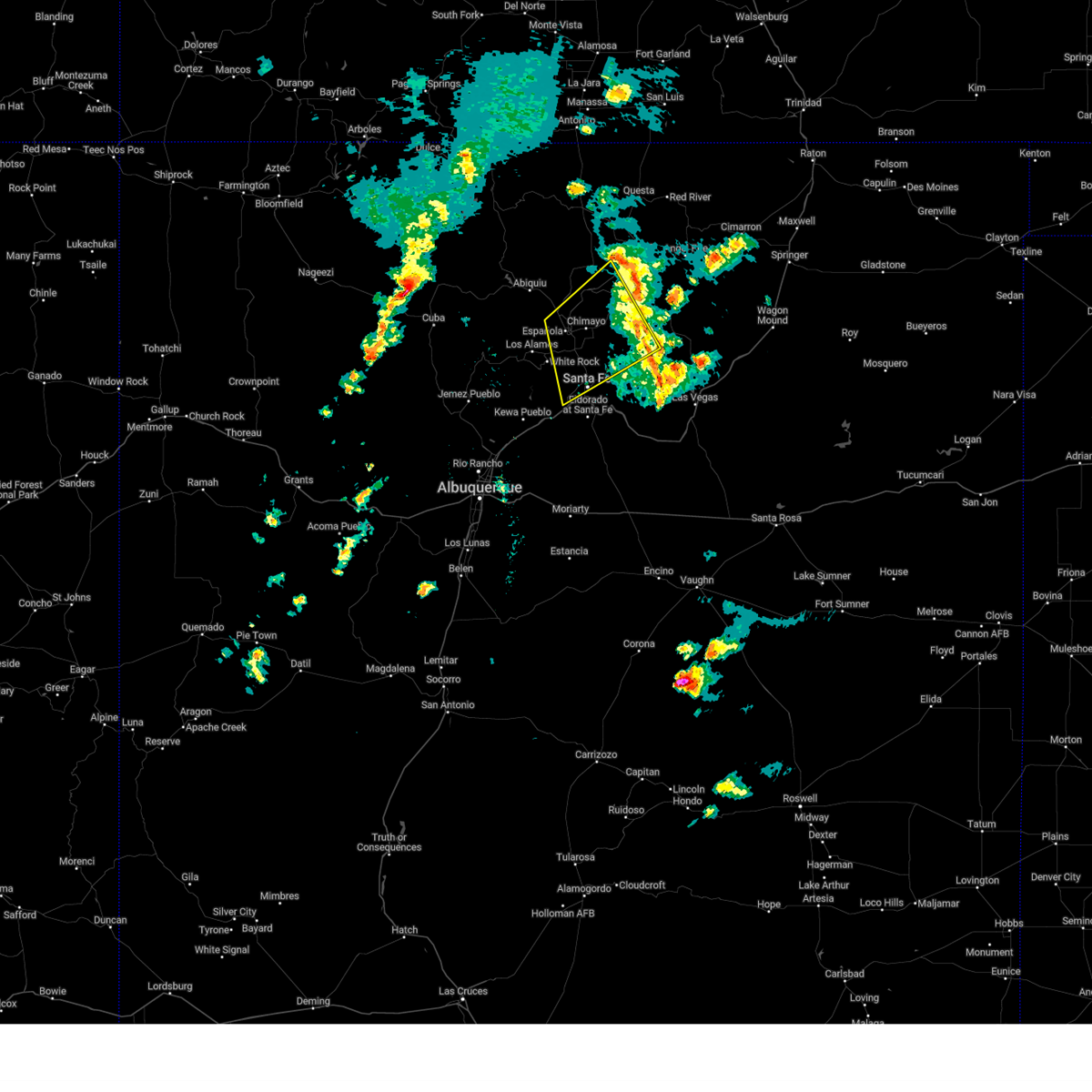
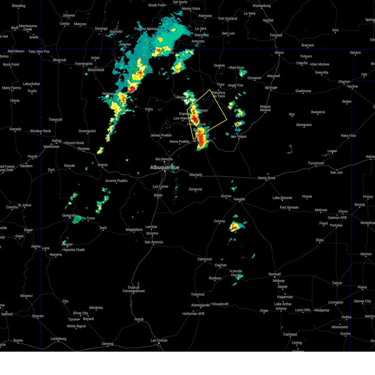
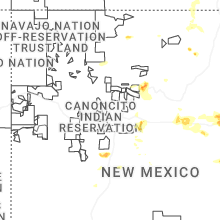
Hail Map for La Cienega, NM
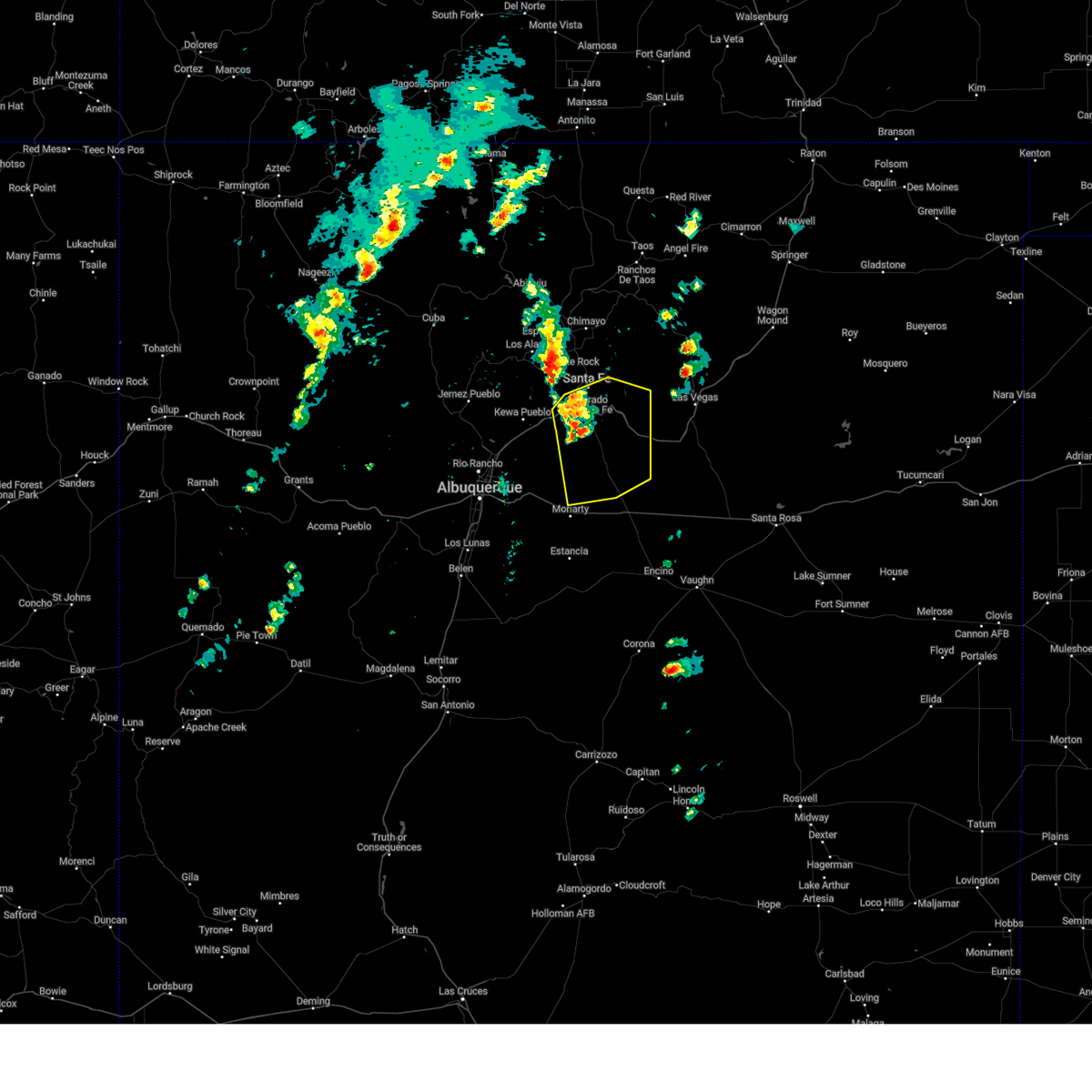
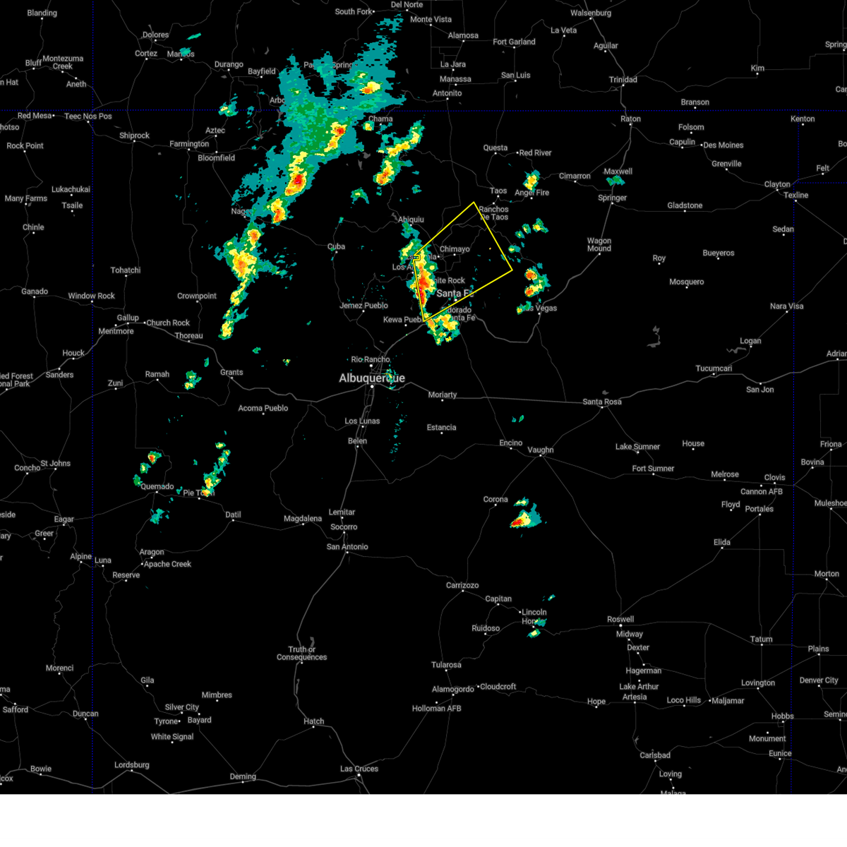
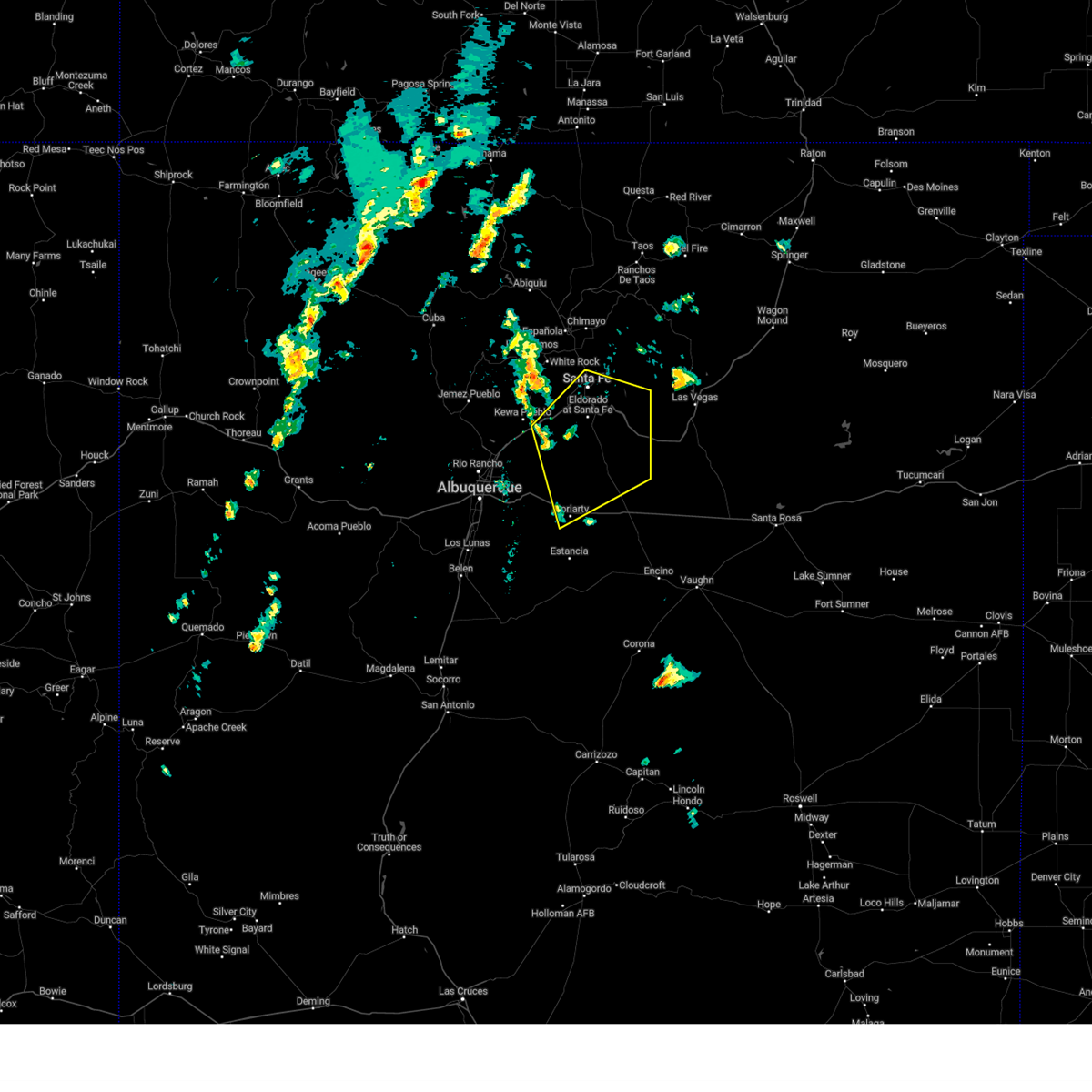
The La Cienega, NM area has had 0 reports of on-the-ground hail by trained spotters, and has been under severe weather warnings 16 times during the past 12 months. Doppler radar has detected hail at or near La Cienega, NM on 34 occasions, including 5 occasions during the past year.
| Name: | La Cienega, NM |
| Where Located: | 44.9 miles NE of Albuquerque, NM |
| Map: | Google Map for La Cienega, NM |
| Population: | 3819 |
| Housing Units: | 1340 |
| More Info: | Search Google for La Cienega, NM |
2
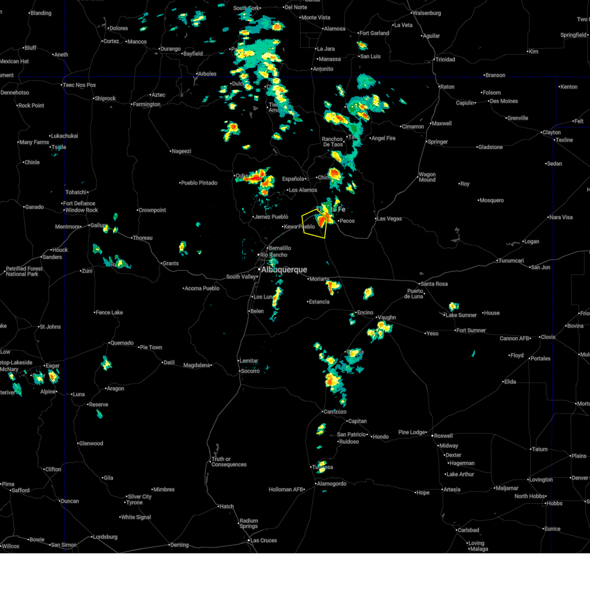
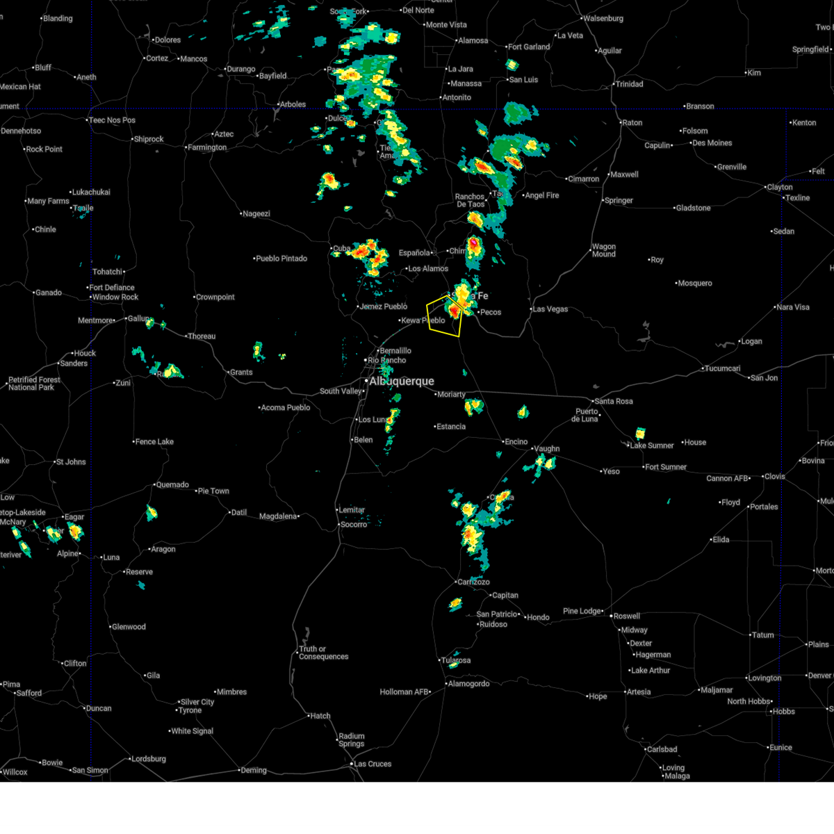
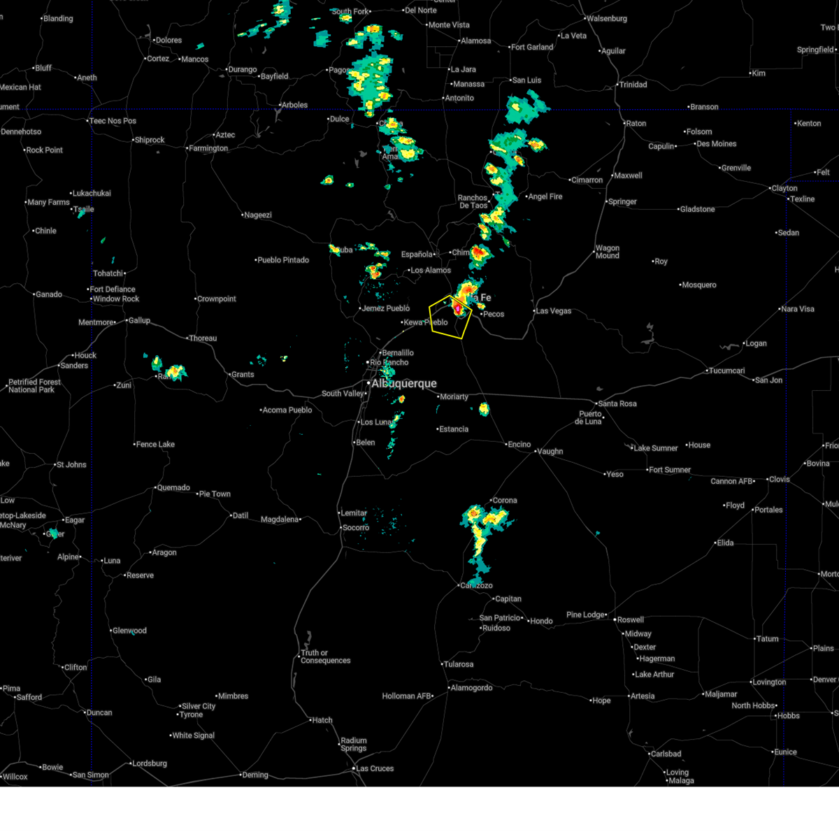
The Top Recent Hail Date for La Cienega, NM is Monday, June 9, 2025 (2nd out of 34)
Hail and Wind Damage Spotted near La Cienega, NM
| Date / Time | Report Details |
|---|---|
| 6/30/2025 12:25 PM MDT |
 The storm which prompted the warning has weakened below severe limits, and no longer poses an immediate threat to life or property. therefore, the warning will be allowed to expire. however, small hail and heavy rain are still possible with this thunderstorm. a severe thunderstorm warning still remains in effect for a portion of southern santa fe county. The storm which prompted the warning has weakened below severe limits, and no longer poses an immediate threat to life or property. therefore, the warning will be allowed to expire. however, small hail and heavy rain are still possible with this thunderstorm. a severe thunderstorm warning still remains in effect for a portion of southern santa fe county.
|
| 6/30/2025 12:16 PM MDT |
 At 1216 pm mdt, a severe thunderstorm was located near canada de los alamos, or 8 miles southeast of santa fe, moving south at 5 mph (radar indicated). Hazards include 60 mph wind gusts and quarter size hail. Hail damage to vehicles is expected. expect wind damage to roofs, siding, and trees. locations impacted include, southern santa fe, eldorado at santa fe, lamy, canada de los alamos, la cienega and agua fria. this includes the following highways, highway 285 between mile markers 280 and 290. Interstate 25 between mile markers 272 and 294. At 1216 pm mdt, a severe thunderstorm was located near canada de los alamos, or 8 miles southeast of santa fe, moving south at 5 mph (radar indicated). Hazards include 60 mph wind gusts and quarter size hail. Hail damage to vehicles is expected. expect wind damage to roofs, siding, and trees. locations impacted include, southern santa fe, eldorado at santa fe, lamy, canada de los alamos, la cienega and agua fria. this includes the following highways, highway 285 between mile markers 280 and 290. Interstate 25 between mile markers 272 and 294.
|
| 6/30/2025 12:01 PM MDT |
 Svrabq the national weather service in albuquerque has issued a * severe thunderstorm warning for, central santa fe county in north central new mexico, * until 1230 pm mdt. * at 1201 pm mdt, a severe thunderstorm was located near canada de los alamos, or 6 miles southeast of santa fe, moving southwest at 10 mph (radar indicated). Hazards include 60 mph wind gusts and quarter size hail. Hail damage to vehicles is expected. Expect wind damage to roofs, siding, and trees. Svrabq the national weather service in albuquerque has issued a * severe thunderstorm warning for, central santa fe county in north central new mexico, * until 1230 pm mdt. * at 1201 pm mdt, a severe thunderstorm was located near canada de los alamos, or 6 miles southeast of santa fe, moving southwest at 10 mph (radar indicated). Hazards include 60 mph wind gusts and quarter size hail. Hail damage to vehicles is expected. Expect wind damage to roofs, siding, and trees.
|
| 6/9/2025 3:19 PM MDT |
 At 319 pm mdt, a severe thunderstorm was located near cerrillos hills state park, or 17 miles southwest of santa fe, moving south at 15 mph (radar indicated). Hazards include 60 mph wind gusts and quarter size hail. Hail damage to vehicles is expected. expect wind damage to roofs, siding, and trees. locations impacted include, southwestern santa fe, eldorado at santa fe, la cienega, cerrillos hills state park, los cerrillos, madrid, la bajada and agua fria. This includes interstate 25 between mile markers 264 and 279. At 319 pm mdt, a severe thunderstorm was located near cerrillos hills state park, or 17 miles southwest of santa fe, moving south at 15 mph (radar indicated). Hazards include 60 mph wind gusts and quarter size hail. Hail damage to vehicles is expected. expect wind damage to roofs, siding, and trees. locations impacted include, southwestern santa fe, eldorado at santa fe, la cienega, cerrillos hills state park, los cerrillos, madrid, la bajada and agua fria. This includes interstate 25 between mile markers 264 and 279.
|
| 6/9/2025 2:54 PM MDT |
 At 254 pm mdt, a severe thunderstorm was located over la cienega, or 12 miles southwest of santa fe, moving south at 10 mph (radar indicated). Hazards include 60 mph wind gusts and quarter size hail. Hail damage to vehicles is expected. expect wind damage to roofs, siding, and trees. locations impacted include, southwestern santa fe, eldorado at santa fe, la cienega, cerrillos hills state park, los cerrillos, madrid, la bajada and agua fria. This includes interstate 25 between mile markers 264 and 279. At 254 pm mdt, a severe thunderstorm was located over la cienega, or 12 miles southwest of santa fe, moving south at 10 mph (radar indicated). Hazards include 60 mph wind gusts and quarter size hail. Hail damage to vehicles is expected. expect wind damage to roofs, siding, and trees. locations impacted include, southwestern santa fe, eldorado at santa fe, la cienega, cerrillos hills state park, los cerrillos, madrid, la bajada and agua fria. This includes interstate 25 between mile markers 264 and 279.
|
| 6/9/2025 2:42 PM MDT | Svrabq the national weather service in albuquerque has issued a * severe thunderstorm warning for, west central santa fe county in north central new mexico, * until 345 pm mdt. * at 242 pm mdt, a severe thunderstorm was located near la cienega, or 11 miles west of santa fe, moving south at 10 mph (radar indicated). Hazards include 60 mph wind gusts and half dollar size hail. Hail damage to vehicles is expected. Expect wind damage to roofs, siding, and trees. |
| 6/9/2025 2:31 PM MDT |
 At 231 pm mdt, a severe thunderstorm was located near la cienega, or 10 miles west of santa fe, moving south at 10 mph (radar indicated). Hazards include golf ball size hail and 60 mph wind gusts. People and animals outdoors will be injured. expect hail damage to roofs, siding, windows, and vehicles. expect wind damage to roofs, siding, and trees. locations impacted include, santa fe, eldorado at santa fe, la cienega and agua fria. This includes interstate 25 between mile markers 268 and 287. At 231 pm mdt, a severe thunderstorm was located near la cienega, or 10 miles west of santa fe, moving south at 10 mph (radar indicated). Hazards include golf ball size hail and 60 mph wind gusts. People and animals outdoors will be injured. expect hail damage to roofs, siding, windows, and vehicles. expect wind damage to roofs, siding, and trees. locations impacted include, santa fe, eldorado at santa fe, la cienega and agua fria. This includes interstate 25 between mile markers 268 and 287.
|
| 6/9/2025 2:20 PM MDT | At 220 pm mdt, a severe thunderstorm was located near la cienega, or 10 miles west of santa fe, moving south at 10 mph (radar indicated). Hazards include 60 mph wind gusts and quarter size hail. Hail damage to vehicles is expected. expect wind damage to roofs, siding, and trees. locations impacted include, santa fe, eldorado at santa fe, la cienega and agua fria. This includes interstate 25 between mile markers 268 and 287. |
| 6/9/2025 2:00 PM MDT | Svrabq the national weather service in albuquerque has issued a * severe thunderstorm warning for, northwestern santa fe county in north central new mexico, * until 245 pm mdt. * at 200 pm mdt, a severe thunderstorm was located 9 miles north of la cienega, or 10 miles west of santa fe, moving southeast at 10 mph (radar indicated). Hazards include 60 mph wind gusts and quarter size hail. Hail damage to vehicles is expected. Expect wind damage to roofs, siding, and trees. |
| 9/17/2024 1:06 PM MDT |
 The storms which prompted the warning have moved out of the area. therefore, the warning will be allowed to expire. however, small hail is still possible with these thunderstorms. a severe thunderstorm watch remains in effect until 700 pm mdt for north central and northeastern new mexico. The storms which prompted the warning have moved out of the area. therefore, the warning will be allowed to expire. however, small hail is still possible with these thunderstorms. a severe thunderstorm watch remains in effect until 700 pm mdt for north central and northeastern new mexico.
|
| 9/17/2024 12:27 PM MDT |
 the severe thunderstorm warning has been cancelled and is no longer in effect the severe thunderstorm warning has been cancelled and is no longer in effect
|
| 9/17/2024 12:27 PM MDT |
 At 1226 pm mdt, severe thunderstorms were located along a line extending from 6 miles northwest of espanola to santa fe, moving northeast at 45 mph (radar indicated). Hazards include 60 mph wind gusts and quarter size hail. Hail damage to vehicles is expected. expect wind damage to roofs, siding, and trees. locations impacted include, santa fe, espanola, chimayo, pojoaque, santa clara pueblo, cuartelez, nambe pueblo, rio chiquito, embudo, and penasco. this includes the following highways, highway 285 between mile markers 337 and 339. State road 63 between mile markers 24 and 25. At 1226 pm mdt, severe thunderstorms were located along a line extending from 6 miles northwest of espanola to santa fe, moving northeast at 45 mph (radar indicated). Hazards include 60 mph wind gusts and quarter size hail. Hail damage to vehicles is expected. expect wind damage to roofs, siding, and trees. locations impacted include, santa fe, espanola, chimayo, pojoaque, santa clara pueblo, cuartelez, nambe pueblo, rio chiquito, embudo, and penasco. this includes the following highways, highway 285 between mile markers 337 and 339. State road 63 between mile markers 24 and 25.
|
| 9/17/2024 12:15 PM MDT |
 the severe thunderstorm warning has been cancelled and is no longer in effect the severe thunderstorm warning has been cancelled and is no longer in effect
|
| 9/17/2024 12:15 PM MDT |
 At 1214 pm mdt, severe thunderstorms were located along a line extending from near la cienega to near stanley, moving northeast at 45 mph (radar indicated). Hazards include 60 mph wind gusts. Expect damage to roofs, siding, and trees. locations impacted include, santa fe, eldorado at santa fe, pecos, cerrillos hills state park, canada de los alamos, lamy, glorieta, rowe, upper colonias, and stanley. this includes the following highways, interstate 25 between mile markers 269 and 318. highway 285 between mile markers 257 and 290. State road 63 between mile markers 0 and 16. At 1214 pm mdt, severe thunderstorms were located along a line extending from near la cienega to near stanley, moving northeast at 45 mph (radar indicated). Hazards include 60 mph wind gusts. Expect damage to roofs, siding, and trees. locations impacted include, santa fe, eldorado at santa fe, pecos, cerrillos hills state park, canada de los alamos, lamy, glorieta, rowe, upper colonias, and stanley. this includes the following highways, interstate 25 between mile markers 269 and 318. highway 285 between mile markers 257 and 290. State road 63 between mile markers 0 and 16.
|
| 9/17/2024 12:11 PM MDT |
 Svrabq the national weather service in albuquerque has issued a * severe thunderstorm warning for, southwestern taos county in north central new mexico, eastern los alamos county in north central new mexico, northwestern san miguel county in northeastern new mexico, southeastern rio arriba county in north central new mexico, northern santa fe county in north central new mexico, west central mora county in northeastern new mexico, * until 115 pm mdt. * at 1210 pm mdt, severe thunderstorms were located along a line extending from near los alamos to la bajada, moving northeast at 45 mph (radar indicated). Hazards include 60 mph wind gusts. expect damage to roofs, siding, and trees Svrabq the national weather service in albuquerque has issued a * severe thunderstorm warning for, southwestern taos county in north central new mexico, eastern los alamos county in north central new mexico, northwestern san miguel county in northeastern new mexico, southeastern rio arriba county in north central new mexico, northern santa fe county in north central new mexico, west central mora county in northeastern new mexico, * until 115 pm mdt. * at 1210 pm mdt, severe thunderstorms were located along a line extending from near los alamos to la bajada, moving northeast at 45 mph (radar indicated). Hazards include 60 mph wind gusts. expect damage to roofs, siding, and trees
|
| 9/17/2024 11:59 AM MDT |
 Svrabq the national weather service in albuquerque has issued a * severe thunderstorm warning for, west central san miguel county in northeastern new mexico, eastern sandoval county in north central new mexico, santa fe county in north central new mexico, north central torrance county in central new mexico, * until 100 pm mdt. * at 1158 am mdt, severe thunderstorms were located along a line extending from near madrid to 6 miles west of moriarty, moving northeast at 45 mph (radar indicated). Hazards include 60 mph wind gusts. expect damage to roofs, siding, and trees Svrabq the national weather service in albuquerque has issued a * severe thunderstorm warning for, west central san miguel county in northeastern new mexico, eastern sandoval county in north central new mexico, santa fe county in north central new mexico, north central torrance county in central new mexico, * until 100 pm mdt. * at 1158 am mdt, severe thunderstorms were located along a line extending from near madrid to 6 miles west of moriarty, moving northeast at 45 mph (radar indicated). Hazards include 60 mph wind gusts. expect damage to roofs, siding, and trees
|
| 6/29/2024 10:19 PM MDT |
 The storm which prompted the warning has moved out of the area. therefore, the warning has been allowed to expire. however, heavy rain and flash flooding is still possible within the area. The storm which prompted the warning has moved out of the area. therefore, the warning has been allowed to expire. however, heavy rain and flash flooding is still possible within the area.
|
| 6/29/2024 9:30 PM MDT |
 Svrabq the national weather service in albuquerque has issued a * severe thunderstorm warning for, east central sandoval county in north central new mexico, west central santa fe county in north central new mexico, * until 1015 pm mdt. * at 929 pm mdt, a severe thunderstorm was located near kewa pueblo, or 18 miles northeast of bernalillo, moving north at 25 mph (radar indicated). Hazards include 60 mph wind gusts. expect damage to roofs, siding, and trees Svrabq the national weather service in albuquerque has issued a * severe thunderstorm warning for, east central sandoval county in north central new mexico, west central santa fe county in north central new mexico, * until 1015 pm mdt. * at 929 pm mdt, a severe thunderstorm was located near kewa pueblo, or 18 miles northeast of bernalillo, moving north at 25 mph (radar indicated). Hazards include 60 mph wind gusts. expect damage to roofs, siding, and trees
|
| 6/19/2024 3:28 PM MDT |
 Svrabq the national weather service in albuquerque has issued a * severe thunderstorm warning for, los alamos county in north central new mexico, southeastern rio arriba county in north central new mexico, east central sandoval county in north central new mexico, northwestern santa fe county in north central new mexico, * until 430 pm mdt. * at 327 pm mdt, a severe thunderstorm was located near la cienega, or 9 miles west of santa fe, moving north at 45 mph (radar indicated). Hazards include 60 mph wind gusts and quarter size hail. Hail damage to vehicles is expected. Expect wind damage to roofs, siding, and trees. Svrabq the national weather service in albuquerque has issued a * severe thunderstorm warning for, los alamos county in north central new mexico, southeastern rio arriba county in north central new mexico, east central sandoval county in north central new mexico, northwestern santa fe county in north central new mexico, * until 430 pm mdt. * at 327 pm mdt, a severe thunderstorm was located near la cienega, or 9 miles west of santa fe, moving north at 45 mph (radar indicated). Hazards include 60 mph wind gusts and quarter size hail. Hail damage to vehicles is expected. Expect wind damage to roofs, siding, and trees.
|
| 6/19/2024 3:18 PM MDT |
 At 318 pm mdt, a severe thunderstorm was located near la cienega, or 14 miles southwest of santa fe, moving north at 40 mph (radar indicated. at 3 pm mdt, the public reported half dollar size hail just north of madrid). Hazards include 60 mph wind gusts and half dollar size hail. Hail damage to vehicles is expected. expect wind damage to roofs, siding, and trees. Locations impacted include, santa fe, cerrillos hills state park, la cienega, cochiti pueblo, los cerrillos, la bajada, cochiti lake, agua fria, and pena blanca. At 318 pm mdt, a severe thunderstorm was located near la cienega, or 14 miles southwest of santa fe, moving north at 40 mph (radar indicated. at 3 pm mdt, the public reported half dollar size hail just north of madrid). Hazards include 60 mph wind gusts and half dollar size hail. Hail damage to vehicles is expected. expect wind damage to roofs, siding, and trees. Locations impacted include, santa fe, cerrillos hills state park, la cienega, cochiti pueblo, los cerrillos, la bajada, cochiti lake, agua fria, and pena blanca.
|
| 6/19/2024 3:06 PM MDT |
 At 305 pm mdt, a severe thunderstorm was located near cerrillos hills state park, or 17 miles southwest of santa fe, moving north at 45 mph (radar indicated. at 244 pm, a trained spotter reported 5 power poles had been knocked down due to high winds in edgewood). Hazards include golf ball size hail and 60 mph wind gusts. People and animals outdoors will be injured. expect hail damage to roofs, siding, windows, and vehicles. expect wind damage to roofs, siding, and trees. Locations impacted include, santa fe, cerrillos hills state park, madrid, la cienega, cochiti pueblo, los cerrillos, la bajada, cochiti lake, domingo, and agua fria. At 305 pm mdt, a severe thunderstorm was located near cerrillos hills state park, or 17 miles southwest of santa fe, moving north at 45 mph (radar indicated. at 244 pm, a trained spotter reported 5 power poles had been knocked down due to high winds in edgewood). Hazards include golf ball size hail and 60 mph wind gusts. People and animals outdoors will be injured. expect hail damage to roofs, siding, windows, and vehicles. expect wind damage to roofs, siding, and trees. Locations impacted include, santa fe, cerrillos hills state park, madrid, la cienega, cochiti pueblo, los cerrillos, la bajada, cochiti lake, domingo, and agua fria.
|
| 6/19/2024 2:56 PM MDT |
 At 255 pm mdt, a severe thunderstorm was located over madrid, or 21 miles east of bernalillo, moving north at 45 mph (radar indicated). Hazards include two inch hail and 60 mph wind gusts. People and animals outdoors will be injured. expect hail damage to roofs, siding, windows, and vehicles. expect wind damage to roofs, siding, and trees. Locations impacted include, santa fe, santo domingo pueblo, cerrillos hills state park, cochiti pueblo, la bajada, madrid, la cienega, los cerrillos, cochiti lake, and golden. At 255 pm mdt, a severe thunderstorm was located over madrid, or 21 miles east of bernalillo, moving north at 45 mph (radar indicated). Hazards include two inch hail and 60 mph wind gusts. People and animals outdoors will be injured. expect hail damage to roofs, siding, windows, and vehicles. expect wind damage to roofs, siding, and trees. Locations impacted include, santa fe, santo domingo pueblo, cerrillos hills state park, cochiti pueblo, la bajada, madrid, la cienega, los cerrillos, cochiti lake, and golden.
|
| 6/19/2024 2:56 PM MDT |
 the severe thunderstorm warning has been cancelled and is no longer in effect the severe thunderstorm warning has been cancelled and is no longer in effect
|
| 6/19/2024 2:42 PM MDT |
 Svrabq the national weather service in albuquerque has issued a * severe thunderstorm warning for, southeastern sandoval county in north central new mexico, southwestern santa fe county in north central new mexico, bernalillo county in central new mexico, * until 330 pm mdt. * at 242 pm mdt, a severe thunderstorm was located over golden, or 18 miles northwest of moriarty, moving north at 45 mph (radar indicated). Hazards include golf ball size hail and 60 mph wind gusts. People and animals outdoors will be injured. expect hail damage to roofs, siding, windows, and vehicles. Expect wind damage to roofs, siding, and trees. Svrabq the national weather service in albuquerque has issued a * severe thunderstorm warning for, southeastern sandoval county in north central new mexico, southwestern santa fe county in north central new mexico, bernalillo county in central new mexico, * until 330 pm mdt. * at 242 pm mdt, a severe thunderstorm was located over golden, or 18 miles northwest of moriarty, moving north at 45 mph (radar indicated). Hazards include golf ball size hail and 60 mph wind gusts. People and animals outdoors will be injured. expect hail damage to roofs, siding, windows, and vehicles. Expect wind damage to roofs, siding, and trees.
|
| 6/14/2024 6:37 PM MDT |
 At 636 pm mdt, a severe thunderstorm was located near santa fe, moving northeast at 40 mph (radar indicated). Hazards include 60 mph wind gusts. Expect damage to roofs, siding, and trees. Locations impacted include, santa fe, los alamos, white rock, pojoaque, eldorado at santa fe, cerrillos hills state park, canada de los alamos, glorieta, frijoles, and bandelier national monument. At 636 pm mdt, a severe thunderstorm was located near santa fe, moving northeast at 40 mph (radar indicated). Hazards include 60 mph wind gusts. Expect damage to roofs, siding, and trees. Locations impacted include, santa fe, los alamos, white rock, pojoaque, eldorado at santa fe, cerrillos hills state park, canada de los alamos, glorieta, frijoles, and bandelier national monument.
|
| 6/14/2024 5:50 PM MDT |
 Svrabq the national weather service in albuquerque has issued a * severe thunderstorm warning for, southeastern los alamos county in north central new mexico, east central sandoval county in north central new mexico, central santa fe county in north central new mexico, * until 645 pm mdt. * at 550 pm mdt, a severe thunderstorm was located over san felipe pueblo, or 10 miles northeast of bernalillo, moving east at 55 mph (radar indicated). Hazards include 60 mph wind gusts. expect damage to roofs, siding, and trees Svrabq the national weather service in albuquerque has issued a * severe thunderstorm warning for, southeastern los alamos county in north central new mexico, east central sandoval county in north central new mexico, central santa fe county in north central new mexico, * until 645 pm mdt. * at 550 pm mdt, a severe thunderstorm was located over san felipe pueblo, or 10 miles northeast of bernalillo, moving east at 55 mph (radar indicated). Hazards include 60 mph wind gusts. expect damage to roofs, siding, and trees
|
| 6/1/2023 1:24 PM MDT |
 At 124 pm mdt, a severe thunderstorm was located near santa fe, moving northeast at 30 mph (radar indicated). Hazards include 60 mph wind gusts and quarter size hail. Hail damage to vehicles is expected. Expect wind damage to roofs, siding, and trees. At 124 pm mdt, a severe thunderstorm was located near santa fe, moving northeast at 30 mph (radar indicated). Hazards include 60 mph wind gusts and quarter size hail. Hail damage to vehicles is expected. Expect wind damage to roofs, siding, and trees.
|
| 7/11/2021 5:18 PM MDT |
 At 518 pm mdt, a severe thunderstorm was located over eastern santa fe, moving southwest at 15 mph (radar indicated). Hazards include 60 mph wind gusts and quarter size hail. Hail damage to vehicles is expected. expect wind damage to roofs, siding, and trees. locations impacted include, santa fe, eldorado at santa fe, tesuque and la cienega. This includes interstate 25 between mile markers 276 and 288. At 518 pm mdt, a severe thunderstorm was located over eastern santa fe, moving southwest at 15 mph (radar indicated). Hazards include 60 mph wind gusts and quarter size hail. Hail damage to vehicles is expected. expect wind damage to roofs, siding, and trees. locations impacted include, santa fe, eldorado at santa fe, tesuque and la cienega. This includes interstate 25 between mile markers 276 and 288.
|
| 7/11/2021 5:01 PM MDT |
 At 501 pm mdt, a severe thunderstorm was located over tesuque, or near santa fe, moving southwest at 15 mph (radar indicated). Hazards include 60 mph wind gusts and quarter size hail. Hail damage to vehicles is expected. Expect wind damage to roofs, siding, and trees. At 501 pm mdt, a severe thunderstorm was located over tesuque, or near santa fe, moving southwest at 15 mph (radar indicated). Hazards include 60 mph wind gusts and quarter size hail. Hail damage to vehicles is expected. Expect wind damage to roofs, siding, and trees.
|
| 7/9/2021 3:19 PM MDT |
 At 319 pm mdt, a severe thunderstorm was located near glorieta, or 8 miles east of santa fe, and is nearly stationary (radar indicated). Hazards include 60 mph wind gusts and penny size hail. Expect damage to roofs, siding, and trees. locations impacted include, santa fe, eldorado at santa fe, canada de los alamos, glorieta, hyde memorial state park, tesuque, lamy and la cienega. this includes the following highways, interstate 25 between mile markers 275 and 303. Highway 285 between mile markers 288 and 290. At 319 pm mdt, a severe thunderstorm was located near glorieta, or 8 miles east of santa fe, and is nearly stationary (radar indicated). Hazards include 60 mph wind gusts and penny size hail. Expect damage to roofs, siding, and trees. locations impacted include, santa fe, eldorado at santa fe, canada de los alamos, glorieta, hyde memorial state park, tesuque, lamy and la cienega. this includes the following highways, interstate 25 between mile markers 275 and 303. Highway 285 between mile markers 288 and 290.
|
| 7/9/2021 2:58 PM MDT |
 At 258 pm mdt, a severe thunderstorm was located near hyde memorial state park, or 8 miles east of santa fe, and is nearly stationary (radar indicated). Hazards include 60 mph wind gusts and penny size hail. expect damage to roofs, siding, and trees At 258 pm mdt, a severe thunderstorm was located near hyde memorial state park, or 8 miles east of santa fe, and is nearly stationary (radar indicated). Hazards include 60 mph wind gusts and penny size hail. expect damage to roofs, siding, and trees
|
| 5/30/2021 2:01 PM MDT |
 At 156 pm mdt, a severe thunderstorm was located near cerrillos hills state park, or 17 miles southwest of santa fe, moving northeast at 15 mph (radar indicated). Hazards include 60 mph wind gusts and quarter size hail. Hail damage to vehicles is expected. Expect wind damage to roofs, siding, and trees. At 156 pm mdt, a severe thunderstorm was located near cerrillos hills state park, or 17 miles southwest of santa fe, moving northeast at 15 mph (radar indicated). Hazards include 60 mph wind gusts and quarter size hail. Hail damage to vehicles is expected. Expect wind damage to roofs, siding, and trees.
|
| 5/30/2021 1:56 PM MDT |
 At 156 pm mdt, a severe thunderstorm was located near cerrillos hills state park, or 17 miles southwest of santa fe, moving northeast at 15 mph (radar indicated). Hazards include 60 mph wind gusts and quarter size hail. Hail damage to vehicles is expected. Expect wind damage to roofs, siding, and trees. At 156 pm mdt, a severe thunderstorm was located near cerrillos hills state park, or 17 miles southwest of santa fe, moving northeast at 15 mph (radar indicated). Hazards include 60 mph wind gusts and quarter size hail. Hail damage to vehicles is expected. Expect wind damage to roofs, siding, and trees.
|
| 5/22/2021 4:23 PM MDT |
 At 423 pm mdt, a severe thunderstorm was located over southern santa fe, moving north at 55 mph (radar indicated). Hazards include 60 mph wind gusts and quarter size hail. Hail damage to vehicles is expected. Expect wind damage to roofs, siding, and trees. At 423 pm mdt, a severe thunderstorm was located over southern santa fe, moving north at 55 mph (radar indicated). Hazards include 60 mph wind gusts and quarter size hail. Hail damage to vehicles is expected. Expect wind damage to roofs, siding, and trees.
|
| 5/17/2021 2:14 PM MDT |
 At 213 pm mdt, a severe thunderstorm was located near eldorado at santa fe, or 13 miles south of santa fe, moving north at 10 mph (radar indicated). Hazards include 60 mph wind gusts and quarter size hail. Hail damage to vehicles is expected. Expect wind damage to roofs, siding, and trees. At 213 pm mdt, a severe thunderstorm was located near eldorado at santa fe, or 13 miles south of santa fe, moving north at 10 mph (radar indicated). Hazards include 60 mph wind gusts and quarter size hail. Hail damage to vehicles is expected. Expect wind damage to roofs, siding, and trees.
|
| 5/17/2021 1:13 PM MDT |
 At 113 pm mdt, a severe thunderstorm was located near los cerrillos, or 13 miles south of santa fe, moving north at 10 mph (radar indicated). Hazards include 60 mph wind gusts and quarter size hail. Hail damage to vehicles is expected. Expect wind damage to roofs, siding, and trees. At 113 pm mdt, a severe thunderstorm was located near los cerrillos, or 13 miles south of santa fe, moving north at 10 mph (radar indicated). Hazards include 60 mph wind gusts and quarter size hail. Hail damage to vehicles is expected. Expect wind damage to roofs, siding, and trees.
|
| 5/17/2021 1:01 PM MDT |
 At 100 pm mdt, a severe thunderstorm was located near los cerrillos, or 16 miles south of santa fe, and is nearly stationary (radar indicated). Hazards include 60 mph wind gusts and quarter size hail. Hail damage to vehicles is expected. expect wind damage to roofs, siding, and trees. locations impacted include, southern santa fe, eldorado at santa fe, cerrillos hills state park, la cienega, galisteo, los cerrillos, madrid, lamy and canada de los alamos. this includes the following highways, interstate 25 between mile markers 268 and 290. Highway 285 between mile markers 284 and 290. At 100 pm mdt, a severe thunderstorm was located near los cerrillos, or 16 miles south of santa fe, and is nearly stationary (radar indicated). Hazards include 60 mph wind gusts and quarter size hail. Hail damage to vehicles is expected. expect wind damage to roofs, siding, and trees. locations impacted include, southern santa fe, eldorado at santa fe, cerrillos hills state park, la cienega, galisteo, los cerrillos, madrid, lamy and canada de los alamos. this includes the following highways, interstate 25 between mile markers 268 and 290. Highway 285 between mile markers 284 and 290.
|
| 5/17/2021 12:16 PM MDT |
 At 1215 pm mdt, a severe thunderstorm was located near los cerrillos, or 17 miles south of santa fe, moving north at 10 mph (radar indicated). Hazards include 60 mph wind gusts and quarter size hail. Hail damage to vehicles is expected. Expect wind damage to roofs, siding, and trees. At 1215 pm mdt, a severe thunderstorm was located near los cerrillos, or 17 miles south of santa fe, moving north at 10 mph (radar indicated). Hazards include 60 mph wind gusts and quarter size hail. Hail damage to vehicles is expected. Expect wind damage to roofs, siding, and trees.
|
| 7/31/2020 5:18 PM MDT |
 At 517 pm mdt, a severe thunderstorm was located near la bajada, or 21 miles northeast of bernalillo, moving south at 15 mph (radar indicated). Hazards include 60 mph wind gusts and penny size hail. Expect damage to roofs, siding, and trees. locations impacted include, santo domingo pueblo, cerrillos hills state park, san felipe pueblo, madrid, kewa pueblo, cochiti pueblo, los cerrillos, la bajada, cochiti lake and domingo. This includes interstate 25 between mile markers 248 and 269. At 517 pm mdt, a severe thunderstorm was located near la bajada, or 21 miles northeast of bernalillo, moving south at 15 mph (radar indicated). Hazards include 60 mph wind gusts and penny size hail. Expect damage to roofs, siding, and trees. locations impacted include, santo domingo pueblo, cerrillos hills state park, san felipe pueblo, madrid, kewa pueblo, cochiti pueblo, los cerrillos, la bajada, cochiti lake and domingo. This includes interstate 25 between mile markers 248 and 269.
|
| 7/31/2020 4:56 PM MDT |
 At 455 pm mdt, a severe thunderstorm was located over cochiti pueblo, or 19 miles south of los alamos, moving south at 20 mph (trained weather spotters). Hazards include 60 mph wind gusts and quarter size hail. Hail damage to vehicles is expected. expect wind damage to roofs, siding, and trees. locations impacted include, santo domingo pueblo, cerrillos hills state park, san felipe pueblo, madrid, kewa pueblo, cochiti pueblo, los cerrillos, la bajada, cochiti lake and domingo. This includes interstate 25 between mile markers 248 and 269. At 455 pm mdt, a severe thunderstorm was located over cochiti pueblo, or 19 miles south of los alamos, moving south at 20 mph (trained weather spotters). Hazards include 60 mph wind gusts and quarter size hail. Hail damage to vehicles is expected. expect wind damage to roofs, siding, and trees. locations impacted include, santo domingo pueblo, cerrillos hills state park, san felipe pueblo, madrid, kewa pueblo, cochiti pueblo, los cerrillos, la bajada, cochiti lake and domingo. This includes interstate 25 between mile markers 248 and 269.
|
| 7/31/2020 4:46 PM MDT |
 At 446 pm mdt, a severe thunderstorm was located over cochiti lake, or 15 miles south of los alamos, moving south at 20 mph (radar indicated). Hazards include 60 mph wind gusts and quarter size hail. Hail damage to vehicles is expected. Expect wind damage to roofs, siding, and trees. At 446 pm mdt, a severe thunderstorm was located over cochiti lake, or 15 miles south of los alamos, moving south at 20 mph (radar indicated). Hazards include 60 mph wind gusts and quarter size hail. Hail damage to vehicles is expected. Expect wind damage to roofs, siding, and trees.
|
| 6/23/2020 3:05 PM MDT |
 At 305 pm mdt, a severe thunderstorm was located near cerrillos hills state park, or 21 miles southwest of santa fe, moving southeast at 20 mph (radar indicated). Hazards include 60 mph wind gusts and quarter size hail. Hail damage to vehicles is expected. expect wind damage to roofs, siding, and trees. locations impacted include, santo domingo pueblo, cerrillos hills state park, madrid, kewa pueblo, galisteo, los cerrillos, la bajada, golden, domingo and la cienega. This includes interstate 25 between mile markers 257 and 271. At 305 pm mdt, a severe thunderstorm was located near cerrillos hills state park, or 21 miles southwest of santa fe, moving southeast at 20 mph (radar indicated). Hazards include 60 mph wind gusts and quarter size hail. Hail damage to vehicles is expected. expect wind damage to roofs, siding, and trees. locations impacted include, santo domingo pueblo, cerrillos hills state park, madrid, kewa pueblo, galisteo, los cerrillos, la bajada, golden, domingo and la cienega. This includes interstate 25 between mile markers 257 and 271.
|
| 6/23/2020 2:42 PM MDT |
 At 241 pm mdt, a severe thunderstorm was located near cochiti pueblo, or 21 miles west of santa fe, moving southeast at 20 mph (radar indicated). Hazards include 60 mph wind gusts and quarter size hail. Hail damage to vehicles is expected. Expect wind damage to roofs, siding, and trees. At 241 pm mdt, a severe thunderstorm was located near cochiti pueblo, or 21 miles west of santa fe, moving southeast at 20 mph (radar indicated). Hazards include 60 mph wind gusts and quarter size hail. Hail damage to vehicles is expected. Expect wind damage to roofs, siding, and trees.
|
| 8/27/2019 3:22 PM MDT |
 At 322 pm mdt, a severe thunderstorm was located over cochiti lake, or 16 miles south of los alamos, moving southeast at 10 mph (radar indicated). Hazards include 60 mph wind gusts and quarter size hail. Hail damage to vehicles is expected. expect wind damage to roofs, siding, and trees. Locations impacted include, cochiti pueblo, la bajada, cochiti lake, domingo, pena blanca and la cienega. At 322 pm mdt, a severe thunderstorm was located over cochiti lake, or 16 miles south of los alamos, moving southeast at 10 mph (radar indicated). Hazards include 60 mph wind gusts and quarter size hail. Hail damage to vehicles is expected. expect wind damage to roofs, siding, and trees. Locations impacted include, cochiti pueblo, la bajada, cochiti lake, domingo, pena blanca and la cienega.
|
| 8/27/2019 3:08 PM MDT |
 The national weather service in albuquerque has issued a * severe thunderstorm warning for. east central sandoval county in north central new mexico. west central santa fe county in north central new mexico. until 400 pm mdt. At 308 pm mdt, a severe thunderstorm was located over cochiti lake,. The national weather service in albuquerque has issued a * severe thunderstorm warning for. east central sandoval county in north central new mexico. west central santa fe county in north central new mexico. until 400 pm mdt. At 308 pm mdt, a severe thunderstorm was located over cochiti lake,.
|
| 6/2/2019 5:48 PM MDT |
 At 548 pm mdt, a severe thunderstorm was located near la bajada, or 17 miles west of santa fe, moving northeast at 15 mph (radar indicated). Hazards include 60 mph wind gusts and quarter size hail. Hail damage to vehicles is expected. expect wind damage to roofs, siding, and trees. Locations impacted include, la bajada. At 548 pm mdt, a severe thunderstorm was located near la bajada, or 17 miles west of santa fe, moving northeast at 15 mph (radar indicated). Hazards include 60 mph wind gusts and quarter size hail. Hail damage to vehicles is expected. expect wind damage to roofs, siding, and trees. Locations impacted include, la bajada.
|
| 6/2/2019 5:33 PM MDT |
 At 533 pm mdt, a severe thunderstorm was located near cochiti pueblo, or 21 miles west of santa fe, moving northeast at 10 mph (radar indicated). Hazards include 60 mph wind gusts and quarter size hail. Hail damage to vehicles is expected. Expect wind damage to roofs, siding, and trees. At 533 pm mdt, a severe thunderstorm was located near cochiti pueblo, or 21 miles west of santa fe, moving northeast at 10 mph (radar indicated). Hazards include 60 mph wind gusts and quarter size hail. Hail damage to vehicles is expected. Expect wind damage to roofs, siding, and trees.
|
| 8/18/2018 12:57 PM MDT |
 At 1257 pm mdt, a severe thunderstorm was located over frijoles, or near los alamos, moving southeast at 20 mph (radar indicated). Hazards include 60 mph wind gusts and quarter size hail. Hail damage to vehicles is expected. Expect wind damage to roofs, siding, and trees. At 1257 pm mdt, a severe thunderstorm was located over frijoles, or near los alamos, moving southeast at 20 mph (radar indicated). Hazards include 60 mph wind gusts and quarter size hail. Hail damage to vehicles is expected. Expect wind damage to roofs, siding, and trees.
|
| 5/21/2018 4:23 PM MDT |
 The severe thunderstorm warning for south central taos, eastern los alamos, southeastern rio arriba and northern santa fe counties will expire at 430 pm mdt, the storms which prompted the warning have weakened below severe limits, and no longer pose an immediate threat to life or property. therefore the warning will be allowed to expire. however gusty winds are still possible with these thunderstorms. a severe thunderstorm watch remains in effect until 700 pm mdt for north central new mexico. The severe thunderstorm warning for south central taos, eastern los alamos, southeastern rio arriba and northern santa fe counties will expire at 430 pm mdt, the storms which prompted the warning have weakened below severe limits, and no longer pose an immediate threat to life or property. therefore the warning will be allowed to expire. however gusty winds are still possible with these thunderstorms. a severe thunderstorm watch remains in effect until 700 pm mdt for north central new mexico.
|
| 5/21/2018 4:07 PM MDT |
 At 407 pm mdt, severe thunderstorms were located along a line extending from 7 miles north of los alamos to near rio en medio in santa fe county, moving northeast at 35 mph (radar indicated). Hazards include 60 mph wind gusts. Expect damage to roofs, siding, and trees. locations impacted include, santa fe, los alamos, espanola, white rock, pojoaque, chimayo, santa clara pueblo, cuartelez, nambe pueblo and rio chiquito. this includes the following highways, interstate 25 between mile markers 268 and 281. Highway 285 between mile markers 337 and 349. At 407 pm mdt, severe thunderstorms were located along a line extending from 7 miles north of los alamos to near rio en medio in santa fe county, moving northeast at 35 mph (radar indicated). Hazards include 60 mph wind gusts. Expect damage to roofs, siding, and trees. locations impacted include, santa fe, los alamos, espanola, white rock, pojoaque, chimayo, santa clara pueblo, cuartelez, nambe pueblo and rio chiquito. this includes the following highways, interstate 25 between mile markers 268 and 281. Highway 285 between mile markers 337 and 349.
|
| 5/21/2018 3:44 PM MDT |
 At 344 pm mdt, severe thunderstorms were located along a line extending from 7 miles southwest of los alamos to 8 miles southeast of white rock, moving northeast at 45 mph (radar indicated). Hazards include 60 mph wind gusts and quarter size hail. Hail damage to vehicles is expected. Expect wind damage to roofs, siding, and trees. At 344 pm mdt, severe thunderstorms were located along a line extending from 7 miles southwest of los alamos to 8 miles southeast of white rock, moving northeast at 45 mph (radar indicated). Hazards include 60 mph wind gusts and quarter size hail. Hail damage to vehicles is expected. Expect wind damage to roofs, siding, and trees.
|
| 5/21/2018 3:29 PM MDT |
 At 329 pm mdt, severe thunderstorms were located along a line extending from near cedar grove to near mcintosh, moving north at 20 mph (radar indicated). Hazards include 60 mph wind gusts and half dollar size hail. Hail damage to vehicles is expected. Expect wind damage to roofs, siding, and trees. At 329 pm mdt, severe thunderstorms were located along a line extending from near cedar grove to near mcintosh, moving north at 20 mph (radar indicated). Hazards include 60 mph wind gusts and half dollar size hail. Hail damage to vehicles is expected. Expect wind damage to roofs, siding, and trees.
|
| 5/21/2018 3:22 PM MDT |
 At 322 pm mdt, severe thunderstorms were located along a line extending from near jemez pueblo to near la bajada, moving northeast at 35 mph (radar indicated). Hazards include 70 mph wind gusts and quarter size hail. Hail damage to vehicles is expected. expect considerable tree damage. wind damage is also likely to mobile homes, roofs, and outbuildings. locations impacted include, santo domingo pueblo, jemez springs, san ysidro, san felipe pueblo, kewa pueblo, cochiti pueblo, la bajada, jemez pueblo, zia pueblo and jemez state monument. This includes interstate 25 between mile markers 249 and 273. At 322 pm mdt, severe thunderstorms were located along a line extending from near jemez pueblo to near la bajada, moving northeast at 35 mph (radar indicated). Hazards include 70 mph wind gusts and quarter size hail. Hail damage to vehicles is expected. expect considerable tree damage. wind damage is also likely to mobile homes, roofs, and outbuildings. locations impacted include, santo domingo pueblo, jemez springs, san ysidro, san felipe pueblo, kewa pueblo, cochiti pueblo, la bajada, jemez pueblo, zia pueblo and jemez state monument. This includes interstate 25 between mile markers 249 and 273.
|
| 5/21/2018 3:05 PM MDT |
 At 304 pm mdt, severe thunderstorms were located along a line extending from 7 miles west of san ysidro to 7 miles northwest of golden, moving north at 40 mph (radar indicated). Hazards include 70 mph wind gusts and quarter size hail. Hail damage to vehicles is expected. expect considerable tree damage. wind damage is also likely to mobile homes, roofs, and outbuildings. locations impacted include, rio rancho, bernalillo, santo domingo pueblo, jemez springs, san ysidro, mariposa, san felipe pueblo, coronado state monument, jemez pueblo and santa ana pueblo. This includes interstate 25 between mile markers 239 and 273. At 304 pm mdt, severe thunderstorms were located along a line extending from 7 miles west of san ysidro to 7 miles northwest of golden, moving north at 40 mph (radar indicated). Hazards include 70 mph wind gusts and quarter size hail. Hail damage to vehicles is expected. expect considerable tree damage. wind damage is also likely to mobile homes, roofs, and outbuildings. locations impacted include, rio rancho, bernalillo, santo domingo pueblo, jemez springs, san ysidro, mariposa, san felipe pueblo, coronado state monument, jemez pueblo and santa ana pueblo. This includes interstate 25 between mile markers 239 and 273.
|
| 5/21/2018 2:44 PM MDT |
 At 243 pm mdt, severe thunderstorms were located along a line extending from 12 miles northeast of marquez to sandia park, moving north at 35 mph (radar indicated). Hazards include 60 mph wind gusts and quarter size hail. Hail damage to vehicles is expected. Expect wind damage to roofs, siding, and trees. At 243 pm mdt, severe thunderstorms were located along a line extending from 12 miles northeast of marquez to sandia park, moving north at 35 mph (radar indicated). Hazards include 60 mph wind gusts and quarter size hail. Hail damage to vehicles is expected. Expect wind damage to roofs, siding, and trees.
|
| 6/25/2017 5:27 PM MDT |
 At 526 pm mdt, a severe thunderstorm was located near cochiti lake, or 12 miles south of los alamos, moving south at 45 mph (radar indicated). Hazards include 60 mph wind gusts and quarter size hail. Hail damage to vehicles is expected. Expect wind damage to roofs, siding, and trees. At 526 pm mdt, a severe thunderstorm was located near cochiti lake, or 12 miles south of los alamos, moving south at 45 mph (radar indicated). Hazards include 60 mph wind gusts and quarter size hail. Hail damage to vehicles is expected. Expect wind damage to roofs, siding, and trees.
|
| 6/25/2017 4:36 PM MDT |
 At 436 pm mdt, a severe thunderstorm was located near frijoles, or 13 miles southeast of los alamos, moving southeast at 20 mph (radar indicated). Hazards include 60 mph wind gusts and half dollar size hail. Hail damage to vehicles is expected. Expect wind damage to roofs, siding, and trees. At 436 pm mdt, a severe thunderstorm was located near frijoles, or 13 miles southeast of los alamos, moving southeast at 20 mph (radar indicated). Hazards include 60 mph wind gusts and half dollar size hail. Hail damage to vehicles is expected. Expect wind damage to roofs, siding, and trees.
|
| 5/9/2017 1:50 PM MDT |
 The severe thunderstorm warning for southern los alamos, east central sandoval and northwestern santa fe counties will expire at 200 pm mdt, the storm which prompted the warning has weakened below severe limits, and no longer pose an immediate threat to life or property. therefore the warning will be allowed to expire. however heavy rain and small hail is still possible with this thunderstorm. a severe thunderstorm watch remains in effect until 600 pm mdt for north central new mexico. to report severe weather, contact your nearest law enforcement agency. they will relay your report to the national weather service albuquerque. The severe thunderstorm warning for southern los alamos, east central sandoval and northwestern santa fe counties will expire at 200 pm mdt, the storm which prompted the warning has weakened below severe limits, and no longer pose an immediate threat to life or property. therefore the warning will be allowed to expire. however heavy rain and small hail is still possible with this thunderstorm. a severe thunderstorm watch remains in effect until 600 pm mdt for north central new mexico. to report severe weather, contact your nearest law enforcement agency. they will relay your report to the national weather service albuquerque.
|
| 5/9/2017 1:34 PM MDT |
 At 134 pm mdt, a severe thunderstorm was located near white rock, or 11 miles southeast of los alamos, moving north at 35 mph (radar indicated). Hazards include 60 mph wind gusts and quarter size hail. Hail damage to vehicles is expected. expect wind damage to roofs, siding, and trees. Locations impacted include, white rock, bandelier national monument and frijoles. At 134 pm mdt, a severe thunderstorm was located near white rock, or 11 miles southeast of los alamos, moving north at 35 mph (radar indicated). Hazards include 60 mph wind gusts and quarter size hail. Hail damage to vehicles is expected. expect wind damage to roofs, siding, and trees. Locations impacted include, white rock, bandelier national monument and frijoles.
|
| 5/9/2017 1:17 PM MDT |
 At 117 pm mdt, a severe thunderstorm was located near la bajada, or 14 miles west of santa fe, moving north at 35 mph (radar indicated). Hazards include 60 mph wind gusts and quarter size hail. Hail damage to vehicles is expected. Expect wind damage to roofs, siding, and trees. At 117 pm mdt, a severe thunderstorm was located near la bajada, or 14 miles west of santa fe, moving north at 35 mph (radar indicated). Hazards include 60 mph wind gusts and quarter size hail. Hail damage to vehicles is expected. Expect wind damage to roofs, siding, and trees.
|
| 5/9/2017 12:13 PM MDT |
 At 1212 pm mdt, a severe thunderstorm was located near la cienega, or 13 miles southwest of santa fe, moving north at 30 mph (radar indicated). Hazards include 60 mph wind gusts and quarter size hail. Hail damage to vehicles is expected. Expect wind damage to roofs, siding, and trees. At 1212 pm mdt, a severe thunderstorm was located near la cienega, or 13 miles southwest of santa fe, moving north at 30 mph (radar indicated). Hazards include 60 mph wind gusts and quarter size hail. Hail damage to vehicles is expected. Expect wind damage to roofs, siding, and trees.
|
| 5/9/2017 11:30 AM MDT |
 At 1130 am mdt, a severe thunderstorm was located 7 miles east of golden, or 20 miles north of moriarty, moving north at 35 mph (radar indicated). Hazards include ping pong ball size hail and 60 mph wind gusts. People and animals outdoors will be injured. expect hail damage to roofs, siding, windows, and vehicles. Expect wind damage to roofs, siding, and trees. At 1130 am mdt, a severe thunderstorm was located 7 miles east of golden, or 20 miles north of moriarty, moving north at 35 mph (radar indicated). Hazards include ping pong ball size hail and 60 mph wind gusts. People and animals outdoors will be injured. expect hail damage to roofs, siding, windows, and vehicles. Expect wind damage to roofs, siding, and trees.
|
| 5/15/2016 4:42 PM MDT | The severe thunderstorm warning for west central santa fe and east central sandoval counties will expire at 445 pm mdt, the storm which prompted the warning has weakened below severe limits, and no longer pose an immediate threat to life or property. therefore the warning will be allowed to expire. however small hail and gusty winds are still possible with this thunderstorm. |
| 5/15/2016 4:25 PM MDT |
 At 425 pm mdt, a severe thunderstorm was located near cochiti pueblo, or 19 miles northeast of bernalillo, moving northeast at 25 mph (radar indicated). Hazards include 60 mph wind gusts and quarter size hail. Hail damage to vehicles is expected. expect wind damage to roofs, siding and trees. this severe storm will be near, cochiti pueblo, cochiti lake and pena blanca around 435 pm mdt. la bajada around 440 pm mdt. This includes interstate 25 between mile markers 264 and 266, and between mile markers 270 and 272. At 425 pm mdt, a severe thunderstorm was located near cochiti pueblo, or 19 miles northeast of bernalillo, moving northeast at 25 mph (radar indicated). Hazards include 60 mph wind gusts and quarter size hail. Hail damage to vehicles is expected. expect wind damage to roofs, siding and trees. this severe storm will be near, cochiti pueblo, cochiti lake and pena blanca around 435 pm mdt. la bajada around 440 pm mdt. This includes interstate 25 between mile markers 264 and 266, and between mile markers 270 and 272.
|
| 5/15/2016 4:12 PM MDT |
 At 412 pm mdt, a severe thunderstorm was located 6 miles west of santo domingo pueblo, or 15 miles north of bernalillo, moving northeast at 25 mph (radar indicated). Hazards include half dollar size hail and 60 mph wind gusts. Hail damage to vehicles is expected. expect wind damage to roofs, siding and trees. this severe thunderstorm will be near, santo domingo pueblo around 425 pm mdt. domingo around 430 pm mdt. cochiti pueblo, cochiti lake and pena blanca around 435 pm mdt. la bajada around 440 pm mdt. This includes interstate 25 between mile markers 262 and 267, and between mile markers 269 and 272. At 412 pm mdt, a severe thunderstorm was located 6 miles west of santo domingo pueblo, or 15 miles north of bernalillo, moving northeast at 25 mph (radar indicated). Hazards include half dollar size hail and 60 mph wind gusts. Hail damage to vehicles is expected. expect wind damage to roofs, siding and trees. this severe thunderstorm will be near, santo domingo pueblo around 425 pm mdt. domingo around 430 pm mdt. cochiti pueblo, cochiti lake and pena blanca around 435 pm mdt. la bajada around 440 pm mdt. This includes interstate 25 between mile markers 262 and 267, and between mile markers 269 and 272.
|
| 7/8/2015 2:40 PM MDT |
 At 239 pm mdt, a severe thunderstorm was located near santa fe, moving southeast at 20 mph (radar indicated). Hazards include quarter size hail and 60 mph wind gusts. Hail damage to vehicles is expected. Expect wind damage to roofs, siding and trees. At 239 pm mdt, a severe thunderstorm was located near santa fe, moving southeast at 20 mph (radar indicated). Hazards include quarter size hail and 60 mph wind gusts. Hail damage to vehicles is expected. Expect wind damage to roofs, siding and trees.
|
| 7/8/2015 1:21 PM MDT |
 At 121 pm mdt, a severe thunderstorm was located over southeastern santa fe, moving southeast at 20 mph (radar indicated). Hazards include quarter size hail and 60 mph wind gusts. Hail damage to vehicles is expected. Expect wind damage to roofs, siding and trees. At 121 pm mdt, a severe thunderstorm was located over southeastern santa fe, moving southeast at 20 mph (radar indicated). Hazards include quarter size hail and 60 mph wind gusts. Hail damage to vehicles is expected. Expect wind damage to roofs, siding and trees.
|
| 6/17/2015 2:08 PM MDT |
 At 208 pm mdt, a severe thunderstorm was located near la cienega, or 10 miles southwest of santa fe, and is drifting towards the south/southeast (radar indicated). Hazards include quarter size hail and 60 mph wind gusts. Hail damage to vehicles is expected. Expect wind damage to roofs, siding and trees. At 208 pm mdt, a severe thunderstorm was located near la cienega, or 10 miles southwest of santa fe, and is drifting towards the south/southeast (radar indicated). Hazards include quarter size hail and 60 mph wind gusts. Hail damage to vehicles is expected. Expect wind damage to roofs, siding and trees.
|
| 10/12/2014 2:12 PM MDT | Ksaf aso in santa fe county NM, 1.9 miles SSW of La Cienega, NM |
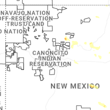
Hail Maps for La Cienega, NM


Connect with Interactive Hail Maps