

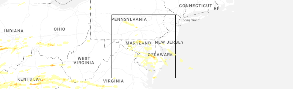
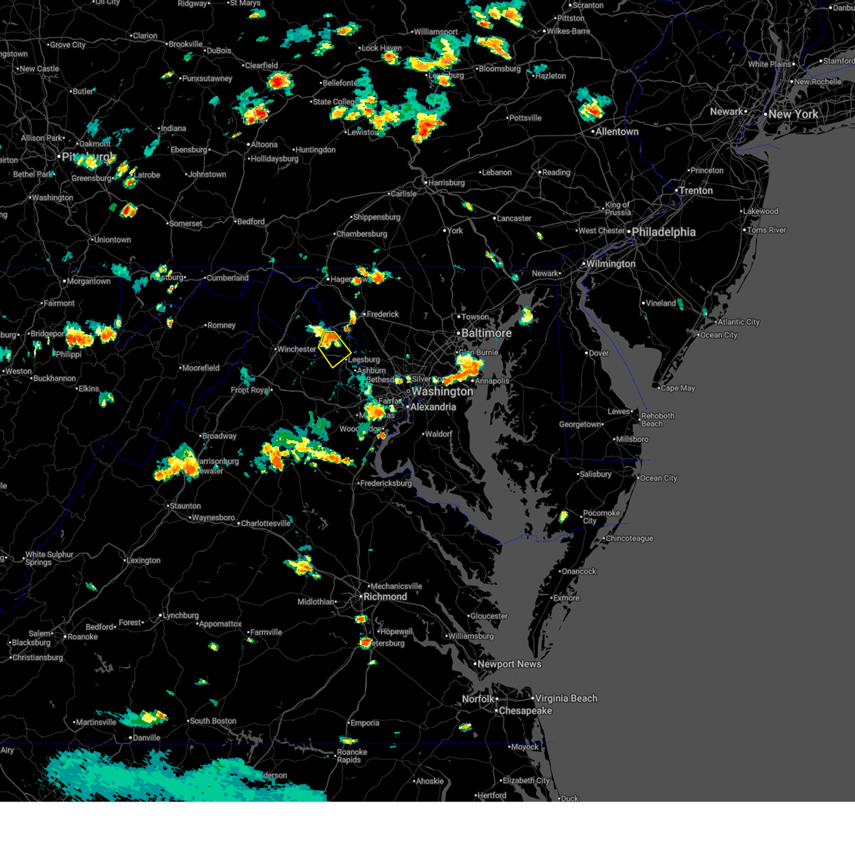
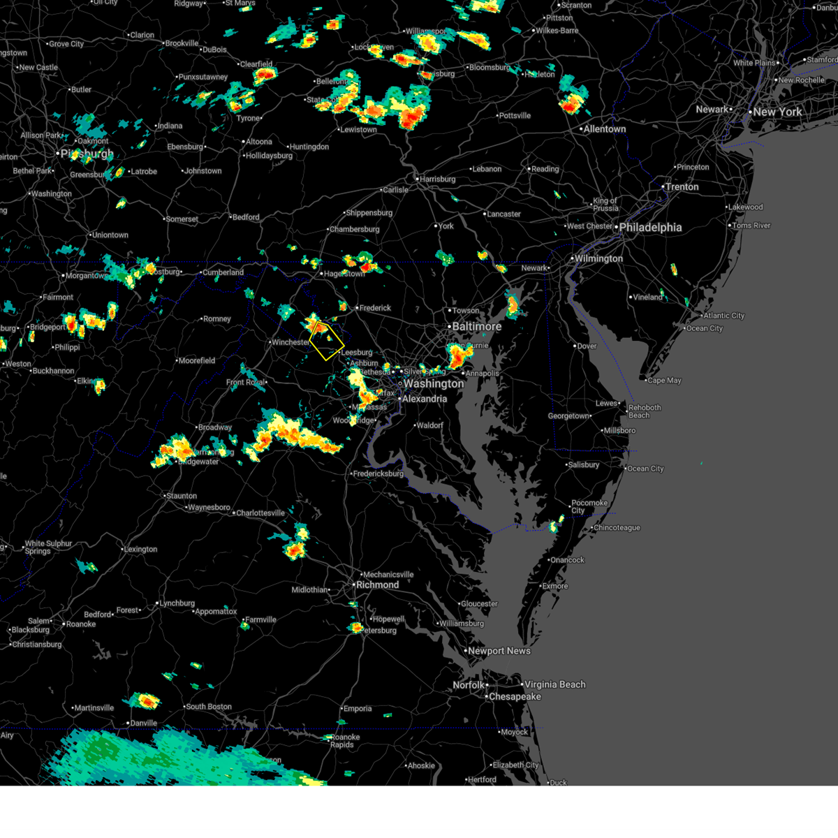
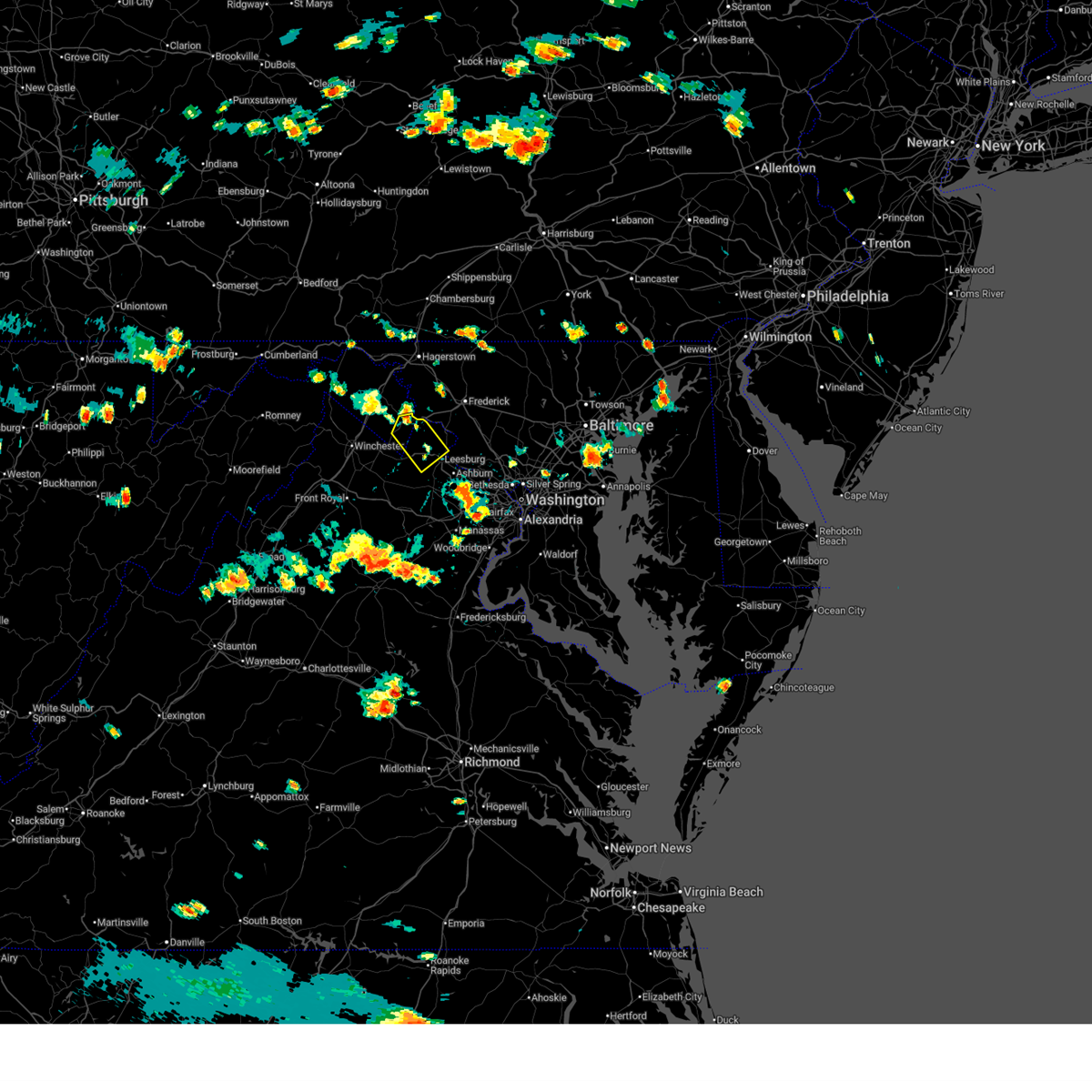
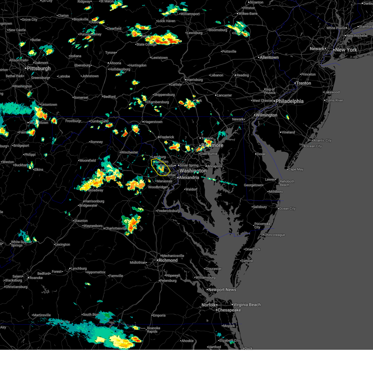
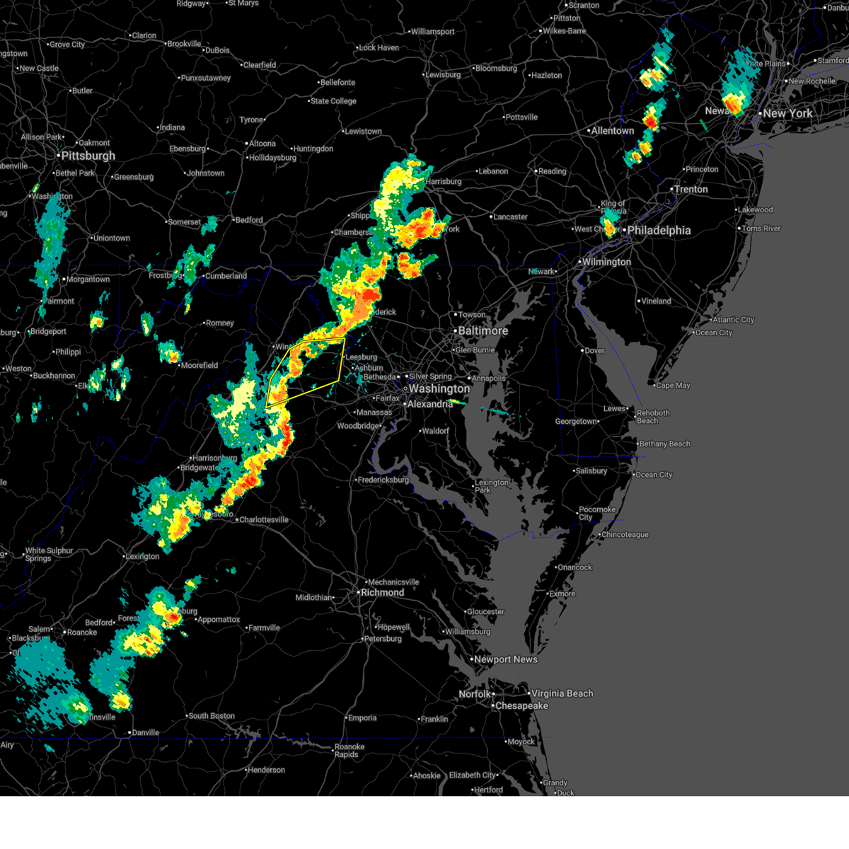
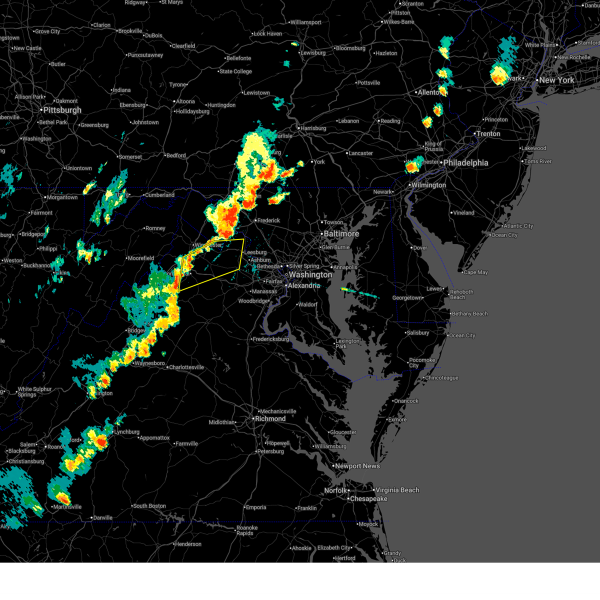
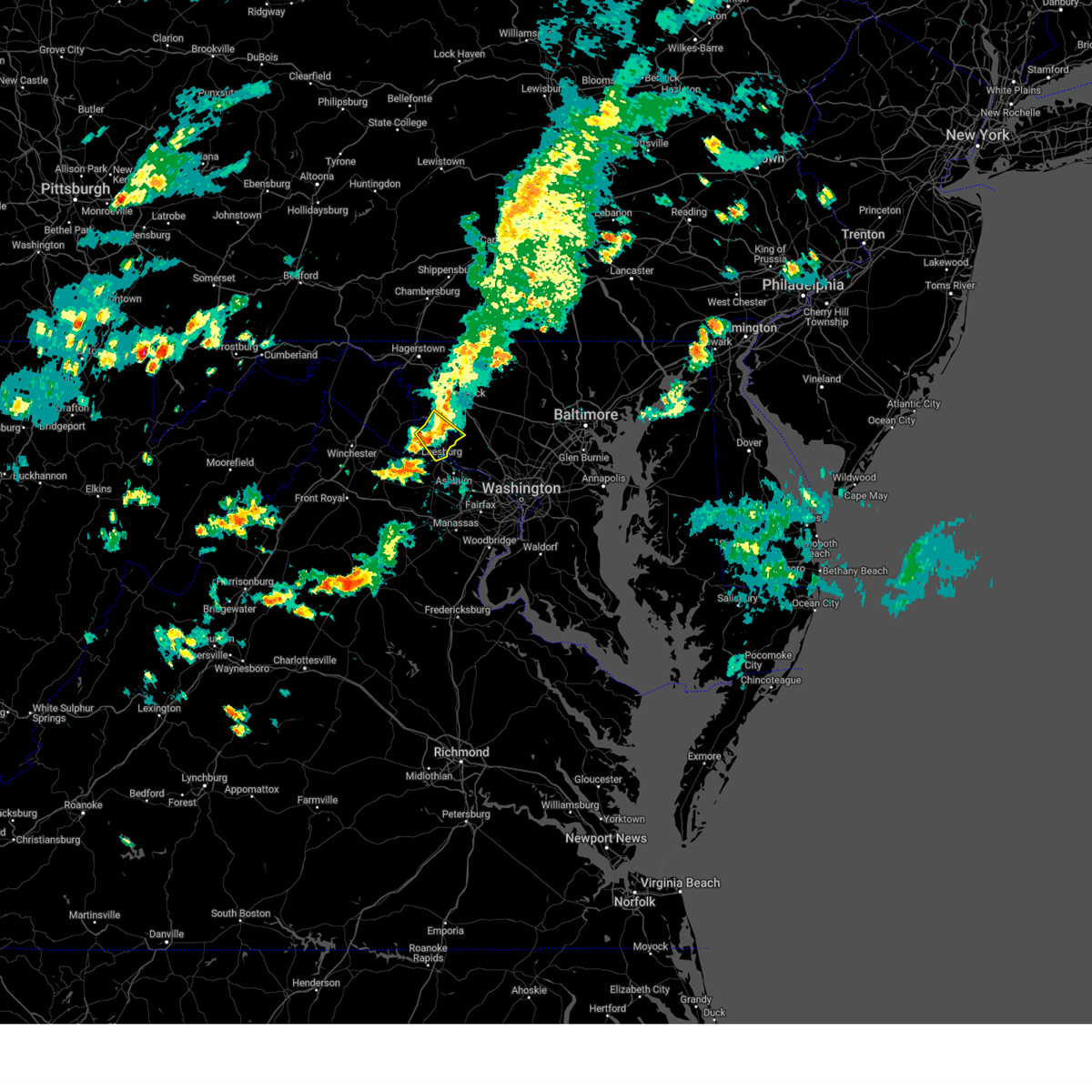
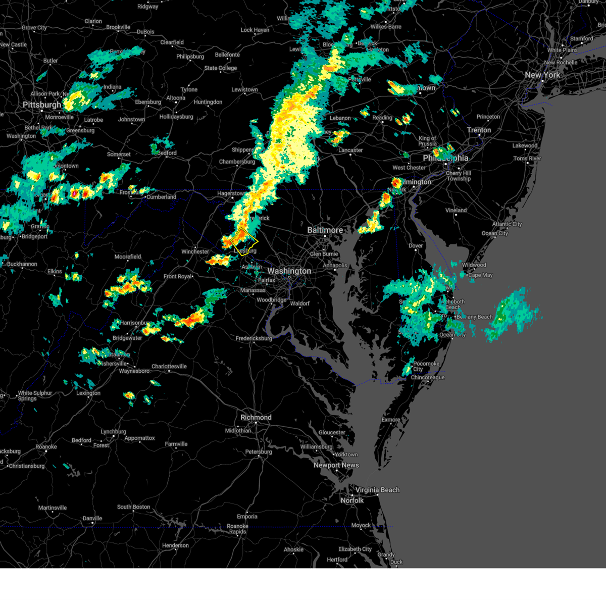
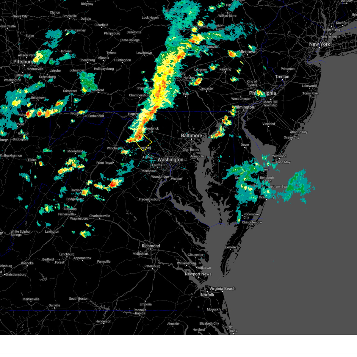
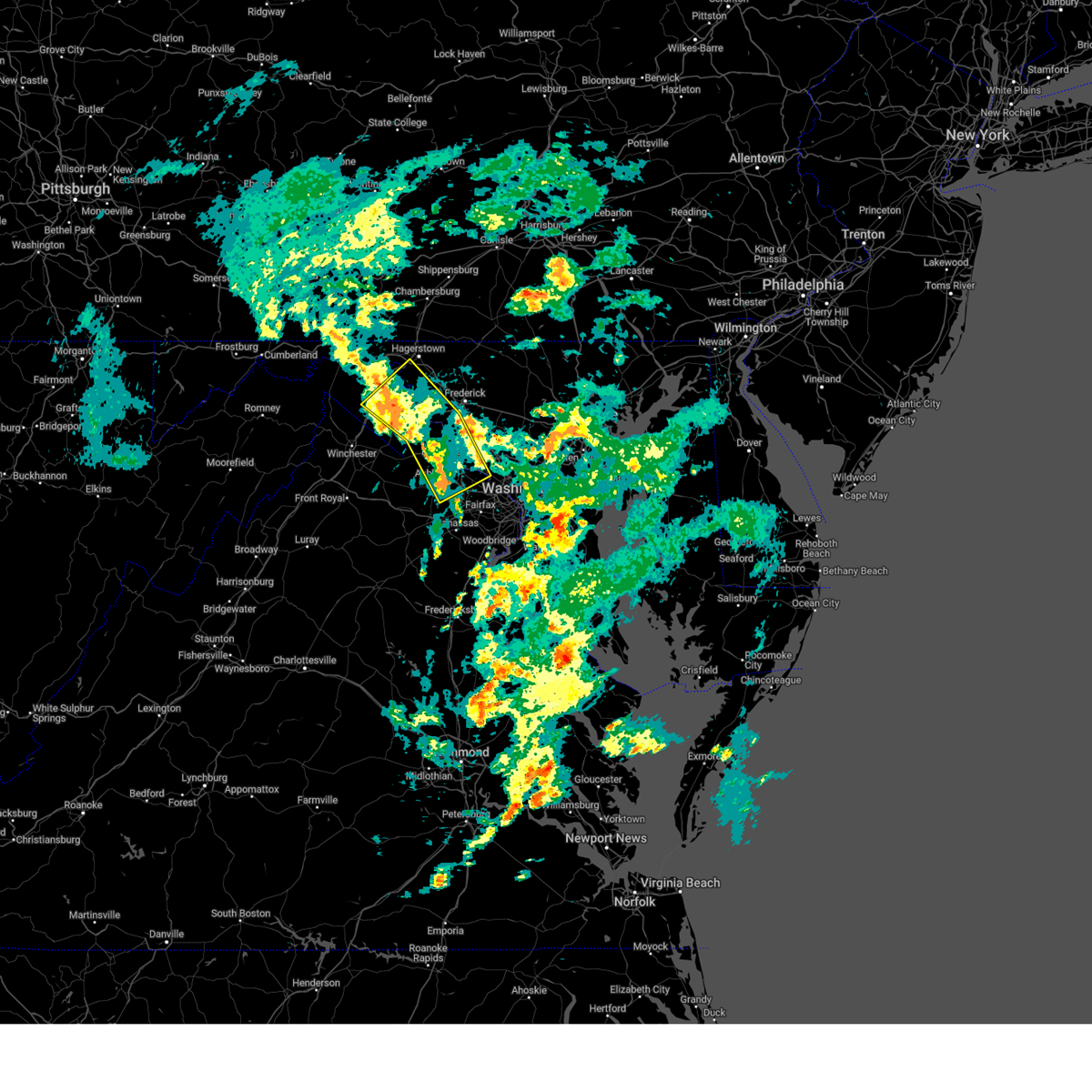
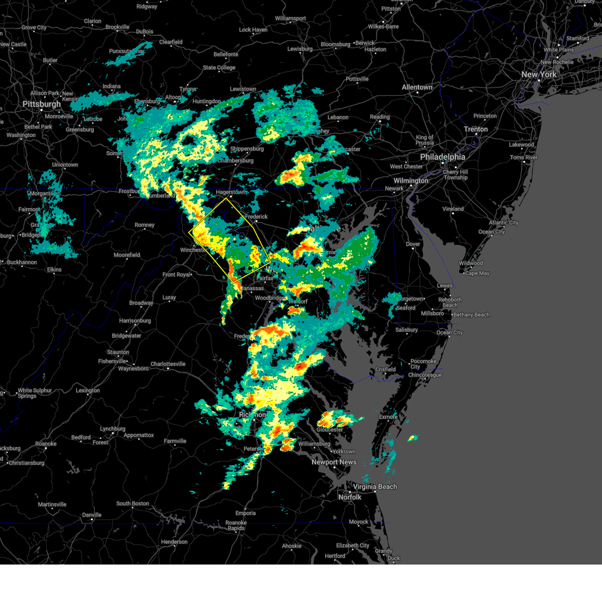
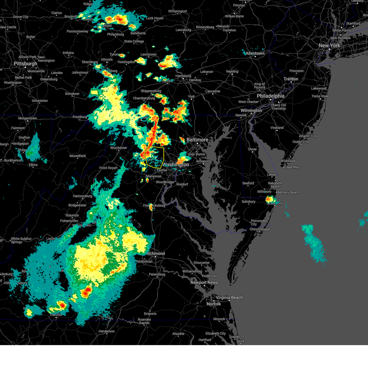
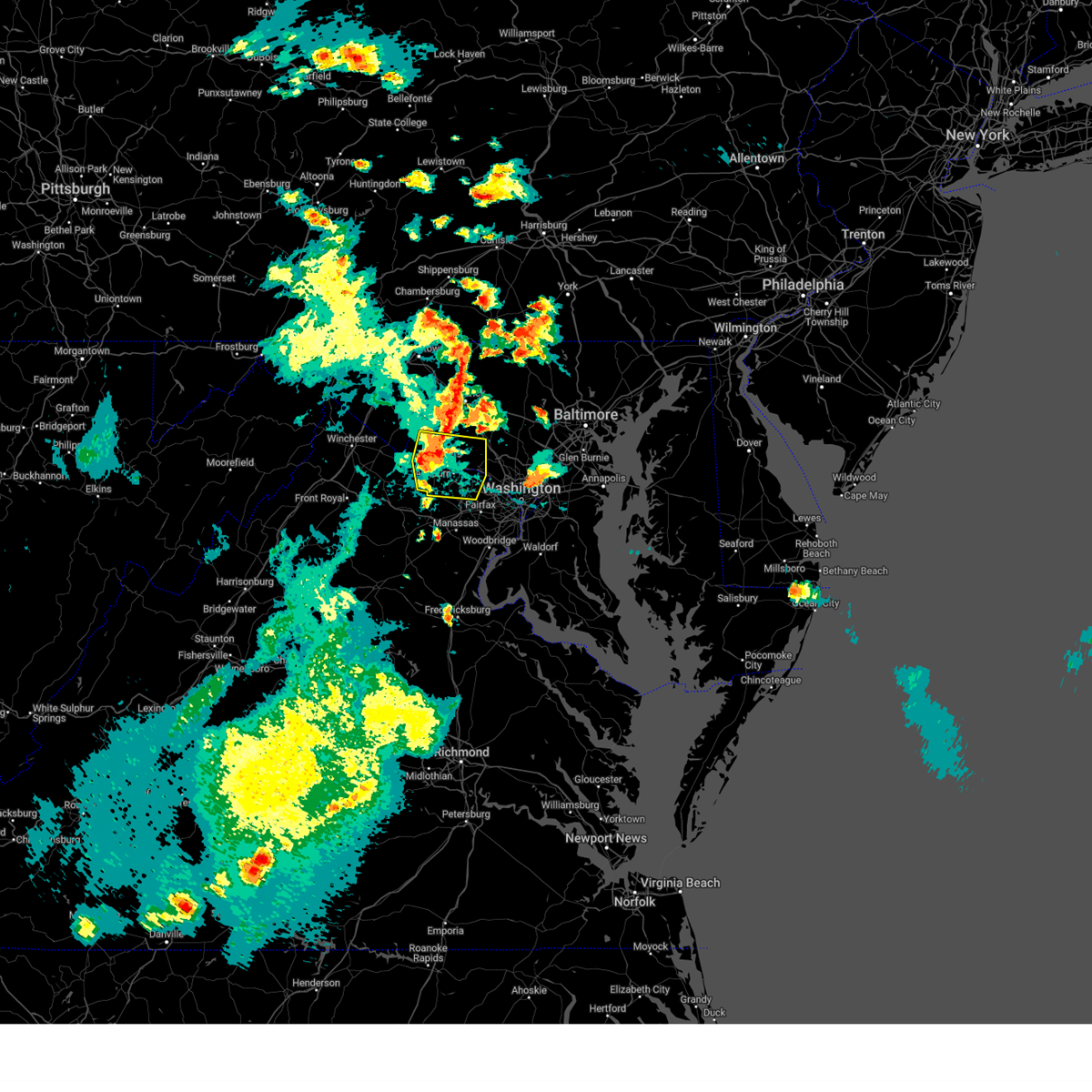
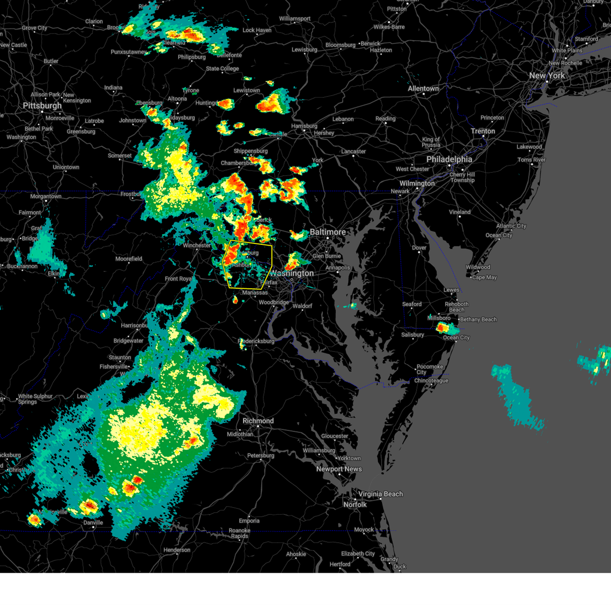
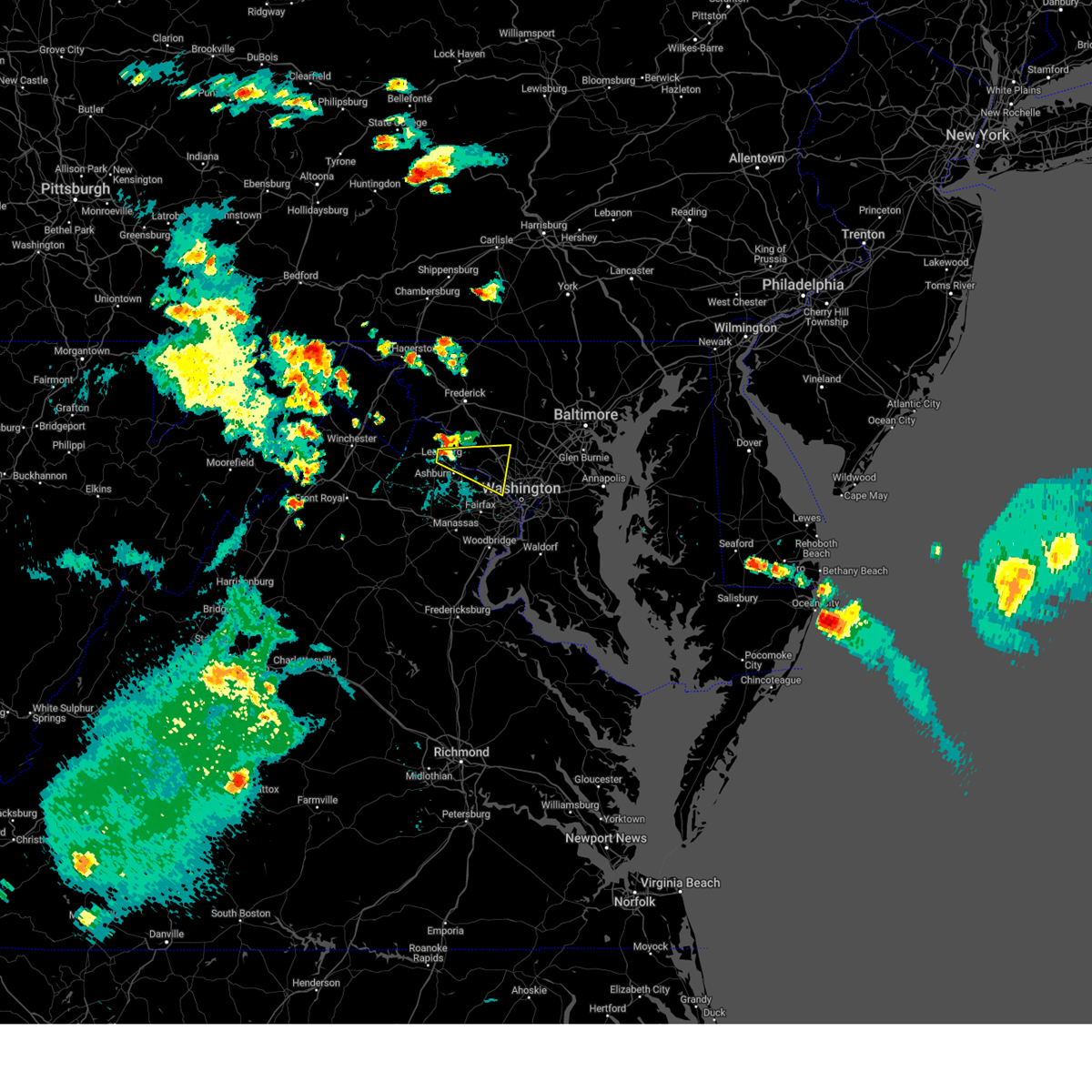
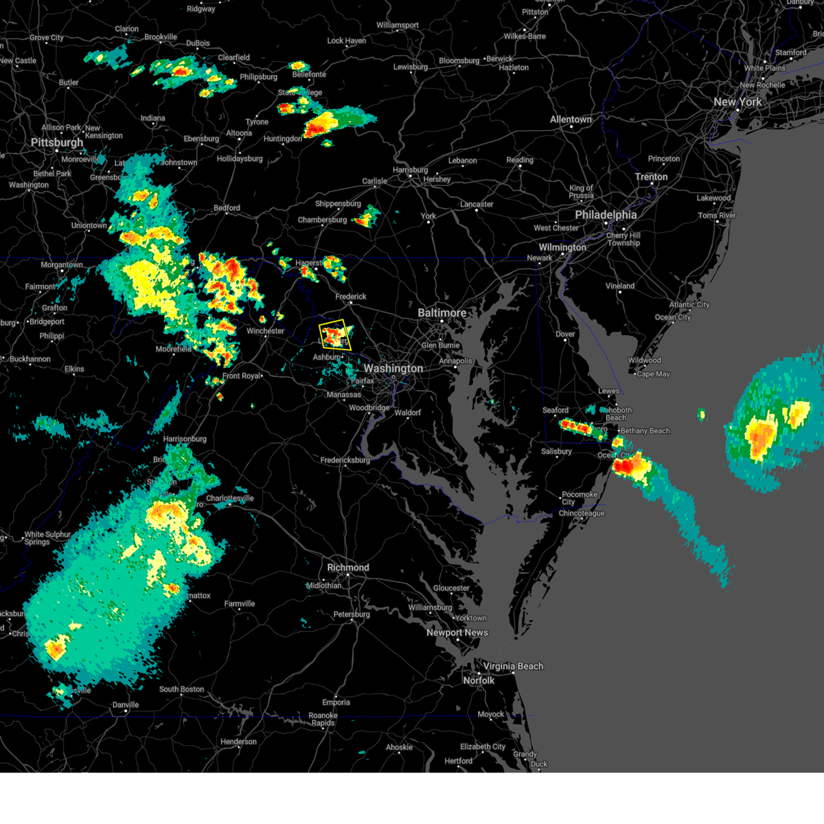
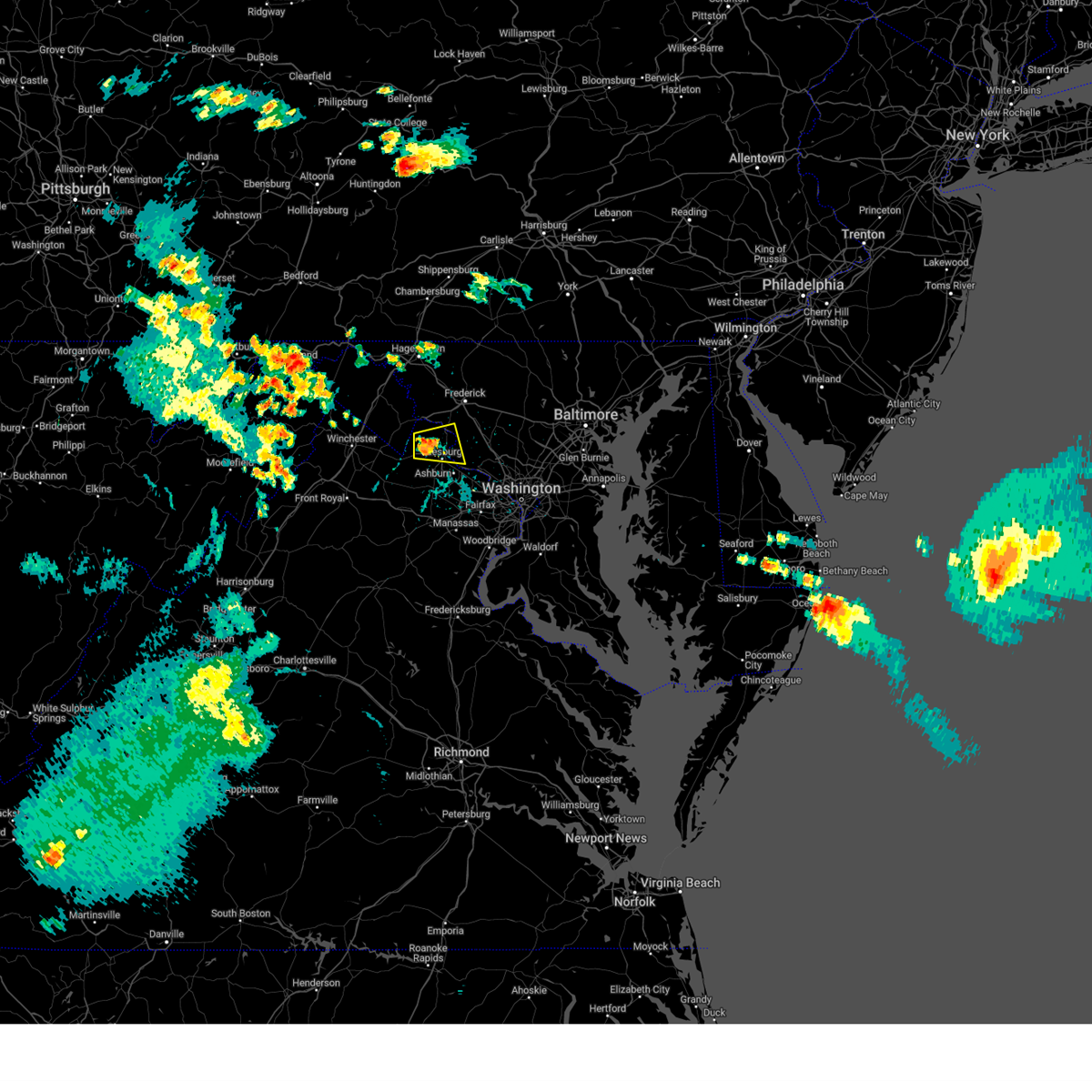
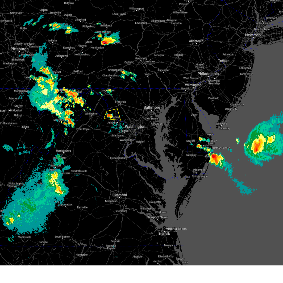
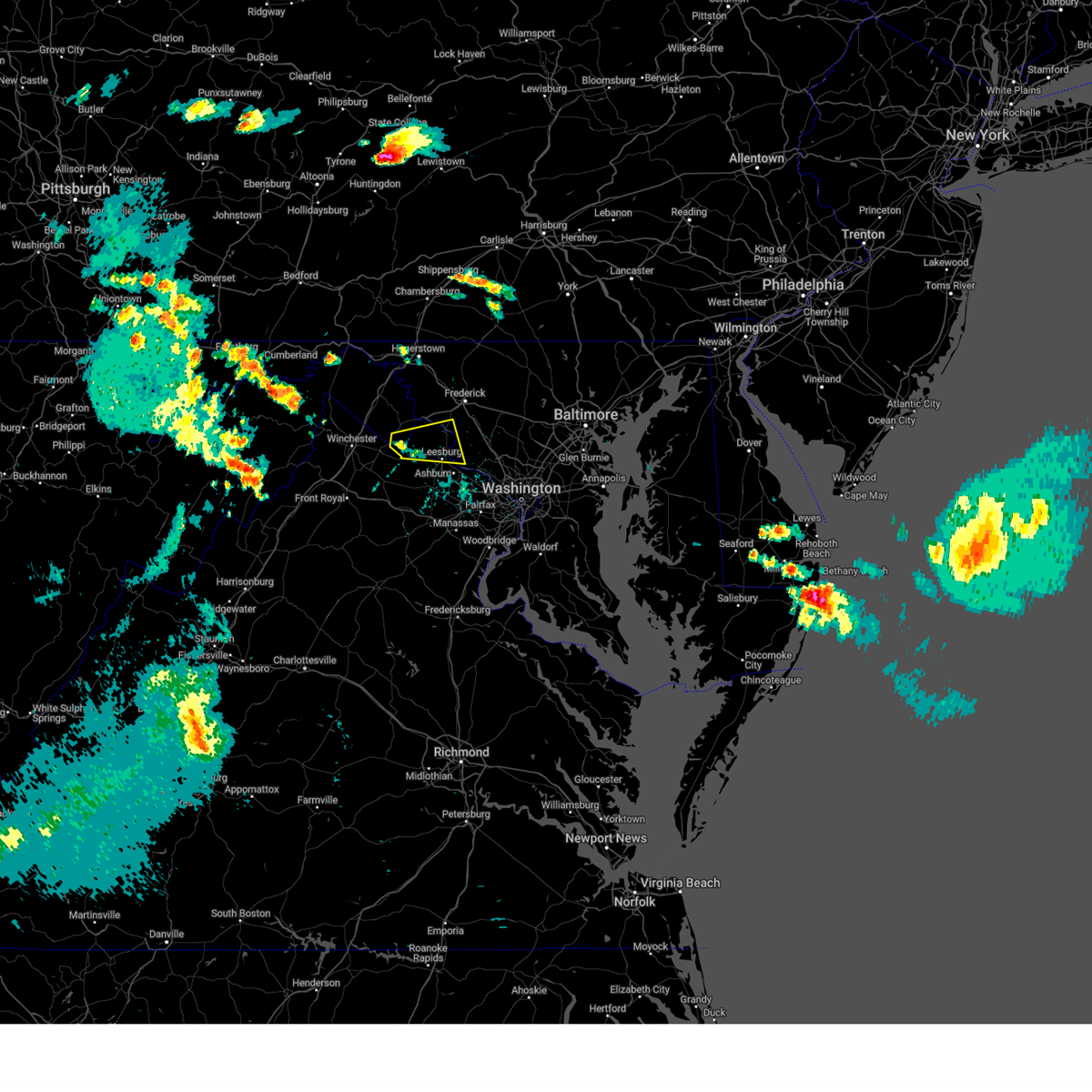
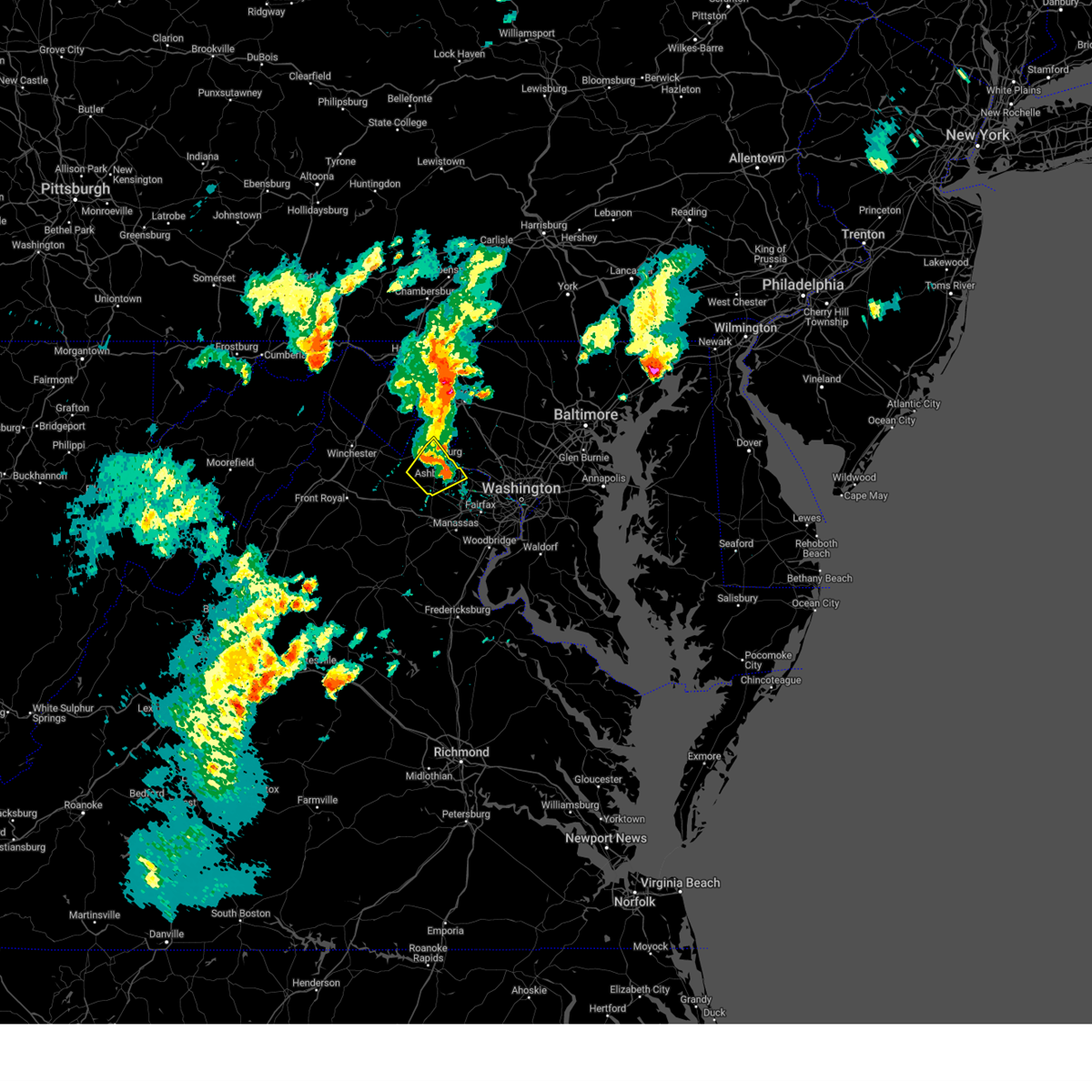
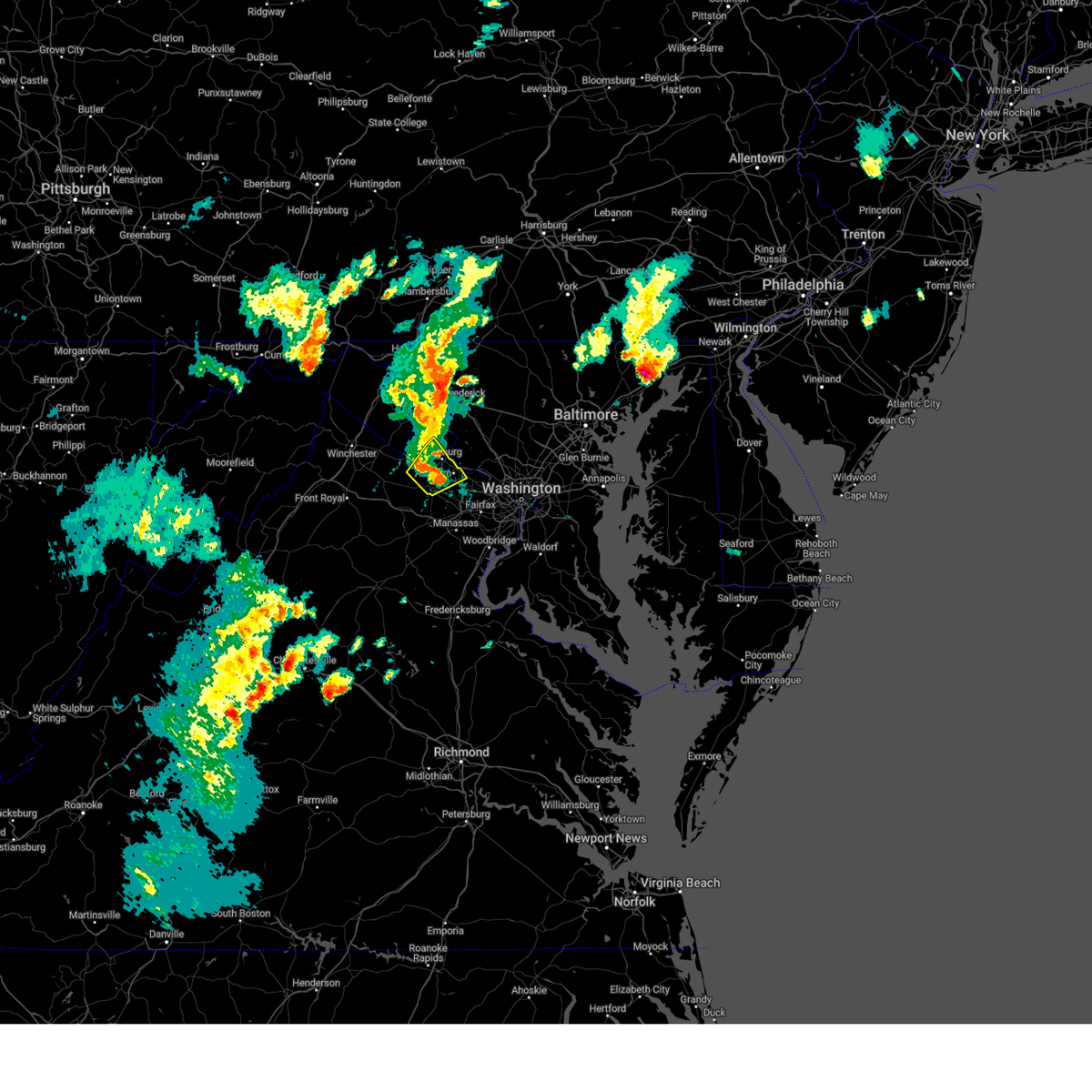
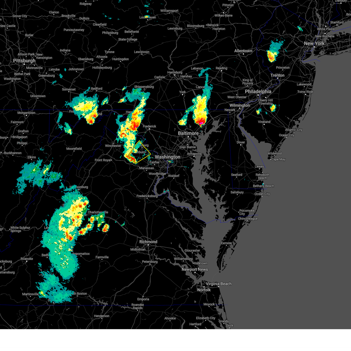
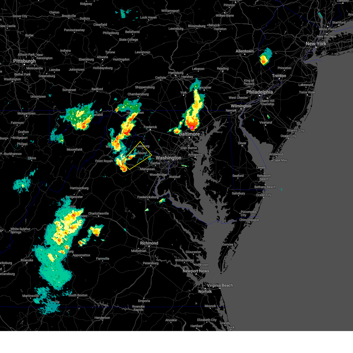
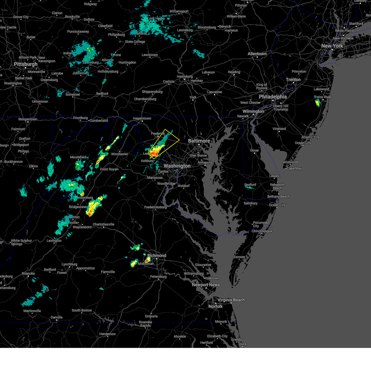
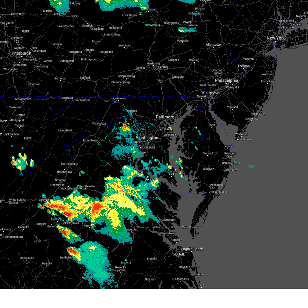
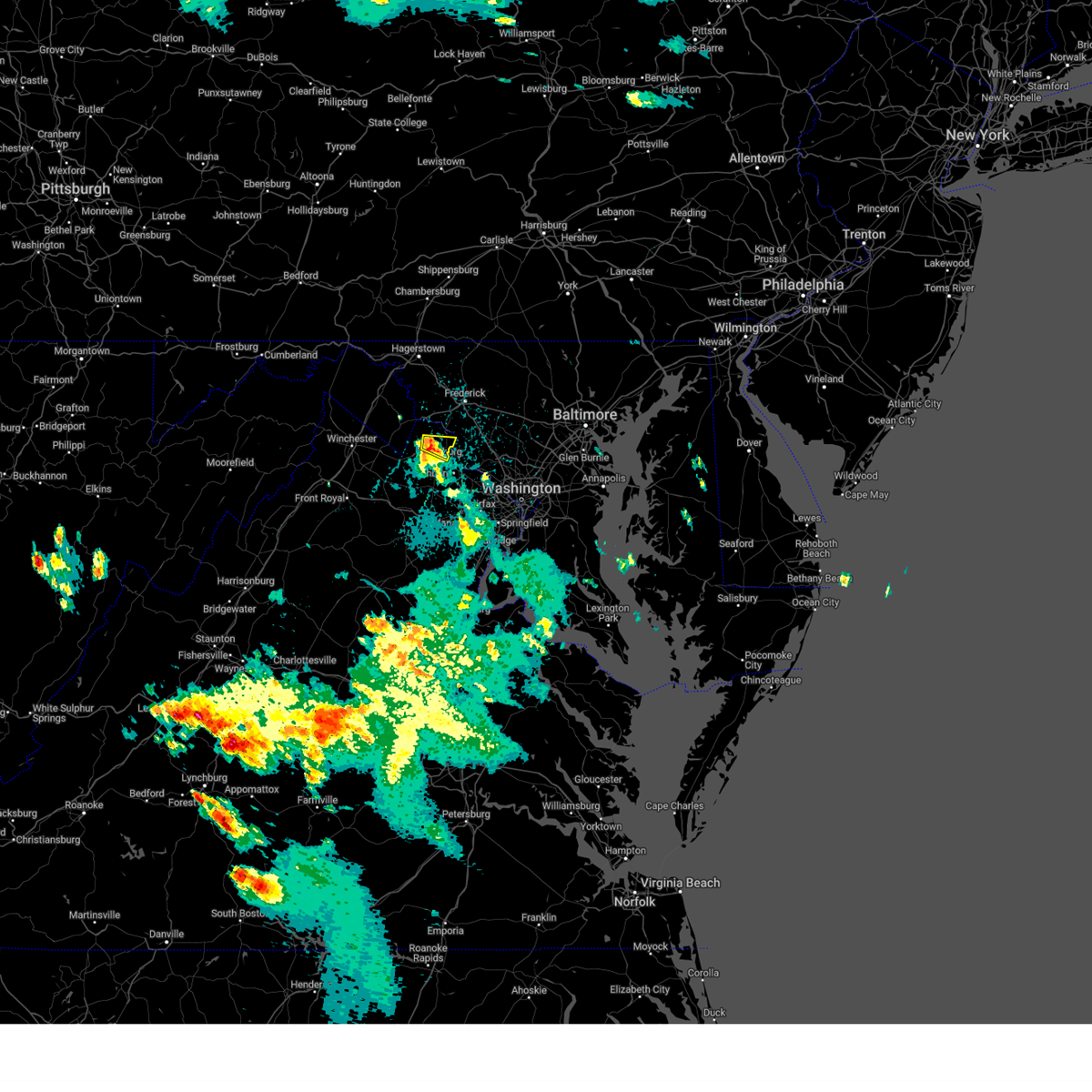
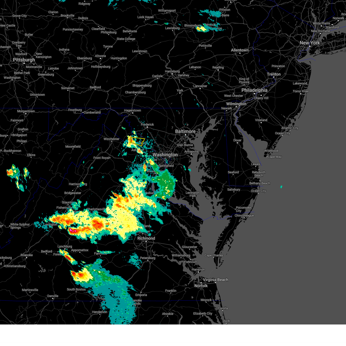
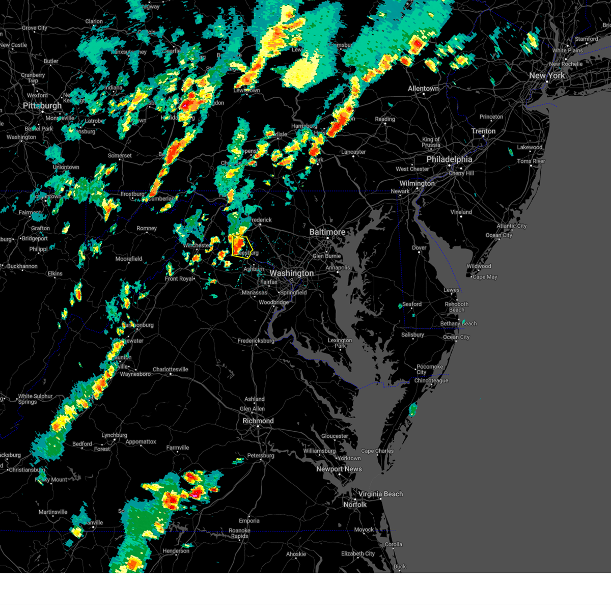
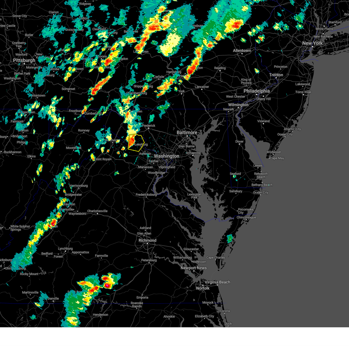
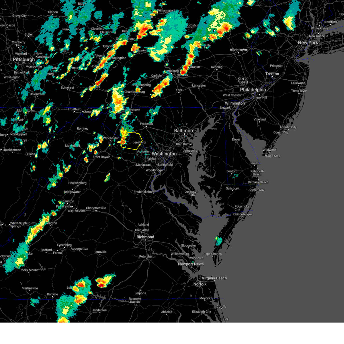
Hail Map for Leesburg, VA
The Leesburg, VA area has had 9 reports of on-the-ground hail by trained spotters, and has been under severe weather warnings 65 times during the past 12 months. Doppler radar has detected hail at or near Leesburg, VA on 62 occasions, including 4 occasions during the past year.
| Name: | Leesburg, VA |
| Where Located: | 51.5 miles WSW of Baltimore, MD |
| Map: | Google Map for Leesburg, VA |
| Population: | 42616 |
| Housing Units: | 15119 |
| More Info: | Search Google for Leesburg, VA |
1
The Top Recent Hail Date for Leesburg, VA is Friday, May 16, 2025 (8th out of 62)
Hail and Wind Damage Spotted near Leesburg, VA
| Date / Time | Report Details |
|---|---|
| 6/25/2025 4:06 PM EDT |
 The storm which prompted the warning has weakened below severe limits, and no longer poses an immediate threat to life or property. therefore, the warning will be allowed to expire. however, gusty winds and heavy rain are still possible with this thunderstorm. to report severe weather, contact your nearest law enforcement agency. they will relay your report to the national weather service sterling virginia. The storm which prompted the warning has weakened below severe limits, and no longer poses an immediate threat to life or property. therefore, the warning will be allowed to expire. however, gusty winds and heavy rain are still possible with this thunderstorm. to report severe weather, contact your nearest law enforcement agency. they will relay your report to the national weather service sterling virginia.
|
| 6/25/2025 3:56 PM EDT |
 At 356 pm edt, a severe thunderstorm was located near purcellville, or 9 miles northwest of leesburg, moving southeast at 20 mph (radar indicated). Hazards include 60 mph wind gusts. Damaging winds will cause some trees and large branches to fall. this could injure those outdoors, as well as damage homes and vehicles. roadways may become blocked by downed trees. localized power outages are possible. unsecured light objects may become projectiles. Locations impacted include, leesburg, purcellville, lovettsville, hamilton, hillsboro, paeonian springs, waterford, neersville, lincoln, and hughesville. At 356 pm edt, a severe thunderstorm was located near purcellville, or 9 miles northwest of leesburg, moving southeast at 20 mph (radar indicated). Hazards include 60 mph wind gusts. Damaging winds will cause some trees and large branches to fall. this could injure those outdoors, as well as damage homes and vehicles. roadways may become blocked by downed trees. localized power outages are possible. unsecured light objects may become projectiles. Locations impacted include, leesburg, purcellville, lovettsville, hamilton, hillsboro, paeonian springs, waterford, neersville, lincoln, and hughesville.
|
| 6/25/2025 3:56 PM EDT |
 the severe thunderstorm warning has been cancelled and is no longer in effect the severe thunderstorm warning has been cancelled and is no longer in effect
|
| 6/25/2025 3:48 PM EDT |
 At 348 pm edt, a severe thunderstorm was located near purcellville, or 8 miles east of charles town, moving southeast at 15 mph (radar indicated). Hazards include 60 mph wind gusts. Damaging winds will cause some trees and large branches to fall. this could injure those outdoors, as well as damage homes and vehicles. roadways may become blocked by downed trees. localized power outages are possible. unsecured light objects may become projectiles. Locations impacted include, leesburg, purcellville, lovettsville, bolivar, hamilton, hillsboro, paeonian springs, waterford, neersville, lincoln, and hughesville. At 348 pm edt, a severe thunderstorm was located near purcellville, or 8 miles east of charles town, moving southeast at 15 mph (radar indicated). Hazards include 60 mph wind gusts. Damaging winds will cause some trees and large branches to fall. this could injure those outdoors, as well as damage homes and vehicles. roadways may become blocked by downed trees. localized power outages are possible. unsecured light objects may become projectiles. Locations impacted include, leesburg, purcellville, lovettsville, bolivar, hamilton, hillsboro, paeonian springs, waterford, neersville, lincoln, and hughesville.
|
| 6/25/2025 3:35 PM EDT |
 Svrlwx the national weather service in sterling virginia has issued a * severe thunderstorm warning for, western montgomery county in central maryland, north central loudoun county in northern virginia, southeastern jefferson county in the panhandle of west virginia, * until 415 pm edt. * at 335 pm edt, a severe thunderstorm was located near harpers ferry, or near charles town, moving southeast at 20 mph (radar indicated). Hazards include 60 mph wind gusts. Damaging winds will cause some trees and large branches to fall. this could injure those outdoors, as well as damage homes and vehicles. roadways may become blocked by downed trees. localized power outages are possible. Unsecured light objects may become projectiles. Svrlwx the national weather service in sterling virginia has issued a * severe thunderstorm warning for, western montgomery county in central maryland, north central loudoun county in northern virginia, southeastern jefferson county in the panhandle of west virginia, * until 415 pm edt. * at 335 pm edt, a severe thunderstorm was located near harpers ferry, or near charles town, moving southeast at 20 mph (radar indicated). Hazards include 60 mph wind gusts. Damaging winds will cause some trees and large branches to fall. this could injure those outdoors, as well as damage homes and vehicles. roadways may become blocked by downed trees. localized power outages are possible. Unsecured light objects may become projectiles.
|
| 6/25/2025 2:53 PM EDT |
 Svrlwx the national weather service in sterling virginia has issued a * severe thunderstorm warning for, southwestern montgomery county in central maryland, southeastern loudoun county in northern virginia, the city of fairfax in northern virginia, northwestern fairfax county in northern virginia, * until 330 pm edt. * at 252 pm edt, severe thunderstorms were located along a line extending from ashburn to reston, moving southeast at 15 mph (radar indicated). Hazards include 60 mph wind gusts. Damaging winds will cause some trees and large branches to fall. this could injure those outdoors, as well as damage homes and vehicles. roadways may become blocked by downed trees. localized power outages are possible. Unsecured light objects may become projectiles. Svrlwx the national weather service in sterling virginia has issued a * severe thunderstorm warning for, southwestern montgomery county in central maryland, southeastern loudoun county in northern virginia, the city of fairfax in northern virginia, northwestern fairfax county in northern virginia, * until 330 pm edt. * at 252 pm edt, severe thunderstorms were located along a line extending from ashburn to reston, moving southeast at 15 mph (radar indicated). Hazards include 60 mph wind gusts. Damaging winds will cause some trees and large branches to fall. this could injure those outdoors, as well as damage homes and vehicles. roadways may become blocked by downed trees. localized power outages are possible. Unsecured light objects may become projectiles.
|
| 6/19/2025 3:27 PM EDT | Svrlwx the national weather service in sterling virginia has issued a * severe thunderstorm warning for, south central carroll county in north central maryland, northwestern howard county in central maryland, montgomery county in central maryland, southeastern frederick county in north central maryland, loudoun county in northern virginia, north central fairfax county in northern virginia, north central fauquier county in northern virginia, northwestern prince william county in northern virginia, * until 400 pm edt. * at 327 pm edt, a severe thunderstorm was located near purcellville, or near leesburg, moving east at 50 mph (radar indicated). Hazards include emergency management reports a history of downed trees with this line of storms. Damaging winds will cause some trees and large branches to fall. this could injure those outdoors, as well as damage homes and vehicles. roadways may become blocked by downed trees. localized power outages are possible. Unsecured light objects may become projectiles. |
| 6/19/2025 3:12 PM EDT |
 the severe thunderstorm warning has been cancelled and is no longer in effect the severe thunderstorm warning has been cancelled and is no longer in effect
|
| 6/19/2025 3:12 PM EDT |
 At 312 pm edt, a severe thunderstorm was located over linden, or near front royal, moving east at 40 mph (emergency management reports a history of downed trees with this line of storms). Hazards include 60 mph wind gusts. Damaging winds will cause some trees and large branches to fall. this could injure those outdoors, as well as damage homes and vehicles. roadways may become blocked by downed trees. localized power outages are possible. unsecured light objects may become projectiles. Locations impacted include, leesburg, front royal, purcellville, berryville, middleburg, round hill, delaplane, linden, oatlands, bluemont, chester gap, boyce, hamilton, hillsboro, huntly, gleedsville, white post, waterford, gaylord, and aldie. At 312 pm edt, a severe thunderstorm was located over linden, or near front royal, moving east at 40 mph (emergency management reports a history of downed trees with this line of storms). Hazards include 60 mph wind gusts. Damaging winds will cause some trees and large branches to fall. this could injure those outdoors, as well as damage homes and vehicles. roadways may become blocked by downed trees. localized power outages are possible. unsecured light objects may become projectiles. Locations impacted include, leesburg, front royal, purcellville, berryville, middleburg, round hill, delaplane, linden, oatlands, bluemont, chester gap, boyce, hamilton, hillsboro, huntly, gleedsville, white post, waterford, gaylord, and aldie.
|
| 6/19/2025 2:55 PM EDT | Trees blew down on us-15 at va-672 lovettsville roa in loudoun county VA, 10.8 miles S of Leesburg, VA |
| 6/19/2025 2:53 PM EDT |
 Svrlwx the national weather service in sterling virginia has issued a * severe thunderstorm warning for, central loudoun county in northern virginia, east central shenandoah county in northwestern virginia, southeastern frederick county in northwestern virginia, warren county in northwestern virginia, clarke county in northwestern virginia, northeastern page county in northwestern virginia, north central rappahannock county in northwestern virginia, northwestern fauquier county in northern virginia, southeastern jefferson county in the panhandle of west virginia, * until 330 pm edt. * at 252 pm edt, a severe thunderstorm was located 7 miles southwest of front royal, moving east at 40 mph (emergency management reports a history of downed trees with this line of storms). Hazards include 60 mph wind gusts. Damaging winds will cause some trees and large branches to fall. this could injure those outdoors, as well as damage homes and vehicles. roadways may become blocked by downed trees. localized power outages are possible. Unsecured light objects may become projectiles. Svrlwx the national weather service in sterling virginia has issued a * severe thunderstorm warning for, central loudoun county in northern virginia, east central shenandoah county in northwestern virginia, southeastern frederick county in northwestern virginia, warren county in northwestern virginia, clarke county in northwestern virginia, northeastern page county in northwestern virginia, north central rappahannock county in northwestern virginia, northwestern fauquier county in northern virginia, southeastern jefferson county in the panhandle of west virginia, * until 330 pm edt. * at 252 pm edt, a severe thunderstorm was located 7 miles southwest of front royal, moving east at 40 mph (emergency management reports a history of downed trees with this line of storms). Hazards include 60 mph wind gusts. Damaging winds will cause some trees and large branches to fall. this could injure those outdoors, as well as damage homes and vehicles. roadways may become blocked by downed trees. localized power outages are possible. Unsecured light objects may become projectiles.
|
| 6/6/2025 2:44 PM EDT |
 The storm which prompted the warning has weakened below severe limits, and has exited the warned area. therefore, the warning will be allowed to expire. to report severe weather, contact your nearest law enforcement agency. they will relay your report to the national weather service sterling virginia. The storm which prompted the warning has weakened below severe limits, and has exited the warned area. therefore, the warning will be allowed to expire. to report severe weather, contact your nearest law enforcement agency. they will relay your report to the national weather service sterling virginia.
|
| 6/6/2025 2:33 PM EDT |
 At 233 pm edt, a severe thunderstorm was located over brunswick, or 12 miles east of charles town, moving southeast at 15 mph (radar indicated). Hazards include 60 mph wind gusts. Damaging winds will cause some trees and large branches to fall. this could injure those outdoors, as well as damage homes and vehicles. roadways may become blocked by downed trees. localized power outages are possible. unsecured light objects may become projectiles. Locations impacted include, brunswick, paeonian springs, rosemont, waterford, petersville, point of rocks, lovettsville, tuscarora, lucketts, taylorstown, and leesburg. At 233 pm edt, a severe thunderstorm was located over brunswick, or 12 miles east of charles town, moving southeast at 15 mph (radar indicated). Hazards include 60 mph wind gusts. Damaging winds will cause some trees and large branches to fall. this could injure those outdoors, as well as damage homes and vehicles. roadways may become blocked by downed trees. localized power outages are possible. unsecured light objects may become projectiles. Locations impacted include, brunswick, paeonian springs, rosemont, waterford, petersville, point of rocks, lovettsville, tuscarora, lucketts, taylorstown, and leesburg.
|
| 6/6/2025 2:22 PM EDT |
 Svrlwx the national weather service in sterling virginia has issued a * severe thunderstorm warning for, southwestern frederick county in north central maryland, northeastern loudoun county in northern virginia, * until 245 pm edt. * at 222 pm edt, a severe thunderstorm was located over brunswick, or 11 miles east of charles town, moving southeast at 15 mph (radar indicated). Hazards include 60 mph wind gusts. Damaging winds will cause some trees and large branches to fall. this could injure those outdoors, as well as damage homes and vehicles. roadways may become blocked by downed trees. localized power outages are possible. Unsecured light objects may become projectiles. Svrlwx the national weather service in sterling virginia has issued a * severe thunderstorm warning for, southwestern frederick county in north central maryland, northeastern loudoun county in northern virginia, * until 245 pm edt. * at 222 pm edt, a severe thunderstorm was located over brunswick, or 11 miles east of charles town, moving southeast at 15 mph (radar indicated). Hazards include 60 mph wind gusts. Damaging winds will cause some trees and large branches to fall. this could injure those outdoors, as well as damage homes and vehicles. roadways may become blocked by downed trees. localized power outages are possible. Unsecured light objects may become projectiles.
|
| 5/30/2025 7:46 PM EDT |
 At 745 pm edt, severe thunderstorms were located along a line extending from near martinsburg to near harpers ferry to arcola, moving northeast at 30 mph (radar indicated). Hazards include 60 mph wind gusts. Damaging winds will cause some trees and large branches to fall. this could injure those outdoors, as well as damage homes and vehicles. roadways may become blocked by downed trees. localized power outages are possible. unsecured light objects may become projectiles. Locations impacted include, winebrenners cross, gleedsville, waterford, brownsville, belmont, doubs, berkeley, fairplay, keedysville, petersville, poolesville, pleasantville, williamsport, millville, gapland, lincoln, herndon, darnestown, antietam, and brunswick. At 745 pm edt, severe thunderstorms were located along a line extending from near martinsburg to near harpers ferry to arcola, moving northeast at 30 mph (radar indicated). Hazards include 60 mph wind gusts. Damaging winds will cause some trees and large branches to fall. this could injure those outdoors, as well as damage homes and vehicles. roadways may become blocked by downed trees. localized power outages are possible. unsecured light objects may become projectiles. Locations impacted include, winebrenners cross, gleedsville, waterford, brownsville, belmont, doubs, berkeley, fairplay, keedysville, petersville, poolesville, pleasantville, williamsport, millville, gapland, lincoln, herndon, darnestown, antietam, and brunswick.
|
| 5/30/2025 7:46 PM EDT |
 the severe thunderstorm warning has been cancelled and is no longer in effect the severe thunderstorm warning has been cancelled and is no longer in effect
|
| 5/30/2025 7:28 PM EDT |
 Svrlwx the national weather service in sterling virginia has issued a * severe thunderstorm warning for, southeastern washington county in north central maryland, southwestern montgomery county in central maryland, southwestern frederick county in north central maryland, loudoun county in northern virginia, east central frederick county in northwestern virginia, northwestern fairfax county in northern virginia, central clarke county in northwestern virginia, north central fauquier county in northern virginia, northwestern prince william county in northern virginia, jefferson county in the panhandle of west virginia, central berkeley county in the panhandle of west virginia, * until 815 pm edt. * at 728 pm edt, severe thunderstorms were located along a line extending from near inwood to near round hill to near middleburg, moving northeast at 35 mph (radar indicated). Hazards include 60 mph wind gusts. Damaging winds will cause some trees and large branches to fall. this could injure those outdoors, as well as damage homes and vehicles. roadways may become blocked by downed trees. localized power outages are possible. Unsecured light objects may become projectiles. Svrlwx the national weather service in sterling virginia has issued a * severe thunderstorm warning for, southeastern washington county in north central maryland, southwestern montgomery county in central maryland, southwestern frederick county in north central maryland, loudoun county in northern virginia, east central frederick county in northwestern virginia, northwestern fairfax county in northern virginia, central clarke county in northwestern virginia, north central fauquier county in northern virginia, northwestern prince william county in northern virginia, jefferson county in the panhandle of west virginia, central berkeley county in the panhandle of west virginia, * until 815 pm edt. * at 728 pm edt, severe thunderstorms were located along a line extending from near inwood to near round hill to near middleburg, moving northeast at 35 mph (radar indicated). Hazards include 60 mph wind gusts. Damaging winds will cause some trees and large branches to fall. this could injure those outdoors, as well as damage homes and vehicles. roadways may become blocked by downed trees. localized power outages are possible. Unsecured light objects may become projectiles.
|
| 5/16/2025 5:05 PM EDT |
 the severe thunderstorm warning has been cancelled and is no longer in effect the severe thunderstorm warning has been cancelled and is no longer in effect
|
| 5/16/2025 5:05 PM EDT |
 At 505 pm edt, severe thunderstorms were located along a line extending from 6 miles northwest of boyds to poolesville to brambleton, moving east at 45 mph (radar indicated). Hazards include 70 mph wind gusts. Damaging winds will cause some trees and large branches to fall. this could injure those outdoors, as well as damage homes and vehicles. roadways may become blocked by downed trees. localized power outages are possible. unsecured light objects may become projectiles. Locations impacted include, gleedsville, sterling, leesburg, waterford, belmont, broadlands, arcola, poolesville, herndon, darnestown, reston, paeonian springs, lowes island, dulles international airport, lucketts, brambleton, lansdowne, great falls, boyds, and barnesville. At 505 pm edt, severe thunderstorms were located along a line extending from 6 miles northwest of boyds to poolesville to brambleton, moving east at 45 mph (radar indicated). Hazards include 70 mph wind gusts. Damaging winds will cause some trees and large branches to fall. this could injure those outdoors, as well as damage homes and vehicles. roadways may become blocked by downed trees. localized power outages are possible. unsecured light objects may become projectiles. Locations impacted include, gleedsville, sterling, leesburg, waterford, belmont, broadlands, arcola, poolesville, herndon, darnestown, reston, paeonian springs, lowes island, dulles international airport, lucketts, brambleton, lansdowne, great falls, boyds, and barnesville.
|
| 5/16/2025 4:54 PM EDT |
 the severe thunderstorm warning has been cancelled and is no longer in effect the severe thunderstorm warning has been cancelled and is no longer in effect
|
| 5/16/2025 4:54 PM EDT |
 At 454 pm edt, severe thunderstorms were located along a line extending from point of rocks to leesburg to near oatlands, moving east at 45 mph (radar indicated). Hazards include 70 mph wind gusts. Damaging winds will cause some trees and large branches to fall. this could injure those outdoors, as well as damage homes and vehicles. roadways may become blocked by downed trees. localized power outages are possible. unsecured light objects may become projectiles. Locations impacted include, gleedsville, sterling, purcellville, leesburg, waterford, belmont, broadlands, arcola, aldie, poolesville, hamilton, philomont, lincoln, herndon, darnestown, reston, paeonian springs, lowes island, dulles international airport, and lucketts. At 454 pm edt, severe thunderstorms were located along a line extending from point of rocks to leesburg to near oatlands, moving east at 45 mph (radar indicated). Hazards include 70 mph wind gusts. Damaging winds will cause some trees and large branches to fall. this could injure those outdoors, as well as damage homes and vehicles. roadways may become blocked by downed trees. localized power outages are possible. unsecured light objects may become projectiles. Locations impacted include, gleedsville, sterling, purcellville, leesburg, waterford, belmont, broadlands, arcola, aldie, poolesville, hamilton, philomont, lincoln, herndon, darnestown, reston, paeonian springs, lowes island, dulles international airport, and lucketts.
|
| 5/16/2025 4:46 PM EDT |
 At 446 pm edt, severe thunderstorms were located along a line extending from near brunswick to near purcellville to near middleburg, moving east at 50 mph (radar indicated). Hazards include 70 mph wind gusts. Damaging winds will cause some trees and large branches to fall. this could injure those outdoors, as well as damage homes and vehicles. roadways may become blocked by downed trees. localized power outages are possible. unsecured light objects may become projectiles. Locations impacted include, catharpin, gleedsville, waterford, woolsey, belmont, aldie, poolesville, philomont, lincoln, herndon, darnestown, the plains, saint louis, paeonian springs, lowes island, neersville, lucketts, brambleton, lansdowne, and great falls. At 446 pm edt, severe thunderstorms were located along a line extending from near brunswick to near purcellville to near middleburg, moving east at 50 mph (radar indicated). Hazards include 70 mph wind gusts. Damaging winds will cause some trees and large branches to fall. this could injure those outdoors, as well as damage homes and vehicles. roadways may become blocked by downed trees. localized power outages are possible. unsecured light objects may become projectiles. Locations impacted include, catharpin, gleedsville, waterford, woolsey, belmont, aldie, poolesville, philomont, lincoln, herndon, darnestown, the plains, saint louis, paeonian springs, lowes island, neersville, lucketts, brambleton, lansdowne, and great falls.
|
| 5/16/2025 4:30 PM EDT | Svrlwx the national weather service in sterling virginia has issued a * severe thunderstorm warning for, west central montgomery county in central maryland, southern frederick county in north central maryland, loudoun county in northern virginia, northwestern fairfax county in northern virginia, northwestern fauquier county in northern virginia, northwestern prince william county in northern virginia, * until 515 pm edt. * at 430 pm edt, severe thunderstorms were located along a line extending from near berryville to near bluemont to near hume, moving east at 45 mph (radar indicated). Hazards include 60 mph wind gusts. Damaging winds will cause some trees and large branches to fall. this could injure those outdoors, as well as damage homes and vehicles. roadways may become blocked by downed trees. localized power outages are possible. Unsecured light objects may become projectiles. |
| 5/16/2025 3:58 PM EDT |
 Svrlwx the national weather service in sterling virginia has issued a * severe thunderstorm warning for, central montgomery county in central maryland, east central loudoun county in northern virginia, north central fairfax county in northern virginia, * until 445 pm edt. * at 358 pm edt, a severe thunderstorm was located over leesburg, moving east at 30 mph (radar indicated). Hazards include 60 mph wind gusts and quarter size hail. Damaging winds will cause some trees and large branches to fall. this could injure those outdoors, as well as damage homes and vehicles. roadways may become blocked by downed trees. localized power outages are possible. Unsecured light objects may become projectiles. Svrlwx the national weather service in sterling virginia has issued a * severe thunderstorm warning for, central montgomery county in central maryland, east central loudoun county in northern virginia, north central fairfax county in northern virginia, * until 445 pm edt. * at 358 pm edt, a severe thunderstorm was located over leesburg, moving east at 30 mph (radar indicated). Hazards include 60 mph wind gusts and quarter size hail. Damaging winds will cause some trees and large branches to fall. this could injure those outdoors, as well as damage homes and vehicles. roadways may become blocked by downed trees. localized power outages are possible. Unsecured light objects may become projectiles.
|
| 5/16/2025 3:55 PM EDT | Large tree knocked down along jared square ne in leesbur in loudoun county VA, 0.6 miles SE of Leesburg, VA |
| 5/16/2025 3:49 PM EDT |
 At 348 pm edt, a severe thunderstorm was located near point of rocks, or 7 miles north of leesburg, moving east at 20 mph (radar indicated). Hazards include 60 mph wind gusts and quarter size hail. Damaging winds will cause some trees and large branches to fall. this could injure those outdoors, as well as damage homes and vehicles. roadways may become blocked by downed trees. localized power outages are possible. unsecured light objects may become projectiles. Locations impacted include, paeonian springs, leesburg, waterford, point of rocks, tuscarora, lucketts, taylorstown, lovettsville, hamilton, lansdowne, adamstown, and poolesville. At 348 pm edt, a severe thunderstorm was located near point of rocks, or 7 miles north of leesburg, moving east at 20 mph (radar indicated). Hazards include 60 mph wind gusts and quarter size hail. Damaging winds will cause some trees and large branches to fall. this could injure those outdoors, as well as damage homes and vehicles. roadways may become blocked by downed trees. localized power outages are possible. unsecured light objects may become projectiles. Locations impacted include, paeonian springs, leesburg, waterford, point of rocks, tuscarora, lucketts, taylorstown, lovettsville, hamilton, lansdowne, adamstown, and poolesville.
|
| 5/16/2025 3:42 PM EDT |
 At 342 pm edt, a severe thunderstorm was located near purcellville, or 7 miles northwest of leesburg, moving east at 25 mph (radar indicated). Hazards include 60 mph wind gusts and quarter size hail. Damaging winds will cause some trees and large branches to fall. this could injure those outdoors, as well as damage homes and vehicles. roadways may become blocked by downed trees. localized power outages are possible. unsecured light objects may become projectiles. Locations impacted include, paeonian springs, purcellville, leesburg, waterford, lucketts, hillsboro, point of rocks, hamilton, tuscarora, lincoln, taylorstown, lovettsville, lansdowne, adamstown, and poolesville. At 342 pm edt, a severe thunderstorm was located near purcellville, or 7 miles northwest of leesburg, moving east at 25 mph (radar indicated). Hazards include 60 mph wind gusts and quarter size hail. Damaging winds will cause some trees and large branches to fall. this could injure those outdoors, as well as damage homes and vehicles. roadways may become blocked by downed trees. localized power outages are possible. unsecured light objects may become projectiles. Locations impacted include, paeonian springs, purcellville, leesburg, waterford, lucketts, hillsboro, point of rocks, hamilton, tuscarora, lincoln, taylorstown, lovettsville, lansdowne, adamstown, and poolesville.
|
| 5/16/2025 3:34 PM EDT |
 the severe thunderstorm warning has been cancelled and is no longer in effect the severe thunderstorm warning has been cancelled and is no longer in effect
|
| 5/16/2025 3:34 PM EDT |
 At 333 pm edt, a severe thunderstorm was located near purcellville, or 8 miles southeast of charles town, moving east at 25 mph (radar indicated). Hazards include 60 mph wind gusts and half dollar size hail. Damaging winds will cause some trees and large branches to fall. this could injure those outdoors, as well as damage homes and vehicles. roadways may become blocked by downed trees. localized power outages are possible. unsecured light objects may become projectiles. Locations impacted include, round hill, paeonian springs, purcellville, leesburg, waterford, neersville, doubs, lucketts, hillsboro, point of rocks, hamilton, lovettsville, tuscarora, lincoln, taylorstown, lansdowne, poolesville, and adamstown. At 333 pm edt, a severe thunderstorm was located near purcellville, or 8 miles southeast of charles town, moving east at 25 mph (radar indicated). Hazards include 60 mph wind gusts and half dollar size hail. Damaging winds will cause some trees and large branches to fall. this could injure those outdoors, as well as damage homes and vehicles. roadways may become blocked by downed trees. localized power outages are possible. unsecured light objects may become projectiles. Locations impacted include, round hill, paeonian springs, purcellville, leesburg, waterford, neersville, doubs, lucketts, hillsboro, point of rocks, hamilton, lovettsville, tuscarora, lincoln, taylorstown, lansdowne, poolesville, and adamstown.
|
| 5/16/2025 3:24 PM EDT |
 Svrlwx the national weather service in sterling virginia has issued a * severe thunderstorm warning for, west central montgomery county in central maryland, southwestern frederick county in north central maryland, northern loudoun county in northern virginia, southeastern jefferson county in the panhandle of west virginia, * until 400 pm edt. * at 324 pm edt, a severe thunderstorm was located near round hill, or near charles town, moving east at 25 mph (radar indicated). Hazards include 60 mph wind gusts and half dollar size hail. Damaging winds will cause some trees and large branches to fall. this could injure those outdoors, as well as damage homes and vehicles. roadways may become blocked by downed trees. localized power outages are possible. Unsecured light objects may become projectiles. Svrlwx the national weather service in sterling virginia has issued a * severe thunderstorm warning for, west central montgomery county in central maryland, southwestern frederick county in north central maryland, northern loudoun county in northern virginia, southeastern jefferson county in the panhandle of west virginia, * until 400 pm edt. * at 324 pm edt, a severe thunderstorm was located near round hill, or near charles town, moving east at 25 mph (radar indicated). Hazards include 60 mph wind gusts and half dollar size hail. Damaging winds will cause some trees and large branches to fall. this could injure those outdoors, as well as damage homes and vehicles. roadways may become blocked by downed trees. localized power outages are possible. Unsecured light objects may become projectiles.
|
| 5/3/2025 5:57 PM EDT |
 The storm which prompted the warning has weakened below severe limits, and no longer poses an immediate threat to life or property. therefore, the warning will be allowed to expire. however, heavy rain is still possible with this thunderstorm. a severe thunderstorm watch remains in effect until 1000 pm edt for central maryland, and northern virginia. to report severe weather, contact your nearest law enforcement agency. they will relay your report to the national weather service sterling virginia. The storm which prompted the warning has weakened below severe limits, and no longer poses an immediate threat to life or property. therefore, the warning will be allowed to expire. however, heavy rain is still possible with this thunderstorm. a severe thunderstorm watch remains in effect until 1000 pm edt for central maryland, and northern virginia. to report severe weather, contact your nearest law enforcement agency. they will relay your report to the national weather service sterling virginia.
|
| 5/3/2025 5:47 PM EDT |
 At 547 pm edt, a severe thunderstorm was located near oatlands, or near leesburg, moving northeast at 35 mph (radar indicated). Hazards include 60 mph wind gusts and quarter size hail. Damaging winds will cause some trees and large branches to fall. this could injure those outdoors, as well as damage homes and vehicles. roadways may become blocked by downed trees. localized power outages are possible. unsecured light objects may become projectiles. Locations impacted include, paeonian springs, gleedsville, purcellville, leesburg, waterford, belmont, brambleton, lansdowne, oatlands, broadlands, aldie, hamilton, philomont, lincoln, hughesville, ashburn, countryside, and sterling. At 547 pm edt, a severe thunderstorm was located near oatlands, or near leesburg, moving northeast at 35 mph (radar indicated). Hazards include 60 mph wind gusts and quarter size hail. Damaging winds will cause some trees and large branches to fall. this could injure those outdoors, as well as damage homes and vehicles. roadways may become blocked by downed trees. localized power outages are possible. unsecured light objects may become projectiles. Locations impacted include, paeonian springs, gleedsville, purcellville, leesburg, waterford, belmont, brambleton, lansdowne, oatlands, broadlands, aldie, hamilton, philomont, lincoln, hughesville, ashburn, countryside, and sterling.
|
| 5/3/2025 5:47 PM EDT |
 the severe thunderstorm warning has been cancelled and is no longer in effect the severe thunderstorm warning has been cancelled and is no longer in effect
|
| 5/3/2025 5:32 PM EDT |
 At 532 pm edt, a severe thunderstorm was located over middleburg, or 9 miles west of brambleton, moving northeast at 35 mph (radar indicated). Hazards include 60 mph wind gusts and quarter size hail. Damaging winds will cause some trees and large branches to fall. this could injure those outdoors, as well as damage homes and vehicles. roadways may become blocked by downed trees. localized power outages are possible. unsecured light objects may become projectiles. Locations impacted include, saint louis, paeonian springs, gleedsville, sterling, purcellville, leesburg, waterford, belmont, brambleton, lansdowne, middleburg, oatlands, broadlands, arcola, aldie, halfway, hamilton, sterling park, philomont, and lincoln. At 532 pm edt, a severe thunderstorm was located over middleburg, or 9 miles west of brambleton, moving northeast at 35 mph (radar indicated). Hazards include 60 mph wind gusts and quarter size hail. Damaging winds will cause some trees and large branches to fall. this could injure those outdoors, as well as damage homes and vehicles. roadways may become blocked by downed trees. localized power outages are possible. unsecured light objects may become projectiles. Locations impacted include, saint louis, paeonian springs, gleedsville, sterling, purcellville, leesburg, waterford, belmont, brambleton, lansdowne, middleburg, oatlands, broadlands, arcola, aldie, halfway, hamilton, sterling park, philomont, and lincoln.
|
| 5/3/2025 5:07 PM EDT |
 Svrlwx the national weather service in sterling virginia has issued a * severe thunderstorm warning for, central loudoun county in northern virginia, north central fauquier county in northern virginia, northwestern prince william county in northern virginia, * until 600 pm edt. * at 507 pm edt, a severe thunderstorm was located near delaplane, or 10 miles northwest of warrenton, moving northeast at 35 mph (radar indicated). Hazards include 60 mph wind gusts and quarter size hail. Damaging winds will cause some trees and large branches to fall. this could injure those outdoors, as well as damage homes and vehicles. roadways may become blocked by downed trees. localized power outages are possible. Unsecured light objects may become projectiles. Svrlwx the national weather service in sterling virginia has issued a * severe thunderstorm warning for, central loudoun county in northern virginia, north central fauquier county in northern virginia, northwestern prince william county in northern virginia, * until 600 pm edt. * at 507 pm edt, a severe thunderstorm was located near delaplane, or 10 miles northwest of warrenton, moving northeast at 35 mph (radar indicated). Hazards include 60 mph wind gusts and quarter size hail. Damaging winds will cause some trees and large branches to fall. this could injure those outdoors, as well as damage homes and vehicles. roadways may become blocked by downed trees. localized power outages are possible. Unsecured light objects may become projectiles.
|
| 5/3/2025 3:27 PM EDT |
 Svrlwx the national weather service in sterling virginia has issued a * severe thunderstorm warning for, south central carroll county in north central maryland, northwestern howard county in central maryland, northwestern montgomery county in central maryland, southeastern frederick county in north central maryland, northeastern loudoun county in northern virginia, * until 415 pm edt. * at 326 pm edt, a severe thunderstorm was located near poolesville, moving northeast at 30 mph (radar indicated). Hazards include 60 mph wind gusts. Damaging winds will cause some trees and large branches to fall. this could injure those outdoors, as well as damage homes and vehicles. roadways may become blocked by downed trees. localized power outages are possible. Unsecured light objects may become projectiles. Svrlwx the national weather service in sterling virginia has issued a * severe thunderstorm warning for, south central carroll county in north central maryland, northwestern howard county in central maryland, northwestern montgomery county in central maryland, southeastern frederick county in north central maryland, northeastern loudoun county in northern virginia, * until 415 pm edt. * at 326 pm edt, a severe thunderstorm was located near poolesville, moving northeast at 30 mph (radar indicated). Hazards include 60 mph wind gusts. Damaging winds will cause some trees and large branches to fall. this could injure those outdoors, as well as damage homes and vehicles. roadways may become blocked by downed trees. localized power outages are possible. Unsecured light objects may become projectiles.
|
| 5/3/2025 3:16 PM EDT | Tree down on gleedsville road at emerald park driv in loudoun county VA, 3.5 miles NE of Leesburg, VA |
| 9/21/2024 8:42 PM EDT |
 The storm which prompted the warning has weakened below severe limits, and no longer poses an immediate threat to life or property. therefore, the warning will be allowed to expire. however, heavy rain is still possible with this thunderstorm. The storm which prompted the warning has weakened below severe limits, and no longer poses an immediate threat to life or property. therefore, the warning will be allowed to expire. however, heavy rain is still possible with this thunderstorm.
|
| 9/21/2024 8:28 PM EDT |
 At 828 pm edt, a severe thunderstorm was located near leesburg, moving east at 25 mph (radar indicated). Hazards include 60 mph wind gusts and quarter size hail. Damaging winds will cause some trees and large branches to fall. this could injure those outdoors, as well as damage homes and vehicles. roadways may become blocked by downed trees. localized power outages are possible. unsecured light objects may become projectiles. Locations impacted include, leesburg, paeonian springs, lucketts, and waterford. At 828 pm edt, a severe thunderstorm was located near leesburg, moving east at 25 mph (radar indicated). Hazards include 60 mph wind gusts and quarter size hail. Damaging winds will cause some trees and large branches to fall. this could injure those outdoors, as well as damage homes and vehicles. roadways may become blocked by downed trees. localized power outages are possible. unsecured light objects may become projectiles. Locations impacted include, leesburg, paeonian springs, lucketts, and waterford.
|
| 9/21/2024 8:10 PM EDT |
 Svrlwx the national weather service in sterling virginia has issued a * severe thunderstorm warning for, northeastern loudoun county in northern virginia, * until 845 pm edt. * at 810 pm edt, a severe thunderstorm was located near purcellville, or 10 miles southeast of charles town, moving east at 25 mph (radar indicated). Hazards include 60 mph wind gusts and quarter size hail. Damaging winds will cause some trees and large branches to fall. this could injure those outdoors, as well as damage homes and vehicles. roadways may become blocked by downed trees. localized power outages are possible. Unsecured light objects may become projectiles. Svrlwx the national weather service in sterling virginia has issued a * severe thunderstorm warning for, northeastern loudoun county in northern virginia, * until 845 pm edt. * at 810 pm edt, a severe thunderstorm was located near purcellville, or 10 miles southeast of charles town, moving east at 25 mph (radar indicated). Hazards include 60 mph wind gusts and quarter size hail. Damaging winds will cause some trees and large branches to fall. this could injure those outdoors, as well as damage homes and vehicles. roadways may become blocked by downed trees. localized power outages are possible. Unsecured light objects may become projectiles.
|
| 8/29/2024 5:37 PM EDT |
 At 537 pm edt, severe thunderstorms were located along a line extending from near leesburg to oatlands to middleburg, moving northwest at 15 mph (radar indicated). Hazards include 60 mph wind gusts and penny size hail. Damaging winds will cause some trees and large branches to fall. this could injure those outdoors, as well as damage homes and vehicles. roadways may become blocked by downed trees. localized power outages are possible. unsecured light objects may become projectiles. Locations impacted include, leesburg, broadlands, lansdowne, brambleton, ashburn, middleburg, the plains, oatlands, belmont, marshall, saint louis, paeonian springs, gleedsville, rectortown, aldie, halfway, philomont, and hughesville. At 537 pm edt, severe thunderstorms were located along a line extending from near leesburg to oatlands to middleburg, moving northwest at 15 mph (radar indicated). Hazards include 60 mph wind gusts and penny size hail. Damaging winds will cause some trees and large branches to fall. this could injure those outdoors, as well as damage homes and vehicles. roadways may become blocked by downed trees. localized power outages are possible. unsecured light objects may become projectiles. Locations impacted include, leesburg, broadlands, lansdowne, brambleton, ashburn, middleburg, the plains, oatlands, belmont, marshall, saint louis, paeonian springs, gleedsville, rectortown, aldie, halfway, philomont, and hughesville.
|
| 8/29/2024 5:29 PM EDT |
 At 529 pm edt, severe thunderstorms were located along a line extending from near leesburg to oatlands to near middleburg, and are nearly stationary (radar indicated). Hazards include 60 mph wind gusts and penny size hail. Damaging winds will cause some trees and large branches to fall. this could injure those outdoors, as well as damage homes and vehicles. roadways may become blocked by downed trees. localized power outages are possible. unsecured light objects may become projectiles. Locations impacted include, leesburg, broadlands, lansdowne, brambleton, ashburn, middleburg, the plains, oatlands, belmont, marshall, saint louis, paeonian springs, gleedsville, rectortown, aldie, halfway, philomont, and hughesville. At 529 pm edt, severe thunderstorms were located along a line extending from near leesburg to oatlands to near middleburg, and are nearly stationary (radar indicated). Hazards include 60 mph wind gusts and penny size hail. Damaging winds will cause some trees and large branches to fall. this could injure those outdoors, as well as damage homes and vehicles. roadways may become blocked by downed trees. localized power outages are possible. unsecured light objects may become projectiles. Locations impacted include, leesburg, broadlands, lansdowne, brambleton, ashburn, middleburg, the plains, oatlands, belmont, marshall, saint louis, paeonian springs, gleedsville, rectortown, aldie, halfway, philomont, and hughesville.
|
| 8/29/2024 5:16 PM EDT |
 Svrlwx the national weather service in sterling virginia has issued a * severe thunderstorm warning for, central loudoun county in northern virginia, north central fauquier county in northern virginia, northwestern prince william county in northern virginia, * until 545 pm edt. * at 516 pm edt, severe thunderstorms were located along a line extending from near broadlands to near oatlands to near the plains, moving northwest at 15 mph (radar indicated). Hazards include 60 mph wind gusts and quarter size hail. Damaging winds will cause some trees and large branches to fall. this could injure those outdoors, as well as damage homes and vehicles. roadways may become blocked by downed trees. localized power outages are possible. Unsecured light objects may become projectiles. Svrlwx the national weather service in sterling virginia has issued a * severe thunderstorm warning for, central loudoun county in northern virginia, north central fauquier county in northern virginia, northwestern prince william county in northern virginia, * until 545 pm edt. * at 516 pm edt, severe thunderstorms were located along a line extending from near broadlands to near oatlands to near the plains, moving northwest at 15 mph (radar indicated). Hazards include 60 mph wind gusts and quarter size hail. Damaging winds will cause some trees and large branches to fall. this could injure those outdoors, as well as damage homes and vehicles. roadways may become blocked by downed trees. localized power outages are possible. Unsecured light objects may become projectiles.
|
| 8/29/2024 4:40 PM EDT |
 At 439 pm edt, a severe thunderstorm was located over ashburn, or near broadlands, moving north at 15 mph (radar indicated). Hazards include 70 mph wind gusts and ping pong ball size hail. Damaging winds will cause some trees and large branches to fall. this could injure those outdoors, as well as damage homes and vehicles. roadways may become blocked by downed trees. localized power outages are possible. unsecured light objects may become projectiles. Locations impacted include, leesburg, herndon, broadlands, lansdowne, lowes island, brambleton, poolesville, dulles international airport, ashburn, sterling, great falls, countryside, arcola, belmont, beallsville, dawsonville, and sterling park. At 439 pm edt, a severe thunderstorm was located over ashburn, or near broadlands, moving north at 15 mph (radar indicated). Hazards include 70 mph wind gusts and ping pong ball size hail. Damaging winds will cause some trees and large branches to fall. this could injure those outdoors, as well as damage homes and vehicles. roadways may become blocked by downed trees. localized power outages are possible. unsecured light objects may become projectiles. Locations impacted include, leesburg, herndon, broadlands, lansdowne, lowes island, brambleton, poolesville, dulles international airport, ashburn, sterling, great falls, countryside, arcola, belmont, beallsville, dawsonville, and sterling park.
|
| 8/29/2024 4:37 PM EDT |
 Svrlwx the national weather service in sterling virginia has issued a * severe thunderstorm warning for, west central montgomery county in central maryland, southeastern loudoun county in northern virginia, northwestern fairfax county in northern virginia, * until 515 pm edt. * at 437 pm edt, a severe thunderstorm was located over ashburn, or near broadlands, moving north at 15 mph (radar indicated). Hazards include 60 mph wind gusts and quarter size hail. Damaging winds will cause some trees and large branches to fall. this could injure those outdoors, as well as damage homes and vehicles. roadways may become blocked by downed trees. localized power outages are possible. Unsecured light objects may become projectiles. Svrlwx the national weather service in sterling virginia has issued a * severe thunderstorm warning for, west central montgomery county in central maryland, southeastern loudoun county in northern virginia, northwestern fairfax county in northern virginia, * until 515 pm edt. * at 437 pm edt, a severe thunderstorm was located over ashburn, or near broadlands, moving north at 15 mph (radar indicated). Hazards include 60 mph wind gusts and quarter size hail. Damaging winds will cause some trees and large branches to fall. this could injure those outdoors, as well as damage homes and vehicles. roadways may become blocked by downed trees. localized power outages are possible. Unsecured light objects may become projectiles.
|
| 8/3/2024 5:36 PM EDT | Tree reported down on watson road near consolidated lan in loudoun county VA, 8.3 miles NNE of Leesburg, VA |
| 8/3/2024 5:25 PM EDT | Tree down on a house in aldie v in loudoun county VA, 7.8 miles NNE of Leesburg, VA |
| 8/3/2024 5:20 PM EDT |
 Svrlwx the national weather service in sterling virginia has issued a * severe thunderstorm warning for, west central montgomery county in central maryland, loudoun county in northern virginia, northwestern fairfax county in northern virginia, east central clarke county in northwestern virginia, north central fauquier county in northern virginia, northwestern prince william county in northern virginia, south central jefferson county in the panhandle of west virginia, * until 545 pm edt. * at 520 pm edt, severe thunderstorms were located along a line extending from round hill to near brambleton to near warrenton, moving northeast at 45 mph (radar indicated). Hazards include 60 mph wind gusts. Damaging winds will cause some trees and large branches to fall. this could injure those outdoors, as well as damage homes and vehicles. roadways may become blocked by downed trees. localized power outages are possible. Unsecured light objects may become projectiles. Svrlwx the national weather service in sterling virginia has issued a * severe thunderstorm warning for, west central montgomery county in central maryland, loudoun county in northern virginia, northwestern fairfax county in northern virginia, east central clarke county in northwestern virginia, north central fauquier county in northern virginia, northwestern prince william county in northern virginia, south central jefferson county in the panhandle of west virginia, * until 545 pm edt. * at 520 pm edt, severe thunderstorms were located along a line extending from round hill to near brambleton to near warrenton, moving northeast at 45 mph (radar indicated). Hazards include 60 mph wind gusts. Damaging winds will cause some trees and large branches to fall. this could injure those outdoors, as well as damage homes and vehicles. roadways may become blocked by downed trees. localized power outages are possible. Unsecured light objects may become projectiles.
|
| 8/3/2024 3:14 PM EDT | Multiple trees reported down along taylorstown roa in loudoun county VA, 9.5 miles S of Leesburg, VA |
| 8/3/2024 3:08 PM EDT |
 the severe thunderstorm warning has been cancelled and is no longer in effect the severe thunderstorm warning has been cancelled and is no longer in effect
|
| 8/3/2024 3:08 PM EDT |
 At 307 pm edt, a severe thunderstorm was located near purcellville, or 8 miles northwest of leesburg, moving east at 20 mph (radar indicated and emergency management reported). Hazards include 70 mph wind gusts and quarter size hail. Damaging winds will cause some trees and large branches to fall. this could injure those outdoors, as well as damage homes and vehicles. roadways may become blocked by downed trees. localized power outages are possible. unsecured light objects may become projectiles. Locations impacted include, leesburg, purcellville, lovettsville, hamilton, hillsboro, paeonian springs, waterford, neersville, lucketts, and taylorstown. At 307 pm edt, a severe thunderstorm was located near purcellville, or 8 miles northwest of leesburg, moving east at 20 mph (radar indicated and emergency management reported). Hazards include 70 mph wind gusts and quarter size hail. Damaging winds will cause some trees and large branches to fall. this could injure those outdoors, as well as damage homes and vehicles. roadways may become blocked by downed trees. localized power outages are possible. unsecured light objects may become projectiles. Locations impacted include, leesburg, purcellville, lovettsville, hamilton, hillsboro, paeonian springs, waterford, neersville, lucketts, and taylorstown.
|
| 8/3/2024 2:58 PM EDT |
 At 258 pm edt, a severe thunderstorm was located near purcellville, or 9 miles southeast of charles town, moving east at 20 mph (emergency manager reported). Hazards include 70 mph wind gusts and quarter size hail. Damaging winds will cause some trees and large branches to fall. this could injure those outdoors, as well as damage homes and vehicles. roadways may become blocked by downed trees. localized power outages are possible. unsecured light objects may become projectiles. Locations impacted include, leesburg, purcellville, round hill, bluemont, lovettsville, hamilton, hillsboro, paeonian springs, waterford, neersville, lucketts, millville, lincoln, hughesville, and taylorstown. At 258 pm edt, a severe thunderstorm was located near purcellville, or 9 miles southeast of charles town, moving east at 20 mph (emergency manager reported). Hazards include 70 mph wind gusts and quarter size hail. Damaging winds will cause some trees and large branches to fall. this could injure those outdoors, as well as damage homes and vehicles. roadways may become blocked by downed trees. localized power outages are possible. unsecured light objects may become projectiles. Locations impacted include, leesburg, purcellville, round hill, bluemont, lovettsville, hamilton, hillsboro, paeonian springs, waterford, neersville, lucketts, millville, lincoln, hughesville, and taylorstown.
|
| 8/3/2024 2:39 PM EDT |
 Svrlwx the national weather service in sterling virginia has issued a * severe thunderstorm warning for, northwestern loudoun county in northern virginia, east central clarke county in northwestern virginia, southeastern jefferson county in the panhandle of west virginia, * until 330 pm edt. * at 239 pm edt, a severe thunderstorm was located near bluemont, or near charles town, moving east at 20 mph (radar indicated). Hazards include 60 mph wind gusts and quarter size hail. Damaging winds will cause some trees and large branches to fall. this could injure those outdoors, as well as damage homes and vehicles. roadways may become blocked by downed trees. localized power outages are possible. Unsecured light objects may become projectiles. Svrlwx the national weather service in sterling virginia has issued a * severe thunderstorm warning for, northwestern loudoun county in northern virginia, east central clarke county in northwestern virginia, southeastern jefferson county in the panhandle of west virginia, * until 330 pm edt. * at 239 pm edt, a severe thunderstorm was located near bluemont, or near charles town, moving east at 20 mph (radar indicated). Hazards include 60 mph wind gusts and quarter size hail. Damaging winds will cause some trees and large branches to fall. this could injure those outdoors, as well as damage homes and vehicles. roadways may become blocked by downed trees. localized power outages are possible. Unsecured light objects may become projectiles.
|
| 7/17/2024 4:58 PM EDT |
 The storms which prompted the warning have weakened below severe limits, and have exited the warned area. therefore, the warning will be allowed to expire. however, gusty winds and heavy rain are still possible with these thunderstorms. a severe thunderstorm watch remains in effect until 1000 pm edt for central maryland, and northern virginia. The storms which prompted the warning have weakened below severe limits, and have exited the warned area. therefore, the warning will be allowed to expire. however, gusty winds and heavy rain are still possible with these thunderstorms. a severe thunderstorm watch remains in effect until 1000 pm edt for central maryland, and northern virginia.
|
| 7/17/2024 4:49 PM EDT | Tree and power lines down south of waterfor in loudoun county VA, 4.8 miles SE of Leesburg, VA |
| 7/17/2024 4:45 PM EDT |
 At 444 pm edt, severe thunderstorms were located along a line extending from purcellville to near oatlands to near the plains, moving east at 35 mph (radar indicated). Hazards include 60 mph wind gusts. Damaging winds will cause some trees and large branches to fall. this could injure those outdoors, as well as damage homes and vehicles. roadways may become blocked by downed trees. localized power outages are possible. unsecured light objects may become projectiles. Locations impacted include, leesburg, broadlands, lansdowne, brambleton, ashburn, purcellville, middleburg, round hill, the plains, delaplane, oatlands, bluemont, belmont, marshall, hamilton, hillsboro, gleedsville, waterford, aldie, and halfway. At 444 pm edt, severe thunderstorms were located along a line extending from purcellville to near oatlands to near the plains, moving east at 35 mph (radar indicated). Hazards include 60 mph wind gusts. Damaging winds will cause some trees and large branches to fall. this could injure those outdoors, as well as damage homes and vehicles. roadways may become blocked by downed trees. localized power outages are possible. unsecured light objects may become projectiles. Locations impacted include, leesburg, broadlands, lansdowne, brambleton, ashburn, purcellville, middleburg, round hill, the plains, delaplane, oatlands, bluemont, belmont, marshall, hamilton, hillsboro, gleedsville, waterford, aldie, and halfway.
|
| 7/17/2024 4:45 PM EDT |
 the severe thunderstorm warning has been cancelled and is no longer in effect the severe thunderstorm warning has been cancelled and is no longer in effect
|
| 7/17/2024 4:30 PM EDT | the severe thunderstorm warning has been cancelled and is no longer in effect |
| 7/17/2024 4:30 PM EDT | At 429 pm edt, severe thunderstorms were located along a line extending from bluemont to near middleburg to near delaplane, moving east at 35 mph (radar indicated). Hazards include 60 mph wind gusts. Damaging winds will cause some trees and large branches to fall. this could injure those outdoors, as well as damage homes and vehicles. roadways may become blocked by downed trees. localized power outages are possible. unsecured light objects may become projectiles. Locations impacted include, leesburg, broadlands, lansdowne, brambleton, ashburn, purcellville, berryville, middleburg, round hill, the plains, delaplane, hume, oatlands, bluemont, belmont, marshall, hamilton, hillsboro, gleedsville, and waterford. |
| 7/17/2024 4:14 PM EDT |
 Svrlwx the national weather service in sterling virginia has issued a * severe thunderstorm warning for, loudoun county in northern virginia, southeastern frederick county in northwestern virginia, northeastern warren county in northwestern virginia, clarke county in northwestern virginia, northeastern rappahannock county in northwestern virginia, northwestern fauquier county in northern virginia, northwestern prince william county in northern virginia, southeastern jefferson county in the panhandle of west virginia, * until 500 pm edt. * at 414 pm edt, severe thunderstorms were located along a line extending from near berryville to 6 miles north of delaplane to near hume, moving east at 35 mph (radar indicated). Hazards include 60 mph wind gusts. Damaging winds will cause some trees and large branches to fall. this could injure those outdoors, as well as damage homes and vehicles. roadways may become blocked by downed trees. localized power outages are possible. Unsecured light objects may become projectiles. Svrlwx the national weather service in sterling virginia has issued a * severe thunderstorm warning for, loudoun county in northern virginia, southeastern frederick county in northwestern virginia, northeastern warren county in northwestern virginia, clarke county in northwestern virginia, northeastern rappahannock county in northwestern virginia, northwestern fauquier county in northern virginia, northwestern prince william county in northern virginia, southeastern jefferson county in the panhandle of west virginia, * until 500 pm edt. * at 414 pm edt, severe thunderstorms were located along a line extending from near berryville to 6 miles north of delaplane to near hume, moving east at 35 mph (radar indicated). Hazards include 60 mph wind gusts. Damaging winds will cause some trees and large branches to fall. this could injure those outdoors, as well as damage homes and vehicles. roadways may become blocked by downed trees. localized power outages are possible. Unsecured light objects may become projectiles.
|
| 7/16/2024 8:38 PM EDT |
 At 838 pm edt, a severe thunderstorm was located near poolesville, moving east at 25 mph (radar indicated). Hazards include 60 mph wind gusts. Damaging winds will cause some trees and large branches to fall. this could injure those outdoors, as well as damage homes and vehicles. roadways may become blocked by downed trees. localized power outages are possible. unsecured light objects may become projectiles. Locations impacted include, leesburg, lansdowne, belmont, and paeonian springs. At 838 pm edt, a severe thunderstorm was located near poolesville, moving east at 25 mph (radar indicated). Hazards include 60 mph wind gusts. Damaging winds will cause some trees and large branches to fall. this could injure those outdoors, as well as damage homes and vehicles. roadways may become blocked by downed trees. localized power outages are possible. unsecured light objects may become projectiles. Locations impacted include, leesburg, lansdowne, belmont, and paeonian springs.
|
| 7/16/2024 8:29 PM EDT |
 the severe thunderstorm warning has been cancelled and is no longer in effect the severe thunderstorm warning has been cancelled and is no longer in effect
|
| 7/16/2024 8:29 PM EDT |
 At 829 pm edt, a severe thunderstorm was located over oatlands, or near brambleton, moving east at 15 mph (radar indicated). Hazards include 60 mph wind gusts. Damaging winds will cause some trees and large branches to fall. this could injure those outdoors, as well as damage homes and vehicles. roadways may become blocked by downed trees. localized power outages are possible. unsecured light objects may become projectiles. Locations impacted include, broadlands, brambleton, ashburn, arcola, oatlands, belmont, gleedsville, aldie, and philomont. At 829 pm edt, a severe thunderstorm was located over oatlands, or near brambleton, moving east at 15 mph (radar indicated). Hazards include 60 mph wind gusts. Damaging winds will cause some trees and large branches to fall. this could injure those outdoors, as well as damage homes and vehicles. roadways may become blocked by downed trees. localized power outages are possible. unsecured light objects may become projectiles. Locations impacted include, broadlands, brambleton, ashburn, arcola, oatlands, belmont, gleedsville, aldie, and philomont.
|
| 7/16/2024 8:29 PM EDT |
 At 829 pm edt, a severe thunderstorm was located near leesburg, moving east at 25 mph (radar indicated). Hazards include 60 mph wind gusts. Damaging winds will cause some trees and large branches to fall. this could injure those outdoors, as well as damage homes and vehicles. roadways may become blocked by downed trees. localized power outages are possible. unsecured light objects may become projectiles. Locations impacted include, leesburg, lansdowne, belmont, hamilton, paeonian springs, waterford, hughesville, lincoln, and lucketts. At 829 pm edt, a severe thunderstorm was located near leesburg, moving east at 25 mph (radar indicated). Hazards include 60 mph wind gusts. Damaging winds will cause some trees and large branches to fall. this could injure those outdoors, as well as damage homes and vehicles. roadways may become blocked by downed trees. localized power outages are possible. unsecured light objects may become projectiles. Locations impacted include, leesburg, lansdowne, belmont, hamilton, paeonian springs, waterford, hughesville, lincoln, and lucketts.
|
| 7/16/2024 8:14 PM EDT |
 Svrlwx the national weather service in sterling virginia has issued a * severe thunderstorm warning for, west central montgomery county in central maryland, central loudoun county in northern virginia, * until 845 pm edt. * at 814 pm edt, a severe thunderstorm was located near purcellville, or near leesburg, moving east at 25 mph (radar indicated). Hazards include 60 mph wind gusts. Damaging winds will cause some trees and large branches to fall. this could injure those outdoors, as well as damage homes and vehicles. roadways may become blocked by downed trees. localized power outages are possible. Unsecured light objects may become projectiles. Svrlwx the national weather service in sterling virginia has issued a * severe thunderstorm warning for, west central montgomery county in central maryland, central loudoun county in northern virginia, * until 845 pm edt. * at 814 pm edt, a severe thunderstorm was located near purcellville, or near leesburg, moving east at 25 mph (radar indicated). Hazards include 60 mph wind gusts. Damaging winds will cause some trees and large branches to fall. this could injure those outdoors, as well as damage homes and vehicles. roadways may become blocked by downed trees. localized power outages are possible. Unsecured light objects may become projectiles.
|
| 7/15/2024 5:08 PM EDT |
 At 508 pm edt, a severe thunderstorm was located over lowes island, moving east at 20 mph (radar indicated). Hazards include 60 mph wind gusts. Damaging winds will cause some trees and large branches to fall. this could injure those outdoors, as well as damage homes and vehicles. roadways may become blocked by downed trees. localized power outages are possible. unsecured light objects may become projectiles. Locations impacted include, germantown, leesburg, lansdowne, lowes island, poolesville, countryside, boyds, clarksburg, darnestown, belmont, barnesville, beallsville, dawsonville, and dickerson. At 508 pm edt, a severe thunderstorm was located over lowes island, moving east at 20 mph (radar indicated). Hazards include 60 mph wind gusts. Damaging winds will cause some trees and large branches to fall. this could injure those outdoors, as well as damage homes and vehicles. roadways may become blocked by downed trees. localized power outages are possible. unsecured light objects may become projectiles. Locations impacted include, germantown, leesburg, lansdowne, lowes island, poolesville, countryside, boyds, clarksburg, darnestown, belmont, barnesville, beallsville, dawsonville, and dickerson.
|
| 7/15/2024 5:00 PM EDT | Several reports of large limbs and trees down in and around leesburg... va of loudoun count in loudoun county VA, 1.4 miles NE of Leesburg, VA |
| 7/15/2024 4:57 PM EDT |
 Svrlwx the national weather service in sterling virginia has issued a * severe thunderstorm warning for, southwestern montgomery county in central maryland, southeastern loudoun county in northern virginia, northwestern fairfax county in northern virginia, * until 530 pm edt. * at 456 pm edt, a severe thunderstorm was located over ashburn, or over broadlands, moving southeast at 25 mph (radar indicated). Hazards include 60 mph wind gusts. Damaging winds will cause some trees and large branches to fall. this could injure those outdoors, as well as damage homes and vehicles. roadways may become blocked by downed trees. localized power outages are possible. Unsecured light objects may become projectiles. Svrlwx the national weather service in sterling virginia has issued a * severe thunderstorm warning for, southwestern montgomery county in central maryland, southeastern loudoun county in northern virginia, northwestern fairfax county in northern virginia, * until 530 pm edt. * at 456 pm edt, a severe thunderstorm was located over ashburn, or over broadlands, moving southeast at 25 mph (radar indicated). Hazards include 60 mph wind gusts. Damaging winds will cause some trees and large branches to fall. this could injure those outdoors, as well as damage homes and vehicles. roadways may become blocked by downed trees. localized power outages are possible. Unsecured light objects may become projectiles.
|
| 7/15/2024 4:52 PM EDT |
 At 452 pm edt, a severe thunderstorm was located near leesburg, moving east at 15 mph (radar indicated). Hazards include 60 mph wind gusts. Damaging winds will cause some trees and large branches to fall. this could injure those outdoors, as well as damage homes and vehicles. roadways may become blocked by downed trees. localized power outages are possible. unsecured light objects may become projectiles. Locations impacted include, germantown, leesburg, lansdowne, lowes island, poolesville, boyds, clarksburg, darnestown, belmont, barnesville, paeonian springs, waterford, lucketts, dickerson, beallsville, and dawsonville. At 452 pm edt, a severe thunderstorm was located near leesburg, moving east at 15 mph (radar indicated). Hazards include 60 mph wind gusts. Damaging winds will cause some trees and large branches to fall. this could injure those outdoors, as well as damage homes and vehicles. roadways may become blocked by downed trees. localized power outages are possible. unsecured light objects may become projectiles. Locations impacted include, germantown, leesburg, lansdowne, lowes island, poolesville, boyds, clarksburg, darnestown, belmont, barnesville, paeonian springs, waterford, lucketts, dickerson, beallsville, and dawsonville.
|
| 7/15/2024 4:51 PM EDT | Trained spotter reported multiple branches and a couple trees down near landsdowne in loudoun county VA, 3.3 miles NNW of Leesburg, VA |
| 7/15/2024 4:50 PM EDT | Several 8 inch diameter limbs down partially blocking fieldstone dr near battlefield pkwy ne in loudoun county VA, 0.6 miles SE of Leesburg, VA |
| 7/15/2024 4:42 PM EDT | Tree down near intersection of n. king street and james monroe highwa in loudoun county VA, 1.8 miles SSE of Leesburg, VA |
| 7/15/2024 4:40 PM EDT |
 Svrlwx the national weather service in sterling virginia has issued a * severe thunderstorm warning for, west central montgomery county in central maryland, central loudoun county in northern virginia, * until 530 pm edt. * at 440 pm edt, a severe thunderstorm was located near leesburg, moving east at 15 mph (radar indicated). Hazards include 60 mph wind gusts. Damaging winds will cause some trees and large branches to fall. this could injure those outdoors, as well as damage homes and vehicles. roadways may become blocked by downed trees. localized power outages are possible. Unsecured light objects may become projectiles. Svrlwx the national weather service in sterling virginia has issued a * severe thunderstorm warning for, west central montgomery county in central maryland, central loudoun county in northern virginia, * until 530 pm edt. * at 440 pm edt, a severe thunderstorm was located near leesburg, moving east at 15 mph (radar indicated). Hazards include 60 mph wind gusts. Damaging winds will cause some trees and large branches to fall. this could injure those outdoors, as well as damage homes and vehicles. roadways may become blocked by downed trees. localized power outages are possible. Unsecured light objects may become projectiles.
|
| 7/15/2024 4:34 PM EDT |
 At 434 pm edt, a severe thunderstorm was located near leesburg, moving east at 20 mph (radar indicated). Hazards include 70 mph wind gusts. Damaging winds will cause some trees and large branches to fall. this could injure those outdoors, as well as damage homes and vehicles. roadways may become blocked by downed trees. localized power outages are possible. unsecured light objects may become projectiles. Locations impacted include, leesburg, lansdowne, purcellville, hamilton, paeonian springs, waterford, lucketts, and lincoln. At 434 pm edt, a severe thunderstorm was located near leesburg, moving east at 20 mph (radar indicated). Hazards include 70 mph wind gusts. Damaging winds will cause some trees and large branches to fall. this could injure those outdoors, as well as damage homes and vehicles. roadways may become blocked by downed trees. localized power outages are possible. unsecured light objects may become projectiles. Locations impacted include, leesburg, lansdowne, purcellville, hamilton, paeonian springs, waterford, lucketts, and lincoln.
|
| 7/15/2024 4:29 PM EDT |
 At 429 pm edt, a severe thunderstorm was located near purcellville, or 7 miles northwest of leesburg, moving east at 15 mph (radar indicated). Hazards include 60 mph wind gusts. Damaging winds will cause some trees and large branches to fall. this could injure those outdoors, as well as damage homes and vehicles. roadways may become blocked by downed trees. localized power outages are possible. unsecured light objects may become projectiles. Locations impacted include, leesburg, lansdowne, purcellville, round hill, hamilton, hillsboro, paeonian springs, waterford, lucketts, and lincoln. At 429 pm edt, a severe thunderstorm was located near purcellville, or 7 miles northwest of leesburg, moving east at 15 mph (radar indicated). Hazards include 60 mph wind gusts. Damaging winds will cause some trees and large branches to fall. this could injure those outdoors, as well as damage homes and vehicles. roadways may become blocked by downed trees. localized power outages are possible. unsecured light objects may become projectiles. Locations impacted include, leesburg, lansdowne, purcellville, round hill, hamilton, hillsboro, paeonian springs, waterford, lucketts, and lincoln.
|
| 7/15/2024 4:28 PM EDT | Tree down near intersection of clarkes gap road and hurley lan in loudoun county VA, 4.8 miles SE of Leesburg, VA |
| 7/15/2024 4:17 PM EDT |
 Svrlwx the national weather service in sterling virginia has issued a * severe thunderstorm warning for, northern loudoun county in northern virginia, * until 445 pm edt. * at 416 pm edt, a severe thunderstorm was located over purcellville, or 9 miles southeast of charles town, moving east at 15 mph (radar indicated). Hazards include 60 mph wind gusts. Damaging winds will cause some trees and large branches to fall. this could injure those outdoors, as well as damage homes and vehicles. roadways may become blocked by downed trees. localized power outages are possible. Unsecured light objects may become projectiles. Svrlwx the national weather service in sterling virginia has issued a * severe thunderstorm warning for, northern loudoun county in northern virginia, * until 445 pm edt. * at 416 pm edt, a severe thunderstorm was located over purcellville, or 9 miles southeast of charles town, moving east at 15 mph (radar indicated). Hazards include 60 mph wind gusts. Damaging winds will cause some trees and large branches to fall. this could injure those outdoors, as well as damage homes and vehicles. roadways may become blocked by downed trees. localized power outages are possible. Unsecured light objects may become projectiles.
|
| 6/26/2024 8:33 PM EDT |
 Svrlwx the national weather service in sterling virginia has issued a * severe thunderstorm warning for, loudoun county in northern virginia, eastern frederick county in northwestern virginia, clarke county in northwestern virginia, north central rappahannock county in northwestern virginia, northwestern fauquier county in northern virginia, northwestern prince william county in northern virginia, southern jefferson county in the panhandle of west virginia, * until 900 pm edt. * at 832 pm edt, severe thunderstorms were located along a line extending from stephens city to near linden to 6 miles south of front royal, moving east at 55 mph (radar indicated). Hazards include 60 mph wind gusts. Damaging winds will cause some trees and large branches to fall. this could injure those outdoors, as well as damage homes and vehicles. roadways may become blocked by downed trees. localized power outages are possible. Unsecured light objects may become projectiles. Svrlwx the national weather service in sterling virginia has issued a * severe thunderstorm warning for, loudoun county in northern virginia, eastern frederick county in northwestern virginia, clarke county in northwestern virginia, north central rappahannock county in northwestern virginia, northwestern fauquier county in northern virginia, northwestern prince william county in northern virginia, southern jefferson county in the panhandle of west virginia, * until 900 pm edt. * at 832 pm edt, severe thunderstorms were located along a line extending from stephens city to near linden to 6 miles south of front royal, moving east at 55 mph (radar indicated). Hazards include 60 mph wind gusts. Damaging winds will cause some trees and large branches to fall. this could injure those outdoors, as well as damage homes and vehicles. roadways may become blocked by downed trees. localized power outages are possible. Unsecured light objects may become projectiles.
|
| 6/5/2024 7:02 PM EDT |
 At 701 pm edt, severe thunderstorms capable of producing tornadoes were located along a line extending from 6 miles northwest of boyds to near poolesville to near lansdowne, moving east at 20 mph (radar indicated rotation). Hazards include tornado. For those in the direct path of a tornado touchdown, flying debris will be dangerous to those caught without shelter. damage to roofs, siding, and windows may occur. mobile homes may be damaged or destroyed. tree damage is likely. these dangerous storms will be near, poolesville and boyds around 705 pm edt. germantown and damascus around 710 pm edt. Other locations impacted by these tornadic storms include dawsonville, clarksburg, dickerson, barnesville, beallsville, and darnestown. At 701 pm edt, severe thunderstorms capable of producing tornadoes were located along a line extending from 6 miles northwest of boyds to near poolesville to near lansdowne, moving east at 20 mph (radar indicated rotation). Hazards include tornado. For those in the direct path of a tornado touchdown, flying debris will be dangerous to those caught without shelter. damage to roofs, siding, and windows may occur. mobile homes may be damaged or destroyed. tree damage is likely. these dangerous storms will be near, poolesville and boyds around 705 pm edt. germantown and damascus around 710 pm edt. Other locations impacted by these tornadic storms include dawsonville, clarksburg, dickerson, barnesville, beallsville, and darnestown.
|
| 6/5/2024 6:53 PM EDT |
 Torlwx the national weather service in sterling virginia has issued a * tornado warning for, northwestern montgomery county in central maryland, southeastern frederick county in north central maryland, northeastern loudoun county in northern virginia, * until 730 pm edt. * at 652 pm edt, severe thunderstorms capable of producing brief tornadoes were located along a line extending from 6 miles east of point of rocks to near poolesville to leesburg, moving east at 20 mph (radar indicated rotation). Hazards include tornado. For those in the direct path of a tornado touchdown, flying debris will be dangerous to those caught without shelter. damage to roofs, siding, and windows may occur. mobile homes may be damaged or destroyed. tree damage is likely. these dangerous storms will be near, leesburg, lansdowne, and poolesville around 700 pm edt. boyds around 705 pm edt. germantown and damascus around 710 pm edt. Other locations impacted by these tornadic storms include clarksburg, dickerson, beallsville, dawsonville, tuscarora, barnesville, and darnestown. Torlwx the national weather service in sterling virginia has issued a * tornado warning for, northwestern montgomery county in central maryland, southeastern frederick county in north central maryland, northeastern loudoun county in northern virginia, * until 730 pm edt. * at 652 pm edt, severe thunderstorms capable of producing brief tornadoes were located along a line extending from 6 miles east of point of rocks to near poolesville to leesburg, moving east at 20 mph (radar indicated rotation). Hazards include tornado. For those in the direct path of a tornado touchdown, flying debris will be dangerous to those caught without shelter. damage to roofs, siding, and windows may occur. mobile homes may be damaged or destroyed. tree damage is likely. these dangerous storms will be near, leesburg, lansdowne, and poolesville around 700 pm edt. boyds around 705 pm edt. germantown and damascus around 710 pm edt. Other locations impacted by these tornadic storms include clarksburg, dickerson, beallsville, dawsonville, tuscarora, barnesville, and darnestown.
|
| 6/5/2024 6:44 PM EDT |
 At 644 pm edt, a confirmed tornado was located near leesburg, moving east at 20 mph (radar confirmed tornado). Hazards include damaging tornado. For those in the direct path of a tornado touchdown, flying debris will be dangerous to those caught without shelter. damage to roofs, siding, and windows may occur. mobile homes may be damaged or destroyed. tree damage is likely. Locations impacted include, poolesville and beallsville. At 644 pm edt, a confirmed tornado was located near leesburg, moving east at 20 mph (radar confirmed tornado). Hazards include damaging tornado. For those in the direct path of a tornado touchdown, flying debris will be dangerous to those caught without shelter. damage to roofs, siding, and windows may occur. mobile homes may be damaged or destroyed. tree damage is likely. Locations impacted include, poolesville and beallsville.
|
| 6/5/2024 6:39 PM EDT |
 At 639 pm edt, a severe thunderstorm capable of producing a tornado was located near leesburg, moving east at 20 mph (radar indicated rotation). Hazards include tornado. For those in the direct path of a tornado touchdown, flying debris will be dangerous to those caught without shelter. damage to roofs, siding, and windows may occur. mobile homes may be damaged or destroyed. tree damage is likely. This tornadic thunderstorm will remain over mainly rural areas of west central montgomery and east central loudoun counties, including the following locations, beallsville. At 639 pm edt, a severe thunderstorm capable of producing a tornado was located near leesburg, moving east at 20 mph (radar indicated rotation). Hazards include tornado. For those in the direct path of a tornado touchdown, flying debris will be dangerous to those caught without shelter. damage to roofs, siding, and windows may occur. mobile homes may be damaged or destroyed. tree damage is likely. This tornadic thunderstorm will remain over mainly rural areas of west central montgomery and east central loudoun counties, including the following locations, beallsville.
|
| 6/5/2024 6:33 PM EDT |
 Torlwx the national weather service in sterling virginia has issued a * tornado warning for, west central montgomery county in central maryland, northeastern loudoun county in northern virginia, * until 700 pm edt. * at 633 pm edt, a severe thunderstorm capable of producing a tornado was located near purcellville, or near leesburg, moving east at 20 mph (radar indicated rotation). Hazards include tornado. For those in the direct path of a tornado touchdown, flying debris will be dangerous to those caught without shelter. damage to roofs, siding, and windows may occur. mobile homes may be damaged or destroyed. tree damage is likely. this dangerous storm will be near, leesburg around 640 pm edt. Other locations impacted by this tornadic thunderstorm include paeonian springs and beallsville. Torlwx the national weather service in sterling virginia has issued a * tornado warning for, west central montgomery county in central maryland, northeastern loudoun county in northern virginia, * until 700 pm edt. * at 633 pm edt, a severe thunderstorm capable of producing a tornado was located near purcellville, or near leesburg, moving east at 20 mph (radar indicated rotation). Hazards include tornado. For those in the direct path of a tornado touchdown, flying debris will be dangerous to those caught without shelter. damage to roofs, siding, and windows may occur. mobile homes may be damaged or destroyed. tree damage is likely. this dangerous storm will be near, leesburg around 640 pm edt. Other locations impacted by this tornadic thunderstorm include paeonian springs and beallsville.
|
| 5/26/2024 10:18 PM EDT |
 the severe thunderstorm warning has been cancelled and is no longer in effect the severe thunderstorm warning has been cancelled and is no longer in effect
|
| 5/26/2024 9:50 PM EDT |
 Svrlwx the national weather service in sterling virginia has issued a * severe thunderstorm warning for, stafford county in northern virginia, south central loudoun county in northern virginia, king george county in central virginia, northeastern orange county in central virginia, the city of fredericksburg in central virginia, southwestern fairfax county in northern virginia, fauquier county in northern virginia, northeastern culpeper county in northern virginia, the city of manassas park in northern virginia, prince william county in northern virginia, the city of manassas in northern virginia, eastern spotsylvania county in central virginia, * until 1045 pm edt. * at 950 pm edt, severe thunderstorms were located along a line extending from 10 miles south of hume to 11 miles southeast of culpeper to near montpelier, moving northeast at 30 mph (radar indicated). Hazards include 60 mph wind gusts and quarter size hail. Damaging winds will cause some trees and large branches to fall. this could injure those outdoors, as well as damage homes and vehicles. roadways may become blocked by downed trees. localized power outages are possible. Unsecured light objects may become projectiles. Svrlwx the national weather service in sterling virginia has issued a * severe thunderstorm warning for, stafford county in northern virginia, south central loudoun county in northern virginia, king george county in central virginia, northeastern orange county in central virginia, the city of fredericksburg in central virginia, southwestern fairfax county in northern virginia, fauquier county in northern virginia, northeastern culpeper county in northern virginia, the city of manassas park in northern virginia, prince william county in northern virginia, the city of manassas in northern virginia, eastern spotsylvania county in central virginia, * until 1045 pm edt. * at 950 pm edt, severe thunderstorms were located along a line extending from 10 miles south of hume to 11 miles southeast of culpeper to near montpelier, moving northeast at 30 mph (radar indicated). Hazards include 60 mph wind gusts and quarter size hail. Damaging winds will cause some trees and large branches to fall. this could injure those outdoors, as well as damage homes and vehicles. roadways may become blocked by downed trees. localized power outages are possible. Unsecured light objects may become projectiles.
|
| 4/15/2024 1:59 PM EDT | Quarter sized hail reported 4.5 miles S of Leesburg, VA |
| 4/15/2024 1:55 PM EDT |
 The storm which prompted the warning has weakened below severe limits, and no longer poses an immediate threat to life or property. therefore, the warning will be allowed to expire. a severe thunderstorm watch remains in effect until 1000 pm edt for central maryland, and northern virginia. The storm which prompted the warning has weakened below severe limits, and no longer poses an immediate threat to life or property. therefore, the warning will be allowed to expire. a severe thunderstorm watch remains in effect until 1000 pm edt for central maryland, and northern virginia.
|
| 4/15/2024 1:50 PM EDT |
 At 149 pm edt, a severe thunderstorm was located near point of rocks, or 7 miles north of leesburg, moving east at 35 mph (radar indicated). Hazards include 60 mph wind gusts and quarter size hail. Damaging winds will cause some trees and large branches to fall. this could injure those outdoors, as well as damage homes and vehicles. roadways may become blocked by downed trees. localized power outages are possible. unsecured light objects may become projectiles. Locations impacted include, lovettsville, lucketts, waterford, and taylorstown. At 149 pm edt, a severe thunderstorm was located near point of rocks, or 7 miles north of leesburg, moving east at 35 mph (radar indicated). Hazards include 60 mph wind gusts and quarter size hail. Damaging winds will cause some trees and large branches to fall. this could injure those outdoors, as well as damage homes and vehicles. roadways may become blocked by downed trees. localized power outages are possible. unsecured light objects may become projectiles. Locations impacted include, lovettsville, lucketts, waterford, and taylorstown.
|
| 4/15/2024 1:36 PM EDT |
 Svrlwx the national weather service in sterling virginia has issued a * severe thunderstorm warning for, northeastern loudoun county in northern virginia, * until 200 pm edt. * at 135 pm edt, a severe thunderstorm was located near harpers ferry, or near charles town, moving east at 35 mph (radar indicated). Hazards include 60 mph wind gusts and quarter size hail. Damaging winds will cause some trees and large branches to fall. this could injure those outdoors, as well as damage homes and vehicles. roadways may become blocked by downed trees. localized power outages are possible. Unsecured light objects may become projectiles. Svrlwx the national weather service in sterling virginia has issued a * severe thunderstorm warning for, northeastern loudoun county in northern virginia, * until 200 pm edt. * at 135 pm edt, a severe thunderstorm was located near harpers ferry, or near charles town, moving east at 35 mph (radar indicated). Hazards include 60 mph wind gusts and quarter size hail. Damaging winds will cause some trees and large branches to fall. this could injure those outdoors, as well as damage homes and vehicles. roadways may become blocked by downed trees. localized power outages are possible. Unsecured light objects may become projectiles.
|
| 9/9/2023 4:04 PM EDT |
 At 404 pm edt, a severe thunderstorm was located near oatlands, or near leesburg, moving north at 15 mph (radar indicated). Hazards include 60 mph wind gusts and quarter size hail. Damaging winds will cause some trees and large branches to fall. this could injure those outdoors, as well as damage homes and vehicles. roadways may become blocked by downed trees. localized power outages are possible. unsecured light objects may become projectiles. locations impacted include, leesburg, broadlands, lansdowne, brambleton, ashburn, oatlands, belmont, gleedsville, and hughesville. hail threat, radar indicated max hail size, 1. 00 in wind threat, radar indicated max wind gust, 60 mph. At 404 pm edt, a severe thunderstorm was located near oatlands, or near leesburg, moving north at 15 mph (radar indicated). Hazards include 60 mph wind gusts and quarter size hail. Damaging winds will cause some trees and large branches to fall. this could injure those outdoors, as well as damage homes and vehicles. roadways may become blocked by downed trees. localized power outages are possible. unsecured light objects may become projectiles. locations impacted include, leesburg, broadlands, lansdowne, brambleton, ashburn, oatlands, belmont, gleedsville, and hughesville. hail threat, radar indicated max hail size, 1. 00 in wind threat, radar indicated max wind gust, 60 mph.
|
| 9/9/2023 4:02 PM EDT |
 At 401 pm edt, a severe thunderstorm was located over leesburg, moving north at 15 mph (radar indicated). Hazards include 60 mph wind gusts and quarter size hail. Damaging winds will cause some trees and large branches to fall. this could injure those outdoors, as well as damage homes and vehicles. roadways may become blocked by downed trees. localized power outages are possible. Unsecured light objects may become projectiles. At 401 pm edt, a severe thunderstorm was located over leesburg, moving north at 15 mph (radar indicated). Hazards include 60 mph wind gusts and quarter size hail. Damaging winds will cause some trees and large branches to fall. this could injure those outdoors, as well as damage homes and vehicles. roadways may become blocked by downed trees. localized power outages are possible. Unsecured light objects may become projectiles.
|
| 9/9/2023 4:00 PM EDT | Several trees and wires blew down between leesburg and purcellvill in loudoun county VA, 5.6 miles ENE of Leesburg, VA |
| 9/9/2023 3:45 PM EDT | Several trees and wires blew down in the arcola/aldie are in loudoun county VA, 9.5 miles NNE of Leesburg, VA |
| 9/9/2023 3:41 PM EDT |
 At 341 pm edt, a severe thunderstorm was located over brambleton, moving north at 15 mph (radar indicated). Hazards include 60 mph wind gusts and quarter size hail. Damaging winds will cause some trees and large branches to fall. this could injure those outdoors, as well as damage homes and vehicles. roadways may become blocked by downed trees. localized power outages are possible. Unsecured light objects may become projectiles. At 341 pm edt, a severe thunderstorm was located over brambleton, moving north at 15 mph (radar indicated). Hazards include 60 mph wind gusts and quarter size hail. Damaging winds will cause some trees and large branches to fall. this could injure those outdoors, as well as damage homes and vehicles. roadways may become blocked by downed trees. localized power outages are possible. Unsecured light objects may become projectiles.
|
| 9/8/2023 6:21 PM EDT |
 At 621 pm edt, a severe thunderstorm was located over middleburg, or 9 miles west of brambleton, moving east at 20 mph (radar indicated). Hazards include 60 mph wind gusts and quarter size hail. Damaging winds will cause some trees and large branches to fall. this could injure those outdoors, as well as damage homes and vehicles. roadways may become blocked by downed trees. localized power outages are possible. unsecured light objects may become projectiles. locations impacted include, leesburg, middleburg, oatlands, saint louis, gleedsville, aldie, and philomont. hail threat, radar indicated max hail size, 1. 00 in wind threat, radar indicated max wind gust, 60 mph. At 621 pm edt, a severe thunderstorm was located over middleburg, or 9 miles west of brambleton, moving east at 20 mph (radar indicated). Hazards include 60 mph wind gusts and quarter size hail. Damaging winds will cause some trees and large branches to fall. this could injure those outdoors, as well as damage homes and vehicles. roadways may become blocked by downed trees. localized power outages are possible. unsecured light objects may become projectiles. locations impacted include, leesburg, middleburg, oatlands, saint louis, gleedsville, aldie, and philomont. hail threat, radar indicated max hail size, 1. 00 in wind threat, radar indicated max wind gust, 60 mph.
|
| 9/8/2023 6:12 PM EDT |
 At 612 pm edt, a severe thunderstorm was located over middleburg, or 12 miles west of brambleton, moving east at 20 mph (radar indicated). Hazards include golf ball size hail and 60 mph wind gusts. Expect wind damage to trees and power lines. hail is large enough to dent and damage vehicles. some hail damage to roofs, siding, and windows is possible. locations impacted include, leesburg, middleburg, oatlands, saint louis, gleedsville, aldie, and philomont. thunderstorm damage threat, considerable hail threat, radar indicated max hail size, 1. 75 in wind threat, radar indicated max wind gust, 60 mph. At 612 pm edt, a severe thunderstorm was located over middleburg, or 12 miles west of brambleton, moving east at 20 mph (radar indicated). Hazards include golf ball size hail and 60 mph wind gusts. Expect wind damage to trees and power lines. hail is large enough to dent and damage vehicles. some hail damage to roofs, siding, and windows is possible. locations impacted include, leesburg, middleburg, oatlands, saint louis, gleedsville, aldie, and philomont. thunderstorm damage threat, considerable hail threat, radar indicated max hail size, 1. 75 in wind threat, radar indicated max wind gust, 60 mph.
|
| 9/8/2023 6:04 PM EDT |
 At 604 pm edt, a severe thunderstorm was located near middleburg, or 14 miles west of brambleton, moving east at 20 mph (radar indicated). Hazards include 60 mph wind gusts and quarter size hail. Damaging winds will cause some trees and large branches to fall. this could injure those outdoors, as well as damage homes and vehicles. roadways may become blocked by downed trees. localized power outages are possible. Unsecured light objects may become projectiles. At 604 pm edt, a severe thunderstorm was located near middleburg, or 14 miles west of brambleton, moving east at 20 mph (radar indicated). Hazards include 60 mph wind gusts and quarter size hail. Damaging winds will cause some trees and large branches to fall. this could injure those outdoors, as well as damage homes and vehicles. roadways may become blocked by downed trees. localized power outages are possible. Unsecured light objects may become projectiles.
|
| 9/8/2023 5:53 PM EDT |
 At 553 pm edt, a severe thunderstorm was located over arcola, or over brambleton, moving north at 10 mph (trained weather spotters). Hazards include 60 mph wind gusts and quarter size hail. Damaging winds will cause some trees and large branches to fall. this could injure those outdoors, as well as damage homes and vehicles. roadways may become blocked by downed trees. localized power outages are possible. unsecured light objects may become projectiles. locations impacted include, south riding, herndon, broadlands, lansdowne, lowes island, brambleton, dulles international airport, ashburn, sterling, chantilly, countryside, arcola, belmont, catharpin, woolsey, aldie, and sterling park. hail threat, observed max hail size, 1. 00 in wind threat, radar indicated max wind gust, 60 mph. At 553 pm edt, a severe thunderstorm was located over arcola, or over brambleton, moving north at 10 mph (trained weather spotters). Hazards include 60 mph wind gusts and quarter size hail. Damaging winds will cause some trees and large branches to fall. this could injure those outdoors, as well as damage homes and vehicles. roadways may become blocked by downed trees. localized power outages are possible. unsecured light objects may become projectiles. locations impacted include, south riding, herndon, broadlands, lansdowne, lowes island, brambleton, dulles international airport, ashburn, sterling, chantilly, countryside, arcola, belmont, catharpin, woolsey, aldie, and sterling park. hail threat, observed max hail size, 1. 00 in wind threat, radar indicated max wind gust, 60 mph.
|
| 9/8/2023 5:41 PM EDT |
 At 541 pm edt, a severe thunderstorm was located over arcola, or over south riding, moving north at 10 mph (trained weather spotters reported quarter size hail in south riding and chantilly). Hazards include 60 mph wind gusts and quarter size hail. Damaging winds will cause some trees and large branches to fall. this could injure those outdoors, as well as damage homes and vehicles. roadways may become blocked by downed trees. localized power outages are possible. unsecured light objects may become projectiles. locations impacted include, south riding, herndon, broadlands, lansdowne, lowes island, brambleton, dulles international airport, ashburn, sterling, chantilly, countryside, arcola, belmont, catharpin, woolsey, aldie, and sterling park. hail threat, observed max hail size, 1. 00 in wind threat, radar indicated max wind gust, 60 mph. At 541 pm edt, a severe thunderstorm was located over arcola, or over south riding, moving north at 10 mph (trained weather spotters reported quarter size hail in south riding and chantilly). Hazards include 60 mph wind gusts and quarter size hail. Damaging winds will cause some trees and large branches to fall. this could injure those outdoors, as well as damage homes and vehicles. roadways may become blocked by downed trees. localized power outages are possible. unsecured light objects may become projectiles. locations impacted include, south riding, herndon, broadlands, lansdowne, lowes island, brambleton, dulles international airport, ashburn, sterling, chantilly, countryside, arcola, belmont, catharpin, woolsey, aldie, and sterling park. hail threat, observed max hail size, 1. 00 in wind threat, radar indicated max wind gust, 60 mph.
|
| 9/8/2023 5:34 PM EDT |
 At 534 pm edt, a severe thunderstorm was located over south riding, moving north at 10 mph (radar indicated). Hazards include 60 mph wind gusts and quarter size hail. Damaging winds will cause some trees and large branches to fall. this could injure those outdoors, as well as damage homes and vehicles. roadways may become blocked by downed trees. localized power outages are possible. Unsecured light objects may become projectiles. At 534 pm edt, a severe thunderstorm was located over south riding, moving north at 10 mph (radar indicated). Hazards include 60 mph wind gusts and quarter size hail. Damaging winds will cause some trees and large branches to fall. this could injure those outdoors, as well as damage homes and vehicles. roadways may become blocked by downed trees. localized power outages are possible. Unsecured light objects may become projectiles.
|
| 9/7/2023 4:02 PM EDT |
 At 401 pm edt, a severe thunderstorm was located over brambleton, moving north at 25 mph (radar indicated). Hazards include 60 mph wind gusts and quarter size hail. Damaging winds will cause some trees and large branches to fall. this could injure those outdoors, as well as damage homes and vehicles. roadways may become blocked by downed trees. localized power outages are possible. unsecured light objects may become projectiles. locations impacted include, leesburg, south riding, broadlands, lansdowne, brambleton, ashburn, sterling, countryside, arcola, and belmont. hail threat, radar indicated max hail size, 1. 00 in wind threat, radar indicated max wind gust, 60 mph. At 401 pm edt, a severe thunderstorm was located over brambleton, moving north at 25 mph (radar indicated). Hazards include 60 mph wind gusts and quarter size hail. Damaging winds will cause some trees and large branches to fall. this could injure those outdoors, as well as damage homes and vehicles. roadways may become blocked by downed trees. localized power outages are possible. unsecured light objects may become projectiles. locations impacted include, leesburg, south riding, broadlands, lansdowne, brambleton, ashburn, sterling, countryside, arcola, and belmont. hail threat, radar indicated max hail size, 1. 00 in wind threat, radar indicated max wind gust, 60 mph.
|
| 9/7/2023 3:53 PM EDT |
 At 353 pm edt, a severe thunderstorm was located near arcola, or near south riding, moving north at 20 mph (radar indicated). Hazards include 60 mph wind gusts and quarter size hail. Damaging winds will cause some trees and large branches to fall. this could injure those outdoors, as well as damage homes and vehicles. roadways may become blocked by downed trees. localized power outages are possible. unsecured light objects may become projectiles. locations impacted include, leesburg, south riding, broadlands, lansdowne, brambleton, ashburn, sterling, countryside, arcola, oatlands, belmont, catharpin, gleedsville, woolsey, and aldie. hail threat, radar indicated max hail size, 1. 00 in wind threat, radar indicated max wind gust, 60 mph. At 353 pm edt, a severe thunderstorm was located near arcola, or near south riding, moving north at 20 mph (radar indicated). Hazards include 60 mph wind gusts and quarter size hail. Damaging winds will cause some trees and large branches to fall. this could injure those outdoors, as well as damage homes and vehicles. roadways may become blocked by downed trees. localized power outages are possible. unsecured light objects may become projectiles. locations impacted include, leesburg, south riding, broadlands, lansdowne, brambleton, ashburn, sterling, countryside, arcola, oatlands, belmont, catharpin, gleedsville, woolsey, and aldie. hail threat, radar indicated max hail size, 1. 00 in wind threat, radar indicated max wind gust, 60 mph.
|
| 9/7/2023 3:39 PM EDT |
 At 339 pm edt, a severe thunderstorm was located near haymarket, or 7 miles southwest of south riding, moving north at 25 mph (radar indicated). Hazards include ping pong ball size hail and 60 mph wind gusts. Damaging winds will cause some trees and large branches to fall. this could injure those outdoors, as well as damage homes and vehicles. roadways may become blocked by downed trees. localized power outages are possible. Unsecured light objects may become projectiles. At 339 pm edt, a severe thunderstorm was located near haymarket, or 7 miles southwest of south riding, moving north at 25 mph (radar indicated). Hazards include ping pong ball size hail and 60 mph wind gusts. Damaging winds will cause some trees and large branches to fall. this could injure those outdoors, as well as damage homes and vehicles. roadways may become blocked by downed trees. localized power outages are possible. Unsecured light objects may become projectiles.
|
| 9/7/2023 2:32 PM EDT |
 At 232 pm edt, a severe thunderstorm was located near countryside, or near poolesville, moving northeast at 30 mph (radar indicated). Hazards include 60 mph wind gusts and quarter size hail. Damaging winds will cause some trees and large branches to fall. this could injure those outdoors, as well as damage homes and vehicles. roadways may become blocked by downed trees. localized power outages are possible. unsecured light objects may become projectiles. locations impacted include, germantown, gaithersburg, lansdowne, lowes island, poolesville, ashburn, montgomery village, sterling, north potomac, great falls, countryside, boyds, clarksburg, darnestown, belmont, adamstown, laytonsville, barnesville, doubs, and park mills. hail threat, radar indicated max hail size, 1. 00 in wind threat, radar indicated max wind gust, 60 mph. At 232 pm edt, a severe thunderstorm was located near countryside, or near poolesville, moving northeast at 30 mph (radar indicated). Hazards include 60 mph wind gusts and quarter size hail. Damaging winds will cause some trees and large branches to fall. this could injure those outdoors, as well as damage homes and vehicles. roadways may become blocked by downed trees. localized power outages are possible. unsecured light objects may become projectiles. locations impacted include, germantown, gaithersburg, lansdowne, lowes island, poolesville, ashburn, montgomery village, sterling, north potomac, great falls, countryside, boyds, clarksburg, darnestown, belmont, adamstown, laytonsville, barnesville, doubs, and park mills. hail threat, radar indicated max hail size, 1. 00 in wind threat, radar indicated max wind gust, 60 mph.
|
| 9/7/2023 2:09 PM EDT |
 At 209 pm edt, a severe thunderstorm was located over brambleton, moving northeast at 30 mph (radar indicated). Hazards include 60 mph wind gusts and quarter size hail. Damaging winds will cause some trees and large branches to fall. this could injure those outdoors, as well as damage homes and vehicles. roadways may become blocked by downed trees. localized power outages are possible. Unsecured light objects may become projectiles. At 209 pm edt, a severe thunderstorm was located over brambleton, moving northeast at 30 mph (radar indicated). Hazards include 60 mph wind gusts and quarter size hail. Damaging winds will cause some trees and large branches to fall. this could injure those outdoors, as well as damage homes and vehicles. roadways may become blocked by downed trees. localized power outages are possible. Unsecured light objects may become projectiles.
|
| 9/7/2023 1:56 PM EDT |
 At 156 pm edt, a severe thunderstorm was located over south riding, moving northeast at 15 mph (radar indicated). Hazards include 60 mph wind gusts and quarter size hail. Damaging winds will cause some trees and large branches to fall. this could injure those outdoors, as well as damage homes and vehicles. roadways may become blocked by downed trees. localized power outages are possible. unsecured light objects may become projectiles. locations impacted include, reston, leesburg, south riding, herndon, broadlands, lansdowne, lowes island, brambleton, poolesville, dulles international airport, ashburn, sterling, north potomac, chantilly, great falls, countryside, arcola, darnestown, belmont, and sterling park. hail threat, radar indicated max hail size, 1. 00 in wind threat, radar indicated max wind gust, 60 mph. At 156 pm edt, a severe thunderstorm was located over south riding, moving northeast at 15 mph (radar indicated). Hazards include 60 mph wind gusts and quarter size hail. Damaging winds will cause some trees and large branches to fall. this could injure those outdoors, as well as damage homes and vehicles. roadways may become blocked by downed trees. localized power outages are possible. unsecured light objects may become projectiles. locations impacted include, reston, leesburg, south riding, herndon, broadlands, lansdowne, lowes island, brambleton, poolesville, dulles international airport, ashburn, sterling, north potomac, chantilly, great falls, countryside, arcola, darnestown, belmont, and sterling park. hail threat, radar indicated max hail size, 1. 00 in wind threat, radar indicated max wind gust, 60 mph.
|
| 9/7/2023 1:42 PM EDT |
 At 142 pm edt, a severe thunderstorm was located over brambleton, moving northeast at 25 mph (radar indicated). Hazards include 60 mph wind gusts and quarter size hail. Damaging winds will cause some trees and large branches to fall. this could injure those outdoors, as well as damage homes and vehicles. roadways may become blocked by downed trees. localized power outages are possible. Unsecured light objects may become projectiles. At 142 pm edt, a severe thunderstorm was located over brambleton, moving northeast at 25 mph (radar indicated). Hazards include 60 mph wind gusts and quarter size hail. Damaging winds will cause some trees and large branches to fall. this could injure those outdoors, as well as damage homes and vehicles. roadways may become blocked by downed trees. localized power outages are possible. Unsecured light objects may become projectiles.
|
| 8/25/2023 6:54 PM EDT |
 At 654 pm edt, a severe thunderstorm was located over countryside, or over lowes island, moving southeast at 25 mph (radar indicated). Hazards include 60 mph wind gusts. Damaging winds will cause some trees and large branches to fall. this could injure those outdoors, as well as damage homes and vehicles. roadways may become blocked by downed trees. localized power outages are possible. unsecured light objects may become projectiles. locations impacted include, germantown, gaithersburg, reston, leesburg, herndon, broadlands, lansdowne, lowes island, brambleton, poolesville, dulles international airport, ashburn, sterling, north potomac, chantilly, great falls, countryside, darnestown, belmont, and beallsville. hail threat, radar indicated max hail size, <. 75 in wind threat, radar indicated max wind gust, 60 mph. At 654 pm edt, a severe thunderstorm was located over countryside, or over lowes island, moving southeast at 25 mph (radar indicated). Hazards include 60 mph wind gusts. Damaging winds will cause some trees and large branches to fall. this could injure those outdoors, as well as damage homes and vehicles. roadways may become blocked by downed trees. localized power outages are possible. unsecured light objects may become projectiles. locations impacted include, germantown, gaithersburg, reston, leesburg, herndon, broadlands, lansdowne, lowes island, brambleton, poolesville, dulles international airport, ashburn, sterling, north potomac, chantilly, great falls, countryside, darnestown, belmont, and beallsville. hail threat, radar indicated max hail size, <. 75 in wind threat, radar indicated max wind gust, 60 mph.
|
| 8/25/2023 6:48 PM EDT |
 At 648 pm edt, a severe thunderstorm was located over poolesville, moving southeast at 25 mph (radar indicated). Hazards include 60 mph wind gusts. Damaging winds will cause some trees and large branches to fall. this could injure those outdoors, as well as damage homes and vehicles. roadways may become blocked by downed trees. localized power outages are possible. unsecured light objects may become projectiles. locations impacted include, germantown, gaithersburg, reston, leesburg, herndon, broadlands, lansdowne, lowes island, brambleton, poolesville, dulles international airport, ashburn, sterling, north potomac, chantilly, great falls, countryside, darnestown, belmont, and beallsville. hail threat, radar indicated max hail size, <. 75 in wind threat, radar indicated max wind gust, 60 mph. At 648 pm edt, a severe thunderstorm was located over poolesville, moving southeast at 25 mph (radar indicated). Hazards include 60 mph wind gusts. Damaging winds will cause some trees and large branches to fall. this could injure those outdoors, as well as damage homes and vehicles. roadways may become blocked by downed trees. localized power outages are possible. unsecured light objects may become projectiles. locations impacted include, germantown, gaithersburg, reston, leesburg, herndon, broadlands, lansdowne, lowes island, brambleton, poolesville, dulles international airport, ashburn, sterling, north potomac, chantilly, great falls, countryside, darnestown, belmont, and beallsville. hail threat, radar indicated max hail size, <. 75 in wind threat, radar indicated max wind gust, 60 mph.
|
| 8/25/2023 6:36 PM EDT |
 At 636 pm edt, a severe thunderstorm was located near lansdowne, moving southeast at 20 mph (radar indicated). Hazards include 60 mph wind gusts. Damaging winds will cause some trees and large branches to fall. this could injure those outdoors, as well as damage homes and vehicles. roadways may become blocked by downed trees. localized power outages are possible. Unsecured light objects may become projectiles. At 636 pm edt, a severe thunderstorm was located near lansdowne, moving southeast at 20 mph (radar indicated). Hazards include 60 mph wind gusts. Damaging winds will cause some trees and large branches to fall. this could injure those outdoors, as well as damage homes and vehicles. roadways may become blocked by downed trees. localized power outages are possible. Unsecured light objects may become projectiles.
|
| 8/7/2023 5:43 PM EDT |
 The severe thunderstorm warning for south central carroll, western howard, montgomery, northern prince georges, southeastern loudoun, northwestern fairfax and northwestern prince william counties will expire at 545 pm edt, the storms which prompted the warning have moved out of the area. therefore, the warning will be allowed to expire. a tornado watch remains in effect until 900 pm edt for central and north central maryland, and northern virginia. to report severe weather, contact your nearest law enforcement agency. they will relay your report to the national weather service sterling virginia. The severe thunderstorm warning for south central carroll, western howard, montgomery, northern prince georges, southeastern loudoun, northwestern fairfax and northwestern prince william counties will expire at 545 pm edt, the storms which prompted the warning have moved out of the area. therefore, the warning will be allowed to expire. a tornado watch remains in effect until 900 pm edt for central and north central maryland, and northern virginia. to report severe weather, contact your nearest law enforcement agency. they will relay your report to the national weather service sterling virginia.
|
| 8/7/2023 5:11 PM EDT |
 At 511 pm edt, severe thunderstorms were located along a line extending from near poolesville to herndon to near haymarket, moving northeast at 55 mph (radar indicated). Hazards include 60 mph wind gusts. Damaging winds will cause some trees and large branches to fall. this could injure those outdoors, as well as damage homes and vehicles. roadways may become blocked by downed trees. localized power outages are possible. Unsecured light objects may become projectiles. At 511 pm edt, severe thunderstorms were located along a line extending from near poolesville to herndon to near haymarket, moving northeast at 55 mph (radar indicated). Hazards include 60 mph wind gusts. Damaging winds will cause some trees and large branches to fall. this could injure those outdoors, as well as damage homes and vehicles. roadways may become blocked by downed trees. localized power outages are possible. Unsecured light objects may become projectiles.
|
| 8/7/2023 5:09 PM EDT | A couple trees down on furnace mountain roa in loudoun county VA, 9.6 miles SSE of Leesburg, VA |
| 8/7/2023 4:59 PM EDT |
 At 459 pm edt, a severe thunderstorm capable of producing a tornado was located near oatlands, or near leesburg, moving northeast at 45 mph (radar indicated rotation). Hazards include tornado and quarter size hail. For those in the direct path of a tornado touchdown, flying debris will be dangerous to those caught without shelter. damage to roofs, siding, and windows may occur. mobile homes may be damaged or destroyed. tree damage is likely. this dangerous storm will be near, leesburg and lansdowne around 510 pm edt. Other locations impacted by this tornadic thunderstorm include paeonian springs, gleedsville, lincoln, hughesville and hamilton. At 459 pm edt, a severe thunderstorm capable of producing a tornado was located near oatlands, or near leesburg, moving northeast at 45 mph (radar indicated rotation). Hazards include tornado and quarter size hail. For those in the direct path of a tornado touchdown, flying debris will be dangerous to those caught without shelter. damage to roofs, siding, and windows may occur. mobile homes may be damaged or destroyed. tree damage is likely. this dangerous storm will be near, leesburg and lansdowne around 510 pm edt. Other locations impacted by this tornadic thunderstorm include paeonian springs, gleedsville, lincoln, hughesville and hamilton.
|
| 8/7/2023 4:57 PM EDT | Large tree onto roadway near the 24000 block of river roa in montgomery county MD, 2.5 miles WSW of Leesburg, VA |
| 8/7/2023 4:56 PM EDT |
 At 455 pm edt, severe thunderstorms were located along a line extending from near gamber to near haymarket, moving east at 55 mph (emergency management continues to report widespread wind damage with this storm). Hazards include 70 mph wind gusts. Damaging winds will cause some trees and large branches to fall. this could injure those outdoors, as well as damage homes and vehicles. roadways may become blocked by downed trees. localized power outages are possible. unsecured light objects may become projectiles. locations impacted include, germantown, frederick, rockville, bethesda, gaithersburg, reston, leesburg, olney, herndon, westminster, damascus, broadlands, lansdowne, lowes island, poolesville, mclean, american legion bridge, harry grove stadium, ellicott city and aspen hill. thunderstorm damage threat, considerable hail threat, radar indicated max hail size, <. 75 in wind threat, radar indicated max wind gust, 70 mph. At 455 pm edt, severe thunderstorms were located along a line extending from near gamber to near haymarket, moving east at 55 mph (emergency management continues to report widespread wind damage with this storm). Hazards include 70 mph wind gusts. Damaging winds will cause some trees and large branches to fall. this could injure those outdoors, as well as damage homes and vehicles. roadways may become blocked by downed trees. localized power outages are possible. unsecured light objects may become projectiles. locations impacted include, germantown, frederick, rockville, bethesda, gaithersburg, reston, leesburg, olney, herndon, westminster, damascus, broadlands, lansdowne, lowes island, poolesville, mclean, american legion bridge, harry grove stadium, ellicott city and aspen hill. thunderstorm damage threat, considerable hail threat, radar indicated max hail size, <. 75 in wind threat, radar indicated max wind gust, 70 mph.
|
| 8/7/2023 4:49 PM EDT |
 At 449 pm edt, a severe thunderstorm capable of producing a tornado was located near oatlands, or 9 miles southwest of leesburg, moving east at 50 mph (radar indicated rotation). Hazards include tornado and quarter size hail. For those in the direct path of a tornado touchdown, flying debris will be dangerous to those caught without shelter. damage to roofs, siding, and windows may occur. mobile homes may be damaged or destroyed. tree damage is likely. this dangerous storm will be near, leesburg around 500 pm edt. lansdowne around 505 pm edt. Other locations impacted by this tornadic thunderstorm include paeonian springs, gleedsville, hamilton, philomont, lincoln, hughesville and saint louis. At 449 pm edt, a severe thunderstorm capable of producing a tornado was located near oatlands, or 9 miles southwest of leesburg, moving east at 50 mph (radar indicated rotation). Hazards include tornado and quarter size hail. For those in the direct path of a tornado touchdown, flying debris will be dangerous to those caught without shelter. damage to roofs, siding, and windows may occur. mobile homes may be damaged or destroyed. tree damage is likely. this dangerous storm will be near, leesburg around 500 pm edt. lansdowne around 505 pm edt. Other locations impacted by this tornadic thunderstorm include paeonian springs, gleedsville, hamilton, philomont, lincoln, hughesville and saint louis.
|
| 8/7/2023 4:40 PM EDT |
 At 440 pm edt, a severe thunderstorm capable of producing a tornado was located near middleburg, or 16 miles west of brambleton, moving northeast at 50 mph (radar indicated rotation). Hazards include tornado and quarter size hail. For those in the direct path of a tornado touchdown, flying debris will be dangerous to those caught without shelter. damage to roofs, siding, and windows may occur. mobile homes may be damaged or destroyed. tree damage is likely. this dangerous storm will be near, middleburg around 445 pm edt. oatlands around 455 pm edt. leesburg around 505 pm edt. Other locations impacted by this tornadic thunderstorm include saint louis, paeonian springs, gleedsville, upperville, hamilton, philomont, lincoln, hughesville and belmont. At 440 pm edt, a severe thunderstorm capable of producing a tornado was located near middleburg, or 16 miles west of brambleton, moving northeast at 50 mph (radar indicated rotation). Hazards include tornado and quarter size hail. For those in the direct path of a tornado touchdown, flying debris will be dangerous to those caught without shelter. damage to roofs, siding, and windows may occur. mobile homes may be damaged or destroyed. tree damage is likely. this dangerous storm will be near, middleburg around 445 pm edt. oatlands around 455 pm edt. leesburg around 505 pm edt. Other locations impacted by this tornadic thunderstorm include saint louis, paeonian springs, gleedsville, upperville, hamilton, philomont, lincoln, hughesville and belmont.
|
| 8/7/2023 4:25 PM EDT |
 At 424 pm edt, severe thunderstorms were located along a line extending from near thurmont to 7 miles north of linden, moving east at 55 mph (emergency management reports widespread wind damage with this line of storms across md and northern va). Hazards include 70 mph wind gusts and quarter size hail. Damaging winds will cause some trees and large branches to fall. this could injure those outdoors, as well as damage homes and vehicles. roadways may become blocked by downed trees. localized power outages are possible. Unsecured light objects may become projectiles. At 424 pm edt, severe thunderstorms were located along a line extending from near thurmont to 7 miles north of linden, moving east at 55 mph (emergency management reports widespread wind damage with this line of storms across md and northern va). Hazards include 70 mph wind gusts and quarter size hail. Damaging winds will cause some trees and large branches to fall. this could injure those outdoors, as well as damage homes and vehicles. roadways may become blocked by downed trees. localized power outages are possible. Unsecured light objects may become projectiles.
|
| 7/29/2023 3:52 PM EDT |
 At 352 pm edt, severe thunderstorms were located along a line extending from near point of rocks to poolesville to lansdowne, moving east at 40 mph (radar indicated). Hazards include 70 mph wind gusts and quarter size hail. Damaging winds will cause some trees and large branches to fall. this could injure those outdoors, as well as damage homes and vehicles. roadways may become blocked by downed trees. localized power outages are possible. unsecured light objects may become projectiles. locations impacted include, columbia, germantown, rockville, bethesda, gaithersburg, leesburg, olney, damascus, broadlands, lansdowne, lowes island, poolesville, aspen hill, potomac, north bethesda, ashburn, montgomery village, sterling, north potomac and fairland. thunderstorm damage threat, considerable hail threat, radar indicated max hail size, 1. 00 in wind threat, radar indicated max wind gust, 70 mph. At 352 pm edt, severe thunderstorms were located along a line extending from near point of rocks to poolesville to lansdowne, moving east at 40 mph (radar indicated). Hazards include 70 mph wind gusts and quarter size hail. Damaging winds will cause some trees and large branches to fall. this could injure those outdoors, as well as damage homes and vehicles. roadways may become blocked by downed trees. localized power outages are possible. unsecured light objects may become projectiles. locations impacted include, columbia, germantown, rockville, bethesda, gaithersburg, leesburg, olney, damascus, broadlands, lansdowne, lowes island, poolesville, aspen hill, potomac, north bethesda, ashburn, montgomery village, sterling, north potomac and fairland. thunderstorm damage threat, considerable hail threat, radar indicated max hail size, 1. 00 in wind threat, radar indicated max wind gust, 70 mph.
|
| 7/29/2023 3:45 PM EDT | Trees blew down on eastbound va-663 taylorstown road in the vicinity of va-673 bald hill roa in loudoun county VA, 7.3 miles S of Leesburg, VA |
| 7/29/2023 3:40 PM EDT |
 At 340 pm edt, severe thunderstorms were located along a line extending from near point of rocks to near leesburg to near oatlands, moving east at 40 mph (radar indicated). Hazards include 60 mph wind gusts and quarter size hail. Damaging winds will cause some trees and large branches to fall. this could injure those outdoors, as well as damage homes and vehicles. roadways may become blocked by downed trees. localized power outages are possible. Unsecured light objects may become projectiles. At 340 pm edt, severe thunderstorms were located along a line extending from near point of rocks to near leesburg to near oatlands, moving east at 40 mph (radar indicated). Hazards include 60 mph wind gusts and quarter size hail. Damaging winds will cause some trees and large branches to fall. this could injure those outdoors, as well as damage homes and vehicles. roadways may become blocked by downed trees. localized power outages are possible. Unsecured light objects may become projectiles.
|
| 7/28/2023 6:12 PM EDT |
 At 612 pm edt, a severe thunderstorm was located over poolesville, moving northeast at 10 mph (radar indicated). Hazards include 70 mph wind gusts and half dollar size hail. Damaging winds will cause some trees and large branches to fall. this could injure those outdoors, as well as damage homes and vehicles. roadways may become blocked by downed trees. localized power outages are possible. unsecured light objects may become projectiles. locations impacted include, germantown, gaithersburg, lansdowne, lowes island, poolesville, ashburn, montgomery village, countryside, boyds, clarksburg, darnestown, belmont, barnesville, dickerson, beallsville and dawsonville. thunderstorm damage threat, considerable hail threat, radar indicated max hail size, 1. 25 in wind threat, radar indicated max wind gust, 70 mph. At 612 pm edt, a severe thunderstorm was located over poolesville, moving northeast at 10 mph (radar indicated). Hazards include 70 mph wind gusts and half dollar size hail. Damaging winds will cause some trees and large branches to fall. this could injure those outdoors, as well as damage homes and vehicles. roadways may become blocked by downed trees. localized power outages are possible. unsecured light objects may become projectiles. locations impacted include, germantown, gaithersburg, lansdowne, lowes island, poolesville, ashburn, montgomery village, countryside, boyds, clarksburg, darnestown, belmont, barnesville, dickerson, beallsville and dawsonville. thunderstorm damage threat, considerable hail threat, radar indicated max hail size, 1. 25 in wind threat, radar indicated max wind gust, 70 mph.
|
| 7/28/2023 5:50 PM EDT |
 At 550 pm edt, a severe thunderstorm was located over countryside, or near lowes island, moving northeast at 15 mph (radar indicated). Hazards include golf ball size hail and 70 mph wind gusts. Expect wind damage to trees and power lines. hail is large enough to dent and damage vehicles. some hail damage to roofs, siding, and windows is possible. locations impacted include, germantown, gaithersburg, leesburg, broadlands, lansdowne, lowes island, brambleton, poolesville, dulles international airport, ashburn, montgomery village, sterling, countryside, boyds, clarksburg, darnestown, belmont, adamstown, barnesville and gleedsville. thunderstorm damage threat, considerable hail threat, radar indicated max hail size, 1. 75 in wind threat, radar indicated max wind gust, 70 mph. At 550 pm edt, a severe thunderstorm was located over countryside, or near lowes island, moving northeast at 15 mph (radar indicated). Hazards include golf ball size hail and 70 mph wind gusts. Expect wind damage to trees and power lines. hail is large enough to dent and damage vehicles. some hail damage to roofs, siding, and windows is possible. locations impacted include, germantown, gaithersburg, leesburg, broadlands, lansdowne, lowes island, brambleton, poolesville, dulles international airport, ashburn, montgomery village, sterling, countryside, boyds, clarksburg, darnestown, belmont, adamstown, barnesville and gleedsville. thunderstorm damage threat, considerable hail threat, radar indicated max hail size, 1. 75 in wind threat, radar indicated max wind gust, 70 mph.
|
| 7/28/2023 5:43 PM EDT |
 At 543 pm edt, a severe thunderstorm was located over ashburn, or near broadlands, moving northeast at 15 mph. another severe thunderstorm was located over leesburg (radar indicated). Hazards include 60 mph wind gusts and quarter size hail. Damaging winds will cause some trees and large branches to fall. this could injure those outdoors, as well as damage homes and vehicles. roadways may become blocked by downed trees. localized power outages are possible. Unsecured light objects may become projectiles. At 543 pm edt, a severe thunderstorm was located over ashburn, or near broadlands, moving northeast at 15 mph. another severe thunderstorm was located over leesburg (radar indicated). Hazards include 60 mph wind gusts and quarter size hail. Damaging winds will cause some trees and large branches to fall. this could injure those outdoors, as well as damage homes and vehicles. roadways may become blocked by downed trees. localized power outages are possible. Unsecured light objects may become projectiles.
|
| 7/27/2023 6:36 PM EDT |
 At 636 pm edt, severe thunderstorms were located along a line extending from countryside to dulles international airport to near south riding, moving east at 20 mph (radar indicated). Hazards include 60 mph wind gusts and nickel size hail. Damaging winds will cause some trees and large branches to fall. this could injure those outdoors, as well as damage homes and vehicles. roadways may become blocked by downed trees. localized power outages are possible. unsecured light objects may become projectiles. locations impacted include, leesburg, south riding, broadlands, lansdowne, brambleton, ashburn, sterling, countryside, arcola, belmont and gleedsville. hail threat, radar indicated max hail size, 0. 88 in wind threat, radar indicated max wind gust, 60 mph. At 636 pm edt, severe thunderstorms were located along a line extending from countryside to dulles international airport to near south riding, moving east at 20 mph (radar indicated). Hazards include 60 mph wind gusts and nickel size hail. Damaging winds will cause some trees and large branches to fall. this could injure those outdoors, as well as damage homes and vehicles. roadways may become blocked by downed trees. localized power outages are possible. unsecured light objects may become projectiles. locations impacted include, leesburg, south riding, broadlands, lansdowne, brambleton, ashburn, sterling, countryside, arcola, belmont and gleedsville. hail threat, radar indicated max hail size, 0. 88 in wind threat, radar indicated max wind gust, 60 mph.
|
| 7/27/2023 6:13 PM EDT |
 At 613 pm edt, severe thunderstorms were located along a line extending from lansdowne to near oatlands to near middleburg, moving east at 20 mph (radar indicated). Hazards include 60 mph wind gusts and nickel size hail. Damaging winds will cause some trees and large branches to fall. this could injure those outdoors, as well as damage homes and vehicles. roadways may become blocked by downed trees. localized power outages are possible. unsecured light objects may become projectiles. locations impacted include, leesburg, south riding, broadlands, lansdowne, brambleton, ashburn, sterling, countryside, middleburg, arcola, oatlands, belmont, gleedsville, woolsey, aldie, halfway and hughesville. hail threat, radar indicated max hail size, 0. 88 in wind threat, radar indicated max wind gust, 60 mph. At 613 pm edt, severe thunderstorms were located along a line extending from lansdowne to near oatlands to near middleburg, moving east at 20 mph (radar indicated). Hazards include 60 mph wind gusts and nickel size hail. Damaging winds will cause some trees and large branches to fall. this could injure those outdoors, as well as damage homes and vehicles. roadways may become blocked by downed trees. localized power outages are possible. unsecured light objects may become projectiles. locations impacted include, leesburg, south riding, broadlands, lansdowne, brambleton, ashburn, sterling, countryside, middleburg, arcola, oatlands, belmont, gleedsville, woolsey, aldie, halfway and hughesville. hail threat, radar indicated max hail size, 0. 88 in wind threat, radar indicated max wind gust, 60 mph.
|
| 7/27/2023 6:04 PM EDT |
 At 604 pm edt, severe thunderstorms were located along a line extending from leesburg to near middleburg to near the plains, moving east at 20 mph (radar indicated). Hazards include 60 mph wind gusts and nickel size hail. Damaging winds will cause some trees and large branches to fall. this could injure those outdoors, as well as damage homes and vehicles. roadways may become blocked by downed trees. localized power outages are possible. unsecured light objects may become projectiles. locations impacted include, leesburg, south riding, broadlands, lansdowne, brambleton, ashburn, sterling, countryside, purcellville, middleburg, arcola, oatlands, belmont, hamilton, saint louis, paeonian springs, gleedsville, woolsey, rectortown and aldie. hail threat, radar indicated max hail size, 0. 88 in wind threat, radar indicated max wind gust, 60 mph. At 604 pm edt, severe thunderstorms were located along a line extending from leesburg to near middleburg to near the plains, moving east at 20 mph (radar indicated). Hazards include 60 mph wind gusts and nickel size hail. Damaging winds will cause some trees and large branches to fall. this could injure those outdoors, as well as damage homes and vehicles. roadways may become blocked by downed trees. localized power outages are possible. unsecured light objects may become projectiles. locations impacted include, leesburg, south riding, broadlands, lansdowne, brambleton, ashburn, sterling, countryside, purcellville, middleburg, arcola, oatlands, belmont, hamilton, saint louis, paeonian springs, gleedsville, woolsey, rectortown and aldie. hail threat, radar indicated max hail size, 0. 88 in wind threat, radar indicated max wind gust, 60 mph.
|
| 7/27/2023 6:00 PM EDT | Several trees and wires blew down around leesbur in loudoun county VA, 1.4 miles NE of Leesburg, VA |
| 7/27/2023 5:55 PM EDT |
 At 555 pm edt, severe thunderstorms were located along a line extending from near leesburg to near middleburg to near delaplane, moving east at 15 mph (radar indicated). Hazards include 60 mph wind gusts. Damaging winds will cause some trees and large branches to fall. this could injure those outdoors, as well as damage homes and vehicles. roadways may become blocked by downed trees. localized power outages are possible. Unsecured light objects may become projectiles. At 555 pm edt, severe thunderstorms were located along a line extending from near leesburg to near middleburg to near delaplane, moving east at 15 mph (radar indicated). Hazards include 60 mph wind gusts. Damaging winds will cause some trees and large branches to fall. this could injure those outdoors, as well as damage homes and vehicles. roadways may become blocked by downed trees. localized power outages are possible. Unsecured light objects may become projectiles.
|
| 7/27/2023 5:48 PM EDT |
 At 548 pm edt, severe thunderstorms were located along a line extending from west of leesburg to near bluemont, moving southeast at 15 mph (radar indicated). Hazards include 60 mph wind gusts. Damaging winds will cause some trees and large branches to fall. this could injure those outdoors, as well as damage homes and vehicles. roadways may become blocked by downed trees. localized power outages are possible. unsecured light objects may become projectiles. locations impacted include, leesburg, purcellville, round hill, bluemont, oatlands, hamilton, paeonian springs, gleedsville, philomont, lincoln and hughesville. hail threat, radar indicated max hail size, <. 75 in wind threat, radar indicated max wind gust, 60 mph. At 548 pm edt, severe thunderstorms were located along a line extending from west of leesburg to near bluemont, moving southeast at 15 mph (radar indicated). Hazards include 60 mph wind gusts. Damaging winds will cause some trees and large branches to fall. this could injure those outdoors, as well as damage homes and vehicles. roadways may become blocked by downed trees. localized power outages are possible. unsecured light objects may become projectiles. locations impacted include, leesburg, purcellville, round hill, bluemont, oatlands, hamilton, paeonian springs, gleedsville, philomont, lincoln and hughesville. hail threat, radar indicated max hail size, <. 75 in wind threat, radar indicated max wind gust, 60 mph.
|
| 7/27/2023 5:38 PM EDT |
 At 538 pm edt, a severe thunderstorm was located near purcellville, or near leesburg, moving east at 15 mph (radar indicated). Hazards include 60 mph wind gusts and nickel size hail. Damaging winds will cause some trees and large branches to fall. this could injure those outdoors, as well as damage homes and vehicles. roadways may become blocked by downed trees. localized power outages are possible. unsecured light objects may become projectiles. locations impacted include, leesburg, purcellville, round hill, bluemont, oatlands, hamilton, paeonian springs, gleedsville, philomont, lincoln and hughesville. hail threat, radar indicated max hail size, 0. 88 in wind threat, radar indicated max wind gust, 60 mph. At 538 pm edt, a severe thunderstorm was located near purcellville, or near leesburg, moving east at 15 mph (radar indicated). Hazards include 60 mph wind gusts and nickel size hail. Damaging winds will cause some trees and large branches to fall. this could injure those outdoors, as well as damage homes and vehicles. roadways may become blocked by downed trees. localized power outages are possible. unsecured light objects may become projectiles. locations impacted include, leesburg, purcellville, round hill, bluemont, oatlands, hamilton, paeonian springs, gleedsville, philomont, lincoln and hughesville. hail threat, radar indicated max hail size, 0. 88 in wind threat, radar indicated max wind gust, 60 mph.
|
| 7/27/2023 5:34 PM EDT | Trees blew down on us-15 james monroe highway/monroe-madison memorial highway between va-651 hogback mountain road and va-704 harmony church roa in loudoun county VA, 5.2 miles NE of Leesburg, VA |
| 7/27/2023 5:26 PM EDT |
 At 526 pm edt, a severe thunderstorm was located over purcellville, or 8 miles west of leesburg, moving east at 15 mph (radar indicated). Hazards include 60 mph wind gusts. Damaging winds will cause some trees and large branches to fall. this could injure those outdoors, as well as damage homes and vehicles. roadways may become blocked by downed trees. localized power outages are possible. Unsecured light objects may become projectiles. At 526 pm edt, a severe thunderstorm was located over purcellville, or 8 miles west of leesburg, moving east at 15 mph (radar indicated). Hazards include 60 mph wind gusts. Damaging winds will cause some trees and large branches to fall. this could injure those outdoors, as well as damage homes and vehicles. roadways may become blocked by downed trees. localized power outages are possible. Unsecured light objects may become projectiles.
|
| 7/27/2023 5:12 PM EDT |
 At 512 pm edt, a severe thunderstorm was located near boyds, or near poolesville, moving east at 15 mph (radar indicated). Hazards include 60 mph wind gusts and quarter size hail. Damaging winds will cause some trees and large branches to fall. this could injure those outdoors, as well as damage homes and vehicles. roadways may become blocked by downed trees. localized power outages are possible. Unsecured light objects may become projectiles. At 512 pm edt, a severe thunderstorm was located near boyds, or near poolesville, moving east at 15 mph (radar indicated). Hazards include 60 mph wind gusts and quarter size hail. Damaging winds will cause some trees and large branches to fall. this could injure those outdoors, as well as damage homes and vehicles. roadways may become blocked by downed trees. localized power outages are possible. Unsecured light objects may become projectiles.
|
| 7/14/2023 5:07 PM EDT |
 At 507 pm edt, a severe thunderstorm was located near purcellville, or near leesburg, moving east at 25 mph (radar indicated). Hazards include 60 mph wind gusts and quarter size hail. Damaging winds will cause some trees and large branches to fall. this could injure those outdoors, as well as damage homes and vehicles. roadways may become blocked by downed trees. localized power outages are possible. Unsecured light objects may become projectiles. At 507 pm edt, a severe thunderstorm was located near purcellville, or near leesburg, moving east at 25 mph (radar indicated). Hazards include 60 mph wind gusts and quarter size hail. Damaging winds will cause some trees and large branches to fall. this could injure those outdoors, as well as damage homes and vehicles. roadways may become blocked by downed trees. localized power outages are possible. Unsecured light objects may become projectiles.
|
| 7/3/2023 8:57 PM EDT |
 At 857 pm edt, a severe thunderstorm was located near bluemont, or 14 miles west of leesburg, moving east at 15 mph (radar indicated). Hazards include 60 mph wind gusts. Damaging winds will cause some trees and large branches to fall. this could injure those outdoors, as well as damage homes and vehicles. roadways may become blocked by downed trees. localized power outages are possible. Unsecured light objects may become projectiles. At 857 pm edt, a severe thunderstorm was located near bluemont, or 14 miles west of leesburg, moving east at 15 mph (radar indicated). Hazards include 60 mph wind gusts. Damaging winds will cause some trees and large branches to fall. this could injure those outdoors, as well as damage homes and vehicles. roadways may become blocked by downed trees. localized power outages are possible. Unsecured light objects may become projectiles.
|
| 6/19/2023 5:20 PM EDT |
 At 519 pm edt, a severe thunderstorm was located near leesburg, moving north at 10 mph (radar indicated). Hazards include 60 mph wind gusts. Damaging winds will cause some trees and large branches to fall. this could injure those outdoors, as well as damage homes and vehicles. roadways may become blocked by downed trees. localized power outages are possible. unsecured light objects may become projectiles. locations impacted include, leesburg, paeonian springs, lucketts and waterford. hail threat, radar indicated max hail size, <. 75 in wind threat, radar indicated max wind gust, 60 mph. At 519 pm edt, a severe thunderstorm was located near leesburg, moving north at 10 mph (radar indicated). Hazards include 60 mph wind gusts. Damaging winds will cause some trees and large branches to fall. this could injure those outdoors, as well as damage homes and vehicles. roadways may become blocked by downed trees. localized power outages are possible. unsecured light objects may become projectiles. locations impacted include, leesburg, paeonian springs, lucketts and waterford. hail threat, radar indicated max hail size, <. 75 in wind threat, radar indicated max wind gust, 60 mph.
|
| 6/19/2023 5:12 PM EDT | Trees down off of old waterford road southeast of the village of waterfor in loudoun county VA, 4.6 miles SE of Leesburg, VA |
| 6/19/2023 5:09 PM EDT |
 At 509 pm edt, a severe thunderstorm was located over leesburg, moving north at 10 mph (radar indicated). Hazards include 60 mph wind gusts. Damaging winds will cause some trees and large branches to fall. this could injure those outdoors, as well as damage homes and vehicles. roadways may become blocked by downed trees. localized power outages are possible. unsecured light objects may become projectiles. locations impacted include, leesburg, paeonian springs, lucketts and waterford. hail threat, radar indicated max hail size, <. 75 in wind threat, radar indicated max wind gust, 60 mph. At 509 pm edt, a severe thunderstorm was located over leesburg, moving north at 10 mph (radar indicated). Hazards include 60 mph wind gusts. Damaging winds will cause some trees and large branches to fall. this could injure those outdoors, as well as damage homes and vehicles. roadways may become blocked by downed trees. localized power outages are possible. unsecured light objects may become projectiles. locations impacted include, leesburg, paeonian springs, lucketts and waterford. hail threat, radar indicated max hail size, <. 75 in wind threat, radar indicated max wind gust, 60 mph.
|
| 6/19/2023 5:03 PM EDT | A few trees down and multiple branches down near rasberry driv in loudoun county VA, 3.3 miles SSE of Leesburg, VA |
| 6/19/2023 4:56 PM EDT |
 At 456 pm edt, a severe thunderstorm was located over leesburg, moving north at 10 mph (radar indicated). Hazards include 60 mph wind gusts. Damaging winds will cause some trees and large branches to fall. this could injure those outdoors, as well as damage homes and vehicles. roadways may become blocked by downed trees. localized power outages are possible. Unsecured light objects may become projectiles. At 456 pm edt, a severe thunderstorm was located over leesburg, moving north at 10 mph (radar indicated). Hazards include 60 mph wind gusts. Damaging winds will cause some trees and large branches to fall. this could injure those outdoors, as well as damage homes and vehicles. roadways may become blocked by downed trees. localized power outages are possible. Unsecured light objects may become projectiles.
|
| 4/22/2023 1:38 PM EDT |
 At 138 pm edt, a severe thunderstorm was located over broadlands, moving northeast at 45 mph (radar indicated). Hazards include 60 mph wind gusts. Damaging winds will cause some trees and large branches to fall. this could injure those outdoors, as well as damage homes and vehicles. roadways may become blocked by downed trees. localized power outages are possible. unsecured light objects may become projectiles. locations impacted include, arlington, germantown, centreville, rockville, bethesda, gaithersburg, reston, leesburg, annandale, olney, herndon, fairfax, vienna, falls church, broadlands, lansdowne, lowes island, brambleton, mantua and pimmit hills. hail threat, radar indicated max hail size, <. 75 in wind threat, radar indicated max wind gust, 60 mph. At 138 pm edt, a severe thunderstorm was located over broadlands, moving northeast at 45 mph (radar indicated). Hazards include 60 mph wind gusts. Damaging winds will cause some trees and large branches to fall. this could injure those outdoors, as well as damage homes and vehicles. roadways may become blocked by downed trees. localized power outages are possible. unsecured light objects may become projectiles. locations impacted include, arlington, germantown, centreville, rockville, bethesda, gaithersburg, reston, leesburg, annandale, olney, herndon, fairfax, vienna, falls church, broadlands, lansdowne, lowes island, brambleton, mantua and pimmit hills. hail threat, radar indicated max hail size, <. 75 in wind threat, radar indicated max wind gust, 60 mph.
|
| 4/22/2023 1:20 PM EDT |
 At 119 pm edt, a severe thunderstorm was located near haymarket, or 8 miles southwest of south riding, moving northeast at 45 mph (radar indicated). Hazards include 60 mph wind gusts. Damaging winds will cause some trees and large branches to fall. this could injure those outdoors, as well as damage homes and vehicles. roadways may become blocked by downed trees. localized power outages are possible. Unsecured light objects may become projectiles. At 119 pm edt, a severe thunderstorm was located near haymarket, or 8 miles southwest of south riding, moving northeast at 45 mph (radar indicated). Hazards include 60 mph wind gusts. Damaging winds will cause some trees and large branches to fall. this could injure those outdoors, as well as damage homes and vehicles. roadways may become blocked by downed trees. localized power outages are possible. Unsecured light objects may become projectiles.
|
| 9/25/2022 2:25 PM EDT |
 The severe thunderstorm warning for southeastern washington county in north central maryland, northwestern montgomery county in central maryland, southwestern frederick county in north central maryland and northeastern loudoun counties in northern virginia will expire at 230 pm edt, the storms which prompted the warning have weakened below severe limits, and no longer pose an immediate threat to life or property. therefore, the warning will be allowed to expire. a severe thunderstorm watch remains in effect until 700 pm edt for central and north central maryland, and northern virginia. The severe thunderstorm warning for southeastern washington county in north central maryland, northwestern montgomery county in central maryland, southwestern frederick county in north central maryland and northeastern loudoun counties in northern virginia will expire at 230 pm edt, the storms which prompted the warning have weakened below severe limits, and no longer pose an immediate threat to life or property. therefore, the warning will be allowed to expire. a severe thunderstorm watch remains in effect until 700 pm edt for central and north central maryland, and northern virginia.
|
| 9/25/2022 2:11 PM EDT |
 At 211 pm edt, severe thunderstorms were located along a line extending from near brunswick to near point of rocks to near oatlands, moving east at 60 mph (radar indicated). Hazards include 60 mph wind gusts. Damaging winds will cause some trees and large branches to fall. this could injure those outdoors, as well as damage homes and vehicles. roadways may become blocked by downed trees. localized power outages are possible. unsecured light objects may become projectiles. locations impacted include, germantown, leesburg, lansdowne, poolesville, ballenger creek, purcellville, brunswick, boyds, point of rocks, clarksburg, darnestown, belmont, adamstown, jefferson, lovettsville, buckeystown, hamilton, rosemont, barnesville and waterford. hail threat, radar indicated max hail size, <. 75 in wind threat, radar indicated max wind gust, 60 mph. At 211 pm edt, severe thunderstorms were located along a line extending from near brunswick to near point of rocks to near oatlands, moving east at 60 mph (radar indicated). Hazards include 60 mph wind gusts. Damaging winds will cause some trees and large branches to fall. this could injure those outdoors, as well as damage homes and vehicles. roadways may become blocked by downed trees. localized power outages are possible. unsecured light objects may become projectiles. locations impacted include, germantown, leesburg, lansdowne, poolesville, ballenger creek, purcellville, brunswick, boyds, point of rocks, clarksburg, darnestown, belmont, adamstown, jefferson, lovettsville, buckeystown, hamilton, rosemont, barnesville and waterford. hail threat, radar indicated max hail size, <. 75 in wind threat, radar indicated max wind gust, 60 mph.
|
| 9/25/2022 1:55 PM EDT |
 At 154 pm edt, severe thunderstorms were located along a line extending from near ranson to near charles town to 7 miles southwest of bluemont, moving east at 60 mph (radar indicated). Hazards include 70 mph wind gusts and quarter size hail. Damaging winds will cause some trees and large branches to fall. this could injure those outdoors, as well as damage homes and vehicles. roadways may become blocked by downed trees. localized power outages are possible. unsecured light objects may become projectiles. Locations impacted include, germantown, leesburg, broadlands, lansdowne, lowes island, charles town, poolesville, ashburn, ballenger creek, countryside, purcellville, brunswick, ranson, berryville, round hill, harpers ferry, corporation of ranson, boyds, point of rocks and bluemont. At 154 pm edt, severe thunderstorms were located along a line extending from near ranson to near charles town to 7 miles southwest of bluemont, moving east at 60 mph (radar indicated). Hazards include 70 mph wind gusts and quarter size hail. Damaging winds will cause some trees and large branches to fall. this could injure those outdoors, as well as damage homes and vehicles. roadways may become blocked by downed trees. localized power outages are possible. unsecured light objects may become projectiles. Locations impacted include, germantown, leesburg, broadlands, lansdowne, lowes island, charles town, poolesville, ashburn, ballenger creek, countryside, purcellville, brunswick, ranson, berryville, round hill, harpers ferry, corporation of ranson, boyds, point of rocks and bluemont.
|
| 9/25/2022 1:39 PM EDT |
 At 139 pm edt, severe thunderstorms were located along a line extending from near inwood to near millwood pike to near stephens city, moving east at 55 mph (radar indicated). Hazards include 70 mph wind gusts and quarter size hail. Damaging winds will cause some trees and large branches to fall. this could injure those outdoors, as well as damage homes and vehicles. roadways may become blocked by downed trees. localized power outages are possible. Unsecured light objects may become projectiles. At 139 pm edt, severe thunderstorms were located along a line extending from near inwood to near millwood pike to near stephens city, moving east at 55 mph (radar indicated). Hazards include 70 mph wind gusts and quarter size hail. Damaging winds will cause some trees and large branches to fall. this could injure those outdoors, as well as damage homes and vehicles. roadways may become blocked by downed trees. localized power outages are possible. Unsecured light objects may become projectiles.
|
| 8/10/2022 3:53 PM EDT | Large tree down at 775 gateway dr se in loudoun county VA, 1.1 miles NNE of Leesburg, VA |
| 8/4/2022 8:59 PM EDT |
 At 859 pm edt, a severe thunderstorm was located near middleburg, or 10 miles southwest of brambleton, moving northeast at 25 mph (radar indicated). Hazards include 60 mph wind gusts. Damaging winds will cause some trees and large branches to fall. this could injure those outdoors, as well as damage homes and vehicles. roadways may become blocked by downed trees. localized power outages are possible. unsecured light objects may become projectiles. locations impacted include, leesburg, south riding, broadlands, brambleton, chantilly, arcola, oatlands, gleedsville, aldie and woolsey. hail threat, radar indicated max hail size, <. 75 in wind threat, radar indicated max wind gust, 60 mph. At 859 pm edt, a severe thunderstorm was located near middleburg, or 10 miles southwest of brambleton, moving northeast at 25 mph (radar indicated). Hazards include 60 mph wind gusts. Damaging winds will cause some trees and large branches to fall. this could injure those outdoors, as well as damage homes and vehicles. roadways may become blocked by downed trees. localized power outages are possible. unsecured light objects may become projectiles. locations impacted include, leesburg, south riding, broadlands, brambleton, chantilly, arcola, oatlands, gleedsville, aldie and woolsey. hail threat, radar indicated max hail size, <. 75 in wind threat, radar indicated max wind gust, 60 mph.
|
| 8/4/2022 8:44 PM EDT |
 At 844 pm edt, a severe thunderstorm was located over the plains, or 10 miles north of warrenton, moving northeast at 25 mph (radar indicated). Hazards include 60 mph wind gusts. Damaging winds will cause some trees and large branches to fall. this could injure those outdoors, as well as damage homes and vehicles. roadways may become blocked by downed trees. localized power outages are possible. Unsecured light objects may become projectiles. At 844 pm edt, a severe thunderstorm was located over the plains, or 10 miles north of warrenton, moving northeast at 25 mph (radar indicated). Hazards include 60 mph wind gusts. Damaging winds will cause some trees and large branches to fall. this could injure those outdoors, as well as damage homes and vehicles. roadways may become blocked by downed trees. localized power outages are possible. Unsecured light objects may become projectiles.
|
| 8/1/2022 10:54 PM EDT |
 At 1053 pm edt, a severe thunderstorm was located over sterling, or near lowes island, moving east at 35 mph (radar indicated). Hazards include 60 mph wind gusts. Damaging winds will cause some trees and large branches to fall. this could injure those outdoors, as well as damage homes and vehicles. roadways may become blocked by downed trees. localized power outages are possible. unsecured light objects may become projectiles. locations impacted include, rockville, gaithersburg, reston, leesburg, herndon, broadlands, lansdowne, lowes island, brambleton, pimmit hills, american legion bridge, potomac, north bethesda, ashburn, sterling, north potomac, tysons corner, wolf trap, great falls and countryside. hail threat, radar indicated max hail size, <. 75 in wind threat, radar indicated max wind gust, 60 mph. At 1053 pm edt, a severe thunderstorm was located over sterling, or near lowes island, moving east at 35 mph (radar indicated). Hazards include 60 mph wind gusts. Damaging winds will cause some trees and large branches to fall. this could injure those outdoors, as well as damage homes and vehicles. roadways may become blocked by downed trees. localized power outages are possible. unsecured light objects may become projectiles. locations impacted include, rockville, gaithersburg, reston, leesburg, herndon, broadlands, lansdowne, lowes island, brambleton, pimmit hills, american legion bridge, potomac, north bethesda, ashburn, sterling, north potomac, tysons corner, wolf trap, great falls and countryside. hail threat, radar indicated max hail size, <. 75 in wind threat, radar indicated max wind gust, 60 mph.
|
| 8/1/2022 10:50 PM EDT | Large tree branch reported down on riverpoint drive near lansdowne golf cours in loudoun county VA, 2.9 miles WNW of Leesburg, VA |
| 8/1/2022 10:37 PM EDT | Tree reported down on the 300 block of belmont driv in loudoun county VA, 1.6 miles E of Leesburg, VA |
| 8/1/2022 10:37 PM EDT |
 At 1037 pm edt, a severe thunderstorm was located over oatlands, or near leesburg, moving east at 35 mph (radar indicated). Hazards include 60 mph wind gusts. Damaging winds will cause some trees and large branches to fall. this could injure those outdoors, as well as damage homes and vehicles. roadways may become blocked by downed trees. localized power outages are possible. Unsecured light objects may become projectiles. At 1037 pm edt, a severe thunderstorm was located over oatlands, or near leesburg, moving east at 35 mph (radar indicated). Hazards include 60 mph wind gusts. Damaging winds will cause some trees and large branches to fall. this could injure those outdoors, as well as damage homes and vehicles. roadways may become blocked by downed trees. localized power outages are possible. Unsecured light objects may become projectiles.
|
| 8/1/2022 10:23 PM EDT |
 At 1023 pm edt, a severe thunderstorm was located over purcellville, or near leesburg, moving east at 35 mph (radar indicated). Hazards include 60 mph wind gusts. Damaging winds will cause some trees and large branches to fall. this could injure those outdoors, as well as damage homes and vehicles. roadways may become blocked by downed trees. localized power outages are possible. unsecured light objects may become projectiles. locations impacted include, leesburg, lansdowne, purcellville, oatlands, hamilton, paeonian springs, gleedsville, lincoln and hughesville. hail threat, radar indicated max hail size, <. 75 in wind threat, radar indicated max wind gust, 60 mph. At 1023 pm edt, a severe thunderstorm was located over purcellville, or near leesburg, moving east at 35 mph (radar indicated). Hazards include 60 mph wind gusts. Damaging winds will cause some trees and large branches to fall. this could injure those outdoors, as well as damage homes and vehicles. roadways may become blocked by downed trees. localized power outages are possible. unsecured light objects may become projectiles. locations impacted include, leesburg, lansdowne, purcellville, oatlands, hamilton, paeonian springs, gleedsville, lincoln and hughesville. hail threat, radar indicated max hail size, <. 75 in wind threat, radar indicated max wind gust, 60 mph.
|
| 8/1/2022 10:13 PM EDT |
 At 1012 pm edt, a severe thunderstorm was located over round hill, or 10 miles southeast of charles town, moving east at 30 mph (radar indicated). Hazards include 60 mph wind gusts. Damaging winds will cause some trees and large branches to fall. this could injure those outdoors, as well as damage homes and vehicles. roadways may become blocked by downed trees. localized power outages are possible. unsecured light objects may become projectiles. locations impacted include, leesburg, lansdowne, purcellville, round hill, bluemont, oatlands, hamilton, hillsboro, paeonian springs, gleedsville, lincoln and hughesville. hail threat, radar indicated max hail size, <. 75 in wind threat, radar indicated max wind gust, 60 mph. At 1012 pm edt, a severe thunderstorm was located over round hill, or 10 miles southeast of charles town, moving east at 30 mph (radar indicated). Hazards include 60 mph wind gusts. Damaging winds will cause some trees and large branches to fall. this could injure those outdoors, as well as damage homes and vehicles. roadways may become blocked by downed trees. localized power outages are possible. unsecured light objects may become projectiles. locations impacted include, leesburg, lansdowne, purcellville, round hill, bluemont, oatlands, hamilton, hillsboro, paeonian springs, gleedsville, lincoln and hughesville. hail threat, radar indicated max hail size, <. 75 in wind threat, radar indicated max wind gust, 60 mph.
|
| 8/1/2022 9:56 PM EDT |
 At 956 pm edt, a severe thunderstorm was located near bluemont, or near charles town, moving southeast at 35 mph (radar indicated). Hazards include 60 mph wind gusts. Damaging winds will cause some trees and large branches to fall. this could injure those outdoors, as well as damage homes and vehicles. roadways may become blocked by downed trees. localized power outages are possible. Unsecured light objects may become projectiles. At 956 pm edt, a severe thunderstorm was located near bluemont, or near charles town, moving southeast at 35 mph (radar indicated). Hazards include 60 mph wind gusts. Damaging winds will cause some trees and large branches to fall. this could injure those outdoors, as well as damage homes and vehicles. roadways may become blocked by downed trees. localized power outages are possible. Unsecured light objects may become projectiles.
|
| 7/25/2022 2:58 PM EDT |
 At 258 pm edt, a severe thunderstorm was located over poolesville, moving east at 40 mph (radar indicated). Hazards include 65 mph wind gusts and quarter size hail. Damaging winds will cause some trees and large branches to fall. this could injure those outdoors, as well as damage homes and vehicles. roadways may become blocked by downed trees. localized power outages are possible. unsecured light objects may become projectiles. locations impacted include, germantown, gaithersburg, leesburg, lansdowne, lowes island, poolesville, ashburn, montgomery village, north potomac, countryside, boyds, darnestown, belmont, beallsville and dawsonville. hail threat, radar indicated max hail size, 1. 00 in wind threat, radar indicated max wind gust, 60 mph. At 258 pm edt, a severe thunderstorm was located over poolesville, moving east at 40 mph (radar indicated). Hazards include 65 mph wind gusts and quarter size hail. Damaging winds will cause some trees and large branches to fall. this could injure those outdoors, as well as damage homes and vehicles. roadways may become blocked by downed trees. localized power outages are possible. unsecured light objects may become projectiles. locations impacted include, germantown, gaithersburg, leesburg, lansdowne, lowes island, poolesville, ashburn, montgomery village, north potomac, countryside, boyds, darnestown, belmont, beallsville and dawsonville. hail threat, radar indicated max hail size, 1. 00 in wind threat, radar indicated max wind gust, 60 mph.
|
| 7/25/2022 2:48 PM EDT |
 At 248 pm edt, a severe thunderstorm was located over leesburg, moving east at 35 mph (radar indicated). Hazards include 65 mph wind gusts and quarter size hail. Damaging winds will cause some trees and large branches to fall. this could injure those outdoors, as well as damage homes and vehicles. roadways may become blocked by downed trees. localized power outages are possible. unsecured light objects may become projectiles. locations impacted include, germantown, gaithersburg, leesburg, lansdowne, lowes island, poolesville, ashburn, montgomery village, north potomac, countryside, boyds, darnestown, belmont, hamilton, barnesville, paeonian springs, waterford, lucketts, dickerson and beallsville. hail threat, radar indicated max hail size, 1. 00 in wind threat, radar indicated max wind gust, 60 mph. At 248 pm edt, a severe thunderstorm was located over leesburg, moving east at 35 mph (radar indicated). Hazards include 65 mph wind gusts and quarter size hail. Damaging winds will cause some trees and large branches to fall. this could injure those outdoors, as well as damage homes and vehicles. roadways may become blocked by downed trees. localized power outages are possible. unsecured light objects may become projectiles. locations impacted include, germantown, gaithersburg, leesburg, lansdowne, lowes island, poolesville, ashburn, montgomery village, north potomac, countryside, boyds, darnestown, belmont, hamilton, barnesville, paeonian springs, waterford, lucketts, dickerson and beallsville. hail threat, radar indicated max hail size, 1. 00 in wind threat, radar indicated max wind gust, 60 mph.
|
| 7/25/2022 2:47 PM EDT | A tree blew down near rt. 740e and james monroe hwy (us-15)... blocking the roadwa in loudoun county VA, 1.8 miles SSE of Leesburg, VA |
| 7/25/2022 2:45 PM EDT | Several trees blew down around leesburg... including near the intersection of us-15 james monroe highway and va-740 tutt lan in loudoun county VA, 1.8 miles SSE of Leesburg, VA |
| 7/25/2022 2:45 PM EDT | Several trees blew down around leesburg... including near the intersection of us-15 james monroe highway and va-740 tutt lan in loudoun county VA, 1.8 miles SSE of Leesburg, VA |
| 7/25/2022 2:39 PM EDT |
 At 238 pm edt, a severe thunderstorm was located near purcellville, or near leesburg, moving east at 35 mph (radar indicated). Hazards include 65 mph wind gusts and quarter size hail. Damaging winds will cause some trees and large branches to fall. this could injure those outdoors, as well as damage homes and vehicles. roadways may become blocked by downed trees. localized power outages are possible. unsecured light objects may become projectiles. locations impacted include, germantown, gaithersburg, leesburg, lansdowne, lowes island, poolesville, ashburn, montgomery village, north potomac, countryside, purcellville, boyds, darnestown, belmont, hamilton, barnesville, hillsboro, waterford, lincoln and paeonian springs. hail threat, radar indicated max hail size, 1. 00 in wind threat, radar indicated max wind gust, 60 mph. At 238 pm edt, a severe thunderstorm was located near purcellville, or near leesburg, moving east at 35 mph (radar indicated). Hazards include 65 mph wind gusts and quarter size hail. Damaging winds will cause some trees and large branches to fall. this could injure those outdoors, as well as damage homes and vehicles. roadways may become blocked by downed trees. localized power outages are possible. unsecured light objects may become projectiles. locations impacted include, germantown, gaithersburg, leesburg, lansdowne, lowes island, poolesville, ashburn, montgomery village, north potomac, countryside, purcellville, boyds, darnestown, belmont, hamilton, barnesville, hillsboro, waterford, lincoln and paeonian springs. hail threat, radar indicated max hail size, 1. 00 in wind threat, radar indicated max wind gust, 60 mph.
|
| 7/25/2022 2:26 PM EDT |
 At 226 pm edt, a severe thunderstorm was located over round hill, or 10 miles southeast of charles town, moving east at 40 mph (radar indicated). Hazards include 60 mph wind gusts and quarter size hail. Damaging winds will cause some trees and large branches to fall. this could injure those outdoors, as well as damage homes and vehicles. roadways may become blocked by downed trees. localized power outages are possible. Unsecured light objects may become projectiles. At 226 pm edt, a severe thunderstorm was located over round hill, or 10 miles southeast of charles town, moving east at 40 mph (radar indicated). Hazards include 60 mph wind gusts and quarter size hail. Damaging winds will cause some trees and large branches to fall. this could injure those outdoors, as well as damage homes and vehicles. roadways may become blocked by downed trees. localized power outages are possible. Unsecured light objects may become projectiles.
|
| 7/18/2022 3:55 PM EDT |
 At 355 pm edt, a severe thunderstorm was located over leesburg, moving northeast at 35 mph (radar indicated). Hazards include 60 mph wind gusts and quarter size hail. Damaging winds will cause some trees and large branches to fall. this could injure those outdoors, as well as damage homes and vehicles. roadways may become blocked by downed trees. localized power outages are possible. unsecured light objects may become projectiles. locations impacted include, germantown, rockville, bethesda, gaithersburg, reston, leesburg, herndon, broadlands, lansdowne, lowes island, brambleton, poolesville, potomac, north bethesda, ashburn, montgomery village, sterling, north potomac, great falls and countryside. hail threat, radar indicated max hail size, 1. 00 in wind threat, radar indicated max wind gust, 60 mph. At 355 pm edt, a severe thunderstorm was located over leesburg, moving northeast at 35 mph (radar indicated). Hazards include 60 mph wind gusts and quarter size hail. Damaging winds will cause some trees and large branches to fall. this could injure those outdoors, as well as damage homes and vehicles. roadways may become blocked by downed trees. localized power outages are possible. unsecured light objects may become projectiles. locations impacted include, germantown, rockville, bethesda, gaithersburg, reston, leesburg, herndon, broadlands, lansdowne, lowes island, brambleton, poolesville, potomac, north bethesda, ashburn, montgomery village, sterling, north potomac, great falls and countryside. hail threat, radar indicated max hail size, 1. 00 in wind threat, radar indicated max wind gust, 60 mph.
|
| 7/18/2022 3:50 PM EDT | Trees blew down near the intersection of va-797 mount gilead road and va-704 harmony church roa in loudoun county VA, 4.4 miles ENE of Leesburg, VA |
| 7/18/2022 3:44 PM EDT |
 At 344 pm edt, a severe thunderstorm was located near oatlands, or 8 miles southwest of leesburg, moving northeast at 35 mph (radar indicated). Hazards include 60 mph wind gusts and quarter size hail. Damaging winds will cause some trees and large branches to fall. this could injure those outdoors, as well as damage homes and vehicles. roadways may become blocked by downed trees. localized power outages are possible. Unsecured light objects may become projectiles. At 344 pm edt, a severe thunderstorm was located near oatlands, or 8 miles southwest of leesburg, moving northeast at 35 mph (radar indicated). Hazards include 60 mph wind gusts and quarter size hail. Damaging winds will cause some trees and large branches to fall. this could injure those outdoors, as well as damage homes and vehicles. roadways may become blocked by downed trees. localized power outages are possible. Unsecured light objects may become projectiles.
|
| 7/12/2022 5:22 PM EDT |
 At 522 pm edt, severe thunderstorms were located along a line extending from near poolesville to 6 miles east of warrenton, moving east at 50 mph (radar indicated). Hazards include 60 mph wind gusts and quarter size hail. Damaging winds will cause some trees and large branches to fall. this could injure those outdoors, as well as damage homes and vehicles. roadways may become blocked by downed trees. localized power outages are possible. unsecured light objects may become projectiles. locations impacted include, germantown, centreville, dale city, rockville, bethesda, gaithersburg, reston, leesburg, annandale, south riding, herndon, fairfax, vienna, falls church, broadlands, lansdowne, lowes island, brambleton, mantua and pimmit hills. hail threat, radar indicated max hail size, 1. 00 in wind threat, radar indicated max wind gust, 60 mph. At 522 pm edt, severe thunderstorms were located along a line extending from near poolesville to 6 miles east of warrenton, moving east at 50 mph (radar indicated). Hazards include 60 mph wind gusts and quarter size hail. Damaging winds will cause some trees and large branches to fall. this could injure those outdoors, as well as damage homes and vehicles. roadways may become blocked by downed trees. localized power outages are possible. unsecured light objects may become projectiles. locations impacted include, germantown, centreville, dale city, rockville, bethesda, gaithersburg, reston, leesburg, annandale, south riding, herndon, fairfax, vienna, falls church, broadlands, lansdowne, lowes island, brambleton, mantua and pimmit hills. hail threat, radar indicated max hail size, 1. 00 in wind threat, radar indicated max wind gust, 60 mph.
|
| 7/12/2022 5:09 PM EDT | Storm damage reported in loudoun county VA, 2.6 miles NNE of Leesburg, VA |
| 7/12/2022 5:09 PM EDT | Quarter sized hail reported 2.7 miles NE of Leesburg, VA |
| 7/12/2022 5:05 PM EDT | Tree down on route 651 near us-1 in loudoun county VA, 4.4 miles ENE of Leesburg, VA |
| 7/12/2022 5:04 PM EDT |
 At 503 pm edt, severe thunderstorms were located along a line extending from near purcellville to 6 miles southeast of hume, moving east at 50 mph (radar indicated). Hazards include 60 mph wind gusts and quarter size hail. Damaging winds will cause some trees and large branches to fall. this could injure those outdoors, as well as damage homes and vehicles. roadways may become blocked by downed trees. localized power outages are possible. Unsecured light objects may become projectiles. At 503 pm edt, severe thunderstorms were located along a line extending from near purcellville to 6 miles southeast of hume, moving east at 50 mph (radar indicated). Hazards include 60 mph wind gusts and quarter size hail. Damaging winds will cause some trees and large branches to fall. this could injure those outdoors, as well as damage homes and vehicles. roadways may become blocked by downed trees. localized power outages are possible. Unsecured light objects may become projectiles.
|
| 7/12/2022 4:53 PM EDT |
 At 452 pm edt, severe thunderstorms were located along a line extending from near leesburg to near hume, moving east at 55 mph (radar indicated). Hazards include 60 mph wind gusts and quarter size hail. Damaging winds will cause some trees and large branches to fall. this could injure those outdoors, as well as damage homes and vehicles. roadways may become blocked by downed trees. localized power outages are possible. unsecured light objects may become projectiles. locations impacted include, leesburg, south riding, broadlands, lansdowne, brambleton, ashburn, linton hall, purcellville, haymarket, middleburg, round hill, arcola, the plains, delaplane, hume, oatlands, bluemont, gainesville, new baltimore and belmont. hail threat, radar indicated max hail size, 1. 00 in wind threat, radar indicated max wind gust, 60 mph. At 452 pm edt, severe thunderstorms were located along a line extending from near leesburg to near hume, moving east at 55 mph (radar indicated). Hazards include 60 mph wind gusts and quarter size hail. Damaging winds will cause some trees and large branches to fall. this could injure those outdoors, as well as damage homes and vehicles. roadways may become blocked by downed trees. localized power outages are possible. unsecured light objects may become projectiles. locations impacted include, leesburg, south riding, broadlands, lansdowne, brambleton, ashburn, linton hall, purcellville, haymarket, middleburg, round hill, arcola, the plains, delaplane, hume, oatlands, bluemont, gainesville, new baltimore and belmont. hail threat, radar indicated max hail size, 1. 00 in wind threat, radar indicated max wind gust, 60 mph.
|
| 7/12/2022 4:27 PM EDT |
 At 427 pm edt, severe thunderstorms were located along a line extending from near berryville to 9 miles southwest of front royal, moving east at 55 mph (radar indicated). Hazards include 60 mph wind gusts and quarter size hail. Damaging winds will cause some trees and large branches to fall. this could injure those outdoors, as well as damage homes and vehicles. roadways may become blocked by downed trees. localized power outages are possible. Unsecured light objects may become projectiles. At 427 pm edt, severe thunderstorms were located along a line extending from near berryville to 9 miles southwest of front royal, moving east at 55 mph (radar indicated). Hazards include 60 mph wind gusts and quarter size hail. Damaging winds will cause some trees and large branches to fall. this could injure those outdoors, as well as damage homes and vehicles. roadways may become blocked by downed trees. localized power outages are possible. Unsecured light objects may become projectiles.
|
| 6/22/2022 4:08 PM EDT |
 At 407 pm edt, severe thunderstorms were located along a line extending from near martinsburg to near oatlands, moving southwest at 30 mph (radar indicated). Hazards include 60 mph wind gusts and quarter size hail. Damaging winds will cause some trees and large branches to fall. this could injure those outdoors, as well as damage homes and vehicles. roadways may become blocked by downed trees. localized power outages are possible. Unsecured light objects may become projectiles. At 407 pm edt, severe thunderstorms were located along a line extending from near martinsburg to near oatlands, moving southwest at 30 mph (radar indicated). Hazards include 60 mph wind gusts and quarter size hail. Damaging winds will cause some trees and large branches to fall. this could injure those outdoors, as well as damage homes and vehicles. roadways may become blocked by downed trees. localized power outages are possible. Unsecured light objects may become projectiles.
|
| 6/16/2022 4:32 PM EDT |
 At 431 pm edt, a severe thunderstorm was located over ashburn, or over broadlands, moving east at 30 mph (radar indicated). Hazards include 60 mph wind gusts. Damaging winds will cause some trees and large branches to fall. this could injure those outdoors, as well as damage homes and vehicles. roadways may become blocked by downed trees. localized power outages are possible. Unsecured light objects may become projectiles. At 431 pm edt, a severe thunderstorm was located over ashburn, or over broadlands, moving east at 30 mph (radar indicated). Hazards include 60 mph wind gusts. Damaging winds will cause some trees and large branches to fall. this could injure those outdoors, as well as damage homes and vehicles. roadways may become blocked by downed trees. localized power outages are possible. Unsecured light objects may become projectiles.
|
| 6/16/2022 4:20 PM EDT | Trees blew down in loudon county on northbound va-651 gap road near us-15 james monroe highwa in loudoun county VA, 6.1 miles NE of Leesburg, VA |
| 6/13/2022 6:46 PM EDT |
 At 646 pm edt, a severe thunderstorm was located over poolesville, moving southeast at 20 mph (radar indicated). Hazards include 60 mph wind gusts and quarter size hail. Damaging winds will cause some trees and large branches to fall. this could injure those outdoors, as well as damage homes and vehicles. roadways may become blocked by downed trees. localized power outages are possible. unsecured light objects may become projectiles. locations impacted include, germantown, lansdowne, poolesville, boyds, belmont, barnesville, dickerson, beallsville and tuscarora. hail threat, radar indicated max hail size, 1. 00 in wind threat, radar indicated max wind gust, 60 mph. At 646 pm edt, a severe thunderstorm was located over poolesville, moving southeast at 20 mph (radar indicated). Hazards include 60 mph wind gusts and quarter size hail. Damaging winds will cause some trees and large branches to fall. this could injure those outdoors, as well as damage homes and vehicles. roadways may become blocked by downed trees. localized power outages are possible. unsecured light objects may become projectiles. locations impacted include, germantown, lansdowne, poolesville, boyds, belmont, barnesville, dickerson, beallsville and tuscarora. hail threat, radar indicated max hail size, 1. 00 in wind threat, radar indicated max wind gust, 60 mph.
|
| 6/13/2022 6:31 PM EDT |
 At 631 pm edt, a severe thunderstorm was located near poolesville, moving southeast at 20 mph (radar indicated). Hazards include 60 mph wind gusts and quarter size hail. Damaging winds will cause some trees and large branches to fall. this could injure those outdoors, as well as damage homes and vehicles. roadways may become blocked by downed trees. localized power outages are possible. Unsecured light objects may become projectiles. At 631 pm edt, a severe thunderstorm was located near poolesville, moving southeast at 20 mph (radar indicated). Hazards include 60 mph wind gusts and quarter size hail. Damaging winds will cause some trees and large branches to fall. this could injure those outdoors, as well as damage homes and vehicles. roadways may become blocked by downed trees. localized power outages are possible. Unsecured light objects may become projectiles.
|
| 6/2/2022 4:08 PM EDT |
 The severe thunderstorm warning for west central montgomery and east central loudoun counties will expire at 415 pm edt, the storm which prompted the warning has moved out of the area. therefore, the warning will be allowed to expire. a severe thunderstorm watch remains in effect until 900 pm edt for central maryland, and northern virginia. to report severe weather, contact your nearest law enforcement agency. they will relay your report to the national weather service sterling virginia. The severe thunderstorm warning for west central montgomery and east central loudoun counties will expire at 415 pm edt, the storm which prompted the warning has moved out of the area. therefore, the warning will be allowed to expire. a severe thunderstorm watch remains in effect until 900 pm edt for central maryland, and northern virginia. to report severe weather, contact your nearest law enforcement agency. they will relay your report to the national weather service sterling virginia.
|
| 6/2/2022 3:48 PM EDT |
 At 348 pm edt, a severe thunderstorm was located over lansdowne, moving east at 30 mph (trained weather spotters. quarter size hail has been reported near leesburg). Hazards include 70 mph wind gusts and half dollar size hail. Damaging winds will cause some trees and large branches to fall. this could injure those outdoors, as well as damage homes and vehicles. roadways may become blocked by downed trees. localized power outages are possible. unsecured light objects may become projectiles. locations impacted include, leesburg, lansdowne, lowes island, poolesville, ashburn, countryside, belmont, barnesville, beallsville and dawsonville. thunderstorm damage threat, considerable hail threat, observed max hail size, 1. 25 in wind threat, radar indicated max wind gust, 70 mph. At 348 pm edt, a severe thunderstorm was located over lansdowne, moving east at 30 mph (trained weather spotters. quarter size hail has been reported near leesburg). Hazards include 70 mph wind gusts and half dollar size hail. Damaging winds will cause some trees and large branches to fall. this could injure those outdoors, as well as damage homes and vehicles. roadways may become blocked by downed trees. localized power outages are possible. unsecured light objects may become projectiles. locations impacted include, leesburg, lansdowne, lowes island, poolesville, ashburn, countryside, belmont, barnesville, beallsville and dawsonville. thunderstorm damage threat, considerable hail threat, observed max hail size, 1. 25 in wind threat, radar indicated max wind gust, 70 mph.
|
| 6/2/2022 3:46 PM EDT | Ping Pong Ball sized hail reported 1.3 miles SSW of Leesburg, VA |
| 6/2/2022 3:42 PM EDT | Multiple trees down near the rt 7 and dulles greenway intersection in loudoun county VA, 1.4 miles NE of Leesburg, VA |
| 6/2/2022 3:42 PM EDT | Ping Pong Ball sized hail reported 1.2 miles NNW of Leesburg, VA |
| 6/2/2022 3:42 PM EDT | Quarter sized hail reported 1 miles N of Leesburg, VA |
| 6/2/2022 3:41 PM EDT |
 At 340 pm edt, a severe thunderstorm was located over leesburg, moving east at 30 mph (radar indicated). Hazards include 70 mph wind gusts and half dollar size hail. Damaging winds will cause some trees and large branches to fall. this could injure those outdoors, as well as damage homes and vehicles. roadways may become blocked by downed trees. localized power outages are possible. unsecured light objects may become projectiles. locations impacted include, leesburg, lansdowne, lowes island, poolesville, ashburn, countryside, belmont, barnesville, dickerson, beallsville, dawsonville and lucketts. thunderstorm damage threat, considerable hail threat, radar indicated max hail size, 1. 25 in wind threat, radar indicated max wind gust, 70 mph. At 340 pm edt, a severe thunderstorm was located over leesburg, moving east at 30 mph (radar indicated). Hazards include 70 mph wind gusts and half dollar size hail. Damaging winds will cause some trees and large branches to fall. this could injure those outdoors, as well as damage homes and vehicles. roadways may become blocked by downed trees. localized power outages are possible. unsecured light objects may become projectiles. locations impacted include, leesburg, lansdowne, lowes island, poolesville, ashburn, countryside, belmont, barnesville, dickerson, beallsville, dawsonville and lucketts. thunderstorm damage threat, considerable hail threat, radar indicated max hail size, 1. 25 in wind threat, radar indicated max wind gust, 70 mph.
|
| 6/2/2022 3:38 PM EDT | Quarter sized hail reported 1.4 miles NE of Leesburg, VA |
| 6/2/2022 3:35 PM EDT | Tree down on the 400 block of dry mill road sw in loudoun county VA, 2.1 miles E of Leesburg, VA |
| 6/2/2022 3:32 PM EDT | Several reports of trees and wires down across northern loudoun county. reports were most focused near the intersection of routes 7 and 9... just to the west of leesbur in loudoun county VA, 4.1 miles ESE of Leesburg, VA |
| 6/2/2022 3:29 PM EDT | Multiple trees down near the 1000 block of bridge view court in loudoun county VA, 4.1 miles ESE of Leesburg, VA |
| 6/2/2022 3:29 PM EDT | Quarter sized hail reported 4.1 miles ESE of Leesburg, VA |
| 6/2/2022 3:25 PM EDT |
 At 325 pm edt, a severe thunderstorm was located over purcellville, or 7 miles northwest of leesburg, moving east at 30 mph (radar indicated). Hazards include 60 mph wind gusts. Damaging winds will cause some trees and large branches to fall. this could injure those outdoors, as well as damage homes and vehicles. roadways may become blocked by downed trees. localized power outages are possible. Unsecured light objects may become projectiles. At 325 pm edt, a severe thunderstorm was located over purcellville, or 7 miles northwest of leesburg, moving east at 30 mph (radar indicated). Hazards include 60 mph wind gusts. Damaging winds will cause some trees and large branches to fall. this could injure those outdoors, as well as damage homes and vehicles. roadways may become blocked by downed trees. localized power outages are possible. Unsecured light objects may become projectiles.
|
| 5/22/2022 7:04 PM EDT |
 At 703 pm edt, severe thunderstorms were located along a line extending from near damascus to 13 miles north of mineral, moving east at 30 mph (measured gust to 58 mph at dulles airport). Hazards include 60 mph wind gusts. Damaging winds will cause some trees and large branches to fall. this could injure those outdoors, as well as damage homes and vehicles. roadways may become blocked by downed trees. localized power outages are possible. Unsecured light objects may become projectiles. At 703 pm edt, severe thunderstorms were located along a line extending from near damascus to 13 miles north of mineral, moving east at 30 mph (measured gust to 58 mph at dulles airport). Hazards include 60 mph wind gusts. Damaging winds will cause some trees and large branches to fall. this could injure those outdoors, as well as damage homes and vehicles. roadways may become blocked by downed trees. localized power outages are possible. Unsecured light objects may become projectiles.
|
| 5/22/2022 4:21 PM EDT |
 At 421 pm edt, a severe thunderstorm was located near leesburg, moving east at 20 mph (radar indicated). Hazards include 60 mph wind gusts and quarter size hail. Damaging winds will cause some trees and large branches to fall. this could injure those outdoors, as well as damage homes and vehicles. roadways may become blocked by downed trees. localized power outages are possible. Unsecured light objects may become projectiles. At 421 pm edt, a severe thunderstorm was located near leesburg, moving east at 20 mph (radar indicated). Hazards include 60 mph wind gusts and quarter size hail. Damaging winds will cause some trees and large branches to fall. this could injure those outdoors, as well as damage homes and vehicles. roadways may become blocked by downed trees. localized power outages are possible. Unsecured light objects may become projectiles.
|
| 5/22/2022 4:14 PM EDT |
 At 413 pm edt, a severe thunderstorm was located over oatlands, or near brambleton, moving east at 20 mph (radar indicated). Hazards include 60 mph wind gusts. Damaging winds will cause some trees and large branches to fall. this could injure those outdoors, as well as damage homes and vehicles. roadways may become blocked by downed trees. localized power outages are possible. unsecured light objects may become projectiles. locations impacted include, reston, leesburg, herndon, broadlands, lansdowne, lowes island, brambleton, poolesville, ashburn, sterling, great falls, countryside, oatlands, belmont, gleedsville, aldie and sterling park. hail threat, radar indicated max hail size, <. 75 in wind threat, radar indicated max wind gust, 60 mph. At 413 pm edt, a severe thunderstorm was located over oatlands, or near brambleton, moving east at 20 mph (radar indicated). Hazards include 60 mph wind gusts. Damaging winds will cause some trees and large branches to fall. this could injure those outdoors, as well as damage homes and vehicles. roadways may become blocked by downed trees. localized power outages are possible. unsecured light objects may become projectiles. locations impacted include, reston, leesburg, herndon, broadlands, lansdowne, lowes island, brambleton, poolesville, ashburn, sterling, great falls, countryside, oatlands, belmont, gleedsville, aldie and sterling park. hail threat, radar indicated max hail size, <. 75 in wind threat, radar indicated max wind gust, 60 mph.
|
| 5/22/2022 3:58 PM EDT |
 At 358 pm edt, a severe thunderstorm was located over middleburg, or 8 miles west of brambleton, moving east at 15 mph (radar indicated). Hazards include 60 mph wind gusts and quarter size hail. Damaging winds will cause some trees and large branches to fall. this could injure those outdoors, as well as damage homes and vehicles. roadways may become blocked by downed trees. localized power outages are possible. Unsecured light objects may become projectiles. At 358 pm edt, a severe thunderstorm was located over middleburg, or 8 miles west of brambleton, moving east at 15 mph (radar indicated). Hazards include 60 mph wind gusts and quarter size hail. Damaging winds will cause some trees and large branches to fall. this could injure those outdoors, as well as damage homes and vehicles. roadways may become blocked by downed trees. localized power outages are possible. Unsecured light objects may become projectiles.
|
| 3/31/2022 10:05 PM EDT |
 At 1005 pm edt, severe thunderstorms were located along a line extending from 6 miles northwest of lansdowne to near leesburg, moving east at 40 mph (radar indicated). Hazards include 60 mph wind gusts and quarter size hail. Damaging winds will cause some trees and large branches to fall. this could injure those outdoors, as well as damage homes and vehicles. roadways may become blocked by downed trees. localized power outages are possible. unsecured light objects may become projectiles. locations impacted include, germantown, leesburg, lansdowne, lowes island, poolesville, ashburn, countryside, boyds, clarksburg, darnestown, belmont, hamilton, paeonian springs, beallsville, dawsonville and hughesville. hail threat, radar indicated max hail size, 1. 00 in wind threat, radar indicated max wind gust, 60 mph. At 1005 pm edt, severe thunderstorms were located along a line extending from 6 miles northwest of lansdowne to near leesburg, moving east at 40 mph (radar indicated). Hazards include 60 mph wind gusts and quarter size hail. Damaging winds will cause some trees and large branches to fall. this could injure those outdoors, as well as damage homes and vehicles. roadways may become blocked by downed trees. localized power outages are possible. unsecured light objects may become projectiles. locations impacted include, germantown, leesburg, lansdowne, lowes island, poolesville, ashburn, countryside, boyds, clarksburg, darnestown, belmont, hamilton, paeonian springs, beallsville, dawsonville and hughesville. hail threat, radar indicated max hail size, 1. 00 in wind threat, radar indicated max wind gust, 60 mph.
|
| 3/31/2022 9:50 PM EDT |
 At 950 pm edt, severe thunderstorms were located along a line extending from purcellville to near middleburg, moving east at 40 mph (radar indicated). Hazards include 60 mph wind gusts and quarter size hail. Damaging winds will cause some trees and large branches to fall. this could injure those outdoors, as well as damage homes and vehicles. roadways may become blocked by downed trees. localized power outages are possible. Unsecured light objects may become projectiles. At 950 pm edt, severe thunderstorms were located along a line extending from purcellville to near middleburg, moving east at 40 mph (radar indicated). Hazards include 60 mph wind gusts and quarter size hail. Damaging winds will cause some trees and large branches to fall. this could injure those outdoors, as well as damage homes and vehicles. roadways may become blocked by downed trees. localized power outages are possible. Unsecured light objects may become projectiles.
|
| 10/25/2021 5:44 PM EDT |
 At 544 pm edt, severe thunderstorms were located along a line extending from south riding to herndon to wolf trap, moving northeast at 50 mph (radar indicated). Hazards include 60 mph wind gusts. Damaging winds will cause some trees and large branches to fall. this could injure those outdoors, as well as damage homes and vehicles. roadways may become blocked by downed trees. localized power outages are possible. Unsecured light objects may become projectiles. At 544 pm edt, severe thunderstorms were located along a line extending from south riding to herndon to wolf trap, moving northeast at 50 mph (radar indicated). Hazards include 60 mph wind gusts. Damaging winds will cause some trees and large branches to fall. this could injure those outdoors, as well as damage homes and vehicles. roadways may become blocked by downed trees. localized power outages are possible. Unsecured light objects may become projectiles.
|
| 8/25/2021 6:45 PM EDT | Tree down on va-653 shreve mill road. branches up to 3 inches in diameter down nearby in brambleto in loudoun county VA, 4 miles NNE of Leesburg, VA |
| 8/11/2021 3:53 PM EDT |
 The severe thunderstorm warning for central loudoun county will expire at 400 pm edt, the storms which prompted the warning have weakened below severe limits, and no longer pose an immediate threat to life or property. therefore, the warning will be allowed to expire. a severe thunderstorm watch remains in effect until 900 pm edt for northern virginia. The severe thunderstorm warning for central loudoun county will expire at 400 pm edt, the storms which prompted the warning have weakened below severe limits, and no longer pose an immediate threat to life or property. therefore, the warning will be allowed to expire. a severe thunderstorm watch remains in effect until 900 pm edt for northern virginia.
|
| 8/11/2021 3:43 PM EDT |
 At 343 pm edt, severe thunderstorms were located along a line extending from near purcellville to near oatlands, moving east at 20 mph (radar indicated). Hazards include 60 mph wind gusts and quarter size hail. Damaging winds will cause some trees and large branches to fall. this could injure those outdoors, as well as damage homes and vehicles. roadways may become blocked by downed trees. localized power outages are possible. unsecured light objects may become projectiles. locations impacted include, leesburg, purcellville, oatlands, hamilton, paeonian springs, gleedsville, lincoln and hughesville. hail threat, radar indicated max hail size, 1. 00 in wind threat, radar indicated max wind gust, 60 mph. At 343 pm edt, severe thunderstorms were located along a line extending from near purcellville to near oatlands, moving east at 20 mph (radar indicated). Hazards include 60 mph wind gusts and quarter size hail. Damaging winds will cause some trees and large branches to fall. this could injure those outdoors, as well as damage homes and vehicles. roadways may become blocked by downed trees. localized power outages are possible. unsecured light objects may become projectiles. locations impacted include, leesburg, purcellville, oatlands, hamilton, paeonian springs, gleedsville, lincoln and hughesville. hail threat, radar indicated max hail size, 1. 00 in wind threat, radar indicated max wind gust, 60 mph.
|
| 8/11/2021 3:42 PM EDT |
 At 342 pm edt, severe thunderstorms were located along a line extending from near carroll valley to 6 miles northeast of purcellville, moving east at 25 mph (radar indicated). Hazards include 60 mph wind gusts. Damaging winds will cause some trees and large branches to fall. this could injure those outdoors, as well as damage homes and vehicles. roadways may become blocked by downed trees. localized power outages are possible. Unsecured light objects may become projectiles. At 342 pm edt, severe thunderstorms were located along a line extending from near carroll valley to 6 miles northeast of purcellville, moving east at 25 mph (radar indicated). Hazards include 60 mph wind gusts. Damaging winds will cause some trees and large branches to fall. this could injure those outdoors, as well as damage homes and vehicles. roadways may become blocked by downed trees. localized power outages are possible. Unsecured light objects may become projectiles.
|
| 8/11/2021 3:24 PM EDT |
 At 324 pm edt, severe thunderstorms were located along a line extending from near purcellville to near hume, moving east at 20 mph (radar indicated). Hazards include 60 mph wind gusts and quarter size hail. Damaging winds will cause some trees and large branches to fall. this could injure those outdoors, as well as damage homes and vehicles. roadways may become blocked by downed trees. localized power outages are possible. unsecured light objects may become projectiles. locations impacted include, leesburg, warrenton, purcellville, middleburg, round hill, the plains, oatlands, bluemont, marshall, hamilton, saint louis, paeonian springs, gleedsville, rectortown, orlean, aldie, meadowville, halfway, airlie and philomont. hail threat, radar indicated max hail size, 1. 00 in wind threat, radar indicated max wind gust, 60 mph. At 324 pm edt, severe thunderstorms were located along a line extending from near purcellville to near hume, moving east at 20 mph (radar indicated). Hazards include 60 mph wind gusts and quarter size hail. Damaging winds will cause some trees and large branches to fall. this could injure those outdoors, as well as damage homes and vehicles. roadways may become blocked by downed trees. localized power outages are possible. unsecured light objects may become projectiles. locations impacted include, leesburg, warrenton, purcellville, middleburg, round hill, the plains, oatlands, bluemont, marshall, hamilton, saint louis, paeonian springs, gleedsville, rectortown, orlean, aldie, meadowville, halfway, airlie and philomont. hail threat, radar indicated max hail size, 1. 00 in wind threat, radar indicated max wind gust, 60 mph.
|
| 8/11/2021 3:18 PM EDT |
 At 318 pm edt, severe thunderstorms were located along a line extending from near round hill to near hume, moving east at 20 mph (radar indicated). Hazards include 60 mph wind gusts and quarter size hail. Damaging winds will cause some trees and large branches to fall. this could injure those outdoors, as well as damage homes and vehicles. roadways may become blocked by downed trees. localized power outages are possible. Unsecured light objects may become projectiles. At 318 pm edt, severe thunderstorms were located along a line extending from near round hill to near hume, moving east at 20 mph (radar indicated). Hazards include 60 mph wind gusts and quarter size hail. Damaging winds will cause some trees and large branches to fall. this could injure those outdoors, as well as damage homes and vehicles. roadways may become blocked by downed trees. localized power outages are possible. Unsecured light objects may become projectiles.
|
| 8/10/2021 5:48 PM EDT | Trees and branches down along lime kiln roa in loudoun county VA, 7.5 miles NE of Leesburg, VA |
| 8/10/2021 5:41 PM EDT |
 At 541 pm edt, severe thunderstorms were located along a line extending from near oatlands to near middleburg to near the plains, moving east at 25 mph (radar indicated). Hazards include 70 mph wind gusts and quarter size hail. Damaging winds will cause some trees and large branches to fall. this could injure those outdoors, as well as damage homes and vehicles. roadways may become blocked by downed trees. localized power outages are possible. Unsecured light objects may become projectiles. At 541 pm edt, severe thunderstorms were located along a line extending from near oatlands to near middleburg to near the plains, moving east at 25 mph (radar indicated). Hazards include 70 mph wind gusts and quarter size hail. Damaging winds will cause some trees and large branches to fall. this could injure those outdoors, as well as damage homes and vehicles. roadways may become blocked by downed trees. localized power outages are possible. Unsecured light objects may become projectiles.
|
| 7/1/2021 1:53 PM EDT |
 At 153 pm edt, a severe thunderstorm was located over oatlands, or near brambleton, moving east at 30 mph (radar indicated). Hazards include 60 mph wind gusts. Damaging winds will cause some trees and large branches to fall. this could injure those outdoors, as well as damage homes and vehicles. roadways may become blocked by downed trees. localized power outages are possible. Unsecured light objects may become projectiles. At 153 pm edt, a severe thunderstorm was located over oatlands, or near brambleton, moving east at 30 mph (radar indicated). Hazards include 60 mph wind gusts. Damaging winds will cause some trees and large branches to fall. this could injure those outdoors, as well as damage homes and vehicles. roadways may become blocked by downed trees. localized power outages are possible. Unsecured light objects may become projectiles.
|
| 6/21/2021 5:28 PM EDT |
 At 528 pm edt, severe thunderstorms were located along a line extending from near mount airy to near north potomac to near south riding, moving east at 35 mph (radar indicated). Hazards include 60 mph wind gusts. Damaging winds will cause some trees and large branches to fall. this could injure those outdoors, as well as damage homes and vehicles. roadways may become blocked by downed trees. localized power outages are possible. unsecured light objects may become projectiles. Locations impacted include, arlington, columbia, germantown, centreville, rockville, bethesda, gaithersburg, reston, annandale, olney, springfield, south riding, herndon, fairfax, vienna, damascus, falls church, broadlands, lansdowne and lowes island. At 528 pm edt, severe thunderstorms were located along a line extending from near mount airy to near north potomac to near south riding, moving east at 35 mph (radar indicated). Hazards include 60 mph wind gusts. Damaging winds will cause some trees and large branches to fall. this could injure those outdoors, as well as damage homes and vehicles. roadways may become blocked by downed trees. localized power outages are possible. unsecured light objects may become projectiles. Locations impacted include, arlington, columbia, germantown, centreville, rockville, bethesda, gaithersburg, reston, annandale, olney, springfield, south riding, herndon, fairfax, vienna, damascus, falls church, broadlands, lansdowne and lowes island.
|
| 6/21/2021 5:03 PM EDT | Tree blew down on cochran mill road near gant lan in loudoun county VA, 3.7 miles N of Leesburg, VA |
| 6/21/2021 5:03 PM EDT | Tree down on dry mill rd at thomas mill rd in loudoun county VA, 3.2 miles E of Leesburg, VA |
| 6/21/2021 5:02 PM EDT |
 At 501 pm edt, severe thunderstorms were located along a line extending from ballenger creek to leesburg to near the plains, moving east at 35 mph (radar indicated). Hazards include 60 mph wind gusts. Damaging winds will cause some trees and large branches to fall. this could injure those outdoors, as well as damage homes and vehicles. roadways may become blocked by downed trees. localized power outages are possible. Unsecured light objects may become projectiles. At 501 pm edt, severe thunderstorms were located along a line extending from ballenger creek to leesburg to near the plains, moving east at 35 mph (radar indicated). Hazards include 60 mph wind gusts. Damaging winds will cause some trees and large branches to fall. this could injure those outdoors, as well as damage homes and vehicles. roadways may become blocked by downed trees. localized power outages are possible. Unsecured light objects may become projectiles.
|
| 6/21/2021 5:01 PM EDT | Tree down on route 699 near dry mill roa in loudoun county VA, 2.6 miles E of Leesburg, VA |
| 6/21/2021 5:01 PM EDT | Tree down on harry byrd highwa in loudoun county VA, 1.1 miles NNE of Leesburg, VA |
| 6/21/2021 4:52 PM EDT |
 At 451 pm edt, severe thunderstorms were located along a line extending from near purcellville to near middleburg, moving east at 40 mph (radar indicated). Hazards include 70 mph wind gusts and half dollar size hail. Damaging winds will cause some trees and large branches to fall. this could injure those outdoors, as well as damage homes and vehicles. roadways may become blocked by downed trees. localized power outages are possible. unsecured light objects may become projectiles. Locations impacted include, leesburg, broadlands, ashburn, purcellville, round hill, oatlands, bluemont, hamilton, hillsboro, paeonian springs, gleedsville, waterford, philomont, lincoln and hughesville. At 451 pm edt, severe thunderstorms were located along a line extending from near purcellville to near middleburg, moving east at 40 mph (radar indicated). Hazards include 70 mph wind gusts and half dollar size hail. Damaging winds will cause some trees and large branches to fall. this could injure those outdoors, as well as damage homes and vehicles. roadways may become blocked by downed trees. localized power outages are possible. unsecured light objects may become projectiles. Locations impacted include, leesburg, broadlands, ashburn, purcellville, round hill, oatlands, bluemont, hamilton, hillsboro, paeonian springs, gleedsville, waterford, philomont, lincoln and hughesville.
|
| 6/21/2021 4:38 PM EDT |
 At 437 pm edt, a severe thunderstorm was located near bluemont, or 14 miles south of charles town, moving east at 55 mph (radar indicated). Hazards include 70 mph wind gusts and half dollar size hail. Damaging winds will cause some trees and large branches to fall. this could injure those outdoors, as well as damage homes and vehicles. roadways may become blocked by downed trees. localized power outages are possible. unsecured light objects may become projectiles. Locations impacted include, leesburg, broadlands, ashburn, purcellville, berryville, round hill, oatlands, bluemont, hamilton, hillsboro, gleedsville, waterford, gaylord, philomont, bethel, lincoln, stringtown, rippon, saint louis and paeonian springs. At 437 pm edt, a severe thunderstorm was located near bluemont, or 14 miles south of charles town, moving east at 55 mph (radar indicated). Hazards include 70 mph wind gusts and half dollar size hail. Damaging winds will cause some trees and large branches to fall. this could injure those outdoors, as well as damage homes and vehicles. roadways may become blocked by downed trees. localized power outages are possible. unsecured light objects may become projectiles. Locations impacted include, leesburg, broadlands, ashburn, purcellville, berryville, round hill, oatlands, bluemont, hamilton, hillsboro, gleedsville, waterford, gaylord, philomont, bethel, lincoln, stringtown, rippon, saint louis and paeonian springs.
|
| 6/21/2021 4:26 PM EDT |
 At 426 pm edt, a severe thunderstorm was located 7 miles east of stephens city, or 7 miles southeast of millwood pike, moving east at 55 mph (radar indicated). Hazards include 70 mph wind gusts and quarter size hail. Damaging winds will cause some trees and large branches to fall. this could injure those outdoors, as well as damage homes and vehicles. roadways may become blocked by downed trees. localized power outages are possible. Unsecured light objects may become projectiles. At 426 pm edt, a severe thunderstorm was located 7 miles east of stephens city, or 7 miles southeast of millwood pike, moving east at 55 mph (radar indicated). Hazards include 70 mph wind gusts and quarter size hail. Damaging winds will cause some trees and large branches to fall. this could injure those outdoors, as well as damage homes and vehicles. roadways may become blocked by downed trees. localized power outages are possible. Unsecured light objects may become projectiles.
|
| 6/14/2021 9:55 PM EDT |
 At 955 pm edt, a severe thunderstorm was located over broadlands, moving east at 25 mph (radar indicated). Hazards include 60 mph wind gusts and quarter size hail. Damaging winds will cause some trees and large branches to fall. this could injure those outdoors, as well as damage homes and vehicles. roadways may become blocked by downed trees. localized power outages are possible. Unsecured light objects may become projectiles. At 955 pm edt, a severe thunderstorm was located over broadlands, moving east at 25 mph (radar indicated). Hazards include 60 mph wind gusts and quarter size hail. Damaging winds will cause some trees and large branches to fall. this could injure those outdoors, as well as damage homes and vehicles. roadways may become blocked by downed trees. localized power outages are possible. Unsecured light objects may become projectiles.
|
| 6/3/2021 4:54 PM EDT |
 At 454 pm edt, severe thunderstorms were located along a line extending from near point of rocks to near leesburg to near oatlands, moving east at 25 mph (radar indicated). Hazards include 60 mph wind gusts and quarter size hail. Damaging winds will cause some trees and large branches to fall. this could injure those outdoors, as well as damage homes and vehicles. roadways may become blocked by downed trees. localized power outages are possible. Unsecured light objects may become projectiles. At 454 pm edt, severe thunderstorms were located along a line extending from near point of rocks to near leesburg to near oatlands, moving east at 25 mph (radar indicated). Hazards include 60 mph wind gusts and quarter size hail. Damaging winds will cause some trees and large branches to fall. this could injure those outdoors, as well as damage homes and vehicles. roadways may become blocked by downed trees. localized power outages are possible. Unsecured light objects may become projectiles.
|
| 5/26/2021 7:36 PM EDT |
 At 736 pm edt, a severe thunderstorm was located over oatlands, or near brambleton, moving east at 35 mph (radar indicated). Hazards include 60 mph wind gusts. Damaging winds will cause some trees and large branches to fall. this could injure those outdoors, as well as damage homes and vehicles. roadways may become blocked by downed trees. localized power outages are possible. unsecured light objects may become projectiles. Locations impacted include, reston, leesburg, south riding, herndon, broadlands, lansdowne, lowes island, brambleton, dulles international airport, ashburn, sterling, north potomac, wolf trap, great falls, countryside, arcola, oatlands, darnestown, belmont and gleedsville. At 736 pm edt, a severe thunderstorm was located over oatlands, or near brambleton, moving east at 35 mph (radar indicated). Hazards include 60 mph wind gusts. Damaging winds will cause some trees and large branches to fall. this could injure those outdoors, as well as damage homes and vehicles. roadways may become blocked by downed trees. localized power outages are possible. unsecured light objects may become projectiles. Locations impacted include, reston, leesburg, south riding, herndon, broadlands, lansdowne, lowes island, brambleton, dulles international airport, ashburn, sterling, north potomac, wolf trap, great falls, countryside, arcola, oatlands, darnestown, belmont and gleedsville.
|
| 5/26/2021 7:27 PM EDT |
 At 727 pm edt, a severe thunderstorm was located over middleburg, or 11 miles west of brambleton, moving east at 35 mph (radar indicated). Hazards include 60 mph wind gusts. Damaging winds will cause some trees and large branches to fall. this could injure those outdoors, as well as damage homes and vehicles. roadways may become blocked by downed trees. localized power outages are possible. Unsecured light objects may become projectiles. At 727 pm edt, a severe thunderstorm was located over middleburg, or 11 miles west of brambleton, moving east at 35 mph (radar indicated). Hazards include 60 mph wind gusts. Damaging winds will cause some trees and large branches to fall. this could injure those outdoors, as well as damage homes and vehicles. roadways may become blocked by downed trees. localized power outages are possible. Unsecured light objects may become projectiles.
|
| 5/26/2021 4:01 PM EDT |
 At 340 pm edt, severe thunderstorms were located along a line extending from purcellville to 7 miles southwest of berryville, moving east at 20 mph (radar indicated). Hazards include 60 mph wind gusts. Damaging winds will cause some trees and large branches to fall. this could injure those outdoors, as well as damage homes and vehicles. roadways may become blocked by downed trees. localized power outages are possible. Unsecured light objects may become projectiles. At 340 pm edt, severe thunderstorms were located along a line extending from purcellville to 7 miles southwest of berryville, moving east at 20 mph (radar indicated). Hazards include 60 mph wind gusts. Damaging winds will cause some trees and large branches to fall. this could injure those outdoors, as well as damage homes and vehicles. roadways may become blocked by downed trees. localized power outages are possible. Unsecured light objects may become projectiles.
|
| 5/26/2021 4:01 PM EDT |
 At 401 pm edt, severe thunderstorms were located along a line extending from near leesburg to near berryville, moving east at 20 mph (radar indicated). Hazards include 60 mph wind gusts. Damaging winds will cause some trees and large branches to fall. this could injure those outdoors, as well as damage homes and vehicles. roadways may become blocked by downed trees. localized power outages are possible. unsecured light objects may become projectiles. Locations impacted include, leesburg, lansdowne, poolesville, purcellville, round hill, bluemont, hamilton, barnesville, saint louis, paeonian springs, gleedsville, waterford, upperville, dickerson, beallsville, philomont, lincoln and hughesville. At 401 pm edt, severe thunderstorms were located along a line extending from near leesburg to near berryville, moving east at 20 mph (radar indicated). Hazards include 60 mph wind gusts. Damaging winds will cause some trees and large branches to fall. this could injure those outdoors, as well as damage homes and vehicles. roadways may become blocked by downed trees. localized power outages are possible. unsecured light objects may become projectiles. Locations impacted include, leesburg, lansdowne, poolesville, purcellville, round hill, bluemont, hamilton, barnesville, saint louis, paeonian springs, gleedsville, waterford, upperville, dickerson, beallsville, philomont, lincoln and hughesville.
|
| 5/26/2021 3:40 PM EDT |
 At 340 pm edt, severe thunderstorms were located along a line extending from purcellville to 7 miles southwest of berryville, moving east at 20 mph (radar indicated). Hazards include 60 mph wind gusts. Damaging winds will cause some trees and large branches to fall. this could injure those outdoors, as well as damage homes and vehicles. roadways may become blocked by downed trees. localized power outages are possible. Unsecured light objects may become projectiles. At 340 pm edt, severe thunderstorms were located along a line extending from purcellville to 7 miles southwest of berryville, moving east at 20 mph (radar indicated). Hazards include 60 mph wind gusts. Damaging winds will cause some trees and large branches to fall. this could injure those outdoors, as well as damage homes and vehicles. roadways may become blocked by downed trees. localized power outages are possible. Unsecured light objects may become projectiles.
|
| 5/26/2021 3:33 PM EDT | Several reports of trees down in the lovettsville and taylorstown are in loudoun county VA, 9.6 miles SSE of Leesburg, VA |
| 4/30/2021 4:31 PM EDT |
 At 430 pm edt, severe thunderstorms were located along a line extending from near smithsburg to braddock heights to near purcellville, moving east at 60 mph (radar indicated). Hazards include 60 mph wind gusts. Damaging winds will cause some trees and large branches to fall. this could injure those outdoors, as well as damage homes and vehicles. roadways may become blocked by downed trees. localized power outages are possible. Unsecured light objects may become projectiles. At 430 pm edt, severe thunderstorms were located along a line extending from near smithsburg to braddock heights to near purcellville, moving east at 60 mph (radar indicated). Hazards include 60 mph wind gusts. Damaging winds will cause some trees and large branches to fall. this could injure those outdoors, as well as damage homes and vehicles. roadways may become blocked by downed trees. localized power outages are possible. Unsecured light objects may become projectiles.
|
| 3/28/2021 5:06 PM EDT |
 At 506 pm edt, severe thunderstorms were located along a line extending from mount airy to near poolesville, moving east at 55 mph (radar indicated). Hazards include 60 mph wind gusts. Damaging winds will cause some trees and large branches to fall. this could injure those outdoors, as well as damage homes and vehicles. roadways may become blocked by downed trees. localized power outages are possible. unsecured light objects may become projectiles. Locations impacted include, leesburg, damascus, lansdowne, poolesville, ashburn, ballenger creek, mount airy, new market, green valley, linganore-bartonsville, clarksburg, belmont, adamstown, buckeystown, monrovia, barnesville, ijamsville, paeonian springs, lucketts and park mills. At 506 pm edt, severe thunderstorms were located along a line extending from mount airy to near poolesville, moving east at 55 mph (radar indicated). Hazards include 60 mph wind gusts. Damaging winds will cause some trees and large branches to fall. this could injure those outdoors, as well as damage homes and vehicles. roadways may become blocked by downed trees. localized power outages are possible. unsecured light objects may become projectiles. Locations impacted include, leesburg, damascus, lansdowne, poolesville, ashburn, ballenger creek, mount airy, new market, green valley, linganore-bartonsville, clarksburg, belmont, adamstown, buckeystown, monrovia, barnesville, ijamsville, paeonian springs, lucketts and park mills.
|
| 3/28/2021 4:44 PM EDT |
 At 444 pm edt, severe thunderstorms were located along a line extending from braddock heights to near purcellville, moving east at 55 mph (radar indicated). Hazards include 60 mph wind gusts. Damaging winds will cause some trees and large branches to fall. this could injure those outdoors, as well as damage homes and vehicles. roadways may become blocked by downed trees. localized power outages are possible. unsecured light objects may become projectiles. Locations impacted include, leesburg, damascus, lansdowne, poolesville, ashburn, ballenger creek, mount airy, purcellville, brunswick, braddock heights, new market, round hill, green valley, point of rocks, bluemont, linganore-bartonsville, clarksburg, belmont, adamstown and jefferson. At 444 pm edt, severe thunderstorms were located along a line extending from braddock heights to near purcellville, moving east at 55 mph (radar indicated). Hazards include 60 mph wind gusts. Damaging winds will cause some trees and large branches to fall. this could injure those outdoors, as well as damage homes and vehicles. roadways may become blocked by downed trees. localized power outages are possible. unsecured light objects may become projectiles. Locations impacted include, leesburg, damascus, lansdowne, poolesville, ashburn, ballenger creek, mount airy, purcellville, brunswick, braddock heights, new market, round hill, green valley, point of rocks, bluemont, linganore-bartonsville, clarksburg, belmont, adamstown and jefferson.
|
| 3/28/2021 4:30 PM EDT |
 At 430 pm edt, severe thunderstorms were located along a line extending from near harpers ferry to near berryville, moving east at 55 mph (radar indicated). Hazards include 60 mph wind gusts. Damaging winds will cause some trees and large branches to fall. this could injure those outdoors, as well as damage homes and vehicles. roadways may become blocked by downed trees. localized power outages are possible. Unsecured light objects may become projectiles. At 430 pm edt, severe thunderstorms were located along a line extending from near harpers ferry to near berryville, moving east at 55 mph (radar indicated). Hazards include 60 mph wind gusts. Damaging winds will cause some trees and large branches to fall. this could injure those outdoors, as well as damage homes and vehicles. roadways may become blocked by downed trees. localized power outages are possible. Unsecured light objects may become projectiles.
|
| 11/15/2020 6:57 PM EST |
 At 622 pm est, severe thunderstorms were located along a line extending from near ballenger creek to near point of rocks to near leesburg, moving southeast at 30 mph (radar indicated). Hazards include 60 mph wind gusts. Damaging winds will cause some trees and large branches to fall. this could injure those outdoors, as well as damage homes and vehicles. roadways may become blocked by downed trees. localized power outages are possible. Unsecured light objects may become projectiles. At 622 pm est, severe thunderstorms were located along a line extending from near ballenger creek to near point of rocks to near leesburg, moving southeast at 30 mph (radar indicated). Hazards include 60 mph wind gusts. Damaging winds will cause some trees and large branches to fall. this could injure those outdoors, as well as damage homes and vehicles. roadways may become blocked by downed trees. localized power outages are possible. Unsecured light objects may become projectiles.
|
| 11/15/2020 6:22 PM EST |
 At 622 pm est, severe thunderstorms were located along a line extending from near ballenger creek to near point of rocks to near leesburg, moving southeast at 30 mph (radar indicated). Hazards include 60 mph wind gusts. Damaging winds will cause some trees and large branches to fall. this could injure those outdoors, as well as damage homes and vehicles. roadways may become blocked by downed trees. localized power outages are possible. Unsecured light objects may become projectiles. At 622 pm est, severe thunderstorms were located along a line extending from near ballenger creek to near point of rocks to near leesburg, moving southeast at 30 mph (radar indicated). Hazards include 60 mph wind gusts. Damaging winds will cause some trees and large branches to fall. this could injure those outdoors, as well as damage homes and vehicles. roadways may become blocked by downed trees. localized power outages are possible. Unsecured light objects may become projectiles.
|
| 11/15/2020 6:13 PM EST |
 At 613 pm est, severe thunderstorms were located along a line extending from point of rocks to 7 miles north of leesburg to purcellville, moving southeast at 25 mph (radar indicated). Hazards include 60 mph wind gusts. Damaging winds will cause some trees and large branches to fall. this could injure those outdoors, as well as damage homes and vehicles. roadways may become blocked by downed trees. localized power outages are possible. unsecured light objects may become projectiles. Locations impacted include, leesburg, purcellville, round hill, lovettsville, hamilton, hillsboro, paeonian springs, waterford, lucketts, lincoln, hughesville and taylorstown. At 613 pm est, severe thunderstorms were located along a line extending from point of rocks to 7 miles north of leesburg to purcellville, moving southeast at 25 mph (radar indicated). Hazards include 60 mph wind gusts. Damaging winds will cause some trees and large branches to fall. this could injure those outdoors, as well as damage homes and vehicles. roadways may become blocked by downed trees. localized power outages are possible. unsecured light objects may become projectiles. Locations impacted include, leesburg, purcellville, round hill, lovettsville, hamilton, hillsboro, paeonian springs, waterford, lucketts, lincoln, hughesville and taylorstown.
|
| 11/15/2020 5:44 PM EST |
 At 543 pm est, severe thunderstorms were located along a line extending from near harpers ferry to charles town to near berryville, moving southeast at 25 mph (radar indicated). Hazards include 60 mph wind gusts. Damaging winds will cause some trees and large branches to fall. this could injure those outdoors, as well as damage homes and vehicles. roadways may become blocked by downed trees. localized power outages are possible. Unsecured light objects may become projectiles. At 543 pm est, severe thunderstorms were located along a line extending from near harpers ferry to charles town to near berryville, moving southeast at 25 mph (radar indicated). Hazards include 60 mph wind gusts. Damaging winds will cause some trees and large branches to fall. this could injure those outdoors, as well as damage homes and vehicles. roadways may become blocked by downed trees. localized power outages are possible. Unsecured light objects may become projectiles.
|
| 9/3/2020 4:31 PM EDT |
 At 431 pm edt, a severe thunderstorm was located over boyds, or near poolesville, moving east at 30 mph (radar indicated). Hazards include 60 mph wind gusts. Damaging winds will cause some trees and large branches to fall. this could injure those outdoors, as well as damage homes and vehicles. roadways may become blocked by downed trees. localized power outages are possible. unsecured light objects may become projectiles. Locations impacted include, germantown, gaithersburg, leesburg, damascus, broadlands, lansdowne, lowes island, poolesville, potomac, ashburn, montgomery village, sterling, north potomac, great falls, countryside, boyds, clarksburg, darnestown, belmont and barnesville. At 431 pm edt, a severe thunderstorm was located over boyds, or near poolesville, moving east at 30 mph (radar indicated). Hazards include 60 mph wind gusts. Damaging winds will cause some trees and large branches to fall. this could injure those outdoors, as well as damage homes and vehicles. roadways may become blocked by downed trees. localized power outages are possible. unsecured light objects may become projectiles. Locations impacted include, germantown, gaithersburg, leesburg, damascus, broadlands, lansdowne, lowes island, poolesville, potomac, ashburn, montgomery village, sterling, north potomac, great falls, countryside, boyds, clarksburg, darnestown, belmont and barnesville.
|
| 9/3/2020 4:22 PM EDT |
 At 422 pm edt, a severe thunderstorm was located over poolesville, moving east at 30 mph (radar indicated). Hazards include 60 mph wind gusts. Damaging winds will cause some trees and large branches to fall. this could injure those outdoors, as well as damage homes and vehicles. roadways may become blocked by downed trees. localized power outages are possible. unsecured light objects may become projectiles. Locations impacted include, germantown, gaithersburg, leesburg, damascus, broadlands, lansdowne, lowes island, poolesville, potomac, ashburn, montgomery village, sterling, north potomac, great falls, countryside, boyds, clarksburg, darnestown, belmont and barnesville. At 422 pm edt, a severe thunderstorm was located over poolesville, moving east at 30 mph (radar indicated). Hazards include 60 mph wind gusts. Damaging winds will cause some trees and large branches to fall. this could injure those outdoors, as well as damage homes and vehicles. roadways may become blocked by downed trees. localized power outages are possible. unsecured light objects may become projectiles. Locations impacted include, germantown, gaithersburg, leesburg, damascus, broadlands, lansdowne, lowes island, poolesville, potomac, ashburn, montgomery village, sterling, north potomac, great falls, countryside, boyds, clarksburg, darnestown, belmont and barnesville.
|
| 9/3/2020 4:07 PM EDT |
 At 406 pm edt, a severe thunderstorm was located near leesburg, moving east at 30 mph (radar indicated). Hazards include 60 mph wind gusts. Damaging winds will cause some trees and large branches to fall. this could injure those outdoors, as well as damage homes and vehicles. roadways may become blocked by downed trees. localized power outages are possible. Unsecured light objects may become projectiles. At 406 pm edt, a severe thunderstorm was located near leesburg, moving east at 30 mph (radar indicated). Hazards include 60 mph wind gusts. Damaging winds will cause some trees and large branches to fall. this could injure those outdoors, as well as damage homes and vehicles. roadways may become blocked by downed trees. localized power outages are possible. Unsecured light objects may become projectiles.
|
| 9/2/2020 7:29 PM EDT |
 At 729 pm edt, severe thunderstorms were located along a line extending from near mount airy to near green valley to near boyds to near lansdowne, moving east at 35 mph (radar indicated). Hazards include 60 mph wind gusts. Damaging winds will cause some trees and large branches to fall. this could injure those outdoors, as well as damage homes and vehicles. roadways may become blocked by downed trees. localized power outages are possible. unsecured light objects may become projectiles. Locations impacted include, germantown, rockville, gaithersburg, leesburg, olney, damascus, lansdowne, lowes island, poolesville, aspen hill, potomac, ashburn, montgomery village, sterling, north potomac, redland, great falls, countryside, mount airy and new market. At 729 pm edt, severe thunderstorms were located along a line extending from near mount airy to near green valley to near boyds to near lansdowne, moving east at 35 mph (radar indicated). Hazards include 60 mph wind gusts. Damaging winds will cause some trees and large branches to fall. this could injure those outdoors, as well as damage homes and vehicles. roadways may become blocked by downed trees. localized power outages are possible. unsecured light objects may become projectiles. Locations impacted include, germantown, rockville, gaithersburg, leesburg, olney, damascus, lansdowne, lowes island, poolesville, aspen hill, potomac, ashburn, montgomery village, sterling, north potomac, redland, great falls, countryside, mount airy and new market.
|
| 9/2/2020 7:21 PM EDT |
 At 721 pm edt, severe thunderstorms were located along a line extending from new market to 6 miles south of ballenger creek to near poolesville to leesburg, moving east at 35 mph (radar indicated). Hazards include 60 mph wind gusts. Damaging winds will cause some trees and large branches to fall. this could injure those outdoors, as well as damage homes and vehicles. roadways may become blocked by downed trees. localized power outages are possible. unsecured light objects may become projectiles. Locations impacted include, germantown, frederick, rockville, gaithersburg, reston, leesburg, olney, damascus, broadlands, lansdowne, lowes island, poolesville, harry grove stadium, aspen hill, potomac, ashburn, montgomery village, sterling, north potomac and ballenger creek. At 721 pm edt, severe thunderstorms were located along a line extending from new market to 6 miles south of ballenger creek to near poolesville to leesburg, moving east at 35 mph (radar indicated). Hazards include 60 mph wind gusts. Damaging winds will cause some trees and large branches to fall. this could injure those outdoors, as well as damage homes and vehicles. roadways may become blocked by downed trees. localized power outages are possible. unsecured light objects may become projectiles. Locations impacted include, germantown, frederick, rockville, gaithersburg, reston, leesburg, olney, damascus, broadlands, lansdowne, lowes island, poolesville, harry grove stadium, aspen hill, potomac, ashburn, montgomery village, sterling, north potomac and ballenger creek.
|
| 9/2/2020 7:21 PM EDT |
 At 705 pm edt, severe thunderstorms were located along a line extending from ballenger creek to point of rocks to 6 miles north of leesburg to near round hill, moving east at 35 mph (radar indicated). Hazards include 60 mph wind gusts. Damaging winds will cause some trees and large branches to fall. this could injure those outdoors, as well as damage homes and vehicles. roadways may become blocked by downed trees. localized power outages are possible. Unsecured light objects may become projectiles. At 705 pm edt, severe thunderstorms were located along a line extending from ballenger creek to point of rocks to 6 miles north of leesburg to near round hill, moving east at 35 mph (radar indicated). Hazards include 60 mph wind gusts. Damaging winds will cause some trees and large branches to fall. this could injure those outdoors, as well as damage homes and vehicles. roadways may become blocked by downed trees. localized power outages are possible. Unsecured light objects may become projectiles.
|
| 9/2/2020 7:06 PM EDT |
 At 705 pm edt, severe thunderstorms were located along a line extending from ballenger creek to point of rocks to 6 miles north of leesburg to near round hill, moving east at 35 mph (radar indicated). Hazards include 60 mph wind gusts. Damaging winds will cause some trees and large branches to fall. this could injure those outdoors, as well as damage homes and vehicles. roadways may become blocked by downed trees. localized power outages are possible. Unsecured light objects may become projectiles. At 705 pm edt, severe thunderstorms were located along a line extending from ballenger creek to point of rocks to 6 miles north of leesburg to near round hill, moving east at 35 mph (radar indicated). Hazards include 60 mph wind gusts. Damaging winds will cause some trees and large branches to fall. this could injure those outdoors, as well as damage homes and vehicles. roadways may become blocked by downed trees. localized power outages are possible. Unsecured light objects may become projectiles.
|
| 9/2/2020 7:00 PM EDT |
 At 700 pm edt, severe thunderstorms were located along a line extending from near braddock heights to near round hill, moving east at 30 mph (radar indicated). Hazards include 60 mph wind gusts. Damaging winds will cause some trees and large branches to fall. this could injure those outdoors, as well as damage homes and vehicles. roadways may become blocked by downed trees. localized power outages are possible. unsecured light objects may become projectiles. Locations impacted include, frederick, leesburg, harry grove stadium, ballenger creek, mount airy, purcellville, brunswick, braddock heights, new market, round hill, green valley, point of rocks, bluemont, linganore-bartonsville, adamstown, jefferson, lovettsville, buckeystown, hamilton and monrovia. At 700 pm edt, severe thunderstorms were located along a line extending from near braddock heights to near round hill, moving east at 30 mph (radar indicated). Hazards include 60 mph wind gusts. Damaging winds will cause some trees and large branches to fall. this could injure those outdoors, as well as damage homes and vehicles. roadways may become blocked by downed trees. localized power outages are possible. unsecured light objects may become projectiles. Locations impacted include, frederick, leesburg, harry grove stadium, ballenger creek, mount airy, purcellville, brunswick, braddock heights, new market, round hill, green valley, point of rocks, bluemont, linganore-bartonsville, adamstown, jefferson, lovettsville, buckeystown, hamilton and monrovia.
|
| 9/2/2020 7:00 PM EDT |
 At 647 pm edt, severe thunderstorms were located along a line extending from near brunswick to near bluemont, moving east at 30 mph (radar indicated). Hazards include 60 mph wind gusts. Damaging winds will cause some trees and large branches to fall. this could injure those outdoors, as well as damage homes and vehicles. roadways may become blocked by downed trees. localized power outages are possible. unsecured light objects may become projectiles. Locations impacted include, frederick, leesburg, charles town, harry grove stadium, ballenger creek, mount airy, purcellville, brunswick, berryville, braddock heights, new market, round hill, harpers ferry, green valley, point of rocks, bluemont, linganore-bartonsville, adamstown, jefferson and lovettsville. At 647 pm edt, severe thunderstorms were located along a line extending from near brunswick to near bluemont, moving east at 30 mph (radar indicated). Hazards include 60 mph wind gusts. Damaging winds will cause some trees and large branches to fall. this could injure those outdoors, as well as damage homes and vehicles. roadways may become blocked by downed trees. localized power outages are possible. unsecured light objects may become projectiles. Locations impacted include, frederick, leesburg, charles town, harry grove stadium, ballenger creek, mount airy, purcellville, brunswick, berryville, braddock heights, new market, round hill, harpers ferry, green valley, point of rocks, bluemont, linganore-bartonsville, adamstown, jefferson and lovettsville.
|
| 9/2/2020 6:47 PM EDT |
 At 647 pm edt, severe thunderstorms were located along a line extending from near brunswick to near bluemont, moving east at 30 mph (radar indicated). Hazards include 60 mph wind gusts. Damaging winds will cause some trees and large branches to fall. this could injure those outdoors, as well as damage homes and vehicles. roadways may become blocked by downed trees. localized power outages are possible. unsecured light objects may become projectiles. Locations impacted include, frederick, leesburg, charles town, harry grove stadium, ballenger creek, mount airy, purcellville, brunswick, berryville, braddock heights, new market, round hill, harpers ferry, green valley, point of rocks, bluemont, linganore-bartonsville, adamstown, jefferson and lovettsville. At 647 pm edt, severe thunderstorms were located along a line extending from near brunswick to near bluemont, moving east at 30 mph (radar indicated). Hazards include 60 mph wind gusts. Damaging winds will cause some trees and large branches to fall. this could injure those outdoors, as well as damage homes and vehicles. roadways may become blocked by downed trees. localized power outages are possible. unsecured light objects may become projectiles. Locations impacted include, frederick, leesburg, charles town, harry grove stadium, ballenger creek, mount airy, purcellville, brunswick, berryville, braddock heights, new market, round hill, harpers ferry, green valley, point of rocks, bluemont, linganore-bartonsville, adamstown, jefferson and lovettsville.
|
| 9/2/2020 6:32 PM EDT |
 At 632 pm edt, severe thunderstorms were located along a line extending from near shepherdstown to near berryville, moving east at 30 mph (radar indicated). Hazards include 60 mph wind gusts. Damaging winds will cause some trees and large branches to fall. this could injure those outdoors, as well as damage homes and vehicles. roadways may become blocked by downed trees. localized power outages are possible. Unsecured light objects may become projectiles. At 632 pm edt, severe thunderstorms were located along a line extending from near shepherdstown to near berryville, moving east at 30 mph (radar indicated). Hazards include 60 mph wind gusts. Damaging winds will cause some trees and large branches to fall. this could injure those outdoors, as well as damage homes and vehicles. roadways may become blocked by downed trees. localized power outages are possible. Unsecured light objects may become projectiles.
|
| 8/6/2020 9:28 PM EDT |
 At 928 pm edt, a severe thunderstorm was located near leesburg, and is nearly stationary (radar indicated). Hazards include 60 mph wind gusts. Damaging winds will cause some trees and large branches to fall. this could injure those outdoors, as well as damage homes and vehicles. roadways may become blocked by downed trees. localized power outages are possible. unsecured light objects may become projectiles. Locations impacted include, leesburg, lansdowne, poolesville, purcellville, belmont, hamilton, paeonian springs, gleedsville, waterford, lucketts, lincoln, hughesville and taylorstown. At 928 pm edt, a severe thunderstorm was located near leesburg, and is nearly stationary (radar indicated). Hazards include 60 mph wind gusts. Damaging winds will cause some trees and large branches to fall. this could injure those outdoors, as well as damage homes and vehicles. roadways may become blocked by downed trees. localized power outages are possible. unsecured light objects may become projectiles. Locations impacted include, leesburg, lansdowne, poolesville, purcellville, belmont, hamilton, paeonian springs, gleedsville, waterford, lucketts, lincoln, hughesville and taylorstown.
|
| 8/6/2020 8:56 PM EDT |
 At 856 pm edt, a severe thunderstorm was located near leesburg, and is nearly stationary (radar indicated). Hazards include isolateed damaging wind gusts of up to 60 mph. Damaging winds will cause some trees and large branches to fall. this could injure those outdoors, as well as damage homes and vehicles. roadways may become blocked by downed trees. localized power outages are possible. Unsecured light objects may become projectiles. At 856 pm edt, a severe thunderstorm was located near leesburg, and is nearly stationary (radar indicated). Hazards include isolateed damaging wind gusts of up to 60 mph. Damaging winds will cause some trees and large branches to fall. this could injure those outdoors, as well as damage homes and vehicles. roadways may become blocked by downed trees. localized power outages are possible. Unsecured light objects may become projectiles.
|
| 7/22/2020 3:04 PM EDT |
 At 303 pm edt, severe thunderstorms were located along a line extending from 7 miles southwest of green valley to near poolesville, moving east at 20 mph (radar indicated). Hazards include scattered damaging wind gusts up to 70 mph and hail up to quarter size. Damaging winds will cause some trees and large branches to fall. this could injure those outdoors, as well as damage homes and vehicles. roadways may become blocked by downed trees. localized power outages are possible. unsecured light objects may become projectiles. Locations impacted include, germantown, damascus, lansdowne, lowes island, poolesville, boyds, clarksburg, darnestown, barnesville, dickerson, beallsville and dawsonville. At 303 pm edt, severe thunderstorms were located along a line extending from 7 miles southwest of green valley to near poolesville, moving east at 20 mph (radar indicated). Hazards include scattered damaging wind gusts up to 70 mph and hail up to quarter size. Damaging winds will cause some trees and large branches to fall. this could injure those outdoors, as well as damage homes and vehicles. roadways may become blocked by downed trees. localized power outages are possible. unsecured light objects may become projectiles. Locations impacted include, germantown, damascus, lansdowne, lowes island, poolesville, boyds, clarksburg, darnestown, barnesville, dickerson, beallsville and dawsonville.
|
| 7/22/2020 3:03 PM EDT |
 At 303 pm edt, severe thunderstorms were located along a line extending from near leesburg to middleburg to near hume, moving east at 10 mph (radar indicated). Hazards include scattered damaging wind gusts up to 60 mph and isolated hail up to quarter size. Damaging winds will cause some trees and large branches to fall. this could injure those outdoors, as well as damage homes and vehicles. roadways may become blocked by downed trees. localized power outages are possible. unsecured light objects may become projectiles. Locations impacted include, leesburg, south riding, broadlands, lansdowne, lowes island, brambleton, dulles international airport, ashburn, sterling, chantilly, countryside, haymarket, middleburg, arcola, the plains, oatlands, gainesville, belmont, marshall and catharpin. At 303 pm edt, severe thunderstorms were located along a line extending from near leesburg to middleburg to near hume, moving east at 10 mph (radar indicated). Hazards include scattered damaging wind gusts up to 60 mph and isolated hail up to quarter size. Damaging winds will cause some trees and large branches to fall. this could injure those outdoors, as well as damage homes and vehicles. roadways may become blocked by downed trees. localized power outages are possible. unsecured light objects may become projectiles. Locations impacted include, leesburg, south riding, broadlands, lansdowne, lowes island, brambleton, dulles international airport, ashburn, sterling, chantilly, countryside, haymarket, middleburg, arcola, the plains, oatlands, gainesville, belmont, marshall and catharpin.
|
| 7/22/2020 2:51 PM EDT |
 At 251 pm edt, severe thunderstorms were located along a line extending from 6 miles east of point of rocks to near leesburg, moving east at 20 mph (radar indicated). Hazards include scattered damaging wind gusts up to 60 mph and isolated hail up to quarter size. Damaging winds will cause some trees and large branches to fall. this could injure those outdoors, as well as damage homes and vehicles. roadways may become blocked by downed trees. localized power outages are possible. Unsecured light objects may become projectiles. At 251 pm edt, severe thunderstorms were located along a line extending from 6 miles east of point of rocks to near leesburg, moving east at 20 mph (radar indicated). Hazards include scattered damaging wind gusts up to 60 mph and isolated hail up to quarter size. Damaging winds will cause some trees and large branches to fall. this could injure those outdoors, as well as damage homes and vehicles. roadways may become blocked by downed trees. localized power outages are possible. Unsecured light objects may become projectiles.
|
| 7/22/2020 2:46 PM EDT |
 At 246 pm edt, severe thunderstorms were located along a line extending from near purcellville to near middleburg to near hume, moving east at 10 mph (radar indicated). Hazards include scattered damaging wind gusts up to 60 mph and isolated hail up to quarter size. Damaging winds will cause some trees and large branches to fall. this could injure those outdoors, as well as damage homes and vehicles. roadways may become blocked by downed trees. localized power outages are possible. unsecured light objects may become projectiles. Locations impacted include, leesburg, south riding, broadlands, lansdowne, lowes island, brambleton, dulles international airport, ashburn, sterling, chantilly, countryside, haymarket, middleburg, arcola, the plains, delaplane, oatlands, gainesville, belmont and marshall. At 246 pm edt, severe thunderstorms were located along a line extending from near purcellville to near middleburg to near hume, moving east at 10 mph (radar indicated). Hazards include scattered damaging wind gusts up to 60 mph and isolated hail up to quarter size. Damaging winds will cause some trees and large branches to fall. this could injure those outdoors, as well as damage homes and vehicles. roadways may become blocked by downed trees. localized power outages are possible. unsecured light objects may become projectiles. Locations impacted include, leesburg, south riding, broadlands, lansdowne, lowes island, brambleton, dulles international airport, ashburn, sterling, chantilly, countryside, haymarket, middleburg, arcola, the plains, delaplane, oatlands, gainesville, belmont and marshall.
|
| 7/22/2020 2:36 PM EDT |
 At 236 pm edt, severe thunderstorms were located along a line extending from near purcellville to near middleburg to near hume, moving southeast at 10 mph (radar indicated). Hazards include 60 mph wind gusts. Damaging winds will cause some trees and large branches to fall. this could injure those outdoors, as well as damage homes and vehicles. roadways may become blocked by downed trees. localized power outages are possible. Unsecured light objects may become projectiles. At 236 pm edt, severe thunderstorms were located along a line extending from near purcellville to near middleburg to near hume, moving southeast at 10 mph (radar indicated). Hazards include 60 mph wind gusts. Damaging winds will cause some trees and large branches to fall. this could injure those outdoors, as well as damage homes and vehicles. roadways may become blocked by downed trees. localized power outages are possible. Unsecured light objects may become projectiles.
|
| 7/22/2020 2:27 PM EDT |
 At 227 pm edt, severe thunderstorms were located along a line extending from near point of rocks to near oatlands to near middleburg, moving southeast at 25 mph (radar indicated). Hazards include 65 mph wind gusts and quarter size hail. Damaging winds will cause some trees and large branches to fall. this could injure those outdoors, as well as damage homes and vehicles. roadways may become blocked by downed trees. localized power outages are possible. unsecured light objects may become projectiles. Locations impacted include, leesburg, purcellville, middleburg, round hill, oatlands, bluemont, lovettsville, hamilton, hillsboro, saint louis, paeonian springs, gleedsville, waterford, neersville, lucketts, aldie, halfway, upperville, philomont and lincoln. At 227 pm edt, severe thunderstorms were located along a line extending from near point of rocks to near oatlands to near middleburg, moving southeast at 25 mph (radar indicated). Hazards include 65 mph wind gusts and quarter size hail. Damaging winds will cause some trees and large branches to fall. this could injure those outdoors, as well as damage homes and vehicles. roadways may become blocked by downed trees. localized power outages are possible. unsecured light objects may become projectiles. Locations impacted include, leesburg, purcellville, middleburg, round hill, oatlands, bluemont, lovettsville, hamilton, hillsboro, saint louis, paeonian springs, gleedsville, waterford, neersville, lucketts, aldie, halfway, upperville, philomont and lincoln.
|
| 7/22/2020 2:18 PM EDT | Tree down near the intersection of va-668 taylorstown road and va-663 downey mill roa in loudoun county VA, 9.6 miles SSE of Leesburg, VA |
| 7/22/2020 2:03 PM EDT |
 At 203 pm edt, severe thunderstorms were located along a line extending from near harpers ferry to round hill to 6 miles southwest of bluemont, moving east at 25 mph (radar indicated). Hazards include 60 mph wind gusts and quarter size hail. Damaging winds will cause some trees and large branches to fall. this could injure those outdoors, as well as damage homes and vehicles. roadways may become blocked by downed trees. localized power outages are possible. Unsecured light objects may become projectiles. At 203 pm edt, severe thunderstorms were located along a line extending from near harpers ferry to round hill to 6 miles southwest of bluemont, moving east at 25 mph (radar indicated). Hazards include 60 mph wind gusts and quarter size hail. Damaging winds will cause some trees and large branches to fall. this could injure those outdoors, as well as damage homes and vehicles. roadways may become blocked by downed trees. localized power outages are possible. Unsecured light objects may become projectiles.
|
| 6/25/2020 5:42 PM EDT |
 At 541 pm edt, a severe thunderstorm was located near point of rocks, or 7 miles north of leesburg, moving east at 35 mph (radar indicated). Hazards include 60 mph wind gusts and quarter size hail. Damaging winds will cause some trees and large branches to fall. this could injure those outdoors, as well as damage homes and vehicles. roadways may become blocked by downed trees. localized power outages are possible. unsecured light objects may become projectiles. Locations impacted include, germantown, leesburg, poolesville, brunswick, boyds, point of rocks, clarksburg, darnestown, adamstown, barnesville, paeonian springs, waterford, doubs, park mills, lucketts, dickerson, beallsville, dawsonville, tuscarora and taylorstown. At 541 pm edt, a severe thunderstorm was located near point of rocks, or 7 miles north of leesburg, moving east at 35 mph (radar indicated). Hazards include 60 mph wind gusts and quarter size hail. Damaging winds will cause some trees and large branches to fall. this could injure those outdoors, as well as damage homes and vehicles. roadways may become blocked by downed trees. localized power outages are possible. unsecured light objects may become projectiles. Locations impacted include, germantown, leesburg, poolesville, brunswick, boyds, point of rocks, clarksburg, darnestown, adamstown, barnesville, paeonian springs, waterford, doubs, park mills, lucketts, dickerson, beallsville, dawsonville, tuscarora and taylorstown.
|
| 6/25/2020 5:26 PM EDT |
 At 526 pm edt, a severe thunderstorm was located near purcellville, or 10 miles northwest of leesburg, moving east at 35 mph (radar indicated). Hazards include 60 mph wind gusts and quarter size hail. Damaging winds will cause some trees and large branches to fall. this could injure those outdoors, as well as damage homes and vehicles. roadways may become blocked by downed trees. localized power outages are possible. Unsecured light objects may become projectiles. At 526 pm edt, a severe thunderstorm was located near purcellville, or 10 miles northwest of leesburg, moving east at 35 mph (radar indicated). Hazards include 60 mph wind gusts and quarter size hail. Damaging winds will cause some trees and large branches to fall. this could injure those outdoors, as well as damage homes and vehicles. roadways may become blocked by downed trees. localized power outages are possible. Unsecured light objects may become projectiles.
|
| 6/22/2020 3:45 PM EDT |
 At 345 pm edt, a severe thunderstorm was located near leesburg, moving north at 30 mph (radar indicated). Hazards include 60 mph wind gusts and quarter size hail. Damaging winds will cause some trees and large branches to fall. this could injure those outdoors, as well as damage homes and vehicles. roadways may become blocked by downed trees. localized power outages are possible. Unsecured light objects may become projectiles. At 345 pm edt, a severe thunderstorm was located near leesburg, moving north at 30 mph (radar indicated). Hazards include 60 mph wind gusts and quarter size hail. Damaging winds will cause some trees and large branches to fall. this could injure those outdoors, as well as damage homes and vehicles. roadways may become blocked by downed trees. localized power outages are possible. Unsecured light objects may become projectiles.
|
| 6/10/2020 7:16 PM EDT |
 At 716 pm edt, severe thunderstorms were located along a line extending from ashburn to near dulles international airport to near south riding, moving northeast at 35 mph (radar indicated). Hazards include 60 mph wind gusts. Damaging winds will cause some trees and large branches to fall. this could injure those outdoors, as well as damage homes and vehicles. roadways may become blocked by downed trees. localized power outages are possible. unsecured light objects may become projectiles. Locations impacted include, germantown, rockville, gaithersburg, reston, leesburg, south riding, herndon, broadlands, lansdowne, lowes island, brambleton, poolesville, dulles international airport, potomac, ashburn, sterling, north potomac, chantilly, great falls and countryside. At 716 pm edt, severe thunderstorms were located along a line extending from ashburn to near dulles international airport to near south riding, moving northeast at 35 mph (radar indicated). Hazards include 60 mph wind gusts. Damaging winds will cause some trees and large branches to fall. this could injure those outdoors, as well as damage homes and vehicles. roadways may become blocked by downed trees. localized power outages are possible. unsecured light objects may become projectiles. Locations impacted include, germantown, rockville, gaithersburg, reston, leesburg, south riding, herndon, broadlands, lansdowne, lowes island, brambleton, poolesville, dulles international airport, potomac, ashburn, sterling, north potomac, chantilly, great falls and countryside.
|
| 6/10/2020 7:02 PM EDT |
 At 701 pm edt, severe thunderstorms were located along a line extending from near oatlands to near arcola to near haymarket, moving northeast at 35 mph (radar indicated). Hazards include 60 mph wind gusts. Damaging winds will cause some trees and large branches to fall. this could injure those outdoors, as well as damage homes and vehicles. roadways may become blocked by downed trees. localized power outages are possible. Unsecured light objects may become projectiles. At 701 pm edt, severe thunderstorms were located along a line extending from near oatlands to near arcola to near haymarket, moving northeast at 35 mph (radar indicated). Hazards include 60 mph wind gusts. Damaging winds will cause some trees and large branches to fall. this could injure those outdoors, as well as damage homes and vehicles. roadways may become blocked by downed trees. localized power outages are possible. Unsecured light objects may become projectiles.
|
| 6/4/2020 10:26 PM EDT |
 At 1026 pm edt, a severe thunderstorm was located over boyds, or near germantown, moving east at 45 mph (radar indicated). Hazards include 60 mph wind gusts. Damaging winds will cause some trees and large branches to fall. this could injure those outdoors, as well as damage homes and vehicles. roadways may become blocked by downed trees. localized power outages are possible. unsecured light objects may become projectiles. Locations impacted include, germantown, rockville, gaithersburg, leesburg, lansdowne, poolesville, ashburn, montgomery village, north potomac, redland, boyds, clarksburg, darnestown, belmont, adamstown, washington grove, barnesville, ijamsville, park mills and lucketts. At 1026 pm edt, a severe thunderstorm was located over boyds, or near germantown, moving east at 45 mph (radar indicated). Hazards include 60 mph wind gusts. Damaging winds will cause some trees and large branches to fall. this could injure those outdoors, as well as damage homes and vehicles. roadways may become blocked by downed trees. localized power outages are possible. unsecured light objects may become projectiles. Locations impacted include, germantown, rockville, gaithersburg, leesburg, lansdowne, poolesville, ashburn, montgomery village, north potomac, redland, boyds, clarksburg, darnestown, belmont, adamstown, washington grove, barnesville, ijamsville, park mills and lucketts.
|
| 6/4/2020 10:10 PM EDT |
 At 1009 pm edt, a severe thunderstorm was located over leesburg, moving east at 45 mph (radar indicated). Hazards include 60 mph wind gusts. Damaging winds will cause some trees and large branches to fall. this could injure those outdoors, as well as damage homes and vehicles. roadways may become blocked by downed trees. localized power outages are possible. Unsecured light objects may become projectiles. At 1009 pm edt, a severe thunderstorm was located over leesburg, moving east at 45 mph (radar indicated). Hazards include 60 mph wind gusts. Damaging winds will cause some trees and large branches to fall. this could injure those outdoors, as well as damage homes and vehicles. roadways may become blocked by downed trees. localized power outages are possible. Unsecured light objects may become projectiles.
|
| 6/4/2020 7:07 PM EDT |
 At 706 pm edt, a severe thunderstorm was located over middleburg, or 11 miles west of brambleton, moving northeast at 25 mph (radar indicated). Hazards include 60 mph wind gusts. Damaging winds will cause some trees and large branches to fall. this could injure those outdoors, as well as damage homes and vehicles. roadways may become blocked by downed trees. localized power outages are possible. Unsecured light objects may become projectiles. At 706 pm edt, a severe thunderstorm was located over middleburg, or 11 miles west of brambleton, moving northeast at 25 mph (radar indicated). Hazards include 60 mph wind gusts. Damaging winds will cause some trees and large branches to fall. this could injure those outdoors, as well as damage homes and vehicles. roadways may become blocked by downed trees. localized power outages are possible. Unsecured light objects may become projectiles.
|
| 4/13/2020 1:56 PM EDT |
 At 156 pm edt, severe thunderstorms with a history of producing damaging winds were located along a line extending from poolesville to near broadlands, moving east at 40 mph (observed wind and radar indicated. a 58 mph wind gust was measured at leesburg executive airport). Hazards include 60 to 70 mph wind gusts. Damaging winds will cause some trees and large branches to fall. this could injure those outdoors, as well as damage homes and vehicles. roadways may become blocked by downed trees. localized power outages are possible. unsecured light objects may become projectiles. Locations impacted include, rockville, bethesda, gaithersburg, reston, leesburg, herndon, vienna, falls church, broadlands, lansdowne, lowes island, brambleton, pimmit hills, poolesville, mclean, american legion bridge, aspen hill, potomac, north bethesda and ashburn. At 156 pm edt, severe thunderstorms with a history of producing damaging winds were located along a line extending from poolesville to near broadlands, moving east at 40 mph (observed wind and radar indicated. a 58 mph wind gust was measured at leesburg executive airport). Hazards include 60 to 70 mph wind gusts. Damaging winds will cause some trees and large branches to fall. this could injure those outdoors, as well as damage homes and vehicles. roadways may become blocked by downed trees. localized power outages are possible. unsecured light objects may become projectiles. Locations impacted include, rockville, bethesda, gaithersburg, reston, leesburg, herndon, vienna, falls church, broadlands, lansdowne, lowes island, brambleton, pimmit hills, poolesville, mclean, american legion bridge, aspen hill, potomac, north bethesda and ashburn.
|
| 4/13/2020 1:50 PM EDT |
 At 150 pm edt, severe thunderstorms were located along a line extending from near leesburg to oatlands, moving east at 40 mph (radar indicated). Hazards include 70 mph wind gusts. Damaging winds will cause some trees and large branches to fall. this could injure those outdoors, as well as damage homes and vehicles. roadways may become blocked by downed trees. localized power outages are possible. unsecured light objects may become projectiles. Locations impacted include, rockville, bethesda, gaithersburg, reston, leesburg, olney, herndon, vienna, falls church, broadlands, lansdowne, lowes island, brambleton, pimmit hills, poolesville, mclean, american legion bridge, aspen hill, potomac and north bethesda. At 150 pm edt, severe thunderstorms were located along a line extending from near leesburg to oatlands, moving east at 40 mph (radar indicated). Hazards include 70 mph wind gusts. Damaging winds will cause some trees and large branches to fall. this could injure those outdoors, as well as damage homes and vehicles. roadways may become blocked by downed trees. localized power outages are possible. unsecured light objects may become projectiles. Locations impacted include, rockville, bethesda, gaithersburg, reston, leesburg, olney, herndon, vienna, falls church, broadlands, lansdowne, lowes island, brambleton, pimmit hills, poolesville, mclean, american legion bridge, aspen hill, potomac and north bethesda.
|
| 4/13/2020 1:48 PM EDT | Storm damage reported in loudoun county VA, 2.6 miles NNE of Leesburg, VA |
| 4/13/2020 1:48 PM EDT |
 At 148 pm edt, severe thunderstorms were located along a line extending from near leesburg to oatlands, moving east at 40 mph (radar indicated). Hazards include 60 mph wind gusts. Damaging winds will cause some trees and large branches to fall. this could injure those outdoors, as well as damage homes and vehicles. roadways may become blocked by downed trees. localized power outages are possible. Unsecured light objects may become projectiles. At 148 pm edt, severe thunderstorms were located along a line extending from near leesburg to oatlands, moving east at 40 mph (radar indicated). Hazards include 60 mph wind gusts. Damaging winds will cause some trees and large branches to fall. this could injure those outdoors, as well as damage homes and vehicles. roadways may become blocked by downed trees. localized power outages are possible. Unsecured light objects may become projectiles.
|
| 4/9/2020 12:15 PM EDT |
 At 1215 pm edt, severe thunderstorms were located along a line extending from leesburg to oatlands, moving east at 55 mph (radar indicated). Hazards include 60 mph wind gusts. Damaging winds will cause some trees and large branches to fall. this could injure those outdoors, as well as damage homes and vehicles. roadways may become blocked by downed trees. localized power outages are possible. unsecured light objects may become projectiles. Locations impacted include, germantown, leesburg, damascus, broadlands, lansdowne, lowes island, brambleton, poolesville, dulles international airport, ashburn, sterling, countryside, purcellville, brunswick, round hill, arcola, oatlands, boyds, point of rocks and bluemont. At 1215 pm edt, severe thunderstorms were located along a line extending from leesburg to oatlands, moving east at 55 mph (radar indicated). Hazards include 60 mph wind gusts. Damaging winds will cause some trees and large branches to fall. this could injure those outdoors, as well as damage homes and vehicles. roadways may become blocked by downed trees. localized power outages are possible. unsecured light objects may become projectiles. Locations impacted include, germantown, leesburg, damascus, broadlands, lansdowne, lowes island, brambleton, poolesville, dulles international airport, ashburn, sterling, countryside, purcellville, brunswick, round hill, arcola, oatlands, boyds, point of rocks and bluemont.
|
| 4/9/2020 12:02 PM EDT |
 At 1201 pm edt, severe thunderstorms were located along a line extending from near charles town to near bluemont, moving east at 40 mph (radar indicated). Hazards include 60 mph wind gusts. Damaging winds will cause some trees and large branches to fall. this could injure those outdoors, as well as damage homes and vehicles. roadways may become blocked by downed trees. localized power outages are possible. unsecured light objects may become projectiles. Locations impacted include, germantown, leesburg, damascus, broadlands, lansdowne, lowes island, brambleton, charles town, poolesville, dulles international airport, ashburn, sterling, countryside, purcellville, brunswick, ranson, berryville, round hill, harpers ferry and arcola. At 1201 pm edt, severe thunderstorms were located along a line extending from near charles town to near bluemont, moving east at 40 mph (radar indicated). Hazards include 60 mph wind gusts. Damaging winds will cause some trees and large branches to fall. this could injure those outdoors, as well as damage homes and vehicles. roadways may become blocked by downed trees. localized power outages are possible. unsecured light objects may become projectiles. Locations impacted include, germantown, leesburg, damascus, broadlands, lansdowne, lowes island, brambleton, charles town, poolesville, dulles international airport, ashburn, sterling, countryside, purcellville, brunswick, ranson, berryville, round hill, harpers ferry and arcola.
|
| 4/9/2020 11:44 AM EDT |
 At 1144 am edt, severe thunderstorms were located along a line extending from 6 miles south of inwood to near millwood pike, moving east at 40 mph (radar indicated). Hazards include 60 mph wind gusts. Damaging winds will cause some trees and large branches to fall. this could injure those outdoors, as well as damage homes and vehicles. roadways may become blocked by downed trees. localized power outages are possible. Unsecured light objects may become projectiles. At 1144 am edt, severe thunderstorms were located along a line extending from 6 miles south of inwood to near millwood pike, moving east at 40 mph (radar indicated). Hazards include 60 mph wind gusts. Damaging winds will cause some trees and large branches to fall. this could injure those outdoors, as well as damage homes and vehicles. roadways may become blocked by downed trees. localized power outages are possible. Unsecured light objects may become projectiles.
|
| 4/8/2020 4:20 AM EDT |
 The severe thunderstorm warning for southwestern carroll county in north central maryland, western montgomery county in central maryland, southeastern frederick county in north central maryland, loudoun county in northern virginia, southeastern clarke county in northwestern virginia and south central jefferson counties in the panhandle of west virginia will expire at 430 am edt, the storms which prompted the warning have moved out of the area. therefore, the warning will be allowed to expire. a severe thunderstorm watch remains in effect until 600 am edt for the panhandle of west virginia. The severe thunderstorm warning for southwestern carroll county in north central maryland, western montgomery county in central maryland, southeastern frederick county in north central maryland, loudoun county in northern virginia, southeastern clarke county in northwestern virginia and south central jefferson counties in the panhandle of west virginia will expire at 430 am edt, the storms which prompted the warning have moved out of the area. therefore, the warning will be allowed to expire. a severe thunderstorm watch remains in effect until 600 am edt for the panhandle of west virginia.
|
| 4/8/2020 4:05 AM EDT |
 At 405 am edt, severe thunderstorms were located along a line extending from damascus to near countryside to delaplane, moving southeast at 60 mph (radar indicated). Hazards include 60 mph wind gusts and quarter size hail. Damaging winds will cause some trees and large branches to fall. this could injure those outdoors, as well as damage homes and vehicles. roadways may become blocked by downed trees. localized power outages are possible. unsecured light objects may become projectiles. Locations impacted include, germantown, gaithersburg, leesburg, south riding, damascus, broadlands, lansdowne, lowes island, brambleton, poolesville, ashburn, montgomery village, sterling, north potomac, countryside, mount airy, purcellville, middleburg, round hill and arcola. At 405 am edt, severe thunderstorms were located along a line extending from damascus to near countryside to delaplane, moving southeast at 60 mph (radar indicated). Hazards include 60 mph wind gusts and quarter size hail. Damaging winds will cause some trees and large branches to fall. this could injure those outdoors, as well as damage homes and vehicles. roadways may become blocked by downed trees. localized power outages are possible. unsecured light objects may become projectiles. Locations impacted include, germantown, gaithersburg, leesburg, south riding, damascus, broadlands, lansdowne, lowes island, brambleton, poolesville, ashburn, montgomery village, sterling, north potomac, countryside, mount airy, purcellville, middleburg, round hill and arcola.
|
| 4/8/2020 3:43 AM EDT |
 At 343 am edt, severe thunderstorms were located along a line extending from clover hill to 6 miles southwest of brunswick to near berryville, moving southeast at 60 mph (radar indicated). Hazards include 60 mph wind gusts and quarter size hail. Damaging winds will cause some trees and large branches to fall. this could injure those outdoors, as well as damage homes and vehicles. roadways may become blocked by downed trees. localized power outages are possible. Unsecured light objects may become projectiles. At 343 am edt, severe thunderstorms were located along a line extending from clover hill to 6 miles southwest of brunswick to near berryville, moving southeast at 60 mph (radar indicated). Hazards include 60 mph wind gusts and quarter size hail. Damaging winds will cause some trees and large branches to fall. this could injure those outdoors, as well as damage homes and vehicles. roadways may become blocked by downed trees. localized power outages are possible. Unsecured light objects may become projectiles.
|
| 3/3/2020 11:12 PM EST | Tree down on lovettsville road at beach grove lane in loudoun county VA, 1.4 miles NE of Leesburg, VA |
| 3/3/2020 11:12 PM EST | Tree down on lovettsville road at beach grove lane in loudoun county VA, 1.4 miles NE of Leesburg, VA |
| 3/3/2020 6:28 PM EST |
 At 628 pm est, a severe thunderstorm was located near round hill, or near charles town, moving northeast at 50 mph (radar indicated). Hazards include 60 mph wind gusts. Damaging winds will cause some trees and large branches to fall. this could injure those outdoors, as well as damage homes and vehicles. roadways may become blocked by downed trees. localized power outages are possible. unsecured light objects may become projectiles. Locations impacted include, charles town, purcellville, round hill, harpers ferry, bluemont, bolivar, hamilton, hillsboro, paeonian springs, neersville, millville and rippon. At 628 pm est, a severe thunderstorm was located near round hill, or near charles town, moving northeast at 50 mph (radar indicated). Hazards include 60 mph wind gusts. Damaging winds will cause some trees and large branches to fall. this could injure those outdoors, as well as damage homes and vehicles. roadways may become blocked by downed trees. localized power outages are possible. unsecured light objects may become projectiles. Locations impacted include, charles town, purcellville, round hill, harpers ferry, bluemont, bolivar, hamilton, hillsboro, paeonian springs, neersville, millville and rippon.
|
| 3/3/2020 6:14 PM EST |
 At 614 pm est, a severe thunderstorm was located over berryville, or 8 miles southwest of charles town, moving northeast at 60 mph (radar indicated). Hazards include 60 mph wind gusts. Damaging winds will cause some trees and large branches to fall. this could injure those outdoors, as well as damage homes and vehicles. roadways may become blocked by downed trees. localized power outages are possible. Unsecured light objects may become projectiles. At 614 pm est, a severe thunderstorm was located over berryville, or 8 miles southwest of charles town, moving northeast at 60 mph (radar indicated). Hazards include 60 mph wind gusts. Damaging winds will cause some trees and large branches to fall. this could injure those outdoors, as well as damage homes and vehicles. roadways may become blocked by downed trees. localized power outages are possible. Unsecured light objects may become projectiles.
|
| 2/7/2020 8:20 AM EST | Multiple downed trees near governor's drive and country club drive in loudoun county VA, 2.3 miles ENE of Leesburg, VA |
| 2/7/2020 7:26 AM EST | 3-ft diameter trees fell on two homes in leesburg. homes suffered structural damag in loudoun county VA, 0.6 miles SE of Leesburg, VA |
| 2/7/2020 7:26 AM EST |
 At 725 am est, a severe thunderstorm was located over leesburg, moving rapidly northeast at 55 mph (radar indicated). Hazards include 60 mph wind gusts. Damaging winds will cause some trees and large branches to fall. this could injure those outdoors, as well as damage homes and vehicles. roadways may become blocked by downed trees. localized power outages are possible. Unsecured light objects may become projectiles. At 725 am est, a severe thunderstorm was located over leesburg, moving rapidly northeast at 55 mph (radar indicated). Hazards include 60 mph wind gusts. Damaging winds will cause some trees and large branches to fall. this could injure those outdoors, as well as damage homes and vehicles. roadways may become blocked by downed trees. localized power outages are possible. Unsecured light objects may become projectiles.
|
| 2/7/2020 7:25 AM EST | Multiple trees down in chesapeake and ohio canal near intersection of whites ferry road and river roa in montgomery county MD, 3 miles SW of Leesburg, VA |
| 2/7/2020 7:25 AM EST | Several trees down and roof damage in around the neighborhood of greenway farm in leesbur in loudoun county VA, 2.3 miles ENE of Leesburg, VA |
| 2/7/2020 7:24 AM EST | Multiple trees and wires down near intersection of leesburg bypass and battlefield parkwa in loudoun county VA, 0.4 miles SSW of Leesburg, VA |
| 2/7/2020 7:23 AM EST | Chimneys toppled at apartments off clark court n in loudoun county VA, 1.4 miles NE of Leesburg, VA |
| 2/7/2020 7:22 AM EST | Multiple downed and snapped trees on barksdale drive in loudoun county VA, 1.1 miles S of Leesburg, VA |
| 2/7/2020 7:21 AM EST | Trees down on house on monroe street se in loudoun county VA, 1.4 miles NE of Leesburg, VA |
| 2/7/2020 7:20 AM EST | Trees down on house in 1000 block of white place s in loudoun county VA, 1.4 miles NE of Leesburg, VA |
| 10/31/2019 7:48 PM EDT |
 At 747 pm edt, severe thunderstorms were located along a line extending from emmitsburg to near ballenger creek to near middleburg, moving east at 40 mph (radar indicated). Hazards include 60 mph wind gusts. Damaging winds will cause some trees and large branches to fall. this could injure those outdoors, as well as damage homes and vehicles. roadways may become blocked by downed trees. localized power outages are possible. unsecured light objects may become projectiles. Locations impacted include, germantown, frederick, gaithersburg, leesburg, westminster, damascus, broadlands, lansdowne, lowes island, brambleton, thurmont, poolesville, emmitsburg, harry grove stadium, ashburn, montgomery village, sterling, north potomac, ballenger creek and countryside. At 747 pm edt, severe thunderstorms were located along a line extending from emmitsburg to near ballenger creek to near middleburg, moving east at 40 mph (radar indicated). Hazards include 60 mph wind gusts. Damaging winds will cause some trees and large branches to fall. this could injure those outdoors, as well as damage homes and vehicles. roadways may become blocked by downed trees. localized power outages are possible. unsecured light objects may become projectiles. Locations impacted include, germantown, frederick, gaithersburg, leesburg, westminster, damascus, broadlands, lansdowne, lowes island, brambleton, thurmont, poolesville, emmitsburg, harry grove stadium, ashburn, montgomery village, sterling, north potomac, ballenger creek and countryside.
|
| 10/31/2019 7:48 PM EDT |
 At 724 pm edt, severe thunderstorms were located along a line extending from near carroll valley to middleburg, moving east at 45 mph (radar indicated). Hazards include 60 mph wind gusts. Damaging winds will cause some trees and large branches to fall. this could injure those outdoors, as well as damage homes and vehicles. roadways may become blocked by downed trees. localized power outages are possible. Unsecured light objects may become projectiles. At 724 pm edt, severe thunderstorms were located along a line extending from near carroll valley to middleburg, moving east at 45 mph (radar indicated). Hazards include 60 mph wind gusts. Damaging winds will cause some trees and large branches to fall. this could injure those outdoors, as well as damage homes and vehicles. roadways may become blocked by downed trees. localized power outages are possible. Unsecured light objects may become projectiles.
|
| 10/31/2019 7:46 PM EDT | Large 6"+ branch down across river road near whites ferry road in montgomery county MD, 3.4 miles SSW of Leesburg, VA |
| 10/31/2019 7:24 PM EDT |
 At 724 pm edt, severe thunderstorms were located along a line extending from near carroll valley to middleburg, moving east at 45 mph (radar indicated). Hazards include 60 mph wind gusts. Damaging winds will cause some trees and large branches to fall. this could injure those outdoors, as well as damage homes and vehicles. roadways may become blocked by downed trees. localized power outages are possible. Unsecured light objects may become projectiles. At 724 pm edt, severe thunderstorms were located along a line extending from near carroll valley to middleburg, moving east at 45 mph (radar indicated). Hazards include 60 mph wind gusts. Damaging winds will cause some trees and large branches to fall. this could injure those outdoors, as well as damage homes and vehicles. roadways may become blocked by downed trees. localized power outages are possible. Unsecured light objects may become projectiles.
|
| 9/11/2019 4:14 PM EDT |
 A severe thunderstorm warning remains in effect until 430 pm edt for central loudoun. north central fauquier and northwestern prince william counties. at 414 pm edt, a severe thunderstorm was located near round hill, or 10 miles west of leesburg, moving southeast at 15 mph. hazard. 60 mph wind gusts and quarter size hail. A severe thunderstorm warning remains in effect until 430 pm edt for central loudoun. north central fauquier and northwestern prince william counties. at 414 pm edt, a severe thunderstorm was located near round hill, or 10 miles west of leesburg, moving southeast at 15 mph. hazard. 60 mph wind gusts and quarter size hail.
|
| 9/11/2019 3:48 PM EDT |
 The national weather service in sterling virginia has issued a * severe thunderstorm warning for. central loudoun county in northern virginia. southeastern clarke county in northwestern virginia. north central fauquier county in northern virginia. Northwestern prince william county in northern virginia. The national weather service in sterling virginia has issued a * severe thunderstorm warning for. central loudoun county in northern virginia. southeastern clarke county in northwestern virginia. north central fauquier county in northern virginia. Northwestern prince william county in northern virginia.
|
| 9/11/2019 3:48 PM EDT |
 At 348 pm edt, a severe thunderstorm was located over bluemont, or 10 miles south of charles town, moving southeast at 20 mph (radar indicated). Hazards include 60 mph wind gusts and quarter size hail. Damaging winds will cause some trees and large branches to fall. this could injure those outdoors, as well as damage homes and vehicles. roadways may become blocked by downed trees. localized power outages are possible. unsecured light objects may become projectiles. this severe thunderstorm will be near, round hill around 400 pm edt. purcellville around 405 pm edt. middleburg around 420 pm edt. broadlands, brambleton and oatlands around 430 pm edt. Other locations impacted by this severe thunderstorm include saint louis, gleedsville, aldie, halfway, woolsey, belmont, philomont, lincoln and hughesville. At 348 pm edt, a severe thunderstorm was located over bluemont, or 10 miles south of charles town, moving southeast at 20 mph (radar indicated). Hazards include 60 mph wind gusts and quarter size hail. Damaging winds will cause some trees and large branches to fall. this could injure those outdoors, as well as damage homes and vehicles. roadways may become blocked by downed trees. localized power outages are possible. unsecured light objects may become projectiles. this severe thunderstorm will be near, round hill around 400 pm edt. purcellville around 405 pm edt. middleburg around 420 pm edt. broadlands, brambleton and oatlands around 430 pm edt. Other locations impacted by this severe thunderstorm include saint louis, gleedsville, aldie, halfway, woolsey, belmont, philomont, lincoln and hughesville.
|
| 9/2/2019 4:27 PM EDT |
 At 426 pm edt, a severe thunderstorm was located over middleburg, or 11 miles west of brambleton, moving southeast at 5 mph (radar indicated). Hazards include 60 mph wind gusts and quarter size hail. Damaging winds will cause some trees and large branches to fall. this could injure those outdoors, as well as damage homes and vehicles. roadways may become blocked by downed trees. localized power outages are possible. Unsecured light objects may become projectiles. At 426 pm edt, a severe thunderstorm was located over middleburg, or 11 miles west of brambleton, moving southeast at 5 mph (radar indicated). Hazards include 60 mph wind gusts and quarter size hail. Damaging winds will cause some trees and large branches to fall. this could injure those outdoors, as well as damage homes and vehicles. roadways may become blocked by downed trees. localized power outages are possible. Unsecured light objects may become projectiles.
|
| 8/22/2019 7:49 PM EDT |
 At 749 pm edt, a severe thunderstorm was located over purcellville, or near leesburg, moving east at 30 mph (radar indicated). Hazards include 60 mph wind gusts. Damaging winds will cause some trees and large branches to fall. this could injure those outdoors, as well as damage homes and vehicles. roadways may become blocked by downed trees. localized power outages are possible. unsecured light objects may become projectiles. Locations impacted include, leesburg, purcellville, hamilton, paeonian springs, gleedsville, lincoln and hughesville. At 749 pm edt, a severe thunderstorm was located over purcellville, or near leesburg, moving east at 30 mph (radar indicated). Hazards include 60 mph wind gusts. Damaging winds will cause some trees and large branches to fall. this could injure those outdoors, as well as damage homes and vehicles. roadways may become blocked by downed trees. localized power outages are possible. unsecured light objects may become projectiles. Locations impacted include, leesburg, purcellville, hamilton, paeonian springs, gleedsville, lincoln and hughesville.
|
| 8/22/2019 7:33 PM EDT |
 The national weather service in sterling virginia has issued a * severe thunderstorm warning for. central loudoun county in northern virginia. until 815 pm edt. At 733 pm edt, a severe thunderstorm was located over bluemont, or 12 miles south of charles town, moving east at 30 mph. The national weather service in sterling virginia has issued a * severe thunderstorm warning for. central loudoun county in northern virginia. until 815 pm edt. At 733 pm edt, a severe thunderstorm was located over bluemont, or 12 miles south of charles town, moving east at 30 mph.
|
| 8/20/2019 6:53 PM EDT |
 The severe thunderstorm warning for west central montgomery and central loudoun counties will expire at 700 pm edt, the storm which prompted the warning has weakened below severe limits, and no longer poses an immediate threat to life or property. therefore, the warning will be allowed to expire. however heavy rain is still possible with this thunderstorm. a severe thunderstorm watch remains in effect until 900 pm edt for central maryland, and northern virginia. to report severe weather, contact your nearest law enforcement agency. they will relay your report to the national weather service sterling virginia. The severe thunderstorm warning for west central montgomery and central loudoun counties will expire at 700 pm edt, the storm which prompted the warning has weakened below severe limits, and no longer poses an immediate threat to life or property. therefore, the warning will be allowed to expire. however heavy rain is still possible with this thunderstorm. a severe thunderstorm watch remains in effect until 900 pm edt for central maryland, and northern virginia. to report severe weather, contact your nearest law enforcement agency. they will relay your report to the national weather service sterling virginia.
|
| 8/20/2019 6:32 PM EDT |
 At 632 pm edt, a severe thunderstorm was located over leesburg, moving east at 20 mph (radar indicated). Hazards include 70 mph wind gusts. Damaging winds will cause some trees and large branches to fall. this could injure those outdoors, as well as damage homes and vehicles. roadways may become blocked by downed trees. localized power outages are possible. unsecured light objects may become projectiles. Locations impacted include, leesburg, broadlands, lansdowne, brambleton, poolesville, ashburn, sterling, countryside, oatlands, belmont, hamilton, paeonian springs, gleedsville, aldie, sterling park and hughesville. At 632 pm edt, a severe thunderstorm was located over leesburg, moving east at 20 mph (radar indicated). Hazards include 70 mph wind gusts. Damaging winds will cause some trees and large branches to fall. this could injure those outdoors, as well as damage homes and vehicles. roadways may become blocked by downed trees. localized power outages are possible. unsecured light objects may become projectiles. Locations impacted include, leesburg, broadlands, lansdowne, brambleton, poolesville, ashburn, sterling, countryside, oatlands, belmont, hamilton, paeonian springs, gleedsville, aldie, sterling park and hughesville.
|
| 8/20/2019 6:32 PM EDT |
 A severe thunderstorm warning remains in effect until 700 pm edt for west central montgomery and central loudoun counties. at 632 pm edt, a severe thunderstorm was located over leesburg, moving east at 20 mph. hazard. 70 mph wind gusts. source. Radar indicated. A severe thunderstorm warning remains in effect until 700 pm edt for west central montgomery and central loudoun counties. at 632 pm edt, a severe thunderstorm was located over leesburg, moving east at 20 mph. hazard. 70 mph wind gusts. source. Radar indicated.
|
| 8/20/2019 6:27 PM EDT | Tree down on delta diamond lan in loudoun county VA, 5.2 miles NE of Leesburg, VA |
| 8/20/2019 6:21 PM EDT |
 The national weather service in sterling virginia has issued a * severe thunderstorm warning for. west central montgomery county in central maryland. central loudoun county in northern virginia. until 700 pm edt. At 621 pm edt, a severe thunderstorm was located over oatlands, or. The national weather service in sterling virginia has issued a * severe thunderstorm warning for. west central montgomery county in central maryland. central loudoun county in northern virginia. until 700 pm edt. At 621 pm edt, a severe thunderstorm was located over oatlands, or.
|
| 8/20/2019 6:21 PM EDT |
 At 621 pm edt, a severe thunderstorm was located over oatlands, or near leesburg, moving east at 15 mph (radar indicated). Hazards include 60 mph wind gusts. Damaging winds will cause some trees and large branches to fall. this could injure those outdoors, as well as damage homes and vehicles. roadways may become blocked by downed trees. localized power outages are possible. Unsecured light objects may become projectiles. At 621 pm edt, a severe thunderstorm was located over oatlands, or near leesburg, moving east at 15 mph (radar indicated). Hazards include 60 mph wind gusts. Damaging winds will cause some trees and large branches to fall. this could injure those outdoors, as well as damage homes and vehicles. roadways may become blocked by downed trees. localized power outages are possible. Unsecured light objects may become projectiles.
|
| 8/19/2019 7:58 PM EDT | Tree down on harmony church road near loudoun orchard roa in loudoun county VA, 5.4 miles E of Leesburg, VA |
| 8/18/2019 8:23 PM EDT |
 At 822 pm edt, a severe thunderstorm was located near brunswick, or 9 miles southwest of harry grove stadium, moving southeast at 25 mph (radar indicated). Hazards include 60 mph wind gusts and quarter size hail. Damaging winds will cause some trees and large branches to fall. this could injure those outdoors, as well as damage homes and vehicles. roadways may become blocked by downed trees. localized power outages are possible. Unsecured light objects may become projectiles. At 822 pm edt, a severe thunderstorm was located near brunswick, or 9 miles southwest of harry grove stadium, moving southeast at 25 mph (radar indicated). Hazards include 60 mph wind gusts and quarter size hail. Damaging winds will cause some trees and large branches to fall. this could injure those outdoors, as well as damage homes and vehicles. roadways may become blocked by downed trees. localized power outages are possible. Unsecured light objects may become projectiles.
|
| 8/15/2019 2:31 PM EDT |
 At 231 pm edt, a severe thunderstorm was located near oatlands, or 7 miles west of brambleton, moving east at 15 mph (radar indicated). Hazards include 60 mph wind gusts and quarter size hail. Damaging winds will cause some trees and large branches to fall. this could injure those outdoors, as well as damage homes and vehicles. roadways may become blocked by downed trees. localized power outages are possible. unsecured light objects may become projectiles. Locations impacted include, middleburg, oatlands, saint louis, philomont, gleedsville and aldie. At 231 pm edt, a severe thunderstorm was located near oatlands, or 7 miles west of brambleton, moving east at 15 mph (radar indicated). Hazards include 60 mph wind gusts and quarter size hail. Damaging winds will cause some trees and large branches to fall. this could injure those outdoors, as well as damage homes and vehicles. roadways may become blocked by downed trees. localized power outages are possible. unsecured light objects may become projectiles. Locations impacted include, middleburg, oatlands, saint louis, philomont, gleedsville and aldie.
|
| 8/15/2019 2:09 PM EDT |
 At 208 pm edt, a severe thunderstorm was located near middleburg, or 15 miles west of brambleton, moving east at 5 mph (radar indicated). Hazards include 60 mph wind gusts and quarter size hail. Damaging winds will cause some trees and large branches to fall. this could injure those outdoors, as well as damage homes and vehicles. roadways may become blocked by downed trees. localized power outages are possible. Unsecured light objects may become projectiles. At 208 pm edt, a severe thunderstorm was located near middleburg, or 15 miles west of brambleton, moving east at 5 mph (radar indicated). Hazards include 60 mph wind gusts and quarter size hail. Damaging winds will cause some trees and large branches to fall. this could injure those outdoors, as well as damage homes and vehicles. roadways may become blocked by downed trees. localized power outages are possible. Unsecured light objects may become projectiles.
|
| 7/22/2019 2:46 PM EDT | Tree reported down on newvalley church road and stumptown roa in loudoun county VA, 6.6 miles S of Leesburg, VA |
| 7/21/2019 7:22 PM EDT | Top of maple tree torn off with 2 inch diameter limbs. lot of trees snapped and blown over in neighborhood. pool fence blown over at club house and furniture blown into in loudoun county VA, 1.5 miles NW of Leesburg, VA |
| 7/21/2019 7:17 PM EDT |
 At 717 pm edt, severe thunderstorms were located along a line extending from near poolesville to near leesburg to near oatlands, moving east at 15 mph (radar indicated and observed. a wind gust of 59 mph was measured at leesburg executive airport). Hazards include 70 mph wind gusts. Damaging winds will cause some trees and large branches to fall. this could injure those outdoors, as well as damage homes and vehicles. roadways may become blocked by downed trees. localized power outages are possible. unsecured light objects may become projectiles. Locations impacted include, leesburg, south riding, broadlands, lansdowne, lowes island, brambleton, poolesville, dulles international airport, ashburn, sterling, countryside, arcola, oatlands, darnestown, belmont, gleedsville, aldie, dawsonville and sterling park. At 717 pm edt, severe thunderstorms were located along a line extending from near poolesville to near leesburg to near oatlands, moving east at 15 mph (radar indicated and observed. a wind gust of 59 mph was measured at leesburg executive airport). Hazards include 70 mph wind gusts. Damaging winds will cause some trees and large branches to fall. this could injure those outdoors, as well as damage homes and vehicles. roadways may become blocked by downed trees. localized power outages are possible. unsecured light objects may become projectiles. Locations impacted include, leesburg, south riding, broadlands, lansdowne, lowes island, brambleton, poolesville, dulles international airport, ashburn, sterling, countryside, arcola, oatlands, darnestown, belmont, gleedsville, aldie, dawsonville and sterling park.
|
| 7/21/2019 7:15 PM EDT | Storm damage reported in loudoun county VA, 2.6 miles NNE of Leesburg, VA |
| 7/21/2019 7:09 PM EDT |
 At 709 pm edt, severe thunderstorms were located along a line extending from near leesburg to near oatlands to near middleburg, moving east at 15 mph (radar indicated). Hazards include 70 mph wind gusts. Damaging winds will cause some trees and large branches to fall. this could injure those outdoors, as well as damage homes and vehicles. roadways may become blocked by downed trees. localized power outages are possible. unsecured light objects may become projectiles. Locations impacted include, leesburg, south riding, broadlands, lansdowne, lowes island, brambleton, poolesville, dulles international airport, ashburn, sterling, countryside, arcola, oatlands, darnestown, belmont, gleedsville, aldie, dawsonville and sterling park. At 709 pm edt, severe thunderstorms were located along a line extending from near leesburg to near oatlands to near middleburg, moving east at 15 mph (radar indicated). Hazards include 70 mph wind gusts. Damaging winds will cause some trees and large branches to fall. this could injure those outdoors, as well as damage homes and vehicles. roadways may become blocked by downed trees. localized power outages are possible. unsecured light objects may become projectiles. Locations impacted include, leesburg, south riding, broadlands, lansdowne, lowes island, brambleton, poolesville, dulles international airport, ashburn, sterling, countryside, arcola, oatlands, darnestown, belmont, gleedsville, aldie, dawsonville and sterling park.
|
| 7/21/2019 7:05 PM EDT |
 At 705 pm edt, severe thunderstorms were located along a line extending from near leesburg to near oatlands to near middleburg, moving east at 15 mph (radar indicated). Hazards include 60 mph wind gusts. Damaging winds will cause some trees and large branches to fall. this could injure those outdoors, as well as damage homes and vehicles. roadways may become blocked by downed trees. localized power outages are possible. Unsecured light objects may become projectiles. At 705 pm edt, severe thunderstorms were located along a line extending from near leesburg to near oatlands to near middleburg, moving east at 15 mph (radar indicated). Hazards include 60 mph wind gusts. Damaging winds will cause some trees and large branches to fall. this could injure those outdoors, as well as damage homes and vehicles. roadways may become blocked by downed trees. localized power outages are possible. Unsecured light objects may become projectiles.
|
| 7/21/2019 6:37 PM EDT |
 At 637 pm edt, a severe thunderstorm was located over bluemont, or 9 miles south of charles town, and is nearly stationary (radar indicated). Hazards include 60 mph wind gusts. Damaging winds will cause some trees and large branches to fall. this could injure those outdoors, as well as damage homes and vehicles. roadways may become blocked by downed trees. localized power outages are possible. Unsecured light objects may become projectiles. At 637 pm edt, a severe thunderstorm was located over bluemont, or 9 miles south of charles town, and is nearly stationary (radar indicated). Hazards include 60 mph wind gusts. Damaging winds will cause some trees and large branches to fall. this could injure those outdoors, as well as damage homes and vehicles. roadways may become blocked by downed trees. localized power outages are possible. Unsecured light objects may become projectiles.
|
| 7/17/2019 5:27 PM EDT |
 The severe thunderstorm warning for montgomery county in central maryland, southeastern frederick county in north central maryland, southeastern loudoun and north central fairfax counties in northern virginia will expire at 530 pm edt, the storm which prompted the warning has moved out of the area. therefore, the warning will be allowed to expire. however gusty winds and heavy rain are still possible with this thunderstorm. a severe thunderstorm watch remains in effect until midnight edt for central maryland, and northern virginia. remember, a severe thunderstorm warning still remains in effect for portions of montgomery, loudoun, fairfax and frederick counties. The severe thunderstorm warning for montgomery county in central maryland, southeastern frederick county in north central maryland, southeastern loudoun and north central fairfax counties in northern virginia will expire at 530 pm edt, the storm which prompted the warning has moved out of the area. therefore, the warning will be allowed to expire. however gusty winds and heavy rain are still possible with this thunderstorm. a severe thunderstorm watch remains in effect until midnight edt for central maryland, and northern virginia. remember, a severe thunderstorm warning still remains in effect for portions of montgomery, loudoun, fairfax and frederick counties.
|
| 7/17/2019 5:09 PM EDT |
 At 507 pm edt, a severe thunderstorm was located over germantown, moving east at 30 mph. additionally, severe thunderstorm winds from a second storm are moving into the sterling park area of eastern loudoun county and will continue moving northeast at 30 mph and impact northwest fairfax and southwest montgomery counties (radar indicated). Hazards include 60 mph wind gusts. Damaging winds will cause some trees and large branches to fall. this could injure those outdoors, as well as damage homes and vehicles. roadways may become blocked by downed trees. localized power outages are possible. unsecured light objects may become projectiles. Locations impacted include, germantown, rockville, gaithersburg, reston, herndon, damascus, broadlands, lansdowne, lowes island, brambleton, poolesville, aspen hill, potomac, north bethesda, ashburn, montgomery village, sterling, north potomac, redland and great falls. At 507 pm edt, a severe thunderstorm was located over germantown, moving east at 30 mph. additionally, severe thunderstorm winds from a second storm are moving into the sterling park area of eastern loudoun county and will continue moving northeast at 30 mph and impact northwest fairfax and southwest montgomery counties (radar indicated). Hazards include 60 mph wind gusts. Damaging winds will cause some trees and large branches to fall. this could injure those outdoors, as well as damage homes and vehicles. roadways may become blocked by downed trees. localized power outages are possible. unsecured light objects may become projectiles. Locations impacted include, germantown, rockville, gaithersburg, reston, herndon, damascus, broadlands, lansdowne, lowes island, brambleton, poolesville, aspen hill, potomac, north bethesda, ashburn, montgomery village, sterling, north potomac, redland and great falls.
|
| 7/17/2019 4:57 PM EDT |
 At 423 pm edt, a severe thunderstorm was located over middleburg, or 11 miles west of brambleton, moving east at 40 mph (radar indicated). Hazards include 60 mph wind gusts. Damaging winds will cause some trees and large branches to fall. this could injure those outdoors, as well as damage homes and vehicles. roadways may become blocked by downed trees. localized power outages are possible. unsecured light objects may become projectiles. Locations impacted include, leesburg, broadlands, lansdowne, brambleton, ashburn, sterling, countryside, purcellville, middleburg, round hill, arcola, oatlands, belmont, hamilton, gleedsville, waterford, aldie, halfway, philomont and lincoln. At 423 pm edt, a severe thunderstorm was located over middleburg, or 11 miles west of brambleton, moving east at 40 mph (radar indicated). Hazards include 60 mph wind gusts. Damaging winds will cause some trees and large branches to fall. this could injure those outdoors, as well as damage homes and vehicles. roadways may become blocked by downed trees. localized power outages are possible. unsecured light objects may become projectiles. Locations impacted include, leesburg, broadlands, lansdowne, brambleton, ashburn, sterling, countryside, purcellville, middleburg, round hill, arcola, oatlands, belmont, hamilton, gleedsville, waterford, aldie, halfway, philomont and lincoln.
|
| 7/17/2019 4:43 PM EDT |
 At 442 pm edt, a severe thunderstorm was located over lansdowne, moving east at 35 mph (radar indicated). Hazards include 60 mph wind gusts. Damaging winds will cause some trees and large branches to fall. this could injure those outdoors, as well as damage homes and vehicles. roadways may become blocked by downed trees. localized power outages are possible. Unsecured light objects may become projectiles. At 442 pm edt, a severe thunderstorm was located over lansdowne, moving east at 35 mph (radar indicated). Hazards include 60 mph wind gusts. Damaging winds will cause some trees and large branches to fall. this could injure those outdoors, as well as damage homes and vehicles. roadways may become blocked by downed trees. localized power outages are possible. Unsecured light objects may become projectiles.
|
| 7/17/2019 4:36 PM EDT | Tree down on route 7 east before route 1 in loudoun county VA, 2.3 miles ENE of Leesburg, VA |
| 7/17/2019 4:24 PM EDT |
 At 423 pm edt, a severe thunderstorm was located over middleburg, or 11 miles west of brambleton, moving east at 40 mph (radar indicated). Hazards include 60 mph wind gusts. Damaging winds will cause some trees and large branches to fall. this could injure those outdoors, as well as damage homes and vehicles. roadways may become blocked by downed trees. localized power outages are possible. unsecured light objects may become projectiles. Locations impacted include, leesburg, broadlands, lansdowne, brambleton, ashburn, sterling, countryside, purcellville, middleburg, round hill, arcola, oatlands, belmont, hamilton, gleedsville, waterford, aldie, halfway, philomont and lincoln. At 423 pm edt, a severe thunderstorm was located over middleburg, or 11 miles west of brambleton, moving east at 40 mph (radar indicated). Hazards include 60 mph wind gusts. Damaging winds will cause some trees and large branches to fall. this could injure those outdoors, as well as damage homes and vehicles. roadways may become blocked by downed trees. localized power outages are possible. unsecured light objects may become projectiles. Locations impacted include, leesburg, broadlands, lansdowne, brambleton, ashburn, sterling, countryside, purcellville, middleburg, round hill, arcola, oatlands, belmont, hamilton, gleedsville, waterford, aldie, halfway, philomont and lincoln.
|
| 7/17/2019 4:12 PM EDT |
 At 411 pm edt, a severe thunderstorm was located near delaplane, or 16 miles east of front royal, moving east at 35 mph (radar indicated). Hazards include 60 mph wind gusts. Damaging winds will cause some trees and large branches to fall. this could injure those outdoors, as well as damage homes and vehicles. roadways may become blocked by downed trees. localized power outages are possible. Unsecured light objects may become projectiles. At 411 pm edt, a severe thunderstorm was located near delaplane, or 16 miles east of front royal, moving east at 35 mph (radar indicated). Hazards include 60 mph wind gusts. Damaging winds will cause some trees and large branches to fall. this could injure those outdoors, as well as damage homes and vehicles. roadways may become blocked by downed trees. localized power outages are possible. Unsecured light objects may become projectiles.
|
| 7/6/2019 6:37 PM EDT |
 At 637 pm edt, a severe thunderstorm was located over ashburn, or over broadlands, moving east at 15 mph (radar indicated). Hazards include 60 mph wind gusts. Damaging winds will cause some trees and large branches to fall. this could injure those outdoors, as well as damage homes and vehicles. roadways may become blocked by downed trees. localized power outages are possible. unsecured light objects may become projectiles. Locations impacted include, reston, leesburg, south riding, herndon, broadlands, lansdowne, lowes island, brambleton, poolesville, dulles international airport, ashburn, sterling, chantilly, great falls, countryside, arcola, darnestown, belmont, dawsonville and sterling park. At 637 pm edt, a severe thunderstorm was located over ashburn, or over broadlands, moving east at 15 mph (radar indicated). Hazards include 60 mph wind gusts. Damaging winds will cause some trees and large branches to fall. this could injure those outdoors, as well as damage homes and vehicles. roadways may become blocked by downed trees. localized power outages are possible. unsecured light objects may become projectiles. Locations impacted include, reston, leesburg, south riding, herndon, broadlands, lansdowne, lowes island, brambleton, poolesville, dulles international airport, ashburn, sterling, chantilly, great falls, countryside, arcola, darnestown, belmont, dawsonville and sterling park.
|
| 7/6/2019 6:25 PM EDT |
 At 624 pm edt, a severe thunderstorm was located over brambleton, moving east at 15 mph (radar indicated). Hazards include 60 mph wind gusts. Damaging winds will cause some trees and large branches to fall. this could injure those outdoors, as well as damage homes and vehicles. roadways may become blocked by downed trees. localized power outages are possible. Unsecured light objects may become projectiles. At 624 pm edt, a severe thunderstorm was located over brambleton, moving east at 15 mph (radar indicated). Hazards include 60 mph wind gusts. Damaging winds will cause some trees and large branches to fall. this could injure those outdoors, as well as damage homes and vehicles. roadways may become blocked by downed trees. localized power outages are possible. Unsecured light objects may become projectiles.
|
| 7/6/2019 6:20 PM EDT | Tree down on marcum farm court near intersection with evergreen mills roa in loudoun county VA, 6.2 miles NNE of Leesburg, VA |
| 7/6/2019 6:18 PM EDT |
 At 618 pm edt, a severe thunderstorm was located near oatlands, or near brambleton, moving east at 15 mph (radar indicated). Hazards include 60 mph wind gusts. Damaging winds will cause some trees and large branches to fall. this could injure those outdoors, as well as damage homes and vehicles. roadways may become blocked by downed trees. localized power outages are possible. unsecured light objects may become projectiles. Locations impacted include, leesburg, south riding, broadlands, brambleton, ashburn, arcola, oatlands, gleedsville and aldie. At 618 pm edt, a severe thunderstorm was located near oatlands, or near brambleton, moving east at 15 mph (radar indicated). Hazards include 60 mph wind gusts. Damaging winds will cause some trees and large branches to fall. this could injure those outdoors, as well as damage homes and vehicles. roadways may become blocked by downed trees. localized power outages are possible. unsecured light objects may become projectiles. Locations impacted include, leesburg, south riding, broadlands, brambleton, ashburn, arcola, oatlands, gleedsville and aldie.
|
| 7/6/2019 6:05 PM EDT |
 At 605 pm edt, a severe thunderstorm was located over middleburg, or 10 miles west of brambleton, moving east at 15 mph (radar indicated). Hazards include 60 mph wind gusts. Damaging winds will cause some trees and large branches to fall. this could injure those outdoors, as well as damage homes and vehicles. roadways may become blocked by downed trees. localized power outages are possible. unsecured light objects may become projectiles. Locations impacted include, leesburg, south riding, broadlands, brambleton, ashburn, middleburg, arcola, oatlands, saint louis, gleedsville, aldie, halfway and philomont. At 605 pm edt, a severe thunderstorm was located over middleburg, or 10 miles west of brambleton, moving east at 15 mph (radar indicated). Hazards include 60 mph wind gusts. Damaging winds will cause some trees and large branches to fall. this could injure those outdoors, as well as damage homes and vehicles. roadways may become blocked by downed trees. localized power outages are possible. unsecured light objects may become projectiles. Locations impacted include, leesburg, south riding, broadlands, brambleton, ashburn, middleburg, arcola, oatlands, saint louis, gleedsville, aldie, halfway and philomont.
|
| 7/6/2019 5:49 PM EDT |
 At 549 pm edt, a severe thunderstorm was located near middleburg, or 14 miles west of brambleton, moving east at 15 mph (radar indicated). Hazards include 60 mph wind gusts. Damaging winds will cause some trees and large branches to fall. this could injure those outdoors, as well as damage homes and vehicles. roadways may become blocked by downed trees. localized power outages are possible. Unsecured light objects may become projectiles. At 549 pm edt, a severe thunderstorm was located near middleburg, or 14 miles west of brambleton, moving east at 15 mph (radar indicated). Hazards include 60 mph wind gusts. Damaging winds will cause some trees and large branches to fall. this could injure those outdoors, as well as damage homes and vehicles. roadways may become blocked by downed trees. localized power outages are possible. Unsecured light objects may become projectiles.
|
| 7/2/2019 6:42 PM EDT |
 At 642 pm edt, a severe thunderstorm was located near leesburg, moving east at 15 mph (radar indicated). Hazards include 60 mph wind gusts. Damaging winds will cause some trees and large branches to fall. this could injure those outdoors, as well as damage homes and vehicles. roadways may become blocked by downed trees. localized power outages are possible. unsecured light objects may become projectiles. Locations impacted include, leesburg, broadlands, lansdowne, brambleton, ashburn, sterling, countryside, belmont and gleedsville. At 642 pm edt, a severe thunderstorm was located near leesburg, moving east at 15 mph (radar indicated). Hazards include 60 mph wind gusts. Damaging winds will cause some trees and large branches to fall. this could injure those outdoors, as well as damage homes and vehicles. roadways may become blocked by downed trees. localized power outages are possible. unsecured light objects may become projectiles. Locations impacted include, leesburg, broadlands, lansdowne, brambleton, ashburn, sterling, countryside, belmont and gleedsville.
|
| 7/2/2019 6:29 PM EDT |
 At 629 pm edt, a severe thunderstorm was located over purcellville, or 7 miles west of leesburg, moving east at 15 mph (radar indicated). Hazards include 60 mph wind gusts. Damaging winds will cause some trees and large branches to fall. this could injure those outdoors, as well as damage homes and vehicles. roadways may become blocked by downed trees. localized power outages are possible. Unsecured light objects may become projectiles. At 629 pm edt, a severe thunderstorm was located over purcellville, or 7 miles west of leesburg, moving east at 15 mph (radar indicated). Hazards include 60 mph wind gusts. Damaging winds will cause some trees and large branches to fall. this could injure those outdoors, as well as damage homes and vehicles. roadways may become blocked by downed trees. localized power outages are possible. Unsecured light objects may become projectiles.
|
| 7/2/2019 6:29 PM EDT |
 The national weather service in sterling virginia has issued a * severe thunderstorm warning for. west central montgomery county in central maryland. central loudoun county in northern virginia. northwestern fairfax county in northern virginia. Until 715 pm edt. The national weather service in sterling virginia has issued a * severe thunderstorm warning for. west central montgomery county in central maryland. central loudoun county in northern virginia. northwestern fairfax county in northern virginia. Until 715 pm edt.
|
| 6/29/2019 10:25 PM EDT |
 At 1025 pm edt, severe thunderstorms were located along a line extending from 6 miles north of boyds to round hill, moving southeast at 30 mph (radar indicated). Hazards include 60 mph wind gusts. Damaging winds will cause some trees and large branches to fall. this could injure those outdoors, as well as damage homes and vehicles. roadways may become blocked by downed trees. localized power outages are possible. Unsecured light objects may become projectiles. At 1025 pm edt, severe thunderstorms were located along a line extending from 6 miles north of boyds to round hill, moving southeast at 30 mph (radar indicated). Hazards include 60 mph wind gusts. Damaging winds will cause some trees and large branches to fall. this could injure those outdoors, as well as damage homes and vehicles. roadways may become blocked by downed trees. localized power outages are possible. Unsecured light objects may become projectiles.
|
| 6/29/2019 10:25 PM EDT |
 The national weather service in sterling virginia has issued a * severe thunderstorm warning for. northwestern montgomery county in central maryland. south central frederick county in north central maryland. loudoun county in northern virginia. Until 1115 pm edt. The national weather service in sterling virginia has issued a * severe thunderstorm warning for. northwestern montgomery county in central maryland. south central frederick county in north central maryland. loudoun county in northern virginia. Until 1115 pm edt.
|
| 6/27/2019 5:12 PM EDT |
 At 511 pm edt, the front edge of damaging winds ahead of a line of severe thunderstorms was located along a line extending from 7 miles northwest of boyds to round hill, moving southeast at 25 mph (radar indicated). Hazards include 60 mph wind gusts. Damaging winds will cause some trees and large branches to fall. this could injure those outdoors, as well as damage homes and vehicles. roadways may become blocked by downed trees. localized power outages are possible. Unsecured light objects may become projectiles. At 511 pm edt, the front edge of damaging winds ahead of a line of severe thunderstorms was located along a line extending from 7 miles northwest of boyds to round hill, moving southeast at 25 mph (radar indicated). Hazards include 60 mph wind gusts. Damaging winds will cause some trees and large branches to fall. this could injure those outdoors, as well as damage homes and vehicles. roadways may become blocked by downed trees. localized power outages are possible. Unsecured light objects may become projectiles.
|
| 6/17/2019 9:53 PM EDT |
 The severe thunderstorm warning for central loudoun county will expire at 1000 pm edt, the storm which prompted the warning has weakened below severe limits, and no longer poses an immediate threat to life or property. therefore, the warning will be allowed to expire. however small hail, gusty winds and heavy rain are still possible with this thunderstorm. to report severe weather, contact your nearest law enforcement agency. they will relay your report to the national weather service sterling virginia. The severe thunderstorm warning for central loudoun county will expire at 1000 pm edt, the storm which prompted the warning has weakened below severe limits, and no longer poses an immediate threat to life or property. therefore, the warning will be allowed to expire. however small hail, gusty winds and heavy rain are still possible with this thunderstorm. to report severe weather, contact your nearest law enforcement agency. they will relay your report to the national weather service sterling virginia.
|
| 6/17/2019 9:42 PM EDT |
 At 942 pm edt, a severe thunderstorm was located near purcellville, or near leesburg, moving northeast at 25 mph (radar indicated). Hazards include 60 mph wind gusts. Damaging winds will cause some trees and large branches to fall. this could injure those outdoors, as well as damage homes and vehicles. roadways may become blocked by downed trees. localized power outages are possible. unsecured light objects may become projectiles. Locations impacted include, leesburg, lansdowne, purcellville, round hill, hamilton, paeonian springs, gleedsville, waterford, philomont, lincoln and hughesville. At 942 pm edt, a severe thunderstorm was located near purcellville, or near leesburg, moving northeast at 25 mph (radar indicated). Hazards include 60 mph wind gusts. Damaging winds will cause some trees and large branches to fall. this could injure those outdoors, as well as damage homes and vehicles. roadways may become blocked by downed trees. localized power outages are possible. unsecured light objects may become projectiles. Locations impacted include, leesburg, lansdowne, purcellville, round hill, hamilton, paeonian springs, gleedsville, waterford, philomont, lincoln and hughesville.
|
| 6/17/2019 9:20 PM EDT |
 At 920 pm edt, a severe thunderstorm was located near bluemont, or 12 miles west of leesburg, moving northeast at 25 mph (radar indicated). Hazards include 60 mph wind gusts and quarter size hail. Damaging winds will cause some trees and large branches to fall. this could injure those outdoors, as well as damage homes and vehicles. roadways may become blocked by downed trees. localized power outages are possible. Unsecured light objects may become projectiles. At 920 pm edt, a severe thunderstorm was located near bluemont, or 12 miles west of leesburg, moving northeast at 25 mph (radar indicated). Hazards include 60 mph wind gusts and quarter size hail. Damaging winds will cause some trees and large branches to fall. this could injure those outdoors, as well as damage homes and vehicles. roadways may become blocked by downed trees. localized power outages are possible. Unsecured light objects may become projectiles.
|
| 6/2/2019 6:08 PM EDT |
 At 608 pm edt, a severe thunderstorm was located over ashburn, or near dulles international airport, moving southeast at 30 mph (radar indicated). Hazards include 60 mph wind gusts. Damaging winds will cause some trees and large branches to fall. this could injure those outdoors, as well as damage homes and vehicles. roadways may become blocked by downed trees. localized power outages are possible. unsecured light objects may become projectiles. Locations impacted include, centreville, reston, leesburg, south riding, herndon, fairfax, vienna, broadlands, lansdowne, lowes island, brambleton, mantua, dulles international airport, potomac, ashburn, oakton, sterling, chantilly, tysons corner and wolf trap. At 608 pm edt, a severe thunderstorm was located over ashburn, or near dulles international airport, moving southeast at 30 mph (radar indicated). Hazards include 60 mph wind gusts. Damaging winds will cause some trees and large branches to fall. this could injure those outdoors, as well as damage homes and vehicles. roadways may become blocked by downed trees. localized power outages are possible. unsecured light objects may become projectiles. Locations impacted include, centreville, reston, leesburg, south riding, herndon, fairfax, vienna, broadlands, lansdowne, lowes island, brambleton, mantua, dulles international airport, potomac, ashburn, oakton, sterling, chantilly, tysons corner and wolf trap.
|
| 6/2/2019 5:52 PM EDT |
 At 552 pm edt, a severe thunderstorm was located over oatlands, or near broadlands, moving southeast at 30 mph (radar indicated). Hazards include 60 mph wind gusts and quarter size hail. Damaging winds will cause some trees and large branches to fall. this could injure those outdoors, as well as damage homes and vehicles. roadways may become blocked by downed trees. localized power outages are possible. Unsecured light objects may become projectiles. At 552 pm edt, a severe thunderstorm was located over oatlands, or near broadlands, moving southeast at 30 mph (radar indicated). Hazards include 60 mph wind gusts and quarter size hail. Damaging winds will cause some trees and large branches to fall. this could injure those outdoors, as well as damage homes and vehicles. roadways may become blocked by downed trees. localized power outages are possible. Unsecured light objects may become projectiles.
|
| 5/23/2019 3:11 PM EDT |
 At 311 pm edt, severe thunderstorms were located along a line extending from countryside to near warrenton, moving southeast at 40 mph (radar indicated). Hazards include 60 mph wind gusts. Damaging winds will cause some trees and large branches to fall. this could injure those outdoors, as well as damage homes and vehicles. roadways may become blocked by downed trees. localized power outages are possible. Unsecured light objects may become projectiles. At 311 pm edt, severe thunderstorms were located along a line extending from countryside to near warrenton, moving southeast at 40 mph (radar indicated). Hazards include 60 mph wind gusts. Damaging winds will cause some trees and large branches to fall. this could injure those outdoors, as well as damage homes and vehicles. roadways may become blocked by downed trees. localized power outages are possible. Unsecured light objects may become projectiles.
|
| 5/23/2019 2:56 PM EDT |
 At 256 pm edt, severe thunderstorms were located along a line extending from near ballenger creek to near lansdowne, moving east at 50 mph (radar indicated). Hazards include 60 mph wind gusts. Damaging winds will cause some trees and large branches to fall. this could injure those outdoors, as well as damage homes and vehicles. roadways may become blocked by downed trees. localized power outages are possible. Unsecured light objects may become projectiles. At 256 pm edt, severe thunderstorms were located along a line extending from near ballenger creek to near lansdowne, moving east at 50 mph (radar indicated). Hazards include 60 mph wind gusts. Damaging winds will cause some trees and large branches to fall. this could injure those outdoors, as well as damage homes and vehicles. roadways may become blocked by downed trees. localized power outages are possible. Unsecured light objects may become projectiles.
|
| 5/23/2019 2:46 PM EDT |
 At 246 pm edt, severe thunderstorms were located along a line extending from near point of rocks to round hill, moving east at 55 mph (radar indicated). Hazards include 60 mph wind gusts and quarter size hail. Damaging winds will cause some trees and large branches to fall. this could injure those outdoors, as well as damage homes and vehicles. roadways may become blocked by downed trees. localized power outages are possible. unsecured light objects may become projectiles. Locations impacted include, leesburg, broadlands, lansdowne, ashburn, purcellville, brunswick, round hill, point of rocks, bluemont, belmont, adamstown, lovettsville, hamilton, hillsboro, paeonian springs, waterford, doubs, park mills, lucketts and dickerson. At 246 pm edt, severe thunderstorms were located along a line extending from near point of rocks to round hill, moving east at 55 mph (radar indicated). Hazards include 60 mph wind gusts and quarter size hail. Damaging winds will cause some trees and large branches to fall. this could injure those outdoors, as well as damage homes and vehicles. roadways may become blocked by downed trees. localized power outages are possible. unsecured light objects may become projectiles. Locations impacted include, leesburg, broadlands, lansdowne, ashburn, purcellville, brunswick, round hill, point of rocks, bluemont, belmont, adamstown, lovettsville, hamilton, hillsboro, paeonian springs, waterford, doubs, park mills, lucketts and dickerson.
|
| 5/23/2019 2:37 PM EDT |
 At 237 pm edt, severe thunderstorms were located along a line extending from brunswick to bluemont, moving east at 55 mph (radar indicated). Hazards include 60 mph wind gusts and quarter size hail. Damaging winds will cause some trees and large branches to fall. this could injure those outdoors, as well as damage homes and vehicles. roadways may become blocked by downed trees. localized power outages are possible. unsecured light objects may become projectiles. Locations impacted include, leesburg, broadlands, lansdowne, ashburn, purcellville, brunswick, round hill, point of rocks, bluemont, belmont, adamstown, lovettsville, hamilton, hillsboro, waterford, park mills, lincoln, paeonian springs, neersville and lucketts. At 237 pm edt, severe thunderstorms were located along a line extending from brunswick to bluemont, moving east at 55 mph (radar indicated). Hazards include 60 mph wind gusts and quarter size hail. Damaging winds will cause some trees and large branches to fall. this could injure those outdoors, as well as damage homes and vehicles. roadways may become blocked by downed trees. localized power outages are possible. unsecured light objects may become projectiles. Locations impacted include, leesburg, broadlands, lansdowne, ashburn, purcellville, brunswick, round hill, point of rocks, bluemont, belmont, adamstown, lovettsville, hamilton, hillsboro, waterford, park mills, lincoln, paeonian springs, neersville and lucketts.
|
| 5/23/2019 2:26 PM EDT |
 At 226 pm edt, severe thunderstorms were located along a line extending from near charles town to near millwood pike, moving east at 55 mph (radar indicated). Hazards include 60 mph wind gusts and quarter size hail. Damaging winds will cause some trees and large branches to fall. this could injure those outdoors, as well as damage homes and vehicles. roadways may become blocked by downed trees. localized power outages are possible. Unsecured light objects may become projectiles. At 226 pm edt, severe thunderstorms were located along a line extending from near charles town to near millwood pike, moving east at 55 mph (radar indicated). Hazards include 60 mph wind gusts and quarter size hail. Damaging winds will cause some trees and large branches to fall. this could injure those outdoors, as well as damage homes and vehicles. roadways may become blocked by downed trees. localized power outages are possible. Unsecured light objects may become projectiles.
|
| 5/2/2019 3:05 PM EDT | Tree reported down on fairway drive near algonkian parkwa in loudoun county VA, 1.4 miles NE of Leesburg, VA |
| 5/2/2019 3:03 PM EDT |
 At 303 pm edt, severe thunderstorms were located along a line extending from near poolesville to near middleburg, moving east at 25 mph (radar indicated). Hazards include 60 mph wind gusts and quarter size hail. Damaging winds will cause some trees and large branches to fall. this could injure those outdoors, as well as damage homes and vehicles. roadways may become blocked by downed trees. localized power outages are possible. Unsecured light objects may become projectiles. At 303 pm edt, severe thunderstorms were located along a line extending from near poolesville to near middleburg, moving east at 25 mph (radar indicated). Hazards include 60 mph wind gusts and quarter size hail. Damaging winds will cause some trees and large branches to fall. this could injure those outdoors, as well as damage homes and vehicles. roadways may become blocked by downed trees. localized power outages are possible. Unsecured light objects may become projectiles.
|
| 4/26/2019 2:39 PM EDT |
 At 238 pm edt, severe thunderstorms were located along a line extending from near lowes island to reston, moving northeast at 40 mph (radar indicated). Hazards include 60 mph wind gusts. Damaging winds will cause some trees and large branches to fall. this could injure those outdoors, as well as damage homes and vehicles. roadways may become blocked by downed trees. localized power outages are possible. unsecured light objects may become projectiles. Locations impacted include, germantown, centreville, rockville, bethesda, gaithersburg, reston, leesburg, olney, south riding, herndon, vienna, damascus, broadlands, lansdowne, lowes island, brambleton, poolesville, american legion bridge, dulles international airport and aspen hill. At 238 pm edt, severe thunderstorms were located along a line extending from near lowes island to reston, moving northeast at 40 mph (radar indicated). Hazards include 60 mph wind gusts. Damaging winds will cause some trees and large branches to fall. this could injure those outdoors, as well as damage homes and vehicles. roadways may become blocked by downed trees. localized power outages are possible. unsecured light objects may become projectiles. Locations impacted include, germantown, centreville, rockville, bethesda, gaithersburg, reston, leesburg, olney, south riding, herndon, vienna, damascus, broadlands, lansdowne, lowes island, brambleton, poolesville, american legion bridge, dulles international airport and aspen hill.
|
| 4/26/2019 2:32 PM EDT |
 At 232 pm edt, severe thunderstorms were located along a line extending from ashburn to dulles international airport, moving east at 50 mph (radar indicated. dulles airport gusted to 53 mph). Hazards include 60 mph wind gusts. Damaging winds will cause some trees and large branches to fall. this could injure those outdoors, as well as damage homes and vehicles. roadways may become blocked by downed trees. localized power outages are possible. unsecured light objects may become projectiles. Locations impacted include, germantown, centreville, rockville, bethesda, gaithersburg, reston, leesburg, olney, south riding, herndon, fairfax, vienna, damascus, broadlands, lansdowne, lowes island, brambleton, pimmit hills, poolesville and mclean. At 232 pm edt, severe thunderstorms were located along a line extending from ashburn to dulles international airport, moving east at 50 mph (radar indicated. dulles airport gusted to 53 mph). Hazards include 60 mph wind gusts. Damaging winds will cause some trees and large branches to fall. this could injure those outdoors, as well as damage homes and vehicles. roadways may become blocked by downed trees. localized power outages are possible. unsecured light objects may become projectiles. Locations impacted include, germantown, centreville, rockville, bethesda, gaithersburg, reston, leesburg, olney, south riding, herndon, fairfax, vienna, damascus, broadlands, lansdowne, lowes island, brambleton, pimmit hills, poolesville and mclean.
|
| 4/26/2019 2:20 PM EDT |
 At 220 pm edt, severe thunderstorms were located along a line extending from near brambleton to near south riding, moving northeast at 50 mph (radar indicated). Hazards include 60 mph wind gusts. Damaging winds will cause some trees and large branches to fall. this could injure those outdoors, as well as damage homes and vehicles. roadways may become blocked by downed trees. localized power outages are possible. Unsecured light objects may become projectiles. At 220 pm edt, severe thunderstorms were located along a line extending from near brambleton to near south riding, moving northeast at 50 mph (radar indicated). Hazards include 60 mph wind gusts. Damaging winds will cause some trees and large branches to fall. this could injure those outdoors, as well as damage homes and vehicles. roadways may become blocked by downed trees. localized power outages are possible. Unsecured light objects may become projectiles.
|
| 4/19/2019 9:02 PM EDT |
 At 901 pm edt, severe thunderstorms were located along a line extending from near poolesville to wolf trap, moving north at 45 mph (radar indicated). Hazards include 60 mph wind gusts. Damaging winds will cause some trees and large branches to fall. this could injure those outdoors, as well as damage homes and vehicles. roadways may become blocked by downed trees. localized power outages are possible. unsecured light objects may become projectiles. Locations impacted include, germantown, rockville, gaithersburg, leesburg, lansdowne, lowes island, poolesville, potomac, ashburn, montgomery village, north potomac, redland, great falls, countryside, boyds, clarksburg, darnestown, derwood, adamstown and washington grove. At 901 pm edt, severe thunderstorms were located along a line extending from near poolesville to wolf trap, moving north at 45 mph (radar indicated). Hazards include 60 mph wind gusts. Damaging winds will cause some trees and large branches to fall. this could injure those outdoors, as well as damage homes and vehicles. roadways may become blocked by downed trees. localized power outages are possible. unsecured light objects may become projectiles. Locations impacted include, germantown, rockville, gaithersburg, leesburg, lansdowne, lowes island, poolesville, potomac, ashburn, montgomery village, north potomac, redland, great falls, countryside, boyds, clarksburg, darnestown, derwood, adamstown and washington grove.
|
| 4/19/2019 8:41 PM EDT |
 At 840 pm edt, severe thunderstorms were located along a line extending from near arcola to 6 miles northwest of dale city, moving north at 45 mph (radar indicated). Hazards include 60 mph wind gusts. Damaging winds will cause some trees and large branches to fall. this could injure those outdoors, as well as damage homes and vehicles. roadways may become blocked by downed trees. localized power outages are possible. Unsecured light objects may become projectiles. At 840 pm edt, severe thunderstorms were located along a line extending from near arcola to 6 miles northwest of dale city, moving north at 45 mph (radar indicated). Hazards include 60 mph wind gusts. Damaging winds will cause some trees and large branches to fall. this could injure those outdoors, as well as damage homes and vehicles. roadways may become blocked by downed trees. localized power outages are possible. Unsecured light objects may become projectiles.
|
| 4/15/2019 1:54 AM EDT |
 At 154 am edt, severe thunderstorms were located along a line extending from near leesburg to bealeton, moving northeast at 55 mph (radar indicated). Hazards include 60 mph wind gusts. Damaging winds will cause some trees and large branches to fall. this could injure those outdoors, as well as damage homes and vehicles. roadways may become blocked by downed trees. localized power outages are possible. unsecured light objects may become projectiles. Locations impacted include, centreville, reston, leesburg, south riding, herndon, broadlands, lansdowne, lowes island, brambleton, warrenton, dulles international airport, ashburn, linton hall, sterling, chantilly, great falls, bull run, countryside, bealeton and haymarket. At 154 am edt, severe thunderstorms were located along a line extending from near leesburg to bealeton, moving northeast at 55 mph (radar indicated). Hazards include 60 mph wind gusts. Damaging winds will cause some trees and large branches to fall. this could injure those outdoors, as well as damage homes and vehicles. roadways may become blocked by downed trees. localized power outages are possible. unsecured light objects may become projectiles. Locations impacted include, centreville, reston, leesburg, south riding, herndon, broadlands, lansdowne, lowes island, brambleton, warrenton, dulles international airport, ashburn, linton hall, sterling, chantilly, great falls, bull run, countryside, bealeton and haymarket.
|
| 4/15/2019 1:43 AM EDT |
 At 142 am edt, severe thunderstorms were located along a line extending from near purcellville to 7 miles west of bealeton, moving northeast at 55 mph (radar indicated). Hazards include 60 mph wind gusts. Damaging winds will cause some trees and large branches to fall. this could injure those outdoors, as well as damage homes and vehicles. roadways may become blocked by downed trees. localized power outages are possible. Unsecured light objects may become projectiles. At 142 am edt, severe thunderstorms were located along a line extending from near purcellville to 7 miles west of bealeton, moving northeast at 55 mph (radar indicated). Hazards include 60 mph wind gusts. Damaging winds will cause some trees and large branches to fall. this could injure those outdoors, as well as damage homes and vehicles. roadways may become blocked by downed trees. localized power outages are possible. Unsecured light objects may become projectiles.
|
| 4/14/2019 6:55 PM EDT |
 At 654 pm edt, multiple severe thunderstorms were tracking across northern loudoun, frederick and carroll counnties, moving northeast at 40 mph (radar indicated). Hazards include 60 mph wind gusts and quarter size hail. Damaging winds will cause some trees and large branches to fall. this could injure those outdoors, as well as damage homes and vehicles. roadways may become blocked by downed trees. localized power outages are possible. Unsecured light objects may become projectiles. At 654 pm edt, multiple severe thunderstorms were tracking across northern loudoun, frederick and carroll counnties, moving northeast at 40 mph (radar indicated). Hazards include 60 mph wind gusts and quarter size hail. Damaging winds will cause some trees and large branches to fall. this could injure those outdoors, as well as damage homes and vehicles. roadways may become blocked by downed trees. localized power outages are possible. Unsecured light objects may become projectiles.
|
| 4/14/2019 6:24 PM EDT |
 At 624 pm edt, a severe thunderstorm was located near leesburg, moving northeast at 45 mph (radar indicated). Hazards include 60 mph wind gusts. Damaging winds will cause some trees and large branches to fall. this could injure those outdoors, as well as damage homes and vehicles. roadways may become blocked by downed trees. localized power outages are possible. Unsecured light objects may become projectiles. At 624 pm edt, a severe thunderstorm was located near leesburg, moving northeast at 45 mph (radar indicated). Hazards include 60 mph wind gusts. Damaging winds will cause some trees and large branches to fall. this could injure those outdoors, as well as damage homes and vehicles. roadways may become blocked by downed trees. localized power outages are possible. Unsecured light objects may become projectiles.
|
| 3/22/2019 3:43 PM EDT |
 At 342 pm edt, severe thunderstorms were located along a line extending from near boyds to oatlands, moving east at 55 mph (radar indicated). Hazards include 60 mph wind gusts. wind gusts over 50 mph were measured at winchester regional airport and leesburg executive airport, and pea size hail was covering the ground in leesburg. Damaging winds will cause some trees and large branches to fall. this could injure those outdoors, as well as damage homes and vehicles. roadways may become blocked by downed trees. localized power outages are possible. unsecured light objects may become projectiles. Locations impacted include, germantown, centreville, rockville, bethesda, gaithersburg, reston, leesburg, olney, south riding, herndon, fairfax, vienna, broadlands, lansdowne, lowes island, brambleton, mantua, pimmit hills, poolesville and mclean. At 342 pm edt, severe thunderstorms were located along a line extending from near boyds to oatlands, moving east at 55 mph (radar indicated). Hazards include 60 mph wind gusts. wind gusts over 50 mph were measured at winchester regional airport and leesburg executive airport, and pea size hail was covering the ground in leesburg. Damaging winds will cause some trees and large branches to fall. this could injure those outdoors, as well as damage homes and vehicles. roadways may become blocked by downed trees. localized power outages are possible. unsecured light objects may become projectiles. Locations impacted include, germantown, centreville, rockville, bethesda, gaithersburg, reston, leesburg, olney, south riding, herndon, fairfax, vienna, broadlands, lansdowne, lowes island, brambleton, mantua, pimmit hills, poolesville and mclean.
|
| 3/22/2019 3:36 PM EDT | Downed tree near riverside parkway and deerfield avenu in loudoun county VA, 4.1 miles NW of Leesburg, VA |
| 3/22/2019 3:36 PM EDT |
 At 335 pm edt, severe thunderstorms were located along a line extending from near poolesville to near middleburg, moving east at 55 mph (radar indicated). Hazards include 60 mph wind gusts. wind gusts over 50 mph were reported at winchester regional airport. small hail is covering the ground in leesburg. Damaging winds will cause some trees and large branches to fall. this could injure those outdoors, as well as damage homes and vehicles. roadways may become blocked by downed trees. localized power outages are possible. unsecured light objects may become projectiles. Locations impacted include, germantown, centreville, rockville, bethesda, gaithersburg, reston, leesburg, olney, south riding, herndon, fairfax, vienna, broadlands, lansdowne, lowes island, brambleton, mantua, pimmit hills, poolesville and mclean. At 335 pm edt, severe thunderstorms were located along a line extending from near poolesville to near middleburg, moving east at 55 mph (radar indicated). Hazards include 60 mph wind gusts. wind gusts over 50 mph were reported at winchester regional airport. small hail is covering the ground in leesburg. Damaging winds will cause some trees and large branches to fall. this could injure those outdoors, as well as damage homes and vehicles. roadways may become blocked by downed trees. localized power outages are possible. unsecured light objects may become projectiles. Locations impacted include, germantown, centreville, rockville, bethesda, gaithersburg, reston, leesburg, olney, south riding, herndon, fairfax, vienna, broadlands, lansdowne, lowes island, brambleton, mantua, pimmit hills, poolesville and mclean.
|
| 3/22/2019 3:35 PM EDT | Storm damage reported in loudoun county VA, 2.6 miles NNE of Leesburg, VA |
| 3/22/2019 3:30 PM EDT | Downed tree near riverside parkway and deefield ave in loudoun county VA, 1.4 miles NE of Leesburg, VA |
| 3/22/2019 3:26 PM EDT |
 At 326 pm edt, severe thunderstorms were located along a line extending from near point of rocks to near bluemont, moving east at 55 mph (radar indicated). Hazards include 60 mph wind gusts. Damaging winds will cause some trees and large branches to fall. this could injure those outdoors, as well as damage homes and vehicles. roadways may become blocked by downed trees. localized power outages are possible. Unsecured light objects may become projectiles. At 326 pm edt, severe thunderstorms were located along a line extending from near point of rocks to near bluemont, moving east at 55 mph (radar indicated). Hazards include 60 mph wind gusts. Damaging winds will cause some trees and large branches to fall. this could injure those outdoors, as well as damage homes and vehicles. roadways may become blocked by downed trees. localized power outages are possible. Unsecured light objects may become projectiles.
|
| 12/21/2018 4:15 PM EST | Tree down at the intersection of hogback mountain rd. and u.s. hwy 15 in loudoun county VA, 6.1 miles NE of Leesburg, VA |
| 9/26/2018 6:04 PM EDT |
 The national weather service in sterling virginia has issued a * severe thunderstorm warning for. montgomery county in central maryland. until 645 pm edt. At 604 pm edt, severe thunderstorms were located along a line extending from 6 miles east of point of rocks to near lansdowne,. The national weather service in sterling virginia has issued a * severe thunderstorm warning for. montgomery county in central maryland. until 645 pm edt. At 604 pm edt, severe thunderstorms were located along a line extending from 6 miles east of point of rocks to near lansdowne,.
|
| 8/1/2018 11:26 PM EDT |
 At 1126 pm edt, a severe thunderstorm was located over ashburn, or near lansdowne, moving northeast at 30 mph (radar indicated). Hazards include 60 mph wind gusts. Damaging winds will cause some trees and large branches to fall. this could injure those outdoors, as well as damage homes and vehicles. roadways may become blocked by downed trees. localized power outages are possible. unsecured light objects may become projectiles. Locations impacted include, germantown, rockville, gaithersburg, leesburg, broadlands, lansdowne, lowes island, brambleton, poolesville, ashburn, montgomery village, sterling, north potomac, redland, great falls, countryside, boyds, clarksburg, darnestown and belmont. At 1126 pm edt, a severe thunderstorm was located over ashburn, or near lansdowne, moving northeast at 30 mph (radar indicated). Hazards include 60 mph wind gusts. Damaging winds will cause some trees and large branches to fall. this could injure those outdoors, as well as damage homes and vehicles. roadways may become blocked by downed trees. localized power outages are possible. unsecured light objects may become projectiles. Locations impacted include, germantown, rockville, gaithersburg, leesburg, broadlands, lansdowne, lowes island, brambleton, poolesville, ashburn, montgomery village, sterling, north potomac, redland, great falls, countryside, boyds, clarksburg, darnestown and belmont.
|
| 8/1/2018 11:05 PM EDT |
 At 1105 pm edt, a severe thunderstorm was located near oatlands, or near brambleton, moving northeast at 35 mph (radar indicated). Hazards include 60 mph wind gusts. Damaging winds will cause some trees and large branches to fall. this could injure those outdoors, as well as damage homes and vehicles. roadways may become blocked by downed trees. localized power outages are possible. Unsecured light objects may become projectiles. At 1105 pm edt, a severe thunderstorm was located near oatlands, or near brambleton, moving northeast at 35 mph (radar indicated). Hazards include 60 mph wind gusts. Damaging winds will cause some trees and large branches to fall. this could injure those outdoors, as well as damage homes and vehicles. roadways may become blocked by downed trees. localized power outages are possible. Unsecured light objects may become projectiles.
|
| 6/24/2018 3:07 PM EDT |
 The severe thunderstorm warning for northwestern montgomery county in central maryland, south central frederick county in north central maryland, central loudoun county in northern virginia and eastern clarke counties in northwestern virginia will expire at 315 pm edt, the storm which prompted the warning has weakened below severe limits, and no longer pose an immediate threat to life or property. therefore the warning will be allowed to expire. The severe thunderstorm warning for northwestern montgomery county in central maryland, south central frederick county in north central maryland, central loudoun county in northern virginia and eastern clarke counties in northwestern virginia will expire at 315 pm edt, the storm which prompted the warning has weakened below severe limits, and no longer pose an immediate threat to life or property. therefore the warning will be allowed to expire.
|
| 6/24/2018 2:54 PM EDT |
 At 254 pm edt, a severe thunderstorm was located over round hill, or 11 miles southeast of charles town, moving northeast at 35 mph (radar indicated). Hazards include 60 mph wind gusts and quarter size hail. Damaging winds will cause some trees and large branches to fall. this could injure those outdoors, as well as damage homes and vehicles. roadways may become blocked by downed trees. localized power outages are possible. unsecured light objects may become projectiles. Locations impacted include, germantown, leesburg, lansdowne, poolesville, ballenger creek, purcellville, round hill, boyds, point of rocks, bluemont, adamstown, buckeystown, hamilton, barnesville, hillsboro, waterford, doubs, park mills, philomont and lincoln. At 254 pm edt, a severe thunderstorm was located over round hill, or 11 miles southeast of charles town, moving northeast at 35 mph (radar indicated). Hazards include 60 mph wind gusts and quarter size hail. Damaging winds will cause some trees and large branches to fall. this could injure those outdoors, as well as damage homes and vehicles. roadways may become blocked by downed trees. localized power outages are possible. unsecured light objects may become projectiles. Locations impacted include, germantown, leesburg, lansdowne, poolesville, ballenger creek, purcellville, round hill, boyds, point of rocks, bluemont, adamstown, buckeystown, hamilton, barnesville, hillsboro, waterford, doubs, park mills, philomont and lincoln.
|
| 6/24/2018 2:32 PM EDT |
 At 232 pm edt, a severe thunderstorm was located near delaplane, or 13 miles northeast of front royal, moving northeast at 40 mph (radar indicated). Hazards include 60 mph wind gusts and quarter size hail. Damaging winds will cause some trees and large branches to fall. this could injure those outdoors, as well as damage homes and vehicles. roadways may become blocked by downed trees. localized power outages are possible. Unsecured light objects may become projectiles. At 232 pm edt, a severe thunderstorm was located near delaplane, or 13 miles northeast of front royal, moving northeast at 40 mph (radar indicated). Hazards include 60 mph wind gusts and quarter size hail. Damaging winds will cause some trees and large branches to fall. this could injure those outdoors, as well as damage homes and vehicles. roadways may become blocked by downed trees. localized power outages are possible. Unsecured light objects may become projectiles.
|
| 6/20/2018 6:23 PM EDT |
 At 623 pm edt, severe thunderstorms were located along a line extending from 6 miles south of boonsboro to near brunswick to 6 miles south of harpers ferry, moving southeast at 30 mph (radar indicated). Hazards include 60 mph wind gusts. Damaging winds will cause some trees and large branches to fall. this could injure those outdoors, as well as damage homes and vehicles. roadways may become blocked by downed trees. localized power outages are possible. unsecured light objects may become projectiles. Locations impacted include, frederick, leesburg, broadlands, lansdowne, harry grove stadium, ashburn, ballenger creek, purcellville, brunswick, braddock heights, harpers ferry, point of rocks, linganore-bartonsville, belmont, adamstown, jefferson, lovettsville, keedysville, buckeystown and sharpsburg. At 623 pm edt, severe thunderstorms were located along a line extending from 6 miles south of boonsboro to near brunswick to 6 miles south of harpers ferry, moving southeast at 30 mph (radar indicated). Hazards include 60 mph wind gusts. Damaging winds will cause some trees and large branches to fall. this could injure those outdoors, as well as damage homes and vehicles. roadways may become blocked by downed trees. localized power outages are possible. unsecured light objects may become projectiles. Locations impacted include, frederick, leesburg, broadlands, lansdowne, harry grove stadium, ashburn, ballenger creek, purcellville, brunswick, braddock heights, harpers ferry, point of rocks, linganore-bartonsville, belmont, adamstown, jefferson, lovettsville, keedysville, buckeystown and sharpsburg.
|
| 6/20/2018 6:08 PM EDT |
 At 608 pm edt, severe thunderstorms were located along a line extending from near shepherdstown to corporation of ranson, moving southeast at 30 mph (radar indicated). Hazards include 60 mph wind gusts. Damaging winds will cause some trees and large branches to fall. this could injure those outdoors, as well as damage homes and vehicles. roadways may become blocked by downed trees. localized power outages are possible. Unsecured light objects may become projectiles. At 608 pm edt, severe thunderstorms were located along a line extending from near shepherdstown to corporation of ranson, moving southeast at 30 mph (radar indicated). Hazards include 60 mph wind gusts. Damaging winds will cause some trees and large branches to fall. this could injure those outdoors, as well as damage homes and vehicles. roadways may become blocked by downed trees. localized power outages are possible. Unsecured light objects may become projectiles.
|
| 6/19/2018 2:27 PM EDT |
 At 227 pm edt, a severe thunderstorm was located over bluemont, or 9 miles south of charles town, moving southeast at 25 mph (radar indicated). Hazards include 60 mph wind gusts and quarter size hail. Damaging winds will cause some trees and large branches to fall. this could injure those outdoors, as well as damage homes and vehicles. roadways may become blocked by downed trees. localized power outages are possible. unsecured light objects may become projectiles. Locations impacted include, leesburg, purcellville, round hill, bluemont, hamilton, saint louis, wickliffe, philomont, lincoln and hughesville. At 227 pm edt, a severe thunderstorm was located over bluemont, or 9 miles south of charles town, moving southeast at 25 mph (radar indicated). Hazards include 60 mph wind gusts and quarter size hail. Damaging winds will cause some trees and large branches to fall. this could injure those outdoors, as well as damage homes and vehicles. roadways may become blocked by downed trees. localized power outages are possible. unsecured light objects may become projectiles. Locations impacted include, leesburg, purcellville, round hill, bluemont, hamilton, saint louis, wickliffe, philomont, lincoln and hughesville.
|
| 6/19/2018 2:08 PM EDT |
 At 208 pm edt, a severe thunderstorm was located near berryville, or near charles town, moving southeast at 25 mph (radar indicated). Hazards include 60 mph wind gusts and quarter size hail. Damaging winds will cause some trees and large branches to fall. this could injure those outdoors, as well as damage homes and vehicles. roadways may become blocked by downed trees. localized power outages are possible. Unsecured light objects may become projectiles. At 208 pm edt, a severe thunderstorm was located near berryville, or near charles town, moving southeast at 25 mph (radar indicated). Hazards include 60 mph wind gusts and quarter size hail. Damaging winds will cause some trees and large branches to fall. this could injure those outdoors, as well as damage homes and vehicles. roadways may become blocked by downed trees. localized power outages are possible. Unsecured light objects may become projectiles.
|
| 5/31/2018 4:49 PM EDT | Tree down at the intersection of bald hill road and loyalty roa in loudoun county VA, 8.3 miles SSE of Leesburg, VA |
| 5/14/2018 6:07 PM EDT |
 At 607 pm edt, severe thunderstorms were located along a line extending from near poolesville to arcola to 6 miles west of warrenton, moving southeast at 35 mph (radar indicated). Hazards include golf ball size hail and 70 mph wind gusts. Expect wind damage to trees and power lines. hail is large enough to dent and damage vehicles. Some hail damage to roofs, siding, and windows is possible. At 607 pm edt, severe thunderstorms were located along a line extending from near poolesville to arcola to 6 miles west of warrenton, moving southeast at 35 mph (radar indicated). Hazards include golf ball size hail and 70 mph wind gusts. Expect wind damage to trees and power lines. hail is large enough to dent and damage vehicles. Some hail damage to roofs, siding, and windows is possible.
|
| 5/14/2018 6:06 PM EDT |
 At 606 pm edt, a severe thunderstorm was located over purcellville, or near leesburg, moving southeast at 25 mph (radar indicated). Hazards include golf ball size hail and 70 mph wind gusts. Expect wind damage to trees and power lines. hail is large enough to dent and damage vehicles. some hail damage to roofs, siding, and windows is possible. Locations impacted include, leesburg, south riding, broadlands, lansdowne, lowes island, brambleton, poolesville, ashburn, sterling, countryside, purcellville, round hill, arcola, oatlands, bluemont, darnestown, belmont, lovettsville, hamilton and hillsboro. At 606 pm edt, a severe thunderstorm was located over purcellville, or near leesburg, moving southeast at 25 mph (radar indicated). Hazards include golf ball size hail and 70 mph wind gusts. Expect wind damage to trees and power lines. hail is large enough to dent and damage vehicles. some hail damage to roofs, siding, and windows is possible. Locations impacted include, leesburg, south riding, broadlands, lansdowne, lowes island, brambleton, poolesville, ashburn, sterling, countryside, purcellville, round hill, arcola, oatlands, bluemont, darnestown, belmont, lovettsville, hamilton and hillsboro.
|
| 5/14/2018 5:49 PM EDT |
 At 549 pm edt, a severe thunderstorm capable of producing a tornado was located near purcellville, or 9 miles northwest of leesburg, moving southeast at 20 mph (radar indicated rotation). Hazards include tornado and baseball size hail. For those in the direct path of a tornado touchdown, flying debris will be dangerous to those caught without shelter. damage to roofs, siding, and windows may occur. mobile homes may be damaged or destroyed. tree damage is likely. this dangerous storm will be near, leesburg, broadlands, lansdowne, ashburn and countryside around 615 pm edt. Other locations impacted by this tornadic thunderstorm include paeonian springs, gleedsville, waterford, hillsboro, hamilton, belmont, lincoln, hughesville and darnestown. At 549 pm edt, a severe thunderstorm capable of producing a tornado was located near purcellville, or 9 miles northwest of leesburg, moving southeast at 20 mph (radar indicated rotation). Hazards include tornado and baseball size hail. For those in the direct path of a tornado touchdown, flying debris will be dangerous to those caught without shelter. damage to roofs, siding, and windows may occur. mobile homes may be damaged or destroyed. tree damage is likely. this dangerous storm will be near, leesburg, broadlands, lansdowne, ashburn and countryside around 615 pm edt. Other locations impacted by this tornadic thunderstorm include paeonian springs, gleedsville, waterford, hillsboro, hamilton, belmont, lincoln, hughesville and darnestown.
|
| 5/14/2018 5:40 PM EDT |
 At 539 pm edt, a severe thunderstorm was located near charles town, moving southeast at 25 mph. this is a very dangerous storm (radar indicated). Hazards include baseball size hail and 70 mph wind gusts. this is a very dangerous storm and will produce significant damage! locations impacted include, leesburg, south riding, broadlands, lansdowne, lowes island, brambleton, poolesville, ashburn, sterling, countryside, purcellville, round hill, arcola, oatlands, bluemont, darnestown, belmont, lovettsville, bolivar and hamilton At 539 pm edt, a severe thunderstorm was located near charles town, moving southeast at 25 mph. this is a very dangerous storm (radar indicated). Hazards include baseball size hail and 70 mph wind gusts. this is a very dangerous storm and will produce significant damage! locations impacted include, leesburg, south riding, broadlands, lansdowne, lowes island, brambleton, poolesville, ashburn, sterling, countryside, purcellville, round hill, arcola, oatlands, bluemont, darnestown, belmont, lovettsville, bolivar and hamilton
|
| 5/14/2018 5:29 PM EDT |
 At 528 pm edt, a severe thunderstorm was located over charles town, moving southeast at 25 mph (radar indicated. at 521 pm, golf ball sized hail was reported in eastern west virginia and the storm continues to strengthen). Hazards include tennis ball size hail and 70 mph wind gusts. Expect wind damage to trees and power lines. hail is large enough to dent and damage vehicles. Some hail damage to roofs, siding, and windows is possible. At 528 pm edt, a severe thunderstorm was located over charles town, moving southeast at 25 mph (radar indicated. at 521 pm, golf ball sized hail was reported in eastern west virginia and the storm continues to strengthen). Hazards include tennis ball size hail and 70 mph wind gusts. Expect wind damage to trees and power lines. hail is large enough to dent and damage vehicles. Some hail damage to roofs, siding, and windows is possible.
|
| 9/5/2017 5:43 PM EDT |
 At 543 pm edt, severe thunderstorms were located along a line extending from near purcellville to near linden, moving east at 40 mph (radar indicated). Hazards include 60 mph wind gusts and quarter size hail. Damaging winds will cause some trees and large branches to fall. this could injure those outdoors, as well as damage homes and vehicles. roadways may become blocked by downed trees. localized power outages are possible. unsecured light objects may become projectiles. Locations impacted include, leesburg, lansdowne, purcellville, middleburg, round hill, oatlands, delaplane, linden, bluemont, hamilton, saint louis, paeonian springs, gleedsville, rectortown, aldie, blue mountain, upperville, markham, philomont and lincoln. At 543 pm edt, severe thunderstorms were located along a line extending from near purcellville to near linden, moving east at 40 mph (radar indicated). Hazards include 60 mph wind gusts and quarter size hail. Damaging winds will cause some trees and large branches to fall. this could injure those outdoors, as well as damage homes and vehicles. roadways may become blocked by downed trees. localized power outages are possible. unsecured light objects may become projectiles. Locations impacted include, leesburg, lansdowne, purcellville, middleburg, round hill, oatlands, delaplane, linden, bluemont, hamilton, saint louis, paeonian springs, gleedsville, rectortown, aldie, blue mountain, upperville, markham, philomont and lincoln.
|
| 9/5/2017 5:34 PM EDT |
 At 534 pm edt, severe thunderstorms were located along a line extending from near bluemont to near linden, moving east at 45 mph (radar indicated). Hazards include 60 mph wind gusts and quarter size hail. Damaging winds will cause some trees and large branches to fall. this could injure those outdoors, as well as damage homes and vehicles. roadways may become blocked by downed trees. localized power outages are possible. Unsecured light objects may become projectiles. At 534 pm edt, severe thunderstorms were located along a line extending from near bluemont to near linden, moving east at 45 mph (radar indicated). Hazards include 60 mph wind gusts and quarter size hail. Damaging winds will cause some trees and large branches to fall. this could injure those outdoors, as well as damage homes and vehicles. roadways may become blocked by downed trees. localized power outages are possible. Unsecured light objects may become projectiles.
|
| 9/5/2017 4:36 PM EDT |
 At 436 pm edt, a severe thunderstorm was located near point of rocks, or 9 miles north of leesburg, moving east at 35 mph (radar indicated). Hazards include 60 mph wind gusts. Damaging winds will cause some trees and large branches to fall. this could injure those outdoors, as well as damage homes and vehicles. roadways may become blocked by downed trees. localized power outages are possible. unsecured light objects may become projectiles. Locations impacted include, leesburg, lansdowne, charles town, purcellville, ranson, round hill, bluemont, corporation of ranson, lovettsville, hamilton, hillsboro, paeonian springs, waterford, neersville, lucketts, millville, lincoln, hughesville and taylorstown. At 436 pm edt, a severe thunderstorm was located near point of rocks, or 9 miles north of leesburg, moving east at 35 mph (radar indicated). Hazards include 60 mph wind gusts. Damaging winds will cause some trees and large branches to fall. this could injure those outdoors, as well as damage homes and vehicles. roadways may become blocked by downed trees. localized power outages are possible. unsecured light objects may become projectiles. Locations impacted include, leesburg, lansdowne, charles town, purcellville, ranson, round hill, bluemont, corporation of ranson, lovettsville, hamilton, hillsboro, paeonian springs, waterford, neersville, lucketts, millville, lincoln, hughesville and taylorstown.
|
| 9/5/2017 4:16 PM EDT |
 At 416 pm edt, a severe thunderstorm was located near charles town, moving east at 35 mph (radar indicated). Hazards include 60 mph wind gusts. Damaging winds will cause some trees and large branches to fall. this could injure those outdoors, as well as damage homes and vehicles. roadways may become blocked by downed trees. localized power outages are possible. Unsecured light objects may become projectiles. At 416 pm edt, a severe thunderstorm was located near charles town, moving east at 35 mph (radar indicated). Hazards include 60 mph wind gusts. Damaging winds will cause some trees and large branches to fall. this could injure those outdoors, as well as damage homes and vehicles. roadways may become blocked by downed trees. localized power outages are possible. Unsecured light objects may become projectiles.
|
| 8/12/2017 6:30 PM EDT |
 At 629 pm edt, a severe thunderstorm was located over round hill, or 10 miles southeast of charles town, moving southeast at 20 mph (radar indicated). Hazards include 60 mph wind gusts and quarter size hail. Damaging winds will cause some trees and large branches to fall. this could injure those outdoors, as well as damage homes and vehicles. roadways may become blocked by downed trees. localized power outages are possible. Unsecured light objects may become projectiles. At 629 pm edt, a severe thunderstorm was located over round hill, or 10 miles southeast of charles town, moving southeast at 20 mph (radar indicated). Hazards include 60 mph wind gusts and quarter size hail. Damaging winds will cause some trees and large branches to fall. this could injure those outdoors, as well as damage homes and vehicles. roadways may become blocked by downed trees. localized power outages are possible. Unsecured light objects may become projectiles.
|
| 8/12/2017 6:15 PM EDT |
 At 615 pm edt, a severe thunderstorm was located near purcellville, or 7 miles northwest of leesburg, moving southeast at 20 mph (radar indicated). Hazards include 60 mph wind gusts. Damaging winds will cause some trees and large branches to fall. this could injure those outdoors, as well as damage homes and vehicles. roadways may become blocked by downed trees. localized power outages are possible. unsecured light objects may become projectiles. Locations impacted include, leesburg, lansdowne, lovettsville, hamilton, hillsboro, paeonian springs, waterford, dickerson, lucketts and taylorstown. At 615 pm edt, a severe thunderstorm was located near purcellville, or 7 miles northwest of leesburg, moving southeast at 20 mph (radar indicated). Hazards include 60 mph wind gusts. Damaging winds will cause some trees and large branches to fall. this could injure those outdoors, as well as damage homes and vehicles. roadways may become blocked by downed trees. localized power outages are possible. unsecured light objects may become projectiles. Locations impacted include, leesburg, lansdowne, lovettsville, hamilton, hillsboro, paeonian springs, waterford, dickerson, lucketts and taylorstown.
|
| 8/12/2017 5:58 PM EDT |
 At 558 pm edt, a severe thunderstorm was located near harpers ferry, or near charles town, moving southeast at 20 mph (radar indicated). Hazards include 60 mph wind gusts and quarter size hail. Damaging winds will cause some trees and large branches to fall. this could injure those outdoors, as well as damage homes and vehicles. roadways may become blocked by downed trees. localized power outages are possible. Unsecured light objects may become projectiles. At 558 pm edt, a severe thunderstorm was located near harpers ferry, or near charles town, moving southeast at 20 mph (radar indicated). Hazards include 60 mph wind gusts and quarter size hail. Damaging winds will cause some trees and large branches to fall. this could injure those outdoors, as well as damage homes and vehicles. roadways may become blocked by downed trees. localized power outages are possible. Unsecured light objects may become projectiles.
|
| 8/3/2017 8:22 PM EDT |
 At 822 pm edt, a severe thunderstorm was located near purcellville, or 7 miles northwest of leesburg, moving north-northeast at 20 mph (radar indicated). Hazards include 60 mph wind gusts and quarter size hail. Damaging winds will cause some trees and large branches to fall. this could injure those outdoors, as well as damage homes and vehicles. roadways may become blocked by downed trees. localized power outages are possible. unsecured light objects may become projectiles. Locations impacted include, leesburg, purcellville, brunswick, point of rocks, adamstown, jefferson, lovettsville, buckeystown, hamilton, rosemont, burkittsville, hillsboro, paeonian springs, waterford, doubs, lucketts, knoxville, petersville, tuscarora and lincoln. At 822 pm edt, a severe thunderstorm was located near purcellville, or 7 miles northwest of leesburg, moving north-northeast at 20 mph (radar indicated). Hazards include 60 mph wind gusts and quarter size hail. Damaging winds will cause some trees and large branches to fall. this could injure those outdoors, as well as damage homes and vehicles. roadways may become blocked by downed trees. localized power outages are possible. unsecured light objects may become projectiles. Locations impacted include, leesburg, purcellville, brunswick, point of rocks, adamstown, jefferson, lovettsville, buckeystown, hamilton, rosemont, burkittsville, hillsboro, paeonian springs, waterford, doubs, lucketts, knoxville, petersville, tuscarora and lincoln.
|
| 8/3/2017 8:11 PM EDT |
 At 811 pm edt, a severe thunderstorm was located over purcellville, or 7 miles west of leesburg, moving northeast at 20 mph (radar indicated). Hazards include 60 mph wind gusts and quarter size hail. Damaging winds will cause some trees and large branches to fall. this could injure those outdoors, as well as damage homes and vehicles. roadways may become blocked by downed trees. localized power outages are possible. Unsecured light objects may become projectiles. At 811 pm edt, a severe thunderstorm was located over purcellville, or 7 miles west of leesburg, moving northeast at 20 mph (radar indicated). Hazards include 60 mph wind gusts and quarter size hail. Damaging winds will cause some trees and large branches to fall. this could injure those outdoors, as well as damage homes and vehicles. roadways may become blocked by downed trees. localized power outages are possible. Unsecured light objects may become projectiles.
|
| 8/3/2017 6:47 PM EDT |
 At 647 pm edt, a severe thunderstorm was located over centreville, moving north at 15 mph (radar indicated). Hazards include 60 mph wind gusts and quarter size hail. Damaging winds will cause some trees and large branches to fall. this could injure those outdoors, as well as damage homes and vehicles. roadways may become blocked by downed trees. localized power outages are possible. Unsecured light objects may become projectiles. At 647 pm edt, a severe thunderstorm was located over centreville, moving north at 15 mph (radar indicated). Hazards include 60 mph wind gusts and quarter size hail. Damaging winds will cause some trees and large branches to fall. this could injure those outdoors, as well as damage homes and vehicles. roadways may become blocked by downed trees. localized power outages are possible. Unsecured light objects may become projectiles.
|
| 8/3/2017 6:20 PM EDT |
 The severe thunderstorm warning for west central montgomery and east central loudoun counties will expire at 630 pm edt, the storm which prompted the warning has weakened below severe limits, and no longer pose an immediate threat to life or property. therefore the warning will be allowed to expire. The severe thunderstorm warning for west central montgomery and east central loudoun counties will expire at 630 pm edt, the storm which prompted the warning has weakened below severe limits, and no longer pose an immediate threat to life or property. therefore the warning will be allowed to expire.
|
| 8/3/2017 6:10 PM EDT |
 At 610 pm edt, a severe thunderstorm was located over broadlands, moving north at 15 mph (radar indicated). Hazards include 60 mph wind gusts. Damaging winds will cause some trees and large branches to fall. this could injure those outdoors, as well as damage homes and vehicles. roadways may become blocked by downed trees. localized power outages are possible. unsecured light objects may become projectiles. Locations impacted include, leesburg, broadlands, lansdowne, poolesville, ashburn, belmont and beallsville. At 610 pm edt, a severe thunderstorm was located over broadlands, moving north at 15 mph (radar indicated). Hazards include 60 mph wind gusts. Damaging winds will cause some trees and large branches to fall. this could injure those outdoors, as well as damage homes and vehicles. roadways may become blocked by downed trees. localized power outages are possible. unsecured light objects may become projectiles. Locations impacted include, leesburg, broadlands, lansdowne, poolesville, ashburn, belmont and beallsville.
|
| 8/3/2017 5:55 PM EDT |
 At 554 pm edt, a severe thunderstorm was located over broadlands, moving north at 20 mph (radar indicated). Hazards include 60 mph wind gusts. Damaging winds will cause some trees and large branches to fall. this could injure those outdoors, as well as damage homes and vehicles. roadways may become blocked by downed trees. localized power outages are possible. Unsecured light objects may become projectiles. At 554 pm edt, a severe thunderstorm was located over broadlands, moving north at 20 mph (radar indicated). Hazards include 60 mph wind gusts. Damaging winds will cause some trees and large branches to fall. this could injure those outdoors, as well as damage homes and vehicles. roadways may become blocked by downed trees. localized power outages are possible. Unsecured light objects may become projectiles.
|
| 7/22/2017 1:41 PM EDT | Tree down on power lines in the 15900 block of limestone school roa in loudoun county VA, 3.9 miles S of Leesburg, VA |
| 7/22/2017 1:33 PM EDT | Six inch in diameter tree down near the intersection of browns lane and sunset hill lan in loudoun county VA, 5.8 miles SSE of Leesburg, VA |
| 7/1/2017 2:53 PM EDT |
 At 252 pm edt, a severe thunderstorm was located over dulles international airport, moving east at 35 mph (radar indicated. a 56 mph wind gust was measured at the national weather service office northwest of dulles airport). Hazards include 60 mph wind gusts. Damaging winds will cause some trees and large branches to fall. this could injure those outdoors, as well as damage homes and vehicles. roadways may become blocked by downed trees. localized power outages are possible. unsecured light objects may become projectiles. Locations impacted include, centreville, reston, south riding, herndon, fairfax, vienna, broadlands, lansdowne, lowes island, brambleton, dulles international airport, ashburn, oakton, sterling, chantilly, wolf trap, great falls, countryside, arcola and oatlands. At 252 pm edt, a severe thunderstorm was located over dulles international airport, moving east at 35 mph (radar indicated. a 56 mph wind gust was measured at the national weather service office northwest of dulles airport). Hazards include 60 mph wind gusts. Damaging winds will cause some trees and large branches to fall. this could injure those outdoors, as well as damage homes and vehicles. roadways may become blocked by downed trees. localized power outages are possible. unsecured light objects may become projectiles. Locations impacted include, centreville, reston, south riding, herndon, fairfax, vienna, broadlands, lansdowne, lowes island, brambleton, dulles international airport, ashburn, oakton, sterling, chantilly, wolf trap, great falls, countryside, arcola and oatlands.
|
| 7/1/2017 2:45 PM EDT | Tree down at fleetwood rd and everfield dr in loudoun county VA, 9.3 miles N of Leesburg, VA |
| 7/1/2017 2:38 PM EDT |
 At 237 pm edt, a severe thunderstorm was located near oatlands, or near brambleton, moving east at 25 mph (radar indicated). Hazards include 60 mph wind gusts. Damaging winds will cause some trees and large branches to fall. this could injure those outdoors, as well as damage homes and vehicles. roadways may become blocked by downed trees. localized power outages are possible. Unsecured light objects may become projectiles. At 237 pm edt, a severe thunderstorm was located near oatlands, or near brambleton, moving east at 25 mph (radar indicated). Hazards include 60 mph wind gusts. Damaging winds will cause some trees and large branches to fall. this could injure those outdoors, as well as damage homes and vehicles. roadways may become blocked by downed trees. localized power outages are possible. Unsecured light objects may become projectiles.
|
| 6/19/2017 3:01 PM EDT | 2 large trees snapped and 1 large tree uprooted near intersection of rt 7 and farm market rd in loudoun county VA, 2.8 miles ESE of Leesburg, VA |
| 6/19/2017 3:00 PM EDT |
 The national weather service in sterling virginia has issued a * severe thunderstorm warning for. south central carroll county in north central maryland. northwestern howard county in central maryland. montgomery county in central maryland. Southeastern frederick county in north central maryland. The national weather service in sterling virginia has issued a * severe thunderstorm warning for. south central carroll county in north central maryland. northwestern howard county in central maryland. montgomery county in central maryland. Southeastern frederick county in north central maryland.
|
| 6/19/2017 3:00 PM EDT |
 At 259 pm edt, a severe thunderstorm was located over leesburg, moving northeast at 40 mph (radar indicated). Hazards include 60 mph wind gusts and quarter size hail. Damaging winds will cause some trees and large branches to fall. this could injure those outdoors, as well as damage homes and vehicles. roadways may become blocked by downed trees. localized power outages are possible. Unsecured light objects may become projectiles. At 259 pm edt, a severe thunderstorm was located over leesburg, moving northeast at 40 mph (radar indicated). Hazards include 60 mph wind gusts and quarter size hail. Damaging winds will cause some trees and large branches to fall. this could injure those outdoors, as well as damage homes and vehicles. roadways may become blocked by downed trees. localized power outages are possible. Unsecured light objects may become projectiles.
|
| 5/30/2017 6:24 PM EDT |
 At 623 pm edt, a severe thunderstorm was located over bluemont, or 11 miles south of charles town, moving southeast at 25 mph (radar indicated). Hazards include 60 mph wind gusts and quarter size hail. Damaging winds will cause some trees and large branches to fall. this could injure those outdoors, as well as damage homes and vehicles. roadways may become blocked by downed trees. localized power outages are possible. unsecured light objects may become projectiles. Locations impacted include, leesburg, broadlands, lansdowne, brambleton, ashburn, purcellville, middleburg, round hill, arcola, oatlands, bluemont, belmont, hamilton, saint louis, paeonian springs, gleedsville, gaylord, wickliffe, aldie and philomont. At 623 pm edt, a severe thunderstorm was located over bluemont, or 11 miles south of charles town, moving southeast at 25 mph (radar indicated). Hazards include 60 mph wind gusts and quarter size hail. Damaging winds will cause some trees and large branches to fall. this could injure those outdoors, as well as damage homes and vehicles. roadways may become blocked by downed trees. localized power outages are possible. unsecured light objects may become projectiles. Locations impacted include, leesburg, broadlands, lansdowne, brambleton, ashburn, purcellville, middleburg, round hill, arcola, oatlands, bluemont, belmont, hamilton, saint louis, paeonian springs, gleedsville, gaylord, wickliffe, aldie and philomont.
|
| 5/30/2017 6:15 PM EDT |
 At 614 pm edt, a severe thunderstorm was located over berryville, or 10 miles southwest of charles town, moving southeast at 25 mph (radar indicated). Hazards include 60 mph wind gusts and quarter size hail. Damaging winds will cause some trees and large branches to fall. this could injure those outdoors, as well as damage homes and vehicles. roadways may become blocked by downed trees. localized power outages are possible. Unsecured light objects may become projectiles. At 614 pm edt, a severe thunderstorm was located over berryville, or 10 miles southwest of charles town, moving southeast at 25 mph (radar indicated). Hazards include 60 mph wind gusts and quarter size hail. Damaging winds will cause some trees and large branches to fall. this could injure those outdoors, as well as damage homes and vehicles. roadways may become blocked by downed trees. localized power outages are possible. Unsecured light objects may become projectiles.
|
| 5/18/2017 7:40 PM EDT |
 The severe thunderstorm warning for west central montgomery, central loudoun, northwestern fairfax, north central fauquier and northwestern prince william counties will expire at 745 pm edt, the storms which prompted the warning have moved out of the area. therefore the warning will be allowed to expire. remember, a severe thunderstorm warning still remains in effect for eastern portions of the area. The severe thunderstorm warning for west central montgomery, central loudoun, northwestern fairfax, north central fauquier and northwestern prince william counties will expire at 745 pm edt, the storms which prompted the warning have moved out of the area. therefore the warning will be allowed to expire. remember, a severe thunderstorm warning still remains in effect for eastern portions of the area.
|
| 5/18/2017 7:19 PM EDT |
 At 719 pm edt, severe thunderstorms were located along a line extending from near purcellville to near middleburg, moving east at 30 mph (trained weather spotters). Hazards include ping pong ball size hail and 60 mph wind gusts. Damaging winds will cause some trees and large branches to fall. this could injure those outdoors, as well as damage homes and vehicles. roadways may become blocked by downed trees. localized power outages are possible. unsecured light objects may become projectiles. Locations impacted include, centreville, reston, leesburg, south riding, herndon, broadlands, lansdowne, brambleton, poolesville, dulles international airport, ashburn, sterling, chantilly, countryside, purcellville, middleburg, arcola, oatlands, belmont and hamilton. At 719 pm edt, severe thunderstorms were located along a line extending from near purcellville to near middleburg, moving east at 30 mph (trained weather spotters). Hazards include ping pong ball size hail and 60 mph wind gusts. Damaging winds will cause some trees and large branches to fall. this could injure those outdoors, as well as damage homes and vehicles. roadways may become blocked by downed trees. localized power outages are possible. unsecured light objects may become projectiles. Locations impacted include, centreville, reston, leesburg, south riding, herndon, broadlands, lansdowne, brambleton, poolesville, dulles international airport, ashburn, sterling, chantilly, countryside, purcellville, middleburg, arcola, oatlands, belmont and hamilton.
|
| 5/18/2017 7:03 PM EDT |
 At 703 pm edt, severe thunderstorms were located along a line extending from near purcellville to middleburg, moving east at 25 mph (radar indicated). Hazards include 60 mph wind gusts and half dollar size hail. Damaging winds will cause some trees and large branches to fall. this could injure those outdoors, as well as damage homes and vehicles. roadways may become blocked by downed trees. localized power outages are possible. Unsecured light objects may become projectiles. At 703 pm edt, severe thunderstorms were located along a line extending from near purcellville to middleburg, moving east at 25 mph (radar indicated). Hazards include 60 mph wind gusts and half dollar size hail. Damaging winds will cause some trees and large branches to fall. this could injure those outdoors, as well as damage homes and vehicles. roadways may become blocked by downed trees. localized power outages are possible. Unsecured light objects may become projectiles.
|
| 4/21/2017 4:00 PM EDT |
 At 400 pm edt, a severe thunderstorm was located over lansdowne, moving east at 30 mph (radar indicated). Hazards include 60 mph wind gusts. Damaging winds will cause some trees and large branches to fall. this could injure those outdoors, as well as damage homes and vehicles. roadways may become blocked by downed trees. localized power outages are possible. Unsecured light objects may become projectiles. At 400 pm edt, a severe thunderstorm was located over lansdowne, moving east at 30 mph (radar indicated). Hazards include 60 mph wind gusts. Damaging winds will cause some trees and large branches to fall. this could injure those outdoors, as well as damage homes and vehicles. roadways may become blocked by downed trees. localized power outages are possible. Unsecured light objects may become projectiles.
|
| 4/6/2017 1:44 PM EDT |
 At 143 pm edt, severe thunderstorms were located along a line extending from near poolesville to near potomac to crystal city, moving northeast at 55 mph (radar indicated). Hazards include 60 mph wind gusts and quarter size hail. Damaging winds will cause some trees and large branches to fall. this could injure those outdoors, as well as damage homes and vehicles. roadways may become blocked by downed trees. localized power outages are possible. unsecured light objects may become projectiles. Locations impacted include, arlington, alexandria, germantown, rockville, bethesda, gaithersburg, leesburg, olney, college park, greenbelt, langley park, beltsville, damascus, lansdowne, lowes island, coral hills, bladensburg, poolesville, national harbor and mclean. At 143 pm edt, severe thunderstorms were located along a line extending from near poolesville to near potomac to crystal city, moving northeast at 55 mph (radar indicated). Hazards include 60 mph wind gusts and quarter size hail. Damaging winds will cause some trees and large branches to fall. this could injure those outdoors, as well as damage homes and vehicles. roadways may become blocked by downed trees. localized power outages are possible. unsecured light objects may become projectiles. Locations impacted include, arlington, alexandria, germantown, rockville, bethesda, gaithersburg, leesburg, olney, college park, greenbelt, langley park, beltsville, damascus, lansdowne, lowes island, coral hills, bladensburg, poolesville, national harbor and mclean.
|
| 4/6/2017 1:12 PM EDT |
 At 111 pm edt, severe thunderstorms were located along a line extending from near warrenton to 6 miles west of dale city to triangle, moving northeast at 50 mph (radar indicated). Hazards include 60 mph wind gusts and quarter size hail. Damaging winds will cause some trees and large branches to fall. this could injure those outdoors, as well as damage homes and vehicles. roadways may become blocked by downed trees. localized power outages are possible. Unsecured light objects may become projectiles. At 111 pm edt, severe thunderstorms were located along a line extending from near warrenton to 6 miles west of dale city to triangle, moving northeast at 50 mph (radar indicated). Hazards include 60 mph wind gusts and quarter size hail. Damaging winds will cause some trees and large branches to fall. this could injure those outdoors, as well as damage homes and vehicles. roadways may become blocked by downed trees. localized power outages are possible. Unsecured light objects may become projectiles.
|
| 3/1/2017 1:22 PM EST |
 The severe thunderstorm warning for eastern washington and western frederick counties in north central maryland, northern loudoun county in northern virginia and eastern jefferson counties in the panhandle of west virginia will expire at 130 pm est, the storms which prompted the warning have moved out of the area. therefore the warning will be allowed to expire. a severe thunderstorm watch remains in effect until 500 pm est for central and north central maryland, northern virginia, and the panhandle of west virginia. remember, a severe thunderstorm warning still remains in effect for portions of frederick and loudoun counties. The severe thunderstorm warning for eastern washington and western frederick counties in north central maryland, northern loudoun county in northern virginia and eastern jefferson counties in the panhandle of west virginia will expire at 130 pm est, the storms which prompted the warning have moved out of the area. therefore the warning will be allowed to expire. a severe thunderstorm watch remains in effect until 500 pm est for central and north central maryland, northern virginia, and the panhandle of west virginia. remember, a severe thunderstorm warning still remains in effect for portions of frederick and loudoun counties.
|
| 3/1/2017 1:14 PM EST |
 At 113 pm est, severe thunderstorms were located along a line extending from emmitsburg to frederick to lansdowne, moving east at 50 mph (radar indicated). Hazards include 60 mph wind gusts. Damaging winds will cause some trees and large branches to fall. this could injure those outdoors, as well as damage homes and vehicles. roadways may become blocked by downed trees. localized power outages are possible. Unsecured light objects may become projectiles. At 113 pm est, severe thunderstorms were located along a line extending from emmitsburg to frederick to lansdowne, moving east at 50 mph (radar indicated). Hazards include 60 mph wind gusts. Damaging winds will cause some trees and large branches to fall. this could injure those outdoors, as well as damage homes and vehicles. roadways may become blocked by downed trees. localized power outages are possible. Unsecured light objects may become projectiles.
|
| 3/1/2017 1:10 PM EST |
 At 110 pm est, severe thunderstorms were located along a line extending from near paramount-long meadow to 6 miles northwest of delaplane, moving east at 50 mph (radar indicated). Hazards include 60 mph wind gusts. Damaging winds will cause some trees and large branches to fall. this could injure those outdoors, as well as damage homes and vehicles. roadways may become blocked by downed trees. localized power outages are possible. unsecured light objects may become projectiles. Locations impacted include, frederick, leesburg, hagerstown, lansdowne, thurmont, emmitsburg, municipal stadium, harry grove stadium, ballenger creek, purcellville, robinwood, brunswick, fountainhead-orchard hills, boonsboro, smithsburg, braddock heights, paramount-long meadow, mount aetna, round hill and mount lena. At 110 pm est, severe thunderstorms were located along a line extending from near paramount-long meadow to 6 miles northwest of delaplane, moving east at 50 mph (radar indicated). Hazards include 60 mph wind gusts. Damaging winds will cause some trees and large branches to fall. this could injure those outdoors, as well as damage homes and vehicles. roadways may become blocked by downed trees. localized power outages are possible. unsecured light objects may become projectiles. Locations impacted include, frederick, leesburg, hagerstown, lansdowne, thurmont, emmitsburg, municipal stadium, harry grove stadium, ballenger creek, purcellville, robinwood, brunswick, fountainhead-orchard hills, boonsboro, smithsburg, braddock heights, paramount-long meadow, mount aetna, round hill and mount lena.
|
| 3/1/2017 1:05 PM EST |
 At 104 pm est, severe thunderstorms were located along a line extending from broadlands to near haymarket to 9 miles east of orange, moving east at 50 mph (radar indicated). Hazards include 60 mph wind gusts. Damaging winds will cause some trees and large branches to fall. this could injure those outdoors, as well as damage homes and vehicles. roadways may become blocked by downed trees. localized power outages are possible. Unsecured light objects may become projectiles. At 104 pm est, severe thunderstorms were located along a line extending from broadlands to near haymarket to 9 miles east of orange, moving east at 50 mph (radar indicated). Hazards include 60 mph wind gusts. Damaging winds will cause some trees and large branches to fall. this could injure those outdoors, as well as damage homes and vehicles. roadways may become blocked by downed trees. localized power outages are possible. Unsecured light objects may become projectiles.
|
| 3/1/2017 1:01 PM EST |
 At 100 pm est, severe thunderstorms were located along a line extending from near middleburg to near culpeper, moving east at 55 mph (radar indicated). Hazards include 60 mph wind gusts. Damaging winds will cause some trees and large branches to fall. this could injure those outdoors, as well as damage homes and vehicles. roadways may become blocked by downed trees. localized power outages are possible. unsecured light objects may become projectiles. Locations impacted include, leesburg, culpeper, broadlands, lansdowne, brambleton, warrenton, orange, madison, ashburn, linton hall, bealeton, haymarket, middleburg, arcola, the plains, oatlands, delaplane, gainesville, new baltimore and belmont. At 100 pm est, severe thunderstorms were located along a line extending from near middleburg to near culpeper, moving east at 55 mph (radar indicated). Hazards include 60 mph wind gusts. Damaging winds will cause some trees and large branches to fall. this could injure those outdoors, as well as damage homes and vehicles. roadways may become blocked by downed trees. localized power outages are possible. unsecured light objects may become projectiles. Locations impacted include, leesburg, culpeper, broadlands, lansdowne, brambleton, warrenton, orange, madison, ashburn, linton hall, bealeton, haymarket, middleburg, arcola, the plains, oatlands, delaplane, gainesville, new baltimore and belmont.
|
| 3/1/2017 12:53 PM EST |
 At 1252 pm est, severe thunderstorms were located along a line extending from near claylick to near stephens city, moving east at 50 mph (radar indicated). Hazards include 60 mph wind gusts. Damaging winds will cause some trees and large branches to fall. this could injure those outdoors, as well as damage homes and vehicles. roadways may become blocked by downed trees. localized power outages are possible. unsecured light objects may become projectiles. Locations impacted include, frederick, leesburg, hagerstown, winchester, martinsburg, lansdowne, thurmont, charles town, emmitsburg, shepherdstown, municipal stadium, harry grove stadium, millwood pike, ballenger creek, purcellville, robinwood, brunswick, fountainhead-orchard hills, ranson and berryville. At 1252 pm est, severe thunderstorms were located along a line extending from near claylick to near stephens city, moving east at 50 mph (radar indicated). Hazards include 60 mph wind gusts. Damaging winds will cause some trees and large branches to fall. this could injure those outdoors, as well as damage homes and vehicles. roadways may become blocked by downed trees. localized power outages are possible. unsecured light objects may become projectiles. Locations impacted include, frederick, leesburg, hagerstown, winchester, martinsburg, lansdowne, thurmont, charles town, emmitsburg, shepherdstown, municipal stadium, harry grove stadium, millwood pike, ballenger creek, purcellville, robinwood, brunswick, fountainhead-orchard hills, ranson and berryville.
|
| 3/1/2017 12:47 PM EST |
 At 1247 pm est, severe thunderstorms were located along a line extending from 6 miles northwest of delaplane to madison, moving east at 55 mph (radar indicated). Hazards include 60 mph wind gusts. Damaging winds will cause some trees and large branches to fall. this could injure those outdoors, as well as damage homes and vehicles. roadways may become blocked by downed trees. localized power outages are possible. unsecured light objects may become projectiles. Locations impacted include, leesburg, culpeper, broadlands, lansdowne, brambleton, warrenton, orange, madison, ashburn, linton hall, bealeton, haymarket, middleburg, stanardsville, sperryville, arcola, the plains, delaplane, linden and hume. At 1247 pm est, severe thunderstorms were located along a line extending from 6 miles northwest of delaplane to madison, moving east at 55 mph (radar indicated). Hazards include 60 mph wind gusts. Damaging winds will cause some trees and large branches to fall. this could injure those outdoors, as well as damage homes and vehicles. roadways may become blocked by downed trees. localized power outages are possible. unsecured light objects may become projectiles. Locations impacted include, leesburg, culpeper, broadlands, lansdowne, brambleton, warrenton, orange, madison, ashburn, linton hall, bealeton, haymarket, middleburg, stanardsville, sperryville, arcola, the plains, delaplane, linden and hume.
|
| 3/1/2017 12:42 PM EST |
 At 1241 pm est, severe thunderstorms were located along a line extending from 7 miles east of hancock to near strasburg, moving east at 50 mph (radar indicated). Hazards include 60 mph wind gusts. Damaging winds will cause some trees and large branches to fall. this could injure those outdoors, as well as damage homes and vehicles. roadways may become blocked by downed trees. localized power outages are possible. Unsecured light objects may become projectiles. At 1241 pm est, severe thunderstorms were located along a line extending from 7 miles east of hancock to near strasburg, moving east at 50 mph (radar indicated). Hazards include 60 mph wind gusts. Damaging winds will cause some trees and large branches to fall. this could injure those outdoors, as well as damage homes and vehicles. roadways may become blocked by downed trees. localized power outages are possible. Unsecured light objects may become projectiles.
|
| 3/1/2017 12:26 PM EST |
 At 1226 pm est, severe thunderstorms were located along a line extending from near strasburg to 8 miles southeast of massanutten, moving east at 55 mph (radar indicated). Hazards include 60 mph wind gusts. Damaging winds will cause some trees and large branches to fall. this could injure those outdoors, as well as damage homes and vehicles. roadways may become blocked by downed trees. localized power outages are possible. Unsecured light objects may become projectiles. At 1226 pm est, severe thunderstorms were located along a line extending from near strasburg to 8 miles southeast of massanutten, moving east at 55 mph (radar indicated). Hazards include 60 mph wind gusts. Damaging winds will cause some trees and large branches to fall. this could injure those outdoors, as well as damage homes and vehicles. roadways may become blocked by downed trees. localized power outages are possible. Unsecured light objects may become projectiles.
|
| 2/25/2017 2:21 PM EST | Tree limb on power lines on east market street near church stree in loudoun county VA, 1.1 miles ESE of Leesburg, VA |
| 2/25/2017 2:12 PM EST |
 At 212 pm est, severe thunderstorms were located along a line extending from purcellville to near middleburg, moving east at 30 mph (radar indicated). Hazards include 60 mph wind gusts. Damaging winds will cause some trees and large branches to fall. this could injure those outdoors, as well as damage homes and vehicles. roadways may become blocked by downed trees. localized power outages are possible. Unsecured light objects may become projectiles. At 212 pm est, severe thunderstorms were located along a line extending from purcellville to near middleburg, moving east at 30 mph (radar indicated). Hazards include 60 mph wind gusts. Damaging winds will cause some trees and large branches to fall. this could injure those outdoors, as well as damage homes and vehicles. roadways may become blocked by downed trees. localized power outages are possible. Unsecured light objects may become projectiles.
|
| 2/12/2017 10:58 PM EST |
 At 1057 pm est, severe thunderstorms were located along a line extending from near gaithersburg to lansdowne to near oatlands, moving east at 50 mph (radar indicated). Hazards include 60 mph wind gusts. Damaging winds will cause some trees and large branches to fall. this could injure those outdoors, as well as damage homes and vehicles. roadways may become blocked by downed trees. localized power outages are possible. unsecured light objects may become projectiles. Locations impacted include, germantown, rockville, bethesda, gaithersburg, reston, leesburg, olney, south riding, herndon, beltsville, vienna, broadlands, lansdowne, lowes island, brambleton, poolesville, american legion bridge, dulles international airport, aspen hill and potomac. At 1057 pm est, severe thunderstorms were located along a line extending from near gaithersburg to lansdowne to near oatlands, moving east at 50 mph (radar indicated). Hazards include 60 mph wind gusts. Damaging winds will cause some trees and large branches to fall. this could injure those outdoors, as well as damage homes and vehicles. roadways may become blocked by downed trees. localized power outages are possible. unsecured light objects may become projectiles. Locations impacted include, germantown, rockville, bethesda, gaithersburg, reston, leesburg, olney, south riding, herndon, beltsville, vienna, broadlands, lansdowne, lowes island, brambleton, poolesville, american legion bridge, dulles international airport, aspen hill and potomac.
|
| 2/12/2017 10:58 PM EST |
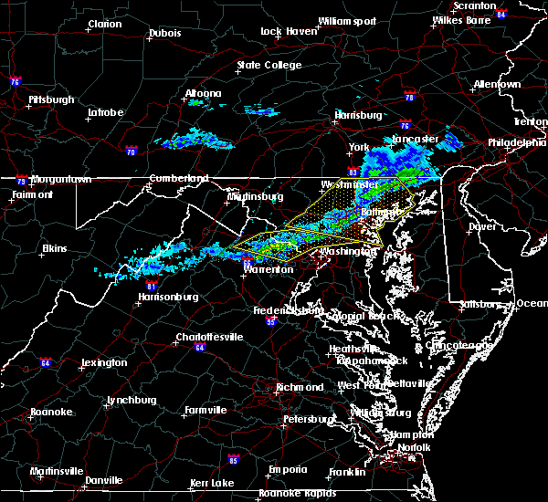 At 1057 pm est, severe thunderstorms were located along a line extending from near gaithersburg to lansdowne to near oatlands, moving east at 50 mph (radar indicated). Hazards include 60 mph wind gusts. Damaging winds will cause some trees and large branches to fall. this could injure those outdoors, as well as damage homes and vehicles. roadways may become blocked by downed trees. localized power outages are possible. unsecured light objects may become projectiles. Locations impacted include, germantown, rockville, bethesda, gaithersburg, reston, leesburg, olney, south riding, herndon, beltsville, vienna, broadlands, lansdowne, lowes island, brambleton, poolesville, american legion bridge, dulles international airport, aspen hill and potomac. At 1057 pm est, severe thunderstorms were located along a line extending from near gaithersburg to lansdowne to near oatlands, moving east at 50 mph (radar indicated). Hazards include 60 mph wind gusts. Damaging winds will cause some trees and large branches to fall. this could injure those outdoors, as well as damage homes and vehicles. roadways may become blocked by downed trees. localized power outages are possible. unsecured light objects may become projectiles. Locations impacted include, germantown, rockville, bethesda, gaithersburg, reston, leesburg, olney, south riding, herndon, beltsville, vienna, broadlands, lansdowne, lowes island, brambleton, poolesville, american legion bridge, dulles international airport, aspen hill and potomac.
|
| 2/12/2017 10:40 PM EST |
 The severe thunderstorm warning for eastern washington county in north central maryland, northwestern montgomery county in central maryland, frederick and northwestern carroll counties in north central maryland, northern loudoun county in northern virginia, northeastern shenandoah and frederick counties in northwestern virginia, northwestern fauquier county in northern virginia, northern warren and clarke counties in northwestern virginia, jefferson county in the panhandle of west virginia, northeastern hardy county in eastern west virginia, southern berkeley county in the panhandle of west virginia and southern hampshire counties in eastern west virginia and the city of winchester will expire at 1045 pm est, the storms which prompted the warning have moved out of the area. therefore the warning will be allowed to expire. to report severe weather, contact your nearest law enforcement agency. they will relay your report to the national weather service sterling virginia. The severe thunderstorm warning for eastern washington county in north central maryland, northwestern montgomery county in central maryland, frederick and northwestern carroll counties in north central maryland, northern loudoun county in northern virginia, northeastern shenandoah and frederick counties in northwestern virginia, northwestern fauquier county in northern virginia, northern warren and clarke counties in northwestern virginia, jefferson county in the panhandle of west virginia, northeastern hardy county in eastern west virginia, southern berkeley county in the panhandle of west virginia and southern hampshire counties in eastern west virginia and the city of winchester will expire at 1045 pm est, the storms which prompted the warning have moved out of the area. therefore the warning will be allowed to expire. to report severe weather, contact your nearest law enforcement agency. they will relay your report to the national weather service sterling virginia.
|
| 2/12/2017 10:38 PM EST |
 At 1037 pm est, severe thunderstorms were located along a line extending from near point of rocks to near round hill to near berryville, moving east at 50 mph (radar indicated). Hazards include 60 mph wind gusts. Damaging winds will cause some trees and large branches to fall. this could injure those outdoors, as well as damage homes and vehicles. roadways may become blocked by downed trees. localized power outages are possible. Unsecured light objects may become projectiles. At 1037 pm est, severe thunderstorms were located along a line extending from near point of rocks to near round hill to near berryville, moving east at 50 mph (radar indicated). Hazards include 60 mph wind gusts. Damaging winds will cause some trees and large branches to fall. this could injure those outdoors, as well as damage homes and vehicles. roadways may become blocked by downed trees. localized power outages are possible. Unsecured light objects may become projectiles.
|
| 2/12/2017 10:22 PM EST |
 At 1020 pm est, severe thunderstorms were located along a line extending from near taneytown to near corporation of ranson to wardensville, moving southeast at 50 mph (radar indicated). Hazards include 60 mph wind gusts. Damaging winds will cause some trees and large branches to fall. this could injure those outdoors, as well as damage homes and vehicles. roadways may become blocked by downed trees. localized power outages are possible. unsecured light objects may become projectiles. locations impacted include, frederick, leesburg, hagerstown, winchester, westminster, martinsburg, lansdowne, strasburg, thurmont, charles town, poolesville, emmitsburg, shepherdstown, harry grove stadium, millwood pike, ballenger creek, mount airy, purcellville, robinwood and taneytown. There have been numerous reports of downed trees across berkeley county. At 1020 pm est, severe thunderstorms were located along a line extending from near taneytown to near corporation of ranson to wardensville, moving southeast at 50 mph (radar indicated). Hazards include 60 mph wind gusts. Damaging winds will cause some trees and large branches to fall. this could injure those outdoors, as well as damage homes and vehicles. roadways may become blocked by downed trees. localized power outages are possible. unsecured light objects may become projectiles. locations impacted include, frederick, leesburg, hagerstown, winchester, westminster, martinsburg, lansdowne, strasburg, thurmont, charles town, poolesville, emmitsburg, shepherdstown, harry grove stadium, millwood pike, ballenger creek, mount airy, purcellville, robinwood and taneytown. There have been numerous reports of downed trees across berkeley county.
|
| 2/12/2017 10:01 PM EST |
 At 1001 pm est, severe thunderstorms were located along a line extending from hagerstown to near inwood to 6 miles south of romney, moving southeast at 45 mph (radar indicated). Hazards include 60 mph wind gusts. Damaging winds will cause some trees and large branches to fall. this could injure those outdoors, as well as damage homes and vehicles. roadways may become blocked by downed trees. localized power outages are possible. Unsecured light objects may become projectiles. At 1001 pm est, severe thunderstorms were located along a line extending from hagerstown to near inwood to 6 miles south of romney, moving southeast at 45 mph (radar indicated). Hazards include 60 mph wind gusts. Damaging winds will cause some trees and large branches to fall. this could injure those outdoors, as well as damage homes and vehicles. roadways may become blocked by downed trees. localized power outages are possible. Unsecured light objects may become projectiles.
|
| 8/17/2016 8:28 PM EDT |
 The severe thunderstorm warning for northwestern prince william, central loudoun and northeastern fauquier counties will expire at 830 pm edt, the storms which prompted the warning have weakened below severe limits, and no longer pose an immediate threat to life or property. therefore the warning will be allowed to expire. however gusty winds are still possible with these thunderstorms. The severe thunderstorm warning for northwestern prince william, central loudoun and northeastern fauquier counties will expire at 830 pm edt, the storms which prompted the warning have weakened below severe limits, and no longer pose an immediate threat to life or property. therefore the warning will be allowed to expire. however gusty winds are still possible with these thunderstorms.
|
| 8/17/2016 8:18 PM EDT |
 At 817 pm edt, severe thunderstorms were located along a line extending from near middleburg to near warrenton, moving northeast at 45 mph (law enforcement). Hazards include 70 mph wind gusts. Damaging winds will cause some trees and large branches to fall. this could injure those outdoors, as well as damage homes and vehicles. roadways may become blocked by downed trees. localized power outages are possible. unsecured light objects may become projectiles. Locations impacted include, leesburg, south riding, brambleton, warrenton, linton hall, bull run, haymarket, middleburg, arcola, the plains, oatlands, gainesville, new baltimore, marshall, nokesville, hamilton, woolsey, broad run, philomont and hughesville. At 817 pm edt, severe thunderstorms were located along a line extending from near middleburg to near warrenton, moving northeast at 45 mph (law enforcement). Hazards include 70 mph wind gusts. Damaging winds will cause some trees and large branches to fall. this could injure those outdoors, as well as damage homes and vehicles. roadways may become blocked by downed trees. localized power outages are possible. unsecured light objects may become projectiles. Locations impacted include, leesburg, south riding, brambleton, warrenton, linton hall, bull run, haymarket, middleburg, arcola, the plains, oatlands, gainesville, new baltimore, marshall, nokesville, hamilton, woolsey, broad run, philomont and hughesville.
|
| 8/17/2016 7:58 PM EDT |
 At 757 pm edt, severe thunderstorms were located along a line extending from near linden to 10 miles west of warrenton, moving northeast at 45 mph (law enforcement). Hazards include 70 mph wind gusts. Damaging winds will cause some trees and large branches to fall. this could injure those outdoors, as well as damage homes and vehicles. roadways may become blocked by downed trees. localized power outages are possible. Unsecured light objects may become projectiles. At 757 pm edt, severe thunderstorms were located along a line extending from near linden to 10 miles west of warrenton, moving northeast at 45 mph (law enforcement). Hazards include 70 mph wind gusts. Damaging winds will cause some trees and large branches to fall. this could injure those outdoors, as well as damage homes and vehicles. roadways may become blocked by downed trees. localized power outages are possible. Unsecured light objects may become projectiles.
|
| 8/16/2016 5:24 PM EDT |
 The severe thunderstorm warning for west central montgomery and central loudoun counties will expire at 530 pm edt, the storm which prompted the warning has weakened below severe limits, and no longer pose an immediate threat to life or property. therefore the warning will be allowed to expire. however gusty winds and heavy rain are still possible with this thunderstorm. a severe thunderstorm watch remains in effect until 1100 pm edt for central maryland, and northern virginia. The severe thunderstorm warning for west central montgomery and central loudoun counties will expire at 530 pm edt, the storm which prompted the warning has weakened below severe limits, and no longer pose an immediate threat to life or property. therefore the warning will be allowed to expire. however gusty winds and heavy rain are still possible with this thunderstorm. a severe thunderstorm watch remains in effect until 1100 pm edt for central maryland, and northern virginia.
|
| 8/16/2016 5:04 PM EDT |
 At 504 pm edt, a severe thunderstorm was located near purcellville, or 8 miles west of leesburg, moving east at 30 mph (radar indicated). Hazards include 60 mph wind gusts. Damaging winds will cause some trees and large branches to fall. this could injure those outdoors, as well as damage homes and vehicles. roadways may become blocked by downed trees. localized power outages are possible. Unsecured light objects may become projectiles. At 504 pm edt, a severe thunderstorm was located near purcellville, or 8 miles west of leesburg, moving east at 30 mph (radar indicated). Hazards include 60 mph wind gusts. Damaging winds will cause some trees and large branches to fall. this could injure those outdoors, as well as damage homes and vehicles. roadways may become blocked by downed trees. localized power outages are possible. Unsecured light objects may become projectiles.
|
| 8/14/2016 7:40 PM EDT |
 The severe thunderstorm warning for northwestern montgomery county in central maryland, southeastern frederick county in north central maryland and northeastern loudoun counties in northern virginia will expire at 745 pm edt, the storm which prompted the warning has moved out of the area. therefore the warning will be allowed to expire. remember, a severe thunderstorm warning still remains in effect for montgomery county. The severe thunderstorm warning for northwestern montgomery county in central maryland, southeastern frederick county in north central maryland and northeastern loudoun counties in northern virginia will expire at 745 pm edt, the storm which prompted the warning has moved out of the area. therefore the warning will be allowed to expire. remember, a severe thunderstorm warning still remains in effect for montgomery county.
|
| 8/14/2016 7:32 PM EDT |
 At 732 pm edt, a severe thunderstorm was located near boyds, or near germantown, moving northeast at 20 mph (radar indicated). Hazards include 60 mph wind gusts. Damaging winds will cause some trees and large branches to fall. this could injure those outdoors, as well as damage homes and vehicles. roadways may become blocked by downed trees. localized power outages are possible. unsecured light objects may become projectiles. Locations impacted include, germantown, gaithersburg, leesburg, damascus, lansdowne, poolesville, montgomery village, boyds, clarksburg, darnestown, washington grove, barnesville, dickerson, tuscarora, beallsville, dawsonville and lucketts. At 732 pm edt, a severe thunderstorm was located near boyds, or near germantown, moving northeast at 20 mph (radar indicated). Hazards include 60 mph wind gusts. Damaging winds will cause some trees and large branches to fall. this could injure those outdoors, as well as damage homes and vehicles. roadways may become blocked by downed trees. localized power outages are possible. unsecured light objects may become projectiles. Locations impacted include, germantown, gaithersburg, leesburg, damascus, lansdowne, poolesville, montgomery village, boyds, clarksburg, darnestown, washington grove, barnesville, dickerson, tuscarora, beallsville, dawsonville and lucketts.
|
| 8/14/2016 7:18 PM EDT |
 At 718 pm edt, a severe thunderstorm was located over round hill, or 10 miles west of leesburg, moving east at 35 mph (radar indicated). Hazards include 60 mph wind gusts. Damaging winds will cause some trees and large branches to fall. this could injure those outdoors, as well as damage homes and vehicles. roadways may become blocked by downed trees. localized power outages are possible. Unsecured light objects may become projectiles. At 718 pm edt, a severe thunderstorm was located over round hill, or 10 miles west of leesburg, moving east at 35 mph (radar indicated). Hazards include 60 mph wind gusts. Damaging winds will cause some trees and large branches to fall. this could injure those outdoors, as well as damage homes and vehicles. roadways may become blocked by downed trees. localized power outages are possible. Unsecured light objects may become projectiles.
|
| 8/14/2016 6:33 PM EDT |
 At 633 pm edt, a severe thunderstorm was located near berryville, or 8 miles south of charles town, moving east at 35 mph (radar indicated). Hazards include 60 mph wind gusts. Damaging winds will cause some trees and large branches to fall. this could injure those outdoors, as well as damage homes and vehicles. roadways may become blocked by downed trees. localized power outages are possible. Unsecured light objects may become projectiles. At 633 pm edt, a severe thunderstorm was located near berryville, or 8 miles south of charles town, moving east at 35 mph (radar indicated). Hazards include 60 mph wind gusts. Damaging winds will cause some trees and large branches to fall. this could injure those outdoors, as well as damage homes and vehicles. roadways may become blocked by downed trees. localized power outages are possible. Unsecured light objects may become projectiles.
|
| 7/31/2016 4:24 PM EDT |
 The severe thunderstorm warning for northwestern montgomery and east central loudoun counties will expire at 430 pm edt, the storm which prompted the warning has weakened below severe limits, and no longer pose an immediate threat to life or property. therefore the warning will be allowed to expire. The severe thunderstorm warning for northwestern montgomery and east central loudoun counties will expire at 430 pm edt, the storm which prompted the warning has weakened below severe limits, and no longer pose an immediate threat to life or property. therefore the warning will be allowed to expire.
|
| 7/31/2016 4:20 PM EDT |
 At 420 pm edt, a severe thunderstorm was located near poolesville, moving east at 20 mph (radar indicated). Hazards include 60 mph wind gusts. Damaging winds will cause some trees and large branches to fall. this could injure those outdoors, as well as damage homes and vehicles. roadways may become blocked by downed trees. localized power outages are possible. unsecured light objects may become projectiles. Locations impacted include, leesburg, lansdowne, poolesville, countryside, belmont, barnesville, dickerson and beallsville. At 420 pm edt, a severe thunderstorm was located near poolesville, moving east at 20 mph (radar indicated). Hazards include 60 mph wind gusts. Damaging winds will cause some trees and large branches to fall. this could injure those outdoors, as well as damage homes and vehicles. roadways may become blocked by downed trees. localized power outages are possible. unsecured light objects may become projectiles. Locations impacted include, leesburg, lansdowne, poolesville, countryside, belmont, barnesville, dickerson and beallsville.
|
| 7/31/2016 4:17 PM EDT |
 A severe thunderstorm warning remains in effect until 430 pm edt for northwestern montgomery county in central maryland. south central frederick county in north central maryland and northeastern loudoun counties in northern virginia. at 416 pm edt. a severe thunderstorm was located near poolesville. Moving east at 20 mph. A severe thunderstorm warning remains in effect until 430 pm edt for northwestern montgomery county in central maryland. south central frederick county in north central maryland and northeastern loudoun counties in northern virginia. at 416 pm edt. a severe thunderstorm was located near poolesville. Moving east at 20 mph.
|
| 7/31/2016 4:17 PM EDT |
 At 420 pm edt, a severe thunderstorm was located near poolesville, moving east at 20 mph (radar indicated). Hazards include 60 mph wind gusts. Damaging winds will cause some trees and large branches to fall. this could injure those outdoors, as well as damage homes and vehicles. roadways may become blocked by downed trees. localized power outages are possible. unsecured light objects may become projectiles. Locations impacted include, leesburg, lansdowne, poolesville, countryside, belmont, barnesville, dickerson and beallsville. At 420 pm edt, a severe thunderstorm was located near poolesville, moving east at 20 mph (radar indicated). Hazards include 60 mph wind gusts. Damaging winds will cause some trees and large branches to fall. this could injure those outdoors, as well as damage homes and vehicles. roadways may become blocked by downed trees. localized power outages are possible. unsecured light objects may become projectiles. Locations impacted include, leesburg, lansdowne, poolesville, countryside, belmont, barnesville, dickerson and beallsville.
|
| 7/31/2016 4:11 PM EDT |
 At 411 pm edt, a severe thunderstorm was located near point of rocks, or near poolesville, moving east at 20 mph (radar indicated). Hazards include 60 mph wind gusts. Damaging winds will cause some trees and large branches to fall. this could injure those outdoors, as well as damage homes and vehicles. roadways may become blocked by downed trees. localized power outages are possible. unsecured light objects may become projectiles. Locations impacted include, leesburg, lansdowne, poolesville, countryside, belmont, hamilton, barnesville, dickerson, paeonian springs, tuscarora, lucketts and beallsville. At 411 pm edt, a severe thunderstorm was located near point of rocks, or near poolesville, moving east at 20 mph (radar indicated). Hazards include 60 mph wind gusts. Damaging winds will cause some trees and large branches to fall. this could injure those outdoors, as well as damage homes and vehicles. roadways may become blocked by downed trees. localized power outages are possible. unsecured light objects may become projectiles. Locations impacted include, leesburg, lansdowne, poolesville, countryside, belmont, hamilton, barnesville, dickerson, paeonian springs, tuscarora, lucketts and beallsville.
|
| 7/31/2016 4:07 PM EDT |
 At 407 pm edt, a severe thunderstorm was located near point of rocks, or 7 miles northwest of poolesville, moving east at 20 mph (radar indicated). Hazards include 60 mph wind gusts. Damaging winds will cause some trees and large branches to fall. this could injure those outdoors, as well as damage homes and vehicles. roadways may become blocked by downed trees. localized power outages are possible. unsecured light objects may become projectiles. Locations impacted include, leesburg, lansdowne, poolesville, countryside, purcellville, point of rocks, belmont, hamilton, barnesville, dickerson, paeonian springs, tuscarora, waterford, beallsville and lucketts. At 407 pm edt, a severe thunderstorm was located near point of rocks, or 7 miles northwest of poolesville, moving east at 20 mph (radar indicated). Hazards include 60 mph wind gusts. Damaging winds will cause some trees and large branches to fall. this could injure those outdoors, as well as damage homes and vehicles. roadways may become blocked by downed trees. localized power outages are possible. unsecured light objects may become projectiles. Locations impacted include, leesburg, lansdowne, poolesville, countryside, purcellville, point of rocks, belmont, hamilton, barnesville, dickerson, paeonian springs, tuscarora, waterford, beallsville and lucketts.
|
| 7/31/2016 4:04 PM EDT |
 At 403 pm edt, a severe thunderstorm was located near point of rocks, or 7 miles north of leesburg, moving east at 20 mph (radar indicated). Hazards include 60 mph wind gusts. Damaging winds will cause some trees and large branches to fall. this could injure those outdoors, as well as damage homes and vehicles. roadways may become blocked by downed trees. localized power outages are possible. unsecured light objects may become projectiles. Locations impacted include, leesburg, lansdowne, poolesville, countryside, purcellville, point of rocks, belmont, hamilton, barnesville, dickerson, paeonian springs, tuscarora, waterford, beallsville, taylorstown and lucketts. At 403 pm edt, a severe thunderstorm was located near point of rocks, or 7 miles north of leesburg, moving east at 20 mph (radar indicated). Hazards include 60 mph wind gusts. Damaging winds will cause some trees and large branches to fall. this could injure those outdoors, as well as damage homes and vehicles. roadways may become blocked by downed trees. localized power outages are possible. unsecured light objects may become projectiles. Locations impacted include, leesburg, lansdowne, poolesville, countryside, purcellville, point of rocks, belmont, hamilton, barnesville, dickerson, paeonian springs, tuscarora, waterford, beallsville, taylorstown and lucketts.
|
| 7/31/2016 4:02 PM EDT | Tree down in 17000 block bridge view ct in loudoun county VA, 4.1 miles ESE of Leesburg, VA |
| 7/31/2016 3:56 PM EDT |
 At 355 pm edt, a severe thunderstorm was located near point of rocks, or 8 miles north of leesburg, moving east at 20 mph (radar indicated). Hazards include 60 mph wind gusts. Damaging winds will cause some trees and large branches to fall. this could injure those outdoors, as well as damage homes and vehicles. roadways may become blocked by downed trees. localized power outages are possible. unsecured light objects may become projectiles. Locations impacted include, leesburg, lansdowne, poolesville, countryside, purcellville, brunswick, point of rocks, belmont, lovettsville, hamilton, barnesville, dickerson, paeonian springs, tuscarora, waterford, beallsville, taylorstown, lucketts and knoxville. At 355 pm edt, a severe thunderstorm was located near point of rocks, or 8 miles north of leesburg, moving east at 20 mph (radar indicated). Hazards include 60 mph wind gusts. Damaging winds will cause some trees and large branches to fall. this could injure those outdoors, as well as damage homes and vehicles. roadways may become blocked by downed trees. localized power outages are possible. unsecured light objects may become projectiles. Locations impacted include, leesburg, lansdowne, poolesville, countryside, purcellville, brunswick, point of rocks, belmont, lovettsville, hamilton, barnesville, dickerson, paeonian springs, tuscarora, waterford, beallsville, taylorstown, lucketts and knoxville.
|
| 7/31/2016 3:52 PM EDT |
 At 352 pm edt, a severe thunderstorm was located near point of rocks, or 9 miles northwest of leesburg, moving east at 20 mph (radar indicated). Hazards include 60 mph wind gusts. Damaging winds will cause some trees and large branches to fall. this could injure those outdoors, as well as damage homes and vehicles. roadways may become blocked by downed trees. localized power outages are possible. Unsecured light objects may become projectiles. At 352 pm edt, a severe thunderstorm was located near point of rocks, or 9 miles northwest of leesburg, moving east at 20 mph (radar indicated). Hazards include 60 mph wind gusts. Damaging winds will cause some trees and large branches to fall. this could injure those outdoors, as well as damage homes and vehicles. roadways may become blocked by downed trees. localized power outages are possible. Unsecured light objects may become projectiles.
|
| 7/30/2016 7:41 PM EDT | The severe thunderstorm warning for southwestern montgomery county in central maryland, southern frederick county in north central maryland, northwestern fairfax and eastern loudoun counties in northern virginia will expire at 745 pm edt, the storms which prompted the warning have weakened. therefore, the warning will be allowed to expire. however heavy rain is still occurring with these thunderstorms. |
| 7/30/2016 7:41 PM EDT | The severe thunderstorm warning for southwestern montgomery county in central maryland, southern frederick county in north central maryland, northwestern fairfax and eastern loudoun counties in northern virginia will expire at 745 pm edt, the storms which prompted the warning have weakened. therefore, the warning will be allowed to expire. however heavy rain is still occurring with these thunderstorms. |
| 7/30/2016 7:30 PM EDT |
 At 730 pm edt, severe thunderstorms were located along a line extending from boyds to arcola, moving southeast at 25 mph (radar indicated). Hazards include 60 mph wind gusts. Damaging winds will cause some trees and large branches to fall. this could injure those outdoors, as well as damage homes and vehicles. roadways may become blocked by downed trees. localized power outages are possible. unsecured light objects may become projectiles. Locations impacted include, germantown, centreville, rockville, gaithersburg, reston, leesburg, south riding, herndon, broadlands, lansdowne, lowes island, brambleton, poolesville, dulles international airport, ashburn, montgomery village, sterling, north potomac, chantilly and redland. At 730 pm edt, severe thunderstorms were located along a line extending from boyds to arcola, moving southeast at 25 mph (radar indicated). Hazards include 60 mph wind gusts. Damaging winds will cause some trees and large branches to fall. this could injure those outdoors, as well as damage homes and vehicles. roadways may become blocked by downed trees. localized power outages are possible. unsecured light objects may become projectiles. Locations impacted include, germantown, centreville, rockville, gaithersburg, reston, leesburg, south riding, herndon, broadlands, lansdowne, lowes island, brambleton, poolesville, dulles international airport, ashburn, montgomery village, sterling, north potomac, chantilly and redland.
|
| 7/30/2016 7:21 PM EDT |
 At 720 pm edt, severe thunderstorms were located along a line extending from near boyds to near brambleton, moving east at 25 mph (radar indicated). Hazards include 60 mph wind gusts. Damaging winds will cause some trees and large branches to fall. this could injure those outdoors, as well as damage homes and vehicles. roadways may become blocked by downed trees. localized power outages are possible. unsecured light objects may become projectiles. Locations impacted include, germantown, centreville, rockville, gaithersburg, reston, leesburg, south riding, herndon, broadlands, lansdowne, lowes island, brambleton, poolesville, dulles international airport, ashburn, montgomery village, sterling, north potomac, chantilly and redland. At 720 pm edt, severe thunderstorms were located along a line extending from near boyds to near brambleton, moving east at 25 mph (radar indicated). Hazards include 60 mph wind gusts. Damaging winds will cause some trees and large branches to fall. this could injure those outdoors, as well as damage homes and vehicles. roadways may become blocked by downed trees. localized power outages are possible. unsecured light objects may become projectiles. Locations impacted include, germantown, centreville, rockville, gaithersburg, reston, leesburg, south riding, herndon, broadlands, lansdowne, lowes island, brambleton, poolesville, dulles international airport, ashburn, montgomery village, sterling, north potomac, chantilly and redland.
|
| 7/30/2016 7:00 PM EDT |
 At 659 pm edt, severe thunderstorms were located along a line extending from point of rocks to near middleburg, moving southeast at 25 mph (radar indicated). Hazards include 60 mph wind gusts. Damaging winds will cause some trees and large branches to fall. this could injure those outdoors, as well as damage homes and vehicles. roadways may become blocked by downed trees. localized power outages are possible. Unsecured light objects may become projectiles. At 659 pm edt, severe thunderstorms were located along a line extending from point of rocks to near middleburg, moving southeast at 25 mph (radar indicated). Hazards include 60 mph wind gusts. Damaging winds will cause some trees and large branches to fall. this could injure those outdoors, as well as damage homes and vehicles. roadways may become blocked by downed trees. localized power outages are possible. Unsecured light objects may become projectiles.
|
| 7/25/2016 5:45 PM EDT |
 At 545 pm edt, a severe thunderstorm was located over broadlands, moving east at 30 mph (radar indicated). Hazards include 70 mph wind gusts and quarter size hail. Damaging winds will cause some trees and large branches to fall. this could injure those outdoors, as well as damage homes and vehicles. roadways may become blocked by downed trees. localized power outages are possible. unsecured light objects may become projectiles. Locations impacted include, centreville, reston, south riding, herndon, broadlands, lowes island, brambleton, dulles international airport, potomac, ashburn, oakton, sterling, chantilly, wolf trap, great falls, countryside, arcola, oatlands, darnestown and belmont. At 545 pm edt, a severe thunderstorm was located over broadlands, moving east at 30 mph (radar indicated). Hazards include 70 mph wind gusts and quarter size hail. Damaging winds will cause some trees and large branches to fall. this could injure those outdoors, as well as damage homes and vehicles. roadways may become blocked by downed trees. localized power outages are possible. unsecured light objects may become projectiles. Locations impacted include, centreville, reston, south riding, herndon, broadlands, lowes island, brambleton, dulles international airport, potomac, ashburn, oakton, sterling, chantilly, wolf trap, great falls, countryside, arcola, oatlands, darnestown and belmont.
|
| 7/25/2016 5:17 PM EDT |
 At 517 pm edt, a severe thunderstorm was located near bluemont, or 12 miles west of leesburg, moving east at 30 mph (radar indicated). Hazards include 70 mph wind gusts and quarter size hail. Damaging winds will cause some trees and large branches to fall. this could injure those outdoors, as well as damage homes and vehicles. roadways may become blocked by downed trees. localized power outages are possible. unsecured light objects may become projectiles. Locations impacted include, leesburg, purcellville, middleburg, round hill, oatlands, bluemont, hamilton, hillsboro, paeonian springs, upperville, philomont, waterford, hughesville, gleedsville, aldie, saint louis, lincoln and wickliffe. At 517 pm edt, a severe thunderstorm was located near bluemont, or 12 miles west of leesburg, moving east at 30 mph (radar indicated). Hazards include 70 mph wind gusts and quarter size hail. Damaging winds will cause some trees and large branches to fall. this could injure those outdoors, as well as damage homes and vehicles. roadways may become blocked by downed trees. localized power outages are possible. unsecured light objects may become projectiles. Locations impacted include, leesburg, purcellville, middleburg, round hill, oatlands, bluemont, hamilton, hillsboro, paeonian springs, upperville, philomont, waterford, hughesville, gleedsville, aldie, saint louis, lincoln and wickliffe.
|
| 7/25/2016 5:16 PM EDT |
 At 515 pm edt, a severe thunderstorm was located near middleburg, or 12 miles west of leesburg, moving east at 30 mph (radar indicated). Hazards include 70 mph wind gusts and quarter size hail. Damaging winds will cause some trees and large branches to fall. this could injure those outdoors, as well as damage homes and vehicles. roadways may become blocked by downed trees. localized power outages are possible. Unsecured light objects may become projectiles. At 515 pm edt, a severe thunderstorm was located near middleburg, or 12 miles west of leesburg, moving east at 30 mph (radar indicated). Hazards include 70 mph wind gusts and quarter size hail. Damaging winds will cause some trees and large branches to fall. this could injure those outdoors, as well as damage homes and vehicles. roadways may become blocked by downed trees. localized power outages are possible. Unsecured light objects may become projectiles.
|
| 7/25/2016 4:58 PM EDT |
 At 458 pm edt, a severe thunderstorm was located over bluemont, or 10 miles south of charles town, moving east at 40 mph (radar indicated). Hazards include 70 mph wind gusts and quarter size hail. Damaging winds will cause some trees and large branches to fall. this could injure those outdoors, as well as damage homes and vehicles. roadways may become blocked by downed trees. localized power outages are possible. unsecured light objects may become projectiles. Locations impacted include, leesburg, purcellville, berryville, middleburg, round hill, oatlands, bluemont, boyce, hamilton, hillsboro, white post, philomont, waterford, hughesville, rippon, gleedsville, aldie, millwood, saint louis and lincoln. At 458 pm edt, a severe thunderstorm was located over bluemont, or 10 miles south of charles town, moving east at 40 mph (radar indicated). Hazards include 70 mph wind gusts and quarter size hail. Damaging winds will cause some trees and large branches to fall. this could injure those outdoors, as well as damage homes and vehicles. roadways may become blocked by downed trees. localized power outages are possible. unsecured light objects may become projectiles. Locations impacted include, leesburg, purcellville, berryville, middleburg, round hill, oatlands, bluemont, boyce, hamilton, hillsboro, white post, philomont, waterford, hughesville, rippon, gleedsville, aldie, millwood, saint louis and lincoln.
|
| 7/25/2016 4:42 PM EDT |
 At 441 pm edt, a severe thunderstorm was located near berryville, or near millwood pike, moving east at 35 mph (radar indicated). Hazards include 60 mph wind gusts and quarter size hail. Damaging winds will cause some trees and large branches to fall. this could injure those outdoors, as well as damage homes and vehicles. roadways may become blocked by downed trees. localized power outages are possible. Unsecured light objects may become projectiles. At 441 pm edt, a severe thunderstorm was located near berryville, or near millwood pike, moving east at 35 mph (radar indicated). Hazards include 60 mph wind gusts and quarter size hail. Damaging winds will cause some trees and large branches to fall. this could injure those outdoors, as well as damage homes and vehicles. roadways may become blocked by downed trees. localized power outages are possible. Unsecured light objects may become projectiles.
|
| 7/24/2016 9:09 PM EDT |
 At 907 pm edt, a severe thunderstorm was located near point of rocks, or near leesburg, moving east at 30 mph (radar indicated). Hazards include 60 mph wind gusts. Damaging winds will cause some trees and large branches to fall. this could injure those outdoors, as well as damage homes and vehicles. roadways may become blocked by downed trees. localized power outages are possible. Locations impacted include, lansdowne, poolesville, brunswick, point of rocks, clarksburg, belmont, adamstown, lovettsville, barnesville, dickerson, paeonian springs, tuscarora, waterford, beallsville, and taylorstown. At 907 pm edt, a severe thunderstorm was located near point of rocks, or near leesburg, moving east at 30 mph (radar indicated). Hazards include 60 mph wind gusts. Damaging winds will cause some trees and large branches to fall. this could injure those outdoors, as well as damage homes and vehicles. roadways may become blocked by downed trees. localized power outages are possible. Locations impacted include, lansdowne, poolesville, brunswick, point of rocks, clarksburg, belmont, adamstown, lovettsville, barnesville, dickerson, paeonian springs, tuscarora, waterford, beallsville, and taylorstown.
|
| 7/24/2016 8:53 PM EDT |
 At 853 pm edt, a severe thunderstorm was located near brunswick, or 10 miles east of charles town, moving east at 25 mph (radar indicated). Hazards include 60 mph wind gusts. Damaging winds will cause some trees and large branches to fall. this could injure those outdoors, as well as damage homes and vehicles. roadways may become blocked by downed trees. Localized power outages are possible. At 853 pm edt, a severe thunderstorm was located near brunswick, or 10 miles east of charles town, moving east at 25 mph (radar indicated). Hazards include 60 mph wind gusts. Damaging winds will cause some trees and large branches to fall. this could injure those outdoors, as well as damage homes and vehicles. roadways may become blocked by downed trees. Localized power outages are possible.
|
| 7/18/2016 3:45 PM EDT |
 At 345 pm edt, severe thunderstorms were located along a line extending from broadlands to near haymarket, moving east at 40 mph (radar indicated). Hazards include 60 mph wind gusts. Damaging winds will cause some trees and large branches to fall. this could injure those outdoors, as well as damage homes and vehicles. roadways may become blocked by downed trees. localized power outages are possible. Unsecured light objects may become projectiles. At 345 pm edt, severe thunderstorms were located along a line extending from broadlands to near haymarket, moving east at 40 mph (radar indicated). Hazards include 60 mph wind gusts. Damaging winds will cause some trees and large branches to fall. this could injure those outdoors, as well as damage homes and vehicles. roadways may become blocked by downed trees. localized power outages are possible. Unsecured light objects may become projectiles.
|
| 7/18/2016 3:34 PM EDT | Large branches down and siding blown off house near galloway drive southeas in loudoun county VA, 2.4 miles N of Leesburg, VA |
| 7/18/2016 3:27 PM EDT |
 At 326 pm edt, a severe thunderstorm was located over leesburg, moving east at 45 mph (radar indicated). Hazards include 60 mph wind gusts. Damaging winds will cause some trees and large branches to fall. this could injure those outdoors, as well as damage homes and vehicles. roadways may become blocked by downed trees. localized power outages are possible. Unsecured light objects may become projectiles. At 326 pm edt, a severe thunderstorm was located over leesburg, moving east at 45 mph (radar indicated). Hazards include 60 mph wind gusts. Damaging winds will cause some trees and large branches to fall. this could injure those outdoors, as well as damage homes and vehicles. roadways may become blocked by downed trees. localized power outages are possible. Unsecured light objects may become projectiles.
|
| 7/18/2016 3:01 PM EDT |
 At 300 pm edt, a severe thunderstorm was located 7 miles south of berryville, or 12 miles southeast of millwood pike, moving east at 35 mph (trained weather spotters). Hazards include 60 mph wind gusts. Damaging winds will cause some trees and large branches to fall. this could injure those outdoors, as well as damage homes and vehicles. roadways may become blocked by downed trees. localized power outages are possible. Unsecured light objects may become projectiles. At 300 pm edt, a severe thunderstorm was located 7 miles south of berryville, or 12 miles southeast of millwood pike, moving east at 35 mph (trained weather spotters). Hazards include 60 mph wind gusts. Damaging winds will cause some trees and large branches to fall. this could injure those outdoors, as well as damage homes and vehicles. roadways may become blocked by downed trees. localized power outages are possible. Unsecured light objects may become projectiles.
|
| 6/21/2016 6:50 PM EDT |
 The severe thunderstorm warning for southeastern loudoun county will expire at 700 pm edt, the storm which prompted the warning has weakened and exited the warned area. therefore the warning will be allowed to expire. a severe thunderstorm watch remains in effect until 900 pm edt for central maryland, and northern virginia. The severe thunderstorm warning for southeastern loudoun county will expire at 700 pm edt, the storm which prompted the warning has weakened and exited the warned area. therefore the warning will be allowed to expire. a severe thunderstorm watch remains in effect until 900 pm edt for central maryland, and northern virginia.
|
| 6/21/2016 6:43 PM EDT |
 At 643 pm edt, a severe thunderstorm was located over oatlands, or near broadlands, moving southeast at 25 mph (radar indicated). Hazards include 60 mph wind gusts and half dollar size hail. Damaging winds will cause some trees and large branches to fall. this could injure those outdoors, as well as damage homes and vehicles. roadways may become blocked by downed trees. localized power outages are possible. unsecured light objects may become projectiles. Locations impacted include, leesburg, south riding, broadlands, lansdowne, lowes island, brambleton, dulles international airport, ashburn, sterling, countryside, arcola, oatlands, belmont, paeonian springs, gleedsville, aldie and sterling park. At 643 pm edt, a severe thunderstorm was located over oatlands, or near broadlands, moving southeast at 25 mph (radar indicated). Hazards include 60 mph wind gusts and half dollar size hail. Damaging winds will cause some trees and large branches to fall. this could injure those outdoors, as well as damage homes and vehicles. roadways may become blocked by downed trees. localized power outages are possible. unsecured light objects may become projectiles. Locations impacted include, leesburg, south riding, broadlands, lansdowne, lowes island, brambleton, dulles international airport, ashburn, sterling, countryside, arcola, oatlands, belmont, paeonian springs, gleedsville, aldie and sterling park.
|
| 6/21/2016 6:33 PM EDT |
 At 633 pm edt, a severe thunderstorm was located near oatlands, or near leesburg, moving southeast at 25 mph (radar indicated). Hazards include 60 mph wind gusts and quarter size hail. frequent lightning is also occurring with this storm. Damaging winds will cause some trees and large branches to fall. this could injure those outdoors, as well as damage homes and vehicles. roadways may become blocked by downed trees. localized power outages are possible. unsecured light objects may become projectiles. Locations impacted include, leesburg, south riding, broadlands, lansdowne, lowes island, brambleton, dulles international airport, ashburn, sterling, countryside, purcellville, arcola, oatlands, belmont, hamilton, hillsboro, paeonian springs, philomont, hughesville and gleedsville. At 633 pm edt, a severe thunderstorm was located near oatlands, or near leesburg, moving southeast at 25 mph (radar indicated). Hazards include 60 mph wind gusts and quarter size hail. frequent lightning is also occurring with this storm. Damaging winds will cause some trees and large branches to fall. this could injure those outdoors, as well as damage homes and vehicles. roadways may become blocked by downed trees. localized power outages are possible. unsecured light objects may become projectiles. Locations impacted include, leesburg, south riding, broadlands, lansdowne, lowes island, brambleton, dulles international airport, ashburn, sterling, countryside, purcellville, arcola, oatlands, belmont, hamilton, hillsboro, paeonian springs, philomont, hughesville and gleedsville.
|
| 6/21/2016 6:11 PM EDT |
 At 610 pm edt, a severe thunderstorm was located over bluemont, or 9 miles south of charles town, moving southeast at 25 mph (radar indicated). Hazards include 60 mph wind gusts. Damaging winds will cause some trees and large branches to fall. this could injure those outdoors, as well as damage homes and vehicles. roadways may become blocked by downed trees. localized power outages are possible. Unsecured light objects may become projectiles. At 610 pm edt, a severe thunderstorm was located over bluemont, or 9 miles south of charles town, moving southeast at 25 mph (radar indicated). Hazards include 60 mph wind gusts. Damaging winds will cause some trees and large branches to fall. this could injure those outdoors, as well as damage homes and vehicles. roadways may become blocked by downed trees. localized power outages are possible. Unsecured light objects may become projectiles.
|
| 6/21/2016 5:39 PM EDT |
 The severe thunderstorm warning for northwestern montgomery county in central maryland, southwestern frederick county in north central maryland and northeastern loudoun counties in northern virginia will expire at 545 pm edt, the storm which prompted the warning has weakened, and no longer pose an immediate threat to life or property. therefore the warning will be allowed to expire. however small hail and heavy rain are still possible with this thunderstorm. a severe thunderstorm watch remains in effect until 900 pm edt for north central maryland, and northern virginia. The severe thunderstorm warning for northwestern montgomery county in central maryland, southwestern frederick county in north central maryland and northeastern loudoun counties in northern virginia will expire at 545 pm edt, the storm which prompted the warning has weakened, and no longer pose an immediate threat to life or property. therefore the warning will be allowed to expire. however small hail and heavy rain are still possible with this thunderstorm. a severe thunderstorm watch remains in effect until 900 pm edt for north central maryland, and northern virginia.
|
| 6/21/2016 5:30 PM EDT |
 At 530 pm edt, a severe thunderstorm was located over brunswick, or 11 miles southeast of shepherdstown, moving southeast at 30 mph (radar indicated). Hazards include 60 mph wind gusts and half dollar size hail. Damaging winds will cause some trees and large branches to fall. this could injure those outdoors, as well as damage homes and vehicles. roadways may become blocked by downed trees. localized power outages are possible. unsecured light objects may become projectiles. Locations impacted include, frederick, leesburg, lansdowne, harry grove stadium, ballenger creek, brunswick, braddock heights, new market, point of rocks, linganore-bartonsville, adamstown, jefferson, lovettsville, buckeystown, monrovia, rosemont, barnesville, burkittsville, dickerson and clifton. At 530 pm edt, a severe thunderstorm was located over brunswick, or 11 miles southeast of shepherdstown, moving southeast at 30 mph (radar indicated). Hazards include 60 mph wind gusts and half dollar size hail. Damaging winds will cause some trees and large branches to fall. this could injure those outdoors, as well as damage homes and vehicles. roadways may become blocked by downed trees. localized power outages are possible. unsecured light objects may become projectiles. Locations impacted include, frederick, leesburg, lansdowne, harry grove stadium, ballenger creek, brunswick, braddock heights, new market, point of rocks, linganore-bartonsville, adamstown, jefferson, lovettsville, buckeystown, monrovia, rosemont, barnesville, burkittsville, dickerson and clifton.
|
| 6/21/2016 5:12 PM EDT |
 At 511 pm edt, a severe thunderstorm was located near shepherdstown, moving southeast at 35 mph (radar indicated). Hazards include 60 mph wind gusts and half dollar size hail. Damaging winds will cause some trees and large branches to fall. this could injure those outdoors, as well as damage homes and vehicles. roadways may become blocked by downed trees. localized power outages are possible. unsecured light objects may become projectiles. Locations impacted include, frederick, leesburg, lansdowne, shepherdstown, harry grove stadium, ballenger creek, brunswick, braddock heights, new market, harpers ferry, point of rocks, linganore-bartonsville, adamstown, jefferson, lovettsville, keedysville, buckeystown, sharpsburg, monrovia and rosemont. At 511 pm edt, a severe thunderstorm was located near shepherdstown, moving southeast at 35 mph (radar indicated). Hazards include 60 mph wind gusts and half dollar size hail. Damaging winds will cause some trees and large branches to fall. this could injure those outdoors, as well as damage homes and vehicles. roadways may become blocked by downed trees. localized power outages are possible. unsecured light objects may become projectiles. Locations impacted include, frederick, leesburg, lansdowne, shepherdstown, harry grove stadium, ballenger creek, brunswick, braddock heights, new market, harpers ferry, point of rocks, linganore-bartonsville, adamstown, jefferson, lovettsville, keedysville, buckeystown, sharpsburg, monrovia and rosemont.
|
| 6/21/2016 4:57 PM EDT |
 At 456 pm edt, a severe thunderstorm was located near shepherdstown, moving southeast at 35 mph (radar indicated). Hazards include 60 mph wind gusts and quarter size hail. Damaging winds will cause some trees and large branches to fall. this could injure those outdoors, as well as damage homes and vehicles. roadways may become blocked by downed trees. localized power outages are possible. Unsecured light objects may become projectiles. At 456 pm edt, a severe thunderstorm was located near shepherdstown, moving southeast at 35 mph (radar indicated). Hazards include 60 mph wind gusts and quarter size hail. Damaging winds will cause some trees and large branches to fall. this could injure those outdoors, as well as damage homes and vehicles. roadways may become blocked by downed trees. localized power outages are possible. Unsecured light objects may become projectiles.
|
| 6/21/2016 2:26 PM EDT | The severe thunderstorm warning for west central montgomery county in central maryland, southern frederick county in north central maryland, northeastern loudoun county in northern virginia and southeastern jefferson counties in the panhandle of west virginia will expire at 230 pm edt, the storms which prompted the warning have weakened and exited the warned area. therefore the warning will be allowed to expire. a severe thunderstorm watch remains in effect until 900 pm edt for north central maryland, northern virginia, and central west virginia. to report severe weather, contact your nearest law enforcement agency. they will relay your report to the national weather service sterling virginia. |
| 6/21/2016 2:26 PM EDT | The severe thunderstorm warning for west central montgomery county in central maryland, southern frederick county in north central maryland, northeastern loudoun county in northern virginia and southeastern jefferson counties in the panhandle of west virginia will expire at 230 pm edt, the storms which prompted the warning have weakened and exited the warned area. therefore the warning will be allowed to expire. a severe thunderstorm watch remains in effect until 900 pm edt for north central maryland, northern virginia, and central west virginia. to report severe weather, contact your nearest law enforcement agency. they will relay your report to the national weather service sterling virginia. |
| 6/21/2016 2:26 PM EDT | The severe thunderstorm warning for west central montgomery county in central maryland, southern frederick county in north central maryland, northeastern loudoun county in northern virginia and southeastern jefferson counties in the panhandle of west virginia will expire at 230 pm edt, the storms which prompted the warning have weakened and exited the warned area. therefore the warning will be allowed to expire. a severe thunderstorm watch remains in effect until 900 pm edt for north central maryland, northern virginia, and central west virginia. to report severe weather, contact your nearest law enforcement agency. they will relay your report to the national weather service sterling virginia. |
| 6/21/2016 2:17 PM EDT |
 At 216 pm edt, severe thunderstorms were located along a line extending from near leesburg to near harpers ferry, moving east at 50 mph (radar indicated). Hazards include 60 mph wind gusts and quarter size hail. Damaging winds will cause some trees and large branches to fall. this could injure those outdoors, as well as damage homes and vehicles. roadways may become blocked by downed trees. localized power outages are possible. unsecured light objects may become projectiles. Locations impacted include, leesburg, lansdowne, charles town, poolesville, ashburn, harpers ferry, belmont, lovettsville, bolivar, hillsboro, neersville, dickerson, paeonian springs, millville, waterford, beallsville, taylorstown and lucketts. At 216 pm edt, severe thunderstorms were located along a line extending from near leesburg to near harpers ferry, moving east at 50 mph (radar indicated). Hazards include 60 mph wind gusts and quarter size hail. Damaging winds will cause some trees and large branches to fall. this could injure those outdoors, as well as damage homes and vehicles. roadways may become blocked by downed trees. localized power outages are possible. unsecured light objects may become projectiles. Locations impacted include, leesburg, lansdowne, charles town, poolesville, ashburn, harpers ferry, belmont, lovettsville, bolivar, hillsboro, neersville, dickerson, paeonian springs, millville, waterford, beallsville, taylorstown and lucketts.
|
| 6/21/2016 1:51 PM EDT |
 At 150 pm edt, a severe thunderstorm was located over kearneysville, or near shepherdstown, moving southeast at 45 mph. additional storms ahead of this storm may also become severe at any time (radar indicated). Hazards include 60 mph wind gusts and quarter size hail. Damaging winds will cause some trees and large branches to fall. this could injure those outdoors, as well as damage homes and vehicles. roadways may become blocked by downed trees. localized power outages are possible. Unsecured light objects may become projectiles. At 150 pm edt, a severe thunderstorm was located over kearneysville, or near shepherdstown, moving southeast at 45 mph. additional storms ahead of this storm may also become severe at any time (radar indicated). Hazards include 60 mph wind gusts and quarter size hail. Damaging winds will cause some trees and large branches to fall. this could injure those outdoors, as well as damage homes and vehicles. roadways may become blocked by downed trees. localized power outages are possible. Unsecured light objects may become projectiles.
|
| 6/16/2016 8:39 PM EDT |
 The severe thunderstorm warning for northwestern prince william, southeastern rappahannock, loudoun, western culpeper, east central madison, central fauquier and southeastern jefferson counties will expire at 845 pm edt, the storms which prompted the warning have moved out of the area. therefore the warning will be allowed to expire. a severe thunderstorm watch remains in effect until 1000 pm edt for northwestern virginia, and central west virginia. The severe thunderstorm warning for northwestern prince william, southeastern rappahannock, loudoun, western culpeper, east central madison, central fauquier and southeastern jefferson counties will expire at 845 pm edt, the storms which prompted the warning have moved out of the area. therefore the warning will be allowed to expire. a severe thunderstorm watch remains in effect until 1000 pm edt for northwestern virginia, and central west virginia.
|
| 6/16/2016 8:39 PM EDT | The severe thunderstorm warning for northwestern prince william, southeastern rappahannock, loudoun, western culpeper, east central madison, central fauquier and southeastern jefferson counties will expire at 845 pm edt, the storms which prompted the warning have moved out of the area. therefore the warning will be allowed to expire. a severe thunderstorm watch remains in effect until 1000 pm edt for northwestern virginia, and central west virginia. |
| 6/16/2016 8:25 PM EDT |
 At 824 pm edt, severe thunderstorms were located along a line extending from near lansdowne to near centreville to near culpeper, moving east at 50 mph (radar indicated). Hazards include 60 mph wind gusts. Damaging winds will cause some trees and large branches to fall. this could injure those outdoors, as well as damage homes and vehicles. roadways may become blocked by downed trees. localized power outages are possible. unsecured light objects may become projectiles. Locations impacted include, leesburg, south riding, culpeper, brambleton, warrenton, charles town, linton hall, purcellville, ranson, bealeton, haymarket, middleburg, round hill, arcola, the plains, oatlands, gainesville, new baltimore, lovettsville and marshall. At 824 pm edt, severe thunderstorms were located along a line extending from near lansdowne to near centreville to near culpeper, moving east at 50 mph (radar indicated). Hazards include 60 mph wind gusts. Damaging winds will cause some trees and large branches to fall. this could injure those outdoors, as well as damage homes and vehicles. roadways may become blocked by downed trees. localized power outages are possible. unsecured light objects may become projectiles. Locations impacted include, leesburg, south riding, culpeper, brambleton, warrenton, charles town, linton hall, purcellville, ranson, bealeton, haymarket, middleburg, round hill, arcola, the plains, oatlands, gainesville, new baltimore, lovettsville and marshall.
|
| 6/16/2016 8:20 PM EDT |
 At 820 pm edt, severe thunderstorms were located along a line extending from leesburg to near haymarket to near warrenton, moving east at 35 mph (radar indicated). Hazards include 60 mph wind gusts. Damaging winds will cause some trees and large branches to fall. this could injure those outdoors, as well as damage homes and vehicles. roadways may become blocked by downed trees. localized power outages are possible. Unsecured light objects may become projectiles. At 820 pm edt, severe thunderstorms were located along a line extending from leesburg to near haymarket to near warrenton, moving east at 35 mph (radar indicated). Hazards include 60 mph wind gusts. Damaging winds will cause some trees and large branches to fall. this could injure those outdoors, as well as damage homes and vehicles. roadways may become blocked by downed trees. localized power outages are possible. Unsecured light objects may become projectiles.
|
| 6/16/2016 8:02 PM EDT |
 At 801 pm edt, severe thunderstorms were located along a line extending from near round hill to near the plains and marshall to near sperryville, moving east at 45 mph (radar indicated). Hazards include 60 mph wind gusts. Damaging winds will cause some trees and large branches to fall. this could injure those outdoors, as well as damage homes and vehicles. roadways may become blocked by downed trees. localized power outages are possible. unsecured light objects may become projectiles. Locations impacted include, leesburg, south riding, culpeper, brambleton, warrenton, charles town, linton hall, purcellville, ranson, bealeton, haymarket, middleburg, round hill, sperryville, arcola, the plains, hume, delaplane, bluemont and oatlands. At 801 pm edt, severe thunderstorms were located along a line extending from near round hill to near the plains and marshall to near sperryville, moving east at 45 mph (radar indicated). Hazards include 60 mph wind gusts. Damaging winds will cause some trees and large branches to fall. this could injure those outdoors, as well as damage homes and vehicles. roadways may become blocked by downed trees. localized power outages are possible. unsecured light objects may become projectiles. Locations impacted include, leesburg, south riding, culpeper, brambleton, warrenton, charles town, linton hall, purcellville, ranson, bealeton, haymarket, middleburg, round hill, sperryville, arcola, the plains, hume, delaplane, bluemont and oatlands.
|
| 6/16/2016 7:39 PM EDT |
 At 739 pm edt, severe thunderstorms were located along a line extending from near charles town to near linden to 7 miles south of front royal to stanley, moving east at 50 mph (radar indicated). Hazards include 60 mph wind gusts and quarter size hail. Damaging winds will cause some trees and large branches to fall. this could injure those outdoors, as well as damage homes and vehicles. roadways may become blocked by downed trees. localized power outages are possible. Unsecured light objects may become projectiles. At 739 pm edt, severe thunderstorms were located along a line extending from near charles town to near linden to 7 miles south of front royal to stanley, moving east at 50 mph (radar indicated). Hazards include 60 mph wind gusts and quarter size hail. Damaging winds will cause some trees and large branches to fall. this could injure those outdoors, as well as damage homes and vehicles. roadways may become blocked by downed trees. localized power outages are possible. Unsecured light objects may become projectiles.
|
| 6/16/2016 4:50 PM EDT |
 At 450 pm edt, a severe thunderstorm was located over purcellville, or 8 miles west of leesburg, moving southeast at 30 mph (radar indicated). Hazards include 60 mph wind gusts and quarter size hail. Damaging winds will cause some trees and large branches to fall. this could injure those outdoors, as well as damage homes and vehicles. roadways may become blocked by downed trees. localized power outages are possible. Unsecured light objects may become projectiles. At 450 pm edt, a severe thunderstorm was located over purcellville, or 8 miles west of leesburg, moving southeast at 30 mph (radar indicated). Hazards include 60 mph wind gusts and quarter size hail. Damaging winds will cause some trees and large branches to fall. this could injure those outdoors, as well as damage homes and vehicles. roadways may become blocked by downed trees. localized power outages are possible. Unsecured light objects may become projectiles.
|
| 2/24/2016 5:54 PM EST | Tree down on rt 15 north of leesburg at jct with selma lane in loudoun county VA, 1.5 miles NW of Leesburg, VA |
| 2/24/2016 5:28 PM EST | The severe thunderstorm warning for western carroll county in north central maryland, western howard and northwestern montgomery counties in central maryland, frederick county in north central maryland and northeastern loudoun counties in northern virginia will expire at 530 pm est, the storms which prompted the warning have weakened below severe limits and exited the warned area. therefore the warning will be allowed to expire. additional severe thunderstorm development remains possible, and a tornado watch remains in effect until 11 pm est. |
| 2/24/2016 5:28 PM EST | The severe thunderstorm warning for western carroll county in north central maryland, western howard and northwestern montgomery counties in central maryland, frederick county in north central maryland and northeastern loudoun counties in northern virginia will expire at 530 pm est, the storms which prompted the warning have weakened below severe limits and exited the warned area. therefore the warning will be allowed to expire. additional severe thunderstorm development remains possible, and a tornado watch remains in effect until 11 pm est. |
| 2/24/2016 5:15 PM EST |
 At 515 pm est, doppler radar indicated a line of severe thunderstorms capable of producing quarter size hail and damaging winds in excess of 60 mph. these storms were located along a line extending from near wolfsville to lansdowne, moving northeast at 40 mph. locations impacted include, frederick, rockville, gaithersburg, thurmont, poolesville, germantown, harry grove stadium, damascus, lowes island, lansdowne, mount airy, walkersville, new market, montgomery village, boyds, clover hill, linganore-bartonsville, north potomac, ballenger creek and discovery-spring garden. a tornado watch remains in effect until 1100 pm est for north central maryland and northern virginia. At 515 pm est, doppler radar indicated a line of severe thunderstorms capable of producing quarter size hail and damaging winds in excess of 60 mph. these storms were located along a line extending from near wolfsville to lansdowne, moving northeast at 40 mph. locations impacted include, frederick, rockville, gaithersburg, thurmont, poolesville, germantown, harry grove stadium, damascus, lowes island, lansdowne, mount airy, walkersville, new market, montgomery village, boyds, clover hill, linganore-bartonsville, north potomac, ballenger creek and discovery-spring garden. a tornado watch remains in effect until 1100 pm est for north central maryland and northern virginia.
|
| 2/24/2016 5:07 PM EST | Tree down on rt 15 north of leesburg at jct with selma lane in loudoun county VA, 1.5 miles NW of Leesburg, VA |
| 2/24/2016 5:01 PM EST |
 At 500 pm est, doppler radar indicated a line of severe thunderstorms capable of producing quarter size hail and damaging winds in excess of 60 mph. these storms were located along a line extending from near boonsboro to near oatlands, moving northeast at 40 mph. locations impacted include, frederick, rockville, gaithersburg, leesburg, thurmont, poolesville, germantown, harry grove stadium, damascus, lowes island, lansdowne, mount airy, purcellville, brunswick, walkersville, boonsboro, new market, montgomery village, boyds and mount lena. a tornado watch remains in effect until 1100 pm est for north central maryland and northern virginia. At 500 pm est, doppler radar indicated a line of severe thunderstorms capable of producing quarter size hail and damaging winds in excess of 60 mph. these storms were located along a line extending from near boonsboro to near oatlands, moving northeast at 40 mph. locations impacted include, frederick, rockville, gaithersburg, leesburg, thurmont, poolesville, germantown, harry grove stadium, damascus, lowes island, lansdowne, mount airy, purcellville, brunswick, walkersville, boonsboro, new market, montgomery village, boyds and mount lena. a tornado watch remains in effect until 1100 pm est for north central maryland and northern virginia.
|
| 2/24/2016 4:51 PM EST |
 At 451 pm est, doppler radar indicated a line of severe thunderstorms capable of producing quarter size hail and damaging winds in excess of 60 mph. these storms were located along a line extending from near shepherdstown to middleburg, and moving northeast at 40 mph. At 451 pm est, doppler radar indicated a line of severe thunderstorms capable of producing quarter size hail and damaging winds in excess of 60 mph. these storms were located along a line extending from near shepherdstown to middleburg, and moving northeast at 40 mph.
|
| 9/29/2015 9:00 PM EDT | Multiple trees down....two hvac units dislodged in area of east market st and catoctin cir in loudoun county VA, 1 miles ENE of Leesburg, VA |
| 8/4/2015 4:27 AM EDT | Tree limb about 10 inches in diameter was down near sierra springs squar in loudoun county VA, 1.5 miles NW of Leesburg, VA |
| 8/4/2015 4:14 AM EDT |
 At 413 am edt, doppler radar indicated a severe thunderstorm capable of producing damaging winds in excess of 60 mph. this storm was located near purcellville, or near leesburg, and moving southeast at 35 mph. At 413 am edt, doppler radar indicated a severe thunderstorm capable of producing damaging winds in excess of 60 mph. this storm was located near purcellville, or near leesburg, and moving southeast at 35 mph.
|
| 6/23/2015 6:35 PM EDT |
 At 635 pm edt, doppler radar indicated a severe thunderstorm capable of producing quarter size hail and damaging winds in excess of 60 mph. this storm was located over countryside, or over lansdowne, and moving southeast at 20 mph. At 635 pm edt, doppler radar indicated a severe thunderstorm capable of producing quarter size hail and damaging winds in excess of 60 mph. this storm was located over countryside, or over lansdowne, and moving southeast at 20 mph.
|
| 6/23/2015 6:28 PM EDT | Quarter sized hail reported 1.5 miles NW of Leesburg, VA, quarter size hail |
| 6/23/2015 6:18 PM EDT |
 At 618 pm edt, doppler radar indicated a line of severe thunderstorms capable of producing quarter size hail and destructive winds in excess of 70 mph. these storms were located along a line extending from near westminster to near purcellville, moving east at 25 mph. locations impacted include, rockville, gaithersburg, leesburg, college park, greenbelt, poolesville, crofton, severn, elkridge, broadlands, olney, damascus, lowes island, lansdowne, langley park, germantown, columbia, byrd stadium, beltsville and baltimore-washington airport. At 618 pm edt, doppler radar indicated a line of severe thunderstorms capable of producing quarter size hail and destructive winds in excess of 70 mph. these storms were located along a line extending from near westminster to near purcellville, moving east at 25 mph. locations impacted include, rockville, gaithersburg, leesburg, college park, greenbelt, poolesville, crofton, severn, elkridge, broadlands, olney, damascus, lowes island, lansdowne, langley park, germantown, columbia, byrd stadium, beltsville and baltimore-washington airport.
|
| 6/23/2015 6:01 PM EDT |
 At 600 pm edt, doppler radar indicated a line of severe thunderstorms capable of producing quarter size hail and destructive winds in excess of 70 mph. these storms were located along a line extending from near westminster to round hill, and moving east at 25 mph. At 600 pm edt, doppler radar indicated a line of severe thunderstorms capable of producing quarter size hail and destructive winds in excess of 70 mph. these storms were located along a line extending from near westminster to round hill, and moving east at 25 mph.
|
| 6/23/2015 5:50 PM EDT | 2 inch diameter tree limbs down in loudoun county VA, 3.9 miles S of Leesburg, VA |
| 6/20/2015 7:40 PM EDT |
 At 740 pm edt, doppler radar indicated a line of severe thunderstorms capable of producing damaging winds in excess of 60 mph. these storms were located along a line extending from near paramount-long meadow to near brambleton, and moving east at 35 mph. At 740 pm edt, doppler radar indicated a line of severe thunderstorms capable of producing damaging winds in excess of 60 mph. these storms were located along a line extending from near paramount-long meadow to near brambleton, and moving east at 35 mph.
|
| 6/20/2015 7:33 PM EDT | Tree down at hwy 15 and braddock rd in loudoun county VA, 1.4 miles NE of Leesburg, VA |
| 6/18/2015 4:30 PM EDT | At 430 pm edt, doppler radar indicated a severe thunderstorm capable of producing quarter size hail and damaging winds in excess of 60 mph. this storm was located over broadlands, and moving southeast at 25 mph. |
| 6/18/2015 4:30 PM EDT | At 430 pm edt, doppler radar indicated a severe thunderstorm capable of producing quarter size hail and damaging winds in excess of 60 mph. this storm was located over broadlands, and moving southeast at 25 mph. |
| 6/18/2015 4:15 PM EDT | At 415 pm edt, doppler radar indicated a severe thunderstorm capable of producing damaging winds in excess of 60 mph. this storm was located over lansdowne, moving southeast at 20 mph. locations impacted include, poolesville, lowes island, lansdowne and dawsonville. |
| 6/18/2015 4:15 PM EDT | At 415 pm edt, doppler radar indicated a severe thunderstorm capable of producing damaging winds in excess of 60 mph. this storm was located over lansdowne, moving southeast at 20 mph. locations impacted include, poolesville, lowes island, lansdowne and dawsonville. |
| 6/18/2015 4:00 PM EDT | At 400 pm edt, doppler radar indicated a severe thunderstorm capable of producing damaging winds in excess of 60 mph. this storm was located near leesburg, and moving east at 20 mph. |
| 6/18/2015 4:00 PM EDT | At 400 pm edt, doppler radar indicated a severe thunderstorm capable of producing damaging winds in excess of 60 mph. this storm was located near leesburg, and moving east at 20 mph. |
| 6/1/2015 6:38 PM EDT | At 638 pm edt, doppler radar indicated a severe thunderstorm capable of producing quarter size hail and damaging winds in excess of 60 mph. this storm was located over countryside, or near lowes island, moving east at 20 mph. locations impacted include, herndon, poolesville, lowes island, lansdowne, reston, countryside, sterling, boyds, ashburn, great falls, wolf trap, dawsonville, sterling park and darnestown. |
| 6/1/2015 6:38 PM EDT | At 638 pm edt, doppler radar indicated a severe thunderstorm capable of producing quarter size hail and damaging winds in excess of 60 mph. this storm was located over countryside, or near lowes island, moving east at 20 mph. locations impacted include, herndon, poolesville, lowes island, lansdowne, reston, countryside, sterling, boyds, ashburn, great falls, wolf trap, dawsonville, sterling park and darnestown. |
| 6/1/2015 6:20 PM EDT | At 620 pm edt, doppler radar indicated a severe thunderstorm capable of producing quarter size hail and damaging winds in excess of 60 mph. this storm was located over ashburn, or over broadlands, and moving east at 20 mph. |
| 6/1/2015 6:20 PM EDT | At 620 pm edt, doppler radar indicated a severe thunderstorm capable of producing quarter size hail and damaging winds in excess of 60 mph. this storm was located over ashburn, or over broadlands, and moving east at 20 mph. |
| 5/31/2015 10:23 PM EDT | The severe thunderstorm warning for frederick, northwestern montgomery, southeastern washington, central loudoun, northeastern jefferson and eastern berkeley counties will expire at 1030 pm edt, the storms which prompted the warning have weakened below severe limits, and no longer poses an immediate threat to life or property. therefore the warning will be allowed to expire. however gusty winds and heavy rain are still possible with these thunderstorms. |
| 5/31/2015 10:23 PM EDT | The severe thunderstorm warning for frederick, northwestern montgomery, southeastern washington, central loudoun, northeastern jefferson and eastern berkeley counties will expire at 1030 pm edt, the storms which prompted the warning have weakened below severe limits, and no longer poses an immediate threat to life or property. therefore the warning will be allowed to expire. however gusty winds and heavy rain are still possible with these thunderstorms. |
| 5/31/2015 10:23 PM EDT | The severe thunderstorm warning for frederick, northwestern montgomery, southeastern washington, central loudoun, northeastern jefferson and eastern berkeley counties will expire at 1030 pm edt, the storms which prompted the warning have weakened below severe limits, and no longer poses an immediate threat to life or property. therefore the warning will be allowed to expire. however gusty winds and heavy rain are still possible with these thunderstorms. |
| 5/31/2015 10:06 PM EDT | At 1006 pm edt, doppler radar indicated a line of severe thunderstorms capable of producing damaging winds in excess of 60 mph. these storms were located along a line extending from near shepherdstown to 6 miles south of harpers ferry to near bluemont, and moving east at 25 mph. |
| 5/31/2015 10:06 PM EDT | At 1006 pm edt, doppler radar indicated a line of severe thunderstorms capable of producing damaging winds in excess of 60 mph. these storms were located along a line extending from near shepherdstown to 6 miles south of harpers ferry to near bluemont, and moving east at 25 mph. |
| 5/31/2015 10:06 PM EDT | At 1006 pm edt, doppler radar indicated a line of severe thunderstorms capable of producing damaging winds in excess of 60 mph. these storms were located along a line extending from near shepherdstown to 6 miles south of harpers ferry to near bluemont, and moving east at 25 mph. |
| 5/16/2015 5:31 PM EDT | At 531 pm edt, doppler radar indicated a severe thunderstorm capable of producing damaging winds in excess of 60 mph. this storm was located over boyds, or near germantown, moving northeast at 25 mph. locations impacted include, herndon, poolesville, reston, south riding, lowes island, brambleton, centreville, dulles international airport, broadlands, lansdowne, countryside, potomac, arcola, chantilly, ashburn, great falls, north potomac, wolf trap, sterling and dawsonville. |
| 5/16/2015 5:31 PM EDT | At 531 pm edt, doppler radar indicated a severe thunderstorm capable of producing damaging winds in excess of 60 mph. this storm was located over boyds, or near germantown, moving northeast at 25 mph. locations impacted include, herndon, poolesville, reston, south riding, lowes island, brambleton, centreville, dulles international airport, broadlands, lansdowne, countryside, potomac, arcola, chantilly, ashburn, great falls, north potomac, wolf trap, sterling and dawsonville. |
| 5/16/2015 5:02 PM EDT | At 501 pm edt, doppler radar indicated a severe thunderstorm capable of producing damaging winds in excess of 60 mph. this storm was located over south riding, and moving northeast at 25 mph. |
| 5/16/2015 5:02 PM EDT | At 501 pm edt, doppler radar indicated a severe thunderstorm capable of producing damaging winds in excess of 60 mph. this storm was located over south riding, and moving northeast at 25 mph. |
| 5/16/2015 4:54 PM EDT | A tree was reported down on powerlines on whites ferry road near james monroe highwa in loudoun county VA, 2.5 miles S of Leesburg, VA |
| 5/16/2015 4:51 PM EDT | At 450 pm edt, doppler radar indicated a severe thunderstorm capable of producing quarter size hail and damaging winds in excess of 60 mph. this storm was located near oatlands, moving east at 35 mph. locations impacted include, leesburg, oatlands, brambleton, saint louis, purcellville, round hill, arcola, bluemont, paeonian springs, middleburg, philomont, hughesville, gleedsville, aldie, hamilton, lincoln and waterford. |
| 5/16/2015 4:51 PM EDT | At 450 pm edt, doppler radar indicated a severe thunderstorm capable of producing quarter size hail and damaging winds in excess of 60 mph. this storm was located near oatlands, moving east at 35 mph. locations impacted include, leesburg, oatlands, brambleton, saint louis, purcellville, round hill, arcola, bluemont, paeonian springs, middleburg, philomont, hughesville, gleedsville, aldie, hamilton, lincoln and waterford. |
| 5/16/2015 4:39 PM EDT | At 438 pm edt, doppler radar indicated a severe thunderstorm capable of producing damaging winds in excess of 60 mph. this storm was located over saint louis, moving east at 35 mph. another thunderstorm capable of producing 50 mph winds and nickel size hail was located near philomont, moving northeast at 35 mph, and may become severe shortly. locations impacted include, leesburg, oatlands, brambleton, saint louis, purcellville, round hill, arcola, bluemont, paeonian springs, middleburg, upperville, philomont, hughesville, gleedsville, aldie, hamilton, lincoln, paris and waterford. |
| 5/16/2015 4:39 PM EDT | At 438 pm edt, doppler radar indicated a severe thunderstorm capable of producing damaging winds in excess of 60 mph. this storm was located over saint louis, moving east at 35 mph. another thunderstorm capable of producing 50 mph winds and nickel size hail was located near philomont, moving northeast at 35 mph, and may become severe shortly. locations impacted include, leesburg, oatlands, brambleton, saint louis, purcellville, round hill, arcola, bluemont, paeonian springs, middleburg, upperville, philomont, hughesville, gleedsville, aldie, hamilton, lincoln, paris and waterford. |
| 5/16/2015 4:31 PM EDT | At 431 pm edt, doppler radar indicated a severe thunderstorm capable of producing damaging winds in excess of 60 mph. this storm was located near delaplane, or near saint louis, and moving east at 35 mph. |
| 5/16/2015 4:31 PM EDT | At 431 pm edt, doppler radar indicated a severe thunderstorm capable of producing damaging winds in excess of 60 mph. this storm was located near delaplane, or near saint louis, and moving east at 35 mph. |
| 9/2/2014 3:35 PM EDT | 2 trees down on old waterford rd in loudoun county VA, 4.1 miles SE of Leesburg, VA |
| 6/24/2013 4:02 PM EDT | A few downed power lines from the storms near leesburg... no flooding report in loudoun county VA, 1.4 miles NE of Leesburg, VA |
| 6/24/2013 4:00 PM EDT | Numerous tree limbs down from sw to ne leesburg... most 1 2 inch to 1 inch in diameter... a few good sized limbs 3 to 5 inches in diameter. some power lines down. no st in loudoun county VA, 1.4 miles NE of Leesburg, VA |
| 6/24/2013 3:59 PM EDT | Balls bluff elementary school mesonet repor in loudoun county VA, 0.7 miles WSW of Leesburg, VA |
| 6/24/2013 3:49 PM EDT | Trees and large limbs down along 23000 block of whites ferry roa in montgomery county MD, 4.7 miles SW of Leesburg, VA |
| 6/24/2013 3:36 PM EDT | Tree down on leesburg bypass blocking lan in loudoun county VA, 0.4 miles SSW of Leesburg, VA |
| 6/24/2013 3:34 PM EDT | Catoctin elementary schoo in loudoun county VA, 2.1 miles E of Leesburg, VA |
| 6/24/2013 3:32 PM EDT | 10-15 large trees 18-24 inch dia uprooted large limbs down and blocking w and od trail at mile marker 3 in loudoun county VA, 3.8 miles ESE of Leesburg, VA |
| 6/24/2013 3:32 PM EDT | 10-15 large trees 18-24 inch dia uprooted large limbs down and blocking w and od trail at mile marker 3 in loudoun county VA, 3.2 miles E of Leesburg, VA |
| 6/24/2013 3:30 PM EDT | Multiple trees down on woodburn road between stagecoach lane and sydnor hill court closing roa in loudoun county VA, 3.8 miles ENE of Leesburg, VA |
| 6/13/2013 3:30 PM EDT | Estimated by trained spotte in loudoun county VA, 3.1 miles ENE of Leesburg, VA |
| 6/13/2013 3:27 PM EDT | Tree down on battlefield pkwy near sycolin rd in loudoun county VA, 1.9 miles NNE of Leesburg, VA |
| 6/13/2013 3:27 PM EDT | Several trees snapped and damage to construction signs on hope pkwy near sunset view ter in loudoun county VA, 1.4 miles NE of Leesburg, VA |
| 6/13/2013 3:22 PM EDT | Tree damage on evergreen mills rd in loudoun county VA, 5.5 miles NNE of Leesburg, VA |
| 8/9/2012 7:28 PM EDT | Tree down on sycolin roa in loudoun county VA, 2.4 miles N of Leesburg, VA |
| 7/8/2012 3:10 PM EDT | Trees down and heavy decorative urn blown ove in loudoun county VA, 3.2 miles SE of Leesburg, VA |
| 7/3/2012 8:12 PM EDT | Large limb down along harry byrd hwy in loudoun county VA, 3.6 miles ESE of Leesburg, VA |
| 6/29/2012 10:15 PM EDT | Storm damage reported in loudoun county VA, 2.8 miles NNE of Leesburg, VA |
| 6/29/2012 10:15 PM EDT | Storm damage reported in loudoun county VA, 2.8 miles NNE of Leesburg, VA |
| 6/29/2012 10:14 PM EDT | Two foot diameter tree down near intersection of route 15 and gap roa in loudoun county VA, 6.1 miles NE of Leesburg, VA |
| 6/29/2012 10:10 PM EDT | Damage to roof of home. many trees two and a half to three feet in diameter snapped in half along thicket c in loudoun county VA, 6.5 miles SSE of Leesburg, VA |
| 6/22/2012 6:51 PM EDT | Damage to pine limbs in loudoun county VA, 5.5 miles NNE of Leesburg, VA |
| 6/1/2012 2:19 PM EDT | Trees down at intersection of route 7 and river creek pkwy in loudoun county VA, 2 miles NW of Leesburg, VA |
| 1/1/0001 12:00 AM | A small plane was toppled at leesburg executive airpor in loudoun county VA, 2.4 miles N of Leesburg, VA |
| 1/1/0001 12:00 AM | *** 1 fatal *** tree fell on cyclist on the c and o canal towpath at whites ferry in montgomery county MD, 2.7 miles SSW of Leesburg, VA |
| 1/1/0001 12:00 AM | Half Dollar sized hail reported 4.2 miles SW of Leesburg, VA, along whites ferry road |
| 1/1/0001 12:00 AM | Softwood tree snapped along river creek parkway in loudoun county VA, 2 miles WNW of Leesburg, VA |
| 4/24/2011 3:55 PM EDT | Shingle roof damage to cwsu center. esitimated 50kt wind gus in loudoun county VA, 1 miles N of Leesburg, VA |
| 1/1/0001 12:00 AM | Large sign torn down and a lot of trees blown down near south king street and davis avenue in leesburg in loudoun county VA, 1.8 miles ENE of Leesburg, VA |
| 1/1/0001 12:00 AM | Large sign torn down and a lot of trees blown down near south king street and davis avenue in leesburg in loudoun county VA, 1.8 miles ENE of Leesburg, VA |
Hail Maps for Leesburg, VA


Connect with Interactive Hail Maps