

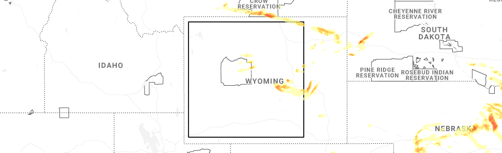
Hail Map for Lucerne, WY
The Lucerne, WY area has had 1 report of on-the-ground hail by trained spotters, and has been under severe weather warnings 3 times during the past 12 months. Doppler radar has detected hail at or near Lucerne, WY on 30 occasions, including 2 occasions during the past year.
| Name: | Lucerne, WY |
| Where Located: | 48.2 miles N of Riverton, WY |
| Map: | Google Map for Lucerne, WY |
| Population: | 535 |
| Housing Units: | 254 |
| More Info: | Search Google for Lucerne, WY |
1
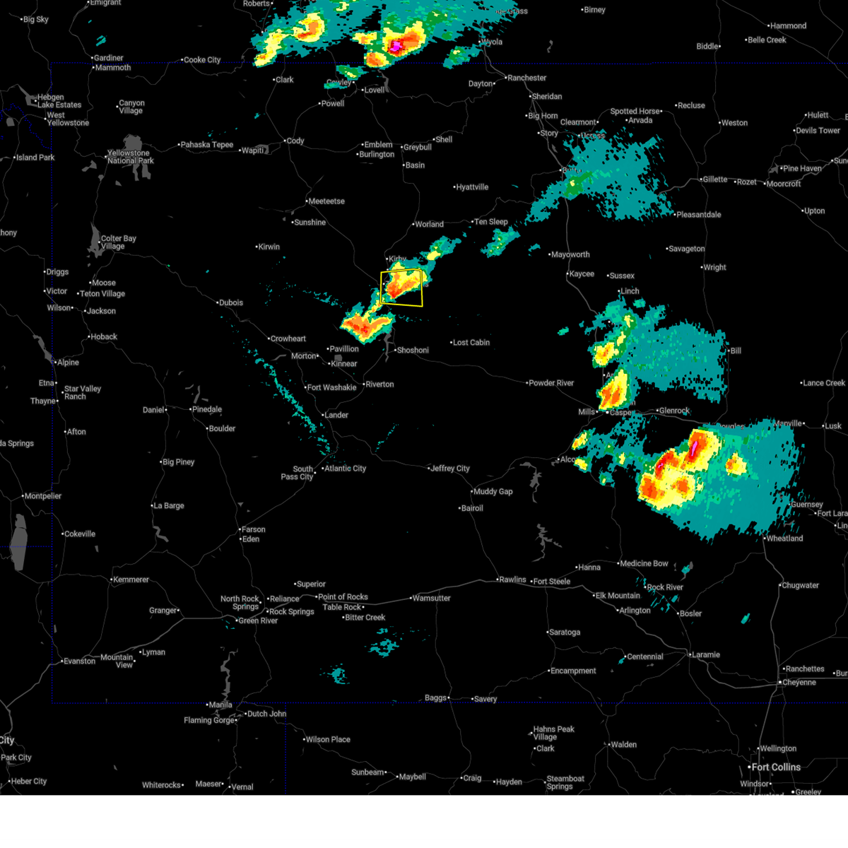
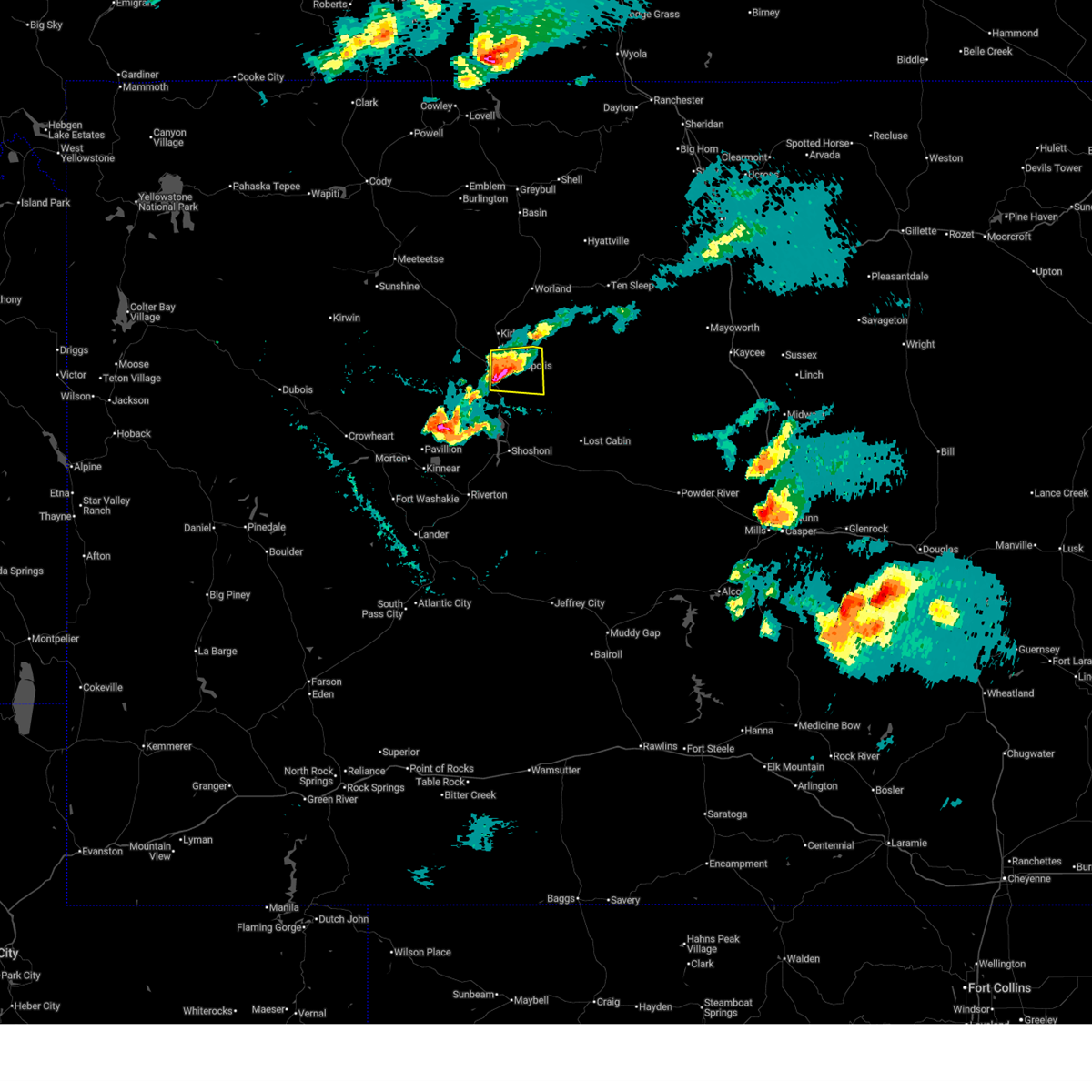
The Top Recent Hail Date for Lucerne, WY is Monday, June 16, 2025 (17th out of 30)
Hail and Wind Damage Spotted near Lucerne, WY
| Date / Time | Report Details |
|---|---|
| 6/16/2025 4:53 PM MDT |
 The storm which prompted the warning has weakened below severe limits, and no longer poses an immediate threat to life or property. therefore, the warning will be allowed to expire. however, small hail is still possible with this thunderstorm. The storm which prompted the warning has weakened below severe limits, and no longer poses an immediate threat to life or property. therefore, the warning will be allowed to expire. however, small hail is still possible with this thunderstorm.
|
| 6/16/2025 4:45 PM MDT |
 At 444 pm mdt, a severe thunderstorm was located near hot springs state park, which is near thermopolis, moving east at 25 mph (radar indicated). Hazards include quarter size hail. Damage to vehicles is expected. This severe thunderstorm will remain over mainly rural areas of southeastern hot springs county, including the following locations, hot springs county fairgrounds. At 444 pm mdt, a severe thunderstorm was located near hot springs state park, which is near thermopolis, moving east at 25 mph (radar indicated). Hazards include quarter size hail. Damage to vehicles is expected. This severe thunderstorm will remain over mainly rural areas of southeastern hot springs county, including the following locations, hot springs county fairgrounds.
|
| 6/16/2025 4:35 PM MDT | Svrriw the national weather service in riverton has issued a * severe thunderstorm warning for, southeastern hot springs county in central wyoming, * until 500 pm mdt. * at 433 pm mdt, a severe thunderstorm was located near thermopolis, moving east at 25 mph (radar indicated). Hazards include quarter size hail. Damage to vehicles is possible. This severe thunderstorm will be near, thermopolis and hot springs state park around 440 pm mdt. |
| 7/1/2024 3:56 PM MDT |
 At 356 pm mdt, a severe thunderstorm was located 13 miles east of lucerne, which is 16 miles east of thermopolis, moving southeast at 30 mph (radar indicated). Hazards include 60 mph wind gusts and penny size hail. Expect damage to roofs, siding, and trees. This severe thunderstorm will remain over mainly rural areas of east central hot springs and central washakie counties. At 356 pm mdt, a severe thunderstorm was located 13 miles east of lucerne, which is 16 miles east of thermopolis, moving southeast at 30 mph (radar indicated). Hazards include 60 mph wind gusts and penny size hail. Expect damage to roofs, siding, and trees. This severe thunderstorm will remain over mainly rural areas of east central hot springs and central washakie counties.
|
| 7/1/2024 3:41 PM MDT |
 Svrriw the national weather service in riverton has issued a * severe thunderstorm warning for, southeastern hot springs county in central wyoming, central washakie county in central wyoming, * until 430 pm mdt. * at 341 pm mdt, a severe thunderstorm was located 7 miles east of kirby, which is 13 miles northeast of thermopolis, moving southeast at 25 mph (radar indicated). Hazards include 60 mph wind gusts and penny size hail. Expect damage to roofs, siding, and trees. This severe thunderstorm will remain over mainly rural areas of southeastern hot springs and central washakie counties. Svrriw the national weather service in riverton has issued a * severe thunderstorm warning for, southeastern hot springs county in central wyoming, central washakie county in central wyoming, * until 430 pm mdt. * at 341 pm mdt, a severe thunderstorm was located 7 miles east of kirby, which is 13 miles northeast of thermopolis, moving southeast at 25 mph (radar indicated). Hazards include 60 mph wind gusts and penny size hail. Expect damage to roofs, siding, and trees. This severe thunderstorm will remain over mainly rural areas of southeastern hot springs and central washakie counties.
|
| 7/1/2024 3:23 PM MDT |
 At 323 pm mdt, a severe thunderstorm was located near winchester, which is 12 miles southwest of worland, moving southeast at 25 mph (radar indicated). Hazards include 60 mph wind gusts and quarter size hail. Hail damage to vehicles is expected. expect wind damage to roofs, siding, and trees. Locations impacted include, worland, kirby, winchester, worland municipal airport, wyoming boys school, and washakie county fairgrounds. At 323 pm mdt, a severe thunderstorm was located near winchester, which is 12 miles southwest of worland, moving southeast at 25 mph (radar indicated). Hazards include 60 mph wind gusts and quarter size hail. Hail damage to vehicles is expected. expect wind damage to roofs, siding, and trees. Locations impacted include, worland, kirby, winchester, worland municipal airport, wyoming boys school, and washakie county fairgrounds.
|
| 7/1/2024 3:13 PM MDT |
 At 313 pm mdt, a severe thunderstorm was located 7 miles northwest of winchester, which is 14 miles west of worland, moving southeast at 25 mph (radar indicated). Hazards include 60 mph wind gusts and quarter size hail. Hail damage to vehicles is expected. expect wind damage to roofs, siding, and trees. Locations impacted include, worland, kirby, winchester, worland municipal airport, wyoming boys school, and washakie county fairgrounds. At 313 pm mdt, a severe thunderstorm was located 7 miles northwest of winchester, which is 14 miles west of worland, moving southeast at 25 mph (radar indicated). Hazards include 60 mph wind gusts and quarter size hail. Hail damage to vehicles is expected. expect wind damage to roofs, siding, and trees. Locations impacted include, worland, kirby, winchester, worland municipal airport, wyoming boys school, and washakie county fairgrounds.
|
| 7/1/2024 3:00 PM MDT |
 Svrriw the national weather service in riverton has issued a * severe thunderstorm warning for, central hot springs county in central wyoming, northwestern washakie county in central wyoming, * until 345 pm mdt. * at 259 pm mdt, a severe thunderstorm was located 12 miles northwest of winchester, which is 18 miles west of worland, moving southeast at 25 mph (radar indicated). Hazards include quarter size hail. damage to vehicles is expected Svrriw the national weather service in riverton has issued a * severe thunderstorm warning for, central hot springs county in central wyoming, northwestern washakie county in central wyoming, * until 345 pm mdt. * at 259 pm mdt, a severe thunderstorm was located 12 miles northwest of winchester, which is 18 miles west of worland, moving southeast at 25 mph (radar indicated). Hazards include quarter size hail. damage to vehicles is expected
|
| 6/26/2023 6:00 PM MDT |
 At 559 pm mdt, a severe thunderstorm was located 9 miles south of hamilton dome, which is also 19 miles west of thermopolis, moving southeast at 20 mph (radar indicated). Hazards include ping pong ball size hail and 60 mph wind gusts. People and animals outdoors will be injured. expect hail damage to roofs, siding, windows, and vehicles. expect wind damage to roofs, siding, and trees. this severe thunderstorm will remain over mainly rural areas of south central hot springs county, including the following locations, hot springs county airport. hail threat, radar indicated max hail size, 1. 50 in wind threat, radar indicated max wind gust, 60 mph. At 559 pm mdt, a severe thunderstorm was located 9 miles south of hamilton dome, which is also 19 miles west of thermopolis, moving southeast at 20 mph (radar indicated). Hazards include ping pong ball size hail and 60 mph wind gusts. People and animals outdoors will be injured. expect hail damage to roofs, siding, windows, and vehicles. expect wind damage to roofs, siding, and trees. this severe thunderstorm will remain over mainly rural areas of south central hot springs county, including the following locations, hot springs county airport. hail threat, radar indicated max hail size, 1. 50 in wind threat, radar indicated max wind gust, 60 mph.
|
| 6/26/2023 5:48 PM MDT |
 At 548 pm mdt, a severe thunderstorm was located over legend rock state petroglyph site, which is also 20 miles northwest of thermopolis, moving east at 30 mph (radar indicated). Hazards include 60 mph wind gusts and half dollar size hail. Hail damage to vehicles is expected. expect wind damage to roofs, siding, and trees. this severe thunderstorm will remain over mainly rural areas of central hot springs county, including the following locations, hot springs county airport. hail threat, radar indicated max hail size, 1. 25 in wind threat, radar indicated max wind gust, 60 mph. At 548 pm mdt, a severe thunderstorm was located over legend rock state petroglyph site, which is also 20 miles northwest of thermopolis, moving east at 30 mph (radar indicated). Hazards include 60 mph wind gusts and half dollar size hail. Hail damage to vehicles is expected. expect wind damage to roofs, siding, and trees. this severe thunderstorm will remain over mainly rural areas of central hot springs county, including the following locations, hot springs county airport. hail threat, radar indicated max hail size, 1. 25 in wind threat, radar indicated max wind gust, 60 mph.
|
| 6/25/2023 2:08 PM MDT |
 At 207 pm mdt, a severe thunderstorm was located 10 miles southeast of hamilton dome, which is also 13 miles west of thermopolis, moving east at 15 mph (radar indicated). Hazards include quarter size hail. Damage to vehicles is expected. locations impacted include, thermopolis, hot springs state park and hot springs county fairgrounds. hail threat, radar indicated max hail size, 1. 00 in wind threat, radar indicated max wind gust, <50 mph. At 207 pm mdt, a severe thunderstorm was located 10 miles southeast of hamilton dome, which is also 13 miles west of thermopolis, moving east at 15 mph (radar indicated). Hazards include quarter size hail. Damage to vehicles is expected. locations impacted include, thermopolis, hot springs state park and hot springs county fairgrounds. hail threat, radar indicated max hail size, 1. 00 in wind threat, radar indicated max wind gust, <50 mph.
|
| 6/25/2023 1:53 PM MDT |
 At 152 pm mdt, a severe thunderstorm was located 9 miles south of hamilton dome, which is also 15 miles west of thermopolis, moving east at 30 mph (radar indicated). Hazards include quarter size hail. damage to vehicles is expected At 152 pm mdt, a severe thunderstorm was located 9 miles south of hamilton dome, which is also 15 miles west of thermopolis, moving east at 30 mph (radar indicated). Hazards include quarter size hail. damage to vehicles is expected
|
| 6/6/2020 4:41 PM MDT |
 The severe thunderstorm warning for hot springs and central washakie counties will expire at 445 pm mdt, the storms which prompted the warning have weakened below severe limits, and no longer pose an immediate threat to life or property. therefore, the warning will be allowed to expire. however gusty winds up to 40 mph are still possible with these thunderstorms. a severe thunderstorm watch remains in effect until 800 pm mdt for central wyoming. to report severe weather, contact your nearest law enforcement agency. they will relay your report to the national weather service riverton. The severe thunderstorm warning for hot springs and central washakie counties will expire at 445 pm mdt, the storms which prompted the warning have weakened below severe limits, and no longer pose an immediate threat to life or property. therefore, the warning will be allowed to expire. however gusty winds up to 40 mph are still possible with these thunderstorms. a severe thunderstorm watch remains in effect until 800 pm mdt for central wyoming. to report severe weather, contact your nearest law enforcement agency. they will relay your report to the national weather service riverton.
|
| 6/6/2020 3:59 PM MDT |
 At 358 pm mdt, severe thunderstorms were located along a line extending from 10 miles northwest of boysen state park to 7 miles west of cottonwood pass, moving north at 45 mph (radar indicated). Hazards include 60 mph wind gusts. Expect damage to roofs, siding, and trees. severe thunderstorms will be near, thermopolis and hot springs state park around 420 pm mdt. lucerne around 430 pm mdt. kirby around 435 pm mdt. winchester around 440 pm mdt. Other locations impacted by these severe thunderstorms include badlands overlook, washakie county fairgrounds, hot springs county airport and hot springs county fairgrounds. At 358 pm mdt, severe thunderstorms were located along a line extending from 10 miles northwest of boysen state park to 7 miles west of cottonwood pass, moving north at 45 mph (radar indicated). Hazards include 60 mph wind gusts. Expect damage to roofs, siding, and trees. severe thunderstorms will be near, thermopolis and hot springs state park around 420 pm mdt. lucerne around 430 pm mdt. kirby around 435 pm mdt. winchester around 440 pm mdt. Other locations impacted by these severe thunderstorms include badlands overlook, washakie county fairgrounds, hot springs county airport and hot springs county fairgrounds.
|
| 6/6/2020 2:51 AM MDT |
 The severe thunderstorm warning for hot springs, southern johnson and washakie counties will expire at 300 am mdt, the storms which prompted the warning have weakened. therefore, the warning will be allowed to expire. The severe thunderstorm warning for hot springs, southern johnson and washakie counties will expire at 300 am mdt, the storms which prompted the warning have weakened. therefore, the warning will be allowed to expire.
|
| 6/6/2020 2:37 AM MDT |
 At 234 am mdt, doppler radar indicated scattered showers across hot springs, southern johnson and washakie counties (radar indicated). Hazards include 60 mph wind gusts. Expect damage to roofs, siding, and trees. These showers are capable of producing wind gusts of 50 to 65 mph with little or no notice. At 234 am mdt, doppler radar indicated scattered showers across hot springs, southern johnson and washakie counties (radar indicated). Hazards include 60 mph wind gusts. Expect damage to roofs, siding, and trees. These showers are capable of producing wind gusts of 50 to 65 mph with little or no notice.
|
| 6/6/2020 1:46 AM MDT |
 At 142 am mdt, weak showers with damaging winds were located along a line extending from near anchor dam to near midwest, moving north at 45 mph (radar indicated. at 1235 am, the casper airport measured a wind gust of 60 mph. at 125 am, the riverton airport measured a 59 mph wind gust). Hazards include 60 mph wind gusts. Expect damage to roofs, siding, and trees. severe thunderstorms will be near, midwest and edgerton around 150 am mdt. hamilton dome around 200 am mdt. linch and legend rock state petroglyph site around 205 am mdt. fort reno historical site around 225 am mdt. other locations impacted by these severe thunderstorms include badlands overlook, hot springs county airport, hot springs county fairgrounds, grass creek, leigh creek campground, wigwam fish rearing station, washakie county fairgrounds, sussex, lost cabin campground and barnum. This includes interstate 25 between mile markers 220 and 285. At 142 am mdt, weak showers with damaging winds were located along a line extending from near anchor dam to near midwest, moving north at 45 mph (radar indicated. at 1235 am, the casper airport measured a wind gust of 60 mph. at 125 am, the riverton airport measured a 59 mph wind gust). Hazards include 60 mph wind gusts. Expect damage to roofs, siding, and trees. severe thunderstorms will be near, midwest and edgerton around 150 am mdt. hamilton dome around 200 am mdt. linch and legend rock state petroglyph site around 205 am mdt. fort reno historical site around 225 am mdt. other locations impacted by these severe thunderstorms include badlands overlook, hot springs county airport, hot springs county fairgrounds, grass creek, leigh creek campground, wigwam fish rearing station, washakie county fairgrounds, sussex, lost cabin campground and barnum. This includes interstate 25 between mile markers 220 and 285.
|
| 8/30/2019 1:38 PM MDT |
 At 138 pm mdt, a severe thunderstorm was located over lucerne, which is near thermopolis, moving east at 30 mph (radar indicated). Hazards include 60 mph wind gusts. Expect damage to roofs, siding, and trees. This severe thunderstorm will remain over mainly rural areas of southeastern hot springs and central washakie counties, including the following locations, hot springs county fairgrounds. At 138 pm mdt, a severe thunderstorm was located over lucerne, which is near thermopolis, moving east at 30 mph (radar indicated). Hazards include 60 mph wind gusts. Expect damage to roofs, siding, and trees. This severe thunderstorm will remain over mainly rural areas of southeastern hot springs and central washakie counties, including the following locations, hot springs county fairgrounds.
|
| 8/21/2019 5:56 PM MDT |
 The severe thunderstorm warning for east central hot springs and central washakie counties will expire at 600 pm mdt, the storm which prompted the warning has weakened below severe limits, and no longer poses an immediate threat to life or property. therefore, the warning will be allowed to expire. however heavy rain is still possible with this thunderstorm. The severe thunderstorm warning for east central hot springs and central washakie counties will expire at 600 pm mdt, the storm which prompted the warning has weakened below severe limits, and no longer poses an immediate threat to life or property. therefore, the warning will be allowed to expire. however heavy rain is still possible with this thunderstorm.
|
| 8/21/2019 5:46 PM MDT |
 At 546 pm mdt, a severe thunderstorm was located 8 miles southeast of worland municipal airport, which is 12 miles southeast of worland, moving northeast at 25 mph (radar indicated). Hazards include quarter size hail. Damage to vehicles is expected. Locations impacted include, worland municipal airport and wyoming boys school. At 546 pm mdt, a severe thunderstorm was located 8 miles southeast of worland municipal airport, which is 12 miles southeast of worland, moving northeast at 25 mph (radar indicated). Hazards include quarter size hail. Damage to vehicles is expected. Locations impacted include, worland municipal airport and wyoming boys school.
|
| 8/21/2019 5:28 PM MDT |
 The national weather service in riverton has issued a * severe thunderstorm warning for. east central hot springs county in central wyoming. central washakie county in central wyoming. until 600 pm mdt. At 527 pm mdt, a severe thunderstorm was located 7 miles southeast. The national weather service in riverton has issued a * severe thunderstorm warning for. east central hot springs county in central wyoming. central washakie county in central wyoming. until 600 pm mdt. At 527 pm mdt, a severe thunderstorm was located 7 miles southeast.
|
| 8/21/2019 5:13 PM MDT |
 At 511 pm mdt, a severe thunderstorm was located over kirby, which is 11 miles north of thermopolis, moving northeast at 5 mph (trained weather spotters. half inch hail was reported in kirby). Hazards include quarter size hail. Damage to vehicles is expected. additionally, over a quarter inch of rain was reported to have fallen in a 15 minute period. This severe storm will be near, winchester around 520 pm mdt. At 511 pm mdt, a severe thunderstorm was located over kirby, which is 11 miles north of thermopolis, moving northeast at 5 mph (trained weather spotters. half inch hail was reported in kirby). Hazards include quarter size hail. Damage to vehicles is expected. additionally, over a quarter inch of rain was reported to have fallen in a 15 minute period. This severe storm will be near, winchester around 520 pm mdt.
|
| 8/21/2019 4:56 PM MDT |
 The national weather service in riverton has issued a * severe thunderstorm warning for. central hot springs county in central wyoming. west central washakie county in central wyoming. until 530 pm mdt. At 456 pm mdt, a severe thunderstorm was located over kirby, which. The national weather service in riverton has issued a * severe thunderstorm warning for. central hot springs county in central wyoming. west central washakie county in central wyoming. until 530 pm mdt. At 456 pm mdt, a severe thunderstorm was located over kirby, which.
|
| 7/15/2019 2:59 PM MDT |
 The severe thunderstorm warning for southeastern hot springs county will expire at 300 pm mdt, the storm which prompted the warning has weakened below severe limits, and no longer poses an immediate threat to life or property. therefore, the warning will be allowed to expire. hail up to the size of pennies and heavy rain are still likely occurring with this thunderstorm. The severe thunderstorm warning for southeastern hot springs county will expire at 300 pm mdt, the storm which prompted the warning has weakened below severe limits, and no longer poses an immediate threat to life or property. therefore, the warning will be allowed to expire. hail up to the size of pennies and heavy rain are still likely occurring with this thunderstorm.
|
| 7/15/2019 2:48 PM MDT |
 At 246 pm mdt, a severe thunderstorm was located a few miles east of thermopolis and was moving east at 30 mph (trained weather spotters). Hazards include 60 mph wind gusts and quarter size hail. Hail damage to vehicles is expected. expect wind damage to roofs, siding, and trees. locations impacted include, rural areas of hot springs county east and southeast of thermopolis. This storm produced hail ranging from quarters to golf balls in thermopolis around 235 pm. At 246 pm mdt, a severe thunderstorm was located a few miles east of thermopolis and was moving east at 30 mph (trained weather spotters). Hazards include 60 mph wind gusts and quarter size hail. Hail damage to vehicles is expected. expect wind damage to roofs, siding, and trees. locations impacted include, rural areas of hot springs county east and southeast of thermopolis. This storm produced hail ranging from quarters to golf balls in thermopolis around 235 pm.
|
| 7/15/2019 2:40 PM MDT |
 At 239 pm mdt, a severe thunderstorm was located over hot springs state park, which is over thermopolis, moving east at 30 mph (trained weather spotters). Hazards include golf ball size hail and 60 mph wind gusts. People and animals outdoors will be injured. expect hail damage to roofs, siding, windows, and vehicles. expect wind damage to roofs, siding, and trees. locations impacted include, thermopolis, lucerne, hot springs state park and hot springs county fairgrounds. Hail stones ranging from the size of quarters to golf balls have been reported. At 239 pm mdt, a severe thunderstorm was located over hot springs state park, which is over thermopolis, moving east at 30 mph (trained weather spotters). Hazards include golf ball size hail and 60 mph wind gusts. People and animals outdoors will be injured. expect hail damage to roofs, siding, windows, and vehicles. expect wind damage to roofs, siding, and trees. locations impacted include, thermopolis, lucerne, hot springs state park and hot springs county fairgrounds. Hail stones ranging from the size of quarters to golf balls have been reported.
|
| 7/15/2019 2:35 PM MDT |
 At 226 pm mdt, a severe thunderstorm was located near thermopolis, moving east at 30 mph (trained weather spotters). Hazards include ping pong ball size hail and 60 mph wind gusts. People and animals outdoors will be injured. expect hail damage to roofs, siding, windows, and vehicles. expect wind damage to roofs, siding, and trees. this severe storm will be near, thermopolis and hot springs state park around 235 pm mdt. other locations impacted by this severe thunderstorm include hot springs county fairgrounds and hot springs county airport. This storm will also impact motorists on state highway 120 heading north from thermopolis. At 226 pm mdt, a severe thunderstorm was located near thermopolis, moving east at 30 mph (trained weather spotters). Hazards include ping pong ball size hail and 60 mph wind gusts. People and animals outdoors will be injured. expect hail damage to roofs, siding, windows, and vehicles. expect wind damage to roofs, siding, and trees. this severe storm will be near, thermopolis and hot springs state park around 235 pm mdt. other locations impacted by this severe thunderstorm include hot springs county fairgrounds and hot springs county airport. This storm will also impact motorists on state highway 120 heading north from thermopolis.
|
| 7/15/2019 2:33 PM MDT | Ping Pong Ball sized hail reported 9.4 miles ENE of Lucerne, WY, 2 broken windows. |
| 7/15/2019 2:28 PM MDT |
 At 226 pm mdt, a severe thunderstorm was located near thermopolis, moving east at 30 mph (trained weather spotters). Hazards include ping pong ball size hail and 60 mph wind gusts. People and animals outdoors will be injured. expect hail damage to roofs, siding, windows, and vehicles. expect wind damage to roofs, siding, and trees. this severe storm will be near, thermopolis and hot springs state park around 235 pm mdt. other locations impacted by this severe thunderstorm include hot springs county fairgrounds and hot springs county airport. This storm will also impact motorists on state highway 120 heading north from thermopolis. At 226 pm mdt, a severe thunderstorm was located near thermopolis, moving east at 30 mph (trained weather spotters). Hazards include ping pong ball size hail and 60 mph wind gusts. People and animals outdoors will be injured. expect hail damage to roofs, siding, windows, and vehicles. expect wind damage to roofs, siding, and trees. this severe storm will be near, thermopolis and hot springs state park around 235 pm mdt. other locations impacted by this severe thunderstorm include hot springs county fairgrounds and hot springs county airport. This storm will also impact motorists on state highway 120 heading north from thermopolis.
|
| 7/15/2019 2:19 PM MDT |
 The national weather service in riverton has issued a * severe thunderstorm warning for. southeastern hot springs county in central wyoming. until 300 pm mdt. At 218 pm mdt, a severe thunderstorm was located near thermopolis, moving southeast at 35 mph. The national weather service in riverton has issued a * severe thunderstorm warning for. southeastern hot springs county in central wyoming. until 300 pm mdt. At 218 pm mdt, a severe thunderstorm was located near thermopolis, moving southeast at 35 mph.
|
| 7/3/2019 6:13 PM MDT |
 The severe thunderstorm warning for southeastern hot springs county will expire at 615 pm mdt, the storm which prompted the warning has moved out of the area. therefore, the warning will be allowed to expire. however small hail is still possible with this thunderstorm east of thermopolis. The severe thunderstorm warning for southeastern hot springs county will expire at 615 pm mdt, the storm which prompted the warning has moved out of the area. therefore, the warning will be allowed to expire. however small hail is still possible with this thunderstorm east of thermopolis.
|
| 7/3/2019 5:59 PM MDT |
 A severe thunderstorm warning remains in effect until 615 pm mdt for southeastern hot springs county. at 557 pm mdt, a severe thunderstorm was located near thermopolis, moving east at 25 mph. hazard. 60 mph wind gusts and quarter size hail. source. Radar indicated. A severe thunderstorm warning remains in effect until 615 pm mdt for southeastern hot springs county. at 557 pm mdt, a severe thunderstorm was located near thermopolis, moving east at 25 mph. hazard. 60 mph wind gusts and quarter size hail. source. Radar indicated.
|
| 7/3/2019 5:48 PM MDT |
 At 546 pm mdt, a severe thunderstorm was 4 miles southwest of thermopolis, moving northeast at 30 mph (radar indicated). Hazards include 60 mph wind gusts and quarter size hail. Hail damage to vehicles is expected. expect wind damage to roofs, siding, and trees. this severe storm will be near, thermopolis and hot springs state park around 555 pm mdt. lucerne around 600 pm mdt. Other locations impacted by this severe thunderstorm include hot springs county fairgrounds. At 546 pm mdt, a severe thunderstorm was 4 miles southwest of thermopolis, moving northeast at 30 mph (radar indicated). Hazards include 60 mph wind gusts and quarter size hail. Hail damage to vehicles is expected. expect wind damage to roofs, siding, and trees. this severe storm will be near, thermopolis and hot springs state park around 555 pm mdt. lucerne around 600 pm mdt. Other locations impacted by this severe thunderstorm include hot springs county fairgrounds.
|
| 7/3/2019 5:37 PM MDT |
 At 536 pm mdt, a severe thunderstorm was located 9 miles southwest of thermopolis, moving northeast at 30 mph (radar indicated). Hazards include 60 mph wind gusts and half dollar size hail. Hail damage to vehicles is expected. expect wind damage to roofs, siding, and trees. this severe thunderstorm will be near, thermopolis and hot springs state park around 555 pm mdt. lucerne around 600 pm mdt. Other locations impacted by this severe thunderstorm include hot springs county fairgrounds. At 536 pm mdt, a severe thunderstorm was located 9 miles southwest of thermopolis, moving northeast at 30 mph (radar indicated). Hazards include 60 mph wind gusts and half dollar size hail. Hail damage to vehicles is expected. expect wind damage to roofs, siding, and trees. this severe thunderstorm will be near, thermopolis and hot springs state park around 555 pm mdt. lucerne around 600 pm mdt. Other locations impacted by this severe thunderstorm include hot springs county fairgrounds.
|
| 7/1/2019 2:07 PM MDT |
 The tornado warning for southeastern hot springs county will expire at 215 pm mdt, the tornado threat has diminished and the tornado warning has been cancelled. however, large hail and damaging winds remain likely and a severe thunderstorm warning remains in effect for the area. The tornado warning for southeastern hot springs county will expire at 215 pm mdt, the tornado threat has diminished and the tornado warning has been cancelled. however, large hail and damaging winds remain likely and a severe thunderstorm warning remains in effect for the area.
|
| 7/1/2019 1:53 PM MDT |
 At 152 pm mdt, a severe thunderstorm capable of producing a tornado was located 7 miles southeast of hot springs state park, which is 8 miles east of thermopolis, moving east at 30 mph. at 149 pm mdt 2 inch hail was reported at hot springs state park (radar indicated rotation). Hazards include tornado and baseball size hail. Flying debris will be dangerous to those caught without shelter. mobile homes will be damaged or destroyed. damage to roofs, windows, and vehicles will occur. tree damage is likely. Locations impacted include, thermopolis, hot springs state park and hot springs county fairgrounds. At 152 pm mdt, a severe thunderstorm capable of producing a tornado was located 7 miles southeast of hot springs state park, which is 8 miles east of thermopolis, moving east at 30 mph. at 149 pm mdt 2 inch hail was reported at hot springs state park (radar indicated rotation). Hazards include tornado and baseball size hail. Flying debris will be dangerous to those caught without shelter. mobile homes will be damaged or destroyed. damage to roofs, windows, and vehicles will occur. tree damage is likely. Locations impacted include, thermopolis, hot springs state park and hot springs county fairgrounds.
|
| 7/1/2019 1:41 PM MDT |
 At 140 pm mdt, a severe thunderstorm capable of producing a tornado was located over hot springs state park, which is over thermopolis, moving east at 30 mph (radar indicated rotation). Hazards include tornado and baseball size hail. Flying debris will be dangerous to those caught without shelter. mobile homes will be damaged or destroyed. damage to roofs, windows, and vehicles will occur. tree damage is likely. This tornadic thunderstorm will remain over mainly rural areas of southeastern hot springs county, including the following locations, hot springs county fairgrounds. At 140 pm mdt, a severe thunderstorm capable of producing a tornado was located over hot springs state park, which is over thermopolis, moving east at 30 mph (radar indicated rotation). Hazards include tornado and baseball size hail. Flying debris will be dangerous to those caught without shelter. mobile homes will be damaged or destroyed. damage to roofs, windows, and vehicles will occur. tree damage is likely. This tornadic thunderstorm will remain over mainly rural areas of southeastern hot springs county, including the following locations, hot springs county fairgrounds.
|
| 7/1/2019 1:29 PM MDT |
 At 129 pm mdt, a severe thunderstorm was located 8 miles northwest of thermopolis, moving east at 15 mph (radar indicated. at 120 pm mdt goldball sized hail was reported at owl creek). Hazards include ping pong ball size hail and 60 mph wind gusts. People and animals outdoors will be injured. expect hail damage to roofs, siding, windows, and vehicles. expect wind damage to roofs, siding, and trees. this severe storm will be near, thermopolis, lucerne, kirby and hot springs state park around 145 pm mdt. Other locations impacted by this severe thunderstorm include hot springs county fairgrounds and hot springs county airport. At 129 pm mdt, a severe thunderstorm was located 8 miles northwest of thermopolis, moving east at 15 mph (radar indicated. at 120 pm mdt goldball sized hail was reported at owl creek). Hazards include ping pong ball size hail and 60 mph wind gusts. People and animals outdoors will be injured. expect hail damage to roofs, siding, windows, and vehicles. expect wind damage to roofs, siding, and trees. this severe storm will be near, thermopolis, lucerne, kirby and hot springs state park around 145 pm mdt. Other locations impacted by this severe thunderstorm include hot springs county fairgrounds and hot springs county airport.
|
| 7/1/2019 1:11 PM MDT |
 At 111 pm mdt, a severe thunderstorm capable of producing a tornado was located 9 miles southeast of hamilton dome, which is 10 miles west of thermopolis, moving east at 25 mph (radar indicated rotation). Hazards include tornado and hail up to two inches in diameter. Flying debris will be dangerous to those caught without shelter. mobile homes will be damaged or destroyed. damage to roofs, windows, and vehicles will occur. tree damage is likely. this dangerous storm will be near, lucerne and hot springs state park around 135 pm mdt. thermopolis around 140 pm mdt. Other locations impacted by this tornadic thunderstorm include hot springs county fairgrounds and hot springs county airport. At 111 pm mdt, a severe thunderstorm capable of producing a tornado was located 9 miles southeast of hamilton dome, which is 10 miles west of thermopolis, moving east at 25 mph (radar indicated rotation). Hazards include tornado and hail up to two inches in diameter. Flying debris will be dangerous to those caught without shelter. mobile homes will be damaged or destroyed. damage to roofs, windows, and vehicles will occur. tree damage is likely. this dangerous storm will be near, lucerne and hot springs state park around 135 pm mdt. thermopolis around 140 pm mdt. Other locations impacted by this tornadic thunderstorm include hot springs county fairgrounds and hot springs county airport.
|
| 7/1/2019 1:10 PM MDT |
 At 110 pm mdt, a severe thunderstorm was located near hamilton dome, which is 13 miles northwest of thermopolis, moving east at 15 mph (radar indicated). Hazards include ping pong ball size hail and 60 mph wind gusts. People and animals outdoors will be injured. expect hail damage to roofs, siding, windows, and vehicles. expect wind damage to roofs, siding, and trees. this severe storm will be near, thermopolis, lucerne, kirby and hot springs state park around 145 pm mdt. Other locations impacted by this severe thunderstorm include hot springs county fairgrounds and hot springs county airport. At 110 pm mdt, a severe thunderstorm was located near hamilton dome, which is 13 miles northwest of thermopolis, moving east at 15 mph (radar indicated). Hazards include ping pong ball size hail and 60 mph wind gusts. People and animals outdoors will be injured. expect hail damage to roofs, siding, windows, and vehicles. expect wind damage to roofs, siding, and trees. this severe storm will be near, thermopolis, lucerne, kirby and hot springs state park around 145 pm mdt. Other locations impacted by this severe thunderstorm include hot springs county fairgrounds and hot springs county airport.
|
| 7/1/2019 12:55 PM MDT |
 At 1254 pm mdt, a severe thunderstorm was located over hamilton dome, which is 17 miles west of thermopolis, moving east at 15 mph (radar indicated). Hazards include 60 mph wind gusts and quarter size hail. Hail damage to vehicles is expected. expect wind damage to roofs, siding, and trees. this severe thunderstorm will be near, thermopolis, lucerne, kirby and hot springs state park around 145 pm mdt. Other locations impacted by this severe thunderstorm include hot springs county fairgrounds and hot springs county airport. At 1254 pm mdt, a severe thunderstorm was located over hamilton dome, which is 17 miles west of thermopolis, moving east at 15 mph (radar indicated). Hazards include 60 mph wind gusts and quarter size hail. Hail damage to vehicles is expected. expect wind damage to roofs, siding, and trees. this severe thunderstorm will be near, thermopolis, lucerne, kirby and hot springs state park around 145 pm mdt. Other locations impacted by this severe thunderstorm include hot springs county fairgrounds and hot springs county airport.
|
| 8/18/2018 4:37 PM MDT |
 The severe thunderstorm warning for southeastern hot springs county will expire at 445 pm mdt, the storm which prompted the warning has weakened below severe limits, and no longer poses an immediate threat to life or property. therefore, the warning will be allowed to expire. however small hail and gusty winds are still possible with this thunderstorm. to report severe weather, contact your nearest law enforcement agency. they will relay your report to the national weather service riverton. The severe thunderstorm warning for southeastern hot springs county will expire at 445 pm mdt, the storm which prompted the warning has weakened below severe limits, and no longer poses an immediate threat to life or property. therefore, the warning will be allowed to expire. however small hail and gusty winds are still possible with this thunderstorm. to report severe weather, contact your nearest law enforcement agency. they will relay your report to the national weather service riverton.
|
| 8/18/2018 4:12 PM MDT |
 At 412 pm mdt, a severe thunderstorm was located 8 miles northwest of thermopolis, moving southeast at 30 mph (radar indicated). Hazards include quarter size hail. Damage to vehicles is expected. this severe thunderstorm will be near, lucerne around 425 pm mdt. thermopolis and hot springs state park around 430 pm mdt. Other locations impacted by this severe thunderstorm include hot springs county fairgrounds, hot sprgs county thermopolis airport and legion town and country golf course. At 412 pm mdt, a severe thunderstorm was located 8 miles northwest of thermopolis, moving southeast at 30 mph (radar indicated). Hazards include quarter size hail. Damage to vehicles is expected. this severe thunderstorm will be near, lucerne around 425 pm mdt. thermopolis and hot springs state park around 430 pm mdt. Other locations impacted by this severe thunderstorm include hot springs county fairgrounds, hot sprgs county thermopolis airport and legion town and country golf course.
|
| 8/18/2018 3:51 PM MDT |
 At 350 pm mdt, a severe thunderstorm was located over legend rock state petroglyph site, or 20 miles northwest of thermopolis, moving southeast at 25 mph (radar indicated). Hazards include two inch hail. People and animals outdoors will be injured. expect damage to roofs, siding, windows, and vehicles. This severe thunderstorm will remain over mainly rural areas of central hot springs county, including the following locations, hot sprgs county thermopolis airport and legion town and country golf course. At 350 pm mdt, a severe thunderstorm was located over legend rock state petroglyph site, or 20 miles northwest of thermopolis, moving southeast at 25 mph (radar indicated). Hazards include two inch hail. People and animals outdoors will be injured. expect damage to roofs, siding, windows, and vehicles. This severe thunderstorm will remain over mainly rural areas of central hot springs county, including the following locations, hot sprgs county thermopolis airport and legion town and country golf course.
|
| 7/28/2018 3:28 PM MDT |
 At 326 pm mdt, a severe thunderstorm was located near hamilton dome, or 17 miles west of thermopolis, moving east at 30 mph (radar indicated). Hazards include 60 mph wind gusts and quarter size hail. Hail damage to vehicles is expected. expect wind damage to roofs, siding, and trees. this severe thunderstorm will be near, thermopolis, lucerne and hot springs state park around 355 pm mdt. Other locations impacted by this severe thunderstorm include hot springs county fairgrounds, hot sprgs county thermopolis airport and legion town and country golf course. At 326 pm mdt, a severe thunderstorm was located near hamilton dome, or 17 miles west of thermopolis, moving east at 30 mph (radar indicated). Hazards include 60 mph wind gusts and quarter size hail. Hail damage to vehicles is expected. expect wind damage to roofs, siding, and trees. this severe thunderstorm will be near, thermopolis, lucerne and hot springs state park around 355 pm mdt. Other locations impacted by this severe thunderstorm include hot springs county fairgrounds, hot sprgs county thermopolis airport and legion town and country golf course.
|
| 7/26/2018 6:55 PM MDT |
 The severe thunderstorm warning for southeastern hot springs and east central fremont counties will expire at 700 pm mdt, the storm which prompted the warning has weakened below severe limits, and no longer poses an immediate threat to life or property. therefore, the warning will be allowed to expire. The severe thunderstorm warning for southeastern hot springs and east central fremont counties will expire at 700 pm mdt, the storm which prompted the warning has weakened below severe limits, and no longer poses an immediate threat to life or property. therefore, the warning will be allowed to expire.
|
| 7/26/2018 6:31 PM MDT |
 At 628 pm mdt, a severe thunderstorm was located 10 miles southeast of hot springs state park, or 11 miles southeast of thermopolis, moving southeast at 45 mph. at 620 pm the thermopolis police department has reported dime to quarter sized hail across town (public. at 615pm 1 inch hail was reported in northwest thermopolis). Hazards include 60 mph wind gusts and quarter size hail. Hail damage to vehicles is expected. expect wind damage to roofs, siding, and trees. Locations impacted include, thermopolis, hot springs state park and hot springs county fairgrounds. At 628 pm mdt, a severe thunderstorm was located 10 miles southeast of hot springs state park, or 11 miles southeast of thermopolis, moving southeast at 45 mph. at 620 pm the thermopolis police department has reported dime to quarter sized hail across town (public. at 615pm 1 inch hail was reported in northwest thermopolis). Hazards include 60 mph wind gusts and quarter size hail. Hail damage to vehicles is expected. expect wind damage to roofs, siding, and trees. Locations impacted include, thermopolis, hot springs state park and hot springs county fairgrounds.
|
| 7/26/2018 6:08 PM MDT |
 At 608 pm mdt, a severe thunderstorm was located near lucerne, or near thermopolis, moving southeast at 45 mph (radar indicated). Hazards include 60 mph wind gusts and quarter size hail. Hail damage to vehicles is expected. Expect wind damage to roofs, siding, and trees. At 608 pm mdt, a severe thunderstorm was located near lucerne, or near thermopolis, moving southeast at 45 mph (radar indicated). Hazards include 60 mph wind gusts and quarter size hail. Hail damage to vehicles is expected. Expect wind damage to roofs, siding, and trees.
|
| 6/6/2018 7:25 PM MDT |
 The severe thunderstorm warning for east central hot springs and west central washakie counties will expire at 730 pm mdt, the storm which prompted the warning has weakened below severe limits, and no longer poses an immediate threat to life or property. therefore, the warning will be allowed to expire. The severe thunderstorm warning for east central hot springs and west central washakie counties will expire at 730 pm mdt, the storm which prompted the warning has weakened below severe limits, and no longer poses an immediate threat to life or property. therefore, the warning will be allowed to expire.
|
| 6/6/2018 7:13 PM MDT |
 At 713 pm mdt, a severe thunderstorm was located near kirby, or 10 miles north of thermopolis, moving north at 35 mph (radar indicated). Hazards include 60 mph wind gusts and quarter size hail. Hail damage to vehicles is expected. expect wind damage to roofs, siding, and trees. This severe thunderstorm will remain over mainly rural areas of east central hot springs and west central washakie counties, including the following locations, hot springs county fairgrounds, hot sprgs county thermopolis airport and legion town and country golf course. At 713 pm mdt, a severe thunderstorm was located near kirby, or 10 miles north of thermopolis, moving north at 35 mph (radar indicated). Hazards include 60 mph wind gusts and quarter size hail. Hail damage to vehicles is expected. expect wind damage to roofs, siding, and trees. This severe thunderstorm will remain over mainly rural areas of east central hot springs and west central washakie counties, including the following locations, hot springs county fairgrounds, hot sprgs county thermopolis airport and legion town and country golf course.
|
| 6/6/2018 6:52 PM MDT |
 At 652 pm mdt, a severe thunderstorm was located over thermopolis, moving north at 35 mph (radar indicated). Hazards include tennis ball size hail and 60 mph wind gusts. People and animals outdoors will be injured. expect hail damage to roofs, siding, windows, and vehicles. expect wind damage to roofs, siding, and trees. this severe thunderstorm will be near, thermopolis and hot springs state park around 655 pm mdt. lucerne around 705 pm mdt. kirby around 715 pm mdt. winchester around 720 pm mdt. Other locations impacted by this severe thunderstorm include hot springs county fairgrounds, hot sprgs county thermopolis airport and legion town and country golf course. At 652 pm mdt, a severe thunderstorm was located over thermopolis, moving north at 35 mph (radar indicated). Hazards include tennis ball size hail and 60 mph wind gusts. People and animals outdoors will be injured. expect hail damage to roofs, siding, windows, and vehicles. expect wind damage to roofs, siding, and trees. this severe thunderstorm will be near, thermopolis and hot springs state park around 655 pm mdt. lucerne around 705 pm mdt. kirby around 715 pm mdt. winchester around 720 pm mdt. Other locations impacted by this severe thunderstorm include hot springs county fairgrounds, hot sprgs county thermopolis airport and legion town and country golf course.
|
| 6/6/2018 6:44 PM MDT |
 At 643 pm mdt, a severe thunderstorm was located near hot springs state park, or near thermopolis, moving northwest at 10 mph (radar indicated). Hazards include two inch hail and 60 mph wind gusts. People and animals outdoors will be injured. expect hail damage to roofs, siding, windows, and vehicles. expect wind damage to roofs, siding, and trees. this severe storm will be near, thermopolis, lucerne and hot springs state park around 700 pm mdt. Other locations impacted by this severe thunderstorm include hot springs county fairgrounds, hot sprgs county thermopolis airport and legion town and country golf course. At 643 pm mdt, a severe thunderstorm was located near hot springs state park, or near thermopolis, moving northwest at 10 mph (radar indicated). Hazards include two inch hail and 60 mph wind gusts. People and animals outdoors will be injured. expect hail damage to roofs, siding, windows, and vehicles. expect wind damage to roofs, siding, and trees. this severe storm will be near, thermopolis, lucerne and hot springs state park around 700 pm mdt. Other locations impacted by this severe thunderstorm include hot springs county fairgrounds, hot sprgs county thermopolis airport and legion town and country golf course.
|
| 6/6/2018 6:16 PM MDT |
 At 615 pm mdt, a severe thunderstorm was located 7 miles east of hot springs state park, or 8 miles east of thermopolis, moving northwest at 10 mph. this is a very dangerous storm (radar indicated). Hazards include baseball size hail and 60 mph wind gusts. People and animals outdoors will be severely injured. expect shattered windows, extensive damage to roofs, siding, and vehicles. this severe thunderstorm will be near, thermopolis, lucerne and hot springs state park around 700 pm mdt. Other locations impacted by this severe thunderstorm include hot springs county fairgrounds, hot sprgs county thermopolis airport and legion town and country golf course. At 615 pm mdt, a severe thunderstorm was located 7 miles east of hot springs state park, or 8 miles east of thermopolis, moving northwest at 10 mph. this is a very dangerous storm (radar indicated). Hazards include baseball size hail and 60 mph wind gusts. People and animals outdoors will be severely injured. expect shattered windows, extensive damage to roofs, siding, and vehicles. this severe thunderstorm will be near, thermopolis, lucerne and hot springs state park around 700 pm mdt. Other locations impacted by this severe thunderstorm include hot springs county fairgrounds, hot sprgs county thermopolis airport and legion town and country golf course.
|
| 6/1/2018 11:22 AM MDT |
 At 1105 am mdt, a severe thunderstorm was located over lucerne, which is 7 miles north of thermopolis, moving east at 20 mph (radar indicated). Hazards include golf ball size hail and 60 mph wind gusts. People and animals outdoors will be injured. expect hail damage to roofs, siding, windows, and vehicles. expect wind damage to roofs, siding, and trees. Locations impacted include, lucerne, kirby, and state highway 789 between lucerne and worland. At 1105 am mdt, a severe thunderstorm was located over lucerne, which is 7 miles north of thermopolis, moving east at 20 mph (radar indicated). Hazards include golf ball size hail and 60 mph wind gusts. People and animals outdoors will be injured. expect hail damage to roofs, siding, windows, and vehicles. expect wind damage to roofs, siding, and trees. Locations impacted include, lucerne, kirby, and state highway 789 between lucerne and worland.
|
| 6/1/2018 11:06 AM MDT |
 At 1105 am mdt, a severe thunderstorm was located over lucerne, which is 7 miles north of thermopolis, moving east at 20 mph (radar indicated). Hazards include golf ball size hail and 60 mph wind gusts. People and animals outdoors will be injured. expect hail damage to roofs, siding, windows, and vehicles. expect wind damage to roofs, siding, and trees. Locations impacted include, lucerne, kirby, and state highway 789 between lucerne and worland. At 1105 am mdt, a severe thunderstorm was located over lucerne, which is 7 miles north of thermopolis, moving east at 20 mph (radar indicated). Hazards include golf ball size hail and 60 mph wind gusts. People and animals outdoors will be injured. expect hail damage to roofs, siding, windows, and vehicles. expect wind damage to roofs, siding, and trees. Locations impacted include, lucerne, kirby, and state highway 789 between lucerne and worland.
|
| 6/1/2018 10:49 AM MDT |
 At 1048 am mdt, a severe thunderstorm was located 7 miles southwest of kirby, which is 9 miles northwest of thermopolis, moving northeast at 25 mph (radar indicated). Hazards include 60 mph wind gusts and half dollar size hail. Hail damage to vehicles is expected. expect wind damage to roofs, siding, and trees. this severe thunderstorm will be near, lucerne around 1100 am mdt. kirby around 1105 am mdt. winchester around 1115 am mdt. wyoming boys school and worland municipal airport around 1130 am mdt. Other locations impacted by this severe thunderstorm include washakie county fairgrounds. At 1048 am mdt, a severe thunderstorm was located 7 miles southwest of kirby, which is 9 miles northwest of thermopolis, moving northeast at 25 mph (radar indicated). Hazards include 60 mph wind gusts and half dollar size hail. Hail damage to vehicles is expected. expect wind damage to roofs, siding, and trees. this severe thunderstorm will be near, lucerne around 1100 am mdt. kirby around 1105 am mdt. winchester around 1115 am mdt. wyoming boys school and worland municipal airport around 1130 am mdt. Other locations impacted by this severe thunderstorm include washakie county fairgrounds.
|
| 6/27/2017 8:58 AM MDT |
 The severe thunderstorm warning for southeastern hot springs, east central fremont and central washakie counties will expire at 300 pm mdt, the storm which prompted the warning has weakened below severe limits, and no longer poses an immediate threat to life or property. therefore the warning will be allowed to expire. however strong wind gusts of 50 to 55 mph are still expected with these thunderstorms the next couple hours. The severe thunderstorm warning for southeastern hot springs, east central fremont and central washakie counties will expire at 300 pm mdt, the storm which prompted the warning has weakened below severe limits, and no longer poses an immediate threat to life or property. therefore the warning will be allowed to expire. however strong wind gusts of 50 to 55 mph are still expected with these thunderstorms the next couple hours.
|
| 6/27/2017 8:47 AM MDT |
 At 245 pm mdt, a severe thunderstorm was located 9 miles southeast of east thermopolis, which is 10 miles southeast of thermopolis, moving east at 30 mph (kirby reported a peak wind gust of 63 mph at 222 pm). Hazards include 60 mph wind gusts. Expect damage to roofs, siding, and trees. Locations impacted include, thermopolis, lucerne, east thermopolis, kirby, hot springs state park, thermopolis hot springs county memorial hospital, hot sprgs county thermopolis airport, northern boysen state park. At 245 pm mdt, a severe thunderstorm was located 9 miles southeast of east thermopolis, which is 10 miles southeast of thermopolis, moving east at 30 mph (kirby reported a peak wind gust of 63 mph at 222 pm). Hazards include 60 mph wind gusts. Expect damage to roofs, siding, and trees. Locations impacted include, thermopolis, lucerne, east thermopolis, kirby, hot springs state park, thermopolis hot springs county memorial hospital, hot sprgs county thermopolis airport, northern boysen state park.
|
| 6/27/2017 8:22 AM MDT |
 At 220 pm mdt, a severe thunderstorm was located 8 miles southwest of thermopolis, moving east at 30 mph (radar indicated). Hazards include 60 mph wind gusts and half inch hail. expect damage to roofs, siding, and trees At 220 pm mdt, a severe thunderstorm was located 8 miles southwest of thermopolis, moving east at 30 mph (radar indicated). Hazards include 60 mph wind gusts and half inch hail. expect damage to roofs, siding, and trees
|
| 6/27/2017 8:10 AM MDT |
 The severe thunderstorm warning for southern hot springs, east central sublette and central fremont counties will expire at 215 pm mdt, the storms which prompted the warning have weakened below severe limits, and no longer pose an immediate threat to life or property. therefore the warning will be allowed to expire. however very strong winds of 50 to 55 mph are still expected with these thunderstorms. The severe thunderstorm warning for southern hot springs, east central sublette and central fremont counties will expire at 215 pm mdt, the storms which prompted the warning have weakened below severe limits, and no longer pose an immediate threat to life or property. therefore the warning will be allowed to expire. however very strong winds of 50 to 55 mph are still expected with these thunderstorms.
|
| 6/27/2017 7:55 AM MDT |
 The severe thunderstorm warning for hot springs, southwestern big horn, northwestern washakie and southeastern park counties will expire at 200 pm mdt, the storms which prompted the warning have weakened below severe limits, and no longer pose an immediate threat to life or property. therefore the warning will be allowed to expire. however strong winds gusts of 50 to 55 mph are still expected with these thunderstorms. The severe thunderstorm warning for hot springs, southwestern big horn, northwestern washakie and southeastern park counties will expire at 200 pm mdt, the storms which prompted the warning have weakened below severe limits, and no longer pose an immediate threat to life or property. therefore the warning will be allowed to expire. however strong winds gusts of 50 to 55 mph are still expected with these thunderstorms.
|
| 6/27/2017 7:40 AM MDT |
 At 139 pm mdt, severe thunderstorms were located along a line extending from 9 miles northwest of thermopolis to 12 miles northwest of cirque of the towers, moving east at 60 mph (radar indicated). Hazards include 60 mph wind gusts and up to half inch size hail. Expect damage to roofs, siding, and trees. Locations impacted include, thermopolis, fort washakie, pavillion, ethete, lucerne, east thermopolis, morton, kinnear, crowheart, hamilton dome, pilot butte reservoir, winkleman dome, anchor dam, white pine ski area, dickinson park, burris, bull lake, ocean lake, hot springs state park and maverik spring dome field. At 139 pm mdt, severe thunderstorms were located along a line extending from 9 miles northwest of thermopolis to 12 miles northwest of cirque of the towers, moving east at 60 mph (radar indicated). Hazards include 60 mph wind gusts and up to half inch size hail. Expect damage to roofs, siding, and trees. Locations impacted include, thermopolis, fort washakie, pavillion, ethete, lucerne, east thermopolis, morton, kinnear, crowheart, hamilton dome, pilot butte reservoir, winkleman dome, anchor dam, white pine ski area, dickinson park, burris, bull lake, ocean lake, hot springs state park and maverik spring dome field.
|
| 6/27/2017 7:33 AM MDT |
 At 131 pm mdt, severe thunderstorms were located along a line extending from 12 miles south of garland to near hamilton dome, moving east at 40 mph (radar indicated). Hazards include 60 mph wind gusts and half inch size hail. Expect damage to roofs, siding, and trees. these severe storms will be near, hamilton dome and legend rock state petroglyph site around 135 pm mdt. Thermopolis, lucerne, east thermopolis and hot springs state park around 200 pm mdt. At 131 pm mdt, severe thunderstorms were located along a line extending from 12 miles south of garland to near hamilton dome, moving east at 40 mph (radar indicated). Hazards include 60 mph wind gusts and half inch size hail. Expect damage to roofs, siding, and trees. these severe storms will be near, hamilton dome and legend rock state petroglyph site around 135 pm mdt. Thermopolis, lucerne, east thermopolis and hot springs state park around 200 pm mdt.
|
| 6/27/2017 7:26 AM MDT |
 At 124 pm mdt, severe thunderstorms were located along a line extending from legend rock state petroglyph site to 6 miles east of white pine ski area, moving east at 40 mph (radar indicated). Hazards include 60 mph wind gusts and half inch size hail. Expect damage to roofs, siding, and trees. severe thunderstorms will be near, crowheart, hamilton dome and legend rock state petroglyph site around 130 pm mdt. thermopolis, lucerne, east thermopolis and hot springs state park around 200 pm mdt. Fort washakie and dickinson park around 215 pm mdt. At 124 pm mdt, severe thunderstorms were located along a line extending from legend rock state petroglyph site to 6 miles east of white pine ski area, moving east at 40 mph (radar indicated). Hazards include 60 mph wind gusts and half inch size hail. Expect damage to roofs, siding, and trees. severe thunderstorms will be near, crowheart, hamilton dome and legend rock state petroglyph site around 130 pm mdt. thermopolis, lucerne, east thermopolis and hot springs state park around 200 pm mdt. Fort washakie and dickinson park around 215 pm mdt.
|
| 6/27/2017 7:19 AM MDT |
 At 118 pm mdt, severe thunderstorms were located along a line extending from 6 miles southeast of ralston to near anchor dam, moving east at 30 mph (radar indicated). Hazards include 60 mph wind gusts. Expect damage to roofs, siding, and trees. severe thunderstorms will be near, legend rock state petroglyph site around 135 pm mdt. Hamilton dome around 140 pm mdt. At 118 pm mdt, severe thunderstorms were located along a line extending from 6 miles southeast of ralston to near anchor dam, moving east at 30 mph (radar indicated). Hazards include 60 mph wind gusts. Expect damage to roofs, siding, and trees. severe thunderstorms will be near, legend rock state petroglyph site around 135 pm mdt. Hamilton dome around 140 pm mdt.
|
| 8/26/2016 3:22 PM MDT |
 The severe thunderstorm warning for south central hot springs county will expire at 330 pm mdt, the storm which prompted the warning has moved out of the area. therefore, the warning will be allowed to expire. however hail to nickels is still possible with this thunderstorm. The severe thunderstorm warning for south central hot springs county will expire at 330 pm mdt, the storm which prompted the warning has moved out of the area. therefore, the warning will be allowed to expire. however hail to nickels is still possible with this thunderstorm.
|
| 8/26/2016 3:05 PM MDT |
 At 305 pm mdt, a severe thunderstorm capable of producing a tornado was located over east thermopolis, or over thermopolis, moving east at 25 mph (radar indicated rotation). Hazards include tornado...ping pong ball size hail...and 60 mph wind gusts. Flying debris will be dangerous to those caught without shelter. mobile homes will be damaged or destroyed. damage to roofs, windows, and vehicles will occur. tree damage is likely. This tornadic thunderstorm will remain over mainly rural areas of southeastern hot springs county, including the following locations: hot sprgs county thermopolis airport, thermopolis high school, hotsprings middle school, legion town and country golf course, ralph witters elementary school, thermopolis middle school, hot springs county fairgrounds, hot springs county library, thermopolis hot springs county memorial hospital and central wyoming college. At 305 pm mdt, a severe thunderstorm capable of producing a tornado was located over east thermopolis, or over thermopolis, moving east at 25 mph (radar indicated rotation). Hazards include tornado...ping pong ball size hail...and 60 mph wind gusts. Flying debris will be dangerous to those caught without shelter. mobile homes will be damaged or destroyed. damage to roofs, windows, and vehicles will occur. tree damage is likely. This tornadic thunderstorm will remain over mainly rural areas of southeastern hot springs county, including the following locations: hot sprgs county thermopolis airport, thermopolis high school, hotsprings middle school, legion town and country golf course, ralph witters elementary school, thermopolis middle school, hot springs county fairgrounds, hot springs county library, thermopolis hot springs county memorial hospital and central wyoming college.
|
| 8/26/2016 3:03 PM MDT |
 At 302 pm mdt, a severe thunderstorm capable of producing a tornado was located over thermopolis, moving east at 25 mph (radar indicated rotation). Hazards include tornado...ping pong ball size hail...and 60 mph wind gusts. Flying debris will be dangerous to those caught without shelter. mobile homes will be damaged or destroyed. damage to roofs, windows, and vehicles will occur. tree damage is likely. this dangerous storm will be near, east thermopolis and hot springs state park around 305 pm mdt. Other locations impacted by this tornadic thunderstorm include hot sprgs county thermopolis airport, thermopolis high school, hotsprings middle school, legion town and country golf course, ralph witters elementary school, thermopolis middle school, hot springs county fairgrounds, hot springs county library, thermopolis hot springs county memorial hospital and central wyoming college. At 302 pm mdt, a severe thunderstorm capable of producing a tornado was located over thermopolis, moving east at 25 mph (radar indicated rotation). Hazards include tornado...ping pong ball size hail...and 60 mph wind gusts. Flying debris will be dangerous to those caught without shelter. mobile homes will be damaged or destroyed. damage to roofs, windows, and vehicles will occur. tree damage is likely. this dangerous storm will be near, east thermopolis and hot springs state park around 305 pm mdt. Other locations impacted by this tornadic thunderstorm include hot sprgs county thermopolis airport, thermopolis high school, hotsprings middle school, legion town and country golf course, ralph witters elementary school, thermopolis middle school, hot springs county fairgrounds, hot springs county library, thermopolis hot springs county memorial hospital and central wyoming college.
|
| 8/26/2016 2:44 PM MDT |
 At 242 pm mdt, a severe thunderstorm was located 8 miles west of thermopolis, moving southeast at 25 mph (radar indicated). Hazards include 60 mph wind gusts and quarter size hail. Some hail damage to vehicles is expected. expect wind damage to roofs, siding, and trees. this severe thunderstorm will be near, thermopolis, east thermopolis and hot springs state park around 315 pm mdt. Other locations impacted by this severe thunderstorm include hot sprgs county thermopolis airport and the hot springs county fairgrounds. At 242 pm mdt, a severe thunderstorm was located 8 miles west of thermopolis, moving southeast at 25 mph (radar indicated). Hazards include 60 mph wind gusts and quarter size hail. Some hail damage to vehicles is expected. expect wind damage to roofs, siding, and trees. this severe thunderstorm will be near, thermopolis, east thermopolis and hot springs state park around 315 pm mdt. Other locations impacted by this severe thunderstorm include hot sprgs county thermopolis airport and the hot springs county fairgrounds.
|
| 8/8/2016 2:57 PM MDT | The severe thunderstorm warning for northwestern washakie and central hot springs counties will expire at 300 pm mdt, the storm which prompted the warning has weakened below severe limits, and no longer pose an immediate threat to life or property. therefore, the warning will be allowed to expire. however dime size hail and gusty winds over 40 mph are still expected with this thunderstorm. this storm may intensify again so stay tuned for possible future warnings on this storm. |
| 8/8/2016 2:30 PM MDT |
 At 230 pm mdt, a severe thunderstorm was located near winchester, or 13 miles southwest of worland, moving east at 30 mph (radar indicated). Hazards include 60 mph wind gusts and quarter size hail. Hail damage to vehicles is expected. expect wind damage to roofs, siding, and trees. this severe storm will be near, wyoming boys school around 250 pm mdt. worland municipal airport around 255 pm mdt. Worland around 300 pm mdt. At 230 pm mdt, a severe thunderstorm was located near winchester, or 13 miles southwest of worland, moving east at 30 mph (radar indicated). Hazards include 60 mph wind gusts and quarter size hail. Hail damage to vehicles is expected. expect wind damage to roofs, siding, and trees. this severe storm will be near, wyoming boys school around 250 pm mdt. worland municipal airport around 255 pm mdt. Worland around 300 pm mdt.
|
| 8/8/2016 2:10 PM MDT |
 At 209 pm mdt, a severe thunderstorm was located 11 miles west of winchester, or 19 miles northwest of thermopolis, moving east at 35 mph (radar indicated). Hazards include 60 mph wind gusts and half dollar size hail. Hail damage to vehicles is expected. expect wind damage to roofs, siding, and trees. this severe thunderstorm will be near, kirby around 225 pm mdt. winchester around 230 pm mdt. wyoming boys school around 240 pm mdt. Worland and worland municipal airport around 250 pm mdt. At 209 pm mdt, a severe thunderstorm was located 11 miles west of winchester, or 19 miles northwest of thermopolis, moving east at 35 mph (radar indicated). Hazards include 60 mph wind gusts and half dollar size hail. Hail damage to vehicles is expected. expect wind damage to roofs, siding, and trees. this severe thunderstorm will be near, kirby around 225 pm mdt. winchester around 230 pm mdt. wyoming boys school around 240 pm mdt. Worland and worland municipal airport around 250 pm mdt.
|
| 8/2/2016 3:05 PM MDT | Large tree blown over... numerous small branches. two power poles snapped 3-4 ft off the ground on state route 170... 1 mile west of interchange with hwy 12 in hot springs county WY, 9.4 miles ENE of Lucerne, WY |
| 7/27/2016 5:40 PM MDT |
 At 540 pm mdt, a severe thunderstorm was located 10 miles east of hamilton dome, which is 10 miles northwest of thermopolis, moving east at 25 mph (radar indicated). Hazards include quarter size hail. Damage to vehicles is expected. This severe storm will be near, thermopolis, lucerne, east thermopolis and hot springs state park around 600 pm mdt. At 540 pm mdt, a severe thunderstorm was located 10 miles east of hamilton dome, which is 10 miles northwest of thermopolis, moving east at 25 mph (radar indicated). Hazards include quarter size hail. Damage to vehicles is expected. This severe storm will be near, thermopolis, lucerne, east thermopolis and hot springs state park around 600 pm mdt.
|
| 7/27/2016 5:14 PM MDT |
 At 514 pm mdt, a severe thunderstorm was located over legend rock state petroglyph site, which is 21 miles northwest of thermopolis, moving southeast at 35 mph (radar indicated). Hazards include quarter size hail. Damage to vehicles is expected. this severe thunderstorm will be near, lucerne around 550 pm mdt. Thermopolis, east thermopolis and hot springs state park around 555 pm mdt. At 514 pm mdt, a severe thunderstorm was located over legend rock state petroglyph site, which is 21 miles northwest of thermopolis, moving southeast at 35 mph (radar indicated). Hazards include quarter size hail. Damage to vehicles is expected. this severe thunderstorm will be near, lucerne around 550 pm mdt. Thermopolis, east thermopolis and hot springs state park around 555 pm mdt.
|
| 7/27/2015 4:32 PM MDT |
 At 430 pm mdt, strong outflow winds were located in northeast fremont county around boysen reservoir and shoshoni, moving northeast at 55 mph (trained weather spotters). Hazards include 60 mph wind gusts. Expect damage to roofs. siding and trees. locations impacted include, thermopolis, shoshoni, lucerne, east thermopolis, lysite, moneta, hidden valley, boysen state park headquarters. At 430 pm mdt, strong outflow winds were located in northeast fremont county around boysen reservoir and shoshoni, moving northeast at 55 mph (trained weather spotters). Hazards include 60 mph wind gusts. Expect damage to roofs. siding and trees. locations impacted include, thermopolis, shoshoni, lucerne, east thermopolis, lysite, moneta, hidden valley, boysen state park headquarters.
|
| 7/27/2015 4:12 PM MDT |
 At 410 pm mdt, strong outflow winds were moving through riverton toward hidden valley, and south of shoshoni, moving northeast at 55 mph (trained weather spotters). Hazards include 60 mph wind gusts. Expect damage to roofs. Siding and trees. At 410 pm mdt, strong outflow winds were moving through riverton toward hidden valley, and south of shoshoni, moving northeast at 55 mph (trained weather spotters). Hazards include 60 mph wind gusts. Expect damage to roofs. Siding and trees.
|
| 7/15/2015 3:00 PM MDT |
 At 258 pm mdt, severe thunderstorms were located along a line extending from 12 miles east of maverik spring dome field to 6 miles southeast of lander, moving east at 30 mph (radar indicated). Hazards include 60 mph wind gusts. Expect damage to roofs. siding and trees. severe thunderstorms will be near, sand draw around 330 pm mdt. Other locations impacted by these severe thunderstorms include riverton regional airport, owl creek kampgrounds, beaver creek gasoline plant, rendezvous elementary school, trinity lutheran school, wind river rv park, central wyoming college, ashgrove elementary school, riverton middle school and arapahoe elementary school. At 258 pm mdt, severe thunderstorms were located along a line extending from 12 miles east of maverik spring dome field to 6 miles southeast of lander, moving east at 30 mph (radar indicated). Hazards include 60 mph wind gusts. Expect damage to roofs. siding and trees. severe thunderstorms will be near, sand draw around 330 pm mdt. Other locations impacted by these severe thunderstorms include riverton regional airport, owl creek kampgrounds, beaver creek gasoline plant, rendezvous elementary school, trinity lutheran school, wind river rv park, central wyoming college, ashgrove elementary school, riverton middle school and arapahoe elementary school.
|
| 7/1/2015 7:44 PM MDT |
 At 743 pm mdt, a severe thunderstorm was located 8 miles east of lucerne, which is 11 miles east of thermopolis, moving southeast at 25 mph (radar indicated). Hazards include ping pong ball size hail. People and animals outdoors will be injured. expect damage to roofs, siding, windows and vehicles. This severe thunderstorm will remain over mainly rural areas of southeastern hot springs county. At 743 pm mdt, a severe thunderstorm was located 8 miles east of lucerne, which is 11 miles east of thermopolis, moving southeast at 25 mph (radar indicated). Hazards include ping pong ball size hail. People and animals outdoors will be injured. expect damage to roofs, siding, windows and vehicles. This severe thunderstorm will remain over mainly rural areas of southeastern hot springs county.
|
| 6/30/2015 4:39 PM MDT |
 The severe thunderstorm warning for south central hot springs county will expire at 445 pm mdt, the storm which prompted the warning has weakened below severe limits, and no longer pose an immediate threat to life or property. therefore the warning will be allowed to expire. however small. The severe thunderstorm warning for south central hot springs county will expire at 445 pm mdt, the storm which prompted the warning has weakened below severe limits, and no longer pose an immediate threat to life or property. therefore the warning will be allowed to expire. however small.
|
| 6/30/2015 4:18 PM MDT |
 At 417 pm mdt, a severe thunderstorm was located near thermopolis, moving southeast at 45 mph (radar indicated). Hazards include 60 mph wind gusts and quarter size hail. Hail damage to vehicles is expected. expect wind damage to roofs, siding and trees. this severe storm will be near, east thermopolis and hot springs state park around 425 pm mdt. At 417 pm mdt, a severe thunderstorm was located near thermopolis, moving southeast at 45 mph (radar indicated). Hazards include 60 mph wind gusts and quarter size hail. Hail damage to vehicles is expected. expect wind damage to roofs, siding and trees. this severe storm will be near, east thermopolis and hot springs state park around 425 pm mdt.
|
| 6/30/2015 3:54 PM MDT |
 At 353 pm mdt, a severe thunderstorm was located near hamilton dome, which is 21 miles west of thermopolis, moving southeast at 35 mph (radar indicated). Hazards include 60 mph wind gusts and quarter to half dollar size hail. Hail damage to vehicles is expected. expect wind damage to roofs, siding and trees. this severe thunderstorm will be near, hot springs state park around 430 pm mdt. Thermopolis and east thermopolis around 435 pm mdt. At 353 pm mdt, a severe thunderstorm was located near hamilton dome, which is 21 miles west of thermopolis, moving southeast at 35 mph (radar indicated). Hazards include 60 mph wind gusts and quarter to half dollar size hail. Hail damage to vehicles is expected. expect wind damage to roofs, siding and trees. this severe thunderstorm will be near, hot springs state park around 430 pm mdt. Thermopolis and east thermopolis around 435 pm mdt.
|
| 6/16/2015 2:12 PM MDT |
 At 212 pm mdt, a severe thunderstorm was located near thermopolis, moving east at 40 mph (radar indicated). Hazards include quarter size hail. Damage to vehicles is expected. this severe storm will be near, thermopolis, lucerne, east thermopolis and hot springs state park around 220 pm mdt. other locations impacted by this severe thunderstorm include hot sprgs county thermopolis airport, thermopolis high school, hotsprings middle school, legion town and country golf course, ralph witters elementary school, thermopolis middle school, hot springs county fairgrounds, hot springs county library, thermopolis hot springs county memorial hospital and hot springs state park. At 212 pm mdt, a severe thunderstorm was located near thermopolis, moving east at 40 mph (radar indicated). Hazards include quarter size hail. Damage to vehicles is expected. this severe storm will be near, thermopolis, lucerne, east thermopolis and hot springs state park around 220 pm mdt. other locations impacted by this severe thunderstorm include hot sprgs county thermopolis airport, thermopolis high school, hotsprings middle school, legion town and country golf course, ralph witters elementary school, thermopolis middle school, hot springs county fairgrounds, hot springs county library, thermopolis hot springs county memorial hospital and hot springs state park.
|
| 6/16/2015 1:56 PM MDT |
 At 156 pm mdt, a severe thunderstorm was located near hamilton dome, which is 13 miles west of thermopolis, moving east at 40 mph (radar indicated). Hazards include quarter size hail. Damage to vehicles is expected. this severe thunderstorm will be near, thermopolis, lucerne, east thermopolis and hot springs state park around 220 pm mdt. Other locations impacted by this severe thunderstorm include hot sprgs county thermopolis airport, thermopolis high school, hotsprings middle school, legion town and country golf course, ralph witters elementary school, thermopolis middle school, hot springs county fairgrounds, hot springs county library, thermopolis hot springs county memorial hospital and hot springs state park. At 156 pm mdt, a severe thunderstorm was located near hamilton dome, which is 13 miles west of thermopolis, moving east at 40 mph (radar indicated). Hazards include quarter size hail. Damage to vehicles is expected. this severe thunderstorm will be near, thermopolis, lucerne, east thermopolis and hot springs state park around 220 pm mdt. Other locations impacted by this severe thunderstorm include hot sprgs county thermopolis airport, thermopolis high school, hotsprings middle school, legion town and country golf course, ralph witters elementary school, thermopolis middle school, hot springs county fairgrounds, hot springs county library, thermopolis hot springs county memorial hospital and hot springs state park.
|
| 6/5/2015 12:03 AM MDT | At 1202 am mdt, a severe thunderstorm was located near east thermopolis, which is near thermopolis, moving northeast at 20 mph (radar indicated). Hazards include quarter size hail. Damage to vehicles is expected. this severe storm will be near, hot springs state park around 1210 am mdt. lucerne around 1225 am mdt. other locations impacted by this severe thunderstorm include hot sprgs county thermopolis airport, thermopolis hot springs county memorial hospital and hot springs state park. |
| 6/4/2015 11:44 PM MDT | At 1142 pm mdt, a severe thunderstorm was located 8 miles northwest of boysen state park headquarters, which is 10 miles south of thermopolis, moving northeast at 20 mph (radar indicated. this storm has produced ping pong ball sized hail in its history). Hazards include quarter size hail. Damage to vehicles is expected. this severe thunderstorm will be near, thermopolis, east thermopolis and hot springs state park around 1210 am mdt. lucerne around 1225 am mdt. Other locations impacted by this severe thunderstorm include hot sprgs county thermopolis airport, hot springs county fairgrounds, thermopolis hot springs county memorial hospital and hot springs state park. |
| 6/2/2015 3:56 PM MDT | The severe thunderstorm warning for east central hot springs and central washakie counties will expire at 400 pm mdt, the storm which prompted the warning has weakened below severe limits, and no longer pose an immediate threat to life or property. therefore the warning will be allowed to expire. however small hail and gusty winds are still possible with this thunderstorm. |
| 6/2/2015 3:35 PM MDT | At 333 pm mdt, a severe thunderstorm was located near lucerne, which is 9 miles northeast of thermopolis, moving east at 35 mph (radar indicated). Hazards include ping pong ball size hail and 60 mph wind gusts. People and animals outdoors will be injured. expect hail damage to roofs, siding, windows and vehicles. expect wind damage to roofs, siding and trees. locations impacted include, lucerne. this severe thunderstorm has shown recent strengthening, especially on its south side. Be alert for large hail, damaging. |
| 6/2/2015 3:30 PM MDT | At 328 pm mdt, a severe thunderstorm was located over lucerne, which is 8 miles northeast of thermopolis, moving east at 35 mph (radar indicated). Hazards include 60 mph wind gusts and quarter size hail. Hail damage to vehicles is expected. expect wind damage to roofs, siding and trees. this severe thunderstorm will remain over mainly rural areas of northeastern hot springs and northwestern washakie counties. this severe thunderstorm is also producing very heavy rain. be alert for possible flooding associated with this severe thunderstorm. |
| 6/2/2015 3:13 PM MDT | At 310 pm mdt, a severe thunderstorm was located 9 miles west of kirby, which is 12 miles northwest of thermopolis, moving east at 30 mph (radar indicated). Hazards include 60 mph wind gusts and quarter size hail. Hail damage to vehicles is expected. expect wind damage to roofs, siding and trees. this severe storm will be near, lucerne, kirby, winchester and the northern outskirts of thermopolis around 330 pm mdt. this storm has also shown increasing rotation so be alert for the possibility of a developing funnel cloud. |
| 6/2/2015 3:01 PM MDT | At 258 pm mdt, a severe thunderstorm was located near hamilton dome, which is 18 miles northwest of thermopolis, moving east at 30 mph (radar indicated). Hazards include 60 mph wind gusts and quarter size hail. Hail damage to vehicles is expected. expect wind damage to roofs, siding and trees. this severe thunderstorm will be near, lucerne, kirby, thermopolis and winchester around 330 pm mdt. Wyoming boys school around 345 pm mdt. |
| 5/4/2015 3:37 PM MDT | At 336 pm mdt, a severe thunderstorm was located 6 miles south of hwy jct 170 and 174, and moving east at 20 mph (radar indicated). Hazards include quarter size hail. Damage to vehicles is expected. the severe thunderstorm will be near, hwy jct 170 and 120 around 400 pm mdt. u. s. hwy 20/789 mile marker 130 and thermopolis around 420 pm mdt. hot springs state park around 425 pm mdt. other locations in the warning include missouri flat rd and hot springs county fairgrounds. report severe weather to the national weather service office in riverton at 1-800-211-1448. 1. 00in. |
| 5/4/2015 3:26 PM MDT | At 324 pm mdt, a severe thunderstorm was located 7 miles southwest of hwy jct 170 and 174, and moving east at 25 mph (radar indicated). Hazards include quarter size hail. Damage to vehicles is expected. the severe thunderstorm will be near, u. s. hwy 20/789 mile marker 130 and thermopolis around 410 pm mdt. other locations in the warning include state hwy 170 mile marker 10, missouri flat rd and hot springs county fairgrounds. report severe weather to the national weather service office in riverton at 1-800-211-1448. 1. 00in. |
| 9/16/2012 2:35 PM MDT | Spotter report in hot springs county WY, 9.4 miles ENE of Lucerne, WY |
| 7/27/2012 8:35 PM MDT | Storm damage reported in hot springs county WY, 9.4 miles ENE of Lucerne, WY |
| 7/10/2012 3:50 PM MDT | No damage reported in hot springs county WY, 9.4 miles ENE of Lucerne, WY |
| 4/6/2012 2:30 PM MDT | Storm damage reported in hot springs county WY, 9.4 miles ENE of Lucerne, WY |
Hail Maps for Lucerne, WY
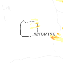


Connect with Interactive Hail Maps