

Hail Map for Lynxville, WI
The Lynxville, WI area has had 0 reports of on-the-ground hail by trained spotters, and has been under severe weather warnings 7 times during the past 12 months. Doppler radar has detected hail at or near Lynxville, WI on 44 occasions, including 2 occasions during the past year.
| Name: | Lynxville, WI |
| Where Located: | 40 miles SSE of La Crosse, WI |
| Map: | Google Map for Lynxville, WI |
| Population: | 132 |
| Housing Units: | 101 |
| More Info: | Search Google for Lynxville, WI |
3
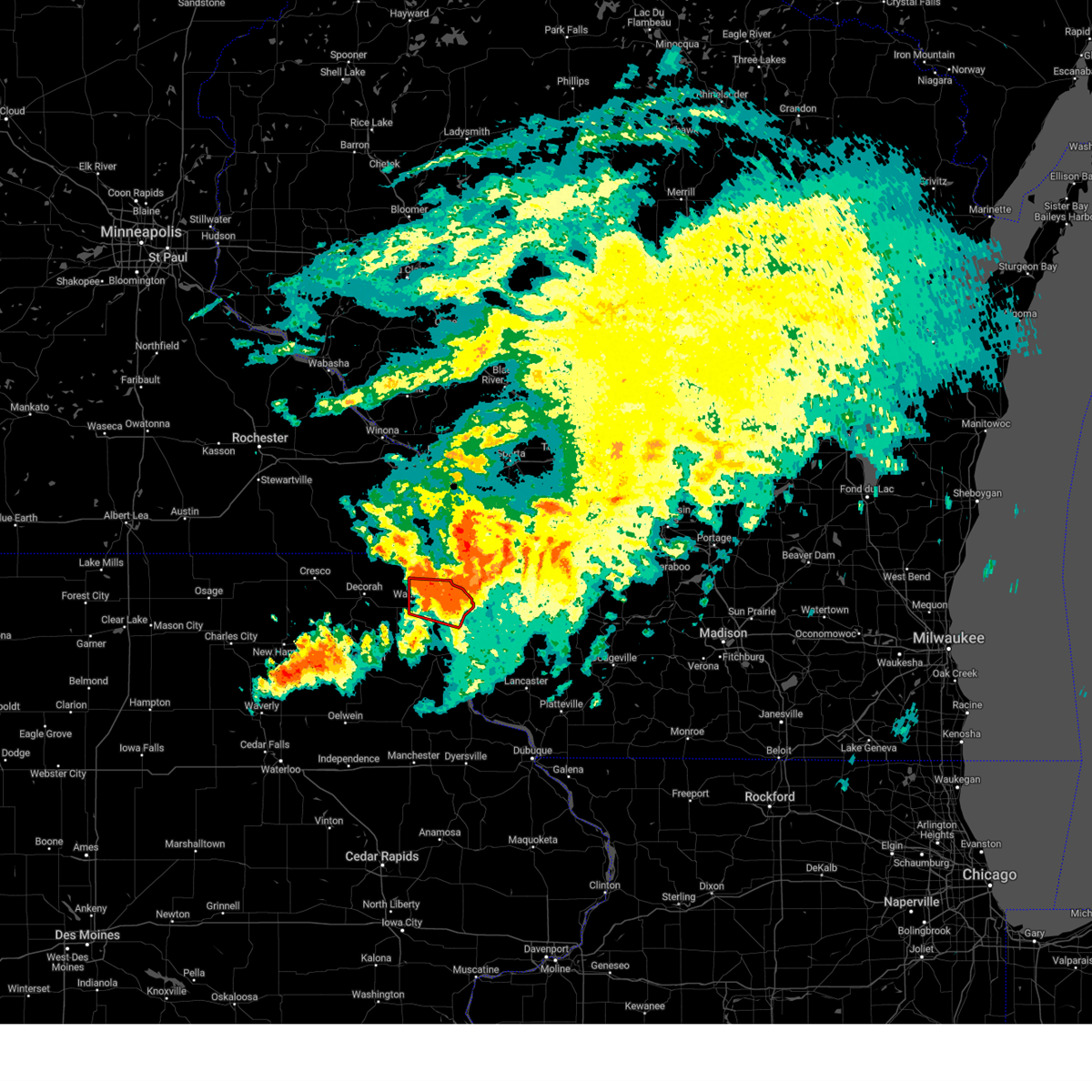
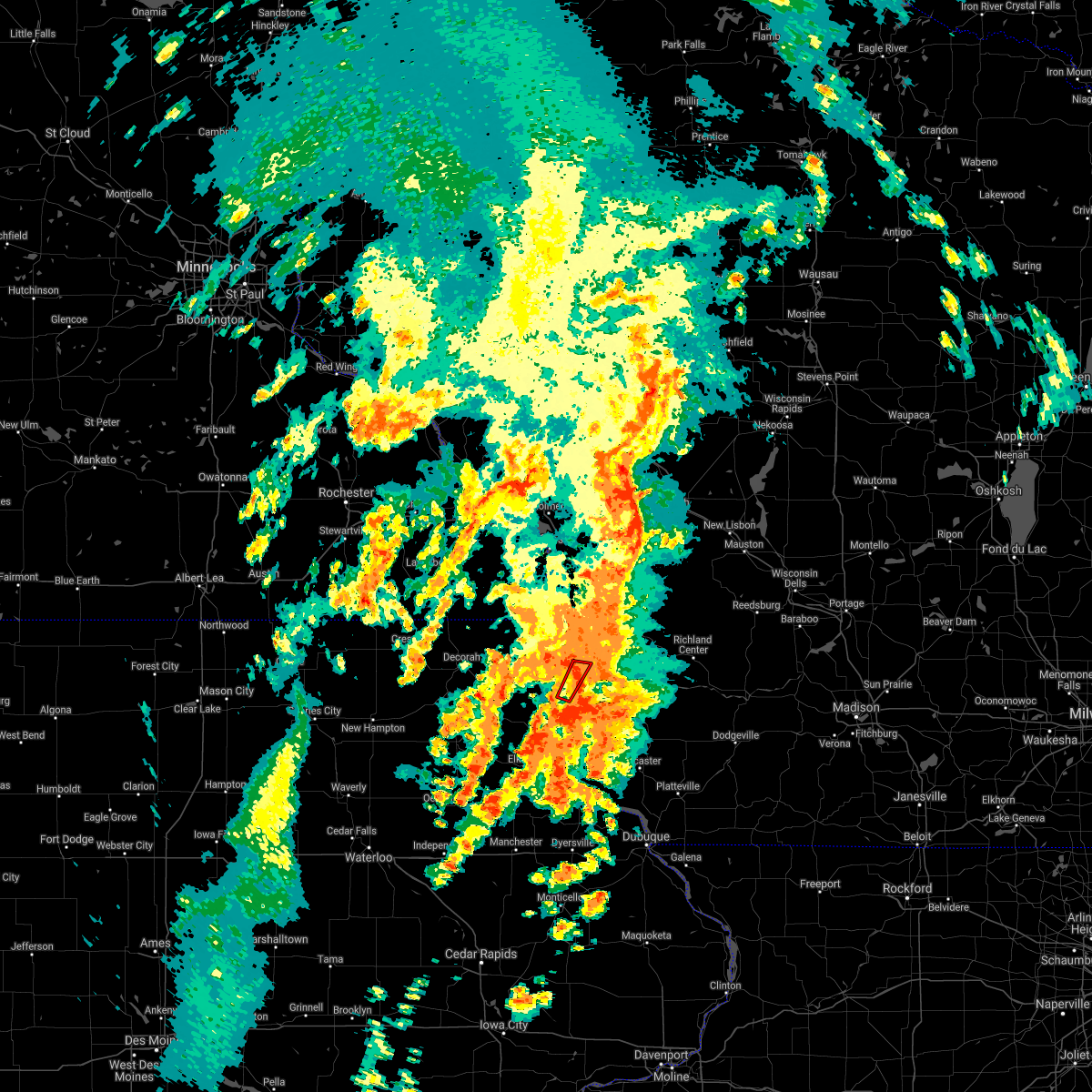
The Top Recent Hail Date for Lynxville, WI is Thursday, April 17, 2025 (3rd out of 44)

Hail and Wind Damage Spotted near Lynxville, WI
| Date / Time | Report Details |
|---|---|
| 4/18/2025 4:37 AM CDT |
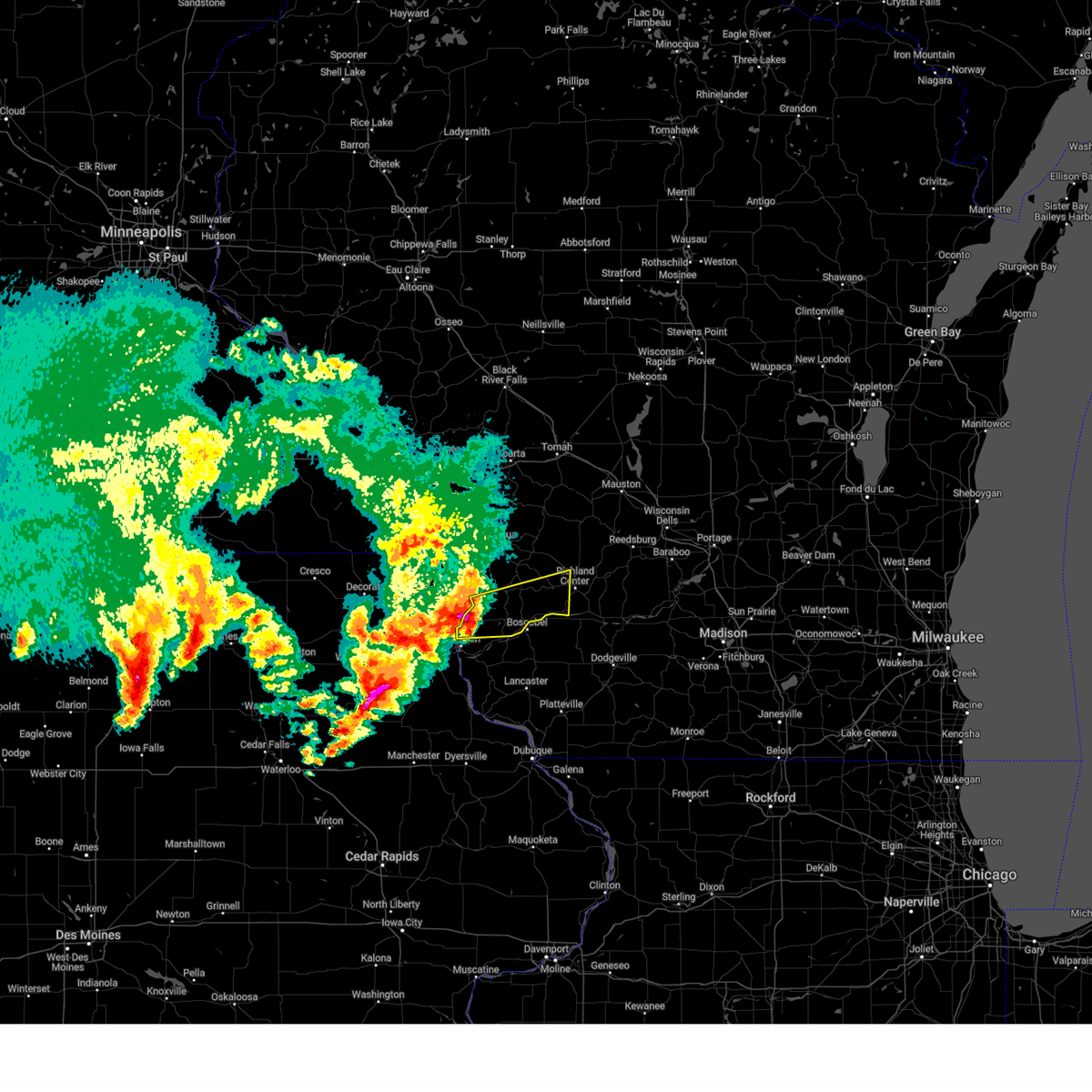 Svrarx the national weather service in la crosse has issued a * severe thunderstorm warning for, southwestern richland county in southwestern wisconsin, central crawford county in southwestern wisconsin, * until 515 am cdt. * at 437 am cdt, a severe thunderstorm was located near harpers ferry, or 12 miles northeast of prairie du chien, moving east at 50 mph (radar indicated). Hazards include quarter size hail. Damage to vehicles is expected. This severe thunderstorm will remain over mainly rural areas of southwestern richland and central crawford counties, including the following locations, eastman, eagle cave, horrigan ridge, plugtown, eagle corners, and mount zion. Svrarx the national weather service in la crosse has issued a * severe thunderstorm warning for, southwestern richland county in southwestern wisconsin, central crawford county in southwestern wisconsin, * until 515 am cdt. * at 437 am cdt, a severe thunderstorm was located near harpers ferry, or 12 miles northeast of prairie du chien, moving east at 50 mph (radar indicated). Hazards include quarter size hail. Damage to vehicles is expected. This severe thunderstorm will remain over mainly rural areas of southwestern richland and central crawford counties, including the following locations, eastman, eagle cave, horrigan ridge, plugtown, eagle corners, and mount zion.
|
| 9/21/2024 5:56 PM CDT | The storm which prompted the warning continues to move southeast and will be shifted into grant county wisconsin shortly. therefore, the warning will be allowed to expire. however, hail and torrential rain is still expected along the wisconsin river before the storm exits. |
| 9/21/2024 5:32 PM CDT |
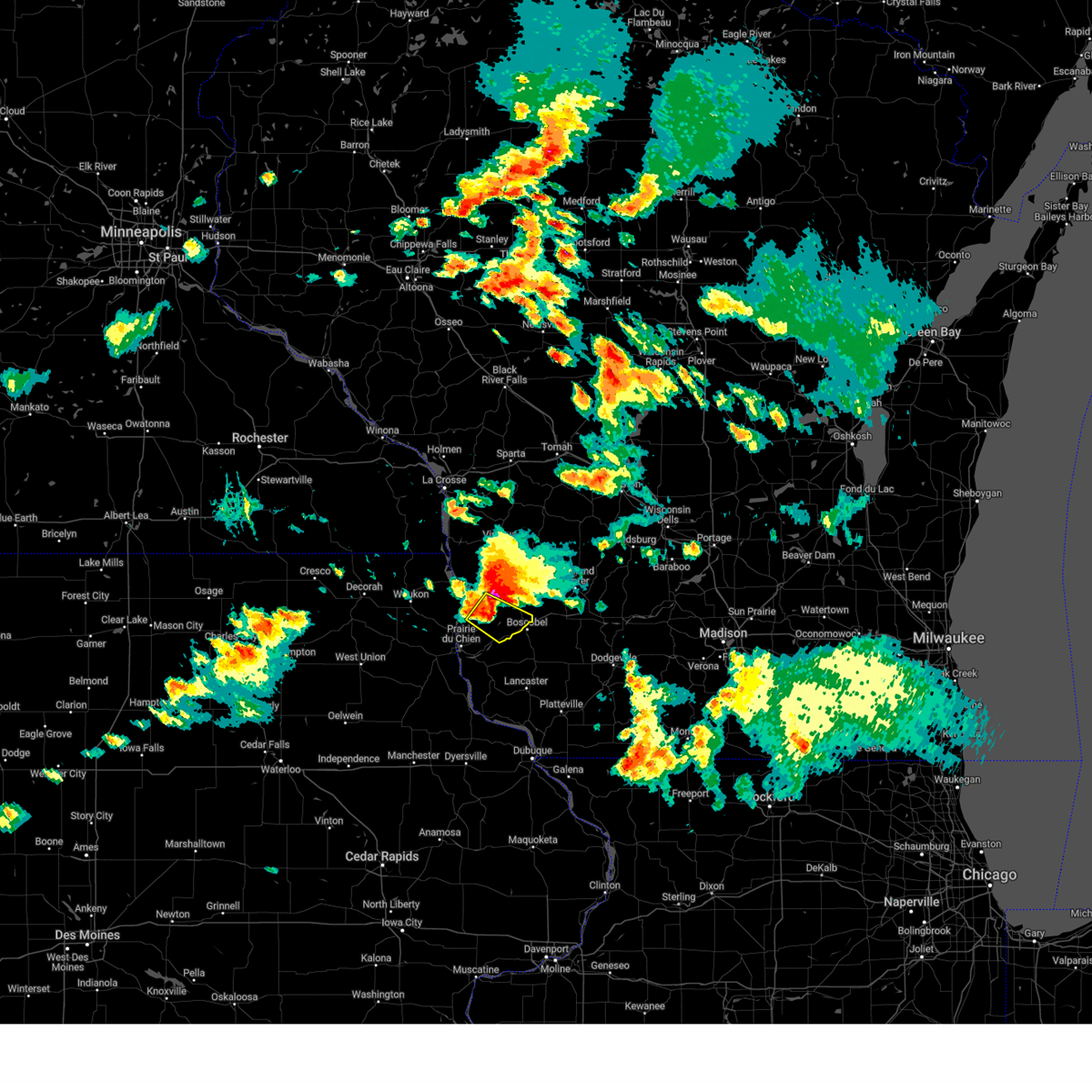 Svrarx the national weather service in la crosse has issued a * severe thunderstorm warning for, central crawford county in southwestern wisconsin, * until 600 pm cdt. * at 532 pm cdt, a severe thunderstorm was located 12 miles northwest of boscobel, or 17 miles southeast of lansing, moving southeast at 30 mph (radar indicated). Hazards include 60 mph wind gusts and quarter size hail. Hail damage to vehicles is expected. expect wind damage to roofs, siding, and trees. This severe thunderstorm will remain over mainly rural areas of central crawford county, including the following locations, wauzeka, seneca, eastman, highway 27 and county f, plugtown, steuben, and harris ridge. Svrarx the national weather service in la crosse has issued a * severe thunderstorm warning for, central crawford county in southwestern wisconsin, * until 600 pm cdt. * at 532 pm cdt, a severe thunderstorm was located 12 miles northwest of boscobel, or 17 miles southeast of lansing, moving southeast at 30 mph (radar indicated). Hazards include 60 mph wind gusts and quarter size hail. Hail damage to vehicles is expected. expect wind damage to roofs, siding, and trees. This severe thunderstorm will remain over mainly rural areas of central crawford county, including the following locations, wauzeka, seneca, eastman, highway 27 and county f, plugtown, steuben, and harris ridge.
|
| 8/5/2024 11:10 PM CDT |
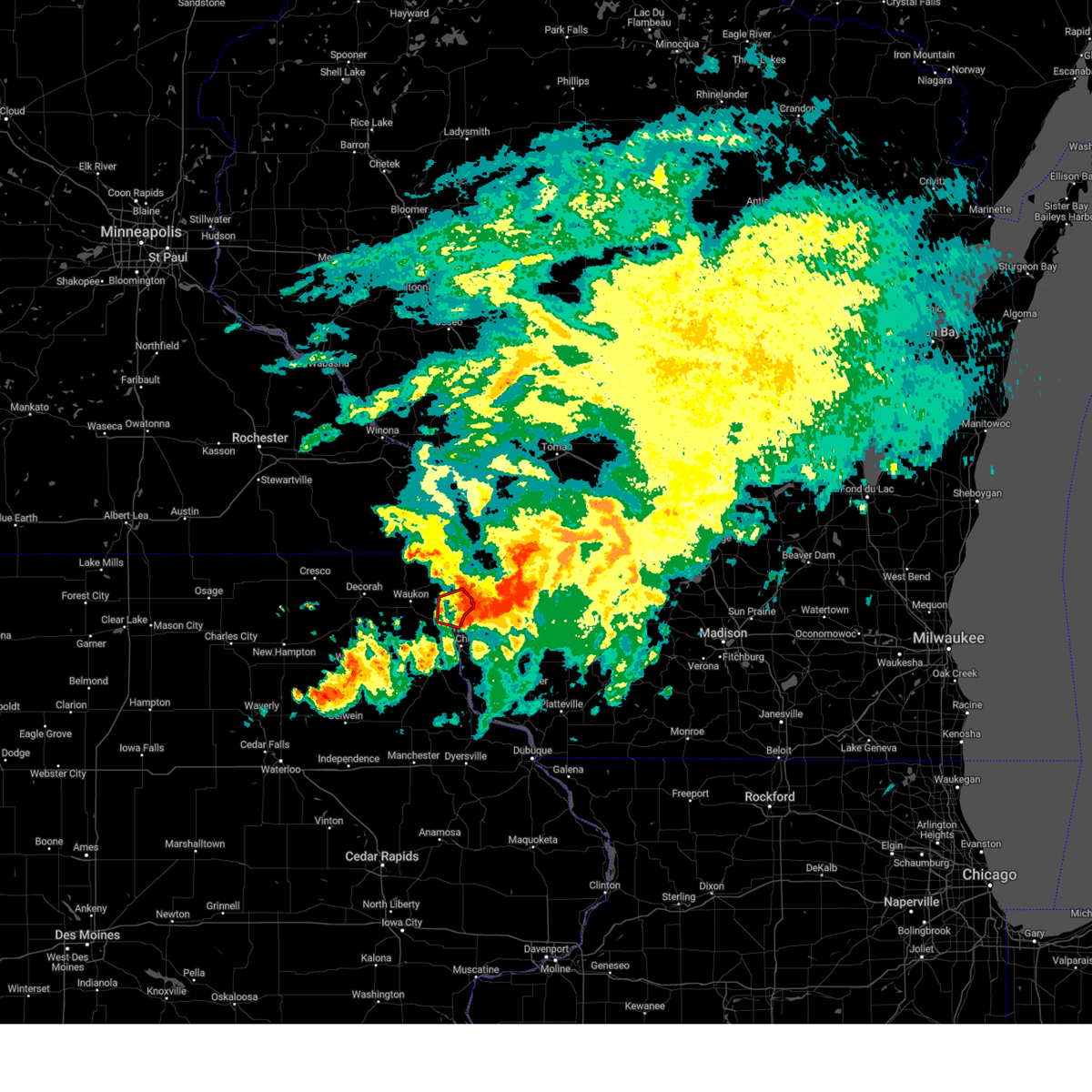 the tornado warning has been cancelled and is no longer in effect the tornado warning has been cancelled and is no longer in effect
|
| 8/5/2024 11:04 PM CDT |
 At 1103 pm cdt, a severe thunderstorm capable of producing a tornado was located over harpers ferry, or 10 miles north of prairie du chien, moving east at 25 mph (radar indicated rotation). Hazards include tornado. Flying debris will be dangerous to those caught without shelter. mobile homes will be damaged or destroyed. damage to roofs, windows, and vehicles will occur. tree damage is likely. This tornadic thunderstorm will remain over mainly rural areas of southeastern allamakee county, including the following locations, county roads a 52 and x 52, waterville, thompson corner, waukon jct, eldergrove, andy mountain campground, and lock and dam 9. At 1103 pm cdt, a severe thunderstorm capable of producing a tornado was located over harpers ferry, or 10 miles north of prairie du chien, moving east at 25 mph (radar indicated rotation). Hazards include tornado. Flying debris will be dangerous to those caught without shelter. mobile homes will be damaged or destroyed. damage to roofs, windows, and vehicles will occur. tree damage is likely. This tornadic thunderstorm will remain over mainly rural areas of southeastern allamakee county, including the following locations, county roads a 52 and x 52, waterville, thompson corner, waukon jct, eldergrove, andy mountain campground, and lock and dam 9.
|
| 8/5/2024 11:02 PM CDT |
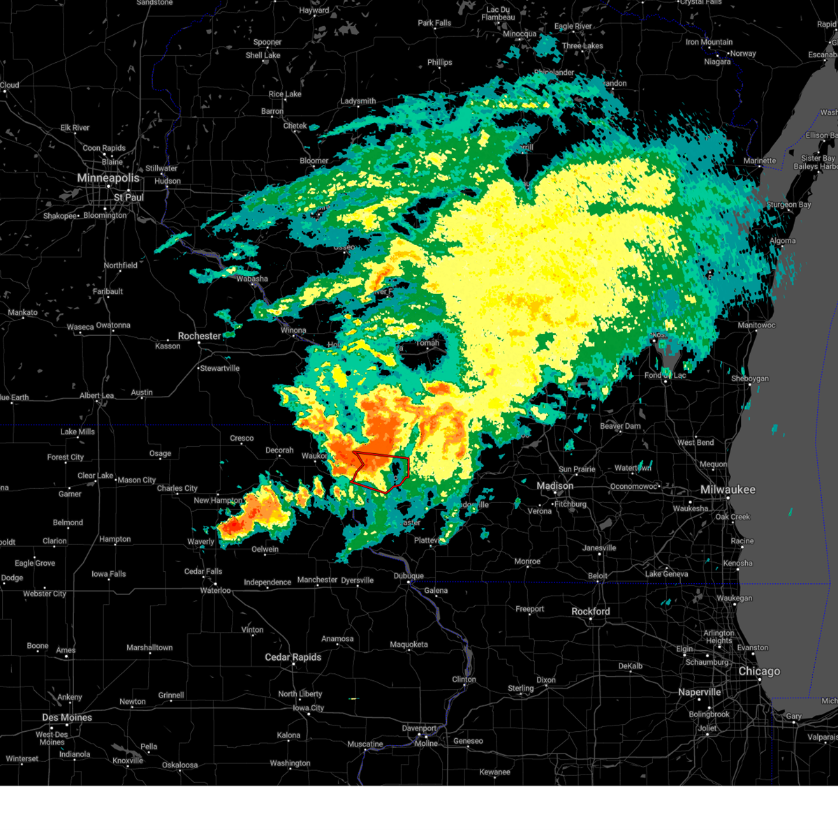 Torarx the national weather service in la crosse has issued a * tornado warning for, central crawford county in southwestern wisconsin, * until 1145 pm cdt. * at 1101 pm cdt, a severe thunderstorm capable of producing a tornado was located over harpers ferry, or 11 miles north of prairie du chien, moving east at 40 mph (radar indicated rotation. this storm has a history of producing tornadoes). Hazards include tornado. Flying debris will be dangerous to those caught without shelter. mobile homes will be damaged or destroyed. damage to roofs, windows, and vehicles will occur. tree damage is likely. this dangerous storm will be near, boscobel around 1125 pm cdt. Other locations impacted by this tornadic thunderstorm include highway 35 and county d, wauzeka, seneca, eastman, highway 27 and county f, plugtown, and steuben. Torarx the national weather service in la crosse has issued a * tornado warning for, central crawford county in southwestern wisconsin, * until 1145 pm cdt. * at 1101 pm cdt, a severe thunderstorm capable of producing a tornado was located over harpers ferry, or 11 miles north of prairie du chien, moving east at 40 mph (radar indicated rotation. this storm has a history of producing tornadoes). Hazards include tornado. Flying debris will be dangerous to those caught without shelter. mobile homes will be damaged or destroyed. damage to roofs, windows, and vehicles will occur. tree damage is likely. this dangerous storm will be near, boscobel around 1125 pm cdt. Other locations impacted by this tornadic thunderstorm include highway 35 and county d, wauzeka, seneca, eastman, highway 27 and county f, plugtown, and steuben.
|
| 8/5/2024 10:43 PM CDT |
 Torarx the national weather service in la crosse has issued a * tornado warning for, central allamakee county in northeastern iowa, * until 1130 pm cdt. * at 1042 pm cdt, a tornado producing storm was located near waukon, moving east at 30 mph (radar confirmed tornado). Hazards include damaging tornado. Flying debris will be dangerous to those caught without shelter. mobile homes will be damaged or destroyed. damage to roofs, windows, and vehicles will occur. tree damage is likely. this tornadic storm will be near, lansing around 1105 pm cdt. Other locations impacted by this tornadic thunderstorm include county roads a 52 and x 52, state road 9 and county x 20, waterville, state road 76 and county x 16, elon, maud, and red barn campground. Torarx the national weather service in la crosse has issued a * tornado warning for, central allamakee county in northeastern iowa, * until 1130 pm cdt. * at 1042 pm cdt, a tornado producing storm was located near waukon, moving east at 30 mph (radar confirmed tornado). Hazards include damaging tornado. Flying debris will be dangerous to those caught without shelter. mobile homes will be damaged or destroyed. damage to roofs, windows, and vehicles will occur. tree damage is likely. this tornadic storm will be near, lansing around 1105 pm cdt. Other locations impacted by this tornadic thunderstorm include county roads a 52 and x 52, state road 9 and county x 20, waterville, state road 76 and county x 16, elon, maud, and red barn campground.
|
| 6/22/2024 5:19 PM CDT |
 Svrarx the national weather service in la crosse has issued a * severe thunderstorm warning for, southeastern allamakee county in northeastern iowa, northeastern grant county in southwestern wisconsin, southern richland county in southwestern wisconsin, crawford county in southwestern wisconsin, * until 615 pm cdt. * at 519 pm cdt, severe thunderstorms were located along a line extending from near lansing to 9 miles northwest of harpers ferry to near waukon, moving east at 40 mph (radar indicated). Hazards include 60 mph wind gusts and penny size hail. expect damage to roofs, siding, and trees Svrarx the national weather service in la crosse has issued a * severe thunderstorm warning for, southeastern allamakee county in northeastern iowa, northeastern grant county in southwestern wisconsin, southern richland county in southwestern wisconsin, crawford county in southwestern wisconsin, * until 615 pm cdt. * at 519 pm cdt, severe thunderstorms were located along a line extending from near lansing to 9 miles northwest of harpers ferry to near waukon, moving east at 40 mph (radar indicated). Hazards include 60 mph wind gusts and penny size hail. expect damage to roofs, siding, and trees
|
| 6/12/2024 3:53 PM CDT |
 the severe thunderstorm warning has been cancelled and is no longer in effect the severe thunderstorm warning has been cancelled and is no longer in effect
|
| 6/12/2024 3:53 PM CDT |
 At 351 pm cdt, severe thunderstorms were located along a line extending from 8 miles northwest of boscobel to 8 miles east of prairie du chien to near guttenberg, moving east at 50 mph (trained weather spotters reported numerous trees and power lines downed in southern allamakee county as the storms moved through). Hazards include 60 mph wind gusts. Expect damage to roofs, siding, and trees. these severe storms will be near, guttenberg, boscobel, and bloomington around 355 pm cdt. cassville around 400 pm cdt. Other locations impacted by these severe thunderstorms include mederville, eastman, beetown, highway 13 and county c 24, county roads k and t, bridgeport, and nelson dewey state park. At 351 pm cdt, severe thunderstorms were located along a line extending from 8 miles northwest of boscobel to 8 miles east of prairie du chien to near guttenberg, moving east at 50 mph (trained weather spotters reported numerous trees and power lines downed in southern allamakee county as the storms moved through). Hazards include 60 mph wind gusts. Expect damage to roofs, siding, and trees. these severe storms will be near, guttenberg, boscobel, and bloomington around 355 pm cdt. cassville around 400 pm cdt. Other locations impacted by these severe thunderstorms include mederville, eastman, beetown, highway 13 and county c 24, county roads k and t, bridgeport, and nelson dewey state park.
|
| 6/12/2024 3:32 PM CDT |
 Svrarx the national weather service in la crosse has issued a * severe thunderstorm warning for, central clayton county in northeastern iowa, southeastern allamakee county in northeastern iowa, northwestern grant county in southwestern wisconsin, southern crawford county in southwestern wisconsin, * until 430 pm cdt. * at 330 pm cdt, severe thunderstorms were located along a line extending from near harpers ferry to near monona to near volga, moving east at 45 mph (trained weather spotters. multiple reports of tree limbs down have been reported near postville, waucoma, and in the yellow river basin since 245 pm). Hazards include 60 mph wind gusts. Expect damage to roofs, siding, and trees. severe thunderstorms will be near, prairie du chien, elkader, mcgregor, marquette, harpers ferry, farmersburg, and volga around 335 pm cdt. garnavillo around 340 pm cdt. guttenberg around 350 pm cdt. bloomington around 355 pm cdt. boscobel and cassville around 400 pm cdt. Other locations impacted by these severe thunderstorms include mederville, eastman, giard, watson, beetown, highway 13 and county c 24, and county roads k and t. Svrarx the national weather service in la crosse has issued a * severe thunderstorm warning for, central clayton county in northeastern iowa, southeastern allamakee county in northeastern iowa, northwestern grant county in southwestern wisconsin, southern crawford county in southwestern wisconsin, * until 430 pm cdt. * at 330 pm cdt, severe thunderstorms were located along a line extending from near harpers ferry to near monona to near volga, moving east at 45 mph (trained weather spotters. multiple reports of tree limbs down have been reported near postville, waucoma, and in the yellow river basin since 245 pm). Hazards include 60 mph wind gusts. Expect damage to roofs, siding, and trees. severe thunderstorms will be near, prairie du chien, elkader, mcgregor, marquette, harpers ferry, farmersburg, and volga around 335 pm cdt. garnavillo around 340 pm cdt. guttenberg around 350 pm cdt. bloomington around 355 pm cdt. boscobel and cassville around 400 pm cdt. Other locations impacted by these severe thunderstorms include mederville, eastman, giard, watson, beetown, highway 13 and county c 24, and county roads k and t.
|
| 5/21/2024 7:33 PM CDT |
 the severe thunderstorm warning has been cancelled and is no longer in effect the severe thunderstorm warning has been cancelled and is no longer in effect
|
| 5/21/2024 7:14 PM CDT |
 At 713 pm cdt, severe thunderstorms were located along a line extending from 7 miles south of waukon to 6 miles northeast of monona to near mcgregor, moving northeast at 70 mph (radar indicated). Hazards include 70 mph wind gusts and penny size hail. Expect considerable tree damage. damage is likely to mobile homes, roofs, and outbuildings. these severe storms will be near, harpers ferry around 720 pm cdt. lansing around 725 pm cdt. Other locations impacted by these severe thunderstorms include volney, county roads a 52 and w 60, watson, county roads x 16 and w 48, fairview, ferryville, and state road 51 and county w 48. At 713 pm cdt, severe thunderstorms were located along a line extending from 7 miles south of waukon to 6 miles northeast of monona to near mcgregor, moving northeast at 70 mph (radar indicated). Hazards include 70 mph wind gusts and penny size hail. Expect considerable tree damage. damage is likely to mobile homes, roofs, and outbuildings. these severe storms will be near, harpers ferry around 720 pm cdt. lansing around 725 pm cdt. Other locations impacted by these severe thunderstorms include volney, county roads a 52 and w 60, watson, county roads x 16 and w 48, fairview, ferryville, and state road 51 and county w 48.
|
| 5/21/2024 7:14 PM CDT |
 the severe thunderstorm warning has been cancelled and is no longer in effect the severe thunderstorm warning has been cancelled and is no longer in effect
|
| 5/21/2024 6:41 PM CDT |
 Svrarx the national weather service in la crosse has issued a * severe thunderstorm warning for, northwestern clayton county in northeastern iowa, allamakee county in northeastern iowa, southern winneshiek county in northeastern iowa, northern crawford county in southwestern wisconsin, * until 745 pm cdt. * at 641 pm cdt, severe thunderstorms were located along a line extending from near hawkeye to near west union to near arlington, moving northeast at 70 mph (radar indicated). Hazards include 70 mph wind gusts and penny size hail. Expect considerable tree damage. damage is likely to mobile homes, roofs, and outbuildings. severe thunderstorms will be near, postville, calmar, and ossian around 650 pm cdt. monona around 655 pm cdt. waukon around 700 pm cdt. lansing and harpers ferry around 710 pm cdt. Other locations impacted by these severe thunderstorms include volney, county roads a 52 and w 60, festina, watson, county road w 46 and centennial road, county roads x 16 and w 48, and fairview. Svrarx the national weather service in la crosse has issued a * severe thunderstorm warning for, northwestern clayton county in northeastern iowa, allamakee county in northeastern iowa, southern winneshiek county in northeastern iowa, northern crawford county in southwestern wisconsin, * until 745 pm cdt. * at 641 pm cdt, severe thunderstorms were located along a line extending from near hawkeye to near west union to near arlington, moving northeast at 70 mph (radar indicated). Hazards include 70 mph wind gusts and penny size hail. Expect considerable tree damage. damage is likely to mobile homes, roofs, and outbuildings. severe thunderstorms will be near, postville, calmar, and ossian around 650 pm cdt. monona around 655 pm cdt. waukon around 700 pm cdt. lansing and harpers ferry around 710 pm cdt. Other locations impacted by these severe thunderstorms include volney, county roads a 52 and w 60, festina, watson, county road w 46 and centennial road, county roads x 16 and w 48, and fairview.
|
| 7/24/2022 12:38 AM CDT |
 The severe thunderstorm warning for central crawford county will expire at 1245 am cdt, the storms which prompted the warning have moved out of the area. therefore, the warning will be allowed to expire. a severe thunderstorm watch remains in effect until 300 am cdt for northeastern iowa, and southwestern wisconsin. The severe thunderstorm warning for central crawford county will expire at 1245 am cdt, the storms which prompted the warning have moved out of the area. therefore, the warning will be allowed to expire. a severe thunderstorm watch remains in effect until 300 am cdt for northeastern iowa, and southwestern wisconsin.
|
| 7/24/2022 12:26 AM CDT |
 At 1226 am cdt, severe thunderstorms were located along a line extending from 14 miles northeast of harpers ferry to 10 miles northwest of boscobel to 11 miles east of prairie du chien, moving east at 30 mph (law enforcement). Hazards include 60 mph wind gusts. Expect damage to roofs, siding, and trees. locations impacted include, prairie du chien, seneca, wauzeka, eastman, mount sterling, ferryville, lynxville, steuben, highway 27 and county f, harris ridge, rising sun, limery ridge, fairview, joy hollow, hazen corners, kickapoo indian caverns, lock and dam 9, oak ridge and crowley ridge. hail threat, radar indicated max hail size, <. 75 in wind threat, observed max wind gust, 60 mph. At 1226 am cdt, severe thunderstorms were located along a line extending from 14 miles northeast of harpers ferry to 10 miles northwest of boscobel to 11 miles east of prairie du chien, moving east at 30 mph (law enforcement). Hazards include 60 mph wind gusts. Expect damage to roofs, siding, and trees. locations impacted include, prairie du chien, seneca, wauzeka, eastman, mount sterling, ferryville, lynxville, steuben, highway 27 and county f, harris ridge, rising sun, limery ridge, fairview, joy hollow, hazen corners, kickapoo indian caverns, lock and dam 9, oak ridge and crowley ridge. hail threat, radar indicated max hail size, <. 75 in wind threat, observed max wind gust, 60 mph.
|
| 7/24/2022 12:08 AM CDT |
 At 1208 am cdt, severe thunderstorms were located along a line extending from 11 miles east of lansing to 6 miles east of harpers ferry to near prairie du chien, moving east at 55 mph (law enforcement). Hazards include 60 mph wind gusts. Expect damage to roofs, siding, and trees. locations impacted include, prairie du chien, mcgregor, marquette, harpers ferry, seneca, wauzeka, eastman, mount sterling, ferryville, lynxville, steuben, county roads a 52 and x 52, highway 35 and county d, spook cave campground, rush creek, giard, harris ridge, limery ridge, fairview and pikes peak state park. hail threat, radar indicated max hail size, <. 75 in wind threat, observed max wind gust, 60 mph. At 1208 am cdt, severe thunderstorms were located along a line extending from 11 miles east of lansing to 6 miles east of harpers ferry to near prairie du chien, moving east at 55 mph (law enforcement). Hazards include 60 mph wind gusts. Expect damage to roofs, siding, and trees. locations impacted include, prairie du chien, mcgregor, marquette, harpers ferry, seneca, wauzeka, eastman, mount sterling, ferryville, lynxville, steuben, county roads a 52 and x 52, highway 35 and county d, spook cave campground, rush creek, giard, harris ridge, limery ridge, fairview and pikes peak state park. hail threat, radar indicated max hail size, <. 75 in wind threat, observed max wind gust, 60 mph.
|
| 7/23/2022 11:53 PM CDT |
 At 1152 pm cdt, severe thunderstorms were located along a line extending from near lansing to near harpers ferry to near monona, moving east at 70 mph (law enforcement). Hazards include 60 mph wind gusts. Expect damage to roofs, siding, and trees. these severe thunderstorms will remain over mainly rural areas of northwestern clayton, southeastern allamakee and western crawford counties, including the following locations, county roads a 52 and x 52, volney, highway 35 and county d, spook cave campground, waterville, eastman and rush creek. hail threat, radar indicated max hail size, <. 75 in wind threat, observed max wind gust, 60 mph. At 1152 pm cdt, severe thunderstorms were located along a line extending from near lansing to near harpers ferry to near monona, moving east at 70 mph (law enforcement). Hazards include 60 mph wind gusts. Expect damage to roofs, siding, and trees. these severe thunderstorms will remain over mainly rural areas of northwestern clayton, southeastern allamakee and western crawford counties, including the following locations, county roads a 52 and x 52, volney, highway 35 and county d, spook cave campground, waterville, eastman and rush creek. hail threat, radar indicated max hail size, <. 75 in wind threat, observed max wind gust, 60 mph.
|
| 4/12/2022 11:51 PM CDT |
 At 1151 pm cdt, severe thunderstorms were located along a line extending from near mabel to 6 miles northeast of decorah to near ossian, moving east at 50 mph (radar indicated). Hazards include 60 mph wind gusts. Expect damage to roofs, siding, and trees. severe thunderstorms will be near, waukon around 1215 am cdt. lansing and new albin around 1220 am cdt. harpers ferry around 1230 am cdt. other locations impacted by these severe thunderstorms include hanover, county roads a 52 and x 52, county roads a 52 and w 60, waterville, state road 76 and county x 16, hesper and nordness. hail threat, radar indicated max hail size, <. 75 in wind threat, radar indicated max wind gust, 60 mph. At 1151 pm cdt, severe thunderstorms were located along a line extending from near mabel to 6 miles northeast of decorah to near ossian, moving east at 50 mph (radar indicated). Hazards include 60 mph wind gusts. Expect damage to roofs, siding, and trees. severe thunderstorms will be near, waukon around 1215 am cdt. lansing and new albin around 1220 am cdt. harpers ferry around 1230 am cdt. other locations impacted by these severe thunderstorms include hanover, county roads a 52 and x 52, county roads a 52 and w 60, waterville, state road 76 and county x 16, hesper and nordness. hail threat, radar indicated max hail size, <. 75 in wind threat, radar indicated max wind gust, 60 mph.
|
| 12/15/2021 9:19 PM CST |
 At 918 pm cst, severe thunderstorms were located along a line extending from 6 miles north of la farge to near lancaster, moving east at 50 mph (radar indicated). Hazards include 70 mph wind gusts. Expect considerable tree damage. damage is likely to mobile homes, roofs, and outbuildings. These severe thunderstorms will remain over mainly rural areas of eastern clayton, southwestern vernon, central grant and crawford counties, including the following locations, eastman, horrigan ridge, turkey river, beetown, bridgeport and fairview. At 918 pm cst, severe thunderstorms were located along a line extending from 6 miles north of la farge to near lancaster, moving east at 50 mph (radar indicated). Hazards include 70 mph wind gusts. Expect considerable tree damage. damage is likely to mobile homes, roofs, and outbuildings. These severe thunderstorms will remain over mainly rural areas of eastern clayton, southwestern vernon, central grant and crawford counties, including the following locations, eastman, horrigan ridge, turkey river, beetown, bridgeport and fairview.
|
| 8/10/2021 3:58 PM CDT |
 At 358 pm cdt, severe thunderstorms were located along a line extending from 10 miles south of viroqua to 7 miles south of lancaster, moving east at 50 mph (law enforcement). Hazards include 60 mph wind gusts. Expect damage to roofs, siding, and trees. locations impacted include, lancaster, lansing, boscobel, cassville, bloomington, harpers ferry, bridgeport, seneca, beetown, wauzeka, potosi, soldiers grove, mount ida, gays mills, eastman, tennyson, de soto, mount hope, mount sterling and patch grove. hail threat, radar indicated max hail size, <. 75 in wind threat, observed max wind gust, 60 mph. At 358 pm cdt, severe thunderstorms were located along a line extending from 10 miles south of viroqua to 7 miles south of lancaster, moving east at 50 mph (law enforcement). Hazards include 60 mph wind gusts. Expect damage to roofs, siding, and trees. locations impacted include, lancaster, lansing, boscobel, cassville, bloomington, harpers ferry, bridgeport, seneca, beetown, wauzeka, potosi, soldiers grove, mount ida, gays mills, eastman, tennyson, de soto, mount hope, mount sterling and patch grove. hail threat, radar indicated max hail size, <. 75 in wind threat, observed max wind gust, 60 mph.
|
| 8/10/2021 3:56 PM CDT |
 At 356 pm cdt, severe thunderstorms were located along a line extending from 11 miles east of lansing to 6 miles north of sherrill, moving east at 40 mph (law enforcement). Hazards include 60 mph wind gusts. expect damage to roofs, siding, and trees At 356 pm cdt, severe thunderstorms were located along a line extending from 11 miles east of lansing to 6 miles north of sherrill, moving east at 40 mph (law enforcement). Hazards include 60 mph wind gusts. expect damage to roofs, siding, and trees
|
| 8/10/2021 3:50 PM CDT |
 At 349 pm cdt, severe thunderstorms were located along a line extending from 9 miles east of lansing to 6 miles northeast of balltown, moving east at 45 mph (law enforcement). Hazards include 60 mph wind gusts and nickel size hail. Expect damage to roofs, siding, and trees. locations impacted include, prairie du chien, waukon, lancaster, guttenberg, lansing, boscobel, cassville, mcgregor, bloomington, marquette, harpers ferry, bridgeport, seneca, beetown, wauzeka, potosi, soldiers grove, mount ida, gays mills and eastman. hail threat, radar indicated max hail size, 0. 88 in wind threat, observed max wind gust, 60 mph. At 349 pm cdt, severe thunderstorms were located along a line extending from 9 miles east of lansing to 6 miles northeast of balltown, moving east at 45 mph (law enforcement). Hazards include 60 mph wind gusts and nickel size hail. Expect damage to roofs, siding, and trees. locations impacted include, prairie du chien, waukon, lancaster, guttenberg, lansing, boscobel, cassville, mcgregor, bloomington, marquette, harpers ferry, bridgeport, seneca, beetown, wauzeka, potosi, soldiers grove, mount ida, gays mills and eastman. hail threat, radar indicated max hail size, 0. 88 in wind threat, observed max wind gust, 60 mph.
|
| 8/10/2021 3:23 PM CDT |
 At 322 pm cdt, severe thunderstorms were located along a line extending from 8 miles east of waukon to near strawberry point, moving east at 50 mph (law enforcement). Hazards include 60 mph wind gusts and quarter size hail. Hail damage to vehicles is expected. Expect wind damage to roofs, siding, and trees. At 322 pm cdt, severe thunderstorms were located along a line extending from 8 miles east of waukon to near strawberry point, moving east at 50 mph (law enforcement). Hazards include 60 mph wind gusts and quarter size hail. Hail damage to vehicles is expected. Expect wind damage to roofs, siding, and trees.
|
| 8/7/2021 11:26 AM CDT |
 At 1126 am cdt, a severe thunderstorm was located 9 miles northeast of harpers ferry, or 12 miles southeast of lansing, moving northeast at 30 mph (radar indicated). Hazards include quarter size hail. damage to vehicles is expected At 1126 am cdt, a severe thunderstorm was located 9 miles northeast of harpers ferry, or 12 miles southeast of lansing, moving northeast at 30 mph (radar indicated). Hazards include quarter size hail. damage to vehicles is expected
|
| 7/27/2021 9:40 AM CDT |
 At 939 am cdt, a severe thunderstorm was located near lansing, moving south at 40 mph (radar indicated). Hazards include quarter size hail. Damage to vehicles is expected. This severe thunderstorm will remain over mainly rural areas of crawford county, including the following locations, eastman, rush creek, harris ridge, fairview, maple ridge, petersburg and ferryville. At 939 am cdt, a severe thunderstorm was located near lansing, moving south at 40 mph (radar indicated). Hazards include quarter size hail. Damage to vehicles is expected. This severe thunderstorm will remain over mainly rural areas of crawford county, including the following locations, eastman, rush creek, harris ridge, fairview, maple ridge, petersburg and ferryville.
|
| 7/27/2021 9:31 AM CDT |
 At 931 am cdt, a severe thunderstorm was located 7 miles east of lansing, moving south at 40 mph (radar indicated). Hazards include quarter size hail. Damage to vehicles is expected. Locations impacted include, seneca, wauzeka, gays mills, eastman, de soto, genoa, mount sterling, ferryville, lynxville, steuben, bell center, red mound, rush creek, harris ridge, fairview, bud, maple ridge, petersburg, retreat and fargo. At 931 am cdt, a severe thunderstorm was located 7 miles east of lansing, moving south at 40 mph (radar indicated). Hazards include quarter size hail. Damage to vehicles is expected. Locations impacted include, seneca, wauzeka, gays mills, eastman, de soto, genoa, mount sterling, ferryville, lynxville, steuben, bell center, red mound, rush creek, harris ridge, fairview, bud, maple ridge, petersburg, retreat and fargo.
|
| 7/27/2021 9:27 AM CDT |
 At 926 am cdt, a severe thunderstorm was located 7 miles northeast of lansing, moving south at 40 mph (radar indicated). Hazards include quarter size hail. Damage to vehicles is expected. Locations impacted include, seneca, wauzeka, gays mills, eastman, de soto, genoa, mount sterling, ferryville, lynxville, steuben, bell center, red mound, rush creek, harris ridge, fairview, bud, maple ridge, petersburg, retreat and fargo. At 926 am cdt, a severe thunderstorm was located 7 miles northeast of lansing, moving south at 40 mph (radar indicated). Hazards include quarter size hail. Damage to vehicles is expected. Locations impacted include, seneca, wauzeka, gays mills, eastman, de soto, genoa, mount sterling, ferryville, lynxville, steuben, bell center, red mound, rush creek, harris ridge, fairview, bud, maple ridge, petersburg, retreat and fargo.
|
| 7/27/2021 9:16 AM CDT |
 At 915 am cdt, a severe thunderstorm was located 9 miles east of new albin, or 11 miles west of viroqua, moving south at 40 mph (radar indicated). Hazards include quarter size hail. Damage to vehicles is expected. This severe thunderstorm will remain over mainly rural areas of southwestern vernon and crawford counties, including the following locations, eastman, red mound, rush creek, harris ridge, fairview, bud and maple ridge. At 915 am cdt, a severe thunderstorm was located 9 miles east of new albin, or 11 miles west of viroqua, moving south at 40 mph (radar indicated). Hazards include quarter size hail. Damage to vehicles is expected. This severe thunderstorm will remain over mainly rural areas of southwestern vernon and crawford counties, including the following locations, eastman, red mound, rush creek, harris ridge, fairview, bud and maple ridge.
|
| 6/29/2021 3:55 PM CDT |
 At 354 pm cdt, a severe thunderstorm capable of producing a tornado was located near harpers ferry, or 7 miles north of prairie du chien, moving east at 10 mph (radar indicated rotation). Hazards include tornado. Flying debris will be dangerous to those caught without shelter. mobile homes will be damaged or destroyed. damage to roofs, windows, and vehicles will occur. Tree damage is likely. At 354 pm cdt, a severe thunderstorm capable of producing a tornado was located near harpers ferry, or 7 miles north of prairie du chien, moving east at 10 mph (radar indicated rotation). Hazards include tornado. Flying debris will be dangerous to those caught without shelter. mobile homes will be damaged or destroyed. damage to roofs, windows, and vehicles will occur. Tree damage is likely.
|
| 6/29/2021 3:49 PM CDT |
 At 348 pm cdt, a severe thunderstorm capable of producing a tornado was located over harpers ferry, or 8 miles north of prairie du chien, moving east at 10 mph (radar indicated rotation). Hazards include tornado. Flying debris will be dangerous to those caught without shelter. mobile homes will be damaged or destroyed. damage to roofs, windows, and vehicles will occur. tree damage is likely. This tornadic thunderstorm will remain over mainly rural areas of southeastern allamakee and central crawford counties, including the following locations, highway 35 and county d, seneca, eastman, highway 27 and county f, steuben, harris ridge and petersburg. At 348 pm cdt, a severe thunderstorm capable of producing a tornado was located over harpers ferry, or 8 miles north of prairie du chien, moving east at 10 mph (radar indicated rotation). Hazards include tornado. Flying debris will be dangerous to those caught without shelter. mobile homes will be damaged or destroyed. damage to roofs, windows, and vehicles will occur. tree damage is likely. This tornadic thunderstorm will remain over mainly rural areas of southeastern allamakee and central crawford counties, including the following locations, highway 35 and county d, seneca, eastman, highway 27 and county f, steuben, harris ridge and petersburg.
|
| 6/29/2021 3:39 PM CDT |
 At 339 pm cdt, a severe thunderstorm capable of producing a tornado was located near harpers ferry, or 8 miles north of prairie du chien, moving east at 10 mph (radar indicated rotation). Hazards include tornado. Flying debris will be dangerous to those caught without shelter. mobile homes will be damaged or destroyed. damage to roofs, windows, and vehicles will occur. tree damage is likely. This dangerous storm will be near, harpers ferry around 350 pm cdt. At 339 pm cdt, a severe thunderstorm capable of producing a tornado was located near harpers ferry, or 8 miles north of prairie du chien, moving east at 10 mph (radar indicated rotation). Hazards include tornado. Flying debris will be dangerous to those caught without shelter. mobile homes will be damaged or destroyed. damage to roofs, windows, and vehicles will occur. tree damage is likely. This dangerous storm will be near, harpers ferry around 350 pm cdt.
|
| 6/29/2021 3:38 PM CDT |
 At 333 pm cdt, a severe thunderstorm capable of producing a tornado was located near harpers ferry, or 9 miles northwest of prairie du chien, moving east at 10 mph (radar indicated rotation). Hazards include tornado. Flying debris will be dangerous to those caught without shelter. mobile homes will be damaged or destroyed. damage to roofs, windows, and vehicles will occur. tree damage is likely. This dangerous storm will be near, harpers ferry around 355 pm cdt. At 333 pm cdt, a severe thunderstorm capable of producing a tornado was located near harpers ferry, or 9 miles northwest of prairie du chien, moving east at 10 mph (radar indicated rotation). Hazards include tornado. Flying debris will be dangerous to those caught without shelter. mobile homes will be damaged or destroyed. damage to roofs, windows, and vehicles will occur. tree damage is likely. This dangerous storm will be near, harpers ferry around 355 pm cdt.
|
| 6/29/2021 3:25 PM CDT |
 At 325 pm cdt, a severe thunderstorm capable of producing a tornado was located near harpers ferry, or 10 miles northwest of prairie du chien, moving east at 10 mph (radar indicated rotation). Hazards include tornado. Flying debris will be dangerous to those caught without shelter. mobile homes will be damaged or destroyed. damage to roofs, windows, and vehicles will occur. tree damage is likely. this dangerous storm will be near, harpers ferry around 400 pm cdt. Other locations impacted by this tornadic thunderstorm include county roads a 52 and x 52, highway 35 and county d, waterville, eastman, harris ridge, limery ridge and petersburg. At 325 pm cdt, a severe thunderstorm capable of producing a tornado was located near harpers ferry, or 10 miles northwest of prairie du chien, moving east at 10 mph (radar indicated rotation). Hazards include tornado. Flying debris will be dangerous to those caught without shelter. mobile homes will be damaged or destroyed. damage to roofs, windows, and vehicles will occur. tree damage is likely. this dangerous storm will be near, harpers ferry around 400 pm cdt. Other locations impacted by this tornadic thunderstorm include county roads a 52 and x 52, highway 35 and county d, waterville, eastman, harris ridge, limery ridge and petersburg.
|
| 7/9/2020 3:02 PM CDT |
 At 301 pm cdt, severe thunderstorms were located along a line extending from near brownsville to near lansing to 10 miles west of boscobel, moving northeast at 35 mph (radar indicated). Hazards include 60 mph wind gusts and penny size hail. Expect damage to roofs, siding, and trees. these severe storms will be near, boscobel around 320 pm cdt. Other locations impacted by these severe thunderstorms include volney, eastman, giard, county 5 and peyton road, highway 14 61 and county n, chaseburg and national. At 301 pm cdt, severe thunderstorms were located along a line extending from near brownsville to near lansing to 10 miles west of boscobel, moving northeast at 35 mph (radar indicated). Hazards include 60 mph wind gusts and penny size hail. Expect damage to roofs, siding, and trees. these severe storms will be near, boscobel around 320 pm cdt. Other locations impacted by these severe thunderstorms include volney, eastman, giard, county 5 and peyton road, highway 14 61 and county n, chaseburg and national.
|
| 7/9/2020 2:29 PM CDT |
 At 228 pm cdt, severe thunderstorms were located along a line extending from 7 miles southeast of spring grove to near marquette, moving northeast at 45 mph (radar indicated). Hazards include 60 mph wind gusts. Expect damage to roofs, siding, and trees. severe thunderstorms will be near, new albin and harpers ferry around 240 pm cdt. stoddard and brownsville around 255 pm cdt. Other locations impacted by these severe thunderstorms include volney, county roads a 52 and w 60, eastman, giard, quandahl, county 5 and peyton road and highway 14 61 and county n. At 228 pm cdt, severe thunderstorms were located along a line extending from 7 miles southeast of spring grove to near marquette, moving northeast at 45 mph (radar indicated). Hazards include 60 mph wind gusts. Expect damage to roofs, siding, and trees. severe thunderstorms will be near, new albin and harpers ferry around 240 pm cdt. stoddard and brownsville around 255 pm cdt. Other locations impacted by these severe thunderstorms include volney, county roads a 52 and w 60, eastman, giard, quandahl, county 5 and peyton road and highway 14 61 and county n.
|
| 6/2/2020 7:23 PM CDT |
 At 722 pm cdt, severe thunderstorms were located along a line extending from 9 miles northwest of richland center to 6 miles northeast of harpers ferry to near waukon, moving southeast at 45 mph. at 715 pm a 63 mph wind gust was reported at viroqua (radar indicated). Hazards include 60 mph wind gusts and quarter size hail. Hail damage to vehicles is expected. expect wind damage to roofs, siding, and trees. these severe storms will be near, postville around 740 pm cdt. Other locations impacted by these severe thunderstorms include volney, county roads a 52 and w 60, eastman, horrigan ridge, quandahl, watson and red barn campground. At 722 pm cdt, severe thunderstorms were located along a line extending from 9 miles northwest of richland center to 6 miles northeast of harpers ferry to near waukon, moving southeast at 45 mph. at 715 pm a 63 mph wind gust was reported at viroqua (radar indicated). Hazards include 60 mph wind gusts and quarter size hail. Hail damage to vehicles is expected. expect wind damage to roofs, siding, and trees. these severe storms will be near, postville around 740 pm cdt. Other locations impacted by these severe thunderstorms include volney, county roads a 52 and w 60, eastman, horrigan ridge, quandahl, watson and red barn campground.
|
| 6/2/2020 7:07 PM CDT |
 At 706 pm cdt, severe thunderstorms were located along a line extending from la farge to near lansing to 6 miles southeast of mabel, moving southeast at 45 mph (radar indicated). Hazards include 60 mph wind gusts and quarter size hail. Hail damage to vehicles is expected. expect wind damage to roofs, siding, and trees. severe thunderstorms will be near, lansing around 710 pm cdt. waukon and harpers ferry around 725 pm cdt. postville around 740 pm cdt. Other locations impacted by these severe thunderstorms include volney, county roads a 52 and w 60, eastman, horrigan ridge, quandahl, watson and red barn campground. At 706 pm cdt, severe thunderstorms were located along a line extending from la farge to near lansing to 6 miles southeast of mabel, moving southeast at 45 mph (radar indicated). Hazards include 60 mph wind gusts and quarter size hail. Hail damage to vehicles is expected. expect wind damage to roofs, siding, and trees. severe thunderstorms will be near, lansing around 710 pm cdt. waukon and harpers ferry around 725 pm cdt. postville around 740 pm cdt. Other locations impacted by these severe thunderstorms include volney, county roads a 52 and w 60, eastman, horrigan ridge, quandahl, watson and red barn campground.
|
| 9/12/2019 6:31 PM CDT |
 A severe thunderstorm warning remains in effect until 700 pm cdt for north central clayton. southeastern allamakee and western crawford counties. at 631 pm cdt, a severe thunderstorm was located near harpers ferry, or 8 miles northwest of prairie du chien, moving north at 35 mph. hazard. 60 mph wind gusts. A severe thunderstorm warning remains in effect until 700 pm cdt for north central clayton. southeastern allamakee and western crawford counties. at 631 pm cdt, a severe thunderstorm was located near harpers ferry, or 8 miles northwest of prairie du chien, moving north at 35 mph. hazard. 60 mph wind gusts.
|
| 9/12/2019 6:16 PM CDT |
 At 615 pm cdt, a severe thunderstorm was located near farmersburg, or 8 miles west of prairie du chien, moving north at 35 mph (radar indicated. strong wind gusts to around 60 mph were also reported in clayton center around 6 pm). Hazards include 60 mph wind gusts. Expect damage to roofs, siding, and trees. this severe thunderstorm will be near, mcgregor around 620 pm cdt. prairie du chien and marquette around 625 pm cdt. harpers ferry around 640 pm cdt. Other locations impacted by this severe thunderstorm include county roads a 52 and x 52, highway 35 and county d, spook cave campground, waterville, giard, watson and national. At 615 pm cdt, a severe thunderstorm was located near farmersburg, or 8 miles west of prairie du chien, moving north at 35 mph (radar indicated. strong wind gusts to around 60 mph were also reported in clayton center around 6 pm). Hazards include 60 mph wind gusts. Expect damage to roofs, siding, and trees. this severe thunderstorm will be near, mcgregor around 620 pm cdt. prairie du chien and marquette around 625 pm cdt. harpers ferry around 640 pm cdt. Other locations impacted by this severe thunderstorm include county roads a 52 and x 52, highway 35 and county d, spook cave campground, waterville, giard, watson and national.
|
| 9/12/2019 6:12 PM CDT |
 The tornado warning for southeastern allamakee and west central crawford counties will expire at 615 pm cdt, the storm which prompted the warning has weakened below severe limits, and no longer appears capable of producing a tornado. therefore, the warning will be allowed to expire. however, heavy rain and frequent lightning are still possible with this thunderstorm. a tornado watch remains in effect until 1000 pm cdt for northeastern iowa, and southwestern wisconsin. The tornado warning for southeastern allamakee and west central crawford counties will expire at 615 pm cdt, the storm which prompted the warning has weakened below severe limits, and no longer appears capable of producing a tornado. therefore, the warning will be allowed to expire. however, heavy rain and frequent lightning are still possible with this thunderstorm. a tornado watch remains in effect until 1000 pm cdt for northeastern iowa, and southwestern wisconsin.
|
| 9/12/2019 6:04 PM CDT |
 At 603 pm cdt, a severe thunderstorm capable of producing a tornado was located just south of harpers ferry, or 7 miles north of prairie du chien, moving northeast at 25 mph (radar indicated rotation). Hazards include tornado. Flying debris will be dangerous to those caught without shelter. mobile homes will be damaged or destroyed. damage to roofs, windows, and vehicles will occur. tree damage is likely. this tornadic thunderstorm pass between harpers ferry and eastman through 615 pm. Andy mountain campground and lock and dam 9 are also in the path of this storm. At 603 pm cdt, a severe thunderstorm capable of producing a tornado was located just south of harpers ferry, or 7 miles north of prairie du chien, moving northeast at 25 mph (radar indicated rotation). Hazards include tornado. Flying debris will be dangerous to those caught without shelter. mobile homes will be damaged or destroyed. damage to roofs, windows, and vehicles will occur. tree damage is likely. this tornadic thunderstorm pass between harpers ferry and eastman through 615 pm. Andy mountain campground and lock and dam 9 are also in the path of this storm.
|
| 9/12/2019 5:57 PM CDT |
 At 538 pm cdt, a severe thunderstorm capable of producing a tornado was located near harpers ferry, or 7 miles south of lansing, moving north at 35 mph (radar indicated rotation). Hazards include tornado. Flying debris will be dangerous to those caught without shelter. mobile homes will be damaged or destroyed. damage to roofs, windows, and vehicles will occur. tree damage is likely. this dangerous storm will be near, lansing around 550 pm cdt. other locations impacted by this tornadic thunderstorm include county roads a 52 and x 52, highway 35 and county d, waterville, rush creek, rising sun, yellow river state forest and thompson corner. This storm is also producing frequent dangerous lightning. At 538 pm cdt, a severe thunderstorm capable of producing a tornado was located near harpers ferry, or 7 miles south of lansing, moving north at 35 mph (radar indicated rotation). Hazards include tornado. Flying debris will be dangerous to those caught without shelter. mobile homes will be damaged or destroyed. damage to roofs, windows, and vehicles will occur. tree damage is likely. this dangerous storm will be near, lansing around 550 pm cdt. other locations impacted by this tornadic thunderstorm include county roads a 52 and x 52, highway 35 and county d, waterville, rush creek, rising sun, yellow river state forest and thompson corner. This storm is also producing frequent dangerous lightning.
|
| 9/12/2019 5:57 PM CDT |
 At 556 pm cdt, a severe thunderstorm capable of producing a tornado was located near waukon junction, or near prairie du chien, moving northeast at 25 mph (radar indicated rotation). Hazards include tornado. Flying debris will be dangerous to those caught without shelter. mobile homes will be damaged or destroyed. damage to roofs, windows, and vehicles will occur. tree damage is likely. this dangerous storm will be near, harpers ferry around 610 pm cdt. Other locations impacted by this tornadic thunderstorm include county roads a 52 and x 52, highway 35 and county d, ferryville, joy hollow, eldergrove, rush creek and andy mountain campground. At 556 pm cdt, a severe thunderstorm capable of producing a tornado was located near waukon junction, or near prairie du chien, moving northeast at 25 mph (radar indicated rotation). Hazards include tornado. Flying debris will be dangerous to those caught without shelter. mobile homes will be damaged or destroyed. damage to roofs, windows, and vehicles will occur. tree damage is likely. this dangerous storm will be near, harpers ferry around 610 pm cdt. Other locations impacted by this tornadic thunderstorm include county roads a 52 and x 52, highway 35 and county d, ferryville, joy hollow, eldergrove, rush creek and andy mountain campground.
|
| 9/12/2019 5:38 PM CDT |
 At 538 pm cdt, a severe thunderstorm capable of producing a tornado was located near harpers ferry, or 7 miles south of lansing, moving north at 35 mph (radar indicated rotation). Hazards include tornado. Flying debris will be dangerous to those caught without shelter. mobile homes will be damaged or destroyed. damage to roofs, windows, and vehicles will occur. tree damage is likely. this dangerous storm will be near, lansing around 550 pm cdt. other locations impacted by this tornadic thunderstorm include county roads a 52 and x 52, highway 35 and county d, waterville, rush creek, rising sun, yellow river state forest and thompson corner. This storm is also producing frequent dangerous lightning. At 538 pm cdt, a severe thunderstorm capable of producing a tornado was located near harpers ferry, or 7 miles south of lansing, moving north at 35 mph (radar indicated rotation). Hazards include tornado. Flying debris will be dangerous to those caught without shelter. mobile homes will be damaged or destroyed. damage to roofs, windows, and vehicles will occur. tree damage is likely. this dangerous storm will be near, lansing around 550 pm cdt. other locations impacted by this tornadic thunderstorm include county roads a 52 and x 52, highway 35 and county d, waterville, rush creek, rising sun, yellow river state forest and thompson corner. This storm is also producing frequent dangerous lightning.
|
| 9/3/2019 2:55 AM CDT |
 At 254 am cdt, a severe thunderstorm was located near boscobel, or 16 miles northeast of prairie du chien, moving southeast at 45 mph (radar indicated). Hazards include half dollar size hail. Damage to vehicles is expected. Locations impacted include, eastman, lynxville, lock and dam 9, harris ridge and crowley ridge. At 254 am cdt, a severe thunderstorm was located near boscobel, or 16 miles northeast of prairie du chien, moving southeast at 45 mph (radar indicated). Hazards include half dollar size hail. Damage to vehicles is expected. Locations impacted include, eastman, lynxville, lock and dam 9, harris ridge and crowley ridge.
|
| 9/3/2019 2:45 AM CDT |
 At 244 am cdt, a severe thunderstorm was located 9 miles east of harpers ferry, or 13 miles northeast of prairie du chien, moving southeast at 45 mph (radar indicated). Hazards include half dollar size hail. Damage to vehicles is expected. Locations impacted include, harpers ferry, eastman, ferryville, lynxville, elon, dalby, eldergrove, andy mountain campground, lock and dam 9, and oak ridge. At 244 am cdt, a severe thunderstorm was located 9 miles east of harpers ferry, or 13 miles northeast of prairie du chien, moving southeast at 45 mph (radar indicated). Hazards include half dollar size hail. Damage to vehicles is expected. Locations impacted include, harpers ferry, eastman, ferryville, lynxville, elon, dalby, eldergrove, andy mountain campground, lock and dam 9, and oak ridge.
|
| 9/3/2019 2:37 AM CDT |
 At 237 am cdt, a severe thunderstorm was located near harpers ferry, or 12 miles southeast of lansing, moving southeast at 45 mph (radar indicated). Hazards include half dollar size hail. Damage to vehicles is expected. This severe thunderstorm will remain over mainly rural areas of east central allamakee and central crawford counties, including the following locations, highway 35 and county d, eastman, elon, harris ridge, fairview and petersburg. At 237 am cdt, a severe thunderstorm was located near harpers ferry, or 12 miles southeast of lansing, moving southeast at 45 mph (radar indicated). Hazards include half dollar size hail. Damage to vehicles is expected. This severe thunderstorm will remain over mainly rural areas of east central allamakee and central crawford counties, including the following locations, highway 35 and county d, eastman, elon, harris ridge, fairview and petersburg.
|
| 9/3/2019 2:18 AM CDT |
 At 218 am cdt, a severe thunderstorm was located near lansing, moving southeast at 45 mph (radar indicated). Hazards include half dollar size hail. Damage to vehicles is expected. this severe thunderstorm will be near, harpers ferry around 235 am cdt. Other locations impacted by this severe thunderstorm include county roads a 52 and x 52, highway 35 and county d, eastman, elon, rush creek, red barn campground and churchtown. At 218 am cdt, a severe thunderstorm was located near lansing, moving southeast at 45 mph (radar indicated). Hazards include half dollar size hail. Damage to vehicles is expected. this severe thunderstorm will be near, harpers ferry around 235 am cdt. Other locations impacted by this severe thunderstorm include county roads a 52 and x 52, highway 35 and county d, eastman, elon, rush creek, red barn campground and churchtown.
|
| 8/5/2019 9:11 PM CDT |
 At 911 pm cdt, severe thunderstorms were located along a line extending from 8 miles northwest of boscobel to 7 miles north of bloomington to near volga, moving southeast at 45 mph (radar indicated). Hazards include 60 mph wind gusts. Expect damage to roofs, siding, and trees. these severe storms will be near, bloomington around 915 pm cdt. boscobel around 920 pm cdt. fennimore around 925 pm cdt. lancaster around 930 pm cdt. Other locations impacted by these severe thunderstorms include eastman, arthur, highway 61 and county t, montfort, giard, eagle corners and turkey river. At 911 pm cdt, severe thunderstorms were located along a line extending from 8 miles northwest of boscobel to 7 miles north of bloomington to near volga, moving southeast at 45 mph (radar indicated). Hazards include 60 mph wind gusts. Expect damage to roofs, siding, and trees. these severe storms will be near, bloomington around 915 pm cdt. boscobel around 920 pm cdt. fennimore around 925 pm cdt. lancaster around 930 pm cdt. Other locations impacted by these severe thunderstorms include eastman, arthur, highway 61 and county t, montfort, giard, eagle corners and turkey river.
|
| 8/5/2019 8:59 PM CDT |
 At 859 pm cdt, severe thunderstorms were located along a line extending from 10 miles east of harpers ferry to 7 miles east of prairie du chien to near volga, moving southeast at 45 mph (radar indicated). Hazards include 60 mph wind gusts. Expect damage to roofs, siding, and trees. severe thunderstorms will be near, bloomington around 910 pm cdt. boscobel around 920 pm cdt. lancaster and fennimore around 925 pm cdt. Other locations impacted by these severe thunderstorms include eastman, highway 61 and county t, montfort, giard, turkey river, national and effigy mounds. At 859 pm cdt, severe thunderstorms were located along a line extending from 10 miles east of harpers ferry to 7 miles east of prairie du chien to near volga, moving southeast at 45 mph (radar indicated). Hazards include 60 mph wind gusts. Expect damage to roofs, siding, and trees. severe thunderstorms will be near, bloomington around 910 pm cdt. boscobel around 920 pm cdt. lancaster and fennimore around 925 pm cdt. Other locations impacted by these severe thunderstorms include eastman, highway 61 and county t, montfort, giard, turkey river, national and effigy mounds.
|
| 6/30/2019 4:40 PM CDT |
 At 414 pm cdt, severe thunderstorms were located along a line extending from 13 miles west of richland center to 7 miles east of harpers ferry, moving southeast at 35 mph (radar indicated). Hazards include 60 mph wind gusts and penny size hail. Expect damage to roofs, siding, and trees. severe thunderstorms will be near, muscoda around 440 pm cdt. Other locations impacted by these severe thunderstorms include eastman, highway 61 and county t, horrigan ridge, eagle corners, county roads k and t, bridgeport and fairview. At 414 pm cdt, severe thunderstorms were located along a line extending from 13 miles west of richland center to 7 miles east of harpers ferry, moving southeast at 35 mph (radar indicated). Hazards include 60 mph wind gusts and penny size hail. Expect damage to roofs, siding, and trees. severe thunderstorms will be near, muscoda around 440 pm cdt. Other locations impacted by these severe thunderstorms include eastman, highway 61 and county t, horrigan ridge, eagle corners, county roads k and t, bridgeport and fairview.
|
| 6/30/2019 4:15 PM CDT |
 At 414 pm cdt, severe thunderstorms were located along a line extending from 13 miles west of richland center to 7 miles east of harpers ferry, moving southeast at 35 mph (radar indicated). Hazards include 60 mph wind gusts and penny size hail. Expect damage to roofs, siding, and trees. severe thunderstorms will be near, muscoda around 440 pm cdt. Other locations impacted by these severe thunderstorms include eastman, highway 61 and county t, horrigan ridge, eagle corners, county roads k and t, bridgeport and fairview. At 414 pm cdt, severe thunderstorms were located along a line extending from 13 miles west of richland center to 7 miles east of harpers ferry, moving southeast at 35 mph (radar indicated). Hazards include 60 mph wind gusts and penny size hail. Expect damage to roofs, siding, and trees. severe thunderstorms will be near, muscoda around 440 pm cdt. Other locations impacted by these severe thunderstorms include eastman, highway 61 and county t, horrigan ridge, eagle corners, county roads k and t, bridgeport and fairview.
|
| 8/28/2018 10:31 AM CDT |
 At 1030 am cdt, a severe thunderstorm was located 7 miles northeast of monona, or 9 miles northwest of prairie du chien, moving east at 40 mph (trained weather spotters. this storm has a history of prodcuing golf ball size hail and wind damage to trees and power lines). Hazards include 60 mph wind gusts and quarter size hail. Hail damage to vehicles is expected. expect wind damage to roofs, siding, and trees. this severe storm will be near, marquette and mcgregor around 1040 am cdt. harpers ferry around 1045 am cdt. Other locations impacted by this severe thunderstorm include hardin, luana, waterville, county roads a 52 and x 52 and volney. At 1030 am cdt, a severe thunderstorm was located 7 miles northeast of monona, or 9 miles northwest of prairie du chien, moving east at 40 mph (trained weather spotters. this storm has a history of prodcuing golf ball size hail and wind damage to trees and power lines). Hazards include 60 mph wind gusts and quarter size hail. Hail damage to vehicles is expected. expect wind damage to roofs, siding, and trees. this severe storm will be near, marquette and mcgregor around 1040 am cdt. harpers ferry around 1045 am cdt. Other locations impacted by this severe thunderstorm include hardin, luana, waterville, county roads a 52 and x 52 and volney.
|
| 8/28/2018 10:08 AM CDT |
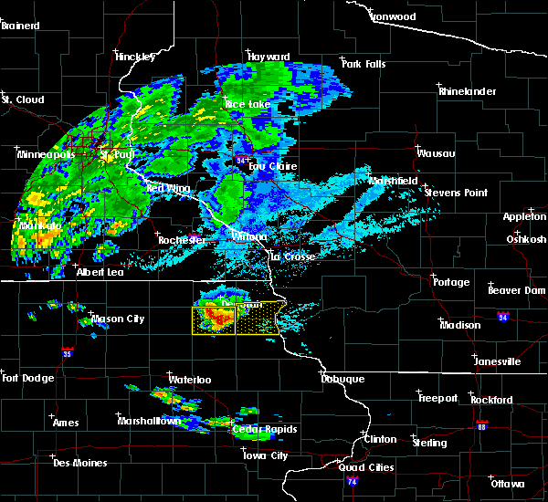 At 1008 am cdt, a severe thunderstorm was located over postville, or 12 miles south of waukon, moving east at 50 mph (trained weather spotters. this storm has a history of producing golf ball size hail and wind damage to trees and power lines). Hazards include golf ball size hail and 60 mph wind gusts. People and animals outdoors will be injured. expect hail damage to roofs, siding, windows, and vehicles. expect wind damage to roofs, siding, and trees. this severe thunderstorm will be near, monona around 1015 am cdt. farmersburg around 1020 am cdt. marquette and mcgregor around 1030 am cdt. harpers ferry around 1035 am cdt. other locations impacted by this severe thunderstorm include hardin, luana, waterville, st. Olaf and clayton. At 1008 am cdt, a severe thunderstorm was located over postville, or 12 miles south of waukon, moving east at 50 mph (trained weather spotters. this storm has a history of producing golf ball size hail and wind damage to trees and power lines). Hazards include golf ball size hail and 60 mph wind gusts. People and animals outdoors will be injured. expect hail damage to roofs, siding, windows, and vehicles. expect wind damage to roofs, siding, and trees. this severe thunderstorm will be near, monona around 1015 am cdt. farmersburg around 1020 am cdt. marquette and mcgregor around 1030 am cdt. harpers ferry around 1035 am cdt. other locations impacted by this severe thunderstorm include hardin, luana, waterville, st. Olaf and clayton.
|
| 5/25/2018 7:09 PM CDT |
 At 707 pm cdt, a severe thunderstorm was located near harpers ferry, or 9 miles north of prairie du chien, moving southeast at 25 mph (law enforcement. widespread tree damage has been reported across the warned area). Hazards include 70 mph wind gusts and quarter size hail. Hail damage to vehicles is expected. expect considerable tree damage. wind damage is also likely to mobile homes, roofs, and outbuildings. Locations impacted include, harpers ferry, seneca, ferryville, waterville, lynxville, rush creek, dalby, yellow river state forest, thompson corner, waukon jct, eldergrove, andy mountain campground, lock and dam 9 and oak ridge. At 707 pm cdt, a severe thunderstorm was located near harpers ferry, or 9 miles north of prairie du chien, moving southeast at 25 mph (law enforcement. widespread tree damage has been reported across the warned area). Hazards include 70 mph wind gusts and quarter size hail. Hail damage to vehicles is expected. expect considerable tree damage. wind damage is also likely to mobile homes, roofs, and outbuildings. Locations impacted include, harpers ferry, seneca, ferryville, waterville, lynxville, rush creek, dalby, yellow river state forest, thompson corner, waukon jct, eldergrove, andy mountain campground, lock and dam 9 and oak ridge.
|
| 5/25/2018 6:59 PM CDT |
 At 643 pm cdt, a severe thunderstorm was located near lansing, moving southeast at 25 mph (law enforcement. tree damage has been reported). Hazards include 60 mph wind gusts. Expect damage to roofs, siding, and trees. this severe thunderstorm will be near, harpers ferry around 710 pm cdt. Other locations impacted by this severe thunderstorm include seneca, ferryville, waterville, lynxville and county roads a 52 and x 52. At 643 pm cdt, a severe thunderstorm was located near lansing, moving southeast at 25 mph (law enforcement. tree damage has been reported). Hazards include 60 mph wind gusts. Expect damage to roofs, siding, and trees. this severe thunderstorm will be near, harpers ferry around 710 pm cdt. Other locations impacted by this severe thunderstorm include seneca, ferryville, waterville, lynxville and county roads a 52 and x 52.
|
| 5/25/2018 6:43 PM CDT |
 At 643 pm cdt, a severe thunderstorm was located near lansing, moving southeast at 25 mph (law enforcement. tree damage has been reported). Hazards include 60 mph wind gusts. Expect damage to roofs, siding, and trees. this severe thunderstorm will be near, harpers ferry around 710 pm cdt. Other locations impacted by this severe thunderstorm include seneca, ferryville, waterville, lynxville and county roads a 52 and x 52. At 643 pm cdt, a severe thunderstorm was located near lansing, moving southeast at 25 mph (law enforcement. tree damage has been reported). Hazards include 60 mph wind gusts. Expect damage to roofs, siding, and trees. this severe thunderstorm will be near, harpers ferry around 710 pm cdt. Other locations impacted by this severe thunderstorm include seneca, ferryville, waterville, lynxville and county roads a 52 and x 52.
|
| 5/25/2018 6:06 PM CDT |
 At 605 pm cdt, a severe thunderstorm was located near new albin, or near lansing, moving southeast at 50 mph (radar indicated). Hazards include 60 mph wind gusts and penny size hail. Expect damage to roofs, siding, and trees. this severe thunderstorm will be near, lansing around 610 pm cdt. harpers ferry around 620 pm cdt. Other locations impacted by this severe thunderstorm include soldiers grove, gays mills, de soto, mount sterling and ferryville. At 605 pm cdt, a severe thunderstorm was located near new albin, or near lansing, moving southeast at 50 mph (radar indicated). Hazards include 60 mph wind gusts and penny size hail. Expect damage to roofs, siding, and trees. this severe thunderstorm will be near, lansing around 610 pm cdt. harpers ferry around 620 pm cdt. Other locations impacted by this severe thunderstorm include soldiers grove, gays mills, de soto, mount sterling and ferryville.
|
| 4/13/2018 7:48 AM CDT |
 At 748 am cdt, a severe thunderstorm was located 12 miles northeast of harpers ferry, or 16 miles east of lansing, moving east at 55 mph (radar indicated). Hazards include quarter size hail. Damage to vehicles is expected. This severe thunderstorm will remain over mainly rural areas of southwestern richland and northern crawford counties, including the following locations: westport, excelsior, seneca, soldiers grove and orion. At 748 am cdt, a severe thunderstorm was located 12 miles northeast of harpers ferry, or 16 miles east of lansing, moving east at 55 mph (radar indicated). Hazards include quarter size hail. Damage to vehicles is expected. This severe thunderstorm will remain over mainly rural areas of southwestern richland and northern crawford counties, including the following locations: westport, excelsior, seneca, soldiers grove and orion.
|
| 9/20/2017 6:16 PM CDT |
 At 616 pm cdt, a severe thunderstorm was located 10 miles northeast of harpers ferry, or 13 miles southeast of lansing, moving northeast at 30 mph (radar indicated). Hazards include 60 mph wind gusts and quarter size hail. Hail damage to vehicles is expected. expect wind damage to roofs, siding, and trees. this severe thunderstorm will be near, clayton around 645 pm cdt. Other locations impacted by this severe thunderstorm include seneca, soldiers grove, gays mills, mount sterling and lynxville. At 616 pm cdt, a severe thunderstorm was located 10 miles northeast of harpers ferry, or 13 miles southeast of lansing, moving northeast at 30 mph (radar indicated). Hazards include 60 mph wind gusts and quarter size hail. Hail damage to vehicles is expected. expect wind damage to roofs, siding, and trees. this severe thunderstorm will be near, clayton around 645 pm cdt. Other locations impacted by this severe thunderstorm include seneca, soldiers grove, gays mills, mount sterling and lynxville.
|
| 7/19/2017 6:53 PM CDT |
 At 652 pm cdt, severe thunderstorms were located along a line extending from clayton to near platteville to east dubuque, moving east at 50 mph (law enforcement. reports continune of widespread wind damage. lancaster reports a great deal of damage. platteville reported a 61 mph wind gust). Hazards include 70 mph wind gusts. Expect considerable tree damage. damage is likely to mobile homes, roofs, and outbuildings. these severe storms will be near, platteville, hazel green and cuba city around 700 pm cdt. Other locations impacted by these severe thunderstorms include westport, excelsior, preston, bridgeport and georgetown. At 652 pm cdt, severe thunderstorms were located along a line extending from clayton to near platteville to east dubuque, moving east at 50 mph (law enforcement. reports continune of widespread wind damage. lancaster reports a great deal of damage. platteville reported a 61 mph wind gust). Hazards include 70 mph wind gusts. Expect considerable tree damage. damage is likely to mobile homes, roofs, and outbuildings. these severe storms will be near, platteville, hazel green and cuba city around 700 pm cdt. Other locations impacted by these severe thunderstorms include westport, excelsior, preston, bridgeport and georgetown.
|
| 7/19/2017 6:45 PM CDT |
 At 644 pm cdt, severe thunderstorms were located along a line extending from near clayton to 7 miles east of lancaster to near centralia, moving east at 60 mph (law enforcement reports high winds across much of western grant county). Hazards include 70 mph wind gusts. Expect considerable tree damage. damage is likely to mobile homes, roofs, and outbuildings. these severe storms will be near, platteville around 650 pm cdt. Hazel green around 705 pm cdt. At 644 pm cdt, severe thunderstorms were located along a line extending from near clayton to 7 miles east of lancaster to near centralia, moving east at 60 mph (law enforcement reports high winds across much of western grant county). Hazards include 70 mph wind gusts. Expect considerable tree damage. damage is likely to mobile homes, roofs, and outbuildings. these severe storms will be near, platteville around 650 pm cdt. Hazel green around 705 pm cdt.
|
| 7/19/2017 6:36 PM CDT |
 At 634 pm cdt, severe thunderstorms were located along a line extending from 8 miles southwest of clayton to near lancaster to near bankston, moving east at 65 mph (trained weather spotters. wind estimates of 60 to 70 mph were reported east of prairie du chien. damage continues to occur to trees and power lines). Hazards include 70 mph wind gusts. Expect considerable tree damage. damage is likely to mobile homes, roofs, and outbuildings. these severe storms will be near, lancaster and fennimore around 640 pm cdt. platteville and dickeyville around 650 pm cdt. cuba city around 655 pm cdt. Hazel green around 700 pm cdt. At 634 pm cdt, severe thunderstorms were located along a line extending from 8 miles southwest of clayton to near lancaster to near bankston, moving east at 65 mph (trained weather spotters. wind estimates of 60 to 70 mph were reported east of prairie du chien. damage continues to occur to trees and power lines). Hazards include 70 mph wind gusts. Expect considerable tree damage. damage is likely to mobile homes, roofs, and outbuildings. these severe storms will be near, lancaster and fennimore around 640 pm cdt. platteville and dickeyville around 650 pm cdt. cuba city around 655 pm cdt. Hazel green around 700 pm cdt.
|
| 7/19/2017 6:26 PM CDT |
 At 623 pm cdt, severe thunderstorms were located along a line extending from 10 miles east of lansing to near bloomington to near colesburg, moving east at 65 mph (trained weather spotters. these storms have a history of wind damage with northern fayette county reporting widespread damage. extreme winds were reported in waukon at 620 pm). Hazards include 70 mph wind gusts. Expect considerable tree damage. damage is likely to mobile homes, roofs, and outbuildings. these severe storms will be near, clayton around 635 pm cdt. lancaster, fennimore and boscobel around 640 pm cdt. platteville and dickeyville around 650 pm cdt. hazel green and cuba city around 655 pm cdt. abandon your canoe on shore if on the wisconsin river. These winds will flip a canoe on water. At 623 pm cdt, severe thunderstorms were located along a line extending from 10 miles east of lansing to near bloomington to near colesburg, moving east at 65 mph (trained weather spotters. these storms have a history of wind damage with northern fayette county reporting widespread damage. extreme winds were reported in waukon at 620 pm). Hazards include 70 mph wind gusts. Expect considerable tree damage. damage is likely to mobile homes, roofs, and outbuildings. these severe storms will be near, clayton around 635 pm cdt. lancaster, fennimore and boscobel around 640 pm cdt. platteville and dickeyville around 650 pm cdt. hazel green and cuba city around 655 pm cdt. abandon your canoe on shore if on the wisconsin river. These winds will flip a canoe on water.
|
| 7/19/2017 6:02 PM CDT |
 At 600 pm cdt, severe thunderstorms were located along a line extending from near houston to near farmersburg to near strawberry point, moving east at 60 mph (trained weather spotters. these storms have a history of producing wind damage to power lines and trees). Hazards include 70 mph wind gusts. Expect considerable tree damage. damage is likely to mobile homes, roofs, and outbuildings. severe thunderstorms will be near, prairie du chien around 615 pm cdt. bloomington and cassville around 625 pm cdt. lancaster and fennimore around 640 pm cdt. clayton around 645 pm cdt. platteville and dickeyville around 650 pm cdt. cuba city around 655 pm cdt. Hazel green around 700 pm cdt. At 600 pm cdt, severe thunderstorms were located along a line extending from near houston to near farmersburg to near strawberry point, moving east at 60 mph (trained weather spotters. these storms have a history of producing wind damage to power lines and trees). Hazards include 70 mph wind gusts. Expect considerable tree damage. damage is likely to mobile homes, roofs, and outbuildings. severe thunderstorms will be near, prairie du chien around 615 pm cdt. bloomington and cassville around 625 pm cdt. lancaster and fennimore around 640 pm cdt. clayton around 645 pm cdt. platteville and dickeyville around 650 pm cdt. cuba city around 655 pm cdt. Hazel green around 700 pm cdt.
|
| 5/17/2017 7:47 PM CDT |
 At 747 pm cdt, severe thunderstorms were located along a line extending from 9 miles east of lansing to near belmont, moving northeast at 50 mph (law enforcement. winds of 65 mph were reported in eastman at 745 pm). Hazards include 70 mph wind gusts. Expect considerable tree damage. damage is likely to mobile homes, roofs, and outbuildings. locations impacted include, platteville, lansing, fennimore, cuba city, hazel green, dickeyville, preston, georgetown, seneca, arthur, wauzeka, ellenboro, union, de soto, ferryville, lynxville, woodman, steuben, highway 61 and county t and stitzer. A tornado watch remains in effect until 1100 pm cdt for northeastern iowa, and southwestern wisconsin. At 747 pm cdt, severe thunderstorms were located along a line extending from 9 miles east of lansing to near belmont, moving northeast at 50 mph (law enforcement. winds of 65 mph were reported in eastman at 745 pm). Hazards include 70 mph wind gusts. Expect considerable tree damage. damage is likely to mobile homes, roofs, and outbuildings. locations impacted include, platteville, lansing, fennimore, cuba city, hazel green, dickeyville, preston, georgetown, seneca, arthur, wauzeka, ellenboro, union, de soto, ferryville, lynxville, woodman, steuben, highway 61 and county t and stitzer. A tornado watch remains in effect until 1100 pm cdt for northeastern iowa, and southwestern wisconsin.
|
| 5/17/2017 7:40 PM CDT |
 At 739 pm cdt, severe thunderstorms were located along a line extending from near lansing to near platteville, moving northeast at 50 mph (law enforcement. in southwest wisconsin...65-75 mph winds have caused extensive damage to trees and outbuildings. further north toward the minnesota-iowa border, 50-60 mph winds have been reported). Hazards include 70 mph wind gusts. Expect considerable tree damage. damage is likely to mobile homes, roofs, and outbuildings. these severe thunderstorms will remain over mainly rural areas of central allamakee, grant and southwestern crawford counties, including the following locations: preston, bridgeport, georgetown, seneca and arthur. A tornado watch remains in effect until 1100 pm cdt for northeastern iowa, and southwestern wisconsin. At 739 pm cdt, severe thunderstorms were located along a line extending from near lansing to near platteville, moving northeast at 50 mph (law enforcement. in southwest wisconsin...65-75 mph winds have caused extensive damage to trees and outbuildings. further north toward the minnesota-iowa border, 50-60 mph winds have been reported). Hazards include 70 mph wind gusts. Expect considerable tree damage. damage is likely to mobile homes, roofs, and outbuildings. these severe thunderstorms will remain over mainly rural areas of central allamakee, grant and southwestern crawford counties, including the following locations: preston, bridgeport, georgetown, seneca and arthur. A tornado watch remains in effect until 1100 pm cdt for northeastern iowa, and southwestern wisconsin.
|
| 5/17/2017 7:25 PM CDT |
 At 725 pm cdt, severe thunderstorms were located along a line extending from 6 miles northwest of harpers ferry to dickeyville, moving northeast at 65 mph (law enforcement. 75 mph winds were reported at patch grove in southwet wisconsin and 70 mph winds in glen haven wisconsin between 710 and 720 pm). Hazards include 70 mph wind gusts. Expect considerable tree damage. damage is likely to mobile homes, roofs, and outbuildings. these severe storms will be near, cuba city and hazel green around 730 pm cdt. platteville around 735 pm cdt. other locations impacted by these severe thunderstorms include hardin, preston, bridgeport, georgetown and seneca. A tornado watch remains in effect until 1100 pm cdt for northeastern iowa, southeastern minnesota, and southwestern wisconsin. At 725 pm cdt, severe thunderstorms were located along a line extending from 6 miles northwest of harpers ferry to dickeyville, moving northeast at 65 mph (law enforcement. 75 mph winds were reported at patch grove in southwet wisconsin and 70 mph winds in glen haven wisconsin between 710 and 720 pm). Hazards include 70 mph wind gusts. Expect considerable tree damage. damage is likely to mobile homes, roofs, and outbuildings. these severe storms will be near, cuba city and hazel green around 730 pm cdt. platteville around 735 pm cdt. other locations impacted by these severe thunderstorms include hardin, preston, bridgeport, georgetown and seneca. A tornado watch remains in effect until 1100 pm cdt for northeastern iowa, southeastern minnesota, and southwestern wisconsin.
|
| 5/17/2017 7:19 PM CDT |
 At 717 pm cdt, severe thunderstorms were located along a line extending from near waukon to durango, moving northeast at 70 mph (law enforcement. 70 mph winds were reported at garber...60- 70 mph winds in glen haven wisconsin, and guttenberg reported 50 mph all around 710 pm). Hazards include 70 mph wind gusts. Expect considerable tree damage. damage is likely to mobile homes, roofs, and outbuildings. these severe storms will be near, harpers ferry around 725 pm cdt. lansing and cuba city around 730 pm cdt. platteville, lancaster and new albin around 735 pm cdt. fennimore around 740 pm cdt. other locations impacted by these severe thunderstorms include hardin, preston, bridgeport, georgetown and seneca. A tornado watch remains in effect until 1100 pm cdt for northeastern iowa, southeastern minnesota, and southwestern wisconsin. At 717 pm cdt, severe thunderstorms were located along a line extending from near waukon to durango, moving northeast at 70 mph (law enforcement. 70 mph winds were reported at garber...60- 70 mph winds in glen haven wisconsin, and guttenberg reported 50 mph all around 710 pm). Hazards include 70 mph wind gusts. Expect considerable tree damage. damage is likely to mobile homes, roofs, and outbuildings. these severe storms will be near, harpers ferry around 725 pm cdt. lansing and cuba city around 730 pm cdt. platteville, lancaster and new albin around 735 pm cdt. fennimore around 740 pm cdt. other locations impacted by these severe thunderstorms include hardin, preston, bridgeport, georgetown and seneca. A tornado watch remains in effect until 1100 pm cdt for northeastern iowa, southeastern minnesota, and southwestern wisconsin.
|
| 5/17/2017 7:09 PM CDT |
 At 706 pm cdt, severe thunderstorms were located along a line extending from near decorah to 10 miles southwest of dubuque, moving northeast at 50 mph (law enforcement. these storms have a history of wind damage from gusts to 70 mph). Hazards include 70 mph wind gusts. Expect considerable tree damage. damage is likely to mobile homes, roofs, and outbuildings. these severe storms will be near, monona around 720 pm cdt. waukon around 730 pm cdt. dickeyville around 735 pm cdt. hazel green and harpers ferry around 740 pm cdt. lansing and cuba city around 745 pm cdt. platteville and new albin around 750 pm cdt. other locations impacted by these severe thunderstorms include hardin, preston, bridgeport, georgetown and seneca. A tornado watch remains in effect until 1100 pm cdt for northeastern iowa, southeastern minnesota, and southwestern wisconsin. At 706 pm cdt, severe thunderstorms were located along a line extending from near decorah to 10 miles southwest of dubuque, moving northeast at 50 mph (law enforcement. these storms have a history of wind damage from gusts to 70 mph). Hazards include 70 mph wind gusts. Expect considerable tree damage. damage is likely to mobile homes, roofs, and outbuildings. these severe storms will be near, monona around 720 pm cdt. waukon around 730 pm cdt. dickeyville around 735 pm cdt. hazel green and harpers ferry around 740 pm cdt. lansing and cuba city around 745 pm cdt. platteville and new albin around 750 pm cdt. other locations impacted by these severe thunderstorms include hardin, preston, bridgeport, georgetown and seneca. A tornado watch remains in effect until 1100 pm cdt for northeastern iowa, southeastern minnesota, and southwestern wisconsin.
|
| 5/17/2017 7:00 PM CDT |
 At 659 pm cdt, severe thunderstorms were located along a line extending from near clermont to near bernard, moving northeast at 50 mph (law enforcement). Hazards include 70 mph wind gusts. Expect considerable tree damage. damage is likely to mobile homes, roofs, and outbuildings. severe thunderstorms will be near, postville around 715 pm cdt. monona around 720 pm cdt. waukon around 730 pm cdt. hazel green and dickeyville around 735 pm cdt. cuba city and harpers ferry around 740 pm cdt. lansing around 745 pm cdt. platteville and new albin around 750 pm cdt. other locations impacted by these severe thunderstorms include hardin, preston, bridgeport, georgetown and seneca. A tornado watch remains in effect until 1100 pm cdt for northeastern iowa, southeastern minnesota, and southwestern wisconsin. At 659 pm cdt, severe thunderstorms were located along a line extending from near clermont to near bernard, moving northeast at 50 mph (law enforcement). Hazards include 70 mph wind gusts. Expect considerable tree damage. damage is likely to mobile homes, roofs, and outbuildings. severe thunderstorms will be near, postville around 715 pm cdt. monona around 720 pm cdt. waukon around 730 pm cdt. hazel green and dickeyville around 735 pm cdt. cuba city and harpers ferry around 740 pm cdt. lansing around 745 pm cdt. platteville and new albin around 750 pm cdt. other locations impacted by these severe thunderstorms include hardin, preston, bridgeport, georgetown and seneca. A tornado watch remains in effect until 1100 pm cdt for northeastern iowa, southeastern minnesota, and southwestern wisconsin.
|
| 5/17/2017 4:22 PM CDT |
 At 421 pm cdt, a severe thunderstorm was located near monona, or 11 miles north of elkader, moving north at 55 mph (law enforcement. large tree limbs have been downed in volga, in clayton county iowa 411 pm). Hazards include 70 mph wind gusts and quarter size hail. Hail damage to vehicles is expected. expect considerable tree damage. wind damage is also likely to mobile homes, roofs, and outbuildings. this severe thunderstorm will be near, waukon and harpers ferry around 440 pm cdt. lansing around 450 pm cdt. new albin around 500 pm cdt. other locations impacted by this severe thunderstorm include hardin, de soto, ferryville, waterville and lynxville. A tornado watch remains in effect until 1100 pm cdt for northeastern iowa, and southwestern wisconsin. At 421 pm cdt, a severe thunderstorm was located near monona, or 11 miles north of elkader, moving north at 55 mph (law enforcement. large tree limbs have been downed in volga, in clayton county iowa 411 pm). Hazards include 70 mph wind gusts and quarter size hail. Hail damage to vehicles is expected. expect considerable tree damage. wind damage is also likely to mobile homes, roofs, and outbuildings. this severe thunderstorm will be near, waukon and harpers ferry around 440 pm cdt. lansing around 450 pm cdt. new albin around 500 pm cdt. other locations impacted by this severe thunderstorm include hardin, de soto, ferryville, waterville and lynxville. A tornado watch remains in effect until 1100 pm cdt for northeastern iowa, and southwestern wisconsin.
|
| 9/19/2016 2:40 PM CDT |
 At 239 pm cdt, a severe thunderstorm was located near lansing, moving east at 35 mph (radar indicated). Hazards include 60 mph wind gusts and quarter size hail. Hail damage to vehicles is expected. expect wind damage to roofs, siding, and trees. This severe thunderstorm will remain over mainly rural areas of northeastern allamakee county, including the following locations: waterville, village creek, county roads a 52 and x 52, andy mountain campground and elon. At 239 pm cdt, a severe thunderstorm was located near lansing, moving east at 35 mph (radar indicated). Hazards include 60 mph wind gusts and quarter size hail. Hail damage to vehicles is expected. expect wind damage to roofs, siding, and trees. This severe thunderstorm will remain over mainly rural areas of northeastern allamakee county, including the following locations: waterville, village creek, county roads a 52 and x 52, andy mountain campground and elon.
|
| 9/19/2016 2:24 PM CDT |
 At 223 pm cdt, a severe thunderstorm was located near waukon, moving east at 35 mph (radar indicated). Hazards include 60 mph wind gusts and quarter size hail. Hail damage is possible. this severe thunderstorm will be near, lansing around 240 pm cdt. harpers ferry around 245 pm cdt. Hail is the main threat from this storm. At 223 pm cdt, a severe thunderstorm was located near waukon, moving east at 35 mph (radar indicated). Hazards include 60 mph wind gusts and quarter size hail. Hail damage is possible. this severe thunderstorm will be near, lansing around 240 pm cdt. harpers ferry around 245 pm cdt. Hail is the main threat from this storm.
|
| 8/4/2016 4:58 PM CDT |
 The severe thunderstorm warning for east central allamakee county will expire at 500 pm cdt, the storm which prompted the warning has moved out of the area. therefore the warning will be allowed to expire. however heavy rain is still possible with this thunderstorm. a severe thunderstorm watch remains in effect until midnight cdt for northeastern iowa, and southwestern wisconsin. The severe thunderstorm warning for east central allamakee county will expire at 500 pm cdt, the storm which prompted the warning has moved out of the area. therefore the warning will be allowed to expire. however heavy rain is still possible with this thunderstorm. a severe thunderstorm watch remains in effect until midnight cdt for northeastern iowa, and southwestern wisconsin.
|
| 8/4/2016 4:49 PM CDT |
 At 448 pm cdt, a severe thunderstorm was located near harpers ferry, or 8 miles southeast of lansing, moving east at 35 mph (radar indicated). Hazards include 60 mph wind gusts. Expect damage to roofs. siding. and trees. This severe thunderstorm will remain over mainly rural areas of east central allamakee county, including the following locations: dalby, village creek, thompson corner, lock and dam 9 and county roads a 52 and x 52. At 448 pm cdt, a severe thunderstorm was located near harpers ferry, or 8 miles southeast of lansing, moving east at 35 mph (radar indicated). Hazards include 60 mph wind gusts. Expect damage to roofs. siding. and trees. This severe thunderstorm will remain over mainly rural areas of east central allamakee county, including the following locations: dalby, village creek, thompson corner, lock and dam 9 and county roads a 52 and x 52.
|
| 8/4/2016 4:30 PM CDT |
 At 430 pm cdt, a severe thunderstorm was located near lansing, moving east at 35 mph (radar indicated). Hazards include 60 mph wind gusts and quarter size hail. Hail damage to vehicles is expected. expect wind damage to roofs, siding, and trees. this severe storm will be near, lansing around 435 pm cdt. Other locations impacted by this severe thunderstorm include village creek, county roads a 52 and x 52, county roads a 26 and x 6 a, elon and red barn campground. At 430 pm cdt, a severe thunderstorm was located near lansing, moving east at 35 mph (radar indicated). Hazards include 60 mph wind gusts and quarter size hail. Hail damage to vehicles is expected. expect wind damage to roofs, siding, and trees. this severe storm will be near, lansing around 435 pm cdt. Other locations impacted by this severe thunderstorm include village creek, county roads a 52 and x 52, county roads a 26 and x 6 a, elon and red barn campground.
|
| 8/4/2016 4:18 PM CDT |
 At 418 pm cdt, a severe thunderstorm was located 7 miles north of waukon, moving east at 35 mph (radar indicated). Hazards include 60 mph wind gusts and half dollar size hail. Hail damage to vehicles is expected. expect wind damage to roofs, siding, and trees. this severe thunderstorm will be near, new albin around 425 pm cdt. lansing around 435 pm cdt. Other locations impacted by this severe thunderstorm include village creek, county roads a 52 and x 52, county roads a 26 and x 6 a, elon and red barn campground. At 418 pm cdt, a severe thunderstorm was located 7 miles north of waukon, moving east at 35 mph (radar indicated). Hazards include 60 mph wind gusts and half dollar size hail. Hail damage to vehicles is expected. expect wind damage to roofs, siding, and trees. this severe thunderstorm will be near, new albin around 425 pm cdt. lansing around 435 pm cdt. Other locations impacted by this severe thunderstorm include village creek, county roads a 52 and x 52, county roads a 26 and x 6 a, elon and red barn campground.
|
| 7/5/2016 11:01 PM CDT |
 At 1101 pm cdt, a severe thunderstorm was located near clayton, or 13 miles west of richland center, moving east at 40 mph (radar indicated). Hazards include 70 mph wind gusts. Expect considerable tree damage. damage is likely to mobile homes, roofs, and outbuildings. This severe thunderstorm will remain over mainly rural areas of northern crawford county, including the following locations: seneca, soldiers grove, gays mills, mount sterling and lynxville. At 1101 pm cdt, a severe thunderstorm was located near clayton, or 13 miles west of richland center, moving east at 40 mph (radar indicated). Hazards include 70 mph wind gusts. Expect considerable tree damage. damage is likely to mobile homes, roofs, and outbuildings. This severe thunderstorm will remain over mainly rural areas of northern crawford county, including the following locations: seneca, soldiers grove, gays mills, mount sterling and lynxville.
|
| 7/5/2016 10:34 PM CDT |
 At 1034 pm cdt, a severe thunderstorm was located 9 miles southwest of viroqua, moving east at 40 mph (radar indicated). Hazards include 70 mph wind gusts. Expect considerable tree damage. damage is likely to mobile homes, roofs, and outbuildings. this severe thunderstorm will be near, clayton around 1055 pm cdt. Other locations impacted by this severe thunderstorm include seneca, soldiers grove, gays mills, de soto and mount sterling. At 1034 pm cdt, a severe thunderstorm was located 9 miles southwest of viroqua, moving east at 40 mph (radar indicated). Hazards include 70 mph wind gusts. Expect considerable tree damage. damage is likely to mobile homes, roofs, and outbuildings. this severe thunderstorm will be near, clayton around 1055 pm cdt. Other locations impacted by this severe thunderstorm include seneca, soldiers grove, gays mills, de soto and mount sterling.
|
| 5/26/2016 5:51 AM CDT |
 At 549 am cdt, severe thunderstorms were located along a line extending from 8 miles east of new albin to 10 miles west of clayton, moving northeast at 55 mph. around 5 am, power lines were downed in monona in northern clayton county. since that time, .no additional reports have been received (law enforcement). Hazards include 60 mph wind gusts. Expect damage to roofs. siding. and trees. these severe storms will be near, clayton around 600 am cdt. Other locations impacted by these severe thunderstorms include hardin, seneca, viola, soldiers grove and gays mills. At 549 am cdt, severe thunderstorms were located along a line extending from 8 miles east of new albin to 10 miles west of clayton, moving northeast at 55 mph. around 5 am, power lines were downed in monona in northern clayton county. since that time, .no additional reports have been received (law enforcement). Hazards include 60 mph wind gusts. Expect damage to roofs. siding. and trees. these severe storms will be near, clayton around 600 am cdt. Other locations impacted by these severe thunderstorms include hardin, seneca, viola, soldiers grove and gays mills.
|
| 5/26/2016 5:28 AM CDT |
 At 528 am cdt, severe thunderstorms were located along a line extending from near waukon to near prairie du chien, moving northeast at 70 mph (radar indicated). Hazards include 60 mph wind gusts. Expect damage to roofs. siding. and trees. severe thunderstorms will be near, lansing around 545 am cdt. clayton around 550 am cdt. Other locations impacted by these severe thunderstorms include hardin, seneca, viola, soldiers grove and gays mills. At 528 am cdt, severe thunderstorms were located along a line extending from near waukon to near prairie du chien, moving northeast at 70 mph (radar indicated). Hazards include 60 mph wind gusts. Expect damage to roofs. siding. and trees. severe thunderstorms will be near, lansing around 545 am cdt. clayton around 550 am cdt. Other locations impacted by these severe thunderstorms include hardin, seneca, viola, soldiers grove and gays mills.
|
| 6/29/2015 6:42 PM CDT |
 At 641 pm cdt, a severe thunderstorm was located near bloomington, or 9 miles southeast of prairie du chien, moving south at 25 mph (radar indicated). Hazards include quarter size hail. Damage to vehicles is expected. Locations impacted include, harpers ferry, eastman, lynxville, andy mountain campground, yellow river state forest and the mississippi river near lynxville. At 641 pm cdt, a severe thunderstorm was located near bloomington, or 9 miles southeast of prairie du chien, moving south at 25 mph (radar indicated). Hazards include quarter size hail. Damage to vehicles is expected. Locations impacted include, harpers ferry, eastman, lynxville, andy mountain campground, yellow river state forest and the mississippi river near lynxville.
|
| 6/29/2015 6:29 PM CDT |
 At 628 pm cdt, a severe thunderstorm was located over harpers ferry, or 9 miles north of prairie du chien, moving south at 25 mph (public). Hazards include quarter size hail. Damage to vehicles is expected. This severe thunderstorm will remain over mainly rural areas of southeastern allamakee and west central crawford counties, including the following locations, eastman, waterville, lynxville, effigy mounds and lock and dam 9. At 628 pm cdt, a severe thunderstorm was located over harpers ferry, or 9 miles north of prairie du chien, moving south at 25 mph (public). Hazards include quarter size hail. Damage to vehicles is expected. This severe thunderstorm will remain over mainly rural areas of southeastern allamakee and west central crawford counties, including the following locations, eastman, waterville, lynxville, effigy mounds and lock and dam 9.
|
| 6/29/2015 6:26 PM CDT |
 At 625 pm cdt, a severe thunderstorm was located over harpers ferry, or 10 miles north of prairie du chien, moving south at 25 mph (public). Hazards include quarter size hail reported between lansing and harpers ferry. Damage to vehicles is expected. This severe thunderstorm will remain over mainly rural areas of southeastern allamakee and northwestern crawford counties, including the following locations, seneca, eastman, ferryville, waterville and lynxville. At 625 pm cdt, a severe thunderstorm was located over harpers ferry, or 10 miles north of prairie du chien, moving south at 25 mph (public). Hazards include quarter size hail reported between lansing and harpers ferry. Damage to vehicles is expected. This severe thunderstorm will remain over mainly rural areas of southeastern allamakee and northwestern crawford counties, including the following locations, seneca, eastman, ferryville, waterville and lynxville.
|
| 6/29/2015 6:21 PM CDT |
 At 621 pm cdt, a severe thunderstorm was located near harpers ferry, or 8 miles south of lansing, moving south at 25 mph (public). Hazards include quarter size hail. Damage to vehicles is expected. this severe storm will be near, harpers ferry around 630 pm cdt. Other locations impacted by this severe thunderstorm include seneca, eastman, ferryville, waterville and lynxville. At 621 pm cdt, a severe thunderstorm was located near harpers ferry, or 8 miles south of lansing, moving south at 25 mph (public). Hazards include quarter size hail. Damage to vehicles is expected. this severe storm will be near, harpers ferry around 630 pm cdt. Other locations impacted by this severe thunderstorm include seneca, eastman, ferryville, waterville and lynxville.
|
| 6/29/2015 6:10 PM CDT |
 At 609 pm cdt, a severe thunderstorm was located over lansing, moving south at 25 mph (public). Hazards include quarter size hail reported about 2 miles northwest of lansing iowa. Damage to vehicles is expected. this severe storm will be near, harpers ferry around 640 pm cdt. Other locations impacted by this severe thunderstorm include seneca, eastman, de soto, ferryville and waterville. At 609 pm cdt, a severe thunderstorm was located over lansing, moving south at 25 mph (public). Hazards include quarter size hail reported about 2 miles northwest of lansing iowa. Damage to vehicles is expected. this severe storm will be near, harpers ferry around 640 pm cdt. Other locations impacted by this severe thunderstorm include seneca, eastman, de soto, ferryville and waterville.
|
| 6/29/2015 6:06 PM CDT |
 At 606 pm cdt, a severe thunderstorm was located over lansing, moving south at 25 mph (radar indicated). Hazards include quarter size hail. Damage to vehicles is expected. this severe thunderstorm will be near, lansing around 610 pm cdt. harpers ferry around 635 pm cdt. Other locations impacted by this severe thunderstorm include seneca, eastman, de soto, ferryville and waterville. At 606 pm cdt, a severe thunderstorm was located over lansing, moving south at 25 mph (radar indicated). Hazards include quarter size hail. Damage to vehicles is expected. this severe thunderstorm will be near, lansing around 610 pm cdt. harpers ferry around 635 pm cdt. Other locations impacted by this severe thunderstorm include seneca, eastman, de soto, ferryville and waterville.
|
| 6/22/2015 8:42 AM CDT |
 At 842 am cdt, severe thunderstorms were located along a line extending from near soldiers grove to 6 miles north of boscobel to 12 miles northeast of prairie du chien, moving east at 40 mph. this was part of a cluster of storms that was hitting nearly the entire county (radar indicated). Hazards include 60 mph wind gusts. Expect damage to roofs. siding and trees. these severe storms will be near, soldiers grove around 845 am cdt. boscobel around 855 am cdt. Other locations impacted by these severe thunderstorms include bridgeport, seneca, wauzeka, clayton and gays mills. At 842 am cdt, severe thunderstorms were located along a line extending from near soldiers grove to 6 miles north of boscobel to 12 miles northeast of prairie du chien, moving east at 40 mph. this was part of a cluster of storms that was hitting nearly the entire county (radar indicated). Hazards include 60 mph wind gusts. Expect damage to roofs. siding and trees. these severe storms will be near, soldiers grove around 845 am cdt. boscobel around 855 am cdt. Other locations impacted by these severe thunderstorms include bridgeport, seneca, wauzeka, clayton and gays mills.
|
| 6/22/2015 8:27 AM CDT |
 At 826 am cdt, severe thunderstorms were located along a line extending from 10 miles southwest of viroqua to 8 miles southwest of soldiers grove to near harpers ferry, moving east at 65 mph (radar indicated). Hazards include 60 mph wind gusts. Expect damage to roofs. siding and trees. severe thunderstorms will be near, soldiers grove around 835 am cdt. boscobel around 840 am cdt. Other locations impacted by these severe thunderstorms include bridgeport, seneca, wauzeka, clayton and gays mills. At 826 am cdt, severe thunderstorms were located along a line extending from 10 miles southwest of viroqua to 8 miles southwest of soldiers grove to near harpers ferry, moving east at 65 mph (radar indicated). Hazards include 60 mph wind gusts. Expect damage to roofs. siding and trees. severe thunderstorms will be near, soldiers grove around 835 am cdt. boscobel around 840 am cdt. Other locations impacted by these severe thunderstorms include bridgeport, seneca, wauzeka, clayton and gays mills.
|
| 6/22/2015 7:21 AM CDT |
 At 721 am cdt, a severe thunderstorm was located 7 miles southeast of harpers ferry, or 9 miles northeast of prairie du chien, moving northeast at 30 mph (radar indicated). Hazards include quarter size hail. Damage to vehicles is expected. this severe storm will be near, boscobel around 745 am cdt. soldiers grove around 800 am cdt. Other locations impacted by this severe thunderstorm include bridgeport, seneca, wauzeka, clayton and gays mills. At 721 am cdt, a severe thunderstorm was located 7 miles southeast of harpers ferry, or 9 miles northeast of prairie du chien, moving northeast at 30 mph (radar indicated). Hazards include quarter size hail. Damage to vehicles is expected. this severe storm will be near, boscobel around 745 am cdt. soldiers grove around 800 am cdt. Other locations impacted by this severe thunderstorm include bridgeport, seneca, wauzeka, clayton and gays mills.
|
| 6/22/2015 7:08 AM CDT |
 At 708 am cdt, a severe thunderstorm was located over prairie du chien, moving northeast at 25 mph (radar indicated). Hazards include quarter size hail. Damage to vehicles is expected. this severe storm will be near, soldiers grove around 800 am cdt. Other locations impacted by this severe thunderstorm include bridgeport, seneca, wauzeka, clayton and gays mills. At 708 am cdt, a severe thunderstorm was located over prairie du chien, moving northeast at 25 mph (radar indicated). Hazards include quarter size hail. Damage to vehicles is expected. this severe storm will be near, soldiers grove around 800 am cdt. Other locations impacted by this severe thunderstorm include bridgeport, seneca, wauzeka, clayton and gays mills.
|
| 6/22/2015 6:54 AM CDT |
 At 654 am cdt, a severe thunderstorm was located over mcgregor, or over prairie du chien, moving northeast at 30 mph (radar indicated). Hazards include golf ball size hail. People and animals outdoors will be injured. expect damage to roofs, siding, windows and vehicles. this severe thunderstorm will be near, prairie du chien around 700 am. boscobel around 745 am cdt. soldiers grove around 800 am cdt. Other locations impacted by this severe thunderstorm include bridgeport, seneca, wauzeka, clayton and gays mills. At 654 am cdt, a severe thunderstorm was located over mcgregor, or over prairie du chien, moving northeast at 30 mph (radar indicated). Hazards include golf ball size hail. People and animals outdoors will be injured. expect damage to roofs, siding, windows and vehicles. this severe thunderstorm will be near, prairie du chien around 700 am. boscobel around 745 am cdt. soldiers grove around 800 am cdt. Other locations impacted by this severe thunderstorm include bridgeport, seneca, wauzeka, clayton and gays mills.
|
Hail Maps for Lynxville, WI


Connect with Interactive Hail Maps