

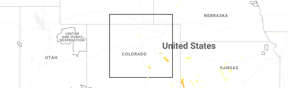
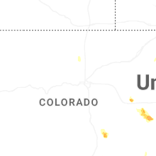
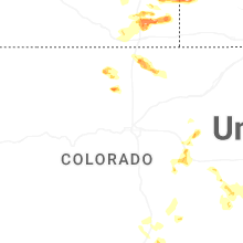
Hail Map for Lyons, CO
The Lyons, CO area has had 9 reports of on-the-ground hail by trained spotters, and has been under severe weather warnings 7 times during the past 12 months. Doppler radar has detected hail at or near Lyons, CO on 33 occasions, including 4 occasions during the past year.
| Name: | Lyons, CO |
| Where Located: | 36.4 miles NNW of Denver, CO |
| Map: | Google Map for Lyons, CO |
| Population: | 2033 |
| Housing Units: | 904 |
| More Info: | Search Google for Lyons, CO |
0
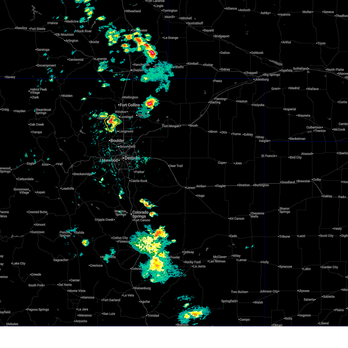
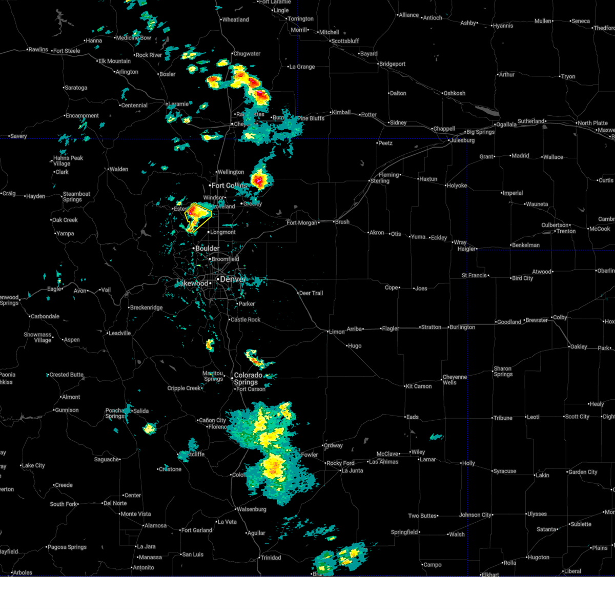
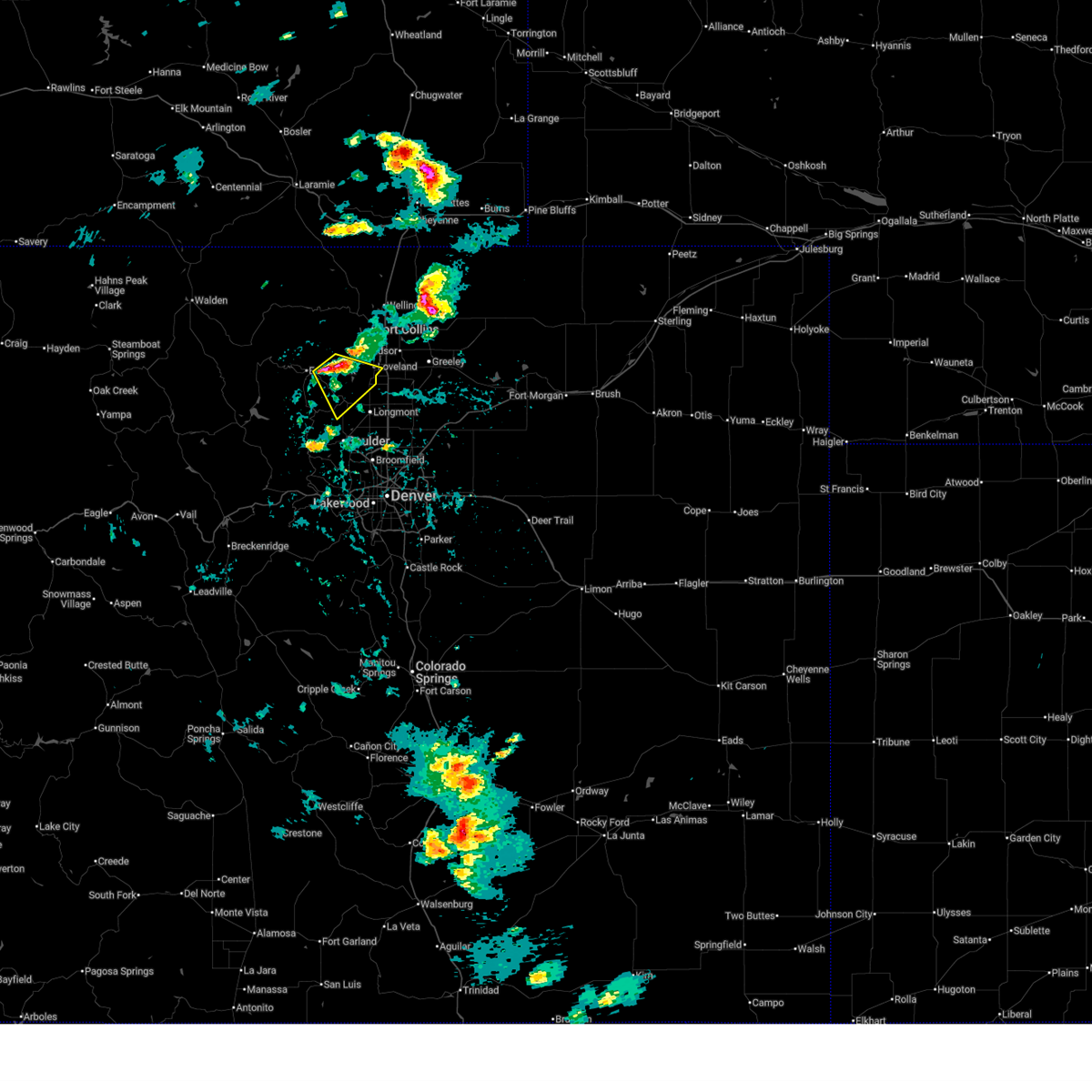
The Top Recent Hail Date for Lyons, CO is Saturday, July 5, 2025 (28th out of 33)
Hail and Wind Damage Spotted near Lyons, CO
| Date / Time | Report Details |
|---|---|
| 6/29/2025 4:29 PM MDT |
 The storm which prompted the warning has weakened below severe limits, and no longer poses an immediate threat to life or property. therefore, the warning will be allowed to expire. however, small hail and gusty winds are still possible with this thunderstorm. to report severe weather, contact your nearest law enforcement agency. they will send your report to the national weather service office. a severe thunderstorm watch remains in effect until 900 pm mdt sunday for portions of north central and northeast colorado. The storm which prompted the warning has weakened below severe limits, and no longer poses an immediate threat to life or property. therefore, the warning will be allowed to expire. however, small hail and gusty winds are still possible with this thunderstorm. to report severe weather, contact your nearest law enforcement agency. they will send your report to the national weather service office. a severe thunderstorm watch remains in effect until 900 pm mdt sunday for portions of north central and northeast colorado.
|
| 6/29/2025 4:25 PM MDT | Quarter sized hail reported 6.7 miles S of Lyons, CO |
| 6/29/2025 4:16 PM MDT |
 At 416 pm mdt, a severe thunderstorm was located near carter lake, or 19 miles southwest of fort collins, moving southeast at 10 mph (radar indicated). Hazards include 60 mph wind gusts and quarter size hail. Hail damage to vehicles is expected. expect wind damage to roofs, siding, and trees. Locations impacted include, southern loveland, berthoud, lyons, carter lake and campion. At 416 pm mdt, a severe thunderstorm was located near carter lake, or 19 miles southwest of fort collins, moving southeast at 10 mph (radar indicated). Hazards include 60 mph wind gusts and quarter size hail. Hail damage to vehicles is expected. expect wind damage to roofs, siding, and trees. Locations impacted include, southern loveland, berthoud, lyons, carter lake and campion.
|
| 6/29/2025 3:47 PM MDT |
 Svrbou the national weather service in denver has issued a * severe thunderstorm warning for, southeastern larimer county in north central colorado, northwest boulder and northeast boulder county in northeastern colorado, * until 430 pm mdt. * at 347 pm mdt, a severe thunderstorm was located near drake, or 19 miles southwest of fort collins, moving southeast at 15 mph (radar indicated). Hazards include ping pong ball size hail and 60 mph wind gusts. People and animals outdoors will be injured. expect hail damage to roofs, siding, windows, and vehicles. Expect wind damage to roofs, siding, and trees. Svrbou the national weather service in denver has issued a * severe thunderstorm warning for, southeastern larimer county in north central colorado, northwest boulder and northeast boulder county in northeastern colorado, * until 430 pm mdt. * at 347 pm mdt, a severe thunderstorm was located near drake, or 19 miles southwest of fort collins, moving southeast at 15 mph (radar indicated). Hazards include ping pong ball size hail and 60 mph wind gusts. People and animals outdoors will be injured. expect hail damage to roofs, siding, windows, and vehicles. Expect wind damage to roofs, siding, and trees.
|
| 7/20/2024 8:33 PM MDT |
 The storm which prompted the warning has moved out of the area. therefore, the warning has been allowed to expire. The storm which prompted the warning has moved out of the area. therefore, the warning has been allowed to expire.
|
| 7/20/2024 8:04 PM MDT |
 At 804 pm mdt, a severe thunderstorm was located over northern longmont, or 24 miles southwest of greeley, moving south at 25 mph (radar indicated). Hazards include 60 mph wind gusts and half dollar size hail. Expect damage to roofs, siding, and trees. hail damage to vehicles is expected. Locations impacted include, northeastern boulder, longmont, erie, firestone, johnstown, frederick, milliken, berthoud, dacono, mead, carter lake, and niwot. At 804 pm mdt, a severe thunderstorm was located over northern longmont, or 24 miles southwest of greeley, moving south at 25 mph (radar indicated). Hazards include 60 mph wind gusts and half dollar size hail. Expect damage to roofs, siding, and trees. hail damage to vehicles is expected. Locations impacted include, northeastern boulder, longmont, erie, firestone, johnstown, frederick, milliken, berthoud, dacono, mead, carter lake, and niwot.
|
| 7/20/2024 7:52 PM MDT |
 At 751 pm mdt, a severe thunderstorm was located near berthoud, or 19 miles south of fort collins, moving south at 25 mph (radar indicated). Hazards include ping pong ball size hail and 60 mph wind gusts. Expect damage to roofs, siding, and trees. people and animals outdoors will be injured. expect hail damage to roofs, siding, windows, and vehicles. Locations impacted include, northern boulder, longmont, southern loveland, erie, firestone, johnstown, frederick, milliken, berthoud, dacono, mead, lyons, carter lake, and niwot. At 751 pm mdt, a severe thunderstorm was located near berthoud, or 19 miles south of fort collins, moving south at 25 mph (radar indicated). Hazards include ping pong ball size hail and 60 mph wind gusts. Expect damage to roofs, siding, and trees. people and animals outdoors will be injured. expect hail damage to roofs, siding, windows, and vehicles. Locations impacted include, northern boulder, longmont, southern loveland, erie, firestone, johnstown, frederick, milliken, berthoud, dacono, mead, lyons, carter lake, and niwot.
|
| 7/20/2024 7:43 PM MDT |
 Svrbou the national weather service in denver colorado has issued a * severe thunderstorm warning for, southwestern weld county in northeastern colorado, southeastern larimer county in north central colorado, northeastern boulder county in northeastern colorado, * until 830 pm mdt. * at 743 pm mdt, a severe thunderstorm was located 4 miles northwest of berthoud, or 15 miles south of fort collins, moving south at 25 mph (radar indicated). Hazards include 60 mph wind gusts and half dollar size hail. Expect damage to roofs, siding, and trees. Hail damage to vehicles is expected. Svrbou the national weather service in denver colorado has issued a * severe thunderstorm warning for, southwestern weld county in northeastern colorado, southeastern larimer county in north central colorado, northeastern boulder county in northeastern colorado, * until 830 pm mdt. * at 743 pm mdt, a severe thunderstorm was located 4 miles northwest of berthoud, or 15 miles south of fort collins, moving south at 25 mph (radar indicated). Hazards include 60 mph wind gusts and half dollar size hail. Expect damage to roofs, siding, and trees. Hail damage to vehicles is expected.
|
| 7/28/2023 4:15 PM MDT |
 At 415 pm mdt, a severe thunderstorm was located near crisman, or 29 miles northwest of denver, moving northeast at 20 mph (radar indicated). Hazards include 60 mph wind gusts and quarter size hail. Expect damage to roofs, siding, and trees. hail damage to vehicles is expected. locations impacted include, niwot, southwestern longmont and lyons. hail threat, radar indicated max hail size, 1. 00 in wind threat, radar indicated max wind gust, 60 mph. At 415 pm mdt, a severe thunderstorm was located near crisman, or 29 miles northwest of denver, moving northeast at 20 mph (radar indicated). Hazards include 60 mph wind gusts and quarter size hail. Expect damage to roofs, siding, and trees. hail damage to vehicles is expected. locations impacted include, niwot, southwestern longmont and lyons. hail threat, radar indicated max hail size, 1. 00 in wind threat, radar indicated max wind gust, 60 mph.
|
| 7/28/2023 3:59 PM MDT |
 At 359 pm mdt, a severe thunderstorm was located 4 miles south of wallstreet, or 28 miles northwest of denver, moving northeast at 20 mph (radar indicated). Hazards include 60 mph wind gusts and quarter size hail. Expect damage to roofs, siding, and trees. hail damage to vehicles is expected. this severe thunderstorm will be near, crisman, salina, sunshine, summerville and eldorado springs around 410 pm mdt. other locations in the path of this severe thunderstorm include boulder, jamestown and niwot. hail threat, radar indicated max hail size, 1. 00 in wind threat, radar indicated max wind gust, 60 mph. At 359 pm mdt, a severe thunderstorm was located 4 miles south of wallstreet, or 28 miles northwest of denver, moving northeast at 20 mph (radar indicated). Hazards include 60 mph wind gusts and quarter size hail. Expect damage to roofs, siding, and trees. hail damage to vehicles is expected. this severe thunderstorm will be near, crisman, salina, sunshine, summerville and eldorado springs around 410 pm mdt. other locations in the path of this severe thunderstorm include boulder, jamestown and niwot. hail threat, radar indicated max hail size, 1. 00 in wind threat, radar indicated max wind gust, 60 mph.
|
| 7/15/2023 5:05 PM MDT |
 The severe thunderstorm warning for northeastern boulder county will expire at 515 pm mdt, the storm which prompted the warning has weakened below severe limits, and no longer poses an immediate threat to life or property. therefore, the warning will be allowed to expire. however small hail is still possible with this thunderstorm. The severe thunderstorm warning for northeastern boulder county will expire at 515 pm mdt, the storm which prompted the warning has weakened below severe limits, and no longer poses an immediate threat to life or property. therefore, the warning will be allowed to expire. however small hail is still possible with this thunderstorm.
|
| 7/15/2023 4:46 PM MDT |
 At 446 pm mdt, a severe thunderstorm was located near lyons, or 23 miles south of fort collins, moving southeast at 25 mph (radar indicated). Hazards include quarter size hail. Damage to vehicles is expected. this severe thunderstorm will be near, longmont and niwot around 505 pm mdt. other locations in the path of this severe thunderstorm include lafayette and erie. hail threat, radar indicated max hail size, 1. 00 in wind threat, radar indicated max wind gust, <50 mph. At 446 pm mdt, a severe thunderstorm was located near lyons, or 23 miles south of fort collins, moving southeast at 25 mph (radar indicated). Hazards include quarter size hail. Damage to vehicles is expected. this severe thunderstorm will be near, longmont and niwot around 505 pm mdt. other locations in the path of this severe thunderstorm include lafayette and erie. hail threat, radar indicated max hail size, 1. 00 in wind threat, radar indicated max wind gust, <50 mph.
|
| 7/15/2023 4:11 PM MDT |
 At 411 pm mdt, a severe thunderstorm was located over drake, or 16 miles southwest of fort collins, moving southeast at 30 mph (radar indicated). Hazards include quarter size hail. Damage to vehicles is expected. this severe thunderstorm will be near, cedar cove around 415 pm mdt. carter lake around 425 pm mdt. other locations in the path of this severe thunderstorm include lyons and berthoud. hail threat, radar indicated max hail size, 1. 00 in wind threat, radar indicated max wind gust, <50 mph. At 411 pm mdt, a severe thunderstorm was located over drake, or 16 miles southwest of fort collins, moving southeast at 30 mph (radar indicated). Hazards include quarter size hail. Damage to vehicles is expected. this severe thunderstorm will be near, cedar cove around 415 pm mdt. carter lake around 425 pm mdt. other locations in the path of this severe thunderstorm include lyons and berthoud. hail threat, radar indicated max hail size, 1. 00 in wind threat, radar indicated max wind gust, <50 mph.
|
| 7/13/2020 4:08 PM MDT |
 At 407 pm mdt, severe thunderstorms were located along a line extending from 5 miles east of pumpkin vine to fort collins to 4 miles south of carter lake, or along a line extending from 22 miles southeast of laramie to 21 miles northwest of greeley to 40 miles north of denver, moving east at 45 mph (radar indicated). Hazards include 60 mph wind gusts. Expect damage to roofs, siding, and trees. Locations impacted include, fort collins, greeley, loveland, windsor, evans, johnstown, wellington, milliken, berthoud, eaton, mead, severance, platteville, lyons, lasalle, ault, gilcrest, pierce, timnath and nunn. At 407 pm mdt, severe thunderstorms were located along a line extending from 5 miles east of pumpkin vine to fort collins to 4 miles south of carter lake, or along a line extending from 22 miles southeast of laramie to 21 miles northwest of greeley to 40 miles north of denver, moving east at 45 mph (radar indicated). Hazards include 60 mph wind gusts. Expect damage to roofs, siding, and trees. Locations impacted include, fort collins, greeley, loveland, windsor, evans, johnstown, wellington, milliken, berthoud, eaton, mead, severance, platteville, lyons, lasalle, ault, gilcrest, pierce, timnath and nunn.
|
| 7/13/2020 3:36 PM MDT |
 At 335 pm mdt, severe thunderstorms were located along a line extending from 11 miles south of hutton lake to 6 miles west of buckhorn mountain to near allenspark, or along a line extending from 22 miles south of laramie to 20 miles west of fort collins to 43 miles northwest of denver, moving east at 45 mph (radar indicated). Hazards include 60 mph wind gusts. expect damage to roofs, siding, and trees At 335 pm mdt, severe thunderstorms were located along a line extending from 11 miles south of hutton lake to 6 miles west of buckhorn mountain to near allenspark, or along a line extending from 22 miles south of laramie to 20 miles west of fort collins to 43 miles northwest of denver, moving east at 45 mph (radar indicated). Hazards include 60 mph wind gusts. expect damage to roofs, siding, and trees
|
| 6/6/2020 3:46 PM MDT |
 At 342 pm mdt, severe thunderstorms were located along a line extending from 3 miles north of drake to near aspen springs to 7 miles west of elevenmile canyon reservoir, or along a line extending from 15 miles west of fort collins to 28 miles west of denver to 39 miles north of hayden pass burn scar, the storms are moving northeast at 60 mph. these are very dangerous storms (an automated weather station in lakewood recorded a peak wind gust to 70 mph at bear creek golf club in southwest lakewood). Hazards include 75 mph wind gusts. Flying debris will be dangerous to those caught without shelter. mobile homes will be heavily damaged. expect considerable damage to roofs, windows, and vehicles. extensive tree damage and power outages are likely. Locations impacted include, denver, fort collins, greeley, aurora, lakewood, thornton, arvada, westminster, centennial, boulder, longmont, loveland, broomfield, highlands ranch, castle rock, commerce city, parker, littleton, northglenn and brighton. At 342 pm mdt, severe thunderstorms were located along a line extending from 3 miles north of drake to near aspen springs to 7 miles west of elevenmile canyon reservoir, or along a line extending from 15 miles west of fort collins to 28 miles west of denver to 39 miles north of hayden pass burn scar, the storms are moving northeast at 60 mph. these are very dangerous storms (an automated weather station in lakewood recorded a peak wind gust to 70 mph at bear creek golf club in southwest lakewood). Hazards include 75 mph wind gusts. Flying debris will be dangerous to those caught without shelter. mobile homes will be heavily damaged. expect considerable damage to roofs, windows, and vehicles. extensive tree damage and power outages are likely. Locations impacted include, denver, fort collins, greeley, aurora, lakewood, thornton, arvada, westminster, centennial, boulder, longmont, loveland, broomfield, highlands ranch, castle rock, commerce city, parker, littleton, northglenn and brighton.
|
| 6/6/2020 3:03 PM MDT |
 At 303 pm mdt, severe thunderstorms were located along a line extending from 3 miles north of drake to near aspen springs to 8 miles west of elevenmile canyon reservoir, or along a line extending from 15 miles west of fort collins to 28 miles west of denver to 39 miles north of hayden pass burn scar, moving northeast at 65 mph. these are very dangerous storms (radar indicated). Hazards include 80 mph wind gusts. Flying debris will be dangerous to those caught without shelter. mobile homes will be heavily damaged. expect considerable damage to roofs, windows, and vehicles. Extensive tree damage and power outages are likely. At 303 pm mdt, severe thunderstorms were located along a line extending from 3 miles north of drake to near aspen springs to 8 miles west of elevenmile canyon reservoir, or along a line extending from 15 miles west of fort collins to 28 miles west of denver to 39 miles north of hayden pass burn scar, moving northeast at 65 mph. these are very dangerous storms (radar indicated). Hazards include 80 mph wind gusts. Flying debris will be dangerous to those caught without shelter. mobile homes will be heavily damaged. expect considerable damage to roofs, windows, and vehicles. Extensive tree damage and power outages are likely.
|
| 9/11/2019 4:29 PM MDT |
 At 429 pm mdt, a severe thunderstorm was located over northwestern longmont, or 24 miles south of fort collins, moving northeast at 45 mph (radar indicated). Hazards include quarter size hail. damage to vehicles is expected At 429 pm mdt, a severe thunderstorm was located over northwestern longmont, or 24 miles south of fort collins, moving northeast at 45 mph (radar indicated). Hazards include quarter size hail. damage to vehicles is expected
|
| 7/20/2019 2:36 PM MDT |
 At 236 pm mdt, a severe thunderstorm was located near jamestown, or 32 miles southwest of fort collins, moving southeast at 10 mph (radar indicated). Hazards include 60 mph wind gusts and half dollar size hail. Expect damage to roofs, siding, and trees. Hail damage to vehicles is expected. At 236 pm mdt, a severe thunderstorm was located near jamestown, or 32 miles southwest of fort collins, moving southeast at 10 mph (radar indicated). Hazards include 60 mph wind gusts and half dollar size hail. Expect damage to roofs, siding, and trees. Hail damage to vehicles is expected.
|
| 7/15/2019 3:36 PM MDT | Ping Pong Ball sized hail reported 5.3 miles S of Lyons, CO |
| 8/14/2018 4:56 PM MDT |
 At 456 pm mdt, a severe thunderstorm was located 4 miles southwest of berthoud, or 19 miles south of fort collins, moving southeast at 20 mph (radar indicated). Hazards include quarter size hail. damage to vehicles is expected At 456 pm mdt, a severe thunderstorm was located 4 miles southwest of berthoud, or 19 miles south of fort collins, moving southeast at 20 mph (radar indicated). Hazards include quarter size hail. damage to vehicles is expected
|
| 11/11/2015 7:50 PM MST | Storm damage reported in boulder county CO, 0.3 miles NE of Lyons, CO |
| 8/16/2015 3:15 PM MDT |
 At 312 pm mdt, a severe thunderstorm was located 5 miles northeast of raymond, or 28 miles southwest of fort collins, moving southeast at 15 mph (radar indicated). Hazards include ping pong ball size hail was reported near allenspark in northwestern boulder county at 3:01 pm mdt. People and animals outdoors will be injured. expect damage to roofs, siding, windows and vehicles. Locations impacted include, estes park, lyons, allenspark, raymond and meeker park. At 312 pm mdt, a severe thunderstorm was located 5 miles northeast of raymond, or 28 miles southwest of fort collins, moving southeast at 15 mph (radar indicated). Hazards include ping pong ball size hail was reported near allenspark in northwestern boulder county at 3:01 pm mdt. People and animals outdoors will be injured. expect damage to roofs, siding, windows and vehicles. Locations impacted include, estes park, lyons, allenspark, raymond and meeker park.
|
| 8/16/2015 2:40 PM MDT |
 At 240 pm mdt, a severe thunderstorm was located 4 miles north of meeker park, or 28 miles southwest of fort collins, moving southeast at 15 mph (radar indicated). Hazards include quarter size hail. damage to vehicles is expected At 240 pm mdt, a severe thunderstorm was located 4 miles north of meeker park, or 28 miles southwest of fort collins, moving southeast at 15 mph (radar indicated). Hazards include quarter size hail. damage to vehicles is expected
|
| 6/4/2015 9:17 PM MDT | At 915 pm mdt, a severe thunderstorm was located near longmont, or 26 miles south of fort collins, moving east at 10 mph. another developing thunderstorm was located over broomfield, also moving east at 10 mph (radar indicated). Hazards include quarter size hail. damage to vehicles is expected |
| 6/4/2015 8:49 PM MDT | At 847 pm mdt, a severe thunderstorm was located 4 miles east of lyons, or 24 miles south of fort collins, moving east at 10 mph. thunderstorms between lyons and longmont have been nearly stationary for the past hour and a half (radar indicated). Hazards include quarter size hail. damage to vehicles is expected |
| 6/4/2015 8:30 PM MDT | Tennis Ball sized hail reported 0.3 miles NE of Lyons, CO, 1.85 inches of rainfall from 715-830 mdt. continuous hail for over one hour. average hail size around one inch. |
| 6/4/2015 8:09 PM MDT | At 807 pm mdt, a severe thunderstorm was located 4 miles south of lyons, or 29 miles south of fort collins, moving south at 15 mph. spotters in the berthoud area have been reporting brief funnel clouds and possible brief tornado touchdowns. heavy rains in the area will also produce flash flooding problems through this evening (radar indicated). Hazards include half dollar size hail. Damage to vehicles is expected. locations impacted include, longmont and lyons. A tornado watch remains in effect until 1000 pm mdt for central colorado. |
| 6/4/2015 7:54 PM MDT | At 753 pm mdt, a severe thunderstorm was located over lyons, or 27 miles southwest of fort collins, moving southwest at 20 mph (radar indicated). Hazards include half dollar size hail. damage to vehicles is expected |
| 6/4/2015 7:13 PM MDT | Hen Egg sized hail reported 1.2 miles SSE of Lyons, CO, damaged shingles and shredded leaves reported. |
| 6/4/2015 7:03 PM MDT | Tennis Ball sized hail reported 0.3 miles NE of Lyons, CO, cars damaged. |
| 6/4/2015 7:03 PM MDT | At 702 pm mdt, a confirmed tornado was located 5 miles northeast of lyons, or 21 miles south of fort collins, moving west at 15 mph (weather spotters confirmed tornado. no recent reports of a tornado have been received, but it is possible for a tornado to develop). Hazards include damaging tornado and half dollar size hail. Flying debris will be dangerous to those caught without shelter. mobile homes will be damaged or destroyed. damage to roofs, windows and vehicles will occur. Tree damage is likely. |
| 6/3/2015 7:18 PM MDT | At 718 pm mdt, a severe thunderstorm was located over loveland, or 8 miles south of fort collins, moving north at 35 mph (radar indicated). Hazards include ping pong ball size hail and 60 mph wind gusts. People and animals outdoors will be injured. expect hail damage to roofs, siding, windows and vehicles. Expect wind damage to roofs, siding and trees. |
| 7/13/2014 3:25 PM MDT | Ping Pong Ball sized hail reported 8.9 miles ESE of Lyons, CO |
| 6/28/2013 7:45 PM MDT | Golf Ball sized hail reported 0.3 miles NE of Lyons, CO |
| 6/28/2013 7:37 PM MDT | Half Dollar sized hail reported 0.3 miles NE of Lyons, CO |
| 1/1/0001 12:00 AM | Quarter sized hail reported 4.8 miles SSE of Lyons, CO |
Hail Maps for Lyons, CO


Connect with Interactive Hail Maps