

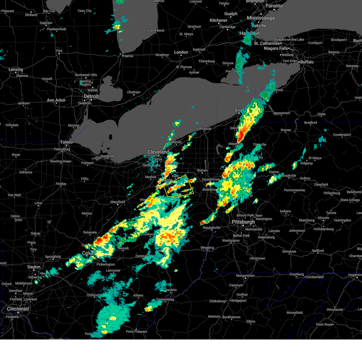
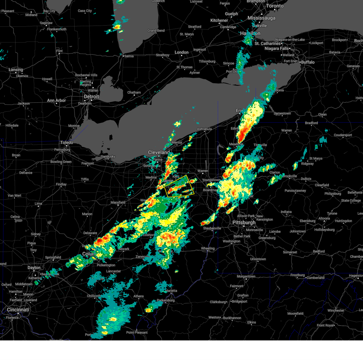
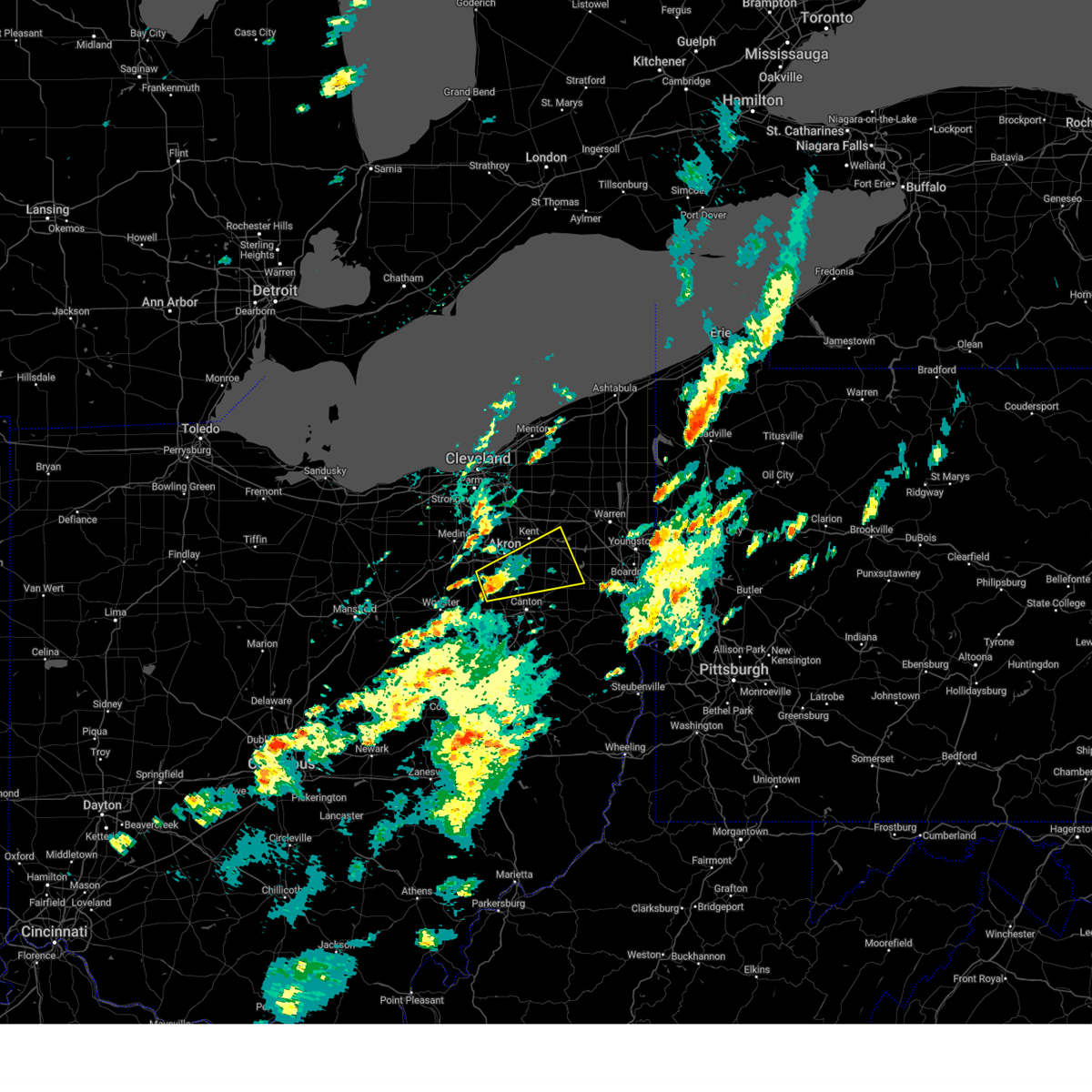
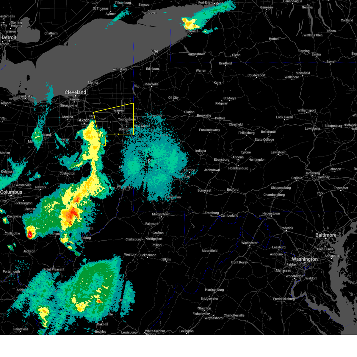
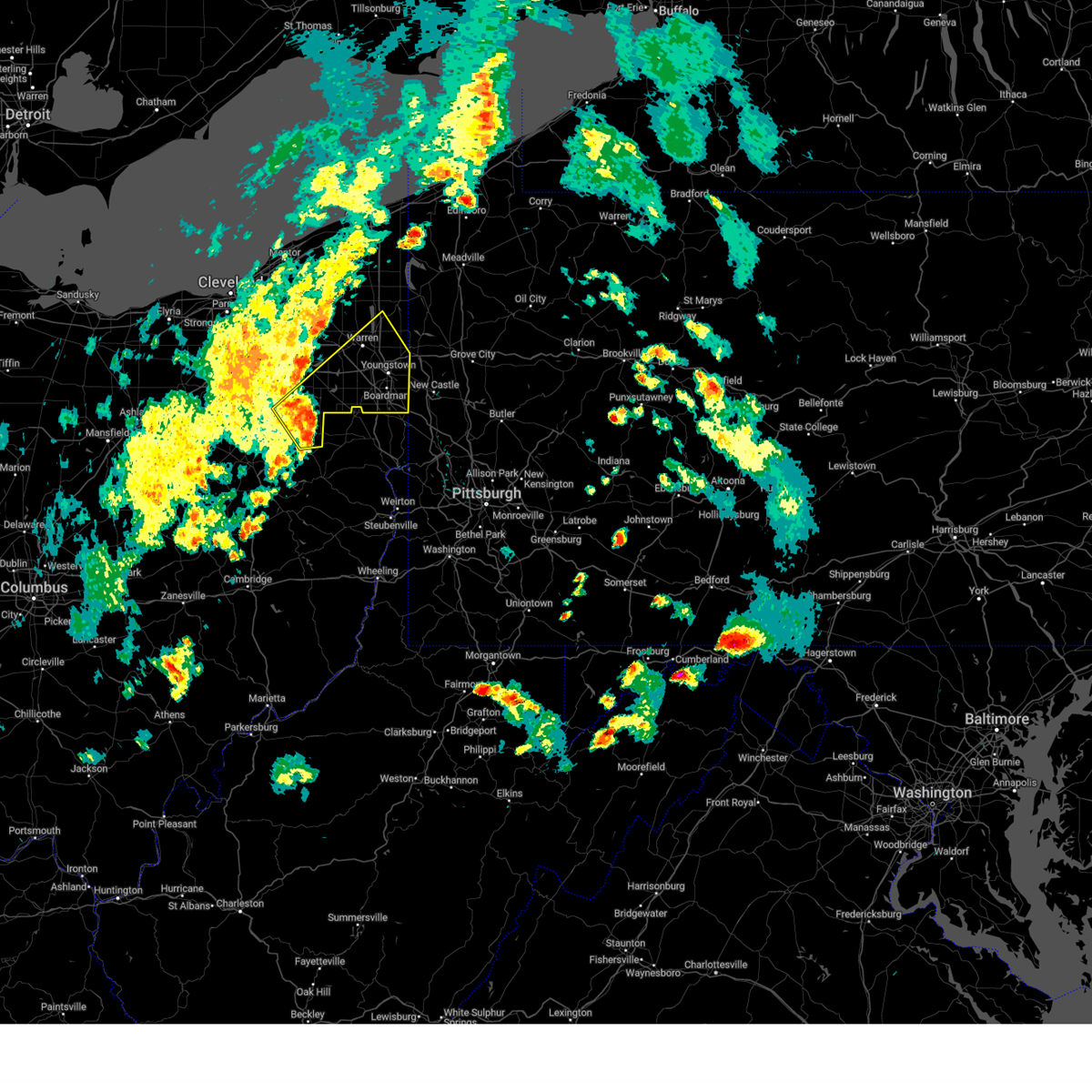
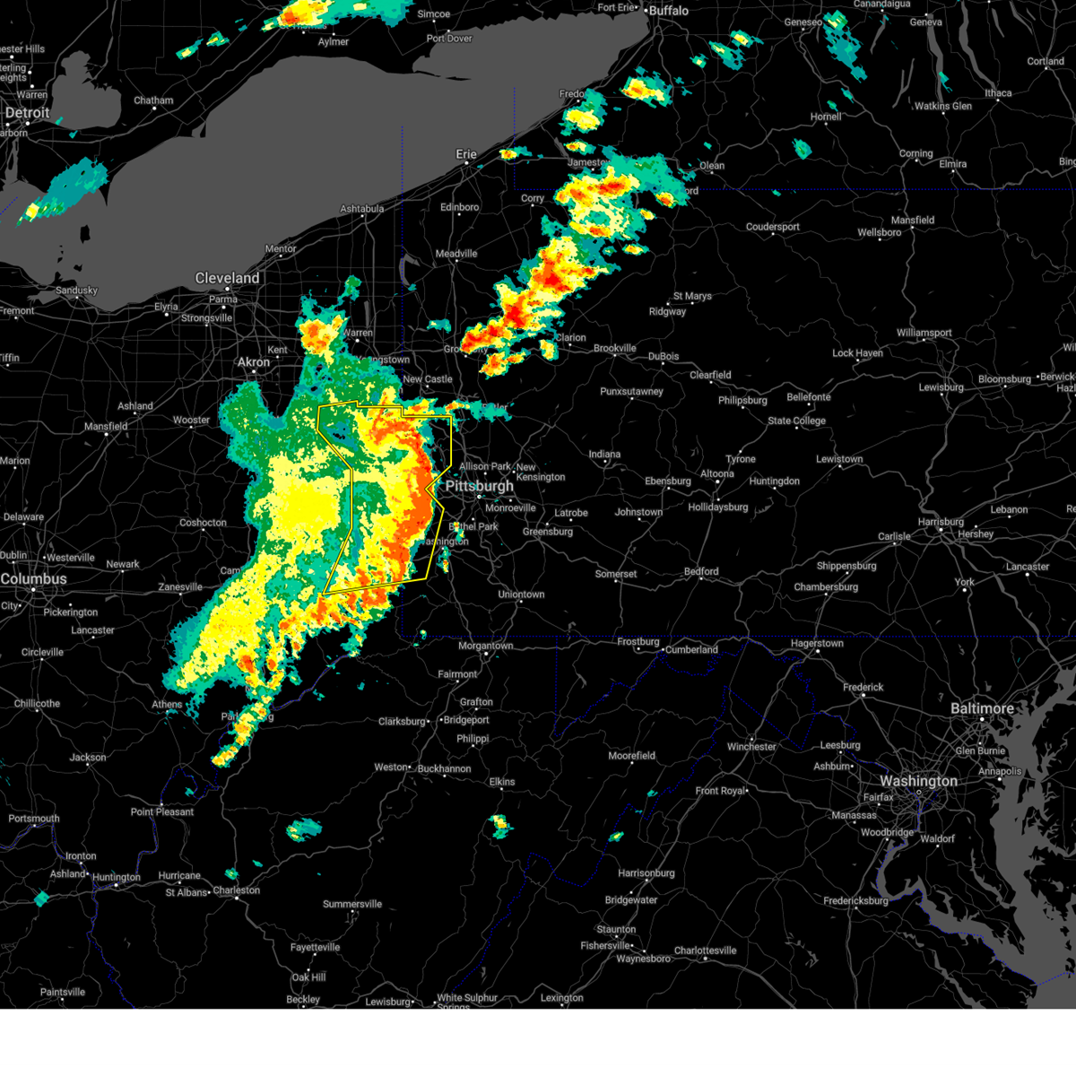
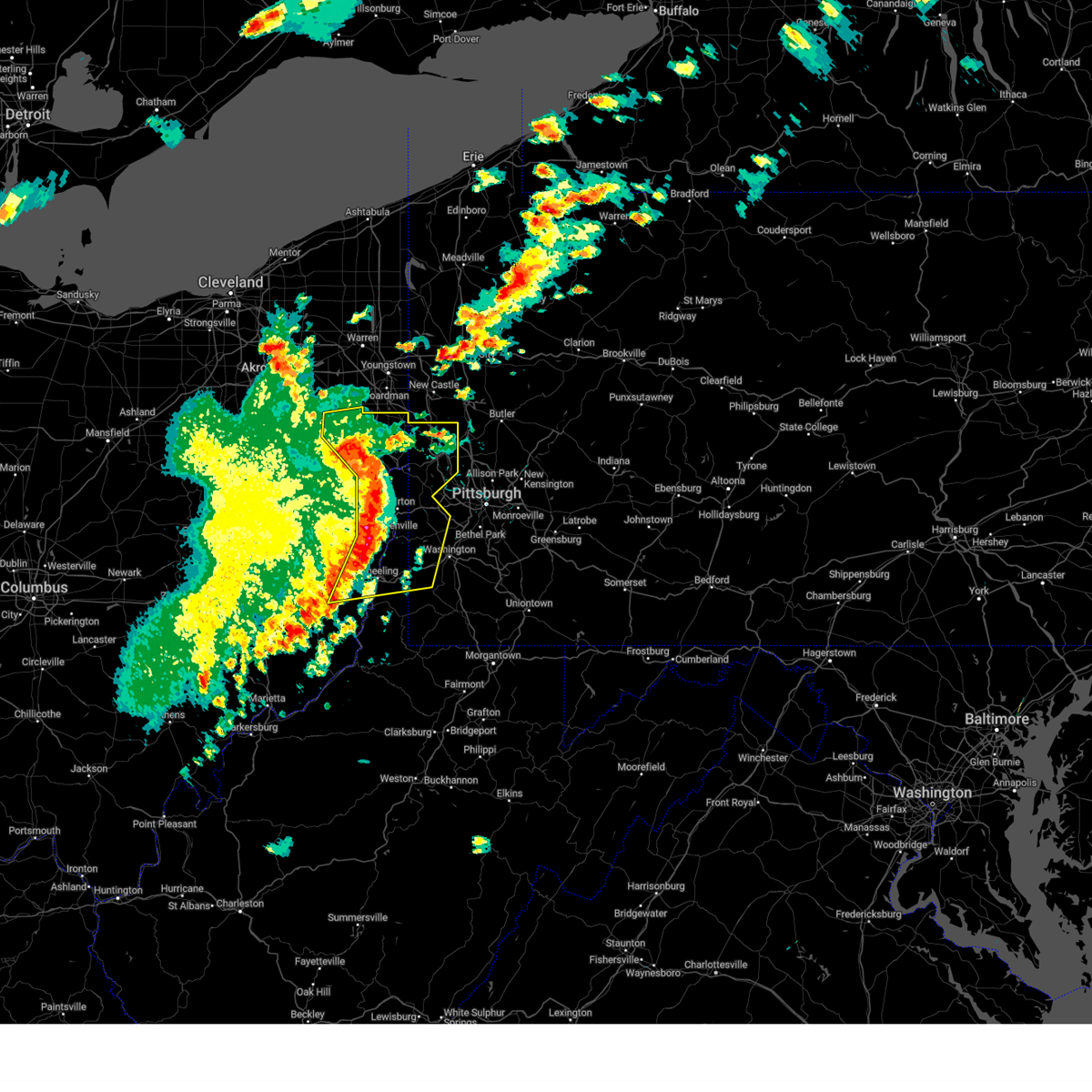
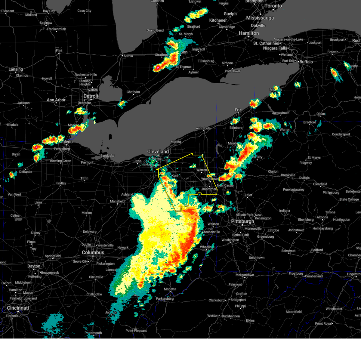
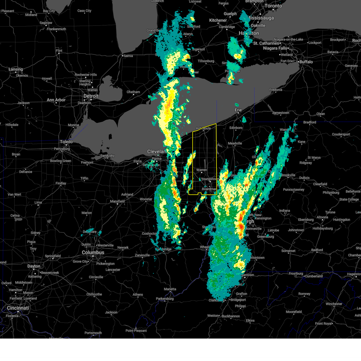
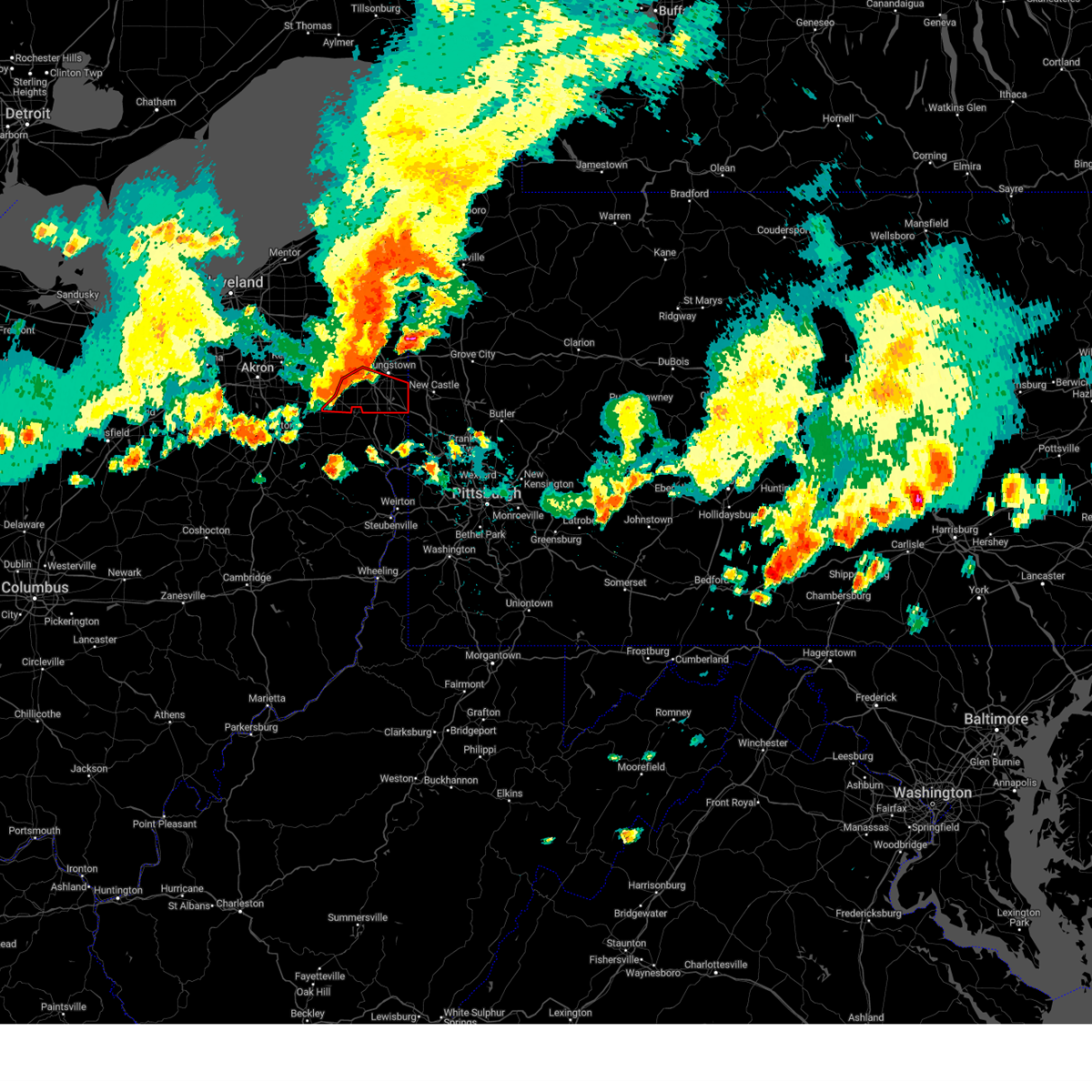
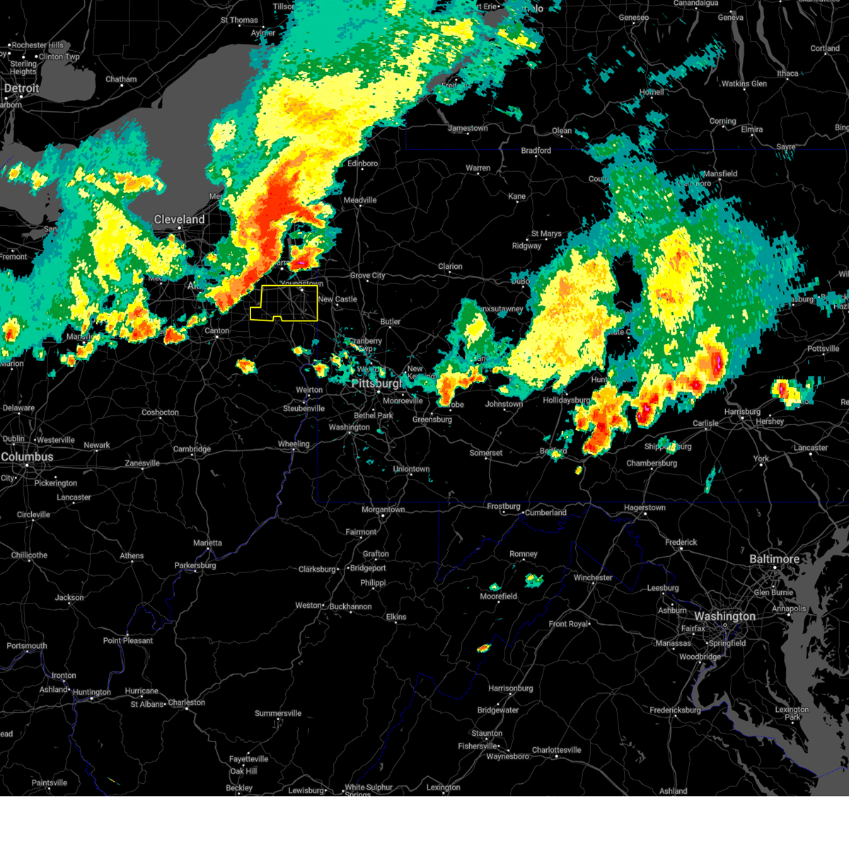
Hail Map for Maple Ridge, OH
The Maple Ridge, OH area has had 0 reports of on-the-ground hail by trained spotters, and has been under severe weather warnings 31 times during the past 12 months. Doppler radar has detected hail at or near Maple Ridge, OH on 30 occasions, including 1 occasion during the past year.
| Name: | Maple Ridge, OH |
| Where Located: | 52.5 miles SE of Cleveland, OH |
| Map: | Google Map for Maple Ridge, OH |
| Population: | 761 |
| Housing Units: | 326 |
| More Info: | Search Google for Maple Ridge, OH |
0
The Top Recent Hail Date for Maple Ridge, OH is Wednesday, June 25, 2025 (15th out of 30)
Hail and Wind Damage Spotted near Maple Ridge, OH
| Date / Time | Report Details |
|---|---|
| 6/18/2025 10:13 PM EDT |
 the severe thunderstorm warning has been cancelled and is no longer in effect the severe thunderstorm warning has been cancelled and is no longer in effect
|
| 6/18/2025 10:13 PM EDT |
 At 1013 pm edt, severe thunderstorms were located along a line extending from near north bloomfield to near niles to near salem, moving east at 60 mph (radar indicated). Hazards include 60 mph wind gusts. Expect damage to trees and power lines. Locations impacted include, youngstown, warren, salem, columbiana, boardman, niles, campbell, hubbard, canfield, cortland, newton falls, sebring, lordstown, kinsman, north bloomfield, vienna center, hilltop, maplewood park, bristolville, and leavittsburg. At 1013 pm edt, severe thunderstorms were located along a line extending from near north bloomfield to near niles to near salem, moving east at 60 mph (radar indicated). Hazards include 60 mph wind gusts. Expect damage to trees and power lines. Locations impacted include, youngstown, warren, salem, columbiana, boardman, niles, campbell, hubbard, canfield, cortland, newton falls, sebring, lordstown, kinsman, north bloomfield, vienna center, hilltop, maplewood park, bristolville, and leavittsburg.
|
| 6/18/2025 9:47 PM EDT |
 Svrcle the national weather service in cleveland has issued a * severe thunderstorm warning for, trumbull county in northeastern ohio, mahoning county in northeastern ohio, eastern geauga county in northeastern ohio, northeastern lake county in northeastern ohio, * until 1100 pm edt. * at 947 pm edt, severe thunderstorms were located along a line extending from near mantua to 6 miles southeast of ravenna to near north canton, moving east at 60 mph (radar indicated). Hazards include 60 mph wind gusts. expect damage to trees and power lines Svrcle the national weather service in cleveland has issued a * severe thunderstorm warning for, trumbull county in northeastern ohio, mahoning county in northeastern ohio, eastern geauga county in northeastern ohio, northeastern lake county in northeastern ohio, * until 1100 pm edt. * at 947 pm edt, severe thunderstorms were located along a line extending from near mantua to 6 miles southeast of ravenna to near north canton, moving east at 60 mph (radar indicated). Hazards include 60 mph wind gusts. expect damage to trees and power lines
|
| 6/18/2025 6:42 PM EDT | The storm which prompted the warning has weakened below severe limits, and no longer appears capable of producing a tornado. therefore, the warning will be allowed to expire. |
| 6/18/2025 6:23 PM EDT | the tornado warning has been cancelled and is no longer in effect |
| 6/18/2025 6:23 PM EDT | At 622 pm edt, a severe thunderstorm capable of producing a tornado was located near ravenna, moving east at 30 mph (radar indicated rotation). Hazards include tornado. Flying debris will be dangerous to those caught without shelter. mobile homes will be damaged or destroyed. damage to roofs, windows, and vehicles will occur. tree damage is likely. this dangerous storm will be near, alliance around 630 pm edt. Other locations impacted by this tornadic thunderstorm include limaville, deerfield, atwater, randolph, edinburg, and brimfield. |
| 6/18/2025 6:09 PM EDT |
 At 609 pm edt, a severe thunderstorm capable of producing a tornado was located near mogadore, or 7 miles southwest of ravenna, moving east at 30 mph (radar indicated rotation). Hazards include tornado. Flying debris will be dangerous to those caught without shelter. mobile homes will be damaged or destroyed. damage to roofs, windows, and vehicles will occur. tree damage is likely. this dangerous storm will be near, alliance around 630 pm edt. Other locations impacted by this tornadic thunderstorm include limaville, brimfield, deerfield, atwater, randolph, and edinburg. At 609 pm edt, a severe thunderstorm capable of producing a tornado was located near mogadore, or 7 miles southwest of ravenna, moving east at 30 mph (radar indicated rotation). Hazards include tornado. Flying debris will be dangerous to those caught without shelter. mobile homes will be damaged or destroyed. damage to roofs, windows, and vehicles will occur. tree damage is likely. this dangerous storm will be near, alliance around 630 pm edt. Other locations impacted by this tornadic thunderstorm include limaville, brimfield, deerfield, atwater, randolph, and edinburg.
|
| 6/18/2025 6:00 PM EDT | Torcle the national weather service in cleveland has issued a * tornado warning for, southern portage county in northeastern ohio, southwestern mahoning county in northeastern ohio, northeastern stark county in northeastern ohio, east central summit county in northeastern ohio, * until 645 pm edt. * at 600 pm edt, a severe thunderstorm capable of producing a tornado was located over tallmadge, or near akron, moving east at 30 mph (radar indicated rotation). Hazards include tornado. Flying debris will be dangerous to those caught without shelter. mobile homes will be damaged or destroyed. damage to roofs, windows, and vehicles will occur. tree damage is likely. this dangerous storm will be near, akron, ravenna, kent, tallmadge, and mogadore around 605 pm edt. alliance around 630 pm edt. Other locations impacted by this tornadic thunderstorm include silver lake, brimfield, brady lake, atwater, edinburg, limaville, lakemore, deerfield, randolph, and munroe falls. |
| 6/9/2025 3:32 PM EDT |
 At 331 pm edt, a severe thunderstorm was located near green, or 9 miles southeast of akron, moving northeast at 30 mph (radar indicated). Hazards include 60 mph wind gusts and penny size hail. Expect damage to trees and power lines. Locations impacted include, akron, ravenna, kent, barberton, green, alliance, tallmadge, north canton, sebring, mogadore, hartville, new franklin, brimfield, randolph, lakemore, atwater, edinburg, deerfield, limaville, and greentown. At 331 pm edt, a severe thunderstorm was located near green, or 9 miles southeast of akron, moving northeast at 30 mph (radar indicated). Hazards include 60 mph wind gusts and penny size hail. Expect damage to trees and power lines. Locations impacted include, akron, ravenna, kent, barberton, green, alliance, tallmadge, north canton, sebring, mogadore, hartville, new franklin, brimfield, randolph, lakemore, atwater, edinburg, deerfield, limaville, and greentown.
|
| 6/9/2025 3:32 PM EDT |
 the severe thunderstorm warning has been cancelled and is no longer in effect the severe thunderstorm warning has been cancelled and is no longer in effect
|
| 6/9/2025 3:14 PM EDT |
 Svrcle the national weather service in cleveland has issued a * severe thunderstorm warning for, southern portage county in northeastern ohio, southwestern mahoning county in northeastern ohio, northern stark county in northeastern ohio, southern summit county in northeastern ohio, northeastern wayne county in northeastern ohio, * until 400 pm edt. * at 314 pm edt, a severe thunderstorm was located near green, or 11 miles south of akron, moving northeast at 30 mph (radar indicated). Hazards include 60 mph wind gusts and penny size hail. expect damage to trees and power lines Svrcle the national weather service in cleveland has issued a * severe thunderstorm warning for, southern portage county in northeastern ohio, southwestern mahoning county in northeastern ohio, northern stark county in northeastern ohio, southern summit county in northeastern ohio, northeastern wayne county in northeastern ohio, * until 400 pm edt. * at 314 pm edt, a severe thunderstorm was located near green, or 11 miles south of akron, moving northeast at 30 mph (radar indicated). Hazards include 60 mph wind gusts and penny size hail. expect damage to trees and power lines
|
| 5/17/2025 12:12 AM EDT | the severe thunderstorm warning has been cancelled and is no longer in effect |
| 5/16/2025 11:39 PM EDT |
 Svrcle the national weather service in cleveland has issued a * severe thunderstorm warning for, southern trumbull county in northeastern ohio, portage county in northeastern ohio, mahoning county in northeastern ohio, northeastern stark county in northeastern ohio, * until 1245 am edt. * at 1138 pm edt, severe thunderstorms were located along a line extending from near tallmadge to near dennison, moving east at 55 mph (radar indicated). Hazards include 60 mph wind gusts. expect damage to trees and power lines Svrcle the national weather service in cleveland has issued a * severe thunderstorm warning for, southern trumbull county in northeastern ohio, portage county in northeastern ohio, mahoning county in northeastern ohio, northeastern stark county in northeastern ohio, * until 1245 am edt. * at 1138 pm edt, severe thunderstorms were located along a line extending from near tallmadge to near dennison, moving east at 55 mph (radar indicated). Hazards include 60 mph wind gusts. expect damage to trees and power lines
|
| 5/1/2025 5:25 PM EDT |
 Svrcle the national weather service in cleveland has issued a * severe thunderstorm warning for, southern trumbull county in northeastern ohio, mahoning county in northeastern ohio, southeastern portage county in northeastern ohio, northeastern stark county in northeastern ohio, * until 615 pm edt. * at 524 pm edt, a severe thunderstorm was located over alliance, or 14 miles west of salem, moving northeast at 45 mph (radar indicated). Hazards include 60 mph wind gusts. expect damage to trees and power lines Svrcle the national weather service in cleveland has issued a * severe thunderstorm warning for, southern trumbull county in northeastern ohio, mahoning county in northeastern ohio, southeastern portage county in northeastern ohio, northeastern stark county in northeastern ohio, * until 615 pm edt. * at 524 pm edt, a severe thunderstorm was located over alliance, or 14 miles west of salem, moving northeast at 45 mph (radar indicated). Hazards include 60 mph wind gusts. expect damage to trees and power lines
|
| 4/29/2025 4:56 PM EDT |
 The storms which prompted the warning have moved out of the area. therefore, the warning will be allowed to expire. however, gusty winds are still possible with these thunderstorms. a severe thunderstorm watch remains in effect until 700 pm edt for east central ohio, and northern west virginia. a severe thunderstorm watch also remains in effect until 1000 pm edt for western and southwestern pennsylvania. remember, a severe thunderstorm warning still remains in effect for beaver and washington counties. The storms which prompted the warning have moved out of the area. therefore, the warning will be allowed to expire. however, gusty winds are still possible with these thunderstorms. a severe thunderstorm watch remains in effect until 700 pm edt for east central ohio, and northern west virginia. a severe thunderstorm watch also remains in effect until 1000 pm edt for western and southwestern pennsylvania. remember, a severe thunderstorm warning still remains in effect for beaver and washington counties.
|
| 4/29/2025 4:47 PM EDT | At 445 pm edt, severe thunderstorms were located along a line extending from near hudson to 6 miles east of minerva, moving northeast at 50 mph (radar indicated). Hazards include 60 mph wind gusts and penny size hail. Expect damage to trees and power lines. Locations impacted include, youngstown, warren, salem, ravenna, columbiana, boardman, kent, niles, streetsboro, campbell, canfield, cortland, newton falls, sebring, lordstown, middlefield, garrettsville, north bloomfield, mantua, and west farmington. |
| 4/29/2025 4:47 PM EDT | the severe thunderstorm warning has been cancelled and is no longer in effect |
| 4/29/2025 4:37 PM EDT |
 At 437 pm edt, severe thunderstorms were located along a line extending from near lisbon to near wellsville to near wintersville to st. clairsville, moving east at 70 mph. these are destructive storms for hancock and brooke counties (radar indicated). Hazards include 80 mph wind gusts. Extensive tree damage and widespread power outages. mobile homes will be heavily damaged. expect considerable damage to roofs, windows and vehicles. locations impacted include, wheeling, weirton, steubenville, salem, east liverpool, aliquippa, beaver falls, martins ferry, columbiana, monaca, st. Clairsville, east palestine, bellaire, wellsville, warwood, wellsburg, bethlehem, west liberty, triadelphia, and avella. At 437 pm edt, severe thunderstorms were located along a line extending from near lisbon to near wellsville to near wintersville to st. clairsville, moving east at 70 mph. these are destructive storms for hancock and brooke counties (radar indicated). Hazards include 80 mph wind gusts. Extensive tree damage and widespread power outages. mobile homes will be heavily damaged. expect considerable damage to roofs, windows and vehicles. locations impacted include, wheeling, weirton, steubenville, salem, east liverpool, aliquippa, beaver falls, martins ferry, columbiana, monaca, st. Clairsville, east palestine, bellaire, wellsville, warwood, wellsburg, bethlehem, west liberty, triadelphia, and avella.
|
| 4/29/2025 4:37 PM EDT |
 the severe thunderstorm warning has been cancelled and is no longer in effect the severe thunderstorm warning has been cancelled and is no longer in effect
|
| 4/29/2025 4:29 PM EDT |
 Svrcle the national weather service in cleveland has issued a * severe thunderstorm warning for, trumbull county in northeastern ohio, mahoning county in northeastern ohio, portage county in northeastern ohio, southern geauga county in northeastern ohio, southeastern cuyahoga county in northeastern ohio, stark county in northeastern ohio, summit county in northeastern ohio, * until 515 pm edt. * at 429 pm edt, severe thunderstorms were located along a line extending from 6 miles northwest of cuyahoga falls to near waynesburg, moving northeast at 50 mph (radar indicated). Hazards include 60 mph wind gusts and penny size hail. expect damage to trees and power lines Svrcle the national weather service in cleveland has issued a * severe thunderstorm warning for, trumbull county in northeastern ohio, mahoning county in northeastern ohio, portage county in northeastern ohio, southern geauga county in northeastern ohio, southeastern cuyahoga county in northeastern ohio, stark county in northeastern ohio, summit county in northeastern ohio, * until 515 pm edt. * at 429 pm edt, severe thunderstorms were located along a line extending from 6 miles northwest of cuyahoga falls to near waynesburg, moving northeast at 50 mph (radar indicated). Hazards include 60 mph wind gusts and penny size hail. expect damage to trees and power lines
|
| 4/29/2025 4:25 PM EDT |
 At 424 pm edt, severe thunderstorms were located along a line extending from minerva to 6 miles east of carrollton to cadiz to near barnesville, moving east at 70 mph. these are destructive storms for jefferson county (radar indicated). Hazards include 80 mph wind gusts. Extensive tree damage and widespread power outages. mobile homes will be heavily damaged. expect considerable damage to roofs, windows and vehicles. locations impacted include, wheeling, weirton, steubenville, salem, east liverpool, aliquippa, beaver falls, martins ferry, columbiana, monaca, st. Clairsville, east palestine, bellaire, barnesville, wellsville, cadiz, carrollton, warwood, wellsburg, and bethlehem. At 424 pm edt, severe thunderstorms were located along a line extending from minerva to 6 miles east of carrollton to cadiz to near barnesville, moving east at 70 mph. these are destructive storms for jefferson county (radar indicated). Hazards include 80 mph wind gusts. Extensive tree damage and widespread power outages. mobile homes will be heavily damaged. expect considerable damage to roofs, windows and vehicles. locations impacted include, wheeling, weirton, steubenville, salem, east liverpool, aliquippa, beaver falls, martins ferry, columbiana, monaca, st. Clairsville, east palestine, bellaire, barnesville, wellsville, cadiz, carrollton, warwood, wellsburg, and bethlehem.
|
| 4/29/2025 4:25 PM EDT |
 the severe thunderstorm warning has been cancelled and is no longer in effect the severe thunderstorm warning has been cancelled and is no longer in effect
|
| 4/3/2025 3:30 AM EDT | The storms which prompted the warning have moved out of the area. therefore, the warning has been allowed to expire. a severe thunderstorm watch remains in effect until 700 am edt for northeastern ohio. to report severe weather, contact your nearest law enforcement agency. they will relay your report to the national weather service cleveland. |
| 4/3/2025 3:11 AM EDT | At 311 am edt, severe thunderstorms were located along a line extending from near ravenna to east sparta, moving east at 70 mph (radar indicated). Hazards include 60 mph wind gusts. Expect damage to trees and power lines. Locations impacted include, canton, ravenna, kent, alliance, north canton, streetsboro, louisville, sebring, minerva, hartville, garrettsville, mantua, waynesburg, east sparta, aurora, brimfield, randolph, atwater, edinburg, and windham. |
| 4/3/2025 3:11 AM EDT | the severe thunderstorm warning has been cancelled and is no longer in effect |
| 4/3/2025 3:00 AM EDT | At 259 am edt, severe thunderstorms were located along a line extending from kent to near wilmot, moving east at 70 mph (radar indicated). Hazards include 60 mph wind gusts. Expect damage to trees and power lines. Locations impacted include, akron, canton, ravenna, cuyahoga falls, massillon, kent, barberton, green, solon, alliance, hudson, twinsburg, tallmadge, north canton, streetsboro, macedonia, louisville, sebring, mogadore, and walnut creek. |
| 4/3/2025 3:00 AM EDT | the severe thunderstorm warning has been cancelled and is no longer in effect |
| 4/3/2025 2:42 AM EDT | Svrcle the national weather service in cleveland has issued a * severe thunderstorm warning for, western mahoning county in northeastern ohio, portage county in northeastern ohio, eastern medina county in northeastern ohio, stark county in northeastern ohio, summit county in northeastern ohio, eastern wayne county in northeastern ohio, holmes county in northeastern ohio, * until 330 am edt. * at 242 am edt, severe thunderstorms were located along a line extending from 7 miles northeast of wadsworth to near millersburg, moving east at 70 mph (radar indicated). Hazards include 60 mph wind gusts. expect damage to trees and power lines |
| 3/16/2025 12:39 PM EDT |
 Svrcle the national weather service in cleveland has issued a * severe thunderstorm warning for, trumbull county in northeastern ohio, mahoning county in northeastern ohio, ashtabula county in northeastern ohio, * until 145 pm edt. * at 1238 pm edt, severe thunderstorms were located along a line extending from near fairport harbor to near streetsboro to hartville to near waynesburg, moving northeast at 60 mph (radar indicated). Hazards include 70 mph wind gusts. Expect considerable tree damage. Damage is likely to mobile homes, roofs, and outbuildings. Svrcle the national weather service in cleveland has issued a * severe thunderstorm warning for, trumbull county in northeastern ohio, mahoning county in northeastern ohio, ashtabula county in northeastern ohio, * until 145 pm edt. * at 1238 pm edt, severe thunderstorms were located along a line extending from near fairport harbor to near streetsboro to hartville to near waynesburg, moving northeast at 60 mph (radar indicated). Hazards include 70 mph wind gusts. Expect considerable tree damage. Damage is likely to mobile homes, roofs, and outbuildings.
|
| 8/6/2024 5:24 PM EDT |
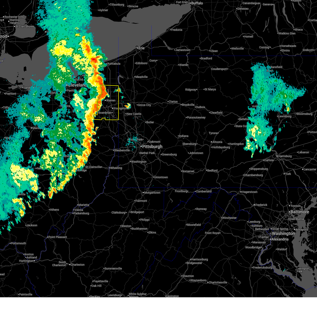
 Torcle the national weather service in cleveland has issued a * tornado warning for, mahoning county in northeastern ohio, * until 600 pm edt. * at 523 pm edt, severe thunderstorms capable of producing both tornadoes and extensive straight line wind damage were located near canfield, or 9 miles north of salem, moving east at 45 mph (radar indicated rotation). Hazards include tornado. Flying debris will be dangerous to those caught without shelter. mobile homes will be damaged or destroyed. damage to roofs, windows, and vehicles will occur. tree damage is likely. these dangerous storms will be near, youngstown, boardman, and canfield around 530 pm edt. Other locations impacted by this tornadic thunderstorm include ellsworth, beloit, berlin center, lowellville, maple ridge, greenford, north jackson, struthers, poland, and new middletown. Torcle the national weather service in cleveland has issued a * tornado warning for, mahoning county in northeastern ohio, * until 600 pm edt. * at 523 pm edt, severe thunderstorms capable of producing both tornadoes and extensive straight line wind damage were located near canfield, or 9 miles north of salem, moving east at 45 mph (radar indicated rotation). Hazards include tornado. Flying debris will be dangerous to those caught without shelter. mobile homes will be damaged or destroyed. damage to roofs, windows, and vehicles will occur. tree damage is likely. these dangerous storms will be near, youngstown, boardman, and canfield around 530 pm edt. Other locations impacted by this tornadic thunderstorm include ellsworth, beloit, berlin center, lowellville, maple ridge, greenford, north jackson, struthers, poland, and new middletown.
|
| 8/6/2024 5:06 PM EDT |
 Svrcle the national weather service in cleveland has issued a * severe thunderstorm warning for, mahoning county in northeastern ohio, * until 600 pm edt. * at 505 pm edt, severe thunderstorms were located along a line extending from near newton falls to near hartville, moving east at 45 mph (radar indicated). Hazards include 70 mph wind gusts and quarter size hail. Minor damage to vehicles is possible. expect considerable tree damage. Wind damage is also likely to mobile homes, roofs, and outbuildings. Svrcle the national weather service in cleveland has issued a * severe thunderstorm warning for, mahoning county in northeastern ohio, * until 600 pm edt. * at 505 pm edt, severe thunderstorms were located along a line extending from near newton falls to near hartville, moving east at 45 mph (radar indicated). Hazards include 70 mph wind gusts and quarter size hail. Minor damage to vehicles is possible. expect considerable tree damage. Wind damage is also likely to mobile homes, roofs, and outbuildings.
|
| 8/25/2023 1:09 AM EDT |
 The severe thunderstorm warning for southwestern mahoning, stark, southern wayne and northeastern holmes counties will expire at 115 am edt, the storms which prompted the warning have moved out of the area. therefore, the warning will be allowed to expire. a severe thunderstorm watch remains in effect until 300 am edt for north central and northeastern ohio. The severe thunderstorm warning for southwestern mahoning, stark, southern wayne and northeastern holmes counties will expire at 115 am edt, the storms which prompted the warning have moved out of the area. therefore, the warning will be allowed to expire. a severe thunderstorm watch remains in effect until 300 am edt for north central and northeastern ohio.
|
| 8/25/2023 12:56 AM EDT |
 At 1256 am edt, severe thunderstorms were located along a line extending from near new waterford to nashville, moving southeast at 55 mph (radar indicated). Hazards include 70 mph wind gusts. Expect considerable tree damage. damage is likely to mobile homes, roofs, and outbuildings. locations impacted include, canton, salem, columbiana, massillon, alliance, north canton, louisville, sebring, minerva, brewster, navarre, dalton, shreve, waynesburg, east sparta, holmesville, wilmot, mount eaton, winesburg and east canton. thunderstorm damage threat, considerable hail threat, radar indicated max hail size, <. 75 in wind threat, radar indicated max wind gust, 70 mph. At 1256 am edt, severe thunderstorms were located along a line extending from near new waterford to nashville, moving southeast at 55 mph (radar indicated). Hazards include 70 mph wind gusts. Expect considerable tree damage. damage is likely to mobile homes, roofs, and outbuildings. locations impacted include, canton, salem, columbiana, massillon, alliance, north canton, louisville, sebring, minerva, brewster, navarre, dalton, shreve, waynesburg, east sparta, holmesville, wilmot, mount eaton, winesburg and east canton. thunderstorm damage threat, considerable hail threat, radar indicated max hail size, <. 75 in wind threat, radar indicated max wind gust, 70 mph.
|
| 8/25/2023 12:20 AM EDT |
 At 1219 am edt, severe thunderstorms were located along a line extending from near mantua to lodi, moving southeast at 75 mph (radar indicated). Hazards include 70 mph wind gusts. Expect considerable tree damage. Damage is likely to mobile homes, roofs, and outbuildings. At 1219 am edt, severe thunderstorms were located along a line extending from near mantua to lodi, moving southeast at 75 mph (radar indicated). Hazards include 70 mph wind gusts. Expect considerable tree damage. Damage is likely to mobile homes, roofs, and outbuildings.
|
| 7/28/2023 2:21 PM EDT |
 At 220 pm edt, severe thunderstorms were located along a line extending from near hartville to near louisville to near east sparta, moving east at 25 mph (radar indicated). Hazards include 60 mph wind gusts. Expect damage to trees and power lines. locations impacted include, canton, alliance, north canton, louisville, sebring, minerva, waynesburg, east sparta, east canton, beloit, maple ridge, robertsville, maximo and greentown. hail threat, radar indicated max hail size, <. 75 in wind threat, radar indicated max wind gust, 60 mph. At 220 pm edt, severe thunderstorms were located along a line extending from near hartville to near louisville to near east sparta, moving east at 25 mph (radar indicated). Hazards include 60 mph wind gusts. Expect damage to trees and power lines. locations impacted include, canton, alliance, north canton, louisville, sebring, minerva, waynesburg, east sparta, east canton, beloit, maple ridge, robertsville, maximo and greentown. hail threat, radar indicated max hail size, <. 75 in wind threat, radar indicated max wind gust, 60 mph.
|
| 7/28/2023 2:08 PM EDT |
 At 208 pm edt, severe thunderstorms were located along a line extending from near mogadore to near louisville to dover, moving east at 35 mph (radar indicated). Hazards include 60 mph wind gusts. expect damage to trees and power lines At 208 pm edt, severe thunderstorms were located along a line extending from near mogadore to near louisville to dover, moving east at 35 mph (radar indicated). Hazards include 60 mph wind gusts. expect damage to trees and power lines
|
| 7/20/2023 9:04 PM EDT |
 At 903 pm edt, severe thunderstorms were located along a line extending from near new wilmington to near sebring to navarre, moving southeast at 40 mph (radar indicated). Hazards include 70 mph wind gusts. Expect considerable tree damage. damage is likely to mobile homes, roofs, and outbuildings. locations impacted include, canton, youngstown, salem, columbiana, boardman, massillon, alliance, north canton, louisville, campbell, canfield, sebring, minerva, brewster, navarre, waynesburg, east sparta, wilmot, austintown and struthers. thunderstorm damage threat, considerable hail threat, radar indicated max hail size, <. 75 in wind threat, radar indicated max wind gust, 70 mph. At 903 pm edt, severe thunderstorms were located along a line extending from near new wilmington to near sebring to navarre, moving southeast at 40 mph (radar indicated). Hazards include 70 mph wind gusts. Expect considerable tree damage. damage is likely to mobile homes, roofs, and outbuildings. locations impacted include, canton, youngstown, salem, columbiana, boardman, massillon, alliance, north canton, louisville, campbell, canfield, sebring, minerva, brewster, navarre, waynesburg, east sparta, wilmot, austintown and struthers. thunderstorm damage threat, considerable hail threat, radar indicated max hail size, <. 75 in wind threat, radar indicated max wind gust, 70 mph.
|
| 7/20/2023 8:53 PM EDT |
 At 853 pm edt, severe thunderstorms were located along a line extending from near new wilmington to near alliance to near brewster, moving southeast at 55 mph (radar indicated). Hazards include 60 mph wind gusts. Expect damage to trees and power lines. locations impacted include, canton, youngstown, salem, columbiana, boardman, massillon, barberton, green, alliance, niles, north canton, louisville, campbell, hubbard, canfield, sebring, minerva, lordstown, hartville and brewster. hail threat, radar indicated max hail size, <. 75 in wind threat, radar indicated max wind gust, 60 mph. At 853 pm edt, severe thunderstorms were located along a line extending from near new wilmington to near alliance to near brewster, moving southeast at 55 mph (radar indicated). Hazards include 60 mph wind gusts. Expect damage to trees and power lines. locations impacted include, canton, youngstown, salem, columbiana, boardman, massillon, barberton, green, alliance, niles, north canton, louisville, campbell, hubbard, canfield, sebring, minerva, lordstown, hartville and brewster. hail threat, radar indicated max hail size, <. 75 in wind threat, radar indicated max wind gust, 60 mph.
|
| 7/20/2023 8:00 PM EDT |
 At 759 pm edt, severe thunderstorms were located along a line extending from near hubbard to near kent to 6 miles northeast of wadsworth, moving southeast at 40 mph (radar indicated). Hazards include 60 mph wind gusts and quarter size hail. Minor damage to vehicles is possible. Expect damage to trees and power lines. At 759 pm edt, severe thunderstorms were located along a line extending from near hubbard to near kent to 6 miles northeast of wadsworth, moving southeast at 40 mph (radar indicated). Hazards include 60 mph wind gusts and quarter size hail. Minor damage to vehicles is possible. Expect damage to trees and power lines.
|
| 4/1/2023 1:38 PM EDT |
 The severe thunderstorm warning for trumbull and mahoning counties will expire at 145 pm edt, the storms which prompted the warning have moved out of the area. therefore, the warning will be allowed to expire. wind gusts to 50 mph will continue for the next several hours and a wind advisory remains in effect until 800 pm edt. a severe thunderstorm watch remains in effect until 600 pm edt for northeastern ohio. The severe thunderstorm warning for trumbull and mahoning counties will expire at 145 pm edt, the storms which prompted the warning have moved out of the area. therefore, the warning will be allowed to expire. wind gusts to 50 mph will continue for the next several hours and a wind advisory remains in effect until 800 pm edt. a severe thunderstorm watch remains in effect until 600 pm edt for northeastern ohio.
|
| 4/1/2023 1:14 PM EDT |
 At 112 pm edt, severe thunderstorms were located along a line extending from 6 miles southeast of north kingsville to bristolville, moving east at 55 mph (radar indicated). Hazards include 70 mph wind gusts. the strongest winds are expected in northern trumbull county, where wind gusts to 75 mph are possible. Expect considerable tree damage. damage is likely to mobile homes, roofs, and outbuildings. locations impacted include, youngstown, warren, salem, columbiana, boardman, alliance, niles, campbell, hubbard, canfield, cortland, newton falls, sebring, lordstown, kinsman, north bloomfield, west farmington, vienna center, leavittsburg and hilltop. thunderstorm damage threat, considerable hail threat, radar indicated max hail size, <. 75 in wind threat, radar indicated max wind gust, 70 mph. At 112 pm edt, severe thunderstorms were located along a line extending from 6 miles southeast of north kingsville to bristolville, moving east at 55 mph (radar indicated). Hazards include 70 mph wind gusts. the strongest winds are expected in northern trumbull county, where wind gusts to 75 mph are possible. Expect considerable tree damage. damage is likely to mobile homes, roofs, and outbuildings. locations impacted include, youngstown, warren, salem, columbiana, boardman, alliance, niles, campbell, hubbard, canfield, cortland, newton falls, sebring, lordstown, kinsman, north bloomfield, west farmington, vienna center, leavittsburg and hilltop. thunderstorm damage threat, considerable hail threat, radar indicated max hail size, <. 75 in wind threat, radar indicated max wind gust, 70 mph.
|
| 4/1/2023 12:38 PM EDT |
 At 1237 pm edt, severe thunderstorms were located along a line extending from 6 miles northeast of middlefield to 7 miles south of ravenna, moving northeast at 65 mph (radar indicated). Hazards include 70 mph wind gusts and nickel size hail. Expect considerable tree damage. Damage is likely to mobile homes, roofs, and outbuildings. At 1237 pm edt, severe thunderstorms were located along a line extending from 6 miles northeast of middlefield to 7 miles south of ravenna, moving northeast at 65 mph (radar indicated). Hazards include 70 mph wind gusts and nickel size hail. Expect considerable tree damage. Damage is likely to mobile homes, roofs, and outbuildings.
|
| 7/25/2022 2:27 AM EDT |
 The severe thunderstorm warning for southwestern mahoning and northeastern stark counties will expire at 230 am edt, the storm which prompted the warning has moved out of the area. therefore, the warning will be allowed to expire. however gusty winds are still possible with this thunderstorm. a tornado watch remains in effect until 700 am edt for northeastern ohio. remember, a severe thunderstorm warning still remains in effect for southeastern mahoning county until 300 am edt. The severe thunderstorm warning for southwestern mahoning and northeastern stark counties will expire at 230 am edt, the storm which prompted the warning has moved out of the area. therefore, the warning will be allowed to expire. however gusty winds are still possible with this thunderstorm. a tornado watch remains in effect until 700 am edt for northeastern ohio. remember, a severe thunderstorm warning still remains in effect for southeastern mahoning county until 300 am edt.
|
| 7/25/2022 1:52 AM EDT |
 At 152 am edt, a severe thunderstorm was located near hartville, or 10 miles northeast of canton, moving east at 45 mph (radar indicated). Hazards include 60 mph wind gusts. expect damage to trees and power lines At 152 am edt, a severe thunderstorm was located near hartville, or 10 miles northeast of canton, moving east at 45 mph (radar indicated). Hazards include 60 mph wind gusts. expect damage to trees and power lines
|
| 7/1/2022 8:43 PM EDT |
 The severe thunderstorm warning for southeastern portage, western mahoning and eastern stark counties will expire at 845 pm edt, the storms which prompted the warning have moved out of the area. therefore, the warning will be allowed to expire. The severe thunderstorm warning for southeastern portage, western mahoning and eastern stark counties will expire at 845 pm edt, the storms which prompted the warning have moved out of the area. therefore, the warning will be allowed to expire.
|
| 7/1/2022 8:30 PM EDT |
 At 830 pm edt, severe thunderstorms were located along a line extending from near sebring to canton, moving southeast at 25 mph (radar indicated). Hazards include 60 mph wind gusts. Expect damage to trees and power lines. locations impacted include, canton, alliance, north canton, louisville, sebring, minerva, waynesburg, east sparta, atwater, east canton, craig beach, beloit, deerfield, meyers lake, limaville, berlin center, robertsville, maple ridge, maximo and perry heights. hail threat, radar indicated max hail size, <. 75 in wind threat, radar indicated max wind gust, 60 mph. At 830 pm edt, severe thunderstorms were located along a line extending from near sebring to canton, moving southeast at 25 mph (radar indicated). Hazards include 60 mph wind gusts. Expect damage to trees and power lines. locations impacted include, canton, alliance, north canton, louisville, sebring, minerva, waynesburg, east sparta, atwater, east canton, craig beach, beloit, deerfield, meyers lake, limaville, berlin center, robertsville, maple ridge, maximo and perry heights. hail threat, radar indicated max hail size, <. 75 in wind threat, radar indicated max wind gust, 60 mph.
|
| 7/1/2022 8:04 PM EDT |
 At 804 pm edt, severe thunderstorms were located along a line extending from 6 miles south of ravenna to near green, moving southeast at 25 mph (radar indicated). Hazards include 60 mph wind gusts and penny size hail. expect damage to trees and power lines At 804 pm edt, severe thunderstorms were located along a line extending from 6 miles south of ravenna to near green, moving southeast at 25 mph (radar indicated). Hazards include 60 mph wind gusts and penny size hail. expect damage to trees and power lines
|
| 6/1/2022 6:53 PM EDT |
 At 653 pm edt, severe thunderstorms were located along a line extending from 7 miles northeast of alliance to near sebring to near east sparta, moving east at 30 mph (radar indicated). Hazards include 60 mph wind gusts and penny size hail. Expect damage to trees and power lines. locations impacted include, salem, columbiana, alliance, sebring, minerva, waynesburg, east sparta, beloit, robertsville, maple ridge and greenford. hail threat, radar indicated max hail size, 0. 75 in wind threat, radar indicated max wind gust, 60 mph. At 653 pm edt, severe thunderstorms were located along a line extending from 7 miles northeast of alliance to near sebring to near east sparta, moving east at 30 mph (radar indicated). Hazards include 60 mph wind gusts and penny size hail. Expect damage to trees and power lines. locations impacted include, salem, columbiana, alliance, sebring, minerva, waynesburg, east sparta, beloit, robertsville, maple ridge and greenford. hail threat, radar indicated max hail size, 0. 75 in wind threat, radar indicated max wind gust, 60 mph.
|
| 6/1/2022 6:24 PM EDT |
 At 624 pm edt, severe thunderstorms were located along a line extending from near hartville to near louisville to brewster, moving east at 30 mph (radar indicated). Hazards include 60 mph wind gusts and penny size hail. expect damage to trees and power lines At 624 pm edt, severe thunderstorms were located along a line extending from near hartville to near louisville to brewster, moving east at 30 mph (radar indicated). Hazards include 60 mph wind gusts and penny size hail. expect damage to trees and power lines
|
| 10/21/2021 5:55 PM EDT |
 At 554 pm edt, a severe thunderstorm capable of producing a tornado was located over sebring, or 7 miles west of salem, moving east at 50 mph (radar indicated rotation). Hazards include tornado. Flying debris will be dangerous to those caught without shelter. mobile homes will be damaged or destroyed. damage to roofs, windows, and vehicles will occur. tree damage is likely. this dangerous storm will be near, salem around 600 pm edt. canfield around 610 pm edt. Other locations impacted by this tornadic thunderstorm include beloit, maple ridge and greenford. At 554 pm edt, a severe thunderstorm capable of producing a tornado was located over sebring, or 7 miles west of salem, moving east at 50 mph (radar indicated rotation). Hazards include tornado. Flying debris will be dangerous to those caught without shelter. mobile homes will be damaged or destroyed. damage to roofs, windows, and vehicles will occur. tree damage is likely. this dangerous storm will be near, salem around 600 pm edt. canfield around 610 pm edt. Other locations impacted by this tornadic thunderstorm include beloit, maple ridge and greenford.
|
| 10/21/2021 5:45 PM EDT |
 At 544 pm edt, a severe thunderstorm capable of producing a tornado was located over alliance, or 13 miles west of salem, moving east at 55 mph (radar indicated rotation). Hazards include tornado. Flying debris will be dangerous to those caught without shelter. mobile homes will be damaged or destroyed. damage to roofs, windows, and vehicles will occur. tree damage is likely. this dangerous storm will be near, sebring around 550 pm edt. salem around 600 pm edt. Other locations impacted by this tornadic thunderstorm include beloit, ellsworth, maple ridge, maximo, greenford and limaville. At 544 pm edt, a severe thunderstorm capable of producing a tornado was located over alliance, or 13 miles west of salem, moving east at 55 mph (radar indicated rotation). Hazards include tornado. Flying debris will be dangerous to those caught without shelter. mobile homes will be damaged or destroyed. damage to roofs, windows, and vehicles will occur. tree damage is likely. this dangerous storm will be near, sebring around 550 pm edt. salem around 600 pm edt. Other locations impacted by this tornadic thunderstorm include beloit, ellsworth, maple ridge, maximo, greenford and limaville.
|
| 9/22/2021 2:59 PM EDT |
 At 259 pm edt, a severe thunderstorm was located over louisville, or 8 miles northeast of canton, moving northeast at 35 mph (radar indicated). Hazards include 60 mph wind gusts. expect damage to trees and power lines At 259 pm edt, a severe thunderstorm was located over louisville, or 8 miles northeast of canton, moving northeast at 35 mph (radar indicated). Hazards include 60 mph wind gusts. expect damage to trees and power lines
|
| 8/11/2021 6:12 PM EDT |
 At 612 pm edt, severe thunderstorms were located along a line extending from near north bloomfield to near garrettsville to hartville, moving east at 45 mph (radar indicated). Hazards include 70 mph wind gusts. Expect considerable tree damage. Damage is likely to mobile homes, roofs, and outbuildings. At 612 pm edt, severe thunderstorms were located along a line extending from near north bloomfield to near garrettsville to hartville, moving east at 45 mph (radar indicated). Hazards include 70 mph wind gusts. Expect considerable tree damage. Damage is likely to mobile homes, roofs, and outbuildings.
|
| 8/11/2021 6:01 PM EDT |
 At 601 pm edt, a line of severe thunderstorms was located from hudson to massillon, moving east at 45 mph (radar indicated). Hazards include 70 mph wind gusts and penny size hail. Expect considerable tree damage. damage is likely to mobile homes, roofs, and outbuildings. locations impacted include, akron, canton, ravenna, cuyahoga falls, massillon, kent, barberton, green, alliance, hudson, wadsworth, tallmadge, north canton, streetsboro, macedonia, louisville, orrville, rittman, sebring and mogadore. thunderstorm damage threat, considerable hail threat, radar indicated max hail size, 0. 75 in wind threat, radar indicated max wind gust, 70 mph. At 601 pm edt, a line of severe thunderstorms was located from hudson to massillon, moving east at 45 mph (radar indicated). Hazards include 70 mph wind gusts and penny size hail. Expect considerable tree damage. damage is likely to mobile homes, roofs, and outbuildings. locations impacted include, akron, canton, ravenna, cuyahoga falls, massillon, kent, barberton, green, alliance, hudson, wadsworth, tallmadge, north canton, streetsboro, macedonia, louisville, orrville, rittman, sebring and mogadore. thunderstorm damage threat, considerable hail threat, radar indicated max hail size, 0. 75 in wind threat, radar indicated max wind gust, 70 mph.
|
| 8/11/2021 5:36 PM EDT |
 At 535 pm edt, a line of severe thunderstorm was located near brunswick to wooster, moving east at 45 mph (radar indicated). Hazards include 70 mph wind gusts and penny size hail. Expect considerable tree damage. Damage is likely to mobile homes, roofs, and outbuildings. At 535 pm edt, a line of severe thunderstorm was located near brunswick to wooster, moving east at 45 mph (radar indicated). Hazards include 70 mph wind gusts and penny size hail. Expect considerable tree damage. Damage is likely to mobile homes, roofs, and outbuildings.
|
| 8/11/2021 11:27 AM EDT |
 At 1127 am edt, a severe thunderstorm was located near sebring, or near salem, moving east at 40 mph (radar indicated). Hazards include 60 mph wind gusts. Expect damage to trees and power lines. locations impacted include, youngstown, salem, columbiana, boardman, alliance, campbell, canfield, sebring, austintown, struthers, poland, ellsworth, new middletown, craig beach, lowellville, beloit, north jackson, berlin center, maple ridge and greenford. hail threat, radar indicated max hail size, <. 75 in wind threat, radar indicated max wind gust, 60 mph. At 1127 am edt, a severe thunderstorm was located near sebring, or near salem, moving east at 40 mph (radar indicated). Hazards include 60 mph wind gusts. Expect damage to trees and power lines. locations impacted include, youngstown, salem, columbiana, boardman, alliance, campbell, canfield, sebring, austintown, struthers, poland, ellsworth, new middletown, craig beach, lowellville, beloit, north jackson, berlin center, maple ridge and greenford. hail threat, radar indicated max hail size, <. 75 in wind threat, radar indicated max wind gust, 60 mph.
|
| 8/11/2021 10:56 AM EDT |
 At 1055 am edt, a severe thunderstorm was located near hartville, or near canton, moving east at 40 mph (radar indicated). Hazards include 60 mph wind gusts. expect damage to trees and power lines At 1055 am edt, a severe thunderstorm was located near hartville, or near canton, moving east at 40 mph (radar indicated). Hazards include 60 mph wind gusts. expect damage to trees and power lines
|
| 7/8/2021 3:27 PM EDT |
 At 326 pm edt, severe thunderstorms were located along a line extending from near newton falls to near alliance to near minerva, moving east at 35 mph (radar indicated). Hazards include 60 mph wind gusts. Expect damage to trees and power lines. Locations impacted include, youngstown, warren, salem, columbiana, boardman, alliance, niles, louisville, campbell, hubbard, canfield, newton falls, sebring, lordstown, vienna center, leavittsburg, hilltop, maplewood park, austintown and struthers. At 326 pm edt, severe thunderstorms were located along a line extending from near newton falls to near alliance to near minerva, moving east at 35 mph (radar indicated). Hazards include 60 mph wind gusts. Expect damage to trees and power lines. Locations impacted include, youngstown, warren, salem, columbiana, boardman, alliance, niles, louisville, campbell, hubbard, canfield, newton falls, sebring, lordstown, vienna center, leavittsburg, hilltop, maplewood park, austintown and struthers.
|
| 7/8/2021 3:20 PM EDT |
 At 320 pm edt, severe thunderstorms were located along a line extending from 6 miles southwest of newton falls to alliance to near louisville, moving east at 35 mph (radar indicated). Hazards include 60 mph wind gusts. expect damage to trees and power lines At 320 pm edt, severe thunderstorms were located along a line extending from 6 miles southwest of newton falls to alliance to near louisville, moving east at 35 mph (radar indicated). Hazards include 60 mph wind gusts. expect damage to trees and power lines
|
| 6/21/2021 1:14 PM EDT |
 At 114 pm edt, a severe thunderstorm was located 8 miles south of ravenna, moving east at 40 mph (radar indicated). Hazards include 60 mph wind gusts. Expect damage to trees and power lines. Locations impacted include, kent, alliance, tallmadge, sebring, hartville, brimfield, randolph, atwater, edinburg, craig beach, beloit, deerfield, limaville, wayland, berlin center and uniontown. At 114 pm edt, a severe thunderstorm was located 8 miles south of ravenna, moving east at 40 mph (radar indicated). Hazards include 60 mph wind gusts. Expect damage to trees and power lines. Locations impacted include, kent, alliance, tallmadge, sebring, hartville, brimfield, randolph, atwater, edinburg, craig beach, beloit, deerfield, limaville, wayland, berlin center and uniontown.
|
| 6/21/2021 1:09 PM EDT |
 At 109 pm edt, a severe thunderstorm was located near ravenna, moving east at 25 mph (radar indicated). Hazards include 60 mph wind gusts and quarter size hail. Minor damage to vehicles is possible. Expect damage to trees and power lines. At 109 pm edt, a severe thunderstorm was located near ravenna, moving east at 25 mph (radar indicated). Hazards include 60 mph wind gusts and quarter size hail. Minor damage to vehicles is possible. Expect damage to trees and power lines.
|
| 6/21/2021 12:58 PM EDT |
 At 1258 pm edt, a severe thunderstorm was located over mogadore, or near akron, moving east at 40 mph (radar indicated). Hazards include 60 mph wind gusts. Expect damage to trees and power lines. Locations impacted include, akron, ravenna, kent, barberton, green, alliance, tallmadge, sebring, mogadore, hartville, norton, brimfield, randolph, lakemore, atwater, edinburg, craig beach, beloit, deerfield and limaville. At 1258 pm edt, a severe thunderstorm was located over mogadore, or near akron, moving east at 40 mph (radar indicated). Hazards include 60 mph wind gusts. Expect damage to trees and power lines. Locations impacted include, akron, ravenna, kent, barberton, green, alliance, tallmadge, sebring, mogadore, hartville, norton, brimfield, randolph, lakemore, atwater, edinburg, craig beach, beloit, deerfield and limaville.
|
| 6/21/2021 12:43 PM EDT |
 At 1243 pm edt, a severe thunderstorm was located over barberton, or near akron, moving east at 40 mph (radar indicated). Hazards include 60 mph wind gusts. expect damage to trees and power lines At 1243 pm edt, a severe thunderstorm was located over barberton, or near akron, moving east at 40 mph (radar indicated). Hazards include 60 mph wind gusts. expect damage to trees and power lines
|
| 11/15/2020 1:50 PM EST |
 At 150 pm est, severe thunderstorms were located along a line extending from geneva-on-the-lake to near louisville, moving east at 60 mph (radar indicated). Hazards include 70 mph wind gusts. Expect considerable tree damage. damage is likely to mobile homes, roofs, and outbuildings. Locations impacted include, erie, youngstown, warren, ashtabula, meadville, conneaut, salem, columbiana, geneva-on-the-lake, boardman, niles, campbell, hubbard, canfield, cortland, corry, edinboro, titusville, newton falls and sebring. At 150 pm est, severe thunderstorms were located along a line extending from geneva-on-the-lake to near louisville, moving east at 60 mph (radar indicated). Hazards include 70 mph wind gusts. Expect considerable tree damage. damage is likely to mobile homes, roofs, and outbuildings. Locations impacted include, erie, youngstown, warren, ashtabula, meadville, conneaut, salem, columbiana, geneva-on-the-lake, boardman, niles, campbell, hubbard, canfield, cortland, corry, edinboro, titusville, newton falls and sebring.
|
| 11/15/2020 1:32 PM EST |
 At 132 pm est, severe thunderstorms were located along a line extending from painesville to near strasburg, moving northeast at 60 mph (radar indicated). Hazards include 70 mph wind gusts. Expect considerable tree damage. Damage is likely to mobile homes, roofs, and outbuildings. At 132 pm est, severe thunderstorms were located along a line extending from painesville to near strasburg, moving northeast at 60 mph (radar indicated). Hazards include 70 mph wind gusts. Expect considerable tree damage. Damage is likely to mobile homes, roofs, and outbuildings.
|
| 8/27/2020 5:25 PM EDT |
 At 525 pm edt, a severe thunderstorm was located near sebring, or 7 miles northwest of salem, moving southeast at 30 mph (radar indicated). Hazards include 60 mph wind gusts. Expect damage to trees and power lines. Locations impacted include, salem, columbiana, boardman, canfield, sebring, new middletown, beloit, maple ridge and greenford. At 525 pm edt, a severe thunderstorm was located near sebring, or 7 miles northwest of salem, moving southeast at 30 mph (radar indicated). Hazards include 60 mph wind gusts. Expect damage to trees and power lines. Locations impacted include, salem, columbiana, boardman, canfield, sebring, new middletown, beloit, maple ridge and greenford.
|
| 8/27/2020 5:14 PM EDT |
 At 514 pm edt, a severe thunderstorm was located near sebring, or 12 miles northwest of salem, moving southeast at 30 mph (radar indicated). Hazards include 60 mph wind gusts. expect damage to trees and power lines At 514 pm edt, a severe thunderstorm was located near sebring, or 12 miles northwest of salem, moving southeast at 30 mph (radar indicated). Hazards include 60 mph wind gusts. expect damage to trees and power lines
|
| 6/10/2020 9:32 PM EDT |
 At 931 pm edt, a severe thunderstorm was located near leetonia, or near columbiana, moving northeast at 50 mph (radar indicated). Hazards include 60 mph wind gusts and nickel size hail. Expect damage to trees and power lines. Locations impacted include, youngstown, salem, columbiana, boardman, alliance, campbell, canfield, sebring, austintown, struthers, poland, ellsworth, new middletown, craig beach, lowellville, beloit, north jackson, berlin center, maple ridge and greenford. At 931 pm edt, a severe thunderstorm was located near leetonia, or near columbiana, moving northeast at 50 mph (radar indicated). Hazards include 60 mph wind gusts and nickel size hail. Expect damage to trees and power lines. Locations impacted include, youngstown, salem, columbiana, boardman, alliance, campbell, canfield, sebring, austintown, struthers, poland, ellsworth, new middletown, craig beach, lowellville, beloit, north jackson, berlin center, maple ridge and greenford.
|
| 6/10/2020 9:07 PM EDT |
 At 906 pm edt, a severe thunderstorm was located over alliance, or 12 miles west of salem, moving northeast at 50 mph (radar indicated). Hazards include 60 mph wind gusts and nickel size hail. expect damage to trees and power lines At 906 pm edt, a severe thunderstorm was located over alliance, or 12 miles west of salem, moving northeast at 50 mph (radar indicated). Hazards include 60 mph wind gusts and nickel size hail. expect damage to trees and power lines
|
| 4/8/2020 12:43 AM EDT |
 The severe thunderstorm warning for southwestern mahoning, northeastern ashland, stark, wayne and holmes counties will expire at 1245 am edt, the storms which prompted the warning have weakened below severe limits, and no longer pose an immediate threat to life or property. therefore, the warning will be allowed to expire. however small hail and heavy rain are still possible with these thunderstorms. The severe thunderstorm warning for southwestern mahoning, northeastern ashland, stark, wayne and holmes counties will expire at 1245 am edt, the storms which prompted the warning have weakened below severe limits, and no longer pose an immediate threat to life or property. therefore, the warning will be allowed to expire. however small hail and heavy rain are still possible with these thunderstorms.
|
| 4/8/2020 12:34 AM EDT |
 At 1233 am edt, severe thunderstorms were located along a line extending from near new waterford to near strasburg to near hayesville, moving southeast at 60 mph (radar indicated). Hazards include 70 mph wind gusts and quarter size hail. Minor damage to vehicles is possible. expect considerable tree damage. wind damage is also likely to mobile homes, roofs, and outbuildings. Locations impacted include, canton, wooster, salem, millersburg, massillon, alliance, north canton, louisville, orrville, berlin, sebring, walnut creek, minerva, brewster, navarre, dalton, shreve, waynesburg, east sparta and holmesville. At 1233 am edt, severe thunderstorms were located along a line extending from near new waterford to near strasburg to near hayesville, moving southeast at 60 mph (radar indicated). Hazards include 70 mph wind gusts and quarter size hail. Minor damage to vehicles is possible. expect considerable tree damage. wind damage is also likely to mobile homes, roofs, and outbuildings. Locations impacted include, canton, wooster, salem, millersburg, massillon, alliance, north canton, louisville, orrville, berlin, sebring, walnut creek, minerva, brewster, navarre, dalton, shreve, waynesburg, east sparta and holmesville.
|
| 4/8/2020 12:23 AM EDT |
 At 1223 am edt, severe thunderstorms were located along a line extending from farrell to near louisville, moving southeast at 45 mph (radar indicated). Hazards include 70 mph wind gusts and quarter size hail. Minor damage to vehicles is possible. expect considerable tree damage. wind damage is also likely to mobile homes, roofs, and outbuildings. Locations impacted include, youngstown, salem, columbiana, boardman, alliance, niles, campbell, hubbard, canfield, sebring, lordstown, hilltop, maplewood park, austintown, struthers, girard, mcdonald, atwater, poland and ellsworth. At 1223 am edt, severe thunderstorms were located along a line extending from farrell to near louisville, moving southeast at 45 mph (radar indicated). Hazards include 70 mph wind gusts and quarter size hail. Minor damage to vehicles is possible. expect considerable tree damage. wind damage is also likely to mobile homes, roofs, and outbuildings. Locations impacted include, youngstown, salem, columbiana, boardman, alliance, niles, campbell, hubbard, canfield, sebring, lordstown, hilltop, maplewood park, austintown, struthers, girard, mcdonald, atwater, poland and ellsworth.
|
| 4/8/2020 12:15 AM EDT |
 At 1215 am edt, severe thunderstorms were located along a line extending from 7 miles north of sebring to near brewster to near savannah, moving southeast at 70 mph (radar indicated). Hazards include 70 mph wind gusts and quarter size hail. Minor damage to vehicles is possible. expect considerable tree damage. wind damage is also likely to mobile homes, roofs, and outbuildings. Locations impacted include, akron, canton, wooster, salem, millersburg, massillon, barberton, green, alliance, wadsworth, tallmadge, north canton, louisville, orrville, berlin, rittman, sebring, mogadore, walnut creek and minerva. At 1215 am edt, severe thunderstorms were located along a line extending from 7 miles north of sebring to near brewster to near savannah, moving southeast at 70 mph (radar indicated). Hazards include 70 mph wind gusts and quarter size hail. Minor damage to vehicles is possible. expect considerable tree damage. wind damage is also likely to mobile homes, roofs, and outbuildings. Locations impacted include, akron, canton, wooster, salem, millersburg, massillon, barberton, green, alliance, wadsworth, tallmadge, north canton, louisville, orrville, berlin, rittman, sebring, mogadore, walnut creek and minerva.
|
| 4/8/2020 12:11 AM EDT |
 At 1211 am edt, severe thunderstorms were located along a line extending from near sharpsville to near hartville, moving southeast at 40 mph (radar indicated). Hazards include 70 mph wind gusts and quarter size hail. Minor damage to vehicles is possible. expect considerable tree damage. Wind damage is also likely to mobile homes, roofs, and outbuildings. At 1211 am edt, severe thunderstorms were located along a line extending from near sharpsville to near hartville, moving southeast at 40 mph (radar indicated). Hazards include 70 mph wind gusts and quarter size hail. Minor damage to vehicles is possible. expect considerable tree damage. Wind damage is also likely to mobile homes, roofs, and outbuildings.
|
| 4/7/2020 11:38 PM EDT |
 At 1137 pm edt, severe thunderstorms were located along a line extending from solon to 6 miles northwest of lodi to near norwalk, moving southeast at 45 mph (radar indicated). Hazards include 70 mph wind gusts and quarter size hail. Minor damage to vehicles is possible. expect considerable tree damage. Wind damage is also likely to mobile homes, roofs, and outbuildings. At 1137 pm edt, severe thunderstorms were located along a line extending from solon to 6 miles northwest of lodi to near norwalk, moving southeast at 45 mph (radar indicated). Hazards include 70 mph wind gusts and quarter size hail. Minor damage to vehicles is possible. expect considerable tree damage. Wind damage is also likely to mobile homes, roofs, and outbuildings.
|
| 3/20/2020 12:51 PM EDT |
 At 1251 pm edt, severe thunderstorms were located along a line extending from near canfield to near shreve, moving east at 60 mph (radar indicated). Hazards include 60 mph wind gusts. Expect damage to trees and power lines. Locations impacted include, canton, wooster, massillon, green, alliance, north canton, louisville, orrville, sebring, minerva, hartville, brewster, navarre, dalton, shreve, waynesburg, east sparta, wilmot, mount eaton and new franklin. At 1251 pm edt, severe thunderstorms were located along a line extending from near canfield to near shreve, moving east at 60 mph (radar indicated). Hazards include 60 mph wind gusts. Expect damage to trees and power lines. Locations impacted include, canton, wooster, massillon, green, alliance, north canton, louisville, orrville, sebring, minerva, hartville, brewster, navarre, dalton, shreve, waynesburg, east sparta, wilmot, mount eaton and new franklin.
|
| 3/20/2020 12:37 PM EDT |
 At 1236 pm edt, severe thunderstorms were located along a line extending from 6 miles north of sebring to near hayesville, moving east at 45 mph (radar indicated). Hazards include 60 mph wind gusts. Expect damage to trees and power lines. Locations impacted include, akron, canton, wooster, massillon, barberton, green, alliance, north canton, louisville, orrville, rittman, sebring, minerva, doylestown, hartville, creston, brewster, navarre, dalton and shreve. At 1236 pm edt, severe thunderstorms were located along a line extending from 6 miles north of sebring to near hayesville, moving east at 45 mph (radar indicated). Hazards include 60 mph wind gusts. Expect damage to trees and power lines. Locations impacted include, akron, canton, wooster, massillon, barberton, green, alliance, north canton, louisville, orrville, rittman, sebring, minerva, doylestown, hartville, creston, brewster, navarre, dalton and shreve.
|
| 3/20/2020 12:18 PM EDT |
 At 1218 pm edt, severe thunderstorms were located along a line extending from near green to near lexington, moving east-southeast at 45 mph (radar indicated). Hazards include 60 mph wind gusts. expect damage to trees and power lines At 1218 pm edt, severe thunderstorms were located along a line extending from near green to near lexington, moving east-southeast at 45 mph (radar indicated). Hazards include 60 mph wind gusts. expect damage to trees and power lines
|
| 7/30/2019 6:30 PM EDT |
 At 629 pm edt, a severe thunderstorm was located near alliance, or 12 miles west of salem, moving east at 15 mph (radar indicated). Hazards include 60 mph wind gusts. Expect damage to trees and power lines. Locations impacted include, alliance, sebring, beloit, deerfield, limaville, berlin center and maple ridge. At 629 pm edt, a severe thunderstorm was located near alliance, or 12 miles west of salem, moving east at 15 mph (radar indicated). Hazards include 60 mph wind gusts. Expect damage to trees and power lines. Locations impacted include, alliance, sebring, beloit, deerfield, limaville, berlin center and maple ridge.
|
| 7/30/2019 6:02 PM EDT |
 At 602 pm edt, a severe thunderstorm was located near hartville, or 12 miles south of ravenna, moving east at 15 mph (radar indicated). Hazards include 60 mph wind gusts and quarter size hail. Minor damage to vehicles is possible. Expect damage to trees and power lines. At 602 pm edt, a severe thunderstorm was located near hartville, or 12 miles south of ravenna, moving east at 15 mph (radar indicated). Hazards include 60 mph wind gusts and quarter size hail. Minor damage to vehicles is possible. Expect damage to trees and power lines.
|
| 7/6/2019 3:54 PM EDT |
 The national weather service in cleveland has issued a * severe thunderstorm warning for. southeastern portage county in northeastern ohio. western mahoning county in northeastern ohio. northeastern stark county in northeastern ohio. Until 500 pm edt. The national weather service in cleveland has issued a * severe thunderstorm warning for. southeastern portage county in northeastern ohio. western mahoning county in northeastern ohio. northeastern stark county in northeastern ohio. Until 500 pm edt.
|
| 6/1/2019 7:42 PM EDT |
 The severe thunderstorm warning for southern trumbull, southeastern portage, mahoning and northeastern stark counties will expire at 745 pm edt, the storms which prompted the warning have weakened below severe limits, and have exited the warned area. therefore, the warning will be allowed to expire. a severe thunderstorm watch remains in effect until 1000 pm edt for northeastern ohio. to report severe weather, contact your nearest law enforcement agency. they will relay your report to the national weather service cleveland. The severe thunderstorm warning for southern trumbull, southeastern portage, mahoning and northeastern stark counties will expire at 745 pm edt, the storms which prompted the warning have weakened below severe limits, and have exited the warned area. therefore, the warning will be allowed to expire. a severe thunderstorm watch remains in effect until 1000 pm edt for northeastern ohio. to report severe weather, contact your nearest law enforcement agency. they will relay your report to the national weather service cleveland.
|
| 6/1/2019 7:31 PM EDT |
 At 731 pm edt, severe thunderstorms were located along a line extending from 9 miles northeast of grove city to alliance, moving east at 40 mph (radar indicated). Hazards include 60 mph wind gusts and quarter size hail. Minor damage to vehicles is possible. expect damage to trees and power lines. Locations impacted include, youngstown, warren, salem, columbiana, boardman, alliance, niles, campbell, hubbard, canfield, newton falls, sebring, lordstown, hartville, vienna center, hilltop, maplewood park, austintown, struthers and girard. At 731 pm edt, severe thunderstorms were located along a line extending from 9 miles northeast of grove city to alliance, moving east at 40 mph (radar indicated). Hazards include 60 mph wind gusts and quarter size hail. Minor damage to vehicles is possible. expect damage to trees and power lines. Locations impacted include, youngstown, warren, salem, columbiana, boardman, alliance, niles, campbell, hubbard, canfield, newton falls, sebring, lordstown, hartville, vienna center, hilltop, maplewood park, austintown, struthers and girard.
|
| 6/1/2019 7:19 PM EDT |
 At 643 pm edt, severe thunderstorms were located along a line extending from near greenville to near mogadore, moving east at 40 mph (radar indicated). Hazards include 60 mph wind gusts and quarter size hail. Minor damage to vehicles is possible. Expect damage to trees and power lines. At 643 pm edt, severe thunderstorms were located along a line extending from near greenville to near mogadore, moving east at 40 mph (radar indicated). Hazards include 60 mph wind gusts and quarter size hail. Minor damage to vehicles is possible. Expect damage to trees and power lines.
|
| 6/1/2019 6:43 PM EDT |
 The national weather service in cleveland has issued a * severe thunderstorm warning for. trumbull county in northeastern ohio. portage county in northeastern ohio. mahoning county in northeastern ohio. Northern stark county in northeastern ohio. The national weather service in cleveland has issued a * severe thunderstorm warning for. trumbull county in northeastern ohio. portage county in northeastern ohio. mahoning county in northeastern ohio. Northern stark county in northeastern ohio.
|
| 5/28/2019 5:38 PM EDT |
 At 537 pm edt, a severe thunderstorm was located over sebring, or 8 miles west of salem, moving east at 35 mph (radar indicated). Hazards include 60 mph wind gusts and quarter size hail. Minor damage to vehicles is possible. expect damage to trees and power lines. Locations impacted include, salem, columbiana, boardman, alliance, canfield, sebring, struthers, poland, ellsworth, new middletown, lowellville, beloit, berlin center, maple ridge and greenford. At 537 pm edt, a severe thunderstorm was located over sebring, or 8 miles west of salem, moving east at 35 mph (radar indicated). Hazards include 60 mph wind gusts and quarter size hail. Minor damage to vehicles is possible. expect damage to trees and power lines. Locations impacted include, salem, columbiana, boardman, alliance, canfield, sebring, struthers, poland, ellsworth, new middletown, lowellville, beloit, berlin center, maple ridge and greenford.
|
| 5/28/2019 5:13 PM EDT |
 At 513 pm edt, a severe thunderstorm was located over hartville, or 10 miles northeast of canton, moving east at 35 mph (radar indicated). Hazards include 60 mph wind gusts and quarter size hail. Minor damage to vehicles is possible. Expect damage to trees and power lines. At 513 pm edt, a severe thunderstorm was located over hartville, or 10 miles northeast of canton, moving east at 35 mph (radar indicated). Hazards include 60 mph wind gusts and quarter size hail. Minor damage to vehicles is possible. Expect damage to trees and power lines.
|
| 5/28/2019 4:37 PM EDT |
 At 437 pm edt, a severe thunderstorm was located near alliance, or 12 miles southeast of ravenna, moving east at 40 mph (radar indicated). Hazards include ping pong ball size hail and 60 mph wind gusts. People and animals outdoors will be injured. expect hail damage to roofs, siding, windows, and vehicles. Expect damage to trees and power lines. At 437 pm edt, a severe thunderstorm was located near alliance, or 12 miles southeast of ravenna, moving east at 40 mph (radar indicated). Hazards include ping pong ball size hail and 60 mph wind gusts. People and animals outdoors will be injured. expect hail damage to roofs, siding, windows, and vehicles. Expect damage to trees and power lines.
|
| 5/25/2019 6:29 PM EDT |
 At 628 pm edt, a severe thunderstorm was located near sebring, or 11 miles northwest of salem, moving east at 40 mph (radar indicated). Hazards include 60 mph wind gusts and quarter size hail. Minor damage to vehicles is possible. Expect damage to trees and power lines. At 628 pm edt, a severe thunderstorm was located near sebring, or 11 miles northwest of salem, moving east at 40 mph (radar indicated). Hazards include 60 mph wind gusts and quarter size hail. Minor damage to vehicles is possible. Expect damage to trees and power lines.
|
| 5/23/2019 9:33 AM EDT |
 At 933 am edt, severe thunderstorms were located along a line extending from near girard to near pymatuning central, moving east at 65 mph (radar indicated). Hazards include 60 mph wind gusts. Expect damage to trees and power lines. Locations impacted include, youngstown, warren, boardman, niles, campbell, hubbard, canfield, sebring, lordstown, vienna center, hilltop, maplewood park, austintown, struthers, girard, vienna, mcdonald, poland, ellsworth and new middletown. At 933 am edt, severe thunderstorms were located along a line extending from near girard to near pymatuning central, moving east at 65 mph (radar indicated). Hazards include 60 mph wind gusts. Expect damage to trees and power lines. Locations impacted include, youngstown, warren, boardman, niles, campbell, hubbard, canfield, sebring, lordstown, vienna center, hilltop, maplewood park, austintown, struthers, girard, vienna, mcdonald, poland, ellsworth and new middletown.
|
| 5/23/2019 9:18 AM EDT |
 At 917 am edt, severe thunderstorms were located along a line extending from conneaut to near orwell, moving northeast at 65 mph (radar indicated). Hazards include 60 mph wind gusts. Expect damage to trees and power lines. Locations impacted include, canton, youngstown, warren, conneaut, boardman, alliance, niles, louisville, campbell, hubbard, canfield, cortland, newton falls, sebring, minerva, lordstown, north kingsville, kinsman, andover and waynesburg. At 917 am edt, severe thunderstorms were located along a line extending from conneaut to near orwell, moving northeast at 65 mph (radar indicated). Hazards include 60 mph wind gusts. Expect damage to trees and power lines. Locations impacted include, canton, youngstown, warren, conneaut, boardman, alliance, niles, louisville, campbell, hubbard, canfield, cortland, newton falls, sebring, minerva, lordstown, north kingsville, kinsman, andover and waynesburg.
|
| 5/23/2019 9:05 AM EDT |
 At 904 am edt, severe thunderstorms were located along a line extending from near ashtabula to west farmington, moving northeast at 65 mph (radar indicated). Hazards include 60 mph wind gusts. Expect damage to trees and power lines. Locations impacted include, canton, youngstown, warren, ashtabula, conneaut, ravenna, geneva-on-the-lake, boardman, massillon, alliance, niles, north canton, louisville, campbell, hubbard, canfield, cortland, geneva, newton falls and sebring. At 904 am edt, severe thunderstorms were located along a line extending from near ashtabula to west farmington, moving northeast at 65 mph (radar indicated). Hazards include 60 mph wind gusts. Expect damage to trees and power lines. Locations impacted include, canton, youngstown, warren, ashtabula, conneaut, ravenna, geneva-on-the-lake, boardman, massillon, alliance, niles, north canton, louisville, campbell, hubbard, canfield, cortland, geneva, newton falls and sebring.
|
| 5/23/2019 9:00 AM EDT |
 At 900 am edt, severe thunderstorms were located along a line extending from near ashtabula to near west farmington, moving northeast at 65 mph (radar indicated). Hazards include 60 mph wind gusts. Expect damage to trees and power lines. Locations impacted include, canton, youngstown, warren, ashtabula, conneaut, ravenna, geneva-on-the-lake, boardman, massillon, kent, green, alliance, hudson, niles, tallmadge, north canton, streetsboro, louisville, campbell and hubbard. At 900 am edt, severe thunderstorms were located along a line extending from near ashtabula to near west farmington, moving northeast at 65 mph (radar indicated). Hazards include 60 mph wind gusts. Expect damage to trees and power lines. Locations impacted include, canton, youngstown, warren, ashtabula, conneaut, ravenna, geneva-on-the-lake, boardman, massillon, kent, green, alliance, hudson, niles, tallmadge, north canton, streetsboro, louisville, campbell and hubbard.
|
| 5/23/2019 8:38 AM EDT |
 At 837 am edt, severe thunderstorms were located along a line extending from painesville to hudson, moving northeast at 60 mph (radar indicated). Hazards include 60 mph wind gusts. expect damage to trees and power lines At 837 am edt, severe thunderstorms were located along a line extending from painesville to hudson, moving northeast at 60 mph (radar indicated). Hazards include 60 mph wind gusts. expect damage to trees and power lines
|
| 4/14/2019 6:26 PM EDT |
 At 626 pm edt, severe thunderstorms were located along a line extending from 6 miles south of lordstown to near minerva, moving northeast at 35 mph (radar indicated). Hazards include 60 mph wind gusts and penny size hail. Expect damage to trees and power lines. Locations impacted include, youngstown, columbiana, boardman, alliance, campbell, canfield, sebring, austintown, struthers, poland, ellsworth, new middletown, craig beach, lowellville, beloit, north jackson, berlin center, maple ridge, greenford and mineral ridge. At 626 pm edt, severe thunderstorms were located along a line extending from 6 miles south of lordstown to near minerva, moving northeast at 35 mph (radar indicated). Hazards include 60 mph wind gusts and penny size hail. Expect damage to trees and power lines. Locations impacted include, youngstown, columbiana, boardman, alliance, campbell, canfield, sebring, austintown, struthers, poland, ellsworth, new middletown, craig beach, lowellville, beloit, north jackson, berlin center, maple ridge, greenford and mineral ridge.
|
| 4/14/2019 5:57 PM EDT |
 At 557 pm edt, severe thunderstorms were located along a line extending from near alliance to near east sparta, moving northeast at 35 mph (radar indicated). Hazards include 60 mph wind gusts. expect damage to trees and power lines At 557 pm edt, severe thunderstorms were located along a line extending from near alliance to near east sparta, moving northeast at 35 mph (radar indicated). Hazards include 60 mph wind gusts. expect damage to trees and power lines
|
| 3/14/2019 8:40 PM EDT |
 At 839 pm edt, a severe thunderstorm capable of producing a tornado was located near sebring, or 11 miles northwest of salem, moving northeast at 60 mph (radar indicated rotation). Hazards include tornado and quarter size hail. Flying debris will be dangerous to those caught without shelter. mobile homes will be damaged or destroyed. damage to roofs, windows, and vehicles will occur. tree damage is likely. this dangerous storm will be near, canfield around 855 pm edt. lordstown around 900 pm edt. Other locations impacted by this tornadic thunderstorm include beloit, berlin center, ellsworth, maple ridge, greenford, north jackson, deerfield, craig beach and austintown. At 839 pm edt, a severe thunderstorm capable of producing a tornado was located near sebring, or 11 miles northwest of salem, moving northeast at 60 mph (radar indicated rotation). Hazards include tornado and quarter size hail. Flying debris will be dangerous to those caught without shelter. mobile homes will be damaged or destroyed. damage to roofs, windows, and vehicles will occur. tree damage is likely. this dangerous storm will be near, canfield around 855 pm edt. lordstown around 900 pm edt. Other locations impacted by this tornadic thunderstorm include beloit, berlin center, ellsworth, maple ridge, greenford, north jackson, deerfield, craig beach and austintown.
|
| 3/14/2019 8:38 PM EDT |
 At 838 pm edt, a severe thunderstorm was located over alliance, or 11 miles west of salem, moving northeast at 60 mph (radar indicated). Hazards include 60 mph wind gusts and quarter size hail. Minor damage to vehicles is possible. expect damage to trees and power lines. Locations impacted include, salem, alliance, sebring, minerva, atwater, ellsworth, craig beach, beloit, deerfield, limaville, north jackson, berlin center, maple ridge, robertsville and greenford. At 838 pm edt, a severe thunderstorm was located over alliance, or 11 miles west of salem, moving northeast at 60 mph (radar indicated). Hazards include 60 mph wind gusts and quarter size hail. Minor damage to vehicles is possible. expect damage to trees and power lines. Locations impacted include, salem, alliance, sebring, minerva, atwater, ellsworth, craig beach, beloit, deerfield, limaville, north jackson, berlin center, maple ridge, robertsville and greenford.
|
| 3/14/2019 8:28 PM EDT |
 At 828 pm edt, a severe thunderstorm capable of producing a tornado was located near louisville, or 9 miles northeast of canton, moving northeast at 60 mph (radar indicated rotation). Hazards include tornado and quarter size hail. Flying debris will be dangerous to those caught without shelter. mobile homes will be damaged or destroyed. damage to roofs, windows, and vehicles will occur. tree damage is likely. this dangerous storm will be near, sebring around 840 pm edt. canfield around 855 pm edt. lordstown around 900 pm edt. Other locations impacted by this tornadic thunderstorm include east canton, north jackson, atwater, limaville, beloit, berlin center, ellsworth, maple ridge, maximo and greenford. At 828 pm edt, a severe thunderstorm capable of producing a tornado was located near louisville, or 9 miles northeast of canton, moving northeast at 60 mph (radar indicated rotation). Hazards include tornado and quarter size hail. Flying debris will be dangerous to those caught without shelter. mobile homes will be damaged or destroyed. damage to roofs, windows, and vehicles will occur. tree damage is likely. this dangerous storm will be near, sebring around 840 pm edt. canfield around 855 pm edt. lordstown around 900 pm edt. Other locations impacted by this tornadic thunderstorm include east canton, north jackson, atwater, limaville, beloit, berlin center, ellsworth, maple ridge, maximo and greenford.
|
| 3/14/2019 8:17 PM EDT |
 At 816 pm edt, a severe thunderstorm was located over navarre, or 7 miles southwest of canton, moving northeast at 60 mph (radar indicated). Hazards include 60 mph wind gusts and quarter size hail. Minor damage to vehicles is possible. Expect damage to trees and power lines. At 816 pm edt, a severe thunderstorm was located over navarre, or 7 miles southwest of canton, moving northeast at 60 mph (radar indicated). Hazards include 60 mph wind gusts and quarter size hail. Minor damage to vehicles is possible. Expect damage to trees and power lines.
|
| 9/21/2018 6:16 PM EDT |
 A severe thunderstorm warning remains in effect until 630 pm edt for southeastern portage. western mahoning and eastern stark counties. At 616 pm edt, severe thunderstorms were located along a line extending from 7 miles north of alliance to minerva, moving east at 40 mph. A severe thunderstorm warning remains in effect until 630 pm edt for southeastern portage. western mahoning and eastern stark counties. At 616 pm edt, severe thunderstorms were located along a line extending from 7 miles north of alliance to minerva, moving east at 40 mph.
|
| 9/21/2018 6:00 PM EDT |
 The national weather service in cleveland has issued a * severe thunderstorm warning for. southern portage county in northeastern ohio. western mahoning county in northeastern ohio. eastern stark county in northeastern ohio. Until 630 pm edt. The national weather service in cleveland has issued a * severe thunderstorm warning for. southern portage county in northeastern ohio. western mahoning county in northeastern ohio. eastern stark county in northeastern ohio. Until 630 pm edt.
|
| 7/5/2018 6:29 PM EDT |
 At 628 pm edt, severe thunderstorms were located along a line extending from lordstown to 8 miles west of canfield to near sebring, moving east at 30 mph (radar indicated). Hazards include 60 mph wind gusts. Expect damage to trees and power lines. Locations impacted include, youngstown, salem, columbiana, boardman, niles, campbell, hubbard, canfield, sebring, lordstown, hilltop, maplewood park, austintown, struthers, girard, mcdonald, poland, ellsworth, new middletown and craig beach. At 628 pm edt, severe thunderstorms were located along a line extending from lordstown to 8 miles west of canfield to near sebring, moving east at 30 mph (radar indicated). Hazards include 60 mph wind gusts. Expect damage to trees and power lines. Locations impacted include, youngstown, salem, columbiana, boardman, niles, campbell, hubbard, canfield, sebring, lordstown, hilltop, maplewood park, austintown, struthers, girard, mcdonald, poland, ellsworth, new middletown and craig beach.
|
| 7/5/2018 6:04 PM EDT |
 The national weather service in cleveland has issued a * severe thunderstorm warning for. southern trumbull county in northeastern ohio. southeastern portage county in northeastern ohio. mahoning county in northeastern ohio. Northeastern stark county in northeastern ohio. The national weather service in cleveland has issued a * severe thunderstorm warning for. southern trumbull county in northeastern ohio. southeastern portage county in northeastern ohio. mahoning county in northeastern ohio. Northeastern stark county in northeastern ohio.
|
| 5/15/2018 10:50 AM EDT |
 At 1049 am edt, severe thunderstorms were located along a line extending from 7 miles southwest of canfield to near salem to near louisville, moving east at 50 mph (radar indicated). Hazards include 60 mph wind gusts and penny size hail. Expect damage to trees and power lines. Locations impacted include, youngstown, salem, columbiana, boardman, alliance, louisville, campbell, canfield, sebring, austintown, struthers, poland, ellsworth, new middletown, east canton, lowellville, beloit, berlin center, maple ridge and maximo. At 1049 am edt, severe thunderstorms were located along a line extending from 7 miles southwest of canfield to near salem to near louisville, moving east at 50 mph (radar indicated). Hazards include 60 mph wind gusts and penny size hail. Expect damage to trees and power lines. Locations impacted include, youngstown, salem, columbiana, boardman, alliance, louisville, campbell, canfield, sebring, austintown, struthers, poland, ellsworth, new middletown, east canton, lowellville, beloit, berlin center, maple ridge and maximo.
|
| 5/15/2018 10:27 AM EDT |
 At 1027 am edt, severe thunderstorms were located along a line extending from near alliance to near louisville to canton, moving east at 60 mph (radar indicated). Hazards include 60 mph wind gusts and nickel size hail. expect damage to trees and power lines At 1027 am edt, severe thunderstorms were located along a line extending from near alliance to near louisville to canton, moving east at 60 mph (radar indicated). Hazards include 60 mph wind gusts and nickel size hail. expect damage to trees and power lines
|
| 7/7/2017 9:28 AM EDT |
 The severe thunderstorm warning for mahoning county will expire at 930 am edt, the storm which prompted the warning has weakened below severe limits, and no longer poses an immediate threat to life or property. therefore the warning will be allowed to expire. The severe thunderstorm warning for mahoning county will expire at 930 am edt, the storm which prompted the warning has weakened below severe limits, and no longer poses an immediate threat to life or property. therefore the warning will be allowed to expire.
|
| 7/7/2017 9:10 AM EDT |
 At 909 am edt, a severe thunderstorm was located over salem, moving east at 50 mph (radar indicated). Hazards include 60 mph wind gusts. Expect damage to trees and power lines. Locations impacted include, salem, columbiana, boardman, canfield, sebring, struthers, poland, ellsworth, new middletown, lowellville, beloit, berlin center, maple ridge and greenford. At 909 am edt, a severe thunderstorm was located over salem, moving east at 50 mph (radar indicated). Hazards include 60 mph wind gusts. Expect damage to trees and power lines. Locations impacted include, salem, columbiana, boardman, canfield, sebring, struthers, poland, ellsworth, new middletown, lowellville, beloit, berlin center, maple ridge and greenford.
|
| 7/7/2017 8:40 AM EDT |
 At 840 am edt, severe thunderstorms were located along a line extending from near newton falls to 9 miles north of sebring, moving east at 60 mph (radar indicated). Hazards include 60 mph wind gusts and quarter size hail. Minor damage to vehicles is possible. Expect damage to trees and power lines. At 840 am edt, severe thunderstorms were located along a line extending from near newton falls to 9 miles north of sebring, moving east at 60 mph (radar indicated). Hazards include 60 mph wind gusts and quarter size hail. Minor damage to vehicles is possible. Expect damage to trees and power lines.
|
| 6/18/2017 7:29 PM EDT |
 At 729 pm edt, severe thunderstorms were located along a line extending from near sharpsville to hubbard to 7 miles west of canfield to alliance, moving east at 40 mph (radar indicated). Hazards include 60 mph wind gusts. expect damage to trees and power lines At 729 pm edt, severe thunderstorms were located along a line extending from near sharpsville to hubbard to 7 miles west of canfield to alliance, moving east at 40 mph (radar indicated). Hazards include 60 mph wind gusts. expect damage to trees and power lines
|
| 6/18/2017 7:06 PM EDT |
 At 633 pm edt, severe thunderstorms were located along a line extending from warren to 8 miles southwest of newton falls to near hartville, moving east at 30 mph (radar indicated). Hazards include 60 mph wind gusts and quarter size hail. Minor damage to vehicles is possible. Expect damage to trees and power lines. At 633 pm edt, severe thunderstorms were located along a line extending from warren to 8 miles southwest of newton falls to near hartville, moving east at 30 mph (radar indicated). Hazards include 60 mph wind gusts and quarter size hail. Minor damage to vehicles is possible. Expect damage to trees and power lines.
|
| 6/18/2017 6:33 PM EDT |
 At 633 pm edt, severe thunderstorms were located along a line extending from warren to 8 miles southwest of newton falls to near hartville, moving east at 30 mph (radar indicated). Hazards include 60 mph wind gusts and quarter size hail. Minor damage to vehicles is possible. Expect damage to trees and power lines. At 633 pm edt, severe thunderstorms were located along a line extending from warren to 8 miles southwest of newton falls to near hartville, moving east at 30 mph (radar indicated). Hazards include 60 mph wind gusts and quarter size hail. Minor damage to vehicles is possible. Expect damage to trees and power lines.
|
| 3/1/2017 6:45 AM EST |
 At 645 am est, severe thunderstorms were located along a line extending from near cambridge springs to near canfield, moving east at 65 mph (radar indicated). Hazards include 60 mph wind gusts. Expect damage to roofs, siding, and trees. Locations impacted include, youngstown, salem, columbiana, boardman, niles, campbell, hubbard, canfield, sebring, lordstown, vienna center, hilltop, maplewood park, austintown, struthers, girard, vienna, mcdonald, poland and ellsworth. At 645 am est, severe thunderstorms were located along a line extending from near cambridge springs to near canfield, moving east at 65 mph (radar indicated). Hazards include 60 mph wind gusts. Expect damage to roofs, siding, and trees. Locations impacted include, youngstown, salem, columbiana, boardman, niles, campbell, hubbard, canfield, sebring, lordstown, vienna center, hilltop, maplewood park, austintown, struthers, girard, vienna, mcdonald, poland and ellsworth.
|
| 3/1/2017 6:28 AM EST |
 At 628 am est, severe thunderstorms were located along a line extending from 8 miles north of harmonsburg to 7 miles north of alliance, moving east at 55 mph (radar indicated). Hazards include 60 mph wind gusts and quarter size hail. Hail damage to vehicles is expected. expect wind damage to roofs, siding, and trees. Locations impacted include, youngstown, warren, salem, columbiana, boardman, alliance, niles, campbell, hubbard, canfield, cortland, newton falls, sebring, lordstown, hartville, kinsman, vienna center, leavittsburg, hilltop and bristolville. At 628 am est, severe thunderstorms were located along a line extending from 8 miles north of harmonsburg to 7 miles north of alliance, moving east at 55 mph (radar indicated). Hazards include 60 mph wind gusts and quarter size hail. Hail damage to vehicles is expected. expect wind damage to roofs, siding, and trees. Locations impacted include, youngstown, warren, salem, columbiana, boardman, alliance, niles, campbell, hubbard, canfield, cortland, newton falls, sebring, lordstown, hartville, kinsman, vienna center, leavittsburg, hilltop and bristolville.
|
| 3/1/2017 6:05 AM EST |
 At 605 am est, severe thunderstorms were located along a line extending from 6 miles southeast of jefferson to near barberton, moving east at 65 mph (radar indicated). Hazards include 60 mph wind gusts and quarter size hail. Hail damage to vehicles is expected. Expect wind damage to roofs, siding, and trees. At 605 am est, severe thunderstorms were located along a line extending from 6 miles southeast of jefferson to near barberton, moving east at 65 mph (radar indicated). Hazards include 60 mph wind gusts and quarter size hail. Hail damage to vehicles is expected. Expect wind damage to roofs, siding, and trees.
|
| 3/1/2017 4:31 AM EST |
 At 431 am est, a severe thunderstorm was located near newton falls, or 11 miles southwest of warren, moving northeast at 35 mph (radar indicated). Hazards include 60 mph wind gusts. Expect damage to roofs, siding, and trees. Locations impacted include, akron, canton, youngstown, warren, ravenna, columbiana, boardman, kent, green, alliance, niles, tallmadge, north canton, streetsboro, louisville, campbell, hubbard, canfield, cortland and newton falls. At 431 am est, a severe thunderstorm was located near newton falls, or 11 miles southwest of warren, moving northeast at 35 mph (radar indicated). Hazards include 60 mph wind gusts. Expect damage to roofs, siding, and trees. Locations impacted include, akron, canton, youngstown, warren, ravenna, columbiana, boardman, kent, green, alliance, niles, tallmadge, north canton, streetsboro, louisville, campbell, hubbard, canfield, cortland and newton falls.
|
| 3/1/2017 4:01 AM EST |
 At 400 am est, a severe thunderstorm was located near alliance, or 12 miles northeast of canton, moving northeast at 35 mph (radar indicated). Hazards include 60 mph wind gusts. expect damage to roofs, siding, and trees At 400 am est, a severe thunderstorm was located near alliance, or 12 miles northeast of canton, moving northeast at 35 mph (radar indicated). Hazards include 60 mph wind gusts. expect damage to roofs, siding, and trees
|
| 1/12/2017 1:37 PM EST |
 At 136 pm est, severe thunderstorms were located along a line extending from 10 miles east of greenville to near canton, moving east at 60 mph (radar indicated). Hazards include 60 mph wind gusts. expect damage to roofs, siding, and trees At 136 pm est, severe thunderstorms were located along a line extending from 10 miles east of greenville to near canton, moving east at 60 mph (radar indicated). Hazards include 60 mph wind gusts. expect damage to roofs, siding, and trees
|
| 8/28/2016 6:50 PM EDT |
 The severe thunderstorm warning for southwestern mahoning, southeastern portage and eastern stark counties will expire at 700 pm edt, the storms which prompted the warning have weakened below severe limits, and no longer pose an immediate threat to life or property. therefore the warning will be allowed to expire. however gusty winds are still possible with these thunderstorms. The severe thunderstorm warning for southwestern mahoning, southeastern portage and eastern stark counties will expire at 700 pm edt, the storms which prompted the warning have weakened below severe limits, and no longer pose an immediate threat to life or property. therefore the warning will be allowed to expire. however gusty winds are still possible with these thunderstorms.
|
| 8/28/2016 6:36 PM EDT |
 At 635 pm edt, severe thunderstorms were located along a line extending from 6 miles south of ravenna to near hartville to near canton, moving east at 20 mph (radar indicated). Hazards include 60 mph wind gusts. Expect damage to roofs. siding and trees. Locations impacted include, canton, alliance, louisville, sebring, minerva, hartville, waynesburg, randolph, atwater, east canton, beloit, deerfield, limaville, maple ridge, maximo and robertsville. At 635 pm edt, severe thunderstorms were located along a line extending from 6 miles south of ravenna to near hartville to near canton, moving east at 20 mph (radar indicated). Hazards include 60 mph wind gusts. Expect damage to roofs. siding and trees. Locations impacted include, canton, alliance, louisville, sebring, minerva, hartville, waynesburg, randolph, atwater, east canton, beloit, deerfield, limaville, maple ridge, maximo and robertsville.
|
| 8/28/2016 6:18 PM EDT |
 At 618 pm edt, a severe thunderstorm was located near north canton, moving southeast at 30 mph (radar indicated). Hazards include 60 mph wind gusts and quarter size hail. Hail damage to wehicles is expected. Expect damage to roofs, siding and trees. At 618 pm edt, a severe thunderstorm was located near north canton, moving southeast at 30 mph (radar indicated). Hazards include 60 mph wind gusts and quarter size hail. Hail damage to wehicles is expected. Expect damage to roofs, siding and trees.
|
| 7/24/2016 2:00 PM EDT |
 At 200 pm edt, a severe thunderstorm was located near sebring, or 12 miles northwest of salem, moving east at 35 mph (radar indicated). Hazards include 70 mph wind gusts. Expect considerable tree damage. Damage is likely to mobile homes, roofs and outbuildings. At 200 pm edt, a severe thunderstorm was located near sebring, or 12 miles northwest of salem, moving east at 35 mph (radar indicated). Hazards include 70 mph wind gusts. Expect considerable tree damage. Damage is likely to mobile homes, roofs and outbuildings.
|
| 7/13/2016 11:07 PM EDT |
 At 1107 pm edt, severe thunderstorms were located along a line extending from near geneva to near orwell to near salem, moving northeast at 45 mph (radar indicated). Hazards include 60 mph wind gusts. Expect damage to roofs. siding and trees. Locations impacted include, youngstown, warren, ashtabula, conneaut, salem, columbiana, jefferson, geneva-on-the-lake, boardman, niles, campbell, hubbard, canfield, cortland, geneva, newton falls, sebring, lordstown, north kingsville and kinsman. At 1107 pm edt, severe thunderstorms were located along a line extending from near geneva to near orwell to near salem, moving northeast at 45 mph (radar indicated). Hazards include 60 mph wind gusts. Expect damage to roofs. siding and trees. Locations impacted include, youngstown, warren, ashtabula, conneaut, salem, columbiana, jefferson, geneva-on-the-lake, boardman, niles, campbell, hubbard, canfield, cortland, geneva, newton falls, sebring, lordstown, north kingsville and kinsman.
|
| 7/13/2016 10:45 PM EDT |
 At 1044 pm edt, severe thunderstorms were located along a line extending from near madison to near garrettsville to near waynesburg, moving northeast at 40 mph. seek shelter now inside a sturdy structure and stay away from windows (radar indicated). Hazards include 60 to 70 mph wind gusts. this storm has a history of damaging winds. Expect considerable tree damage. Damage is likely to mobile homes, roofs and outbuildings. At 1044 pm edt, severe thunderstorms were located along a line extending from near madison to near garrettsville to near waynesburg, moving northeast at 40 mph. seek shelter now inside a sturdy structure and stay away from windows (radar indicated). Hazards include 60 to 70 mph wind gusts. this storm has a history of damaging winds. Expect considerable tree damage. Damage is likely to mobile homes, roofs and outbuildings.
|
| 7/14/2015 3:12 PM EDT |
 At 311 pm edt, a severe thunderstorm was located near sebring, or 11 miles northwest of salem, moving east at 45 mph. other strong thunderstorms in portage county were moving east as well (radar indicated). Hazards include 60 mph wind gusts. Expect damage to roofs. Siding and trees. At 311 pm edt, a severe thunderstorm was located near sebring, or 11 miles northwest of salem, moving east at 45 mph. other strong thunderstorms in portage county were moving east as well (radar indicated). Hazards include 60 mph wind gusts. Expect damage to roofs. Siding and trees.
|
| 6/14/2015 8:08 PM EDT |
 At 808 pm edt, a severe thunderstorm was located over sebring, or 10 miles west of salem, moving east at 40 mph (radar indicated). Hazards include 60 mph wind gusts. Expect damage to roofs. Siding and trees. At 808 pm edt, a severe thunderstorm was located over sebring, or 10 miles west of salem, moving east at 40 mph (radar indicated). Hazards include 60 mph wind gusts. Expect damage to roofs. Siding and trees.
|
| 6/12/2015 4:40 PM EDT |
 At 440 pm edt, a severe thunderstorm was located near canfield, or 8 miles west of youngstown, moving east at 55 mph (radar indicated). Hazards include 60 mph wind gusts. Expect damage to roofs. Siding and trees. At 440 pm edt, a severe thunderstorm was located near canfield, or 8 miles west of youngstown, moving east at 55 mph (radar indicated). Hazards include 60 mph wind gusts. Expect damage to roofs. Siding and trees.
|
| 5/11/2015 7:15 PM EDT | At 713 pm edt, severe thunderstorms were located along a line extending from louisville to minerva, and moving northeast at 40 mph (radar indicated). Hazards include 60 mph wind gusts and quarter size hail. Hail damage to vehicles is expected. Expect wind damage to roofs, siding and trees. |
| 7/23/2013 3:45 PM EDT | Two trees reported down on property at 6470 mahoning columbiana county r in columbiana county OH, 1.8 miles NNW of Maple Ridge, OH |
Hail Maps for Maple Ridge, OH


Connect with Interactive Hail Maps