

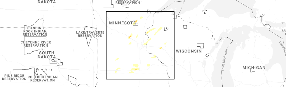
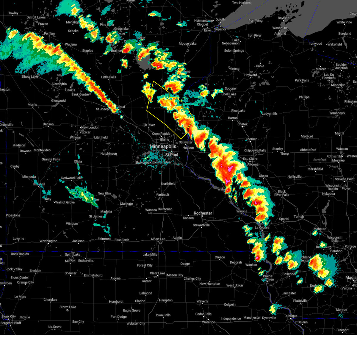
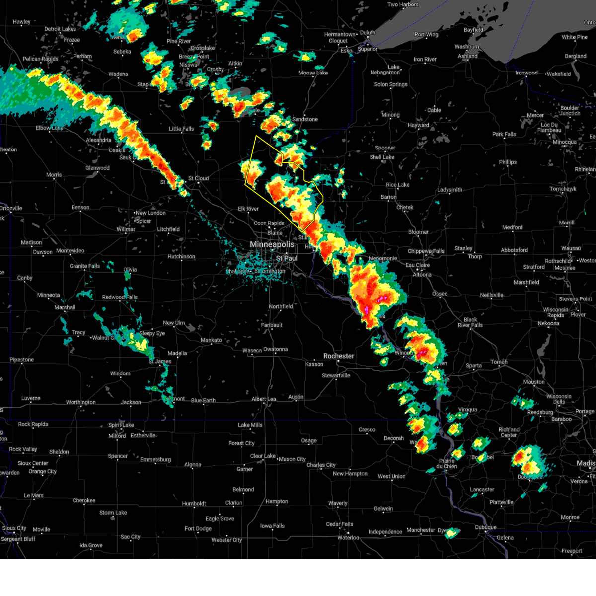
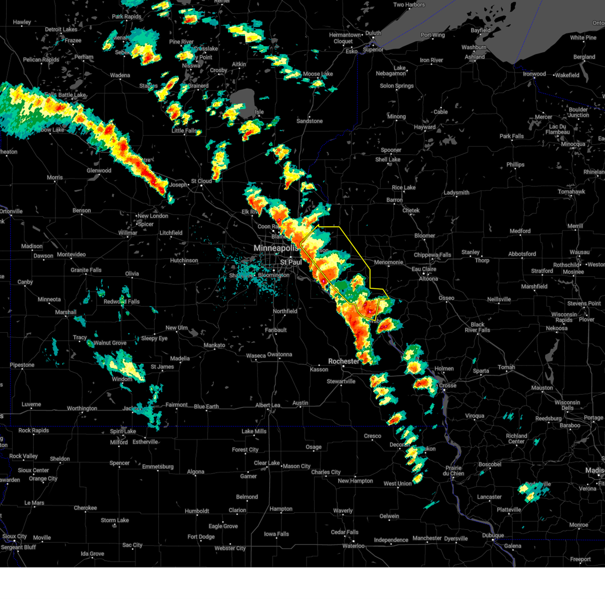
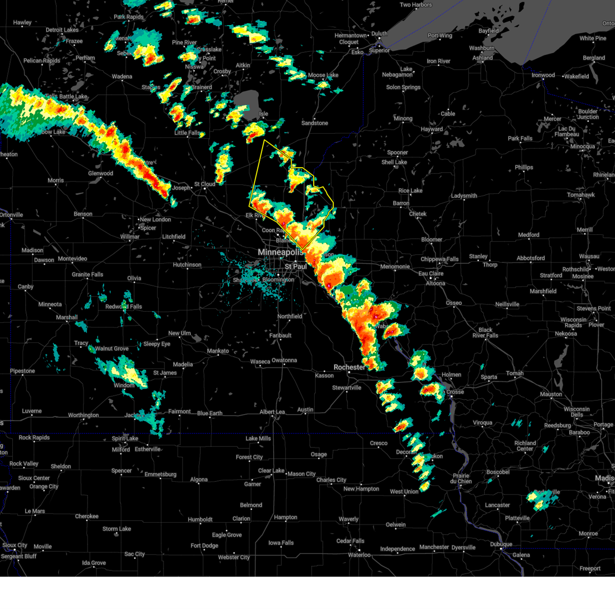
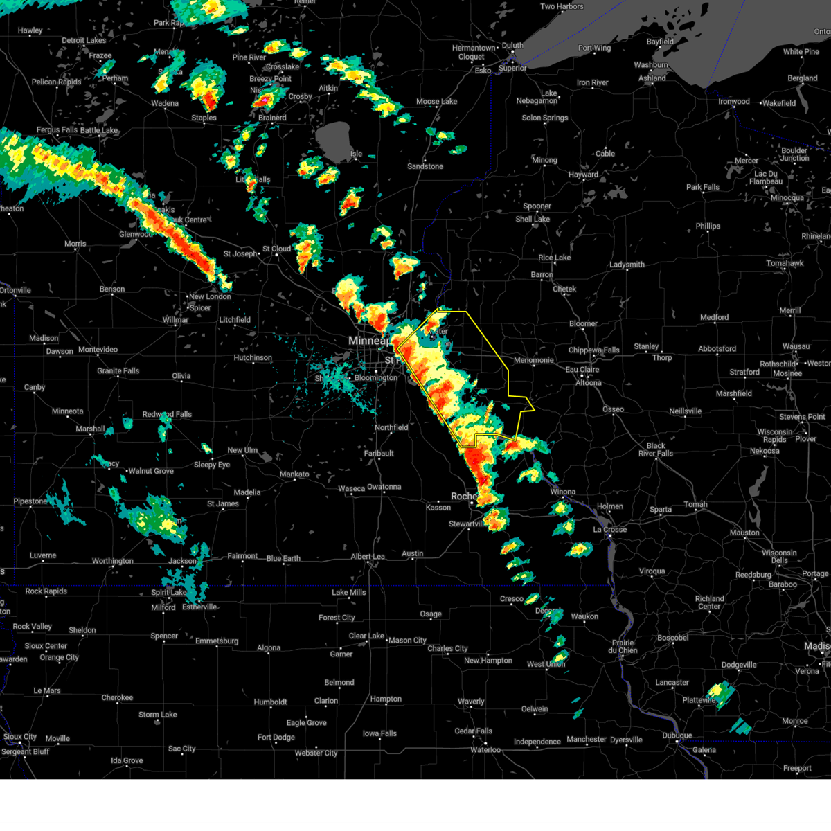
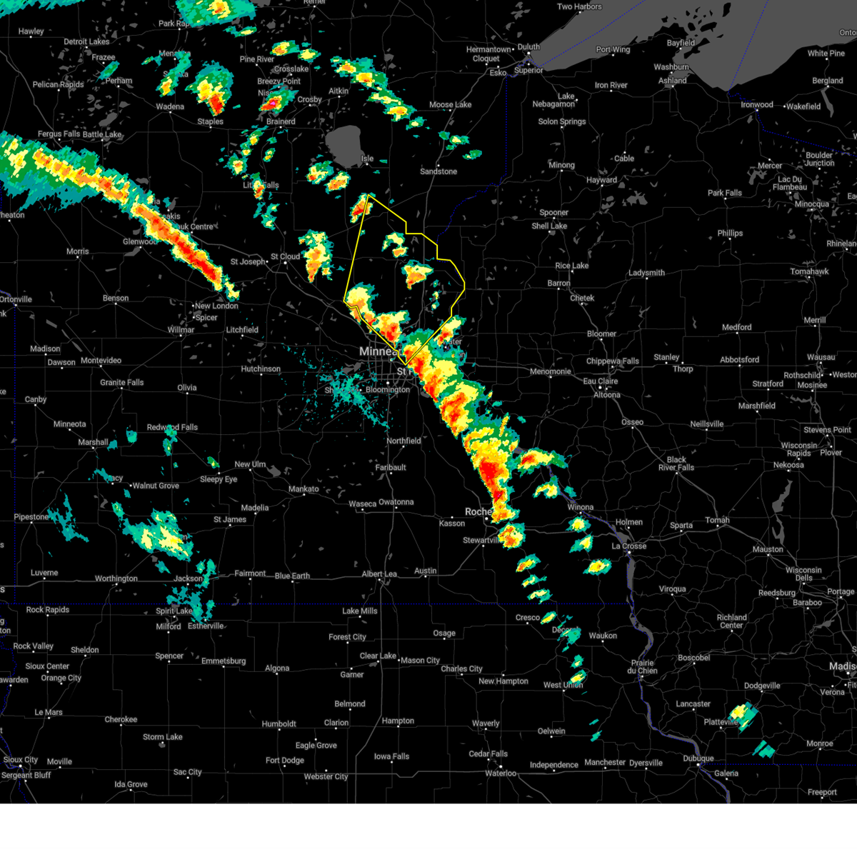
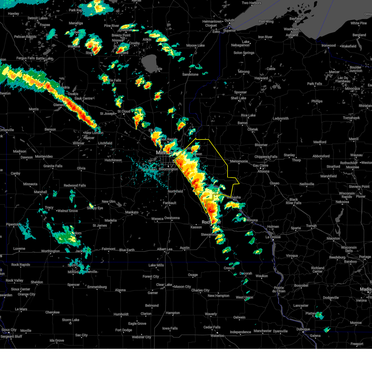
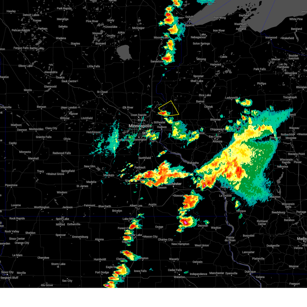
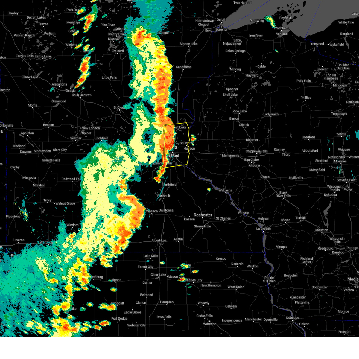
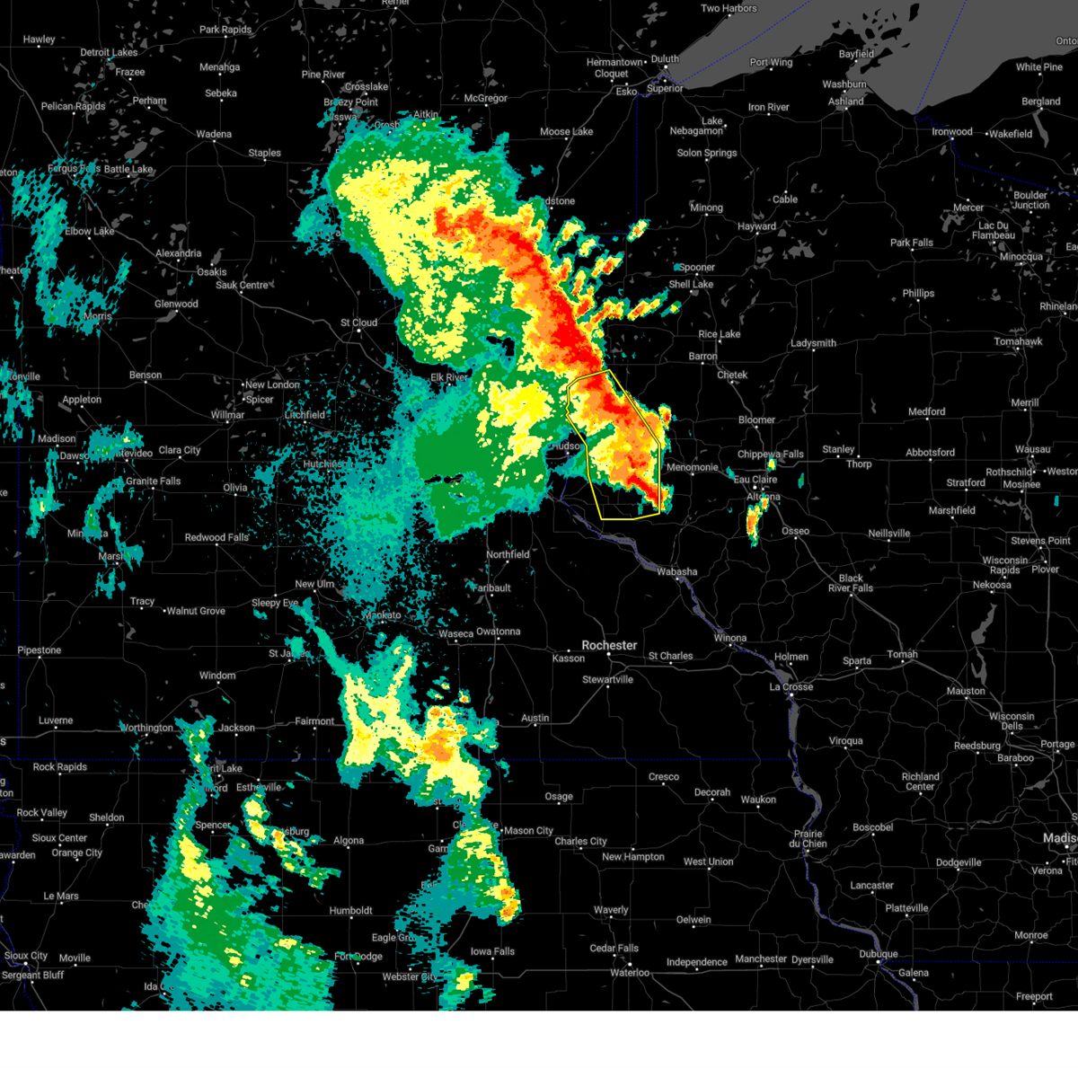
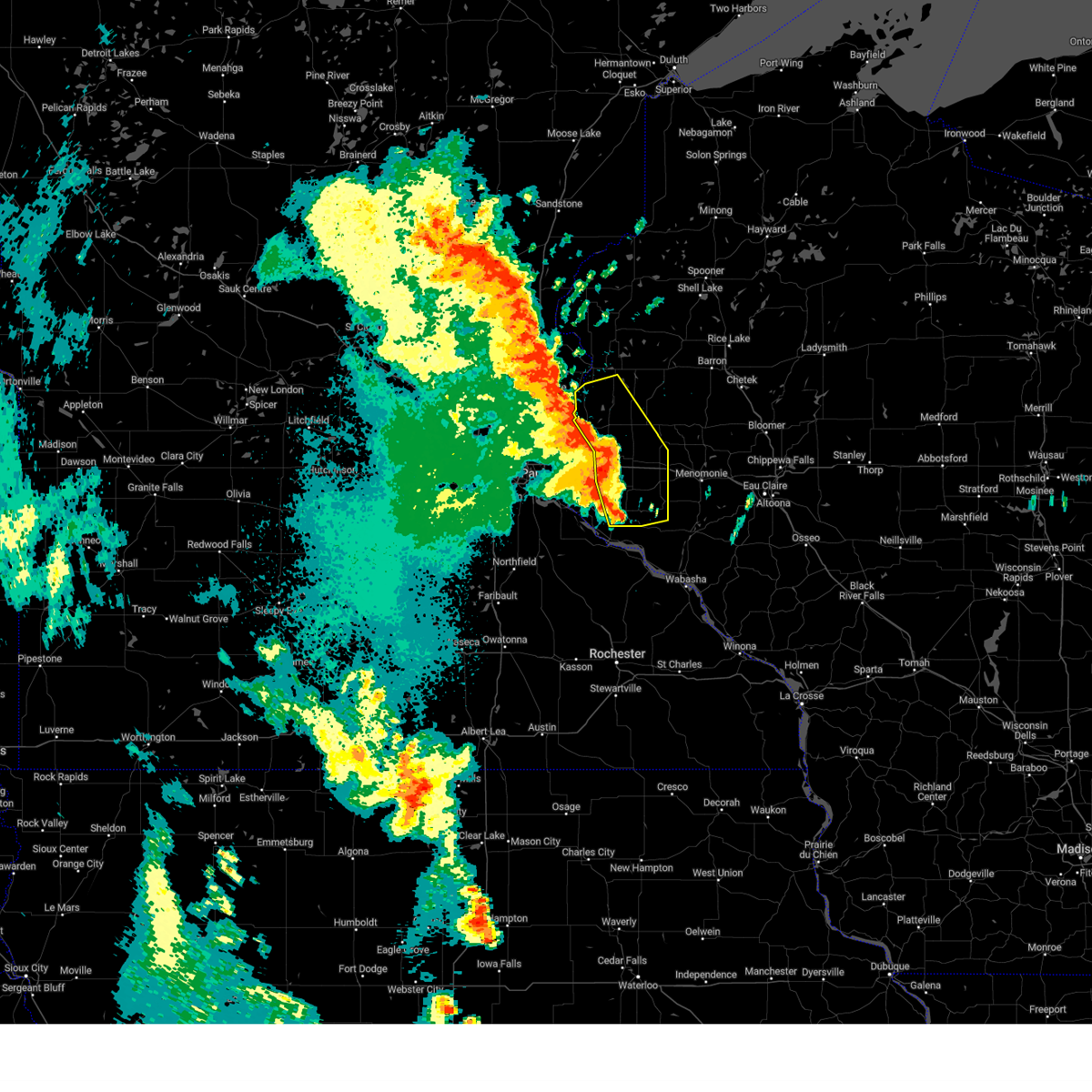
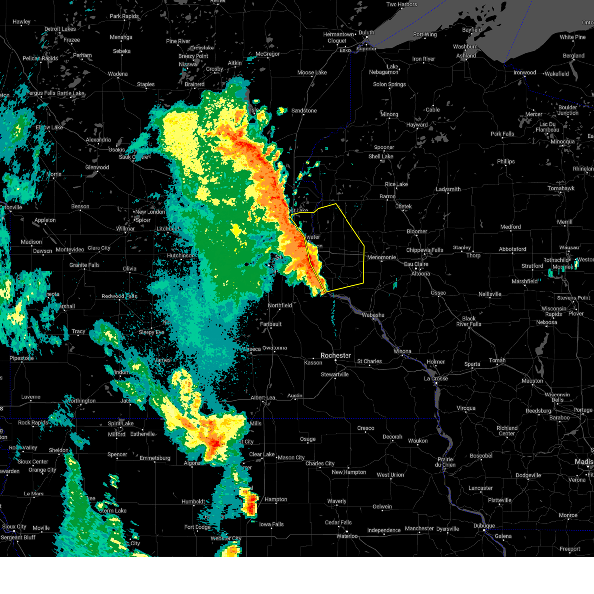
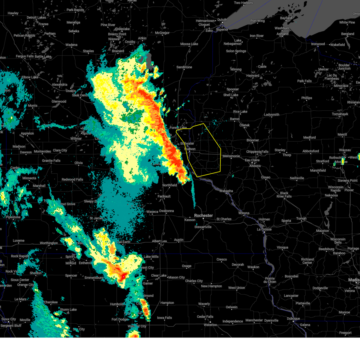
Hail Map for Marine on St. Croix, MN
The Marine on St. Croix, MN area has had 0 reports of on-the-ground hail by trained spotters, and has been under severe weather warnings 29 times during the past 12 months. Doppler radar has detected hail at or near Marine on St. Croix, MN on 56 occasions, including 5 occasions during the past year.
| Name: | Marine on St. Croix, MN |
| Where Located: | 28.7 miles ENE of Minneapolis, MN |
| Map: | Google Map for Marine on St. Croix, MN |
| Population: | 689 |
| Housing Units: | 348 |
| More Info: | Search Google for Marine on St. Croix, MN |
1
The Top Recent Hail Date for Marine on St. Croix, MN is Thursday, April 17, 2025 (12th out of 56)
Hail and Wind Damage Spotted near Marine on St. Croix, MN
| Date / Time | Report Details |
|---|---|
| 7/3/2025 10:38 PM CDT |
 The storm which prompted the warning has weakened below severe limits, and no longer poses an immediate threat to life or property. therefore, the warning will be allowed to expire. however, heavy rain is still possible with this thunderstorm. The storm which prompted the warning has weakened below severe limits, and no longer poses an immediate threat to life or property. therefore, the warning will be allowed to expire. however, heavy rain is still possible with this thunderstorm.
|
| 7/3/2025 10:21 PM CDT |
 At 1021 pm cdt, a severe thunderstorm was located 5 miles southeast of center city, moving east at 10 mph (radar indicated). Hazards include quarter size hail. Damage to vehicles is expected. locations impacted include, lindstrom, scandia, osceola, st. Croix falls, taylors falls, dresser, center city, shafer, osceola airport, east farmington, otisville and william obrien state park. At 1021 pm cdt, a severe thunderstorm was located 5 miles southeast of center city, moving east at 10 mph (radar indicated). Hazards include quarter size hail. Damage to vehicles is expected. locations impacted include, lindstrom, scandia, osceola, st. Croix falls, taylors falls, dresser, center city, shafer, osceola airport, east farmington, otisville and william obrien state park.
|
| 7/3/2025 10:01 PM CDT |
 Svrmpx the national weather service in the twin cities has issued a * severe thunderstorm warning for, southeastern chisago county in east central minnesota, northeastern washington county in east central minnesota, south central polk county in northwestern wisconsin, * until 1045 pm cdt. * at 1001 pm cdt, a severe thunderstorm was located near lindstrom, moving east at 10 mph (radar indicated). Hazards include ping pong ball size hail. People and animals outdoors will be injured. Expect damage to roofs, siding, windows, and vehicles. Svrmpx the national weather service in the twin cities has issued a * severe thunderstorm warning for, southeastern chisago county in east central minnesota, northeastern washington county in east central minnesota, south central polk county in northwestern wisconsin, * until 1045 pm cdt. * at 1001 pm cdt, a severe thunderstorm was located near lindstrom, moving east at 10 mph (radar indicated). Hazards include ping pong ball size hail. People and animals outdoors will be injured. Expect damage to roofs, siding, windows, and vehicles.
|
| 5/15/2025 3:28 PM CDT |
 The storms which prompted the warning have moved out of the area. therefore, the warning will be allowed to expire. however, heavy rain is still possible with these thunderstorms. The storms which prompted the warning have moved out of the area. therefore, the warning will be allowed to expire. however, heavy rain is still possible with these thunderstorms.
|
| 5/15/2025 3:18 PM CDT |
 The severe thunderstorm warning that was previously in effect has been upgraded to a tornado warning. please refer to that bulletin for the latest information on this dangerous weather situation. however, gusty winds are still possible with these thunderstorms. a tornado watch remains in effect until 800 pm cdt for portions of east central minnesota and west central wisconsin. The severe thunderstorm warning that was previously in effect has been upgraded to a tornado warning. please refer to that bulletin for the latest information on this dangerous weather situation. however, gusty winds are still possible with these thunderstorms. a tornado watch remains in effect until 800 pm cdt for portions of east central minnesota and west central wisconsin.
|
| 5/15/2025 3:12 PM CDT |
 At 312 pm cdt, severe thunderstorms were located along a line from 10 miles southeast of bock to over chisago city, or along a line from 13 miles northwest of cambridge to 20 miles southeast of cambridge, moving northeast at 50 mph (radar indicated). Hazards include 60 mph wind gusts and quarter size hail. Hail damage to vehicles is expected. expect wind damage to roofs, siding, and trees. locations impacted include, cambridge, forest lake, ham lake, hugo, east bethel, north branch, st. francis, isanti, chisago city, princeton, lindstrom, scandia, mora, rush city, st. Croix falls, stacy, brunswick, taylors falls, center city and ogilvie. At 312 pm cdt, severe thunderstorms were located along a line from 10 miles southeast of bock to over chisago city, or along a line from 13 miles northwest of cambridge to 20 miles southeast of cambridge, moving northeast at 50 mph (radar indicated). Hazards include 60 mph wind gusts and quarter size hail. Hail damage to vehicles is expected. expect wind damage to roofs, siding, and trees. locations impacted include, cambridge, forest lake, ham lake, hugo, east bethel, north branch, st. francis, isanti, chisago city, princeton, lindstrom, scandia, mora, rush city, st. Croix falls, stacy, brunswick, taylors falls, center city and ogilvie.
|
| 5/15/2025 3:12 PM CDT |
 the severe thunderstorm warning has been cancelled and is no longer in effect the severe thunderstorm warning has been cancelled and is no longer in effect
|
| 5/15/2025 3:03 PM CDT |
 the severe thunderstorm warning has been cancelled and is no longer in effect the severe thunderstorm warning has been cancelled and is no longer in effect
|
| 5/15/2025 3:03 PM CDT |
 At 303 pm cdt, severe thunderstorms were located along a line from over somerset to 8 miles east of pepin, or along a line from 19 miles north of river falls to 29 miles east of red wing, moving northeast at 50 mph (radar indicated). Hazards include 60 mph wind gusts and quarter size hail. Hail damage to vehicles is expected. expect wind damage to roofs, siding, and trees. Locations impacted include, river falls, woodbury, oakdale, stillwater, hugo, hudson, new richmond, lake elmo, mahtomedi, north hudson, bayport, ellsworth, afton, somerset, durand, hammond, baldwin, roberts, woodville and pepin. At 303 pm cdt, severe thunderstorms were located along a line from over somerset to 8 miles east of pepin, or along a line from 19 miles north of river falls to 29 miles east of red wing, moving northeast at 50 mph (radar indicated). Hazards include 60 mph wind gusts and quarter size hail. Hail damage to vehicles is expected. expect wind damage to roofs, siding, and trees. Locations impacted include, river falls, woodbury, oakdale, stillwater, hugo, hudson, new richmond, lake elmo, mahtomedi, north hudson, bayport, ellsworth, afton, somerset, durand, hammond, baldwin, roberts, woodville and pepin.
|
| 5/15/2025 2:55 PM CDT |
 At 255 pm cdt, severe thunderstorms were located along a line from near zimmerman to near hugo, or along a line from 16 miles west of cambridge to 17 miles north of st. paul, moving northeast at 50 mph (radar indicated). Hazards include 60 mph wind gusts and quarter size hail. Hail damage to vehicles is expected. expect wind damage to roofs, siding, and trees. locations impacted include, cambridge, blaine, andover, shoreview, white bear lake, elk river, lino lakes, forest lake, ham lake, hugo, east bethel, north branch, mahtomedi, st. Francis, isanti, zimmerman, chisago city, princeton, lindstrom and scandia. At 255 pm cdt, severe thunderstorms were located along a line from near zimmerman to near hugo, or along a line from 16 miles west of cambridge to 17 miles north of st. paul, moving northeast at 50 mph (radar indicated). Hazards include 60 mph wind gusts and quarter size hail. Hail damage to vehicles is expected. expect wind damage to roofs, siding, and trees. locations impacted include, cambridge, blaine, andover, shoreview, white bear lake, elk river, lino lakes, forest lake, ham lake, hugo, east bethel, north branch, mahtomedi, st. Francis, isanti, zimmerman, chisago city, princeton, lindstrom and scandia.
|
| 5/15/2025 2:55 PM CDT |
 the severe thunderstorm warning has been cancelled and is no longer in effect the severe thunderstorm warning has been cancelled and is no longer in effect
|
| 5/15/2025 2:44 PM CDT |
 At 244 pm cdt, severe thunderstorms were located along a line from over oakdale to 12 miles south of pepin, or along a line from 8 miles northeast of st. paul to 24 miles southeast of red wing, moving northeast at 50 mph (radar indicated). Hazards include 60 mph wind gusts and quarter size hail. Hail damage to vehicles is expected. expect wind damage to roofs, siding, and trees. locations impacted include, st. paul, red wing, river falls, woodbury, maplewood, cottage grove, oakdale, white bear lake, hastings, south st. paul, stillwater, hugo, hudson, new richmond, lake elmo, mahtomedi, st. Paul park, prescott, north hudson and bayport. At 244 pm cdt, severe thunderstorms were located along a line from over oakdale to 12 miles south of pepin, or along a line from 8 miles northeast of st. paul to 24 miles southeast of red wing, moving northeast at 50 mph (radar indicated). Hazards include 60 mph wind gusts and quarter size hail. Hail damage to vehicles is expected. expect wind damage to roofs, siding, and trees. locations impacted include, st. paul, red wing, river falls, woodbury, maplewood, cottage grove, oakdale, white bear lake, hastings, south st. paul, stillwater, hugo, hudson, new richmond, lake elmo, mahtomedi, st. Paul park, prescott, north hudson and bayport.
|
| 5/15/2025 2:41 PM CDT |
 Svrmpx the national weather service in the twin cities has issued a * severe thunderstorm warning for, eastern sherburne county in central minnesota, anoka county in east central minnesota, chisago county in east central minnesota, northeast hennepin county in east central minnesota, isanti county in east central minnesota, southwestern kanabec county in east central minnesota, southeastern mille lacs county in east central minnesota, northern ramsey county in east central minnesota, northern washington county in east central minnesota, * until 330 pm cdt. * at 241 pm cdt, a line of severe thunderstorms were located from near elk river to over vadnais heights, or along a line from 17 miles northeast of buffalo to 6 miles north of st. paul, moving northeast at 50 mph (radar indicated). Hazards include 60 mph wind gusts and quarter size hail. Hail damage to vehicles is expected. Expect wind damage to roofs, siding, and trees. Svrmpx the national weather service in the twin cities has issued a * severe thunderstorm warning for, eastern sherburne county in central minnesota, anoka county in east central minnesota, chisago county in east central minnesota, northeast hennepin county in east central minnesota, isanti county in east central minnesota, southwestern kanabec county in east central minnesota, southeastern mille lacs county in east central minnesota, northern ramsey county in east central minnesota, northern washington county in east central minnesota, * until 330 pm cdt. * at 241 pm cdt, a line of severe thunderstorms were located from near elk river to over vadnais heights, or along a line from 17 miles northeast of buffalo to 6 miles north of st. paul, moving northeast at 50 mph (radar indicated). Hazards include 60 mph wind gusts and quarter size hail. Hail damage to vehicles is expected. Expect wind damage to roofs, siding, and trees.
|
| 5/15/2025 2:31 PM CDT |
 Svrmpx the national weather service in the twin cities has issued a * severe thunderstorm warning for, northeastern dakota county in east central minnesota, southern ramsey county in east central minnesota, washington county in east central minnesota, central goodhue county in southeastern minnesota, pepin county in west central wisconsin, pierce county in west central wisconsin, st. croix county in west central wisconsin, * until 315 pm cdt. * at 231 pm cdt, a line of severe thunderstorms were located from mendota heights to 11 miles east of pine island, or along a line from near st. paul to 26 miles south of red wing, moving northeast at 50 mph (radar indicated). Hazards include 60 mph wind gusts and quarter size hail. Hail damage to vehicles is expected. Expect wind damage to roofs, siding, and trees. Svrmpx the national weather service in the twin cities has issued a * severe thunderstorm warning for, northeastern dakota county in east central minnesota, southern ramsey county in east central minnesota, washington county in east central minnesota, central goodhue county in southeastern minnesota, pepin county in west central wisconsin, pierce county in west central wisconsin, st. croix county in west central wisconsin, * until 315 pm cdt. * at 231 pm cdt, a line of severe thunderstorms were located from mendota heights to 11 miles east of pine island, or along a line from near st. paul to 26 miles south of red wing, moving northeast at 50 mph (radar indicated). Hazards include 60 mph wind gusts and quarter size hail. Hail damage to vehicles is expected. Expect wind damage to roofs, siding, and trees.
|
| 9/19/2024 5:52 PM CDT |
 Svrmpx the national weather service in the twin cities has issued a * severe thunderstorm warning for, southeastern chisago county in east central minnesota, south central polk county in northwestern wisconsin, * until 615 pm cdt. * at 552 pm cdt, a severe thunderstorm was located near scandia, or 27 miles north of river falls, moving northeast at 30 mph (radar indicated). Hazards include 60 mph wind gusts and quarter size hail. Hail damage to vehicles is expected. Expect wind damage to roofs, siding, and trees. Svrmpx the national weather service in the twin cities has issued a * severe thunderstorm warning for, southeastern chisago county in east central minnesota, south central polk county in northwestern wisconsin, * until 615 pm cdt. * at 552 pm cdt, a severe thunderstorm was located near scandia, or 27 miles north of river falls, moving northeast at 30 mph (radar indicated). Hazards include 60 mph wind gusts and quarter size hail. Hail damage to vehicles is expected. Expect wind damage to roofs, siding, and trees.
|
| 8/29/2024 5:15 PM CDT | The storms which prompted the warning have weakened below severe limits, and no longer pose an immediate threat to life or property. therefore, the warning has been allowed to expire. however, gusty winds and heavy rain are still possible with these thunderstorms. a severe thunderstorm watch remains in effect until 900 pm cdt for east central minnesota, and northwestern and west central wisconsin. |
| 8/29/2024 5:02 PM CDT | At 502 pm cdt, severe thunderstorms were located along a line extending from lindstrom to near stillwater to cottage grove, moving east at 30 mph (radar indicated). Hazards include 60 mph wind gusts. Expect damage to roofs, siding, and trees. these severe storms will be near, stillwater, bayport, and afton around 510 pm cdt. other locations impacted by these severe thunderstorms include newport, otisville, lake st croix beach, wyoming, willernie, lakeland shores, north st. Paul, lilydale, sunfish, and oak park heights. |
| 8/29/2024 5:02 PM CDT | the severe thunderstorm warning has been cancelled and is no longer in effect |
| 8/29/2024 4:46 PM CDT |
 At 445 pm cdt, severe thunderstorms were located along a line extending from near stacy to near white bear lake to inver grove heights, moving northeast at 40 mph (radar indicated). Hazards include 60 mph wind gusts. Expect damage to roofs, siding, and trees. these severe storms will be near, st. paul, woodbury, maplewood, cottage grove, and inver grove heights around 450 pm cdt. scandia and bayport around 455 pm cdt. other locations impacted by these severe thunderstorms include lake st croix beach, wyoming, lakeland shores, north st. Paul, lexington, sunfish, oak park heights, dellwood, mall of america, and pine springs. At 445 pm cdt, severe thunderstorms were located along a line extending from near stacy to near white bear lake to inver grove heights, moving northeast at 40 mph (radar indicated). Hazards include 60 mph wind gusts. Expect damage to roofs, siding, and trees. these severe storms will be near, st. paul, woodbury, maplewood, cottage grove, and inver grove heights around 450 pm cdt. scandia and bayport around 455 pm cdt. other locations impacted by these severe thunderstorms include lake st croix beach, wyoming, lakeland shores, north st. Paul, lexington, sunfish, oak park heights, dellwood, mall of america, and pine springs.
|
| 8/29/2024 4:35 PM CDT | At 435 pm cdt, severe thunderstorms were located along a line extending from near east bethel to near shoreview to near eagan, moving east at 40 mph (radar indicated). Hazards include 60 mph wind gusts. Expect damage to roofs, siding, and trees. these severe storms will be near, st. paul, woodbury, maplewood, cottage grove, and inver grove heights around 440 pm cdt. chisago city around 445 pm cdt. stillwater and afton around 450 pm cdt. lindstrom, scandia, and bayport around 455 pm cdt. other locations impacted by these severe thunderstorms include robbinsdale, lake st croix beach, wyoming, lakeland shores, north st. Paul, cedar, lexington, sunfish, oak park heights, and north minneapolis. |
| 8/29/2024 4:18 PM CDT | Svrmpx the national weather service in the twin cities has issued a * severe thunderstorm warning for, eastern hennepin county in east central minnesota, northwestern dakota county in east central minnesota, south central chisago county in east central minnesota, anoka county in east central minnesota, washington county in east central minnesota, ramsey county in east central minnesota, * until 515 pm cdt. * at 417 pm cdt, severe thunderstorms were located along a line extending from near elk river to near brooklyn park to bloomington, moving east at 45 mph (radar indicated). Hazards include 60 mph wind gusts. Expect damage to roofs, siding, and trees. severe thunderstorms will be near, minneapolis, st. paul, bloomington, brooklyn park, and eagan around 425 pm cdt. maplewood, inver grove heights, lino lakes, south st. paul, and west st. paul around 430 pm cdt. woodbury, white bear lake, and hugo around 435 pm cdt. oakdale, forest lake, lake elmo, and mahtomedi around 440 pm cdt. stillwater, chisago city, and afton around 445 pm cdt. those attending the minnesota state fair are in the path of these storms and should prepare for imminent dangerous weather conditions. Seek shelter now!. |
| 8/27/2024 6:27 AM CDT |
 The storms which prompted the warning have moved out of the area. therefore, the warning will be allowed to expire. to report severe weather, contact your nearest law enforcement agency. they will relay your report to the national weather service the twin cities. The storms which prompted the warning have moved out of the area. therefore, the warning will be allowed to expire. to report severe weather, contact your nearest law enforcement agency. they will relay your report to the national weather service the twin cities.
|
| 8/27/2024 6:11 AM CDT |
 the severe thunderstorm warning has been cancelled and is no longer in effect the severe thunderstorm warning has been cancelled and is no longer in effect
|
| 8/27/2024 6:11 AM CDT |
 At 610 am cdt, severe thunderstorms were located along a line extending from 6 miles north of somerset to near baldwin to 6 miles east of ellsworth, moving east at 60 mph (radar indicated). Hazards include 60 mph wind gusts. Expect damage to roofs, siding, and trees. these severe storms will be near, new richmond, woodville, glenwood city, elmwood, and star prairie around 615 am cdt. Other locations impacted by these severe thunderstorms include el paso, osceola airport, boardman, wilson, huntington, martel, wanderoos, beldenville, east farmington, and hersey. At 610 am cdt, severe thunderstorms were located along a line extending from 6 miles north of somerset to near baldwin to 6 miles east of ellsworth, moving east at 60 mph (radar indicated). Hazards include 60 mph wind gusts. Expect damage to roofs, siding, and trees. these severe storms will be near, new richmond, woodville, glenwood city, elmwood, and star prairie around 615 am cdt. Other locations impacted by these severe thunderstorms include el paso, osceola airport, boardman, wilson, huntington, martel, wanderoos, beldenville, east farmington, and hersey.
|
| 8/27/2024 5:59 AM CDT |
 At 559 am cdt, severe thunderstorms were located along a line extending from near scandia to near roberts to near ellsworth, moving east at 60 mph (radar indicated). Hazards include 60 mph wind gusts. Expect damage to roofs, siding, and trees. these severe storms will be near, new richmond, somerset, hammond, baldwin, and roberts around 605 am cdt. woodville and star prairie around 610 am cdt. elmwood around 615 am cdt. Glenwood city around 620 am cdt. At 559 am cdt, severe thunderstorms were located along a line extending from near scandia to near roberts to near ellsworth, moving east at 60 mph (radar indicated). Hazards include 60 mph wind gusts. Expect damage to roofs, siding, and trees. these severe storms will be near, new richmond, somerset, hammond, baldwin, and roberts around 605 am cdt. woodville and star prairie around 610 am cdt. elmwood around 615 am cdt. Glenwood city around 620 am cdt.
|
| 8/27/2024 5:45 AM CDT |
 Svrmpx the national weather service in the twin cities has issued a * severe thunderstorm warning for, northern washington county in east central minnesota, pierce county in west central wisconsin, st. croix county in west central wisconsin, south central polk county in northwestern wisconsin, * until 630 am cdt. * at 544 am cdt, severe thunderstorms were located along a line extending from lino lakes to lake elmo to 6 miles south of prescott, moving east at 55 mph (radar indicated). Hazards include 60 mph wind gusts. Expect damage to roofs, siding, and trees. severe thunderstorms will be near, river falls, stillwater, hugo, hudson, and north hudson around 550 am cdt. ellsworth around 555 am cdt. somerset and roberts around 600 am cdt. new richmond, hammond, and baldwin around 605 am cdt. woodville and star prairie around 610 am cdt. elmwood around 615 am cdt. Glenwood city around 620 am cdt. Svrmpx the national weather service in the twin cities has issued a * severe thunderstorm warning for, northern washington county in east central minnesota, pierce county in west central wisconsin, st. croix county in west central wisconsin, south central polk county in northwestern wisconsin, * until 630 am cdt. * at 544 am cdt, severe thunderstorms were located along a line extending from lino lakes to lake elmo to 6 miles south of prescott, moving east at 55 mph (radar indicated). Hazards include 60 mph wind gusts. Expect damage to roofs, siding, and trees. severe thunderstorms will be near, river falls, stillwater, hugo, hudson, and north hudson around 550 am cdt. ellsworth around 555 am cdt. somerset and roberts around 600 am cdt. new richmond, hammond, and baldwin around 605 am cdt. woodville and star prairie around 610 am cdt. elmwood around 615 am cdt. Glenwood city around 620 am cdt.
|
| 8/26/2024 7:55 PM CDT |
 the severe thunderstorm warning has been cancelled and is no longer in effect the severe thunderstorm warning has been cancelled and is no longer in effect
|
| 8/26/2024 7:55 PM CDT |
 At 754 pm cdt, a severe thunderstorm was located near star prairie, or 26 miles north of river falls, moving east at 45 mph (radar indicated). Hazards include 60 mph wind gusts and quarter size hail. Hail damage to vehicles is expected. expect wind damage to roofs, siding, and trees. locations impacted include, forest lake, hugo, new richmond, chisago city, lindstrom, scandia, amery, somerset, osceola, st. Croix falls, stacy, and clear lake. At 754 pm cdt, a severe thunderstorm was located near star prairie, or 26 miles north of river falls, moving east at 45 mph (radar indicated). Hazards include 60 mph wind gusts and quarter size hail. Hail damage to vehicles is expected. expect wind damage to roofs, siding, and trees. locations impacted include, forest lake, hugo, new richmond, chisago city, lindstrom, scandia, amery, somerset, osceola, st. Croix falls, stacy, and clear lake.
|
| 8/26/2024 7:39 PM CDT |
 Svrmpx the national weather service in the twin cities has issued a * severe thunderstorm warning for, southeastern chisago county in east central minnesota, eastern anoka county in east central minnesota, northern washington county in east central minnesota, northern ramsey county in east central minnesota, northern st. croix county in west central wisconsin, southeastern polk county in northwestern wisconsin, * until 815 pm cdt. * at 739 pm cdt, a severe thunderstorm was located over scandia, or 23 miles northeast of st. paul, moving east at 40 mph (radar indicated). Hazards include 60 mph wind gusts and quarter size hail. Hail damage to vehicles is expected. Expect wind damage to roofs, siding, and trees. Svrmpx the national weather service in the twin cities has issued a * severe thunderstorm warning for, southeastern chisago county in east central minnesota, eastern anoka county in east central minnesota, northern washington county in east central minnesota, northern ramsey county in east central minnesota, northern st. croix county in west central wisconsin, southeastern polk county in northwestern wisconsin, * until 815 pm cdt. * at 739 pm cdt, a severe thunderstorm was located over scandia, or 23 miles northeast of st. paul, moving east at 40 mph (radar indicated). Hazards include 60 mph wind gusts and quarter size hail. Hail damage to vehicles is expected. Expect wind damage to roofs, siding, and trees.
|
| 6/18/2024 9:29 PM CDT |
 The storm which prompted the warning has weakened below severe limits, and no longer poses an immediate threat to life or property. therefore, the warning will be allowed to expire. however, gusty winds are still possible with this thunderstorm. to report severe weather, contact your nearest law enforcement agency. they will relay your report to the national weather service the twin cities. The storm which prompted the warning has weakened below severe limits, and no longer poses an immediate threat to life or property. therefore, the warning will be allowed to expire. however, gusty winds are still possible with this thunderstorm. to report severe weather, contact your nearest law enforcement agency. they will relay your report to the national weather service the twin cities.
|
| 6/18/2024 8:53 PM CDT |
 Svrmpx the national weather service in the twin cities has issued a * severe thunderstorm warning for, northern washington county in east central minnesota, northwestern st. croix county in west central wisconsin, southwestern polk county in northwestern wisconsin, * until 930 pm cdt. * at 853 pm cdt, a severe thunderstorm was located near mahtomedi, or 13 miles northeast of st. paul, moving northeast at 45 mph (radar indicated). Hazards include 60 mph wind gusts and penny size hail. expect damage to roofs, siding, and trees Svrmpx the national weather service in the twin cities has issued a * severe thunderstorm warning for, northern washington county in east central minnesota, northwestern st. croix county in west central wisconsin, southwestern polk county in northwestern wisconsin, * until 930 pm cdt. * at 853 pm cdt, a severe thunderstorm was located near mahtomedi, or 13 miles northeast of st. paul, moving northeast at 45 mph (radar indicated). Hazards include 60 mph wind gusts and penny size hail. expect damage to roofs, siding, and trees
|
| 8/11/2023 4:22 PM CDT |
 At 422 pm cdt, a severe thunderstorm was located over chisago city, or 17 miles southeast of cambridge, moving southeast at 50 mph (radar indicated). Hazards include 60 mph wind gusts and quarter size hail. Hail damage to vehicles is expected. expect wind damage to roofs, siding, and trees. this severe thunderstorm will be near, lindstrom and center city around 430 pm cdt. scandia, osceola and taylors falls around 435 pm cdt. dresser around 440 pm cdt. other locations in the path of this severe thunderstorm include new richmond and star prairie. hail threat, radar indicated max hail size, 1. 00 in wind threat, radar indicated max wind gust, 60 mph. At 422 pm cdt, a severe thunderstorm was located over chisago city, or 17 miles southeast of cambridge, moving southeast at 50 mph (radar indicated). Hazards include 60 mph wind gusts and quarter size hail. Hail damage to vehicles is expected. expect wind damage to roofs, siding, and trees. this severe thunderstorm will be near, lindstrom and center city around 430 pm cdt. scandia, osceola and taylors falls around 435 pm cdt. dresser around 440 pm cdt. other locations in the path of this severe thunderstorm include new richmond and star prairie. hail threat, radar indicated max hail size, 1. 00 in wind threat, radar indicated max wind gust, 60 mph.
|
| 7/4/2023 11:20 AM CDT |
 The severe thunderstorm warning for east central washington and northwestern st. croix counties will expire at 1130 am cdt, the storm which prompted the warning has weakened below severe limits, and no longer poses an immediate threat to life or property. therefore, the warning will be allowed to expire. however heavy rain is still possible with this thunderstorm. to report severe weather, contact your nearest law enforcement agency. they will relay your report to the national weather service the twin cities. The severe thunderstorm warning for east central washington and northwestern st. croix counties will expire at 1130 am cdt, the storm which prompted the warning has weakened below severe limits, and no longer poses an immediate threat to life or property. therefore, the warning will be allowed to expire. however heavy rain is still possible with this thunderstorm. to report severe weather, contact your nearest law enforcement agency. they will relay your report to the national weather service the twin cities.
|
| 7/4/2023 11:11 AM CDT |
 At 1111 am cdt, a severe thunderstorm was located over stillwater, or 13 miles northeast of st. paul, moving east at 20 mph (radar indicated). Hazards include 60 mph wind gusts. Expect damage to roofs, siding, and trees. locations impacted include, stillwater, north hudson, bayport, hudson and somerset. hail threat, radar indicated max hail size, <. 75 in wind threat, radar indicated max wind gust, 60 mph. At 1111 am cdt, a severe thunderstorm was located over stillwater, or 13 miles northeast of st. paul, moving east at 20 mph (radar indicated). Hazards include 60 mph wind gusts. Expect damage to roofs, siding, and trees. locations impacted include, stillwater, north hudson, bayport, hudson and somerset. hail threat, radar indicated max hail size, <. 75 in wind threat, radar indicated max wind gust, 60 mph.
|
| 7/4/2023 10:57 AM CDT |
 At 1057 am cdt, a severe thunderstorm was located over oakdale, or 8 miles northeast of st. paul, moving east at 20 mph (radar indicated). Hazards include 60 mph wind gusts and quarter size hail. Hail damage to vehicles is expected. expect wind damage to roofs, siding, and trees. this severe thunderstorm will be near, afton around 1105 am cdt. lake elmo around 1110 am cdt. other locations in the path of this severe thunderstorm include stillwater, hudson, north hudson, bayport and somerset. hail threat, radar indicated max hail size, 1. 00 in wind threat, radar indicated max wind gust, 60 mph. At 1057 am cdt, a severe thunderstorm was located over oakdale, or 8 miles northeast of st. paul, moving east at 20 mph (radar indicated). Hazards include 60 mph wind gusts and quarter size hail. Hail damage to vehicles is expected. expect wind damage to roofs, siding, and trees. this severe thunderstorm will be near, afton around 1105 am cdt. lake elmo around 1110 am cdt. other locations in the path of this severe thunderstorm include stillwater, hudson, north hudson, bayport and somerset. hail threat, radar indicated max hail size, 1. 00 in wind threat, radar indicated max wind gust, 60 mph.
|
| 9/20/2022 8:01 PM CDT |
 At 801 pm cdt, a severe thunderstorm was located over hugo, or 18 miles northeast of st. paul, moving east at 40 mph (radar indicated). Hazards include half dollar size hail. Damage to vehicles is expected. this severe thunderstorm will be near, stillwater and scandia around 810 pm cdt. somerset around 820 pm cdt. other locations in the path of this severe thunderstorm include new richmond and star prairie. hail threat, radar indicated max hail size, 1. 25 in wind threat, radar indicated max wind gust, <50 mph. At 801 pm cdt, a severe thunderstorm was located over hugo, or 18 miles northeast of st. paul, moving east at 40 mph (radar indicated). Hazards include half dollar size hail. Damage to vehicles is expected. this severe thunderstorm will be near, stillwater and scandia around 810 pm cdt. somerset around 820 pm cdt. other locations in the path of this severe thunderstorm include new richmond and star prairie. hail threat, radar indicated max hail size, 1. 25 in wind threat, radar indicated max wind gust, <50 mph.
|
| 8/27/2022 9:26 PM CDT | At 926 pm cdt, severe thunderstorms were located along a line extending from near hugo to near somerset to near hudson, moving northeast at 45 mph (radar indicated). Hazards include 60 mph wind gusts. Expect damage to roofs, siding, and trees. Locations impacted include, somerset, scandia, roberts, chisago city, lindstrom, osceola, center city, star prairie, new richmond and dresser. |
| 8/27/2022 9:26 PM CDT | At 926 pm cdt, severe thunderstorms were located along a line extending from near hugo to near somerset to near hudson, moving northeast at 45 mph (radar indicated). Hazards include 60 mph wind gusts. Expect damage to roofs, siding, and trees. Locations impacted include, somerset, scandia, roberts, chisago city, lindstrom, osceola, center city, star prairie, new richmond and dresser. |
| 8/27/2022 9:08 PM CDT | At 907 pm cdt, severe thunderstorms were located along a line extending from vadnais heights to oakdale to near cottage grove, moving northeast at 45 mph (radar indicated). Hazards include 60 mph wind gusts. Expect damage to roofs, siding, and trees. severe thunderstorms will be near, stillwater, hugo and bayport around 920 pm cdt. hudson and north hudson around 925 pm cdt. Other locations in the path of these severe thunderstorms include forest lake, somerset, roberts, scandia, new richmond, chisago city, lindstrom, osceola, center city, taylors falls, dresser and star prairie. |
| 8/27/2022 9:08 PM CDT | At 907 pm cdt, severe thunderstorms were located along a line extending from vadnais heights to oakdale to near cottage grove, moving northeast at 45 mph (radar indicated). Hazards include 60 mph wind gusts. Expect damage to roofs, siding, and trees. severe thunderstorms will be near, stillwater, hugo and bayport around 920 pm cdt. hudson and north hudson around 925 pm cdt. Other locations in the path of these severe thunderstorms include forest lake, somerset, roberts, scandia, new richmond, chisago city, lindstrom, osceola, center city, taylors falls, dresser and star prairie. |
| 5/19/2022 4:01 PM CDT |
 At 400 pm cdt, severe thunderstorms were located along a line extending from near scandia to stillwater to near woodbury, moving east at 60 mph (trained weather spotters). Hazards include golf ball size hail. People and animals outdoors will be injured. expect damage to roofs, siding, windows, and vehicles. severe thunderstorms will be near, scandia and bayport around 405 pm cdt. somerset and osceola around 410 pm cdt. hudson, new richmond, north hudson and star prairie around 415 pm cdt. river falls and roberts around 420 pm cdt. other locations in the path of these severe thunderstorms include amery, hammond, baldwin, clear lake, woodville, clayton and glenwood city. thunderstorm damage threat, considerable hail threat, radar indicated max hail size, 1. 75 in wind threat, radar indicated max wind gust, <50 mph. At 400 pm cdt, severe thunderstorms were located along a line extending from near scandia to stillwater to near woodbury, moving east at 60 mph (trained weather spotters). Hazards include golf ball size hail. People and animals outdoors will be injured. expect damage to roofs, siding, windows, and vehicles. severe thunderstorms will be near, scandia and bayport around 405 pm cdt. somerset and osceola around 410 pm cdt. hudson, new richmond, north hudson and star prairie around 415 pm cdt. river falls and roberts around 420 pm cdt. other locations in the path of these severe thunderstorms include amery, hammond, baldwin, clear lake, woodville, clayton and glenwood city. thunderstorm damage threat, considerable hail threat, radar indicated max hail size, 1. 75 in wind threat, radar indicated max wind gust, <50 mph.
|
| 5/12/2022 8:41 PM CDT |
 At 840 pm cdt, a gust front was located along a line extending from 6 miles northeast of cambridge to near ham lake to near roseville to near elko new market, moving east at 50 mph (radar indicated). Hazards include 60 mph wind gusts. Expect damage to roofs, siding, and trees. the gust front will be near, maplewood, lino lakes, hugo and vadnais heights around 845 pm cdt. oakdale, white bear lake, forest lake, north branch and mahtomedi around 850 pm cdt. lake elmo, chisago city and rush city around 855 pm cdt. stillwater, lindstrom, cannon falls, scandia and bayport around 900 pm cdt. hudson and osceola around 905 pm cdt. taylors falls around 910 pm cdt. hail threat, radar indicated max hail size, <. 75 in wind threat, radar indicated max wind gust, 60 mph. At 840 pm cdt, a gust front was located along a line extending from 6 miles northeast of cambridge to near ham lake to near roseville to near elko new market, moving east at 50 mph (radar indicated). Hazards include 60 mph wind gusts. Expect damage to roofs, siding, and trees. the gust front will be near, maplewood, lino lakes, hugo and vadnais heights around 845 pm cdt. oakdale, white bear lake, forest lake, north branch and mahtomedi around 850 pm cdt. lake elmo, chisago city and rush city around 855 pm cdt. stillwater, lindstrom, cannon falls, scandia and bayport around 900 pm cdt. hudson and osceola around 905 pm cdt. taylors falls around 910 pm cdt. hail threat, radar indicated max hail size, <. 75 in wind threat, radar indicated max wind gust, 60 mph.
|
| 5/12/2022 8:25 PM CDT |
 At 823 pm cdt, a gust front was located along a line extending from 7 miles east of princeton to anoka to near plymouth to 5 miles east of new prague, moving east at 50 mph (radar indicated. at 819 pm cdt, a 67 mph wind gust was reported 1 mile west southwest of shakopee). Hazards include 60 mph wind gusts. Expect damage to roofs, siding, and trees. severe thunderstorms will be near, minneapolis, columbia heights and ham lake around 830 pm cdt. blaine, roseville, new brighton, lino lakes and mounds view around 835 pm cdt. shoreview and arden hills around 840 pm cdt. st. paul, maplewood, farmington, hugo and vadnais heights around 845 pm cdt. oakdale, white bear lake, forest lake, north branch and mahtomedi around 850 pm cdt. lake elmo, chisago city, cannon falls and rush city around 855 pm cdt. stillwater, lindstrom, scandia, bayport and center city around 900 pm cdt. thunderstorms with heavy rain will follow the gust front by up to 30 minutes. hail threat, radar indicated max hail size, <. 75 in wind threat, observed max wind gust, 60 mph. At 823 pm cdt, a gust front was located along a line extending from 7 miles east of princeton to anoka to near plymouth to 5 miles east of new prague, moving east at 50 mph (radar indicated. at 819 pm cdt, a 67 mph wind gust was reported 1 mile west southwest of shakopee). Hazards include 60 mph wind gusts. Expect damage to roofs, siding, and trees. severe thunderstorms will be near, minneapolis, columbia heights and ham lake around 830 pm cdt. blaine, roseville, new brighton, lino lakes and mounds view around 835 pm cdt. shoreview and arden hills around 840 pm cdt. st. paul, maplewood, farmington, hugo and vadnais heights around 845 pm cdt. oakdale, white bear lake, forest lake, north branch and mahtomedi around 850 pm cdt. lake elmo, chisago city, cannon falls and rush city around 855 pm cdt. stillwater, lindstrom, scandia, bayport and center city around 900 pm cdt. thunderstorms with heavy rain will follow the gust front by up to 30 minutes. hail threat, radar indicated max hail size, <. 75 in wind threat, observed max wind gust, 60 mph.
|
| 5/11/2022 9:43 PM CDT |
 The severe thunderstorm warning for southeastern chisago, st. croix and polk counties will expire at 945 pm cdt, the severe thunderstorm which prompted the warning has weakened and moved out of the warned area. therefore, the warning will be allowed to expire. a tornado watch remains in effect until midnight cdt for east central minnesota, and northwestern and west central wisconsin. The severe thunderstorm warning for southeastern chisago, st. croix and polk counties will expire at 945 pm cdt, the severe thunderstorm which prompted the warning has weakened and moved out of the warned area. therefore, the warning will be allowed to expire. a tornado watch remains in effect until midnight cdt for east central minnesota, and northwestern and west central wisconsin.
|
| 5/11/2022 9:00 PM CDT |
 At 900 pm cdt, a severe thunderstorm was located near center city, or 24 miles southeast of cambridge, moving northeast at 50 mph (law enforcement). Hazards include 70 mph wind gusts and quarter size hail. Hail damage to vehicles is expected. expect considerable tree damage. wind damage is also likely to mobile homes, roofs, and outbuildings. This severe thunderstorm will remain over mainly rural areas of southeastern chisago and washington counties, including the following locations, otisville, grant, afton state park, lake st croix beach, wyoming, willernie, lakeland shores, st paul park, william obrien state park and st marys point. At 900 pm cdt, a severe thunderstorm was located near center city, or 24 miles southeast of cambridge, moving northeast at 50 mph (law enforcement). Hazards include 70 mph wind gusts and quarter size hail. Hail damage to vehicles is expected. expect considerable tree damage. wind damage is also likely to mobile homes, roofs, and outbuildings. This severe thunderstorm will remain over mainly rural areas of southeastern chisago and washington counties, including the following locations, otisville, grant, afton state park, lake st croix beach, wyoming, willernie, lakeland shores, st paul park, william obrien state park and st marys point.
|
| 5/11/2022 8:40 PM CDT |
 At 840 pm cdt, a severe thunderstorm was located over forest lake, or 21 miles southeast of cambridge, moving northeast at 60 mph (radar indicated). Hazards include 70 mph wind gusts and quarter size hail. Hail damage to vehicles is expected. expect considerable tree damage. wind damage is also likely to mobile homes, roofs, and outbuildings. this severe thunderstorm will be near, chisago city and lindstrom around 850 pm cdt. osceola and center city around 855 pm cdt. st. croix falls, taylors falls and dresser around 900 pm cdt. Other locations in the path of this severe thunderstorm include centuria, balsam lake, luck, milltown and frederic. At 840 pm cdt, a severe thunderstorm was located over forest lake, or 21 miles southeast of cambridge, moving northeast at 60 mph (radar indicated). Hazards include 70 mph wind gusts and quarter size hail. Hail damage to vehicles is expected. expect considerable tree damage. wind damage is also likely to mobile homes, roofs, and outbuildings. this severe thunderstorm will be near, chisago city and lindstrom around 850 pm cdt. osceola and center city around 855 pm cdt. st. croix falls, taylors falls and dresser around 900 pm cdt. Other locations in the path of this severe thunderstorm include centuria, balsam lake, luck, milltown and frederic.
|
| 5/11/2022 8:13 PM CDT |
 At 813 pm cdt, a severe thunderstorm was located over st. louis park, or 7 miles west of minneapolis, moving northeast at 50 mph (law enforcement). Hazards include 70 mph wind gusts and quarter size hail. Hail damage to vehicles is expected. expect considerable tree damage. wind damage is also likely to mobile homes, roofs, and outbuildings. this severe thunderstorm will be near, brooklyn center around 820 pm cdt. brooklyn park, roseville and columbia heights around 825 pm cdt. fridley, shoreview, new brighton, mounds view and arden hills around 830 pm cdt. Other locations in the path of this severe thunderstorm include vadnais heights, blaine, lino lakes, hugo, forest lake, scandia and stacy. At 813 pm cdt, a severe thunderstorm was located over st. louis park, or 7 miles west of minneapolis, moving northeast at 50 mph (law enforcement). Hazards include 70 mph wind gusts and quarter size hail. Hail damage to vehicles is expected. expect considerable tree damage. wind damage is also likely to mobile homes, roofs, and outbuildings. this severe thunderstorm will be near, brooklyn center around 820 pm cdt. brooklyn park, roseville and columbia heights around 825 pm cdt. fridley, shoreview, new brighton, mounds view and arden hills around 830 pm cdt. Other locations in the path of this severe thunderstorm include vadnais heights, blaine, lino lakes, hugo, forest lake, scandia and stacy.
|
| 5/9/2022 5:40 PM CDT |
 At 540 pm cdt, a severe thunderstorm was located over stillwater, or 13 miles northeast of st. paul, moving northeast at 60 mph (radar indicated). Hazards include 60 mph wind gusts and quarter size hail. Hail damage to vehicles is expected. expect wind damage to roofs, siding, and trees. this severe thunderstorm will be near, somerset around 550 pm cdt. new richmond around 555 pm cdt. osceola and star prairie around 600 pm cdt. other locations in the path of this severe thunderstorm include dresser. hail threat, radar indicated max hail size, 1. 00 in wind threat, radar indicated max wind gust, 60 mph. At 540 pm cdt, a severe thunderstorm was located over stillwater, or 13 miles northeast of st. paul, moving northeast at 60 mph (radar indicated). Hazards include 60 mph wind gusts and quarter size hail. Hail damage to vehicles is expected. expect wind damage to roofs, siding, and trees. this severe thunderstorm will be near, somerset around 550 pm cdt. new richmond around 555 pm cdt. osceola and star prairie around 600 pm cdt. other locations in the path of this severe thunderstorm include dresser. hail threat, radar indicated max hail size, 1. 00 in wind threat, radar indicated max wind gust, 60 mph.
|
| 5/9/2022 10:26 AM CDT |
 At 1026 am cdt, a severe thunderstorm was located over taylors falls, or 27 miles east of cambridge, moving east at 50 mph (radar indicated). Hazards include ping pong ball size hail and 60 mph wind gusts. People and animals outdoors will be injured. expect hail damage to roofs, siding, windows, and vehicles. expect wind damage to roofs, siding, and trees. this severe thunderstorm will be near, centuria around 1035 am cdt. balsam lake around 1040 am cdt. hail threat, radar indicated max hail size, 1. 50 in wind threat, radar indicated max wind gust, 60 mph. At 1026 am cdt, a severe thunderstorm was located over taylors falls, or 27 miles east of cambridge, moving east at 50 mph (radar indicated). Hazards include ping pong ball size hail and 60 mph wind gusts. People and animals outdoors will be injured. expect hail damage to roofs, siding, windows, and vehicles. expect wind damage to roofs, siding, and trees. this severe thunderstorm will be near, centuria around 1035 am cdt. balsam lake around 1040 am cdt. hail threat, radar indicated max hail size, 1. 50 in wind threat, radar indicated max wind gust, 60 mph.
|
| 5/9/2022 10:16 AM CDT |
 At 1016 am cdt, a severe thunderstorm was located over center city, or 24 miles southeast of cambridge, moving east at 50 mph (radar indicated). Hazards include 60 mph wind gusts and quarter size hail. Hail damage to vehicles is expected. expect wind damage to roofs, siding, and trees. locations impacted include, taylors falls. hail threat, radar indicated max hail size, 1. 00 in wind threat, radar indicated max wind gust, 60 mph. At 1016 am cdt, a severe thunderstorm was located over center city, or 24 miles southeast of cambridge, moving east at 50 mph (radar indicated). Hazards include 60 mph wind gusts and quarter size hail. Hail damage to vehicles is expected. expect wind damage to roofs, siding, and trees. locations impacted include, taylors falls. hail threat, radar indicated max hail size, 1. 00 in wind threat, radar indicated max wind gust, 60 mph.
|
| 5/9/2022 9:57 AM CDT |
 At 956 am cdt, a severe thunderstorm was located near east bethel, or 15 miles south of cambridge, moving east at 50 mph (radar indicated). Hazards include 60 mph wind gusts and quarter size hail. Hail damage to vehicles is expected. expect wind damage to roofs, siding, and trees. this severe thunderstorm will be near, forest lake and stacy around 1005 am cdt. chisago city, lindstrom and center city around 1015 am cdt. other locations in the path of this severe thunderstorm include taylors falls. hail threat, radar indicated max hail size, 1. 00 in wind threat, radar indicated max wind gust, 60 mph. At 956 am cdt, a severe thunderstorm was located near east bethel, or 15 miles south of cambridge, moving east at 50 mph (radar indicated). Hazards include 60 mph wind gusts and quarter size hail. Hail damage to vehicles is expected. expect wind damage to roofs, siding, and trees. this severe thunderstorm will be near, forest lake and stacy around 1005 am cdt. chisago city, lindstrom and center city around 1015 am cdt. other locations in the path of this severe thunderstorm include taylors falls. hail threat, radar indicated max hail size, 1. 00 in wind threat, radar indicated max wind gust, 60 mph.
|
| 9/17/2021 3:15 AM CDT |
 At 315 am cdt, severe thunderstorms were located along a line extending from near hugo to south st. paul, moving northeast at 70 mph (radar indicated). Hazards include 60 mph wind gusts. Expect considerable tree damage. damage is likely to mobile homes, roofs, and outbuildings. severe thunderstorms will be near, scandia and somerset around 320 am cdt. stillwater, hudson, north hudson, bayport and osceola around 325 am cdt. new richmond, amery and roberts around 330 am cdt. thunderstorm damage threat, considerable hail threat, radar indicated max hail size, <. 75 in wind threat, observed max wind gust, 70 mph. At 315 am cdt, severe thunderstorms were located along a line extending from near hugo to south st. paul, moving northeast at 70 mph (radar indicated). Hazards include 60 mph wind gusts. Expect considerable tree damage. damage is likely to mobile homes, roofs, and outbuildings. severe thunderstorms will be near, scandia and somerset around 320 am cdt. stillwater, hudson, north hudson, bayport and osceola around 325 am cdt. new richmond, amery and roberts around 330 am cdt. thunderstorm damage threat, considerable hail threat, radar indicated max hail size, <. 75 in wind threat, observed max wind gust, 70 mph.
|
| 8/24/2021 6:25 AM CDT |
 At 625 am cdt, a severe thunderstorm was located over brooklyn park, or 12 miles northwest of minneapolis, moving east at 50 mph (radar indicated). Hazards include 60 mph wind gusts and nickel size hail. Expect damage to roofs, siding, and trees. this severe thunderstorm will be near, minneapolis, brooklyn center, fridley and spring lake park around 630 am cdt. shoreview, new brighton, columbia heights and mounds view around 635 am cdt. roseville and arden hills around 640 am cdt. st. paul, maplewood and vadnais heights around 645 am cdt. other locations in the path of this severe thunderstorm include oakdale, white bear lake, mahtomedi, woodbury, lake elmo, stillwater, hudson, bayport and afton. hail threat, radar indicated max hail size, 0. 88 in wind threat, radar indicated max wind gust, 60 mph. At 625 am cdt, a severe thunderstorm was located over brooklyn park, or 12 miles northwest of minneapolis, moving east at 50 mph (radar indicated). Hazards include 60 mph wind gusts and nickel size hail. Expect damage to roofs, siding, and trees. this severe thunderstorm will be near, minneapolis, brooklyn center, fridley and spring lake park around 630 am cdt. shoreview, new brighton, columbia heights and mounds view around 635 am cdt. roseville and arden hills around 640 am cdt. st. paul, maplewood and vadnais heights around 645 am cdt. other locations in the path of this severe thunderstorm include oakdale, white bear lake, mahtomedi, woodbury, lake elmo, stillwater, hudson, bayport and afton. hail threat, radar indicated max hail size, 0. 88 in wind threat, radar indicated max wind gust, 60 mph.
|
| 7/28/2021 9:37 PM CDT |
 At 936 pm cdt, a severe thunderstorm was located near somerset, or 21 miles north of river falls, moving southeast at 45 mph (radar indicated). Hazards include 70 mph wind gusts and quarter size hail. Hail damage to vehicles is expected. expect considerable tree damage. wind damage is also likely to mobile homes, roofs, and outbuildings. this severe thunderstorm will be near, stillwater and somerset around 940 pm cdt. bayport around 945 pm cdt. hudson and north hudson around 950 pm cdt. roberts around 955 pm cdt. Other locations in the path of this severe thunderstorm include river falls. At 936 pm cdt, a severe thunderstorm was located near somerset, or 21 miles north of river falls, moving southeast at 45 mph (radar indicated). Hazards include 70 mph wind gusts and quarter size hail. Hail damage to vehicles is expected. expect considerable tree damage. wind damage is also likely to mobile homes, roofs, and outbuildings. this severe thunderstorm will be near, stillwater and somerset around 940 pm cdt. bayport around 945 pm cdt. hudson and north hudson around 950 pm cdt. roberts around 955 pm cdt. Other locations in the path of this severe thunderstorm include river falls.
|
| 7/28/2021 8:55 PM CDT |
 At 854 pm cdt, a severe thunderstorm was located over centuria, or 33 miles east of cambridge, moving southeast at 50 mph (radar indicated). Hazards include 70 mph wind gusts and half dollar size hail. Hail damage to vehicles is expected. expect considerable tree damage. wind damage is also likely to mobile homes, roofs, and outbuildings. this severe thunderstorm will be near, amery around 910 pm cdt. Other locations in the path of this severe thunderstorm include clear lake. At 854 pm cdt, a severe thunderstorm was located over centuria, or 33 miles east of cambridge, moving southeast at 50 mph (radar indicated). Hazards include 70 mph wind gusts and half dollar size hail. Hail damage to vehicles is expected. expect considerable tree damage. wind damage is also likely to mobile homes, roofs, and outbuildings. this severe thunderstorm will be near, amery around 910 pm cdt. Other locations in the path of this severe thunderstorm include clear lake.
|
| 7/28/2021 12:09 PM CDT |
 At 1209 pm cdt, a severe thunderstorm was located near osceola, or 26 miles north of river falls, moving east at 40 mph (radar indicated). Hazards include 60 mph wind gusts and quarter size hail. Hail damage to vehicles is expected. expect wind damage to roofs, siding, and trees. Locations impacted include, new richmond and star prairie. At 1209 pm cdt, a severe thunderstorm was located near osceola, or 26 miles north of river falls, moving east at 40 mph (radar indicated). Hazards include 60 mph wind gusts and quarter size hail. Hail damage to vehicles is expected. expect wind damage to roofs, siding, and trees. Locations impacted include, new richmond and star prairie.
|
| 7/28/2021 11:59 AM CDT |
 At 1159 am cdt, a severe thunderstorm was located over scandia moving east at 40 mph (radar indicated). Hazards include 60 mph wind gusts and quarter size hail. Hail damage to vehicles is expected. expect wind damage to roofs, siding, and trees. this severe thunderstorm will be near, osceola around 1205 pm cdt. Other locations in the path of this severe thunderstorm include new richmond and star prairie. At 1159 am cdt, a severe thunderstorm was located over scandia moving east at 40 mph (radar indicated). Hazards include 60 mph wind gusts and quarter size hail. Hail damage to vehicles is expected. expect wind damage to roofs, siding, and trees. this severe thunderstorm will be near, osceola around 1205 pm cdt. Other locations in the path of this severe thunderstorm include new richmond and star prairie.
|
| 7/28/2021 11:59 AM CDT |
 The national weather service in the twin cities has issued a * severe thunderstorm warning for. southeastern chisago county in east central minnesota. northeastern washington county in east central minnesota. northwestern st. croix county in west central wisconsin. South central polk county in northwestern wisconsin. The national weather service in the twin cities has issued a * severe thunderstorm warning for. southeastern chisago county in east central minnesota. northeastern washington county in east central minnesota. northwestern st. croix county in west central wisconsin. South central polk county in northwestern wisconsin.
|
| 7/24/2021 2:18 AM CDT |
 At 217 am cdt, a severe thunderstorm was located 6 miles north of somerset, or 24 miles north of river falls, moving east at 40 mph (radar indicated). Hazards include 60 mph wind gusts and penny size hail. Expect damage to roofs, siding, and trees. Locations impacted include, star prairie, amery and clear lake. At 217 am cdt, a severe thunderstorm was located 6 miles north of somerset, or 24 miles north of river falls, moving east at 40 mph (radar indicated). Hazards include 60 mph wind gusts and penny size hail. Expect damage to roofs, siding, and trees. Locations impacted include, star prairie, amery and clear lake.
|
| 7/24/2021 2:03 AM CDT |
 At 202 am cdt, a severe thunderstorm was located near hugo, or 20 miles northeast of st. paul, moving east at 40 mph (radar indicated). Hazards include 60 mph wind gusts and quarter size hail. Hail damage to vehicles is expected. expect wind damage to roofs, siding, and trees. this severe thunderstorm will be near, scandia around 210 am cdt. somerset and osceola around 215 am cdt. new richmond around 220 am cdt. Other locations in the path of this severe thunderstorm include star prairie, amery and clear lake. At 202 am cdt, a severe thunderstorm was located near hugo, or 20 miles northeast of st. paul, moving east at 40 mph (radar indicated). Hazards include 60 mph wind gusts and quarter size hail. Hail damage to vehicles is expected. expect wind damage to roofs, siding, and trees. this severe thunderstorm will be near, scandia around 210 am cdt. somerset and osceola around 215 am cdt. new richmond around 220 am cdt. Other locations in the path of this severe thunderstorm include star prairie, amery and clear lake.
|
| 8/14/2020 8:13 PM CDT |
 At 813 pm cdt, a severe thunderstorm was located over mahtomedi, or 11 miles northeast of st. paul, moving east at 40 mph (law enforcement reported trees down across the west metro). Hazards include 60 mph wind gusts. Expect damage to roofs, siding, and trees. this severe thunderstorm will be near, stillwater and bayport around 825 pm cdt. hudson and north hudson around 830 pm cdt. somerset around 835 pm cdt. new richmond around 845 pm cdt. star prairie around 850 pm cdt. Other locations impacted by this severe thunderstorm include otisville, grant, lake st croix beach, willernie, lakeland shores, boardman, huntington, william obrien state park, willow river state park and st marys point. At 813 pm cdt, a severe thunderstorm was located over mahtomedi, or 11 miles northeast of st. paul, moving east at 40 mph (law enforcement reported trees down across the west metro). Hazards include 60 mph wind gusts. Expect damage to roofs, siding, and trees. this severe thunderstorm will be near, stillwater and bayport around 825 pm cdt. hudson and north hudson around 830 pm cdt. somerset around 835 pm cdt. new richmond around 845 pm cdt. star prairie around 850 pm cdt. Other locations impacted by this severe thunderstorm include otisville, grant, lake st croix beach, willernie, lakeland shores, boardman, huntington, william obrien state park, willow river state park and st marys point.
|
| 7/18/2020 6:47 PM CDT |
 At 634 pm cdt, a severe thunderstorm was located over scandia, or 23 miles northeast of st. paul, moving east at 25 mph (radar indicated). Hazards include two inch hail and 60 mph wind gusts. People and animals outdoors will be injured. expect hail damage to roofs, siding, windows, and vehicles. expect wind damage to roofs, siding, and trees. this severe thunderstorm will be near, osceola around 650 pm cdt. somerset around 700 pm cdt. new richmond around 710 pm cdt. star prairie around 715 pm cdt. Other locations impacted by this severe thunderstorm include east farmington, deronda, osceola airport, huntington, new richmond airport, nye and wanderoos. At 634 pm cdt, a severe thunderstorm was located over scandia, or 23 miles northeast of st. paul, moving east at 25 mph (radar indicated). Hazards include two inch hail and 60 mph wind gusts. People and animals outdoors will be injured. expect hail damage to roofs, siding, windows, and vehicles. expect wind damage to roofs, siding, and trees. this severe thunderstorm will be near, osceola around 650 pm cdt. somerset around 700 pm cdt. new richmond around 710 pm cdt. star prairie around 715 pm cdt. Other locations impacted by this severe thunderstorm include east farmington, deronda, osceola airport, huntington, new richmond airport, nye and wanderoos.
|
| 7/18/2020 6:41 PM CDT |
 The tornado warning for northern washington county will expire at 645 pm cdt, the storm which prompted the warning has moved out of the area. therefore, the warning will be allowed to expire. a severe thunderstorm watch remains in effect until 1100 pm cdt for east central minnesota, and northwestern and west central wisconsin. The tornado warning for northern washington county will expire at 645 pm cdt, the storm which prompted the warning has moved out of the area. therefore, the warning will be allowed to expire. a severe thunderstorm watch remains in effect until 1100 pm cdt for east central minnesota, and northwestern and west central wisconsin.
|
| 7/18/2020 6:35 PM CDT |
 At 634 pm cdt, a severe thunderstorm was located over scandia, or 23 miles northeast of st. paul, moving east at 25 mph (radar indicated). Hazards include two inch hail and 60 mph wind gusts. People and animals outdoors will be injured. expect hail damage to roofs, siding, windows, and vehicles. expect wind damage to roofs, siding, and trees. this severe thunderstorm will be near, osceola around 650 pm cdt. somerset around 700 pm cdt. new richmond around 710 pm cdt. star prairie around 715 pm cdt. Other locations impacted by this severe thunderstorm include east farmington, deronda, osceola airport, huntington, new richmond airport, nye and wanderoos. At 634 pm cdt, a severe thunderstorm was located over scandia, or 23 miles northeast of st. paul, moving east at 25 mph (radar indicated). Hazards include two inch hail and 60 mph wind gusts. People and animals outdoors will be injured. expect hail damage to roofs, siding, windows, and vehicles. expect wind damage to roofs, siding, and trees. this severe thunderstorm will be near, osceola around 650 pm cdt. somerset around 700 pm cdt. new richmond around 710 pm cdt. star prairie around 715 pm cdt. Other locations impacted by this severe thunderstorm include east farmington, deronda, osceola airport, huntington, new richmond airport, nye and wanderoos.
|
| 7/18/2020 6:28 PM CDT |
 At 628 pm cdt, a severe thunderstorm capable of producing a tornado was located over hugo, or 16 miles northeast of st. paul, moving east at 20 mph (weather spotters reported a funnel cloud). Hazards include tornado and two inch hail. Flying debris will be dangerous to those caught without shelter. mobile homes will be damaged or destroyed. damage to roofs, windows, and vehicles will occur. tree damage is likely. this dangerous storm will be near, scandia around 645 pm cdt. Other locations impacted by this tornadic thunderstorm include otisville, marine on st croix, william obrien state park and grant. At 628 pm cdt, a severe thunderstorm capable of producing a tornado was located over hugo, or 16 miles northeast of st. paul, moving east at 20 mph (weather spotters reported a funnel cloud). Hazards include tornado and two inch hail. Flying debris will be dangerous to those caught without shelter. mobile homes will be damaged or destroyed. damage to roofs, windows, and vehicles will occur. tree damage is likely. this dangerous storm will be near, scandia around 645 pm cdt. Other locations impacted by this tornadic thunderstorm include otisville, marine on st croix, william obrien state park and grant.
|
| 7/18/2020 6:16 PM CDT |
 At 615 pm cdt, a severe thunderstorm capable of producing a tornado was located over lino lakes, or 15 miles north of st. paul, moving east at 30 mph (weather spotters reported a funnel cloud). Hazards include tornado and two inch hail. Flying debris will be dangerous to those caught without shelter. mobile homes will be damaged or destroyed. damage to roofs, windows, and vehicles will occur. tree damage is likely. this dangerous storm will be near, hugo around 620 pm cdt. scandia around 635 pm cdt. Other locations impacted by this tornadic thunderstorm include otisville, marine on st croix, william obrien state park and grant. At 615 pm cdt, a severe thunderstorm capable of producing a tornado was located over lino lakes, or 15 miles north of st. paul, moving east at 30 mph (weather spotters reported a funnel cloud). Hazards include tornado and two inch hail. Flying debris will be dangerous to those caught without shelter. mobile homes will be damaged or destroyed. damage to roofs, windows, and vehicles will occur. tree damage is likely. this dangerous storm will be near, hugo around 620 pm cdt. scandia around 635 pm cdt. Other locations impacted by this tornadic thunderstorm include otisville, marine on st croix, william obrien state park and grant.
|
| 7/18/2020 6:07 PM CDT |
 At 607 pm cdt, a severe thunderstorm capable of producing a tornado was located over lino lakes, or 17 miles north of st. paul, moving east at 25 mph (weather spotters reported funnel cloud). Hazards include tornado and hail up to two inches in diameter. Flying debris will be dangerous to those caught without shelter. mobile homes will be damaged or destroyed. damage to roofs, windows, and vehicles will occur. tree damage is likely. this dangerous storm will be near, hugo around 615 pm cdt. scandia around 645 pm cdt. Other locations impacted by this tornadic thunderstorm include otisville, marine on st croix, william obrien state park and grant. At 607 pm cdt, a severe thunderstorm capable of producing a tornado was located over lino lakes, or 17 miles north of st. paul, moving east at 25 mph (weather spotters reported funnel cloud). Hazards include tornado and hail up to two inches in diameter. Flying debris will be dangerous to those caught without shelter. mobile homes will be damaged or destroyed. damage to roofs, windows, and vehicles will occur. tree damage is likely. this dangerous storm will be near, hugo around 615 pm cdt. scandia around 645 pm cdt. Other locations impacted by this tornadic thunderstorm include otisville, marine on st croix, william obrien state park and grant.
|
| 9/2/2019 10:56 PM CDT |
 At 1056 pm cdt, severe thunderstorms were located along a line extending from 6 miles east of star prairie to near rosemount to near montgomery, moving east at 55 mph (radar indicated). Hazards include 60 mph wind gusts and quarter size hail. Hail damage to vehicles is expected. expect wind damage to roofs, siding, and trees. locations impacted include, st. Paul, eagan, woodbury, burnsville, lakeville, apple valley, maplewood, cottage grove, inver grove heights, oakdale, savage and white bear lake. At 1056 pm cdt, severe thunderstorms were located along a line extending from 6 miles east of star prairie to near rosemount to near montgomery, moving east at 55 mph (radar indicated). Hazards include 60 mph wind gusts and quarter size hail. Hail damage to vehicles is expected. expect wind damage to roofs, siding, and trees. locations impacted include, st. Paul, eagan, woodbury, burnsville, lakeville, apple valley, maplewood, cottage grove, inver grove heights, oakdale, savage and white bear lake.
|
| 9/2/2019 10:48 PM CDT |
 At 1048 pm cdt, severe thunderstorms were located along a line extending from star prairie to near rosemount to near le center, moving east at 45 mph (radar indicated). Hazards include 60 mph wind gusts and quarter size hail. Hail damage to vehicles is expected. expect wind damage to roofs, siding, and trees. locations impacted include, minneapolis, st. paul, bloomington, eagan, woodbury, eden prairie, burnsville, lakeville, minnetonka, apple valley, edina and st. Louis park. At 1048 pm cdt, severe thunderstorms were located along a line extending from star prairie to near rosemount to near le center, moving east at 45 mph (radar indicated). Hazards include 60 mph wind gusts and quarter size hail. Hail damage to vehicles is expected. expect wind damage to roofs, siding, and trees. locations impacted include, minneapolis, st. paul, bloomington, eagan, woodbury, eden prairie, burnsville, lakeville, minnetonka, apple valley, edina and st. Louis park.
|
| 9/2/2019 10:37 PM CDT |
 At 1037 pm cdt, severe thunderstorms were located along a line extending from near somerset to burnsville to near le sueur, moving east at 60 mph (radar indicated). Hazards include 70 mph wind gusts. Expect considerable tree damage. damage is likely to mobile homes, roofs, and outbuildings. locations impacted include, minneapolis, st. Paul, bloomington, brooklyn park, plymouth, eagan, woodbury, eden prairie, burnsville, lakeville, minnetonka and apple valley. At 1037 pm cdt, severe thunderstorms were located along a line extending from near somerset to burnsville to near le sueur, moving east at 60 mph (radar indicated). Hazards include 70 mph wind gusts. Expect considerable tree damage. damage is likely to mobile homes, roofs, and outbuildings. locations impacted include, minneapolis, st. Paul, bloomington, brooklyn park, plymouth, eagan, woodbury, eden prairie, burnsville, lakeville, minnetonka and apple valley.
|
| 9/2/2019 10:22 PM CDT |
 At 1022 pm cdt, severe thunderstorms were located along a line extending from near forest lake to 6 miles south of arlington, moving east at 45 mph (radar indicated). Hazards include 70 mph wind gusts. Expect considerable tree damage. Damage is likely to mobile homes, roofs, and outbuildings. At 1022 pm cdt, severe thunderstorms were located along a line extending from near forest lake to 6 miles south of arlington, moving east at 45 mph (radar indicated). Hazards include 70 mph wind gusts. Expect considerable tree damage. Damage is likely to mobile homes, roofs, and outbuildings.
|
| 8/27/2019 1:53 PM CDT |
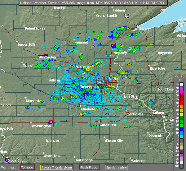 At 153 pm cdt, a severe thunderstorm was located near star prairie, or 24 miles north of river falls, moving east at 35 mph (radar indicated). Hazards include 60 mph wind gusts and quarter size hail. Hail damage to vehicles is expected. expect wind damage to roofs, siding, and trees. Locations impacted include, new richmond, somerset, star prairie, cylon, deer park, huntington and new richmond airport. At 153 pm cdt, a severe thunderstorm was located near star prairie, or 24 miles north of river falls, moving east at 35 mph (radar indicated). Hazards include 60 mph wind gusts and quarter size hail. Hail damage to vehicles is expected. expect wind damage to roofs, siding, and trees. Locations impacted include, new richmond, somerset, star prairie, cylon, deer park, huntington and new richmond airport.
|
| 8/27/2019 1:33 PM CDT |
 At 132 pm cdt, a severe thunderstorm was located near scandia, or 22 miles northeast of st. paul, moving east at 40 mph (radar indicated). Hazards include 60 mph wind gusts and quarter size hail. Hail damage to vehicles is expected. Expect wind damage to roofs, siding, and trees. At 132 pm cdt, a severe thunderstorm was located near scandia, or 22 miles northeast of st. paul, moving east at 40 mph (radar indicated). Hazards include 60 mph wind gusts and quarter size hail. Hail damage to vehicles is expected. Expect wind damage to roofs, siding, and trees.
|
| 8/5/2019 2:00 PM CDT |
 At 159 pm cdt, a severe thunderstorm was located near scandia, or 27 miles southeast of cambridge, moving east at 35 mph (radar indicated). Hazards include 60 mph wind gusts and quarter size hail. Hail damage to vehicles is expected. expect wind damage to roofs, siding, and trees. locations impacted include, chisago city, lindstrom, scandia, somerset, osceola, st. Croix falls, taylors falls, centuria, dresser, center city, star prairie and shafer. At 159 pm cdt, a severe thunderstorm was located near scandia, or 27 miles southeast of cambridge, moving east at 35 mph (radar indicated). Hazards include 60 mph wind gusts and quarter size hail. Hail damage to vehicles is expected. expect wind damage to roofs, siding, and trees. locations impacted include, chisago city, lindstrom, scandia, somerset, osceola, st. Croix falls, taylors falls, centuria, dresser, center city, star prairie and shafer.
|
| 8/5/2019 1:45 PM CDT |
 At 145 pm cdt, a severe thunderstorm was located near scandia, or 25 miles southeast of cambridge, moving northeast at 45 mph (radar indicated). Hazards include 60 mph wind gusts and quarter size hail. Hail damage to vehicles is expected. expect wind damage to roofs, siding, and trees. Locations impacted include, lino lakes, forest lake, hugo, chisago city and grant. At 145 pm cdt, a severe thunderstorm was located near scandia, or 25 miles southeast of cambridge, moving northeast at 45 mph (radar indicated). Hazards include 60 mph wind gusts and quarter size hail. Hail damage to vehicles is expected. expect wind damage to roofs, siding, and trees. Locations impacted include, lino lakes, forest lake, hugo, chisago city and grant.
|
| 8/5/2019 1:43 PM CDT |
 At 142 pm cdt, a severe thunderstorm was located over forest lake, or 22 miles north of st. paul, moving east at 35 mph (radar indicated). Hazards include 60 mph wind gusts and quarter size hail. Hail damage to vehicles is expected. Expect wind damage to roofs, siding, and trees. At 142 pm cdt, a severe thunderstorm was located over forest lake, or 22 miles north of st. paul, moving east at 35 mph (radar indicated). Hazards include 60 mph wind gusts and quarter size hail. Hail damage to vehicles is expected. Expect wind damage to roofs, siding, and trees.
|
| 8/5/2019 1:28 PM CDT |
 At 128 pm cdt, a severe thunderstorm was located near lino lakes, or 19 miles north of st. paul, moving northeast at 45 mph (radar indicated). Hazards include two inch hail and 60 mph wind gusts. People and animals outdoors will be injured. expect hail damage to roofs, siding, windows, and vehicles. expect wind damage to roofs, siding, and trees. Locations impacted include, blaine, shoreview, white bear lake, new brighton, lino lakes, forest lake, ham lake, hugo, vadnais heights, mounds view, east bethel and arden hills. At 128 pm cdt, a severe thunderstorm was located near lino lakes, or 19 miles north of st. paul, moving northeast at 45 mph (radar indicated). Hazards include two inch hail and 60 mph wind gusts. People and animals outdoors will be injured. expect hail damage to roofs, siding, windows, and vehicles. expect wind damage to roofs, siding, and trees. Locations impacted include, blaine, shoreview, white bear lake, new brighton, lino lakes, forest lake, ham lake, hugo, vadnais heights, mounds view, east bethel and arden hills.
|
| 8/5/2019 1:13 PM CDT |
 At 112 pm cdt, a severe thunderstorm was located over coon rapids, or 12 miles north of minneapolis, moving northeast at 45 mph (public). Hazards include two inch hail and 60 mph wind gusts. People and animals outdoors will be injured. expect hail damage to roofs, siding, windows, and vehicles. Expect wind damage to roofs, siding, and trees. At 112 pm cdt, a severe thunderstorm was located over coon rapids, or 12 miles north of minneapolis, moving northeast at 45 mph (public). Hazards include two inch hail and 60 mph wind gusts. People and animals outdoors will be injured. expect hail damage to roofs, siding, windows, and vehicles. Expect wind damage to roofs, siding, and trees.
|
| 5/31/2019 8:20 PM CDT |
 The severe thunderstorm warning for northeastern washington county will expire at 830 pm cdt, the storm which prompted the warning has weakened below severe limits, and has exited the warned area. therefore, the warning will be allowed to expire. The severe thunderstorm warning for northeastern washington county will expire at 830 pm cdt, the storm which prompted the warning has weakened below severe limits, and has exited the warned area. therefore, the warning will be allowed to expire.
|
| 5/31/2019 8:08 PM CDT |
 At 807 pm cdt, a severe thunderstorm was located near hugo, or 20 miles northeast of st. paul, moving southeast at 30 mph (public). Hazards include quarter size hail. Damage to vehicles is expected. Locations impacted include, forest lake, hugo, scandia, otisville, marine on st croix and william obrien state park. At 807 pm cdt, a severe thunderstorm was located near hugo, or 20 miles northeast of st. paul, moving southeast at 30 mph (public). Hazards include quarter size hail. Damage to vehicles is expected. Locations impacted include, forest lake, hugo, scandia, otisville, marine on st croix and william obrien state park.
|
| 5/31/2019 7:58 PM CDT |
 At 758 pm cdt, a severe thunderstorm was located near forest lake, or 21 miles north of st. paul, moving southeast at 30 mph (public). Hazards include quarter size hail. damage to vehicles is expected At 758 pm cdt, a severe thunderstorm was located near forest lake, or 21 miles north of st. paul, moving southeast at 30 mph (public). Hazards include quarter size hail. damage to vehicles is expected
|
| 9/20/2018 7:09 PM CDT |
 The severe thunderstorm warning for southeastern hennepin, dakota, northwestern goodhue, southeastern anoka, washington and ramsey counties will expire at 715 pm cdt, the storms which prompted the warning have weakened below severe limits. therefore, the warning will be allowed to expire. however gusty winds and heavy rain are still possible with these thunderstorms. a tornado watch remains in effect until 1100 pm cdt for south central, southeastern and east central minnesota. a tornado watch also remains in effect until midnight cdt for west central wisconsin. to report severe weather, contact your nearest law enforcement agency. they will relay your report to the national weather service the twin cities. remember, a tornado warning still remains in effect for dakota county until 730 pm. The severe thunderstorm warning for southeastern hennepin, dakota, northwestern goodhue, southeastern anoka, washington and ramsey counties will expire at 715 pm cdt, the storms which prompted the warning have weakened below severe limits. therefore, the warning will be allowed to expire. however gusty winds and heavy rain are still possible with these thunderstorms. a tornado watch remains in effect until 1100 pm cdt for south central, southeastern and east central minnesota. a tornado watch also remains in effect until midnight cdt for west central wisconsin. to report severe weather, contact your nearest law enforcement agency. they will relay your report to the national weather service the twin cities. remember, a tornado warning still remains in effect for dakota county until 730 pm.
|
| 9/20/2018 6:41 PM CDT |
 The national weather service in the twin cities has issued a * severe thunderstorm warning for. southeastern hennepin county in east central minnesota. dakota county in east central minnesota. northwestern goodhue county in southeastern minnesota. Southeastern anoka county in east central minnesota. The national weather service in the twin cities has issued a * severe thunderstorm warning for. southeastern hennepin county in east central minnesota. dakota county in east central minnesota. northwestern goodhue county in southeastern minnesota. Southeastern anoka county in east central minnesota.
|
| 8/27/2018 6:12 PM CDT |
 At 612 pm cdt, severe thunderstorms were located along a line extending from near east farmington to roberts, moving northeast at 60 mph (radar indicated). Hazards include 60 mph wind gusts. Expect damage to roofs, siding, and trees. these severe storms will be near, baldwin around 615 pm cdt. osceola, dresser and star prairie around 620 pm cdt. amery around 630 pm cdt. clear lake and balsam lake around 635 pm cdt. clayton around 640 pm cdt. turtle lake around 645 pm cdt. almena around 650 pm cdt. barron around 655 pm cdt. Other locations impacted by these severe thunderstorms include otisville, hillsdale, osceola airport, boardman, huntington, range, wanderoos, william obrien state park, willow river state park and burkhardt. At 612 pm cdt, severe thunderstorms were located along a line extending from near east farmington to roberts, moving northeast at 60 mph (radar indicated). Hazards include 60 mph wind gusts. Expect damage to roofs, siding, and trees. these severe storms will be near, baldwin around 615 pm cdt. osceola, dresser and star prairie around 620 pm cdt. amery around 630 pm cdt. clear lake and balsam lake around 635 pm cdt. clayton around 640 pm cdt. turtle lake around 645 pm cdt. almena around 650 pm cdt. barron around 655 pm cdt. Other locations impacted by these severe thunderstorms include otisville, hillsdale, osceola airport, boardman, huntington, range, wanderoos, william obrien state park, willow river state park and burkhardt.
|
| 8/27/2018 6:03 PM CDT |
 At 603 pm cdt, severe thunderstorms were located along a line extending from near marine on st croix to near river falls, moving northeast at 60 mph (radar indicated). Hazards include 60 mph wind gusts. Expect damage to roofs, siding, and trees. severe thunderstorms will be near, new richmond, osceola, baldwin and star prairie around 615 pm cdt. dresser around 620 pm cdt. amery, clear lake and balsam lake around 630 pm cdt. turtle lake, clayton and prairie farm around 640 pm cdt. almena around 645 pm cdt. Barron and cumberland around 650 pm cdt. At 603 pm cdt, severe thunderstorms were located along a line extending from near marine on st croix to near river falls, moving northeast at 60 mph (radar indicated). Hazards include 60 mph wind gusts. Expect damage to roofs, siding, and trees. severe thunderstorms will be near, new richmond, osceola, baldwin and star prairie around 615 pm cdt. dresser around 620 pm cdt. amery, clear lake and balsam lake around 630 pm cdt. turtle lake, clayton and prairie farm around 640 pm cdt. almena around 645 pm cdt. Barron and cumberland around 650 pm cdt.
|
| 8/26/2018 6:25 AM CDT |
 The national weather service in the twin cities has issued a * severe thunderstorm warning for. south central chisago county in east central minnesota. northeastern anoka county in east central minnesota. northern washington county in east central minnesota. South central polk county in northwestern wisconsin. The national weather service in the twin cities has issued a * severe thunderstorm warning for. south central chisago county in east central minnesota. northeastern anoka county in east central minnesota. northern washington county in east central minnesota. South central polk county in northwestern wisconsin.
|
| 8/4/2018 12:17 AM CDT |
 At 1217 am cdt, a severe thunderstorm was located over east farmington, or 29 miles north of river falls, moving east at 25 mph (radar indicated). Hazards include quarter size hail. damage to vehicles is expected At 1217 am cdt, a severe thunderstorm was located over east farmington, or 29 miles north of river falls, moving east at 25 mph (radar indicated). Hazards include quarter size hail. damage to vehicles is expected
|
| 7/12/2018 5:36 PM CDT |
 At 535 pm cdt, a severe thunderstorm was located over huntington, or 25 miles north of river falls, moving east at 20 mph (radar indicated). Hazards include 60 mph wind gusts and penny size hail. Expect damage to roofs, siding, and trees. Locations impacted include, new richmond, amery, somerset, osceola, clear lake, star prairie, cylon, deer park, osceola airport, huntington, range and wanderoos. At 535 pm cdt, a severe thunderstorm was located over huntington, or 25 miles north of river falls, moving east at 20 mph (radar indicated). Hazards include 60 mph wind gusts and penny size hail. Expect damage to roofs, siding, and trees. Locations impacted include, new richmond, amery, somerset, osceola, clear lake, star prairie, cylon, deer park, osceola airport, huntington, range and wanderoos.
|
| 7/12/2018 5:18 PM CDT |
 At 517 pm cdt, a severe thunderstorm was located over east farmington, or 28 miles north of river falls, moving east at 25 mph (radar indicated). Hazards include 60 mph wind gusts and quarter size hail. Hail damage to vehicles is expected. Expect wind damage to roofs, siding, and trees. At 517 pm cdt, a severe thunderstorm was located over east farmington, or 28 miles north of river falls, moving east at 25 mph (radar indicated). Hazards include 60 mph wind gusts and quarter size hail. Hail damage to vehicles is expected. Expect wind damage to roofs, siding, and trees.
|
| 5/25/2018 5:49 PM CDT |
 At 548 pm cdt, a severe thunderstorm was located over east farmington, or 25 miles north of river falls, moving east at 15 mph (radar indicated). Hazards include 60 mph wind gusts. Expect damage to roofs, siding, and trees. this severe storm will be near, new richmond and star prairie around 615 pm cdt. Other locations impacted by this severe thunderstorm include huntington, east farmington and new richmond airport. At 548 pm cdt, a severe thunderstorm was located over east farmington, or 25 miles north of river falls, moving east at 15 mph (radar indicated). Hazards include 60 mph wind gusts. Expect damage to roofs, siding, and trees. this severe storm will be near, new richmond and star prairie around 615 pm cdt. Other locations impacted by this severe thunderstorm include huntington, east farmington and new richmond airport.
|
| 5/25/2018 5:36 PM CDT |
 At 536 pm cdt, a severe thunderstorm was located over otisville, or 26 miles north of river falls, moving east at 15 mph (radar indicated). Hazards include quarter size hail. Damage to vehicles is expected. this severe storm will be near, somerset around 550 pm cdt. new richmond and star prairie around 600 pm cdt. Other locations impacted by this severe thunderstorm include otisville, marine on st croix, huntington, east farmington, new richmond airport and william obrien state park. At 536 pm cdt, a severe thunderstorm was located over otisville, or 26 miles north of river falls, moving east at 15 mph (radar indicated). Hazards include quarter size hail. Damage to vehicles is expected. this severe storm will be near, somerset around 550 pm cdt. new richmond and star prairie around 600 pm cdt. Other locations impacted by this severe thunderstorm include otisville, marine on st croix, huntington, east farmington, new richmond airport and william obrien state park.
|
| 5/25/2018 5:18 PM CDT |
 At 518 pm cdt, a severe thunderstorm was located over scandia, or 24 miles northeast of st. paul, moving east at 15 mph (radar indicated). Hazards include 60 mph wind gusts and quarter size hail. Hail damage to vehicles is expected. expect wind damage to roofs, siding, and trees. this severe storm will be near, new richmond, somerset and star prairie around 600 pm cdt. Other locations impacted by this severe thunderstorm include otisville, marine on st croix, huntington, east farmington, new richmond airport and william obrien state park. At 518 pm cdt, a severe thunderstorm was located over scandia, or 24 miles northeast of st. paul, moving east at 15 mph (radar indicated). Hazards include 60 mph wind gusts and quarter size hail. Hail damage to vehicles is expected. expect wind damage to roofs, siding, and trees. this severe storm will be near, new richmond, somerset and star prairie around 600 pm cdt. Other locations impacted by this severe thunderstorm include otisville, marine on st croix, huntington, east farmington, new richmond airport and william obrien state park.
|
| 5/25/2018 5:03 PM CDT |
 At 503 pm cdt, a severe thunderstorm was located near scandia, or 24 miles northeast of st. paul, moving east at 20 mph (radar indicated). Hazards include 60 mph wind gusts and quarter size hail. Hail damage to vehicles is expected. expect wind damage to roofs, siding, and trees. this severe thunderstorm will be near, scandia around 515 pm cdt. somerset around 535 pm cdt. new richmond around 550 pm cdt. star prairie around 555 pm cdt. Other locations impacted by this severe thunderstorm include otisville, marine on st croix, huntington, east farmington, new richmond airport and william obrien state park. At 503 pm cdt, a severe thunderstorm was located near scandia, or 24 miles northeast of st. paul, moving east at 20 mph (radar indicated). Hazards include 60 mph wind gusts and quarter size hail. Hail damage to vehicles is expected. expect wind damage to roofs, siding, and trees. this severe thunderstorm will be near, scandia around 515 pm cdt. somerset around 535 pm cdt. new richmond around 550 pm cdt. star prairie around 555 pm cdt. Other locations impacted by this severe thunderstorm include otisville, marine on st croix, huntington, east farmington, new richmond airport and william obrien state park.
|
| 7/12/2017 3:10 AM CDT |
 The severe thunderstorm warning for northeastern dakota, washington, southern ramsey, western pierce, st. croix and south central polk counties will expire at 315 am cdt, the gust front which prompted the warning has weakened below severe limits. therefore the warning will be allowed to expire. however gusty winds are still possible for the next hour. The severe thunderstorm warning for northeastern dakota, washington, southern ramsey, western pierce, st. croix and south central polk counties will expire at 315 am cdt, the gust front which prompted the warning has weakened below severe limits. therefore the warning will be allowed to expire. however gusty winds are still possible for the next hour.
|
| 7/12/2017 2:48 AM CDT |
 At 248 am cdt, severe thunderstorms were located along a line extending from east farmington to near lake elmo airport to st. paul, moving southeast at 70 mph (radar indicated). Hazards include 60 mph wind gusts. Expect damage to roofs, siding, and trees. severe thunderstorms will be near, hudson, new richmond, afton and star prairie around 255 am cdt. river falls around 300 am cdt. hastings and prescott around 305 am cdt. ellsworth, baldwin and hammond around 310 am cdt. Woodville around 315 am cdt. At 248 am cdt, severe thunderstorms were located along a line extending from east farmington to near lake elmo airport to st. paul, moving southeast at 70 mph (radar indicated). Hazards include 60 mph wind gusts. Expect damage to roofs, siding, and trees. severe thunderstorms will be near, hudson, new richmond, afton and star prairie around 255 am cdt. river falls around 300 am cdt. hastings and prescott around 305 am cdt. ellsworth, baldwin and hammond around 310 am cdt. Woodville around 315 am cdt.
|
| 7/12/2017 2:43 AM CDT | Trees dow in washington county MN, 2.9 miles ENE of Marine on St. Croix, MN |
| 6/14/2017 12:56 AM CDT |
 At 1255 am cdt, severe thunderstorms were located along a line extending from chisago city to st. paul park, moving east at 50 mph (radar indicated). Hazards include 60 mph wind gusts and penny size hail. Expect damage to roofs, siding, and trees. these severe storms will be near, chisago city, lindstrom and center city around 100 am cdt. other locations impacted by these severe thunderstorms include newport, otisville, wyoming, willernie, north st. Paul, sunfish, shafer, oak park heights, st paul airport and sunfish lake. At 1255 am cdt, severe thunderstorms were located along a line extending from chisago city to st. paul park, moving east at 50 mph (radar indicated). Hazards include 60 mph wind gusts and penny size hail. Expect damage to roofs, siding, and trees. these severe storms will be near, chisago city, lindstrom and center city around 100 am cdt. other locations impacted by these severe thunderstorms include newport, otisville, wyoming, willernie, north st. Paul, sunfish, shafer, oak park heights, st paul airport and sunfish lake.
|
| 6/14/2017 12:25 AM CDT |
 At 1225 am cdt, severe thunderstorms were located along a line extending from near rogers to mn valley state rec area, moving east at 45 mph (radar indicated). Hazards include 60 mph wind gusts. Expect damage to roofs, siding, and trees. severe thunderstorms will be near, maple grove around 1230 am cdt. brooklyn park, ramsey and champlin around 1235 am cdt. coon rapids, andover and anoka around 1240 am cdt. savage around 1245 am cdt. burnsville and ham lake around 1250 am cdt. apple valley and east bethel around 1255 am cdt. bloomington and rosemount around 100 am cdt. eagan, forest lake and stacy around 105 am cdt. other locations impacted by these severe thunderstorms include wyoming, north st. paul, cedar, sunfish, lexington, shafer, oak park heights, mall of america, pine springs and fort snelling. this includes the following highways, interstate 35 between mile markers 130 and 139. u. s. highway 8 in minnesota between mile markers 0 and 5, and between mile markers 7 and 18. u. s. Highway 61 between mile markers 163 and 164. At 1225 am cdt, severe thunderstorms were located along a line extending from near rogers to mn valley state rec area, moving east at 45 mph (radar indicated). Hazards include 60 mph wind gusts. Expect damage to roofs, siding, and trees. severe thunderstorms will be near, maple grove around 1230 am cdt. brooklyn park, ramsey and champlin around 1235 am cdt. coon rapids, andover and anoka around 1240 am cdt. savage around 1245 am cdt. burnsville and ham lake around 1250 am cdt. apple valley and east bethel around 1255 am cdt. bloomington and rosemount around 100 am cdt. eagan, forest lake and stacy around 105 am cdt. other locations impacted by these severe thunderstorms include wyoming, north st. paul, cedar, sunfish, lexington, shafer, oak park heights, mall of america, pine springs and fort snelling. this includes the following highways, interstate 35 between mile markers 130 and 139. u. s. highway 8 in minnesota between mile markers 0 and 5, and between mile markers 7 and 18. u. s. Highway 61 between mile markers 163 and 164.
|
| 6/11/2017 9:11 AM CDT |
 At 910 am cdt, severe thunderstorms were located along a line extending from near shafer to near river falls, moving east at 60 mph (law enforcement extensive damage with this storm). Hazards include tennis ball size hail and 70 mph wind gusts. People and animals outdoors will be injured. expect hail damage to roofs, siding, windows, and vehicles. expect considerable tree damage. wind damage is also likely to mobile homes, roofs, and outbuildings. these severe storms will be near, river falls and roberts around 915 am cdt. hammond around 920 am cdt. baldwin around 925 am cdt. amery around 930 am cdt. Other locations impacted by these severe thunderstorms include otisville, lake st croix beach, willernie, lakeland shores, boardman, huntington, wanderoos, oak park heights, pine springs and deer park. At 910 am cdt, severe thunderstorms were located along a line extending from near shafer to near river falls, moving east at 60 mph (law enforcement extensive damage with this storm). Hazards include tennis ball size hail and 70 mph wind gusts. People and animals outdoors will be injured. expect hail damage to roofs, siding, windows, and vehicles. expect considerable tree damage. wind damage is also likely to mobile homes, roofs, and outbuildings. these severe storms will be near, river falls and roberts around 915 am cdt. hammond around 920 am cdt. baldwin around 925 am cdt. amery around 930 am cdt. Other locations impacted by these severe thunderstorms include otisville, lake st croix beach, willernie, lakeland shores, boardman, huntington, wanderoos, oak park heights, pine springs and deer park.
|
| 6/11/2017 9:09 AM CDT |
 At 908 am cdt, severe thunderstorms were located along a line extending from near shafer to near kinnickinnic state park, moving east at 55 mph (law enforcement reported golf ball hail and wind damage). Hazards include golf ball size hail and 70 mph wind gusts. People and animals outdoors will be injured. expect hail damage to roofs, siding, windows, and vehicles. expect considerable tree damage. wind damage is also likely to mobile homes, roofs, and outbuildings. these severe storms will be near, roberts and dresser around 915 am cdt. baldwin and hammond around 925 am cdt. amery around 930 am cdt. Other locations impacted by these severe thunderstorms include otisville, lake st croix beach, willernie, lakeland shores, boardman, huntington, wanderoos, oak park heights, pine springs and deer park. At 908 am cdt, severe thunderstorms were located along a line extending from near shafer to near kinnickinnic state park, moving east at 55 mph (law enforcement reported golf ball hail and wind damage). Hazards include golf ball size hail and 70 mph wind gusts. People and animals outdoors will be injured. expect hail damage to roofs, siding, windows, and vehicles. expect considerable tree damage. wind damage is also likely to mobile homes, roofs, and outbuildings. these severe storms will be near, roberts and dresser around 915 am cdt. baldwin and hammond around 925 am cdt. amery around 930 am cdt. Other locations impacted by these severe thunderstorms include otisville, lake st croix beach, willernie, lakeland shores, boardman, huntington, wanderoos, oak park heights, pine springs and deer park.
|
| 6/11/2017 8:50 AM CDT |
 At 850 am cdt, severe thunderstorms were located along a line extending from near east bethel to south st. paul, moving east at 60 mph (law enforcement). Hazards include ping pong ball size hail and 60 mph wind gusts. People and animals outdoors will be injured. expect hail damage to roofs, siding, windows, and vehicles. expect wind damage to roofs, siding, and trees. severe thunderstorms will be near, forest lake around 855 am cdt. afton around 900 am cdt. hudson, north hudson and bayport around 905 am cdt. river falls and osceola around 910 am cdt. roberts and dresser around 915 am cdt. hammond around 920 am cdt. baldwin around 925 am cdt. other locations impacted by these severe thunderstorms include otisville, vermillion, lake st croix beach, willernie, lakeland shores, boardman, huntington, wanderoos, oak park heights and pine springs. this includes the following highways, interstate 35 between mile markers 131 and 132. interstate 94 in wisconsin between mile markers 1 and 20. u. s. highway 8 in minnesota between mile markers 0 and 1. u. s. Highway 61 near mile marker 165. At 850 am cdt, severe thunderstorms were located along a line extending from near east bethel to south st. paul, moving east at 60 mph (law enforcement). Hazards include ping pong ball size hail and 60 mph wind gusts. People and animals outdoors will be injured. expect hail damage to roofs, siding, windows, and vehicles. expect wind damage to roofs, siding, and trees. severe thunderstorms will be near, forest lake around 855 am cdt. afton around 900 am cdt. hudson, north hudson and bayport around 905 am cdt. river falls and osceola around 910 am cdt. roberts and dresser around 915 am cdt. hammond around 920 am cdt. baldwin around 925 am cdt. other locations impacted by these severe thunderstorms include otisville, vermillion, lake st croix beach, willernie, lakeland shores, boardman, huntington, wanderoos, oak park heights and pine springs. this includes the following highways, interstate 35 between mile markers 131 and 132. interstate 94 in wisconsin between mile markers 1 and 20. u. s. highway 8 in minnesota between mile markers 0 and 1. u. s. Highway 61 near mile marker 165.
|
| 9/21/2016 4:42 PM CDT |
 The national weather service in the twin cities has issued a * severe thunderstorm warning for. northern washington county in east central minnesota. northwestern st. croix county in west central wisconsin. south central polk county in northwestern wisconsin. Until 515 pm cdt. The national weather service in the twin cities has issued a * severe thunderstorm warning for. northern washington county in east central minnesota. northwestern st. croix county in west central wisconsin. south central polk county in northwestern wisconsin. Until 515 pm cdt.
|
| 8/19/2016 3:51 AM CDT |
 At 350 am cdt, severe thunderstorms were located along a line extending from near harris to cushing to cylon, moving northeast at 45 mph (radar indicated). Hazards include 60 mph wind gusts. Expect damage to roofs. siding. and trees. these severe storms will be near, frederic, luck and clear lake around 400 am cdt. Other locations impacted by these severe thunderstorms include branch, otisville, wild river state park, cushing, nye, osceola airport, rush city airport, deronda, wanderoos and stanchfield. At 350 am cdt, severe thunderstorms were located along a line extending from near harris to cushing to cylon, moving northeast at 45 mph (radar indicated). Hazards include 60 mph wind gusts. Expect damage to roofs. siding. and trees. these severe storms will be near, frederic, luck and clear lake around 400 am cdt. Other locations impacted by these severe thunderstorms include branch, otisville, wild river state park, cushing, nye, osceola airport, rush city airport, deronda, wanderoos and stanchfield.
|
| 8/19/2016 3:28 AM CDT |
 At 327 am cdt, severe thunderstorms were located along a line extending from near st. francis to near stacy to near stillwater, moving northeast at 35 mph (radar indicated). Hazards include 60 mph wind gusts. Expect damage to roofs. siding. and trees. these severe storms will be near, forest lake around 330 am cdt. Other locations impacted by these severe thunderstorms include pine springs, grant, bethel, birchwood, birchwood village, cedar, willernie, centerville and oak grove. At 327 am cdt, severe thunderstorms were located along a line extending from near st. francis to near stacy to near stillwater, moving northeast at 35 mph (radar indicated). Hazards include 60 mph wind gusts. Expect damage to roofs. siding. and trees. these severe storms will be near, forest lake around 330 am cdt. Other locations impacted by these severe thunderstorms include pine springs, grant, bethel, birchwood, birchwood village, cedar, willernie, centerville and oak grove.
|
| 8/19/2016 3:15 AM CDT |
 At 315 am cdt, severe thunderstorms were located along a line extending from near st. francis to near wyoming to near river falls, moving northeast at 45 mph (radar indicated). Hazards include 60 mph wind gusts. Expect damage to roofs. siding. and trees. severe thunderstorms will be near, stacy around 325 am cdt. chisago city, lindstrom and center city around 330 am cdt. rush city around 355 am cdt. frederic and luck around 400 am cdt. other locations impacted by these severe thunderstorms include branch, otisville, wild river state park, athens, cushing, nye, osceola airport, rush city airport, deronda and spencer brook. this includes the following highways, interstate 35 between mile markers 133 and 163. u. s. highway 8 in minnesota between mile markers 1 and 5, and between mile markers 7 and 22. u. s. Highway 61 between mile markers 161 and 165. At 315 am cdt, severe thunderstorms were located along a line extending from near st. francis to near wyoming to near river falls, moving northeast at 45 mph (radar indicated). Hazards include 60 mph wind gusts. Expect damage to roofs. siding. and trees. severe thunderstorms will be near, stacy around 325 am cdt. chisago city, lindstrom and center city around 330 am cdt. rush city around 355 am cdt. frederic and luck around 400 am cdt. other locations impacted by these severe thunderstorms include branch, otisville, wild river state park, athens, cushing, nye, osceola airport, rush city airport, deronda and spencer brook. this includes the following highways, interstate 35 between mile markers 133 and 163. u. s. highway 8 in minnesota between mile markers 1 and 5, and between mile markers 7 and 22. u. s. Highway 61 between mile markers 161 and 165.
|
| 8/19/2016 3:10 AM CDT |
 At 308 am cdt, severe thunderstorms were located along a line extending from elk river to near ham lake to oakdale, moving northeast at 55 mph (radar indicated). Hazards include 60 mph wind gusts. Expect damage to roofs. siding. and trees. these severe storms will be near, woodbury, oakdale, white bear lake, lino lakes and lake elmo around 315 am cdt. forest lake around 325 am cdt. other locations impacted by these severe thunderstorms include north st. Paul, bethel, birchwood, grant, nowthen, falcon heights, birchwood village, south maplewood, willernie and centerville. At 308 am cdt, severe thunderstorms were located along a line extending from elk river to near ham lake to oakdale, moving northeast at 55 mph (radar indicated). Hazards include 60 mph wind gusts. Expect damage to roofs. siding. and trees. these severe storms will be near, woodbury, oakdale, white bear lake, lino lakes and lake elmo around 315 am cdt. forest lake around 325 am cdt. other locations impacted by these severe thunderstorms include north st. Paul, bethel, birchwood, grant, nowthen, falcon heights, birchwood village, south maplewood, willernie and centerville.
|
| 8/19/2016 3:01 AM CDT |
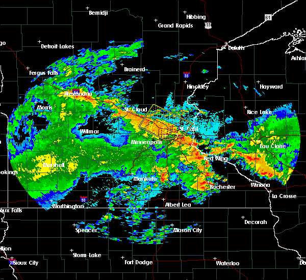 At 301 am cdt, severe thunderstorms were located along a line extending from lake elmo to near prescott, moving northeast at 50 mph (radar indicated). Hazards include 60 mph wind gusts. Expect damage to roofs. siding. and trees. severe thunderstorms will be near, stillwater, hudson, north hudson and bayport around 310 am cdt. river falls around 315 am cdt. somerset and roberts around 320 am cdt. new richmond, baldwin and hammond around 325 am cdt. woodville around 330 am cdt. glenwood city around 345 am cdt. other locations impacted by these severe thunderstorms include burkhardt, lakeland, lake elmo airport, afton state park, lakeland shores, houlton, st marys point, new richmond airport, cylon and lake st croix beach. this includes the following highways, interstate 94 in minnesota between mile markers 249 and 258. interstate 94 in wisconsin between mile markers 1 and 24. u. s. Highway 61 between mile markers 125 and 130. At 301 am cdt, severe thunderstorms were located along a line extending from lake elmo to near prescott, moving northeast at 50 mph (radar indicated). Hazards include 60 mph wind gusts. Expect damage to roofs. siding. and trees. severe thunderstorms will be near, stillwater, hudson, north hudson and bayport around 310 am cdt. river falls around 315 am cdt. somerset and roberts around 320 am cdt. new richmond, baldwin and hammond around 325 am cdt. woodville around 330 am cdt. glenwood city around 345 am cdt. other locations impacted by these severe thunderstorms include burkhardt, lakeland, lake elmo airport, afton state park, lakeland shores, houlton, st marys point, new richmond airport, cylon and lake st croix beach. this includes the following highways, interstate 94 in minnesota between mile markers 249 and 258. interstate 94 in wisconsin between mile markers 1 and 24. u. s. Highway 61 between mile markers 125 and 130.
|
| 8/19/2016 2:45 AM CDT |
 At 245 am cdt, severe thunderstorms were located along a line extending from near buffalo to st. louis park, moving northeast at 30 mph (radar indicated). Hazards include 60 mph wind gusts. Expect damage to roofs. siding. and trees. severe thunderstorms will be near, st. louis park, richfield and msp international airport around 250 am cdt. plymouth and golden valley around 255 am cdt. minneapolis and albertville around 300 am cdt. brooklyn center, columbia heights, st. michael and big lake around 305 am cdt. roseville, fridley and spring lake park around 310 am cdt. shoreview, elk river, new brighton and mounds view around 315 am cdt. vadnais heights, arden hills and zimmerman around 320 am cdt. st. francis around 325 am cdt. other locations impacted by these severe thunderstorms include fort snelling, north minneapolis, osseo, new hope, north st. paul, bethel, birchwood, como park, crystal airport and univ of mn minneapolis campus. this includes the following highways, interstate 35 between mile markers 128 and 132. interstate 94 in minnesota between mile markers 197 and 249. u. s. highway 10 in minnesota between mile markers 206 and 240. u. s. highway 12 between mile markers 151 and 156. u. s. highway 169 between mile markers 125 and 175. u. s. highway 8 in minnesota near mile marker 0. u. s. Highway 61 between mile markers 134 and 161. At 245 am cdt, severe thunderstorms were located along a line extending from near buffalo to st. louis park, moving northeast at 30 mph (radar indicated). Hazards include 60 mph wind gusts. Expect damage to roofs. siding. and trees. severe thunderstorms will be near, st. louis park, richfield and msp international airport around 250 am cdt. plymouth and golden valley around 255 am cdt. minneapolis and albertville around 300 am cdt. brooklyn center, columbia heights, st. michael and big lake around 305 am cdt. roseville, fridley and spring lake park around 310 am cdt. shoreview, elk river, new brighton and mounds view around 315 am cdt. vadnais heights, arden hills and zimmerman around 320 am cdt. st. francis around 325 am cdt. other locations impacted by these severe thunderstorms include fort snelling, north minneapolis, osseo, new hope, north st. paul, bethel, birchwood, como park, crystal airport and univ of mn minneapolis campus. this includes the following highways, interstate 35 between mile markers 128 and 132. interstate 94 in minnesota between mile markers 197 and 249. u. s. highway 10 in minnesota between mile markers 206 and 240. u. s. highway 12 between mile markers 151 and 156. u. s. highway 169 between mile markers 125 and 175. u. s. highway 8 in minnesota near mile marker 0. u. s. Highway 61 between mile markers 134 and 161.
|
| 7/23/2016 11:14 AM CDT |
 At 1114 am cdt, severe thunderstorms were located along a line extending from pine springs to near woodville to near the big swamp area, moving northeast at 40 mph (radar indicated). Hazards include 60 mph wind gusts. Expect damage to roofs. siding. and trees. severe thunderstorms will be near, woodville around 1120 am cdt. hudson and knapp around 1125 am cdt. glenwood city around 1130 am cdt. somerset, boyceville and elk mound around 1135 am cdt. new richmond around 1140 am cdt. wheeler around 1145 am cdt. star prairie around 1150 am cdt. ridgeland around 1155 am cdt. other locations impacted by these severe thunderstorms include arkansaw, caryville, downing, lakeland shores, birchwood, cedar falls, grant, sand creek, birchwood village and willernie. this includes the following highways, interstate 94 in minnesota between mile markers 257 and 258. interstate 94 in wisconsin between mile markers 1 and 56. u. s. Highway 61 between mile markers 154 and 156. At 1114 am cdt, severe thunderstorms were located along a line extending from pine springs to near woodville to near the big swamp area, moving northeast at 40 mph (radar indicated). Hazards include 60 mph wind gusts. Expect damage to roofs. siding. and trees. severe thunderstorms will be near, woodville around 1120 am cdt. hudson and knapp around 1125 am cdt. glenwood city around 1130 am cdt. somerset, boyceville and elk mound around 1135 am cdt. new richmond around 1140 am cdt. wheeler around 1145 am cdt. star prairie around 1150 am cdt. ridgeland around 1155 am cdt. other locations impacted by these severe thunderstorms include arkansaw, caryville, downing, lakeland shores, birchwood, cedar falls, grant, sand creek, birchwood village and willernie. this includes the following highways, interstate 94 in minnesota between mile markers 257 and 258. interstate 94 in wisconsin between mile markers 1 and 56. u. s. Highway 61 between mile markers 154 and 156.
|
| 7/5/2016 6:43 PM CDT |
 At 642 pm cdt, a severe thunderstorm was located over burkhardt, or 10 miles north of river falls, moving east at 30 mph (law enforcement). Hazards include 60 mph wind gusts and quarter size hail. Hail damage to vehicles is expected. expect wind damage to roofs, siding, and trees. this severe storm will be near, roberts around 650 pm cdt. hammond around 700 pm cdt. baldwin around 710 pm cdt. Other locations impacted by this severe thunderstorm include burkhardt, lakeland, boardman, lakeland shores, oak park heights, houlton, st marys point, new richmond airport, willow river state park and lake st croix beach. At 642 pm cdt, a severe thunderstorm was located over burkhardt, or 10 miles north of river falls, moving east at 30 mph (law enforcement). Hazards include 60 mph wind gusts and quarter size hail. Hail damage to vehicles is expected. expect wind damage to roofs, siding, and trees. this severe storm will be near, roberts around 650 pm cdt. hammond around 700 pm cdt. baldwin around 710 pm cdt. Other locations impacted by this severe thunderstorm include burkhardt, lakeland, boardman, lakeland shores, oak park heights, houlton, st marys point, new richmond airport, willow river state park and lake st croix beach.
|
| 7/5/2016 6:43 PM CDT |
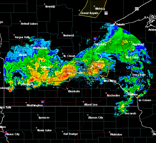 At 642 pm cdt, a severe thunderstorm was located over burkhardt, or 10 miles north of river falls, moving east at 30 mph (law enforcement). Hazards include 60 mph wind gusts and quarter size hail. Hail damage to vehicles is expected. expect wind damage to roofs, siding, and trees. this severe storm will be near, roberts around 650 pm cdt. hammond around 700 pm cdt. baldwin around 710 pm cdt. Other locations impacted by this severe thunderstorm include burkhardt, lakeland, boardman, lakeland shores, oak park heights, houlton, st marys point, new richmond airport, willow river state park and lake st croix beach. At 642 pm cdt, a severe thunderstorm was located over burkhardt, or 10 miles north of river falls, moving east at 30 mph (law enforcement). Hazards include 60 mph wind gusts and quarter size hail. Hail damage to vehicles is expected. expect wind damage to roofs, siding, and trees. this severe storm will be near, roberts around 650 pm cdt. hammond around 700 pm cdt. baldwin around 710 pm cdt. Other locations impacted by this severe thunderstorm include burkhardt, lakeland, boardman, lakeland shores, oak park heights, houlton, st marys point, new richmond airport, willow river state park and lake st croix beach.
|
| 7/5/2016 6:10 PM CDT |
 At 609 pm cdt, a severe thunderstorm was located over birchwood village, or 9 miles northeast of st. paul, moving east at 30 mph (law enforcement reported). Hazards include 60 mph wind gusts and quarter size hail. Hail damage to vehicles is expected. expect wind damage to roofs, siding, and trees. this severe thunderstorm will be near, stillwater and afton around 625 pm cdt. bayport around 630 pm cdt. hudson, north hudson and somerset around 635 pm cdt. roberts around 650 pm cdt. hammond around 705 pm cdt. Baldwin around 710 pm cdt. At 609 pm cdt, a severe thunderstorm was located over birchwood village, or 9 miles northeast of st. paul, moving east at 30 mph (law enforcement reported). Hazards include 60 mph wind gusts and quarter size hail. Hail damage to vehicles is expected. expect wind damage to roofs, siding, and trees. this severe thunderstorm will be near, stillwater and afton around 625 pm cdt. bayport around 630 pm cdt. hudson, north hudson and somerset around 635 pm cdt. roberts around 650 pm cdt. hammond around 705 pm cdt. Baldwin around 710 pm cdt.
|
| 7/18/2015 1:06 AM CDT |
 At 106 am cdt, severe thunderstorms were located along a line extending from near wyoming to stillwater to prescott, moving east at 50 mph (radar indicated). Hazards include 60 mph wind gusts. Expect damage to roofs. siding and trees. severe thunderstorms will be near, stillwater, bayport and afton around 110 am cdt. hudson, north hudson and somerset around 115 am cdt. new richmond, chisago city and lindstrom around 120 am cdt. scandia and roberts around 125 am cdt. osceola and hammond around 130 am cdt. baldwin and dresser around 135 am cdt. woodville and star prairie around 140 am cdt. amery and glenwood city around 145 am cdt. Other locations impacted by these severe thunderstorms include otisville, lakeland shores, nye, osceola airport, grant, deronda, william obrien state park, wanderoos, willow river state park and wilson. At 106 am cdt, severe thunderstorms were located along a line extending from near wyoming to stillwater to prescott, moving east at 50 mph (radar indicated). Hazards include 60 mph wind gusts. Expect damage to roofs. siding and trees. severe thunderstorms will be near, stillwater, bayport and afton around 110 am cdt. hudson, north hudson and somerset around 115 am cdt. new richmond, chisago city and lindstrom around 120 am cdt. scandia and roberts around 125 am cdt. osceola and hammond around 130 am cdt. baldwin and dresser around 135 am cdt. woodville and star prairie around 140 am cdt. amery and glenwood city around 145 am cdt. Other locations impacted by these severe thunderstorms include otisville, lakeland shores, nye, osceola airport, grant, deronda, william obrien state park, wanderoos, willow river state park and wilson.
|
| 7/12/2015 10:49 PM CDT |
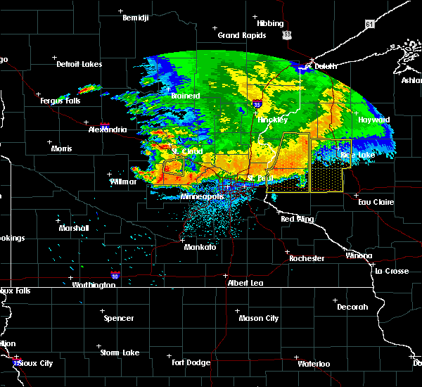 At 1049 pm cdt, a severe thunderstorm was located near clayton, or 26 miles southwest of rice lake, moving southeast at 35 mph (radar indicated). Hazards include 60 mph wind gusts. Expect damage to roofs. siding and trees. locations impacted include, river falls, hudson, new richmond, north hudson, bayport, amery, somerset, baldwin, hammond, roberts, woodville and glenwood city. This includes interstate 94 in wisconsin between mile markers 1 and 30. At 1049 pm cdt, a severe thunderstorm was located near clayton, or 26 miles southwest of rice lake, moving southeast at 35 mph (radar indicated). Hazards include 60 mph wind gusts. Expect damage to roofs. siding and trees. locations impacted include, river falls, hudson, new richmond, north hudson, bayport, amery, somerset, baldwin, hammond, roberts, woodville and glenwood city. This includes interstate 94 in wisconsin between mile markers 1 and 30.
|
| 7/12/2015 9:59 PM CDT |
 At 959 pm cdt, a severe thunderstorm was located near wolf creek, or 25 miles east of cambridge, moving southeast at 35 mph (radar indicated). Hazards include 60 mph wind gusts and nickel size hail. Expect damage to roofs. siding and trees. this severe thunderstorm will be near, st. croix falls around 1010 pm cdt. centuria and milltown around 1015 pm cdt. balsam lake around 1020 pm cdt. amery around 1035 pm cdt. clear lake and turtle lake around 1045 pm cdt. clayton around 1050 pm cdt. other locations impacted by this severe thunderstorm include burkhardt, range, deer park, houlton, new richmond airport, huntington, cylon, mckinley, emerald and forest. this includes interstate 94 in wisconsin between mile markers 1 and 30. A tornado watch remains in effect until 100 am cdt for east central minnesota and northwestern wisconsin. At 959 pm cdt, a severe thunderstorm was located near wolf creek, or 25 miles east of cambridge, moving southeast at 35 mph (radar indicated). Hazards include 60 mph wind gusts and nickel size hail. Expect damage to roofs. siding and trees. this severe thunderstorm will be near, st. croix falls around 1010 pm cdt. centuria and milltown around 1015 pm cdt. balsam lake around 1020 pm cdt. amery around 1035 pm cdt. clear lake and turtle lake around 1045 pm cdt. clayton around 1050 pm cdt. other locations impacted by this severe thunderstorm include burkhardt, range, deer park, houlton, new richmond airport, huntington, cylon, mckinley, emerald and forest. this includes interstate 94 in wisconsin between mile markers 1 and 30. A tornado watch remains in effect until 100 am cdt for east central minnesota and northwestern wisconsin.
|
| 7/12/2015 9:48 PM CDT |
 At 948 pm cdt, a severe thunderstorm was located over bethel, or 11 miles south of cambridge, moving east at 25 mph (radar indicated). Hazards include 60 mph wind gusts and nickel size hail. Expect damage to roofs. siding and trees. this severe thunderstorm will be near, ham lake around 955 pm cdt. east bethel around 1000 pm cdt. forest lake around 1020 pm cdt. scandia around 1045 pm cdt. other locations impacted by this severe thunderstorm include fort snelling, otisville, north st. paul, bethel, birchwood, grant, nowthen, falcon heights, william obrien state park and birchwood village. this includes the following highways, interstate 35 between mile markers 128 and 132. interstate 94 in minnesota near mile marker 225, and between mile markers 238 and 257. A tornado watch remains in effect until 100 am cdt for east central minnesota and northwestern wisconsin. At 948 pm cdt, a severe thunderstorm was located over bethel, or 11 miles south of cambridge, moving east at 25 mph (radar indicated). Hazards include 60 mph wind gusts and nickel size hail. Expect damage to roofs. siding and trees. this severe thunderstorm will be near, ham lake around 955 pm cdt. east bethel around 1000 pm cdt. forest lake around 1020 pm cdt. scandia around 1045 pm cdt. other locations impacted by this severe thunderstorm include fort snelling, otisville, north st. paul, bethel, birchwood, grant, nowthen, falcon heights, william obrien state park and birchwood village. this includes the following highways, interstate 35 between mile markers 128 and 132. interstate 94 in minnesota near mile marker 225, and between mile markers 238 and 257. A tornado watch remains in effect until 100 am cdt for east central minnesota and northwestern wisconsin.
|
| 6/29/2015 6:18 PM CDT |
 At 618 pm cdt, severe thunderstorms were located along a line extending from near marine on st croix to near forest lake to near wyoming, moving south at 20 mph (radar indicated). Hazards include golf ball size hail. People and animals outdoors will be injured. expect damage to roofs, siding, windows and vehicles. these severe storms will be near, lino lakes and hugo around 630 pm cdt. other locations impacted by these severe thunderstorms include wyoming, centerville, william obrien state park, marine on st croix and grant. This includes interstate 35 between mile markers 128 and 137. At 618 pm cdt, severe thunderstorms were located along a line extending from near marine on st croix to near forest lake to near wyoming, moving south at 20 mph (radar indicated). Hazards include golf ball size hail. People and animals outdoors will be injured. expect damage to roofs, siding, windows and vehicles. these severe storms will be near, lino lakes and hugo around 630 pm cdt. other locations impacted by these severe thunderstorms include wyoming, centerville, william obrien state park, marine on st croix and grant. This includes interstate 35 between mile markers 128 and 137.
|
| 6/29/2015 5:54 PM CDT |
 At 553 pm cdt, a severe thunderstorm was located over chisago city, or 19 miles southeast of cambridge, moving south at 25 mph (radar indicated). Hazards include two inch hail. People and animals outdoors will be injured. expect damage to roofs, siding, windows and vehicles. this severe storm will be near, forest lake around 600 pm cdt. scandia around 610 pm cdt. hugo around 615 pm cdt. other locations impacted by this severe thunderstorm include william obrien state park, wyoming, marine on st croix, centerville and grant. This includes interstate 35 between mile markers 128 and 140. At 553 pm cdt, a severe thunderstorm was located over chisago city, or 19 miles southeast of cambridge, moving south at 25 mph (radar indicated). Hazards include two inch hail. People and animals outdoors will be injured. expect damage to roofs, siding, windows and vehicles. this severe storm will be near, forest lake around 600 pm cdt. scandia around 610 pm cdt. hugo around 615 pm cdt. other locations impacted by this severe thunderstorm include william obrien state park, wyoming, marine on st croix, centerville and grant. This includes interstate 35 between mile markers 128 and 140.
|
| 6/29/2015 5:32 PM CDT |
 At 532 pm cdt, a severe thunderstorm was located over north branch, or 13 miles east of cambridge, moving south at 25 mph (trained weather spotters). Hazards include half dollar size hail. Damage to vehicles is expected. this severe thunderstorm will be near, chisago city and stacy around 545 pm cdt. lindstrom around 550 pm cdt. forest lake around 600 pm cdt. lino lakes and hugo around 615 pm cdt. other locations impacted by this severe thunderstorm include wyoming, otisville, william obrien state park, marine on st croix, centerville, circle pines and grant. This includes interstate 35 between mile markers 128 and 141. At 532 pm cdt, a severe thunderstorm was located over north branch, or 13 miles east of cambridge, moving south at 25 mph (trained weather spotters). Hazards include half dollar size hail. Damage to vehicles is expected. this severe thunderstorm will be near, chisago city and stacy around 545 pm cdt. lindstrom around 550 pm cdt. forest lake around 600 pm cdt. lino lakes and hugo around 615 pm cdt. other locations impacted by this severe thunderstorm include wyoming, otisville, william obrien state park, marine on st croix, centerville, circle pines and grant. This includes interstate 35 between mile markers 128 and 141.
|
| 5/3/2015 6:17 PM CDT | At 616 pm cdt, severe thunderstorms were located along a line extending from near new richmond airport to woodville to near esdaile, moving east at 40 mph (radar indicated). Hazards include ping pong ball size hail and 60 mph wind gusts. People and animals outdoors will be injured. expect hail damage to roofs, siding, windows and vehicles. expect wind damage to roofs, siding and trees. locations impacted include, menomonie, river falls, hudson, new richmond, ellsworth, somerset, baldwin, hammond, roberts, spring valley, woodville and glenwood city. 1. 50in. |
| 5/3/2015 5:58 PM CDT | At 558 pm cdt, severe thunderstorms were located along a line extending from marine on st croix to lakeland shores, moving east at 40 mph (radar indicated). Hazards include ping pong ball size hail and 60 mph wind gusts. People and animals outdoors will be injured. expect hail damage to roofs, siding, windows and vehicles. Expect wind damage to roofs, siding and trees. |
| 5/3/2015 5:51 PM CDT | At 550 pm cdt, severe thunderstorms were located along a line extending from near marine on st croix to near lake elmo airport to near woodbury, moving east at 50 mph (radar indicated). Hazards include golf ball size hail and 60 mph wind gusts. People and animals outdoors will be injured. expect hail damage to roofs, siding, windows and vehicles. expect wind damage to roofs, siding and trees. locations impacted include, woodbury, maplewood, cottage grove, oakdale, stillwater, hugo, hudson, new richmond, lake elmo, mahtomedi, north hudson and bayport. 1. 75in. |
| 5/3/2015 5:51 PM CDT | At 550 pm cdt, severe thunderstorms were located along a line extending from near marine on st croix to near lake elmo airport to near woodbury, moving east at 50 mph (radar indicated). Hazards include golf ball size hail and 60 mph wind gusts. People and animals outdoors will be injured. expect hail damage to roofs, siding, windows and vehicles. expect wind damage to roofs, siding and trees. locations impacted include, woodbury, maplewood, cottage grove, oakdale, stillwater, hugo, hudson, new richmond, lake elmo, mahtomedi, north hudson and bayport. 1. 75in. |
| 5/3/2015 5:37 PM CDT | At 536 pm cdt, severe thunderstorms were located along a line extending from hugo to north st. paul to st. paul, moving east at 45 mph (radar indicated). Hazards include 60 mph wind gusts and half dollar size hail. Hail damage to vehicles is expected. expect wind damage to roofs, siding and trees. locations impacted include, st. paul, woodbury, maplewood, cottage grove, inver grove heights, roseville, oakdale, shoreview, white bear lake, lino lakes, south st. paul and west st. paul. 1. 25in. |
| 5/3/2015 5:37 PM CDT | At 536 pm cdt, severe thunderstorms were located along a line extending from hugo to north st. paul to st. paul, moving east at 45 mph (radar indicated). Hazards include 60 mph wind gusts and half dollar size hail. Hail damage to vehicles is expected. expect wind damage to roofs, siding and trees. locations impacted include, st. paul, woodbury, maplewood, cottage grove, inver grove heights, roseville, oakdale, shoreview, white bear lake, lino lakes, south st. paul and west st. paul. 1. 25in. |
| 5/3/2015 5:23 PM CDT | At 522 pm cdt, severe thunderstorms were located along a line extending from near lino lakes to minneapolis, moving east at 40 mph (radar indicated). Hazards include 60 mph wind gusts and half dollar size hail. Hail damage to vehicles is expected. expect wind damage to roofs, siding and trees. locations impacted include, minneapolis, st. paul, bloomington, brooklyn park, eagan, woodbury, coon rapids, eden prairie, burnsville, blaine, minnetonka and edina. 1. 25in. |
| 5/3/2015 5:23 PM CDT | At 522 pm cdt, severe thunderstorms were located along a line extending from near lino lakes to minneapolis, moving east at 40 mph (radar indicated). Hazards include 60 mph wind gusts and half dollar size hail. Hail damage to vehicles is expected. expect wind damage to roofs, siding and trees. locations impacted include, minneapolis, st. paul, bloomington, brooklyn park, eagan, woodbury, coon rapids, eden prairie, burnsville, blaine, minnetonka and edina. 1. 25in. |
| 5/3/2015 5:08 PM CDT | At 507 pm cdt, severe thunderstorms were located along a line extending from near ham lake to medicine lake, moving east at 50 mph (radar indicated). Hazards include half dollar size hail. damage to vehicles is expected |
| 5/3/2015 5:08 PM CDT | At 507 pm cdt, severe thunderstorms were located along a line extending from near ham lake to medicine lake, moving east at 50 mph (radar indicated). Hazards include half dollar size hail. damage to vehicles is expected |
Hail Maps for Marine on St. Croix, MN
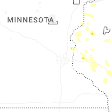


Connect with Interactive Hail Maps