

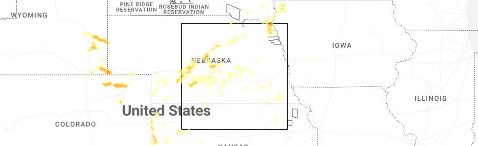
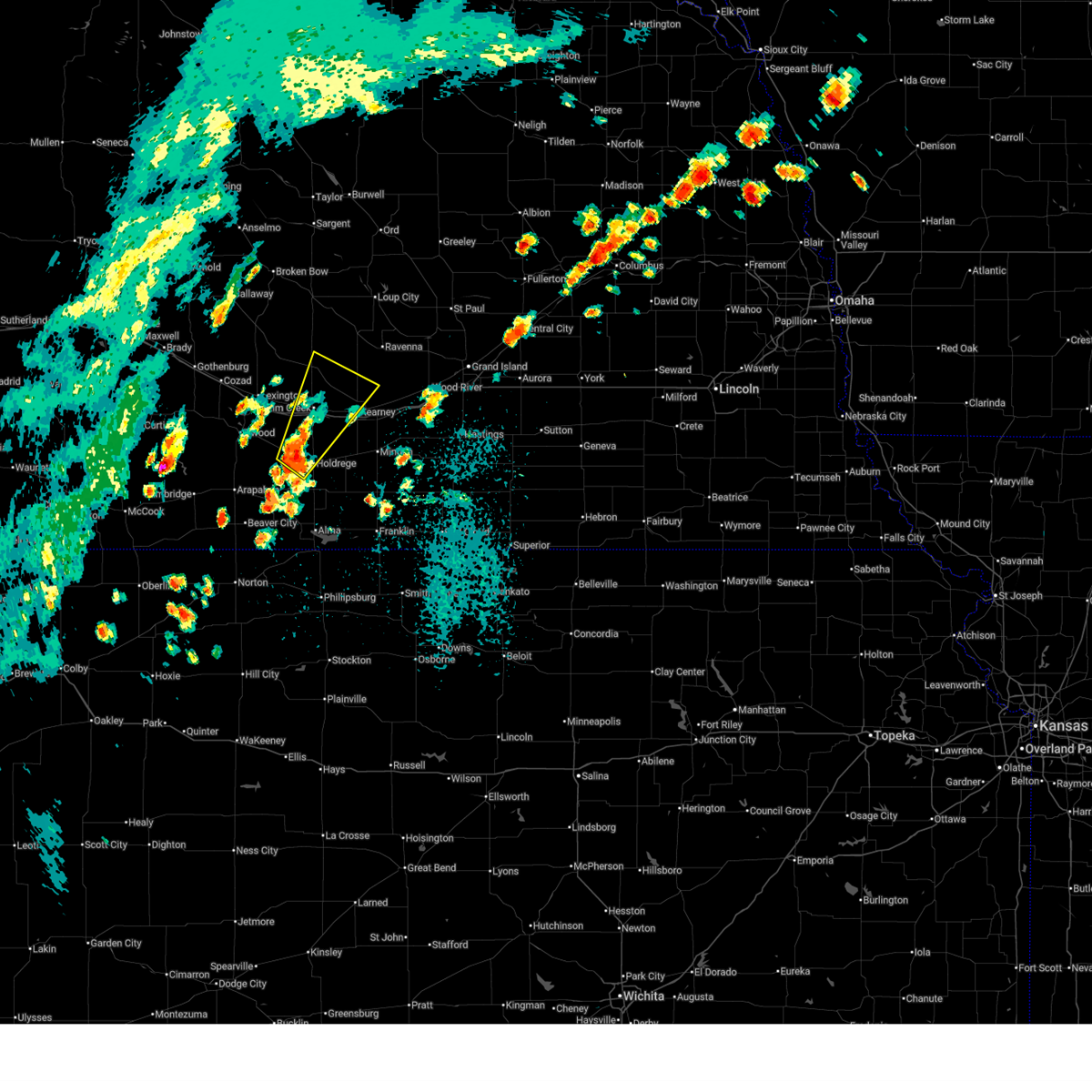
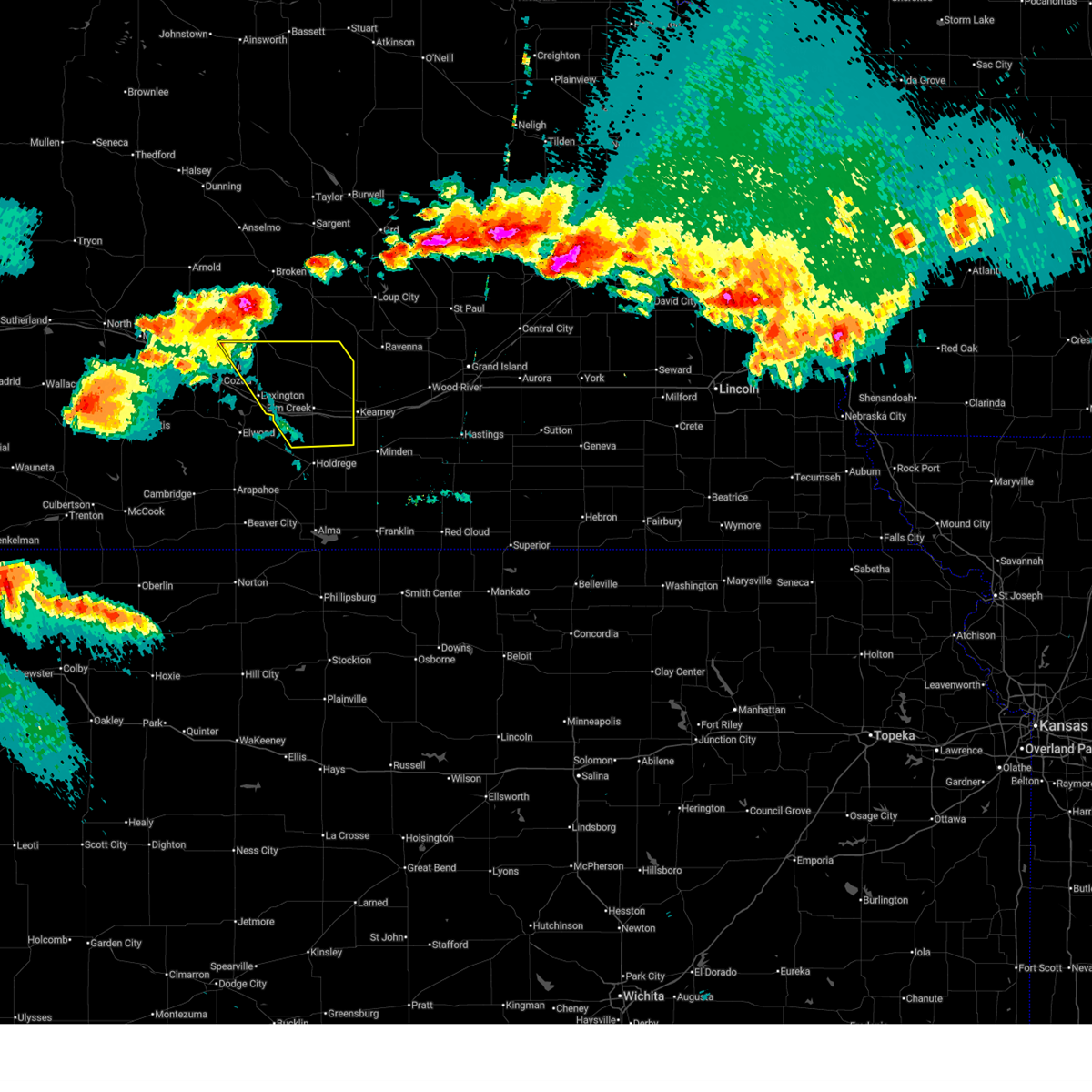
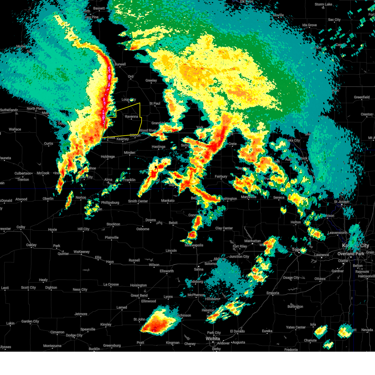
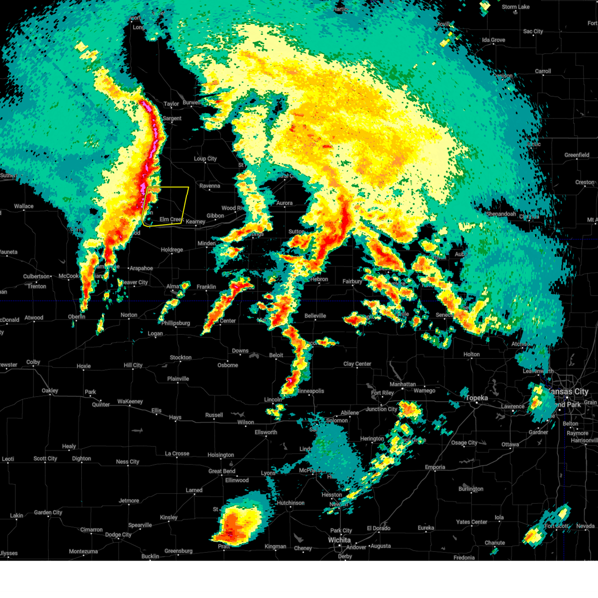
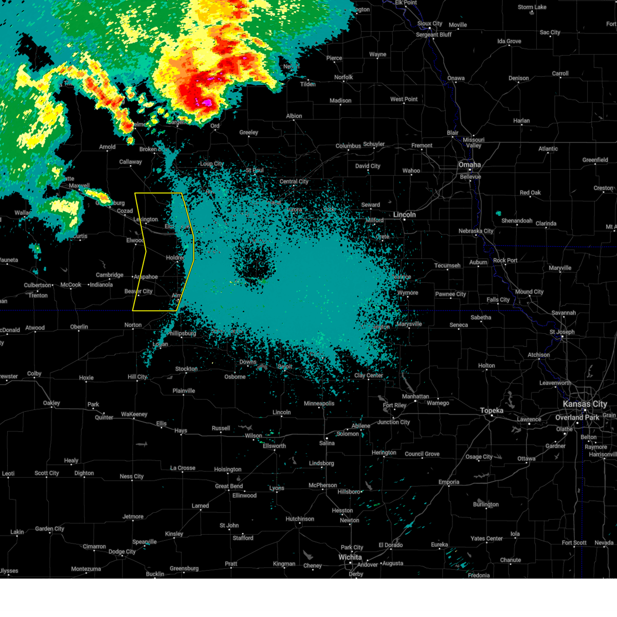
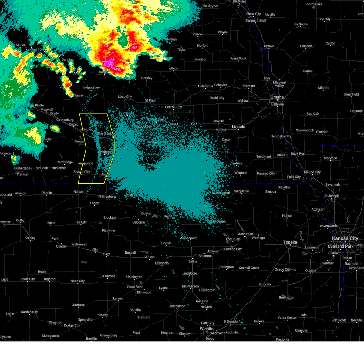
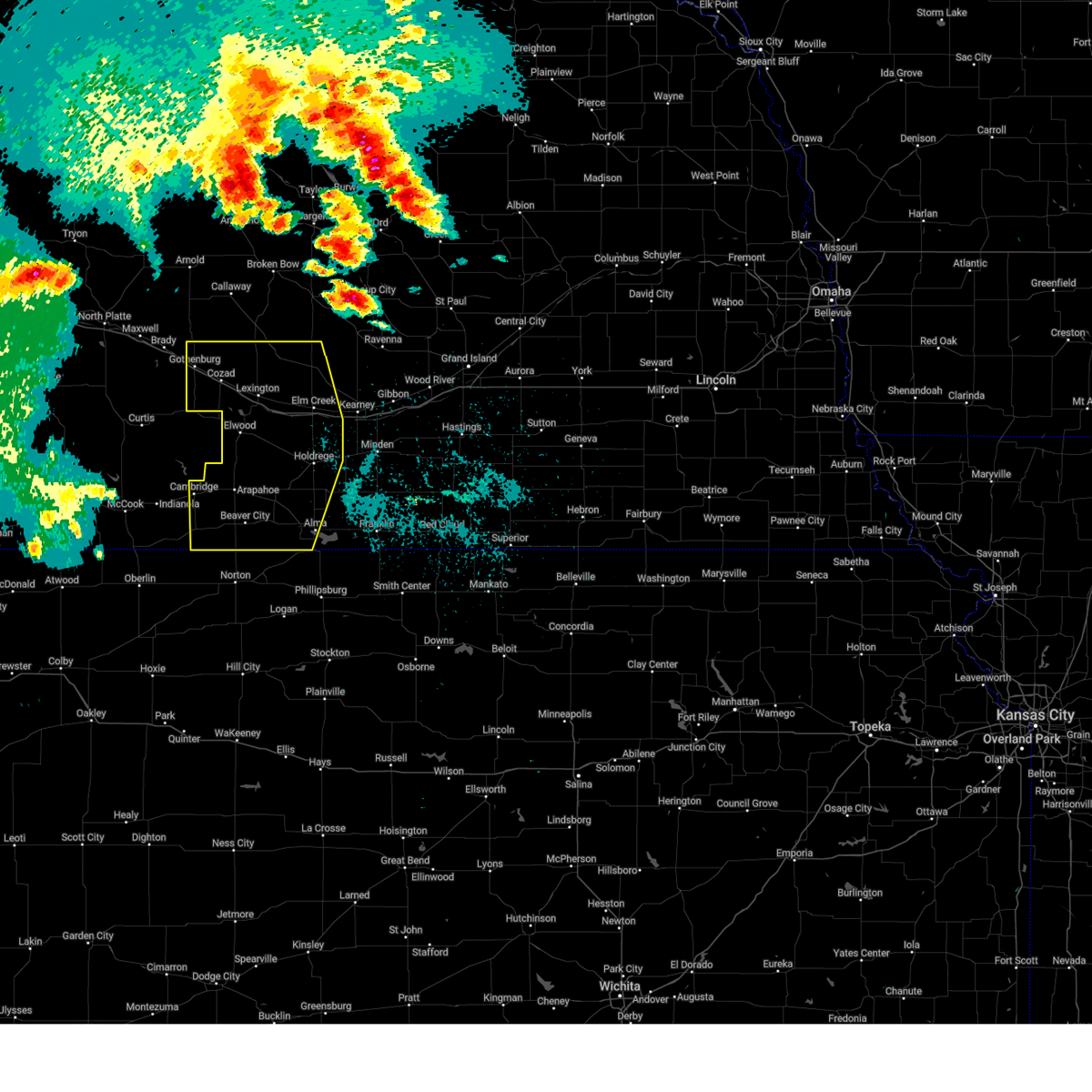
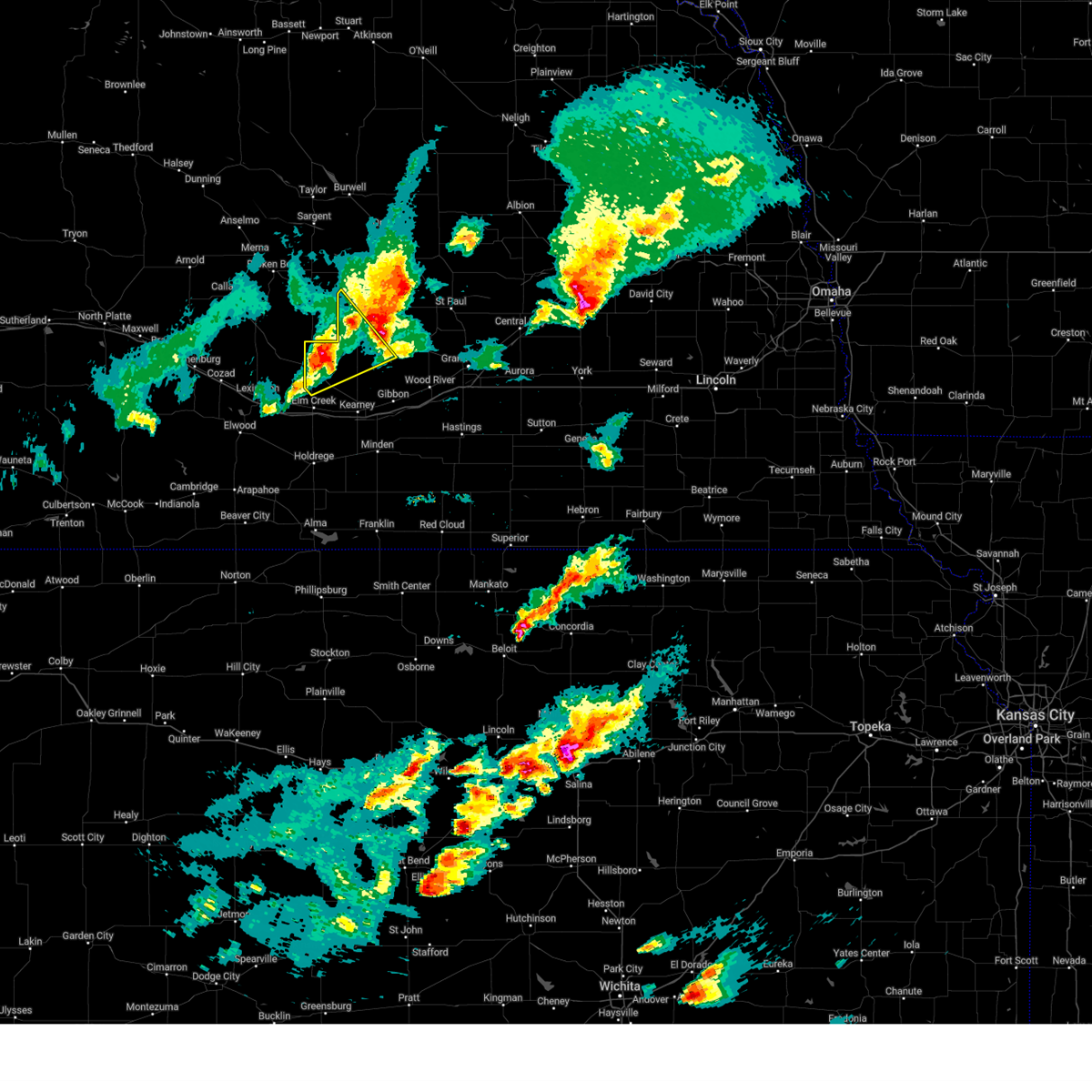
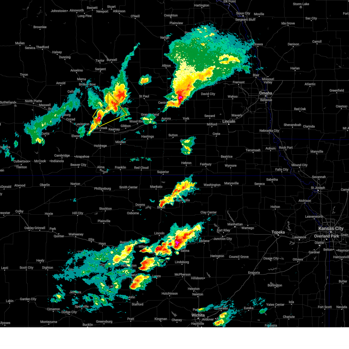
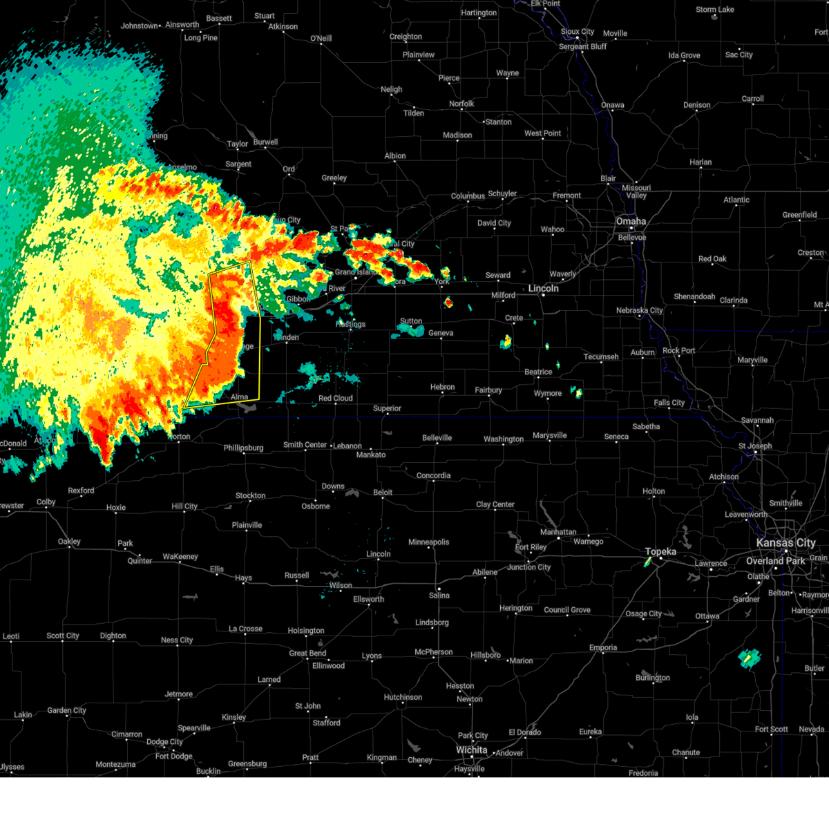
Hail Map for Miller, NE
The Miller, NE area has had 11 reports of on-the-ground hail by trained spotters, and has been under severe weather warnings 28 times during the past 12 months. Doppler radar has detected hail at or near Miller, NE on 104 occasions, including 6 occasions during the past year.
| Name: | Miller, NE |
| Where Located: | 55 miles W of Grand Island, NE |
| Map: | Google Map for Miller, NE |
| Population: | 136 |
| Housing Units: | 66 |
| More Info: | Search Google for Miller, NE |
1
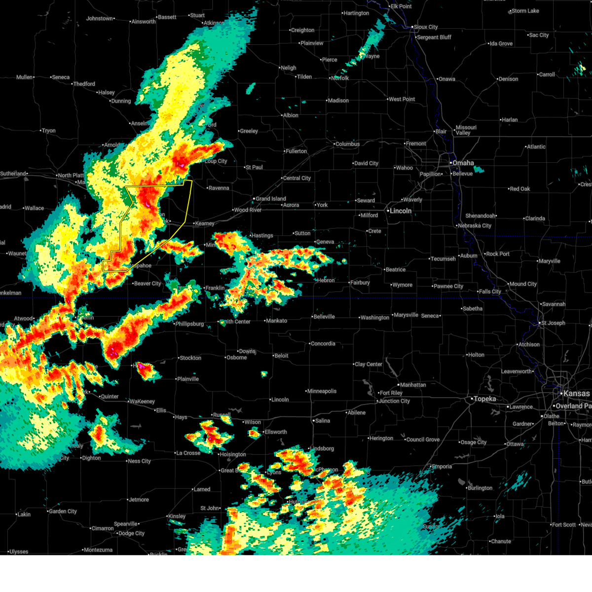
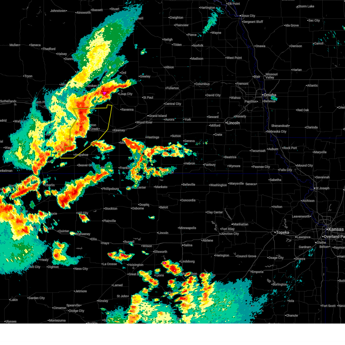
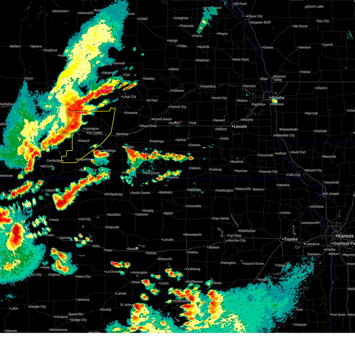
The Top Recent Hail Date for Miller, NE is Monday, June 2, 2025 (14th out of 104)
Hail and Wind Damage Spotted near Miller, NE
| Date / Time | Report Details |
|---|---|
| 6/30/2025 2:26 AM CDT |
 At 224 am cdt, severe thunderstorms were located along a line extending from near eddyville to near overton to near smithfield to 6 miles northwest of holbrook, moving east at 35 mph (at 215 am...the automated weather station at lexington recorded a wind gust of 67 mph). Hazards include 70 mph wind gusts and nickel size hail. Expect considerable tree damage. damage is likely to mobile homes, roofs, and outbuildings. these severe storms will be near, bertrand, overton, sumner, and smithfield around 230 am cdt. arapahoe, elm creek, and miller around 235 am cdt. odessa, loomis, and amherst around 245 am cdt. This includes interstate 80 between mile markers 228 and 264. At 224 am cdt, severe thunderstorms were located along a line extending from near eddyville to near overton to near smithfield to 6 miles northwest of holbrook, moving east at 35 mph (at 215 am...the automated weather station at lexington recorded a wind gust of 67 mph). Hazards include 70 mph wind gusts and nickel size hail. Expect considerable tree damage. damage is likely to mobile homes, roofs, and outbuildings. these severe storms will be near, bertrand, overton, sumner, and smithfield around 230 am cdt. arapahoe, elm creek, and miller around 235 am cdt. odessa, loomis, and amherst around 245 am cdt. This includes interstate 80 between mile markers 228 and 264.
|
| 6/30/2025 2:17 AM CDT |
 At 217 am cdt, severe thunderstorms were located along a line extending from near eddyville to 6 miles northwest of overton to near smithfield to 6 miles east of medicine creek reservoir state recreation area, moving east at 35 mph (radar indicated). Hazards include 60 mph wind gusts and nickel size hail. Expect damage to roofs, siding, and trees. these severe storms will be near, overton, sumner, eddyville, and smithfield around 220 am cdt. bertrand and holbrook around 225 am cdt. arapahoe and miller around 230 am cdt. elm creek around 235 am cdt. loomis and amherst around 240 am cdt. odessa around 245 am cdt. This includes interstate 80 between mile markers 228 and 264. At 217 am cdt, severe thunderstorms were located along a line extending from near eddyville to 6 miles northwest of overton to near smithfield to 6 miles east of medicine creek reservoir state recreation area, moving east at 35 mph (radar indicated). Hazards include 60 mph wind gusts and nickel size hail. Expect damage to roofs, siding, and trees. these severe storms will be near, overton, sumner, eddyville, and smithfield around 220 am cdt. bertrand and holbrook around 225 am cdt. arapahoe and miller around 230 am cdt. elm creek around 235 am cdt. loomis and amherst around 240 am cdt. odessa around 245 am cdt. This includes interstate 80 between mile markers 228 and 264.
|
| 6/30/2025 1:55 AM CDT |
 Svrgid the national weather service in hastings has issued a * severe thunderstorm warning for, northwestern phelps county in south central nebraska, gosper county in south central nebraska, western buffalo county in south central nebraska, southwestern sherman county in central nebraska, dawson county in south central nebraska, northwestern furnas county in south central nebraska, * until 245 am cdt. * at 154 am cdt, severe thunderstorms were located along a line extending from near oconto to 6 miles northwest of lexington to eustis to near stockville, moving east at 35 mph (radar indicated). Hazards include 60 mph wind gusts and nickel size hail. Expect damage to roofs, siding, and trees. severe thunderstorms will be near, lexington, eddyville, and johnson lake around 200 am cdt. elwood around 205 am cdt. other locations in the path of these severe thunderstorms include sumner, overton, smithfield, miller, elm creek and bertrand. This includes interstate 80 between mile markers 219 and 264. Svrgid the national weather service in hastings has issued a * severe thunderstorm warning for, northwestern phelps county in south central nebraska, gosper county in south central nebraska, western buffalo county in south central nebraska, southwestern sherman county in central nebraska, dawson county in south central nebraska, northwestern furnas county in south central nebraska, * until 245 am cdt. * at 154 am cdt, severe thunderstorms were located along a line extending from near oconto to 6 miles northwest of lexington to eustis to near stockville, moving east at 35 mph (radar indicated). Hazards include 60 mph wind gusts and nickel size hail. Expect damage to roofs, siding, and trees. severe thunderstorms will be near, lexington, eddyville, and johnson lake around 200 am cdt. elwood around 205 am cdt. other locations in the path of these severe thunderstorms include sumner, overton, smithfield, miller, elm creek and bertrand. This includes interstate 80 between mile markers 219 and 264.
|
| 6/25/2025 3:50 PM CDT | At 349 pm cdt, a severe thunderstorm was located 7 miles north of lexington, moving northeast at 50 mph (radar indicated). Hazards include 60 mph wind gusts and quarter size hail. Hail damage to vehicles is expected. expect wind damage to roofs, siding, and trees. this severe storm will be near, eddyville around 355 pm cdt. This includes interstate 80 between mile markers 223 and 240. |
| 6/25/2025 3:27 PM CDT | Svrgid the national weather service in hastings has issued a * severe thunderstorm warning for, north central gosper county in south central nebraska, northwestern buffalo county in south central nebraska, central dawson county in south central nebraska, * until 415 pm cdt. * at 327 pm cdt, a severe thunderstorm was located over eustis, or 14 miles southwest of lexington, moving northeast at 45 mph (radar indicated). Hazards include 60 mph wind gusts and quarter size hail. Hail damage to vehicles is expected. expect wind damage to roofs, siding, and trees. this severe thunderstorm will be near, lexington around 340 pm cdt. other locations in the path of this severe thunderstorm include eddyville. This includes interstate 80 between mile markers 223 and 241. |
| 6/25/2025 2:46 PM CDT |
 Svrgid the national weather service in hastings has issued a * severe thunderstorm warning for, central phelps county in south central nebraska, northwestern kearney county in south central nebraska, western buffalo county in south central nebraska, southeastern dawson county in south central nebraska, * until 330 pm cdt. * at 246 pm cdt, a severe thunderstorm was located over loomis, or near holdrege, moving northeast at 40 mph (radar indicated). Hazards include 60 mph wind gusts and quarter size hail. Hail damage to vehicles is expected. expect wind damage to roofs, siding, and trees. this severe thunderstorm will be near, elm creek around 305 pm cdt. other locations in the path of this severe thunderstorm include odessa and amherst. This includes interstate 80 between mile markers 251 and 271. Svrgid the national weather service in hastings has issued a * severe thunderstorm warning for, central phelps county in south central nebraska, northwestern kearney county in south central nebraska, western buffalo county in south central nebraska, southeastern dawson county in south central nebraska, * until 330 pm cdt. * at 246 pm cdt, a severe thunderstorm was located over loomis, or near holdrege, moving northeast at 40 mph (radar indicated). Hazards include 60 mph wind gusts and quarter size hail. Hail damage to vehicles is expected. expect wind damage to roofs, siding, and trees. this severe thunderstorm will be near, elm creek around 305 pm cdt. other locations in the path of this severe thunderstorm include odessa and amherst. This includes interstate 80 between mile markers 251 and 271.
|
| 6/16/2025 8:47 PM CDT | the severe thunderstorm warning has been cancelled and is no longer in effect |
| 6/16/2025 8:23 PM CDT |
 Svrgid the national weather service in hastings has issued a * severe thunderstorm warning for, northern phelps county in south central nebraska, northwestern kearney county in south central nebraska, western buffalo county in south central nebraska, eastern dawson county in south central nebraska, * until 915 pm cdt. * at 822 pm cdt, severe winds were located along a line of showers extending from 10 miles southwest of oconto to near lexington to 8 miles northeast of bertrand, moving east at 30 mph (law enforcement). Hazards include 70 mph wind gusts. Expect considerable tree damage. damage is likely to mobile homes, roofs, and outbuildings. severe thunderstorms will be near, overton around 830 pm cdt. elm creek around 835 pm cdt. eddyville around 840 pm cdt. other locations in the path of these severe thunderstorms include odessa, sumner, amherst, miller and kearney. This includes interstate 80 between mile markers 238 and 271. Svrgid the national weather service in hastings has issued a * severe thunderstorm warning for, northern phelps county in south central nebraska, northwestern kearney county in south central nebraska, western buffalo county in south central nebraska, eastern dawson county in south central nebraska, * until 915 pm cdt. * at 822 pm cdt, severe winds were located along a line of showers extending from 10 miles southwest of oconto to near lexington to 8 miles northeast of bertrand, moving east at 30 mph (law enforcement). Hazards include 70 mph wind gusts. Expect considerable tree damage. damage is likely to mobile homes, roofs, and outbuildings. severe thunderstorms will be near, overton around 830 pm cdt. elm creek around 835 pm cdt. eddyville around 840 pm cdt. other locations in the path of these severe thunderstorms include odessa, sumner, amherst, miller and kearney. This includes interstate 80 between mile markers 238 and 271.
|
| 5/18/2025 11:39 PM CDT |
 Svrgid the national weather service in hastings has issued a * severe thunderstorm warning for, buffalo county in south central nebraska, southern sherman county in central nebraska, east central dawson county in south central nebraska, * until 1230 am cdt. * at 1138 pm cdt, severe thunderstorms were located along a line extending from 11 miles southwest of litchfield to 6 miles south of miller, moving east at 35 mph (emergency management reported 60 mph in miller at 1137 pm cdt). Hazards include 60 mph wind gusts and penny size hail. Expect damage to roofs, siding, and trees. severe thunderstorms will be near, amherst around 1145 pm cdt. pleasanton and hazard around 1155 pm cdt. Other locations in the path of these severe thunderstorms include ravenna, poole and rockville. Svrgid the national weather service in hastings has issued a * severe thunderstorm warning for, buffalo county in south central nebraska, southern sherman county in central nebraska, east central dawson county in south central nebraska, * until 1230 am cdt. * at 1138 pm cdt, severe thunderstorms were located along a line extending from 11 miles southwest of litchfield to 6 miles south of miller, moving east at 35 mph (emergency management reported 60 mph in miller at 1137 pm cdt). Hazards include 60 mph wind gusts and penny size hail. Expect damage to roofs, siding, and trees. severe thunderstorms will be near, amherst around 1145 pm cdt. pleasanton and hazard around 1155 pm cdt. Other locations in the path of these severe thunderstorms include ravenna, poole and rockville.
|
| 5/18/2025 11:37 PM CDT | Emergency manager reports 60mph winds in mille in buffalo county NE, 0.1 miles SW of Miller, NE |
| 5/18/2025 11:19 PM CDT |
 Svrgid the national weather service in hastings has issued a * severe thunderstorm warning for, western buffalo county in south central nebraska, eastern dawson county in south central nebraska, * until 1145 pm cdt. * at 1118 pm cdt, severe thunderstorms were located along a line extending from near eddyville to lexington, moving east at 35 mph (radar indicated). Hazards include 60 mph wind gusts and penny size hail. Expect damage to roofs, siding, and trees. severe thunderstorms will be near, sumner around 1125 pm cdt. This includes interstate 80 between mile markers 238 and 245. Svrgid the national weather service in hastings has issued a * severe thunderstorm warning for, western buffalo county in south central nebraska, eastern dawson county in south central nebraska, * until 1145 pm cdt. * at 1118 pm cdt, severe thunderstorms were located along a line extending from near eddyville to lexington, moving east at 35 mph (radar indicated). Hazards include 60 mph wind gusts and penny size hail. Expect damage to roofs, siding, and trees. severe thunderstorms will be near, sumner around 1125 pm cdt. This includes interstate 80 between mile markers 238 and 245.
|
| 5/14/2025 10:28 PM CDT |
 The storms which prompted the warning have weakened below severe limits, and no longer pose an immediate threat to life or property. therefore, the warning will be allowed to expire. however, gusty winds around 50 mph are still possible. a severe thunderstorm watch remains in effect until 300 am cdt for south central nebraska. The storms which prompted the warning have weakened below severe limits, and no longer pose an immediate threat to life or property. therefore, the warning will be allowed to expire. however, gusty winds around 50 mph are still possible. a severe thunderstorm watch remains in effect until 300 am cdt for south central nebraska.
|
| 5/14/2025 10:15 PM CDT |
 At 1013 pm cdt, outflow from strong thunderstorms over southwest nebraska was located along a line extending from 8 miles north of oconto to 8 miles northeast of loomis to 6 miles west of long island, moving east at 55 mph (automated weather station. widespread wind gusts of 50 to 60 mph have been reported with this outflow, along with reduced visibility to one quarter mile, or less, from blowing dust). Hazards include 60 mph wind gusts. Expect damage to roofs, siding, and trees. these severe winds will be near, holdrege, alma, elm creek, odessa, orleans, sumner, funk, miller, and ragan around 1020 pm cdt. amherst and huntley around 1025 pm cdt. This includes interstate 80 between mile markers 234 and 267. At 1013 pm cdt, outflow from strong thunderstorms over southwest nebraska was located along a line extending from 8 miles north of oconto to 8 miles northeast of loomis to 6 miles west of long island, moving east at 55 mph (automated weather station. widespread wind gusts of 50 to 60 mph have been reported with this outflow, along with reduced visibility to one quarter mile, or less, from blowing dust). Hazards include 60 mph wind gusts. Expect damage to roofs, siding, and trees. these severe winds will be near, holdrege, alma, elm creek, odessa, orleans, sumner, funk, miller, and ragan around 1020 pm cdt. amherst and huntley around 1025 pm cdt. This includes interstate 80 between mile markers 234 and 267.
|
| 5/14/2025 9:27 PM CDT |
 Svrgid the national weather service in hastings has issued a * severe thunderstorm warning for, phelps county in south central nebraska, gosper county in south central nebraska, western buffalo county in south central nebraska, dawson county in south central nebraska, furnas county in south central nebraska, harlan county in south central nebraska, * until 1030 pm cdt. * at 924 pm cdt, outflow from strong thunderstorms over southwest nebraska was located along a line extending from 9 miles northeast of north platte airport to 6 miles east of stockville to 6 miles southwest of danbury, moving east at 55 mph (automated weather station. widespread wind gusts of 50 to 70 mph have been reported with this outflow, along with reduced visibility to one half mile, or less, from blowing dust). Hazards include 70 mph wind gusts. Expect considerable tree damage. damage is likely to mobile homes, roofs, and outbuildings. rapid reduction in visibility due to blowing dust. severe winds will be near, cambridge around 930 pm cdt. gothenburg around 935 pm cdt. cozad, elwood, holbrook, wilsonville, and willow island around 940 pm cdt. other locations in the path of these severe thunderstorms include arapahoe, hendley, johnson lake, smithfield, lexington, bertrand, beaver city, edison, oxford, hollinger, overton, loomis, stamford and eddyville. This includes interstate 80 between mile markers 209 and 267. Svrgid the national weather service in hastings has issued a * severe thunderstorm warning for, phelps county in south central nebraska, gosper county in south central nebraska, western buffalo county in south central nebraska, dawson county in south central nebraska, furnas county in south central nebraska, harlan county in south central nebraska, * until 1030 pm cdt. * at 924 pm cdt, outflow from strong thunderstorms over southwest nebraska was located along a line extending from 9 miles northeast of north platte airport to 6 miles east of stockville to 6 miles southwest of danbury, moving east at 55 mph (automated weather station. widespread wind gusts of 50 to 70 mph have been reported with this outflow, along with reduced visibility to one half mile, or less, from blowing dust). Hazards include 70 mph wind gusts. Expect considerable tree damage. damage is likely to mobile homes, roofs, and outbuildings. rapid reduction in visibility due to blowing dust. severe winds will be near, cambridge around 930 pm cdt. gothenburg around 935 pm cdt. cozad, elwood, holbrook, wilsonville, and willow island around 940 pm cdt. other locations in the path of these severe thunderstorms include arapahoe, hendley, johnson lake, smithfield, lexington, bertrand, beaver city, edison, oxford, hollinger, overton, loomis, stamford and eddyville. This includes interstate 80 between mile markers 209 and 267.
|
| 4/1/2025 8:56 PM CDT |
 The storm which prompted the warning has weakened below severe limits, and no longer poses an immediate threat to life or property. therefore, the warning will be allowed to expire. however, small hail and gusty winds are still possible with this thunderstorm. a severe thunderstorm watch remains in effect until 300 am cdt for central nebraska. The storm which prompted the warning has weakened below severe limits, and no longer poses an immediate threat to life or property. therefore, the warning will be allowed to expire. however, small hail and gusty winds are still possible with this thunderstorm. a severe thunderstorm watch remains in effect until 300 am cdt for central nebraska.
|
| 4/1/2025 8:46 PM CDT |
 the severe thunderstorm warning has been cancelled and is no longer in effect the severe thunderstorm warning has been cancelled and is no longer in effect
|
| 4/1/2025 8:46 PM CDT |
 At 846 pm cdt, a severe thunderstorm was located near miller, or 21 miles northwest of kearney, moving northeast at 40 mph (radar indicated). Hazards include 60 mph wind gusts and quarter size hail. Hail damage to vehicles is expected. expect wind damage to roofs, siding, and trees. This severe storm will be near, hazard around 900 pm cdt. At 846 pm cdt, a severe thunderstorm was located near miller, or 21 miles northwest of kearney, moving northeast at 40 mph (radar indicated). Hazards include 60 mph wind gusts and quarter size hail. Hail damage to vehicles is expected. expect wind damage to roofs, siding, and trees. This severe storm will be near, hazard around 900 pm cdt.
|
| 4/1/2025 8:37 PM CDT |
 Svrgid the national weather service in hastings has issued a * severe thunderstorm warning for, northern buffalo county in south central nebraska, southwestern sherman county in central nebraska, east central dawson county in south central nebraska, * until 900 pm cdt. * at 837 pm cdt, a severe thunderstorm was located over miller, or 20 miles northeast of lexington, moving northeast at 40 mph (radar indicated). Hazards include 60 mph wind gusts and half dollar size hail. Hail damage to vehicles is expected. expect wind damage to roofs, siding, and trees. This severe thunderstorm will be near, miller around 840 pm cdt. Svrgid the national weather service in hastings has issued a * severe thunderstorm warning for, northern buffalo county in south central nebraska, southwestern sherman county in central nebraska, east central dawson county in south central nebraska, * until 900 pm cdt. * at 837 pm cdt, a severe thunderstorm was located over miller, or 20 miles northeast of lexington, moving northeast at 40 mph (radar indicated). Hazards include 60 mph wind gusts and half dollar size hail. Hail damage to vehicles is expected. expect wind damage to roofs, siding, and trees. This severe thunderstorm will be near, miller around 840 pm cdt.
|
| 8/14/2024 12:27 AM CDT |
 At 1227 am cdt, severe thunderstorms were located along a line extending from near miller to 8 miles southwest of odessa to 7 miles southwest of ragan, moving east at 65 mph (radar indicated). Hazards include 60 mph wind gusts and penny size hail. Expect damage to roofs, siding, and trees. these severe storms will be near, holdrege, elm creek, odessa, amherst, funk, miller, and ragan around 1230 am cdt. This includes interstate 80 between mile markers 246 and 267. At 1227 am cdt, severe thunderstorms were located along a line extending from near miller to 8 miles southwest of odessa to 7 miles southwest of ragan, moving east at 65 mph (radar indicated). Hazards include 60 mph wind gusts and penny size hail. Expect damage to roofs, siding, and trees. these severe storms will be near, holdrege, elm creek, odessa, amherst, funk, miller, and ragan around 1230 am cdt. This includes interstate 80 between mile markers 246 and 267.
|
| 8/14/2024 12:27 AM CDT |
 the severe thunderstorm warning has been cancelled and is no longer in effect the severe thunderstorm warning has been cancelled and is no longer in effect
|
| 8/14/2024 12:14 AM CDT |
 At 1214 am cdt, severe thunderstorms were located along a line extending from near lexington to near bertrand to hollinger, moving east at 55 mph (radar indicated). Hazards include 60 mph wind gusts and penny size hail. Expect damage to roofs, siding, and trees. these severe storms will be near, oxford, overton, loomis, stamford, and atlanta around 1220 am cdt. holdrege, elm creek, and orleans around 1225 am cdt. funk around 1230 am cdt. odessa, amherst, huntley, and ragan around 1235 am cdt. This includes interstate 80 between mile markers 236 and 267. At 1214 am cdt, severe thunderstorms were located along a line extending from near lexington to near bertrand to hollinger, moving east at 55 mph (radar indicated). Hazards include 60 mph wind gusts and penny size hail. Expect damage to roofs, siding, and trees. these severe storms will be near, oxford, overton, loomis, stamford, and atlanta around 1220 am cdt. holdrege, elm creek, and orleans around 1225 am cdt. funk around 1230 am cdt. odessa, amherst, huntley, and ragan around 1235 am cdt. This includes interstate 80 between mile markers 236 and 267.
|
| 8/13/2024 11:54 PM CDT |
 Svrgid the national weather service in hastings has issued a * severe thunderstorm warning for, phelps county in south central nebraska, gosper county in south central nebraska, western buffalo county in south central nebraska, dawson county in south central nebraska, furnas county in south central nebraska, harlan county in south central nebraska, * until 1245 am cdt. * at 1154 pm cdt, severe thunderstorms were located along a line extending from near cozad to 9 miles north of arapahoe to near hendley, moving east at 55 mph (radar indicated). Hazards include ping pong ball size hail and 60 mph wind gusts. People and animals outdoors will be injured. expect hail damage to roofs, siding, windows, and vehicles. expect wind damage to roofs, siding, and trees. severe thunderstorms will be near, lexington, arapahoe, elwood, beaver city, edison, smithfield, hendley, and johnson lake around 1200 am cdt. bertrand and hollinger around 1205 am cdt. oxford around 1210 am cdt. other locations in the path of these severe thunderstorms include overton, loomis, stamford, atlanta, holdrege, elm creek, orleans, odessa, amherst, funk, huntley and ragan. This includes interstate 80 between mile markers 217 and 267. Svrgid the national weather service in hastings has issued a * severe thunderstorm warning for, phelps county in south central nebraska, gosper county in south central nebraska, western buffalo county in south central nebraska, dawson county in south central nebraska, furnas county in south central nebraska, harlan county in south central nebraska, * until 1245 am cdt. * at 1154 pm cdt, severe thunderstorms were located along a line extending from near cozad to 9 miles north of arapahoe to near hendley, moving east at 55 mph (radar indicated). Hazards include ping pong ball size hail and 60 mph wind gusts. People and animals outdoors will be injured. expect hail damage to roofs, siding, windows, and vehicles. expect wind damage to roofs, siding, and trees. severe thunderstorms will be near, lexington, arapahoe, elwood, beaver city, edison, smithfield, hendley, and johnson lake around 1200 am cdt. bertrand and hollinger around 1205 am cdt. oxford around 1210 am cdt. other locations in the path of these severe thunderstorms include overton, loomis, stamford, atlanta, holdrege, elm creek, orleans, odessa, amherst, funk, huntley and ragan. This includes interstate 80 between mile markers 217 and 267.
|
| 7/16/2024 8:07 PM CDT |
 At 806 pm cdt, a severe thunderstorm was located near sumner, or 14 miles northeast of lexington, moving south at 35 mph (trained weather spotters). Hazards include golf ball size hail and 70 mph wind gusts. People and animals outdoors will be injured. expect hail damage to roofs, siding, windows, and vehicles. expect considerable tree damage. wind damage is also likely to mobile homes, roofs, and outbuildings. this severe storm will be near, elm creek and overton around 820 pm cdt. This includes interstate 80 between mile markers 244 and 260. At 806 pm cdt, a severe thunderstorm was located near sumner, or 14 miles northeast of lexington, moving south at 35 mph (trained weather spotters). Hazards include golf ball size hail and 70 mph wind gusts. People and animals outdoors will be injured. expect hail damage to roofs, siding, windows, and vehicles. expect considerable tree damage. wind damage is also likely to mobile homes, roofs, and outbuildings. this severe storm will be near, elm creek and overton around 820 pm cdt. This includes interstate 80 between mile markers 244 and 260.
|
| 7/16/2024 7:57 PM CDT |
 At 757 pm cdt, a severe thunderstorm was located over sumner, or 17 miles northeast of lexington, moving south at 35 mph (radar indicated). Hazards include golf ball size hail and 70 mph wind gusts. People and animals outdoors will be injured. expect hail damage to roofs, siding, windows, and vehicles. expect considerable tree damage. wind damage is also likely to mobile homes, roofs, and outbuildings. this severe storm will be near, elm creek around 815 pm cdt. This includes interstate 80 between mile markers 242 and 267. At 757 pm cdt, a severe thunderstorm was located over sumner, or 17 miles northeast of lexington, moving south at 35 mph (radar indicated). Hazards include golf ball size hail and 70 mph wind gusts. People and animals outdoors will be injured. expect hail damage to roofs, siding, windows, and vehicles. expect considerable tree damage. wind damage is also likely to mobile homes, roofs, and outbuildings. this severe storm will be near, elm creek around 815 pm cdt. This includes interstate 80 between mile markers 242 and 267.
|
| 7/16/2024 7:49 PM CDT |
 At 749 pm cdt, a severe thunderstorm was located near sumner, or 19 miles northeast of lexington, moving south at 35 mph (radar indicated). Hazards include golf ball size hail and 60 mph wind gusts. People and animals outdoors will be injured. expect hail damage to roofs, siding, windows, and vehicles. expect wind damage to roofs, siding, and trees. this severe storm will be near, sumner around 755 pm cdt. elm creek around 815 pm cdt. This includes interstate 80 between mile markers 240 and 270. At 749 pm cdt, a severe thunderstorm was located near sumner, or 19 miles northeast of lexington, moving south at 35 mph (radar indicated). Hazards include golf ball size hail and 60 mph wind gusts. People and animals outdoors will be injured. expect hail damage to roofs, siding, windows, and vehicles. expect wind damage to roofs, siding, and trees. this severe storm will be near, sumner around 755 pm cdt. elm creek around 815 pm cdt. This includes interstate 80 between mile markers 240 and 270.
|
| 7/16/2024 7:43 PM CDT |
 At 743 pm cdt, a severe thunderstorm was located near eddyville, or 22 miles northeast of lexington, moving south at 35 mph (public). Hazards include ping pong ball size hail and 60 mph wind gusts. People and animals outdoors will be injured. expect hail damage to roofs, siding, windows, and vehicles. expect wind damage to roofs, siding, and trees. this severe storm will be near, sumner around 750 pm cdt. miller around 755 pm cdt. elm creek around 815 pm cdt. This includes interstate 80 between mile markers 240 and 271. At 743 pm cdt, a severe thunderstorm was located near eddyville, or 22 miles northeast of lexington, moving south at 35 mph (public). Hazards include ping pong ball size hail and 60 mph wind gusts. People and animals outdoors will be injured. expect hail damage to roofs, siding, windows, and vehicles. expect wind damage to roofs, siding, and trees. this severe storm will be near, sumner around 750 pm cdt. miller around 755 pm cdt. elm creek around 815 pm cdt. This includes interstate 80 between mile markers 240 and 271.
|
| 7/16/2024 7:35 PM CDT |
 Svrgid the national weather service in hastings has issued a * severe thunderstorm warning for, western buffalo county in south central nebraska, eastern dawson county in south central nebraska, * until 815 pm cdt. * at 735 pm cdt, a severe thunderstorm was located 8 miles northeast of eddyville, or 20 miles south of broken bow, moving south at 40 mph (radar indicated). Hazards include ping pong ball size hail and 60 mph wind gusts. People and animals outdoors will be injured. expect hail damage to roofs, siding, windows, and vehicles. expect wind damage to roofs, siding, and trees. this severe thunderstorm will be near, sumner around 750 pm cdt. miller around 755 pm cdt. This includes interstate 80 between mile markers 240 and 271. Svrgid the national weather service in hastings has issued a * severe thunderstorm warning for, western buffalo county in south central nebraska, eastern dawson county in south central nebraska, * until 815 pm cdt. * at 735 pm cdt, a severe thunderstorm was located 8 miles northeast of eddyville, or 20 miles south of broken bow, moving south at 40 mph (radar indicated). Hazards include ping pong ball size hail and 60 mph wind gusts. People and animals outdoors will be injured. expect hail damage to roofs, siding, windows, and vehicles. expect wind damage to roofs, siding, and trees. this severe thunderstorm will be near, sumner around 750 pm cdt. miller around 755 pm cdt. This includes interstate 80 between mile markers 240 and 271.
|
| 7/6/2024 3:00 PM CDT |
 the severe thunderstorm warning has been cancelled and is no longer in effect the severe thunderstorm warning has been cancelled and is no longer in effect
|
| 7/6/2024 2:31 PM CDT |
 Svrgid the national weather service in hastings has issued a * severe thunderstorm warning for, northwestern buffalo county in south central nebraska, northeastern dawson county in south central nebraska, * until 315 pm cdt. * at 231 pm cdt, a severe thunderstorm was located over sumner, or 18 miles northeast of lexington, moving east at 20 mph (radar indicated). Hazards include 60 mph wind gusts and quarter size hail. Hail damage to vehicles is expected. expect wind damage to roofs, siding, and trees. This severe thunderstorm will be near, miller around 235 pm cdt. Svrgid the national weather service in hastings has issued a * severe thunderstorm warning for, northwestern buffalo county in south central nebraska, northeastern dawson county in south central nebraska, * until 315 pm cdt. * at 231 pm cdt, a severe thunderstorm was located over sumner, or 18 miles northeast of lexington, moving east at 20 mph (radar indicated). Hazards include 60 mph wind gusts and quarter size hail. Hail damage to vehicles is expected. expect wind damage to roofs, siding, and trees. This severe thunderstorm will be near, miller around 235 pm cdt.
|
| 6/21/2024 8:38 PM CDT | Tree blown over laying across hwy 18 in buffalo county NE, 1.5 miles S of Miller, NE |
| 6/7/2024 8:04 PM CDT | Quarter sized hail reported 0.1 miles SW of Miller, NE, fire dept reports quarter size hail in miller. |
| 6/7/2024 7:23 PM CDT |
 At 722 pm cdt, a severe thunderstorm was located 7 miles north of miller, or 25 miles northeast of lexington, moving southeast at 35 mph (radar indicated). Hazards include ping pong ball size hail and 60 mph wind gusts. People and animals outdoors will be injured. expect hail damage to roofs, siding, windows, and vehicles. expect wind damage to roofs, siding, and trees. Locations impacted include, miller. At 722 pm cdt, a severe thunderstorm was located 7 miles north of miller, or 25 miles northeast of lexington, moving southeast at 35 mph (radar indicated). Hazards include ping pong ball size hail and 60 mph wind gusts. People and animals outdoors will be injured. expect hail damage to roofs, siding, windows, and vehicles. expect wind damage to roofs, siding, and trees. Locations impacted include, miller.
|
| 6/7/2024 7:16 PM CDT |
 Svrgid the national weather service in hastings has issued a * severe thunderstorm warning for, northwestern buffalo county in south central nebraska, northeastern dawson county in south central nebraska, * until 800 pm cdt. * at 716 pm cdt, a severe thunderstorm was located 10 miles northeast of eddyville, or 22 miles southeast of broken bow, moving southeast at 30 mph (radar indicated). Hazards include ping pong ball size hail and 60 mph wind gusts. People and animals outdoors will be injured. expect hail damage to roofs, siding, windows, and vehicles. expect wind damage to roofs, siding, and trees. This severe thunderstorm will remain over mainly rural areas of northwestern buffalo and northeastern dawson counties. Svrgid the national weather service in hastings has issued a * severe thunderstorm warning for, northwestern buffalo county in south central nebraska, northeastern dawson county in south central nebraska, * until 800 pm cdt. * at 716 pm cdt, a severe thunderstorm was located 10 miles northeast of eddyville, or 22 miles southeast of broken bow, moving southeast at 30 mph (radar indicated). Hazards include ping pong ball size hail and 60 mph wind gusts. People and animals outdoors will be injured. expect hail damage to roofs, siding, windows, and vehicles. expect wind damage to roofs, siding, and trees. This severe thunderstorm will remain over mainly rural areas of northwestern buffalo and northeastern dawson counties.
|
| 6/2/2024 9:10 PM CDT |
 the severe thunderstorm warning has been cancelled and is no longer in effect the severe thunderstorm warning has been cancelled and is no longer in effect
|
| 6/2/2024 9:10 PM CDT |
 At 910 pm cdt, severe thunderstorms were located along a line extending from near litchfield to near wilcox, moving east at 45 mph (radar indicated). Hazards include 60 mph wind gusts. Expect damage to roofs, siding, and trees. these severe storms will be near, kearney, pleasanton, and poole around 915 pm cdt. ravenna around 920 pm cdt. gibbon around 925 pm cdt. shelton around 935 pm cdt. This includes interstate 80 between mile markers 255 and 318. At 910 pm cdt, severe thunderstorms were located along a line extending from near litchfield to near wilcox, moving east at 45 mph (radar indicated). Hazards include 60 mph wind gusts. Expect damage to roofs, siding, and trees. these severe storms will be near, kearney, pleasanton, and poole around 915 pm cdt. ravenna around 920 pm cdt. gibbon around 925 pm cdt. shelton around 935 pm cdt. This includes interstate 80 between mile markers 255 and 318.
|
| 6/2/2024 9:08 PM CDT |
 Svrgid the national weather service in hastings has issued a * severe thunderstorm warning for, western clay county in south central nebraska, northwestern nuckolls county in south central nebraska, adams county in south central nebraska, southwestern hamilton county in south central nebraska, buffalo county in south central nebraska, southern sherman county in central nebraska, southern howard county in central nebraska, hall county in south central nebraska, * until 945 pm cdt. * at 907 pm cdt, severe thunderstorms were located along a line extending from near litchfield to near wilcox, moving east at 45 mph (radar indicated). Hazards include 60 mph wind gusts. Expect damage to roofs, siding, and trees. severe thunderstorms will be near, kearney, ravenna, and poole around 915 pm cdt. gibbon around 920 pm cdt. other locations in the path of these severe thunderstorms include shelton. This includes interstate 80 between mile markers 255 and 318. Svrgid the national weather service in hastings has issued a * severe thunderstorm warning for, western clay county in south central nebraska, northwestern nuckolls county in south central nebraska, adams county in south central nebraska, southwestern hamilton county in south central nebraska, buffalo county in south central nebraska, southern sherman county in central nebraska, southern howard county in central nebraska, hall county in south central nebraska, * until 945 pm cdt. * at 907 pm cdt, severe thunderstorms were located along a line extending from near litchfield to near wilcox, moving east at 45 mph (radar indicated). Hazards include 60 mph wind gusts. Expect damage to roofs, siding, and trees. severe thunderstorms will be near, kearney, ravenna, and poole around 915 pm cdt. gibbon around 920 pm cdt. other locations in the path of these severe thunderstorms include shelton. This includes interstate 80 between mile markers 255 and 318.
|
| 5/23/2024 11:40 PM CDT |
 the severe thunderstorm warning has been cancelled and is no longer in effect the severe thunderstorm warning has been cancelled and is no longer in effect
|
| 5/23/2024 11:40 PM CDT |
 At 1139 pm cdt, severe thunderstorms were located along a line extending from near hazard to near odessa to near alma, moving northeast at 45 mph (radar indicated). Hazards include 70 mph wind gusts and quarter size hail. Hail damage to vehicles is expected. expect considerable tree damage. wind damage is also likely to mobile homes, roofs, and outbuildings. these severe storms will be near, kearney, odessa, wilcox, pleasanton, funk, riverdale, republican city, hazard, huntley, and ragan around 1145 pm cdt. axtell and harlan county dam around 1150 pm cdt. ravenna, hildreth, and poole around 1200 am cdt. This includes interstate 80 between mile markers 238 and 290. At 1139 pm cdt, severe thunderstorms were located along a line extending from near hazard to near odessa to near alma, moving northeast at 45 mph (radar indicated). Hazards include 70 mph wind gusts and quarter size hail. Hail damage to vehicles is expected. expect considerable tree damage. wind damage is also likely to mobile homes, roofs, and outbuildings. these severe storms will be near, kearney, odessa, wilcox, pleasanton, funk, riverdale, republican city, hazard, huntley, and ragan around 1145 pm cdt. axtell and harlan county dam around 1150 pm cdt. ravenna, hildreth, and poole around 1200 am cdt. This includes interstate 80 between mile markers 238 and 290.
|
| 5/23/2024 11:20 PM CDT |
 Svrgid the national weather service in hastings has issued a * severe thunderstorm warning for, northwestern smith county in north central kansas, northern phillips county in north central kansas, franklin county in south central nebraska, phelps county in south central nebraska, kearney county in south central nebraska, gosper county in south central nebraska, buffalo county in south central nebraska, southern sherman county in central nebraska, eastern dawson county in south central nebraska, eastern furnas county in south central nebraska, harlan county in south central nebraska, * until midnight cdt. * at 1120 pm cdt, severe thunderstorms were located along a line extending from near miller to loomis to near long island, moving northeast at 45 mph (radar indicated). Hazards include 70 mph wind gusts and quarter size hail. Hail damage to vehicles is expected. expect considerable tree damage. wind damage is also likely to mobile homes, roofs, and outbuildings. severe thunderstorms will be near, holdrege, elm creek, orleans, loomis, amherst, long island, atlanta, and woodruff around 1125 pm cdt. alma and odessa around 1130 pm cdt. hazard, huntley, and ragan around 1135 pm cdt. pleasanton, funk, and riverdale around 1140 pm cdt. other locations in the path of these severe thunderstorms include kearney, wilcox, republican city and axtell. This includes interstate 80 between mile markers 233 and 290. Svrgid the national weather service in hastings has issued a * severe thunderstorm warning for, northwestern smith county in north central kansas, northern phillips county in north central kansas, franklin county in south central nebraska, phelps county in south central nebraska, kearney county in south central nebraska, gosper county in south central nebraska, buffalo county in south central nebraska, southern sherman county in central nebraska, eastern dawson county in south central nebraska, eastern furnas county in south central nebraska, harlan county in south central nebraska, * until midnight cdt. * at 1120 pm cdt, severe thunderstorms were located along a line extending from near miller to loomis to near long island, moving northeast at 45 mph (radar indicated). Hazards include 70 mph wind gusts and quarter size hail. Hail damage to vehicles is expected. expect considerable tree damage. wind damage is also likely to mobile homes, roofs, and outbuildings. severe thunderstorms will be near, holdrege, elm creek, orleans, loomis, amherst, long island, atlanta, and woodruff around 1125 pm cdt. alma and odessa around 1130 pm cdt. hazard, huntley, and ragan around 1135 pm cdt. pleasanton, funk, and riverdale around 1140 pm cdt. other locations in the path of these severe thunderstorms include kearney, wilcox, republican city and axtell. This includes interstate 80 between mile markers 233 and 290.
|
| 5/23/2024 11:00 PM CDT |
 Svrgid the national weather service in hastings has issued a * severe thunderstorm warning for, northeastern gosper county in south central nebraska, northwestern buffalo county in south central nebraska, dawson county in south central nebraska, * until 1130 pm cdt. * at 1100 pm cdt, a severe thunderstorm was located near lexington, moving northeast at 35 mph (radar indicated). Hazards include 60 mph wind gusts and quarter size hail. Hail damage to vehicles is expected. expect wind damage to roofs, siding, and trees. this severe thunderstorm will be near, sumner around 1115 pm cdt. This includes interstate 80 between mile markers 224 and 247. Svrgid the national weather service in hastings has issued a * severe thunderstorm warning for, northeastern gosper county in south central nebraska, northwestern buffalo county in south central nebraska, dawson county in south central nebraska, * until 1130 pm cdt. * at 1100 pm cdt, a severe thunderstorm was located near lexington, moving northeast at 35 mph (radar indicated). Hazards include 60 mph wind gusts and quarter size hail. Hail damage to vehicles is expected. expect wind damage to roofs, siding, and trees. this severe thunderstorm will be near, sumner around 1115 pm cdt. This includes interstate 80 between mile markers 224 and 247.
|
| 5/21/2024 2:45 AM CDT |
 The storms which prompted the warning have weakened below severe limits, and no longer pose an immediate threat to life or property. therefore, the warning has been allowed to expire. however, gusty winds and heavy rain are still possible with these thunderstorms. a severe thunderstorm watch remains in effect until 700 am cdt for south central nebraska. The storms which prompted the warning have weakened below severe limits, and no longer pose an immediate threat to life or property. therefore, the warning has been allowed to expire. however, gusty winds and heavy rain are still possible with these thunderstorms. a severe thunderstorm watch remains in effect until 700 am cdt for south central nebraska.
|
| 5/21/2024 2:38 AM CDT |
 At 238 am cdt, severe thunderstorms were located along a line extending from oconto to near overton, moving northeast at 45 mph (radar indicated). Hazards include 60 mph wind gusts. Expect damage to roofs, siding, and trees. these severe storms will be near, sumner and miller around 245 am cdt. This includes interstate 80 between mile markers 238 and 243. At 238 am cdt, severe thunderstorms were located along a line extending from oconto to near overton, moving northeast at 45 mph (radar indicated). Hazards include 60 mph wind gusts. Expect damage to roofs, siding, and trees. these severe storms will be near, sumner and miller around 245 am cdt. This includes interstate 80 between mile markers 238 and 243.
|
| 5/21/2024 2:31 AM CDT |
 At 231 am cdt, severe thunderstorms were located along a line extending from near oconto to near overton, moving northeast at 45 mph (radar indicated). Hazards include 60 mph wind gusts and quarter size hail. Hail damage to vehicles is expected. expect wind damage to roofs, siding, and trees. these severe storms will be near, overton and eddyville around 235 am cdt. sumner around 240 am cdt. miller around 245 am cdt. This includes interstate 80 between mile markers 232 and 243. At 231 am cdt, severe thunderstorms were located along a line extending from near oconto to near overton, moving northeast at 45 mph (radar indicated). Hazards include 60 mph wind gusts and quarter size hail. Hail damage to vehicles is expected. expect wind damage to roofs, siding, and trees. these severe storms will be near, overton and eddyville around 235 am cdt. sumner around 240 am cdt. miller around 245 am cdt. This includes interstate 80 between mile markers 232 and 243.
|
| 5/21/2024 2:16 AM CDT |
 At 216 am cdt, severe thunderstorms were located along a line extending from 7 miles north of cozad to near johnson lake, moving northeast at 40 mph (radar indicated). Hazards include 60 mph wind gusts and quarter size hail. Hail damage to vehicles is expected. expect wind damage to roofs, siding, and trees. these severe storms will be near, lexington around 220 am cdt. eddyville around 235 am cdt. sumner around 245 am cdt. This includes interstate 80 between mile markers 220 and 243. At 216 am cdt, severe thunderstorms were located along a line extending from 7 miles north of cozad to near johnson lake, moving northeast at 40 mph (radar indicated). Hazards include 60 mph wind gusts and quarter size hail. Hail damage to vehicles is expected. expect wind damage to roofs, siding, and trees. these severe storms will be near, lexington around 220 am cdt. eddyville around 235 am cdt. sumner around 245 am cdt. This includes interstate 80 between mile markers 220 and 243.
|
| 5/21/2024 2:04 AM CDT |
 Svrgid the national weather service in hastings has issued a * severe thunderstorm warning for, north central gosper county in south central nebraska, northwestern buffalo county in south central nebraska, dawson county in south central nebraska, * until 245 am cdt. * at 204 am cdt, a severe thunderstorm was located near johnson lake, or 7 miles west of lexington, moving northeast at 45 mph (radar indicated). Hazards include 60 mph wind gusts and quarter size hail. Hail damage to vehicles is expected. expect wind damage to roofs, siding, and trees. this severe thunderstorm will be near, lexington around 210 am cdt. other locations in the path of this severe thunderstorm include eddyville and sumner. This includes interstate 80 between mile markers 212 and 243. Svrgid the national weather service in hastings has issued a * severe thunderstorm warning for, north central gosper county in south central nebraska, northwestern buffalo county in south central nebraska, dawson county in south central nebraska, * until 245 am cdt. * at 204 am cdt, a severe thunderstorm was located near johnson lake, or 7 miles west of lexington, moving northeast at 45 mph (radar indicated). Hazards include 60 mph wind gusts and quarter size hail. Hail damage to vehicles is expected. expect wind damage to roofs, siding, and trees. this severe thunderstorm will be near, lexington around 210 am cdt. other locations in the path of this severe thunderstorm include eddyville and sumner. This includes interstate 80 between mile markers 212 and 243.
|
| 4/16/2024 2:05 AM CDT |
 At 205 am cdt, severe thunderstorms were located along a line extending from near cozad to near sumner, moving northwest at 10 mph (automated weather station). Hazards include 60 mph wind gusts. Expect damage to roofs, siding, and trees. these severe storms will be near, lexington, cozad, and sumner around 210 am cdt. willow island around 220 am cdt. This includes interstate 80 between mile markers 216 and 232. At 205 am cdt, severe thunderstorms were located along a line extending from near cozad to near sumner, moving northwest at 10 mph (automated weather station). Hazards include 60 mph wind gusts. Expect damage to roofs, siding, and trees. these severe storms will be near, lexington, cozad, and sumner around 210 am cdt. willow island around 220 am cdt. This includes interstate 80 between mile markers 216 and 232.
|
| 4/16/2024 1:44 AM CDT |
 Svrgid the national weather service in hastings has issued a * severe thunderstorm warning for, northwestern buffalo county in south central nebraska, dawson county in south central nebraska, * until 215 am cdt. * at 143 am cdt, severe thunderstorms were located along a line extending from 6 miles northeast of eustis to 7 miles southwest of miller, moving north at 35 mph (automated weather station. at 137 am cdt, the lexington airport measured a wind gust of 59 mph). Hazards include 60 mph wind gusts. Expect damage to roofs, siding, and trees. severe thunderstorms will be near, cozad, sumner, and miller around 150 am cdt. eddyville around 200 am cdt. This includes interstate 80 between mile markers 216 and 239. Svrgid the national weather service in hastings has issued a * severe thunderstorm warning for, northwestern buffalo county in south central nebraska, dawson county in south central nebraska, * until 215 am cdt. * at 143 am cdt, severe thunderstorms were located along a line extending from 6 miles northeast of eustis to 7 miles southwest of miller, moving north at 35 mph (automated weather station. at 137 am cdt, the lexington airport measured a wind gust of 59 mph). Hazards include 60 mph wind gusts. Expect damage to roofs, siding, and trees. severe thunderstorms will be near, cozad, sumner, and miller around 150 am cdt. eddyville around 200 am cdt. This includes interstate 80 between mile markers 216 and 239.
|
| 4/6/2024 4:14 PM CDT |
 Svrgid the national weather service in hastings has issued a * severe thunderstorm warning for, northeastern franklin county in south central nebraska, kearney county in south central nebraska, valley county in central nebraska, buffalo county in south central nebraska, sherman county in central nebraska, southwestern howard county in central nebraska, western hall county in south central nebraska, * until 500 pm cdt. * at 413 pm cdt, severe thunderstorms were located along a line extending from near ansley to pleasanton to norman, moving north at 55 mph (automated weather station. this line of thunderstorms has a history of producing 60 to 70 mph wind gusts). Hazards include 70 mph wind gusts. Expect considerable tree damage. damage is likely to mobile homes, roofs, and outbuildings. severe thunderstorms will be near, gibbon, pleasanton, litchfield, heartwell, hazard, and poole around 420 pm cdt. ravenna around 425 pm cdt. shelton around 430 pm cdt. other locations in the path of these severe thunderstorms include loup city, arcadia, rockville, howard city, sherman reservoir dam, ashton and boelus. This includes interstate 80 between mile markers 267 and 298. Svrgid the national weather service in hastings has issued a * severe thunderstorm warning for, northeastern franklin county in south central nebraska, kearney county in south central nebraska, valley county in central nebraska, buffalo county in south central nebraska, sherman county in central nebraska, southwestern howard county in central nebraska, western hall county in south central nebraska, * until 500 pm cdt. * at 413 pm cdt, severe thunderstorms were located along a line extending from near ansley to pleasanton to norman, moving north at 55 mph (automated weather station. this line of thunderstorms has a history of producing 60 to 70 mph wind gusts). Hazards include 70 mph wind gusts. Expect considerable tree damage. damage is likely to mobile homes, roofs, and outbuildings. severe thunderstorms will be near, gibbon, pleasanton, litchfield, heartwell, hazard, and poole around 420 pm cdt. ravenna around 425 pm cdt. shelton around 430 pm cdt. other locations in the path of these severe thunderstorms include loup city, arcadia, rockville, howard city, sherman reservoir dam, ashton and boelus. This includes interstate 80 between mile markers 267 and 298.
|
| 4/6/2024 4:07 PM CDT |
 At 407 pm cdt, severe thunderstorms were located along a line extending from 7 miles southwest of berwyn to near riverdale to near campbell, moving north at 60 mph (automated weather station). Hazards include 70 mph wind gusts. Expect considerable tree damage. damage is likely to mobile homes, roofs, and outbuildings. these severe storms will be near, pleasanton, heartwell, and norman around 410 pm cdt. gibbon, litchfield, hazard, and poole around 415 pm cdt. shelton around 425 pm cdt. This includes interstate 80 between mile markers 259 and 292. At 407 pm cdt, severe thunderstorms were located along a line extending from 7 miles southwest of berwyn to near riverdale to near campbell, moving north at 60 mph (automated weather station). Hazards include 70 mph wind gusts. Expect considerable tree damage. damage is likely to mobile homes, roofs, and outbuildings. these severe storms will be near, pleasanton, heartwell, and norman around 410 pm cdt. gibbon, litchfield, hazard, and poole around 415 pm cdt. shelton around 425 pm cdt. This includes interstate 80 between mile markers 259 and 292.
|
| 4/6/2024 3:53 PM CDT |
 At 352 pm cdt, severe thunderstorms were located along a line extending from 7 miles north of callaway to near sumner to near norman, moving northeast at 55 mph (automated weather station). Hazards include 70 mph wind gusts. Expect considerable tree damage. damage is likely to mobile homes, roofs, and outbuildings. these severe storms will be near, heartwell around 400 pm cdt. gibbon and pleasanton around 405 pm cdt. shelton, litchfield, hazard, and poole around 410 pm cdt. This includes interstate 80 between mile markers 254 and 292. At 352 pm cdt, severe thunderstorms were located along a line extending from 7 miles north of callaway to near sumner to near norman, moving northeast at 55 mph (automated weather station). Hazards include 70 mph wind gusts. Expect considerable tree damage. damage is likely to mobile homes, roofs, and outbuildings. these severe storms will be near, heartwell around 400 pm cdt. gibbon and pleasanton around 405 pm cdt. shelton, litchfield, hazard, and poole around 410 pm cdt. This includes interstate 80 between mile markers 254 and 292.
|
| 4/6/2024 3:53 PM CDT |
 the severe thunderstorm warning has been cancelled and is no longer in effect the severe thunderstorm warning has been cancelled and is no longer in effect
|
| 4/6/2024 3:29 PM CDT |
 Svrgid the national weather service in hastings has issued a * severe thunderstorm warning for, franklin county in south central nebraska, phelps county in south central nebraska, kearney county in south central nebraska, northeastern gosper county in south central nebraska, buffalo county in south central nebraska, southwestern sherman county in central nebraska, dawson county in south central nebraska, northeastern harlan county in south central nebraska, * until 415 pm cdt. * at 329 pm cdt, severe thunderstorms were located along a line extending from 13 miles northeast of gothenburg to overton to near franklin, moving north at 65 mph (automated weather station). Hazards include 70 mph wind gusts. Expect considerable tree damage. damage is likely to mobile homes, roofs, and outbuildings. severe thunderstorms will be near, elm creek, axtell, odessa, hildreth, sumner, upland, and eddyville around 335 pm cdt. kearney, minden, amherst, and miller around 340 pm cdt. riverdale around 345 pm cdt. other locations in the path of these severe thunderstorms include gibbon, pleasanton, litchfield, hazard and poole. This includes interstate 80 between mile markers 224 and 292. Svrgid the national weather service in hastings has issued a * severe thunderstorm warning for, franklin county in south central nebraska, phelps county in south central nebraska, kearney county in south central nebraska, northeastern gosper county in south central nebraska, buffalo county in south central nebraska, southwestern sherman county in central nebraska, dawson county in south central nebraska, northeastern harlan county in south central nebraska, * until 415 pm cdt. * at 329 pm cdt, severe thunderstorms were located along a line extending from 13 miles northeast of gothenburg to overton to near franklin, moving north at 65 mph (automated weather station). Hazards include 70 mph wind gusts. Expect considerable tree damage. damage is likely to mobile homes, roofs, and outbuildings. severe thunderstorms will be near, elm creek, axtell, odessa, hildreth, sumner, upland, and eddyville around 335 pm cdt. kearney, minden, amherst, and miller around 340 pm cdt. riverdale around 345 pm cdt. other locations in the path of these severe thunderstorms include gibbon, pleasanton, litchfield, hazard and poole. This includes interstate 80 between mile markers 224 and 292.
|
| 4/6/2024 3:19 PM CDT |
 At 319 pm cdt, severe thunderstorms were located along a line extending from 9 miles east of brady to 7 miles south of overton to near bloomington, moving north at 55 mph (radar indicated). Hazards include 70 mph wind gusts. Expect considerable tree damage. damage is likely to mobile homes, roofs, and outbuildings. these severe storms will be near, overton, hildreth, wilcox, and funk around 325 pm cdt. elm creek and axtell around 330 pm cdt. odessa, sumner, and eddyville around 335 pm cdt. minden and miller around 340 pm cdt. kearney and amherst around 345 pm cdt. This includes interstate 80 between mile markers 209 and 274. At 319 pm cdt, severe thunderstorms were located along a line extending from 9 miles east of brady to 7 miles south of overton to near bloomington, moving north at 55 mph (radar indicated). Hazards include 70 mph wind gusts. Expect considerable tree damage. damage is likely to mobile homes, roofs, and outbuildings. these severe storms will be near, overton, hildreth, wilcox, and funk around 325 pm cdt. elm creek and axtell around 330 pm cdt. odessa, sumner, and eddyville around 335 pm cdt. minden and miller around 340 pm cdt. kearney and amherst around 345 pm cdt. This includes interstate 80 between mile markers 209 and 274.
|
| 4/6/2024 3:19 PM CDT |
 the severe thunderstorm warning has been cancelled and is no longer in effect the severe thunderstorm warning has been cancelled and is no longer in effect
|
| 4/6/2024 3:07 PM CDT |
 At 307 pm cdt, severe thunderstorms were located along a line extending from near gothenburg to near bertrand to near bloomington, moving north at 60 mph (radar indicated). Hazards include 70 mph wind gusts. Expect considerable tree damage. damage is likely to mobile homes, roofs, and outbuildings. these severe storms will be near, lexington, holdrege, cozad, overton, wilcox, funk, and ragan around 315 pm cdt. elm creek, axtell, and hildreth around 325 pm cdt. eddyville around 330 pm cdt. odessa and sumner around 335 pm cdt. other locations impacted by these severe thunderstorms include farnam. This includes interstate 80 between mile markers 209 and 274. At 307 pm cdt, severe thunderstorms were located along a line extending from near gothenburg to near bertrand to near bloomington, moving north at 60 mph (radar indicated). Hazards include 70 mph wind gusts. Expect considerable tree damage. damage is likely to mobile homes, roofs, and outbuildings. these severe storms will be near, lexington, holdrege, cozad, overton, wilcox, funk, and ragan around 315 pm cdt. elm creek, axtell, and hildreth around 325 pm cdt. eddyville around 330 pm cdt. odessa and sumner around 335 pm cdt. other locations impacted by these severe thunderstorms include farnam. This includes interstate 80 between mile markers 209 and 274.
|
| 4/6/2024 2:53 PM CDT |
 Svrgid the national weather service in hastings has issued a * severe thunderstorm warning for, northwestern smith county in north central kansas, northeastern phillips county in north central kansas, franklin county in south central nebraska, phelps county in south central nebraska, kearney county in south central nebraska, gosper county in south central nebraska, southwestern buffalo county in south central nebraska, dawson county in south central nebraska, northeastern furnas county in south central nebraska, harlan county in south central nebraska, * until 330 pm cdt. * at 252 pm cdt, severe thunderstorms were located along a line extending from 9 miles northwest of eustis to near kensington, moving north at 55 mph (radar indicated). Hazards include 70 mph wind gusts. Expect considerable tree damage. damage is likely to mobile homes, roofs, and outbuildings. severe thunderstorms will be near, alma, elwood, orleans, republican city, and harlan county dam around 255 pm cdt. gothenburg, bertrand, atlanta, naponee, smithfield, huntley, willow island, and johnson lake around 300 pm cdt. cozad, loomis, bloomington, and ragan around 305 pm cdt. lexington, holdrege, and franklin around 310 pm cdt. other locations in the path of these severe thunderstorms include wilcox, funk, overton, hildreth and axtell. This includes interstate 80 between mile markers 209 and 274. Svrgid the national weather service in hastings has issued a * severe thunderstorm warning for, northwestern smith county in north central kansas, northeastern phillips county in north central kansas, franklin county in south central nebraska, phelps county in south central nebraska, kearney county in south central nebraska, gosper county in south central nebraska, southwestern buffalo county in south central nebraska, dawson county in south central nebraska, northeastern furnas county in south central nebraska, harlan county in south central nebraska, * until 330 pm cdt. * at 252 pm cdt, severe thunderstorms were located along a line extending from 9 miles northwest of eustis to near kensington, moving north at 55 mph (radar indicated). Hazards include 70 mph wind gusts. Expect considerable tree damage. damage is likely to mobile homes, roofs, and outbuildings. severe thunderstorms will be near, alma, elwood, orleans, republican city, and harlan county dam around 255 pm cdt. gothenburg, bertrand, atlanta, naponee, smithfield, huntley, willow island, and johnson lake around 300 pm cdt. cozad, loomis, bloomington, and ragan around 305 pm cdt. lexington, holdrege, and franklin around 310 pm cdt. other locations in the path of these severe thunderstorms include wilcox, funk, overton, hildreth and axtell. This includes interstate 80 between mile markers 209 and 274.
|
| 10/12/2023 1:13 AM CDT |
 The severe thunderstorm warning for northwestern buffalo and northeastern dawson counties will expire at 115 am cdt, the storm which prompted the warning has moved out of the area. therefore, the warning will be allowed to expire. The severe thunderstorm warning for northwestern buffalo and northeastern dawson counties will expire at 115 am cdt, the storm which prompted the warning has moved out of the area. therefore, the warning will be allowed to expire.
|
| 10/12/2023 12:52 AM CDT |
 At 1252 am cdt, a severe thunderstorm was located near miller, or 20 miles northeast of lexington, moving northeast at 25 mph (radar indicated). Hazards include 60 mph wind gusts and quarter size hail. Hail damage to vehicles is expected. expect wind damage to roofs, siding, and trees. this severe thunderstorm will remain over mainly rural areas of northwestern buffalo and northeastern dawson counties. hail threat, radar indicated max hail size, 1. 00 in wind threat, radar indicated max wind gust, 60 mph. At 1252 am cdt, a severe thunderstorm was located near miller, or 20 miles northeast of lexington, moving northeast at 25 mph (radar indicated). Hazards include 60 mph wind gusts and quarter size hail. Hail damage to vehicles is expected. expect wind damage to roofs, siding, and trees. this severe thunderstorm will remain over mainly rural areas of northwestern buffalo and northeastern dawson counties. hail threat, radar indicated max hail size, 1. 00 in wind threat, radar indicated max wind gust, 60 mph.
|
| 10/12/2023 12:35 AM CDT |
 At 1234 am cdt, a severe thunderstorm was located near sumner, or 13 miles northeast of lexington, moving northeast at 35 mph (radar indicated). Hazards include 60 mph wind gusts and half dollar size hail. Hail damage to vehicles is expected. expect wind damage to roofs, siding, and trees. this severe thunderstorm will be near, sumner around 1240 am cdt. hail threat, radar indicated max hail size, 1. 25 in wind threat, radar indicated max wind gust, 60 mph. At 1234 am cdt, a severe thunderstorm was located near sumner, or 13 miles northeast of lexington, moving northeast at 35 mph (radar indicated). Hazards include 60 mph wind gusts and half dollar size hail. Hail damage to vehicles is expected. expect wind damage to roofs, siding, and trees. this severe thunderstorm will be near, sumner around 1240 am cdt. hail threat, radar indicated max hail size, 1. 25 in wind threat, radar indicated max wind gust, 60 mph.
|
| 10/3/2023 4:08 PM CDT |
 At 408 pm cdt, a severe thunderstorm was located over miller, or 20 miles northwest of kearney, moving northeast at 60 mph (radar indicated). Hazards include 60 mph wind gusts and half dollar size hail. Hail damage to vehicles is expected. expect wind damage to roofs, siding, and trees. this severe storm will be near, litchfield and hazard around 425 pm cdt. hail threat, radar indicated max hail size, 1. 25 in wind threat, radar indicated max wind gust, 60 mph. At 408 pm cdt, a severe thunderstorm was located over miller, or 20 miles northwest of kearney, moving northeast at 60 mph (radar indicated). Hazards include 60 mph wind gusts and half dollar size hail. Hail damage to vehicles is expected. expect wind damage to roofs, siding, and trees. this severe storm will be near, litchfield and hazard around 425 pm cdt. hail threat, radar indicated max hail size, 1. 25 in wind threat, radar indicated max wind gust, 60 mph.
|
| 10/3/2023 3:56 PM CDT |
 At 356 pm cdt, a severe thunderstorm was located near sumner, or 15 miles northeast of lexington, moving northeast at 55 mph (radar indicated). Hazards include 60 mph wind gusts and half dollar size hail. Hail damage to vehicles is expected. expect wind damage to roofs, siding, and trees. this severe thunderstorm will be near, miller around 400 pm cdt. other locations in the path of this severe thunderstorm include litchfield. this includes interstate 80 between mile markers 238 and 240, and between mile markers 243 and 256. hail threat, radar indicated max hail size, 1. 25 in wind threat, radar indicated max wind gust, 60 mph. At 356 pm cdt, a severe thunderstorm was located near sumner, or 15 miles northeast of lexington, moving northeast at 55 mph (radar indicated). Hazards include 60 mph wind gusts and half dollar size hail. Hail damage to vehicles is expected. expect wind damage to roofs, siding, and trees. this severe thunderstorm will be near, miller around 400 pm cdt. other locations in the path of this severe thunderstorm include litchfield. this includes interstate 80 between mile markers 238 and 240, and between mile markers 243 and 256. hail threat, radar indicated max hail size, 1. 25 in wind threat, radar indicated max wind gust, 60 mph.
|
| 9/21/2023 5:12 PM CDT |
 At 512 pm cdt, a severe thunderstorm was located near sumner, or 12 miles northeast of lexington, moving north at 10 mph (radar indicated). Hazards include 60 mph wind gusts and quarter size hail. Hail damage to vehicles is expected. expect wind damage to roofs, siding, and trees. this severe storm will be near, sumner around 520 pm cdt. hail threat, radar indicated max hail size, 1. 00 in wind threat, radar indicated max wind gust, 60 mph. At 512 pm cdt, a severe thunderstorm was located near sumner, or 12 miles northeast of lexington, moving north at 10 mph (radar indicated). Hazards include 60 mph wind gusts and quarter size hail. Hail damage to vehicles is expected. expect wind damage to roofs, siding, and trees. this severe storm will be near, sumner around 520 pm cdt. hail threat, radar indicated max hail size, 1. 00 in wind threat, radar indicated max wind gust, 60 mph.
|
| 9/21/2023 5:01 PM CDT |
 At 501 pm cdt, a severe thunderstorm was located 7 miles southwest of sumner, or 10 miles northeast of lexington, moving north at 10 mph (radar indicated). Hazards include 70 mph wind gusts and ping pong ball size hail. People and animals outdoors will be injured. expect hail damage to roofs, siding, windows, and vehicles. expect considerable tree damage. wind damage is also likely to mobile homes, roofs, and outbuildings. This severe thunderstorm will be near, sumner around 515 pm cdt. At 501 pm cdt, a severe thunderstorm was located 7 miles southwest of sumner, or 10 miles northeast of lexington, moving north at 10 mph (radar indicated). Hazards include 70 mph wind gusts and ping pong ball size hail. People and animals outdoors will be injured. expect hail damage to roofs, siding, windows, and vehicles. expect considerable tree damage. wind damage is also likely to mobile homes, roofs, and outbuildings. This severe thunderstorm will be near, sumner around 515 pm cdt.
|
| 9/21/2023 4:54 PM CDT |
 At 454 pm cdt, severe thunderstorms were located along a line extending from 6 miles south of sumner to near lexington to near gothenburg, moving northeast at 5 mph (radar indicated). Hazards include golf ball size hail and 60 mph wind gusts. People and animals outdoors will be injured. expect hail damage to roofs, siding, windows, and vehicles. expect wind damage to roofs, siding, and trees. these severe storms will be near, lexington, cozad, gothenburg, and willow island around 500 pm cdt. miller around 520 pm cdt. this includes interstate 80 between mile markers 209 and 242. thunderstorm damage threat, considerable hail threat, radar indicated max hail size, 1. 75 in wind threat, radar indicated max wind gust, 60 mph. At 454 pm cdt, severe thunderstorms were located along a line extending from 6 miles south of sumner to near lexington to near gothenburg, moving northeast at 5 mph (radar indicated). Hazards include golf ball size hail and 60 mph wind gusts. People and animals outdoors will be injured. expect hail damage to roofs, siding, windows, and vehicles. expect wind damage to roofs, siding, and trees. these severe storms will be near, lexington, cozad, gothenburg, and willow island around 500 pm cdt. miller around 520 pm cdt. this includes interstate 80 between mile markers 209 and 242. thunderstorm damage threat, considerable hail threat, radar indicated max hail size, 1. 75 in wind threat, radar indicated max wind gust, 60 mph.
|
| 9/21/2023 4:32 PM CDT |
 At 432 pm cdt, severe thunderstorms were located along a line extending from 6 miles north of overton to near lexington to near gothenburg, moving northeast at 5 mph (radar indicated). Hazards include golf ball size hail and 60 mph wind gusts. People and animals outdoors will be injured. expect hail damage to roofs, siding, windows, and vehicles. expect wind damage to roofs, siding, and trees. these severe storms will be near, lexington, cozad, gothenburg, and willow island around 435 pm cdt. this includes interstate 80 between mile markers 209 and 250. thunderstorm damage threat, considerable hail threat, radar indicated max hail size, 1. 75 in wind threat, radar indicated max wind gust, 60 mph. At 432 pm cdt, severe thunderstorms were located along a line extending from 6 miles north of overton to near lexington to near gothenburg, moving northeast at 5 mph (radar indicated). Hazards include golf ball size hail and 60 mph wind gusts. People and animals outdoors will be injured. expect hail damage to roofs, siding, windows, and vehicles. expect wind damage to roofs, siding, and trees. these severe storms will be near, lexington, cozad, gothenburg, and willow island around 435 pm cdt. this includes interstate 80 between mile markers 209 and 250. thunderstorm damage threat, considerable hail threat, radar indicated max hail size, 1. 75 in wind threat, radar indicated max wind gust, 60 mph.
|
| 9/21/2023 4:23 PM CDT |
 At 423 pm cdt, severe thunderstorms were located along a line extending from near overton to near gothenburg, moving northeast at 20 mph (radar indicated). Hazards include 60 mph wind gusts and quarter size hail. Hail damage to vehicles is expected. expect wind damage to roofs, siding, and trees. severe thunderstorms will be near, gothenburg around 430 pm cdt. sumner around 440 pm cdt. other locations in the path of these severe thunderstorms include miller and eddyville. this includes interstate 80 between mile markers 209 and 250. hail threat, radar indicated max hail size, 1. 00 in wind threat, radar indicated max wind gust, 60 mph. At 423 pm cdt, severe thunderstorms were located along a line extending from near overton to near gothenburg, moving northeast at 20 mph (radar indicated). Hazards include 60 mph wind gusts and quarter size hail. Hail damage to vehicles is expected. expect wind damage to roofs, siding, and trees. severe thunderstorms will be near, gothenburg around 430 pm cdt. sumner around 440 pm cdt. other locations in the path of these severe thunderstorms include miller and eddyville. this includes interstate 80 between mile markers 209 and 250. hail threat, radar indicated max hail size, 1. 00 in wind threat, radar indicated max wind gust, 60 mph.
|
| 8/8/2023 11:15 PM CDT |
 At 1114 pm cdt, severe thunderstorms were located along a line extending from poole to near kearney to 8 miles south of elm creek, moving east at 55 mph (radar indicated). Hazards include 60 mph wind gusts and penny size hail. Expect damage to roofs, siding, and trees. these severe storms will be near, gibbon and funk around 1125 pm cdt. axtell and heartwell around 1130 pm cdt. minden around 1140 pm cdt. norman around 1145 pm cdt. this includes interstate 80 between mile markers 244 and 292. hail threat, radar indicated max hail size, 0. 75 in wind threat, radar indicated max wind gust, 60 mph. At 1114 pm cdt, severe thunderstorms were located along a line extending from poole to near kearney to 8 miles south of elm creek, moving east at 55 mph (radar indicated). Hazards include 60 mph wind gusts and penny size hail. Expect damage to roofs, siding, and trees. these severe storms will be near, gibbon and funk around 1125 pm cdt. axtell and heartwell around 1130 pm cdt. minden around 1140 pm cdt. norman around 1145 pm cdt. this includes interstate 80 between mile markers 244 and 292. hail threat, radar indicated max hail size, 0. 75 in wind threat, radar indicated max wind gust, 60 mph.
|
| 8/8/2023 10:51 PM CDT |
 At 1050 pm cdt, severe thunderstorms were located along a line extending from near miller to elm creek to 7 miles northeast of smithfield, moving southeast at 45 mph (radar indicated). Hazards include 60 mph wind gusts and nickel size hail. Expect damage to roofs, siding, and trees. severe thunderstorms will be near, elm creek around 1055 pm cdt. odessa around 1100 pm cdt. pleasanton and amherst around 1105 pm cdt. kearney and riverdale around 1110 pm cdt. other locations in the path of these severe thunderstorms include funk, minden, gibbon, shelton, axtell, heartwell and norman. this includes interstate 80 between mile markers 236 and 292. hail threat, radar indicated max hail size, 0. 88 in wind threat, radar indicated max wind gust, 60 mph. At 1050 pm cdt, severe thunderstorms were located along a line extending from near miller to elm creek to 7 miles northeast of smithfield, moving southeast at 45 mph (radar indicated). Hazards include 60 mph wind gusts and nickel size hail. Expect damage to roofs, siding, and trees. severe thunderstorms will be near, elm creek around 1055 pm cdt. odessa around 1100 pm cdt. pleasanton and amherst around 1105 pm cdt. kearney and riverdale around 1110 pm cdt. other locations in the path of these severe thunderstorms include funk, minden, gibbon, shelton, axtell, heartwell and norman. this includes interstate 80 between mile markers 236 and 292. hail threat, radar indicated max hail size, 0. 88 in wind threat, radar indicated max wind gust, 60 mph.
|
| 7/29/2023 5:43 AM CDT |
 At 541 am cdt, severe thunderstorms were located along a line extending from near cairo to near kearney to funk, moving southeast at 50 mph (automated weather station. this line has a history of producing measured wind gusts of 60 to 70 mph). Hazards include 70 mph wind gusts and penny size hail. Expect considerable tree damage. damage is likely to mobile homes, roofs, and outbuildings. these severe storms will be near, axtell around 545 am cdt. minden and wilcox around 550 am cdt. wood river and heartwell around 555 am cdt. hildreth and norman around 600 am cdt. hansen around 610 am cdt. hastings, franklin, campbell, trumbull and bloomington around 615 am cdt. bladen around 620 am cdt. glenvil and inland around 625 am cdt. this includes interstate 80 between mile markers 255 and 308. thunderstorm damage threat, considerable hail threat, radar indicated max hail size, 0. 75 in wind threat, observed max wind gust, 70 mph. At 541 am cdt, severe thunderstorms were located along a line extending from near cairo to near kearney to funk, moving southeast at 50 mph (automated weather station. this line has a history of producing measured wind gusts of 60 to 70 mph). Hazards include 70 mph wind gusts and penny size hail. Expect considerable tree damage. damage is likely to mobile homes, roofs, and outbuildings. these severe storms will be near, axtell around 545 am cdt. minden and wilcox around 550 am cdt. wood river and heartwell around 555 am cdt. hildreth and norman around 600 am cdt. hansen around 610 am cdt. hastings, franklin, campbell, trumbull and bloomington around 615 am cdt. bladen around 620 am cdt. glenvil and inland around 625 am cdt. this includes interstate 80 between mile markers 255 and 308. thunderstorm damage threat, considerable hail threat, radar indicated max hail size, 0. 75 in wind threat, observed max wind gust, 70 mph.
|
| 7/29/2023 5:20 AM CDT |
 At 518 am cdt, severe thunderstorms were located along a line extending from near ravenna to near riverdale to 7 miles southwest of overton, moving southeast at 50 mph (automated weather station. this line of thunderstorms has a history of producing measured wind gusts of 60 to 70 mph). Hazards include 70 mph wind gusts and penny size hail. Expect considerable tree damage. damage is likely to mobile homes, roofs, and outbuildings. severe thunderstorms will be near, kearney around 530 am cdt. other locations in the path of these severe thunderstorms include holdrege, shelton, minden, wood river, funk, heartwell, ragan, wilcox, prosser, norman, juniata, holstein, hansen, hastings, trumbull, campbell, bladen and inland. this includes interstate 80 between mile markers 240 and 308. thunderstorm damage threat, considerable hail threat, radar indicated max hail size, 0. 75 in wind threat, observed max wind gust, 70 mph. At 518 am cdt, severe thunderstorms were located along a line extending from near ravenna to near riverdale to 7 miles southwest of overton, moving southeast at 50 mph (automated weather station. this line of thunderstorms has a history of producing measured wind gusts of 60 to 70 mph). Hazards include 70 mph wind gusts and penny size hail. Expect considerable tree damage. damage is likely to mobile homes, roofs, and outbuildings. severe thunderstorms will be near, kearney around 530 am cdt. other locations in the path of these severe thunderstorms include holdrege, shelton, minden, wood river, funk, heartwell, ragan, wilcox, prosser, norman, juniata, holstein, hansen, hastings, trumbull, campbell, bladen and inland. this includes interstate 80 between mile markers 240 and 308. thunderstorm damage threat, considerable hail threat, radar indicated max hail size, 0. 75 in wind threat, observed max wind gust, 70 mph.
|
| 7/29/2023 4:44 AM CDT |
 At 443 am cdt, severe thunderstorms were located along a line extending from 7 miles northeast of mason city to 6 miles east of oconto to near gothenburg, moving southeast at 45 mph (automated weather stations have measured wind gusts around 60 mph). Hazards include 60 mph wind gusts and quarter size hail. Hail damage to vehicles is expected. expect wind damage to roofs, siding, and trees. severe thunderstorms will be near, eddyville around 450 am cdt. litchfield around 455 am cdt. sumner around 500 am cdt. other locations in the path of these severe thunderstorms include miller, hazard, lexington, ravenna, rockville, johnson lake, amherst, riverdale and smithfield. this includes interstate 80 between mile markers 209 and 260. hail threat, radar indicated max hail size, 1. 00 in wind threat, observed max wind gust, 60 mph. At 443 am cdt, severe thunderstorms were located along a line extending from 7 miles northeast of mason city to 6 miles east of oconto to near gothenburg, moving southeast at 45 mph (automated weather stations have measured wind gusts around 60 mph). Hazards include 60 mph wind gusts and quarter size hail. Hail damage to vehicles is expected. expect wind damage to roofs, siding, and trees. severe thunderstorms will be near, eddyville around 450 am cdt. litchfield around 455 am cdt. sumner around 500 am cdt. other locations in the path of these severe thunderstorms include miller, hazard, lexington, ravenna, rockville, johnson lake, amherst, riverdale and smithfield. this includes interstate 80 between mile markers 209 and 260. hail threat, radar indicated max hail size, 1. 00 in wind threat, observed max wind gust, 60 mph.
|
| 5/5/2023 11:36 PM CDT |
 At 1136 pm cdt, severe thunderstorms were located along a line extending from 8 miles southwest of mason city to near miller to 6 miles northeast of bertrand, moving east at 40 mph (radar indicated). Hazards include 60 mph wind gusts and quarter size hail. Hail damage to vehicles is expected. expect wind damage to roofs, siding, and trees. these severe storms will be near, miller around 1140 pm cdt. amherst around 1150 pm cdt. riverdale around 1155 pm cdt. odessa around 1200 am cdt. This includes interstate 80 between mile markers 246 and 269. At 1136 pm cdt, severe thunderstorms were located along a line extending from 8 miles southwest of mason city to near miller to 6 miles northeast of bertrand, moving east at 40 mph (radar indicated). Hazards include 60 mph wind gusts and quarter size hail. Hail damage to vehicles is expected. expect wind damage to roofs, siding, and trees. these severe storms will be near, miller around 1140 pm cdt. amherst around 1150 pm cdt. riverdale around 1155 pm cdt. odessa around 1200 am cdt. This includes interstate 80 between mile markers 246 and 269.
|
| 5/5/2023 11:31 PM CDT |
 At 1131 pm cdt, severe thunderstorms were located along a line extending from 11 miles northeast of eddyville to 7 miles southwest of miller to near bertrand, moving east at 40 mph (radar indicated). Hazards include 60 mph wind gusts and quarter size hail. Hail damage to vehicles is expected. expect wind damage to roofs, siding, and trees. these severe storms will be near, miller around 1140 pm cdt. amherst around 1145 pm cdt. riverdale around 1155 pm cdt. odessa around 1200 am cdt. This includes interstate 80 between mile markers 245 and 269. At 1131 pm cdt, severe thunderstorms were located along a line extending from 11 miles northeast of eddyville to 7 miles southwest of miller to near bertrand, moving east at 40 mph (radar indicated). Hazards include 60 mph wind gusts and quarter size hail. Hail damage to vehicles is expected. expect wind damage to roofs, siding, and trees. these severe storms will be near, miller around 1140 pm cdt. amherst around 1145 pm cdt. riverdale around 1155 pm cdt. odessa around 1200 am cdt. This includes interstate 80 between mile markers 245 and 269.
|
| 5/5/2023 11:15 PM CDT |
 At 1115 pm cdt, severe thunderstorms were located along a line extending from near oconto to near smithfield to 10 miles north of holbrook, moving east at 45 mph (radar indicated). Hazards include 60 mph wind gusts and quarter size hail. Hail damage to vehicles is expected. expect wind damage to roofs, siding, and trees. these severe storms will be near, eddyville around 1120 pm cdt. overton around 1130 pm cdt. elm creek around 1140 pm cdt. bertrand around 1145 pm cdt. odessa around 1150 pm cdt. riverdale around 1200 am cdt. This includes interstate 80 between mile markers 237 and 269. At 1115 pm cdt, severe thunderstorms were located along a line extending from near oconto to near smithfield to 10 miles north of holbrook, moving east at 45 mph (radar indicated). Hazards include 60 mph wind gusts and quarter size hail. Hail damage to vehicles is expected. expect wind damage to roofs, siding, and trees. these severe storms will be near, eddyville around 1120 pm cdt. overton around 1130 pm cdt. elm creek around 1140 pm cdt. bertrand around 1145 pm cdt. odessa around 1150 pm cdt. riverdale around 1200 am cdt. This includes interstate 80 between mile markers 237 and 269.
|
| 5/5/2023 11:10 PM CDT |
 At 1110 pm cdt, severe thunderstorms were located along a line extending from near oconto to near johnson lake to 9 miles northeast of medicine creek reservoir state recreation area, moving east at 40 mph (radar indicated). Hazards include 60 mph wind gusts and quarter size hail. Hail damage to vehicles is expected. expect wind damage to roofs, siding, and trees. severe thunderstorms will be near, eddyville and smithfield around 1115 pm cdt. overton around 1130 pm cdt. other locations in the path of these severe thunderstorms include elm creek, bertrand, odessa, loomis, atlanta and holdrege. This includes interstate 80 between mile markers 237 and 269. At 1110 pm cdt, severe thunderstorms were located along a line extending from near oconto to near johnson lake to 9 miles northeast of medicine creek reservoir state recreation area, moving east at 40 mph (radar indicated). Hazards include 60 mph wind gusts and quarter size hail. Hail damage to vehicles is expected. expect wind damage to roofs, siding, and trees. severe thunderstorms will be near, eddyville and smithfield around 1115 pm cdt. overton around 1130 pm cdt. other locations in the path of these severe thunderstorms include elm creek, bertrand, odessa, loomis, atlanta and holdrege. This includes interstate 80 between mile markers 237 and 269.
|
| 3/30/2023 7:14 PM CDT |
 At 714 pm cdt, a severe thunderstorm was located near miller, or 21 miles northeast of lexington, moving northeast at 40 mph (radar indicated). Hazards include 60 mph wind gusts and half dollar size hail. Hail damage to vehicles is expected. Expect wind damage to roofs, siding, and trees. At 714 pm cdt, a severe thunderstorm was located near miller, or 21 miles northeast of lexington, moving northeast at 40 mph (radar indicated). Hazards include 60 mph wind gusts and half dollar size hail. Hail damage to vehicles is expected. Expect wind damage to roofs, siding, and trees.
|
| 7/23/2022 4:23 PM CDT |
 At 423 pm cdt, a severe thunderstorm was located near sumner, or 12 miles northeast of lexington, moving east at 20 mph (trained weather spotters). Hazards include ping pong ball size hail and 60 mph wind gusts. People and animals outdoors will be injured. expect hail damage to roofs, siding, windows, and vehicles. expect wind damage to roofs, siding, and trees. this severe storm will be near, miller around 445 pm cdt. hail threat, observed max hail size, 1. 50 in wind threat, radar indicated max wind gust, 60 mph. At 423 pm cdt, a severe thunderstorm was located near sumner, or 12 miles northeast of lexington, moving east at 20 mph (trained weather spotters). Hazards include ping pong ball size hail and 60 mph wind gusts. People and animals outdoors will be injured. expect hail damage to roofs, siding, windows, and vehicles. expect wind damage to roofs, siding, and trees. this severe storm will be near, miller around 445 pm cdt. hail threat, observed max hail size, 1. 50 in wind threat, radar indicated max wind gust, 60 mph.
|
| 7/23/2022 4:09 PM CDT |
 At 409 pm cdt, a severe thunderstorm was located near lexington, moving northeast at 15 mph (trained weather spotters reported ping pong ball size hail near lexington). Hazards include ping pong ball size hail and 60 mph wind gusts. People and animals outdoors will be injured. expect hail damage to roofs, siding, windows, and vehicles. expect wind damage to roofs, siding, and trees. this severe thunderstorm will be near, overton around 425 pm cdt. other locations in the path of this severe thunderstorm include sumner and miller. hail threat, observed max hail size, 1. 50 in wind threat, radar indicated max wind gust, 60 mph. At 409 pm cdt, a severe thunderstorm was located near lexington, moving northeast at 15 mph (trained weather spotters reported ping pong ball size hail near lexington). Hazards include ping pong ball size hail and 60 mph wind gusts. People and animals outdoors will be injured. expect hail damage to roofs, siding, windows, and vehicles. expect wind damage to roofs, siding, and trees. this severe thunderstorm will be near, overton around 425 pm cdt. other locations in the path of this severe thunderstorm include sumner and miller. hail threat, observed max hail size, 1. 50 in wind threat, radar indicated max wind gust, 60 mph.
|
| 7/16/2022 8:46 PM CDT |
 At 845 pm cdt, severe thunderstorms were located along a line extending from 8 miles west of cairo to near gibbon to kearney to near amherst, moving southeast at 40 mph (radar indicated). Hazards include 60 mph wind gusts and quarter size hail. Hail damage to vehicles is expected. expect wind damage to roofs, siding, and trees. these severe storms will be near, gibbon around 850 pm cdt. shelton around 900 pm cdt. this includes interstate 80 between mile markers 255 and 292. hail threat, radar indicated max hail size, 1. 00 in wind threat, radar indicated max wind gust, 60 mph. At 845 pm cdt, severe thunderstorms were located along a line extending from 8 miles west of cairo to near gibbon to kearney to near amherst, moving southeast at 40 mph (radar indicated). Hazards include 60 mph wind gusts and quarter size hail. Hail damage to vehicles is expected. expect wind damage to roofs, siding, and trees. these severe storms will be near, gibbon around 850 pm cdt. shelton around 900 pm cdt. this includes interstate 80 between mile markers 255 and 292. hail threat, radar indicated max hail size, 1. 00 in wind threat, radar indicated max wind gust, 60 mph.
|
| 7/16/2022 8:33 PM CDT |
 At 833 pm cdt, severe thunderstorms were located along a line extending from ravenna to 8 miles southeast of pleasanton to near riverdale to near miller, moving southeast at 45 mph (radar indicated). Hazards include 70 mph wind gusts and quarter size hail. Hail damage to vehicles is expected. expect considerable tree damage. wind damage is also likely to mobile homes, roofs, and outbuildings. severe thunderstorms will be near, ravenna and poole around 840 pm cdt. elm creek around 845 pm cdt. gibbon around 850 pm cdt. other locations in the path of these severe thunderstorms include shelton, odessa and kearney. this includes interstate 80 between mile markers 255 and 292. thunderstorm damage threat, considerable hail threat, radar indicated max hail size, 1. 00 in wind threat, radar indicated max wind gust, 70 mph. At 833 pm cdt, severe thunderstorms were located along a line extending from ravenna to 8 miles southeast of pleasanton to near riverdale to near miller, moving southeast at 45 mph (radar indicated). Hazards include 70 mph wind gusts and quarter size hail. Hail damage to vehicles is expected. expect considerable tree damage. wind damage is also likely to mobile homes, roofs, and outbuildings. severe thunderstorms will be near, ravenna and poole around 840 pm cdt. elm creek around 845 pm cdt. gibbon around 850 pm cdt. other locations in the path of these severe thunderstorms include shelton, odessa and kearney. this includes interstate 80 between mile markers 255 and 292. thunderstorm damage threat, considerable hail threat, radar indicated max hail size, 1. 00 in wind threat, radar indicated max wind gust, 70 mph.
|
| 7/16/2022 8:19 PM CDT |
 At 819 pm cdt, severe thunderstorms were located along a line extending from near hazard to near pleasanton to 11 miles north of riverdale to near amherst to miller, moving southeast at 40 mph (radar indicated). Hazards include 70 mph wind gusts and quarter size hail. Hail damage to vehicles is expected. expect considerable tree damage. wind damage is also likely to mobile homes, roofs, and outbuildings. these severe storms will be near, pleasanton around 825 pm cdt. ravenna and poole around 830 pm cdt. riverdale around 835 pm cdt. thunderstorm damage threat, considerable hail threat, radar indicated max hail size, 1. 00 in wind threat, radar indicated max wind gust, 70 mph. At 819 pm cdt, severe thunderstorms were located along a line extending from near hazard to near pleasanton to 11 miles north of riverdale to near amherst to miller, moving southeast at 40 mph (radar indicated). Hazards include 70 mph wind gusts and quarter size hail. Hail damage to vehicles is expected. expect considerable tree damage. wind damage is also likely to mobile homes, roofs, and outbuildings. these severe storms will be near, pleasanton around 825 pm cdt. ravenna and poole around 830 pm cdt. riverdale around 835 pm cdt. thunderstorm damage threat, considerable hail threat, radar indicated max hail size, 1. 00 in wind threat, radar indicated max wind gust, 70 mph.
|
| 7/16/2022 7:56 PM CDT |
 At 755 pm cdt, a severe thunderstorm was located 8 miles southwest of mason city, or 23 miles southeast of broken bow, moving southeast at 35 mph (radar indicated). Hazards include 70 mph wind gusts and quarter size hail. Hail damage to vehicles is expected. expect considerable tree damage. wind damage is also likely to mobile homes, roofs, and outbuildings. this severe thunderstorm will be near, miller around 815 pm cdt. other locations in the path of this severe thunderstorm include pleasanton, amherst and riverdale. thunderstorm damage threat, considerable hail threat, radar indicated max hail size, 1. 00 in wind threat, radar indicated max wind gust, 70 mph. At 755 pm cdt, a severe thunderstorm was located 8 miles southwest of mason city, or 23 miles southeast of broken bow, moving southeast at 35 mph (radar indicated). Hazards include 70 mph wind gusts and quarter size hail. Hail damage to vehicles is expected. expect considerable tree damage. wind damage is also likely to mobile homes, roofs, and outbuildings. this severe thunderstorm will be near, miller around 815 pm cdt. other locations in the path of this severe thunderstorm include pleasanton, amherst and riverdale. thunderstorm damage threat, considerable hail threat, radar indicated max hail size, 1. 00 in wind threat, radar indicated max wind gust, 70 mph.
|
| 6/9/2022 10:12 PM CDT |
 The severe thunderstorm warning for west central buffalo county will expire at 1015 pm cdt, the storm which prompted the warning has weakened below severe limits, and no longer poses an immediate threat to life or property. therefore, the warning will be allowed to expire. however small hail and gusty winds are still possible with this thunderstorm. a severe thunderstorm watch remains in effect until midnight cdt for south central nebraska. The severe thunderstorm warning for west central buffalo county will expire at 1015 pm cdt, the storm which prompted the warning has weakened below severe limits, and no longer poses an immediate threat to life or property. therefore, the warning will be allowed to expire. however small hail and gusty winds are still possible with this thunderstorm. a severe thunderstorm watch remains in effect until midnight cdt for south central nebraska.
|
| 6/9/2022 10:04 PM CDT |
 At 1003 pm cdt, a severe thunderstorm was located near miller, or 18 miles east of lexington, moving southeast at 35 mph (radar indicated). Hazards include quarter size hail. Damage to vehicles is expected. this severe storm will be near, amherst around 1015 pm cdt. hail threat, radar indicated max hail size, 1. 00 in wind threat, radar indicated max wind gust, <50 mph. At 1003 pm cdt, a severe thunderstorm was located near miller, or 18 miles east of lexington, moving southeast at 35 mph (radar indicated). Hazards include quarter size hail. Damage to vehicles is expected. this severe storm will be near, amherst around 1015 pm cdt. hail threat, radar indicated max hail size, 1. 00 in wind threat, radar indicated max wind gust, <50 mph.
|
| 6/9/2022 9:54 PM CDT |
 At 953 pm cdt, a severe thunderstorm was located over sumner, or 16 miles northeast of lexington, moving southeast at 35 mph (radar indicated). Hazards include quarter size hail. Damage to vehicles is expected. this severe storm will be near, miller around 1000 pm cdt. amherst around 1015 pm cdt. this includes interstate 80 between mile markers 250 and 252. hail threat, radar indicated max hail size, 1. 00 in wind threat, radar indicated max wind gust, <50 mph. At 953 pm cdt, a severe thunderstorm was located over sumner, or 16 miles northeast of lexington, moving southeast at 35 mph (radar indicated). Hazards include quarter size hail. Damage to vehicles is expected. this severe storm will be near, miller around 1000 pm cdt. amherst around 1015 pm cdt. this includes interstate 80 between mile markers 250 and 252. hail threat, radar indicated max hail size, 1. 00 in wind threat, radar indicated max wind gust, <50 mph.
|
| 6/9/2022 9:45 PM CDT |
 At 945 pm cdt, a severe thunderstorm was located over sumner, or 15 miles northeast of lexington, moving southeast at 35 mph (radar indicated). Hazards include quarter size hail. Damage to vehicles is expected. this severe thunderstorm will be near, sumner around 950 pm cdt. miller around 1000 pm cdt. other locations in the path of this severe thunderstorm include amherst. this includes interstate 80 between mile markers 250 and 252. hail threat, radar indicated max hail size, 1. 00 in wind threat, radar indicated max wind gust, <50 mph. At 945 pm cdt, a severe thunderstorm was located over sumner, or 15 miles northeast of lexington, moving southeast at 35 mph (radar indicated). Hazards include quarter size hail. Damage to vehicles is expected. this severe thunderstorm will be near, sumner around 950 pm cdt. miller around 1000 pm cdt. other locations in the path of this severe thunderstorm include amherst. this includes interstate 80 between mile markers 250 and 252. hail threat, radar indicated max hail size, 1. 00 in wind threat, radar indicated max wind gust, <50 mph.
|
| 6/9/2022 9:32 PM CDT |
 At 932 pm cdt, a severe thunderstorm was located over eddyville, or 16 miles north of lexington, moving southeast at 35 mph (radar indicated). Hazards include 60 mph wind gusts and quarter size hail. Hail damage to vehicles is expected. expect wind damage to roofs, siding, and trees. this severe storm will be near, sumner around 945 pm cdt. hail threat, radar indicated max hail size, 1. 00 in wind threat, radar indicated max wind gust, 60 mph. At 932 pm cdt, a severe thunderstorm was located over eddyville, or 16 miles north of lexington, moving southeast at 35 mph (radar indicated). Hazards include 60 mph wind gusts and quarter size hail. Hail damage to vehicles is expected. expect wind damage to roofs, siding, and trees. this severe storm will be near, sumner around 945 pm cdt. hail threat, radar indicated max hail size, 1. 00 in wind threat, radar indicated max wind gust, 60 mph.
|
| 6/9/2022 9:21 PM CDT |
 At 920 pm cdt, a severe thunderstorm was located near oconto, or 21 miles north of lexington, moving southeast at 40 mph (radar indicated). Hazards include 60 mph wind gusts and quarter size hail. Hail damage to vehicles is expected. expect wind damage to roofs, siding, and trees. this severe thunderstorm will be near, eddyville around 930 pm cdt. other locations in the path of this severe thunderstorm include sumner. hail threat, radar indicated max hail size, 1. 00 in wind threat, radar indicated max wind gust, 60 mph. At 920 pm cdt, a severe thunderstorm was located near oconto, or 21 miles north of lexington, moving southeast at 40 mph (radar indicated). Hazards include 60 mph wind gusts and quarter size hail. Hail damage to vehicles is expected. expect wind damage to roofs, siding, and trees. this severe thunderstorm will be near, eddyville around 930 pm cdt. other locations in the path of this severe thunderstorm include sumner. hail threat, radar indicated max hail size, 1. 00 in wind threat, radar indicated max wind gust, 60 mph.
|
| 6/6/2022 11:12 PM CDT | Golf Ball sized hail reported 2 miles N of Miller, NE, facebook. |
| 6/6/2022 10:52 PM CDT | Golf Ball sized hail reported 2 miles N of Miller, NE, corrects time of previous hail report from 2 s miller. time estimated from radar. report via facebook. |
| 6/6/2022 10:42 PM CDT |
 At 1042 pm cdt, a severe thunderstorm was located over sumner, or 15 miles northeast of lexington, moving southeast at 50 mph (radar indicated). Hazards include 60 mph wind gusts and quarter size hail. Hail damage to vehicles is expected. expect wind damage to roofs, siding, and trees. this severe thunderstorm will be near, miller around 1045 pm cdt. amherst around 1055 pm cdt. elm creek around 1100 pm cdt. other locations in the path of this severe thunderstorm include odessa, riverdale and kearney. this includes interstate 80 between mile markers 251 and 291. hail threat, radar indicated max hail size, 1. 00 in wind threat, radar indicated max wind gust, 60 mph. At 1042 pm cdt, a severe thunderstorm was located over sumner, or 15 miles northeast of lexington, moving southeast at 50 mph (radar indicated). Hazards include 60 mph wind gusts and quarter size hail. Hail damage to vehicles is expected. expect wind damage to roofs, siding, and trees. this severe thunderstorm will be near, miller around 1045 pm cdt. amherst around 1055 pm cdt. elm creek around 1100 pm cdt. other locations in the path of this severe thunderstorm include odessa, riverdale and kearney. this includes interstate 80 between mile markers 251 and 291. hail threat, radar indicated max hail size, 1. 00 in wind threat, radar indicated max wind gust, 60 mph.
|
| 6/6/2022 10:36 PM CDT |
 At 1036 pm cdt, a severe thunderstorm was located near eddyville, or 14 miles northeast of lexington, moving southeast at 45 mph (emergency management). Hazards include 60 mph wind gusts and quarter size hail. Hail damage to vehicles is expected. expect wind damage to roofs, siding, and trees. this severe storm will be near, sumner around 1040 pm cdt. miller around 1050 pm cdt. elm creek and amherst around 1100 pm cdt. odessa around 1110 pm cdt. this includes interstate 80 between mile markers 237 and 267. hail threat, radar indicated max hail size, 1. 00 in wind threat, radar indicated max wind gust, 60 mph. At 1036 pm cdt, a severe thunderstorm was located near eddyville, or 14 miles northeast of lexington, moving southeast at 45 mph (emergency management). Hazards include 60 mph wind gusts and quarter size hail. Hail damage to vehicles is expected. expect wind damage to roofs, siding, and trees. this severe storm will be near, sumner around 1040 pm cdt. miller around 1050 pm cdt. elm creek and amherst around 1100 pm cdt. odessa around 1110 pm cdt. this includes interstate 80 between mile markers 237 and 267. hail threat, radar indicated max hail size, 1. 00 in wind threat, radar indicated max wind gust, 60 mph.
|
| 6/6/2022 10:23 PM CDT |
 At 1023 pm cdt, a severe thunderstorm was located near eddyville, or 17 miles north of lexington, moving southeast at 40 mph (radar indicated). Hazards include 60 mph wind gusts and quarter size hail. Hail damage to vehicles is expected. expect wind damage to roofs, siding, and trees. this severe storm will be near, eddyville around 1030 pm cdt. sumner around 1040 pm cdt. miller around 1050 pm cdt. elm creek and amherst around 1100 pm cdt. this includes interstate 80 between mile markers 238 and 267. hail threat, radar indicated max hail size, 1. 00 in wind threat, radar indicated max wind gust, 60 mph. At 1023 pm cdt, a severe thunderstorm was located near eddyville, or 17 miles north of lexington, moving southeast at 40 mph (radar indicated). Hazards include 60 mph wind gusts and quarter size hail. Hail damage to vehicles is expected. expect wind damage to roofs, siding, and trees. this severe storm will be near, eddyville around 1030 pm cdt. sumner around 1040 pm cdt. miller around 1050 pm cdt. elm creek and amherst around 1100 pm cdt. this includes interstate 80 between mile markers 238 and 267. hail threat, radar indicated max hail size, 1. 00 in wind threat, radar indicated max wind gust, 60 mph.
|
| 6/6/2022 10:05 PM CDT |
 At 1005 pm cdt, a severe thunderstorm was located 7 miles west of oconto, or 24 miles southwest of broken bow, moving southeast at 50 mph (radar indicated). Hazards include 60 mph wind gusts and quarter size hail. Hail damage to vehicles is expected. expect wind damage to roofs, siding, and trees. this severe thunderstorm will be near, eddyville around 1025 pm cdt. other locations in the path of this severe thunderstorm include sumner, miller and amherst. this includes interstate 80 between mile markers 229 and 267. hail threat, radar indicated max hail size, 1. 00 in wind threat, radar indicated max wind gust, 60 mph. At 1005 pm cdt, a severe thunderstorm was located 7 miles west of oconto, or 24 miles southwest of broken bow, moving southeast at 50 mph (radar indicated). Hazards include 60 mph wind gusts and quarter size hail. Hail damage to vehicles is expected. expect wind damage to roofs, siding, and trees. this severe thunderstorm will be near, eddyville around 1025 pm cdt. other locations in the path of this severe thunderstorm include sumner, miller and amherst. this includes interstate 80 between mile markers 229 and 267. hail threat, radar indicated max hail size, 1. 00 in wind threat, radar indicated max wind gust, 60 mph.
|
| 6/6/2022 7:23 PM CDT |
 At 723 pm cdt, severe thunderstorms were located along a line extending from near pleasanton to near miller, moving southeast at 40 mph (radar indicated). Hazards include 60 mph wind gusts and quarter size hail. Hail damage to vehicles is expected. expect wind damage to roofs, siding, and trees. severe thunderstorms will be near, kearney and elm creek around 740 pm cdt. other locations in the path of these severe thunderstorms include odessa, riverdale, gibbon, kenesaw and heartwell. this includes interstate 80 between mile markers 252 and 292. hail threat, radar indicated max hail size, 1. 00 in wind threat, radar indicated max wind gust, 60 mph. At 723 pm cdt, severe thunderstorms were located along a line extending from near pleasanton to near miller, moving southeast at 40 mph (radar indicated). Hazards include 60 mph wind gusts and quarter size hail. Hail damage to vehicles is expected. expect wind damage to roofs, siding, and trees. severe thunderstorms will be near, kearney and elm creek around 740 pm cdt. other locations in the path of these severe thunderstorms include odessa, riverdale, gibbon, kenesaw and heartwell. this includes interstate 80 between mile markers 252 and 292. hail threat, radar indicated max hail size, 1. 00 in wind threat, radar indicated max wind gust, 60 mph.
|
| 6/6/2022 7:22 PM CDT |
 At 721 pm cdt, severe thunderstorms were located along a line extending from pleasanton to near miller, moving southeast at 35 mph (law enforcement). Hazards include 60 mph wind gusts and quarter size hail. Hail damage to vehicles is expected. expect wind damage to roofs, siding, and trees. these severe storms will be near, pleasanton around 725 pm cdt. amherst around 735 pm cdt. hail threat, radar indicated max hail size, 1. 00 in wind threat, radar indicated max wind gust, 60 mph. At 721 pm cdt, severe thunderstorms were located along a line extending from pleasanton to near miller, moving southeast at 35 mph (law enforcement). Hazards include 60 mph wind gusts and quarter size hail. Hail damage to vehicles is expected. expect wind damage to roofs, siding, and trees. these severe storms will be near, pleasanton around 725 pm cdt. amherst around 735 pm cdt. hail threat, radar indicated max hail size, 1. 00 in wind threat, radar indicated max wind gust, 60 mph.
|
| 6/6/2022 7:13 PM CDT |
 At 644 pm cdt, severe thunderstorms were located along a line extending from near mason city to near oconto, moving southeast at 30 mph (radar indicated). Hazards include 60 mph wind gusts and quarter size hail. Hail damage to vehicles is expected. expect wind damage to roofs, siding, and trees. these severe storms will be near, litchfield around 650 pm cdt. hazard around 700 pm cdt. pleasanton around 715 pm cdt. sumner around 720 pm cdt. miller around 725 pm cdt. Amherst around 745 pm cdt. At 644 pm cdt, severe thunderstorms were located along a line extending from near mason city to near oconto, moving southeast at 30 mph (radar indicated). Hazards include 60 mph wind gusts and quarter size hail. Hail damage to vehicles is expected. expect wind damage to roofs, siding, and trees. these severe storms will be near, litchfield around 650 pm cdt. hazard around 700 pm cdt. pleasanton around 715 pm cdt. sumner around 720 pm cdt. miller around 725 pm cdt. Amherst around 745 pm cdt.
|
| 6/6/2022 6:44 PM CDT |
 At 644 pm cdt, severe thunderstorms were located along a line extending from near mason city to near oconto, moving southeast at 30 mph (radar indicated). Hazards include 60 mph wind gusts and quarter size hail. Hail damage to vehicles is expected. expect wind damage to roofs, siding, and trees. these severe storms will be near, litchfield around 650 pm cdt. hazard around 700 pm cdt. pleasanton around 715 pm cdt. sumner around 720 pm cdt. miller around 725 pm cdt. Amherst around 745 pm cdt. At 644 pm cdt, severe thunderstorms were located along a line extending from near mason city to near oconto, moving southeast at 30 mph (radar indicated). Hazards include 60 mph wind gusts and quarter size hail. Hail damage to vehicles is expected. expect wind damage to roofs, siding, and trees. these severe storms will be near, litchfield around 650 pm cdt. hazard around 700 pm cdt. pleasanton around 715 pm cdt. sumner around 720 pm cdt. miller around 725 pm cdt. Amherst around 745 pm cdt.
|
| 6/6/2022 6:31 PM CDT |
 At 630 pm cdt, severe thunderstorms were located along a line extending from near mason city to 6 miles north of oconto, moving southeast at 30 mph (radar indicated). Hazards include 60 mph wind gusts and quarter size hail. Hail damage to vehicles is expected. expect wind damage to roofs, siding, and trees. severe thunderstorms will be near, litchfield around 650 pm cdt. other locations in the path of these severe thunderstorms include hazard, eddyville, pleasanton, sumner and miller. hail threat, radar indicated max hail size, 1. 00 in wind threat, radar indicated max wind gust, 60 mph. At 630 pm cdt, severe thunderstorms were located along a line extending from near mason city to 6 miles north of oconto, moving southeast at 30 mph (radar indicated). Hazards include 60 mph wind gusts and quarter size hail. Hail damage to vehicles is expected. expect wind damage to roofs, siding, and trees. severe thunderstorms will be near, litchfield around 650 pm cdt. other locations in the path of these severe thunderstorms include hazard, eddyville, pleasanton, sumner and miller. hail threat, radar indicated max hail size, 1. 00 in wind threat, radar indicated max wind gust, 60 mph.
|
| 6/5/2022 8:05 PM CDT |
 At 804 pm cdt, a severe thunderstorm was located near lexington, moving southeast at 25 mph (trained weather spotters. at 801 pm cdt, quarter size hail was reported in lexington). Hazards include 60 mph wind gusts and quarter size hail. Hail damage to vehicles is expected. expect wind damage to roofs, siding, and trees. this severe storm will be near, overton around 820 pm cdt. elm creek around 840 pm cdt. this includes interstate 80 between mile markers 211 and 254. hail threat, observed max hail size, 1. 00 in wind threat, radar indicated max wind gust, 60 mph. At 804 pm cdt, a severe thunderstorm was located near lexington, moving southeast at 25 mph (trained weather spotters. at 801 pm cdt, quarter size hail was reported in lexington). Hazards include 60 mph wind gusts and quarter size hail. Hail damage to vehicles is expected. expect wind damage to roofs, siding, and trees. this severe storm will be near, overton around 820 pm cdt. elm creek around 840 pm cdt. this includes interstate 80 between mile markers 211 and 254. hail threat, observed max hail size, 1. 00 in wind threat, radar indicated max wind gust, 60 mph.
|
| 6/5/2022 7:44 PM CDT |
 At 744 pm cdt, severe thunderstorms were located along a line extending from near eddyville to near lexington, moving southeast at 20 mph (trained weather spotters). Hazards include 60 mph wind gusts and quarter size hail. Hail damage to vehicles is expected. expect wind damage to roofs, siding, and trees. severe thunderstorms will be near, lexington around 755 pm cdt. sumner around 800 pm cdt. other locations in the path of these severe thunderstorms include miller, overton and amherst. this includes interstate 80 between mile markers 211 and 254. hail threat, observed max hail size, 1. 00 in wind threat, radar indicated max wind gust, 60 mph. At 744 pm cdt, severe thunderstorms were located along a line extending from near eddyville to near lexington, moving southeast at 20 mph (trained weather spotters). Hazards include 60 mph wind gusts and quarter size hail. Hail damage to vehicles is expected. expect wind damage to roofs, siding, and trees. severe thunderstorms will be near, lexington around 755 pm cdt. sumner around 800 pm cdt. other locations in the path of these severe thunderstorms include miller, overton and amherst. this includes interstate 80 between mile markers 211 and 254. hail threat, observed max hail size, 1. 00 in wind threat, radar indicated max wind gust, 60 mph.
|
| 6/4/2022 7:14 PM CDT |
 At 713 pm cdt, a severe thunderstorm was located 9 miles northeast of miller, or 26 miles northwest of kearney, moving southeast at 15 mph (radar indicated). Hazards include quarter size hail. Damage to vehicles is expected. locations impacted include, pleasanton, sumner and miller. hail threat, radar indicated max hail size, 1. 00 in wind threat, radar indicated max wind gust, <50 mph. At 713 pm cdt, a severe thunderstorm was located 9 miles northeast of miller, or 26 miles northwest of kearney, moving southeast at 15 mph (radar indicated). Hazards include quarter size hail. Damage to vehicles is expected. locations impacted include, pleasanton, sumner and miller. hail threat, radar indicated max hail size, 1. 00 in wind threat, radar indicated max wind gust, <50 mph.
|
| 6/4/2022 6:43 PM CDT |
 At 642 pm cdt, a severe thunderstorm was located near mason city, or 22 miles southeast of broken bow, moving southeast at 20 mph (radar indicated). Hazards include quarter size hail. damage to vehicles is expected At 642 pm cdt, a severe thunderstorm was located near mason city, or 22 miles southeast of broken bow, moving southeast at 20 mph (radar indicated). Hazards include quarter size hail. damage to vehicles is expected
|
| 5/12/2022 2:25 PM CDT |
 At 224 pm cdt, severe thunderstorms were located along a line extending from 6 miles north of mason city to 8 miles northeast of riverdale to upland, moving northeast at 55 mph (radar indicated). Hazards include 70 mph wind gusts and half dollar size hail. Hail damage to vehicles is expected. expect considerable tree damage. wind damage is also likely to mobile homes, roofs, and outbuildings. these severe storms will be near, pleasanton around 230 pm cdt. arcadia and poole around 235 pm cdt. ravenna, holstein and norman around 240 pm cdt. heartwell around 245 pm cdt. kenesaw, rockville and boelus around 250 pm cdt. ord, ashton and elyria around 255 pm cdt. wood river, farwell, prosser and fort hartsuff state park around 300 pm cdt. this includes interstate 80 between mile markers 255 and 302. thunderstorm damage threat, considerable hail threat, radar indicated max hail size, 1. 25 in wind threat, radar indicated max wind gust, 70 mph. At 224 pm cdt, severe thunderstorms were located along a line extending from 6 miles north of mason city to 8 miles northeast of riverdale to upland, moving northeast at 55 mph (radar indicated). Hazards include 70 mph wind gusts and half dollar size hail. Hail damage to vehicles is expected. expect considerable tree damage. wind damage is also likely to mobile homes, roofs, and outbuildings. these severe storms will be near, pleasanton around 230 pm cdt. arcadia and poole around 235 pm cdt. ravenna, holstein and norman around 240 pm cdt. heartwell around 245 pm cdt. kenesaw, rockville and boelus around 250 pm cdt. ord, ashton and elyria around 255 pm cdt. wood river, farwell, prosser and fort hartsuff state park around 300 pm cdt. this includes interstate 80 between mile markers 255 and 302. thunderstorm damage threat, considerable hail threat, radar indicated max hail size, 1. 25 in wind threat, radar indicated max wind gust, 70 mph.
|
| 5/12/2022 2:11 PM CDT |
 At 211 pm cdt, severe thunderstorms were located along a line extending from near mason city to near kearney to 8 miles north of franklin, moving northeast at 55 mph (radar indicated). Hazards include 70 mph wind gusts and half dollar size hail. Hail damage to vehicles is expected. expect considerable tree damage. wind damage is also likely to mobile homes, roofs, and outbuildings. severe thunderstorms will be near, pleasanton around 225 pm cdt. arcadia and poole around 230 pm cdt. other locations in the path of these severe thunderstorms include ravenna, norman, holstein, heartwell, ord, kenesaw, rockville, elyria and boelus. this includes interstate 80 between mile markers 249 and 302. thunderstorm damage threat, considerable hail threat, radar indicated max hail size, 1. 25 in wind threat, radar indicated max wind gust, 70 mph. At 211 pm cdt, severe thunderstorms were located along a line extending from near mason city to near kearney to 8 miles north of franklin, moving northeast at 55 mph (radar indicated). Hazards include 70 mph wind gusts and half dollar size hail. Hail damage to vehicles is expected. expect considerable tree damage. wind damage is also likely to mobile homes, roofs, and outbuildings. severe thunderstorms will be near, pleasanton around 225 pm cdt. arcadia and poole around 230 pm cdt. other locations in the path of these severe thunderstorms include ravenna, norman, holstein, heartwell, ord, kenesaw, rockville, elyria and boelus. this includes interstate 80 between mile markers 249 and 302. thunderstorm damage threat, considerable hail threat, radar indicated max hail size, 1. 25 in wind threat, radar indicated max wind gust, 70 mph.
|
| 5/12/2022 2:04 PM CDT |
 At 204 pm cdt, severe thunderstorms were located along a line extending from near eddyville to near sumner to near elm creek, moving north at 65 mph (radar indicated). Hazards include 60 mph wind gusts and half dollar size hail. Hail damage to vehicles is expected. expect wind damage to roofs, siding, and trees. these severe storms will be near, amherst around 215 pm cdt. this includes interstate 80 between mile markers 244 and 276. hail threat, radar indicated max hail size, 1. 25 in wind threat, radar indicated max wind gust, 60 mph. At 204 pm cdt, severe thunderstorms were located along a line extending from near eddyville to near sumner to near elm creek, moving north at 65 mph (radar indicated). Hazards include 60 mph wind gusts and half dollar size hail. Hail damage to vehicles is expected. expect wind damage to roofs, siding, and trees. these severe storms will be near, amherst around 215 pm cdt. this includes interstate 80 between mile markers 244 and 276. hail threat, radar indicated max hail size, 1. 25 in wind threat, radar indicated max wind gust, 60 mph.
|
| 5/12/2022 1:57 PM CDT |
 At 157 pm cdt, severe thunderstorms were located along a line extending from near eddyville to 6 miles south of sumner to 8 miles south of overton, moving north at 65 mph (radar indicated). Hazards include 60 mph wind gusts and half dollar size hail. Hail damage to vehicles is expected. expect wind damage to roofs, siding, and trees. these severe storms will be near, eddyville around 200 pm cdt. sumner around 205 pm cdt. amherst and miller around 215 pm cdt. this includes interstate 80 between mile markers 235 and 276. hail threat, radar indicated max hail size, 1. 25 in wind threat, radar indicated max wind gust, 60 mph. At 157 pm cdt, severe thunderstorms were located along a line extending from near eddyville to 6 miles south of sumner to 8 miles south of overton, moving north at 65 mph (radar indicated). Hazards include 60 mph wind gusts and half dollar size hail. Hail damage to vehicles is expected. expect wind damage to roofs, siding, and trees. these severe storms will be near, eddyville around 200 pm cdt. sumner around 205 pm cdt. amherst and miller around 215 pm cdt. this includes interstate 80 between mile markers 235 and 276. hail threat, radar indicated max hail size, 1. 25 in wind threat, radar indicated max wind gust, 60 mph.
|
| 5/12/2022 1:49 PM CDT |
 At 148 pm cdt, severe thunderstorms were located along a line extending from 7 miles north of lexington to near overton to near loomis, moving north at 65 mph (radar indicated). Hazards include 60 mph wind gusts and half dollar size hail. Hail damage to vehicles is expected. expect wind damage to roofs, siding, and trees. severe thunderstorms will be near, eddyville around 200 pm cdt. elm creek and sumner around 205 pm cdt. other locations in the path of these severe thunderstorms include amherst and miller. this includes interstate 80 between mile markers 228 and 276. hail threat, radar indicated max hail size, 1. 25 in wind threat, radar indicated max wind gust, 60 mph. At 148 pm cdt, severe thunderstorms were located along a line extending from 7 miles north of lexington to near overton to near loomis, moving north at 65 mph (radar indicated). Hazards include 60 mph wind gusts and half dollar size hail. Hail damage to vehicles is expected. expect wind damage to roofs, siding, and trees. severe thunderstorms will be near, eddyville around 200 pm cdt. elm creek and sumner around 205 pm cdt. other locations in the path of these severe thunderstorms include amherst and miller. this includes interstate 80 between mile markers 228 and 276. hail threat, radar indicated max hail size, 1. 25 in wind threat, radar indicated max wind gust, 60 mph.
|
| 4/29/2022 5:21 PM CDT |
 At 520 pm cdt, severe thunderstorms were located along a line extending from near miller to 7 miles southwest of elm creek to near oxford, moving east at 40 mph (radar indicated). Hazards include 60 mph wind gusts and quarter size hail. Hail damage to vehicles is expected. expect wind damage to roofs, siding, and trees. these severe storms will be near, elm creek around 525 pm cdt. odessa around 535 pm cdt. huntley and ragan around 540 pm cdt. this includes interstate 80 between mile markers 250 and 266. hail threat, radar indicated max hail size, 1. 00 in wind threat, radar indicated max wind gust, 60 mph. At 520 pm cdt, severe thunderstorms were located along a line extending from near miller to 7 miles southwest of elm creek to near oxford, moving east at 40 mph (radar indicated). Hazards include 60 mph wind gusts and quarter size hail. Hail damage to vehicles is expected. expect wind damage to roofs, siding, and trees. these severe storms will be near, elm creek around 525 pm cdt. odessa around 535 pm cdt. huntley and ragan around 540 pm cdt. this includes interstate 80 between mile markers 250 and 266. hail threat, radar indicated max hail size, 1. 00 in wind threat, radar indicated max wind gust, 60 mph.
|
| 4/29/2022 5:00 PM CDT |
 At 500 pm cdt, severe thunderstorms were located along a line extending from eddyville to 6 miles northeast of smithfield to near edison, moving east at 40 mph (radar indicated). Hazards include 60 mph wind gusts and quarter size hail. Hail damage to vehicles is expected. expect wind damage to roofs, siding, and trees. severe thunderstorms will be near, overton and sumner around 510 pm cdt. oxford around 515 pm cdt. miller around 520 pm cdt. other locations in the path of these severe thunderstorms include elm creek, odessa and huntley. this includes interstate 80 between mile markers 237 and 266. hail threat, radar indicated max hail size, 1. 00 in wind threat, radar indicated max wind gust, 60 mph. At 500 pm cdt, severe thunderstorms were located along a line extending from eddyville to 6 miles northeast of smithfield to near edison, moving east at 40 mph (radar indicated). Hazards include 60 mph wind gusts and quarter size hail. Hail damage to vehicles is expected. expect wind damage to roofs, siding, and trees. severe thunderstorms will be near, overton and sumner around 510 pm cdt. oxford around 515 pm cdt. miller around 520 pm cdt. other locations in the path of these severe thunderstorms include elm creek, odessa and huntley. this includes interstate 80 between mile markers 237 and 266. hail threat, radar indicated max hail size, 1. 00 in wind threat, radar indicated max wind gust, 60 mph.
|
| 8/22/2021 7:39 PM CDT |
 At 739 pm cdt, a severe thunderstorm was located over miller, or 22 miles northwest of kearney, moving northeast at 20 mph (radar indicated). Hazards include 60 mph wind gusts and quarter size hail. Hail damage to vehicles is expected. Expect wind damage to roofs, siding, and trees. At 739 pm cdt, a severe thunderstorm was located over miller, or 22 miles northwest of kearney, moving northeast at 20 mph (radar indicated). Hazards include 60 mph wind gusts and quarter size hail. Hail damage to vehicles is expected. Expect wind damage to roofs, siding, and trees.
|
| 8/5/2021 4:40 PM CDT |
 At 440 pm cdt, a severe thunderstorm was located near pleasanton, or 19 miles north of kearney, moving southeast at 15 mph (radar indicated). Hazards include 60 mph wind gusts and quarter size hail. Hail damage to vehicles is expected. expect wind damage to roofs, siding, and trees. this severe thunderstorm will be near, pleasanton around 455 pm cdt. hail threat, radar indicated max hail size, 1. 00 in wind threat, radar indicated max wind gust, 60 mph. At 440 pm cdt, a severe thunderstorm was located near pleasanton, or 19 miles north of kearney, moving southeast at 15 mph (radar indicated). Hazards include 60 mph wind gusts and quarter size hail. Hail damage to vehicles is expected. expect wind damage to roofs, siding, and trees. this severe thunderstorm will be near, pleasanton around 455 pm cdt. hail threat, radar indicated max hail size, 1. 00 in wind threat, radar indicated max wind gust, 60 mph.
|
| 7/9/2021 10:17 PM CDT |
 At 1017 pm cdt, severe thunderstorms were located along a line extending from 6 miles southwest of pleasanton to near loomis to near atlanta to 6 miles north of edison, moving southeast at 60 mph (radar indicated). Hazards include 70 mph wind gusts and half dollar size hail. Hail damage to vehicles is expected. expect considerable tree damage. wind damage is also likely to mobile homes, roofs, and outbuildings. severe thunderstorms will be near, holdrege and atlanta around 1020 pm cdt. oxford, funk and riverdale around 1025 pm cdt. kearney and ragan around 1030 pm cdt. gibbon, wilcox and huntley around 1035 pm cdt. other locations in the path of these severe thunderstorms include orleans, hildreth, republican city, alma, naponee, heartwell, bloomington and harlan county dam. This includes interstate 80 between mile markers 242 and 292. At 1017 pm cdt, severe thunderstorms were located along a line extending from 6 miles southwest of pleasanton to near loomis to near atlanta to 6 miles north of edison, moving southeast at 60 mph (radar indicated). Hazards include 70 mph wind gusts and half dollar size hail. Hail damage to vehicles is expected. expect considerable tree damage. wind damage is also likely to mobile homes, roofs, and outbuildings. severe thunderstorms will be near, holdrege and atlanta around 1020 pm cdt. oxford, funk and riverdale around 1025 pm cdt. kearney and ragan around 1030 pm cdt. gibbon, wilcox and huntley around 1035 pm cdt. other locations in the path of these severe thunderstorms include orleans, hildreth, republican city, alma, naponee, heartwell, bloomington and harlan county dam. This includes interstate 80 between mile markers 242 and 292.
|
| 7/9/2021 9:54 PM CDT |
 At 953 pm cdt, severe thunderstorms were located along a line extending from 6 miles north of miller to near lexington to near elwood to near eustis, moving east at 70 mph (radar indicated). Hazards include 70 mph wind gusts and half dollar size hail. Hail damage to vehicles is expected. expect considerable tree damage. wind damage is also likely to mobile homes, roofs, and outbuildings. severe thunderstorms will be near, overton around 1005 pm cdt. elm creek and bertrand around 1010 pm cdt. other locations in the path of these severe thunderstorms include odessa, amherst, loomis, riverdale and kearney. This includes interstate 80 between mile markers 218 and 271. At 953 pm cdt, severe thunderstorms were located along a line extending from 6 miles north of miller to near lexington to near elwood to near eustis, moving east at 70 mph (radar indicated). Hazards include 70 mph wind gusts and half dollar size hail. Hail damage to vehicles is expected. expect considerable tree damage. wind damage is also likely to mobile homes, roofs, and outbuildings. severe thunderstorms will be near, overton around 1005 pm cdt. elm creek and bertrand around 1010 pm cdt. other locations in the path of these severe thunderstorms include odessa, amherst, loomis, riverdale and kearney. This includes interstate 80 between mile markers 218 and 271.
|
| 8/16/2020 5:59 PM CDT |
 The national weather service in hastings has issued a * severe thunderstorm warning for. western buffalo county in south central nebraska. until 630 pm cdt. At 559 pm cdt, a severe thunderstorm was located over amherst, or 12 miles northwest of kearney, moving south at 20 mph. The national weather service in hastings has issued a * severe thunderstorm warning for. western buffalo county in south central nebraska. until 630 pm cdt. At 559 pm cdt, a severe thunderstorm was located over amherst, or 12 miles northwest of kearney, moving south at 20 mph.
|
| 8/16/2020 5:42 PM CDT |
 At 542 pm cdt, a severe thunderstorm was located near amherst, or 17 miles northwest of kearney, moving southeast at 15 mph (radar indicated). Hazards include tennis ball size hail and 60 mph wind gusts. People and animals outdoors will be injured. expect hail damage to roofs, siding, windows, and vehicles. expect wind damage to roofs, siding, and trees. locations impacted include, amherst and riverdale. This includes interstate 80 between mile markers 262 and 282. At 542 pm cdt, a severe thunderstorm was located near amherst, or 17 miles northwest of kearney, moving southeast at 15 mph (radar indicated). Hazards include tennis ball size hail and 60 mph wind gusts. People and animals outdoors will be injured. expect hail damage to roofs, siding, windows, and vehicles. expect wind damage to roofs, siding, and trees. locations impacted include, amherst and riverdale. This includes interstate 80 between mile markers 262 and 282.
|
| 8/16/2020 5:12 PM CDT |
 At 511 pm cdt, a severe thunderstorm was located near amherst, or 18 miles northwest of kearney, moving southeast at 10 mph (radar indicated). Hazards include tennis ball size hail and 60 mph wind gusts. People and animals outdoors will be injured. expect hail damage to roofs, siding, windows, and vehicles. expect wind damage to roofs, siding, and trees. locations impacted include, amherst and riverdale. This includes interstate 80 between mile markers 262 and 282. At 511 pm cdt, a severe thunderstorm was located near amherst, or 18 miles northwest of kearney, moving southeast at 10 mph (radar indicated). Hazards include tennis ball size hail and 60 mph wind gusts. People and animals outdoors will be injured. expect hail damage to roofs, siding, windows, and vehicles. expect wind damage to roofs, siding, and trees. locations impacted include, amherst and riverdale. This includes interstate 80 between mile markers 262 and 282.
|
| 8/16/2020 4:59 PM CDT |
 At 458 pm cdt, a severe thunderstorm was located near amherst, or 17 miles northwest of kearney, moving southeast at 25 mph (radar indicated). Hazards include 60 mph wind gusts and half dollar size hail. Hail damage to vehicles is expected. Expect wind damage to roofs, siding, and trees. At 458 pm cdt, a severe thunderstorm was located near amherst, or 17 miles northwest of kearney, moving southeast at 25 mph (radar indicated). Hazards include 60 mph wind gusts and half dollar size hail. Hail damage to vehicles is expected. Expect wind damage to roofs, siding, and trees.
|
| 7/13/2020 10:53 PM CDT |
 The severe thunderstorm warning for phelps, northwestern kearney, western buffalo, gosper and eastern dawson counties will expire at 1100 pm cdt, the storms which prompted the warning have weakened below severe limits, and no longer pose an immediate threat to life or property. therefore, the warning will be allowed to expire. however gusty winds are still possible with these thunderstorms. a severe thunderstorm watch remains in effect until 300 am cdt for south central nebraska. The severe thunderstorm warning for phelps, northwestern kearney, western buffalo, gosper and eastern dawson counties will expire at 1100 pm cdt, the storms which prompted the warning have weakened below severe limits, and no longer pose an immediate threat to life or property. therefore, the warning will be allowed to expire. however gusty winds are still possible with these thunderstorms. a severe thunderstorm watch remains in effect until 300 am cdt for south central nebraska.
|
| 7/13/2020 10:20 PM CDT |
 At 955 pm cdt, severe thunderstorms were located along a line extending from near oconto to near lexington to near elwood to 11 miles north of arapahoe, moving east at 50 mph (radar indicated). Hazards include 60 mph wind gusts and penny size hail. expect damage to roofs, siding, and trees At 955 pm cdt, severe thunderstorms were located along a line extending from near oconto to near lexington to near elwood to 11 miles north of arapahoe, moving east at 50 mph (radar indicated). Hazards include 60 mph wind gusts and penny size hail. expect damage to roofs, siding, and trees
|
| 7/13/2020 9:56 PM CDT |
 At 955 pm cdt, severe thunderstorms were located along a line extending from near oconto to near lexington to near elwood to 11 miles north of arapahoe, moving east at 50 mph (radar indicated). Hazards include 60 mph wind gusts and penny size hail. expect damage to roofs, siding, and trees At 955 pm cdt, severe thunderstorms were located along a line extending from near oconto to near lexington to near elwood to 11 miles north of arapahoe, moving east at 50 mph (radar indicated). Hazards include 60 mph wind gusts and penny size hail. expect damage to roofs, siding, and trees
|
| 7/10/2020 6:11 PM CDT |
 At 609 pm cdt, severe thunderstorms were located along a line extending from 9 miles southeast of poole to near kearney to near overton, moving southeast at 35 mph (radar indicated). Hazards include 70 mph wind gusts and quarter size hail. Hail damage to vehicles is expected. expect considerable tree damage. wind damage is also likely to mobile homes, roofs, and outbuildings. locations impacted include, kearney, gibbon, ravenna, shelton, elm creek, overton, odessa, pleasanton, amherst, riverdale, miller, rockville and poole. this includes interstate 80 between mile markers 245 and 288. please note that the main threat for large hail will focus between kearney and gibbon. Damaging winds are the main threat within most of the warning area. At 609 pm cdt, severe thunderstorms were located along a line extending from 9 miles southeast of poole to near kearney to near overton, moving southeast at 35 mph (radar indicated). Hazards include 70 mph wind gusts and quarter size hail. Hail damage to vehicles is expected. expect considerable tree damage. wind damage is also likely to mobile homes, roofs, and outbuildings. locations impacted include, kearney, gibbon, ravenna, shelton, elm creek, overton, odessa, pleasanton, amherst, riverdale, miller, rockville and poole. this includes interstate 80 between mile markers 245 and 288. please note that the main threat for large hail will focus between kearney and gibbon. Damaging winds are the main threat within most of the warning area.
|
| 7/10/2020 5:58 PM CDT |
 At 556 pm cdt, severe thunderstorms were located along a line extending from near ravenna to riverdale to near lexington, moving southeast at 45 mph (radar indicated. in addition, a trained spotter reported estimated 60 mph winds north of riverdale at 552 pm cdt). Hazards include 70 mph wind gusts and ping pong ball size hail. People and animals outdoors will be injured. expect hail damage to roofs, siding, windows, and vehicles. expect considerable tree damage. wind damage is also likely to mobile homes, roofs, and outbuildings. locations impacted include, kearney, gibbon, ravenna, shelton, elm creek, overton, odessa, pleasanton, amherst, sumner, riverdale, miller, rockville, eddyville, hazard and poole. this includes interstate 80 between mile markers 240 and 288. please note that the main threat for large hail will focus over central buffalo county. damaging winds are the main threat within most of the warning area. precautionary/preparedness actions, for your protection move to an interior room on the lowest floor of a building. torrential rainfall is occurring with these storms, and may lead to flash flooding. do not drive your vehicle through flooded roadways. At 556 pm cdt, severe thunderstorms were located along a line extending from near ravenna to riverdale to near lexington, moving southeast at 45 mph (radar indicated. in addition, a trained spotter reported estimated 60 mph winds north of riverdale at 552 pm cdt). Hazards include 70 mph wind gusts and ping pong ball size hail. People and animals outdoors will be injured. expect hail damage to roofs, siding, windows, and vehicles. expect considerable tree damage. wind damage is also likely to mobile homes, roofs, and outbuildings. locations impacted include, kearney, gibbon, ravenna, shelton, elm creek, overton, odessa, pleasanton, amherst, sumner, riverdale, miller, rockville, eddyville, hazard and poole. this includes interstate 80 between mile markers 240 and 288. please note that the main threat for large hail will focus over central buffalo county. damaging winds are the main threat within most of the warning area. precautionary/preparedness actions, for your protection move to an interior room on the lowest floor of a building. torrential rainfall is occurring with these storms, and may lead to flash flooding. do not drive your vehicle through flooded roadways.
|
| 7/10/2020 5:44 PM CDT |
 At 544 pm cdt, severe thunderstorms were located along a line extending from near rockville to near amherst to 7 miles southwest of eddyville, moving southeast at 35 mph (radar indicated). Hazards include 70 mph wind gusts and ping pong ball size hail. People and animals outdoors will be injured. expect hail damage to roofs, siding, windows, and vehicles. expect considerable tree damage. Wind damage is also likely to mobile homes, roofs, and outbuildings. At 544 pm cdt, severe thunderstorms were located along a line extending from near rockville to near amherst to 7 miles southwest of eddyville, moving southeast at 35 mph (radar indicated). Hazards include 70 mph wind gusts and ping pong ball size hail. People and animals outdoors will be injured. expect hail damage to roofs, siding, windows, and vehicles. expect considerable tree damage. Wind damage is also likely to mobile homes, roofs, and outbuildings.
|
| 7/10/2020 5:32 PM CDT |
 At 531 pm cdt, severe thunderstorms were located along a line extending from near loup city to 8 miles southwest of litchfield to 9 miles southwest of oconto, moving south at 30 mph (radar indicated). Hazards include 70 mph wind gusts and ping pong ball size hail. People and animals outdoors will be injured. expect hail damage to roofs, siding, windows, and vehicles. expect considerable tree damage. wind damage is also likely to mobile homes, roofs, and outbuildings. Locations impacted include, lexington, ravenna, loup city, pleasanton, litchfield, amherst, sumner, riverdale, miller, rockville, eddyville, hazard and poole. At 531 pm cdt, severe thunderstorms were located along a line extending from near loup city to 8 miles southwest of litchfield to 9 miles southwest of oconto, moving south at 30 mph (radar indicated). Hazards include 70 mph wind gusts and ping pong ball size hail. People and animals outdoors will be injured. expect hail damage to roofs, siding, windows, and vehicles. expect considerable tree damage. wind damage is also likely to mobile homes, roofs, and outbuildings. Locations impacted include, lexington, ravenna, loup city, pleasanton, litchfield, amherst, sumner, riverdale, miller, rockville, eddyville, hazard and poole.
|
| 7/10/2020 5:20 PM CDT |
 At 519 pm cdt, severe thunderstorms were located along a line extending from near loup city to 6 miles south of mason city to 7 miles southwest of oconto, moving southeast at 25 mph (radar indicated). Hazards include 70 mph wind gusts and ping pong ball size hail. People and animals outdoors will be injured. expect hail damage to roofs, siding, windows, and vehicles. expect considerable tree damage. wind damage is also likely to mobile homes, roofs, and outbuildings. Locations impacted include, lexington, ravenna, loup city, pleasanton, litchfield, amherst, sumner, riverdale, miller, rockville, eddyville, hazard and poole. At 519 pm cdt, severe thunderstorms were located along a line extending from near loup city to 6 miles south of mason city to 7 miles southwest of oconto, moving southeast at 25 mph (radar indicated). Hazards include 70 mph wind gusts and ping pong ball size hail. People and animals outdoors will be injured. expect hail damage to roofs, siding, windows, and vehicles. expect considerable tree damage. wind damage is also likely to mobile homes, roofs, and outbuildings. Locations impacted include, lexington, ravenna, loup city, pleasanton, litchfield, amherst, sumner, riverdale, miller, rockville, eddyville, hazard and poole.
|
| 7/10/2020 5:05 PM CDT |
 At 505 pm cdt, severe thunderstorms were located along a line extending from near arcadia to near mason city to near oconto, moving south at 30 mph (radar indicated). Hazards include 70 mph wind gusts and ping pong ball size hail. People and animals outdoors will be injured. expect hail damage to roofs, siding, windows, and vehicles. expect considerable tree damage. Wind damage is also likely to mobile homes, roofs, and outbuildings. At 505 pm cdt, severe thunderstorms were located along a line extending from near arcadia to near mason city to near oconto, moving south at 30 mph (radar indicated). Hazards include 70 mph wind gusts and ping pong ball size hail. People and animals outdoors will be injured. expect hail damage to roofs, siding, windows, and vehicles. expect considerable tree damage. Wind damage is also likely to mobile homes, roofs, and outbuildings.
|
| 7/8/2020 10:57 PM CDT |
 At 1057 pm cdt, severe thunderstorms were located along a line extending from 8 miles south of ord to near miller, moving east at 50 mph (radar indicated). Hazards include 60 mph wind gusts. Expect damage to roofs, siding, and trees. Locations impacted include, loup city, pleasanton, arcadia, litchfield, miller, hazard and sherman reservoir dam. At 1057 pm cdt, severe thunderstorms were located along a line extending from 8 miles south of ord to near miller, moving east at 50 mph (radar indicated). Hazards include 60 mph wind gusts. Expect damage to roofs, siding, and trees. Locations impacted include, loup city, pleasanton, arcadia, litchfield, miller, hazard and sherman reservoir dam.
|
| 7/8/2020 10:43 PM CDT |
 At 1042 pm cdt, severe thunderstorms were located along a line extending from near comstock to sumner, moving east at 50 mph (trained weather spotters. at 1019 pm cdt, a 61 mph wind gust was reported in broken bow). Hazards include 60 mph wind gusts. Expect damage to roofs, siding, and trees. Locations impacted include, loup city, pleasanton, arcadia, litchfield, sumner, miller, eddyville, hazard and sherman reservoir dam. At 1042 pm cdt, severe thunderstorms were located along a line extending from near comstock to sumner, moving east at 50 mph (trained weather spotters. at 1019 pm cdt, a 61 mph wind gust was reported in broken bow). Hazards include 60 mph wind gusts. Expect damage to roofs, siding, and trees. Locations impacted include, loup city, pleasanton, arcadia, litchfield, sumner, miller, eddyville, hazard and sherman reservoir dam.
|
| 7/8/2020 10:28 PM CDT |
 At 1028 pm cdt, severe thunderstorms were located along a line extending from near sargent to 7 miles southwest of eddyville, moving east at 50 mph (radar indicated). Hazards include 60 mph wind gusts. expect damage to roofs, siding, and trees At 1028 pm cdt, severe thunderstorms were located along a line extending from near sargent to 7 miles southwest of eddyville, moving east at 50 mph (radar indicated). Hazards include 60 mph wind gusts. expect damage to roofs, siding, and trees
|
| 6/30/2020 7:59 PM CDT |
 The national weather service in hastings has issued a * severe thunderstorm warning for. northwestern buffalo county in south central nebraska. northeastern dawson county in south central nebraska. until 830 pm cdt. At 759 pm cdt, a severe thunderstorm was located over sumner, or 18. The national weather service in hastings has issued a * severe thunderstorm warning for. northwestern buffalo county in south central nebraska. northeastern dawson county in south central nebraska. until 830 pm cdt. At 759 pm cdt, a severe thunderstorm was located over sumner, or 18.
|
| 6/20/2020 8:20 PM CDT |
 At 820 pm cdt, a severe thunderstorm was located near miller, or 21 miles northwest of kearney, moving southeast at 25 mph (radar indicated). Hazards include 60 mph wind gusts and quarter size hail. Hail damage to vehicles is expected. expect wind damage to roofs, siding, and trees. Locations impacted include, amherst and miller. At 820 pm cdt, a severe thunderstorm was located near miller, or 21 miles northwest of kearney, moving southeast at 25 mph (radar indicated). Hazards include 60 mph wind gusts and quarter size hail. Hail damage to vehicles is expected. expect wind damage to roofs, siding, and trees. Locations impacted include, amherst and miller.
|
| 6/20/2020 7:54 PM CDT |
 At 754 pm cdt, a severe thunderstorm was located 7 miles north of sumner, or 23 miles northeast of lexington, moving southeast at 20 mph (radar indicated). Hazards include 60 mph wind gusts and quarter size hail. Hail damage to vehicles is expected. Expect wind damage to roofs, siding, and trees. At 754 pm cdt, a severe thunderstorm was located 7 miles north of sumner, or 23 miles northeast of lexington, moving southeast at 20 mph (radar indicated). Hazards include 60 mph wind gusts and quarter size hail. Hail damage to vehicles is expected. Expect wind damage to roofs, siding, and trees.
|
| 6/3/2020 8:59 PM CDT |
 A severe thunderstorm warning remains in effect until 930 pm cdt for northern buffalo and southern sherman counties. at 859 pm cdt, a severe thunderstorm was located 7 miles southwest of hazard, or 24 miles north of kearney, moving east at 35 mph. hazard. 60 mph wind gusts and quarter size hail. source. Radar indicated. A severe thunderstorm warning remains in effect until 930 pm cdt for northern buffalo and southern sherman counties. at 859 pm cdt, a severe thunderstorm was located 7 miles southwest of hazard, or 24 miles north of kearney, moving east at 35 mph. hazard. 60 mph wind gusts and quarter size hail. source. Radar indicated.
|
| 6/3/2020 8:44 PM CDT |
 At 844 pm cdt, a severe thunderstorm was located 7 miles north of miller, or 25 miles northeast of lexington, moving east at 35 mph (radar indicated). Hazards include 60 mph wind gusts and quarter size hail. Hail damage to vehicles is expected. Expect wind damage to roofs, siding, and trees. At 844 pm cdt, a severe thunderstorm was located 7 miles north of miller, or 25 miles northeast of lexington, moving east at 35 mph (radar indicated). Hazards include 60 mph wind gusts and quarter size hail. Hail damage to vehicles is expected. Expect wind damage to roofs, siding, and trees.
|
| 9/11/2019 11:44 PM CDT |
 At 1144 pm cdt, severe thunderstorms were located along a line extending from 6 miles south of oconto to 6 miles west of lexington to near elwood to near holbrook, moving east at 30 mph (radar indicated). Hazards include 60 mph wind gusts. expect damage to roofs, siding, and trees At 1144 pm cdt, severe thunderstorms were located along a line extending from 6 miles south of oconto to 6 miles west of lexington to near elwood to near holbrook, moving east at 30 mph (radar indicated). Hazards include 60 mph wind gusts. expect damage to roofs, siding, and trees
|
| 9/11/2019 11:32 PM CDT |
 At 1131 pm cdt, severe thunderstorms were located along a line extending from 9 miles south of callaway to 9 miles northeast of cozad to near johnson lake to near medicine creek reservoir state recreation area, moving east at 35 mph (radar indicated). Hazards include 70 mph wind gusts and penny size hail. Expect considerable tree damage. Damage is likely to mobile homes, roofs, and outbuildings. At 1131 pm cdt, severe thunderstorms were located along a line extending from 9 miles south of callaway to 9 miles northeast of cozad to near johnson lake to near medicine creek reservoir state recreation area, moving east at 35 mph (radar indicated). Hazards include 70 mph wind gusts and penny size hail. Expect considerable tree damage. Damage is likely to mobile homes, roofs, and outbuildings.
|
| 8/26/2019 5:52 AM CDT |
 At 551 am cdt, severe thunderstorms were located along a line extending from near cotesfield to near farwell to near rockville to poole to near miller, moving southeast at 50 mph (radar indicated). Hazards include 60 mph wind gusts and half dollar size hail. Hail damage to vehicles is expected. Expect wind damage to roofs, siding, and trees. At 551 am cdt, severe thunderstorms were located along a line extending from near cotesfield to near farwell to near rockville to poole to near miller, moving southeast at 50 mph (radar indicated). Hazards include 60 mph wind gusts and half dollar size hail. Hail damage to vehicles is expected. Expect wind damage to roofs, siding, and trees.
|
| 8/26/2019 5:27 AM CDT |
 At 527 am cdt, severe thunderstorms were located along a line extending from 6 miles north of sherman reservoir dam to near loup city to 9 miles south of arcadia to 7 miles north of litchfield to 8 miles northeast of eddyville, moving southeast at 30 mph (radar indicated). Hazards include ping pong ball size hail and 60 mph wind gusts. People and animals outdoors will be injured. expect hail damage to roofs, siding, windows, and vehicles. expect wind damage to roofs, siding, and trees. Locations impacted include, ravenna, loup city, pleasanton, litchfield, elba, ashton, miller, farwell, rockville, hazard, cotesfield, sherman reservoir dam, poole and boelus. At 527 am cdt, severe thunderstorms were located along a line extending from 6 miles north of sherman reservoir dam to near loup city to 9 miles south of arcadia to 7 miles north of litchfield to 8 miles northeast of eddyville, moving southeast at 30 mph (radar indicated). Hazards include ping pong ball size hail and 60 mph wind gusts. People and animals outdoors will be injured. expect hail damage to roofs, siding, windows, and vehicles. expect wind damage to roofs, siding, and trees. Locations impacted include, ravenna, loup city, pleasanton, litchfield, elba, ashton, miller, farwell, rockville, hazard, cotesfield, sherman reservoir dam, poole and boelus.
|
| 8/26/2019 5:20 AM CDT |
 At 520 am cdt, severe thunderstorms were located along a line extending from 8 miles north of sherman reservoir dam to near loup city to 7 miles south of arcadia to 8 miles north of litchfield to 9 miles northeast of eddyville, moving southeast at 30 mph (radar indicated). Hazards include 60 mph wind gusts and quarter size hail. Hail damage to vehicles is expected. Expect wind damage to roofs, siding, and trees. At 520 am cdt, severe thunderstorms were located along a line extending from 8 miles north of sherman reservoir dam to near loup city to 7 miles south of arcadia to 8 miles north of litchfield to 9 miles northeast of eddyville, moving southeast at 30 mph (radar indicated). Hazards include 60 mph wind gusts and quarter size hail. Hail damage to vehicles is expected. Expect wind damage to roofs, siding, and trees.
|
| 8/12/2019 1:02 AM CDT |
 A severe thunderstorm warning remains in effect until 130 am cdt for buffalo and sherman counties. at 102 am cdt, a severe thunderstorm was located over hazard, or 26 miles north of kearney, moving northeast at 45 mph. hazard. 60 mph wind gusts. source. Radar indicated. A severe thunderstorm warning remains in effect until 130 am cdt for buffalo and sherman counties. at 102 am cdt, a severe thunderstorm was located over hazard, or 26 miles north of kearney, moving northeast at 45 mph. hazard. 60 mph wind gusts. source. Radar indicated.
|
| 8/12/2019 12:43 AM CDT |
 At 1242 am cdt, a severe thunderstorm was located 9 miles northeast of miller, or 23 miles northwest of kearney, moving northeast at 50 mph. this warning replaces the previous warning in effect for dawson and buffalo counties (radar indicated). Hazards include 60 mph wind gusts. expect damage to roofs, siding, and trees At 1242 am cdt, a severe thunderstorm was located 9 miles northeast of miller, or 23 miles northwest of kearney, moving northeast at 50 mph. this warning replaces the previous warning in effect for dawson and buffalo counties (radar indicated). Hazards include 60 mph wind gusts. expect damage to roofs, siding, and trees
|
| 8/12/2019 12:34 AM CDT |
 At 1234 am cdt, a severe thunderstorm was located over miller, or 22 miles northwest of kearney, moving east at 55 mph (radar indicated). Hazards include 70 mph wind gusts. Expect considerable tree damage. damage is likely to mobile homes, roofs, and outbuildings. locations impacted include, kearney, lexington, elm creek, overton, odessa, pleasanton, amherst, sumner, funk, riverdale, miller and eddyville. This includes interstate 80 between mile markers 227 and 274. At 1234 am cdt, a severe thunderstorm was located over miller, or 22 miles northwest of kearney, moving east at 55 mph (radar indicated). Hazards include 70 mph wind gusts. Expect considerable tree damage. damage is likely to mobile homes, roofs, and outbuildings. locations impacted include, kearney, lexington, elm creek, overton, odessa, pleasanton, amherst, sumner, funk, riverdale, miller and eddyville. This includes interstate 80 between mile markers 227 and 274.
|
| 8/12/2019 12:18 AM CDT |
 At 1218 am cdt, a severe thunderstorm was located 8 miles southwest of sumner, or 9 miles northeast of lexington, moving east at 45 mph (radar indicated). Hazards include 70 mph wind gusts. Expect considerable tree damage. damage is likely to mobile homes, roofs, and outbuildings. locations impacted include, kearney, lexington, cozad, elm creek, axtell, overton, odessa, pleasanton, amherst, sumner, funk, riverdale, miller, eddyville, willow island and johnson lake. This includes interstate 80 between mile markers 217 and 274. At 1218 am cdt, a severe thunderstorm was located 8 miles southwest of sumner, or 9 miles northeast of lexington, moving east at 45 mph (radar indicated). Hazards include 70 mph wind gusts. Expect considerable tree damage. damage is likely to mobile homes, roofs, and outbuildings. locations impacted include, kearney, lexington, cozad, elm creek, axtell, overton, odessa, pleasanton, amherst, sumner, funk, riverdale, miller, eddyville, willow island and johnson lake. This includes interstate 80 between mile markers 217 and 274.
|
| 8/12/2019 12:05 AM CDT |
 At 1205 am cdt, a severe thunderstorm was located near lexington, moving east at 45 mph (radar indicated). Hazards include 70 mph wind gusts. Expect considerable tree damage. Damage is likely to mobile homes, roofs, and outbuildings. At 1205 am cdt, a severe thunderstorm was located near lexington, moving east at 45 mph (radar indicated). Hazards include 70 mph wind gusts. Expect considerable tree damage. Damage is likely to mobile homes, roofs, and outbuildings.
|
| 7/13/2019 1:25 AM CDT |
 The severe thunderstorm warning for western buffalo county will expire at 130 am cdt, the storm which prompted the warning has weakened below severe limits, and no longer poses an immediate threat to life or property. therefore, the warning will be allowed to expire. The severe thunderstorm warning for western buffalo county will expire at 130 am cdt, the storm which prompted the warning has weakened below severe limits, and no longer poses an immediate threat to life or property. therefore, the warning will be allowed to expire.
|
| 7/13/2019 1:15 AM CDT |
 At 115 am cdt, a severe thunderstorm was located over miller, or 22 miles northeast of lexington, moving northeast at 15 mph (radar indicated). Hazards include 60 mph wind gusts and quarter size hail. Hail damage to vehicles is expected. expect wind damage to roofs, siding, and trees. Locations impacted include, pleasanton, amherst, riverdale and miller. At 115 am cdt, a severe thunderstorm was located over miller, or 22 miles northeast of lexington, moving northeast at 15 mph (radar indicated). Hazards include 60 mph wind gusts and quarter size hail. Hail damage to vehicles is expected. expect wind damage to roofs, siding, and trees. Locations impacted include, pleasanton, amherst, riverdale and miller.
|
| 7/13/2019 1:00 AM CDT | Quarter sized hail reported 0.1 miles SW of Miller, NE |
| 7/13/2019 12:58 AM CDT |
 At 1258 am cdt, a severe thunderstorm was located over miller, or 19 miles northeast of lexington, moving east at 15 mph (radar indicated). Hazards include 60 mph wind gusts and quarter size hail. Hail damage to vehicles is expected. expect wind damage to roofs, siding, and trees. Locations impacted include, pleasanton, amherst, sumner, riverdale and miller. At 1258 am cdt, a severe thunderstorm was located over miller, or 19 miles northeast of lexington, moving east at 15 mph (radar indicated). Hazards include 60 mph wind gusts and quarter size hail. Hail damage to vehicles is expected. expect wind damage to roofs, siding, and trees. Locations impacted include, pleasanton, amherst, sumner, riverdale and miller.
|
| 7/13/2019 12:42 AM CDT |
 At 1242 am cdt, a severe thunderstorm was located near miller, or 15 miles northeast of lexington, moving east at 25 mph (radar indicated). Hazards include ping pong ball size hail and 60 mph wind gusts. People and animals outdoors will be injured. expect hail damage to roofs, siding, windows, and vehicles. Expect wind damage to roofs, siding, and trees. At 1242 am cdt, a severe thunderstorm was located near miller, or 15 miles northeast of lexington, moving east at 25 mph (radar indicated). Hazards include ping pong ball size hail and 60 mph wind gusts. People and animals outdoors will be injured. expect hail damage to roofs, siding, windows, and vehicles. Expect wind damage to roofs, siding, and trees.
|
| 6/21/2019 12:25 AM CDT |
 At 1223 am cdt, severe thunderstorms were located along a line extending from 7 miles southeast of poole to near odessa to near overton, moving north-northeast at 10 mph (radar indicated. in addition, quarter size hail was reported 4 miles south of elm creek at 1204 am cdt by law enforcement). Hazards include 60 mph wind gusts and quarter size hail. Hail damage to vehicles is expected. expect wind damage to roofs, siding, and trees. locations impacted include, ravenna, elm creek, overton, odessa, pleasanton, amherst, sumner, riverdale, miller and poole. This includes interstate 80 between mile markers 241 and 264. At 1223 am cdt, severe thunderstorms were located along a line extending from 7 miles southeast of poole to near odessa to near overton, moving north-northeast at 10 mph (radar indicated. in addition, quarter size hail was reported 4 miles south of elm creek at 1204 am cdt by law enforcement). Hazards include 60 mph wind gusts and quarter size hail. Hail damage to vehicles is expected. expect wind damage to roofs, siding, and trees. locations impacted include, ravenna, elm creek, overton, odessa, pleasanton, amherst, sumner, riverdale, miller and poole. This includes interstate 80 between mile markers 241 and 264.
|
| 6/21/2019 12:00 AM CDT |
 At 1200 am cdt, severe thunderstorms were located along a line extending from 8 miles northwest of gibbon to near elm creek to near smithfield, moving north at 20 mph (radar indicated). Hazards include 60 mph wind gusts and half dollar size hail. Hail damage to vehicles is expected. Expect wind damage to roofs, siding, and trees. At 1200 am cdt, severe thunderstorms were located along a line extending from 8 miles northwest of gibbon to near elm creek to near smithfield, moving north at 20 mph (radar indicated). Hazards include 60 mph wind gusts and half dollar size hail. Hail damage to vehicles is expected. Expect wind damage to roofs, siding, and trees.
|
| 5/28/2019 12:18 AM CDT |
 At 1218 am cdt, a severe thunderstorm capable of producing a tornado was located near miller, or 19 miles northwest of kearney, moving east at 35 mph (radar indicated rotation). Hazards include tornado. Flying debris will be dangerous to those caught without shelter. mobile homes will be damaged or destroyed. damage to roofs, windows, and vehicles will occur. tree damage is likely. this dangerous storm will be near, pleasanton around 1240 am cdt. Ravenna and poole around 1245 am cdt. At 1218 am cdt, a severe thunderstorm capable of producing a tornado was located near miller, or 19 miles northwest of kearney, moving east at 35 mph (radar indicated rotation). Hazards include tornado. Flying debris will be dangerous to those caught without shelter. mobile homes will be damaged or destroyed. damage to roofs, windows, and vehicles will occur. tree damage is likely. this dangerous storm will be near, pleasanton around 1240 am cdt. Ravenna and poole around 1245 am cdt.
|
| 5/28/2019 12:12 AM CDT | Quarter sized hail reported 0.1 miles SW of Miller, NE |
| 5/28/2019 12:00 AM CDT |
 At 1200 am cdt, a severe thunderstorm was located over sumner, or 17 miles northeast of lexington, moving east at 40 mph (radar indicated). Hazards include two inch hail and 60 mph wind gusts. People and animals outdoors will be injured. expect hail damage to roofs, siding, windows, and vehicles. Expect wind damage to roofs, siding, and trees. At 1200 am cdt, a severe thunderstorm was located over sumner, or 17 miles northeast of lexington, moving east at 40 mph (radar indicated). Hazards include two inch hail and 60 mph wind gusts. People and animals outdoors will be injured. expect hail damage to roofs, siding, windows, and vehicles. Expect wind damage to roofs, siding, and trees.
|
| 5/17/2019 4:37 PM CDT |
 At 436 pm cdt, severe thunderstorms were located along a line extending from 9 miles north of amherst to near miller to near elm creek, moving northeast at 40 mph (trained weather spotters. at 426 pm quarter size hail was reported in overton). Hazards include 60 mph wind gusts and half dollar size hail. Hail damage to vehicles is expected. expect wind damage to roofs, siding, and trees. locations impacted include, elm creek, amherst, sumner and miller. A tornado watch remains in effect until 1000 pm cdt for south central and central nebraska. At 436 pm cdt, severe thunderstorms were located along a line extending from 9 miles north of amherst to near miller to near elm creek, moving northeast at 40 mph (trained weather spotters. at 426 pm quarter size hail was reported in overton). Hazards include 60 mph wind gusts and half dollar size hail. Hail damage to vehicles is expected. expect wind damage to roofs, siding, and trees. locations impacted include, elm creek, amherst, sumner and miller. A tornado watch remains in effect until 1000 pm cdt for south central and central nebraska.
|
| 5/17/2019 4:22 PM CDT |
 At 421 pm cdt, severe thunderstorms were located along a line extending from eddyville to 8 miles south of sumner to near overton, moving northeast at 45 mph (radar indicated). Hazards include ping pong ball size hail and 60 mph wind gusts. People and animals outdoors will be injured. expect hail damage to roofs, siding, windows, and vehicles. Expect wind damage to roofs, siding, and trees. At 421 pm cdt, severe thunderstorms were located along a line extending from eddyville to 8 miles south of sumner to near overton, moving northeast at 45 mph (radar indicated). Hazards include ping pong ball size hail and 60 mph wind gusts. People and animals outdoors will be injured. expect hail damage to roofs, siding, windows, and vehicles. Expect wind damage to roofs, siding, and trees.
|
| 7/19/2018 7:49 PM CDT |
 At 749 pm cdt, a severe thunderstorm was located near overton, or 13 miles east of lexington, moving southeast at 25 mph (radar indicated). Hazards include 60 mph wind gusts and quarter size hail. Hail damage to vehicles is expected. expect wind damage to roofs, siding, and trees. locations impacted include, elm creek, overton, odessa, sumner and miller. This includes interstate 80 between mile markers 242 and 270. At 749 pm cdt, a severe thunderstorm was located near overton, or 13 miles east of lexington, moving southeast at 25 mph (radar indicated). Hazards include 60 mph wind gusts and quarter size hail. Hail damage to vehicles is expected. expect wind damage to roofs, siding, and trees. locations impacted include, elm creek, overton, odessa, sumner and miller. This includes interstate 80 between mile markers 242 and 270.
|
| 7/19/2018 7:41 PM CDT |
 At 741 pm cdt, a severe thunderstorm was located near overton, or 12 miles east of lexington, moving southeast at 25 mph (radar indicated). Hazards include 60 mph wind gusts and quarter size hail. Hail damage to vehicles is expected. Expect wind damage to roofs, siding, and trees. At 741 pm cdt, a severe thunderstorm was located near overton, or 12 miles east of lexington, moving southeast at 25 mph (radar indicated). Hazards include 60 mph wind gusts and quarter size hail. Hail damage to vehicles is expected. Expect wind damage to roofs, siding, and trees.
|
| 6/30/2018 9:40 PM CDT |
 At 940 pm cdt, severe thunderstorms were located along a line extending from 6 miles southwest of arcadia to 9 miles southwest of litchfield to 6 miles south of miller to near overton, moving east at 40 mph (radar indicated). Hazards include 60 mph wind gusts. expect damage to roofs, siding, and trees At 940 pm cdt, severe thunderstorms were located along a line extending from 6 miles southwest of arcadia to 9 miles southwest of litchfield to 6 miles south of miller to near overton, moving east at 40 mph (radar indicated). Hazards include 60 mph wind gusts. expect damage to roofs, siding, and trees
|
| 6/9/2018 1:19 AM CDT |
 At 119 am cdt, severe thunderstorm outflow winds were located along a line extending from near cedar rapids to near rockville to near willow island, moving south at 45 mph (radar indicated). Hazards include 60 mph wind gusts. Expect damage to roofs, siding, and trees. locations impacted include, lexington, cozad, gothenburg, greeley, st. paul, ravenna, fullerton, loup city, spalding, palmer, pleasanton, scotia, dannebrog, north loup, wolbach, litchfield, sumner, elba, ashton and miller. This includes interstate 80 between mile markers 209 and 231. At 119 am cdt, severe thunderstorm outflow winds were located along a line extending from near cedar rapids to near rockville to near willow island, moving south at 45 mph (radar indicated). Hazards include 60 mph wind gusts. Expect damage to roofs, siding, and trees. locations impacted include, lexington, cozad, gothenburg, greeley, st. paul, ravenna, fullerton, loup city, spalding, palmer, pleasanton, scotia, dannebrog, north loup, wolbach, litchfield, sumner, elba, ashton and miller. This includes interstate 80 between mile markers 209 and 231.
|
| 6/9/2018 1:00 AM CDT |
 At 1259 am cdt, severe thunderstorm outflow winds were located along a line extending from near spalding to near sherman reservoir dam to near oconto, moving south at 45 mph (radar indicated. in addition, at 1231 am cdt, the ord airport gusted to 64 mph). Hazards include 60 mph wind gusts. expect damage to roofs, siding, and trees At 1259 am cdt, severe thunderstorm outflow winds were located along a line extending from near spalding to near sherman reservoir dam to near oconto, moving south at 45 mph (radar indicated. in addition, at 1231 am cdt, the ord airport gusted to 64 mph). Hazards include 60 mph wind gusts. expect damage to roofs, siding, and trees
|
| 6/1/2018 10:58 PM CDT |
 At 1058 pm cdt, severe thunderstorms were located along a line extending from 7 miles south of miller to near overton to near smithfield, moving northeast at 25 mph (radar indicated). Hazards include ping pong ball size hail and 60 mph wind gusts. People and animals outdoors will be injured. expect hail damage to roofs, siding, windows, and vehicles. Expect wind damage to roofs, siding, and trees. At 1058 pm cdt, severe thunderstorms were located along a line extending from 7 miles south of miller to near overton to near smithfield, moving northeast at 25 mph (radar indicated). Hazards include ping pong ball size hail and 60 mph wind gusts. People and animals outdoors will be injured. expect hail damage to roofs, siding, windows, and vehicles. Expect wind damage to roofs, siding, and trees.
|
| 6/1/2018 10:34 PM CDT |
 At 1032 pm cdt, severe thunderstorms were located along a line extending from 6 miles west of rockville to 6 miles south of miller, moving southeast at 20 mph (trained weather spotters reported ping pong ball size hail at 1030 pm cdt). Hazards include ping pong ball size hail and 60 mph wind gusts. People and animals outdoors will be injured. expect hail damage to roofs, siding, windows, and vehicles. expect wind damage to roofs, siding, and trees. locations impacted include, kearney, ravenna, elm creek, odessa, pleasanton, litchfield, amherst, sumner, riverdale, miller, rockville, hazard and poole. This includes interstate 80 between mile markers 258 and 269. At 1032 pm cdt, severe thunderstorms were located along a line extending from 6 miles west of rockville to 6 miles south of miller, moving southeast at 20 mph (trained weather spotters reported ping pong ball size hail at 1030 pm cdt). Hazards include ping pong ball size hail and 60 mph wind gusts. People and animals outdoors will be injured. expect hail damage to roofs, siding, windows, and vehicles. expect wind damage to roofs, siding, and trees. locations impacted include, kearney, ravenna, elm creek, odessa, pleasanton, litchfield, amherst, sumner, riverdale, miller, rockville, hazard and poole. This includes interstate 80 between mile markers 258 and 269.
|
| 6/1/2018 10:27 PM CDT |
 At 1027 pm cdt, severe thunderstorms were located along a line extending from 6 miles northeast of hazard to 6 miles southwest of miller, moving southeast at 20 mph (radar indicated). Hazards include ping pong ball size hail and 60 mph wind gusts. People and animals outdoors will be injured. expect hail damage to roofs, siding, windows, and vehicles. expect wind damage to roofs, siding, and trees. locations impacted include, kearney, ravenna, elm creek, odessa, pleasanton, litchfield, amherst, sumner, riverdale, miller, rockville, hazard and poole. This includes interstate 80 between mile markers 258 and 269. At 1027 pm cdt, severe thunderstorms were located along a line extending from 6 miles northeast of hazard to 6 miles southwest of miller, moving southeast at 20 mph (radar indicated). Hazards include ping pong ball size hail and 60 mph wind gusts. People and animals outdoors will be injured. expect hail damage to roofs, siding, windows, and vehicles. expect wind damage to roofs, siding, and trees. locations impacted include, kearney, ravenna, elm creek, odessa, pleasanton, litchfield, amherst, sumner, riverdale, miller, rockville, hazard and poole. This includes interstate 80 between mile markers 258 and 269.
|
| 6/1/2018 10:14 PM CDT |
 At 1013 pm cdt, severe thunderstorms were located along a line extending from near litchfield to near sumner, moving southeast at 20 mph (radar indicated). Hazards include 60 mph wind gusts and quarter size hail. Hail damage to vehicles is expected. Expect wind damage to roofs, siding, and trees. At 1013 pm cdt, severe thunderstorms were located along a line extending from near litchfield to near sumner, moving southeast at 20 mph (radar indicated). Hazards include 60 mph wind gusts and quarter size hail. Hail damage to vehicles is expected. Expect wind damage to roofs, siding, and trees.
|
| 6/1/2018 9:24 PM CDT |
 At 923 pm cdt, a severe thunderstorm was located 10 miles north of sumner, or 24 miles southeast of broken bow, moving east at 35 mph (radar indicated). Hazards include ping pong ball size hail and 60 mph wind gusts. People and animals outdoors will be injured. expect hail damage to roofs, siding, windows, and vehicles. Expect wind damage to roofs, siding, and trees. At 923 pm cdt, a severe thunderstorm was located 10 miles north of sumner, or 24 miles southeast of broken bow, moving east at 35 mph (radar indicated). Hazards include ping pong ball size hail and 60 mph wind gusts. People and animals outdoors will be injured. expect hail damage to roofs, siding, windows, and vehicles. Expect wind damage to roofs, siding, and trees.
|
| 5/11/2018 1:27 AM CDT |
 The severe thunderstorm warning for phelps, kearney, buffalo, southeastern dawson and southwestern hall counties will expire at 130 am cdt, the storm which prompted the warning has weakened below severe limits, and no longer poses an immediate threat to life or property. therefore the warning will be allowed to expire. however small hail and gusty winds are still possible with this thunderstorm. a severe thunderstorm watch remains in effect until 300 am cdt for south central nebraska. The severe thunderstorm warning for phelps, kearney, buffalo, southeastern dawson and southwestern hall counties will expire at 130 am cdt, the storm which prompted the warning has weakened below severe limits, and no longer poses an immediate threat to life or property. therefore the warning will be allowed to expire. however small hail and gusty winds are still possible with this thunderstorm. a severe thunderstorm watch remains in effect until 300 am cdt for south central nebraska.
|
| 5/11/2018 12:44 AM CDT |
 At 1243 am cdt, a severe thunderstorm was located near elm creek, or 16 miles east of lexington, moving east at 40 mph (radar indicated). Hazards include 60 mph wind gusts and penny size hail. expect damage to roofs, siding, and trees At 1243 am cdt, a severe thunderstorm was located near elm creek, or 16 miles east of lexington, moving east at 40 mph (radar indicated). Hazards include 60 mph wind gusts and penny size hail. expect damage to roofs, siding, and trees
|
| 5/11/2018 12:24 AM CDT |
 At 1219 am cdt, severe thunderstorms were located along a line extending from near sherman reservoir dam to near ravenna to near riverdale to lexington, moving east at 40 mph (trained weather spotters. numerous reports continue to come in from trained spotters and automated observing equipment indicating fairly widespread 60 to 70 mph winds associated with the leading gust front and then with the thunderstorms back behind the gust front. gustnadoes have also been reported along the gust front, which are comparable to very strong dust devils). Hazards include 70 mph wind gusts and penny size hail. Expect considerable tree damage. damage is likely to mobile homes, roofs, and outbuildings. locations impacted include, kearney, lexington, ravenna, loup city, elm creek, bertrand, elwood, overton, odessa, pleasanton, litchfield, amherst, sumner, ashton, riverdale, miller, rockville, eddyville, hazard and smithfield. This includes interstate 80 between mile markers 225 and 281. At 1219 am cdt, severe thunderstorms were located along a line extending from near sherman reservoir dam to near ravenna to near riverdale to lexington, moving east at 40 mph (trained weather spotters. numerous reports continue to come in from trained spotters and automated observing equipment indicating fairly widespread 60 to 70 mph winds associated with the leading gust front and then with the thunderstorms back behind the gust front. gustnadoes have also been reported along the gust front, which are comparable to very strong dust devils). Hazards include 70 mph wind gusts and penny size hail. Expect considerable tree damage. damage is likely to mobile homes, roofs, and outbuildings. locations impacted include, kearney, lexington, ravenna, loup city, elm creek, bertrand, elwood, overton, odessa, pleasanton, litchfield, amherst, sumner, ashton, riverdale, miller, rockville, eddyville, hazard and smithfield. This includes interstate 80 between mile markers 225 and 281.
|
| 5/10/2018 11:44 PM CDT |
 At 1143 pm cdt, severe thunderstorms were located along a line extending from litchfield to near overton to 7 miles southwest of eustis, moving east at 20 mph (trained weather spotters and automated weather observing equipment ). Hazards include 70 mph wind gusts. Expect considerable tree damage. Damage is likely to mobile homes, roofs, and outbuildings. At 1143 pm cdt, severe thunderstorms were located along a line extending from litchfield to near overton to 7 miles southwest of eustis, moving east at 20 mph (trained weather spotters and automated weather observing equipment ). Hazards include 70 mph wind gusts. Expect considerable tree damage. Damage is likely to mobile homes, roofs, and outbuildings.
|
| 5/10/2018 11:35 PM CDT |
 At 1135 pm cdt, severe thunderstorms were located along a line extending from near elyria to near loup city to 7 miles west of hazard to near miller, moving east at 45 mph (radar indicated). Hazards include 60 mph wind gusts. Expect damage to roofs, siding, and trees. Locations impacted include, ord, ravenna, loup city, pleasanton, arcadia, north loup, litchfield, ashton, miller, rockville, hazard, elyria, fort hartsuff state park and sherman reservoir dam. At 1135 pm cdt, severe thunderstorms were located along a line extending from near elyria to near loup city to 7 miles west of hazard to near miller, moving east at 45 mph (radar indicated). Hazards include 60 mph wind gusts. Expect damage to roofs, siding, and trees. Locations impacted include, ord, ravenna, loup city, pleasanton, arcadia, north loup, litchfield, ashton, miller, rockville, hazard, elyria, fort hartsuff state park and sherman reservoir dam.
|
| 5/10/2018 10:57 PM CDT |
 The national weather service in hastings has issued a * severe thunderstorm warning for. valley county in central nebraska. northwestern buffalo county in south central nebraska. sherman county in central nebraska. Until midnight cdt. The national weather service in hastings has issued a * severe thunderstorm warning for. valley county in central nebraska. northwestern buffalo county in south central nebraska. sherman county in central nebraska. Until midnight cdt.
|
| 10/2/2017 9:54 PM CDT |
 At 953 pm cdt, a severe thunderstorm was located 7 miles southwest of sumner, or 10 miles northeast of lexington, moving northeast at 30 mph (radar indicated). Hazards include quarter size hail. damage to vehicles is expected At 953 pm cdt, a severe thunderstorm was located 7 miles southwest of sumner, or 10 miles northeast of lexington, moving northeast at 30 mph (radar indicated). Hazards include quarter size hail. damage to vehicles is expected
|
| 10/1/2017 9:37 PM CDT |
 At 937 pm cdt, a severe thunderstorm was located near elm creek, or 11 miles west of kearney, moving east at 35 mph (radar indicated). Hazards include 70 mph wind gusts and quarter size hail. Hail damage to vehicles is expected. expect considerable tree damage. wind damage is also likely to mobile homes, roofs, and outbuildings. locations impacted include, elm creek, odessa, amherst and miller. this includes interstate 80 between mile markers 255 and 267. A tornado watch remains in effect until 1100 pm cdt for south central nebraska. At 937 pm cdt, a severe thunderstorm was located near elm creek, or 11 miles west of kearney, moving east at 35 mph (radar indicated). Hazards include 70 mph wind gusts and quarter size hail. Hail damage to vehicles is expected. expect considerable tree damage. wind damage is also likely to mobile homes, roofs, and outbuildings. locations impacted include, elm creek, odessa, amherst and miller. this includes interstate 80 between mile markers 255 and 267. A tornado watch remains in effect until 1100 pm cdt for south central nebraska.
|
| 10/1/2017 9:26 PM CDT |
 At 926 pm cdt, a severe thunderstorm was located over elm creek, or 17 miles east of lexington, moving east at 35 mph (radar indicated). Hazards include 70 mph wind gusts and quarter size hail. Hail damage to vehicles is expected. expect considerable tree damage. wind damage is also likely to mobile homes, roofs, and outbuildings. locations impacted include, lexington, elm creek, overton, odessa, amherst, sumner and miller. this includes interstate 80 between mile markers 238 and 267. A tornado watch remains in effect until 1100 pm cdt for south central nebraska. At 926 pm cdt, a severe thunderstorm was located over elm creek, or 17 miles east of lexington, moving east at 35 mph (radar indicated). Hazards include 70 mph wind gusts and quarter size hail. Hail damage to vehicles is expected. expect considerable tree damage. wind damage is also likely to mobile homes, roofs, and outbuildings. locations impacted include, lexington, elm creek, overton, odessa, amherst, sumner and miller. this includes interstate 80 between mile markers 238 and 267. A tornado watch remains in effect until 1100 pm cdt for south central nebraska.
|
| 10/1/2017 9:11 PM CDT |
 At 911 pm cdt, a severe thunderstorm was located near overton, or 8 miles southeast of lexington, moving east at 35 mph (radar indicated). Hazards include 70 mph wind gusts and quarter size hail. Hail damage to vehicles is expected. expect considerable tree damage. wind damage is also likely to mobile homes, roofs, and outbuildings. locations impacted include, lexington, elm creek, overton, odessa, amherst, sumner, miller and johnson lake. this includes interstate 80 between mile markers 229 and 267. A tornado watch remains in effect until 1100 pm cdt for south central nebraska. At 911 pm cdt, a severe thunderstorm was located near overton, or 8 miles southeast of lexington, moving east at 35 mph (radar indicated). Hazards include 70 mph wind gusts and quarter size hail. Hail damage to vehicles is expected. expect considerable tree damage. wind damage is also likely to mobile homes, roofs, and outbuildings. locations impacted include, lexington, elm creek, overton, odessa, amherst, sumner, miller and johnson lake. this includes interstate 80 between mile markers 229 and 267. A tornado watch remains in effect until 1100 pm cdt for south central nebraska.
|
| 10/1/2017 8:54 PM CDT |
 At 853 pm cdt, a severe thunderstorm was located near johnson lake, or near lexington, moving east at 35 mph. this warning replaces the previous warning in effect for dawson and gosper counties (radar indicated). Hazards include 60 mph wind gusts and quarter size hail. Hail damage to vehicles is expected. Expect wind damage to roofs, siding, and trees. At 853 pm cdt, a severe thunderstorm was located near johnson lake, or near lexington, moving east at 35 mph. this warning replaces the previous warning in effect for dawson and gosper counties (radar indicated). Hazards include 60 mph wind gusts and quarter size hail. Hail damage to vehicles is expected. Expect wind damage to roofs, siding, and trees.
|
| 9/15/2017 7:24 PM CDT |
 The severe thunderstorm warning for west central buffalo and southeastern dawson counties will expire at 730 pm cdt, the storm which prompted the warning has weakened below severe limits, and no longer poses an immediate threat to life or property. therefore the warning will be allowed to expire. however small hail and gusty winds are still possible with this thunderstorm. The severe thunderstorm warning for west central buffalo and southeastern dawson counties will expire at 730 pm cdt, the storm which prompted the warning has weakened below severe limits, and no longer poses an immediate threat to life or property. therefore the warning will be allowed to expire. however small hail and gusty winds are still possible with this thunderstorm.
|
| 9/15/2017 7:11 PM CDT |
 At 711 pm cdt, a severe thunderstorm was located near overton, or 12 miles east of lexington, moving northeast at 15 mph (trained weather spotters). Hazards include 60 mph wind gusts and half dollar size hail. Hail damage to vehicles is expected. expect wind damage to roofs, siding, and trees. Locations impacted include, elm creek, overton, amherst and miller. At 711 pm cdt, a severe thunderstorm was located near overton, or 12 miles east of lexington, moving northeast at 15 mph (trained weather spotters). Hazards include 60 mph wind gusts and half dollar size hail. Hail damage to vehicles is expected. expect wind damage to roofs, siding, and trees. Locations impacted include, elm creek, overton, amherst and miller.
|
| 9/15/2017 6:44 PM CDT |
 At 643 pm cdt, a severe thunderstorm was located over overton, or 12 miles east of lexington, moving northeast at 20 mph (radar indicated). Hazards include 60 mph wind gusts and quarter size hail. Hail damage to vehicles is expected. Expect wind damage to roofs, siding, and trees. At 643 pm cdt, a severe thunderstorm was located over overton, or 12 miles east of lexington, moving northeast at 20 mph (radar indicated). Hazards include 60 mph wind gusts and quarter size hail. Hail damage to vehicles is expected. Expect wind damage to roofs, siding, and trees.
|
| 8/27/2017 4:10 AM CDT |
 At 408 am cdt, severe thunderstorms were located along a line extending from near wood river to near prosser to near kearney, moving southeast at 55 mph (emergency management. at 405am power lines were down near pleasanton). Hazards include 70 mph wind gusts and quarter size hail. Hail damage to vehicles is expected. expect considerable tree damage. wind damage is also likely to mobile homes, roofs, and outbuildings. locations impacted include, grand island, kearney, lexington, cozad, gibbon, ravenna, wood river, shelton, elm creek, doniphan, cairo, alda, overton, odessa, pleasanton, amherst, sumner, riverdale, miller and eddyville. This includes interstate 80 between mile markers 218 and 317. At 408 am cdt, severe thunderstorms were located along a line extending from near wood river to near prosser to near kearney, moving southeast at 55 mph (emergency management. at 405am power lines were down near pleasanton). Hazards include 70 mph wind gusts and quarter size hail. Hail damage to vehicles is expected. expect considerable tree damage. wind damage is also likely to mobile homes, roofs, and outbuildings. locations impacted include, grand island, kearney, lexington, cozad, gibbon, ravenna, wood river, shelton, elm creek, doniphan, cairo, alda, overton, odessa, pleasanton, amherst, sumner, riverdale, miller and eddyville. This includes interstate 80 between mile markers 218 and 317.
|
| 8/27/2017 3:43 AM CDT |
 At 343 am cdt, severe thunderstorms were located along a line extending from near boelus to 6 miles east of poole to 7 miles west of pleasanton, moving southeast at 55 mph (radar indicated). Hazards include 60 mph wind gusts and quarter size hail. Hail damage to vehicles is expected. Expect wind damage to roofs, siding, and trees. At 343 am cdt, severe thunderstorms were located along a line extending from near boelus to 6 miles east of poole to 7 miles west of pleasanton, moving southeast at 55 mph (radar indicated). Hazards include 60 mph wind gusts and quarter size hail. Hail damage to vehicles is expected. Expect wind damage to roofs, siding, and trees.
|
| 8/16/2017 1:46 AM CDT |
 At 146 am cdt, severe thunderstorms were located along a line extending from 6 miles northeast of sumner to near elm creek to 6 miles southwest of overton, moving east at 30 mph (trained weather spotters). Hazards include 60 mph wind gusts and dime size hail. expect damage to roofs, siding, and trees At 146 am cdt, severe thunderstorms were located along a line extending from 6 miles northeast of sumner to near elm creek to 6 miles southwest of overton, moving east at 30 mph (trained weather spotters). Hazards include 60 mph wind gusts and dime size hail. expect damage to roofs, siding, and trees
|
| 8/13/2017 9:59 PM CDT |
 At 959 pm cdt, a severe thunderstorm was located near miller, or 18 miles northwest of kearney, moving southeast at 15 mph (radar indicated). Hazards include 60 mph wind gusts and half dollar size hail. Hail damage to vehicles is expected. Expect wind damage to roofs, siding, and trees. At 959 pm cdt, a severe thunderstorm was located near miller, or 18 miles northwest of kearney, moving southeast at 15 mph (radar indicated). Hazards include 60 mph wind gusts and half dollar size hail. Hail damage to vehicles is expected. Expect wind damage to roofs, siding, and trees.
|
| 8/13/2017 9:42 PM CDT |
 At 941 pm cdt, a severe thunderstorm was located near miller, or 17 miles northeast of lexington, moving southeast at 15 mph (radar indicated). Hazards include 60 mph wind gusts and quarter size hail. Hail damage to vehicles is expected. expect wind damage to roofs, siding, and trees. Locations impacted include, elm creek, amherst, sumner and miller. At 941 pm cdt, a severe thunderstorm was located near miller, or 17 miles northeast of lexington, moving southeast at 15 mph (radar indicated). Hazards include 60 mph wind gusts and quarter size hail. Hail damage to vehicles is expected. expect wind damage to roofs, siding, and trees. Locations impacted include, elm creek, amherst, sumner and miller.
|
| 8/13/2017 9:11 PM CDT |
 At 911 pm cdt, a severe thunderstorm was located over sumner, or 17 miles northeast of lexington, moving southeast at 15 mph (radar indicated). Hazards include golf ball size hail and 70 mph wind gusts. People and animals outdoors will be injured. expect hail damage to roofs, siding, windows, and vehicles. expect considerable tree damage. Wind damage is also likely to mobile homes, roofs, and outbuildings. At 911 pm cdt, a severe thunderstorm was located over sumner, or 17 miles northeast of lexington, moving southeast at 15 mph (radar indicated). Hazards include golf ball size hail and 70 mph wind gusts. People and animals outdoors will be injured. expect hail damage to roofs, siding, windows, and vehicles. expect considerable tree damage. Wind damage is also likely to mobile homes, roofs, and outbuildings.
|
| 8/13/2017 8:37 PM CDT |
 At 837 pm cdt, a severe thunderstorm was located near eddyville, or 21 miles north of lexington, moving southeast at 30 mph (radar indicated). Hazards include two inch hail and 60 mph wind gusts. People and animals outdoors will be injured. expect hail damage to roofs, siding, windows, and vehicles. Expect wind damage to roofs, siding, and trees. At 837 pm cdt, a severe thunderstorm was located near eddyville, or 21 miles north of lexington, moving southeast at 30 mph (radar indicated). Hazards include two inch hail and 60 mph wind gusts. People and animals outdoors will be injured. expect hail damage to roofs, siding, windows, and vehicles. Expect wind damage to roofs, siding, and trees.
|
| 8/12/2017 9:51 PM CDT |
 The severe thunderstorm warning for northwestern buffalo county will expire at 1000 pm cdt, the severe thunderstorm which prompted the warning has weakened. moved out of the warned area. therefore, the warning will be allowed to expire. however small hail and gusty winds to 50 mph are still possible with this thunderstorm. a severe thunderstorm watch remains in effect until midnight cdt for south central nebraska. The severe thunderstorm warning for northwestern buffalo county will expire at 1000 pm cdt, the severe thunderstorm which prompted the warning has weakened. moved out of the warned area. therefore, the warning will be allowed to expire. however small hail and gusty winds to 50 mph are still possible with this thunderstorm. a severe thunderstorm watch remains in effect until midnight cdt for south central nebraska.
|
| 8/12/2017 9:45 PM CDT |
 At 944 pm cdt, a severe thunderstorm was located near miller, or 20 miles northwest of kearney, moving southeast at 25 mph (radar indicated). Hazards include 70 mph wind gusts and quarter size hail. Hail damage to vehicles is expected. expect considerable tree damage. wind damage is also likely to mobile homes, roofs, and outbuildings. Locations impacted include, miller. At 944 pm cdt, a severe thunderstorm was located near miller, or 20 miles northwest of kearney, moving southeast at 25 mph (radar indicated). Hazards include 70 mph wind gusts and quarter size hail. Hail damage to vehicles is expected. expect considerable tree damage. wind damage is also likely to mobile homes, roofs, and outbuildings. Locations impacted include, miller.
|
| 8/12/2017 9:11 PM CDT |
 At 911 pm cdt, a severe thunderstorm was located 10 miles northeast of sumner, or 24 miles southeast of broken bow, moving southeast at 15 mph (radar indicated). Hazards include golf ball size hail and 70 mph wind gusts. People and animals outdoors will be injured. expect hail damage to roofs, siding, windows, and vehicles. expect considerable tree damage. Wind damage is also likely to mobile homes, roofs, and outbuildings. At 911 pm cdt, a severe thunderstorm was located 10 miles northeast of sumner, or 24 miles southeast of broken bow, moving southeast at 15 mph (radar indicated). Hazards include golf ball size hail and 70 mph wind gusts. People and animals outdoors will be injured. expect hail damage to roofs, siding, windows, and vehicles. expect considerable tree damage. Wind damage is also likely to mobile homes, roofs, and outbuildings.
|
| 6/27/2017 5:30 PM CDT |
 At 1030 pm cdt, severe thunderstorms were located along a line extending from near pleasanton to near elm creek to near bertrand to 8 miles southwest of loomis, moving east at 55 mph (radar indicated). Hazards include 70 mph wind gusts and nickel size hail. Expect considerable tree damage. damage is likely to mobile homes, roofs, and outbuildings. locations impacted include, kearney, lexington, holdrege, elm creek, bertrand, axtell, elwood, overton, odessa, loomis, wilcox, amherst, sumner, funk, riverdale, miller, atlanta and smithfield. This includes interstate 80 between mile markers 236 and 281. At 1030 pm cdt, severe thunderstorms were located along a line extending from near pleasanton to near elm creek to near bertrand to 8 miles southwest of loomis, moving east at 55 mph (radar indicated). Hazards include 70 mph wind gusts and nickel size hail. Expect considerable tree damage. damage is likely to mobile homes, roofs, and outbuildings. locations impacted include, kearney, lexington, holdrege, elm creek, bertrand, axtell, elwood, overton, odessa, loomis, wilcox, amherst, sumner, funk, riverdale, miller, atlanta and smithfield. This includes interstate 80 between mile markers 236 and 281.
|
| 6/27/2017 5:06 PM CDT |
 At 1005 pm cdt, severe thunderstorms were located along a line extending from near sumner to near johnson lake to 6 miles southwest of elwood to near holbrook, moving east at 55 mph (radar indicated). Hazards include 60 mph wind gusts and nickel size hail. expect damage to roofs, siding, and trees At 1005 pm cdt, severe thunderstorms were located along a line extending from near sumner to near johnson lake to 6 miles southwest of elwood to near holbrook, moving east at 55 mph (radar indicated). Hazards include 60 mph wind gusts and nickel size hail. expect damage to roofs, siding, and trees
|
| 5/16/2017 7:42 PM CDT |
 The severe thunderstorm warning for buffalo county will expire at 745 pm cdt, the storms which prompted the warning have weakened below severe limits, and have exited the warned area. therefore, the warning will be allowed to expire. however gusty winds are still possible with these thunderstorms. a severe thunderstorm watch remains in effect until midnight cdt for south central nebraska. a severe thunderstorm watch also remains in effect until midnight cdt for south central and central nebraska. The severe thunderstorm warning for buffalo county will expire at 745 pm cdt, the storms which prompted the warning have weakened below severe limits, and have exited the warned area. therefore, the warning will be allowed to expire. however gusty winds are still possible with these thunderstorms. a severe thunderstorm watch remains in effect until midnight cdt for south central nebraska. a severe thunderstorm watch also remains in effect until midnight cdt for south central and central nebraska.
|
| 5/16/2017 7:24 PM CDT |
 At 723 pm cdt, severe thunderstorms were located along a line extending from 6 miles northeast of overton to near pleasanton to near wood river, moving north at 45 mph (radar indicated). Hazards include 60 mph wind gusts. Expect damage to roofs, siding, and trees. locations impacted include, kearney, gibbon, ravenna, shelton, elm creek, odessa, pleasanton, amherst, riverdale, miller and poole. This includes interstate 80 between mile markers 255 and 292. At 723 pm cdt, severe thunderstorms were located along a line extending from 6 miles northeast of overton to near pleasanton to near wood river, moving north at 45 mph (radar indicated). Hazards include 60 mph wind gusts. Expect damage to roofs, siding, and trees. locations impacted include, kearney, gibbon, ravenna, shelton, elm creek, odessa, pleasanton, amherst, riverdale, miller and poole. This includes interstate 80 between mile markers 255 and 292.
|
| 5/16/2017 7:03 PM CDT |
 At 703 pm cdt, severe thunderstorms were located along a line extending from 7 miles northeast of bertrand to near kearney to near kenesaw, moving north at 45 mph (radar indicated). Hazards include 70 mph wind gusts. Expect considerable tree damage. Damage is likely to mobile homes, roofs, and outbuildings. At 703 pm cdt, severe thunderstorms were located along a line extending from 7 miles northeast of bertrand to near kearney to near kenesaw, moving north at 45 mph (radar indicated). Hazards include 70 mph wind gusts. Expect considerable tree damage. Damage is likely to mobile homes, roofs, and outbuildings.
|
| 4/9/2017 5:58 PM CDT |
 At 557 pm cdt, severe thunderstorms were located along a line extending from near sumner to near odessa to 7 miles southeast of elm creek to ragan, moving east at 40 mph (trained weather spotters). Hazards include 70 mph wind gusts. Expect considerable tree damage. damage is likely to mobile homes, roofs, and outbuildings. locations impacted include, lexington, holdrege, elm creek, overton, odessa, loomis, sumner, funk, miller and atlanta. This includes interstate 80 between mile markers 235 and 267. At 557 pm cdt, severe thunderstorms were located along a line extending from near sumner to near odessa to 7 miles southeast of elm creek to ragan, moving east at 40 mph (trained weather spotters). Hazards include 70 mph wind gusts. Expect considerable tree damage. damage is likely to mobile homes, roofs, and outbuildings. locations impacted include, lexington, holdrege, elm creek, overton, odessa, loomis, sumner, funk, miller and atlanta. This includes interstate 80 between mile markers 235 and 267.
|
| 4/9/2017 5:25 PM CDT |
 At 524 pm cdt, severe thunderstorms were located along a line extending from cozad to near smithfield to near edison, moving east at 45 mph (trained weather spotters. there have been several reports of 60 to 70 mph winds associated with this line of thunderstorms). Hazards include 70 mph wind gusts. Expect considerable tree damage. Damage is likely to mobile homes, roofs, and outbuildings. At 524 pm cdt, severe thunderstorms were located along a line extending from cozad to near smithfield to near edison, moving east at 45 mph (trained weather spotters. there have been several reports of 60 to 70 mph winds associated with this line of thunderstorms). Hazards include 70 mph wind gusts. Expect considerable tree damage. Damage is likely to mobile homes, roofs, and outbuildings.
|
| 3/23/2017 10:17 PM CDT |
 At 1016 pm cdt, severe thunderstorms were producing severe outflow wind extending from near eddyville to near giltner, moving northeast at 35 mph (radar indicated). Hazards include 70 mph wind gusts. Expect considerable tree damage. Damage is likely to mobile homes, roofs, and outbuildings. At 1016 pm cdt, severe thunderstorms were producing severe outflow wind extending from near eddyville to near giltner, moving northeast at 35 mph (radar indicated). Hazards include 70 mph wind gusts. Expect considerable tree damage. Damage is likely to mobile homes, roofs, and outbuildings.
|
| 3/23/2017 9:51 PM CDT |
 At 951 pm cdt, severe thunderstorms were located along a line extending from near holbrook to near miller, moving north at 50 mph (radar indicated). Hazards include 70 mph wind gusts. Expect considerable tree damage. Damage is likely to mobile homes, roofs, and outbuildings. At 951 pm cdt, severe thunderstorms were located along a line extending from near holbrook to near miller, moving north at 50 mph (radar indicated). Hazards include 70 mph wind gusts. Expect considerable tree damage. Damage is likely to mobile homes, roofs, and outbuildings.
|
| 9/15/2016 8:56 PM CDT |
 At 856 pm cdt, severe thunderstorms were located along a line extending from near miller to odessa, moving east at 30 mph (radar indicated). Hazards include ping pong ball size hail and 60 mph wind gusts. People and animals outdoors will be injured. expect hail damage to roofs, siding, windows, and vehicles. Expect wind damage to roofs, siding, and trees. At 856 pm cdt, severe thunderstorms were located along a line extending from near miller to odessa, moving east at 30 mph (radar indicated). Hazards include ping pong ball size hail and 60 mph wind gusts. People and animals outdoors will be injured. expect hail damage to roofs, siding, windows, and vehicles. Expect wind damage to roofs, siding, and trees.
|
| 9/15/2016 8:37 PM CDT |
 At 837 pm cdt, a severe thunderstorm was located a few miles south of miller, or 18 miles east of lexington, moving northeast at 25 mph (radar indicated). Hazards include ping pong ball size hail and 60 mph wind gusts. People and animals outdoors will be injured. expect hail damage to roofs, siding, windows, and vehicles. Expect wind damage to roofs, siding, and trees. At 837 pm cdt, a severe thunderstorm was located a few miles south of miller, or 18 miles east of lexington, moving northeast at 25 mph (radar indicated). Hazards include ping pong ball size hail and 60 mph wind gusts. People and animals outdoors will be injured. expect hail damage to roofs, siding, windows, and vehicles. Expect wind damage to roofs, siding, and trees.
|
| 9/15/2016 8:27 PM CDT |
 At 826 pm cdt, a severe thunderstorm was located very near sumner, or 15 miles northeast of lexington, moving northeast at 20 mph. another sevre thunderstorm was located southeast of sumner and southwest of miller, also moving northeast at 20 mph (radar indicated). Hazards include ping pong ball size hail and 60 mph wind gusts. People and animals outdoors will be injured. expect hail damage to roofs, siding, windows, and vehicles. expect wind damage to roofs, siding, and trees. Locations impacted include, sumner, miller and eddyville. At 826 pm cdt, a severe thunderstorm was located very near sumner, or 15 miles northeast of lexington, moving northeast at 20 mph. another sevre thunderstorm was located southeast of sumner and southwest of miller, also moving northeast at 20 mph (radar indicated). Hazards include ping pong ball size hail and 60 mph wind gusts. People and animals outdoors will be injured. expect hail damage to roofs, siding, windows, and vehicles. expect wind damage to roofs, siding, and trees. Locations impacted include, sumner, miller and eddyville.
|
| 9/15/2016 8:11 PM CDT |
 At 810 pm cdt, a severe thunderstorm was located near overton, or 9 miles northeast of lexington, moving northeast at 20 mph (radar indicated). Hazards include ping pong ball size hail and 60 mph wind gusts. People and animals outdoors will be injured. expect hail damage to roofs, siding, windows, and vehicles. Expect wind damage to roofs, siding, and trees. At 810 pm cdt, a severe thunderstorm was located near overton, or 9 miles northeast of lexington, moving northeast at 20 mph (radar indicated). Hazards include ping pong ball size hail and 60 mph wind gusts. People and animals outdoors will be injured. expect hail damage to roofs, siding, windows, and vehicles. Expect wind damage to roofs, siding, and trees.
|
| 9/9/2016 10:29 AM CDT |
 At 1029 am cdt, a severe thunderstorm was located over miller, or 21 miles northeast of lexington, moving east at 30 mph (radar indicated). Hazards include quarter size hail. damage to vehicles is expected At 1029 am cdt, a severe thunderstorm was located over miller, or 21 miles northeast of lexington, moving east at 30 mph (radar indicated). Hazards include quarter size hail. damage to vehicles is expected
|
| 8/12/2016 2:08 AM CDT |
 The severe thunderstorm warning for eastern dawson, western buffalo, northeastern gosper and northwestern phelps counties will expire at 215 am cdt, the storms which prompted the warning have weakened below severe limits, and no longer pose an immediate threat to life or property. therefore, the warning will be allowed to expire. however gusty winds and heavy rain are still possible with these thunderstorms. The severe thunderstorm warning for eastern dawson, western buffalo, northeastern gosper and northwestern phelps counties will expire at 215 am cdt, the storms which prompted the warning have weakened below severe limits, and no longer pose an immediate threat to life or property. therefore, the warning will be allowed to expire. however gusty winds and heavy rain are still possible with these thunderstorms.
|
| 8/12/2016 1:55 AM CDT |
 At 155 am cdt, severe thunderstorms were located along a line extending from eddyville to near overton to near bertrand, moving east at 35 mph (radar indicated). Hazards include 60 mph wind gusts. Expect damage to roofs. siding. and trees. locations impacted include, lexington, elm creek, bertrand, overton, loomis, amherst, sumner, miller, eddyville, smithfield and johnson lake. This includes interstate 80 between mile markers 231 and 262. At 155 am cdt, severe thunderstorms were located along a line extending from eddyville to near overton to near bertrand, moving east at 35 mph (radar indicated). Hazards include 60 mph wind gusts. Expect damage to roofs. siding. and trees. locations impacted include, lexington, elm creek, bertrand, overton, loomis, amherst, sumner, miller, eddyville, smithfield and johnson lake. This includes interstate 80 between mile markers 231 and 262.
|
| 8/12/2016 1:41 AM CDT |
 At 140 am cdt, severe thunderstorms were located along a line extending from 7 miles southwest of oconto to near lexington to near smithfield, moving east at 30 mph (radar indicated). Hazards include 60 mph wind gusts. Expect damage to roofs. siding. And trees. At 140 am cdt, severe thunderstorms were located along a line extending from 7 miles southwest of oconto to near lexington to near smithfield, moving east at 30 mph (radar indicated). Hazards include 60 mph wind gusts. Expect damage to roofs. siding. And trees.
|
| 8/11/2016 7:31 PM CDT |
 At 730 pm cdt, a severe thunderstorm was located near eddyville, or 22 miles south of broken bow, moving east at 30 mph (radar indicated). Hazards include 60 mph wind gusts and quarter size hail. Hail damage to vehicles is expected. Expect wind damage to roofs, siding, and trees. At 730 pm cdt, a severe thunderstorm was located near eddyville, or 22 miles south of broken bow, moving east at 30 mph (radar indicated). Hazards include 60 mph wind gusts and quarter size hail. Hail damage to vehicles is expected. Expect wind damage to roofs, siding, and trees.
|
| 7/27/2016 8:30 PM CDT | Quarter sized hail reported 2.1 miles SE of Miller, NE |
| 7/27/2016 8:11 PM CDT |
 At 811 pm cdt, a severe thunderstorm was located 7 miles northeast of sumner, or 24 miles northeast of lexington, moving south at 25 mph (radar indicated). Hazards include 60 mph wind gusts and quarter size hail. Hail damage to vehicles is expected. Expect wind damage to roofs, siding, and trees. At 811 pm cdt, a severe thunderstorm was located 7 miles northeast of sumner, or 24 miles northeast of lexington, moving south at 25 mph (radar indicated). Hazards include 60 mph wind gusts and quarter size hail. Hail damage to vehicles is expected. Expect wind damage to roofs, siding, and trees.
|
| 7/6/2016 11:52 PM CDT |
 The severe thunderstorm warning for eastern dawson and northwestern buffalo counties will expire at midnight cdt, the storm which prompted the warning has moved out of the area. therefore the warning will be allowed to expire. a severe thunderstorm watch remains in effect until midnight cdt for south central nebraska. a severe thunderstorm watch also remains in effect until 300 am cdt for south central nebraska. The severe thunderstorm warning for eastern dawson and northwestern buffalo counties will expire at midnight cdt, the storm which prompted the warning has moved out of the area. therefore the warning will be allowed to expire. a severe thunderstorm watch remains in effect until midnight cdt for south central nebraska. a severe thunderstorm watch also remains in effect until 300 am cdt for south central nebraska.
|
| 7/6/2016 11:17 PM CDT |
 At 1117 pm cdt, a severe thunderstorm was located over lexington, moving northeast at 55 mph (radar indicated). Hazards include 60 mph wind gusts and quarter size hail. Hail damage to vehicles is expected. Expect wind damage to roofs, siding, and trees. At 1117 pm cdt, a severe thunderstorm was located over lexington, moving northeast at 55 mph (radar indicated). Hazards include 60 mph wind gusts and quarter size hail. Hail damage to vehicles is expected. Expect wind damage to roofs, siding, and trees.
|
| 6/17/2016 8:01 PM CDT |
 At 800 pm cdt, severe thunderstorms were located along a line extending from 9 miles north of lexington to near elm creek, moving northeast at 15 mph. these are very dangerous storms (radar indicated). Hazards include 80 mph wind gusts. Flying debris will be dangerous to those caught without shelter. mobile homes will be heavily damaged. expect considerable damage to roofs, windows, and vehicles. extensive tree damage and power outages are likely. Locations impacted include, lexington, cozad, elm creek, bertrand, elwood, overton, loomis, amherst, sumner, miller, eddyville, smithfield and johnson lake. At 800 pm cdt, severe thunderstorms were located along a line extending from 9 miles north of lexington to near elm creek, moving northeast at 15 mph. these are very dangerous storms (radar indicated). Hazards include 80 mph wind gusts. Flying debris will be dangerous to those caught without shelter. mobile homes will be heavily damaged. expect considerable damage to roofs, windows, and vehicles. extensive tree damage and power outages are likely. Locations impacted include, lexington, cozad, elm creek, bertrand, elwood, overton, loomis, amherst, sumner, miller, eddyville, smithfield and johnson lake.
|
| 6/17/2016 7:41 PM CDT |
 At 741 pm cdt, severe thunderstorms were located along a line extending from 6 miles northwest of lexington to near elm creek, moving northeast at 15 mph (radar indicated). Hazards include 70 mph wind gusts. Expect considerable tree damage. Damage is likely to mobile homes, roofs, and outbuildings. At 741 pm cdt, severe thunderstorms were located along a line extending from 6 miles northwest of lexington to near elm creek, moving northeast at 15 mph (radar indicated). Hazards include 70 mph wind gusts. Expect considerable tree damage. Damage is likely to mobile homes, roofs, and outbuildings.
|
| 5/30/2016 9:26 PM CDT | The severe thunderstorm warning for dawson and buffalo counties will expire at 930 pm cdt, the storms which prompted the warning have weakened below severe limits, and no longer pose an immediate threat to life or property. therefore the warning will be allowed to expire. however gusty winds to 50 mph are still possible with these thunderstorms. a severe thunderstorm watch remains in effect until 1000 pm cdt for south central nebraska. |
| 5/30/2016 9:03 PM CDT |
 At 903 pm cdt, severe thunderstorms were located along a line extending from 10 miles northeast of eddyville to near sumner to near overton to 8 miles northeast of bertrand, moving east at 35 mph (radar indicated). Hazards include 60 mph wind gusts. Expect damage to roofs. siding. and trees. Locations impacted include, kearney, lexington, cozad, elm creek, overton, odessa, pleasanton, amherst, sumner, riverdale, miller and eddyville. At 903 pm cdt, severe thunderstorms were located along a line extending from 10 miles northeast of eddyville to near sumner to near overton to 8 miles northeast of bertrand, moving east at 35 mph (radar indicated). Hazards include 60 mph wind gusts. Expect damage to roofs. siding. and trees. Locations impacted include, kearney, lexington, cozad, elm creek, overton, odessa, pleasanton, amherst, sumner, riverdale, miller and eddyville.
|
| 5/30/2016 8:39 PM CDT |
 At 837 pm cdt, severe thunderstorms were located along a line extending from 9 miles northwest of eddyville to near lexington to near elwood, moving east at 40 mph (radar indicated). Hazards include 60 mph wind gusts. Expect damage to roofs. siding. And trees. At 837 pm cdt, severe thunderstorms were located along a line extending from 9 miles northwest of eddyville to near lexington to near elwood, moving east at 40 mph (radar indicated). Hazards include 60 mph wind gusts. Expect damage to roofs. siding. And trees.
|
| 5/25/2016 12:31 AM CDT |
 At 1231 am cdt, a severe thunderstorm was located 8 miles northwest of johnson lake, or 13 miles west of lexington, moving east at 45 mph (radar indicated). Hazards include 60 mph wind gusts. Expect damage to roofs. siding. And trees. At 1231 am cdt, a severe thunderstorm was located 8 miles northwest of johnson lake, or 13 miles west of lexington, moving east at 45 mph (radar indicated). Hazards include 60 mph wind gusts. Expect damage to roofs. siding. And trees.
|
| 5/8/2016 8:39 PM CDT |
 The severe thunderstorm warning for northeastern dawson and northwestern buffalo counties will expire at 845 pm cdt, the storm which prompted the warning has weakened below severe limits, and have exited the warned area. therefore the warning will be allowed to expire. a severe thunderstorm watch remains in effect until midnight cdt for south central nebraska. The severe thunderstorm warning for northeastern dawson and northwestern buffalo counties will expire at 845 pm cdt, the storm which prompted the warning has weakened below severe limits, and have exited the warned area. therefore the warning will be allowed to expire. a severe thunderstorm watch remains in effect until midnight cdt for south central nebraska.
|
| 5/8/2016 8:29 PM CDT |
 At 828 pm cdt, a severe thunderstorm was located near sumner, or 20 miles northeast of lexington, moving north at 25 mph (radar indicated). Hazards include 60 mph wind gusts and quarter size hail. Hail damage to vehicles is expected. expect wind damage to roofs, siding, and trees. Locations impacted include, sumner, miller and eddyville. At 828 pm cdt, a severe thunderstorm was located near sumner, or 20 miles northeast of lexington, moving north at 25 mph (radar indicated). Hazards include 60 mph wind gusts and quarter size hail. Hail damage to vehicles is expected. expect wind damage to roofs, siding, and trees. Locations impacted include, sumner, miller and eddyville.
|
| 5/8/2016 8:17 PM CDT |
 At 816 pm cdt, a severe thunderstorm was located over sumner, or 16 miles northeast of lexington, moving north at 25 mph (radar indicated). Hazards include 60 mph wind gusts and quarter size hail. Hail damage to vehicles is expected. Expect wind damage to roofs, siding, and trees. At 816 pm cdt, a severe thunderstorm was located over sumner, or 16 miles northeast of lexington, moving north at 25 mph (radar indicated). Hazards include 60 mph wind gusts and quarter size hail. Hail damage to vehicles is expected. Expect wind damage to roofs, siding, and trees.
|
| 4/26/2016 7:42 PM CDT |
 At 741 pm cdt, a severe thunderstorm was located over elm creek, or 14 miles west of kearney, moving north at 30 mph (radar indicated). Hazards include golf ball size hail and 60 mph wind gusts. People and animals outdoors will be injured. expect hail damage to roofs, siding, windows, and vehicles. expect wind damage to roofs, siding, and trees. Locations impacted include, elm creek, odessa, pleasanton, amherst, sumner, riverdale, miller and eddyville. At 741 pm cdt, a severe thunderstorm was located over elm creek, or 14 miles west of kearney, moving north at 30 mph (radar indicated). Hazards include golf ball size hail and 60 mph wind gusts. People and animals outdoors will be injured. expect hail damage to roofs, siding, windows, and vehicles. expect wind damage to roofs, siding, and trees. Locations impacted include, elm creek, odessa, pleasanton, amherst, sumner, riverdale, miller and eddyville.
|
| 4/26/2016 7:38 PM CDT |
 At 738 pm cdt, a severe thunderstorm was located over elm creek, or 13 miles west of kearney, moving north at 30 mph (radar indicated). Hazards include golf ball size hail and 60 mph wind gusts. People and animals outdoors will be injured. expect hail damage to roofs, siding, windows, and vehicles. Expect wind damage to roofs, siding, and trees. At 738 pm cdt, a severe thunderstorm was located over elm creek, or 13 miles west of kearney, moving north at 30 mph (radar indicated). Hazards include golf ball size hail and 60 mph wind gusts. People and animals outdoors will be injured. expect hail damage to roofs, siding, windows, and vehicles. Expect wind damage to roofs, siding, and trees.
|
| 9/9/2015 5:35 PM CDT |
 At 535 pm cdt, severe thunderstorms were located along a line extending from near miller to near riverdale, moving east at 20 mph (radar indicated). Hazards include 60 mph wind gusts and quarter size hail. Hail damage to vehicles is expected. expect wind damage to roofs, siding and trees. Locations impacted include, pleasanton, amherst, riverdale and miller. At 535 pm cdt, severe thunderstorms were located along a line extending from near miller to near riverdale, moving east at 20 mph (radar indicated). Hazards include 60 mph wind gusts and quarter size hail. Hail damage to vehicles is expected. expect wind damage to roofs, siding and trees. Locations impacted include, pleasanton, amherst, riverdale and miller.
|
| 9/9/2015 5:12 PM CDT |
 At 512 pm cdt, severe thunderstorms were located along a line extending from sumner to near amherst, moving east at 20 mph (radar indicated). Hazards include 60 mph wind gusts and quarter size hail. Hail damage to vehicles is expected. Expect wind damage to roofs, siding and trees. At 512 pm cdt, severe thunderstorms were located along a line extending from sumner to near amherst, moving east at 20 mph (radar indicated). Hazards include 60 mph wind gusts and quarter size hail. Hail damage to vehicles is expected. Expect wind damage to roofs, siding and trees.
|
| 9/9/2015 12:40 PM CDT | Quarter sized hail reported 2.2 miles S of Miller, NE |
| 8/8/2015 12:33 AM CDT |
 At 1232 am cdt, a severe thunderstorm was located near lexington, moving east at 45 mph (radar indicated). Hazards include 60 mph wind gusts. Expect damage to roofs. siding and trees. locations impacted include, lexington, cozad, elm creek, overton, amherst, sumner, miller and eddyville. This includes interstate 80 between mile markers 222 and 262. At 1232 am cdt, a severe thunderstorm was located near lexington, moving east at 45 mph (radar indicated). Hazards include 60 mph wind gusts. Expect damage to roofs. siding and trees. locations impacted include, lexington, cozad, elm creek, overton, amherst, sumner, miller and eddyville. This includes interstate 80 between mile markers 222 and 262.
|
| 8/8/2015 12:19 AM CDT |
 At 1218 am cdt, a severe thunderstorm was located over cozad, or 13 miles northwest of lexington, moving east at 40 mph (radar indicated). Hazards include 70 mph wind gusts. Expect considerable tree damage. Damage is likely to mobile homes, roofs and outbuildings. At 1218 am cdt, a severe thunderstorm was located over cozad, or 13 miles northwest of lexington, moving east at 40 mph (radar indicated). Hazards include 70 mph wind gusts. Expect considerable tree damage. Damage is likely to mobile homes, roofs and outbuildings.
|
| 6/3/2015 12:39 AM CDT | At 1239 am cdt, a severe thunderstorm was located near intersection of highway 183 and cumro road, or 20 miles southeast of broken bow, moving southeast at 45 mph (radar indicated). Hazards include 70 mph wind gusts and penny size hail. Expect considerable tree damage. Damage is likely to mobile homes, roofs and outbuildings. |
| 7/7/2014 7:42 PM CDT | Quarter sized hail reported 0.1 miles SW of Miller, NE, spotter went out and measured after the fact and reported quarter size hail. |
| 5/7/2014 8:30 PM CDT | Golf Ball sized hail reported 0.1 miles SW of Miller, NE, buffalo county emergency manager relayed a law enforcement report of golf ball size hail in miller. |
| 5/7/2014 8:25 PM CDT | Quarter sized hail reported 0.1 miles SW of Miller, NE |
| 1/1/0001 12:00 AM | Quarter sized hail reported 0.1 miles SW of Miller, NE |
| 1/1/0001 12:00 AM | Blew pieces of church off in buffalo county NE, 0.1 miles SW of Miller, NE |
Hail Maps for Miller, NE


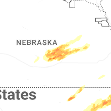


Connect with Interactive Hail Maps