

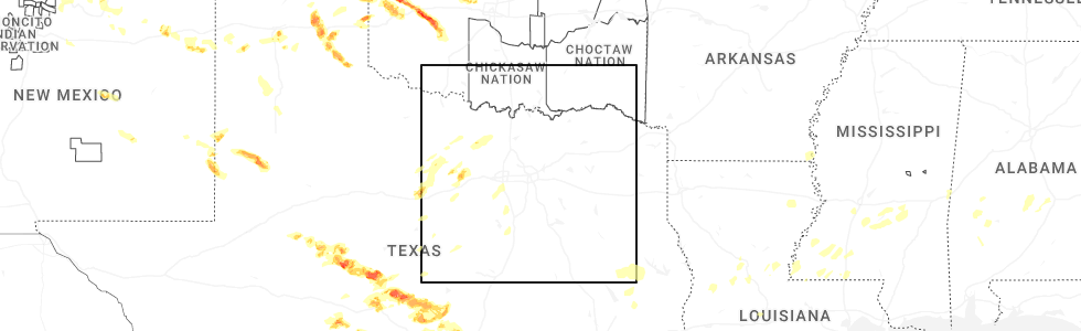
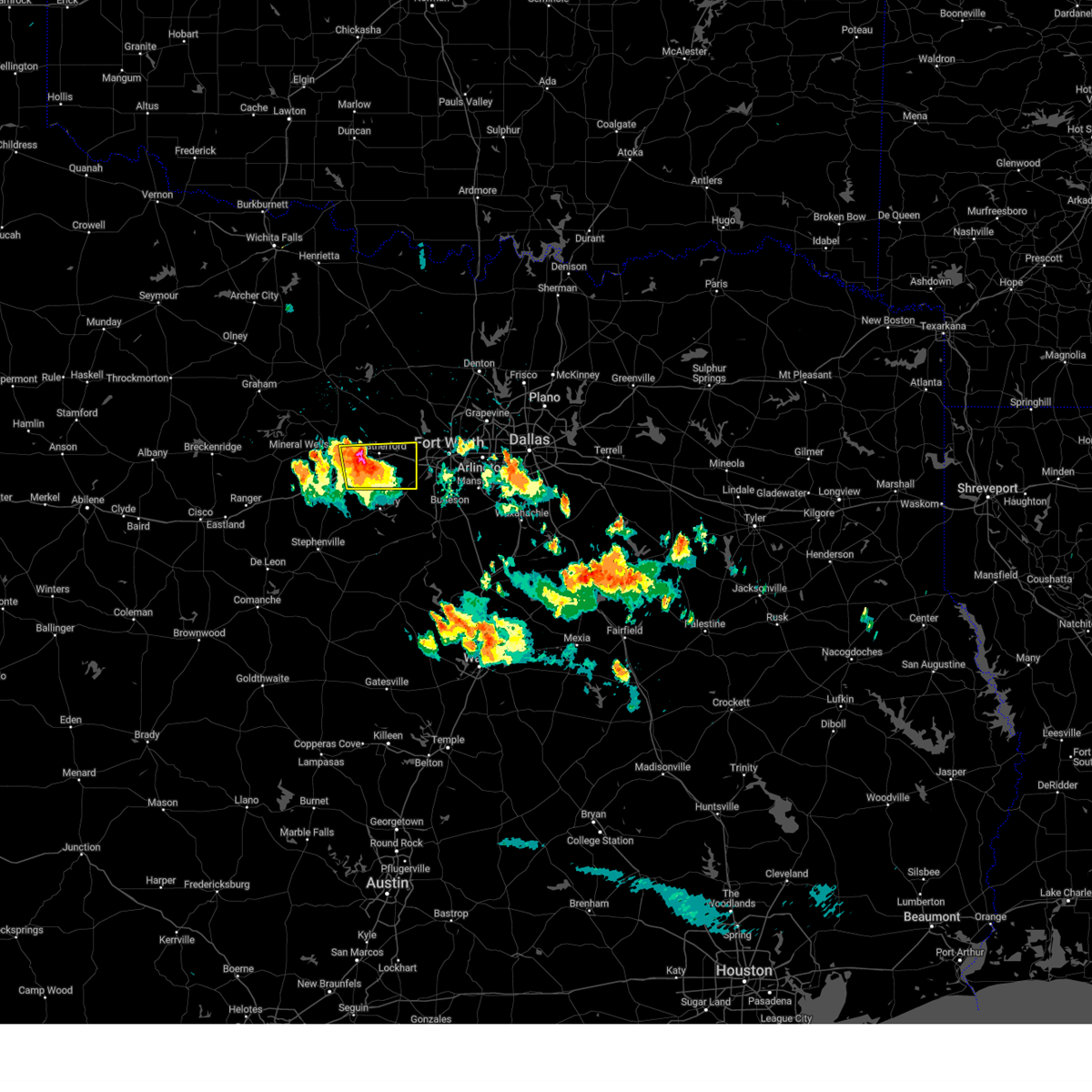
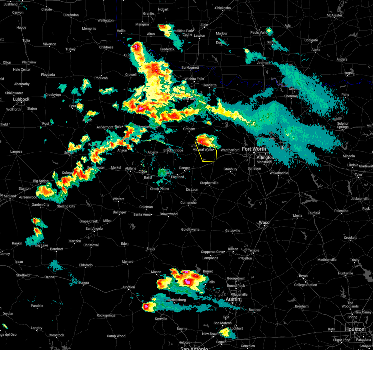
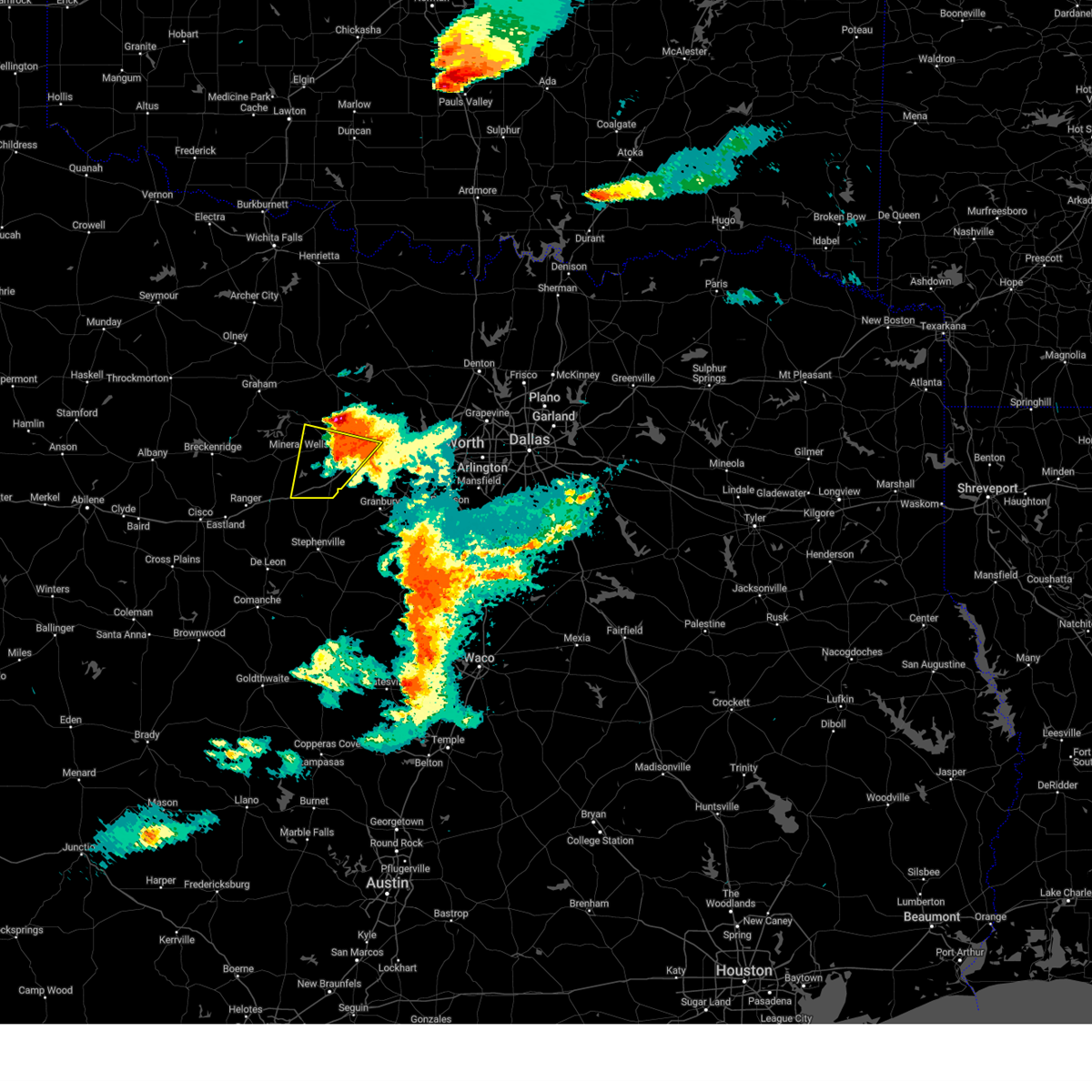
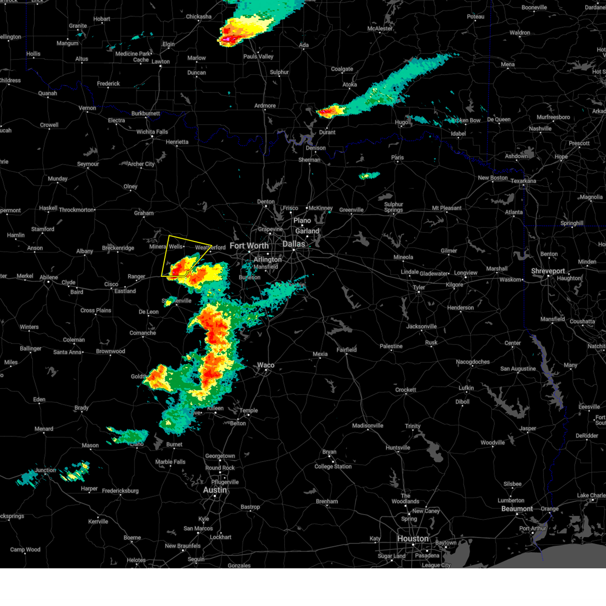
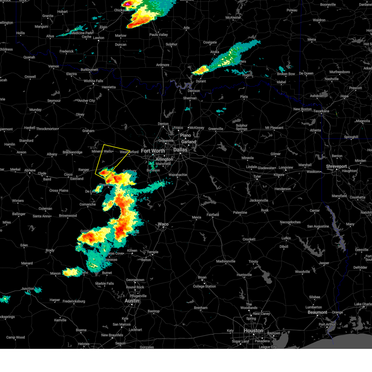
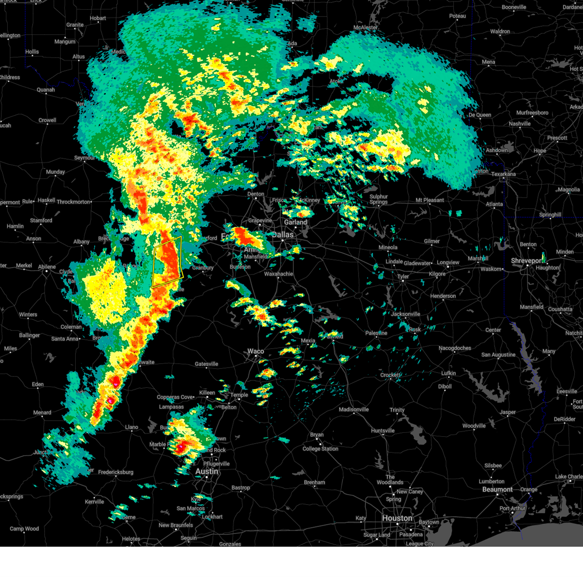
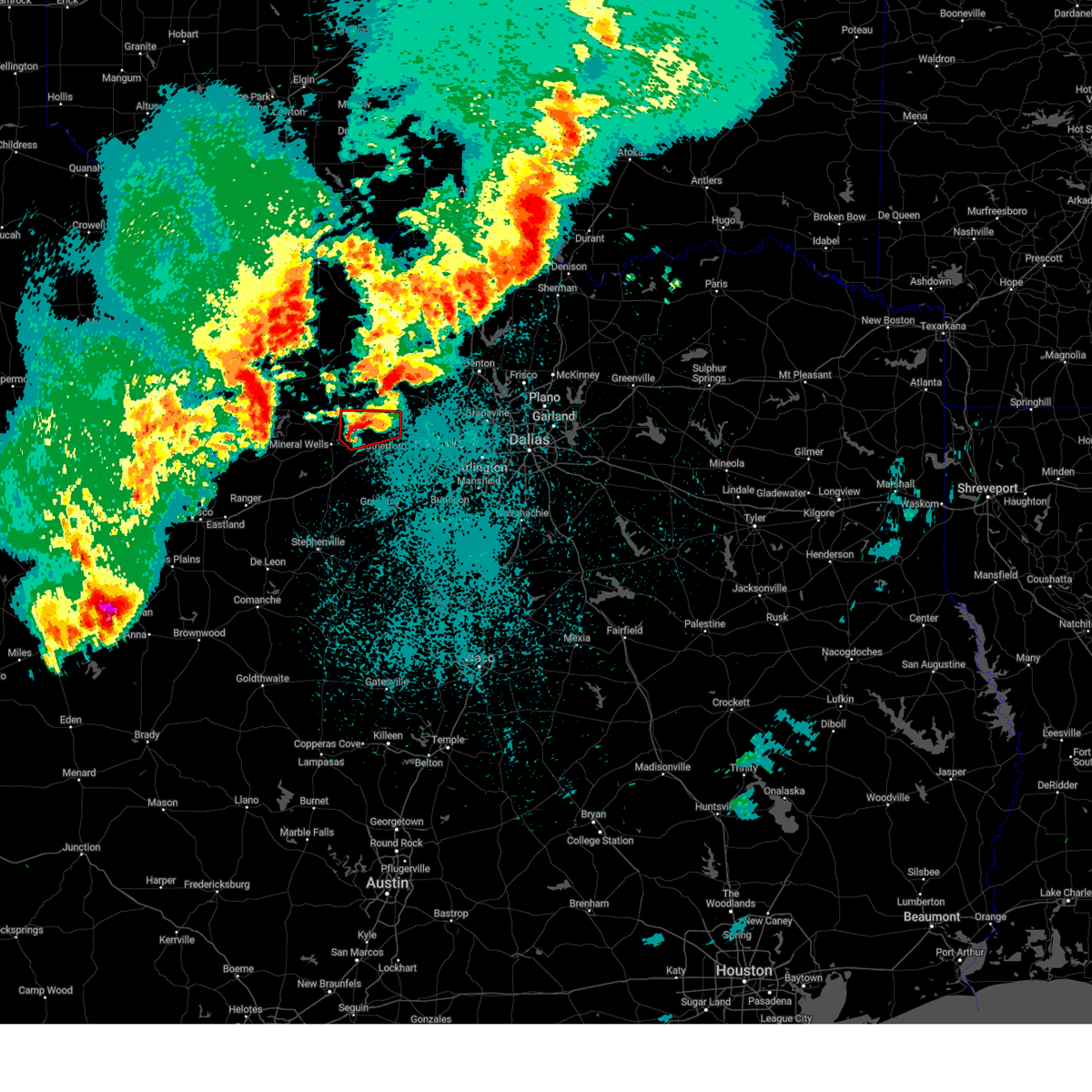
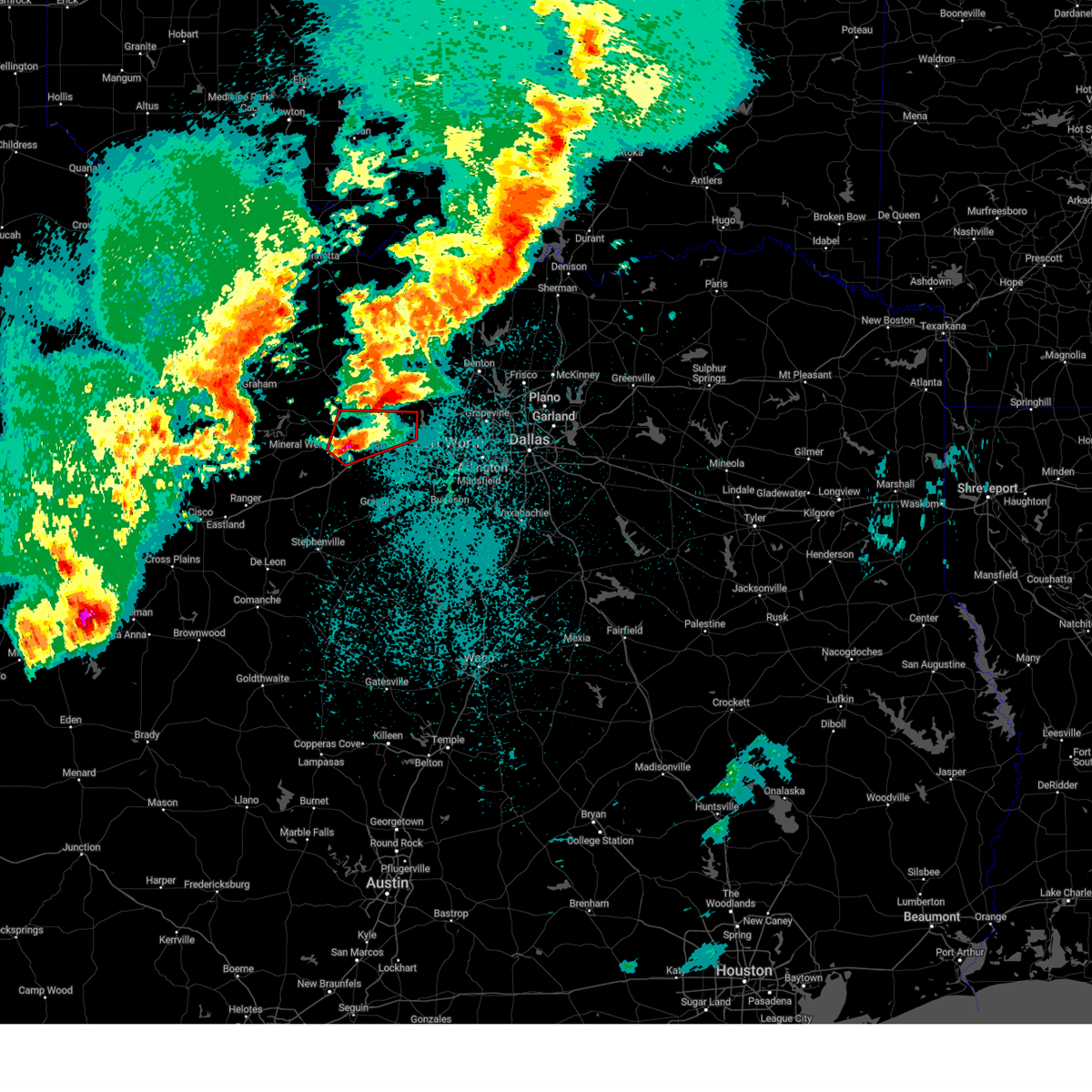
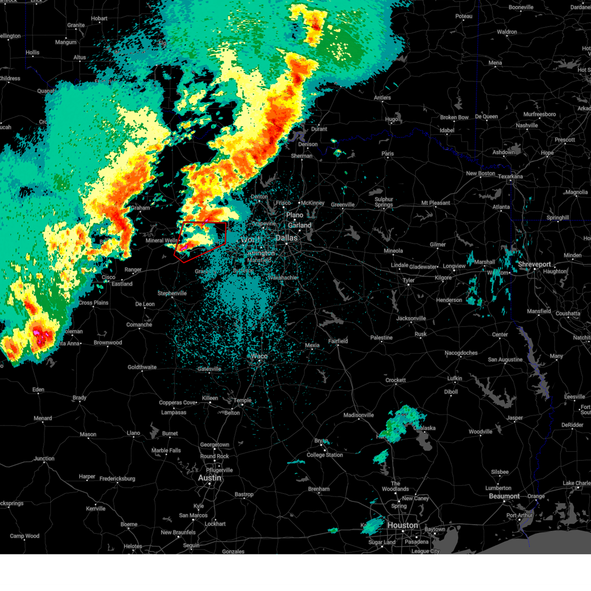
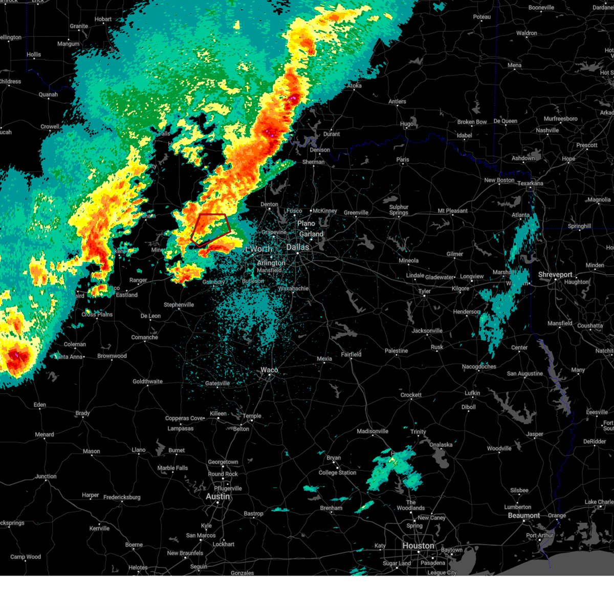
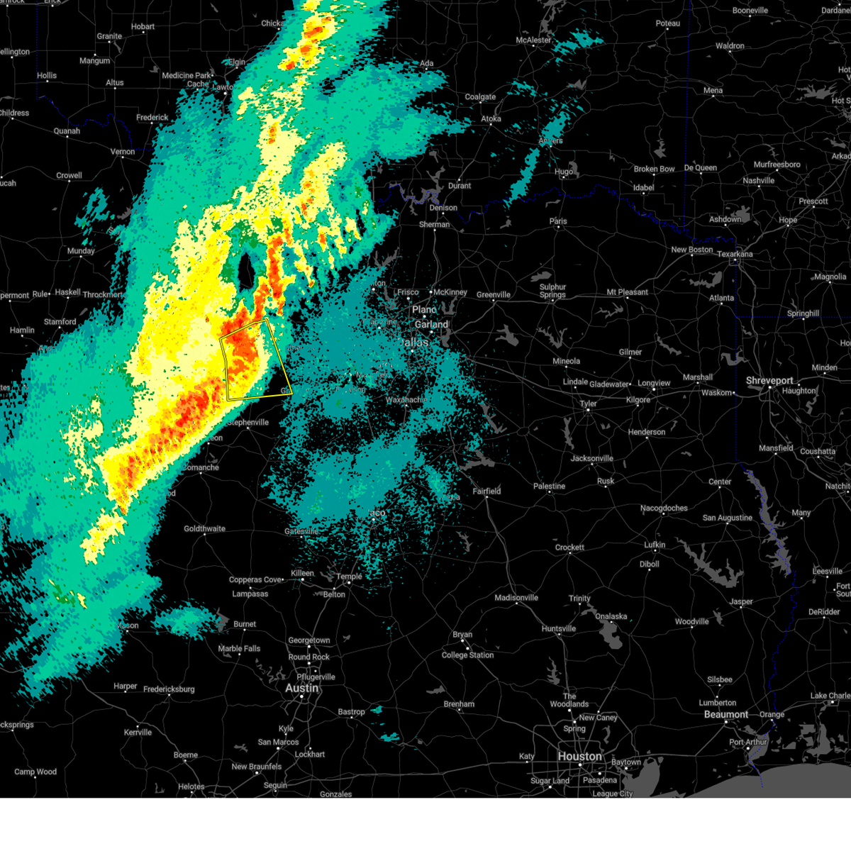
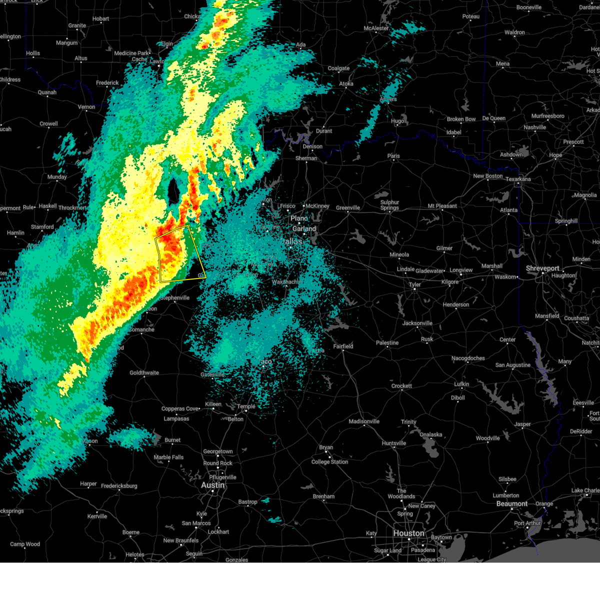
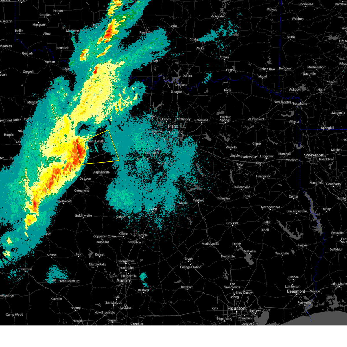
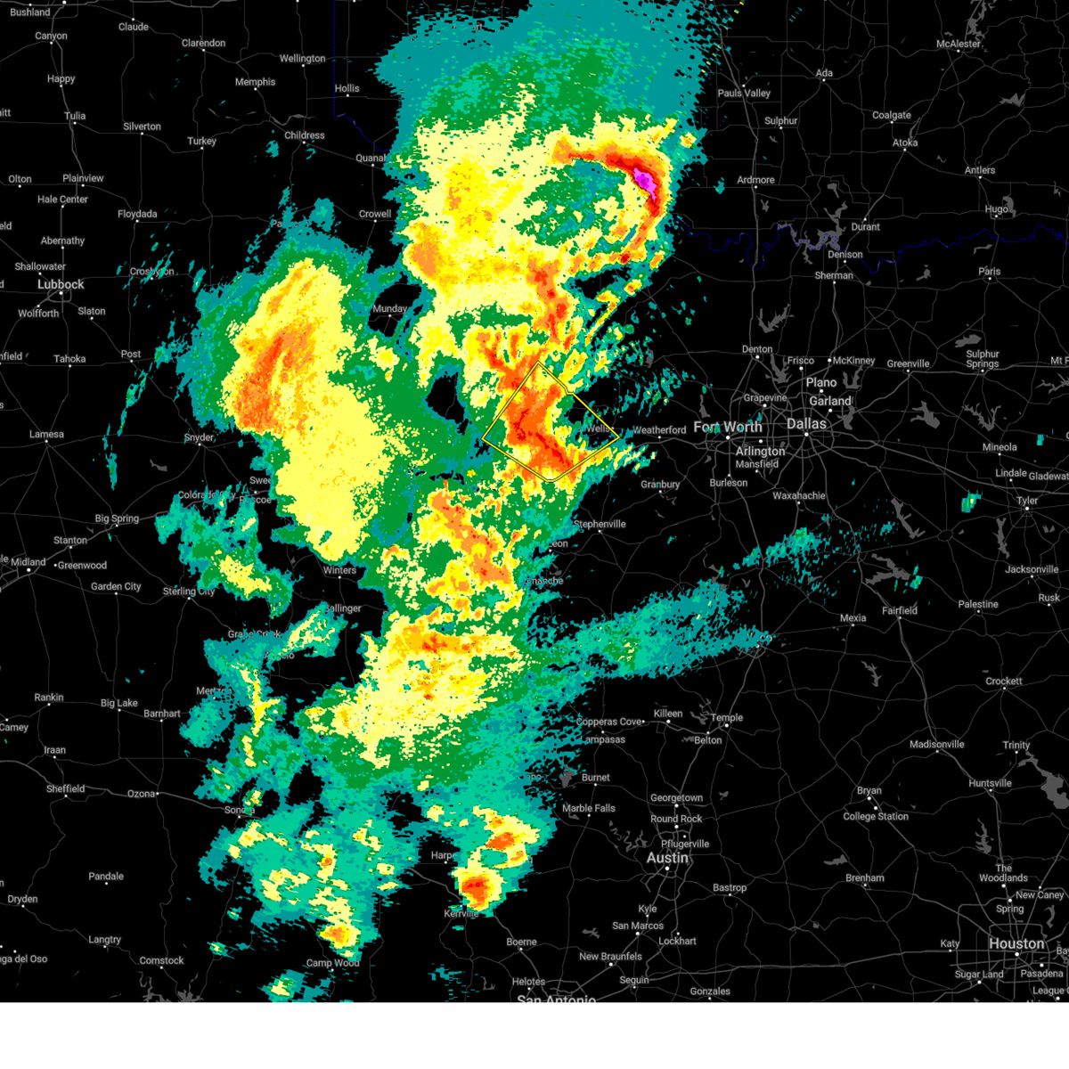
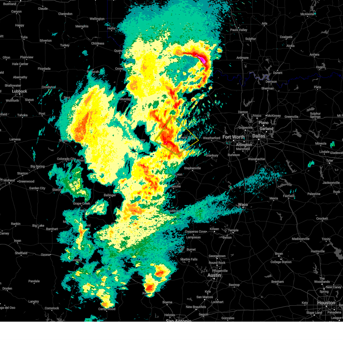
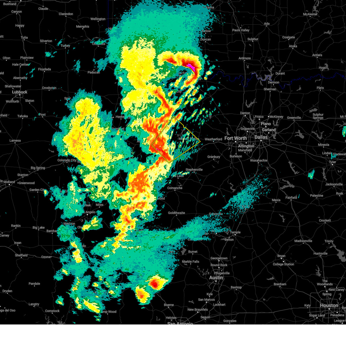
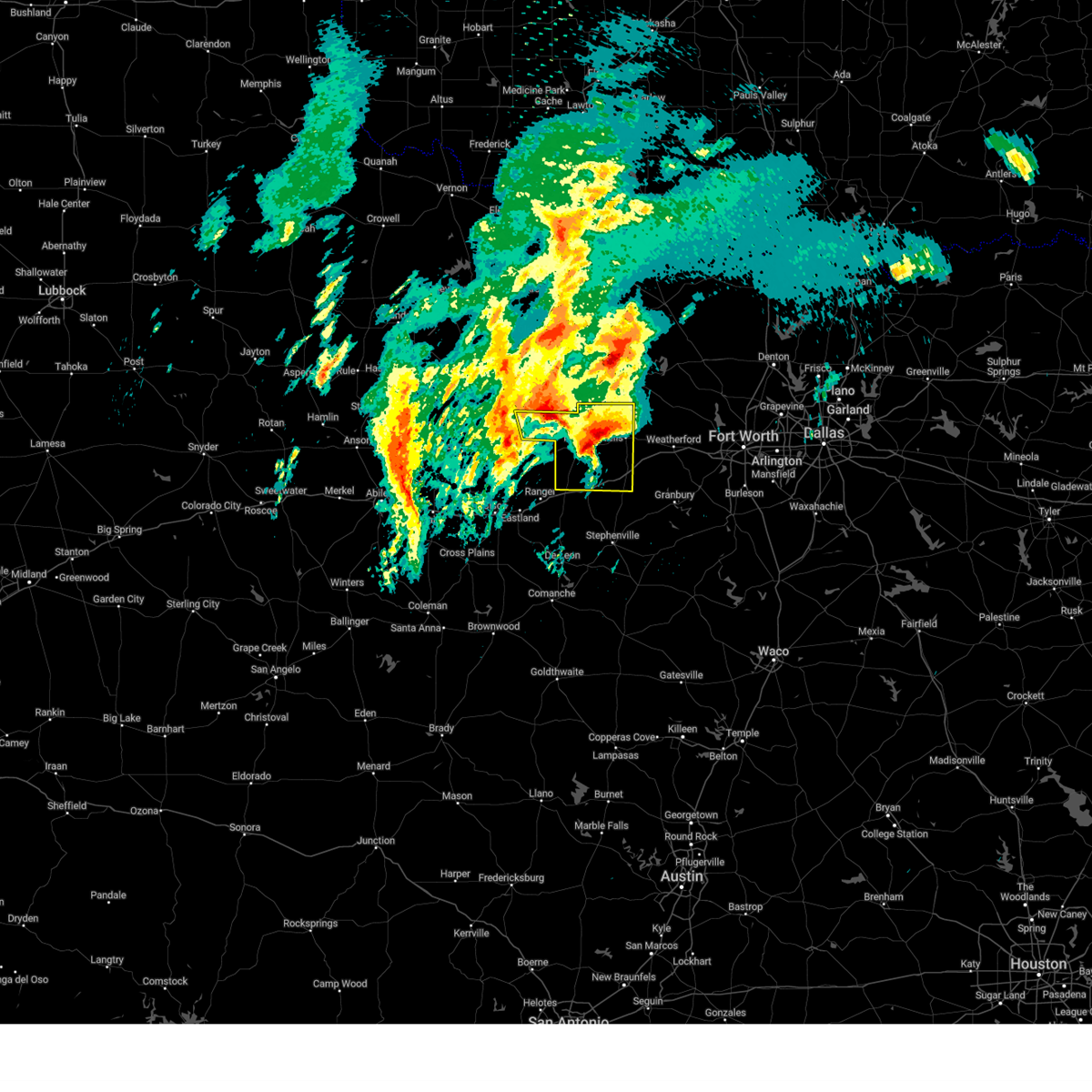
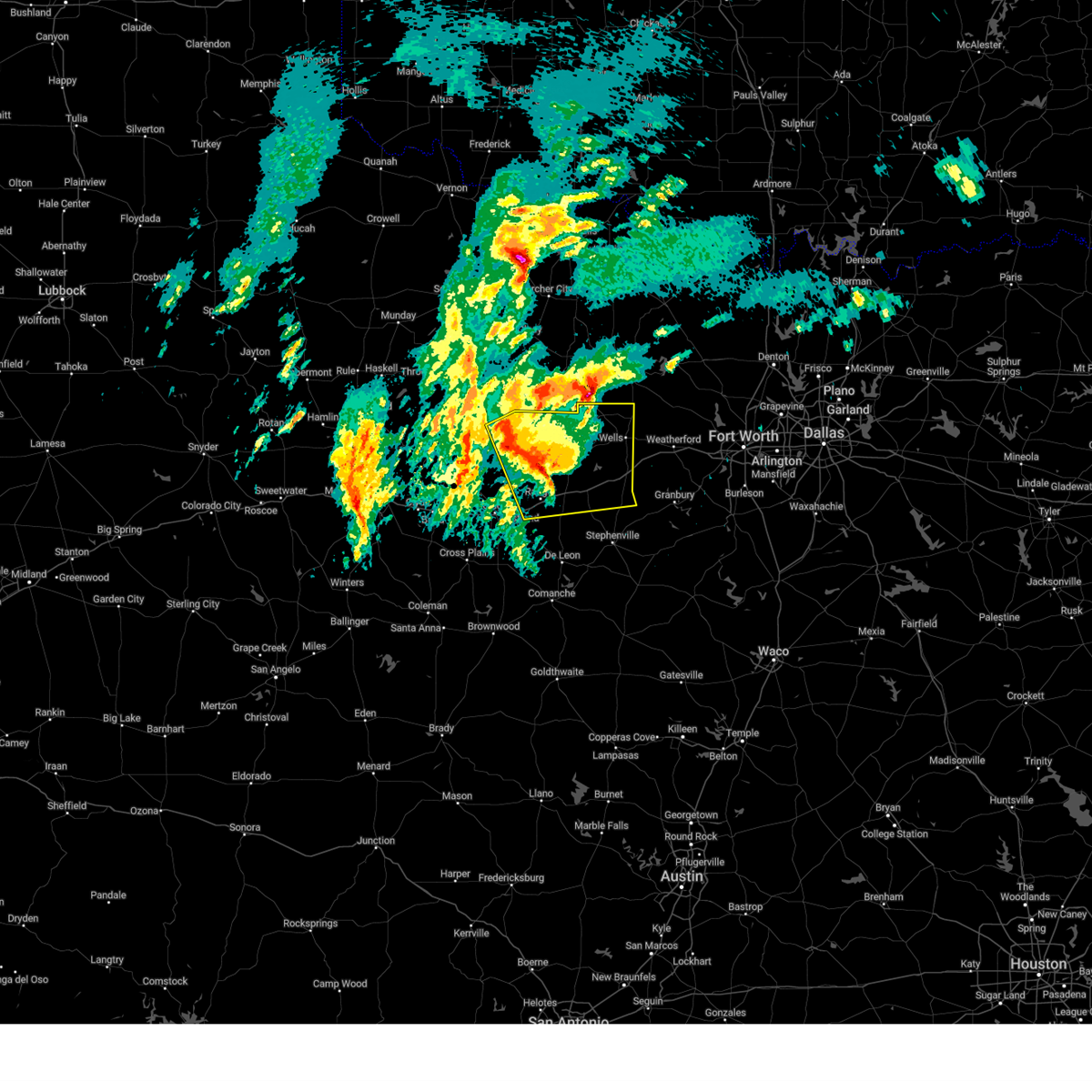
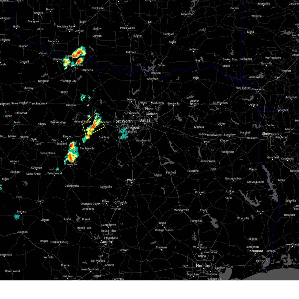
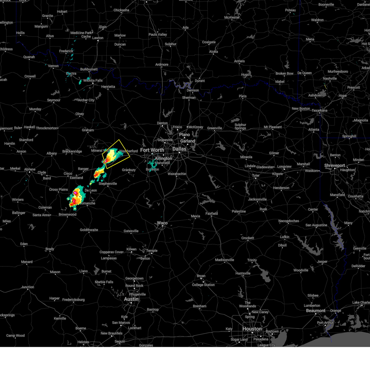
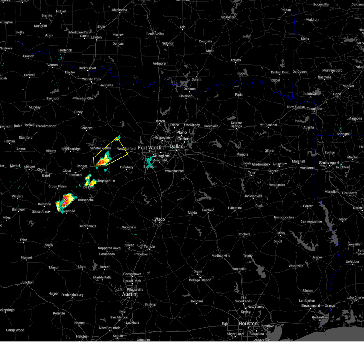
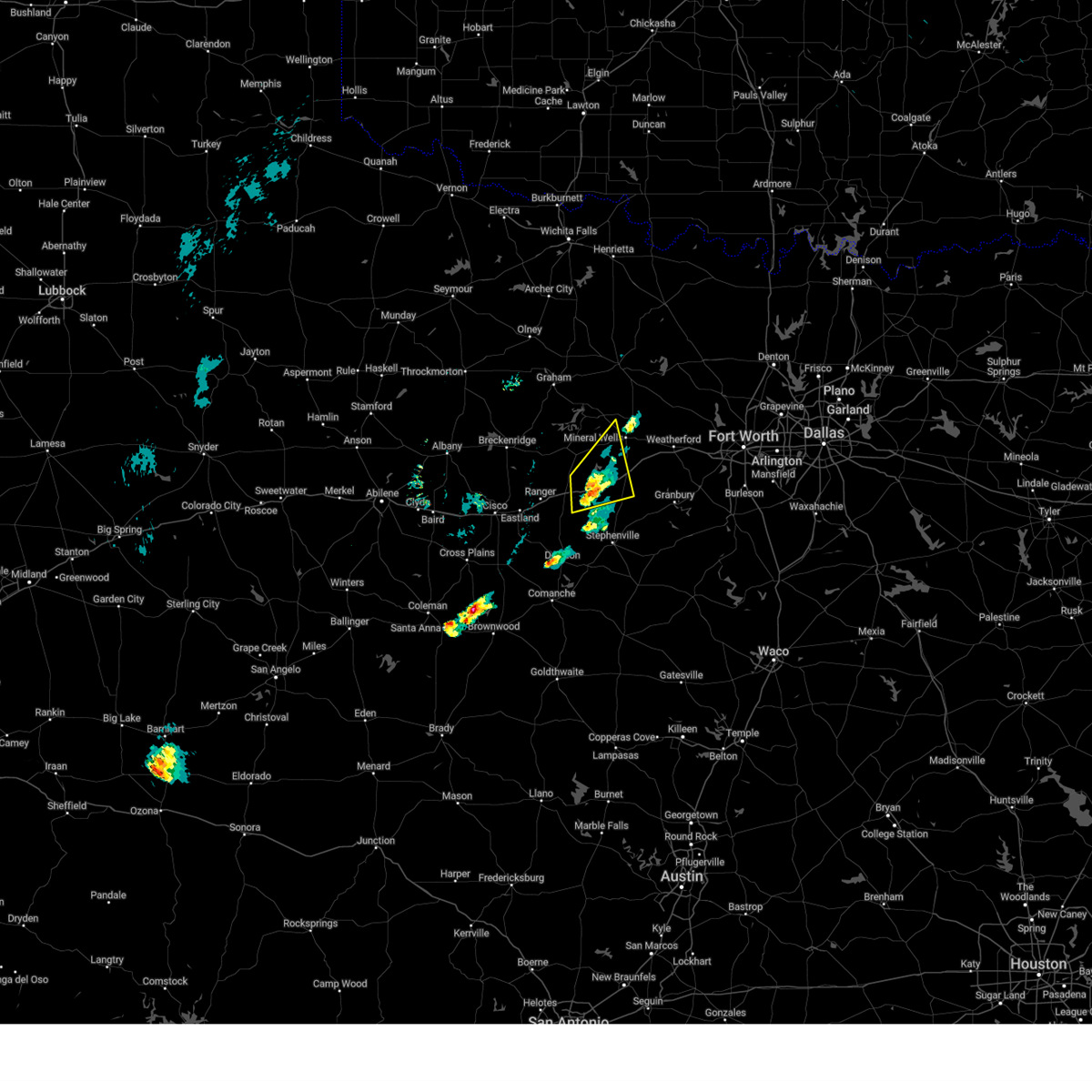
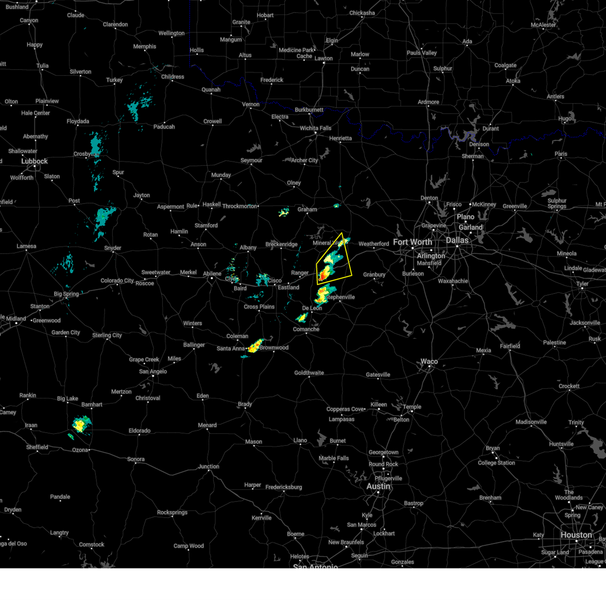
Hail Map for Mineral Wells, TX
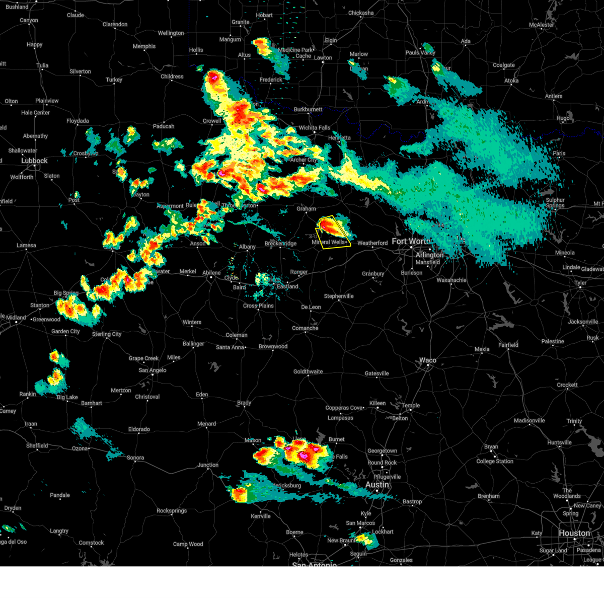
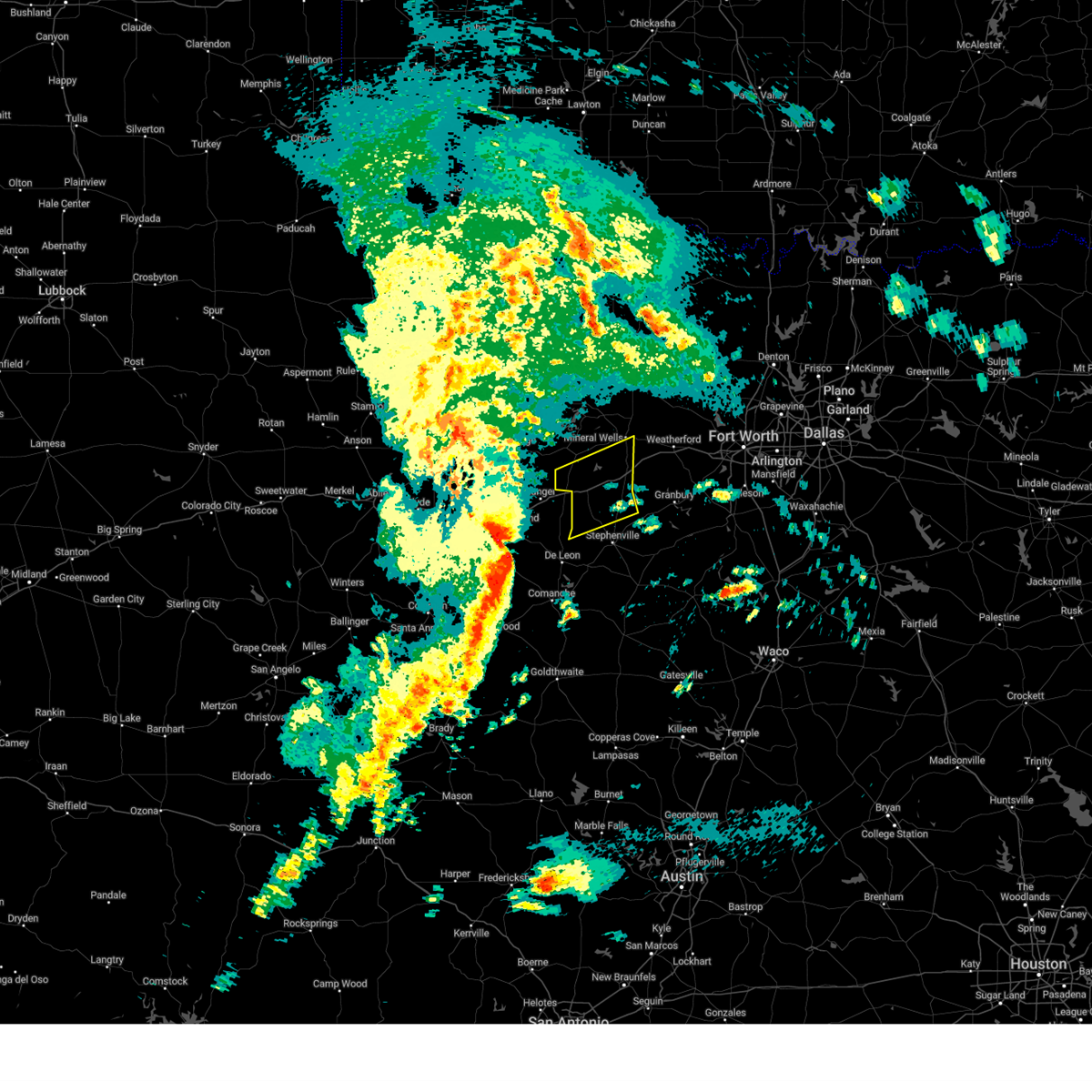
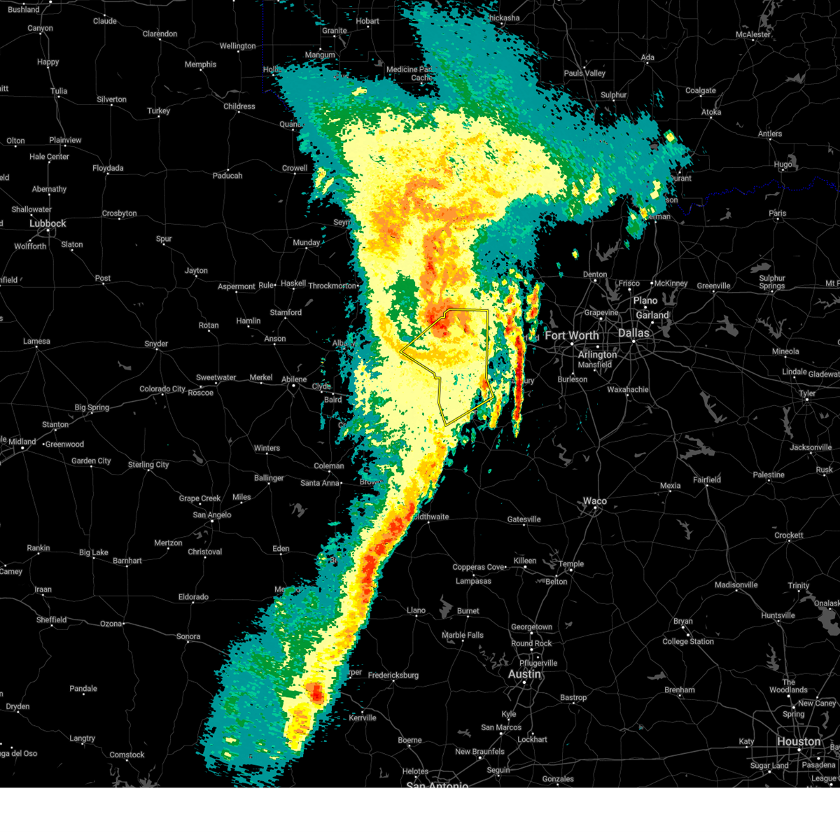
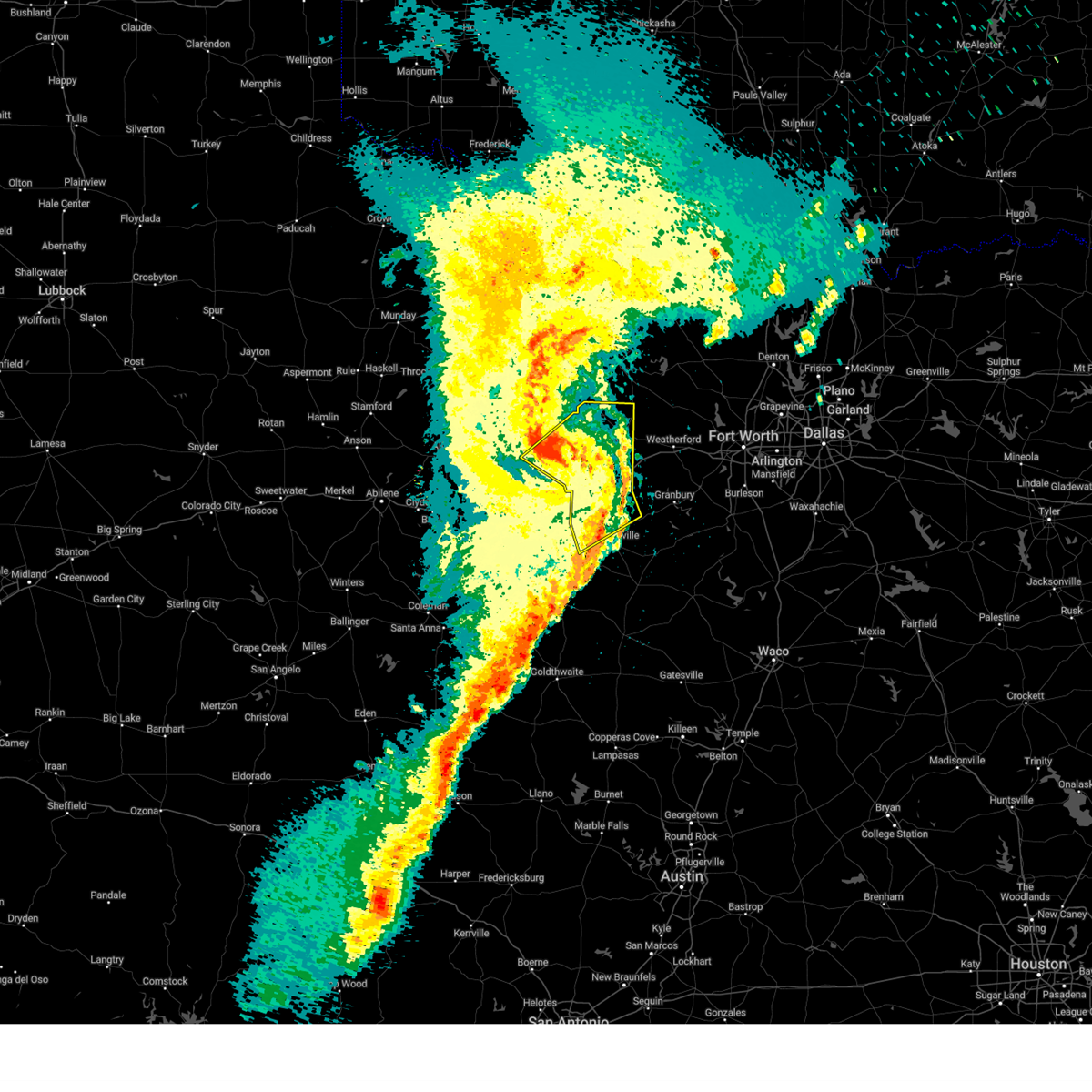
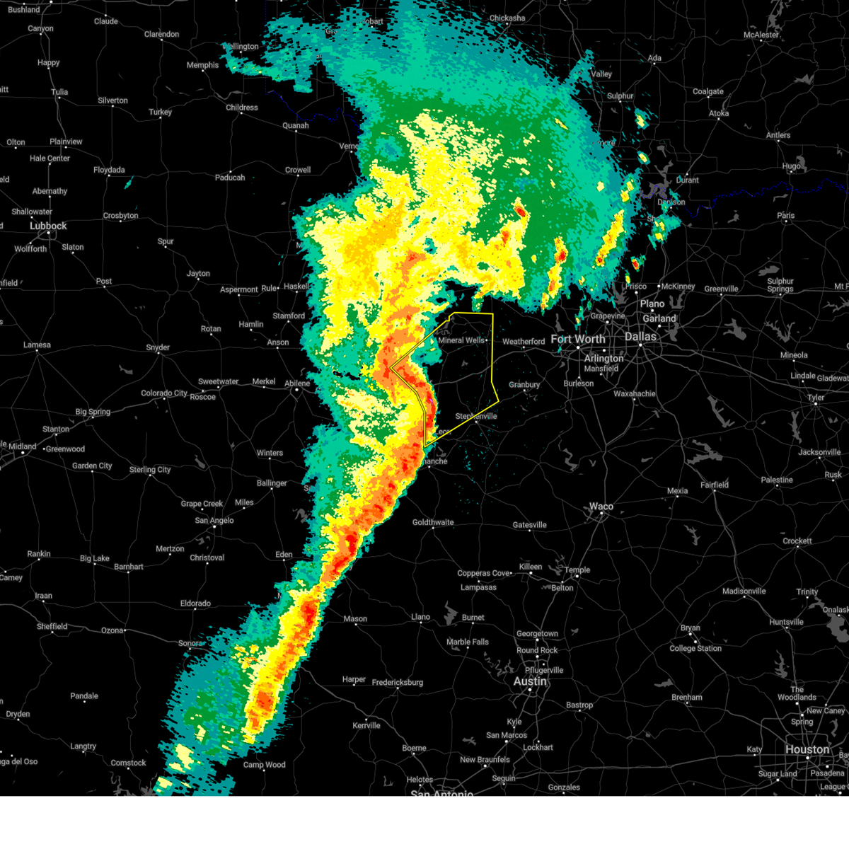
The Mineral Wells, TX area has had 34 reports of on-the-ground hail by trained spotters, and has been under severe weather warnings 89 times during the past 12 months. Doppler radar has detected hail at or near Mineral Wells, TX on 112 occasions, including 7 occasions during the past year.
| Name: | Mineral Wells, TX |
| Where Located: | 74.1 miles W of Dallas, TX |
| Map: | Google Map for Mineral Wells, TX |
| Population: | 16788 |
| Housing Units: | 6331 |
| More Info: | Search Google for Mineral Wells, TX |
2
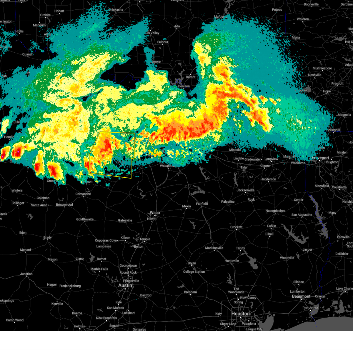
The Top Recent Hail Date for Mineral Wells, TX is Monday, May 26, 2025 (10th out of 112)
Hail and Wind Damage Spotted near Mineral Wells, TX
| Date / Time | Report Details |
|---|---|
| 6/8/2025 11:08 PM CDT |
 At 1108 pm cdt, severe thunderstorms were located along a line extending from near poolville to western lake to bluff dale, moving east at 45 mph (radar indicated). Hazards include 70 mph wind gusts and quarter size hail. Hail damage to vehicles is expected. expect considerable tree damage. wind damage is also likely to mobile homes, roofs, and outbuildings. Locations impacted include, lipan, dinosaur valley state park, weatherford, glen rose, mambrino, willow park, acton, bennett, lake weatherford, waples, horseshoe bend, annetta north, nemo, brock junction, pecan plantation, advance, lake granbury, springtown, authon, and millsap. At 1108 pm cdt, severe thunderstorms were located along a line extending from near poolville to western lake to bluff dale, moving east at 45 mph (radar indicated). Hazards include 70 mph wind gusts and quarter size hail. Hail damage to vehicles is expected. expect considerable tree damage. wind damage is also likely to mobile homes, roofs, and outbuildings. Locations impacted include, lipan, dinosaur valley state park, weatherford, glen rose, mambrino, willow park, acton, bennett, lake weatherford, waples, horseshoe bend, annetta north, nemo, brock junction, pecan plantation, advance, lake granbury, springtown, authon, and millsap.
|
| 6/8/2025 11:08 PM CDT |
 the severe thunderstorm warning has been cancelled and is no longer in effect the severe thunderstorm warning has been cancelled and is no longer in effect
|
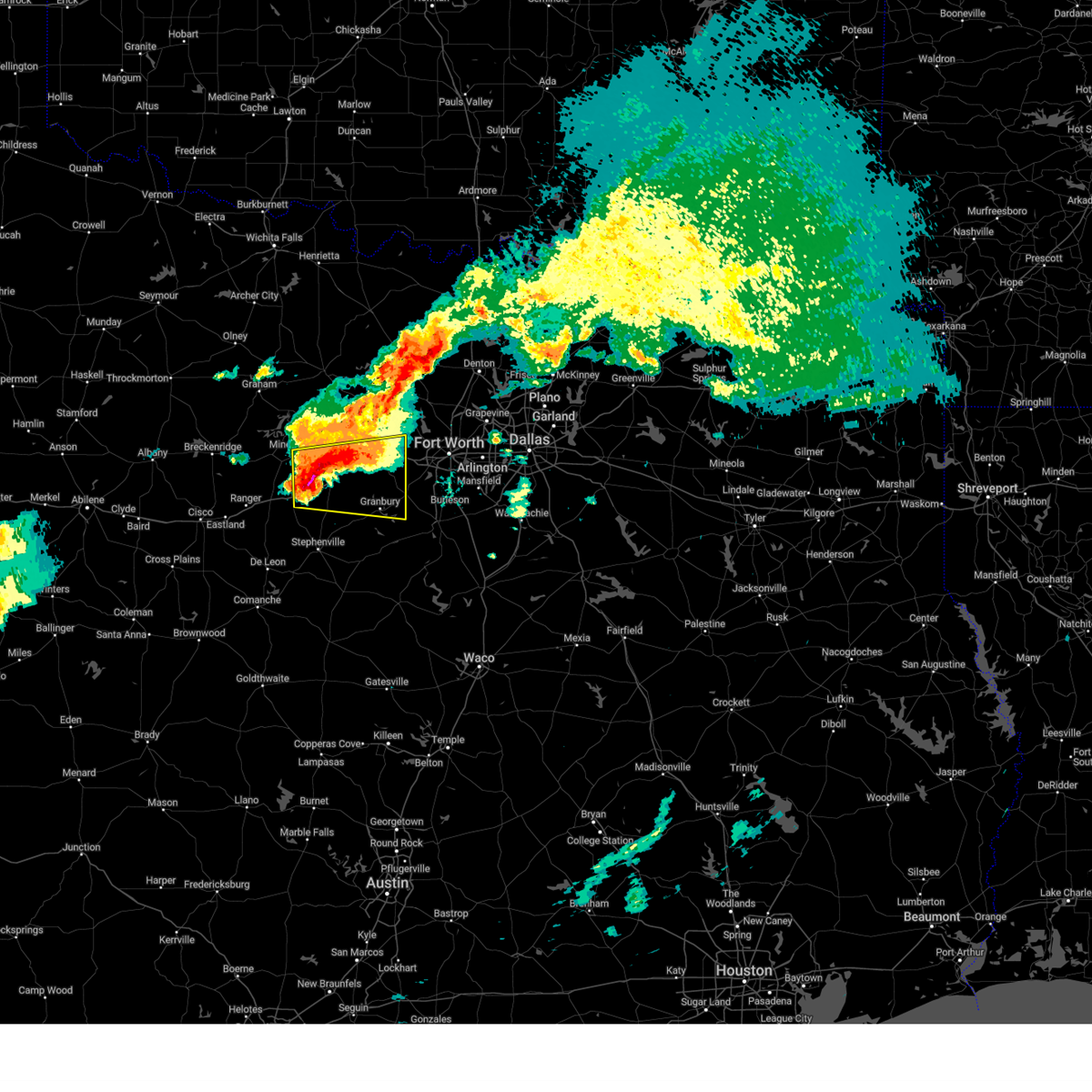
| 6/8/2025 10:59 PM CDT | Svrfwd the national weather service in fort worth has issued a * severe thunderstorm warning for, parker county in north central texas, * until 1145 pm cdt. * at 1058 pm cdt, a severe thunderstorm was located near brock, or 9 miles west of weatherford, moving east at 40 mph. this is a destructive storm for weatherford (radar indicated). Hazards include 80 mph wind gusts and quarter size hail. Flying debris will be dangerous to those caught without shelter. mobile homes will be heavily damaged. expect considerable damage to roofs, windows, and vehicles. Extensive tree damage and power outages are likely. |
| 6/8/2025 10:53 PM CDT | Mineral wells asos gusted to 69 mp in parker county TX, 2.9 miles N of Mineral Wells, TX |
| 6/8/2025 10:50 PM CDT |
 At 1049 pm cdt, severe thunderstorms were located along a line extending from near cool to near lipan to huckabay, moving southeast at 40 mph (radar indicated). Hazards include 70 mph wind gusts and quarter size hail. Hail damage to vehicles is expected. expect considerable tree damage. wind damage is also likely to mobile homes, roofs, and outbuildings. Locations impacted include, gordon, palo pinto, santo, mineral wells, lake palo pinto, mingus, new salem, thurber, graford, brazos, lone camp, strawn, palo pinto mountains state park, and hannibal. At 1049 pm cdt, severe thunderstorms were located along a line extending from near cool to near lipan to huckabay, moving southeast at 40 mph (radar indicated). Hazards include 70 mph wind gusts and quarter size hail. Hail damage to vehicles is expected. expect considerable tree damage. wind damage is also likely to mobile homes, roofs, and outbuildings. Locations impacted include, gordon, palo pinto, santo, mineral wells, lake palo pinto, mingus, new salem, thurber, graford, brazos, lone camp, strawn, palo pinto mountains state park, and hannibal.
|
| 6/8/2025 10:50 PM CDT |
 the severe thunderstorm warning has been cancelled and is no longer in effect the severe thunderstorm warning has been cancelled and is no longer in effect
|
| 6/8/2025 10:47 PM CDT |
 At 1047 pm cdt, severe thunderstorms were located along a line extending from 8 miles east of graford to 8 miles northwest of lipan to huckabay, moving east at 45 mph (radar indicated). Hazards include 70 mph wind gusts and quarter size hail. Hail damage to vehicles is expected. expect considerable tree damage. wind damage is also likely to mobile homes, roofs, and outbuildings. Locations impacted include, lipan, palo pinto, santo, dinosaur valley state park, weatherford, glen rose, mambrino, willow park, acton, bennett, lake weatherford, waples, thurber, graford, hannibal, horseshoe bend, salesville, annetta north, nemo, and brock junction. At 1047 pm cdt, severe thunderstorms were located along a line extending from 8 miles east of graford to 8 miles northwest of lipan to huckabay, moving east at 45 mph (radar indicated). Hazards include 70 mph wind gusts and quarter size hail. Hail damage to vehicles is expected. expect considerable tree damage. wind damage is also likely to mobile homes, roofs, and outbuildings. Locations impacted include, lipan, palo pinto, santo, dinosaur valley state park, weatherford, glen rose, mambrino, willow park, acton, bennett, lake weatherford, waples, thurber, graford, hannibal, horseshoe bend, salesville, annetta north, nemo, and brock junction.
|
| 6/8/2025 10:44 PM CDT | Images of roof torn off metal building and powerlines downed on hwy 180 west of mineral well in palo pinto county TX, 4.4 miles ENE of Mineral Wells, TX |
| 6/8/2025 10:36 PM CDT |
 Svrfwd the national weather service in fort worth has issued a * severe thunderstorm warning for, northern somervell county in north central texas, northern erath county in north central texas, parker county in north central texas, palo pinto county in north central texas, hood county in north central texas, * until 1130 pm cdt. * at 1035 pm cdt, severe thunderstorms were located along a line extending from near graford to near lake palo pinto to 6 miles west of huckabay, moving east at 45 mph (radar indicated). Hazards include 65 mph wind gusts and quarter size hail. Hail damage to vehicles is expected. Expect wind damage to roofs, siding, and trees. Svrfwd the national weather service in fort worth has issued a * severe thunderstorm warning for, northern somervell county in north central texas, northern erath county in north central texas, parker county in north central texas, palo pinto county in north central texas, hood county in north central texas, * until 1130 pm cdt. * at 1035 pm cdt, severe thunderstorms were located along a line extending from near graford to near lake palo pinto to 6 miles west of huckabay, moving east at 45 mph (radar indicated). Hazards include 65 mph wind gusts and quarter size hail. Hail damage to vehicles is expected. Expect wind damage to roofs, siding, and trees.
|
| 6/8/2025 10:29 PM CDT | the severe thunderstorm warning has been cancelled and is no longer in effect |
| 6/8/2025 10:29 PM CDT | At 1029 pm cdt, severe thunderstorms were located along a line extending from near graford to lake palo pinto to 6 miles southeast of palo pinto mountains state park, moving east at 55 mph (radar indicated). Hazards include 65 mph wind gusts and quarter size hail. Hail damage to vehicles is expected. expect wind damage to roofs, siding, and trees. Locations impacted include, gordon, possum kingdom lake, ranger, palo pinto, santo, mineral wells, lake palo pinto, mingus, new salem, possum kingdom state park, thurber, graford, brazos, lone camp, strawn, palo pinto mountains state park, and hannibal. |
| 6/8/2025 10:20 PM CDT |
 At 1019 pm cdt, severe thunderstorms were located along a line extending from near graford to near cisco, moving east at 45 mph (radar indicated). Hazards include 65 mph wind gusts and quarter size hail. Hail damage to vehicles is expected. expect wind damage to roofs, siding, and trees. these severe storms will be near, lake leon, eastland, ranger, graford, palo pinto, palo pinto mountains state park, and lake olden around 1025 pm cdt. mineral wells around 1030 pm cdt. lake palo pinto and gordon around 1035 pm cdt. Other locations impacted by these severe thunderstorms include nimrod, kokomo, santo, staff, carbon, okra, harpersville, duster, morton valley, and mingus. At 1019 pm cdt, severe thunderstorms were located along a line extending from near graford to near cisco, moving east at 45 mph (radar indicated). Hazards include 65 mph wind gusts and quarter size hail. Hail damage to vehicles is expected. expect wind damage to roofs, siding, and trees. these severe storms will be near, lake leon, eastland, ranger, graford, palo pinto, palo pinto mountains state park, and lake olden around 1025 pm cdt. mineral wells around 1030 pm cdt. lake palo pinto and gordon around 1035 pm cdt. Other locations impacted by these severe thunderstorms include nimrod, kokomo, santo, staff, carbon, okra, harpersville, duster, morton valley, and mingus.
|
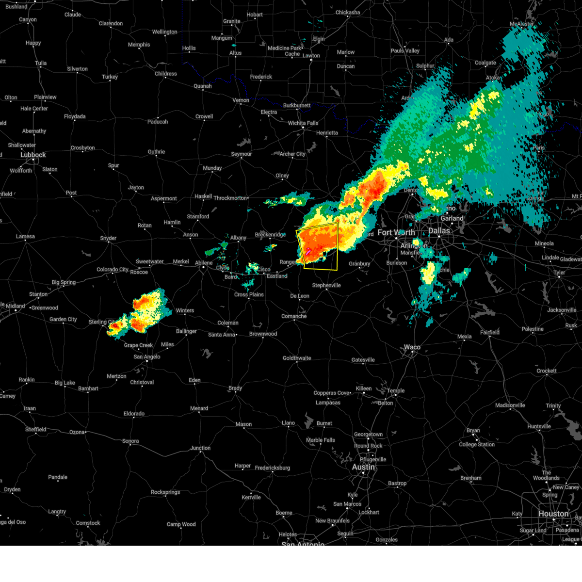
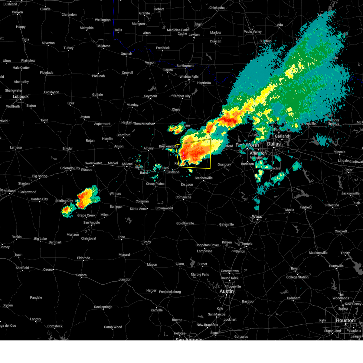
| 6/8/2025 9:58 PM CDT | Svrfwd the national weather service in fort worth has issued a * severe thunderstorm warning for, southern young county in north central texas, northwestern erath county in north central texas, eastland county in north central texas, stephens county in north central texas, palo pinto county in north central texas, northwestern comanche county in central texas, * until 1100 pm cdt. * at 957 pm cdt, severe thunderstorms were located along a line extending from 7 miles north of possum kingdom lake to near lake cisco, moving southeast at 40 mph (radar indicated). Hazards include 65 mph wind gusts and half dollar size hail. Hail damage to vehicles is expected. expect wind damage to roofs, siding, and trees. severe thunderstorms will be near, lake cisco, necessity, possum kingdom state park, cisco, gunsight, caddo, and possum kingdom lake around 1005 pm cdt. eastland, ranger, graford, and palo pinto mountains state park around 1015 pm cdt. lake leon, palo pinto, and lake olden around 1020 pm cdt. mineral wells around 1025 pm cdt. lake palo pinto around 1030 pm cdt. gordon around 1035 pm cdt. gorman around 1040 pm cdt. other locations impacted by these severe thunderstorms include nimrod, kokomo, santo, staff, okra, harpersville, duster, morton valley, new salem, and thurber. This includes interstate 20 between mile markers 324 and 389. |
| 6/8/2025 4:58 PM CDT |
 At 457 pm cdt, a severe thunderstorm was located near lake palo pinto, or 20 miles southwest of mineral wells, moving southeast at 15 mph (radar indicated). Hazards include 60 mph wind gusts and half dollar size hail. Hail damage to vehicles is expected. expect wind damage to roofs, siding, and trees. this severe storm will be near, lake palo pinto around 505 pm cdt. Other locations impacted by this severe thunderstorm include brazos, lone camp, santo, and new salem. At 457 pm cdt, a severe thunderstorm was located near lake palo pinto, or 20 miles southwest of mineral wells, moving southeast at 15 mph (radar indicated). Hazards include 60 mph wind gusts and half dollar size hail. Hail damage to vehicles is expected. expect wind damage to roofs, siding, and trees. this severe storm will be near, lake palo pinto around 505 pm cdt. Other locations impacted by this severe thunderstorm include brazos, lone camp, santo, and new salem.
|
| 6/8/2025 4:39 PM CDT | At 439 pm cdt, a severe thunderstorm was located 8 miles northwest of lake palo pinto, or 21 miles west of mineral wells, moving southeast at 20 mph (radar indicated). Hazards include golf ball size hail and 60 mph wind gusts. People and animals outdoors will be injured. expect hail damage to roofs, siding, windows, and vehicles. expect wind damage to roofs, siding, and trees. this severe storm will be near, lake palo pinto around 450 pm cdt. Other locations impacted by this severe thunderstorm include brazos, lone camp, santo, and new salem. |
| 6/8/2025 4:21 PM CDT | Svrfwd the national weather service in fort worth has issued a * severe thunderstorm warning for, central palo pinto county in north central texas, * until 530 pm cdt. * at 421 pm cdt, a severe thunderstorm was located 9 miles south of possum kingdom lake, or 22 miles northeast of ranger, moving east at 20 mph (radar indicated). Hazards include 60 mph wind gusts and half dollar size hail. Hail damage to vehicles is expected. expect wind damage to roofs, siding, and trees. this severe thunderstorm will be near, lake palo pinto around 445 pm cdt. other locations impacted by this severe thunderstorm include brazos, lone camp, santo, and new salem. This includes interstate 20 between mile markers 378 and 389. |
| 6/3/2025 8:36 PM CDT | Trees down north of mineral well in palo pinto county TX, 4.9 miles SSE of Mineral Wells, TX |
| 6/3/2025 8:05 PM CDT | Svrfwd the national weather service in fort worth has issued a * severe thunderstorm warning for, northwestern parker county in north central texas, northeastern palo pinto county in north central texas, * until 845 pm cdt. * at 805 pm cdt, a severe thunderstorm was located near mineral wells, moving east at 30 mph (radar indicated). Hazards include 60 mph wind gusts and nickel size hail. Expect damage to roofs, siding, and trees. this severe thunderstorm will be near, mineral wells around 810 pm cdt. lake mineral wells around 815 pm cdt. Other locations impacted by this severe thunderstorm include adell, peaster, agnes, whitt, advance, authon, oran, garner, salesville, and peadenville. |
| 6/1/2025 8:10 PM CDT |
 the severe thunderstorm warning has been cancelled and is no longer in effect the severe thunderstorm warning has been cancelled and is no longer in effect
|
| 6/1/2025 8:10 PM CDT |
 At 809 pm cdt, a severe thunderstorm was located near western lake, or near weatherford, moving east at 25 mph (trained weather spotters). Hazards include two inch hail and 60 mph wind gusts. People and animals outdoors will be injured. expect hail damage to roofs, siding, windows, and vehicles. expect wind damage to roofs, siding, and trees. this severe storm will be near, weatherford around 815 pm cdt. annetta and hudson oaks around 820 pm cdt. willow park around 825 pm cdt. aledo around 830 pm cdt. Other locations impacted by this severe thunderstorm include brock junction, millsap, dennis, tin top, horseshoe bend, annetta south, annetta north, bennett, cresson, and lake granbury. At 809 pm cdt, a severe thunderstorm was located near western lake, or near weatherford, moving east at 25 mph (trained weather spotters). Hazards include two inch hail and 60 mph wind gusts. People and animals outdoors will be injured. expect hail damage to roofs, siding, windows, and vehicles. expect wind damage to roofs, siding, and trees. this severe storm will be near, weatherford around 815 pm cdt. annetta and hudson oaks around 820 pm cdt. willow park around 825 pm cdt. aledo around 830 pm cdt. Other locations impacted by this severe thunderstorm include brock junction, millsap, dennis, tin top, horseshoe bend, annetta south, annetta north, bennett, cresson, and lake granbury.
|
| 6/1/2025 8:00 PM CDT | Quarter sized hail reported 4.2 miles N of Mineral Wells, TX, report from mping: quarter (1.00 in.). |
| 6/1/2025 7:52 PM CDT |
 At 752 pm cdt, a severe thunderstorm was located over brock, or 12 miles southeast of mineral wells, moving east at 25 mph (public). Hazards include two inch hail and 60 mph wind gusts. People and animals outdoors will be injured. expect hail damage to roofs, siding, windows, and vehicles. expect wind damage to roofs, siding, and trees. this severe storm will be near, brock around 755 pm cdt. weatherford and western lake around 805 pm cdt. annetta and hudson oaks around 820 pm cdt. aledo and willow park around 825 pm cdt. Other locations impacted by this severe thunderstorm include brock junction, dennis, annetta south, bennett, new salem, millsap, tin top, horseshoe bend, brazos, and annetta north. At 752 pm cdt, a severe thunderstorm was located over brock, or 12 miles southeast of mineral wells, moving east at 25 mph (public). Hazards include two inch hail and 60 mph wind gusts. People and animals outdoors will be injured. expect hail damage to roofs, siding, windows, and vehicles. expect wind damage to roofs, siding, and trees. this severe storm will be near, brock around 755 pm cdt. weatherford and western lake around 805 pm cdt. annetta and hudson oaks around 820 pm cdt. aledo and willow park around 825 pm cdt. Other locations impacted by this severe thunderstorm include brock junction, dennis, annetta south, bennett, new salem, millsap, tin top, horseshoe bend, brazos, and annetta north.
|
| 6/1/2025 7:52 PM CDT |
 the severe thunderstorm warning has been cancelled and is no longer in effect the severe thunderstorm warning has been cancelled and is no longer in effect
|
| 6/1/2025 7:43 PM CDT |
 At 743 pm cdt, a severe thunderstorm was located near brock, or 11 miles south of mineral wells, moving east at 25 mph (radar indicated). Hazards include golf ball size hail and 60 mph wind gusts. People and animals outdoors will be injured. expect hail damage to roofs, siding, windows, and vehicles. expect wind damage to roofs, siding, and trees. this severe storm will be near, brock around 750 pm cdt. weatherford and western lake around 805 pm cdt. annetta and hudson oaks around 820 pm cdt. willow park around 825 pm cdt. aledo around 830 pm cdt. Other locations impacted by this severe thunderstorm include brock junction, santo, dennis, annetta south, mingus, bennett, new salem, millsap, tin top, and horseshoe bend. At 743 pm cdt, a severe thunderstorm was located near brock, or 11 miles south of mineral wells, moving east at 25 mph (radar indicated). Hazards include golf ball size hail and 60 mph wind gusts. People and animals outdoors will be injured. expect hail damage to roofs, siding, windows, and vehicles. expect wind damage to roofs, siding, and trees. this severe storm will be near, brock around 750 pm cdt. weatherford and western lake around 805 pm cdt. annetta and hudson oaks around 820 pm cdt. willow park around 825 pm cdt. aledo around 830 pm cdt. Other locations impacted by this severe thunderstorm include brock junction, santo, dennis, annetta south, mingus, bennett, new salem, millsap, tin top, and horseshoe bend.
|
| 6/1/2025 7:30 PM CDT |
 Svrfwd the national weather service in fort worth has issued a * severe thunderstorm warning for, southern parker county in north central texas, southeastern palo pinto county in north central texas, northern hood county in north central texas, * until 830 pm cdt. * at 730 pm cdt, a severe thunderstorm was located 10 miles east of lake palo pinto, or 11 miles south of mineral wells, moving east at 25 mph (radar indicated). Hazards include 60 mph wind gusts and half dollar size hail. Hail damage to vehicles is expected. expect wind damage to roofs, siding, and trees. this severe thunderstorm will be near, brock around 745 pm cdt. western lake around 805 pm cdt. weatherford around 810 pm cdt. annetta around 820 pm cdt. other locations impacted by this severe thunderstorm include brock junction, santo, dennis, annetta south, mingus, bennett, new salem, millsap, tin top, and horseshoe bend. this includes the following highways, interstate 20 between mile markers 369 and 422. Interstate 30 near mile marker 1. Svrfwd the national weather service in fort worth has issued a * severe thunderstorm warning for, southern parker county in north central texas, southeastern palo pinto county in north central texas, northern hood county in north central texas, * until 830 pm cdt. * at 730 pm cdt, a severe thunderstorm was located 10 miles east of lake palo pinto, or 11 miles south of mineral wells, moving east at 25 mph (radar indicated). Hazards include 60 mph wind gusts and half dollar size hail. Hail damage to vehicles is expected. expect wind damage to roofs, siding, and trees. this severe thunderstorm will be near, brock around 745 pm cdt. western lake around 805 pm cdt. weatherford around 810 pm cdt. annetta around 820 pm cdt. other locations impacted by this severe thunderstorm include brock junction, santo, dennis, annetta south, mingus, bennett, new salem, millsap, tin top, and horseshoe bend. this includes the following highways, interstate 20 between mile markers 369 and 422. Interstate 30 near mile marker 1.
|
| 5/26/2025 2:27 PM CDT |
 The storm which prompted the warning has weakened below severe limits. therefore the warning will be allowed to expire. however small hail and heavy rain are still possible with this thunderstorm. The storm which prompted the warning has weakened below severe limits. therefore the warning will be allowed to expire. however small hail and heavy rain are still possible with this thunderstorm.
|
| 5/26/2025 2:16 PM CDT |
 At 216 pm cdt, a severe thunderstorm was located near mineral wells, moving northeast at 25 mph (trained weather spotters). Hazards include 60 mph wind gusts and quarter size hail. Hail damage to vehicles is expected. expect wind damage to roofs, siding, and trees. this severe storm will be near, mineral wells around 220 pm cdt. Other locations impacted by this severe thunderstorm include adell, peaster, agnes, whitt, advance, authon, garner, millsap, salesville, and peadenville. At 216 pm cdt, a severe thunderstorm was located near mineral wells, moving northeast at 25 mph (trained weather spotters). Hazards include 60 mph wind gusts and quarter size hail. Hail damage to vehicles is expected. expect wind damage to roofs, siding, and trees. this severe storm will be near, mineral wells around 220 pm cdt. Other locations impacted by this severe thunderstorm include adell, peaster, agnes, whitt, advance, authon, garner, millsap, salesville, and peadenville.
|
| 5/26/2025 1:53 PM CDT | Quarter sized hail reported 1.5 miles ENE of Mineral Wells, TX, report from mping. |
| 5/26/2025 1:38 PM CDT |
 Svrfwd the national weather service in fort worth has issued a * severe thunderstorm warning for, northern parker county in north central texas, east central palo pinto county in north central texas, * until 230 pm cdt. * at 138 pm cdt, a severe thunderstorm was located near mineral wells, moving northeast at 25 mph (radar indicated). Hazards include 60 mph wind gusts and quarter size hail. Hail damage to vehicles is expected. expect wind damage to roofs, siding, and trees. this severe thunderstorm will be near, cool, mineral wells, and lake mineral wells around 145 pm cdt. poolville around 215 pm cdt. other locations impacted by this severe thunderstorm include adell, peaster, agnes, whitt, bennett, advance, authon, garner, millsap, and salesville. This includes interstate 20 between mile markers 391 and 397. Svrfwd the national weather service in fort worth has issued a * severe thunderstorm warning for, northern parker county in north central texas, east central palo pinto county in north central texas, * until 230 pm cdt. * at 138 pm cdt, a severe thunderstorm was located near mineral wells, moving northeast at 25 mph (radar indicated). Hazards include 60 mph wind gusts and quarter size hail. Hail damage to vehicles is expected. expect wind damage to roofs, siding, and trees. this severe thunderstorm will be near, cool, mineral wells, and lake mineral wells around 145 pm cdt. poolville around 215 pm cdt. other locations impacted by this severe thunderstorm include adell, peaster, agnes, whitt, bennett, advance, authon, garner, millsap, and salesville. This includes interstate 20 between mile markers 391 and 397.
|
| 5/22/2025 7:12 PM CDT |
 At 711 pm cdt, a severe thunderstorm was located near palo pinto, or 12 miles west of mineral wells, moving southeast at 15 mph (radar indicated). Hazards include 60 mph wind gusts and quarter size hail. Hail damage to vehicles is expected. expect wind damage to roofs, siding, and trees. this severe storm will be near, palo pinto around 715 pm cdt. Other locations impacted by this severe thunderstorm include brazos, lone camp, and new salem. At 711 pm cdt, a severe thunderstorm was located near palo pinto, or 12 miles west of mineral wells, moving southeast at 15 mph (radar indicated). Hazards include 60 mph wind gusts and quarter size hail. Hail damage to vehicles is expected. expect wind damage to roofs, siding, and trees. this severe storm will be near, palo pinto around 715 pm cdt. Other locations impacted by this severe thunderstorm include brazos, lone camp, and new salem.
|
| 5/22/2025 6:43 PM CDT |
 Svrfwd the national weather service in fort worth has issued a * severe thunderstorm warning for, central palo pinto county in north central texas, * until 745 pm cdt. * at 642 pm cdt, a severe thunderstorm was located near graford, or 16 miles west of mineral wells, moving southeast at 20 mph (radar indicated). Hazards include 60 mph wind gusts and quarter size hail. Hail damage to vehicles is expected. expect wind damage to roofs, siding, and trees. this severe thunderstorm will be near, palo pinto around 655 pm cdt. other locations impacted by this severe thunderstorm include brazos, lone camp, and new salem. This includes interstate 20 between mile markers 388 and 389. Svrfwd the national weather service in fort worth has issued a * severe thunderstorm warning for, central palo pinto county in north central texas, * until 745 pm cdt. * at 642 pm cdt, a severe thunderstorm was located near graford, or 16 miles west of mineral wells, moving southeast at 20 mph (radar indicated). Hazards include 60 mph wind gusts and quarter size hail. Hail damage to vehicles is expected. expect wind damage to roofs, siding, and trees. this severe thunderstorm will be near, palo pinto around 655 pm cdt. other locations impacted by this severe thunderstorm include brazos, lone camp, and new salem. This includes interstate 20 between mile markers 388 and 389.
|
| 5/22/2025 6:30 PM CDT |
 At 629 pm cdt, a severe thunderstorm was located near graford, or 16 miles northwest of mineral wells, moving southeast at 25 mph (radar indicated). Hazards include 60 mph wind gusts and half dollar size hail. Hail damage to vehicles is expected. expect wind damage to roofs, siding, and trees. this severe storm will be near, graford around 635 pm cdt. palo pinto around 655 pm cdt. Mineral wells around 700 pm cdt. At 629 pm cdt, a severe thunderstorm was located near graford, or 16 miles northwest of mineral wells, moving southeast at 25 mph (radar indicated). Hazards include 60 mph wind gusts and half dollar size hail. Hail damage to vehicles is expected. expect wind damage to roofs, siding, and trees. this severe storm will be near, graford around 635 pm cdt. palo pinto around 655 pm cdt. Mineral wells around 700 pm cdt.
|
| 5/22/2025 6:30 PM CDT |
 the severe thunderstorm warning has been cancelled and is no longer in effect the severe thunderstorm warning has been cancelled and is no longer in effect
|
| 5/22/2025 5:48 PM CDT |
 Svrfwd the national weather service in fort worth has issued a * severe thunderstorm warning for, southeastern young county in north central texas, southwestern jack county in north central texas, northeastern palo pinto county in north central texas, * until 645 pm cdt. * at 548 pm cdt, a severe thunderstorm was located 8 miles south of bryson, or 10 miles east of graham, moving southeast at 20 mph (radar indicated). Hazards include 60 mph wind gusts and half dollar size hail. Hail damage to vehicles is expected. expect wind damage to roofs, siding, and trees. this severe thunderstorm will be near, possum kingdom lake around 555 pm cdt. Graford around 620 pm cdt. Svrfwd the national weather service in fort worth has issued a * severe thunderstorm warning for, southeastern young county in north central texas, southwestern jack county in north central texas, northeastern palo pinto county in north central texas, * until 645 pm cdt. * at 548 pm cdt, a severe thunderstorm was located 8 miles south of bryson, or 10 miles east of graham, moving southeast at 20 mph (radar indicated). Hazards include 60 mph wind gusts and half dollar size hail. Hail damage to vehicles is expected. expect wind damage to roofs, siding, and trees. this severe thunderstorm will be near, possum kingdom lake around 555 pm cdt. Graford around 620 pm cdt.
|
| 5/18/2025 8:32 PM CDT |
 the severe thunderstorm warning has been cancelled and is no longer in effect the severe thunderstorm warning has been cancelled and is no longer in effect
|
| 5/18/2025 8:32 PM CDT |
 At 831 pm cdt, a severe thunderstorm was located near lipan, or 16 miles south of mineral wells, moving east at 25 mph. this is a destructive storm for southeast palo pinto county, southern parker county, and northern hood county (trained weather spotters. at 827 pm cdt...golf ball size hail was reported on i-20 near santo with this storm). Hazards include baseball size hail and 60 mph wind gusts. People and animals outdoors will be severely injured. expect shattered windows, extensive damage to roofs, siding, and vehicles. Locations impacted include, lipan, dennis, cool, hudson oaks, weatherford, western lake, willow park, acton, bennett, lake weatherford, waples, new salem, tin top, horseshoe bend, brazos, annetta north, oak trail shores, brock junction, stockton bend, and annetta south. At 831 pm cdt, a severe thunderstorm was located near lipan, or 16 miles south of mineral wells, moving east at 25 mph. this is a destructive storm for southeast palo pinto county, southern parker county, and northern hood county (trained weather spotters. at 827 pm cdt...golf ball size hail was reported on i-20 near santo with this storm). Hazards include baseball size hail and 60 mph wind gusts. People and animals outdoors will be severely injured. expect shattered windows, extensive damage to roofs, siding, and vehicles. Locations impacted include, lipan, dennis, cool, hudson oaks, weatherford, western lake, willow park, acton, bennett, lake weatherford, waples, new salem, tin top, horseshoe bend, brazos, annetta north, oak trail shores, brock junction, stockton bend, and annetta south.
|
| 5/18/2025 8:11 PM CDT |
 Svrfwd the national weather service in fort worth has issued a * severe thunderstorm warning for, north central erath county in north central texas, southern parker county in north central texas, southeastern palo pinto county in north central texas, northern hood county in north central texas, * until 930 pm cdt. * at 810 pm cdt, a severe thunderstorm was located near santo, or 17 miles south of mineral wells, moving east at 30 mph. this is a destructive storm for southern palo pinto, southern parker county, northeast erath county, and northern hood counties (radar indicated). Hazards include baseball size hail and 60 mph wind gusts. People and animals outdoors will be severely injured. Expect shattered windows, extensive damage to roofs, siding, and vehicles. Svrfwd the national weather service in fort worth has issued a * severe thunderstorm warning for, north central erath county in north central texas, southern parker county in north central texas, southeastern palo pinto county in north central texas, northern hood county in north central texas, * until 930 pm cdt. * at 810 pm cdt, a severe thunderstorm was located near santo, or 17 miles south of mineral wells, moving east at 30 mph. this is a destructive storm for southern palo pinto, southern parker county, northeast erath county, and northern hood counties (radar indicated). Hazards include baseball size hail and 60 mph wind gusts. People and animals outdoors will be severely injured. Expect shattered windows, extensive damage to roofs, siding, and vehicles.
|
| 5/18/2025 8:00 PM CDT |
 At 800 pm cdt, a severe thunderstorm was located near lake palo pinto, or 21 miles southwest of mineral wells, moving east at 20 mph (radar indicated). Hazards include two inch hail and 60 mph wind gusts. People and animals outdoors will be injured. expect hail damage to roofs, siding, windows, and vehicles. expect wind damage to roofs, siding, and trees. Locations impacted include, gordon, palo pinto, santo, patillo, mineral wells, lake palo pinto, mingus, new salem, thurber, brazos, salesville, lone camp, peadenville, strawn, and possum kingdom lake. At 800 pm cdt, a severe thunderstorm was located near lake palo pinto, or 21 miles southwest of mineral wells, moving east at 20 mph (radar indicated). Hazards include two inch hail and 60 mph wind gusts. People and animals outdoors will be injured. expect hail damage to roofs, siding, windows, and vehicles. expect wind damage to roofs, siding, and trees. Locations impacted include, gordon, palo pinto, santo, patillo, mineral wells, lake palo pinto, mingus, new salem, thurber, brazos, salesville, lone camp, peadenville, strawn, and possum kingdom lake.
|
| 5/18/2025 8:00 PM CDT |
 the severe thunderstorm warning has been cancelled and is no longer in effect the severe thunderstorm warning has been cancelled and is no longer in effect
|
| 5/18/2025 7:43 PM CDT |
 At 742 pm cdt, a severe thunderstorm was located over lake palo pinto, or 18 miles southwest of mineral wells, moving east at 30 mph. another severe thunderstorm was located 5 miles west of strawn, moving east at 30 mph (radar indicated). Hazards include tennis ball size hail and 60 mph wind gusts. People and animals outdoors will be injured. expect hail damage to roofs, siding, windows, and vehicles. expect wind damage to roofs, siding, and trees. Locations impacted include, gordon, ranger, palo pinto, santo, patillo, mineral wells, caddo, lake palo pinto, mingus, new salem, thurber, brazos, salesville, lone camp, strawn, palo pinto mountains state park, peadenville, and possum kingdom lake. At 742 pm cdt, a severe thunderstorm was located over lake palo pinto, or 18 miles southwest of mineral wells, moving east at 30 mph. another severe thunderstorm was located 5 miles west of strawn, moving east at 30 mph (radar indicated). Hazards include tennis ball size hail and 60 mph wind gusts. People and animals outdoors will be injured. expect hail damage to roofs, siding, windows, and vehicles. expect wind damage to roofs, siding, and trees. Locations impacted include, gordon, ranger, palo pinto, santo, patillo, mineral wells, caddo, lake palo pinto, mingus, new salem, thurber, brazos, salesville, lone camp, strawn, palo pinto mountains state park, peadenville, and possum kingdom lake.
|
| 5/18/2025 7:27 PM CDT | At 725 pm cdt, a severe thunderstorm was located near strawn, or 15 miles northeast of ranger, moving east at 30 mph. another severe thunderstorm was located 5 miles northwest of tiffin, moving east at 30 mph (radar indicated. at 716 pm cdt...tennis ball size hail was reported in la casa with these storms). Hazards include tennis ball size hail and 60 mph wind gusts. People and animals outdoors will be injured. expect hail damage to roofs, siding, windows, and vehicles. expect wind damage to roofs, siding, and trees. Locations impacted include, gordon, ranger, palo pinto, santo, patillo, necessity, mineral wells, caddo, lake palo pinto, breckenridge, morton valley, mingus, lake daniel, new salem, thurber, brazos, salesville, gunsight, lone camp, and strawn. |
| 5/18/2025 6:55 PM CDT | Svrfwd the national weather service in fort worth has issued a * severe thunderstorm warning for, northwestern erath county in north central texas, northeastern eastland county in north central texas, stephens county in north central texas, palo pinto county in north central texas, * until 815 pm cdt. * at 654 pm cdt, a severe thunderstorm was located near necessity, or 8 miles northwest of ranger, moving east at 30 mph. another severe thunderstorm was located 5 miles southwest of breckenridge, moving east at 30 mph. this is a destructive storm for stephens, palo pinto, north eastland, and north erath counties (radar indicated). Hazards include baseball size hail and 70 mph wind gusts. People and animals outdoors will be severely injured. Expect shattered windows, extensive damage to roofs, siding, and vehicles. |
| 5/17/2025 5:38 PM CDT |
 At 537 pm cdt, a severe thunderstorm was located near joplin, or 13 miles southeast of jacksboro, moving north at 25 mph (radar indicated). Hazards include 60 mph wind gusts and quarter size hail. Hail damage to vehicles is expected. expect wind damage to roofs, siding, and trees. Locations impacted include, adell, poolville, lost creek reservoir, cottondale, gibtown, bridgeport, joplin, chico, agnes, boonsville, vineyard, wizard wells, oran, garner, salesville, peadenville, peaster, jacksboro, whitt, and advance. At 537 pm cdt, a severe thunderstorm was located near joplin, or 13 miles southeast of jacksboro, moving north at 25 mph (radar indicated). Hazards include 60 mph wind gusts and quarter size hail. Hail damage to vehicles is expected. expect wind damage to roofs, siding, and trees. Locations impacted include, adell, poolville, lost creek reservoir, cottondale, gibtown, bridgeport, joplin, chico, agnes, boonsville, vineyard, wizard wells, oran, garner, salesville, peadenville, peaster, jacksboro, whitt, and advance.
|
| 5/17/2025 5:26 PM CDT |
 At 526 pm cdt, a severe thunderstorm was located near perrin, or 12 miles north of mineral wells, moving northeast at 35 mph (radar indicated). Hazards include golf ball size hail and 60 mph wind gusts. People and animals outdoors will be injured. expect hail damage to roofs, siding, windows, and vehicles. expect wind damage to roofs, siding, and trees. Locations impacted include, adell, poolville, lost creek reservoir, cottondale, cool, lake mineral wells, gibtown, bridgeport, joplin, chico, agnes, bartons chapel, boonsville, bennett, vineyard, wizard wells, oran, garner, graford, and salesville. At 526 pm cdt, a severe thunderstorm was located near perrin, or 12 miles north of mineral wells, moving northeast at 35 mph (radar indicated). Hazards include golf ball size hail and 60 mph wind gusts. People and animals outdoors will be injured. expect hail damage to roofs, siding, windows, and vehicles. expect wind damage to roofs, siding, and trees. Locations impacted include, adell, poolville, lost creek reservoir, cottondale, cool, lake mineral wells, gibtown, bridgeport, joplin, chico, agnes, bartons chapel, boonsville, bennett, vineyard, wizard wells, oran, garner, graford, and salesville.
|
| 5/17/2025 5:22 PM CDT | Quarter sized hail reported 1 miles NE of Mineral Wells, TX, quarter size hail in mineral wells via social media pictures. |
| 5/17/2025 5:22 PM CDT |
 the severe thunderstorm warning has been cancelled and is no longer in effect the severe thunderstorm warning has been cancelled and is no longer in effect
|
| 5/17/2025 5:20 PM CDT |
 Svrfwd the national weather service in fort worth has issued a * severe thunderstorm warning for, southwestern wise county in north central texas, southeastern jack county in north central texas, northwestern parker county in north central texas, northeastern palo pinto county in north central texas, * until 615 pm cdt. * at 519 pm cdt, a severe thunderstorm was located 7 miles north of mineral wells, moving northeast at 25 mph (radar indicated). Hazards include 60 mph wind gusts and quarter size hail. Hail damage to vehicles is expected. Expect wind damage to roofs, siding, and trees. Svrfwd the national weather service in fort worth has issued a * severe thunderstorm warning for, southwestern wise county in north central texas, southeastern jack county in north central texas, northwestern parker county in north central texas, northeastern palo pinto county in north central texas, * until 615 pm cdt. * at 519 pm cdt, a severe thunderstorm was located 7 miles north of mineral wells, moving northeast at 25 mph (radar indicated). Hazards include 60 mph wind gusts and quarter size hail. Hail damage to vehicles is expected. Expect wind damage to roofs, siding, and trees.
|
| 5/17/2025 4:59 PM CDT |
 At 459 pm cdt, a severe thunderstorm was located near santo, or 15 miles southwest of mineral wells, moving northeast at 35 mph (radar indicated). Hazards include ping pong ball size hail and 60 mph wind gusts. People and animals outdoors will be injured. expect hail damage to roofs, siding, windows, and vehicles. expect wind damage to roofs, siding, and trees. Locations impacted include, brock junction, gordon, palo pinto, santo, cool, mineral wells, lake mineral wells, lake palo pinto, brock, bennett, new salem, garner, millsap, brazos, lone camp, and weatherford. At 459 pm cdt, a severe thunderstorm was located near santo, or 15 miles southwest of mineral wells, moving northeast at 35 mph (radar indicated). Hazards include ping pong ball size hail and 60 mph wind gusts. People and animals outdoors will be injured. expect hail damage to roofs, siding, windows, and vehicles. expect wind damage to roofs, siding, and trees. Locations impacted include, brock junction, gordon, palo pinto, santo, cool, mineral wells, lake mineral wells, lake palo pinto, brock, bennett, new salem, garner, millsap, brazos, lone camp, and weatherford.
|
| 5/17/2025 4:59 PM CDT |
 the severe thunderstorm warning has been cancelled and is no longer in effect the severe thunderstorm warning has been cancelled and is no longer in effect
|
| 5/17/2025 4:40 PM CDT |
 Svrfwd the national weather service in fort worth has issued a * severe thunderstorm warning for, north central erath county in north central texas, southwestern parker county in north central texas, eastern palo pinto county in north central texas, * until 545 pm cdt. * at 440 pm cdt, a severe thunderstorm was located 5 miles south of gordon, or 18 miles north of stephenville, moving northeast at 30 mph (radar indicated). Hazards include 60 mph wind gusts and half dollar size hail. Hail damage to vehicles is expected. Expect wind damage to roofs, siding, and trees. Svrfwd the national weather service in fort worth has issued a * severe thunderstorm warning for, north central erath county in north central texas, southwestern parker county in north central texas, eastern palo pinto county in north central texas, * until 545 pm cdt. * at 440 pm cdt, a severe thunderstorm was located 5 miles south of gordon, or 18 miles north of stephenville, moving northeast at 30 mph (radar indicated). Hazards include 60 mph wind gusts and half dollar size hail. Hail damage to vehicles is expected. Expect wind damage to roofs, siding, and trees.
|
| 5/6/2025 8:51 AM CDT |
 The storm which prompted the warning has weakened below severe limits. therefore the warning will be allowed to expire. however small hail and gusty winds are still possible with this thunderstorm. a severe thunderstorm watch remains in effect until 1000 am cdt for north central texas. The storm which prompted the warning has weakened below severe limits. therefore the warning will be allowed to expire. however small hail and gusty winds are still possible with this thunderstorm. a severe thunderstorm watch remains in effect until 1000 am cdt for north central texas.
|
| 5/6/2025 8:42 AM CDT |
 At 842 am cdt, a severe thunderstorm was located 8 miles southeast of lake palo pinto, or 18 miles south of mineral wells, moving northeast at 40 mph (radar indicated). Hazards include 60 mph wind gusts and quarter size hail. Hail damage to vehicles is expected. expect wind damage to roofs, siding, and trees. This severe thunderstorm will remain over mainly rural areas of northwestern erath and southeastern palo pinto counties, including the following locations, hannibal, brazos, lone camp, santo, patillo, and new salem. At 842 am cdt, a severe thunderstorm was located 8 miles southeast of lake palo pinto, or 18 miles south of mineral wells, moving northeast at 40 mph (radar indicated). Hazards include 60 mph wind gusts and quarter size hail. Hail damage to vehicles is expected. expect wind damage to roofs, siding, and trees. This severe thunderstorm will remain over mainly rural areas of northwestern erath and southeastern palo pinto counties, including the following locations, hannibal, brazos, lone camp, santo, patillo, and new salem.
|
| 5/6/2025 8:18 AM CDT |
 At 817 am cdt, a severe thunderstorm was located near gordon, or 15 miles east of ranger, moving northeast at 45 mph (radar indicated). Hazards include 60 mph wind gusts and quarter size hail. Hail damage to vehicles is expected. expect wind damage to roofs, siding, and trees. this severe storm will be near, lake palo pinto and gordon around 825 am cdt. Other locations impacted by this severe thunderstorm include mingus, santo, patillo, new salem, thurber, hannibal, brazos, lone camp, and strawn. At 817 am cdt, a severe thunderstorm was located near gordon, or 15 miles east of ranger, moving northeast at 45 mph (radar indicated). Hazards include 60 mph wind gusts and quarter size hail. Hail damage to vehicles is expected. expect wind damage to roofs, siding, and trees. this severe storm will be near, lake palo pinto and gordon around 825 am cdt. Other locations impacted by this severe thunderstorm include mingus, santo, patillo, new salem, thurber, hannibal, brazos, lone camp, and strawn.
|
| 5/6/2025 8:18 AM CDT |
 the severe thunderstorm warning has been cancelled and is no longer in effect the severe thunderstorm warning has been cancelled and is no longer in effect
|
| 5/6/2025 7:59 AM CDT |
 Svrfwd the national weather service in fort worth has issued a * severe thunderstorm warning for, northwestern erath county in north central texas, eastern eastland county in north central texas, southeastern stephens county in north central texas, southern palo pinto county in north central texas, * until 900 am cdt. * at 759 am cdt, a severe thunderstorm was located near lake leon, or near ranger, moving northeast at 45 mph (radar indicated). Hazards include 60 mph wind gusts and quarter size hail. Hail damage to vehicles is expected. expect wind damage to roofs, siding, and trees. this severe thunderstorm will be near, gordon around 815 am cdt. lake palo pinto around 830 am cdt. other locations impacted by this severe thunderstorm include kokomo, santo, patillo, staff, mingus, new salem, thurber, hannibal, brazos, and lone camp. This includes interstate 20 between mile markers 343 and 389. Svrfwd the national weather service in fort worth has issued a * severe thunderstorm warning for, northwestern erath county in north central texas, eastern eastland county in north central texas, southeastern stephens county in north central texas, southern palo pinto county in north central texas, * until 900 am cdt. * at 759 am cdt, a severe thunderstorm was located near lake leon, or near ranger, moving northeast at 45 mph (radar indicated). Hazards include 60 mph wind gusts and quarter size hail. Hail damage to vehicles is expected. expect wind damage to roofs, siding, and trees. this severe thunderstorm will be near, gordon around 815 am cdt. lake palo pinto around 830 am cdt. other locations impacted by this severe thunderstorm include kokomo, santo, patillo, staff, mingus, new salem, thurber, hannibal, brazos, and lone camp. This includes interstate 20 between mile markers 343 and 389.
|
| 4/20/2025 2:54 AM CDT |
 The storms which prompted the warning have weakened below severe limits. therefore the warning has been allowed to expire. however gusty winds are still possible with these thunderstorms. a tornado watch remains in effect until 700 am cdt for north central texas. a severe thunderstorm watch remains in effect until 500 am cdt for north central texas. The storms which prompted the warning have weakened below severe limits. therefore the warning has been allowed to expire. however gusty winds are still possible with these thunderstorms. a tornado watch remains in effect until 700 am cdt for north central texas. a severe thunderstorm watch remains in effect until 500 am cdt for north central texas.
|
| 4/20/2025 2:36 AM CDT |
 the severe thunderstorm warning has been cancelled and is no longer in effect the severe thunderstorm warning has been cancelled and is no longer in effect
|
| 4/20/2025 2:36 AM CDT |
 At 235 am cdt, severe thunderstorms were located along a line extending from near graford to near palo pinto to 6 miles northwest of lipan to morgan mill, moving northeast at 70 mph (radar indicated). Hazards include 60 mph wind gusts and quarter size hail. Hail damage to vehicles is expected. expect wind damage to roofs, siding, and trees. these severe storms will be near, graford and mineral wells around 240 am cdt. Other locations impacted by these severe thunderstorms include santo, patillo, lingleville, mingus, oran, new salem, thurber, hannibal, brazos, and salesville. At 235 am cdt, severe thunderstorms were located along a line extending from near graford to near palo pinto to 6 miles northwest of lipan to morgan mill, moving northeast at 70 mph (radar indicated). Hazards include 60 mph wind gusts and quarter size hail. Hail damage to vehicles is expected. expect wind damage to roofs, siding, and trees. these severe storms will be near, graford and mineral wells around 240 am cdt. Other locations impacted by these severe thunderstorms include santo, patillo, lingleville, mingus, oran, new salem, thurber, hannibal, brazos, and salesville.
|
| 4/20/2025 2:11 AM CDT |
 Svrfwd the national weather service in fort worth has issued a * severe thunderstorm warning for, northern erath county in north central texas, northeastern eastland county in north central texas, southeastern stephens county in north central texas, palo pinto county in north central texas, north central comanche county in central texas, * until 245 am cdt. * at 210 am cdt, severe thunderstorms were located along a line extending from near necessity to palo pinto mountains state park to 10 miles west of huckabay to near de leon, moving northeast at 70 mph (radar indicated). Hazards include 60 mph wind gusts and quarter size hail. Hail damage to vehicles is expected. expect wind damage to roofs, siding, and trees. severe thunderstorms will be near, gordon, caddo, and palo pinto mountains state park around 215 am cdt. lake palo pinto, huckabay, and possum kingdom lake around 220 am cdt. palo pinto around 225 am cdt. morgan mill around 230 am cdt. graford and mineral wells around 235 am cdt. other locations impacted by these severe thunderstorms include santo, patillo, lingleville, mingus, rucker, oran, new salem, thurber, hannibal, and brazos. This includes interstate 20 between mile markers 349 and 389. Svrfwd the national weather service in fort worth has issued a * severe thunderstorm warning for, northern erath county in north central texas, northeastern eastland county in north central texas, southeastern stephens county in north central texas, palo pinto county in north central texas, north central comanche county in central texas, * until 245 am cdt. * at 210 am cdt, severe thunderstorms were located along a line extending from near necessity to palo pinto mountains state park to 10 miles west of huckabay to near de leon, moving northeast at 70 mph (radar indicated). Hazards include 60 mph wind gusts and quarter size hail. Hail damage to vehicles is expected. expect wind damage to roofs, siding, and trees. severe thunderstorms will be near, gordon, caddo, and palo pinto mountains state park around 215 am cdt. lake palo pinto, huckabay, and possum kingdom lake around 220 am cdt. palo pinto around 225 am cdt. morgan mill around 230 am cdt. graford and mineral wells around 235 am cdt. other locations impacted by these severe thunderstorms include santo, patillo, lingleville, mingus, rucker, oran, new salem, thurber, hannibal, and brazos. This includes interstate 20 between mile markers 349 and 389.
|
| 4/19/2025 11:00 PM CDT |
 At 1100 pm cdt, a confirmed tornado was located near cool, or 7 miles east of mineral wells, moving northeast at 35 mph (emergency management confirmed tornado). Hazards include damaging tornado and two inch hail. Flying debris will be dangerous to those caught without shelter. mobile homes will be damaged or destroyed. damage to roofs, windows, and vehicles will occur. tree damage is likely. this tornado will be near, poolville around 1110 pm cdt. Other locations impacted by this tornadic thunderstorm include adell, peaster, agnes, whitt, advance, authon, and garner. At 1100 pm cdt, a confirmed tornado was located near cool, or 7 miles east of mineral wells, moving northeast at 35 mph (emergency management confirmed tornado). Hazards include damaging tornado and two inch hail. Flying debris will be dangerous to those caught without shelter. mobile homes will be damaged or destroyed. damage to roofs, windows, and vehicles will occur. tree damage is likely. this tornado will be near, poolville around 1110 pm cdt. Other locations impacted by this tornadic thunderstorm include adell, peaster, agnes, whitt, advance, authon, and garner.
|
| 4/19/2025 11:00 PM CDT |
 the tornado warning has been cancelled and is no longer in effect the tornado warning has been cancelled and is no longer in effect
|
| 4/19/2025 10:49 PM CDT |
 At 1049 pm cdt, a severe thunderstorm capable of producing a tornado was located near cool, or 7 miles southeast of mineral wells, moving northeast at 35 mph (radar indicated rotation). Hazards include tornado and tennis ball size hail. Flying debris will be dangerous to those caught without shelter. mobile homes will be damaged or destroyed. damage to roofs, windows, and vehicles will occur. tree damage is likely. this dangerous storm will be near, springtown around 1120 pm cdt. Other locations impacted by this tornadic thunderstorm include adell, peaster, whitt, advance, agnes, bennett, authon, garner, millsap, and sanctuary. At 1049 pm cdt, a severe thunderstorm capable of producing a tornado was located near cool, or 7 miles southeast of mineral wells, moving northeast at 35 mph (radar indicated rotation). Hazards include tornado and tennis ball size hail. Flying debris will be dangerous to those caught without shelter. mobile homes will be damaged or destroyed. damage to roofs, windows, and vehicles will occur. tree damage is likely. this dangerous storm will be near, springtown around 1120 pm cdt. Other locations impacted by this tornadic thunderstorm include adell, peaster, whitt, advance, agnes, bennett, authon, garner, millsap, and sanctuary.
|
| 4/19/2025 10:37 PM CDT |
 Torfwd the national weather service in fort worth has issued a * tornado warning for, parker county in north central texas, east central palo pinto county in north central texas, * until 1115 pm cdt. * at 1036 pm cdt, a severe thunderstorm capable of producing a tornado was located near brock, or 8 miles south of mineral wells, moving northeast at 40 mph (radar indicated rotation). Hazards include tornado and tennis ball size hail. Flying debris will be dangerous to those caught without shelter. mobile homes will be damaged or destroyed. damage to roofs, windows, and vehicles will occur. tree damage is likely. this dangerous storm will be near, cool around 1045 pm cdt. other locations impacted by this tornadic thunderstorm include brock junction, adell, peaster, whitt, advance, agnes, bennett, authon, new salem, and garner. This includes interstate 20 between mile markers 387 and 415. Torfwd the national weather service in fort worth has issued a * tornado warning for, parker county in north central texas, east central palo pinto county in north central texas, * until 1115 pm cdt. * at 1036 pm cdt, a severe thunderstorm capable of producing a tornado was located near brock, or 8 miles south of mineral wells, moving northeast at 40 mph (radar indicated rotation). Hazards include tornado and tennis ball size hail. Flying debris will be dangerous to those caught without shelter. mobile homes will be damaged or destroyed. damage to roofs, windows, and vehicles will occur. tree damage is likely. this dangerous storm will be near, cool around 1045 pm cdt. other locations impacted by this tornadic thunderstorm include brock junction, adell, peaster, whitt, advance, agnes, bennett, authon, new salem, and garner. This includes interstate 20 between mile markers 387 and 415.
|
| 4/19/2025 10:08 PM CDT |
 the tornado warning has been cancelled and is no longer in effect the tornado warning has been cancelled and is no longer in effect
|
| 4/19/2025 9:56 PM CDT |
 Torfwd the national weather service in fort worth has issued a * tornado warning for, southwestern wise county in north central texas, southeastern jack county in north central texas, northwestern parker county in north central texas, * until 1045 pm cdt. * at 955 pm cdt, a severe thunderstorm capable of producing a tornado was located 7 miles southwest of poolville, or 10 miles northeast of mineral wells, moving northeast at 30 mph (radar indicated rotation). Hazards include tornado and ping pong ball size hail. Flying debris will be dangerous to those caught without shelter. mobile homes will be damaged or destroyed. damage to roofs, windows, and vehicles will occur. tree damage is likely. this dangerous storm will be near, poolville around 1000 pm cdt. paradise around 1030 pm cdt. Other locations impacted by this tornadic thunderstorm include gibtown, adell, balsora, agnes, whitt, boonsville, advance, authon, cottondale, and keeter. Torfwd the national weather service in fort worth has issued a * tornado warning for, southwestern wise county in north central texas, southeastern jack county in north central texas, northwestern parker county in north central texas, * until 1045 pm cdt. * at 955 pm cdt, a severe thunderstorm capable of producing a tornado was located 7 miles southwest of poolville, or 10 miles northeast of mineral wells, moving northeast at 30 mph (radar indicated rotation). Hazards include tornado and ping pong ball size hail. Flying debris will be dangerous to those caught without shelter. mobile homes will be damaged or destroyed. damage to roofs, windows, and vehicles will occur. tree damage is likely. this dangerous storm will be near, poolville around 1000 pm cdt. paradise around 1030 pm cdt. Other locations impacted by this tornadic thunderstorm include gibtown, adell, balsora, agnes, whitt, boonsville, advance, authon, cottondale, and keeter.
|
| 4/19/2025 9:46 PM CDT |
 the tornado warning has been cancelled and is no longer in effect the tornado warning has been cancelled and is no longer in effect
|
| 4/19/2025 9:46 PM CDT |
 At 946 pm cdt, a severe thunderstorm capable of producing a tornado was located 7 miles northeast of cool, or 10 miles northwest of weatherford, moving northeast at 35 mph (radar indicated rotation). Hazards include tornado. Flying debris will be dangerous to those caught without shelter. mobile homes will be damaged or destroyed. damage to roofs, windows, and vehicles will occur. tree damage is likely. this dangerous storm will be near, poolville around 955 pm cdt. springtown around 1005 pm cdt. Other locations impacted by this tornadic thunderstorm include brock junction, adell, peaster, agnes, whitt, bennett, advance, authon, garner, and millsap. At 946 pm cdt, a severe thunderstorm capable of producing a tornado was located 7 miles northeast of cool, or 10 miles northwest of weatherford, moving northeast at 35 mph (radar indicated rotation). Hazards include tornado. Flying debris will be dangerous to those caught without shelter. mobile homes will be damaged or destroyed. damage to roofs, windows, and vehicles will occur. tree damage is likely. this dangerous storm will be near, poolville around 955 pm cdt. springtown around 1005 pm cdt. Other locations impacted by this tornadic thunderstorm include brock junction, adell, peaster, agnes, whitt, bennett, advance, authon, garner, and millsap.
|
| 4/19/2025 9:20 PM CDT |
 Torfwd the national weather service in fort worth has issued a * tornado warning for, parker county in north central texas, east central palo pinto county in north central texas, * until 1000 pm cdt. * at 920 pm cdt, a severe thunderstorm capable of producing a tornado was located 8 miles southwest of cool, or 8 miles south of mineral wells, moving northeast at 35 mph (radar indicated rotation). Hazards include tornado. Flying debris will be dangerous to those caught without shelter. mobile homes will be damaged or destroyed. damage to roofs, windows, and vehicles will occur. tree damage is likely. this dangerous storm will be near, cool and mineral wells around 925 pm cdt. lake mineral wells around 930 pm cdt. poolville around 955 pm cdt. other locations impacted by this tornadic thunderstorm include brock junction, adell, peaster, whitt, advance, agnes, bennett, authon, garner, and millsap. This includes interstate 20 between mile markers 392 and 417. Torfwd the national weather service in fort worth has issued a * tornado warning for, parker county in north central texas, east central palo pinto county in north central texas, * until 1000 pm cdt. * at 920 pm cdt, a severe thunderstorm capable of producing a tornado was located 8 miles southwest of cool, or 8 miles south of mineral wells, moving northeast at 35 mph (radar indicated rotation). Hazards include tornado. Flying debris will be dangerous to those caught without shelter. mobile homes will be damaged or destroyed. damage to roofs, windows, and vehicles will occur. tree damage is likely. this dangerous storm will be near, cool and mineral wells around 925 pm cdt. lake mineral wells around 930 pm cdt. poolville around 955 pm cdt. other locations impacted by this tornadic thunderstorm include brock junction, adell, peaster, whitt, advance, agnes, bennett, authon, garner, and millsap. This includes interstate 20 between mile markers 392 and 417.
|
| 4/19/2025 4:00 AM CDT |
 Svrfwd the national weather service in fort worth has issued a * severe thunderstorm warning for, southwestern wise county in north central texas, southeastern jack county in north central texas, parker county in north central texas, northeastern palo pinto county in north central texas, * until 430 am cdt. * at 359 am cdt, a severe thunderstorm was located over cool, or near mineral wells, moving east at 50 mph (radar indicated). Hazards include 60 mph wind gusts and quarter size hail. Hail damage to vehicles is expected. expect wind damage to roofs, siding, and trees. this severe thunderstorm will be near, weatherford around 405 am cdt. lake weatherford around 415 am cdt. azle and reno around 425 am cdt. other locations impacted by this severe thunderstorm include brock junction, adell, peaster, whitt, advance, dennis, cottondale, annetta south, keeter, and gibtown. this includes the following highways, interstate 20 between mile markers 389 and 422. Interstate 30 near mile marker 1. Svrfwd the national weather service in fort worth has issued a * severe thunderstorm warning for, southwestern wise county in north central texas, southeastern jack county in north central texas, parker county in north central texas, northeastern palo pinto county in north central texas, * until 430 am cdt. * at 359 am cdt, a severe thunderstorm was located over cool, or near mineral wells, moving east at 50 mph (radar indicated). Hazards include 60 mph wind gusts and quarter size hail. Hail damage to vehicles is expected. expect wind damage to roofs, siding, and trees. this severe thunderstorm will be near, weatherford around 405 am cdt. lake weatherford around 415 am cdt. azle and reno around 425 am cdt. other locations impacted by this severe thunderstorm include brock junction, adell, peaster, whitt, advance, dennis, cottondale, annetta south, keeter, and gibtown. this includes the following highways, interstate 20 between mile markers 389 and 422. Interstate 30 near mile marker 1.
|
| 4/19/2025 3:43 AM CDT |
 At 343 am cdt, a severe thunderstorm was located 9 miles northwest of lipan, or 12 miles south of mineral wells, moving east at 50 mph (radar indicated). Hazards include 65 mph wind gusts and quarter size hail. Hail damage to vehicles is expected. expect wind damage to roofs, siding, and trees. this severe storm will be near, brock around 350 am cdt. Other locations impacted by this severe thunderstorm include brock junction, santo, patillo, dennis, bennett, oran, new salem, garner, millsap, and horseshoe bend. At 343 am cdt, a severe thunderstorm was located 9 miles northwest of lipan, or 12 miles south of mineral wells, moving east at 50 mph (radar indicated). Hazards include 65 mph wind gusts and quarter size hail. Hail damage to vehicles is expected. expect wind damage to roofs, siding, and trees. this severe storm will be near, brock around 350 am cdt. Other locations impacted by this severe thunderstorm include brock junction, santo, patillo, dennis, bennett, oran, new salem, garner, millsap, and horseshoe bend.
|
| 4/19/2025 3:43 AM CDT |
 the severe thunderstorm warning has been cancelled and is no longer in effect the severe thunderstorm warning has been cancelled and is no longer in effect
|
| 4/19/2025 3:13 AM CDT |
 Svrfwd the national weather service in fort worth has issued a * severe thunderstorm warning for, northwestern erath county in north central texas, northeastern eastland county in north central texas, western parker county in north central texas, southeastern stephens county in north central texas, palo pinto county in north central texas, northwestern hood county in north central texas, * until 400 am cdt. * at 313 am cdt, a severe thunderstorm was located near palo pinto mountains state park, or 9 miles northeast of ranger, moving east at 50 mph (radar indicated). Hazards include 65 mph wind gusts and quarter size hail. Hail damage to vehicles is expected. expect wind damage to roofs, siding, and trees. this severe thunderstorm will be near, gordon around 320 am cdt. lake palo pinto around 325 am cdt. brock around 350 am cdt. other locations impacted by this severe thunderstorm include brock junction, santo, patillo, dennis, mingus, bennett, oran, new salem, garner, and millsap. This includes interstate 20 between mile markers 353 and 399. Svrfwd the national weather service in fort worth has issued a * severe thunderstorm warning for, northwestern erath county in north central texas, northeastern eastland county in north central texas, western parker county in north central texas, southeastern stephens county in north central texas, palo pinto county in north central texas, northwestern hood county in north central texas, * until 400 am cdt. * at 313 am cdt, a severe thunderstorm was located near palo pinto mountains state park, or 9 miles northeast of ranger, moving east at 50 mph (radar indicated). Hazards include 65 mph wind gusts and quarter size hail. Hail damage to vehicles is expected. expect wind damage to roofs, siding, and trees. this severe thunderstorm will be near, gordon around 320 am cdt. lake palo pinto around 325 am cdt. brock around 350 am cdt. other locations impacted by this severe thunderstorm include brock junction, santo, patillo, dennis, mingus, bennett, oran, new salem, garner, and millsap. This includes interstate 20 between mile markers 353 and 399.
|
| 4/5/2025 2:36 AM CDT |
 the severe thunderstorm warning has been cancelled and is no longer in effect the severe thunderstorm warning has been cancelled and is no longer in effect
|
| 4/5/2025 2:23 AM CDT |
 At 222 am cdt, a severe thunderstorm was located over caddo, or 13 miles east of breckenridge, moving northeast at 55 mph (radar indicated). Hazards include 60 mph wind gusts and quarter size hail. Hail damage to vehicles is expected. expect wind damage to roofs, siding, and trees. Locations impacted include, possum kingdom lake, lake graham, graham, palo pinto, necessity, caddo, lake palo pinto, breckenridge, eliasville, possum kingdom state park, ivan, lone camp, strawn, south bend, palo pinto mountains state park, hubbard creek reservoir, and mineral wells. At 222 am cdt, a severe thunderstorm was located over caddo, or 13 miles east of breckenridge, moving northeast at 55 mph (radar indicated). Hazards include 60 mph wind gusts and quarter size hail. Hail damage to vehicles is expected. expect wind damage to roofs, siding, and trees. Locations impacted include, possum kingdom lake, lake graham, graham, palo pinto, necessity, caddo, lake palo pinto, breckenridge, eliasville, possum kingdom state park, ivan, lone camp, strawn, south bend, palo pinto mountains state park, hubbard creek reservoir, and mineral wells.
|
| 4/5/2025 2:23 AM CDT |
 the severe thunderstorm warning has been cancelled and is no longer in effect the severe thunderstorm warning has been cancelled and is no longer in effect
|
| 4/5/2025 2:09 AM CDT |
 Svrfwd the national weather service in fort worth has issued a * severe thunderstorm warning for, southeastern young county in north central texas, north central eastland county in north central texas, stephens county in north central texas, palo pinto county in north central texas, * until 300 am cdt. * at 208 am cdt, a severe thunderstorm was located over lake daniel, or 11 miles south of breckenridge, moving northeast at 55 mph (radar indicated). Hazards include 60 mph wind gusts and half dollar size hail. Hail damage to vehicles is expected. Expect wind damage to roofs, siding, and trees. Svrfwd the national weather service in fort worth has issued a * severe thunderstorm warning for, southeastern young county in north central texas, north central eastland county in north central texas, stephens county in north central texas, palo pinto county in north central texas, * until 300 am cdt. * at 208 am cdt, a severe thunderstorm was located over lake daniel, or 11 miles south of breckenridge, moving northeast at 55 mph (radar indicated). Hazards include 60 mph wind gusts and half dollar size hail. Hail damage to vehicles is expected. Expect wind damage to roofs, siding, and trees.
|
| 4/3/2025 6:37 AM CDT |
 At 635 am cdt, a severe thunderstorm was located near lake palo pinto, moving east at 55 mph. another severe thunderstorm was located near ivan, moving northeast at 40 mph (radar indicated). Hazards include two inch hail and 65 mph wind gusts. People and animals outdoors will be injured. expect damage to roofs, siding, windows, and vehicles. Locations impacted include, gordon, possum kingdom lake, palo pinto, santo, mineral wells, lake palo pinto, mingus, oran, new salem, possum kingdom state park, graford, ivan, brazos, salesville, lone camp, strawn, peadenville, palo pinto mountains state park, and eliasville. At 635 am cdt, a severe thunderstorm was located near lake palo pinto, moving east at 55 mph. another severe thunderstorm was located near ivan, moving northeast at 40 mph (radar indicated). Hazards include two inch hail and 65 mph wind gusts. People and animals outdoors will be injured. expect damage to roofs, siding, windows, and vehicles. Locations impacted include, gordon, possum kingdom lake, palo pinto, santo, mineral wells, lake palo pinto, mingus, oran, new salem, possum kingdom state park, graford, ivan, brazos, salesville, lone camp, strawn, peadenville, palo pinto mountains state park, and eliasville.
|
| 4/3/2025 6:37 AM CDT |
 the severe thunderstorm warning has been cancelled and is no longer in effect the severe thunderstorm warning has been cancelled and is no longer in effect
|
| 4/3/2025 6:18 AM CDT |
 Svrfwd the national weather service in fort worth has issued a * severe thunderstorm warning for, northwestern erath county in north central texas, northeastern eastland county in north central texas, stephens county in north central texas, palo pinto county in north central texas, * until 715 am cdt. * at 617 am cdt, a severe thunderstorm was located near breckenridge and strawn, moving east at 35 mph (radar indicated). Hazards include two inch hail and 65 mph wind gusts. People and animals outdoors will be injured. expect hail damage to roofs, siding, windows, and vehicles. Expect wind damage to roofs, siding, and trees. Svrfwd the national weather service in fort worth has issued a * severe thunderstorm warning for, northwestern erath county in north central texas, northeastern eastland county in north central texas, stephens county in north central texas, palo pinto county in north central texas, * until 715 am cdt. * at 617 am cdt, a severe thunderstorm was located near breckenridge and strawn, moving east at 35 mph (radar indicated). Hazards include two inch hail and 65 mph wind gusts. People and animals outdoors will be injured. expect hail damage to roofs, siding, windows, and vehicles. Expect wind damage to roofs, siding, and trees.
|
| 3/29/2025 8:27 PM CDT |
 The storm which prompted the warning has weakened below severe limits. therefore the warning will be allowed to expire. however small hail and gusty winds are still possible with this thunderstorm. a severe thunderstorm watch remains in effect until 200 am cdt for north central texas. The storm which prompted the warning has weakened below severe limits. therefore the warning will be allowed to expire. however small hail and gusty winds are still possible with this thunderstorm. a severe thunderstorm watch remains in effect until 200 am cdt for north central texas.
|
| 3/29/2025 8:04 PM CDT |
 At 803 pm cdt, a severe thunderstorm was located 7 miles east of lake palo pinto, or 11 miles southwest of mineral wells, moving northeast at 30 mph (radar indicated). Hazards include golf ball size hail and 60 mph wind gusts. People and animals outdoors will be injured. expect hail damage to roofs, siding, windows, and vehicles. expect wind damage to roofs, siding, and trees. this severe storm will be near, mineral wells around 815 pm cdt. cool and lake mineral wells around 820 pm cdt. Other locations impacted by this severe thunderstorm include brock junction, adell, whitt, santo, bennett, authon, new salem, garner, millsap, and brazos. At 803 pm cdt, a severe thunderstorm was located 7 miles east of lake palo pinto, or 11 miles southwest of mineral wells, moving northeast at 30 mph (radar indicated). Hazards include golf ball size hail and 60 mph wind gusts. People and animals outdoors will be injured. expect hail damage to roofs, siding, windows, and vehicles. expect wind damage to roofs, siding, and trees. this severe storm will be near, mineral wells around 815 pm cdt. cool and lake mineral wells around 820 pm cdt. Other locations impacted by this severe thunderstorm include brock junction, adell, whitt, santo, bennett, authon, new salem, garner, millsap, and brazos.
|
| 3/29/2025 7:36 PM CDT |
 Svrfwd the national weather service in fort worth has issued a * severe thunderstorm warning for, western parker county in north central texas, southeastern palo pinto county in north central texas, * until 830 pm cdt. * at 736 pm cdt, a severe thunderstorm was located over gordon, or 20 miles east of ranger, moving northeast at 30 mph (radar indicated). Hazards include golf ball size hail and 60 mph wind gusts. People and animals outdoors will be injured. expect hail damage to roofs, siding, windows, and vehicles. expect wind damage to roofs, siding, and trees. this severe thunderstorm will be near, lake palo pinto around 740 pm cdt. mineral wells around 810 pm cdt. cool around 815 pm cdt. lake mineral wells around 820 pm cdt. other locations impacted by this severe thunderstorm include brock junction, adell, whitt, santo, mingus, bennett, authon, new salem, garner, and millsap. This includes interstate 20 between mile markers 368 and 407. Svrfwd the national weather service in fort worth has issued a * severe thunderstorm warning for, western parker county in north central texas, southeastern palo pinto county in north central texas, * until 830 pm cdt. * at 736 pm cdt, a severe thunderstorm was located over gordon, or 20 miles east of ranger, moving northeast at 30 mph (radar indicated). Hazards include golf ball size hail and 60 mph wind gusts. People and animals outdoors will be injured. expect hail damage to roofs, siding, windows, and vehicles. expect wind damage to roofs, siding, and trees. this severe thunderstorm will be near, lake palo pinto around 740 pm cdt. mineral wells around 810 pm cdt. cool around 815 pm cdt. lake mineral wells around 820 pm cdt. other locations impacted by this severe thunderstorm include brock junction, adell, whitt, santo, mingus, bennett, authon, new salem, garner, and millsap. This includes interstate 20 between mile markers 368 and 407.
|
| 3/29/2025 7:23 PM CDT |
 The storm which prompted the warning has weakened below severe limits. therefore the warning will be allowed to expire. however small hail and gusty winds are still possible with this thunderstorm. a severe thunderstorm watch remains in effect until 200 am cdt for north central texas. The storm which prompted the warning has weakened below severe limits. therefore the warning will be allowed to expire. however small hail and gusty winds are still possible with this thunderstorm. a severe thunderstorm watch remains in effect until 200 am cdt for north central texas.
|
| 3/29/2025 7:10 PM CDT |
 the severe thunderstorm warning has been cancelled and is no longer in effect the severe thunderstorm warning has been cancelled and is no longer in effect
|
| 3/29/2025 7:10 PM CDT |
 At 710 pm cdt, a severe thunderstorm was located near gordon, or 16 miles east of ranger, moving northeast at 30 mph (radar indicated). Hazards include 60 mph wind gusts and half dollar size hail. Hail damage to vehicles is expected. expect wind damage to roofs, siding, and trees. this severe storm will be near, gordon around 715 pm cdt. lake palo pinto around 730 pm cdt. Other locations impacted by this severe thunderstorm include mingus, santo, patillo, new salem, thurber, brazos, and lone camp. At 710 pm cdt, a severe thunderstorm was located near gordon, or 16 miles east of ranger, moving northeast at 30 mph (radar indicated). Hazards include 60 mph wind gusts and half dollar size hail. Hail damage to vehicles is expected. expect wind damage to roofs, siding, and trees. this severe storm will be near, gordon around 715 pm cdt. lake palo pinto around 730 pm cdt. Other locations impacted by this severe thunderstorm include mingus, santo, patillo, new salem, thurber, brazos, and lone camp.
|
| 3/29/2025 6:57 PM CDT |
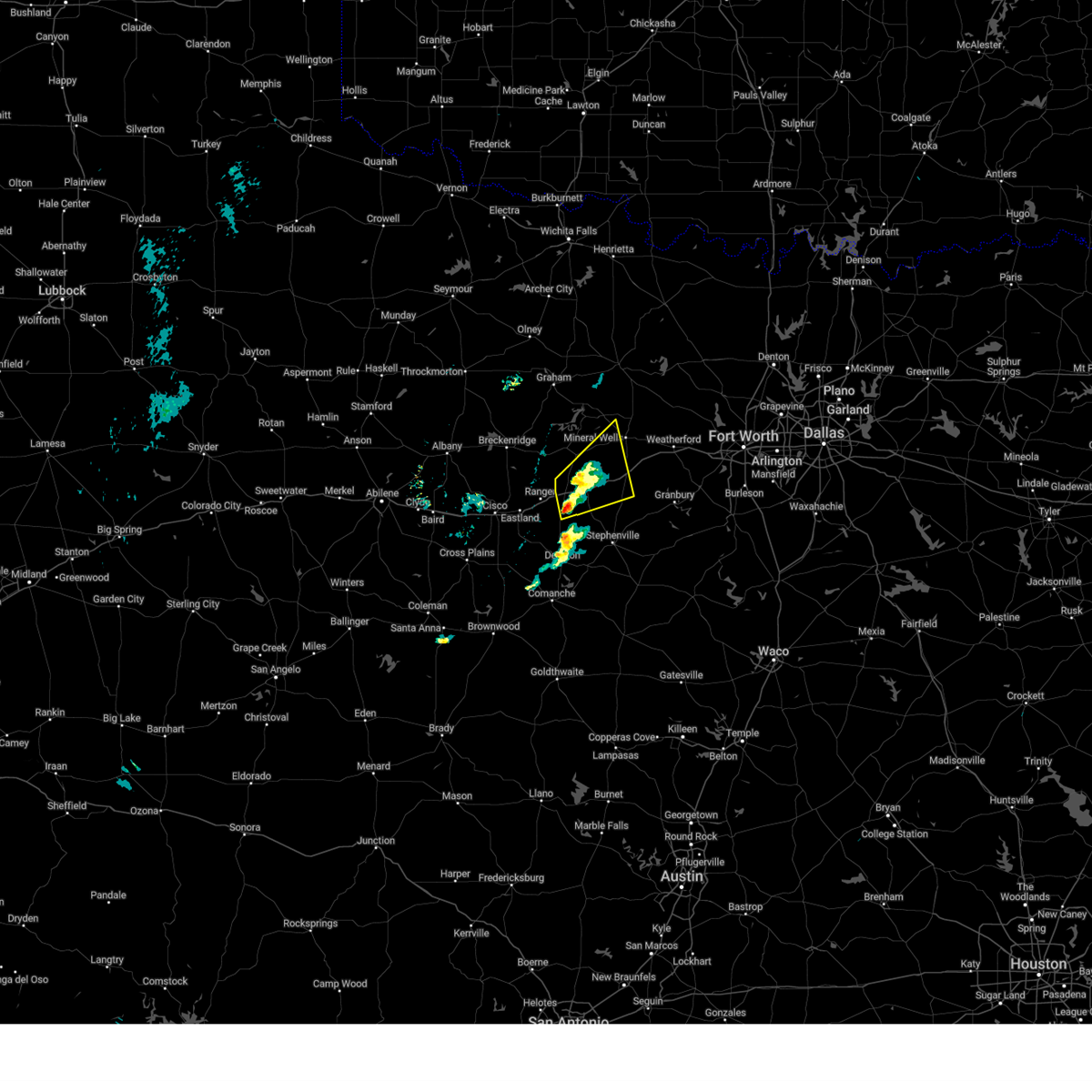 At 657 pm cdt, a severe thunderstorm was located 8 miles southeast of palo pinto mountains state park, or 11 miles east of ranger, moving northeast at 30 mph (radar indicated). Hazards include ping pong ball size hail and 60 mph wind gusts. People and animals outdoors will be injured. expect hail damage to roofs, siding, windows, and vehicles. expect wind damage to roofs, siding, and trees. this severe storm will be near, gordon around 705 pm cdt. Other locations impacted by this severe thunderstorm include mingus, santo, patillo, new salem, thurber, brazos, lone camp, and strawn. At 657 pm cdt, a severe thunderstorm was located 8 miles southeast of palo pinto mountains state park, or 11 miles east of ranger, moving northeast at 30 mph (radar indicated). Hazards include ping pong ball size hail and 60 mph wind gusts. People and animals outdoors will be injured. expect hail damage to roofs, siding, windows, and vehicles. expect wind damage to roofs, siding, and trees. this severe storm will be near, gordon around 705 pm cdt. Other locations impacted by this severe thunderstorm include mingus, santo, patillo, new salem, thurber, brazos, lone camp, and strawn.
|
| 3/29/2025 6:32 PM CDT |
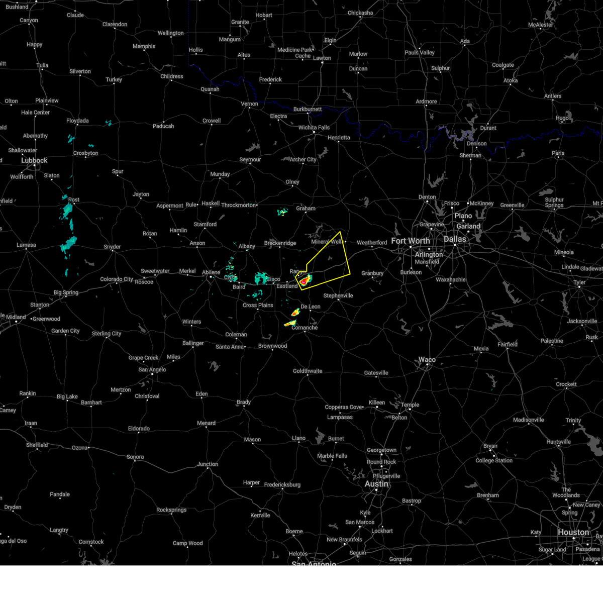 Svrfwd the national weather service in fort worth has issued a * severe thunderstorm warning for, northwestern erath county in north central texas, northeastern eastland county in north central texas, southeastern palo pinto county in north central texas, * until 730 pm cdt. * at 632 pm cdt, a severe thunderstorm was located near ranger, moving northeast at 30 mph (radar indicated). Hazards include ping pong ball size hail and 60 mph wind gusts. People and animals outdoors will be injured. expect hail damage to roofs, siding, windows, and vehicles. expect wind damage to roofs, siding, and trees. this severe thunderstorm will be near, palo pinto mountains state park around 640 pm cdt. gordon around 655 pm cdt. lake palo pinto around 705 pm cdt. other locations impacted by this severe thunderstorm include mingus, santo, patillo, new salem, thurber, brazos, lone camp, and strawn. This includes interstate 20 between mile markers 349 and 387. Svrfwd the national weather service in fort worth has issued a * severe thunderstorm warning for, northwestern erath county in north central texas, northeastern eastland county in north central texas, southeastern palo pinto county in north central texas, * until 730 pm cdt. * at 632 pm cdt, a severe thunderstorm was located near ranger, moving northeast at 30 mph (radar indicated). Hazards include ping pong ball size hail and 60 mph wind gusts. People and animals outdoors will be injured. expect hail damage to roofs, siding, windows, and vehicles. expect wind damage to roofs, siding, and trees. this severe thunderstorm will be near, palo pinto mountains state park around 640 pm cdt. gordon around 655 pm cdt. lake palo pinto around 705 pm cdt. other locations impacted by this severe thunderstorm include mingus, santo, patillo, new salem, thurber, brazos, lone camp, and strawn. This includes interstate 20 between mile markers 349 and 387.
|
| 3/4/2025 4:36 AM CST |
 At 435 am cst, severe thunderstorms were located along a line extending from near sunset to poolville to brock, moving east at 55 mph. a 66 mph wind gust was measured near poolville at 433 am cst (trained weather spotters). Hazards include 65 mph wind gusts and penny size hail. Expect damage to roofs, siding, and trees. these severe storms will be near, lake weatherford, alvord, paradise, bridgeport, briar, decatur, weatherford, reno, springtown, and hudson oaks around 440 am cst. boyd, annetta, aledo, willow park, and azle around 445 am cst. Other locations impacted by these severe thunderstorms include adell, dennis, cottondale, park springs, crafton, agnes, boonsville, bennett, garner, and tin top. At 435 am cst, severe thunderstorms were located along a line extending from near sunset to poolville to brock, moving east at 55 mph. a 66 mph wind gust was measured near poolville at 433 am cst (trained weather spotters). Hazards include 65 mph wind gusts and penny size hail. Expect damage to roofs, siding, and trees. these severe storms will be near, lake weatherford, alvord, paradise, bridgeport, briar, decatur, weatherford, reno, springtown, and hudson oaks around 440 am cst. boyd, annetta, aledo, willow park, and azle around 445 am cst. Other locations impacted by these severe thunderstorms include adell, dennis, cottondale, park springs, crafton, agnes, boonsville, bennett, garner, and tin top.
|
| 3/4/2025 4:36 AM CST |
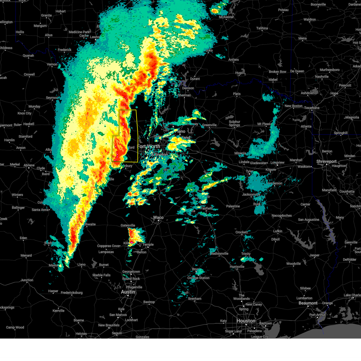 the severe thunderstorm warning has been cancelled and is no longer in effect the severe thunderstorm warning has been cancelled and is no longer in effect
|
| 3/4/2025 4:22 AM CST |
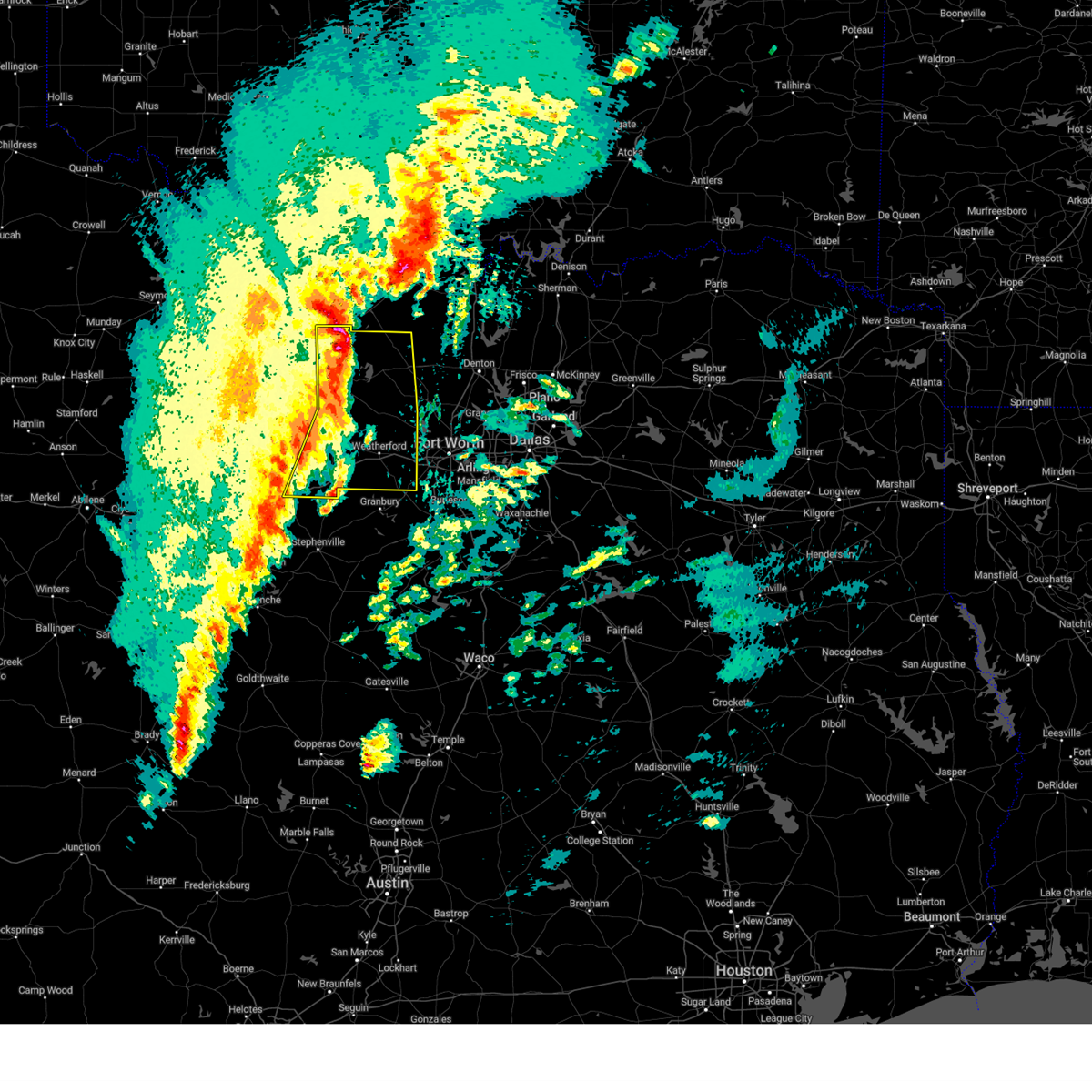 At 422 am cst, severe thunderstorms were located along a line extending from near newport to poolville to lipan, moving east at 55 mph (radar indicated). Hazards include 60 mph wind gusts and penny size hail. Expect damage to roofs, siding, and trees. these severe storms will be near, cool, poolville, bridgeport, brock, and lake bridgeport around 425 am cst. sunset, chico, and weatherford around 430 am cst. alvord, paradise, springtown, and western lake around 435 am cst. lake weatherford, boyd, annetta, willow park, briar, decatur, reno, and hudson oaks around 440 am cst. aledo and azle around 445 am cst. Other locations impacted by these severe thunderstorms include adell, lost creek reservoir, santo, cundiff, dennis, cottondale, park springs, crafton, gibtown, and joplin. At 422 am cst, severe thunderstorms were located along a line extending from near newport to poolville to lipan, moving east at 55 mph (radar indicated). Hazards include 60 mph wind gusts and penny size hail. Expect damage to roofs, siding, and trees. these severe storms will be near, cool, poolville, bridgeport, brock, and lake bridgeport around 425 am cst. sunset, chico, and weatherford around 430 am cst. alvord, paradise, springtown, and western lake around 435 am cst. lake weatherford, boyd, annetta, willow park, briar, decatur, reno, and hudson oaks around 440 am cst. aledo and azle around 445 am cst. Other locations impacted by these severe thunderstorms include adell, lost creek reservoir, santo, cundiff, dennis, cottondale, park springs, crafton, gibtown, and joplin.
|
| 3/4/2025 4:03 AM CST |
 At 402 am cst, severe thunderstorms were located along a line extending from near jacksboro to graford to gordon, moving east at 60 mph (radar indicated). Hazards include 60 mph wind gusts and penny size hail. Expect damage to roofs, siding, and trees. these severe storms will be near, jacksboro, mineral wells, and fort richardson state park around 410 am cst. cool and lake mineral wells around 415 am cst. poolville, brock, and lake bridgeport around 420 am cst. bridgeport, chico, and weatherford around 425 am cst. paradise, springtown, and western lake around 430 am cst. lake weatherford, alvord, annetta, willow park, briar, decatur, reno, and hudson oaks around 435 am cst. Boyd, aledo, and azle around 440 am cst. At 402 am cst, severe thunderstorms were located along a line extending from near jacksboro to graford to gordon, moving east at 60 mph (radar indicated). Hazards include 60 mph wind gusts and penny size hail. Expect damage to roofs, siding, and trees. these severe storms will be near, jacksboro, mineral wells, and fort richardson state park around 410 am cst. cool and lake mineral wells around 415 am cst. poolville, brock, and lake bridgeport around 420 am cst. bridgeport, chico, and weatherford around 425 am cst. paradise, springtown, and western lake around 430 am cst. lake weatherford, alvord, annetta, willow park, briar, decatur, reno, and hudson oaks around 435 am cst. Boyd, aledo, and azle around 440 am cst.
|
| 3/4/2025 4:03 AM CST |
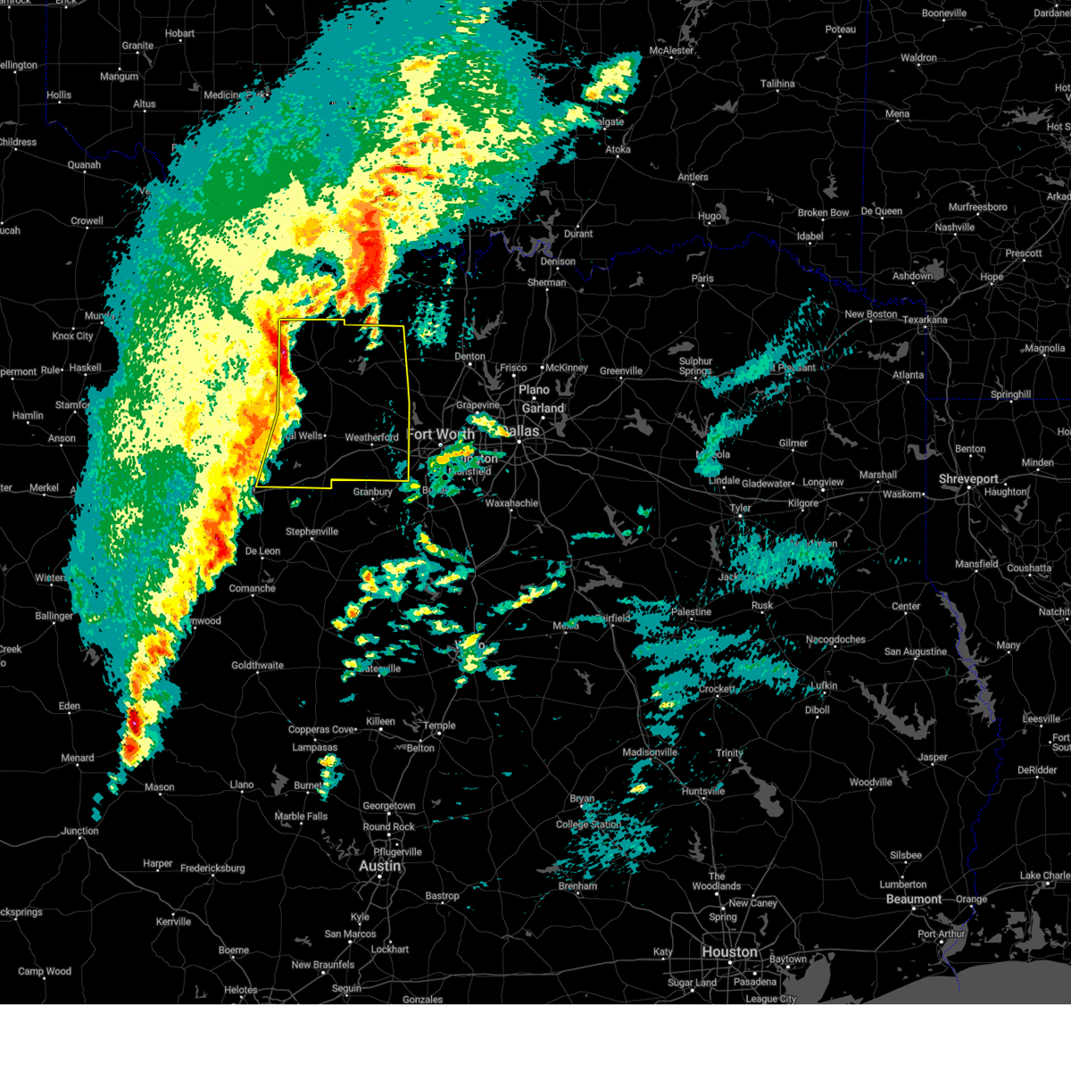 the severe thunderstorm warning has been cancelled and is no longer in effect the severe thunderstorm warning has been cancelled and is no longer in effect
|
| 3/4/2025 3:52 AM CST |
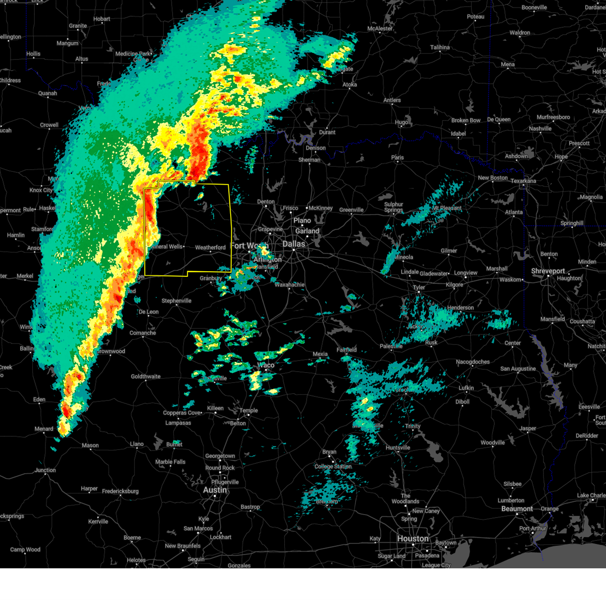 Svrfwd the national weather service in fort worth has issued a * severe thunderstorm warning for, eastern young county in north central texas, wise county in north central texas, jack county in north central texas, parker county in north central texas, palo pinto county in north central texas, * until 500 am cst. * at 352 am cst, severe thunderstorms were located along a line extending from from loving to graford to strawn, moving east at 55 mph (radar indicated). Hazards include 60 mph wind gusts and penny size hail. Expect damage to roofs, siding, and trees. severe thunderstorms will be near, lake palo pinto, jacksboro, graford, gordon, and palo pinto around 400 am cst. mineral wells and fort richardson state park around 405 am cst. cool and lake mineral wells around 410 am cst. poolville, brock, and lake bridgeport around 420 am cst. bridgeport and weatherford around 425 am cst. chico, springtown, and western lake around 430 am cst. lake weatherford, alvord, paradise, sunset, and hudson oaks around 435 am cst. boyd, annetta, aledo, willow park, briar, decatur, azle, and reno around 440 am cst. other locations impacted by these severe thunderstorms include santo, cundiff, park springs, crafton, gibtown, joplin, bartons chapel, bennett, vineyard, and wizard wells. this includes the following highways, interstate 20 between mile markers 370 and 422. Interstate 30 near mile marker 1. Svrfwd the national weather service in fort worth has issued a * severe thunderstorm warning for, eastern young county in north central texas, wise county in north central texas, jack county in north central texas, parker county in north central texas, palo pinto county in north central texas, * until 500 am cst. * at 352 am cst, severe thunderstorms were located along a line extending from from loving to graford to strawn, moving east at 55 mph (radar indicated). Hazards include 60 mph wind gusts and penny size hail. Expect damage to roofs, siding, and trees. severe thunderstorms will be near, lake palo pinto, jacksboro, graford, gordon, and palo pinto around 400 am cst. mineral wells and fort richardson state park around 405 am cst. cool and lake mineral wells around 410 am cst. poolville, brock, and lake bridgeport around 420 am cst. bridgeport and weatherford around 425 am cst. chico, springtown, and western lake around 430 am cst. lake weatherford, alvord, paradise, sunset, and hudson oaks around 435 am cst. boyd, annetta, aledo, willow park, briar, decatur, azle, and reno around 440 am cst. other locations impacted by these severe thunderstorms include santo, cundiff, park springs, crafton, gibtown, joplin, bartons chapel, bennett, vineyard, and wizard wells. this includes the following highways, interstate 20 between mile markers 370 and 422. Interstate 30 near mile marker 1.
|
| 11/8/2024 1:25 AM CST |
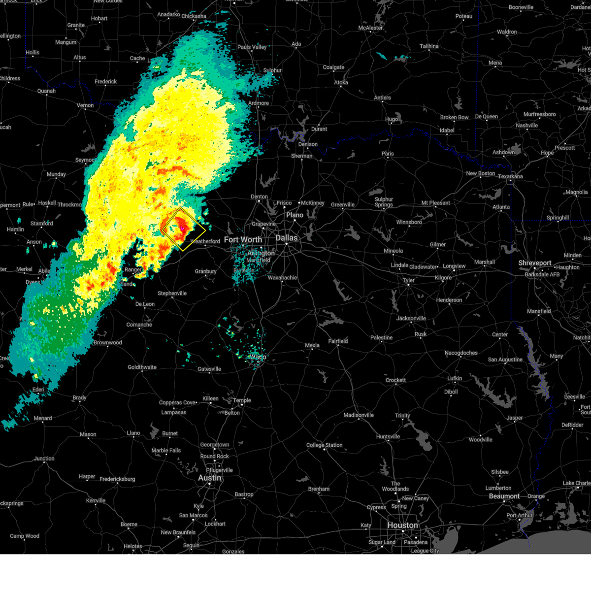 At 124 am cst, a severe thunderstorm was located 7 miles north of mineral wells, moving northeast at 35 mph (radar indicated). Hazards include 60 mph wind gusts and quarter size hail. Hail damage to vehicles is expected. expect wind damage to roofs, siding, and trees. This severe thunderstorm will remain over mainly rural areas of southeastern jack, northwestern parker and northeastern palo pinto counties, including the following locations, adell, peaster, whitt, advance, gibtown, perrin, bennett, authon, oran, and millsap. At 124 am cst, a severe thunderstorm was located 7 miles north of mineral wells, moving northeast at 35 mph (radar indicated). Hazards include 60 mph wind gusts and quarter size hail. Hail damage to vehicles is expected. expect wind damage to roofs, siding, and trees. This severe thunderstorm will remain over mainly rural areas of southeastern jack, northwestern parker and northeastern palo pinto counties, including the following locations, adell, peaster, whitt, advance, gibtown, perrin, bennett, authon, oran, and millsap.
|
| 11/8/2024 12:58 AM CST |
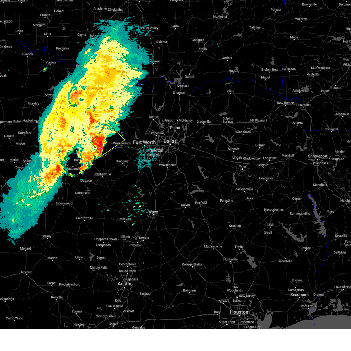 Svrfwd the national weather service in fort worth has issued a * severe thunderstorm warning for, southeastern jack county in north central texas, northwestern parker county in north central texas, eastern palo pinto county in north central texas, * until 200 am cst. * at 1256 am cst, a severe thunderstorm was located near palo pinto, or 9 miles southwest of mineral wells, moving northeast at 25 mph (radar indicated). Hazards include 60 mph wind gusts and half dollar size hail. Hail damage to vehicles is expected. expect wind damage to roofs, siding, and trees. this severe thunderstorm will be near, mineral wells around 100 am cst. lake mineral wells around 120 am cst. Other locations impacted by this severe thunderstorm include adell, peaster, whitt, santo, advance, perrin, bennett, authon, oran, and millsap. Svrfwd the national weather service in fort worth has issued a * severe thunderstorm warning for, southeastern jack county in north central texas, northwestern parker county in north central texas, eastern palo pinto county in north central texas, * until 200 am cst. * at 1256 am cst, a severe thunderstorm was located near palo pinto, or 9 miles southwest of mineral wells, moving northeast at 25 mph (radar indicated). Hazards include 60 mph wind gusts and half dollar size hail. Hail damage to vehicles is expected. expect wind damage to roofs, siding, and trees. this severe thunderstorm will be near, mineral wells around 100 am cst. lake mineral wells around 120 am cst. Other locations impacted by this severe thunderstorm include adell, peaster, whitt, santo, advance, perrin, bennett, authon, oran, and millsap.
|
| 5/22/2024 4:41 PM CDT |
 the severe thunderstorm warning has been cancelled and is no longer in effect the severe thunderstorm warning has been cancelled and is no longer in effect
|
| 5/22/2024 4:29 PM CDT |
 At 429 pm cdt, a severe thunderstorm was located over cool, or near mineral wells, moving east at 35 mph (radar indicated). Hazards include 60 mph wind gusts and quarter size hail. Hail damage to vehicles is expected. expect wind damage to roofs, siding, and trees. this severe storm will be near, weatherford around 440 pm cdt. lake weatherford around 455 pm cdt. azle and reno around 505 pm cdt. Other locations impacted by this severe thunderstorm include brock junction, peaster, bennett, authon, millsap, garner, annetta south, annetta north, sanctuary, and la junta. At 429 pm cdt, a severe thunderstorm was located over cool, or near mineral wells, moving east at 35 mph (radar indicated). Hazards include 60 mph wind gusts and quarter size hail. Hail damage to vehicles is expected. expect wind damage to roofs, siding, and trees. this severe storm will be near, weatherford around 440 pm cdt. lake weatherford around 455 pm cdt. azle and reno around 505 pm cdt. Other locations impacted by this severe thunderstorm include brock junction, peaster, bennett, authon, millsap, garner, annetta south, annetta north, sanctuary, and la junta.
|
| 5/22/2024 4:29 PM CDT |
 the severe thunderstorm warning has been cancelled and is no longer in effect the severe thunderstorm warning has been cancelled and is no longer in effect
|
| 5/22/2024 4:20 PM CDT | Ping Pong Ball sized hail reported 4.2 miles N of Mineral Wells, TX, report from mping: ping pong ball (1.50 in.). |
| 5/22/2024 4:20 PM CDT | Golf Ball sized hail reported 5 miles N of Mineral Wells, TX, golf ball size hail south of mineral wells. |
| 5/22/2024 4:13 PM CDT | Quarter sized hail reported 7.9 miles NNE of Mineral Wells, TX, report from mping: quarter (1.00 in.). |
| 5/22/2024 4:10 PM CDT |
 Svrfwd the national weather service in fort worth has issued a * severe thunderstorm warning for, parker county in north central texas, east central palo pinto county in north central texas, * until 515 pm cdt. * at 409 pm cdt, a severe thunderstorm was located 7 miles southwest of mineral wells, moving east at 35 mph (radar indicated). Hazards include 60 mph wind gusts and quarter size hail. Hail damage to vehicles is expected. expect wind damage to roofs, siding, and trees. this severe thunderstorm will be near, mineral wells around 415 pm cdt. cool around 420 pm cdt. weatherford around 435 pm cdt. hudson oaks and lake weatherford around 450 pm cdt. willow park around 455 pm cdt. azle around 505 pm cdt. other locations impacted by this severe thunderstorm include brock junction, peaster, dennis, annetta south, bennett, authon, millsap, garner, tin top, and brazos. this includes the following highways, interstate 20 between mile markers 389 and 422. Interstate 30 near mile marker 1. Svrfwd the national weather service in fort worth has issued a * severe thunderstorm warning for, parker county in north central texas, east central palo pinto county in north central texas, * until 515 pm cdt. * at 409 pm cdt, a severe thunderstorm was located 7 miles southwest of mineral wells, moving east at 35 mph (radar indicated). Hazards include 60 mph wind gusts and quarter size hail. Hail damage to vehicles is expected. expect wind damage to roofs, siding, and trees. this severe thunderstorm will be near, mineral wells around 415 pm cdt. cool around 420 pm cdt. weatherford around 435 pm cdt. hudson oaks and lake weatherford around 450 pm cdt. willow park around 455 pm cdt. azle around 505 pm cdt. other locations impacted by this severe thunderstorm include brock junction, peaster, dennis, annetta south, bennett, authon, millsap, garner, tin top, and brazos. this includes the following highways, interstate 20 between mile markers 389 and 422. Interstate 30 near mile marker 1.
|
| 5/22/2024 3:42 PM CDT |
 At 341 pm cdt, a severe thunderstorm was located 8 miles west of palo pinto, or 21 miles west of mineral wells, moving east at 35 mph (radar indicated). Hazards include 60 mph wind gusts and quarter size hail. Hail damage to vehicles is expected. expect wind damage to roofs, siding, and trees. this severe storm will be near, palo pinto around 350 pm cdt. mineral wells around 405 pm cdt. Other locations impacted by this severe thunderstorm include brazos, lone camp, new salem, salesville, and peadenville. At 341 pm cdt, a severe thunderstorm was located 8 miles west of palo pinto, or 21 miles west of mineral wells, moving east at 35 mph (radar indicated). Hazards include 60 mph wind gusts and quarter size hail. Hail damage to vehicles is expected. expect wind damage to roofs, siding, and trees. this severe storm will be near, palo pinto around 350 pm cdt. mineral wells around 405 pm cdt. Other locations impacted by this severe thunderstorm include brazos, lone camp, new salem, salesville, and peadenville.
|
| 5/22/2024 3:42 PM CDT |
 the severe thunderstorm warning has been cancelled and is no longer in effect the severe thunderstorm warning has been cancelled and is no longer in effect
|
| 5/22/2024 3:10 PM CDT |
 Svrfwd the national weather service in fort worth has issued a * severe thunderstorm warning for, southeastern stephens county in north central texas, palo pinto county in north central texas, * until 415 pm cdt. * at 309 pm cdt, a severe thunderstorm was located near necessity, or 13 miles southeast of breckenridge, moving east at 35 mph (radar indicated). Hazards include 60 mph wind gusts and quarter size hail. Hail damage to vehicles is expected. expect wind damage to roofs, siding, and trees. this severe thunderstorm will be near, caddo around 315 pm cdt. palo pinto around 345 pm cdt. mineral wells around 400 pm cdt. other locations impacted by this severe thunderstorm include santo, new salem, brazos, lone camp, strawn, salesville, peadenville, and mingus. This includes interstate 20 between mile markers 374 and 389. Svrfwd the national weather service in fort worth has issued a * severe thunderstorm warning for, southeastern stephens county in north central texas, palo pinto county in north central texas, * until 415 pm cdt. * at 309 pm cdt, a severe thunderstorm was located near necessity, or 13 miles southeast of breckenridge, moving east at 35 mph (radar indicated). Hazards include 60 mph wind gusts and quarter size hail. Hail damage to vehicles is expected. expect wind damage to roofs, siding, and trees. this severe thunderstorm will be near, caddo around 315 pm cdt. palo pinto around 345 pm cdt. mineral wells around 400 pm cdt. other locations impacted by this severe thunderstorm include santo, new salem, brazos, lone camp, strawn, salesville, peadenville, and mingus. This includes interstate 20 between mile markers 374 and 389.
|
| 5/9/2024 3:59 PM CDT |
 the severe thunderstorm warning has been cancelled and is no longer in effect the severe thunderstorm warning has been cancelled and is no longer in effect
|
| 5/9/2024 3:32 PM CDT |
 At 332 pm cdt, a severe thunderstorm was located over cool, or near mineral wells, moving east at 25 mph (radar indicated). Hazards include 60 mph wind gusts and quarter size hail. Hail damage to vehicles is expected. expect wind damage to roofs, siding, and trees. this severe storm will be near, cool around 340 pm cdt. weatherford around 355 pm cdt. Other locations impacted by this severe thunderstorm include brock junction, peaster, bennett, authon, millsap, and garner. At 332 pm cdt, a severe thunderstorm was located over cool, or near mineral wells, moving east at 25 mph (radar indicated). Hazards include 60 mph wind gusts and quarter size hail. Hail damage to vehicles is expected. expect wind damage to roofs, siding, and trees. this severe storm will be near, cool around 340 pm cdt. weatherford around 355 pm cdt. Other locations impacted by this severe thunderstorm include brock junction, peaster, bennett, authon, millsap, and garner.
|
| 5/9/2024 3:14 PM CDT | Ping Pong Ball sized hail reported 8.7 miles ENE of Mineral Wells, TX, report from mping: ping pong ball (1.50 in.). |
| 5/9/2024 3:12 PM CDT |
 Svrfwd the national weather service in fort worth has issued a * severe thunderstorm warning for, western parker county in north central texas, eastern palo pinto county in north central texas, * until 415 pm cdt. * at 311 pm cdt, a severe thunderstorm was located near palo pinto, or 7 miles west of mineral wells, moving east at 15 mph (radar indicated). Hazards include ping pong ball size hail and 60 mph wind gusts. People and animals outdoors will be injured. expect hail damage to roofs, siding, windows, and vehicles. expect wind damage to roofs, siding, and trees. this severe thunderstorm will be near, mineral wells around 315 pm cdt. lake mineral wells around 330 pm cdt. cool around 335 pm cdt. Other locations impacted by this severe thunderstorm include brock junction, adell, peaster, advance, bennett, authon, millsap, garner, brazos, and salesville. Svrfwd the national weather service in fort worth has issued a * severe thunderstorm warning for, western parker county in north central texas, eastern palo pinto county in north central texas, * until 415 pm cdt. * at 311 pm cdt, a severe thunderstorm was located near palo pinto, or 7 miles west of mineral wells, moving east at 15 mph (radar indicated). Hazards include ping pong ball size hail and 60 mph wind gusts. People and animals outdoors will be injured. expect hail damage to roofs, siding, windows, and vehicles. expect wind damage to roofs, siding, and trees. this severe thunderstorm will be near, mineral wells around 315 pm cdt. lake mineral wells around 330 pm cdt. cool around 335 pm cdt. Other locations impacted by this severe thunderstorm include brock junction, adell, peaster, advance, bennett, authon, millsap, garner, brazos, and salesville.
|
| 5/9/2024 2:47 PM CDT |
 At 246 pm cdt, a severe thunderstorm was located over palo pinto, or 11 miles west of mineral wells, moving east at 15 mph (radar indicated). Hazards include 60 mph wind gusts and half dollar size hail. Hail damage to vehicles is expected. expect wind damage to roofs, siding, and trees. Locations impacted by this severe thunderstorm include, palo pinto, mineral wells, salesville, lone camp, oran, and peadenville. At 246 pm cdt, a severe thunderstorm was located over palo pinto, or 11 miles west of mineral wells, moving east at 15 mph (radar indicated). Hazards include 60 mph wind gusts and half dollar size hail. Hail damage to vehicles is expected. expect wind damage to roofs, siding, and trees. Locations impacted by this severe thunderstorm include, palo pinto, mineral wells, salesville, lone camp, oran, and peadenville.
|
| 5/9/2024 2:07 PM CDT |
 Svrfwd the national weather service in fort worth has issued a * severe thunderstorm warning for, central palo pinto county in north central texas, * until 315 pm cdt. * at 207 pm cdt, a severe thunderstorm was located 7 miles west of palo pinto, or 20 miles west of mineral wells, moving east at 25 mph (radar indicated). Hazards include 60 mph wind gusts and half dollar size hail. Hail damage to vehicles is expected. expect wind damage to roofs, siding, and trees. this severe thunderstorm will be near, palo pinto around 215 pm cdt. mineral wells around 235 pm cdt. Other locations impacted by this severe thunderstorm include salesville, lone camp, oran, and peadenville. Svrfwd the national weather service in fort worth has issued a * severe thunderstorm warning for, central palo pinto county in north central texas, * until 315 pm cdt. * at 207 pm cdt, a severe thunderstorm was located 7 miles west of palo pinto, or 20 miles west of mineral wells, moving east at 25 mph (radar indicated). Hazards include 60 mph wind gusts and half dollar size hail. Hail damage to vehicles is expected. expect wind damage to roofs, siding, and trees. this severe thunderstorm will be near, palo pinto around 215 pm cdt. mineral wells around 235 pm cdt. Other locations impacted by this severe thunderstorm include salesville, lone camp, oran, and peadenville.
|
| 4/28/2024 1:44 AM CDT |
 The storms which prompted the warning have weakened below severe limits. therefore the warning will be allowed to expire. however heavy rainfall is still occurring and may lead to flash flooding. do not drive your vehicle through flooded roadways. turn around, don't drown!. The storms which prompted the warning have weakened below severe limits. therefore the warning will be allowed to expire. however heavy rainfall is still occurring and may lead to flash flooding. do not drive your vehicle through flooded roadways. turn around, don't drown!.
|
| 4/28/2024 1:26 AM CDT |
 At 125 am cdt, severe thunderstorms were located along a line extending from near lake bridgeport to graford to metcalf gap, moving east at 45 mph (radar indicated). Hazards include 60 mph wind gusts and quarter size hail. Hail damage to vehicles is expected. expect wind damage to roofs, siding, and trees. Other locations impacted by these severe thunderstorms include jermyn, lost creek reservoir, cundiff, harpersville, gibtown, joplin, perrin, bartons chapel, wizard wells, and vineyard. At 125 am cdt, severe thunderstorms were located along a line extending from near lake bridgeport to graford to metcalf gap, moving east at 45 mph (radar indicated). Hazards include 60 mph wind gusts and quarter size hail. Hail damage to vehicles is expected. expect wind damage to roofs, siding, and trees. Other locations impacted by these severe thunderstorms include jermyn, lost creek reservoir, cundiff, harpersville, gibtown, joplin, perrin, bartons chapel, wizard wells, and vineyard.
|
| 4/28/2024 1:10 AM CDT |
 At 109 am cdt, severe thunderstorms were located along a line extending from jacksboro to graford to caddo, moving east at 45 mph (radar indicated). Hazards include 60 mph wind gusts and quarter size hail. Hail damage to vehicles is expected. expect wind damage to roofs, siding, and trees. these severe storms will be near, graford and possum kingdom lake around 115 am cdt. palo pinto and lake bridgeport around 120 am cdt. mineral wells around 125 am cdt. lake palo pinto around 135 am cdt. Other locations impacted by these severe thunderstorms include jermyn, lost creek reservoir, cundiff, loving, harpersville, gibtown, joplin, eliasville, perrin, and bartons chapel. At 109 am cdt, severe thunderstorms were located along a line extending from jacksboro to graford to caddo, moving east at 45 mph (radar indicated). Hazards include 60 mph wind gusts and quarter size hail. Hail damage to vehicles is expected. expect wind damage to roofs, siding, and trees. these severe storms will be near, graford and possum kingdom lake around 115 am cdt. palo pinto and lake bridgeport around 120 am cdt. mineral wells around 125 am cdt. lake palo pinto around 135 am cdt. Other locations impacted by these severe thunderstorms include jermyn, lost creek reservoir, cundiff, loving, harpersville, gibtown, joplin, eliasville, perrin, and bartons chapel.
|
| 4/28/2024 12:42 AM CDT |
 Svrfwd the national weather service in fort worth has issued a * severe thunderstorm warning for, young county in north central texas, jack county in north central texas, stephens county in north central texas, palo pinto county in north central texas, * until 145 am cdt. * at 1241 am cdt, severe thunderstorms were located along a line extending from near lake graham to near possum kingdom state park to near ibex, moving east at 50 mph (radar indicated). Hazards include 60 mph wind gusts and quarter size hail. Hail damage to vehicles is expected. expect wind damage to roofs, siding, and trees. severe thunderstorms will be near, graham, breckenridge, possum kingdom state park, lake daniel, and possum kingdom lake around 1245 am cdt. bryson around 1250 am cdt. necessity and caddo around 1255 am cdt. graford around 105 am cdt. jacksboro and fort richardson state park around 110 am cdt. palo pinto around 120 am cdt. mineral wells and lake bridgeport around 125 am cdt. Lake palo pinto around 130 am cdt. Svrfwd the national weather service in fort worth has issued a * severe thunderstorm warning for, young county in north central texas, jack county in north central texas, stephens county in north central texas, palo pinto county in north central texas, * until 145 am cdt. * at 1241 am cdt, severe thunderstorms were located along a line extending from near lake graham to near possum kingdom state park to near ibex, moving east at 50 mph (radar indicated). Hazards include 60 mph wind gusts and quarter size hail. Hail damage to vehicles is expected. expect wind damage to roofs, siding, and trees. severe thunderstorms will be near, graham, breckenridge, possum kingdom state park, lake daniel, and possum kingdom lake around 1245 am cdt. bryson around 1250 am cdt. necessity and caddo around 1255 am cdt. graford around 105 am cdt. jacksboro and fort richardson state park around 110 am cdt. palo pinto around 120 am cdt. mineral wells and lake bridgeport around 125 am cdt. Lake palo pinto around 130 am cdt.
|
| 4/9/2024 1:13 AM CDT |
 the severe thunderstorm warning has been cancelled and is no longer in effect the severe thunderstorm warning has been cancelled and is no longer in effect
|
| 4/9/2024 1:02 AM CDT |
 At 102 am cdt, a severe thunderstorm was located over cool, or near mineral wells, moving east at 20 mph (radar indicated). Hazards include quarter size hail. Damage to vehicles is possible. Locations impacted include, weatherford, mineral wells, brock, cool, lake mineral wells, annetta north, millsap, brock junction, bennett, garner, brazos, and peaster. At 102 am cdt, a severe thunderstorm was located over cool, or near mineral wells, moving east at 20 mph (radar indicated). Hazards include quarter size hail. Damage to vehicles is possible. Locations impacted include, weatherford, mineral wells, brock, cool, lake mineral wells, annetta north, millsap, brock junction, bennett, garner, brazos, and peaster.
|
| 4/9/2024 12:56 AM CDT |
 Svrfwd the national weather service in fort worth has issued a * severe thunderstorm warning for, western parker county in north central texas, east central palo pinto county in north central texas, * until 200 am cdt. * at 1256 am cdt, a severe thunderstorm was located near mineral wells, moving east at 20 mph (radar indicated). Hazards include ping pong ball size hail and 60 mph wind gusts. People and animals outdoors will be injured. expect hail damage to roofs, siding, windows, and vehicles. Expect wind damage to roofs, siding, and trees. Svrfwd the national weather service in fort worth has issued a * severe thunderstorm warning for, western parker county in north central texas, east central palo pinto county in north central texas, * until 200 am cdt. * at 1256 am cdt, a severe thunderstorm was located near mineral wells, moving east at 20 mph (radar indicated). Hazards include ping pong ball size hail and 60 mph wind gusts. People and animals outdoors will be injured. expect hail damage to roofs, siding, windows, and vehicles. Expect wind damage to roofs, siding, and trees.
|
| 4/9/2024 12:14 AM CDT |
 At 1213 am cdt, a severe thunderstorm was located near mineral wells, moving east at 35 mph (radar indicated). Hazards include ping pong ball size hail and 60 mph wind gusts. People and animals outdoors will be injured. expect hail damage to roofs, siding, windows, and vehicles. expect wind damage to roofs, siding, and trees. Locations impacted include, weatherford, mineral wells, graford, poolville, palo pinto, cool, lake mineral wells, millsap, adell, advance, salesville, peaster, whitt, bennett, authon, oran, garner, peadenville, and brock junction. At 1213 am cdt, a severe thunderstorm was located near mineral wells, moving east at 35 mph (radar indicated). Hazards include ping pong ball size hail and 60 mph wind gusts. People and animals outdoors will be injured. expect hail damage to roofs, siding, windows, and vehicles. expect wind damage to roofs, siding, and trees. Locations impacted include, weatherford, mineral wells, graford, poolville, palo pinto, cool, lake mineral wells, millsap, adell, advance, salesville, peaster, whitt, bennett, authon, oran, garner, peadenville, and brock junction.
|
| 4/8/2024 11:52 PM CDT |
 Svrfwd the national weather service in fort worth has issued a * severe thunderstorm warning for, northwestern parker county in north central texas, northeastern palo pinto county in north central texas, * until 100 am cdt. * at 1152 pm cdt, a severe thunderstorm was located near palo pinto, or 15 miles west of mineral wells, moving east at 35 mph (radar indicated). Hazards include two inch hail and 60 mph wind gusts. People and animals outdoors will be injured. expect hail damage to roofs, siding, windows, and vehicles. Expect wind damage to roofs, siding, and trees. Svrfwd the national weather service in fort worth has issued a * severe thunderstorm warning for, northwestern parker county in north central texas, northeastern palo pinto county in north central texas, * until 100 am cdt. * at 1152 pm cdt, a severe thunderstorm was located near palo pinto, or 15 miles west of mineral wells, moving east at 35 mph (radar indicated). Hazards include two inch hail and 60 mph wind gusts. People and animals outdoors will be injured. expect hail damage to roofs, siding, windows, and vehicles. Expect wind damage to roofs, siding, and trees.
|
| 4/1/2024 6:09 PM CDT |
 At 609 pm cdt, a severe thunderstorm was located near poolville, moving east at 50 mph (radar indicated). Hazards include 65 mph wind gusts and half dollar size hail. Hail damage to vehicles is expected. Expect wind damage to roofs, siding, and trees. At 609 pm cdt, a severe thunderstorm was located near poolville, moving east at 50 mph (radar indicated). Hazards include 65 mph wind gusts and half dollar size hail. Hail damage to vehicles is expected. Expect wind damage to roofs, siding, and trees.
|
| 4/1/2024 6:08 PM CDT |
 Svrfwd the national weather service in fort worth has issued a * severe thunderstorm warning for, southern wise county in north central texas, southeastern jack county in north central texas, northern parker county in north central texas, northwestern tarrant county in north central texas, * until 700 pm cdt. * at 607 pm cdt, a severe thunderstorm was located near poolville, moving east at 50 mph (radar indicated). Hazards include 65 mph wind gusts and half dollar size hail. Hail damage to vehicles is expected. expect wind damage to roofs, siding, and trees. this severe thunderstorm will be near, poolville around 610 pm cdt. springtown around 615 pm cdt. briar and reno around 625 pm cdt. pecan acres, rhome, and aurora around 630 pm cdt. Other locations impacted by this severe thunderstorm include adell, peaster, whitt, advance, cottondale, keeter, gibtown, agnes, boonsville, and authon. Svrfwd the national weather service in fort worth has issued a * severe thunderstorm warning for, southern wise county in north central texas, southeastern jack county in north central texas, northern parker county in north central texas, northwestern tarrant county in north central texas, * until 700 pm cdt. * at 607 pm cdt, a severe thunderstorm was located near poolville, moving east at 50 mph (radar indicated). Hazards include 65 mph wind gusts and half dollar size hail. Hail damage to vehicles is expected. expect wind damage to roofs, siding, and trees. this severe thunderstorm will be near, poolville around 610 pm cdt. springtown around 615 pm cdt. briar and reno around 625 pm cdt. pecan acres, rhome, and aurora around 630 pm cdt. Other locations impacted by this severe thunderstorm include adell, peaster, whitt, advance, cottondale, keeter, gibtown, agnes, boonsville, and authon.
|
| 4/1/2024 5:58 PM CDT |
 At 557 pm cdt, a severe thunderstorm was located near mineral wells and salesville, moving east at 45 mph (radar indicated). Hazards include 65 mph wind gusts and half dollar size hail. Hail damage to vehicles is expected. Expect wind damage to roofs, siding, and trees. At 557 pm cdt, a severe thunderstorm was located near mineral wells and salesville, moving east at 45 mph (radar indicated). Hazards include 65 mph wind gusts and half dollar size hail. Hail damage to vehicles is expected. Expect wind damage to roofs, siding, and trees.
|
| 4/1/2024 5:44 PM CDT |
 the severe thunderstorm warning has been cancelled and is no longer in effect the severe thunderstorm warning has been cancelled and is no longer in effect
|
| 4/1/2024 5:44 PM CDT |
 At 542 pm cdt, a severe thunderstorm was located over graford, or 15 miles northwest of mineral wells, moving east at 50 mph (radar indicated). Hazards include golf ball size hail and 65 mph wind gusts. People and animals outdoors will be injured. expect damage to roofs, siding, windows, and vehicles. Other locations impacted by this severe thunderstorm include adell, whitt, advance, gibtown, joplin, perrin, bartons chapel, wizard wells, vineyard, and authon. At 542 pm cdt, a severe thunderstorm was located over graford, or 15 miles northwest of mineral wells, moving east at 50 mph (radar indicated). Hazards include golf ball size hail and 65 mph wind gusts. People and animals outdoors will be injured. expect damage to roofs, siding, windows, and vehicles. Other locations impacted by this severe thunderstorm include adell, whitt, advance, gibtown, joplin, perrin, bartons chapel, wizard wells, vineyard, and authon.
|
| 4/1/2024 5:30 PM CDT |
 the severe thunderstorm warning has been cancelled and is no longer in effect the severe thunderstorm warning has been cancelled and is no longer in effect
|
| 4/1/2024 5:30 PM CDT |
 At 529 pm cdt, a severe thunderstorm was located near possum kingdom lake, moving east at 50 mph. this is a destructive storm for areas near the possum kingdom lake! (radar indicated). Hazards include baseball size hail and 70 mph wind gusts. People and animals outdoors will be severely injured. expect shattered windows, extensive damage to roofs, siding, and vehicles. this severe storm will be near, graford around 540 pm cdt. Other locations impacted by this severe thunderstorm include adell, whitt, advance, gibtown, joplin, perrin, bartons chapel, wizard wells, vineyard, and authon. At 529 pm cdt, a severe thunderstorm was located near possum kingdom lake, moving east at 50 mph. this is a destructive storm for areas near the possum kingdom lake! (radar indicated). Hazards include baseball size hail and 70 mph wind gusts. People and animals outdoors will be severely injured. expect shattered windows, extensive damage to roofs, siding, and vehicles. this severe storm will be near, graford around 540 pm cdt. Other locations impacted by this severe thunderstorm include adell, whitt, advance, gibtown, joplin, perrin, bartons chapel, wizard wells, vineyard, and authon.
|
| 4/1/2024 5:20 PM CDT |
 Svrfwd the national weather service in fort worth has issued a * severe thunderstorm warning for, southeastern young county in north central texas, southern jack county in north central texas, northwestern parker county in north central texas, northeastern stephens county in north central texas, northern palo pinto county in north central texas, * until 615 pm cdt. * at 518 pm cdt, a severe thunderstorm was located near possum kingdom state park, moving east at 50 mph. at 514 pm cdt, two inch hail was reported with this storm (radar indicated). Hazards include two inch hail and 70 mph wind gusts. People and animals outdoors will be injured. expect hail damage to roofs, siding, windows, and vehicles. expect considerable tree damage. wind damage is also likely to mobile homes, roofs, and outbuildings. this severe thunderstorm will be near, possum kingdom lake around 525 pm cdt. graford around 540 pm cdt. Other locations impacted by this severe thunderstorm include adell, whitt, advance, gibtown, joplin, perrin, bartons chapel, wizard wells, vineyard, and authon. Svrfwd the national weather service in fort worth has issued a * severe thunderstorm warning for, southeastern young county in north central texas, southern jack county in north central texas, northwestern parker county in north central texas, northeastern stephens county in north central texas, northern palo pinto county in north central texas, * until 615 pm cdt. * at 518 pm cdt, a severe thunderstorm was located near possum kingdom state park, moving east at 50 mph. at 514 pm cdt, two inch hail was reported with this storm (radar indicated). Hazards include two inch hail and 70 mph wind gusts. People and animals outdoors will be injured. expect hail damage to roofs, siding, windows, and vehicles. expect considerable tree damage. wind damage is also likely to mobile homes, roofs, and outbuildings. this severe thunderstorm will be near, possum kingdom lake around 525 pm cdt. graford around 540 pm cdt. Other locations impacted by this severe thunderstorm include adell, whitt, advance, gibtown, joplin, perrin, bartons chapel, wizard wells, vineyard, and authon.
|
| 3/21/2024 5:55 PM CDT |
 the severe thunderstorm warning has been cancelled and is no longer in effect the severe thunderstorm warning has been cancelled and is no longer in effect
|
| 3/21/2024 5:55 PM CDT |
 At 555 pm cdt, a severe thunderstorm was located over poolville, or 15 miles southwest of bridgeport, moving east at 30 mph (radar indicated). Hazards include 60 mph wind gusts and quarter size hail. Hail damage to vehicles is expected. expect wind damage to roofs, siding, and trees. this severe storm will be near, poolville around 600 pm cdt. Other locations impacted by this severe thunderstorm include adell, peaster, whitt, advance, lake bridgeport, gibtown, joplin, balsora, agnes, and boonsville. At 555 pm cdt, a severe thunderstorm was located over poolville, or 15 miles southwest of bridgeport, moving east at 30 mph (radar indicated). Hazards include 60 mph wind gusts and quarter size hail. Hail damage to vehicles is expected. expect wind damage to roofs, siding, and trees. this severe storm will be near, poolville around 600 pm cdt. Other locations impacted by this severe thunderstorm include adell, peaster, whitt, advance, lake bridgeport, gibtown, joplin, balsora, agnes, and boonsville.
|
| 3/21/2024 5:34 PM CDT |
 At 533 pm cdt, a severe thunderstorm was located 9 miles north of mineral wells, moving east at 25 mph (radar indicated). Hazards include 60 mph wind gusts and quarter size hail. Hail damage to vehicles is expected. expect wind damage to roofs, siding, and trees. this severe storm will be near, poolville around 550 pm cdt. Other locations impacted by this severe thunderstorm include adell, peaster, whitt, advance, lake bridgeport, gibtown, joplin, balsora, perrin, and agnes. At 533 pm cdt, a severe thunderstorm was located 9 miles north of mineral wells, moving east at 25 mph (radar indicated). Hazards include 60 mph wind gusts and quarter size hail. Hail damage to vehicles is expected. expect wind damage to roofs, siding, and trees. this severe storm will be near, poolville around 550 pm cdt. Other locations impacted by this severe thunderstorm include adell, peaster, whitt, advance, lake bridgeport, gibtown, joplin, balsora, perrin, and agnes.
|
| 3/21/2024 5:10 PM CDT |
 Svrfwd the national weather service in fort worth has issued a * severe thunderstorm warning for, southwestern wise county in north central texas, southeastern jack county in north central texas, northwestern parker county in north central texas, northeastern palo pinto county in north central texas, * until 615 pm cdt. * at 510 pm cdt, a severe thunderstorm was located over graford, or 13 miles northwest of mineral wells, moving east at 30 mph (radar indicated). Hazards include 60 mph wind gusts and quarter size hail. Hail damage to vehicles is expected. expect wind damage to roofs, siding, and trees. this severe thunderstorm will be near, graford around 515 pm cdt. poolville around 555 pm cdt. Other locations impacted by this severe thunderstorm include adell, peaster, whitt, advance, lake bridgeport, gibtown, joplin, balsora, perrin, and agnes. Svrfwd the national weather service in fort worth has issued a * severe thunderstorm warning for, southwestern wise county in north central texas, southeastern jack county in north central texas, northwestern parker county in north central texas, northeastern palo pinto county in north central texas, * until 615 pm cdt. * at 510 pm cdt, a severe thunderstorm was located over graford, or 13 miles northwest of mineral wells, moving east at 30 mph (radar indicated). Hazards include 60 mph wind gusts and quarter size hail. Hail damage to vehicles is expected. expect wind damage to roofs, siding, and trees. this severe thunderstorm will be near, graford around 515 pm cdt. poolville around 555 pm cdt. Other locations impacted by this severe thunderstorm include adell, peaster, whitt, advance, lake bridgeport, gibtown, joplin, balsora, perrin, and agnes.
|
| 3/7/2024 4:57 PM CST |
 Svrfwd the national weather service in fort worth has issued a * severe thunderstorm warning for, southern jack county in north central texas, northwestern parker county in north central texas, northern palo pinto county in north central texas, * until 600 pm cst. * at 457 pm cst, a severe thunderstorm was located near possum kingdom lake, or 15 miles southeast of graham, moving northeast at 25 mph (radar indicated). Hazards include half dollar size hail. Damage to vehicles is possible. this severe thunderstorm will be near, possum kingdom lake around 500 pm cst. graford around 510 pm cst. Other locations impacted by this severe thunderstorm include adell, joplin, perrin, whitt, bartons chapel, advance, oran, salesville, and peadenville. Svrfwd the national weather service in fort worth has issued a * severe thunderstorm warning for, southern jack county in north central texas, northwestern parker county in north central texas, northern palo pinto county in north central texas, * until 600 pm cst. * at 457 pm cst, a severe thunderstorm was located near possum kingdom lake, or 15 miles southeast of graham, moving northeast at 25 mph (radar indicated). Hazards include half dollar size hail. Damage to vehicles is possible. this severe thunderstorm will be near, possum kingdom lake around 500 pm cst. graford around 510 pm cst. Other locations impacted by this severe thunderstorm include adell, joplin, perrin, whitt, bartons chapel, advance, oran, salesville, and peadenville.
|
| 10/4/2023 8:21 PM CDT |
 At 821 pm cdt, severe thunderstorms were located along a line extending from 7 miles west of poolville to 6 miles northeast of lake mineral wells to near cool, moving east at 40 mph (radar indicated). Hazards include 70 mph wind gusts and ping pong ball size hail. People and animals outdoors will be injured. expect hail damage to roofs, siding, windows, and vehicles. expect considerable tree damage. wind damage is also likely to mobile homes, roofs, and outbuildings. locations impacted include, weatherford, mineral wells, poolville, cool, lake mineral wells, millsap, adell, advance, peaster, whitt, agnes, authon, and garner. thunderstorm damage threat, considerable hail threat, observed max hail size, 1. 50 in wind threat, radar indicated max wind gust, 70 mph. At 821 pm cdt, severe thunderstorms were located along a line extending from 7 miles west of poolville to 6 miles northeast of lake mineral wells to near cool, moving east at 40 mph (radar indicated). Hazards include 70 mph wind gusts and ping pong ball size hail. People and animals outdoors will be injured. expect hail damage to roofs, siding, windows, and vehicles. expect considerable tree damage. wind damage is also likely to mobile homes, roofs, and outbuildings. locations impacted include, weatherford, mineral wells, poolville, cool, lake mineral wells, millsap, adell, advance, peaster, whitt, agnes, authon, and garner. thunderstorm damage threat, considerable hail threat, observed max hail size, 1. 50 in wind threat, radar indicated max wind gust, 70 mph.
|
| 10/4/2023 8:09 PM CDT | Storm damage reported in palo pinto county TX, 6.2 miles S of Mineral Wells, TX |
| 10/4/2023 7:59 PM CDT |
 At 758 pm cdt, severe thunderstorms were located along a line extending from 12 miles north of jacksboro to near fort richardson state park to near graford, moving east at 35 mph (radar indicated. ping-pong ball sized hail reported 4 miles south of jacksboro). Hazards include golf ball size hail and 60 mph wind gusts. People and animals outdoors will be injured. expect hail damage to roofs, siding, windows, and vehicles. expect wind damage to roofs, siding, and trees. locations impacted include, weatherford, mineral wells, bridgeport, jacksboro, alvord, chico, graford, poolville, paradise, cool, lake mineral wells, fort richardson state park, runaway bay, millsap, perrin, lake bridgeport, adell, advance, salesville, and cundiff. thunderstorm damage threat, considerable hail threat, observed max hail size, 1. 75 in wind threat, radar indicated max wind gust, 60 mph. At 758 pm cdt, severe thunderstorms were located along a line extending from 12 miles north of jacksboro to near fort richardson state park to near graford, moving east at 35 mph (radar indicated. ping-pong ball sized hail reported 4 miles south of jacksboro). Hazards include golf ball size hail and 60 mph wind gusts. People and animals outdoors will be injured. expect hail damage to roofs, siding, windows, and vehicles. expect wind damage to roofs, siding, and trees. locations impacted include, weatherford, mineral wells, bridgeport, jacksboro, alvord, chico, graford, poolville, paradise, cool, lake mineral wells, fort richardson state park, runaway bay, millsap, perrin, lake bridgeport, adell, advance, salesville, and cundiff. thunderstorm damage threat, considerable hail threat, observed max hail size, 1. 75 in wind threat, radar indicated max wind gust, 60 mph.
|
| 10/4/2023 7:50 PM CDT |
 At 749 pm cdt, severe thunderstorms were located along a line extending from 13 miles northwest of jacksboro to 6 miles east of bryson to 7 miles west of graford, moving east at 35 mph (radar indicated). Hazards include 60 mph wind gusts and penny size hail. expect damage to roofs, siding, and trees At 749 pm cdt, severe thunderstorms were located along a line extending from 13 miles northwest of jacksboro to 6 miles east of bryson to 7 miles west of graford, moving east at 35 mph (radar indicated). Hazards include 60 mph wind gusts and penny size hail. expect damage to roofs, siding, and trees
|
| 7/3/2023 3:39 PM CDT |
 At 339 pm cdt, a severe thunderstorm was located over mineral wells, moving northeast at 5 mph (radar indicated). Hazards include 60 mph wind gusts. expect damage to roofs, siding, and trees At 339 pm cdt, a severe thunderstorm was located over mineral wells, moving northeast at 5 mph (radar indicated). Hazards include 60 mph wind gusts. expect damage to roofs, siding, and trees
|
| 6/11/2023 9:26 PM CDT |
 At 926 pm cdt, a severe thunderstorm was located 8 miles north of weatherford, moving east at 40 mph (radar indicated). Hazards include 60 mph wind gusts and half dollar size hail. Hail damage to vehicles is expected. expect wind damage to roofs, siding, and trees. locations impacted include, weatherford, mineral wells, azle, briar, willow park, reno, aledo, springtown, brock, hudson oaks, annetta, poolville, cool, lake mineral wells, lake weatherford, annetta south, annetta north, millsap, sanctuary and la junta. hail threat, radar indicated max hail size, 1. 25 in wind threat, radar indicated max wind gust, 60 mph. At 926 pm cdt, a severe thunderstorm was located 8 miles north of weatherford, moving east at 40 mph (radar indicated). Hazards include 60 mph wind gusts and half dollar size hail. Hail damage to vehicles is expected. expect wind damage to roofs, siding, and trees. locations impacted include, weatherford, mineral wells, azle, briar, willow park, reno, aledo, springtown, brock, hudson oaks, annetta, poolville, cool, lake mineral wells, lake weatherford, annetta south, annetta north, millsap, sanctuary and la junta. hail threat, radar indicated max hail size, 1. 25 in wind threat, radar indicated max wind gust, 60 mph.
|
| 6/11/2023 9:17 PM CDT |
 At 917 pm cdt, a severe thunderstorm was located over mineral wells, moving east at 15 mph (radar indicated). Hazards include 60 mph wind gusts and half dollar size hail. Hail damage to vehicles is expected. expect wind damage to roofs, siding, and trees. locations impacted include, mineral wells, graford, salesville, oran and peadenville. hail threat, radar indicated max hail size, 1. 25 in wind threat, radar indicated max wind gust, 60 mph. At 917 pm cdt, a severe thunderstorm was located over mineral wells, moving east at 15 mph (radar indicated). Hazards include 60 mph wind gusts and half dollar size hail. Hail damage to vehicles is expected. expect wind damage to roofs, siding, and trees. locations impacted include, mineral wells, graford, salesville, oran and peadenville. hail threat, radar indicated max hail size, 1. 25 in wind threat, radar indicated max wind gust, 60 mph.
|
| 6/11/2023 8:59 PM CDT |
 At 859 pm cdt, a severe thunderstorm was located over mineral wells, moving east at 40 mph (radar indicated). Hazards include golf ball size hail and 65 mph wind gusts. People and animals outdoors will be injured. expect hail damage to roofs, siding, windows, and vehicles. Expect wind damage to roofs, siding, and trees. At 859 pm cdt, a severe thunderstorm was located over mineral wells, moving east at 40 mph (radar indicated). Hazards include golf ball size hail and 65 mph wind gusts. People and animals outdoors will be injured. expect hail damage to roofs, siding, windows, and vehicles. Expect wind damage to roofs, siding, and trees.
|
| 6/11/2023 8:48 PM CDT |
 At 848 pm cdt, a severe thunderstorm was located near palo pinto, or 10 miles west of mineral wells, moving east at 35 mph (radar indicated). Hazards include 70 mph wind gusts and half dollar size hail. Hail damage to vehicles is expected. expect considerable tree damage. wind damage is also likely to mobile homes, roofs, and outbuildings. locations impacted include, mineral wells, graford, gordon, palo pinto, lake palo pinto, possum kingdom lake, mingus, new salem, salesville, santo, oran, brazos, lone camp, peadenville and thurber. thunderstorm damage threat, considerable hail threat, radar indicated max hail size, 1. 25 in wind threat, radar indicated max wind gust, 70 mph. At 848 pm cdt, a severe thunderstorm was located near palo pinto, or 10 miles west of mineral wells, moving east at 35 mph (radar indicated). Hazards include 70 mph wind gusts and half dollar size hail. Hail damage to vehicles is expected. expect considerable tree damage. wind damage is also likely to mobile homes, roofs, and outbuildings. locations impacted include, mineral wells, graford, gordon, palo pinto, lake palo pinto, possum kingdom lake, mingus, new salem, salesville, santo, oran, brazos, lone camp, peadenville and thurber. thunderstorm damage threat, considerable hail threat, radar indicated max hail size, 1. 25 in wind threat, radar indicated max wind gust, 70 mph.
|
| 6/11/2023 8:32 PM CDT |
 At 832 pm cdt, a severe thunderstorm was located 9 miles west of palo pinto, or 21 miles northeast of ranger, moving east at 40 mph (radar indicated). Hazards include 60 mph wind gusts and half dollar size hail. Hail damage to vehicles is expected. expect wind damage to roofs, siding, and trees. locations impacted include, mineral wells, graford, gordon, palo pinto, possum kingdom lake, lake palo pinto, possum kingdom state park, palo pinto mountains state park, strawn, mingus, new salem, salesville, santo, oran, brazos, lone camp, peadenville and thurber. hail threat, radar indicated max hail size, 1. 25 in wind threat, radar indicated max wind gust, 60 mph. At 832 pm cdt, a severe thunderstorm was located 9 miles west of palo pinto, or 21 miles northeast of ranger, moving east at 40 mph (radar indicated). Hazards include 60 mph wind gusts and half dollar size hail. Hail damage to vehicles is expected. expect wind damage to roofs, siding, and trees. locations impacted include, mineral wells, graford, gordon, palo pinto, possum kingdom lake, lake palo pinto, possum kingdom state park, palo pinto mountains state park, strawn, mingus, new salem, salesville, santo, oran, brazos, lone camp, peadenville and thurber. hail threat, radar indicated max hail size, 1. 25 in wind threat, radar indicated max wind gust, 60 mph.
|
| 6/11/2023 8:13 PM CDT |
 At 813 pm cdt, a severe thunderstorm was located 8 miles northeast of palo pinto mountains state park, or 14 miles northeast of ranger, moving east at 15 mph (radar indicated). Hazards include ping pong ball size hail and 60 mph wind gusts. People and animals outdoors will be injured. expect hail damage to roofs, siding, windows, and vehicles. Expect wind damage to roofs, siding, and trees. At 813 pm cdt, a severe thunderstorm was located 8 miles northeast of palo pinto mountains state park, or 14 miles northeast of ranger, moving east at 15 mph (radar indicated). Hazards include ping pong ball size hail and 60 mph wind gusts. People and animals outdoors will be injured. expect hail damage to roofs, siding, windows, and vehicles. Expect wind damage to roofs, siding, and trees.
|
| 6/11/2023 6:23 PM CDT |
 At 623 pm cdt, a severe thunderstorm was located over brock, or 9 miles west of weatherford, moving southeast at 15 mph (radar indicated). Hazards include 60 mph wind gusts and half dollar size hail. Hail damage to vehicles is expected. expect wind damage to roofs, siding, and trees. locations impacted include, weatherford, mineral wells, azle, briar, willow park, reno, aledo, brock, hudson oaks, western lake, annetta, cool, lake mineral wells, lake weatherford, cresson, annetta south, annetta north, millsap, sanctuary and la junta. hail threat, radar indicated max hail size, 1. 25 in wind threat, radar indicated max wind gust, 60 mph. At 623 pm cdt, a severe thunderstorm was located over brock, or 9 miles west of weatherford, moving southeast at 15 mph (radar indicated). Hazards include 60 mph wind gusts and half dollar size hail. Hail damage to vehicles is expected. expect wind damage to roofs, siding, and trees. locations impacted include, weatherford, mineral wells, azle, briar, willow park, reno, aledo, brock, hudson oaks, western lake, annetta, cool, lake mineral wells, lake weatherford, cresson, annetta south, annetta north, millsap, sanctuary and la junta. hail threat, radar indicated max hail size, 1. 25 in wind threat, radar indicated max wind gust, 60 mph.
|
| 6/11/2023 6:04 PM CDT |
 At 604 pm cdt, a severe thunderstorm was located near brock, or 9 miles southeast of mineral wells, moving east at 20 mph (radar indicated). Hazards include 60 mph wind gusts and half dollar size hail. Hail damage to vehicles is expected. Expect wind damage to roofs, siding, and trees. At 604 pm cdt, a severe thunderstorm was located near brock, or 9 miles southeast of mineral wells, moving east at 20 mph (radar indicated). Hazards include 60 mph wind gusts and half dollar size hail. Hail damage to vehicles is expected. Expect wind damage to roofs, siding, and trees.
|
| 5/12/2023 12:13 AM CDT |
 At 1212 am cdt, a severe thunderstorm was located near palo pinto, or 16 miles west of mineral wells, moving northeast at 15 mph (radar indicated). Hazards include 60 mph wind gusts and quarter size hail. Hail damage to vehicles is expected. Expect wind damage to roofs, siding, and trees. At 1212 am cdt, a severe thunderstorm was located near palo pinto, or 16 miles west of mineral wells, moving northeast at 15 mph (radar indicated). Hazards include 60 mph wind gusts and quarter size hail. Hail damage to vehicles is expected. Expect wind damage to roofs, siding, and trees.
|
| 5/11/2023 10:53 PM CDT |
 At 1050 pm cdt, a pair of severe thunderstorms were in palo pinto county. one storm was near mineral wells, and the other was near palo pinto mountains state park. both were moving east at 10 mph (radar indicated). Hazards include ping pong ball size hail and 60 mph wind gusts. People and animals outdoors will be injured. expect hail damage to roofs, siding, windows, and vehicles. expect wind damage to roofs, siding, and trees. severe storms will be near, cool around 1115 pm cdt. gordon around 1130 pm cdt. lake palo pinto around 1155 pm cdt. palo pinto around 1200 am cdt. hail threat, radar indicated max hail size, 1. 50 in wind threat, radar indicated max wind gust, 60 mph. At 1050 pm cdt, a pair of severe thunderstorms were in palo pinto county. one storm was near mineral wells, and the other was near palo pinto mountains state park. both were moving east at 10 mph (radar indicated). Hazards include ping pong ball size hail and 60 mph wind gusts. People and animals outdoors will be injured. expect hail damage to roofs, siding, windows, and vehicles. expect wind damage to roofs, siding, and trees. severe storms will be near, cool around 1115 pm cdt. gordon around 1130 pm cdt. lake palo pinto around 1155 pm cdt. palo pinto around 1200 am cdt. hail threat, radar indicated max hail size, 1. 50 in wind threat, radar indicated max wind gust, 60 mph.
|
| 5/11/2023 10:36 PM CDT |
 At 1033 pm cdt, a pair of severe thunderstorms were moving northeast at 20 mph. one storm was near lake mineral wells in western parker county, and the other was near gordon in southwestern palo pinto county (radar indicated). Hazards include 60 mph wind gusts and quarter size hail. Hail damage to vehicles is expected. expect wind damage to roofs, siding, and trees. the parker county storm will be near, poolville around 1100 pm cdt. hail threat, radar indicated max hail size, 1. 00 in wind threat, radar indicated max wind gust, 60 mph. At 1033 pm cdt, a pair of severe thunderstorms were moving northeast at 20 mph. one storm was near lake mineral wells in western parker county, and the other was near gordon in southwestern palo pinto county (radar indicated). Hazards include 60 mph wind gusts and quarter size hail. Hail damage to vehicles is expected. expect wind damage to roofs, siding, and trees. the parker county storm will be near, poolville around 1100 pm cdt. hail threat, radar indicated max hail size, 1. 00 in wind threat, radar indicated max wind gust, 60 mph.
|
| 5/11/2023 10:22 PM CDT | Golf Ball sized hail reported 0.9 miles NNW of Mineral Wells, TX |
| 5/11/2023 10:12 PM CDT |
 At 1010 pm cdt, a new severe thunderstorm was located near gordon, or 13 miles northeast of ranger, moving northeast at 15 mph (radar indicated). Hazards include 60 mph wind gusts and half dollar size hail. Hail damage to vehicles is expected. expect wind damage to roofs, siding, and trees. this severe thunderstorm will be near, gordon around 1025 pm cdt. lake palo pinto around 1045 pm cdt. palo pinto around 1105 pm cdt. another severe thunderstorm was located near mineral wells. hail threat, radar indicated max hail size, 1. 25 in wind threat, radar indicated max wind gust, 60 mph. At 1010 pm cdt, a new severe thunderstorm was located near gordon, or 13 miles northeast of ranger, moving northeast at 15 mph (radar indicated). Hazards include 60 mph wind gusts and half dollar size hail. Hail damage to vehicles is expected. expect wind damage to roofs, siding, and trees. this severe thunderstorm will be near, gordon around 1025 pm cdt. lake palo pinto around 1045 pm cdt. palo pinto around 1105 pm cdt. another severe thunderstorm was located near mineral wells. hail threat, radar indicated max hail size, 1. 25 in wind threat, radar indicated max wind gust, 60 mph.
|
| 5/11/2023 10:03 PM CDT | Golf Ball sized hail reported 5.8 miles ENE of Mineral Wells, TX |
| 5/11/2023 9:57 PM CDT | Ping Pong Ball sized hail reported 4.4 miles ENE of Mineral Wells, TX, report from mping: ping pong ball (1.50 in.). |
| 5/11/2023 9:53 PM CDT |
 At 952 pm cdt, a severe thunderstorm capable of producing a tornado was located 7 miles southwest of mineral wells, moving east at 10 mph (radar indicated rotation). Hazards include tornado and ping pong ball size hail. Flying debris will be dangerous to those caught without shelter. mobile homes will be damaged or destroyed. damage to roofs, windows, and vehicles will occur. tree damage is likely. this dangerous storm will be near, mineral wells around 1015 pm cdt. on its present path, the circulation will cross highway 281 south of mineral wells. The hail core will be to the north, likely impacting the city of mineral wells. At 952 pm cdt, a severe thunderstorm capable of producing a tornado was located 7 miles southwest of mineral wells, moving east at 10 mph (radar indicated rotation). Hazards include tornado and ping pong ball size hail. Flying debris will be dangerous to those caught without shelter. mobile homes will be damaged or destroyed. damage to roofs, windows, and vehicles will occur. tree damage is likely. this dangerous storm will be near, mineral wells around 1015 pm cdt. on its present path, the circulation will cross highway 281 south of mineral wells. The hail core will be to the north, likely impacting the city of mineral wells.
|
| 5/11/2023 9:52 PM CDT | Quarter sized hail reported 4.4 miles ENE of Mineral Wells, TX |
| 5/11/2023 9:44 PM CDT |
 At 942 pm cdt, a severe thunderstorm capable of producing a tornado was located near pleasant valley, or 8 miles southwest of mineral wells, moving east at 15 mph (radar indicated rotation). Hazards include tornado and ping pong ball size hail. Flying debris will be dangerous to those caught without shelter. mobile homes will be damaged or destroyed. damage to roofs, windows, and vehicles will occur. tree damage is likely. this dangerous storm will be near, mineral wells around 1015 pm cdt. on its present path, the circulation will cross highway 281 south of mineral wells. The hail core will be to the north, likely impacting the city of mineral wells. At 942 pm cdt, a severe thunderstorm capable of producing a tornado was located near pleasant valley, or 8 miles southwest of mineral wells, moving east at 15 mph (radar indicated rotation). Hazards include tornado and ping pong ball size hail. Flying debris will be dangerous to those caught without shelter. mobile homes will be damaged or destroyed. damage to roofs, windows, and vehicles will occur. tree damage is likely. this dangerous storm will be near, mineral wells around 1015 pm cdt. on its present path, the circulation will cross highway 281 south of mineral wells. The hail core will be to the north, likely impacting the city of mineral wells.
|
| 5/11/2023 9:00 PM CDT |
 At 858 pm cdt, a severe thunderstorm was located 3 miles south of palo pinto, or 15 miles southwest of mineral wells, moving northeast at 10 mph (radar indicated). Hazards include golf ball size hail and 60 mph wind gusts. People and animals outdoors will be injured. expect hail damage to roofs, siding, windows, and vehicles. expect wind damage to roofs, siding, and trees. this severe storm will be near, palo pinto around 910 pm cdt. thunderstorm damage threat, considerable hail threat, radar indicated max hail size, 1. 75 in wind threat, radar indicated max wind gust, 60 mph. At 858 pm cdt, a severe thunderstorm was located 3 miles south of palo pinto, or 15 miles southwest of mineral wells, moving northeast at 10 mph (radar indicated). Hazards include golf ball size hail and 60 mph wind gusts. People and animals outdoors will be injured. expect hail damage to roofs, siding, windows, and vehicles. expect wind damage to roofs, siding, and trees. this severe storm will be near, palo pinto around 910 pm cdt. thunderstorm damage threat, considerable hail threat, radar indicated max hail size, 1. 75 in wind threat, radar indicated max wind gust, 60 mph.
|
| 5/11/2023 8:45 PM CDT |
 At 844 pm cdt, a severe thunderstorm was located near lake palo pinto, or 17 miles southwest of mineral wells, moving northeast at 15 mph (radar indicated). Hazards include 60 mph wind gusts and quarter size hail. Hail damage to vehicles is expected. Expect wind damage to roofs, siding, and trees. At 844 pm cdt, a severe thunderstorm was located near lake palo pinto, or 17 miles southwest of mineral wells, moving northeast at 15 mph (radar indicated). Hazards include 60 mph wind gusts and quarter size hail. Hail damage to vehicles is expected. Expect wind damage to roofs, siding, and trees.
|
| 5/7/2023 10:08 PM CDT |
 The severe thunderstorm warning for central palo pinto county will expire at 1015 pm cdt, the storm which prompted the warning has weakened below severe limits. therefore the warning will be allowed to expire. gusty winds are still possible with this thunderstorm. The severe thunderstorm warning for central palo pinto county will expire at 1015 pm cdt, the storm which prompted the warning has weakened below severe limits. therefore the warning will be allowed to expire. gusty winds are still possible with this thunderstorm.
|
| 5/7/2023 9:47 PM CDT |
 At 947 pm cdt, a severe thunderstorm was located near mineral wells, moving northeast at 25 mph (radar indicated). Hazards include 60 mph wind gusts and quarter size hail. Hail damage to vehicles is expected. expect wind damage to roofs, siding, and trees. locations impacted include, mineral wells, graford, palo pinto, possum kingdom lake, salesville, oran, lone camp and peadenville. hail threat, radar indicated max hail size, 1. 00 in wind threat, radar indicated max wind gust, 60 mph. At 947 pm cdt, a severe thunderstorm was located near mineral wells, moving northeast at 25 mph (radar indicated). Hazards include 60 mph wind gusts and quarter size hail. Hail damage to vehicles is expected. expect wind damage to roofs, siding, and trees. locations impacted include, mineral wells, graford, palo pinto, possum kingdom lake, salesville, oran, lone camp and peadenville. hail threat, radar indicated max hail size, 1. 00 in wind threat, radar indicated max wind gust, 60 mph.
|
| 5/7/2023 9:33 PM CDT |
 At 932 pm cdt, a severe thunderstorm was located over palo pinto, or 12 miles west of mineral wells, moving northeast at 30 mph (radar indicated). Hazards include 60 mph wind gusts and quarter size hail. Hail damage to vehicles is expected. Expect wind damage to roofs, siding, and trees. At 932 pm cdt, a severe thunderstorm was located over palo pinto, or 12 miles west of mineral wells, moving northeast at 30 mph (radar indicated). Hazards include 60 mph wind gusts and quarter size hail. Hail damage to vehicles is expected. Expect wind damage to roofs, siding, and trees.
|
| 4/2/2023 3:34 PM CDT |
 At 334 pm cdt, a severe thunderstorm was located near weatherford, moving east at 55 mph (radar indicated). Hazards include 60 mph wind gusts and half dollar size hail. Hail damage to vehicles is expected. expect wind damage to roofs, siding, and trees. locations impacted include, weatherford, azle, briar, willow park, reno, springtown, hudson oaks, poolville, paradise, lake weatherford, perrin, sanctuary, la junta, adell, advance, cottondale, gibtown, agnes, boonsville and garner. hail threat, radar indicated max hail size, 1. 25 in wind threat, radar indicated max wind gust, 60 mph. At 334 pm cdt, a severe thunderstorm was located near weatherford, moving east at 55 mph (radar indicated). Hazards include 60 mph wind gusts and half dollar size hail. Hail damage to vehicles is expected. expect wind damage to roofs, siding, and trees. locations impacted include, weatherford, azle, briar, willow park, reno, springtown, hudson oaks, poolville, paradise, lake weatherford, perrin, sanctuary, la junta, adell, advance, cottondale, gibtown, agnes, boonsville and garner. hail threat, radar indicated max hail size, 1. 25 in wind threat, radar indicated max wind gust, 60 mph.
|
| 4/2/2023 3:23 PM CDT |
 At 323 pm cdt, a severe thunderstorm was located near brock, or 9 miles southeast of mineral wells, moving east at 55 mph (radar indicated). Hazards include 60 mph wind gusts and half dollar size hail. Hail damage to vehicles is expected. expect wind damage to roofs, siding, and trees. locations impacted include, weatherford, mineral wells, azle, briar, willow park, reno, aledo, springtown, brock, hudson oaks, annetta, graford, poolville, paradise, cool, lake mineral wells, lake weatherford, annetta north, millsap and perrin. hail threat, radar indicated max hail size, 1. 25 in wind threat, radar indicated max wind gust, 60 mph. At 323 pm cdt, a severe thunderstorm was located near brock, or 9 miles southeast of mineral wells, moving east at 55 mph (radar indicated). Hazards include 60 mph wind gusts and half dollar size hail. Hail damage to vehicles is expected. expect wind damage to roofs, siding, and trees. locations impacted include, weatherford, mineral wells, azle, briar, willow park, reno, aledo, springtown, brock, hudson oaks, annetta, graford, poolville, paradise, cool, lake mineral wells, lake weatherford, annetta north, millsap and perrin. hail threat, radar indicated max hail size, 1. 25 in wind threat, radar indicated max wind gust, 60 mph.
|
| 4/2/2023 3:15 PM CDT | Ping Pong Ball sized hail reported 10 miles NNE of Mineral Wells, TX, social media report of ping pong ball size hail north of 281 and i-20. |
| 4/2/2023 3:15 PM CDT |
 At 315 pm cdt, a severe thunderstorm was located near brock, or 8 miles south of mineral wells, moving east at 55 mph (radar indicated). Hazards include 60 mph wind gusts and half dollar size hail. Hail damage to vehicles is expected. Expect wind damage to roofs, siding, and trees. At 315 pm cdt, a severe thunderstorm was located near brock, or 8 miles south of mineral wells, moving east at 55 mph (radar indicated). Hazards include 60 mph wind gusts and half dollar size hail. Hail damage to vehicles is expected. Expect wind damage to roofs, siding, and trees.
|
| 3/24/2023 4:52 AM CDT |
 At 451 am cdt, severe thunderstorms were located along a line extending from mineral wells to 10 miles east of stephenville, moving northeast at 50 mph (radar indicated). Hazards include 65 mph wind gusts and quarter size hail. Hail damage to vehicles is expected. expect wind damage to roofs, siding, and trees. locations impacted include, weatherford, stephenville, mineral wells, granbury, pecan plantation, willow park, springtown, glen rose, brock, hudson oaks, western lake, annetta, lipan, cool, dinosaur valley state park, lake weatherford, squaw creek reservoir, lake mineral wells, oak trail shores and bluff dale. hail threat, radar indicated max hail size, 1. 00 in wind threat, observed max wind gust, 65 mph. At 451 am cdt, severe thunderstorms were located along a line extending from mineral wells to 10 miles east of stephenville, moving northeast at 50 mph (radar indicated). Hazards include 65 mph wind gusts and quarter size hail. Hail damage to vehicles is expected. expect wind damage to roofs, siding, and trees. locations impacted include, weatherford, stephenville, mineral wells, granbury, pecan plantation, willow park, springtown, glen rose, brock, hudson oaks, western lake, annetta, lipan, cool, dinosaur valley state park, lake weatherford, squaw creek reservoir, lake mineral wells, oak trail shores and bluff dale. hail threat, radar indicated max hail size, 1. 00 in wind threat, observed max wind gust, 65 mph.
|
| 3/24/2023 4:47 AM CDT | 60 mph wind gust measured at mineral wells airpor in parker county TX, 2.9 miles N of Mineral Wells, TX |
| 3/24/2023 4:22 AM CDT |
 At 421 am cdt, severe thunderstorms were located along a line extending from 7 miles west of palo pinto to near dublin, moving northeast at 50 mph (radar indicated). Hazards include 65 mph wind gusts and quarter size hail. Hail damage to vehicles is expected. Expect wind damage to roofs, siding, and trees. At 421 am cdt, severe thunderstorms were located along a line extending from 7 miles west of palo pinto to near dublin, moving northeast at 50 mph (radar indicated). Hazards include 65 mph wind gusts and quarter size hail. Hail damage to vehicles is expected. Expect wind damage to roofs, siding, and trees.
|
| 3/16/2023 3:22 PM CDT | Tennis Ball sized hail reported 0.8 miles N of Mineral Wells, TX, social media photos of tennis ball hail in mineral wells. |
| 3/16/2023 3:20 PM CDT | Tennis Ball sized hail reported 1.8 miles SE of Mineral Wells, TX, damage to windshield and mirror of a car. |
| 3/16/2023 3:16 PM CDT |
 At 315 pm cdt, a severe thunderstorm was located 7 miles northeast of lake mineral wells, or 9 miles northeast of mineral wells, moving east at 45 mph (radar indicated). Hazards include golf ball size hail and 60 mph wind gusts. People and animals outdoors will be injured. expect hail damage to roofs, siding, windows, and vehicles. expect wind damage to roofs, siding, and trees. locations impacted include, mineral wells, cool, lake mineral wells, millsap, adell, advance, gibtown, whitt, authon, garner and bennett. thunderstorm damage threat, considerable hail threat, radar indicated max hail size, 1. 75 in wind threat, radar indicated max wind gust, 60 mph. At 315 pm cdt, a severe thunderstorm was located 7 miles northeast of lake mineral wells, or 9 miles northeast of mineral wells, moving east at 45 mph (radar indicated). Hazards include golf ball size hail and 60 mph wind gusts. People and animals outdoors will be injured. expect hail damage to roofs, siding, windows, and vehicles. expect wind damage to roofs, siding, and trees. locations impacted include, mineral wells, cool, lake mineral wells, millsap, adell, advance, gibtown, whitt, authon, garner and bennett. thunderstorm damage threat, considerable hail threat, radar indicated max hail size, 1. 75 in wind threat, radar indicated max wind gust, 60 mph.
|
| 3/16/2023 3:12 PM CDT |
 At 312 pm cdt, a severe thunderstorm was located near lake mineral wells, or near mineral wells, moving east at 45 mph (radar indicated). Hazards include golf ball size hail and 60 mph wind gusts. People and animals outdoors will be injured. expect hail damage to roofs, siding, windows, and vehicles. Expect wind damage to roofs, siding, and trees. At 312 pm cdt, a severe thunderstorm was located near lake mineral wells, or near mineral wells, moving east at 45 mph (radar indicated). Hazards include golf ball size hail and 60 mph wind gusts. People and animals outdoors will be injured. expect hail damage to roofs, siding, windows, and vehicles. Expect wind damage to roofs, siding, and trees.
|
| 3/16/2023 3:06 PM CDT | Golf Ball sized hail reported 2.1 miles SW of Mineral Wells, TX |
| 3/16/2023 2:59 PM CDT |
 At 259 pm cdt, a severe thunderstorm was located near graford, or near mineral wells, moving east at 45 mph (radar indicated). Hazards include two inch hail and 60 mph wind gusts. People and animals outdoors will be injured. expect hail damage to roofs, siding, windows, and vehicles. expect wind damage to roofs, siding, and trees. locations impacted include, mineral wells, graford, palo pinto, cool, lake mineral wells, millsap, perrin, adell, advance, salesville, whitt, gibtown, joplin, authon, oran, garner, peadenville and bennett. thunderstorm damage threat, considerable hail threat, radar indicated max hail size, 2. 00 in wind threat, radar indicated max wind gust, 60 mph. At 259 pm cdt, a severe thunderstorm was located near graford, or near mineral wells, moving east at 45 mph (radar indicated). Hazards include two inch hail and 60 mph wind gusts. People and animals outdoors will be injured. expect hail damage to roofs, siding, windows, and vehicles. expect wind damage to roofs, siding, and trees. locations impacted include, mineral wells, graford, palo pinto, cool, lake mineral wells, millsap, perrin, adell, advance, salesville, whitt, gibtown, joplin, authon, oran, garner, peadenville and bennett. thunderstorm damage threat, considerable hail threat, radar indicated max hail size, 2. 00 in wind threat, radar indicated max wind gust, 60 mph.
|
| 3/16/2023 2:40 PM CDT |
 At 240 pm cdt, a severe thunderstorm was located near possum kingdom lake, or 18 miles west of mineral wells, moving east at 45 mph (radar indicated). Hazards include two inch hail and 60 mph wind gusts. People and animals outdoors will be injured. expect hail damage to roofs, siding, windows, and vehicles. Expect wind damage to roofs, siding, and trees. At 240 pm cdt, a severe thunderstorm was located near possum kingdom lake, or 18 miles west of mineral wells, moving east at 45 mph (radar indicated). Hazards include two inch hail and 60 mph wind gusts. People and animals outdoors will be injured. expect hail damage to roofs, siding, windows, and vehicles. Expect wind damage to roofs, siding, and trees.
|
| 3/2/2023 5:21 PM CST |
 The severe thunderstorm warning for eastern palo pinto county will expire at 530 pm cst, the storm which prompted the warning has moved out of the area. therefore the warning will be allowed to expire. however gusty winds are still possible with this thunderstorm. a tornado watch remains in effect until 1000 pm cst for north central texas. The severe thunderstorm warning for eastern palo pinto county will expire at 530 pm cst, the storm which prompted the warning has moved out of the area. therefore the warning will be allowed to expire. however gusty winds are still possible with this thunderstorm. a tornado watch remains in effect until 1000 pm cst for north central texas.
|
| 3/2/2023 5:13 PM CST |
 At 512 pm cst, a severe thunderstorm was located just west of weatherford, moving east at 45 mph. a 71 mph wind gust was reported at mineral wells airport in the last few minutes (radar indicated). Hazards include 70 mph wind gusts and quarter size hail. Hail damage to vehicles is expected. expect considerable tree damage. wind damage is also likely to mobile homes, roofs, and outbuildings. locations impacted include, weatherford, mineral wells, azle, briar, willow park, reno, aledo, springtown, brock, hudson oaks, western lake, annetta, poolville, cool, lake mineral wells, lake weatherford, annetta south, annetta north, millsap and sanctuary. thunderstorm damage threat, considerable hail threat, radar indicated max hail size, 1. 00 in wind threat, radar indicated max wind gust, 70 mph. At 512 pm cst, a severe thunderstorm was located just west of weatherford, moving east at 45 mph. a 71 mph wind gust was reported at mineral wells airport in the last few minutes (radar indicated). Hazards include 70 mph wind gusts and quarter size hail. Hail damage to vehicles is expected. expect considerable tree damage. wind damage is also likely to mobile homes, roofs, and outbuildings. locations impacted include, weatherford, mineral wells, azle, briar, willow park, reno, aledo, springtown, brock, hudson oaks, western lake, annetta, poolville, cool, lake mineral wells, lake weatherford, annetta south, annetta north, millsap and sanctuary. thunderstorm damage threat, considerable hail threat, radar indicated max hail size, 1. 00 in wind threat, radar indicated max wind gust, 70 mph.
|
| 3/2/2023 5:12 PM CST |
 At 512 pm cst, a severe thunderstorm was located near cool, or 9 miles east of mineral wells, moving east at 45 mph (radar indicated). Hazards include 65 mph wind gusts and nickel size hail. Expect damage to roofs, siding, and trees. locations impacted include, mineral wells, new salem, salesville, santo, oran, brazos and peadenville. hail threat, radar indicated max hail size, 0. 88 in wind threat, radar indicated max wind gust, 65 mph. At 512 pm cst, a severe thunderstorm was located near cool, or 9 miles east of mineral wells, moving east at 45 mph (radar indicated). Hazards include 65 mph wind gusts and nickel size hail. Expect damage to roofs, siding, and trees. locations impacted include, mineral wells, new salem, salesville, santo, oran, brazos and peadenville. hail threat, radar indicated max hail size, 0. 88 in wind threat, radar indicated max wind gust, 65 mph.
|
| 3/2/2023 5:02 PM CST | Mineral wells airport asos measured a gust to 71 mp in parker county TX, 2.9 miles N of Mineral Wells, TX |
| 3/2/2023 4:59 PM CST |
 At 459 pm cst, a severe thunderstorm was located over cool, or over mineral wells, moving east at 45 mph (radar indicated). Hazards include 70 mph wind gusts and quarter size hail. Hail damage to vehicles is expected. expect considerable tree damage. Wind damage is also likely to mobile homes, roofs, and outbuildings. At 459 pm cst, a severe thunderstorm was located over cool, or over mineral wells, moving east at 45 mph (radar indicated). Hazards include 70 mph wind gusts and quarter size hail. Hail damage to vehicles is expected. expect considerable tree damage. Wind damage is also likely to mobile homes, roofs, and outbuildings.
|
| 3/2/2023 4:53 PM CST |
 At 453 pm cst, a severe thunderstorm was located just west of mineral wells, moving east at 45 mph (radar indicated). Hazards include 65 mph wind gusts and nickel size hail. Expect damage to roofs, siding, and trees. locations impacted include, mineral wells, graford, gordon, palo pinto, lake palo pinto, mingus, new salem, salesville, santo, oran, brazos, lone camp and peadenville. hail threat, radar indicated max hail size, 0. 88 in wind threat, radar indicated max wind gust, 65 mph. At 453 pm cst, a severe thunderstorm was located just west of mineral wells, moving east at 45 mph (radar indicated). Hazards include 65 mph wind gusts and nickel size hail. Expect damage to roofs, siding, and trees. locations impacted include, mineral wells, graford, gordon, palo pinto, lake palo pinto, mingus, new salem, salesville, santo, oran, brazos, lone camp and peadenville. hail threat, radar indicated max hail size, 0. 88 in wind threat, radar indicated max wind gust, 65 mph.
|
| 3/2/2023 4:40 PM CST |
 At 439 pm cst, a cluster of severe thunderstorms was located from near possum kingdom lake to strawn, moving east at 45 mph (radar indicated). Hazards include 65 mph wind gusts and nickel size hail. Expect damage to roofs, siding, and trees. locations impacted include, mineral wells, graford, gordon, palo pinto, possum kingdom lake, lake palo pinto, possum kingdom state park, palo pinto mountains state park, strawn, mingus, new salem, salesville, santo, oran, brazos, lone camp and peadenville. hail threat, radar indicated max hail size, 0. 88 in wind threat, radar indicated max wind gust, 65 mph. At 439 pm cst, a cluster of severe thunderstorms was located from near possum kingdom lake to strawn, moving east at 45 mph (radar indicated). Hazards include 65 mph wind gusts and nickel size hail. Expect damage to roofs, siding, and trees. locations impacted include, mineral wells, graford, gordon, palo pinto, possum kingdom lake, lake palo pinto, possum kingdom state park, palo pinto mountains state park, strawn, mingus, new salem, salesville, santo, oran, brazos, lone camp and peadenville. hail threat, radar indicated max hail size, 0. 88 in wind threat, radar indicated max wind gust, 65 mph.
|
| 3/2/2023 4:23 PM CST |
 At 422 pm cst, a severe thunderstorm was located near possum kingdom state park, or 20 miles south of graham, moving east at 45 mph (radar indicated). Hazards include 65 mph wind gusts and nickel size hail. expect damage to roofs, siding, and trees At 422 pm cst, a severe thunderstorm was located near possum kingdom state park, or 20 miles south of graham, moving east at 45 mph (radar indicated). Hazards include 65 mph wind gusts and nickel size hail. expect damage to roofs, siding, and trees
|
| 2/26/2023 10:22 PM CST |
 The severe thunderstorm warning for northeastern palo pinto county will expire at 1030 pm cst, the storm which prompted the warning has moved out of the area. therefore the warning will be allowed to expire. however gusty winds are still possible with this thunderstorm. The severe thunderstorm warning for northeastern palo pinto county will expire at 1030 pm cst, the storm which prompted the warning has moved out of the area. therefore the warning will be allowed to expire. however gusty winds are still possible with this thunderstorm.
|
| 2/26/2023 10:16 PM CST |
 At 1016 pm cst, a severe thunderstorm was located near mineral wells, moving east at 50 mph (radar indicated). Hazards include 60 mph wind gusts and penny size hail. Expect damage to roofs, siding, and trees. locations impacted include, mineral wells, salesville, oran and peadenville. hail threat, radar indicated max hail size, 0. 75 in wind threat, radar indicated max wind gust, 60 mph. At 1016 pm cst, a severe thunderstorm was located near mineral wells, moving east at 50 mph (radar indicated). Hazards include 60 mph wind gusts and penny size hail. Expect damage to roofs, siding, and trees. locations impacted include, mineral wells, salesville, oran and peadenville. hail threat, radar indicated max hail size, 0. 75 in wind threat, radar indicated max wind gust, 60 mph.
|
| 2/26/2023 10:03 PM CST |
 At 1003 pm cst, a severe thunderstorm was located near graford, or 12 miles west of mineral wells, moving east at 50 mph (radar indicated). Hazards include 60 mph wind gusts and quarter size hail. Hail damage to vehicles is expected. expect wind damage to roofs, siding, and trees. locations impacted include, mineral wells, graford, palo pinto, possum kingdom lake, salesville, oran and peadenville. hail threat, radar indicated max hail size, 1. 00 in wind threat, radar indicated max wind gust, 60 mph. At 1003 pm cst, a severe thunderstorm was located near graford, or 12 miles west of mineral wells, moving east at 50 mph (radar indicated). Hazards include 60 mph wind gusts and quarter size hail. Hail damage to vehicles is expected. expect wind damage to roofs, siding, and trees. locations impacted include, mineral wells, graford, palo pinto, possum kingdom lake, salesville, oran and peadenville. hail threat, radar indicated max hail size, 1. 00 in wind threat, radar indicated max wind gust, 60 mph.
|
| 2/26/2023 9:47 PM CST |
 At 947 pm cst, a severe thunderstorm was located over possum kingdom state park, or 18 miles south of graham, moving east at 50 mph (radar indicated). Hazards include 60 mph wind gusts and quarter size hail. Hail damage to vehicles is expected. Expect wind damage to roofs, siding, and trees. At 947 pm cst, a severe thunderstorm was located over possum kingdom state park, or 18 miles south of graham, moving east at 50 mph (radar indicated). Hazards include 60 mph wind gusts and quarter size hail. Hail damage to vehicles is expected. Expect wind damage to roofs, siding, and trees.
|
| 12/13/2022 6:12 AM CST |
 At 612 am cst, a severe thunderstorm capable of producing a tornado was located near lake mineral wells, or 7 miles northeast of mineral wells, moving northeast at 35 mph (radar indicated rotation). Hazards include tornado. Flying debris will be dangerous to those caught without shelter. mobile homes will be damaged or destroyed. damage to roofs, windows, and vehicles will occur. tree damage is likely. this dangerous storm will be near, poolville around 625 am cst. springtown around 645 am cst. paradise around 655 am cst. Other locations impacted by this tornadic thunderstorm include adell, agnes, whitt, advance, authon, cottondale, keeter, boonsville and garner. At 612 am cst, a severe thunderstorm capable of producing a tornado was located near lake mineral wells, or 7 miles northeast of mineral wells, moving northeast at 35 mph (radar indicated rotation). Hazards include tornado. Flying debris will be dangerous to those caught without shelter. mobile homes will be damaged or destroyed. damage to roofs, windows, and vehicles will occur. tree damage is likely. this dangerous storm will be near, poolville around 625 am cst. springtown around 645 am cst. paradise around 655 am cst. Other locations impacted by this tornadic thunderstorm include adell, agnes, whitt, advance, authon, cottondale, keeter, boonsville and garner.
|
| 12/13/2022 5:49 AM CST |
 At 548 am cst, a severe thunderstorm capable of producing a tornado was located near palo pinto, or 10 miles west of mineral wells, moving northeast at 35 mph (radar indicated rotation). Hazards include tornado. Flying debris will be dangerous to those caught without shelter. mobile homes will be damaged or destroyed. damage to roofs, windows, and vehicles will occur. tree damage is likely. this dangerous storm will be near, cool and lake mineral wells around 610 am cst. mineral wells around 615 am cst. Other locations impacted by this tornadic thunderstorm include adell, peaster, whitt, advance, authon, garner, salesville and peadenville. At 548 am cst, a severe thunderstorm capable of producing a tornado was located near palo pinto, or 10 miles west of mineral wells, moving northeast at 35 mph (radar indicated rotation). Hazards include tornado. Flying debris will be dangerous to those caught without shelter. mobile homes will be damaged or destroyed. damage to roofs, windows, and vehicles will occur. tree damage is likely. this dangerous storm will be near, cool and lake mineral wells around 610 am cst. mineral wells around 615 am cst. Other locations impacted by this tornadic thunderstorm include adell, peaster, whitt, advance, authon, garner, salesville and peadenville.
|
| 12/13/2022 5:30 AM CST |
 At 530 am cst, a severe thunderstorm capable of producing a tornado was located near palo pinto, or 19 miles west of mineral wells, moving northeast at 40 mph (radar indicated rotation). Hazards include tornado. Flying debris will be dangerous to those caught without shelter. mobile homes will be damaged or destroyed. damage to roofs, windows, and vehicles will occur. tree damage is likely. this dangerous storm will be near, palo pinto around 540 am cst. mineral wells, cool and lake mineral wells around 605 am cst. Other locations impacted by this tornadic thunderstorm include adell, peaster, whitt, advance, authon, garner, salesville, peadenville, millsap and lone camp. At 530 am cst, a severe thunderstorm capable of producing a tornado was located near palo pinto, or 19 miles west of mineral wells, moving northeast at 40 mph (radar indicated rotation). Hazards include tornado. Flying debris will be dangerous to those caught without shelter. mobile homes will be damaged or destroyed. damage to roofs, windows, and vehicles will occur. tree damage is likely. this dangerous storm will be near, palo pinto around 540 am cst. mineral wells, cool and lake mineral wells around 605 am cst. Other locations impacted by this tornadic thunderstorm include adell, peaster, whitt, advance, authon, garner, salesville, peadenville, millsap and lone camp.
|
| 9/4/2022 4:26 PM CDT |
 The severe thunderstorm warning for northwestern johnson, parker and hood counties will expire at 430 pm cdt, the storm which prompted the warning has weakened below severe limits. therefore the warning will be allowed to expire. however gusty winds and heavy rain are still possible with this thunderstorm. The severe thunderstorm warning for northwestern johnson, parker and hood counties will expire at 430 pm cdt, the storm which prompted the warning has weakened below severe limits. therefore the warning will be allowed to expire. however gusty winds and heavy rain are still possible with this thunderstorm.
|
| 9/4/2022 3:32 PM CDT |
 At 331 pm cdt, severe thunderstorms were located along a line extending from near aledo to 8 miles south of cool, moving south at 15 mph (radar indicated). Hazards include 60 mph wind gusts and quarter size hail. Hail damage to vehicles is expected. Expect wind damage to roofs, siding, and trees. At 331 pm cdt, severe thunderstorms were located along a line extending from near aledo to 8 miles south of cool, moving south at 15 mph (radar indicated). Hazards include 60 mph wind gusts and quarter size hail. Hail damage to vehicles is expected. Expect wind damage to roofs, siding, and trees.
|
| 7/20/2022 6:40 PM CDT |
 At 638 pm cdt, a severe thunderstorm was located near metcalf gap and palo pinto, moving southeast around 5 mph (radar indicated). Hazards include 60 mph wind gusts and nickel size hail. expect damage to roofs, siding, and trees At 638 pm cdt, a severe thunderstorm was located near metcalf gap and palo pinto, moving southeast around 5 mph (radar indicated). Hazards include 60 mph wind gusts and nickel size hail. expect damage to roofs, siding, and trees
|
| 4/12/2022 4:31 PM CDT |
 At 429 pm cdt, a severe thunderstorm was located near morgan mill and huckabay, moving northeast at 25 mph (radar indicated). Hazards include 60 mph wind gusts and quarter size hail. Hail damage to vehicles is expected. Expect wind damage to roofs, siding, and trees. At 429 pm cdt, a severe thunderstorm was located near morgan mill and huckabay, moving northeast at 25 mph (radar indicated). Hazards include 60 mph wind gusts and quarter size hail. Hail damage to vehicles is expected. Expect wind damage to roofs, siding, and trees.
|
| 4/4/2022 9:53 PM CDT |
 The severe thunderstorm warning for eastern palo pinto county will expire at 1000 pm cdt, the storm which prompted the warning has weakened below severe limits, and has exited the warned area. therefore, the warning will be allowed to expire. however small hail and gusty winds are still possible with this thunderstorm. The severe thunderstorm warning for eastern palo pinto county will expire at 1000 pm cdt, the storm which prompted the warning has weakened below severe limits, and has exited the warned area. therefore, the warning will be allowed to expire. however small hail and gusty winds are still possible with this thunderstorm.
|
| 4/4/2022 9:34 PM CDT |
 At 933 pm cdt, a severe thunderstorm was located 12 miles southwest of mineral wells, moving east at 40 mph (radar indicated). Hazards include 60 mph wind gusts and quarter size hail. Hail damage to vehicles is expected. expect wind damage to roofs, siding, and trees. locations impacted include, mineral wells and graford. hail threat, radar indicated max hail size, 1. 00 in wind threat, radar indicated max wind gust, 60 mph. At 933 pm cdt, a severe thunderstorm was located 12 miles southwest of mineral wells, moving east at 40 mph (radar indicated). Hazards include 60 mph wind gusts and quarter size hail. Hail damage to vehicles is expected. expect wind damage to roofs, siding, and trees. locations impacted include, mineral wells and graford. hail threat, radar indicated max hail size, 1. 00 in wind threat, radar indicated max wind gust, 60 mph.
|
| 4/4/2022 9:17 PM CDT |
 At 916 pm cdt, a severe thunderstorm was located 9 miles southeast of possum kingdom state park, or 22 miles west of mineral wells, moving east at 40 mph (radar indicated). Hazards include 60 mph wind gusts and half dollar size hail. Hail damage to vehicles is expected. expect wind damage to roofs, siding, and trees. locations impacted include, mineral wells and graford. hail threat, radar indicated max hail size, 1. 25 in wind threat, radar indicated max wind gust, 60 mph. At 916 pm cdt, a severe thunderstorm was located 9 miles southeast of possum kingdom state park, or 22 miles west of mineral wells, moving east at 40 mph (radar indicated). Hazards include 60 mph wind gusts and half dollar size hail. Hail damage to vehicles is expected. expect wind damage to roofs, siding, and trees. locations impacted include, mineral wells and graford. hail threat, radar indicated max hail size, 1. 25 in wind threat, radar indicated max wind gust, 60 mph.
|
| 4/4/2022 9:01 PM CDT |
 At 901 pm cdt, a severe thunderstorm was located 8 miles southwest of possum kingdom state park, or 16 miles east of breckenridge, moving east at 40 mph (radar indicated). Hazards include 60 mph wind gusts and half dollar size hail. Hail damage to vehicles is expected. Expect wind damage to roofs, siding, and trees. At 901 pm cdt, a severe thunderstorm was located 8 miles southwest of possum kingdom state park, or 16 miles east of breckenridge, moving east at 40 mph (radar indicated). Hazards include 60 mph wind gusts and half dollar size hail. Hail damage to vehicles is expected. Expect wind damage to roofs, siding, and trees.
|
| 3/21/2022 4:59 PM CDT |
 At 458 pm cdt, a severe thunderstorm was located near lipan, or 11 miles west of granbury, moving northeast at 80 mph (radar indicated). Hazards include 60 mph wind gusts and quarter size hail. Hail damage to vehicles is expected. Expect wind damage to roofs, siding, and trees. At 458 pm cdt, a severe thunderstorm was located near lipan, or 11 miles west of granbury, moving northeast at 80 mph (radar indicated). Hazards include 60 mph wind gusts and quarter size hail. Hail damage to vehicles is expected. Expect wind damage to roofs, siding, and trees.
|
| 3/21/2022 4:08 PM CDT |
 The severe thunderstorm warning for northwestern erath, northeastern eastland and southeastern palo pinto counties will expire at 415 pm cdt, the storm which prompted the warning has weakened below severe limits, and has exited the warned area. therefore, the warning will be allowed to expire. however small hail and gusty winds are still possible with this thunderstorm. a tornado watch remains in effect until 1000 pm cdt for north central texas. a severe thunderstorm watch remains in effect until 900 pm cdt for north central texas. The severe thunderstorm warning for northwestern erath, northeastern eastland and southeastern palo pinto counties will expire at 415 pm cdt, the storm which prompted the warning has weakened below severe limits, and has exited the warned area. therefore, the warning will be allowed to expire. however small hail and gusty winds are still possible with this thunderstorm. a tornado watch remains in effect until 1000 pm cdt for north central texas. a severe thunderstorm watch remains in effect until 900 pm cdt for north central texas.
|
| 3/21/2022 3:49 PM CDT |
 At 349 pm cdt, a severe thunderstorm capable of producing a tornado was located 11 miles south of mineral wells, moving northeast at 55 mph (radar indicated rotation). Hazards include tornado and ping pong ball size hail. Flying debris will be dangerous to those caught without shelter. mobile homes will be damaged or destroyed. damage to roofs, windows, and vehicles will occur. tree damage is likely. this dangerous storm will be near, cool around 400 pm cdt. mineral wells and mineral wells state park around 405 pm cdt. Other locations impacted by this tornadic thunderstorm include millsap. At 349 pm cdt, a severe thunderstorm capable of producing a tornado was located 11 miles south of mineral wells, moving northeast at 55 mph (radar indicated rotation). Hazards include tornado and ping pong ball size hail. Flying debris will be dangerous to those caught without shelter. mobile homes will be damaged or destroyed. damage to roofs, windows, and vehicles will occur. tree damage is likely. this dangerous storm will be near, cool around 400 pm cdt. mineral wells and mineral wells state park around 405 pm cdt. Other locations impacted by this tornadic thunderstorm include millsap.
|
| 3/21/2022 3:36 PM CDT |
 At 335 pm cdt, a severe thunderstorm capable of producing a tornado was located near gordon, or 21 miles north of stephenville, moving northeast at 55 mph (radar indicated rotation). Hazards include tornado and ping pong ball size hail. Flying debris will be dangerous to those caught without shelter. mobile homes will be damaged or destroyed. damage to roofs, windows, and vehicles will occur. tree damage is likely. this dangerous storm will be near, cool around 400 pm cdt. mineral wells and mineral wells state park around 405 pm cdt. other locations impacted by this tornadic thunderstorm include millsap. This includes interstate 20 between mile markers 366 and 399. At 335 pm cdt, a severe thunderstorm capable of producing a tornado was located near gordon, or 21 miles north of stephenville, moving northeast at 55 mph (radar indicated rotation). Hazards include tornado and ping pong ball size hail. Flying debris will be dangerous to those caught without shelter. mobile homes will be damaged or destroyed. damage to roofs, windows, and vehicles will occur. tree damage is likely. this dangerous storm will be near, cool around 400 pm cdt. mineral wells and mineral wells state park around 405 pm cdt. other locations impacted by this tornadic thunderstorm include millsap. This includes interstate 20 between mile markers 366 and 399.
|
| 3/21/2022 3:26 PM CDT |
 At 326 pm cdt, a severe thunderstorm was located near huckabay, or 15 miles east of ranger, moving northeast at 55 mph (radar indicated). Hazards include ping pong ball size hail and 60 mph wind gusts. People and animals outdoors will be injured. expect hail damage to roofs, siding, windows, and vehicles. Expect wind damage to roofs, siding, and trees. At 326 pm cdt, a severe thunderstorm was located near huckabay, or 15 miles east of ranger, moving northeast at 55 mph (radar indicated). Hazards include ping pong ball size hail and 60 mph wind gusts. People and animals outdoors will be injured. expect hail damage to roofs, siding, windows, and vehicles. Expect wind damage to roofs, siding, and trees.
|
| 2/21/2022 10:38 PM CST |
 The severe thunderstorm warning for eastern palo pinto county will expire at 1045 pm cst, the storm which prompted the warning has weakened below severe limits. therefore the warning will be allowed to expire. however gusty winds are still possible with this thunderstorm. a severe thunderstorm watch remains in effect until 200 am cst for north central texas. The severe thunderstorm warning for eastern palo pinto county will expire at 1045 pm cst, the storm which prompted the warning has weakened below severe limits. therefore the warning will be allowed to expire. however gusty winds are still possible with this thunderstorm. a severe thunderstorm watch remains in effect until 200 am cst for north central texas.
|
| 2/21/2022 10:31 PM CST |
 At 1030 pm cst, a severe thunderstorm was located 10 miles southwest of mineral wells, moving east at 55 mph (radar indicated). Hazards include 60 mph wind gusts and quarter size hail. Hail damage to vehicles is expected. expect wind damage to roofs, siding, and trees. locations impacted include, mineral wells and graford. hail threat, radar indicated max hail size, 1. 00 in wind threat, radar indicated max wind gust, 60 mph. At 1030 pm cst, a severe thunderstorm was located 10 miles southwest of mineral wells, moving east at 55 mph (radar indicated). Hazards include 60 mph wind gusts and quarter size hail. Hail damage to vehicles is expected. expect wind damage to roofs, siding, and trees. locations impacted include, mineral wells and graford. hail threat, radar indicated max hail size, 1. 00 in wind threat, radar indicated max wind gust, 60 mph.
|
| 2/21/2022 10:01 PM CST |
 At 1000 pm cst, a severe thunderstorm was located 8 miles northeast of ranger, moving east at 55 mph (radar indicated). Hazards include 60 mph wind gusts and half dollar size hail. Hail damage to vehicles is expected. Expect wind damage to roofs, siding, and trees. At 1000 pm cst, a severe thunderstorm was located 8 miles northeast of ranger, moving east at 55 mph (radar indicated). Hazards include 60 mph wind gusts and half dollar size hail. Hail damage to vehicles is expected. Expect wind damage to roofs, siding, and trees.
|
| 2/21/2022 9:09 PM CST |
 At 909 pm cst, a severe thunderstorm was located near mineral wells, moving east at 55 mph (radar indicated). Hazards include 60 mph wind gusts and quarter size hail. Hail damage to vehicles is expected. expect wind damage to roofs, siding, and trees. locations impacted include, weatherford, mineral wells, willow park, hudson oaks, annetta, cool, mineral wells state park, annetta north and millsap. hail threat, radar indicated max hail size, 1. 00 in wind threat, radar indicated max wind gust, 60 mph. At 909 pm cst, a severe thunderstorm was located near mineral wells, moving east at 55 mph (radar indicated). Hazards include 60 mph wind gusts and quarter size hail. Hail damage to vehicles is expected. expect wind damage to roofs, siding, and trees. locations impacted include, weatherford, mineral wells, willow park, hudson oaks, annetta, cool, mineral wells state park, annetta north and millsap. hail threat, radar indicated max hail size, 1. 00 in wind threat, radar indicated max wind gust, 60 mph.
|
| 2/21/2022 8:54 PM CST |
 At 854 pm cst, a severe thunderstorm was located 9 miles northeast of gordon, or 16 miles southwest of mineral wells, moving northeast at 55 mph (radar indicated). Hazards include 60 mph wind gusts and half dollar size hail. Hail damage to vehicles is expected. expect wind damage to roofs, siding, and trees. locations impacted include, weatherford, mineral wells, willow park, hudson oaks, annetta, gordon, cool, mineral wells state park, annetta south, annetta north, millsap and mingus. hail threat, radar indicated max hail size, 1. 25 in wind threat, radar indicated max wind gust, 60 mph. At 854 pm cst, a severe thunderstorm was located 9 miles northeast of gordon, or 16 miles southwest of mineral wells, moving northeast at 55 mph (radar indicated). Hazards include 60 mph wind gusts and half dollar size hail. Hail damage to vehicles is expected. expect wind damage to roofs, siding, and trees. locations impacted include, weatherford, mineral wells, willow park, hudson oaks, annetta, gordon, cool, mineral wells state park, annetta south, annetta north, millsap and mingus. hail threat, radar indicated max hail size, 1. 25 in wind threat, radar indicated max wind gust, 60 mph.
|
| 2/21/2022 8:42 PM CST |
 At 842 pm cst, a severe thunderstorm was located 7 miles northwest of gordon, or 14 miles northeast of ranger, moving east at 55 mph (radar indicated). Hazards include 60 mph wind gusts and half dollar size hail. Hail damage to vehicles is expected. Expect wind damage to roofs, siding, and trees. At 842 pm cst, a severe thunderstorm was located 7 miles northwest of gordon, or 14 miles northeast of ranger, moving east at 55 mph (radar indicated). Hazards include 60 mph wind gusts and half dollar size hail. Hail damage to vehicles is expected. Expect wind damage to roofs, siding, and trees.
|
| 2/21/2022 8:38 PM CST |
 At 837 pm cst, a severe thunderstorm was located over mineral wells state park, or over mineral wells, moving east at 45 mph (radar indicated). Hazards include 60 mph wind gusts and quarter size hail. Hail damage to vehicles is expected. expect wind damage to roofs, siding, and trees. locations impacted include, weatherford, mineral wells, azle, briar, willow park, reno, springtown, hudson oaks, boyd, cool, poolville, cottondale, mineral wells state park, millsap and sanctuary. hail threat, radar indicated max hail size, 1. 00 in wind threat, observed max wind gust, 60 mph. At 837 pm cst, a severe thunderstorm was located over mineral wells state park, or over mineral wells, moving east at 45 mph (radar indicated). Hazards include 60 mph wind gusts and quarter size hail. Hail damage to vehicles is expected. expect wind damage to roofs, siding, and trees. locations impacted include, weatherford, mineral wells, azle, briar, willow park, reno, springtown, hudson oaks, boyd, cool, poolville, cottondale, mineral wells state park, millsap and sanctuary. hail threat, radar indicated max hail size, 1. 00 in wind threat, observed max wind gust, 60 mph.
|
| 2/21/2022 8:31 PM CST | Storm damage reported in palo pinto county TX, 2.6 miles ENE of Mineral Wells, TX |
| 2/21/2022 8:21 PM CST | At 821 pm cst, a severe thunderstorm was located 7 miles south of graford, or 11 miles west of mineral wells, moving east at 45 mph (radar indicated). Hazards include 60 mph wind gusts and nickel size hail. expect damage to roofs, siding, and trees |
| 10/27/2021 2:00 AM CDT |
 At 159 am cdt, severe thunderstorms were located along a line extending from 9 miles west of chico to 10 miles northeast of lipan, moving east at 55 mph (radar indicated). Hazards include 65 mph wind gusts. Expect damage to roofs, siding, and trees. locations impacted include, weatherford, mineral wells, azle, decatur, bridgeport, briar, pecan acres, willow park, reno, aledo, springtown, hudson oaks, alvord, annetta, new fairview, aurora, boyd, chico, paradise and cool. hail threat, radar indicated max hail size, <. 75 in wind threat, observed max wind gust, 65 mph. At 159 am cdt, severe thunderstorms were located along a line extending from 9 miles west of chico to 10 miles northeast of lipan, moving east at 55 mph (radar indicated). Hazards include 65 mph wind gusts. Expect damage to roofs, siding, and trees. locations impacted include, weatherford, mineral wells, azle, decatur, bridgeport, briar, pecan acres, willow park, reno, aledo, springtown, hudson oaks, alvord, annetta, new fairview, aurora, boyd, chico, paradise and cool. hail threat, radar indicated max hail size, <. 75 in wind threat, observed max wind gust, 65 mph.
|
| 10/27/2021 1:46 AM CDT | 63 mph wind gust measured at mineral wells airpor in palo pinto county TX, 2.8 miles N of Mineral Wells, TX |
| 10/27/2021 1:44 AM CDT |
 At 143 am cdt, severe thunderstorms were located along a line extending from near jacksboro to 7 miles northwest of lipan, moving east at 55 mph (radar indicated). Hazards include 60 mph wind gusts. expect damage to roofs, siding, and trees At 143 am cdt, severe thunderstorms were located along a line extending from near jacksboro to 7 miles northwest of lipan, moving east at 55 mph (radar indicated). Hazards include 60 mph wind gusts. expect damage to roofs, siding, and trees
|
| 10/27/2021 1:39 AM CDT |
 At 138 am cdt, severe thunderstorms were located along a line extending from 10 miles northwest of jacksboro to near gordon, moving east at 45 mph (radar indicated). Hazards include 60 mph wind gusts. Expect damage to roofs, siding, and trees. locations impacted include, mineral wells, jacksboro, graford, bryson, gordon and newport. hail threat, radar indicated max hail size, <. 75 in wind threat, radar indicated max wind gust, 60 mph. At 138 am cdt, severe thunderstorms were located along a line extending from 10 miles northwest of jacksboro to near gordon, moving east at 45 mph (radar indicated). Hazards include 60 mph wind gusts. Expect damage to roofs, siding, and trees. locations impacted include, mineral wells, jacksboro, graford, bryson, gordon and newport. hail threat, radar indicated max hail size, <. 75 in wind threat, radar indicated max wind gust, 60 mph.
|
| 10/27/2021 1:23 AM CDT |
 At 123 am cdt, severe thunderstorms were located along a line extending from 14 miles northwest of bryson to 6 miles west of gordon, moving east at 50 mph (radar indicated). Hazards include 60 mph wind gusts. Expect damage to roofs, siding, and trees. locations impacted include, mineral wells, graham, jacksboro, graford, bryson, gordon, possum kingdom state park, newport, strawn and mingus. hail threat, radar indicated max hail size, <. 75 in wind threat, radar indicated max wind gust, 60 mph. At 123 am cdt, severe thunderstorms were located along a line extending from 14 miles northwest of bryson to 6 miles west of gordon, moving east at 50 mph (radar indicated). Hazards include 60 mph wind gusts. Expect damage to roofs, siding, and trees. locations impacted include, mineral wells, graham, jacksboro, graford, bryson, gordon, possum kingdom state park, newport, strawn and mingus. hail threat, radar indicated max hail size, <. 75 in wind threat, radar indicated max wind gust, 60 mph.
|
| 10/27/2021 1:07 AM CDT |
 At 107 am cdt, severe thunderstorms were located along a line extending from 7 miles west of graham to 7 miles southeast of necessity, moving northeast at 50 mph (radar indicated). Hazards include 60 mph wind gusts. expect damage to roofs, siding, and trees At 107 am cdt, severe thunderstorms were located along a line extending from 7 miles west of graham to 7 miles southeast of necessity, moving northeast at 50 mph (radar indicated). Hazards include 60 mph wind gusts. expect damage to roofs, siding, and trees
|
| 10/10/2021 8:20 PM CDT | Mineral wells asos reported 60 mph winds at 8:20p in palo pinto county TX, 0.7 miles E of Mineral Wells, TX |
| 10/10/2021 8:13 PM CDT |
 At 813 pm cdt, severe thunderstorms were located along a line extending from 7 miles west of poolville to cool to 6 miles northwest of lipan, moving east at 50 mph (radar indicated). Hazards include 70 mph wind gusts and quarter size hail. Hail damage to vehicles is expected. expect considerable tree damage. Wind damage is also likely to mobile homes, roofs, and outbuildings. At 813 pm cdt, severe thunderstorms were located along a line extending from 7 miles west of poolville to cool to 6 miles northwest of lipan, moving east at 50 mph (radar indicated). Hazards include 70 mph wind gusts and quarter size hail. Hail damage to vehicles is expected. expect considerable tree damage. Wind damage is also likely to mobile homes, roofs, and outbuildings.
|
| 10/10/2021 7:54 PM CDT |
 At 753 pm cdt, severe thunderstorms were located along a line extending from near newport to near graford to near gorman, moving east at 50 mph (radar indicated). Hazards include 60 mph wind gusts and quarter size hail. Hail damage to vehicles is expected. Expect wind damage to roofs, siding, and trees. At 753 pm cdt, severe thunderstorms were located along a line extending from near newport to near graford to near gorman, moving east at 50 mph (radar indicated). Hazards include 60 mph wind gusts and quarter size hail. Hail damage to vehicles is expected. Expect wind damage to roofs, siding, and trees.
|
| 10/10/2021 7:08 PM CDT |
 At 707 pm cdt, a severe thunderstorm was located 7 miles east of ibex, or 8 miles southwest of breckenridge, moving east at 65 mph (radar indicated). Hazards include 70 mph wind gusts and half dollar size hail. Hail damage to vehicles is expected. expect considerable tree damage. wind damage is also likely to mobile homes, roofs, and outbuildings. locations impacted include, mineral wells, breckenridge, graford, possum kingdom state park, necessity, gunsight and crystal falls. thunderstorm damage threat, considerable hail threat, radar indicated max hail size, 1. 25 in wind threat, radar indicated max wind gust, 70 mph. At 707 pm cdt, a severe thunderstorm was located 7 miles east of ibex, or 8 miles southwest of breckenridge, moving east at 65 mph (radar indicated). Hazards include 70 mph wind gusts and half dollar size hail. Hail damage to vehicles is expected. expect considerable tree damage. wind damage is also likely to mobile homes, roofs, and outbuildings. locations impacted include, mineral wells, breckenridge, graford, possum kingdom state park, necessity, gunsight and crystal falls. thunderstorm damage threat, considerable hail threat, radar indicated max hail size, 1. 25 in wind threat, radar indicated max wind gust, 70 mph.
|
| 10/10/2021 7:03 PM CDT |
 At 702 pm cdt, a severe thunderstorm was located near ibex, or 13 miles southeast of albany, moving northeast at 65 mph (radar indicated). Hazards include 60 mph wind gusts and quarter size hail. Hail damage to vehicles is expected. Expect wind damage to roofs, siding, and trees. At 702 pm cdt, a severe thunderstorm was located near ibex, or 13 miles southeast of albany, moving northeast at 65 mph (radar indicated). Hazards include 60 mph wind gusts and quarter size hail. Hail damage to vehicles is expected. Expect wind damage to roofs, siding, and trees.
|
| 9/29/2021 7:40 PM CDT |
 The severe thunderstorm warning for palo pinto county will expire at 745 pm cdt, the severe thunderstorm which prompted the warning has weakened. therefore, the warning will be allowed to expire. however small hail and heavy rain are still possible with this thunderstorm. The severe thunderstorm warning for palo pinto county will expire at 745 pm cdt, the severe thunderstorm which prompted the warning has weakened. therefore, the warning will be allowed to expire. however small hail and heavy rain are still possible with this thunderstorm.
|
| 9/29/2021 7:11 PM CDT |
 At 710 pm cdt, a severe thunderstorm was located near gordon, or 20 miles northeast of ranger, and is nearly stationary (radar indicated). Hazards include 60 mph wind gusts and half dollar size hail. Hail damage to vehicles is expected. expect wind damage to roofs, siding, and trees. locations impacted include, gordon and mingus. hail threat, radar indicated max hail size, 1. 25 in wind threat, radar indicated max wind gust, 60 mph. At 710 pm cdt, a severe thunderstorm was located near gordon, or 20 miles northeast of ranger, and is nearly stationary (radar indicated). Hazards include 60 mph wind gusts and half dollar size hail. Hail damage to vehicles is expected. expect wind damage to roofs, siding, and trees. locations impacted include, gordon and mingus. hail threat, radar indicated max hail size, 1. 25 in wind threat, radar indicated max wind gust, 60 mph.
|
| 9/29/2021 6:52 PM CDT |
 At 651 pm cdt, a severe thunderstorm was located near gordon, or 19 miles northeast of ranger, moving east at 15 mph (radar indicated). Hazards include 60 mph wind gusts and half dollar size hail. Hail damage to vehicles is expected. Expect wind damage to roofs, siding, and trees. At 651 pm cdt, a severe thunderstorm was located near gordon, or 19 miles northeast of ranger, moving east at 15 mph (radar indicated). Hazards include 60 mph wind gusts and half dollar size hail. Hail damage to vehicles is expected. Expect wind damage to roofs, siding, and trees.
|
| 7/28/2021 6:23 PM CDT |
 At 622 pm cdt, a severe thunderstorm was located over haltom city, and is nearly stationary (radar indicated). Hazards include 60 mph wind gusts. pea to half inch size hail. expect damage to roofs, siding, and trees At 622 pm cdt, a severe thunderstorm was located over haltom city, and is nearly stationary (radar indicated). Hazards include 60 mph wind gusts. pea to half inch size hail. expect damage to roofs, siding, and trees
|
| 7/27/2021 5:38 PM CDT |
 At 537 pm cdt, severe thunderstorms were located along a line extending from bridgeport to graford, moving southwest at 5 mph (radar indicated). Hazards include 65 mph wind gusts. expect damage to roofs, siding, and trees At 537 pm cdt, severe thunderstorms were located along a line extending from bridgeport to graford, moving southwest at 5 mph (radar indicated). Hazards include 65 mph wind gusts. expect damage to roofs, siding, and trees
|
| 4/28/2021 7:08 PM CDT |
 At 708 pm cdt, a severe thunderstorm was located 8 miles southeast of cool, or 10 miles west of weatherford, moving east at 35 mph (radar indicated). Hazards include 60 mph wind gusts and half dollar size hail. Hail damage to vehicles is expected. Expect wind damage to roofs, siding, and trees. At 708 pm cdt, a severe thunderstorm was located 8 miles southeast of cool, or 10 miles west of weatherford, moving east at 35 mph (radar indicated). Hazards include 60 mph wind gusts and half dollar size hail. Hail damage to vehicles is expected. Expect wind damage to roofs, siding, and trees.
|
| 4/28/2021 5:27 AM CDT |
 The severe thunderstorm warning for southeastern young, southwestern jack, eastern stephens and palo pinto counties will expire at 530 am cdt, the storm which prompted the warning has weakened below severe limits. therefore the warning will be allowed to expire. however small hail and gusty winds are still possible with this thunderstorm. a tornado watch remains in effect until 1000 am cdt for north central texas. The severe thunderstorm warning for southeastern young, southwestern jack, eastern stephens and palo pinto counties will expire at 530 am cdt, the storm which prompted the warning has weakened below severe limits. therefore the warning will be allowed to expire. however small hail and gusty winds are still possible with this thunderstorm. a tornado watch remains in effect until 1000 am cdt for north central texas.
|
| 4/28/2021 5:06 AM CDT |
 At 505 am cdt, a severe thunderstorm was located near necessity, or 10 miles east of breckenridge, moving northeast at 45 mph (radar indicated). Hazards include 60 mph wind gusts and penny size hail. Expect damage to roofs, siding, and trees. locations impacted include, mineral wells, graford, necessity and possum kingdom state park. A tornado watch remains in effect until 1000 am cdt for north central texas. At 505 am cdt, a severe thunderstorm was located near necessity, or 10 miles east of breckenridge, moving northeast at 45 mph (radar indicated). Hazards include 60 mph wind gusts and penny size hail. Expect damage to roofs, siding, and trees. locations impacted include, mineral wells, graford, necessity and possum kingdom state park. A tornado watch remains in effect until 1000 am cdt for north central texas.
|
| 4/28/2021 4:27 AM CDT |
 At 427 am cdt, a severe thunderstorm was located near necessity, or 10 miles east of breckenridge, moving northeast at 40 mph (radar indicated). Hazards include 60 mph wind gusts and quarter size hail. Hail damage to vehicles is expected. Expect wind damage to roofs, siding, and trees. At 427 am cdt, a severe thunderstorm was located near necessity, or 10 miles east of breckenridge, moving northeast at 40 mph (radar indicated). Hazards include 60 mph wind gusts and quarter size hail. Hail damage to vehicles is expected. Expect wind damage to roofs, siding, and trees.
|
| 3/17/2021 3:42 AM CDT | Half Dollar sized hail reported 1.3 miles NW of Mineral Wells, TX |
| 3/17/2021 3:40 AM CDT |
 The national weather service in fort worth has issued a * severe thunderstorm warning for. wise county in north central texas. denton county in north central texas. parker county in north central texas. Tarrant county in north central texas. The national weather service in fort worth has issued a * severe thunderstorm warning for. wise county in north central texas. denton county in north central texas. parker county in north central texas. Tarrant county in north central texas.
|
| 11/24/2020 7:44 PM CST |
 At 743 pm cst, a severe thunderstorm was located near cool, or 9 miles west of weatherford, moving east at 45 mph (radar indicated). Hazards include 65 mph wind gusts. expect damage to roofs, siding, and trees At 743 pm cst, a severe thunderstorm was located near cool, or 9 miles west of weatherford, moving east at 45 mph (radar indicated). Hazards include 65 mph wind gusts. expect damage to roofs, siding, and trees
|
| 11/24/2020 7:37 PM CST | Mineral wells asos reports gust to 56 kt in parker county TX, 2.9 miles N of Mineral Wells, TX |
| 6/23/2020 4:11 AM CDT |
 At 411 am cdt, a severe thunderstorm was located 7 miles north of gordon, or 18 miles southwest of mineral wells, moving east at 35 mph (radar indicated). Hazards include 60 mph wind gusts. expect damage to roofs, siding, and trees At 411 am cdt, a severe thunderstorm was located 7 miles north of gordon, or 18 miles southwest of mineral wells, moving east at 35 mph (radar indicated). Hazards include 60 mph wind gusts. expect damage to roofs, siding, and trees
|
| 5/23/2020 1:38 AM CDT |
 The severe thunderstorm warning for southwestern wise, southeastern jack, northwestern parker and northeastern palo pinto counties will expire at 145 am cdt, the storm which prompted the warning has weakened below severe limits. therefore the warning will be allowed to expire. however heavy rain is still possible with this thunderstorm. a severe thunderstorm watch remains in effect until 200 am cdt for north central texas. The severe thunderstorm warning for southwestern wise, southeastern jack, northwestern parker and northeastern palo pinto counties will expire at 145 am cdt, the storm which prompted the warning has weakened below severe limits. therefore the warning will be allowed to expire. however heavy rain is still possible with this thunderstorm. a severe thunderstorm watch remains in effect until 200 am cdt for north central texas.
|
| 5/23/2020 1:17 AM CDT |
 At 116 am cdt, a severe thunderstorm was located near graford, or 15 miles south of jacksboro, moving southeast at 20 mph (radar indicated). Hazards include 60 mph wind gusts and quarter size hail. Hail damage to vehicles is expected. expect wind damage to roofs, siding, and trees. Locations impacted include, mineral wells, graford, cool, poolville, mineral wells state park and boonsville. At 116 am cdt, a severe thunderstorm was located near graford, or 15 miles south of jacksboro, moving southeast at 20 mph (radar indicated). Hazards include 60 mph wind gusts and quarter size hail. Hail damage to vehicles is expected. expect wind damage to roofs, siding, and trees. Locations impacted include, mineral wells, graford, cool, poolville, mineral wells state park and boonsville.
|
| 5/23/2020 12:23 AM CDT |
 At 1222 am cdt, a severe thunderstorm was located near jacksboro, moving southeast at 15 mph (radar indicated). Hazards include 60 mph wind gusts and quarter size hail. Hail damage to vehicles is expected. Expect wind damage to roofs, siding, and trees. At 1222 am cdt, a severe thunderstorm was located near jacksboro, moving southeast at 15 mph (radar indicated). Hazards include 60 mph wind gusts and quarter size hail. Hail damage to vehicles is expected. Expect wind damage to roofs, siding, and trees.
|
| 5/15/2020 10:42 PM CDT |
 At 1041 pm cdt, severe thunderstorms were located along a line extending from near poolville to near lipan, moving east at 25 mph (radar indicated). Hazards include 60 mph wind gusts. Expect damage to roofs, siding, and trees. Locations impacted include, mineral wells, cool, poolville, mineral wells state park and millsap. At 1041 pm cdt, severe thunderstorms were located along a line extending from near poolville to near lipan, moving east at 25 mph (radar indicated). Hazards include 60 mph wind gusts. Expect damage to roofs, siding, and trees. Locations impacted include, mineral wells, cool, poolville, mineral wells state park and millsap.
|
| 5/15/2020 9:57 PM CDT |
 At 957 pm cdt, severe thunderstorms were located along a line extending from 7 miles north of jacksboro to near gordon, moving east at 30 mph (radar indicated). Hazards include 60 mph wind gusts and penny size hail. expect damage to roofs, siding, and trees At 957 pm cdt, severe thunderstorms were located along a line extending from 7 miles north of jacksboro to near gordon, moving east at 30 mph (radar indicated). Hazards include 60 mph wind gusts and penny size hail. expect damage to roofs, siding, and trees
|
| 5/15/2020 9:29 PM CDT |
 At 927 pm cdt, severe thunderstorms were located along a line extending from 13 miles south of windthorst to 12 miles northwest of gordon to rising star, moving east at 35 mph (weather station. at 910 pm, a 60 mph wind gust was reported at graham municipal airport). Hazards include 60 mph wind gusts and quarter size hail. Hail damage to vehicles is expected. expect wind damage to roofs, siding, and trees. Locations impacted include, mineral wells, graham, breckenridge, jacksboro, eastland, cisco, olney, ranger, gorman, rising star, graford, bryson, gordon, necessity, possum kingdom state park, gunsight, crystal falls, strawn, newcastle and carbon. At 927 pm cdt, severe thunderstorms were located along a line extending from 13 miles south of windthorst to 12 miles northwest of gordon to rising star, moving east at 35 mph (weather station. at 910 pm, a 60 mph wind gust was reported at graham municipal airport). Hazards include 60 mph wind gusts and quarter size hail. Hail damage to vehicles is expected. expect wind damage to roofs, siding, and trees. Locations impacted include, mineral wells, graham, breckenridge, jacksboro, eastland, cisco, olney, ranger, gorman, rising star, graford, bryson, gordon, necessity, possum kingdom state park, gunsight, crystal falls, strawn, newcastle and carbon.
|
| 5/15/2020 9:12 PM CDT |
 At 911 pm cdt, severe thunderstorms were located along a line extending from 11 miles east of olney to near necessity to near cross cut, moving east at 35 mph (radar indicated). Hazards include 60 mph wind gusts and quarter size hail. Hail damage to vehicles is expected. Expect wind damage to roofs, siding, and trees. At 911 pm cdt, severe thunderstorms were located along a line extending from 11 miles east of olney to near necessity to near cross cut, moving east at 35 mph (radar indicated). Hazards include 60 mph wind gusts and quarter size hail. Hail damage to vehicles is expected. Expect wind damage to roofs, siding, and trees.
|
| 5/7/2020 9:51 PM CDT |
 At 950 pm cdt, a severe thunderstorm was located near poolville, or 10 miles northeast of mineral wells, moving southeast at 45 mph (radar indicated). Hazards include two inch hail and 60 mph wind gusts. People and animals outdoors will be injured. expect hail damage to roofs, siding, windows, and vehicles. expect wind damage to roofs, siding, and trees. Locations impacted include, weatherford, mineral wells, azle, decatur, bridgeport, briar, willow park, reno, aledo, springtown, hudson oaks, annetta, boyd, paradise, cool, poolville, cottondale, boonsville, mineral wells state park and runaway bay. At 950 pm cdt, a severe thunderstorm was located near poolville, or 10 miles northeast of mineral wells, moving southeast at 45 mph (radar indicated). Hazards include two inch hail and 60 mph wind gusts. People and animals outdoors will be injured. expect hail damage to roofs, siding, windows, and vehicles. expect wind damage to roofs, siding, and trees. Locations impacted include, weatherford, mineral wells, azle, decatur, bridgeport, briar, willow park, reno, aledo, springtown, hudson oaks, annetta, boyd, paradise, cool, poolville, cottondale, boonsville, mineral wells state park and runaway bay.
|
| 5/7/2020 9:28 PM CDT |
 At 927 pm cdt, a severe thunderstorm was located 7 miles south of jacksboro, moving southeast at 45 mph (radar indicated). Hazards include two inch hail and 60 mph wind gusts. People and animals outdoors will be injured. expect hail damage to roofs, siding, windows, and vehicles. Expect wind damage to roofs, siding, and trees. At 927 pm cdt, a severe thunderstorm was located 7 miles south of jacksboro, moving southeast at 45 mph (radar indicated). Hazards include two inch hail and 60 mph wind gusts. People and animals outdoors will be injured. expect hail damage to roofs, siding, windows, and vehicles. Expect wind damage to roofs, siding, and trees.
|
| 4/28/2020 11:06 PM CDT |
 At 1106 pm cdt, severe thunderstorms were located along a line extending from near springtown to near graford, moving southeast at 20 mph (radar indicated). Hazards include 60 mph wind gusts and half dollar size hail. Hail damage to vehicles is expected. expect wind damage to roofs, siding, and trees. Locations impacted include, weatherford, mineral wells, azle, briar, willow park, reno, aledo, springtown, hudson oaks, annetta, gordon, cool, mineral wells state park, annetta south, annetta north, millsap and sanctuary. At 1106 pm cdt, severe thunderstorms were located along a line extending from near springtown to near graford, moving southeast at 20 mph (radar indicated). Hazards include 60 mph wind gusts and half dollar size hail. Hail damage to vehicles is expected. expect wind damage to roofs, siding, and trees. Locations impacted include, weatherford, mineral wells, azle, briar, willow park, reno, aledo, springtown, hudson oaks, annetta, gordon, cool, mineral wells state park, annetta south, annetta north, millsap and sanctuary.
|
| 4/28/2020 10:25 PM CDT |
 At 1024 pm cdt, severe thunderstorms were located along a line extending from near boonsville to 7 miles south of bryson, moving southeast at 20 mph (radar indicated). Hazards include 60 mph wind gusts and half dollar size hail. Hail damage to vehicles is expected. Expect wind damage to roofs, siding, and trees. At 1024 pm cdt, severe thunderstorms were located along a line extending from near boonsville to 7 miles south of bryson, moving southeast at 20 mph (radar indicated). Hazards include 60 mph wind gusts and half dollar size hail. Hail damage to vehicles is expected. Expect wind damage to roofs, siding, and trees.
|
| 3/18/2020 10:59 PM CDT |
 At 1059 pm cdt, severe thunderstorms were located along a line extending from near boyd to 10 miles west of weatherford, moving east at 30 mph. these storms produced a 56 mph wind gust at mineral wells airport over the last several minutes (radar indicated). Hazards include 60 mph wind gusts and penny size hail. Expect damage to roofs, siding, and trees. locations impacted include, weatherford, mineral wells, azle, decatur, bridgeport, briar, pecan acres, willow park, reno, springtown, hudson oaks, new fairview, aurora, boyd, paradise, cool, poolville, cottondale, boonsville and mineral wells state park. A tornado watch remains in effect until midnight cdt for north central texas. At 1059 pm cdt, severe thunderstorms were located along a line extending from near boyd to 10 miles west of weatherford, moving east at 30 mph. these storms produced a 56 mph wind gust at mineral wells airport over the last several minutes (radar indicated). Hazards include 60 mph wind gusts and penny size hail. Expect damage to roofs, siding, and trees. locations impacted include, weatherford, mineral wells, azle, decatur, bridgeport, briar, pecan acres, willow park, reno, springtown, hudson oaks, new fairview, aurora, boyd, paradise, cool, poolville, cottondale, boonsville and mineral wells state park. A tornado watch remains in effect until midnight cdt for north central texas.
|
| 3/18/2020 10:40 PM CDT |
 At 1040 pm cdt, severe thunderstorms were located along a line extending from near boonsville to 9 miles southwest of mineral wells, moving east at 40 mph (radar indicated). Hazards include 60 mph wind gusts and quarter size hail. Hail damage to vehicles is expected. Expect wind damage to roofs, siding, and trees. At 1040 pm cdt, severe thunderstorms were located along a line extending from near boonsville to 9 miles southwest of mineral wells, moving east at 40 mph (radar indicated). Hazards include 60 mph wind gusts and quarter size hail. Hail damage to vehicles is expected. Expect wind damage to roofs, siding, and trees.
|
| 3/18/2020 10:27 PM CDT |
 At 1026 pm cdt, a severe thunderstorm was located over cool, or near mineral wells, moving east at 35 mph (radar indicated). Hazards include 65 mph wind gusts and quarter size hail. Hail damage to vehicles is expected. expect wind damage to roofs, siding, and trees. locations impacted include, weatherford, mineral wells, graford, cool, poolville, mineral wells state park and millsap. A tornado watch remains in effect until midnight cdt for north central texas. At 1026 pm cdt, a severe thunderstorm was located over cool, or near mineral wells, moving east at 35 mph (radar indicated). Hazards include 65 mph wind gusts and quarter size hail. Hail damage to vehicles is expected. expect wind damage to roofs, siding, and trees. locations impacted include, weatherford, mineral wells, graford, cool, poolville, mineral wells state park and millsap. A tornado watch remains in effect until midnight cdt for north central texas.
|
| 3/18/2020 9:46 PM CDT |
 At 946 pm cdt, a severe thunderstorm was located 10 miles southeast of possum kingdom state park, or 21 miles west of mineral wells, moving east at 35 mph (radar indicated). Hazards include 70 mph wind gusts and quarter size hail. Hail damage to vehicles is expected. expect considerable tree damage. Wind damage is also likely to mobile homes, roofs, and outbuildings. At 946 pm cdt, a severe thunderstorm was located 10 miles southeast of possum kingdom state park, or 21 miles west of mineral wells, moving east at 35 mph (radar indicated). Hazards include 70 mph wind gusts and quarter size hail. Hail damage to vehicles is expected. expect considerable tree damage. Wind damage is also likely to mobile homes, roofs, and outbuildings.
|
| 3/17/2020 11:39 PM CDT |
 The severe thunderstorm warning for southeastern jack, northwestern parker and northern palo pinto counties will expire at 1145 pm cdt, the storm which prompted the warning has weakened below severe limits. therefore the warning will be allowed to expire. however gusty winds and heavy rain are still possible with this thunderstorm. The severe thunderstorm warning for southeastern jack, northwestern parker and northern palo pinto counties will expire at 1145 pm cdt, the storm which prompted the warning has weakened below severe limits. therefore the warning will be allowed to expire. however gusty winds and heavy rain are still possible with this thunderstorm.
|
| 3/17/2020 11:09 PM CDT |
 At 1109 pm cdt, a severe thunderstorm was located 9 miles north of mineral wells state park, or 11 miles north of mineral wells, moving east at 30 mph (radar indicated). Hazards include 60 mph wind gusts and nickel size hail. Expect damage to roofs, siding, and trees. Locations impacted include, mineral wells, graford, cool and mineral wells state park. At 1109 pm cdt, a severe thunderstorm was located 9 miles north of mineral wells state park, or 11 miles north of mineral wells, moving east at 30 mph (radar indicated). Hazards include 60 mph wind gusts and nickel size hail. Expect damage to roofs, siding, and trees. Locations impacted include, mineral wells, graford, cool and mineral wells state park.
|
| 3/17/2020 10:46 PM CDT |
 At 1045 pm cdt, a severe thunderstorm was located over graford, or 14 miles northwest of mineral wells, moving east at 25 mph (radar indicated). Hazards include 60 mph wind gusts and nickel size hail. expect damage to roofs, siding, and trees At 1045 pm cdt, a severe thunderstorm was located over graford, or 14 miles northwest of mineral wells, moving east at 25 mph (radar indicated). Hazards include 60 mph wind gusts and nickel size hail. expect damage to roofs, siding, and trees
|
| 3/13/2020 11:29 AM CDT |
 The severe thunderstorm warning for northeastern palo pinto county will expire at 1130 am cdt, the storm which prompted the warning has weakened slightly below severe limits. therefore the warning will be allowed to expire. however small hail is still possible with this thunderstorm. The severe thunderstorm warning for northeastern palo pinto county will expire at 1130 am cdt, the storm which prompted the warning has weakened slightly below severe limits. therefore the warning will be allowed to expire. however small hail is still possible with this thunderstorm.
|
| 3/13/2020 11:14 AM CDT |
 At 1113 am cdt, a severe thunderstorm was located over graford, or 12 miles northwest of mineral wells, moving east at 40 mph (radar indicated). Hazards include quarter size hail. Damage to vehicles is possible. Locations impacted include, mineral wells and graford. At 1113 am cdt, a severe thunderstorm was located over graford, or 12 miles northwest of mineral wells, moving east at 40 mph (radar indicated). Hazards include quarter size hail. Damage to vehicles is possible. Locations impacted include, mineral wells and graford.
|
| 3/13/2020 10:57 AM CDT |
 At 1056 am cdt, a severe thunderstorm was located near possum kingdom state park, or 20 miles southeast of graham, moving east at 45 mph (radar indicated). Hazards include quarter size hail. Damage to vehicles is possible. Locations impacted include, mineral wells, graford and possum kingdom state park. At 1056 am cdt, a severe thunderstorm was located near possum kingdom state park, or 20 miles southeast of graham, moving east at 45 mph (radar indicated). Hazards include quarter size hail. Damage to vehicles is possible. Locations impacted include, mineral wells, graford and possum kingdom state park.
|
| 3/13/2020 10:44 AM CDT |
 At 1044 am cdt, a severe thunderstorm was located near possum kingdom state park, or 20 miles east of breckenridge, moving east at 45 mph (radar indicated). Hazards include quarter size hail. damage to vehicles is possible At 1044 am cdt, a severe thunderstorm was located near possum kingdom state park, or 20 miles east of breckenridge, moving east at 45 mph (radar indicated). Hazards include quarter size hail. damage to vehicles is possible
|
| 10/20/2019 11:58 PM CDT |
 At 1157 pm cdt, a line of severe thunderstorms extends from near denton to northwest fort worth to near weatherford, moving east at 35 mph (radar indicated). Hazards include 65 mph wind gusts and penny size hail. Expect damage to roofs, siding, and trees. locations impacted include, fort worth, arlington, denton, lewisville, flower mound, euless, bedford, grapevine, haltom city, keller, hurst, the colony, southlake, weatherford, watauga, colleyville, benbrook, corinth, saginaw and mineral wells. A tornado watch remains in effect until 200 am cdt for north central texas. At 1157 pm cdt, a line of severe thunderstorms extends from near denton to northwest fort worth to near weatherford, moving east at 35 mph (radar indicated). Hazards include 65 mph wind gusts and penny size hail. Expect damage to roofs, siding, and trees. locations impacted include, fort worth, arlington, denton, lewisville, flower mound, euless, bedford, grapevine, haltom city, keller, hurst, the colony, southlake, weatherford, watauga, colleyville, benbrook, corinth, saginaw and mineral wells. A tornado watch remains in effect until 200 am cdt for north central texas.
|
| 10/20/2019 11:41 PM CDT |
 At 1140 pm cdt, a line of severe thunderstorms was located from near denton to mineral wells, moving east at 40 mph. a 75 mph wind gust was reported at mineral wells airport in the last few minutes (radar indicated). Hazards include 70 mph wind gusts. Expect considerable tree damage. Damage is likely to mobile homes, roofs, and outbuildings. At 1140 pm cdt, a line of severe thunderstorms was located from near denton to mineral wells, moving east at 40 mph. a 75 mph wind gust was reported at mineral wells airport in the last few minutes (radar indicated). Hazards include 70 mph wind gusts. Expect considerable tree damage. Damage is likely to mobile homes, roofs, and outbuildings.
|
| 10/20/2019 11:36 PM CDT | 65 kts reported at kmwl in palo pinto county TX, 2.4 miles NE of Mineral Wells, TX |
| 10/20/2019 6:55 PM CDT |
 At 654 pm cdt, a severe thunderstorm was located 7 miles southeast of cool, or 8 miles west of weatherford, moving northeast at 30 mph (radar indicated). Hazards include 60 mph wind gusts and half dollar size hail. Hail damage to vehicles is expected. expect wind damage to roofs, siding, and trees. Locations impacted include, weatherford, briar, reno, springtown, cool, poolville and millsap. At 654 pm cdt, a severe thunderstorm was located 7 miles southeast of cool, or 8 miles west of weatherford, moving northeast at 30 mph (radar indicated). Hazards include 60 mph wind gusts and half dollar size hail. Hail damage to vehicles is expected. expect wind damage to roofs, siding, and trees. Locations impacted include, weatherford, briar, reno, springtown, cool, poolville and millsap.
|
| 10/20/2019 6:47 PM CDT |
 At 647 pm cdt, a severe thunderstorm was located 7 miles southeast of cool, or 10 miles west of weatherford, moving northeast at 30 mph (radar indicated). Hazards include 60 mph wind gusts and half dollar size hail. Hail damage to vehicles is expected. Expect wind damage to roofs, siding, and trees. At 647 pm cdt, a severe thunderstorm was located 7 miles southeast of cool, or 10 miles west of weatherford, moving northeast at 30 mph (radar indicated). Hazards include 60 mph wind gusts and half dollar size hail. Hail damage to vehicles is expected. Expect wind damage to roofs, siding, and trees.
|
| 10/10/2019 8:02 PM CDT |
 At 802 pm cdt, a severe thunderstorm was located 8 miles south of cool, or 11 miles southeast of mineral wells, moving east at 30 mph (radar indicated). Hazards include tennis ball size hail and 60 mph wind gusts. People and animals outdoors will be injured. expect hail damage to roofs, siding, windows, and vehicles. expect wind damage to roofs, siding, and trees. Locations impacted include, weatherford, mineral wells, azle, briar, willow park, reno, aledo, springtown, hudson oaks, annetta, cool, mineral wells state park, annetta south, annetta north, millsap and sanctuary. At 802 pm cdt, a severe thunderstorm was located 8 miles south of cool, or 11 miles southeast of mineral wells, moving east at 30 mph (radar indicated). Hazards include tennis ball size hail and 60 mph wind gusts. People and animals outdoors will be injured. expect hail damage to roofs, siding, windows, and vehicles. expect wind damage to roofs, siding, and trees. Locations impacted include, weatherford, mineral wells, azle, briar, willow park, reno, aledo, springtown, hudson oaks, annetta, cool, mineral wells state park, annetta south, annetta north, millsap and sanctuary.
|
| 7/10/2019 8:06 PM CDT |
 The severe thunderstorm warning for north central erath, southwestern parker, southeastern palo pinto and northwestern hood counties will expire at 815 pm cdt, the storm which prompted the warning has moved out of the area. therefore the warning will be allowed to expire. The severe thunderstorm warning for north central erath, southwestern parker, southeastern palo pinto and northwestern hood counties will expire at 815 pm cdt, the storm which prompted the warning has moved out of the area. therefore the warning will be allowed to expire.
|
| 7/10/2019 7:23 PM CDT |
 At 722 pm cdt, a severe thunderstorm was located 8 miles north of lipan, or 12 miles south of mineral wells, moving southwest at 25 mph (radar indicated). Hazards include 60 mph wind gusts and nickel size hail. expect damage to roofs, siding, and trees At 722 pm cdt, a severe thunderstorm was located 8 miles north of lipan, or 12 miles south of mineral wells, moving southwest at 25 mph (radar indicated). Hazards include 60 mph wind gusts and nickel size hail. expect damage to roofs, siding, and trees
|
| 6/23/2019 8:41 PM CDT |
 At 841 pm cdt, a severe thunderstorm was located 7 miles north of oak trail shores, or 11 miles northwest of granbury, moving east at 50 mph (radar indicated). Hazards include 60 mph wind gusts and nickel size hail. Expect damage to roofs, siding, and trees. Locations impacted include, weatherford, mineral wells, willow park, aledo, hudson oaks, annetta, cool, mineral wells state park, annetta south, annetta north and millsap. At 841 pm cdt, a severe thunderstorm was located 7 miles north of oak trail shores, or 11 miles northwest of granbury, moving east at 50 mph (radar indicated). Hazards include 60 mph wind gusts and nickel size hail. Expect damage to roofs, siding, and trees. Locations impacted include, weatherford, mineral wells, willow park, aledo, hudson oaks, annetta, cool, mineral wells state park, annetta south, annetta north and millsap.
|
| 6/23/2019 8:30 PM CDT | Half Dollar sized hail reported 2.4 miles NE of Mineral Wells, TX |
| 6/23/2019 8:23 PM CDT |
 At 822 pm cdt, a severe thunderstorm was located 8 miles south of mineral wells, moving east at 45 mph (radar indicated). Hazards include 60 mph wind gusts and nickel size hail. expect damage to roofs, siding, and trees At 822 pm cdt, a severe thunderstorm was located 8 miles south of mineral wells, moving east at 45 mph (radar indicated). Hazards include 60 mph wind gusts and nickel size hail. expect damage to roofs, siding, and trees
|
| 6/16/2019 3:14 PM CDT |
 At 313 pm cdt, severe thunderstorms were located along a line extending from aledo to 9 miles northwest of gordon, moving south at 20 mph (radar indicated). Hazards include 60 mph wind gusts and penny size hail. Expect damage to roofs, siding, and trees. Locations impacted include, weatherford, mineral wells, willow park, aledo, hudson oaks, annetta, gordon, cool, strawn, annetta south, annetta north, millsap and mingus. At 313 pm cdt, severe thunderstorms were located along a line extending from aledo to 9 miles northwest of gordon, moving south at 20 mph (radar indicated). Hazards include 60 mph wind gusts and penny size hail. Expect damage to roofs, siding, and trees. Locations impacted include, weatherford, mineral wells, willow park, aledo, hudson oaks, annetta, gordon, cool, strawn, annetta south, annetta north, millsap and mingus.
|
| 6/16/2019 2:29 PM CDT |
 The national weather service in fort worth has issued a * severe thunderstorm warning for. parker county in north central texas. palo pinto county in north central texas. until 330 pm cdt. At 227 pm cdt, severe thunderstorms were located along a line. The national weather service in fort worth has issued a * severe thunderstorm warning for. parker county in north central texas. palo pinto county in north central texas. until 330 pm cdt. At 227 pm cdt, severe thunderstorms were located along a line.
|
| 6/1/2019 4:36 PM CDT |
 At 436 pm cdt, a severe thunderstorm was located near poolville, or 13 miles northeast of mineral wells, moving east at 20 mph (radar indicated). Hazards include 60 mph wind gusts and quarter size hail. Hail damage to vehicles is expected. Expect wind damage to roofs, siding, and trees. At 436 pm cdt, a severe thunderstorm was located near poolville, or 13 miles northeast of mineral wells, moving east at 20 mph (radar indicated). Hazards include 60 mph wind gusts and quarter size hail. Hail damage to vehicles is expected. Expect wind damage to roofs, siding, and trees.
|
| 5/29/2019 12:15 PM CDT |
 At 1215 pm cdt, severe thunderstorms were located along a line extending from 7 miles northeast of graford to mineral wells to 6 miles northwest of lipan, moving east at 45 mph (radar indicated). Hazards include 60 mph wind gusts and quarter size hail. Hail damage to vehicles is expected. Expect wind damage to roofs, siding, and trees. At 1215 pm cdt, severe thunderstorms were located along a line extending from 7 miles northeast of graford to mineral wells to 6 miles northwest of lipan, moving east at 45 mph (radar indicated). Hazards include 60 mph wind gusts and quarter size hail. Hail damage to vehicles is expected. Expect wind damage to roofs, siding, and trees.
|
| 5/29/2019 10:10 AM CDT |
 The severe thunderstorm warning for northeastern palo pinto county will expire at 1015 am cdt, the storm which prompted the warning has weakened below severe limits, and has exited the warned area. therefore, the warning will be allowed to expire. a severe thunderstorm watch remains in effect until 100 pm cdt for north central texas. The severe thunderstorm warning for northeastern palo pinto county will expire at 1015 am cdt, the storm which prompted the warning has weakened below severe limits, and has exited the warned area. therefore, the warning will be allowed to expire. a severe thunderstorm watch remains in effect until 100 pm cdt for north central texas.
|
| 5/29/2019 9:52 AM CDT |
 At 952 am cdt, a severe thunderstorm was located near graford, or 9 miles northwest of mineral wells, moving east at 45 mph (radar indicated). Hazards include 60 mph wind gusts and quarter size hail. Hail damage to vehicles is expected. expect wind damage to roofs, siding, and trees. Locations impacted include, areas north of mineral wells and graford. At 952 am cdt, a severe thunderstorm was located near graford, or 9 miles northwest of mineral wells, moving east at 45 mph (radar indicated). Hazards include 60 mph wind gusts and quarter size hail. Hail damage to vehicles is expected. expect wind damage to roofs, siding, and trees. Locations impacted include, areas north of mineral wells and graford.
|
| 5/29/2019 9:32 AM CDT |
 At 931 am cdt, a severe thunderstorm was located near possum kingdom state park, or 18 miles south of graham, moving northeast at 45 mph (radar indicated). Hazards include 60 mph wind gusts and quarter size hail. Hail damage to vehicles is expected. expect wind damage to roofs, siding, and trees. Locations impacted include, graford and possum kingdom state park. At 931 am cdt, a severe thunderstorm was located near possum kingdom state park, or 18 miles south of graham, moving northeast at 45 mph (radar indicated). Hazards include 60 mph wind gusts and quarter size hail. Hail damage to vehicles is expected. expect wind damage to roofs, siding, and trees. Locations impacted include, graford and possum kingdom state park.
|
| 5/29/2019 9:12 AM CDT |
 At 911 am cdt, a severe thunderstorm was located near necessity, or 13 miles east of breckenridge, moving east at 45 mph (radar indicated). Hazards include 60 mph wind gusts and quarter size hail. Hail damage to vehicles is expected. Expect wind damage to roofs, siding, and trees. At 911 am cdt, a severe thunderstorm was located near necessity, or 13 miles east of breckenridge, moving east at 45 mph (radar indicated). Hazards include 60 mph wind gusts and quarter size hail. Hail damage to vehicles is expected. Expect wind damage to roofs, siding, and trees.
|
| 4/23/2019 8:37 PM CDT |
 At 836 pm cdt, a severe thunderstorm was located near oak trail shores, or 10 miles northwest of granbury, moving east at 35 mph (radar indicated). Hazards include 60 mph wind gusts and quarter size hail. Hail damage to vehicles is expected. expect wind damage to roofs, siding, and trees. Locations impacted include, weatherford, mineral wells, azle, briar, willow park, reno, aledo, springtown, hudson oaks, annetta, lipan, cool, mineral wells state park, oak trail shores, annetta south, annetta north, millsap and sanctuary. At 836 pm cdt, a severe thunderstorm was located near oak trail shores, or 10 miles northwest of granbury, moving east at 35 mph (radar indicated). Hazards include 60 mph wind gusts and quarter size hail. Hail damage to vehicles is expected. expect wind damage to roofs, siding, and trees. Locations impacted include, weatherford, mineral wells, azle, briar, willow park, reno, aledo, springtown, hudson oaks, annetta, lipan, cool, mineral wells state park, oak trail shores, annetta south, annetta north, millsap and sanctuary.
|
| 4/23/2019 8:22 PM CDT |
 At 821 pm cdt, a severe thunderstorm was located over lipan, or 14 miles northwest of granbury, moving east at 35 mph (radar indicated). Hazards include 60 mph wind gusts and quarter size hail. Hail damage to vehicles is expected. Expect wind damage to roofs, siding, and trees. At 821 pm cdt, a severe thunderstorm was located over lipan, or 14 miles northwest of granbury, moving east at 35 mph (radar indicated). Hazards include 60 mph wind gusts and quarter size hail. Hail damage to vehicles is expected. Expect wind damage to roofs, siding, and trees.
|
| 3/13/2019 4:11 AM CDT |
 At 410 am cdt, severe thunderstorms were located along a line extending from springtown to glen rose, moving east at 50 mph (radar indicated). Hazards include 60 mph wind gusts. Expect damage to roofs, siding, and trees. Locations impacted include, weatherford, stephenville, mineral wells, azle, granbury, dublin, briar, pecan plantation, willow park, reno, aledo, springtown, glen rose, hudson oaks, annetta, lipan, cool, poolville, dinosaur valley state park and oak trail shores. At 410 am cdt, severe thunderstorms were located along a line extending from springtown to glen rose, moving east at 50 mph (radar indicated). Hazards include 60 mph wind gusts. Expect damage to roofs, siding, and trees. Locations impacted include, weatherford, stephenville, mineral wells, azle, granbury, dublin, briar, pecan plantation, willow park, reno, aledo, springtown, glen rose, hudson oaks, annetta, lipan, cool, poolville, dinosaur valley state park and oak trail shores.
|
| 3/13/2019 3:30 AM CDT | Mineral wells asos reports wind gust of 59 mp in palo pinto county TX, 2.4 miles NE of Mineral Wells, TX |
| 3/13/2019 3:12 AM CDT |
 At 311 am cdt, severe thunderstorms were located along a line extending from graford to de leon, moving east at 50 mph (radar indicated). Hazards include 60 mph wind gusts. expect damage to roofs, siding, and trees At 311 am cdt, severe thunderstorms were located along a line extending from graford to de leon, moving east at 50 mph (radar indicated). Hazards include 60 mph wind gusts. expect damage to roofs, siding, and trees
|
| 3/13/2019 2:49 AM CDT |
 At 249 am cdt, severe thunderstorms were located along a line extending from olney to ranger, moving east at 55 mph (radar indicated). Hazards include 65 mph wind gusts. Expect damage to roofs, siding, and trees. Locations impacted include, mineral wells, graham, breckenridge, jacksboro, olney, graford, bryson, necessity, possum kingdom state park, gunsight, crystal falls, strawn and newcastle. At 249 am cdt, severe thunderstorms were located along a line extending from olney to ranger, moving east at 55 mph (radar indicated). Hazards include 65 mph wind gusts. Expect damage to roofs, siding, and trees. Locations impacted include, mineral wells, graham, breckenridge, jacksboro, olney, graford, bryson, necessity, possum kingdom state park, gunsight, crystal falls, strawn and newcastle.
|
| 3/13/2019 2:05 AM CDT |
 At 203 am cdt, severe thunderstorms were located along a line extending from near throckmorton to near moran, moving northeast at 55 mph (radar indicated). Hazards include 65 mph wind gusts. expect damage to roofs, siding, and trees At 203 am cdt, severe thunderstorms were located along a line extending from near throckmorton to near moran, moving northeast at 55 mph (radar indicated). Hazards include 65 mph wind gusts. expect damage to roofs, siding, and trees
|
| 11/30/2018 7:48 PM CST |
 At 747 pm cst, severe thunderstorms were located along a line extending from bridgeport to near cool, moving east at 35 mph (radar indicated). Hazards include 60 mph wind gusts and quarter size hail. Hail damage to vehicles is expected. expect wind damage to roofs, siding, and trees. locations impacted include, weatherford, mineral wells, azle, decatur, bridgeport, briar, pecan acres, willow park, reno, aledo, springtown, hudson oaks, annetta, new fairview, aurora, boyd, paradise, cool, poolville and cottondale. A tornado watch remains in effect until midnight cst for north central texas. At 747 pm cst, severe thunderstorms were located along a line extending from bridgeport to near cool, moving east at 35 mph (radar indicated). Hazards include 60 mph wind gusts and quarter size hail. Hail damage to vehicles is expected. expect wind damage to roofs, siding, and trees. locations impacted include, weatherford, mineral wells, azle, decatur, bridgeport, briar, pecan acres, willow park, reno, aledo, springtown, hudson oaks, annetta, new fairview, aurora, boyd, paradise, cool, poolville and cottondale. A tornado watch remains in effect until midnight cst for north central texas.
|
| 11/30/2018 7:21 PM CST |
 At 721 pm cst, a line of severe thunderstorms was located 8 miles northwest of mineral wells state park, or 8 miles north of mineral wells, moving east at 45 mph (radar indicated). Hazards include 60 mph wind gusts and quarter size hail. Hail damage to vehicles is expected. Expect wind damage to roofs, siding, and trees. At 721 pm cst, a line of severe thunderstorms was located 8 miles northwest of mineral wells state park, or 8 miles north of mineral wells, moving east at 45 mph (radar indicated). Hazards include 60 mph wind gusts and quarter size hail. Hail damage to vehicles is expected. Expect wind damage to roofs, siding, and trees.
|
| 11/30/2018 6:53 PM CST |
 At 652 pm cst, severe thunderstorms were located along a line extending from near bryson to near possum kingdom state park, moving northeast at 45 mph (radar indicated). Hazards include 60 mph wind gusts and quarter size hail. Hail damage to vehicles is expected. expect wind damage to roofs, siding, and trees. locations impacted include, mineral wells, jacksboro, graford, bryson, possum kingdom state park and newport. A tornado watch remains in effect until midnight cst for north central texas. At 652 pm cst, severe thunderstorms were located along a line extending from near bryson to near possum kingdom state park, moving northeast at 45 mph (radar indicated). Hazards include 60 mph wind gusts and quarter size hail. Hail damage to vehicles is expected. expect wind damage to roofs, siding, and trees. locations impacted include, mineral wells, jacksboro, graford, bryson, possum kingdom state park and newport. A tornado watch remains in effect until midnight cst for north central texas.
|
| 11/30/2018 6:28 PM CST |
 At 628 pm cst, severe thunderstorms were located along a line extending from near graham to 7 miles north of necessity, moving northeast at 45 mph (radar indicated). Hazards include 60 mph wind gusts and quarter size hail. Hail damage to vehicles is expected. Expect wind damage to roofs, siding, and trees. At 628 pm cst, severe thunderstorms were located along a line extending from near graham to 7 miles north of necessity, moving northeast at 45 mph (radar indicated). Hazards include 60 mph wind gusts and quarter size hail. Hail damage to vehicles is expected. Expect wind damage to roofs, siding, and trees.
|
| 8/18/2018 5:11 PM CDT | A least one trailer flipped upside down with damage to 3 others. trees dow in palo pinto county TX, 6.1 miles NE of Mineral Wells, TX |
| 5/3/2018 8:27 AM CDT |
 At 825 am cdt, severe thunderstorms were located along a line extending from 9 miles west of graford to near gordon to 13 miles northwest of huckabay to 11 miles southeast of ranger, moving northeast at 45 mph (radar indicated). Hazards include 65 mph wind gusts and quarter size hail. Hail damage to vehicles is expected. Expect wind damage to roofs, siding, and trees. At 825 am cdt, severe thunderstorms were located along a line extending from 9 miles west of graford to near gordon to 13 miles northwest of huckabay to 11 miles southeast of ranger, moving northeast at 45 mph (radar indicated). Hazards include 65 mph wind gusts and quarter size hail. Hail damage to vehicles is expected. Expect wind damage to roofs, siding, and trees.
|
| 5/3/2018 4:03 AM CDT |
 A tornado warning remains in effect until 430 am cdt for southwestern jack and northeastern palo pinto counties. at 402 am cdt, a severe thunderstorm capable of producing a tornado was located near graford, or 16 miles southeast of graham, moving east at 40 mph. hazard. Tornado and ping pong ball size hail. A tornado warning remains in effect until 430 am cdt for southwestern jack and northeastern palo pinto counties. at 402 am cdt, a severe thunderstorm capable of producing a tornado was located near graford, or 16 miles southeast of graham, moving east at 40 mph. hazard. Tornado and ping pong ball size hail.
|
| 5/3/2018 3:53 AM CDT |
 At 352 am cdt, a severe thunderstorm capable of producing a tornado was located near possum kingdom state park, or 16 miles south of graham, moving east at 35 mph (radar indicated rotation). Hazards include tornado and quarter size hail. Flying debris will be dangerous to those caught without shelter. mobile homes will be damaged or destroyed. damage to roofs, windows, and vehicles will occur. tree damage is likely. this dangerous storm will be near, graford around 415 am cdt. Mineral wells around 430 am cdt. At 352 am cdt, a severe thunderstorm capable of producing a tornado was located near possum kingdom state park, or 16 miles south of graham, moving east at 35 mph (radar indicated rotation). Hazards include tornado and quarter size hail. Flying debris will be dangerous to those caught without shelter. mobile homes will be damaged or destroyed. damage to roofs, windows, and vehicles will occur. tree damage is likely. this dangerous storm will be near, graford around 415 am cdt. Mineral wells around 430 am cdt.
|
| 5/3/2018 3:42 AM CDT |
 At 342 am cdt, a severe thunderstorm capable of producing a tornado was located over possum kingdom state park, or 15 miles south of graham, moving east at 35 mph (radar indicated rotation). Hazards include tornado. Flying debris will be dangerous to those caught without shelter. mobile homes will be damaged or destroyed. damage to roofs, windows, and vehicles will occur. tree damage is likely. this dangerous storm will be near, graford around 415 am cdt. Mineral wells around 430 am cdt. At 342 am cdt, a severe thunderstorm capable of producing a tornado was located over possum kingdom state park, or 15 miles south of graham, moving east at 35 mph (radar indicated rotation). Hazards include tornado. Flying debris will be dangerous to those caught without shelter. mobile homes will be damaged or destroyed. damage to roofs, windows, and vehicles will occur. tree damage is likely. this dangerous storm will be near, graford around 415 am cdt. Mineral wells around 430 am cdt.
|
| 4/21/2018 5:05 PM CDT |
 The national weather service in fort worth has issued a * severe thunderstorm warning for. parker county in north central texas. northwestern tarrant county in north central texas. until 600 pm cdt. At 503 pm cdt, two severe thunderstorms located near willow park. The national weather service in fort worth has issued a * severe thunderstorm warning for. parker county in north central texas. northwestern tarrant county in north central texas. until 600 pm cdt. At 503 pm cdt, two severe thunderstorms located near willow park.
|
| 4/21/2018 4:50 PM CDT | Quarter sized hail reported 2.4 miles NE of Mineral Wells, TX |
| 4/21/2018 4:42 PM CDT |
 At 440 pm cdt, two severe thunderstorms were located between 7 miles north of weatherford and 6 miles west of mineral wells, moving east at 30 mph (radar indicated). Hazards include 60 mph wind gusts and quarter size hail. Hail damage to vehicles is expected. expect wind damage to roofs, siding, and trees. Locations impacted include, weatherford, mineral wells, azle, briar, willow park, reno, aledo, springtown, hudson oaks, cool, poolville, mineral wells state park, annetta north and sanctuary. At 440 pm cdt, two severe thunderstorms were located between 7 miles north of weatherford and 6 miles west of mineral wells, moving east at 30 mph (radar indicated). Hazards include 60 mph wind gusts and quarter size hail. Hail damage to vehicles is expected. expect wind damage to roofs, siding, and trees. Locations impacted include, weatherford, mineral wells, azle, briar, willow park, reno, aledo, springtown, hudson oaks, cool, poolville, mineral wells state park, annetta north and sanctuary.
|
| 4/21/2018 4:15 PM CDT |
 At 414 pm cdt, a severe thunderstorm was located near mineral wells, moving east at 35 mph (radar indicated). Hazards include 60 mph wind gusts and quarter size hail. Hail damage to vehicles is expected. Expect wind damage to roofs, siding, and trees. At 414 pm cdt, a severe thunderstorm was located near mineral wells, moving east at 35 mph (radar indicated). Hazards include 60 mph wind gusts and quarter size hail. Hail damage to vehicles is expected. Expect wind damage to roofs, siding, and trees.
|
| 4/21/2018 4:08 PM CDT |
 At 407 pm cdt, a severe thunderstorm was located near graford, or 7 miles northwest of mineral wells, moving east at 35 mph (radar indicated). Hazards include 60 mph wind gusts and quarter size hail. Hail damage to vehicles is expected. expect wind damage to roofs, siding, and trees. Locations impacted include, mineral wells and graford. At 407 pm cdt, a severe thunderstorm was located near graford, or 7 miles northwest of mineral wells, moving east at 35 mph (radar indicated). Hazards include 60 mph wind gusts and quarter size hail. Hail damage to vehicles is expected. expect wind damage to roofs, siding, and trees. Locations impacted include, mineral wells and graford.
|
| 4/21/2018 3:46 PM CDT |
 At 345 pm cdt, a severe thunderstorm was located 7 miles west of graford, or 16 miles southeast of graham, moving east at 25 mph (radar indicated). Hazards include 60 mph wind gusts and quarter size hail. Hail damage to vehicles is expected. expect wind damage to roofs, siding, and trees. Locations impacted include, mineral wells and graford. At 345 pm cdt, a severe thunderstorm was located 7 miles west of graford, or 16 miles southeast of graham, moving east at 25 mph (radar indicated). Hazards include 60 mph wind gusts and quarter size hail. Hail damage to vehicles is expected. expect wind damage to roofs, siding, and trees. Locations impacted include, mineral wells and graford.
|
| 4/21/2018 3:26 PM CDT |
 At 326 pm cdt, a severe thunderstorm was located near possum kingdom state park, or 9 miles south of graham, moving east at 25 mph (radar indicated). Hazards include 60 mph wind gusts and quarter size hail. Hail damage to vehicles is expected. Expect wind damage to roofs, siding, and trees. At 326 pm cdt, a severe thunderstorm was located near possum kingdom state park, or 9 miles south of graham, moving east at 25 mph (radar indicated). Hazards include 60 mph wind gusts and quarter size hail. Hail damage to vehicles is expected. Expect wind damage to roofs, siding, and trees.
|
| 8/6/2017 7:20 PM CDT | Large tree limbs down at river view and soda springs road in parker county TX, 7.7 miles N of Mineral Wells, TX |
| 4/21/2017 8:21 PM CDT |
 At 820 pm cdt, a severe thunderstorm was located over cool, or near mineral wells, moving southeast at 30 mph (radar indicated). Hazards include 60 mph wind gusts and quarter size hail. Hail damage to vehicles is expected. Expect wind damage to roofs, siding, and trees. At 820 pm cdt, a severe thunderstorm was located over cool, or near mineral wells, moving southeast at 30 mph (radar indicated). Hazards include 60 mph wind gusts and quarter size hail. Hail damage to vehicles is expected. Expect wind damage to roofs, siding, and trees.
|
| 3/29/2017 1:24 AM CDT |
 At 124 am cdt, a severe thunderstorm was located 7 miles east of cool, or 7 miles northwest of weatherford, moving northeast at 45 mph (radar indicated). Hazards include 60 mph wind gusts and nickel size hail. Expect damage to roofs, siding, and trees. this severe thunderstorm will be near, weatherford and hudson oaks around 135 am cdt. willow park around 140 am cdt. springtown around 145 am cdt. other locations impacted by this severe thunderstorm include annetta south, annetta north and millsap. This includes interstate 20 between mile markers 390 and 419. At 124 am cdt, a severe thunderstorm was located 7 miles east of cool, or 7 miles northwest of weatherford, moving northeast at 45 mph (radar indicated). Hazards include 60 mph wind gusts and nickel size hail. Expect damage to roofs, siding, and trees. this severe thunderstorm will be near, weatherford and hudson oaks around 135 am cdt. willow park around 140 am cdt. springtown around 145 am cdt. other locations impacted by this severe thunderstorm include annetta south, annetta north and millsap. This includes interstate 20 between mile markers 390 and 419.
|
| 7/4/2016 11:29 PM CDT |
 At 1127 pm cdt, a severe thunderstorm was located near weatherford, moving east at 30 mph (radar indicated). Hazards include 60 mph wind gusts. Expect damage to roofs. siding. and trees. this severe storm will be near, weatherford and hudson oaks around 1140 pm cdt. annetta around 1145 pm cdt. Other locations impacted by this severe thunderstorm include millsap and annetta north. At 1127 pm cdt, a severe thunderstorm was located near weatherford, moving east at 30 mph (radar indicated). Hazards include 60 mph wind gusts. Expect damage to roofs. siding. and trees. this severe storm will be near, weatherford and hudson oaks around 1140 pm cdt. annetta around 1145 pm cdt. Other locations impacted by this severe thunderstorm include millsap and annetta north.
|
| 7/4/2016 11:06 PM CDT |
 At 1105 pm cdt, a severe thunderstorm was located over mineral wells, moving east at 30 mph (radar indicated). Hazards include 60 mph wind gusts. Expect damage to roofs. siding. and trees. this severe thunderstorm will be near, cool around 1110 pm cdt. weatherford and hudson oaks around 1150 pm cdt. annetta around 1155 pm cdt. other locations impacted by this severe thunderstorm include millsap and annetta north. This includes interstate 20 between mile markers 376 and 414. At 1105 pm cdt, a severe thunderstorm was located over mineral wells, moving east at 30 mph (radar indicated). Hazards include 60 mph wind gusts. Expect damage to roofs. siding. and trees. this severe thunderstorm will be near, cool around 1110 pm cdt. weatherford and hudson oaks around 1150 pm cdt. annetta around 1155 pm cdt. other locations impacted by this severe thunderstorm include millsap and annetta north. This includes interstate 20 between mile markers 376 and 414.
|
| 7/4/2016 11:04 PM CDT | Delayed report---62 mph measured at mineral wells asos (kmwl in palo pinto county TX, 2.4 miles NE of Mineral Wells, TX |
| 5/30/2016 2:07 AM CDT |
 The severe thunderstorm warning for parker and southeastern palo pinto counties will expire at 215 am cdt, the storm which prompted the warning has weakened below severe limits. therefore the warning will be allowed to expire. however heavy rain is still possible with this thunderstorm. The severe thunderstorm warning for parker and southeastern palo pinto counties will expire at 215 am cdt, the storm which prompted the warning has weakened below severe limits. therefore the warning will be allowed to expire. however heavy rain is still possible with this thunderstorm.
|
| 5/30/2016 1:29 AM CDT |
 At 128 am cdt, a severe thunderstorm was located 8 miles south of mineral wells, moving east at 55 mph (radar indicated). Hazards include 60 mph wind gusts. Expect damage to roofs. siding. and trees. this severe thunderstorm will be near, cool around 135 am cdt. mineral wells state park around 140 am cdt. weatherford and hudson oaks around 155 am cdt. willow park around 200 am cdt. azle and briar around 210 am cdt. other locations impacted by this severe thunderstorm include annetta north, millsap, sanctuary and annetta south. this includes the following interstates, interstate 20 between mile markers 382 and 422. Interstate 30 near mile marker 1. At 128 am cdt, a severe thunderstorm was located 8 miles south of mineral wells, moving east at 55 mph (radar indicated). Hazards include 60 mph wind gusts. Expect damage to roofs. siding. and trees. this severe thunderstorm will be near, cool around 135 am cdt. mineral wells state park around 140 am cdt. weatherford and hudson oaks around 155 am cdt. willow park around 200 am cdt. azle and briar around 210 am cdt. other locations impacted by this severe thunderstorm include annetta north, millsap, sanctuary and annetta south. this includes the following interstates, interstate 20 between mile markers 382 and 422. Interstate 30 near mile marker 1.
|
| 5/26/2016 9:39 PM CDT |
 At 939 pm cdt, a severe thunderstorm was located near lipan, or 16 miles west of granbury, moving east at 40 mph (radar indicated). Hazards include 70 mph wind gusts and quarter size hail. Hail damage to vehicles is expected. expect considerable tree damage. wind damage is also likely to mobile homes, roofs, and outbuildings. this severe thunderstorm will be near, oak trail shores around 1000 pm cdt. granbury and pecan plantation around 1010 pm cdt. other locations impacted by this severe thunderstorm include annetta north, millsap, annetta south and tolar. this includes the following interstates, interstate 20 between mile markers 390 and 422. Interstate 30 near mile marker 1. At 939 pm cdt, a severe thunderstorm was located near lipan, or 16 miles west of granbury, moving east at 40 mph (radar indicated). Hazards include 70 mph wind gusts and quarter size hail. Hail damage to vehicles is expected. expect considerable tree damage. wind damage is also likely to mobile homes, roofs, and outbuildings. this severe thunderstorm will be near, oak trail shores around 1000 pm cdt. granbury and pecan plantation around 1010 pm cdt. other locations impacted by this severe thunderstorm include annetta north, millsap, annetta south and tolar. this includes the following interstates, interstate 20 between mile markers 390 and 422. Interstate 30 near mile marker 1.
|
| 5/26/2016 9:32 PM CDT |
 At 932 pm cdt, severe thunderstorms were located along a line extending from 13 miles southwest of mineral wells to 9 miles northeast of gordon to near morgan mill, moving northeast at 40 mph (radar indicated). Hazards include 70 mph wind gusts and half dollar size hail. Hail damage to vehicles is expected. expect considerable tree damage. wind damage is also likely to mobile homes, roofs, and outbuildings. these severe storms will be near, mineral wells around 1000 pm cdt. Other locations impacted by these severe thunderstorms include mingus and strawn. At 932 pm cdt, severe thunderstorms were located along a line extending from 13 miles southwest of mineral wells to 9 miles northeast of gordon to near morgan mill, moving northeast at 40 mph (radar indicated). Hazards include 70 mph wind gusts and half dollar size hail. Hail damage to vehicles is expected. expect considerable tree damage. wind damage is also likely to mobile homes, roofs, and outbuildings. these severe storms will be near, mineral wells around 1000 pm cdt. Other locations impacted by these severe thunderstorms include mingus and strawn.
|
| 5/26/2016 9:11 PM CDT |
 At 910 pm cdt, severe thunderstorms were located along a line extending from 15 miles northeast of ranger to near gordon to 6 miles west of huckabay, moving northeast at 40 mph (radar indicated). Hazards include 65 mph wind gusts and quarter size hail. Hail damage to vehicles is expected. expect wind damage to roofs, siding, and trees. severe thunderstorms will be near, gordon around 915 pm cdt. mineral wells around 955 pm cdt. other locations impacted by these severe thunderstorms include mingus and strawn. This includes interstate 20 between mile markers 364 and 389. At 910 pm cdt, severe thunderstorms were located along a line extending from 15 miles northeast of ranger to near gordon to 6 miles west of huckabay, moving northeast at 40 mph (radar indicated). Hazards include 65 mph wind gusts and quarter size hail. Hail damage to vehicles is expected. expect wind damage to roofs, siding, and trees. severe thunderstorms will be near, gordon around 915 pm cdt. mineral wells around 955 pm cdt. other locations impacted by these severe thunderstorms include mingus and strawn. This includes interstate 20 between mile markers 364 and 389.
|
| 5/11/2016 8:58 PM CDT |
 At 857 pm cdt, a severe thunderstorm was located near graford, or 9 miles west of mineral wells, moving east at 25 mph (radar indicated). Hazards include 60 mph wind gusts. Expect damage to roofs. siding. and trees. this severe thunderstorm will be near, cool and mineral wells state park around 925 pm cdt. mineral wells around 930 pm cdt. weatherford around 1000 pm cdt. other locations impacted by this severe thunderstorm include millsap. This includes interstate 20 between mile markers 390 and 410. At 857 pm cdt, a severe thunderstorm was located near graford, or 9 miles west of mineral wells, moving east at 25 mph (radar indicated). Hazards include 60 mph wind gusts. Expect damage to roofs. siding. and trees. this severe thunderstorm will be near, cool and mineral wells state park around 925 pm cdt. mineral wells around 930 pm cdt. weatherford around 1000 pm cdt. other locations impacted by this severe thunderstorm include millsap. This includes interstate 20 between mile markers 390 and 410.
|
| 5/11/2016 8:27 PM CDT |
 At 826 pm cdt, severe thunderstorms were located along a line extending from 7 miles northeast of crystal falls to 10 miles south of possum kingdom state park to near gunsight, moving east at 30 mph (radar indicated). Hazards include 65 mph wind gusts and half dollar size hail. Hail damage to vehicles is expected. expect wind damage to roofs, siding, and trees. these severe storms will be near, possum kingdom state park around 850 pm cdt. Other locations impacted by these severe thunderstorms include mingus and strawn. At 826 pm cdt, severe thunderstorms were located along a line extending from 7 miles northeast of crystal falls to 10 miles south of possum kingdom state park to near gunsight, moving east at 30 mph (radar indicated). Hazards include 65 mph wind gusts and half dollar size hail. Hail damage to vehicles is expected. expect wind damage to roofs, siding, and trees. these severe storms will be near, possum kingdom state park around 850 pm cdt. Other locations impacted by these severe thunderstorms include mingus and strawn.
|
| 5/11/2016 7:53 PM CDT |
 At 753 pm cdt, severe thunderstorms were located along a line extending from 8 miles southwest of crystal falls to near breckenridge to near cisco, moving east at 35 mph (radar indicated). Hazards include 65 mph wind gusts and half dollar size hail. Hail damage to vehicles is expected. expect wind damage to roofs, siding, and trees. severe thunderstorms will be near, breckenridge and crystal falls around 805 pm cdt. necessity around 810 pm cdt. eastland around 820 pm cdt. ranger around 830 pm cdt. possum kingdom state park around 840 pm cdt. other locations impacted by these severe thunderstorms include mingus, carbon, strawn and us-180 near the shackelford- stephens county line. This includes interstate 20 between mile markers 324 and 363, and between mile markers 368 and 389. At 753 pm cdt, severe thunderstorms were located along a line extending from 8 miles southwest of crystal falls to near breckenridge to near cisco, moving east at 35 mph (radar indicated). Hazards include 65 mph wind gusts and half dollar size hail. Hail damage to vehicles is expected. expect wind damage to roofs, siding, and trees. severe thunderstorms will be near, breckenridge and crystal falls around 805 pm cdt. necessity around 810 pm cdt. eastland around 820 pm cdt. ranger around 830 pm cdt. possum kingdom state park around 840 pm cdt. other locations impacted by these severe thunderstorms include mingus, carbon, strawn and us-180 near the shackelford- stephens county line. This includes interstate 20 between mile markers 324 and 363, and between mile markers 368 and 389.
|
| 5/10/2016 6:32 PM CDT |
 At 632 pm cdt, a severe thunderstorm was located 11 miles northeast of lipan, or 11 miles southwest of weatherford, moving northeast at 40 mph (radar indicated). Hazards include golf ball size hail and 65 mph wind gusts. People and animals outdoors will be injured. expect hail damage to roofs, siding, windows, and vehicles. expect wind damage to roofs, siding, and trees. this severe storm will be near, weatherford, hudson oaks and annetta around 655 pm cdt. Willow park and aledo around 700 pm cdt. At 632 pm cdt, a severe thunderstorm was located 11 miles northeast of lipan, or 11 miles southwest of weatherford, moving northeast at 40 mph (radar indicated). Hazards include golf ball size hail and 65 mph wind gusts. People and animals outdoors will be injured. expect hail damage to roofs, siding, windows, and vehicles. expect wind damage to roofs, siding, and trees. this severe storm will be near, weatherford, hudson oaks and annetta around 655 pm cdt. Willow park and aledo around 700 pm cdt.
|
| 5/10/2016 6:27 PM CDT |
 At 626 pm cdt, a severe thunderstorm was located 9 miles north of lipan, or 11 miles south of mineral wells, moving northeast at 35 mph (radar indicated). Hazards include golf ball size hail and 60 mph wind gusts. People and animals outdoors will be injured. expect hail damage to roofs, siding, windows, and vehicles. expect wind damage to roofs, siding, and trees. Locations impacted include, i-20 and highway 281 intersection. At 626 pm cdt, a severe thunderstorm was located 9 miles north of lipan, or 11 miles south of mineral wells, moving northeast at 35 mph (radar indicated). Hazards include golf ball size hail and 60 mph wind gusts. People and animals outdoors will be injured. expect hail damage to roofs, siding, windows, and vehicles. expect wind damage to roofs, siding, and trees. Locations impacted include, i-20 and highway 281 intersection.
|
| 5/10/2016 6:06 PM CDT |
 At 606 pm cdt, a severe thunderstorm was located near lipan, or 20 miles north of stephenville, moving northeast at 35 mph (radar indicated). Hazards include ping pong ball size hail and 60 mph wind gusts. People and animals outdoors will be injured. expect hail damage to roofs, siding, windows, and vehicles. Expect wind damage to roofs, siding, and trees. At 606 pm cdt, a severe thunderstorm was located near lipan, or 20 miles north of stephenville, moving northeast at 35 mph (radar indicated). Hazards include ping pong ball size hail and 60 mph wind gusts. People and animals outdoors will be injured. expect hail damage to roofs, siding, windows, and vehicles. Expect wind damage to roofs, siding, and trees.
|
| 5/10/2016 6:03 PM CDT |
 At 602 pm cdt, a severe thunderstorm was located near gordon, or 21 miles north of stephenville, moving northeast at 30 mph (radar indicated). Hazards include golf ball size hail and 60 mph wind gusts. People and animals outdoors will be injured. expect hail damage to roofs, siding, windows, and vehicles. expect wind damage to roofs, siding, and trees. Locations impacted include, crossing i-20 near gordan and highway 281 and mineral wells. At 602 pm cdt, a severe thunderstorm was located near gordon, or 21 miles north of stephenville, moving northeast at 30 mph (radar indicated). Hazards include golf ball size hail and 60 mph wind gusts. People and animals outdoors will be injured. expect hail damage to roofs, siding, windows, and vehicles. expect wind damage to roofs, siding, and trees. Locations impacted include, crossing i-20 near gordan and highway 281 and mineral wells.
|
| 5/10/2016 5:48 PM CDT |
 At 548 pm cdt, a severe thunderstorm was located near gordon, or 20 miles east of ranger, moving northeast at 20 mph (radar indicated). Hazards include ping pong ball size hail and 60 mph wind gusts. People and animals outdoors will be injured. expect hail damage to roofs, siding, windows, and vehicles. Expect wind damage to roofs, siding, and trees. At 548 pm cdt, a severe thunderstorm was located near gordon, or 20 miles east of ranger, moving northeast at 20 mph (radar indicated). Hazards include ping pong ball size hail and 60 mph wind gusts. People and animals outdoors will be injured. expect hail damage to roofs, siding, windows, and vehicles. Expect wind damage to roofs, siding, and trees.
|
| 5/8/2016 7:38 PM CDT |
 The severe thunderstorm warning for northeastern palo pinto and southwestern jack counties will expire at 745 pm cdt, the storm which prompted the warning has moved out of the area. therefore the warning will be allowed to expire. a severe thunderstorm watch remains in effect until 900 pm cdt for north central texas. remember, a severe thunderstorm warning still remains in effect for eastern jack county until 815 pm. The severe thunderstorm warning for northeastern palo pinto and southwestern jack counties will expire at 745 pm cdt, the storm which prompted the warning has moved out of the area. therefore the warning will be allowed to expire. a severe thunderstorm watch remains in effect until 900 pm cdt for north central texas. remember, a severe thunderstorm warning still remains in effect for eastern jack county until 815 pm.
|
| 5/8/2016 7:15 PM CDT |
 At 714 pm cdt, a severe thunderstorm was located 7 miles east of graford, or 8 miles north of mineral wells, moving east at 50 mph (radar indicated). Hazards include 60 mph wind gusts. Expect damage to roofs. siding. and trees. This severe thunderstorm will remain over mainly rural areas of northeastern palo pinto and southwestern jack counties. At 714 pm cdt, a severe thunderstorm was located 7 miles east of graford, or 8 miles north of mineral wells, moving east at 50 mph (radar indicated). Hazards include 60 mph wind gusts. Expect damage to roofs. siding. and trees. This severe thunderstorm will remain over mainly rural areas of northeastern palo pinto and southwestern jack counties.
|
| 5/8/2016 7:12 PM CDT |
 At 711 pm cdt, a severe thunderstorm was located near graford, or 13 miles northwest of mineral wells, moving northeast at 45 mph (radar indicated). Hazards include 60 mph wind gusts. Expect damage to roofs. siding. and trees. this severe thunderstorm will be near, poolville around 735 pm cdt. boonsville around 740 pm cdt. bridgeport and cottondale around 750 pm cdt. paradise around 755 pm cdt. decatur around 805 pm cdt. Other locations impacted by this severe thunderstorm include rhome, millsap, sanctuary, lake bridgeport, runaway bay and newark. At 711 pm cdt, a severe thunderstorm was located near graford, or 13 miles northwest of mineral wells, moving northeast at 45 mph (radar indicated). Hazards include 60 mph wind gusts. Expect damage to roofs. siding. and trees. this severe thunderstorm will be near, poolville around 735 pm cdt. boonsville around 740 pm cdt. bridgeport and cottondale around 750 pm cdt. paradise around 755 pm cdt. decatur around 805 pm cdt. Other locations impacted by this severe thunderstorm include rhome, millsap, sanctuary, lake bridgeport, runaway bay and newark.
|
| 5/8/2016 7:02 PM CDT |
 At 701 pm cdt, a severe thunderstorm was located near graford, or 13 miles west of mineral wells, moving east at 50 mph (radar indicated). Hazards include 60 mph wind gusts. Expect damage to roofs. siding. and trees. this severe storm will be near, graford around 705 pm cdt. Mineral wells around 720 pm cdt. At 701 pm cdt, a severe thunderstorm was located near graford, or 13 miles west of mineral wells, moving east at 50 mph (radar indicated). Hazards include 60 mph wind gusts. Expect damage to roofs. siding. and trees. this severe storm will be near, graford around 705 pm cdt. Mineral wells around 720 pm cdt.
|
| 5/8/2016 6:40 PM CDT |
 At 639 pm cdt, a severe thunderstorm was located near possum kingdom state park, or 18 miles east of breckenridge, moving east at 50 mph (radar indicated). Hazards include 60 mph wind gusts and penny size hail. Expect damage to roofs. siding. and trees. this severe thunderstorm will be near, graford around 705 pm cdt. Mineral wells around 720 pm cdt. At 639 pm cdt, a severe thunderstorm was located near possum kingdom state park, or 18 miles east of breckenridge, moving east at 50 mph (radar indicated). Hazards include 60 mph wind gusts and penny size hail. Expect damage to roofs. siding. and trees. this severe thunderstorm will be near, graford around 705 pm cdt. Mineral wells around 720 pm cdt.
|
| 4/29/2016 2:38 PM CDT |
 At 237 pm cdt, a severe thunderstorm was located near gordon, or 21 miles east of ranger, moving northeast at 30 mph (radar indicated). Hazards include 60 mph wind gusts and quarter size hail. Hail damage to vehicles is expected. expect wind damage to roofs, siding, and trees. this severe thunderstorm will be near, cool around 325 pm cdt. mineral wells state park around 330 pm cdt. mineral wells around 335 pm cdt. poolville around 345 pm cdt. other locations impacted by this severe thunderstorm include mingus and millsap. this includes interstate 20 between mile markers 365 and 408. A tornado watch remains in effect until 1000 pm cdt for north central texas. At 237 pm cdt, a severe thunderstorm was located near gordon, or 21 miles east of ranger, moving northeast at 30 mph (radar indicated). Hazards include 60 mph wind gusts and quarter size hail. Hail damage to vehicles is expected. expect wind damage to roofs, siding, and trees. this severe thunderstorm will be near, cool around 325 pm cdt. mineral wells state park around 330 pm cdt. mineral wells around 335 pm cdt. poolville around 345 pm cdt. other locations impacted by this severe thunderstorm include mingus and millsap. this includes interstate 20 between mile markers 365 and 408. A tornado watch remains in effect until 1000 pm cdt for north central texas.
|
| 4/26/2016 8:31 PM CDT |
 At 831 pm cdt, severe thunderstorms were located along a line extending from bowie to runaway bay to gordon, moving east at 40 mph (radar indicated). Hazards include 60 mph wind gusts and penny size hail. Expect damage to roofs. siding. And trees. At 831 pm cdt, severe thunderstorms were located along a line extending from bowie to runaway bay to gordon, moving east at 40 mph (radar indicated). Hazards include 60 mph wind gusts and penny size hail. Expect damage to roofs. siding. And trees.
|
| 4/26/2016 8:30 PM CDT |
 At 829 pm cdt, severe thunderstorms were located along a line extending from 9 miles north of mineral wells state park to near mineral wells to gordon, moving east at 55 mph (radar indicated). Hazards include 65 mph wind gusts and nickel size hail. Expect damage to roofs. siding. and trees. these severe storms will be near, mineral wells around 840 pm cdt. other locations impacted by these severe thunderstorms include mingus and strawn. A tornado watch remains in effect until midnight cdt for north central texas. At 829 pm cdt, severe thunderstorms were located along a line extending from 9 miles north of mineral wells state park to near mineral wells to gordon, moving east at 55 mph (radar indicated). Hazards include 65 mph wind gusts and nickel size hail. Expect damage to roofs. siding. and trees. these severe storms will be near, mineral wells around 840 pm cdt. other locations impacted by these severe thunderstorms include mingus and strawn. A tornado watch remains in effect until midnight cdt for north central texas.
|
| 4/26/2016 8:00 PM CDT |
 At 759 pm cdt, a line of severe thunderstorms was located from near graham to eastland, moving east at 40 mph (radar indicated). Hazards include 65 mph wind gusts and nickel size hail. Expect damage to roofs. siding. and trees. this severe thunderstorm will be near, mineral wells around 845 pm cdt. other locations impacted by this severe thunderstorm include mingus and strawn. this includes interstate 20 between mile markers 370 and 389. A tornado watch remains in effect until midnight cdt for north central texas. At 759 pm cdt, a line of severe thunderstorms was located from near graham to eastland, moving east at 40 mph (radar indicated). Hazards include 65 mph wind gusts and nickel size hail. Expect damage to roofs. siding. and trees. this severe thunderstorm will be near, mineral wells around 845 pm cdt. other locations impacted by this severe thunderstorm include mingus and strawn. this includes interstate 20 between mile markers 370 and 389. A tornado watch remains in effect until midnight cdt for north central texas.
|
| 4/20/2016 1:10 AM CDT |
 The tornado warning for northwestern parker county will expire at 115 am cdt, the tornado threat has diminished and the tornado warning has been cancelled. however, damaging winds remain possible and a severe thunderstorm warning remains in effect for the area. a severe thunderstorm watch remains in effect until 300 am cdt for north central texas. remember, a severe thunderstorm warning still remains in effect for parker county for damaging winds. The tornado warning for northwestern parker county will expire at 115 am cdt, the tornado threat has diminished and the tornado warning has been cancelled. however, damaging winds remain possible and a severe thunderstorm warning remains in effect for the area. a severe thunderstorm watch remains in effect until 300 am cdt for north central texas. remember, a severe thunderstorm warning still remains in effect for parker county for damaging winds.
|
| 4/20/2016 1:03 AM CDT |
 At 103 am cdt, a severe thunderstorm capable of producing a tornado was located near mineral wells state park, or near mineral wells, moving northeast at 25 mph (radar indicated rotation). Hazards include tornado. Flying debris will be dangerous to those caught without shelter. mobile homes will be damaged or destroyed. damage to roofs, windows, and vehicles will occur. tree damage is likely. Locations impacted include, mineral wells. At 103 am cdt, a severe thunderstorm capable of producing a tornado was located near mineral wells state park, or near mineral wells, moving northeast at 25 mph (radar indicated rotation). Hazards include tornado. Flying debris will be dangerous to those caught without shelter. mobile homes will be damaged or destroyed. damage to roofs, windows, and vehicles will occur. tree damage is likely. Locations impacted include, mineral wells.
|
| 4/20/2016 12:52 AM CDT |
 At 1251 am cdt, a severe thunderstorm capable of producing a tornado was located over mineral wells state park, or near mineral wells, moving northeast at 25 mph (radar indicated rotation). Hazards include tornado. Flying debris will be dangerous to those caught without shelter. mobile homes will be damaged or destroyed. damage to roofs, windows, and vehicles will occur. tree damage is likely. This tornadic thunderstorm will remain over mainly rural areas of northwestern parker and east central palo pinto counties. At 1251 am cdt, a severe thunderstorm capable of producing a tornado was located over mineral wells state park, or near mineral wells, moving northeast at 25 mph (radar indicated rotation). Hazards include tornado. Flying debris will be dangerous to those caught without shelter. mobile homes will be damaged or destroyed. damage to roofs, windows, and vehicles will occur. tree damage is likely. This tornadic thunderstorm will remain over mainly rural areas of northwestern parker and east central palo pinto counties.
|
| 4/20/2016 12:44 AM CDT |
 At 1243 am cdt, severe thunderstorms were located along a line extending from near graford to 8 miles south of mineral wells to gordon, moving northeast at 30 mph (radar indicated). Hazards include 60 mph wind gusts and quarter size hail. Hail damage to vehicles is expected. expect wind damage to roofs, siding, and trees. severe thunderstorms will be near, graford around 1250 am cdt. cool and mineral wells state park around 100 am cdt. mineral wells around 105 am cdt. poolville around 120 am cdt. weatherford and hudson oaks around 130 am cdt. willow park around 135 am cdt. azle, briar and springtown around 145 am cdt. other locations impacted by these severe thunderstorms include annetta north, millsap, mingus, sanctuary and annetta south. this includes the following interstates, interstate 20 between mile markers 371 and 422. Interstate 30 near mile marker 1. At 1243 am cdt, severe thunderstorms were located along a line extending from near graford to 8 miles south of mineral wells to gordon, moving northeast at 30 mph (radar indicated). Hazards include 60 mph wind gusts and quarter size hail. Hail damage to vehicles is expected. expect wind damage to roofs, siding, and trees. severe thunderstorms will be near, graford around 1250 am cdt. cool and mineral wells state park around 100 am cdt. mineral wells around 105 am cdt. poolville around 120 am cdt. weatherford and hudson oaks around 130 am cdt. willow park around 135 am cdt. azle, briar and springtown around 145 am cdt. other locations impacted by these severe thunderstorms include annetta north, millsap, mingus, sanctuary and annetta south. this includes the following interstates, interstate 20 between mile markers 371 and 422. Interstate 30 near mile marker 1.
|
| 4/17/2016 1:42 AM CDT | The severe thunderstorm warning for northwestern parker and northeastern palo pinto counties will expire at 145 am cdt, the storm which prompted the warning has weakened below severe limits, and no longer pose an immediate threat to life or property. therefore the warning will be allowed to expire. however heavy rain is still possible with this thunderstorm as it moves north into jack county. a severe thunderstorm watch remains in effect until 700 am cdt for north central texas. |
| 4/17/2016 1:28 AM CDT |
 At 128 am cdt, a severe thunderstorm was located near mineral wells state park, or near mineral wells, moving north at 25 mph (radar indicated). Hazards include quarter size hail. Damage to vehicles is possible. This severe thunderstorm will remain over mainly rural areas of northwestern parker and northeastern palo pinto counties. At 128 am cdt, a severe thunderstorm was located near mineral wells state park, or near mineral wells, moving north at 25 mph (radar indicated). Hazards include quarter size hail. Damage to vehicles is possible. This severe thunderstorm will remain over mainly rural areas of northwestern parker and northeastern palo pinto counties.
|
| 4/17/2016 12:58 AM CDT |
 At 1258 am cdt, a severe thunderstorm was located near mineral wells, moving north at 30 mph (radar indicated). Hazards include ping pong ball size hail. People and animals outdoors will be injured. expect damage to roofs, siding, windows, and vehicles. this severe thunderstorm will be near, cool around 105 am cdt. mineral wells state park around 110 am cdt. mineral wells around 115 am cdt. Other locations impacted by this severe thunderstorm include millsap. At 1258 am cdt, a severe thunderstorm was located near mineral wells, moving north at 30 mph (radar indicated). Hazards include ping pong ball size hail. People and animals outdoors will be injured. expect damage to roofs, siding, windows, and vehicles. this severe thunderstorm will be near, cool around 105 am cdt. mineral wells state park around 110 am cdt. mineral wells around 115 am cdt. Other locations impacted by this severe thunderstorm include millsap.
|
| 4/17/2016 12:28 AM CDT |
 At 1227 am cdt, a severe thunderstorm was located near jacksboro, moving north at 30 mph. another severe thunderstorm was located near mineral wells moving north at 30 mph (radar indicated). Hazards include quarter size hail. Damage to vehicles is possible. This severe storm will be near, jacksboro around 1240 am cdt. At 1227 am cdt, a severe thunderstorm was located near jacksboro, moving north at 30 mph. another severe thunderstorm was located near mineral wells moving north at 30 mph (radar indicated). Hazards include quarter size hail. Damage to vehicles is possible. This severe storm will be near, jacksboro around 1240 am cdt.
|
| 4/17/2016 12:01 AM CDT |
 At 1201 am cdt, a severe thunderstorm was located 12 miles southwest of mineral wells, moving north at 35 mph (radar indicated). Hazards include quarter size hail. Damage to vehicles is possible. this severe thunderstorm will be near, graford around 1230 am cdt. This includes interstate 20 between mile markers 383 and 389. At 1201 am cdt, a severe thunderstorm was located 12 miles southwest of mineral wells, moving north at 35 mph (radar indicated). Hazards include quarter size hail. Damage to vehicles is possible. this severe thunderstorm will be near, graford around 1230 am cdt. This includes interstate 20 between mile markers 383 and 389.
|
| 4/16/2016 11:24 PM CDT |
 At 1124 pm cdt, a severe thunderstorm was located 9 miles west of mineral wells, moving northeast at 30 mph (radar indicated). Hazards include 60 mph wind gusts and half dollar size hail. Hail damage to vehicles is expected. expect wind damage to roofs, siding, and trees. Locations impacted include, mineral wells, jacksboro, graford, bryson and newport. At 1124 pm cdt, a severe thunderstorm was located 9 miles west of mineral wells, moving northeast at 30 mph (radar indicated). Hazards include 60 mph wind gusts and half dollar size hail. Hail damage to vehicles is expected. expect wind damage to roofs, siding, and trees. Locations impacted include, mineral wells, jacksboro, graford, bryson and newport.
|
| 4/16/2016 11:05 PM CDT |
 At 1105 pm cdt, a severe thunderstorm was located 9 miles north of gordon, or 17 miles southwest of mineral wells, moving north at 30 mph. another severe thunderstorm was located west of jacksboro moving north (radar indicated). Hazards include 60 mph wind gusts and half dollar size hail. Hail damage to vehicles is expected. expect wind damage to roofs, siding, and trees. Locations impacted include, mineral wells, graham, jacksboro, graford, bryson, gordon, possum kingdom state park, newport, strawn and mingus. At 1105 pm cdt, a severe thunderstorm was located 9 miles north of gordon, or 17 miles southwest of mineral wells, moving north at 30 mph. another severe thunderstorm was located west of jacksboro moving north (radar indicated). Hazards include 60 mph wind gusts and half dollar size hail. Hail damage to vehicles is expected. expect wind damage to roofs, siding, and trees. Locations impacted include, mineral wells, graham, jacksboro, graford, bryson, gordon, possum kingdom state park, newport, strawn and mingus.
|
| 4/16/2016 10:57 PM CDT |
 At 1056 pm cdt, a severe thunderstorm was located over bryson, or 12 miles southwest of jacksboro, moving north at 55 mph. another severe storm was located near gordon moving north towards palo pinto (radar indicated). Hazards include 60 mph wind gusts and quarter size hail. Hail damage to vehicles is expected. expect wind damage to roofs, siding, and trees. this severe thunderstorm will remain over mainly rural areas of eastern young, palo pinto and jack counties, including the following locations: mingus and strawn. This includes interstate 20 between mile markers 370 and 380. At 1056 pm cdt, a severe thunderstorm was located over bryson, or 12 miles southwest of jacksboro, moving north at 55 mph. another severe storm was located near gordon moving north towards palo pinto (radar indicated). Hazards include 60 mph wind gusts and quarter size hail. Hail damage to vehicles is expected. expect wind damage to roofs, siding, and trees. this severe thunderstorm will remain over mainly rural areas of eastern young, palo pinto and jack counties, including the following locations: mingus and strawn. This includes interstate 20 between mile markers 370 and 380.
|
| 3/30/2016 3:55 PM CDT |
 At 354 pm cdt, a severe thunderstorm was located 11 miles north of gordon, or 19 miles southwest of mineral wells, moving east at 25 mph (radar indicated). Hazards include 60 mph wind gusts and quarter size hail. Hail damage to vehicles is expected. Expect wind damage to roofs, siding, and trees. At 354 pm cdt, a severe thunderstorm was located 11 miles north of gordon, or 19 miles southwest of mineral wells, moving east at 25 mph (radar indicated). Hazards include 60 mph wind gusts and quarter size hail. Hail damage to vehicles is expected. Expect wind damage to roofs, siding, and trees.
|
| 3/30/2016 3:33 PM CDT |
 At 332 pm cdt, a severe thunderstorm was located 8 miles west of weatherford, moving northeast at 25 mph (radar indicated). Hazards include 60 mph wind gusts and quarter size hail. Hail damage to vehicles is expected. Expect wind damage to roofs, siding, and trees. At 332 pm cdt, a severe thunderstorm was located 8 miles west of weatherford, moving northeast at 25 mph (radar indicated). Hazards include 60 mph wind gusts and quarter size hail. Hail damage to vehicles is expected. Expect wind damage to roofs, siding, and trees.
|
| 3/17/2016 5:43 AM CDT |
 At 542 am cdt, a severe thunderstorm capable of producing a tornado was located near cool, or near mineral wells, moving east at 35 mph (radar indicated rotation). Hazards include tornado. Flying debris will be dangerous to those caught without shelter. mobile homes will be damaged or destroyed. damage to roofs, windows, and vehicles will occur. tree damage is likely. this dangerous storm will be near, weatherford and hudson oaks around 605 am cdt. willow park around 610 am cdt. azle and springtown around 615 am cdt. Other locations impacted by this tornadic thunderstorm include sanctuary, millsap and annetta north. At 542 am cdt, a severe thunderstorm capable of producing a tornado was located near cool, or near mineral wells, moving east at 35 mph (radar indicated rotation). Hazards include tornado. Flying debris will be dangerous to those caught without shelter. mobile homes will be damaged or destroyed. damage to roofs, windows, and vehicles will occur. tree damage is likely. this dangerous storm will be near, weatherford and hudson oaks around 605 am cdt. willow park around 610 am cdt. azle and springtown around 615 am cdt. Other locations impacted by this tornadic thunderstorm include sanctuary, millsap and annetta north.
|
| 3/17/2016 5:26 AM CDT |
 At 525 am cdt, a severe thunderstorm was located 7 miles north of mineral wells, moving east at 30 mph (radar indicated). Hazards include quarter size hail. damage to vehicles is expected At 525 am cdt, a severe thunderstorm was located 7 miles north of mineral wells, moving east at 30 mph (radar indicated). Hazards include quarter size hail. damage to vehicles is expected
|
| 3/17/2016 1:52 AM CDT |
 At 151 am cdt, a severe thunderstorm was located 10 miles southeast of graham, moving east at 25 mph (radar indicated). Hazards include ping pong ball size hail. People and animals outdoors will be injured. expect damage to roofs, siding, windows, and vehicles. Locations impacted include, graford, bryson and possum kingdom state park. At 151 am cdt, a severe thunderstorm was located 10 miles southeast of graham, moving east at 25 mph (radar indicated). Hazards include ping pong ball size hail. People and animals outdoors will be injured. expect damage to roofs, siding, windows, and vehicles. Locations impacted include, graford, bryson and possum kingdom state park.
|
| 3/17/2016 1:39 AM CDT |
 At 139 am cdt, a severe thunderstorm was located 7 miles north of possum kingdom state park, or 8 miles south of graham, moving east at 30 mph (radar indicated). Hazards include half dollar size hail. damage to vehicles is expected At 139 am cdt, a severe thunderstorm was located 7 miles north of possum kingdom state park, or 8 miles south of graham, moving east at 30 mph (radar indicated). Hazards include half dollar size hail. damage to vehicles is expected
|
| 3/7/2016 6:23 PM CST |
 At 622 pm cst, severe thunderstorms were located along a line extending from near boonsville to near weatherford, moving northeast at 30 mph (radar indicated). Hazards include 70 mph wind gusts and quarter size hail. in addition...a tornado warning remains in effect for the northern portions of the county. Hail damage to vehicles is expected. expect considerable tree damage. wind damage is also likely to mobile homes, roofs, and outbuildings. locations impacted include, weatherford, mineral wells, cool, poolville, mineral wells state park and millsap. This includes interstate 20 between mile markers 394 and 407. At 622 pm cst, severe thunderstorms were located along a line extending from near boonsville to near weatherford, moving northeast at 30 mph (radar indicated). Hazards include 70 mph wind gusts and quarter size hail. in addition...a tornado warning remains in effect for the northern portions of the county. Hail damage to vehicles is expected. expect considerable tree damage. wind damage is also likely to mobile homes, roofs, and outbuildings. locations impacted include, weatherford, mineral wells, cool, poolville, mineral wells state park and millsap. This includes interstate 20 between mile markers 394 and 407.
|
| 3/7/2016 6:12 PM CST |
 At 611 pm cst, a severe thunderstorm capable of producing a tornado was located over mineral wells state park, or northeast of cool, moving north at 30 mph (radar indicated rotation). Hazards include tornado and golf ball size hail. Flying debris will be dangerous to those caught without shelter. mobile homes will be damaged or destroyed. damage to roofs, windows, and vehicles will occur. tree damage is likely. This tornadic thunderstorm will remain over mainly rural areas of northwestern parker county. At 611 pm cst, a severe thunderstorm capable of producing a tornado was located over mineral wells state park, or northeast of cool, moving north at 30 mph (radar indicated rotation). Hazards include tornado and golf ball size hail. Flying debris will be dangerous to those caught without shelter. mobile homes will be damaged or destroyed. damage to roofs, windows, and vehicles will occur. tree damage is likely. This tornadic thunderstorm will remain over mainly rural areas of northwestern parker county.
|
| 3/7/2016 6:00 PM CST |
 At 559 pm cst, severe thunderstorms were located along a line extending from 10 miles north of mineral wells state park to 9 miles north of lipan, moving northeast at 15 mph (radar indicated). Hazards include 60 mph wind gusts and penny size hail. Expect damage to roofs. siding. And trees. At 559 pm cst, severe thunderstorms were located along a line extending from 10 miles north of mineral wells state park to 9 miles north of lipan, moving northeast at 15 mph (radar indicated). Hazards include 60 mph wind gusts and penny size hail. Expect damage to roofs. siding. And trees.
|
| 11/17/2015 2:09 AM CST |
 At 208 am cst, a severe thunderstorm was located over graford, or 9 miles northwest of mineral wells, moving northeast at 45 mph (radar indicated). Hazards include 60 mph wind gusts and penny size hail. Expect damage to roofs. siding and trees. locations impacted include, mineral wells and graford. A tornado watch remains in effect until 300 am cst for north central texas. At 208 am cst, a severe thunderstorm was located over graford, or 9 miles northwest of mineral wells, moving northeast at 45 mph (radar indicated). Hazards include 60 mph wind gusts and penny size hail. Expect damage to roofs. siding and trees. locations impacted include, mineral wells and graford. A tornado watch remains in effect until 300 am cst for north central texas.
|
| 11/17/2015 1:51 AM CST |
 At 150 am cst, a severe thunderstorm was located 7 miles southeast of possum kingdom state park, or 21 miles south of graham, moving northeast at 35 mph (radar indicated). Hazards include 60 mph wind gusts and quarter size hail. Hail damage to vehicles is possible. expect wind damage to roofs, siding and trees. locations impacted include, mineral wells, graford and strawn. A tornado watch remains in effect until 300 am cst for north central texas. At 150 am cst, a severe thunderstorm was located 7 miles southeast of possum kingdom state park, or 21 miles south of graham, moving northeast at 35 mph (radar indicated). Hazards include 60 mph wind gusts and quarter size hail. Hail damage to vehicles is possible. expect wind damage to roofs, siding and trees. locations impacted include, mineral wells, graford and strawn. A tornado watch remains in effect until 300 am cst for north central texas.
|
| 11/17/2015 1:26 AM CST |
 At 126 am cst, a severe thunderstorm was located 9 miles northeast of necessity, or 15 miles east of breckenridge, moving northeast at 45 mph (radar indicated). Hazards include 60 mph wind gusts. Expect damage to roofs. Siding and trees. At 126 am cst, a severe thunderstorm was located 9 miles northeast of necessity, or 15 miles east of breckenridge, moving northeast at 45 mph (radar indicated). Hazards include 60 mph wind gusts. Expect damage to roofs. Siding and trees.
|
| 11/5/2015 5:06 PM CST |
 At 505 pm cst, a severe thunderstorm was located near poolville, or 12 miles northeast of mineral wells, moving east at 50 mph (radar indicated). Hazards include 70 mph wind gusts and quarter size hail. Hail damage to vehicles is expected. expect considerable tree damage. Wind damage is also likely to mobile homes, roofs and outbuildings. At 505 pm cst, a severe thunderstorm was located near poolville, or 12 miles northeast of mineral wells, moving east at 50 mph (radar indicated). Hazards include 70 mph wind gusts and quarter size hail. Hail damage to vehicles is expected. expect considerable tree damage. Wind damage is also likely to mobile homes, roofs and outbuildings.
|
| 11/5/2015 4:49 PM CST |
 At 448 pm cst, a severe thunderstorm was located near graford, or 10 miles northwest of mineral wells, moving northeast at 55 mph (radar indicated). Hazards include 70 mph wind gusts and quarter size hail. Hail damage to vehicles is expected. expect considerable tree damage. wind damage is also likely to mobile homes, roofs and outbuildings. locations impacted include, mineral wells, graford, mineral wells state park and possum kingdom state park. A tornado watch remains in effect until 800 pm cst for north central texas. At 448 pm cst, a severe thunderstorm was located near graford, or 10 miles northwest of mineral wells, moving northeast at 55 mph (radar indicated). Hazards include 70 mph wind gusts and quarter size hail. Hail damage to vehicles is expected. expect considerable tree damage. wind damage is also likely to mobile homes, roofs and outbuildings. locations impacted include, mineral wells, graford, mineral wells state park and possum kingdom state park. A tornado watch remains in effect until 800 pm cst for north central texas.
|
| 11/5/2015 4:37 PM CST |
 At 436 pm cst, a severe thunderstorm was located near graford, or 15 miles west of mineral wells, moving northeast at 55 mph (radar indicated). Hazards include 60 mph wind gusts and quarter size hail. Hail damage to vehicles is expected. Expect wind damage to roofs, siding and trees. At 436 pm cst, a severe thunderstorm was located near graford, or 15 miles west of mineral wells, moving northeast at 55 mph (radar indicated). Hazards include 60 mph wind gusts and quarter size hail. Hail damage to vehicles is expected. Expect wind damage to roofs, siding and trees.
|
| 11/5/2015 1:55 PM CST |
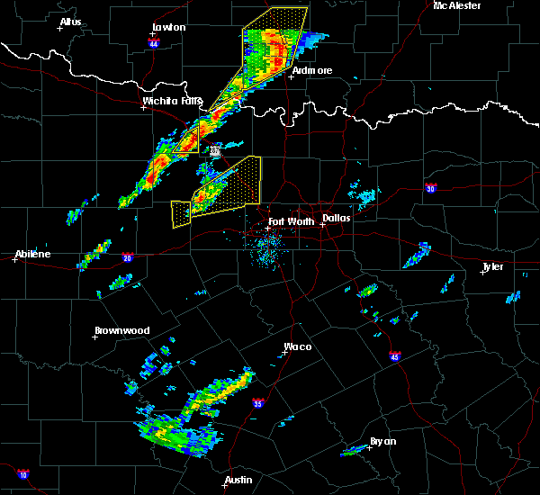 At 155 pm cst, a severe thunderstorm was located 7 miles west of poolville, or 14 miles northeast of mineral wells, moving northeast at 50 mph (radar indicated). Hazards include 60 mph wind gusts and quarter size hail. Hail damage to vehicles is expected. Expect wind damage to roofs, siding and trees. At 155 pm cst, a severe thunderstorm was located 7 miles west of poolville, or 14 miles northeast of mineral wells, moving northeast at 50 mph (radar indicated). Hazards include 60 mph wind gusts and quarter size hail. Hail damage to vehicles is expected. Expect wind damage to roofs, siding and trees.
|
| 11/5/2015 1:40 PM CST |
 At 139 pm cst, a severe thunderstorm was located near graford, or 8 miles northwest of mineral wells, moving northeast at 45 mph (radar indicated). Hazards include 60 mph wind gusts and quarter size hail. Hail damage to vehicles is possible. locations impacted include, mineral wells. A tornado watch remains in effect until 800 pm cst for north central texas. At 139 pm cst, a severe thunderstorm was located near graford, or 8 miles northwest of mineral wells, moving northeast at 45 mph (radar indicated). Hazards include 60 mph wind gusts and quarter size hail. Hail damage to vehicles is possible. locations impacted include, mineral wells. A tornado watch remains in effect until 800 pm cst for north central texas.
|
| 11/5/2015 1:24 PM CST |
 At 123 pm cst, a severe thunderstorm was located near graford, or 12 miles west of mineral wells, moving northeast at 50 mph (radar indicated). Hazards include 60 mph wind gusts and quarter size hail. Hail damage to vehicles is expected. Expect wind damage to roofs, siding and trees. At 123 pm cst, a severe thunderstorm was located near graford, or 12 miles west of mineral wells, moving northeast at 50 mph (radar indicated). Hazards include 60 mph wind gusts and quarter size hail. Hail damage to vehicles is expected. Expect wind damage to roofs, siding and trees.
|
| 8/25/2015 5:14 PM CDT |
 At 513 pm cdt, a severe thunderstorm was located near mineral wells, moving southwest at 15 mph. a 54 mph wind gust was measured at mineral wells airport earlier (radar indicated). Hazards include 60 mph wind gusts and nickel size hail. Expect damage to roofs. siding and trees. this severe thunderstorm will be near, gordon around 600 pm cdt. other locations impacted by this severe thunderstorm include mingus, millsap and strawn. This includes interstate 20 between mile markers 370 and 406. At 513 pm cdt, a severe thunderstorm was located near mineral wells, moving southwest at 15 mph. a 54 mph wind gust was measured at mineral wells airport earlier (radar indicated). Hazards include 60 mph wind gusts and nickel size hail. Expect damage to roofs. siding and trees. this severe thunderstorm will be near, gordon around 600 pm cdt. other locations impacted by this severe thunderstorm include mingus, millsap and strawn. This includes interstate 20 between mile markers 370 and 406.
|
| 8/25/2015 5:01 PM CDT |
 At 501 pm cdt, a severe thunderstorm was located over mineral wells, moving south at 25 mph. a wind gust to 54 mph was reported at mineral wells airport (radar indicated). Hazards include 60 mph wind gusts and quarter size hail. Hail damage to vehicles is expected. expect wind damage to roofs, siding and trees. This severe thunderstorm will remain over mainly rural areas of northwestern parker and central palo pinto counties. At 501 pm cdt, a severe thunderstorm was located over mineral wells, moving south at 25 mph. a wind gust to 54 mph was reported at mineral wells airport (radar indicated). Hazards include 60 mph wind gusts and quarter size hail. Hail damage to vehicles is expected. expect wind damage to roofs, siding and trees. This severe thunderstorm will remain over mainly rural areas of northwestern parker and central palo pinto counties.
|
| 8/25/2015 4:36 PM CDT |
 At 436 pm cdt, a severe thunderstorm was located 7 miles northeast of graford, or 12 miles north of mineral wells, moving southwest at 25 mph (radar indicated). Hazards include 60 mph wind gusts and quarter size hail. Hail damage to vehicles is expected. expect wind damage to roofs, siding and trees. This severe thunderstorm will be near, graford around 450 pm cdt. At 436 pm cdt, a severe thunderstorm was located 7 miles northeast of graford, or 12 miles north of mineral wells, moving southwest at 25 mph (radar indicated). Hazards include 60 mph wind gusts and quarter size hail. Hail damage to vehicles is expected. expect wind damage to roofs, siding and trees. This severe thunderstorm will be near, graford around 450 pm cdt.
|
| 5/28/2015 8:12 PM CDT | The severe thunderstorm warning for parker, wise, northeastern palo pinto and eastern jack counties will expire at 815 pm cdt, the storms which prompted the warning have weakened below severe limits, and no longer pose an immediate threat to life or property. therefore the warning will be allowed to expire. however small. |
| 5/28/2015 7:56 PM CDT | At 756 pm cdt, severe thunderstorms were located along a line extending from near sunset to near cottondale to 6 miles south of cool, moving east at 15 mph (radar indicated). Hazards include 60 mph wind gusts and quarter size hail. Hail damage to vehicles is expected. expect wind damage to roofs, siding and trees. locations impacted include, weatherford, mineral wells, azle, decatur, bridgeport, jacksboro, briar, pecan acres, willow park, reno, aledo, springtown, hudson oaks, alvord, annetta, new fairview, aurora, boyd, chico and graford. this includes the following interstates, interstate 20 between mile markers 397 and 422. Interstate 30 near mile marker 1. |
| 5/28/2015 7:21 PM CDT | At 720 pm cdt, severe thunderstorms were located along a line extending from near newport to 7 miles northwest of boonsville to 12 miles southwest of graford, moving east at 45 mph (radar indicated). Hazards include 70 mph wind gusts and quarter size hail. Hail damage to vehicles is expected. expect considerable tree damage. Wind damage is also likely to mobile homes, roofs and outbuildings. |
| 5/28/2015 7:11 PM CDT | At 710 pm cdt, severe thunderstorms were located along a line extending from 11 miles west of newport to 6 miles southeast of jacksboro to near graford to 7 miles northeast of ranger, moving northeast at 30 mph (radar indicated). Hazards include 70 mph wind gusts and quarter size hail. Hail damage to vehicles is expected. expect considerable tree damage. wind damage is also likely to mobile homes, roofs and outbuildings. locations impacted include, mineral wells, graham, breckenridge, jacksboro, graford, bryson, gordon, necessity, gunsight, possum kingdom state park, newport, strawn and mingus. This includes interstate 20 between mile markers 369 and 389. |
| 5/28/2015 6:49 PM CDT | At 648 pm cdt, severe thunderstorms were located along a line extending from 13 miles northwest of jacksboro to 9 miles northeast of ranger, moving southeast at 35 mph. the strongest part of this line was located in young county moving into jack county (radar indicated). Hazards include 70 mph wind gusts and half dollar size hail. Hail damage to vehicles is expected. expect considerable tree damage. wind damage is also likely to mobile homes, roofs and outbuildings. locations impacted include, mineral wells, graham, breckenridge, jacksboro, olney, graford, bryson, gordon, necessity, gunsight, crystal falls, possum kingdom state park, newport, strawn, newcastle, mingus and us-180 near the shackelford-stephens county line. This includes interstate 20 between mile markers 369 and 389. |
| 5/28/2015 6:27 PM CDT | At 627 pm cdt, severe thunderstorms were located along a line extending from near olney to near crystal falls, moving east at 35 mph (radar indicated). Hazards include 70 mph wind gusts and nickel size hail. Expect considerable tree damage. Damage is likely to mobile homes, roofs and outbuildings. |
| 5/26/2015 6:36 PM CDT | At 635 pm cdt, severe thunderstorms were located along a line extending from near necessity to 8 miles northeast of gordon, moving southeast at 20 mph (radar indicated and spotter confirmed). Hazards include tennis ball size hail and 60 mph wind gusts. People and animals outdoors will be injured. expect hail damage to roofs, siding, windows and vehicles. expect wind damage to roofs, siding and trees. locations impacted include, gordon, necessity, strawn, palo pinto creek reservoir and mingus. this includes interstate 20 between mile markers 370 and 389. A tornado watch remains in effect until 1000 pm cdt for north central texas. |
| 5/26/2015 6:07 PM CDT | At 604 pm cdt, severe thunderstorms were located along a line extending from 5 miles east of breckenridge to the city of palo pinto, moving southeast at 30 mph (radar indicated). Hazards include golf ball size hail and 60 mph wind gusts. People and animals outdoors will be injured. expect hail damage to roofs, siding, windows and vehicles. Expect wind damage to roofs, siding and trees. |
| 5/25/2015 1:23 PM CDT | At 122 pm cdt, severe thunderstorms were located along a line extending from near poolville to 8 miles northeast of lipan, moving east at 40 mph (radar indicated). Hazards include 70 mph wind gusts and penny size hail. Expect considerable tree damage. damage is likely to mobile homes, roofs and outbuildings. locations impacted include, weatherford, mineral wells, azle, briar, willow park, reno, aledo, springtown, hudson oaks, annetta, cool, poolville, mineral wells state park, annetta south, annetta north, millsap and sanctuary. this includes the following interstates, interstate 20 between mile markers 390 and 422. interstate 30 near mile marker 1. A tornado watch remains in effect until 600 pm cdt for north central texas. |
| 5/25/2015 12:46 PM CDT | At 1246 pm cdt, severe thunderstorms were located along a line extending from near graford to 9 miles northeast of gordon, moving east at 45 mph (radar indicated). Hazards include 70 mph wind gusts and penny size hail. Expect considerable tree damage. Damage is likely to mobile homes, roofs and outbuildings. |
| 5/19/2015 7:57 PM CDT | At 756 pm cdt, a severe thunderstorm with a history of producing a tornado was located near mineral wells state park, or 8 miles northeast of mineral wells, moving northeast at 30 mph (radar indicated rotation). Hazards include tornado and hail up to two inches in diameter. Flying debris will be dangerous to those caught without shelter. mobile homes will be damaged or destroyed. damage to roofs, windows and vehicles will occur. tree damage is likely. this dangerous storm will be near, poolville around 815 pm cdt. boonsville around 825 pm cdt. Other locations impacted by this tornadic thunderstorm include runaway bay. |
| 5/19/2015 7:48 PM CDT | At 747 pm cdt, a confirmed tornado was located near mineral wells , moving northeast at 30 mph (law enforcement confirmed tornado). Hazards include damaging tornado and two inch hail. Flying debris will be dangerous to those caught without shelter. mobile homes will be damaged or destroyed. damage to roofs, windows and vehicles will occur. tree damage is likely. This tornado will be near, poolville around 800 pm cdt. |
| 5/19/2015 7:37 PM CDT | At 736 pm cdt, a severe thunderstorm capable of producing a tornado was located over mineral wells state park, or over mineral wells, moving east at 35 mph (law enforcement reported). Hazards include tornado. Flying debris will be dangerous to those caught without shelter. mobile homes will be damaged or destroyed. damage to roofs, windows and vehicles will occur. tree damage is likely. This dangerous storm will be near, poolville around 800 pm cdt. |
| 5/19/2015 7:29 PM CDT | At 728 pm cdt, a confirmed tornado was located over mineral wells, moving northeast at 20 mph (emergency management confirmed tornado). Hazards include tornado and two inch hail. Flying debris will be dangerous to those caught without shelter. mobile homes will be damaged or destroyed. damage to roofs, windows and vehicles will occur. tree damage is likely. This tornadic thunderstorm will remain over mainly rural areas of northeastern palo pinto county. |
| 5/19/2015 7:29 PM CDT | At 729 pm cdt, a severe thunderstorm was located over cool, or over mineral wells, moving east at 35 mph (radar indicated). Hazards include two inch hail and 60 mph wind gusts. People and animals outdoors will be injured. expect hail damage to roofs, siding, windows and vehicles. Expect wind damage to roofs, siding and trees. |
| 5/19/2015 7:26 PM CDT | At 726 pm cdt, a confirmed tornado was located on highway 180, west of mineral wells, moving northeast at 15 mph (emergency management confirmed tornado). Hazards include tornado. Flying debris will be dangerous to those caught without shelter. mobile homes will be damaged or destroyed. damage to roofs, windows and vehicles will occur. tree damage is likely. This tornado will be near, mineral wells around 745 pm cdt. |
| 5/19/2015 7:18 PM CDT | Golf Ball sized hail reported 1.5 miles ENE of Mineral Wells, TX, golfball hail on ne side of mineral wells |
| 5/19/2015 7:16 PM CDT | At 716 pm cdt, a severe thunderstorm was located near mineral wells, moving northeast at 20 mph (radar indicated). Hazards include ping pong ball size hail and 60 mph wind gusts. People and animals outdoors will be injured. expect hail damage to roofs, siding, windows and vehicles. expect wind damage to roofs, siding and trees. locations impacted include, mineral wells. precautionary/preparedness actions, for your protection move to an interior room on the lowest floor of a building. a tornado warning remains in effect until 745 pm for northeastern palo pinto county. A tornado watch remains in effect until 1000 pm cdt for north central texas. |
| 5/19/2015 7:11 PM CDT | The national weather service in fort worth has issued a * tornado warning for. northeastern palo pinto county in north central texas. until 745 pm cdt * at 710 pm cdt. a severe thunderstorm capable of producing a tornado was located 7 miles southwest of mineral wells. Moving. |
| 5/19/2015 7:01 PM CDT | At 701 pm cdt, a severe thunderstorm was located 8 miles north of mineral wells state park, or 10 miles north of mineral wells, moving northeast at 25 mph (radar indicated). Hazards include ping pong ball size hail and 60 mph wind gusts. People and animals outdoors will be injured. expect hail damage to roofs, siding, windows and vehicles. Expect wind damage to roofs, siding and trees. |
| 5/19/2015 6:48 PM CDT | At 647 pm cdt, a severe thunderstorm was located 12 miles southwest of mineral wells, moving northeast at 30 mph. a tornado warning still remains in effect for northeastern portions of palo pinto county (radar indicated). Hazards include ping pong ball size hail and 60 mph wind gusts. People and animals outdoors will be injured. expect hail damage to roofs, siding, windows and vehicles. Expect wind damage to roofs, siding and trees. |
| 5/19/2015 6:43 PM CDT | At 643 pm cdt, a severe thunderstorm capable of producing a tornado was located near graford, or 8 miles northwest of mineral wells, moving northeast at 20 mph (radar indicated rotation). Hazards include tornado and baseball size hail. Flying debris will be dangerous to those caught without shelter. mobile homes will be damaged or destroyed. damage to roofs, windows and vehicles will occur. tree damage is likely. This tornadic thunderstorm will remain over mainly rural areas of northeastern palo pinto county. |
| 5/19/2015 6:26 PM CDT | At 625 pm cdt, a confirmed tornado was located 8 miles south of graford, or 10 miles west of mineral wells, moving northeast at 20 mph (public confirmed tornado). Hazards include damaging tornado and baseball size hail. Flying debris will be dangerous to those caught without shelter. mobile homes will be damaged or destroyed. damage to roofs, windows and vehicles will occur. tree damage is likely. The tornado will be near, graford around 645 pm cdt. |
| 5/19/2015 6:24 PM CDT | At 622 pm cdt, a confirmed tornado was located just to the southeast of the city of palo pinto, moving northeast at 20 mph (weather spotters confirmed tornado). Hazards include damaging tornado and golf ball size hail. Flying debris will be dangerous to those caught without shelter. mobile homes will be damaged or destroyed. damage to roofs, windows and vehicles will occur. tree damage is likely. Locations impacted include, mineral wells. |
| 5/19/2015 6:15 PM CDT | At 614 pm cdt, a severe thunderstorm capable of producing a tornado was located near palo pinto, moving northeast at 20 mph (radar indicated rotation). Hazards include tornado and golf ball size hail. Flying debris will be dangerous to those caught without shelter. mobile homes will be damaged or destroyed. damage to roofs, windows and vehicles will occur. tree damage is likely. Locations impacted include, palo pinto and mineral wells. |
| 5/19/2015 6:12 PM CDT | At 614 pm cdt, a severe thunderstorm capable of producing a tornado was located near palo pinto, moving northeast at 20 mph (radar indicated rotation). Hazards include tornado and golf ball size hail. Flying debris will be dangerous to those caught without shelter. mobile homes will be damaged or destroyed. damage to roofs, windows and vehicles will occur. tree damage is likely. Locations impacted include, palo pinto and mineral wells. |
| 5/19/2015 5:59 PM CDT | At 559 pm cdt, a severe thunderstorm capable of producing a tornado was located 11 miles north of gordon, or 17 miles southwest of mineral wells, moving east at 15 mph (radar indicated rotation). Hazards include tornado and golf ball size hail. Flying debris will be dangerous to those caught without shelter. mobile homes will be damaged or destroyed. damage to roofs, windows and vehicles will occur. tree damage is likely. This tornadic thunderstorm will remain over mainly rural areas of southeastern palo pinto county. |
| 5/19/2015 5:50 PM CDT | At 550 pm cdt, a severe thunderstorm was located 11 miles north of gordon, or 17 miles southwest of mineral wells, moving northeast at 25 mph (radar indicated). Hazards include golf ball size hail and 60 mph wind gusts. People and animals outdoors will be injured. expect hail damage to roofs, siding, windows and vehicles. expect wind damage to roofs, siding and trees. locations impacted include, mineral wells. This includes interstate 20 between mile markers 378 and 379, and between mile markers 384 and 389. |
| 5/19/2015 5:40 PM CDT | The national weather service in fort worth has issued a * severe thunderstorm warning for. central palo pinto county in north central texas. until 630 pm cdt * at 539 pm cdt. a severe thunderstorm was located 8 miles north of gordon. or 19 miles southwest of mineral wells. Moving northeast. |
| 5/16/2015 11:52 PM CDT | At 1150 pm cdt, severe thunderstorms were located along a line extending from 8 miles north of mineral wells state park to 7 miles southwest of poolville to near weatherford to 7 miles northeast of lipan, moving east at 60 mph (radar indicated). Hazards include 60 mph wind gusts. Expect damage to roofs. siding and trees. locations impacted include, weatherford, mineral wells, azle, briar, willow park, reno, aledo, springtown, hudson oaks, annetta, graford, gordon, cool, poolville, mineral wells state park, annetta south, annetta north, millsap and sanctuary. this includes the following interstates, interstate 20 between mile markers 368 and 422. interstate 30 near mile marker 1. Possible. |
| 5/16/2015 11:51 PM CDT | Roof damage to a house on fm1195 off 281 in palo pinto county TX, 2.9 miles NNE of Mineral Wells, TX |
| 5/16/2015 11:42 PM CDT | Part of the roof of a frame house removed. trailer home pushed off pinnings abt 2 ft. metal poles ripped outof groun in parker county TX, 3.6 miles N of Mineral Wells, TX |
| 5/16/2015 11:40 PM CDT | Powerlines down around mineral wells in palo pinto county TX, 2.4 miles NE of Mineral Wells, TX |
| 5/16/2015 11:40 PM CDT | Roof damage to a house on fm1195 off hwy 281 in palo pinto county TX, 2.9 miles NNE of Mineral Wells, TX |
| 5/16/2015 11:31 PM CDT | At 1130 pm cdt, severe thunderstorms were located along a line extending from near graford to 11 miles south of mineral wells to 8 miles north of morgan mill, moving east at 50 mph (radar indicated). Hazards include 60 mph wind gusts. Expect damage to roofs. Siding and trees. |
| 5/10/2015 5:45 AM CDT | At 545 am cdt, severe thunderstorms were located along a line extending from 10 miles northwest of weatherford to 5 miles south of annetta to glen rose, moving east at 45 mph (radar indicated). Hazards include 60 mph wind gusts. Expect damage to roofs. siding and trees. locations impacted include, weatherford, mineral wells, azle, granbury, briar, pecan plantation, willow park, reno, aledo, springtown, glen rose, hudson oaks, annetta, lipan, cool, oak trail shores, poolville, dinosaur valley state park, mineral wells state park and tolar. 75in. |
| 5/10/2015 5:39 AM CDT | The severe thunderstorm warning for erath and palo pinto counties will expire at 545 am cdt, the storms which prompted the warning have moved out of the area. therefore the warning will be allowed to expire. a severe thunderstorm watch remains in effect until 900 am cdt for north central texas. |
| 5/10/2015 5:15 AM CDT | At 515 am cdt, severe thunderstorms were located along a line extending from 10 miles southwest of mineral wells to near lipan to 10 miles north of hico, moving east at 45 mph (radar indicated). Hazards include 60 mph wind gusts. Expect damage to roofs. Siding and trees. |
| 5/10/2015 4:52 AM CDT | At 452 am cdt, severe thunderstorms were located along a line extending from 10 miles northwest of gordon to huckabay to dublin, moving northeast at 45 mph (radar indicated). Hazards include 60 mph wind gusts. Expect damage to roofs. siding and trees. locations impacted include, stephenville, mineral wells, dublin, graford, gordon, huckabay, morgan mill, possum kingdom state park, strawn and mingus. this includes interstate 20 between mile markers 364 and 389. 75in. |
| 5/10/2015 4:32 AM CDT | At 431 am cdt, severe thunderstorms were located along a line extending from near ranger to de leon to near comanche, moving northeast at 45 mph (radar indicated). Hazards include 60 mph wind gusts. Expect damage to roofs. Siding and trees. |
| 5/9/2015 12:35 AM CDT | At 1234 am cdt, a severe thunderstorm was located 10 miles northwest of gordon, or 20 miles northeast of ranger, moving east at 20 mph (radar indicated). Hazards include quarter size hail. Minor damage to vehicles is expected. locations impacted include, gordon, strawn and mingus. this includes interstate 20 between mile markers 368 and 383. a tornado watch remains in effect until 300 am cdt for north central texas. 1. 00in. |
| 5/9/2015 12:14 AM CDT | At 1213 am cdt, a severe thunderstorm was located 10 miles east of necessity, or 15 miles northeast of ranger, moving east at 25 mph (radar indicated). Hazards include 60 mph wind gusts and quarter size hail. Hail damage to vehicles is expected. Expect wind damage to roofs, siding and trees. |
| 5/8/2015 7:48 PM CDT | At 747 pm cdt, severe thunderstorms were located along a line extending from graham to 14 miles northwest of possum kingdom state park to near crystal falls to 8 miles southeast of fort griffin, moving east at 20 mph (radar indicated). Hazards include golf ball size hail and 70 mph wind gusts. People and animals outdoors will be injured. expect hail damage to roofs, siding, windows and vehicles. expect considerable tree damage. Wind damage is also likely to mobile homes, roofs and outbuildings. |
| 5/7/2015 8:07 PM CDT | At 806 pm cdt, severe thunderstorms were located along a line extending from near jacksboro to near graford to 10 miles northwest of gordon, moving east at 45 mph (radar indicated). Hazards include 70 mph wind gusts and quarter size hail. Hail damage to vehicles is expected. expect considerable tree damage. Wind damage is also likely to mobile homes, roofs and outbuildings. |
| 5/7/2015 7:45 PM CDT | At 744 pm cdt, severe thunderstorms were located along a line extending from 6 miles southwest of bryson to near possum kingdom state park to near necessity, moving east at 25 mph (radar indicated). Hazards include 70 mph wind gusts and penny size hail. Expect considerable tree damage. Damage is likely to mobile homes, roofs and outbuildings. |
| 4/26/2015 8:57 PM CDT | At 857 pm cdt, a severe thunderstorm was located 8 miles southwest of gordon, or 13 miles east of ranger, moving east at 25 mph (radar indicated). Hazards include golf ball size hail and 60 mph wind gusts. People and animals outdoors will be injured. expect hail damage to roofs, siding, windows and vehicles. Expect wind damage to roofs, siding and trees. |
| 4/26/2015 8:46 PM CDT | At 846 pm cdt, a severe thunderstorm was located near lipan, or 15 miles south of mineral wells, moving east at 25 mph (radar indicated). Hazards include tennis ball size hail and 60 mph wind gusts. People and animals outdoors will be injured. expect hail damage to roofs, siding, windows and vehicles. expect wind damage to roofs, siding and trees. locations impacted include, mineral wells, gordon, strawn and mingus. this includes interstate 20 between mile markers 364 and 389. a tornado watch remains in effect until 1100 pm cdt for north central texas. 2. 50in. |
| 4/26/2015 7:57 PM CDT | At 756 pm cdt, a severe thunderstorm was located 8 miles southwest of gordon, or 11 miles east of ranger, moving northeast at 30 mph. this is a dangerous storm (radar indicated). Hazards include baseball size hail and 60 mph wind gusts. People and animals outdoors will be severely injured. Expect shattered windows, extensive damage to roofs, siding and vehicles. |
| 4/26/2015 7:27 PM CDT | At 727 pm cdt, a severe thunderstorm was located 7 miles south of mineral wells, moving northeast at 60 mph (radar indicated). Hazards include quarter size hail. Damage to vehicles is expected. locations impacted include, mineral wells, briar, reno, springtown, cool, poolville, mineral wells state park and millsap. a tornado watch remains in effect until 1100 pm cdt for north central texas. 1. 00in. |
| 4/26/2015 7:09 PM CDT | At 709 pm cdt, a severe thunderstorm was located over gordon, or 21 miles east of ranger, moving northeast at 60 mph (radar indicated). Hazards include 60 mph wind gusts and quarter size hail. Hail damage to vehicles is expected. Expect wind damage to roofs, siding and trees. |
| 4/26/2015 6:55 PM CDT | At 654 pm cdt, a severe thunderstorm was located near crystal falls, or 12 miles north of breckenridge, moving east at 50 mph (radar indicated). Hazards include 60 mph wind gusts and quarter size hail. Hail damage to vehicles is expected. Expect wind damage to roofs, siding and trees. |
| 4/26/2015 5:48 PM CDT | At 547 pm cdt, a severe thunderstorm was located 11 miles east of necessity, or 16 miles northeast of ranger, moving northeast at 60 mph (radar indicated). Hazards include 60 mph wind gusts and quarter size hail. Hail damage to vehicles is expected. expect wind damage to roofs, siding and trees. locations impacted include, graford, necessity and possum kingdom state park. a tornado watch remains in effect until 800 pm cdt for north central texas. a tornado watch also remains in effect until 1100 pm cdt for north central texas. 1. 00in. |
| 4/26/2015 5:38 PM CDT | At 538 pm cdt, a severe thunderstorm was located near ranger, moving northeast at 50 mph (radar indicated). Hazards include 60 mph wind gusts and quarter size hail. Hail damage to vehicles is expected. Expect wind damage to roofs, siding and trees. |
| 4/18/2015 6:58 PM CDT | At 657 pm cdt, severe thunderstorms were located along a line extending from 7 miles south of poolville to 8 miles south of annetta, moving east at 55 mph (radar indicated). Hazards include 70 mph wind gusts and half dollar size hail. the strongest winds will affect the area south of i-20. Hail damage to vehicles is expected. expect considerable tree damage. wind damage is also likely to mobile homes, roofs and outbuildings. locations impacted include, weatherford, mineral wells, azle, briar, willow park, reno, aledo, springtown, hudson oaks, annetta, cool, poolville, mineral wells state park, annetta south, annetta north, millsap and sanctuary. Possible. |
| 4/18/2015 6:41 PM CDT | At 641 pm cdt, severe thunderstorms were located along a line extending from 6 miles southwest of springtown to near lipan, moving east at 35 mph (radar indicated). Hazards include 60 mph wind gusts and half dollar size hail. Hail damage to vehicles is expected. Expect wind damage to roofs, siding and trees. |
| 4/18/2015 6:13 PM CDT | At 612 pm cdt, a severe thunderstorm was located near mineral wells, moving east at 10 mph (trained weather spotters. at 550 pm golf ball sized hail was reported along hwy 180 through palo pinto). Hazards include golf ball size hail and 60 mph wind gusts. People and animals outdoors will be injured. expect hail damage to roofs, siding, windows and vehicles. expect wind damage to roofs, siding and trees. this severe storm will be near, mineral wells, cool and mineral wells state park around 645 pm cdt. other locations impacted by this severe thunderstorm include millsap. this includes interstate 20 between mile markers 385 and 408. 1. 75in. |
| 4/18/2015 5:43 PM CDT | At 542 pm cdt, a severe thunderstorm was located 11 miles west of mineral wells, moving east at 25 mph (radar indicated). Hazards include golf ball size hail and 60 mph wind gusts. People and animals outdoors will be injured. expect hail damage to roofs, siding, windows and vehicles. expect wind damage to roofs, siding and trees. this severe thunderstorm will be near, cool and mineral wells around 610 pm cdt. other locations impacted by this severe thunderstorm include millsap. 1. 75in. |
| 4/18/2015 5:30 PM CDT | At 529 pm cdt, a severe thunderstorm was located 7 miles south of graford, or 10 miles west of mineral wells, moving east at 20 mph (radar indicated). Hazards include golf ball size hail and 60 mph wind gusts. People and animals outdoors will be injured. expect hail damage to roofs, siding, windows and vehicles. expect wind damage to roofs, siding and trees. this severe thunderstorm will move toward mineral wells by 550 pm. 1. 75in. |
| 4/18/2015 5:05 PM CDT | At 504 pm cdt, a severe thunderstorm was located 10 miles east of possum kingdom state park, or 17 miles west of mineral wells, moving east at 25 mph (radar indicated). Hazards include ping pong ball size hail and 60 mph wind gusts. People and animals outdoors will be injured. expect hail damage to roofs, siding, windows and vehicles. expect wind damage to roofs, siding and trees. locations impacted include, brad and the city of palo pinto. 1. 50in. |
| 4/18/2015 4:48 PM CDT | At 446 pm cdt, a severe thunderstorm was located over possum kingdom state park, or 16 miles south of graham, moving east at 25 mph (radar indicated). Hazards include ping pong ball size hail and 60 mph wind gusts. People and animals outdoors will be injured. expect hail damage to roofs, siding, windows and vehicles. expect wind damage to roofs, siding and trees. this severe thunderstorm will affect possum kingdom lake and the city of palo pinto. 1. 50in. |
| 4/17/2015 4:55 PM CDT | At 454 pm cdt, a severe thunderstorm was located near cool, or 8 miles southeast of mineral wells, moving northeast at 20 mph (radar indicated). Hazards include 60 mph wind gusts and half dollar size hail. Hail damage to vehicles is expected. Expect wind damage to roofs, siding and trees. |
| 4/16/2015 3:52 PM CDT | At 352 pm cdt, a severe thunderstorm was located near mineral wells state park, or near mineral wells, moving east at 25 mph (radar indicated). Hazards include 60 mph wind gusts and quarter size hail. Hail damage to vehicles is expected. Expect wind damage to roofs, siding and trees. |
| 4/16/2015 3:27 PM CDT | At 325 pm cdt, a severe thunderstorm was located near mineral wells, moving northeast at 15 mph (radar indicated). Hazards include 60 mph wind gusts and half dollar size hail. Hail damage to vehicles is expected. expect wind damage to roofs, siding and trees. locations impacted include, mineral wells and graford. Possible. |
| 4/16/2015 3:06 PM CDT | At 305 pm cdt, severe thunderstorms were located along a line extending from near graford to near gordon, moving north at 25 mph (radar indicated). Hazards include 60 mph wind gusts and half dollar size hail. Hail damage to vehicles is expected. Expect wind damage to roofs, siding and trees. |
| 4/1/2015 6:18 PM CST | Quarter sized hail reported 8.3 miles SW of Mineral Wells, TX, 12 nw weatherford |
| 4/1/2015 7:16 PM CDT | A severe thunderstorm warning remains in effect until 730 pm cdt for northern parker county. at 716 pm cdt. a severe thunderstorm was located 8 miles northwest of weatherford. moving northeast at 30 mph. hazard. 60 mph wind gusts and quarter size hail. source. Radar indicated. |
| 4/1/2015 6:54 PM CDT | The national weather service in fort worth has issued a * severe thunderstorm warning for. northwestern parker county in north central texas. until 730 pm cdt * at 653 pm cdt. a severe thunderstorm was located near cool. or 7 miles southeast of mineral wells. Moving northeast at 25 mph. |
| 5/15/2013 6:25 PM CDT | Grapefruit sized hail reported 2.4 miles NE of Mineral Wells, TX, in mineral wells |
| 5/15/2013 6:20 PM CDT | Golf Ball sized hail reported 2.4 miles NE of Mineral Wells, TX, in mineral wells |
| 5/15/2013 6:14 PM CDT | Half Dollar sized hail reported 2.4 miles NE of Mineral Wells, TX, at kmwl |
| 5/15/2013 6:13 PM CDT | Ping Pong Ball sized hail reported 2.4 miles NE of Mineral Wells, TX, at kmwl |
| 3/9/2013 4:40 PM CST | Quarter sized hail reported 2 miles ENE of Mineral Wells, TX |
| 3/9/2013 3:40 PM CST | Quarter sized hail reported 2 miles ENE of Mineral Wells, TX |
| 5/30/2012 10:20 PM CDT | Large trees downed in mineral wells knocked power out to s.e. side of town in palo pinto county TX, 2.4 miles NE of Mineral Wells, TX |
| 5/6/2012 8:48 PM CDT | 60 mph wind gust in whitt in parker county TX, 9.3 miles SSW of Mineral Wells, TX |
| 5/4/2012 7:48 PM CDT | Golf Ball sized hail reported 2.9 miles N of Mineral Wells, TX, palo pinto/parker county line |
| 5/4/2012 7:47 PM CDT | Ping Pong Ball sized hail reported 2.4 miles NE of Mineral Wells, TX, mwl airport |
| 5/4/2012 7:45 PM CDT | Quarter sized hail reported 2.4 miles NE of Mineral Wells, TX, quarter sized hail in mineral wells |
| 5/4/2012 6:29 PM CDT | Quarter sized hail reported 4.9 miles ESE of Mineral Wells, TX, and 50 mph wind. |
| 5/24/2011 5:06 PM CDT | Baseball sized hail reported 2.8 miles NE of Mineral Wells, TX |
| 1/1/0001 12:00 AM | Quarter sized hail reported 2.4 miles NE of Mineral Wells, TX |
| 5/1/2011 8:30 AM CDT | Golf Ball sized hail reported 2.4 miles NE of Mineral Wells, TX, golfball size hail at highway 281 and interstate 20 |
| 1/1/0001 12:00 AM | Quarter sized hail reported 2.4 miles NE of Mineral Wells, TX, quarter hail in mineral wells |
Hail Maps for Mineral Wells, TX

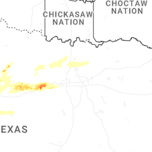
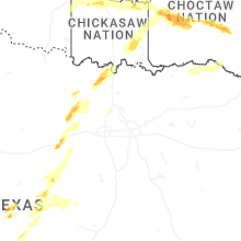
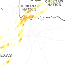
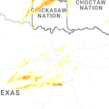


Connect with Interactive Hail Maps