

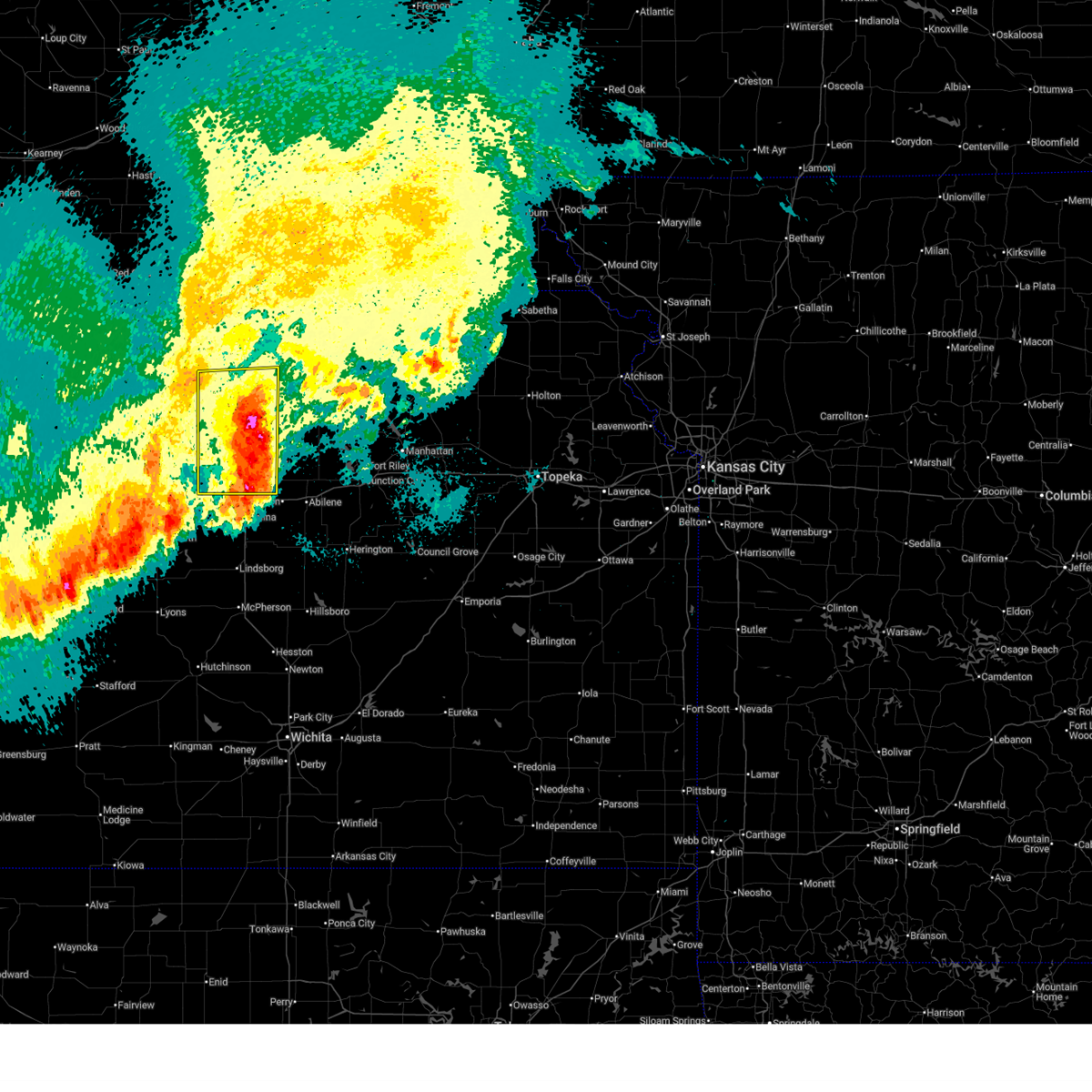
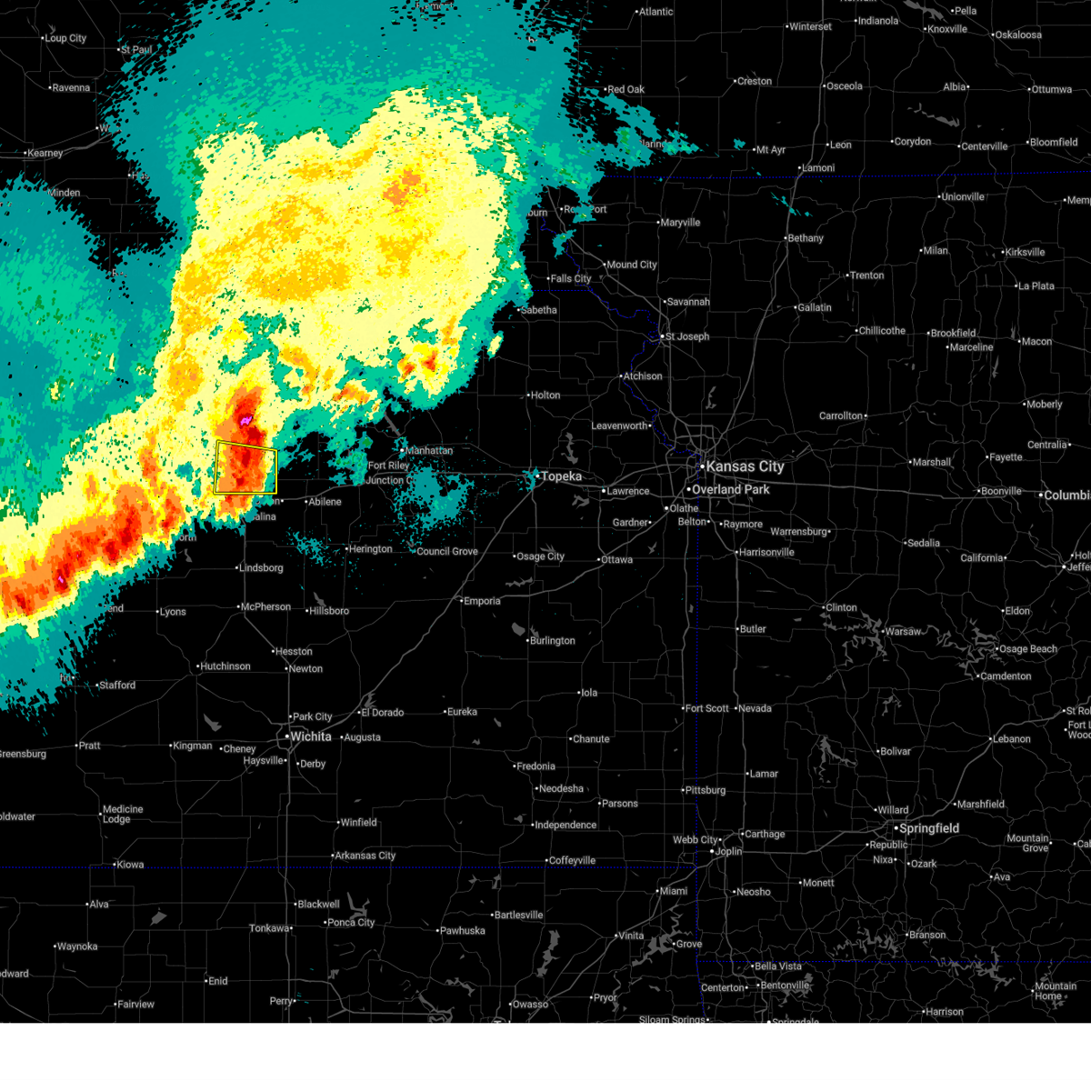
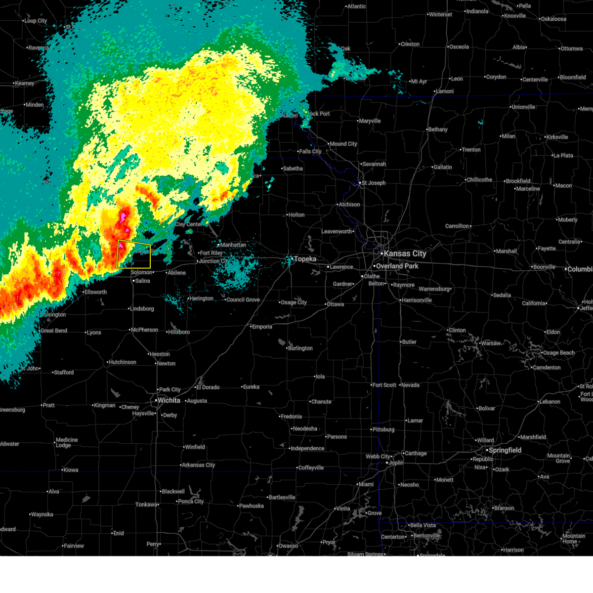
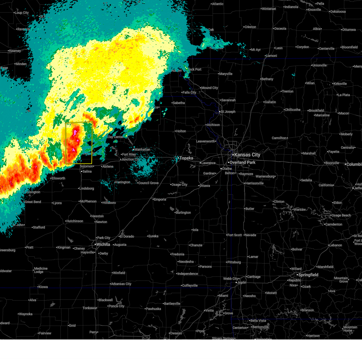
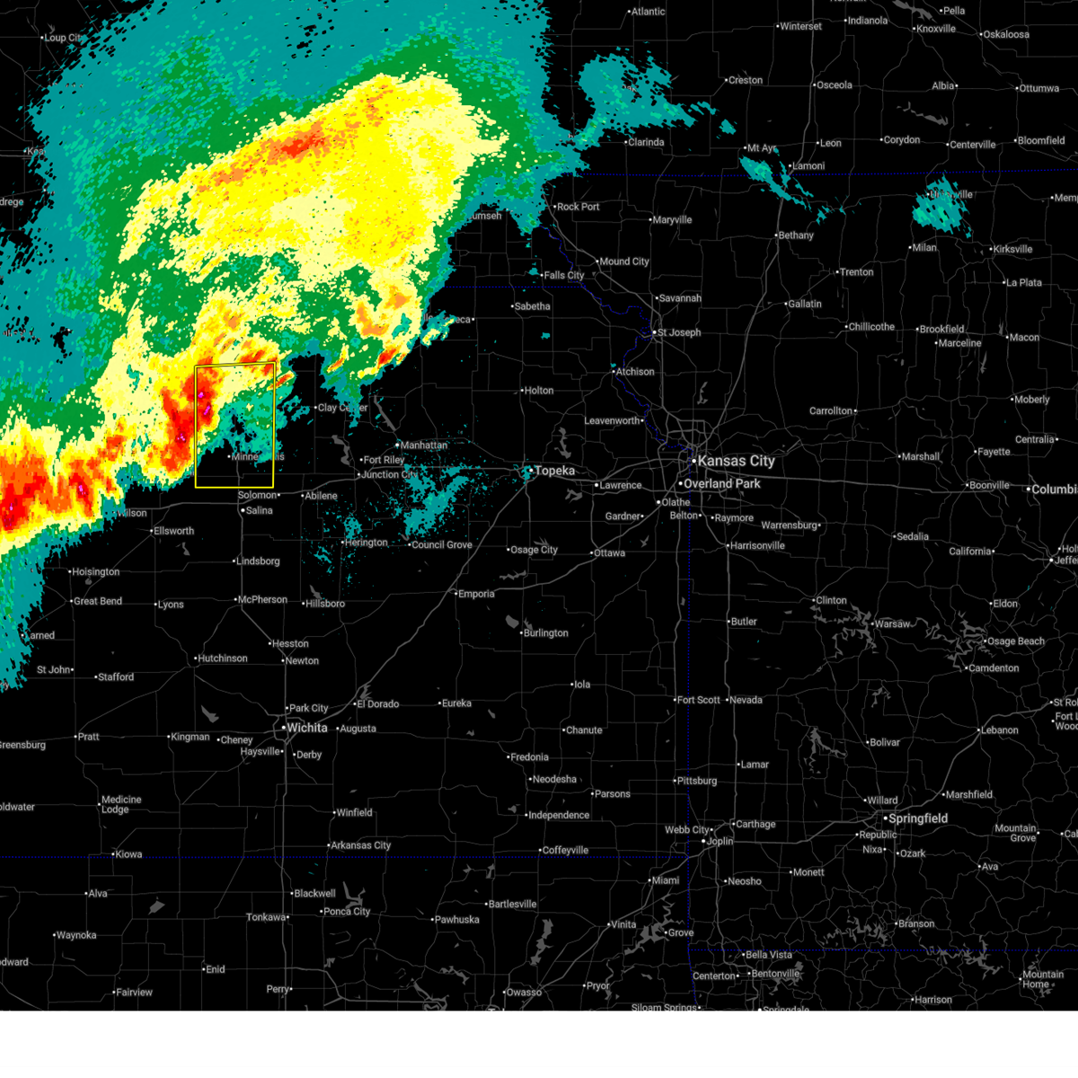
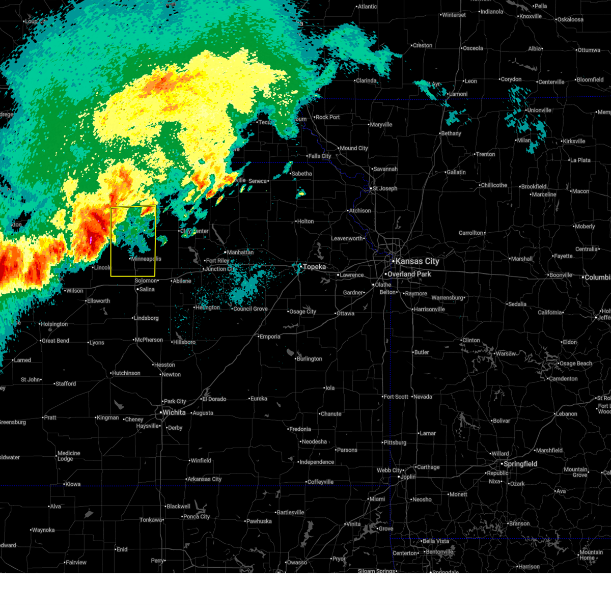
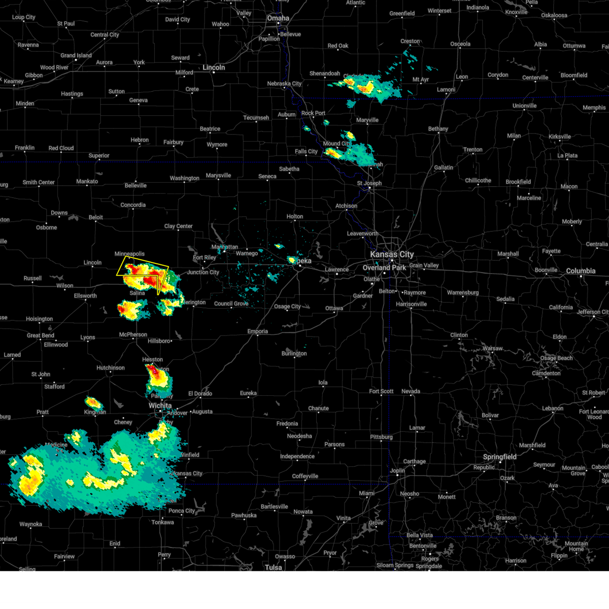
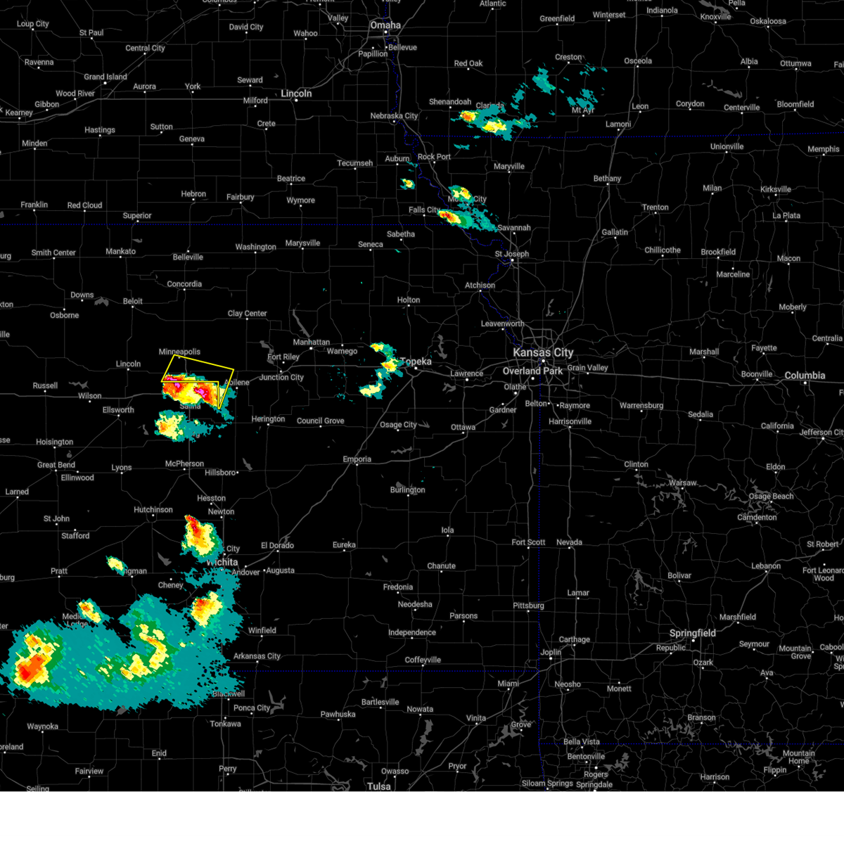
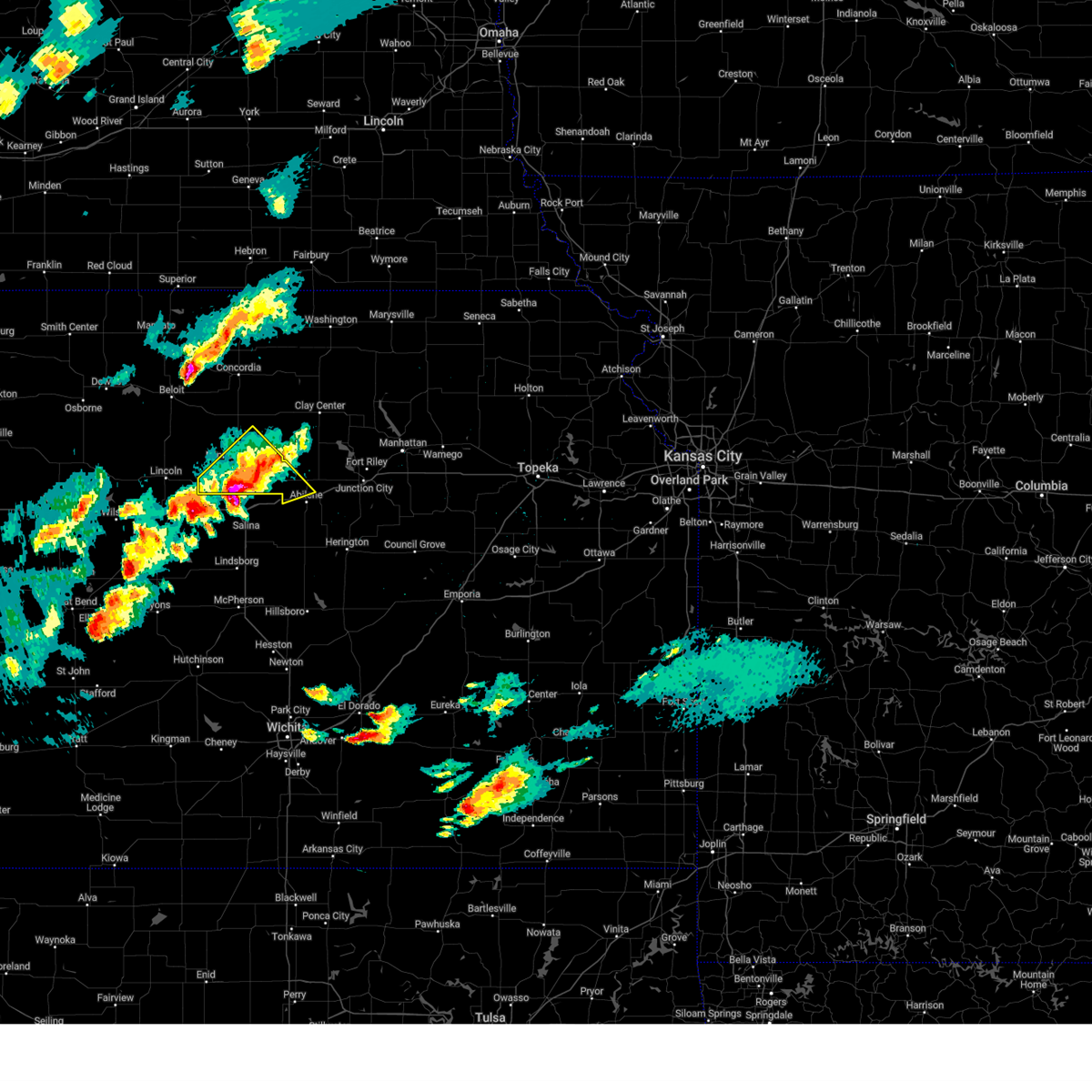
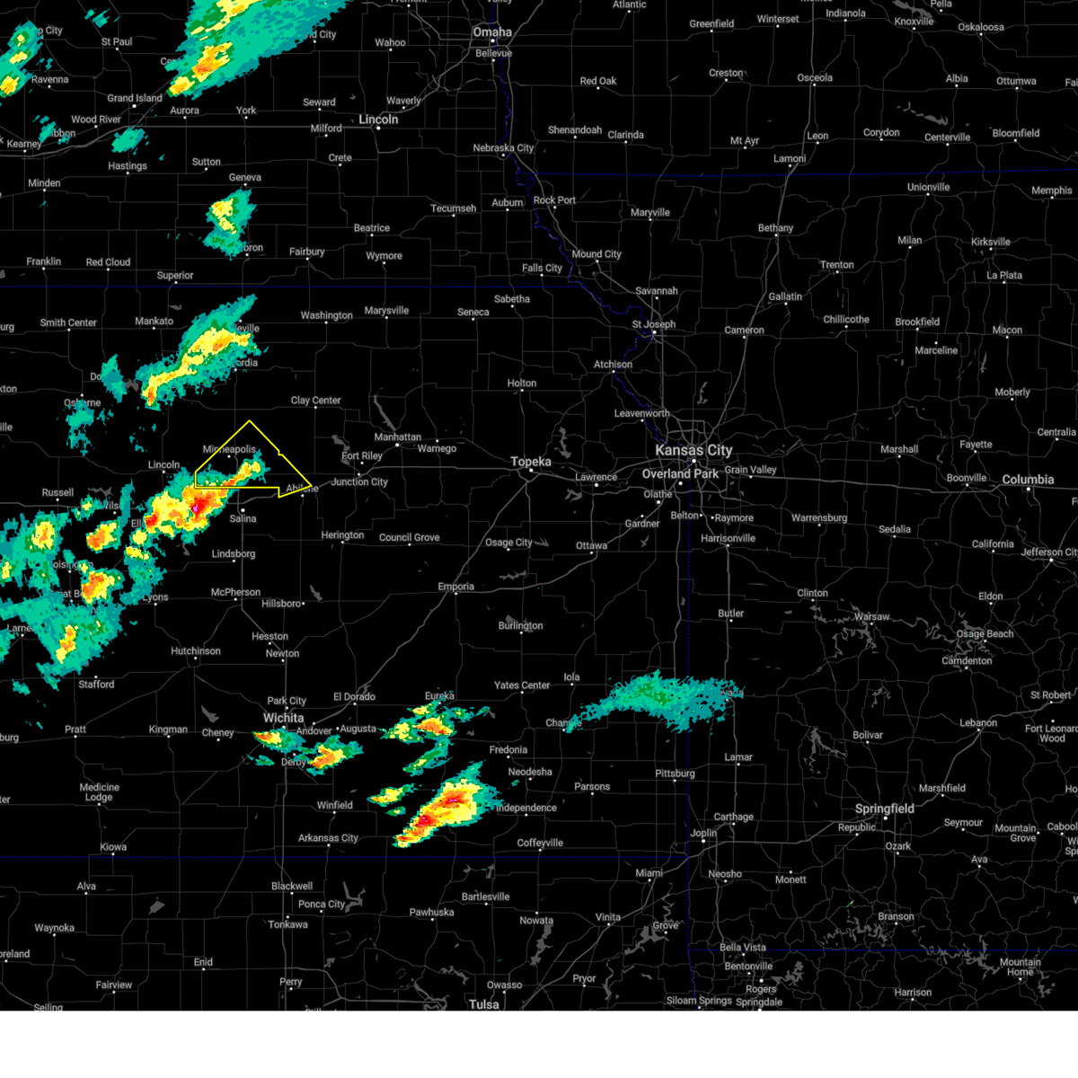
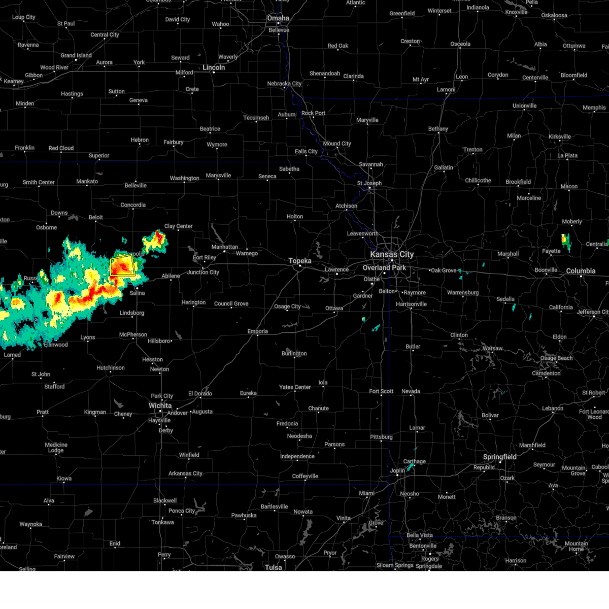
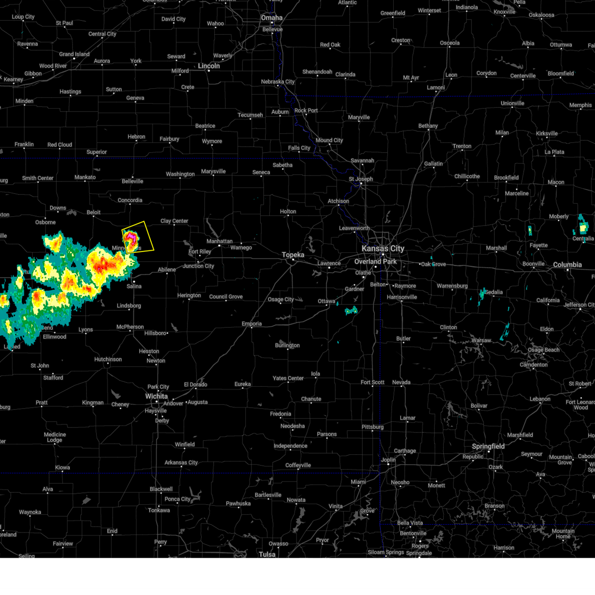
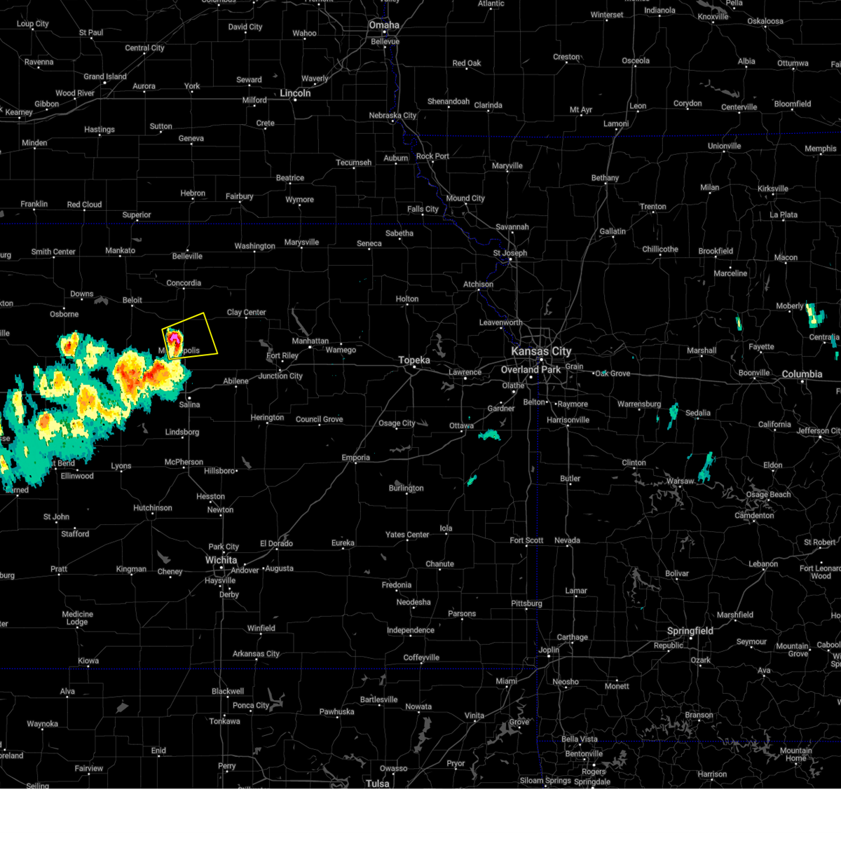
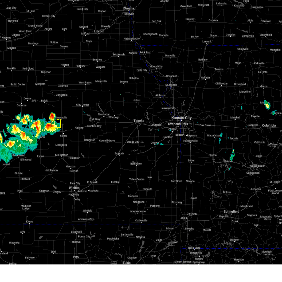
Hail Map for Minneapolis, KS
The Minneapolis, KS area has had 43 reports of on-the-ground hail by trained spotters, and has been under severe weather warnings 24 times during the past 12 months. Doppler radar has detected hail at or near Minneapolis, KS on 104 occasions, including 6 occasions during the past year.
| Name: | Minneapolis, KS |
| Where Located: | 61.5 miles W of Manhattan, KS |
| Map: | Google Map for Minneapolis, KS |
| Population: | 2032 |
| Housing Units: | 919 |
| More Info: | Search Google for Minneapolis, KS |
0
The Top Recent Hail Date for Minneapolis, KS is Tuesday, April 22, 2025 (56th out of 104)

Hail and Wind Damage Spotted near Minneapolis, KS
| Date / Time | Report Details |
|---|---|
| 6/17/2025 2:24 AM CDT |
 The storms which prompted the warning have moved out of the area. therefore, the warning will be allowed to expire. a severe thunderstorm watch remains in effect until 700 am cdt for north central kansas. remember, a severe thunderstorm warning still remains in effect for eastern areas of ottawa and cloud counties. The storms which prompted the warning have moved out of the area. therefore, the warning will be allowed to expire. a severe thunderstorm watch remains in effect until 700 am cdt for north central kansas. remember, a severe thunderstorm warning still remains in effect for eastern areas of ottawa and cloud counties.
|
| 6/17/2025 2:21 AM CDT | Personal weather statio in ottawa county KS, 5.7 miles W of Minneapolis, KS |
| 6/17/2025 2:19 AM CDT |
 At 219 am cdt, a severe thunderstorm was located near wells, or 11 miles east of minneapolis, moving east at 25 mph. this is a destructive storm (radar indicated). Hazards include 80 mph wind gusts and quarter size hail. Flying debris will be dangerous to those caught without shelter. mobile homes will be heavily damaged. expect considerable damage to roofs, windows, and vehicles. extensive tree damage and power outages are likely. Locations impacted include, minneapolis, bennington, culver, wells, and niles. At 219 am cdt, a severe thunderstorm was located near wells, or 11 miles east of minneapolis, moving east at 25 mph. this is a destructive storm (radar indicated). Hazards include 80 mph wind gusts and quarter size hail. Flying debris will be dangerous to those caught without shelter. mobile homes will be heavily damaged. expect considerable damage to roofs, windows, and vehicles. extensive tree damage and power outages are likely. Locations impacted include, minneapolis, bennington, culver, wells, and niles.
|
| 6/17/2025 2:00 AM CDT |
 Svrtop the national weather service in topeka has issued a * severe thunderstorm warning for, ottawa county in north central kansas, * until 230 am cdt. * at 200 am cdt, a severe thunderstorm was located near minneapolis, moving east at 25 mph. this is a destructive storm (radar indicated). Hazards include 80 mph wind gusts and quarter size hail. Flying debris will be dangerous to those caught without shelter. mobile homes will be heavily damaged. expect considerable damage to roofs, windows, and vehicles. Extensive tree damage and power outages are likely. Svrtop the national weather service in topeka has issued a * severe thunderstorm warning for, ottawa county in north central kansas, * until 230 am cdt. * at 200 am cdt, a severe thunderstorm was located near minneapolis, moving east at 25 mph. this is a destructive storm (radar indicated). Hazards include 80 mph wind gusts and quarter size hail. Flying debris will be dangerous to those caught without shelter. mobile homes will be heavily damaged. expect considerable damage to roofs, windows, and vehicles. Extensive tree damage and power outages are likely.
|
| 6/17/2025 1:51 AM CDT |
 At 151 am cdt, severe thunderstorms were located along a line extending from 5 miles southwest of minneapolis to 7 miles northeast of delphos to near concordia, moving east at 30 mph (radar indicated). Hazards include 70 mph wind gusts and ping pong ball size hail. People and animals outdoors will be injured. expect hail damage to roofs, siding, windows, and vehicles. expect considerable tree damage. wind damage is also likely to mobile homes, roofs, and outbuildings. Locations impacted include, concordia, minneapolis, clyde, bennington, miltonvale, glasco, delphos, tescott, culver, wells, aurora, niles, and ada. At 151 am cdt, severe thunderstorms were located along a line extending from 5 miles southwest of minneapolis to 7 miles northeast of delphos to near concordia, moving east at 30 mph (radar indicated). Hazards include 70 mph wind gusts and ping pong ball size hail. People and animals outdoors will be injured. expect hail damage to roofs, siding, windows, and vehicles. expect considerable tree damage. wind damage is also likely to mobile homes, roofs, and outbuildings. Locations impacted include, concordia, minneapolis, clyde, bennington, miltonvale, glasco, delphos, tescott, culver, wells, aurora, niles, and ada.
|
| 6/17/2025 1:33 AM CDT |
 At 133 am cdt, severe thunderstorms were located along a line extending from near ada to glasco to 5 miles southeast of jamestown, moving east at 20 mph (radar indicated). Hazards include 70 mph wind gusts and quarter size hail. Hail damage to vehicles is expected. expect considerable tree damage. wind damage is also likely to mobile homes, roofs, and outbuildings. Locations impacted include, concordia, minneapolis, clyde, bennington, miltonvale, glasco, delphos, tescott, culver, wells, aurora, niles, and ada. At 133 am cdt, severe thunderstorms were located along a line extending from near ada to glasco to 5 miles southeast of jamestown, moving east at 20 mph (radar indicated). Hazards include 70 mph wind gusts and quarter size hail. Hail damage to vehicles is expected. expect considerable tree damage. wind damage is also likely to mobile homes, roofs, and outbuildings. Locations impacted include, concordia, minneapolis, clyde, bennington, miltonvale, glasco, delphos, tescott, culver, wells, aurora, niles, and ada.
|
| 6/17/2025 1:19 AM CDT |
 Svrtop the national weather service in topeka has issued a * severe thunderstorm warning for, ottawa county in north central kansas, cloud county in north central kansas, * until 230 am cdt. * at 118 am cdt, a severe thunderstorm was located over simpson, or 10 miles east of beloit, moving east at 30 mph (radar indicated). Hazards include 60 mph wind gusts and quarter size hail. Hail damage to vehicles is expected. Expect wind damage to roofs, siding, and trees. Svrtop the national weather service in topeka has issued a * severe thunderstorm warning for, ottawa county in north central kansas, cloud county in north central kansas, * until 230 am cdt. * at 118 am cdt, a severe thunderstorm was located over simpson, or 10 miles east of beloit, moving east at 30 mph (radar indicated). Hazards include 60 mph wind gusts and quarter size hail. Hail damage to vehicles is expected. Expect wind damage to roofs, siding, and trees.
|
| 4/22/2025 9:01 PM CDT | Ping Pong Ball sized hail reported 4.5 miles NNW of Minneapolis, KS, report from mping: ping pong ball (1.50 in.). |
| 4/22/2025 8:51 PM CDT |
 At 850 pm cdt, a severe thunderstorm was located near niles, moving northeast at 20 mph. a second severe thunderstorm was located 7 miles west of bennington, moving northeast at 20 mph (radar indicated). Hazards include 60 mph wind gusts and quarter size hail. Hail damage to vehicles is expected. expect wind damage to roofs, siding, and trees. locations impacted include, solomon, culver, niles, minneapolis, bennington, and talmage. This includes interstate 70 between mile markers 267 and 270. At 850 pm cdt, a severe thunderstorm was located near niles, moving northeast at 20 mph. a second severe thunderstorm was located 7 miles west of bennington, moving northeast at 20 mph (radar indicated). Hazards include 60 mph wind gusts and quarter size hail. Hail damage to vehicles is expected. expect wind damage to roofs, siding, and trees. locations impacted include, solomon, culver, niles, minneapolis, bennington, and talmage. This includes interstate 70 between mile markers 267 and 270.
|
| 4/22/2025 8:38 PM CDT |
 Svrtop the national weather service in topeka has issued a * severe thunderstorm warning for, northwestern dickinson county in central kansas, southern ottawa county in north central kansas, * until 900 pm cdt. * at 836 pm cdt, a severe thunderstorm was located near niles, moving northeast at 15 mph. a second severe thunderstorm was located 8 miles east of tescott, moving northeast at 20 mph (radar indicated). Hazards include 60 mph wind gusts and half dollar size hail. Hail damage to vehicles is expected. Expect wind damage to roofs, siding, and trees. Svrtop the national weather service in topeka has issued a * severe thunderstorm warning for, northwestern dickinson county in central kansas, southern ottawa county in north central kansas, * until 900 pm cdt. * at 836 pm cdt, a severe thunderstorm was located near niles, moving northeast at 15 mph. a second severe thunderstorm was located 8 miles east of tescott, moving northeast at 20 mph (radar indicated). Hazards include 60 mph wind gusts and half dollar size hail. Hail damage to vehicles is expected. Expect wind damage to roofs, siding, and trees.
|
| 4/1/2025 8:47 PM CDT |
 At 846 pm cdt, a severe thunderstorm was located 4 miles southeast of wells, moving northeast at 65 mph (radar indicated). Hazards include tennis ball size hail and 70 mph wind gusts. People and animals outdoors will be injured. expect hail damage to roofs, siding, windows, and vehicles. expect considerable tree damage. wind damage is also likely to mobile homes, roofs, and outbuildings. locations impacted include, culver, niles, minneapolis, tescott, talmage, solomon, manchester, wells, and bennington. This includes interstate 70 between mile markers 267 and 270. At 846 pm cdt, a severe thunderstorm was located 4 miles southeast of wells, moving northeast at 65 mph (radar indicated). Hazards include tennis ball size hail and 70 mph wind gusts. People and animals outdoors will be injured. expect hail damage to roofs, siding, windows, and vehicles. expect considerable tree damage. wind damage is also likely to mobile homes, roofs, and outbuildings. locations impacted include, culver, niles, minneapolis, tescott, talmage, solomon, manchester, wells, and bennington. This includes interstate 70 between mile markers 267 and 270.
|
| 4/1/2025 8:23 PM CDT |
 Svrtop the national weather service in topeka has issued a * severe thunderstorm warning for, northwestern dickinson county in central kansas, ottawa county in north central kansas, * until 900 pm cdt. * at 823 pm cdt, a severe thunderstorm was located 7 miles north of brookville, moving northeast at 65 mph (radar indicated). Hazards include ping pong ball size hail and 60 mph wind gusts. People and animals outdoors will be injured. expect hail damage to roofs, siding, windows, and vehicles. Expect wind damage to roofs, siding, and trees. Svrtop the national weather service in topeka has issued a * severe thunderstorm warning for, northwestern dickinson county in central kansas, ottawa county in north central kansas, * until 900 pm cdt. * at 823 pm cdt, a severe thunderstorm was located 7 miles north of brookville, moving northeast at 65 mph (radar indicated). Hazards include ping pong ball size hail and 60 mph wind gusts. People and animals outdoors will be injured. expect hail damage to roofs, siding, windows, and vehicles. Expect wind damage to roofs, siding, and trees.
|
| 3/27/2025 6:46 PM CDT |
 At 646 pm cdt, a severe thunderstorm was located 4 miles north of culver, moving east at 30 mph (radar indicated). Hazards include 60 mph wind gusts and quarter size hail. Hail damage to vehicles is expected. expect wind damage to roofs, siding, and trees. Locations impacted include, minneapolis, culver, and tescott. At 646 pm cdt, a severe thunderstorm was located 4 miles north of culver, moving east at 30 mph (radar indicated). Hazards include 60 mph wind gusts and quarter size hail. Hail damage to vehicles is expected. expect wind damage to roofs, siding, and trees. Locations impacted include, minneapolis, culver, and tescott.
|
| 3/27/2025 6:28 PM CDT |
 Svrtop the national weather service in topeka has issued a * severe thunderstorm warning for, southwestern ottawa county in north central kansas, * until 700 pm cdt. * at 626 pm cdt, a severe thunderstorm was located over tescott, moving east at 40 mph (radar indicated). Hazards include 60 mph wind gusts and quarter size hail. Hail damage to vehicles is expected. Expect wind damage to roofs, siding, and trees. Svrtop the national weather service in topeka has issued a * severe thunderstorm warning for, southwestern ottawa county in north central kansas, * until 700 pm cdt. * at 626 pm cdt, a severe thunderstorm was located over tescott, moving east at 40 mph (radar indicated). Hazards include 60 mph wind gusts and quarter size hail. Hail damage to vehicles is expected. Expect wind damage to roofs, siding, and trees.
|
| 3/27/2025 6:24 PM CDT |
 At 624 pm cdt, a severe thunderstorm was located 8 miles southwest of miltonvale, moving east at 40 mph (radar indicated). Hazards include ping pong ball size hail and 60 mph wind gusts. People and animals outdoors will be injured. expect hail damage to roofs, siding, windows, and vehicles. expect wind damage to roofs, siding, and trees. Locations impacted include, minneapolis, wells, and miltonvale. At 624 pm cdt, a severe thunderstorm was located 8 miles southwest of miltonvale, moving east at 40 mph (radar indicated). Hazards include ping pong ball size hail and 60 mph wind gusts. People and animals outdoors will be injured. expect hail damage to roofs, siding, windows, and vehicles. expect wind damage to roofs, siding, and trees. Locations impacted include, minneapolis, wells, and miltonvale.
|
| 3/27/2025 6:12 PM CDT |
 Svrtop the national weather service in topeka has issued a * severe thunderstorm warning for, northern ottawa county in north central kansas, southeastern cloud county in north central kansas, * until 645 pm cdt. * at 612 pm cdt, a severe thunderstorm was located near delphos, moving east at 40 mph (radar indicated). Hazards include ping pong ball size hail and 60 mph wind gusts. People and animals outdoors will be injured. expect hail damage to roofs, siding, windows, and vehicles. Expect wind damage to roofs, siding, and trees. Svrtop the national weather service in topeka has issued a * severe thunderstorm warning for, northern ottawa county in north central kansas, southeastern cloud county in north central kansas, * until 645 pm cdt. * at 612 pm cdt, a severe thunderstorm was located near delphos, moving east at 40 mph (radar indicated). Hazards include ping pong ball size hail and 60 mph wind gusts. People and animals outdoors will be injured. expect hail damage to roofs, siding, windows, and vehicles. Expect wind damage to roofs, siding, and trees.
|
| 3/27/2025 6:01 PM CDT |
 Svrtop the national weather service in topeka has issued a * severe thunderstorm warning for, southwestern ottawa county in north central kansas, * until 630 pm cdt. * at 600 pm cdt, a severe thunderstorm was located over beverly, moving east at 25 mph (radar indicated). Hazards include 60 mph wind gusts and quarter size hail. Hail damage to vehicles is expected. Expect wind damage to roofs, siding, and trees. Svrtop the national weather service in topeka has issued a * severe thunderstorm warning for, southwestern ottawa county in north central kansas, * until 630 pm cdt. * at 600 pm cdt, a severe thunderstorm was located over beverly, moving east at 25 mph (radar indicated). Hazards include 60 mph wind gusts and quarter size hail. Hail damage to vehicles is expected. Expect wind damage to roofs, siding, and trees.
|
| 3/27/2025 5:53 PM CDT |
 Svrtop the national weather service in topeka has issued a * severe thunderstorm warning for, northern ottawa county in north central kansas, south central cloud county in north central kansas, * until 615 pm cdt. * at 551 pm cdt, a severe thunderstorm was located near barnard, moving east at 35 mph (radar indicated). Hazards include 60 mph wind gusts and quarter size hail. Hail damage to vehicles is expected. Expect wind damage to roofs, siding, and trees. Svrtop the national weather service in topeka has issued a * severe thunderstorm warning for, northern ottawa county in north central kansas, south central cloud county in north central kansas, * until 615 pm cdt. * at 551 pm cdt, a severe thunderstorm was located near barnard, moving east at 35 mph (radar indicated). Hazards include 60 mph wind gusts and quarter size hail. Hail damage to vehicles is expected. Expect wind damage to roofs, siding, and trees.
|
| 9/20/2024 7:13 PM CDT |
 At 711 pm cdt, severe thunderstorms were located along a line extending from near bennington to 4 miles northwest of gypsum to 5 miles north of canton, moving east-northeast at 30 mph (radar indicated). Hazards include 70 mph wind gusts and penny size hail. Expect considerable tree damage. damage is likely to mobile homes, roofs, and outbuildings. locations impacted include, abilene, minneapolis, solomon, enterprise, bennington, hope, manchester, carlton, niles, and talmage. this includes interstate 70 between mile markers 267 and 279. At 7:04 pm cdt, the automated weather station at the salina, ks airport measured a 67 mph wind gust. At 711 pm cdt, severe thunderstorms were located along a line extending from near bennington to 4 miles northwest of gypsum to 5 miles north of canton, moving east-northeast at 30 mph (radar indicated). Hazards include 70 mph wind gusts and penny size hail. Expect considerable tree damage. damage is likely to mobile homes, roofs, and outbuildings. locations impacted include, abilene, minneapolis, solomon, enterprise, bennington, hope, manchester, carlton, niles, and talmage. this includes interstate 70 between mile markers 267 and 279. At 7:04 pm cdt, the automated weather station at the salina, ks airport measured a 67 mph wind gust.
|
| 9/20/2024 7:00 PM CDT |
 Svrtop the national weather service in topeka has issued a * severe thunderstorm warning for, western dickinson county in central kansas, southeastern ottawa county in north central kansas, * until 745 pm cdt. * at 659 pm cdt, severe thunderstorms were located along a line extending from near bennington to 3 miles northwest of gypsum to 5 miles west of moundridge, moving east at 35 mph (radar indicated). Hazards include 60 mph wind gusts and penny size hail. expect damage to roofs, siding, and trees Svrtop the national weather service in topeka has issued a * severe thunderstorm warning for, western dickinson county in central kansas, southeastern ottawa county in north central kansas, * until 745 pm cdt. * at 659 pm cdt, severe thunderstorms were located along a line extending from near bennington to 3 miles northwest of gypsum to 5 miles west of moundridge, moving east at 35 mph (radar indicated). Hazards include 60 mph wind gusts and penny size hail. expect damage to roofs, siding, and trees
|
| 9/20/2024 6:54 PM CDT |
 At 653 pm cdt, a severe thunderstorm was located over culver, moving northeast at 35 mph (radar indicated). Hazards include 60 mph wind gusts and penny size hail. Expect damage to roofs, siding, and trees. Locations impacted include, minneapolis, bennington, tescott, culver, and niles. At 653 pm cdt, a severe thunderstorm was located over culver, moving northeast at 35 mph (radar indicated). Hazards include 60 mph wind gusts and penny size hail. Expect damage to roofs, siding, and trees. Locations impacted include, minneapolis, bennington, tescott, culver, and niles.
|
| 9/20/2024 6:46 PM CDT |
 At 645 pm cdt, a severe thunderstorm was located near culver, moving northeast at 40 mph (radar indicated). Hazards include 60 mph wind gusts. Expect damage to roofs, siding, and trees. locations impacted include, minneapolis, bennington, tescott, culver, wells, niles, and ada. At 6:20pm, a 60 mph wind gust was reported 2 miles west-southwest of glendale. At 645 pm cdt, a severe thunderstorm was located near culver, moving northeast at 40 mph (radar indicated). Hazards include 60 mph wind gusts. Expect damage to roofs, siding, and trees. locations impacted include, minneapolis, bennington, tescott, culver, wells, niles, and ada. At 6:20pm, a 60 mph wind gust was reported 2 miles west-southwest of glendale.
|
| 9/20/2024 6:36 PM CDT |
 Svrtop the national weather service in topeka has issued a * severe thunderstorm warning for, ottawa county in north central kansas, * until 715 pm cdt. * at 636 pm cdt, a severe thunderstorm was located 5 miles north of brookville, moving northeast at 45 mph (radar indicated). Hazards include 60 mph wind gusts. expect damage to roofs, siding, and trees Svrtop the national weather service in topeka has issued a * severe thunderstorm warning for, ottawa county in north central kansas, * until 715 pm cdt. * at 636 pm cdt, a severe thunderstorm was located 5 miles north of brookville, moving northeast at 45 mph (radar indicated). Hazards include 60 mph wind gusts. expect damage to roofs, siding, and trees
|
| 8/14/2024 7:58 PM CDT |
 the severe thunderstorm warning has been cancelled and is no longer in effect the severe thunderstorm warning has been cancelled and is no longer in effect
|
| 8/14/2024 7:37 PM CDT |
 Svrtop the national weather service in topeka has issued a * severe thunderstorm warning for, western ottawa county in north central kansas, * until 815 pm cdt. * at 736 pm cdt, severe thunderstorms were located 5 miles south of beverly, moving northeast at 35 mph (radar indicated). Hazards include 60 mph wind gusts. expect damage to roofs, siding, and trees Svrtop the national weather service in topeka has issued a * severe thunderstorm warning for, western ottawa county in north central kansas, * until 815 pm cdt. * at 736 pm cdt, severe thunderstorms were located 5 miles south of beverly, moving northeast at 35 mph (radar indicated). Hazards include 60 mph wind gusts. expect damage to roofs, siding, and trees
|
| 8/14/2024 5:19 PM CDT | Travel trailer flipped and destroye in ottawa county KS, 7.4 miles WNW of Minneapolis, KS |
| 8/14/2024 5:19 PM CDT | Power pole down. time estimated by rada in ottawa county KS, 8.3 miles W of Minneapolis, KS |
| 7/31/2024 7:04 PM CDT |
 Svrtop the national weather service in topeka has issued a * severe thunderstorm warning for, southern ottawa county in north central kansas, * until 730 pm cdt. * at 704 pm cdt, a severe thunderstorm was located near culver, moving east at 30 mph (radar indicated). Hazards include 60 mph wind gusts and quarter size hail. Hail damage to vehicles is expected. Expect wind damage to roofs, siding, and trees. Svrtop the national weather service in topeka has issued a * severe thunderstorm warning for, southern ottawa county in north central kansas, * until 730 pm cdt. * at 704 pm cdt, a severe thunderstorm was located near culver, moving east at 30 mph (radar indicated). Hazards include 60 mph wind gusts and quarter size hail. Hail damage to vehicles is expected. Expect wind damage to roofs, siding, and trees.
|
| 7/16/2024 5:38 AM CDT |
 At 538 am cdt, severe thunderstorms were located along a line extending from 4 miles northwest of idana to 7 miles east of longford to 3 miles south of enterprise, moving east at 60 mph (radar indicated). Hazards include 70 mph wind gusts and quarter size hail. Hail damage to vehicles is expected. expect considerable tree damage. wind damage is also likely to mobile homes, roofs, and outbuildings. locations impacted include, junction city, abilene, clay center, minneapolis, chapman, solomon, wakefield, enterprise, bennington, miltonvale, milford, delphos, morganville, wells, manchester, longford, oak hill, niles, talmage, and idana. This includes interstate 70 between mile markers 267 and 297. At 538 am cdt, severe thunderstorms were located along a line extending from 4 miles northwest of idana to 7 miles east of longford to 3 miles south of enterprise, moving east at 60 mph (radar indicated). Hazards include 70 mph wind gusts and quarter size hail. Hail damage to vehicles is expected. expect considerable tree damage. wind damage is also likely to mobile homes, roofs, and outbuildings. locations impacted include, junction city, abilene, clay center, minneapolis, chapman, solomon, wakefield, enterprise, bennington, miltonvale, milford, delphos, morganville, wells, manchester, longford, oak hill, niles, talmage, and idana. This includes interstate 70 between mile markers 267 and 297.
|
| 7/16/2024 5:27 AM CDT |
 Svrtop the national weather service in topeka has issued a * severe thunderstorm warning for, dickinson county in central kansas, western geary county in east central kansas, southwestern riley county in northeastern kansas, northwestern morris county in east central kansas, ottawa county in north central kansas, clay county in north central kansas, southeastern cloud county in north central kansas, * until 600 am cdt. * at 525 am cdt, severe thunderstorms were located along a line extending from 4 miles west of miltonvale to 3 miles west of longford to 6 miles southeast of solomon, moving east at 60 mph (radar indicated. at 517 am, a 79 mph wind gust was observed at a local weather station 5 miles west of niles). Hazards include 70 mph wind gusts and penny size hail. Expect considerable tree damage. Damage is likely to mobile homes, roofs, and outbuildings. Svrtop the national weather service in topeka has issued a * severe thunderstorm warning for, dickinson county in central kansas, western geary county in east central kansas, southwestern riley county in northeastern kansas, northwestern morris county in east central kansas, ottawa county in north central kansas, clay county in north central kansas, southeastern cloud county in north central kansas, * until 600 am cdt. * at 525 am cdt, severe thunderstorms were located along a line extending from 4 miles west of miltonvale to 3 miles west of longford to 6 miles southeast of solomon, moving east at 60 mph (radar indicated. at 517 am, a 79 mph wind gust was observed at a local weather station 5 miles west of niles). Hazards include 70 mph wind gusts and penny size hail. Expect considerable tree damage. Damage is likely to mobile homes, roofs, and outbuildings.
|
| 7/16/2024 5:21 AM CDT |
 At 521 am cdt, severe thunderstorms were located along a line extending from 5 miles southwest of aurora to 4 miles west of oak hill to 4 miles southeast of solomon, moving east at 50 mph (radar indicated. a 54 mph wind gust was observed 3nne of culver at 510 am). Hazards include 70 mph wind gusts and penny size hail. Expect considerable tree damage. damage is likely to mobile homes, roofs, and outbuildings. Locations impacted include, minneapolis, bennington, miltonvale, delphos, tescott, culver, wells, manchester, longford, oak hill, niles, talmage, and ada. At 521 am cdt, severe thunderstorms were located along a line extending from 5 miles southwest of aurora to 4 miles west of oak hill to 4 miles southeast of solomon, moving east at 50 mph (radar indicated. a 54 mph wind gust was observed 3nne of culver at 510 am). Hazards include 70 mph wind gusts and penny size hail. Expect considerable tree damage. damage is likely to mobile homes, roofs, and outbuildings. Locations impacted include, minneapolis, bennington, miltonvale, delphos, tescott, culver, wells, manchester, longford, oak hill, niles, talmage, and ada.
|
| 7/16/2024 4:57 AM CDT |
 Svrtop the national weather service in topeka has issued a * severe thunderstorm warning for, northwestern dickinson county in central kansas, ottawa county in north central kansas, southwestern clay county in north central kansas, southern cloud county in north central kansas, * until 530 am cdt. * at 456 am cdt, severe thunderstorms were located along a line extending from 5 miles southwest of simpson to 4 miles east of ada to 3 miles west of salina, moving east at 50 mph (radar indicated). Hazards include 70 mph wind gusts and penny size hail. Expect considerable tree damage. Damage is likely to mobile homes, roofs, and outbuildings. Svrtop the national weather service in topeka has issued a * severe thunderstorm warning for, northwestern dickinson county in central kansas, ottawa county in north central kansas, southwestern clay county in north central kansas, southern cloud county in north central kansas, * until 530 am cdt. * at 456 am cdt, severe thunderstorms were located along a line extending from 5 miles southwest of simpson to 4 miles east of ada to 3 miles west of salina, moving east at 50 mph (radar indicated). Hazards include 70 mph wind gusts and penny size hail. Expect considerable tree damage. Damage is likely to mobile homes, roofs, and outbuildings.
|
| 7/16/2024 4:38 AM CDT |
 Svrtop the national weather service in topeka has issued a * severe thunderstorm warning for, ottawa county in north central kansas, southern cloud county in north central kansas, * until 500 am cdt. * at 437 am cdt, severe thunderstorms were located along a line extending from near barnard to near beverly to 5 miles west of brookville, moving east at 50 mph. these are destructive storms for tescott, minneapolis, ada and wells (radar indicated). Hazards include 80 mph wind gusts and penny size hail. Flying debris will be dangerous to those caught without shelter. mobile homes will be heavily damaged. expect considerable damage to roofs, windows, and vehicles. Extensive tree damage and power outages are likely. Svrtop the national weather service in topeka has issued a * severe thunderstorm warning for, ottawa county in north central kansas, southern cloud county in north central kansas, * until 500 am cdt. * at 437 am cdt, severe thunderstorms were located along a line extending from near barnard to near beverly to 5 miles west of brookville, moving east at 50 mph. these are destructive storms for tescott, minneapolis, ada and wells (radar indicated). Hazards include 80 mph wind gusts and penny size hail. Flying debris will be dangerous to those caught without shelter. mobile homes will be heavily damaged. expect considerable damage to roofs, windows, and vehicles. Extensive tree damage and power outages are likely.
|
| 7/4/2024 12:38 AM CDT |
 At 1238 am cdt, severe thunderstorms were located along a line extending from near oak hill to 5 miles southwest of manchester to 5 miles southeast of salina, moving east at 45 mph (at 12:28am, law enforcement reported 55 to 65mph winds in culver). Hazards include 70 mph wind gusts. Expect considerable tree damage. damage is likely to mobile homes, roofs, and outbuildings. Locations impacted include, minneapolis, bennington, wells, and niles. At 1238 am cdt, severe thunderstorms were located along a line extending from near oak hill to 5 miles southwest of manchester to 5 miles southeast of salina, moving east at 45 mph (at 12:28am, law enforcement reported 55 to 65mph winds in culver). Hazards include 70 mph wind gusts. Expect considerable tree damage. damage is likely to mobile homes, roofs, and outbuildings. Locations impacted include, minneapolis, bennington, wells, and niles.
|
| 7/4/2024 12:26 AM CDT |
 At 1225 am cdt, severe thunderstorms were located along a line extending from 6 miles southwest of miltonvale to bennington to 3 miles northeast of smolan, moving east at 45 mph (radar indicated). Hazards include 60 mph wind gusts. Expect damage to roofs, siding, and trees. Locations impacted include, minneapolis, bennington, delphos, tescott, culver, wells, niles, and ada. At 1225 am cdt, severe thunderstorms were located along a line extending from 6 miles southwest of miltonvale to bennington to 3 miles northeast of smolan, moving east at 45 mph (radar indicated). Hazards include 60 mph wind gusts. Expect damage to roofs, siding, and trees. Locations impacted include, minneapolis, bennington, delphos, tescott, culver, wells, niles, and ada.
|
| 7/4/2024 12:22 AM CDT |
 At 1221 am cdt, severe thunderstorms were located along a line extending from 6 miles southwest of miltonvale to near bennington to 5 miles northwest of smolan, moving east at 40 mph (radar indicated). Hazards include 70 mph wind gusts. Expect considerable tree damage. damage is likely to mobile homes, roofs, and outbuildings. Locations impacted include, minneapolis, bennington, delphos, tescott, culver, wells, niles, and ada. At 1221 am cdt, severe thunderstorms were located along a line extending from 6 miles southwest of miltonvale to near bennington to 5 miles northwest of smolan, moving east at 40 mph (radar indicated). Hazards include 70 mph wind gusts. Expect considerable tree damage. damage is likely to mobile homes, roofs, and outbuildings. Locations impacted include, minneapolis, bennington, delphos, tescott, culver, wells, niles, and ada.
|
| 7/4/2024 12:13 AM CDT |
 At 1213 am cdt, severe thunderstorms were located along a line extending from 3 miles east of delphos to 4 miles north of culver to 3 miles east of brookville, moving east at 50 mph (radar indicated). Hazards include 70 mph wind gusts. Expect considerable tree damage. damage is likely to mobile homes, roofs, and outbuildings. Locations impacted include, minneapolis, bennington, delphos, tescott, culver, wells, niles, and ada. At 1213 am cdt, severe thunderstorms were located along a line extending from 3 miles east of delphos to 4 miles north of culver to 3 miles east of brookville, moving east at 50 mph (radar indicated). Hazards include 70 mph wind gusts. Expect considerable tree damage. damage is likely to mobile homes, roofs, and outbuildings. Locations impacted include, minneapolis, bennington, delphos, tescott, culver, wells, niles, and ada.
|
| 7/4/2024 12:01 AM CDT |
 Svrtop the national weather service in topeka has issued a * severe thunderstorm warning for, ottawa county in north central kansas, * until 1245 am cdt. * at 1200 am cdt, severe thunderstorms were located along a line extending from 6 miles southwest of glasco to near beverly to 7 miles west of brookville, moving east at 45 mph (radar indicated). Hazards include 70 mph wind gusts. a trained spotter 3 miles southeast of sylvan grove reported 70mph winds. Expect considerable tree damage. Damage is likely to mobile homes, roofs, and outbuildings. Svrtop the national weather service in topeka has issued a * severe thunderstorm warning for, ottawa county in north central kansas, * until 1245 am cdt. * at 1200 am cdt, severe thunderstorms were located along a line extending from 6 miles southwest of glasco to near beverly to 7 miles west of brookville, moving east at 45 mph (radar indicated). Hazards include 70 mph wind gusts. a trained spotter 3 miles southeast of sylvan grove reported 70mph winds. Expect considerable tree damage. Damage is likely to mobile homes, roofs, and outbuildings.
|
| 6/26/2024 3:37 AM CDT |
 Svrtop the national weather service in topeka has issued a * severe thunderstorm warning for, dickinson county in central kansas, eastern ottawa county in north central kansas, southwestern clay county in north central kansas, * until 445 am cdt. * at 337 am cdt, severe thunderstorms were located along a line extending from 4 miles northeast of oak hill to near wells, moving southeast at 45 mph (radar indicated). Hazards include 60 mph wind gusts. expect damage to roofs, siding, and trees Svrtop the national weather service in topeka has issued a * severe thunderstorm warning for, dickinson county in central kansas, eastern ottawa county in north central kansas, southwestern clay county in north central kansas, * until 445 am cdt. * at 337 am cdt, severe thunderstorms were located along a line extending from 4 miles northeast of oak hill to near wells, moving southeast at 45 mph (radar indicated). Hazards include 60 mph wind gusts. expect damage to roofs, siding, and trees
|
| 6/15/2024 10:52 PM CDT | Quarter sized hail reported 15.2 miles WSW of Minneapolis, KS, estimated around quarter size. |
| 6/13/2024 8:12 PM CDT | Quarter sized hail reported 0.6 miles SSW of Minneapolis, KS, report from mping: quarter (1.00 in.). |
| 6/13/2024 8:09 PM CDT | Quarter sized hail reported 0.4 miles ENE of Minneapolis, KS |
| 6/13/2024 8:09 PM CDT |
 Svrtop the national weather service in topeka has issued a * severe thunderstorm warning for, southeastern ottawa county in north central kansas, * until 845 pm cdt. * at 809 pm cdt, a severe thunderstorm was located near minneapolis, moving east at 20 mph (radar indicated). Hazards include 60 mph wind gusts and half dollar size hail. Hail damage to vehicles is expected. Expect wind damage to roofs, siding, and trees. Svrtop the national weather service in topeka has issued a * severe thunderstorm warning for, southeastern ottawa county in north central kansas, * until 845 pm cdt. * at 809 pm cdt, a severe thunderstorm was located near minneapolis, moving east at 20 mph (radar indicated). Hazards include 60 mph wind gusts and half dollar size hail. Hail damage to vehicles is expected. Expect wind damage to roofs, siding, and trees.
|
| 6/13/2024 8:06 PM CDT | Ping Pong Ball sized hail reported 0.3 miles NW of Minneapolis, KS |
| 6/13/2024 8:03 PM CDT | Quarter sized hail reported 0.3 miles NW of Minneapolis, KS |
| 6/13/2024 6:12 PM CDT |
 Svrtop the national weather service in topeka has issued a * severe thunderstorm warning for, northwestern dickinson county in central kansas, southeastern ottawa county in north central kansas, southwestern clay county in north central kansas, * until 700 pm cdt. * at 611 pm cdt, a severe thunderstorm was located 6 miles north of niles, moving south at 15 mph (radar indicated). Hazards include 60 mph wind gusts and half dollar size hail. Hail damage to vehicles is expected. Expect wind damage to roofs, siding, and trees. Svrtop the national weather service in topeka has issued a * severe thunderstorm warning for, northwestern dickinson county in central kansas, southeastern ottawa county in north central kansas, southwestern clay county in north central kansas, * until 700 pm cdt. * at 611 pm cdt, a severe thunderstorm was located 6 miles north of niles, moving south at 15 mph (radar indicated). Hazards include 60 mph wind gusts and half dollar size hail. Hail damage to vehicles is expected. Expect wind damage to roofs, siding, and trees.
|
| 5/25/2024 10:54 PM CDT |
 Svrtop the national weather service in topeka has issued a * severe thunderstorm warning for, eastern ottawa county in north central kansas, * until 1130 pm cdt. * at 1054 pm cdt, a severe thunderstorm was located 4 miles north of bennington, moving east at 35 mph (radar indicated). Hazards include 60 mph wind gusts and quarter size hail. Hail damage to vehicles is expected. Expect wind damage to roofs, siding, and trees. Svrtop the national weather service in topeka has issued a * severe thunderstorm warning for, eastern ottawa county in north central kansas, * until 1130 pm cdt. * at 1054 pm cdt, a severe thunderstorm was located 4 miles north of bennington, moving east at 35 mph (radar indicated). Hazards include 60 mph wind gusts and quarter size hail. Hail damage to vehicles is expected. Expect wind damage to roofs, siding, and trees.
|
| 5/25/2024 10:49 PM CDT |
 At 1048 pm cdt, a severe thunderstorm was located 4 miles northeast of minneapolis, moving northeast at 45 mph (radar indicated). Hazards include 60 mph wind gusts and nickel size hail. Expect damage to roofs, siding, and trees. Locations impacted include, minneapolis. At 1048 pm cdt, a severe thunderstorm was located 4 miles northeast of minneapolis, moving northeast at 45 mph (radar indicated). Hazards include 60 mph wind gusts and nickel size hail. Expect damage to roofs, siding, and trees. Locations impacted include, minneapolis.
|
| 5/25/2024 10:49 PM CDT |
 the severe thunderstorm warning has been cancelled and is no longer in effect the severe thunderstorm warning has been cancelled and is no longer in effect
|
| 5/25/2024 10:31 PM CDT |
 Svrtop the national weather service in topeka has issued a * severe thunderstorm warning for, northern ottawa county in north central kansas, southern cloud county in north central kansas, * until 1100 pm cdt. * at 1030 pm cdt, a severe thunderstorm was located near ada, moving northeast at 40 mph (radar indicated). Hazards include 60 mph wind gusts and nickel size hail. expect damage to roofs, siding, and trees Svrtop the national weather service in topeka has issued a * severe thunderstorm warning for, northern ottawa county in north central kansas, southern cloud county in north central kansas, * until 1100 pm cdt. * at 1030 pm cdt, a severe thunderstorm was located near ada, moving northeast at 40 mph (radar indicated). Hazards include 60 mph wind gusts and nickel size hail. expect damage to roofs, siding, and trees
|
| 5/19/2024 5:06 PM CDT |
 At 505 pm cdt, severe thunderstorms were located along a line extending from 3 miles south of ada to 5 miles northwest of brookville to 7 miles east of kanopolis, moving east at 30 mph (radar indicated). Hazards include golf ball size hail and 70 mph wind gusts. People and animals outdoors will be injured. expect hail damage to roofs, siding, windows, and vehicles. expect considerable tree damage. wind damage is also likely to mobile homes, roofs, and outbuildings. Locations impacted include, minneapolis, bennington, tescott, culver, wells, and niles. At 505 pm cdt, severe thunderstorms were located along a line extending from 3 miles south of ada to 5 miles northwest of brookville to 7 miles east of kanopolis, moving east at 30 mph (radar indicated). Hazards include golf ball size hail and 70 mph wind gusts. People and animals outdoors will be injured. expect hail damage to roofs, siding, windows, and vehicles. expect considerable tree damage. wind damage is also likely to mobile homes, roofs, and outbuildings. Locations impacted include, minneapolis, bennington, tescott, culver, wells, and niles.
|
| 5/19/2024 4:54 PM CDT |
 At 454 pm cdt, severe thunderstorms were located along a line extending from 5 miles north of beverly to 9 miles northwest of brookville to near kanopolis, moving east at 40 mph (radar indicated). Hazards include golf ball size hail and 70 mph wind gusts. People and animals outdoors will be injured. expect hail damage to roofs, siding, windows, and vehicles. expect considerable tree damage. wind damage is also likely to mobile homes, roofs, and outbuildings. Locations impacted include, minneapolis, bennington, tescott, culver, wells, and niles. At 454 pm cdt, severe thunderstorms were located along a line extending from 5 miles north of beverly to 9 miles northwest of brookville to near kanopolis, moving east at 40 mph (radar indicated). Hazards include golf ball size hail and 70 mph wind gusts. People and animals outdoors will be injured. expect hail damage to roofs, siding, windows, and vehicles. expect considerable tree damage. wind damage is also likely to mobile homes, roofs, and outbuildings. Locations impacted include, minneapolis, bennington, tescott, culver, wells, and niles.
|
| 5/19/2024 4:39 PM CDT |
 Svrtop the national weather service in topeka has issued a * severe thunderstorm warning for, southern ottawa county in north central kansas, * until 545 pm cdt. * at 439 pm cdt, severe thunderstorms were located along a line extending from 4 miles north of lincoln to 11 miles north of kanopolis to 3 miles west of ellsworth, moving east at 40 mph (radar indicated). Hazards include golf ball size hail and 70 mph wind gusts. People and animals outdoors will be injured. expect hail damage to roofs, siding, windows, and vehicles. expect considerable tree damage. Wind damage is also likely to mobile homes, roofs, and outbuildings. Svrtop the national weather service in topeka has issued a * severe thunderstorm warning for, southern ottawa county in north central kansas, * until 545 pm cdt. * at 439 pm cdt, severe thunderstorms were located along a line extending from 4 miles north of lincoln to 11 miles north of kanopolis to 3 miles west of ellsworth, moving east at 40 mph (radar indicated). Hazards include golf ball size hail and 70 mph wind gusts. People and animals outdoors will be injured. expect hail damage to roofs, siding, windows, and vehicles. expect considerable tree damage. Wind damage is also likely to mobile homes, roofs, and outbuildings.
|
| 5/6/2024 8:39 PM CDT |
 The storms which prompted the warning have weakened below severe limits, and no longer pose an immediate threat to life or property. therefore, the warning will be allowed to expire. however, small hail is still possible with these thunderstorms. a tornado watch remains in effect until 1100 pm cdt for north central kansas. The storms which prompted the warning have weakened below severe limits, and no longer pose an immediate threat to life or property. therefore, the warning will be allowed to expire. however, small hail is still possible with these thunderstorms. a tornado watch remains in effect until 1100 pm cdt for north central kansas.
|
| 5/6/2024 8:22 PM CDT |
 Svrtop the national weather service in topeka has issued a * severe thunderstorm warning for, central ottawa county in north central kansas, southwestern washington county in north central kansas, eastern cloud county in north central kansas, * until 845 pm cdt. * at 822 pm cdt, severe thunderstorms were located along a line extending from 6 miles northeast of concordia to 3 miles northeast of delphos to 4 miles south of tescott, moving northeast at 45 mph (radar indicated). Hazards include quarter size hail. damage to vehicles is expected Svrtop the national weather service in topeka has issued a * severe thunderstorm warning for, central ottawa county in north central kansas, southwestern washington county in north central kansas, eastern cloud county in north central kansas, * until 845 pm cdt. * at 822 pm cdt, severe thunderstorms were located along a line extending from 6 miles northeast of concordia to 3 miles northeast of delphos to 4 miles south of tescott, moving northeast at 45 mph (radar indicated). Hazards include quarter size hail. damage to vehicles is expected
|
| 5/6/2024 7:56 PM CDT |
 Svrtop the national weather service in topeka has issued a * severe thunderstorm warning for, western ottawa county in north central kansas, southeastern republic county in north central kansas, cloud county in north central kansas, * until 830 pm cdt. * at 756 pm cdt, severe thunderstorms were located along a line extending from 8 miles north of concordia to near glasco to near kanopolis, moving northeast at 40 mph (radar indicated). Hazards include 60 mph wind gusts and quarter size hail. Hail damage to vehicles is expected. Expect wind damage to roofs, siding, and trees. Svrtop the national weather service in topeka has issued a * severe thunderstorm warning for, western ottawa county in north central kansas, southeastern republic county in north central kansas, cloud county in north central kansas, * until 830 pm cdt. * at 756 pm cdt, severe thunderstorms were located along a line extending from 8 miles north of concordia to near glasco to near kanopolis, moving northeast at 40 mph (radar indicated). Hazards include 60 mph wind gusts and quarter size hail. Hail damage to vehicles is expected. Expect wind damage to roofs, siding, and trees.
|
| 5/6/2024 6:12 PM CDT |
 The storm which prompted the warning has weakened below severe limits, and has exited the warned area. therefore, the warning will be allowed to expire. however, small hail and gusty winds are still possible with this thunderstorm. a tornado watch remains in effect until 1100 pm cdt for central and north central kansas. The storm which prompted the warning has weakened below severe limits, and has exited the warned area. therefore, the warning will be allowed to expire. however, small hail and gusty winds are still possible with this thunderstorm. a tornado watch remains in effect until 1100 pm cdt for central and north central kansas.
|
| 5/6/2024 5:51 PM CDT |
 Svrtop the national weather service in topeka has issued a * severe thunderstorm warning for, ottawa county in north central kansas, * until 615 pm cdt. * at 550 pm cdt, a severe thunderstorm was located 5 miles south of tescott, moving northeast at 50 mph (radar indicated). Hazards include 60 mph wind gusts and quarter size hail. Hail damage to vehicles is expected. Expect wind damage to roofs, siding, and trees. Svrtop the national weather service in topeka has issued a * severe thunderstorm warning for, ottawa county in north central kansas, * until 615 pm cdt. * at 550 pm cdt, a severe thunderstorm was located 5 miles south of tescott, moving northeast at 50 mph (radar indicated). Hazards include 60 mph wind gusts and quarter size hail. Hail damage to vehicles is expected. Expect wind damage to roofs, siding, and trees.
|
| 4/6/2024 4:41 PM CDT |
 Svrtop the national weather service in topeka has issued a * severe thunderstorm warning for, northwestern dickinson county in central kansas, ottawa county in north central kansas, republic county in north central kansas, southwestern washington county in north central kansas, western clay county in north central kansas, cloud county in north central kansas, * until 515 pm cdt. * at 440 pm cdt, severe thunderstorms were located along a line extending from byron to near miltonvale to 4 miles southeast of lindsborg, moving north at 55 mph (radar indicated). Hazards include 70 mph wind gusts and nickel size hail. Expect considerable tree damage. Damage is likely to mobile homes, roofs, and outbuildings. Svrtop the national weather service in topeka has issued a * severe thunderstorm warning for, northwestern dickinson county in central kansas, ottawa county in north central kansas, republic county in north central kansas, southwestern washington county in north central kansas, western clay county in north central kansas, cloud county in north central kansas, * until 515 pm cdt. * at 440 pm cdt, severe thunderstorms were located along a line extending from byron to near miltonvale to 4 miles southeast of lindsborg, moving north at 55 mph (radar indicated). Hazards include 70 mph wind gusts and nickel size hail. Expect considerable tree damage. Damage is likely to mobile homes, roofs, and outbuildings.
|
| 4/6/2024 4:26 PM CDT |
 At 425 pm cdt, severe thunderstorms were located along a line extending from near courtland to 6 miles northeast of delphos to 3 miles northwest of mcpherson, moving northeast at 55 mph (radar indicated). Hazards include 70 mph wind gusts and quarter size hail. Hail damage to vehicles is expected. expect considerable tree damage. wind damage is also likely to mobile homes, roofs, and outbuildings. Locations impacted include, concordia, minneapolis, belleville, clyde, bennington, miltonvale, glasco, scandia, delphos, jamestown, courtland, cuba, norway, culver, wells, republic, munden, narka, agenda, and aurora. At 425 pm cdt, severe thunderstorms were located along a line extending from near courtland to 6 miles northeast of delphos to 3 miles northwest of mcpherson, moving northeast at 55 mph (radar indicated). Hazards include 70 mph wind gusts and quarter size hail. Hail damage to vehicles is expected. expect considerable tree damage. wind damage is also likely to mobile homes, roofs, and outbuildings. Locations impacted include, concordia, minneapolis, belleville, clyde, bennington, miltonvale, glasco, scandia, delphos, jamestown, courtland, cuba, norway, culver, wells, republic, munden, narka, agenda, and aurora.
|
| 4/6/2024 4:14 PM CDT |
 Svrtop the national weather service in topeka has issued a * severe thunderstorm warning for, ottawa county in north central kansas, republic county in north central kansas, cloud county in north central kansas, * until 445 pm cdt. * at 413 pm cdt, severe thunderstorms were located along a line extending from 4 miles east of randall to 4 miles south of delphos to near inman, moving northeast at 55 mph (radar indicated). Hazards include 70 mph wind gusts. Expect considerable tree damage. Damage is likely to mobile homes, roofs, and outbuildings. Svrtop the national weather service in topeka has issued a * severe thunderstorm warning for, ottawa county in north central kansas, republic county in north central kansas, cloud county in north central kansas, * until 445 pm cdt. * at 413 pm cdt, severe thunderstorms were located along a line extending from 4 miles east of randall to 4 miles south of delphos to near inman, moving northeast at 55 mph (radar indicated). Hazards include 70 mph wind gusts. Expect considerable tree damage. Damage is likely to mobile homes, roofs, and outbuildings.
|
| 3/13/2024 11:30 PM CDT | Public estimated 60 mph wind gusts just north of minneapolis on highway 81. called into dispatc in ottawa county KS, 3.2 miles SW of Minneapolis, KS |
| 3/13/2024 11:18 PM CDT |
 Svrtop the national weather service in topeka has issued a * severe thunderstorm warning for, ottawa county in north central kansas, southeastern cloud county in north central kansas, * until 1145 pm cdt. * at 1117 pm cdt, severe thunderstorms were located along a line extending from 7 miles east of delphos to 5 miles east of culver, moving east at 35 mph (radar indicated). Hazards include 60 mph wind gusts and quarter size hail. Hail damage to vehicles is expected. Expect wind damage to roofs, siding, and trees. Svrtop the national weather service in topeka has issued a * severe thunderstorm warning for, ottawa county in north central kansas, southeastern cloud county in north central kansas, * until 1145 pm cdt. * at 1117 pm cdt, severe thunderstorms were located along a line extending from 7 miles east of delphos to 5 miles east of culver, moving east at 35 mph (radar indicated). Hazards include 60 mph wind gusts and quarter size hail. Hail damage to vehicles is expected. Expect wind damage to roofs, siding, and trees.
|
| 7/22/2023 6:35 PM CDT |
 At 634 pm cdt, a severe thunderstorm was located near ada, moving south at 30 mph. this replaces the previous severe thunderstorm warning in effect for portions of this area (radar indicated). Hazards include two inch hail and 60 mph wind gusts. People and animals outdoors will be injured. expect hail damage to roofs, siding, windows, and vehicles. Expect wind damage to roofs, siding, and trees. At 634 pm cdt, a severe thunderstorm was located near ada, moving south at 30 mph. this replaces the previous severe thunderstorm warning in effect for portions of this area (radar indicated). Hazards include two inch hail and 60 mph wind gusts. People and animals outdoors will be injured. expect hail damage to roofs, siding, windows, and vehicles. Expect wind damage to roofs, siding, and trees.
|
| 7/22/2023 6:27 PM CDT |
 At 626 pm cdt, a severe thunderstorm was located near ada, moving south at 30 mph (radar indicated). Hazards include 60 mph wind gusts and quarter size hail. Hail damage to vehicles is expected. expect wind damage to roofs, siding, and trees. locations impacted include, minneapolis, bennington, culver, niles and ada. hail threat, radar indicated max hail size, 1. 00 in wind threat, radar indicated max wind gust, 60 mph. At 626 pm cdt, a severe thunderstorm was located near ada, moving south at 30 mph (radar indicated). Hazards include 60 mph wind gusts and quarter size hail. Hail damage to vehicles is expected. expect wind damage to roofs, siding, and trees. locations impacted include, minneapolis, bennington, culver, niles and ada. hail threat, radar indicated max hail size, 1. 00 in wind threat, radar indicated max wind gust, 60 mph.
|
| 7/22/2023 6:14 PM CDT |
 At 613 pm cdt, a severe thunderstorm was located near delphos, moving southeast at 30 mph (radar indicated). Hazards include 60 mph wind gusts and half dollar size hail. Hail damage to vehicles is expected. Expect wind damage to roofs, siding, and trees. At 613 pm cdt, a severe thunderstorm was located near delphos, moving southeast at 30 mph (radar indicated). Hazards include 60 mph wind gusts and half dollar size hail. Hail damage to vehicles is expected. Expect wind damage to roofs, siding, and trees.
|
| 7/22/2023 5:54 PM CDT |
 The severe thunderstorm warning for southeastern ottawa county will expire at 600 pm cdt, the storm which prompted the warning has weakened below severe limits, and no longer poses an immediate threat to life or property. therefore, the warning will be allowed to expire. however gusty winds are still possible with this thunderstorm. a severe thunderstorm watch remains in effect until 1100 pm cdt for north central kansas. The severe thunderstorm warning for southeastern ottawa county will expire at 600 pm cdt, the storm which prompted the warning has weakened below severe limits, and no longer poses an immediate threat to life or property. therefore, the warning will be allowed to expire. however gusty winds are still possible with this thunderstorm. a severe thunderstorm watch remains in effect until 1100 pm cdt for north central kansas.
|
| 7/22/2023 5:43 PM CDT |
 At 543 pm cdt, a severe thunderstorm was located 4 miles north of bennington, moving south at 15 mph (radar indicated). Hazards include 60 mph wind gusts and quarter size hail. Hail damage to vehicles is expected. expect wind damage to roofs, siding, and trees. locations impacted include, minneapolis, bennington, wells and niles. hail threat, radar indicated max hail size, 1. 00 in wind threat, radar indicated max wind gust, 60 mph. At 543 pm cdt, a severe thunderstorm was located 4 miles north of bennington, moving south at 15 mph (radar indicated). Hazards include 60 mph wind gusts and quarter size hail. Hail damage to vehicles is expected. expect wind damage to roofs, siding, and trees. locations impacted include, minneapolis, bennington, wells and niles. hail threat, radar indicated max hail size, 1. 00 in wind threat, radar indicated max wind gust, 60 mph.
|
| 7/22/2023 5:25 PM CDT |
 At 525 pm cdt, a severe thunderstorm was located near wells, moving south at 20 mph (radar indicated). Hazards include 60 mph wind gusts and quarter size hail. Hail damage to vehicles is expected. Expect wind damage to roofs, siding, and trees. At 525 pm cdt, a severe thunderstorm was located near wells, moving south at 20 mph (radar indicated). Hazards include 60 mph wind gusts and quarter size hail. Hail damage to vehicles is expected. Expect wind damage to roofs, siding, and trees.
|
| 7/22/2023 5:01 PM CDT |
 At 501 pm cdt, a severe thunderstorm was located 6 miles north of wells, moving south at 35 mph (radar indicated). Hazards include 60 mph wind gusts and quarter size hail. Hail damage to vehicles is expected. expect wind damage to roofs, siding, and trees. locations impacted include, minneapolis, bennington and wells. hail threat, radar indicated max hail size, 1. 00 in wind threat, radar indicated max wind gust, 60 mph. At 501 pm cdt, a severe thunderstorm was located 6 miles north of wells, moving south at 35 mph (radar indicated). Hazards include 60 mph wind gusts and quarter size hail. Hail damage to vehicles is expected. expect wind damage to roofs, siding, and trees. locations impacted include, minneapolis, bennington and wells. hail threat, radar indicated max hail size, 1. 00 in wind threat, radar indicated max wind gust, 60 mph.
|
| 7/22/2023 4:52 PM CDT |
 At 452 pm cdt, a severe thunderstorm was located 8 miles west of miltonvale, moving south at 35 mph (radar indicated). Hazards include ping pong ball size hail and 60 mph wind gusts. People and animals outdoors will be injured. expect hail damage to roofs, siding, windows, and vehicles. Expect wind damage to roofs, siding, and trees. At 452 pm cdt, a severe thunderstorm was located 8 miles west of miltonvale, moving south at 35 mph (radar indicated). Hazards include ping pong ball size hail and 60 mph wind gusts. People and animals outdoors will be injured. expect hail damage to roofs, siding, windows, and vehicles. Expect wind damage to roofs, siding, and trees.
|
| 6/30/2023 10:11 PM CDT |
 The severe thunderstorm warning for ottawa and southwestern cloud counties will expire at 1015 pm cdt, the storms which prompted the warning have weakened below severe limits, and no longer pose an immediate threat to life or property. therefore, the warning will be allowed to expire. however small hail, gusty winds and heavy rain are still possible with these thunderstorms. a severe thunderstorm watch remains in effect until 1100 pm cdt for north central kansas. The severe thunderstorm warning for ottawa and southwestern cloud counties will expire at 1015 pm cdt, the storms which prompted the warning have weakened below severe limits, and no longer pose an immediate threat to life or property. therefore, the warning will be allowed to expire. however small hail, gusty winds and heavy rain are still possible with these thunderstorms. a severe thunderstorm watch remains in effect until 1100 pm cdt for north central kansas.
|
| 6/30/2023 9:51 PM CDT |
 At 950 pm cdt, severe thunderstorms were located along a line extending from 4 miles northeast of simpson to near delphos to 4 miles north of salina, moving east at 60 mph (radar indicated). Hazards include 60 mph wind gusts and quarter size hail. Hail damage to vehicles is expected. expect wind damage to roofs, siding, and trees. locations impacted include, minneapolis, bennington, glasco, delphos, tescott, culver, wells and ada. hail threat, radar indicated max hail size, 1. 00 in wind threat, radar indicated max wind gust, 60 mph. At 950 pm cdt, severe thunderstorms were located along a line extending from 4 miles northeast of simpson to near delphos to 4 miles north of salina, moving east at 60 mph (radar indicated). Hazards include 60 mph wind gusts and quarter size hail. Hail damage to vehicles is expected. expect wind damage to roofs, siding, and trees. locations impacted include, minneapolis, bennington, glasco, delphos, tescott, culver, wells and ada. hail threat, radar indicated max hail size, 1. 00 in wind threat, radar indicated max wind gust, 60 mph.
|
| 6/30/2023 9:36 PM CDT |
 At 935 pm cdt, severe thunderstorms were located along a line extending from near beloit to 6 miles southwest of simpson to 7 miles south of tescott, moving east at 60 mph (radar indicated). Hazards include 60 mph wind gusts and quarter size hail. Hail damage to vehicles is expected. Expect wind damage to roofs, siding, and trees. At 935 pm cdt, severe thunderstorms were located along a line extending from near beloit to 6 miles southwest of simpson to 7 miles south of tescott, moving east at 60 mph (radar indicated). Hazards include 60 mph wind gusts and quarter size hail. Hail damage to vehicles is expected. Expect wind damage to roofs, siding, and trees.
|
| 6/5/2023 6:21 PM CDT |
 The severe thunderstorm warning for northeastern ottawa county will expire at 630 pm cdt, the storm which prompted the warning has weakened below severe limits, and no longer poses an immediate threat to life or property. therefore, the warning will be allowed to expire. however gusty winds and heavy rain are still possible with this thunderstorm. The severe thunderstorm warning for northeastern ottawa county will expire at 630 pm cdt, the storm which prompted the warning has weakened below severe limits, and no longer poses an immediate threat to life or property. therefore, the warning will be allowed to expire. however gusty winds and heavy rain are still possible with this thunderstorm.
|
| 6/5/2023 6:04 PM CDT |
 At 603 pm cdt, a severe thunderstorm was located 5 miles north of wells, moving southwest at 10 mph (radar indicated). Hazards include 60 mph wind gusts and penny size hail. Expect damage to roofs, siding, and trees. locations impacted include, minneapolis, delphos and wells. hail threat, radar indicated max hail size, 0. 75 in wind threat, radar indicated max wind gust, 60 mph. At 603 pm cdt, a severe thunderstorm was located 5 miles north of wells, moving southwest at 10 mph (radar indicated). Hazards include 60 mph wind gusts and penny size hail. Expect damage to roofs, siding, and trees. locations impacted include, minneapolis, delphos and wells. hail threat, radar indicated max hail size, 0. 75 in wind threat, radar indicated max wind gust, 60 mph.
|
| 6/5/2023 5:48 PM CDT |
 At 547 pm cdt, a severe thunderstorm was located 7 miles north of wells, moving southwest at 10 mph (trained weather spotters. at 546 pm cdt, spotters reported hail up to the size of quarters 6 miles north of wells). Hazards include 60 mph wind gusts and quarter size hail. Hail damage to vehicles is expected. expect wind damage to roofs, siding, and trees. locations impacted include, minneapolis, delphos and wells. hail threat, observed max hail size, 1. 00 in wind threat, radar indicated max wind gust, 60 mph. At 547 pm cdt, a severe thunderstorm was located 7 miles north of wells, moving southwest at 10 mph (trained weather spotters. at 546 pm cdt, spotters reported hail up to the size of quarters 6 miles north of wells). Hazards include 60 mph wind gusts and quarter size hail. Hail damage to vehicles is expected. expect wind damage to roofs, siding, and trees. locations impacted include, minneapolis, delphos and wells. hail threat, observed max hail size, 1. 00 in wind threat, radar indicated max wind gust, 60 mph.
|
| 6/5/2023 5:41 PM CDT |
 At 541 pm cdt, a severe thunderstorm was located 7 miles southwest of miltonvale, moving southwest at 10 mph (radar indicated). Hazards include 60 mph wind gusts and quarter size hail. Hail damage to vehicles is expected. Expect wind damage to roofs, siding, and trees. At 541 pm cdt, a severe thunderstorm was located 7 miles southwest of miltonvale, moving southwest at 10 mph (radar indicated). Hazards include 60 mph wind gusts and quarter size hail. Hail damage to vehicles is expected. Expect wind damage to roofs, siding, and trees.
|
| 5/9/2023 12:52 PM CDT |
 At 1252 pm cdt, severe thunderstorms were located along a line extending from belleville to 4 miles northeast of minneapolis, moving east at 35 mph (trained weather spotters). Hazards include two inch hail and 70 mph wind gusts. People and animals outdoors will be injured. expect hail damage to roofs, siding, windows, and vehicles. expect considerable tree damage. wind damage is also likely to mobile homes, roofs, and outbuildings. locations impacted include, concordia, minneapolis, belleville, clyde, miltonvale, glasco, scandia, delphos, jamestown, courtland, cuba, norway, wells, munden, agenda, aurora and ada. thunderstorm damage threat, considerable hail threat, radar indicated max hail size, 2. 00 in wind threat, radar indicated max wind gust, 70 mph. At 1252 pm cdt, severe thunderstorms were located along a line extending from belleville to 4 miles northeast of minneapolis, moving east at 35 mph (trained weather spotters). Hazards include two inch hail and 70 mph wind gusts. People and animals outdoors will be injured. expect hail damage to roofs, siding, windows, and vehicles. expect considerable tree damage. wind damage is also likely to mobile homes, roofs, and outbuildings. locations impacted include, concordia, minneapolis, belleville, clyde, miltonvale, glasco, scandia, delphos, jamestown, courtland, cuba, norway, wells, munden, agenda, aurora and ada. thunderstorm damage threat, considerable hail threat, radar indicated max hail size, 2. 00 in wind threat, radar indicated max wind gust, 70 mph.
|
| 5/9/2023 12:40 PM CDT |
 At 1240 pm cdt, severe thunderstorms were located along a line extending from near cuba to 4 miles northwest of minneapolis, moving east at 45 mph (trained weather spotters). Hazards include tennis ball size hail and 70 mph wind gusts. People and animals outdoors will be injured. expect hail damage to roofs, siding, windows, and vehicles. expect considerable tree damage. wind damage is also likely to mobile homes, roofs, and outbuildings. locations impacted include, concordia, minneapolis, belleville, clyde, miltonvale, glasco, scandia, delphos, jamestown, courtland, cuba, norway, wells, munden, agenda, aurora and ada. thunderstorm damage threat, considerable hail threat, radar indicated max hail size, 2. 50 in wind threat, radar indicated max wind gust, 70 mph. At 1240 pm cdt, severe thunderstorms were located along a line extending from near cuba to 4 miles northwest of minneapolis, moving east at 45 mph (trained weather spotters). Hazards include tennis ball size hail and 70 mph wind gusts. People and animals outdoors will be injured. expect hail damage to roofs, siding, windows, and vehicles. expect considerable tree damage. wind damage is also likely to mobile homes, roofs, and outbuildings. locations impacted include, concordia, minneapolis, belleville, clyde, miltonvale, glasco, scandia, delphos, jamestown, courtland, cuba, norway, wells, munden, agenda, aurora and ada. thunderstorm damage threat, considerable hail threat, radar indicated max hail size, 2. 50 in wind threat, radar indicated max wind gust, 70 mph.
|
| 5/9/2023 12:28 PM CDT |
 At 1228 pm cdt, severe thunderstorms were located along a line extending from belleville to near ada, moving east at 50 mph (radar indicated). Hazards include two inch hail and 70 mph wind gusts. People and animals outdoors will be injured. expect hail damage to roofs, siding, windows, and vehicles. expect considerable tree damage. Wind damage is also likely to mobile homes, roofs, and outbuildings. At 1228 pm cdt, severe thunderstorms were located along a line extending from belleville to near ada, moving east at 50 mph (radar indicated). Hazards include two inch hail and 70 mph wind gusts. People and animals outdoors will be injured. expect hail damage to roofs, siding, windows, and vehicles. expect considerable tree damage. Wind damage is also likely to mobile homes, roofs, and outbuildings.
|
| 4/20/2023 2:33 AM CDT |
 At 232 am cdt, severe thunderstorms were located along a line extending from 4 miles northwest of hanover to 6 miles south of barnes to 4 miles northeast of wakefield, moving northeast at 60 mph (trained weather spotters). Hazards include 60 mph wind gusts and quarter size hail. Hail damage to vehicles is expected. expect wind damage to roofs, siding, and trees. locations impacted include, clay center, minneapolis, washington, wakefield, bennington, clifton, linn, greenleaf, tescott, morganville, morrowville, green, culver, wells, palmer, haddam, manchester, mahaska, longford and vining. hail threat, radar indicated max hail size, 1. 00 in wind threat, radar indicated max wind gust, 60 mph. At 232 am cdt, severe thunderstorms were located along a line extending from 4 miles northwest of hanover to 6 miles south of barnes to 4 miles northeast of wakefield, moving northeast at 60 mph (trained weather spotters). Hazards include 60 mph wind gusts and quarter size hail. Hail damage to vehicles is expected. expect wind damage to roofs, siding, and trees. locations impacted include, clay center, minneapolis, washington, wakefield, bennington, clifton, linn, greenleaf, tescott, morganville, morrowville, green, culver, wells, palmer, haddam, manchester, mahaska, longford and vining. hail threat, radar indicated max hail size, 1. 00 in wind threat, radar indicated max wind gust, 60 mph.
|
| 4/20/2023 2:05 AM CDT |
 At 205 am cdt, severe thunderstorms were located along a line extending from 5 miles east of agenda to near idana to 4 miles west of talmage, moving northeast at 55 mph (trained weather spotters reported 60 mph winds in clyde). Hazards include 60 mph wind gusts and quarter size hail. Hail damage to vehicles is expected. expect wind damage to roofs, siding, and trees. locations impacted include, concordia, clay center, minneapolis, belleville, washington, wakefield, clyde, bennington, clifton, miltonvale, linn, delphos, greenleaf, tescott, morganville, cuba, morrowville, green, culver and wells. hail threat, radar indicated max hail size, 1. 00 in wind threat, radar indicated max wind gust, 60 mph. At 205 am cdt, severe thunderstorms were located along a line extending from 5 miles east of agenda to near idana to 4 miles west of talmage, moving northeast at 55 mph (trained weather spotters reported 60 mph winds in clyde). Hazards include 60 mph wind gusts and quarter size hail. Hail damage to vehicles is expected. expect wind damage to roofs, siding, and trees. locations impacted include, concordia, clay center, minneapolis, belleville, washington, wakefield, clyde, bennington, clifton, miltonvale, linn, delphos, greenleaf, tescott, morganville, cuba, morrowville, green, culver and wells. hail threat, radar indicated max hail size, 1. 00 in wind threat, radar indicated max wind gust, 60 mph.
|
| 4/20/2023 1:56 AM CDT |
 At 155 am cdt, severe thunderstorms were located along a line extending from 4 miles northwest of clyde to 4 miles west of talmage, moving northeast at 60 mph (trained weather spotters reported 65 mph winds and quarter size hail in glasco). Hazards include 60 mph wind gusts and quarter size hail. Hail damage to vehicles is expected. Expect wind damage to roofs, siding, and trees. At 155 am cdt, severe thunderstorms were located along a line extending from 4 miles northwest of clyde to 4 miles west of talmage, moving northeast at 60 mph (trained weather spotters reported 65 mph winds and quarter size hail in glasco). Hazards include 60 mph wind gusts and quarter size hail. Hail damage to vehicles is expected. Expect wind damage to roofs, siding, and trees.
|
| 4/20/2023 1:39 AM CDT |
 At 139 am cdt, a severe thunderstorm was located 8 miles west of miltonvale, moving northeast at 55 mph (radar indicated). Hazards include 60 mph wind gusts and quarter size hail. Hail damage to vehicles is expected. expect wind damage to roofs, siding, and trees. locations impacted include, minneapolis, bennington, miltonvale, glasco, delphos, tescott, culver, wells, aurora, niles and ada. hail threat, radar indicated max hail size, 1. 00 in wind threat, radar indicated max wind gust, 60 mph. At 139 am cdt, a severe thunderstorm was located 8 miles west of miltonvale, moving northeast at 55 mph (radar indicated). Hazards include 60 mph wind gusts and quarter size hail. Hail damage to vehicles is expected. expect wind damage to roofs, siding, and trees. locations impacted include, minneapolis, bennington, miltonvale, glasco, delphos, tescott, culver, wells, aurora, niles and ada. hail threat, radar indicated max hail size, 1. 00 in wind threat, radar indicated max wind gust, 60 mph.
|
| 4/20/2023 1:11 AM CDT |
 At 111 am cdt, a severe thunderstorm was located 4 miles southeast of barnard, moving northeast at 55 mph (radar indicated). Hazards include 60 mph wind gusts and quarter size hail. Hail damage to vehicles is expected. Expect wind damage to roofs, siding, and trees. At 111 am cdt, a severe thunderstorm was located 4 miles southeast of barnard, moving northeast at 55 mph (radar indicated). Hazards include 60 mph wind gusts and quarter size hail. Hail damage to vehicles is expected. Expect wind damage to roofs, siding, and trees.
|
| 4/14/2023 7:24 PM CDT |
 At 723 pm cdt, a severe thunderstorm was located near ada, moving northeast at 40 mph (radar indicated). Hazards include 60 mph wind gusts and quarter size hail. Hail damage to vehicles is expected. Expect wind damage to roofs, siding, and trees. At 723 pm cdt, a severe thunderstorm was located near ada, moving northeast at 40 mph (radar indicated). Hazards include 60 mph wind gusts and quarter size hail. Hail damage to vehicles is expected. Expect wind damage to roofs, siding, and trees.
|
| 7/28/2022 4:58 AM CDT |
 The severe thunderstorm warning for ottawa and southern cloud counties will expire at 500 am cdt, the storms which prompted the warning have weakened below severe limits, and no longer pose an immediate threat to life or property. therefore, the warning will be allowed to expire. however small hail, gusty winds and heavy rain are still possible with these thunderstorms. The severe thunderstorm warning for ottawa and southern cloud counties will expire at 500 am cdt, the storms which prompted the warning have weakened below severe limits, and no longer pose an immediate threat to life or property. therefore, the warning will be allowed to expire. however small hail, gusty winds and heavy rain are still possible with these thunderstorms.
|
| 7/28/2022 4:55 AM CDT |
 At 454 am cdt, severe thunderstorms were located along a line extending from 7 miles southwest of miltonvale to 6 miles southeast of wells to 3 miles west of niles, moving east at 40 mph (at 440 am...a trained weather spotters reported a 12 inch tree branch was blown down). Hazards include 60 mph wind gusts. Expect damage to roofs, siding, and trees. locations impacted include, minneapolis, bennington, delphos, tescott, culver and wells. hail threat, radar indicated max hail size, <. 75 in wind threat, radar indicated max wind gust, 60 mph. At 454 am cdt, severe thunderstorms were located along a line extending from 7 miles southwest of miltonvale to 6 miles southeast of wells to 3 miles west of niles, moving east at 40 mph (at 440 am...a trained weather spotters reported a 12 inch tree branch was blown down). Hazards include 60 mph wind gusts. Expect damage to roofs, siding, and trees. locations impacted include, minneapolis, bennington, delphos, tescott, culver and wells. hail threat, radar indicated max hail size, <. 75 in wind threat, radar indicated max wind gust, 60 mph.
|
| 7/28/2022 4:51 AM CDT |
 At 449 am cdt, severe thunderstorms were located along a line extending from 7 miles east of delphos to 3 miles northeast of bennington to 7 miles west of niles, moving east at 40 mph (at 440 am...law enforcement estimated 60 mph wind gust with power outage). Hazards include 60 mph wind gusts. Expect damage to roofs, siding, and trees. locations impacted include, minneapolis, bennington, delphos, tescott, culver and wells. hail threat, radar indicated max hail size, <. 75 in wind threat, radar indicated max wind gust, 60 mph. At 449 am cdt, severe thunderstorms were located along a line extending from 7 miles east of delphos to 3 miles northeast of bennington to 7 miles west of niles, moving east at 40 mph (at 440 am...law enforcement estimated 60 mph wind gust with power outage). Hazards include 60 mph wind gusts. Expect damage to roofs, siding, and trees. locations impacted include, minneapolis, bennington, delphos, tescott, culver and wells. hail threat, radar indicated max hail size, <. 75 in wind threat, radar indicated max wind gust, 60 mph.
|
| 7/28/2022 4:42 AM CDT |
 At 442 am cdt, severe thunderstorms were located along a line extending from 3 miles east of delphos to near bennington to 4 miles east of culver, moving east at 40 mph (radar indicated). Hazards include 60 mph wind gusts and penny size hail. Expect damage to roofs, siding, and trees. locations impacted include, minneapolis, bennington, delphos, tescott, culver and wells. hail threat, radar indicated max hail size, 0. 75 in wind threat, radar indicated max wind gust, 60 mph. At 442 am cdt, severe thunderstorms were located along a line extending from 3 miles east of delphos to near bennington to 4 miles east of culver, moving east at 40 mph (radar indicated). Hazards include 60 mph wind gusts and penny size hail. Expect damage to roofs, siding, and trees. locations impacted include, minneapolis, bennington, delphos, tescott, culver and wells. hail threat, radar indicated max hail size, 0. 75 in wind threat, radar indicated max wind gust, 60 mph.
|
| 7/28/2022 4:40 AM CDT | Reported strong wind and power was ou in ottawa county KS, 0.4 miles ENE of Minneapolis, KS |
| 7/28/2022 4:40 AM CDT | Observer reported that part of a large healthy tree was blown down and onto the power lines which caused a power outag in ottawa county KS, 0.6 miles SSW of Minneapolis, KS |
| 7/28/2022 4:25 AM CDT |
 At 425 am cdt, a severe thunderstorm was located near ada, moving southeast at 35 mph (radar indicated). Hazards include 60 mph wind gusts and quarter size hail. Hail damage to vehicles is expected. Expect wind damage to roofs, siding, and trees. At 425 am cdt, a severe thunderstorm was located near ada, moving southeast at 35 mph (radar indicated). Hazards include 60 mph wind gusts and quarter size hail. Hail damage to vehicles is expected. Expect wind damage to roofs, siding, and trees.
|
| 7/6/2022 9:17 PM CDT |
 At 916 pm cdt, a severe thunderstorm was located near minneapolis, moving northeast at 30 mph (radar indicated). Hazards include 60 mph wind gusts and penny size hail. Expect damage to roofs, siding, and trees. locations impacted include, minneapolis, bennington and wells. hail threat, radar indicated max hail size, 0. 75 in wind threat, radar indicated max wind gust, 60 mph. At 916 pm cdt, a severe thunderstorm was located near minneapolis, moving northeast at 30 mph (radar indicated). Hazards include 60 mph wind gusts and penny size hail. Expect damage to roofs, siding, and trees. locations impacted include, minneapolis, bennington and wells. hail threat, radar indicated max hail size, 0. 75 in wind threat, radar indicated max wind gust, 60 mph.
|
| 7/6/2022 8:58 PM CDT |
 At 858 pm cdt, a severe thunderstorm was located 4 miles north of culver, moving northeast at 25 mph (radar indicated). Hazards include 60 mph wind gusts and penny size hail. expect damage to roofs, siding, and trees At 858 pm cdt, a severe thunderstorm was located 4 miles north of culver, moving northeast at 25 mph (radar indicated). Hazards include 60 mph wind gusts and penny size hail. expect damage to roofs, siding, and trees
|
| 6/21/2022 7:51 PM CDT |
 At 750 pm cdt, severe thunderstorms were located along a line extending from 5 miles west of longford to near enterprise to near herington, moving east at 30 mph (emergency management reported a tree down on the north side of abilene along interstate 70). Hazards include 70 mph wind gusts and quarter size hail. Hail damage to vehicles is expected. expect considerable tree damage. wind damage is also likely to mobile homes, roofs, and outbuildings. locations impacted include, abilene, herington, minneapolis, chapman, solomon, enterprise, bennington, hope, woodbine, wells, manchester, longford, carlton, niles, talmage and moonlight. this includes interstate 70 between mile markers 267 and 289. thunderstorm damage threat, considerable hail threat, radar indicated max hail size, 1. 00 in wind threat, observed max wind gust, 70 mph. At 750 pm cdt, severe thunderstorms were located along a line extending from 5 miles west of longford to near enterprise to near herington, moving east at 30 mph (emergency management reported a tree down on the north side of abilene along interstate 70). Hazards include 70 mph wind gusts and quarter size hail. Hail damage to vehicles is expected. expect considerable tree damage. wind damage is also likely to mobile homes, roofs, and outbuildings. locations impacted include, abilene, herington, minneapolis, chapman, solomon, enterprise, bennington, hope, woodbine, wells, manchester, longford, carlton, niles, talmage and moonlight. this includes interstate 70 between mile markers 267 and 289. thunderstorm damage threat, considerable hail threat, radar indicated max hail size, 1. 00 in wind threat, observed max wind gust, 70 mph.
|
| 6/21/2022 7:45 PM CDT |
 At 744 pm cdt, severe thunderstorms were located along a line extending from 4 miles northeast of wells to near abilene to 3 miles northeast of ramona, moving east at 30 mph (radar indicated). Hazards include 60 mph wind gusts and quarter size hail. Hail damage to vehicles is expected. Expect wind damage to roofs, siding, and trees. At 744 pm cdt, severe thunderstorms were located along a line extending from 4 miles northeast of wells to near abilene to 3 miles northeast of ramona, moving east at 30 mph (radar indicated). Hazards include 60 mph wind gusts and quarter size hail. Hail damage to vehicles is expected. Expect wind damage to roofs, siding, and trees.
|
| 6/21/2022 7:15 PM CDT |
 At 715 pm cdt, a severe thunderstorm was located 4 miles northwest of bennington, moving east at 15 mph (radar indicated). Hazards include 60 mph wind gusts and quarter size hail. Hail damage to vehicles is expected. Expect wind damage to roofs, siding, and trees. At 715 pm cdt, a severe thunderstorm was located 4 miles northwest of bennington, moving east at 15 mph (radar indicated). Hazards include 60 mph wind gusts and quarter size hail. Hail damage to vehicles is expected. Expect wind damage to roofs, siding, and trees.
|
| 6/7/2022 11:40 PM CDT |
 The severe thunderstorm warning for northern dickinson, northwestern geary, southwestern riley, southern ottawa, west central pottawatomie and southern clay counties will expire at 1145 pm cdt, the storms which prompted the warning have moved out of the area. therefore, the warning will be allowed to expire. however gusty winds and heavy rain are still possible with these thunderstorms. a severe thunderstorm watch remains in effect until 500 am cdt for central, north central, northeastern and east central kansas. The severe thunderstorm warning for northern dickinson, northwestern geary, southwestern riley, southern ottawa, west central pottawatomie and southern clay counties will expire at 1145 pm cdt, the storms which prompted the warning have moved out of the area. therefore, the warning will be allowed to expire. however gusty winds and heavy rain are still possible with these thunderstorms. a severe thunderstorm watch remains in effect until 500 am cdt for central, north central, northeastern and east central kansas.
|
| 6/7/2022 11:23 PM CDT |
 At 1123 pm cdt, severe thunderstorms were located along a line extending from 5 miles east of olsburg to 3 miles northwest of milford lake to 3 miles northeast of culver, moving southeast at 45 mph (radar indicated). Hazards include 60 mph wind gusts and penny size hail. Expect damage to roofs, siding, and trees. locations impacted include, abilene, minneapolis, westmoreland, solomon, wakefield, riley, bennington, milford, tescott, culver, wells, manchester, longford, niles, talmage, milford lake, moonlight, keats and tuttle creek lake. this includes interstate 70 between mile markers 267 and 277. hail threat, radar indicated max hail size, 0. 75 in wind threat, radar indicated max wind gust, 60 mph. At 1123 pm cdt, severe thunderstorms were located along a line extending from 5 miles east of olsburg to 3 miles northwest of milford lake to 3 miles northeast of culver, moving southeast at 45 mph (radar indicated). Hazards include 60 mph wind gusts and penny size hail. Expect damage to roofs, siding, and trees. locations impacted include, abilene, minneapolis, westmoreland, solomon, wakefield, riley, bennington, milford, tescott, culver, wells, manchester, longford, niles, talmage, milford lake, moonlight, keats and tuttle creek lake. this includes interstate 70 between mile markers 267 and 277. hail threat, radar indicated max hail size, 0. 75 in wind threat, radar indicated max wind gust, 60 mph.
|
| 6/7/2022 11:19 PM CDT |
 At 1118 pm cdt, severe thunderstorms were located along a line extending from 5 miles northeast of olsburg to near wakefield to 4 miles north of culver, moving southeast at 50 mph (radar indicated). Hazards include 70 mph wind gusts and nickel size hail. Expect considerable tree damage. damage is likely to mobile homes, roofs, and outbuildings. locations impacted include, abilene, clay center, minneapolis, blue rapids, westmoreland, blaine, solomon, wakefield, riley, waterville, bennington, miltonvale, milford, leonardville, delphos, tescott, olsburg, randolph, green and culver. this includes interstate 70 between mile markers 267 and 277. thunderstorm damage threat, considerable hail threat, radar indicated max hail size, 0. 88 in wind threat, radar indicated max wind gust, 70 mph. At 1118 pm cdt, severe thunderstorms were located along a line extending from 5 miles northeast of olsburg to near wakefield to 4 miles north of culver, moving southeast at 50 mph (radar indicated). Hazards include 70 mph wind gusts and nickel size hail. Expect considerable tree damage. damage is likely to mobile homes, roofs, and outbuildings. locations impacted include, abilene, clay center, minneapolis, blue rapids, westmoreland, blaine, solomon, wakefield, riley, waterville, bennington, miltonvale, milford, leonardville, delphos, tescott, olsburg, randolph, green and culver. this includes interstate 70 between mile markers 267 and 277. thunderstorm damage threat, considerable hail threat, radar indicated max hail size, 0. 88 in wind threat, radar indicated max wind gust, 70 mph.
|
| 6/7/2022 10:54 PM CDT |
 At 1053 pm cdt, severe thunderstorms were located along a line extending from 3 miles north of waterville to miltonvale to 6 miles west of delphos, moving southeast at 45 mph (radar indicated). Hazards include 70 mph wind gusts and quarter size hail. Hail damage to vehicles is expected. expect considerable tree damage. Wind damage is also likely to mobile homes, roofs, and outbuildings. At 1053 pm cdt, severe thunderstorms were located along a line extending from 3 miles north of waterville to miltonvale to 6 miles west of delphos, moving southeast at 45 mph (radar indicated). Hazards include 70 mph wind gusts and quarter size hail. Hail damage to vehicles is expected. expect considerable tree damage. Wind damage is also likely to mobile homes, roofs, and outbuildings.
|
| 5/17/2022 10:21 PM CDT |
 At 1021 pm cdt, severe thunderstorms were located along a line extending from 4 miles west of oak hill to near gypsum, moving east at 40 mph (radar indicated). Hazards include 60 mph wind gusts and penny size hail. Expect damage to roofs, siding, and trees. locations impacted include, minneapolis, bennington, delphos, wells and niles. hail threat, radar indicated max hail size, 0. 75 in wind threat, radar indicated max wind gust, 60 mph. At 1021 pm cdt, severe thunderstorms were located along a line extending from 4 miles west of oak hill to near gypsum, moving east at 40 mph (radar indicated). Hazards include 60 mph wind gusts and penny size hail. Expect damage to roofs, siding, and trees. locations impacted include, minneapolis, bennington, delphos, wells and niles. hail threat, radar indicated max hail size, 0. 75 in wind threat, radar indicated max wind gust, 60 mph.
|
| 5/17/2022 10:00 PM CDT |
 At 959 pm cdt, severe thunderstorms were located along a line extending from 7 miles east of delphos to 5 miles west of smolan, moving east at 30 mph (radar indicated). Hazards include 60 mph wind gusts and nickel size hail. Expect damage to roofs, siding, and trees. locations impacted include, minneapolis, bennington, delphos, tescott, culver, wells, niles and ada. hail threat, radar indicated max hail size, 0. 88 in wind threat, radar indicated max wind gust, 60 mph. At 959 pm cdt, severe thunderstorms were located along a line extending from 7 miles east of delphos to 5 miles west of smolan, moving east at 30 mph (radar indicated). Hazards include 60 mph wind gusts and nickel size hail. Expect damage to roofs, siding, and trees. locations impacted include, minneapolis, bennington, delphos, tescott, culver, wells, niles and ada. hail threat, radar indicated max hail size, 0. 88 in wind threat, radar indicated max wind gust, 60 mph.
|
| 5/17/2022 9:46 PM CDT |
 At 945 pm cdt, severe thunderstorms were located along a line extending from 3 miles southeast of delphos to near brookville, moving east at 40 mph (radar indicated). Hazards include 60 mph wind gusts. Expect damage to roofs, siding, and trees. locations impacted include, minneapolis, bennington, delphos, tescott, culver, wells, niles and ada. hail threat, radar indicated max hail size, <. 75 in wind threat, radar indicated max wind gust, 60 mph. At 945 pm cdt, severe thunderstorms were located along a line extending from 3 miles southeast of delphos to near brookville, moving east at 40 mph (radar indicated). Hazards include 60 mph wind gusts. Expect damage to roofs, siding, and trees. locations impacted include, minneapolis, bennington, delphos, tescott, culver, wells, niles and ada. hail threat, radar indicated max hail size, <. 75 in wind threat, radar indicated max wind gust, 60 mph.
|
| 5/17/2022 9:25 PM CDT |
 At 925 pm cdt, severe thunderstorms were located along a line extending from 6 miles south of simpson to 9 miles northeast of ellsworth, moving east at 50 mph (radar indicated). Hazards include 60 mph wind gusts. expect damage to roofs, siding, and trees At 925 pm cdt, severe thunderstorms were located along a line extending from 6 miles south of simpson to 9 miles northeast of ellsworth, moving east at 50 mph (radar indicated). Hazards include 60 mph wind gusts. expect damage to roofs, siding, and trees
|
| 5/15/2022 6:25 AM CDT |
 At 625 am cdt, a severe thunderstorm was located near beverly, moving east at 30 mph (radar indicated). Hazards include quarter size hail. damage to vehicles is expected At 625 am cdt, a severe thunderstorm was located near beverly, moving east at 30 mph (radar indicated). Hazards include quarter size hail. damage to vehicles is expected
|
| 4/12/2022 8:26 PM CDT |
 At 825 pm cdt, severe thunderstorms were located along a line extending from 4 miles southwest of morganville to 3 miles northwest of oak hill to 3 miles southeast of culver, moving east at 35 mph (public. at 8:19pm, ping pong ball size hail was reported in minneapolis). Hazards include ping pong ball size hail and 60 mph wind gusts. People and animals outdoors will be injured. expect hail damage to roofs, siding, windows, and vehicles. Expect wind damage to roofs, siding, and trees. At 825 pm cdt, severe thunderstorms were located along a line extending from 4 miles southwest of morganville to 3 miles northwest of oak hill to 3 miles southeast of culver, moving east at 35 mph (public. at 8:19pm, ping pong ball size hail was reported in minneapolis). Hazards include ping pong ball size hail and 60 mph wind gusts. People and animals outdoors will be injured. expect hail damage to roofs, siding, windows, and vehicles. Expect wind damage to roofs, siding, and trees.
|
| 4/12/2022 8:22 PM CDT | Half Dollar sized hail reported 0.3 miles NW of Minneapolis, KS |
| 4/12/2022 8:08 PM CDT |
 At 807 pm cdt, severe thunderstorms were located along a line extending from 5 miles northeast of miltonvale to 7 miles west of oak hill to 5 miles southwest of culver, moving east at 35 mph (radar indicated). Hazards include 60 mph wind gusts and quarter size hail. Hail damage to vehicles is expected. expect wind damage to roofs, siding, and trees. locations impacted include, minneapolis, solomon, bennington, tescott, culver, wells, manchester, longford, oak hill, niles and talmage. this includes interstate 70 between mile markers 267 and 270. hail threat, radar indicated max hail size, 1. 00 in wind threat, radar indicated max wind gust, 60 mph. At 807 pm cdt, severe thunderstorms were located along a line extending from 5 miles northeast of miltonvale to 7 miles west of oak hill to 5 miles southwest of culver, moving east at 35 mph (radar indicated). Hazards include 60 mph wind gusts and quarter size hail. Hail damage to vehicles is expected. expect wind damage to roofs, siding, and trees. locations impacted include, minneapolis, solomon, bennington, tescott, culver, wells, manchester, longford, oak hill, niles and talmage. this includes interstate 70 between mile markers 267 and 270. hail threat, radar indicated max hail size, 1. 00 in wind threat, radar indicated max wind gust, 60 mph.
|
| 4/12/2022 8:07 PM CDT | Quarter sized hail reported 3 miles E of Minneapolis, KS |
| 4/12/2022 7:43 PM CDT |
 At 742 pm cdt, severe thunderstorms were located along a line extending from 4 miles south of aurora to 7 miles east of delphos to 4 miles south of tescott, moving east at 35 mph (radar indicated). Hazards include 60 mph wind gusts and quarter size hail. Hail damage to vehicles is expected. Expect wind damage to roofs, siding, and trees. At 742 pm cdt, severe thunderstorms were located along a line extending from 4 miles south of aurora to 7 miles east of delphos to 4 miles south of tescott, moving east at 35 mph (radar indicated). Hazards include 60 mph wind gusts and quarter size hail. Hail damage to vehicles is expected. Expect wind damage to roofs, siding, and trees.
|
| 12/15/2021 2:42 PM CST |
 At 240 pm cst, severe thunderstorms were located along a line extending from 5 miles north of hubbell to near agenda to 4 miles east of culver, moving northeast at 60 mph. these are destructive storms! (trained weather spotters). Hazards include 80 mph wind gusts. Flying debris will be dangerous to those caught without shelter. mobile homes will be heavily damaged. expect considerable damage to roofs, windows, and vehicles. Extensive tree damage and power outages are likely. At 240 pm cst, severe thunderstorms were located along a line extending from 5 miles north of hubbell to near agenda to 4 miles east of culver, moving northeast at 60 mph. these are destructive storms! (trained weather spotters). Hazards include 80 mph wind gusts. Flying debris will be dangerous to those caught without shelter. mobile homes will be heavily damaged. expect considerable damage to roofs, windows, and vehicles. Extensive tree damage and power outages are likely.
|
| 12/15/2021 2:40 PM CST | Corrects previous tstm wnd dmg report from minneapolis. power lines and transformers down. time estimated from rada in ottawa county KS, 0.4 miles ENE of Minneapolis, KS |
| 12/15/2021 2:35 PM CST |
 At 233 pm cst, severe thunderstorms were located along a line extending from 5 miles north of chester to 3 miles northwest of munden to near bennington, moving east at 55 mph. these are destructive storms! (trained weather spotters. spotters reported 84 mph wind gusts as well as damage near courtland at 228 pm). Hazards include 80 mph wind gusts. Flying debris will be dangerous to those caught without shelter. mobile homes will be heavily damaged. expect considerable damage to roofs, windows, and vehicles. extensive tree damage and power outages are likely. locations impacted include, concordia, minneapolis, belleville, clyde, bennington, miltonvale, glasco, scandia, delphos, tescott, jamestown, cuba, norway, culver, wells, republic, munden, narka, agenda and aurora. thunderstorm damage threat, destructive hail threat, radar indicated max hail size, <. 75 in wind threat, radar indicated max wind gust, 80 mph. At 233 pm cst, severe thunderstorms were located along a line extending from 5 miles north of chester to 3 miles northwest of munden to near bennington, moving east at 55 mph. these are destructive storms! (trained weather spotters. spotters reported 84 mph wind gusts as well as damage near courtland at 228 pm). Hazards include 80 mph wind gusts. Flying debris will be dangerous to those caught without shelter. mobile homes will be heavily damaged. expect considerable damage to roofs, windows, and vehicles. extensive tree damage and power outages are likely. locations impacted include, concordia, minneapolis, belleville, clyde, bennington, miltonvale, glasco, scandia, delphos, tescott, jamestown, cuba, norway, culver, wells, republic, munden, narka, agenda and aurora. thunderstorm damage threat, destructive hail threat, radar indicated max hail size, <. 75 in wind threat, radar indicated max wind gust, 80 mph.
|
| 12/15/2021 2:32 PM CST | 4 inch tree limbs dow in ottawa county KS, 7 miles ESE of Minneapolis, KS |
| 12/15/2021 2:22 PM CST |
 At 221 pm cst, severe thunderstorms were located along a line extending from 3 miles northwest of byron to near republic to culver, moving east at 55 mph (radar indicated). Hazards include 70 mph wind gusts. Expect considerable tree damage. damage is likely to mobile homes, roofs, and outbuildings. locations impacted include, concordia, minneapolis, belleville, clyde, bennington, miltonvale, glasco, scandia, delphos, tescott, jamestown, courtland, cuba, norway, culver, wells, republic, munden, narka and agenda. thunderstorm damage threat, considerable hail threat, radar indicated max hail size, <. 75 in wind threat, radar indicated max wind gust, 70 mph. At 221 pm cst, severe thunderstorms were located along a line extending from 3 miles northwest of byron to near republic to culver, moving east at 55 mph (radar indicated). Hazards include 70 mph wind gusts. Expect considerable tree damage. damage is likely to mobile homes, roofs, and outbuildings. locations impacted include, concordia, minneapolis, belleville, clyde, bennington, miltonvale, glasco, scandia, delphos, tescott, jamestown, courtland, cuba, norway, culver, wells, republic, munden, narka and agenda. thunderstorm damage threat, considerable hail threat, radar indicated max hail size, <. 75 in wind threat, radar indicated max wind gust, 70 mph.
|
| 12/15/2021 1:57 PM CST |
 At 154 pm cst, severe thunderstorms were located along a line extending from 3 miles southwest of lawrence to near mankato to 9 miles south of lincoln, moving east at 55 mph. these are destructive storms! (radar indicated). Hazards include 80 mph wind gusts. Flying debris will be dangerous to those caught without shelter. mobile homes will be heavily damaged. expect considerable damage to roofs, windows, and vehicles. Extensive tree damage and power outages are likely. At 154 pm cst, severe thunderstorms were located along a line extending from 3 miles southwest of lawrence to near mankato to 9 miles south of lincoln, moving east at 55 mph. these are destructive storms! (radar indicated). Hazards include 80 mph wind gusts. Flying debris will be dangerous to those caught without shelter. mobile homes will be heavily damaged. expect considerable damage to roofs, windows, and vehicles. Extensive tree damage and power outages are likely.
|
| 9/2/2021 2:40 PM CDT |
 The severe thunderstorm warning for southwestern ottawa county will expire at 245 pm cdt, the storm which prompted the warning has weakened below severe limits, and no longer poses an immediate threat to life or property. therefore, the warning will be allowed to expire. however gusty winds are still possible with this thunderstorm. The severe thunderstorm warning for southwestern ottawa county will expire at 245 pm cdt, the storm which prompted the warning has weakened below severe limits, and no longer poses an immediate threat to life or property. therefore, the warning will be allowed to expire. however gusty winds are still possible with this thunderstorm.
|
| 9/2/2021 2:25 PM CDT |
 At 225 pm cdt, a severe thunderstorm was located over culver, moving northeast at 30 mph (radar indicated). Hazards include 60 mph wind gusts and quarter size hail. Hail damage to vehicles is expected. expect wind damage to roofs, siding, and trees. locations impacted include, minneapolis, bennington and culver. hail threat, radar indicated max hail size, 1. 00 in wind threat, radar indicated max wind gust, 60 mph. At 225 pm cdt, a severe thunderstorm was located over culver, moving northeast at 30 mph (radar indicated). Hazards include 60 mph wind gusts and quarter size hail. Hail damage to vehicles is expected. expect wind damage to roofs, siding, and trees. locations impacted include, minneapolis, bennington and culver. hail threat, radar indicated max hail size, 1. 00 in wind threat, radar indicated max wind gust, 60 mph.
|
| 9/2/2021 1:59 PM CDT |
 At 159 pm cdt, a severe thunderstorm was located 7 miles south of beverly, moving northeast at 30 mph (radar indicated). Hazards include 60 mph wind gusts and quarter size hail. Hail damage to vehicles is expected. Expect wind damage to roofs, siding, and trees. At 159 pm cdt, a severe thunderstorm was located 7 miles south of beverly, moving northeast at 30 mph (radar indicated). Hazards include 60 mph wind gusts and quarter size hail. Hail damage to vehicles is expected. Expect wind damage to roofs, siding, and trees.
|
| 8/20/2021 6:10 PM CDT |
 At 609 pm cdt, a severe thunderstorm was located 4 miles north of oak hill, moving northeast at 40 mph (trained weather spotters). Hazards include 60 mph wind gusts and quarter size hail. Hail damage to vehicles is expected. expect wind damage to roofs, siding, and trees. locations impacted include, minneapolis, miltonvale, wells, manchester, longford, oak hill, talmage and idana. hail threat, radar indicated max hail size, 1. 00 in wind threat, observed max wind gust, 60 mph. At 609 pm cdt, a severe thunderstorm was located 4 miles north of oak hill, moving northeast at 40 mph (trained weather spotters). Hazards include 60 mph wind gusts and quarter size hail. Hail damage to vehicles is expected. expect wind damage to roofs, siding, and trees. locations impacted include, minneapolis, miltonvale, wells, manchester, longford, oak hill, talmage and idana. hail threat, radar indicated max hail size, 1. 00 in wind threat, observed max wind gust, 60 mph.
|
| 8/20/2021 5:57 PM CDT |
 At 557 pm cdt, a severe thunderstorm was located 6 miles south of miltonvale, moving northeast at 40 mph (trained weather spotters). Hazards include 60 mph wind gusts and quarter size hail. Hail damage to vehicles is expected. expect wind damage to roofs, siding, and trees. locations impacted include, minneapolis, bennington, miltonvale, wells, manchester, longford, oak hill, talmage and idana. hail threat, radar indicated max hail size, 1. 00 in wind threat, observed max wind gust, 60 mph. At 557 pm cdt, a severe thunderstorm was located 6 miles south of miltonvale, moving northeast at 40 mph (trained weather spotters). Hazards include 60 mph wind gusts and quarter size hail. Hail damage to vehicles is expected. expect wind damage to roofs, siding, and trees. locations impacted include, minneapolis, bennington, miltonvale, wells, manchester, longford, oak hill, talmage and idana. hail threat, radar indicated max hail size, 1. 00 in wind threat, observed max wind gust, 60 mph.
|
| 8/20/2021 5:40 PM CDT |
 At 540 pm cdt, a severe thunderstorm was located 5 miles northeast of minneapolis, moving northeast at 40 mph (radar indicated). Hazards include 60 mph wind gusts and quarter size hail. Hail damage to vehicles is expected. Expect wind damage to roofs, siding, and trees. At 540 pm cdt, a severe thunderstorm was located 5 miles northeast of minneapolis, moving northeast at 40 mph (radar indicated). Hazards include 60 mph wind gusts and quarter size hail. Hail damage to vehicles is expected. Expect wind damage to roofs, siding, and trees.
|
| 8/20/2021 5:26 PM CDT | Quarter sized hail reported 7 miles ESE of Minneapolis, KS |
| 8/20/2021 5:20 PM CDT |
 At 520 pm cdt, a severe thunderstorm was located near ada, moving northeast at 40 mph (radar indicated). Hazards include 60 mph wind gusts and quarter size hail. Hail damage to vehicles is expected. Expect wind damage to roofs, siding, and trees. At 520 pm cdt, a severe thunderstorm was located near ada, moving northeast at 40 mph (radar indicated). Hazards include 60 mph wind gusts and quarter size hail. Hail damage to vehicles is expected. Expect wind damage to roofs, siding, and trees.
|
| 8/7/2021 9:11 PM CDT |
 The severe thunderstorm warning for ottawa and southern cloud counties will expire at 915 pm cdt, the storms which prompted the warning have moved out of the area. therefore, the warning will be allowed to expire. however gusty winds are still possible with these thunderstorms. a severe thunderstorm watch remains in effect until 100 am cdt for central and north central kansas. remember, a severe thunderstorm warning still remains in effect for southeast ottawa county until 1000 pm cdt. The severe thunderstorm warning for ottawa and southern cloud counties will expire at 915 pm cdt, the storms which prompted the warning have moved out of the area. therefore, the warning will be allowed to expire. however gusty winds are still possible with these thunderstorms. a severe thunderstorm watch remains in effect until 100 am cdt for central and north central kansas. remember, a severe thunderstorm warning still remains in effect for southeast ottawa county until 1000 pm cdt.
|
| 8/7/2021 9:00 PM CDT |
 At 859 pm cdt, severe thunderstorms were located along a line extending from 5 miles southwest of clyde to 4 miles southwest of bennington, moving east at 50 mph (radar indicated). Hazards include 60 mph wind gusts. Expect damage to roofs, siding, and trees. locations impacted include, minneapolis, clyde, bennington, miltonvale, delphos, tescott, culver, wells, aurora and niles. hail threat, radar indicated max hail size, <. 75 in wind threat, radar indicated max wind gust, 60 mph. At 859 pm cdt, severe thunderstorms were located along a line extending from 5 miles southwest of clyde to 4 miles southwest of bennington, moving east at 50 mph (radar indicated). Hazards include 60 mph wind gusts. Expect damage to roofs, siding, and trees. locations impacted include, minneapolis, clyde, bennington, miltonvale, delphos, tescott, culver, wells, aurora and niles. hail threat, radar indicated max hail size, <. 75 in wind threat, radar indicated max wind gust, 60 mph.
|
| 8/7/2021 8:42 PM CDT |
 At 842 pm cdt, severe thunderstorms were located along a line extending from 7 miles south of concordia to 6 miles south of tescott, moving northeast at 50 mph (radar indicated). Hazards include 60 mph wind gusts. expect damage to roofs, siding, and trees At 842 pm cdt, severe thunderstorms were located along a line extending from 7 miles south of concordia to 6 miles south of tescott, moving northeast at 50 mph (radar indicated). Hazards include 60 mph wind gusts. expect damage to roofs, siding, and trees
|
| 6/25/2021 11:41 PM CDT |
 At 1141 pm cdt, severe thunderstorms were located along a line extending from near concordia to 6 miles southwest of glasco, moving east at 25 mph (radar indicated). Hazards include 60 mph wind gusts and quarter size hail. Hail damage to vehicles is expected. expect wind damage to roofs, siding, and trees. Locations impacted include, concordia, minneapolis, glasco, delphos, jamestown, aurora and ada. At 1141 pm cdt, severe thunderstorms were located along a line extending from near concordia to 6 miles southwest of glasco, moving east at 25 mph (radar indicated). Hazards include 60 mph wind gusts and quarter size hail. Hail damage to vehicles is expected. expect wind damage to roofs, siding, and trees. Locations impacted include, concordia, minneapolis, glasco, delphos, jamestown, aurora and ada.
|
| 6/25/2021 11:34 PM CDT |
 At 1133 pm cdt, severe thunderstorms were located along a line extending from 6 miles southwest of concordia to near ada, moving east at 30 mph (radar indicated). Hazards include 60 mph wind gusts and quarter size hail. Hail damage to vehicles is expected. expect wind damage to roofs, siding, and trees. Locations impacted include, concordia, minneapolis, glasco, delphos, jamestown, aurora and ada. At 1133 pm cdt, severe thunderstorms were located along a line extending from 6 miles southwest of concordia to near ada, moving east at 30 mph (radar indicated). Hazards include 60 mph wind gusts and quarter size hail. Hail damage to vehicles is expected. expect wind damage to roofs, siding, and trees. Locations impacted include, concordia, minneapolis, glasco, delphos, jamestown, aurora and ada.
|
| 6/25/2021 11:26 PM CDT |
 At 1125 pm cdt, severe thunderstorms were located along a line extending from 5 miles southeast of jamestown to 4 miles west of ada, moving east at 30 mph (radar indicated). Hazards include 60 mph wind gusts and quarter size hail. Hail damage to vehicles is expected. Expect wind damage to roofs, siding, and trees. At 1125 pm cdt, severe thunderstorms were located along a line extending from 5 miles southeast of jamestown to 4 miles west of ada, moving east at 30 mph (radar indicated). Hazards include 60 mph wind gusts and quarter size hail. Hail damage to vehicles is expected. Expect wind damage to roofs, siding, and trees.
|
| 4/6/2021 9:11 PM CDT |
 At 911 pm cdt, severe thunderstorms were located along a line extending from 7 miles northeast of barnard to near ada to 5 miles south of tescott, moving northeast at 40 mph (radar indicated). Hazards include 60 mph wind gusts and penny size hail. Expect damage to roofs, siding, and trees. Locations impacted include, minneapolis, delphos, tescott, culver and ada. At 911 pm cdt, severe thunderstorms were located along a line extending from 7 miles northeast of barnard to near ada to 5 miles south of tescott, moving northeast at 40 mph (radar indicated). Hazards include 60 mph wind gusts and penny size hail. Expect damage to roofs, siding, and trees. Locations impacted include, minneapolis, delphos, tescott, culver and ada.
|
| 4/6/2021 8:52 PM CDT |
 At 852 pm cdt, severe thunderstorms were located along a line extending from 6 miles north of barnard to 4 miles east of lincoln to 9 miles northeast of kanopolis, moving northeast at 35 mph (radar indicated). Hazards include 70 mph wind gusts and penny size hail. Expect considerable tree damage. damage is likely to mobile homes, roofs, and outbuildings. Locations impacted include, minneapolis, delphos, tescott, culver and ada. At 852 pm cdt, severe thunderstorms were located along a line extending from 6 miles north of barnard to 4 miles east of lincoln to 9 miles northeast of kanopolis, moving northeast at 35 mph (radar indicated). Hazards include 70 mph wind gusts and penny size hail. Expect considerable tree damage. damage is likely to mobile homes, roofs, and outbuildings. Locations impacted include, minneapolis, delphos, tescott, culver and ada.
|
| 4/6/2021 8:41 PM CDT |
 At 841 pm cdt, severe thunderstorms were located along a line extending from 7 miles east of victor to near lincoln to 6 miles northeast of ellsworth, moving northeast at 55 mph (radar indicated). Hazards include 70 mph wind gusts and nickel size hail. Expect considerable tree damage. Damage is likely to mobile homes, roofs, and outbuildings. At 841 pm cdt, severe thunderstorms were located along a line extending from 7 miles east of victor to near lincoln to 6 miles northeast of ellsworth, moving northeast at 55 mph (radar indicated). Hazards include 70 mph wind gusts and nickel size hail. Expect considerable tree damage. Damage is likely to mobile homes, roofs, and outbuildings.
|
| 7/20/2020 1:22 AM CDT |
 At 122 am cdt, a severe thunderstorm was located 4 miles south of delphos, moving northeast at 30 mph (radar indicated). Hazards include ping pong ball size hail and 60 mph wind gusts. People and animals outdoors will be injured. expect hail damage to roofs, siding, windows, and vehicles. Expect wind damage to roofs, siding, and trees. At 122 am cdt, a severe thunderstorm was located 4 miles south of delphos, moving northeast at 30 mph (radar indicated). Hazards include ping pong ball size hail and 60 mph wind gusts. People and animals outdoors will be injured. expect hail damage to roofs, siding, windows, and vehicles. Expect wind damage to roofs, siding, and trees.
|
| 7/9/2020 1:56 AM CDT |
 At 155 am cdt, severe thunderstorms were located along a line extending from 5 miles northwest of bern to near louisville to 3 miles southwest of new cambria, moving southeast at 50 mph (radar indicated). Hazards include 60 mph wind gusts and penny size hail. Expect damage to roofs, siding, and trees. locations impacted include, manhattan, junction city, abilene, wamego, hiawatha, sabetha, minneapolis, seneca, alma, westmoreland, blaine, st. marys, ogden, grandview plaza, chapman, solomon, enterprise, onaga, bennington and st. george. This includes interstate 70 between mile markers 267 and 337. At 155 am cdt, severe thunderstorms were located along a line extending from 5 miles northwest of bern to near louisville to 3 miles southwest of new cambria, moving southeast at 50 mph (radar indicated). Hazards include 60 mph wind gusts and penny size hail. Expect damage to roofs, siding, and trees. locations impacted include, manhattan, junction city, abilene, wamego, hiawatha, sabetha, minneapolis, seneca, alma, westmoreland, blaine, st. marys, ogden, grandview plaza, chapman, solomon, enterprise, onaga, bennington and st. george. This includes interstate 70 between mile markers 267 and 337.
|
| 7/9/2020 1:42 AM CDT |
 At 141 am cdt, severe thunderstorms were located along a line extending from near axtell to 5 miles east of olsburg to near longford, moving east at 50 mph (automated weather station in marysville at 135 am cdt). Hazards include 70 mph wind gusts and penny size hail. Expect considerable tree damage. damage is likely to mobile homes, roofs, and outbuildings. Locations impacted include, marysville, minneapolis, blue rapids, wakefield, riley, frankfort, waterville, bennington, milford, leonardville, axtell, tescott, olsburg, beattie, randolph, summerfield, green, culver, wells and manchester. At 141 am cdt, severe thunderstorms were located along a line extending from near axtell to 5 miles east of olsburg to near longford, moving east at 50 mph (automated weather station in marysville at 135 am cdt). Hazards include 70 mph wind gusts and penny size hail. Expect considerable tree damage. damage is likely to mobile homes, roofs, and outbuildings. Locations impacted include, marysville, minneapolis, blue rapids, wakefield, riley, frankfort, waterville, bennington, milford, leonardville, axtell, tescott, olsburg, beattie, randolph, summerfield, green, culver, wells and manchester.
|
| 7/9/2020 1:35 AM CDT |
 At 135 am cdt, severe thunderstorms were located along a line extending from 3 miles southeast of summerfield to near tuttle creek lake to 4 miles south of tescott, moving southeast at 55 mph (radar indicated). Hazards include 60 mph wind gusts and penny size hail. expect damage to roofs, siding, and trees At 135 am cdt, severe thunderstorms were located along a line extending from 3 miles southeast of summerfield to near tuttle creek lake to 4 miles south of tescott, moving southeast at 55 mph (radar indicated). Hazards include 60 mph wind gusts and penny size hail. expect damage to roofs, siding, and trees
|
| 7/9/2020 1:07 AM CDT |
 At 107 am cdt, severe thunderstorms were located along a line extending from 5 miles southeast of odell to 4 miles north of green to 4 miles northeast of ada, moving east at 50 mph (radar indicated). Hazards include 60 mph wind gusts and penny size hail. expect damage to roofs, siding, and trees At 107 am cdt, severe thunderstorms were located along a line extending from 5 miles southeast of odell to 4 miles north of green to 4 miles northeast of ada, moving east at 50 mph (radar indicated). Hazards include 60 mph wind gusts and penny size hail. expect damage to roofs, siding, and trees
|
| 7/2/2020 11:12 PM CDT |
 At 1112 pm cdt, severe thunderstorms were located along a line extending from 4 miles northeast of byron to near aurora to near salina, moving east at 35 mph (radar indicated). Hazards include 60 mph wind gusts. Expect damage to roofs, siding, and trees. Locations impacted include, concordia, minneapolis, bennington, miltonvale, glasco, delphos, tescott, jamestown, culver, wells, aurora and ada. At 1112 pm cdt, severe thunderstorms were located along a line extending from 4 miles northeast of byron to near aurora to near salina, moving east at 35 mph (radar indicated). Hazards include 60 mph wind gusts. Expect damage to roofs, siding, and trees. Locations impacted include, concordia, minneapolis, bennington, miltonvale, glasco, delphos, tescott, jamestown, culver, wells, aurora and ada.
|
| 7/2/2020 11:02 PM CDT |
 At 1101 pm cdt, severe thunderstorms were located along a line extending from 3 miles northwest of byron to 4 miles west of aurora to 4 miles northwest of smolan, moving east at 25 mph (trained weather spotters estimated 60 mph wind gusts at 1049 pm in culver). Hazards include 60 mph wind gusts and penny size hail. Expect damage to roofs, siding, and trees. Locations impacted include, concordia, minneapolis, bennington, miltonvale, glasco, delphos, tescott, jamestown, culver, wells, aurora and ada. At 1101 pm cdt, severe thunderstorms were located along a line extending from 3 miles northwest of byron to 4 miles west of aurora to 4 miles northwest of smolan, moving east at 25 mph (trained weather spotters estimated 60 mph wind gusts at 1049 pm in culver). Hazards include 60 mph wind gusts and penny size hail. Expect damage to roofs, siding, and trees. Locations impacted include, concordia, minneapolis, bennington, miltonvale, glasco, delphos, tescott, jamestown, culver, wells, aurora and ada.
|
| 7/2/2020 10:42 PM CDT |
 At 1042 pm cdt, severe thunderstorms were located along a line extending from near jamestown to 8 miles southwest of concordia to near brookville, moving east at 35 mph (radar indicated). Hazards include 60 mph wind gusts and penny size hail. expect damage to roofs, siding, and trees At 1042 pm cdt, severe thunderstorms were located along a line extending from near jamestown to 8 miles southwest of concordia to near brookville, moving east at 35 mph (radar indicated). Hazards include 60 mph wind gusts and penny size hail. expect damage to roofs, siding, and trees
|
| 5/24/2020 9:06 PM CDT |
 At 906 pm cdt, a severe thunderstorm was located over culver, moving north at 10 mph (radar indicated). Hazards include 60 mph wind gusts and half dollar size hail. Hail damage to vehicles is expected. Expect wind damage to roofs, siding, and trees. At 906 pm cdt, a severe thunderstorm was located over culver, moving north at 10 mph (radar indicated). Hazards include 60 mph wind gusts and half dollar size hail. Hail damage to vehicles is expected. Expect wind damage to roofs, siding, and trees.
|
| 5/24/2020 8:23 PM CDT |
 At 822 pm cdt, a severe thunderstorm was located over tescott, moving north at 10 mph. a second severe thunderstorm was located 2 miles northeast of culver, moving north at 10 mph (radar indicated). Hazards include 60 mph wind gusts and quarter size hail. Hail damage to vehicles is expected. expect wind damage to roofs, siding, and trees. Locations impacted include, minneapolis, tescott and culver. At 822 pm cdt, a severe thunderstorm was located over tescott, moving north at 10 mph. a second severe thunderstorm was located 2 miles northeast of culver, moving north at 10 mph (radar indicated). Hazards include 60 mph wind gusts and quarter size hail. Hail damage to vehicles is expected. expect wind damage to roofs, siding, and trees. Locations impacted include, minneapolis, tescott and culver.
|
| 5/24/2020 8:05 PM CDT |
 At 804 pm cdt, a severe thunderstorm was located near beverly, moving north at 15 mph. a second severe thunderstorm was located near culver, also moving north at 15 mph (radar indicated). Hazards include 60 mph wind gusts and half dollar size hail. Hail damage to vehicles is expected. Expect wind damage to roofs, siding, and trees. At 804 pm cdt, a severe thunderstorm was located near beverly, moving north at 15 mph. a second severe thunderstorm was located near culver, also moving north at 15 mph (radar indicated). Hazards include 60 mph wind gusts and half dollar size hail. Hail damage to vehicles is expected. Expect wind damage to roofs, siding, and trees.
|
| 5/4/2020 8:56 AM CDT | Golf Ball sized hail reported 4.6 miles NW of Minneapolis, KS, hail up to golf ball sized. time estimated from radar. |
| 5/4/2020 8:32 AM CDT |
 At 832 am cdt, severe thunderstorms were located along a line extending from 3 miles south of minneapolis to near talmage, moving east at 30 mph (trained weather spotters). Hazards include tennis ball size hail and 70 mph wind gusts. People and animals outdoors will be injured. expect hail damage to roofs, siding, windows, and vehicles. expect considerable tree damage. wind damage is also likely to mobile homes, roofs, and outbuildings. Locations impacted include, minneapolis, bennington, wells, manchester, longford, talmage and niles. At 832 am cdt, severe thunderstorms were located along a line extending from 3 miles south of minneapolis to near talmage, moving east at 30 mph (trained weather spotters). Hazards include tennis ball size hail and 70 mph wind gusts. People and animals outdoors will be injured. expect hail damage to roofs, siding, windows, and vehicles. expect considerable tree damage. wind damage is also likely to mobile homes, roofs, and outbuildings. Locations impacted include, minneapolis, bennington, wells, manchester, longford, talmage and niles.
|
| 5/4/2020 8:24 AM CDT |
 At 824 am cdt, severe thunderstorms were located along a line extending from 5 miles southwest of minneapolis to near manchester, moving east at 30 mph (trained weather spotters). Hazards include golf ball size hail and 70 mph wind gusts. People and animals outdoors will be injured. expect hail damage to roofs, siding, windows, and vehicles. expect considerable tree damage. wind damage is also likely to mobile homes, roofs, and outbuildings. Locations impacted include, minneapolis, bennington, wells, manchester, longford, talmage and niles. At 824 am cdt, severe thunderstorms were located along a line extending from 5 miles southwest of minneapolis to near manchester, moving east at 30 mph (trained weather spotters). Hazards include golf ball size hail and 70 mph wind gusts. People and animals outdoors will be injured. expect hail damage to roofs, siding, windows, and vehicles. expect considerable tree damage. wind damage is also likely to mobile homes, roofs, and outbuildings. Locations impacted include, minneapolis, bennington, wells, manchester, longford, talmage and niles.
|
| 5/4/2020 8:16 AM CDT |
 At 816 am cdt, severe thunderstorms were located along a line extending from 4 miles northeast of tescott to 4 miles southwest of manchester, moving east at 30 mph (radar indicated). Hazards include golf ball size hail and 70 mph wind gusts. People and animals outdoors will be injured. expect hail damage to roofs, siding, windows, and vehicles. expect considerable tree damage. Wind damage is also likely to mobile homes, roofs, and outbuildings. At 816 am cdt, severe thunderstorms were located along a line extending from 4 miles northeast of tescott to 4 miles southwest of manchester, moving east at 30 mph (radar indicated). Hazards include golf ball size hail and 70 mph wind gusts. People and animals outdoors will be injured. expect hail damage to roofs, siding, windows, and vehicles. expect considerable tree damage. Wind damage is also likely to mobile homes, roofs, and outbuildings.
|
| 5/4/2020 8:00 AM CDT | Quarter sized hail reported 0.4 miles ENE of Minneapolis, KS |
| 5/4/2020 7:52 AM CDT |
 At 752 am cdt, a severe thunderstorm was located 4 miles northwest of culver, moving northeast at 40 mph (trained weather spotters). Hazards include golf ball size hail and 70 mph wind gusts. People and animals outdoors will be injured. expect hail damage to roofs, siding, windows, and vehicles. expect considerable tree damage. wind damage is also likely to mobile homes, roofs, and outbuildings. Locations impacted include, minneapolis, bennington, tescott, culver, wells and niles. At 752 am cdt, a severe thunderstorm was located 4 miles northwest of culver, moving northeast at 40 mph (trained weather spotters). Hazards include golf ball size hail and 70 mph wind gusts. People and animals outdoors will be injured. expect hail damage to roofs, siding, windows, and vehicles. expect considerable tree damage. wind damage is also likely to mobile homes, roofs, and outbuildings. Locations impacted include, minneapolis, bennington, tescott, culver, wells and niles.
|
| 5/4/2020 7:33 AM CDT |
 At 732 am cdt, a severe thunderstorm was located over beverly, moving northeast at 40 mph (trained weather spotters. quarter size hail was reported in lincoln with this storm at 7:21 am). Hazards include golf ball size hail. People and animals outdoors will be injured. Expect damage to roofs, siding, windows, and vehicles. At 732 am cdt, a severe thunderstorm was located over beverly, moving northeast at 40 mph (trained weather spotters. quarter size hail was reported in lincoln with this storm at 7:21 am). Hazards include golf ball size hail. People and animals outdoors will be injured. Expect damage to roofs, siding, windows, and vehicles.
|
| 9/24/2019 7:54 PM CDT |
 The severe thunderstorm warning for southeastern ottawa county will expire at 800 pm cdt, the storm which prompted the warning has weakened below severe limits, and no longer poses an immediate threat to life or property. therefore, the warning will be allowed to expire. however small hail and gusty winds are still possible with this thunderstorm. a severe thunderstorm watch remains in effect until midnight cdt for central and north central kansas. The severe thunderstorm warning for southeastern ottawa county will expire at 800 pm cdt, the storm which prompted the warning has weakened below severe limits, and no longer poses an immediate threat to life or property. therefore, the warning will be allowed to expire. however small hail and gusty winds are still possible with this thunderstorm. a severe thunderstorm watch remains in effect until midnight cdt for central and north central kansas.
|
| 9/24/2019 7:42 PM CDT |
 At 741 pm cdt, a severe thunderstorm was located near bennington, moving southeast at 30 mph (radar indicated). Hazards include 60 mph wind gusts and quarter size hail. Hail damage to vehicles is expected. expect wind damage to roofs, siding, and trees. Locations impacted include, minneapolis, bennington and wells. At 741 pm cdt, a severe thunderstorm was located near bennington, moving southeast at 30 mph (radar indicated). Hazards include 60 mph wind gusts and quarter size hail. Hail damage to vehicles is expected. expect wind damage to roofs, siding, and trees. Locations impacted include, minneapolis, bennington and wells.
|
| 9/24/2019 7:13 PM CDT |
 At 713 pm cdt, a severe thunderstorm was located 4 miles west of minneapolis, moving southeast at 30 mph (radar indicated). Hazards include 60 mph wind gusts and half dollar size hail. Hail damage to vehicles is expected. Expect wind damage to roofs, siding, and trees. At 713 pm cdt, a severe thunderstorm was located 4 miles west of minneapolis, moving southeast at 30 mph (radar indicated). Hazards include 60 mph wind gusts and half dollar size hail. Hail damage to vehicles is expected. Expect wind damage to roofs, siding, and trees.
|
| 9/24/2019 6:27 PM CDT |
 At 627 pm cdt, a severe thunderstorm was located 4 miles southeast of barnard, moving northeast at 50 mph (radar indicated). Hazards include 60 mph wind gusts and quarter size hail. Hail damage to vehicles is expected. Expect wind damage to roofs, siding, and trees. At 627 pm cdt, a severe thunderstorm was located 4 miles southeast of barnard, moving northeast at 50 mph (radar indicated). Hazards include 60 mph wind gusts and quarter size hail. Hail damage to vehicles is expected. Expect wind damage to roofs, siding, and trees.
|
| 8/29/2019 11:27 PM CDT |
 The severe thunderstorm warning for ottawa county will expire at 1130 pm cdt, the storm which prompted the warning has weakened below severe limits, and no longer poses an immediate threat to life or property. therefore, the warning will be allowed to expire. however gusty winds and heavy rain are still possible with this thunderstorm. a severe thunderstorm watch remains in effect until 300 am cdt for north central kansas. The severe thunderstorm warning for ottawa county will expire at 1130 pm cdt, the storm which prompted the warning has weakened below severe limits, and no longer poses an immediate threat to life or property. therefore, the warning will be allowed to expire. however gusty winds and heavy rain are still possible with this thunderstorm. a severe thunderstorm watch remains in effect until 300 am cdt for north central kansas.
|
| 8/29/2019 10:45 PM CDT |
 At 1045 pm cdt, a severe thunderstorm was located over barnard, moving southeast at 40 mph (radar indicated). Hazards include 60 mph wind gusts and quarter size hail. Hail damage to vehicles is expected. Expect wind damage to roofs, siding, and trees. At 1045 pm cdt, a severe thunderstorm was located over barnard, moving southeast at 40 mph (radar indicated). Hazards include 60 mph wind gusts and quarter size hail. Hail damage to vehicles is expected. Expect wind damage to roofs, siding, and trees.
|
| 8/29/2019 10:27 PM CDT |
 At 1026 pm cdt, severe thunderstorms were located along a line extending from near agenda to 4 miles southwest of miltonvale to 5 miles south of delphos, moving southeast at 40 mph (radar indicated. an automated weather station in concordia reported a wind gust of 58 mph). Hazards include 60 mph wind gusts. Expect damage to roofs, siding, and trees. Locations impacted include, concordia, minneapolis, belleville, clyde, bennington, clifton, miltonvale, glasco, delphos, tescott, morganville, culver, wells, palmer, manchester, longford, agenda, aurora, vining and oak hill. At 1026 pm cdt, severe thunderstorms were located along a line extending from near agenda to 4 miles southwest of miltonvale to 5 miles south of delphos, moving southeast at 40 mph (radar indicated. an automated weather station in concordia reported a wind gust of 58 mph). Hazards include 60 mph wind gusts. Expect damage to roofs, siding, and trees. Locations impacted include, concordia, minneapolis, belleville, clyde, bennington, clifton, miltonvale, glasco, delphos, tescott, morganville, culver, wells, palmer, manchester, longford, agenda, aurora, vining and oak hill.
|
| 8/29/2019 10:00 PM CDT |
 At 959 pm cdt, severe thunderstorms were located along a line extending from near belleville to 8 miles northeast of glasco to 5 miles southwest of asherville, moving southeast at 40 mph (radar indicated. a 60 mph wind gust was recently reported in jewell). Hazards include 60 mph wind gusts. expect damage to roofs, siding, and trees At 959 pm cdt, severe thunderstorms were located along a line extending from near belleville to 8 miles northeast of glasco to 5 miles southwest of asherville, moving southeast at 40 mph (radar indicated. a 60 mph wind gust was recently reported in jewell). Hazards include 60 mph wind gusts. expect damage to roofs, siding, and trees
|
| 8/17/2019 12:58 AM CDT |
 At 1257 am cdt, a severe thunderstorm was located 4 miles southeast of green, moving east at 50 mph (emergency 60 mph winds 2 miles east-northeast of green at 1245 am). Hazards include 60 mph wind gusts. Expect damage to roofs, siding, and trees. Locations impacted include, clay center, minneapolis, wakefield, riley, clifton, miltonvale, milford, glasco, leonardville, delphos, morganville, green, wells, longford, aurora, vining, oak hill, idana and ada. At 1257 am cdt, a severe thunderstorm was located 4 miles southeast of green, moving east at 50 mph (emergency 60 mph winds 2 miles east-northeast of green at 1245 am). Hazards include 60 mph wind gusts. Expect damage to roofs, siding, and trees. Locations impacted include, clay center, minneapolis, wakefield, riley, clifton, miltonvale, milford, glasco, leonardville, delphos, morganville, green, wells, longford, aurora, vining, oak hill, idana and ada.
|
| 8/17/2019 12:21 AM CDT |
 At 1220 am cdt, a severe thunderstorm was located 8 miles west of miltonvale, moving east at 35 mph. a second severe thunderstorm was located 5 miles south of clifton, moving east at 30 mph (radar indicated). Hazards include half dollar size hail. damage to vehicles is expected At 1220 am cdt, a severe thunderstorm was located 8 miles west of miltonvale, moving east at 35 mph. a second severe thunderstorm was located 5 miles south of clifton, moving east at 30 mph (radar indicated). Hazards include half dollar size hail. damage to vehicles is expected
|
| 8/11/2019 4:08 AM CDT |
 At 408 am cdt, a severe thunderstorm was located near wells, moving northeast at 35 mph (radar indicated). Hazards include 60 mph wind gusts. expect damage to roofs, siding, and trees At 408 am cdt, a severe thunderstorm was located near wells, moving northeast at 35 mph (radar indicated). Hazards include 60 mph wind gusts. expect damage to roofs, siding, and trees
|
| 6/22/2019 4:52 PM CDT |
 At 452 pm cdt, a severe thunderstorm was located 4 miles northwest of salina, moving northeast at 30 mph (radar indicated). Hazards include 60 mph wind gusts and half dollar size hail. Hail damage to vehicles is expected. expect wind damage to roofs, siding, and trees. this severe thunderstorm will be near, culver around 500 pm cdt. bennington and niles around 520 pm cdt. Wells around 530 pm cdt. At 452 pm cdt, a severe thunderstorm was located 4 miles northwest of salina, moving northeast at 30 mph (radar indicated). Hazards include 60 mph wind gusts and half dollar size hail. Hail damage to vehicles is expected. expect wind damage to roofs, siding, and trees. this severe thunderstorm will be near, culver around 500 pm cdt. bennington and niles around 520 pm cdt. Wells around 530 pm cdt.
|
| 5/27/2019 1:54 AM CDT |
 The severe thunderstorm warning for ottawa county will expire at 200 am cdt, the storms which prompted the warning have moved out of the area. therefore, the warning will be allowed to expire. however gusty winds are still possible with these thunderstorms. a second severe thunderstorm remains in effect for eastern ottawa county until 230 am. a severe thunderstorm watch remains in effect until 500 am cdt for north central kansas. to report severe weather, contact your nearest law enforcement agency. they will relay your report to the national weather service topeka. The severe thunderstorm warning for ottawa county will expire at 200 am cdt, the storms which prompted the warning have moved out of the area. therefore, the warning will be allowed to expire. however gusty winds are still possible with these thunderstorms. a second severe thunderstorm remains in effect for eastern ottawa county until 230 am. a severe thunderstorm watch remains in effect until 500 am cdt for north central kansas. to report severe weather, contact your nearest law enforcement agency. they will relay your report to the national weather service topeka.
|
| 5/27/2019 1:36 AM CDT |
 At 136 am cdt, severe thunderstorms were located along a line extending from 3 miles southwest of glasco to 3 miles west of niles to 5 miles north of moundridge, moving northeast at 70 mph. these are very dangerous storms (76 mph winds were measured in salina at 132 am). Hazards include 80 mph wind gusts and penny size hail. Flying debris will be dangerous to those caught without shelter. mobile homes will be heavily damaged. expect considerable damage to roofs, windows, and vehicles. extensive tree damage and power outages are likely. These severe storms will be near, bennington and niles around 140 am cdt. At 136 am cdt, severe thunderstorms were located along a line extending from 3 miles southwest of glasco to 3 miles west of niles to 5 miles north of moundridge, moving northeast at 70 mph. these are very dangerous storms (76 mph winds were measured in salina at 132 am). Hazards include 80 mph wind gusts and penny size hail. Flying debris will be dangerous to those caught without shelter. mobile homes will be heavily damaged. expect considerable damage to roofs, windows, and vehicles. extensive tree damage and power outages are likely. These severe storms will be near, bennington and niles around 140 am cdt.
|
| 5/27/2019 1:29 AM CDT |
 At 129 am cdt, severe thunderstorms were located along a line extending from near barnard to 4 miles southeast of culver to 4 miles east of inman, moving northeast at 50 mph (trained weather spotters reported 70 mph winds in culver at 127 am). Hazards include 70 mph wind gusts and penny size hail. Expect considerable tree damage. damage is likely to mobile homes, roofs, and outbuildings. these severe storms will be near, culver around 135 am cdt. bennington around 140 am cdt. niles around 145 am cdt. Delphos and wells around 150 am cdt. At 129 am cdt, severe thunderstorms were located along a line extending from near barnard to 4 miles southeast of culver to 4 miles east of inman, moving northeast at 50 mph (trained weather spotters reported 70 mph winds in culver at 127 am). Hazards include 70 mph wind gusts and penny size hail. Expect considerable tree damage. damage is likely to mobile homes, roofs, and outbuildings. these severe storms will be near, culver around 135 am cdt. bennington around 140 am cdt. niles around 145 am cdt. Delphos and wells around 150 am cdt.
|
| 5/27/2019 1:07 AM CDT |
 At 107 am cdt, severe thunderstorms were located along a line extending from 5 miles northeast of sylvan grove to 6 miles west of brookville to near hutchinson, moving northeast at 60 mph (radar indicated). Hazards include 70 mph wind gusts and penny size hail. Expect considerable tree damage. damage is likely to mobile homes, roofs, and outbuildings. these severe storms will be near, culver around 125 am cdt. bennington around 135 am cdt. Wells around 140 am cdt. At 107 am cdt, severe thunderstorms were located along a line extending from 5 miles northeast of sylvan grove to 6 miles west of brookville to near hutchinson, moving northeast at 60 mph (radar indicated). Hazards include 70 mph wind gusts and penny size hail. Expect considerable tree damage. damage is likely to mobile homes, roofs, and outbuildings. these severe storms will be near, culver around 125 am cdt. bennington around 135 am cdt. Wells around 140 am cdt.
|
| 5/27/2019 12:56 AM CDT |
 At 1256 am cdt, severe thunderstorms were located along a line extending from 4 miles west of sylvan grove to 4 miles south of kanopolis to near partridge, moving northeast at 50 mph (radar indicated). Hazards include 70 mph wind gusts and penny size hail. Expect considerable tree damage. damage is likely to mobile homes, roofs, and outbuildings. severe thunderstorms will be near, bennington and delphos around 145 am cdt. Niles around 150 am cdt. At 1256 am cdt, severe thunderstorms were located along a line extending from 4 miles west of sylvan grove to 4 miles south of kanopolis to near partridge, moving northeast at 50 mph (radar indicated). Hazards include 70 mph wind gusts and penny size hail. Expect considerable tree damage. damage is likely to mobile homes, roofs, and outbuildings. severe thunderstorms will be near, bennington and delphos around 145 am cdt. Niles around 150 am cdt.
|
| 5/24/2019 2:53 AM CDT |
 At 252 am cdt, severe thunderstorms were located along a line extending from 4 miles southeast of belleville to 9 miles east of delphos to near bennington, moving northeast at 50 mph (radar indicated). Hazards include 60 mph wind gusts and quarter size hail. Hail damage to vehicles is expected. expect wind damage to roofs, siding, and trees. Locations impacted include, concordia, minneapolis, clyde, bennington, miltonvale, cuba, wells, agenda, aurora and niles. At 252 am cdt, severe thunderstorms were located along a line extending from 4 miles southeast of belleville to 9 miles east of delphos to near bennington, moving northeast at 50 mph (radar indicated). Hazards include 60 mph wind gusts and quarter size hail. Hail damage to vehicles is expected. expect wind damage to roofs, siding, and trees. Locations impacted include, concordia, minneapolis, clyde, bennington, miltonvale, cuba, wells, agenda, aurora and niles.
|
| 5/24/2019 2:37 AM CDT |
 At 236 am cdt, severe thunderstorms were located along a line extending from near norway to near ada to 8 miles northwest of brookville, moving northeast at 55 mph (radar indicated). Hazards include 60 mph wind gusts and half dollar size hail. Hail damage to vehicles is expected. expect wind damage to roofs, siding, and trees. Locations impacted include, concordia, minneapolis, clyde, bennington, miltonvale, glasco, delphos, tescott, jamestown, cuba, norway, culver, wells, agenda, aurora, niles and ada. At 236 am cdt, severe thunderstorms were located along a line extending from near norway to near ada to 8 miles northwest of brookville, moving northeast at 55 mph (radar indicated). Hazards include 60 mph wind gusts and half dollar size hail. Hail damage to vehicles is expected. expect wind damage to roofs, siding, and trees. Locations impacted include, concordia, minneapolis, clyde, bennington, miltonvale, glasco, delphos, tescott, jamestown, cuba, norway, culver, wells, agenda, aurora, niles and ada.
|
| 5/24/2019 2:17 AM CDT |
 At 215 am cdt, severe thunderstorms were located along a line extending from 4 miles north of beloit to near lincoln to near ellsworth, moving northeast at 50 mph (radar indicated). Hazards include 60 mph wind gusts and quarter size hail. Hail damage to vehicles is expected. Expect wind damage to roofs, siding, and trees. At 215 am cdt, severe thunderstorms were located along a line extending from 4 miles north of beloit to near lincoln to near ellsworth, moving northeast at 50 mph (radar indicated). Hazards include 60 mph wind gusts and quarter size hail. Hail damage to vehicles is expected. Expect wind damage to roofs, siding, and trees.
|
| 5/23/2019 7:49 PM CDT |
 At 719 pm cdt, a severe thunderstorm was located 7 miles south of beverly, moving northeast at 45 mph (radar indicated). Hazards include 60 mph wind gusts and quarter size hail. Hail damage to vehicles is expected. Expect wind damage to roofs, siding, and trees. At 719 pm cdt, a severe thunderstorm was located 7 miles south of beverly, moving northeast at 45 mph (radar indicated). Hazards include 60 mph wind gusts and quarter size hail. Hail damage to vehicles is expected. Expect wind damage to roofs, siding, and trees.
|
| 5/23/2019 7:20 PM CDT |
 At 719 pm cdt, a severe thunderstorm was located 7 miles south of beverly, moving northeast at 45 mph (radar indicated). Hazards include 60 mph wind gusts and quarter size hail. Hail damage to vehicles is expected. Expect wind damage to roofs, siding, and trees. At 719 pm cdt, a severe thunderstorm was located 7 miles south of beverly, moving northeast at 45 mph (radar indicated). Hazards include 60 mph wind gusts and quarter size hail. Hail damage to vehicles is expected. Expect wind damage to roofs, siding, and trees.
|
| 5/17/2019 11:07 PM CDT |
 A severe thunderstorm warning remains in effect until 1145 pm cdt for northern ottawa. republic and cloud counties. at 1107 pm cdt, severe thunderstorms were located along a line extending from near jewell to near scottsville to near simpson to 3 miles east of barnard, moving northeast at 60 mph. hazard. 70 mph wind gusts and nickel size hail. A severe thunderstorm warning remains in effect until 1145 pm cdt for northern ottawa. republic and cloud counties. at 1107 pm cdt, severe thunderstorms were located along a line extending from near jewell to near scottsville to near simpson to 3 miles east of barnard, moving northeast at 60 mph. hazard. 70 mph wind gusts and nickel size hail.
|
| 5/17/2019 10:54 PM CDT |
 At 1054 pm cdt, severe thunderstorms were located along a line extending from near glen elder to 4 miles southwest of beloit to 6 miles northwest of barnard to 6 miles northwest of lincoln, moving northeast at 60 mph (radar indicated). Hazards include 70 mph wind gusts and nickel size hail. Expect considerable tree damage. damage is likely to mobile homes, roofs, and outbuildings. Locations impacted include, concordia, minneapolis, belleville, miltonvale, glasco, scandia, delphos, jamestown, courtland, norway, republic, munden, aurora and ada. At 1054 pm cdt, severe thunderstorms were located along a line extending from near glen elder to 4 miles southwest of beloit to 6 miles northwest of barnard to 6 miles northwest of lincoln, moving northeast at 60 mph (radar indicated). Hazards include 70 mph wind gusts and nickel size hail. Expect considerable tree damage. damage is likely to mobile homes, roofs, and outbuildings. Locations impacted include, concordia, minneapolis, belleville, miltonvale, glasco, scandia, delphos, jamestown, courtland, norway, republic, munden, aurora and ada.
|
| 5/17/2019 10:53 PM CDT |
 At 1052 pm cdt, severe thunderstorms were located along a line extending from 3 miles northeast of glen elder to 4 miles southwest of beloit to 6 miles northwest of barnard to 6 miles northwest of lincoln, moving northeast at 70 mph (radar indicated). Hazards include 70 mph wind gusts and nickel size hail. Expect considerable tree damage. Damage is likely to mobile homes, roofs, and outbuildings. At 1052 pm cdt, severe thunderstorms were located along a line extending from 3 miles northeast of glen elder to 4 miles southwest of beloit to 6 miles northwest of barnard to 6 miles northwest of lincoln, moving northeast at 70 mph (radar indicated). Hazards include 70 mph wind gusts and nickel size hail. Expect considerable tree damage. Damage is likely to mobile homes, roofs, and outbuildings.
|
| 3/28/2019 8:06 AM CDT | Quarter sized hail reported 6.2 miles W of Minneapolis, KS |
| 3/28/2019 8:03 AM CDT |
 At 803 am cdt, a severe thunderstorm was located 4 miles southwest of wells, moving northeast at 25 mph (radar indicated). Hazards include ping pong ball size hail. People and animals outdoors will be injured. expect damage to roofs, siding, windows, and vehicles. This severe storm will be near, wells around 810 am cdt. At 803 am cdt, a severe thunderstorm was located 4 miles southwest of wells, moving northeast at 25 mph (radar indicated). Hazards include ping pong ball size hail. People and animals outdoors will be injured. expect damage to roofs, siding, windows, and vehicles. This severe storm will be near, wells around 810 am cdt.
|
| 3/28/2019 7:59 AM CDT |
 At 759 am cdt, a severe thunderstorm was located 4 miles northwest of bennington, moving northeast at 25 mph (radar indicated). Hazards include quarter size hail. Damage to vehicles is expected. This severe thunderstorm will be near, wells around 810 am cdt. At 759 am cdt, a severe thunderstorm was located 4 miles northwest of bennington, moving northeast at 25 mph (radar indicated). Hazards include quarter size hail. Damage to vehicles is expected. This severe thunderstorm will be near, wells around 810 am cdt.
|
| 9/20/2018 7:13 PM CDT |
 At 712 pm cdt, severe thunderstorms were located along a line extending from near delphos to 4 miles southwest of tescott, moving southeast at 40 mph (radar indicated). Hazards include 60 mph wind gusts and penny size hail. Expect damage to roofs, siding, and trees. Locations impacted include, minneapolis, delphos, tescott, culver and ada. At 712 pm cdt, severe thunderstorms were located along a line extending from near delphos to 4 miles southwest of tescott, moving southeast at 40 mph (radar indicated). Hazards include 60 mph wind gusts and penny size hail. Expect damage to roofs, siding, and trees. Locations impacted include, minneapolis, delphos, tescott, culver and ada.
|
| 9/20/2018 6:37 PM CDT |
 At 637 pm cdt, severe thunderstorms were located along a line extending from 6 miles southwest of randall to 3 miles northeast of wilson, moving east at 45 mph (radar indicated). Hazards include 60 mph wind gusts and penny size hail. expect damage to roofs, siding, and trees At 637 pm cdt, severe thunderstorms were located along a line extending from 6 miles southwest of randall to 3 miles northeast of wilson, moving east at 45 mph (radar indicated). Hazards include 60 mph wind gusts and penny size hail. expect damage to roofs, siding, and trees
|
| 9/2/2018 5:54 PM CDT |
 At 554 pm cdt, severe thunderstorms were located along a line extending from 3 miles northeast of culver to near bennington, and are nearly stationary (radar indicated). Hazards include 60 mph wind gusts and quarter size hail. Hail damage to vehicles is expected. expect wind damage to roofs, siding, and trees. Locations impacted include, minneapolis, bennington and wells. At 554 pm cdt, severe thunderstorms were located along a line extending from 3 miles northeast of culver to near bennington, and are nearly stationary (radar indicated). Hazards include 60 mph wind gusts and quarter size hail. Hail damage to vehicles is expected. expect wind damage to roofs, siding, and trees. Locations impacted include, minneapolis, bennington and wells.
|
| 9/2/2018 5:43 PM CDT |
 At 543 pm cdt, a severe thunderstorm was located over bennington, moving northeast at 5 mph (radar indicated). Hazards include 60 mph wind gusts and quarter size hail. Hail damage to vehicles is expected. Expect wind damage to roofs, siding, and trees. At 543 pm cdt, a severe thunderstorm was located over bennington, moving northeast at 5 mph (radar indicated). Hazards include 60 mph wind gusts and quarter size hail. Hail damage to vehicles is expected. Expect wind damage to roofs, siding, and trees.
|
| 9/2/2018 5:10 PM CDT |
 At 510 pm cdt, a severe thunderstorm was located near bennington, moving northeast at 15 mph (radar indicated). Hazards include 60 mph wind gusts and nickel size hail. Expect damage to roofs, siding, and trees. Locations impacted include, minneapolis, bennington, culver, wells and niles. At 510 pm cdt, a severe thunderstorm was located near bennington, moving northeast at 15 mph (radar indicated). Hazards include 60 mph wind gusts and nickel size hail. Expect damage to roofs, siding, and trees. Locations impacted include, minneapolis, bennington, culver, wells and niles.
|
| 9/2/2018 5:04 PM CDT |
 At 504 pm cdt, a severe thunderstorm was located 4 miles northeast of culver, moving northeast at 10 mph (radar indicated). Hazards include 60 mph wind gusts and nickel size hail. Expect damage to roofs, siding, and trees. Locations impacted include, minneapolis, bennington, culver, wells and niles. At 504 pm cdt, a severe thunderstorm was located 4 miles northeast of culver, moving northeast at 10 mph (radar indicated). Hazards include 60 mph wind gusts and nickel size hail. Expect damage to roofs, siding, and trees. Locations impacted include, minneapolis, bennington, culver, wells and niles.
|
| 9/2/2018 4:53 PM CDT |
 At 453 pm cdt, a severe thunderstorm was located near culver, moving northeast at 15 mph (radar indicated). Hazards include 60 mph wind gusts and nickel size hail. Expect damage to roofs, siding, and trees. Locations impacted include, minneapolis, bennington, culver, wells and niles. At 453 pm cdt, a severe thunderstorm was located near culver, moving northeast at 15 mph (radar indicated). Hazards include 60 mph wind gusts and nickel size hail. Expect damage to roofs, siding, and trees. Locations impacted include, minneapolis, bennington, culver, wells and niles.
|
| 9/2/2018 4:44 PM CDT |
 At 444 pm cdt, a severe thunderstorm was located over culver, moving northeast at 15 mph (radar indicated). Hazards include 60 mph wind gusts and nickel size hail. expect damage to roofs, siding, and trees At 444 pm cdt, a severe thunderstorm was located over culver, moving northeast at 15 mph (radar indicated). Hazards include 60 mph wind gusts and nickel size hail. expect damage to roofs, siding, and trees
|
| 7/25/2018 2:42 PM CDT |
 At 241 pm cdt, severe thunderstorms were located along a line extending from near scandia to 3 miles southeast of norway to near simpson, moving east at 40 mph (radar indicated). Hazards include 60 mph wind gusts. Expect damage to roofs, siding, and trees. Locations impacted include, concordia, minneapolis, belleville, clyde, miltonvale, glasco, scandia, delphos, jamestown, courtland, cuba, norway, wells, agenda and aurora. At 241 pm cdt, severe thunderstorms were located along a line extending from near scandia to 3 miles southeast of norway to near simpson, moving east at 40 mph (radar indicated). Hazards include 60 mph wind gusts. Expect damage to roofs, siding, and trees. Locations impacted include, concordia, minneapolis, belleville, clyde, miltonvale, glasco, scandia, delphos, jamestown, courtland, cuba, norway, wells, agenda and aurora.
|
| 7/25/2018 2:33 PM CDT |
 At 233 pm cdt, severe thunderstorms were located along a line extending from scandia to near norway to near asherville, moving east at 45 mph (radar indicated). Hazards include 60 mph wind gusts. Expect damage to roofs, siding, and trees. Locations impacted include, concordia, minneapolis, belleville, clyde, miltonvale, glasco, scandia, delphos, jamestown, courtland, cuba, norway, wells, republic, agenda and aurora. At 233 pm cdt, severe thunderstorms were located along a line extending from scandia to near norway to near asherville, moving east at 45 mph (radar indicated). Hazards include 60 mph wind gusts. Expect damage to roofs, siding, and trees. Locations impacted include, concordia, minneapolis, belleville, clyde, miltonvale, glasco, scandia, delphos, jamestown, courtland, cuba, norway, wells, republic, agenda and aurora.
|
| 7/25/2018 2:21 PM CDT |
 At 220 pm cdt, severe thunderstorms were located along a line extending from 4 miles northeast of formoso to 5 miles southwest of courtland to 3 miles west of beloit, moving east at 45 mph (radar indicated). Hazards include 60 mph wind gusts and penny size hail. Expect damage to roofs, siding, and trees. Locations impacted include, concordia, minneapolis, belleville, clyde, miltonvale, glasco, scandia, delphos, jamestown, courtland, cuba, norway, wells, republic, agenda and aurora. At 220 pm cdt, severe thunderstorms were located along a line extending from 4 miles northeast of formoso to 5 miles southwest of courtland to 3 miles west of beloit, moving east at 45 mph (radar indicated). Hazards include 60 mph wind gusts and penny size hail. Expect damage to roofs, siding, and trees. Locations impacted include, concordia, minneapolis, belleville, clyde, miltonvale, glasco, scandia, delphos, jamestown, courtland, cuba, norway, wells, republic, agenda and aurora.
|
| 7/25/2018 2:06 PM CDT |
 At 206 pm cdt, severe thunderstorms were located along a line extending from 3 miles west of webber to near montrose to 6 miles southwest of jewell, moving east at 45 mph (radar indicated). Hazards include 60 mph wind gusts and penny size hail. expect damage to roofs, siding, and trees At 206 pm cdt, severe thunderstorms were located along a line extending from 3 miles west of webber to near montrose to 6 miles southwest of jewell, moving east at 45 mph (radar indicated). Hazards include 60 mph wind gusts and penny size hail. expect damage to roofs, siding, and trees
|
| 7/19/2018 1:49 PM CDT |
 At 148 pm cdt, severe thunderstorms were located along a line extending from near miltonvale to near oak hill to near solomon, moving east at 30 mph (radar indicated). Hazards include 60 mph wind gusts. Expect damage to roofs, siding, and trees. Locations impacted include, minneapolis, bennington, culver, wells and niles. At 148 pm cdt, severe thunderstorms were located along a line extending from near miltonvale to near oak hill to near solomon, moving east at 30 mph (radar indicated). Hazards include 60 mph wind gusts. Expect damage to roofs, siding, and trees. Locations impacted include, minneapolis, bennington, culver, wells and niles.
|
| 7/19/2018 1:30 PM CDT |
 At 130 pm cdt, severe thunderstorms were located along a line extending from 4 miles southwest of miltonvale to 6 miles west of oak hill to near niles, moving east at 35 mph (trained weather spotters. these storms have a history of producing damaging winds). Hazards include 70 mph wind gusts and quarter size hail. Hail damage to vehicles is expected. expect considerable tree damage. wind damage is also likely to mobile homes, roofs, and outbuildings. Locations impacted include, minneapolis, bennington, delphos, culver, wells and niles. At 130 pm cdt, severe thunderstorms were located along a line extending from 4 miles southwest of miltonvale to 6 miles west of oak hill to near niles, moving east at 35 mph (trained weather spotters. these storms have a history of producing damaging winds). Hazards include 70 mph wind gusts and quarter size hail. Hail damage to vehicles is expected. expect considerable tree damage. wind damage is also likely to mobile homes, roofs, and outbuildings. Locations impacted include, minneapolis, bennington, delphos, culver, wells and niles.
|
| 7/19/2018 1:22 PM CDT |
 At 121 pm cdt, severe thunderstorms were located along a line extending from 7 miles west of miltonvale to 8 miles north of wells to near niles, moving east at 35 mph (radar indicated). Hazards include 70 mph wind gusts and quarter size hail. Hail damage to vehicles is expected. expect considerable tree damage. wind damage is also likely to mobile homes, roofs, and outbuildings. Locations impacted include, minneapolis, bennington, delphos, culver, wells and niles. At 121 pm cdt, severe thunderstorms were located along a line extending from 7 miles west of miltonvale to 8 miles north of wells to near niles, moving east at 35 mph (radar indicated). Hazards include 70 mph wind gusts and quarter size hail. Hail damage to vehicles is expected. expect considerable tree damage. wind damage is also likely to mobile homes, roofs, and outbuildings. Locations impacted include, minneapolis, bennington, delphos, culver, wells and niles.
|
| 7/19/2018 1:14 PM CDT |
 At 113 pm cdt, severe thunderstorms were located along a line extending from 5 miles northeast of delphos to 9 miles northwest of wells to 4 miles south of bennington, moving east at 35 mph (radar indicated). Hazards include 70 mph wind gusts and quarter size hail. Hail damage to vehicles is expected. expect considerable tree damage. Wind damage is also likely to mobile homes, roofs, and outbuildings. At 113 pm cdt, severe thunderstorms were located along a line extending from 5 miles northeast of delphos to 9 miles northwest of wells to 4 miles south of bennington, moving east at 35 mph (radar indicated). Hazards include 70 mph wind gusts and quarter size hail. Hail damage to vehicles is expected. expect considerable tree damage. Wind damage is also likely to mobile homes, roofs, and outbuildings.
|
| 7/19/2018 1:03 PM CDT |
 At 103 pm cdt, severe thunderstorms were located along a line extending from 5 miles northeast of delphos to near minneapolis, moving east at 25 mph. these are very dangerous storms (radar indicated). Hazards include 80 mph wind gusts and half dollar size hail. Flying debris will be dangerous to those caught without shelter. mobile homes will be heavily damaged. expect considerable damage to roofs, windows, and vehicles. extensive tree damage and power outages are likely. Locations impacted include, minneapolis and wells. At 103 pm cdt, severe thunderstorms were located along a line extending from 5 miles northeast of delphos to near minneapolis, moving east at 25 mph. these are very dangerous storms (radar indicated). Hazards include 80 mph wind gusts and half dollar size hail. Flying debris will be dangerous to those caught without shelter. mobile homes will be heavily damaged. expect considerable damage to roofs, windows, and vehicles. extensive tree damage and power outages are likely. Locations impacted include, minneapolis and wells.
|
| 7/19/2018 12:59 PM CDT |
 At 1259 pm cdt, severe thunderstorms were located along a line extending from 3 miles east of glasco to 3 miles west of minneapolis, moving east at 40 mph. these are very dangerous storms (radar indicated). Hazards include 80 mph wind gusts and quarter size hail. Flying debris will be dangerous to those caught without shelter. mobile homes will be heavily damaged. expect considerable damage to roofs, windows, and vehicles. extensive tree damage and power outages are likely. These severe storms will be near, minneapolis around 105 pm cdt. At 1259 pm cdt, severe thunderstorms were located along a line extending from 3 miles east of glasco to 3 miles west of minneapolis, moving east at 40 mph. these are very dangerous storms (radar indicated). Hazards include 80 mph wind gusts and quarter size hail. Flying debris will be dangerous to those caught without shelter. mobile homes will be heavily damaged. expect considerable damage to roofs, windows, and vehicles. extensive tree damage and power outages are likely. These severe storms will be near, minneapolis around 105 pm cdt.
|
| 7/19/2018 12:53 PM CDT |
 At 1252 pm cdt, severe thunderstorms were located along a line extending from near glasco to 3 miles southeast of ada, moving east at 35 mph (radar indicated). Hazards include 70 mph wind gusts and half dollar size hail. Hail damage to vehicles is expected. expect considerable tree damage. wind damage is also likely to mobile homes, roofs, and outbuildings. These severe storms will be near, minneapolis around 105 pm cdt. At 1252 pm cdt, severe thunderstorms were located along a line extending from near glasco to 3 miles southeast of ada, moving east at 35 mph (radar indicated). Hazards include 70 mph wind gusts and half dollar size hail. Hail damage to vehicles is expected. expect considerable tree damage. wind damage is also likely to mobile homes, roofs, and outbuildings. These severe storms will be near, minneapolis around 105 pm cdt.
|
| 7/19/2018 12:48 PM CDT |
 At 1248 pm cdt, a severe thunderstorm was located 4 miles north of minneapolis, moving east at 20 mph (radar indicated). Hazards include 70 mph wind gusts and half dollar size hail. Hail damage to vehicles is expected. expect considerable tree damage. Wind damage is also likely to mobile homes, roofs, and outbuildings. At 1248 pm cdt, a severe thunderstorm was located 4 miles north of minneapolis, moving east at 20 mph (radar indicated). Hazards include 70 mph wind gusts and half dollar size hail. Hail damage to vehicles is expected. expect considerable tree damage. Wind damage is also likely to mobile homes, roofs, and outbuildings.
|
| 7/19/2018 12:44 PM CDT |
 At 1244 pm cdt, a severe thunderstorm was located 7 miles northeast of barnard, moving east at 35 mph (radar indicated). Hazards include two inch hail and 70 mph wind gusts. People and animals outdoors will be injured. expect hail damage to roofs, siding, windows, and vehicles. expect considerable tree damage. wind damage is also likely to mobile homes, roofs, and outbuildings. this severe storm will be near, ada around 1250 pm cdt. delphos around 100 pm cdt. Minneapolis around 105 pm cdt. At 1244 pm cdt, a severe thunderstorm was located 7 miles northeast of barnard, moving east at 35 mph (radar indicated). Hazards include two inch hail and 70 mph wind gusts. People and animals outdoors will be injured. expect hail damage to roofs, siding, windows, and vehicles. expect considerable tree damage. wind damage is also likely to mobile homes, roofs, and outbuildings. this severe storm will be near, ada around 1250 pm cdt. delphos around 100 pm cdt. Minneapolis around 105 pm cdt.
|
| 7/19/2018 12:41 PM CDT |
 At 1239 pm cdt, a severe thunderstorm was located 7 miles north of ada, moving east at 40 mph (radar indicated). Hazards include 70 mph wind gusts and half dollar size hail. Hail damage to vehicles is expected. expect considerable tree damage. wind damage is also likely to mobile homes, roofs, and outbuildings. this severe storm will be near, delphos around 1250 pm cdt. Minneapolis around 100 pm cdt. At 1239 pm cdt, a severe thunderstorm was located 7 miles north of ada, moving east at 40 mph (radar indicated). Hazards include 70 mph wind gusts and half dollar size hail. Hail damage to vehicles is expected. expect considerable tree damage. wind damage is also likely to mobile homes, roofs, and outbuildings. this severe storm will be near, delphos around 1250 pm cdt. Minneapolis around 100 pm cdt.
|
| 7/19/2018 12:33 PM CDT |
 At 1233 pm cdt, a severe thunderstorm was located 5 miles northeast of barnard, moving east at 35 mph (radar indicated). Hazards include 70 mph wind gusts and half dollar size hail. Hail damage to vehicles is expected. expect considerable tree damage. wind damage is also likely to mobile homes, roofs, and outbuildings. this severe storm will be near, ada around 1245 pm cdt. delphos around 1255 pm cdt. Minneapolis around 100 pm cdt. At 1233 pm cdt, a severe thunderstorm was located 5 miles northeast of barnard, moving east at 35 mph (radar indicated). Hazards include 70 mph wind gusts and half dollar size hail. Hail damage to vehicles is expected. expect considerable tree damage. wind damage is also likely to mobile homes, roofs, and outbuildings. this severe storm will be near, ada around 1245 pm cdt. delphos around 1255 pm cdt. Minneapolis around 100 pm cdt.
|
| 7/19/2018 12:24 PM CDT |
 At 1224 pm cdt, a severe thunderstorm was located 8 miles northwest of barnard, moving east at 40 mph (radar indicated). Hazards include 70 mph wind gusts and half dollar size hail. Hail damage to vehicles is expected. expect considerable tree damage. wind damage is also likely to mobile homes, roofs, and outbuildings. this severe storm will be near, ada around 1245 pm cdt. delphos around 1255 pm cdt. Minneapolis around 100 pm cdt. At 1224 pm cdt, a severe thunderstorm was located 8 miles northwest of barnard, moving east at 40 mph (radar indicated). Hazards include 70 mph wind gusts and half dollar size hail. Hail damage to vehicles is expected. expect considerable tree damage. wind damage is also likely to mobile homes, roofs, and outbuildings. this severe storm will be near, ada around 1245 pm cdt. delphos around 1255 pm cdt. Minneapolis around 100 pm cdt.
|
| 7/19/2018 12:16 PM CDT |
 At 1216 pm cdt, a severe thunderstorm was located 4 miles northeast of victor, moving east at 40 mph (radar indicated). Hazards include golf ball size hail and 70 mph wind gusts. People and animals outdoors will be injured. expect hail damage to roofs, siding, windows, and vehicles. expect considerable tree damage. wind damage is also likely to mobile homes, roofs, and outbuildings. this severe thunderstorm will be near, ada around 1250 pm cdt. delphos around 1255 pm cdt. Minneapolis around 100 pm cdt. At 1216 pm cdt, a severe thunderstorm was located 4 miles northeast of victor, moving east at 40 mph (radar indicated). Hazards include golf ball size hail and 70 mph wind gusts. People and animals outdoors will be injured. expect hail damage to roofs, siding, windows, and vehicles. expect considerable tree damage. wind damage is also likely to mobile homes, roofs, and outbuildings. this severe thunderstorm will be near, ada around 1250 pm cdt. delphos around 1255 pm cdt. Minneapolis around 100 pm cdt.
|
| 5/13/2018 11:08 PM CDT |
 The severe thunderstorm warning for western ottawa and southwestern cloud counties will expire at 1115 pm cdt, the storm which prompted the warning has weakened below severe limits, and no longer poses an immediate threat to life or property. therefore the warning will be allowed to expire. however small hail and gusty winds are still possible with this thunderstorm. to report severe weather, contact your nearest law enforcement agency. they will relay your report to the national weather service topeka. The severe thunderstorm warning for western ottawa and southwestern cloud counties will expire at 1115 pm cdt, the storm which prompted the warning has weakened below severe limits, and no longer poses an immediate threat to life or property. therefore the warning will be allowed to expire. however small hail and gusty winds are still possible with this thunderstorm. to report severe weather, contact your nearest law enforcement agency. they will relay your report to the national weather service topeka.
|
| 5/13/2018 10:58 PM CDT |
 At 1058 pm cdt, a severe thunderstorm was located over delphos, moving north at 30 mph (radar indicated). Hazards include ping pong ball size hail and 60 mph wind gusts. People and animals outdoors will be injured. expect hail damage to roofs, siding, windows, and vehicles. expect wind damage to roofs, siding, and trees. Locations impacted include, minneapolis, glasco, delphos, tescott and ada. At 1058 pm cdt, a severe thunderstorm was located over delphos, moving north at 30 mph (radar indicated). Hazards include ping pong ball size hail and 60 mph wind gusts. People and animals outdoors will be injured. expect hail damage to roofs, siding, windows, and vehicles. expect wind damage to roofs, siding, and trees. Locations impacted include, minneapolis, glasco, delphos, tescott and ada.
|
| 5/13/2018 10:36 PM CDT |
 At 1036 pm cdt, a severe thunderstorm was located over tescott, moving north at 30 mph (radar indicated). Hazards include ping pong ball size hail and 60 mph wind gusts. People and animals outdoors will be injured. expect hail damage to roofs, siding, windows, and vehicles. Expect wind damage to roofs, siding, and trees. At 1036 pm cdt, a severe thunderstorm was located over tescott, moving north at 30 mph (radar indicated). Hazards include ping pong ball size hail and 60 mph wind gusts. People and animals outdoors will be injured. expect hail damage to roofs, siding, windows, and vehicles. Expect wind damage to roofs, siding, and trees.
|
| 5/2/2018 4:36 PM CDT |
 At 435 pm cdt, a severe thunderstorm capable of producing a tornado was located 6 miles southwest of miltonvale, moving northeast at 40 mph (radar indicated rotation). Hazards include tornado and ping pong ball size hail. Flying debris will be dangerous to those caught without shelter. mobile homes will be damaged or destroyed. damage to roofs, windows, and vehicles will occur. tree damage is likely. This tornadic thunderstorm will remain over mainly rural areas of northeastern ottawa county. At 435 pm cdt, a severe thunderstorm capable of producing a tornado was located 6 miles southwest of miltonvale, moving northeast at 40 mph (radar indicated rotation). Hazards include tornado and ping pong ball size hail. Flying debris will be dangerous to those caught without shelter. mobile homes will be damaged or destroyed. damage to roofs, windows, and vehicles will occur. tree damage is likely. This tornadic thunderstorm will remain over mainly rural areas of northeastern ottawa county.
|
| 5/2/2018 4:19 PM CDT |
 At 415 pm cdt, a confirmed tornado was located 4 miles northeast of minneapolis, moving northeast at 35 mph (weather spotters confirmed tornado). Hazards include damaging tornado and ping pong ball size hail. Flying debris will be dangerous to those caught without shelter. mobile homes will be damaged or destroyed. damage to roofs, windows, and vehicles will occur. tree damage is likely. This tornadic thunderstorm will remain over mainly rural areas of northeastern ottawa county. At 415 pm cdt, a confirmed tornado was located 4 miles northeast of minneapolis, moving northeast at 35 mph (weather spotters confirmed tornado). Hazards include damaging tornado and ping pong ball size hail. Flying debris will be dangerous to those caught without shelter. mobile homes will be damaged or destroyed. damage to roofs, windows, and vehicles will occur. tree damage is likely. This tornadic thunderstorm will remain over mainly rural areas of northeastern ottawa county.
|
| 5/2/2018 4:13 PM CDT |
 At 413 pm cdt, a severe thunderstorm capable of producing a tornado was located near minneapolis, moving northeast at 40 mph (radar indicated rotation). Hazards include tornado and ping pong ball size hail. Flying debris will be dangerous to those caught without shelter. mobile homes will be damaged or destroyed. damage to roofs, windows, and vehicles will occur. tree damage is likely. This tornadic thunderstorm will remain over mainly rural areas of northeastern ottawa county. At 413 pm cdt, a severe thunderstorm capable of producing a tornado was located near minneapolis, moving northeast at 40 mph (radar indicated rotation). Hazards include tornado and ping pong ball size hail. Flying debris will be dangerous to those caught without shelter. mobile homes will be damaged or destroyed. damage to roofs, windows, and vehicles will occur. tree damage is likely. This tornadic thunderstorm will remain over mainly rural areas of northeastern ottawa county.
|
| 5/2/2018 4:04 PM CDT |
 At 404 pm cdt, a severe thunderstorm capable of producing a tornado was located 5 miles northeast of tescott, moving northeast at 30 mph (radar indicated rotation). Hazards include tornado and ping pong ball size hail. Flying debris will be dangerous to those caught without shelter. mobile homes will be damaged or destroyed. damage to roofs, windows, and vehicles will occur. tree damage is likely. Locations impacted include, minneapolis, delphos, tescott, culver and ada. At 404 pm cdt, a severe thunderstorm capable of producing a tornado was located 5 miles northeast of tescott, moving northeast at 30 mph (radar indicated rotation). Hazards include tornado and ping pong ball size hail. Flying debris will be dangerous to those caught without shelter. mobile homes will be damaged or destroyed. damage to roofs, windows, and vehicles will occur. tree damage is likely. Locations impacted include, minneapolis, delphos, tescott, culver and ada.
|
| 5/2/2018 3:52 PM CDT |
 At 351 pm cdt, a severe thunderstorm capable of producing a tornado was located near tescott, moving northeast at 35 mph (radar indicated rotation). Hazards include tornado. Flying debris will be dangerous to those caught without shelter. mobile homes will be damaged or destroyed. damage to roofs, windows, and vehicles will occur. tree damage is likely. this dangerous storm will be near, ada around 405 pm cdt. minneapolis around 415 pm cdt. Delphos around 425 pm cdt. At 351 pm cdt, a severe thunderstorm capable of producing a tornado was located near tescott, moving northeast at 35 mph (radar indicated rotation). Hazards include tornado. Flying debris will be dangerous to those caught without shelter. mobile homes will be damaged or destroyed. damage to roofs, windows, and vehicles will occur. tree damage is likely. this dangerous storm will be near, ada around 405 pm cdt. minneapolis around 415 pm cdt. Delphos around 425 pm cdt.
|
| 5/2/2018 3:41 PM CDT |
 At 341 pm cdt, a severe thunderstorm was located near beverly, moving north at 35 mph (radar indicated). Hazards include ping pong ball size hail and 60 mph wind gusts. People and animals outdoors will be injured. expect hail damage to roofs, siding, windows, and vehicles. Expect wind damage to roofs, siding, and trees. At 341 pm cdt, a severe thunderstorm was located near beverly, moving north at 35 mph (radar indicated). Hazards include ping pong ball size hail and 60 mph wind gusts. People and animals outdoors will be injured. expect hail damage to roofs, siding, windows, and vehicles. Expect wind damage to roofs, siding, and trees.
|
| 5/1/2018 9:15 PM CDT |
 At 915 pm cdt, a severe thunderstorm was located 4 miles north of ada, moving east at 40 mph (radar indicated). Hazards include tennis ball size hail and 60 mph wind gusts. People and animals outdoors will be injured. expect hail damage to roofs, siding, windows, and vehicles. expect wind damage to roofs, siding, and trees. locations impacted include, minneapolis, miltonvale, glasco, delphos, wells and ada. A tornado watch remains in effect until 1000 pm cdt for central and north central kansas. At 915 pm cdt, a severe thunderstorm was located 4 miles north of ada, moving east at 40 mph (radar indicated). Hazards include tennis ball size hail and 60 mph wind gusts. People and animals outdoors will be injured. expect hail damage to roofs, siding, windows, and vehicles. expect wind damage to roofs, siding, and trees. locations impacted include, minneapolis, miltonvale, glasco, delphos, wells and ada. A tornado watch remains in effect until 1000 pm cdt for central and north central kansas.
|
| 5/1/2018 9:00 PM CDT |
 At 859 pm cdt, a severe thunderstorm was located near barnard, moving east at 40 mph. a second severe thunderstorm was located near minneapolis, also moving east at 40 mph (radar indicated). Hazards include tennis ball size hail and 60 mph wind gusts. People and animals outdoors will be injured. expect hail damage to roofs, siding, windows, and vehicles. Expect wind damage to roofs, siding, and trees. At 859 pm cdt, a severe thunderstorm was located near barnard, moving east at 40 mph. a second severe thunderstorm was located near minneapolis, also moving east at 40 mph (radar indicated). Hazards include tennis ball size hail and 60 mph wind gusts. People and animals outdoors will be injured. expect hail damage to roofs, siding, windows, and vehicles. Expect wind damage to roofs, siding, and trees.
|
| 5/1/2018 8:50 PM CDT | Storm damage reported in ottawa county KS, 3 miles WNW of Minneapolis, KS |
| 5/1/2018 8:45 PM CDT |
 At 837 pm cdt, a severe thunderstorm capable of producing a tornado was located 4 miles west of minneapolis, moving east at 40 mph (radar indicated rotation). Hazards include tornado and softball size hail. Flying debris will be dangerous to those caught without shelter. mobile homes will be damaged or destroyed. damage to roofs, windows, and vehicles will occur. tree damage is likely. This dangerous storm will be near, wells around 855 pm cdt. At 837 pm cdt, a severe thunderstorm capable of producing a tornado was located 4 miles west of minneapolis, moving east at 40 mph (radar indicated rotation). Hazards include tornado and softball size hail. Flying debris will be dangerous to those caught without shelter. mobile homes will be damaged or destroyed. damage to roofs, windows, and vehicles will occur. tree damage is likely. This dangerous storm will be near, wells around 855 pm cdt.
|
| 5/1/2018 8:40 PM CDT | Golf Ball sized hail reported 7 miles ESE of Minneapolis, KS |
| 5/1/2018 8:39 PM CDT |
 At 838 pm cdt, a severe thunderstorm capable of producing a tornado was located 6 miles northeast of wells, moving northeast at 35 mph (radar indicated rotation). Hazards include tornado and two inch hail. Flying debris will be dangerous to those caught without shelter. mobile homes will be damaged or destroyed. damage to roofs, windows, and vehicles will occur. tree damage is likely. Locations impacted include, minneapolis, wells, longford and oak hill. At 838 pm cdt, a severe thunderstorm capable of producing a tornado was located 6 miles northeast of wells, moving northeast at 35 mph (radar indicated rotation). Hazards include tornado and two inch hail. Flying debris will be dangerous to those caught without shelter. mobile homes will be damaged or destroyed. damage to roofs, windows, and vehicles will occur. tree damage is likely. Locations impacted include, minneapolis, wells, longford and oak hill.
|
| 5/1/2018 8:37 PM CDT |
 At 837 pm cdt, a severe thunderstorm capable of producing a tornado was located 4 miles west of minneapolis, moving east at 40 mph (radar indicated rotation). Hazards include tornado and softball size hail. Flying debris will be dangerous to those caught without shelter. mobile homes will be damaged or destroyed. damage to roofs, windows, and vehicles will occur. tree damage is likely. This dangerous storm will be near, wells around 855 pm cdt. At 837 pm cdt, a severe thunderstorm capable of producing a tornado was located 4 miles west of minneapolis, moving east at 40 mph (radar indicated rotation). Hazards include tornado and softball size hail. Flying debris will be dangerous to those caught without shelter. mobile homes will be damaged or destroyed. damage to roofs, windows, and vehicles will occur. tree damage is likely. This dangerous storm will be near, wells around 855 pm cdt.
|
| 5/1/2018 8:26 PM CDT |
 The national weather service in topeka has issued a * tornado warning for. northwestern dickinson county in central kansas. northeastern ottawa county in north central kansas. southwestern clay county in north central kansas. Until 900 pm cdt. The national weather service in topeka has issued a * tornado warning for. northwestern dickinson county in central kansas. northeastern ottawa county in north central kansas. southwestern clay county in north central kansas. Until 900 pm cdt.
|
| 5/1/2018 8:26 PM CDT |
 At 825 pm cdt, a severe thunderstorm capable of producing a tornado was located near ada, moving east at 40 mph (radar indicated rotation). Hazards include tornado and golf ball size hail. Flying debris will be dangerous to those caught without shelter. mobile homes will be damaged or destroyed. damage to roofs, windows, and vehicles will occur. tree damage is likely. this dangerous storm will be near, minneapolis around 840 pm cdt. delphos around 845 pm cdt. Wells around 855 pm cdt. At 825 pm cdt, a severe thunderstorm capable of producing a tornado was located near ada, moving east at 40 mph (radar indicated rotation). Hazards include tornado and golf ball size hail. Flying debris will be dangerous to those caught without shelter. mobile homes will be damaged or destroyed. damage to roofs, windows, and vehicles will occur. tree damage is likely. this dangerous storm will be near, minneapolis around 840 pm cdt. delphos around 845 pm cdt. Wells around 855 pm cdt.
|
| 5/1/2018 8:08 PM CDT |
 At 807 pm cdt, a confirmed extremely dangerous tornado was located 4 miles south of minneapolis, moving northeast at 30 mph. an additional tornado may be forming 5 miles nw of bennington. this is a particularly dangerous situation. take cover now! (law enforcement confirmed tornado). Hazards include damaging tornado. You are in a life-threatening situation. flying debris may be deadly to those caught without shelter. mobile homes will be destroyed. considerable damage to homes, businesses, and vehicles is likely and complete destruction is possible. the tornado will be near, bennington around 815 pm cdt. Wells around 825 pm cdt. At 807 pm cdt, a confirmed extremely dangerous tornado was located 4 miles south of minneapolis, moving northeast at 30 mph. an additional tornado may be forming 5 miles nw of bennington. this is a particularly dangerous situation. take cover now! (law enforcement confirmed tornado). Hazards include damaging tornado. You are in a life-threatening situation. flying debris may be deadly to those caught without shelter. mobile homes will be destroyed. considerable damage to homes, businesses, and vehicles is likely and complete destruction is possible. the tornado will be near, bennington around 815 pm cdt. Wells around 825 pm cdt.
|
| 5/1/2018 8:07 PM CDT | Minor to extensive damage to homes from the tornado. radar estimated tim in ottawa county KS, 3.4 miles ENE of Minneapolis, KS |
| 5/1/2018 7:54 PM CDT |
 At 753 pm cdt, a confirmed large and extremely dangerous tornado was located near tescott, moving northeast at 30 mph. this is a particularly dangerous situation. take cover now! (law enforcement confirmed tornado). Hazards include damaging tornado. You are in a life-threatening situation. flying debris may be deadly to those caught without shelter. mobile homes will be destroyed. considerable damage to homes, businesses, and vehicles is likely and complete destruction is possible. the tornado will be near, minneapolis around 810 pm cdt. bennington around 815 pm cdt. Wells around 825 pm cdt. At 753 pm cdt, a confirmed large and extremely dangerous tornado was located near tescott, moving northeast at 30 mph. this is a particularly dangerous situation. take cover now! (law enforcement confirmed tornado). Hazards include damaging tornado. You are in a life-threatening situation. flying debris may be deadly to those caught without shelter. mobile homes will be destroyed. considerable damage to homes, businesses, and vehicles is likely and complete destruction is possible. the tornado will be near, minneapolis around 810 pm cdt. bennington around 815 pm cdt. Wells around 825 pm cdt.
|
| 5/1/2018 7:48 PM CDT |
 At 726 pm cdt, a severe thunderstorm capable of producing a tornado was located 7 miles south of beverly, moving northeast at 40 mph (radar indicated rotation). Hazards include tornado and hail up to two inches in diameter. Flying debris will be dangerous to those caught without shelter. mobile homes will be damaged or destroyed. damage to roofs, windows, and vehicles will occur. tree damage is likely. this dangerous storm will be near, tescott around 740 pm cdt. Culver around 750 pm cdt. At 726 pm cdt, a severe thunderstorm capable of producing a tornado was located 7 miles south of beverly, moving northeast at 40 mph (radar indicated rotation). Hazards include tornado and hail up to two inches in diameter. Flying debris will be dangerous to those caught without shelter. mobile homes will be damaged or destroyed. damage to roofs, windows, and vehicles will occur. tree damage is likely. this dangerous storm will be near, tescott around 740 pm cdt. Culver around 750 pm cdt.
|
| 5/1/2018 7:26 PM CDT |
 At 726 pm cdt, a severe thunderstorm capable of producing a tornado was located 7 miles south of beverly, moving northeast at 40 mph (radar indicated rotation). Hazards include tornado and hail up to two inches in diameter. Flying debris will be dangerous to those caught without shelter. mobile homes will be damaged or destroyed. damage to roofs, windows, and vehicles will occur. tree damage is likely. this dangerous storm will be near, tescott around 740 pm cdt. Culver around 750 pm cdt. At 726 pm cdt, a severe thunderstorm capable of producing a tornado was located 7 miles south of beverly, moving northeast at 40 mph (radar indicated rotation). Hazards include tornado and hail up to two inches in diameter. Flying debris will be dangerous to those caught without shelter. mobile homes will be damaged or destroyed. damage to roofs, windows, and vehicles will occur. tree damage is likely. this dangerous storm will be near, tescott around 740 pm cdt. Culver around 750 pm cdt.
|
| 10/6/2017 7:44 PM CDT |
 At 744 pm cdt, severe thunderstorms were located along a line extending from 7 miles southwest of asherville to 3 miles northeast of lincoln, moving east at 45 mph (radar indicated). Hazards include 70 mph wind gusts and quarter size hail. Hail damage to vehicles is expected. expect considerable tree damage. Wind damage is also likely to mobile homes, roofs, and outbuildings. At 744 pm cdt, severe thunderstorms were located along a line extending from 7 miles southwest of asherville to 3 miles northeast of lincoln, moving east at 45 mph (radar indicated). Hazards include 70 mph wind gusts and quarter size hail. Hail damage to vehicles is expected. expect considerable tree damage. Wind damage is also likely to mobile homes, roofs, and outbuildings.
|
| 9/18/2017 5:22 PM CDT |
 At 521 pm cdt, a severe thunderstorm was located over tescott, moving east at 25 mph (trained weather spotters. at 5:15pm, trained spotters north of beverly reported 60 mph winds). Hazards include ping pong ball size hail and 60 mph wind gusts. People and animals outdoors will be injured. expect hail damage to roofs, siding, windows, and vehicles. expect wind damage to roofs, siding, and trees. This severe storm will be near, culver around 540 pm cdt. At 521 pm cdt, a severe thunderstorm was located over tescott, moving east at 25 mph (trained weather spotters. at 5:15pm, trained spotters north of beverly reported 60 mph winds). Hazards include ping pong ball size hail and 60 mph wind gusts. People and animals outdoors will be injured. expect hail damage to roofs, siding, windows, and vehicles. expect wind damage to roofs, siding, and trees. This severe storm will be near, culver around 540 pm cdt.
|
| 9/18/2017 5:18 PM CDT |
 At 518 pm cdt, a severe thunderstorm was located near tescott, moving east at 25 mph (radar indicated). Hazards include ping pong ball size hail and 60 mph wind gusts. People and animals outdoors will be injured. expect hail damage to roofs, siding, windows, and vehicles. expect wind damage to roofs, siding, and trees. this severe storm will be near, tescott around 525 pm cdt. culver around 540 pm cdt. Minneapolis around 545 pm cdt. At 518 pm cdt, a severe thunderstorm was located near tescott, moving east at 25 mph (radar indicated). Hazards include ping pong ball size hail and 60 mph wind gusts. People and animals outdoors will be injured. expect hail damage to roofs, siding, windows, and vehicles. expect wind damage to roofs, siding, and trees. this severe storm will be near, tescott around 525 pm cdt. culver around 540 pm cdt. Minneapolis around 545 pm cdt.
|
| 9/18/2017 5:00 PM CDT |
 At 500 pm cdt, a severe thunderstorm was located 5 miles northeast of lincoln, moving east at 15 mph (radar indicated). Hazards include 60 mph wind gusts and quarter size hail. Hail damage to vehicles is expected. expect wind damage to roofs, siding, and trees. this severe thunderstorm will be near, ada around 530 pm cdt. tescott around 535 pm cdt. Minneapolis around 545 pm cdt. At 500 pm cdt, a severe thunderstorm was located 5 miles northeast of lincoln, moving east at 15 mph (radar indicated). Hazards include 60 mph wind gusts and quarter size hail. Hail damage to vehicles is expected. expect wind damage to roofs, siding, and trees. this severe thunderstorm will be near, ada around 530 pm cdt. tescott around 535 pm cdt. Minneapolis around 545 pm cdt.
|
| 8/16/2017 6:41 AM CDT |
 The severe thunderstorm warning for northwestern dickinson, northwestern riley, ottawa, southern washington, clay and eastern cloud counties will expire at 645 am cdt, the storms which prompted the warning have weakened below severe limits, and no longer pose an immediate threat to life or property. therefore the warning will be allowed to expire. however gusty winds are still possible with these thunderstorms. The severe thunderstorm warning for northwestern dickinson, northwestern riley, ottawa, southern washington, clay and eastern cloud counties will expire at 645 am cdt, the storms which prompted the warning have weakened below severe limits, and no longer pose an immediate threat to life or property. therefore the warning will be allowed to expire. however gusty winds are still possible with these thunderstorms.
|
| 8/16/2017 6:14 AM CDT |
 At 613 am cdt, severe thunderstorms were located along a line extending from 5 miles south of fairbury to 5 miles northeast of morganville to near manchester, moving east at 35 mph (radar indicated). Hazards include 60 mph wind gusts and penny size hail. expect damage to roofs, siding, and trees At 613 am cdt, severe thunderstorms were located along a line extending from 5 miles south of fairbury to 5 miles northeast of morganville to near manchester, moving east at 35 mph (radar indicated). Hazards include 60 mph wind gusts and penny size hail. expect damage to roofs, siding, and trees
|
| 8/16/2017 5:45 AM CDT |
 At 544 am cdt, severe thunderstorms were located along a line extending from 4 miles north of hubbell to 5 miles northeast of aurora to 4 miles west of bennington, moving east at 35 mph (67 mph wind gusts measured at concordia airport at 538 pm). Hazards include 70 mph wind gusts and penny size hail. Expect considerable tree damage. Damage is likely to mobile homes, roofs, and outbuildings. At 544 am cdt, severe thunderstorms were located along a line extending from 4 miles north of hubbell to 5 miles northeast of aurora to 4 miles west of bennington, moving east at 35 mph (67 mph wind gusts measured at concordia airport at 538 pm). Hazards include 70 mph wind gusts and penny size hail. Expect considerable tree damage. Damage is likely to mobile homes, roofs, and outbuildings.
|
| 6/15/2017 4:59 PM CDT |
 At 458 pm cdt, a severe thunderstorm was located near niles, moving east at 25 mph (radar indicated). Hazards include golf ball size hail and 60 mph wind gusts. People and animals outdoors will be injured. expect hail damage to roofs, siding, windows, and vehicles. Expect wind damage to roofs, siding, and trees. At 458 pm cdt, a severe thunderstorm was located near niles, moving east at 25 mph (radar indicated). Hazards include golf ball size hail and 60 mph wind gusts. People and animals outdoors will be injured. expect hail damage to roofs, siding, windows, and vehicles. Expect wind damage to roofs, siding, and trees.
|
| 6/15/2017 4:52 PM CDT | Quarter sized hail reported 7 miles ESE of Minneapolis, KS |
| 6/15/2017 4:28 PM CDT |
 At 427 pm cdt, a severe thunderstorm was located over culver, moving east at 40 mph (trained weather spotters reported quarter sized hail in culver at 425 pm). Hazards include golf ball size hail and 60 mph wind gusts. People and animals outdoors will be injured. expect hail damage to roofs, siding, windows, and vehicles. expect wind damage to roofs, siding, and trees. Locations impacted include, minneapolis, bennington, delphos, tescott, culver, wells, niles and ada. At 427 pm cdt, a severe thunderstorm was located over culver, moving east at 40 mph (trained weather spotters reported quarter sized hail in culver at 425 pm). Hazards include golf ball size hail and 60 mph wind gusts. People and animals outdoors will be injured. expect hail damage to roofs, siding, windows, and vehicles. expect wind damage to roofs, siding, and trees. Locations impacted include, minneapolis, bennington, delphos, tescott, culver, wells, niles and ada.
|
| 6/15/2017 4:21 PM CDT |
 At 420 pm cdt, a severe thunderstorm was located 4 miles south of tescott, moving east at 40 mph (radar indicated). Hazards include golf ball size hail and 60 mph wind gusts. People and animals outdoors will be injured. expect hail damage to roofs, siding, windows, and vehicles. Expect wind damage to roofs, siding, and trees. At 420 pm cdt, a severe thunderstorm was located 4 miles south of tescott, moving east at 40 mph (radar indicated). Hazards include golf ball size hail and 60 mph wind gusts. People and animals outdoors will be injured. expect hail damage to roofs, siding, windows, and vehicles. Expect wind damage to roofs, siding, and trees.
|
| 5/25/2017 11:13 PM CDT |
 The severe thunderstorm warning for ottawa and southeastern cloud counties will expire at 1115 pm cdt. the storm which prompted the warning has weakened below severe limits, and no longer poses an immediate threat to life or property. therefore the warning will be allowed to expire. However small hail and gusty winds are still possible with this thunderstorm. The severe thunderstorm warning for ottawa and southeastern cloud counties will expire at 1115 pm cdt. the storm which prompted the warning has weakened below severe limits, and no longer poses an immediate threat to life or property. therefore the warning will be allowed to expire. However small hail and gusty winds are still possible with this thunderstorm.
|
| 5/25/2017 11:05 PM CDT |
 At 1105 pm cdt, a severe thunderstorm was located 4 miles southeast of delphos, moving northeast at 35 mph (radar indicated). Hazards include 60 mph wind gusts and quarter size hail. Hail damage to vehicles is expected. expect wind damage to roofs, siding, and trees. Locations impacted include, minneapolis, bennington, miltonvale, delphos and wells. At 1105 pm cdt, a severe thunderstorm was located 4 miles southeast of delphos, moving northeast at 35 mph (radar indicated). Hazards include 60 mph wind gusts and quarter size hail. Hail damage to vehicles is expected. expect wind damage to roofs, siding, and trees. Locations impacted include, minneapolis, bennington, miltonvale, delphos and wells.
|
| 5/25/2017 10:49 PM CDT |
 At 1047 pm cdt, severe thunderstorms were located along a line extending from 4 miles north of ada to 7 miles south of tescott, moving east at 45 mph (radar indicated). Hazards include 60 mph wind gusts and half dollar size hail. Hail damage to vehicles is expected. expect wind damage to roofs, siding, and trees. locations impacted include, minneapolis, bennington, miltonvale, delphos, tescott, culver, wells, niles and ada. this storm has a history of producing damaging winds and hail. Damaging wind is possible along this entire line of storms while the best chance for large hail will be in northern ottawa county. At 1047 pm cdt, severe thunderstorms were located along a line extending from 4 miles north of ada to 7 miles south of tescott, moving east at 45 mph (radar indicated). Hazards include 60 mph wind gusts and half dollar size hail. Hail damage to vehicles is expected. expect wind damage to roofs, siding, and trees. locations impacted include, minneapolis, bennington, miltonvale, delphos, tescott, culver, wells, niles and ada. this storm has a history of producing damaging winds and hail. Damaging wind is possible along this entire line of storms while the best chance for large hail will be in northern ottawa county.
|
| 5/25/2017 10:29 PM CDT |
 At 1029 pm cdt, severe thunderstorms were located along a line extending from near barnard to 10 miles northeast of kanopolis, moving east at 45 mph (radar indicated. these storms have a history of producing damaging winds and large hail). Hazards include 60 mph wind gusts and half dollar size hail. Hail damage to vehicles is expected. Expect wind damage to roofs, siding, and trees. At 1029 pm cdt, severe thunderstorms were located along a line extending from near barnard to 10 miles northeast of kanopolis, moving east at 45 mph (radar indicated. these storms have a history of producing damaging winds and large hail). Hazards include 60 mph wind gusts and half dollar size hail. Hail damage to vehicles is expected. Expect wind damage to roofs, siding, and trees.
|
| 4/19/2017 6:51 PM CDT |
 At 651 pm cdt, severe thunderstorms were located along a line extending from minneapolis to near tescott, moving east at 40 mph (radar indicated). Hazards include golf ball size hail and 70 mph wind gusts. People and animals outdoors will be injured. expect hail damage to roofs, siding, windows, and vehicles. expect considerable tree damage. wind damage is also likely to mobile homes, roofs, and outbuildings. severe thunderstorms will be near, minneapolis around 655 pm cdt. wells around 705 pm cdt. bennington around 715 pm cdt. manchester and niles around 725 pm cdt. solomon and talmage around 730 pm cdt. This includes interstate 70 between mile markers 267 and 274. At 651 pm cdt, severe thunderstorms were located along a line extending from minneapolis to near tescott, moving east at 40 mph (radar indicated). Hazards include golf ball size hail and 70 mph wind gusts. People and animals outdoors will be injured. expect hail damage to roofs, siding, windows, and vehicles. expect considerable tree damage. wind damage is also likely to mobile homes, roofs, and outbuildings. severe thunderstorms will be near, minneapolis around 655 pm cdt. wells around 705 pm cdt. bennington around 715 pm cdt. manchester and niles around 725 pm cdt. solomon and talmage around 730 pm cdt. This includes interstate 70 between mile markers 267 and 274.
|
| 4/19/2017 6:27 PM CDT |
 At 627 pm cdt, a severe thunderstorm was located near beverly, moving east at 50 mph (radar indicated). Hazards include two inch hail and 60 mph wind gusts. People and animals outdoors will be injured. expect hail damage to roofs, siding, windows, and vehicles. expect wind damage to roofs, siding, and trees. Locations impacted include, minneapolis, bennington, tescott, culver and ada. At 627 pm cdt, a severe thunderstorm was located near beverly, moving east at 50 mph (radar indicated). Hazards include two inch hail and 60 mph wind gusts. People and animals outdoors will be injured. expect hail damage to roofs, siding, windows, and vehicles. expect wind damage to roofs, siding, and trees. Locations impacted include, minneapolis, bennington, tescott, culver and ada.
|
| 4/19/2017 6:21 PM CDT |
 At 620 pm cdt, a severe thunderstorm was located 4 miles east of lincoln, moving east at 35 mph (trained weather spotters reported quarter sized hail in lincoln at 617 pm). Hazards include ping pong ball size hail and 60 mph wind gusts. People and animals outdoors will be injured. expect hail damage to roofs, siding, windows, and vehicles. Expect wind damage to roofs, siding, and trees. At 620 pm cdt, a severe thunderstorm was located 4 miles east of lincoln, moving east at 35 mph (trained weather spotters reported quarter sized hail in lincoln at 617 pm). Hazards include ping pong ball size hail and 60 mph wind gusts. People and animals outdoors will be injured. expect hail damage to roofs, siding, windows, and vehicles. Expect wind damage to roofs, siding, and trees.
|
| 4/15/2017 7:54 PM CDT |
 At 753 pm cdt, a severe thunderstorm was located near wells, moving east at 15 mph (radar indicated). Hazards include 60 mph wind gusts and half dollar size hail. Hail damage to vehicles is expected. expect wind damage to roofs, siding, and trees. this severe thunderstorm will be near, wells around 800 pm cdt. Manchester, longford and oak hill around 845 pm cdt. At 753 pm cdt, a severe thunderstorm was located near wells, moving east at 15 mph (radar indicated). Hazards include 60 mph wind gusts and half dollar size hail. Hail damage to vehicles is expected. expect wind damage to roofs, siding, and trees. this severe thunderstorm will be near, wells around 800 pm cdt. Manchester, longford and oak hill around 845 pm cdt.
|
| 10/4/2016 6:02 PM CDT |
 At 558 pm cdt, a severe thunderstorm was located near longford, moving northeast at 35 mph. a second severe storm located 4 miles south of bennington has moved into the warned area (radar indicated). Hazards include 60 mph wind gusts and half dollar size hail. Hail damage to vehicles is expected. expect wind damage to roofs, siding, and trees. locations impacted include, minneapolis, bennington, wells, manchester, longford, oak hill and niles. A tornado watch remains in effect until 900 pm cdt for north central and central kansas. At 558 pm cdt, a severe thunderstorm was located near longford, moving northeast at 35 mph. a second severe storm located 4 miles south of bennington has moved into the warned area (radar indicated). Hazards include 60 mph wind gusts and half dollar size hail. Hail damage to vehicles is expected. expect wind damage to roofs, siding, and trees. locations impacted include, minneapolis, bennington, wells, manchester, longford, oak hill and niles. A tornado watch remains in effect until 900 pm cdt for north central and central kansas.
|
| 10/4/2016 5:41 PM CDT |
 At 541 pm cdt, a severe thunderstorm was located near wells, moving northeast at 35 mph (radar indicated). Hazards include 60 mph wind gusts and half dollar size hail. Hail damage to vehicles is expected. Expect wind damage to roofs, siding, and trees. At 541 pm cdt, a severe thunderstorm was located near wells, moving northeast at 35 mph (radar indicated). Hazards include 60 mph wind gusts and half dollar size hail. Hail damage to vehicles is expected. Expect wind damage to roofs, siding, and trees.
|
| 10/4/2016 5:40 PM CDT | Quarter sized hail reported 4.1 miles WNW of Minneapolis, KS, . |
| 10/4/2016 5:30 PM CDT | Via severe studios live feed from an anemomete in ottawa county KS, 11.4 miles WSW of Minneapolis, KS |
| 10/4/2016 5:26 PM CDT |
 At 526 pm cdt, a severe thunderstorm was located 5 miles northeast of culver, moving east at 20 mph (radar indicated). Hazards include two inch hail and 60 mph wind gusts. People and animals outdoors will be injured. expect hail damage to roofs, siding, windows, and vehicles. expect wind damage to roofs, siding, and trees. locations impacted include, minneapolis, bennington, tescott, culver and wells. A tornado watch remains in effect until 900 pm cdt for north central kansas. At 526 pm cdt, a severe thunderstorm was located 5 miles northeast of culver, moving east at 20 mph (radar indicated). Hazards include two inch hail and 60 mph wind gusts. People and animals outdoors will be injured. expect hail damage to roofs, siding, windows, and vehicles. expect wind damage to roofs, siding, and trees. locations impacted include, minneapolis, bennington, tescott, culver and wells. A tornado watch remains in effect until 900 pm cdt for north central kansas.
|
| 10/4/2016 5:11 PM CDT | Delayed report...at least 5 power poles down possibly mor in ottawa county KS, 4 miles S of Minneapolis, KS |
| 10/4/2016 4:54 PM CDT |
 At 454 pm cdt, a severe thunderstorm was located 4 miles north of tescott, moving northeast at 30 mph (radar indicated). Hazards include two inch hail and 60 mph wind gusts. People and animals outdoors will be injured. expect hail damage to roofs, siding, windows, and vehicles. Expect wind damage to roofs, siding, and trees. At 454 pm cdt, a severe thunderstorm was located 4 miles north of tescott, moving northeast at 30 mph (radar indicated). Hazards include two inch hail and 60 mph wind gusts. People and animals outdoors will be injured. expect hail damage to roofs, siding, windows, and vehicles. Expect wind damage to roofs, siding, and trees.
|
| 10/4/2016 4:42 PM CDT |
 At 425 pm cdt, a severe thunderstorm was located near beverly, moving northeast at 25 mph (radar indicated). Hazards include ping pong ball size hail and 60 mph wind gusts. People and animals outdoors will be injured. expect hail damage to roofs, siding, windows, and vehicles. Expect wind damage to roofs, siding, and trees. At 425 pm cdt, a severe thunderstorm was located near beverly, moving northeast at 25 mph (radar indicated). Hazards include ping pong ball size hail and 60 mph wind gusts. People and animals outdoors will be injured. expect hail damage to roofs, siding, windows, and vehicles. Expect wind damage to roofs, siding, and trees.
|
| 10/4/2016 4:26 PM CDT |
 At 425 pm cdt, a severe thunderstorm was located near beverly, moving northeast at 25 mph (radar indicated). Hazards include ping pong ball size hail and 60 mph wind gusts. People and animals outdoors will be injured. expect hail damage to roofs, siding, windows, and vehicles. Expect wind damage to roofs, siding, and trees. At 425 pm cdt, a severe thunderstorm was located near beverly, moving northeast at 25 mph (radar indicated). Hazards include ping pong ball size hail and 60 mph wind gusts. People and animals outdoors will be injured. expect hail damage to roofs, siding, windows, and vehicles. Expect wind damage to roofs, siding, and trees.
|
| 7/28/2016 6:56 PM CDT |
 The severe thunderstorm warning for clay, cloud, ottawa and northwestern dickinson counties will expire at 700 pm cdt, the storms which prompted the warning have weakened below severe limits, and no longer pose an immediate threat to life or property. therefore the warning will be allowed to expire. however gusty winds and heavy rain are still possible with these thunderstorms. a severe thunderstorm watch remains in effect until 1100 pm cdt for north central and central kansas. The severe thunderstorm warning for clay, cloud, ottawa and northwestern dickinson counties will expire at 700 pm cdt, the storms which prompted the warning have weakened below severe limits, and no longer pose an immediate threat to life or property. therefore the warning will be allowed to expire. however gusty winds and heavy rain are still possible with these thunderstorms. a severe thunderstorm watch remains in effect until 1100 pm cdt for north central and central kansas.
|
| 7/28/2016 6:44 PM CDT |
 At 642 pm cdt, severe thunderstorms were located along a line extending from vining to near oak hill to 5 miles north of niles, moving east at 45 mph (radar indicated). Hazards include 60 mph wind gusts and penny size hail. Expect damage to roofs. siding. and trees. Locations impacted include, concordia, clay center, minneapolis, wakefield, bennington, clifton, miltonvale, glasco, delphos, jamestown, morganville, green, wells, manchester, longford, aurora, vining, oak hill, ada and moonlight. At 642 pm cdt, severe thunderstorms were located along a line extending from vining to near oak hill to 5 miles north of niles, moving east at 45 mph (radar indicated). Hazards include 60 mph wind gusts and penny size hail. Expect damage to roofs. siding. and trees. Locations impacted include, concordia, clay center, minneapolis, wakefield, bennington, clifton, miltonvale, glasco, delphos, jamestown, morganville, green, wells, manchester, longford, aurora, vining, oak hill, ada and moonlight.
|
| 7/28/2016 6:33 PM CDT |
 At 632 pm cdt, severe thunderstorms were located along a line extending from clyde to oak hill to near niles, moving east at 55 mph (radar indicated). Hazards include 70 mph wind gusts and penny size hail. Expect considerable tree damage. damage is likely to mobile homes, roofs, and outbuildings. Locations impacted include, concordia, clay center, minneapolis, wakefield, bennington, clifton, miltonvale, glasco, delphos, jamestown, morganville, green, wells, manchester, longford, aurora, vining, oak hill, ada and moonlight. At 632 pm cdt, severe thunderstorms were located along a line extending from clyde to oak hill to near niles, moving east at 55 mph (radar indicated). Hazards include 70 mph wind gusts and penny size hail. Expect considerable tree damage. damage is likely to mobile homes, roofs, and outbuildings. Locations impacted include, concordia, clay center, minneapolis, wakefield, bennington, clifton, miltonvale, glasco, delphos, jamestown, morganville, green, wells, manchester, longford, aurora, vining, oak hill, ada and moonlight.
|
| 7/28/2016 6:19 PM CDT |
 At 617 pm cdt, severe thunderstorms were located along a line extending from near concordia to 7 miles southwest of aurora to near minneapolis, moving east at 60 mph (trained weather spotters. at 612 pm cdt a spotter estimated a 70 mph wind gust 4 miles northeast of delphos). Hazards include 70 mph wind gusts and penny size hail. Expect considerable tree damage. damage is likely to mobile homes, roofs, and outbuildings. Locations impacted include, concordia, clay center, minneapolis, wakefield, bennington, clifton, miltonvale, glasco, delphos, jamestown, morganville, green, wells, manchester, longford, aurora, vining, oak hill, ada and moonlight. At 617 pm cdt, severe thunderstorms were located along a line extending from near concordia to 7 miles southwest of aurora to near minneapolis, moving east at 60 mph (trained weather spotters. at 612 pm cdt a spotter estimated a 70 mph wind gust 4 miles northeast of delphos). Hazards include 70 mph wind gusts and penny size hail. Expect considerable tree damage. damage is likely to mobile homes, roofs, and outbuildings. Locations impacted include, concordia, clay center, minneapolis, wakefield, bennington, clifton, miltonvale, glasco, delphos, jamestown, morganville, green, wells, manchester, longford, aurora, vining, oak hill, ada and moonlight.
|
| 7/28/2016 6:12 PM CDT |
 At 610 pm cdt, severe thunderstorms were located along a line extending from norway to 6 miles east of glasco to near ada, moving east at 60 mph (trained weather spotter reported 70 mph wind gust 6 miles north of glasco). Hazards include 70 mph wind gusts and penny size hail. Expect considerable tree damage. Damage is likely to mobile homes, roofs, and outbuildings. At 610 pm cdt, severe thunderstorms were located along a line extending from norway to 6 miles east of glasco to near ada, moving east at 60 mph (trained weather spotter reported 70 mph wind gust 6 miles north of glasco). Hazards include 70 mph wind gusts and penny size hail. Expect considerable tree damage. Damage is likely to mobile homes, roofs, and outbuildings.
|
| 7/13/2016 7:50 AM CDT | Storm damage reported in ottawa county KS, 2.9 miles NW of Minneapolis, KS |
| 7/13/2016 7:33 AM CDT | Storm damage reported in ottawa county KS, 2.9 miles NW of Minneapolis, KS |
| 7/13/2016 7:32 AM CDT | At 732 am cdt, severe thunderstorms were located along a line extending from 6 miles north of concordia to near niles to 6 miles southeast of lindsborg, moving east at 50 mph (radar indicated). Hazards include 60 mph wind gusts and penny size hail. Expect damage to roofs. siding. and trees. Locations impacted include, concordia, minneapolis, clyde, bennington, miltonvale, glasco, delphos, tescott, jamestown, culver, wells, aurora, ada and niles. |
| 7/13/2016 7:13 AM CDT |
 At 712 am cdt, severe thunderstorms were located along a line extending from near jamestown to 7 miles south of beverly to 7 miles east of geneseo, moving east at 45 mph (radar indicated). Hazards include 60 mph wind gusts and penny size hail. Expect damage to roofs. siding. and trees. Locations impacted include, concordia, minneapolis, clyde, bennington, miltonvale, glasco, delphos, tescott, jamestown, culver, wells, aurora, ada and niles. At 712 am cdt, severe thunderstorms were located along a line extending from near jamestown to 7 miles south of beverly to 7 miles east of geneseo, moving east at 45 mph (radar indicated). Hazards include 60 mph wind gusts and penny size hail. Expect damage to roofs. siding. and trees. Locations impacted include, concordia, minneapolis, clyde, bennington, miltonvale, glasco, delphos, tescott, jamestown, culver, wells, aurora, ada and niles.
|
| 7/13/2016 7:01 AM CDT |
 At 659 am cdt, severe thunderstorms were located along a line extending from 6 miles south of jewell to 10 miles north of ellsworth to near chase, moving east at 40 mph (radar indicated). Hazards include 60 mph wind gusts and penny size hail. Expect damage to roofs. siding. And trees. At 659 am cdt, severe thunderstorms were located along a line extending from 6 miles south of jewell to 10 miles north of ellsworth to near chase, moving east at 40 mph (radar indicated). Hazards include 60 mph wind gusts and penny size hail. Expect damage to roofs. siding. And trees.
|
| 6/28/2016 3:55 AM CDT |
 At 355 am cdt, a severe thunderstorm was located over wells, moving southeast at 40 mph (radar indicated). Hazards include 60 mph wind gusts. Expect damage to roofs. siding. and trees. Locations impacted include, minneapolis, bennington, wells and niles. At 355 am cdt, a severe thunderstorm was located over wells, moving southeast at 40 mph (radar indicated). Hazards include 60 mph wind gusts. Expect damage to roofs. siding. and trees. Locations impacted include, minneapolis, bennington, wells and niles.
|
| 6/28/2016 3:35 AM CDT |
 At 335 am cdt, a severe thunderstorm was located 6 miles northeast of delphos, moving south at 40 mph (radar indicated). Hazards include 60 mph wind gusts. Expect damage to roofs. siding. And trees. At 335 am cdt, a severe thunderstorm was located 6 miles northeast of delphos, moving south at 40 mph (radar indicated). Hazards include 60 mph wind gusts. Expect damage to roofs. siding. And trees.
|
| 5/26/2016 9:37 PM CDT |
 At 936 pm cdt, a severe thunderstorm was located near niles, moving east at 40 mph (radar indicated. spotters reported 50 to 55mph winds 4 miles east northeast of culver at 921pm). Hazards include 60 mph wind gusts. Expect damage to roofs. siding. and trees. locations impacted include, abilene, minneapolis, solomon, bennington, miltonvale, delphos, tescott, culver, wells, manchester, longford, oak hill, ada, niles, talmage and idana. this includes interstate 70 between mile markers 267 and 276. A tornado watch remains in effect until 1000 pm cdt for north central kansas. At 936 pm cdt, a severe thunderstorm was located near niles, moving east at 40 mph (radar indicated. spotters reported 50 to 55mph winds 4 miles east northeast of culver at 921pm). Hazards include 60 mph wind gusts. Expect damage to roofs. siding. and trees. locations impacted include, abilene, minneapolis, solomon, bennington, miltonvale, delphos, tescott, culver, wells, manchester, longford, oak hill, ada, niles, talmage and idana. this includes interstate 70 between mile markers 267 and 276. A tornado watch remains in effect until 1000 pm cdt for north central kansas.
|
| 5/26/2016 9:08 PM CDT |
 At 908 pm cdt, a severe thunderstorm was located near minneapolis, moving east at 40 mph (radar indicated). Hazards include 60 mph wind gusts. Expect damage to roofs. siding. And trees. At 908 pm cdt, a severe thunderstorm was located near minneapolis, moving east at 40 mph (radar indicated). Hazards include 60 mph wind gusts. Expect damage to roofs. siding. And trees.
|
| 5/25/2016 6:30 PM CDT | Quarter sized hail reported 4.1 miles WNW of Minneapolis, KS |
| 5/25/2016 6:09 PM CDT | Golf Ball sized hail reported 0.3 miles NW of Minneapolis, KS |
| 5/25/2016 6:05 PM CDT |
 At 605 pm cdt, a severe thunderstorm capable of producing a tornado was located near minneapolis, moving east at 20 mph (weather spotters reported a funnel cloud southwest of minneapolis at 605 pm). Hazards include tornado and hail up to two inches in diameter. Flying debris will be dangerous to those caught without shelter. mobile homes will be damaged or destroyed. damage to roofs, windows, and vehicles will occur. tree damage is likely. this dangerous storm will be near, minneapolis around 610 pm cdt. Bennington and wells around 630 pm cdt. At 605 pm cdt, a severe thunderstorm capable of producing a tornado was located near minneapolis, moving east at 20 mph (weather spotters reported a funnel cloud southwest of minneapolis at 605 pm). Hazards include tornado and hail up to two inches in diameter. Flying debris will be dangerous to those caught without shelter. mobile homes will be damaged or destroyed. damage to roofs, windows, and vehicles will occur. tree damage is likely. this dangerous storm will be near, minneapolis around 610 pm cdt. Bennington and wells around 630 pm cdt.
|
| 5/25/2016 6:00 PM CDT |
 At 559 pm cdt, a severe thunderstorm was located just west of minneapolis, moving east at 20 mph (radar indicated). Hazards include two inch hail and 60 mph wind gusts. People and animals outdoors will be injured. expect hail damage to roofs, siding, windows, and vehicles. expect wind damage to roofs, siding, and trees. locations impacted include, minneapolis and wells. A tornado watch remains in effect until 900 pm cdt for north central kansas. At 559 pm cdt, a severe thunderstorm was located just west of minneapolis, moving east at 20 mph (radar indicated). Hazards include two inch hail and 60 mph wind gusts. People and animals outdoors will be injured. expect hail damage to roofs, siding, windows, and vehicles. expect wind damage to roofs, siding, and trees. locations impacted include, minneapolis and wells. A tornado watch remains in effect until 900 pm cdt for north central kansas.
|
| 5/25/2016 5:47 PM CDT |
 At 547 pm cdt, a severe thunderstorm was located near ada, moving east at 25 mph (radar indicated). Hazards include two inch hail and 60 mph wind gusts. People and animals outdoors will be injured. expect hail damage to roofs, siding, windows, and vehicles. Expect wind damage to roofs, siding, and trees. At 547 pm cdt, a severe thunderstorm was located near ada, moving east at 25 mph (radar indicated). Hazards include two inch hail and 60 mph wind gusts. People and animals outdoors will be injured. expect hail damage to roofs, siding, windows, and vehicles. Expect wind damage to roofs, siding, and trees.
|
| 5/24/2016 10:27 PM CDT | The national weather service in topeka has issued a * severe thunderstorm warning for. clay county in north central kansas. southwestern washington county in north central kansas. southeastern republic county in north central kansas. Cloud county in north central kansas. |
| 5/9/2016 5:34 PM CDT |
 At 533 pm cdt, a severe thunderstorm was located near ada, moving north at 30 mph. another severe storm was northeast of glasco, also moving north at 30 mph. this is a very dangerous storm (trained weather spotters reported baseball size hail 7 miles west of minneapolis at 530 pm). Hazards include baseball size hail. People and animals outdoors will be severely injured. expect shattered windows, extensive damage to roofs, siding, and vehicles. Locations impacted include, minneapolis, glasco, delphos and ada. At 533 pm cdt, a severe thunderstorm was located near ada, moving north at 30 mph. another severe storm was northeast of glasco, also moving north at 30 mph. this is a very dangerous storm (trained weather spotters reported baseball size hail 7 miles west of minneapolis at 530 pm). Hazards include baseball size hail. People and animals outdoors will be severely injured. expect shattered windows, extensive damage to roofs, siding, and vehicles. Locations impacted include, minneapolis, glasco, delphos and ada.
|
| 5/9/2016 5:30 PM CDT | Baseball sized hail reported 7.3 miles E of Minneapolis, KS, baseball size hail decreased to dollar coin size by 533 pm. |
| 5/9/2016 5:25 PM CDT |
 At 524 pm cdt, a severe thunderstorm was located near ada, moving north at 30 mph. another severe storm was near glasco, also moving north (radar indicated). Hazards include half dollar size hail. damage to vehicles is expected At 524 pm cdt, a severe thunderstorm was located near ada, moving north at 30 mph. another severe storm was near glasco, also moving north (radar indicated). Hazards include half dollar size hail. damage to vehicles is expected
|
| 4/24/2016 7:32 PM CDT |
 At 731 pm cdt, a severe thunderstorm was located over wells, moving northeast at 30 mph. this is a very dangerous storm (trained weather spotters reported baseball size hail in minneapolis). Hazards include baseball size hail and 60 mph wind gusts. People and animals outdoors will be severely injured. expect shattered windows, extensive damage to roofs, siding, and vehicles. locations impacted include, minneapolis, miltonvale and wells. A tornado watch remains in effect until 1100 pm cdt for north central kansas. At 731 pm cdt, a severe thunderstorm was located over wells, moving northeast at 30 mph. this is a very dangerous storm (trained weather spotters reported baseball size hail in minneapolis). Hazards include baseball size hail and 60 mph wind gusts. People and animals outdoors will be severely injured. expect shattered windows, extensive damage to roofs, siding, and vehicles. locations impacted include, minneapolis, miltonvale and wells. A tornado watch remains in effect until 1100 pm cdt for north central kansas.
|
| 4/24/2016 7:26 PM CDT | Tennis Ball sized hail reported 0.4 miles ENE of Minneapolis, KS |
| 4/24/2016 7:25 PM CDT | Baseball sized hail reported 0.3 miles NW of Minneapolis, KS |
| 4/24/2016 7:25 PM CDT |
 At 724 pm cdt, a severe thunderstorm was located near wells, moving northeast at 30 mph (radar indicated). Hazards include golf ball size hail and 60 mph wind gusts. People and animals outdoors will be injured. expect hail damage to roofs, siding, windows, and vehicles. Expect wind damage to roofs, siding, and trees. At 724 pm cdt, a severe thunderstorm was located near wells, moving northeast at 30 mph (radar indicated). Hazards include golf ball size hail and 60 mph wind gusts. People and animals outdoors will be injured. expect hail damage to roofs, siding, windows, and vehicles. Expect wind damage to roofs, siding, and trees.
|
| 4/24/2016 5:35 PM CDT |
 At 534 pm cdt, a severe thunderstorm was located near culver, moving northeast at 30 mph. a second severe thunderstorms was located near tescott, moving north-northeast at 25 mph (radar indicated). Hazards include two inch hail and 60 mph wind gusts. People and animals outdoors will be injured. expect hail damage to roofs, siding, windows, and vehicles. expect wind damage to roofs, siding, and trees. locations impacted include, minneapolis, tescott and culver. A tornado watch remains in effect until 1100 pm cdt for north central kansas. At 534 pm cdt, a severe thunderstorm was located near culver, moving northeast at 30 mph. a second severe thunderstorms was located near tescott, moving north-northeast at 25 mph (radar indicated). Hazards include two inch hail and 60 mph wind gusts. People and animals outdoors will be injured. expect hail damage to roofs, siding, windows, and vehicles. expect wind damage to roofs, siding, and trees. locations impacted include, minneapolis, tescott and culver. A tornado watch remains in effect until 1100 pm cdt for north central kansas.
|
| 4/24/2016 5:23 PM CDT |
 At 522 pm cdt, a severe thunderstorm was located 7 miles north of brookville, moving northeast at 35 mph (radar indicated). Hazards include two inch hail and 60 mph wind gusts. People and animals outdoors will be injured. expect hail damage to roofs, siding, windows, and vehicles. expect wind damage to roofs, siding, and trees. locations impacted include, rural areas south of minneapolis, tescott and culver. A tornado watch remains in effect until 1100 pm cdt for north central kansas. At 522 pm cdt, a severe thunderstorm was located 7 miles north of brookville, moving northeast at 35 mph (radar indicated). Hazards include two inch hail and 60 mph wind gusts. People and animals outdoors will be injured. expect hail damage to roofs, siding, windows, and vehicles. expect wind damage to roofs, siding, and trees. locations impacted include, rural areas south of minneapolis, tescott and culver. A tornado watch remains in effect until 1100 pm cdt for north central kansas.
|
| 4/24/2016 5:05 PM CDT |
 At 505 pm cdt, a severe thunderstorm was located 9 miles northwest of brookville, moving northeast at 30 mph (radar indicated). Hazards include golf ball size hail and 60 mph wind gusts. People and animals outdoors will be injured. expect hail damage to roofs, siding, windows, and vehicles. Expect wind damage to roofs, siding, and trees. At 505 pm cdt, a severe thunderstorm was located 9 miles northwest of brookville, moving northeast at 30 mph (radar indicated). Hazards include golf ball size hail and 60 mph wind gusts. People and animals outdoors will be injured. expect hail damage to roofs, siding, windows, and vehicles. Expect wind damage to roofs, siding, and trees.
|
| 9/10/2015 7:53 PM CDT | Golf Ball sized hail reported 15.2 miles WSW of Minneapolis, KS, several golf ball hail stones and 40 mph winds estimated |
| 6/5/2015 1:05 AM CDT | Storm damage reported in ottawa county KS, 0.4 miles ENE of Minneapolis, KS |
| 6/5/2015 1:04 AM CDT | At 101 am cdt, severe thunderstorms were located along a line extending from scottsville to 5 miles west of manchester to 5 miles northeast of chapman, and moving south at 25 mph (radar indicated). Hazards include 60 mph wind gusts and penny size hail. Expect damage to roofs. Siding and trees. |
| 5/7/2015 3:55 PM CDT | Quarter sized hail reported 10.7 miles SW of Minneapolis, KS, spotter reported quarter size hail 2 miles north and 1 mile east of his stationary location. |
| 5/6/2015 8:43 PM CDT | At 842 pm cdt, a confirmed tornado was located near minneapolis, and moving northeast at 40 mph (law enforcement confirmed tornado. at 838 pm a tornado was reported 4 miles south of minneapolis). Hazards include damaging tornado and quarter size hail. Flying debris will be dangerous to those caught without shelter. mobile homes will be damaged or destroyed. damage to roofs, windows and vehicles will occur. tree damage is likely. the tornado will affect mainly rural areas of eastern and northeastern ottawa county. Observed. |
| 5/6/2015 8:32 PM CDT | At 829 pm cdt, a severe thunderstorm capable of producing a tornado was located 4 miles south of minneapolis, and moving northeast at 45 mph (radar indicated rotation). Hazards include tornado and half dollar size hail. Flying debris will be dangerous to those caught without shelter. mobile homes will be damaged or destroyed. damage to roofs, windows and vehicles will occur. tree damage is likely. this dangerous storm will be near, wells around 840 pm cdt. Radar indicated. |
| 5/6/2015 8:20 PM CDT | At 818 pm cdt, a severe thunderstorm capable of producing a tornado was located near culver, and moving northeast at 30 mph (weather spotters reported funnel cloud south of culver). Hazards include tornado and half dollar size hail. Flying debris will be dangerous to those caught without shelter. mobile homes will be damaged or destroyed. damage to roofs, windows and vehicles will occur. tree damage is likely. this dangerous storm will be near, minneapolis around 835 pm cdt. wells around 845 pm cdt. Radar indicated. |
| 5/6/2015 8:05 PM CDT | At 805 pm cdt, a severe thunderstorm was located near tescott, and moving northeast at 30 mph (radar indicated). Hazards include 60 mph wind gusts and half dollar size hail. Hail damage to vehicles is expected. Expect wind damage to roofs, siding and trees. |
| 9/18/2014 1:21 AM CDT | Golf Ball sized hail reported 0.3 miles NW of Minneapolis, KS |
| 9/18/2014 1:20 AM CDT | Hen Egg sized hail reported 0.4 miles ENE of Minneapolis, KS |
| 8/24/2014 7:45 PM CDT | Reported windgust of 75 mph. almost blew 18 wheeler over on us-8 in ottawa county KS, 4.2 miles SSW of Minneapolis, KS |
| 8/24/2014 7:45 PM CDT | Quarter sized hail reported 4.2 miles SSW of Minneapolis, KS, 1 inch hail reported. |
| 8/24/2014 5:55 PM CDT | Reported windgust of 75 mph. almost blew 18 wheeler over on us-8 in ottawa county KS, 4.2 miles SSW of Minneapolis, KS |
| 8/17/2014 10:33 PM CDT | Estimated wind gusts 50-60 mph with large trees bending over and power ou in ottawa county KS, 0.4 miles ENE of Minneapolis, KS |
| 6/15/2014 12:30 AM CDT | Sheriff reports there is tree and structural damage in tow in ottawa county KS, 0.4 miles ENE of Minneapolis, KS |
| 8/15/2013 4:15 PM CDT | Half Dollar sized hail reported 8.4 miles W of Minneapolis, KS |
| 6/25/2013 3:15 AM CDT | Also reporting four inches of standing water on state highway 106 in minneapoli in ottawa county KS, 0.4 miles ENE of Minneapolis, KS |
| 6/25/2013 3:15 AM CDT | Six inch tree limbs down. time estimate in ottawa county KS, 0.4 miles ENE of Minneapolis, KS |
| 6/25/2013 3:07 AM CDT | Golf Ball sized hail reported 0.4 miles ENE of Minneapolis, KS, also had 1.5 inches of rain in 30 minutes. 1.5 inch tree limbs down. |
| 5/29/2013 5:00 PM CDT | Storm damage reported in ottawa county KS, 10.7 miles SW of Minneapolis, KS |
| 5/28/2013 6:58 PM CDT | Storm damage reported in ottawa county KS, 4.1 miles WNW of Minneapolis, KS |
| 5/28/2013 6:45 PM CDT | Golf Ball sized hail reported 4.1 miles WNW of Minneapolis, KS |
| 5/28/2013 5:49 PM CDT | Half Dollar sized hail reported 0.3 miles NW of Minneapolis, KS |
| 5/28/2013 5:36 PM CDT | Golf Ball sized hail reported 3.8 miles WNW of Minneapolis, KS |
| 5/28/2013 5:32 PM CDT | Golf Ball sized hail reported 3.8 miles WNW of Minneapolis, KS |
| 5/18/2013 9:50 PM CDT | Wind gust estimated around 80 mph. several trees uprooted. damage to roofs and tree branches in the town of minneaplolis and lidsne in ottawa county KS, 0.4 miles ENE of Minneapolis, KS |
| 11/10/2012 7:52 PM CST | Measured by home weather statio in ottawa county KS, 0.3 miles NW of Minneapolis, KS |
| 11/10/2012 7:43 PM CST | With pea to marble sized hail and heavy rainfal in ottawa county KS, 0.4 miles ENE of Minneapolis, KS |
| 10/13/2012 5:23 PM CDT | Storm damage reported in ottawa county KS, 0.3 miles NW of Minneapolis, KS |
| 10/13/2012 5:22 PM CDT | Sheriff reported a power line down from the strong winds in minneapoli in ottawa county KS, 0.4 miles ENE of Minneapolis, KS |
| 7/18/2012 8:32 PM CDT | Power poles down near k106 and 170th road in ottawa county KS, 2.9 miles NW of Minneapolis, KS |
| 7/18/2012 8:32 PM CDT | Power poles down near us81 and ivy road in ottawa county KS, 4.1 miles NW of Minneapolis, KS |
| 7/18/2012 7:39 PM CDT | Localized downburst blew over 4 trees...several power lines down...south side of minneapolis in ottawa county KS, 0.4 miles ENE of Minneapolis, KS |
| 6/14/2012 9:38 PM CDT | Storm damage reported in ottawa county KS, 10.7 miles SW of Minneapolis, KS |
| 6/14/2012 9:31 PM CDT | Small branches down in ottawa county KS, 0.4 miles ENE of Minneapolis, KS |
| 1/1/0001 12:00 AM | Quarter sized hail reported 15.2 miles WSW of Minneapolis, KS |
| 1/1/0001 12:00 AM | Quarter sized hail reported 15.2 miles WSW of Minneapolis, KS |
| 1/1/0001 12:00 AM | Quarter sized hail reported 9.2 miles WSW of Minneapolis, KS |
| 1/1/0001 12:00 AM | Storm damage reported in ottawa county KS, 9.2 miles WSW of Minneapolis, KS |
| 1/1/0001 12:00 AM | Storm damage reported in ottawa county KS, 9.2 miles WSW of Minneapolis, KS |
| 1/1/0001 12:00 AM | Quarter sized hail reported 9.2 miles WSW of Minneapolis, KS |
| 1/1/0001 12:00 AM | Delayed multiple reports of wind damage in ottawa county near the state lake. windows blown out of a house near the intersection of n 180th rd and limestone rd. three t in ottawa county KS, 6.2 miles W of Minneapolis, KS |
| 1/1/0001 12:00 AM | Ping Pong Ball sized hail reported 21.3 miles SW of Minneapolis, KS |
| 1/1/0001 12:00 AM | Quarter sized hail reported 14.7 miles WSW of Minneapolis, KS |
| 1/1/0001 12:00 AM | Golf Ball sized hail reported 16.1 miles SW of Minneapolis, KS, delayed report via nssl severe hazards analysis and verification experiment. |
| 1/1/0001 12:00 AM | Golf Ball sized hail reported 11.6 miles WSW of Minneapolis, KS, delay report via nssl severe hazards analysis and verification experiment |
| 1/1/0001 12:00 AM | Half Dollar sized hail reported 9.9 miles SW of Minneapolis, KS, delayed report via nssl severe hazards analysis and verification experiment. |
| 1/1/0001 12:00 AM | Quarter sized hail reported 4.1 miles WNW of Minneapolis, KS |
| 1/1/0001 12:00 AM | 4-5 inch diameter tree limbs down. winds were estimated at 50-60 mp in ottawa county KS, 4.1 miles WNW of Minneapolis, KS |
| 1/1/0001 12:00 AM | Golf Ball sized hail reported 4.1 miles NW of Minneapolis, KS, delayed reported relayed by nssl severe hazards analysis and verification experiment. |
| 1/1/0001 12:00 AM | Power is out around minneapolis in ottawa county KS, 0.4 miles ENE of Minneapolis, KS |
| 1/1/0001 12:00 AM | Quarter sized hail reported 7.4 miles ESE of Minneapolis, KS |
Hail Maps for Minneapolis, KS


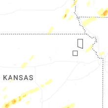


Connect with Interactive Hail Maps