

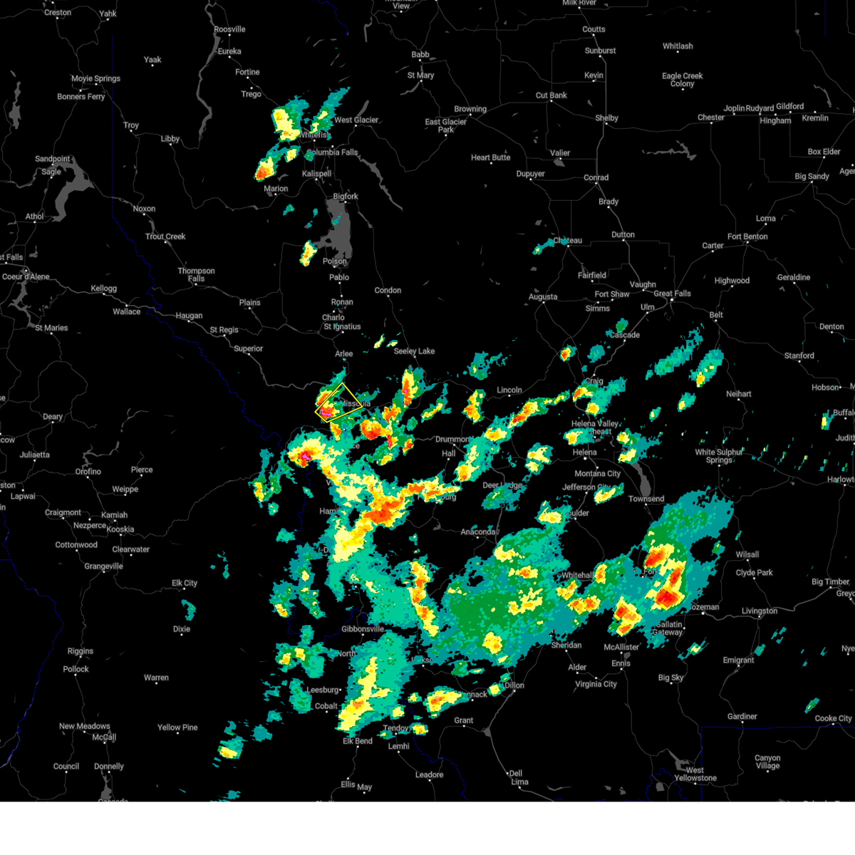
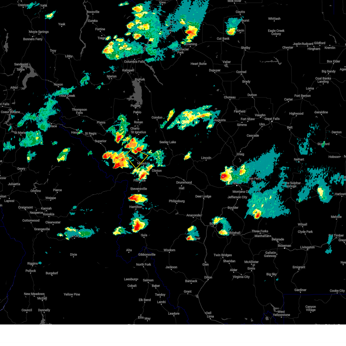
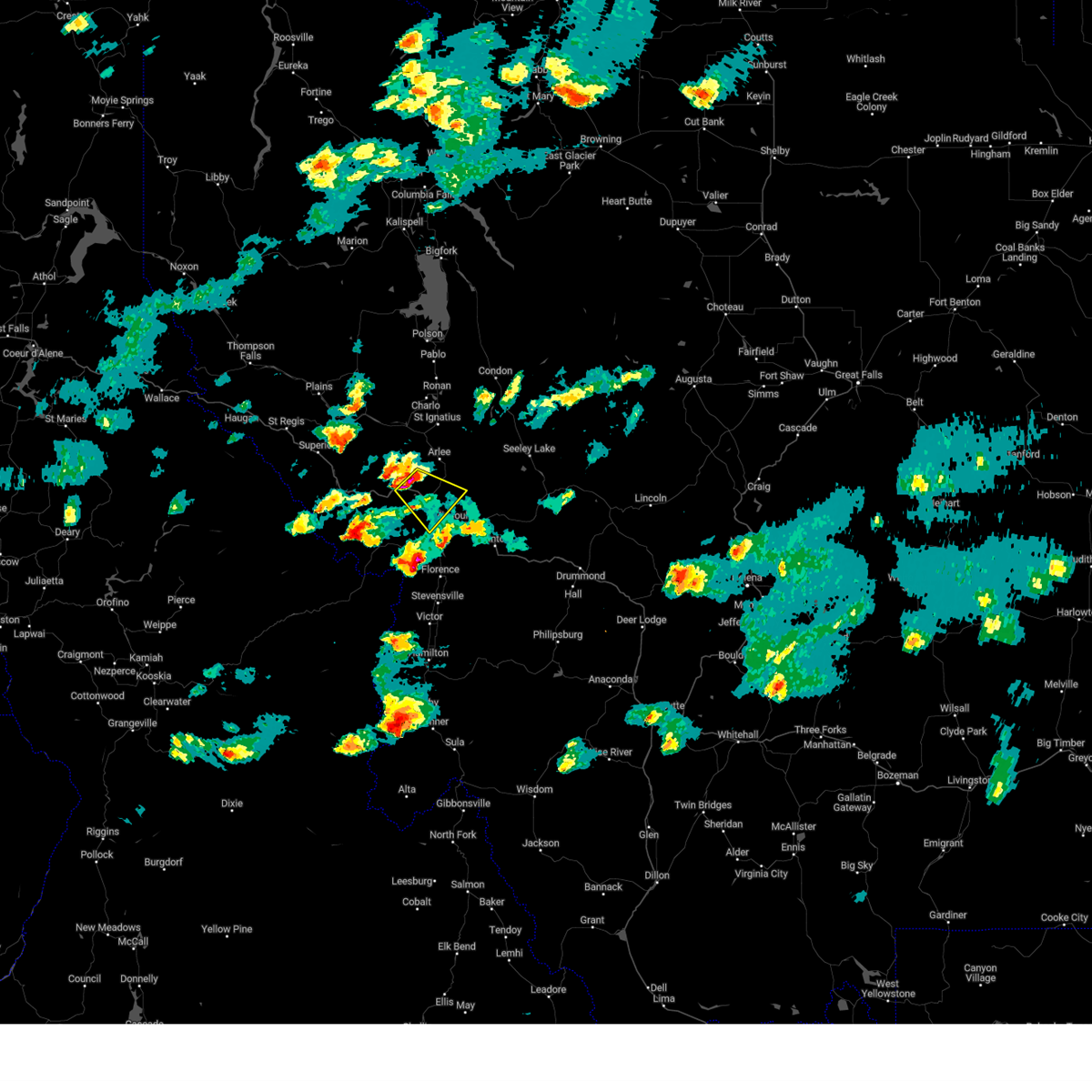
Hail Map for Missoula, MT
The Missoula, MT area has had 14 reports of on-the-ground hail by trained spotters, and has been under severe weather warnings 17 times during the past 12 months. Doppler radar has detected hail at or near Missoula, MT on 16 occasions, including 3 occasions during the past year.
| Name: | Missoula, MT |
| Where Located: | 1.2 miles WSW of Missoula, MT |
| Map: | Google Map for Missoula, MT |
| Population: | 66788 |
| Housing Units: | 30682 |
| More Info: | Search Google for Missoula, MT |
2
The Top Recent Hail Date for Missoula, MT is Tuesday, August 6, 2024 (4th out of 16)

Hail and Wind Damage Spotted near Missoula, MT
| Date / Time | Report Details |
|---|---|
| 8/23/2024 5:52 PM MDT | Trees down along mullen r in missoula county MT, 3.7 miles ESE of Missoula, MT |
| 8/23/2024 5:07 PM MDT | Storm damage reported in missoula county MT, 11.9 miles SE of Missoula, MT |
| 8/23/2024 4:09 PM MDT |
 Svrmso the national weather service in missoula has issued a * severe thunderstorm warning for, southeastern mineral county in west central montana, south central lake county in northwestern montana, central missoula county in west central montana, southeastern sanders county in northwestern montana, * until 445 pm mdt. * at 409 pm mdt, severe thunderstorms were located along a line extending from near bonner-west riverside to 8 miles south of frenchtown, moving north at 40 mph (radar indicated). Hazards include 60 mph wind gusts. expect damage to roofs, siding, and trees Svrmso the national weather service in missoula has issued a * severe thunderstorm warning for, southeastern mineral county in west central montana, south central lake county in northwestern montana, central missoula county in west central montana, southeastern sanders county in northwestern montana, * until 445 pm mdt. * at 409 pm mdt, severe thunderstorms were located along a line extending from near bonner-west riverside to 8 miles south of frenchtown, moving north at 40 mph (radar indicated). Hazards include 60 mph wind gusts. expect damage to roofs, siding, and trees
|
| 8/23/2024 4:07 PM MDT | Asos station kmso missoula... m in missoula county MT, 5.3 miles SE of Missoula, MT |
| 8/23/2024 4:00 PM MDT | Storm damage reported in missoula county MT, 11.9 miles SE of Missoula, MT |
| 8/23/2024 3:41 PM MDT |
 Svrmso the national weather service in missoula has issued a * severe thunderstorm warning for, southern missoula county in west central montana, northwestern granite county in west central montana, north central ravalli county in west central montana, * until 415 pm mdt. * at 340 pm mdt, severe thunderstorms were located along a line extending from 20 miles west of drummond to 8 miles southwest of florence, moving north at 30 mph (trained weather spotters). Hazards include 60 mph wind gusts. expect damage to roofs, siding, and trees Svrmso the national weather service in missoula has issued a * severe thunderstorm warning for, southern missoula county in west central montana, northwestern granite county in west central montana, north central ravalli county in west central montana, * until 415 pm mdt. * at 340 pm mdt, severe thunderstorms were located along a line extending from 20 miles west of drummond to 8 miles southwest of florence, moving north at 30 mph (trained weather spotters). Hazards include 60 mph wind gusts. expect damage to roofs, siding, and trees
|
| 8/19/2024 4:30 PM MDT |
 Svrmso the national weather service in missoula has issued a * severe thunderstorm warning for, south central missoula county in west central montana, * until 500 pm mdt. * at 430 pm mdt, a severe thunderstorm was located near wye, or 7 miles west of missoula, moving northeast at 20 mph (radar indicated). Hazards include 60 mph wind gusts and quarter size hail. Hail damage to vehicles is expected. Expect wind damage to roofs, siding, and trees. Svrmso the national weather service in missoula has issued a * severe thunderstorm warning for, south central missoula county in west central montana, * until 500 pm mdt. * at 430 pm mdt, a severe thunderstorm was located near wye, or 7 miles west of missoula, moving northeast at 20 mph (radar indicated). Hazards include 60 mph wind gusts and quarter size hail. Hail damage to vehicles is expected. Expect wind damage to roofs, siding, and trees.
|
| 8/18/2024 6:23 PM MDT | At 623 pm mdt, severe thunderstorms were located along a line extending from wye to 11 miles southwest of ovando, moving northeast at 35 mph (public). Hazards include 70 mph wind gusts. Expect considerable tree damage. damage is likely to mobile homes, roofs, and outbuildings. Locations impacted include, missoula, bonner-west riverside, wye, east missoula, evaro, frenchtown, seeley lake, potomac, clearwater, greenough, and twin creeks. |
| 8/18/2024 6:16 PM MDT | Storm damage reported in missoula county MT, 5.3 miles SE of Missoula, MT |
| 8/18/2024 6:15 PM MDT | Tree down across fleet street. additional damage to tree branches in pleasant view neighborhoo in missoula county MT, 2.7 miles SSE of Missoula, MT |
| 8/18/2024 6:10 PM MDT | Missoula county reports eastbound traffic closed at reserve st as well as westbound at paxon st for a tree in the roa in missoula county MT, 1.9 miles NNE of Missoula, MT |
| 8/18/2024 6:10 PM MDT | Trees on powerline... power ou in missoula county MT, 2.1 miles NNE of Missoula, MT |
| 8/18/2024 6:06 PM MDT |
 Svrmso the national weather service in missoula has issued a * severe thunderstorm warning for, southeastern missoula county in west central montana, * until 645 pm mdt. * at 605 pm mdt, severe thunderstorms were located along a line extending from near lolo to 14 miles northwest of drummond, moving northeast at 35 mph (radar indicated). Hazards include 60 mph wind gusts. expect damage to roofs, siding, and trees Svrmso the national weather service in missoula has issued a * severe thunderstorm warning for, southeastern missoula county in west central montana, * until 645 pm mdt. * at 605 pm mdt, severe thunderstorms were located along a line extending from near lolo to 14 miles northwest of drummond, moving northeast at 35 mph (radar indicated). Hazards include 60 mph wind gusts. expect damage to roofs, siding, and trees
|
| 8/18/2024 5:58 PM MDT |
 At 557 pm mdt, severe thunderstorms were located along a line extending from near lolo to 17 miles west of drummond, moving north at 35 mph (radar indicated). Hazards include 60 mph wind gusts and quarter size hail. Hail damage to vehicles is expected. expect wind damage to roofs, siding, and trees. Locations impacted include, missoula, lolo, bonner-west riverside, wye, east missoula, florence, nimrod, potomac, greenough, twin creeks, clinton, and turah. At 557 pm mdt, severe thunderstorms were located along a line extending from near lolo to 17 miles west of drummond, moving north at 35 mph (radar indicated). Hazards include 60 mph wind gusts and quarter size hail. Hail damage to vehicles is expected. expect wind damage to roofs, siding, and trees. Locations impacted include, missoula, lolo, bonner-west riverside, wye, east missoula, florence, nimrod, potomac, greenough, twin creeks, clinton, and turah.
|
| 8/18/2024 5:40 PM MDT |
 Svrmso the national weather service in missoula has issued a * severe thunderstorm warning for, southeastern missoula county in west central montana, northwestern granite county in west central montana, north central ravalli county in west central montana, * until 615 pm mdt. * at 540 pm mdt, severe thunderstorms were located along a line extending from near florence to 20 miles west of drummond, moving north at 35 mph (radar indicated). Hazards include ping pong ball size hail and 60 mph wind gusts. People and animals outdoors will be injured. expect hail damage to roofs, siding, windows, and vehicles. Expect wind damage to roofs, siding, and trees. Svrmso the national weather service in missoula has issued a * severe thunderstorm warning for, southeastern missoula county in west central montana, northwestern granite county in west central montana, north central ravalli county in west central montana, * until 615 pm mdt. * at 540 pm mdt, severe thunderstorms were located along a line extending from near florence to 20 miles west of drummond, moving north at 35 mph (radar indicated). Hazards include ping pong ball size hail and 60 mph wind gusts. People and animals outdoors will be injured. expect hail damage to roofs, siding, windows, and vehicles. Expect wind damage to roofs, siding, and trees.
|
| 8/6/2024 6:15 PM MDT | Quarter sized hail reported 2.1 miles SE of Missoula, MT, plentiful 3/4 with at least 1 quarter sized. |
| 8/6/2024 6:14 PM MDT |
 the severe thunderstorm warning has been cancelled and is no longer in effect the severe thunderstorm warning has been cancelled and is no longer in effect
|
| 8/6/2024 6:02 PM MDT |
 Svrmso the national weather service in missoula has issued a * severe thunderstorm warning for, southeastern missoula county in west central montana, northwestern granite county in west central montana, north central ravalli county in west central montana, * until 630 pm mdt. * at 602 pm mdt, a severe thunderstorm was located near florence, or 12 miles south of missoula, moving east at 35 mph (radar indicated). Hazards include quarter size hail winds up to 40 mph. damage to vehicles is expected Svrmso the national weather service in missoula has issued a * severe thunderstorm warning for, southeastern missoula county in west central montana, northwestern granite county in west central montana, north central ravalli county in west central montana, * until 630 pm mdt. * at 602 pm mdt, a severe thunderstorm was located near florence, or 12 miles south of missoula, moving east at 35 mph (radar indicated). Hazards include quarter size hail winds up to 40 mph. damage to vehicles is expected
|
| 8/6/2024 5:58 PM MDT |
 Svrmso the national weather service in missoula has issued a * severe thunderstorm warning for, south central missoula county in west central montana, * until 630 pm mdt. * at 558 pm mdt, a severe thunderstorm was located over frenchtown, or 14 miles northwest of missoula, moving southeast at 25 mph (radar indicated). Hazards include 60 mph wind gusts. expect damage to roofs, siding, and trees Svrmso the national weather service in missoula has issued a * severe thunderstorm warning for, south central missoula county in west central montana, * until 630 pm mdt. * at 558 pm mdt, a severe thunderstorm was located over frenchtown, or 14 miles northwest of missoula, moving southeast at 25 mph (radar indicated). Hazards include 60 mph wind gusts. expect damage to roofs, siding, and trees
|
| 7/24/2024 9:27 PM MDT |
 The severe thunderstorm which prompted the warning has moved out of the area. therefore, the warning will be allowed to expire. The severe thunderstorm which prompted the warning has moved out of the area. therefore, the warning will be allowed to expire.
|
| 7/24/2024 9:25 PM MDT |
 The severe thunderstorm which prompted the warning has therefore, the warning will be allowed to expire. The severe thunderstorm which prompted the warning has therefore, the warning will be allowed to expire.
|
| 7/24/2024 9:13 PM MDT |
 At 913 pm mdt, a severe thunderstorm was located near wye, or near missoula, moving northeast at 25 mph (radar indicated). Hazards include 70 mph wind gusts. Expect damage to roofs, siding, and trees. Locations impacted include, missoula, lolo, bonner-west riverside, wye, east missoula, frenchtown, and turah. At 913 pm mdt, a severe thunderstorm was located near wye, or near missoula, moving northeast at 25 mph (radar indicated). Hazards include 70 mph wind gusts. Expect damage to roofs, siding, and trees. Locations impacted include, missoula, lolo, bonner-west riverside, wye, east missoula, frenchtown, and turah.
|
| 7/24/2024 9:05 PM MDT | Power ou in missoula county MT, 11.9 miles SE of Missoula, MT |
| 7/24/2024 9:05 PM MDT | Weather underground station at 5026 feet on mt. sentinel...nearly 2000 feet above the missoula valley floo in missoula county MT, 3.1 miles WNW of Missoula, MT |
| 7/24/2024 9:04 PM MDT |
 At 903 pm mdt, a severe thunderstorm was located near missoula, moving northeast at 25 mph (radar indicated). Hazards include 60 mph wind gusts. wind gusts estimated up to 80 mph in the missoula valley. seek shelter now. Expect damage to roofs, siding, and trees. Locations impacted include, missoula, lolo, bonner-west riverside, wye, florence, east missoula, frenchtown, lolo hot springs, and turah. At 903 pm mdt, a severe thunderstorm was located near missoula, moving northeast at 25 mph (radar indicated). Hazards include 60 mph wind gusts. wind gusts estimated up to 80 mph in the missoula valley. seek shelter now. Expect damage to roofs, siding, and trees. Locations impacted include, missoula, lolo, bonner-west riverside, wye, florence, east missoula, frenchtown, lolo hot springs, and turah.
|
| 7/24/2024 9:02 PM MDT |
 Svrmso the national weather service in missoula has issued a * severe thunderstorm warning for, south central lake county in northwestern montana, central missoula county in west central montana, southeastern sanders county in northwestern montana, * until 930 pm mdt. * at 901 pm mdt, a severe thunderstorm was located near evaro, or 9 miles north of missoula, moving northeast at 20 mph (radar indicated). Hazards include 70 mph wind gusts. Expect considerable tree damage. Damage is likely to mobile homes, roofs, and outbuildings. Svrmso the national weather service in missoula has issued a * severe thunderstorm warning for, south central lake county in northwestern montana, central missoula county in west central montana, southeastern sanders county in northwestern montana, * until 930 pm mdt. * at 901 pm mdt, a severe thunderstorm was located near evaro, or 9 miles north of missoula, moving northeast at 20 mph (radar indicated). Hazards include 70 mph wind gusts. Expect considerable tree damage. Damage is likely to mobile homes, roofs, and outbuildings.
|
| 7/24/2024 9:01 PM MDT | Gusts to 60+ mph has been occurring for ~20 minute in missoula county MT, 4.9 miles SE of Missoula, MT |
| 7/24/2024 9:00 PM MDT | Toppled 70 year old maple tree... along with other tree damage. power and cell service ou in missoula county MT, 1.3 miles NNW of Missoula, MT |
| 7/24/2024 8:59 PM MDT |
 At 859 pm mdt, a severe thunderstorm was located near lolo, or near missoula, moving northeast at 25 mph (radar indicated). Hazards include 60 mph wind gusts. gusts in excess of 65 mph is occuring in the missoula valley. take shelter now. Expect damage to roofs, siding, and trees. Locations impacted include, missoula, lolo, bonner-west riverside, wye, florence, east missoula, frenchtown, lolo hot springs, and turah. At 859 pm mdt, a severe thunderstorm was located near lolo, or near missoula, moving northeast at 25 mph (radar indicated). Hazards include 60 mph wind gusts. gusts in excess of 65 mph is occuring in the missoula valley. take shelter now. Expect damage to roofs, siding, and trees. Locations impacted include, missoula, lolo, bonner-west riverside, wye, florence, east missoula, frenchtown, lolo hot springs, and turah.
|
| 7/24/2024 8:42 PM MDT |
 Svrmso the national weather service in missoula has issued a * severe thunderstorm warning for, south central missoula county in west central montana, north central ravalli county in west central montana, * until 930 pm mdt. * at 841 pm mdt, a severe thunderstorm was located near lolo, or 12 miles southwest of missoula, moving northeast at 25 mph (radar indicated). Hazards include 60 mph wind gusts. this cluster of thunderstorms have a history of producing 50 to 60 mph wind gusts, creating poweroutages. expect damage to roofs, siding, and trees Svrmso the national weather service in missoula has issued a * severe thunderstorm warning for, south central missoula county in west central montana, north central ravalli county in west central montana, * until 930 pm mdt. * at 841 pm mdt, a severe thunderstorm was located near lolo, or 12 miles southwest of missoula, moving northeast at 25 mph (radar indicated). Hazards include 60 mph wind gusts. this cluster of thunderstorms have a history of producing 50 to 60 mph wind gusts, creating poweroutages. expect damage to roofs, siding, and trees
|
| 8/22/2023 5:22 PM MDT |
 The severe thunderstorm warning for south central missoula county will expire at 530 pm mdt, the severe thunderstorm which prompted the warning has weakened. moved out of the warned area. therefore, the warning will be allowed to expire. The severe thunderstorm warning for south central missoula county will expire at 530 pm mdt, the severe thunderstorm which prompted the warning has weakened. moved out of the warned area. therefore, the warning will be allowed to expire.
|
| 8/22/2023 5:19 PM MDT |
 At 519 pm mdt, a severe thunderstorm was located near missoula, moving northeast at 30 mph (radar indicated). Hazards include 50-60 mph wind gusts has been reported. Hail damage to vehicles is expected. expect wind damage to roofs, siding, and trees. locations impacted include, missoula, bonner-west riverside, wye, east missoula, frenchtown, and turah. hail threat, radar indicated max hail size, 1. 00 in wind threat, radar indicated max wind gust, 60 mph. At 519 pm mdt, a severe thunderstorm was located near missoula, moving northeast at 30 mph (radar indicated). Hazards include 50-60 mph wind gusts has been reported. Hail damage to vehicles is expected. expect wind damage to roofs, siding, and trees. locations impacted include, missoula, bonner-west riverside, wye, east missoula, frenchtown, and turah. hail threat, radar indicated max hail size, 1. 00 in wind threat, radar indicated max wind gust, 60 mph.
|
| 8/22/2023 5:02 PM MDT |
 At 502 pm mdt, a severe thunderstorm was located over lolo, or near missoula, moving northeast at 30 mph (radar indicated). Hazards include 60 mph wind gusts and quarter size hail. Hail damage to vehicles is expected. Expect wind damage to roofs, siding, and trees. At 502 pm mdt, a severe thunderstorm was located over lolo, or near missoula, moving northeast at 30 mph (radar indicated). Hazards include 60 mph wind gusts and quarter size hail. Hail damage to vehicles is expected. Expect wind damage to roofs, siding, and trees.
|
| 7/8/2022 4:06 PM MDT |
 The severe thunderstorm warning for central missoula county will expire at 415 pm mdt, the severe thunderstorm which prompted the warning has moved out of the warned area. therefore, the warning will be allowed to expire. a severe thunderstorm watch remains in effect until 1000 pm mdt for west central montana. The severe thunderstorm warning for central missoula county will expire at 415 pm mdt, the severe thunderstorm which prompted the warning has moved out of the warned area. therefore, the warning will be allowed to expire. a severe thunderstorm watch remains in effect until 1000 pm mdt for west central montana.
|
| 7/8/2022 3:55 PM MDT | Hen Egg sized hail reported 7.7 miles SE of Missoula, MT |
| 7/8/2022 3:50 PM MDT | Golf Ball sized hail reported 11.2 miles SSE of Missoula, MT |
| 7/8/2022 3:49 PM MDT |
 At 348 pm mdt, a severe thunderstorm was located near wye, or 10 miles northwest of missoula, moving northeast at 15 mph (public). Hazards include two inch hail and 60 mph wind gusts. golf ball size hail has been reported near the wye. People and animals outdoors will be injured. expect hail damage to roofs, siding, windows, and vehicles. expect wind damage to roofs, siding, and trees. locations impacted include, missoula and wye. thunderstorm damage threat, considerable hail threat, radar indicated max hail size, 2. 00 in wind threat, radar indicated max wind gust, 60 mph. At 348 pm mdt, a severe thunderstorm was located near wye, or 10 miles northwest of missoula, moving northeast at 15 mph (public). Hazards include two inch hail and 60 mph wind gusts. golf ball size hail has been reported near the wye. People and animals outdoors will be injured. expect hail damage to roofs, siding, windows, and vehicles. expect wind damage to roofs, siding, and trees. locations impacted include, missoula and wye. thunderstorm damage threat, considerable hail threat, radar indicated max hail size, 2. 00 in wind threat, radar indicated max wind gust, 60 mph.
|
| 7/8/2022 3:48 PM MDT | Golf Ball sized hail reported 9.5 miles SSE of Missoula, MT |
| 7/8/2022 3:45 PM MDT | Tennis Ball sized hail reported 8.3 miles SE of Missoula, MT |
| 7/8/2022 3:41 PM MDT |
 At 339 pm mdt, a severe thunderstorm was located near wye, or 10 miles northwest of missoula, moving northeast at 15 mph (radar indicated). Hazards include two inch hail and 60 mph wind gusts. the severe thunderstorm continues to strengthen. damaging hail is expected between frenchtown and missoula. People and animals outdoors will be injured. expect hail damage to roofs, siding, windows, and vehicles. expect wind damage to roofs, siding, and trees. locations impacted include, missoula and wye. thunderstorm damage threat, considerable hail threat, radar indicated max hail size, 2. 00 in wind threat, radar indicated max wind gust, 60 mph. At 339 pm mdt, a severe thunderstorm was located near wye, or 10 miles northwest of missoula, moving northeast at 15 mph (radar indicated). Hazards include two inch hail and 60 mph wind gusts. the severe thunderstorm continues to strengthen. damaging hail is expected between frenchtown and missoula. People and animals outdoors will be injured. expect hail damage to roofs, siding, windows, and vehicles. expect wind damage to roofs, siding, and trees. locations impacted include, missoula and wye. thunderstorm damage threat, considerable hail threat, radar indicated max hail size, 2. 00 in wind threat, radar indicated max wind gust, 60 mph.
|
| 7/8/2022 3:33 PM MDT |
 At 332 pm mdt, a severe thunderstorm was located near frenchtown, or 11 miles northwest of missoula, moving northeast at 15 mph (radar indicated). Hazards include golf ball size hail and 60 mph wind gusts. gusty outflow winds are expected to produce 60 mph or strong winds downtown missoula in the next half hour. People and animals outdoors will be injured. expect hail damage to roofs, siding, windows, and vehicles. Expect wind damage to roofs, siding, and trees. At 332 pm mdt, a severe thunderstorm was located near frenchtown, or 11 miles northwest of missoula, moving northeast at 15 mph (radar indicated). Hazards include golf ball size hail and 60 mph wind gusts. gusty outflow winds are expected to produce 60 mph or strong winds downtown missoula in the next half hour. People and animals outdoors will be injured. expect hail damage to roofs, siding, windows, and vehicles. Expect wind damage to roofs, siding, and trees.
|
| 6/18/2022 2:09 PM MDT |
 The severe thunderstorm warning for southeastern missoula county will expire at 215 pm mdt, the storm which prompted the warning has moved out of the area. therefore, the warning will be allowed to expire. a severe thunderstorm watch remains in effect until 700 pm mdt for west central montana. The severe thunderstorm warning for southeastern missoula county will expire at 215 pm mdt, the storm which prompted the warning has moved out of the area. therefore, the warning will be allowed to expire. a severe thunderstorm watch remains in effect until 700 pm mdt for west central montana.
|
| 6/18/2022 1:34 PM MDT |
 At 133 pm mdt, a severe thunderstorm was located near florence, or 12 miles south of missoula, moving northeast at 45 mph (radar indicated). Hazards include quarter size hail. in addition wind gusts to 40 mph and heavy rain is anticipated. damage to vehicles is expected At 133 pm mdt, a severe thunderstorm was located near florence, or 12 miles south of missoula, moving northeast at 45 mph (radar indicated). Hazards include quarter size hail. in addition wind gusts to 40 mph and heavy rain is anticipated. damage to vehicles is expected
|
| 6/18/2022 1:07 PM MDT | Quarter sized hail reported 3.8 miles SW of Missoula, MT, spotter called back after finding hail of 1 inch. |
| 7/1/2021 6:53 PM MDT | Asos station kmso missoula... m in missoula county MT, 5.3 miles SE of Missoula, MT |
| 7/1/2021 6:15 PM MDT | A 8-12 inch diameter tree branch was downed along mullan road in missoula. report retrieved via social media. time of damage estimate in missoula county MT, 5 miles ESE of Missoula, MT |
| 7/1/2021 6:08 PM MDT |
 At 608 pm mdt, a severe thunderstorm was located over lolo, or near missoula, moving northwest at 10 mph (radar indicated). Hazards include 60 mph wind gusts. Expect damage to roofs, siding, and trees. Locations impacted include, missoula, lolo and wye. At 608 pm mdt, a severe thunderstorm was located over lolo, or near missoula, moving northwest at 10 mph (radar indicated). Hazards include 60 mph wind gusts. Expect damage to roofs, siding, and trees. Locations impacted include, missoula, lolo and wye.
|
| 7/1/2021 6:05 PM MDT | Photos of three downed trees along mullan trail road in missoul in missoula county MT, 3.7 miles ESE of Missoula, MT |
| 7/1/2021 6:00 PM MDT | Broadcast media reports downed power lines and roof damage near bickford street and ronan street. time of report estimate in missoula county MT, 0.7 miles NW of Missoula, MT |
| 7/1/2021 6:00 PM MDT | Nws employee reports downed powerlines on kent ave. a 10 to 12 inch diameter... 40 foot pine tree was snapped halfway up. time of damage estimate in missoula county MT, 1.3 miles NNW of Missoula, MT |
| 7/1/2021 5:56 PM MDT | Corrects previous report of 64 mph wind gust measured at kmso asos with wind observation time of 556 pm md in missoula county MT, 5.3 miles SE of Missoula, MT |
| 7/1/2021 5:56 PM MDT |
 At 555 pm mdt, a severe thunderstorm was located over lolo, or near missoula, moving north at 10 mph (radar indicated). Hazards include 60 mph wind gusts. expect damage to roofs, siding, and trees At 555 pm mdt, a severe thunderstorm was located over lolo, or near missoula, moving north at 10 mph (radar indicated). Hazards include 60 mph wind gusts. expect damage to roofs, siding, and trees
|
| 8/6/2020 9:50 PM MDT | A tree was reported down across rattlesnake driv in missoula county MT, 2.9 miles WSW of Missoula, MT |
| 5/31/2020 8:15 AM MDT | Sensor on top of mt sentinel at 5...026 ft. winds were from the ss in missoula county MT, 2.7 miles WNW of Missoula, MT |
| 5/31/2020 8:00 AM MDT | Sensor on top of mt sentinel at 5...026 ft. winds were from the ss in missoula county MT, 2.7 miles WNW of Missoula, MT |
| 8/11/2019 2:45 PM MDT | Downed tree across gharreet st around 1/2 mile south of reserve s in missoula county MT, 2.7 miles NNE of Missoula, MT |
| 8/11/2019 2:30 PM MDT | A branch fell on two cars near the cross streets of 9th and grant st. there were also media reports of a tree that fell on a house and also on a shed in orchard home in missoula county MT, 0.7 miles NE of Missoula, MT |
| 8/11/2019 2:30 PM MDT | Holfuy.com sensor on mt. sentinel east of missoul in missoula county MT, 2.7 miles WNW of Missoula, MT |
| 8/11/2019 2:29 PM MDT | A tree fell and blocked the street. time estimated by radar and nearby observation in missoula county MT, 2.4 miles E of Missoula, MT |
| 8/11/2019 2:24 PM MDT | A ponderosa pine tree... approximately 2 feet in diameter fell on a car on blue mountain road. time is estimated with a nearby observatio in missoula county MT, 4.6 miles NE of Missoula, MT |
| 8/11/2019 2:24 PM MDT | Ambient weather ws-2090 station at a private residence. found on wundermap.co in missoula county MT, 5.7 miles E of Missoula, MT |
| 5/31/2018 1:41 PM MDT |
 At 141 pm mdt, a severe thunderstorm was located over missoula, moving northeast at 35 mph (radar indicated). Hazards include 60 mph wind gusts have been reported and penny size hail continues to be a threat as well. Expect damage to roofs, siding, and trees. Locations impacted include, missoula, lolo, bonner-west riverside, wye, east missoula, evaro, frenchtown, huson and turah. At 141 pm mdt, a severe thunderstorm was located over missoula, moving northeast at 35 mph (radar indicated). Hazards include 60 mph wind gusts have been reported and penny size hail continues to be a threat as well. Expect damage to roofs, siding, and trees. Locations impacted include, missoula, lolo, bonner-west riverside, wye, east missoula, evaro, frenchtown, huson and turah.
|
| 5/31/2018 1:40 PM MDT | Quarter sized hail reported 1 miles SSW of Missoula, MT, two separate reports from the public of quarter sized hail around missoula. |
| 5/31/2018 1:34 PM MDT | Storm damage reported in missoula county MT, 4.9 miles SE of Missoula, MT |
| 5/31/2018 1:20 PM MDT |
 At 120 pm mdt, a severe thunderstorm was located near lolo, or 11 miles southwest of missoula, moving northeast at 35 mph (radar indicated). Hazards include 60 mph wind gusts and penny size hail. expect damage to roofs, siding, and trees At 120 pm mdt, a severe thunderstorm was located near lolo, or 11 miles southwest of missoula, moving northeast at 35 mph (radar indicated). Hazards include 60 mph wind gusts and penny size hail. expect damage to roofs, siding, and trees
|
| 5/6/2018 7:06 PM MDT |
 The severe thunderstorm warning for southwestern missoula county will expire at 715 pm mdt, the severe thunderstorm which prompted the warning has weakened and is moving out of the warned area. therefore, the warning will be allowed to expire. strong winds near 40 mph, heavy rain, and small hail will continue for another 10 to 20 minutes. The severe thunderstorm warning for southwestern missoula county will expire at 715 pm mdt, the severe thunderstorm which prompted the warning has weakened and is moving out of the warned area. therefore, the warning will be allowed to expire. strong winds near 40 mph, heavy rain, and small hail will continue for another 10 to 20 minutes.
|
| 5/6/2018 6:49 PM MDT | Corrects previous tstm wnd gst report from 3 sse east missoula. mount sentinel wx statio in missoula county MT, 5 miles WNW of Missoula, MT |
| 5/6/2018 6:45 PM MDT | Large tree across river road between russell and reserve causing power and phone outage in missoula county MT, 1 miles SSE of Missoula, MT |
| 5/6/2018 6:45 PM MDT | Large tree fell on a house at reserve and river road. unsure of extent of damage to house from phot in missoula county MT, 1.3 miles SE of Missoula, MT |
| 5/6/2018 6:40 PM MDT |
 At 640 pm mdt, a severe thunderstorm was located near missoula, moving north at 40 mph (radar indicated). Hazards include 60 mph wind gusts and nickel size hail. expect damage to roofs, siding, and trees At 640 pm mdt, a severe thunderstorm was located near missoula, moving north at 40 mph (radar indicated). Hazards include 60 mph wind gusts and nickel size hail. expect damage to roofs, siding, and trees
|
| 5/6/2018 4:49 PM MDT | Mount sentinel wx statio in missoula county MT, 5 miles WNW of Missoula, MT |
| 7/15/2017 5:39 PM MDT |
 The severe thunderstorm warning for southeastern missoula and north central ravalli counties will expire at 545 pm mdt, the storm which prompted the warning has weakened below severe limits, and has exited the warned area. therefore, the warning will be allowed to expire. The severe thunderstorm warning for southeastern missoula and north central ravalli counties will expire at 545 pm mdt, the storm which prompted the warning has weakened below severe limits, and has exited the warned area. therefore, the warning will be allowed to expire.
|
| 7/15/2017 4:59 PM MDT |
 At 458 pm mdt, a severe thunderstorm was located over florence, or 16 miles south of missoula, moving northeast at 30 mph (radar indicated). Hazards include 60 mph wind gusts, heavy rain and penny size hail. expect damage to roofs, siding, and trees At 458 pm mdt, a severe thunderstorm was located over florence, or 16 miles south of missoula, moving northeast at 30 mph (radar indicated). Hazards include 60 mph wind gusts, heavy rain and penny size hail. expect damage to roofs, siding, and trees
|
| 7/15/2017 4:27 PM MDT |
 At 426 pm mdt, a severe thunderstorm was located 8 miles west of stevensville, or 19 miles north of hamilton, moving northeast at 45 mph (radar indicated). Hazards include 65 mph wind gusts and penny size hail. expect damage to roofs, siding, and trees At 426 pm mdt, a severe thunderstorm was located 8 miles west of stevensville, or 19 miles north of hamilton, moving northeast at 45 mph (radar indicated). Hazards include 65 mph wind gusts and penny size hail. expect damage to roofs, siding, and trees
|
| 4/7/2017 4:12 PM MDT | Two large bull pine trees knocked over by the wind. a part of a shed roof was blown of in missoula county MT, 12.5 miles SSE of Missoula, MT |
| 8/18/2016 6:10 PM MDT | Maple tree (trunk estimated to be 18 inches in diameter) snapped in half and blocked traffic for a short tim in missoula county MT, 0.7 miles NW of Missoula, MT |
| 8/18/2016 6:03 PM MDT | Power outage reported in the upper miller creek area. in missoula county MT, 4.2 miles NNE of Missoula, MT |
| 8/18/2016 6:00 PM MDT | Quarter sized hail reported 1.1 miles ENE of Missoula, MT, . |
| 8/6/2016 4:55 PM MDT |
 The severe thunderstorm warning for northern ravalli and south central missoula counties will expire at 500 pm mdt, the storm which prompted the warning has weakened below severe limits, and no longer poses an immediate threat to life or property. therefore the warning will be allowed to expire. however gusty winds are still possible with this thunderstorm and power outages have been reported in the missoula area. The severe thunderstorm warning for northern ravalli and south central missoula counties will expire at 500 pm mdt, the storm which prompted the warning has weakened below severe limits, and no longer poses an immediate threat to life or property. therefore the warning will be allowed to expire. however gusty winds are still possible with this thunderstorm and power outages have been reported in the missoula area.
|
| 8/6/2016 4:31 PM MDT | Reports of numerous power lines and tree branches down around tow in missoula county MT, 1.4 miles W of Missoula, MT |
| 8/6/2016 4:18 PM MDT |
 At 417 pm mdt, doppler radar indicated a severe thunderstorm capable of producing damaging winds in excess of 60 mph. this storm was located over lolo, or 9 miles south of missoula, and moving northeast at 15 mph. the gust front ahead of the main thunderstorm could produce damaging winds. At 417 pm mdt, doppler radar indicated a severe thunderstorm capable of producing damaging winds in excess of 60 mph. this storm was located over lolo, or 9 miles south of missoula, and moving northeast at 15 mph. the gust front ahead of the main thunderstorm could produce damaging winds.
|
| 7/17/2016 9:51 PM MDT |
 At 951 pm mdt, multiple trained weather spotters reported a severe thunderstorm producing quarter size hail and damaging winds in excess of 60 mph. this storm was located 10 miles northeast of bonner-west riverside, or 15 miles east of missoula, moving northeast at 55 mph. locations impacted include, missoula, lolo, stevensville, evaro, wye, bonner-west riverside, frenchtown, florence, east missoula, arlee, twin creeks, clinton, potomac and turah. At 951 pm mdt, multiple trained weather spotters reported a severe thunderstorm producing quarter size hail and damaging winds in excess of 60 mph. this storm was located 10 miles northeast of bonner-west riverside, or 15 miles east of missoula, moving northeast at 55 mph. locations impacted include, missoula, lolo, stevensville, evaro, wye, bonner-west riverside, frenchtown, florence, east missoula, arlee, twin creeks, clinton, potomac and turah.
|
| 7/17/2016 9:27 PM MDT |
 At 926 pm mdt, doppler radar indicated a severe thunderstorm capable of producing damaging winds in excess of 60 mph. this storm was located over lolo, or 10 miles south of missoula, and moving northeast at 55 mph. nickel size to quarter size hail may also accompany the damaging winds. At 926 pm mdt, doppler radar indicated a severe thunderstorm capable of producing damaging winds in excess of 60 mph. this storm was located over lolo, or 10 miles south of missoula, and moving northeast at 55 mph. nickel size to quarter size hail may also accompany the damaging winds.
|
| 8/14/2015 4:11 PM MDT |
 The severe thunderstorm warning for southeastern missoula and northern ravalli counties will expire at 415 pm mdt, the storm which prompted the warning has weakened below severe limits, and no longer poses an immediate threat to life or property. therefore the warning will be allowed to expire. however gusty winds and heavy rain are still possible with this thunderstorm. to report severe weather, contact your nearest law enforcement agency. they will relay your report to the national weather service missoula. The severe thunderstorm warning for southeastern missoula and northern ravalli counties will expire at 415 pm mdt, the storm which prompted the warning has weakened below severe limits, and no longer poses an immediate threat to life or property. therefore the warning will be allowed to expire. however gusty winds and heavy rain are still possible with this thunderstorm. to report severe weather, contact your nearest law enforcement agency. they will relay your report to the national weather service missoula.
|
| 8/14/2015 4:08 PM MDT |
 At 408 pm mdt, doppler radar indicated a severe thunderstorm capable of producing quarter size hail and damaging winds in excess of 60 mph. this storm was located over evaro, or 13 miles northwest of missoula, moving northeast at 35 mph. locations impacted include, frenchtown, wye, ninemile and huson. At 408 pm mdt, doppler radar indicated a severe thunderstorm capable of producing quarter size hail and damaging winds in excess of 60 mph. this storm was located over evaro, or 13 miles northwest of missoula, moving northeast at 35 mph. locations impacted include, frenchtown, wye, ninemile and huson.
|
| 8/14/2015 3:58 PM MDT |
 At 358 pm mdt, the public reported a severe thunderstorm producing quarter size hail and damaging winds in excess of 60 mph. this storm was located over bonner-west riverside, or near missoula, moving northeast at 35 mph. locations impacted include, missoula, lolo, east missoula, bonner-west riverside, turah and clinton. At 358 pm mdt, the public reported a severe thunderstorm producing quarter size hail and damaging winds in excess of 60 mph. this storm was located over bonner-west riverside, or near missoula, moving northeast at 35 mph. locations impacted include, missoula, lolo, east missoula, bonner-west riverside, turah and clinton.
|
| 8/14/2015 3:47 PM MDT |
 At 347 pm mdt, doppler radar indicated a severe thunderstorm capable of producing quarter size hail and damaging winds in excess of 60 mph. this storm was located 9 miles southeast of alberton, or 16 miles west of missoula, and moving northeast at 35 mph. At 347 pm mdt, doppler radar indicated a severe thunderstorm capable of producing quarter size hail and damaging winds in excess of 60 mph. this storm was located 9 miles southeast of alberton, or 16 miles west of missoula, and moving northeast at 35 mph.
|
| 8/14/2015 3:38 PM MDT |
 At 337 pm mdt, doppler radar indicated a severe thunderstorm capable of producing quarter size hail and damaging winds in excess of 60 mph. this storm was located near florence, or 12 miles south of missoula, and moving northeast at 30 mph. At 337 pm mdt, doppler radar indicated a severe thunderstorm capable of producing quarter size hail and damaging winds in excess of 60 mph. this storm was located near florence, or 12 miles south of missoula, and moving northeast at 30 mph.
|
| 8/10/2015 7:06 PM MDT |
 The severe thunderstorm warning for south central missoula county will expire at 715 pm mdt, the storm which prompted the warning has moved out of the area. therefore the warning will be allowed to expire. this thunderstorm produce a wind gust to 74 mph at the missoula airport at 633 pm. The severe thunderstorm warning for south central missoula county will expire at 715 pm mdt, the storm which prompted the warning has moved out of the area. therefore the warning will be allowed to expire. this thunderstorm produce a wind gust to 74 mph at the missoula airport at 633 pm.
|
| 8/10/2015 6:56 PM MDT |
 At 655 pm mdt, emergency management reported a severe thunderstorm producing damaging winds in excess of 60 mph. this storm was located near evaro, or 8 miles north of missoula, moving north at 25 mph. locations impacted include, missoula, lolo, frenchtown, evaro, wye, east missoula, bonner-west riverside and turah. At 655 pm mdt, emergency management reported a severe thunderstorm producing damaging winds in excess of 60 mph. this storm was located near evaro, or 8 miles north of missoula, moving north at 25 mph. locations impacted include, missoula, lolo, frenchtown, evaro, wye, east missoula, bonner-west riverside and turah.
|
| 8/10/2015 6:39 PM MDT | Storm damage reported in missoula county MT, 4.9 miles SE of Missoula, MT |
| 8/10/2015 6:23 PM MDT |
 At 622 pm mdt, doppler radar indicated a severe thunderstorm capable of producing damaging winds in excess of 60 mph. this storm was located near lolo, or near missoula, and moving north at 25 mph. this storm has a history of damaging winds, capable of downing power lines and trees. At 622 pm mdt, doppler radar indicated a severe thunderstorm capable of producing damaging winds in excess of 60 mph. this storm was located near lolo, or near missoula, and moving north at 25 mph. this storm has a history of damaging winds, capable of downing power lines and trees.
|
| 5/31/2015 6:50 PM MDT | Spruce tree maybe 10"+ at the base at the corner of edith and franklin st. in missoul in missoula county MT, 0.7 miles NW of Missoula, MT |
| 8/9/2013 7:25 PM MDT | Storm damage reported in missoula county MT, 4.4 miles NNE of Missoula, MT |
| 8/9/2013 7:00 PM MDT | "hundreds" of reports of trees and powerlines down all around the missoula area in missoula county MT, 1.4 miles W of Missoula, MT |
| 8/9/2013 7:00 PM MDT | There were thirteen phone calls that came into the 911 center related to either power being out or power lines being down due to the win in missoula county MT, 1.4 miles W of Missoula, MT |
| 5/13/2013 5:10 PM MDT | Large trees down in the university district and along daly avenu in missoula county MT, 1.5 miles WNW of Missoula, MT |
| 5/13/2013 5:10 PM MDT | Power lines down across mullan roa in missoula county MT, 2.5 miles SE of Missoula, MT |
| 8/21/2012 4:59 PM MDT | Point 6 radar raws. elevation 7929 feet in missoula county MT, 5.2 miles SSE of Missoula, MT |
| 8/8/2012 6:57 PM MDT | Downed trees near the cross streets of phillips and cowper in missoul in missoula county MT, 1 miles SSW of Missoula, MT |
| 7/27/2012 3:25 PM MDT | Quarter sized hail reported 1.4 miles W of Missoula, MT |
| 7/27/2012 3:20 PM MDT | Quarter sized hail reported 0.5 miles WSW of Missoula, MT |
| 6/26/2012 11:21 AM MDT | Multiple trees blown down on the south side of missoula. one tree was 10 to 12 inches in diameter and was snapped off at the bas in missoula county MT, 4 miles N of Missoula, MT |
| 6/23/2012 7:55 PM MDT | Quarter sized hail reported 0.9 miles S of Missoula, MT |
| 6/23/2012 7:16 PM MDT | Quarter sized hail reported 6 miles SSE of Missoula, MT |
| 6/23/2012 7:14 PM MDT | Downed tree damaged nearby building. quarter size hail also. damage at missoula international airport including to a hanger door and a sign down on a rental ca in missoula county MT, 4.9 miles SE of Missoula, MT |
| 6/23/2012 7:14 PM MDT | Downed tree damaged nearby building. quarter size hail als in missoula county MT, 4.9 miles SE of Missoula, MT |
| 4/26/2012 3:19 PM MDT | A large spruce tree blown ove in missoula county MT, 5.2 miles SSW of Missoula, MT |
| 4/26/2012 3:15 PM MDT | Orchard homes development received wind damage when a tree limb fell and crushed an outbuildin in missoula county MT, 1.4 miles W of Missoula, MT |
| 3/28/2012 1:56 PM MDT | Three 25-40 foot cedar trees were snapped at the trunks. up to 2 feet in diameter at various heights behind the washington-grizzley stadiu in missoula county MT, 1.4 miles W of Missoula, MT |
| 3/28/2012 1:56 PM MDT | Tree downed on top of parked cars downtown missoul in missoula county MT, 1.4 miles W of Missoula, MT |
| 3/28/2012 1:56 PM MDT | Tree downed on top of parked cars in parking lot at the university of montan in missoula county MT, 1.4 miles W of Missoula, MT |
| 3/28/2012 1:50 PM MDT | Large tree downed on 2nd street in downtown mis in missoula county MT, 1.4 miles W of Missoula, MT |
| 3/28/2012 1:50 PM MDT | Papa murphys pizza sign destroyed on brooks street in downtown missoula in missoula county MT, 1.4 miles W of Missoula, MT |
| 1/1/0001 12:00 AM | Quarter sized hail reported 6.6 miles SSW of Missoula, MT, nws employee measured one inch size hail at residence north of missoula in the prospect creek neighborhood. |
| 1/1/0001 12:00 AM | Quarter sized hail reported 5.2 miles SSE of Missoula, MT, nws employees measured inch size hail at the weather forecast office. |
Hail Maps for Missoula, MT


Connect with Interactive Hail Maps