

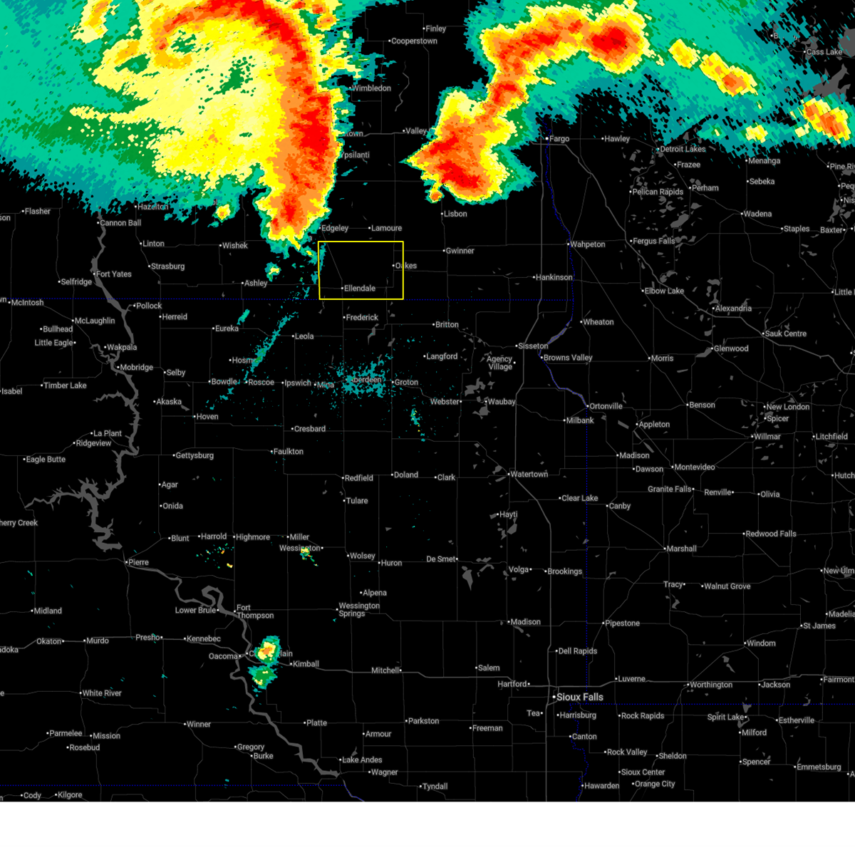
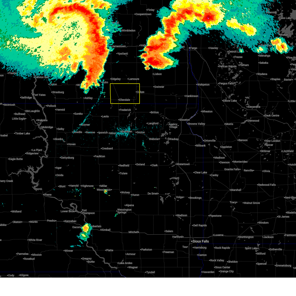
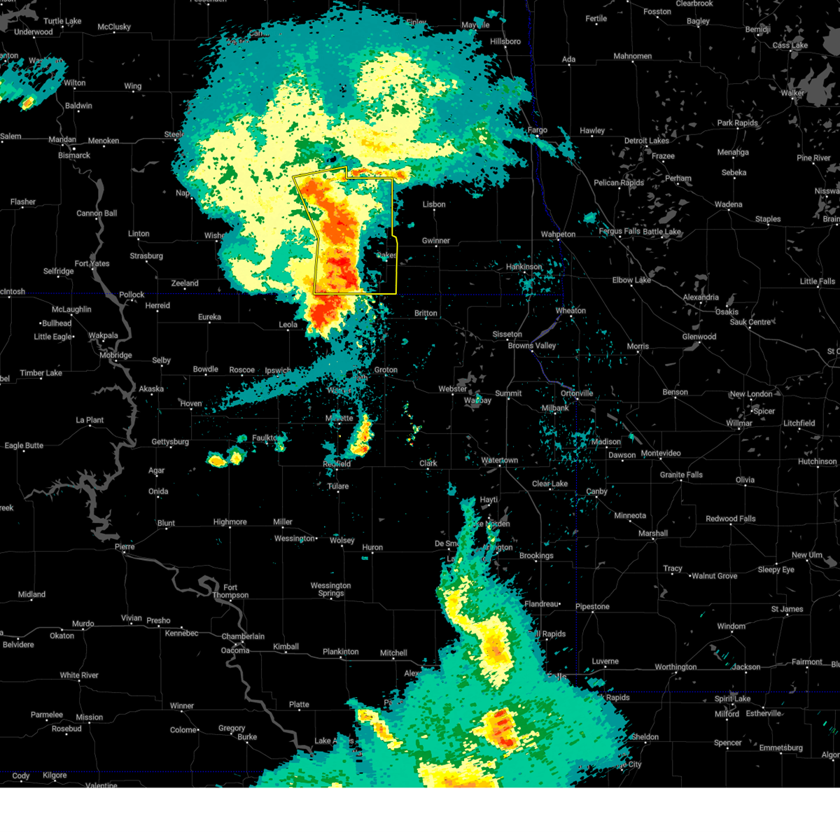
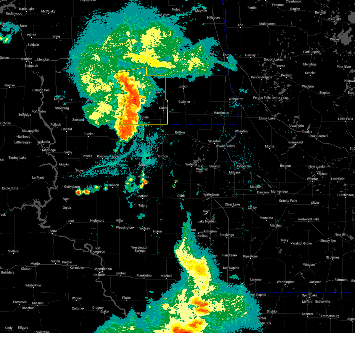
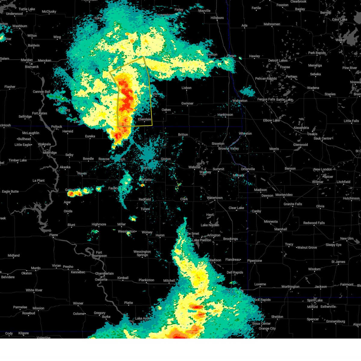
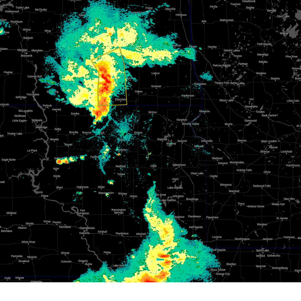
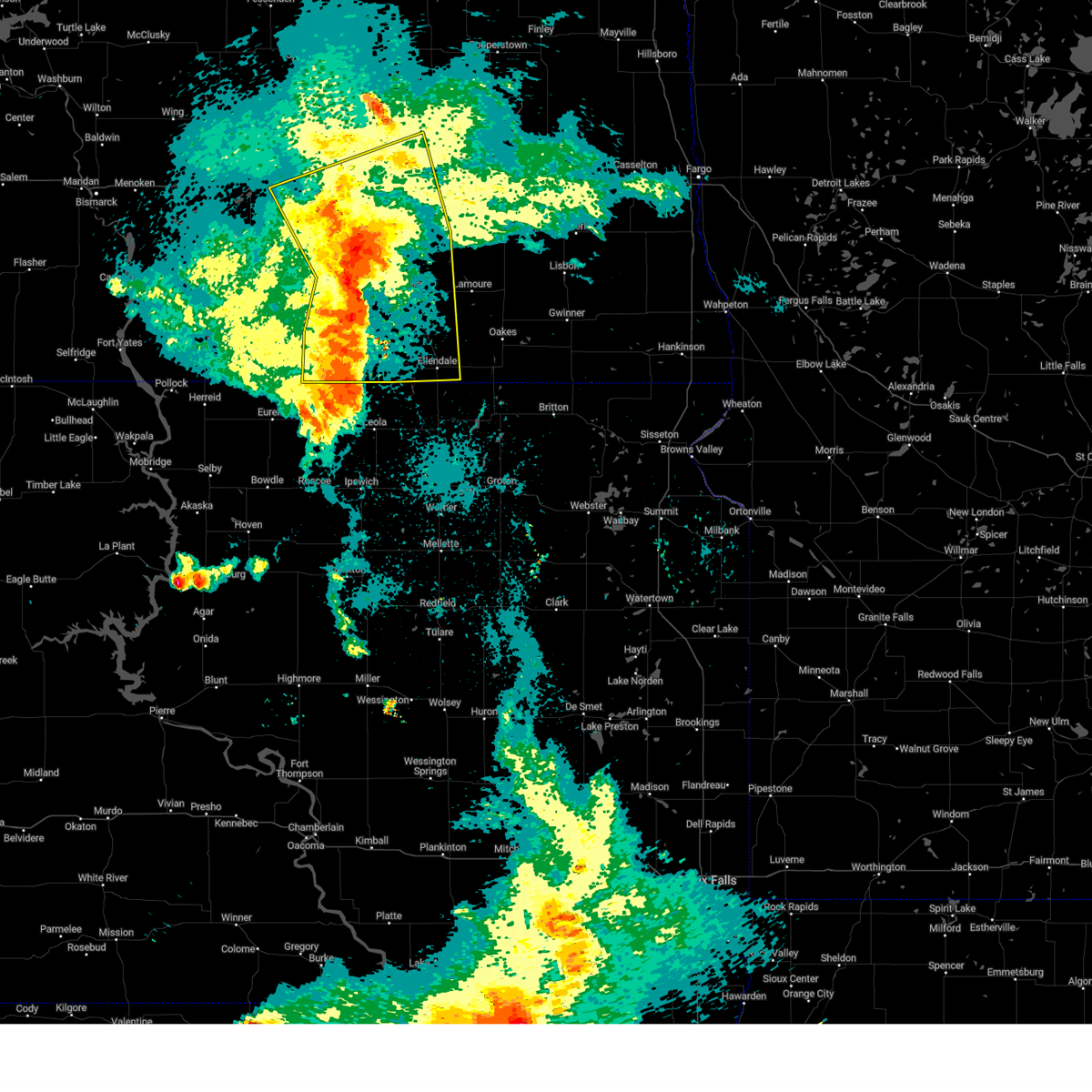
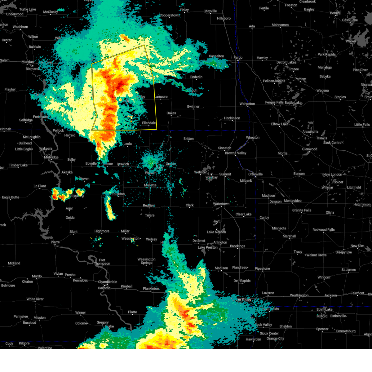
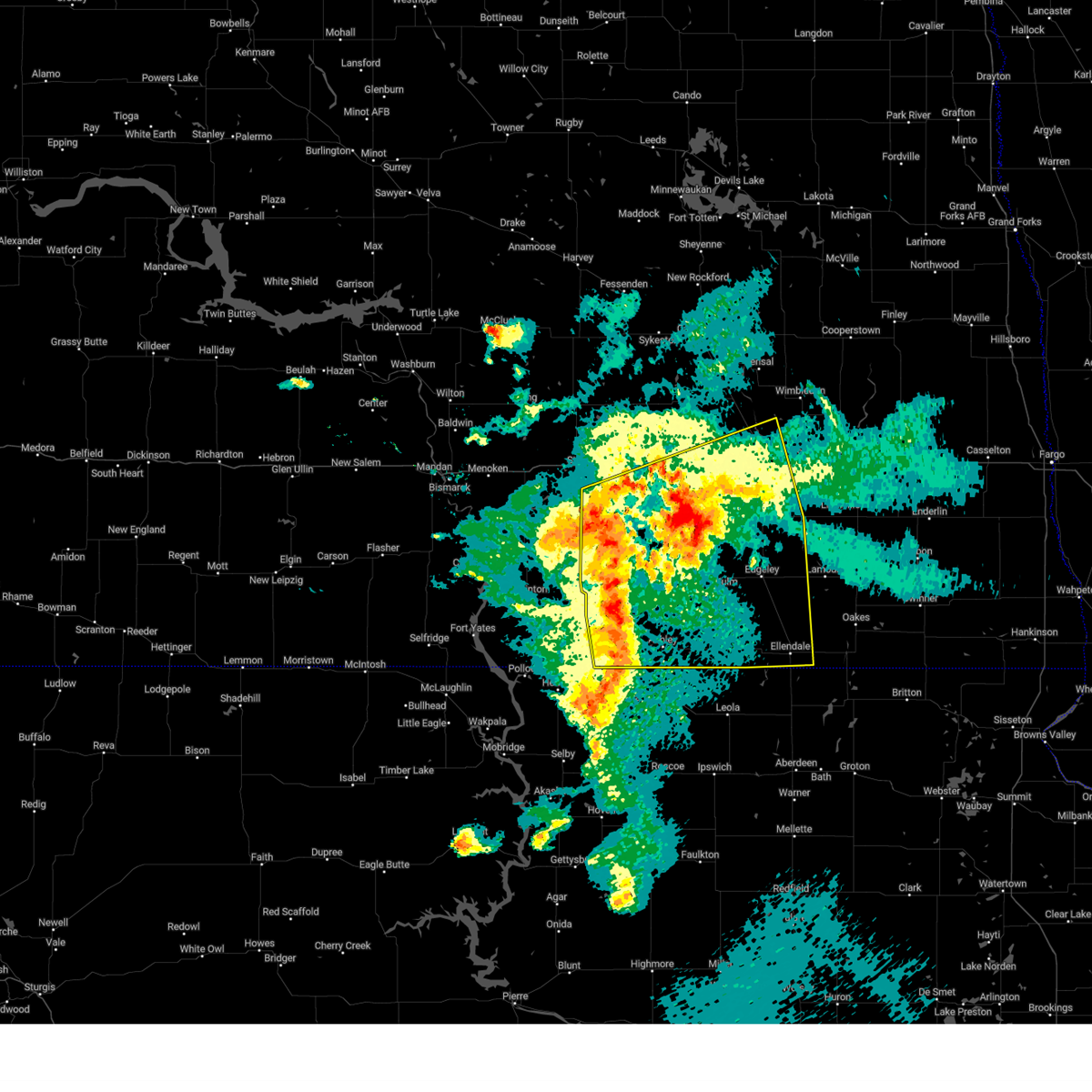
Hail Map for Monango, ND
The Monango, ND area has had 0 reports of on-the-ground hail by trained spotters, and has been under severe weather warnings 10 times during the past 12 months. Doppler radar has detected hail at or near Monango, ND on 55 occasions.
| Name: | Monango, ND |
| Where Located: | 49.5 miles N of Aberdeen, SD |
| Map: | Google Map for Monango, ND |
| Population: | 36 |
| Housing Units: | 22 |
| More Info: | Search Google for Monango, ND |
3
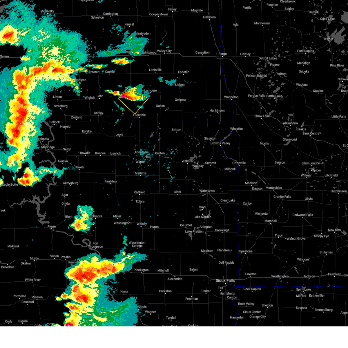
The Top Recent Hail Date for Monango, ND is Thursday, May 23, 2024 (19th out of 55)

Hail and Wind Damage Spotted near Monango, ND
| Date / Time | Report Details |
|---|---|
| 6/20/2025 10:49 PM CDT |
 Svrbis the national weather service in bismarck has issued a * severe thunderstorm warning for, dickey county in southeastern north dakota, * until 1130 pm cdt. * at 1049 pm cdt, severe thunderstorms were located along a line extending from 5 miles southeast of edgeley to near elm lake, moving east at 105 mph (radar indicated). Hazards include 60 mph wind gusts. expect damage to roofs, siding, and trees Svrbis the national weather service in bismarck has issued a * severe thunderstorm warning for, dickey county in southeastern north dakota, * until 1130 pm cdt. * at 1049 pm cdt, severe thunderstorms were located along a line extending from 5 miles southeast of edgeley to near elm lake, moving east at 105 mph (radar indicated). Hazards include 60 mph wind gusts. expect damage to roofs, siding, and trees
|
| 6/20/2025 10:40 PM CDT |
 Svrbis the national weather service in bismarck has issued a * severe thunderstorm warning for, dickey county in southeastern north dakota, * until 1130 pm cdt. * at 1039 pm cdt, severe thunderstorms were located along a line extending from 4 miles east of kulm to near spring creek colony, moving east at 105 mph (radar indicated). Hazards include 60 mph wind gusts. expect damage to roofs, siding, and trees Svrbis the national weather service in bismarck has issued a * severe thunderstorm warning for, dickey county in southeastern north dakota, * until 1130 pm cdt. * at 1039 pm cdt, severe thunderstorms were located along a line extending from 4 miles east of kulm to near spring creek colony, moving east at 105 mph (radar indicated). Hazards include 60 mph wind gusts. expect damage to roofs, siding, and trees
|
| 7/29/2024 10:42 PM CDT |
 At 1042 pm cdt, severe thunderstorms were located along a line extending from near marion to 4 miles south of la moure to 9 miles northwest of hecla, moving east at 40 mph (radar indicated). Hazards include 60 mph wind gusts. Expect damage to roofs, siding, and trees. Locations impacted include, ellendale, oakes, lamoure, edgeley, marion, la moure, adrian, verona, fullerton, dickey, ludden, la moure city, grand rapids, monango, berlin, guelph, nortonville, and glover. At 1042 pm cdt, severe thunderstorms were located along a line extending from near marion to 4 miles south of la moure to 9 miles northwest of hecla, moving east at 40 mph (radar indicated). Hazards include 60 mph wind gusts. Expect damage to roofs, siding, and trees. Locations impacted include, ellendale, oakes, lamoure, edgeley, marion, la moure, adrian, verona, fullerton, dickey, ludden, la moure city, grand rapids, monango, berlin, guelph, nortonville, and glover.
|
| 7/29/2024 10:27 PM CDT |
 Svrbis the national weather service in bismarck has issued a * severe thunderstorm warning for, lamoure county in southeastern north dakota, dickey county in southeastern north dakota, southeastern stutsman county in southeastern north dakota, * until 1130 pm cdt. * at 1027 pm cdt, severe thunderstorms were located along a line extending from near adrian to 9 miles northwest of fullerton to 5 miles southwest of ellendale, moving east at 40 mph (radar indicated). Hazards include 60 mph wind gusts. expect damage to roofs, siding, and trees Svrbis the national weather service in bismarck has issued a * severe thunderstorm warning for, lamoure county in southeastern north dakota, dickey county in southeastern north dakota, southeastern stutsman county in southeastern north dakota, * until 1130 pm cdt. * at 1027 pm cdt, severe thunderstorms were located along a line extending from near adrian to 9 miles northwest of fullerton to 5 miles southwest of ellendale, moving east at 40 mph (radar indicated). Hazards include 60 mph wind gusts. expect damage to roofs, siding, and trees
|
| 7/29/2024 10:18 PM CDT |
 At 1018 pm cdt, severe thunderstorms were located along a line extending from 8 miles west of jamestown to 6 miles southwest of adrian to 7 miles west of ellendale, moving east at 55 mph (radar indicated). Hazards include 60 mph wind gusts. Expect damage to roofs, siding, and trees. these severe storms will be near, ellendale, ypsilanti, adrian, montpelier, fullerton, and dickey around 1025 pm cdt. Other locations impacted by these severe thunderstorms include nortonville, monango, berlin, alfred, merricourt, sydney, and millarton. At 1018 pm cdt, severe thunderstorms were located along a line extending from 8 miles west of jamestown to 6 miles southwest of adrian to 7 miles west of ellendale, moving east at 55 mph (radar indicated). Hazards include 60 mph wind gusts. Expect damage to roofs, siding, and trees. these severe storms will be near, ellendale, ypsilanti, adrian, montpelier, fullerton, and dickey around 1025 pm cdt. Other locations impacted by these severe thunderstorms include nortonville, monango, berlin, alfred, merricourt, sydney, and millarton.
|
| 7/29/2024 10:18 PM CDT |
 the severe thunderstorm warning has been cancelled and is no longer in effect the severe thunderstorm warning has been cancelled and is no longer in effect
|
| 7/29/2024 10:01 PM CDT |
 At 959 pm cdt, severe thunderstorms were located along a line extending from 4 miles southwest of cleveland to near jud to 6 miles northwest of spring creek colony, moving east at 55 mph (public. at 955 pm at 66 mph gust was reported 7 miles northwest of wirch). Hazards include 60 mph wind gusts. Expect damage to roofs, siding, and trees. these severe storms will be near, edgeley, jud, forbes, and merricourt city around 1005 pm cdt. jamestown, ellendale, adrian, montpelier, and dickey around 1020 pm cdt. ypsilanti and fullerton around 1025 pm cdt. Other locations impacted by these severe thunderstorms include eldridge, nortonville, monango, fredonia, berlin, windsor, alfred, streeter memorial, merricourt, and sydney. At 959 pm cdt, severe thunderstorms were located along a line extending from 4 miles southwest of cleveland to near jud to 6 miles northwest of spring creek colony, moving east at 55 mph (public. at 955 pm at 66 mph gust was reported 7 miles northwest of wirch). Hazards include 60 mph wind gusts. Expect damage to roofs, siding, and trees. these severe storms will be near, edgeley, jud, forbes, and merricourt city around 1005 pm cdt. jamestown, ellendale, adrian, montpelier, and dickey around 1020 pm cdt. ypsilanti and fullerton around 1025 pm cdt. Other locations impacted by these severe thunderstorms include eldridge, nortonville, monango, fredonia, berlin, windsor, alfred, streeter memorial, merricourt, and sydney.
|
| 7/29/2024 9:47 PM CDT |
 At 946 pm cdt, severe thunderstorms were located along a line extending from 7 miles southwest of medina to 12 miles south of gackle to 5 miles north of long lake, moving east at 50 mph (radar indicated). Hazards include 60 mph wind gusts. Expect damage to roofs, siding, and trees. these severe storms will be near, gackle around 950 pm cdt. kulm and jud around 955 pm cdt. cleveland around 1000 pm cdt. edgeley, forbes, and merricourt city around 1005 pm cdt. jamestown, ellendale, adrian, montpelier, and dickey around 1020 pm cdt. ypsilanti and fullerton around 1025 pm cdt. Other locations impacted by these severe thunderstorms include eldridge, monango, fredonia, berlin, windsor, merricourt, millarton, nortonville, green lake, and danzig. At 946 pm cdt, severe thunderstorms were located along a line extending from 7 miles southwest of medina to 12 miles south of gackle to 5 miles north of long lake, moving east at 50 mph (radar indicated). Hazards include 60 mph wind gusts. Expect damage to roofs, siding, and trees. these severe storms will be near, gackle around 950 pm cdt. kulm and jud around 955 pm cdt. cleveland around 1000 pm cdt. edgeley, forbes, and merricourt city around 1005 pm cdt. jamestown, ellendale, adrian, montpelier, and dickey around 1020 pm cdt. ypsilanti and fullerton around 1025 pm cdt. Other locations impacted by these severe thunderstorms include eldridge, monango, fredonia, berlin, windsor, merricourt, millarton, nortonville, green lake, and danzig.
|
| 7/29/2024 9:23 PM CDT |
 Svrbis the national weather service in bismarck has issued a * severe thunderstorm warning for, lamoure county in southeastern north dakota, dickey county in southeastern north dakota, southeastern kidder county in south central north dakota, logan county in southeastern north dakota, mcintosh county in southeastern north dakota, southern stutsman county in southeastern north dakota, * until 1030 pm cdt. * at 922 pm cdt, severe thunderstorms were located along a line extending from 4 miles southeast of lake isabel to 13 miles southwest of streeter to 7 miles southeast of venturia, moving east at 50 mph (public. at 858 pm a 59 mph wind gust was reported in napoleon). Hazards include 60 mph wind gusts. expect damage to roofs, siding, and trees Svrbis the national weather service in bismarck has issued a * severe thunderstorm warning for, lamoure county in southeastern north dakota, dickey county in southeastern north dakota, southeastern kidder county in south central north dakota, logan county in southeastern north dakota, mcintosh county in southeastern north dakota, southern stutsman county in southeastern north dakota, * until 1030 pm cdt. * at 922 pm cdt, severe thunderstorms were located along a line extending from 4 miles southeast of lake isabel to 13 miles southwest of streeter to 7 miles southeast of venturia, moving east at 50 mph (public. at 858 pm a 59 mph wind gust was reported in napoleon). Hazards include 60 mph wind gusts. expect damage to roofs, siding, and trees
|
| 7/29/2024 7:53 PM CDT |
 Svrbis the national weather service in bismarck has issued a * severe thunderstorm warning for, southwestern lamoure county in southeastern north dakota, northwestern dickey county in southeastern north dakota, * until 900 pm cdt. * at 753 pm cdt, a severe thunderstorm was located near merricourt city, or 21 miles northwest of ellendale, moving southeast at 15 mph (radar indicated). Hazards include golf ball size hail. People and animals outdoors will be injured. Expect damage to roofs, siding, windows, and vehicles. Svrbis the national weather service in bismarck has issued a * severe thunderstorm warning for, southwestern lamoure county in southeastern north dakota, northwestern dickey county in southeastern north dakota, * until 900 pm cdt. * at 753 pm cdt, a severe thunderstorm was located near merricourt city, or 21 miles northwest of ellendale, moving southeast at 15 mph (radar indicated). Hazards include golf ball size hail. People and animals outdoors will be injured. Expect damage to roofs, siding, windows, and vehicles.
|
| 6/18/2024 2:38 AM CDT |
 The storms which prompted the warning have weakened below severe limits. therefore, the warning will be allowed to expire. however, gusty winds are still possible with these thunderstorms. a severe thunderstorm watch remains in effect until 600 am cdt for southeastern north dakota. The storms which prompted the warning have weakened below severe limits. therefore, the warning will be allowed to expire. however, gusty winds are still possible with these thunderstorms. a severe thunderstorm watch remains in effect until 600 am cdt for southeastern north dakota.
|
| 6/18/2024 2:12 AM CDT |
 At 212 am cdt, severe thunderstorms were located along a line extending from 5 miles southeast of litchville to 5 miles south of la moure city to 6 miles southwest of ellendale, moving east at 40 mph (radar indicated). Hazards include 60 mph wind gusts and penny size hail. Expect damage to roofs, siding, and trees. Locations impacted include, ellendale, oakes, lamoure, ashley, edgeley, kulm, marion, la moure, adrian, verona, jud, fullerton, forbes, dickey, ludden, venturia, la moure city, merricourt city, grand rapids, and fredonia. At 212 am cdt, severe thunderstorms were located along a line extending from 5 miles southeast of litchville to 5 miles south of la moure city to 6 miles southwest of ellendale, moving east at 40 mph (radar indicated). Hazards include 60 mph wind gusts and penny size hail. Expect damage to roofs, siding, and trees. Locations impacted include, ellendale, oakes, lamoure, ashley, edgeley, kulm, marion, la moure, adrian, verona, jud, fullerton, forbes, dickey, ludden, venturia, la moure city, merricourt city, grand rapids, and fredonia.
|
| 6/18/2024 1:59 AM CDT |
 At 158 am cdt, severe thunderstorms were located along a line extending from near marion to 8 miles north of fullerton to forbes, moving east at 35 mph (radar indicated). Hazards include 60 mph wind gusts and penny size hail. Expect damage to roofs, siding, and trees. Locations impacted include, ellendale, oakes, wishek, lamoure, ashley, edgeley, kulm, gackle, marion, la moure, adrian, zeeland, verona, lehr, jud, fullerton, forbes, dickey, ludden, and venturia. At 158 am cdt, severe thunderstorms were located along a line extending from near marion to 8 miles north of fullerton to forbes, moving east at 35 mph (radar indicated). Hazards include 60 mph wind gusts and penny size hail. Expect damage to roofs, siding, and trees. Locations impacted include, ellendale, oakes, wishek, lamoure, ashley, edgeley, kulm, gackle, marion, la moure, adrian, zeeland, verona, lehr, jud, fullerton, forbes, dickey, ludden, and venturia.
|
| 6/18/2024 1:39 AM CDT |
 Svrbis the national weather service in bismarck has issued a * severe thunderstorm warning for, lamoure county in southeastern north dakota, dickey county in southeastern north dakota, eastern logan county in southeastern north dakota, mcintosh county in southeastern north dakota, * until 245 am cdt. * at 138 am cdt, severe thunderstorms were located along a line extending from near adrian to 5 miles northeast of merricourt city to 6 miles northwest of spring creek colony, moving east at 40 mph (radar indicated). Hazards include 70 mph wind gusts and penny size hail. Expect considerable tree damage. Damage is likely to mobile homes, roofs, and outbuildings. Svrbis the national weather service in bismarck has issued a * severe thunderstorm warning for, lamoure county in southeastern north dakota, dickey county in southeastern north dakota, eastern logan county in southeastern north dakota, mcintosh county in southeastern north dakota, * until 245 am cdt. * at 138 am cdt, severe thunderstorms were located along a line extending from near adrian to 5 miles northeast of merricourt city to 6 miles northwest of spring creek colony, moving east at 40 mph (radar indicated). Hazards include 70 mph wind gusts and penny size hail. Expect considerable tree damage. Damage is likely to mobile homes, roofs, and outbuildings.
|
| 6/18/2024 1:26 AM CDT |
 At 126 am cdt, severe thunderstorms were located along a line extending from near adrian to near kulm to 5 miles south of ashley, moving east at 40 mph (radar indicated). Hazards include 70 mph wind gusts and nickel size hail. Expect considerable tree damage. damage is likely to mobile homes, roofs, and outbuildings. Locations impacted include, wishek, lamoure, ashley, edgeley, kulm, gackle, marion, la moure, adrian, zeeland, lehr, jud, hague, dickey, venturia, la moure city, merricourt city, grand rapids, fredonia, and monango. At 126 am cdt, severe thunderstorms were located along a line extending from near adrian to near kulm to 5 miles south of ashley, moving east at 40 mph (radar indicated). Hazards include 70 mph wind gusts and nickel size hail. Expect considerable tree damage. damage is likely to mobile homes, roofs, and outbuildings. Locations impacted include, wishek, lamoure, ashley, edgeley, kulm, gackle, marion, la moure, adrian, zeeland, lehr, jud, hague, dickey, venturia, la moure city, merricourt city, grand rapids, fredonia, and monango.
|
| 6/18/2024 1:13 AM CDT |
 At 113 am cdt, severe thunderstorms were located along a line extending from 8 miles northeast of jud to 4 miles west of kulm to near venturia, moving east at 40 mph (radar indicated). Hazards include 70 mph wind gusts and quarter size hail. Hail damage to vehicles is expected. expect considerable tree damage. wind damage is also likely to mobile homes, roofs, and outbuildings. Locations impacted include, wishek, lamoure, ashley, edgeley, kulm, gackle, marion, la moure, adrian, zeeland, lehr, jud, hague, dickey, venturia, la moure city, merricourt city, grand rapids, fredonia, and monango. At 113 am cdt, severe thunderstorms were located along a line extending from 8 miles northeast of jud to 4 miles west of kulm to near venturia, moving east at 40 mph (radar indicated). Hazards include 70 mph wind gusts and quarter size hail. Hail damage to vehicles is expected. expect considerable tree damage. wind damage is also likely to mobile homes, roofs, and outbuildings. Locations impacted include, wishek, lamoure, ashley, edgeley, kulm, gackle, marion, la moure, adrian, zeeland, lehr, jud, hague, dickey, venturia, la moure city, merricourt city, grand rapids, fredonia, and monango.
|
| 6/18/2024 12:58 AM CDT |
 At 1257 am cdt, severe thunderstorms were located along a line extending from 7 miles northwest of jud to 6 miles east of lehr to near greenway, moving east at 40 mph (radar indicated). Hazards include 60 mph wind gusts and quarter size hail. Hail damage to vehicles is expected. expect wind damage to roofs, siding, and trees. Locations impacted include, wishek, lamoure, napoleon, ashley, edgeley, strasburg, kulm, gackle, marion, la moure, adrian, zeeland, lehr, jud, hague, westfield, dickey, venturia, la moure city, and merricourt city. At 1257 am cdt, severe thunderstorms were located along a line extending from 7 miles northwest of jud to 6 miles east of lehr to near greenway, moving east at 40 mph (radar indicated). Hazards include 60 mph wind gusts and quarter size hail. Hail damage to vehicles is expected. expect wind damage to roofs, siding, and trees. Locations impacted include, wishek, lamoure, napoleon, ashley, edgeley, strasburg, kulm, gackle, marion, la moure, adrian, zeeland, lehr, jud, hague, westfield, dickey, venturia, la moure city, and merricourt city.
|
| 6/18/2024 12:44 AM CDT |
 Svrbis the national weather service in bismarck has issued a * severe thunderstorm warning for, lamoure county in southeastern north dakota, western dickey county in southeastern north dakota, logan county in southeastern north dakota, mcintosh county in southeastern north dakota, southeastern emmons county in south central north dakota, * until 145 am cdt. * at 1243 am cdt, severe thunderstorms were located along a line extending from gackle to near lehr to near zeeland, moving east at 40 mph (radar indicated). Hazards include 60 mph wind gusts and quarter size hail. Hail damage to vehicles is expected. Expect wind damage to roofs, siding, and trees. Svrbis the national weather service in bismarck has issued a * severe thunderstorm warning for, lamoure county in southeastern north dakota, western dickey county in southeastern north dakota, logan county in southeastern north dakota, mcintosh county in southeastern north dakota, southeastern emmons county in south central north dakota, * until 145 am cdt. * at 1243 am cdt, severe thunderstorms were located along a line extending from gackle to near lehr to near zeeland, moving east at 40 mph (radar indicated). Hazards include 60 mph wind gusts and quarter size hail. Hail damage to vehicles is expected. Expect wind damage to roofs, siding, and trees.
|
| 5/23/2024 4:42 PM CDT |
 The storm which prompted the warning has weakened below severe limits, and has exited the warned area. therefore, the warning will be allowed to expire. however, small hail is still possible with this thunderstorm. a severe thunderstorm watch remains in effect until 1100 pm cdt for southeastern north dakota. The storm which prompted the warning has weakened below severe limits, and has exited the warned area. therefore, the warning will be allowed to expire. however, small hail is still possible with this thunderstorm. a severe thunderstorm watch remains in effect until 1100 pm cdt for southeastern north dakota.
|
| 5/23/2024 4:20 PM CDT |
 At 420 pm cdt, a severe thunderstorm was located 5 miles southeast of merricourt city, or 12 miles northwest of ellendale, moving northeast at 30 mph (radar indicated). Hazards include 60 mph wind gusts and quarter size hail. Hail damage to vehicles is expected. expect wind damage to roofs, siding, and trees. Locations impacted include, fullerton and monango. At 420 pm cdt, a severe thunderstorm was located 5 miles southeast of merricourt city, or 12 miles northwest of ellendale, moving northeast at 30 mph (radar indicated). Hazards include 60 mph wind gusts and quarter size hail. Hail damage to vehicles is expected. expect wind damage to roofs, siding, and trees. Locations impacted include, fullerton and monango.
|
| 5/23/2024 4:11 PM CDT |
 At 411 pm cdt, a severe thunderstorm was located 7 miles south of merricourt city, or 12 miles northwest of ellendale, moving northeast at 25 mph (radar indicated). Hazards include ping pong ball size hail and 60 mph wind gusts. People and animals outdoors will be injured. expect hail damage to roofs, siding, windows, and vehicles. expect wind damage to roofs, siding, and trees. Locations impacted include, fullerton, merricourt city, monango, and merricourt. At 411 pm cdt, a severe thunderstorm was located 7 miles south of merricourt city, or 12 miles northwest of ellendale, moving northeast at 25 mph (radar indicated). Hazards include ping pong ball size hail and 60 mph wind gusts. People and animals outdoors will be injured. expect hail damage to roofs, siding, windows, and vehicles. expect wind damage to roofs, siding, and trees. Locations impacted include, fullerton, merricourt city, monango, and merricourt.
|
| 5/23/2024 4:01 PM CDT |
 At 401 pm cdt, a severe thunderstorm was located 6 miles north of forbes, or 14 miles west of ellendale, moving northeast at 25 mph (radar indicated). Hazards include golf ball size hail and 60 mph wind gusts. People and animals outdoors will be injured. expect hail damage to roofs, siding, windows, and vehicles. expect wind damage to roofs, siding, and trees. Locations impacted include, fullerton, merricourt city, monango, and merricourt. At 401 pm cdt, a severe thunderstorm was located 6 miles north of forbes, or 14 miles west of ellendale, moving northeast at 25 mph (radar indicated). Hazards include golf ball size hail and 60 mph wind gusts. People and animals outdoors will be injured. expect hail damage to roofs, siding, windows, and vehicles. expect wind damage to roofs, siding, and trees. Locations impacted include, fullerton, merricourt city, monango, and merricourt.
|
| 5/23/2024 3:50 PM CDT |
 Svrbis the national weather service in bismarck has issued a * severe thunderstorm warning for, western dickey county in southeastern north dakota, * until 445 pm cdt. * at 350 pm cdt, a severe thunderstorm was located 5 miles northwest of forbes, or 16 miles west of ellendale, moving northeast at 25 mph (radar indicated). Hazards include ping pong ball size hail and 60 mph wind gusts. People and animals outdoors will be injured. expect hail damage to roofs, siding, windows, and vehicles. Expect wind damage to roofs, siding, and trees. Svrbis the national weather service in bismarck has issued a * severe thunderstorm warning for, western dickey county in southeastern north dakota, * until 445 pm cdt. * at 350 pm cdt, a severe thunderstorm was located 5 miles northwest of forbes, or 16 miles west of ellendale, moving northeast at 25 mph (radar indicated). Hazards include ping pong ball size hail and 60 mph wind gusts. People and animals outdoors will be injured. expect hail damage to roofs, siding, windows, and vehicles. Expect wind damage to roofs, siding, and trees.
|
| 7/21/2022 9:52 PM CDT |
 At 952 pm cdt, a severe thunderstorm was located 11 miles north of forbes, or 11 miles northwest of ellendale, moving southeast at 50 mph (radar indicated). Hazards include quarter size hail. damage to vehicles is expected At 952 pm cdt, a severe thunderstorm was located 11 miles north of forbes, or 11 miles northwest of ellendale, moving southeast at 50 mph (radar indicated). Hazards include quarter size hail. damage to vehicles is expected
|
| 6/29/2022 11:39 PM CDT |
 The severe thunderstorm warning for central lamoure and north central dickey counties will expire at 1145 pm cdt, the storm which prompted the warning has weakened below severe limits, and no longer poses an immediate threat to life or property. therefore, the warning will be allowed to expire. however gusty winds are still possible with this thunderstorm. a severe thunderstorm watch remains in effect until 100 am cdt for southeastern north dakota. The severe thunderstorm warning for central lamoure and north central dickey counties will expire at 1145 pm cdt, the storm which prompted the warning has weakened below severe limits, and no longer poses an immediate threat to life or property. therefore, the warning will be allowed to expire. however gusty winds are still possible with this thunderstorm. a severe thunderstorm watch remains in effect until 100 am cdt for southeastern north dakota.
|
| 6/29/2022 11:28 PM CDT |
 At 1127 pm cdt, a severe thunderstorm was located 8 miles northeast of edgeley, moving east at 50 mph (radar indicated). Hazards include 60 mph wind gusts. Expect damage to roofs, siding, and trees. locations impacted include, lamoure. hail threat, radar indicated max hail size, <. 75 in wind threat, radar indicated max wind gust, 60 mph. At 1127 pm cdt, a severe thunderstorm was located 8 miles northeast of edgeley, moving east at 50 mph (radar indicated). Hazards include 60 mph wind gusts. Expect damage to roofs, siding, and trees. locations impacted include, lamoure. hail threat, radar indicated max hail size, <. 75 in wind threat, radar indicated max wind gust, 60 mph.
|
| 6/29/2022 10:55 PM CDT |
 At 1054 pm cdt, a severe thunderstorm was located 8 miles west of kulm, or 20 miles west of edgeley, moving east at 50 mph (radar indicated). Hazards include 70 mph wind gusts. Expect considerable tree damage. damage is likely to mobile homes, roofs, and outbuildings. this severe thunderstorm will be near, kulm around 1105 pm cdt. other locations in the path of this severe thunderstorm include edgeley, dickey and lamoure. thunderstorm damage threat, considerable hail threat, radar indicated max hail size, <. 75 in wind threat, radar indicated max wind gust, 70 mph. At 1054 pm cdt, a severe thunderstorm was located 8 miles west of kulm, or 20 miles west of edgeley, moving east at 50 mph (radar indicated). Hazards include 70 mph wind gusts. Expect considerable tree damage. damage is likely to mobile homes, roofs, and outbuildings. this severe thunderstorm will be near, kulm around 1105 pm cdt. other locations in the path of this severe thunderstorm include edgeley, dickey and lamoure. thunderstorm damage threat, considerable hail threat, radar indicated max hail size, <. 75 in wind threat, radar indicated max wind gust, 70 mph.
|
| 6/24/2022 9:57 PM CDT |
 The severe thunderstorm warning for southeastern lamoure and dickey counties will expire at 1000 pm cdt, the storms which prompted the warning have weakened below severe limits, and no longer pose an immediate threat to life or property. therefore, the warning will be allowed to expire. a severe thunderstorm watch remains in effect until 1100 pm cdt for southeastern north dakota. The severe thunderstorm warning for southeastern lamoure and dickey counties will expire at 1000 pm cdt, the storms which prompted the warning have weakened below severe limits, and no longer pose an immediate threat to life or property. therefore, the warning will be allowed to expire. a severe thunderstorm watch remains in effect until 1100 pm cdt for southeastern north dakota.
|
| 6/24/2022 9:49 PM CDT |
 At 948 pm cdt, severe thunderstorms were located along a line extending from near lisbon to 8 miles west of gwinner to near ludden, moving east at 45 mph (radar indicated). Hazards include 60 mph wind gusts and penny size hail. Expect damage to roofs, siding, and trees. locations impacted include, oakes, ellendale, lamoure, verona, fullerton, forbes, ludden, monango, guelph and glover. hail threat, radar indicated max hail size, 0. 75 in wind threat, radar indicated max wind gust, 60 mph. At 948 pm cdt, severe thunderstorms were located along a line extending from near lisbon to 8 miles west of gwinner to near ludden, moving east at 45 mph (radar indicated). Hazards include 60 mph wind gusts and penny size hail. Expect damage to roofs, siding, and trees. locations impacted include, oakes, ellendale, lamoure, verona, fullerton, forbes, ludden, monango, guelph and glover. hail threat, radar indicated max hail size, 0. 75 in wind threat, radar indicated max wind gust, 60 mph.
|
| 6/24/2022 9:35 PM CDT |
 At 935 pm cdt, severe thunderstorms were located along a line extending from 7 miles northeast of verona to near oakes to 7 miles southwest of ludden, moving east at 50 mph (radar indicated). Hazards include 60 mph wind gusts and quarter size hail. Hail damage to vehicles is expected. expect wind damage to roofs, siding, and trees. these severe thunderstorms will remain over mainly rural areas of southeastern lamoure and dickey counties, including the following locations, monango, guelph, berlin, grand rapids and glover. hail threat, radar indicated max hail size, 1. 00 in wind threat, radar indicated max wind gust, 60 mph. At 935 pm cdt, severe thunderstorms were located along a line extending from 7 miles northeast of verona to near oakes to 7 miles southwest of ludden, moving east at 50 mph (radar indicated). Hazards include 60 mph wind gusts and quarter size hail. Hail damage to vehicles is expected. expect wind damage to roofs, siding, and trees. these severe thunderstorms will remain over mainly rural areas of southeastern lamoure and dickey counties, including the following locations, monango, guelph, berlin, grand rapids and glover. hail threat, radar indicated max hail size, 1. 00 in wind threat, radar indicated max wind gust, 60 mph.
|
| 6/24/2022 9:20 PM CDT |
 At 919 pm cdt, severe thunderstorms were located along a line extending from 5 miles west of verona to 8 miles west of oakes to 5 miles north of frederick, moving east at 45 mph (radar indicated). Hazards include 60 mph wind gusts and quarter size hail. Hail damage to vehicles is expected. expect wind damage to roofs, siding, and trees. severe thunderstorms will be near, verona around 925 pm cdt. oakes around 930 pm cdt. other locations in the path of these severe thunderstorms include ludden. hail threat, radar indicated max hail size, 1. 00 in wind threat, radar indicated max wind gust, 60 mph. At 919 pm cdt, severe thunderstorms were located along a line extending from 5 miles west of verona to 8 miles west of oakes to 5 miles north of frederick, moving east at 45 mph (radar indicated). Hazards include 60 mph wind gusts and quarter size hail. Hail damage to vehicles is expected. expect wind damage to roofs, siding, and trees. severe thunderstorms will be near, verona around 925 pm cdt. oakes around 930 pm cdt. other locations in the path of these severe thunderstorms include ludden. hail threat, radar indicated max hail size, 1. 00 in wind threat, radar indicated max wind gust, 60 mph.
|
| 6/24/2022 8:50 PM CDT |
 At 849 pm cdt, a severe thunderstorm was located near kulm, or 13 miles southwest of edgeley, moving northeast at 35 mph (radar indicated). Hazards include 60 mph wind gusts and penny size hail. Expect damage to roofs, siding, and trees. locations impacted include, edgeley, monango and merricourt. hail threat, radar indicated max hail size, 0. 75 in wind threat, radar indicated max wind gust, 60 mph. At 849 pm cdt, a severe thunderstorm was located near kulm, or 13 miles southwest of edgeley, moving northeast at 35 mph (radar indicated). Hazards include 60 mph wind gusts and penny size hail. Expect damage to roofs, siding, and trees. locations impacted include, edgeley, monango and merricourt. hail threat, radar indicated max hail size, 0. 75 in wind threat, radar indicated max wind gust, 60 mph.
|
| 6/24/2022 8:38 PM CDT |
 At 837 pm cdt, a severe thunderstorm was located 9 miles southwest of kulm, or 17 miles northeast of ashley, moving east at 30 mph (radar indicated). Hazards include 60 mph wind gusts and quarter size hail. Hail damage to vehicles is expected. expect wind damage to roofs, siding, and trees. locations impacted include, edgeley, kulm, fredonia, monango and merricourt. hail threat, radar indicated max hail size, 1. 00 in wind threat, radar indicated max wind gust, 60 mph. At 837 pm cdt, a severe thunderstorm was located 9 miles southwest of kulm, or 17 miles northeast of ashley, moving east at 30 mph (radar indicated). Hazards include 60 mph wind gusts and quarter size hail. Hail damage to vehicles is expected. expect wind damage to roofs, siding, and trees. locations impacted include, edgeley, kulm, fredonia, monango and merricourt. hail threat, radar indicated max hail size, 1. 00 in wind threat, radar indicated max wind gust, 60 mph.
|
| 6/24/2022 8:25 PM CDT |
 At 825 pm cdt, a severe thunderstorm was located 11 miles southeast of lehr, or 14 miles northeast of ashley, moving northeast at 35 mph (radar indicated). Hazards include 60 mph wind gusts and half dollar size hail. Hail damage to vehicles is expected. Expect wind damage to roofs, siding, and trees. At 825 pm cdt, a severe thunderstorm was located 11 miles southeast of lehr, or 14 miles northeast of ashley, moving northeast at 35 mph (radar indicated). Hazards include 60 mph wind gusts and half dollar size hail. Hail damage to vehicles is expected. Expect wind damage to roofs, siding, and trees.
|
| 6/20/2022 5:16 PM CDT |
 At 515 pm cdt, a severe thunderstorm was located near fullerton, or 10 miles northeast of ellendale, moving northeast at 45 mph (radar indicated). Hazards include two inch hail and 70 mph wind gusts. People and animals outdoors will be injured. expect hail damage to roofs, siding, windows, and vehicles. expect considerable tree damage. wind damage is also likely to mobile homes, roofs, and outbuildings. locations impacted include, ellendale, fullerton and monango. thunderstorm damage threat, considerable hail threat, radar indicated max hail size, 2. 00 in wind threat, radar indicated max wind gust, 70 mph. At 515 pm cdt, a severe thunderstorm was located near fullerton, or 10 miles northeast of ellendale, moving northeast at 45 mph (radar indicated). Hazards include two inch hail and 70 mph wind gusts. People and animals outdoors will be injured. expect hail damage to roofs, siding, windows, and vehicles. expect considerable tree damage. wind damage is also likely to mobile homes, roofs, and outbuildings. locations impacted include, ellendale, fullerton and monango. thunderstorm damage threat, considerable hail threat, radar indicated max hail size, 2. 00 in wind threat, radar indicated max wind gust, 70 mph.
|
| 6/20/2022 5:05 PM CDT |
 At 504 pm cdt, a severe thunderstorm was located over ellendale, moving east at 30 mph (radar indicated). Hazards include two inch hail and 70 mph wind gusts. People and animals outdoors will be injured. expect hail damage to roofs, siding, windows, and vehicles. expect considerable tree damage. wind damage is also likely to mobile homes, roofs, and outbuildings. locations impacted include, ellendale, fullerton and monango. thunderstorm damage threat, considerable hail threat, radar indicated max hail size, 2. 00 in wind threat, radar indicated max wind gust, 70 mph. At 504 pm cdt, a severe thunderstorm was located over ellendale, moving east at 30 mph (radar indicated). Hazards include two inch hail and 70 mph wind gusts. People and animals outdoors will be injured. expect hail damage to roofs, siding, windows, and vehicles. expect considerable tree damage. wind damage is also likely to mobile homes, roofs, and outbuildings. locations impacted include, ellendale, fullerton and monango. thunderstorm damage threat, considerable hail threat, radar indicated max hail size, 2. 00 in wind threat, radar indicated max wind gust, 70 mph.
|
| 6/20/2022 4:51 PM CDT |
 At 451 pm cdt, a severe thunderstorm was located 6 miles northeast of forbes, or 9 miles west of ellendale, moving northeast at 30 mph (radar indicated). Hazards include two inch hail and 60 mph wind gusts. People and animals outdoors will be injured. expect hail damage to roofs, siding, windows, and vehicles. expect wind damage to roofs, siding, and trees. locations impacted include, ellendale, fullerton, forbes, monango and merricourt. thunderstorm damage threat, considerable hail threat, radar indicated max hail size, 2. 00 in wind threat, radar indicated max wind gust, 60 mph. At 451 pm cdt, a severe thunderstorm was located 6 miles northeast of forbes, or 9 miles west of ellendale, moving northeast at 30 mph (radar indicated). Hazards include two inch hail and 60 mph wind gusts. People and animals outdoors will be injured. expect hail damage to roofs, siding, windows, and vehicles. expect wind damage to roofs, siding, and trees. locations impacted include, ellendale, fullerton, forbes, monango and merricourt. thunderstorm damage threat, considerable hail threat, radar indicated max hail size, 2. 00 in wind threat, radar indicated max wind gust, 60 mph.
|
| 6/20/2022 4:38 PM CDT |
 At 438 pm cdt, a severe thunderstorm was located near spring creek colony, or 17 miles west of ellendale, moving northeast at 30 mph (radar indicated). Hazards include golf ball size hail and 60 mph wind gusts. People and animals outdoors will be injured. expect hail damage to roofs, siding, windows, and vehicles. expect wind damage to roofs, siding, and trees. this severe thunderstorm will be near, forbes around 445 pm cdt. other locations in the path of this severe thunderstorm include fullerton. thunderstorm damage threat, considerable hail threat, radar indicated max hail size, 1. 75 in wind threat, radar indicated max wind gust, 60 mph. At 438 pm cdt, a severe thunderstorm was located near spring creek colony, or 17 miles west of ellendale, moving northeast at 30 mph (radar indicated). Hazards include golf ball size hail and 60 mph wind gusts. People and animals outdoors will be injured. expect hail damage to roofs, siding, windows, and vehicles. expect wind damage to roofs, siding, and trees. this severe thunderstorm will be near, forbes around 445 pm cdt. other locations in the path of this severe thunderstorm include fullerton. thunderstorm damage threat, considerable hail threat, radar indicated max hail size, 1. 75 in wind threat, radar indicated max wind gust, 60 mph.
|
| 6/14/2022 5:34 AM CDT |
 At 533 am cdt, severe thunderstorms were located along a line extending from 10 miles south of edgeley to 5 miles northeast of fullerton to 4 miles northeast of oakes, moving northeast at 50 mph (emergency management). Hazards include 70 mph wind gusts and quarter size hail. Hail damage to vehicles is expected. expect considerable tree damage. wind damage is also likely to mobile homes, roofs, and outbuildings. locations impacted include, oakes, fullerton, monango and glover. thunderstorm damage threat, considerable hail threat, observed max hail size, 1. 00 in wind threat, radar indicated max wind gust, 70 mph. At 533 am cdt, severe thunderstorms were located along a line extending from 10 miles south of edgeley to 5 miles northeast of fullerton to 4 miles northeast of oakes, moving northeast at 50 mph (emergency management). Hazards include 70 mph wind gusts and quarter size hail. Hail damage to vehicles is expected. expect considerable tree damage. wind damage is also likely to mobile homes, roofs, and outbuildings. locations impacted include, oakes, fullerton, monango and glover. thunderstorm damage threat, considerable hail threat, observed max hail size, 1. 00 in wind threat, radar indicated max wind gust, 70 mph.
|
| 6/14/2022 5:14 AM CDT |
 At 513 am cdt, severe thunderstorms were located along a line extending from 13 miles northwest of ellendale to 8 miles southeast of fullerton to near hecla, moving northeast at 55 mph. these are destructive storms for central and eastern dickey county (trained weather spotters). Hazards include 80 mph wind gusts and two inch hail. Flying debris will be dangerous to those caught without shelter. mobile homes will be heavily damaged. expect considerable damage to roofs, windows, and vehicles. extensive tree damage and power outages are likely. locations impacted include, oakes, ellendale, fullerton, forbes, ludden, monango, guelph and glover. thunderstorm damage threat, destructive hail threat, radar indicated max hail size, 2. 00 in wind threat, observed max wind gust, 80 mph. At 513 am cdt, severe thunderstorms were located along a line extending from 13 miles northwest of ellendale to 8 miles southeast of fullerton to near hecla, moving northeast at 55 mph. these are destructive storms for central and eastern dickey county (trained weather spotters). Hazards include 80 mph wind gusts and two inch hail. Flying debris will be dangerous to those caught without shelter. mobile homes will be heavily damaged. expect considerable damage to roofs, windows, and vehicles. extensive tree damage and power outages are likely. locations impacted include, oakes, ellendale, fullerton, forbes, ludden, monango, guelph and glover. thunderstorm damage threat, destructive hail threat, radar indicated max hail size, 2. 00 in wind threat, observed max wind gust, 80 mph.
|
| 6/14/2022 5:00 AM CDT |
 At 459 am cdt, severe thunderstorms were located along a line extending from near ellendale to 7 miles east of frederick to near columbia, moving northeast at 55 mph. these are destructive storms for dickey county (trained weather spotters). Hazards include 80 mph wind gusts and golf ball size hail. Flying debris will be dangerous to those caught without shelter. mobile homes will be heavily damaged. expect considerable damage to roofs, windows, and vehicles. extensive tree damage and power outages are likely. locations impacted include, oakes, ellendale, fullerton, forbes, ludden, monango, guelph, glover, and merricourt. thunderstorm damage threat, destructive hail threat, observed max hail size, 1. 75 in wind threat, observed max wind gust, 80 mph. At 459 am cdt, severe thunderstorms were located along a line extending from near ellendale to 7 miles east of frederick to near columbia, moving northeast at 55 mph. these are destructive storms for dickey county (trained weather spotters). Hazards include 80 mph wind gusts and golf ball size hail. Flying debris will be dangerous to those caught without shelter. mobile homes will be heavily damaged. expect considerable damage to roofs, windows, and vehicles. extensive tree damage and power outages are likely. locations impacted include, oakes, ellendale, fullerton, forbes, ludden, monango, guelph, glover, and merricourt. thunderstorm damage threat, destructive hail threat, observed max hail size, 1. 75 in wind threat, observed max wind gust, 80 mph.
|
| 6/14/2022 4:56 AM CDT |
 At 455 am cdt, severe thunderstorms were located along a line extending from 6 miles west of ellendale to near frederick to near columbia, moving northeast at 90 mph. these are destructive storms for dickey county (trained weather spotters). Hazards include 80 mph wind gusts and golf ball size hail. Flying debris will be dangerous to those caught without shelter. mobile homes will be heavily damaged. expect considerable damage to roofs, windows, and vehicles. extensive tree damage and power outages are likely. locations impacted include, ellendale, fullerton, forbes, guelph, ludden, and oakes. thunderstorm damage threat, destructive hail threat, radar indicated max hail size, 1. 75 in wind threat, radar indicated max wind gust, 80 mph. At 455 am cdt, severe thunderstorms were located along a line extending from 6 miles west of ellendale to near frederick to near columbia, moving northeast at 90 mph. these are destructive storms for dickey county (trained weather spotters). Hazards include 80 mph wind gusts and golf ball size hail. Flying debris will be dangerous to those caught without shelter. mobile homes will be heavily damaged. expect considerable damage to roofs, windows, and vehicles. extensive tree damage and power outages are likely. locations impacted include, ellendale, fullerton, forbes, guelph, ludden, and oakes. thunderstorm damage threat, destructive hail threat, radar indicated max hail size, 1. 75 in wind threat, radar indicated max wind gust, 80 mph.
|
| 6/14/2022 4:43 AM CDT |
 At 442 am cdt, severe thunderstorms were located along a line extending from near forbes to 6 miles west of barnard to near richmond lake rec area, moving northeast at 55 mph (trained weather spotters). Hazards include 70 mph wind gusts and ping pong ball size hail. People and animals outdoors will be injured. expect hail damage to roofs, siding, windows, and vehicles. expect considerable tree damage. wind damage is also likely to mobile homes, roofs, and outbuildings. severe thunderstorms will be near, ellendale around 500 am cdt. other locations in the path of these severe thunderstorms include fullerton, ludden and oakes. thunderstorm damage threat, considerable hail threat, radar indicated max hail size, 1. 50 in wind threat, radar indicated max wind gust, 70 mph. At 442 am cdt, severe thunderstorms were located along a line extending from near forbes to 6 miles west of barnard to near richmond lake rec area, moving northeast at 55 mph (trained weather spotters). Hazards include 70 mph wind gusts and ping pong ball size hail. People and animals outdoors will be injured. expect hail damage to roofs, siding, windows, and vehicles. expect considerable tree damage. wind damage is also likely to mobile homes, roofs, and outbuildings. severe thunderstorms will be near, ellendale around 500 am cdt. other locations in the path of these severe thunderstorms include fullerton, ludden and oakes. thunderstorm damage threat, considerable hail threat, radar indicated max hail size, 1. 50 in wind threat, radar indicated max wind gust, 70 mph.
|
| 8/24/2021 12:45 AM CDT |
 At 1244 am cdt, severe thunderstorms were located along a line extending from 6 miles southeast of lamoure to 4 miles west of oakes to 6 miles northwest of hecla, moving east at 45 mph (radar indicated). Hazards include 70 mph wind gusts. Expect considerable tree damage. damage is likely to mobile homes, roofs, and outbuildings. severe thunderstorms will be near, oakes around 1250 am cdt. thunderstorm damage threat, considerable hail threat, radar indicated max hail size, <. 75 in wind threat, radar indicated max wind gust, 70 mph. At 1244 am cdt, severe thunderstorms were located along a line extending from 6 miles southeast of lamoure to 4 miles west of oakes to 6 miles northwest of hecla, moving east at 45 mph (radar indicated). Hazards include 70 mph wind gusts. Expect considerable tree damage. damage is likely to mobile homes, roofs, and outbuildings. severe thunderstorms will be near, oakes around 1250 am cdt. thunderstorm damage threat, considerable hail threat, radar indicated max hail size, <. 75 in wind threat, radar indicated max wind gust, 70 mph.
|
| 8/22/2021 5:43 PM CDT |
 The severe thunderstorm warning for northwestern dickey county will expire at 545 pm cdt, the storm which prompted the warning has moved out of the area. therefore, the warning will be allowed to expire. a severe thunderstorm watch remains in effect until 900 pm cdt for southeastern north dakota. The severe thunderstorm warning for northwestern dickey county will expire at 545 pm cdt, the storm which prompted the warning has moved out of the area. therefore, the warning will be allowed to expire. a severe thunderstorm watch remains in effect until 900 pm cdt for southeastern north dakota.
|
| 8/22/2021 5:27 PM CDT |
 At 527 pm cdt, a severe thunderstorm was located 13 miles west of fullerton, or 13 miles northwest of ellendale, moving northeast at 50 mph (radar indicated). Hazards include 60 mph wind gusts and half dollar size hail. Hail damage to vehicles is expected. expect wind damage to roofs, siding, and trees. locations impacted include, monango and merricourt. hail threat, radar indicated max hail size, 1. 25 in wind threat, radar indicated max wind gust, 60 mph. At 527 pm cdt, a severe thunderstorm was located 13 miles west of fullerton, or 13 miles northwest of ellendale, moving northeast at 50 mph (radar indicated). Hazards include 60 mph wind gusts and half dollar size hail. Hail damage to vehicles is expected. expect wind damage to roofs, siding, and trees. locations impacted include, monango and merricourt. hail threat, radar indicated max hail size, 1. 25 in wind threat, radar indicated max wind gust, 60 mph.
|
| 8/22/2021 5:13 PM CDT |
 At 512 pm cdt, a severe thunderstorm was located 5 miles northwest of forbes, or 16 miles west of ellendale, moving northeast at 45 mph (radar indicated). Hazards include ping pong ball size hail and 60 mph wind gusts. People and animals outdoors will be injured. expect hail damage to roofs, siding, windows, and vehicles. expect wind damage to roofs, siding, and trees. this severe thunderstorm will remain over mainly rural areas of western dickey county, including the following locations, monango and merricourt. hail threat, radar indicated max hail size, 1. 50 in wind threat, radar indicated max wind gust, 60 mph. At 512 pm cdt, a severe thunderstorm was located 5 miles northwest of forbes, or 16 miles west of ellendale, moving northeast at 45 mph (radar indicated). Hazards include ping pong ball size hail and 60 mph wind gusts. People and animals outdoors will be injured. expect hail damage to roofs, siding, windows, and vehicles. expect wind damage to roofs, siding, and trees. this severe thunderstorm will remain over mainly rural areas of western dickey county, including the following locations, monango and merricourt. hail threat, radar indicated max hail size, 1. 50 in wind threat, radar indicated max wind gust, 60 mph.
|
| 7/23/2021 11:01 PM CDT |
 At 1101 pm cdt, a severe thunderstorm was located 7 miles west of hecla, or 13 miles southeast of ellendale, moving east at 50 mph (radar indicated). Hazards include 60 mph wind gusts and nickel size hail. Expect damage to roofs, siding, and trees. Locations impacted include, oakes, ellendale, fullerton, forbes, ludden, monango, guelph, glover and merricourt. At 1101 pm cdt, a severe thunderstorm was located 7 miles west of hecla, or 13 miles southeast of ellendale, moving east at 50 mph (radar indicated). Hazards include 60 mph wind gusts and nickel size hail. Expect damage to roofs, siding, and trees. Locations impacted include, oakes, ellendale, fullerton, forbes, ludden, monango, guelph, glover and merricourt.
|
| 7/23/2021 10:09 PM CDT |
 At 1008 pm cdt, a severe thunderstorm was located 9 miles east of ashley, moving east at 50 mph (radar indicated). Hazards include 60 mph wind gusts and nickel size hail. expect damage to roofs, siding, and trees At 1008 pm cdt, a severe thunderstorm was located 9 miles east of ashley, moving east at 50 mph (radar indicated). Hazards include 60 mph wind gusts and nickel size hail. expect damage to roofs, siding, and trees
|
| 6/11/2021 4:26 AM CDT |
 The severe thunderstorm warning for lamoure, dickey, foster and stutsman counties will expire at 430 am cdt, the storms which prompted the warning have weakened below severe limits, and have exited the warned area. therefore, the warning will be allowed to expire. however gusty winds are still possible behind these thunderstorms. a severe thunderstorm watch remains in effect until 700 am cdt for southeastern north dakota. The severe thunderstorm warning for lamoure, dickey, foster and stutsman counties will expire at 430 am cdt, the storms which prompted the warning have weakened below severe limits, and have exited the warned area. therefore, the warning will be allowed to expire. however gusty winds are still possible behind these thunderstorms. a severe thunderstorm watch remains in effect until 700 am cdt for southeastern north dakota.
|
| 6/11/2021 4:01 AM CDT |
 At 401 am cdt, severe thunderstorms were located along a line extending from 7 miles northwest of grace city to 7 miles southeast of new rockford to jud to near forbes to 8 miles northeast of frederick, moving east at 30 mph (radar indicated). Hazards include 60 mph wind gusts and penny size hail. Expect damage to roofs, siding, and trees. Locations impacted include, grace city, ludden, ellendale, adrian, montpelier, marion, mchenry and dickey. At 401 am cdt, severe thunderstorms were located along a line extending from 7 miles northwest of grace city to 7 miles southeast of new rockford to jud to near forbes to 8 miles northeast of frederick, moving east at 30 mph (radar indicated). Hazards include 60 mph wind gusts and penny size hail. Expect damage to roofs, siding, and trees. Locations impacted include, grace city, ludden, ellendale, adrian, montpelier, marion, mchenry and dickey.
|
| 6/11/2021 3:43 AM CDT |
 At 343 am cdt, severe thunderstorms were located along a line extending from 5 miles southeast of new rockford to 8 miles east of cathay to 7 miles south of gackle to 5 miles west of spring creek colony to near frederick, moving east at 30 mph (radar indicated). Hazards include 60 mph wind gusts and penny size hail. Expect damage to roofs, siding, and trees. severe thunderstorms will be near, carrington around 350 am cdt. jud around 400 am cdt. Other locations in the path of these severe thunderstorms include forbes, grace city, mchenry, ludden, ellendale, adrian and montpelier. At 343 am cdt, severe thunderstorms were located along a line extending from 5 miles southeast of new rockford to 8 miles east of cathay to 7 miles south of gackle to 5 miles west of spring creek colony to near frederick, moving east at 30 mph (radar indicated). Hazards include 60 mph wind gusts and penny size hail. Expect damage to roofs, siding, and trees. severe thunderstorms will be near, carrington around 350 am cdt. jud around 400 am cdt. Other locations in the path of these severe thunderstorms include forbes, grace city, mchenry, ludden, ellendale, adrian and montpelier.
|
| 7/4/2020 6:13 PM CDT |
 At 612 pm cdt, severe thunderstorms were located along a line extending from 7 miles southeast of edgeley to 11 miles northwest of ellendale to near spring creek colony to 6 miles southeast of venturia, moving southeast at 20 mph (radar indicated). Hazards include 70 mph wind gusts and ping pong ball size hail. People and animals outdoors will be injured. expect hail damage to roofs, siding, windows, and vehicles. expect considerable tree damage. wind damage is also likely to mobile homes, roofs, and outbuildings. Locations impacted include, ellendale, ashley, edgeley, kulm, fullerton, forbes, monango and merricourt. At 612 pm cdt, severe thunderstorms were located along a line extending from 7 miles southeast of edgeley to 11 miles northwest of ellendale to near spring creek colony to 6 miles southeast of venturia, moving southeast at 20 mph (radar indicated). Hazards include 70 mph wind gusts and ping pong ball size hail. People and animals outdoors will be injured. expect hail damage to roofs, siding, windows, and vehicles. expect considerable tree damage. wind damage is also likely to mobile homes, roofs, and outbuildings. Locations impacted include, ellendale, ashley, edgeley, kulm, fullerton, forbes, monango and merricourt.
|
| 7/4/2020 5:57 PM CDT |
 At 557 pm cdt, severe thunderstorms were located along a line extending from 7 miles east of edgeley to 10 miles northwest of fullerton to 9 miles north of forbes to 7 miles southeast of ashley, moving east at 35 mph (radar indicated). Hazards include 70 mph wind gusts and ping pong ball size hail. People and animals outdoors will be injured. expect hail damage to roofs, siding, windows, and vehicles. expect considerable tree damage. Wind damage is also likely to mobile homes, roofs, and outbuildings. At 557 pm cdt, severe thunderstorms were located along a line extending from 7 miles east of edgeley to 10 miles northwest of fullerton to 9 miles north of forbes to 7 miles southeast of ashley, moving east at 35 mph (radar indicated). Hazards include 70 mph wind gusts and ping pong ball size hail. People and animals outdoors will be injured. expect hail damage to roofs, siding, windows, and vehicles. expect considerable tree damage. Wind damage is also likely to mobile homes, roofs, and outbuildings.
|
| 7/4/2020 5:46 PM CDT |
 At 545 pm cdt, a severe thunderstorm was located 10 miles south of edgeley, moving southeast at 15 mph (radar indicated). Hazards include ping pong ball size hail and 60 mph wind gusts. People and animals outdoors will be injured. expect hail damage to roofs, siding, windows, and vehicles. expect wind damage to roofs, siding, and trees. Locations impacted include, edgeley, kulm, fredonia, monango, berlin and merricourt. At 545 pm cdt, a severe thunderstorm was located 10 miles south of edgeley, moving southeast at 15 mph (radar indicated). Hazards include ping pong ball size hail and 60 mph wind gusts. People and animals outdoors will be injured. expect hail damage to roofs, siding, windows, and vehicles. expect wind damage to roofs, siding, and trees. Locations impacted include, edgeley, kulm, fredonia, monango, berlin and merricourt.
|
| 7/4/2020 5:10 PM CDT |
 At 509 pm cdt, a severe thunderstorm was located over kulm, or 12 miles southwest of edgeley, moving southeast at 15 mph (radar indicated). Hazards include ping pong ball size hail and 60 mph wind gusts. People and animals outdoors will be injured. expect hail damage to roofs, siding, windows, and vehicles. expect wind damage to roofs, siding, and trees. This severe thunderstorm will remain over mainly rural areas of southwestern lamoure, northwestern dickey, southeastern logan and northeastern mcintosh counties, including the following locations, monango, merricourt, fredonia and berlin. At 509 pm cdt, a severe thunderstorm was located over kulm, or 12 miles southwest of edgeley, moving southeast at 15 mph (radar indicated). Hazards include ping pong ball size hail and 60 mph wind gusts. People and animals outdoors will be injured. expect hail damage to roofs, siding, windows, and vehicles. expect wind damage to roofs, siding, and trees. This severe thunderstorm will remain over mainly rural areas of southwestern lamoure, northwestern dickey, southeastern logan and northeastern mcintosh counties, including the following locations, monango, merricourt, fredonia and berlin.
|
| 7/4/2020 4:29 PM CDT |
 At 429 pm cdt, a severe thunderstorm was located near edgeley, moving northeast at 10 mph (radar indicated). Hazards include 60 mph wind gusts and quarter size hail. Hail damage to vehicles is expected. expect wind damage to roofs, siding, and trees. this severe storm will be near, edgeley around 450 pm cdt. Other locations impacted by this severe thunderstorm include monango and merricourt. At 429 pm cdt, a severe thunderstorm was located near edgeley, moving northeast at 10 mph (radar indicated). Hazards include 60 mph wind gusts and quarter size hail. Hail damage to vehicles is expected. expect wind damage to roofs, siding, and trees. this severe storm will be near, edgeley around 450 pm cdt. Other locations impacted by this severe thunderstorm include monango and merricourt.
|
| 7/4/2020 4:26 PM CDT |
 At 426 pm cdt, a severe thunderstorm was located near edgeley, moving northeast at 10 mph (radar indicated). Hazards include 60 mph wind gusts and quarter size hail. Hail damage to vehicles is expected. expect wind damage to roofs, siding, and trees. this severe thunderstorm will be near, edgeley around 450 pm cdt. Other locations impacted by this severe thunderstorm include monango and merricourt. At 426 pm cdt, a severe thunderstorm was located near edgeley, moving northeast at 10 mph (radar indicated). Hazards include 60 mph wind gusts and quarter size hail. Hail damage to vehicles is expected. expect wind damage to roofs, siding, and trees. this severe thunderstorm will be near, edgeley around 450 pm cdt. Other locations impacted by this severe thunderstorm include monango and merricourt.
|
| 6/7/2020 8:57 PM CDT |
 At 856 pm cdt, severe thunderstorms were located along a line extending from 8 miles southeast of edgeley to near hecla, moving northeast at 45 mph (radar indicated. at 855 pm cdt, the dickey county emergency manager reported trees down in ellendale from these storms). Hazards include 70 mph wind gusts. Expect considerable tree damage. damage is likely to mobile homes, roofs, and outbuildings. Locations impacted include, oakes, ellendale, fullerton, forbes, ludden, monango, guelph and glover. At 856 pm cdt, severe thunderstorms were located along a line extending from 8 miles southeast of edgeley to near hecla, moving northeast at 45 mph (radar indicated. at 855 pm cdt, the dickey county emergency manager reported trees down in ellendale from these storms). Hazards include 70 mph wind gusts. Expect considerable tree damage. damage is likely to mobile homes, roofs, and outbuildings. Locations impacted include, oakes, ellendale, fullerton, forbes, ludden, monango, guelph and glover.
|
| 6/7/2020 8:44 PM CDT |
 At 844 pm cdt, severe thunderstorms were located along a line extending from 12 miles north of forbes to near columbia, moving northeast at 45 mph (radar indicated). Hazards include 70 mph wind gusts. Expect considerable tree damage. damage is likely to mobile homes, roofs, and outbuildings. These severe thunderstorms will remain over mainly rural areas of dickey county, including the following locations, monango, merricourt, guelph and glover. At 844 pm cdt, severe thunderstorms were located along a line extending from 12 miles north of forbes to near columbia, moving northeast at 45 mph (radar indicated). Hazards include 70 mph wind gusts. Expect considerable tree damage. damage is likely to mobile homes, roofs, and outbuildings. These severe thunderstorms will remain over mainly rural areas of dickey county, including the following locations, monango, merricourt, guelph and glover.
|
| 6/7/2020 8:30 PM CDT |
 At 829 pm cdt, severe thunderstorms were located along a line extending from 7 miles north of spring creek colony to 5 miles west of westport to 4 miles west of mansfield, moving east at 45 mph (radar indicated). Hazards include 70 mph wind gusts. Expect considerable tree damage. damage is likely to mobile homes, roofs, and outbuildings. severe thunderstorms will be near, ellendale around 855 pm cdt. fullerton around 905 pm cdt. oakes around 925 pm cdt. Other locations impacted by these severe thunderstorms include monango, merricourt, guelph and glover. At 829 pm cdt, severe thunderstorms were located along a line extending from 7 miles north of spring creek colony to 5 miles west of westport to 4 miles west of mansfield, moving east at 45 mph (radar indicated). Hazards include 70 mph wind gusts. Expect considerable tree damage. damage is likely to mobile homes, roofs, and outbuildings. severe thunderstorms will be near, ellendale around 855 pm cdt. fullerton around 905 pm cdt. oakes around 925 pm cdt. Other locations impacted by these severe thunderstorms include monango, merricourt, guelph and glover.
|
| 6/2/2020 8:10 AM CDT |
 At 809 am cdt, a severe thunderstorm was located near edgeley, moving east at 55 mph (radar indicated). Hazards include 60 mph wind gusts and quarter size hail. Hail damage to vehicles is expected. expect wind damage to roofs, siding, and trees. This severe thunderstorm will remain over mainly rural areas of western lamoure and western dickey counties, including the following locations, nortonville, alfred, monango, merricourt and berlin. At 809 am cdt, a severe thunderstorm was located near edgeley, moving east at 55 mph (radar indicated). Hazards include 60 mph wind gusts and quarter size hail. Hail damage to vehicles is expected. expect wind damage to roofs, siding, and trees. This severe thunderstorm will remain over mainly rural areas of western lamoure and western dickey counties, including the following locations, nortonville, alfred, monango, merricourt and berlin.
|
| 6/2/2020 7:59 AM CDT |
 At 738 am cdt, a severe thunderstorm was located 5 miles east of lehr, or 16 miles north of ashley, moving east at 55 mph (radar indicated). Hazards include 60 mph wind gusts and half dollar size hail. Hail damage to vehicles is expected. expect wind damage to roofs, siding, and trees. this severe thunderstorm will be near, kulm around 755 am cdt. edgeley around 810 am cdt. Other locations impacted by this severe thunderstorm include nortonville, danzig, green lake, monango, fredonia, berlin, alfred and merricourt. At 738 am cdt, a severe thunderstorm was located 5 miles east of lehr, or 16 miles north of ashley, moving east at 55 mph (radar indicated). Hazards include 60 mph wind gusts and half dollar size hail. Hail damage to vehicles is expected. expect wind damage to roofs, siding, and trees. this severe thunderstorm will be near, kulm around 755 am cdt. edgeley around 810 am cdt. Other locations impacted by this severe thunderstorm include nortonville, danzig, green lake, monango, fredonia, berlin, alfred and merricourt.
|
| 6/2/2020 7:39 AM CDT |
 At 738 am cdt, a severe thunderstorm was located 5 miles east of lehr, or 16 miles north of ashley, moving east at 55 mph (radar indicated). Hazards include 60 mph wind gusts and half dollar size hail. Hail damage to vehicles is expected. expect wind damage to roofs, siding, and trees. this severe thunderstorm will be near, kulm around 755 am cdt. edgeley around 810 am cdt. Other locations impacted by this severe thunderstorm include nortonville, danzig, green lake, monango, fredonia, berlin, alfred and merricourt. At 738 am cdt, a severe thunderstorm was located 5 miles east of lehr, or 16 miles north of ashley, moving east at 55 mph (radar indicated). Hazards include 60 mph wind gusts and half dollar size hail. Hail damage to vehicles is expected. expect wind damage to roofs, siding, and trees. this severe thunderstorm will be near, kulm around 755 am cdt. edgeley around 810 am cdt. Other locations impacted by this severe thunderstorm include nortonville, danzig, green lake, monango, fredonia, berlin, alfred and merricourt.
|
| 9/2/2019 6:24 PM CDT |
 The severe thunderstorm warning for eastern dickey county will expire at 630 pm cdt, the storm which prompted the warning has moved out of the area. therefore, the warning will be allowed to expire. a severe thunderstorm watch remains in effect until 800 pm cdt for southeastern north dakota. The severe thunderstorm warning for eastern dickey county will expire at 630 pm cdt, the storm which prompted the warning has moved out of the area. therefore, the warning will be allowed to expire. a severe thunderstorm watch remains in effect until 800 pm cdt for southeastern north dakota.
|
| 9/2/2019 6:03 PM CDT |
 At 602 pm cdt, a severe thunderstorm was located near fullerton, or 15 miles northeast of ellendale, moving southeast at 60 mph (radar indicated). Hazards include 60 mph wind gusts. Expect damage to roofs, siding, and trees. Locations impacted include, oakes, fullerton, ludden, monango and guelph. At 602 pm cdt, a severe thunderstorm was located near fullerton, or 15 miles northeast of ellendale, moving southeast at 60 mph (radar indicated). Hazards include 60 mph wind gusts. Expect damage to roofs, siding, and trees. Locations impacted include, oakes, fullerton, ludden, monango and guelph.
|
| 9/2/2019 5:50 PM CDT |
 At 550 pm cdt, a severe thunderstorm was located 5 miles south of edgeley, moving southeast at 35 mph (radar indicated). Hazards include 60 mph wind gusts and quarter size hail. Hail damage to vehicles is expected. expect wind damage to roofs, siding, and trees. Locations impacted include, oakes, ellendale, edgeley, fullerton, ludden, monango, berlin, guelph and merricourt. At 550 pm cdt, a severe thunderstorm was located 5 miles south of edgeley, moving southeast at 35 mph (radar indicated). Hazards include 60 mph wind gusts and quarter size hail. Hail damage to vehicles is expected. expect wind damage to roofs, siding, and trees. Locations impacted include, oakes, ellendale, edgeley, fullerton, ludden, monango, berlin, guelph and merricourt.
|
| 9/2/2019 5:29 PM CDT |
 At 529 pm cdt, a severe thunderstorm was located 6 miles northeast of kulm, or 8 miles west of edgeley, moving southeast at 50 mph (radar indicated). Hazards include 70 mph wind gusts and half dollar size hail. Hail damage to vehicles is expected. expect considerable tree damage. Wind damage is also likely to mobile homes, roofs, and outbuildings. At 529 pm cdt, a severe thunderstorm was located 6 miles northeast of kulm, or 8 miles west of edgeley, moving southeast at 50 mph (radar indicated). Hazards include 70 mph wind gusts and half dollar size hail. Hail damage to vehicles is expected. expect considerable tree damage. Wind damage is also likely to mobile homes, roofs, and outbuildings.
|
| 6/15/2019 6:35 PM CDT |
 At 635 pm cdt, a severe thunderstorm capable of producing a tornado was located 5 miles west of fullerton, or 11 miles north of ellendale, moving east at 10 mph (radar indicated rotation). Hazards include tornado and quarter size hail. Flying debris will be dangerous to those caught without shelter. mobile homes will be damaged or destroyed. damage to roofs, windows, and vehicles will occur. tree damage is likely. this dangerous storm will be near, fullerton around 700 pm cdt. Other locations impacted by this tornadic thunderstorm include monango. At 635 pm cdt, a severe thunderstorm capable of producing a tornado was located 5 miles west of fullerton, or 11 miles north of ellendale, moving east at 10 mph (radar indicated rotation). Hazards include tornado and quarter size hail. Flying debris will be dangerous to those caught without shelter. mobile homes will be damaged or destroyed. damage to roofs, windows, and vehicles will occur. tree damage is likely. this dangerous storm will be near, fullerton around 700 pm cdt. Other locations impacted by this tornadic thunderstorm include monango.
|
| 7/4/2018 3:39 AM CDT |
 At 320 am cdt, severe thunderstorms were located along a line extending from 5 miles southeast of lamoure to 4 miles south of ellendale, moving east at 20 mph (radar indicated). Hazards include 60 mph wind gusts and quarter size hail. Hail damage to vehicles is expected. expect wind damage to roofs, siding, and trees. severe thunderstorms will be near, lamoure around 325 am cdt. verona around 345 am cdt. ludden around 415 am cdt. Other locations impacted by these severe thunderstorms include monango, guelph and glover. At 320 am cdt, severe thunderstorms were located along a line extending from 5 miles southeast of lamoure to 4 miles south of ellendale, moving east at 20 mph (radar indicated). Hazards include 60 mph wind gusts and quarter size hail. Hail damage to vehicles is expected. expect wind damage to roofs, siding, and trees. severe thunderstorms will be near, lamoure around 325 am cdt. verona around 345 am cdt. ludden around 415 am cdt. Other locations impacted by these severe thunderstorms include monango, guelph and glover.
|
| 7/4/2018 3:20 AM CDT |
 At 320 am cdt, severe thunderstorms were located along a line extending from 5 miles southeast of lamoure to 4 miles south of ellendale, moving east at 20 mph (radar indicated). Hazards include 60 mph wind gusts and quarter size hail. Hail damage to vehicles is expected. expect wind damage to roofs, siding, and trees. severe thunderstorms will be near, lamoure around 325 am cdt. verona around 345 am cdt. ludden around 415 am cdt. Other locations impacted by these severe thunderstorms include monango, guelph and glover. At 320 am cdt, severe thunderstorms were located along a line extending from 5 miles southeast of lamoure to 4 miles south of ellendale, moving east at 20 mph (radar indicated). Hazards include 60 mph wind gusts and quarter size hail. Hail damage to vehicles is expected. expect wind damage to roofs, siding, and trees. severe thunderstorms will be near, lamoure around 325 am cdt. verona around 345 am cdt. ludden around 415 am cdt. Other locations impacted by these severe thunderstorms include monango, guelph and glover.
|
| 7/3/2018 6:39 AM CDT |
 At 638 am cdt, severe thunderstorms were located along a line extending from 5 miles northwest of spiritwood lake to 4 miles west of dickey to 7 miles west of spring creek colony, moving east at 60 mph (radar indicated). Hazards include 70 mph wind gusts and quarter size hail. Hail damage to vehicles is expected. expect considerable tree damage. wind damage is also likely to mobile homes, roofs, and outbuildings. Locations impacted include, jamestown, oakes, ellendale, ashley, edgeley, medina, lamoure, kulm, gackle, marion, ypsilanti, adrian, buchanan, spiritwood lake, montpelier, verona, cleveland, lehr, spiritwood and jud. At 638 am cdt, severe thunderstorms were located along a line extending from 5 miles northwest of spiritwood lake to 4 miles west of dickey to 7 miles west of spring creek colony, moving east at 60 mph (radar indicated). Hazards include 70 mph wind gusts and quarter size hail. Hail damage to vehicles is expected. expect considerable tree damage. wind damage is also likely to mobile homes, roofs, and outbuildings. Locations impacted include, jamestown, oakes, ellendale, ashley, edgeley, medina, lamoure, kulm, gackle, marion, ypsilanti, adrian, buchanan, spiritwood lake, montpelier, verona, cleveland, lehr, spiritwood and jud.
|
| 7/3/2018 6:13 AM CDT |
 At 612 am cdt, severe thunderstorms were located along a line extending from 6 miles east of woodworth to 7 miles west of jud to near venturia, moving east at 60 mph (radar indicated). Hazards include 70 mph wind gusts and quarter size hail. Hail damage to vehicles is expected. expect considerable tree damage. Wind damage is also likely to mobile homes, roofs, and outbuildings. At 612 am cdt, severe thunderstorms were located along a line extending from 6 miles east of woodworth to 7 miles west of jud to near venturia, moving east at 60 mph (radar indicated). Hazards include 70 mph wind gusts and quarter size hail. Hail damage to vehicles is expected. expect considerable tree damage. Wind damage is also likely to mobile homes, roofs, and outbuildings.
|
| 6/29/2018 4:06 AM CDT |
 The severe thunderstorm warning for eastern lamoure and dickey counties will expire at 415 am cdt, the storms which prompted the warning have moved out of the area. therefore, the warning will be allowed to expire. a severe thunderstorm watch remains in effect until 800 am cdt for southeastern north dakota. The severe thunderstorm warning for eastern lamoure and dickey counties will expire at 415 am cdt, the storms which prompted the warning have moved out of the area. therefore, the warning will be allowed to expire. a severe thunderstorm watch remains in effect until 800 am cdt for southeastern north dakota.
|
| 6/29/2018 3:48 AM CDT |
 At 348 am cdt, severe thunderstorms were located along a line extending from 12 miles southeast of litchville to 4 miles northeast of oakes to 4 miles southwest of ludden, moving east at 60 mph (radar indicated). Hazards include 60 mph wind gusts and quarter size hail. Hail damage to vehicles is expected. expect wind damage to roofs, siding, and trees. These severe thunderstorms will remain over mainly rural areas of eastern lamoure and dickey counties, including the following locations, monango, guelph, berlin, grand rapids and glover. At 348 am cdt, severe thunderstorms were located along a line extending from 12 miles southeast of litchville to 4 miles northeast of oakes to 4 miles southwest of ludden, moving east at 60 mph (radar indicated). Hazards include 60 mph wind gusts and quarter size hail. Hail damage to vehicles is expected. expect wind damage to roofs, siding, and trees. These severe thunderstorms will remain over mainly rural areas of eastern lamoure and dickey counties, including the following locations, monango, guelph, berlin, grand rapids and glover.
|
| 6/29/2018 3:30 AM CDT |
 At 330 am cdt, severe thunderstorms were located along a line extending from 5 miles southeast of litchville to near lamoure to forbes, moving east at 45 mph (radar indicated). Hazards include 60 mph wind gusts and quarter size hail. Hail damage to vehicles is expected. expect wind damage to roofs, siding, and trees. these severe storms will be near, lamoure around 335 am cdt. ellendale and verona around 345 am cdt. ludden around 410 am cdt. Other locations impacted by these severe thunderstorms include monango, merricourt, guelph, berlin, grand rapids and glover. At 330 am cdt, severe thunderstorms were located along a line extending from 5 miles southeast of litchville to near lamoure to forbes, moving east at 45 mph (radar indicated). Hazards include 60 mph wind gusts and quarter size hail. Hail damage to vehicles is expected. expect wind damage to roofs, siding, and trees. these severe storms will be near, lamoure around 335 am cdt. ellendale and verona around 345 am cdt. ludden around 410 am cdt. Other locations impacted by these severe thunderstorms include monango, merricourt, guelph, berlin, grand rapids and glover.
|
| 6/29/2018 3:17 AM CDT |
 At 317 am cdt, severe thunderstorms were located along a line extending from near marion to 9 miles northeast of long lake, moving east at 45 mph (radar indicated). Hazards include 60 mph wind gusts and quarter size hail. Hail damage to vehicles is expected. expect wind damage to roofs, siding, and trees. severe thunderstorms will be near, marion and dickey around 320 am cdt. forbes around 335 am cdt. ellendale around 355 am cdt. ludden around 415 am cdt. Other locations impacted by these severe thunderstorms include monango, merricourt, guelph, berlin, grand rapids and glover. At 317 am cdt, severe thunderstorms were located along a line extending from near marion to 9 miles northeast of long lake, moving east at 45 mph (radar indicated). Hazards include 60 mph wind gusts and quarter size hail. Hail damage to vehicles is expected. expect wind damage to roofs, siding, and trees. severe thunderstorms will be near, marion and dickey around 320 am cdt. forbes around 335 am cdt. ellendale around 355 am cdt. ludden around 415 am cdt. Other locations impacted by these severe thunderstorms include monango, merricourt, guelph, berlin, grand rapids and glover.
|
| 9/19/2017 8:29 PM CDT |
 At 829 pm cdt, a severe thunderstorm was located 9 miles west of fullerton, or 9 miles northwest of ellendale, moving northeast at 40 mph (radar indicated). Hazards include 60 mph wind gusts and quarter size hail. Hail damage to vehicles is expected. expect wind damage to roofs, siding, and trees. locations impacted include, monango. A tornado watch remains in effect until midnight cdt for southeastern north dakota. At 829 pm cdt, a severe thunderstorm was located 9 miles west of fullerton, or 9 miles northwest of ellendale, moving northeast at 40 mph (radar indicated). Hazards include 60 mph wind gusts and quarter size hail. Hail damage to vehicles is expected. expect wind damage to roofs, siding, and trees. locations impacted include, monango. A tornado watch remains in effect until midnight cdt for southeastern north dakota.
|
| 9/19/2017 8:15 PM CDT |
 At 815 pm cdt, a severe thunderstorm was located near forbes, or 13 miles west of ellendale, moving northeast at 45 mph (radar indicated). Hazards include 60 mph wind gusts and quarter size hail. Hail damage to vehicles is expected. expect wind damage to roofs, siding, and trees. this severe thunderstorm will remain over mainly rural areas of western dickey county, including the following locations: monango and merricourt. A tornado watch remains in effect until midnight cdt for southeastern north dakota. At 815 pm cdt, a severe thunderstorm was located near forbes, or 13 miles west of ellendale, moving northeast at 45 mph (radar indicated). Hazards include 60 mph wind gusts and quarter size hail. Hail damage to vehicles is expected. expect wind damage to roofs, siding, and trees. this severe thunderstorm will remain over mainly rural areas of western dickey county, including the following locations: monango and merricourt. A tornado watch remains in effect until midnight cdt for southeastern north dakota.
|
| 9/19/2017 8:03 PM CDT |
 At 802 pm cdt, a severe thunderstorm was located 5 miles west of spring creek colony, or 20 miles southeast of ashley, moving northeast at 45 mph (radar indicated). Hazards include 70 mph wind gusts and quarter size hail. Hail damage to vehicles is expected. expect considerable tree damage. wind damage is also likely to mobile homes, roofs, and outbuildings. this severe thunderstorm will be near, forbes around 815 pm cdt. other locations impacted by this severe thunderstorm include monango and merricourt. A tornado watch remains in effect until midnight cdt for southeastern north dakota. At 802 pm cdt, a severe thunderstorm was located 5 miles west of spring creek colony, or 20 miles southeast of ashley, moving northeast at 45 mph (radar indicated). Hazards include 70 mph wind gusts and quarter size hail. Hail damage to vehicles is expected. expect considerable tree damage. wind damage is also likely to mobile homes, roofs, and outbuildings. this severe thunderstorm will be near, forbes around 815 pm cdt. other locations impacted by this severe thunderstorm include monango and merricourt. A tornado watch remains in effect until midnight cdt for southeastern north dakota.
|
| 9/19/2017 4:03 PM CDT |
 At 403 pm cdt, a severe thunderstorm was located 9 miles east of edgeley, moving northeast at 35 mph. this is a very dangerous storm (radar indicated). Hazards include 80 mph wind gusts and tennis ball size hail. Flying debris will be dangerous to those caught without shelter. mobile homes will be heavily damaged. expect considerable damage to roofs, windows, and vehicles. extensive tree damage and power outages are likely. this severe storm will be near, lamoure around 415 pm cdt. dickey around 420 pm cdt. marion around 435 pm cdt. other locations impacted by this severe thunderstorm include nortonville, merricourt, berlin, grand rapids and monango. A tornado watch remains in effect until midnight cdt for southeastern north dakota. At 403 pm cdt, a severe thunderstorm was located 9 miles east of edgeley, moving northeast at 35 mph. this is a very dangerous storm (radar indicated). Hazards include 80 mph wind gusts and tennis ball size hail. Flying debris will be dangerous to those caught without shelter. mobile homes will be heavily damaged. expect considerable damage to roofs, windows, and vehicles. extensive tree damage and power outages are likely. this severe storm will be near, lamoure around 415 pm cdt. dickey around 420 pm cdt. marion around 435 pm cdt. other locations impacted by this severe thunderstorm include nortonville, merricourt, berlin, grand rapids and monango. A tornado watch remains in effect until midnight cdt for southeastern north dakota.
|
| 9/19/2017 3:43 PM CDT |
 At 342 pm cdt, a severe thunderstorm was located 8 miles south of edgeley, moving northeast at 30 mph. this is a very dangerous storm (radar indicated). Hazards include 80 mph wind gusts and tennis ball size hail. Flying debris will be dangerous to those caught without shelter. mobile homes will be heavily damaged. expect considerable damage to roofs, windows, and vehicles. extensive tree damage and power outages are likely. this severe thunderstorm will be near, edgeley around 355 pm cdt. lamoure around 420 pm cdt. dickey around 425 pm cdt. marion around 440 pm cdt. other locations impacted by this severe thunderstorm include nortonville, monango, merricourt, berlin and grand rapids. A tornado watch remains in effect until midnight cdt for southeastern north dakota. At 342 pm cdt, a severe thunderstorm was located 8 miles south of edgeley, moving northeast at 30 mph. this is a very dangerous storm (radar indicated). Hazards include 80 mph wind gusts and tennis ball size hail. Flying debris will be dangerous to those caught without shelter. mobile homes will be heavily damaged. expect considerable damage to roofs, windows, and vehicles. extensive tree damage and power outages are likely. this severe thunderstorm will be near, edgeley around 355 pm cdt. lamoure around 420 pm cdt. dickey around 425 pm cdt. marion around 440 pm cdt. other locations impacted by this severe thunderstorm include nortonville, monango, merricourt, berlin and grand rapids. A tornado watch remains in effect until midnight cdt for southeastern north dakota.
|
| 7/21/2017 10:16 PM CDT |
 At 1015 pm cdt, a severe thunderstorm was located 8 miles north of fullerton, or 13 miles southeast of edgeley, moving northeast at 25 mph (trained weather spotters). Hazards include 60 mph wind gusts and half dollar size hail. Hail damage to vehicles is expected. expect wind damage to roofs, siding, and trees. this severe storm will be near, lamoure around 1040 pm cdt. Other locations impacted by this severe thunderstorm include monango, merricourt, berlin, grand rapids and glover. At 1015 pm cdt, a severe thunderstorm was located 8 miles north of fullerton, or 13 miles southeast of edgeley, moving northeast at 25 mph (trained weather spotters). Hazards include 60 mph wind gusts and half dollar size hail. Hail damage to vehicles is expected. expect wind damage to roofs, siding, and trees. this severe storm will be near, lamoure around 1040 pm cdt. Other locations impacted by this severe thunderstorm include monango, merricourt, berlin, grand rapids and glover.
|
| 7/21/2017 10:00 PM CDT |
 At 1000 pm cdt, a severe thunderstorm was located 8 miles northwest of fullerton, or 11 miles southeast of edgeley, moving northeast at 25 mph (radar indicated). Hazards include 60 mph wind gusts and quarter size hail. Hail damage to vehicles is expected. expect wind damage to roofs, siding, and trees. this severe storm will be near, fullerton around 1010 pm cdt. lamoure around 1040 pm cdt. Other locations impacted by this severe thunderstorm include nortonville, monango, merricourt, berlin, grand rapids and glover. At 1000 pm cdt, a severe thunderstorm was located 8 miles northwest of fullerton, or 11 miles southeast of edgeley, moving northeast at 25 mph (radar indicated). Hazards include 60 mph wind gusts and quarter size hail. Hail damage to vehicles is expected. expect wind damage to roofs, siding, and trees. this severe storm will be near, fullerton around 1010 pm cdt. lamoure around 1040 pm cdt. Other locations impacted by this severe thunderstorm include nortonville, monango, merricourt, berlin, grand rapids and glover.
|
| 7/21/2017 9:44 PM CDT |
 At 943 pm cdt, a severe thunderstorm was located 13 miles west of fullerton, or 13 miles northwest of ellendale, moving northeast at 25 mph (radar indicated). Hazards include 60 mph wind gusts and quarter size hail. Hail damage to vehicles is expected. expect wind damage to roofs, siding, and trees. this severe thunderstorm will be near, fullerton around 1010 pm cdt. lamoure around 1040 pm cdt. Other locations impacted by this severe thunderstorm include nortonville, monango, merricourt, berlin, grand rapids and glover. At 943 pm cdt, a severe thunderstorm was located 13 miles west of fullerton, or 13 miles northwest of ellendale, moving northeast at 25 mph (radar indicated). Hazards include 60 mph wind gusts and quarter size hail. Hail damage to vehicles is expected. expect wind damage to roofs, siding, and trees. this severe thunderstorm will be near, fullerton around 1010 pm cdt. lamoure around 1040 pm cdt. Other locations impacted by this severe thunderstorm include nortonville, monango, merricourt, berlin, grand rapids and glover.
|
| 6/13/2017 4:37 AM CDT |
 The severe thunderstorm warning for southern lamoure and dickey counties will expire at 445 am cdt, the storms which prompted the warning have weakened below severe limits, and no longer pose an immediate threat to life or property. therefore, the warning will be allowed to expire. The severe thunderstorm warning for southern lamoure and dickey counties will expire at 445 am cdt, the storms which prompted the warning have weakened below severe limits, and no longer pose an immediate threat to life or property. therefore, the warning will be allowed to expire.
|
| 6/13/2017 4:20 AM CDT |
 At 420 am cdt, severe thunderstorms were located along a line extending from 6 miles southwest of edgeley to 4 miles west of oakes to 4 miles north of amherst, moving northeast at 45 mph (radar indicated). Hazards include 60 mph wind gusts. Expect damage to roofs, siding, and trees. Locations impacted include, oakes, ellendale, edgeley, lamoure, fullerton, ludden, monango, berlin, guelph, glover and merricourt. At 420 am cdt, severe thunderstorms were located along a line extending from 6 miles southwest of edgeley to 4 miles west of oakes to 4 miles north of amherst, moving northeast at 45 mph (radar indicated). Hazards include 60 mph wind gusts. Expect damage to roofs, siding, and trees. Locations impacted include, oakes, ellendale, edgeley, lamoure, fullerton, ludden, monango, berlin, guelph, glover and merricourt.
|
| 6/13/2017 4:12 AM CDT |
 At 412 am cdt, severe thunderstorms were located along a line extending from 7 miles southeast of kulm to 6 miles northwest of ludden to near amherst, moving northeast at 50 mph (radar indicated). Hazards include 60 mph wind gusts. Expect damage to roofs, siding, and trees. Locations impacted include, oakes, ellendale, edgeley, lamoure, kulm, fullerton, ludden, monango, berlin, guelph, glover and merricourt. At 412 am cdt, severe thunderstorms were located along a line extending from 7 miles southeast of kulm to 6 miles northwest of ludden to near amherst, moving northeast at 50 mph (radar indicated). Hazards include 60 mph wind gusts. Expect damage to roofs, siding, and trees. Locations impacted include, oakes, ellendale, edgeley, lamoure, kulm, fullerton, ludden, monango, berlin, guelph, glover and merricourt.
|
| 6/13/2017 3:54 AM CDT |
 At 353 am cdt, severe thunderstorms were located along a line extending from 13 miles northwest of spring creek colony to 7 miles northeast of frederick to near putney, moving northeast at 50 mph (radar indicated). Hazards include 60 mph wind gusts and penny size hail. Expect damage to roofs, siding, and trees. Locations impacted include, oakes, ellendale, edgeley, lamoure, kulm, fullerton, ludden, monango, berlin, guelph, glover and merricourt. At 353 am cdt, severe thunderstorms were located along a line extending from 13 miles northwest of spring creek colony to 7 miles northeast of frederick to near putney, moving northeast at 50 mph (radar indicated). Hazards include 60 mph wind gusts and penny size hail. Expect damage to roofs, siding, and trees. Locations impacted include, oakes, ellendale, edgeley, lamoure, kulm, fullerton, ludden, monango, berlin, guelph, glover and merricourt.
|
| 6/13/2017 3:38 AM CDT |
 At 337 am cdt, severe thunderstorms were located along a line extending from near long lake to 5 miles west of barnard to near bath in south dakota, moving northeast at 50 mph (radar indicated). Hazards include 60 mph wind gusts. Expect damage to roofs, siding, and trees. severe thunderstorms will be near, ludden around 415 am cdt. oakes around 425 am cdt. lamoure around 445 am cdt. Other locations impacted by these severe thunderstorms include monango, merricourt, guelph, berlin and glover. At 337 am cdt, severe thunderstorms were located along a line extending from near long lake to 5 miles west of barnard to near bath in south dakota, moving northeast at 50 mph (radar indicated). Hazards include 60 mph wind gusts. Expect damage to roofs, siding, and trees. severe thunderstorms will be near, ludden around 415 am cdt. oakes around 425 am cdt. lamoure around 445 am cdt. Other locations impacted by these severe thunderstorms include monango, merricourt, guelph, berlin and glover.
|
| 8/18/2016 8:16 AM CDT |
 At 815 am cdt, severe thunderstorms were located along a line extending from 7 miles northwest of ludden to 6 miles east of verona, moving southeast at 35 mph (radar indicated). Hazards include 70 mph wind gusts and quarter size hail. Hail damage to vehicles is expected. expect considerable tree damage. wind damage is also likely to mobile homes, roofs, and outbuildings. Locations impacted include, oakes, lamoure, verona, fullerton, ludden, grand rapids, monango, berlin, guelph and glover. At 815 am cdt, severe thunderstorms were located along a line extending from 7 miles northwest of ludden to 6 miles east of verona, moving southeast at 35 mph (radar indicated). Hazards include 70 mph wind gusts and quarter size hail. Hail damage to vehicles is expected. expect considerable tree damage. wind damage is also likely to mobile homes, roofs, and outbuildings. Locations impacted include, oakes, lamoure, verona, fullerton, ludden, grand rapids, monango, berlin, guelph and glover.
|
| 8/18/2016 7:57 AM CDT |
 At 757 am cdt, severe thunderstorms were located along a line extending from 4 miles northwest of fullerton to 12 miles southeast of litchville, moving southeast at 50 mph (radar indicated). Hazards include 70 mph wind gusts and quarter size hail. Hail damage to vehicles is expected. expect considerable tree damage. Wind damage is also likely to mobile homes, roofs, and outbuildings. At 757 am cdt, severe thunderstorms were located along a line extending from 4 miles northwest of fullerton to 12 miles southeast of litchville, moving southeast at 50 mph (radar indicated). Hazards include 70 mph wind gusts and quarter size hail. Hail damage to vehicles is expected. expect considerable tree damage. Wind damage is also likely to mobile homes, roofs, and outbuildings.
|
| 8/10/2016 1:13 PM CDT |
 At 112 pm cdt, a severe thunderstorm was located 6 miles south of fullerton, or 7 miles northeast of ellendale, moving east at 25 mph (radar indicated). Hazards include 60 mph wind gusts and quarter size hail. Hail damage to vehicles is expected. expect wind damage to roofs, siding, and trees. Locations impacted include, oakes, ellendale, lamoure, verona, fullerton, ludden, monango, guelph and glover. At 112 pm cdt, a severe thunderstorm was located 6 miles south of fullerton, or 7 miles northeast of ellendale, moving east at 25 mph (radar indicated). Hazards include 60 mph wind gusts and quarter size hail. Hail damage to vehicles is expected. expect wind damage to roofs, siding, and trees. Locations impacted include, oakes, ellendale, lamoure, verona, fullerton, ludden, monango, guelph and glover.
|
| 8/10/2016 12:50 PM CDT |
 At 1248 pm cdt, a severe thunderstorm was located 6 miles northwest of ellendale, moving northeast at 20 mph (radar indicated). Hazards include 60 mph wind gusts and half dollar size hail. hail the size of a quarter was received northeast of forbes from this storm. Hail damage to vehicles is expected. expect wind damage to roofs, siding, and trees. Locations impacted include, oakes, ellendale, lamoure, verona, fullerton, forbes, ludden, monango, guelph, merricourt and glover. At 1248 pm cdt, a severe thunderstorm was located 6 miles northwest of ellendale, moving northeast at 20 mph (radar indicated). Hazards include 60 mph wind gusts and half dollar size hail. hail the size of a quarter was received northeast of forbes from this storm. Hail damage to vehicles is expected. expect wind damage to roofs, siding, and trees. Locations impacted include, oakes, ellendale, lamoure, verona, fullerton, forbes, ludden, monango, guelph, merricourt and glover.
|
| 8/10/2016 12:30 PM CDT |
 At 1228 pm cdt, a severe thunderstorm was located 8 miles north of forbes, or 10 miles northwest of ellendale, moving northeast at 40 mph (radar indicated). Hazards include 60 mph wind gusts and half dollar size hail. Hail damage to vehicles is expected. Expect wind damage to roofs, siding, and trees. At 1228 pm cdt, a severe thunderstorm was located 8 miles north of forbes, or 10 miles northwest of ellendale, moving northeast at 40 mph (radar indicated). Hazards include 60 mph wind gusts and half dollar size hail. Hail damage to vehicles is expected. Expect wind damage to roofs, siding, and trees.
|
| 8/10/2016 12:02 PM CDT |
 At 1200 pm cdt, a severe thunderstorm was located 7 miles north of spring creek colony, or 17 miles west of ellendale, moving northeast at 20 mph. another severe storm was about 7 miles north of forbes, also moving northeast at 20 mph (radar indicated). Hazards include 60 mph wind gusts and half dollar size hail. Hail damage to vehicles is expected. expect wind damage to roofs, siding, and trees. Locations impacted include, ellendale, edgeley, kulm, fullerton, forbes, monango, berlin and merricourt. At 1200 pm cdt, a severe thunderstorm was located 7 miles north of spring creek colony, or 17 miles west of ellendale, moving northeast at 20 mph. another severe storm was about 7 miles north of forbes, also moving northeast at 20 mph (radar indicated). Hazards include 60 mph wind gusts and half dollar size hail. Hail damage to vehicles is expected. expect wind damage to roofs, siding, and trees. Locations impacted include, ellendale, edgeley, kulm, fullerton, forbes, monango, berlin and merricourt.
|
| 8/10/2016 11:30 AM CDT |
 At 1130 am cdt, a severe thunderstorm was located 8 miles northwest of forbes, or 16 miles west of ellendale, moving northeast at 35 mph (radar indicated). Hazards include 60 mph wind gusts and half dollar size hail. Hail damage to vehicles is expected. Expect wind damage to roofs, siding, and trees. At 1130 am cdt, a severe thunderstorm was located 8 miles northwest of forbes, or 16 miles west of ellendale, moving northeast at 35 mph (radar indicated). Hazards include 60 mph wind gusts and half dollar size hail. Hail damage to vehicles is expected. Expect wind damage to roofs, siding, and trees.
|
| 8/10/2016 11:18 AM CDT |
 At 1116 am cdt, a severe thunderstorm was located near monango, 5 miles west of fullerton, or 11 miles north of ellendale, moving northeast at 35 mph (radar indicated). Hazards include 60 mph wind gusts and half dollar size hail. Hail damage to vehicles is expected. expect wind damage to roofs, siding, and trees. Locations impacted include, edgeley, lamoure, kulm, fullerton, monango, berlin, merricourt and glover. At 1116 am cdt, a severe thunderstorm was located near monango, 5 miles west of fullerton, or 11 miles north of ellendale, moving northeast at 35 mph (radar indicated). Hazards include 60 mph wind gusts and half dollar size hail. Hail damage to vehicles is expected. expect wind damage to roofs, siding, and trees. Locations impacted include, edgeley, lamoure, kulm, fullerton, monango, berlin, merricourt and glover.
|
| 8/10/2016 11:02 AM CDT |
 At 1100 am cdt, a severe thunderstorm was located 12 miles north of forbes, or 17 miles northwest of ellendale, moving northeast at 40 mph. other severe storms extended from eastern mcintosh county to north of fullerton in dickey county (radar indicated). Hazards include 60 mph wind gusts and half dollar size hail. Hail damage to vehicles is expected. expect wind damage to roofs, siding, and trees. Locations impacted include, edgeley, lamoure, kulm, fullerton, monango, berlin, merricourt and glover. At 1100 am cdt, a severe thunderstorm was located 12 miles north of forbes, or 17 miles northwest of ellendale, moving northeast at 40 mph. other severe storms extended from eastern mcintosh county to north of fullerton in dickey county (radar indicated). Hazards include 60 mph wind gusts and half dollar size hail. Hail damage to vehicles is expected. expect wind damage to roofs, siding, and trees. Locations impacted include, edgeley, lamoure, kulm, fullerton, monango, berlin, merricourt and glover.
|
| 8/10/2016 10:44 AM CDT |
 At 1043 am cdt, a severe thunderstorm was located 11 miles south of kulm, or 19 miles east of ashley, moving northeast at 35 mph (radar indicated). Hazards include 60 mph wind gusts and half dollar size hail. Hail damage to vehicles is expected. expect wind damage to roofs, siding, and trees. this severe thunderstorm will be near, kulm around 1100 am cdt. edgeley around 1115 am cdt. Other locations impacted by this severe thunderstorm include merricourt, glover, berlin and monango. At 1043 am cdt, a severe thunderstorm was located 11 miles south of kulm, or 19 miles east of ashley, moving northeast at 35 mph (radar indicated). Hazards include 60 mph wind gusts and half dollar size hail. Hail damage to vehicles is expected. expect wind damage to roofs, siding, and trees. this severe thunderstorm will be near, kulm around 1100 am cdt. edgeley around 1115 am cdt. Other locations impacted by this severe thunderstorm include merricourt, glover, berlin and monango.
|
| 8/10/2016 2:07 AM CDT |
 At 206 am cdt, severe thunderstorms were located along a line extending from 7 miles southwest of lamoure to 5 miles southeast of ellendale, moving east at 45 mph (radar indicated). Hazards include 60 mph wind gusts. Expect damage to roofs. siding. and trees. these severe storms will be near, ludden around 225 am cdt. Other locations impacted by these severe thunderstorms include merricourt, glover, guelph and monango. At 206 am cdt, severe thunderstorms were located along a line extending from 7 miles southwest of lamoure to 5 miles southeast of ellendale, moving east at 45 mph (radar indicated). Hazards include 60 mph wind gusts. Expect damage to roofs. siding. and trees. these severe storms will be near, ludden around 225 am cdt. Other locations impacted by these severe thunderstorms include merricourt, glover, guelph and monango.
|
| 8/10/2016 1:37 AM CDT |
 At 137 am cdt, severe thunderstorms were located along a line extending from 6 miles east of kulm to near forbes, moving east at 45 mph (radar indicated). Hazards include 60 mph wind gusts and penny size hail. Expect damage to roofs. siding. and trees. severe thunderstorms will be near, forbes around 140 am cdt. ellendale around 200 am cdt. ludden around 225 am cdt. Other locations impacted by these severe thunderstorms include merricourt, glover, guelph and monango. At 137 am cdt, severe thunderstorms were located along a line extending from 6 miles east of kulm to near forbes, moving east at 45 mph (radar indicated). Hazards include 60 mph wind gusts and penny size hail. Expect damage to roofs. siding. and trees. severe thunderstorms will be near, forbes around 140 am cdt. ellendale around 200 am cdt. ludden around 225 am cdt. Other locations impacted by these severe thunderstorms include merricourt, glover, guelph and monango.
|
| 8/1/2016 7:58 PM CDT |
 At 758 pm cdt, severe thunderstorms were located along a line extending from 5 miles southwest of verona to 6 miles southwest of fullerton, moving southeast at 20 mph (radar indicated). Hazards include 60 mph wind gusts and quarter size hail. Hail damage to vehicles is expected. Expect wind damage to roofs, siding, and trees. At 758 pm cdt, severe thunderstorms were located along a line extending from 5 miles southwest of verona to 6 miles southwest of fullerton, moving southeast at 20 mph (radar indicated). Hazards include 60 mph wind gusts and quarter size hail. Hail damage to vehicles is expected. Expect wind damage to roofs, siding, and trees.
|
| 7/10/2016 11:39 PM CDT |
 At 1139 pm cdt, severe thunderstorms were located along a line extending from mchenry to dickey to near spring creek colony, moving east at 45 mph (trained weather spotters). Hazards include 60 mph wind gusts and quarter size hail. Hail damage to vehicles is expected. expect wind damage to roofs, siding, and trees. Locations impacted include, jamestown, carrington, oakes, ellendale, edgeley, lamoure, kulm, gackle, and spiritwood. At 1139 pm cdt, severe thunderstorms were located along a line extending from mchenry to dickey to near spring creek colony, moving east at 45 mph (trained weather spotters). Hazards include 60 mph wind gusts and quarter size hail. Hail damage to vehicles is expected. expect wind damage to roofs, siding, and trees. Locations impacted include, jamestown, carrington, oakes, ellendale, edgeley, lamoure, kulm, gackle, and spiritwood.
|
| 7/10/2016 11:26 PM CDT |
 At 1124 pm cdt, severe thunderstorms were located along a line extending from 4 miles north of grace city to 7 miles west of adrian to 7 miles east of long lake, moving east at 45 mph (trained weather spotters). Hazards include 60 mph wind gusts and quarter size hail. Hail damage to vehicles is expected. expect wind damage to roofs, siding, and trees. Locations impacted include, jamestown, carrington, ellendale, ashley, wishek, lamoure, gackle, and streeter. At 1124 pm cdt, severe thunderstorms were located along a line extending from 4 miles north of grace city to 7 miles west of adrian to 7 miles east of long lake, moving east at 45 mph (trained weather spotters). Hazards include 60 mph wind gusts and quarter size hail. Hail damage to vehicles is expected. expect wind damage to roofs, siding, and trees. Locations impacted include, jamestown, carrington, ellendale, ashley, wishek, lamoure, gackle, and streeter.
|
| 7/10/2016 10:59 PM CDT |
 At 1058 pm cdt, severe thunderstorms were located along a line extending from new rockford to 4 miles east of gackle to 8 miles south of ashley, moving east at 45 mph (radar indicated). Hazards include 60 mph wind gusts and quarter size hail. Hail damage to vehicles is expected. Expect wind damage to roofs, siding, and trees. At 1058 pm cdt, severe thunderstorms were located along a line extending from new rockford to 4 miles east of gackle to 8 miles south of ashley, moving east at 45 mph (radar indicated). Hazards include 60 mph wind gusts and quarter size hail. Hail damage to vehicles is expected. Expect wind damage to roofs, siding, and trees.
|
| 6/22/2016 2:27 AM CDT |
 At 226 am cdt, a severe thunderstorm was located 10 miles south of kulm, or 18 miles northeast of ashley, moving southeast at 60 mph (radar indicated). Hazards include 60 mph wind gusts and penny size hail. Expect damage to roofs. siding. and trees. this severe thunderstorm will be near, forbes around 245 am cdt. ellendale around 255 am cdt. Other locations impacted by this severe thunderstorm include merricourt, glover, guelph and monango. At 226 am cdt, a severe thunderstorm was located 10 miles south of kulm, or 18 miles northeast of ashley, moving southeast at 60 mph (radar indicated). Hazards include 60 mph wind gusts and penny size hail. Expect damage to roofs. siding. and trees. this severe thunderstorm will be near, forbes around 245 am cdt. ellendale around 255 am cdt. Other locations impacted by this severe thunderstorm include merricourt, glover, guelph and monango.
|
| 8/7/2015 5:39 PM CDT |
 At 538 pm cdt, a severe thunderstorm was located near spring creek colony, or 17 miles west of ellendale, moving east at 25 mph (radar indicated). Hazards include quarter size hail. Damage to vehicles is expected. Locations impacted include, forbes and monango. At 538 pm cdt, a severe thunderstorm was located near spring creek colony, or 17 miles west of ellendale, moving east at 25 mph (radar indicated). Hazards include quarter size hail. Damage to vehicles is expected. Locations impacted include, forbes and monango.
|
| 8/7/2015 5:25 PM CDT |
 At 525 pm cdt, a severe thunderstorm was located 8 miles northwest of spring creek colony, or 17 miles east of ashley, moving east at 25 mph (radar indicated). Hazards include quarter size hail. Damage to vehicles is expected. Locations impacted include, forbes and monango. At 525 pm cdt, a severe thunderstorm was located 8 miles northwest of spring creek colony, or 17 miles east of ashley, moving east at 25 mph (radar indicated). Hazards include quarter size hail. Damage to vehicles is expected. Locations impacted include, forbes and monango.
|
| 8/7/2015 5:01 PM CDT |
 At 500 pm cdt, a severe thunderstorm was located 8 miles northwest of spring creek colony, or 18 miles east of ashley, moving northeast at 25 mph (trained weather spotters). Hazards include quarter size hail. Damage to vehicles is expected. This severe thunderstorm will remain over mainly rural areas of southeastern mcintosh and western dickey counties, including the following locations, merricourt and monango. At 500 pm cdt, a severe thunderstorm was located 8 miles northwest of spring creek colony, or 18 miles east of ashley, moving northeast at 25 mph (trained weather spotters). Hazards include quarter size hail. Damage to vehicles is expected. This severe thunderstorm will remain over mainly rural areas of southeastern mcintosh and western dickey counties, including the following locations, merricourt and monango.
|
| 7/17/2015 6:54 PM CDT |
 At 654 pm cdt, a severe thunderstorm was located near verona, or 12 miles north of oakes, moving east at 30 mph (radar indicated). Hazards include 60 mph wind gusts and quarter size hail. Hail damage to vehicles is expected. expect wind damage to roofs, siding and trees. Locations impacted include, edgeley, lamoure, grand rapids, monango, berlin and glover. At 654 pm cdt, a severe thunderstorm was located near verona, or 12 miles north of oakes, moving east at 30 mph (radar indicated). Hazards include 60 mph wind gusts and quarter size hail. Hail damage to vehicles is expected. expect wind damage to roofs, siding and trees. Locations impacted include, edgeley, lamoure, grand rapids, monango, berlin and glover.
|
| 7/17/2015 6:35 PM CDT |
 At 634 pm cdt, a severe thunderstorm was located near lamoure, or 15 miles northwest of oakes, moving east at 30 mph (radar indicated). Hazards include 60 mph wind gusts and quarter size hail. Hail damage to vehicles is expected. expect wind damage to roofs, siding and trees. This severe thunderstorm will remain over mainly rural areas of southeastern lamoure and northern dickey counties, including the following locations, merricourt, glover, berlin, grand rapids and monango. At 634 pm cdt, a severe thunderstorm was located near lamoure, or 15 miles northwest of oakes, moving east at 30 mph (radar indicated). Hazards include 60 mph wind gusts and quarter size hail. Hail damage to vehicles is expected. expect wind damage to roofs, siding and trees. This severe thunderstorm will remain over mainly rural areas of southeastern lamoure and northern dickey counties, including the following locations, merricourt, glover, berlin, grand rapids and monango.
|
| 7/17/2015 6:22 PM CDT |
 The severe thunderstorm warning for western dickey county will expire at 630 pm cdt, the storm which prompted the warning has moved out of the area. therefore the warning will be allowed to expire. however heavy rain is still possible with this thunderstorm. remember, a severe thunderstorm warning still remains in effect for northern dickey county until 700 pm cdt. a severe thunderstorm watch remains in effect until 1100 pm cdt for southeastern north dakota. The severe thunderstorm warning for western dickey county will expire at 630 pm cdt, the storm which prompted the warning has moved out of the area. therefore the warning will be allowed to expire. however heavy rain is still possible with this thunderstorm. remember, a severe thunderstorm warning still remains in effect for northern dickey county until 700 pm cdt. a severe thunderstorm watch remains in effect until 1100 pm cdt for southeastern north dakota.
|
| 7/17/2015 6:20 PM CDT |
 At 620 pm cdt, a severe thunderstorm was located 9 miles north of fullerton, or 12 miles east of edgeley, moving east at 30 mph (radar indicated). Hazards include 60 mph wind gusts and quarter size hail. Hail damage to vehicles is expected. expect wind damage to roofs, siding and trees. this severe storm will be near, lamoure around 635 pm cdt. Other locations impacted by this severe thunderstorm include merricourt, glover, berlin, grand rapids and monango. At 620 pm cdt, a severe thunderstorm was located 9 miles north of fullerton, or 12 miles east of edgeley, moving east at 30 mph (radar indicated). Hazards include 60 mph wind gusts and quarter size hail. Hail damage to vehicles is expected. expect wind damage to roofs, siding and trees. this severe storm will be near, lamoure around 635 pm cdt. Other locations impacted by this severe thunderstorm include merricourt, glover, berlin, grand rapids and monango.
|
| 7/17/2015 6:10 PM CDT |
 At 609 pm cdt, a severe thunderstorm was located near fullerton, or 12 miles north of ellendale, moving northeast at 35 mph (radar indicated). Hazards include 60 mph wind gusts and quarter size hail. Hail damage to vehicles is expected. expect wind damage to roofs, siding and trees. Locations impacted include, ellendale, monango and merricourt. At 609 pm cdt, a severe thunderstorm was located near fullerton, or 12 miles north of ellendale, moving northeast at 35 mph (radar indicated). Hazards include 60 mph wind gusts and quarter size hail. Hail damage to vehicles is expected. expect wind damage to roofs, siding and trees. Locations impacted include, ellendale, monango and merricourt.
|
| 7/17/2015 5:55 PM CDT |
 At 554 pm cdt, a severe thunderstorm was located 10 miles northwest of ellendale, moving northeast at 35 mph (radar indicated). Hazards include 60 mph wind gusts and quarter size hail. Hail damage to vehicles is expected. expect wind damage to roofs, siding and trees. Locations impacted include, ellendale, forbes, monango and merricourt. At 554 pm cdt, a severe thunderstorm was located 10 miles northwest of ellendale, moving northeast at 35 mph (radar indicated). Hazards include 60 mph wind gusts and quarter size hail. Hail damage to vehicles is expected. expect wind damage to roofs, siding and trees. Locations impacted include, ellendale, forbes, monango and merricourt.
|
| 7/17/2015 5:53 PM CDT |
 At 553 pm cdt, a severe thunderstorm was located 6 miles south of edgeley, moving east at 30 mph (radar indicated). Hazards include 60 mph wind gusts and quarter size hail. Hail damage to vehicles is expected. expect wind damage to roofs, siding and trees. this severe thunderstorm will be near, lamoure around 635 pm cdt. Other locations impacted by this severe thunderstorm include merricourt, glover, berlin, grand rapids and monango. At 553 pm cdt, a severe thunderstorm was located 6 miles south of edgeley, moving east at 30 mph (radar indicated). Hazards include 60 mph wind gusts and quarter size hail. Hail damage to vehicles is expected. expect wind damage to roofs, siding and trees. this severe thunderstorm will be near, lamoure around 635 pm cdt. Other locations impacted by this severe thunderstorm include merricourt, glover, berlin, grand rapids and monango.
|
| 7/17/2015 5:41 PM CDT |
 At 540 pm cdt, a severe thunderstorm was located 8 miles north of forbes, or 15 miles west of ellendale, moving northeast at 35 mph (radar indicated). Hazards include 60 mph wind gusts and quarter size hail. Hail damage to vehicles is expected. expect wind damage to roofs, siding and trees. Locations impacted include, ellendale, forbes, monango and merricourt. At 540 pm cdt, a severe thunderstorm was located 8 miles north of forbes, or 15 miles west of ellendale, moving northeast at 35 mph (radar indicated). Hazards include 60 mph wind gusts and quarter size hail. Hail damage to vehicles is expected. expect wind damage to roofs, siding and trees. Locations impacted include, ellendale, forbes, monango and merricourt.
|
| 7/17/2015 5:26 PM CDT |
 At 526 pm cdt, a severe thunderstorm was located 7 miles northwest of spring creek colony, or 19 miles east of ashley, moving northeast at 35 mph (radar indicated). Hazards include 60 mph wind gusts and quarter size hail. Hail damage to vehicles is expected. expect wind damage to roofs, siding and trees. This severe thunderstorm will remain over mainly rural areas of southeastern mcintosh and western dickey counties, including the following locations, merricourt and monango. At 526 pm cdt, a severe thunderstorm was located 7 miles northwest of spring creek colony, or 19 miles east of ashley, moving northeast at 35 mph (radar indicated). Hazards include 60 mph wind gusts and quarter size hail. Hail damage to vehicles is expected. expect wind damage to roofs, siding and trees. This severe thunderstorm will remain over mainly rural areas of southeastern mcintosh and western dickey counties, including the following locations, merricourt and monango.
|
| 6/27/2015 4:58 PM CDT |
 At 458 pm cdt, a severe thunderstorm was located 6 miles west of lamoure, or 13 miles east of edgeley, moving east at 35 mph (radar indicated). Hazards include 60 mph wind gusts and quarter size hail. Hail damage to vehicles is expected. expect wind damage to roofs, siding and trees. this severe storm will be near, lamoure around 505 pm cdt. other locations impacted by this severe thunderstorm include merricourt, glover, berlin, grand rapids and monango. A tornado watch remains in effect until 1000 pm cdt for southeastern north dakota. At 458 pm cdt, a severe thunderstorm was located 6 miles west of lamoure, or 13 miles east of edgeley, moving east at 35 mph (radar indicated). Hazards include 60 mph wind gusts and quarter size hail. Hail damage to vehicles is expected. expect wind damage to roofs, siding and trees. this severe storm will be near, lamoure around 505 pm cdt. other locations impacted by this severe thunderstorm include merricourt, glover, berlin, grand rapids and monango. A tornado watch remains in effect until 1000 pm cdt for southeastern north dakota.
|
| 6/27/2015 4:42 PM CDT |
 At 440 pm cdt, a severe thunderstorm was located near edgeley, moving east at 35 mph (radar indicated). Hazards include 60 mph wind gusts and quarter size hail. Hail damage to vehicles is expected. expect wind damage to roofs, siding and trees. this severe storm will be near, lamoure around 510 pm cdt. other locations impacted by this severe thunderstorm include merricourt, glover, berlin, grand rapids and monango. A tornado watch remains in effect until 1000 pm cdt for southeastern north dakota. At 440 pm cdt, a severe thunderstorm was located near edgeley, moving east at 35 mph (radar indicated). Hazards include 60 mph wind gusts and quarter size hail. Hail damage to vehicles is expected. expect wind damage to roofs, siding and trees. this severe storm will be near, lamoure around 510 pm cdt. other locations impacted by this severe thunderstorm include merricourt, glover, berlin, grand rapids and monango. A tornado watch remains in effect until 1000 pm cdt for southeastern north dakota.
|
| 6/27/2015 4:23 PM CDT |
 At 421 pm cdt, a severe thunderstorm was located 5 miles southeast of jud, or 8 miles northwest of edgeley, moving southeast at 35 mph (radar indicated). Hazards include 60 mph wind gusts and half dollar size hail. Hail damage to vehicles is expected. expect wind damage to roofs, siding and trees. this severe thunderstorm will be near, edgeley around 435 pm cdt. lamoure around 505 pm cdt. other locations impacted by this severe thunderstorm include merricourt, glover, berlin, grand rapids and monango. A tornado watch remains in effect until 1000 pm cdt for southeastern north dakota. At 421 pm cdt, a severe thunderstorm was located 5 miles southeast of jud, or 8 miles northwest of edgeley, moving southeast at 35 mph (radar indicated). Hazards include 60 mph wind gusts and half dollar size hail. Hail damage to vehicles is expected. expect wind damage to roofs, siding and trees. this severe thunderstorm will be near, edgeley around 435 pm cdt. lamoure around 505 pm cdt. other locations impacted by this severe thunderstorm include merricourt, glover, berlin, grand rapids and monango. A tornado watch remains in effect until 1000 pm cdt for southeastern north dakota.
|
| 6/21/2015 11:36 PM CDT |
 At 1136 pm cdt, a severe thunderstorm was located near ellendale, moving east at 45 mph (radar indicated). Hazards include 60 mph wind gusts and quarter size hail. Hail damage to vehicles is expected. expect wind damage to roofs, siding and trees. this severe storm will be near, fullerton around 1140 pm cdt. Other locations impacted by this severe thunderstorm include guelph, glover and monango. At 1136 pm cdt, a severe thunderstorm was located near ellendale, moving east at 45 mph (radar indicated). Hazards include 60 mph wind gusts and quarter size hail. Hail damage to vehicles is expected. expect wind damage to roofs, siding and trees. this severe storm will be near, fullerton around 1140 pm cdt. Other locations impacted by this severe thunderstorm include guelph, glover and monango.
|
| 6/21/2015 11:24 PM CDT |
 At 1124 pm cdt, a severe thunderstorm was located 7 miles northwest of ellendale, moving east at 50 mph (radar indicated). Hazards include 60 mph wind gusts and quarter size hail. Hail damage to vehicles is expected. expect wind damage to roofs, siding and trees. this severe storm will be near, ellendale around 1130 pm cdt. Other locations impacted by this severe thunderstorm include merricourt, glover, guelph and monango. At 1124 pm cdt, a severe thunderstorm was located 7 miles northwest of ellendale, moving east at 50 mph (radar indicated). Hazards include 60 mph wind gusts and quarter size hail. Hail damage to vehicles is expected. expect wind damage to roofs, siding and trees. this severe storm will be near, ellendale around 1130 pm cdt. Other locations impacted by this severe thunderstorm include merricourt, glover, guelph and monango.
|
| 6/21/2015 11:11 PM CDT |
 At 1110 pm cdt, a severe thunderstorm was located 10 miles northwest of forbes, or 18 miles west of ellendale, moving east at 45 mph (radar indicated). Hazards include 60 mph wind gusts and quarter size hail. Hail damage to vehicles is expected. expect wind damage to roofs, siding and trees. this severe storm will be near, ellendale around 1135 pm cdt. Other locations impacted by this severe thunderstorm include merricourt, glover, guelph and monango. At 1110 pm cdt, a severe thunderstorm was located 10 miles northwest of forbes, or 18 miles west of ellendale, moving east at 45 mph (radar indicated). Hazards include 60 mph wind gusts and quarter size hail. Hail damage to vehicles is expected. expect wind damage to roofs, siding and trees. this severe storm will be near, ellendale around 1135 pm cdt. Other locations impacted by this severe thunderstorm include merricourt, glover, guelph and monango.
|
| 6/21/2015 10:49 PM CDT |
 At 1049 pm cdt, a severe thunderstorm was located 9 miles northeast of ashley, moving east at 50 mph (radar indicated). Hazards include 70 mph wind gusts and ping pong ball size hail. People and animals outdoors will be injured. expect hail damage to roofs, siding, windows and vehicles. expect considerable tree damage. wind damage is also likely to mobile homes, roofs and outbuildings. this severe thunderstorm will be near, ellendale around 1130 pm cdt. Other locations impacted by this severe thunderstorm include merricourt, glover, guelph and monango. At 1049 pm cdt, a severe thunderstorm was located 9 miles northeast of ashley, moving east at 50 mph (radar indicated). Hazards include 70 mph wind gusts and ping pong ball size hail. People and animals outdoors will be injured. expect hail damage to roofs, siding, windows and vehicles. expect considerable tree damage. wind damage is also likely to mobile homes, roofs and outbuildings. this severe thunderstorm will be near, ellendale around 1130 pm cdt. Other locations impacted by this severe thunderstorm include merricourt, glover, guelph and monango.
|
| 1/1/0001 12:00 AM | Time is estimated based on radar. many trees snapped around merricourt...mainly evergreen. all lying in a similar directio in dickey county ND, 8.4 miles ESE of Monango, ND |
Hail Maps for Monango, ND


Connect with Interactive Hail Maps