

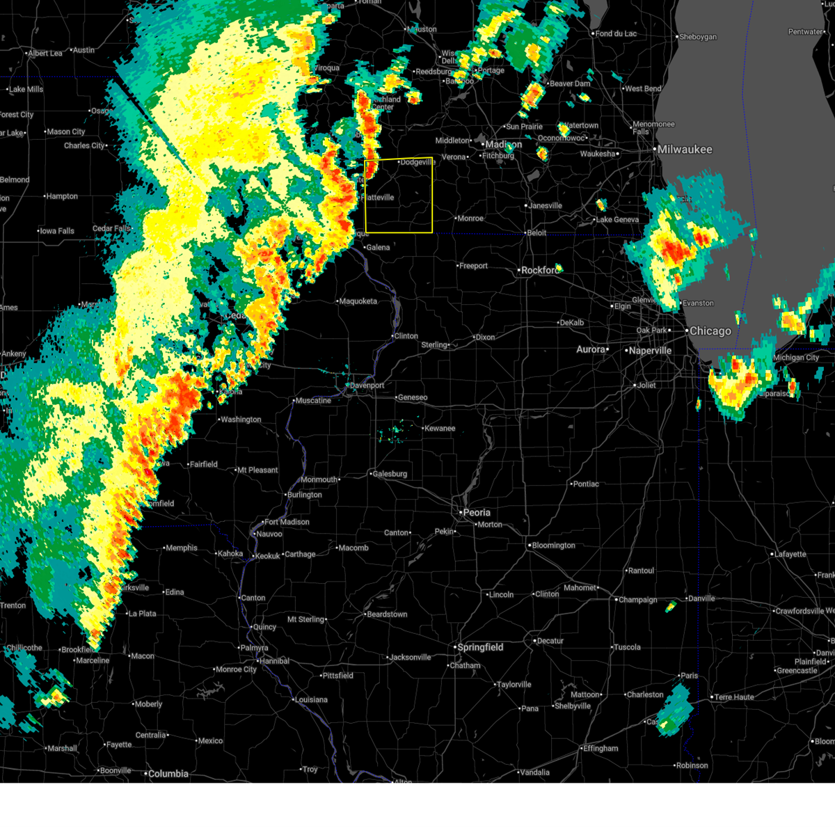
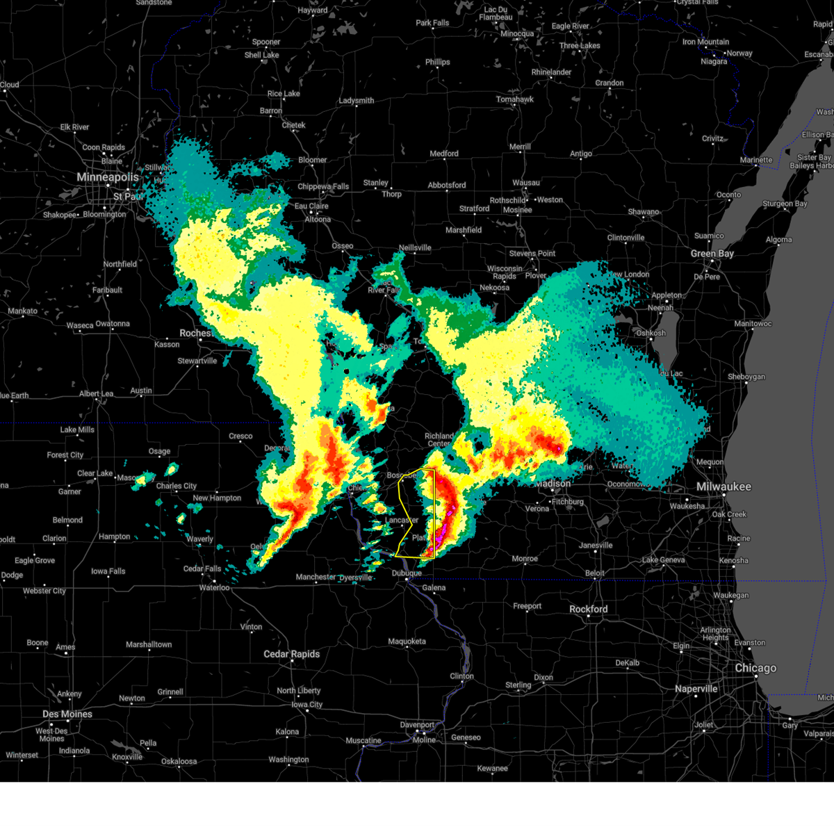
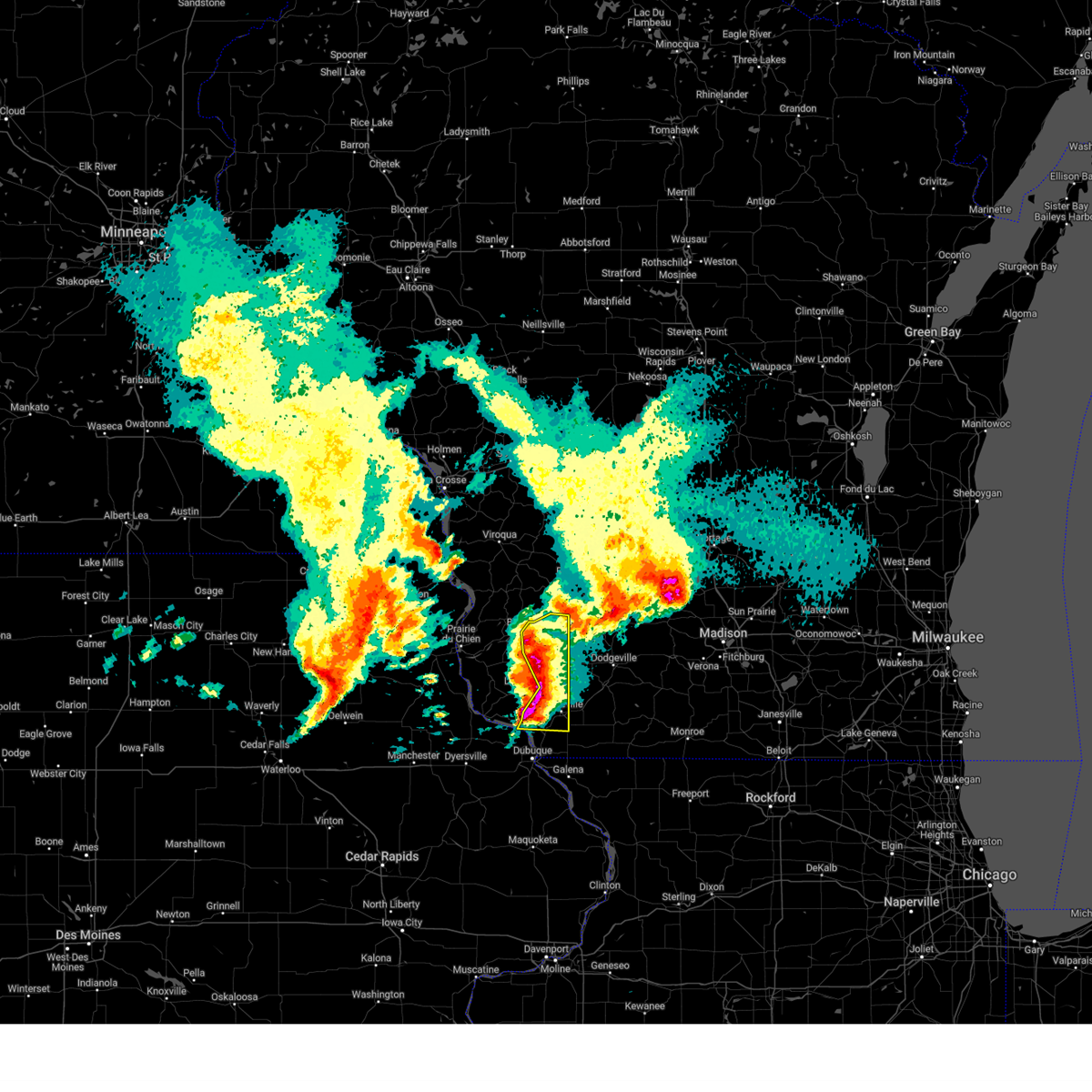
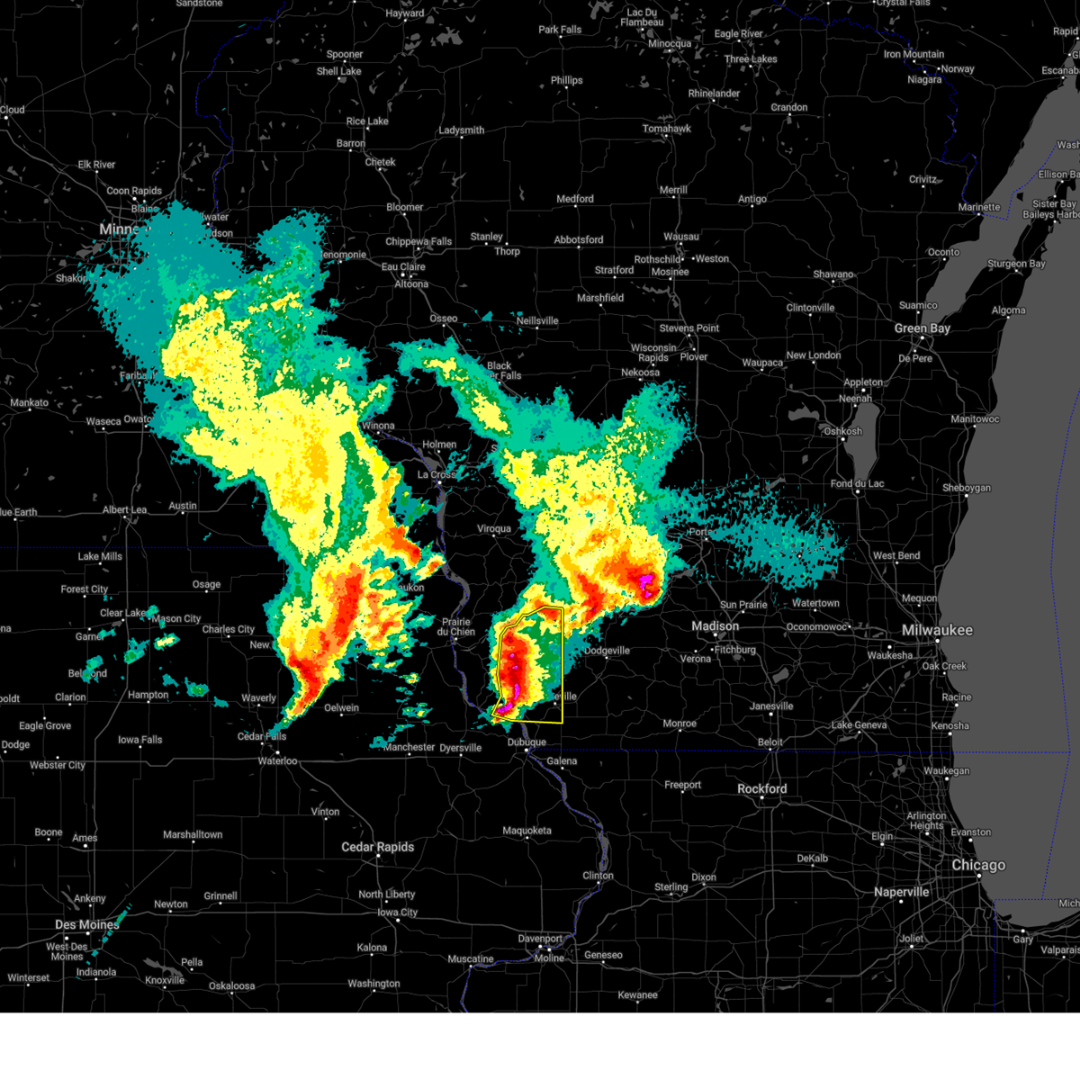
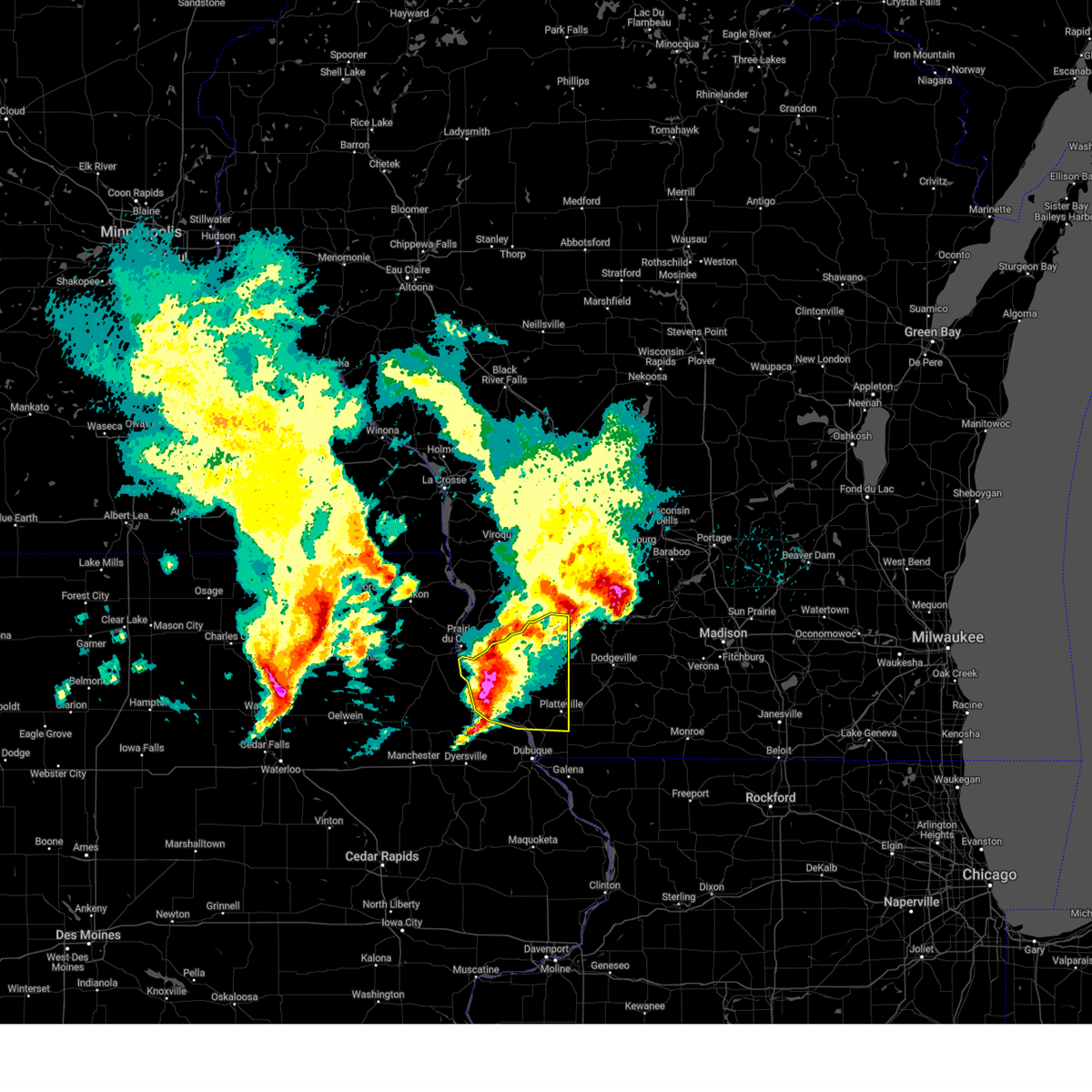
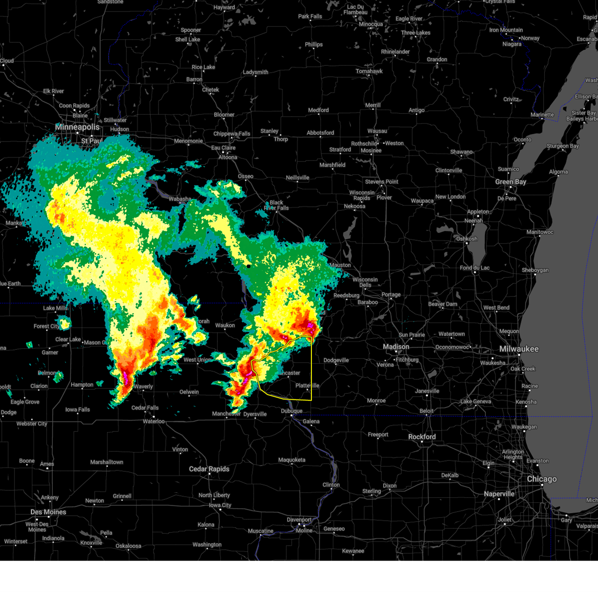
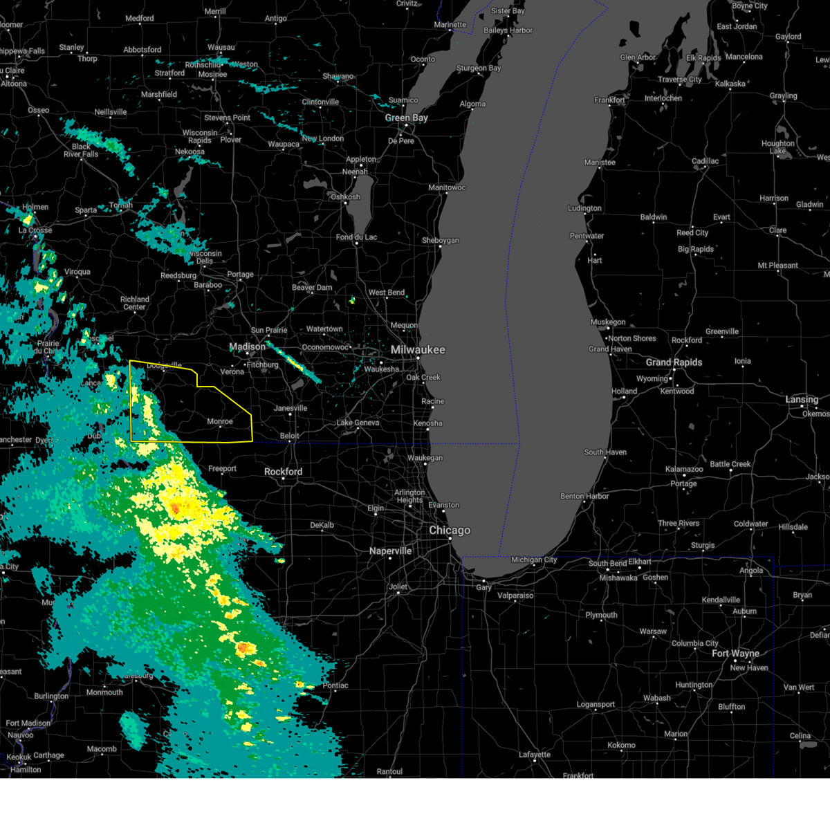
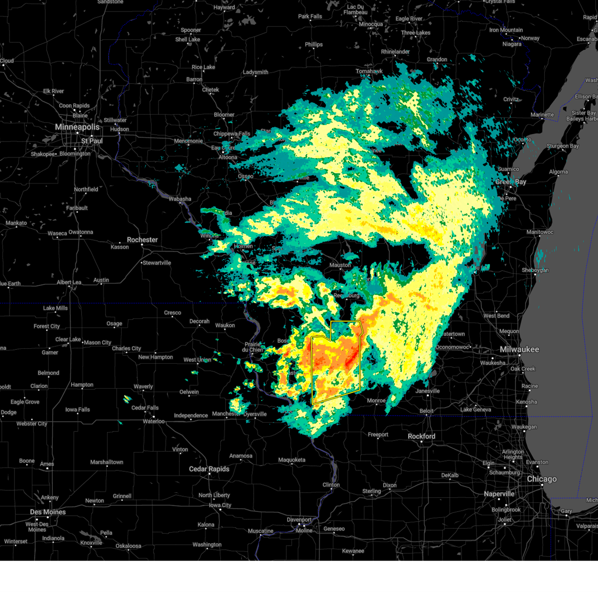
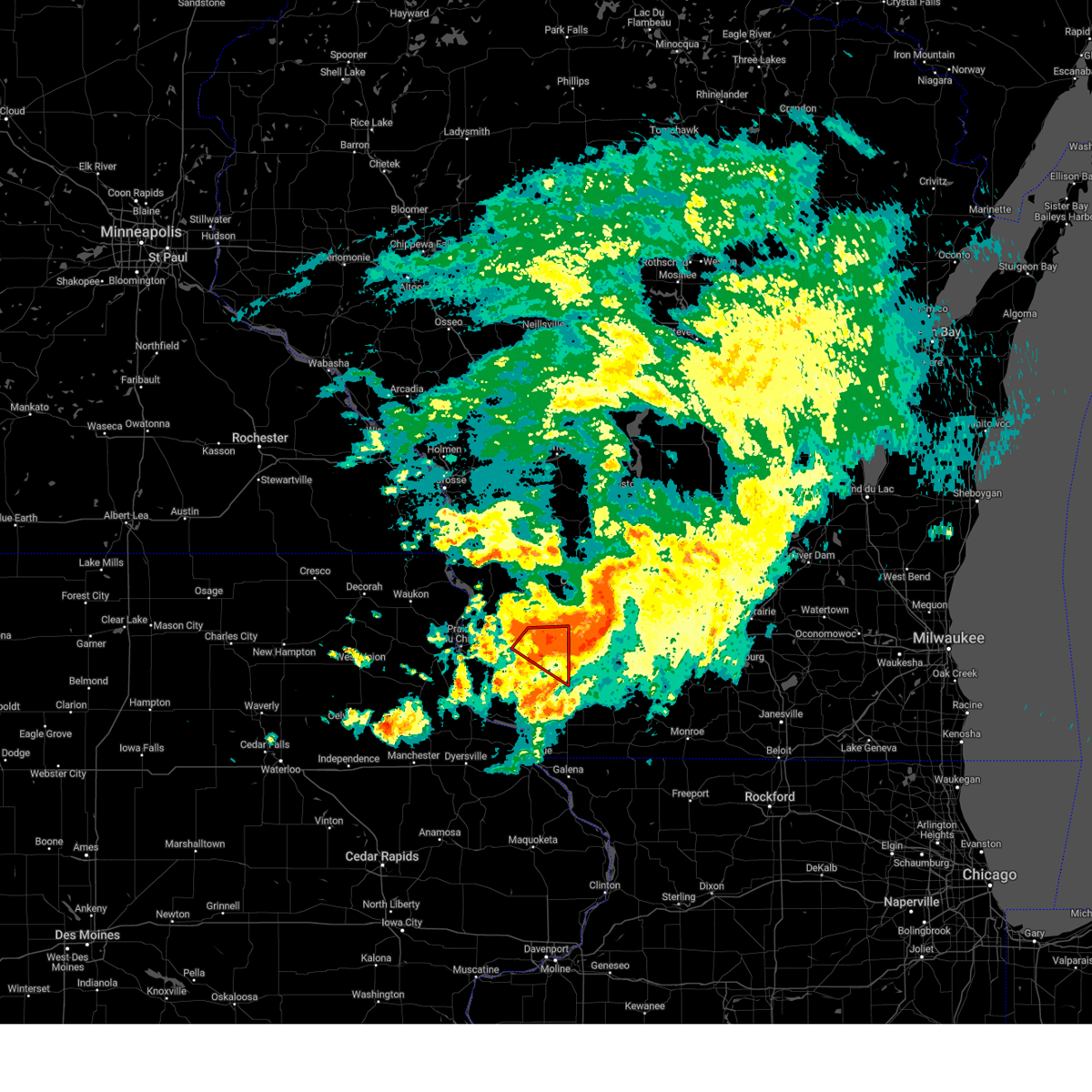
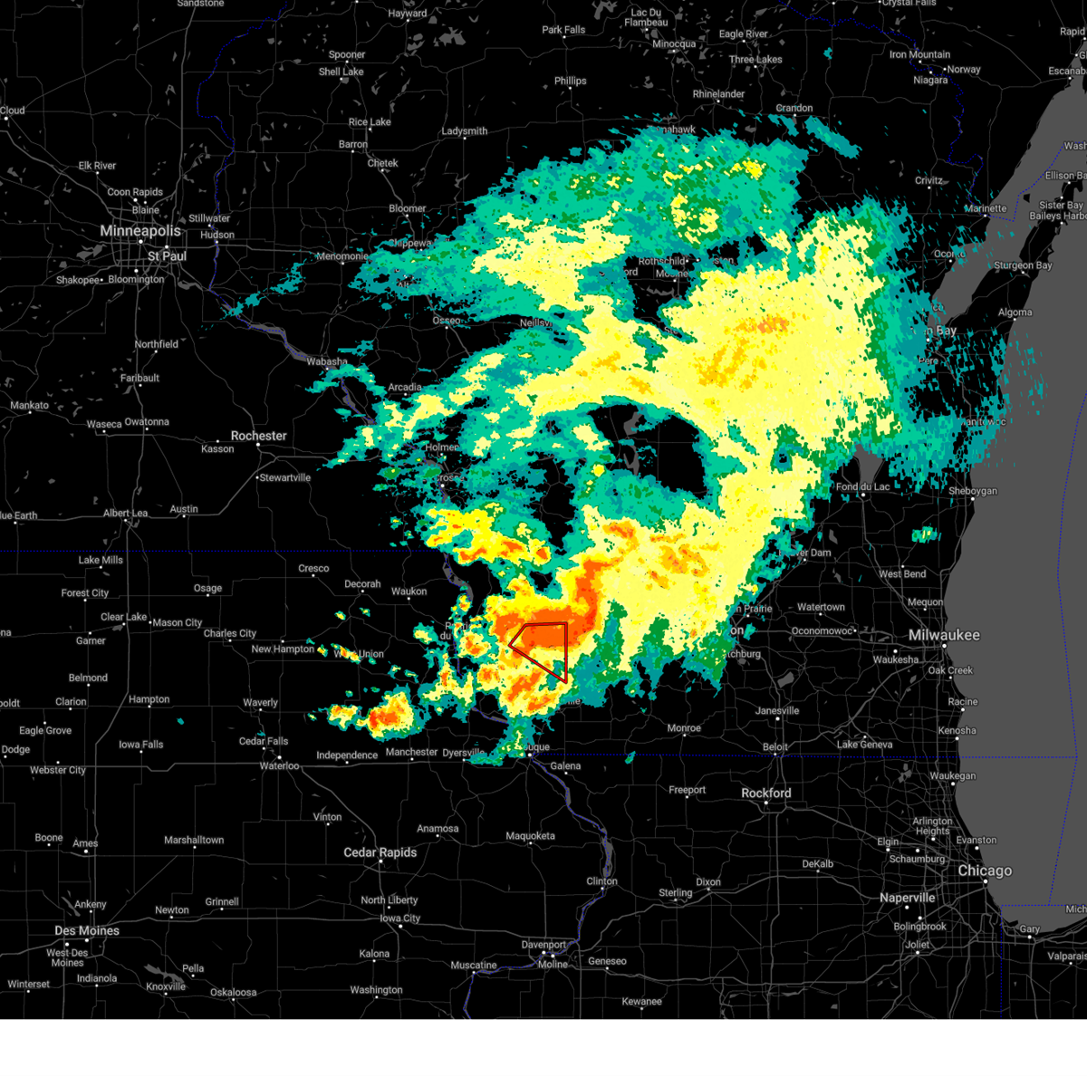
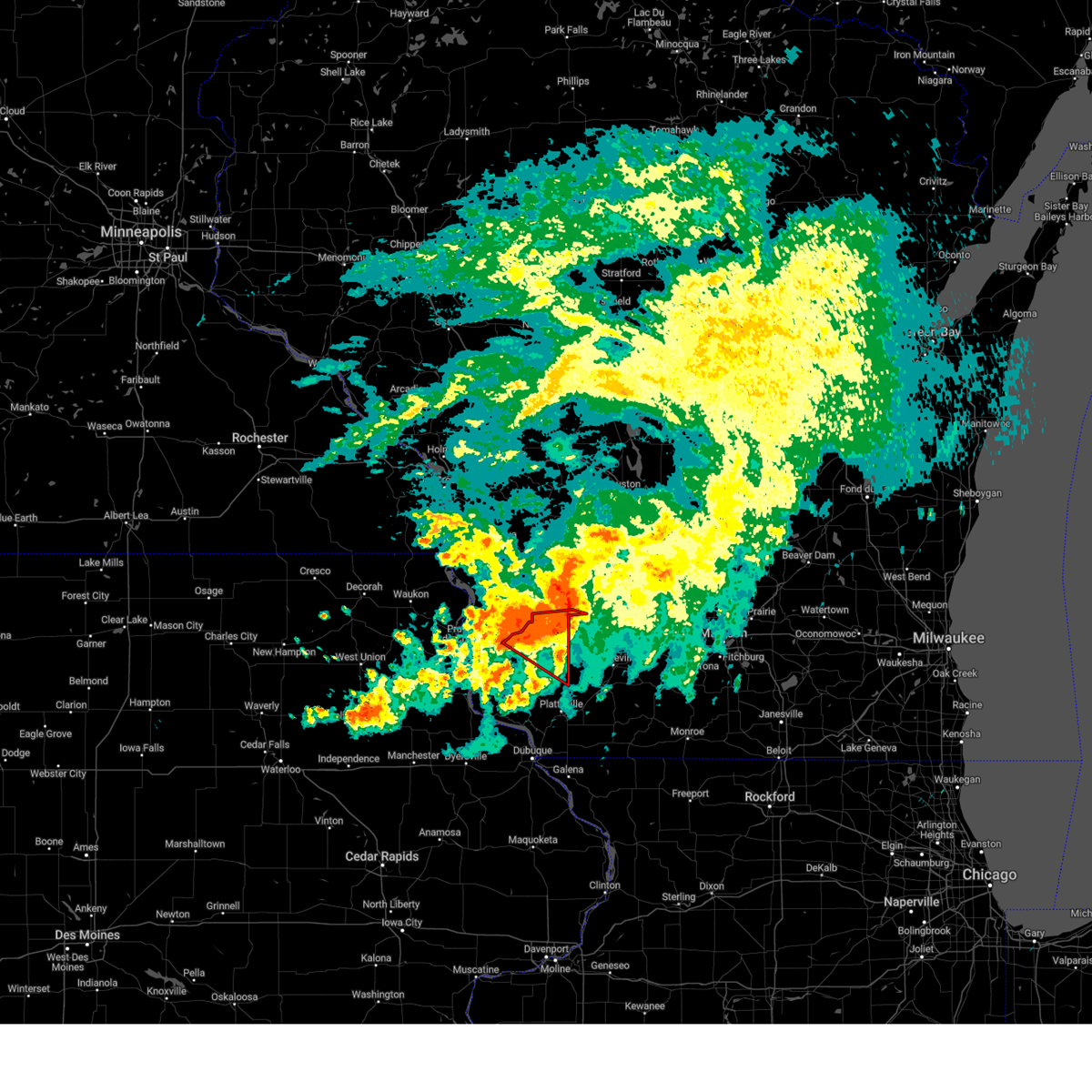
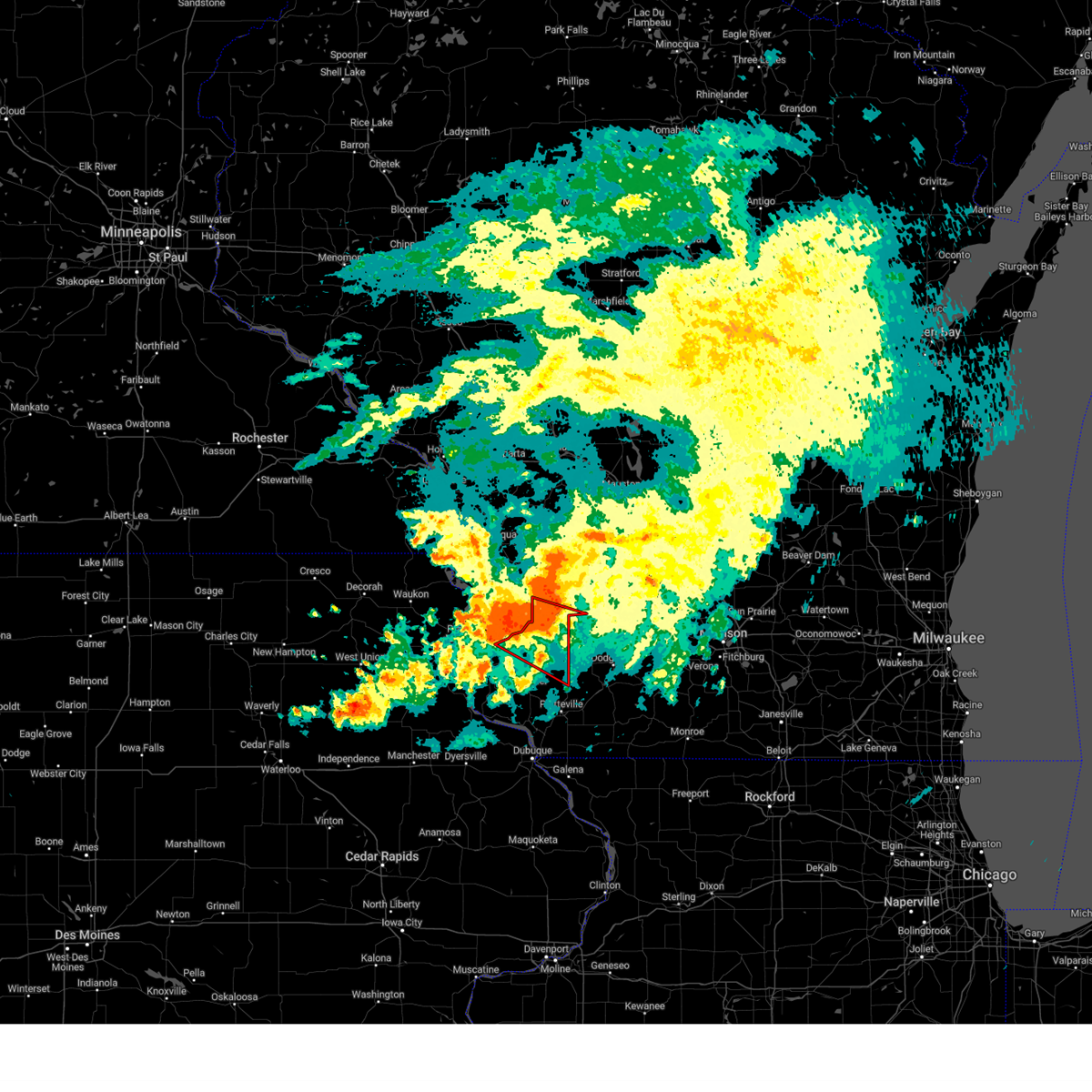
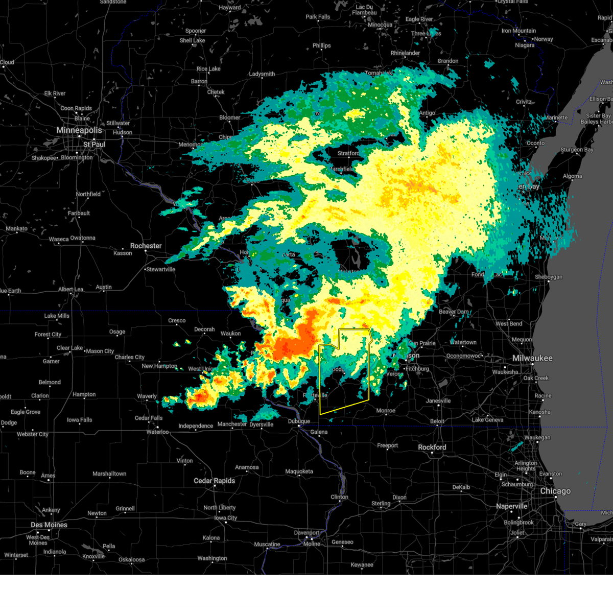
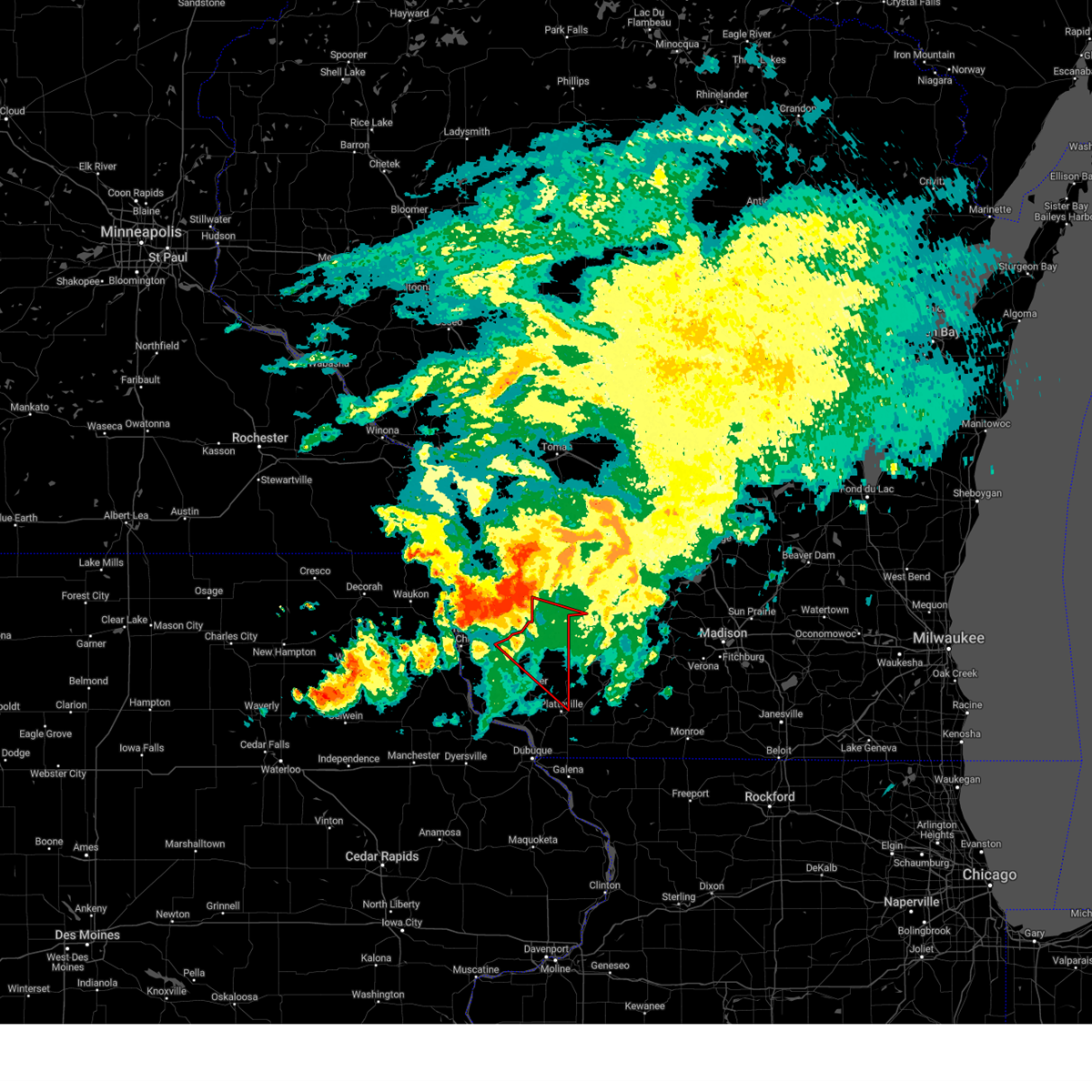
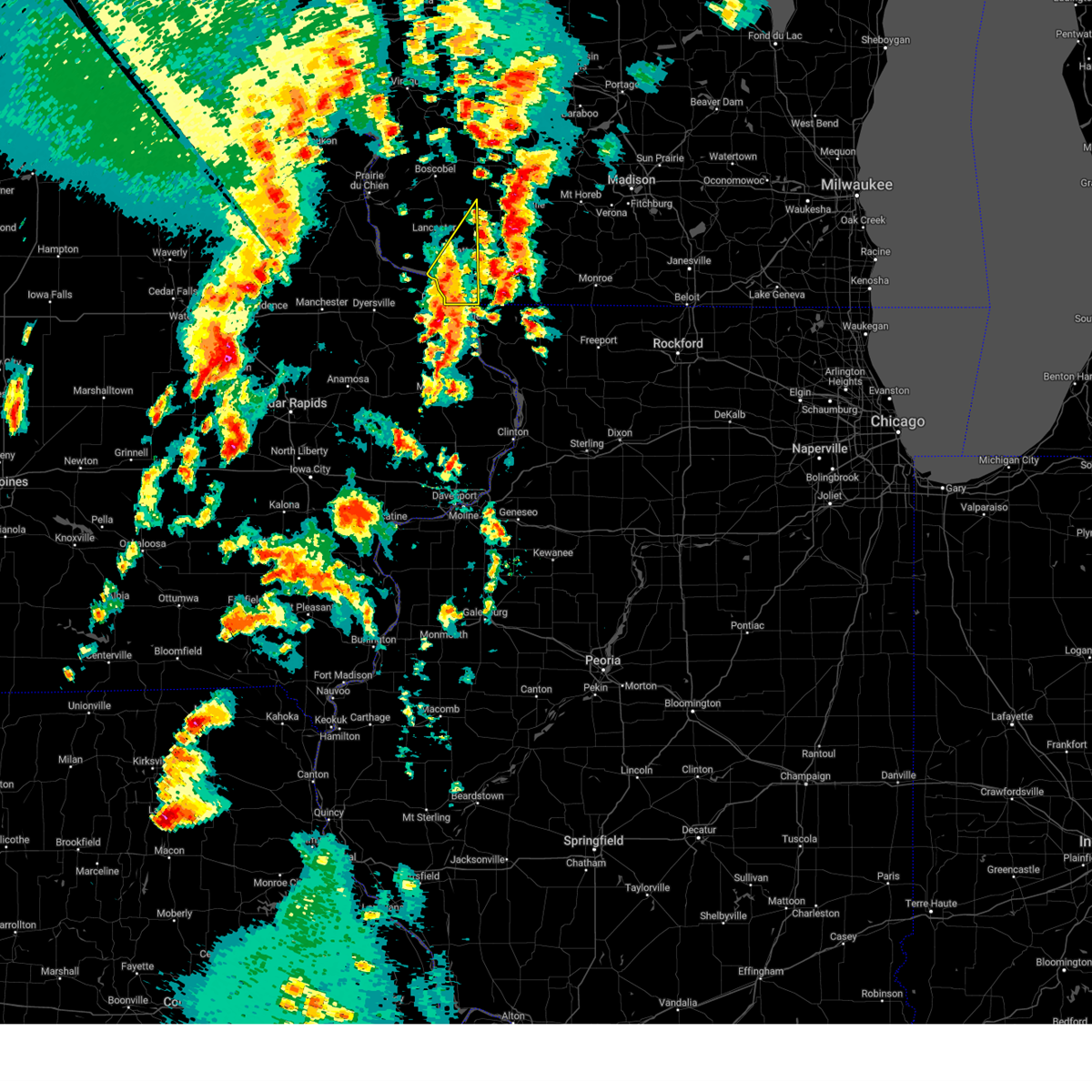
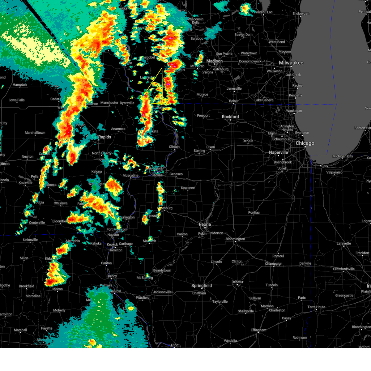
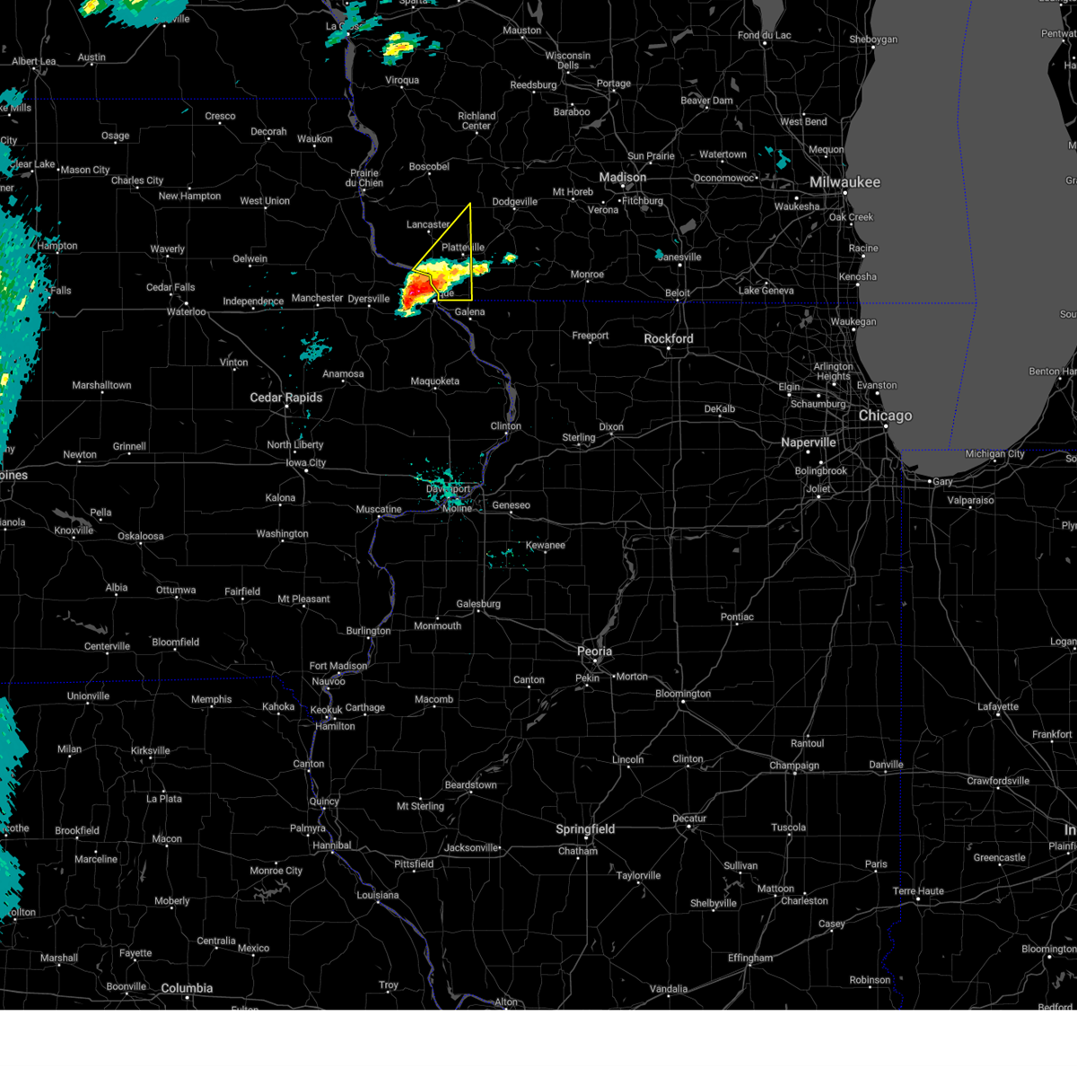
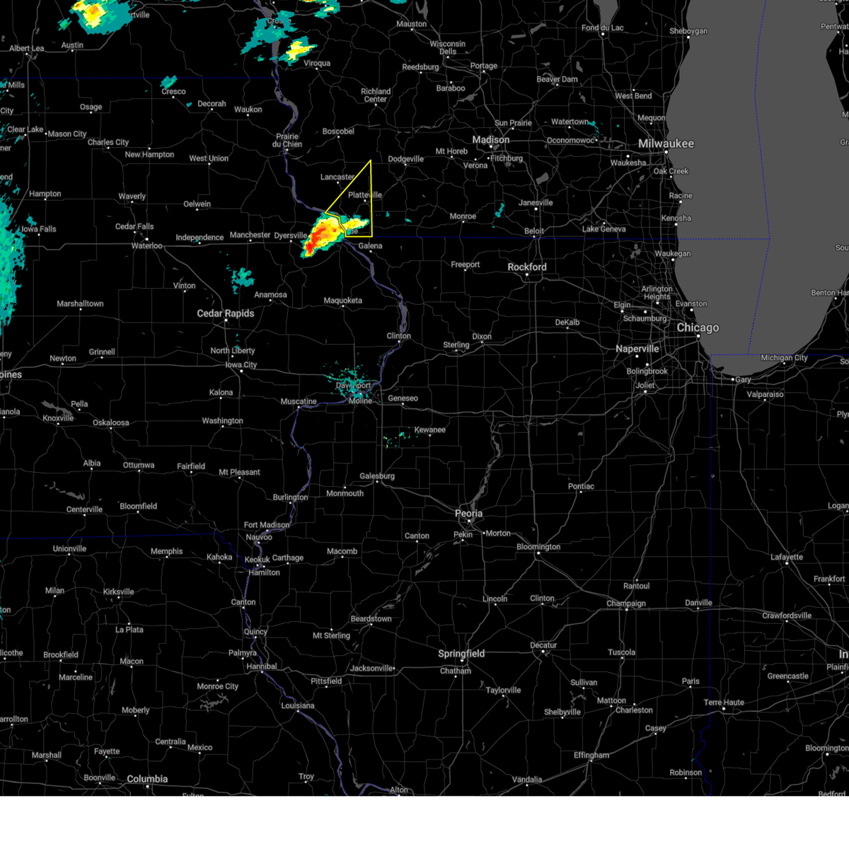
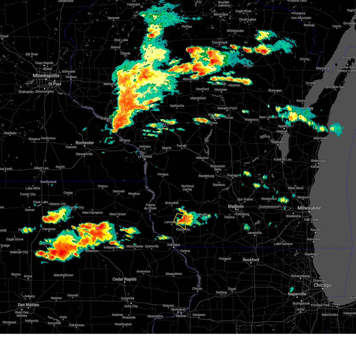
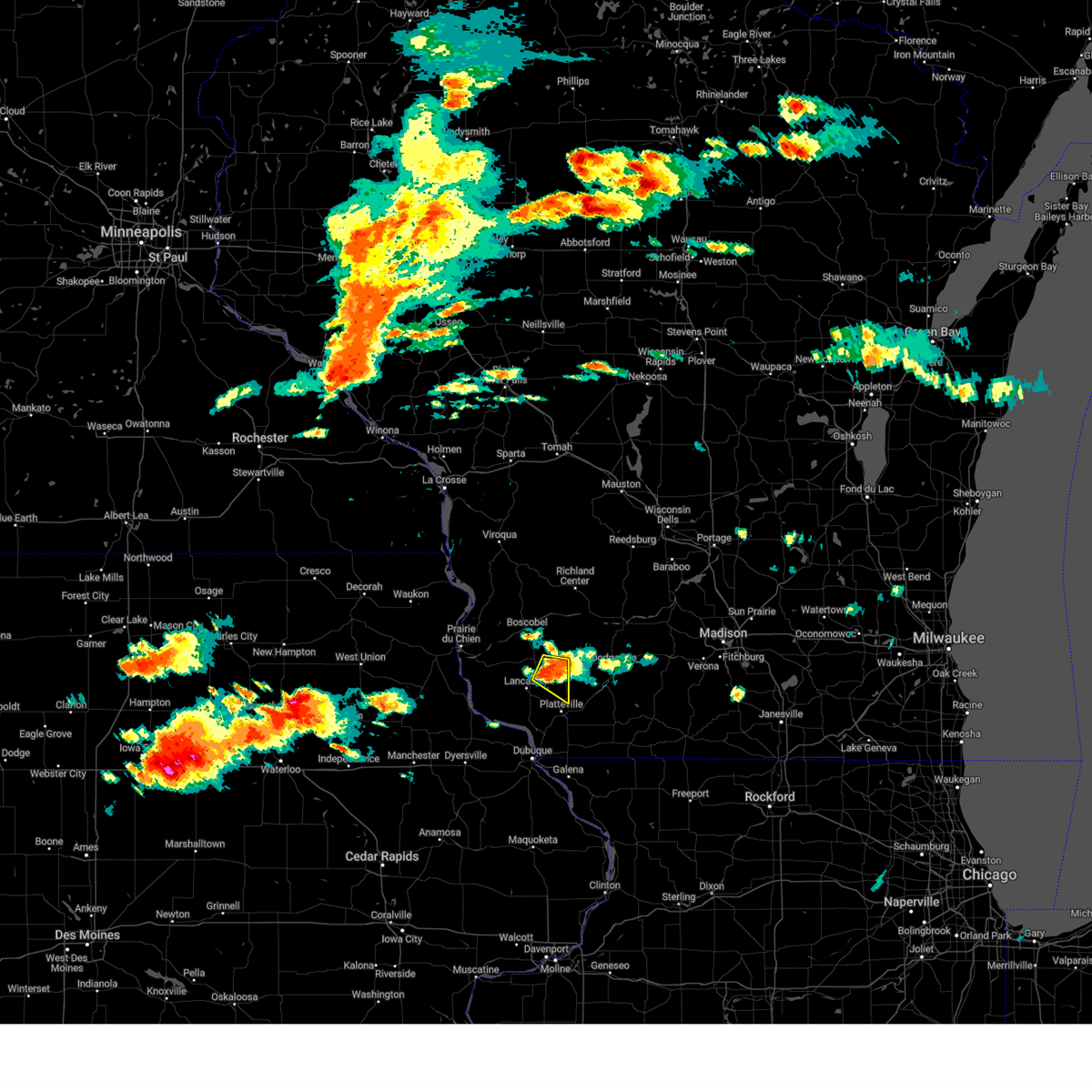
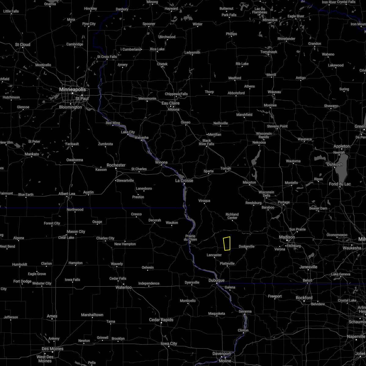
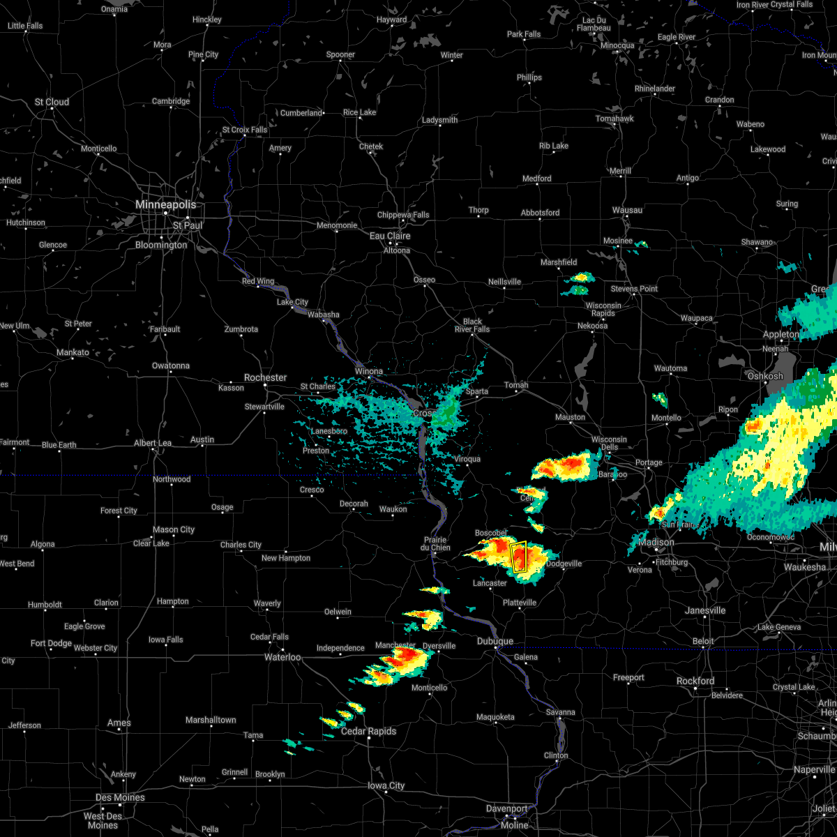
Hail Map for Montfort, WI
The Montfort, WI area has had 4 reports of on-the-ground hail by trained spotters, and has been under severe weather warnings 27 times during the past 12 months. Doppler radar has detected hail at or near Montfort, WI on 41 occasions, including 2 occasions during the past year.
| Name: | Montfort, WI |
| Where Located: | 53.4 miles W of Madison, WI |
| Map: | Google Map for Montfort, WI |
| Population: | 718 |
| Housing Units: | 298 |
| More Info: | Search Google for Montfort, WI |
0
The Top Recent Hail Date for Montfort, WI is Thursday, March 27, 2025 (22nd out of 41)

Hail and Wind Damage Spotted near Montfort, WI
| Date / Time | Report Details |
|---|---|
| 7/11/2025 5:39 PM CDT | Svrmkx the national weather service in milwaukee/sullivan has issued a * severe thunderstorm warning for, northern lafayette county in south central wisconsin, northern green county in south central wisconsin, iowa county in south central wisconsin, southwestern dane county in south central wisconsin, * until 630 pm cdt. * at 539 pm cdt, severe thunderstorms were located along a line extending from 13 miles west of dodgeville to near mineral point to near argyle, moving northeast at 50 mph (radar indicated). Hazards include 70 mph wind gusts and quarter size hail. Hail damage to vehicles is expected. expect considerable tree damage. Wind damage is also likely to mobile homes, roofs, and outbuildings. |
| 7/11/2025 5:15 PM CDT | At 513 pm cdt, severe thunderstorms were located along a line extending from 7 miles northeast of fennimore to near platteville, moving east at 30 mph (radar indicated. a 70 mph wind was reported at lancaster in grant county). Hazards include 70 mph wind gusts and quarter size hail. Hail damage to vehicles is expected. expect considerable tree damage. wind damage is also likely to mobile homes, roofs, and outbuildings. Locations impacted include, dodgeville, mineral point, blanchardville, barneveld, highland, ridgeway, centerville, linden, waldwick, cobb, clyde, rewey, hollandale, governor dodge st park, edmund, blue mound st park, blackhawk lake rec area, london, and jonesdale. |
| 7/11/2025 5:06 PM CDT | Svrmkx the national weather service in milwaukee/sullivan has issued a * severe thunderstorm warning for, iowa county in south central wisconsin, * until 545 pm cdt. * at 506 pm cdt, severe thunderstorms were located along a line extending from near fennimore to near platteville, moving northeast at 45 mph (radar indicated). Hazards include 60 mph wind gusts and quarter size hail. Hail damage to vehicles is expected. Expect wind damage to roofs, siding, and trees. |
| 6/26/2025 8:21 PM CDT |
 Svrmkx the national weather service in milwaukee/sullivan has issued a * severe thunderstorm warning for, lafayette county in south central wisconsin, southern iowa county in south central wisconsin, * until 915 pm cdt. * at 820 pm cdt, severe thunderstorms were located along a line extending from 9 miles southeast of fennimore to platteville to near menominee, moving east at 35 mph (radar indicated). Hazards include 60 mph wind gusts and nickel size hail. expect damage to roofs, siding, and trees Svrmkx the national weather service in milwaukee/sullivan has issued a * severe thunderstorm warning for, lafayette county in south central wisconsin, southern iowa county in south central wisconsin, * until 915 pm cdt. * at 820 pm cdt, severe thunderstorms were located along a line extending from 9 miles southeast of fennimore to platteville to near menominee, moving east at 35 mph (radar indicated). Hazards include 60 mph wind gusts and nickel size hail. expect damage to roofs, siding, and trees
|
| 4/18/2025 6:00 AM CDT |
 the severe thunderstorm warning has been cancelled and is no longer in effect the severe thunderstorm warning has been cancelled and is no longer in effect
|
| 4/18/2025 5:57 AM CDT |
 At 555 am cdt, severe thunderstorms were located along a line extending from 6 miles southeast of muscoda to 6 miles west of mineral point to near cuba city, moving east at 55 mph (public). Hazards include two inch hail and 60 mph wind gusts. People and animals outdoors will be injured. expect hail damage to roofs, siding, windows, and vehicles. expect wind damage to roofs, siding, and trees. locations impacted include, calamine, lamont, belmont, darlington, ridgeway, rewey, fayette, wiota, avoca, yellowstone lake st park, blackhawk lake rec area, linden, waldwick, argyle, highland, platte mounds, barneveld, orion, cobb, and arena. At 552 am cdt, two inch diameter hail was reported by the public near platteville. At 555 am cdt, severe thunderstorms were located along a line extending from 6 miles southeast of muscoda to 6 miles west of mineral point to near cuba city, moving east at 55 mph (public). Hazards include two inch hail and 60 mph wind gusts. People and animals outdoors will be injured. expect hail damage to roofs, siding, windows, and vehicles. expect wind damage to roofs, siding, and trees. locations impacted include, calamine, lamont, belmont, darlington, ridgeway, rewey, fayette, wiota, avoca, yellowstone lake st park, blackhawk lake rec area, linden, waldwick, argyle, highland, platte mounds, barneveld, orion, cobb, and arena. At 552 am cdt, two inch diameter hail was reported by the public near platteville.
|
| 4/18/2025 5:43 AM CDT |
 At 543 am cdt, severe thunderstorms were located along a line extending from near boscobel to 10 miles north of platteville to near dickeyville, moving east at 60 mph (radar indicated). Hazards include golf ball size hail and 60 mph wind gusts. People and animals outdoors will be injured. expect hail damage to roofs, siding, windows, and vehicles. expect wind damage to roofs, siding, and trees. these severe storms will be near, muscoda and platteville around 550 am cdt. Other locations impacted by these severe thunderstorms include preston, arthur, highway 61 and county t, montfort, potosi, livingston, and orion. At 543 am cdt, severe thunderstorms were located along a line extending from near boscobel to 10 miles north of platteville to near dickeyville, moving east at 60 mph (radar indicated). Hazards include golf ball size hail and 60 mph wind gusts. People and animals outdoors will be injured. expect hail damage to roofs, siding, windows, and vehicles. expect wind damage to roofs, siding, and trees. these severe storms will be near, muscoda and platteville around 550 am cdt. Other locations impacted by these severe thunderstorms include preston, arthur, highway 61 and county t, montfort, potosi, livingston, and orion.
|
| 4/18/2025 5:41 AM CDT |
 Svrmkx the national weather service in milwaukee/sullivan has issued a * severe thunderstorm warning for, lafayette county in south central wisconsin, iowa county in south central wisconsin, * until 630 am cdt. * at 541 am cdt, severe thunderstorms were located along a line extending from near boscobel to 6 miles east of lancaster to near sherrill, moving east at 60 mph (radar indicated). Hazards include golf ball size hail and 60 mph wind gusts. People and animals outdoors will be injured. expect hail damage to roofs, siding, windows, and vehicles. Expect wind damage to roofs, siding, and trees. Svrmkx the national weather service in milwaukee/sullivan has issued a * severe thunderstorm warning for, lafayette county in south central wisconsin, iowa county in south central wisconsin, * until 630 am cdt. * at 541 am cdt, severe thunderstorms were located along a line extending from near boscobel to 6 miles east of lancaster to near sherrill, moving east at 60 mph (radar indicated). Hazards include golf ball size hail and 60 mph wind gusts. People and animals outdoors will be injured. expect hail damage to roofs, siding, windows, and vehicles. Expect wind damage to roofs, siding, and trees.
|
| 4/18/2025 5:37 AM CDT |
 At 537 am cdt, severe thunderstorms were located along a line extending from near boscobel to near fennimore to 7 miles south of lancaster, moving east at 55 mph (radar indicated). Hazards include golf ball size hail. People and animals outdoors will be injured. expect damage to roofs, siding, windows, and vehicles. these severe storms will be near, lancaster and fennimore around 540 am cdt. muscoda and platteville around 550 am cdt. Other locations impacted by these severe thunderstorms include big h campground, preston, arthur, highway 61 and county t, montfort, mount ida, and union. At 537 am cdt, severe thunderstorms were located along a line extending from near boscobel to near fennimore to 7 miles south of lancaster, moving east at 55 mph (radar indicated). Hazards include golf ball size hail. People and animals outdoors will be injured. expect damage to roofs, siding, windows, and vehicles. these severe storms will be near, lancaster and fennimore around 540 am cdt. muscoda and platteville around 550 am cdt. Other locations impacted by these severe thunderstorms include big h campground, preston, arthur, highway 61 and county t, montfort, mount ida, and union.
|
| 4/18/2025 5:26 AM CDT |
 At 525 am cdt, severe thunderstorms were located along a line extending from 12 miles east of prairie du chien to near bloomington to near cassville, moving east at 55 mph (radar indicated). Hazards include half dollar size hail. Damage to vehicles is expected. these severe storms will be near, lancaster and fennimore around 530 am cdt. boscobel around 535 am cdt. muscoda and platteville around 550 am cdt. Other locations impacted by these severe thunderstorms include big h campground, preston, arthur, highway 61 and county t, montfort, mount ida, and beetown. At 525 am cdt, severe thunderstorms were located along a line extending from 12 miles east of prairie du chien to near bloomington to near cassville, moving east at 55 mph (radar indicated). Hazards include half dollar size hail. Damage to vehicles is expected. these severe storms will be near, lancaster and fennimore around 530 am cdt. boscobel around 535 am cdt. muscoda and platteville around 550 am cdt. Other locations impacted by these severe thunderstorms include big h campground, preston, arthur, highway 61 and county t, montfort, mount ida, and beetown.
|
| 4/18/2025 5:09 AM CDT |
 Svrarx the national weather service in la crosse has issued a * severe thunderstorm warning for, grant county in southwestern wisconsin, * until 615 am cdt. * at 509 am cdt, severe thunderstorms were located along a line extending from near prairie du chien to near colesburg, moving east at 55 mph (radar indicated). Hazards include half dollar size hail. Damage to vehicles is expected. severe thunderstorms will be near, bloomington and cassville around 515 am cdt. boscobel around 525 am cdt. lancaster and fennimore around 530 am cdt. muscoda around 540 am cdt. platteville around 550 am cdt. Other locations impacted by these severe thunderstorms include big h campground, preston, arthur, highway 61 and county t, montfort, mount ida, and beetown. Svrarx the national weather service in la crosse has issued a * severe thunderstorm warning for, grant county in southwestern wisconsin, * until 615 am cdt. * at 509 am cdt, severe thunderstorms were located along a line extending from near prairie du chien to near colesburg, moving east at 55 mph (radar indicated). Hazards include half dollar size hail. Damage to vehicles is expected. severe thunderstorms will be near, bloomington and cassville around 515 am cdt. boscobel around 525 am cdt. lancaster and fennimore around 530 am cdt. muscoda around 540 am cdt. platteville around 550 am cdt. Other locations impacted by these severe thunderstorms include big h campground, preston, arthur, highway 61 and county t, montfort, mount ida, and beetown.
|
| 3/14/2025 11:13 PM CDT | The storms which prompted the warning have weakened below severe limits. therefore, the warning will be allowed to expire. a severe thunderstorm watch remains in effect until 400 am cdt for south central wisconsin. remember, a severe thunderstorm warning still remains in effect for green county. |
| 3/14/2025 10:38 PM CDT | Svrmkx the national weather service in milwaukee/sullivan has issued a * severe thunderstorm warning for, lafayette county in south central wisconsin, green county in south central wisconsin, southern iowa county in south central wisconsin, * until 1115 pm cdt. * at 1037 pm cdt, severe thunderstorms were located along a line extending from 11 miles east of fennimore to near darlington to near winslow, moving northeast at 25 mph (radar indicated). Hazards include 60 mph wind gusts. these storms have a history of producing 50 to 60 mph winds. expect damage to roofs, siding, and trees |
| 3/14/2025 10:27 PM CDT |
 At 1026 pm cdt, severe thunderstorms were located along a line extending from 10 miles east of fennimore to darlington to near lena, moving northeast at 50 mph (trained weather spotters 5 miles north-northwest of platteville measured 59 mph wind gusts). Hazards include 60 mph wind gusts. Expect damage to roofs, siding, and trees. Locations impacted include, calamine, lamont, belmont, darlington, brodhead, rewey, juda, fayette, wiota, yellowstone lake st park, linden, waldwick, new diggings, argyle, albany, gratiot, platte mounds, lead mine, monroe, and benton. At 1026 pm cdt, severe thunderstorms were located along a line extending from 10 miles east of fennimore to darlington to near lena, moving northeast at 50 mph (trained weather spotters 5 miles north-northwest of platteville measured 59 mph wind gusts). Hazards include 60 mph wind gusts. Expect damage to roofs, siding, and trees. Locations impacted include, calamine, lamont, belmont, darlington, brodhead, rewey, juda, fayette, wiota, yellowstone lake st park, linden, waldwick, new diggings, argyle, albany, gratiot, platte mounds, lead mine, monroe, and benton.
|
| 3/14/2025 10:04 PM CDT | Svrmkx the national weather service in milwaukee/sullivan has issued a * severe thunderstorm warning for, lafayette county in south central wisconsin, green county in south central wisconsin, southern iowa county in south central wisconsin, * until 1045 pm cdt. * at 1003 pm cdt, severe thunderstorms were located along a line extending from peosta to near galena to mount carroll, moving northeast at 65 mph (radar indicated. these storms have a history of producing 50 to 60 mph). Hazards include 60 mph wind gusts. expect damage to roofs, siding, and trees |
| 9/21/2024 6:47 PM CDT | The storm which prompted the warning has weakened below severe limits, and no longer poses an immediate threat to life or property. therefore, the warning has been allowed to expire. however, small hail, gusty winds and heavy rain are still possible with this thunderstorm. there has been reports of street flooding in fennimore and wind damage further north when the storms were stronger. |
| 9/21/2024 6:17 PM CDT | At 617 pm cdt, a severe thunderstorm was located over fennimore, or 10 miles northeast of lancaster, moving southeast at 30 mph (radar indicated). Hazards include 60 mph wind gusts and quarter size hail. Hail damage to vehicles is expected. expect wind damage to roofs, siding, and trees. this severe storm will be near, platteville around 650 pm cdt. Other locations impacted by this severe thunderstorm include preston, arthur, highway 61 and county t, montfort, werley, mount ida, and livingston. |
| 9/21/2024 5:48 PM CDT | Svrarx the national weather service in la crosse has issued a * severe thunderstorm warning for, eastern grant county in southwestern wisconsin, * until 645 pm cdt. * at 548 pm cdt, a severe thunderstorm was located near boscobel, or 18 miles northeast of prairie du chien, moving southeast at 40 mph (radar indicated). Hazards include 60 mph wind gusts and quarter size hail. Hail damage to vehicles is expected. expect wind damage to roofs, siding, and trees. this severe thunderstorm will be near, boscobel around 555 pm cdt. fennimore around 605 pm cdt. Other locations impacted by this severe thunderstorm include preston, arthur, highway 61 and county t, montfort, werley, mount ida, and livingston. |
| 8/6/2024 12:14 AM CDT |
 the severe thunderstorm warning has been cancelled and is no longer in effect the severe thunderstorm warning has been cancelled and is no longer in effect
|
| 8/5/2024 11:54 PM CDT |
 At 1154 pm cdt, severe thunderstorms were located along a line extending from 11 miles north of spring green to 7 miles north of dodgeville to 8 miles north of platteville, moving east at 45 mph (radar indicated). Hazards include 60 mph wind gusts and penny size hail. Expect damage to roofs, siding, and trees. Locations impacted include, dodgeville, mineral point, darlington, spring green, belmont, blanchardville, barneveld, highland, arena, plain, ridgeway, avoca, orion, linden, waldwick, elk grove, cobb, fayette, clyde, and lamont. At 1154 pm cdt, severe thunderstorms were located along a line extending from 11 miles north of spring green to 7 miles north of dodgeville to 8 miles north of platteville, moving east at 45 mph (radar indicated). Hazards include 60 mph wind gusts and penny size hail. Expect damage to roofs, siding, and trees. Locations impacted include, dodgeville, mineral point, darlington, spring green, belmont, blanchardville, barneveld, highland, arena, plain, ridgeway, avoca, orion, linden, waldwick, elk grove, cobb, fayette, clyde, and lamont.
|
| 8/5/2024 11:53 PM CDT |
 The storm which prompted the warning has weakened below severe limits, and no longer appears capable of producing a tornado. therefore, the warning will be allowed to expire. a tornado watch remains in effect until midnight cdt for southwestern wisconsin. The storm which prompted the warning has weakened below severe limits, and no longer appears capable of producing a tornado. therefore, the warning will be allowed to expire. a tornado watch remains in effect until midnight cdt for southwestern wisconsin.
|
| 8/5/2024 11:46 PM CDT |
 the tornado warning has been cancelled and is no longer in effect the tornado warning has been cancelled and is no longer in effect
|
| 8/5/2024 11:46 PM CDT |
 At 1146 pm cdt, a severe thunderstorm capable of producing a tornado was located over fennimore, or 11 miles north of lancaster, moving east at 40 mph (radar indicated rotation). Hazards include tornado. Flying debris will be dangerous to those caught without shelter. mobile homes will be damaged or destroyed. damage to roofs, windows, and vehicles will occur. tree damage is likely. this dangerous storm will be near, fennimore around 1150 pm cdt. Other locations impacted by this tornadic thunderstorm include preston, highway 61 and county t, montfort, livingston, red oak ridge, county roads k and t, and centerville. At 1146 pm cdt, a severe thunderstorm capable of producing a tornado was located over fennimore, or 11 miles north of lancaster, moving east at 40 mph (radar indicated rotation). Hazards include tornado. Flying debris will be dangerous to those caught without shelter. mobile homes will be damaged or destroyed. damage to roofs, windows, and vehicles will occur. tree damage is likely. this dangerous storm will be near, fennimore around 1150 pm cdt. Other locations impacted by this tornadic thunderstorm include preston, highway 61 and county t, montfort, livingston, red oak ridge, county roads k and t, and centerville.
|
| 8/5/2024 11:36 PM CDT |
 At 1136 pm cdt, a severe squall line capable of producing both tornadoes and extensive straight line wind damage was located along a line extending from near muscoda to 8 miles northwest of fennimore, moving southeast at 40 mph (radar indicated rotation). Hazards include tornado. Flying debris will be dangerous to those caught without shelter. mobile homes will be damaged or destroyed. damage to roofs, windows, and vehicles will occur. tree damage is likely. these dangerous storms will be near, fennimore around 1140 pm cdt. Other locations impacted by these tornadic storms include westport, preston, highway 61 and county t, montfort, livingston, eagle corners, and orion. At 1136 pm cdt, a severe squall line capable of producing both tornadoes and extensive straight line wind damage was located along a line extending from near muscoda to 8 miles northwest of fennimore, moving southeast at 40 mph (radar indicated rotation). Hazards include tornado. Flying debris will be dangerous to those caught without shelter. mobile homes will be damaged or destroyed. damage to roofs, windows, and vehicles will occur. tree damage is likely. these dangerous storms will be near, fennimore around 1140 pm cdt. Other locations impacted by these tornadic storms include westport, preston, highway 61 and county t, montfort, livingston, eagle corners, and orion.
|
| 8/5/2024 11:29 PM CDT |
 At 1129 pm cdt, a severe squall line capable of producing both tornadoes and extensive straight line wind damage was located along a line extending from near muscoda to 10 miles east of prairie du chien, moving southeast at 30 mph (radar indicated rotation). Hazards include tornado. Flying debris will be dangerous to those caught without shelter. mobile homes will be damaged or destroyed. damage to roofs, windows, and vehicles will occur. tree damage is likely. these dangerous storms will be near, boscobel and muscoda around 1135 pm cdt. fennimore around 1145 pm cdt. Other locations impacted by these tornadic storms include westport, preston, highway 61 and county t, montfort, eagle cave, werley, and livingston. At 1129 pm cdt, a severe squall line capable of producing both tornadoes and extensive straight line wind damage was located along a line extending from near muscoda to 10 miles east of prairie du chien, moving southeast at 30 mph (radar indicated rotation). Hazards include tornado. Flying debris will be dangerous to those caught without shelter. mobile homes will be damaged or destroyed. damage to roofs, windows, and vehicles will occur. tree damage is likely. these dangerous storms will be near, boscobel and muscoda around 1135 pm cdt. fennimore around 1145 pm cdt. Other locations impacted by these tornadic storms include westport, preston, highway 61 and county t, montfort, eagle cave, werley, and livingston.
|
| 8/5/2024 11:26 PM CDT |
 Svrmkx the national weather service in milwaukee/sullivan has issued a * severe thunderstorm warning for, northern lafayette county in south central wisconsin, iowa county in south central wisconsin, southwestern sauk county in south central wisconsin, * until 1230 am cdt. * at 1124 pm cdt, severe thunderstorms were located along a line extending from 8 miles northwest of richland center to near muscoda to 8 miles north of bloomington, moving southeast at 45 mph (radar indicated). Hazards include 60 mph wind gusts and quarter size hail. Hail damage to vehicles is expected. Expect wind damage to roofs, siding, and trees. Svrmkx the national weather service in milwaukee/sullivan has issued a * severe thunderstorm warning for, northern lafayette county in south central wisconsin, iowa county in south central wisconsin, southwestern sauk county in south central wisconsin, * until 1230 am cdt. * at 1124 pm cdt, severe thunderstorms were located along a line extending from 8 miles northwest of richland center to near muscoda to 8 miles north of bloomington, moving southeast at 45 mph (radar indicated). Hazards include 60 mph wind gusts and quarter size hail. Hail damage to vehicles is expected. Expect wind damage to roofs, siding, and trees.
|
| 8/5/2024 11:15 PM CDT |
 Torarx the national weather service in la crosse has issued a * tornado warning for, northeastern grant county in southwestern wisconsin, southwestern richland county in southwestern wisconsin, * until midnight cdt. * at 1115 pm cdt, severe thunderstorms capable of producing both tornadoes and extensive straight line wind damage were located along a line extending from 8 miles north of boscobel to 6 miles northeast of prairie du chien, moving southeast at 35 mph (radar indicated rotation). Hazards include tornado. Flying debris will be dangerous to those caught without shelter. mobile homes will be damaged or destroyed. damage to roofs, windows, and vehicles will occur. tree damage is likely. these dangerous storms will be near, boscobel around 1120 pm cdt. muscoda around 1130 pm cdt. fennimore around 1140 pm cdt. Other locations impacted by these tornadic storms include westport, preston, arthur, highway 61 and county t, montfort, eagle cave, and werley. Torarx the national weather service in la crosse has issued a * tornado warning for, northeastern grant county in southwestern wisconsin, southwestern richland county in southwestern wisconsin, * until midnight cdt. * at 1115 pm cdt, severe thunderstorms capable of producing both tornadoes and extensive straight line wind damage were located along a line extending from 8 miles north of boscobel to 6 miles northeast of prairie du chien, moving southeast at 35 mph (radar indicated rotation). Hazards include tornado. Flying debris will be dangerous to those caught without shelter. mobile homes will be damaged or destroyed. damage to roofs, windows, and vehicles will occur. tree damage is likely. these dangerous storms will be near, boscobel around 1120 pm cdt. muscoda around 1130 pm cdt. fennimore around 1140 pm cdt. Other locations impacted by these tornadic storms include westport, preston, arthur, highway 61 and county t, montfort, eagle cave, and werley.
|
| 6/22/2024 6:39 PM CDT |
 At 639 pm cdt, severe thunderstorms were located along a line extending from 6 miles northeast of spring green to near dodgeville to 10 miles north of platteville, moving east at 45 mph (radar indicated). Hazards include 60 mph wind gusts and quarter size hail. Hail damage to vehicles is expected. expect wind damage to roofs, siding, and trees. Locations impacted include, dodgeville, mineral point, spring green, blanchardville, barneveld, highland, arena, ridgeway, centerville, linden, waldwick, cobb, clyde, rewey, hollandale, governor dodge st park, edmund, blue mound st park, blackhawk lake rec area, and london. At 639 pm cdt, severe thunderstorms were located along a line extending from 6 miles northeast of spring green to near dodgeville to 10 miles north of platteville, moving east at 45 mph (radar indicated). Hazards include 60 mph wind gusts and quarter size hail. Hail damage to vehicles is expected. expect wind damage to roofs, siding, and trees. Locations impacted include, dodgeville, mineral point, spring green, blanchardville, barneveld, highland, arena, ridgeway, centerville, linden, waldwick, cobb, clyde, rewey, hollandale, governor dodge st park, edmund, blue mound st park, blackhawk lake rec area, and london.
|
| 6/22/2024 6:17 PM CDT |
 Svrmkx the national weather service in milwaukee/sullivan has issued a * severe thunderstorm warning for, iowa county in south central wisconsin, southwestern sauk county in south central wisconsin, * until 700 pm cdt. * at 617 pm cdt, severe thunderstorms were located along a line extending from 6 miles southeast of richland center to near muscoda to near fennimore, moving east at 45 mph (radar indicated). Hazards include 60 mph wind gusts and quarter size hail. Hail damage to vehicles is expected. Expect wind damage to roofs, siding, and trees. Svrmkx the national weather service in milwaukee/sullivan has issued a * severe thunderstorm warning for, iowa county in south central wisconsin, southwestern sauk county in south central wisconsin, * until 700 pm cdt. * at 617 pm cdt, severe thunderstorms were located along a line extending from 6 miles southeast of richland center to near muscoda to near fennimore, moving east at 45 mph (radar indicated). Hazards include 60 mph wind gusts and quarter size hail. Hail damage to vehicles is expected. Expect wind damage to roofs, siding, and trees.
|
| 6/12/2024 4:40 PM CDT |
 At 439 pm cdt, severe thunderstorms were located along a line extending from 8 miles west of spring green to 10 miles west of dodgeville to platteville, moving east at 35 mph (law enforcement reported wind damage in dickeyville and lancaster around 430 pm). Hazards include 60 mph wind gusts. Expect damage to roofs, siding, and trees. these severe thunderstorms will remain over mainly rural areas of eastern grant and southeastern richland counties, including the following locations, preston, arthur, montfort, eagle cave, eagle corners, union, and cornelia. The warning will be allowed to expire at 445 pm. At 439 pm cdt, severe thunderstorms were located along a line extending from 8 miles west of spring green to 10 miles west of dodgeville to platteville, moving east at 35 mph (law enforcement reported wind damage in dickeyville and lancaster around 430 pm). Hazards include 60 mph wind gusts. Expect damage to roofs, siding, and trees. these severe thunderstorms will remain over mainly rural areas of eastern grant and southeastern richland counties, including the following locations, preston, arthur, montfort, eagle cave, eagle corners, union, and cornelia. The warning will be allowed to expire at 445 pm.
|
| 6/12/2024 4:30 PM CDT |
 At 430 pm cdt, severe thunderstorms were located along a line extending from 8 miles east of richland center to near sageville, moving east at 45 mph (trained weather spotters. trees and power lines have been reported down in boscobel and lancaster, along with a measured 64 mph wind gust at the boscobel airport). Hazards include 60 mph wind gusts and penny size hail. Expect damage to roofs, siding, and trees. Locations impacted include, dodgeville, mineral point, darlington, spring green, shullsburg, belmont, benton, argyle, blanchardville, barneveld, wiota, blue mounds, highland, arena, plain, ridgeway, avoca, orion, linden, and new diggings. At 430 pm cdt, severe thunderstorms were located along a line extending from 8 miles east of richland center to near sageville, moving east at 45 mph (trained weather spotters. trees and power lines have been reported down in boscobel and lancaster, along with a measured 64 mph wind gust at the boscobel airport). Hazards include 60 mph wind gusts and penny size hail. Expect damage to roofs, siding, and trees. Locations impacted include, dodgeville, mineral point, darlington, spring green, shullsburg, belmont, benton, argyle, blanchardville, barneveld, wiota, blue mounds, highland, arena, plain, ridgeway, avoca, orion, linden, and new diggings.
|
| 6/12/2024 4:11 PM CDT |
 Svrmkx the national weather service in milwaukee/sullivan has issued a * severe thunderstorm warning for, lafayette county in south central wisconsin, iowa county in south central wisconsin, southwestern sauk county in south central wisconsin, * until 515 pm cdt. * at 410 pm cdt, severe thunderstorms were located along a line extending from near richland center to rickardsville, moving east at 45 mph (trained weather spotters. there have been numerous reports of tree and power line damage across southwestern wisconsin with the storms). Hazards include 60 mph wind gusts and penny size hail. expect damage to roofs, siding, and trees Svrmkx the national weather service in milwaukee/sullivan has issued a * severe thunderstorm warning for, lafayette county in south central wisconsin, iowa county in south central wisconsin, southwestern sauk county in south central wisconsin, * until 515 pm cdt. * at 410 pm cdt, severe thunderstorms were located along a line extending from near richland center to rickardsville, moving east at 45 mph (trained weather spotters. there have been numerous reports of tree and power line damage across southwestern wisconsin with the storms). Hazards include 60 mph wind gusts and penny size hail. expect damage to roofs, siding, and trees
|
| 6/12/2024 4:03 PM CDT |
 Svrarx the national weather service in la crosse has issued a * severe thunderstorm warning for, eastern grant county in southwestern wisconsin, southern richland county in southwestern wisconsin, * until 445 pm cdt. * at 401 pm cdt, severe thunderstorms were located along a line extending from near boscobel to 8 miles northeast of bloomington to near guttenberg, moving east at 50 mph (law enforcement. multiple reports of tree limbs and power lines down have been reported near postville, guttenberg, and bagley since 345 pm). Hazards include 60 mph wind gusts. Expect damage to roofs, siding, and trees. severe thunderstorms will be near, boscobel and fennimore around 405 pm cdt. lancaster around 410 pm cdt. muscoda around 415 pm cdt. platteville around 430 pm cdt. Other locations impacted by these severe thunderstorms include big h campground, preston, arthur, highway 61 and county t, montfort, eagle cave, and eagle corners. Svrarx the national weather service in la crosse has issued a * severe thunderstorm warning for, eastern grant county in southwestern wisconsin, southern richland county in southwestern wisconsin, * until 445 pm cdt. * at 401 pm cdt, severe thunderstorms were located along a line extending from near boscobel to 8 miles northeast of bloomington to near guttenberg, moving east at 50 mph (law enforcement. multiple reports of tree limbs and power lines down have been reported near postville, guttenberg, and bagley since 345 pm). Hazards include 60 mph wind gusts. Expect damage to roofs, siding, and trees. severe thunderstorms will be near, boscobel and fennimore around 405 pm cdt. lancaster around 410 pm cdt. muscoda around 415 pm cdt. platteville around 430 pm cdt. Other locations impacted by these severe thunderstorms include big h campground, preston, arthur, highway 61 and county t, montfort, eagle cave, and eagle corners.
|
| 5/21/2024 8:27 PM CDT |
 the severe thunderstorm warning has been cancelled and is no longer in effect the severe thunderstorm warning has been cancelled and is no longer in effect
|
| 5/21/2024 7:45 PM CDT |
 Svrarx the national weather service in la crosse has issued a * severe thunderstorm warning for, southeastern clayton county in northeastern iowa, grant county in southwestern wisconsin, * until 845 pm cdt. * at 745 pm cdt, a severe thunderstorm was located over luxemburg, or 14 miles south of guttenberg, moving northeast at 60 mph (radar indicated). Hazards include 70 mph wind gusts and quarter size hail. Hail damage to vehicles is expected. expect considerable tree damage. wind damage is also likely to mobile homes, roofs, and outbuildings. this severe thunderstorm will be near, cassville around 750 pm cdt. lancaster around 805 pm cdt. fennimore around 810 pm cdt. Other locations impacted by this severe thunderstorm include big h campground, preston, arthur, highway 61 and county t, montfort, mount ida, and turkey river. Svrarx the national weather service in la crosse has issued a * severe thunderstorm warning for, southeastern clayton county in northeastern iowa, grant county in southwestern wisconsin, * until 845 pm cdt. * at 745 pm cdt, a severe thunderstorm was located over luxemburg, or 14 miles south of guttenberg, moving northeast at 60 mph (radar indicated). Hazards include 70 mph wind gusts and quarter size hail. Hail damage to vehicles is expected. expect considerable tree damage. wind damage is also likely to mobile homes, roofs, and outbuildings. this severe thunderstorm will be near, cassville around 750 pm cdt. lancaster around 805 pm cdt. fennimore around 810 pm cdt. Other locations impacted by this severe thunderstorm include big h campground, preston, arthur, highway 61 and county t, montfort, mount ida, and turkey river.
|
| 5/21/2024 6:48 PM CDT |
 At 647 pm cdt, a severe thunderstorm was located near cuba city, or near platteville, moving northeast at 65 mph (radar indicated). Hazards include 70 mph wind gusts and penny size hail. Expect considerable tree damage. damage is likely to mobile homes, roofs, and outbuildings. This severe thunderstorm will remain over mainly rural areas of southeastern grant county, including the following locations, kieler, lock and dam 11, sandy hook, arthur, montfort, potosi, and livingston. At 647 pm cdt, a severe thunderstorm was located near cuba city, or near platteville, moving northeast at 65 mph (radar indicated). Hazards include 70 mph wind gusts and penny size hail. Expect considerable tree damage. damage is likely to mobile homes, roofs, and outbuildings. This severe thunderstorm will remain over mainly rural areas of southeastern grant county, including the following locations, kieler, lock and dam 11, sandy hook, arthur, montfort, potosi, and livingston.
|
| 5/21/2024 6:35 PM CDT |
 Svrarx the national weather service in la crosse has issued a * severe thunderstorm warning for, southeastern grant county in southwestern wisconsin, * until 700 pm cdt. * at 634 pm cdt, a severe thunderstorm was located over east dubuque, or near dubuque, moving northeast at 65 mph (radar indicated). Hazards include 60 mph wind gusts and quarter size hail. Hail damage to vehicles is expected. expect wind damage to roofs, siding, and trees. this severe thunderstorm will be near, dickeyville around 640 pm cdt. cuba city around 645 pm cdt. platteville around 650 pm cdt. Other locations impacted by this severe thunderstorm include kieler, lock and dam 11, sandy hook, arthur, montfort, potosi, and livingston. Svrarx the national weather service in la crosse has issued a * severe thunderstorm warning for, southeastern grant county in southwestern wisconsin, * until 700 pm cdt. * at 634 pm cdt, a severe thunderstorm was located over east dubuque, or near dubuque, moving northeast at 65 mph (radar indicated). Hazards include 60 mph wind gusts and quarter size hail. Hail damage to vehicles is expected. expect wind damage to roofs, siding, and trees. this severe thunderstorm will be near, dickeyville around 640 pm cdt. cuba city around 645 pm cdt. platteville around 650 pm cdt. Other locations impacted by this severe thunderstorm include kieler, lock and dam 11, sandy hook, arthur, montfort, potosi, and livingston.
|
| 5/21/2024 3:39 PM CDT |
 At 338 pm cdt, a severe thunderstorm was located near sherrill, or 8 miles north of dubuque, moving northeast at 45 mph (radar indicated). Hazards include golf ball size hail and 60 mph wind gusts. People and animals outdoors will be injured. expect hail damage to roofs, siding, windows, and vehicles. expect wind damage to roofs, siding, and trees. this severe storm will be near, dickeyville around 345 pm cdt. platteville around 350 pm cdt. Other locations impacted by this severe thunderstorm include kieler, lock and dam 11, sandy hook, arthur, montfort, potosi, and livingston. At 338 pm cdt, a severe thunderstorm was located near sherrill, or 8 miles north of dubuque, moving northeast at 45 mph (radar indicated). Hazards include golf ball size hail and 60 mph wind gusts. People and animals outdoors will be injured. expect hail damage to roofs, siding, windows, and vehicles. expect wind damage to roofs, siding, and trees. this severe storm will be near, dickeyville around 345 pm cdt. platteville around 350 pm cdt. Other locations impacted by this severe thunderstorm include kieler, lock and dam 11, sandy hook, arthur, montfort, potosi, and livingston.
|
| 5/21/2024 3:30 PM CDT |
 Svrarx the national weather service in la crosse has issued a * severe thunderstorm warning for, southeastern grant county in southwestern wisconsin, * until 415 pm cdt. * at 329 pm cdt, a severe thunderstorm was located over durango, or near dubuque, moving northeast at 45 mph (radar indicated). Hazards include ping pong ball size hail and 60 mph wind gusts. People and animals outdoors will be injured. expect hail damage to roofs, siding, windows, and vehicles. expect wind damage to roofs, siding, and trees. this severe thunderstorm will be near, dickeyville around 340 pm cdt. platteville around 350 pm cdt. Other locations impacted by this severe thunderstorm include kieler, lock and dam 11, sandy hook, arthur, montfort, potosi, and livingston. Svrarx the national weather service in la crosse has issued a * severe thunderstorm warning for, southeastern grant county in southwestern wisconsin, * until 415 pm cdt. * at 329 pm cdt, a severe thunderstorm was located over durango, or near dubuque, moving northeast at 45 mph (radar indicated). Hazards include ping pong ball size hail and 60 mph wind gusts. People and animals outdoors will be injured. expect hail damage to roofs, siding, windows, and vehicles. expect wind damage to roofs, siding, and trees. this severe thunderstorm will be near, dickeyville around 340 pm cdt. platteville around 350 pm cdt. Other locations impacted by this severe thunderstorm include kieler, lock and dam 11, sandy hook, arthur, montfort, potosi, and livingston.
|
| 4/16/2024 5:54 PM CDT |
 The storm which prompted the warning has weakened below severe limits, and no longer poses an immediate threat to life or property. therefore, the warning will be allowed to expire. a tornado watch remains in effect until 1000 pm cdt for south central wisconsin. The storm which prompted the warning has weakened below severe limits, and no longer poses an immediate threat to life or property. therefore, the warning will be allowed to expire. a tornado watch remains in effect until 1000 pm cdt for south central wisconsin.
|
| 4/16/2024 5:45 PM CDT |
 the severe thunderstorm warning has been cancelled and is no longer in effect the severe thunderstorm warning has been cancelled and is no longer in effect
|
| 4/16/2024 5:40 PM CDT |
 At 539 pm cdt, a severe thunderstorm was located over dodgeville, moving north at 55 mph. an additional line of thunderstorms is approaching western lafayette county and will also have the potential of producing 60 mph wind gusts (radar indicated). Hazards include 60 mph wind gusts and quarter size hail. Hail damage to vehicles is expected. expect wind damage to roofs, siding, and trees. Locations impacted include, dodgeville, mineral point, darlington, shullsburg, belmont, benton, barneveld, highland, arena, ridgeway, centerville, avoca, orion, linden, new diggings, waldwick, elk grove, cobb, fayette, and clyde. At 539 pm cdt, a severe thunderstorm was located over dodgeville, moving north at 55 mph. an additional line of thunderstorms is approaching western lafayette county and will also have the potential of producing 60 mph wind gusts (radar indicated). Hazards include 60 mph wind gusts and quarter size hail. Hail damage to vehicles is expected. expect wind damage to roofs, siding, and trees. Locations impacted include, dodgeville, mineral point, darlington, shullsburg, belmont, benton, barneveld, highland, arena, ridgeway, centerville, avoca, orion, linden, new diggings, waldwick, elk grove, cobb, fayette, and clyde.
|
| 4/16/2024 5:26 PM CDT |
 At 525 pm cdt, severe thunderstorms were located along a line extending from near prairie du chien to near east dubuque, moving northeast at 55 mph. additional storms are moving northeast between boscobel and fennimore (radar indicated). Hazards include 60 mph wind gusts. Expect damage to roofs, siding, and trees. these severe storms will be near, lancaster, dickeyville, and bloomington around 530 pm cdt. cuba city and hazel green around 535 pm cdt. platteville and fennimore around 540 pm cdt. Other locations impacted by these severe thunderstorms include big h campground, preston, arthur, highway 61 and county t, montfort, mount ida, and beetown. At 525 pm cdt, severe thunderstorms were located along a line extending from near prairie du chien to near east dubuque, moving northeast at 55 mph. additional storms are moving northeast between boscobel and fennimore (radar indicated). Hazards include 60 mph wind gusts. Expect damage to roofs, siding, and trees. these severe storms will be near, lancaster, dickeyville, and bloomington around 530 pm cdt. cuba city and hazel green around 535 pm cdt. platteville and fennimore around 540 pm cdt. Other locations impacted by these severe thunderstorms include big h campground, preston, arthur, highway 61 and county t, montfort, mount ida, and beetown.
|
| 4/16/2024 5:26 PM CDT |
 the severe thunderstorm warning has been cancelled and is no longer in effect the severe thunderstorm warning has been cancelled and is no longer in effect
|
| 4/16/2024 5:23 PM CDT |
 At 523 pm cdt, a severe thunderstorm was located near darlington, moving north at 70 mph (radar indicated). Hazards include 60 mph wind gusts and quarter size hail. Hail damage to vehicles is expected. expect wind damage to roofs, siding, and trees. Locations impacted include, dodgeville, mineral point, darlington, shullsburg, belmont, benton, barneveld, highland, arena, ridgeway, centerville, avoca, orion, linden, new diggings, waldwick, elk grove, cobb, fayette, and clyde. At 523 pm cdt, a severe thunderstorm was located near darlington, moving north at 70 mph (radar indicated). Hazards include 60 mph wind gusts and quarter size hail. Hail damage to vehicles is expected. expect wind damage to roofs, siding, and trees. Locations impacted include, dodgeville, mineral point, darlington, shullsburg, belmont, benton, barneveld, highland, arena, ridgeway, centerville, avoca, orion, linden, new diggings, waldwick, elk grove, cobb, fayette, and clyde.
|
| 4/16/2024 5:13 PM CDT |
 Svrarx the national weather service in la crosse has issued a * severe thunderstorm warning for, eastern clayton county in northeastern iowa, grant county in southwestern wisconsin, * until 600 pm cdt. * at 511 pm cdt, severe thunderstorms were located along a line extending from near farmersburg to near peosta, moving northeast at 55 mph. another line of storms extends from near platteville to near boscobel (radar indicated). Hazards include 60 mph wind gusts. Expect damage to roofs, siding, and trees. severe thunderstorms will be near, guttenberg, cassville, and garnavillo around 515 pm cdt. bloomington around 525 pm cdt. lancaster and dickeyville around 530 pm cdt. platteville, cuba city, and hazel green around 535 pm cdt. fennimore around 540 pm cdt. Other locations impacted by these severe thunderstorms include arthur, highway 61 and county t, montfort, turkey river, beetown, county roads k and t, and fairview. Svrarx the national weather service in la crosse has issued a * severe thunderstorm warning for, eastern clayton county in northeastern iowa, grant county in southwestern wisconsin, * until 600 pm cdt. * at 511 pm cdt, severe thunderstorms were located along a line extending from near farmersburg to near peosta, moving northeast at 55 mph. another line of storms extends from near platteville to near boscobel (radar indicated). Hazards include 60 mph wind gusts. Expect damage to roofs, siding, and trees. severe thunderstorms will be near, guttenberg, cassville, and garnavillo around 515 pm cdt. bloomington around 525 pm cdt. lancaster and dickeyville around 530 pm cdt. platteville, cuba city, and hazel green around 535 pm cdt. fennimore around 540 pm cdt. Other locations impacted by these severe thunderstorms include arthur, highway 61 and county t, montfort, turkey river, beetown, county roads k and t, and fairview.
|
| 4/16/2024 5:12 PM CDT |
 Svrmkx the national weather service in milwaukee/sullivan has issued a * severe thunderstorm warning for, lafayette county in south central wisconsin, iowa county in south central wisconsin, * until 600 pm cdt. * at 511 pm cdt, a severe thunderstorm was located over scales mound, or 11 miles east of galena, moving north at 55 mph (radar indicated). Hazards include 60 mph wind gusts and quarter size hail. Hail damage to vehicles is expected. Expect wind damage to roofs, siding, and trees. Svrmkx the national weather service in milwaukee/sullivan has issued a * severe thunderstorm warning for, lafayette county in south central wisconsin, iowa county in south central wisconsin, * until 600 pm cdt. * at 511 pm cdt, a severe thunderstorm was located over scales mound, or 11 miles east of galena, moving north at 55 mph (radar indicated). Hazards include 60 mph wind gusts and quarter size hail. Hail damage to vehicles is expected. Expect wind damage to roofs, siding, and trees.
|
| 7/28/2023 6:48 PM CDT |
 At 648 pm cdt, a severe thunderstorm was located 11 miles southeast of fennimore, or 12 miles north of platteville, moving east at 20 mph (emergency management). Hazards include tennis ball size hail and 60 mph wind gusts. People and animals outdoors will be injured. expect hail damage to roofs, siding, windows, and vehicles. expect wind damage to roofs, siding, and trees. Locations impacted include, preston, arthur, montfort, livingston, union, annaton and stitzer. At 648 pm cdt, a severe thunderstorm was located 11 miles southeast of fennimore, or 12 miles north of platteville, moving east at 20 mph (emergency management). Hazards include tennis ball size hail and 60 mph wind gusts. People and animals outdoors will be injured. expect hail damage to roofs, siding, windows, and vehicles. expect wind damage to roofs, siding, and trees. Locations impacted include, preston, arthur, montfort, livingston, union, annaton and stitzer.
|
| 7/28/2023 6:46 PM CDT |
 At 645 pm cdt, a severe thunderstorm was located 11 miles southeast of fennimore, or 12 miles north of platteville, moving east at 25 mph (radar indicated). Hazards include 60 mph wind gusts and quarter size hail. Hail damage to vehicles is expected. expect wind damage to roofs, siding, and trees. locations impacted include, belmont, centerville, linden, cobb, rewey, platte mounds, london, and edmund. hail threat, radar indicated max hail size, 1. 00 in wind threat, radar indicated max wind gust, 60 mph. At 645 pm cdt, a severe thunderstorm was located 11 miles southeast of fennimore, or 12 miles north of platteville, moving east at 25 mph (radar indicated). Hazards include 60 mph wind gusts and quarter size hail. Hail damage to vehicles is expected. expect wind damage to roofs, siding, and trees. locations impacted include, belmont, centerville, linden, cobb, rewey, platte mounds, london, and edmund. hail threat, radar indicated max hail size, 1. 00 in wind threat, radar indicated max wind gust, 60 mph.
|
| 7/28/2023 6:38 PM CDT |
 At 637 pm cdt, a severe thunderstorm was located 7 miles southeast of fennimore, or 10 miles northeast of lancaster, moving east at 20 mph (emergency management reported quarter size hail in fennimore). Hazards include 60 mph wind gusts and quarter size hail. Hail damage to vehicles is expected. expect wind damage to roofs, siding, and trees. locations impacted include, preston, arthur, montfort, livingston, union, annaton and stitzer. hail threat, radar indicated max hail size, 1. 00 in wind threat, radar indicated max wind gust, 60 mph. At 637 pm cdt, a severe thunderstorm was located 7 miles southeast of fennimore, or 10 miles northeast of lancaster, moving east at 20 mph (emergency management reported quarter size hail in fennimore). Hazards include 60 mph wind gusts and quarter size hail. Hail damage to vehicles is expected. expect wind damage to roofs, siding, and trees. locations impacted include, preston, arthur, montfort, livingston, union, annaton and stitzer. hail threat, radar indicated max hail size, 1. 00 in wind threat, radar indicated max wind gust, 60 mph.
|
| 7/28/2023 6:35 PM CDT |
 At 634 pm cdt, a severe thunderstorm was located 7 miles southeast of fennimore, or 10 miles northeast of lancaster, moving east at 25 mph (radar indicated). Hazards include 60 mph wind gusts and quarter size hail. Hail damage to vehicles is expected. Expect wind damage to roofs, siding, and trees. At 634 pm cdt, a severe thunderstorm was located 7 miles southeast of fennimore, or 10 miles northeast of lancaster, moving east at 25 mph (radar indicated). Hazards include 60 mph wind gusts and quarter size hail. Hail damage to vehicles is expected. Expect wind damage to roofs, siding, and trees.
|
| 7/28/2023 6:13 PM CDT |
 At 613 pm cdt, a severe thunderstorm was located over fennimore, or 9 miles north of lancaster, moving east at 20 mph (radar indicated). Hazards include 60 mph wind gusts and quarter size hail. Hail damage to vehicles is expected. expect wind damage to roofs, siding, and trees. this severe thunderstorm will remain over mainly rural areas of east central grant county, including the following locations, preston, annaton, arthur, montfort, werley, mount ida and livingston. hail threat, radar indicated max hail size, 1. 00 in wind threat, radar indicated max wind gust, 60 mph. At 613 pm cdt, a severe thunderstorm was located over fennimore, or 9 miles north of lancaster, moving east at 20 mph (radar indicated). Hazards include 60 mph wind gusts and quarter size hail. Hail damage to vehicles is expected. expect wind damage to roofs, siding, and trees. this severe thunderstorm will remain over mainly rural areas of east central grant county, including the following locations, preston, annaton, arthur, montfort, werley, mount ida and livingston. hail threat, radar indicated max hail size, 1. 00 in wind threat, radar indicated max wind gust, 60 mph.
|
| 7/24/2022 12:57 AM CDT |
 At 1256 am cdt, severe thunderstorms were located along a line extending from near richland center to 8 miles southeast of muscoda to 10 miles northwest of mineral point, moving east at 45 mph (radar indicated). Hazards include 60 mph wind gusts. expect damage to roofs, siding, and trees At 1256 am cdt, severe thunderstorms were located along a line extending from near richland center to 8 miles southeast of muscoda to 10 miles northwest of mineral point, moving east at 45 mph (radar indicated). Hazards include 60 mph wind gusts. expect damage to roofs, siding, and trees
|
| 7/5/2022 6:58 PM CDT |
 At 658 pm cdt, a severe thunderstorm was located 7 miles north of bloomington, or 12 miles east of prairie du chien, moving east at 25 mph (radar indicated). Hazards include 60 mph wind gusts and penny size hail. Expect damage to roofs, siding, and trees. this severe thunderstorm will be near, lancaster and fennimore around 730 pm cdt. platteville around 800 pm cdt. other locations impacted by this severe thunderstorm include preston, arthur, montfort, werley, mount ida and livingston. hail threat, radar indicated max hail size, 0. 75 in wind threat, radar indicated max wind gust, 60 mph. At 658 pm cdt, a severe thunderstorm was located 7 miles north of bloomington, or 12 miles east of prairie du chien, moving east at 25 mph (radar indicated). Hazards include 60 mph wind gusts and penny size hail. Expect damage to roofs, siding, and trees. this severe thunderstorm will be near, lancaster and fennimore around 730 pm cdt. platteville around 800 pm cdt. other locations impacted by this severe thunderstorm include preston, arthur, montfort, werley, mount ida and livingston. hail threat, radar indicated max hail size, 0. 75 in wind threat, radar indicated max wind gust, 60 mph.
|
| 9/20/2021 7:57 PM CDT |
 The severe thunderstorm warning for iowa and southwestern sauk counties will expire at 800 pm cdt, the storms which prompted the warning have weakened below severe limits, and no longer pose an immediate threat to life or property. therefore, the warning will be allowed to expire. however gusty winds up to 40 mph are still possible with these thunderstorms. The severe thunderstorm warning for iowa and southwestern sauk counties will expire at 800 pm cdt, the storms which prompted the warning have weakened below severe limits, and no longer pose an immediate threat to life or property. therefore, the warning will be allowed to expire. however gusty winds up to 40 mph are still possible with these thunderstorms.
|
| 9/20/2021 7:43 PM CDT |
 At 743 pm cdt, severe thunderstorms were located along a line extending from 7 miles east of muscoda to 10 miles northwest of dodgeville, moving east at 45 mph (radar indicated). Hazards include 60 mph wind gusts. Expect damage to roofs, siding, and trees. these severe storms will be near, spring green around 800 pm cdt. Other locations impacted by these severe thunderstorms include barneveld, ridgeway, orion, cobb, arena, governor dodge st park, edmund, clyde, blue mound st park and avoca. At 743 pm cdt, severe thunderstorms were located along a line extending from 7 miles east of muscoda to 10 miles northwest of dodgeville, moving east at 45 mph (radar indicated). Hazards include 60 mph wind gusts. Expect damage to roofs, siding, and trees. these severe storms will be near, spring green around 800 pm cdt. Other locations impacted by these severe thunderstorms include barneveld, ridgeway, orion, cobb, arena, governor dodge st park, edmund, clyde, blue mound st park and avoca.
|
| 9/20/2021 7:32 PM CDT |
 At 731 pm cdt, severe thunderstorms were located along a line extending from 9 miles southwest of richland center to muscoda to 6 miles northeast of fennimore, moving northeast at 55 mph (radar indicated. at 7:25pm, a 48 mph wind gust was measured in boscobel). Hazards include 60 mph wind gusts. Expect damage to roofs, siding, and trees. these severe storms will be near, richland center around 745 pm cdt. Other locations impacted by these severe thunderstorms include preston, montfort, eagle cave, ithaca, eagle corners, highway 58 and county b and sextonville. At 731 pm cdt, severe thunderstorms were located along a line extending from 9 miles southwest of richland center to muscoda to 6 miles northeast of fennimore, moving northeast at 55 mph (radar indicated. at 7:25pm, a 48 mph wind gust was measured in boscobel). Hazards include 60 mph wind gusts. Expect damage to roofs, siding, and trees. these severe storms will be near, richland center around 745 pm cdt. Other locations impacted by these severe thunderstorms include preston, montfort, eagle cave, ithaca, eagle corners, highway 58 and county b and sextonville.
|
| 9/20/2021 7:30 PM CDT |
 At 730 pm cdt, severe thunderstorms were located along a line extending from muscoda to 8 miles east of fennimore, moving east at 50 mph (radar indicated). Hazards include 60 mph wind gusts. Expect damage to roofs, siding, and trees. these severe storms will be near, spring green around 800 pm cdt. Other locations impacted by these severe thunderstorms include barneveld, ridgeway, orion, cobb, arena, governor dodge st park, edmund, clyde, blue mound st park and avoca. At 730 pm cdt, severe thunderstorms were located along a line extending from muscoda to 8 miles east of fennimore, moving east at 50 mph (radar indicated). Hazards include 60 mph wind gusts. Expect damage to roofs, siding, and trees. these severe storms will be near, spring green around 800 pm cdt. Other locations impacted by these severe thunderstorms include barneveld, ridgeway, orion, cobb, arena, governor dodge st park, edmund, clyde, blue mound st park and avoca.
|
| 9/20/2021 7:22 PM CDT |
 At 721 pm cdt, severe thunderstorms were located along a line extending from near boscobel to near fennimore, moving east at 50 mph (radar indicated). Hazards include 60 mph wind gusts. Expect damage to roofs, siding, and trees. severe thunderstorms will be near, dodgeville around 745 pm cdt. spring green around 755 pm cdt. Other locations impacted by these severe thunderstorms include barneveld, ridgeway, orion, cobb, arena, governor dodge st park, edmund, clyde, blue mound st park and avoca. At 721 pm cdt, severe thunderstorms were located along a line extending from near boscobel to near fennimore, moving east at 50 mph (radar indicated). Hazards include 60 mph wind gusts. Expect damage to roofs, siding, and trees. severe thunderstorms will be near, dodgeville around 745 pm cdt. spring green around 755 pm cdt. Other locations impacted by these severe thunderstorms include barneveld, ridgeway, orion, cobb, arena, governor dodge st park, edmund, clyde, blue mound st park and avoca.
|
| 9/20/2021 7:20 PM CDT |
 At 720 pm cdt, severe thunderstorms were located along a line extending from near boscobel to 7 miles north of fennimore to near lancaster, moving northeast at 45 mph (radar indicated). Hazards include 60 mph wind gusts. Expect damage to roofs, siding, and trees. severe thunderstorms will be near, muscoda around 735 pm cdt. richland center around 750 pm cdt. Other locations impacted by these severe thunderstorms include preston, highway 61 and county t, montfort, eagle cave, mount ida, plugtown and ithaca. At 720 pm cdt, severe thunderstorms were located along a line extending from near boscobel to 7 miles north of fennimore to near lancaster, moving northeast at 45 mph (radar indicated). Hazards include 60 mph wind gusts. Expect damage to roofs, siding, and trees. severe thunderstorms will be near, muscoda around 735 pm cdt. richland center around 750 pm cdt. Other locations impacted by these severe thunderstorms include preston, highway 61 and county t, montfort, eagle cave, mount ida, plugtown and ithaca.
|
| 8/11/2021 5:10 PM CDT |
 At 510 pm cdt, a severe thunderstorm was located 10 miles south of muscoda, or 12 miles northwest of dodgeville, moving east at 40 mph (radar indicated). Hazards include 60 mph wind gusts and nickel size hail. expect damage to roofs, siding, and trees At 510 pm cdt, a severe thunderstorm was located 10 miles south of muscoda, or 12 miles northwest of dodgeville, moving east at 40 mph (radar indicated). Hazards include 60 mph wind gusts and nickel size hail. expect damage to roofs, siding, and trees
|
| 8/11/2021 4:45 PM CDT |
 At 445 pm cdt, a severe thunderstorm was located 7 miles northwest of dodgeville, moving east at 35 mph (radar indicated). Hazards include quarter size hail. Damage to vehicles is expected. Locations impacted include, dodgeville, highland, centerville, cobb, clyde, blackhawk lake rec area, governor dodge st park and edmund. At 445 pm cdt, a severe thunderstorm was located 7 miles northwest of dodgeville, moving east at 35 mph (radar indicated). Hazards include quarter size hail. Damage to vehicles is expected. Locations impacted include, dodgeville, highland, centerville, cobb, clyde, blackhawk lake rec area, governor dodge st park and edmund.
|
| 8/11/2021 4:36 PM CDT |
 The severe thunderstorm warning for northeastern grant county will expire at 445 pm cdt, the storm which prompted the warning has moved out of the area. therefore, the warning will be allowed to expire. however small hail is still possible with the thunderstorms over northern grant county. a tornado watch remains in effect until 800 pm cdt for southwestern wisconsin. to report severe weather, contact your nearest law enforcement agency. they will relay your report to the national weather service la crosse. The severe thunderstorm warning for northeastern grant county will expire at 445 pm cdt, the storm which prompted the warning has moved out of the area. therefore, the warning will be allowed to expire. however small hail is still possible with the thunderstorms over northern grant county. a tornado watch remains in effect until 800 pm cdt for southwestern wisconsin. to report severe weather, contact your nearest law enforcement agency. they will relay your report to the national weather service la crosse.
|
| 8/11/2021 4:23 PM CDT |
 At 422 pm cdt, a severe thunderstorm was located 9 miles south of muscoda, or 16 miles west of dodgeville, moving east at 30 mph (radar indicated). Hazards include 60 mph wind gusts and quarter size hail. Hail damage to vehicles is expected. Expect wind damage to roofs, siding, and trees. At 422 pm cdt, a severe thunderstorm was located 9 miles south of muscoda, or 16 miles west of dodgeville, moving east at 30 mph (radar indicated). Hazards include 60 mph wind gusts and quarter size hail. Hail damage to vehicles is expected. Expect wind damage to roofs, siding, and trees.
|
| 8/11/2021 4:22 PM CDT |
 At 422 pm cdt, a severe thunderstorm was located 9 miles south of muscoda, or 18 miles west of dodgeville, moving east at 35 mph (radar indicated). Hazards include quarter size hail. damage to vehicles is expected At 422 pm cdt, a severe thunderstorm was located 9 miles south of muscoda, or 18 miles west of dodgeville, moving east at 35 mph (radar indicated). Hazards include quarter size hail. damage to vehicles is expected
|
| 8/10/2021 4:44 PM CDT |
 At 444 pm cdt, severe thunderstorms were located along a line extending from 10 miles northwest of richland center to 7 miles southeast of muscoda to hazel green, moving east at 40 mph (law enforcement). Hazards include 70 mph wind gusts. Expect considerable tree damage. damage is likely to mobile homes, roofs, and outbuildings. locations impacted include, dubuque, platteville, richland center, cuba city, muscoda, hazel green, dickeyville, georgetown, lone rock, arthur, rockbridge, montfort, livingston, centerville, avoca, ithaca, orion, sylvan, union and cazenovia. thunderstorm damage threat, considerable hail threat, radar indicated max hail size, <. 75 in wind threat, observed max wind gust, 70 mph. At 444 pm cdt, severe thunderstorms were located along a line extending from 10 miles northwest of richland center to 7 miles southeast of muscoda to hazel green, moving east at 40 mph (law enforcement). Hazards include 70 mph wind gusts. Expect considerable tree damage. damage is likely to mobile homes, roofs, and outbuildings. locations impacted include, dubuque, platteville, richland center, cuba city, muscoda, hazel green, dickeyville, georgetown, lone rock, arthur, rockbridge, montfort, livingston, centerville, avoca, ithaca, orion, sylvan, union and cazenovia. thunderstorm damage threat, considerable hail threat, radar indicated max hail size, <. 75 in wind threat, observed max wind gust, 70 mph.
|
| 8/10/2021 4:37 PM CDT |
 At 435 pm cdt, severe thunderstorms were located along a line extending from 9 miles south of la farge to near muscoda to near hazel green, moving east at 40 mph (law enforcement. at 4:32pm, 72 mph winds were reported in livingston). Hazards include 70 mph wind gusts. Expect considerable tree damage. damage is likely to mobile homes, roofs, and outbuildings. locations impacted include, dubuque, platteville, richland center, fennimore, cuba city, muscoda, hazel green, dickeyville, westport, excelsior, preston, georgetown, lone rock, arthur, rockbridge, montfort, potosi, livingston, centerville and avoca. thunderstorm damage threat, considerable hail threat, radar indicated max hail size, <. 75 in wind threat, observed max wind gust, 70 mph. At 435 pm cdt, severe thunderstorms were located along a line extending from 9 miles south of la farge to near muscoda to near hazel green, moving east at 40 mph (law enforcement. at 4:32pm, 72 mph winds were reported in livingston). Hazards include 70 mph wind gusts. Expect considerable tree damage. damage is likely to mobile homes, roofs, and outbuildings. locations impacted include, dubuque, platteville, richland center, fennimore, cuba city, muscoda, hazel green, dickeyville, westport, excelsior, preston, georgetown, lone rock, arthur, rockbridge, montfort, potosi, livingston, centerville and avoca. thunderstorm damage threat, considerable hail threat, radar indicated max hail size, <. 75 in wind threat, observed max wind gust, 70 mph.
|
| 8/10/2021 4:36 PM CDT |
 At 435 pm cdt, severe thunderstorms were located along a line extending from 8 miles east of mauston to near sauk city to near shullsburg, moving east at 40 mph (weather equipment in platteville reported a 70 mph wind gust). Hazards include 70 mph wind gusts and quarter size hail. Hail damage to vehicles is expected. expect considerable tree damage. wind damage is also likely to mobile homes, roofs, and outbuildings. locations impacted include, baraboo, reedsburg, dodgeville, prairie du sac, sauk city, wisconsin dells, mineral point, lake delton, mazomanie, spring green, west baraboo, black earth, belmont, benton, barneveld, highland, arena, plain, bluffview and north freedom. thunderstorm damage threat, considerable hail threat, radar indicated max hail size, 1. 00 in wind threat, observed max wind gust, 70 mph. At 435 pm cdt, severe thunderstorms were located along a line extending from 8 miles east of mauston to near sauk city to near shullsburg, moving east at 40 mph (weather equipment in platteville reported a 70 mph wind gust). Hazards include 70 mph wind gusts and quarter size hail. Hail damage to vehicles is expected. expect considerable tree damage. wind damage is also likely to mobile homes, roofs, and outbuildings. locations impacted include, baraboo, reedsburg, dodgeville, prairie du sac, sauk city, wisconsin dells, mineral point, lake delton, mazomanie, spring green, west baraboo, black earth, belmont, benton, barneveld, highland, arena, plain, bluffview and north freedom. thunderstorm damage threat, considerable hail threat, radar indicated max hail size, 1. 00 in wind threat, observed max wind gust, 70 mph.
|
| 8/10/2021 4:29 PM CDT |
 At 429 pm cdt, severe thunderstorms were located along a line extending from 9 miles south of la farge to 6 miles south of muscoda to near east dubuque, moving northeast at 45 mph (law enforcement). Hazards include 60 mph wind gusts. Expect damage to roofs, siding, and trees. locations impacted include, dubuque, platteville, richland center, lancaster, boscobel, fennimore, cuba city, muscoda, hazel green, dickeyville, westport, excelsior, preston, georgetown, lone rock, arthur, rockbridge, montfort, potosi and livingston. hail threat, radar indicated max hail size, <. 75 in wind threat, observed max wind gust, 60 mph. At 429 pm cdt, severe thunderstorms were located along a line extending from 9 miles south of la farge to 6 miles south of muscoda to near east dubuque, moving northeast at 45 mph (law enforcement). Hazards include 60 mph wind gusts. Expect damage to roofs, siding, and trees. locations impacted include, dubuque, platteville, richland center, lancaster, boscobel, fennimore, cuba city, muscoda, hazel green, dickeyville, westport, excelsior, preston, georgetown, lone rock, arthur, rockbridge, montfort, potosi and livingston. hail threat, radar indicated max hail size, <. 75 in wind threat, observed max wind gust, 60 mph.
|
| 8/10/2021 4:22 PM CDT |
 At 421 pm cdt, severe thunderstorms were located along a line extending from near mauston to near spring green to near cuba city, moving northeast at 45 mph (radar indicated). Hazards include 60 mph wind gusts and quarter size hail. Hail damage to vehicles is possible. expect wind damage to roofs, siding, and trees. locations impacted include, baraboo, reedsburg, dodgeville, prairie du sac, sauk city, wisconsin dells, mineral point, lake delton, mazomanie, spring green, west baraboo, black earth, belmont, benton, barneveld, highland, arena, plain, bluffview and north freedom. hail threat, radar indicated max hail size, 1. 00 in wind threat, radar indicated max wind gust, 60 mph. At 421 pm cdt, severe thunderstorms were located along a line extending from near mauston to near spring green to near cuba city, moving northeast at 45 mph (radar indicated). Hazards include 60 mph wind gusts and quarter size hail. Hail damage to vehicles is possible. expect wind damage to roofs, siding, and trees. locations impacted include, baraboo, reedsburg, dodgeville, prairie du sac, sauk city, wisconsin dells, mineral point, lake delton, mazomanie, spring green, west baraboo, black earth, belmont, benton, barneveld, highland, arena, plain, bluffview and north freedom. hail threat, radar indicated max hail size, 1. 00 in wind threat, radar indicated max wind gust, 60 mph.
|
| 8/10/2021 4:15 PM CDT |
 At 415 pm cdt, severe thunderstorms were located along a line extending from 11 miles southeast of viroqua to platteville, moving east at 40 mph (law enforcement). Hazards include 60 mph wind gusts. Expect damage to roofs, siding, and trees. locations impacted include, dubuque, platteville, richland center, lancaster, boscobel, fennimore, cuba city, muscoda, hazel green, dickeyville, westport, excelsior, preston, georgetown, lone rock, seneca, arthur, rockbridge, montfort and wauzeka. hail threat, radar indicated max hail size, <. 75 in wind threat, observed max wind gust, 60 mph. At 415 pm cdt, severe thunderstorms were located along a line extending from 11 miles southeast of viroqua to platteville, moving east at 40 mph (law enforcement). Hazards include 60 mph wind gusts. Expect damage to roofs, siding, and trees. locations impacted include, dubuque, platteville, richland center, lancaster, boscobel, fennimore, cuba city, muscoda, hazel green, dickeyville, westport, excelsior, preston, georgetown, lone rock, seneca, arthur, rockbridge, montfort and wauzeka. hail threat, radar indicated max hail size, <. 75 in wind threat, observed max wind gust, 60 mph.
|
| 8/10/2021 4:02 PM CDT |
 At 401 pm cdt, severe thunderstorms were located along a line extending from hillsboro to 6 miles north of belmont, moving northeast at 40 mph (radar indicated). Hazards include 60 mph wind gusts and quarter size hail. Hail damage to vehicles is expected. Expect wind damage to roofs, siding, and trees. At 401 pm cdt, severe thunderstorms were located along a line extending from hillsboro to 6 miles north of belmont, moving northeast at 40 mph (radar indicated). Hazards include 60 mph wind gusts and quarter size hail. Hail damage to vehicles is expected. Expect wind damage to roofs, siding, and trees.
|
| 8/10/2021 3:56 PM CDT |
 At 356 pm cdt, severe thunderstorms were located along a line extending from 11 miles east of lansing to 6 miles north of sherrill, moving east at 40 mph (law enforcement). Hazards include 60 mph wind gusts. expect damage to roofs, siding, and trees At 356 pm cdt, severe thunderstorms were located along a line extending from 11 miles east of lansing to 6 miles north of sherrill, moving east at 40 mph (law enforcement). Hazards include 60 mph wind gusts. expect damage to roofs, siding, and trees
|
| 7/29/2021 12:51 AM CDT |
 At 1249 am cdt, severe thunderstorms were located along a line extending from near cross plains to 7 miles southeast of muscoda, moving southeast at 45 mph (radar indicated. at 61 mph was reported at lone rock airport). Hazards include 60 mph wind gusts. expect damage to roofs, siding, and trees At 1249 am cdt, severe thunderstorms were located along a line extending from near cross plains to 7 miles southeast of muscoda, moving southeast at 45 mph (radar indicated. at 61 mph was reported at lone rock airport). Hazards include 60 mph wind gusts. expect damage to roofs, siding, and trees
|
| 8/10/2020 1:21 PM CDT |
 At 121 pm cdt, severe thunderstorms were located along a line extending from near dodgeville to near scales mound, moving east at 45 mph (trained weather spotters. these storms have a history of producing wind damage in platteville and grant county). Hazards include 60 mph wind gusts and quarter size hail. Hail damage to vehicles is expected. expect wind damage to roofs, siding, and trees. Locations impacted include, dodgeville, mineral point, darlington, shullsburg, belmont, benton, argyle, blanchardville, barneveld, wiota, highland, ridgeway, linden, new diggings, south wayne, waldwick, elk grove, cobb, fayette and clyde. At 121 pm cdt, severe thunderstorms were located along a line extending from near dodgeville to near scales mound, moving east at 45 mph (trained weather spotters. these storms have a history of producing wind damage in platteville and grant county). Hazards include 60 mph wind gusts and quarter size hail. Hail damage to vehicles is expected. expect wind damage to roofs, siding, and trees. Locations impacted include, dodgeville, mineral point, darlington, shullsburg, belmont, benton, argyle, blanchardville, barneveld, wiota, highland, ridgeway, linden, new diggings, south wayne, waldwick, elk grove, cobb, fayette and clyde.
|
| 8/10/2020 1:12 PM CDT |
 At 111 pm cdt, severe thunderstorms were located along a line extending from near dodgeville to near council hill, moving east at 45 mph (trained weather spotters. a tree was reported down on a house in platteville. these storms also have a history of widespread 55 to 65 mph wind gusts across grant county). Hazards include 60 mph wind gusts and quarter size hail. Hail damage to vehicles is expected. expect wind damage to roofs, siding, and trees. Locations impacted include, dodgeville, mineral point, darlington, shullsburg, belmont, benton, argyle, blanchardville, barneveld, wiota, highland, ridgeway, linden, new diggings, south wayne, waldwick, elk grove, cobb, fayette and clyde. At 111 pm cdt, severe thunderstorms were located along a line extending from near dodgeville to near council hill, moving east at 45 mph (trained weather spotters. a tree was reported down on a house in platteville. these storms also have a history of widespread 55 to 65 mph wind gusts across grant county). Hazards include 60 mph wind gusts and quarter size hail. Hail damage to vehicles is expected. expect wind damage to roofs, siding, and trees. Locations impacted include, dodgeville, mineral point, darlington, shullsburg, belmont, benton, argyle, blanchardville, barneveld, wiota, highland, ridgeway, linden, new diggings, south wayne, waldwick, elk grove, cobb, fayette and clyde.
|
| 8/10/2020 1:02 PM CDT |
 At 102 pm cdt, severe thunderstorms were located along a line extending from near fennimore to near platteville to menominee, moving east at 40 mph (radar indicated). Hazards include 60 mph wind gusts and quarter size hail. Hail damage to vehicles is expected. expect wind damage to roofs, siding, and trees. these severe storms will be near, cuba city and hazel green around 110 pm cdt. Other locations impacted by these severe thunderstorms include big h campground, preston, arthur, highway 61 and county t, montfort, mount ida and union. At 102 pm cdt, severe thunderstorms were located along a line extending from near fennimore to near platteville to menominee, moving east at 40 mph (radar indicated). Hazards include 60 mph wind gusts and quarter size hail. Hail damage to vehicles is expected. expect wind damage to roofs, siding, and trees. these severe storms will be near, cuba city and hazel green around 110 pm cdt. Other locations impacted by these severe thunderstorms include big h campground, preston, arthur, highway 61 and county t, montfort, mount ida and union.
|
| 8/10/2020 12:56 PM CDT |
 At 1255 pm cdt, severe thunderstorms were located along a line extending from 9 miles south of muscoda to dickeyville, moving east at 40 mph (radar indicated. there have been several reports of 60 to 65 mph winds across grant county with these storms). Hazards include 60 mph wind gusts and half dollar size hail. Hail damage to vehicles is expected. expect wind damage to roofs, siding, and trees. Locations impacted include, dodgeville, mineral point, darlington, shullsburg, belmont, benton, argyle, blanchardville, barneveld, wiota, highland, ridgeway, linden, new diggings, south wayne, waldwick, elk grove, cobb, fayette and clyde. At 1255 pm cdt, severe thunderstorms were located along a line extending from 9 miles south of muscoda to dickeyville, moving east at 40 mph (radar indicated. there have been several reports of 60 to 65 mph winds across grant county with these storms). Hazards include 60 mph wind gusts and half dollar size hail. Hail damage to vehicles is expected. expect wind damage to roofs, siding, and trees. Locations impacted include, dodgeville, mineral point, darlington, shullsburg, belmont, benton, argyle, blanchardville, barneveld, wiota, highland, ridgeway, linden, new diggings, south wayne, waldwick, elk grove, cobb, fayette and clyde.
|
| 8/10/2020 12:43 PM CDT |
 At 1242 pm cdt, severe thunderstorms were located along a line extending from 8 miles southwest of boscobel to near lancaster to durango, moving east at 35 mph (radar indicated). Hazards include 70 mph wind gusts and quarter size hail. Hail damage to vehicles is expected. expect considerable tree damage. wind damage is also likely to mobile homes, roofs, and outbuildings. these severe storms will be near, dickeyville around 100 pm cdt. platteville around 105 pm cdt. cuba city and hazel green around 115 pm cdt. Other locations impacted by these severe thunderstorms include arthur, highway 61 and county t, montfort, beetown, county roads k and t, nelson dewey state park and lancaster municipal airport. At 1242 pm cdt, severe thunderstorms were located along a line extending from 8 miles southwest of boscobel to near lancaster to durango, moving east at 35 mph (radar indicated). Hazards include 70 mph wind gusts and quarter size hail. Hail damage to vehicles is expected. expect considerable tree damage. wind damage is also likely to mobile homes, roofs, and outbuildings. these severe storms will be near, dickeyville around 100 pm cdt. platteville around 105 pm cdt. cuba city and hazel green around 115 pm cdt. Other locations impacted by these severe thunderstorms include arthur, highway 61 and county t, montfort, beetown, county roads k and t, nelson dewey state park and lancaster municipal airport.
|
| 8/10/2020 12:37 PM CDT |
 At 1236 pm cdt, severe thunderstorms were located along a line extending from 9 miles southwest of boscobel to near lancaster to rickardsville, moving east at 35 mph (radar indicated). Hazards include 70 mph wind gusts and quarter size hail. Hail damage to vehicles is expected. expect considerable tree damage. wind damage is also likely to mobile homes, roofs, and outbuildings. severe thunderstorms will be near, lancaster around 1240 pm cdt. fennimore and dickeyville around 100 pm cdt. platteville around 105 pm cdt. cuba city and hazel green around 115 pm cdt. Other locations impacted by these severe thunderstorms include arthur, highway 61 and county t, montfort, beetown, county roads k and t, nelson dewey state park and lancaster municipal airport. At 1236 pm cdt, severe thunderstorms were located along a line extending from 9 miles southwest of boscobel to near lancaster to rickardsville, moving east at 35 mph (radar indicated). Hazards include 70 mph wind gusts and quarter size hail. Hail damage to vehicles is expected. expect considerable tree damage. wind damage is also likely to mobile homes, roofs, and outbuildings. severe thunderstorms will be near, lancaster around 1240 pm cdt. fennimore and dickeyville around 100 pm cdt. platteville around 105 pm cdt. cuba city and hazel green around 115 pm cdt. Other locations impacted by these severe thunderstorms include arthur, highway 61 and county t, montfort, beetown, county roads k and t, nelson dewey state park and lancaster municipal airport.
|
| 8/10/2020 12:34 PM CDT |
 At 1233 pm cdt, severe thunderstorms were located along a line extending from near boscobel to balltown, moving east at 45 mph (trained weather spotters. a 63 mph wind gust was measured in patch grove in grant county). Hazards include 60 mph wind gusts and penny size hail. expect damage to roofs, siding, and trees At 1233 pm cdt, severe thunderstorms were located along a line extending from near boscobel to balltown, moving east at 45 mph (trained weather spotters. a 63 mph wind gust was measured in patch grove in grant county). Hazards include 60 mph wind gusts and penny size hail. expect damage to roofs, siding, and trees
|
| 7/7/2020 4:32 PM CDT |
 At 431 pm cdt, a severe thunderstorm was located near mineral point, moving east at 25 mph (radar indicated). Hazards include 60 mph wind gusts and quarter size hail. Hail damage to vehicles is expected. expect wind damage to roofs, siding, and trees. Locations impacted include, dodgeville, mineral point, highland, ridgeway, centerville, linden, waldwick, cobb, clyde, rewey, hollandale, governor dodge st park, edmund, blackhawk lake rec area, london and jonesdale. At 431 pm cdt, a severe thunderstorm was located near mineral point, moving east at 25 mph (radar indicated). Hazards include 60 mph wind gusts and quarter size hail. Hail damage to vehicles is expected. expect wind damage to roofs, siding, and trees. Locations impacted include, dodgeville, mineral point, highland, ridgeway, centerville, linden, waldwick, cobb, clyde, rewey, hollandale, governor dodge st park, edmund, blackhawk lake rec area, london and jonesdale.
|
| 7/7/2020 4:17 PM CDT |
 At 417 pm cdt, a severe thunderstorm was located 11 miles north of belmont, or 11 miles north of platteville, moving northeast at 20 mph (radar indicated). Hazards include 60 mph wind gusts and quarter size hail. Hail damage to vehicles is expected. Expect wind damage to roofs, siding, and trees. At 417 pm cdt, a severe thunderstorm was located 11 miles north of belmont, or 11 miles north of platteville, moving northeast at 20 mph (radar indicated). Hazards include 60 mph wind gusts and quarter size hail. Hail damage to vehicles is expected. Expect wind damage to roofs, siding, and trees.
|
| 6/26/2020 3:55 PM CDT |
 The severe thunderstorm warning for east central grant county will expire at 400 pm cdt, the storm which prompted the warning has weakened below severe limits, and no longer poses an immediate threat to life or property. therefore, the warning will be allowed to expire. however gusty winds and heavy rain are still possible with this thunderstorm. a severe thunderstorm watch remains in effect until 900 pm cdt for southwestern wisconsin. The severe thunderstorm warning for east central grant county will expire at 400 pm cdt, the storm which prompted the warning has weakened below severe limits, and no longer poses an immediate threat to life or property. therefore, the warning will be allowed to expire. however gusty winds and heavy rain are still possible with this thunderstorm. a severe thunderstorm watch remains in effect until 900 pm cdt for southwestern wisconsin.
|
| 6/26/2020 3:47 PM CDT |
 At 345 pm cdt, a severe thunderstorm was located 7 miles east of lancaster, moving east at 40 mph (emergency management. this storm has blown down trees and powerlines in glen haven and bloomington). Hazards include 60 mph wind gusts. Expect damage to roofs, siding, and trees. Locations impacted include, lancaster, fennimore, preston, beetown, arthur, montfort, livingston, ellenboro, union, stitzer, porters bridge, annaton, lancaster municipal airport, klondyke secluded acres and hurricane. At 345 pm cdt, a severe thunderstorm was located 7 miles east of lancaster, moving east at 40 mph (emergency management. this storm has blown down trees and powerlines in glen haven and bloomington). Hazards include 60 mph wind gusts. Expect damage to roofs, siding, and trees. Locations impacted include, lancaster, fennimore, preston, beetown, arthur, montfort, livingston, ellenboro, union, stitzer, porters bridge, annaton, lancaster municipal airport, klondyke secluded acres and hurricane.
|
| 6/26/2020 3:40 PM CDT |
 At 339 pm cdt, a severe thunderstorm was located near lancaster, moving east at 40 mph (radar indicated). Hazards include 60 mph wind gusts. Expect damage to roofs, siding, and trees. This severe thunderstorm will remain over mainly rural areas of central grant county, including the following locations, preston, arthur, montfort, livingston, beetown, union and stitzer. At 339 pm cdt, a severe thunderstorm was located near lancaster, moving east at 40 mph (radar indicated). Hazards include 60 mph wind gusts. Expect damage to roofs, siding, and trees. This severe thunderstorm will remain over mainly rural areas of central grant county, including the following locations, preston, arthur, montfort, livingston, beetown, union and stitzer.
|
| 6/26/2020 3:14 PM CDT |
 At 314 pm cdt, a severe thunderstorm was located over bloomington, or 10 miles west of lancaster, moving east at 40 mph (radar indicated). Hazards include 60 mph wind gusts. Expect damage to roofs, siding, and trees. this severe thunderstorm will be near, lancaster around 335 pm cdt. fennimore around 340 pm cdt. Other locations impacted by this severe thunderstorm include preston, arthur, montfort, mount ida, beetown, union and porters bridge. At 314 pm cdt, a severe thunderstorm was located over bloomington, or 10 miles west of lancaster, moving east at 40 mph (radar indicated). Hazards include 60 mph wind gusts. Expect damage to roofs, siding, and trees. this severe thunderstorm will be near, lancaster around 335 pm cdt. fennimore around 340 pm cdt. Other locations impacted by this severe thunderstorm include preston, arthur, montfort, mount ida, beetown, union and porters bridge.
|
| 6/2/2020 8:53 PM CDT |
 The severe thunderstorm warning for iowa and dane counties will expire at 900 pm cdt, the storms which prompted the warning have weakened below severe limits, and no longer pose an immediate threat to life or property. therefore, the warning will be allowed to expire. however gusty winds of 35 to 45 mph are still possible with these thunderstorms. a severe thunderstorm watch remains in effect until midnight cdt for south central wisconsin. The severe thunderstorm warning for iowa and dane counties will expire at 900 pm cdt, the storms which prompted the warning have weakened below severe limits, and no longer pose an immediate threat to life or property. therefore, the warning will be allowed to expire. however gusty winds of 35 to 45 mph are still possible with these thunderstorms. a severe thunderstorm watch remains in effect until midnight cdt for south central wisconsin.
|
| 6/2/2020 8:23 PM CDT |
 At 822 pm cdt, severe thunderstorms were located along a line extending from near marshall to near mineral point, moving southeast at 50 mph (radar indicated). Hazards include 60 mph wind gusts. Expect damage to roofs, siding, and trees. Locations impacted include, madison, sun prairie, fitchburg, middleton, stoughton, waunakee, verona, oregon, mcfarland, monona, mount horeb, windsor, edgerton, dodgeville, marshall, sauk city, mineral point, deforest, cottage grove and cross plains. At 822 pm cdt, severe thunderstorms were located along a line extending from near marshall to near mineral point, moving southeast at 50 mph (radar indicated). Hazards include 60 mph wind gusts. Expect damage to roofs, siding, and trees. Locations impacted include, madison, sun prairie, fitchburg, middleton, stoughton, waunakee, verona, oregon, mcfarland, monona, mount horeb, windsor, edgerton, dodgeville, marshall, sauk city, mineral point, deforest, cottage grove and cross plains.
|
| 6/2/2020 8:06 PM CDT |
 At 805 pm cdt, severe thunderstorms were located along a line extending from near poynette to 10 miles southwest of spring green, moving south at 60 mph (radar indicated). Hazards include 60 mph wind gusts. expect damage to roofs, siding, and trees At 805 pm cdt, severe thunderstorms were located along a line extending from near poynette to 10 miles southwest of spring green, moving south at 60 mph (radar indicated). Hazards include 60 mph wind gusts. expect damage to roofs, siding, and trees
|
| 3/28/2020 8:56 PM CDT |
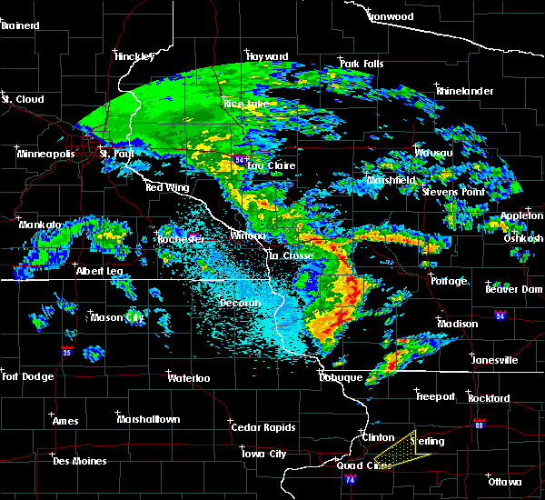 At 855 pm cdt, a severe thunderstorm was located 11 miles east of fennimore, or 15 miles west of dodgeville, moving northeast at 75 mph (radar indicated. at 835 pm, spotters in potosi reported 40 mph winds and power outages). Hazards include 60 mph wind gusts. Expect damage to roofs, siding, and trees. locations impacted include, montfort and livingston. This warning will be cancelled before 915 pm as the storms are moving out of eastern grant county. At 855 pm cdt, a severe thunderstorm was located 11 miles east of fennimore, or 15 miles west of dodgeville, moving northeast at 75 mph (radar indicated. at 835 pm, spotters in potosi reported 40 mph winds and power outages). Hazards include 60 mph wind gusts. Expect damage to roofs, siding, and trees. locations impacted include, montfort and livingston. This warning will be cancelled before 915 pm as the storms are moving out of eastern grant county.
|
| 3/28/2020 8:48 PM CDT |
 At 848 pm cdt, a severe thunderstorm was located 8 miles southeast of fennimore, or 11 miles northeast of lancaster, moving northeast at 75 mph (radar indicated. at 835 pm, spotters in potosi reported 40 mph winds and power outages). Hazards include 60 mph wind gusts. Expect damage to roofs, siding, and trees. This severe thunderstorm will remain over mainly rural areas of east central grant county, including the following locations, annaton, arthur, montfort, union and livingston. At 848 pm cdt, a severe thunderstorm was located 8 miles southeast of fennimore, or 11 miles northeast of lancaster, moving northeast at 75 mph (radar indicated. at 835 pm, spotters in potosi reported 40 mph winds and power outages). Hazards include 60 mph wind gusts. Expect damage to roofs, siding, and trees. This severe thunderstorm will remain over mainly rural areas of east central grant county, including the following locations, annaton, arthur, montfort, union and livingston.
|
| 3/28/2020 8:45 PM CDT |
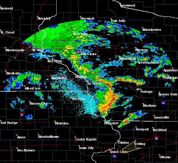 At 844 pm cdt, a severe thunderstorm was located 7 miles east of lancaster, moving northeast at 75 mph (radar indicated. at 835 pm, spotters in potosi reported 40 mph winds and power outages). Hazards include 60 mph wind gusts. Expect damage to roofs, siding, and trees. This severe thunderstorm will remain over mainly rural areas of east central grant county, including the following locations, annaton, arthur, lancaster municipal airport, montfort, livingston, union and ellenboro. At 844 pm cdt, a severe thunderstorm was located 7 miles east of lancaster, moving northeast at 75 mph (radar indicated. at 835 pm, spotters in potosi reported 40 mph winds and power outages). Hazards include 60 mph wind gusts. Expect damage to roofs, siding, and trees. This severe thunderstorm will remain over mainly rural areas of east central grant county, including the following locations, annaton, arthur, lancaster municipal airport, montfort, livingston, union and ellenboro.
|
| 3/28/2020 8:40 PM CDT |
 At 840 pm cdt, a severe thunderstorm was located near lancaster, moving northeast at 85 mph (radar indicated). Hazards include 60 mph wind gusts. Expect damage to roofs, siding, and trees. This severe thunderstorm will remain over mainly rural areas of southeastern grant county, including the following locations, arthur, montfort, potosi, livingston, union, rockville and annaton. At 840 pm cdt, a severe thunderstorm was located near lancaster, moving northeast at 85 mph (radar indicated). Hazards include 60 mph wind gusts. Expect damage to roofs, siding, and trees. This severe thunderstorm will remain over mainly rural areas of southeastern grant county, including the following locations, arthur, montfort, potosi, livingston, union, rockville and annaton.
|
| 8/5/2019 10:16 PM CDT |
 At 1015 pm cdt, a severe thunderstorm was located near mineral point, moving east at 35 mph (radar indicated. at 1000 pm cdt the platteville airport reported a wind gust of 54 mph). Hazards include 60 mph wind gusts and quarter size hail. Hail damage to vehicles is expected. expect wind damage to roofs, siding, and trees. Locations impacted include, dodgeville, mineral point, darlington, shullsburg, belmont, benton, argyle, blanchardville, somers, wiota, linden, new diggings, south wayne, cobb, lamont, rewey, hollandale, gratiot, yellowstone lake st park and platte mounds. At 1015 pm cdt, a severe thunderstorm was located near mineral point, moving east at 35 mph (radar indicated. at 1000 pm cdt the platteville airport reported a wind gust of 54 mph). Hazards include 60 mph wind gusts and quarter size hail. Hail damage to vehicles is expected. expect wind damage to roofs, siding, and trees. Locations impacted include, dodgeville, mineral point, darlington, shullsburg, belmont, benton, argyle, blanchardville, somers, wiota, linden, new diggings, south wayne, cobb, lamont, rewey, hollandale, gratiot, yellowstone lake st park and platte mounds.
|
| 8/5/2019 10:03 PM CDT |
 At 1002 pm cdt, a severe thunderstorm was located near belmont, or 7 miles southwest of mineral point, moving east at 40 mph (radar indicated. at 1000 pm cdt the platteville airport reported a wind gust of 54 mph). Hazards include 60 mph wind gusts and quarter size hail. Hail damage to vehicles is expected. Expect wind damage to roofs, siding, and trees. At 1002 pm cdt, a severe thunderstorm was located near belmont, or 7 miles southwest of mineral point, moving east at 40 mph (radar indicated. at 1000 pm cdt the platteville airport reported a wind gust of 54 mph). Hazards include 60 mph wind gusts and quarter size hail. Hail damage to vehicles is expected. Expect wind damage to roofs, siding, and trees.
|
| 8/5/2019 9:40 PM CDT |
 The severe thunderstorm warning for southeastern clayton, grant, southwestern richland and southeastern crawford counties will expire at 945 pm cdt, the storms which prompted the warning have weakened below severe limits, and no longer pose an immediate threat to life or property. therefore, the warning will be allowed to expire. however gusty winds up to 40 mph are still possible with these thunderstorms as they work across southern grant county through 1030 pm. The severe thunderstorm warning for southeastern clayton, grant, southwestern richland and southeastern crawford counties will expire at 945 pm cdt, the storms which prompted the warning have weakened below severe limits, and no longer pose an immediate threat to life or property. therefore, the warning will be allowed to expire. however gusty winds up to 40 mph are still possible with these thunderstorms as they work across southern grant county through 1030 pm.
|
| 8/5/2019 9:26 PM CDT |
 At 926 pm cdt, severe thunderstorms were located along a line extending from near boscobel to near lancaster to near colesburg, moving southeast at 45 mph (radar indicated). Hazards include 60 mph wind gusts. Expect damage to roofs, siding, and trees. Locations impacted include, lancaster, guttenberg, boscobel, fennimore, muscoda, cassville, garnavillo, bloomington, westport, excelsior, preston, bridgeport, beetown, arthur, montfort, wauzeka, livingston, orion, mount ida and ellenboro. At 926 pm cdt, severe thunderstorms were located along a line extending from near boscobel to near lancaster to near colesburg, moving southeast at 45 mph (radar indicated). Hazards include 60 mph wind gusts. Expect damage to roofs, siding, and trees. Locations impacted include, lancaster, guttenberg, boscobel, fennimore, muscoda, cassville, garnavillo, bloomington, westport, excelsior, preston, bridgeport, beetown, arthur, montfort, wauzeka, livingston, orion, mount ida and ellenboro.
|
| 8/5/2019 9:11 PM CDT |
 At 911 pm cdt, severe thunderstorms were located along a line extending from 8 miles northwest of boscobel to 7 miles north of bloomington to near volga, moving southeast at 45 mph (radar indicated). Hazards include 60 mph wind gusts. Expect damage to roofs, siding, and trees. these severe storms will be near, bloomington around 915 pm cdt. boscobel around 920 pm cdt. fennimore around 925 pm cdt. lancaster around 930 pm cdt. Other locations impacted by these severe thunderstorms include eastman, arthur, highway 61 and county t, montfort, giard, eagle corners and turkey river. At 911 pm cdt, severe thunderstorms were located along a line extending from 8 miles northwest of boscobel to 7 miles north of bloomington to near volga, moving southeast at 45 mph (radar indicated). Hazards include 60 mph wind gusts. Expect damage to roofs, siding, and trees. these severe storms will be near, bloomington around 915 pm cdt. boscobel around 920 pm cdt. fennimore around 925 pm cdt. lancaster around 930 pm cdt. Other locations impacted by these severe thunderstorms include eastman, arthur, highway 61 and county t, montfort, giard, eagle corners and turkey river.
|
| 8/5/2019 8:59 PM CDT |
 At 859 pm cdt, severe thunderstorms were located along a line extending from 10 miles east of harpers ferry to 7 miles east of prairie du chien to near volga, moving southeast at 45 mph (radar indicated). Hazards include 60 mph wind gusts. Expect damage to roofs, siding, and trees. severe thunderstorms will be near, bloomington around 910 pm cdt. boscobel around 920 pm cdt. lancaster and fennimore around 925 pm cdt. Other locations impacted by these severe thunderstorms include eastman, highway 61 and county t, montfort, giard, turkey river, national and effigy mounds. At 859 pm cdt, severe thunderstorms were located along a line extending from 10 miles east of harpers ferry to 7 miles east of prairie du chien to near volga, moving southeast at 45 mph (radar indicated). Hazards include 60 mph wind gusts. Expect damage to roofs, siding, and trees. severe thunderstorms will be near, bloomington around 910 pm cdt. boscobel around 920 pm cdt. lancaster and fennimore around 925 pm cdt. Other locations impacted by these severe thunderstorms include eastman, highway 61 and county t, montfort, giard, turkey river, national and effigy mounds.
|
| 7/20/2019 2:03 PM CDT |
 At 202 pm cdt, severe thunderstorms were located along a line extending from near lake delton to near shullsburg, moving east at 65 mph (trained weather spotters. a wind gust to 60 mph was reported in the dodgeville area at 2 pm). Hazards include 60 mph wind gusts. Expect damage to roofs, siding, and trees. Locations impacted include, dodgeville, prairie du sac, sauk city, mineral point, darlington, spring green, shullsburg, belmont, benton, argyle, blanchardville, somers, barneveld, wiota, highland, arena, plain, ridgeway, avoca and orion. At 202 pm cdt, severe thunderstorms were located along a line extending from near lake delton to near shullsburg, moving east at 65 mph (trained weather spotters. a wind gust to 60 mph was reported in the dodgeville area at 2 pm). Hazards include 60 mph wind gusts. Expect damage to roofs, siding, and trees. Locations impacted include, dodgeville, prairie du sac, sauk city, mineral point, darlington, spring green, shullsburg, belmont, benton, argyle, blanchardville, somers, barneveld, wiota, highland, arena, plain, ridgeway, avoca and orion.
|
| 7/20/2019 1:51 PM CDT |
 At 150 pm cdt, severe thunderstorms were located along a line extending from reedsburg to near cuba city, moving east at 40 mph (trained weather spotters. numerous 50 to 60 mph wind reports have been received with this line. a 55 mph wind gust was measured within the last 5 minutes at the lone rock airport). Hazards include 60 mph wind gusts. Expect damage to roofs, siding, and trees. locations impacted include, baraboo, reedsburg, dodgeville, prairie du sac, sauk city, wisconsin dells, mineral point, darlington, lake delton, spring green, west baraboo, shullsburg, belmont, benton, argyle, blanchardville, somers, barneveld, wiota and highland. People attending the baraboo big top parade and circus celebration should seek safe shelter immediately!. At 150 pm cdt, severe thunderstorms were located along a line extending from reedsburg to near cuba city, moving east at 40 mph (trained weather spotters. numerous 50 to 60 mph wind reports have been received with this line. a 55 mph wind gust was measured within the last 5 minutes at the lone rock airport). Hazards include 60 mph wind gusts. Expect damage to roofs, siding, and trees. locations impacted include, baraboo, reedsburg, dodgeville, prairie du sac, sauk city, wisconsin dells, mineral point, darlington, lake delton, spring green, west baraboo, shullsburg, belmont, benton, argyle, blanchardville, somers, barneveld, wiota and highland. People attending the baraboo big top parade and circus celebration should seek safe shelter immediately!.
|
| 7/20/2019 1:50 PM CDT |
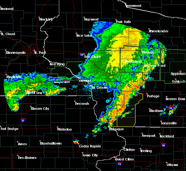 At 148 pm cdt, severe thunderstorms were located along a line extending from near reedsburg to near dickeyville, moving east at 50 mph (radar indicated. winds gusts of 52 to 55 mph were reported in fennimore at 148 pm). Hazards include 60 mph wind gusts. Expect damage to roofs, siding, and trees. These severe thunderstorms will remain over mainly rural areas of grant county, including the following locations, big h campground, preston, arthur, montfort, beetown, union and cornelia. At 148 pm cdt, severe thunderstorms were located along a line extending from near reedsburg to near dickeyville, moving east at 50 mph (radar indicated. winds gusts of 52 to 55 mph were reported in fennimore at 148 pm). Hazards include 60 mph wind gusts. Expect damage to roofs, siding, and trees. These severe thunderstorms will remain over mainly rural areas of grant county, including the following locations, big h campground, preston, arthur, montfort, beetown, union and cornelia.
|
| 7/20/2019 1:35 PM CDT |
 At 135 pm cdt, severe thunderstorms were located along a line extending from 8 miles south of wonewoc to 6 miles northwest of dickeyville, moving east at 45 mph (radar indicated). Hazards include 60 mph wind gusts. Expect damage to roofs, siding, and trees. these severe storms will be near, cuba city around 150 pm cdt. Other locations impacted by these severe thunderstorms include arthur, highway 61 and county t, montfort, eagle corners, beetown, highway 80 and county c c and woodstock. At 135 pm cdt, severe thunderstorms were located along a line extending from 8 miles south of wonewoc to 6 miles northwest of dickeyville, moving east at 45 mph (radar indicated). Hazards include 60 mph wind gusts. Expect damage to roofs, siding, and trees. these severe storms will be near, cuba city around 150 pm cdt. Other locations impacted by these severe thunderstorms include arthur, highway 61 and county t, montfort, eagle corners, beetown, highway 80 and county c c and woodstock.
|
| 7/20/2019 1:31 PM CDT |
 At 131 pm cdt, severe thunderstorms were located along a line extending from 7 miles south of hillsboro to sherrill, moving east at 65 mph (trained weather spotters. tree damage was reported across portions of far southwestern wisconsin with this line. a 60 mph wind gust was also measured). Hazards include 60 mph wind gusts. expect damage to roofs, siding, and trees At 131 pm cdt, severe thunderstorms were located along a line extending from 7 miles south of hillsboro to sherrill, moving east at 65 mph (trained weather spotters. tree damage was reported across portions of far southwestern wisconsin with this line. a 60 mph wind gust was also measured). Hazards include 60 mph wind gusts. expect damage to roofs, siding, and trees
|
| 7/20/2019 1:20 PM CDT |
 At 120 pm cdt, severe thunderstorms were located along a line extending from 9 miles north of richland center to balltown, moving east at 70 mph (radar indicated). Hazards include 60 mph wind gusts. Expect damage to roofs, siding, and trees. severe thunderstorms will be near, dickeyville around 135 pm cdt. platteville around 140 pm cdt. Other locations impacted by these severe thunderstorms include highway 61 and county t, montfort, highway 80 and county c c, gillingham, neptune, county roads a and z and blue river. At 120 pm cdt, severe thunderstorms were located along a line extending from 9 miles north of richland center to balltown, moving east at 70 mph (radar indicated). Hazards include 60 mph wind gusts. Expect damage to roofs, siding, and trees. severe thunderstorms will be near, dickeyville around 135 pm cdt. platteville around 140 pm cdt. Other locations impacted by these severe thunderstorms include highway 61 and county t, montfort, highway 80 and county c c, gillingham, neptune, county roads a and z and blue river.
|
| 7/18/2019 4:04 AM CDT |
 At 404 am cdt, severe thunderstorms were located along a line extending from 7 miles southeast of muscoda to 6 miles southeast of lancaster, moving southeast at 50 mph (law enforcement). Hazards include 60 mph wind gusts and quarter size hail. Hail damage to vehicles is expected. expect wind damage to roofs, siding, and trees. these severe storms will be near, platteville around 415 am cdt. Other locations impacted by these severe thunderstorms include preston, arthur, highway 61 and county t, montfort, mount ida, beetown and union. At 404 am cdt, severe thunderstorms were located along a line extending from 7 miles southeast of muscoda to 6 miles southeast of lancaster, moving southeast at 50 mph (law enforcement). Hazards include 60 mph wind gusts and quarter size hail. Hail damage to vehicles is expected. expect wind damage to roofs, siding, and trees. these severe storms will be near, platteville around 415 am cdt. Other locations impacted by these severe thunderstorms include preston, arthur, highway 61 and county t, montfort, mount ida, beetown and union.
|
| 7/18/2019 3:50 AM CDT |
 At 348 am cdt, severe thunderstorms were located along a line extending from near muscoda to near lancaster, moving southeast at 50 mph (law enforcement. quarter size hail was reported in woodman at 345 am). Hazards include 60 mph wind gusts and quarter size hail. Hail damage to vehicles is expected. expect wind damage to roofs, siding, and trees. severe thunderstorms will be near, muscoda around 355 am cdt. platteville around 410 am cdt. cuba city around 415 am cdt. Other locations impacted by these severe thunderstorms include preston, arthur, highway 61 and county t, montfort, mount ida, beetown and union. At 348 am cdt, severe thunderstorms were located along a line extending from near muscoda to near lancaster, moving southeast at 50 mph (law enforcement. quarter size hail was reported in woodman at 345 am). Hazards include 60 mph wind gusts and quarter size hail. Hail damage to vehicles is expected. expect wind damage to roofs, siding, and trees. severe thunderstorms will be near, muscoda around 355 am cdt. platteville around 410 am cdt. cuba city around 415 am cdt. Other locations impacted by these severe thunderstorms include preston, arthur, highway 61 and county t, montfort, mount ida, beetown and union.
|
| 6/30/2019 5:18 PM CDT |
 At 518 pm cdt, severe thunderstorms were located along a line extending from 6 miles north of belmont to near balltown, moving southeast at 30 mph (law enforcement. these storms have a history of producing damage to trees). Hazards include 60 mph wind gusts and quarter size hail. Hail damage to vehicles is expected. expect wind damage to roofs, siding, and trees. these severe storms will be near, platteville around 525 pm cdt. Other locations impacted by these severe thunderstorms include arthur, montfort, beetown, nelson dewey state park, lancaster municipal airport, georgetown and ellenboro. At 518 pm cdt, severe thunderstorms were located along a line extending from 6 miles north of belmont to near balltown, moving southeast at 30 mph (law enforcement. these storms have a history of producing damage to trees). Hazards include 60 mph wind gusts and quarter size hail. Hail damage to vehicles is expected. expect wind damage to roofs, siding, and trees. these severe storms will be near, platteville around 525 pm cdt. Other locations impacted by these severe thunderstorms include arthur, montfort, beetown, nelson dewey state park, lancaster municipal airport, georgetown and ellenboro.
|
| 6/30/2019 4:39 PM CDT |
 The national weather service in la crosse has issued a * severe thunderstorm warning for. grant county in southwestern wisconsin. until 615 pm cdt. At 437 pm cdt, severe thunderstorms were located along a line extending from 7 miles east of boscobel to near mcgregor, moving. The national weather service in la crosse has issued a * severe thunderstorm warning for. grant county in southwestern wisconsin. until 615 pm cdt. At 437 pm cdt, severe thunderstorms were located along a line extending from 7 miles east of boscobel to near mcgregor, moving.
|
| 6/27/2019 3:50 PM CDT |
 The severe thunderstorm warning for iowa and sauk counties will expire at 400 pm cdt, the storms which prompted the warning have moved out of the area. therefore, the warning will be allowed to expire. a severe thunderstorm watch remains in effect until 700 pm cdt for south central wisconsin. The severe thunderstorm warning for iowa and sauk counties will expire at 400 pm cdt, the storms which prompted the warning have moved out of the area. therefore, the warning will be allowed to expire. a severe thunderstorm watch remains in effect until 700 pm cdt for south central wisconsin.
|
| 6/27/2019 3:40 PM CDT |
 At 339 pm cdt, severe thunderstorms were located along a line extending from 7 miles northwest of portage to 6 miles west of blanchardville, moving east at 35 mph (emergency management). Hazards include 60 mph wind gusts. trees were reported down from arena to mineral point in iowa county. Expect damage to roofs, siding, and trees. Locations impacted include, baraboo, reedsburg, dodgeville, prairie du sac, sauk city, wisconsin dells, mineral point, lake delton, spring green, west baraboo, barneveld, highland, arena, plain, north freedom, ridgeway, avoca, orion, linden and cobb. At 339 pm cdt, severe thunderstorms were located along a line extending from 7 miles northwest of portage to 6 miles west of blanchardville, moving east at 35 mph (emergency management). Hazards include 60 mph wind gusts. trees were reported down from arena to mineral point in iowa county. Expect damage to roofs, siding, and trees. Locations impacted include, baraboo, reedsburg, dodgeville, prairie du sac, sauk city, wisconsin dells, mineral point, lake delton, spring green, west baraboo, barneveld, highland, arena, plain, north freedom, ridgeway, avoca, orion, linden and cobb.
|
| 6/27/2019 3:21 PM CDT |
 At 321 pm cdt, severe thunderstorms were located along a line extending from wisconsin dells to mineral point, moving east at 35 mph (radar indicated). Hazards include 60 mph wind gusts. Expect damage to roofs, siding, and trees. Locations impacted include, baraboo, reedsburg, dodgeville, prairie du sac, sauk city, wisconsin dells, mineral point, lake delton, spring green, west baraboo, barneveld, highland, arena, plain, north freedom, ridgeway, avoca, orion, linden and cobb. At 321 pm cdt, severe thunderstorms were located along a line extending from wisconsin dells to mineral point, moving east at 35 mph (radar indicated). Hazards include 60 mph wind gusts. Expect damage to roofs, siding, and trees. Locations impacted include, baraboo, reedsburg, dodgeville, prairie du sac, sauk city, wisconsin dells, mineral point, lake delton, spring green, west baraboo, barneveld, highland, arena, plain, north freedom, ridgeway, avoca, orion, linden and cobb.
|
| 6/27/2019 3:07 PM CDT |
 The national weather service in milwaukee/sullivan has issued a * severe thunderstorm warning for. iowa county in south central wisconsin. sauk county in south central wisconsin. until 400 pm cdt. At 307 pm cdt, severe thunderstorms were located along a line. The national weather service in milwaukee/sullivan has issued a * severe thunderstorm warning for. iowa county in south central wisconsin. sauk county in south central wisconsin. until 400 pm cdt. At 307 pm cdt, severe thunderstorms were located along a line.
|
| 10/9/2018 3:14 PM CDT |
 At 313 pm cdt, severe thunderstorms were located along a line extending from near fennimore to platteville, moving north at 25 mph (radar indicated). Hazards include 60 mph wind gusts. Expect damage to roofs, siding, and trees. These severe thunderstorms will remain over mainly rural areas of southeastern grant county, including the following locations, arthur, montfort, livingston, ellenboro and union. At 313 pm cdt, severe thunderstorms were located along a line extending from near fennimore to platteville, moving north at 25 mph (radar indicated). Hazards include 60 mph wind gusts. Expect damage to roofs, siding, and trees. These severe thunderstorms will remain over mainly rural areas of southeastern grant county, including the following locations, arthur, montfort, livingston, ellenboro and union.
|
| 10/9/2018 3:01 PM CDT |
 At 301 pm cdt, a severe thunderstorm was located near lancaster, moving northeast at 25 mph (radar indicated). Hazards include 60 mph wind gusts and quarter size hail. Hail damage to vehicles is expected. expect wind damage to roofs, siding, and trees. this severe storm will be near, lancaster around 315 pm cdt. platteville around 320 pm cdt. Other locations impacted by this severe thunderstorm include arthur, montfort, potosi, livingston and ellenboro. At 301 pm cdt, a severe thunderstorm was located near lancaster, moving northeast at 25 mph (radar indicated). Hazards include 60 mph wind gusts and quarter size hail. Hail damage to vehicles is expected. expect wind damage to roofs, siding, and trees. this severe storm will be near, lancaster around 315 pm cdt. platteville around 320 pm cdt. Other locations impacted by this severe thunderstorm include arthur, montfort, potosi, livingston and ellenboro.
|
| 10/9/2018 2:46 PM CDT |
 At 246 pm cdt, a severe thunderstorm was located near balltown, or 11 miles south of lancaster, moving northeast at 25 mph (radar indicated). Hazards include 60 mph wind gusts and quarter size hail. Hail damage to vehicles is expected. expect wind damage to roofs, siding, and trees. this severe thunderstorm will be near, dickeyville around 255 pm cdt. lancaster around 315 pm cdt. platteville around 325 pm cdt. Other locations impacted by this severe thunderstorm include arthur, montfort, potosi, livingston and ellenboro. At 246 pm cdt, a severe thunderstorm was located near balltown, or 11 miles south of lancaster, moving northeast at 25 mph (radar indicated). Hazards include 60 mph wind gusts and quarter size hail. Hail damage to vehicles is expected. expect wind damage to roofs, siding, and trees. this severe thunderstorm will be near, dickeyville around 255 pm cdt. lancaster around 315 pm cdt. platteville around 325 pm cdt. Other locations impacted by this severe thunderstorm include arthur, montfort, potosi, livingston and ellenboro.
|
| 9/2/2018 4:38 PM CDT |
 At 437 pm cdt, severe thunderstorms were located along a line extending from 6 miles northwest of dodgeville to near belmont to near hazel green, moving east at 40 mph (law enforcement report of downed trees and powerlines). Hazards include 60 mph wind gusts. Expect damage to roofs, siding, and trees. locations impacted include, dodgeville, mineral point, darlington, shullsburg, belmont, benton, highland, linden, new diggings, cobb, rewey, platte mounds, lead mine, governor dodge st park, edmund, blackhawk lake rec area, london and leslie. People attending county fair at the iowa county fair grounds should seek safe shelter immediately!. At 437 pm cdt, severe thunderstorms were located along a line extending from 6 miles northwest of dodgeville to near belmont to near hazel green, moving east at 40 mph (law enforcement report of downed trees and powerlines). Hazards include 60 mph wind gusts. Expect damage to roofs, siding, and trees. locations impacted include, dodgeville, mineral point, darlington, shullsburg, belmont, benton, highland, linden, new diggings, cobb, rewey, platte mounds, lead mine, governor dodge st park, edmund, blackhawk lake rec area, london and leslie. People attending county fair at the iowa county fair grounds should seek safe shelter immediately!.
|
| 9/2/2018 4:36 PM CDT |
 The severe thunderstorm warning for northeastern grant county will expire at 445 pm cdt, the storms which prompted the warning have moved out of the area. therefore the warning will be allowed to expire. however gusty winds are still possible with these thunderstorms. in addition, a severe thunderstorm warning still remains in effect for southeastern grant county until 445 pm cdt. The severe thunderstorm warning for northeastern grant county will expire at 445 pm cdt, the storms which prompted the warning have moved out of the area. therefore the warning will be allowed to expire. however gusty winds are still possible with these thunderstorms. in addition, a severe thunderstorm warning still remains in effect for southeastern grant county until 445 pm cdt.
|
| 9/2/2018 4:28 PM CDT |
 At 427 pm cdt, severe thunderstorms were located along a line extending from 10 miles southeast of muscoda to near belmont to hazel green, moving east at 40 mph (radar indicated). Hazards include 60 mph wind gusts. Expect damage to roofs, siding, and trees. locations impacted include, dodgeville, mineral point, darlington, shullsburg, belmont, benton, highland, linden, new diggings, cobb, rewey, platte mounds, lead mine, governor dodge st park, edmund, blackhawk lake rec area, london and leslie. People attending the county fair at the iowa county fair grounds should seek safe shelter immediately!. At 427 pm cdt, severe thunderstorms were located along a line extending from 10 miles southeast of muscoda to near belmont to hazel green, moving east at 40 mph (radar indicated). Hazards include 60 mph wind gusts. Expect damage to roofs, siding, and trees. locations impacted include, dodgeville, mineral point, darlington, shullsburg, belmont, benton, highland, linden, new diggings, cobb, rewey, platte mounds, lead mine, governor dodge st park, edmund, blackhawk lake rec area, london and leslie. People attending the county fair at the iowa county fair grounds should seek safe shelter immediately!.
|
| 9/2/2018 4:20 PM CDT |
 At 420 pm cdt, severe thunderstorms were located along a line extending from 7 miles northeast of fennimore to near platteville to east dubuque, moving east at 30 mph (radar indicated). Hazards include 60 mph wind gusts. expect damage to roofs, siding, and trees At 420 pm cdt, severe thunderstorms were located along a line extending from 7 miles northeast of fennimore to near platteville to east dubuque, moving east at 30 mph (radar indicated). Hazards include 60 mph wind gusts. expect damage to roofs, siding, and trees
|
| 9/2/2018 4:16 PM CDT |
 At 416 pm cdt, severe thunderstorms were located along a line extending from near muscoda to 7 miles north of platteville, moving northeast at 35 mph (law enforcement. these storms have a history of producing damage to trees). Hazards include 60 mph wind gusts. Expect damage to roofs, siding, and trees. these severe storms will be near, muscoda around 425 pm cdt. Other locations impacted by these severe thunderstorms include preston, arthur, montfort, livingston and orion. At 416 pm cdt, severe thunderstorms were located along a line extending from near muscoda to 7 miles north of platteville, moving northeast at 35 mph (law enforcement. these storms have a history of producing damage to trees). Hazards include 60 mph wind gusts. Expect damage to roofs, siding, and trees. these severe storms will be near, muscoda around 425 pm cdt. Other locations impacted by these severe thunderstorms include preston, arthur, montfort, livingston and orion.
|
| 9/2/2018 4:09 PM CDT |
 At 408 pm cdt, severe thunderstorms were located along a line extending from near boscobel to 6 miles east of lancaster, moving northeast at 35 mph (law enforcement. at 409 pm cdt, downed trees were reported near lancaster). Hazards include 60 mph wind gusts. Expect damage to roofs, siding, and trees. severe thunderstorms will be near, muscoda around 425 pm cdt. Other locations impacted by these severe thunderstorms include preston, arthur, montfort, livingston and orion. At 408 pm cdt, severe thunderstorms were located along a line extending from near boscobel to 6 miles east of lancaster, moving northeast at 35 mph (law enforcement. at 409 pm cdt, downed trees were reported near lancaster). Hazards include 60 mph wind gusts. Expect damage to roofs, siding, and trees. severe thunderstorms will be near, muscoda around 425 pm cdt. Other locations impacted by these severe thunderstorms include preston, arthur, montfort, livingston and orion.
|
| 7/13/2018 6:13 PM CDT |
 At 611 pm cdt, severe thunderstorms were located along a line extending from muscoda to 6 miles northwest of dickeyville, moving east at 25 mph (law enforcement. around 550 pm, small tree limbs were downed in lancaster in grant co. some sporadic tree damage was also reported in richland county). Hazards include 60 mph wind gusts. Expect damage to roofs, siding, and trees. these severe storms will be near, muscoda around 615 pm cdt. platteville around 630 pm cdt. Other locations impacted by these severe thunderstorms include westport, excelsior, preston, beetown and arthur. At 611 pm cdt, severe thunderstorms were located along a line extending from muscoda to 6 miles northwest of dickeyville, moving east at 25 mph (law enforcement. around 550 pm, small tree limbs were downed in lancaster in grant co. some sporadic tree damage was also reported in richland county). Hazards include 60 mph wind gusts. Expect damage to roofs, siding, and trees. these severe storms will be near, muscoda around 615 pm cdt. platteville around 630 pm cdt. Other locations impacted by these severe thunderstorms include westport, excelsior, preston, beetown and arthur.
|
| 7/13/2018 5:51 PM CDT |
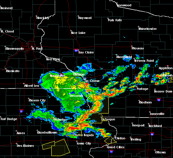 At 550 pm cdt, severe thunderstorms were located along a line extending from near boscobel to 6 miles northeast of sherrill, moving east at 30 mph (radar indicated). Hazards include 60 mph wind gusts. Expect damage to roofs, siding, and trees. these severe storms will be near, muscoda around 610 pm cdt. platteville around 615 pm cdt. other locations impacted by these severe thunderstorms include westport, excelsior, preston, beetown and arthur. Torrential rains of 2 inches and brief, minor urban flooding should be expected with this line of storms as it passes. At 550 pm cdt, severe thunderstorms were located along a line extending from near boscobel to 6 miles northeast of sherrill, moving east at 30 mph (radar indicated). Hazards include 60 mph wind gusts. Expect damage to roofs, siding, and trees. these severe storms will be near, muscoda around 610 pm cdt. platteville around 615 pm cdt. other locations impacted by these severe thunderstorms include westport, excelsior, preston, beetown and arthur. Torrential rains of 2 inches and brief, minor urban flooding should be expected with this line of storms as it passes.
|
| 7/13/2018 5:43 PM CDT |
 At 542 pm cdt, severe thunderstorms were located along a line extending from near boscobel to near balltown, moving east at 30 mph (trained weather spotters and airport wind measurements of over 50 mph have occurred with these storms). Hazards include 60 mph wind gusts. Expect damage to roofs, siding, and trees. these severe storms will be near, boscobel around 545 pm cdt. lancaster around 600 pm cdt. muscoda around 615 pm cdt. platteville around 625 pm cdt. Other locations impacted by these severe thunderstorms include westport, excelsior, preston, beetown and arthur. At 542 pm cdt, severe thunderstorms were located along a line extending from near boscobel to near balltown, moving east at 30 mph (trained weather spotters and airport wind measurements of over 50 mph have occurred with these storms). Hazards include 60 mph wind gusts. Expect damage to roofs, siding, and trees. these severe storms will be near, boscobel around 545 pm cdt. lancaster around 600 pm cdt. muscoda around 615 pm cdt. platteville around 625 pm cdt. Other locations impacted by these severe thunderstorms include westport, excelsior, preston, beetown and arthur.
|
| 7/13/2018 5:29 PM CDT |
 At 528 pm cdt, severe thunderstorms were located along a line extending from 9 miles west of boscobel to near cassville, moving east at 25 mph (radar indicated). Hazards include 60 mph wind gusts. Expect damage to roofs, siding, and trees. severe thunderstorms will be near, boscobel around 550 pm cdt. platteville and muscoda around 630 pm cdt. Other locations impacted by these severe thunderstorms include westport, excelsior, preston, bridgeport and beetown. At 528 pm cdt, severe thunderstorms were located along a line extending from 9 miles west of boscobel to near cassville, moving east at 25 mph (radar indicated). Hazards include 60 mph wind gusts. Expect damage to roofs, siding, and trees. severe thunderstorms will be near, boscobel around 550 pm cdt. platteville and muscoda around 630 pm cdt. Other locations impacted by these severe thunderstorms include westport, excelsior, preston, bridgeport and beetown.
|
| 5/25/2018 8:32 PM CDT |
 At 831 pm cdt, severe thunderstorms were located along a line extending from 7 miles southwest of muscoda to near east dubuque, moving southeast at 25 mph (trained weather spotters). Hazards include 60 mph wind gusts and quarter size hail. Hail damage to vehicles is expected. expect wind damage to roofs, siding, and trees. these severe storms will be near, dickeyville around 835 pm cdt. hazel green and cuba city around 845 pm cdt. Other locations impacted by these severe thunderstorms include preston, georgetown, arthur, montfort and potosi. At 831 pm cdt, severe thunderstorms were located along a line extending from 7 miles southwest of muscoda to near east dubuque, moving southeast at 25 mph (trained weather spotters). Hazards include 60 mph wind gusts and quarter size hail. Hail damage to vehicles is expected. expect wind damage to roofs, siding, and trees. these severe storms will be near, dickeyville around 835 pm cdt. hazel green and cuba city around 845 pm cdt. Other locations impacted by these severe thunderstorms include preston, georgetown, arthur, montfort and potosi.
|
| 5/25/2018 8:19 PM CDT |
 A severe thunderstorm warning remains in effect until 845 pm cdt for southeastern clayton and grant counties. at 818 pm cdt, severe thunderstorms were located along a line extending from 7 miles southwest of muscoda to near platteville to near new vienna to near independence, moving southeast at 35 mph. hazard. 60 mph wind gusts and quarter size hail. A severe thunderstorm warning remains in effect until 845 pm cdt for southeastern clayton and grant counties. at 818 pm cdt, severe thunderstorms were located along a line extending from 7 miles southwest of muscoda to near platteville to near new vienna to near independence, moving southeast at 35 mph. hazard. 60 mph wind gusts and quarter size hail.
|
| 5/25/2018 8:19 PM CDT |
 At 818 pm cdt, severe thunderstorms were located along a line extending from 7 miles southwest of muscoda to near platteville to near new vienna to near independence, moving southeast at 35 mph (trained weather spotters). Hazards include 60 mph wind gusts and quarter size hail. Hail damage to vehicles is expected. expect wind damage to roofs, siding, and trees. these severe storms will be near, platteville and dickeyville around 825 pm cdt. cuba city around 835 pm cdt. hazel green around 845 pm cdt. Other locations impacted by these severe thunderstorms include preston, georgetown, beetown, arthur and montfort. At 818 pm cdt, severe thunderstorms were located along a line extending from 7 miles southwest of muscoda to near platteville to near new vienna to near independence, moving southeast at 35 mph (trained weather spotters). Hazards include 60 mph wind gusts and quarter size hail. Hail damage to vehicles is expected. expect wind damage to roofs, siding, and trees. these severe storms will be near, platteville and dickeyville around 825 pm cdt. cuba city around 835 pm cdt. hazel green around 845 pm cdt. Other locations impacted by these severe thunderstorms include preston, georgetown, beetown, arthur and montfort.
|
| 5/25/2018 8:08 PM CDT |
 At 806 pm cdt, severe thunderstorms were located along a line extending from 6 miles west of muscoda to 6 miles southeast of lancaster to luxemburg to near hazleton, moving southeast at 40 mph (trained weather spotters. a 60 mph wind gust was reported near wauzeka in southern crawford county, and quarter size hail was reported in oelwein). Hazards include 60 mph wind gusts and quarter size hail. Hail damage to vehicles is expected. expect wind damage to roofs, siding, and trees. these severe storms will be near, lancaster and cassville around 810 pm cdt. muscoda around 815 pm cdt. platteville and dickeyville around 820 pm cdt. dubuque and cuba city around 830 pm cdt. hazel green around 835 pm cdt. Other locations impacted by these severe thunderstorms include preston, georgetown, beetown, arthur and montfort. At 806 pm cdt, severe thunderstorms were located along a line extending from 6 miles west of muscoda to 6 miles southeast of lancaster to luxemburg to near hazleton, moving southeast at 40 mph (trained weather spotters. a 60 mph wind gust was reported near wauzeka in southern crawford county, and quarter size hail was reported in oelwein). Hazards include 60 mph wind gusts and quarter size hail. Hail damage to vehicles is expected. expect wind damage to roofs, siding, and trees. these severe storms will be near, lancaster and cassville around 810 pm cdt. muscoda around 815 pm cdt. platteville and dickeyville around 820 pm cdt. dubuque and cuba city around 830 pm cdt. hazel green around 835 pm cdt. Other locations impacted by these severe thunderstorms include preston, georgetown, beetown, arthur and montfort.
|
| 5/25/2018 7:57 PM CDT |
 At 755 pm cdt, severe thunderstorms were located along a line extending from near boscobel to near lancaster to near colesburg to fairbank, moving east at 40 mph (radar indicated). Hazards include 60 mph wind gusts and nickel size hail. Expect damage to roofs, siding, and trees. these severe storms will be near, lancaster, guttenberg, fennimore and boscobel around 800 pm cdt. muscoda and cassville around 810 pm cdt. platteville around 815 pm cdt. dubuque and strawberry point around 830 pm cdt. dickeyville and edgewood around 840 pm cdt. hazel green and cuba city around 845 pm cdt. Other locations impacted by these severe thunderstorms include preston, bridgeport, georgetown, beetown and arthur. At 755 pm cdt, severe thunderstorms were located along a line extending from near boscobel to near lancaster to near colesburg to fairbank, moving east at 40 mph (radar indicated). Hazards include 60 mph wind gusts and nickel size hail. Expect damage to roofs, siding, and trees. these severe storms will be near, lancaster, guttenberg, fennimore and boscobel around 800 pm cdt. muscoda and cassville around 810 pm cdt. platteville around 815 pm cdt. dubuque and strawberry point around 830 pm cdt. dickeyville and edgewood around 840 pm cdt. hazel green and cuba city around 845 pm cdt. Other locations impacted by these severe thunderstorms include preston, bridgeport, georgetown, beetown and arthur.
|
| 5/25/2018 7:57 PM CDT |
 At 739 pm cdt, severe thunderstorms were located along a line extending from boscobel to near guttenberg to near strawberry point, moving southeast at 40 mph (trained weather spotters. at 730 pm cdt, tree damage was reported near eastman in western crawford county). Hazards include 70 mph wind gusts and quarter size hail. Hail damage to vehicles is expected. expect considerable tree damage. wind damage is also likely to mobile homes, roofs, and outbuildings. severe thunderstorms will be near, boscobel around 745 pm cdt. cassville, muscoda and fennimore around 755 pm cdt. dickeyville around 825 pm cdt. dubuque around 835 pm cdt. cuba city around 840 pm cdt. hazel green around 845 pm cdt. Other locations impacted by these severe thunderstorms include preston, bridgeport, georgetown, beetown and arthur. At 739 pm cdt, severe thunderstorms were located along a line extending from boscobel to near guttenberg to near strawberry point, moving southeast at 40 mph (trained weather spotters. at 730 pm cdt, tree damage was reported near eastman in western crawford county). Hazards include 70 mph wind gusts and quarter size hail. Hail damage to vehicles is expected. expect considerable tree damage. wind damage is also likely to mobile homes, roofs, and outbuildings. severe thunderstorms will be near, boscobel around 745 pm cdt. cassville, muscoda and fennimore around 755 pm cdt. dickeyville around 825 pm cdt. dubuque around 835 pm cdt. cuba city around 840 pm cdt. hazel green around 845 pm cdt. Other locations impacted by these severe thunderstorms include preston, bridgeport, georgetown, beetown and arthur.
|
| 5/25/2018 7:40 PM CDT |
 At 739 pm cdt, severe thunderstorms were located along a line extending from boscobel to near guttenberg to near strawberry point, moving southeast at 40 mph (trained weather spotters. at 730 pm cdt, tree damage was reported near eastman in western crawford county). Hazards include 70 mph wind gusts and quarter size hail. Hail damage to vehicles is expected. expect considerable tree damage. wind damage is also likely to mobile homes, roofs, and outbuildings. severe thunderstorms will be near, boscobel around 745 pm cdt. cassville, muscoda and fennimore around 755 pm cdt. dickeyville around 825 pm cdt. dubuque around 835 pm cdt. cuba city around 840 pm cdt. hazel green around 845 pm cdt. Other locations impacted by these severe thunderstorms include preston, bridgeport, georgetown, beetown and arthur. At 739 pm cdt, severe thunderstorms were located along a line extending from boscobel to near guttenberg to near strawberry point, moving southeast at 40 mph (trained weather spotters. at 730 pm cdt, tree damage was reported near eastman in western crawford county). Hazards include 70 mph wind gusts and quarter size hail. Hail damage to vehicles is expected. expect considerable tree damage. wind damage is also likely to mobile homes, roofs, and outbuildings. severe thunderstorms will be near, boscobel around 745 pm cdt. cassville, muscoda and fennimore around 755 pm cdt. dickeyville around 825 pm cdt. dubuque around 835 pm cdt. cuba city around 840 pm cdt. hazel green around 845 pm cdt. Other locations impacted by these severe thunderstorms include preston, bridgeport, georgetown, beetown and arthur.
|
| 7/19/2017 6:32 PM CDT |
 At 631 pm cdt, a severe thunderstorm was located 8 miles northeast of bloomington, or 13 miles northwest of lancaster, moving east at 55 mph. this storm has a history of producing widespread wind damage. seek shelter now!!! this is a very dangerous storm (radar indicated). Hazards include 80 mph wind gusts. Flying debris will be dangerous to those caught without shelter. mobile homes will be heavily damaged. expect considerable damage to roofs, windows, and vehicles. Extensive tree damage and power outages are likely. At 631 pm cdt, a severe thunderstorm was located 8 miles northeast of bloomington, or 13 miles northwest of lancaster, moving east at 55 mph. this storm has a history of producing widespread wind damage. seek shelter now!!! this is a very dangerous storm (radar indicated). Hazards include 80 mph wind gusts. Flying debris will be dangerous to those caught without shelter. mobile homes will be heavily damaged. expect considerable damage to roofs, windows, and vehicles. Extensive tree damage and power outages are likely.
|
| 6/28/2017 6:03 PM CDT | Storm damage reported in grant county WI, 0.1 miles WSW of Montfort, WI |
| 6/28/2017 1:23 PM CDT |
 At 621 pm cdt, severe thunderstorms were located along a line extending from 6 miles southwest of mazomanie to 6 miles northwest of blanchardville to near darlington, moving east at 60 mph. power poles were reported snapped in southwest iowa county (radar indicated). Hazards include 70 mph wind gusts and quarter size hail. Hail damage to vehicles is expected. expect considerable tree damage. wind damage is also likely to mobile homes, roofs, and outbuildings. locations impacted include, dodgeville, mineral point, darlington, shullsburg, belmont, benton, argyle, blanchardville, somers, barneveld, wiota, highland, arena, ridgeway, avoca, orion, linden, new diggings, south wayne and cobb. People attending the land`s end concert series in dodgeville should seek safe shelter immediately! a tornado watch remains in effect until 1000 pm cdt for south central wisconsin. At 621 pm cdt, severe thunderstorms were located along a line extending from 6 miles southwest of mazomanie to 6 miles northwest of blanchardville to near darlington, moving east at 60 mph. power poles were reported snapped in southwest iowa county (radar indicated). Hazards include 70 mph wind gusts and quarter size hail. Hail damage to vehicles is expected. expect considerable tree damage. wind damage is also likely to mobile homes, roofs, and outbuildings. locations impacted include, dodgeville, mineral point, darlington, shullsburg, belmont, benton, argyle, blanchardville, somers, barneveld, wiota, highland, arena, ridgeway, avoca, orion, linden, new diggings, south wayne and cobb. People attending the land`s end concert series in dodgeville should seek safe shelter immediately! a tornado watch remains in effect until 1000 pm cdt for south central wisconsin.
|
| 6/28/2017 1:11 PM CDT |
 The tornado warning for east central grant county will expire at 615 pm cdt, the storm which prompted the warning has moved out of the area. therefore the warning will be allowed to expire. to report severe weather, contact your nearest law enforcement agency. they will relay your report to the national weather service la crosse. a tornado watch remains in effect until 1000 pm cdt for southwestern wisconsin. The tornado warning for east central grant county will expire at 615 pm cdt, the storm which prompted the warning has moved out of the area. therefore the warning will be allowed to expire. to report severe weather, contact your nearest law enforcement agency. they will relay your report to the national weather service la crosse. a tornado watch remains in effect until 1000 pm cdt for southwestern wisconsin.
|
| 6/28/2017 1:08 PM CDT |
 At 605 pm cdt, severe thunderstorms were located along a line extending from 8 miles southwest of spring green to near mineral point to near belmont, moving east at 60 mph. other storms were located ahead of the main line. these are very dangerous storms (radar indicated). Hazards include 80 mph wind gusts and quarter size hail. Flying debris will be dangerous to those caught without shelter. mobile homes will be heavily damaged. expect considerable damage to roofs, windows, and vehicles. extensive tree damage and power outages are likely. locations impacted include, dodgeville, mineral point, darlington, shullsburg, belmont, benton, argyle, blanchardville, somers, barneveld, wiota, highland, arena, ridgeway, avoca, orion, linden, new diggings, south wayne and cobb. People attending the land`s end concert series in dodgeville should seek safe shelter immediately! a tornado watch remains in effect until 1000 pm cdt for south central wisconsin. At 605 pm cdt, severe thunderstorms were located along a line extending from 8 miles southwest of spring green to near mineral point to near belmont, moving east at 60 mph. other storms were located ahead of the main line. these are very dangerous storms (radar indicated). Hazards include 80 mph wind gusts and quarter size hail. Flying debris will be dangerous to those caught without shelter. mobile homes will be heavily damaged. expect considerable damage to roofs, windows, and vehicles. extensive tree damage and power outages are likely. locations impacted include, dodgeville, mineral point, darlington, shullsburg, belmont, benton, argyle, blanchardville, somers, barneveld, wiota, highland, arena, ridgeway, avoca, orion, linden, new diggings, south wayne and cobb. People attending the land`s end concert series in dodgeville should seek safe shelter immediately! a tornado watch remains in effect until 1000 pm cdt for south central wisconsin.
|
| 6/28/2017 12:58 PM CDT |
 At 558 pm cdt, severe thunderstorms were located along a line extending from near muscoda to 10 miles north of platteville to near dickeyville, moving east at 60 mph (radar indicated). Hazards include 70 mph wind gusts and quarter size hail. Hail damage to vehicles is expected. expect considerable tree damage. wind damage is also likely to mobile homes, roofs, and outbuildings. locations impacted include, dodgeville, mineral point, darlington, shullsburg, belmont, benton, argyle, blanchardville, somers, barneveld, wiota, highland, arena, ridgeway, avoca, orion, linden, new diggings, south wayne and cobb. People attending the land`s end concert series in dodgeville should seek safe shelter immediately! a tornado watch remains in effect until 1000 pm cdt for south central wisconsin. At 558 pm cdt, severe thunderstorms were located along a line extending from near muscoda to 10 miles north of platteville to near dickeyville, moving east at 60 mph (radar indicated). Hazards include 70 mph wind gusts and quarter size hail. Hail damage to vehicles is expected. expect considerable tree damage. wind damage is also likely to mobile homes, roofs, and outbuildings. locations impacted include, dodgeville, mineral point, darlington, shullsburg, belmont, benton, argyle, blanchardville, somers, barneveld, wiota, highland, arena, ridgeway, avoca, orion, linden, new diggings, south wayne and cobb. People attending the land`s end concert series in dodgeville should seek safe shelter immediately! a tornado watch remains in effect until 1000 pm cdt for south central wisconsin.
|
| 6/28/2017 12:51 PM CDT |
 At 549 pm cdt, a severe thunderstorm was located over fennimore, or 7 miles northeast of lancaster, moving east at 50 mph. a tornado warning remains in effect (trained weather spotters reported wind gusts to 58 mph 1 mile north of lancaster). Hazards include 60 mph wind gusts and nickel size hail. Expect damage to roofs, siding, and trees. this severe thunderstorm will remain over mainly rural areas of grant and southern crawford counties, including the following locations: preston, bridgeport, arthur, montfort and wauzeka. A tornado watch remains in effect until 1000 pm cdt for northeastern iowa, and southwestern wisconsin. At 549 pm cdt, a severe thunderstorm was located over fennimore, or 7 miles northeast of lancaster, moving east at 50 mph. a tornado warning remains in effect (trained weather spotters reported wind gusts to 58 mph 1 mile north of lancaster). Hazards include 60 mph wind gusts and nickel size hail. Expect damage to roofs, siding, and trees. this severe thunderstorm will remain over mainly rural areas of grant and southern crawford counties, including the following locations: preston, bridgeport, arthur, montfort and wauzeka. A tornado watch remains in effect until 1000 pm cdt for northeastern iowa, and southwestern wisconsin.
|
| 6/28/2017 12:48 PM CDT |
 At 546 pm cdt, a severe thunderstorm capable of producing a tornado was located near stitzer, or near fennimore, moving east at 45 mph (radar indicated rotation. at 545 pm, the stitzer fire department reported observing a funnel cloud with this storm). Hazards include tornado. Flying debris will be dangerous to those caught without shelter. mobile homes will be damaged or destroyed. damage to roofs, windows, and vehicles will occur. tree damage is likely. This tornadic thunderstorm will remain over mainly rural areas of east central grant county, including the following locations: preston, arthur, montfort, livingston and mount ida. At 546 pm cdt, a severe thunderstorm capable of producing a tornado was located near stitzer, or near fennimore, moving east at 45 mph (radar indicated rotation. at 545 pm, the stitzer fire department reported observing a funnel cloud with this storm). Hazards include tornado. Flying debris will be dangerous to those caught without shelter. mobile homes will be damaged or destroyed. damage to roofs, windows, and vehicles will occur. tree damage is likely. This tornadic thunderstorm will remain over mainly rural areas of east central grant county, including the following locations: preston, arthur, montfort, livingston and mount ida.
|
| 6/28/2017 12:43 PM CDT |
 At 543 pm cdt, severe thunderstorms were located along a line extending from near boscobel to 6 miles northeast of balltown, moving east at 40 mph (radar indicated). Hazards include 70 mph wind gusts and quarter size hail. Hail damage to vehicles is expected. expect considerable tree damage. Wind damage is also likely to mobile homes, roofs, and outbuildings. At 543 pm cdt, severe thunderstorms were located along a line extending from near boscobel to 6 miles northeast of balltown, moving east at 40 mph (radar indicated). Hazards include 70 mph wind gusts and quarter size hail. Hail damage to vehicles is expected. expect considerable tree damage. Wind damage is also likely to mobile homes, roofs, and outbuildings.
|
| 6/28/2017 12:40 PM CDT |
 At 539 pm cdt, a severe thunderstorm capable of producing a tornado was located near lancaster, moving east at 45 mph (radar indicated rotation). Hazards include tornado. Flying debris will be dangerous to those caught without shelter. mobile homes will be damaged or destroyed. damage to roofs, windows, and vehicles will occur. tree damage is likely. this dangerous storm will be near, fennimore around 550 pm cdt. Other locations impacted by this tornadic thunderstorm include preston, arthur, montfort, livingston and mount ida. At 539 pm cdt, a severe thunderstorm capable of producing a tornado was located near lancaster, moving east at 45 mph (radar indicated rotation). Hazards include tornado. Flying debris will be dangerous to those caught without shelter. mobile homes will be damaged or destroyed. damage to roofs, windows, and vehicles will occur. tree damage is likely. this dangerous storm will be near, fennimore around 550 pm cdt. Other locations impacted by this tornadic thunderstorm include preston, arthur, montfort, livingston and mount ida.
|
| 6/28/2017 12:25 PM CDT |
 At 523 pm cdt, a severe thunderstorm was located 7 miles east of prairie du chien, moving east at 40 mph (emergency management reported numerous trees down near farmersburg at 453 pm). Hazards include 60 mph wind gusts and quarter size hail. Hail damage to vehicles is expected. expect wind damage to roofs, siding, and trees. this severe storm will be near, lancaster and boscobel around 545 pm cdt. fennimore around 550 pm cdt. other locations impacted by this severe thunderstorm include preston, bridgeport, arthur, montfort and wauzeka. A tornado watch remains in effect until 1000 pm cdt for northeastern iowa, and southwestern wisconsin. At 523 pm cdt, a severe thunderstorm was located 7 miles east of prairie du chien, moving east at 40 mph (emergency management reported numerous trees down near farmersburg at 453 pm). Hazards include 60 mph wind gusts and quarter size hail. Hail damage to vehicles is expected. expect wind damage to roofs, siding, and trees. this severe storm will be near, lancaster and boscobel around 545 pm cdt. fennimore around 550 pm cdt. other locations impacted by this severe thunderstorm include preston, bridgeport, arthur, montfort and wauzeka. A tornado watch remains in effect until 1000 pm cdt for northeastern iowa, and southwestern wisconsin.
|
| 6/28/2017 12:11 PM CDT |
 At 510 pm cdt, a severe thunderstorm was located over mcgregor, or near prairie du chien, moving east at 40 mph (emergency management reported 60 mph winds in farmersburg). Hazards include 60 mph wind gusts and quarter size hail. Hail damage to vehicles is expected. expect wind damage to roofs, siding, and trees. this severe thunderstorm will be near, bloomington around 530 pm cdt. lancaster and boscobel around 545 pm cdt. fennimore around 550 pm cdt. other locations impacted by this severe thunderstorm include preston, bridgeport, arthur, montfort and wauzeka. A tornado watch remains in effect until 1000 pm cdt for northeastern iowa, and southwestern wisconsin. At 510 pm cdt, a severe thunderstorm was located over mcgregor, or near prairie du chien, moving east at 40 mph (emergency management reported 60 mph winds in farmersburg). Hazards include 60 mph wind gusts and quarter size hail. Hail damage to vehicles is expected. expect wind damage to roofs, siding, and trees. this severe thunderstorm will be near, bloomington around 530 pm cdt. lancaster and boscobel around 545 pm cdt. fennimore around 550 pm cdt. other locations impacted by this severe thunderstorm include preston, bridgeport, arthur, montfort and wauzeka. A tornado watch remains in effect until 1000 pm cdt for northeastern iowa, and southwestern wisconsin.
|
| 6/16/2017 8:03 PM CDT |
 At 803 pm cdt, severe thunderstorms were located along a line extending from 6 miles southeast of la farge to 7 miles northwest of muscoda, moving east at 40 mph (radar indicated). Hazards include 60 mph wind gusts and penny size hail. Expect damage to roofs, siding, and trees. these severe storms will be near, muscoda around 810 pm cdt. richland center around 815 pm cdt. Other locations impacted by these severe thunderstorms include germantown, westport, excelsior, preston and lone rock. At 803 pm cdt, severe thunderstorms were located along a line extending from 6 miles southeast of la farge to 7 miles northwest of muscoda, moving east at 40 mph (radar indicated). Hazards include 60 mph wind gusts and penny size hail. Expect damage to roofs, siding, and trees. these severe storms will be near, muscoda around 810 pm cdt. richland center around 815 pm cdt. Other locations impacted by these severe thunderstorms include germantown, westport, excelsior, preston and lone rock.
|
| 6/16/2017 7:44 PM CDT |
 At 743 pm cdt, severe thunderstorms were located along a line extending from near clayton to 9 miles east of harpers ferry, moving southeast at 35 mph (radar indicated). Hazards include 60 mph wind gusts and penny size hail. Expect damage to roofs, siding, and trees. severe thunderstorms will be near, clayton around 750 pm cdt. boscobel around 805 pm cdt. richland center around 810 pm cdt. muscoda around 820 pm cdt. fennimore around 825 pm cdt. Other locations impacted by these severe thunderstorms include germantown, westport, excelsior, preston and lone rock. At 743 pm cdt, severe thunderstorms were located along a line extending from near clayton to 9 miles east of harpers ferry, moving southeast at 35 mph (radar indicated). Hazards include 60 mph wind gusts and penny size hail. Expect damage to roofs, siding, and trees. severe thunderstorms will be near, clayton around 750 pm cdt. boscobel around 805 pm cdt. richland center around 810 pm cdt. muscoda around 820 pm cdt. fennimore around 825 pm cdt. Other locations impacted by these severe thunderstorms include germantown, westport, excelsior, preston and lone rock.
|
| 5/17/2017 7:54 PM CDT |
 At 752 pm cdt, severe thunderstorms were located along a line extending from 8 miles west of viroqua to near muscoda to council hill, moving northeast at 65 mph (radar indicated). Hazards include 60 mph wind gusts and quarter size hail. Hail damage to vehicles is expected. Expect wind damage to roofs, siding, and trees. At 752 pm cdt, severe thunderstorms were located along a line extending from 8 miles west of viroqua to near muscoda to council hill, moving northeast at 65 mph (radar indicated). Hazards include 60 mph wind gusts and quarter size hail. Hail damage to vehicles is expected. Expect wind damage to roofs, siding, and trees.
|
| 5/17/2017 7:52 PM CDT |
 At 751 pm cdt, severe thunderstorms were located along a line extending from near brownsville to 8 miles west of richland center to near dodgeville, moving north at 65 mph (law enforcement. 45 mph winds were reported in desoto in vernon county and 65 mph winds were reported in eastman in crawford county at 745 pm). Hazards include 70 mph wind gusts. Expect considerable tree damage. damage is likely to mobile homes, roofs, and outbuildings. these severe storms will be near, richland center, stoddard and coon valley around 755 pm cdt. la crosse around 800 pm cdt. west salem, onalaska, bangor and la farge around 805 pm cdt. hillsboro around 815 pm cdt. other locations impacted by these severe thunderstorms include germantown, westport, newton, excelsior and medary. A tornado watch remains in effect until 1100 pm cdt for northeastern iowa, southeastern minnesota, and central, southwestern and west central wisconsin. At 751 pm cdt, severe thunderstorms were located along a line extending from near brownsville to 8 miles west of richland center to near dodgeville, moving north at 65 mph (law enforcement. 45 mph winds were reported in desoto in vernon county and 65 mph winds were reported in eastman in crawford county at 745 pm). Hazards include 70 mph wind gusts. Expect considerable tree damage. damage is likely to mobile homes, roofs, and outbuildings. these severe storms will be near, richland center, stoddard and coon valley around 755 pm cdt. la crosse around 800 pm cdt. west salem, onalaska, bangor and la farge around 805 pm cdt. hillsboro around 815 pm cdt. other locations impacted by these severe thunderstorms include germantown, westport, newton, excelsior and medary. A tornado watch remains in effect until 1100 pm cdt for northeastern iowa, southeastern minnesota, and central, southwestern and west central wisconsin.
|
| 5/17/2017 7:43 PM CDT |
 At 743 pm cdt, severe thunderstorms were located along a line extending from 7 miles southwest of muscoda to belmont to bellevue, moving east at 55 mph (radar indicated). Hazards include 70 mph wind gusts and quarter size hail. Hail damage to vehicles is expected. expect considerable tree damage. wind damage is also likely to mobile homes, roofs, and outbuildings. locations impacted include, dodgeville, mineral point, darlington, shullsburg, belmont, benton, argyle, blanchardville, somers, wiota, highland, ridgeway, avoca, orion, linden, new diggings, south wayne, cobb, lamont and rewey. A tornado watch remains in effect until 1100 pm cdt for south central wisconsin. At 743 pm cdt, severe thunderstorms were located along a line extending from 7 miles southwest of muscoda to belmont to bellevue, moving east at 55 mph (radar indicated). Hazards include 70 mph wind gusts and quarter size hail. Hail damage to vehicles is expected. expect considerable tree damage. wind damage is also likely to mobile homes, roofs, and outbuildings. locations impacted include, dodgeville, mineral point, darlington, shullsburg, belmont, benton, argyle, blanchardville, somers, wiota, highland, ridgeway, avoca, orion, linden, new diggings, south wayne, cobb, lamont and rewey. A tornado watch remains in effect until 1100 pm cdt for south central wisconsin.
|
| 5/17/2017 7:37 PM CDT |
 At 735 pm cdt, severe thunderstorms were located along a line extending from 6 miles north of houston, to near boscobel to cuba city, moving north at 60 mph (law enforcement. in southwest wisconsin...65-75 mph winds have caused extensive damage to trees and outbuildings. further north toward the minnesota-iowa border, 50-60 mph winds have been reported). Hazards include 70 mph wind gusts. Expect considerable tree damage. damage is likely to mobile homes, roofs, and outbuildings. these severe storms will be near, clayton around 750 pm cdt. la farge around 805 pm cdt. hillsboro around 815 pm cdt. other locations impacted by these severe thunderstorms include germantown, westport, newton, excelsior and medary. A tornado watch remains in effect until 1100 pm cdt for northeastern iowa, southeastern minnesota, and central, southwestern and west central wisconsin. At 735 pm cdt, severe thunderstorms were located along a line extending from 6 miles north of houston, to near boscobel to cuba city, moving north at 60 mph (law enforcement. in southwest wisconsin...65-75 mph winds have caused extensive damage to trees and outbuildings. further north toward the minnesota-iowa border, 50-60 mph winds have been reported). Hazards include 70 mph wind gusts. Expect considerable tree damage. damage is likely to mobile homes, roofs, and outbuildings. these severe storms will be near, clayton around 750 pm cdt. la farge around 805 pm cdt. hillsboro around 815 pm cdt. other locations impacted by these severe thunderstorms include germantown, westport, newton, excelsior and medary. A tornado watch remains in effect until 1100 pm cdt for northeastern iowa, southeastern minnesota, and central, southwestern and west central wisconsin.
|
| 5/17/2017 7:31 PM CDT |
 At 730 pm cdt, severe thunderstorms were located along a line extending from caledonia to platteville, moving north at 80 mph (law enforcement. 75 mph winds were reported at patch grove southwet wisconsin and 70 mph winds in glen haven sconsin between 710 and 720 pm). Hazards include 70 mph wind gusts. Expect considerable tree damage. damage is likely to mobile homes, roofs, and outbuildings. severe thunderstorms will be near, la crosse around 745 pm cdt. onalaska and west salem around 750 pm cdt. muscoda around 755 pm cdt. other locations impacted by these severe thunderstorms include germantown, westport, newton, excelsior and medary. A tornado watch remains in effect until 1100 pm cdt for northeastern iowa, southeastern minnesota, and central, southwestern and west central wisconsin. At 730 pm cdt, severe thunderstorms were located along a line extending from caledonia to platteville, moving north at 80 mph (law enforcement. 75 mph winds were reported at patch grove southwet wisconsin and 70 mph winds in glen haven sconsin between 710 and 720 pm). Hazards include 70 mph wind gusts. Expect considerable tree damage. damage is likely to mobile homes, roofs, and outbuildings. severe thunderstorms will be near, la crosse around 745 pm cdt. onalaska and west salem around 750 pm cdt. muscoda around 755 pm cdt. other locations impacted by these severe thunderstorms include germantown, westport, newton, excelsior and medary. A tornado watch remains in effect until 1100 pm cdt for northeastern iowa, southeastern minnesota, and central, southwestern and west central wisconsin.
|
| 5/17/2017 7:27 PM CDT |
 At 726 pm cdt, severe thunderstorms were located along a line extending from 9 miles southwest of boscobel to near dickeyville to near zwingle, moving east at 60 mph (radar indicated). Hazards include 70 mph wind gusts and quarter size hail. Hail damage to vehicles is expected. expect considerable tree damage. Wind damage is also likely to mobile homes, roofs, and outbuildings. At 726 pm cdt, severe thunderstorms were located along a line extending from 9 miles southwest of boscobel to near dickeyville to near zwingle, moving east at 60 mph (radar indicated). Hazards include 70 mph wind gusts and quarter size hail. Hail damage to vehicles is expected. expect considerable tree damage. Wind damage is also likely to mobile homes, roofs, and outbuildings.
|
| 5/15/2017 8:44 PM CDT |
 At 843 pm cdt, severe thunderstorms were located along a line extending from near dodgeville to near mineral point, moving east at 45 mph (trained weather spotters. at 841 pm, 64 mph winds were reported in darlington). Hazards include 70 mph wind gusts. Expect considerable tree damage. damage is likely to mobile homes, roofs, and outbuildings. Locations impacted include, dodgeville, mineral point, darlington, shullsburg, belmont, benton, argyle, blanchardville, somers, barneveld, wiota, highland, ridgeway, linden, new diggings, south wayne, cobb, lamont, rewey and hollandale. At 843 pm cdt, severe thunderstorms were located along a line extending from near dodgeville to near mineral point, moving east at 45 mph (trained weather spotters. at 841 pm, 64 mph winds were reported in darlington). Hazards include 70 mph wind gusts. Expect considerable tree damage. damage is likely to mobile homes, roofs, and outbuildings. Locations impacted include, dodgeville, mineral point, darlington, shullsburg, belmont, benton, argyle, blanchardville, somers, barneveld, wiota, highland, ridgeway, linden, new diggings, south wayne, cobb, lamont, rewey and hollandale.
|
| 5/15/2017 8:36 PM CDT |
 At 834 pm cdt, severe thunderstorms were located along a line extending from 8 miles southeast of muscoda to near mineral point to near hazel green, moving east at 50 mph (trained weather spotters). Hazards include 70 mph wind gusts and quarter size hail. Hail damage to vehicles is expected. expect considerable tree damage. Wind damage is also likely to mobile homes, roofs, and outbuildings. At 834 pm cdt, severe thunderstorms were located along a line extending from 8 miles southeast of muscoda to near mineral point to near hazel green, moving east at 50 mph (trained weather spotters). Hazards include 70 mph wind gusts and quarter size hail. Hail damage to vehicles is expected. expect considerable tree damage. Wind damage is also likely to mobile homes, roofs, and outbuildings.
|
| 5/15/2017 8:27 PM CDT |
 At 825 pm cdt, severe thunderstorms were located along a line extending from 7 miles southwest of muscoda to 9 miles northwest of mineral point to menominee, moving east at 55 mph (emergency manager. at 820 pm cdt, a 68 mph wind gust was reported in cuba city). Hazards include 70 mph wind gusts and quarter size hail. Hail damage to vehicles is expected. expect considerable tree damage. wind damage is also likely to mobile homes, roofs, and outbuildings. These severe thunderstorms will remain over mainly rural areas of eastern grant county, including the following locations: preston, georgetown, arthur, montfort and potosi. At 825 pm cdt, severe thunderstorms were located along a line extending from 7 miles southwest of muscoda to 9 miles northwest of mineral point to menominee, moving east at 55 mph (emergency manager. at 820 pm cdt, a 68 mph wind gust was reported in cuba city). Hazards include 70 mph wind gusts and quarter size hail. Hail damage to vehicles is expected. expect considerable tree damage. wind damage is also likely to mobile homes, roofs, and outbuildings. These severe thunderstorms will remain over mainly rural areas of eastern grant county, including the following locations: preston, georgetown, arthur, montfort and potosi.
|
| 5/15/2017 8:23 PM CDT | Storm damage reported in grant county WI, 0.1 miles WSW of Montfort, WI |
| 5/15/2017 8:23 PM CDT |
 At 822 pm cdt, severe thunderstorms were located along a line extending from 10 miles east of fennimore to near platteville, moving east at 45 mph (law enforcement. 820pm, 68 mph winds where reported in cuba city). Hazards include 70 mph wind gusts. Expect considerable tree damage. damage is likely to mobile homes, roofs, and outbuildings. Locations impacted include, dodgeville, mineral point, darlington, shullsburg, belmont, benton, argyle, blanchardville, somers, barneveld, wiota, highland, ridgeway, linden, new diggings, south wayne, cobb, lamont, rewey and hollandale. At 822 pm cdt, severe thunderstorms were located along a line extending from 10 miles east of fennimore to near platteville, moving east at 45 mph (law enforcement. 820pm, 68 mph winds where reported in cuba city). Hazards include 70 mph wind gusts. Expect considerable tree damage. damage is likely to mobile homes, roofs, and outbuildings. Locations impacted include, dodgeville, mineral point, darlington, shullsburg, belmont, benton, argyle, blanchardville, somers, barneveld, wiota, highland, ridgeway, linden, new diggings, south wayne, cobb, lamont, rewey and hollandale.
|
| 5/15/2017 8:22 PM CDT |
 At 813 pm cdt, severe thunderstorms were located along a line extending from near boscobel to near fennimore to asbury, moving east at 55 mph (trained weather spotters). Hazards include 70 mph wind gusts and quarter size hail. Hail damage to vehicles is expected. expect considerable tree damage. wind damage is also likely to mobile homes, roofs, and outbuildings. severe thunderstorms will be near, hazel green and cuba city around 830 pm cdt. Other locations impacted by these severe thunderstorms include preston, georgetown, arthur, montfort and potosi. At 813 pm cdt, severe thunderstorms were located along a line extending from near boscobel to near fennimore to asbury, moving east at 55 mph (trained weather spotters). Hazards include 70 mph wind gusts and quarter size hail. Hail damage to vehicles is expected. expect considerable tree damage. wind damage is also likely to mobile homes, roofs, and outbuildings. severe thunderstorms will be near, hazel green and cuba city around 830 pm cdt. Other locations impacted by these severe thunderstorms include preston, georgetown, arthur, montfort and potosi.
|
| 5/15/2017 8:14 PM CDT |
 At 813 pm cdt, severe thunderstorms were located along a line extending from near boscobel to near fennimore to asbury, moving east at 55 mph (trained weather spotters). Hazards include 70 mph wind gusts and quarter size hail. Hail damage to vehicles is expected. expect considerable tree damage. wind damage is also likely to mobile homes, roofs, and outbuildings. severe thunderstorms will be near, hazel green and cuba city around 830 pm cdt. Other locations impacted by these severe thunderstorms include preston, georgetown, arthur, montfort and potosi. At 813 pm cdt, severe thunderstorms were located along a line extending from near boscobel to near fennimore to asbury, moving east at 55 mph (trained weather spotters). Hazards include 70 mph wind gusts and quarter size hail. Hail damage to vehicles is expected. expect considerable tree damage. wind damage is also likely to mobile homes, roofs, and outbuildings. severe thunderstorms will be near, hazel green and cuba city around 830 pm cdt. Other locations impacted by these severe thunderstorms include preston, georgetown, arthur, montfort and potosi.
|
| 5/15/2017 8:11 PM CDT |
 At 809 pm cdt, severe thunderstorms were located along a line extending from near boscobel to near fennimore to 7 miles northeast of sherrill, moving east at 55 mph (emergency manager. at 806 pm cdt, a 65 mph wind gust was reported in potosi). Hazards include 70 mph wind gusts and quarter size hail. Hail damage to vehicles is expected. expect considerable tree damage. wind damage is also likely to mobile homes, roofs, and outbuildings. these severe storms will be near, platteville, dickeyville and cuba city around 815 pm cdt. Other locations impacted by these severe thunderstorms include preston, georgetown, beetown, arthur and montfort. At 809 pm cdt, severe thunderstorms were located along a line extending from near boscobel to near fennimore to 7 miles northeast of sherrill, moving east at 55 mph (emergency manager. at 806 pm cdt, a 65 mph wind gust was reported in potosi). Hazards include 70 mph wind gusts and quarter size hail. Hail damage to vehicles is expected. expect considerable tree damage. wind damage is also likely to mobile homes, roofs, and outbuildings. these severe storms will be near, platteville, dickeyville and cuba city around 815 pm cdt. Other locations impacted by these severe thunderstorms include preston, georgetown, beetown, arthur and montfort.
|
| 5/15/2017 8:09 PM CDT |
 At 807 pm cdt, severe thunderstorms were located along a line extending from near fennimore to 6 miles south of lancaster, moving east at 50 mph (law enforcement. widespread wind damage was reported across northeast iowa with these storms). Hazards include 70 mph wind gusts and quarter size hail. Hail damage to vehicles is expected. expect considerable tree damage. wind damage is also likely to mobile homes, roofs, and outbuildings. Locations impacted include, dodgeville, mineral point, darlington, shullsburg, belmont, benton, argyle, blanchardville, somers, barneveld, wiota, highland, ridgeway, linden, new diggings, south wayne, cobb, lamont, rewey and hollandale. At 807 pm cdt, severe thunderstorms were located along a line extending from near fennimore to 6 miles south of lancaster, moving east at 50 mph (law enforcement. widespread wind damage was reported across northeast iowa with these storms). Hazards include 70 mph wind gusts and quarter size hail. Hail damage to vehicles is expected. expect considerable tree damage. wind damage is also likely to mobile homes, roofs, and outbuildings. Locations impacted include, dodgeville, mineral point, darlington, shullsburg, belmont, benton, argyle, blanchardville, somers, barneveld, wiota, highland, ridgeway, linden, new diggings, south wayne, cobb, lamont, rewey and hollandale.
|
| 5/15/2017 7:59 PM CDT |
 At 758 pm cdt, severe thunderstorms were located along a line extending from 9 miles northeast of prairie du chien to 7 miles northeast of bloomington to near cassville, moving east at 45 mph (trained weather spotters). Hazards include 60 mph wind gusts and quarter size hail. Hail damage to vehicles is expected. expect wind damage to roofs, siding, and trees. these severe storms will be near, lancaster around 805 pm cdt. fennimore around 810 pm cdt. boscobel around 815 pm cdt. dickeyville around 820 pm cdt. Other locations impacted by these severe thunderstorms include preston, bridgeport, georgetown, beetown and arthur. At 758 pm cdt, severe thunderstorms were located along a line extending from 9 miles northeast of prairie du chien to 7 miles northeast of bloomington to near cassville, moving east at 45 mph (trained weather spotters). Hazards include 60 mph wind gusts and quarter size hail. Hail damage to vehicles is expected. expect wind damage to roofs, siding, and trees. these severe storms will be near, lancaster around 805 pm cdt. fennimore around 810 pm cdt. boscobel around 815 pm cdt. dickeyville around 820 pm cdt. Other locations impacted by these severe thunderstorms include preston, bridgeport, georgetown, beetown and arthur.
|
| 5/15/2017 7:57 PM CDT |
 At 756 pm cdt, severe thunderstorms were located along a line extending from 7 miles west of boscobel to rickardsville, moving east at 60 mph. these storms have a history of producing wind damage. seek shelter now! (radar indicated). Hazards include 70 mph wind gusts and half dollar size hail. Hail damage to vehicles is expected. expect considerable tree damage. Wind damage is also likely to mobile homes, roofs, and outbuildings. At 756 pm cdt, severe thunderstorms were located along a line extending from 7 miles west of boscobel to rickardsville, moving east at 60 mph. these storms have a history of producing wind damage. seek shelter now! (radar indicated). Hazards include 70 mph wind gusts and half dollar size hail. Hail damage to vehicles is expected. expect considerable tree damage. Wind damage is also likely to mobile homes, roofs, and outbuildings.
|
| 5/15/2017 7:47 PM CDT |
 At 746 pm cdt, severe thunderstorms were located along a line extending from near prairie du chien to near bloomington to near colesburg, moving east at 60 mph (trained weather spotters). Hazards include 70 mph wind gusts and ping pong ball size hail. People and animals outdoors will be injured. expect hail damage to roofs, siding, windows, and vehicles. expect considerable tree damage. wind damage is also likely to mobile homes, roofs, and outbuildings. these severe storms will be near, bloomington around 750 pm cdt. lancaster and fennimore around 800 pm cdt. boscobel around 805 pm cdt. platteville, dickeyville, cuba city and hazel green around 815 pm cdt. Other locations impacted by these severe thunderstorms include preston, bridgeport, georgetown, beetown and arthur. At 746 pm cdt, severe thunderstorms were located along a line extending from near prairie du chien to near bloomington to near colesburg, moving east at 60 mph (trained weather spotters). Hazards include 70 mph wind gusts and ping pong ball size hail. People and animals outdoors will be injured. expect hail damage to roofs, siding, windows, and vehicles. expect considerable tree damage. wind damage is also likely to mobile homes, roofs, and outbuildings. these severe storms will be near, bloomington around 750 pm cdt. lancaster and fennimore around 800 pm cdt. boscobel around 805 pm cdt. platteville, dickeyville, cuba city and hazel green around 815 pm cdt. Other locations impacted by these severe thunderstorms include preston, bridgeport, georgetown, beetown and arthur.
|
| 5/15/2017 7:36 PM CDT |
 At 735 pm cdt, severe thunderstorms were located along a line extending from 6 miles northwest of marquette to near mcgregor to near edgewood, moving east at 50 mph (trained weather spotters). Hazards include 70 mph wind gusts and ping pong ball size hail. People and animals outdoors will be injured. expect hail damage to roofs, siding, windows, and vehicles. expect considerable tree damage. wind damage is also likely to mobile homes, roofs, and outbuildings. these severe storms will be near, guttenberg and bloomington around 750 pm cdt. cassville around 755 pm cdt. lancaster and fennimore around 805 pm cdt. boscobel around 810 pm cdt. Other locations impacted by these severe thunderstorms include preston, bridgeport, georgetown, beetown and arthur. At 735 pm cdt, severe thunderstorms were located along a line extending from 6 miles northwest of marquette to near mcgregor to near edgewood, moving east at 50 mph (trained weather spotters). Hazards include 70 mph wind gusts and ping pong ball size hail. People and animals outdoors will be injured. expect hail damage to roofs, siding, windows, and vehicles. expect considerable tree damage. wind damage is also likely to mobile homes, roofs, and outbuildings. these severe storms will be near, guttenberg and bloomington around 750 pm cdt. cassville around 755 pm cdt. lancaster and fennimore around 805 pm cdt. boscobel around 810 pm cdt. Other locations impacted by these severe thunderstorms include preston, bridgeport, georgetown, beetown and arthur.
|
| 5/15/2017 7:27 PM CDT |
 At 726 pm cdt, severe thunderstorms were located along a line extending from near monona to near mcgregor to near strawberry point, moving east at 60 mph (trained weather spotters). Hazards include 70 mph wind gusts and ping pong ball size hail. People and animals outdoors will be injured. expect hail damage to roofs, siding, windows, and vehicles. expect considerable tree damage. wind damage is also likely to mobile homes, roofs, and outbuildings. severe thunderstorms will be near, mcgregor and garnavillo around 730 pm cdt. marquette around 735 pm cdt. prairie du chien around 740 pm cdt. guttenberg and bloomington around 745 pm cdt. Other locations impacted by these severe thunderstorms include preston, bridgeport, georgetown, beetown and arthur. At 726 pm cdt, severe thunderstorms were located along a line extending from near monona to near mcgregor to near strawberry point, moving east at 60 mph (trained weather spotters). Hazards include 70 mph wind gusts and ping pong ball size hail. People and animals outdoors will be injured. expect hail damage to roofs, siding, windows, and vehicles. expect considerable tree damage. wind damage is also likely to mobile homes, roofs, and outbuildings. severe thunderstorms will be near, mcgregor and garnavillo around 730 pm cdt. marquette around 735 pm cdt. prairie du chien around 740 pm cdt. guttenberg and bloomington around 745 pm cdt. Other locations impacted by these severe thunderstorms include preston, bridgeport, georgetown, beetown and arthur.
|
| 3/23/2017 5:52 PM CDT |
 The severe thunderstorm warning for northeastern grant county will expire at 600 pm cdt, the storm which prompted the warning has moved out of the area. therefore the warning will be allowed to expire. The severe thunderstorm warning for northeastern grant county will expire at 600 pm cdt, the storm which prompted the warning has moved out of the area. therefore the warning will be allowed to expire.
|
| 3/23/2017 5:46 PM CDT |
 At 545 pm cdt, a severe thunderstorm was located 10 miles east of fennimore, or 15 miles northwest of mineral point, moving east at 35 mph. law enforcement reported quarter size two miles east to southeast of fennimore (law enforcement). Hazards include quarter size hail. Damage to vehicles is expected. Locations impacted include, fennimore, preston, livingston, union, highway 61 and county t, werley, and annaton. At 545 pm cdt, a severe thunderstorm was located 10 miles east of fennimore, or 15 miles northwest of mineral point, moving east at 35 mph. law enforcement reported quarter size two miles east to southeast of fennimore (law enforcement). Hazards include quarter size hail. Damage to vehicles is expected. Locations impacted include, fennimore, preston, livingston, union, highway 61 and county t, werley, and annaton.
|
| 3/23/2017 5:40 PM CDT |
 At 540 pm cdt, a severe thunderstorm was located 11 miles north of platteville, moving east at 50 mph (radar indicated). Hazards include ping pong ball size hail. People and animals outdoors will be injured. expect damage to roofs, siding, windows, and vehicles. Locations impacted include, dodgeville, mineral point, blanchardville, barneveld, highland, ridgeway, linden, cobb, rewey, hollandale, governor dodge st park, edmund, blue mound st park, blackhawk lake rec area and london. At 540 pm cdt, a severe thunderstorm was located 11 miles north of platteville, moving east at 50 mph (radar indicated). Hazards include ping pong ball size hail. People and animals outdoors will be injured. expect damage to roofs, siding, windows, and vehicles. Locations impacted include, dodgeville, mineral point, blanchardville, barneveld, highland, ridgeway, linden, cobb, rewey, hollandale, governor dodge st park, edmund, blue mound st park, blackhawk lake rec area and london.
|
| 3/23/2017 5:35 PM CDT |
 At 535 pm cdt, a severe thunderstorm was located 9 miles east of fennimore, or 13 miles northeast of lancaster, moving east at 50 mph (radar indicated). Hazards include quarter size hail. Damage to vehicles is expected. This severe thunderstorm will remain over mainly rural areas of northeastern grant county, including the following locations: preston, arthur, montfort, livingston and mount ida. At 535 pm cdt, a severe thunderstorm was located 9 miles east of fennimore, or 13 miles northeast of lancaster, moving east at 50 mph (radar indicated). Hazards include quarter size hail. Damage to vehicles is expected. This severe thunderstorm will remain over mainly rural areas of northeastern grant county, including the following locations: preston, arthur, montfort, livingston and mount ida.
|
| 3/23/2017 5:24 PM CDT |
 At 524 pm cdt, a severe thunderstorm was located near lancaster, moving east at 50 mph (radar indicated). Hazards include ping pong ball size hail. People and animals outdoors will be injured. Expect damage to roofs, siding, windows, and vehicles. At 524 pm cdt, a severe thunderstorm was located near lancaster, moving east at 50 mph (radar indicated). Hazards include ping pong ball size hail. People and animals outdoors will be injured. Expect damage to roofs, siding, windows, and vehicles.
|
| 3/23/2017 5:13 PM CDT |
 At 513 pm cdt, a severe thunderstorm was located near bloomington, or 8 miles northwest of lancaster, moving east at 50 mph (radar indicated). Hazards include ping pong ball size hail. People and animals outdoors will be injured. expect damage to roofs, siding, windows, and vehicles. this severe thunderstorm will be near, lancaster around 520 pm cdt. fennimore around 525 pm cdt. Other locations impacted by this severe thunderstorm include preston, beetown, arthur, montfort and livingston. At 513 pm cdt, a severe thunderstorm was located near bloomington, or 8 miles northwest of lancaster, moving east at 50 mph (radar indicated). Hazards include ping pong ball size hail. People and animals outdoors will be injured. expect damage to roofs, siding, windows, and vehicles. this severe thunderstorm will be near, lancaster around 520 pm cdt. fennimore around 525 pm cdt. Other locations impacted by this severe thunderstorm include preston, beetown, arthur, montfort and livingston.
|
| 3/6/2017 10:07 PM CST |
 At 1006 pm cst, severe thunderstorms were located along a line extending from near richland center to 9 miles southeast of fennimore, moving east at 45 mph. at 945 pm cst, 2 to 3 inch diameter tree limbs were reported down near mount hope from these storms (public). Hazards include 60 mph wind gusts and penny size hail. Expect damage to roofs, siding, and trees. Locations impacted include, dodgeville, mineral point, blanchardville, barneveld, highland, arena, ridgeway, avoca, orion, linden, cobb, rewey, hollandale, governor dodge st park, edmund, blue mound st park, blackhawk lake rec area and london. At 1006 pm cst, severe thunderstorms were located along a line extending from near richland center to 9 miles southeast of fennimore, moving east at 45 mph. at 945 pm cst, 2 to 3 inch diameter tree limbs were reported down near mount hope from these storms (public). Hazards include 60 mph wind gusts and penny size hail. Expect damage to roofs, siding, and trees. Locations impacted include, dodgeville, mineral point, blanchardville, barneveld, highland, arena, ridgeway, avoca, orion, linden, cobb, rewey, hollandale, governor dodge st park, edmund, blue mound st park, blackhawk lake rec area and london.
|
| 3/6/2017 9:55 PM CST |
 At 954 pm cst, severe thunderstorms were located along a line extending from 8 miles northwest of muscoda to lancaster, moving east at 45 mph. at 945 pm cst, 2 to 3 inch diameter tree limbs were reported down near mount hope (public reported). Hazards include 60 mph wind gusts and penny size hail. Expect damage to roofs, siding, and trees. Locations impacted include, dodgeville, mineral point, blanchardville, barneveld, highland, arena, ridgeway, avoca, orion, linden, cobb, rewey, hollandale, governor dodge st park, edmund, blue mound st park, blackhawk lake rec area and london. At 954 pm cst, severe thunderstorms were located along a line extending from 8 miles northwest of muscoda to lancaster, moving east at 45 mph. at 945 pm cst, 2 to 3 inch diameter tree limbs were reported down near mount hope (public reported). Hazards include 60 mph wind gusts and penny size hail. Expect damage to roofs, siding, and trees. Locations impacted include, dodgeville, mineral point, blanchardville, barneveld, highland, arena, ridgeway, avoca, orion, linden, cobb, rewey, hollandale, governor dodge st park, edmund, blue mound st park, blackhawk lake rec area and london.
|
| 3/6/2017 9:45 PM CST |
 At 944 pm cst, severe thunderstorms were located along a line extending from near boscobel to 6 miles west of lancaster, moving east at 50 mph (radar indicated). Hazards include 60 mph wind gusts and penny size hail. expect damage to roofs, siding, and trees At 944 pm cst, severe thunderstorms were located along a line extending from near boscobel to 6 miles west of lancaster, moving east at 50 mph (radar indicated). Hazards include 60 mph wind gusts and penny size hail. expect damage to roofs, siding, and trees
|
| 3/6/2017 9:44 PM CST |
 At 942 pm cst, severe thunderstorms were located along a line extending from near boscobel to 6 miles east of cassville, moving northeast at 55 mph (law enforcement. wind damage occurred in clayton county iowa however, no reports have been received in the last 30 minutes). Hazards include 60 mph wind gusts. Expect damage to roofs, siding, and trees. these severe storms will be near, boscobel around 950 pm cst. muscoda around 1000 pm cst. platteville and fennimore around 1005 pm cst. Other locations impacted by these severe thunderstorms include preston, georgetown, beetown, arthur and montfort. At 942 pm cst, severe thunderstorms were located along a line extending from near boscobel to 6 miles east of cassville, moving northeast at 55 mph (law enforcement. wind damage occurred in clayton county iowa however, no reports have been received in the last 30 minutes). Hazards include 60 mph wind gusts. Expect damage to roofs, siding, and trees. these severe storms will be near, boscobel around 950 pm cst. muscoda around 1000 pm cst. platteville and fennimore around 1005 pm cst. Other locations impacted by these severe thunderstorms include preston, georgetown, beetown, arthur and montfort.
|
| 3/6/2017 9:33 PM CST |
 At 930 pm cst, severe thunderstorms were located along a line extending from 10 miles north of bloomington to near cassville, moving northeast at 60 mph (law enforcement reported shingles off a house in monona in clayton county iowa at 852 pm). Hazards include 70 mph wind gusts. Expect considerable tree damage. damage is likely to homes, roofs, and outbuildings. these severe storms will be near, boscobel and bloomington around 945 pm cst. lancaster around 950 pm cst. muscoda around 955 pm cst. Fennimore around 1000 pm cst. At 930 pm cst, severe thunderstorms were located along a line extending from 10 miles north of bloomington to near cassville, moving northeast at 60 mph (law enforcement reported shingles off a house in monona in clayton county iowa at 852 pm). Hazards include 70 mph wind gusts. Expect considerable tree damage. damage is likely to homes, roofs, and outbuildings. these severe storms will be near, boscobel and bloomington around 945 pm cst. lancaster around 950 pm cst. muscoda around 955 pm cst. Fennimore around 1000 pm cst.
|
| 3/6/2017 9:12 PM CST |
 At 910 pm cst, severe thunderstorms were located along a line extending from near garnavillo to greeley, moving northeast at 55 mph (law enforcement. winds of 70 to 75 mph were reported at elkader and edgewood in clayton county iowa). Hazards include 70 mph wind gusts. Expect considerable tree damage. damage is likely to mobile homes, roofs, and outbuildings. severe thunderstorms will be near, garnavillo around 915 pm cst. guttenberg around 920 pm cst. bloomington around 930 pm cst. cassville around 935 pm cst. fennimore and boscobel around 950 pm cst. lancaster around 955 pm cst. platteville and muscoda around 1005 pm cst. A tornado watch remains in effect until 1000 pm cst for northeastern iowa. At 910 pm cst, severe thunderstorms were located along a line extending from near garnavillo to greeley, moving northeast at 55 mph (law enforcement. winds of 70 to 75 mph were reported at elkader and edgewood in clayton county iowa). Hazards include 70 mph wind gusts. Expect considerable tree damage. damage is likely to mobile homes, roofs, and outbuildings. severe thunderstorms will be near, garnavillo around 915 pm cst. guttenberg around 920 pm cst. bloomington around 930 pm cst. cassville around 935 pm cst. fennimore and boscobel around 950 pm cst. lancaster around 955 pm cst. platteville and muscoda around 1005 pm cst. A tornado watch remains in effect until 1000 pm cst for northeastern iowa.
|
| 9/19/2016 4:09 PM CDT |
 The severe thunderstorm warning for southern grant county will expire at 415 pm cdt, the storm near dickeyville and platteville which prompted the warning has weakened below severe limits, and no longer pose an immediate threat to life or property. therefore the warning will be allowed to expire. a severe thunderstorm watch remains in effect until 800 pm cdt for southwestern wisconsin. The severe thunderstorm warning for southern grant county will expire at 415 pm cdt, the storm near dickeyville and platteville which prompted the warning has weakened below severe limits, and no longer pose an immediate threat to life or property. therefore the warning will be allowed to expire. a severe thunderstorm watch remains in effect until 800 pm cdt for southwestern wisconsin.
|
| 9/19/2016 4:01 PM CDT |
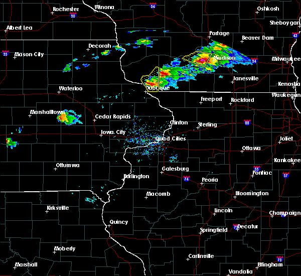 At 359 pm cdt, a severe thunderstorm was located between dickeyville and potosi, moving east at 30 mph (trained weather spotters). Hazards include 60 mph wind gusts and quarter size hail. Hail damage to vehicles is expected. expect wind damage to roofs, siding, and trees. this severe storm will be near, platteville around 405 pm cdt. cuba city and hazel green around 415 pm cdt. Other locations impacted by this severe thunderstorm include georgetown, arthur, potosi, livingston and tennyson. At 359 pm cdt, a severe thunderstorm was located between dickeyville and potosi, moving east at 30 mph (trained weather spotters). Hazards include 60 mph wind gusts and quarter size hail. Hail damage to vehicles is expected. expect wind damage to roofs, siding, and trees. this severe storm will be near, platteville around 405 pm cdt. cuba city and hazel green around 415 pm cdt. Other locations impacted by this severe thunderstorm include georgetown, arthur, potosi, livingston and tennyson.
|
| 9/19/2016 3:55 PM CDT |
 At 354 pm cdt, a severe thunderstorm was near livingston and another was near potosi, moving southeast at 40 mph (trained weather spotters). Hazards include 60 mph wind gusts and quarter size hail. Hail damage is possible. this severe storm will be near, cuba city around 400 pm cdt. hazel green around 405 pm cdt. Other locations impacted by this severe thunderstorm include georgetown, arthur, montfort, potosi and livingston. At 354 pm cdt, a severe thunderstorm was near livingston and another was near potosi, moving southeast at 40 mph (trained weather spotters). Hazards include 60 mph wind gusts and quarter size hail. Hail damage is possible. this severe storm will be near, cuba city around 400 pm cdt. hazel green around 405 pm cdt. Other locations impacted by this severe thunderstorm include georgetown, arthur, montfort, potosi and livingston.
|
| 9/19/2016 3:43 PM CDT |
 At 340 pm cdt, a severe thunderstorm was southeast of fennimore while another severe storm was northwest of potosi in grant county. these storms are still showing signs of large hail and do have some rotation within the storm (trained weather spotters). Hazards include 60 mph wind gusts and quarter size hail. Hail damage is possible. this severe storm will be near, dickeyville around 350 pm cdt. platteville around 355 pm cdt. cuba city and hazel green around 405 pm cdt. Spotters have reported non rotating wall clouds. At 340 pm cdt, a severe thunderstorm was southeast of fennimore while another severe storm was northwest of potosi in grant county. these storms are still showing signs of large hail and do have some rotation within the storm (trained weather spotters). Hazards include 60 mph wind gusts and quarter size hail. Hail damage is possible. this severe storm will be near, dickeyville around 350 pm cdt. platteville around 355 pm cdt. cuba city and hazel green around 405 pm cdt. Spotters have reported non rotating wall clouds.
|
| 9/19/2016 3:32 PM CDT |
 At 330 pm cdt, two severe storms were in the warned area. one storm was near beetown, north of cassville, while the other was headed into the fennimore area. the storms were moving southeast at 40 mph (trained weather spotters). Hazards include 60 mph wind gusts and quarter size hail. Hail damage to vehicles is expected. expect wind damage to roofs, siding, and trees. this severe storm will be near, fennimore around 335 pm cdt. dickeyville around 350 pm cdt. platteville around 355 pm cdt. cuba city and hazel green around 405 pm cdt. Other locations impacted by this severe thunderstorm include preston, georgetown, beetown, arthur and montfort. At 330 pm cdt, two severe storms were in the warned area. one storm was near beetown, north of cassville, while the other was headed into the fennimore area. the storms were moving southeast at 40 mph (trained weather spotters). Hazards include 60 mph wind gusts and quarter size hail. Hail damage to vehicles is expected. expect wind damage to roofs, siding, and trees. this severe storm will be near, fennimore around 335 pm cdt. dickeyville around 350 pm cdt. platteville around 355 pm cdt. cuba city and hazel green around 405 pm cdt. Other locations impacted by this severe thunderstorm include preston, georgetown, beetown, arthur and montfort.
|
| 9/19/2016 3:25 PM CDT |
 At 324 pm cdt, a severe thunderstorm was located near cassville, or 9 miles east of guttenberg, moving southeast at 40 mph. the glen haven fire department reported one inch hail as this storm moved through (trained weather spotters). Hazards include 60 mph wind gusts and quarter size hail. Hail damage to vehicles is expected. expect wind damage to roofs, siding, and trees. this severe storm will be near, lancaster around 335 pm cdt. dickeyville around 350 pm cdt. platteville around 355 pm cdt. cuba city and hazel green around 405 pm cdt. Another storm is headed towards fennimore as well. At 324 pm cdt, a severe thunderstorm was located near cassville, or 9 miles east of guttenberg, moving southeast at 40 mph. the glen haven fire department reported one inch hail as this storm moved through (trained weather spotters). Hazards include 60 mph wind gusts and quarter size hail. Hail damage to vehicles is expected. expect wind damage to roofs, siding, and trees. this severe storm will be near, lancaster around 335 pm cdt. dickeyville around 350 pm cdt. platteville around 355 pm cdt. cuba city and hazel green around 405 pm cdt. Another storm is headed towards fennimore as well.
|
| 9/19/2016 3:13 PM CDT |
 At 312 pm cdt, severe thunderstorms were moving into grant county from south and east of prairie du chien, moving southeast at 40 mph (radar indicated). Hazards include 60 mph wind gusts and quarter size hail. Hail damage is possible. this severe thunderstorm will be near, () cassville and bloomington around 320 pm cdt. lancaster around 335 pm cdt. dickeyville around 350 pm cdt. platteville around 355 pm cdt. cuba city and hazel green around 405 pm cdt. The main threat from these storms will be large hail. At 312 pm cdt, severe thunderstorms were moving into grant county from south and east of prairie du chien, moving southeast at 40 mph (radar indicated). Hazards include 60 mph wind gusts and quarter size hail. Hail damage is possible. this severe thunderstorm will be near, () cassville and bloomington around 320 pm cdt. lancaster around 335 pm cdt. dickeyville around 350 pm cdt. platteville around 355 pm cdt. cuba city and hazel green around 405 pm cdt. The main threat from these storms will be large hail.
|
| 8/4/2016 8:09 PM CDT |
 At 807 pm cdt, severe thunderstorms were located along a line extending from near belmont to near hazel green, moving east at 50 mph (trained weather spotters). Hazards include 60 mph wind gusts. at 745 pm...wind damage was reported in potosi. Expect damage to roofs. siding. and trees. Locations impacted include, mineral point, darlington, shullsburg, belmont, benton, argyle, blanchardville, somers, wiota, linden, new diggings, south wayne, cobb, lamont, rewey, gratiot, woodford, london, yellowstone lake st park and platte mounds. At 807 pm cdt, severe thunderstorms were located along a line extending from near belmont to near hazel green, moving east at 50 mph (trained weather spotters). Hazards include 60 mph wind gusts. at 745 pm...wind damage was reported in potosi. Expect damage to roofs. siding. and trees. Locations impacted include, mineral point, darlington, shullsburg, belmont, benton, argyle, blanchardville, somers, wiota, linden, new diggings, south wayne, cobb, lamont, rewey, gratiot, woodford, london, yellowstone lake st park and platte mounds.
|
| 8/4/2016 8:06 PM CDT |
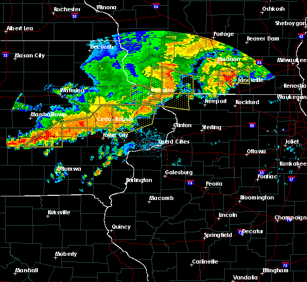 At 803 pm cdt, severe thunderstorms were located along a line extending from 12 miles east of fennimore to hazel green, moving east at 45 mph (law enforcement reports power lines and trees down in many parts of southern grant county including potosi, cuba city, and hazel green). Hazards include 60 mph wind gusts. Expect damage to roofs. siding. and trees. most of the severe winds have now pushed east of grant county. lightning is the main threat with ponding on roads. the warning will be allowed to expire at 815 pm. Locations impacted include, platteville, cuba city, hazel green, dickeyville, preston, montfort, livingston, kieler, sinsinawa, sandy hook. At 803 pm cdt, severe thunderstorms were located along a line extending from 12 miles east of fennimore to hazel green, moving east at 45 mph (law enforcement reports power lines and trees down in many parts of southern grant county including potosi, cuba city, and hazel green). Hazards include 60 mph wind gusts. Expect damage to roofs. siding. and trees. most of the severe winds have now pushed east of grant county. lightning is the main threat with ponding on roads. the warning will be allowed to expire at 815 pm. Locations impacted include, platteville, cuba city, hazel green, dickeyville, preston, montfort, livingston, kieler, sinsinawa, sandy hook.
|
| 8/4/2016 7:56 PM CDT |
 At 754 pm cdt, the leading edge of a severe line of thunderstormswas located along a line extending from preston to hazel green, moving east at 55 mph (law enforcement. pockets of wind damage have been reported along this line of storms). Hazards include 60 mph wind gusts. Expect damage to roofs. siding. and trees. These severe thunderstorms will remain over mainly rural areas of southeastern grant county, including the following locations: preston, georgetown, arthur, montfort and potosi. At 754 pm cdt, the leading edge of a severe line of thunderstormswas located along a line extending from preston to hazel green, moving east at 55 mph (law enforcement. pockets of wind damage have been reported along this line of storms). Hazards include 60 mph wind gusts. Expect damage to roofs. siding. and trees. These severe thunderstorms will remain over mainly rural areas of southeastern grant county, including the following locations: preston, georgetown, arthur, montfort and potosi.
|
| 8/4/2016 7:49 PM CDT |
 At 748 pm cdt, severe thunderstorms were located along a line extending from 7 miles northwest of platteville to near east dubuque, moving east at 50 mph (trained weather spotters. at 745 pm...wind damage was reported in potosi). Hazards include 60 mph wind gusts. Expect damage to roofs. siding. And trees. At 748 pm cdt, severe thunderstorms were located along a line extending from 7 miles northwest of platteville to near east dubuque, moving east at 50 mph (trained weather spotters. at 745 pm...wind damage was reported in potosi). Hazards include 60 mph wind gusts. Expect damage to roofs. siding. And trees.
|
| 8/4/2016 7:47 PM CDT |
 At 745 pm cdt, severe thunderstorms were located along a line extending from 7 miles southeast of fennimore to near dickeyville, moving east at 65 mph (law enforcement. power lines have been downed from these storms with winds in the 60 mph range near potosi). Hazards include 60 mph wind gusts. Expect damage to roofs. siding. and trees. these severe storms will be near, platteville, cuba city and hazel green around 755 pm cdt. Other locations impacted by these severe thunderstorms include preston, georgetown, beetown, arthur and montfort. At 745 pm cdt, severe thunderstorms were located along a line extending from 7 miles southeast of fennimore to near dickeyville, moving east at 65 mph (law enforcement. power lines have been downed from these storms with winds in the 60 mph range near potosi). Hazards include 60 mph wind gusts. Expect damage to roofs. siding. and trees. these severe storms will be near, platteville, cuba city and hazel green around 755 pm cdt. Other locations impacted by these severe thunderstorms include preston, georgetown, beetown, arthur and montfort.
|
| 8/4/2016 7:33 PM CDT |
 At 733 pm cdt, severe thunderstorms were located along a line extending from lancaster to balltown, moving east at 60 mph (radar indicated). Hazards include 60 mph wind gusts. Expect damage to roofs. siding. and trees. severe thunderstorms will be near, fennimore around 740 pm cdt. dickeyville around 745 pm cdt. platteville, cuba city and hazel green around 755 pm cdt. Other locations impacted by these severe thunderstorms include preston, georgetown, beetown, arthur and montfort. At 733 pm cdt, severe thunderstorms were located along a line extending from lancaster to balltown, moving east at 60 mph (radar indicated). Hazards include 60 mph wind gusts. Expect damage to roofs. siding. and trees. severe thunderstorms will be near, fennimore around 740 pm cdt. dickeyville around 745 pm cdt. platteville, cuba city and hazel green around 755 pm cdt. Other locations impacted by these severe thunderstorms include preston, georgetown, beetown, arthur and montfort.
|
| 8/4/2016 6:16 PM CDT |
 At 616 pm cdt, a severe thunderstorm was located near mineral point, moving southeast at 35 mph (radar indicated). Hazards include 60 mph wind gusts and quarter size hail. Hail damage to vehicles is expected. Expect wind damage to roofs, siding, and trees. At 616 pm cdt, a severe thunderstorm was located near mineral point, moving southeast at 35 mph (radar indicated). Hazards include 60 mph wind gusts and quarter size hail. Hail damage to vehicles is expected. Expect wind damage to roofs, siding, and trees.
|
| 7/21/2016 8:22 PM CDT |
 The severe thunderstorm warning for iowa county will expire at 830 pm cdt, the storm which prompted the warning has weakened below severe limits, and no longer pose an immediate threat to life or property. therefore the warning will be allowed to expire. however gusty winds and heavy rain are still possible with this thunderstorm. a severe thunderstorm watch remains in effect until 900 pm cdt for south central wisconsin. The severe thunderstorm warning for iowa county will expire at 830 pm cdt, the storm which prompted the warning has weakened below severe limits, and no longer pose an immediate threat to life or property. therefore the warning will be allowed to expire. however gusty winds and heavy rain are still possible with this thunderstorm. a severe thunderstorm watch remains in effect until 900 pm cdt for south central wisconsin.
|
| 7/21/2016 7:55 PM CDT |
 At 754 pm cdt, a severe thunderstorm was located near dodgeville, moving south at 55 mph (radar indicated). Hazards include 60 mph wind gusts. Expect damage to roofs. siding. and trees. Locations impacted include, dodgeville, mineral point, blanchardville, barneveld, highland, arena, ridgeway, avoca, orion, linden, cobb, rewey, hollandale, edmund, blackhawk lake rec area, london, governor dodge st park and blue mound st park. At 754 pm cdt, a severe thunderstorm was located near dodgeville, moving south at 55 mph (radar indicated). Hazards include 60 mph wind gusts. Expect damage to roofs. siding. and trees. Locations impacted include, dodgeville, mineral point, blanchardville, barneveld, highland, arena, ridgeway, avoca, orion, linden, cobb, rewey, hollandale, edmund, blackhawk lake rec area, london, governor dodge st park and blue mound st park.
|
| 7/21/2016 7:39 PM CDT |
 At 739 pm cdt, a severe thunderstorm was located 8 miles southeast of muscoda, or 14 miles northwest of dodgeville, moving south at 45 mph (radar indicated). Hazards include 60 mph wind gusts. Expect damage to roofs. siding. And trees. At 739 pm cdt, a severe thunderstorm was located 8 miles southeast of muscoda, or 14 miles northwest of dodgeville, moving south at 45 mph (radar indicated). Hazards include 60 mph wind gusts. Expect damage to roofs. siding. And trees.
|
| 7/5/2016 11:48 PM CDT |
 At 1146 pm cdt, severe thunderstorms were located along a line extending from 6 miles north of dodgeville to near dickeyville, moving southeast at 45 mph (radar indicated). Hazards include 60 mph wind gusts. Expect damage to roofs. siding. and trees. Locations impacted include, dodgeville, mineral point, darlington, belmont, linden, rewey, hollandale, blackhawk lake rec area, yellowstone lake st park, london and leslie. At 1146 pm cdt, severe thunderstorms were located along a line extending from 6 miles north of dodgeville to near dickeyville, moving southeast at 45 mph (radar indicated). Hazards include 60 mph wind gusts. Expect damage to roofs. siding. and trees. Locations impacted include, dodgeville, mineral point, darlington, belmont, linden, rewey, hollandale, blackhawk lake rec area, yellowstone lake st park, london and leslie.
|
| 7/5/2016 11:35 PM CDT |
 At 1135 pm cdt, a severe thunderstorm was located 9 miles southeast of fennimore, or 11 miles east of lancaster, moving southeast at 70 mph (radar indicated). Hazards include 60 mph wind gusts. Expect damage to roofs. siding. And trees. At 1135 pm cdt, a severe thunderstorm was located 9 miles southeast of fennimore, or 11 miles east of lancaster, moving southeast at 70 mph (radar indicated). Hazards include 60 mph wind gusts. Expect damage to roofs. siding. And trees.
|
| 11/11/2015 7:06 PM CST |
 The severe thunderstorm warning for southeastern clayton and southern grant counties will expire at 715 pm cst, the storms which prompted the warning have moved out of the area. therefore the warning will be allowed to expire. emergency management reported a few trees down between kieler and cuba city. The severe thunderstorm warning for southeastern clayton and southern grant counties will expire at 715 pm cst, the storms which prompted the warning have moved out of the area. therefore the warning will be allowed to expire. emergency management reported a few trees down between kieler and cuba city.
|
| 11/11/2015 6:56 PM CST |
 At 654 pm cst, a severe thunderstorm was located 8 miles north of belmont, or 9 miles northeast of platteville, moving northeast at 55 mph (radar indicated). Hazards include 60 mph wind gusts. Expect damage to roofs. siding and trees. Locations impacted include, dodgeville, mineral point, argyle, blanchardville, somers, barneveld, wiota, highland, ridgeway, avoca, orion, linden, south wayne, cobb, rewey, hollandale, edmund, blackhawk lake rec area, yellowstone lake st park and woodford. At 654 pm cst, a severe thunderstorm was located 8 miles north of belmont, or 9 miles northeast of platteville, moving northeast at 55 mph (radar indicated). Hazards include 60 mph wind gusts. Expect damage to roofs. siding and trees. Locations impacted include, dodgeville, mineral point, argyle, blanchardville, somers, barneveld, wiota, highland, ridgeway, avoca, orion, linden, south wayne, cobb, rewey, hollandale, edmund, blackhawk lake rec area, yellowstone lake st park and woodford.
|
| 11/11/2015 6:48 PM CST |
 At 647 pm cst, severe thunderstorms were located along a line extending from near lancaster to near platteville to near benton, moving northeast at 60 mph (emergency management reported power lines down near the town of kieler). Hazards include 60 mph wind gusts. Expect damage to roofs. siding and trees. These severe thunderstorms will remain over mainly rural areas of southeastern clayton and southern grant counties, including the following locations, preston, georgetown, beetown, arthur and potosi. At 647 pm cst, severe thunderstorms were located along a line extending from near lancaster to near platteville to near benton, moving northeast at 60 mph (emergency management reported power lines down near the town of kieler). Hazards include 60 mph wind gusts. Expect damage to roofs. siding and trees. These severe thunderstorms will remain over mainly rural areas of southeastern clayton and southern grant counties, including the following locations, preston, georgetown, beetown, arthur and potosi.
|
| 11/11/2015 6:44 PM CST |
 At 641 pm cst, a line of severe thunderstorms were located near cuba city, or 8 miles south of platteville, moving northeast at 55 mph (radar indicated). Hazards include 60 mph wind gusts. Expect damage to roofs. Siding and trees. At 641 pm cst, a line of severe thunderstorms were located near cuba city, or 8 miles south of platteville, moving northeast at 55 mph (radar indicated). Hazards include 60 mph wind gusts. Expect damage to roofs. Siding and trees.
|
| 11/11/2015 6:30 PM CST |
 At 629 pm cst, severe thunderstorms were located along a line extending from cassville to near sherrill to st. donatus, moving northeast at 45 mph (radar indicated). Hazards include 60 mph wind gusts. Expect damage to roofs. siding and trees. severe thunderstorms will be near, dickeyville around 635 pm cst. hazel green around 640 pm cst. platteville and cuba city around 645 pm cst. lancaster around 650 pm cst. Other locations impacted by these severe thunderstorms include preston, georgetown, beetown, arthur and potosi. At 629 pm cst, severe thunderstorms were located along a line extending from cassville to near sherrill to st. donatus, moving northeast at 45 mph (radar indicated). Hazards include 60 mph wind gusts. Expect damage to roofs. siding and trees. severe thunderstorms will be near, dickeyville around 635 pm cst. hazel green around 640 pm cst. platteville and cuba city around 645 pm cst. lancaster around 650 pm cst. Other locations impacted by these severe thunderstorms include preston, georgetown, beetown, arthur and potosi.
|
| 7/13/2015 4:21 AM CDT |
 At 420 am cdt, severe thunderstorms were located along a line extending from near waterloo to deerfield to 7 miles north of belmont, moving southeast at 45 mph. at 334 am, lone rock reported a wind gust of 68 mph (radar indicated). Hazards include 70 mph wind gusts. Expect considerable tree damage. damage is likely to mobile homes, roofs and outbuildings. locations impacted include, madison, janesville, fitchburg, watertown, middleton, whitewater, hartford, stoughton, fort atkinson, monroe, verona, oregon, jefferson, mcfarland, monona, mount horeb, lake mills, milton, edgerton and mayville. People attending the jefferson county fair should seek safe shelter immediately!. At 420 am cdt, severe thunderstorms were located along a line extending from near waterloo to deerfield to 7 miles north of belmont, moving southeast at 45 mph. at 334 am, lone rock reported a wind gust of 68 mph (radar indicated). Hazards include 70 mph wind gusts. Expect considerable tree damage. damage is likely to mobile homes, roofs and outbuildings. locations impacted include, madison, janesville, fitchburg, watertown, middleton, whitewater, hartford, stoughton, fort atkinson, monroe, verona, oregon, jefferson, mcfarland, monona, mount horeb, lake mills, milton, edgerton and mayville. People attending the jefferson county fair should seek safe shelter immediately!.
|
| 7/13/2015 4:06 AM CDT |
 At 404 am cdt, severe thunderstorms were located along a line extending from near columbus to near sun prairie to 8 miles southeast of fennimore, moving southeast at 45 mph. at 334 am, a wind gust of 68 mph was reported at lone rock (radar indicated). Hazards include 70 mph wind gusts. Expect considerable tree damage. damage is likely to mobile homes, roofs and outbuildings. locations impacted include, madison, janesville, fitchburg, watertown, middleton, whitewater, hartford, stoughton, fort atkinson, monroe, verona, oregon, jefferson, mcfarland, monona, mount horeb, lake mills, milton, edgerton and mayville. People attending the jefferson county fair should seek safe shelter immediately!. At 404 am cdt, severe thunderstorms were located along a line extending from near columbus to near sun prairie to 8 miles southeast of fennimore, moving southeast at 45 mph. at 334 am, a wind gust of 68 mph was reported at lone rock (radar indicated). Hazards include 70 mph wind gusts. Expect considerable tree damage. damage is likely to mobile homes, roofs and outbuildings. locations impacted include, madison, janesville, fitchburg, watertown, middleton, whitewater, hartford, stoughton, fort atkinson, monroe, verona, oregon, jefferson, mcfarland, monona, mount horeb, lake mills, milton, edgerton and mayville. People attending the jefferson county fair should seek safe shelter immediately!.
|
| 7/13/2015 3:52 AM CDT |
 At 352 am cdt, severe thunderstorms were located along a line extending from near rio to near waunakee to fennimore, moving southeast at 45 mph (radar indicated). Hazards include 70 mph wind gusts. Expect considerable tree damage. Damage is likely to mobile homes, roofs and outbuildings. At 352 am cdt, severe thunderstorms were located along a line extending from near rio to near waunakee to fennimore, moving southeast at 45 mph (radar indicated). Hazards include 70 mph wind gusts. Expect considerable tree damage. Damage is likely to mobile homes, roofs and outbuildings.
|
| 6/22/2015 9:56 AM CDT |
 At 954 am cdt, severe thunderstorms were located along a line extending from 9 miles southwest of westfield to near waunakee to 6 miles east of monroe to near pearl city, moving east at 60 mph. reports of widespread trees and power lines down in iowa and lafayette counties have been reported (radar indicated). Hazards include 70 mph wind gusts and quarter size hail. Hail damage to vehicles is expected. expect considerable tree damage. wind damage is also likely to mobile homes, roofs and outbuildings. widespread trees and power lines down in iowa and lafayette counites have been reported. these severe storms will be near, waunakee, windsor, brodhead, deforest, maple bluff and albany around 1000 am cdt. Other locations impacted by these severe thunderstorms include east bristol, mount vernon, pine bluff, magnolia, merrimac, somers, plain, paoli, arena and leland. At 954 am cdt, severe thunderstorms were located along a line extending from 9 miles southwest of westfield to near waunakee to 6 miles east of monroe to near pearl city, moving east at 60 mph. reports of widespread trees and power lines down in iowa and lafayette counties have been reported (radar indicated). Hazards include 70 mph wind gusts and quarter size hail. Hail damage to vehicles is expected. expect considerable tree damage. wind damage is also likely to mobile homes, roofs and outbuildings. widespread trees and power lines down in iowa and lafayette counites have been reported. these severe storms will be near, waunakee, windsor, brodhead, deforest, maple bluff and albany around 1000 am cdt. Other locations impacted by these severe thunderstorms include east bristol, mount vernon, pine bluff, magnolia, merrimac, somers, plain, paoli, arena and leland.
|
| 6/22/2015 9:47 AM CDT |
 At 945 am cdt, severe thunderstorms were located along a line extending from 6 miles north of wisconsin dells to mazomanie to near winslow to near massbach, moving east at 50 mph. the mineral point airport reported winds of 51 miles per hour at 941 am cdt (radar indicated). Hazards include 70 mph wind gusts and quarter size hail. Hail damage to vehicles is expected. expect considerable tree damage. wind damage is also likely to mobile homes, roofs and outbuildings. these severe storms will be near, cross plains around 955 am cdt. madison, middleton, waunakee and shorewood hills around 1000 am cdt. Other locations impacted by these severe thunderstorms include east bristol, mount vernon, pine bluff, magnolia, merrimac, somers, plain, paoli, arena and leland. At 945 am cdt, severe thunderstorms were located along a line extending from 6 miles north of wisconsin dells to mazomanie to near winslow to near massbach, moving east at 50 mph. the mineral point airport reported winds of 51 miles per hour at 941 am cdt (radar indicated). Hazards include 70 mph wind gusts and quarter size hail. Hail damage to vehicles is expected. expect considerable tree damage. wind damage is also likely to mobile homes, roofs and outbuildings. these severe storms will be near, cross plains around 955 am cdt. madison, middleton, waunakee and shorewood hills around 1000 am cdt. Other locations impacted by these severe thunderstorms include east bristol, mount vernon, pine bluff, magnolia, merrimac, somers, plain, paoli, arena and leland.
|
| 6/22/2015 9:38 AM CDT |
 At 937 am cdt, severe thunderstorms were located along a line extending from 9 miles southeast of mauston to near mazomanie to 7 miles southwest of argyle to near hanover, moving east at 50 mph (radar indicated). Hazards include 70 mph wind gusts and quarter size hail. Hail damage to vehicles is expected. expect considerable tree damage. wind damage is also likely to mobile homes, roofs and outbuildings. these severe storms will be near, argyle around 940 am cdt. wisconsin dells, mazomanie and black earth around 945 am cdt. lake delton around 950 am cdt. monroe and cross plains around 955 am cdt. madison, fitchburg, middleton, verona, portage and shorewood hills around 1000 am cdt. Other locations impacted by these severe thunderstorms include east bristol, mount vernon, pine bluff, magnolia, merrimac, somers, plain, paoli, arena and leland. At 937 am cdt, severe thunderstorms were located along a line extending from 9 miles southeast of mauston to near mazomanie to 7 miles southwest of argyle to near hanover, moving east at 50 mph (radar indicated). Hazards include 70 mph wind gusts and quarter size hail. Hail damage to vehicles is expected. expect considerable tree damage. wind damage is also likely to mobile homes, roofs and outbuildings. these severe storms will be near, argyle around 940 am cdt. wisconsin dells, mazomanie and black earth around 945 am cdt. lake delton around 950 am cdt. monroe and cross plains around 955 am cdt. madison, fitchburg, middleton, verona, portage and shorewood hills around 1000 am cdt. Other locations impacted by these severe thunderstorms include east bristol, mount vernon, pine bluff, magnolia, merrimac, somers, plain, paoli, arena and leland.
|
| 6/22/2015 9:25 AM CDT |
 A severe thunderstorm warning remains in effect until 930 am cdt for eastern richland and eastern grant counties, there have been numerous reports of trees down and damage across southern parts of grant county in far southwest wisconsin. wind gusts of 60 to 70 mph have been reported by trained spotters and amateur radio operators (trained weather spotters). Hazards include 70 mph wind gusts. Expect considerable tree damage. damage is likely to mobile homes, roofs and outbuildings. these severe storms will be near, hazel green around 925 am cdt. these storms are about to exit the warned area. The warning will expire on time. A severe thunderstorm warning remains in effect until 930 am cdt for eastern richland and eastern grant counties, there have been numerous reports of trees down and damage across southern parts of grant county in far southwest wisconsin. wind gusts of 60 to 70 mph have been reported by trained spotters and amateur radio operators (trained weather spotters). Hazards include 70 mph wind gusts. Expect considerable tree damage. damage is likely to mobile homes, roofs and outbuildings. these severe storms will be near, hazel green around 925 am cdt. these storms are about to exit the warned area. The warning will expire on time.
|
| 6/22/2015 9:24 AM CDT |
 At 923 am cdt, severe thunderstorms were located along a line extending from near mauston to near spring green to near belmont to springbrook, moving east at 50 mph (radar indicated). Hazards include 70 mph wind gusts and quarter size hail. Hail damage to vehicles is expected. expect considerable tree damage. wind damage is also likely to mobile homes, roofs and outbuildings. these severe storms will be near, darlington around 930 am cdt. wisconsin dells, mazomanie and black earth around 940 am cdt. lake delton and argyle around 945 am cdt. cross plains around 950 am cdt. waunakee and verona around 955 am cdt. madison, fitchburg, middleton, monroe, portage, monona, shorewood hills and maple bluff around 1000 am cdt. Other locations impacted by these severe thunderstorms include east bristol, mount vernon, pine bluff, magnolia, merrimac, somers, plain, paoli, arena and leland. At 923 am cdt, severe thunderstorms were located along a line extending from near mauston to near spring green to near belmont to springbrook, moving east at 50 mph (radar indicated). Hazards include 70 mph wind gusts and quarter size hail. Hail damage to vehicles is expected. expect considerable tree damage. wind damage is also likely to mobile homes, roofs and outbuildings. these severe storms will be near, darlington around 930 am cdt. wisconsin dells, mazomanie and black earth around 940 am cdt. lake delton and argyle around 945 am cdt. cross plains around 950 am cdt. waunakee and verona around 955 am cdt. madison, fitchburg, middleton, monroe, portage, monona, shorewood hills and maple bluff around 1000 am cdt. Other locations impacted by these severe thunderstorms include east bristol, mount vernon, pine bluff, magnolia, merrimac, somers, plain, paoli, arena and leland.
|
| 6/22/2015 9:16 AM CDT |
 At 916 am cdt, severe thunderstorms were located along a line extending from 6 miles northwest of muscoda to 9 miles southeast of fennimore to near dickeyville, moving southeast at 55 mph. these storms are heading into the platteville area with strong winds (law enforcement). Hazards include 60 mph wind gusts. Expect damage to roofs. siding and trees. these severe storms will be near, hazel green, cuba city and dickeyville around 920 am cdt. platteville around 920 am cdt. Other locations impacted by these severe thunderstorms include germantown, westport, excelsior, preston and georgetown. At 916 am cdt, severe thunderstorms were located along a line extending from 6 miles northwest of muscoda to 9 miles southeast of fennimore to near dickeyville, moving southeast at 55 mph. these storms are heading into the platteville area with strong winds (law enforcement). Hazards include 60 mph wind gusts. Expect damage to roofs. siding and trees. these severe storms will be near, hazel green, cuba city and dickeyville around 920 am cdt. platteville around 920 am cdt. Other locations impacted by these severe thunderstorms include germantown, westport, excelsior, preston and georgetown.
|
| 6/22/2015 9:13 AM CDT |
 At 911 am cdt, severe thunderstorms were located along a line extending from 8 miles east of soldiers grove to fennimore to near dickeyville, moving southeast at 50 mph. a barn was blown down east of cassville and there could be more damage across the southern end of grant county, including platteville (law enforcement). Hazards include 60 mph wind gusts. Expect damage to roofs. siding and trees. these severe storms will be near, dickeyville around 915 am cdt. cuba city and muscoda around 920 am cdt. platteville and hazel green around 920 am cdt. Other locations impacted by these severe thunderstorms include germantown, westport, excelsior, preston and georgetown. At 911 am cdt, severe thunderstorms were located along a line extending from 8 miles east of soldiers grove to fennimore to near dickeyville, moving southeast at 50 mph. a barn was blown down east of cassville and there could be more damage across the southern end of grant county, including platteville (law enforcement). Hazards include 60 mph wind gusts. Expect damage to roofs. siding and trees. these severe storms will be near, dickeyville around 915 am cdt. cuba city and muscoda around 920 am cdt. platteville and hazel green around 920 am cdt. Other locations impacted by these severe thunderstorms include germantown, westport, excelsior, preston and georgetown.
|
| 6/22/2015 9:07 AM CDT |
 At 906 am cdt, severe thunderstorms were located along a line extending from richland center to 6 miles east of fennimore to near sherrill, moving east at 40 mph. there have been reports of tree damage as this line moved out of northeast iowa (law enforcement). Hazards include 60 mph wind gusts. Expect damage to roofs. siding and trees. these severe storms will be near, dickeyville around 920 am cdt. platteville around 925 am cdt. cuba city and hazel green around 930 am cdt. Other locations impacted by these severe thunderstorms include germantown, westport, excelsior, preston and georgetown. At 906 am cdt, severe thunderstorms were located along a line extending from richland center to 6 miles east of fennimore to near sherrill, moving east at 40 mph. there have been reports of tree damage as this line moved out of northeast iowa (law enforcement). Hazards include 60 mph wind gusts. Expect damage to roofs. siding and trees. these severe storms will be near, dickeyville around 920 am cdt. platteville around 925 am cdt. cuba city and hazel green around 930 am cdt. Other locations impacted by these severe thunderstorms include germantown, westport, excelsior, preston and georgetown.
|
| 6/22/2015 9:00 AM CDT |
 At 900 am cdt, severe thunderstorms were located along a line extending from near hillsboro to near cascade, moving east at 70 mph (radar indicated). Hazards include 60 mph wind gusts and quarter size hail. Hail damage to vehicles is expected. expect wind damage to roofs, siding and trees. severe thunderstorms will be near, wisconsin dells around 920 am cdt. lake delton around 925 am cdt. Other locations impacted by these severe thunderstorms include east bristol, mount vernon, pine bluff, magnolia, merrimac, somers, plain, paoli, arena and leland. At 900 am cdt, severe thunderstorms were located along a line extending from near hillsboro to near cascade, moving east at 70 mph (radar indicated). Hazards include 60 mph wind gusts and quarter size hail. Hail damage to vehicles is expected. expect wind damage to roofs, siding and trees. severe thunderstorms will be near, wisconsin dells around 920 am cdt. lake delton around 925 am cdt. Other locations impacted by these severe thunderstorms include east bristol, mount vernon, pine bluff, magnolia, merrimac, somers, plain, paoli, arena and leland.
|
| 6/22/2015 8:55 AM CDT |
 At 853 am cdt, severe thunderstorms were located along a line extending from 6 miles southwest of muscoda to cassville, moving east at 75 mph. tree damage was reported in prairie du chien wisconsin and across parts of southern clayton county iowa (law enforcement). Hazards include 60 mph wind gusts. Expect damage to roofs. siding and trees. these severe storms will be near, muscoda around 900 am cdt. dickeyville around 910 am cdt. platteville around 915 am cdt. Other locations impacted by these severe thunderstorms include germantown, westport, excelsior, preston and georgetown. At 853 am cdt, severe thunderstorms were located along a line extending from 6 miles southwest of muscoda to cassville, moving east at 75 mph. tree damage was reported in prairie du chien wisconsin and across parts of southern clayton county iowa (law enforcement). Hazards include 60 mph wind gusts. Expect damage to roofs. siding and trees. these severe storms will be near, muscoda around 900 am cdt. dickeyville around 910 am cdt. platteville around 915 am cdt. Other locations impacted by these severe thunderstorms include germantown, westport, excelsior, preston and georgetown.
|
| 6/22/2015 8:40 AM CDT |
 At 839 am cdt, severe thunderstorms were located along a line extending from 9 miles north of boscobel to near colesburg, moving southeast at 35 mph. these storms have a history of producing wind damage (radar indicated). Hazards include 60 mph wind gusts. Expect damage to roofs. siding and trees. severe thunderstorms will be near, boscobel around 845 am cdt. cassville around 855 am cdt. muscoda around 900 am cdt. Other locations impacted by these severe thunderstorms include germantown, westport, excelsior, preston and georgetown. At 839 am cdt, severe thunderstorms were located along a line extending from 9 miles north of boscobel to near colesburg, moving southeast at 35 mph. these storms have a history of producing wind damage (radar indicated). Hazards include 60 mph wind gusts. Expect damage to roofs. siding and trees. severe thunderstorms will be near, boscobel around 845 am cdt. cassville around 855 am cdt. muscoda around 900 am cdt. Other locations impacted by these severe thunderstorms include germantown, westport, excelsior, preston and georgetown.
|
| 6/22/2015 8:40 AM CDT |
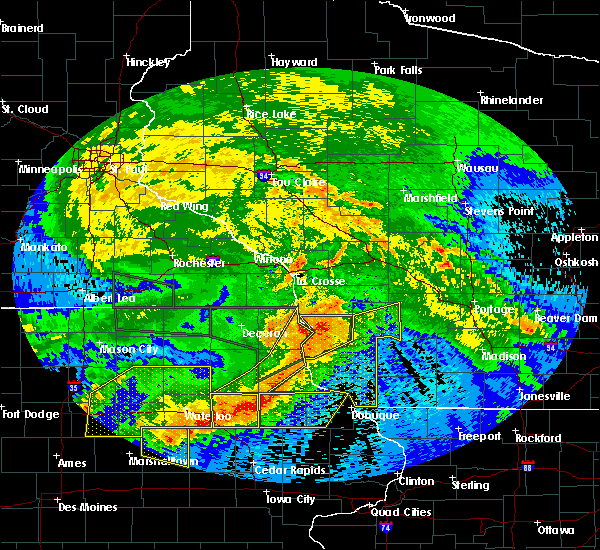 At 839 am cdt, severe thunderstorms were located along a line extending from 9 miles north of boscobel to near colesburg, moving southeast at 35 mph. these storms have a history of producing wind damage (radar indicated). Hazards include 60 mph wind gusts. Expect damage to roofs. siding and trees. severe thunderstorms will be near, boscobel around 845 am cdt. cassville around 855 am cdt. muscoda around 900 am cdt. Other locations impacted by these severe thunderstorms include germantown, westport, excelsior, preston and georgetown. At 839 am cdt, severe thunderstorms were located along a line extending from 9 miles north of boscobel to near colesburg, moving southeast at 35 mph. these storms have a history of producing wind damage (radar indicated). Hazards include 60 mph wind gusts. Expect damage to roofs. siding and trees. severe thunderstorms will be near, boscobel around 845 am cdt. cassville around 855 am cdt. muscoda around 900 am cdt. Other locations impacted by these severe thunderstorms include germantown, westport, excelsior, preston and georgetown.
|
| 4/9/2015 5:00 PM CDT | The national weather service in milwaukee/sullivan has issued a * severe thunderstorm warning for. south central sauk county in south central wisconsin. central iowa county in south central wisconsin. until 545 pm cdt * at 500 pm cdt. A severe thunderstorm was located 9 miles northwest. |
| 1/1/0001 12:00 AM | Half Dollar sized hail reported 4.9 miles SE of Montfort, WI |
| 6/8/2011 5:38 PM CDT | Quarter sized hail reported 7.5 miles SE of Montfort, WI, wind gusts to 50 mph/heavy rain |
| 6/8/2011 5:23 PM CDT | Golf Ball sized hail reported 7.5 miles SE of Montfort, WI |
| 6/8/2011 5:16 PM CDT | Quarter sized hail reported 7.5 miles SE of Montfort, WI |
Hail Maps for Montfort, WI
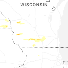


Connect with Interactive Hail Maps