

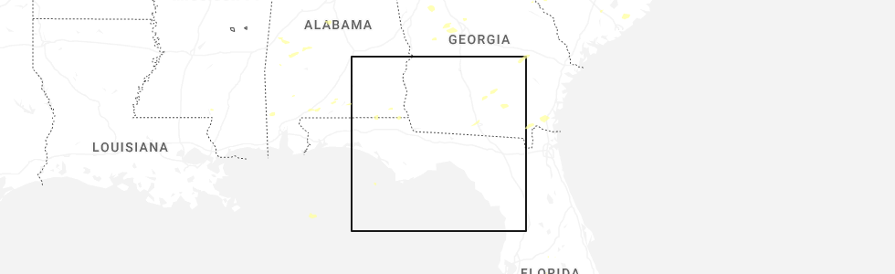
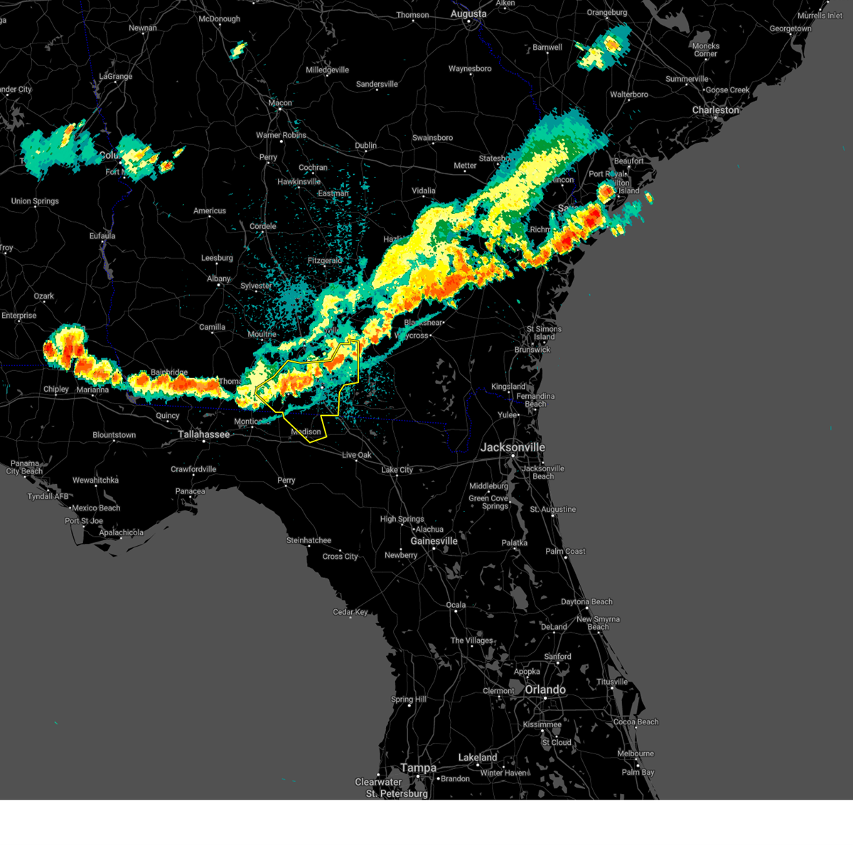
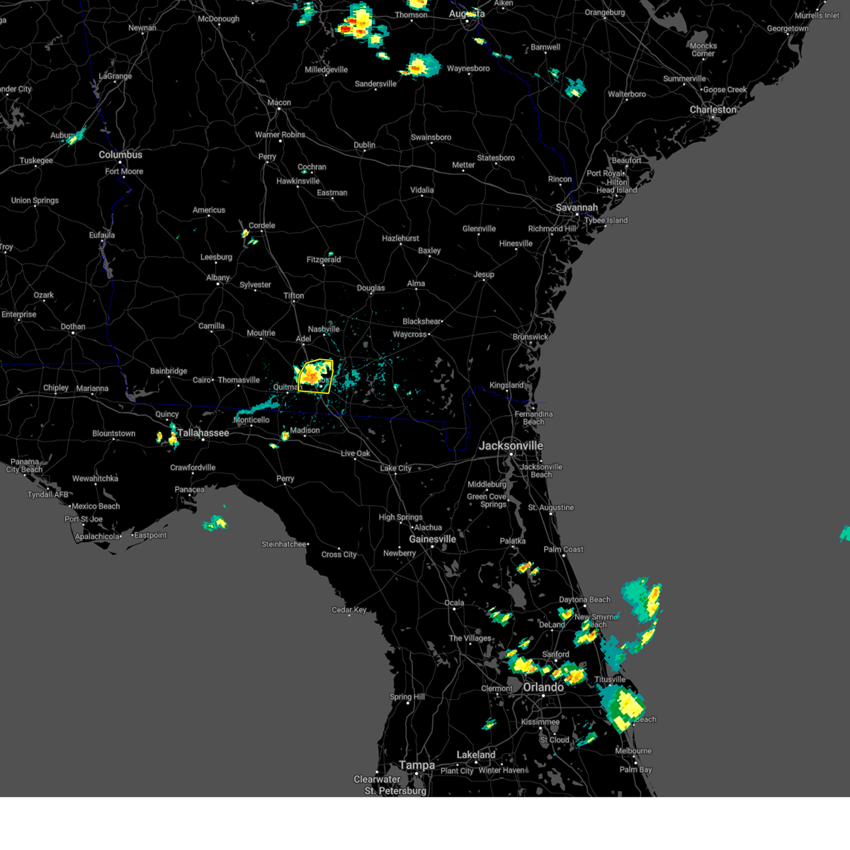
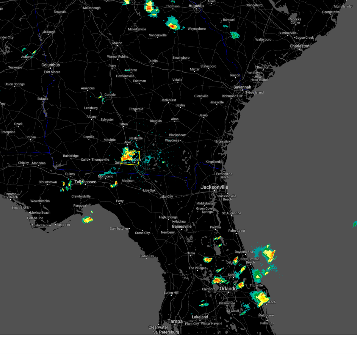
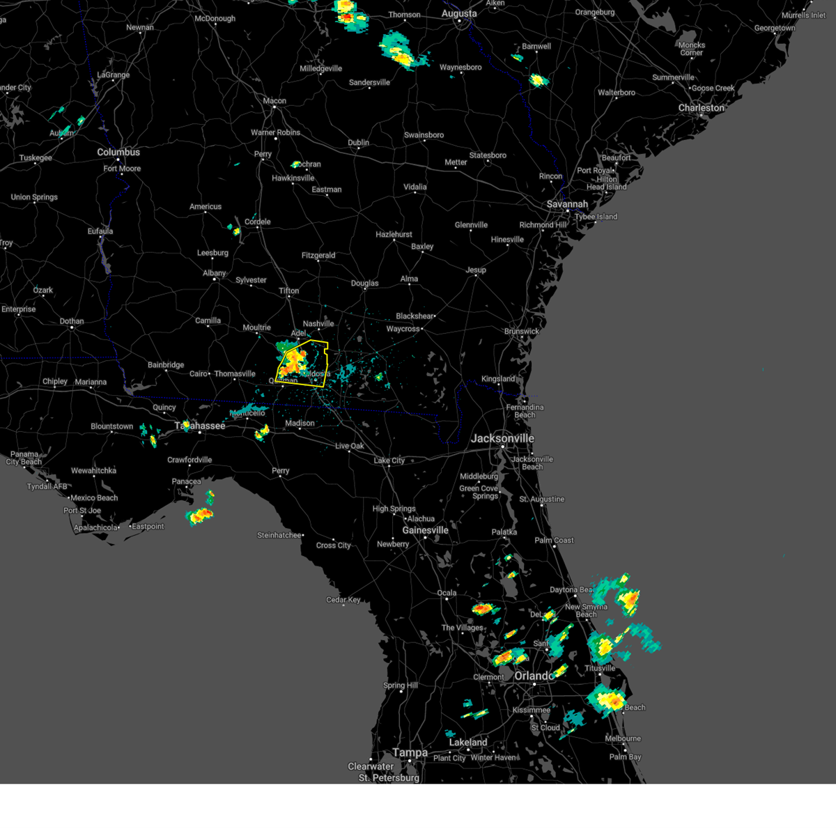
Hail Map for Moody AFB, GA
The Moody AFB, GA area has had 1 report of on-the-ground hail by trained spotters, and has been under severe weather warnings 27 times during the past 12 months. Doppler radar has detected hail at or near Moody AFB, GA on 47 occasions, including 1 occasion during the past year.
| Name: | Moody AFB, GA |
| Where Located: | 42.3 miles SSW of Douglas, GA |
| Map: | Google Map for Moody AFB, GA |
| Population: | 886 |
| Housing Units: | 305 |
| More Info: | Search Google for Moody AFB, GA |
0
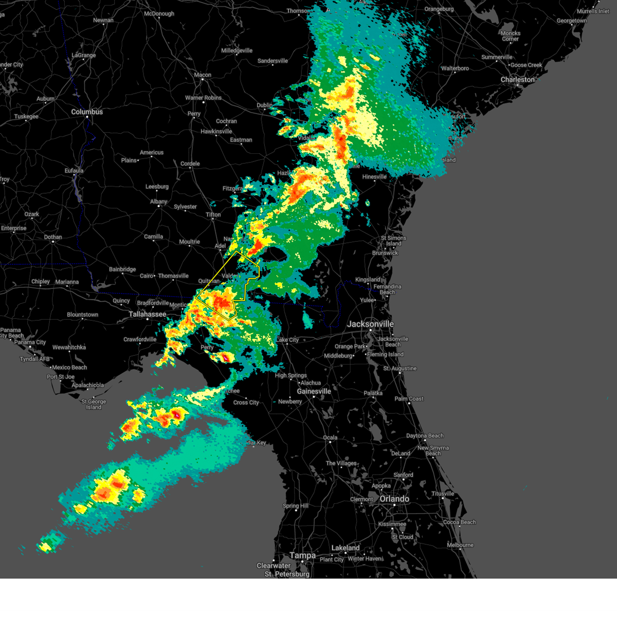
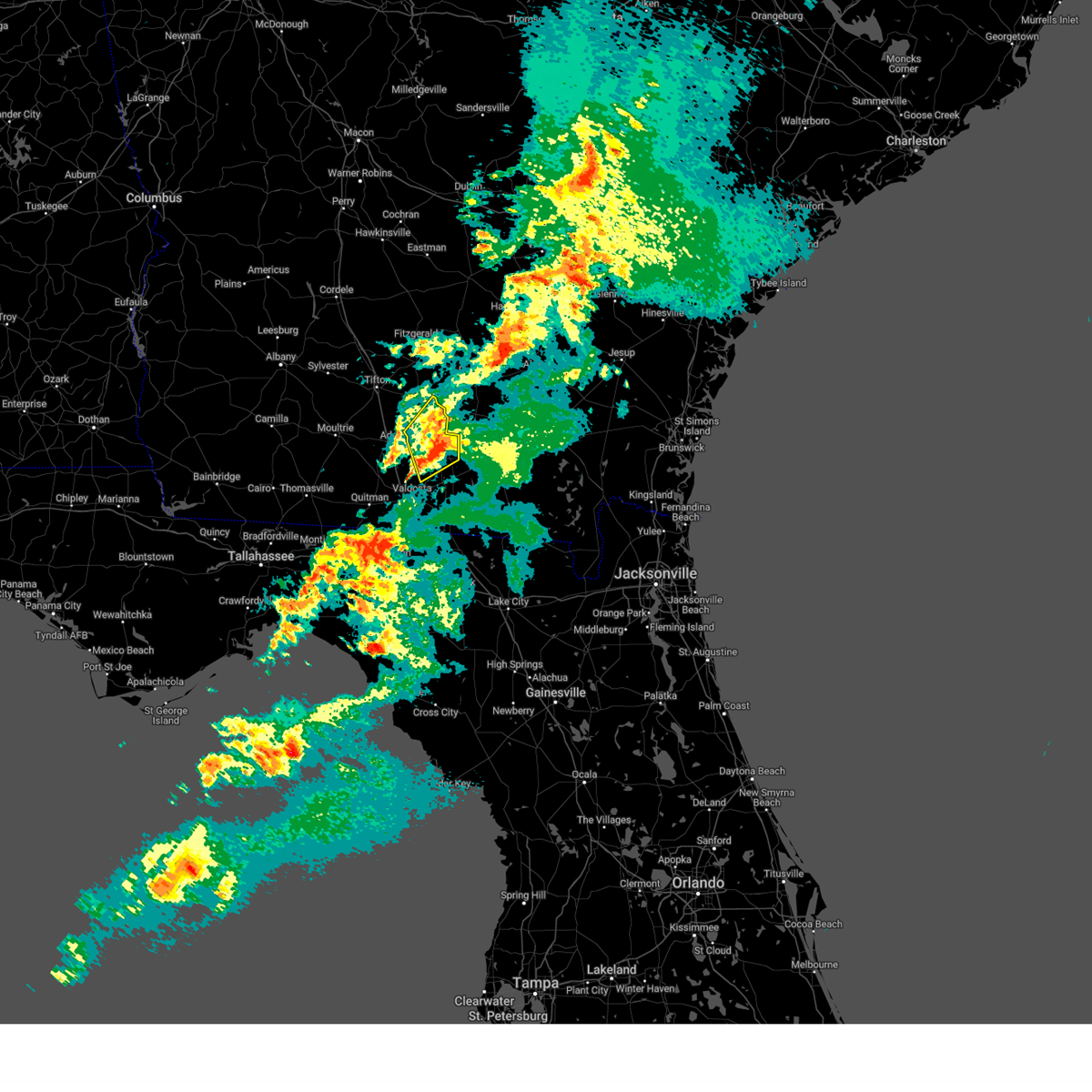
The Top Recent Hail Date for Moody AFB, GA is Monday, June 9, 2025 (44th out of 47)
Hail and Wind Damage Spotted near Moody AFB, GA
| Date / Time | Report Details |
|---|---|
| 6/26/2025 4:37 PM EDT |
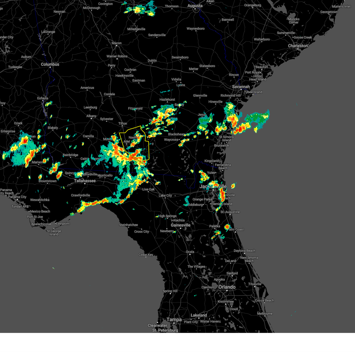
 At 436 pm edt, severe thunderstorms were located along a line extending from near nashville to near adel, moving northwest at 10 mph (radar indicated). Hazards include 60 mph wind gusts. Expect damage to roofs, siding, and trees. Locations impacted include, nashville, adel, valdosta, hahira, sparks, ray city, moody air force base, berlin, cecil, ellenton, reed bingham state park, new lois, barretts, massee, greggs, flat ford, wagon wheel, allenville, weber, and cottle. At 436 pm edt, severe thunderstorms were located along a line extending from near nashville to near adel, moving northwest at 10 mph (radar indicated). Hazards include 60 mph wind gusts. Expect damage to roofs, siding, and trees. Locations impacted include, nashville, adel, valdosta, hahira, sparks, ray city, moody air force base, berlin, cecil, ellenton, reed bingham state park, new lois, barretts, massee, greggs, flat ford, wagon wheel, allenville, weber, and cottle.
|
| 6/26/2025 4:37 PM EDT |
 the severe thunderstorm warning has been cancelled and is no longer in effect the severe thunderstorm warning has been cancelled and is no longer in effect
|
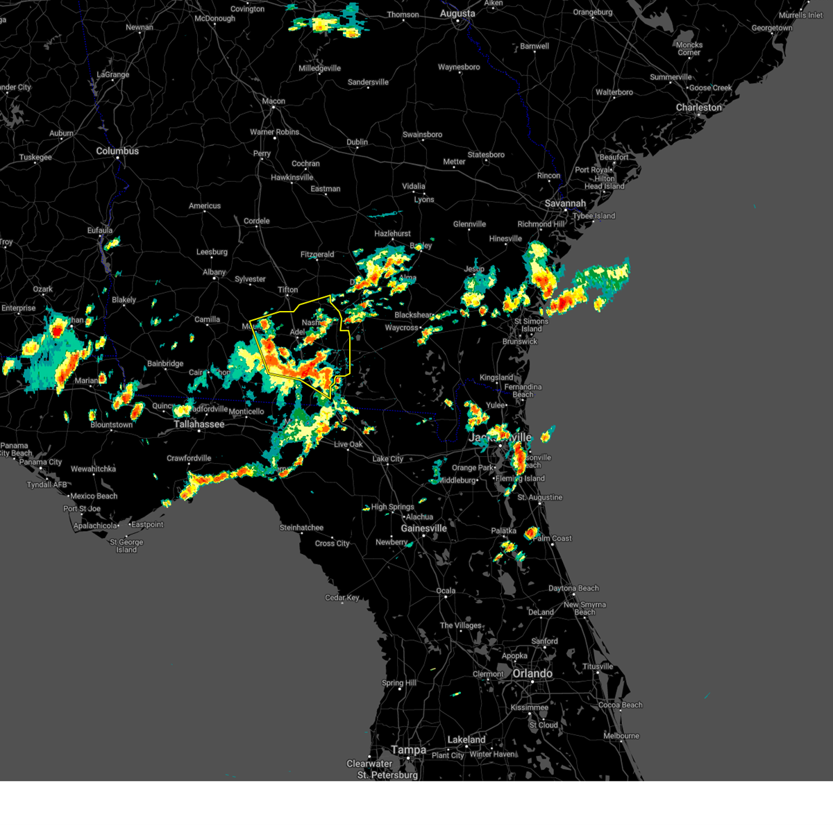
| 6/26/2025 3:36 PM EDT | Svrtae the national weather service in tallahassee has issued a * severe thunderstorm warning for, cook county in south central georgia, southern berrien county in south central georgia, western lowndes county in south central georgia, brooks county in south central georgia, southeastern colquitt county in south central georgia, * until 500 pm edt. * at 336 pm edt, severe thunderstorms were located along a line extending from near hahira to 8 miles west of lake park, moving northwest at 10 mph (radar indicated). Hazards include 60 mph wind gusts. expect damage to roofs, siding, and trees |
| 6/19/2025 4:46 PM EDT |
 Svrtae the national weather service in tallahassee has issued a * severe thunderstorm warning for, southeastern cook county in south central georgia, southeastern berrien county in south central georgia, lanier county in south central georgia, north central lowndes county in south central georgia, * until 530 pm edt. * at 445 pm edt, a severe thunderstorm was located near hahira, or 9 miles southeast of adel, moving east at 25 mph (radar indicated). Hazards include 60 mph wind gusts and penny size hail. expect damage to roofs, siding, and trees Svrtae the national weather service in tallahassee has issued a * severe thunderstorm warning for, southeastern cook county in south central georgia, southeastern berrien county in south central georgia, lanier county in south central georgia, north central lowndes county in south central georgia, * until 530 pm edt. * at 445 pm edt, a severe thunderstorm was located near hahira, or 9 miles southeast of adel, moving east at 25 mph (radar indicated). Hazards include 60 mph wind gusts and penny size hail. expect damage to roofs, siding, and trees
|
| 6/9/2025 2:14 PM EDT |
 The storms which prompted the warning have moved out of the area. therefore, the warning will be allowed to expire. however, gusty winds up to 50 mph and heavy rain are still possible with these thunderstorms in far eastern berrien county. The storms which prompted the warning have moved out of the area. therefore, the warning will be allowed to expire. however, gusty winds up to 50 mph and heavy rain are still possible with these thunderstorms in far eastern berrien county.
|
| 6/9/2025 1:50 PM EDT |
 the severe thunderstorm warning has been cancelled and is no longer in effect the severe thunderstorm warning has been cancelled and is no longer in effect
|
| 6/9/2025 1:50 PM EDT |
 At 150 pm edt, severe thunderstorms were located along a line extending from near sparks to near hahira to near lakeland to 7 miles northeast of mayday, moving northeast at 45 mph (radar indicated). Hazards include 60 mph wind gusts. Expect damage to roofs, siding, and trees. Locations impacted include, nashville, lakeland, adel, valdosta, hahira, sparks, enigma, ray city, lenox, alapaha, moody air force base, meigs, cecil, new lois, barretts, massee, greggs, flat ford, glory, and wagon wheel. At 150 pm edt, severe thunderstorms were located along a line extending from near sparks to near hahira to near lakeland to 7 miles northeast of mayday, moving northeast at 45 mph (radar indicated). Hazards include 60 mph wind gusts. Expect damage to roofs, siding, and trees. Locations impacted include, nashville, lakeland, adel, valdosta, hahira, sparks, enigma, ray city, lenox, alapaha, moody air force base, meigs, cecil, new lois, barretts, massee, greggs, flat ford, glory, and wagon wheel.
|
| 6/9/2025 1:29 PM EDT |
 Svrtae the national weather service in tallahassee has issued a * severe thunderstorm warning for, cook county in south central georgia, berrien county in south central georgia, lanier county in south central georgia, lowndes county in south central georgia, northern brooks county in south central georgia, eastern colquitt county in south central georgia, * until 215 pm edt. * at 129 pm edt, severe thunderstorms were located along a line extending from 9 miles southeast of moultrie to 9 miles east of pavo to near valdosta to 6 miles southwest of mayday, moving northeast at 45 mph (radar indicated). Hazards include 60 mph wind gusts. expect damage to roofs, siding, and trees Svrtae the national weather service in tallahassee has issued a * severe thunderstorm warning for, cook county in south central georgia, berrien county in south central georgia, lanier county in south central georgia, lowndes county in south central georgia, northern brooks county in south central georgia, eastern colquitt county in south central georgia, * until 215 pm edt. * at 129 pm edt, severe thunderstorms were located along a line extending from 9 miles southeast of moultrie to 9 miles east of pavo to near valdosta to 6 miles southwest of mayday, moving northeast at 45 mph (radar indicated). Hazards include 60 mph wind gusts. expect damage to roofs, siding, and trees
|
| 3/16/2025 8:42 AM EDT |
 Svrtae the national weather service in tallahassee has issued a * severe thunderstorm warning for, northeastern jefferson county in big bend florida, northeastern madison county in big bend florida, southeastern cook county in south central georgia, south central berrien county in south central georgia, central lanier county in south central georgia, lowndes county in south central georgia, southeastern brooks county in south central georgia, * until 915 am edt. * at 841 am edt, severe thunderstorms were located along a line extending from 9 miles southwest of quitman to near blue springs, moving northeast at 60 mph (radar indicated). Hazards include 60 mph wind gusts and penny size hail. expect damage to roofs, siding, and trees Svrtae the national weather service in tallahassee has issued a * severe thunderstorm warning for, northeastern jefferson county in big bend florida, northeastern madison county in big bend florida, southeastern cook county in south central georgia, south central berrien county in south central georgia, central lanier county in south central georgia, lowndes county in south central georgia, southeastern brooks county in south central georgia, * until 915 am edt. * at 841 am edt, severe thunderstorms were located along a line extending from 9 miles southwest of quitman to near blue springs, moving northeast at 60 mph (radar indicated). Hazards include 60 mph wind gusts and penny size hail. expect damage to roofs, siding, and trees
|
| 3/16/2025 8:32 AM EDT |
 the severe thunderstorm warning has been cancelled and is no longer in effect the severe thunderstorm warning has been cancelled and is no longer in effect
|
| 3/16/2025 8:32 AM EDT |
 At 832 am edt, a severe thunderstorm was located 9 miles northeast of lakeland, moving northeast at 60 mph (radar indicated). Hazards include 60 mph wind gusts and quarter size hail. Hail damage to vehicles is expected. expect wind damage to roofs, siding, and trees. Locations impacted include, courthouse, cottle, berrien co a/p, barretts, new lois, glory, nashville, hansell, moody air force base, bannockburn, meigs, lakeland, allenville, weber, ray city, and teeterville. At 832 am edt, a severe thunderstorm was located 9 miles northeast of lakeland, moving northeast at 60 mph (radar indicated). Hazards include 60 mph wind gusts and quarter size hail. Hail damage to vehicles is expected. expect wind damage to roofs, siding, and trees. Locations impacted include, courthouse, cottle, berrien co a/p, barretts, new lois, glory, nashville, hansell, moody air force base, bannockburn, meigs, lakeland, allenville, weber, ray city, and teeterville.
|
| 3/16/2025 8:16 AM EDT |
 Svrtae the national weather service in tallahassee has issued a * severe thunderstorm warning for, southeastern cook county in south central georgia, central berrien county in south central georgia, lanier county in south central georgia, northern lowndes county in south central georgia, northeastern brooks county in south central georgia, * until 900 am edt. * at 816 am edt, a severe thunderstorm was located over moody air force base, or 8 miles west of lakeland, moving northeast at 55 mph (radar indicated). Hazards include 60 mph wind gusts and quarter size hail. Hail damage to vehicles is expected. Expect wind damage to roofs, siding, and trees. Svrtae the national weather service in tallahassee has issued a * severe thunderstorm warning for, southeastern cook county in south central georgia, central berrien county in south central georgia, lanier county in south central georgia, northern lowndes county in south central georgia, northeastern brooks county in south central georgia, * until 900 am edt. * at 816 am edt, a severe thunderstorm was located over moody air force base, or 8 miles west of lakeland, moving northeast at 55 mph (radar indicated). Hazards include 60 mph wind gusts and quarter size hail. Hail damage to vehicles is expected. Expect wind damage to roofs, siding, and trees.
|
| 2/16/2025 8:38 AM EST |
 At 838 am est, severe thunderstorms were located along a line extending from near ray city to 10 miles southwest of quitman, moving east at 35 mph (radar indicated). Hazards include 60 mph wind gusts. Expect damage to roofs, siding, and trees. Locations impacted include, lake park, lakeland, valdosta, quitman, moody air force base, i-75 at exit 16, remerton, dasher, naylor, greenwood, barretts, twin lakes, hansell, valdosta regional airport, kinderlou, i-75 at exit 5, nankin, empress, clyattville, and brooks co a/p. At 838 am est, severe thunderstorms were located along a line extending from near ray city to 10 miles southwest of quitman, moving east at 35 mph (radar indicated). Hazards include 60 mph wind gusts. Expect damage to roofs, siding, and trees. Locations impacted include, lake park, lakeland, valdosta, quitman, moody air force base, i-75 at exit 16, remerton, dasher, naylor, greenwood, barretts, twin lakes, hansell, valdosta regional airport, kinderlou, i-75 at exit 5, nankin, empress, clyattville, and brooks co a/p.
|
| 2/16/2025 7:50 AM EST |
 Svrtae the national weather service in tallahassee has issued a * severe thunderstorm warning for, central lanier county in south central georgia, lowndes county in south central georgia, brooks county in south central georgia, * until 915 am est. * at 750 am est, severe thunderstorms were located along a line extending from coolidge to 10 miles northeast of havana, moving east at 55 mph (radar indicated). Hazards include 60 mph wind gusts. expect damage to roofs, siding, and trees Svrtae the national weather service in tallahassee has issued a * severe thunderstorm warning for, central lanier county in south central georgia, lowndes county in south central georgia, brooks county in south central georgia, * until 915 am est. * at 750 am est, severe thunderstorms were located along a line extending from coolidge to 10 miles northeast of havana, moving east at 55 mph (radar indicated). Hazards include 60 mph wind gusts. expect damage to roofs, siding, and trees
|
| 8/18/2024 10:50 PM EDT |
 The storms which prompted the warning have weakened below severe limits, and no longer pose an immediate threat to life or property. therefore, the warning will be allowed to expire. a severe thunderstorm watch remains in effect until 200 am edt for big bend florida, and south central georgia. to report severe weather, contact your nearest law enforcement agency. they will relay your report to the national weather service tallahassee. The storms which prompted the warning have weakened below severe limits, and no longer pose an immediate threat to life or property. therefore, the warning will be allowed to expire. a severe thunderstorm watch remains in effect until 200 am edt for big bend florida, and south central georgia. to report severe weather, contact your nearest law enforcement agency. they will relay your report to the national weather service tallahassee.
|
| 8/18/2024 10:34 PM EDT |
 At 1034 pm edt, severe thunderstorms were located along a line extending from lakeland to near boston, moving southeast at 30 mph (radar indicated). Hazards include 60 mph wind gusts. Expect damage to roofs, siding, and trees. Locations impacted include, madison, lake park, lakeland, valdosta, quitman, hahira, boston, i-75 at exit 16, moody air force base, remerton, meigs, dasher, morven, grooverville, barretts, hamburg, pinetta, hansell, lovett, and nankin. At 1034 pm edt, severe thunderstorms were located along a line extending from lakeland to near boston, moving southeast at 30 mph (radar indicated). Hazards include 60 mph wind gusts. Expect damage to roofs, siding, and trees. Locations impacted include, madison, lake park, lakeland, valdosta, quitman, hahira, boston, i-75 at exit 16, moody air force base, remerton, meigs, dasher, morven, grooverville, barretts, hamburg, pinetta, hansell, lovett, and nankin.
|
| 8/18/2024 10:34 PM EDT |
 the severe thunderstorm warning has been cancelled and is no longer in effect the severe thunderstorm warning has been cancelled and is no longer in effect
|
| 8/18/2024 10:13 PM EDT | the severe thunderstorm warning has been cancelled and is no longer in effect |
| 8/18/2024 10:13 PM EDT | At 1013 pm edt, severe thunderstorms were located along a line extending from near ray city to 10 miles north of quitman to near boston, moving southeast at 30 mph (radar indicated). Hazards include 60 mph wind gusts. Expect damage to roofs, siding, and trees. Locations impacted include, nashville, adel, valdosta, madison, lake park, lakeland, quitman, hahira, sparks, boston, ray city, ochlocknee, pavo, coolidge, i-75 at exit 16, moody air force base, remerton, meigs, dasher, and morven. |
| 8/18/2024 9:28 PM EDT | Svrtae the national weather service in tallahassee has issued a * severe thunderstorm warning for, northeastern madison county in big bend florida, cook county in south central georgia, central berrien county in south central georgia, lanier county in south central georgia, lowndes county in south central georgia, northern thomas county in south central georgia, brooks county in south central georgia, colquitt county in south central georgia, * until 1100 pm edt. * at 928 pm edt, severe thunderstorms were located along a line extending from near lenox to near moultrie to near ochlocknee, moving southeast at 35 mph (radar indicated). Hazards include 60 mph wind gusts. expect damage to roofs, siding, and trees |
| 8/8/2024 4:29 PM EDT |
 At 429 pm edt, a severe thunderstorm was located over valdosta, moving east at 20 mph (radar indicated). Hazards include 60 mph wind gusts. Expect damage to roofs, siding, and trees. Locations impacted include, valdosta, hahira, i-75 at exit 16, moody air force base, remerton, barretts, i-75 at exit 29, i-75 at exit 22, and kinderlou. At 429 pm edt, a severe thunderstorm was located over valdosta, moving east at 20 mph (radar indicated). Hazards include 60 mph wind gusts. Expect damage to roofs, siding, and trees. Locations impacted include, valdosta, hahira, i-75 at exit 16, moody air force base, remerton, barretts, i-75 at exit 29, i-75 at exit 22, and kinderlou.
|
| 8/8/2024 4:19 PM EDT |
 At 419 pm edt, a severe thunderstorm was located near valdosta, moving east at 20 mph (radar indicated). Hazards include 60 mph wind gusts. Expect damage to roofs, siding, and trees. Locations impacted include, valdosta, hahira, i-75 at exit 16, moody air force base, remerton, morven, barretts, i-75 at exit 29, i-75 at exit 22, and kinderlou. At 419 pm edt, a severe thunderstorm was located near valdosta, moving east at 20 mph (radar indicated). Hazards include 60 mph wind gusts. Expect damage to roofs, siding, and trees. Locations impacted include, valdosta, hahira, i-75 at exit 16, moody air force base, remerton, morven, barretts, i-75 at exit 29, i-75 at exit 22, and kinderlou.
|
| 8/8/2024 4:19 PM EDT |
 the severe thunderstorm warning has been cancelled and is no longer in effect the severe thunderstorm warning has been cancelled and is no longer in effect
|
| 8/8/2024 4:07 PM EDT |
 At 407 pm edt, a severe thunderstorm was located near hahira, or 10 miles northwest of valdosta, moving east at 20 mph (radar indicated). Hazards include 60 mph wind gusts. Expect damage to roofs, siding, and trees. Locations impacted include, valdosta, hahira, ray city, moody air force base, i-75 at exit 16, remerton, morven, cecil, barney, barretts, new lois, kinderlou, i-75 at exit 29, and i-75 at exit 22. At 407 pm edt, a severe thunderstorm was located near hahira, or 10 miles northwest of valdosta, moving east at 20 mph (radar indicated). Hazards include 60 mph wind gusts. Expect damage to roofs, siding, and trees. Locations impacted include, valdosta, hahira, ray city, moody air force base, i-75 at exit 16, remerton, morven, cecil, barney, barretts, new lois, kinderlou, i-75 at exit 29, and i-75 at exit 22.
|
| 8/8/2024 3:48 PM EDT |
 the severe thunderstorm warning has been cancelled and is no longer in effect the severe thunderstorm warning has been cancelled and is no longer in effect
|
| 8/8/2024 3:48 PM EDT |
 At 348 pm edt, a severe thunderstorm was located 9 miles west of hahira, or 11 miles southwest of adel, moving east at 20 mph (radar indicated). Hazards include 60 mph wind gusts. Expect damage to roofs, siding, and trees. Locations impacted include, valdosta, adel, hahira, ray city, moody air force base, i-75 at exit 16, remerton, morven, cecil, barney, barretts, new lois, greggs, pine valley, kinderlou, i-75 at exit 29, and i-75 at exit 22. At 348 pm edt, a severe thunderstorm was located 9 miles west of hahira, or 11 miles southwest of adel, moving east at 20 mph (radar indicated). Hazards include 60 mph wind gusts. Expect damage to roofs, siding, and trees. Locations impacted include, valdosta, adel, hahira, ray city, moody air force base, i-75 at exit 16, remerton, morven, cecil, barney, barretts, new lois, greggs, pine valley, kinderlou, i-75 at exit 29, and i-75 at exit 22.
|
| 8/8/2024 3:35 PM EDT |
 Svrtae the national weather service in tallahassee has issued a * severe thunderstorm warning for, southern cook county in south central georgia, south central berrien county in south central georgia, northwestern lowndes county in south central georgia, central brooks county in south central georgia, southeastern colquitt county in south central georgia, * until 445 pm edt. * at 335 pm edt, a severe thunderstorm was located 8 miles east of pavo, or 13 miles southwest of adel, moving east at 20 mph (radar indicated). Hazards include 60 mph wind gusts. expect damage to roofs, siding, and trees Svrtae the national weather service in tallahassee has issued a * severe thunderstorm warning for, southern cook county in south central georgia, south central berrien county in south central georgia, northwestern lowndes county in south central georgia, central brooks county in south central georgia, southeastern colquitt county in south central georgia, * until 445 pm edt. * at 335 pm edt, a severe thunderstorm was located 8 miles east of pavo, or 13 miles southwest of adel, moving east at 20 mph (radar indicated). Hazards include 60 mph wind gusts. expect damage to roofs, siding, and trees
|
| 5/28/2024 12:28 AM EDT |
 The storms which prompted the warning have moved out of the area. therefore, the warning will be allowed to expire. however, gusty winds are still possible with these thunderstorms. remember, a severe thunderstorm warning still remains in effect for eastern lanier county until 1 am edt. The storms which prompted the warning have moved out of the area. therefore, the warning will be allowed to expire. however, gusty winds are still possible with these thunderstorms. remember, a severe thunderstorm warning still remains in effect for eastern lanier county until 1 am edt.
|
| 5/28/2024 12:18 AM EDT |
 At 1218 am edt, a severe thunderstorm was located 7 miles south of moody air force base, or 8 miles east of valdosta, moving east at 35 mph (radar indicated). Hazards include 60 mph wind gusts. Expect damage to roofs, siding, and trees. Locations impacted include, valdosta, lake park, moody air force base, dasher, naylor, greenwood, i-75 at exit 11, valdosta regional airport, and stockton. At 1218 am edt, a severe thunderstorm was located 7 miles south of moody air force base, or 8 miles east of valdosta, moving east at 35 mph (radar indicated). Hazards include 60 mph wind gusts. Expect damage to roofs, siding, and trees. Locations impacted include, valdosta, lake park, moody air force base, dasher, naylor, greenwood, i-75 at exit 11, valdosta regional airport, and stockton.
|
| 5/28/2024 12:18 AM EDT |
 the severe thunderstorm warning has been cancelled and is no longer in effect the severe thunderstorm warning has been cancelled and is no longer in effect
|
| 5/28/2024 12:17 AM EDT |
 the severe thunderstorm warning has been cancelled and is no longer in effect the severe thunderstorm warning has been cancelled and is no longer in effect
|
| 5/28/2024 12:17 AM EDT |
 At 1217 am edt, severe thunderstorms were located along a line extending from 8 miles northeast of ray city to lakeland to near moody air force base, moving east at 45 mph (radar indicated). Hazards include 60 mph wind gusts. Expect damage to roofs, siding, and trees. Locations impacted include, lakeland, moody air force base, meigs, courthouse, barretts, hansell, and teeterville. At 1217 am edt, severe thunderstorms were located along a line extending from 8 miles northeast of ray city to lakeland to near moody air force base, moving east at 45 mph (radar indicated). Hazards include 60 mph wind gusts. Expect damage to roofs, siding, and trees. Locations impacted include, lakeland, moody air force base, meigs, courthouse, barretts, hansell, and teeterville.
|
| 5/28/2024 12:07 AM EDT |
 Svrtae the national weather service in tallahassee has issued a * severe thunderstorm warning for, southern lanier county in south central georgia, lowndes county in south central georgia, east central brooks county in south central georgia, * until 1245 am edt. * at 1207 am edt, a severe thunderstorm was located over valdosta, moving east at 40 mph (radar indicated). Hazards include 60 mph wind gusts. expect damage to roofs, siding, and trees Svrtae the national weather service in tallahassee has issued a * severe thunderstorm warning for, southern lanier county in south central georgia, lowndes county in south central georgia, east central brooks county in south central georgia, * until 1245 am edt. * at 1207 am edt, a severe thunderstorm was located over valdosta, moving east at 40 mph (radar indicated). Hazards include 60 mph wind gusts. expect damage to roofs, siding, and trees
|
| 5/28/2024 12:02 AM EDT |
 At 1202 am edt, severe thunderstorms were located along a line extending from near nashville to near ray city to 7 miles northwest of moody air force base to near hahira, moving east at 35 mph (radar indicated). Hazards include 60 mph wind gusts and penny size hail. Expect damage to roofs, siding, and trees. Locations impacted include, lakeland, nashville, hahira, ray city, moody air force base, meigs, courthouse, barretts, new lois, allenville, hansell, and teeterville. At 1202 am edt, severe thunderstorms were located along a line extending from near nashville to near ray city to 7 miles northwest of moody air force base to near hahira, moving east at 35 mph (radar indicated). Hazards include 60 mph wind gusts and penny size hail. Expect damage to roofs, siding, and trees. Locations impacted include, lakeland, nashville, hahira, ray city, moody air force base, meigs, courthouse, barretts, new lois, allenville, hansell, and teeterville.
|
| 5/28/2024 12:02 AM EDT |
 the severe thunderstorm warning has been cancelled and is no longer in effect the severe thunderstorm warning has been cancelled and is no longer in effect
|
| 5/27/2024 11:45 PM EDT |
 Svrtae the national weather service in tallahassee has issued a * severe thunderstorm warning for, cook county in south central georgia, southeastern berrien county in south central georgia, lanier county in south central georgia, northwestern lowndes county in south central georgia, north central brooks county in south central georgia, * until 1230 am edt. * at 1145 pm edt, severe thunderstorms were located along a line extending from sparks to adel to 7 miles west of hahira, moving east at 30 mph (radar indicated). Hazards include 60 mph wind gusts and penny size hail. expect damage to roofs, siding, and trees Svrtae the national weather service in tallahassee has issued a * severe thunderstorm warning for, cook county in south central georgia, southeastern berrien county in south central georgia, lanier county in south central georgia, northwestern lowndes county in south central georgia, north central brooks county in south central georgia, * until 1230 am edt. * at 1145 pm edt, severe thunderstorms were located along a line extending from sparks to adel to 7 miles west of hahira, moving east at 30 mph (radar indicated). Hazards include 60 mph wind gusts and penny size hail. expect damage to roofs, siding, and trees
|
| 5/27/2024 9:06 PM EDT |
 The storm which prompted the warning has weakened below severe limits, and no longer poses an immediate threat to life or property. therefore, the warning will be allowed to expire. a severe thunderstorm watch remains in effect until 1000 pm edt for south central georgia. to report severe weather, contact your nearest law enforcement agency. they will relay your report to the national weather service tallahassee. The storm which prompted the warning has weakened below severe limits, and no longer poses an immediate threat to life or property. therefore, the warning will be allowed to expire. a severe thunderstorm watch remains in effect until 1000 pm edt for south central georgia. to report severe weather, contact your nearest law enforcement agency. they will relay your report to the national weather service tallahassee.
|
| 5/27/2024 8:18 PM EDT |
 At 818 pm edt, a severe thunderstorm was located over ray city, or 7 miles southeast of nashville, moving east at 15 mph (radar indicated). Hazards include 60 mph wind gusts. Expect damage to roofs, siding, and trees. Locations impacted include, nashville, lakeland, hahira, ray city, moody air force base, meigs, cecil, courthouse, cottle, berrien co a/p, greenwood, barretts, new lois, massee, hansell, i-75 at exit 29, allenville, weber, stockton, and teeterville. At 818 pm edt, a severe thunderstorm was located over ray city, or 7 miles southeast of nashville, moving east at 15 mph (radar indicated). Hazards include 60 mph wind gusts. Expect damage to roofs, siding, and trees. Locations impacted include, nashville, lakeland, hahira, ray city, moody air force base, meigs, cecil, courthouse, cottle, berrien co a/p, greenwood, barretts, new lois, massee, hansell, i-75 at exit 29, allenville, weber, stockton, and teeterville.
|
| 5/27/2024 7:38 PM EDT |
 Svrtae the national weather service in tallahassee has issued a * severe thunderstorm warning for, cook county in south central georgia, southeastern berrien county in south central georgia, lanier county in south central georgia, northern lowndes county in south central georgia, * until 915 pm edt. * at 738 pm edt, a severe thunderstorm was located near adel, moving east at 25 mph (radar indicated). Hazards include 60 mph wind gusts and quarter size hail. Hail damage to vehicles is expected. Expect wind damage to roofs, siding, and trees. Svrtae the national weather service in tallahassee has issued a * severe thunderstorm warning for, cook county in south central georgia, southeastern berrien county in south central georgia, lanier county in south central georgia, northern lowndes county in south central georgia, * until 915 pm edt. * at 738 pm edt, a severe thunderstorm was located near adel, moving east at 25 mph (radar indicated). Hazards include 60 mph wind gusts and quarter size hail. Hail damage to vehicles is expected. Expect wind damage to roofs, siding, and trees.
|
| 5/17/2024 9:17 PM EDT |
 At 916 pm edt, severe thunderstorms were located along a line extending from near manor to near du pont to near hahira, moving east at 30 mph (radar indicated). Hazards include 60 mph wind gusts and penny size hail. Expect damage to roofs, siding, and trees. Locations impacted include, lakeland, valdosta, moody air force base, meigs, naylor, courthouse, greenwood, barretts, hansell, stockton, and teeterville. At 916 pm edt, severe thunderstorms were located along a line extending from near manor to near du pont to near hahira, moving east at 30 mph (radar indicated). Hazards include 60 mph wind gusts and penny size hail. Expect damage to roofs, siding, and trees. Locations impacted include, lakeland, valdosta, moody air force base, meigs, naylor, courthouse, greenwood, barretts, hansell, stockton, and teeterville.
|
| 5/17/2024 9:17 PM EDT |
 the severe thunderstorm warning has been cancelled and is no longer in effect the severe thunderstorm warning has been cancelled and is no longer in effect
|
| 5/17/2024 9:00 PM EDT |
 the severe thunderstorm warning has been cancelled and is no longer in effect the severe thunderstorm warning has been cancelled and is no longer in effect
|
| 5/17/2024 9:00 PM EDT |
 At 900 pm edt, severe thunderstorms were located along a line extending from cogdell to near du pont to 8 miles west of hahira, moving east at 30 mph (radar indicated). Hazards include 60 mph wind gusts and penny size hail. Expect damage to roofs, siding, and trees. Locations impacted include, lakeland, valdosta, hahira, ray city, moody air force base, i-75 at exit 16, remerton, meigs, cecil, naylor, courthouse, greenwood, barretts, new lois, hansell, i-75 at exit 29, allenville, i-75 at exit 22, stockton, and teeterville. At 900 pm edt, severe thunderstorms were located along a line extending from cogdell to near du pont to 8 miles west of hahira, moving east at 30 mph (radar indicated). Hazards include 60 mph wind gusts and penny size hail. Expect damage to roofs, siding, and trees. Locations impacted include, lakeland, valdosta, hahira, ray city, moody air force base, i-75 at exit 16, remerton, meigs, cecil, naylor, courthouse, greenwood, barretts, new lois, hansell, i-75 at exit 29, allenville, i-75 at exit 22, stockton, and teeterville.
|
| 5/17/2024 8:21 PM EDT |
 The storm which prompted the warning has weakened below severe limits, and no longer appears capable of producing a tornado. therefore, the warning will be allowed to expire. a tornado watch remains in effect until 1100 pm edt for south central georgia. The storm which prompted the warning has weakened below severe limits, and no longer appears capable of producing a tornado. therefore, the warning will be allowed to expire. a tornado watch remains in effect until 1100 pm edt for south central georgia.
|
| 5/17/2024 8:06 PM EDT |
 At 805 pm edt, a confirmed tornado was located 10 miles northeast of pavo, or 10 miles southeast of moultrie, moving east at 25 mph (law enforcement confirmed tornado). Hazards include damaging tornado. Flying debris will be dangerous to those caught without shelter. mobile homes will be damaged or destroyed. damage to roofs, windows, and vehicles will occur. tree damage is likely. this tornado will be near, adel around 830 pm edt. Other locations impacted by this tornadic thunderstorm include reed bingham state park, cottle, cook co a/p, berrien co a/p, barretts, new lois, ellenton, massee, berlin, and greggs. At 805 pm edt, a confirmed tornado was located 10 miles northeast of pavo, or 10 miles southeast of moultrie, moving east at 25 mph (law enforcement confirmed tornado). Hazards include damaging tornado. Flying debris will be dangerous to those caught without shelter. mobile homes will be damaged or destroyed. damage to roofs, windows, and vehicles will occur. tree damage is likely. this tornado will be near, adel around 830 pm edt. Other locations impacted by this tornadic thunderstorm include reed bingham state park, cottle, cook co a/p, berrien co a/p, barretts, new lois, ellenton, massee, berlin, and greggs.
|
| 5/17/2024 8:03 PM EDT |
 the tornado warning has been cancelled and is no longer in effect the tornado warning has been cancelled and is no longer in effect
|
| 5/17/2024 8:03 PM EDT |
 At 802 pm edt, a severe thunderstorm capable of producing a tornado was located 9 miles northeast of pavo, or 9 miles southeast of moultrie, moving east at 25 mph (radar indicated rotation). Hazards include tornado. Flying debris will be dangerous to those caught without shelter. mobile homes will be damaged or destroyed. damage to roofs, windows, and vehicles will occur. tree damage is likely. this dangerous storm will be near, adel around 830 pm edt. Other locations impacted by this tornadic thunderstorm include reed bingham state park, cottle, cook co a/p, berrien co a/p, barretts, new lois, ellenton, massee, berlin, and greggs. At 802 pm edt, a severe thunderstorm capable of producing a tornado was located 9 miles northeast of pavo, or 9 miles southeast of moultrie, moving east at 25 mph (radar indicated rotation). Hazards include tornado. Flying debris will be dangerous to those caught without shelter. mobile homes will be damaged or destroyed. damage to roofs, windows, and vehicles will occur. tree damage is likely. this dangerous storm will be near, adel around 830 pm edt. Other locations impacted by this tornadic thunderstorm include reed bingham state park, cottle, cook co a/p, berrien co a/p, barretts, new lois, ellenton, massee, berlin, and greggs.
|
| 5/17/2024 7:54 PM EDT |
 Svrtae the national weather service in tallahassee has issued a * severe thunderstorm warning for, southeastern cook county in south central georgia, southeastern berrien county in south central georgia, lanier county in south central georgia, northern lowndes county in south central georgia, central brooks county in south central georgia, * until 930 pm edt. * at 754 pm edt, severe thunderstorms were located along a line extending from near nashville to near hahira to near ochlocknee, moving east at 30 mph (radar indicated). Hazards include 60 mph wind gusts and penny size hail. expect damage to roofs, siding, and trees Svrtae the national weather service in tallahassee has issued a * severe thunderstorm warning for, southeastern cook county in south central georgia, southeastern berrien county in south central georgia, lanier county in south central georgia, northern lowndes county in south central georgia, central brooks county in south central georgia, * until 930 pm edt. * at 754 pm edt, severe thunderstorms were located along a line extending from near nashville to near hahira to near ochlocknee, moving east at 30 mph (radar indicated). Hazards include 60 mph wind gusts and penny size hail. expect damage to roofs, siding, and trees
|
| 5/17/2024 7:34 PM EDT |
 Tortae the national weather service in tallahassee has issued a * tornado warning for, cook county in south central georgia, south central berrien county in south central georgia, west central lanier county in south central georgia, northwestern lowndes county in south central georgia, northeastern thomas county in south central georgia, northwestern brooks county in south central georgia, southern colquitt county in south central georgia, * until 830 pm edt. * at 734 pm edt, a severe thunderstorm capable of producing a tornado was located near coolidge, or 7 miles southwest of moultrie, moving east at 25 mph (radar indicated rotation). Hazards include tornado. Flying debris will be dangerous to those caught without shelter. mobile homes will be damaged or destroyed. damage to roofs, windows, and vehicles will occur. tree damage is likely. this dangerous storm will be near, moultrie around 740 pm edt. Other locations impacted by this tornadic thunderstorm include reed bingham state park, cottle, cook co a/p, barney, berrien co a/p, barretts, new lois, ellenton, massee, and autreyville. Tortae the national weather service in tallahassee has issued a * tornado warning for, cook county in south central georgia, south central berrien county in south central georgia, west central lanier county in south central georgia, northwestern lowndes county in south central georgia, northeastern thomas county in south central georgia, northwestern brooks county in south central georgia, southern colquitt county in south central georgia, * until 830 pm edt. * at 734 pm edt, a severe thunderstorm capable of producing a tornado was located near coolidge, or 7 miles southwest of moultrie, moving east at 25 mph (radar indicated rotation). Hazards include tornado. Flying debris will be dangerous to those caught without shelter. mobile homes will be damaged or destroyed. damage to roofs, windows, and vehicles will occur. tree damage is likely. this dangerous storm will be near, moultrie around 740 pm edt. Other locations impacted by this tornadic thunderstorm include reed bingham state park, cottle, cook co a/p, barney, berrien co a/p, barretts, new lois, ellenton, massee, and autreyville.
|
| 5/14/2024 7:19 AM EDT |
 the severe thunderstorm warning has been cancelled and is no longer in effect the severe thunderstorm warning has been cancelled and is no longer in effect
|
| 5/14/2024 7:02 AM EDT |
 At 702 am edt, severe thunderstorms were located along a line extending from near sparks to 7 miles west of needmore, moving northeast at 50 mph (radar indicated). Hazards include 60 mph wind gusts. Expect damage to roofs, siding, and trees. Locations impacted include, lakeland, nashville, ray city, moody air force base, meigs, naylor, courthouse, greenwood, barretts, new lois, hansell, allenville, stockton, and teeterville. At 702 am edt, severe thunderstorms were located along a line extending from near sparks to 7 miles west of needmore, moving northeast at 50 mph (radar indicated). Hazards include 60 mph wind gusts. Expect damage to roofs, siding, and trees. Locations impacted include, lakeland, nashville, ray city, moody air force base, meigs, naylor, courthouse, greenwood, barretts, new lois, hansell, allenville, stockton, and teeterville.
|
| 5/14/2024 7:02 AM EDT |
 the severe thunderstorm warning has been cancelled and is no longer in effect the severe thunderstorm warning has been cancelled and is no longer in effect
|
| 5/14/2024 6:43 AM EDT |
 At 643 am edt, severe thunderstorms were located along a line extending from 9 miles west of adel to jasper, moving northeast at 50 mph (radar indicated). Hazards include 60 mph wind gusts. Expect damage to roofs, siding, and trees. Locations impacted include, lake park, lakeland, adel, valdosta, hahira, sparks, ray city, i-75 at exit 16, moody air force base, remerton, meigs, dasher, morven, cecil, barretts, new lois, greggs, hansell, allenville, and clyattville. At 643 am edt, severe thunderstorms were located along a line extending from 9 miles west of adel to jasper, moving northeast at 50 mph (radar indicated). Hazards include 60 mph wind gusts. Expect damage to roofs, siding, and trees. Locations impacted include, lake park, lakeland, adel, valdosta, hahira, sparks, ray city, i-75 at exit 16, moody air force base, remerton, meigs, dasher, morven, cecil, barretts, new lois, greggs, hansell, allenville, and clyattville.
|
| 5/14/2024 6:34 AM EDT |
 At 634 am edt, severe thunderstorms were located along a line extending from 6 miles northeast of pavo to near suwannee springs, moving northeast at 50 mph (radar indicated). Hazards include 60 mph wind gusts. Expect damage to roofs, siding, and trees. Locations impacted include, lake park, lakeland, adel, valdosta, quitman, moultrie, hahira, sparks, ray city, i-75 at exit 16, moody air force base, remerton, meigs, dasher, morven, berlin, cecil, barretts, new lois, and greggs. At 634 am edt, severe thunderstorms were located along a line extending from 6 miles northeast of pavo to near suwannee springs, moving northeast at 50 mph (radar indicated). Hazards include 60 mph wind gusts. Expect damage to roofs, siding, and trees. Locations impacted include, lake park, lakeland, adel, valdosta, quitman, moultrie, hahira, sparks, ray city, i-75 at exit 16, moody air force base, remerton, meigs, dasher, morven, berlin, cecil, barretts, new lois, and greggs.
|
| 5/14/2024 6:34 AM EDT |
 the severe thunderstorm warning has been cancelled and is no longer in effect the severe thunderstorm warning has been cancelled and is no longer in effect
|
| 5/14/2024 6:19 AM EDT |
 At 619 am edt, severe thunderstorms were located along a line extending from near pavo to 7 miles south of suwannee river state park, moving east at 50 mph (radar indicated). Hazards include 60 mph wind gusts. Expect damage to roofs, siding, and trees. Locations impacted include, adel, valdosta, madison, lake park, lakeland, quitman, moultrie, hahira, sparks, boston, ray city, pavo, coolidge, i-75 at exit 16, moody air force base, remerton, meigs, dasher, morven, and berlin. At 619 am edt, severe thunderstorms were located along a line extending from near pavo to 7 miles south of suwannee river state park, moving east at 50 mph (radar indicated). Hazards include 60 mph wind gusts. Expect damage to roofs, siding, and trees. Locations impacted include, adel, valdosta, madison, lake park, lakeland, quitman, moultrie, hahira, sparks, boston, ray city, pavo, coolidge, i-75 at exit 16, moody air force base, remerton, meigs, dasher, morven, and berlin.
|
| 5/14/2024 6:01 AM EDT |
 Svrtae the national weather service in tallahassee has issued a * severe thunderstorm warning for, northeastern jefferson county in big bend florida, madison county in big bend florida, cook county in south central georgia, southeastern berrien county in south central georgia, lanier county in south central georgia, lowndes county in south central georgia, thomas county in south central georgia, brooks county in south central georgia, southern colquitt county in south central georgia, * until 730 am edt. * at 600 am edt, severe thunderstorms were located along a line extending from near thomasville to 6 miles southwest of dowling park, moving northeast at 50 mph (radar indicated). Hazards include 60 mph wind gusts. expect damage to roofs, siding, and trees Svrtae the national weather service in tallahassee has issued a * severe thunderstorm warning for, northeastern jefferson county in big bend florida, madison county in big bend florida, cook county in south central georgia, southeastern berrien county in south central georgia, lanier county in south central georgia, lowndes county in south central georgia, thomas county in south central georgia, brooks county in south central georgia, southern colquitt county in south central georgia, * until 730 am edt. * at 600 am edt, severe thunderstorms were located along a line extending from near thomasville to 6 miles southwest of dowling park, moving northeast at 50 mph (radar indicated). Hazards include 60 mph wind gusts. expect damage to roofs, siding, and trees
|
| 5/10/2024 8:06 AM EDT | The storms which prompted the warning have moved out of the area. therefore, the warning will be allowed to expire. a severe thunderstorm watch remains in effect until 1100 am edt for south central georgia. to report severe weather, contact your nearest law enforcement agency. they will relay your report to the national weather service tallahassee. |
| 5/10/2024 7:37 AM EDT | the tornado warning has been cancelled and is no longer in effect |
| 5/10/2024 7:37 AM EDT | At 737 am edt, severe thunderstorms capable of producing tornadoes were located along a line extending from 8 miles east of nashville to 8 miles south of quitman, moving east at 55 mph (radar indicated rotation). Hazards include tornado. Flying debris will be dangerous to those caught without shelter. mobile homes will be damaged or destroyed. damage to roofs, windows, and vehicles will occur. tree damage is likely. these dangerous storms will be near, valdosta, ray city, and moody air force base around 740 am edt. lakeland and i-75 at exit 16 around 745 am edt. lake park around 800 am edt. Other locations impacted by these tornadic storms include barretts, new lois, dasher, hansell, nankin, empress, allenville, clyattville, weber, and brooks co a/p. |
| 5/10/2024 7:22 AM EDT |
 Tortae the national weather service in tallahassee has issued a * tornado warning for, cook county in south central georgia, southeastern berrien county in south central georgia, lanier county in south central georgia, lowndes county in south central georgia, southeastern thomas county in south central georgia, brooks county in south central georgia, southeastern colquitt county in south central georgia, * until 815 am edt. * at 722 am edt, a severe thunderstorm capable of producing a tornado was located near boston, or 7 miles west of quitman, moving east at 45 mph (radar indicated rotation). Hazards include tornado. Flying debris will be dangerous to those caught without shelter. mobile homes will be damaged or destroyed. damage to roofs, windows, and vehicles will occur. tree damage is likely. this dangerous storm will be near, quitman around 725 am edt. valdosta and i-75 at exit 16 around 745 am edt. Other locations impacted by this tornadic thunderstorm include grooverville, barretts, new lois, massee, greggs, dasher, everett, hansell, nankin, and empress. Tortae the national weather service in tallahassee has issued a * tornado warning for, cook county in south central georgia, southeastern berrien county in south central georgia, lanier county in south central georgia, lowndes county in south central georgia, southeastern thomas county in south central georgia, brooks county in south central georgia, southeastern colquitt county in south central georgia, * until 815 am edt. * at 722 am edt, a severe thunderstorm capable of producing a tornado was located near boston, or 7 miles west of quitman, moving east at 45 mph (radar indicated rotation). Hazards include tornado. Flying debris will be dangerous to those caught without shelter. mobile homes will be damaged or destroyed. damage to roofs, windows, and vehicles will occur. tree damage is likely. this dangerous storm will be near, quitman around 725 am edt. valdosta and i-75 at exit 16 around 745 am edt. Other locations impacted by this tornadic thunderstorm include grooverville, barretts, new lois, massee, greggs, dasher, everett, hansell, nankin, and empress.
|
| 5/10/2024 7:20 AM EDT |
 the severe thunderstorm warning has been cancelled and is no longer in effect the severe thunderstorm warning has been cancelled and is no longer in effect
|
| 5/10/2024 7:20 AM EDT |
 At 719 am edt, severe thunderstorms were located along a line extending from near alapaha to 7 miles south of boston, moving east at 45 mph (radar indicated). Hazards include 70 mph wind gusts. Expect considerable tree damage. damage is likely to mobile homes, roofs, and outbuildings. Locations impacted include, nashville, adel, valdosta, lake park, lakeland, quitman, hahira, sparks, boston, enigma, ray city, lenox, alapaha, pavo, i-75 at exit 16, moody air force base, remerton, meigs, dasher, and morven. At 719 am edt, severe thunderstorms were located along a line extending from near alapaha to 7 miles south of boston, moving east at 45 mph (radar indicated). Hazards include 70 mph wind gusts. Expect considerable tree damage. damage is likely to mobile homes, roofs, and outbuildings. Locations impacted include, nashville, adel, valdosta, lake park, lakeland, quitman, hahira, sparks, boston, enigma, ray city, lenox, alapaha, pavo, i-75 at exit 16, moody air force base, remerton, meigs, dasher, and morven.
|
| 5/10/2024 6:27 AM EDT |
 Svrtae the national weather service in tallahassee has issued a * severe thunderstorm warning for, cook county in south central georgia, berrien county in south central georgia, lanier county in south central georgia, lowndes county in south central georgia, thomas county in south central georgia, brooks county in south central georgia, colquitt county in south central georgia, southern tift county in south central georgia, southern worth county in south central georgia, * until 800 am edt. * at 626 am edt, severe thunderstorms were located along a line extending from doerun to 11 miles south of cairo, moving east at 55 mph (radar indicated). Hazards include 60 mph wind gusts. expect damage to roofs, siding, and trees Svrtae the national weather service in tallahassee has issued a * severe thunderstorm warning for, cook county in south central georgia, berrien county in south central georgia, lanier county in south central georgia, lowndes county in south central georgia, thomas county in south central georgia, brooks county in south central georgia, colquitt county in south central georgia, southern tift county in south central georgia, southern worth county in south central georgia, * until 800 am edt. * at 626 am edt, severe thunderstorms were located along a line extending from doerun to 11 miles south of cairo, moving east at 55 mph (radar indicated). Hazards include 60 mph wind gusts. expect damage to roofs, siding, and trees
|
| 5/4/2024 5:25 PM EDT |
 The storm which prompted the warning has weakened below severe limits, and no longer poses an immediate threat to life or property. therefore, the warning will be allowed to expire. The storm which prompted the warning has weakened below severe limits, and no longer poses an immediate threat to life or property. therefore, the warning will be allowed to expire.
|
| 5/4/2024 4:47 PM EDT |
 Svrtae the national weather service in tallahassee has issued a * severe thunderstorm warning for, southern cook county in south central georgia, south central berrien county in south central georgia, northwestern lanier county in south central georgia, northwestern lowndes county in south central georgia, northeastern brooks county in south central georgia, * until 530 pm edt. * at 447 pm edt, a severe thunderstorm was located near hahira, or 10 miles south of adel, moving east at 15 mph (radar indicated). Hazards include 60 mph wind gusts and quarter size hail. Hail damage to vehicles is expected. Expect wind damage to roofs, siding, and trees. Svrtae the national weather service in tallahassee has issued a * severe thunderstorm warning for, southern cook county in south central georgia, south central berrien county in south central georgia, northwestern lanier county in south central georgia, northwestern lowndes county in south central georgia, northeastern brooks county in south central georgia, * until 530 pm edt. * at 447 pm edt, a severe thunderstorm was located near hahira, or 10 miles south of adel, moving east at 15 mph (radar indicated). Hazards include 60 mph wind gusts and quarter size hail. Hail damage to vehicles is expected. Expect wind damage to roofs, siding, and trees.
|
| 4/11/2024 6:53 AM EDT |
 The storms which prompted the warning have weakened below severe limits, and no longer pose an immediate threat to life or property. therefore, the warning has been allowed to expire. however, gusty winds are still possible with these thunderstorms. The storms which prompted the warning have weakened below severe limits, and no longer pose an immediate threat to life or property. therefore, the warning has been allowed to expire. however, gusty winds are still possible with these thunderstorms.
|
| 4/11/2024 6:03 AM EDT |
 Svrtae the national weather service in tallahassee has issued a * severe thunderstorm warning for, northeastern jefferson county in big bend florida, northeastern madison county in big bend florida, southern lanier county in south central georgia, lowndes county in south central georgia, southeastern thomas county in south central georgia, brooks county in south central georgia, * until 645 am edt. * at 603 am edt, severe thunderstorms were located along a line extending from 8 miles northeast of monticello to 10 miles northwest of madison to near blue springs, moving northeast at 60 mph (radar indicated). Hazards include 60 mph wind gusts. expect damage to roofs, siding, and trees Svrtae the national weather service in tallahassee has issued a * severe thunderstorm warning for, northeastern jefferson county in big bend florida, northeastern madison county in big bend florida, southern lanier county in south central georgia, lowndes county in south central georgia, southeastern thomas county in south central georgia, brooks county in south central georgia, * until 645 am edt. * at 603 am edt, severe thunderstorms were located along a line extending from 8 miles northeast of monticello to 10 miles northwest of madison to near blue springs, moving northeast at 60 mph (radar indicated). Hazards include 60 mph wind gusts. expect damage to roofs, siding, and trees
|
| 3/27/2024 2:14 AM EDT |
 At 214 am edt, a severe thunderstorm was located near lakeland, moving northeast at 45 mph (radar indicated). Hazards include 60 mph wind gusts and quarter size hail. Hail damage to vehicles is expected. expect wind damage to roofs, siding, and trees. Locations impacted include, lakeland, moody air force base, meigs, naylor, courthouse, greenwood, barretts, hansell, and stockton. At 214 am edt, a severe thunderstorm was located near lakeland, moving northeast at 45 mph (radar indicated). Hazards include 60 mph wind gusts and quarter size hail. Hail damage to vehicles is expected. expect wind damage to roofs, siding, and trees. Locations impacted include, lakeland, moody air force base, meigs, naylor, courthouse, greenwood, barretts, hansell, and stockton.
|
| 3/27/2024 1:57 AM EDT |
 Svrtae the national weather service in tallahassee has issued a * severe thunderstorm warning for, lanier county in south central georgia, northeastern lowndes county in south central georgia, * until 230 am edt. * at 157 am edt, a severe thunderstorm was located near valdosta, moving northeast at 45 mph (radar indicated). Hazards include 60 mph wind gusts and half dollar size hail. Hail damage to vehicles is expected. Expect wind damage to roofs, siding, and trees. Svrtae the national weather service in tallahassee has issued a * severe thunderstorm warning for, lanier county in south central georgia, northeastern lowndes county in south central georgia, * until 230 am edt. * at 157 am edt, a severe thunderstorm was located near valdosta, moving northeast at 45 mph (radar indicated). Hazards include 60 mph wind gusts and half dollar size hail. Hail damage to vehicles is expected. Expect wind damage to roofs, siding, and trees.
|
| 2/4/2024 3:36 PM EST |
 The tornado warning for north central lowndes county will expire at 345 pm est, the storm which prompted the warning has moved out of the area. therefore, the warning will be allowed to expire. to report severe weather, contact your nearest law enforcement agency. they will relay your report to the national weather service tallahassee. The tornado warning for north central lowndes county will expire at 345 pm est, the storm which prompted the warning has moved out of the area. therefore, the warning will be allowed to expire. to report severe weather, contact your nearest law enforcement agency. they will relay your report to the national weather service tallahassee.
|
| 2/4/2024 3:27 PM EST |
 At 327 pm est, a severe thunderstorm capable of producing a tornado was located over moody air force base, or 7 miles northeast of valdosta, moving north at 35 mph (radar indicated rotation). Hazards include tornado. Flying debris will be dangerous to those caught without shelter. mobile homes will be damaged or destroyed. damage to roofs, windows, and vehicles will occur. tree damage is likely. This tornadic thunderstorm will remain over mainly rural areas of north central lowndes county, including the following locations, barretts. At 327 pm est, a severe thunderstorm capable of producing a tornado was located over moody air force base, or 7 miles northeast of valdosta, moving north at 35 mph (radar indicated rotation). Hazards include tornado. Flying debris will be dangerous to those caught without shelter. mobile homes will be damaged or destroyed. damage to roofs, windows, and vehicles will occur. tree damage is likely. This tornadic thunderstorm will remain over mainly rural areas of north central lowndes county, including the following locations, barretts.
|
| 2/4/2024 3:20 PM EST |
 At 319 pm est, a confirmed tornado was located near valdosta, moving north at 40 mph (radar confirmed tornado). Hazards include damaging tornado. Flying debris will be dangerous to those caught without shelter. mobile homes will be damaged or destroyed. damage to roofs, windows, and vehicles will occur. tree damage is likely. this tornado will be near, valdosta and moody air force base around 325 pm est. Other locations impacted by this tornadic thunderstorm include barretts. At 319 pm est, a confirmed tornado was located near valdosta, moving north at 40 mph (radar confirmed tornado). Hazards include damaging tornado. Flying debris will be dangerous to those caught without shelter. mobile homes will be damaged or destroyed. damage to roofs, windows, and vehicles will occur. tree damage is likely. this tornado will be near, valdosta and moody air force base around 325 pm est. Other locations impacted by this tornadic thunderstorm include barretts.
|
| 2/4/2024 3:17 PM EST |
 At 317 pm est, a severe thunderstorm capable of producing a tornado was located near valdosta, moving north at 40 mph (radar indicated rotation). Hazards include tornado. Flying debris will be dangerous to those caught without shelter. mobile homes will be damaged or destroyed. damage to roofs, windows, and vehicles will occur. tree damage is likely. this dangerous storm will be near, valdosta and moody air force base around 320 pm est. Other locations impacted by this tornadic thunderstorm include barretts. At 317 pm est, a severe thunderstorm capable of producing a tornado was located near valdosta, moving north at 40 mph (radar indicated rotation). Hazards include tornado. Flying debris will be dangerous to those caught without shelter. mobile homes will be damaged or destroyed. damage to roofs, windows, and vehicles will occur. tree damage is likely. this dangerous storm will be near, valdosta and moody air force base around 320 pm est. Other locations impacted by this tornadic thunderstorm include barretts.
|
| 2/4/2024 3:10 PM EST |
 At 310 pm est, a severe thunderstorm capable of producing a tornado was located near valdosta, moving north at 40 mph (radar indicated rotation). Hazards include tornado. Flying debris will be dangerous to those caught without shelter. mobile homes will be damaged or destroyed. damage to roofs, windows, and vehicles will occur. tree damage is likely. this dangerous storm will be near, valdosta around 315 pm est. moody air force base around 320 pm est. Other locations impacted by this tornadic thunderstorm include barretts and valdosta regional airport. At 310 pm est, a severe thunderstorm capable of producing a tornado was located near valdosta, moving north at 40 mph (radar indicated rotation). Hazards include tornado. Flying debris will be dangerous to those caught without shelter. mobile homes will be damaged or destroyed. damage to roofs, windows, and vehicles will occur. tree damage is likely. this dangerous storm will be near, valdosta around 315 pm est. moody air force base around 320 pm est. Other locations impacted by this tornadic thunderstorm include barretts and valdosta regional airport.
|
| 2/4/2024 2:32 PM EST |
 At 232 pm est, a severe thunderstorm capable of producing a tornado was located over valdosta, moving north at 45 mph (radar indicated rotation). Hazards include tornado. Flying debris will be dangerous to those caught without shelter. mobile homes will be damaged or destroyed. damage to roofs, windows, and vehicles will occur. tree damage is likely. this dangerous storm will be near, valdosta around 235 pm est. moody air force base around 240 pm est. Other locations impacted by this tornadic thunderstorm include i-75 at exit 22, barretts, valdosta regional airport, and remerton. At 232 pm est, a severe thunderstorm capable of producing a tornado was located over valdosta, moving north at 45 mph (radar indicated rotation). Hazards include tornado. Flying debris will be dangerous to those caught without shelter. mobile homes will be damaged or destroyed. damage to roofs, windows, and vehicles will occur. tree damage is likely. this dangerous storm will be near, valdosta around 235 pm est. moody air force base around 240 pm est. Other locations impacted by this tornadic thunderstorm include i-75 at exit 22, barretts, valdosta regional airport, and remerton.
|
| 1/9/2024 12:24 PM EST |
 At 1224 pm est, severe thunderstorms were located along a line extending from near alapaha to near lake park, moving east at 40 mph (radar indicated). Hazards include 70 mph wind gusts. Expect considerable tree damage. Damage is likely to mobile homes, roofs, and outbuildings. At 1224 pm est, severe thunderstorms were located along a line extending from near alapaha to near lake park, moving east at 40 mph (radar indicated). Hazards include 70 mph wind gusts. Expect considerable tree damage. Damage is likely to mobile homes, roofs, and outbuildings.
|
| 1/9/2024 12:22 PM EST |
 At 1222 pm est, severe thunderstorms were located along a line extending from near ray city to 7 miles southwest of lake park, moving east at 50 mph (radar indicated). Hazards include 70 mph wind gusts. Expect considerable tree damage. damage is likely to mobile homes, roofs, and outbuildings. Locations impacted include, lake park, valdosta, hahira, moody air force base, i-75 at exit 16, remerton, dasher, naylor, greenwood, barretts, twin lakes, valdosta regional airport, i-75 at exit 5, clyattville, i-75 at exit 22, i-75 at exit 11, and stockton. At 1222 pm est, severe thunderstorms were located along a line extending from near ray city to 7 miles southwest of lake park, moving east at 50 mph (radar indicated). Hazards include 70 mph wind gusts. Expect considerable tree damage. damage is likely to mobile homes, roofs, and outbuildings. Locations impacted include, lake park, valdosta, hahira, moody air force base, i-75 at exit 16, remerton, dasher, naylor, greenwood, barretts, twin lakes, valdosta regional airport, i-75 at exit 5, clyattville, i-75 at exit 22, i-75 at exit 11, and stockton.
|
| 1/9/2024 12:01 PM EST |
 At 1201 pm est, severe thunderstorms were located along a line extending from 6 miles southwest of adel to 9 miles south of quitman, moving east at 50 mph (radar indicated). Hazards include 70 mph wind gusts. Expect considerable tree damage. damage is likely to mobile homes, roofs, and outbuildings. Locations impacted include, lake park, valdosta, quitman, lakeland, hahira, i-75 at exit 16, moody air force base, remerton, dasher, morven, barretts, hansell, nankin, empress, clyattville, brooks co a/p, i-75 at exit 11, naylor, barney, and greenwood. At 1201 pm est, severe thunderstorms were located along a line extending from 6 miles southwest of adel to 9 miles south of quitman, moving east at 50 mph (radar indicated). Hazards include 70 mph wind gusts. Expect considerable tree damage. damage is likely to mobile homes, roofs, and outbuildings. Locations impacted include, lake park, valdosta, quitman, lakeland, hahira, i-75 at exit 16, moody air force base, remerton, dasher, morven, barretts, hansell, nankin, empress, clyattville, brooks co a/p, i-75 at exit 11, naylor, barney, and greenwood.
|
| 1/9/2024 11:40 AM EST |
 At 1140 am est, severe thunderstorms were located along a line extending from near pavo to 8 miles south of boston, moving east at 35 mph (radar indicated). Hazards include 70 mph wind gusts. Expect considerable tree damage. damage is likely to mobile homes, roofs, and outbuildings. Locations impacted include, lake park, valdosta, quitman, lakeland, hahira, boston, pavo, i-75 at exit 16, moody air force base, remerton, dasher, morven, barwick, grooverville, barretts, enon, everett, hansell, nankin, and empress. At 1140 am est, severe thunderstorms were located along a line extending from near pavo to 8 miles south of boston, moving east at 35 mph (radar indicated). Hazards include 70 mph wind gusts. Expect considerable tree damage. damage is likely to mobile homes, roofs, and outbuildings. Locations impacted include, lake park, valdosta, quitman, lakeland, hahira, boston, pavo, i-75 at exit 16, moody air force base, remerton, dasher, morven, barwick, grooverville, barretts, enon, everett, hansell, nankin, and empress.
|
| 1/9/2024 11:12 AM EST |
 At 1112 am est, severe thunderstorms were located along a line extending from near ochlocknee to 11 miles southwest of thomasville, moving east at 50 mph (radar indicated). Hazards include 70 mph wind gusts. Expect considerable tree damage. Damage is likely to mobile homes, roofs, and outbuildings. At 1112 am est, severe thunderstorms were located along a line extending from near ochlocknee to 11 miles southwest of thomasville, moving east at 50 mph (radar indicated). Hazards include 70 mph wind gusts. Expect considerable tree damage. Damage is likely to mobile homes, roofs, and outbuildings.
|
| 12/10/2023 10:29 AM EST |
 At 1029 am est, severe thunderstorms were located along a line extending from near pavo to 14 miles south of monticello, moving northeast at 40 mph (radar indicated). Hazards include 60 mph wind gusts. expect damage to roofs, siding, and trees At 1029 am est, severe thunderstorms were located along a line extending from near pavo to 14 miles south of monticello, moving northeast at 40 mph (radar indicated). Hazards include 60 mph wind gusts. expect damage to roofs, siding, and trees
|
| 9/8/2023 5:04 PM EDT |
 At 504 pm edt, a severe thunderstorm was located near moody air force base, or 9 miles east of valdosta, moving southeast at 15 mph (radar indicated). Hazards include 60 mph wind gusts. expect damage to roofs, siding, and trees At 504 pm edt, a severe thunderstorm was located near moody air force base, or 9 miles east of valdosta, moving southeast at 15 mph (radar indicated). Hazards include 60 mph wind gusts. expect damage to roofs, siding, and trees
|
| 8/16/2023 1:19 AM EDT |
 At 119 am edt, a severe thunderstorm was located over moody air force base, or 8 miles southwest of lakeland, moving northeast at 20 mph (radar indicated). Hazards include 60 mph wind gusts. Expect damage to roofs, siding, and trees. locations impacted include, lakeland, valdosta, moody air force base, meigs, naylor, barretts, hansell and stockton. hail threat, radar indicated max hail size, <. 75 in wind threat, radar indicated max wind gust, 60 mph. At 119 am edt, a severe thunderstorm was located over moody air force base, or 8 miles southwest of lakeland, moving northeast at 20 mph (radar indicated). Hazards include 60 mph wind gusts. Expect damage to roofs, siding, and trees. locations impacted include, lakeland, valdosta, moody air force base, meigs, naylor, barretts, hansell and stockton. hail threat, radar indicated max hail size, <. 75 in wind threat, radar indicated max wind gust, 60 mph.
|
| 8/16/2023 12:59 AM EDT |
 At 1259 am edt, a severe thunderstorm was located over valdosta, moving northeast at 20 mph (radar indicated). Hazards include 60 mph wind gusts and penny size hail. expect damage to roofs, siding, and trees At 1259 am edt, a severe thunderstorm was located over valdosta, moving northeast at 20 mph (radar indicated). Hazards include 60 mph wind gusts and penny size hail. expect damage to roofs, siding, and trees
|
| 8/8/2023 7:20 PM EDT |
 At 720 pm edt, severe thunderstorms were located along a line extending from near lakeland to 7 miles southeast of boston, moving east at 40 mph (radar indicated). Hazards include 60 mph wind gusts. Expect damage to roofs, siding, and trees. locations impacted include, lake park, valdosta, quitman, i-75 at exit 16, moody air force base, remerton, dasher, morven, grooverville, nankin, empress, clyattville, brooks co a/p, i-75 at exit 11, dixie, naylor, greenwood, twin lakes, oaklawn and valdosta regional airport. hail threat, radar indicated max hail size, <. 75 in wind threat, radar indicated max wind gust, 60 mph. At 720 pm edt, severe thunderstorms were located along a line extending from near lakeland to 7 miles southeast of boston, moving east at 40 mph (radar indicated). Hazards include 60 mph wind gusts. Expect damage to roofs, siding, and trees. locations impacted include, lake park, valdosta, quitman, i-75 at exit 16, moody air force base, remerton, dasher, morven, grooverville, nankin, empress, clyattville, brooks co a/p, i-75 at exit 11, dixie, naylor, greenwood, twin lakes, oaklawn and valdosta regional airport. hail threat, radar indicated max hail size, <. 75 in wind threat, radar indicated max wind gust, 60 mph.
|
| 8/8/2023 7:00 PM EDT |
 At 700 pm edt, severe thunderstorms were located along a line extending from 10 miles northeast of pavo to 8 miles southwest of thomasville, moving east at 25 mph (radar indicated). Hazards include 60 mph wind gusts. Expect damage to roofs, siding, and trees. locations impacted include, lake park, lakeland, valdosta, quitman, thomasville, hahira, boston, pavo, i-75 at exit 16, moody air force base, remerton, meigs, dasher, morven, barwick, thomasville municipal a/p, grooverville, barretts, dillon and everett. hail threat, radar indicated max hail size, <. 75 in wind threat, radar indicated max wind gust, 60 mph. At 700 pm edt, severe thunderstorms were located along a line extending from 10 miles northeast of pavo to 8 miles southwest of thomasville, moving east at 25 mph (radar indicated). Hazards include 60 mph wind gusts. Expect damage to roofs, siding, and trees. locations impacted include, lake park, lakeland, valdosta, quitman, thomasville, hahira, boston, pavo, i-75 at exit 16, moody air force base, remerton, meigs, dasher, morven, barwick, thomasville municipal a/p, grooverville, barretts, dillon and everett. hail threat, radar indicated max hail size, <. 75 in wind threat, radar indicated max wind gust, 60 mph.
|
| 8/8/2023 6:37 PM EDT |
 At 637 pm edt, severe thunderstorms were located along a line extending from near pavo to 6 miles southwest of thomasville, moving east at 25 mph (radar indicated). Hazards include 60 mph wind gusts. Expect damage to roofs, siding, and trees. locations impacted include, valdosta, thomasville, lake park, lakeland, quitman, hahira, boston, pavo, coolidge, i-75 at exit 16, moody air force base, remerton, meigs, dasher, morven, barwick, barretts, dillon, everett and merrillville. hail threat, radar indicated max hail size, <. 75 in wind threat, radar indicated max wind gust, 60 mph. At 637 pm edt, severe thunderstorms were located along a line extending from near pavo to 6 miles southwest of thomasville, moving east at 25 mph (radar indicated). Hazards include 60 mph wind gusts. Expect damage to roofs, siding, and trees. locations impacted include, valdosta, thomasville, lake park, lakeland, quitman, hahira, boston, pavo, coolidge, i-75 at exit 16, moody air force base, remerton, meigs, dasher, morven, barwick, barretts, dillon, everett and merrillville. hail threat, radar indicated max hail size, <. 75 in wind threat, radar indicated max wind gust, 60 mph.
|
| 8/8/2023 6:10 PM EDT |
 At 610 pm edt, a severe thunderstorm was located near thomasville, moving southeast at 30 mph (radar indicated). Hazards include 60 mph wind gusts. expect damage to roofs, siding, and trees At 610 pm edt, a severe thunderstorm was located near thomasville, moving southeast at 30 mph (radar indicated). Hazards include 60 mph wind gusts. expect damage to roofs, siding, and trees
|
| 8/6/2023 7:10 PM EDT |
 At 709 pm edt, a severe thunderstorm was located near quitman, moving east at 20 mph (radar indicated). Hazards include 60 mph wind gusts. expect damage to roofs, siding, and trees At 709 pm edt, a severe thunderstorm was located near quitman, moving east at 20 mph (radar indicated). Hazards include 60 mph wind gusts. expect damage to roofs, siding, and trees
|
| 8/4/2023 5:07 PM EDT |
 At 506 pm edt, severe thunderstorms were located along a line extending from near ray city to near lake park, moving southeast at 30 mph (radar indicated). Hazards include 60 mph wind gusts. Expect damage to roofs, siding, and trees. locations impacted include, nashville, lakeland, lake park, valdosta, ray city, moody air force base, meigs, dasher, naylor, courthouse, berrien co a/p, greenwood, barretts, hansell, allenville, stockton, teeterville and new lois. hail threat, radar indicated max hail size, <. 75 in wind threat, radar indicated max wind gust, 60 mph. At 506 pm edt, severe thunderstorms were located along a line extending from near ray city to near lake park, moving southeast at 30 mph (radar indicated). Hazards include 60 mph wind gusts. Expect damage to roofs, siding, and trees. locations impacted include, nashville, lakeland, lake park, valdosta, ray city, moody air force base, meigs, dasher, naylor, courthouse, berrien co a/p, greenwood, barretts, hansell, allenville, stockton, teeterville and new lois. hail threat, radar indicated max hail size, <. 75 in wind threat, radar indicated max wind gust, 60 mph.
|
| 8/4/2023 4:57 PM EDT |
 At 457 pm edt, severe thunderstorms were located along a line extending from near nashville to i-75 at exit 16, moving southeast at 35 mph (radar indicated). Hazards include 60 mph wind gusts. Expect damage to roofs, siding, and trees. locations impacted include, nashville, lakeland, valdosta, lake park, ray city, i-75 at exit 16, moody air force base, remerton, meigs, dasher, barretts, new lois, massee, hansell, allenville, i-75 at exit 11, teeterville, naylor, courthouse and cottle. hail threat, radar indicated max hail size, <. 75 in wind threat, radar indicated max wind gust, 60 mph. At 457 pm edt, severe thunderstorms were located along a line extending from near nashville to i-75 at exit 16, moving southeast at 35 mph (radar indicated). Hazards include 60 mph wind gusts. Expect damage to roofs, siding, and trees. locations impacted include, nashville, lakeland, valdosta, lake park, ray city, i-75 at exit 16, moody air force base, remerton, meigs, dasher, barretts, new lois, massee, hansell, allenville, i-75 at exit 11, teeterville, naylor, courthouse and cottle. hail threat, radar indicated max hail size, <. 75 in wind threat, radar indicated max wind gust, 60 mph.
|
| 8/4/2023 4:42 PM EDT |
 At 442 pm edt, severe thunderstorms were located along a line extending from near sparks to near i-75 at exit 16, moving east at 25 mph (radar indicated). Hazards include 60 mph wind gusts. Expect damage to roofs, siding, and trees. locations impacted include, nashville, lakeland, valdosta, adel, lake park, hahira, ray city, lenox, i-75 at exit 16, moody air force base, remerton, meigs, dasher, morven, cecil, barretts, new lois, massee, hansell and allenville. hail threat, radar indicated max hail size, <. 75 in wind threat, radar indicated max wind gust, 60 mph. At 442 pm edt, severe thunderstorms were located along a line extending from near sparks to near i-75 at exit 16, moving east at 25 mph (radar indicated). Hazards include 60 mph wind gusts. Expect damage to roofs, siding, and trees. locations impacted include, nashville, lakeland, valdosta, adel, lake park, hahira, ray city, lenox, i-75 at exit 16, moody air force base, remerton, meigs, dasher, morven, cecil, barretts, new lois, massee, hansell and allenville. hail threat, radar indicated max hail size, <. 75 in wind threat, radar indicated max wind gust, 60 mph.
|
| 8/4/2023 4:25 PM EDT |
 At 425 pm edt, a severe thunderstorm was located 7 miles west of hahira, or 9 miles southwest of adel, moving southeast at 35 mph (radar indicated). Hazards include 60 mph wind gusts. Expect damage to roofs, siding, and trees. locations impacted include, nashville, lakeland, adel, valdosta, lake park, hahira, sparks, ray city, lenox, i-75 at exit 16, moody air force base, remerton, meigs, dasher, morven, cecil, barretts, new lois, massee and greggs. hail threat, radar indicated max hail size, <. 75 in wind threat, radar indicated max wind gust, 60 mph. At 425 pm edt, a severe thunderstorm was located 7 miles west of hahira, or 9 miles southwest of adel, moving southeast at 35 mph (radar indicated). Hazards include 60 mph wind gusts. Expect damage to roofs, siding, and trees. locations impacted include, nashville, lakeland, adel, valdosta, lake park, hahira, sparks, ray city, lenox, i-75 at exit 16, moody air force base, remerton, meigs, dasher, morven, cecil, barretts, new lois, massee and greggs. hail threat, radar indicated max hail size, <. 75 in wind threat, radar indicated max wind gust, 60 mph.
|
| 8/4/2023 4:10 PM EDT |
 At 409 pm edt, a severe thunderstorm was located 8 miles southwest of sparks, or 8 miles west of adel, moving southeast at 35 mph (radar indicated). Hazards include 60 mph wind gusts. Expect damage to roofs, siding, and trees. locations impacted include, nashville, adel, valdosta, lakeland, lake park, moultrie, hahira, sparks, ray city, lenox, i-75 at exit 16, moody air force base, remerton, meigs, dasher, morven, berlin, cecil, ellenton and reed bingham state park. hail threat, radar indicated max hail size, <. 75 in wind threat, radar indicated max wind gust, 60 mph. At 409 pm edt, a severe thunderstorm was located 8 miles southwest of sparks, or 8 miles west of adel, moving southeast at 35 mph (radar indicated). Hazards include 60 mph wind gusts. Expect damage to roofs, siding, and trees. locations impacted include, nashville, adel, valdosta, lakeland, lake park, moultrie, hahira, sparks, ray city, lenox, i-75 at exit 16, moody air force base, remerton, meigs, dasher, morven, berlin, cecil, ellenton and reed bingham state park. hail threat, radar indicated max hail size, <. 75 in wind threat, radar indicated max wind gust, 60 mph.
|
| 8/4/2023 3:54 PM EDT |
 At 354 pm edt, a severe thunderstorm was located near moultrie, moving southeast at 35 mph (radar indicated). Hazards include 60 mph wind gusts. expect damage to roofs, siding, and trees At 354 pm edt, a severe thunderstorm was located near moultrie, moving southeast at 35 mph (radar indicated). Hazards include 60 mph wind gusts. expect damage to roofs, siding, and trees
|
| 7/23/2023 11:21 AM EDT |
 At 1121 am edt, a severe thunderstorm was located 8 miles south of quitman, moving northeast at 20 mph (radar indicated). Hazards include 60 mph wind gusts. expect damage to roofs, siding, and trees At 1121 am edt, a severe thunderstorm was located 8 miles south of quitman, moving northeast at 20 mph (radar indicated). Hazards include 60 mph wind gusts. expect damage to roofs, siding, and trees
|
| 7/22/2023 2:52 PM EDT |
 At 252 pm edt, severe thunderstorms were located along a line extending from near lakeland to 7 miles east of quitman, moving east at 35 mph (radar indicated). Hazards include 60 mph wind gusts and quarter size hail. Hail damage to vehicles is expected. Expect wind damage to roofs, siding, and trees. At 252 pm edt, severe thunderstorms were located along a line extending from near lakeland to 7 miles east of quitman, moving east at 35 mph (radar indicated). Hazards include 60 mph wind gusts and quarter size hail. Hail damage to vehicles is expected. Expect wind damage to roofs, siding, and trees.
|
| 7/22/2023 2:45 PM EDT |
 At 245 pm edt, severe thunderstorms were located along a line extending from 7 miles north of du pont to near thomasville, moving southeast at 10 mph (radar indicated). Hazards include 60 mph wind gusts and penny size hail. Expect damage to roofs, siding, and trees. locations impacted include, nashville, lakeland, adel, thomasville, hahira, sparks, ray city, pavo, coolidge, moody air force base, meigs, morven, berlin, barwick, cecil, reed bingham state park, thomasville municipal a/p, barretts, new lois and massee. hail threat, radar indicated max hail size, 0. 75 in wind threat, radar indicated max wind gust, 60 mph. At 245 pm edt, severe thunderstorms were located along a line extending from 7 miles north of du pont to near thomasville, moving southeast at 10 mph (radar indicated). Hazards include 60 mph wind gusts and penny size hail. Expect damage to roofs, siding, and trees. locations impacted include, nashville, lakeland, adel, thomasville, hahira, sparks, ray city, pavo, coolidge, moody air force base, meigs, morven, berlin, barwick, cecil, reed bingham state park, thomasville municipal a/p, barretts, new lois and massee. hail threat, radar indicated max hail size, 0. 75 in wind threat, radar indicated max wind gust, 60 mph.
|
| 7/22/2023 2:36 PM EDT |
 At 235 pm edt, a severe thunderstorm was located near hahira, or 9 miles northwest of valdosta, moving east at 25 mph (radar indicated). Hazards include 60 mph wind gusts and quarter size hail. Hail damage to vehicles is expected. Expect wind damage to roofs, siding, and trees. At 235 pm edt, a severe thunderstorm was located near hahira, or 9 miles northwest of valdosta, moving east at 25 mph (radar indicated). Hazards include 60 mph wind gusts and quarter size hail. Hail damage to vehicles is expected. Expect wind damage to roofs, siding, and trees.
|
| 7/22/2023 1:55 PM EDT |
 At 155 pm edt, severe thunderstorms were located along a line extending from near alapaha to near pelham, moving east at 30 mph (radar indicated). Hazards include 60 mph wind gusts and penny size hail. expect damage to roofs, siding, and trees At 155 pm edt, severe thunderstorms were located along a line extending from near alapaha to near pelham, moving east at 30 mph (radar indicated). Hazards include 60 mph wind gusts and penny size hail. expect damage to roofs, siding, and trees
|
| 7/9/2023 5:02 PM EDT |
 At 502 pm edt, severe thunderstorms were located along a line extending from near alapaha to near mayday, moving east at 25 mph (radar indicated). Hazards include 60 mph wind gusts. Expect damage to roofs, siding, and trees. locations impacted include, nashville, lakeland, ray city, moody air force base, meigs, naylor, courthouse, berrien co a/p, greenwood, barretts, hansell, bannockburn, allenville, weber, stockton and teeterville. hail threat, radar indicated max hail size, <. 75 in wind threat, radar indicated max wind gust, 60 mph. At 502 pm edt, severe thunderstorms were located along a line extending from near alapaha to near mayday, moving east at 25 mph (radar indicated). Hazards include 60 mph wind gusts. Expect damage to roofs, siding, and trees. locations impacted include, nashville, lakeland, ray city, moody air force base, meigs, naylor, courthouse, berrien co a/p, greenwood, barretts, hansell, bannockburn, allenville, weber, stockton and teeterville. hail threat, radar indicated max hail size, <. 75 in wind threat, radar indicated max wind gust, 60 mph.
|
| 7/9/2023 4:19 PM EDT |
 At 419 pm edt, severe thunderstorms were located along a line extending from omega to adel to near valdosta, moving east at 20 mph (radar indicated). Hazards include 60 mph wind gusts. expect damage to roofs, siding, and trees At 419 pm edt, severe thunderstorms were located along a line extending from omega to adel to near valdosta, moving east at 20 mph (radar indicated). Hazards include 60 mph wind gusts. expect damage to roofs, siding, and trees
|
| 7/2/2023 8:56 PM EDT |
 The severe thunderstorm warning for southeastern cook, south central berrien, lowndes and southeastern brooks counties will expire at 900 pm edt, the storm which prompted the warning has weakened below severe limits, and no longer poses an immediate threat to life or property. therefore, the warning will be allowed to expire. to report severe weather, contact your nearest law enforcement agency. they will relay your report to the national weather service tallahassee. The severe thunderstorm warning for southeastern cook, south central berrien, lowndes and southeastern brooks counties will expire at 900 pm edt, the storm which prompted the warning has weakened below severe limits, and no longer poses an immediate threat to life or property. therefore, the warning will be allowed to expire. to report severe weather, contact your nearest law enforcement agency. they will relay your report to the national weather service tallahassee.
|
| 7/2/2023 8:32 PM EDT |
 At 832 pm edt, a severe thunderstorm was located near valdosta, moving northwest at 10 mph (radar indicated). Hazards include 60 mph wind gusts. Expect damage to roofs, siding, and trees. locations impacted include, valdosta, hahira, ray city, moody air force base, i-75 at exit 16, remerton, dasher, cecil, naylor, barretts, valdosta regional airport, kinderlou, i-75 at exit 29, blue springs, i-75 at exit 22 and i-75 at exit 11. hail threat, radar indicated max hail size, <. 75 in wind threat, radar indicated max wind gust, 60 mph. At 832 pm edt, a severe thunderstorm was located near valdosta, moving northwest at 10 mph (radar indicated). Hazards include 60 mph wind gusts. Expect damage to roofs, siding, and trees. locations impacted include, valdosta, hahira, ray city, moody air force base, i-75 at exit 16, remerton, dasher, cecil, naylor, barretts, valdosta regional airport, kinderlou, i-75 at exit 29, blue springs, i-75 at exit 22 and i-75 at exit 11. hail threat, radar indicated max hail size, <. 75 in wind threat, radar indicated max wind gust, 60 mph.
|
| 7/2/2023 7:46 PM EDT |
 At 746 pm edt, a severe thunderstorm was located near moody air force base, or 8 miles southwest of lakeland, moving north at 10 mph (radar indicated). Hazards include 60 mph wind gusts. expect damage to roofs, siding, and trees At 746 pm edt, a severe thunderstorm was located near moody air force base, or 8 miles southwest of lakeland, moving north at 10 mph (radar indicated). Hazards include 60 mph wind gusts. expect damage to roofs, siding, and trees
|
| 6/20/2023 10:02 PM EDT |
 At 1001 pm edt, severe thunderstorms were located along a line extending from near ray city to 6 miles west of mayday, moving northeast at 10 mph (radar indicated). Hazards include 60 mph wind gusts and penny size hail. Expect damage to roofs, siding, and trees. locations impacted include, lakeland, valdosta, ray city, moody air force base, meigs, naylor, courthouse, greenwood, barretts, new lois, hansell, allenville, stockton and teeterville. hail threat, radar indicated max hail size, 0. 75 in wind threat, radar indicated max wind gust, 60 mph. At 1001 pm edt, severe thunderstorms were located along a line extending from near ray city to 6 miles west of mayday, moving northeast at 10 mph (radar indicated). Hazards include 60 mph wind gusts and penny size hail. Expect damage to roofs, siding, and trees. locations impacted include, lakeland, valdosta, ray city, moody air force base, meigs, naylor, courthouse, greenwood, barretts, new lois, hansell, allenville, stockton and teeterville. hail threat, radar indicated max hail size, 0. 75 in wind threat, radar indicated max wind gust, 60 mph.
|
| 6/20/2023 9:39 PM EDT |
 At 938 pm edt, a severe thunderstorm was located near i-75 at exit 16, or near valdosta, moving northeast at 10 mph (radar indicated). Hazards include 60 mph wind gusts and penny size hail. expect damage to roofs, siding, and trees At 938 pm edt, a severe thunderstorm was located near i-75 at exit 16, or near valdosta, moving northeast at 10 mph (radar indicated). Hazards include 60 mph wind gusts and penny size hail. expect damage to roofs, siding, and trees
|
| 6/19/2023 9:35 AM EDT |
 At 935 am edt, severe thunderstorms were located along a line extending from near tifton to near lenox to 8 miles west of adel to 6 miles southeast of pavo to 7 miles southwest of boston to 14 miles northeast of tallahassee, moving east at 45 mph (radar indicated). Hazards include 60 mph wind gusts. expect damage to roofs, siding, and trees At 935 am edt, severe thunderstorms were located along a line extending from near tifton to near lenox to 8 miles west of adel to 6 miles southeast of pavo to 7 miles southwest of boston to 14 miles northeast of tallahassee, moving east at 45 mph (radar indicated). Hazards include 60 mph wind gusts. expect damage to roofs, siding, and trees
|
| 6/14/2023 9:51 PM EDT |
 At 951 pm edt, severe thunderstorms were located along a line extending from near ray city to 9 miles southeast of quitman, moving east at 60 mph (radar indicated). Hazards include 60 mph wind gusts. Expect damage to roofs, siding, and trees. locations impacted include, lake park, lakeland, valdosta, hahira, ray city, i-75 at exit 16, moody air force base, remerton, meigs, dasher, barretts, hansell, nankin, clyattville, i-75 at exit 11, teeterville, naylor, courthouse, greenwood and twin lakes. hail threat, radar indicated max hail size, <. 75 in wind threat, radar indicated max wind gust, 60 mph. At 951 pm edt, severe thunderstorms were located along a line extending from near ray city to 9 miles southeast of quitman, moving east at 60 mph (radar indicated). Hazards include 60 mph wind gusts. Expect damage to roofs, siding, and trees. locations impacted include, lake park, lakeland, valdosta, hahira, ray city, i-75 at exit 16, moody air force base, remerton, meigs, dasher, barretts, hansell, nankin, clyattville, i-75 at exit 11, teeterville, naylor, courthouse, greenwood and twin lakes. hail threat, radar indicated max hail size, <. 75 in wind threat, radar indicated max wind gust, 60 mph.
|
| 6/14/2023 9:33 PM EDT |
 At 933 pm edt, severe thunderstorms were located along a line extending from near lenox to 9 miles southeast of boston, moving east at 65 mph (radar indicated). Hazards include 60 mph wind gusts. Expect damage to roofs, siding, and trees. locations impacted include, nashville, adel, valdosta, lake park, lakeland, quitman, hahira, sparks, enigma, ray city, lenox, alapaha, i-75 at exit 16, moody air force base, remerton, meigs, dasher, morven, berlin and cecil. hail threat, radar indicated max hail size, <. 75 in wind threat, radar indicated max wind gust, 60 mph. At 933 pm edt, severe thunderstorms were located along a line extending from near lenox to 9 miles southeast of boston, moving east at 65 mph (radar indicated). Hazards include 60 mph wind gusts. Expect damage to roofs, siding, and trees. locations impacted include, nashville, adel, valdosta, lake park, lakeland, quitman, hahira, sparks, enigma, ray city, lenox, alapaha, i-75 at exit 16, moody air force base, remerton, meigs, dasher, morven, berlin and cecil. hail threat, radar indicated max hail size, <. 75 in wind threat, radar indicated max wind gust, 60 mph.
|
| 6/14/2023 9:03 PM EDT |
 At 902 pm edt, severe thunderstorms were located along a line extending from doerun to 8 miles north of havana, moving east at 55 mph (radar indicated). Hazards include 60 mph wind gusts. expect damage to roofs, siding, and trees At 902 pm edt, severe thunderstorms were located along a line extending from doerun to 8 miles north of havana, moving east at 55 mph (radar indicated). Hazards include 60 mph wind gusts. expect damage to roofs, siding, and trees
|
| 6/14/2023 7:54 PM EDT |
 At 754 pm edt, severe thunderstorms were located along a line extending from 7 miles north of lakeland to 6 miles north of quitman, moving southeast at 45 mph (radar indicated). Hazards include 60 mph wind gusts and quarter size hail. Hail damage to vehicles is expected. expect wind damage to roofs, siding, and trees. locations impacted include, lake park, lakeland, valdosta, nashville, adel, hahira, ray city, i-75 at exit 16, moody air force base, remerton, meigs, dasher, cecil, barretts, new lois, greggs, hansell, allenville, clyattville and weber. hail threat, radar indicated max hail size, 1. 00 in wind threat, radar indicated max wind gust, 60 mph. At 754 pm edt, severe thunderstorms were located along a line extending from 7 miles north of lakeland to 6 miles north of quitman, moving southeast at 45 mph (radar indicated). Hazards include 60 mph wind gusts and quarter size hail. Hail damage to vehicles is expected. expect wind damage to roofs, siding, and trees. locations impacted include, lake park, lakeland, valdosta, nashville, adel, hahira, ray city, i-75 at exit 16, moody air force base, remerton, meigs, dasher, cecil, barretts, new lois, greggs, hansell, allenville, clyattville and weber. hail threat, radar indicated max hail size, 1. 00 in wind threat, radar indicated max wind gust, 60 mph.
|
| 6/14/2023 7:21 PM EDT |
 At 721 pm edt, severe thunderstorms were located along a line extending from near alapaha to 6 miles south of moultrie, moving east at 55 mph (radar indicated). Hazards include 60 mph wind gusts and quarter size hail. Hail damage to vehicles is expected. Expect wind damage to roofs, siding, and trees. At 721 pm edt, severe thunderstorms were located along a line extending from near alapaha to 6 miles south of moultrie, moving east at 55 mph (radar indicated). Hazards include 60 mph wind gusts and quarter size hail. Hail damage to vehicles is expected. Expect wind damage to roofs, siding, and trees.
|
| 6/13/2023 5:31 PM EDT |
 At 530 pm edt, severe thunderstorms were located along a line extending from near hahira to 11 miles southeast of quitman, moving east at 35 mph (radar indicated). Hazards include 60 mph wind gusts. expect damage to roofs, siding, and trees At 530 pm edt, severe thunderstorms were located along a line extending from near hahira to 11 miles southeast of quitman, moving east at 35 mph (radar indicated). Hazards include 60 mph wind gusts. expect damage to roofs, siding, and trees
|
| 6/12/2023 9:36 PM EDT |
 At 936 pm edt, a severe thunderstorm was located near valdosta, moving east at 25 mph (radar indicated). Hazards include 60 mph wind gusts. Expect damage to roofs, siding, and trees. locations impacted include, valdosta, hahira, i-75 at exit 16, moody air force base, remerton, morven, barretts, i-75 at exit 29 and i-75 at exit 22. hail threat, radar indicated max hail size, <. 75 in wind threat, radar indicated max wind gust, 60 mph. At 936 pm edt, a severe thunderstorm was located near valdosta, moving east at 25 mph (radar indicated). Hazards include 60 mph wind gusts. Expect damage to roofs, siding, and trees. locations impacted include, valdosta, hahira, i-75 at exit 16, moody air force base, remerton, morven, barretts, i-75 at exit 29 and i-75 at exit 22. hail threat, radar indicated max hail size, <. 75 in wind threat, radar indicated max wind gust, 60 mph.
|
| 6/12/2023 9:26 PM EDT |
 At 926 pm edt, a severe thunderstorm was located 7 miles southwest of hahira, or 10 miles west of valdosta, moving east at 25 mph (radar indicated). Hazards include 60 mph wind gusts and penny size hail. Expect damage to roofs, siding, and trees. locations impacted include, valdosta, hahira, i-75 at exit 16, moody air force base, remerton, morven, barney, barretts, i-75 at exit 29 and i-75 at exit 22. hail threat, radar indicated max hail size, 0. 75 in wind threat, radar indicated max wind gust, 60 mph. At 926 pm edt, a severe thunderstorm was located 7 miles southwest of hahira, or 10 miles west of valdosta, moving east at 25 mph (radar indicated). Hazards include 60 mph wind gusts and penny size hail. Expect damage to roofs, siding, and trees. locations impacted include, valdosta, hahira, i-75 at exit 16, moody air force base, remerton, morven, barney, barretts, i-75 at exit 29 and i-75 at exit 22. hail threat, radar indicated max hail size, 0. 75 in wind threat, radar indicated max wind gust, 60 mph.
|
| 6/12/2023 9:13 PM EDT |
 At 913 pm edt, a severe thunderstorm was located 8 miles east of pavo, or 10 miles north of quitman, moving southeast at 25 mph (radar indicated). Hazards include 60 mph wind gusts and penny size hail. expect damage to roofs, siding, and trees At 913 pm edt, a severe thunderstorm was located 8 miles east of pavo, or 10 miles north of quitman, moving southeast at 25 mph (radar indicated). Hazards include 60 mph wind gusts and penny size hail. expect damage to roofs, siding, and trees
|
| 6/12/2023 7:42 AM EDT |
 At 742 am edt, a severe thunderstorm was located near moultrie, moving southeast at 30 mph (radar indicated). Hazards include 60 mph wind gusts. expect damage to roofs, siding, and trees At 742 am edt, a severe thunderstorm was located near moultrie, moving southeast at 30 mph (radar indicated). Hazards include 60 mph wind gusts. expect damage to roofs, siding, and trees
|
| 5/12/2023 6:01 PM EDT |
 At 600 pm edt, severe thunderstorms were located along a line extending from near hahira to near moody air force base to 7 miles south of lakeland to near mayday, moving northeast at 30 mph (radar indicated). Hazards include 60 mph wind gusts. Expect damage to roofs, siding, and trees. locations impacted include, lake park, valdosta, hahira, moody air force base, i-75 at exit 16, remerton, dasher, naylor, barretts, twin lakes, valdosta regional airport, kinderlou, i-75 at exit 29, i-75 at exit 22, i-75 at exit 11 and i-75 at exit 5. hail threat, radar indicated max hail size, <. 75 in wind threat, radar indicated max wind gust, 60 mph. At 600 pm edt, severe thunderstorms were located along a line extending from near hahira to near moody air force base to 7 miles south of lakeland to near mayday, moving northeast at 30 mph (radar indicated). Hazards include 60 mph wind gusts. Expect damage to roofs, siding, and trees. locations impacted include, lake park, valdosta, hahira, moody air force base, i-75 at exit 16, remerton, dasher, naylor, barretts, twin lakes, valdosta regional airport, kinderlou, i-75 at exit 29, i-75 at exit 22, i-75 at exit 11 and i-75 at exit 5. hail threat, radar indicated max hail size, <. 75 in wind threat, radar indicated max wind gust, 60 mph.
|
| 5/12/2023 5:24 PM EDT |
 At 524 pm edt, severe thunderstorms were located along a line extending from near quitman to near i-75 at exit 16 to near lake park to near blue springs, moving northeast at 30 mph (radar indicated). Hazards include 60 mph wind gusts. expect damage to roofs, siding, and trees At 524 pm edt, severe thunderstorms were located along a line extending from near quitman to near i-75 at exit 16 to near lake park to near blue springs, moving northeast at 30 mph (radar indicated). Hazards include 60 mph wind gusts. expect damage to roofs, siding, and trees
|
| 4/15/2023 11:50 PM EDT |
 The severe thunderstorm warning for lanier and northeastern lowndes counties will expire at midnight edt, the storm which prompted the warning has weakened below severe limits, and no longer poses an immediate threat to life or property. therefore, the warning will be allowed to expire. to report severe weather, contact your nearest law enforcement agency. they will relay your report to the national weather service tallahassee. The severe thunderstorm warning for lanier and northeastern lowndes counties will expire at midnight edt, the storm which prompted the warning has weakened below severe limits, and no longer poses an immediate threat to life or property. therefore, the warning will be allowed to expire. to report severe weather, contact your nearest law enforcement agency. they will relay your report to the national weather service tallahassee.
|
| 4/15/2023 11:33 PM EDT |
 At 1133 pm edt, a severe thunderstorm was located near moody air force base, or 7 miles south of lakeland, moving northeast at 30 mph (radar indicated). Hazards include 60 mph wind gusts. Expect damage to roofs, siding, and trees. locations impacted include, lakeland, valdosta, moody air force base, meigs, naylor, greenwood, barretts, hansell, stockton and teeterville. hail threat, radar indicated max hail size, <. 75 in wind threat, radar indicated max wind gust, 60 mph. At 1133 pm edt, a severe thunderstorm was located near moody air force base, or 7 miles south of lakeland, moving northeast at 30 mph (radar indicated). Hazards include 60 mph wind gusts. Expect damage to roofs, siding, and trees. locations impacted include, lakeland, valdosta, moody air force base, meigs, naylor, greenwood, barretts, hansell, stockton and teeterville. hail threat, radar indicated max hail size, <. 75 in wind threat, radar indicated max wind gust, 60 mph.
|
| 4/15/2023 11:10 PM EDT |
 At 1110 pm edt, a severe thunderstorm was located near i-75 at exit 16, or near valdosta, moving northeast at 25 mph (radar indicated). Hazards include 60 mph wind gusts. expect damage to roofs, siding, and trees At 1110 pm edt, a severe thunderstorm was located near i-75 at exit 16, or near valdosta, moving northeast at 25 mph (radar indicated). Hazards include 60 mph wind gusts. expect damage to roofs, siding, and trees
|
| 3/12/2023 3:24 PM EDT |
 At 324 pm edt, severe thunderstorms were located along a line extending from near nashville to near ray city to near hahira, moving east at 35 mph (radar indicated). Hazards include 60 mph wind gusts and penny size hail. expect damage to roofs, siding, and trees At 324 pm edt, severe thunderstorms were located along a line extending from near nashville to near ray city to near hahira, moving east at 35 mph (radar indicated). Hazards include 60 mph wind gusts and penny size hail. expect damage to roofs, siding, and trees
|
| 1/22/2023 6:14 PM EST |
 At 614 pm est, severe thunderstorms were located along a line extending from 9 miles northeast of lakeland to 10 miles west of lake park, moving southeast at 30 mph (radar indicated). Hazards include 60 mph wind gusts. Expect damage to roofs, siding, and trees. Locations impacted include, lake park, lakeland, valdosta, moody air force base, i-75 at exit 16, remerton, meigs, dasher, naylor, courthouse, greenwood, barretts, twin lakes, hansell, valdosta regional airport, kinderlou, i-75 at exit 5, clyattville, i-75 at exit 11 and stockton. At 614 pm est, severe thunderstorms were located along a line extending from 9 miles northeast of lakeland to 10 miles west of lake park, moving southeast at 30 mph (radar indicated). Hazards include 60 mph wind gusts. Expect damage to roofs, siding, and trees. Locations impacted include, lake park, lakeland, valdosta, moody air force base, i-75 at exit 16, remerton, meigs, dasher, naylor, courthouse, greenwood, barretts, twin lakes, hansell, valdosta regional airport, kinderlou, i-75 at exit 5, clyattville, i-75 at exit 11 and stockton.
|
| 1/22/2023 5:37 PM EST |
 At 537 pm est, severe thunderstorms were located along a line extending from near alapaha to 10 miles southwest of quitman, moving east at 35 mph (radar indicated). Hazards include 60 mph wind gusts. expect damage to roofs, siding, and trees At 537 pm est, severe thunderstorms were located along a line extending from near alapaha to 10 miles southwest of quitman, moving east at 35 mph (radar indicated). Hazards include 60 mph wind gusts. expect damage to roofs, siding, and trees
|
| 1/4/2023 11:01 AM EST |
 At 1100 am est, severe thunderstorms were located along a line extending from 7 miles west of hahira to 8 miles northeast of quitman to 13 miles southeast of boston, moving east at 25 mph (radar indicated). Hazards include 60 mph wind gusts. expect damage to roofs, siding, and trees At 1100 am est, severe thunderstorms were located along a line extending from 7 miles west of hahira to 8 miles northeast of quitman to 13 miles southeast of boston, moving east at 25 mph (radar indicated). Hazards include 60 mph wind gusts. expect damage to roofs, siding, and trees
|
| 11/30/2022 10:28 AM EST |
 At 1028 am est, severe thunderstorms were located along a line extending from 6 miles east of adel to near hahira to 8 miles north of monticello, moving east at 35 mph (radar indicated). Hazards include 60 mph wind gusts. Expect damage to roofs, siding, and trees. Locations impacted include, lake park, nashville, lakeland, quitman, valdosta, hahira, ray city, i-75 at exit 16, moody air force base, remerton, meigs, dasher, morven, cecil, barretts, new lois, hansell, nankin, empress and allenville. At 1028 am est, severe thunderstorms were located along a line extending from 6 miles east of adel to near hahira to 8 miles north of monticello, moving east at 35 mph (radar indicated). Hazards include 60 mph wind gusts. Expect damage to roofs, siding, and trees. Locations impacted include, lake park, nashville, lakeland, quitman, valdosta, hahira, ray city, i-75 at exit 16, moody air force base, remerton, meigs, dasher, morven, cecil, barretts, new lois, hansell, nankin, empress and allenville.
|
| 11/30/2022 10:08 AM EST |
 At 1008 am est, severe thunderstorms were located along a line extending from near sparks to 9 miles east of pavo to 9 miles south of thomasville, moving east at 35 mph (radar indicated). Hazards include 60 mph wind gusts. Expect damage to roofs, siding, and trees. Locations impacted include, nashville, adel, valdosta, lake park, lakeland, quitman, thomasville, moultrie, hahira, sparks, boston, ray city, pavo, i-75 at exit 16, moody air force base, remerton, meigs, dasher, morven and berlin. At 1008 am est, severe thunderstorms were located along a line extending from near sparks to 9 miles east of pavo to 9 miles south of thomasville, moving east at 35 mph (radar indicated). Hazards include 60 mph wind gusts. Expect damage to roofs, siding, and trees. Locations impacted include, nashville, adel, valdosta, lake park, lakeland, quitman, thomasville, moultrie, hahira, sparks, boston, ray city, pavo, i-75 at exit 16, moody air force base, remerton, meigs, dasher, morven and berlin.
|
| 11/30/2022 9:31 AM EST |
 At 931 am est, severe thunderstorms were located along a line extending from near riverside to near coolidge to 8 miles southwest of whigham, moving east at 35 mph (radar indicated). Hazards include 60 mph wind gusts. expect damage to roofs, siding, and trees At 931 am est, severe thunderstorms were located along a line extending from near riverside to near coolidge to 8 miles southwest of whigham, moving east at 35 mph (radar indicated). Hazards include 60 mph wind gusts. expect damage to roofs, siding, and trees
|
| 9/11/2022 3:54 PM EDT |
 At 354 pm edt, severe thunderstorms were located along a line extending from near nashville to near statenville, moving east at 30 mph (radar indicated). Hazards include 60 mph wind gusts. expect damage to roofs, siding, and trees At 354 pm edt, severe thunderstorms were located along a line extending from near nashville to near statenville, moving east at 30 mph (radar indicated). Hazards include 60 mph wind gusts. expect damage to roofs, siding, and trees
|
| 6/24/2022 4:23 PM EDT |
 At 423 pm edt, a severe thunderstorm was located over ray city, or near lakeland, moving southeast at 5 mph (radar indicated). Hazards include 60 mph wind gusts. expect damage to roofs, siding, and trees At 423 pm edt, a severe thunderstorm was located over ray city, or near lakeland, moving southeast at 5 mph (radar indicated). Hazards include 60 mph wind gusts. expect damage to roofs, siding, and trees
|
| 6/14/2022 4:15 PM EDT |
 At 415 pm edt, severe thunderstorms were located along a line extending from 9 miles northeast of pelham to 8 miles northeast of pavo to 6 miles north of mayday, moving southwest at 20 mph (radar indicated). Hazards include 60 mph wind gusts and penny size hail. expect damage to roofs, siding, and trees At 415 pm edt, severe thunderstorms were located along a line extending from 9 miles northeast of pelham to 8 miles northeast of pavo to 6 miles north of mayday, moving southwest at 20 mph (radar indicated). Hazards include 60 mph wind gusts and penny size hail. expect damage to roofs, siding, and trees
|
| 6/14/2022 3:35 PM EDT |
 At 335 pm edt, severe thunderstorms were located along a line extending from 6 miles northwest of norman park to 9 miles north of lakeland, moving south at 15 mph (radar indicated). Hazards include 60 mph wind gusts. expect damage to roofs, siding, and trees At 335 pm edt, severe thunderstorms were located along a line extending from 6 miles northwest of norman park to 9 miles north of lakeland, moving south at 15 mph (radar indicated). Hazards include 60 mph wind gusts. expect damage to roofs, siding, and trees
|
| 5/30/2022 7:26 PM EDT |
 At 726 pm edt, a severe thunderstorm was located over hahira, or 7 miles north of valdosta, moving east at 10 mph (radar indicated). Hazards include 60 mph wind gusts. expect damage to roofs, siding, and trees At 726 pm edt, a severe thunderstorm was located over hahira, or 7 miles north of valdosta, moving east at 10 mph (radar indicated). Hazards include 60 mph wind gusts. expect damage to roofs, siding, and trees
|
| 5/15/2022 8:05 PM EDT |
 The severe thunderstorm warning for central lanier and northeastern lowndes counties will expire at 815 pm edt, the storm which prompted the warning has moved out of the area. therefore, the warning will be allowed to expire. however heavy rain is still possible with this thunderstorm. to report severe weather, contact your nearest law enforcement agency. they will relay your report to the national weather service tallahassee. The severe thunderstorm warning for central lanier and northeastern lowndes counties will expire at 815 pm edt, the storm which prompted the warning has moved out of the area. therefore, the warning will be allowed to expire. however heavy rain is still possible with this thunderstorm. to report severe weather, contact your nearest law enforcement agency. they will relay your report to the national weather service tallahassee.
|
| 5/15/2022 7:57 PM EDT |
 At 757 pm edt, a severe thunderstorm was located 7 miles south of lakeland, moving northeast at 10 mph (radar indicated). Hazards include 60 mph wind gusts. Expect damage to roofs, siding, and trees. locations impacted include, lakeland, moody air force base, naylor, greenwood, barretts, hansell and stockton. hail threat, radar indicated max hail size, <. 75 in wind threat, radar indicated max wind gust, 60 mph. At 757 pm edt, a severe thunderstorm was located 7 miles south of lakeland, moving northeast at 10 mph (radar indicated). Hazards include 60 mph wind gusts. Expect damage to roofs, siding, and trees. locations impacted include, lakeland, moody air force base, naylor, greenwood, barretts, hansell and stockton. hail threat, radar indicated max hail size, <. 75 in wind threat, radar indicated max wind gust, 60 mph.
|
| 5/15/2022 7:23 PM EDT |
 At 723 pm edt, a severe thunderstorm was located near mayday, or 10 miles east of valdosta, moving northeast at 15 mph (radar indicated). Hazards include 60 mph wind gusts and quarter size hail. Hail damage to vehicles is expected. Expect wind damage to roofs, siding, and trees. At 723 pm edt, a severe thunderstorm was located near mayday, or 10 miles east of valdosta, moving northeast at 15 mph (radar indicated). Hazards include 60 mph wind gusts and quarter size hail. Hail damage to vehicles is expected. Expect wind damage to roofs, siding, and trees.
|
| 3/19/2022 5:27 PM EDT |
 At 527 pm edt, severe thunderstorms were located along a line extending from near willacoochee to near i-75 at exit 16, moving east at 40 mph (radar indicated). Hazards include 60 mph wind gusts and quarter size hail. Hail damage to vehicles is expected. expect wind damage to roofs, siding, and trees. locations impacted include, lakeland, valdosta, hahira, ray city, moody air force base, i-75 at exit 16, remerton, meigs, naylor, courthouse, greenwood, barretts, hansell, allenville, i-75 at exit 22, stockton and teeterville. hail threat, radar indicated max hail size, 1. 00 in wind threat, radar indicated max wind gust, 60 mph. At 527 pm edt, severe thunderstorms were located along a line extending from near willacoochee to near i-75 at exit 16, moving east at 40 mph (radar indicated). Hazards include 60 mph wind gusts and quarter size hail. Hail damage to vehicles is expected. expect wind damage to roofs, siding, and trees. locations impacted include, lakeland, valdosta, hahira, ray city, moody air force base, i-75 at exit 16, remerton, meigs, naylor, courthouse, greenwood, barretts, hansell, allenville, i-75 at exit 22, stockton and teeterville. hail threat, radar indicated max hail size, 1. 00 in wind threat, radar indicated max wind gust, 60 mph.
|
| 3/19/2022 5:16 PM EDT |
 At 516 pm edt, severe thunderstorms were located along a line extending from 7 miles southwest of willacoochee to near quitman, moving east at 40 mph (radar indicated). Hazards include 60 mph wind gusts and quarter size hail. Hail damage to vehicles is expected. expect wind damage to roofs, siding, and trees. locations impacted include, nashville, lakeland, valdosta, quitman, hahira, ray city, i-75 at exit 16, moody air force base, remerton, meigs, cecil, barretts, new lois, hansell, allenville, weber, teeterville, naylor, courthouse and berrien co a/p. hail threat, radar indicated max hail size, 1. 00 in wind threat, radar indicated max wind gust, 60 mph. At 516 pm edt, severe thunderstorms were located along a line extending from 7 miles southwest of willacoochee to near quitman, moving east at 40 mph (radar indicated). Hazards include 60 mph wind gusts and quarter size hail. Hail damage to vehicles is expected. expect wind damage to roofs, siding, and trees. locations impacted include, nashville, lakeland, valdosta, quitman, hahira, ray city, i-75 at exit 16, moody air force base, remerton, meigs, cecil, barretts, new lois, hansell, allenville, weber, teeterville, naylor, courthouse and berrien co a/p. hail threat, radar indicated max hail size, 1. 00 in wind threat, radar indicated max wind gust, 60 mph.
|
| 3/19/2022 5:10 PM EDT |
 At 510 pm edt, severe thunderstorms were located along a line extending from near nashville to near quitman, moving east at 35 mph (radar indicated). Hazards include 60 mph wind gusts. Expect damage to roofs, siding, and trees. locations impacted include, nashville, lakeland, valdosta, quitman, hahira, ray city, i-75 at exit 16, moody air force base, remerton, meigs, morven, cecil, barretts, new lois, hansell, allenville, weber, brooks co a/p, teeterville and naylor. hail threat, radar indicated max hail size, <. 75 in wind threat, radar indicated max wind gust, 60 mph. At 510 pm edt, severe thunderstorms were located along a line extending from near nashville to near quitman, moving east at 35 mph (radar indicated). Hazards include 60 mph wind gusts. Expect damage to roofs, siding, and trees. locations impacted include, nashville, lakeland, valdosta, quitman, hahira, ray city, i-75 at exit 16, moody air force base, remerton, meigs, morven, cecil, barretts, new lois, hansell, allenville, weber, brooks co a/p, teeterville and naylor. hail threat, radar indicated max hail size, <. 75 in wind threat, radar indicated max wind gust, 60 mph.
|
| 3/19/2022 4:53 PM EDT |
 At 453 pm edt, severe thunderstorms were located along a line extending from near sparks to 6 miles north of quitman, moving east at 40 mph (radar indicated). Hazards include 60 mph wind gusts. expect damage to roofs, siding, and trees At 453 pm edt, severe thunderstorms were located along a line extending from near sparks to 6 miles north of quitman, moving east at 40 mph (radar indicated). Hazards include 60 mph wind gusts. expect damage to roofs, siding, and trees
|
| 3/12/2022 6:05 AM EST |
 At 604 am est, severe thunderstorms were located along a line extending from 7 miles south of willacoochee to 8 miles south of quitman, moving east at 40 mph (radar indicated). Hazards include 60 mph wind gusts. Expect damage to roofs, siding, and trees. locations impacted include, nashville, adel, valdosta, lake park, lakeland, quitman, hahira, sparks, enigma, ray city, alapaha, i-75 at exit 16, moody air force base, remerton, meigs, dasher, morven, cecil, barretts and greggs. hail threat, radar indicated max hail size, <. 75 in wind threat, radar indicated max wind gust, 60 mph. At 604 am est, severe thunderstorms were located along a line extending from 7 miles south of willacoochee to 8 miles south of quitman, moving east at 40 mph (radar indicated). Hazards include 60 mph wind gusts. Expect damage to roofs, siding, and trees. locations impacted include, nashville, adel, valdosta, lake park, lakeland, quitman, hahira, sparks, enigma, ray city, alapaha, i-75 at exit 16, moody air force base, remerton, meigs, dasher, morven, cecil, barretts and greggs. hail threat, radar indicated max hail size, <. 75 in wind threat, radar indicated max wind gust, 60 mph.
|
| 3/12/2022 5:11 AM EST |
 At 511 am est, severe thunderstorms were located along a line extending from 9 miles northeast of ty ty to near coolidge, moving east at 40 mph (radar indicated). Hazards include 60 mph wind gusts. expect damage to roofs, siding, and trees At 511 am est, severe thunderstorms were located along a line extending from 9 miles northeast of ty ty to near coolidge, moving east at 40 mph (radar indicated). Hazards include 60 mph wind gusts. expect damage to roofs, siding, and trees
|
| 1/2/2022 11:00 PM EST |
 At 1100 pm est, severe thunderstorms were located along a line extending from near lakeland to 8 miles west of lake park, moving northeast at 55 mph (radar indicated). Hazards include 60 mph wind gusts. Expect damage to roofs, siding, and trees. locations impacted include, lake park, valdosta, moody air force base, i-75 at exit 16, remerton, dasher, naylor, barretts, twin lakes, valdosta regional airport, i-75 at exit 5, clyattville and i-75 at exit 11. hail threat, radar indicated max hail size, <. 75 in wind threat, radar indicated max wind gust, 60 mph. At 1100 pm est, severe thunderstorms were located along a line extending from near lakeland to 8 miles west of lake park, moving northeast at 55 mph (radar indicated). Hazards include 60 mph wind gusts. Expect damage to roofs, siding, and trees. locations impacted include, lake park, valdosta, moody air force base, i-75 at exit 16, remerton, dasher, naylor, barretts, twin lakes, valdosta regional airport, i-75 at exit 5, clyattville and i-75 at exit 11. hail threat, radar indicated max hail size, <. 75 in wind threat, radar indicated max wind gust, 60 mph.
|
| 1/2/2022 10:31 PM EST |
 At 1031 pm est, severe thunderstorms were located along a line extending from 8 miles northeast of quitman to 12 miles southeast of monticello, moving northeast at 50 mph (radar indicated). Hazards include 60 mph wind gusts. expect damage to roofs, siding, and trees At 1031 pm est, severe thunderstorms were located along a line extending from 8 miles northeast of quitman to 12 miles southeast of monticello, moving northeast at 50 mph (radar indicated). Hazards include 60 mph wind gusts. expect damage to roofs, siding, and trees
|
| 9/1/2021 8:56 PM EDT |
 The severe thunderstorm warning for cook, southeastern berrien, lanier, northern lowndes, northwestern brooks and southeastern colquitt counties will expire at 900 pm edt, the storms which prompted the warning have weakened below severe limits, and no longer pose an immediate threat to life or property. therefore, the warning will be allowed to expire. however gusty winds and heavy rain are still possible with these thunderstorms. The severe thunderstorm warning for cook, southeastern berrien, lanier, northern lowndes, northwestern brooks and southeastern colquitt counties will expire at 900 pm edt, the storms which prompted the warning have weakened below severe limits, and no longer pose an immediate threat to life or property. therefore, the warning will be allowed to expire. however gusty winds and heavy rain are still possible with these thunderstorms.
|
| 9/1/2021 7:59 PM EDT |
 At 759 pm edt, severe thunderstorms were located along a line extending from 8 miles east of moultrie to near nashville, moving east at 20 mph (radar indicated). Hazards include 60 mph wind gusts. expect damage to roofs, siding, and trees At 759 pm edt, severe thunderstorms were located along a line extending from 8 miles east of moultrie to near nashville, moving east at 20 mph (radar indicated). Hazards include 60 mph wind gusts. expect damage to roofs, siding, and trees
|
| 8/31/2021 12:56 PM EDT |
 At 1256 pm edt, severe thunderstorms were located along a line extending from alapaha to 7 miles northeast of lake park, moving northeast at 35 mph (radar indicated). Hazards include 60 mph wind gusts. Expect damage to roofs, siding, and trees. locations impacted include, nashville, lakeland, enigma, ray city, alapaha, moody air force base, meigs, naylor, courthouse, berrien co a/p, greenwood, barretts, glory, hansell, bannockburn, allenville, weber, stockton and teeterville. hail threat, radar indicated max hail size, <. 75 in wind threat, radar indicated max wind gust, 60 mph. At 1256 pm edt, severe thunderstorms were located along a line extending from alapaha to 7 miles northeast of lake park, moving northeast at 35 mph (radar indicated). Hazards include 60 mph wind gusts. Expect damage to roofs, siding, and trees. locations impacted include, nashville, lakeland, enigma, ray city, alapaha, moody air force base, meigs, naylor, courthouse, berrien co a/p, greenwood, barretts, glory, hansell, bannockburn, allenville, weber, stockton and teeterville. hail threat, radar indicated max hail size, <. 75 in wind threat, radar indicated max wind gust, 60 mph.
|
| 8/31/2021 12:28 PM EDT |
 At 1228 pm edt, severe thunderstorms were located along a line extending from near lenox to 9 miles west of lake park, moving northeast at 30 mph (radar indicated). Hazards include 60 mph wind gusts. expect damage to roofs, siding, and trees At 1228 pm edt, severe thunderstorms were located along a line extending from near lenox to 9 miles west of lake park, moving northeast at 30 mph (radar indicated). Hazards include 60 mph wind gusts. expect damage to roofs, siding, and trees
|
| 7/28/2021 7:00 PM EDT |
 At 700 pm edt, doppler radar indicated a severe thunderstorm capable of producing damaging winds in excess of 60 mph. this storm was located over ray city, or 7 miles southeast of nashville, and moving southwest at 35 mph. penny size hail may also accompany the damaging winds. At 700 pm edt, doppler radar indicated a severe thunderstorm capable of producing damaging winds in excess of 60 mph. this storm was located over ray city, or 7 miles southeast of nashville, and moving southwest at 35 mph. penny size hail may also accompany the damaging winds.
|
| 7/12/2021 4:23 PM EDT |
 At 423 pm edt, a severe thunderstorm was located near moody air force base, or near valdosta, moving north at 20 mph (radar indicated). Hazards include 60 mph wind gusts. expect damage to roofs, siding, and trees At 423 pm edt, a severe thunderstorm was located near moody air force base, or near valdosta, moving north at 20 mph (radar indicated). Hazards include 60 mph wind gusts. expect damage to roofs, siding, and trees
|
| 5/12/2021 12:23 PM EDT |
 At 1222 pm edt, severe thunderstorms were located along a line extending from near mystic to near ray city, moving east at 45 mph (radar indicated). Hazards include 60 mph wind gusts. Expect damage to roofs, siding, and trees. Locations impacted include, nashville, lakeland, adel, ocilla, hahira, sparks, enigma, ray city, alapaha, mystic, moody air force base, meigs, cecil, barretts, new lois, gladys, massee, greggs, glory and waterloo. At 1222 pm edt, severe thunderstorms were located along a line extending from near mystic to near ray city, moving east at 45 mph (radar indicated). Hazards include 60 mph wind gusts. Expect damage to roofs, siding, and trees. Locations impacted include, nashville, lakeland, adel, ocilla, hahira, sparks, enigma, ray city, alapaha, mystic, moody air force base, meigs, cecil, barretts, new lois, gladys, massee, greggs, glory and waterloo.
|
| 5/12/2021 11:47 AM EDT |
 At 1147 am edt, severe thunderstorms were located along a line extending from near sylvester to near pavo, moving northeast at 40 mph (radar indicated). Hazards include 60 mph wind gusts. expect damage to roofs, siding, and trees At 1147 am edt, severe thunderstorms were located along a line extending from near sylvester to near pavo, moving northeast at 40 mph (radar indicated). Hazards include 60 mph wind gusts. expect damage to roofs, siding, and trees
|
| 5/5/2021 12:13 AM EDT |
 At 1213 am edt, severe thunderstorms were located along a line extending from near lakeland to 10 miles south of quitman, moving southeast at 35 mph (radar indicated). Hazards include 60 mph wind gusts. Expect damage to roofs, siding, and trees. Locations impacted include, lake park, lakeland, valdosta, quitman, moody air force base, i-75 at exit 16, remerton, meigs, dasher, naylor, courthouse, greenwood, barretts, twin lakes, hansell, valdosta regional airport, kinderlou, i-75 at exit 5, nankin and empress. At 1213 am edt, severe thunderstorms were located along a line extending from near lakeland to 10 miles south of quitman, moving southeast at 35 mph (radar indicated). Hazards include 60 mph wind gusts. Expect damage to roofs, siding, and trees. Locations impacted include, lake park, lakeland, valdosta, quitman, moody air force base, i-75 at exit 16, remerton, meigs, dasher, naylor, courthouse, greenwood, barretts, twin lakes, hansell, valdosta regional airport, kinderlou, i-75 at exit 5, nankin and empress.
|
| 5/4/2021 11:13 PM EDT |
 At 1113 pm edt, severe thunderstorms were located along a line extending from 6 miles southwest of ambrose to near ochlocknee, moving east at 40 mph (radar indicated). Hazards include 60 mph wind gusts. expect damage to roofs, siding, and trees At 1113 pm edt, severe thunderstorms were located along a line extending from 6 miles southwest of ambrose to near ochlocknee, moving east at 40 mph (radar indicated). Hazards include 60 mph wind gusts. expect damage to roofs, siding, and trees
|
| 4/24/2021 11:26 PM EDT |
 The severe thunderstorm warning for central lanier and northeastern lowndes counties will expire at 1130 pm edt, the storm which prompted the warning has moved out of the area. therefore, the warning will be allowed to expire. a severe thunderstorm watch remains in effect until 100 am edt for south central georgia. The severe thunderstorm warning for central lanier and northeastern lowndes counties will expire at 1130 pm edt, the storm which prompted the warning has moved out of the area. therefore, the warning will be allowed to expire. a severe thunderstorm watch remains in effect until 100 am edt for south central georgia.
|
| 4/24/2021 11:13 PM EDT |
 At 1113 pm edt, a severe thunderstorm was located near mayday, or 8 miles southeast of lakeland, moving east at 45 mph (radar indicated). Hazards include 60 mph wind gusts. Expect damage to roofs, siding, and trees. Locations impacted include, lakeland, valdosta, moody air force base, remerton, naylor, greenwood, barretts, i-75 at exit 22, hansell and stockton. At 1113 pm edt, a severe thunderstorm was located near mayday, or 8 miles southeast of lakeland, moving east at 45 mph (radar indicated). Hazards include 60 mph wind gusts. Expect damage to roofs, siding, and trees. Locations impacted include, lakeland, valdosta, moody air force base, remerton, naylor, greenwood, barretts, i-75 at exit 22, hansell and stockton.
|
| 4/24/2021 11:01 PM EDT |
 At 1039 pm edt, a severe thunderstorm was located near hahira, or near valdosta, moving east at 50 mph (radar indicated). Hazards include 60 mph wind gusts. expect damage to roofs, siding, and trees At 1039 pm edt, a severe thunderstorm was located near hahira, or near valdosta, moving east at 50 mph (radar indicated). Hazards include 60 mph wind gusts. expect damage to roofs, siding, and trees
|
| 4/24/2021 10:39 PM EDT |
 At 1039 pm edt, a severe thunderstorm was located near hahira, or near valdosta, moving east at 50 mph (radar indicated). Hazards include 60 mph wind gusts. expect damage to roofs, siding, and trees At 1039 pm edt, a severe thunderstorm was located near hahira, or near valdosta, moving east at 50 mph (radar indicated). Hazards include 60 mph wind gusts. expect damage to roofs, siding, and trees
|
| 4/24/2021 10:19 PM EDT |
 At 1019 pm edt, a severe thunderstorm capable of producing a tornado was located near lakeland, moving east at 35 mph (radar indicated rotation). Hazards include tornado. Flying debris will be dangerous to those caught without shelter. mobile homes will be damaged or destroyed. damage to roofs, windows, and vehicles will occur. tree damage is likely. This tornadic thunderstorm will remain over mainly rural areas of south central berrien, lanier and northeastern lowndes counties, including the following locations, meigs, courthouse, hansell, greenwood, barretts and stockton. At 1019 pm edt, a severe thunderstorm capable of producing a tornado was located near lakeland, moving east at 35 mph (radar indicated rotation). Hazards include tornado. Flying debris will be dangerous to those caught without shelter. mobile homes will be damaged or destroyed. damage to roofs, windows, and vehicles will occur. tree damage is likely. This tornadic thunderstorm will remain over mainly rural areas of south central berrien, lanier and northeastern lowndes counties, including the following locations, meigs, courthouse, hansell, greenwood, barretts and stockton.
|
| 4/24/2021 9:55 PM EDT |
 At 954 pm edt, a severe thunderstorm capable of producing a tornado was located over hahira, or 8 miles northwest of valdosta, moving east at 35 mph (radar indicated rotation). Hazards include tornado and half dollar size hail. Flying debris will be dangerous to those caught without shelter. mobile homes will be damaged or destroyed. damage to roofs, windows, and vehicles will occur. tree damage is likely. this dangerous storm will be near, valdosta around 1000 pm edt. ray city around 1010 pm edt. moody air force base around 1015 pm edt. lakeland around 1025 pm edt. Other locations impacted by this tornadic thunderstorm include naylor, meigs, courthouse, greenwood, barretts, i-75 at exit 29, cecil, hansell and stockton. At 954 pm edt, a severe thunderstorm capable of producing a tornado was located over hahira, or 8 miles northwest of valdosta, moving east at 35 mph (radar indicated rotation). Hazards include tornado and half dollar size hail. Flying debris will be dangerous to those caught without shelter. mobile homes will be damaged or destroyed. damage to roofs, windows, and vehicles will occur. tree damage is likely. this dangerous storm will be near, valdosta around 1000 pm edt. ray city around 1010 pm edt. moody air force base around 1015 pm edt. lakeland around 1025 pm edt. Other locations impacted by this tornadic thunderstorm include naylor, meigs, courthouse, greenwood, barretts, i-75 at exit 29, cecil, hansell and stockton.
|
| 4/24/2021 9:44 PM EDT |
 At 944 pm edt, a severe thunderstorm was located near hahira, or 11 miles south of adel, moving east at 40 mph (radar indicated). Hazards include 70 mph wind gusts. Expect considerable tree damage. damage is likely to mobile homes, roofs, and outbuildings. Locations impacted include, lakeland, adel, valdosta, hahira, ray city, pavo, moody air force base, meigs, morven, berlin, barwick, cecil, thomasville municipal a/p, barretts, new lois, dillon, greggs, hansell, allenville and teeterville. At 944 pm edt, a severe thunderstorm was located near hahira, or 11 miles south of adel, moving east at 40 mph (radar indicated). Hazards include 70 mph wind gusts. Expect considerable tree damage. damage is likely to mobile homes, roofs, and outbuildings. Locations impacted include, lakeland, adel, valdosta, hahira, ray city, pavo, moody air force base, meigs, morven, berlin, barwick, cecil, thomasville municipal a/p, barretts, new lois, dillon, greggs, hansell, allenville and teeterville.
|
| 4/24/2021 9:21 PM EDT |
 At 921 pm edt, a severe thunderstorm was located over pavo, or 15 miles northwest of quitman, moving east at 55 mph (radar indicated). Hazards include 70 mph wind gusts. Expect considerable tree damage. Damage is likely to mobile homes, roofs, and outbuildings. At 921 pm edt, a severe thunderstorm was located over pavo, or 15 miles northwest of quitman, moving east at 55 mph (radar indicated). Hazards include 70 mph wind gusts. Expect considerable tree damage. Damage is likely to mobile homes, roofs, and outbuildings.
|
| 2/15/2021 3:58 PM EST |
 At 358 pm est, severe thunderstorms were located along a line extending from near valdosta to near statenville to near white springs, moving northeast at 65 mph (radar indicated). Hazards include 60 mph wind gusts and quarter size hail. Hail damage to vehicles is expected. expect wind damage to roofs, siding, and trees. Locations impacted include, lake park, lakeland, valdosta, adel, hahira, ray city, i-75 at exit 16, moody air force base, remerton, meigs, dasher, cecil, barretts, new lois, greggs, hansell, allenville, clyattville, i-75 at exit 11 and teeterville. At 358 pm est, severe thunderstorms were located along a line extending from near valdosta to near statenville to near white springs, moving northeast at 65 mph (radar indicated). Hazards include 60 mph wind gusts and quarter size hail. Hail damage to vehicles is expected. expect wind damage to roofs, siding, and trees. Locations impacted include, lake park, lakeland, valdosta, adel, hahira, ray city, i-75 at exit 16, moody air force base, remerton, meigs, dasher, cecil, barretts, new lois, greggs, hansell, allenville, clyattville, i-75 at exit 11 and teeterville.
|
| 2/15/2021 3:24 PM EST |
 At 324 pm est, severe thunderstorms were located along a line extending from 10 miles southwest of madison to near dowling park to 10 miles southeast of mayo, moving northeast at 65 mph (radar indicated). Hazards include 60 mph wind gusts and quarter size hail. Hail damage to vehicles is expected. Expect wind damage to roofs, siding, and trees. At 324 pm est, severe thunderstorms were located along a line extending from 10 miles southwest of madison to near dowling park to 10 miles southeast of mayo, moving northeast at 65 mph (radar indicated). Hazards include 60 mph wind gusts and quarter size hail. Hail damage to vehicles is expected. Expect wind damage to roofs, siding, and trees.
|
| 12/24/2020 3:17 PM EST |
 At 317 pm est, severe thunderstorms were located along a line extending from near enigma to 7 miles south of quitman, moving northeast at 45 mph (radar indicated). Hazards include 60 mph wind gusts. Expect damage to roofs, siding, and trees. Locations impacted include, nashville, adel, valdosta, lake park, lakeland, quitman, hahira, sparks, enigma, ray city, lenox, alapaha, i-75 at exit 16, moody air force base, remerton, meigs, dasher, morven, cecil and barretts. At 317 pm est, severe thunderstorms were located along a line extending from near enigma to 7 miles south of quitman, moving northeast at 45 mph (radar indicated). Hazards include 60 mph wind gusts. Expect damage to roofs, siding, and trees. Locations impacted include, nashville, adel, valdosta, lake park, lakeland, quitman, hahira, sparks, enigma, ray city, lenox, alapaha, i-75 at exit 16, moody air force base, remerton, meigs, dasher, morven, cecil and barretts.
|
| 12/24/2020 3:02 PM EST |
 At 302 pm est, severe thunderstorms were located along a line extending from near omega to 9 miles southeast of boston, moving northeast at 35 mph (radar indicated). Hazards include 60 mph wind gusts. expect damage to roofs, siding, and trees At 302 pm est, severe thunderstorms were located along a line extending from near omega to 9 miles southeast of boston, moving northeast at 35 mph (radar indicated). Hazards include 60 mph wind gusts. expect damage to roofs, siding, and trees
|
| 8/24/2020 7:19 PM EDT |
 At 719 pm edt, severe thunderstorms were located along a line extending from near statenville to i-75 at exit 16 to near quitman, moving north at 45 mph (radar indicated). Hazards include 60 mph wind gusts. expect damage to roofs, siding, and trees At 719 pm edt, severe thunderstorms were located along a line extending from near statenville to i-75 at exit 16 to near quitman, moving north at 45 mph (radar indicated). Hazards include 60 mph wind gusts. expect damage to roofs, siding, and trees
|
| 7/30/2020 3:44 PM EDT |
 At 343 pm edt, a severe thunderstorm was located near hahira, or 10 miles south of adel, moving southeast at 25 mph (radar indicated). Hazards include 60 mph wind gusts. expect damage to roofs, siding, and trees At 343 pm edt, a severe thunderstorm was located near hahira, or 10 miles south of adel, moving southeast at 25 mph (radar indicated). Hazards include 60 mph wind gusts. expect damage to roofs, siding, and trees
|
| 7/1/2020 4:16 PM EDT |
 At 415 pm edt, a severe thunderstorm was located near i-75 at exit 16, or near valdosta, moving east at 25 mph (radar indicated). Hazards include 60 mph wind gusts. expect damage to roofs, siding, and trees At 415 pm edt, a severe thunderstorm was located near i-75 at exit 16, or near valdosta, moving east at 25 mph (radar indicated). Hazards include 60 mph wind gusts. expect damage to roofs, siding, and trees
|
| 7/1/2020 3:40 PM EDT |
 At 340 pm edt, a severe thunderstorm was located near pavo, or 11 miles northwest of quitman, moving east at 40 mph (radar indicated). Hazards include 60 mph wind gusts. expect damage to roofs, siding, and trees At 340 pm edt, a severe thunderstorm was located near pavo, or 11 miles northwest of quitman, moving east at 40 mph (radar indicated). Hazards include 60 mph wind gusts. expect damage to roofs, siding, and trees
|
| 4/23/2020 7:09 PM EDT |
 At 708 pm edt, severe thunderstorms were located along a line extending from hahira to 9 miles south of quitman to 9 miles south of monticello to 8 miles east of st. marks to 17 miles southeast of crawfordville, moving east at 40 mph (radar indicated). Hazards include 60 mph wind gusts and penny size hail. expect damage to roofs, siding, and trees At 708 pm edt, severe thunderstorms were located along a line extending from hahira to 9 miles south of quitman to 9 miles south of monticello to 8 miles east of st. marks to 17 miles southeast of crawfordville, moving east at 40 mph (radar indicated). Hazards include 60 mph wind gusts and penny size hail. expect damage to roofs, siding, and trees
|
| 4/23/2020 7:09 PM EDT |
 The national weather service in tallahassee has issued a * severe thunderstorm warning for. western lafayette county in big bend of florida. taylor county in big bend of florida. central jefferson county in big bend of florida. Madison county in big bend of florida. The national weather service in tallahassee has issued a * severe thunderstorm warning for. western lafayette county in big bend of florida. taylor county in big bend of florida. central jefferson county in big bend of florida. Madison county in big bend of florida.
|
| 4/23/2020 2:05 PM EDT |
 The severe thunderstorm warning for lanier, lowndes and central brooks counties will expire at 215 pm edt, the storms which prompted the warning have weakened below severe limits, and no longer pose an immediate threat to life or property. therefore, the warning will be allowed to expire. however gusty winds are still possible with these thunderstorms. a tornado watch remains in effect until 500 pm edt for south central georgia. The severe thunderstorm warning for lanier, lowndes and central brooks counties will expire at 215 pm edt, the storms which prompted the warning have weakened below severe limits, and no longer pose an immediate threat to life or property. therefore, the warning will be allowed to expire. however gusty winds are still possible with these thunderstorms. a tornado watch remains in effect until 500 pm edt for south central georgia.
|
| 4/23/2020 1:43 PM EDT |
 At 143 pm edt, severe thunderstorms were located along a line extending from 8 miles southwest of pearson to 9 miles northeast of lakeland to near du pont to quitman, moving east at 40 mph (radar indicated). Hazards include 60 mph wind gusts and quarter size hail. Hail damage to vehicles is expected. Expect wind damage to roofs, siding, and trees. At 143 pm edt, severe thunderstorms were located along a line extending from 8 miles southwest of pearson to 9 miles northeast of lakeland to near du pont to quitman, moving east at 40 mph (radar indicated). Hazards include 60 mph wind gusts and quarter size hail. Hail damage to vehicles is expected. Expect wind damage to roofs, siding, and trees.
|
| 4/23/2020 1:38 PM EDT |
 At 138 pm edt, severe thunderstorms were located along a line extending from near pearson to lakeland to i-75 at exit 16, moving east at 45 mph (radar indicated). Hazards include 70 mph wind gusts and quarter size hail. Hail damage to vehicles is expected. expect considerable tree damage. wind damage is also likely to mobile homes, roofs, and outbuildings. Locations impacted include, nashville, lakeland, adel, valdosta, hahira, sparks, ray city, alapaha, moody air force base, remerton, meigs, morven, berlin, cecil, barretts, new lois, massee, greggs, glory and hansell. At 138 pm edt, severe thunderstorms were located along a line extending from near pearson to lakeland to i-75 at exit 16, moving east at 45 mph (radar indicated). Hazards include 70 mph wind gusts and quarter size hail. Hail damage to vehicles is expected. expect considerable tree damage. wind damage is also likely to mobile homes, roofs, and outbuildings. Locations impacted include, nashville, lakeland, adel, valdosta, hahira, sparks, ray city, alapaha, moody air force base, remerton, meigs, morven, berlin, cecil, barretts, new lois, massee, greggs, glory and hansell.
|
| 4/23/2020 12:48 PM EDT |
 The national weather service in tallahassee has issued a * severe thunderstorm warning for. cook county in south central georgia. berrien county in south central georgia. south central irwin county in south central georgia. Lanier county in south central georgia. The national weather service in tallahassee has issued a * severe thunderstorm warning for. cook county in south central georgia. berrien county in south central georgia. south central irwin county in south central georgia. Lanier county in south central georgia.
|
| 4/19/2020 6:27 PM EDT |
 At 627 pm edt, a severe thunderstorm was located over valdosta, moving east at 35 mph (radar indicated). Hazards include 60 mph wind gusts and quarter size hail. Hail damage to vehicles is expected. Expect wind damage to roofs, siding, and trees. At 627 pm edt, a severe thunderstorm was located over valdosta, moving east at 35 mph (radar indicated). Hazards include 60 mph wind gusts and quarter size hail. Hail damage to vehicles is expected. Expect wind damage to roofs, siding, and trees.
|
| 4/13/2020 7:56 AM EDT |
 At 754 am edt, a severe thunderstorm was located over valdosta, moving northeast at 30 mph (radar indicated). Hazards include 70 mph wind gusts. Expect considerable tree damage. Damage is likely to mobile homes, roofs, and outbuildings. At 754 am edt, a severe thunderstorm was located over valdosta, moving northeast at 30 mph (radar indicated). Hazards include 70 mph wind gusts. Expect considerable tree damage. Damage is likely to mobile homes, roofs, and outbuildings.
|
| 4/13/2020 7:51 AM EDT |
 At 751 am edt, a severe thunderstorm capable of producing a tornado was located near moody air force base, or near valdosta, moving northeast at 65 mph (radar indicated rotation). Hazards include tornado. Flying debris will be dangerous to those caught without shelter. mobile homes will be damaged or destroyed. damage to roofs, windows, and vehicles will occur. tree damage is likely. this dangerous storm will be near, lakeland around 800 am edt. Other locations impacted by this tornadic thunderstorm include naylor, courthouse, hansell, greenwood and stockton. At 751 am edt, a severe thunderstorm capable of producing a tornado was located near moody air force base, or near valdosta, moving northeast at 65 mph (radar indicated rotation). Hazards include tornado. Flying debris will be dangerous to those caught without shelter. mobile homes will be damaged or destroyed. damage to roofs, windows, and vehicles will occur. tree damage is likely. this dangerous storm will be near, lakeland around 800 am edt. Other locations impacted by this tornadic thunderstorm include naylor, courthouse, hansell, greenwood and stockton.
|
| 4/13/2020 7:38 AM EDT |
 At 737 am edt, severe thunderstorms were located along a line extending from 6 miles northeast of cogdell to 11 miles southeast of monticello, moving southeast at 30 mph (radar indicated). Hazards include 70 mph wind gusts. Expect considerable tree damage. damage is likely to mobile homes, roofs, and outbuildings. Locations impacted include, lake park, nashville, lakeland, quitman, valdosta, hahira, boston, ray city, i-75 at exit 16, moody air force base, remerton, meigs, dasher, morven, cecil, grooverville, barretts, new lois, everett and hansell. At 737 am edt, severe thunderstorms were located along a line extending from 6 miles northeast of cogdell to 11 miles southeast of monticello, moving southeast at 30 mph (radar indicated). Hazards include 70 mph wind gusts. Expect considerable tree damage. damage is likely to mobile homes, roofs, and outbuildings. Locations impacted include, lake park, nashville, lakeland, quitman, valdosta, hahira, boston, ray city, i-75 at exit 16, moody air force base, remerton, meigs, dasher, morven, cecil, grooverville, barretts, new lois, everett and hansell.
|
| 4/13/2020 6:52 AM EDT |
 At 652 am edt, severe thunderstorms were located along a line extending from near willacoochee to 15 miles northeast of tallahassee, moving east at 35 mph (radar indicated). Hazards include 70 mph wind gusts. Expect considerable tree damage. damage is likely to mobile homes, roofs, and outbuildings. Locations impacted include, nashville, adel, thomasville, lakeland, valdosta, lake park, quitman, cairo, moultrie, hahira, sparks, boston, ray city, lenox, ochlocknee, alapaha, pavo, coolidge, i-75 at exit 16 and moody air force base. At 652 am edt, severe thunderstorms were located along a line extending from near willacoochee to 15 miles northeast of tallahassee, moving east at 35 mph (radar indicated). Hazards include 70 mph wind gusts. Expect considerable tree damage. damage is likely to mobile homes, roofs, and outbuildings. Locations impacted include, nashville, adel, thomasville, lakeland, valdosta, lake park, quitman, cairo, moultrie, hahira, sparks, boston, ray city, lenox, ochlocknee, alapaha, pavo, coolidge, i-75 at exit 16 and moody air force base.
|
| 4/13/2020 6:27 AM EDT |
 At 627 am edt, severe thunderstorms were located along a line extending from near enigma to 6 miles northeast of havana, moving southeast at 40 mph (radar indicated). Hazards include 60 mph wind gusts. expect damage to roofs, siding, and trees At 627 am edt, severe thunderstorms were located along a line extending from near enigma to 6 miles northeast of havana, moving southeast at 40 mph (radar indicated). Hazards include 60 mph wind gusts. expect damage to roofs, siding, and trees
|
| 4/8/2020 8:16 PM EDT |
 At 816 pm edt, a severe thunderstorm was located near ray city, or 7 miles south of nashville, moving southeast at 40 mph (radar indicated). Hazards include 60 mph wind gusts. expect damage to roofs, siding, and trees At 816 pm edt, a severe thunderstorm was located near ray city, or 7 miles south of nashville, moving southeast at 40 mph (radar indicated). Hazards include 60 mph wind gusts. expect damage to roofs, siding, and trees
|
| 3/31/2020 2:49 PM EDT |
 At 249 pm edt, a severe thunderstorm was located near hahira, or 9 miles northwest of valdosta, moving east at 50 mph (radar indicated). Hazards include 60 mph wind gusts. expect damage to roofs, siding, and trees At 249 pm edt, a severe thunderstorm was located near hahira, or 9 miles northwest of valdosta, moving east at 50 mph (radar indicated). Hazards include 60 mph wind gusts. expect damage to roofs, siding, and trees
|
| 2/6/2020 6:43 PM EST |
 At 642 pm est, doppler radar indicated a severe thunderstorm capable of producing damaging winds in excess of 60 mph. this storm was located near valdosta, and moving northeast at 55 mph. At 642 pm est, doppler radar indicated a severe thunderstorm capable of producing damaging winds in excess of 60 mph. this storm was located near valdosta, and moving northeast at 55 mph.
|
| 12/17/2019 2:21 PM EST |
 The severe thunderstorm warning for northeastern madison, southern lanier, lowndes and southeastern brooks counties will expire at 230 pm est, the storm which prompted the warning has moved out of the area. therefore, the warning will be allowed to expire. a tornado watch remains in effect until 400 pm est for big bend of florida, and south central georgia. The severe thunderstorm warning for northeastern madison, southern lanier, lowndes and southeastern brooks counties will expire at 230 pm est, the storm which prompted the warning has moved out of the area. therefore, the warning will be allowed to expire. a tornado watch remains in effect until 400 pm est for big bend of florida, and south central georgia.
|
| 12/17/2019 1:47 PM EST |
 At 146 pm est, a severe thunderstorm was located 9 miles southeast of quitman, moving east at 45 mph (radar indicated). Hazards include 60 mph wind gusts. expect damage to roofs, siding, and trees At 146 pm est, a severe thunderstorm was located 9 miles southeast of quitman, moving east at 45 mph (radar indicated). Hazards include 60 mph wind gusts. expect damage to roofs, siding, and trees
|
| 8/10/2019 8:18 PM EDT |
 The national weather service in tallahassee has issued a * severe thunderstorm warning for. northeastern lowndes county in south central georgia. lanier county in south central georgia. until 845 pm edt. At 818 pm edt, a severe thunderstorm was located over moody air. The national weather service in tallahassee has issued a * severe thunderstorm warning for. northeastern lowndes county in south central georgia. lanier county in south central georgia. until 845 pm edt. At 818 pm edt, a severe thunderstorm was located over moody air.
|
| 6/24/2019 8:03 PM EDT |
 At 803 pm edt, a severe thunderstorm was located 7 miles west of mayday, or 10 miles east of valdosta, moving east at 40 mph (radar indicated). Hazards include 60 mph wind gusts. Expect damage to roofs, siding, and trees. Locations impacted include, lake park, valdosta, moody air force base, i-75 at exit 16, remerton, dasher, naylor, barretts, twin lakes, valdosta regional airport, i-75 at exit 5, clyattville and i-75 at exit 11. At 803 pm edt, a severe thunderstorm was located 7 miles west of mayday, or 10 miles east of valdosta, moving east at 40 mph (radar indicated). Hazards include 60 mph wind gusts. Expect damage to roofs, siding, and trees. Locations impacted include, lake park, valdosta, moody air force base, i-75 at exit 16, remerton, dasher, naylor, barretts, twin lakes, valdosta regional airport, i-75 at exit 5, clyattville and i-75 at exit 11.
|
| 6/24/2019 7:37 PM EDT |
 At 737 pm edt, a severe thunderstorm was located near i-75 at exit 16, or 7 miles west of valdosta, moving east at 40 mph (radar indicated). Hazards include 60 mph wind gusts. Expect damage to roofs, siding, and trees. Locations impacted include, lake park, quitman, valdosta, moody air force base, i-75 at exit 16, remerton, dasher, naylor, barretts, twin lakes, valdosta regional airport, kinderlou, i-75 at exit 5, nankin, empress, clyattville, brooks co a/p, blue springs, i-75 at exit 22 and i-75 at exit 11. At 737 pm edt, a severe thunderstorm was located near i-75 at exit 16, or 7 miles west of valdosta, moving east at 40 mph (radar indicated). Hazards include 60 mph wind gusts. Expect damage to roofs, siding, and trees. Locations impacted include, lake park, quitman, valdosta, moody air force base, i-75 at exit 16, remerton, dasher, naylor, barretts, twin lakes, valdosta regional airport, kinderlou, i-75 at exit 5, nankin, empress, clyattville, brooks co a/p, blue springs, i-75 at exit 22 and i-75 at exit 11.
|
| 6/24/2019 6:54 PM EDT |
 At 654 pm edt, severe thunderstorms were located along a line extending from 6 miles northeast of thomasville to 9 miles southwest of boston, moving east at 40 mph (radar indicated). Hazards include 60 mph wind gusts. expect damage to roofs, siding, and trees At 654 pm edt, severe thunderstorms were located along a line extending from 6 miles northeast of thomasville to 9 miles southwest of boston, moving east at 40 mph (radar indicated). Hazards include 60 mph wind gusts. expect damage to roofs, siding, and trees
|
| 6/20/2019 8:55 PM EDT |
 The severe thunderstorm warning for southeastern cook, southeastern berrien, northern lowndes and lanier counties will expire at 900 pm edt, the storm which prompted the warning has weakened below severe limits, and no longer poses an immediate threat to life or property. therefore, the warning will be allowed to expire. a severe thunderstorm watch remains in effect until 1000 pm edt for south central georgia. to report severe weather, contact your nearest law enforcement agency. they will relay your report to the national weather service tallahassee. The severe thunderstorm warning for southeastern cook, southeastern berrien, northern lowndes and lanier counties will expire at 900 pm edt, the storm which prompted the warning has weakened below severe limits, and no longer poses an immediate threat to life or property. therefore, the warning will be allowed to expire. a severe thunderstorm watch remains in effect until 1000 pm edt for south central georgia. to report severe weather, contact your nearest law enforcement agency. they will relay your report to the national weather service tallahassee.
|
| 6/20/2019 8:42 PM EDT |
 At 841 pm edt, a severe thunderstorm was located over hahira, or 8 miles northwest of valdosta, moving east at 35 mph (radar indicated). Hazards include 60 mph wind gusts. Expect damage to roofs, siding, and trees. Locations impacted include, lakeland, valdosta, adel, hahira, ray city, moody air force base, meigs, cecil, naylor, courthouse, greenwood, barretts, new lois, greggs, pine valley, hansell, i-75 at exit 29, allenville, i-75 at exit 22 and stockton. At 841 pm edt, a severe thunderstorm was located over hahira, or 8 miles northwest of valdosta, moving east at 35 mph (radar indicated). Hazards include 60 mph wind gusts. Expect damage to roofs, siding, and trees. Locations impacted include, lakeland, valdosta, adel, hahira, ray city, moody air force base, meigs, cecil, naylor, courthouse, greenwood, barretts, new lois, greggs, pine valley, hansell, i-75 at exit 29, allenville, i-75 at exit 22 and stockton.
|
| 6/20/2019 8:29 PM EDT |
 At 828 pm edt, severe thunderstorms were located along a line extending from pavo to near cogdell, moving east at 40 mph (radar indicated). Hazards include 60 mph wind gusts. Expect damage to roofs, siding, and trees. Locations impacted include, nashville, lakeland, adel, valdosta, hahira, sparks, ray city, lenox, pavo, moody air force base, meigs, morven, barwick, cecil, reed bingham state park, barretts, new lois, massee, greggs and glory. At 828 pm edt, severe thunderstorms were located along a line extending from pavo to near cogdell, moving east at 40 mph (radar indicated). Hazards include 60 mph wind gusts. Expect damage to roofs, siding, and trees. Locations impacted include, nashville, lakeland, adel, valdosta, hahira, sparks, ray city, lenox, pavo, moody air force base, meigs, morven, barwick, cecil, reed bingham state park, barretts, new lois, massee, greggs and glory.
|
| 6/20/2019 8:14 PM EDT |
 At 814 pm edt, severe thunderstorms were located along a line extending from near coolidge to near pearson, moving east at 40 mph (radar indicated). Hazards include 60 mph wind gusts. Expect damage to roofs, siding, and trees. Locations impacted include, nashville, adel, valdosta, lakeland, moultrie, hahira, sparks, ray city, lenox, ochlocknee, pavo, coolidge, moody air force base, meigs, morven, berlin, barwick, cecil, ellenton and reed bingham state park. At 814 pm edt, severe thunderstorms were located along a line extending from near coolidge to near pearson, moving east at 40 mph (radar indicated). Hazards include 60 mph wind gusts. Expect damage to roofs, siding, and trees. Locations impacted include, nashville, adel, valdosta, lakeland, moultrie, hahira, sparks, ray city, lenox, ochlocknee, pavo, coolidge, moody air force base, meigs, morven, berlin, barwick, cecil, ellenton and reed bingham state park.
|
| 6/20/2019 7:40 PM EDT |
 At 740 pm edt, severe thunderstorms were located along a line extending from pelham to near alapaha, moving southeast at 35 mph (radar indicated. in addition, trees have been reported down with these storms). Hazards include 60 mph wind gusts. expect damage to roofs, siding, and trees At 740 pm edt, severe thunderstorms were located along a line extending from pelham to near alapaha, moving southeast at 35 mph (radar indicated. in addition, trees have been reported down with these storms). Hazards include 60 mph wind gusts. expect damage to roofs, siding, and trees
|
| 5/12/2019 3:06 PM EDT |
 The severe thunderstorm warning for southeastern cook, berrien, northern lowndes and lanier counties will expire at 315 pm edt, the storms which prompted the warning have weakened below severe limits, and have exited the warned area. therefore, the warning will be allowed to expire. a severe thunderstorm watch remains in effect until 900 pm edt for south central georgia. The severe thunderstorm warning for southeastern cook, berrien, northern lowndes and lanier counties will expire at 315 pm edt, the storms which prompted the warning have weakened below severe limits, and have exited the warned area. therefore, the warning will be allowed to expire. a severe thunderstorm watch remains in effect until 900 pm edt for south central georgia.
|
| 5/12/2019 2:38 PM EDT |
 At 237 pm edt, severe thunderstorms were located along a line extending from near willacoochee to near ray city to 7 miles southeast of quitman, moving east at 50 mph (radar indicated). Hazards include 60 mph wind gusts. Expect damage to roofs, siding, and trees. Locations impacted include, nashville, lakeland, hahira, ray city, moody air force base, meigs, cecil, courthouse, cottle, berrien co a/p, greenwood, barretts, new lois, massee, hansell, bannockburn, i-75 at exit 29, allenville, weber and teeterville. At 237 pm edt, severe thunderstorms were located along a line extending from near willacoochee to near ray city to 7 miles southeast of quitman, moving east at 50 mph (radar indicated). Hazards include 60 mph wind gusts. Expect damage to roofs, siding, and trees. Locations impacted include, nashville, lakeland, hahira, ray city, moody air force base, meigs, cecil, courthouse, cottle, berrien co a/p, greenwood, barretts, new lois, massee, hansell, bannockburn, i-75 at exit 29, allenville, weber and teeterville.
|
| 5/12/2019 2:22 PM EDT |
 The national weather service in tallahassee has issued a * severe thunderstorm warning for. southeastern cook county in south central georgia. berrien county in south central georgia. lowndes county in south central georgia. Lanier county in south central georgia. The national weather service in tallahassee has issued a * severe thunderstorm warning for. southeastern cook county in south central georgia. berrien county in south central georgia. lowndes county in south central georgia. Lanier county in south central georgia.
|
| 4/19/2019 9:52 AM EDT |
 At 952 am edt, severe thunderstorms were located along a line extending from near ambrose to near crossroads, moving northeast at 50 mph (radar indicated). Hazards include 60 mph wind gusts. Expect damage to roofs, siding, and trees. locations impacted include, lake park, lakeland, valdosta, ray city, moody air force base, meigs, dasher, naylor, courthouse, greenwood, barretts, twin lakes, hansell, bannockburn, i-75 at exit 5, allenville, weber, stockton and teeterville. A tornado watch remains in effect until 1100 am edt for south central georgia. At 952 am edt, severe thunderstorms were located along a line extending from near ambrose to near crossroads, moving northeast at 50 mph (radar indicated). Hazards include 60 mph wind gusts. Expect damage to roofs, siding, and trees. locations impacted include, lake park, lakeland, valdosta, ray city, moody air force base, meigs, dasher, naylor, courthouse, greenwood, barretts, twin lakes, hansell, bannockburn, i-75 at exit 5, allenville, weber, stockton and teeterville. A tornado watch remains in effect until 1100 am edt for south central georgia.
|
| 4/19/2019 9:36 AM EDT |
 At 936 am edt, severe thunderstorms were located along a line extending from alapaha to near suwannee river state park, moving northeast at 50 mph (radar indicated). Hazards include 60 mph wind gusts. expect damage to roofs, siding, and trees At 936 am edt, severe thunderstorms were located along a line extending from alapaha to near suwannee river state park, moving northeast at 50 mph (radar indicated). Hazards include 60 mph wind gusts. expect damage to roofs, siding, and trees
|
| 12/2/2018 10:07 AM EST |
 At 1007 am est, doppler radar indicated a severe thunderstorm capable of producing damaging winds in excess of 60 mph. this storm was located near quitman, and moving northeast at 60 mph. At 1007 am est, doppler radar indicated a severe thunderstorm capable of producing damaging winds in excess of 60 mph. this storm was located near quitman, and moving northeast at 60 mph.
|
| 8/29/2018 4:54 PM EDT |
 At 454 pm edt, severe thunderstorms were located along a line extending from 8 miles north of lakeland to 6 miles west of i-75 at exit 16, moving north at 25 mph (radar indicated). Hazards include 60 mph wind gusts. Expect damage to roofs, siding, and trees. Locations impacted include, nashville, lakeland, quitman, valdosta, hahira, ray city, i-75 at exit 16, moody air force base, remerton, meigs, morven, cecil, barretts, new lois, hansell, allenville, weber, brooks co a/p, teeterville and courthouse. At 454 pm edt, severe thunderstorms were located along a line extending from 8 miles north of lakeland to 6 miles west of i-75 at exit 16, moving north at 25 mph (radar indicated). Hazards include 60 mph wind gusts. Expect damage to roofs, siding, and trees. Locations impacted include, nashville, lakeland, quitman, valdosta, hahira, ray city, i-75 at exit 16, moody air force base, remerton, meigs, morven, cecil, barretts, new lois, hansell, allenville, weber, brooks co a/p, teeterville and courthouse.
|
| 8/29/2018 4:36 PM EDT |
 At 436 pm edt, severe thunderstorms were located along a line extending from near lakeland to 7 miles west of lake park, moving north at 25 mph (radar indicated). Hazards include 60 mph wind gusts. expect damage to roofs, siding, and trees At 436 pm edt, severe thunderstorms were located along a line extending from near lakeland to 7 miles west of lake park, moving north at 25 mph (radar indicated). Hazards include 60 mph wind gusts. expect damage to roofs, siding, and trees
|
| 8/21/2018 3:00 PM EDT |
 At 300 pm edt, a severe thunderstorm was located 7 miles northeast of quitman, moving east at 20 mph (radar indicated). Hazards include 60 mph wind gusts. expect damage to roofs, siding, and trees At 300 pm edt, a severe thunderstorm was located 7 miles northeast of quitman, moving east at 20 mph (radar indicated). Hazards include 60 mph wind gusts. expect damage to roofs, siding, and trees
|
| 8/8/2018 5:28 PM EDT |
 At 528 pm edt, a severe thunderstorm was located near moody air force base, or near valdosta, moving northeast at 15 mph (radar indicated). Hazards include 60 mph wind gusts. expect damage to roofs, siding, and trees At 528 pm edt, a severe thunderstorm was located near moody air force base, or near valdosta, moving northeast at 15 mph (radar indicated). Hazards include 60 mph wind gusts. expect damage to roofs, siding, and trees
|
| 7/22/2018 7:54 PM EDT |
 At 754 pm edt, a severe thunderstorm was located near moody air force base, or 9 miles north of valdosta, moving east at 30 mph (radar indicated). Hazards include 60 mph wind gusts and quarter size hail. Hail damage to vehicles is expected. Expect wind damage to roofs, siding, and trees. At 754 pm edt, a severe thunderstorm was located near moody air force base, or 9 miles north of valdosta, moving east at 30 mph (radar indicated). Hazards include 60 mph wind gusts and quarter size hail. Hail damage to vehicles is expected. Expect wind damage to roofs, siding, and trees.
|
| 7/2/2018 9:40 PM EDT |
 The severe thunderstorm warning for northeastern lowndes county will expire at 945 pm edt, the storm which prompted the warning has weakened below severe limits. therefore, the warning will be allowed to expire. The severe thunderstorm warning for northeastern lowndes county will expire at 945 pm edt, the storm which prompted the warning has weakened below severe limits. therefore, the warning will be allowed to expire.
|
| 7/2/2018 9:09 PM EDT |
 At 908 pm edt, a severe thunderstorm was located near moody air force base, or 9 miles southwest of lakeland, moving west at 10 mph (radar indicated). Hazards include 60 mph wind gusts. expect damage to roofs, siding, and trees At 908 pm edt, a severe thunderstorm was located near moody air force base, or 9 miles southwest of lakeland, moving west at 10 mph (radar indicated). Hazards include 60 mph wind gusts. expect damage to roofs, siding, and trees
|
| 6/22/2018 1:00 PM EDT |
 At 100 pm edt, a severe thunderstorm was located over mayday, or 11 miles north of statenville, moving east at 35 mph (radar indicated). Hazards include 60 mph wind gusts. Expect damage to roofs, siding, and trees. Locations impacted include, lakeland, valdosta, moody air force base, dasher, naylor, greenwood, barretts, hansell and stockton. At 100 pm edt, a severe thunderstorm was located over mayday, or 11 miles north of statenville, moving east at 35 mph (radar indicated). Hazards include 60 mph wind gusts. Expect damage to roofs, siding, and trees. Locations impacted include, lakeland, valdosta, moody air force base, dasher, naylor, greenwood, barretts, hansell and stockton.
|
| 6/22/2018 12:46 PM EDT |
 At 1246 pm edt, a severe thunderstorm was located 7 miles east of i-75 at exit 16, or 7 miles southeast of valdosta, moving east at 35 mph (radar indicated). Hazards include 60 mph wind gusts. expect damage to roofs, siding, and trees At 1246 pm edt, a severe thunderstorm was located 7 miles east of i-75 at exit 16, or 7 miles southeast of valdosta, moving east at 35 mph (radar indicated). Hazards include 60 mph wind gusts. expect damage to roofs, siding, and trees
|
| 6/2/2018 3:21 PM EDT |
 At 320 pm edt, a severe thunderstorm was located near moody air force base, or 7 miles south of lakeland, moving east at 15 mph. this is a very dangerous storm (radar indicated). Hazards include 80 mph wind gusts. Flying debris will be dangerous to those caught without shelter. mobile homes will be heavily damaged. expect considerable damage to roofs, windows, and vehicles. extensive tree damage and power outages are likely. Locations impacted include, lakeland, moody air force base, meigs, naylor, greenwood, barretts, hansell and stockton. At 320 pm edt, a severe thunderstorm was located near moody air force base, or 7 miles south of lakeland, moving east at 15 mph. this is a very dangerous storm (radar indicated). Hazards include 80 mph wind gusts. Flying debris will be dangerous to those caught without shelter. mobile homes will be heavily damaged. expect considerable damage to roofs, windows, and vehicles. extensive tree damage and power outages are likely. Locations impacted include, lakeland, moody air force base, meigs, naylor, greenwood, barretts, hansell and stockton.
|
| 6/2/2018 3:03 PM EDT |
 At 303 pm edt, a severe thunderstorm was located near hahira, or 7 miles north of valdosta, moving east at 25 mph (radar indicated). Hazards include 60 mph wind gusts. Expect damage to roofs, siding, and trees. Locations impacted include, lakeland, valdosta, hahira, ray city, moody air force base, meigs, cecil, naylor, greenwood, barretts, new lois, hansell, i-75 at exit 29, i-75 at exit 22 and stockton. At 303 pm edt, a severe thunderstorm was located near hahira, or 7 miles north of valdosta, moving east at 25 mph (radar indicated). Hazards include 60 mph wind gusts. Expect damage to roofs, siding, and trees. Locations impacted include, lakeland, valdosta, hahira, ray city, moody air force base, meigs, cecil, naylor, greenwood, barretts, new lois, hansell, i-75 at exit 29, i-75 at exit 22 and stockton.
|
| 6/2/2018 2:41 PM EDT |
 At 241 pm edt, a severe thunderstorm was located 8 miles west of hahira, or 9 miles southwest of adel, moving east at 15 mph (radar indicated). Hazards include 60 mph wind gusts. expect damage to roofs, siding, and trees At 241 pm edt, a severe thunderstorm was located 8 miles west of hahira, or 9 miles southwest of adel, moving east at 15 mph (radar indicated). Hazards include 60 mph wind gusts. expect damage to roofs, siding, and trees
|
| 4/15/2018 10:11 AM EDT |
 At 1011 am edt, severe thunderstorms were located along a line extending from near enigma to near blue springs, moving east at 30 mph (radar indicated). Hazards include 60 mph wind gusts. expect damage to roofs, siding, and trees At 1011 am edt, severe thunderstorms were located along a line extending from near enigma to near blue springs, moving east at 30 mph (radar indicated). Hazards include 60 mph wind gusts. expect damage to roofs, siding, and trees
|
| 4/15/2018 9:37 AM EDT |
 At 937 am edt, severe thunderstorms were located along a line extending from norman park to 6 miles southwest of madison, moving east at 40 mph (radar indicated). Hazards include 60 mph wind gusts. expect damage to roofs, siding, and trees At 937 am edt, severe thunderstorms were located along a line extending from norman park to 6 miles southwest of madison, moving east at 40 mph (radar indicated). Hazards include 60 mph wind gusts. expect damage to roofs, siding, and trees
|
| 9/1/2017 2:27 PM EDT |
 At 227 pm edt, a severe thunderstorm was located over hahira, or 8 miles south of adel, moving northeast at 20 mph (radar indicated). Hazards include 60 mph wind gusts. Expect damage to roofs, siding, and trees. Locations impacted include, valdosta, adel, hahira, ray city, moody air force base, cecil, barretts, new lois, greggs, pine valley, i-75 at exit 29, allenville and i-75 at exit 22. At 227 pm edt, a severe thunderstorm was located over hahira, or 8 miles south of adel, moving northeast at 20 mph (radar indicated). Hazards include 60 mph wind gusts. Expect damage to roofs, siding, and trees. Locations impacted include, valdosta, adel, hahira, ray city, moody air force base, cecil, barretts, new lois, greggs, pine valley, i-75 at exit 29, allenville and i-75 at exit 22.
|
| 9/1/2017 2:19 PM EDT |
 At 219 pm edt, a severe thunderstorm was located near hahira, or 10 miles south of adel, moving northeast at 35 mph (radar indicated). Hazards include 60 mph wind gusts. Expect damage to roofs, siding, and trees. Locations impacted include, adel, valdosta, hahira, ray city, moody air force base, morven, cecil, barney, barretts, new lois, greggs, pine valley, i-75 at exit 29, allenville and i-75 at exit 22. At 219 pm edt, a severe thunderstorm was located near hahira, or 10 miles south of adel, moving northeast at 35 mph (radar indicated). Hazards include 60 mph wind gusts. Expect damage to roofs, siding, and trees. Locations impacted include, adel, valdosta, hahira, ray city, moody air force base, morven, cecil, barney, barretts, new lois, greggs, pine valley, i-75 at exit 29, allenville and i-75 at exit 22.
|
| 9/1/2017 2:08 PM EDT |
 At 208 pm edt, a severe thunderstorm was located near pavo, or 11 miles northwest of quitman, moving northeast at 20 mph (radar indicated). Hazards include 60 mph wind gusts. expect damage to roofs, siding, and trees At 208 pm edt, a severe thunderstorm was located near pavo, or 11 miles northwest of quitman, moving northeast at 20 mph (radar indicated). Hazards include 60 mph wind gusts. expect damage to roofs, siding, and trees
|
| 8/20/2017 7:11 PM EDT |
 The severe thunderstorm warning for lowndes and central lanier counties will expire at 715 pm edt, the storm which prompted the warning has weakened below severe limits, and no longer poses an immediate threat to life or property. therefore the warning will be allowed to expire. to report severe weather, contact your nearest law enforcement agency. they will relay your report to the national weather service tallahassee. The severe thunderstorm warning for lowndes and central lanier counties will expire at 715 pm edt, the storm which prompted the warning has weakened below severe limits, and no longer poses an immediate threat to life or property. therefore the warning will be allowed to expire. to report severe weather, contact your nearest law enforcement agency. they will relay your report to the national weather service tallahassee.
|
| 8/20/2017 6:53 PM EDT |
 At 652 pm edt, a severe thunderstorm was located near moody air force base, or near lakeland, moving west at 5 mph (radar indicated). Hazards include 60 mph wind gusts. Expect damage to roofs, siding, and trees. Locations impacted include, lakeland, valdosta, hahira, moody air force base, i-75 at exit 16, remerton, dasher, naylor, barretts, hansell, valdosta regional airport, kinderlou, i-75 at exit 29, i-75 at exit 22 and i-75 at exit 11. At 652 pm edt, a severe thunderstorm was located near moody air force base, or near lakeland, moving west at 5 mph (radar indicated). Hazards include 60 mph wind gusts. Expect damage to roofs, siding, and trees. Locations impacted include, lakeland, valdosta, hahira, moody air force base, i-75 at exit 16, remerton, dasher, naylor, barretts, hansell, valdosta regional airport, kinderlou, i-75 at exit 29, i-75 at exit 22 and i-75 at exit 11.
|
| 8/20/2017 6:37 PM EDT |
 At 637 pm edt, a severe thunderstorm was located near mayday, or 8 miles south of lakeland, moving west at 10 mph (radar indicated). Hazards include 60 mph wind gusts. expect damage to roofs, siding, and trees At 637 pm edt, a severe thunderstorm was located near mayday, or 8 miles south of lakeland, moving west at 10 mph (radar indicated). Hazards include 60 mph wind gusts. expect damage to roofs, siding, and trees
|
| 2/7/2017 8:09 PM EST |
 At 808 pm est, severe thunderstorms were located along a line extending from near alapaha to near lakeland to near lake park, moving east at 45 mph (radar indicated). Hazards include 60 mph wind gusts. Expect damage to roofs, siding, and trees. Locations impacted include, lake park, lakeland, nashville, valdosta, enigma, ray city, alapaha, moody air force base, meigs, dasher, allenville, i-75 at exit 5, naylor, i-75 at exit 11, glory, valdosta regional airport, hansell, greenwood, twin lakes and barretts. At 808 pm est, severe thunderstorms were located along a line extending from near alapaha to near lakeland to near lake park, moving east at 45 mph (radar indicated). Hazards include 60 mph wind gusts. Expect damage to roofs, siding, and trees. Locations impacted include, lake park, lakeland, nashville, valdosta, enigma, ray city, alapaha, moody air force base, meigs, dasher, allenville, i-75 at exit 5, naylor, i-75 at exit 11, glory, valdosta regional airport, hansell, greenwood, twin lakes and barretts.
|
| 2/7/2017 7:53 PM EST |
 At 753 pm est, severe thunderstorms were located along a line extending from enigma to near hahira to near i-75 at exit 16, moving east at 45 mph (radar indicated). Hazards include 60 mph wind gusts. expect damage to roofs, siding, and trees At 753 pm est, severe thunderstorms were located along a line extending from enigma to near hahira to near i-75 at exit 16, moving east at 45 mph (radar indicated). Hazards include 60 mph wind gusts. expect damage to roofs, siding, and trees
|
| 2/7/2017 7:37 PM EST |
 At 737 pm est, severe thunderstorms were located along a line extending from near omega to sparks to 8 miles southwest of hahira, moving east at 55 mph (radar indicated). Hazards include 60 mph wind gusts. expect damage to roofs, siding, and trees At 737 pm est, severe thunderstorms were located along a line extending from near omega to sparks to 8 miles southwest of hahira, moving east at 55 mph (radar indicated). Hazards include 60 mph wind gusts. expect damage to roofs, siding, and trees
|
| 2/7/2017 7:33 PM EST |
 At 733 pm est, severe thunderstorms were located along a line extending from omega to near sparks to 8 miles northeast of quitman, moving east at 55 mph (radar indicated). Hazards include 60 mph wind gusts. Expect damage to roofs, siding, and trees. Locations impacted include, quitman, moultrie, valdosta, lake park, lakeland, adel, nashville, tifton, hahira, sparks, boston, enigma, omega, ray city, norman park, lenox, doerun, alapaha, pavo and i-75 at exit 16. At 733 pm est, severe thunderstorms were located along a line extending from omega to near sparks to 8 miles northeast of quitman, moving east at 55 mph (radar indicated). Hazards include 60 mph wind gusts. Expect damage to roofs, siding, and trees. Locations impacted include, quitman, moultrie, valdosta, lake park, lakeland, adel, nashville, tifton, hahira, sparks, boston, enigma, omega, ray city, norman park, lenox, doerun, alapaha, pavo and i-75 at exit 16.
|
| 2/7/2017 7:06 PM EST |
 At 706 pm est, severe thunderstorms were located along a line extending from near doerun to 6 miles southwest of riverside to near thomasville, moving east at 55 mph (radar indicated). Hazards include 60 mph wind gusts. expect damage to roofs, siding, and trees At 706 pm est, severe thunderstorms were located along a line extending from near doerun to 6 miles southwest of riverside to near thomasville, moving east at 55 mph (radar indicated). Hazards include 60 mph wind gusts. expect damage to roofs, siding, and trees
|
| 1/22/2017 4:37 PM EST |
 At 437 pm est, a severe thunderstorm was located near moody air force base, or near valdosta, moving northeast at 85 mph (radar indicated). Hazards include 60 mph wind gusts. Expect damage to roofs, siding, and trees. locations impacted include, lakeland, valdosta, moody air force base, remerton, meigs, valdosta regional airport, stockton, courthouse, hansell, greenwood, naylor and barretts. A tornado watch remains in effect until 800 pm est for south central georgia. At 437 pm est, a severe thunderstorm was located near moody air force base, or near valdosta, moving northeast at 85 mph (radar indicated). Hazards include 60 mph wind gusts. Expect damage to roofs, siding, and trees. locations impacted include, lakeland, valdosta, moody air force base, remerton, meigs, valdosta regional airport, stockton, courthouse, hansell, greenwood, naylor and barretts. A tornado watch remains in effect until 800 pm est for south central georgia.
|
| 1/22/2017 4:23 PM EST |
 At 423 pm est, a severe thunderstorm was located 7 miles southeast of quitman, moving northeast at 70 mph (radar indicated). Hazards include 60 mph wind gusts. expect damage to roofs, siding, and trees At 423 pm est, a severe thunderstorm was located 7 miles southeast of quitman, moving northeast at 70 mph (radar indicated). Hazards include 60 mph wind gusts. expect damage to roofs, siding, and trees
|
| 1/22/2017 8:05 AM EST |
 At 805 am est, a severe thunderstorm capable of producing a tornado was located near quitman, moving northeast at 60 mph (radar indicated rotation). Hazards include tornado and ping pong ball size hail. Flying debris will be dangerous to those caught without shelter. mobile homes will be damaged or destroyed. damage to roofs, windows, and vehicles will occur. tree damage is likely. this dangerous storm will be near, i-75 at exit 16 around 820 am est. valdosta around 825 am est. moody air force base around 830 am est. Other locations impacted by this tornadic thunderstorm include i-75 at exit 11, remerton, i-75 at exit 5, empress, valdosta regional airport, blue springs, dasher, nankin, kinderlou and twin lakes. At 805 am est, a severe thunderstorm capable of producing a tornado was located near quitman, moving northeast at 60 mph (radar indicated rotation). Hazards include tornado and ping pong ball size hail. Flying debris will be dangerous to those caught without shelter. mobile homes will be damaged or destroyed. damage to roofs, windows, and vehicles will occur. tree damage is likely. this dangerous storm will be near, i-75 at exit 16 around 820 am est. valdosta around 825 am est. moody air force base around 830 am est. Other locations impacted by this tornadic thunderstorm include i-75 at exit 11, remerton, i-75 at exit 5, empress, valdosta regional airport, blue springs, dasher, nankin, kinderlou and twin lakes.
|
| 1/22/2017 7:58 AM EST |
 At 758 am est, a severe thunderstorm was located near quitman, moving east at 55 mph (radar indicated). Hazards include 70 mph wind gusts and half dollar size hail. Hail damage to vehicles is expected. expect considerable tree damage. Wind damage is also likely to mobile homes, roofs, and outbuildings. At 758 am est, a severe thunderstorm was located near quitman, moving east at 55 mph (radar indicated). Hazards include 70 mph wind gusts and half dollar size hail. Hail damage to vehicles is expected. expect considerable tree damage. Wind damage is also likely to mobile homes, roofs, and outbuildings.
|
| 1/22/2017 7:13 AM EST |
 At 712 am est, a severe thunderstorm capable of producing a tornado was located over moody air force base, or 8 miles northeast of valdosta, moving east at 55 mph (radar indicated rotation). Hazards include tornado and half dollar size hail. Flying debris will be dangerous to those caught without shelter. mobile homes will be damaged or destroyed. damage to roofs, windows, and vehicles will occur. tree damage is likely. this dangerous storm will be near, lakeland around 725 am est. Other locations impacted by this tornadic thunderstorm include allenville, new lois, meigs, courthouse, hansell, teeterville and barretts. At 712 am est, a severe thunderstorm capable of producing a tornado was located over moody air force base, or 8 miles northeast of valdosta, moving east at 55 mph (radar indicated rotation). Hazards include tornado and half dollar size hail. Flying debris will be dangerous to those caught without shelter. mobile homes will be damaged or destroyed. damage to roofs, windows, and vehicles will occur. tree damage is likely. this dangerous storm will be near, lakeland around 725 am est. Other locations impacted by this tornadic thunderstorm include allenville, new lois, meigs, courthouse, hansell, teeterville and barretts.
|
| 1/22/2017 6:47 AM EST |
 At 647 am est, a severe thunderstorm capable of producing a tornado was located 9 miles north of quitman, moving northeast at 50 mph (radar indicated rotation). Hazards include tornado. Flying debris will be dangerous to those caught without shelter. mobile homes will be damaged or destroyed. damage to roofs, windows, and vehicles will occur. tree damage is likely. this dangerous storm will be near, valdosta and hahira around 705 am est. ray city and moody air force base around 715 am est. lakeland around 725 am est. Other locations impacted by this tornadic thunderstorm include allenville, brooks co a/p, new lois, teeterville, barney, morven, cecil, i-75 at exit 29, meigs and courthouse. At 647 am est, a severe thunderstorm capable of producing a tornado was located 9 miles north of quitman, moving northeast at 50 mph (radar indicated rotation). Hazards include tornado. Flying debris will be dangerous to those caught without shelter. mobile homes will be damaged or destroyed. damage to roofs, windows, and vehicles will occur. tree damage is likely. this dangerous storm will be near, valdosta and hahira around 705 am est. ray city and moody air force base around 715 am est. lakeland around 725 am est. Other locations impacted by this tornadic thunderstorm include allenville, brooks co a/p, new lois, teeterville, barney, morven, cecil, i-75 at exit 29, meigs and courthouse.
|
| 1/22/2017 6:31 AM EST |
 At 631 am est, a severe thunderstorm was located near thomasville, moving northeast at 55 mph (radar indicated). Hazards include 60 mph wind gusts and quarter size hail. Hail damage to vehicles is expected. Expect wind damage to roofs, siding, and trees. At 631 am est, a severe thunderstorm was located near thomasville, moving northeast at 55 mph (radar indicated). Hazards include 60 mph wind gusts and quarter size hail. Hail damage to vehicles is expected. Expect wind damage to roofs, siding, and trees.
|
| 1/2/2017 10:59 PM EST |
 At 1058 pm est, severe thunderstorms were located along a line extending from 9 miles southwest of adel to 9 miles southwest of quitman, moving east at 40 mph (radar indicated). Hazards include 60 mph wind gusts. expect damage to roofs, siding, and trees At 1058 pm est, severe thunderstorms were located along a line extending from 9 miles southwest of adel to 9 miles southwest of quitman, moving east at 40 mph (radar indicated). Hazards include 60 mph wind gusts. expect damage to roofs, siding, and trees
|
| 8/14/2016 8:00 PM EDT |
 At 800 pm edt, severe thunderstorms were located along a line extending from near lakeland to near quitman, moving northwest at 30 mph (radar indicated). Hazards include 60 mph wind gusts. Expect damage to roofs. siding. and trees. Locations impacted include, quitman, lakeland, valdosta, nashville, hahira, ray city, i-75 at exit 16, valdosta state university, moody air force base, remerton, meigs, morven, cecil, dixie, allenville, blue springs, empress, hansell, barretts and brooks co a/p. At 800 pm edt, severe thunderstorms were located along a line extending from near lakeland to near quitman, moving northwest at 30 mph (radar indicated). Hazards include 60 mph wind gusts. Expect damage to roofs. siding. and trees. Locations impacted include, quitman, lakeland, valdosta, nashville, hahira, ray city, i-75 at exit 16, valdosta state university, moody air force base, remerton, meigs, morven, cecil, dixie, allenville, blue springs, empress, hansell, barretts and brooks co a/p.
|
| 8/14/2016 7:41 PM EDT |
 At 740 pm edt, severe thunderstorms were located along a line extending from near lakeland to 8 miles southeast of quitman, moving northwest at 35 mph (radar indicated). Hazards include 60 mph wind gusts. Expect damage to roofs. siding. and trees. Locations impacted include, lake park, quitman, lakeland, valdosta, nashville, hahira, ray city, i-75 at exit 16, valdosta state university, moody air force base, remerton, meigs, dasher, morven, cecil, dixie, allenville, i- 75 at exit 5, blue springs and nankin. At 740 pm edt, severe thunderstorms were located along a line extending from near lakeland to 8 miles southeast of quitman, moving northwest at 35 mph (radar indicated). Hazards include 60 mph wind gusts. Expect damage to roofs. siding. and trees. Locations impacted include, lake park, quitman, lakeland, valdosta, nashville, hahira, ray city, i-75 at exit 16, valdosta state university, moody air force base, remerton, meigs, dasher, morven, cecil, dixie, allenville, i- 75 at exit 5, blue springs and nankin.
|
| 8/14/2016 7:06 PM EDT |
 At 706 pm edt, severe thunderstorms were located along a line extending from 10 miles north of needmore to near jennings, moving northwest at 30 mph (radar indicated). Hazards include 60 mph wind gusts. Expect damage to roofs. siding. And trees. At 706 pm edt, severe thunderstorms were located along a line extending from 10 miles north of needmore to near jennings, moving northwest at 30 mph (radar indicated). Hazards include 60 mph wind gusts. Expect damage to roofs. siding. And trees.
|
| 7/19/2016 6:26 PM EDT |
 At 625 pm edt, severe thunderstorms were located along a line extending from adel to near madison, moving west at 40 mph (radar indicated). Hazards include 60 mph wind gusts and quarter size hail. Hail damage to vehicles is expected. expect wind damage to roofs, siding, and trees. Locations impacted include, monticello, quitman, moultrie, valdosta, madison, lake park, adel, hahira, sparks, boston, pavo, coolidge, riverside, i-75 at exit 16, valdosta state university, moody air force base, schley, remerton, dasher and greenville. At 625 pm edt, severe thunderstorms were located along a line extending from adel to near madison, moving west at 40 mph (radar indicated). Hazards include 60 mph wind gusts and quarter size hail. Hail damage to vehicles is expected. expect wind damage to roofs, siding, and trees. Locations impacted include, monticello, quitman, moultrie, valdosta, madison, lake park, adel, hahira, sparks, boston, pavo, coolidge, riverside, i-75 at exit 16, valdosta state university, moody air force base, schley, remerton, dasher and greenville.
|
| 7/19/2016 6:07 PM EDT |
 At 607 pm edt, severe thunderstorms were located along a line extending from near nashville to near madison, moving west at 40 mph. these storms have a history of blowing down several trees (radar indicated). Hazards include 60 mph wind gusts. Expect damage to roofs. siding. And trees. At 607 pm edt, severe thunderstorms were located along a line extending from near nashville to near madison, moving west at 40 mph. these storms have a history of blowing down several trees (radar indicated). Hazards include 60 mph wind gusts. Expect damage to roofs. siding. And trees.
|
| 7/19/2016 5:48 PM EDT |
 At 547 pm edt, a severe thunderstorm was located 7 miles northeast of ray city, or 8 miles southeast of nashville, moving south at 35 mph. other severe storms were located near valdosta (radar indicated). Hazards include 60 mph wind gusts. Expect damage to roofs. siding. and trees. Locations impacted include, lake park, lakeland, nashville, valdosta, adel, hahira, ray city, i-75 at exit 16, valdosta state university, moody air force base, remerton, meigs, dasher, cecil, allenville, i-75 at exit 5, naylor, i-75 at exit 11, valdosta regional airport and hansell. At 547 pm edt, a severe thunderstorm was located 7 miles northeast of ray city, or 8 miles southeast of nashville, moving south at 35 mph. other severe storms were located near valdosta (radar indicated). Hazards include 60 mph wind gusts. Expect damage to roofs. siding. and trees. Locations impacted include, lake park, lakeland, nashville, valdosta, adel, hahira, ray city, i-75 at exit 16, valdosta state university, moody air force base, remerton, meigs, dasher, cecil, allenville, i-75 at exit 5, naylor, i-75 at exit 11, valdosta regional airport and hansell.
|
| 7/19/2016 5:32 PM EDT |
 At 532 pm edt, a severe thunderstorm was located near willacoochee, moving south at 20 mph. other strong to severe storms were also developing near valdosta (radar indicated). Hazards include 60 mph wind gusts. Expect damage to roofs. siding. and trees. Locations impacted include, lake park, lakeland, nashville, valdosta, adel, hahira, ray city, alapaha, i-75 at exit 16, valdosta state university, moody air force base, remerton, meigs, dasher, cecil, allenville, i-75 at exit 5, naylor, i-75 at exit 11 and glory. At 532 pm edt, a severe thunderstorm was located near willacoochee, moving south at 20 mph. other strong to severe storms were also developing near valdosta (radar indicated). Hazards include 60 mph wind gusts. Expect damage to roofs. siding. and trees. Locations impacted include, lake park, lakeland, nashville, valdosta, adel, hahira, ray city, alapaha, i-75 at exit 16, valdosta state university, moody air force base, remerton, meigs, dasher, cecil, allenville, i-75 at exit 5, naylor, i-75 at exit 11 and glory.
|
| 7/19/2016 5:10 PM EDT |
 At 510 pm edt, a severe thunderstorm was located near willacoochee, moving south at 35 mph (radar indicated). Hazards include 60 mph wind gusts. Expect damage to roofs. siding. And trees. At 510 pm edt, a severe thunderstorm was located near willacoochee, moving south at 35 mph (radar indicated). Hazards include 60 mph wind gusts. Expect damage to roofs. siding. And trees.
|
| 6/17/2016 10:23 PM EDT |
 At 1023 pm edt, severe thunderstorms were located along a line extending from near pearson to near lenox, moving southeast at 45 mph (radar indicated). Hazards include 60 mph wind gusts. Expect damage to roofs. siding. and trees. Locations impacted include, tifton, lakeland, adel, nashville, hahira, sparks, enigma, ray city, lenox, alapaha, unionville, phillipsburg, moody air force base, meigs, cecil, allenville, glory, eldorado, hansell and barretts. At 1023 pm edt, severe thunderstorms were located along a line extending from near pearson to near lenox, moving southeast at 45 mph (radar indicated). Hazards include 60 mph wind gusts. Expect damage to roofs. siding. and trees. Locations impacted include, tifton, lakeland, adel, nashville, hahira, sparks, enigma, ray city, lenox, alapaha, unionville, phillipsburg, moody air force base, meigs, cecil, allenville, glory, eldorado, hansell and barretts.
|
| 6/17/2016 9:56 PM EDT |
 At 955 pm edt, severe thunderstorms were located along a line extending from 6 miles southwest of ambrose to 7 miles northeast of ty ty, moving southeast at 45 mph (radar indicated). Hazards include 60 mph wind gusts. Expect damage to roofs. siding. And trees. At 955 pm edt, severe thunderstorms were located along a line extending from 6 miles southwest of ambrose to 7 miles northeast of ty ty, moving southeast at 45 mph (radar indicated). Hazards include 60 mph wind gusts. Expect damage to roofs. siding. And trees.
|
| 5/3/2016 6:02 PM EDT |
 At 601 pm edt, a severe thunderstorm was located near moody air force base, or 8 miles east of valdosta, moving east at 35 mph (law enforcement). Hazards include golf ball size hail and 60 mph wind gusts. People and animals outdoors will be injured. expect hail damage to roofs, siding, windows, and vehicles. expect wind damage to roofs, siding, and trees. Locations impacted include, lakeland, valdosta, moody air force base, meigs, stockton, courthouse, hansell, greenwood, naylor and barretts. At 601 pm edt, a severe thunderstorm was located near moody air force base, or 8 miles east of valdosta, moving east at 35 mph (law enforcement). Hazards include golf ball size hail and 60 mph wind gusts. People and animals outdoors will be injured. expect hail damage to roofs, siding, windows, and vehicles. expect wind damage to roofs, siding, and trees. Locations impacted include, lakeland, valdosta, moody air force base, meigs, stockton, courthouse, hansell, greenwood, naylor and barretts.
|
| 5/3/2016 5:45 PM EDT |
 At 545 pm edt, a severe thunderstorm was located over valdosta, moving east at 35 mph (radar indicated). Hazards include 60 mph wind gusts and quarter size hail. Hail damage to vehicles is expected. Expect wind damage to roofs, siding, and trees. At 545 pm edt, a severe thunderstorm was located over valdosta, moving east at 35 mph (radar indicated). Hazards include 60 mph wind gusts and quarter size hail. Hail damage to vehicles is expected. Expect wind damage to roofs, siding, and trees.
|
| 4/1/2016 5:00 PM EDT |
 At 500 pm edt, severe thunderstorms were located along a line extending from near willacoochee to 8 miles southwest of i-75 at exit 16, moving east at 40 mph (radar indicated). Hazards include 60 mph wind gusts. Expect damage to roofs. siding. and trees. locations impacted include, lakeland, valdosta, lake park, nashville, ray city, i-75 at exit 16, moody air force base, remerton, meigs, dasher, allenville, bannockburn, stockton, teeterville, naylor, i-75 at exit 11, weber, glory, valdosta regional airport and courthouse. A tornado watch remains in effect until 900 pm edt for south central georgia. At 500 pm edt, severe thunderstorms were located along a line extending from near willacoochee to 8 miles southwest of i-75 at exit 16, moving east at 40 mph (radar indicated). Hazards include 60 mph wind gusts. Expect damage to roofs. siding. and trees. locations impacted include, lakeland, valdosta, lake park, nashville, ray city, i-75 at exit 16, moody air force base, remerton, meigs, dasher, allenville, bannockburn, stockton, teeterville, naylor, i-75 at exit 11, weber, glory, valdosta regional airport and courthouse. A tornado watch remains in effect until 900 pm edt for south central georgia.
|
| 4/1/2016 4:45 PM EDT |
 At 444 pm edt, severe thunderstorms were located along a line extending from 6 miles northeast of alapaha to quitman, moving east at 45 mph. these storms have a history of blowing down a few trees (radar indicated). Hazards include 60 mph wind gusts. Expect damage to roofs. siding. And trees. At 444 pm edt, severe thunderstorms were located along a line extending from 6 miles northeast of alapaha to quitman, moving east at 45 mph. these storms have a history of blowing down a few trees (radar indicated). Hazards include 60 mph wind gusts. Expect damage to roofs. siding. And trees.
|
| 2/24/2016 5:20 AM EST |
 The severe thunderstorm warning for northeastern taylor, northwestern lafayette, madison, brooks, central lanier and lowndes counties will expire at 530 am est, the storms which prompted the warning have weakened below severe limits, and no longer pose an immediate threat to life or property. therefore the warning will be allowed to expire. a tornado watch remains in effect until 600 am est for northwest florida and south central georgia. The severe thunderstorm warning for northeastern taylor, northwestern lafayette, madison, brooks, central lanier and lowndes counties will expire at 530 am est, the storms which prompted the warning have weakened below severe limits, and no longer pose an immediate threat to life or property. therefore the warning will be allowed to expire. a tornado watch remains in effect until 600 am est for northwest florida and south central georgia.
|
| 2/24/2016 4:42 AM EST |
 At 442 am est, severe thunderstorms were located along a line extending from near quitman to 7 miles northeast of perry, moving east at 55 mph (radar indicated). Hazards include 60 mph wind gusts. Expect damage to roofs. Siding and trees. At 442 am est, severe thunderstorms were located along a line extending from near quitman to 7 miles northeast of perry, moving east at 55 mph (radar indicated). Hazards include 60 mph wind gusts. Expect damage to roofs. Siding and trees.
|
| 8/7/2015 7:07 PM EDT |
 At 707 pm edt, doppler radar indicated a severe thunderstorm capable of producing damaging winds in excess of 60 mph. this storm was located near ray city, or near lakeland, moving east at 30 mph. locations impacted include, lakeland, valdosta, hahira, ray city, i-75 at exit 16, moody air force base, remerton, meigs, morven, cecil, allenville, new lois, teeterville, naylor, i-75 at exit 29, courthouse, hansell, barretts, i-75 at exit 22 and kinderlou. At 707 pm edt, doppler radar indicated a severe thunderstorm capable of producing damaging winds in excess of 60 mph. this storm was located near ray city, or near lakeland, moving east at 30 mph. locations impacted include, lakeland, valdosta, hahira, ray city, i-75 at exit 16, moody air force base, remerton, meigs, morven, cecil, allenville, new lois, teeterville, naylor, i-75 at exit 29, courthouse, hansell, barretts, i-75 at exit 22 and kinderlou.
|
| 8/7/2015 6:48 PM EDT |
 At 648 pm edt, the national weather service has detected a severe thunderstorm capable of producing damaging winds in excess of 60 mph. this storm was located near hahira, or 7 miles southeast of adel, and moving east at 30 mph. At 648 pm edt, the national weather service has detected a severe thunderstorm capable of producing damaging winds in excess of 60 mph. this storm was located near hahira, or 7 miles southeast of adel, and moving east at 30 mph.
|
| 7/29/2015 2:59 PM EDT |
 At 258 pm edt, doppler radar indicated a severe thunderstorm capable of producing damaging winds in excess of 60 mph. this storm was located 3 miles north of valdosta, moving southeast at 20 mph. locations impacted include, valdosta, i-75 at exit 16, moody air force base, remerton and valdosta regional airport. At 258 pm edt, doppler radar indicated a severe thunderstorm capable of producing damaging winds in excess of 60 mph. this storm was located 3 miles north of valdosta, moving southeast at 20 mph. locations impacted include, valdosta, i-75 at exit 16, moody air force base, remerton and valdosta regional airport.
|
| 7/29/2015 2:43 PM EDT |
 At 242 pm edt, the national weather service has detected a severe thunderstorm capable of producing damaging winds in excess of 60 mph. this storm was located near moody air force base, or near valdosta, and moving southeast at 20 mph. At 242 pm edt, the national weather service has detected a severe thunderstorm capable of producing damaging winds in excess of 60 mph. this storm was located near moody air force base, or near valdosta, and moving southeast at 20 mph.
|
| 7/22/2015 7:16 PM EDT |
 At 716 pm edt, the national weather service has detected a severe thunderstorm capable of producing damaging winds in excess of 60 mph. this storm was located near lakeland, and moving south at 10 mph. At 716 pm edt, the national weather service has detected a severe thunderstorm capable of producing damaging winds in excess of 60 mph. this storm was located near lakeland, and moving south at 10 mph.
|
| 7/22/2015 4:50 PM EDT | 53 knot peak gust measured at moody afb. trees also reported down near the north gate of the base via a social media post to walb-tv facebook pag in lowndes county GA, 1.5 miles W of Moody AFB, GA |
| 7/19/2015 8:52 PM EDT |
 At 852 pm edt, doppler radar indicated a line of severe thunderstorms capable of producing damaging winds in excess of 60 mph. these storms were located along a line extending from 6 miles northeast of quitman to 6 miles north of mayday, moving southeast at 35 mph. locations impacted include, lakeland, valdosta, hahira, i-75 at exit 16, moody air force base, remerton, meigs, morven, stockton, teeterville, barney, naylor, sand hill, valdosta regional airport, i-75 at exit 29, courthouse, hansell, greenwood, kinderlou and barretts. At 852 pm edt, doppler radar indicated a line of severe thunderstorms capable of producing damaging winds in excess of 60 mph. these storms were located along a line extending from 6 miles northeast of quitman to 6 miles north of mayday, moving southeast at 35 mph. locations impacted include, lakeland, valdosta, hahira, i-75 at exit 16, moody air force base, remerton, meigs, morven, stockton, teeterville, barney, naylor, sand hill, valdosta regional airport, i-75 at exit 29, courthouse, hansell, greenwood, kinderlou and barretts.
|
| 7/19/2015 8:34 PM EDT |
 At 833 pm edt, doppler radar indicated a line of severe thunderstorms capable of producing damaging winds in excess of 60 mph. these storms were located along a line extending from 6 miles northwest of hahira to near lakeland, moving southeast at 45 mph. a 51 mph wind gust was recently measured at moody afb. locations impacted include, lakeland, adel, nashville, valdosta, hahira, sparks, ray city, i-75 at exit 16, moody air force base, remerton, meigs, morven, cecil, allenville, barney, naylor, valdosta regional airport, hansell, greenwood and greggs. At 833 pm edt, doppler radar indicated a line of severe thunderstorms capable of producing damaging winds in excess of 60 mph. these storms were located along a line extending from 6 miles northwest of hahira to near lakeland, moving southeast at 45 mph. a 51 mph wind gust was recently measured at moody afb. locations impacted include, lakeland, adel, nashville, valdosta, hahira, sparks, ray city, i-75 at exit 16, moody air force base, remerton, meigs, morven, cecil, allenville, barney, naylor, valdosta regional airport, hansell, greenwood and greggs.
|
| 7/19/2015 8:08 PM EDT |
 At 807 pm edt, the national weather service has detected a line of severe thunderstorms capable of producing damaging winds in excess of 60 mph. these storms were located along a line extending from 8 miles southeast of norman park to near adel, and moving southeast at 50 mph. At 807 pm edt, the national weather service has detected a line of severe thunderstorms capable of producing damaging winds in excess of 60 mph. these storms were located along a line extending from 8 miles southeast of norman park to near adel, and moving southeast at 50 mph.
|
| 7/17/2015 6:58 PM EDT |
 At 658 pm edt, the national weather service has detected a severe thunderstorm capable of producing damaging winds in excess of 60 mph. this storm was located near lakeland, and moving southwest at 10 mph. At 658 pm edt, the national weather service has detected a severe thunderstorm capable of producing damaging winds in excess of 60 mph. this storm was located near lakeland, and moving southwest at 10 mph.
|
| 7/14/2015 4:55 PM EDT |
 At 455 pm edt, the national weather service has detected a line of severe thunderstorms capable of producing damaging winds in excess of 60 mph. these storms were located along a line extending from adel to lakeland, and moving southeast at 10 mph. At 455 pm edt, the national weather service has detected a line of severe thunderstorms capable of producing damaging winds in excess of 60 mph. these storms were located along a line extending from adel to lakeland, and moving southeast at 10 mph.
|
| 7/2/2015 4:24 PM EDT |
 At 423 pm edt, the national weather service has detected a line of severe thunderstorms capable of producing damaging winds in excess of 60 mph. these storms were located along a line extending from near lenox to near hahira, and moving east at 40 mph. At 423 pm edt, the national weather service has detected a line of severe thunderstorms capable of producing damaging winds in excess of 60 mph. these storms were located along a line extending from near lenox to near hahira, and moving east at 40 mph.
|
| 7/2/2015 3:46 PM EDT |
 At 346 pm edt, the national weather service has detected a severe thunderstorm capable of producing damaging winds in excess of 60 mph. this storm was located near moultrie, and moving east at 40 mph. At 346 pm edt, the national weather service has detected a severe thunderstorm capable of producing damaging winds in excess of 60 mph. this storm was located near moultrie, and moving east at 40 mph.
|
| 6/30/2015 1:04 PM EDT |
 At 104 pm edt, doppler radar indicated a line of severe thunderstorms capable of producing damaging winds in excess of 60 mph. these storms were located along a line extending from near sparks to 7 miles southeast of quitman, moving east at 35 mph. locations impacted include, lake park, lakeland, adel, nashville, valdosta, hahira, sparks, ray city, lenox, i-75 at exit 16, moody air force base, remerton, meigs, dasher, morven, cecil, allenville, i-75 at exit 5, blue springs and nankin. At 104 pm edt, doppler radar indicated a line of severe thunderstorms capable of producing damaging winds in excess of 60 mph. these storms were located along a line extending from near sparks to 7 miles southeast of quitman, moving east at 35 mph. locations impacted include, lake park, lakeland, adel, nashville, valdosta, hahira, sparks, ray city, lenox, i-75 at exit 16, moody air force base, remerton, meigs, dasher, morven, cecil, allenville, i-75 at exit 5, blue springs and nankin.
|
| 6/30/2015 12:33 PM EDT |
 At 1232 pm edt, the national weather service has detected a line of severe thunderstorms capable of producing damaging winds in excess of 60 mph. these storms were located along a line extending from near moultrie to near boston, and moving east at 40 mph. these storms have a history of wind damage in thomas county. At 1232 pm edt, the national weather service has detected a line of severe thunderstorms capable of producing damaging winds in excess of 60 mph. these storms were located along a line extending from near moultrie to near boston, and moving east at 40 mph. these storms have a history of wind damage in thomas county.
|
| 6/28/2015 2:52 PM EDT |
 At 251 pm edt, doppler radar indicated a severe thunderstorm capable of producing damaging winds in excess of 60 mph. this storm was located near statenville. this storm was nearly stationary. locations impacted include, lakeland, lake park, valdosta, i-75 at exit 16, moody air force base, remerton, dasher, i-75 at exit 5, stockton, naylor, i-75 at exit 11, valdosta regional airport, courthouse, hansell, greenwood, twin lakes, clyattville, barretts and i-75 at exit 22. At 251 pm edt, doppler radar indicated a severe thunderstorm capable of producing damaging winds in excess of 60 mph. this storm was located near statenville. this storm was nearly stationary. locations impacted include, lakeland, lake park, valdosta, i-75 at exit 16, moody air force base, remerton, dasher, i-75 at exit 5, stockton, naylor, i-75 at exit 11, valdosta regional airport, courthouse, hansell, greenwood, twin lakes, clyattville, barretts and i-75 at exit 22.
|
| 6/28/2015 2:35 PM EDT |
 At 235 pm edt, the national weather service has detected a severe thunderstorm capable of producing damaging winds in excess of 60 mph. this storm was located near lake park, and moving east at 40 mph. At 235 pm edt, the national weather service has detected a severe thunderstorm capable of producing damaging winds in excess of 60 mph. this storm was located near lake park, and moving east at 40 mph.
|
| 6/27/2015 3:54 PM EDT |
 At 353 pm edt, the national weather service has detected a line of severe thunderstorms capable of producing damaging winds in excess of 60 mph. these storms were located along a line extending from near pavo to 16 miles east of woodville, and moving northeast at 30 mph. At 353 pm edt, the national weather service has detected a line of severe thunderstorms capable of producing damaging winds in excess of 60 mph. these storms were located along a line extending from near pavo to 16 miles east of woodville, and moving northeast at 30 mph.
|
| 6/27/2015 3:13 PM EDT | The severe thunderstorm warning for northeastern lowndes, southeastern cook, south central berrien and lanier counties will expire at 315 pm edt, the storm which prompted the warning has weakened below severe limits, and no longer poses an immediate threat to life or property. therefore the warning will be allowed to expire. |
| 6/27/2015 2:52 PM EDT |
 At 252 pm edt, doppler radar indicated a severe thunderstorm capable of producing damaging winds in excess of 60 mph. this storm was located near ray city, or near lakeland, moving east at 25 mph. locations impacted include, lakeland, ray city, moody air force base, meigs, new lois, stockton, hansell, courthouse, greenwood, teeterville and barretts. At 252 pm edt, doppler radar indicated a severe thunderstorm capable of producing damaging winds in excess of 60 mph. this storm was located near ray city, or near lakeland, moving east at 25 mph. locations impacted include, lakeland, ray city, moody air force base, meigs, new lois, stockton, hansell, courthouse, greenwood, teeterville and barretts.
|
| 6/27/2015 2:35 PM EDT |
 At 235 pm edt, the national weather service has detected a severe thunderstorm capable of producing damaging winds in excess of 60 mph. this storm was located near ray city, or 11 miles north of valdosta, and moving east at 25 mph. At 235 pm edt, the national weather service has detected a severe thunderstorm capable of producing damaging winds in excess of 60 mph. this storm was located near ray city, or 11 miles north of valdosta, and moving east at 25 mph.
|
| 6/17/2015 3:28 PM EDT |
 At 328 pm edt, the national weather service has detected a severe thunderstorm capable of producing damaging winds in excess of 60 mph. this storm was located 7 miles southeast of lakeland, and moving west at 10 mph. At 328 pm edt, the national weather service has detected a severe thunderstorm capable of producing damaging winds in excess of 60 mph. this storm was located 7 miles southeast of lakeland, and moving west at 10 mph.
|
| 6/12/2015 9:11 PM EDT |
 At 911 pm edt, the national weather service has detected a severe thunderstorm capable of producing damaging winds in excess of 60 mph. this storm was located over hahira, or 8 miles north of valdosta, and moving north at 20 mph. At 911 pm edt, the national weather service has detected a severe thunderstorm capable of producing damaging winds in excess of 60 mph. this storm was located over hahira, or 8 miles north of valdosta, and moving north at 20 mph.
|
| 6/12/2015 7:28 PM EDT |
 The national weather service in tallahassee has issued a * severe thunderstorm warning for. north central lowndes county in south central georgia. southeastern cook county in south central georgia. southeastern berrien county in south central georgia. Northwestern lanier county in south central georgia. The national weather service in tallahassee has issued a * severe thunderstorm warning for. north central lowndes county in south central georgia. southeastern cook county in south central georgia. southeastern berrien county in south central georgia. Northwestern lanier county in south central georgia.
|
| 6/12/2015 6:59 PM EDT |
 At 659 pm edt, the national weather service has detected a severe thunderstorm capable of producing damaging winds in excess of 60 mph. this storm was located over valdosta, and moving north at 20 mph. At 659 pm edt, the national weather service has detected a severe thunderstorm capable of producing damaging winds in excess of 60 mph. this storm was located over valdosta, and moving north at 20 mph.
|
| 6/3/2015 7:37 PM EDT | At 737 pm edt, doppler radar indicated a line of severe thunderstorms capable of producing quarter size hail and damaging winds in excess of 60 mph. these storms were located along a line extending from 6 miles southwest of willacoochee to near moody air force base, moving southeast at 20 mph. locations impacted include, lakeland, nashville, valdosta, ray city, moody air force base, meigs, allenville, new lois, teeterville, berrien co a/p, naylor, weber, courthouse, hansell, barretts and stockton. |
| 6/3/2015 7:13 PM EDT | At 713 pm edt, the national weather service has detected a severe thunderstorm capable of producing quarter size hail and damaging winds in excess of 60 mph. this storm was located near nashville, and moving southeast at 25 mph. this storm has a history of producing large hail and downed trees. |
| 5/26/2015 5:04 PM EDT | At 501 pm edt, local law enforcement reported a severe thunderstorm producing damaging winds in excess of 60 mph. this storm was located over nashville, moving north at 20 mph. trees reported down in and north of the town of valdosta. this storm may restrengthen as it travels north northeast into southern berrien county. locations impacted include, valdosta, ray city, new lois, allenville. |
| 5/26/2015 4:43 PM EDT | At 443 pm edt, the national weather service has detected a severe thunderstorm capable of producing quarter size hail and damaging winds in excess of 60 mph. this storm was located near valdosta, and moving north at 20 mph. |
| 4/19/2015 3:01 PM EDT | this alert has expired |
| 4/19/2015 3:01 PM EDT | this alert has expired |
| 4/19/2015 2:42 PM EDT | At 241 pm edt, doppler radar indicated a line of severe thunderstorms capable of producing damaging winds in excess of 60 mph. these storms were located along a line extending from near hahira to 19 miles southwest of perry, moving northeast at 30 mph. locations impacted include, perry, valdosta, madison, lake park, hahira, i-75 at exit 16, moody air force base, remerton, dasher, greenville, morven, lee, smith, townsend, blue springs, nankin, i-75 at exit 11, valdosta regional airport, bucell junction and barretts. |
| 4/19/2015 2:42 PM EDT | At 241 pm edt, doppler radar indicated a line of severe thunderstorms capable of producing damaging winds in excess of 60 mph. these storms were located along a line extending from near hahira to 19 miles southwest of perry, moving northeast at 30 mph. locations impacted include, perry, valdosta, madison, lake park, hahira, i-75 at exit 16, moody air force base, remerton, dasher, greenville, morven, lee, smith, townsend, blue springs, nankin, i-75 at exit 11, valdosta regional airport, bucell junction and barretts. |
| 4/19/2015 2:15 PM EDT | At 215 pm edt, the national weather service has detected a line of severe thunderstorms capable of producing damaging winds in excess of 60 mph. these storms were located along a line extending from 6 miles east of pavo to 29 miles west of steinhatchee, and moving east at 30 mph. |
| 4/19/2015 2:15 PM EDT | At 215 pm edt, the national weather service has detected a line of severe thunderstorms capable of producing damaging winds in excess of 60 mph. these storms were located along a line extending from 6 miles east of pavo to 29 miles west of steinhatchee, and moving east at 30 mph. |
| 7/9/2014 6:38 PM EDT | 10 trees down with several power lines and a structure fire near bemiss r in lowndes county GA, 0.3 miles WSW of Moody AFB, GA |
| 7/3/2012 6:54 PM EDT | Four mobile homes and one house damaged. several trees and powerlines down in the are in lowndes county GA, 1.3 miles NNE of Moody AFB, GA |
| 6/11/2012 5:02 PM EDT | Downed tree blocking street on bemiss roa in lowndes county GA, 1.8 miles SSW of Moody AFB, GA |
| 3/3/2012 11:40 AM EST | A tree was blown down onto a camper at 6941 pine circl in lowndes county GA, 0.6 miles NNE of Moody AFB, GA |
| 1/1/0001 12:00 AM | Quarter sized hail reported 1.5 miles W of Moody AFB, GA |
Hail Maps for Moody AFB, GA


Connect with Interactive Hail Maps