

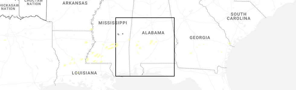
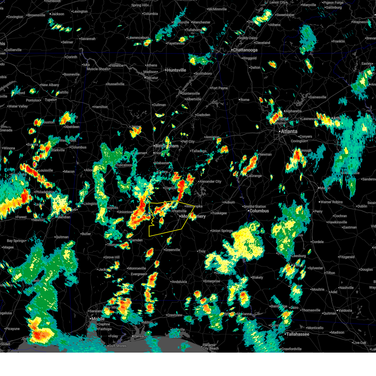
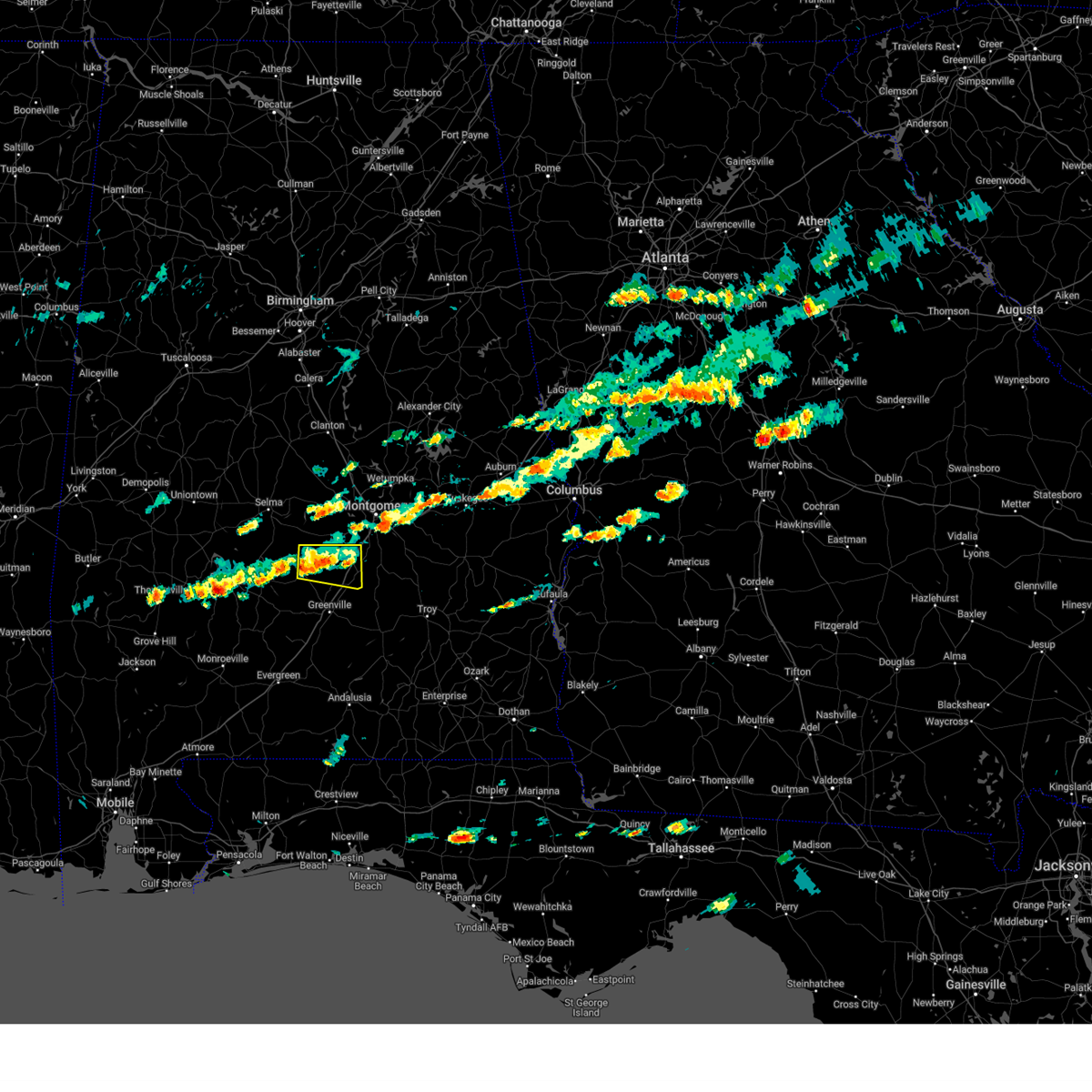
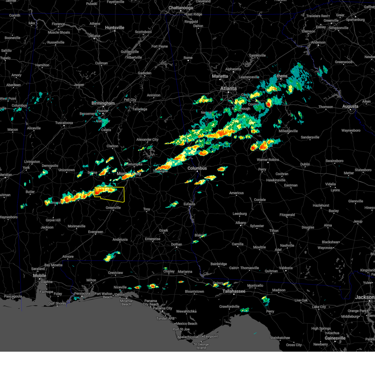
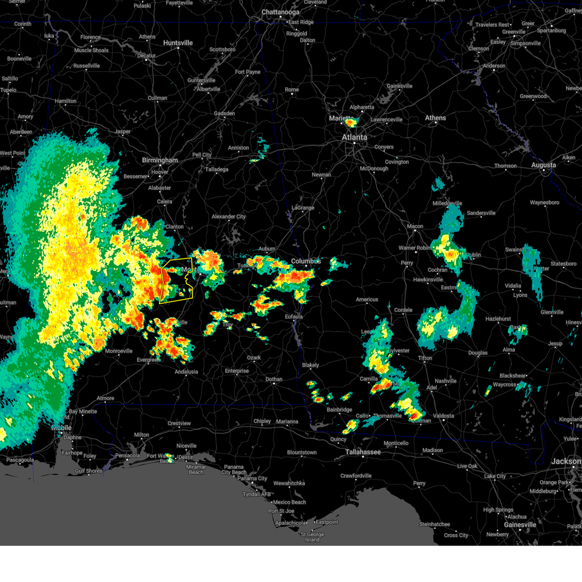
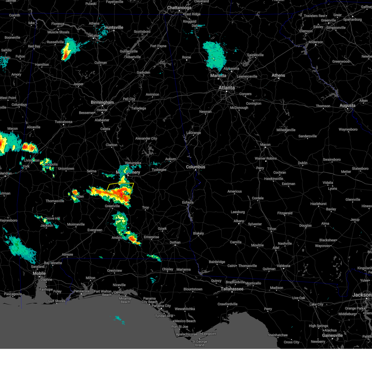
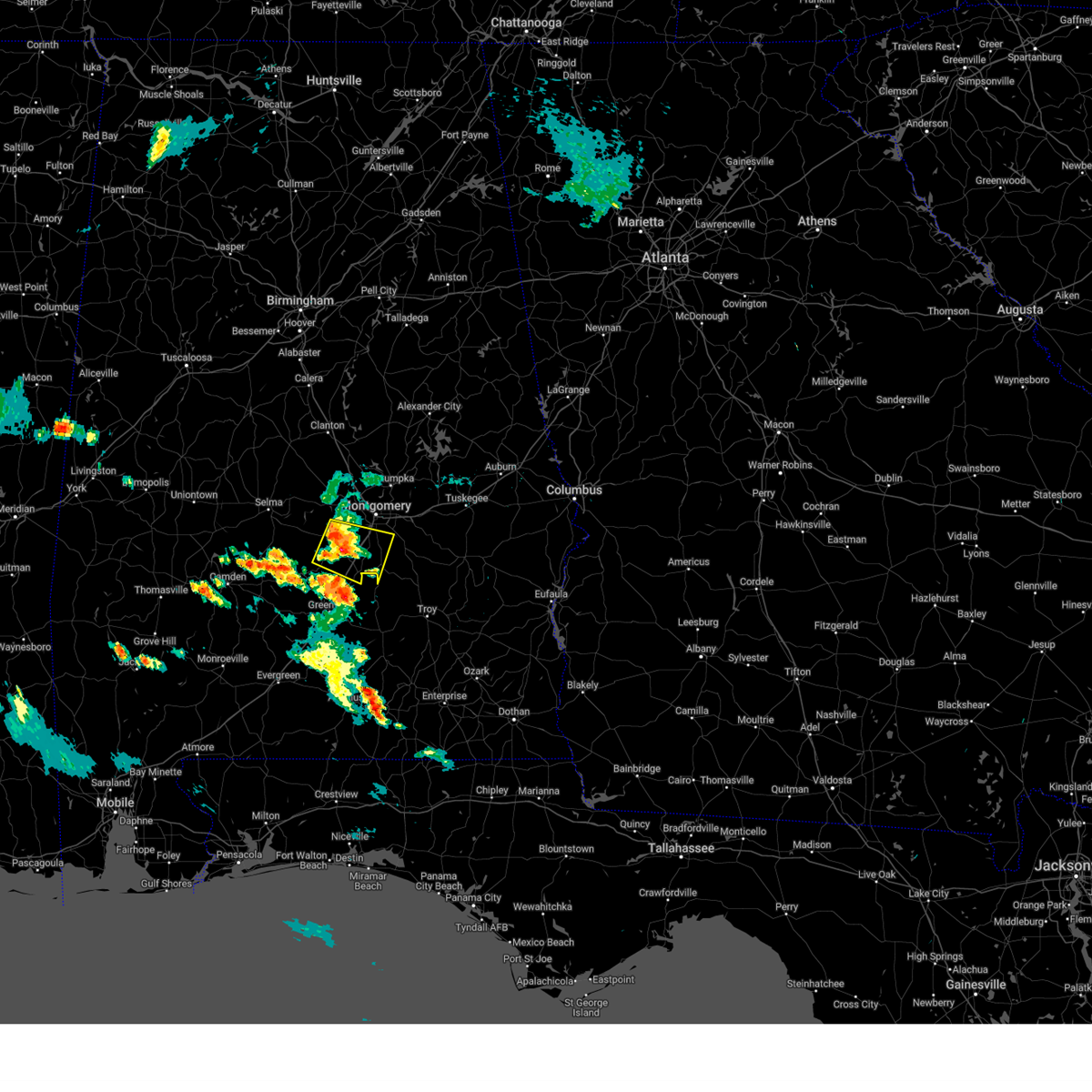
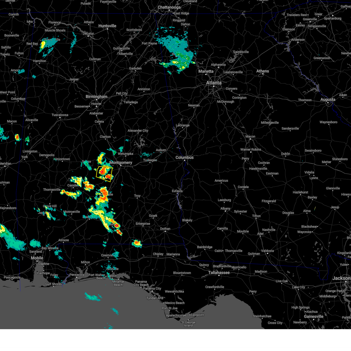
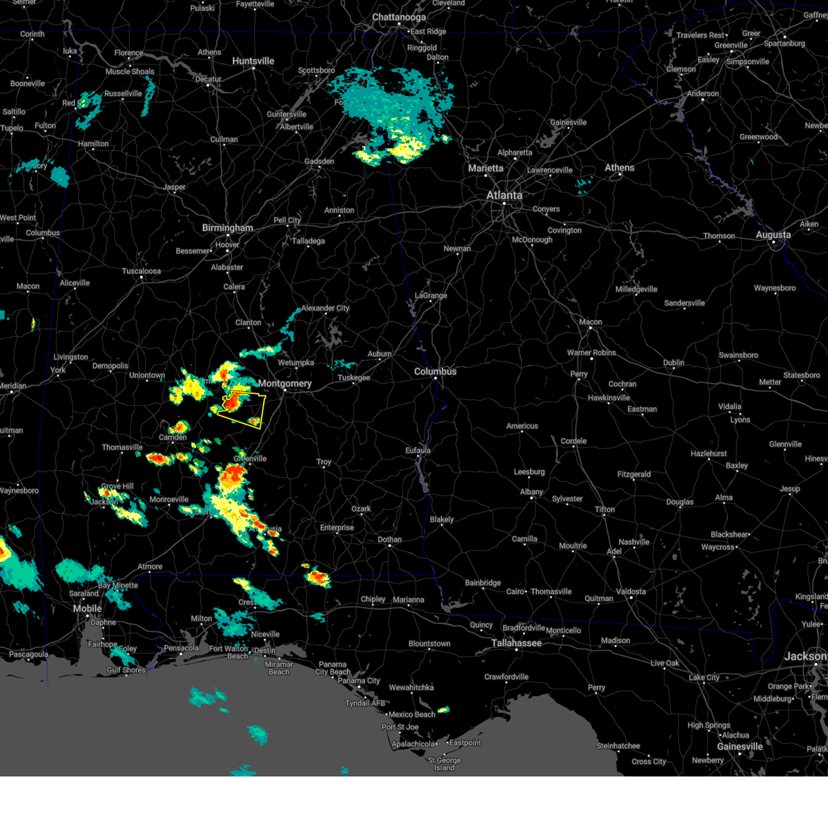
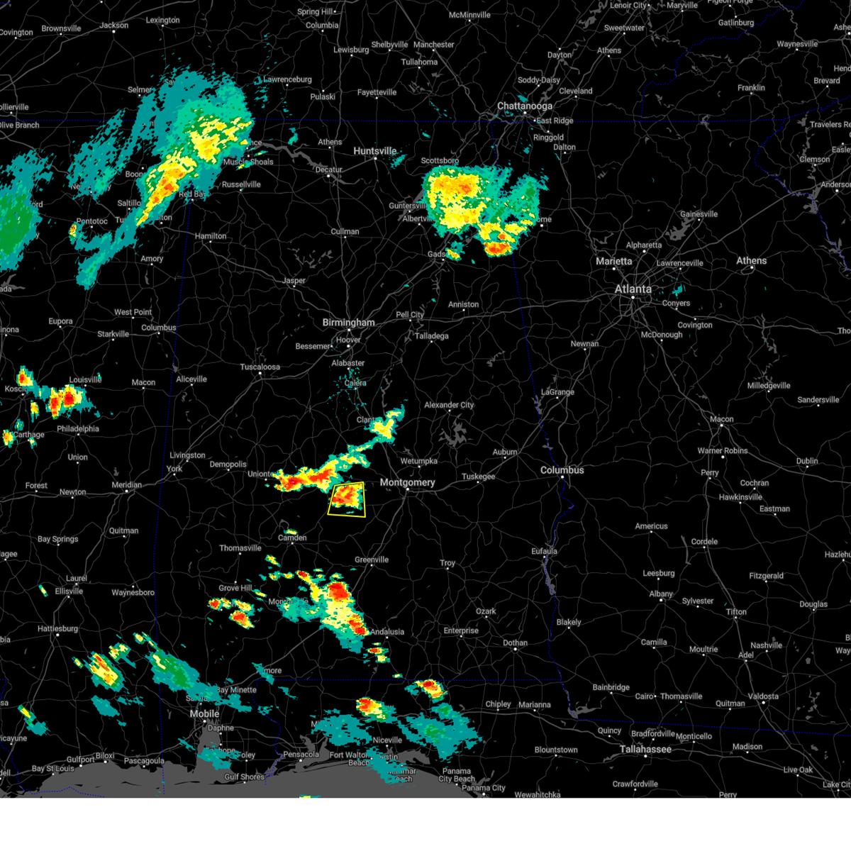
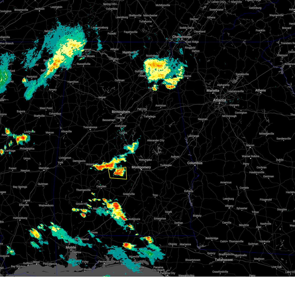
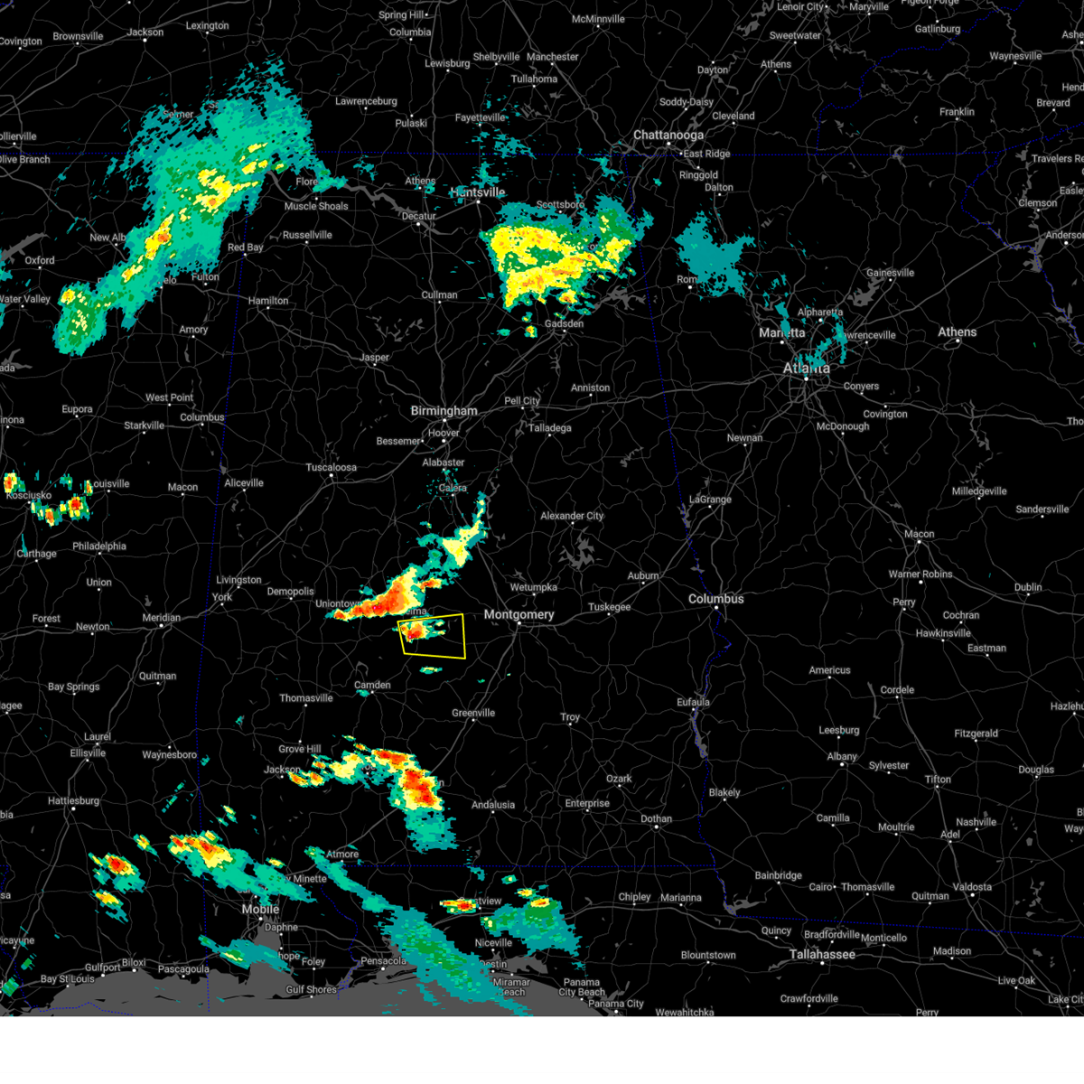
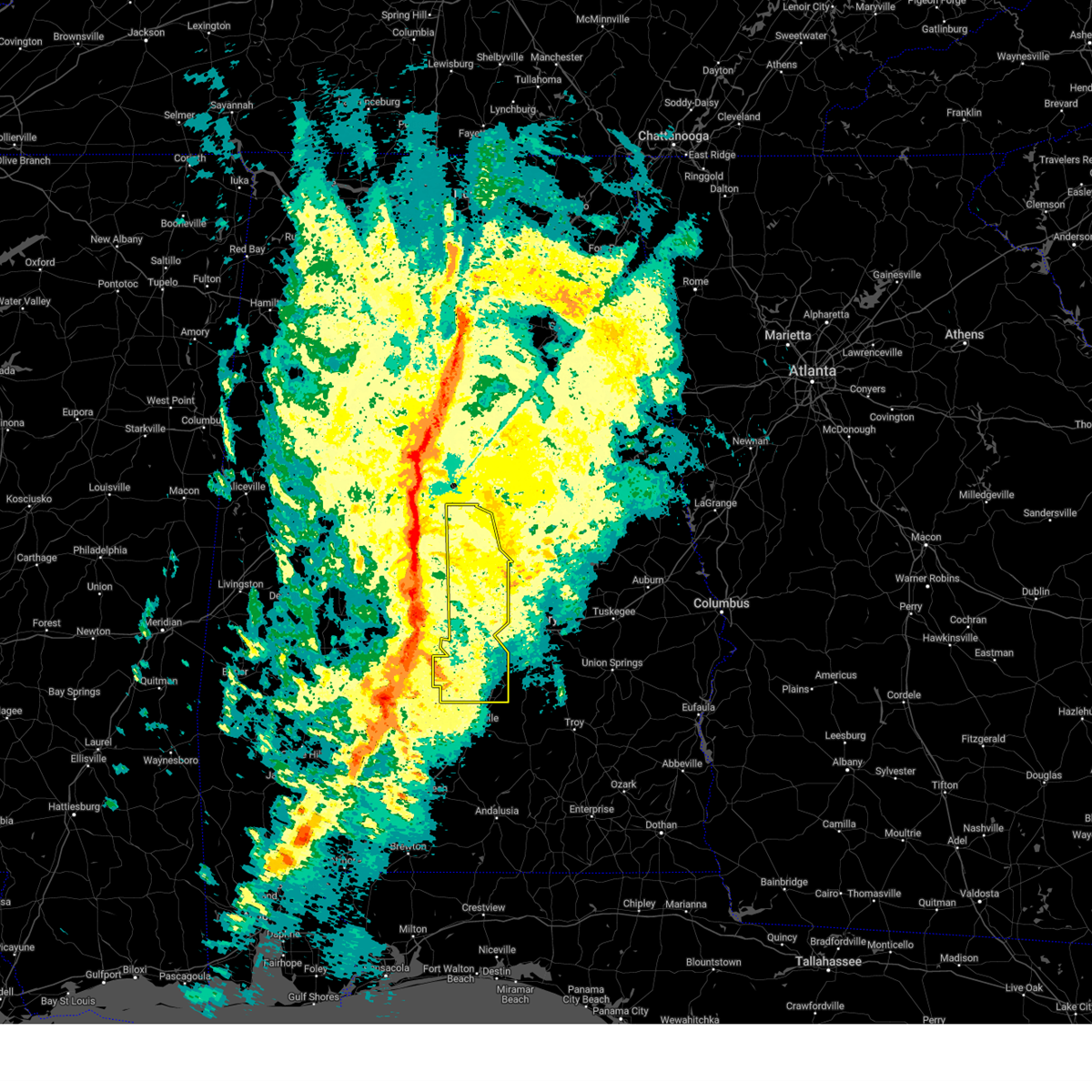
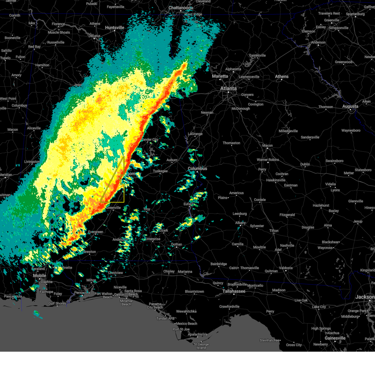
Hail Map for Mosses, AL
The Mosses, AL area has had 0 reports of on-the-ground hail by trained spotters, and has been under severe weather warnings 30 times during the past 12 months. Doppler radar has detected hail at or near Mosses, AL on 72 occasions, including 4 occasions during the past year.
| Name: | Mosses, AL |
| Where Located: | 37.6 miles ENE of Camden, AL |
| Map: | Google Map for Mosses, AL |
| Population: | 1029 |
| Housing Units: | 409 |
| More Info: | Search Google for Mosses, AL |
1
The Top Recent Hail Date for Mosses, AL is Monday, May 26, 2025 (21st out of 72)
Hail and Wind Damage Spotted near Mosses, AL
| Date / Time | Report Details |
|---|---|
| 7/1/2025 6:07 PM CDT | the severe thunderstorm warning has been cancelled and is no longer in effect |
| 7/1/2025 6:07 PM CDT | At 607 pm cdt, severe thunderstorms were located along a line extending from montgomery to hyundai motors of alabama to near pintlala, moving southeast at 35 mph (radar indicated). Hazards include 60 mph wind gusts. Expect damage to roofs, siding, and trees. Locations impacted include, montgomery, hayneville, coosada, montgomery zoo, boylston, hyundai motors of alabama, alabama state university, auburn university in montgomery, bob woodruff lake, hope hull, woodcrest, dannelly field, eastdale mall, maxwell air force base, snowdoun, montgomery riverwalk stadium, pinedale, lagoon park, gunter air force base, and alabama state capitol. |
| 7/1/2025 5:59 PM CDT |
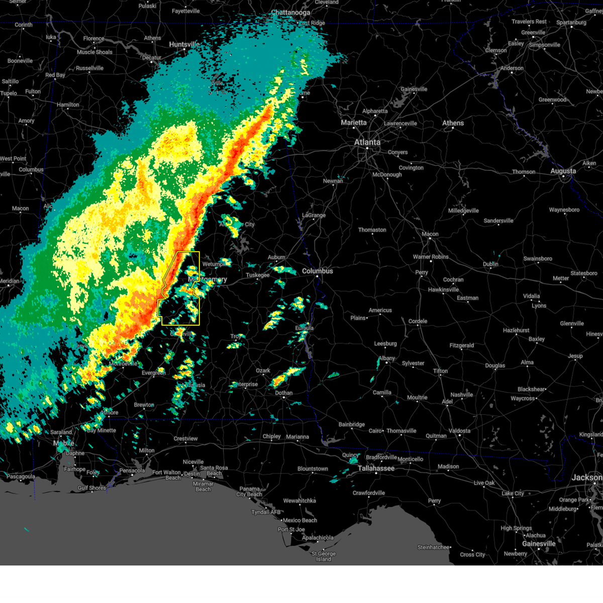
 At 559 pm cdt, severe thunderstorms were located along a line extending from montgomery to near hayneville to near gordonville, moving southeast at 30 mph (radar indicated). Hazards include 60 mph wind gusts. Expect damage to roofs, siding, and trees. Locations impacted include, montgomery, fort deposit, mosses, hayneville, meadville, pike road, gordonville, pine level, hyundai motors of alabama, beechwood, auburn university in montgomery, dublin, snowdoun, grady, sellers, davenport, ramer, waugh, lagoon park, and pintlala. At 559 pm cdt, severe thunderstorms were located along a line extending from montgomery to near hayneville to near gordonville, moving southeast at 30 mph (radar indicated). Hazards include 60 mph wind gusts. Expect damage to roofs, siding, and trees. Locations impacted include, montgomery, fort deposit, mosses, hayneville, meadville, pike road, gordonville, pine level, hyundai motors of alabama, beechwood, auburn university in montgomery, dublin, snowdoun, grady, sellers, davenport, ramer, waugh, lagoon park, and pintlala.
|
| 7/1/2025 5:54 PM CDT |
 the severe thunderstorm warning has been cancelled and is no longer in effect the severe thunderstorm warning has been cancelled and is no longer in effect
|
| 7/1/2025 5:54 PM CDT |
 At 554 pm cdt, severe thunderstorms were located along a line extending from near bob woodruff lake to montgomery to near hayneville, moving southeast at 30 mph (radar indicated). Hazards include 60 mph wind gusts. Expect damage to roofs, siding, and trees. Locations impacted include, montgomery, prattville, millbrook, mosses, hayneville, coosada, lowndesboro, montgomery zoo, boylston, hyundai motors of alabama, auburn university in montgomery, bob woodruff lake, woodcrest, emerald mountain, maxwell air force base, snowdoun, lagoon park, pintlala, hunter, and alabama state university. At 554 pm cdt, severe thunderstorms were located along a line extending from near bob woodruff lake to montgomery to near hayneville, moving southeast at 30 mph (radar indicated). Hazards include 60 mph wind gusts. Expect damage to roofs, siding, and trees. Locations impacted include, montgomery, prattville, millbrook, mosses, hayneville, coosada, lowndesboro, montgomery zoo, boylston, hyundai motors of alabama, auburn university in montgomery, bob woodruff lake, woodcrest, emerald mountain, maxwell air force base, snowdoun, lagoon park, pintlala, hunter, and alabama state university.
|
| 7/1/2025 5:46 PM CDT | Svrbmx the national weather service in birmingham has issued a * severe thunderstorm warning for, lowndes county in south central alabama, montgomery county in south central alabama, * until 700 pm cdt. * at 546 pm cdt, severe thunderstorms were located along a line extending from coosada to near hayneville to 10 miles west of gordonville, moving southeast at 30 mph (radar indicated). Hazards include 60 mph wind gusts. expect damage to roofs, siding, and trees |
| 7/1/2025 5:34 PM CDT |
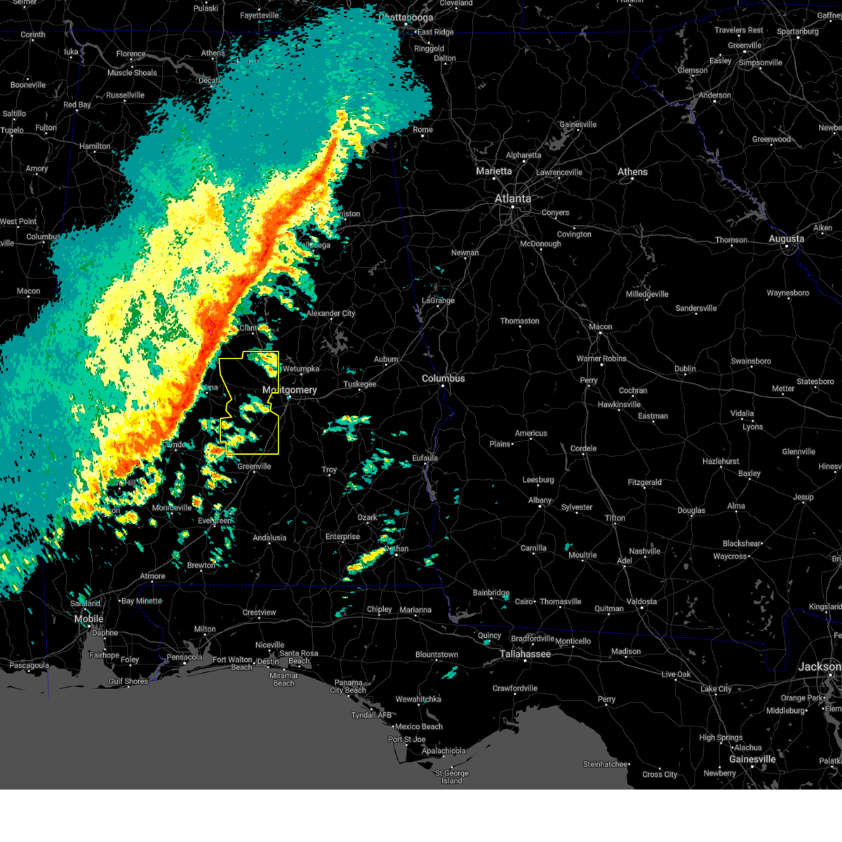
 At 533 pm cdt, severe thunderstorms were located along a line extending from deatsville to near autauga county airport to white hall to 8 miles southeast of belknap, moving southeast at 20 mph (radar indicated). Hazards include 60 mph wind gusts. Expect damage to roofs, siding, and trees. Locations impacted include, montgomery, prattville, millbrook, wetumpka, mosses, hayneville, elmore, coosada, deatsville, autaugaville, white hall, gordonville, lowndesboro, benton, hyundai motors of alabama, auburn university in montgomery, autauga county airport, woodcrest, snowdoun, and lagoon park. At 533 pm cdt, severe thunderstorms were located along a line extending from deatsville to near autauga county airport to white hall to 8 miles southeast of belknap, moving southeast at 20 mph (radar indicated). Hazards include 60 mph wind gusts. Expect damage to roofs, siding, and trees. Locations impacted include, montgomery, prattville, millbrook, wetumpka, mosses, hayneville, elmore, coosada, deatsville, autaugaville, white hall, gordonville, lowndesboro, benton, hyundai motors of alabama, auburn university in montgomery, autauga county airport, woodcrest, snowdoun, and lagoon park.
|
| 7/1/2025 5:24 PM CDT | At 523 pm cdt, severe thunderstorms were located along a line extending from near deatsville to near autaugaville to near mulberry to near tyler, moving southeast at 20 mph (radar indicated). Hazards include 60 mph wind gusts. Expect damage to roofs, siding, and trees. Locations impacted include, montgomery, prattville, millbrook, wetumpka, mosses, hayneville, elmore, coosada, deatsville, autaugaville, white hall, gordonville, lowndesboro, benton, hyundai motors of alabama, auburn university in montgomery, autauga county airport, woodcrest, snowdoun, and lagoon park. |
| 7/1/2025 5:18 PM CDT | At 517 pm cdt, severe thunderstorms were located along a line extending from near deatsville to autaugaville to near gardner island to near dallas lake, moving southeast at 20 mph (radar indicated). Hazards include 60 mph wind gusts. Expect damage to roofs, siding, and trees. Locations impacted include, montgomery, prattville, millbrook, wetumpka, mosses, hayneville, elmore, coosada, deatsville, autaugaville, white hall, gordonville, lowndesboro, benton, hyundai motors of alabama, auburn university in montgomery, autauga county airport, woodcrest, snowdoun, and lagoon park. |
| 7/1/2025 5:06 PM CDT |
 Svrbmx the national weather service in birmingham has issued a * severe thunderstorm warning for, autauga county in central alabama, southwestern elmore county in east central alabama, lowndes county in south central alabama, northwestern montgomery county in south central alabama, * until 615 pm cdt. * at 505 pm cdt, severe thunderstorms were located along a line extending from near deatsville to near mulberry to near paul m grist state park, moving southeast at 35 mph (radar indicated). Hazards include 60 mph wind gusts. expect damage to roofs, siding, and trees Svrbmx the national weather service in birmingham has issued a * severe thunderstorm warning for, autauga county in central alabama, southwestern elmore county in east central alabama, lowndes county in south central alabama, northwestern montgomery county in south central alabama, * until 615 pm cdt. * at 505 pm cdt, severe thunderstorms were located along a line extending from near deatsville to near mulberry to near paul m grist state park, moving southeast at 35 mph (radar indicated). Hazards include 60 mph wind gusts. expect damage to roofs, siding, and trees
|
| 6/25/2025 9:38 PM CDT |
 At 938 pm cdt, severe thunderstorms were located along a line extending from montgomery to near dannelly reservoir, moving northwest at 30 mph (radar indicated). Hazards include 60 mph wind gusts. Expect damage to roofs, siding, and trees. Locations impacted include, montgomery, selma, mosses, hayneville, selmont-west selmont, pike road, coosada, white hall, gordonville, orrville, lowndesboro, benton, hyundai motors of alabama, bogue chitto, auburn university in montgomery, tyler, woodcrest, dannelly reservoir, waugh, and lagoon park. At 938 pm cdt, severe thunderstorms were located along a line extending from montgomery to near dannelly reservoir, moving northwest at 30 mph (radar indicated). Hazards include 60 mph wind gusts. Expect damage to roofs, siding, and trees. Locations impacted include, montgomery, selma, mosses, hayneville, selmont-west selmont, pike road, coosada, white hall, gordonville, orrville, lowndesboro, benton, hyundai motors of alabama, bogue chitto, auburn university in montgomery, tyler, woodcrest, dannelly reservoir, waugh, and lagoon park.
|
| 6/25/2025 9:20 PM CDT |
 Svrbmx the national weather service in birmingham has issued a * severe thunderstorm warning for, lowndes county in south central alabama, dallas county in south central alabama, montgomery county in south central alabama, * until 1015 pm cdt. * at 920 pm cdt, severe thunderstorms were located along a line extending from pike road to 8 miles southeast of dannelly reservoir, moving northwest at 25 mph (radar indicated). Hazards include 60 mph wind gusts. expect damage to roofs, siding, and trees Svrbmx the national weather service in birmingham has issued a * severe thunderstorm warning for, lowndes county in south central alabama, dallas county in south central alabama, montgomery county in south central alabama, * until 1015 pm cdt. * at 920 pm cdt, severe thunderstorms were located along a line extending from pike road to 8 miles southeast of dannelly reservoir, moving northwest at 25 mph (radar indicated). Hazards include 60 mph wind gusts. expect damage to roofs, siding, and trees
|
| 5/30/2025 2:05 PM CDT |
 the severe thunderstorm warning has been cancelled and is no longer in effect the severe thunderstorm warning has been cancelled and is no longer in effect
|
| 5/30/2025 1:52 PM CDT |
 the severe thunderstorm warning has been cancelled and is no longer in effect the severe thunderstorm warning has been cancelled and is no longer in effect
|
| 5/30/2025 1:52 PM CDT |
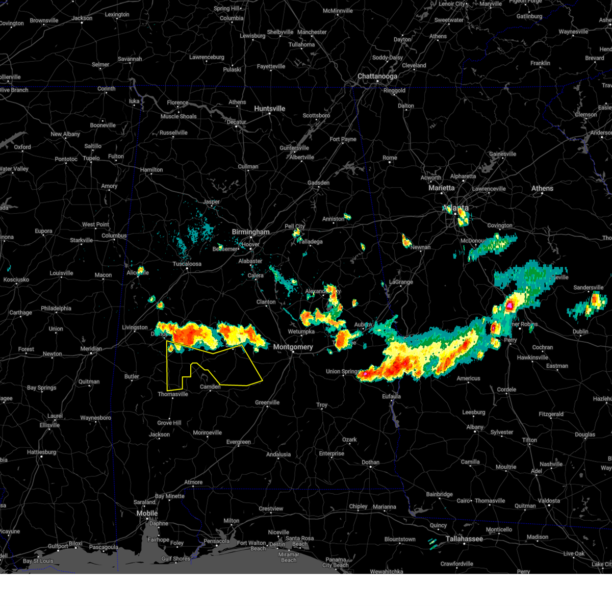
 At 151 pm cdt, a severe thunderstorm was located near beechwood, or near mosses, moving east at 40 mph (radar indicated). Hazards include 60 mph wind gusts and quarter size hail. Hail damage to vehicles is expected. expect wind damage to roofs, siding, and trees. Locations impacted include, fort deposit, mosses, hayneville, gordonville, logan, beechwood, davenport, calhoun, mount willing, letohatchee, and collirene. At 151 pm cdt, a severe thunderstorm was located near beechwood, or near mosses, moving east at 40 mph (radar indicated). Hazards include 60 mph wind gusts and quarter size hail. Hail damage to vehicles is expected. expect wind damage to roofs, siding, and trees. Locations impacted include, fort deposit, mosses, hayneville, gordonville, logan, beechwood, davenport, calhoun, mount willing, letohatchee, and collirene.
|
| 5/30/2025 1:37 PM CDT |
 Svrbmx the national weather service in birmingham has issued a * severe thunderstorm warning for, lowndes county in south central alabama, southeastern dallas county in south central alabama, * until 215 pm cdt. * at 136 pm cdt, a severe thunderstorm was located 9 miles west of gordonville, or 11 miles southwest of mosses, moving east at 40 mph (radar indicated). Hazards include 60 mph wind gusts and quarter size hail. Hail damage to vehicles is expected. Expect wind damage to roofs, siding, and trees. Svrbmx the national weather service in birmingham has issued a * severe thunderstorm warning for, lowndes county in south central alabama, southeastern dallas county in south central alabama, * until 215 pm cdt. * at 136 pm cdt, a severe thunderstorm was located 9 miles west of gordonville, or 11 miles southwest of mosses, moving east at 40 mph (radar indicated). Hazards include 60 mph wind gusts and quarter size hail. Hail damage to vehicles is expected. Expect wind damage to roofs, siding, and trees.
|
| 5/26/2025 6:26 PM CDT |
 Svrbmx the national weather service in birmingham has issued a * severe thunderstorm warning for, southeastern autauga county in central alabama, central lowndes county in south central alabama, * until 715 pm cdt. * at 625 pm cdt, severe thunderstorms were located along a line extending from near mulberry to near white hall to near gordonville, moving northeast at 40 mph (radar indicated). Hazards include 60 mph wind gusts and quarter size hail. Hail damage to vehicles is expected. Expect wind damage to roofs, siding, and trees. Svrbmx the national weather service in birmingham has issued a * severe thunderstorm warning for, southeastern autauga county in central alabama, central lowndes county in south central alabama, * until 715 pm cdt. * at 625 pm cdt, severe thunderstorms were located along a line extending from near mulberry to near white hall to near gordonville, moving northeast at 40 mph (radar indicated). Hazards include 60 mph wind gusts and quarter size hail. Hail damage to vehicles is expected. Expect wind damage to roofs, siding, and trees.
|
| 5/24/2025 4:14 PM CDT |
 At 414 pm cdt, a severe thunderstorm was located near pintlala, or 8 miles east of hayneville, moving east at 15 mph (radar indicated). Hazards include 60 mph wind gusts and quarter size hail. Hail damage to vehicles is expected. expect wind damage to roofs, siding, and trees. Locations impacted include, mosses, hayneville, gordonville, snowdoun, sprague, beechwood, sellers, strata, davenport, pintlala, calhoun, and letohatchee. At 414 pm cdt, a severe thunderstorm was located near pintlala, or 8 miles east of hayneville, moving east at 15 mph (radar indicated). Hazards include 60 mph wind gusts and quarter size hail. Hail damage to vehicles is expected. expect wind damage to roofs, siding, and trees. Locations impacted include, mosses, hayneville, gordonville, snowdoun, sprague, beechwood, sellers, strata, davenport, pintlala, calhoun, and letohatchee.
|
| 5/24/2025 3:50 PM CDT |
 Svrbmx the national weather service in birmingham has issued a * severe thunderstorm warning for, eastern lowndes county in south central alabama, southwestern montgomery county in south central alabama, * until 430 pm cdt. * at 350 pm cdt, a severe thunderstorm was located near hayneville, moving east at 10 mph (radar indicated). Hazards include 60 mph wind gusts and quarter size hail. Hail damage to vehicles is expected. Expect wind damage to roofs, siding, and trees. Svrbmx the national weather service in birmingham has issued a * severe thunderstorm warning for, eastern lowndes county in south central alabama, southwestern montgomery county in south central alabama, * until 430 pm cdt. * at 350 pm cdt, a severe thunderstorm was located near hayneville, moving east at 10 mph (radar indicated). Hazards include 60 mph wind gusts and quarter size hail. Hail damage to vehicles is expected. Expect wind damage to roofs, siding, and trees.
|
| 5/24/2025 3:31 PM CDT |
 At 331 pm cdt, a severe thunderstorm was located over white hall, or near mosses, moving east at 15 mph (radar indicated). Hazards include 60 mph wind gusts and quarter size hail. Hail damage to vehicles is expected. expect wind damage to roofs, siding, and trees. Locations impacted include, mosses, hayneville, white hall, gordonville, lowndesboro, and manack. At 331 pm cdt, a severe thunderstorm was located over white hall, or near mosses, moving east at 15 mph (radar indicated). Hazards include 60 mph wind gusts and quarter size hail. Hail damage to vehicles is expected. expect wind damage to roofs, siding, and trees. Locations impacted include, mosses, hayneville, white hall, gordonville, lowndesboro, and manack.
|
| 5/24/2025 3:14 PM CDT |
 Svrbmx the national weather service in birmingham has issued a * severe thunderstorm warning for, central lowndes county in south central alabama, * until 400 pm cdt. * at 314 pm cdt, a severe thunderstorm was located over benton, or 9 miles northwest of mosses, moving east at 15 mph (radar indicated). Hazards include 60 mph wind gusts and quarter size hail. Hail damage to vehicles is expected. Expect wind damage to roofs, siding, and trees. Svrbmx the national weather service in birmingham has issued a * severe thunderstorm warning for, central lowndes county in south central alabama, * until 400 pm cdt. * at 314 pm cdt, a severe thunderstorm was located over benton, or 9 miles northwest of mosses, moving east at 15 mph (radar indicated). Hazards include 60 mph wind gusts and quarter size hail. Hail damage to vehicles is expected. Expect wind damage to roofs, siding, and trees.
|
| 5/24/2025 2:55 PM CDT |
 At 255 pm cdt, a severe thunderstorm was located over tyler, or 9 miles southeast of selmont-west selmont, moving east at 15 mph (radar indicated). Hazards include 60 mph wind gusts and quarter size hail. Hail damage to vehicles is expected. expect wind damage to roofs, siding, and trees. locations impacted include, mosses, white hall, benton, tyler, and robert f. Henry lock and dam. At 255 pm cdt, a severe thunderstorm was located over tyler, or 9 miles southeast of selmont-west selmont, moving east at 15 mph (radar indicated). Hazards include 60 mph wind gusts and quarter size hail. Hail damage to vehicles is expected. expect wind damage to roofs, siding, and trees. locations impacted include, mosses, white hall, benton, tyler, and robert f. Henry lock and dam.
|
| 5/24/2025 2:48 PM CDT |
 At 248 pm cdt, a severe thunderstorm was located over tyler, or 7 miles southeast of selmont-west selmont, moving east at 15 mph (radar indicated). Hazards include 60 mph wind gusts and quarter size hail. Hail damage to vehicles is expected. expect wind damage to roofs, siding, and trees. locations impacted include, selma, mosses, selmont-west selmont, white hall, benton, belknap, tyler, dallas lake, old cahaba park, dallas county horse arena, skyharbor airport, robert f. Henry lock and dam, craig field aiport, and selma drag strip. At 248 pm cdt, a severe thunderstorm was located over tyler, or 7 miles southeast of selmont-west selmont, moving east at 15 mph (radar indicated). Hazards include 60 mph wind gusts and quarter size hail. Hail damage to vehicles is expected. expect wind damage to roofs, siding, and trees. locations impacted include, selma, mosses, selmont-west selmont, white hall, benton, belknap, tyler, dallas lake, old cahaba park, dallas county horse arena, skyharbor airport, robert f. Henry lock and dam, craig field aiport, and selma drag strip.
|
| 5/24/2025 2:25 PM CDT |
 Svrbmx the national weather service in birmingham has issued a * severe thunderstorm warning for, southwestern autauga county in central alabama, northwestern lowndes county in south central alabama, east central dallas county in south central alabama, * until 315 pm cdt. * at 225 pm cdt, a severe thunderstorm was located near selmont-west selmont, moving east at 15 mph (radar indicated). Hazards include 60 mph wind gusts and quarter size hail. Hail damage to vehicles is expected. Expect wind damage to roofs, siding, and trees. Svrbmx the national weather service in birmingham has issued a * severe thunderstorm warning for, southwestern autauga county in central alabama, northwestern lowndes county in south central alabama, east central dallas county in south central alabama, * until 315 pm cdt. * at 225 pm cdt, a severe thunderstorm was located near selmont-west selmont, moving east at 15 mph (radar indicated). Hazards include 60 mph wind gusts and quarter size hail. Hail damage to vehicles is expected. Expect wind damage to roofs, siding, and trees.
|
| 3/4/2025 9:02 PM CST |
 Svrbmx the national weather service in birmingham has issued a * severe thunderstorm warning for, autauga county in central alabama, chilton county in central alabama, lowndes county in south central alabama, * until 1000 pm cst. * at 902 pm cst, severe thunderstorms were located along a line extending from near brierfield ironworks park to 7 miles south of belknap, moving east at 35 mph (radar indicated). Hazards include 60 mph wind gusts. expect damage to roofs, siding, and trees Svrbmx the national weather service in birmingham has issued a * severe thunderstorm warning for, autauga county in central alabama, chilton county in central alabama, lowndes county in south central alabama, * until 1000 pm cst. * at 902 pm cst, severe thunderstorms were located along a line extending from near brierfield ironworks park to 7 miles south of belknap, moving east at 35 mph (radar indicated). Hazards include 60 mph wind gusts. expect damage to roofs, siding, and trees
|
| 2/16/2025 2:18 AM CST |
 At 218 am cst, severe thunderstorms were located along a line extending from near equality to 6 miles north of fort deposit, moving east at 65 mph (radar indicated). Hazards include 70 mph wind gusts. Expect considerable tree damage. damage is likely to mobile homes, roofs, and outbuildings. Locations impacted include, prattville, millbrook, fort deposit, mosses, hayneville, deatsville, white hall, gordonville, lowndesboro, lowndes county airport, beechwood, autauga county airport, logan, calhoun, manack, letohatchee, mount willing, and clover hill. At 218 am cst, severe thunderstorms were located along a line extending from near equality to 6 miles north of fort deposit, moving east at 65 mph (radar indicated). Hazards include 70 mph wind gusts. Expect considerable tree damage. damage is likely to mobile homes, roofs, and outbuildings. Locations impacted include, prattville, millbrook, fort deposit, mosses, hayneville, deatsville, white hall, gordonville, lowndesboro, lowndes county airport, beechwood, autauga county airport, logan, calhoun, manack, letohatchee, mount willing, and clover hill.
|
| 2/16/2025 2:02 AM CST |
 At 201 am cst, severe thunderstorms were located along a line extending from near welona to 7 miles southwest of gordonville, moving east at 65 mph (radar indicated). Hazards include 70 mph wind gusts. Expect considerable tree damage. damage is likely to mobile homes, roofs, and outbuildings. Locations impacted include, prattville, millbrook, fort deposit, mosses, hayneville, deatsville, autaugaville, white hall, gordonville, billingsley, lowndesboro, benton, booth, vida junction, beechwood, autauga county airport, mulberry, marbury, lowndes county airport, and logan. At 201 am cst, severe thunderstorms were located along a line extending from near welona to 7 miles southwest of gordonville, moving east at 65 mph (radar indicated). Hazards include 70 mph wind gusts. Expect considerable tree damage. damage is likely to mobile homes, roofs, and outbuildings. Locations impacted include, prattville, millbrook, fort deposit, mosses, hayneville, deatsville, autaugaville, white hall, gordonville, billingsley, lowndesboro, benton, booth, vida junction, beechwood, autauga county airport, mulberry, marbury, lowndes county airport, and logan.
|
| 2/16/2025 1:29 AM CST |
 Svrbmx the national weather service in birmingham has issued a * severe thunderstorm warning for, autauga county in central alabama, lowndes county in south central alabama, * until 245 am cst. * at 129 am cst, severe thunderstorms were located along a line extending from near lawley to 6 miles west of dannelly reservoir, moving east at 65 mph (radar indicated). Hazards include 70 mph wind gusts. Expect considerable tree damage. Damage is likely to mobile homes, roofs, and outbuildings. Svrbmx the national weather service in birmingham has issued a * severe thunderstorm warning for, autauga county in central alabama, lowndes county in south central alabama, * until 245 am cst. * at 129 am cst, severe thunderstorms were located along a line extending from near lawley to 6 miles west of dannelly reservoir, moving east at 65 mph (radar indicated). Hazards include 70 mph wind gusts. Expect considerable tree damage. Damage is likely to mobile homes, roofs, and outbuildings.
|
| 2/12/2025 11:41 PM CST | Svrbmx the national weather service in birmingham has issued a * severe thunderstorm warning for, lowndes county in south central alabama, montgomery county in south central alabama, * until 1245 am cst. * at 1141 pm cst, severe thunderstorms were located along a line extending from lowndesboro to 9 miles west of lowndes county airport, moving east at 50 mph (radar indicated). Hazards include 60 mph wind gusts. expect damage to roofs, siding, and trees |
| 8/18/2024 6:03 PM CDT |
 Svrbmx the national weather service in birmingham has issued a * severe thunderstorm warning for, eastern marengo county in southwestern alabama, southwestern perry county in central alabama, southwestern lowndes county in south central alabama, dallas county in south central alabama, * until 700 pm cdt. * at 603 pm cdt, severe thunderstorms were located along a line extending from valley grande to near bogue chitto to near demopolis, moving south at 30 mph (radar indicated). Hazards include 60 mph wind gusts and quarter size hail. Hail damage to vehicles is expected. Expect wind damage to roofs, siding, and trees. Svrbmx the national weather service in birmingham has issued a * severe thunderstorm warning for, eastern marengo county in southwestern alabama, southwestern perry county in central alabama, southwestern lowndes county in south central alabama, dallas county in south central alabama, * until 700 pm cdt. * at 603 pm cdt, severe thunderstorms were located along a line extending from valley grande to near bogue chitto to near demopolis, moving south at 30 mph (radar indicated). Hazards include 60 mph wind gusts and quarter size hail. Hail damage to vehicles is expected. Expect wind damage to roofs, siding, and trees.
|
| 4/20/2024 9:27 PM CDT |
 The storm which prompted the warning has weakened below severe limits, and has exited the warned area. therefore, the warning will be allowed to expire. however, small hail and gusty winds are still possible with this thunderstorm. The storm which prompted the warning has weakened below severe limits, and has exited the warned area. therefore, the warning will be allowed to expire. however, small hail and gusty winds are still possible with this thunderstorm.
|
| 4/20/2024 9:19 PM CDT |
 At 919 pm cdt, a severe thunderstorm was located near hayneville, moving northeast at 30 mph (radar indicated). Hazards include 60 mph wind gusts and quarter size hail. Hail damage to vehicles is expected. expect wind damage to roofs, siding, and trees. Locations impacted include, mosses, hayneville, gordonville, beechwood, and letohatchee. At 919 pm cdt, a severe thunderstorm was located near hayneville, moving northeast at 30 mph (radar indicated). Hazards include 60 mph wind gusts and quarter size hail. Hail damage to vehicles is expected. expect wind damage to roofs, siding, and trees. Locations impacted include, mosses, hayneville, gordonville, beechwood, and letohatchee.
|
| 4/20/2024 9:11 PM CDT |
 At 911 pm cdt, a severe thunderstorm was located near beechwood, or near hayneville, moving northeast at 30 mph (radar indicated). Hazards include 60 mph wind gusts and quarter size hail. Hail damage to vehicles is expected. expect wind damage to roofs, siding, and trees. Locations impacted include, fort deposit, mosses, hayneville, gordonville, lowndes county airport, beechwood, calhoun, mount willing, clover hill, and letohatchee. At 911 pm cdt, a severe thunderstorm was located near beechwood, or near hayneville, moving northeast at 30 mph (radar indicated). Hazards include 60 mph wind gusts and quarter size hail. Hail damage to vehicles is expected. expect wind damage to roofs, siding, and trees. Locations impacted include, fort deposit, mosses, hayneville, gordonville, lowndes county airport, beechwood, calhoun, mount willing, clover hill, and letohatchee.
|
| 4/20/2024 8:54 PM CDT |
 Svrbmx the national weather service in birmingham has issued a * severe thunderstorm warning for, southeastern lowndes county in south central alabama, * until 930 pm cdt. * at 854 pm cdt, a severe thunderstorm was located near lowndes county airport, or near fort deposit, moving northeast at 30 mph (radar indicated). Hazards include 60 mph wind gusts and quarter size hail. Hail damage to vehicles is expected. Expect wind damage to roofs, siding, and trees. Svrbmx the national weather service in birmingham has issued a * severe thunderstorm warning for, southeastern lowndes county in south central alabama, * until 930 pm cdt. * at 854 pm cdt, a severe thunderstorm was located near lowndes county airport, or near fort deposit, moving northeast at 30 mph (radar indicated). Hazards include 60 mph wind gusts and quarter size hail. Hail damage to vehicles is expected. Expect wind damage to roofs, siding, and trees.
|
| 8/8/2023 1:38 PM CDT |
 At 138 pm cdt, severe thunderstorms were located along a line extending from near white hall to near lowndes county airport, moving east at 30 mph (radar indicated). Hazards include 60 mph wind gusts. Expect damage to roofs, siding, and trees. locations impacted include, southwestern montgomery, prattville, fort deposit, mosses, hayneville, white hall, gordonville, lowndesboro, benton, beechwood, grady, sellers, davenport, ramer, pintlala, lowndes county airport, strata, naftel, hope hull and dannelly field. hail threat, radar indicated max hail size, <. 75 in wind threat, radar indicated max wind gust, 60 mph. At 138 pm cdt, severe thunderstorms were located along a line extending from near white hall to near lowndes county airport, moving east at 30 mph (radar indicated). Hazards include 60 mph wind gusts. Expect damage to roofs, siding, and trees. locations impacted include, southwestern montgomery, prattville, fort deposit, mosses, hayneville, white hall, gordonville, lowndesboro, benton, beechwood, grady, sellers, davenport, ramer, pintlala, lowndes county airport, strata, naftel, hope hull and dannelly field. hail threat, radar indicated max hail size, <. 75 in wind threat, radar indicated max wind gust, 60 mph.
|
| 8/8/2023 1:26 PM CDT |
 At 126 pm cdt, severe thunderstorms were located along a line extending from benton to near lowndes county airport, moving east at 30 mph (radar indicated). Hazards include 60 mph wind gusts. expect damage to roofs, siding, and trees At 126 pm cdt, severe thunderstorms were located along a line extending from benton to near lowndes county airport, moving east at 30 mph (radar indicated). Hazards include 60 mph wind gusts. expect damage to roofs, siding, and trees
|
| 6/19/2023 4:43 AM CDT |
 At 443 am cdt, a severe thunderstorm was located near beechwood, or near hayneville, moving east at 50 mph (radar indicated). Hazards include 60 mph wind gusts and penny size hail. Expect damage to roofs, siding, and trees. Locations impacted include, fort deposit, mosses, hayneville, gordonville, lowndes county airport, beechwood, logan, calhoun, letohatchee, mount willing, collirene, clover hill, farmersville and fostoria. At 443 am cdt, a severe thunderstorm was located near beechwood, or near hayneville, moving east at 50 mph (radar indicated). Hazards include 60 mph wind gusts and penny size hail. Expect damage to roofs, siding, and trees. Locations impacted include, fort deposit, mosses, hayneville, gordonville, lowndes county airport, beechwood, logan, calhoun, letohatchee, mount willing, collirene, clover hill, farmersville and fostoria.
|
| 6/19/2023 4:22 AM CDT |
 At 422 am cdt, a severe thunderstorm was located 8 miles southeast of belknap, or 13 miles west of mosses, moving east at 50 mph (radar indicated). Hazards include 60 mph wind gusts and penny size hail. expect damage to roofs, siding, and trees At 422 am cdt, a severe thunderstorm was located 8 miles southeast of belknap, or 13 miles west of mosses, moving east at 50 mph (radar indicated). Hazards include 60 mph wind gusts and penny size hail. expect damage to roofs, siding, and trees
|
| 6/16/2023 9:17 PM CDT |
 At 917 pm cdt, severe thunderstorms were located along a line extending from benton to near davenport, moving east at 35 mph (radar indicated). Hazards include 60 mph wind gusts. expect damage to roofs, siding, and trees At 917 pm cdt, severe thunderstorms were located along a line extending from benton to near davenport, moving east at 35 mph (radar indicated). Hazards include 60 mph wind gusts. expect damage to roofs, siding, and trees
|
| 6/16/2023 9:10 PM CDT |
 At 909 pm cdt, a severe thunderstorm was located near belknap, or 9 miles southeast of selmont-west selmont, moving east at 35 mph (radar indicated). Hazards include 60 mph wind gusts and penny size hail. Expect damage to roofs, siding, and trees. locations impacted include, mosses, gordonville, beechwood, mount willing, collirene and fostoria. hail threat, radar indicated max hail size, 0. 75 in wind threat, radar indicated max wind gust, 60 mph. At 909 pm cdt, a severe thunderstorm was located near belknap, or 9 miles southeast of selmont-west selmont, moving east at 35 mph (radar indicated). Hazards include 60 mph wind gusts and penny size hail. Expect damage to roofs, siding, and trees. locations impacted include, mosses, gordonville, beechwood, mount willing, collirene and fostoria. hail threat, radar indicated max hail size, 0. 75 in wind threat, radar indicated max wind gust, 60 mph.
|
| 6/16/2023 8:54 PM CDT |
 At 854 pm cdt, severe thunderstorms were located along a line extending from near gordonville to lowndes county airport, moving east at 40 mph (radar indicated). Hazards include golf ball size hail and 70 mph wind gusts. People and animals outdoors will be injured. expect hail damage to roofs, siding, windows, and vehicles. expect considerable tree damage. wind damage is also likely to mobile homes, roofs, and outbuildings. locations impacted include, fort deposit, mosses, gordonville, logan, lowndes county airport, beechwood, calhoun, mount willing, collirene, clover hill, farmersville and fostoria. thunderstorm damage threat, considerable hail threat, radar indicated max hail size, 1. 75 in wind threat, radar indicated max wind gust, 70 mph. At 854 pm cdt, severe thunderstorms were located along a line extending from near gordonville to lowndes county airport, moving east at 40 mph (radar indicated). Hazards include golf ball size hail and 70 mph wind gusts. People and animals outdoors will be injured. expect hail damage to roofs, siding, windows, and vehicles. expect considerable tree damage. wind damage is also likely to mobile homes, roofs, and outbuildings. locations impacted include, fort deposit, mosses, gordonville, logan, lowndes county airport, beechwood, calhoun, mount willing, collirene, clover hill, farmersville and fostoria. thunderstorm damage threat, considerable hail threat, radar indicated max hail size, 1. 75 in wind threat, radar indicated max wind gust, 70 mph.
|
| 6/16/2023 8:40 PM CDT |
 At 840 pm cdt, severe thunderstorms were located along a line extending from 9 miles west of gordonville to 8 miles west of lowndes county airport, moving east at 35 mph (radar indicated). Hazards include golf ball size hail and 70 mph wind gusts. People and animals outdoors will be injured. expect hail damage to roofs, siding, windows, and vehicles. expect considerable tree damage. wind damage is also likely to mobile homes, roofs, and outbuildings. locations impacted include, fort deposit, mosses, gordonville, logan, lowndes county airport, beechwood, calhoun, mount willing, collirene, clover hill, farmersville and fostoria. thunderstorm damage threat, considerable hail threat, radar indicated max hail size, 1. 75 in wind threat, radar indicated max wind gust, 70 mph. At 840 pm cdt, severe thunderstorms were located along a line extending from 9 miles west of gordonville to 8 miles west of lowndes county airport, moving east at 35 mph (radar indicated). Hazards include golf ball size hail and 70 mph wind gusts. People and animals outdoors will be injured. expect hail damage to roofs, siding, windows, and vehicles. expect considerable tree damage. wind damage is also likely to mobile homes, roofs, and outbuildings. locations impacted include, fort deposit, mosses, gordonville, logan, lowndes county airport, beechwood, calhoun, mount willing, collirene, clover hill, farmersville and fostoria. thunderstorm damage threat, considerable hail threat, radar indicated max hail size, 1. 75 in wind threat, radar indicated max wind gust, 70 mph.
|
| 6/16/2023 8:31 PM CDT |
 At 831 pm cdt, severe thunderstorms were located along a line extending from 6 miles south of belknap to 6 miles northeast of pine apple, moving east at 45 mph (radar indicated). Hazards include golf ball size hail and 60 mph wind gusts. People and animals outdoors will be injured. expect hail damage to roofs, siding, windows, and vehicles. Expect wind damage to roofs, siding, and trees. At 831 pm cdt, severe thunderstorms were located along a line extending from 6 miles south of belknap to 6 miles northeast of pine apple, moving east at 45 mph (radar indicated). Hazards include golf ball size hail and 60 mph wind gusts. People and animals outdoors will be injured. expect hail damage to roofs, siding, windows, and vehicles. Expect wind damage to roofs, siding, and trees.
|
| 6/14/2023 5:17 PM CDT |
 At 517 pm cdt, severe thunderstorms were located along a line extending from near lowndesboro to 7 miles east of pine apple, moving east at 65 mph (radar indicated). Hazards include 70 mph wind gusts and quarter size hail. Hail damage to vehicles is expected. expect considerable tree damage. wind damage is also likely to mobile homes, roofs, and outbuildings. locations impacted include, fort deposit, mosses, hayneville, white hall, gordonville, lowndesboro, benton, lowndes county airport, beechwood, logan, calhoun, letohatchee, mount willing, collirene, clover hill, farmersville and fostoria. thunderstorm damage threat, considerable hail threat, radar indicated max hail size, 1. 00 in wind threat, radar indicated max wind gust, 70 mph. At 517 pm cdt, severe thunderstorms were located along a line extending from near lowndesboro to 7 miles east of pine apple, moving east at 65 mph (radar indicated). Hazards include 70 mph wind gusts and quarter size hail. Hail damage to vehicles is expected. expect considerable tree damage. wind damage is also likely to mobile homes, roofs, and outbuildings. locations impacted include, fort deposit, mosses, hayneville, white hall, gordonville, lowndesboro, benton, lowndes county airport, beechwood, logan, calhoun, letohatchee, mount willing, collirene, clover hill, farmersville and fostoria. thunderstorm damage threat, considerable hail threat, radar indicated max hail size, 1. 00 in wind threat, radar indicated max wind gust, 70 mph.
|
| 6/14/2023 4:56 PM CDT |
 At 456 pm cdt, severe thunderstorms were located along a line extending from near selmont-west selmont to 8 miles east of camden, moving east at 70 mph (radar indicated). Hazards include 60 mph wind gusts and quarter size hail. Hail damage to vehicles is expected. Expect wind damage to roofs, siding, and trees. At 456 pm cdt, severe thunderstorms were located along a line extending from near selmont-west selmont to 8 miles east of camden, moving east at 70 mph (radar indicated). Hazards include 60 mph wind gusts and quarter size hail. Hail damage to vehicles is expected. Expect wind damage to roofs, siding, and trees.
|
| 6/14/2023 3:55 PM CDT |
 At 355 pm cdt, a severe thunderstorm was located over hayneville, moving east at 45 mph (radar indicated). Hazards include 70 mph wind gusts and quarter size hail. Hail damage to vehicles is expected. expect considerable tree damage. wind damage is also likely to mobile homes, roofs, and outbuildings. locations impacted include, mosses, hayneville, white hall, gordonville, lowndesboro, benton, beechwood, logan, calhoun, manack, letohatchee, mount willing and collirene. thunderstorm damage threat, considerable hail threat, radar indicated max hail size, 1. 00 in wind threat, radar indicated max wind gust, 70 mph. At 355 pm cdt, a severe thunderstorm was located over hayneville, moving east at 45 mph (radar indicated). Hazards include 70 mph wind gusts and quarter size hail. Hail damage to vehicles is expected. expect considerable tree damage. wind damage is also likely to mobile homes, roofs, and outbuildings. locations impacted include, mosses, hayneville, white hall, gordonville, lowndesboro, benton, beechwood, logan, calhoun, manack, letohatchee, mount willing and collirene. thunderstorm damage threat, considerable hail threat, radar indicated max hail size, 1. 00 in wind threat, radar indicated max wind gust, 70 mph.
|
| 6/14/2023 3:46 PM CDT |
 At 346 pm cdt, a severe thunderstorm was located over mosses, moving southeast at 50 mph (radar indicated). Hazards include 70 mph wind gusts and quarter size hail. Hail damage to vehicles is expected. expect considerable tree damage. wind damage is also likely to mobile homes, roofs, and outbuildings. locations impacted include, fort deposit, mosses, hayneville, autaugaville, white hall, gordonville, lowndesboro, benton, beechwood, tyler, logan, calhoun, manack, robert f. henry lock and dam, letohatchee, mount willing and collirene. thunderstorm damage threat, considerable hail threat, radar indicated max hail size, 1. 00 in wind threat, radar indicated max wind gust, 70 mph. At 346 pm cdt, a severe thunderstorm was located over mosses, moving southeast at 50 mph (radar indicated). Hazards include 70 mph wind gusts and quarter size hail. Hail damage to vehicles is expected. expect considerable tree damage. wind damage is also likely to mobile homes, roofs, and outbuildings. locations impacted include, fort deposit, mosses, hayneville, autaugaville, white hall, gordonville, lowndesboro, benton, beechwood, tyler, logan, calhoun, manack, robert f. henry lock and dam, letohatchee, mount willing and collirene. thunderstorm damage threat, considerable hail threat, radar indicated max hail size, 1. 00 in wind threat, radar indicated max wind gust, 70 mph.
|
| 6/14/2023 3:31 PM CDT |
 At 331 pm cdt, a severe thunderstorm was located over tyler, or 7 miles east of selmont-west selmont, moving east at 45 mph (radar indicated). Hazards include 70 mph wind gusts and quarter size hail. Hail damage to vehicles is expected. expect considerable tree damage. Wind damage is also likely to mobile homes, roofs, and outbuildings. At 331 pm cdt, a severe thunderstorm was located over tyler, or 7 miles east of selmont-west selmont, moving east at 45 mph (radar indicated). Hazards include 70 mph wind gusts and quarter size hail. Hail damage to vehicles is expected. expect considerable tree damage. Wind damage is also likely to mobile homes, roofs, and outbuildings.
|
| 3/26/2023 9:35 PM CDT |
 At 933 pm cdt, severe thunderstorms were located along a line extending from near vida junction to beechwood, moving east at 55 mph (radar indicated). Hazards include 60 mph wind gusts. Expect damage to roofs, siding, and trees. locations impacted include, prattville, millbrook, fort deposit, mosses, hayneville, autaugaville, white hall, gordonville, lowndesboro, booth, beechwood, autauga county airport, calhoun, manack, letohatchee, mount willing and clover hill. hail threat, radar indicated max hail size, <. 75 in wind threat, radar indicated max wind gust, 60 mph. At 933 pm cdt, severe thunderstorms were located along a line extending from near vida junction to beechwood, moving east at 55 mph (radar indicated). Hazards include 60 mph wind gusts. Expect damage to roofs, siding, and trees. locations impacted include, prattville, millbrook, fort deposit, mosses, hayneville, autaugaville, white hall, gordonville, lowndesboro, booth, beechwood, autauga county airport, calhoun, manack, letohatchee, mount willing and clover hill. hail threat, radar indicated max hail size, <. 75 in wind threat, radar indicated max wind gust, 60 mph.
|
| 3/26/2023 9:15 PM CDT |
 At 915 pm cdt, severe thunderstorms were located along a line extending from near burnsville to 10 miles southeast of belknap, moving east at 55 mph (radar indicated). Hazards include 60 mph wind gusts. expect damage to roofs, siding, and trees At 915 pm cdt, severe thunderstorms were located along a line extending from near burnsville to 10 miles southeast of belknap, moving east at 55 mph (radar indicated). Hazards include 60 mph wind gusts. expect damage to roofs, siding, and trees
|
| 1/12/2023 2:18 PM CST |
 At 217 pm cst, severe thunderstorms were located along a line extending from montgomery to 10 miles northeast of pine apple, moving east at 50 mph (radar indicated). Hazards include 60 mph wind gusts and quarter size hail. Hail damage to vehicles is expected. expect wind damage to roofs, siding, and trees. locations impacted include, montgomery, fort deposit, mosses, hayneville, coosada, gordonville, lowndesboro, montgomery zoo, boylston, hyundai motors of alabama, beechwood, auburn university in montgomery, woodcrest, maxwell air force base, snowdoun, davenport, lagoon park, pintlala, hunter and lowndes county airport. hail threat, radar indicated max hail size, 1. 00 in wind threat, radar indicated max wind gust, 60 mph. At 217 pm cst, severe thunderstorms were located along a line extending from montgomery to 10 miles northeast of pine apple, moving east at 50 mph (radar indicated). Hazards include 60 mph wind gusts and quarter size hail. Hail damage to vehicles is expected. expect wind damage to roofs, siding, and trees. locations impacted include, montgomery, fort deposit, mosses, hayneville, coosada, gordonville, lowndesboro, montgomery zoo, boylston, hyundai motors of alabama, beechwood, auburn university in montgomery, woodcrest, maxwell air force base, snowdoun, davenport, lagoon park, pintlala, hunter and lowndes county airport. hail threat, radar indicated max hail size, 1. 00 in wind threat, radar indicated max wind gust, 60 mph.
|
| 1/12/2023 1:56 PM CST |
 At 156 pm cst, severe thunderstorms were located along a line extending from near coosada to near pine apple, moving east at 60 mph (radar indicated). Hazards include 60 mph wind gusts and quarter size hail. Hail damage to vehicles is expected. expect wind damage to roofs, siding, and trees. locations impacted include, montgomery, fort deposit, mosses, hayneville, coosada, white hall, gordonville, lowndesboro, montgomery zoo, boylston, hyundai motors of alabama, beechwood, auburn university in montgomery, bob woodruff lake, woodcrest, maxwell air force base, snowdoun, davenport, lagoon park and pintlala. hail threat, radar indicated max hail size, 1. 00 in wind threat, radar indicated max wind gust, 60 mph. At 156 pm cst, severe thunderstorms were located along a line extending from near coosada to near pine apple, moving east at 60 mph (radar indicated). Hazards include 60 mph wind gusts and quarter size hail. Hail damage to vehicles is expected. expect wind damage to roofs, siding, and trees. locations impacted include, montgomery, fort deposit, mosses, hayneville, coosada, white hall, gordonville, lowndesboro, montgomery zoo, boylston, hyundai motors of alabama, beechwood, auburn university in montgomery, bob woodruff lake, woodcrest, maxwell air force base, snowdoun, davenport, lagoon park and pintlala. hail threat, radar indicated max hail size, 1. 00 in wind threat, radar indicated max wind gust, 60 mph.
|
| 1/12/2023 1:40 PM CST |
 At 140 pm cst, severe thunderstorms were located along a line extending from near autauga county airport to near vredenburgh, moving east at 60 mph (radar indicated). Hazards include 60 mph wind gusts and quarter size hail. Hail damage to vehicles is expected. expect wind damage to roofs, siding, and trees. locations impacted include, montgomery, fort deposit, mosses, hayneville, coosada, white hall, gordonville, lowndesboro, benton, montgomery zoo, boylston, hyundai motors of alabama, beechwood, auburn university in montgomery, bob woodruff lake, woodcrest, maxwell air force base, snowdoun, davenport and lagoon park. hail threat, radar indicated max hail size, 1. 00 in wind threat, radar indicated max wind gust, 60 mph. At 140 pm cst, severe thunderstorms were located along a line extending from near autauga county airport to near vredenburgh, moving east at 60 mph (radar indicated). Hazards include 60 mph wind gusts and quarter size hail. Hail damage to vehicles is expected. expect wind damage to roofs, siding, and trees. locations impacted include, montgomery, fort deposit, mosses, hayneville, coosada, white hall, gordonville, lowndesboro, benton, montgomery zoo, boylston, hyundai motors of alabama, beechwood, auburn university in montgomery, bob woodruff lake, woodcrest, maxwell air force base, snowdoun, davenport and lagoon park. hail threat, radar indicated max hail size, 1. 00 in wind threat, radar indicated max wind gust, 60 mph.
|
| 1/12/2023 1:24 PM CST |
 At 124 pm cst, severe thunderstorms were located along a line extending from near benton to near yellow bluff, moving east at 60 mph (radar indicated). Hazards include 60 mph wind gusts and quarter size hail. Hail damage to vehicles is expected. Expect wind damage to roofs, siding, and trees. At 124 pm cst, severe thunderstorms were located along a line extending from near benton to near yellow bluff, moving east at 60 mph (radar indicated). Hazards include 60 mph wind gusts and quarter size hail. Hail damage to vehicles is expected. Expect wind damage to roofs, siding, and trees.
|
| 7/21/2022 8:43 PM CDT |
 At 843 pm cdt, severe thunderstorms were located along a line extending from 9 miles southeast of belknap to davenport, moving south at 35 mph (radar indicated). Hazards include 60 mph wind gusts. expect damage to roofs, siding, and trees At 843 pm cdt, severe thunderstorms were located along a line extending from 9 miles southeast of belknap to davenport, moving south at 35 mph (radar indicated). Hazards include 60 mph wind gusts. expect damage to roofs, siding, and trees
|
| 7/21/2022 8:36 PM CDT |
 At 836 pm cdt, severe thunderstorms were located along a line extending from near davenport to fort deposit to 8 miles southeast of belknap, moving south at 35 mph (radar indicated). Hazards include 60 mph wind gusts and quarter size hail. Hail damage to vehicles is expected. expect wind damage to roofs, siding, and trees. locations impacted include, fort deposit, mosses, hayneville, gordonville, lowndes county airport, beechwood, strata, naftel, snowdoun, logan, sprague, sellers, davenport, lapine, pintlala, calhoun, letohatchee, mount willing, collirene and clover hill. hail threat, radar indicated max hail size, 1. 00 in wind threat, radar indicated max wind gust, 60 mph. At 836 pm cdt, severe thunderstorms were located along a line extending from near davenport to fort deposit to 8 miles southeast of belknap, moving south at 35 mph (radar indicated). Hazards include 60 mph wind gusts and quarter size hail. Hail damage to vehicles is expected. expect wind damage to roofs, siding, and trees. locations impacted include, fort deposit, mosses, hayneville, gordonville, lowndes county airport, beechwood, strata, naftel, snowdoun, logan, sprague, sellers, davenport, lapine, pintlala, calhoun, letohatchee, mount willing, collirene and clover hill. hail threat, radar indicated max hail size, 1. 00 in wind threat, radar indicated max wind gust, 60 mph.
|
| 7/21/2022 8:19 PM CDT |
 At 819 pm cdt, severe thunderstorms were located along a line extending from near snowdoun to near hayneville to 6 miles south of tyler, moving south at 40 mph (radar indicated). Hazards include 60 mph wind gusts and quarter size hail. Hail damage to vehicles is expected. expect wind damage to roofs, siding, and trees. locations impacted include, montgomery, fort deposit, mosses, hayneville, white hall, gordonville, lowndesboro, benton, montgomery zoo, boylston, hyundai motors of alabama, beechwood, woodcrest, maxwell air force base, snowdoun, sellers, davenport, pintlala, lowndes county airport and alabama state university. hail threat, radar indicated max hail size, 1. 00 in wind threat, radar indicated max wind gust, 60 mph. At 819 pm cdt, severe thunderstorms were located along a line extending from near snowdoun to near hayneville to 6 miles south of tyler, moving south at 40 mph (radar indicated). Hazards include 60 mph wind gusts and quarter size hail. Hail damage to vehicles is expected. expect wind damage to roofs, siding, and trees. locations impacted include, montgomery, fort deposit, mosses, hayneville, white hall, gordonville, lowndesboro, benton, montgomery zoo, boylston, hyundai motors of alabama, beechwood, woodcrest, maxwell air force base, snowdoun, sellers, davenport, pintlala, lowndes county airport and alabama state university. hail threat, radar indicated max hail size, 1. 00 in wind threat, radar indicated max wind gust, 60 mph.
|
| 7/21/2022 8:04 PM CDT |
 At 804 pm cdt, severe thunderstorms were located along a line extending from waugh to near dannelly field to near selmont-west selmont, moving south at 25 mph (radar indicated). Hazards include 60 mph wind gusts and quarter size hail. Hail damage to vehicles is expected. expect wind damage to roofs, siding, and trees. locations impacted include, montgomery, fort deposit, mosses, hayneville, meadville, pike road, coosada, white hall, gordonville, lowndesboro, benton, hyundai motors of alabama, auburn university in montgomery, dublin, woodcrest, snowdoun, sellers, ramer, waugh and lagoon park. hail threat, radar indicated max hail size, 1. 00 in wind threat, radar indicated max wind gust, 60 mph. At 804 pm cdt, severe thunderstorms were located along a line extending from waugh to near dannelly field to near selmont-west selmont, moving south at 25 mph (radar indicated). Hazards include 60 mph wind gusts and quarter size hail. Hail damage to vehicles is expected. expect wind damage to roofs, siding, and trees. locations impacted include, montgomery, fort deposit, mosses, hayneville, meadville, pike road, coosada, white hall, gordonville, lowndesboro, benton, hyundai motors of alabama, auburn university in montgomery, dublin, woodcrest, snowdoun, sellers, ramer, waugh and lagoon park. hail threat, radar indicated max hail size, 1. 00 in wind threat, radar indicated max wind gust, 60 mph.
|
| 7/21/2022 7:43 PM CDT |
 At 743 pm cdt, severe thunderstorms were located along a line extending from tallassee to montgomery to valley grande, moving south at 35 mph (radar indicated). Hazards include 60 mph wind gusts and quarter size hail. Hail damage to vehicles is expected. expect wind damage to roofs, siding, and trees. locations impacted include, montgomery, union springs, fort deposit, mosses, hayneville, meadville, milstead, pike road, coosada, white hall, shorter, gordonville, franklin, lowndesboro, benton, hyundai motors of alabama, auburn university in montgomery, dublin, woodcrest and snowdoun. hail threat, radar indicated max hail size, 1. 00 in wind threat, radar indicated max wind gust, 60 mph. At 743 pm cdt, severe thunderstorms were located along a line extending from tallassee to montgomery to valley grande, moving south at 35 mph (radar indicated). Hazards include 60 mph wind gusts and quarter size hail. Hail damage to vehicles is expected. expect wind damage to roofs, siding, and trees. locations impacted include, montgomery, union springs, fort deposit, mosses, hayneville, meadville, milstead, pike road, coosada, white hall, shorter, gordonville, franklin, lowndesboro, benton, hyundai motors of alabama, auburn university in montgomery, dublin, woodcrest and snowdoun. hail threat, radar indicated max hail size, 1. 00 in wind threat, radar indicated max wind gust, 60 mph.
|
| 7/21/2022 7:24 PM CDT |
 At 724 pm cdt, severe thunderstorms were located along a line extending from martin dam to near millbrook to near paul m grist state park, moving south at 35 mph (radar indicated). Hazards include 60 mph wind gusts and quarter size hail. Hail damage to vehicles is expected. Expect wind damage to roofs, siding, and trees. At 724 pm cdt, severe thunderstorms were located along a line extending from martin dam to near millbrook to near paul m grist state park, moving south at 35 mph (radar indicated). Hazards include 60 mph wind gusts and quarter size hail. Hail damage to vehicles is expected. Expect wind damage to roofs, siding, and trees.
|
| 6/17/2022 7:13 PM CDT |
 At 713 pm cdt, a severe thunderstorm was located over lowndesboro, or near hayneville, moving southeast at 20 mph (radar indicated). Hazards include 60 mph wind gusts and quarter size hail. Hail damage to vehicles is expected. Expect wind damage to roofs, siding, and trees. At 713 pm cdt, a severe thunderstorm was located over lowndesboro, or near hayneville, moving southeast at 20 mph (radar indicated). Hazards include 60 mph wind gusts and quarter size hail. Hail damage to vehicles is expected. Expect wind damage to roofs, siding, and trees.
|
| 6/15/2022 10:21 PM CDT |
 The severe thunderstorm warning for central autauga and lowndes counties will expire at 1030 pm cdt, the storms which prompted the warning have weakened below severe limits, and no longer pose an immediate threat to life or property. therefore, the warning will be allowed to expire. a severe thunderstorm watch remains in effect until 200 am cdt for central and south central alabama. to report severe weather, contact your nearest law enforcement agency. they will relay your report to the national weather service birmingham. The severe thunderstorm warning for central autauga and lowndes counties will expire at 1030 pm cdt, the storms which prompted the warning have weakened below severe limits, and no longer pose an immediate threat to life or property. therefore, the warning will be allowed to expire. a severe thunderstorm watch remains in effect until 200 am cdt for central and south central alabama. to report severe weather, contact your nearest law enforcement agency. they will relay your report to the national weather service birmingham.
|
| 6/15/2022 10:07 PM CDT |
 At 1007 pm cdt, severe thunderstorms were located along a line extending from near billingsley to near white hall to near highland home, moving west at 25 mph (radar indicated). Hazards include 60 mph wind gusts. Expect damage to roofs, siding, and trees. locations impacted include, fort deposit, mosses, hayneville, autaugaville, white hall, gordonville, billingsley, lowndesboro, booth, lowndes county airport, vida junction, beechwood, logan, calhoun, letohatchee and new prospect. hail threat, radar indicated max hail size, <. 75 in wind threat, radar indicated max wind gust, 60 mph. At 1007 pm cdt, severe thunderstorms were located along a line extending from near billingsley to near white hall to near highland home, moving west at 25 mph (radar indicated). Hazards include 60 mph wind gusts. Expect damage to roofs, siding, and trees. locations impacted include, fort deposit, mosses, hayneville, autaugaville, white hall, gordonville, billingsley, lowndesboro, booth, lowndes county airport, vida junction, beechwood, logan, calhoun, letohatchee and new prospect. hail threat, radar indicated max hail size, <. 75 in wind threat, radar indicated max wind gust, 60 mph.
|
| 6/15/2022 10:00 PM CDT |
 At 959 pm cdt, severe thunderstorms were located along a line extending from near thorsby to near white hall to near logan, moving west at 40 mph (radar indicated). Hazards include 60 mph wind gusts. expect damage to roofs, siding, and trees At 959 pm cdt, severe thunderstorms were located along a line extending from near thorsby to near white hall to near logan, moving west at 40 mph (radar indicated). Hazards include 60 mph wind gusts. expect damage to roofs, siding, and trees
|
| 6/15/2022 9:48 PM CDT |
 At 947 pm cdt, severe thunderstorms were located along a line extending from near marbury to 6 miles northeast of lowndesboro to near kent, moving west at 35 mph (radar indicated). Hazards include 60 mph wind gusts. wind gusts to 51 mph have been measured with this line of storms with reports of downed trees. Expect damage to roofs, siding, and trees. locations impacted include, southwestern montgomery, prattville, troy, millbrook, fort deposit, mosses, hayneville, deatsville, autaugaville, white hall, gordonville, billingsley, lowndesboro, booth, vida junction, beechwood, dublin, autauga county airport, woodcrest and maxwell air force base. hail threat, radar indicated max hail size, <. 75 in wind threat, radar indicated max wind gust, 60 mph. At 947 pm cdt, severe thunderstorms were located along a line extending from near marbury to 6 miles northeast of lowndesboro to near kent, moving west at 35 mph (radar indicated). Hazards include 60 mph wind gusts. wind gusts to 51 mph have been measured with this line of storms with reports of downed trees. Expect damage to roofs, siding, and trees. locations impacted include, southwestern montgomery, prattville, troy, millbrook, fort deposit, mosses, hayneville, deatsville, autaugaville, white hall, gordonville, billingsley, lowndesboro, booth, vida junction, beechwood, dublin, autauga county airport, woodcrest and maxwell air force base. hail threat, radar indicated max hail size, <. 75 in wind threat, radar indicated max wind gust, 60 mph.
|
| 6/15/2022 9:19 PM CDT |
 At 918 pm cdt, severe thunderstorms were located along a line extending from near speed to pike road to near linwood, moving west at 25 mph (emergency management). Hazards include 60 mph wind gusts. trees have been knoced down with this line of storms. expect damage to roofs, siding, and trees At 918 pm cdt, severe thunderstorms were located along a line extending from near speed to pike road to near linwood, moving west at 25 mph (emergency management). Hazards include 60 mph wind gusts. trees have been knoced down with this line of storms. expect damage to roofs, siding, and trees
|
| 4/13/2022 11:34 PM CDT |
 At 1134 pm cdt, severe thunderstorms were located along a line extending from marble valley to near lyle to near hayneville, moving east at 50 mph (radar indicated). Hazards include 60 mph wind gusts. Expect damage to roofs, siding, and trees. locations impacted include, prattville, fort deposit, mosses, hayneville, gordonville, lowndesboro, lowndes county airport, beechwood, autauga county airport, logan, calhoun, manack, letohatchee and clover hill. hail threat, radar indicated max hail size, <. 75 in wind threat, radar indicated max wind gust, 60 mph. At 1134 pm cdt, severe thunderstorms were located along a line extending from marble valley to near lyle to near hayneville, moving east at 50 mph (radar indicated). Hazards include 60 mph wind gusts. Expect damage to roofs, siding, and trees. locations impacted include, prattville, fort deposit, mosses, hayneville, gordonville, lowndesboro, lowndes county airport, beechwood, autauga county airport, logan, calhoun, manack, letohatchee and clover hill. hail threat, radar indicated max hail size, <. 75 in wind threat, radar indicated max wind gust, 60 mph.
|
| 4/13/2022 11:21 PM CDT |
 At 1121 pm cdt, severe thunderstorms were located along a line extending from near lay lake to higgins ferry park to beechwood, moving east at 50 mph (radar indicated). Hazards include 60 mph wind gusts. Expect damage to roofs, siding, and trees. locations impacted include, prattville, millbrook, calera, clanton, fort deposit, mosses, hayneville, deatsville, autaugaville, white hall, gordonville, lowndesboro, booth, vida junction, beechwood, gap of the mountain, autauga county airport, verbena, marbury and lowndes county airport. hail threat, radar indicated max hail size, <. 75 in wind threat, radar indicated max wind gust, 60 mph. At 1121 pm cdt, severe thunderstorms were located along a line extending from near lay lake to higgins ferry park to beechwood, moving east at 50 mph (radar indicated). Hazards include 60 mph wind gusts. Expect damage to roofs, siding, and trees. locations impacted include, prattville, millbrook, calera, clanton, fort deposit, mosses, hayneville, deatsville, autaugaville, white hall, gordonville, lowndesboro, booth, vida junction, beechwood, gap of the mountain, autauga county airport, verbena, marbury and lowndes county airport. hail threat, radar indicated max hail size, <. 75 in wind threat, radar indicated max wind gust, 60 mph.
|
| 4/13/2022 11:05 PM CDT |
 At 1105 pm cdt, severe thunderstorms were located along a line extending from near calera to clanton to 9 miles southeast of belknap, moving east at 50 mph (radar indicated). Hazards include 70 mph wind gusts. Expect considerable tree damage. damage is likely to mobile homes, roofs, and outbuildings. Locations impacted include, prattville, millbrook, calera, clanton, jemison, fort deposit, mosses, hayneville, thorsby, deatsville, autaugaville, white hall, gordonville, billingsley, lowndesboro, benton, gap of the mountain, autauga county airport, verbena and mulberry. At 1105 pm cdt, severe thunderstorms were located along a line extending from near calera to clanton to 9 miles southeast of belknap, moving east at 50 mph (radar indicated). Hazards include 70 mph wind gusts. Expect considerable tree damage. damage is likely to mobile homes, roofs, and outbuildings. Locations impacted include, prattville, millbrook, calera, clanton, jemison, fort deposit, mosses, hayneville, thorsby, deatsville, autaugaville, white hall, gordonville, billingsley, lowndesboro, benton, gap of the mountain, autauga county airport, verbena and mulberry.
|
| 4/13/2022 10:34 PM CDT |
 At 1034 pm cdt, severe thunderstorms were located along a line extending from near centreville to 6 miles north of camden, moving east at 50 mph (radar indicated). Hazards include 60 mph wind gusts. expect damage to roofs, siding, and trees At 1034 pm cdt, severe thunderstorms were located along a line extending from near centreville to 6 miles north of camden, moving east at 50 mph (radar indicated). Hazards include 60 mph wind gusts. expect damage to roofs, siding, and trees
|
| 3/30/2022 11:53 PM CDT |
 At 1153 pm cdt, a severe squall line capable of producing both tornadoes and extensive straight line wind damage was located along a line extending from 7 miles east of belknap to near beechwood to 6 miles west of lowndes county airport, moving northeast at 55 mph (radar indicated rotation). Hazards include tornado. Flying debris will be dangerous to those caught without shelter. mobile homes will be damaged or destroyed. damage to roofs, windows, and vehicles will occur. tree damage is likely. Locations impacted include, fort deposit, mosses, hayneville, white hall, gordonville, lowndesboro, lowndes county airport, beechwood, mount willing, collirene and clover hill. At 1153 pm cdt, a severe squall line capable of producing both tornadoes and extensive straight line wind damage was located along a line extending from 7 miles east of belknap to near beechwood to 6 miles west of lowndes county airport, moving northeast at 55 mph (radar indicated rotation). Hazards include tornado. Flying debris will be dangerous to those caught without shelter. mobile homes will be damaged or destroyed. damage to roofs, windows, and vehicles will occur. tree damage is likely. Locations impacted include, fort deposit, mosses, hayneville, white hall, gordonville, lowndesboro, lowndes county airport, beechwood, mount willing, collirene and clover hill.
|
| 3/30/2022 11:48 PM CDT |
 At 1148 pm cdt, a severe squall line capable of producing both tornadoes and extensive straight line wind damage was located along a line extending from near dallas lake to near tyler to near gordonville to 7 miles west of lowndes county airport, moving northeast at 60 mph (radar indicated rotation). Hazards include tornado. Flying debris will be dangerous to those caught without shelter. mobile homes will be damaged or destroyed. damage to roofs, windows, and vehicles will occur. tree damage is likely. Locations impacted include, fort deposit, mosses, hayneville, white hall, gordonville, lowndesboro, benton, lowndes county airport, belknap, beechwood, tyler, dallas lake, calhoun, mount willing, collirene, clover hill and fostoria. At 1148 pm cdt, a severe squall line capable of producing both tornadoes and extensive straight line wind damage was located along a line extending from near dallas lake to near tyler to near gordonville to 7 miles west of lowndes county airport, moving northeast at 60 mph (radar indicated rotation). Hazards include tornado. Flying debris will be dangerous to those caught without shelter. mobile homes will be damaged or destroyed. damage to roofs, windows, and vehicles will occur. tree damage is likely. Locations impacted include, fort deposit, mosses, hayneville, white hall, gordonville, lowndesboro, benton, lowndes county airport, belknap, beechwood, tyler, dallas lake, calhoun, mount willing, collirene, clover hill and fostoria.
|
| 3/30/2022 11:43 PM CDT |
 At 1143 pm cdt, a severe squall line capable of producing both tornadoes and extensive straight line wind damage was located along a line extending from near old cahaba park to near belknap to 7 miles southwest of gordonville to 11 miles east of pine apple, moving northeast at 45 mph (radar indicated rotation). Hazards include tornado. Flying debris will be dangerous to those caught without shelter. mobile homes will be damaged or destroyed. damage to roofs, windows, and vehicles will occur. tree damage is likely. Locations impacted include, fort deposit, mosses, hayneville, white hall, gordonville, lowndesboro, benton, lowndes county airport, belknap, beechwood, gardner island, tyler, dallas lake, dannelly reservoir, calhoun, craig field aiport, mount willing, collirene, clover hill and farmersville. At 1143 pm cdt, a severe squall line capable of producing both tornadoes and extensive straight line wind damage was located along a line extending from near old cahaba park to near belknap to 7 miles southwest of gordonville to 11 miles east of pine apple, moving northeast at 45 mph (radar indicated rotation). Hazards include tornado. Flying debris will be dangerous to those caught without shelter. mobile homes will be damaged or destroyed. damage to roofs, windows, and vehicles will occur. tree damage is likely. Locations impacted include, fort deposit, mosses, hayneville, white hall, gordonville, lowndesboro, benton, lowndes county airport, belknap, beechwood, gardner island, tyler, dallas lake, dannelly reservoir, calhoun, craig field aiport, mount willing, collirene, clover hill and farmersville.
|
| 3/30/2022 11:29 PM CDT |
 At 1129 pm cdt, a severe squall line capable of producing both tornadoes and extensive straight line wind damage was located along a line extending from dannelly reservoir to near belknap to near pine apple, moving northeast at 55 mph (radar indicated rotation). Hazards include tornado. Flying debris will be dangerous to those caught without shelter. mobile homes will be damaged or destroyed. damage to roofs, windows, and vehicles will occur. tree damage is likely. Locations impacted include, fort deposit, mosses, hayneville, white hall, gordonville, lowndesboro, benton, lowndes county airport, belknap, beechwood, gardner island, tyler, dallas lake, dannelly reservoir, calhoun, tilden, carlowville, minter, craig field aiport and mount willing. At 1129 pm cdt, a severe squall line capable of producing both tornadoes and extensive straight line wind damage was located along a line extending from dannelly reservoir to near belknap to near pine apple, moving northeast at 55 mph (radar indicated rotation). Hazards include tornado. Flying debris will be dangerous to those caught without shelter. mobile homes will be damaged or destroyed. damage to roofs, windows, and vehicles will occur. tree damage is likely. Locations impacted include, fort deposit, mosses, hayneville, white hall, gordonville, lowndesboro, benton, lowndes county airport, belknap, beechwood, gardner island, tyler, dallas lake, dannelly reservoir, calhoun, tilden, carlowville, minter, craig field aiport and mount willing.
|
| 3/30/2022 11:16 PM CDT |
 At 1116 pm cdt, severe thunderstorms capable of producing both tornadoes and extensive straight line wind damage were located along a line extending from 7 miles north of camden to 9 miles south of dannelly reservoir to 6 miles northwest of pine apple to 7 miles northeast of beatrice, moving northeast at 50 mph (radar indicated rotation). Hazards include tornado. Flying debris will be dangerous to those caught without shelter. mobile homes will be damaged or destroyed. damage to roofs, windows, and vehicles will occur. Tree damage is likely. At 1116 pm cdt, severe thunderstorms capable of producing both tornadoes and extensive straight line wind damage were located along a line extending from 7 miles north of camden to 9 miles south of dannelly reservoir to 6 miles northwest of pine apple to 7 miles northeast of beatrice, moving northeast at 50 mph (radar indicated rotation). Hazards include tornado. Flying debris will be dangerous to those caught without shelter. mobile homes will be damaged or destroyed. damage to roofs, windows, and vehicles will occur. Tree damage is likely.
|
| 12/30/2021 1:57 PM CST |
 At 157 pm cst, a severe thunderstorm was located over hayneville, moving east at 40 mph (radar indicated). Hazards include 60 mph wind gusts and quarter size hail. Hail damage to vehicles is expected. Expect wind damage to roofs, siding, and trees. At 157 pm cst, a severe thunderstorm was located over hayneville, moving east at 40 mph (radar indicated). Hazards include 60 mph wind gusts and quarter size hail. Hail damage to vehicles is expected. Expect wind damage to roofs, siding, and trees.
|
| 5/4/2021 6:31 PM CDT |
 At 631 pm cdt, severe thunderstorms were located along a line extending from near hunter to 6 miles northwest of davenport to 8 miles west of greenville, moving east at 55 mph (radar indicated). Hazards include 60 mph wind gusts. Expect damage to roofs, siding, and trees. Locations impacted include, fort deposit, mosses, hayneville, gordonville, lowndesboro, lowndes county airport, beechwood, logan, calhoun, manack, letohatchee, mount willing, clover hill and fostoria. At 631 pm cdt, severe thunderstorms were located along a line extending from near hunter to 6 miles northwest of davenport to 8 miles west of greenville, moving east at 55 mph (radar indicated). Hazards include 60 mph wind gusts. Expect damage to roofs, siding, and trees. Locations impacted include, fort deposit, mosses, hayneville, gordonville, lowndesboro, lowndes county airport, beechwood, logan, calhoun, manack, letohatchee, mount willing, clover hill and fostoria.
|
| 5/4/2021 6:23 PM CDT |
 At 623 pm cdt, severe thunderstorms were located along a line extending from near deatsville to 6 miles northeast of hayneville to 9 miles west of lowndes county airport, moving east at 60 mph (radar indicated). Hazards include 60 mph wind gusts. this line of storms has a history of producing high winds and wind damage. Expect damage to roofs, siding, and trees. locations impacted include, prattville, fort deposit, mosses, hayneville, autaugaville, white hall, gordonville, lowndesboro, benton, booth, beechwood, autauga county airport, marbury, lowndes county airport, logan, calhoun, robert f. Henry lock and dam, clover hill, farmersville and manack. At 623 pm cdt, severe thunderstorms were located along a line extending from near deatsville to 6 miles northeast of hayneville to 9 miles west of lowndes county airport, moving east at 60 mph (radar indicated). Hazards include 60 mph wind gusts. this line of storms has a history of producing high winds and wind damage. Expect damage to roofs, siding, and trees. locations impacted include, prattville, fort deposit, mosses, hayneville, autaugaville, white hall, gordonville, lowndesboro, benton, booth, beechwood, autauga county airport, marbury, lowndes county airport, logan, calhoun, robert f. Henry lock and dam, clover hill, farmersville and manack.
|
| 5/4/2021 6:15 PM CDT |
 At 615 pm cdt, severe thunderstorms were located along a line extending from near welona to 8 miles west of lowndes county airport, moving east at 50 mph (radar indicated). Hazards include 60 mph wind gusts. Expect damage to roofs, siding, and trees. locations impacted include, prattville, fort deposit, mosses, hayneville, autaugaville, white hall, gordonville, billingsley, lowndesboro, benton, booth, vida junction, beechwood, autauga county airport, mulberry, marbury, lowndes county airport, logan, calhoun and robert f. Henry lock and dam. At 615 pm cdt, severe thunderstorms were located along a line extending from near welona to 8 miles west of lowndes county airport, moving east at 50 mph (radar indicated). Hazards include 60 mph wind gusts. Expect damage to roofs, siding, and trees. locations impacted include, prattville, fort deposit, mosses, hayneville, autaugaville, white hall, gordonville, billingsley, lowndesboro, benton, booth, vida junction, beechwood, autauga county airport, mulberry, marbury, lowndes county airport, logan, calhoun and robert f. Henry lock and dam.
|
| 5/4/2021 5:49 PM CDT |
 At 549 pm cdt, severe thunderstorms were located along a line extending from lay lake to 8 miles southwest of belknap, moving east at 50 mph (radar indicated). Hazards include 60 mph wind gusts. Expect damage to roofs, siding, and trees. Locations impacted include, prattville, millbrook, calera, clanton, jemison, fort deposit, mosses, hayneville, thorsby, deatsville, autaugaville, white hall, maplesville, gordonville, billingsley, lowndesboro, benton, gap of the mountain, autauga county airport and verbena. At 549 pm cdt, severe thunderstorms were located along a line extending from lay lake to 8 miles southwest of belknap, moving east at 50 mph (radar indicated). Hazards include 60 mph wind gusts. Expect damage to roofs, siding, and trees. Locations impacted include, prattville, millbrook, calera, clanton, jemison, fort deposit, mosses, hayneville, thorsby, deatsville, autaugaville, white hall, maplesville, gordonville, billingsley, lowndesboro, benton, gap of the mountain, autauga county airport and verbena.
|
| 5/4/2021 5:29 PM CDT |
 At 528 pm cdt, severe thunderstorms were located along a line extending from brierfield ironworks park to 6 miles west of dannelly reservoir, moving east at 60 mph (radar indicated). Hazards include 60 mph wind gusts. this line of storms has a history of producing wind damage. expect damage to roofs, siding, and trees At 528 pm cdt, severe thunderstorms were located along a line extending from brierfield ironworks park to 6 miles west of dannelly reservoir, moving east at 60 mph (radar indicated). Hazards include 60 mph wind gusts. this line of storms has a history of producing wind damage. expect damage to roofs, siding, and trees
|
| 4/9/2021 2:21 PM CDT |
 At 220 pm cdt, a severe thunderstorm was located 7 miles south of gordonville, or 9 miles southwest of mosses, moving east at 15 mph (radar indicated). Hazards include 60 mph wind gusts and half dollar size hail. Hail damage to vehicles is expected. Expect wind damage to roofs, siding, and trees. At 220 pm cdt, a severe thunderstorm was located 7 miles south of gordonville, or 9 miles southwest of mosses, moving east at 15 mph (radar indicated). Hazards include 60 mph wind gusts and half dollar size hail. Hail damage to vehicles is expected. Expect wind damage to roofs, siding, and trees.
|
| 3/17/2021 10:07 PM CDT |
 At 1007 pm cdt, severe thunderstorms were located along a line extending from 7 miles northeast of jemison to near booth to near lowndes county airport, moving east at 50 mph (radar indicated). Hazards include 60 mph wind gusts. Expect damage to roofs, siding, and trees. Locations impacted include, montgomery, prattville, millbrook, clanton, wetumpka, tallassee, jemison, goodwater, fort deposit, mosses, hayneville, rockford, kellyton, weogufka, equality, meadville, stewartville, pike road, thorsby and elmore. At 1007 pm cdt, severe thunderstorms were located along a line extending from 7 miles northeast of jemison to near booth to near lowndes county airport, moving east at 50 mph (radar indicated). Hazards include 60 mph wind gusts. Expect damage to roofs, siding, and trees. Locations impacted include, montgomery, prattville, millbrook, clanton, wetumpka, tallassee, jemison, goodwater, fort deposit, mosses, hayneville, rockford, kellyton, weogufka, equality, meadville, stewartville, pike road, thorsby and elmore.
|
| 3/17/2021 9:51 PM CDT |
 At 951 pm cdt, severe thunderstorms were located along a line extending from near ashby to near vida junction to 9 miles northwest of greenville, moving east at 50 mph (radar indicated). Hazards include 60 mph wind gusts. expect damage to roofs, siding, and trees At 951 pm cdt, severe thunderstorms were located along a line extending from near ashby to near vida junction to 9 miles northwest of greenville, moving east at 50 mph (radar indicated). Hazards include 60 mph wind gusts. expect damage to roofs, siding, and trees
|
| 8/11/2020 1:49 PM CDT |
 At 149 pm cdt, a severe thunderstorm was located over mosses, and is nearly stationary (radar indicated). Hazards include 60 mph wind gusts and nickel size hail. Expect damage to roofs, siding, and trees. Locations impacted include, mosses, hayneville, gordonville and beechwood. At 149 pm cdt, a severe thunderstorm was located over mosses, and is nearly stationary (radar indicated). Hazards include 60 mph wind gusts and nickel size hail. Expect damage to roofs, siding, and trees. Locations impacted include, mosses, hayneville, gordonville and beechwood.
|
| 8/11/2020 1:37 PM CDT |
 At 137 pm cdt, a severe thunderstorm was located over mosses, and is nearly stationary (radar indicated). Hazards include 60 mph wind gusts and quarter size hail. Hail damage to vehicles is expected. Expect wind damage to roofs, siding, and trees. At 137 pm cdt, a severe thunderstorm was located over mosses, and is nearly stationary (radar indicated). Hazards include 60 mph wind gusts and quarter size hail. Hail damage to vehicles is expected. Expect wind damage to roofs, siding, and trees.
|
| 7/12/2020 4:23 PM CDT |
 At 423 pm cdt, severe thunderstorms were located along a line extending from mosses to near hardaway, moving southeast at 35 mph (radar indicated). Hazards include 60 mph wind gusts. Expect damage to roofs, siding, and trees. Locations impacted include, southern montgomery, union springs, fort deposit, mosses, hayneville, meadville, pike road, gordonville, pine level, hyundai motors of alabama, beechwood, aberfoil, dublin, franklin field, beans crossroads, snowdoun, shopton, grady, sellers and davenport. At 423 pm cdt, severe thunderstorms were located along a line extending from mosses to near hardaway, moving southeast at 35 mph (radar indicated). Hazards include 60 mph wind gusts. Expect damage to roofs, siding, and trees. Locations impacted include, southern montgomery, union springs, fort deposit, mosses, hayneville, meadville, pike road, gordonville, pine level, hyundai motors of alabama, beechwood, aberfoil, dublin, franklin field, beans crossroads, snowdoun, shopton, grady, sellers and davenport.
|
| 7/12/2020 4:09 PM CDT |
 At 409 pm cdt, severe thunderstorms were located along a line extending from near gordonville to near liverpool, moving southeast at 35 mph (radar indicated). Hazards include 60 mph wind gusts. Expect damage to roofs, siding, and trees. Locations impacted include, montgomery, union springs, fort deposit, mosses, hayneville, meadville, milstead, pike road, white hall, shorter, gordonville, lowndesboro, benton, hyundai motors of alabama, auburn university in montgomery, dublin, woodcrest, beans crossroads, snowdoun and shopton. At 409 pm cdt, severe thunderstorms were located along a line extending from near gordonville to near liverpool, moving southeast at 35 mph (radar indicated). Hazards include 60 mph wind gusts. Expect damage to roofs, siding, and trees. Locations impacted include, montgomery, union springs, fort deposit, mosses, hayneville, meadville, milstead, pike road, white hall, shorter, gordonville, lowndesboro, benton, hyundai motors of alabama, auburn university in montgomery, dublin, woodcrest, beans crossroads, snowdoun and shopton.
|
| 7/12/2020 4:03 PM CDT |
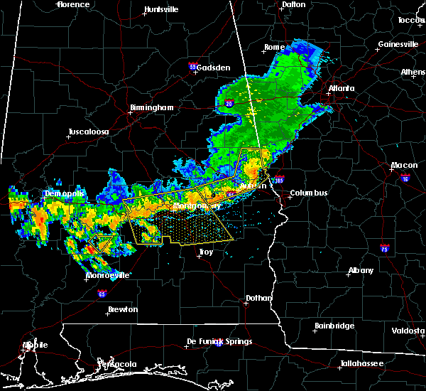 At 403 pm cdt, severe thunderstorms were located along a line extending from near white hall to near milstead, moving southeast at 35 mph (radar indicated). Hazards include 60 mph wind gusts. Expect damage to roofs, siding, and trees. Locations impacted include, montgomery, prattville, millbrook, union springs, fort deposit, mosses, hayneville, meadville, milstead, pike road, white hall, shorter, gordonville, lowndesboro, benton, hyundai motors of alabama, auburn university in montgomery, dublin, woodcrest and beans crossroads. At 403 pm cdt, severe thunderstorms were located along a line extending from near white hall to near milstead, moving southeast at 35 mph (radar indicated). Hazards include 60 mph wind gusts. Expect damage to roofs, siding, and trees. Locations impacted include, montgomery, prattville, millbrook, union springs, fort deposit, mosses, hayneville, meadville, milstead, pike road, white hall, shorter, gordonville, lowndesboro, benton, hyundai motors of alabama, auburn university in montgomery, dublin, woodcrest and beans crossroads.
|
| 7/12/2020 3:49 PM CDT |
 At 349 pm cdt, severe thunderstorms were located along a line extending from near benton to near milstead, moving southeast at 35 mph (radar indicated). Hazards include 60 mph wind gusts. expect damage to roofs, siding, and trees At 349 pm cdt, severe thunderstorms were located along a line extending from near benton to near milstead, moving southeast at 35 mph (radar indicated). Hazards include 60 mph wind gusts. expect damage to roofs, siding, and trees
|
| 4/19/2020 6:50 PM CDT |
 At 650 pm cdt, a severe thunderstorm was located over mosses, moving east at 45 mph (radar indicated). Hazards include 60 mph wind gusts. Expect damage to roofs, siding, and trees. Locations impacted include, mosses, hayneville, white hall, gordonville, lowndesboro, beechwood, manack and letohatchee. At 650 pm cdt, a severe thunderstorm was located over mosses, moving east at 45 mph (radar indicated). Hazards include 60 mph wind gusts. Expect damage to roofs, siding, and trees. Locations impacted include, mosses, hayneville, white hall, gordonville, lowndesboro, beechwood, manack and letohatchee.
|
| 4/19/2020 6:35 PM CDT |
 At 635 pm cdt, severe thunderstorms were located along a line extending from benton to 10 miles southwest of gordonville, moving east at 45 mph (radar indicated). Hazards include 60 mph wind gusts. expect damage to roofs, siding, and trees At 635 pm cdt, severe thunderstorms were located along a line extending from benton to 10 miles southwest of gordonville, moving east at 45 mph (radar indicated). Hazards include 60 mph wind gusts. expect damage to roofs, siding, and trees
|
| 4/12/2020 10:52 PM CDT |
 At 1051 pm cdt, severe thunderstorms were located along a line extending from near autauga county airport to near lowndes county airport, moving east at 45 mph (radar indicated). Hazards include 60 mph wind gusts. winds over 50 mph have been measured with these storms. Expect damage to roofs, siding, and trees. Locations impacted include, montgomery, fort deposit, mosses, hayneville, meadville, pike road, white hall, gordonville, lowndesboro, hyundai motors of alabama, auburn university in montgomery, dublin, woodcrest, snowdoun, sellers, ramer, waugh, hunter, alabama state university and logan. At 1051 pm cdt, severe thunderstorms were located along a line extending from near autauga county airport to near lowndes county airport, moving east at 45 mph (radar indicated). Hazards include 60 mph wind gusts. winds over 50 mph have been measured with these storms. Expect damage to roofs, siding, and trees. Locations impacted include, montgomery, fort deposit, mosses, hayneville, meadville, pike road, white hall, gordonville, lowndesboro, hyundai motors of alabama, auburn university in montgomery, dublin, woodcrest, snowdoun, sellers, ramer, waugh, hunter, alabama state university and logan.
|
| 4/12/2020 10:37 PM CDT |
 At 1037 pm cdt, severe thunderstorms were located along a line extending from near autaugaville to 8 miles southwest of gordonville, moving east at 55 mph (radar indicated). Hazards include 60 mph wind gusts. expect damage to roofs, siding, and trees At 1037 pm cdt, severe thunderstorms were located along a line extending from near autaugaville to 8 miles southwest of gordonville, moving east at 55 mph (radar indicated). Hazards include 60 mph wind gusts. expect damage to roofs, siding, and trees
|
| 3/4/2020 5:32 AM CST |
 At 531 am cst, a severe thunderstorm was located near gordonville, or 7 miles southwest of mosses, moving east at 50 mph (radar indicated). Hazards include 60 mph wind gusts and quarter size hail. Hail damage to vehicles is expected. Expect wind damage to roofs, siding, and trees. At 531 am cst, a severe thunderstorm was located near gordonville, or 7 miles southwest of mosses, moving east at 50 mph (radar indicated). Hazards include 60 mph wind gusts and quarter size hail. Hail damage to vehicles is expected. Expect wind damage to roofs, siding, and trees.
|
| 1/11/2020 2:16 PM CST |
 At 216 pm cst, severe thunderstorms were located along a line extending from near bentleyville to lowndes county airport, moving east at 50 mph (radar indicated). Hazards include 60 mph wind gusts. Expect damage to roofs, siding, and trees. Locations impacted include, prattville, fort deposit, mosses, hayneville, autaugaville, gordonville, lowndesboro, booth, marbury, lowndes county airport, beechwood, autauga county airport, logan, davenport, calhoun, manack, letohatchee, new prospect, mount willing and clover hill. At 216 pm cst, severe thunderstorms were located along a line extending from near bentleyville to lowndes county airport, moving east at 50 mph (radar indicated). Hazards include 60 mph wind gusts. Expect damage to roofs, siding, and trees. Locations impacted include, prattville, fort deposit, mosses, hayneville, autaugaville, gordonville, lowndesboro, booth, marbury, lowndes county airport, beechwood, autauga county airport, logan, davenport, calhoun, manack, letohatchee, new prospect, mount willing and clover hill.
|
| 1/11/2020 2:03 PM CST |
 At 203 pm cst, severe thunderstorms were located along a line extending from near strickland crossroads to 10 miles northwest of greenville, moving northeast at 55 mph (radar indicated). Hazards include 60 mph wind gusts. Expect damage to roofs, siding, and trees. Locations impacted include, prattville, millbrook, clanton, fort deposit, mosses, hayneville, deatsville, autaugaville, white hall, gordonville, billingsley, lowndesboro, booth, vida junction, beechwood, autauga county airport, davenport, verbena, marbury and lowndes county airport. At 203 pm cst, severe thunderstorms were located along a line extending from near strickland crossroads to 10 miles northwest of greenville, moving northeast at 55 mph (radar indicated). Hazards include 60 mph wind gusts. Expect damage to roofs, siding, and trees. Locations impacted include, prattville, millbrook, clanton, fort deposit, mosses, hayneville, deatsville, autaugaville, white hall, gordonville, billingsley, lowndesboro, booth, vida junction, beechwood, autauga county airport, davenport, verbena, marbury and lowndes county airport.
|
| 1/11/2020 1:55 PM CST |
 At 155 pm cst, severe thunderstorms were located along a line extending from lay lake dam to 6 miles east of pine apple, moving northeast at 50 mph (radar indicated). Hazards include 60 mph wind gusts. Expect damage to roofs, siding, and trees. Locations impacted include, prattville, millbrook, clanton, fort deposit, mosses, hayneville, deatsville, autaugaville, white hall, gordonville, billingsley, lowndesboro, benton, booth, vida junction, beechwood, autauga county airport, davenport, verbena and mulberry. At 155 pm cst, severe thunderstorms were located along a line extending from lay lake dam to 6 miles east of pine apple, moving northeast at 50 mph (radar indicated). Hazards include 60 mph wind gusts. Expect damage to roofs, siding, and trees. Locations impacted include, prattville, millbrook, clanton, fort deposit, mosses, hayneville, deatsville, autaugaville, white hall, gordonville, billingsley, lowndesboro, benton, booth, vida junction, beechwood, autauga county airport, davenport, verbena and mulberry.
|
| 1/11/2020 1:41 PM CST |
 At 141 pm cst, severe thunderstorms were located along a line extending from near gap of the mountain to near pine apple, moving northeast at 55 mph (radar indicated). Hazards include 60 mph wind gusts. Expect damage to roofs, siding, and trees. Locations impacted include, prattville, millbrook, clanton, fort deposit, mosses, hayneville, deatsville, autaugaville, white hall, gordonville, billingsley, lowndesboro, benton, booth, vida junction, beechwood, autauga county airport, davenport, verbena and mulberry. At 141 pm cst, severe thunderstorms were located along a line extending from near gap of the mountain to near pine apple, moving northeast at 55 mph (radar indicated). Hazards include 60 mph wind gusts. Expect damage to roofs, siding, and trees. Locations impacted include, prattville, millbrook, clanton, fort deposit, mosses, hayneville, deatsville, autaugaville, white hall, gordonville, billingsley, lowndesboro, benton, booth, vida junction, beechwood, autauga county airport, davenport, verbena and mulberry.
|
| 1/11/2020 1:27 PM CST |
 At 126 pm cst, severe thunderstorms were located along a line extending from chilton county motor sports park to beatrice, moving northeast at 55 mph (radar indicated). Hazards include 60 mph wind gusts. expect damage to roofs, siding, and trees At 126 pm cst, severe thunderstorms were located along a line extending from chilton county motor sports park to beatrice, moving northeast at 55 mph (radar indicated). Hazards include 60 mph wind gusts. expect damage to roofs, siding, and trees
|
| 8/4/2019 3:21 PM CDT |
 At 321 pm cdt, a severe thunderstorm was located near gordonville, or near mosses, and is nearly stationary (radar indicated). Hazards include 60 mph wind gusts and quarter size hail. Hail damage to vehicles is expected. expect wind damage to roofs, siding, and trees. Locations impacted include, mosses, hayneville, white hall, gordonville, lowndesboro, beechwood, mount willing and collirene. At 321 pm cdt, a severe thunderstorm was located near gordonville, or near mosses, and is nearly stationary (radar indicated). Hazards include 60 mph wind gusts and quarter size hail. Hail damage to vehicles is expected. expect wind damage to roofs, siding, and trees. Locations impacted include, mosses, hayneville, white hall, gordonville, lowndesboro, beechwood, mount willing and collirene.
|
| 8/4/2019 3:06 PM CDT |
 At 306 pm cdt, a severe thunderstorm was located near gordonville, or 7 miles northwest of mosses, and is nearly stationary (radar indicated). Hazards include 60 mph wind gusts and quarter size hail. Hail damage to vehicles is expected. Expect wind damage to roofs, siding, and trees. At 306 pm cdt, a severe thunderstorm was located near gordonville, or 7 miles northwest of mosses, and is nearly stationary (radar indicated). Hazards include 60 mph wind gusts and quarter size hail. Hail damage to vehicles is expected. Expect wind damage to roofs, siding, and trees.
|
| 5/9/2019 3:22 PM CDT |
 The severe thunderstorm warning for central lowndes county will expire at 330 pm cdt. the storm which prompted the warning has weakened below severe limits, and no longer poses an immediate threat to life or property. therefore, the warning will be allowed to expire. To report severe weather, contact your nearest law enforcement. The severe thunderstorm warning for central lowndes county will expire at 330 pm cdt. the storm which prompted the warning has weakened below severe limits, and no longer poses an immediate threat to life or property. therefore, the warning will be allowed to expire. To report severe weather, contact your nearest law enforcement.
|
| 5/9/2019 3:13 PM CDT |
 At 301 pm cdt, a severe thunderstorm was located near white hall, or near mosses, moving east at 25 mph (radar indicated). Hazards include 60 mph wind gusts. Expect damage to roofs, siding, and trees. Locations impacted include, mosses, hayneville, white hall, gordonville, lowndesboro, benton and manack. At 301 pm cdt, a severe thunderstorm was located near white hall, or near mosses, moving east at 25 mph (radar indicated). Hazards include 60 mph wind gusts. Expect damage to roofs, siding, and trees. Locations impacted include, mosses, hayneville, white hall, gordonville, lowndesboro, benton and manack.
|
| 5/9/2019 3:01 PM CDT |
 A severe thunderstorm warning remains in effect until 330 pm cdt for northern lowndes county. at 301 pm cdt, a severe thunderstorm was located near white hall, or near mosses, moving east at 25 mph. hazard. 60 mph wind gusts. source. Radar indicated. A severe thunderstorm warning remains in effect until 330 pm cdt for northern lowndes county. at 301 pm cdt, a severe thunderstorm was located near white hall, or near mosses, moving east at 25 mph. hazard. 60 mph wind gusts. source. Radar indicated.
|
| 5/9/2019 2:50 PM CDT |
 The national weather service in birmingham has issued a * severe thunderstorm warning for. northern lowndes county in south central alabama. until 330 pm cdt. At 250 pm cdt, a severe thunderstorm was located over white hall, or near mosses, moving northeast at 30 mph. The national weather service in birmingham has issued a * severe thunderstorm warning for. northern lowndes county in south central alabama. until 330 pm cdt. At 250 pm cdt, a severe thunderstorm was located over white hall, or near mosses, moving northeast at 30 mph.
|
| 4/18/2019 9:06 PM CDT |
 At 905 pm cdt, severe thunderstorms were located along a line extending from near white hall to near hayneville to logan, moving northeast at 60 mph (radar indicated). Hazards include 60 mph wind gusts and penny size hail. Expect damage to roofs, siding, and trees. locations impacted include, montgomery, fort deposit, mosses, hayneville, pike road, white hall, gordonville, lowndesboro, benton, montgomery zoo, boylston, hyundai motors of alabama, beechwood, auburn university in montgomery, woodcrest, maxwell air force base, snowdoun, sellers, davenport and waugh. A tornado watch remains in effect until 1100 pm cdt for central, south central and east central alabama. At 905 pm cdt, severe thunderstorms were located along a line extending from near white hall to near hayneville to logan, moving northeast at 60 mph (radar indicated). Hazards include 60 mph wind gusts and penny size hail. Expect damage to roofs, siding, and trees. locations impacted include, montgomery, fort deposit, mosses, hayneville, pike road, white hall, gordonville, lowndesboro, benton, montgomery zoo, boylston, hyundai motors of alabama, beechwood, auburn university in montgomery, woodcrest, maxwell air force base, snowdoun, sellers, davenport and waugh. A tornado watch remains in effect until 1100 pm cdt for central, south central and east central alabama.
|
| 4/18/2019 8:43 PM CDT |
 At 843 pm cdt, severe thunderstorms were located along a line extending from 11 miles north of pine apple to 12 miles west of lowndes county airport to 8 miles north of georgiana, moving northeast at 70 mph (radar indicated). Hazards include 60 mph wind gusts and penny size hail. expect damage to roofs, siding, and trees At 843 pm cdt, severe thunderstorms were located along a line extending from 11 miles north of pine apple to 12 miles west of lowndes county airport to 8 miles north of georgiana, moving northeast at 70 mph (radar indicated). Hazards include 60 mph wind gusts and penny size hail. expect damage to roofs, siding, and trees
|
| 4/14/2019 5:02 AM CDT |
 At 502 am cdt, severe thunderstorms were located along a line extending from near lowndesboro to lowndes county airport, moving northeast at 35 mph (radar indicated). Hazards include 60 mph wind gusts. Expect damage to roofs, siding, and trees. locations impacted include, fort deposit, mosses, hayneville, white hall, gordonville, lowndesboro, lowndes county airport, logan, beechwood, calhoun, manack and letohatchee. A tornado watch remains in effect until 900 am cdt for central and south central alabama. At 502 am cdt, severe thunderstorms were located along a line extending from near lowndesboro to lowndes county airport, moving northeast at 35 mph (radar indicated). Hazards include 60 mph wind gusts. Expect damage to roofs, siding, and trees. locations impacted include, fort deposit, mosses, hayneville, white hall, gordonville, lowndesboro, lowndes county airport, logan, beechwood, calhoun, manack and letohatchee. A tornado watch remains in effect until 900 am cdt for central and south central alabama.
|
| 4/14/2019 4:47 AM CDT |
 At 447 am cdt, severe thunderstorms were located along a line extending from near gordonville to 9 miles west of lowndes county airport, moving northeast at 40 mph (radar indicated). Hazards include 60 mph wind gusts. expect damage to roofs, siding, and trees At 447 am cdt, severe thunderstorms were located along a line extending from near gordonville to 9 miles west of lowndes county airport, moving northeast at 40 mph (radar indicated). Hazards include 60 mph wind gusts. expect damage to roofs, siding, and trees
|
| 3/3/2019 1:50 PM CST |
 At 150 pm cst, severe thunderstorms were located along a line extending from blue ridge to 8 miles north of pine apple, moving east at 45 mph (radar indicated). Hazards include 60 mph wind gusts and nickel size hail. Expect damage to roofs, siding, and trees. locations impacted include, montgomery, fort deposit, mosses, hayneville, meadville, pike road, gordonville, pine level, hyundai motors of alabama, beechwood, auburn university in montgomery, dublin, woodcrest, snowdoun, grady, sellers, davenport, ramer, waugh and lagoon park. A tornado watch remains in effect until 600 pm cst for south central, southeastern and east central alabama. At 150 pm cst, severe thunderstorms were located along a line extending from blue ridge to 8 miles north of pine apple, moving east at 45 mph (radar indicated). Hazards include 60 mph wind gusts and nickel size hail. Expect damage to roofs, siding, and trees. locations impacted include, montgomery, fort deposit, mosses, hayneville, meadville, pike road, gordonville, pine level, hyundai motors of alabama, beechwood, auburn university in montgomery, dublin, woodcrest, snowdoun, grady, sellers, davenport, ramer, waugh and lagoon park. A tornado watch remains in effect until 600 pm cst for south central, southeastern and east central alabama.
|
| 3/3/2019 1:40 PM CST |
 At 140 pm cst, severe thunderstorms were located along a line extending from boylston to 11 miles north of pine apple, moving east at 50 mph (radar indicated). Hazards include 60 mph wind gusts and nickel size hail. expect damage to roofs, siding, and trees At 140 pm cst, severe thunderstorms were located along a line extending from boylston to 11 miles north of pine apple, moving east at 50 mph (radar indicated). Hazards include 60 mph wind gusts and nickel size hail. expect damage to roofs, siding, and trees
|
| 7/22/2018 12:45 PM CDT |
 At 1245 pm cdt, a severe thunderstorm was located over mosses, moving east at 40 mph (radar indicated). Hazards include 60 mph wind gusts and quarter size hail. Hail damage to vehicles is expected. Expect wind damage to roofs, siding, and trees. At 1245 pm cdt, a severe thunderstorm was located over mosses, moving east at 40 mph (radar indicated). Hazards include 60 mph wind gusts and quarter size hail. Hail damage to vehicles is expected. Expect wind damage to roofs, siding, and trees.
|
| 6/28/2018 4:56 PM CDT |
 At 456 pm cdt, severe thunderstorms were located along a line extending from near newbern to near dublin, moving south at 40 mph (radar indicated). Hazards include 60 mph wind gusts. expect damage to roofs, siding, and trees At 456 pm cdt, severe thunderstorms were located along a line extending from near newbern to near dublin, moving south at 40 mph (radar indicated). Hazards include 60 mph wind gusts. expect damage to roofs, siding, and trees
|
| 6/28/2018 4:48 PM CDT |
 At 447 pm cdt, severe thunderstorms were located along a line extending from near moundville to burnsville to near pintlala, moving south at 40 mph (radar indicated). Hazards include 60 mph wind gusts and penny size hail. Expect damage to roofs, siding, and trees. Locations impacted include, southwestern montgomery, selma, valley grande, marion, mosses, hayneville, selmont-west selmont, autaugaville, white hall, lowndesboro, benton, hyundai motors of alabama, gardner island, tyler, heiberger, davenport, pintlala, mulberry, paul m grist state park and hope hull. At 447 pm cdt, severe thunderstorms were located along a line extending from near moundville to burnsville to near pintlala, moving south at 40 mph (radar indicated). Hazards include 60 mph wind gusts and penny size hail. Expect damage to roofs, siding, and trees. Locations impacted include, southwestern montgomery, selma, valley grande, marion, mosses, hayneville, selmont-west selmont, autaugaville, white hall, lowndesboro, benton, hyundai motors of alabama, gardner island, tyler, heiberger, davenport, pintlala, mulberry, paul m grist state park and hope hull.
|
| 6/28/2018 4:27 PM CDT |
 At 427 pm cdt, severe thunderstorms were located along a line extending from tuscaloosa regional airport to near parnell to montgomery, moving south at 40 mph (radar indicated). Hazards include 60 mph wind gusts and penny size hail. expect damage to roofs, siding, and trees At 427 pm cdt, severe thunderstorms were located along a line extending from tuscaloosa regional airport to near parnell to montgomery, moving south at 40 mph (radar indicated). Hazards include 60 mph wind gusts and penny size hail. expect damage to roofs, siding, and trees
|
| 6/26/2018 4:03 PM CDT |
 The national weather service in birmingham has issued a * severe thunderstorm warning for. central lowndes county in south central alabama. until 445 pm cdt. At 403 pm cdt, a severe thunderstorm was located over gordonville, or over mosses, moving north at 10 mph. The national weather service in birmingham has issued a * severe thunderstorm warning for. central lowndes county in south central alabama. until 445 pm cdt. At 403 pm cdt, a severe thunderstorm was located over gordonville, or over mosses, moving north at 10 mph.
|
| 10/7/2017 6:59 PM CDT |
 At 659 pm cdt, a severe thunderstorm capable of producing a tornado was located over mosses, moving northwest at 20 mph (radar indicated rotation). Hazards include tornado. Flying debris will be dangerous to those caught without shelter. mobile homes will be damaged or destroyed. damage to roofs, windows, and vehicles will occur. Tree damage is likely. At 659 pm cdt, a severe thunderstorm capable of producing a tornado was located over mosses, moving northwest at 20 mph (radar indicated rotation). Hazards include tornado. Flying debris will be dangerous to those caught without shelter. mobile homes will be damaged or destroyed. damage to roofs, windows, and vehicles will occur. Tree damage is likely.
|
| 7/21/2017 5:55 PM CDT |
 At 554 pm cdt, a severe thunderstorm was located near hayneville, moving north at 25 mph (radar indicated). Hazards include 60 mph wind gusts and penny size hail. Expect damage to roofs, siding, and trees. Locations impacted include, fort deposit, mosses, hayneville, white hall, gordonville, lowndesboro, beechwood, calhoun and letohatchee. At 554 pm cdt, a severe thunderstorm was located near hayneville, moving north at 25 mph (radar indicated). Hazards include 60 mph wind gusts and penny size hail. Expect damage to roofs, siding, and trees. Locations impacted include, fort deposit, mosses, hayneville, white hall, gordonville, lowndesboro, beechwood, calhoun and letohatchee.
|
| 7/21/2017 5:41 PM CDT |
 At 541 pm cdt, a severe thunderstorm was located near logan, or near fort deposit, moving north at 20 mph (radar indicated). Hazards include 60 mph wind gusts and nickel size hail. expect damage to roofs, siding, and trees At 541 pm cdt, a severe thunderstorm was located near logan, or near fort deposit, moving north at 20 mph (radar indicated). Hazards include 60 mph wind gusts and nickel size hail. expect damage to roofs, siding, and trees
|
| 4/5/2017 9:40 AM CDT |
 At 940 am cdt, a severe thunderstorm was located near gordonville, or 8 miles southwest of mosses, moving east at 55 mph (radar indicated). Hazards include 60 mph wind gusts and quarter size hail. Hail damage to vehicles is expected. expect wind damage to roofs, siding, and trees. locations impacted include, mosses, hayneville, white hall, gordonville, lowndesboro, beechwood, manack, mount willing, collirene, letohatchee, farmersville and fostoria. A tornado watch remains in effect until noon cdt for south central alabama. At 940 am cdt, a severe thunderstorm was located near gordonville, or 8 miles southwest of mosses, moving east at 55 mph (radar indicated). Hazards include 60 mph wind gusts and quarter size hail. Hail damage to vehicles is expected. expect wind damage to roofs, siding, and trees. locations impacted include, mosses, hayneville, white hall, gordonville, lowndesboro, beechwood, manack, mount willing, collirene, letohatchee, farmersville and fostoria. A tornado watch remains in effect until noon cdt for south central alabama.
|
| 4/5/2017 9:28 AM CDT |
 At 928 am cdt, a severe thunderstorm was located 8 miles south of belknap, or 15 miles northeast of camden, moving northeast at 45 mph (radar indicated). Hazards include 60 mph wind gusts and quarter size hail. Hail damage to vehicles is expected. expect wind damage to roofs, siding, and trees. locations impacted include, mosses, hayneville, white hall, gordonville, lowndesboro, benton, beechwood, belknap, manack, tilden, carlowville, letohatchee, minter, mount willing, collirene, farmersville and fostoria. A tornado watch remains in effect until noon cdt for south central alabama. At 928 am cdt, a severe thunderstorm was located 8 miles south of belknap, or 15 miles northeast of camden, moving northeast at 45 mph (radar indicated). Hazards include 60 mph wind gusts and quarter size hail. Hail damage to vehicles is expected. expect wind damage to roofs, siding, and trees. locations impacted include, mosses, hayneville, white hall, gordonville, lowndesboro, benton, beechwood, belknap, manack, tilden, carlowville, letohatchee, minter, mount willing, collirene, farmersville and fostoria. A tornado watch remains in effect until noon cdt for south central alabama.
|
| 4/5/2017 9:00 AM CDT |
 At 900 am cdt, a severe thunderstorm was located near camden, moving northeast at 45 mph (radar indicated). Hazards include ping pong ball size hail and 60 mph wind gusts. People and animals outdoors will be injured. expect hail damage to roofs, siding, windows, and vehicles. Expect wind damage to roofs, siding, and trees. At 900 am cdt, a severe thunderstorm was located near camden, moving northeast at 45 mph (radar indicated). Hazards include ping pong ball size hail and 60 mph wind gusts. People and animals outdoors will be injured. expect hail damage to roofs, siding, windows, and vehicles. Expect wind damage to roofs, siding, and trees.
|
| 1/22/2017 11:57 AM CST |
 At 1156 am cst, severe thunderstorms were located along a line extending from near parnell to mulberry to near tyler to 12 miles south of gordonville to 7 miles northwest of i65 and al 106, moving northeast at 60 mph (radar indicated). Hazards include 60 mph wind gusts and quarter size hail. Hail damage to vehicles is expected. Expect wind damage to roofs, siding, and trees. At 1156 am cst, severe thunderstorms were located along a line extending from near parnell to mulberry to near tyler to 12 miles south of gordonville to 7 miles northwest of i65 and al 106, moving northeast at 60 mph (radar indicated). Hazards include 60 mph wind gusts and quarter size hail. Hail damage to vehicles is expected. Expect wind damage to roofs, siding, and trees.
|
| 1/21/2017 11:02 PM CST |
 At 1101 pm cst, a severe thunderstorm was located over beechwood, or near hayneville, moving northeast at 60 mph (radar indicated). Hazards include quarter size hail. Damage to vehicles is expected. locations impacted include, mosses, hayneville, gordonville, beechwood, mount willing and letohatchee. A tornado watch remains in effect until 300 am cst for south central alabama. At 1101 pm cst, a severe thunderstorm was located over beechwood, or near hayneville, moving northeast at 60 mph (radar indicated). Hazards include quarter size hail. Damage to vehicles is expected. locations impacted include, mosses, hayneville, gordonville, beechwood, mount willing and letohatchee. A tornado watch remains in effect until 300 am cst for south central alabama.
|
| 1/21/2017 10:55 PM CST |
 At 1054 pm cst, a severe thunderstorm was located near beechwood, or 7 miles southwest of mosses, moving northeast at 60 mph (radar indicated). Hazards include ping pong ball size hail. People and animals outdoors will be injured. Expect damage to roofs, siding, windows, and vehicles. At 1054 pm cst, a severe thunderstorm was located near beechwood, or 7 miles southwest of mosses, moving northeast at 60 mph (radar indicated). Hazards include ping pong ball size hail. People and animals outdoors will be injured. Expect damage to roofs, siding, windows, and vehicles.
|
| 1/21/2017 4:35 AM CST |
 At 435 am cst, a severe thunderstorm was located near mosses, moving northeast at 40 mph (radar indicated). Hazards include golf ball size hail and 60 mph wind gusts. People and animals outdoors will be injured. expect hail damage to roofs, siding, windows, and vehicles. expect wind damage to roofs, siding, and trees. locations impacted include, mosses, hayneville, white hall, gordonville, lowndesboro, beechwood and manack. A tornado watch remains in effect until 1100 am cst for south central alabama. At 435 am cst, a severe thunderstorm was located near mosses, moving northeast at 40 mph (radar indicated). Hazards include golf ball size hail and 60 mph wind gusts. People and animals outdoors will be injured. expect hail damage to roofs, siding, windows, and vehicles. expect wind damage to roofs, siding, and trees. locations impacted include, mosses, hayneville, white hall, gordonville, lowndesboro, beechwood and manack. A tornado watch remains in effect until 1100 am cst for south central alabama.
|
| 1/21/2017 4:25 AM CST |
 At 425 am cst, a severe thunderstorm was located near gordonville, or 8 miles west of mosses, moving northeast at 40 mph (radar indicated). Hazards include golf ball size hail and 60 mph wind gusts. People and animals outdoors will be injured. expect hail damage to roofs, siding, windows, and vehicles. expect wind damage to roofs, siding, and trees. locations impacted include, mosses, hayneville, white hall, gordonville, lowndesboro, beechwood, manack, collirene, fostoria and farmersville. A tornado watch remains in effect until 1100 am cst for south central alabama. At 425 am cst, a severe thunderstorm was located near gordonville, or 8 miles west of mosses, moving northeast at 40 mph (radar indicated). Hazards include golf ball size hail and 60 mph wind gusts. People and animals outdoors will be injured. expect hail damage to roofs, siding, windows, and vehicles. expect wind damage to roofs, siding, and trees. locations impacted include, mosses, hayneville, white hall, gordonville, lowndesboro, beechwood, manack, collirene, fostoria and farmersville. A tornado watch remains in effect until 1100 am cst for south central alabama.
|
| 1/21/2017 4:19 AM CST |
 At 419 am cst, a severe thunderstorm was located 8 miles west of gordonville, or 12 miles west of mosses, moving northeast at 40 mph (radar indicated). Hazards include 60 mph wind gusts and quarter size hail. Hail damage to vehicles is expected. Expect wind damage to roofs, siding, and trees. At 419 am cst, a severe thunderstorm was located 8 miles west of gordonville, or 12 miles west of mosses, moving northeast at 40 mph (radar indicated). Hazards include 60 mph wind gusts and quarter size hail. Hail damage to vehicles is expected. Expect wind damage to roofs, siding, and trees.
|
| 7/6/2016 3:06 PM CDT |
 The severe thunderstorm warning for northern lowndes and southeastern autauga counties will expire at 315 pm cdt, the storm which prompted the warning has weakened below severe limits, and no longer pose an immediate threat to life or property. therefore the warning will be allowed to expire. however gusty winds are still possible with this thunderstorm. to report severe weather, contact your nearest law enforcement agency. they will relay your report to the national weather service birmingham. The severe thunderstorm warning for northern lowndes and southeastern autauga counties will expire at 315 pm cdt, the storm which prompted the warning has weakened below severe limits, and no longer pose an immediate threat to life or property. therefore the warning will be allowed to expire. however gusty winds are still possible with this thunderstorm. to report severe weather, contact your nearest law enforcement agency. they will relay your report to the national weather service birmingham.
|
| 7/6/2016 2:57 PM CDT |
 At 256 pm cdt, a severe thunderstorm was located near lowndesboro, or 9 miles north of mosses, moving northeast at 20 mph (radar indicated). Hazards include 60 mph wind gusts. Expect damage to roofs. siding. and trees. Locations impacted include, prattville, millbrook, mosses, autaugaville, white hall, gordonville, lowndesboro, autauga county airport and manack. At 256 pm cdt, a severe thunderstorm was located near lowndesboro, or 9 miles north of mosses, moving northeast at 20 mph (radar indicated). Hazards include 60 mph wind gusts. Expect damage to roofs. siding. and trees. Locations impacted include, prattville, millbrook, mosses, autaugaville, white hall, gordonville, lowndesboro, autauga county airport and manack.
|
| 7/6/2016 2:35 PM CDT |
 At 235 pm cdt, a severe thunderstorm was located near white hall, or near mosses, moving northeast at 20 mph (radar indicated). Hazards include 60 mph wind gusts and quarter size hail. Hail damage to vehicles is expected. Expect wind damage to roofs, siding, and trees. At 235 pm cdt, a severe thunderstorm was located near white hall, or near mosses, moving northeast at 20 mph (radar indicated). Hazards include 60 mph wind gusts and quarter size hail. Hail damage to vehicles is expected. Expect wind damage to roofs, siding, and trees.
|
| 6/17/2016 5:31 PM CDT |
 At 531 pm cdt, severe thunderstorms were located along a line extending from near mount meigs to near pintlala to 7 miles northeast of pine apple, moving southeast at 45 mph (radar indicated). Hazards include 60 mph wind gusts. Expect damage to roofs. siding. and trees. Locations impacted include, montgomery, fort deposit, mosses, hayneville, meadville, pike road, gordonville, boylston, waugh, alabama state university, woodcrest, ramer, snowdoun, lagoon park, lowndes county airport, dublin, sellers, montgomery riverwalk stadium, grady and montgomery zoo. At 531 pm cdt, severe thunderstorms were located along a line extending from near mount meigs to near pintlala to 7 miles northeast of pine apple, moving southeast at 45 mph (radar indicated). Hazards include 60 mph wind gusts. Expect damage to roofs. siding. and trees. Locations impacted include, montgomery, fort deposit, mosses, hayneville, meadville, pike road, gordonville, boylston, waugh, alabama state university, woodcrest, ramer, snowdoun, lagoon park, lowndes county airport, dublin, sellers, montgomery riverwalk stadium, grady and montgomery zoo.
|
| 6/17/2016 5:19 PM CDT |
 At 519 pm cdt, severe thunderstorms were located along a line extending from near blue ridge to near pintlala to 9 miles northeast of oak hill, moving southeast at 45 mph (radar indicated). Hazards include 60 mph wind gusts. Expect damage to roofs. siding. and trees. Locations impacted include, montgomery, fort deposit, mosses, hayneville, meadville, pike road, white hall, gordonville, lowndesboro, boylston, waugh, alabama state university, woodcrest, ramer, snowdoun, lagoon park, lowndes county airport, dublin, sellers and montgomery riverwalk stadium. At 519 pm cdt, severe thunderstorms were located along a line extending from near blue ridge to near pintlala to 9 miles northeast of oak hill, moving southeast at 45 mph (radar indicated). Hazards include 60 mph wind gusts. Expect damage to roofs. siding. and trees. Locations impacted include, montgomery, fort deposit, mosses, hayneville, meadville, pike road, white hall, gordonville, lowndesboro, boylston, waugh, alabama state university, woodcrest, ramer, snowdoun, lagoon park, lowndes county airport, dublin, sellers and montgomery riverwalk stadium.
|
| 6/17/2016 5:08 PM CDT |
 At 508 pm cdt, severe thunderstorms were located along a line extending from near wetumpka to near cantelous to 8 miles south of belknap, moving southeast at 45 mph (radar indicated). Hazards include 60 mph wind gusts. Expect damage to roofs. siding. and trees. Locations impacted include, montgomery, fort deposit, mosses, hayneville, meadville, pike road, white hall, gordonville, lowndesboro, benton, boylston, waugh, alabama state university, woodcrest, ramer, snowdoun, lagoon park, lowndes county airport, dublin and sellers. At 508 pm cdt, severe thunderstorms were located along a line extending from near wetumpka to near cantelous to 8 miles south of belknap, moving southeast at 45 mph (radar indicated). Hazards include 60 mph wind gusts. Expect damage to roofs. siding. and trees. Locations impacted include, montgomery, fort deposit, mosses, hayneville, meadville, pike road, white hall, gordonville, lowndesboro, benton, boylston, waugh, alabama state university, woodcrest, ramer, snowdoun, lagoon park, lowndes county airport, dublin and sellers.
|
| 6/17/2016 4:53 PM CDT |
 At 452 pm cdt, severe thunderstorms were located along a line extending from near deatsville to near autaugaville to near dannelly reservoir, moving southeast at 45 mph (radar indicated). Hazards include 60 mph wind gusts. Expect damage to roofs. siding. and trees. Locations impacted include, montgomery, fort deposit, mosses, hayneville, meadville, pike road, white hall, gordonville, lowndesboro, benton, boylston, waugh, alabama state university, woodcrest, ramer, snowdoun, lagoon park, lowndes county airport, dublin and sellers. At 452 pm cdt, severe thunderstorms were located along a line extending from near deatsville to near autaugaville to near dannelly reservoir, moving southeast at 45 mph (radar indicated). Hazards include 60 mph wind gusts. Expect damage to roofs. siding. and trees. Locations impacted include, montgomery, fort deposit, mosses, hayneville, meadville, pike road, white hall, gordonville, lowndesboro, benton, boylston, waugh, alabama state university, woodcrest, ramer, snowdoun, lagoon park, lowndes county airport, dublin and sellers.
|
| 6/17/2016 4:39 PM CDT |
 At 438 pm cdt, severe thunderstorms were located along a line extending from near marbury to near orrville, moving southeast at 40 mph (radar indicated). Hazards include 60 mph wind gusts. Expect damage to roofs. siding. And trees. At 438 pm cdt, severe thunderstorms were located along a line extending from near marbury to near orrville, moving southeast at 40 mph (radar indicated). Hazards include 60 mph wind gusts. Expect damage to roofs. siding. And trees.
|
| 4/6/2016 10:38 PM CDT |
 At 1037 pm cdt, a severe thunderstorm was located over gordonville, or near mosses, moving southeast at 40 mph (radar indicated). Hazards include 60 mph wind gusts and quarter size hail. Hail damage to vehicles is expected. expect wind damage to roofs, siding, and trees. Locations impacted include, fort deposit, mosses, hayneville, gordonville, logan, lowndes county airport, beechwood, calhoun, letohatchee, fostoria, collirene, mount willing, clover hill and farmersville. At 1037 pm cdt, a severe thunderstorm was located over gordonville, or near mosses, moving southeast at 40 mph (radar indicated). Hazards include 60 mph wind gusts and quarter size hail. Hail damage to vehicles is expected. expect wind damage to roofs, siding, and trees. Locations impacted include, fort deposit, mosses, hayneville, gordonville, logan, lowndes county airport, beechwood, calhoun, letohatchee, fostoria, collirene, mount willing, clover hill and farmersville.
|
| 4/6/2016 10:28 PM CDT |
 At 1028 pm cdt, a severe thunderstorm was located near gordonville, or 8 miles west of mosses, moving southeast at 40 mph (radar indicated). Hazards include 60 mph wind gusts and quarter size hail. Hail damage to vehicles is expected. expect wind damage to roofs, siding, and trees. Locations impacted include, fort deposit, mosses, hayneville, white hall, gordonville, benton, logan, lowndes county airport, beechwood, tyler, calhoun, letohatchee, fostoria, collirene, mount willing, clover hill and farmersville. At 1028 pm cdt, a severe thunderstorm was located near gordonville, or 8 miles west of mosses, moving southeast at 40 mph (radar indicated). Hazards include 60 mph wind gusts and quarter size hail. Hail damage to vehicles is expected. expect wind damage to roofs, siding, and trees. Locations impacted include, fort deposit, mosses, hayneville, white hall, gordonville, benton, logan, lowndes county airport, beechwood, tyler, calhoun, letohatchee, fostoria, collirene, mount willing, clover hill and farmersville.
|
| 4/6/2016 10:11 PM CDT |
 At 1011 pm cdt, a severe thunderstorm was located near dallas lake, or 8 miles south of selmont-west selmont, moving southeast at 40 mph (radar indicated). Hazards include 60 mph wind gusts and quarter size hail. Hail damage to vehicles is expected. Expect wind damage to roofs, siding, and trees. At 1011 pm cdt, a severe thunderstorm was located near dallas lake, or 8 miles south of selmont-west selmont, moving southeast at 40 mph (radar indicated). Hazards include 60 mph wind gusts and quarter size hail. Hail damage to vehicles is expected. Expect wind damage to roofs, siding, and trees.
|
| 3/1/2016 7:39 PM CST |
 At 739 pm cst, severe thunderstorms were located along a line extending from near white hall to near booth to near elmore, moving east at 50 mph (radar indicated). Hazards include 60 mph wind gusts and quarter size hail. Hail damage to vehicles is expected. expect wind damage to roofs, siding and trees. locations impacted include, prattville, millbrook, mosses, hayneville, deatsville, autaugaville, white hall, gordonville, billingsley, lowndesboro, benton, vida junction, autauga county airport, booth, mulberry, robert f. henry lock and dam, manack, collirene and dawson mill. This includes interstate 65 mile marker 158 and near mile marker 186. At 739 pm cst, severe thunderstorms were located along a line extending from near white hall to near booth to near elmore, moving east at 50 mph (radar indicated). Hazards include 60 mph wind gusts and quarter size hail. Hail damage to vehicles is expected. expect wind damage to roofs, siding and trees. locations impacted include, prattville, millbrook, mosses, hayneville, deatsville, autaugaville, white hall, gordonville, billingsley, lowndesboro, benton, vida junction, autauga county airport, booth, mulberry, robert f. henry lock and dam, manack, collirene and dawson mill. This includes interstate 65 mile marker 158 and near mile marker 186.
|
| 3/1/2016 7:19 PM CST |
 At 719 pm cst, severe thunderstorms were located along a line extending from near belknap to near gardner island to near booth, moving east at 50 mph (radar indicated). Hazards include 60 mph wind gusts and quarter size hail. Hail damage to vehicles is expected. expect wind damage to roofs, siding and trees. locations impacted include, prattville, selma, millbrook, mosses, hayneville, selmont-west selmont, deatsville, autaugaville, white hall, gordonville, billingsley, lowndesboro, benton, memorial stadium, burnsville, vida junction, dallas county horse arena, dallas lake, old cahaba park and autauga county airport. This includes interstate 65 mile marker 158 and near mile marker 186. At 719 pm cst, severe thunderstorms were located along a line extending from near belknap to near gardner island to near booth, moving east at 50 mph (radar indicated). Hazards include 60 mph wind gusts and quarter size hail. Hail damage to vehicles is expected. expect wind damage to roofs, siding and trees. locations impacted include, prattville, selma, millbrook, mosses, hayneville, selmont-west selmont, deatsville, autaugaville, white hall, gordonville, billingsley, lowndesboro, benton, memorial stadium, burnsville, vida junction, dallas county horse arena, dallas lake, old cahaba park and autauga county airport. This includes interstate 65 mile marker 158 and near mile marker 186.
|
| 3/1/2016 7:02 PM CST |
 At 701 pm cst, severe thunderstorms were located along a line extending from five points to near burnsville, moving east at 50 mph (radar indicated). Hazards include 60 mph wind gusts and quarter size hail. Hail damage to vehicles is expected. Expect wind damage to roofs, siding and trees. At 701 pm cst, severe thunderstorms were located along a line extending from five points to near burnsville, moving east at 50 mph (radar indicated). Hazards include 60 mph wind gusts and quarter size hail. Hail damage to vehicles is expected. Expect wind damage to roofs, siding and trees.
|
| 8/8/2015 6:10 PM CDT |
 At 610 pm cdt, a severe thunderstorm was located near gordonville, or 9 miles west of mosses, moving south at 15 mph (radar indicated). Hazards include 60 mph wind gusts and quarter size hail. Hail damage to vehicles is expected. expect wind damage to roofs, siding and trees. Locations impacted include, fort deposit, mosses, gordonville, beechwood, minter, collirene, mount willing, fostoria, clover hill and farmersville. At 610 pm cdt, a severe thunderstorm was located near gordonville, or 9 miles west of mosses, moving south at 15 mph (radar indicated). Hazards include 60 mph wind gusts and quarter size hail. Hail damage to vehicles is expected. expect wind damage to roofs, siding and trees. Locations impacted include, fort deposit, mosses, gordonville, beechwood, minter, collirene, mount willing, fostoria, clover hill and farmersville.
|
| 8/8/2015 5:50 PM CDT |
 The national weather service in birmingham has issued a * severe thunderstorm warning for. southeastern dallas county in south central alabama. southwestern lowndes county in south central alabama. until 645 pm cdt * at 550 pm cdt. a severe thunderstorm was located near benton. Or. The national weather service in birmingham has issued a * severe thunderstorm warning for. southeastern dallas county in south central alabama. southwestern lowndes county in south central alabama. until 645 pm cdt * at 550 pm cdt. a severe thunderstorm was located near benton. Or.
|
| 8/8/2015 5:39 PM CDT |
 At 538 pm cdt, a severe thunderstorm was located over benton, or 11 miles northwest of mosses, moving south at 15 mph (radar indicated). Hazards include 60 mph wind gusts and quarter size hail. Hail damage to vehicles is expected. expect wind damage to roofs, siding and trees. locations impacted include, mosses, white hall, benton, tyler and robert f. Henry lock and dam. At 538 pm cdt, a severe thunderstorm was located over benton, or 11 miles northwest of mosses, moving south at 15 mph (radar indicated). Hazards include 60 mph wind gusts and quarter size hail. Hail damage to vehicles is expected. expect wind damage to roofs, siding and trees. locations impacted include, mosses, white hall, benton, tyler and robert f. Henry lock and dam.
|
| 8/8/2015 5:28 PM CDT |
 At 528 pm cdt, a severe thunderstorm was located over benton, or 12 miles northwest of mosses, moving south at 20 mph (radar indicated). Hazards include 60 mph wind gusts and quarter size hail. Hail damage to vehicles is expected. expect wind damage to roofs, siding and trees. locations impacted include, mosses, autaugaville, white hall, benton, tyler and robert f. Henry lock and dam. At 528 pm cdt, a severe thunderstorm was located over benton, or 12 miles northwest of mosses, moving south at 20 mph (radar indicated). Hazards include 60 mph wind gusts and quarter size hail. Hail damage to vehicles is expected. expect wind damage to roofs, siding and trees. locations impacted include, mosses, autaugaville, white hall, benton, tyler and robert f. Henry lock and dam.
|
| 8/8/2015 5:14 PM CDT |
 At 514 pm cdt, a severe thunderstorm was located near gardner island, or 11 miles east of selmont-west selmont, moving south at 15 mph (radar indicated). Hazards include 60 mph wind gusts and quarter size hail. Hail damage to vehicles is expected. Expect wind damage to roofs, siding and trees. At 514 pm cdt, a severe thunderstorm was located near gardner island, or 11 miles east of selmont-west selmont, moving south at 15 mph (radar indicated). Hazards include 60 mph wind gusts and quarter size hail. Hail damage to vehicles is expected. Expect wind damage to roofs, siding and trees.
|
| 6/24/2015 10:05 PM CDT |
 At 1004 pm cdt, severe thunderstorms were located along a line extending from near gardner island to 10 miles southwest of gordonville, moving west at 35 mph (radar indicated). Hazards include 60 mph wind gusts. Expect damage to roofs. siding and trees. Locations impacted include, fort deposit, mosses, hayneville, gordonville, lowndes county airport, beechwood, calhoun, collirene, mount willing, fostoria, clover hill and farmersville. At 1004 pm cdt, severe thunderstorms were located along a line extending from near gardner island to 10 miles southwest of gordonville, moving west at 35 mph (radar indicated). Hazards include 60 mph wind gusts. Expect damage to roofs. siding and trees. Locations impacted include, fort deposit, mosses, hayneville, gordonville, lowndes county airport, beechwood, calhoun, collirene, mount willing, fostoria, clover hill and farmersville.
|
| 6/24/2015 9:42 PM CDT |
 At 940 pm cdt, severe thunderstorms were located along a line extending from near autaugaville to near fort deposit, moving west at 35 mph. Hazards include 60 mph wind gusts. Expect damage to roofs. siding and trees. locations impacted include, fort deposit, mosses, hayneville, autaugaville, white hall, gordonville, lowndesboro, benton, logan, lowndes county airport, beechwood, mulberry, calhoun, letohatchee, fostoria, robert f. Henry lock and dam, manack, collirene, mount willing and clover hill. At 940 pm cdt, severe thunderstorms were located along a line extending from near autaugaville to near fort deposit, moving west at 35 mph. Hazards include 60 mph wind gusts. Expect damage to roofs. siding and trees. locations impacted include, fort deposit, mosses, hayneville, autaugaville, white hall, gordonville, lowndesboro, benton, logan, lowndes county airport, beechwood, mulberry, calhoun, letohatchee, fostoria, robert f. Henry lock and dam, manack, collirene, mount willing and clover hill.
|
| 6/24/2015 9:36 PM CDT | Tree down along county 2. also a powerline down on highway 9 in lowndes county AL, 2.9 miles WNW of Mosses, AL |
| 6/24/2015 9:13 PM CDT |
 At 912 pm cdt, severe thunderstorms were located along a line extending from hunter to near davenport, moving west at 35 mph (radar indicated). Hazards include 60 mph wind gusts and quarter size hail. Hail damage to vehicles is expected. Expect wind damage to roofs, siding and trees. At 912 pm cdt, severe thunderstorms were located along a line extending from hunter to near davenport, moving west at 35 mph (radar indicated). Hazards include 60 mph wind gusts and quarter size hail. Hail damage to vehicles is expected. Expect wind damage to roofs, siding and trees.
|
Hail Maps for Mosses, AL
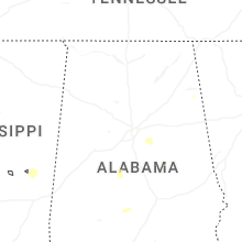
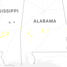
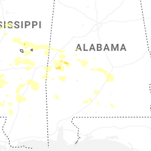


Connect with Interactive Hail Maps