

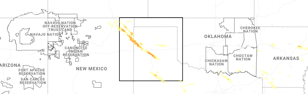
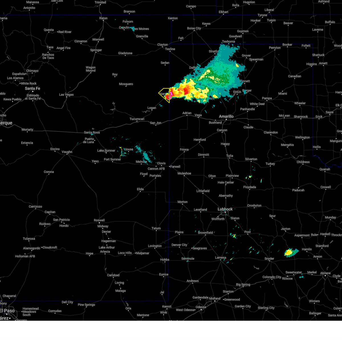
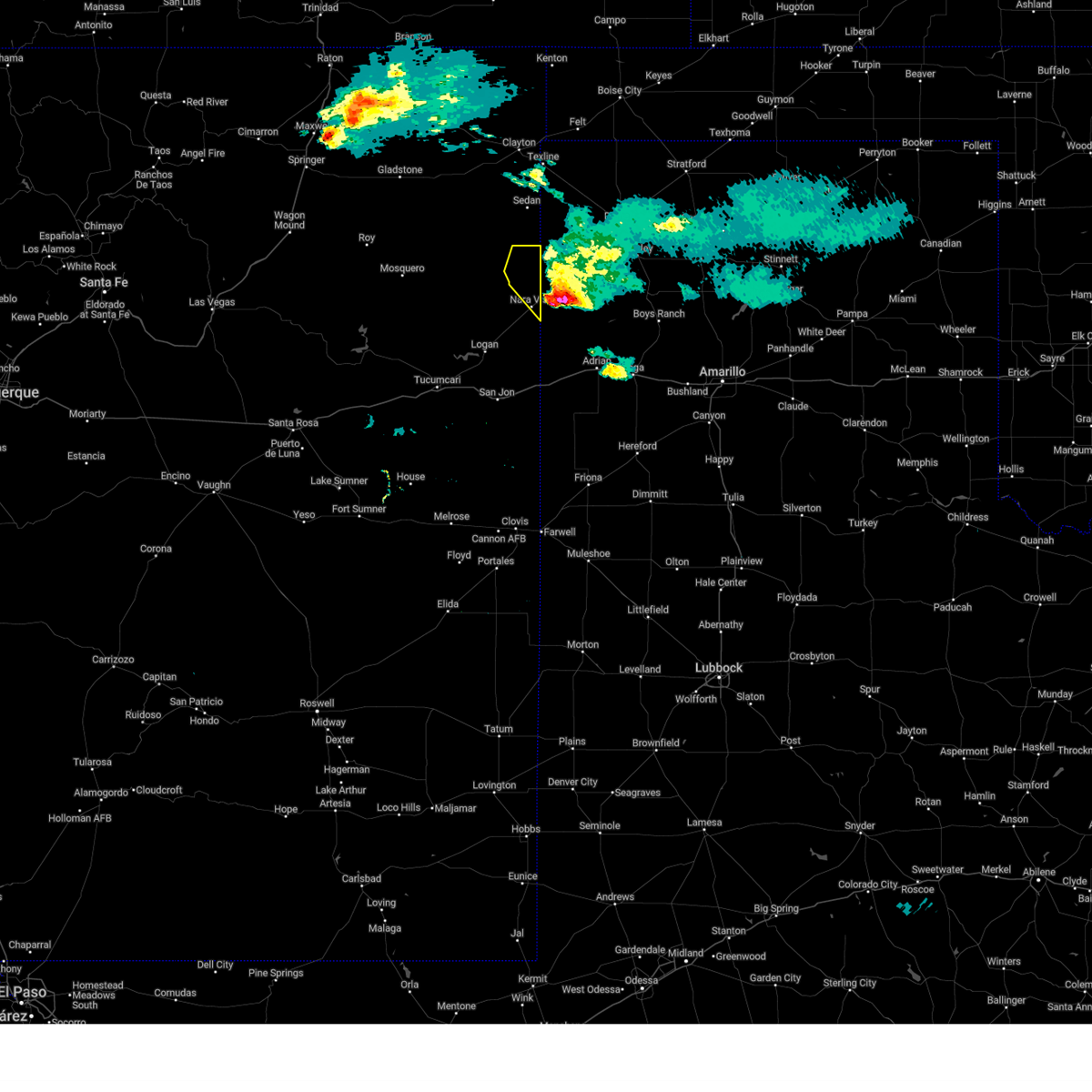
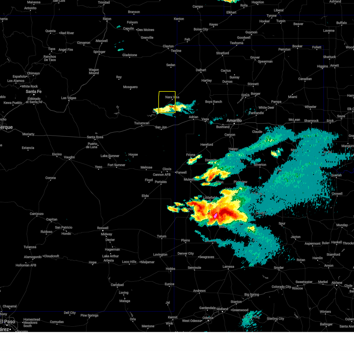
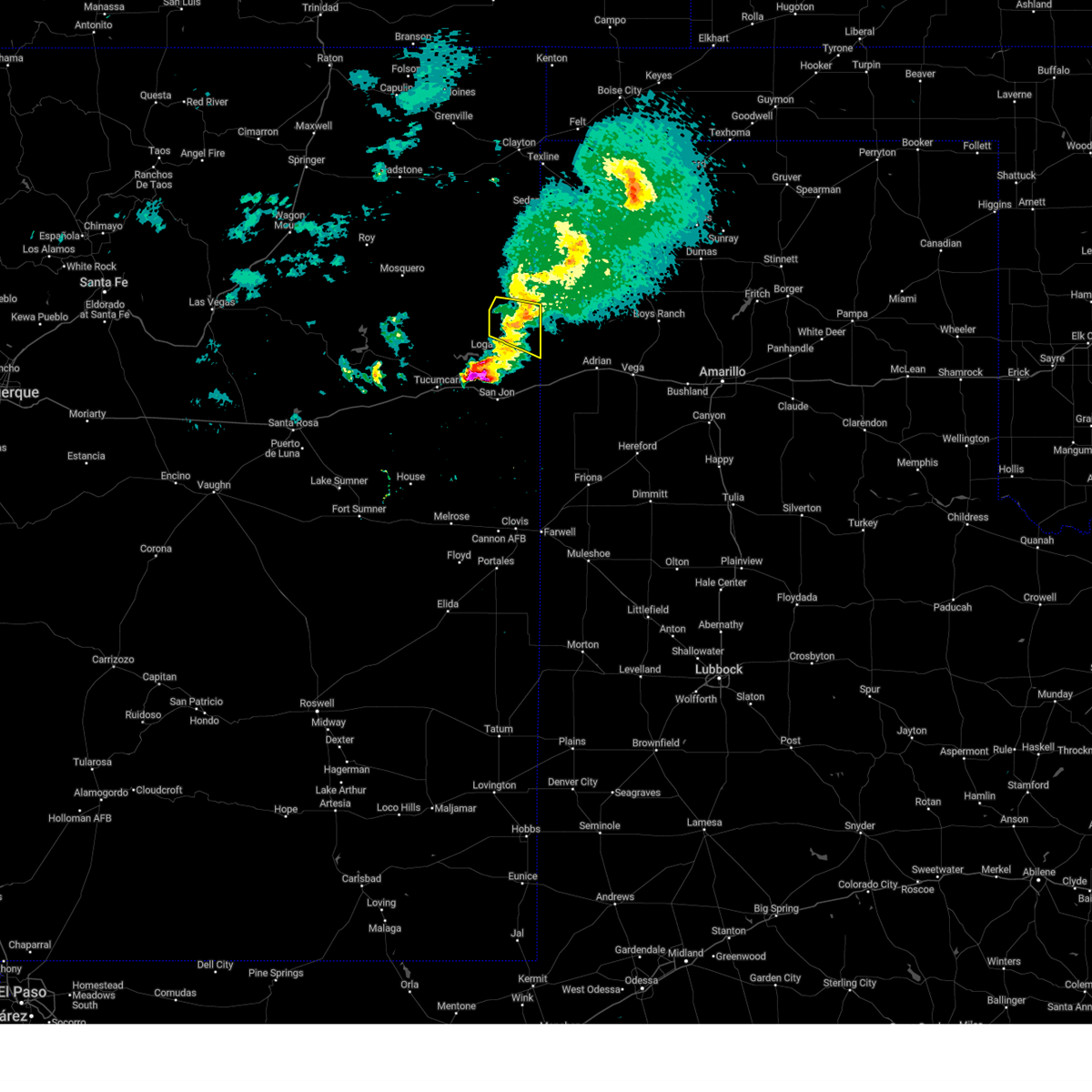
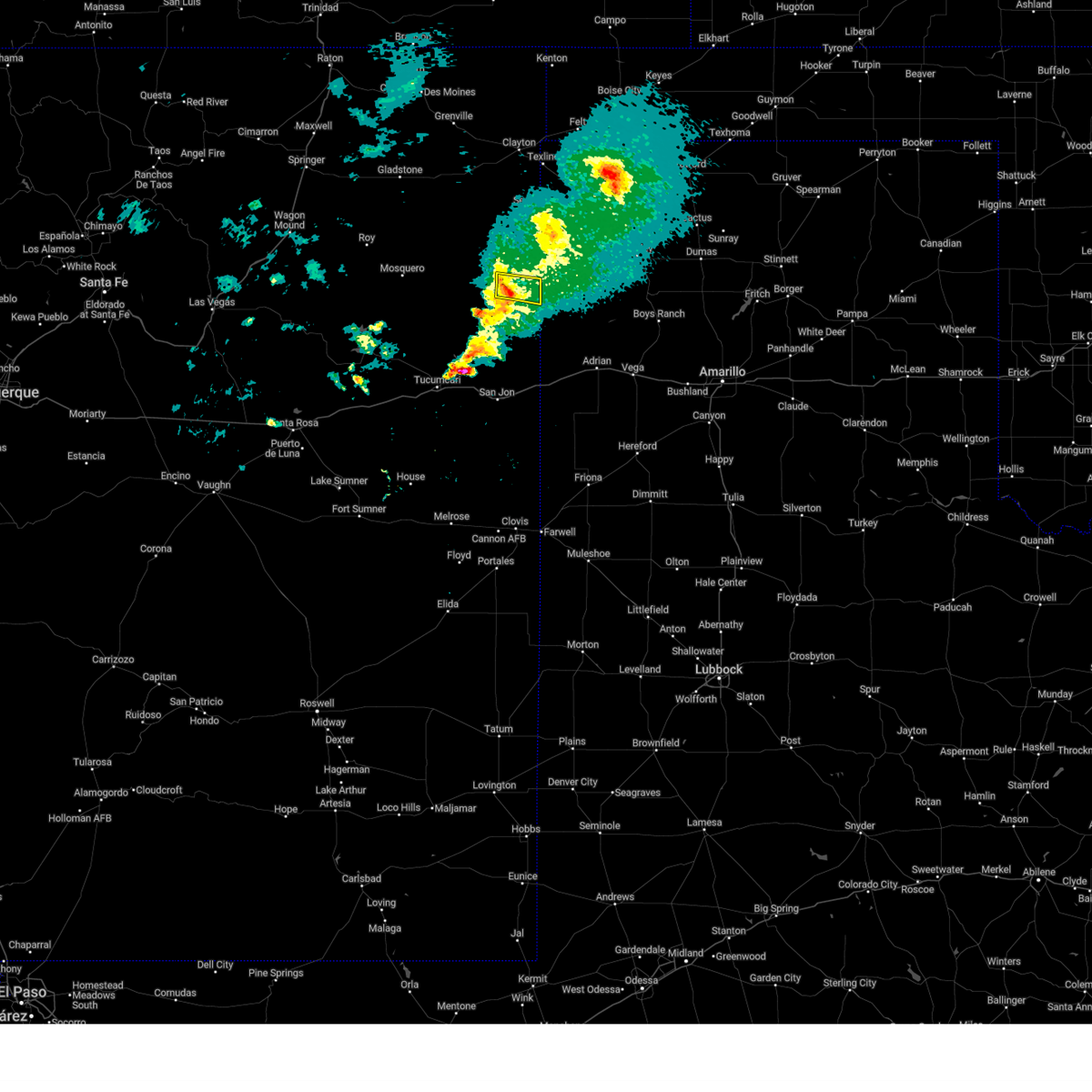
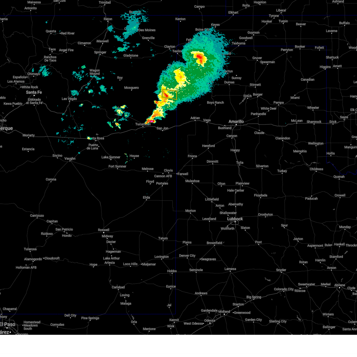
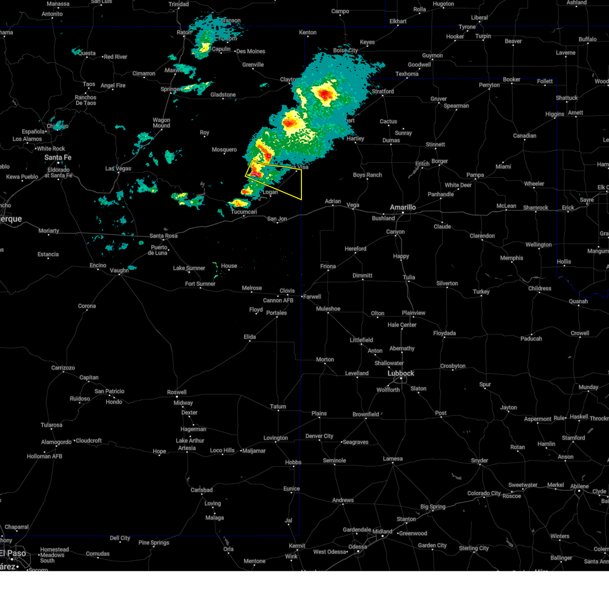
Hail Map for Nara Visa, NM
The Nara Visa, NM area has had 14 reports of on-the-ground hail by trained spotters, and has been under severe weather warnings 26 times during the past 12 months. Doppler radar has detected hail at or near Nara Visa, NM on 75 occasions, including 5 occasions during the past year.
| Name: | Nara Visa, NM |
| Where Located: | 46.3 miles NE of Tucumcari, NM |
| Map: | Google Map for Nara Visa, NM |
| Population: | 95 |
| Housing Units: | 60 |
| More Info: | Search Google for Nara Visa, NM |
1
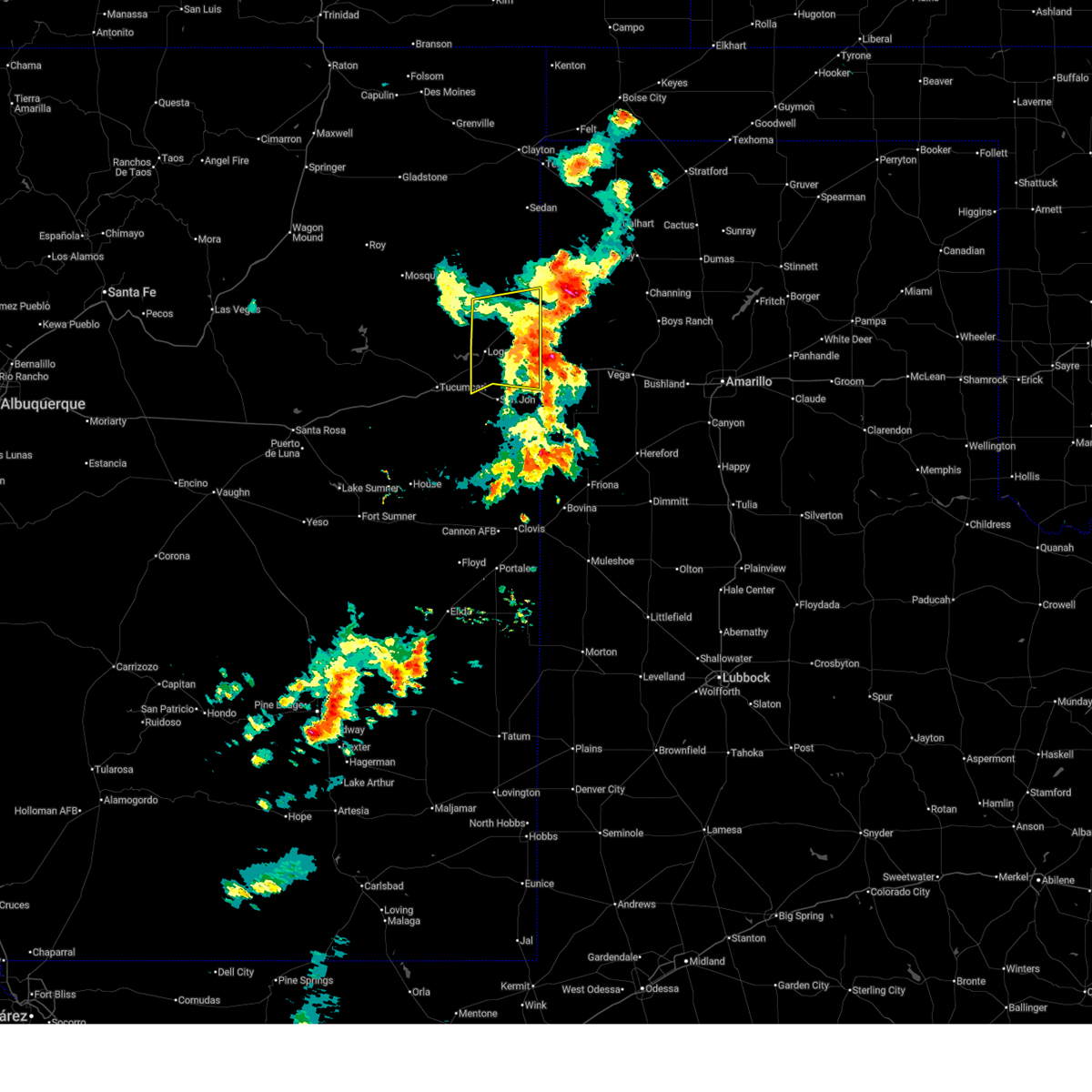
The Top Recent Hail Date for Nara Visa, NM is Saturday, June 7, 2025 (12th out of 75)
Hail and Wind Damage Spotted near Nara Visa, NM
| Date / Time | Report Details |
|---|---|
| 6/22/2025 6:13 PM MDT |
 The storms which prompted the warning have weakened below severe limits, and no longer pose an immediate threat to life or property. therefore, the warning will be allowed to expire. however, small hail, gusty winds, and heavy rain are still possible with these thunderstorms. The storms which prompted the warning have weakened below severe limits, and no longer pose an immediate threat to life or property. therefore, the warning will be allowed to expire. however, small hail, gusty winds, and heavy rain are still possible with these thunderstorms.
|
| 6/22/2025 5:55 PM MDT |
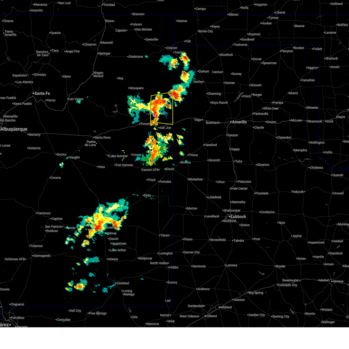
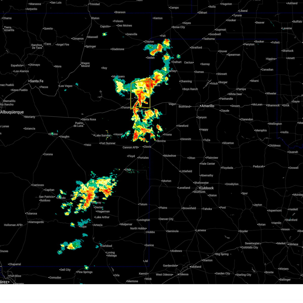 At 555 pm mdt, severe thunderstorms were located along a line from 12 miles west of nara visa to 8 miles north of san jon, moving east at 10 mph (radar indicated). Hazards include 60 mph wind gusts and quarter size hail. Hail damage to vehicles is expected. expect wind damage to roofs, siding, and trees. locations impacted include, nara visa, logan and ute lake state park. This includes interstate 40 between mile markers 346 and 348, and between mile markers 369 and 373. At 555 pm mdt, severe thunderstorms were located along a line from 12 miles west of nara visa to 8 miles north of san jon, moving east at 10 mph (radar indicated). Hazards include 60 mph wind gusts and quarter size hail. Hail damage to vehicles is expected. expect wind damage to roofs, siding, and trees. locations impacted include, nara visa, logan and ute lake state park. This includes interstate 40 between mile markers 346 and 348, and between mile markers 369 and 373.
|
| 6/22/2025 6:49 PM CDT | Peak downburst wind gust of 59 mp in oldham county TX, 8.4 miles WNW of Nara Visa, NM |
| 6/22/2025 5:36 PM MDT | Storm damage reported in quay county NM, 6.8 miles E of Nara Visa, NM |
| 6/22/2025 5:31 PM MDT |
 Svrabq the national weather service in albuquerque has issued a * severe thunderstorm warning for, northeastern quay county in east central new mexico, southeastern harding county in northeastern new mexico, * until 615 pm mdt. * at 531 pm mdt, severe thunderstorms were located along a line from 16 miles north of logan to 8 miles north of san jon, moving east at 10 mph (radar indicated). Hazards include 60 mph wind gusts and quarter size hail. Hail damage to vehicles is expected. Expect wind damage to roofs, siding, and trees. Svrabq the national weather service in albuquerque has issued a * severe thunderstorm warning for, northeastern quay county in east central new mexico, southeastern harding county in northeastern new mexico, * until 615 pm mdt. * at 531 pm mdt, severe thunderstorms were located along a line from 16 miles north of logan to 8 miles north of san jon, moving east at 10 mph (radar indicated). Hazards include 60 mph wind gusts and quarter size hail. Hail damage to vehicles is expected. Expect wind damage to roofs, siding, and trees.
|
| 6/8/2025 12:10 AM MDT |
 the severe thunderstorm warning has been cancelled and is no longer in effect the severe thunderstorm warning has been cancelled and is no longer in effect
|
| 6/8/2025 12:02 AM MDT |
 the severe thunderstorm warning has been cancelled and is no longer in effect the severe thunderstorm warning has been cancelled and is no longer in effect
|
| 6/8/2025 12:02 AM MDT |
 At 1202 am mdt, a severe thunderstorm was located near nara visa, moving southeast at 30 mph (radar indicated). Hazards include 60 mph wind gusts and half dollar size hail. Hail damage to vehicles is expected. expect wind damage to roofs, siding, and trees. Locations impacted include, nara visa. At 1202 am mdt, a severe thunderstorm was located near nara visa, moving southeast at 30 mph (radar indicated). Hazards include 60 mph wind gusts and half dollar size hail. Hail damage to vehicles is expected. expect wind damage to roofs, siding, and trees. Locations impacted include, nara visa.
|
| 6/7/2025 11:43 PM MDT |
 Svrabq the national weather service in albuquerque has issued a * severe thunderstorm warning for, northeastern quay county in east central new mexico, southeastern union county in northeastern new mexico, * until 1230 am mdt. * at 1143 pm mdt, a severe thunderstorm was located 12 miles south of amistad, or 11 miles northwest of nara visa, moving southeast at 30 mph (radar indicated). Hazards include ping pong ball size hail and 60 mph wind gusts. People and animals outdoors will be injured. expect hail damage to roofs, siding, windows, and vehicles. Expect wind damage to roofs, siding, and trees. Svrabq the national weather service in albuquerque has issued a * severe thunderstorm warning for, northeastern quay county in east central new mexico, southeastern union county in northeastern new mexico, * until 1230 am mdt. * at 1143 pm mdt, a severe thunderstorm was located 12 miles south of amistad, or 11 miles northwest of nara visa, moving southeast at 30 mph (radar indicated). Hazards include ping pong ball size hail and 60 mph wind gusts. People and animals outdoors will be injured. expect hail damage to roofs, siding, windows, and vehicles. Expect wind damage to roofs, siding, and trees.
|
| 6/7/2025 8:28 PM MDT |
 The storm which prompted the warning has moved out of the area. therefore, the warning will be allowed to expire. a severe thunderstorm watch remains in effect until 900 pm mdt for a portion of northeast new mexico. The storm which prompted the warning has moved out of the area. therefore, the warning will be allowed to expire. a severe thunderstorm watch remains in effect until 900 pm mdt for a portion of northeast new mexico.
|
| 6/7/2025 8:03 PM MDT |
 At 803 pm mdt, a severe thunderstorm was located 8 miles south of amistad, moving southeast at 30 mph (radar indicated). Hazards include 60 mph wind gusts and quarter size hail. Hail damage to vehicles is expected. expect wind damage to roofs, siding, and trees. Locations impacted include, amistad and nara visa. At 803 pm mdt, a severe thunderstorm was located 8 miles south of amistad, moving southeast at 30 mph (radar indicated). Hazards include 60 mph wind gusts and quarter size hail. Hail damage to vehicles is expected. expect wind damage to roofs, siding, and trees. Locations impacted include, amistad and nara visa.
|
| 6/7/2025 7:44 PM MDT |
 Svrabq the national weather service in albuquerque has issued a * severe thunderstorm warning for, northeastern quay county in east central new mexico, southeastern union county in northeastern new mexico, * until 830 pm mdt. * at 744 pm mdt, a severe thunderstorm was located 6 miles south of hayden, or 6 miles southwest of amistad, moving southeast at 35 mph (radar indicated). Hazards include ping pong ball size hail and 60 mph wind gusts. People and animals outdoors will be injured. expect hail damage to roofs, siding, windows, and vehicles. Expect wind damage to roofs, siding, and trees. Svrabq the national weather service in albuquerque has issued a * severe thunderstorm warning for, northeastern quay county in east central new mexico, southeastern union county in northeastern new mexico, * until 830 pm mdt. * at 744 pm mdt, a severe thunderstorm was located 6 miles south of hayden, or 6 miles southwest of amistad, moving southeast at 35 mph (radar indicated). Hazards include ping pong ball size hail and 60 mph wind gusts. People and animals outdoors will be injured. expect hail damage to roofs, siding, windows, and vehicles. Expect wind damage to roofs, siding, and trees.
|
| 6/5/2025 6:56 PM MDT |
 the severe thunderstorm warning has been cancelled and is no longer in effect the severe thunderstorm warning has been cancelled and is no longer in effect
|
| 6/5/2025 6:43 PM MDT |
 the severe thunderstorm warning has been cancelled and is no longer in effect the severe thunderstorm warning has been cancelled and is no longer in effect
|
| 6/5/2025 6:43 PM MDT |
 At 643 pm mdt, a severe thunderstorm was located 7 miles south of nara visa, moving northeast at 25 mph (radar indicated). Hazards include 60 mph wind gusts and small hail. Expect damage to roofs, siding, and trees. Locations impacted include, nara visa. At 643 pm mdt, a severe thunderstorm was located 7 miles south of nara visa, moving northeast at 25 mph (radar indicated). Hazards include 60 mph wind gusts and small hail. Expect damage to roofs, siding, and trees. Locations impacted include, nara visa.
|
| 6/5/2025 6:15 PM MDT |
 Svrabq the national weather service in albuquerque has issued a * severe thunderstorm warning for, northeastern quay county in east central new mexico, southeastern harding county in northeastern new mexico, * until 715 pm mdt. * at 615 pm mdt, severe thunderstorms were located along a line from 7 miles southwest of ute lake state park to 17 miles south of nara visa, moving north at 25 mph (radar indicated). Hazards include 60 mph wind gusts and half dollar size hail. Hail damage to vehicles is expected. Expect wind damage to roofs, siding, and trees. Svrabq the national weather service in albuquerque has issued a * severe thunderstorm warning for, northeastern quay county in east central new mexico, southeastern harding county in northeastern new mexico, * until 715 pm mdt. * at 615 pm mdt, severe thunderstorms were located along a line from 7 miles southwest of ute lake state park to 17 miles south of nara visa, moving north at 25 mph (radar indicated). Hazards include 60 mph wind gusts and half dollar size hail. Hail damage to vehicles is expected. Expect wind damage to roofs, siding, and trees.
|
| 5/1/2025 6:23 PM MDT |
 the severe thunderstorm warning has been cancelled and is no longer in effect the severe thunderstorm warning has been cancelled and is no longer in effect
|
| 5/1/2025 6:14 PM MDT |
 The storm which prompted the warning has weakened below severe limits, and has exited the warned area. therefore, the warning will be allowed to expire. however, small hail and gusty winds are still possible with this thunderstorm. a severe thunderstorm watch remains in effect until 1200 am mdt friday for a portion of east central new mexico. The storm which prompted the warning has weakened below severe limits, and has exited the warned area. therefore, the warning will be allowed to expire. however, small hail and gusty winds are still possible with this thunderstorm. a severe thunderstorm watch remains in effect until 1200 am mdt friday for a portion of east central new mexico.
|
| 5/1/2025 6:05 PM MDT | At 605 pm mdt, a severe thunderstorm was located 12 miles southwest of nara visa, moving east at 30 mph (radar indicated). Hazards include 60 mph wind gusts and small hail. Expect damage to roofs, siding, and trees. Locations impacted include, nara visa. |
| 5/1/2025 6:05 PM MDT | the severe thunderstorm warning has been cancelled and is no longer in effect |
| 5/1/2025 5:55 PM MDT |
 the severe thunderstorm warning has been cancelled and is no longer in effect the severe thunderstorm warning has been cancelled and is no longer in effect
|
| 5/1/2025 5:55 PM MDT |
 At 555 pm mdt, a severe thunderstorm was located 6 miles northwest of nara visa, moving east at 25 mph (radar indicated). Hazards include 60 mph wind gusts and small hail. Expect damage to roofs, siding, and trees. Locations impacted include, mainly rural areas of northeastern quay and southeastern union counties. At 555 pm mdt, a severe thunderstorm was located 6 miles northwest of nara visa, moving east at 25 mph (radar indicated). Hazards include 60 mph wind gusts and small hail. Expect damage to roofs, siding, and trees. Locations impacted include, mainly rural areas of northeastern quay and southeastern union counties.
|
| 5/1/2025 5:46 PM MDT | At 546 pm mdt, a severe thunderstorm was located 12 miles north of ute lake state park, or 19 miles west of nara visa, moving east at 15 mph (radar indicated). Hazards include 60 mph wind gusts and small hail. Expect damage to roofs, siding, and trees. Locations impacted include, nara visa. |
| 5/1/2025 5:42 PM MDT | Svrabq the national weather service in albuquerque has issued a * severe thunderstorm warning for, northeastern quay county in east central new mexico, east central harding county in northeastern new mexico, southeastern union county in northeastern new mexico, * until 630 pm mdt. * at 542 pm mdt, a severe thunderstorm was located 12 miles northwest of nara visa, moving east at 20 mph (radar indicated). Hazards include 60 mph wind gusts and small hail. expect damage to roofs, siding, and trees |
| 5/1/2025 5:28 PM MDT |
 Svrabq the national weather service in albuquerque has issued a * severe thunderstorm warning for, northeastern quay county in east central new mexico, southeastern harding county in northeastern new mexico, * until 615 pm mdt. * at 528 pm mdt, a severe thunderstorm was located 12 miles north of ute lake state park, or 21 miles west of nara visa, moving east at 40 mph (radar indicated). Hazards include 70 mph wind gusts and small hail. Expect considerable tree damage. Damage is likely to mobile homes, roofs, and outbuildings. Svrabq the national weather service in albuquerque has issued a * severe thunderstorm warning for, northeastern quay county in east central new mexico, southeastern harding county in northeastern new mexico, * until 615 pm mdt. * at 528 pm mdt, a severe thunderstorm was located 12 miles north of ute lake state park, or 21 miles west of nara visa, moving east at 40 mph (radar indicated). Hazards include 70 mph wind gusts and small hail. Expect considerable tree damage. Damage is likely to mobile homes, roofs, and outbuildings.
|
| 9/17/2024 6:27 PM CDT | Wind gusts of 58 mph or greater were measured for 5 minutes beginning at 627 p in oldham county TX, 8.4 miles WNW of Nara Visa, NM |
| 7/9/2024 9:13 PM CDT | Storm damage reported in oldham county TX, 5.5 miles WNW of Nara Visa, NM |
| 7/8/2024 3:37 AM MDT |
 the severe thunderstorm warning has been cancelled and is no longer in effect the severe thunderstorm warning has been cancelled and is no longer in effect
|
| 7/8/2024 3:21 AM MDT |
 At 321 am mdt, a severe thunderstorm was located 10 miles northeast of ute lake state park, or 18 miles west of nara visa, moving southeast at 20 mph (radar indicated). Hazards include 60 mph wind gusts and quarter size hail. Hail damage to vehicles is expected. expect wind damage to roofs, siding, and trees. Locations impacted include, logan. At 321 am mdt, a severe thunderstorm was located 10 miles northeast of ute lake state park, or 18 miles west of nara visa, moving southeast at 20 mph (radar indicated). Hazards include 60 mph wind gusts and quarter size hail. Hail damage to vehicles is expected. expect wind damage to roofs, siding, and trees. Locations impacted include, logan.
|
| 7/8/2024 3:01 AM MDT |
 Svrabq the national weather service in albuquerque has issued a * severe thunderstorm warning for, southeastern harding county in northeastern new mexico, northeastern quay county in east central new mexico, * until 400 am mdt. * at 301 am mdt, a severe thunderstorm was located 12 miles north of ute lake state park, or 22 miles west of nara visa, moving southeast at 20 mph (radar indicated). Hazards include 60 mph wind gusts and quarter size hail. Hail damage to vehicles is expected. Expect wind damage to roofs, siding, and trees. Svrabq the national weather service in albuquerque has issued a * severe thunderstorm warning for, southeastern harding county in northeastern new mexico, northeastern quay county in east central new mexico, * until 400 am mdt. * at 301 am mdt, a severe thunderstorm was located 12 miles north of ute lake state park, or 22 miles west of nara visa, moving southeast at 20 mph (radar indicated). Hazards include 60 mph wind gusts and quarter size hail. Hail damage to vehicles is expected. Expect wind damage to roofs, siding, and trees.
|
| 6/14/2024 5:28 PM MDT |
 The storms which prompted the warning have moved out of the area. therefore, the warning will be allowed to expire. a severe thunderstorm watch remains in effect until 900 pm mdt for northeastern new mexico. The storms which prompted the warning have moved out of the area. therefore, the warning will be allowed to expire. a severe thunderstorm watch remains in effect until 900 pm mdt for northeastern new mexico.
|
| 6/14/2024 5:12 PM MDT |
 At 512 pm mdt, severe thunderstorms were located along a line extending from seneca to 7 miles north of glenrio, moving northeast at 30 mph (radar indicated). Hazards include 60 mph wind gusts. Expect damage to roofs, siding, and trees. Locations impacted include, clayton, amistad, nara visa, glenrio, seneca, sedan, and bard. At 512 pm mdt, severe thunderstorms were located along a line extending from seneca to 7 miles north of glenrio, moving northeast at 30 mph (radar indicated). Hazards include 60 mph wind gusts. Expect damage to roofs, siding, and trees. Locations impacted include, clayton, amistad, nara visa, glenrio, seneca, sedan, and bard.
|
| 6/14/2024 4:42 PM MDT |
 Svrabq the national weather service in albuquerque has issued a * severe thunderstorm warning for, northeastern quay county in east central new mexico, southeastern union county in northeastern new mexico, * until 530 pm mdt. * at 441 pm mdt, severe thunderstorms were located along a line extending from near clayton to 8 miles east of san jon, moving northeast at 30 mph (radar indicated. at 350 pm mdt, trained storm spotters near amistad reported 60 to 70 mph wind gusts). Hazards include 60 mph wind gusts. expect damage to roofs, siding, and trees Svrabq the national weather service in albuquerque has issued a * severe thunderstorm warning for, northeastern quay county in east central new mexico, southeastern union county in northeastern new mexico, * until 530 pm mdt. * at 441 pm mdt, severe thunderstorms were located along a line extending from near clayton to 8 miles east of san jon, moving northeast at 30 mph (radar indicated. at 350 pm mdt, trained storm spotters near amistad reported 60 to 70 mph wind gusts). Hazards include 60 mph wind gusts. expect damage to roofs, siding, and trees
|
| 6/14/2024 4:05 PM MDT |
 the severe thunderstorm warning has been cancelled and is no longer in effect the severe thunderstorm warning has been cancelled and is no longer in effect
|
| 6/14/2024 4:05 PM MDT |
 At 404 pm mdt, severe thunderstorms were located along a line extending from 12 miles west of hayden to 13 miles southwest of nara visa, moving northeast at 30 mph (radar indicated). Hazards include 60 mph wind gusts and quarter size hail. Hail damage to vehicles is expected. expect wind damage to roofs, siding, and trees. Locations impacted include, amistad, nara visa, logan, hayden, ute lake state park, sedan, and rosebud. At 404 pm mdt, severe thunderstorms were located along a line extending from 12 miles west of hayden to 13 miles southwest of nara visa, moving northeast at 30 mph (radar indicated). Hazards include 60 mph wind gusts and quarter size hail. Hail damage to vehicles is expected. expect wind damage to roofs, siding, and trees. Locations impacted include, amistad, nara visa, logan, hayden, ute lake state park, sedan, and rosebud.
|
| 6/14/2024 3:50 PM MDT | Corrects previous non-tstm wnd gst report from amista in union county NM, 21.4 miles S of Nara Visa, NM |
| 6/14/2024 3:40 PM MDT |
 Svrabq the national weather service in albuquerque has issued a * severe thunderstorm warning for, northeastern san miguel county in northeastern new mexico, harding county in northeastern new mexico, northeastern quay county in east central new mexico, southern union county in northeastern new mexico, * until 445 pm mdt. * at 340 pm mdt, severe thunderstorms were located along a line extending from 8 miles southeast of chicosa lake state park to 11 miles southwest of nara visa, moving north at 30 mph (radar indicated). Hazards include 60 mph wind gusts and half dollar size hail. Hail damage to vehicles is expected. Expect wind damage to roofs, siding, and trees. Svrabq the national weather service in albuquerque has issued a * severe thunderstorm warning for, northeastern san miguel county in northeastern new mexico, harding county in northeastern new mexico, northeastern quay county in east central new mexico, southern union county in northeastern new mexico, * until 445 pm mdt. * at 340 pm mdt, severe thunderstorms were located along a line extending from 8 miles southeast of chicosa lake state park to 11 miles southwest of nara visa, moving north at 30 mph (radar indicated). Hazards include 60 mph wind gusts and half dollar size hail. Hail damage to vehicles is expected. Expect wind damage to roofs, siding, and trees.
|
| 6/14/2024 3:36 PM MDT |
 At 336 pm mdt, severe thunderstorms were located along a line extending from 8 miles southeast of chicosa lake state park to 11 miles southwest of nara visa, moving northeast at 40 mph (radar indicated). Hazards include 60 mph wind gusts and half dollar size hail. Hail damage to vehicles is expected. expect wind damage to roofs, siding, and trees. Locations impacted include, mosquero, amistad, nara visa, logan, bueyeros, hayden, solano, ute lake state park, sedan, and yates. At 336 pm mdt, severe thunderstorms were located along a line extending from 8 miles southeast of chicosa lake state park to 11 miles southwest of nara visa, moving northeast at 40 mph (radar indicated). Hazards include 60 mph wind gusts and half dollar size hail. Hail damage to vehicles is expected. expect wind damage to roofs, siding, and trees. Locations impacted include, mosquero, amistad, nara visa, logan, bueyeros, hayden, solano, ute lake state park, sedan, and yates.
|
| 6/14/2024 3:27 PM MDT |
 At 327 pm mdt, severe thunderstorms were located along a line extending from 7 miles west of hayden to 9 miles northwest of ute lake state park, moving northeast at 25 mph (radar indicated). Hazards include 60 mph wind gusts and quarter size hail. Hail damage to vehicles is expected. expect wind damage to roofs, siding, and trees. locations impacted include, mosquero, amistad, nara visa, logan, bueyeros, hayden, solano, conchas lake state park, conchas dam, and conchas. This includes state road 104 between mile markers 73 and 95. At 327 pm mdt, severe thunderstorms were located along a line extending from 7 miles west of hayden to 9 miles northwest of ute lake state park, moving northeast at 25 mph (radar indicated). Hazards include 60 mph wind gusts and quarter size hail. Hail damage to vehicles is expected. expect wind damage to roofs, siding, and trees. locations impacted include, mosquero, amistad, nara visa, logan, bueyeros, hayden, solano, conchas lake state park, conchas dam, and conchas. This includes state road 104 between mile markers 73 and 95.
|
| 6/14/2024 3:00 PM MDT |
 Svrabq the national weather service in albuquerque has issued a * severe thunderstorm warning for, northeastern san miguel county in northeastern new mexico, harding county in northeastern new mexico, northeastern quay county in east central new mexico, southern union county in northeastern new mexico, * until 345 pm mdt. * at 300 pm mdt, severe thunderstorms were located along a line extending from 6 miles north of bueyeros to 13 miles north of tucumcari, moving north at 30 mph (radar indicated). Hazards include 60 mph wind gusts and penny size hail. expect damage to roofs, siding, and trees Svrabq the national weather service in albuquerque has issued a * severe thunderstorm warning for, northeastern san miguel county in northeastern new mexico, harding county in northeastern new mexico, northeastern quay county in east central new mexico, southern union county in northeastern new mexico, * until 345 pm mdt. * at 300 pm mdt, severe thunderstorms were located along a line extending from 6 miles north of bueyeros to 13 miles north of tucumcari, moving north at 30 mph (radar indicated). Hazards include 60 mph wind gusts and penny size hail. expect damage to roofs, siding, and trees
|
| 6/14/2024 2:47 PM MDT |
 At 247 pm mdt, severe thunderstorms were located along a line extending from near des moines to 19 miles northwest of ute lake state park, moving northeast at 30 mph (radar indicated). Hazards include 60 mph wind gusts and penny size hail. Expect damage to roofs, siding, and trees. Locations impacted include, clayton, des moines, mosquero, amistad, nara visa, folsom, grenville, bueyeros, hayden, and clayton lake state park. At 247 pm mdt, severe thunderstorms were located along a line extending from near des moines to 19 miles northwest of ute lake state park, moving northeast at 30 mph (radar indicated). Hazards include 60 mph wind gusts and penny size hail. Expect damage to roofs, siding, and trees. Locations impacted include, clayton, des moines, mosquero, amistad, nara visa, folsom, grenville, bueyeros, hayden, and clayton lake state park.
|
| 6/14/2024 1:57 PM MDT |
 Svrabq the national weather service in albuquerque has issued a * severe thunderstorm warning for, northeastern san miguel county in northeastern new mexico, harding county in northeastern new mexico, northeastern quay county in east central new mexico, union county in northeastern new mexico, eastern colfax county in northeastern new mexico, * until 300 pm mdt. * at 156 pm mdt, severe thunderstorms were located along a line extending from near folsom to 9 miles southeast of mosquero, moving east at 30 mph (radar indicated). Hazards include 60 mph wind gusts and quarter size hail. Hail damage to vehicles is expected. Expect wind damage to roofs, siding, and trees. Svrabq the national weather service in albuquerque has issued a * severe thunderstorm warning for, northeastern san miguel county in northeastern new mexico, harding county in northeastern new mexico, northeastern quay county in east central new mexico, union county in northeastern new mexico, eastern colfax county in northeastern new mexico, * until 300 pm mdt. * at 156 pm mdt, severe thunderstorms were located along a line extending from near folsom to 9 miles southeast of mosquero, moving east at 30 mph (radar indicated). Hazards include 60 mph wind gusts and quarter size hail. Hail damage to vehicles is expected. Expect wind damage to roofs, siding, and trees.
|
| 5/31/2024 7:37 PM MDT |
 Svrabq the national weather service in albuquerque has issued a * severe thunderstorm warning for, northeastern quay county in east central new mexico, * until 800 pm mdt. * at 737 pm mdt, a severe thunderstorm was located 7 miles south of nara visa, moving southeast at 20 mph (radar indicated). Hazards include 60 mph wind gusts and quarter size hail. Hail damage to vehicles is expected. Expect wind damage to roofs, siding, and trees. Svrabq the national weather service in albuquerque has issued a * severe thunderstorm warning for, northeastern quay county in east central new mexico, * until 800 pm mdt. * at 737 pm mdt, a severe thunderstorm was located 7 miles south of nara visa, moving southeast at 20 mph (radar indicated). Hazards include 60 mph wind gusts and quarter size hail. Hail damage to vehicles is expected. Expect wind damage to roofs, siding, and trees.
|
| 5/31/2024 8:36 PM CDT | Storm damage reported in oldham county TX, 8.4 miles WNW of Nara Visa, NM |
| 5/31/2024 7:29 PM MDT |
 The storm which prompted the warning has moved out of the area. therefore, the warning will be allowed to expire. a severe thunderstorm watch remains in effect until 1000 pm mdt for northeastern and east central new mexico. The storm which prompted the warning has moved out of the area. therefore, the warning will be allowed to expire. a severe thunderstorm watch remains in effect until 1000 pm mdt for northeastern and east central new mexico.
|
| 5/31/2024 7:17 PM MDT |
 the severe thunderstorm warning has been cancelled and is no longer in effect the severe thunderstorm warning has been cancelled and is no longer in effect
|
| 5/31/2024 7:17 PM MDT |
 At 716 pm mdt, a severe thunderstorm was located near nara visa, moving east at 35 mph (radar indicated). Hazards include 60 mph wind gusts and quarter size hail. Hail damage to vehicles is expected. expect wind damage to roofs, siding, and trees. Locations impacted include, nara visa. At 716 pm mdt, a severe thunderstorm was located near nara visa, moving east at 35 mph (radar indicated). Hazards include 60 mph wind gusts and quarter size hail. Hail damage to vehicles is expected. expect wind damage to roofs, siding, and trees. Locations impacted include, nara visa.
|
| 5/31/2024 6:49 PM MDT |
 At 649 pm mdt, a severe thunderstorm was located 15 miles northwest of nara visa, moving southeast at 35 mph (radar indicated). Hazards include 60 mph wind gusts and quarter size hail. Hail damage to vehicles is expected. expect wind damage to roofs, siding, and trees. Locations impacted include, nara visa. At 649 pm mdt, a severe thunderstorm was located 15 miles northwest of nara visa, moving southeast at 35 mph (radar indicated). Hazards include 60 mph wind gusts and quarter size hail. Hail damage to vehicles is expected. expect wind damage to roofs, siding, and trees. Locations impacted include, nara visa.
|
| 5/31/2024 6:27 PM MDT |
 Svrabq the national weather service in albuquerque has issued a * severe thunderstorm warning for, east central harding county in northeastern new mexico, northeastern quay county in east central new mexico, southern union county in northeastern new mexico, * until 730 pm mdt. * at 627 pm mdt, a severe thunderstorm was located 13 miles southwest of hayden, or 18 miles west of amistad, moving southeast at 35 mph (radar indicated). Hazards include 60 mph wind gusts and half dollar size hail. Hail damage to vehicles is expected. Expect wind damage to roofs, siding, and trees. Svrabq the national weather service in albuquerque has issued a * severe thunderstorm warning for, east central harding county in northeastern new mexico, northeastern quay county in east central new mexico, southern union county in northeastern new mexico, * until 730 pm mdt. * at 627 pm mdt, a severe thunderstorm was located 13 miles southwest of hayden, or 18 miles west of amistad, moving southeast at 35 mph (radar indicated). Hazards include 60 mph wind gusts and half dollar size hail. Hail damage to vehicles is expected. Expect wind damage to roofs, siding, and trees.
|
| 5/30/2024 2:02 AM MDT |
 At 202 am mdt, a severe thunderstorm was located 13 miles north of ute lake state park, or 24 miles west of nara visa, moving east at 30 mph (radar indicated). Hazards include 60 mph wind gusts and half dollar size hail. Hail damage to vehicles is expected. expect wind damage to roofs, siding, and trees. locations impacted include, mosquero, amistad, nara visa, logan, hayden, ute lake state park, bell ranch, and rosebud. This includes state road 104 between mile markers 81 and 89. At 202 am mdt, a severe thunderstorm was located 13 miles north of ute lake state park, or 24 miles west of nara visa, moving east at 30 mph (radar indicated). Hazards include 60 mph wind gusts and half dollar size hail. Hail damage to vehicles is expected. expect wind damage to roofs, siding, and trees. locations impacted include, mosquero, amistad, nara visa, logan, hayden, ute lake state park, bell ranch, and rosebud. This includes state road 104 between mile markers 81 and 89.
|
| 5/30/2024 1:28 AM MDT |
 Svrabq the national weather service in albuquerque has issued a * severe thunderstorm warning for, northeastern san miguel county in northeastern new mexico, southeastern harding county in northeastern new mexico, northeastern quay county in east central new mexico, southeastern union county in northeastern new mexico, * until 230 am mdt. * at 127 am mdt, a pair of severe thunderstorms was located in far about 19 miles south of mosquero and just south of rosebud, moving east at 30 mph (radar indicated). Hazards include 60 mph wind gusts and quarter size hail. Hail damage to vehicles is expected. Expect wind damage to roofs, siding, and trees. Svrabq the national weather service in albuquerque has issued a * severe thunderstorm warning for, northeastern san miguel county in northeastern new mexico, southeastern harding county in northeastern new mexico, northeastern quay county in east central new mexico, southeastern union county in northeastern new mexico, * until 230 am mdt. * at 127 am mdt, a pair of severe thunderstorms was located in far about 19 miles south of mosquero and just south of rosebud, moving east at 30 mph (radar indicated). Hazards include 60 mph wind gusts and quarter size hail. Hail damage to vehicles is expected. Expect wind damage to roofs, siding, and trees.
|
| 5/28/2024 6:10 PM MDT | Golf Ball sized hail reported 10.2 miles S of Nara Visa, NM |
| 5/28/2024 5:45 PM MDT | Quarter sized hail reported 19.4 miles S of Nara Visa, NM |
| 5/28/2024 5:45 PM MDT |
 Svrabq the national weather service in albuquerque has issued a * severe thunderstorm warning for, east central harding county in northeastern new mexico, northeastern quay county in east central new mexico, southeastern union county in northeastern new mexico, * until 645 pm mdt. * at 545 pm mdt, severe thunderstorms were located along a line extending from near amistad to 13 miles south of hayden, moving southeast at 15 mph (trained weather spotters reported 1 inch hail 2 miles south of amistad). Hazards include ping pong ball size hail and 60 mph wind gusts. People and animals outdoors will be injured. expect hail damage to roofs, siding, windows, and vehicles. Expect wind damage to roofs, siding, and trees. Svrabq the national weather service in albuquerque has issued a * severe thunderstorm warning for, east central harding county in northeastern new mexico, northeastern quay county in east central new mexico, southeastern union county in northeastern new mexico, * until 645 pm mdt. * at 545 pm mdt, severe thunderstorms were located along a line extending from near amistad to 13 miles south of hayden, moving southeast at 15 mph (trained weather spotters reported 1 inch hail 2 miles south of amistad). Hazards include ping pong ball size hail and 60 mph wind gusts. People and animals outdoors will be injured. expect hail damage to roofs, siding, windows, and vehicles. Expect wind damage to roofs, siding, and trees.
|
| 9/13/2023 9:21 PM MDT |
 At 920 pm mdt, severe thunderstorms were located along a line extending from near nara visa to near logan, moving southeast at 35 mph (radar indicated). Hazards include 60 mph wind gusts and penny size hail. expect damage to roofs, siding, and trees At 920 pm mdt, severe thunderstorms were located along a line extending from near nara visa to near logan, moving southeast at 35 mph (radar indicated). Hazards include 60 mph wind gusts and penny size hail. expect damage to roofs, siding, and trees
|
| 8/13/2023 5:54 PM MDT |
 The severe thunderstorm warning for northeastern quay county will expire at 600 pm mdt, the storm which prompted the warning has moved out of the area. therefore, the warning will be allowed to expire. The severe thunderstorm warning for northeastern quay county will expire at 600 pm mdt, the storm which prompted the warning has moved out of the area. therefore, the warning will be allowed to expire.
|
| 8/13/2023 5:43 PM MDT |
 At 542 pm mdt, a severe thunderstorm was located 13 miles south of nara visa, moving east at 30 mph (radar indicated). Hazards include 60 mph wind gusts and half dollar size hail. Hail damage to vehicles is expected. Expect wind damage to roofs, siding, and trees. At 542 pm mdt, a severe thunderstorm was located 13 miles south of nara visa, moving east at 30 mph (radar indicated). Hazards include 60 mph wind gusts and half dollar size hail. Hail damage to vehicles is expected. Expect wind damage to roofs, siding, and trees.
|
| 6/30/2023 10:03 PM MDT |
 At 1003 pm mdt, a severe thunderstorm was located over hayden, or 8 miles west of amistad, moving southeast at 30 mph (radar indicated). Hazards include two inch hail and 60 mph wind gusts. People and animals outdoors will be injured. expect hail damage to roofs, siding, windows, and vehicles. expect wind damage to roofs, siding, and trees. locations impacted include, amistad, nara visa, hayden and rosebud. thunderstorm damage threat, considerable hail threat, radar indicated max hail size, 2. 00 in wind threat, radar indicated max wind gust, 60 mph. At 1003 pm mdt, a severe thunderstorm was located over hayden, or 8 miles west of amistad, moving southeast at 30 mph (radar indicated). Hazards include two inch hail and 60 mph wind gusts. People and animals outdoors will be injured. expect hail damage to roofs, siding, windows, and vehicles. expect wind damage to roofs, siding, and trees. locations impacted include, amistad, nara visa, hayden and rosebud. thunderstorm damage threat, considerable hail threat, radar indicated max hail size, 2. 00 in wind threat, radar indicated max wind gust, 60 mph.
|
| 6/30/2023 9:51 PM MDT |
 At 951 pm mdt, a severe thunderstorm was located 7 miles west of hayden, or 14 miles west of amistad, moving southeast at 30 mph (radar indicated). Hazards include baseball size hail and 60 mph wind gusts. People and animals outdoors will be severely injured. Expect shattered windows, extensive damage to roofs, siding, and vehicles. At 951 pm mdt, a severe thunderstorm was located 7 miles west of hayden, or 14 miles west of amistad, moving southeast at 30 mph (radar indicated). Hazards include baseball size hail and 60 mph wind gusts. People and animals outdoors will be severely injured. Expect shattered windows, extensive damage to roofs, siding, and vehicles.
|
| 6/22/2023 8:54 PM MDT |
 At 853 pm mdt, a severe thunderstorm was located 8 miles east of logan, or 18 miles southwest of nara visa, moving east at 25 mph (trained weather spotters. at 840 pm mdt trained weather spotters reported hail up to the size of half dollars north of logan, new mexico). Hazards include 60 mph wind gusts and half dollar size hail. Hail damage to vehicles is expected. Expect wind damage to roofs, siding, and trees. At 853 pm mdt, a severe thunderstorm was located 8 miles east of logan, or 18 miles southwest of nara visa, moving east at 25 mph (trained weather spotters. at 840 pm mdt trained weather spotters reported hail up to the size of half dollars north of logan, new mexico). Hazards include 60 mph wind gusts and half dollar size hail. Hail damage to vehicles is expected. Expect wind damage to roofs, siding, and trees.
|
| 6/12/2023 8:25 PM MDT |
 The severe thunderstorm warning for eastern harding, northeastern quay and southeastern union counties will expire at 830 pm mdt, the storm which prompted the warning has weakened below severe limits, and no longer poses an immediate threat to life or property. therefore, the warning will be allowed to expire. however small hail and gusty winds are still possible with this thunderstorm. The severe thunderstorm warning for eastern harding, northeastern quay and southeastern union counties will expire at 830 pm mdt, the storm which prompted the warning has weakened below severe limits, and no longer poses an immediate threat to life or property. therefore, the warning will be allowed to expire. however small hail and gusty winds are still possible with this thunderstorm.
|
| 6/12/2023 8:10 PM MDT |
 At 810 pm mdt, a severe thunderstorm was located 14 miles west of nara visa, moving east at 25 mph (radar indicated). Hazards include 60 mph wind gusts and half dollar size hail. Hail damage to vehicles is expected. expect wind damage to roofs, siding, and trees. this severe thunderstorm will remain over mainly rural areas of eastern harding, northeastern quay and southeastern union counties. hail threat, radar indicated max hail size, 1. 25 in wind threat, radar indicated max wind gust, 60 mph. At 810 pm mdt, a severe thunderstorm was located 14 miles west of nara visa, moving east at 25 mph (radar indicated). Hazards include 60 mph wind gusts and half dollar size hail. Hail damage to vehicles is expected. expect wind damage to roofs, siding, and trees. this severe thunderstorm will remain over mainly rural areas of eastern harding, northeastern quay and southeastern union counties. hail threat, radar indicated max hail size, 1. 25 in wind threat, radar indicated max wind gust, 60 mph.
|
| 6/12/2023 7:52 PM MDT |
 At 752 pm mdt, a severe thunderstorm was located 18 miles north of ute lake state park, or 22 miles west of nara visa, moving east at 25 mph (radar indicated). Hazards include 60 mph wind gusts and half dollar size hail. Hail damage to vehicles is expected. expect wind damage to roofs, siding, and trees. this severe thunderstorm will remain over mainly rural areas of southeastern harding, northeastern quay and southern union counties. hail threat, radar indicated max hail size, 1. 25 in wind threat, radar indicated max wind gust, 60 mph. At 752 pm mdt, a severe thunderstorm was located 18 miles north of ute lake state park, or 22 miles west of nara visa, moving east at 25 mph (radar indicated). Hazards include 60 mph wind gusts and half dollar size hail. Hail damage to vehicles is expected. expect wind damage to roofs, siding, and trees. this severe thunderstorm will remain over mainly rural areas of southeastern harding, northeastern quay and southern union counties. hail threat, radar indicated max hail size, 1. 25 in wind threat, radar indicated max wind gust, 60 mph.
|
| 6/12/2023 7:23 PM MDT |
 At 723 pm mdt, a severe thunderstorm was located 15 miles southeast of mosquero, moving east at 25 mph (radar indicated). Hazards include 60 mph wind gusts and half dollar size hail. Hail damage to vehicles is expected. expect wind damage to roofs, siding, and trees. this severe thunderstorm will remain over mainly rural areas of southeastern harding, northeastern quay and southeastern union counties. hail threat, radar indicated max hail size, 1. 25 in wind threat, radar indicated max wind gust, 60 mph. At 723 pm mdt, a severe thunderstorm was located 15 miles southeast of mosquero, moving east at 25 mph (radar indicated). Hazards include 60 mph wind gusts and half dollar size hail. Hail damage to vehicles is expected. expect wind damage to roofs, siding, and trees. this severe thunderstorm will remain over mainly rural areas of southeastern harding, northeastern quay and southeastern union counties. hail threat, radar indicated max hail size, 1. 25 in wind threat, radar indicated max wind gust, 60 mph.
|
| 6/12/2023 6:37 PM MDT |
 At 636 pm mdt, a severe thunderstorm was located near nara visa, moving east at 35 mph (radar indicated). Hazards include 60 mph wind gusts and quarter size hail. Hail damage to vehicles is expected. expect wind damage to roofs, siding, and trees. locations impacted include, nara visa. hail threat, radar indicated max hail size, 1. 00 in wind threat, radar indicated max wind gust, 60 mph. At 636 pm mdt, a severe thunderstorm was located near nara visa, moving east at 35 mph (radar indicated). Hazards include 60 mph wind gusts and quarter size hail. Hail damage to vehicles is expected. expect wind damage to roofs, siding, and trees. locations impacted include, nara visa. hail threat, radar indicated max hail size, 1. 00 in wind threat, radar indicated max wind gust, 60 mph.
|
| 6/12/2023 6:34 PM MDT | Hen Egg sized hail reported 7.6 miles NE of Nara Visa, NM, report from mping: hen egg (2.00 in.). |
| 6/12/2023 6:13 PM MDT |
 At 613 pm mdt, a severe thunderstorm was located 10 miles west of nara visa, moving east at 35 mph (radar indicated). Hazards include 60 mph wind gusts and quarter size hail. Hail damage to vehicles is expected. Expect wind damage to roofs, siding, and trees. At 613 pm mdt, a severe thunderstorm was located 10 miles west of nara visa, moving east at 35 mph (radar indicated). Hazards include 60 mph wind gusts and quarter size hail. Hail damage to vehicles is expected. Expect wind damage to roofs, siding, and trees.
|
| 6/12/2023 5:52 PM MDT |
 The severe thunderstorm warning for northeastern quay and southeastern union counties will expire at 600 pm mdt, the storm which prompted the warning has weakened below severe limits, and has exited the warned area. therefore, the warning will be allowed to expire. a severe thunderstorm watch remains in effect until 700 pm mdt for northeastern and east central new mexico. remember, a severe thunderstorm warning remains in effect for southeastern harding county and north central quay county until 615 pm mdt. The severe thunderstorm warning for northeastern quay and southeastern union counties will expire at 600 pm mdt, the storm which prompted the warning has weakened below severe limits, and has exited the warned area. therefore, the warning will be allowed to expire. a severe thunderstorm watch remains in effect until 700 pm mdt for northeastern and east central new mexico. remember, a severe thunderstorm warning remains in effect for southeastern harding county and north central quay county until 615 pm mdt.
|
| 6/12/2023 5:13 PM MDT |
 At 513 pm mdt, a severe thunderstorm was located 8 miles west of nara visa, moving east at 25 mph (radar indicated). Hazards include 60 mph wind gusts and quarter size hail. Hail damage to vehicles is expected. Expect wind damage to roofs, siding, and trees. At 513 pm mdt, a severe thunderstorm was located 8 miles west of nara visa, moving east at 25 mph (radar indicated). Hazards include 60 mph wind gusts and quarter size hail. Hail damage to vehicles is expected. Expect wind damage to roofs, siding, and trees.
|
| 5/30/2023 7:05 PM MDT |
 At 704 pm mdt, severe thunderstorms were located along a line extending from 9 miles southwest of ute lake state park to 7 miles southeast of logan, moving east northeast at 15 mph (radar indicated). Hazards include 60 mph wind gusts and quarter size hail. Hail damage to vehicles is expected. expect wind damage to roofs, siding, and trees. locations impacted include, logan, nara visa, ute lake state park and rosebud. hail threat, radar indicated max hail size, 1. 00 in wind threat, radar indicated max wind gust, 60 mph. At 704 pm mdt, severe thunderstorms were located along a line extending from 9 miles southwest of ute lake state park to 7 miles southeast of logan, moving east northeast at 15 mph (radar indicated). Hazards include 60 mph wind gusts and quarter size hail. Hail damage to vehicles is expected. expect wind damage to roofs, siding, and trees. locations impacted include, logan, nara visa, ute lake state park and rosebud. hail threat, radar indicated max hail size, 1. 00 in wind threat, radar indicated max wind gust, 60 mph.
|
| 5/30/2023 6:38 PM MDT |
 At 637 pm mdt, severe thunderstorms were located along a line extending from 19 miles southeast of mosquero to near logan, moving northeast at 20 mph (radar indicated). Hazards include 60 mph wind gusts and quarter size hail. Hail damage to vehicles is expected. Expect wind damage to roofs, siding, and trees. At 637 pm mdt, severe thunderstorms were located along a line extending from 19 miles southeast of mosquero to near logan, moving northeast at 20 mph (radar indicated). Hazards include 60 mph wind gusts and quarter size hail. Hail damage to vehicles is expected. Expect wind damage to roofs, siding, and trees.
|
| 5/27/2023 4:49 AM MDT |
 At 449 am mdt, a severe thunderstorm was located 8 miles south of nara visa, moving east at 20 mph (radar indicated). Hazards include 60 mph wind gusts and quarter size hail. Hail damage to vehicles is expected. expect wind damage to roofs, siding, and trees. locations impacted include, logan, nara visa and ute lake state park. hail threat, radar indicated max hail size, 1. 00 in wind threat, radar indicated max wind gust, 60 mph. At 449 am mdt, a severe thunderstorm was located 8 miles south of nara visa, moving east at 20 mph (radar indicated). Hazards include 60 mph wind gusts and quarter size hail. Hail damage to vehicles is expected. expect wind damage to roofs, siding, and trees. locations impacted include, logan, nara visa and ute lake state park. hail threat, radar indicated max hail size, 1. 00 in wind threat, radar indicated max wind gust, 60 mph.
|
| 5/27/2023 4:28 AM MDT |
 At 428 am mdt, a severe thunderstorm was located 11 miles southwest of nara visa, moving east at 20 mph (radar indicated). Hazards include 60 mph wind gusts and quarter size hail. Hail damage to vehicles is expected. Expect wind damage to roofs, siding, and trees. At 428 am mdt, a severe thunderstorm was located 11 miles southwest of nara visa, moving east at 20 mph (radar indicated). Hazards include 60 mph wind gusts and quarter size hail. Hail damage to vehicles is expected. Expect wind damage to roofs, siding, and trees.
|
| 5/27/2023 4:06 AM MDT |
 At 405 am mdt, severe thunderstorms were located along a line extending from 6 miles northeast of conchas dam to 8 miles northeast of ute lake state park, moving east at 20 mph (radar indicated). Hazards include 60 mph wind gusts and quarter size hail. Hail damage to vehicles is expected. expect wind damage to roofs, siding, and trees. locations impacted include, logan, nara visa, conchas, variadero, conchas lake state park, conchas dam, bell ranch and ute lake state park. this includes state road 104 between mile markers 49 and 53, and between mile markers 75 and 76. hail threat, radar indicated max hail size, 1. 00 in wind threat, radar indicated max wind gust, 60 mph. At 405 am mdt, severe thunderstorms were located along a line extending from 6 miles northeast of conchas dam to 8 miles northeast of ute lake state park, moving east at 20 mph (radar indicated). Hazards include 60 mph wind gusts and quarter size hail. Hail damage to vehicles is expected. expect wind damage to roofs, siding, and trees. locations impacted include, logan, nara visa, conchas, variadero, conchas lake state park, conchas dam, bell ranch and ute lake state park. this includes state road 104 between mile markers 49 and 53, and between mile markers 75 and 76. hail threat, radar indicated max hail size, 1. 00 in wind threat, radar indicated max wind gust, 60 mph.
|
| 5/27/2023 3:31 AM MDT |
 At 331 am mdt, severe thunderstorms were located along a line extending from 12 miles northwest of conchas dam to 13 miles north of ute lake state park, moving east at 20 mph (radar indicated). Hazards include ping pong ball size hail and 60 mph wind gusts. People and animals outdoors will be injured. expect hail damage to roofs, siding, windows, and vehicles. Expect wind damage to roofs, siding, and trees. At 331 am mdt, severe thunderstorms were located along a line extending from 12 miles northwest of conchas dam to 13 miles north of ute lake state park, moving east at 20 mph (radar indicated). Hazards include ping pong ball size hail and 60 mph wind gusts. People and animals outdoors will be injured. expect hail damage to roofs, siding, windows, and vehicles. Expect wind damage to roofs, siding, and trees.
|
| 5/24/2023 5:45 PM MDT | Ping Pong Ball sized hail reported 18.3 miles SSE of Nara Visa, NM, hail between half inch and ping pong balls lasted around 45 minutes. significant accumulation. |
| 5/24/2023 5:10 PM MDT |
 At 510 pm mdt, severe thunderstorms were located along a line extending from 9 miles southeast of bueyeros to near logan, moving northeast at 20 mph (radar indicated). Hazards include 60 mph wind gusts and half dollar size hail. Hail damage to vehicles is expected. expect wind damage to roofs, siding, and trees. locations impacted include, logan, nara visa, ute lake state park and rosebud. this includes state road 104 between mile markers 96 and 98. hail threat, radar indicated max hail size, 1. 25 in wind threat, radar indicated max wind gust, 60 mph. At 510 pm mdt, severe thunderstorms were located along a line extending from 9 miles southeast of bueyeros to near logan, moving northeast at 20 mph (radar indicated). Hazards include 60 mph wind gusts and half dollar size hail. Hail damage to vehicles is expected. expect wind damage to roofs, siding, and trees. locations impacted include, logan, nara visa, ute lake state park and rosebud. this includes state road 104 between mile markers 96 and 98. hail threat, radar indicated max hail size, 1. 25 in wind threat, radar indicated max wind gust, 60 mph.
|
| 5/24/2023 4:34 PM MDT |
 At 434 pm mdt, severe thunderstorms were located along a line extending from 11 miles south of bueyeros to 8 miles northeast of tucumcari, moving northeast at 20 mph (radar indicated). Hazards include 60 mph wind gusts and half dollar size hail. Hail damage to vehicles is expected. Expect wind damage to roofs, siding, and trees. At 434 pm mdt, severe thunderstorms were located along a line extending from 11 miles south of bueyeros to 8 miles northeast of tucumcari, moving northeast at 20 mph (radar indicated). Hazards include 60 mph wind gusts and half dollar size hail. Hail damage to vehicles is expected. Expect wind damage to roofs, siding, and trees.
|
| 5/10/2023 6:44 PM MDT |
 At 643 pm mdt, severe thunderstorms were located along a line extending from 15 miles southwest of pritchett to near amistad, moving north at 25 mph. individual storm cells are moving north at 50 mph (radar indicated). Hazards include 60 mph wind gusts and nickel size hail. Expect damage to roofs, siding, and trees. locations impacted include, clayton, grenville, amistad, nara visa, bueyeros, hayden, clayton lake state park, seneca, mount dora and sedan. this includes highway 64 between mile markers 396 and 429. hail threat, radar indicated max hail size, 0. 88 in wind threat, radar indicated max wind gust, 60 mph. At 643 pm mdt, severe thunderstorms were located along a line extending from 15 miles southwest of pritchett to near amistad, moving north at 25 mph. individual storm cells are moving north at 50 mph (radar indicated). Hazards include 60 mph wind gusts and nickel size hail. Expect damage to roofs, siding, and trees. locations impacted include, clayton, grenville, amistad, nara visa, bueyeros, hayden, clayton lake state park, seneca, mount dora and sedan. this includes highway 64 between mile markers 396 and 429. hail threat, radar indicated max hail size, 0. 88 in wind threat, radar indicated max wind gust, 60 mph.
|
| 5/10/2023 6:15 PM MDT |
 At 614 pm mdt, severe thunderstorms were located along a line extending from 9 miles northwest of kenton to 9 miles northwest of nara visa, moving northeast at 25 mph. individual storms are moving north at 50 mph (radar indicated). Hazards include 60 mph wind gusts and nickel size hail. expect damage to roofs, siding, and trees At 614 pm mdt, severe thunderstorms were located along a line extending from 9 miles northwest of kenton to 9 miles northwest of nara visa, moving northeast at 25 mph. individual storms are moving north at 50 mph (radar indicated). Hazards include 60 mph wind gusts and nickel size hail. expect damage to roofs, siding, and trees
|
| 5/10/2023 6:03 PM MDT |
 At 603 pm mdt, severe thunderstorms were located along a line extending from 6 miles east of bueyeros to 6 miles south of amistad, moving east at 55 mph (radar indicated). Hazards include 60 mph wind gusts and quarter size hail. Hail damage to vehicles is expected. expect wind damage to roofs, siding, and trees. locations impacted include, amistad, nara visa, bueyeros, hayden, sedan and rosebud. hail threat, radar indicated max hail size, 1. 00 in wind threat, radar indicated max wind gust, 60 mph. At 603 pm mdt, severe thunderstorms were located along a line extending from 6 miles east of bueyeros to 6 miles south of amistad, moving east at 55 mph (radar indicated). Hazards include 60 mph wind gusts and quarter size hail. Hail damage to vehicles is expected. expect wind damage to roofs, siding, and trees. locations impacted include, amistad, nara visa, bueyeros, hayden, sedan and rosebud. hail threat, radar indicated max hail size, 1. 00 in wind threat, radar indicated max wind gust, 60 mph.
|
| 5/10/2023 5:30 PM MDT |
 At 530 pm mdt, severe thunderstorms were located along a line extending from 15 miles northwest of ute lake state park to 13 miles southwest of nara visa, moving north at 55 mph (radar indicated). Hazards include 60 mph wind gusts and quarter size hail. Hail damage to vehicles is expected. Expect wind damage to roofs, siding, and trees. At 530 pm mdt, severe thunderstorms were located along a line extending from 15 miles northwest of ute lake state park to 13 miles southwest of nara visa, moving north at 55 mph (radar indicated). Hazards include 60 mph wind gusts and quarter size hail. Hail damage to vehicles is expected. Expect wind damage to roofs, siding, and trees.
|
| 7/29/2022 5:28 PM MDT |
 At 528 pm mdt, a severe thunderstorm was located 11 miles west of nara visa, moving northeast at 20 mph (radar indicated). Hazards include 60 mph wind gusts and quarter size hail. Hail damage to vehicles is expected. Expect wind damage to roofs, siding, and trees. At 528 pm mdt, a severe thunderstorm was located 11 miles west of nara visa, moving northeast at 20 mph (radar indicated). Hazards include 60 mph wind gusts and quarter size hail. Hail damage to vehicles is expected. Expect wind damage to roofs, siding, and trees.
|
| 6/7/2022 7:29 PM MDT |
 At 729 pm mdt, severe thunderstorms were located along a line extending from 21 miles southeast of mosquero to 12 miles west of ute lake state park, moving southeast at 15 mph (radar indicated). Hazards include two inch hail and 60 mph wind gusts. People and animals outdoors will be injured. expect hail damage to roofs, siding, windows, and vehicles. expect wind damage to roofs, siding, and trees. locations impacted include, tucumcari, logan, nara visa and ute lake state park. this includes the following highways, interstate 40 between mile markers 325 and 354. state road 104 between mile markers 89 and 105. thunderstorm damage threat, considerable hail threat, radar indicated max hail size, 2. 00 in wind threat, radar indicated max wind gust, 60 mph. At 729 pm mdt, severe thunderstorms were located along a line extending from 21 miles southeast of mosquero to 12 miles west of ute lake state park, moving southeast at 15 mph (radar indicated). Hazards include two inch hail and 60 mph wind gusts. People and animals outdoors will be injured. expect hail damage to roofs, siding, windows, and vehicles. expect wind damage to roofs, siding, and trees. locations impacted include, tucumcari, logan, nara visa and ute lake state park. this includes the following highways, interstate 40 between mile markers 325 and 354. state road 104 between mile markers 89 and 105. thunderstorm damage threat, considerable hail threat, radar indicated max hail size, 2. 00 in wind threat, radar indicated max wind gust, 60 mph.
|
| 6/7/2022 7:14 PM MDT |
 At 714 pm mdt, severe thunderstorms were located along a line extending from 17 miles southeast of mosquero to 15 miles west of ute lake state park, moving southeast at 20 mph (radar indicated). Hazards include ping pong ball size hail and 60 mph wind gusts. People and animals outdoors will be injured. expect hail damage to roofs, siding, windows, and vehicles. Expect wind damage to roofs, siding, and trees. At 714 pm mdt, severe thunderstorms were located along a line extending from 17 miles southeast of mosquero to 15 miles west of ute lake state park, moving southeast at 20 mph (radar indicated). Hazards include ping pong ball size hail and 60 mph wind gusts. People and animals outdoors will be injured. expect hail damage to roofs, siding, windows, and vehicles. Expect wind damage to roofs, siding, and trees.
|
| 5/1/2022 5:03 PM MDT |
 At 503 pm mdt, a severe thunderstorm was located 10 miles northwest of nara visa, moving northeast at 30 mph (radar indicated). Hazards include 60 mph wind gusts and quarter size hail. Hail damage to vehicles is expected. expect wind damage to roofs, siding, and trees. locations impacted include, nara visa and amistad. hail threat, radar indicated max hail size, 1. 00 in wind threat, radar indicated max wind gust, 60 mph. At 503 pm mdt, a severe thunderstorm was located 10 miles northwest of nara visa, moving northeast at 30 mph (radar indicated). Hazards include 60 mph wind gusts and quarter size hail. Hail damage to vehicles is expected. expect wind damage to roofs, siding, and trees. locations impacted include, nara visa and amistad. hail threat, radar indicated max hail size, 1. 00 in wind threat, radar indicated max wind gust, 60 mph.
|
| 5/1/2022 4:48 PM MDT |
 At 447 pm mdt, a severe thunderstorm was located 8 miles west of nara visa, moving northeast at 35 mph (radar indicated). Hazards include 60 mph wind gusts and quarter size hail. Hail damage to vehicles is expected. Expect wind damage to roofs, siding, and trees. At 447 pm mdt, a severe thunderstorm was located 8 miles west of nara visa, moving northeast at 35 mph (radar indicated). Hazards include 60 mph wind gusts and quarter size hail. Hail damage to vehicles is expected. Expect wind damage to roofs, siding, and trees.
|
| 4/27/2022 8:13 PM MDT |
 At 813 pm mdt, a severe thunderstorm was located 19 miles west of nara visa, moving east at 35 mph (radar indicated). Hazards include 60 mph wind gusts and quarter size hail. Hail damage to vehicles is expected. expect wind damage to roofs, siding, and trees. this severe thunderstorm will remain over mainly rural areas of east central harding and northeastern quay counties. hail threat, radar indicated max hail size, 1. 00 in wind threat, radar indicated max wind gust, 60 mph. At 813 pm mdt, a severe thunderstorm was located 19 miles west of nara visa, moving east at 35 mph (radar indicated). Hazards include 60 mph wind gusts and quarter size hail. Hail damage to vehicles is expected. expect wind damage to roofs, siding, and trees. this severe thunderstorm will remain over mainly rural areas of east central harding and northeastern quay counties. hail threat, radar indicated max hail size, 1. 00 in wind threat, radar indicated max wind gust, 60 mph.
|
| 4/27/2022 7:58 PM MDT |
 At 758 pm mdt, a severe thunderstorm was located 20 miles north of ute lake state park, or 22 miles east of mosquero, moving east at 35 mph (radar indicated). Hazards include 60 mph wind gusts and quarter size hail. Hail damage to vehicles is expected. Expect wind damage to roofs, siding, and trees. At 758 pm mdt, a severe thunderstorm was located 20 miles north of ute lake state park, or 22 miles east of mosquero, moving east at 35 mph (radar indicated). Hazards include 60 mph wind gusts and quarter size hail. Hail damage to vehicles is expected. Expect wind damage to roofs, siding, and trees.
|
| 4/27/2022 7:09 PM MDT |
 The severe thunderstorm warning for northeastern quay county will expire at 715 pm mdt, the storm which prompted the warning has moved out of the area. therefore, the warning will be allowed to expire. a severe thunderstorm watch remains in effect until midnight mdt for east central new mexico. to report severe weather that occurred at your location, contact the national weather service in albuquerque at 1.888.386.7637. The severe thunderstorm warning for northeastern quay county will expire at 715 pm mdt, the storm which prompted the warning has moved out of the area. therefore, the warning will be allowed to expire. a severe thunderstorm watch remains in effect until midnight mdt for east central new mexico. to report severe weather that occurred at your location, contact the national weather service in albuquerque at 1.888.386.7637.
|
| 4/27/2022 6:45 PM MDT |
 At 644 pm mdt, a severe thunderstorm was located 12 miles east of logan, or 16 miles south of nara visa, moving east at 30 mph (radar indicated). Hazards include 60 mph wind gusts and nickel size hail. Expect damage to roofs, siding, and trees. locations impacted include, nara visa. hail threat, radar indicated max hail size, 0. 88 in wind threat, radar indicated max wind gust, 60 mph. At 644 pm mdt, a severe thunderstorm was located 12 miles east of logan, or 16 miles south of nara visa, moving east at 30 mph (radar indicated). Hazards include 60 mph wind gusts and nickel size hail. Expect damage to roofs, siding, and trees. locations impacted include, nara visa. hail threat, radar indicated max hail size, 0. 88 in wind threat, radar indicated max wind gust, 60 mph.
|
| 4/27/2022 6:31 PM MDT |
 At 630 pm mdt, a severe thunderstorm was located near logan, or 20 miles southwest of nara visa, moving east at 30 mph (radar indicated). Hazards include 60 mph wind gusts and nickel size hail. expect damage to roofs, siding, and trees At 630 pm mdt, a severe thunderstorm was located near logan, or 20 miles southwest of nara visa, moving east at 30 mph (radar indicated). Hazards include 60 mph wind gusts and nickel size hail. expect damage to roofs, siding, and trees
|
| 7/16/2021 10:32 PM CDT | Thunderstorm collapsed right on top of the mesone in oldham county TX, 8.4 miles WNW of Nara Visa, NM |
| 7/4/2021 7:09 PM CDT | Multiple gusts in excess of 58 mph. maximum gust of 69 mph occurred at 728 cd in oldham county TX, 8.4 miles WNW of Nara Visa, NM |
| 6/1/2021 10:48 PM MDT |
 At 1047 pm mdt, a severe thunderstorm was located near nara visa, moving south at 30 mph (radar indicated). Hazards include 60 mph wind gusts and quarter size hail. Hail damage to vehicles is expected. expect wind damage to roofs, siding, and trees. Locations impacted include, nara visa. At 1047 pm mdt, a severe thunderstorm was located near nara visa, moving south at 30 mph (radar indicated). Hazards include 60 mph wind gusts and quarter size hail. Hail damage to vehicles is expected. expect wind damage to roofs, siding, and trees. Locations impacted include, nara visa.
|
| 6/1/2021 10:41 PM MDT |
 At 1041 pm mdt, a severe thunderstorm was located over nara visa, moving south at 30 mph (radar indicated). Hazards include ping pong ball size hail and 60 mph wind gusts. People and animals outdoors will be injured. expect hail damage to roofs, siding, windows, and vehicles. Expect wind damage to roofs, siding, and trees. At 1041 pm mdt, a severe thunderstorm was located over nara visa, moving south at 30 mph (radar indicated). Hazards include ping pong ball size hail and 60 mph wind gusts. People and animals outdoors will be injured. expect hail damage to roofs, siding, windows, and vehicles. Expect wind damage to roofs, siding, and trees.
|
| 6/1/2021 10:36 PM MDT |
 At 1035 pm mdt, a severe thunderstorm capable of producing a tornado was located near nara visa, moving south at 30 mph (radar indicated rotation). Hazards include tornado and quarter size hail. Flying debris will be dangerous to those caught without shelter. mobile homes will be damaged or destroyed. damage to roofs, windows, and vehicles will occur. tree damage is likely. This tornadic thunderstorm will remain over mainly rural areas of northeastern quay county. At 1035 pm mdt, a severe thunderstorm capable of producing a tornado was located near nara visa, moving south at 30 mph (radar indicated rotation). Hazards include tornado and quarter size hail. Flying debris will be dangerous to those caught without shelter. mobile homes will be damaged or destroyed. damage to roofs, windows, and vehicles will occur. tree damage is likely. This tornadic thunderstorm will remain over mainly rural areas of northeastern quay county.
|
| 6/1/2021 10:28 PM MDT |
 At 1027 pm mdt, a severe thunderstorm was located 8 miles north of nara visa, moving south southeast at 25 mph (radar indicated). Hazards include 70 mph wind gusts and quarter size hail. a tornado warning is alsi in effect with this storm until 11 pm mdt. Hail damage to vehicles is expected. expect considerable tree damage. wind damage is also likely to mobile homes, roofs, and outbuildings. Locations impacted include, nara visa. At 1027 pm mdt, a severe thunderstorm was located 8 miles north of nara visa, moving south southeast at 25 mph (radar indicated). Hazards include 70 mph wind gusts and quarter size hail. a tornado warning is alsi in effect with this storm until 11 pm mdt. Hail damage to vehicles is expected. expect considerable tree damage. wind damage is also likely to mobile homes, roofs, and outbuildings. Locations impacted include, nara visa.
|
| 6/1/2021 10:12 PM MDT |
 At 1012 pm mdt, a severe thunderstorm capable of producing a tornado was located near amistad, moving southeast at 30 mph (radar indicated rotation). Hazards include tornado and quarter size hail. Flying debris will be dangerous to those caught without shelter. mobile homes will be damaged or destroyed. damage to roofs, windows, and vehicles will occur. tree damage is likely. This dangerous storm will be near, nara visa around 1040 pm mdt. At 1012 pm mdt, a severe thunderstorm capable of producing a tornado was located near amistad, moving southeast at 30 mph (radar indicated rotation). Hazards include tornado and quarter size hail. Flying debris will be dangerous to those caught without shelter. mobile homes will be damaged or destroyed. damage to roofs, windows, and vehicles will occur. tree damage is likely. This dangerous storm will be near, nara visa around 1040 pm mdt.
|
| 6/1/2021 9:49 PM MDT |
 At 949 pm mdt, a severe thunderstorm was located near amistad, moving south southeast at 25 mph (radar indicated). Hazards include 70 mph wind gusts and quarter size hail. Hail damage to vehicles is expected. expect considerable tree damage. wind damage is also likely to mobile homes, roofs, and outbuildings. Locations impacted include, nara visa, amistad and hayden. At 949 pm mdt, a severe thunderstorm was located near amistad, moving south southeast at 25 mph (radar indicated). Hazards include 70 mph wind gusts and quarter size hail. Hail damage to vehicles is expected. expect considerable tree damage. wind damage is also likely to mobile homes, roofs, and outbuildings. Locations impacted include, nara visa, amistad and hayden.
|
| 6/1/2021 9:37 PM MDT |
 The national weather service in albuquerque has issued a * severe thunderstorm warning for. northeastern quay county in east central new mexico. southeastern union county in northeastern new mexico. until 1045 pm mdt. At 937 pm mdt, a severe thunderstorm was located near hayden, or 8. The national weather service in albuquerque has issued a * severe thunderstorm warning for. northeastern quay county in east central new mexico. southeastern union county in northeastern new mexico. until 1045 pm mdt. At 937 pm mdt, a severe thunderstorm was located near hayden, or 8.
|
| 5/30/2021 12:23 AM MDT |
 At 1222 am mdt, a severe thunderstorm was located 7 miles northeast of logan, or 17 miles southwest of nara visa, moving east at 25 mph (radar indicated). Hazards include 60 mph wind gusts. Expect damage to roofs, siding, and trees. Locations impacted include, logan and ute lake state park. At 1222 am mdt, a severe thunderstorm was located 7 miles northeast of logan, or 17 miles southwest of nara visa, moving east at 25 mph (radar indicated). Hazards include 60 mph wind gusts. Expect damage to roofs, siding, and trees. Locations impacted include, logan and ute lake state park.
|
| 5/30/2021 1:22 AM CDT | West texas mesonet recorded 86 mph wind gus in oldham county TX, 5.5 miles WNW of Nara Visa, NM |
| 5/30/2021 12:10 AM MDT |
 At 1209 am mdt, a severe thunderstorm was located near nara visa, moving east at 20 mph (radar indicated). Hazards include 60 mph wind gusts and quarter size hail. Hail damage to vehicles is expected. Expect wind damage to roofs, siding, and trees. At 1209 am mdt, a severe thunderstorm was located near nara visa, moving east at 20 mph (radar indicated). Hazards include 60 mph wind gusts and quarter size hail. Hail damage to vehicles is expected. Expect wind damage to roofs, siding, and trees.
|
| 5/30/2021 12:08 AM MDT |
 At 1207 am mdt, a severe thunderstorm was located 7 miles north of ute lake state park, or 22 miles west of nara visa, moving east at 25 mph (radar indicated). Hazards include 60 mph wind gusts and quarter size hail. Hail damage to vehicles is expected. expect wind damage to roofs, siding, and trees. Locations impacted include, logan and ute lake state park. At 1207 am mdt, a severe thunderstorm was located 7 miles north of ute lake state park, or 22 miles west of nara visa, moving east at 25 mph (radar indicated). Hazards include 60 mph wind gusts and quarter size hail. Hail damage to vehicles is expected. expect wind damage to roofs, siding, and trees. Locations impacted include, logan and ute lake state park.
|
| 5/29/2021 11:42 PM MDT |
 At 1142 pm mdt, a severe thunderstorm was located 13 miles northwest of ute lake state park, or 24 miles southeast of mosquero, moving east at 25 mph (radar indicated). Hazards include 60 mph wind gusts and half dollar size hail. Hail damage to vehicles is expected. Expect wind damage to roofs, siding, and trees. At 1142 pm mdt, a severe thunderstorm was located 13 miles northwest of ute lake state park, or 24 miles southeast of mosquero, moving east at 25 mph (radar indicated). Hazards include 60 mph wind gusts and half dollar size hail. Hail damage to vehicles is expected. Expect wind damage to roofs, siding, and trees.
|
| 5/23/2021 8:17 PM MDT | Quarter sized hail reported 21.2 miles S of Nara Visa, NM |
| 5/21/2021 6:07 PM MDT |
 The severe thunderstorm warning for southeastern harding, northeastern quay and southern union counties will expire at 615 pm mdt, the storm which prompted the warning has weakened below severe limits, and no longer poses an immediate threat to life or property. therefore, the warning will be allowed to expire. however heavy rain is still possible with this thunderstorm. The severe thunderstorm warning for southeastern harding, northeastern quay and southern union counties will expire at 615 pm mdt, the storm which prompted the warning has weakened below severe limits, and no longer poses an immediate threat to life or property. therefore, the warning will be allowed to expire. however heavy rain is still possible with this thunderstorm.
|
| 5/21/2021 5:50 PM MDT |
 At 550 pm mdt, a severe thunderstorm was located near logan, or 17 miles southwest of nara visa, moving north at 35 mph (radar indicated). Hazards include 60 mph wind gusts and half dollar size hail. Hail damage to vehicles is expected. Expect wind damage to roofs, siding, and trees. At 550 pm mdt, a severe thunderstorm was located near logan, or 17 miles southwest of nara visa, moving north at 35 mph (radar indicated). Hazards include 60 mph wind gusts and half dollar size hail. Hail damage to vehicles is expected. Expect wind damage to roofs, siding, and trees.
|
| 5/17/2021 5:25 PM MDT |
 At 525 pm mdt, severe thunderstorms were located along a line extending from 8 miles southeast of nara visa to 16 miles southeast of bueyeros, moving north at 20 mph (radar indicated). Hazards include 60 mph wind gusts and quarter size hail. Hail damage to vehicles is expected. expect wind damage to roofs, siding, and trees. Locations impacted include, amistad, nara visa, hayden and rosebud. At 525 pm mdt, severe thunderstorms were located along a line extending from 8 miles southeast of nara visa to 16 miles southeast of bueyeros, moving north at 20 mph (radar indicated). Hazards include 60 mph wind gusts and quarter size hail. Hail damage to vehicles is expected. expect wind damage to roofs, siding, and trees. Locations impacted include, amistad, nara visa, hayden and rosebud.
|
| 5/17/2021 4:57 PM MDT |
 At 457 pm mdt, severe thunderstorms were located along a line extending from near nara visa to 8 miles north of ute lake state park, moving north at 20 mph (radar indicated). Hazards include 60 mph wind gusts and quarter size hail. Hail damage to vehicles is expected. Expect wind damage to roofs, siding, and trees. At 457 pm mdt, severe thunderstorms were located along a line extending from near nara visa to 8 miles north of ute lake state park, moving north at 20 mph (radar indicated). Hazards include 60 mph wind gusts and quarter size hail. Hail damage to vehicles is expected. Expect wind damage to roofs, siding, and trees.
|
| 5/17/2021 4:42 PM MDT |
 At 442 pm mdt, a severe thunderstorm capable of producing a tornado was located 7 miles southwest of nara visa, moving northwest at 15 mph (radar indicated rotation). Hazards include tornado and quarter size hail. Flying debris will be dangerous to those caught without shelter. mobile homes will be damaged or destroyed. damage to roofs, windows, and vehicles will occur. tree damage is likely. This tornadic thunderstorm will remain over mainly rural areas of northeastern quay county. At 442 pm mdt, a severe thunderstorm capable of producing a tornado was located 7 miles southwest of nara visa, moving northwest at 15 mph (radar indicated rotation). Hazards include tornado and quarter size hail. Flying debris will be dangerous to those caught without shelter. mobile homes will be damaged or destroyed. damage to roofs, windows, and vehicles will occur. tree damage is likely. This tornadic thunderstorm will remain over mainly rural areas of northeastern quay county.
|
| 5/17/2021 4:21 PM MDT |
 At 420 pm mdt, a severe thunderstorm was located over nara visa, moving north at 15 mph (radar indicated). Hazards include 60 mph wind gusts and quarter size hail. Hail damage to vehicles is expected. expect wind damage to roofs, siding, and trees. Locations impacted include, nara visa. At 420 pm mdt, a severe thunderstorm was located over nara visa, moving north at 15 mph (radar indicated). Hazards include 60 mph wind gusts and quarter size hail. Hail damage to vehicles is expected. expect wind damage to roofs, siding, and trees. Locations impacted include, nara visa.
|
| 5/17/2021 3:59 PM MDT |
 The national weather service in albuquerque has issued a * severe thunderstorm warning for. northeastern quay county in east central new mexico. southeastern union county in northeastern new mexico. until 500 pm mdt. At 359 pm mdt, a severe thunderstorm was located near nara visa,. The national weather service in albuquerque has issued a * severe thunderstorm warning for. northeastern quay county in east central new mexico. southeastern union county in northeastern new mexico. until 500 pm mdt. At 359 pm mdt, a severe thunderstorm was located near nara visa,.
|
| 5/14/2021 6:18 PM CDT | Mesonet station 118 romero 11ss in oldham county TX, 8.4 miles WNW of Nara Visa, NM |
| 5/7/2021 5:05 PM CDT | Storm damage reported in oldham county TX, 5.5 miles WNW of Nara Visa, NM |
| 3/13/2021 12:27 PM MST |
 At 1227 pm mst, severe thunderstorms were located along a line extending from nara visa to 6 miles west of glenrio, moving northeast at 40 mph (radar indicated). Hazards include 60 mph wind gusts and nickel size hail. Expect damage to roofs, siding, and trees. locations impacted include, nara visa, glenrio and bard. This includes interstate 40 between mile markers 360 and 373. At 1227 pm mst, severe thunderstorms were located along a line extending from nara visa to 6 miles west of glenrio, moving northeast at 40 mph (radar indicated). Hazards include 60 mph wind gusts and nickel size hail. Expect damage to roofs, siding, and trees. locations impacted include, nara visa, glenrio and bard. This includes interstate 40 between mile markers 360 and 373.
|
| 3/13/2021 12:17 PM MST |
 At 1216 pm mst, severe thunderstorms were located along a line extending from 7 miles southwest of nara visa to near san jon, moving northeast at 40 mph (radar indicated). Hazards include 60 mph wind gusts and nickel size hail. Expect damage to roofs, siding, and trees. locations impacted include, nara visa, glenrio and bard. This includes interstate 40 between mile markers 359 and 373. At 1216 pm mst, severe thunderstorms were located along a line extending from 7 miles southwest of nara visa to near san jon, moving northeast at 40 mph (radar indicated). Hazards include 60 mph wind gusts and nickel size hail. Expect damage to roofs, siding, and trees. locations impacted include, nara visa, glenrio and bard. This includes interstate 40 between mile markers 359 and 373.
|
| 3/13/2021 11:47 AM MST |
 At 1147 am mst, severe thunderstorms were located along a line extending from near logan to 6 miles west of wheatland, moving northeast at 40 mph (radar indicated). Hazards include 60 mph wind gusts and nickel size hail. expect damage to roofs, siding, and trees At 1147 am mst, severe thunderstorms were located along a line extending from near logan to 6 miles west of wheatland, moving northeast at 40 mph (radar indicated). Hazards include 60 mph wind gusts and nickel size hail. expect damage to roofs, siding, and trees
|
| 8/28/2020 8:30 PM CDT | Storm damage reported in oldham county TX, 8.4 miles WNW of Nara Visa, NM |
| 7/31/2020 8:08 PM MDT |
 At 808 pm mdt, severe thunderstorms were located along a line extending from 10 miles south of bueyeros to 12 miles northeast of conchas dam to 6 miles west of variadero, moving southeast at 50 mph (radar indicated). Hazards include 60 mph wind gusts and quarter size hail. Hail damage to vehicles is expected. Expect wind damage to roofs, siding, and trees. At 808 pm mdt, severe thunderstorms were located along a line extending from 10 miles south of bueyeros to 12 miles northeast of conchas dam to 6 miles west of variadero, moving southeast at 50 mph (radar indicated). Hazards include 60 mph wind gusts and quarter size hail. Hail damage to vehicles is expected. Expect wind damage to roofs, siding, and trees.
|
| 7/15/2020 8:33 PM MDT |
 At 833 pm mdt, a severe thunderstorm was located near nara visa, moving north at 35 mph (radar indicated). Hazards include 60 mph wind gusts and nickel size hail. expect damage to roofs, siding, and trees At 833 pm mdt, a severe thunderstorm was located near nara visa, moving north at 35 mph (radar indicated). Hazards include 60 mph wind gusts and nickel size hail. expect damage to roofs, siding, and trees
|
| 7/15/2020 9:31 PM CDT | Storm damage reported in oldham county TX, 8.4 miles WNW of Nara Visa, NM |
| 7/15/2020 8:18 PM MDT |
 At 817 pm mdt, severe thunderstorms were located along a line extending from 8 miles southeast of mosquero to 10 miles northwest of glenrio, moving north at 25 mph (radar indicated). Hazards include 70 mph wind gusts and quarter size hail. Hail damage to vehicles is expected. expect considerable tree damage. wind damage is also likely to mobile homes, roofs, and outbuildings. locations impacted include, logan, nara visa, bueyeros, ute lake state park and rosebud. This includes interstate 40 between mile markers 366 and 373. At 817 pm mdt, severe thunderstorms were located along a line extending from 8 miles southeast of mosquero to 10 miles northwest of glenrio, moving north at 25 mph (radar indicated). Hazards include 70 mph wind gusts and quarter size hail. Hail damage to vehicles is expected. expect considerable tree damage. wind damage is also likely to mobile homes, roofs, and outbuildings. locations impacted include, logan, nara visa, bueyeros, ute lake state park and rosebud. This includes interstate 40 between mile markers 366 and 373.
|
| 7/15/2020 8:00 PM MDT |
 At 800 pm mdt, severe thunderstorms were located along a line extending from 13 miles southeast of mosquero to 7 miles west of glenrio, moving north at 25 mph (radar indicated). Hazards include 70 mph wind gusts and half dollar size hail. Hail damage to vehicles is expected. expect considerable tree damage. Wind damage is also likely to mobile homes, roofs, and outbuildings. At 800 pm mdt, severe thunderstorms were located along a line extending from 13 miles southeast of mosquero to 7 miles west of glenrio, moving north at 25 mph (radar indicated). Hazards include 70 mph wind gusts and half dollar size hail. Hail damage to vehicles is expected. expect considerable tree damage. Wind damage is also likely to mobile homes, roofs, and outbuildings.
|
| 7/15/2020 7:32 PM MDT |
 At 730 pm mdt, severe thunderstorms were located along a line extending from 17 miles east of conchas dam to near san jon, moving northeast at 35 mph (automated surface weather observation system at the tucumcari airport measured a 63 mph thunderstorm wind gust). Hazards include 60 mph wind gusts and half dollar size hail. Hail damage to vehicles is expected. expect wind damage to roofs, siding, and trees. locations impacted include, logan, san jon, glenrio, ute lake state park and bard. This includes interstate 40 between mile markers 337 and 373. At 730 pm mdt, severe thunderstorms were located along a line extending from 17 miles east of conchas dam to near san jon, moving northeast at 35 mph (automated surface weather observation system at the tucumcari airport measured a 63 mph thunderstorm wind gust). Hazards include 60 mph wind gusts and half dollar size hail. Hail damage to vehicles is expected. expect wind damage to roofs, siding, and trees. locations impacted include, logan, san jon, glenrio, ute lake state park and bard. This includes interstate 40 between mile markers 337 and 373.
|
| 7/15/2020 7:14 PM MDT |
 At 714 pm mdt, severe thunderstorms were located along a line extending from 13 miles east of conchas to 8 miles southwest of san jon, moving northeast at 35 mph (radar indicated). Hazards include 60 mph wind gusts and quarter size hail. Hail damage to vehicles is expected. Expect wind damage to roofs, siding, and trees. At 714 pm mdt, severe thunderstorms were located along a line extending from 13 miles east of conchas to 8 miles southwest of san jon, moving northeast at 35 mph (radar indicated). Hazards include 60 mph wind gusts and quarter size hail. Hail damage to vehicles is expected. Expect wind damage to roofs, siding, and trees.
|
| 7/4/2020 10:06 PM CDT | Storm damage reported in oldham county TX, 8.4 miles WNW of Nara Visa, NM |
| 6/19/2020 11:28 PM MDT |
 At 1128 pm mdt, a severe thunderstorm was located 11 miles northwest of nara visa, moving east at 45 mph (radar indicated). Hazards include ping pong ball size hail and 60 mph wind gusts. People and animals outdoors will be injured. expect hail damage to roofs, siding, windows, and vehicles. Expect wind damage to roofs, siding, and trees. At 1128 pm mdt, a severe thunderstorm was located 11 miles northwest of nara visa, moving east at 45 mph (radar indicated). Hazards include ping pong ball size hail and 60 mph wind gusts. People and animals outdoors will be injured. expect hail damage to roofs, siding, windows, and vehicles. Expect wind damage to roofs, siding, and trees.
|
| 8/23/2019 8:05 PM MDT |
 At 805 pm mdt, severe thunderstorms were located along a line extending from 10 miles northwest of nara visa to 11 miles north of logan, moving southeast at 25 mph (radar indicated). Hazards include 60 mph wind gusts and quarter size hail. Hail damage to vehicles is expected. expect wind damage to roofs, siding, and trees. Locations impacted include, nara visa. At 805 pm mdt, severe thunderstorms were located along a line extending from 10 miles northwest of nara visa to 11 miles north of logan, moving southeast at 25 mph (radar indicated). Hazards include 60 mph wind gusts and quarter size hail. Hail damage to vehicles is expected. expect wind damage to roofs, siding, and trees. Locations impacted include, nara visa.
|
| 8/23/2019 7:51 PM MDT |
 At 751 pm mdt, severe thunderstorms were located along a line extending from near amistad to 11 miles north of ute lake state park, moving southeast at 20 mph (radar indicated). Hazards include 60 mph wind gusts and quarter size hail. Hail damage to vehicles is expected. expect wind damage to roofs, siding, and trees. Locations impacted include, nara visa, amistad and hayden. At 751 pm mdt, severe thunderstorms were located along a line extending from near amistad to 11 miles north of ute lake state park, moving southeast at 20 mph (radar indicated). Hazards include 60 mph wind gusts and quarter size hail. Hail damage to vehicles is expected. expect wind damage to roofs, siding, and trees. Locations impacted include, nara visa, amistad and hayden.
|
| 8/23/2019 7:37 PM MDT |
 At 737 pm mdt, severe thunderstorms were located along a line extending from near sedan to 11 miles northwest of ute lake state park, moving east at 25 mph (radar indicated). Hazards include 60 mph wind gusts and quarter size hail. Hail damage to vehicles is expected. Expect wind damage to roofs, siding, and trees. At 737 pm mdt, severe thunderstorms were located along a line extending from near sedan to 11 miles northwest of ute lake state park, moving east at 25 mph (radar indicated). Hazards include 60 mph wind gusts and quarter size hail. Hail damage to vehicles is expected. Expect wind damage to roofs, siding, and trees.
|
| 8/14/2019 2:41 AM MDT |
 At 240 am mdt, a severe thunderstorm was located near nara visa, moving southeast at 25 mph (radar indicated). Hazards include golf ball size hail and 60 mph wind gusts. People and animals outdoors will be injured. expect hail damage to roofs, siding, windows, and vehicles. Expect wind damage to roofs, siding, and trees. At 240 am mdt, a severe thunderstorm was located near nara visa, moving southeast at 25 mph (radar indicated). Hazards include golf ball size hail and 60 mph wind gusts. People and animals outdoors will be injured. expect hail damage to roofs, siding, windows, and vehicles. Expect wind damage to roofs, siding, and trees.
|
| 8/14/2019 2:39 AM MDT |
 The tornado warning for northeastern quay county will expire at 245 am mdt, the tornado threat has diminished and the tornado warning has been cancelled. however, large hail and damaging winds remain likely and a severe thunderstorm warning remains in effect for the area. however small hail, gusty winds and heavy rain are still possible with this thunderstorm. The tornado warning for northeastern quay county will expire at 245 am mdt, the tornado threat has diminished and the tornado warning has been cancelled. however, large hail and damaging winds remain likely and a severe thunderstorm warning remains in effect for the area. however small hail, gusty winds and heavy rain are still possible with this thunderstorm.
|
| 8/14/2019 2:32 AM MDT |
 At 231 am mdt, a severe thunderstorm capable of producing a tornado was located near nara visa, moving southeast at 30 mph. the area of strongest rotation is now south of nara visa and just east of u.s. highway 54 (radar indicated rotation). Hazards include tornado and golf ball size hail. Flying debris will be dangerous to those caught without shelter. mobile homes will be damaged or destroyed. damage to roofs, windows, and vehicles will occur. tree damage is likely. This tornadic thunderstorm will remain over mainly rural areas of northeastern quay county. At 231 am mdt, a severe thunderstorm capable of producing a tornado was located near nara visa, moving southeast at 30 mph. the area of strongest rotation is now south of nara visa and just east of u.s. highway 54 (radar indicated rotation). Hazards include tornado and golf ball size hail. Flying debris will be dangerous to those caught without shelter. mobile homes will be damaged or destroyed. damage to roofs, windows, and vehicles will occur. tree damage is likely. This tornadic thunderstorm will remain over mainly rural areas of northeastern quay county.
|
| 8/14/2019 2:29 AM MDT |
 At 229 am mdt, a severe thunderstorm was located near nara visa, moving southeast at 20 mph (radar indicated). Hazards include golf ball size hail and 60 mph wind gusts. People and animals outdoors will be injured. expect hail damage to roofs, siding, windows, and vehicles. expect wind damage to roofs, siding, and trees. Locations impacted include, nara visa. At 229 am mdt, a severe thunderstorm was located near nara visa, moving southeast at 20 mph (radar indicated). Hazards include golf ball size hail and 60 mph wind gusts. People and animals outdoors will be injured. expect hail damage to roofs, siding, windows, and vehicles. expect wind damage to roofs, siding, and trees. Locations impacted include, nara visa.
|
| 8/14/2019 2:26 AM MDT |
 At 226 am mdt, a severe thunderstorm was located near nara visa, moving southeast at 20 mph (radar indicated). Hazards include golf ball size hail and 60 mph wind gusts. People and animals outdoors will be injured. expect hail damage to roofs, siding, windows, and vehicles. expect wind damage to roofs, siding, and trees. Locations impacted include, nara visa. At 226 am mdt, a severe thunderstorm was located near nara visa, moving southeast at 20 mph (radar indicated). Hazards include golf ball size hail and 60 mph wind gusts. People and animals outdoors will be injured. expect hail damage to roofs, siding, windows, and vehicles. expect wind damage to roofs, siding, and trees. Locations impacted include, nara visa.
|
| 8/14/2019 2:18 AM MDT |
 At 218 am mdt, a severe thunderstorm capable of producing a tornado was located near nara visa, moving southeast at 10 mph (radar indicated rotation). Hazards include tornado and golf ball size hail. Flying debris will be dangerous to those caught without shelter. mobile homes will be damaged or destroyed. damage to roofs, windows, and vehicles will occur. tree damage is likely. This dangerous storm will be near, nara visa around 245 am mdt. At 218 am mdt, a severe thunderstorm capable of producing a tornado was located near nara visa, moving southeast at 10 mph (radar indicated rotation). Hazards include tornado and golf ball size hail. Flying debris will be dangerous to those caught without shelter. mobile homes will be damaged or destroyed. damage to roofs, windows, and vehicles will occur. tree damage is likely. This dangerous storm will be near, nara visa around 245 am mdt.
|
| 8/14/2019 2:03 AM MDT |
 At 203 am mdt, a severe thunderstorm was located 11 miles south of amistad, moving southeast at 15 mph (radar indicated). Hazards include golf ball size hail and 60 mph wind gusts. People and animals outdoors will be injured. expect hail damage to roofs, siding, windows, and vehicles. Expect wind damage to roofs, siding, and trees. At 203 am mdt, a severe thunderstorm was located 11 miles south of amistad, moving southeast at 15 mph (radar indicated). Hazards include golf ball size hail and 60 mph wind gusts. People and animals outdoors will be injured. expect hail damage to roofs, siding, windows, and vehicles. Expect wind damage to roofs, siding, and trees.
|
| 8/13/2019 7:42 PM MDT |
 At 742 pm mdt, a severe thunderstorm was located 10 miles southeast of nara visa, moving southeast at 30 mph (radar indicated). Hazards include 60 mph wind gusts and half dollar size hail. Hail damage to vehicles is expected. Expect wind damage to roofs, siding, and trees. At 742 pm mdt, a severe thunderstorm was located 10 miles southeast of nara visa, moving southeast at 30 mph (radar indicated). Hazards include 60 mph wind gusts and half dollar size hail. Hail damage to vehicles is expected. Expect wind damage to roofs, siding, and trees.
|
| 8/13/2019 7:35 PM MDT |
 At 735 pm mdt, a severe thunderstorm was located 7 miles southeast of nara visa, moving southeast at 30 mph (radar indicated). Hazards include 60 mph wind gusts and half dollar size hail. Hail damage to vehicles is expected. Expect wind damage to roofs, siding, and trees. At 735 pm mdt, a severe thunderstorm was located 7 miles southeast of nara visa, moving southeast at 30 mph (radar indicated). Hazards include 60 mph wind gusts and half dollar size hail. Hail damage to vehicles is expected. Expect wind damage to roofs, siding, and trees.
|
| 8/13/2019 7:15 PM MDT |
 At 715 pm mdt, a severe thunderstorm was located over nara visa, moving southeast at 30 mph (radar indicated). Hazards include 60 mph wind gusts and half dollar size hail. Hail damage to vehicles is expected. Expect wind damage to roofs, siding, and trees. At 715 pm mdt, a severe thunderstorm was located over nara visa, moving southeast at 30 mph (radar indicated). Hazards include 60 mph wind gusts and half dollar size hail. Hail damage to vehicles is expected. Expect wind damage to roofs, siding, and trees.
|
| 8/13/2019 6:44 PM MDT |
 At 644 pm mdt, a severe thunderstorm was located 11 miles southwest of amistad, moving south at 15 mph (radar indicated). Hazards include 60 mph wind gusts and half dollar size hail. Hail damage to vehicles is expected. expect wind damage to roofs, siding, and trees. Locations impacted include, nara visa. At 644 pm mdt, a severe thunderstorm was located 11 miles southwest of amistad, moving south at 15 mph (radar indicated). Hazards include 60 mph wind gusts and half dollar size hail. Hail damage to vehicles is expected. expect wind damage to roofs, siding, and trees. Locations impacted include, nara visa.
|
| 8/13/2019 6:12 PM MDT |
 At 611 pm mdt, a severe thunderstorm was located near amistad, moving south at 15 mph (radar indicated). Hazards include ping pong ball size hail and 60 mph wind gusts. People and animals outdoors will be injured. expect hail damage to roofs, siding, windows, and vehicles. Expect wind damage to roofs, siding, and trees. At 611 pm mdt, a severe thunderstorm was located near amistad, moving south at 15 mph (radar indicated). Hazards include ping pong ball size hail and 60 mph wind gusts. People and animals outdoors will be injured. expect hail damage to roofs, siding, windows, and vehicles. Expect wind damage to roofs, siding, and trees.
|
| 8/8/2019 7:34 PM MDT |
 At 734 pm mdt, a severe thunderstorm was located 9 miles west of nara visa, moving east at 30 mph (radar indicated). Hazards include 60 mph wind gusts and quarter size hail. Hail damage to vehicles is expected. Expect wind damage to roofs, siding, and trees. At 734 pm mdt, a severe thunderstorm was located 9 miles west of nara visa, moving east at 30 mph (radar indicated). Hazards include 60 mph wind gusts and quarter size hail. Hail damage to vehicles is expected. Expect wind damage to roofs, siding, and trees.
|
| 7/4/2019 5:17 PM MDT |
 At 516 pm mdt, a severe thunderstorm was located 12 miles south of nara visa, moving northwest at 10 mph (radar indicated). Hazards include ping pong ball size hail and 60 mph wind gusts. People and animals outdoors will be injured. expect hail damage to roofs, siding, windows, and vehicles. expect wind damage to roofs, siding, and trees. This severe thunderstorm will remain over mainly rural areas of eastern quay county. At 516 pm mdt, a severe thunderstorm was located 12 miles south of nara visa, moving northwest at 10 mph (radar indicated). Hazards include ping pong ball size hail and 60 mph wind gusts. People and animals outdoors will be injured. expect hail damage to roofs, siding, windows, and vehicles. expect wind damage to roofs, siding, and trees. This severe thunderstorm will remain over mainly rural areas of eastern quay county.
|
| 6/17/2019 7:22 PM MDT |
 The severe thunderstorm warning for southeastern harding and northeastern quay counties will expire at 730 pm mdt, the storms which prompted the warning have weakened below severe limits, and no longer pose an immediate threat to life or property. therefore the warning will be allowed to expire. however small hail, gusty winds and heavy rain are still possible with these thunderstorms. a severe thunderstorm watch remains in effect until 900 pm mdt for northeastern and east central new mexico. The severe thunderstorm warning for southeastern harding and northeastern quay counties will expire at 730 pm mdt, the storms which prompted the warning have weakened below severe limits, and no longer pose an immediate threat to life or property. therefore the warning will be allowed to expire. however small hail, gusty winds and heavy rain are still possible with these thunderstorms. a severe thunderstorm watch remains in effect until 900 pm mdt for northeastern and east central new mexico.
|
| 6/17/2019 6:55 PM MDT |
 At 654 pm mdt, severe thunderstorms were located along a line extending from 9 miles south of nara visa to 10 miles south of ute lake state park, moving south at 20 mph (radar indicated). Hazards include 60 mph wind gusts and penny size hail. Expect damage to roofs, siding, and trees. locations impacted include, logan, san jon, nara visa, glenrio, ute lake state park and bard. This includes interstate 40 between mile markers 344 and 373. At 654 pm mdt, severe thunderstorms were located along a line extending from 9 miles south of nara visa to 10 miles south of ute lake state park, moving south at 20 mph (radar indicated). Hazards include 60 mph wind gusts and penny size hail. Expect damage to roofs, siding, and trees. locations impacted include, logan, san jon, nara visa, glenrio, ute lake state park and bard. This includes interstate 40 between mile markers 344 and 373.
|
| 6/17/2019 6:50 PM MDT | Quarter sized hail reported 0.2 miles NNE of Nara Visa, NM |
| 6/17/2019 6:29 PM MDT |
 The national weather service in albuquerque has issued a * severe thunderstorm warning for. southeastern harding county in northeastern new mexico. northeastern quay county in east central new mexico. until 730 pm mdt. At 629 pm mdt, severe thunderstorms were located along a line. The national weather service in albuquerque has issued a * severe thunderstorm warning for. southeastern harding county in northeastern new mexico. northeastern quay county in east central new mexico. until 730 pm mdt. At 629 pm mdt, severe thunderstorms were located along a line.
|
| 6/17/2019 6:07 PM MDT |
 At 607 pm mdt, a severe thunderstorm was located 9 miles southwest of nara visa, moving east at 20 mph (radar indicated). Hazards include 70 mph wind gusts and ping pong ball size hail. People and animals outdoors will be injured. expect hail damage to roofs, siding, windows, and vehicles. expect considerable tree damage. wind damage is also likely to mobile homes, roofs, and outbuildings. Locations impacted include, nara visa. At 607 pm mdt, a severe thunderstorm was located 9 miles southwest of nara visa, moving east at 20 mph (radar indicated). Hazards include 70 mph wind gusts and ping pong ball size hail. People and animals outdoors will be injured. expect hail damage to roofs, siding, windows, and vehicles. expect considerable tree damage. wind damage is also likely to mobile homes, roofs, and outbuildings. Locations impacted include, nara visa.
|
| 6/17/2019 5:45 PM MDT |
 At 545 pm mdt, a severe thunderstorm was located 7 miles west of nara visa, moving northeast at 15 mph (radar indicated). Hazards include golf ball size hail and 60 mph wind gusts. People and animals outdoors will be injured. expect hail damage to roofs, siding, windows, and vehicles. Expect wind damage to roofs, siding, and trees. At 545 pm mdt, a severe thunderstorm was located 7 miles west of nara visa, moving northeast at 15 mph (radar indicated). Hazards include golf ball size hail and 60 mph wind gusts. People and animals outdoors will be injured. expect hail damage to roofs, siding, windows, and vehicles. Expect wind damage to roofs, siding, and trees.
|
| 6/17/2019 5:19 PM MDT |
 At 519 pm mdt, a severe thunderstorm was located 9 miles west of nara visa, moving northeast at 20 mph (radar indicated). Hazards include 60 mph wind gusts and quarter size hail. Hail damage to vehicles is expected. expect wind damage to roofs, siding, and trees. Locations impacted include, nara visa. At 519 pm mdt, a severe thunderstorm was located 9 miles west of nara visa, moving northeast at 20 mph (radar indicated). Hazards include 60 mph wind gusts and quarter size hail. Hail damage to vehicles is expected. expect wind damage to roofs, siding, and trees. Locations impacted include, nara visa.
|
| 6/17/2019 4:39 PM MDT |
 At 438 pm mdt, a severe thunderstorm was located 11 miles west of nara visa, moving northeast at 15 mph (radar indicated). Hazards include 60 mph wind gusts and half dollar size hail. Hail damage to vehicles is expected. Expect wind damage to roofs, siding, and trees. At 438 pm mdt, a severe thunderstorm was located 11 miles west of nara visa, moving northeast at 15 mph (radar indicated). Hazards include 60 mph wind gusts and half dollar size hail. Hail damage to vehicles is expected. Expect wind damage to roofs, siding, and trees.
|
| 6/13/2019 8:30 PM MDT | Quarter sized hail reported 9.5 miles S of Nara Visa, NM |
| 6/13/2019 7:00 PM MDT | Hen Egg sized hail reported 21.3 miles SE of Nara Visa, NM |
| 5/26/2019 6:28 PM MDT |
 At 627 pm mdt, severe thunderstorms were located along a line extending from 9 miles west of romero to 11 miles northeast of logan, moving east at 30 mph. these are very dangerous storms (radar indicated). Hazards include three inch hail. People and animals outdoors will be severely injured. Expect shattered windows, extensive damage to roofs, siding, and vehicles. At 627 pm mdt, severe thunderstorms were located along a line extending from 9 miles west of romero to 11 miles northeast of logan, moving east at 30 mph. these are very dangerous storms (radar indicated). Hazards include three inch hail. People and animals outdoors will be severely injured. Expect shattered windows, extensive damage to roofs, siding, and vehicles.
|
| 5/26/2019 6:03 PM MDT |
 At 602 pm mdt, severe thunderstorms were located along a line extending from near clayton to near logan, moving northeast at 15 mph (radar indicated). Hazards include 70 mph wind gusts and quarter size hail. Hail damage to vehicles is expected. expect considerable tree damage. wind damage is also likely to mobile homes, roofs, and outbuildings. locations impacted include, clayton, logan, amistad, nara visa, hayden, ute lake state park, sedan and rosebud. A tornado watch remains in effect until 900 pm mdt for northeastern and east central new mexico. At 602 pm mdt, severe thunderstorms were located along a line extending from near clayton to near logan, moving northeast at 15 mph (radar indicated). Hazards include 70 mph wind gusts and quarter size hail. Hail damage to vehicles is expected. expect considerable tree damage. wind damage is also likely to mobile homes, roofs, and outbuildings. locations impacted include, clayton, logan, amistad, nara visa, hayden, ute lake state park, sedan and rosebud. A tornado watch remains in effect until 900 pm mdt for northeastern and east central new mexico.
|
| 5/26/2019 5:37 PM MDT |
 At 537 pm mdt, severe thunderstorms were located along a line extending from 15 miles northwest of sedan to near ute lake state park, moving northeast at 40 mph (radar indicated). Hazards include 70 mph wind gusts and ping pong ball size hail. People and animals outdoors will be injured. expect hail damage to roofs, siding, windows, and vehicles. expect considerable tree damage. Wind damage is also likely to mobile homes, roofs, and outbuildings. At 537 pm mdt, severe thunderstorms were located along a line extending from 15 miles northwest of sedan to near ute lake state park, moving northeast at 40 mph (radar indicated). Hazards include 70 mph wind gusts and ping pong ball size hail. People and animals outdoors will be injured. expect hail damage to roofs, siding, windows, and vehicles. expect considerable tree damage. Wind damage is also likely to mobile homes, roofs, and outbuildings.
|
| 5/25/2019 1:26 PM MDT |
 At 126 pm mdt, a severe thunderstorm was located 10 miles north of glenrio, or 19 miles south of nara visa, moving north at 15 mph (radar indicated). Hazards include 60 mph wind gusts and half dollar size hail. Hail damage to vehicles is expected. Expect wind damage to roofs, siding, and trees. At 126 pm mdt, a severe thunderstorm was located 10 miles north of glenrio, or 19 miles south of nara visa, moving north at 15 mph (radar indicated). Hazards include 60 mph wind gusts and half dollar size hail. Hail damage to vehicles is expected. Expect wind damage to roofs, siding, and trees.
|
| 5/20/2019 1:55 AM MDT |
 The severe thunderstorm warning for southeastern harding, northeastern quay and southeastern union counties will expire at 200 am mdt, the storm which prompted the warning has weakened below severe limits, and no longer poses an immediate threat to life or property. therefore the warning will be allowed to expire. however small hail is still possible with this thunderstorm. a severe thunderstorm watch remains in effect until 900 am mdt for northeastern and east central new mexico. The severe thunderstorm warning for southeastern harding, northeastern quay and southeastern union counties will expire at 200 am mdt, the storm which prompted the warning has weakened below severe limits, and no longer poses an immediate threat to life or property. therefore the warning will be allowed to expire. however small hail is still possible with this thunderstorm. a severe thunderstorm watch remains in effect until 900 am mdt for northeastern and east central new mexico.
|
| 5/20/2019 1:43 AM MDT |
 At 142 am mdt, a severe thunderstorm was located near logan, or 20 miles southwest of nara visa, moving northeast at 75 mph (trained weather spotters). Hazards include golf ball size hail and 60 mph wind gusts. People and animals outdoors will be injured. expect hail damage to roofs, siding, windows, and vehicles. expect wind damage to roofs, siding, and trees. Locations impacted include, logan, nara visa and ute lake state park. At 142 am mdt, a severe thunderstorm was located near logan, or 20 miles southwest of nara visa, moving northeast at 75 mph (trained weather spotters). Hazards include golf ball size hail and 60 mph wind gusts. People and animals outdoors will be injured. expect hail damage to roofs, siding, windows, and vehicles. expect wind damage to roofs, siding, and trees. Locations impacted include, logan, nara visa and ute lake state park.
|
| 5/20/2019 1:22 AM MDT |
 At 122 am mdt, a severe thunderstorm was located 10 miles southeast of tucumcari, moving northeast at 60 mph (radar indicated). Hazards include ping pong ball size hail and 60 mph wind gusts. People and animals outdoors will be injured. expect hail damage to roofs, siding, windows, and vehicles. Expect wind damage to roofs, siding, and trees. At 122 am mdt, a severe thunderstorm was located 10 miles southeast of tucumcari, moving northeast at 60 mph (radar indicated). Hazards include ping pong ball size hail and 60 mph wind gusts. People and animals outdoors will be injured. expect hail damage to roofs, siding, windows, and vehicles. Expect wind damage to roofs, siding, and trees.
|
| 5/4/2019 5:43 PM MDT |
 At 543 pm mdt, a severe thunderstorm was located near nara visa, moving east at 20 mph (radar indicated). Hazards include 60 mph wind gusts and quarter size hail. Hail damage to vehicles is expected. expect wind damage to roofs, siding, and trees. Locations impacted include, nara visa. At 543 pm mdt, a severe thunderstorm was located near nara visa, moving east at 20 mph (radar indicated). Hazards include 60 mph wind gusts and quarter size hail. Hail damage to vehicles is expected. expect wind damage to roofs, siding, and trees. Locations impacted include, nara visa.
|
| 5/4/2019 5:29 PM MDT |
 At 529 pm mdt, a severe thunderstorm was located near nara visa, moving east at 20 mph (radar indicated). Hazards include 60 mph wind gusts and quarter size hail. Hail damage to vehicles is expected. Expect wind damage to roofs, siding, and trees. At 529 pm mdt, a severe thunderstorm was located near nara visa, moving east at 20 mph (radar indicated). Hazards include 60 mph wind gusts and quarter size hail. Hail damage to vehicles is expected. Expect wind damage to roofs, siding, and trees.
|
| 3/22/2019 3:37 PM MDT |
 The severe thunderstorm warning for northeastern quay county will expire at 345 pm mdt, the storm which prompted the warning has weakened below severe limits, and no longer poses an immediate threat to life or property. therefore the warning will be allowed to expire. however, gusty winds, brief downpours, and small hail are still possible with the thunderstorms in this area. a severe thunderstorm watch remains in effect until 900 pm mdt for east central new mexico. The severe thunderstorm warning for northeastern quay county will expire at 345 pm mdt, the storm which prompted the warning has weakened below severe limits, and no longer poses an immediate threat to life or property. therefore the warning will be allowed to expire. however, gusty winds, brief downpours, and small hail are still possible with the thunderstorms in this area. a severe thunderstorm watch remains in effect until 900 pm mdt for east central new mexico.
|
| 3/22/2019 2:58 PM MDT |
 At 257 pm mdt, a severe thunderstorm was located near nara visa, moving north at 25 mph (radar indicated). Hazards include 60 mph wind gusts and quarter size hail. Hail damage to vehicles is expected. expect wind damage to roofs, siding, and trees. Locations impacted include, nara visa. At 257 pm mdt, a severe thunderstorm was located near nara visa, moving north at 25 mph (radar indicated). Hazards include 60 mph wind gusts and quarter size hail. Hail damage to vehicles is expected. expect wind damage to roofs, siding, and trees. Locations impacted include, nara visa.
|
| 3/22/2019 2:40 PM MDT |
 At 239 pm mdt, a severe thunderstorm was located 14 miles south of nara visa, moving north at 25 mph (radar indicated). Hazards include 60 mph wind gusts and half dollar size hail. Hail damage to vehicles is expected. Expect wind damage to roofs, siding, and trees. At 239 pm mdt, a severe thunderstorm was located 14 miles south of nara visa, moving north at 25 mph (radar indicated). Hazards include 60 mph wind gusts and half dollar size hail. Hail damage to vehicles is expected. Expect wind damage to roofs, siding, and trees.
|
| 9/9/2018 6:02 PM MDT |
 At 602 pm mdt, a severe thunderstorm was located 7 miles west of romero, or 8 miles north of nara visa, moving southeast at 15 mph (radar indicated). Hazards include 60 mph wind gusts and quarter size hail. Hail damage to vehicles is expected. expect wind damage to roofs, siding, and trees. Locations impacted include, nara visa. At 602 pm mdt, a severe thunderstorm was located 7 miles west of romero, or 8 miles north of nara visa, moving southeast at 15 mph (radar indicated). Hazards include 60 mph wind gusts and quarter size hail. Hail damage to vehicles is expected. expect wind damage to roofs, siding, and trees. Locations impacted include, nara visa.
|
| 9/9/2018 5:50 PM MDT |
 At 550 pm mdt, a severe thunderstorm was located 10 miles north of nara visa, moving southeast at 20 mph (radar indicated). Hazards include 60 mph wind gusts and quarter size hail. Hail damage to vehicles is expected. expect wind damage to roofs, siding, and trees. Locations impacted include, nara visa. At 550 pm mdt, a severe thunderstorm was located 10 miles north of nara visa, moving southeast at 20 mph (radar indicated). Hazards include 60 mph wind gusts and quarter size hail. Hail damage to vehicles is expected. expect wind damage to roofs, siding, and trees. Locations impacted include, nara visa.
|
| 9/9/2018 5:28 PM MDT |
 At 528 pm mdt, a severe thunderstorm was located near amistad, moving south at 20 mph (radar indicated). Hazards include 60 mph wind gusts and quarter size hail. Hail damage to vehicles is expected. Expect wind damage to roofs, siding, and trees. At 528 pm mdt, a severe thunderstorm was located near amistad, moving south at 20 mph (radar indicated). Hazards include 60 mph wind gusts and quarter size hail. Hail damage to vehicles is expected. Expect wind damage to roofs, siding, and trees.
|
| 6/25/2018 12:24 AM MDT |
 At 1224 am mdt, a severe thunderstorm was located 14 miles south of nara visa, moving east at 40 mph (radar indicated). Hazards include 60 mph wind gusts and quarter size hail. Hail damage to vehicles is expected. expect wind damage to roofs, siding, and trees. locations impacted include, logan, nara visa, glenrio and bard. This includes interstate 40 between mile markers 346 and 347, and between mile markers 361 and 373. At 1224 am mdt, a severe thunderstorm was located 14 miles south of nara visa, moving east at 40 mph (radar indicated). Hazards include 60 mph wind gusts and quarter size hail. Hail damage to vehicles is expected. expect wind damage to roofs, siding, and trees. locations impacted include, logan, nara visa, glenrio and bard. This includes interstate 40 between mile markers 346 and 347, and between mile markers 361 and 373.
|
| 6/25/2018 12:05 AM MDT |
 At 1204 am mdt, a severe thunderstorm was located near logan, or 19 miles southwest of nara visa, moving east at 35 mph (radar indicated). Hazards include 60 mph wind gusts and quarter size hail. Hail damage to vehicles is expected. expect wind damage to roofs, siding, and trees. locations impacted include, logan, san jon, nara visa, glenrio, ute lake state park and bard. This includes interstate 40 between mile markers 337 and 373. At 1204 am mdt, a severe thunderstorm was located near logan, or 19 miles southwest of nara visa, moving east at 35 mph (radar indicated). Hazards include 60 mph wind gusts and quarter size hail. Hail damage to vehicles is expected. expect wind damage to roofs, siding, and trees. locations impacted include, logan, san jon, nara visa, glenrio, ute lake state park and bard. This includes interstate 40 between mile markers 337 and 373.
|
| 6/24/2018 11:43 PM MDT |
 At 1142 pm mdt, a severe thunderstorm was located 7 miles south of nara visa, moving east at 40 mph. another severe thunderstorm was located 10 miles north of tucumcari also moving east at 40 mph (radar indicated). Hazards include 70 mph wind gusts and ping pong ball size hail. People and animals outdoors will be injured. expect hail damage to roofs, siding, windows, and vehicles. expect considerable tree damage. Wind damage is also likely to mobile homes, roofs, and outbuildings. At 1142 pm mdt, a severe thunderstorm was located 7 miles south of nara visa, moving east at 40 mph. another severe thunderstorm was located 10 miles north of tucumcari also moving east at 40 mph (radar indicated). Hazards include 70 mph wind gusts and ping pong ball size hail. People and animals outdoors will be injured. expect hail damage to roofs, siding, windows, and vehicles. expect considerable tree damage. Wind damage is also likely to mobile homes, roofs, and outbuildings.
|
| 6/24/2018 11:24 PM MDT |
 At 1122 pm mdt, severe thunderstorms were located along a line extending from near nara visa to 15 miles west of logan to just northwest of tucumcari, moving east at around 40 mph (radar indicated). Hazards include 60 mph wind gusts and half dollar size hail. Hail damage to vehicles is expected. expect wind damage to roofs, siding, and trees. Locations impacted include, logan, nara visa, ute lake state park and rosebud. At 1122 pm mdt, severe thunderstorms were located along a line extending from near nara visa to 15 miles west of logan to just northwest of tucumcari, moving east at around 40 mph (radar indicated). Hazards include 60 mph wind gusts and half dollar size hail. Hail damage to vehicles is expected. expect wind damage to roofs, siding, and trees. Locations impacted include, logan, nara visa, ute lake state park and rosebud.
|
| 6/24/2018 10:45 PM MDT |
 At 1045 pm mdt, severe thunderstorms were located along a line extending from 8 miles northeast of romero to 19 miles east of conchas dam, moving southeast at 25 mph (radar indicated). Hazards include 60 mph wind gusts and half dollar size hail. Hail damage to vehicles is expected. Expect wind damage to roofs, siding, and trees. At 1045 pm mdt, severe thunderstorms were located along a line extending from 8 miles northeast of romero to 19 miles east of conchas dam, moving southeast at 25 mph (radar indicated). Hazards include 60 mph wind gusts and half dollar size hail. Hail damage to vehicles is expected. Expect wind damage to roofs, siding, and trees.
|
| 6/24/2018 10:29 PM MDT |
 At 1028 pm mdt, severe thunderstorms were located along a line extending from 7 miles northwest of romero to 14 miles west of nara visa, moving south at 30 mph (radar indicated). Hazards include golf ball size hail and 70 mph wind gusts. People and animals outdoors will be injured. expect hail damage to roofs, siding, windows, and vehicles. expect considerable tree damage. wind damage is also likely to mobile homes, roofs, and outbuildings. Locations impacted include, nara visa and amistad. At 1028 pm mdt, severe thunderstorms were located along a line extending from 7 miles northwest of romero to 14 miles west of nara visa, moving south at 30 mph (radar indicated). Hazards include golf ball size hail and 70 mph wind gusts. People and animals outdoors will be injured. expect hail damage to roofs, siding, windows, and vehicles. expect considerable tree damage. wind damage is also likely to mobile homes, roofs, and outbuildings. Locations impacted include, nara visa and amistad.
|
| 6/24/2018 10:12 PM MDT |
 At 1011 pm mdt, severe thunderstorms were located along a line extending from near amistad to 15 miles south of hayden, moving southeast at 20 mph (radar indicated). Hazards include 60 mph wind gusts and quarter size hail. Hail damage to vehicles is expected. expect wind damage to roofs, siding, and trees. Locations impacted include, amistad, nara visa, hayden and rosebud. At 1011 pm mdt, severe thunderstorms were located along a line extending from near amistad to 15 miles south of hayden, moving southeast at 20 mph (radar indicated). Hazards include 60 mph wind gusts and quarter size hail. Hail damage to vehicles is expected. expect wind damage to roofs, siding, and trees. Locations impacted include, amistad, nara visa, hayden and rosebud.
|
| 6/24/2018 9:39 PM MDT |
 At 939 pm mdt, severe thunderstorms were located along a line extending from near sedan to 6 miles southwest of hayden, moving south at 35 mph (radar indicated). Hazards include ping pong ball size hail and 60 mph wind gusts. People and animals outdoors will be injured. expect hail damage to roofs, siding, windows, and vehicles. Expect wind damage to roofs, siding, and trees. At 939 pm mdt, severe thunderstorms were located along a line extending from near sedan to 6 miles southwest of hayden, moving south at 35 mph (radar indicated). Hazards include ping pong ball size hail and 60 mph wind gusts. People and animals outdoors will be injured. expect hail damage to roofs, siding, windows, and vehicles. Expect wind damage to roofs, siding, and trees.
|
| 6/21/2018 3:21 AM MDT |
 At 321 am mdt, a severe thunderstorm was located near nara visa, moving southeast at 25 mph (radar indicated). Hazards include 60 mph wind gusts and quarter size hail. Hail damage to vehicles is expected. expect wind damage to roofs, siding, and trees. Locations impacted include, nara visa. At 321 am mdt, a severe thunderstorm was located near nara visa, moving southeast at 25 mph (radar indicated). Hazards include 60 mph wind gusts and quarter size hail. Hail damage to vehicles is expected. expect wind damage to roofs, siding, and trees. Locations impacted include, nara visa.
|
| 6/21/2018 2:59 AM MDT |
 The national weather service in albuquerque has issued a * severe thunderstorm warning for. northeastern quay county in east central new mexico. until 400 am mdt. At 259 am mdt, a severe thunderstorm was located near nara visa, moving south at 30 mph. The national weather service in albuquerque has issued a * severe thunderstorm warning for. northeastern quay county in east central new mexico. until 400 am mdt. At 259 am mdt, a severe thunderstorm was located near nara visa, moving south at 30 mph.
|
| 6/21/2018 2:49 AM MDT |
 At 249 am mdt, a severe thunderstorm was located 9 miles northwest of nara visa, moving south at 30 mph (radar indicated). Hazards include ping pong ball size hail and 60 mph wind gusts. People and animals outdoors will be injured. expect hail damage to roofs, siding, windows, and vehicles. expect wind damage to roofs, siding, and trees. Locations impacted include, nara visa. At 249 am mdt, a severe thunderstorm was located 9 miles northwest of nara visa, moving south at 30 mph (radar indicated). Hazards include ping pong ball size hail and 60 mph wind gusts. People and animals outdoors will be injured. expect hail damage to roofs, siding, windows, and vehicles. expect wind damage to roofs, siding, and trees. Locations impacted include, nara visa.
|
| 6/21/2018 2:35 AM MDT |
 At 235 am mdt, a severe thunderstorm was located 9 miles southwest of amistad, moving south at 25 mph (radar indicated). Hazards include golf ball size hail and 60 mph wind gusts. People and animals outdoors will be injured. expect hail damage to roofs, siding, windows, and vehicles. expect wind damage to roofs, siding, and trees. Locations impacted include, nara visa. At 235 am mdt, a severe thunderstorm was located 9 miles southwest of amistad, moving south at 25 mph (radar indicated). Hazards include golf ball size hail and 60 mph wind gusts. People and animals outdoors will be injured. expect hail damage to roofs, siding, windows, and vehicles. expect wind damage to roofs, siding, and trees. Locations impacted include, nara visa.
|
| 6/21/2018 2:13 AM MDT |
 At 213 am mdt, a severe thunderstorm was located over hayden, or near amistad, moving south at 35 mph. this is a very dangerous storm (radar indicated). Hazards include baseball size hail and 60 mph wind gusts. People and animals outdoors will be severely injured. expect shattered windows, extensive damage to roofs, siding, and vehicles. Locations impacted include, nara visa, amistad and hayden. At 213 am mdt, a severe thunderstorm was located over hayden, or near amistad, moving south at 35 mph. this is a very dangerous storm (radar indicated). Hazards include baseball size hail and 60 mph wind gusts. People and animals outdoors will be severely injured. expect shattered windows, extensive damage to roofs, siding, and vehicles. Locations impacted include, nara visa, amistad and hayden.
|
| 6/21/2018 1:57 AM MDT |
 At 157 am mdt, a severe thunderstorm was located 7 miles north of hayden, or 13 miles northwest of amistad, moving south at 35 mph. this is a very dangerous storm (radar indicated). Hazards include baseball size hail and 60 mph wind gusts. People and animals outdoors will be severely injured. Expect shattered windows, extensive damage to roofs, siding, and vehicles. At 157 am mdt, a severe thunderstorm was located 7 miles north of hayden, or 13 miles northwest of amistad, moving south at 35 mph. this is a very dangerous storm (radar indicated). Hazards include baseball size hail and 60 mph wind gusts. People and animals outdoors will be severely injured. Expect shattered windows, extensive damage to roofs, siding, and vehicles.
|
| 5/23/2018 9:07 PM MDT |
 At 907 pm mdt, severe thunderstorms were located along a line extending from 17 miles northwest of ute lake state park to near nara visa, moving northeast at 20 mph (radar indicated). Hazards include 60 mph wind gusts and half dollar size hail. Hail damage to vehicles is expected. expect wind damage to roofs, siding, and trees. Locations impacted include, nara visa. At 907 pm mdt, severe thunderstorms were located along a line extending from 17 miles northwest of ute lake state park to near nara visa, moving northeast at 20 mph (radar indicated). Hazards include 60 mph wind gusts and half dollar size hail. Hail damage to vehicles is expected. expect wind damage to roofs, siding, and trees. Locations impacted include, nara visa.
|
| 5/23/2018 8:44 PM MDT |
 At 842 pm mdt, severe thunderstorms were located along a line extending from 18 miles northwest of ute lake state park to 6 miles south of nara visa, moving northeast at 15 mph (radar indicated). Hazards include 60 mph wind gusts and half dollar size hail. Hail damage to vehicles is expected. Expect wind damage to roofs, siding, and trees. At 842 pm mdt, severe thunderstorms were located along a line extending from 18 miles northwest of ute lake state park to 6 miles south of nara visa, moving northeast at 15 mph (radar indicated). Hazards include 60 mph wind gusts and half dollar size hail. Hail damage to vehicles is expected. Expect wind damage to roofs, siding, and trees.
|
| 5/23/2018 8:19 PM MDT |
 At 744 pm mdt, a severe thunderstorm was located 12 miles southwest of nara visa, moving north at 20 mph (radar indicated). Hazards include ping pong ball size hail and 60 mph wind gusts. People and animals outdoors will be injured. expect hail damage to roofs, siding, windows, and vehicles. Expect wind damage to roofs, siding, and trees. At 744 pm mdt, a severe thunderstorm was located 12 miles southwest of nara visa, moving north at 20 mph (radar indicated). Hazards include ping pong ball size hail and 60 mph wind gusts. People and animals outdoors will be injured. expect hail damage to roofs, siding, windows, and vehicles. Expect wind damage to roofs, siding, and trees.
|
| 5/23/2018 7:45 PM MDT |
 At 744 pm mdt, a severe thunderstorm was located 12 miles southwest of nara visa, moving north at 20 mph (radar indicated). Hazards include ping pong ball size hail and 60 mph wind gusts. People and animals outdoors will be injured. expect hail damage to roofs, siding, windows, and vehicles. Expect wind damage to roofs, siding, and trees. At 744 pm mdt, a severe thunderstorm was located 12 miles southwest of nara visa, moving north at 20 mph (radar indicated). Hazards include ping pong ball size hail and 60 mph wind gusts. People and animals outdoors will be injured. expect hail damage to roofs, siding, windows, and vehicles. Expect wind damage to roofs, siding, and trees.
|
| 5/23/2018 7:35 PM MDT | Quarter sized hail reported 0.2 miles NNE of Nara Visa, NM |
| 5/23/2018 7:26 PM MDT |
 At 726 pm mdt, a severe thunderstorm was located over nara visa, moving northeast at 25 mph (radar indicated). Hazards include ping pong ball size hail and 60 mph wind gusts. People and animals outdoors will be injured. expect hail damage to roofs, siding, windows, and vehicles. Expect wind damage to roofs, siding, and trees. At 726 pm mdt, a severe thunderstorm was located over nara visa, moving northeast at 25 mph (radar indicated). Hazards include ping pong ball size hail and 60 mph wind gusts. People and animals outdoors will be injured. expect hail damage to roofs, siding, windows, and vehicles. Expect wind damage to roofs, siding, and trees.
|
| 8/27/2017 9:03 PM MDT |
 At 903 pm mdt, a severe thunderstorm was located 8 miles southwest of amistad, moving southwest at 20 mph (radar indicated). Hazards include 60 mph wind gusts and quarter size hail. Hail damage to vehicles is expected. expect wind damage to roofs, siding, and trees. This severe thunderstorm will remain over mainly rural areas of east central harding, northeastern quay and southeastern union counties. At 903 pm mdt, a severe thunderstorm was located 8 miles southwest of amistad, moving southwest at 20 mph (radar indicated). Hazards include 60 mph wind gusts and quarter size hail. Hail damage to vehicles is expected. expect wind damage to roofs, siding, and trees. This severe thunderstorm will remain over mainly rural areas of east central harding, northeastern quay and southeastern union counties.
|
| 8/27/2017 8:52 PM MDT | Ping Pong Ball sized hail reported 18.8 miles S of Nara Visa, NM |
| 8/27/2017 8:43 PM MDT |
 At 842 pm mdt, a severe thunderstorm was located over amistad, moving south at 15 mph (radar indicated). Hazards include 60 mph wind gusts and quarter size hail. Hail damage to vehicles is expected. Expect wind damage to roofs, siding, and trees. At 842 pm mdt, a severe thunderstorm was located over amistad, moving south at 15 mph (radar indicated). Hazards include 60 mph wind gusts and quarter size hail. Hail damage to vehicles is expected. Expect wind damage to roofs, siding, and trees.
|
| 8/14/2017 7:58 PM MDT |
 At 758 pm mdt, severe thunderstorms were located along a line extending from 10 miles south of romero to near ute lake state park, moving southeast at 30 mph (radar indicated). Hazards include 60 mph wind gusts and quarter size hail. Hail damage to vehicles is expected. expect wind damage to roofs, siding, and trees. locations impacted include, logan, nara visa and ute lake state park. This includes interstate 40 between mile markers 344 and 351. At 758 pm mdt, severe thunderstorms were located along a line extending from 10 miles south of romero to near ute lake state park, moving southeast at 30 mph (radar indicated). Hazards include 60 mph wind gusts and quarter size hail. Hail damage to vehicles is expected. expect wind damage to roofs, siding, and trees. locations impacted include, logan, nara visa and ute lake state park. This includes interstate 40 between mile markers 344 and 351.
|
| 8/14/2017 7:56 PM MDT | Half Dollar sized hail reported 6.8 miles E of Nara Visa, NM |
| 8/14/2017 7:39 PM MDT |
 At 738 pm mdt, severe thunderstorms were located along a line extending from near nara visa to 12 miles northwest of ute lake state park, moving southeast at 30 mph (radar indicated). Hazards include 60 mph wind gusts and quarter size hail. Hail damage to vehicles is expected. Expect wind damage to roofs, siding, and trees. At 738 pm mdt, severe thunderstorms were located along a line extending from near nara visa to 12 miles northwest of ute lake state park, moving southeast at 30 mph (radar indicated). Hazards include 60 mph wind gusts and quarter size hail. Hail damage to vehicles is expected. Expect wind damage to roofs, siding, and trees.
|
| 8/14/2017 6:26 PM MDT | Quarter sized hail reported 21.2 miles S of Nara Visa, NM |
| 7/4/2017 3:52 PM MDT |
 At 352 pm mdt, a severe thunderstorm was located near nara visa, moving southeast at 15 mph (radar indicated). Hazards include 60 mph wind gusts and quarter size hail. Hail damage to vehicles is expected. expect wind damage to roofs, siding, and trees. Locations impacted include, nara visa. At 352 pm mdt, a severe thunderstorm was located near nara visa, moving southeast at 15 mph (radar indicated). Hazards include 60 mph wind gusts and quarter size hail. Hail damage to vehicles is expected. expect wind damage to roofs, siding, and trees. Locations impacted include, nara visa.
|
| 7/4/2017 3:26 PM MDT |
 At 326 pm mdt, a severe thunderstorm was located 8 miles west of nara visa, moving southeast at 15 mph (radar indicated). Hazards include 60 mph wind gusts and quarter size hail. Hail damage to vehicles is expected. Expect wind damage to roofs, siding, and trees. At 326 pm mdt, a severe thunderstorm was located 8 miles west of nara visa, moving southeast at 15 mph (radar indicated). Hazards include 60 mph wind gusts and quarter size hail. Hail damage to vehicles is expected. Expect wind damage to roofs, siding, and trees.
|
| 7/3/2016 6:35 PM MDT |
 At 635 pm mdt, a severe thunderstorm was located 11 miles north of ute lake state park, or 23 miles west of nara visa, moving southeast at 40 mph (trained weather spotters). Hazards include 60 mph wind gusts and quarter size hail. Hail damage to vehicles is expected. expect wind damage to roofs, siding, and trees. This severe thunderstorm will remain over mainly rural areas of northeastern quay and southeastern harding counties. At 635 pm mdt, a severe thunderstorm was located 11 miles north of ute lake state park, or 23 miles west of nara visa, moving southeast at 40 mph (trained weather spotters). Hazards include 60 mph wind gusts and quarter size hail. Hail damage to vehicles is expected. expect wind damage to roofs, siding, and trees. This severe thunderstorm will remain over mainly rural areas of northeastern quay and southeastern harding counties.
|
| 7/3/2016 6:08 PM MDT |
 At 607 pm mdt, a severe thunderstorm was located 9 miles east of mosquero, moving southeast at 50 mph (trained weather spotters). Hazards include quarter size hail and 60 mph wind gusts. Hail damage to vehicles is expected. expect wind damage to roofs, siding, and trees. This severe thunderstorm will remain over mainly rural areas of northeastern quay and southeastern harding counties. At 607 pm mdt, a severe thunderstorm was located 9 miles east of mosquero, moving southeast at 50 mph (trained weather spotters). Hazards include quarter size hail and 60 mph wind gusts. Hail damage to vehicles is expected. expect wind damage to roofs, siding, and trees. This severe thunderstorm will remain over mainly rural areas of northeastern quay and southeastern harding counties.
|
| 5/21/2016 10:28 PM MDT | The national weather service in albuquerque has issued a * severe thunderstorm warning for. southeastern union county in northeastern new mexico. northeastern quay county in east central new mexico. southeastern harding county in northeastern new mexico. Until 1130 pm mdt. |
| 4/15/2016 10:06 PM MDT |
 At 1006 pm mdt, a severe thunderstorm was located over nara visa, moving northeast at 35 mph (radar indicated). Hazards include 60 mph wind gusts and quarter size hail. Hail damage to vehicles is expected. expect wind damage to roofs, siding and trees. Locations impacted include, nara visa. At 1006 pm mdt, a severe thunderstorm was located over nara visa, moving northeast at 35 mph (radar indicated). Hazards include 60 mph wind gusts and quarter size hail. Hail damage to vehicles is expected. expect wind damage to roofs, siding and trees. Locations impacted include, nara visa.
|
| 4/15/2016 9:50 PM MDT |
 At 950 pm mdt, a severe thunderstorm was located 11 miles southwest of nara visa, moving northeast at 35 mph (radar indicated). Hazards include quarter size hail and 60 mph wind gusts. Hail damage to vehicles is expected. Expect wind damage to roofs, siding and trees. At 950 pm mdt, a severe thunderstorm was located 11 miles southwest of nara visa, moving northeast at 35 mph (radar indicated). Hazards include quarter size hail and 60 mph wind gusts. Hail damage to vehicles is expected. Expect wind damage to roofs, siding and trees.
|
| 8/18/2015 11:12 PM MDT |
 At 1112 pm mdt, a severe thunderstorm was located 9 miles south of amistad, moving southeast at 35 mph (radar indicated). Hazards include 60 mph wind gusts and half dollar size hail. Hail damage to vehicles is expected. expect wind damage to roofs, siding and trees. Locations impacted include, amistad, nara visa, hayden and rosebud. At 1112 pm mdt, a severe thunderstorm was located 9 miles south of amistad, moving southeast at 35 mph (radar indicated). Hazards include 60 mph wind gusts and half dollar size hail. Hail damage to vehicles is expected. expect wind damage to roofs, siding and trees. Locations impacted include, amistad, nara visa, hayden and rosebud.
|
| 8/18/2015 11:08 PM MDT |
 The tornado warning for northeastern quay county will expire at 1115 pm mdt, the storm which prompted the warning has moved out of the area. therefore the warning will be allowed to expire. however small. The tornado warning for northeastern quay county will expire at 1115 pm mdt, the storm which prompted the warning has moved out of the area. therefore the warning will be allowed to expire. however small.
|
| 8/18/2015 11:07 PM MDT |
 The tornado warning for northeastern quay county will expire at 1115 pm mdt, the storm which prompted the warning has moved out of the area. therefore the warning will be allowed to expire. however small. The tornado warning for northeastern quay county will expire at 1115 pm mdt, the storm which prompted the warning has moved out of the area. therefore the warning will be allowed to expire. however small.
|
| 8/18/2015 10:52 PM MDT |
 At 1052 pm mdt, a severe thunderstorm capable of producing a tornado was located over nara visa, moving southeast at 35 mph (radar indicated rotation). Hazards include tornado and half dollar size hail. Flying debris will be dangerous to those caught without shelter. mobile homes will be damaged or destroyed. damage to roofs, windows and vehicles will occur. tree damage is likely. This dangerous storm will be near, nara visa around 1055 pm mdt. At 1052 pm mdt, a severe thunderstorm capable of producing a tornado was located over nara visa, moving southeast at 35 mph (radar indicated rotation). Hazards include tornado and half dollar size hail. Flying debris will be dangerous to those caught without shelter. mobile homes will be damaged or destroyed. damage to roofs, windows and vehicles will occur. tree damage is likely. This dangerous storm will be near, nara visa around 1055 pm mdt.
|
| 8/18/2015 10:49 PM MDT |
 At 1049 pm mdt, a severe thunderstorm capable of producing a tornado was located near nara visa, moving southeast at 35 mph (radar indicated rotation). Hazards include tornado and half dollar size hail. Flying debris will be dangerous to those caught without shelter. mobile homes will be damaged or destroyed. damage to roofs, windows and vehicles will occur. tree damage is likely. This dangerous storm will be near, nara visa around 1100 pm mdt. At 1049 pm mdt, a severe thunderstorm capable of producing a tornado was located near nara visa, moving southeast at 35 mph (radar indicated rotation). Hazards include tornado and half dollar size hail. Flying debris will be dangerous to those caught without shelter. mobile homes will be damaged or destroyed. damage to roofs, windows and vehicles will occur. tree damage is likely. This dangerous storm will be near, nara visa around 1100 pm mdt.
|
| 8/18/2015 10:43 PM MDT |
 At 1042 pm mdt, a severe thunderstorm was located over hayden, or 8 miles northwest of amistad, moving southeast at 35 mph (radar indicated). Hazards include half dollar size hail and 60 mph wind gusts. Hail damage to vehicles is expected. Expect wind damage to roofs, siding and trees. At 1042 pm mdt, a severe thunderstorm was located over hayden, or 8 miles northwest of amistad, moving southeast at 35 mph (radar indicated). Hazards include half dollar size hail and 60 mph wind gusts. Hail damage to vehicles is expected. Expect wind damage to roofs, siding and trees.
|
| 8/18/2015 8:30 PM MDT | Quarter sized hail reported 0.2 miles NNE of Nara Visa, NM |
| 8/18/2015 8:25 PM MDT |
 At 824 pm mdt, a severe thunderstorm was located over nara visa, moving southeast at 30 mph (radar indicated). Hazards include 60 mph wind gusts and quarter size hail. Hail damage to vehicles is expected. expect wind damage to roofs, siding and trees. Locations impacted include, nara visa and state road 402. At 824 pm mdt, a severe thunderstorm was located over nara visa, moving southeast at 30 mph (radar indicated). Hazards include 60 mph wind gusts and quarter size hail. Hail damage to vehicles is expected. expect wind damage to roofs, siding and trees. Locations impacted include, nara visa and state road 402.
|
| 8/18/2015 7:59 PM MDT |
 At 759 pm mdt, a severe thunderstorm was located 7 miles south of amistad, moving southeast at 25 mph (radar indicated). Hazards include quarter size hail and 60 mph wind gusts. Hail damage to vehicles is expected. Expect wind damage to roofs, siding and trees. At 759 pm mdt, a severe thunderstorm was located 7 miles south of amistad, moving southeast at 25 mph (radar indicated). Hazards include quarter size hail and 60 mph wind gusts. Hail damage to vehicles is expected. Expect wind damage to roofs, siding and trees.
|
| 8/18/2015 7:55 PM MDT | Quarter sized hail reported 15.4 miles SSE of Nara Visa, NM |
| 6/1/2015 6:01 PM MDT | At 600 pm mdt, national weather service doppler radar indicated severe thunderstorms were located along a line extending from 8 miles southeast of amistad to nara visa to near logan, moving east at 25 mph (radar indicated). Hazards include 60 mph wind gusts and quarter size hail. Hail damage to vehicles is expected. expect wind damage to roofs, siding and trees. locations impacted include, nara visa, logan and glenrio. This includes interstate 40 between mile markers 365 and 373. |
| 6/1/2015 5:45 PM MDT | At 544 pm mdt, national weather service doppler radar indicated severe thunderstorms located along a line extending from 8 miles southeast of amistad to 6 miles southwest of nara visa to 6 miles south of logan, moving northeast at 25 mph (radar indicated). Hazards include quarter size hail and 60 mph wind gusts. Hail damage to vehicles is expected. Expect wind damage to roofs, siding and trees. |
| 7/14/2014 5:02 PM MDT | Storm damage reported in union county NM, 15.4 miles SSE of Nara Visa, NM |
| 5/22/2014 3:30 PM MDT | Storm damage reported in union county NM, 10.2 miles S of Nara Visa, NM |
| 6/16/2012 7:05 PM MDT | Power has been out since around 650 or 7 pm md in quay county NM, 6.8 miles E of Nara Visa, NM |
| 6/16/2012 7:05 PM MDT | Power has been out since around 650 or 7 pm md in quay county NM, 6.8 miles E of Nara Visa, NM |
| 5/21/2012 7:40 PM MDT | Storm damage reported in union county NM, 10.2 miles S of Nara Visa, NM |
Hail Maps for Nara Visa, NM
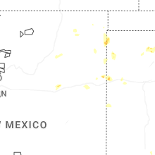
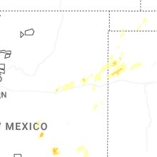
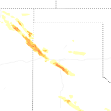
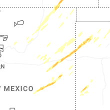


Connect with Interactive Hail Maps