

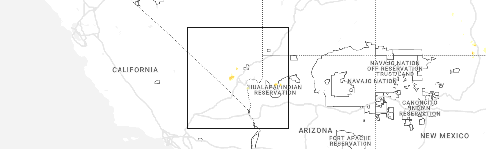
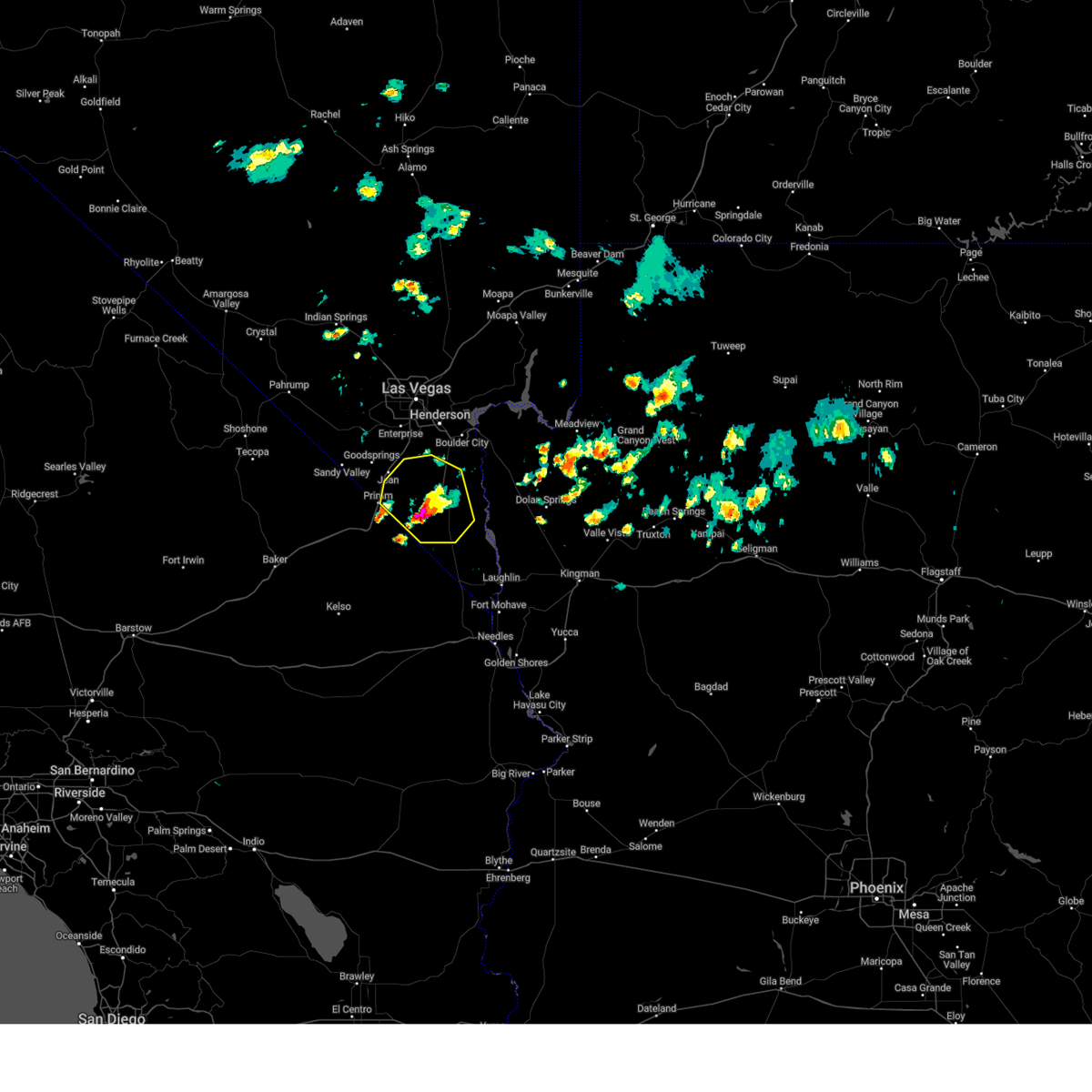
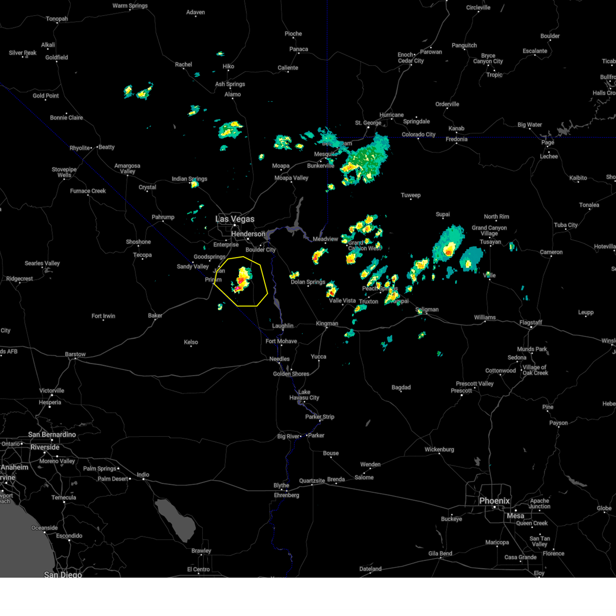
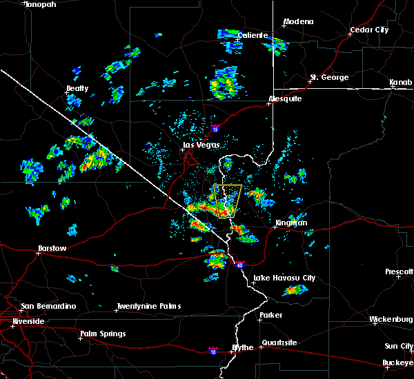
Hail Map for Nelson, NV
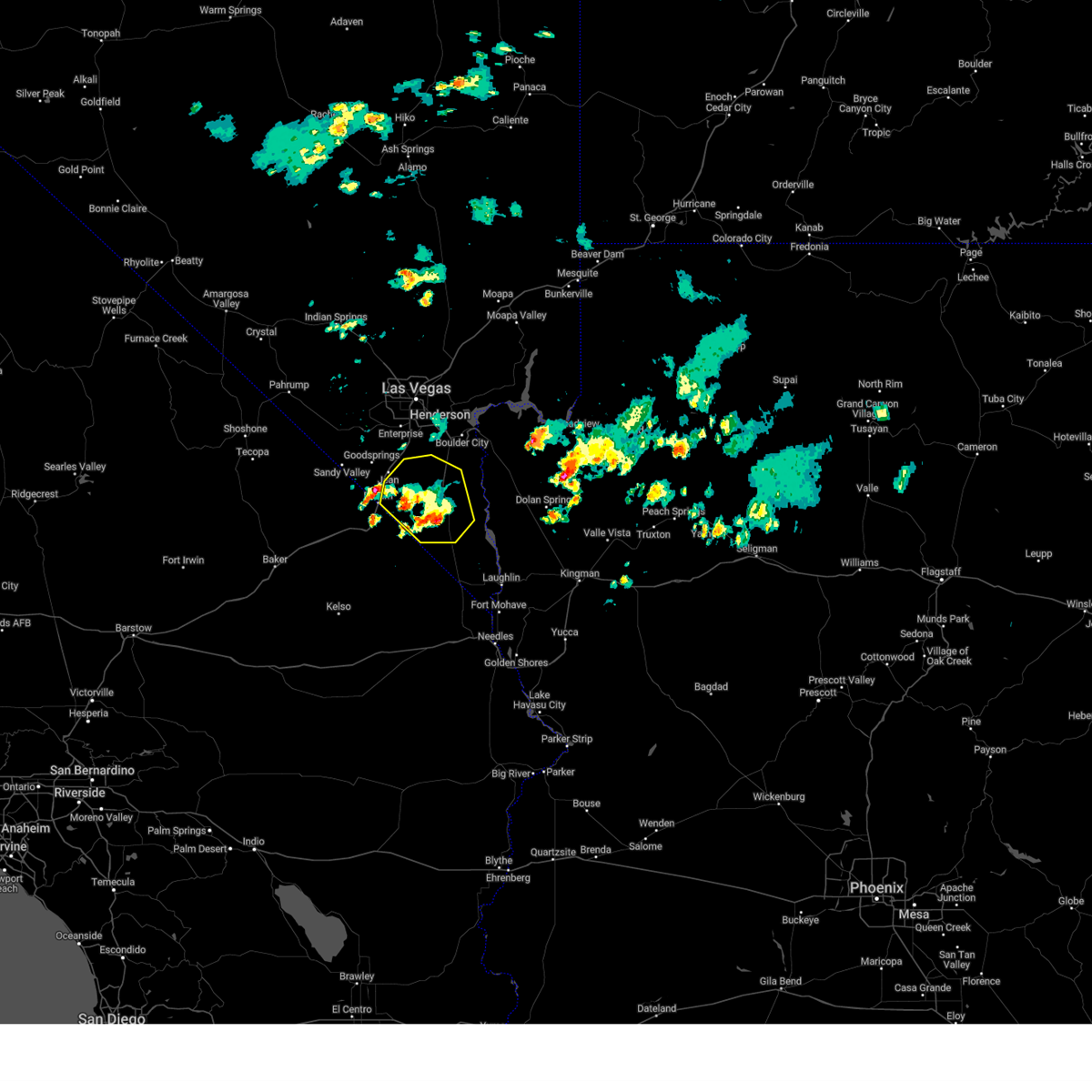
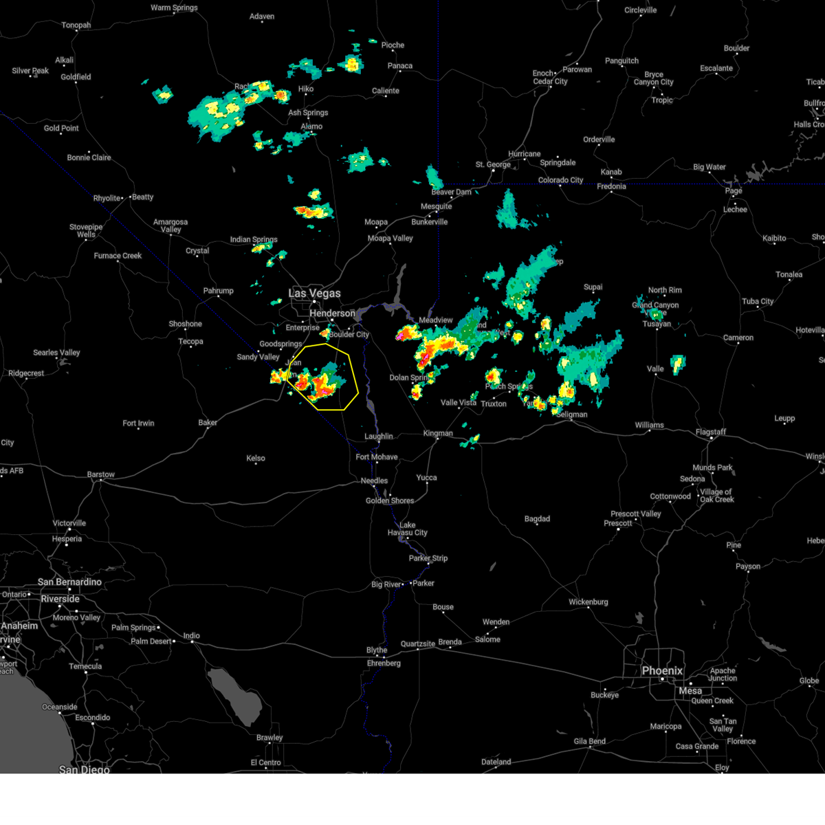
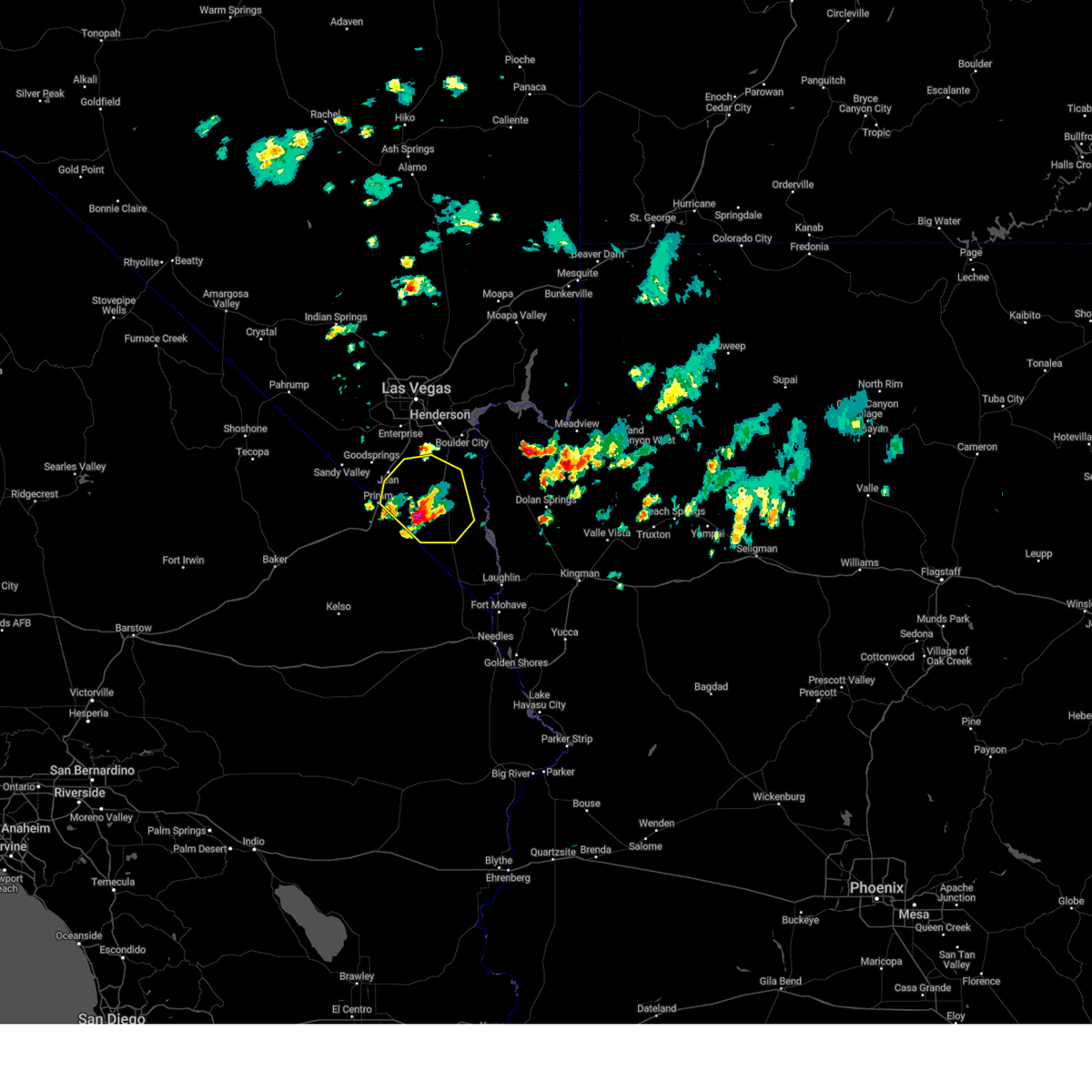
The Nelson, NV area has had 0 reports of on-the-ground hail by trained spotters, and has been under severe weather warnings 5 times during the past 12 months. Doppler radar has detected hail at or near Nelson, NV on 11 occasions.
| Name: | Nelson, NV |
| Where Located: | 36.4 miles SSE of Las Vegas, NV |
| Map: | Google Map for Nelson, NV |
| Population: | 37 |
| Housing Units: | 43 |
| More Info: | Search Google for Nelson, NV |
0
The Top Recent Hail Date for Nelson, NV is Tuesday, August 1, 2023 (11th out of 11)
Hail and Wind Damage Spotted near Nelson, NV
| Date / Time | Report Details |
|---|---|
| 6/5/2025 1:12 PM PDT |
 The storm which prompted the warning has weakened, and no longer poses an immediate threat to life or property. therefore, the warning will be allowed to expire. pea-sized hail was noted along nipton road, also known as state route 164, also known as joshua tree highway, around 1:08 pm. The storm which prompted the warning has weakened, and no longer poses an immediate threat to life or property. therefore, the warning will be allowed to expire. pea-sized hail was noted along nipton road, also known as state route 164, also known as joshua tree highway, around 1:08 pm.
|
| 6/5/2025 12:37 PM PDT |
 At 1237 pm pdt, a severe thunderstorm was located 13 miles north of cottonwood cove campground, or 14 miles northeast of searchlight, moving east at 10 mph (radar indicated). Hazards include 60 mph wind gusts and quarter size hail. Hail damage to vehicles is expected. expect wind damage to roofs and trees. Locations impacted include, searchlight and nipton road mile marker 3. At 1237 pm pdt, a severe thunderstorm was located 13 miles north of cottonwood cove campground, or 14 miles northeast of searchlight, moving east at 10 mph (radar indicated). Hazards include 60 mph wind gusts and quarter size hail. Hail damage to vehicles is expected. expect wind damage to roofs and trees. Locations impacted include, searchlight and nipton road mile marker 3.
|
| 6/5/2025 12:15 PM PDT |
 Svrvef the national weather service in las vegas has issued a * severe thunderstorm warning for, south central clark county in southern nevada, * until 115 pm pdt. * at 1215 pm pdt, a severe thunderstorm was located 11 miles north of searchlight, moving east at 10 mph (radar indicated). Hazards include 60 mph wind gusts and quarter size hail. Hail damage to vehicles is expected. Expect wind damage to roofs and trees. Svrvef the national weather service in las vegas has issued a * severe thunderstorm warning for, south central clark county in southern nevada, * until 115 pm pdt. * at 1215 pm pdt, a severe thunderstorm was located 11 miles north of searchlight, moving east at 10 mph (radar indicated). Hazards include 60 mph wind gusts and quarter size hail. Hail damage to vehicles is expected. Expect wind damage to roofs and trees.
|
| 6/5/2025 11:49 AM PDT |
 At 1148 am pdt, a severe thunderstorm was located 9 miles north of searchlight, moving east at 10 mph (radar indicated). Hazards include 60 mph wind gusts. Expect damage to roofs and trees. Locations impacted include, searchlight and nipton road mile marker 3. At 1148 am pdt, a severe thunderstorm was located 9 miles north of searchlight, moving east at 10 mph (radar indicated). Hazards include 60 mph wind gusts. Expect damage to roofs and trees. Locations impacted include, searchlight and nipton road mile marker 3.
|
| 6/5/2025 11:09 AM PDT |
 Svrvef the national weather service in las vegas has issued a * severe thunderstorm warning for, south central clark county in southern nevada, * until 1215 pm pdt. * at 1108 am pdt, a severe thunderstorm was located 8 miles northeast of nipton road mile marker 3, or 10 miles northwest of searchlight, moving east at 10 mph (radar indicated). Hazards include 60 mph wind gusts. expect damage to roofs and trees Svrvef the national weather service in las vegas has issued a * severe thunderstorm warning for, south central clark county in southern nevada, * until 1215 pm pdt. * at 1108 am pdt, a severe thunderstorm was located 8 miles northeast of nipton road mile marker 3, or 10 miles northwest of searchlight, moving east at 10 mph (radar indicated). Hazards include 60 mph wind gusts. expect damage to roofs and trees
|
| 8/18/2022 4:22 PM PDT |
 The severe thunderstorm warning for northwestern mohave and central clark counties will expire at 430 pm pdt/430 pm mst/, the storm which prompted the warning has weakened below severe limits, and no longer poses an immediate threat to life or property. therefore, the warning will be allowed to expire. The severe thunderstorm warning for northwestern mohave and central clark counties will expire at 430 pm pdt/430 pm mst/, the storm which prompted the warning has weakened below severe limits, and no longer poses an immediate threat to life or property. therefore, the warning will be allowed to expire.
|
| 8/18/2022 3:59 PM PDT |
 At 359 pm pdt/359 pm mst/, a severe thunderstorm was located near echo bay campground, or 19 miles south of overton, moving northeast at 10 mph (radar indicated). Hazards include 60 mph wind gusts. Expect damage to roofs and trees. locations impacted include, henderson, boulder city, las vegas bay, lake las vegas, sam boyd stadium, east las vegas, boulder beach, railroad pass, boulder beach campground, las vegas bay campground, callville bay, hoover dam, callville bay campground, lake mead national recreation area, black mtn and willow beach. hail threat, radar indicated max hail size, <. 75 in wind threat, radar indicated max wind gust, 60 mph. At 359 pm pdt/359 pm mst/, a severe thunderstorm was located near echo bay campground, or 19 miles south of overton, moving northeast at 10 mph (radar indicated). Hazards include 60 mph wind gusts. Expect damage to roofs and trees. locations impacted include, henderson, boulder city, las vegas bay, lake las vegas, sam boyd stadium, east las vegas, boulder beach, railroad pass, boulder beach campground, las vegas bay campground, callville bay, hoover dam, callville bay campground, lake mead national recreation area, black mtn and willow beach. hail threat, radar indicated max hail size, <. 75 in wind threat, radar indicated max wind gust, 60 mph.
|
| 8/18/2022 3:30 PM PDT |
 At 329 pm pdt/329 pm mst/, a severe thunderstorm was located over old henderson, moving northeast at 10 mph. this storm will impact far southern henderson and boulder beach through the upcoming hour (radar indicated). Hazards include 60 mph wind gusts. expect damage to roofs and trees At 329 pm pdt/329 pm mst/, a severe thunderstorm was located over old henderson, moving northeast at 10 mph. this storm will impact far southern henderson and boulder beach through the upcoming hour (radar indicated). Hazards include 60 mph wind gusts. expect damage to roofs and trees
|
| 7/28/2022 10:57 PM PDT |
 The severe thunderstorm warning for northwestern mohave and central clark counties will expire at 1100 pm pdt/1100 pm mst/, the storm which prompted the warning has moved out of the area. therefore, the warning will be allowed to expire. however heavy rain and gusty winds are still possible with this thunderstorm south of boulder city and along highway 95 toward searchlight. The severe thunderstorm warning for northwestern mohave and central clark counties will expire at 1100 pm pdt/1100 pm mst/, the storm which prompted the warning has moved out of the area. therefore, the warning will be allowed to expire. however heavy rain and gusty winds are still possible with this thunderstorm south of boulder city and along highway 95 toward searchlight.
|
| 7/28/2022 10:14 PM PDT |
 At 1013 pm pdt/1013 pm mst/, a severe thunderstorm was located near boulder city, moving southwest at 30 mph (radar indicated). Hazards include 60 mph wind gusts. Expect damage to roofs and trees. locations impacted include, henderson, boulder city, las vegas bay, lake las vegas, boulder beach, railroad pass, boulder beach campground, las vegas bay campground, callville bay, hoover dam, callville bay campground, lake mead national recreation area and willow beach. hail threat, radar indicated max hail size, <. 75 in wind threat, radar indicated max wind gust, 60 mph. At 1013 pm pdt/1013 pm mst/, a severe thunderstorm was located near boulder city, moving southwest at 30 mph (radar indicated). Hazards include 60 mph wind gusts. Expect damage to roofs and trees. locations impacted include, henderson, boulder city, las vegas bay, lake las vegas, boulder beach, railroad pass, boulder beach campground, las vegas bay campground, callville bay, hoover dam, callville bay campground, lake mead national recreation area and willow beach. hail threat, radar indicated max hail size, <. 75 in wind threat, radar indicated max wind gust, 60 mph.
|
| 7/28/2022 9:41 PM PDT |
 At 941 pm pdt/941 pm mst/, a severe thunderstorm was located near callville bay, or 10 miles east of las vegas bay, moving southwest at 30 mph (radar and surface wind observation indicated). Hazards include 60 mph wind gusts. expect damage to roofs and trees At 941 pm pdt/941 pm mst/, a severe thunderstorm was located near callville bay, or 10 miles east of las vegas bay, moving southwest at 30 mph (radar and surface wind observation indicated). Hazards include 60 mph wind gusts. expect damage to roofs and trees
|
| 8/12/2021 9:10 PM PDT |
 At 909 pm pdt/909 pm mst/, a severe thunderstorm was located near callville bay, or near las vegas bay, moving south at 20 mph (radar indicated). Hazards include 60 mph wind gusts. expect damage to roofs and trees At 909 pm pdt/909 pm mst/, a severe thunderstorm was located near callville bay, or near las vegas bay, moving south at 20 mph (radar indicated). Hazards include 60 mph wind gusts. expect damage to roofs and trees
|
| 7/29/2021 6:52 PM PDT |
 The severe thunderstorm warning for northwestern mohave and central clark counties will expire at 700 pm pdt/700 pm mst/, the storm which prompted the warning has weakened below severe limits, and no longer poses an immediate threat to life or property. therefore, the warning will be allowed to expire. however gusty winds up to 45 mph are still possible. The severe thunderstorm warning for northwestern mohave and central clark counties will expire at 700 pm pdt/700 pm mst/, the storm which prompted the warning has weakened below severe limits, and no longer poses an immediate threat to life or property. therefore, the warning will be allowed to expire. however gusty winds up to 45 mph are still possible.
|
| 7/29/2021 6:32 PM PDT |
 At 629 pm pdt/629 pm mst/, a severe thunderstorm was located near railroad pass, or near henderson, moving northwest at 10 mph. a thunderstorm has produced 62 mph. these thunderstorms are capable of producing isolated microburst winds up to 60 mph (radar indicated). Hazards include 60 mph wind gusts. Expect damage to roofs and trees. locations impacted include, henderson, boulder city, anthem, southern highlands, enterprise, boulder beach, sloan, railroad pass, boulder beach campground, seven hills, hoover dam, black mtn and willow beach. This includes interstate 15 in nevada between mile markers 13 and 25. At 629 pm pdt/629 pm mst/, a severe thunderstorm was located near railroad pass, or near henderson, moving northwest at 10 mph. a thunderstorm has produced 62 mph. these thunderstorms are capable of producing isolated microburst winds up to 60 mph (radar indicated). Hazards include 60 mph wind gusts. Expect damage to roofs and trees. locations impacted include, henderson, boulder city, anthem, southern highlands, enterprise, boulder beach, sloan, railroad pass, boulder beach campground, seven hills, hoover dam, black mtn and willow beach. This includes interstate 15 in nevada between mile markers 13 and 25.
|
| 7/29/2021 6:04 PM PDT |
 At 604 pm pdt/604 pm mst/, a severe thunderstorm was located near railroad pass, or near boulder city, moving northwest at 10 mph (radar indicated). Hazards include 60 mph wind gusts. expect damage to roofs and trees At 604 pm pdt/604 pm mst/, a severe thunderstorm was located near railroad pass, or near boulder city, moving northwest at 10 mph (radar indicated). Hazards include 60 mph wind gusts. expect damage to roofs and trees
|
| 7/25/2021 9:53 PM PDT |
 The severe thunderstorm warning for western mohave, western clark and southeastern nye counties will expire at 1000 pm pdt/1000 pm mst/, the storms which prompted the warning continue to move southwest through far southern clark county and southern nye county. additional, severe thunderstorm warnings will be issued. gusty winds are still possible with these thunderstorms. The severe thunderstorm warning for western mohave, western clark and southeastern nye counties will expire at 1000 pm pdt/1000 pm mst/, the storms which prompted the warning continue to move southwest through far southern clark county and southern nye county. additional, severe thunderstorm warnings will be issued. gusty winds are still possible with these thunderstorms.
|
| 7/25/2021 9:32 PM PDT |
 At 930 pm pdt/930 pm mst/, severe thunderstorms were located along a line extending from near cottonwood cove campground to near goodsprings to 6 miles west of indian springs, moving south at 35 mph (radar indicated). Hazards include 70 mph wind gusts. Expect considerable tree damage. damage is likely to mobile homes, roofs, and outbuildings. locations impacted include, henderson, pahrump, laughlin, rainbow canyon, mountains edge, blue diamond, southern highlands, jean, mt. charleston, red rock canyon, enterprise, searchlight, primm, spring mountains, mercury, summerlin, spring valley, paradise, kyle canyon campground and fletcher view campground. This includes interstate 15 in nevada between mile markers 1 and 25. At 930 pm pdt/930 pm mst/, severe thunderstorms were located along a line extending from near cottonwood cove campground to near goodsprings to 6 miles west of indian springs, moving south at 35 mph (radar indicated). Hazards include 70 mph wind gusts. Expect considerable tree damage. damage is likely to mobile homes, roofs, and outbuildings. locations impacted include, henderson, pahrump, laughlin, rainbow canyon, mountains edge, blue diamond, southern highlands, jean, mt. charleston, red rock canyon, enterprise, searchlight, primm, spring mountains, mercury, summerlin, spring valley, paradise, kyle canyon campground and fletcher view campground. This includes interstate 15 in nevada between mile markers 1 and 25.
|
| 7/25/2021 8:59 PM PDT |
 At 857 pm pdt/857 pm mst/, severe thunderstorms were located along a line extending from 13 miles north of cottonwood cove campground to spring valley to 15 miles north of indian springs, moving south at 35 mph (radar indicated). Hazards include 70 mph wind gusts. Expect considerable tree damage. Damage is likely to mobile homes, roofs, and outbuildings. At 857 pm pdt/857 pm mst/, severe thunderstorms were located along a line extending from 13 miles north of cottonwood cove campground to spring valley to 15 miles north of indian springs, moving south at 35 mph (radar indicated). Hazards include 70 mph wind gusts. Expect considerable tree damage. Damage is likely to mobile homes, roofs, and outbuildings.
|
| 7/25/2021 6:36 PM MST |
 At 635 pm pdt/635 pm mst/, severe thunderstorms were located along a line extending from 13 miles south of hoover dam to 7 miles north of cottonwood cove campground to near big bend rec area, moving west (radar indicated). Hazards include 60 mph wind gusts. Expect damage to roofs and trees. Locations impacted include, bullhead city, laughlin, katherine landing, searchlight, cottonwood cove, cottonwood cove campground, big bend rec area, cal-nev-ari, dolan springs and golden valley. At 635 pm pdt/635 pm mst/, severe thunderstorms were located along a line extending from 13 miles south of hoover dam to 7 miles north of cottonwood cove campground to near big bend rec area, moving west (radar indicated). Hazards include 60 mph wind gusts. Expect damage to roofs and trees. Locations impacted include, bullhead city, laughlin, katherine landing, searchlight, cottonwood cove, cottonwood cove campground, big bend rec area, cal-nev-ari, dolan springs and golden valley.
|
| 7/25/2021 6:01 PM MST |
 At 559 pm pdt/559 pm mst/, severe thunderstorms were located along a line extending from 16 miles southeast of grand canyon ranch to 13 miles northeast of packsaddle campground to near hualapai mountain park, moving west at 25 mph (radar indicated). Hazards include 40 to 60 mph wind gusts. This storm will produce sudden wind gusts over the colorado river from laughlin to willow beach which could exceed 40 mph. Possible damage to roofs and trees as well. At 559 pm pdt/559 pm mst/, severe thunderstorms were located along a line extending from 16 miles southeast of grand canyon ranch to 13 miles northeast of packsaddle campground to near hualapai mountain park, moving west at 25 mph (radar indicated). Hazards include 40 to 60 mph wind gusts. This storm will produce sudden wind gusts over the colorado river from laughlin to willow beach which could exceed 40 mph. Possible damage to roofs and trees as well.
|
| 4/12/2020 4:36 PM MST |
 The severe thunderstorm warning for west central mohave and south central clark counties will expire at 445 pm pdt/445 pm mst/, the storm which prompted the warning has weakened below severe limits, and no longer poses an immediate threat to life or property. therefore, the warning will be allowed to expire. however small hail, gusty winds and heavy rain are still ocurring with this thunderstorm. The severe thunderstorm warning for west central mohave and south central clark counties will expire at 445 pm pdt/445 pm mst/, the storm which prompted the warning has weakened below severe limits, and no longer poses an immediate threat to life or property. therefore, the warning will be allowed to expire. however small hail, gusty winds and heavy rain are still ocurring with this thunderstorm.
|
| 4/12/2020 4:23 PM MST |
 At 422 pm pdt/422 pm mst/, a severe thunderstorm was located 13 miles north of cottonwood cove campground, or 20 miles northeast of searchlight, moving southeast at 25 mph (radar indicated). Hazards include 60 mph wind gusts. Expect damage to roofs and trees. Locations impacted include, cottonwood cove and cottonwood cove campground, nelson, state route 165, and highway 93. At 422 pm pdt/422 pm mst/, a severe thunderstorm was located 13 miles north of cottonwood cove campground, or 20 miles northeast of searchlight, moving southeast at 25 mph (radar indicated). Hazards include 60 mph wind gusts. Expect damage to roofs and trees. Locations impacted include, cottonwood cove and cottonwood cove campground, nelson, state route 165, and highway 93.
|
| 4/12/2020 3:59 PM MST |
 At 358 pm pdt/358 pm mst/, a severe thunderstorm was located 15 miles south of boulder city, moving southeast at 25 mph (radar indicated). Hazards include 60 mph wind gusts. expect damage to roofs and trees At 358 pm pdt/358 pm mst/, a severe thunderstorm was located 15 miles south of boulder city, moving southeast at 25 mph (radar indicated). Hazards include 60 mph wind gusts. expect damage to roofs and trees
|
| 4/12/2020 3:47 PM PDT |
 At 347 pm pdt/347 pm mst/, a severe thunderstorm was located 10 miles south of boulder city, moving east at 20 mph (radar indicated). Hazards include 60 mph wind gusts and quarter size hail. Hail damage to vehicles is expected. expect wind damage to roofs and trees. Locations impacted include, willow beach and highway 93. At 347 pm pdt/347 pm mst/, a severe thunderstorm was located 10 miles south of boulder city, moving east at 20 mph (radar indicated). Hazards include 60 mph wind gusts and quarter size hail. Hail damage to vehicles is expected. expect wind damage to roofs and trees. Locations impacted include, willow beach and highway 93.
|
| 4/12/2020 3:26 PM PDT |
 At 325 pm pdt/325 pm mst/, a severe thunderstorm was located 9 miles south of railroad pass, or 10 miles southwest of boulder city, moving east at 20 mph (radar indicated). Hazards include 60 mph wind gusts and quarter size hail. Hail damage to vehicles is expected. Expect wind damage to roofs and trees. At 325 pm pdt/325 pm mst/, a severe thunderstorm was located 9 miles south of railroad pass, or 10 miles southwest of boulder city, moving east at 20 mph (radar indicated). Hazards include 60 mph wind gusts and quarter size hail. Hail damage to vehicles is expected. Expect wind damage to roofs and trees.
|
| 9/2/2019 12:42 AM PDT |
 The severe thunderstorm warning for northwestern mohave and central clark counties will expire at 1245 am pdt/1245 am mst/, the severe thunderstorm warning has been replaced with a new severe thunderstorm warning for the las vegas valley, valid until 130 am pdt, for severe winds up to 80 mph. The severe thunderstorm warning for northwestern mohave and central clark counties will expire at 1245 am pdt/1245 am mst/, the severe thunderstorm warning has been replaced with a new severe thunderstorm warning for the las vegas valley, valid until 130 am pdt, for severe winds up to 80 mph.
|
| 9/2/2019 12:25 AM PDT |
 At 1223 am pdt/1223 am mst/, severe outflow winds were spreading over the eastern half of the las vegas valley. multiple stations were reporting gusts of 50 to 70 mph. take shelter now! (radar indicated). Hazards include 70 mph wind gusts. Expect considerable tree damage. damage is likely to mobile homes, roofs, and outbuildings. Locations impacted include, las vegas, henderson, north las vegas, boulder city, anthem, the strip, downtown las vegas, east las vegas, sam boyd stadium, las vegas bay, lake las vegas, green valley, paradise, nellis afb, spring valley, summerlin, enterprise, railroad pass, boulder beach campground and las vegas bay campground. At 1223 am pdt/1223 am mst/, severe outflow winds were spreading over the eastern half of the las vegas valley. multiple stations were reporting gusts of 50 to 70 mph. take shelter now! (radar indicated). Hazards include 70 mph wind gusts. Expect considerable tree damage. damage is likely to mobile homes, roofs, and outbuildings. Locations impacted include, las vegas, henderson, north las vegas, boulder city, anthem, the strip, downtown las vegas, east las vegas, sam boyd stadium, las vegas bay, lake las vegas, green valley, paradise, nellis afb, spring valley, summerlin, enterprise, railroad pass, boulder beach campground and las vegas bay campground.
|
| 9/2/2019 12:04 AM PDT |
 At 1204 am pdt/1204 am mst/, a severe thunderstorm was located 14 miles south of boulder city, moving north at 40 mph (radar indicated). Hazards include 70 mph wind gusts. Expect considerable tree damage. Damage is likely to mobile homes, roofs, and outbuildings. At 1204 am pdt/1204 am mst/, a severe thunderstorm was located 14 miles south of boulder city, moving north at 40 mph (radar indicated). Hazards include 70 mph wind gusts. Expect considerable tree damage. Damage is likely to mobile homes, roofs, and outbuildings.
|
| 10/21/2018 12:54 AM MST |
 At 1254 am pdt/1254 am mst/, a severe thunderstorm was located near cottonwood cove, or 13 miles northeast of katherine landing, moving north at 25 mph (radar indicated). Hazards include 60 mph wind gusts and quarter size hail. Hail damage to vehicles is expected. Expect wind damage to roofs and trees. At 1254 am pdt/1254 am mst/, a severe thunderstorm was located near cottonwood cove, or 13 miles northeast of katherine landing, moving north at 25 mph (radar indicated). Hazards include 60 mph wind gusts and quarter size hail. Hail damage to vehicles is expected. Expect wind damage to roofs and trees.
|
| 8/11/2018 9:36 PM PDT |
 At 837 pm pdt/837 pm mst/, severe thunderstorms were located along a line extending from the sheep mountains to willow beach, moving southwest at 30 mph (radar indicated). Hazards include 70 mph wind gusts. Expect considerable tree damage. Damage is likely to mobile homes, roofs, and outbuildings. At 837 pm pdt/837 pm mst/, severe thunderstorms were located along a line extending from the sheep mountains to willow beach, moving southwest at 30 mph (radar indicated). Hazards include 70 mph wind gusts. Expect considerable tree damage. Damage is likely to mobile homes, roofs, and outbuildings.
|
| 8/11/2018 9:36 PM PDT |
 The severe thunderstorm warning for west central mohave and northwestern clark counties will expire at 945 pm pdt/945 pm mst/, the storms which prompted the warning have weakened below severe limits, and have exited the warned area. therefore, the warning will be allowed to expire. however gusty winds will linger over the next hour or so. The severe thunderstorm warning for west central mohave and northwestern clark counties will expire at 945 pm pdt/945 pm mst/, the storms which prompted the warning have weakened below severe limits, and have exited the warned area. therefore, the warning will be allowed to expire. however gusty winds will linger over the next hour or so.
|
| 8/11/2018 8:39 PM PDT |
 At 837 pm pdt/837 pm mst/, severe thunderstorms were located along a line extending from the sheep mountains to willow beach, moving southwest at 30 mph (radar indicated). Hazards include 70 mph wind gusts. Expect considerable tree damage. Damage is likely to mobile homes, roofs, and outbuildings. At 837 pm pdt/837 pm mst/, severe thunderstorms were located along a line extending from the sheep mountains to willow beach, moving southwest at 30 mph (radar indicated). Hazards include 70 mph wind gusts. Expect considerable tree damage. Damage is likely to mobile homes, roofs, and outbuildings.
|
| 8/11/2018 8:36 PM PDT |
 At 836 pm pdt/836 pm mst/, wind gusts in excess of 70 mph are being reported in the warned area (radar indicated). Hazards include 70 mph wind gusts. Expect considerable tree damage. damage is likely to mobile homes, roofs, and outbuildings. locations impacted include, las vegas, henderson, north las vegas, boulder city, rainbow canyon, summerlin, nellis afb, red rock canyon, green valley, spring mountains, paradise, lone mountain, anthem, mountains edge, the strip, blue diamond, downtown las vegas, east las vegas, sam boyd stadium and southern highlands. This includes interstate 15 in nevada between mile markers 17 and 25. At 836 pm pdt/836 pm mst/, wind gusts in excess of 70 mph are being reported in the warned area (radar indicated). Hazards include 70 mph wind gusts. Expect considerable tree damage. damage is likely to mobile homes, roofs, and outbuildings. locations impacted include, las vegas, henderson, north las vegas, boulder city, rainbow canyon, summerlin, nellis afb, red rock canyon, green valley, spring mountains, paradise, lone mountain, anthem, mountains edge, the strip, blue diamond, downtown las vegas, east las vegas, sam boyd stadium and southern highlands. This includes interstate 15 in nevada between mile markers 17 and 25.
|
| 8/11/2018 8:07 PM PDT |
 At 806 pm pdt/806 pm mst/, severe thunderstorms were located along a line extending from 20 miles north of aliante to callville bay, moving southwest at 30 mph (radar indicated). Hazards include 60 mph wind gusts. expect damage to roofs and trees At 806 pm pdt/806 pm mst/, severe thunderstorms were located along a line extending from 20 miles north of aliante to callville bay, moving southwest at 30 mph (radar indicated). Hazards include 60 mph wind gusts. expect damage to roofs and trees
|
| 7/8/2018 1:27 PM PDT |
 At 127 pm pdt/127 pm mst/, a severe thunderstorm was located 12 miles south of anthem, moving north at 10 mph (radar indicated). Hazards include 60 mph wind gusts and quarter size hail. Hail damage to vehicles is expected. Expect wind damage to roofs and trees. At 127 pm pdt/127 pm mst/, a severe thunderstorm was located 12 miles south of anthem, moving north at 10 mph (radar indicated). Hazards include 60 mph wind gusts and quarter size hail. Hail damage to vehicles is expected. Expect wind damage to roofs and trees.
|
| 8/2/2017 6:10 PM MST |
 The severe thunderstorm warning for west central mohave and south central clark counties will expire at 615 pm pdt/615 pm mst/, the thunderstorm outflow boundary which prompted the warning has weakened and exited the warned area. therefore the warning will be allowed to expire. storms which generated the outflow boundary will continue to move west into the area and may generate more gusty winds and heavy rain. The severe thunderstorm warning for west central mohave and south central clark counties will expire at 615 pm pdt/615 pm mst/, the thunderstorm outflow boundary which prompted the warning has weakened and exited the warned area. therefore the warning will be allowed to expire. storms which generated the outflow boundary will continue to move west into the area and may generate more gusty winds and heavy rain.
|
| 8/2/2017 5:45 PM MST |
 At 542 pm pdt/542 pm mst/, a thunderstorm outflow boundary generating severe winds from thunderstorms to the east was located along a line extending from willow beach to near oatman, moving west at 25 mph (radar indicated). Hazards include 60 mph wind gusts. Expect damage to roofs, siding, and trees. Locations impacted include, bullhead city, laughlin, katherine landing, cottonwood cove, cottonwood cove campground, big bend rec area, golden valley, dolan springs and willow beach. At 542 pm pdt/542 pm mst/, a thunderstorm outflow boundary generating severe winds from thunderstorms to the east was located along a line extending from willow beach to near oatman, moving west at 25 mph (radar indicated). Hazards include 60 mph wind gusts. Expect damage to roofs, siding, and trees. Locations impacted include, bullhead city, laughlin, katherine landing, cottonwood cove, cottonwood cove campground, big bend rec area, golden valley, dolan springs and willow beach.
|
| 8/2/2017 5:14 PM MST |
 At 513 pm pdt/513 pm mst/, severe thunderstorms were located along a line extending from 11 miles southwest of temple bar campground to near kingman, moving west at 20 mph (radar indicated). Hazards include 60 mph wind gusts. expect damage to roofs, siding, and trees At 513 pm pdt/513 pm mst/, severe thunderstorms were located along a line extending from 11 miles southwest of temple bar campground to near kingman, moving west at 20 mph (radar indicated). Hazards include 60 mph wind gusts. expect damage to roofs, siding, and trees
|
| 7/18/2017 5:03 PM PDT |
 At 502 pm pdt/502 pm mst/, a severe thunderstorm was located 9 miles northeast of callville bay campground, or 16 miles east of las vegas bay, in the narrows on lake mead, moving northeast at 15 mph (radar indicated). Hazards include 60 mph wind gusts. Expect damage to roofs, siding, and trees. Locations impacted include, henderson, boulder city, las vegas bay, lake las vegas, the motor speedway, east las vegas, boulder beach, railroad pass, boulder beach campground, las vegas bay campground, callville bay, hoover dam, callville bay campground, willow beach, sunrise mtn and frenchman mtn. At 502 pm pdt/502 pm mst/, a severe thunderstorm was located 9 miles northeast of callville bay campground, or 16 miles east of las vegas bay, in the narrows on lake mead, moving northeast at 15 mph (radar indicated). Hazards include 60 mph wind gusts. Expect damage to roofs, siding, and trees. Locations impacted include, henderson, boulder city, las vegas bay, lake las vegas, the motor speedway, east las vegas, boulder beach, railroad pass, boulder beach campground, las vegas bay campground, callville bay, hoover dam, callville bay campground, willow beach, sunrise mtn and frenchman mtn.
|
| 7/18/2017 5:03 PM PDT |
 At 450 pm pdt/450 pm mst/, a severe thunderstorm was located near boulder beach, or near las vegas bay, moving northeast at 20 mph (radar indicated). Hazards include 60 mph wind gusts. Expect damage to roofs, siding, and trees. Locations impacted include, henderson, boulder city, las vegas bay, lake las vegas, east las vegas, boulder beach, railroad pass, boulder beach campground, las vegas bay campground, callville bay, hoover dam, callville bay campground, willow beach, sunrise mtn and frenchman mtn. At 450 pm pdt/450 pm mst/, a severe thunderstorm was located near boulder beach, or near las vegas bay, moving northeast at 20 mph (radar indicated). Hazards include 60 mph wind gusts. Expect damage to roofs, siding, and trees. Locations impacted include, henderson, boulder city, las vegas bay, lake las vegas, east las vegas, boulder beach, railroad pass, boulder beach campground, las vegas bay campground, callville bay, hoover dam, callville bay campground, willow beach, sunrise mtn and frenchman mtn.
|
| 7/18/2017 4:51 PM PDT |
 At 450 pm pdt/450 pm mst/, a severe thunderstorm was located near boulder beach, or near las vegas bay, moving northeast at 20 mph (radar indicated). Hazards include 60 mph wind gusts. Expect damage to roofs, siding, and trees. Locations impacted include, henderson, boulder city, las vegas bay, lake las vegas, east las vegas, boulder beach, railroad pass, boulder beach campground, las vegas bay campground, callville bay, hoover dam, callville bay campground, willow beach, sunrise mtn and frenchman mtn. At 450 pm pdt/450 pm mst/, a severe thunderstorm was located near boulder beach, or near las vegas bay, moving northeast at 20 mph (radar indicated). Hazards include 60 mph wind gusts. Expect damage to roofs, siding, and trees. Locations impacted include, henderson, boulder city, las vegas bay, lake las vegas, east las vegas, boulder beach, railroad pass, boulder beach campground, las vegas bay campground, callville bay, hoover dam, callville bay campground, willow beach, sunrise mtn and frenchman mtn.
|
| 7/18/2017 4:39 PM PDT |
 At 437 pm pdt/437 pm mst/, a severe thunderstorm was located over boulder beach campground, or near boulder city, moving north at 20 mph (radar indicated). Hazards include 70 mph wind gusts and quarter size hail. Hail damage to vehicles is expected. expect considerable tree damage. wind damage is also likely to mobile homes, roofs, and outbuildings. Locations impacted include, henderson, boulder city, las vegas bay, lake las vegas, the motor speedway, east las vegas, boulder beach, railroad pass, boulder beach campground, las vegas bay campground, callville bay, hoover dam, callville bay campground, willow beach, sunrise mtn and frenchman mtn. At 437 pm pdt/437 pm mst/, a severe thunderstorm was located over boulder beach campground, or near boulder city, moving north at 20 mph (radar indicated). Hazards include 70 mph wind gusts and quarter size hail. Hail damage to vehicles is expected. expect considerable tree damage. wind damage is also likely to mobile homes, roofs, and outbuildings. Locations impacted include, henderson, boulder city, las vegas bay, lake las vegas, the motor speedway, east las vegas, boulder beach, railroad pass, boulder beach campground, las vegas bay campground, callville bay, hoover dam, callville bay campground, willow beach, sunrise mtn and frenchman mtn.
|
| 7/18/2017 4:25 PM PDT |
 At 423 pm pdt/423 pm mst/, a severe thunderstorm was located near boulder city, moving north at 20 mph (radar indicated). Hazards include 70 mph wind gusts and quarter size hail. Expect considerable tree damage. Damage is likely to mobile homes, roofs, and outbuildings. At 423 pm pdt/423 pm mst/, a severe thunderstorm was located near boulder city, moving north at 20 mph (radar indicated). Hazards include 70 mph wind gusts and quarter size hail. Expect considerable tree damage. Damage is likely to mobile homes, roofs, and outbuildings.
|
| 8/7/2015 1:59 PM PDT |
 At 157 pm pdt /157 pm mst/, doppler radar indicated a severe thunderstorm capable of producing damaging winds in excess of 60 mph. this storm was located near nelson, or 16 miles north of cottonwood cove campground and moving northeast at 20 mph. this replaces the previous severe thunderstorm warning. At 157 pm pdt /157 pm mst/, doppler radar indicated a severe thunderstorm capable of producing damaging winds in excess of 60 mph. this storm was located near nelson, or 16 miles north of cottonwood cove campground and moving northeast at 20 mph. this replaces the previous severe thunderstorm warning.
|
| 8/7/2015 1:48 PM PDT |
 At 148 pm pdt /148 pm mst/, doppler radar indicated a severe thunderstorm capable of producing quarter size hail and destructive winds in excess of 70 mph. this storm was located 15 miles north of searchlight, moving northeast at 20 mph. this severe thunderstorm will remain over mainly rural areas of western mohave and southeastern clark counties. At 148 pm pdt /148 pm mst/, doppler radar indicated a severe thunderstorm capable of producing quarter size hail and destructive winds in excess of 70 mph. this storm was located 15 miles north of searchlight, moving northeast at 20 mph. this severe thunderstorm will remain over mainly rural areas of western mohave and southeastern clark counties.
|
| 8/7/2015 1:34 PM PDT |
 At 133 pm pdt /133 pm mst/, doppler radar indicated a severe thunderstorm capable of producing quarter size hail and destructive winds in excess of 70 mph. this storm was located over highway 95 11 miles north of searchlight, and moving northeast at 20 mph. At 133 pm pdt /133 pm mst/, doppler radar indicated a severe thunderstorm capable of producing quarter size hail and destructive winds in excess of 70 mph. this storm was located over highway 95 11 miles north of searchlight, and moving northeast at 20 mph.
|
Hail Maps for Nelson, NV


Connect with Interactive Hail Maps