

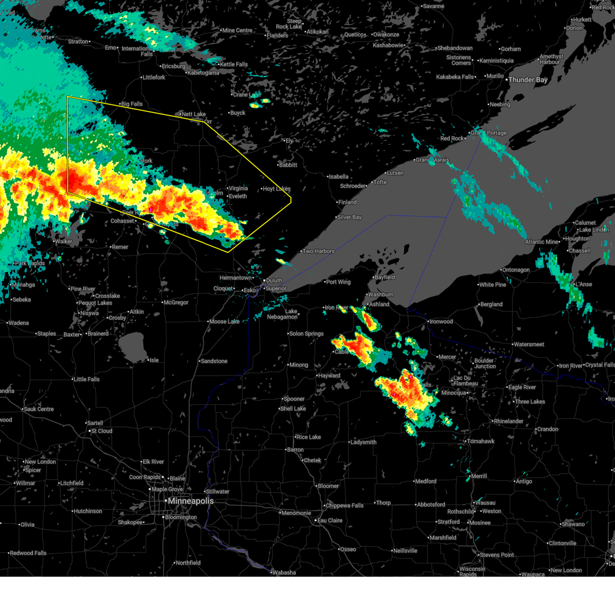
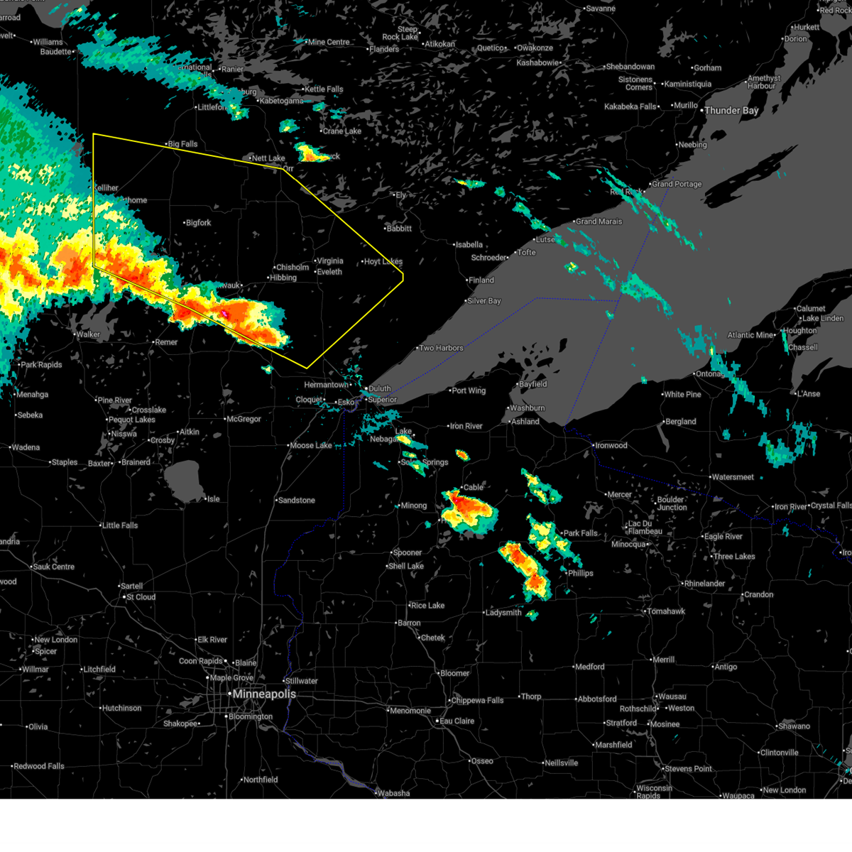
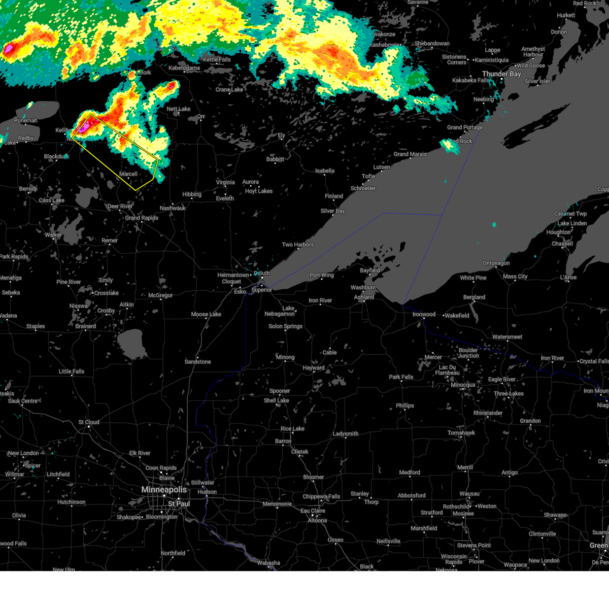
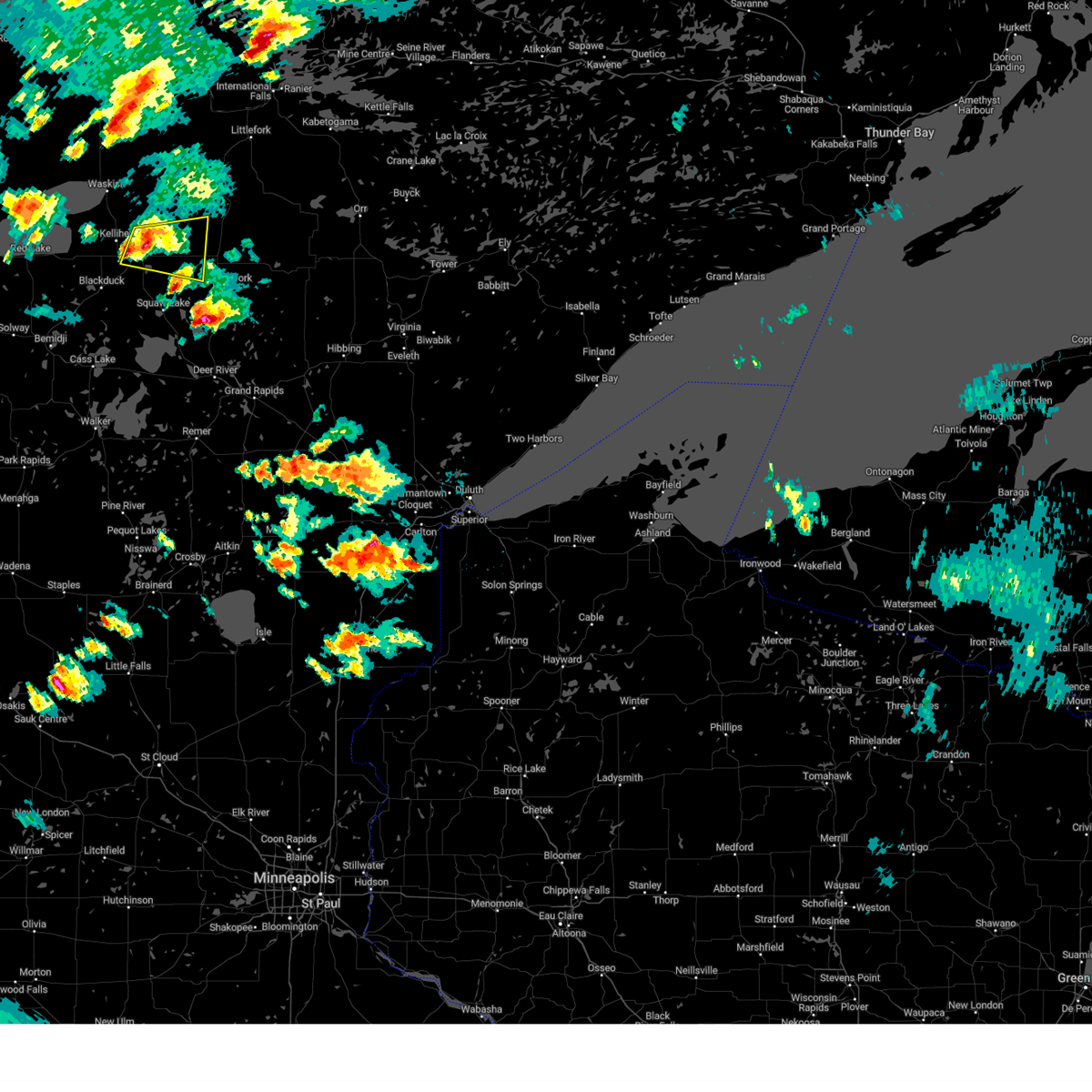
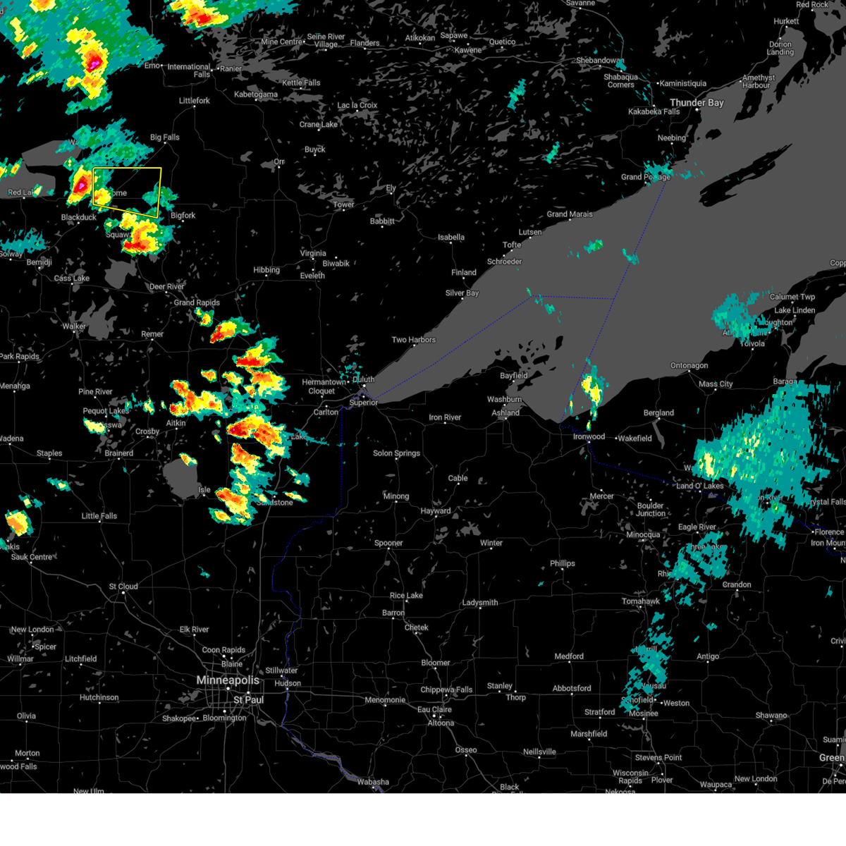
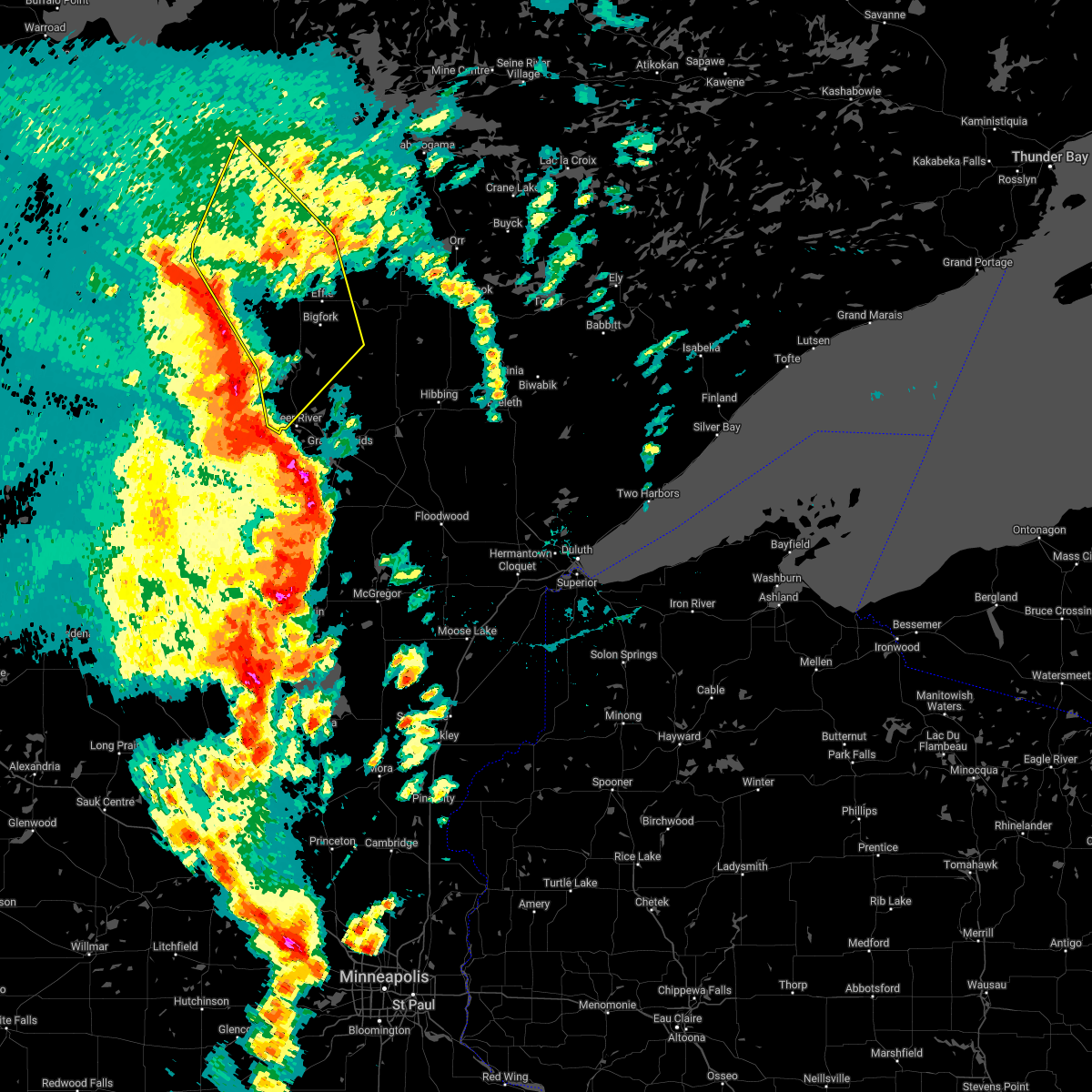
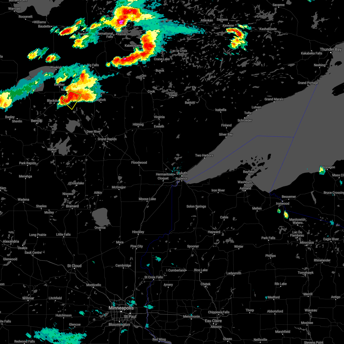
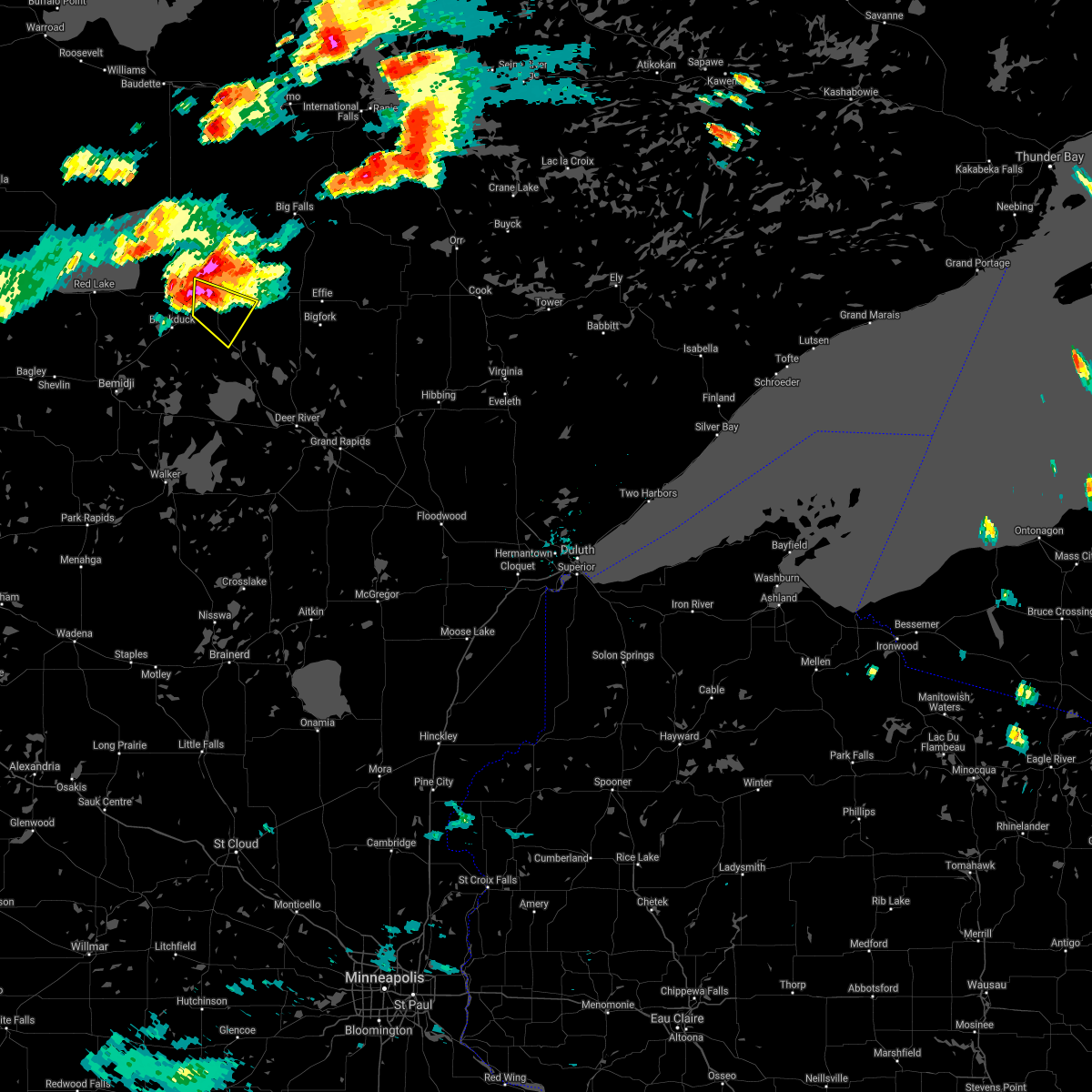
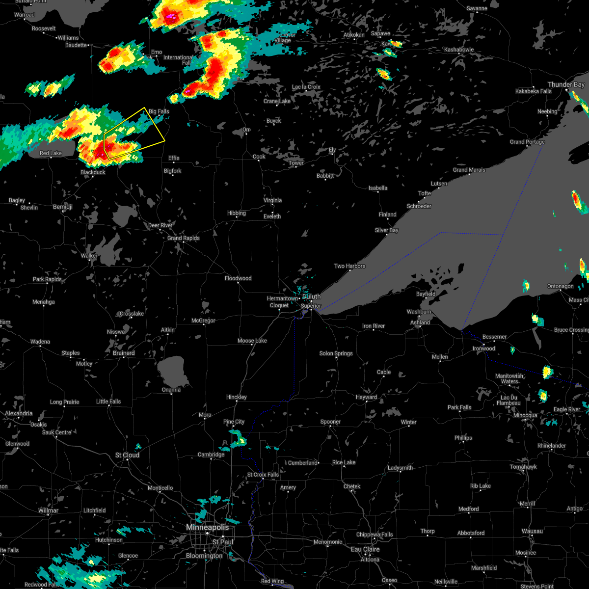
Hail Map for Northome, MN
The Northome, MN area has had 1 report of on-the-ground hail by trained spotters, and has been under severe weather warnings 7 times during the past 12 months. Doppler radar has detected hail at or near Northome, MN on 33 occasions, including 2 occasions during the past year.
| Name: | Northome, MN |
| Where Located: | 39.4 miles NE of Bemidji, MN |
| Map: | Google Map for Northome, MN |
| Population: | 200 |
| Housing Units: | 104 |
| More Info: | Search Google for Northome, MN |
4
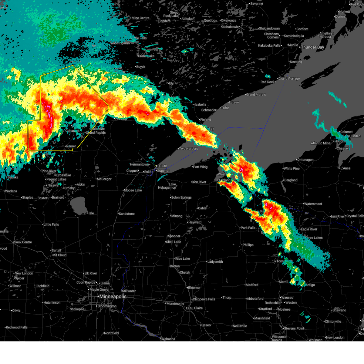
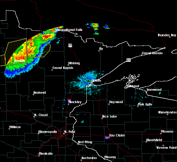
The Top Recent Hail Date for Northome, MN is Saturday, August 3, 2024 (8th out of 33)

Hail and Wind Damage Spotted near Northome, MN
| Date / Time | Report Details |
|---|---|
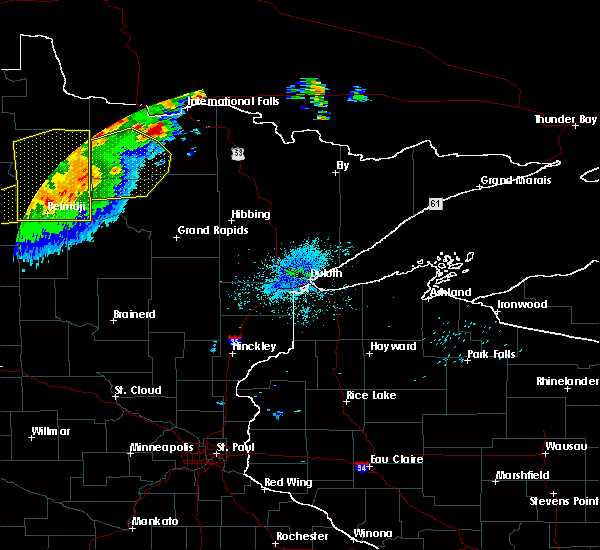
| 6/21/2025 1:07 AM CDT |
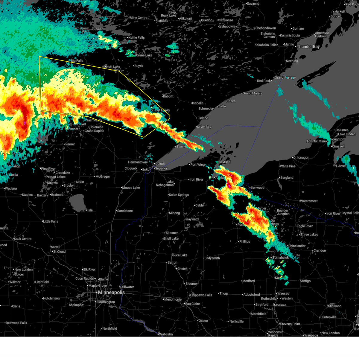
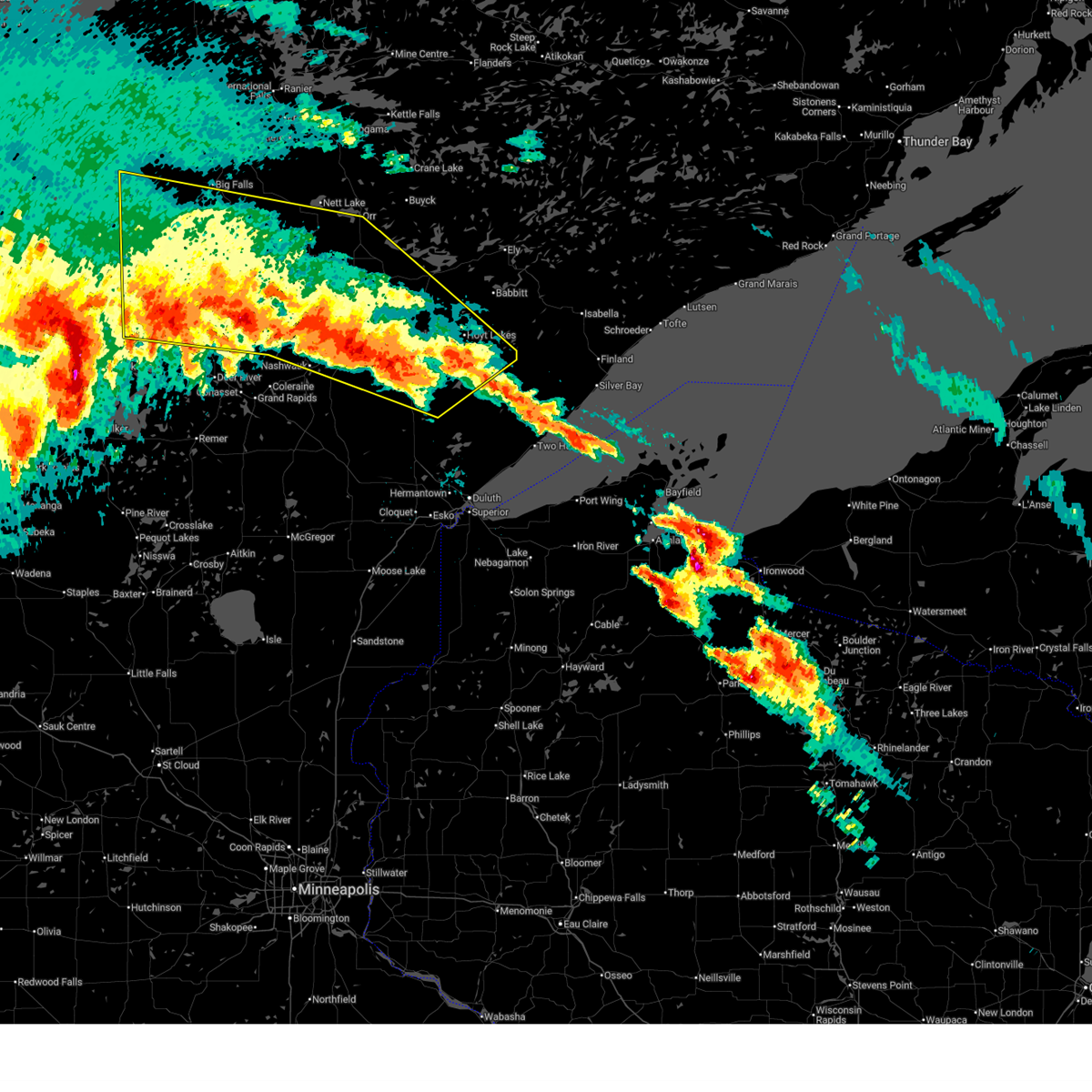
 At 106 am cdt, severe thunderstorms were located along a line extending from near kelliher to 10 miles northwest of lake winnibigoshish to near laporte, moving east at 70 mph. these are destructive storms for northern cass and itasca counties (radar indicated). Hazards include 90 mph wind gusts and penny size hail. You are in a life-threatening situation. flying debris may be deadly to those caught without shelter. mobile homes will be heavily damaged or destroyed. homes and businesses will have substantial roof and window damage. expect extensive tree damage and power outages. Locations impacted include, grand rapids, walker, cohasset, coleraine, deer river, marcell, bigfork, remer, taconite, northome, longville, effie, bena, federal dam, squaw lake, zemple, mizpah, boy river, alvwood, and leech lake. At 106 am cdt, severe thunderstorms were located along a line extending from near kelliher to 10 miles northwest of lake winnibigoshish to near laporte, moving east at 70 mph. these are destructive storms for northern cass and itasca counties (radar indicated). Hazards include 90 mph wind gusts and penny size hail. You are in a life-threatening situation. flying debris may be deadly to those caught without shelter. mobile homes will be heavily damaged or destroyed. homes and businesses will have substantial roof and window damage. expect extensive tree damage and power outages. Locations impacted include, grand rapids, walker, cohasset, coleraine, deer river, marcell, bigfork, remer, taconite, northome, longville, effie, bena, federal dam, squaw lake, zemple, mizpah, boy river, alvwood, and leech lake.
|
| 6/21/2025 12:48 AM CDT |
 At 1246 am cdt, severe thunderstorms were located along a line extending from near effie to near mccarthy beach state park to eveleth, moving northeast at 45 mph (radar indicated). Hazards include two inch hail and 60 mph wind gusts. People and animals outdoors will be injured. expect hail damage to roofs, siding, windows, and vehicles. expect wind damage to roofs, siding, and trees. Locations impacted include, hibbing, lake vermilion, virginia, chisholm, eveleth, mountain iron, hoyt lakes, gilbert, aurora, babbitt, keewatin, buhl, nashwauk, biwabik, cherry, embarrass, cook, marcell, bigfork, and orr. At 1246 am cdt, severe thunderstorms were located along a line extending from near effie to near mccarthy beach state park to eveleth, moving northeast at 45 mph (radar indicated). Hazards include two inch hail and 60 mph wind gusts. People and animals outdoors will be injured. expect hail damage to roofs, siding, windows, and vehicles. expect wind damage to roofs, siding, and trees. Locations impacted include, hibbing, lake vermilion, virginia, chisholm, eveleth, mountain iron, hoyt lakes, gilbert, aurora, babbitt, keewatin, buhl, nashwauk, biwabik, cherry, embarrass, cook, marcell, bigfork, and orr.
|
| 6/21/2025 12:48 AM CDT |
 the severe thunderstorm warning has been cancelled and is no longer in effect the severe thunderstorm warning has been cancelled and is no longer in effect
|
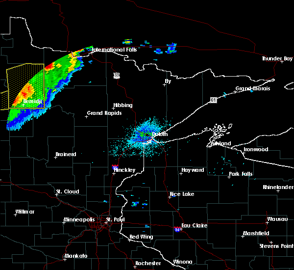
| 6/21/2025 12:30 AM CDT |
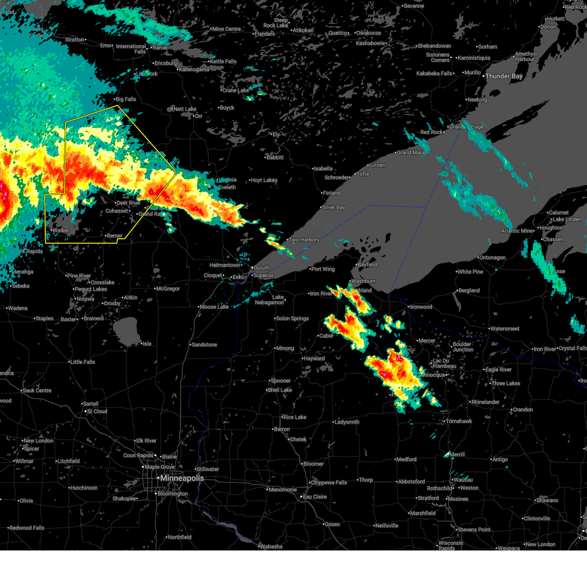 Svrdlh the national weather service in duluth mn has issued a * severe thunderstorm warning for, itasca county in north central minnesota, northern cass county in north central minnesota, southwestern koochiching county in north central minnesota, * until 130 am cdt. * at 1230 am cdt, severe thunderstorms were located along a line extending from 6 miles northeast of clearbrook to 11 miles southwest of wilton to near many point lake, moving east at 70 mph (radar indicated). Hazards include 70 mph wind gusts and half dollar size hail. Hail damage to vehicles is expected. expect considerable tree damage. Wind damage is also likely to mobile homes, roofs, and outbuildings. Svrdlh the national weather service in duluth mn has issued a * severe thunderstorm warning for, itasca county in north central minnesota, northern cass county in north central minnesota, southwestern koochiching county in north central minnesota, * until 130 am cdt. * at 1230 am cdt, severe thunderstorms were located along a line extending from 6 miles northeast of clearbrook to 11 miles southwest of wilton to near many point lake, moving east at 70 mph (radar indicated). Hazards include 70 mph wind gusts and half dollar size hail. Hail damage to vehicles is expected. expect considerable tree damage. Wind damage is also likely to mobile homes, roofs, and outbuildings.
|
| 6/21/2025 12:22 AM CDT |
 At 1221 am cdt, severe thunderstorms were located along a line extending from 6 miles northeast of inger to 8 miles north of hill annex mine state park to 7 miles north of toivola, moving northeast at 45 mph (radar indicated). Hazards include tennis ball size hail and 70 mph wind gusts. People and animals outdoors will be injured. expect hail damage to roofs, siding, windows, and vehicles. expect considerable tree damage. wind damage is also likely to mobile homes, roofs, and outbuildings. Locations impacted include, hibbing, keewatin, nashwauk, marcell, chisholm, cherry, bigfork, scenic state park, mountain iron, buhl, eveleth, effie, virginia, gilbert, mccarthy beach state park, biwabik, togo, cook and meadow brook. At 1221 am cdt, severe thunderstorms were located along a line extending from 6 miles northeast of inger to 8 miles north of hill annex mine state park to 7 miles north of toivola, moving northeast at 45 mph (radar indicated). Hazards include tennis ball size hail and 70 mph wind gusts. People and animals outdoors will be injured. expect hail damage to roofs, siding, windows, and vehicles. expect considerable tree damage. wind damage is also likely to mobile homes, roofs, and outbuildings. Locations impacted include, hibbing, keewatin, nashwauk, marcell, chisholm, cherry, bigfork, scenic state park, mountain iron, buhl, eveleth, effie, virginia, gilbert, mccarthy beach state park, biwabik, togo, cook and meadow brook.
|
| 6/21/2025 12:04 AM CDT |
 Svrdlh the national weather service in duluth mn has issued a * severe thunderstorm warning for, itasca county in north central minnesota, northeastern cass county in north central minnesota, southern koochiching county in north central minnesota, southern st. louis county in northeastern minnesota, * until 100 am cdt. * at 1204 am cdt, severe thunderstorms were located along a line extending from near inger to near coleraine to 8 miles northeast of swan river, moving northeast at 45 mph (radar indicated). Hazards include golf ball size hail and 60 mph wind gusts. People and animals outdoors will be injured. expect hail damage to roofs, siding, windows, and vehicles. expect wind damage to roofs, siding, and trees. severe thunderstorms will be near, hibbing, nashwauk, taconite, inger, hill annex mine state park, and pengilly around 1210 am cdt. keewatin and marcell around 1215 am cdt. Other locations in the path of these severe thunderstorms include chisholm, cherry, bigfork, scenic state park, mountain iron, buhl, virginia, eveleth, gilbert, effie, mccarthy beach state park and togo. Svrdlh the national weather service in duluth mn has issued a * severe thunderstorm warning for, itasca county in north central minnesota, northeastern cass county in north central minnesota, southern koochiching county in north central minnesota, southern st. louis county in northeastern minnesota, * until 100 am cdt. * at 1204 am cdt, severe thunderstorms were located along a line extending from near inger to near coleraine to 8 miles northeast of swan river, moving northeast at 45 mph (radar indicated). Hazards include golf ball size hail and 60 mph wind gusts. People and animals outdoors will be injured. expect hail damage to roofs, siding, windows, and vehicles. expect wind damage to roofs, siding, and trees. severe thunderstorms will be near, hibbing, nashwauk, taconite, inger, hill annex mine state park, and pengilly around 1210 am cdt. keewatin and marcell around 1215 am cdt. Other locations in the path of these severe thunderstorms include chisholm, cherry, bigfork, scenic state park, mountain iron, buhl, virginia, eveleth, gilbert, effie, mccarthy beach state park and togo.
|
| 8/3/2024 10:23 AM CDT |
 Svrdlh the national weather service in duluth mn has issued a * severe thunderstorm warning for, northeastern itasca county in north central minnesota, southwestern koochiching county in north central minnesota, * until 1115 am cdt. * at 1022 am cdt, a severe thunderstorm was located over mizpah, moving southeast at 45 mph (radar indicated). Hazards include 60 mph wind gusts and quarter size hail. Hail damage to vehicles is expected. Expect wind damage to roofs, siding, and trees. Svrdlh the national weather service in duluth mn has issued a * severe thunderstorm warning for, northeastern itasca county in north central minnesota, southwestern koochiching county in north central minnesota, * until 1115 am cdt. * at 1022 am cdt, a severe thunderstorm was located over mizpah, moving southeast at 45 mph (radar indicated). Hazards include 60 mph wind gusts and quarter size hail. Hail damage to vehicles is expected. Expect wind damage to roofs, siding, and trees.
|
| 6/18/2024 5:59 AM CDT |
 The storms which prompted the warning have weakened. therefore, the warning will be allowed to expire. a severe thunderstorm watch remains in effect until 900 am cdt for north central and east central minnesota. The storms which prompted the warning have weakened. therefore, the warning will be allowed to expire. a severe thunderstorm watch remains in effect until 900 am cdt for north central and east central minnesota.
|
| 6/18/2024 5:52 AM CDT |
 At 552 am cdt, severe thunderstorms were located along a line extending from 10 miles southeast of big falls to near poplar, moving east at 40 mph (radar indicated). Hazards include 60 mph wind gusts and penny size hail. Expect damage to roofs, siding, and trees. Locations impacted include, walker, pequot lakes, pine river, marcell, bigfork, wabedo, hackensack, backus, northome, poplar, longville, effie, bena, federal dam, squaw lake, mizpah, boy river, alvwood, leech lake, and gemmell. At 552 am cdt, severe thunderstorms were located along a line extending from 10 miles southeast of big falls to near poplar, moving east at 40 mph (radar indicated). Hazards include 60 mph wind gusts and penny size hail. Expect damage to roofs, siding, and trees. Locations impacted include, walker, pequot lakes, pine river, marcell, bigfork, wabedo, hackensack, backus, northome, poplar, longville, effie, bena, federal dam, squaw lake, mizpah, boy river, alvwood, leech lake, and gemmell.
|
| 6/18/2024 5:35 AM CDT |
 At 535 am cdt, severe thunderstorms were located along a line extending from near margie to 6 miles east of sebeka, moving east at 40 mph (radar indicated). Hazards include 60 mph wind gusts and nickel size hail. Expect damage to roofs, siding, and trees. Locations impacted include, walker, pequot lakes, pine river, marcell, bigfork, wabedo, hackensack, backus, northome, poplar, longville, effie, bena, federal dam, squaw lake, mizpah, boy river, alvwood, leech lake, and gemmell. At 535 am cdt, severe thunderstorms were located along a line extending from near margie to 6 miles east of sebeka, moving east at 40 mph (radar indicated). Hazards include 60 mph wind gusts and nickel size hail. Expect damage to roofs, siding, and trees. Locations impacted include, walker, pequot lakes, pine river, marcell, bigfork, wabedo, hackensack, backus, northome, poplar, longville, effie, bena, federal dam, squaw lake, mizpah, boy river, alvwood, leech lake, and gemmell.
|
| 6/18/2024 5:26 AM CDT |
 At 526 am cdt, severe thunderstorms were located along a line extending from near margie to sebeka, moving east at 40 mph (radar indicated). Hazards include 60 mph wind gusts and quarter size hail. Hail damage to vehicles is expected. expect wind damage to roofs, siding, and trees. Locations impacted include, walker, squaw lake, margie, lake winnibigoshish, leech lake, oslund, hackensack, bena, federal dam, backus, poplar, inger, effie, woman lake, pine river, bigfork, longville, boy river, ball club, marcell, wabedo, scenic state park and pequot lakes. At 526 am cdt, severe thunderstorms were located along a line extending from near margie to sebeka, moving east at 40 mph (radar indicated). Hazards include 60 mph wind gusts and quarter size hail. Hail damage to vehicles is expected. expect wind damage to roofs, siding, and trees. Locations impacted include, walker, squaw lake, margie, lake winnibigoshish, leech lake, oslund, hackensack, bena, federal dam, backus, poplar, inger, effie, woman lake, pine river, bigfork, longville, boy river, ball club, marcell, wabedo, scenic state park and pequot lakes.
|
| 6/18/2024 5:02 AM CDT |
 Svrdlh the national weather service in duluth mn has issued a * severe thunderstorm warning for, northwestern itasca county in north central minnesota, cass county in north central minnesota, southern koochiching county in north central minnesota, northwestern crow wing county in east central minnesota, * until 600 am cdt. * at 500 am cdt, severe thunderstorms were located along a line extending from 10 miles east of waskish to 11 miles north of new york mills, moving east at 40 mph (radar indicated). Hazards include 60 mph wind gusts and quarter size hail. Hail damage to vehicles is expected. expect wind damage to roofs, siding, and trees. severe thunderstorms will be near, northome around 505 am cdt. mizpah around 510 am cdt. alvwood and gemmell around 515 am cdt. margie, lake winnibigoshish, and leech lake around 520 am cdt. Other locations in the path of these severe thunderstorms include walker, squaw lake, oslund, hackensack, bena and federal dam. Svrdlh the national weather service in duluth mn has issued a * severe thunderstorm warning for, northwestern itasca county in north central minnesota, cass county in north central minnesota, southern koochiching county in north central minnesota, northwestern crow wing county in east central minnesota, * until 600 am cdt. * at 500 am cdt, severe thunderstorms were located along a line extending from 10 miles east of waskish to 11 miles north of new york mills, moving east at 40 mph (radar indicated). Hazards include 60 mph wind gusts and quarter size hail. Hail damage to vehicles is expected. expect wind damage to roofs, siding, and trees. severe thunderstorms will be near, northome around 505 am cdt. mizpah around 510 am cdt. alvwood and gemmell around 515 am cdt. margie, lake winnibigoshish, and leech lake around 520 am cdt. Other locations in the path of these severe thunderstorms include walker, squaw lake, oslund, hackensack, bena and federal dam.
|
| 7/19/2023 4:00 PM CDT |
 At 400 pm cdt, a severe thunderstorm was located over northome, moving east at 30 mph (radar indicated). Hazards include 60 mph wind gusts and quarter size hail. Hail damage to vehicles is expected. expect wind damage to roofs, siding, and trees. locations impacted include, northome, mizpah, gemmell, and orth. hail threat, radar indicated max hail size, 1. 00 in wind threat, radar indicated max wind gust, 60 mph. At 400 pm cdt, a severe thunderstorm was located over northome, moving east at 30 mph (radar indicated). Hazards include 60 mph wind gusts and quarter size hail. Hail damage to vehicles is expected. expect wind damage to roofs, siding, and trees. locations impacted include, northome, mizpah, gemmell, and orth. hail threat, radar indicated max hail size, 1. 00 in wind threat, radar indicated max wind gust, 60 mph.
|
| 7/19/2023 3:35 PM CDT |
 At 335 pm cdt, a severe thunderstorm was located over kelliher, or 37 miles northeast of bemidji, moving east at 30 mph (radar indicated). Hazards include 60 mph wind gusts and half dollar size hail. Hail damage to vehicles is expected. Expect wind damage to roofs, siding, and trees. At 335 pm cdt, a severe thunderstorm was located over kelliher, or 37 miles northeast of bemidji, moving east at 30 mph (radar indicated). Hazards include 60 mph wind gusts and half dollar size hail. Hail damage to vehicles is expected. Expect wind damage to roofs, siding, and trees.
|
| 7/10/2022 10:39 AM CDT |
 At 1039 am cdt, severe thunderstorms were located along a line extending from 11 miles east of baudette, to 12 miles northwest of lake winnibigoshish, moving east at 40 mph (radar indicated). Hazards include 60 mph wind gusts and quarter size hail. Hail damage to vehicles is expected. expect wind damage to roofs, siding, and trees. locations impacted include, deer river, birchdale, big falls, northome, squaw lake, zemple, mizpah, alvwood, manitou, oslund, inger, gemmell, margie, lake winnibigoshish, ball club, spring lake, bowstring, sand lake, max, and wirt. hail threat, radar indicated max hail size, 1. 00 in wind threat, radar indicated max wind gust, 60 mph. At 1039 am cdt, severe thunderstorms were located along a line extending from 11 miles east of baudette, to 12 miles northwest of lake winnibigoshish, moving east at 40 mph (radar indicated). Hazards include 60 mph wind gusts and quarter size hail. Hail damage to vehicles is expected. expect wind damage to roofs, siding, and trees. locations impacted include, deer river, birchdale, big falls, northome, squaw lake, zemple, mizpah, alvwood, manitou, oslund, inger, gemmell, margie, lake winnibigoshish, ball club, spring lake, bowstring, sand lake, max, and wirt. hail threat, radar indicated max hail size, 1. 00 in wind threat, radar indicated max wind gust, 60 mph.
|
| 7/10/2022 10:14 AM CDT |
 At 1013 am cdt, severe thunderstorms were located along a line extending from baudette, to upper red lake, to 6 miles east of lavinia, moving east at 45 mph (radar indicated). Hazards include 60 mph wind gusts and quarter size hail. Hail damage to vehicles is expected. Expect wind damage to roofs, siding, and trees. At 1013 am cdt, severe thunderstorms were located along a line extending from baudette, to upper red lake, to 6 miles east of lavinia, moving east at 45 mph (radar indicated). Hazards include 60 mph wind gusts and quarter size hail. Hail damage to vehicles is expected. Expect wind damage to roofs, siding, and trees.
|
| 6/24/2022 11:20 PM CDT |
 At 1119 pm cdt, severe thunderstorms were located along a line extending from near mizpah, to inger, to ball club, to near longville, moving east at 55 mph. these are destructive storms for bena, ball club, deer river, highway 2 between deer river and bena (radar indicated). Hazards include 80 mph wind gusts and quarter size hail. Flying debris will be dangerous to those caught without shelter. mobile homes will be heavily damaged. expect considerable damage to roofs, windows, and vehicles. extensive tree damage and power outages are likely. these severe storms will be near, ball club around 1125 pm cdt. deer river, zemple and days high landing around 1130 pm cdt. marcell and remer around 1135 pm cdt. pokegama dam around 1140 pm cdt. grand rapids, bigfork, effie and gunn around 1145 pm cdt. coleraine around 1150 pm cdt. taconite around 1155 pm cdt. pengilly around 1200 am cdt. Other locations impacted by these severe thunderstorms include buck lake, calumet, swan lake, stony brook, orth, bowstring, wirt, la prairie, sugar lake and rosy. At 1119 pm cdt, severe thunderstorms were located along a line extending from near mizpah, to inger, to ball club, to near longville, moving east at 55 mph. these are destructive storms for bena, ball club, deer river, highway 2 between deer river and bena (radar indicated). Hazards include 80 mph wind gusts and quarter size hail. Flying debris will be dangerous to those caught without shelter. mobile homes will be heavily damaged. expect considerable damage to roofs, windows, and vehicles. extensive tree damage and power outages are likely. these severe storms will be near, ball club around 1125 pm cdt. deer river, zemple and days high landing around 1130 pm cdt. marcell and remer around 1135 pm cdt. pokegama dam around 1140 pm cdt. grand rapids, bigfork, effie and gunn around 1145 pm cdt. coleraine around 1150 pm cdt. taconite around 1155 pm cdt. pengilly around 1200 am cdt. Other locations impacted by these severe thunderstorms include buck lake, calumet, swan lake, stony brook, orth, bowstring, wirt, la prairie, sugar lake and rosy.
|
| 6/24/2022 11:09 PM CDT |
 At 1108 pm cdt, severe thunderstorms were located along a line extending from mizpah, to 6 miles northwest of oslund, to near lake winnibigoshish, to near leech lake, moving east at 45 mph (radar indicated). Hazards include 70 mph wind gusts and quarter size hail. Hail damage to vehicles is expected. expect considerable tree damage. wind damage is also likely to mobile homes, roofs, and outbuildings. severe thunderstorms will be near, oslund and inger around 1115 pm cdt. deer river around 1130 pm cdt. bigfork and remer around 1135 pm cdt. effie around 1145 pm cdt. coleraine around 1150 pm cdt. cohasset and pokegama lake around 1155 pm cdt. taconite and gunn around 1200 am cdt. pengilly around 1205 am cdt. Other locations impacted by these severe thunderstorms include buck lake, calumet, swan lake, stony brook, orth, bowstring, wirt, la prairie, sugar lake and rosy. At 1108 pm cdt, severe thunderstorms were located along a line extending from mizpah, to 6 miles northwest of oslund, to near lake winnibigoshish, to near leech lake, moving east at 45 mph (radar indicated). Hazards include 70 mph wind gusts and quarter size hail. Hail damage to vehicles is expected. expect considerable tree damage. wind damage is also likely to mobile homes, roofs, and outbuildings. severe thunderstorms will be near, oslund and inger around 1115 pm cdt. deer river around 1130 pm cdt. bigfork and remer around 1135 pm cdt. effie around 1145 pm cdt. coleraine around 1150 pm cdt. cohasset and pokegama lake around 1155 pm cdt. taconite and gunn around 1200 am cdt. pengilly around 1205 am cdt. Other locations impacted by these severe thunderstorms include buck lake, calumet, swan lake, stony brook, orth, bowstring, wirt, la prairie, sugar lake and rosy.
|
| 6/24/2022 11:02 PM CDT |
 At 1101 pm cdt, severe thunderstorms were located along a line extending from near northome, to near squaw lake, to near bena, to leech lake, moving east at 45 mph (radar indicated). Hazards include 70 mph wind gusts and quarter size hail. Hail damage to vehicles is expected. expect considerable tree damage. wind damage is also likely to mobile homes, roofs, and outbuildings. these severe storms will be near, bena around 1105 pm cdt. federal dam and squaw lake around 1110 pm cdt. oslund around 1115 pm cdt. boy river, ball club and inger around 1120 pm cdt. deer river, marcell and zemple around 1135 pm cdt. Other locations impacted by these severe thunderstorms include max, portage lake, ball club lake, decker lake, mud lake, sand lake, six mile lake, orth, tobique and brevik. At 1101 pm cdt, severe thunderstorms were located along a line extending from near northome, to near squaw lake, to near bena, to leech lake, moving east at 45 mph (radar indicated). Hazards include 70 mph wind gusts and quarter size hail. Hail damage to vehicles is expected. expect considerable tree damage. wind damage is also likely to mobile homes, roofs, and outbuildings. these severe storms will be near, bena around 1105 pm cdt. federal dam and squaw lake around 1110 pm cdt. oslund around 1115 pm cdt. boy river, ball club and inger around 1120 pm cdt. deer river, marcell and zemple around 1135 pm cdt. Other locations impacted by these severe thunderstorms include max, portage lake, ball club lake, decker lake, mud lake, sand lake, six mile lake, orth, tobique and brevik.
|
| 6/24/2022 10:48 PM CDT |
 At 1048 pm cdt, severe thunderstorms were located along a line extending from 7 miles west of kelliher, to near blackduck, to 9 miles southwest of alvwood, to 13 miles southeast of turtle river, to 15 miles southeast of lavinia, to near laporte, moving east at 40 mph (radar indicated). Hazards include 70 mph wind gusts and quarter size hail. Hail damage to vehicles is expected. expect considerable tree damage. wind damage is also likely to mobile homes, roofs, and outbuildings. these severe storms will be near, alvwood around 1105 pm cdt. squaw lake around 1110 pm cdt. northome, bena, federal dam, mizpah and lake winnibigoshish around 1115 pm cdt. oslund and leech lake around 1120 pm cdt. boy river, inger and gemmell around 1125 pm cdt. ball club around 1130 pm cdt. deer river, marcell and zemple around 1145 pm cdt. Other locations impacted by these severe thunderstorms include max, portage lake, ball club lake, decker lake, mud lake, sand lake, six mile lake, orth, tobique and brevik. At 1048 pm cdt, severe thunderstorms were located along a line extending from 7 miles west of kelliher, to near blackduck, to 9 miles southwest of alvwood, to 13 miles southeast of turtle river, to 15 miles southeast of lavinia, to near laporte, moving east at 40 mph (radar indicated). Hazards include 70 mph wind gusts and quarter size hail. Hail damage to vehicles is expected. expect considerable tree damage. wind damage is also likely to mobile homes, roofs, and outbuildings. these severe storms will be near, alvwood around 1105 pm cdt. squaw lake around 1110 pm cdt. northome, bena, federal dam, mizpah and lake winnibigoshish around 1115 pm cdt. oslund and leech lake around 1120 pm cdt. boy river, inger and gemmell around 1125 pm cdt. ball club around 1130 pm cdt. deer river, marcell and zemple around 1145 pm cdt. Other locations impacted by these severe thunderstorms include max, portage lake, ball club lake, decker lake, mud lake, sand lake, six mile lake, orth, tobique and brevik.
|
| 6/24/2022 10:28 PM CDT |
 At 1027 pm cdt, severe thunderstorms were located along a line extending from lower red lake, to tenstrike, to 6 miles southeast of bemidji, to near laporte, moving east at 35 mph (radar indicated). Hazards include 70 mph wind gusts and quarter size hail. Hail damage to vehicles is expected. expect considerable tree damage. wind damage is also likely to mobile homes, roofs, and outbuildings. these severe storms will be near, alvwood around 1100 pm cdt. northome, bena and squaw lake around 1115 pm cdt. federal dam, mizpah, oslund and leech lake around 1120 pm cdt. gemmell, inger and lake winnibigoshish around 1125 pm cdt. boy river around 1130 pm cdt. ball club around 1135 pm cdt. deer river, marcell and zemple around 1145 pm cdt. Other locations impacted by these severe thunderstorms include max, portage lake, ball club lake, decker lake, mud lake, sand lake, six mile lake, orth, tobique and brevik. At 1027 pm cdt, severe thunderstorms were located along a line extending from lower red lake, to tenstrike, to 6 miles southeast of bemidji, to near laporte, moving east at 35 mph (radar indicated). Hazards include 70 mph wind gusts and quarter size hail. Hail damage to vehicles is expected. expect considerable tree damage. wind damage is also likely to mobile homes, roofs, and outbuildings. these severe storms will be near, alvwood around 1100 pm cdt. northome, bena and squaw lake around 1115 pm cdt. federal dam, mizpah, oslund and leech lake around 1120 pm cdt. gemmell, inger and lake winnibigoshish around 1125 pm cdt. boy river around 1130 pm cdt. ball club around 1135 pm cdt. deer river, marcell and zemple around 1145 pm cdt. Other locations impacted by these severe thunderstorms include max, portage lake, ball club lake, decker lake, mud lake, sand lake, six mile lake, orth, tobique and brevik.
|
| 6/24/2022 10:19 PM CDT |
 At 1018 pm cdt, severe thunderstorms were located along a line extending from lower red lake, to near turtle river, to near bemidji, to near lake george, moving east at 35 mph (radar indicated). Hazards include 70 mph wind gusts and quarter size hail. Hail damage to vehicles is expected. expect considerable tree damage. Wind damage is also likely to mobile homes, roofs, and outbuildings. At 1018 pm cdt, severe thunderstorms were located along a line extending from lower red lake, to near turtle river, to near bemidji, to near lake george, moving east at 35 mph (radar indicated). Hazards include 70 mph wind gusts and quarter size hail. Hail damage to vehicles is expected. expect considerable tree damage. Wind damage is also likely to mobile homes, roofs, and outbuildings.
|
| 5/30/2022 7:00 PM CDT |
 At 659 pm cdt, severe thunderstorms were located along a line extending from 9 miles northwest of margie, to 9 miles west of effie, to 7 miles southwest of marcell, moving northeast at 55 mph (radar indicated). Hazards include 70 mph wind gusts and penny size hail. Expect considerable tree damage. damage is likely to mobile homes, roofs, and outbuildings. Locations impacted include, marcell, bigfork, big falls, northome, effie, squaw lake, mizpah, oslund, inger, gemmell, ball club, margie, spring lake, bowstring, sand lake, max, wirt, ball club lake, bois forte band deer creek area, and grand falls. At 659 pm cdt, severe thunderstorms were located along a line extending from 9 miles northwest of margie, to 9 miles west of effie, to 7 miles southwest of marcell, moving northeast at 55 mph (radar indicated). Hazards include 70 mph wind gusts and penny size hail. Expect considerable tree damage. damage is likely to mobile homes, roofs, and outbuildings. Locations impacted include, marcell, bigfork, big falls, northome, effie, squaw lake, mizpah, oslund, inger, gemmell, ball club, margie, spring lake, bowstring, sand lake, max, wirt, ball club lake, bois forte band deer creek area, and grand falls.
|
| 5/30/2022 6:45 PM CDT |
 At 644 pm cdt, severe thunderstorms were located along a line extending from near mizpah, to near oslund, to near ball club, moving northeast at 55 mph (radar indicated). Hazards include 70 mph wind gusts and quarter size hail. Hail damage to vehicles is expected. expect considerable tree damage. Wind damage is also likely to mobile homes, roofs, and outbuildings. At 644 pm cdt, severe thunderstorms were located along a line extending from near mizpah, to near oslund, to near ball club, moving northeast at 55 mph (radar indicated). Hazards include 70 mph wind gusts and quarter size hail. Hail damage to vehicles is expected. expect considerable tree damage. Wind damage is also likely to mobile homes, roofs, and outbuildings.
|
| 5/30/2022 6:31 PM CDT |
 At 631 pm cdt, severe thunderstorms were located along a line extending from near alvwood, to near lake winnibigoshish, to near boy river, moving northeast at 50 mph (radar indicated). Hazards include 70 mph wind gusts and quarter size hail. Hail damage to vehicles is expected. expect considerable tree damage. wind damage is also likely to mobile homes, roofs, and outbuildings. Locations impacted include, deer river, northome, bena, federal dam, squaw lake, mizpah, boy river, alvwood, oslund, leech lake, inger, gemmell, ball club, lake winnibigoshish, spring lake, bowstring, sand lake, max, wirt, and portage lake. At 631 pm cdt, severe thunderstorms were located along a line extending from near alvwood, to near lake winnibigoshish, to near boy river, moving northeast at 50 mph (radar indicated). Hazards include 70 mph wind gusts and quarter size hail. Hail damage to vehicles is expected. expect considerable tree damage. wind damage is also likely to mobile homes, roofs, and outbuildings. Locations impacted include, deer river, northome, bena, federal dam, squaw lake, mizpah, boy river, alvwood, oslund, leech lake, inger, gemmell, ball club, lake winnibigoshish, spring lake, bowstring, sand lake, max, wirt, and portage lake.
|
| 5/30/2022 6:18 PM CDT |
 At 617 pm cdt, severe thunderstorms were located along a line extending from 9 miles southeast of tenstrike, to 7 miles west of bena, to near leech lake, moving northeast at 45 mph (radar indicated). Hazards include 70 mph wind gusts and quarter size hail. Hail damage to vehicles is expected. expect considerable tree damage. wind damage is also likely to mobile homes, roofs, and outbuildings. Locations impacted include, walker, deer river, hackensack, northome, bena, federal dam, squaw lake, mizpah, boy river, alvwood, oslund, leech lake, inger, gemmell, ball club, lake winnibigoshish, spring lake, cass lake, wilkinson, and bowstring. At 617 pm cdt, severe thunderstorms were located along a line extending from 9 miles southeast of tenstrike, to 7 miles west of bena, to near leech lake, moving northeast at 45 mph (radar indicated). Hazards include 70 mph wind gusts and quarter size hail. Hail damage to vehicles is expected. expect considerable tree damage. wind damage is also likely to mobile homes, roofs, and outbuildings. Locations impacted include, walker, deer river, hackensack, northome, bena, federal dam, squaw lake, mizpah, boy river, alvwood, oslund, leech lake, inger, gemmell, ball club, lake winnibigoshish, spring lake, cass lake, wilkinson, and bowstring.
|
| 5/30/2022 6:02 PM CDT |
 At 602 pm cdt, severe thunderstorms were located along a line extending from 10 miles southeast of lavinia, to near leech lake, to hackensack, moving northeast at 45 mph (radar indicated). Hazards include 70 mph wind gusts and quarter size hail. Hail damage to vehicles is expected. expect considerable tree damage. Wind damage is also likely to mobile homes, roofs, and outbuildings. At 602 pm cdt, severe thunderstorms were located along a line extending from 10 miles southeast of lavinia, to near leech lake, to hackensack, moving northeast at 45 mph (radar indicated). Hazards include 70 mph wind gusts and quarter size hail. Hail damage to vehicles is expected. expect considerable tree damage. Wind damage is also likely to mobile homes, roofs, and outbuildings.
|
| 7/28/2021 7:14 PM CDT |
 At 714 pm cdt, a severe thunderstorm was located near alvwood, or 37 miles northeast of bemidji, moving southeast at 35 mph (radar indicated). Hazards include ping pong ball size hail and 60 mph wind gusts. People and animals outdoors will be injured. expect hail damage to roofs, siding, windows, and vehicles. expect wind damage to roofs, siding, and trees. this severe storm will be near, squaw lake around 725 pm cdt. Other locations in the path of this severe thunderstorm include oslund. At 714 pm cdt, a severe thunderstorm was located near alvwood, or 37 miles northeast of bemidji, moving southeast at 35 mph (radar indicated). Hazards include ping pong ball size hail and 60 mph wind gusts. People and animals outdoors will be injured. expect hail damage to roofs, siding, windows, and vehicles. expect wind damage to roofs, siding, and trees. this severe storm will be near, squaw lake around 725 pm cdt. Other locations in the path of this severe thunderstorm include oslund.
|
| 7/28/2021 7:06 PM CDT |
 At 706 pm cdt, a severe thunderstorm was located near northome, or 36 miles northeast of bemidji, moving southeast at 35 mph (radar indicated). Hazards include ping pong ball size hail and 60 mph wind gusts. People and animals outdoors will be injured. expect hail damage to roofs, siding, windows, and vehicles. expect wind damage to roofs, siding, and trees. this severe storm will be near, alvwood around 710 pm cdt. Other locations in the path of this severe thunderstorm include squaw lake and oslund. At 706 pm cdt, a severe thunderstorm was located near northome, or 36 miles northeast of bemidji, moving southeast at 35 mph (radar indicated). Hazards include ping pong ball size hail and 60 mph wind gusts. People and animals outdoors will be injured. expect hail damage to roofs, siding, windows, and vehicles. expect wind damage to roofs, siding, and trees. this severe storm will be near, alvwood around 710 pm cdt. Other locations in the path of this severe thunderstorm include squaw lake and oslund.
|
| 7/28/2021 6:51 PM CDT |
 At 651 pm cdt, a severe thunderstorm was located near kelliher, or 37 miles northeast of bemidji, moving southeast at 35 mph (radar indicated). Hazards include 60 mph wind gusts and quarter size hail. Hail damage to vehicles is expected. expect wind damage to roofs, siding, and trees. this severe thunderstorm will be near, mizpah around 655 pm cdt. northome around 700 pm cdt. Other locations in the path of this severe thunderstorm include alvwood, squaw lake and oslund. At 651 pm cdt, a severe thunderstorm was located near kelliher, or 37 miles northeast of bemidji, moving southeast at 35 mph (radar indicated). Hazards include 60 mph wind gusts and quarter size hail. Hail damage to vehicles is expected. expect wind damage to roofs, siding, and trees. this severe thunderstorm will be near, mizpah around 655 pm cdt. northome around 700 pm cdt. Other locations in the path of this severe thunderstorm include alvwood, squaw lake and oslund.
|
| 7/23/2021 5:39 PM CDT | The spotter reported a few trees down at his location and his power was ou in itasca county MN, 13.7 miles NW of Northome, MN |
| 7/23/2021 5:30 PM CDT | Spotter reported a tree down onto power lines about two miles west of their home. time estimated by rada in itasca county MN, 10.9 miles NNW of Northome, MN |
| 7/23/2021 5:19 PM CDT |
 At 518 pm cdt, a severe thunderstorm was located near alvwood, or 38 miles northeast of bemidji, moving southeast at 30 mph (radar indicated). Hazards include 70 mph wind gusts and ping pong ball size hail. People and animals outdoors will be injured. expect hail damage to roofs, siding, windows, and vehicles. expect considerable tree damage. wind damage is also likely to mobile homes, roofs, and outbuildings. Locations impacted include, northome and alvwood. At 518 pm cdt, a severe thunderstorm was located near alvwood, or 38 miles northeast of bemidji, moving southeast at 30 mph (radar indicated). Hazards include 70 mph wind gusts and ping pong ball size hail. People and animals outdoors will be injured. expect hail damage to roofs, siding, windows, and vehicles. expect considerable tree damage. wind damage is also likely to mobile homes, roofs, and outbuildings. Locations impacted include, northome and alvwood.
|
| 7/23/2021 4:59 PM CDT |
 At 458 pm cdt, a severe thunderstorm was located near northome, or 34 miles northeast of bemidji, moving southeast at 15 mph (at 453 pm, trained weather spotters reported 2 inch hail with this storm near shooks). Hazards include two inch hail and 70 mph wind gusts. People and animals outdoors will be injured. expect hail damage to roofs, siding, windows, and vehicles. expect considerable tree damage. Wind damage is also likely to mobile homes, roofs, and outbuildings. At 458 pm cdt, a severe thunderstorm was located near northome, or 34 miles northeast of bemidji, moving southeast at 15 mph (at 453 pm, trained weather spotters reported 2 inch hail with this storm near shooks). Hazards include two inch hail and 70 mph wind gusts. People and animals outdoors will be injured. expect hail damage to roofs, siding, windows, and vehicles. expect considerable tree damage. Wind damage is also likely to mobile homes, roofs, and outbuildings.
|
| 7/23/2021 4:53 PM CDT | Hen Egg sized hail reported 7.5 miles E of Northome, MN, numerous 1" hail stones with 2" ones mixed in. |
| 7/23/2021 4:50 PM CDT |
 At 450 pm cdt, a severe thunderstorm was located near mizpah, moving northeast at 35 mph (radar indicated). Hazards include 70 mph wind gusts and ping pong ball size hail. People and animals outdoors will be injured. expect hail damage to roofs, siding, windows, and vehicles. expect considerable tree damage. wind damage is also likely to mobile homes, roofs, and outbuildings. this severe thunderstorm will be near, mizpah around 455 pm cdt. gemmell around 505 pm cdt. Other locations in the path of this severe thunderstorm include margie. At 450 pm cdt, a severe thunderstorm was located near mizpah, moving northeast at 35 mph (radar indicated). Hazards include 70 mph wind gusts and ping pong ball size hail. People and animals outdoors will be injured. expect hail damage to roofs, siding, windows, and vehicles. expect considerable tree damage. wind damage is also likely to mobile homes, roofs, and outbuildings. this severe thunderstorm will be near, mizpah around 455 pm cdt. gemmell around 505 pm cdt. Other locations in the path of this severe thunderstorm include margie.
|
| 8/13/2020 11:26 PM CDT |
 At 1126 pm cdt, severe thunderstorms were located along a line extending from near waskish, to 17 miles northwest of gemmell, to 7 miles northwest of mizpah, to near kelliher, moving northeast at 35 mph (at 1111 pm cdt, emergency management reported power outages in kelliher). Hazards include 60 mph wind gusts and penny size hail. Expect damage to roofs, siding, and trees. Locations impacted include, big falls, northome, mizpah, gemmell, margie, and grand falls. At 1126 pm cdt, severe thunderstorms were located along a line extending from near waskish, to 17 miles northwest of gemmell, to 7 miles northwest of mizpah, to near kelliher, moving northeast at 35 mph (at 1111 pm cdt, emergency management reported power outages in kelliher). Hazards include 60 mph wind gusts and penny size hail. Expect damage to roofs, siding, and trees. Locations impacted include, big falls, northome, mizpah, gemmell, margie, and grand falls.
|
| 8/13/2020 11:10 PM CDT |
 At 1109 pm cdt, severe thunderstorms were located along a line extending from upper red lake, to 8 miles southwest of waskish, to 7 miles southwest of kelliher, to 7 miles northwest of blackduck, moving northeast at 40 mph (radar indicated). Hazards include 70 mph wind gusts and penny size hail. Expect considerable tree damage. damage is likely to mobile homes, roofs, and outbuildings. Locations impacted include, big falls, northome, squaw lake, mizpah, alvwood, gemmell, margie, wirt, orth, grand falls, and whitefish lake. At 1109 pm cdt, severe thunderstorms were located along a line extending from upper red lake, to 8 miles southwest of waskish, to 7 miles southwest of kelliher, to 7 miles northwest of blackduck, moving northeast at 40 mph (radar indicated). Hazards include 70 mph wind gusts and penny size hail. Expect considerable tree damage. damage is likely to mobile homes, roofs, and outbuildings. Locations impacted include, big falls, northome, squaw lake, mizpah, alvwood, gemmell, margie, wirt, orth, grand falls, and whitefish lake.
|
| 8/13/2020 10:47 PM CDT |
 At 1046 pm cdt, severe thunderstorms were located over southern beltrami county, along a line extending from ponemah, to lower red lake, to 7 miles east of redby, to 8 miles northwest of tenstrike, to 6 miles northwest of turtle river, moving east at 40 mph (radar indicated). Hazards include 70 mph wind gusts and penny size hail. Expect considerable tree damage. Damage is likely to mobile homes, roofs, and outbuildings. At 1046 pm cdt, severe thunderstorms were located over southern beltrami county, along a line extending from ponemah, to lower red lake, to 7 miles east of redby, to 8 miles northwest of tenstrike, to 6 miles northwest of turtle river, moving east at 40 mph (radar indicated). Hazards include 70 mph wind gusts and penny size hail. Expect considerable tree damage. Damage is likely to mobile homes, roofs, and outbuildings.
|
| 7/17/2020 7:40 PM CDT |
 At 740 pm cdt, severe thunderstorms were located along a line extending from 10 miles west of kelliher, to 7 miles east of lavinia, to 7 miles south of lake george, moving east at 30 mph (radar indicated). Hazards include 60 mph wind gusts and penny size hail. Expect damage to roofs, siding, and trees. Locations impacted include, walker, northome, bena, federal dam, squaw lake, alvwood, oslund, leech lake, inger, lake winnibigoshish, cass lake, wilkinson, sand lake, max, portage lake, decker lake, six mile lake, orth, brevik, and rosy. At 740 pm cdt, severe thunderstorms were located along a line extending from 10 miles west of kelliher, to 7 miles east of lavinia, to 7 miles south of lake george, moving east at 30 mph (radar indicated). Hazards include 60 mph wind gusts and penny size hail. Expect damage to roofs, siding, and trees. Locations impacted include, walker, northome, bena, federal dam, squaw lake, alvwood, oslund, leech lake, inger, lake winnibigoshish, cass lake, wilkinson, sand lake, max, portage lake, decker lake, six mile lake, orth, brevik, and rosy.
|
| 7/17/2020 7:28 PM CDT |
 At 727 pm cdt, severe thunderstorms were located along a line extending from lower red lake, to near lavinia, to 8 miles south of lake george, moving east at 40 mph (radar indicated). Hazards include 60 mph wind gusts and penny size hail. expect damage to roofs, siding, and trees At 727 pm cdt, severe thunderstorms were located along a line extending from lower red lake, to near lavinia, to 8 miles south of lake george, moving east at 40 mph (radar indicated). Hazards include 60 mph wind gusts and penny size hail. expect damage to roofs, siding, and trees
|
| 7/17/2019 5:26 PM CDT |
 At 526 pm cdt, a severe thunderstorm was located just north of alvwood, or 37 miles northeast of bemidji, moving northeast at 20 mph (radar indicated). Hazards include 60 mph wind gusts and nickel size hail. expect damage to roofs, siding, and trees At 526 pm cdt, a severe thunderstorm was located just north of alvwood, or 37 miles northeast of bemidji, moving northeast at 20 mph (radar indicated). Hazards include 60 mph wind gusts and nickel size hail. expect damage to roofs, siding, and trees
|
| 7/15/2019 1:32 PM CDT |
 At 132 pm cdt, severe thunderstorms were located along a line extending from near margie, to 8 miles east of gemmell, to near alvwood, moving east at 40 mph (radar indicated). Hazards include 60 mph wind gusts and quarter size hail. Hail damage to vehicles is expected. expect wind damage to roofs, siding, and trees. these severe storms will be near, big falls and margie around 135 pm cdt. squaw lake around 145 pm cdt. Other locations impacted by these severe thunderstorms include deer creek reservation, orth, whitefish lake, bois forte reservation, craigville, wirt, coon lake and scenic state park. At 132 pm cdt, severe thunderstorms were located along a line extending from near margie, to 8 miles east of gemmell, to near alvwood, moving east at 40 mph (radar indicated). Hazards include 60 mph wind gusts and quarter size hail. Hail damage to vehicles is expected. expect wind damage to roofs, siding, and trees. these severe storms will be near, big falls and margie around 135 pm cdt. squaw lake around 145 pm cdt. Other locations impacted by these severe thunderstorms include deer creek reservation, orth, whitefish lake, bois forte reservation, craigville, wirt, coon lake and scenic state park.
|
| 7/15/2019 1:17 PM CDT |
 At 116 pm cdt, severe thunderstorms were located along a line extending from 7 miles west of margie, to gemmell, to 7 miles northwest of alvwood, moving east at 50 mph (doppler radar indicated. there was a public report of trees down across minnesota highway 72 4 miles south of waskish with this storm around 1 pm). Hazards include 60 mph wind gusts and quarter size hail. Hail damage to vehicles is expected. expect wind damage to roofs, siding, and trees. severe thunderstorms will be near, gemmell around 120 pm cdt. northome and margie around 125 pm cdt. big falls around 130 pm cdt. squaw lake around 135 pm cdt. bigfork and effie around 200 pm cdt. Other locations impacted by these severe thunderstorms include deer creek reservation, orth, whitefish lake, bois forte reservation, craigville, grand falls, wirt, coon lake and scenic state park. At 116 pm cdt, severe thunderstorms were located along a line extending from 7 miles west of margie, to gemmell, to 7 miles northwest of alvwood, moving east at 50 mph (doppler radar indicated. there was a public report of trees down across minnesota highway 72 4 miles south of waskish with this storm around 1 pm). Hazards include 60 mph wind gusts and quarter size hail. Hail damage to vehicles is expected. expect wind damage to roofs, siding, and trees. severe thunderstorms will be near, gemmell around 120 pm cdt. northome and margie around 125 pm cdt. big falls around 130 pm cdt. squaw lake around 135 pm cdt. bigfork and effie around 200 pm cdt. Other locations impacted by these severe thunderstorms include deer creek reservation, orth, whitefish lake, bois forte reservation, craigville, grand falls, wirt, coon lake and scenic state park.
|
| 7/15/2019 1:10 PM CDT |
 At 109 pm cdt, severe thunderstorms were located along a line extending from 10 miles southeast of waskish, to 7 miles northeast of kelliher, to near northome, to near blackduck, moving east at 50 mph (doppler radar indicated. there was a public report of trees down on minnesota highway 72 south of waskish around 1 pm). Hazards include 60 mph wind gusts and quarter size hail. Hail damage to vehicles is expected. expect wind damage to roofs, siding, and trees. Locations impacted include, northome, squaw lake, mizpah, alvwood, gemmell, margie, orth, and rosy. At 109 pm cdt, severe thunderstorms were located along a line extending from 10 miles southeast of waskish, to 7 miles northeast of kelliher, to near northome, to near blackduck, moving east at 50 mph (doppler radar indicated. there was a public report of trees down on minnesota highway 72 south of waskish around 1 pm). Hazards include 60 mph wind gusts and quarter size hail. Hail damage to vehicles is expected. expect wind damage to roofs, siding, and trees. Locations impacted include, northome, squaw lake, mizpah, alvwood, gemmell, margie, orth, and rosy.
|
| 7/15/2019 1:03 PM CDT |
 At 103 pm cdt, severe thunderstorms were located along a line extending from 8 miles southeast of waskish, to near kelliher, to near blackduck, moving east at 20 mph (radar indicated). Hazards include 60 mph wind gusts and quarter size hail. Hail damage to vehicles is expected. Expect wind damage to roofs, siding, and trees. At 103 pm cdt, severe thunderstorms were located along a line extending from 8 miles southeast of waskish, to near kelliher, to near blackduck, moving east at 20 mph (radar indicated). Hazards include 60 mph wind gusts and quarter size hail. Hail damage to vehicles is expected. Expect wind damage to roofs, siding, and trees.
|
| 7/8/2019 11:08 PM CDT |
 The severe thunderstorm warning for northwestern itasca, northeastern cass and southwestern koochiching counties will expire at 1115 pm cdt, the storms which prompted the warning have weakened below severe limits, and no longer pose an immediate threat to life or property. therefore, the warning will be allowed to expire. however gusty winds and heavy rain are still possible with these thunderstorms. a severe thunderstorm watch remains in effect until 200 am cdt for north central minnesota. The severe thunderstorm warning for northwestern itasca, northeastern cass and southwestern koochiching counties will expire at 1115 pm cdt, the storms which prompted the warning have weakened below severe limits, and no longer pose an immediate threat to life or property. therefore, the warning will be allowed to expire. however gusty winds and heavy rain are still possible with these thunderstorms. a severe thunderstorm watch remains in effect until 200 am cdt for north central minnesota.
|
| 7/8/2019 10:57 PM CDT |
 At 1057 pm cdt, severe thunderstorms were located along a line extending from 6 miles northeast of blackduck, to 14 miles southeast of turtle river, moving east at 35 mph (radar indicated). Hazards include 60 mph wind gusts and penny size hail. Expect damage to roofs, siding, and trees. Locations impacted include, northome, bena, squaw lake, mizpah, alvwood, oslund, inger, lake winnibigoshish, ball club, spring lake, cass lake, sand lake, max, wirt, ball club lake, portage lake, decker lake, six mile lake, orth, and rosy. At 1057 pm cdt, severe thunderstorms were located along a line extending from 6 miles northeast of blackduck, to 14 miles southeast of turtle river, moving east at 35 mph (radar indicated). Hazards include 60 mph wind gusts and penny size hail. Expect damage to roofs, siding, and trees. Locations impacted include, northome, bena, squaw lake, mizpah, alvwood, oslund, inger, lake winnibigoshish, ball club, spring lake, cass lake, sand lake, max, wirt, ball club lake, portage lake, decker lake, six mile lake, orth, and rosy.
|
| 7/8/2019 10:33 PM CDT |
 At 1032 pm cdt, severe thunderstorms were located along a line extending from 6 miles east of redby, to lavinia, moving east at 35 mph (radar indicated. at 1016 pm cdt this line of storms produced a 51 mph gust in bemidji). Hazards include 60 mph wind gusts and penny size hail. expect damage to roofs, siding, and trees At 1032 pm cdt, severe thunderstorms were located along a line extending from 6 miles east of redby, to lavinia, moving east at 35 mph (radar indicated. at 1016 pm cdt this line of storms produced a 51 mph gust in bemidji). Hazards include 60 mph wind gusts and penny size hail. expect damage to roofs, siding, and trees
|
| 6/30/2019 1:33 AM CDT |
 At 133 am cdt, severe thunderstorms were located along a line extending from near gemmell, to near lake winnibigoshish, moving east at 45 mph (radar indicated). Hazards include ping pong ball size hail and 60 mph wind gusts. People and animals outdoors will be injured. expect hail damage to roofs, siding, windows, and vehicles. expect wind damage to roofs, siding, and trees. these severe storms will be near, ball club around 145 am cdt. Other locations impacted by these severe thunderstorms include rosy, max, ball club lake, portage lake, decker lake, mud lake, dixon lake, sand lake, six mile lake and jessie lake. At 133 am cdt, severe thunderstorms were located along a line extending from near gemmell, to near lake winnibigoshish, moving east at 45 mph (radar indicated). Hazards include ping pong ball size hail and 60 mph wind gusts. People and animals outdoors will be injured. expect hail damage to roofs, siding, windows, and vehicles. expect wind damage to roofs, siding, and trees. these severe storms will be near, ball club around 145 am cdt. Other locations impacted by these severe thunderstorms include rosy, max, ball club lake, portage lake, decker lake, mud lake, dixon lake, sand lake, six mile lake and jessie lake.
|
| 6/30/2019 1:25 AM CDT |
 At 125 am cdt, severe thunderstorms were located along a line extending from near gemmell, to near lake winnibigoshish, moving southeast at 45 mph (radar indicated). Hazards include ping pong ball size hail and 60 mph wind gusts. People and animals outdoors will be injured. expect hail damage to roofs, siding, windows, and vehicles. expect wind damage to roofs, siding, and trees. these severe storms will be near, lake winnibigoshish around 135 am cdt. inger around 140 am cdt. ball club around 145 am cdt. Other locations impacted by these severe thunderstorms include rosy, max, ball club lake, portage lake, decker lake, mud lake, dixon lake, sand lake, six mile lake and jessie lake. At 125 am cdt, severe thunderstorms were located along a line extending from near gemmell, to near lake winnibigoshish, moving southeast at 45 mph (radar indicated). Hazards include ping pong ball size hail and 60 mph wind gusts. People and animals outdoors will be injured. expect hail damage to roofs, siding, windows, and vehicles. expect wind damage to roofs, siding, and trees. these severe storms will be near, lake winnibigoshish around 135 am cdt. inger around 140 am cdt. ball club around 145 am cdt. Other locations impacted by these severe thunderstorms include rosy, max, ball club lake, portage lake, decker lake, mud lake, dixon lake, sand lake, six mile lake and jessie lake.
|
| 6/30/2019 1:06 AM CDT |
 At 106 am cdt, severe thunderstorms were located along a line extending from 9 miles southeast of waskish, to 10 miles southwest of alvwood, moving east at 45 mph (radar indicated). Hazards include 60 mph wind gusts and quarter size hail. Hail damage to vehicles is expected. expect wind damage to roofs, siding, and trees. these severe storms will be near, lake winnibigoshish, gemmell and oslund around 125 am cdt. inger and margie around 130 am cdt. marcell around 145 am cdt. Other locations impacted by these severe thunderstorms include rosy, max, ball club lake, portage lake, decker lake, mud lake, dixon lake, sand lake, six mile lake and jessie lake. At 106 am cdt, severe thunderstorms were located along a line extending from 9 miles southeast of waskish, to 10 miles southwest of alvwood, moving east at 45 mph (radar indicated). Hazards include 60 mph wind gusts and quarter size hail. Hail damage to vehicles is expected. expect wind damage to roofs, siding, and trees. these severe storms will be near, lake winnibigoshish, gemmell and oslund around 125 am cdt. inger and margie around 130 am cdt. marcell around 145 am cdt. Other locations impacted by these severe thunderstorms include rosy, max, ball club lake, portage lake, decker lake, mud lake, dixon lake, sand lake, six mile lake and jessie lake.
|
| 6/30/2019 12:55 AM CDT |
 At 1254 am cdt, severe thunderstorms were located along a line extending from near kelliher, to 12 miles southeast of tenstrike, moving southeast at 45 mph (radar indicated). Hazards include 60 mph wind gusts and half dollar size hail. Hail damage to vehicles is expected. expect wind damage to roofs, siding, and trees. severe thunderstorms will be near, mizpah around 110 am cdt. northome and gemmell around 115 am cdt. bena and lake winnibigoshish around 120 am cdt. ball club around 130 am cdt. deer river and zemple around 140 am cdt. bigfork, effie and days high landing around 145 am cdt. Other locations impacted by these severe thunderstorms include rosy, max, ball club lake, portage lake, decker lake, mud lake, dixon lake, sand lake, six mile lake and jessie lake. At 1254 am cdt, severe thunderstorms were located along a line extending from near kelliher, to 12 miles southeast of tenstrike, moving southeast at 45 mph (radar indicated). Hazards include 60 mph wind gusts and half dollar size hail. Hail damage to vehicles is expected. expect wind damage to roofs, siding, and trees. severe thunderstorms will be near, mizpah around 110 am cdt. northome and gemmell around 115 am cdt. bena and lake winnibigoshish around 120 am cdt. ball club around 130 am cdt. deer river and zemple around 140 am cdt. bigfork, effie and days high landing around 145 am cdt. Other locations impacted by these severe thunderstorms include rosy, max, ball club lake, portage lake, decker lake, mud lake, dixon lake, sand lake, six mile lake and jessie lake.
|
| 7/11/2018 10:20 PM CDT |
 At 1020 pm cdt, a severe thunderstorm was located near kelliher, moving east at 35 mph (radar indicated). Hazards include 70 mph wind gusts and quarter size hail. Hail damage to vehicles is expected. expect considerable tree damage. Wind damage is also likely to mobile homes, roofs, and outbuildings. At 1020 pm cdt, a severe thunderstorm was located near kelliher, moving east at 35 mph (radar indicated). Hazards include 70 mph wind gusts and quarter size hail. Hail damage to vehicles is expected. expect considerable tree damage. Wind damage is also likely to mobile homes, roofs, and outbuildings.
|
| 7/8/2018 8:15 AM CDT | Trees down. radar estimated tim in koochiching county MN, 23.2 miles W of Northome, MN |
| 7/1/2018 11:43 PM CDT |
 At 1143 pm cdt, a severe thunderstorm was located 8 miles northwest of effie, moving east at 45 mph (radar indicated). Hazards include 60 mph wind gusts and quarter size hail. Hail damage to vehicles is expected. expect wind damage to roofs, siding, and trees. Locations impacted include, bigfork, northome, effie, mizpah, gemmell, margie, wirt, deer creek reservation, orth, craigville, coon lake, and scenic state park. At 1143 pm cdt, a severe thunderstorm was located 8 miles northwest of effie, moving east at 45 mph (radar indicated). Hazards include 60 mph wind gusts and quarter size hail. Hail damage to vehicles is expected. expect wind damage to roofs, siding, and trees. Locations impacted include, bigfork, northome, effie, mizpah, gemmell, margie, wirt, deer creek reservation, orth, craigville, coon lake, and scenic state park.
|
| 7/1/2018 11:24 PM CDT |
 At 1123 pm cdt, a severe thunderstorm was located near gemmell, moving east at 45 mph (radar indicated). Hazards include 60 mph wind gusts and quarter size hail. Hail damage to vehicles is expected. expect wind damage to roofs, siding, and trees. Locations impacted include, bigfork, northome, effie, mizpah, gemmell, margie, wirt, deer creek reservation, orth, craigville, coon lake, and scenic state park. At 1123 pm cdt, a severe thunderstorm was located near gemmell, moving east at 45 mph (radar indicated). Hazards include 60 mph wind gusts and quarter size hail. Hail damage to vehicles is expected. expect wind damage to roofs, siding, and trees. Locations impacted include, bigfork, northome, effie, mizpah, gemmell, margie, wirt, deer creek reservation, orth, craigville, coon lake, and scenic state park.
|
| 7/1/2018 11:15 PM CDT |
 At 1115 pm cdt, a severe thunderstorm was located over mizpah, moving east at 50 mph (radar indicated). Hazards include 60 mph wind gusts and quarter size hail. Hail damage to vehicles is expected. Expect wind damage to roofs, siding, and trees. At 1115 pm cdt, a severe thunderstorm was located over mizpah, moving east at 50 mph (radar indicated). Hazards include 60 mph wind gusts and quarter size hail. Hail damage to vehicles is expected. Expect wind damage to roofs, siding, and trees.
|
| 6/29/2018 6:18 AM CDT |
 At 617 am cdt, severe thunderstorms were located along a line extending from 12 miles northeast of waskish, to near margie, to 11 miles southeast of gemmell, to oslund, to near lake winnibigoshish, moving east at 75 mph. these are very dangerous storms (radar indicated. trained spotters near kelliher and northwest of bemidji reported numerous trees down with this storm). Hazards include 80 mph wind gusts. Flying debris will be dangerous to those caught without shelter. mobile homes will be heavily damaged. expect considerable damage to roofs, windows, and vehicles. Extensive tree damage and power outages are likely. At 617 am cdt, severe thunderstorms were located along a line extending from 12 miles northeast of waskish, to near margie, to 11 miles southeast of gemmell, to oslund, to near lake winnibigoshish, moving east at 75 mph. these are very dangerous storms (radar indicated. trained spotters near kelliher and northwest of bemidji reported numerous trees down with this storm). Hazards include 80 mph wind gusts. Flying debris will be dangerous to those caught without shelter. mobile homes will be heavily damaged. expect considerable damage to roofs, windows, and vehicles. Extensive tree damage and power outages are likely.
|
| 6/29/2018 6:11 AM CDT |
 At 610 am cdt, severe thunderstorms were located along a line extending from 9 miles north of waskish, to 8 miles northwest of gemmell, to near mizpah, to 6 miles west of squaw lake, to 14 miles west of lake winnibigoshish, moving northeast at 80 mph (trained weather spotters reported numerous trees down near kelliher). Hazards include 70 mph wind gusts and penny size hail. Expect considerable tree damage. damage is likely to mobile homes, roofs, and outbuildings. Locations impacted include, birchdale, littlefork, big falls, northome, effie, squaw lake, mizpah, alvwood, manitou, oslund, inger, gemmell, margie, loman, lake winnibigoshish, spring lake, bowstring, sand lake, max, and wirt. At 610 am cdt, severe thunderstorms were located along a line extending from 9 miles north of waskish, to 8 miles northwest of gemmell, to near mizpah, to 6 miles west of squaw lake, to 14 miles west of lake winnibigoshish, moving northeast at 80 mph (trained weather spotters reported numerous trees down near kelliher). Hazards include 70 mph wind gusts and penny size hail. Expect considerable tree damage. damage is likely to mobile homes, roofs, and outbuildings. Locations impacted include, birchdale, littlefork, big falls, northome, effie, squaw lake, mizpah, alvwood, manitou, oslund, inger, gemmell, margie, loman, lake winnibigoshish, spring lake, bowstring, sand lake, max, and wirt.
|
| 6/29/2018 6:00 AM CDT | Extensive tree damage throughout the area. reported by emergency manage in beltrami county MN, 8.4 miles ESE of Northome, MN |
| 6/29/2018 5:58 AM CDT |
 At 558 am cdt, severe thunderstorms were located along a line extending from 6 miles northwest of upper red lake, to 6 miles northeast of blackduck, to 8 miles southeast of turtle river, to 6 miles northwest of laporte, moving east at 70 mph (trained weather spotters). Hazards include 70 mph wind gusts and penny size hail. Expect considerable tree damage. damage is likely to mobile homes, roofs, and outbuildings. Locations impacted include, birchdale, littlefork, big falls, northome, effie, squaw lake, mizpah, alvwood, manitou, oslund, inger, gemmell, margie, loman, lake winnibigoshish, spring lake, bowstring, sand lake, max, and wirt. At 558 am cdt, severe thunderstorms were located along a line extending from 6 miles northwest of upper red lake, to 6 miles northeast of blackduck, to 8 miles southeast of turtle river, to 6 miles northwest of laporte, moving east at 70 mph (trained weather spotters). Hazards include 70 mph wind gusts and penny size hail. Expect considerable tree damage. damage is likely to mobile homes, roofs, and outbuildings. Locations impacted include, birchdale, littlefork, big falls, northome, effie, squaw lake, mizpah, alvwood, manitou, oslund, inger, gemmell, margie, loman, lake winnibigoshish, spring lake, bowstring, sand lake, max, and wirt.
|
| 6/29/2018 5:34 AM CDT |
 At 533 am cdt, severe thunderstorms were located along a line extending from 14 miles southeast of grygla, to lower red lake, to 6 miles south of little rock, to 10 miles north of bad medicine lake, moving northeast at 75 mph (trained weather spotters). Hazards include 70 mph wind gusts and penny size hail. Expect considerable tree damage. Damage is likely to mobile homes, roofs, and outbuildings. At 533 am cdt, severe thunderstorms were located along a line extending from 14 miles southeast of grygla, to lower red lake, to 6 miles south of little rock, to 10 miles north of bad medicine lake, moving northeast at 75 mph (trained weather spotters). Hazards include 70 mph wind gusts and penny size hail. Expect considerable tree damage. Damage is likely to mobile homes, roofs, and outbuildings.
|
| 9/14/2017 3:23 PM CDT |
 At 322 pm cdt, a severe thunderstorm was located near alvwood, or 37 miles northeast of bemidji, moving east at 35 mph (radar indicated). Hazards include 60 mph wind gusts and quarter size hail. Hail damage to vehicles is expected. Expect wind damage to roofs, siding, and trees. At 322 pm cdt, a severe thunderstorm was located near alvwood, or 37 miles northeast of bemidji, moving east at 35 mph (radar indicated). Hazards include 60 mph wind gusts and quarter size hail. Hail damage to vehicles is expected. Expect wind damage to roofs, siding, and trees.
|
| 7/21/2017 4:06 PM CDT | Peak winds measured at an rwis statio in beltrami county MN, 7.5 miles E of Northome, MN |
| 7/21/2016 2:01 AM CDT |
 At 158 am cdt, severe thunderstorms were located along a line extending from 10 miles northeast of oslund, to near outing, moving east at 60 mph (emergency management. spotters reported winds up to 70 mph at moondance jam). Hazards include 70 mph wind gusts and quarter size hail. Hail damage to vehicles is expected. expect considerable tree damage. wind damage is also likely to mobile homes, roofs, and outbuildings. severe thunderstorms will be near, bigfork around 210 am cdt. effie and grand rapids around 215 am cdt. togo around 235 am cdt. floodwood around 250 am cdt. cook around 255 am cdt. mountain iron around 300 am cdt. Other locations impacted by these severe thunderstorms include savanna portage state park, perch lake, cut foot sioux lake, washburn lake, deer lake northern itasca county, scenic state park, wirt, hart lake, gowan and bowstring. At 158 am cdt, severe thunderstorms were located along a line extending from 10 miles northeast of oslund, to near outing, moving east at 60 mph (emergency management. spotters reported winds up to 70 mph at moondance jam). Hazards include 70 mph wind gusts and quarter size hail. Hail damage to vehicles is expected. expect considerable tree damage. wind damage is also likely to mobile homes, roofs, and outbuildings. severe thunderstorms will be near, bigfork around 210 am cdt. effie and grand rapids around 215 am cdt. togo around 235 am cdt. floodwood around 250 am cdt. cook around 255 am cdt. mountain iron around 300 am cdt. Other locations impacted by these severe thunderstorms include savanna portage state park, perch lake, cut foot sioux lake, washburn lake, deer lake northern itasca county, scenic state park, wirt, hart lake, gowan and bowstring.
|
| 6/25/2016 6:28 AM CDT |
 At 628 am cdt, a severe thunderstorm was located over margie, moving east at 60 mph (radar indicated). Hazards include 60 mph wind gusts. Expect damage to roofs. siding. and trees. This severe thunderstorm will remain over mainly rural areas of northwestern itasca and southern koochiching counties, including the following locations: craigville and orth. At 628 am cdt, a severe thunderstorm was located over margie, moving east at 60 mph (radar indicated). Hazards include 60 mph wind gusts. Expect damage to roofs. siding. and trees. This severe thunderstorm will remain over mainly rural areas of northwestern itasca and southern koochiching counties, including the following locations: craigville and orth.
|
| 7/24/2015 3:12 AM CDT | The severe thunderstorm warning for northeastern cass, northwestern itasca and southwestern koochiching counties will expire at 315 am cdt, the storms which prompted the warning have weakened below severe limits, and exited the warned area. therefore the warning will be allowed to expire. however gusty winds up to 45 mph are still possible with these thunderstorms, and winds may continue to be strong after the storms pass. |
| 7/24/2015 2:49 AM CDT |
 At 248 am cdt, severe thunderstorms were located along a line extending from mizpah to near lake winnibigoshish, moving east at 30 mph (radar indicated). Hazards include 60 mph wind gusts. Expect damage to roofs. siding and trees. these severe storms will be near, gemmell around 255 am cdt. ball club around 310 am cdt. deer river around 315 am cdt. other locations impacted by these severe thunderstorms include ball club lake, cut foot sioux lake, bowstring lake, spring lake, talmoon, portage lake, wirt, bowstring, whitefish lake and orth. This includes palace casino and white oak casino. At 248 am cdt, severe thunderstorms were located along a line extending from mizpah to near lake winnibigoshish, moving east at 30 mph (radar indicated). Hazards include 60 mph wind gusts. Expect damage to roofs. siding and trees. these severe storms will be near, gemmell around 255 am cdt. ball club around 310 am cdt. deer river around 315 am cdt. other locations impacted by these severe thunderstorms include ball club lake, cut foot sioux lake, bowstring lake, spring lake, talmoon, portage lake, wirt, bowstring, whitefish lake and orth. This includes palace casino and white oak casino.
|
| 7/24/2015 2:24 AM CDT |
 At 224 am cdt, severe thunderstorms were located along a line extending from 6 miles south of kelliher to 10 miles west of bena, moving east at 30 mph (radar indicated). Hazards include 60 mph wind gusts. Expect damage to roofs. siding and trees. severe thunderstorms will be near, northome, bena and mizpah around 245 am cdt. gemmell around 255 am cdt. lake winnibigoshish around 300 am cdt. inger around 310 am cdt. other locations impacted by these severe thunderstorms include ball club lake, cut foot sioux lake, bowstring lake, spring lake, talmoon, portage lake, wirt, bowstring, whitefish lake and orth. This includes palace casino and white oak casino. At 224 am cdt, severe thunderstorms were located along a line extending from 6 miles south of kelliher to 10 miles west of bena, moving east at 30 mph (radar indicated). Hazards include 60 mph wind gusts. Expect damage to roofs. siding and trees. severe thunderstorms will be near, northome, bena and mizpah around 245 am cdt. gemmell around 255 am cdt. lake winnibigoshish around 300 am cdt. inger around 310 am cdt. other locations impacted by these severe thunderstorms include ball club lake, cut foot sioux lake, bowstring lake, spring lake, talmoon, portage lake, wirt, bowstring, whitefish lake and orth. This includes palace casino and white oak casino.
|
Hail Maps for Northome, MN


Connect with Interactive Hail Maps