

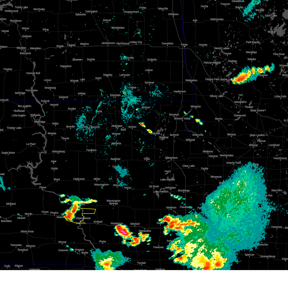
Hail Map for Oacoma, SD
The Oacoma, SD area has had 2 reports of on-the-ground hail by trained spotters, and has been under severe weather warnings 18 times during the past 12 months. Doppler radar has detected hail at or near Oacoma, SD on 78 occasions, including 6 occasions during the past year.
| Name: | Oacoma, SD |
| Where Located: | 62.2 miles SE of Pierre, SD |
| Map: | Google Map for Oacoma, SD |
| Population: | 451 |
| Housing Units: | 236 |
| More Info: | Search Google for Oacoma, SD |
1
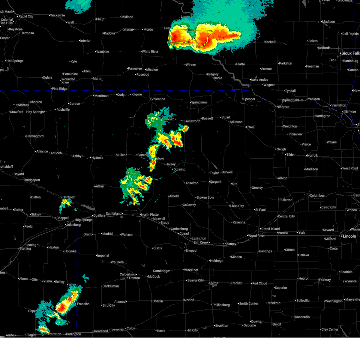
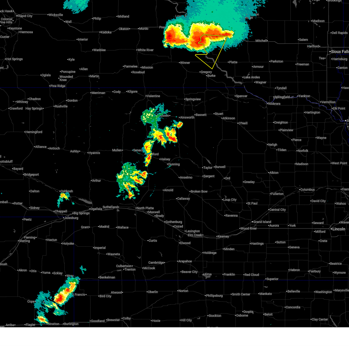
The Top Recent Hail Date for Oacoma, SD is Wednesday, August 14, 2024 (18th out of 78)

Hail and Wind Damage Spotted near Oacoma, SD
| Date / Time | Report Details |
|---|---|
| 6/27/2025 8:20 PM CDT |
 At 820 pm cdt, a severe thunderstorm was located near earling hill, or 9 miles south of presho, moving east at 10 mph (radar indicated). Hazards include tennis ball size hail and 60 mph wind gusts. People and animals outdoors will be injured. expect hail damage to roofs, siding, windows, and vehicles. expect wind damage to roofs, siding, and trees. Locations impacted include, oacoma, reliance, earling hill, lyman, dude ranch, and lake francis case. At 820 pm cdt, a severe thunderstorm was located near earling hill, or 9 miles south of presho, moving east at 10 mph (radar indicated). Hazards include tennis ball size hail and 60 mph wind gusts. People and animals outdoors will be injured. expect hail damage to roofs, siding, windows, and vehicles. expect wind damage to roofs, siding, and trees. Locations impacted include, oacoma, reliance, earling hill, lyman, dude ranch, and lake francis case.
|
| 6/27/2025 8:19 PM CDT |
 Svrfsd the national weather service in sioux falls has issued a * severe thunderstorm warning for, northwestern charles mix county in south central south dakota, northwestern gregory county in south central south dakota, southern brule county in south central south dakota, * until 900 pm cdt. * at 818 pm cdt, a severe thunderstorm was located near lake francis case, or 8 miles south of oacoma, moving southeast at 30 mph (radar indicated). Hazards include 60 mph wind gusts and nickel size hail. Expect damage to roofs, siding, and trees. This severe thunderstorm will be near, chamberlain and lake francis case through 830 pm cdt. Svrfsd the national weather service in sioux falls has issued a * severe thunderstorm warning for, northwestern charles mix county in south central south dakota, northwestern gregory county in south central south dakota, southern brule county in south central south dakota, * until 900 pm cdt. * at 818 pm cdt, a severe thunderstorm was located near lake francis case, or 8 miles south of oacoma, moving southeast at 30 mph (radar indicated). Hazards include 60 mph wind gusts and nickel size hail. Expect damage to roofs, siding, and trees. This severe thunderstorm will be near, chamberlain and lake francis case through 830 pm cdt.
|
| 6/27/2025 8:04 PM CDT |
 At 804 pm cdt, a severe thunderstorm was located 7 miles southwest of earling hill, or 9 miles southwest of presho, moving east at 20 mph (radar indicated). Hazards include tennis ball size hail and 60 mph wind gusts. People and animals outdoors will be injured. expect hail damage to roofs, siding, windows, and vehicles. expect wind damage to roofs, siding, and trees. Locations impacted include, presho, oacoma, kennebec, reliance, vivian, fate dam, lyman, 5 mile corner, dude ranch, earling hill, byre lake, lake francis case, and southeastern lower brule reservation. At 804 pm cdt, a severe thunderstorm was located 7 miles southwest of earling hill, or 9 miles southwest of presho, moving east at 20 mph (radar indicated). Hazards include tennis ball size hail and 60 mph wind gusts. People and animals outdoors will be injured. expect hail damage to roofs, siding, windows, and vehicles. expect wind damage to roofs, siding, and trees. Locations impacted include, presho, oacoma, kennebec, reliance, vivian, fate dam, lyman, 5 mile corner, dude ranch, earling hill, byre lake, lake francis case, and southeastern lower brule reservation.
|
| 6/27/2025 8:04 PM CDT |
 the severe thunderstorm warning has been cancelled and is no longer in effect the severe thunderstorm warning has been cancelled and is no longer in effect
|
| 6/27/2025 7:41 PM CDT |
 Svrabr the national weather service in aberdeen has issued a * severe thunderstorm warning for, southeastern jones county in central south dakota, central lyman county in central south dakota, * until 830 pm cdt. * at 741 pm cdt, a severe thunderstorm was located 8 miles southwest of lyman, or 16 miles southeast of presho, moving east at 15 mph (radar indicated). Hazards include two inch hail and 60 mph wind gusts. People and animals outdoors will be injured. expect hail damage to roofs, siding, windows, and vehicles. expect wind damage to roofs, siding, and trees. This severe thunderstorm will remain over mainly rural areas of southeastern jones and central lyman counties, including the following locations, southeastern lower brule reservation. Svrabr the national weather service in aberdeen has issued a * severe thunderstorm warning for, southeastern jones county in central south dakota, central lyman county in central south dakota, * until 830 pm cdt. * at 741 pm cdt, a severe thunderstorm was located 8 miles southwest of lyman, or 16 miles southeast of presho, moving east at 15 mph (radar indicated). Hazards include two inch hail and 60 mph wind gusts. People and animals outdoors will be injured. expect hail damage to roofs, siding, windows, and vehicles. expect wind damage to roofs, siding, and trees. This severe thunderstorm will remain over mainly rural areas of southeastern jones and central lyman counties, including the following locations, southeastern lower brule reservation.
|
| 8/14/2024 8:30 PM CDT |
 The storm which prompted the warning has weakened below severe limits, and no longer poses an immediate threat to life or property. therefore, the warning has been allowed to expire. however, small hail and gusty winds are still possible with this thunderstorm as well as storms extending from near huron south into gregory county. The storm which prompted the warning has weakened below severe limits, and no longer poses an immediate threat to life or property. therefore, the warning has been allowed to expire. however, small hail and gusty winds are still possible with this thunderstorm as well as storms extending from near huron south into gregory county.
|
| 8/14/2024 7:59 PM CDT |
 At 758 pm cdt, a severe thunderstorm was located over chamberlain, moving east at 25 mph (radar indicated). Hazards include 60 mph wind gusts and quarter size hail. Hail damage to vehicles is expected. expect wind damage to roofs, siding, and trees. at 758 pm cdt, dime sized hail was reported in chamberlain. This severe thunderstorm will remain over mainly rural areas of central brule county, including the following locations, pukwana. At 758 pm cdt, a severe thunderstorm was located over chamberlain, moving east at 25 mph (radar indicated). Hazards include 60 mph wind gusts and quarter size hail. Hail damage to vehicles is expected. expect wind damage to roofs, siding, and trees. at 758 pm cdt, dime sized hail was reported in chamberlain. This severe thunderstorm will remain over mainly rural areas of central brule county, including the following locations, pukwana.
|
| 8/14/2024 7:46 PM CDT |
 Svrfsd the national weather service in sioux falls has issued a * severe thunderstorm warning for, central brule county in south central south dakota, * until 830 pm cdt. * at 746 pm cdt, a severe thunderstorm was located over oacoma, moving east at 25 mph (radar indicated). Hazards include 60 mph wind gusts and quarter size hail. Hail damage to vehicles is expected. expect wind damage to roofs, siding, and trees. This severe thunderstorm will be near, chamberlain and lake francis case around 750 pm cdt. Svrfsd the national weather service in sioux falls has issued a * severe thunderstorm warning for, central brule county in south central south dakota, * until 830 pm cdt. * at 746 pm cdt, a severe thunderstorm was located over oacoma, moving east at 25 mph (radar indicated). Hazards include 60 mph wind gusts and quarter size hail. Hail damage to vehicles is expected. expect wind damage to roofs, siding, and trees. This severe thunderstorm will be near, chamberlain and lake francis case around 750 pm cdt.
|
| 7/30/2024 6:15 AM CDT |
 Svrfsd the national weather service in sioux falls has issued a * severe thunderstorm warning for, brule county in south central south dakota, * until 700 am cdt. * at 615 am cdt, a severe thunderstorm was located 8 miles north of oacoma, moving east at 30 mph (radar indicated). Hazards include 60 mph wind gusts and quarter size hail. Hail damage to vehicles is expected. expect wind damage to roofs, siding, and trees. This severe thunderstorm will be near, chamberlain and lake francis case around 620 am cdt. Svrfsd the national weather service in sioux falls has issued a * severe thunderstorm warning for, brule county in south central south dakota, * until 700 am cdt. * at 615 am cdt, a severe thunderstorm was located 8 miles north of oacoma, moving east at 30 mph (radar indicated). Hazards include 60 mph wind gusts and quarter size hail. Hail damage to vehicles is expected. expect wind damage to roofs, siding, and trees. This severe thunderstorm will be near, chamberlain and lake francis case around 620 am cdt.
|
| 7/30/2024 6:09 AM CDT |
 Svrabr the national weather service in aberdeen has issued a * severe thunderstorm warning for, east central lyman county in central south dakota, southeastern buffalo county in central south dakota, * until 715 am cdt. * at 609 am cdt, a severe thunderstorm was located over reliance, or 10 miles northwest of oacoma, moving east at 25 mph (radar indicated). Hazards include 60 mph wind gusts and quarter size hail. Hail damage to vehicles is expected. expect wind damage to roofs, siding, and trees. this severe thunderstorm will be near, lake francis case around 615 am cdt. oacoma around 625 am cdt. Other locations in the path of this severe thunderstorm include shelby and crow creek housing. Svrabr the national weather service in aberdeen has issued a * severe thunderstorm warning for, east central lyman county in central south dakota, southeastern buffalo county in central south dakota, * until 715 am cdt. * at 609 am cdt, a severe thunderstorm was located over reliance, or 10 miles northwest of oacoma, moving east at 25 mph (radar indicated). Hazards include 60 mph wind gusts and quarter size hail. Hail damage to vehicles is expected. expect wind damage to roofs, siding, and trees. this severe thunderstorm will be near, lake francis case around 615 am cdt. oacoma around 625 am cdt. Other locations in the path of this severe thunderstorm include shelby and crow creek housing.
|
| 7/14/2024 3:09 AM CDT |
 The storms which prompted the warning have weakened below severe limits, and have exited the warned area. therefore, the warning will be allowed to expire. however, gusty winds and heavy rain are still possible with these thunderstorms. a severe thunderstorm watch remains in effect until 600 am cdt for central and north central south dakota. a severe thunderstorm watch also remains in effect until 800 am cdt for northeastern south dakota. The storms which prompted the warning have weakened below severe limits, and have exited the warned area. therefore, the warning will be allowed to expire. however, gusty winds and heavy rain are still possible with these thunderstorms. a severe thunderstorm watch remains in effect until 600 am cdt for central and north central south dakota. a severe thunderstorm watch also remains in effect until 800 am cdt for northeastern south dakota.
|
| 7/14/2024 2:52 AM CDT |
 the severe thunderstorm warning has been cancelled and is no longer in effect the severe thunderstorm warning has been cancelled and is no longer in effect
|
| 7/14/2024 2:52 AM CDT |
 At 251 am cdt, severe thunderstorms were located along a line extending from 6 miles west of athol to 7 miles west of aurora center, moving east at 55 mph (radar indicated). Hazards include 70 mph wind gusts. Expect considerable tree damage. damage is likely to mobile homes, roofs, and outbuildings. Locations impacted include, redfield, tulare, cottonwood lake, twin lakes, spottswood, hitchcock, frankfort, glendale colony, spink colony and camrose colony. At 251 am cdt, severe thunderstorms were located along a line extending from 6 miles west of athol to 7 miles west of aurora center, moving east at 55 mph (radar indicated). Hazards include 70 mph wind gusts. Expect considerable tree damage. damage is likely to mobile homes, roofs, and outbuildings. Locations impacted include, redfield, tulare, cottonwood lake, twin lakes, spottswood, hitchcock, frankfort, glendale colony, spink colony and camrose colony.
|
| 7/14/2024 2:44 AM CDT |
 At 242 am cdt, severe thunderstorms were located along a line extending from near burdette to 7 miles northwest of wessington springs to 10 miles southwest of grass ranch colony, moving southeast at 60 mph (radar indicated. at 235 pm, the chamberlain asos recorded a 60 mph wind gust). Hazards include 70 mph wind gusts. Expect considerable tree damage. damage is likely to mobile homes, roofs, and outbuildings. Locations impacted include, wessington springs, white lake, wessington, lane, plankinton, wolsey, alpena, virgil, aurora center, woonsocket, stickney, storla, hitchcock, huron, mount vernon, letcher, forestburg, mitchell and loomis. At 242 am cdt, severe thunderstorms were located along a line extending from near burdette to 7 miles northwest of wessington springs to 10 miles southwest of grass ranch colony, moving southeast at 60 mph (radar indicated. at 235 pm, the chamberlain asos recorded a 60 mph wind gust). Hazards include 70 mph wind gusts. Expect considerable tree damage. damage is likely to mobile homes, roofs, and outbuildings. Locations impacted include, wessington springs, white lake, wessington, lane, plankinton, wolsey, alpena, virgil, aurora center, woonsocket, stickney, storla, hitchcock, huron, mount vernon, letcher, forestburg, mitchell and loomis.
|
| 7/14/2024 2:35 AM CDT | Mesonet station ocms2 oacoma 2w (sd mesonet in lyman county SD, 2.5 miles ENE of Oacoma, SD |
| 7/14/2024 2:20 AM CDT |
 Svrabr the national weather service in aberdeen has issued a * severe thunderstorm warning for, eastern jones county in central south dakota, hand county in central south dakota, sully county in central south dakota, hyde county in central south dakota, southern faulk county in north central south dakota, southern potter county in north central south dakota, southeastern stanley county in central south dakota, hughes county in central south dakota, southern spink county in northeastern south dakota, lyman county in central south dakota, buffalo county in central south dakota, * until 315 am cdt. * at 220 am cdt, severe thunderstorms were located along a line extending from near burkmere to 8 miles east of iona, moving east at 55 mph (radar indicated). Hazards include 70 mph wind gusts. Expect considerable tree damage. damage is likely to mobile homes, roofs, and outbuildings. severe thunderstorms will be near, miller, faulkton, miller dale colony, shelby, orient, ree heights, gann valley, polo, etbauer hill, and sunshine bible academy around 225 am cdt. st. lawrence, miranda, and pleasant valley country church around 230 am cdt. burdette, rockham, devoe, and danforth around 235 am cdt. zell, vayland, and rosehill dam around 240 am cdt. Other locations in the path of these severe thunderstorms include cottonwood lake, redfield, athol, twin lakes, tulare, ashton, spottswood and hitchcock. Svrabr the national weather service in aberdeen has issued a * severe thunderstorm warning for, eastern jones county in central south dakota, hand county in central south dakota, sully county in central south dakota, hyde county in central south dakota, southern faulk county in north central south dakota, southern potter county in north central south dakota, southeastern stanley county in central south dakota, hughes county in central south dakota, southern spink county in northeastern south dakota, lyman county in central south dakota, buffalo county in central south dakota, * until 315 am cdt. * at 220 am cdt, severe thunderstorms were located along a line extending from near burkmere to 8 miles east of iona, moving east at 55 mph (radar indicated). Hazards include 70 mph wind gusts. Expect considerable tree damage. damage is likely to mobile homes, roofs, and outbuildings. severe thunderstorms will be near, miller, faulkton, miller dale colony, shelby, orient, ree heights, gann valley, polo, etbauer hill, and sunshine bible academy around 225 am cdt. st. lawrence, miranda, and pleasant valley country church around 230 am cdt. burdette, rockham, devoe, and danforth around 235 am cdt. zell, vayland, and rosehill dam around 240 am cdt. Other locations in the path of these severe thunderstorms include cottonwood lake, redfield, athol, twin lakes, tulare, ashton, spottswood and hitchcock.
|
| 7/14/2024 2:15 AM CDT | Mesonet station ocms2 oacoma 2w (sd mesonet in lyman county SD, 2.5 miles ENE of Oacoma, SD |
| 7/14/2024 2:06 AM CDT |
 Svrfsd the national weather service in sioux falls has issued a * severe thunderstorm warning for, davison county in southeastern south dakota, western kingsbury county in east central south dakota, sanborn county in east central south dakota, beadle county in east central south dakota, aurora county in south central south dakota, jerauld county in central south dakota, brule county in south central south dakota, * until 300 am cdt. * at 206 am cdt, severe thunderstorms were located along a line extending from 9 miles east of stone lake to 7 miles northeast of stephan to 9 miles north of hamill, moving southeast at 60 mph (radar indicated). Hazards include 70 mph wind gusts. Expect considerable tree damage. damage is likely to mobile homes, roofs, and outbuildings. severe thunderstorms will be near, lake francis case around 210 am cdt. chamberlain around 215 am cdt. Other locations in the path of these severe thunderstorms include kimball, wessington, grass ranch colony, wessington springs, white lake and lane. Svrfsd the national weather service in sioux falls has issued a * severe thunderstorm warning for, davison county in southeastern south dakota, western kingsbury county in east central south dakota, sanborn county in east central south dakota, beadle county in east central south dakota, aurora county in south central south dakota, jerauld county in central south dakota, brule county in south central south dakota, * until 300 am cdt. * at 206 am cdt, severe thunderstorms were located along a line extending from 9 miles east of stone lake to 7 miles northeast of stephan to 9 miles north of hamill, moving southeast at 60 mph (radar indicated). Hazards include 70 mph wind gusts. Expect considerable tree damage. damage is likely to mobile homes, roofs, and outbuildings. severe thunderstorms will be near, lake francis case around 210 am cdt. chamberlain around 215 am cdt. Other locations in the path of these severe thunderstorms include kimball, wessington, grass ranch colony, wessington springs, white lake and lane.
|
| 7/14/2024 1:50 AM CDT |
 At 148 am cdt/1248 am mdt/, severe thunderstorms were located along a line extending from 8 miles south of lowry to 9 miles south of earling hill, moving east at 50 mph (radar indicated). Hazards include 70 mph wind gusts. Expect considerable tree damage. damage is likely to mobile homes, roofs, and outbuildings. Locations impacted include, kennebec, harrold, lebanon, lake sharpe, joe creek rec area, lyman, west bend rec area, stone lake, byre lake, holabird, lower brule, reliance, seneca, medicine butte, fort thompson, highmore, stephan, onaka, lake francis case, counselor creek boat access area, tailrace rec area, oacoma, dude ranch, brentwood colony, thunderbird colony, burkmere, lees corner, shelby, ree heights, norbeck, crow creek housing and etbauer hill. At 148 am cdt/1248 am mdt/, severe thunderstorms were located along a line extending from 8 miles south of lowry to 9 miles south of earling hill, moving east at 50 mph (radar indicated). Hazards include 70 mph wind gusts. Expect considerable tree damage. damage is likely to mobile homes, roofs, and outbuildings. Locations impacted include, kennebec, harrold, lebanon, lake sharpe, joe creek rec area, lyman, west bend rec area, stone lake, byre lake, holabird, lower brule, reliance, seneca, medicine butte, fort thompson, highmore, stephan, onaka, lake francis case, counselor creek boat access area, tailrace rec area, oacoma, dude ranch, brentwood colony, thunderbird colony, burkmere, lees corner, shelby, ree heights, norbeck, crow creek housing and etbauer hill.
|
| 7/14/2024 1:27 AM CDT |
 Svrabr the national weather service in aberdeen has issued a * severe thunderstorm warning for, jones county in central south dakota, western hand county in central south dakota, sully county in central south dakota, hyde county in central south dakota, western faulk county in north central south dakota, potter county in north central south dakota, stanley county in central south dakota, southeastern dewey county in north central south dakota, hughes county in central south dakota, lyman county in central south dakota, western buffalo county in central south dakota, * until 230 am cdt/130 am mdt/. * at 126 am cdt/1226 am mdt/, severe thunderstorms were located along a line extending from 6 miles south of swan creek rec area to 12 miles south of 5 mile corner, moving east at 50 mph. these are destructive storms (radar indicated). Hazards include 80 mph wind gusts. Flying debris will be dangerous to those caught without shelter. mobile homes will be heavily damaged. expect considerable damage to roofs, windows, and vehicles. extensive tree damage and power outages are likely. severe thunderstorms will be near, onida, presho, agar, lake sharpe, rousseau, gorman, canning, earling hill, sully lake, and 5 mile corner around 130 am cdt. gettysburg, blunt, cedar creek rec area, cottonwood lake near agar, degrey rec area, and fate dam around 135 am cdt. kennebec and byre lake around 140 am cdt. harrold, lebanon, joe creek rec area, and stone lake around 145 am cdt. Other locations in the path of these severe thunderstorms include lyman, west bend rec area, lower brule, reliance, holabird, medicine butte, seneca, onaka, lake francis case, counselor creek boat access area, fort thompson, highmore, stephan, tailrace rec area and dude ranch. Svrabr the national weather service in aberdeen has issued a * severe thunderstorm warning for, jones county in central south dakota, western hand county in central south dakota, sully county in central south dakota, hyde county in central south dakota, western faulk county in north central south dakota, potter county in north central south dakota, stanley county in central south dakota, southeastern dewey county in north central south dakota, hughes county in central south dakota, lyman county in central south dakota, western buffalo county in central south dakota, * until 230 am cdt/130 am mdt/. * at 126 am cdt/1226 am mdt/, severe thunderstorms were located along a line extending from 6 miles south of swan creek rec area to 12 miles south of 5 mile corner, moving east at 50 mph. these are destructive storms (radar indicated). Hazards include 80 mph wind gusts. Flying debris will be dangerous to those caught without shelter. mobile homes will be heavily damaged. expect considerable damage to roofs, windows, and vehicles. extensive tree damage and power outages are likely. severe thunderstorms will be near, onida, presho, agar, lake sharpe, rousseau, gorman, canning, earling hill, sully lake, and 5 mile corner around 130 am cdt. gettysburg, blunt, cedar creek rec area, cottonwood lake near agar, degrey rec area, and fate dam around 135 am cdt. kennebec and byre lake around 140 am cdt. harrold, lebanon, joe creek rec area, and stone lake around 145 am cdt. Other locations in the path of these severe thunderstorms include lyman, west bend rec area, lower brule, reliance, holabird, medicine butte, seneca, onaka, lake francis case, counselor creek boat access area, fort thompson, highmore, stephan, tailrace rec area and dude ranch.
|
| 7/18/2023 8:29 PM CDT |
 At 828 pm cdt, severe thunderstorms were located along a line extending from 7 miles northwest of kimball to 7 miles south of chamberlain to 10 miles northwest of hamill, moving southeast at 35 mph (chamberlain asos reported a gust of 61 mph around 827 pm cdt). Hazards include 60 mph wind gusts and nickel size hail. Expect damage to roofs, siding, and trees. severe thunderstorms will be near, kimball around 840 pm cdt. other locations in the path of these severe thunderstorms include white lake and grass ranch colony. hail threat, radar indicated max hail size, 0. 88 in wind threat, observed max wind gust, 60 mph. At 828 pm cdt, severe thunderstorms were located along a line extending from 7 miles northwest of kimball to 7 miles south of chamberlain to 10 miles northwest of hamill, moving southeast at 35 mph (chamberlain asos reported a gust of 61 mph around 827 pm cdt). Hazards include 60 mph wind gusts and nickel size hail. Expect damage to roofs, siding, and trees. severe thunderstorms will be near, kimball around 840 pm cdt. other locations in the path of these severe thunderstorms include white lake and grass ranch colony. hail threat, radar indicated max hail size, 0. 88 in wind threat, observed max wind gust, 60 mph.
|
| 7/18/2023 8:26 PM CDT |
 At 825 pm cdt, severe thunderstorms were located along a line extending from near shelby to near lake francis case to 10 miles southwest of lyman, moving south at 40 mph. these are destructive storms for wind and hail (radar indicated). Hazards include 80 mph wind gusts and two inch hail. Flying debris will be dangerous to those caught without shelter. mobile homes will be heavily damaged. expect considerable damage to roofs, windows, and vehicles. extensive tree damage and power outages are likely. locations impacted include, fort thompson, presho, oacoma, kennebec, reliance, shelby, iona, gann valley, fate dam, crow creek housing, tailrace rec area, lyman, medicine butte, counselor creek boat access area, dude ranch, etbauer hill, earling hill, byre lake, lees corner and lake francis case. thunderstorm damage threat, destructive hail threat, radar indicated max hail size, 2. 00 in wind threat, radar indicated max wind gust, 80 mph. At 825 pm cdt, severe thunderstorms were located along a line extending from near shelby to near lake francis case to 10 miles southwest of lyman, moving south at 40 mph. these are destructive storms for wind and hail (radar indicated). Hazards include 80 mph wind gusts and two inch hail. Flying debris will be dangerous to those caught without shelter. mobile homes will be heavily damaged. expect considerable damage to roofs, windows, and vehicles. extensive tree damage and power outages are likely. locations impacted include, fort thompson, presho, oacoma, kennebec, reliance, shelby, iona, gann valley, fate dam, crow creek housing, tailrace rec area, lyman, medicine butte, counselor creek boat access area, dude ranch, etbauer hill, earling hill, byre lake, lees corner and lake francis case. thunderstorm damage threat, destructive hail threat, radar indicated max hail size, 2. 00 in wind threat, radar indicated max wind gust, 80 mph.
|
| 7/18/2023 8:15 PM CDT | Mesonet station ocms2 oacoma 2w (sd mesonet in lyman county SD, 2.5 miles ENE of Oacoma, SD |
| 7/18/2023 8:05 PM CDT | Semi tipped over along i-9 in lyman county SD, 1.9 miles E of Oacoma, SD |
| 7/18/2023 8:04 PM CDT |
 At 803 pm cdt, severe thunderstorms were located along a line extending from near lees corner to near oacoma to near fate dam, moving southeast at 40 mph (radar indicated). Hazards include golf ball size hail and 60 mph wind gusts. People and animals outdoors will be injured. expect hail damage to roofs, siding, windows, and vehicles. expect wind damage to roofs, siding, and trees. locations impacted include, oacoma, etbauer hill, dude ranch, crow creek housing, shelby, lyman and iona. thunderstorm damage threat, considerable hail threat, radar indicated max hail size, 1. 75 in wind threat, radar indicated max wind gust, 60 mph. At 803 pm cdt, severe thunderstorms were located along a line extending from near lees corner to near oacoma to near fate dam, moving southeast at 40 mph (radar indicated). Hazards include golf ball size hail and 60 mph wind gusts. People and animals outdoors will be injured. expect hail damage to roofs, siding, windows, and vehicles. expect wind damage to roofs, siding, and trees. locations impacted include, oacoma, etbauer hill, dude ranch, crow creek housing, shelby, lyman and iona. thunderstorm damage threat, considerable hail threat, radar indicated max hail size, 1. 75 in wind threat, radar indicated max wind gust, 60 mph.
|
| 7/18/2023 8:03 PM CDT |
 At 801 pm cdt, severe thunderstorms were located along a line extending from near crow creek housing to near oacoma to near earling hill, moving southeast at 35 mph (radar indicated). Hazards include ping pong ball size hail and 60 mph wind gusts. People and animals outdoors will be injured. expect hail damage to roofs, siding, windows, and vehicles. expect wind damage to roofs, siding, and trees. severe thunderstorms will be near, lake francis case around 810 pm cdt. chamberlain around 815 pm cdt. other locations in the path of these severe thunderstorms include kimball, white lake and grass ranch colony. hail threat, radar indicated max hail size, 1. 50 in wind threat, radar indicated max wind gust, 60 mph. At 801 pm cdt, severe thunderstorms were located along a line extending from near crow creek housing to near oacoma to near earling hill, moving southeast at 35 mph (radar indicated). Hazards include ping pong ball size hail and 60 mph wind gusts. People and animals outdoors will be injured. expect hail damage to roofs, siding, windows, and vehicles. expect wind damage to roofs, siding, and trees. severe thunderstorms will be near, lake francis case around 810 pm cdt. chamberlain around 815 pm cdt. other locations in the path of these severe thunderstorms include kimball, white lake and grass ranch colony. hail threat, radar indicated max hail size, 1. 50 in wind threat, radar indicated max wind gust, 60 mph.
|
| 7/18/2023 7:45 PM CDT |
 At 745 pm cdt, severe thunderstorms were located along a line extending from near stephan to near medicine butte to near presho, moving southeast at 40 mph (radar indicated). Hazards include 60 mph wind gusts and half dollar size hail. Hail damage to vehicles is expected. expect wind damage to roofs, siding, and trees. severe thunderstorms will be near, medicine butte, counselor creek boat access area and tailrace rec area around 750 pm cdt. reliance around 755 pm cdt. lees corner around 800 pm cdt. other locations in the path of these severe thunderstorms include oacoma, etbauer hill, dude ranch, crow creek housing, shelby, gann valley and iona. hail threat, radar indicated max hail size, 1. 25 in wind threat, radar indicated max wind gust, 60 mph. At 745 pm cdt, severe thunderstorms were located along a line extending from near stephan to near medicine butte to near presho, moving southeast at 40 mph (radar indicated). Hazards include 60 mph wind gusts and half dollar size hail. Hail damage to vehicles is expected. expect wind damage to roofs, siding, and trees. severe thunderstorms will be near, medicine butte, counselor creek boat access area and tailrace rec area around 750 pm cdt. reliance around 755 pm cdt. lees corner around 800 pm cdt. other locations in the path of these severe thunderstorms include oacoma, etbauer hill, dude ranch, crow creek housing, shelby, gann valley and iona. hail threat, radar indicated max hail size, 1. 25 in wind threat, radar indicated max wind gust, 60 mph.
|
| 6/24/2023 1:58 AM CDT |
 The severe thunderstorm warning for southeastern hughes, eastern lyman and buffalo counties will expire at 200 am cdt, the storms which prompted the warning have moved out of the area. therefore, the warning will be allowed to expire. however gusty winds are still possible with these thunderstorms. a severe thunderstorm watch remains in effect until 500 am cdt for central south dakota. The severe thunderstorm warning for southeastern hughes, eastern lyman and buffalo counties will expire at 200 am cdt, the storms which prompted the warning have moved out of the area. therefore, the warning will be allowed to expire. however gusty winds are still possible with these thunderstorms. a severe thunderstorm watch remains in effect until 500 am cdt for central south dakota.
|
| 6/24/2023 1:25 AM CDT | Mesonet station ocms2 oacoma 2w (sd mesonet in lyman county SD, 2.5 miles ENE of Oacoma, SD |
| 6/24/2023 1:19 AM CDT |
 At 119 am cdt, severe thunderstorms were located along a line extending from 11 miles northeast of degrey rec area to counselor creek boat access area to near dude ranch, moving east at 45 mph (radar indicated). Hazards include 60 mph wind gusts. Expect damage to roofs, siding, and trees. severe thunderstorms will be near, fort thompson, oacoma, dude ranch, tailrace rec area and lake francis case around 125 am cdt. lees corner around 130 am cdt. shelby and crow creek housing around 135 am cdt. other locations in the path of these severe thunderstorms include etbauer hill and gann valley. hail threat, radar indicated max hail size, <. 75 in wind threat, radar indicated max wind gust, 60 mph. At 119 am cdt, severe thunderstorms were located along a line extending from 11 miles northeast of degrey rec area to counselor creek boat access area to near dude ranch, moving east at 45 mph (radar indicated). Hazards include 60 mph wind gusts. Expect damage to roofs, siding, and trees. severe thunderstorms will be near, fort thompson, oacoma, dude ranch, tailrace rec area and lake francis case around 125 am cdt. lees corner around 130 am cdt. shelby and crow creek housing around 135 am cdt. other locations in the path of these severe thunderstorms include etbauer hill and gann valley. hail threat, radar indicated max hail size, <. 75 in wind threat, radar indicated max wind gust, 60 mph.
|
| 8/24/2022 8:40 PM CDT | The severe thunderstorm warning for east central lyman county will expire at 845 pm cdt, the storm which prompted the warning has weakened below severe limits, and has exited the warned area. therefore, the warning will be allowed to expire. to report severe weather, contact your nearest law enforcement agency. they will relay your report to the national weather service aberdeen. |
| 8/24/2022 8:33 PM CDT | At 832 pm cdt, a severe thunderstorm was located over lake francis case, or over oacoma, moving south at 20 mph (radar indicated. at 825 pm cdt, 60 mph wind was recorded in oacoma). Hazards include 60 mph wind gusts and quarter size hail. Hail damage to vehicles is expected. expect wind damage to roofs, siding, and trees. locations impacted include, oacoma, dude ranch and lake francis case. hail threat, radar indicated max hail size, 1. 00 in wind threat, radar indicated max wind gust, 60 mph. |
| 8/24/2022 8:25 PM CDT | Mesonet station ocms2 oacoma 2w (sd mesonet in lyman county SD, 2.5 miles ENE of Oacoma, SD |
| 8/24/2022 8:15 PM CDT | At 814 pm cdt, a severe thunderstorm was located near oacoma, moving south at 20 mph (radar indicated). Hazards include golf ball size hail and 70 mph wind gusts. People and animals outdoors will be injured. expect hail damage to roofs, siding, windows, and vehicles. expect considerable tree damage. wind damage is also likely to mobile homes, roofs, and outbuildings. locations impacted include, oacoma, dude ranch and lake francis case. thunderstorm damage threat, considerable hail threat, radar indicated max hail size, 1. 75 in wind threat, radar indicated max wind gust, 70 mph. |
| 8/24/2022 8:11 PM CDT | At 811 pm cdt, a severe thunderstorm was located near oacoma, moving south at 20 mph (radar indicated). Hazards include 60 mph wind gusts and half dollar size hail. Hail damage to vehicles is expected. expect wind damage to roofs, siding, and trees. locations impacted include, oacoma, dude ranch and lake francis case. hail threat, radar indicated max hail size, 1. 25 in wind threat, radar indicated max wind gust, 60 mph. |
| 8/24/2022 8:00 PM CDT | At 800 pm cdt, a severe thunderstorm was located 7 miles south of tailrace rec area, or 8 miles south of fort thompson, moving southeast at 20 mph (radar indicated). Hazards include 60 mph wind gusts and quarter size hail. Hail damage to vehicles is expected. Expect wind damage to roofs, siding, and trees. |
| 8/2/2022 6:56 PM CDT |
 At 655 pm cdt, a severe thunderstorm was located 9 miles east of chamberlain, moving northeast at 35 mph (radar indicated). Hazards include 60 mph wind gusts. Expect damage to roofs, siding, and trees. this severe thunderstorm will be near, grass ranch colony around 705 pm cdt. kimball around 710 pm cdt. white lake around 725 pm cdt. other locations impacted by this severe thunderstorm include pukwana. hail threat, radar indicated max hail size, <. 75 in wind threat, radar indicated max wind gust, 60 mph. At 655 pm cdt, a severe thunderstorm was located 9 miles east of chamberlain, moving northeast at 35 mph (radar indicated). Hazards include 60 mph wind gusts. Expect damage to roofs, siding, and trees. this severe thunderstorm will be near, grass ranch colony around 705 pm cdt. kimball around 710 pm cdt. white lake around 725 pm cdt. other locations impacted by this severe thunderstorm include pukwana. hail threat, radar indicated max hail size, <. 75 in wind threat, radar indicated max wind gust, 60 mph.
|
| 8/2/2022 6:48 PM CDT |
 At 648 pm cdt, a severe thunderstorm was located over lake francis case, or over chamberlain, moving northeast at 35 mph (radar indicated). Hazards include 60 mph wind gusts. Expect damage to roofs, siding, and trees. this severe thunderstorm will remain over mainly rural areas of northwestern charles mix, northwestern gregory and western brule counties, including the following locations, dixon in gregory county and pukwana. hail threat, radar indicated max hail size, <. 75 in wind threat, radar indicated max wind gust, 60 mph. At 648 pm cdt, a severe thunderstorm was located over lake francis case, or over chamberlain, moving northeast at 35 mph (radar indicated). Hazards include 60 mph wind gusts. Expect damage to roofs, siding, and trees. this severe thunderstorm will remain over mainly rural areas of northwestern charles mix, northwestern gregory and western brule counties, including the following locations, dixon in gregory county and pukwana. hail threat, radar indicated max hail size, <. 75 in wind threat, radar indicated max wind gust, 60 mph.
|
| 8/2/2022 6:45 PM CDT | Mesonet station ocms2 oacoma 2w (sd mesonet in lyman county SD, 2.5 miles ENE of Oacoma, SD |
| 8/2/2022 6:41 PM CDT |
 At 641 pm cdt, severe thunderstorms were located along a line extending from counselor creek boat access area to 6 miles southeast of iona, moving northeast at 35 mph (radar indicated). Hazards include 60 mph wind gusts. Expect damage to roofs, siding, and trees. locations impacted include, tailrace rec area, fort thompson and lees corner. hail threat, radar indicated max hail size, <. 75 in wind threat, radar indicated max wind gust, 60 mph. At 641 pm cdt, severe thunderstorms were located along a line extending from counselor creek boat access area to 6 miles southeast of iona, moving northeast at 35 mph (radar indicated). Hazards include 60 mph wind gusts. Expect damage to roofs, siding, and trees. locations impacted include, tailrace rec area, fort thompson and lees corner. hail threat, radar indicated max hail size, <. 75 in wind threat, radar indicated max wind gust, 60 mph.
|
| 8/2/2022 6:19 PM CDT |
 At 619 pm cdt, a severe thunderstorm was located 7 miles north of hamill, or 18 miles west of chamberlain, moving northeast at 35 mph (radar indicated). Hazards include 60 mph wind gusts. Expect damage to roofs, siding, and trees. this severe thunderstorm will be near, lake francis case around 635 pm cdt. chamberlain around 650 pm cdt. other locations impacted by this severe thunderstorm include dixon in gregory county and pukwana. hail threat, radar indicated max hail size, <. 75 in wind threat, radar indicated max wind gust, 60 mph. At 619 pm cdt, a severe thunderstorm was located 7 miles north of hamill, or 18 miles west of chamberlain, moving northeast at 35 mph (radar indicated). Hazards include 60 mph wind gusts. Expect damage to roofs, siding, and trees. this severe thunderstorm will be near, lake francis case around 635 pm cdt. chamberlain around 650 pm cdt. other locations impacted by this severe thunderstorm include dixon in gregory county and pukwana. hail threat, radar indicated max hail size, <. 75 in wind threat, radar indicated max wind gust, 60 mph.
|
| 8/2/2022 6:17 PM CDT |
 At 617 pm cdt, severe thunderstorms were located along a line extending from near medicine butte to 9 miles southwest of iona, moving northeast at 35 mph (radar indicated). Hazards include 60 mph wind gusts. Expect damage to roofs, siding, and trees. severe thunderstorms will be near, medicine butte around 625 pm cdt. iona around 630 pm cdt. counselor creek boat access area around 635 pm cdt. other locations in the path of these severe thunderstorms include lake sharpe, tailrace rec area, fort thompson and lees corner. hail threat, radar indicated max hail size, <. 75 in wind threat, radar indicated max wind gust, 60 mph. At 617 pm cdt, severe thunderstorms were located along a line extending from near medicine butte to 9 miles southwest of iona, moving northeast at 35 mph (radar indicated). Hazards include 60 mph wind gusts. Expect damage to roofs, siding, and trees. severe thunderstorms will be near, medicine butte around 625 pm cdt. iona around 630 pm cdt. counselor creek boat access area around 635 pm cdt. other locations in the path of these severe thunderstorms include lake sharpe, tailrace rec area, fort thompson and lees corner. hail threat, radar indicated max hail size, <. 75 in wind threat, radar indicated max wind gust, 60 mph.
|
| 7/5/2022 1:29 PM CDT |
 At 128 pm cdt, severe thunderstorms were located along a line extending from 9 miles west of storla to 9 miles southwest of iona, moving southeast at 40 mph (trained weather spotters). Hazards include 60 mph wind gusts and penny size hail. Expect damage to roofs, siding, and trees. these severe thunderstorms will remain over mainly rural areas of southern hand, southeastern hyde, eastern lyman and buffalo counties, including the following locations, crow creek reservation and southeastern lower brule reservation. hail threat, radar indicated max hail size, 0. 75 in wind threat, observed max wind gust, 60 mph. At 128 pm cdt, severe thunderstorms were located along a line extending from 9 miles west of storla to 9 miles southwest of iona, moving southeast at 40 mph (trained weather spotters). Hazards include 60 mph wind gusts and penny size hail. Expect damage to roofs, siding, and trees. these severe thunderstorms will remain over mainly rural areas of southern hand, southeastern hyde, eastern lyman and buffalo counties, including the following locations, crow creek reservation and southeastern lower brule reservation. hail threat, radar indicated max hail size, 0. 75 in wind threat, observed max wind gust, 60 mph.
|
| 7/5/2022 1:23 PM CDT |
 At 121 pm cdt, severe thunderstorms were located along a line extending from 9 miles southwest of virgil to 6 miles southwest of wessington springs to 9 miles east of chamberlain, moving southeast at 45 mph (trained weather spotters. at 120 pm cdt, a 60 mph wind gust was reported at 13 miles west-northwest of wessington springs). Hazards include 70 mph wind gusts and quarter size hail. Hail damage to vehicles is expected. expect considerable tree damage. wind damage is also likely to mobile homes, roofs, and outbuildings. these severe storms will be near, wessington springs around 125 pm cdt. alpena around 135 pm cdt. lane around 140 pm cdt. other locations impacted by these severe thunderstorms include pukwana. thunderstorm damage threat, considerable hail threat, radar indicated max hail size, 1. 00 in wind threat, radar indicated max wind gust, 70 mph. At 121 pm cdt, severe thunderstorms were located along a line extending from 9 miles southwest of virgil to 6 miles southwest of wessington springs to 9 miles east of chamberlain, moving southeast at 45 mph (trained weather spotters. at 120 pm cdt, a 60 mph wind gust was reported at 13 miles west-northwest of wessington springs). Hazards include 70 mph wind gusts and quarter size hail. Hail damage to vehicles is expected. expect considerable tree damage. wind damage is also likely to mobile homes, roofs, and outbuildings. these severe storms will be near, wessington springs around 125 pm cdt. alpena around 135 pm cdt. lane around 140 pm cdt. other locations impacted by these severe thunderstorms include pukwana. thunderstorm damage threat, considerable hail threat, radar indicated max hail size, 1. 00 in wind threat, radar indicated max wind gust, 70 mph.
|
| 7/5/2022 1:17 PM CDT |
 At 116 pm cdt, severe thunderstorms were located along a line extending from 12 miles north of white lake to 9 miles south of hamill, moving southeast at 45 mph (trained weather spotters). Hazards include 70 mph wind gusts and nickel size hail. Expect considerable tree damage. damage is likely to mobile homes, roofs, and outbuildings. locations impacted include, lower brule, fort thompson, oacoma, reliance, shelby, iona, crow creek housing, tailrace rec area, lyman, pleasant valley country church, medicine butte, stephan, counselor creek boat access area, dude ranch, etbauer hill, gann valley, lees corner, lake francis case, sunshine bible academy and lake sharpe. thunderstorm damage threat, considerable hail threat, radar indicated max hail size, 0. 88 in wind threat, observed max wind gust, 70 mph. At 116 pm cdt, severe thunderstorms were located along a line extending from 12 miles north of white lake to 9 miles south of hamill, moving southeast at 45 mph (trained weather spotters). Hazards include 70 mph wind gusts and nickel size hail. Expect considerable tree damage. damage is likely to mobile homes, roofs, and outbuildings. locations impacted include, lower brule, fort thompson, oacoma, reliance, shelby, iona, crow creek housing, tailrace rec area, lyman, pleasant valley country church, medicine butte, stephan, counselor creek boat access area, dude ranch, etbauer hill, gann valley, lees corner, lake francis case, sunshine bible academy and lake sharpe. thunderstorm damage threat, considerable hail threat, radar indicated max hail size, 0. 88 in wind threat, observed max wind gust, 70 mph.
|
| 7/5/2022 1:00 PM CDT |
 At 100 pm cdt, severe thunderstorms were located along a line extending from near rosehill dam to 7 miles southeast of pleasant valley country church to 7 miles north of oacoma, moving southeast at 40 mph (trained weather spotters). Hazards include 70 mph wind gusts and quarter size hail. Hail damage to vehicles is expected. expect considerable tree damage. wind damage is also likely to mobile homes, roofs, and outbuildings. these severe storms will be near, wessington springs around 130 pm cdt. kimball, alpena and lane around 140 pm cdt. other locations impacted by these severe thunderstorms include pukwana. thunderstorm damage threat, considerable hail threat, radar indicated max hail size, 1. 00 in wind threat, radar indicated max wind gust, 70 mph. At 100 pm cdt, severe thunderstorms were located along a line extending from near rosehill dam to 7 miles southeast of pleasant valley country church to 7 miles north of oacoma, moving southeast at 40 mph (trained weather spotters). Hazards include 70 mph wind gusts and quarter size hail. Hail damage to vehicles is expected. expect considerable tree damage. wind damage is also likely to mobile homes, roofs, and outbuildings. these severe storms will be near, wessington springs around 130 pm cdt. kimball, alpena and lane around 140 pm cdt. other locations impacted by these severe thunderstorms include pukwana. thunderstorm damage threat, considerable hail threat, radar indicated max hail size, 1. 00 in wind threat, radar indicated max wind gust, 70 mph.
|
| 7/5/2022 12:55 PM CDT | Via sd mesonet ocms in lyman county SD, 2.5 miles ENE of Oacoma, SD |
| 7/5/2022 12:51 PM CDT |
 At 1251 pm cdt, severe thunderstorms were located along a line extending from 6 miles northeast of gann valley to 9 miles north of ideal, moving southeast at 40 mph (trained weather spotters). Hazards include 70 mph wind gusts and nickel size hail. Expect considerable tree damage. damage is likely to mobile homes, roofs, and outbuildings. locations impacted include, gann valley. thunderstorm damage threat, considerable hail threat, radar indicated max hail size, 0. 88 in wind threat, radar indicated max wind gust, 70 mph. At 1251 pm cdt, severe thunderstorms were located along a line extending from 6 miles northeast of gann valley to 9 miles north of ideal, moving southeast at 40 mph (trained weather spotters). Hazards include 70 mph wind gusts and nickel size hail. Expect considerable tree damage. damage is likely to mobile homes, roofs, and outbuildings. locations impacted include, gann valley. thunderstorm damage threat, considerable hail threat, radar indicated max hail size, 0. 88 in wind threat, radar indicated max wind gust, 70 mph.
|
| 7/5/2022 12:43 PM CDT |
 At 1242 pm cdt, severe thunderstorms were located along a line extending from near sunshine bible academy to near pleasant valley country church to medicine butte, moving southeast at 40 mph (trained weather spotters). Hazards include 70 mph wind gusts and nickel size hail. Expect considerable tree damage. damage is likely to mobile homes, roofs, and outbuildings. severe thunderstorms will be near, chamberlain around 110 pm cdt. wessington springs around 125 pm cdt. alpena and lane around 135 pm cdt. kimball around 140 pm cdt. other locations impacted by these severe thunderstorms include pukwana. thunderstorm damage threat, considerable hail threat, radar indicated max hail size, 0. 88 in wind threat, radar indicated max wind gust, 70 mph. At 1242 pm cdt, severe thunderstorms were located along a line extending from near sunshine bible academy to near pleasant valley country church to medicine butte, moving southeast at 40 mph (trained weather spotters). Hazards include 70 mph wind gusts and nickel size hail. Expect considerable tree damage. damage is likely to mobile homes, roofs, and outbuildings. severe thunderstorms will be near, chamberlain around 110 pm cdt. wessington springs around 125 pm cdt. alpena and lane around 135 pm cdt. kimball around 140 pm cdt. other locations impacted by these severe thunderstorms include pukwana. thunderstorm damage threat, considerable hail threat, radar indicated max hail size, 0. 88 in wind threat, radar indicated max wind gust, 70 mph.
|
| 7/5/2022 12:21 PM CDT |
 At 1221 pm cdt, severe thunderstorms were located along a line extending from 7 miles south of miller dale colony to near 5 mile corner, moving southeast at 45 mph (trained weather spotters). Hazards include 70 mph wind gusts and nickel size hail. Expect considerable tree damage. damage is likely to mobile homes, roofs, and outbuildings. severe thunderstorms will be near, sunshine bible academy around 1225 pm cdt. pleasant valley country church around 1230 pm cdt. other locations in the path of these severe thunderstorms include gann valley. thunderstorm damage threat, considerable hail threat, radar indicated max hail size, 0. 88 in wind threat, radar indicated max wind gust, 70 mph. At 1221 pm cdt, severe thunderstorms were located along a line extending from 7 miles south of miller dale colony to near 5 mile corner, moving southeast at 45 mph (trained weather spotters). Hazards include 70 mph wind gusts and nickel size hail. Expect considerable tree damage. damage is likely to mobile homes, roofs, and outbuildings. severe thunderstorms will be near, sunshine bible academy around 1225 pm cdt. pleasant valley country church around 1230 pm cdt. other locations in the path of these severe thunderstorms include gann valley. thunderstorm damage threat, considerable hail threat, radar indicated max hail size, 0. 88 in wind threat, radar indicated max wind gust, 70 mph.
|
| 7/4/2022 1:56 AM CDT |
 At 156 am cdt, severe thunderstorms were located along a line extending from 8 miles east of stephan to near chamberlain to near iona, moving east at 30 mph (radar indicated). Hazards include 60 mph wind gusts and penny size hail. Expect damage to roofs, siding, and trees. locations impacted include, kimball. hail threat, radar indicated max hail size, 0. 75 in wind threat, radar indicated max wind gust, 60 mph. At 156 am cdt, severe thunderstorms were located along a line extending from 8 miles east of stephan to near chamberlain to near iona, moving east at 30 mph (radar indicated). Hazards include 60 mph wind gusts and penny size hail. Expect damage to roofs, siding, and trees. locations impacted include, kimball. hail threat, radar indicated max hail size, 0. 75 in wind threat, radar indicated max wind gust, 60 mph.
|
| 7/4/2022 1:36 AM CDT |
 At 136 am cdt, severe thunderstorms were located along a line extending from near stephan to near dude ranch to near hamill, moving east at 30 mph (radar indicated). Hazards include 60 mph wind gusts and penny size hail. Expect damage to roofs, siding, and trees. severe thunderstorms will be near, lake francis case around 140 am cdt. chamberlain around 150 am cdt. other locations in the path of these severe thunderstorms include kimball. hail threat, radar indicated max hail size, 0. 75 in wind threat, radar indicated max wind gust, 60 mph. At 136 am cdt, severe thunderstorms were located along a line extending from near stephan to near dude ranch to near hamill, moving east at 30 mph (radar indicated). Hazards include 60 mph wind gusts and penny size hail. Expect damage to roofs, siding, and trees. severe thunderstorms will be near, lake francis case around 140 am cdt. chamberlain around 150 am cdt. other locations in the path of these severe thunderstorms include kimball. hail threat, radar indicated max hail size, 0. 75 in wind threat, radar indicated max wind gust, 60 mph.
|
| 7/4/2022 1:32 AM CDT |
 At 132 am cdt, severe thunderstorms were located along a line extending from 6 miles north of stephan to near oacoma to 10 miles south of hamill, moving east at 30 mph (radar indicated). Hazards include 60 mph wind gusts. Expect damage to roofs, siding, and trees. severe thunderstorms will be near, oacoma and dude ranch around 135 am cdt. crow creek housing around 145 am cdt. shelby and iona around 150 am cdt. other locations in the path of these severe thunderstorms include sunshine bible academy, pleasant valley country church and rosehill dam. hail threat, radar indicated max hail size, <. 75 in wind threat, radar indicated max wind gust, 60 mph. At 132 am cdt, severe thunderstorms were located along a line extending from 6 miles north of stephan to near oacoma to 10 miles south of hamill, moving east at 30 mph (radar indicated). Hazards include 60 mph wind gusts. Expect damage to roofs, siding, and trees. severe thunderstorms will be near, oacoma and dude ranch around 135 am cdt. crow creek housing around 145 am cdt. shelby and iona around 150 am cdt. other locations in the path of these severe thunderstorms include sunshine bible academy, pleasant valley country church and rosehill dam. hail threat, radar indicated max hail size, <. 75 in wind threat, radar indicated max wind gust, 60 mph.
|
| 7/4/2022 1:21 AM CDT |
 At 120 am cdt, a severe thunderstorm was located near tailrace rec area, or near fort thompson, moving east at 30 mph (radar indicated). Hazards include 60 mph wind gusts. Expect damage to roofs, siding, and trees. locations impacted include, lees corner, shelby, crow creek housing and etbauer hill. hail threat, radar indicated max hail size, <. 75 in wind threat, radar indicated max wind gust, 60 mph. At 120 am cdt, a severe thunderstorm was located near tailrace rec area, or near fort thompson, moving east at 30 mph (radar indicated). Hazards include 60 mph wind gusts. Expect damage to roofs, siding, and trees. locations impacted include, lees corner, shelby, crow creek housing and etbauer hill. hail threat, radar indicated max hail size, <. 75 in wind threat, radar indicated max wind gust, 60 mph.
|
| 7/4/2022 12:42 AM CDT |
 At 1242 am cdt, a severe thunderstorm was located near joe creek rec area, or 9 miles west of lower brule, moving east at 35 mph (radar indicated). Hazards include 60 mph wind gusts. Expect damage to roofs, siding, and trees. this severe thunderstorm will be near, lower brule and medicine butte around 100 am cdt. other locations in the path of this severe thunderstorm include counselor creek boat access area, tailrace rec area, lake sharpe, fort thompson, lees corner, crow creek housing, shelby and etbauer hill. hail threat, radar indicated max hail size, <. 75 in wind threat, radar indicated max wind gust, 60 mph. At 1242 am cdt, a severe thunderstorm was located near joe creek rec area, or 9 miles west of lower brule, moving east at 35 mph (radar indicated). Hazards include 60 mph wind gusts. Expect damage to roofs, siding, and trees. this severe thunderstorm will be near, lower brule and medicine butte around 100 am cdt. other locations in the path of this severe thunderstorm include counselor creek boat access area, tailrace rec area, lake sharpe, fort thompson, lees corner, crow creek housing, shelby and etbauer hill. hail threat, radar indicated max hail size, <. 75 in wind threat, radar indicated max wind gust, 60 mph.
|
| 7/3/2022 2:28 AM CDT |
 At 227 am cdt, a severe thunderstorm was located near oacoma, or near chamberlain, moving east at 35 mph (radar indicated). Hazards include 60 mph wind gusts and penny size hail. Expect damage to roofs, siding, and trees. this severe thunderstorm will remain over mainly rural areas of northern brule county, including the following locations, pukwana. hail threat, radar indicated max hail size, 0. 75 in wind threat, radar indicated max wind gust, 60 mph. At 227 am cdt, a severe thunderstorm was located near oacoma, or near chamberlain, moving east at 35 mph (radar indicated). Hazards include 60 mph wind gusts and penny size hail. Expect damage to roofs, siding, and trees. this severe thunderstorm will remain over mainly rural areas of northern brule county, including the following locations, pukwana. hail threat, radar indicated max hail size, 0. 75 in wind threat, radar indicated max wind gust, 60 mph.
|
| 6/29/2022 7:37 PM CDT |
 The severe thunderstorm warning for southeastern hughes, eastern lyman and buffalo counties will expire at 745 pm cdt, the storm which prompted the warning has weakened below severe limits, and no longer poses an immediate threat to life or property. therefore, the warning will be allowed to expire. however gusty winds are still possible with this thunderstorm. a severe thunderstorm watch remains in effect until 900 pm cdt for central south dakota. a severe thunderstorm watch also remains in effect until 100 am cdt for central south dakota. The severe thunderstorm warning for southeastern hughes, eastern lyman and buffalo counties will expire at 745 pm cdt, the storm which prompted the warning has weakened below severe limits, and no longer poses an immediate threat to life or property. therefore, the warning will be allowed to expire. however gusty winds are still possible with this thunderstorm. a severe thunderstorm watch remains in effect until 900 pm cdt for central south dakota. a severe thunderstorm watch also remains in effect until 100 am cdt for central south dakota.
|
| 6/29/2022 6:54 PM CDT |
 At 654 pm cdt, severe thunderstorms were located along a line extending from fort thompson to 7 miles east of reliance to near dude ranch, moving east at 40 mph (radar indicated). Hazards include 60 mph wind gusts and penny size hail. Expect damage to roofs, siding, and trees. severe thunderstorms will be near, chamberlain around 710 pm cdt. other locations in the path of these severe thunderstorms include kimball. hail threat, radar indicated max hail size, 0. 75 in wind threat, radar indicated max wind gust, 60 mph. At 654 pm cdt, severe thunderstorms were located along a line extending from fort thompson to 7 miles east of reliance to near dude ranch, moving east at 40 mph (radar indicated). Hazards include 60 mph wind gusts and penny size hail. Expect damage to roofs, siding, and trees. severe thunderstorms will be near, chamberlain around 710 pm cdt. other locations in the path of these severe thunderstorms include kimball. hail threat, radar indicated max hail size, 0. 75 in wind threat, radar indicated max wind gust, 60 mph.
|
| 6/29/2022 6:39 PM CDT |
 At 638 pm cdt, a severe thunderstorm was located near medicine butte, or 9 miles south of fort thompson, moving east at 45 mph (radar indicated). Hazards include 60 mph wind gusts and penny size hail. expect damage to roofs, siding, and trees At 638 pm cdt, a severe thunderstorm was located near medicine butte, or 9 miles south of fort thompson, moving east at 45 mph (radar indicated). Hazards include 60 mph wind gusts and penny size hail. expect damage to roofs, siding, and trees
|
| 6/24/2022 10:39 PM CDT |
 The severe thunderstorm warning for southeastern lyman county will expire at 1045 pm cdt, the storm which prompted the warning has moved out of the area. therefore, the warning will be allowed to expire. however gusty winds are still possible with this thunderstorm. a severe thunderstorm watch remains in effect until midnight cdt for central south dakota. The severe thunderstorm warning for southeastern lyman county will expire at 1045 pm cdt, the storm which prompted the warning has moved out of the area. therefore, the warning will be allowed to expire. however gusty winds are still possible with this thunderstorm. a severe thunderstorm watch remains in effect until midnight cdt for central south dakota.
|
| 6/24/2022 10:39 PM CDT |
 At 1038 pm cdt, a severe thunderstorm was located near chamberlain, moving northeast at 40 mph (radar indicated). Hazards include 60 mph wind gusts. Expect damage to roofs, siding, and trees. this severe storm will be near, kimball around 1055 pm cdt. other locations impacted by this severe thunderstorm include pukwana. hail threat, radar indicated max hail size, <. 75 in wind threat, radar indicated max wind gust, 60 mph. At 1038 pm cdt, a severe thunderstorm was located near chamberlain, moving northeast at 40 mph (radar indicated). Hazards include 60 mph wind gusts. Expect damage to roofs, siding, and trees. this severe storm will be near, kimball around 1055 pm cdt. other locations impacted by this severe thunderstorm include pukwana. hail threat, radar indicated max hail size, <. 75 in wind threat, radar indicated max wind gust, 60 mph.
|
| 6/24/2022 10:31 PM CDT |
 At 1031 pm cdt, a severe thunderstorm was located near lake francis case, or 7 miles south of chamberlain, moving east at 35 mph (radar indicated). Hazards include 60 mph wind gusts and penny size hail. Expect damage to roofs, siding, and trees. this severe thunderstorm will remain over mainly rural areas of southeastern lyman county. hail threat, radar indicated max hail size, 0. 75 in wind threat, radar indicated max wind gust, 60 mph. At 1031 pm cdt, a severe thunderstorm was located near lake francis case, or 7 miles south of chamberlain, moving east at 35 mph (radar indicated). Hazards include 60 mph wind gusts and penny size hail. Expect damage to roofs, siding, and trees. this severe thunderstorm will remain over mainly rural areas of southeastern lyman county. hail threat, radar indicated max hail size, 0. 75 in wind threat, radar indicated max wind gust, 60 mph.
|
| 6/24/2022 10:21 PM CDT |
 At 1020 pm cdt, a severe thunderstorm was located near lake francis case, or near chamberlain, moving northeast at 40 mph (radar indicated). Hazards include 60 mph wind gusts and nickel size hail. Expect damage to roofs, siding, and trees. this severe thunderstorm will be near, chamberlain around 1025 pm cdt. other locations impacted by this severe thunderstorm include pukwana and kimball. hail threat, radar indicated max hail size, 0. 88 in wind threat, radar indicated max wind gust, 60 mph. At 1020 pm cdt, a severe thunderstorm was located near lake francis case, or near chamberlain, moving northeast at 40 mph (radar indicated). Hazards include 60 mph wind gusts and nickel size hail. Expect damage to roofs, siding, and trees. this severe thunderstorm will be near, chamberlain around 1025 pm cdt. other locations impacted by this severe thunderstorm include pukwana and kimball. hail threat, radar indicated max hail size, 0. 88 in wind threat, radar indicated max wind gust, 60 mph.
|
| 6/24/2022 10:08 PM CDT |
 At 1008 pm cdt, a severe thunderstorm was located 7 miles northeast of hamill, or 14 miles southwest of chamberlain, moving northeast at 45 mph (radar indicated). Hazards include 60 mph wind gusts and quarter size hail. Hail damage to vehicles is expected. expect wind damage to roofs, siding, and trees. this severe thunderstorm will be near, lake francis case around 1020 pm cdt. oacoma and dude ranch around 1025 pm cdt. hail threat, radar indicated max hail size, 1. 00 in wind threat, radar indicated max wind gust, 60 mph. At 1008 pm cdt, a severe thunderstorm was located 7 miles northeast of hamill, or 14 miles southwest of chamberlain, moving northeast at 45 mph (radar indicated). Hazards include 60 mph wind gusts and quarter size hail. Hail damage to vehicles is expected. expect wind damage to roofs, siding, and trees. this severe thunderstorm will be near, lake francis case around 1020 pm cdt. oacoma and dude ranch around 1025 pm cdt. hail threat, radar indicated max hail size, 1. 00 in wind threat, radar indicated max wind gust, 60 mph.
|
| 6/13/2022 12:13 AM CDT |
 At 1212 am cdt, severe thunderstorms were located along a line extending from 9 miles east of stephan to 8 miles northeast of iona, moving east at 50 mph (radar indicated). Hazards include 70 mph wind gusts and quarter size hail. Hail damage to vehicles is expected. expect considerable tree damage. wind damage is also likely to mobile homes, roofs, and outbuildings. Locations impacted include, lower brule, fort thompson, oacoma, reliance, shelby, iona, crow creek housing, tailrace rec area, pleasant valley country church, medicine butte, counselor creek boat access area, dude ranch, etbauer hill, gann valley, lees corner, lake francis case, lake sharpe, crow creek reservation and eastern lower brule reservation. At 1212 am cdt, severe thunderstorms were located along a line extending from 9 miles east of stephan to 8 miles northeast of iona, moving east at 50 mph (radar indicated). Hazards include 70 mph wind gusts and quarter size hail. Hail damage to vehicles is expected. expect considerable tree damage. wind damage is also likely to mobile homes, roofs, and outbuildings. Locations impacted include, lower brule, fort thompson, oacoma, reliance, shelby, iona, crow creek housing, tailrace rec area, pleasant valley country church, medicine butte, counselor creek boat access area, dude ranch, etbauer hill, gann valley, lees corner, lake francis case, lake sharpe, crow creek reservation and eastern lower brule reservation.
|
| 6/13/2022 12:08 AM CDT |
 At 1207 am cdt, severe thunderstorms were located along a line extending from near stephan to near oacoma to 7 miles north of iona, moving east at 40 mph (trained weather spotters. a report of 69 mph winds was observed near reliance). Hazards include 70 mph wind gusts and quarter size hail. Hail damage to vehicles is expected. expect considerable tree damage. wind damage is also likely to mobile homes, roofs, and outbuildings. these severe storms will be near, chamberlain around 1210 am cdt. other locations in the path of these severe thunderstorms include kimball and grass ranch colony. thunderstorm damage threat, considerable hail threat, radar indicated max hail size, 1. 00 in wind threat, radar indicated max wind gust, 70 mph. At 1207 am cdt, severe thunderstorms were located along a line extending from near stephan to near oacoma to 7 miles north of iona, moving east at 40 mph (trained weather spotters. a report of 69 mph winds was observed near reliance). Hazards include 70 mph wind gusts and quarter size hail. Hail damage to vehicles is expected. expect considerable tree damage. wind damage is also likely to mobile homes, roofs, and outbuildings. these severe storms will be near, chamberlain around 1210 am cdt. other locations in the path of these severe thunderstorms include kimball and grass ranch colony. thunderstorm damage threat, considerable hail threat, radar indicated max hail size, 1. 00 in wind threat, radar indicated max wind gust, 70 mph.
|
| 6/13/2022 12:05 AM CDT | Storm damage reported in lyman county SD, 2.5 miles ENE of Oacoma, SD |
| 6/12/2022 11:53 PM CDT |
 At 1152 pm cdt, severe thunderstorms were located along a line extending from near lower brule to reliance to near hamill, moving east at 40 mph (radar indicated). Hazards include 70 mph wind gusts and ping pong ball size hail. People and animals outdoors will be injured. expect hail damage to roofs, siding, windows, and vehicles. expect considerable tree damage. wind damage is also likely to mobile homes, roofs, and outbuildings. severe thunderstorms will be near, lake francis case around 1200 am cdt. chamberlain around 1210 am cdt. other locations in the path of these severe thunderstorms include kimball and grass ranch colony. thunderstorm damage threat, considerable hail threat, radar indicated max hail size, 1. 50 in wind threat, radar indicated max wind gust, 70 mph. At 1152 pm cdt, severe thunderstorms were located along a line extending from near lower brule to reliance to near hamill, moving east at 40 mph (radar indicated). Hazards include 70 mph wind gusts and ping pong ball size hail. People and animals outdoors will be injured. expect hail damage to roofs, siding, windows, and vehicles. expect considerable tree damage. wind damage is also likely to mobile homes, roofs, and outbuildings. severe thunderstorms will be near, lake francis case around 1200 am cdt. chamberlain around 1210 am cdt. other locations in the path of these severe thunderstorms include kimball and grass ranch colony. thunderstorm damage threat, considerable hail threat, radar indicated max hail size, 1. 50 in wind threat, radar indicated max wind gust, 70 mph.
|
| 6/12/2022 11:45 PM CDT |
 At 1144 pm cdt, severe thunderstorms were located along a line extending from near west bend rec area to near hamill, moving east at 50 mph (radar indicated). Hazards include two inch hail and 70 mph wind gusts. People and animals outdoors will be injured. expect hail damage to roofs, siding, windows, and vehicles. expect considerable tree damage. Wind damage is also likely to mobile homes, roofs, and outbuildings. At 1144 pm cdt, severe thunderstorms were located along a line extending from near west bend rec area to near hamill, moving east at 50 mph (radar indicated). Hazards include two inch hail and 70 mph wind gusts. People and animals outdoors will be injured. expect hail damage to roofs, siding, windows, and vehicles. expect considerable tree damage. Wind damage is also likely to mobile homes, roofs, and outbuildings.
|
| 6/12/2022 1:24 AM CDT |
 The severe thunderstorm warning for southeastern lyman county will expire at 130 am cdt, the storm which prompted the warning has moved out of the area. therefore, the warning will be allowed to expire. however gusty winds are still possible with this thunderstorm. a severe thunderstorm watch remains in effect until 300 am cdt for central south dakota. The severe thunderstorm warning for southeastern lyman county will expire at 130 am cdt, the storm which prompted the warning has moved out of the area. therefore, the warning will be allowed to expire. however gusty winds are still possible with this thunderstorm. a severe thunderstorm watch remains in effect until 300 am cdt for central south dakota.
|
| 6/12/2022 1:01 AM CDT |
 At 100 am cdt, a severe thunderstorm was located 9 miles northwest of hamill, or 18 miles southeast of presho, moving east at 55 mph (radar indicated). Hazards include 60 mph wind gusts. Expect damage to roofs, siding, and trees. locations impacted include, oacoma, iona, dude ranch and lake francis case. hail threat, radar indicated max hail size, <. 75 in wind threat, radar indicated max wind gust, 60 mph. At 100 am cdt, a severe thunderstorm was located 9 miles northwest of hamill, or 18 miles southeast of presho, moving east at 55 mph (radar indicated). Hazards include 60 mph wind gusts. Expect damage to roofs, siding, and trees. locations impacted include, oacoma, iona, dude ranch and lake francis case. hail threat, radar indicated max hail size, <. 75 in wind threat, radar indicated max wind gust, 60 mph.
|
| 6/12/2022 12:45 AM CDT |
 At 1245 am cdt, severe thunderstorms were located along a line extending from 5 mile corner to near earling hill to 10 miles northwest of ideal, moving east at 55 mph (radar indicated). Hazards include 60 mph wind gusts. expect damage to roofs, siding, and trees At 1245 am cdt, severe thunderstorms were located along a line extending from 5 mile corner to near earling hill to 10 miles northwest of ideal, moving east at 55 mph (radar indicated). Hazards include 60 mph wind gusts. expect damage to roofs, siding, and trees
|
| 5/12/2022 1:25 AM CDT |
 The severe thunderstorm warning for northeastern lyman county will expire at 130 am cdt, the severe thunderstorm which prompted the warning has weakened and moved out of the warned area. therefore, the warning will be allowed to expire. The severe thunderstorm warning for northeastern lyman county will expire at 130 am cdt, the severe thunderstorm which prompted the warning has weakened and moved out of the warned area. therefore, the warning will be allowed to expire.
|
| 5/12/2022 1:13 AM CDT |
 At 113 am cdt, a severe thunderstorm was located 7 miles southeast of tailrace rec area, or 9 miles south of fort thompson, moving north at 30 mph (radar indicated). Hazards include two inch hail and 60 mph wind gusts. People and animals outdoors will be injured. expect hail damage to roofs, siding, windows, and vehicles. expect wind damage to roofs, siding, and trees. this severe thunderstorm will be near, crow creek housing around 120 am cdt. tailrace rec area around 125 am cdt. fort thompson around 130 am cdt. other locations in the path of this severe thunderstorm include lees corner and etbauer hill. thunderstorm damage threat, considerable hail threat, radar indicated max hail size, 2. 00 in wind threat, radar indicated max wind gust, 60 mph. At 113 am cdt, a severe thunderstorm was located 7 miles southeast of tailrace rec area, or 9 miles south of fort thompson, moving north at 30 mph (radar indicated). Hazards include two inch hail and 60 mph wind gusts. People and animals outdoors will be injured. expect hail damage to roofs, siding, windows, and vehicles. expect wind damage to roofs, siding, and trees. this severe thunderstorm will be near, crow creek housing around 120 am cdt. tailrace rec area around 125 am cdt. fort thompson around 130 am cdt. other locations in the path of this severe thunderstorm include lees corner and etbauer hill. thunderstorm damage threat, considerable hail threat, radar indicated max hail size, 2. 00 in wind threat, radar indicated max wind gust, 60 mph.
|
| 5/12/2022 1:00 AM CDT |
 At 100 am cdt, a severe thunderstorm was located near oacoma, or 8 miles northwest of chamberlain, moving north at 30 mph (radar indicated). Hazards include golf ball size hail. People and animals outdoors will be injured. expect damage to roofs, siding, windows, and vehicles. locations impacted include, lower brule, oacoma, reliance, medicine butte, counselor creek boat access area, dude ranch, lyman, lake francis case, lake sharpe, lower brule reservation and crow creek reservation. thunderstorm damage threat, considerable hail threat, radar indicated max hail size, 1. 75 in wind threat, radar indicated max wind gust, <50 mph. At 100 am cdt, a severe thunderstorm was located near oacoma, or 8 miles northwest of chamberlain, moving north at 30 mph (radar indicated). Hazards include golf ball size hail. People and animals outdoors will be injured. expect damage to roofs, siding, windows, and vehicles. locations impacted include, lower brule, oacoma, reliance, medicine butte, counselor creek boat access area, dude ranch, lyman, lake francis case, lake sharpe, lower brule reservation and crow creek reservation. thunderstorm damage threat, considerable hail threat, radar indicated max hail size, 1. 75 in wind threat, radar indicated max wind gust, <50 mph.
|
| 5/12/2022 12:43 AM CDT |
 At 1243 am cdt, a severe thunderstorm was located near dude ranch, or 9 miles west of chamberlain, moving north at 55 mph (radar indicated). Hazards include half dollar size hail. Damage to vehicles is expected. locations impacted include, medicine butte, counselor creek boat access area and lake sharpe. hail threat, radar indicated max hail size, 1. 25 in wind threat, radar indicated max wind gust, <50 mph. At 1243 am cdt, a severe thunderstorm was located near dude ranch, or 9 miles west of chamberlain, moving north at 55 mph (radar indicated). Hazards include half dollar size hail. Damage to vehicles is expected. locations impacted include, medicine butte, counselor creek boat access area and lake sharpe. hail threat, radar indicated max hail size, 1. 25 in wind threat, radar indicated max wind gust, <50 mph.
|
| 5/12/2022 12:26 AM CDT |
 At 1226 am cdt, a severe thunderstorm was located 9 miles south of reliance, or 16 miles west of chamberlain, moving north at 30 mph (radar indicated). Hazards include half dollar size hail. Damage to vehicles is expected. this severe thunderstorm will be near, lake francis case around 1235 am cdt. lyman around 1240 am cdt. reliance around 1245 am cdt. other locations in the path of this severe thunderstorm include medicine butte, lower brule, counselor creek boat access area and lake sharpe. hail threat, radar indicated max hail size, 1. 25 in wind threat, radar indicated max wind gust, <50 mph. At 1226 am cdt, a severe thunderstorm was located 9 miles south of reliance, or 16 miles west of chamberlain, moving north at 30 mph (radar indicated). Hazards include half dollar size hail. Damage to vehicles is expected. this severe thunderstorm will be near, lake francis case around 1235 am cdt. lyman around 1240 am cdt. reliance around 1245 am cdt. other locations in the path of this severe thunderstorm include medicine butte, lower brule, counselor creek boat access area and lake sharpe. hail threat, radar indicated max hail size, 1. 25 in wind threat, radar indicated max wind gust, <50 mph.
|
| 5/12/2022 12:04 AM CDT |
 At 1204 am cdt, a severe thunderstorm was located 7 miles west of dude ranch, or 12 miles west of chamberlain, moving north at 50 mph (radar indicated). Hazards include half dollar size hail. Damage to vehicles is expected. locations impacted include, oacoma, reliance, medicine butte, counselor creek boat access area, lower brule and lake sharpe. hail threat, radar indicated max hail size, 1. 25 in wind threat, radar indicated max wind gust, <50 mph. At 1204 am cdt, a severe thunderstorm was located 7 miles west of dude ranch, or 12 miles west of chamberlain, moving north at 50 mph (radar indicated). Hazards include half dollar size hail. Damage to vehicles is expected. locations impacted include, oacoma, reliance, medicine butte, counselor creek boat access area, lower brule and lake sharpe. hail threat, radar indicated max hail size, 1. 25 in wind threat, radar indicated max wind gust, <50 mph.
|
| 5/11/2022 11:42 PM CDT |
 At 1142 pm cdt, a severe thunderstorm was located over hamill, or 19 miles southwest of chamberlain, moving north at 50 mph (radar indicated). Hazards include ping pong ball size hail and 60 mph wind gusts. People and animals outdoors will be injured. expect hail damage to roofs, siding, windows, and vehicles. expect wind damage to roofs, siding, and trees. this severe thunderstorm will be near, lake francis case around 1155 pm cdt. dude ranch around 1200 am cdt. other locations in the path of this severe thunderstorm include reliance, medicine butte, counselor creek boat access area, lower brule and lake sharpe. hail threat, radar indicated max hail size, 1. 50 in wind threat, radar indicated max wind gust, 60 mph. At 1142 pm cdt, a severe thunderstorm was located over hamill, or 19 miles southwest of chamberlain, moving north at 50 mph (radar indicated). Hazards include ping pong ball size hail and 60 mph wind gusts. People and animals outdoors will be injured. expect hail damage to roofs, siding, windows, and vehicles. expect wind damage to roofs, siding, and trees. this severe thunderstorm will be near, lake francis case around 1155 pm cdt. dude ranch around 1200 am cdt. other locations in the path of this severe thunderstorm include reliance, medicine butte, counselor creek boat access area, lower brule and lake sharpe. hail threat, radar indicated max hail size, 1. 50 in wind threat, radar indicated max wind gust, 60 mph.
|
| 4/22/2022 6:08 PM CDT |
 At 608 pm cdt, a severe thunderstorm was located near oacoma, or 7 miles northwest of chamberlain, moving north at 50 mph (radar indicated). Hazards include 60 mph wind gusts and quarter size hail. Hail damage to vehicles is expected. expect wind damage to roofs, siding, and trees. this severe thunderstorm will be near, tailrace rec area and counselor creek boat access area around 620 pm cdt. fort thompson, lake sharpe and lees corner around 625 pm cdt. hail threat, radar indicated max hail size, 1. 00 in wind threat, radar indicated max wind gust, 60 mph. At 608 pm cdt, a severe thunderstorm was located near oacoma, or 7 miles northwest of chamberlain, moving north at 50 mph (radar indicated). Hazards include 60 mph wind gusts and quarter size hail. Hail damage to vehicles is expected. expect wind damage to roofs, siding, and trees. this severe thunderstorm will be near, tailrace rec area and counselor creek boat access area around 620 pm cdt. fort thompson, lake sharpe and lees corner around 625 pm cdt. hail threat, radar indicated max hail size, 1. 00 in wind threat, radar indicated max wind gust, 60 mph.
|
| 8/22/2021 5:15 PM CDT |
 At 515 pm cdt, a severe thunderstorm was located near oacoma, or near chamberlain, moving east at 45 mph (radar indicated). Hazards include ping pong ball size hail and 60 mph wind gusts. People and animals outdoors will be injured. expect hail damage to roofs, siding, windows, and vehicles. expect wind damage to roofs, siding, and trees. this severe thunderstorm will remain over mainly rural areas of northern brule county, including the following locations, pukwana. hail threat, radar indicated max hail size, 1. 50 in wind threat, radar indicated max wind gust, 60 mph. At 515 pm cdt, a severe thunderstorm was located near oacoma, or near chamberlain, moving east at 45 mph (radar indicated). Hazards include ping pong ball size hail and 60 mph wind gusts. People and animals outdoors will be injured. expect hail damage to roofs, siding, windows, and vehicles. expect wind damage to roofs, siding, and trees. this severe thunderstorm will remain over mainly rural areas of northern brule county, including the following locations, pukwana. hail threat, radar indicated max hail size, 1. 50 in wind threat, radar indicated max wind gust, 60 mph.
|
| 8/6/2021 11:36 PM CDT |
 At 1134 pm cdt, a severe thunderstorm was located over lees corner, or near fort thompson, moving northeast at 50 mph (radar indicated. at 1115 pm cdt...reliance weather station reported a 71 mph wind). Hazards include 70 mph wind gusts and quarter size hail. Hail damage to vehicles is expected. expect considerable tree damage. wind damage is also likely to mobile homes, roofs, and outbuildings. locations impacted include, miller dale colony, ree heights, miller and st. lawrence. thunderstorm damage threat, considerable hail threat, radar indicated max hail size, 1. 00 in wind threat, radar indicated max wind gust, 70 mph. At 1134 pm cdt, a severe thunderstorm was located over lees corner, or near fort thompson, moving northeast at 50 mph (radar indicated. at 1115 pm cdt...reliance weather station reported a 71 mph wind). Hazards include 70 mph wind gusts and quarter size hail. Hail damage to vehicles is expected. expect considerable tree damage. wind damage is also likely to mobile homes, roofs, and outbuildings. locations impacted include, miller dale colony, ree heights, miller and st. lawrence. thunderstorm damage threat, considerable hail threat, radar indicated max hail size, 1. 00 in wind threat, radar indicated max wind gust, 70 mph.
|
| 8/6/2021 11:29 PM CDT |
 At 1129 pm cdt, a severe thunderstorm was located over tailrace rec area, or over fort thompson, moving northeast at 50 mph (radar indicated). Hazards include 60 mph wind gusts and quarter size hail. Hail damage to vehicles is expected. expect wind damage to roofs, siding, and trees. this severe thunderstorm will be near, lees corner around 1135 pm cdt. other locations in the path of this severe thunderstorm include miller dale colony, ree heights, miller and st. lawrence. hail threat, radar indicated max hail size, 1. 00 in wind threat, radar indicated max wind gust, 60 mph. At 1129 pm cdt, a severe thunderstorm was located over tailrace rec area, or over fort thompson, moving northeast at 50 mph (radar indicated). Hazards include 60 mph wind gusts and quarter size hail. Hail damage to vehicles is expected. expect wind damage to roofs, siding, and trees. this severe thunderstorm will be near, lees corner around 1135 pm cdt. other locations in the path of this severe thunderstorm include miller dale colony, ree heights, miller and st. lawrence. hail threat, radar indicated max hail size, 1. 00 in wind threat, radar indicated max wind gust, 60 mph.
|
| 8/6/2021 11:26 PM CDT |
 At 1125 pm cdt, a severe thunderstorm was located near chamberlain, moving northeast at 35 mph (radar indicated). Hazards include 60 mph wind gusts and quarter size hail. Hail damage to vehicles is expected. expect wind damage to roofs, siding, and trees. this severe thunderstorm will remain over mainly rural areas of western brule county, including the following locations, pukwana. hail threat, radar indicated max hail size, 1. 00 in wind threat, radar indicated max wind gust, 60 mph. At 1125 pm cdt, a severe thunderstorm was located near chamberlain, moving northeast at 35 mph (radar indicated). Hazards include 60 mph wind gusts and quarter size hail. Hail damage to vehicles is expected. expect wind damage to roofs, siding, and trees. this severe thunderstorm will remain over mainly rural areas of western brule county, including the following locations, pukwana. hail threat, radar indicated max hail size, 1. 00 in wind threat, radar indicated max wind gust, 60 mph.
|
| 8/6/2021 11:10 PM CDT |
 At 1109 pm cdt, a severe thunderstorm was located near dude ranch, or 9 miles southwest of chamberlain, moving northeast at 35 mph (radar indicated). Hazards include 60 mph wind gusts and quarter size hail. Hail damage to vehicles is expected. expect wind damage to roofs, siding, and trees. this severe thunderstorm will be near, lake francis case around 1115 pm cdt. other locations in the path of this severe thunderstorm include chamberlain. hail threat, radar indicated max hail size, 1. 00 in wind threat, radar indicated max wind gust, 60 mph. At 1109 pm cdt, a severe thunderstorm was located near dude ranch, or 9 miles southwest of chamberlain, moving northeast at 35 mph (radar indicated). Hazards include 60 mph wind gusts and quarter size hail. Hail damage to vehicles is expected. expect wind damage to roofs, siding, and trees. this severe thunderstorm will be near, lake francis case around 1115 pm cdt. other locations in the path of this severe thunderstorm include chamberlain. hail threat, radar indicated max hail size, 1. 00 in wind threat, radar indicated max wind gust, 60 mph.
|
| 8/6/2021 11:07 PM CDT |
 At 1106 pm cdt, a severe thunderstorm was located 9 miles south of lyman, or 17 miles west of chamberlain, moving northeast at 30 mph (radar indicated). Hazards include 60 mph wind gusts and quarter size hail. Hail damage to vehicles is expected. expect wind damage to roofs, siding, and trees. this severe thunderstorm will be near, lyman around 1115 pm cdt. lake francis case around 1120 pm cdt. reliance around 1125 pm cdt. other locations in the path of this severe thunderstorm include oacoma, dude ranch and medicine butte. hail threat, radar indicated max hail size, 1. 00 in wind threat, radar indicated max wind gust, 60 mph. At 1106 pm cdt, a severe thunderstorm was located 9 miles south of lyman, or 17 miles west of chamberlain, moving northeast at 30 mph (radar indicated). Hazards include 60 mph wind gusts and quarter size hail. Hail damage to vehicles is expected. expect wind damage to roofs, siding, and trees. this severe thunderstorm will be near, lyman around 1115 pm cdt. lake francis case around 1120 pm cdt. reliance around 1125 pm cdt. other locations in the path of this severe thunderstorm include oacoma, dude ranch and medicine butte. hail threat, radar indicated max hail size, 1. 00 in wind threat, radar indicated max wind gust, 60 mph.
|
| 7/5/2021 2:44 PM CDT |
 At 244 pm cdt, a severe thunderstorm was located near dude ranch, or 9 miles west of chamberlain, moving north at 10 mph (radar indicated). Hazards include ping pong ball size hail and 60 mph wind gusts. People and animals outdoors will be injured. expect hail damage to roofs, siding, windows, and vehicles. expect wind damage to roofs, siding, and trees. Locations impacted include, oacoma, dude ranch and lake francis case. At 244 pm cdt, a severe thunderstorm was located near dude ranch, or 9 miles west of chamberlain, moving north at 10 mph (radar indicated). Hazards include ping pong ball size hail and 60 mph wind gusts. People and animals outdoors will be injured. expect hail damage to roofs, siding, windows, and vehicles. expect wind damage to roofs, siding, and trees. Locations impacted include, oacoma, dude ranch and lake francis case.
|
| 7/5/2021 2:30 PM CDT |
 At 229 pm cdt, a severe thunderstorm was located near dude ranch, or 10 miles southwest of chamberlain, moving northeast at 5 mph (radar indicated). Hazards include 60 mph wind gusts and half dollar size hail. Hail damage to vehicles is expected. Expect wind damage to roofs, siding, and trees. At 229 pm cdt, a severe thunderstorm was located near dude ranch, or 10 miles southwest of chamberlain, moving northeast at 5 mph (radar indicated). Hazards include 60 mph wind gusts and half dollar size hail. Hail damage to vehicles is expected. Expect wind damage to roofs, siding, and trees.
|
| 7/5/2021 2:08 PM CDT |
 At 207 pm cdt, a severe thunderstorm was located 8 miles south of lyman, or 17 miles west of chamberlain, and is nearly stationary (radar indicated). Hazards include ping pong ball size hail and 60 mph wind gusts. People and animals outdoors will be injured. expect hail damage to roofs, siding, windows, and vehicles. expect wind damage to roofs, siding, and trees. Locations impacted include, oacoma, reliance, lyman, byre lake, dude ranch and lake francis case. At 207 pm cdt, a severe thunderstorm was located 8 miles south of lyman, or 17 miles west of chamberlain, and is nearly stationary (radar indicated). Hazards include ping pong ball size hail and 60 mph wind gusts. People and animals outdoors will be injured. expect hail damage to roofs, siding, windows, and vehicles. expect wind damage to roofs, siding, and trees. Locations impacted include, oacoma, reliance, lyman, byre lake, dude ranch and lake francis case.
|
| 7/5/2021 1:50 PM CDT |
 At 149 pm cdt, a severe thunderstorm was located 9 miles south of reliance, or 16 miles west of chamberlain, moving east at 10 mph (radar indicated). Hazards include ping pong ball size hail and 60 mph wind gusts. People and animals outdoors will be injured. expect hail damage to roofs, siding, windows, and vehicles. Expect wind damage to roofs, siding, and trees. At 149 pm cdt, a severe thunderstorm was located 9 miles south of reliance, or 16 miles west of chamberlain, moving east at 10 mph (radar indicated). Hazards include ping pong ball size hail and 60 mph wind gusts. People and animals outdoors will be injured. expect hail damage to roofs, siding, windows, and vehicles. Expect wind damage to roofs, siding, and trees.
|
| 6/11/2021 3:28 AM CDT |
 At 328 am cdt, severe thunderstorms were located along a line extending from 6 miles northeast of etbauer hill to 8 miles west of kimball to near dallas, moving east at 45 mph (radar indicated. at 315 am cdt, a 62 mph wind gust was reported at the airport in chamberlain). Hazards include 60 mph wind gusts. Expect damage to roofs, siding, and trees. these severe storms will be near, kimball around 340 am cdt. herrick around 350 am cdt. Other locations impacted by these severe thunderstorms include dixon in gregory county and pukwana. At 328 am cdt, severe thunderstorms were located along a line extending from 6 miles northeast of etbauer hill to 8 miles west of kimball to near dallas, moving east at 45 mph (radar indicated. at 315 am cdt, a 62 mph wind gust was reported at the airport in chamberlain). Hazards include 60 mph wind gusts. Expect damage to roofs, siding, and trees. these severe storms will be near, kimball around 340 am cdt. herrick around 350 am cdt. Other locations impacted by these severe thunderstorms include dixon in gregory county and pukwana.
|
| 6/11/2021 3:13 AM CDT |
 At 312 am cdt, severe thunderstorms were located along a line extending from near lees corner to lake francis case to 6 miles southwest of colome, moving east at 45 mph (radar indicated). Hazards include 60 mph wind gusts. Expect damage to roofs, siding, and trees. severe thunderstorms will be near, chamberlain around 320 am cdt. gregory around 335 am cdt. kimball around 340 am cdt. burke around 345 am cdt. herrick around 350 am cdt. st. charles around 355 am cdt. Other locations impacted by these severe thunderstorms include dixon in gregory county and pukwana. At 312 am cdt, severe thunderstorms were located along a line extending from near lees corner to lake francis case to 6 miles southwest of colome, moving east at 45 mph (radar indicated). Hazards include 60 mph wind gusts. Expect damage to roofs, siding, and trees. severe thunderstorms will be near, chamberlain around 320 am cdt. gregory around 335 am cdt. kimball around 340 am cdt. burke around 345 am cdt. herrick around 350 am cdt. st. charles around 355 am cdt. Other locations impacted by these severe thunderstorms include dixon in gregory county and pukwana.
|
| 5/23/2021 10:33 PM CDT |
 At 1031 pm cdt, severe thunderstorms were located along a line extending from near reliance to 7 miles south of lake francis case to 10 miles northeast of gregory, moving northeast at 55 mph (radar indicated). Hazards include 60 mph wind gusts. Expect damage to roofs, siding, and trees. these severe storms will be near, chamberlain around 1040 pm cdt. Other locations impacted by these severe thunderstorms include dixon in gregory county and pukwana. At 1031 pm cdt, severe thunderstorms were located along a line extending from near reliance to 7 miles south of lake francis case to 10 miles northeast of gregory, moving northeast at 55 mph (radar indicated). Hazards include 60 mph wind gusts. Expect damage to roofs, siding, and trees. these severe storms will be near, chamberlain around 1040 pm cdt. Other locations impacted by these severe thunderstorms include dixon in gregory county and pukwana.
|
| 5/23/2021 10:19 PM CDT |
 At 1018 pm cdt, severe thunderstorms were located along a line extending from near lake sharpe to near lower brule to near hamill, moving east at 55 mph. these are very dangerous storms (trained weather spotters. at 1002 pm cdt, a 83 mph wind was reported 6 miles southwest of joe creek recreation area). Hazards include 80 mph wind gusts. Flying debris will be dangerous to those caught without shelter. mobile homes will be heavily damaged. expect considerable damage to roofs, windows, and vehicles. extensive tree damage and power outages are likely. Locations impacted include, tailrace rec area, counselor creek boat access area, fort thompson, lake francis case, oacoma, lees corner, dude ranch and etbauer hill. At 1018 pm cdt, severe thunderstorms were located along a line extending from near lake sharpe to near lower brule to near hamill, moving east at 55 mph. these are very dangerous storms (trained weather spotters. at 1002 pm cdt, a 83 mph wind was reported 6 miles southwest of joe creek recreation area). Hazards include 80 mph wind gusts. Flying debris will be dangerous to those caught without shelter. mobile homes will be heavily damaged. expect considerable damage to roofs, windows, and vehicles. extensive tree damage and power outages are likely. Locations impacted include, tailrace rec area, counselor creek boat access area, fort thompson, lake francis case, oacoma, lees corner, dude ranch and etbauer hill.
|
| 5/23/2021 10:17 PM CDT |
 At 1016 pm cdt, severe thunderstorms were located along a line extending from 11 miles south of lyman to 6 miles southeast of hamill to near dallas, moving northeast at 50 mph (radar indicated). Hazards include 60 mph wind gusts. Expect damage to roofs, siding, and trees. severe thunderstorms will be near, lake francis case around 1030 pm cdt. chamberlain around 1045 pm cdt. Other locations impacted by these severe thunderstorms include dixon in gregory county and pukwana in brule county. At 1016 pm cdt, severe thunderstorms were located along a line extending from 11 miles south of lyman to 6 miles southeast of hamill to near dallas, moving northeast at 50 mph (radar indicated). Hazards include 60 mph wind gusts. Expect damage to roofs, siding, and trees. severe thunderstorms will be near, lake francis case around 1030 pm cdt. chamberlain around 1045 pm cdt. Other locations impacted by these severe thunderstorms include dixon in gregory county and pukwana in brule county.
|
| 5/23/2021 10:04 PM CDT |
 At 1002 pm cdt, severe thunderstorms were located along a line extending from 7 miles south of rousseau to 6 miles northeast of fate dam to 6 miles northwest of ideal, moving east at 65 mph (trained weather spotters. at 940 pm cdt, a 78 mph wind gust was reported 3 miles west of presho and multiple vehicles blown over on interstate 90). Hazards include 70 mph wind gusts. Expect considerable tree damage. damage is likely to mobile homes, roofs, and outbuildings. severe thunderstorms will be near, kennebec and byre lake around 1005 pm cdt. cedar creek rec area around 1010 pm cdt. lower brule, medicine butte and joe creek rec area around 1015 pm cdt. counselor creek boat access area and west bend rec area around 1020 pm cdt. Other locations in the path of these severe thunderstorms include fort thompson, lake sharpe, tailrace rec area, lake francis case, lees corner and etbauer hill. At 1002 pm cdt, severe thunderstorms were located along a line extending from 7 miles south of rousseau to 6 miles northeast of fate dam to 6 miles northwest of ideal, moving east at 65 mph (trained weather spotters. at 940 pm cdt, a 78 mph wind gust was reported 3 miles west of presho and multiple vehicles blown over on interstate 90). Hazards include 70 mph wind gusts. Expect considerable tree damage. damage is likely to mobile homes, roofs, and outbuildings. severe thunderstorms will be near, kennebec and byre lake around 1005 pm cdt. cedar creek rec area around 1010 pm cdt. lower brule, medicine butte and joe creek rec area around 1015 pm cdt. counselor creek boat access area and west bend rec area around 1020 pm cdt. Other locations in the path of these severe thunderstorms include fort thompson, lake sharpe, tailrace rec area, lake francis case, lees corner and etbauer hill.
|
| 7/24/2020 8:36 PM CDT |
 The severe thunderstorm warning for brule county will expire at 845 pm cdt, the storm which prompted the warning has weakened below severe limits, and no longer poses an immediate threat to life or property. therefore, the warning will be allowed to expire. however gusty winds are still possible with this thunderstorm. The severe thunderstorm warning for brule county will expire at 845 pm cdt, the storm which prompted the warning has weakened below severe limits, and no longer poses an immediate threat to life or property. therefore, the warning will be allowed to expire. however gusty winds are still possible with this thunderstorm.
|
| 7/24/2020 8:25 PM CDT |
 At 825 pm cdt, a severe thunderstorm was located 9 miles southeast of chamberlain, moving east at 30 mph (radar indicated). Hazards include 60 mph wind gusts. Expect damage to roofs, siding, and trees. this severe storm will be near, kimball around 850 pm cdt. Other locations impacted by this severe thunderstorm include pukwana. At 825 pm cdt, a severe thunderstorm was located 9 miles southeast of chamberlain, moving east at 30 mph (radar indicated). Hazards include 60 mph wind gusts. Expect damage to roofs, siding, and trees. this severe storm will be near, kimball around 850 pm cdt. Other locations impacted by this severe thunderstorm include pukwana.
|
| 7/24/2020 7:53 PM CDT |
 At 753 pm cdt, a severe thunderstorm was located near dude ranch, or 9 miles southwest of chamberlain, moving east at 35 mph (radar indicated). Hazards include 60 mph wind gusts. Expect damage to roofs, siding, and trees. this severe thunderstorm will be near, lake francis case around 800 pm cdt. chamberlain around 805 pm cdt. kimball around 835 pm cdt. Other locations impacted by this severe thunderstorm include pukwana. At 753 pm cdt, a severe thunderstorm was located near dude ranch, or 9 miles southwest of chamberlain, moving east at 35 mph (radar indicated). Hazards include 60 mph wind gusts. Expect damage to roofs, siding, and trees. this severe thunderstorm will be near, lake francis case around 800 pm cdt. chamberlain around 805 pm cdt. kimball around 835 pm cdt. Other locations impacted by this severe thunderstorm include pukwana.
|
| 7/24/2020 7:40 PM CDT |
 At 738 pm cdt, a severe thunderstorm was located over medicine butte, or 8 miles south of lower brule, moving east at 35 mph (radar indicated). Hazards include 60 mph wind gusts and nickel size hail. Expect damage to roofs, siding, and trees. Locations impacted include, lower brule, presho, fort thompson, lyman, oacoma, kennebec, reliance, fate dam, tailrace rec area, medicine butte, counselor creek boat access area, earling hills, dude ranch, byre lake, lees corner, lake francis case and lake sharpe. At 738 pm cdt, a severe thunderstorm was located over medicine butte, or 8 miles south of lower brule, moving east at 35 mph (radar indicated). Hazards include 60 mph wind gusts and nickel size hail. Expect damage to roofs, siding, and trees. Locations impacted include, lower brule, presho, fort thompson, lyman, oacoma, kennebec, reliance, fate dam, tailrace rec area, medicine butte, counselor creek boat access area, earling hills, dude ranch, byre lake, lees corner, lake francis case and lake sharpe.
|
| 7/24/2020 7:19 PM CDT |
 At 718 pm cdt, a severe thunderstorm was located over byre lake, or 11 miles east of presho, moving east at 30 mph (radar indicated). Hazards include 60 mph wind gusts and quarter size hail. Hail damage to vehicles is expected. expect wind damage to roofs, siding, and trees. Locations impacted include, lower brule, presho, fort thompson, lyman, oacoma, kennebec, reliance, fate dam, tailrace rec area, medicine butte, counselor creek boat access area, 5 mile corner, earling hills, dude ranch, byre lake, lees corner, lake francis case and lake sharpe. At 718 pm cdt, a severe thunderstorm was located over byre lake, or 11 miles east of presho, moving east at 30 mph (radar indicated). Hazards include 60 mph wind gusts and quarter size hail. Hail damage to vehicles is expected. expect wind damage to roofs, siding, and trees. Locations impacted include, lower brule, presho, fort thompson, lyman, oacoma, kennebec, reliance, fate dam, tailrace rec area, medicine butte, counselor creek boat access area, 5 mile corner, earling hills, dude ranch, byre lake, lees corner, lake francis case and lake sharpe.
|
| 7/24/2020 6:53 PM CDT |
 At 652 pm cdt, a severe thunderstorm was located over presho, moving east at 35 mph (radar indicated). Hazards include 60 mph wind gusts. expect damage to roofs, siding, and trees At 652 pm cdt, a severe thunderstorm was located over presho, moving east at 35 mph (radar indicated). Hazards include 60 mph wind gusts. expect damage to roofs, siding, and trees
|
| 7/7/2020 12:56 AM CDT |
 At 1253 am cdt, severe thunderstorms were located along a line extending from near shelby to 14 miles northeast of burke to 14 miles northeast of springview, moving east at 50 mph (radar indicated). Hazards include 70 mph wind gusts. Expect considerable tree damage. damage is likely to mobile homes, roofs, and outbuildings. these severe storms will be near, kimball and platte around 110 am cdt. Other locations impacted by these severe thunderstorms include dixon and burke in gregory county, and pukwana. At 1253 am cdt, severe thunderstorms were located along a line extending from near shelby to 14 miles northeast of burke to 14 miles northeast of springview, moving east at 50 mph (radar indicated). Hazards include 70 mph wind gusts. Expect considerable tree damage. damage is likely to mobile homes, roofs, and outbuildings. these severe storms will be near, kimball and platte around 110 am cdt. Other locations impacted by these severe thunderstorms include dixon and burke in gregory county, and pukwana.
|
| 7/7/2020 12:31 AM CDT |
 At 1231 am cdt, severe thunderstorms were located along a line extending from tailrace rec area to near iona, moving east at 50 mph (radar indicated). Hazards include 60 mph wind gusts and penny size hail. Expect damage to roofs, siding, and trees. severe thunderstorms will be near, fort thompson and tailrace rec area around 1235 am cdt. Gann valley around 1255 am cdt. At 1231 am cdt, severe thunderstorms were located along a line extending from tailrace rec area to near iona, moving east at 50 mph (radar indicated). Hazards include 60 mph wind gusts and penny size hail. Expect damage to roofs, siding, and trees. severe thunderstorms will be near, fort thompson and tailrace rec area around 1235 am cdt. Gann valley around 1255 am cdt.
|
| 7/7/2020 12:28 AM CDT |
 At 1227 am cdt, severe thunderstorms were located along a line extending from near counselor creek boat access area to 7 miles southwest of iona to near wewela, moving east at 50 mph (radar indicated). Hazards include 70 mph wind gusts. Expect considerable tree damage. damage is likely to mobile homes, roofs, and outbuildings. severe thunderstorms will be near, kimball around 105 am cdt. platte around 110 am cdt. Other locations impacted by these severe thunderstorms include dixon in gregory county and pukwana. At 1227 am cdt, severe thunderstorms were located along a line extending from near counselor creek boat access area to 7 miles southwest of iona to near wewela, moving east at 50 mph (radar indicated). Hazards include 70 mph wind gusts. Expect considerable tree damage. damage is likely to mobile homes, roofs, and outbuildings. severe thunderstorms will be near, kimball around 105 am cdt. platte around 110 am cdt. Other locations impacted by these severe thunderstorms include dixon in gregory county and pukwana.
|
| 7/6/2020 11:56 PM CDT |
 At 1156 pm cdt, severe thunderstorms were located along a line extending from 6 miles south of cedar creek rec area to 11 miles southwest of earling hills, moving east at 40 mph (radar indicated). Hazards include 60 mph wind gusts and quarter size hail. Hail damage to vehicles is expected. expect wind damage to roofs, siding, and trees. these severe storms will be near, reliance and medicine butte around 1220 am cdt. counselor creek boat access area around 1225 am cdt. Shelby, iona and crow creek housing around 1245 am cdt. At 1156 pm cdt, severe thunderstorms were located along a line extending from 6 miles south of cedar creek rec area to 11 miles southwest of earling hills, moving east at 40 mph (radar indicated). Hazards include 60 mph wind gusts and quarter size hail. Hail damage to vehicles is expected. expect wind damage to roofs, siding, and trees. these severe storms will be near, reliance and medicine butte around 1220 am cdt. counselor creek boat access area around 1225 am cdt. Shelby, iona and crow creek housing around 1245 am cdt.
|
| 7/6/2020 11:46 PM CDT |
 At 1146 pm cdt, severe thunderstorms were located along a line extending from near cedar creek rec area to 13 miles south of 5 mile corner, moving east at 40 mph (radar indicated). Hazards include 60 mph wind gusts and nickel size hail. Expect damage to roofs, siding, and trees. severe thunderstorms will be near, byre lake around 1200 am cdt. medicine butte around 1215 am cdt. Reliance and counselor creek boat access area around 1220 am cdt. At 1146 pm cdt, severe thunderstorms were located along a line extending from near cedar creek rec area to 13 miles south of 5 mile corner, moving east at 40 mph (radar indicated). Hazards include 60 mph wind gusts and nickel size hail. Expect damage to roofs, siding, and trees. severe thunderstorms will be near, byre lake around 1200 am cdt. medicine butte around 1215 am cdt. Reliance and counselor creek boat access area around 1220 am cdt.
|
| 7/5/2020 7:33 PM CDT |
 At 730 pm cdt, severe thunderstorms were located along a line extending from shelby to near chamberlain to near iona, moving east at 40 mph (radar indicated. earlier, at 654 pm cdt, wind gusts to 72 mph were reported near reliance sd). Hazards include 60 mph wind gusts and penny size hail. Expect damage to roofs, siding, and trees. These severe thunderstorms will remain over mainly rural areas of central brule county, including the following locations, pukwana. At 730 pm cdt, severe thunderstorms were located along a line extending from shelby to near chamberlain to near iona, moving east at 40 mph (radar indicated. earlier, at 654 pm cdt, wind gusts to 72 mph were reported near reliance sd). Hazards include 60 mph wind gusts and penny size hail. Expect damage to roofs, siding, and trees. These severe thunderstorms will remain over mainly rural areas of central brule county, including the following locations, pukwana.
|
| 7/5/2020 7:28 PM CDT |
 At 728 pm cdt, severe thunderstorms were located along a line extending from near crow creek housing to chamberlain to near iona, moving east at 25 mph (radar indicated). Hazards include 70 mph wind gusts. Expect considerable tree damage. damage is likely to mobile homes, roofs, and outbuildings. These severe thunderstorms will remain over mainly rural areas of southeastern lyman county. At 728 pm cdt, severe thunderstorms were located along a line extending from near crow creek housing to chamberlain to near iona, moving east at 25 mph (radar indicated). Hazards include 70 mph wind gusts. Expect considerable tree damage. damage is likely to mobile homes, roofs, and outbuildings. These severe thunderstorms will remain over mainly rural areas of southeastern lyman county.
|
| 7/5/2020 7:07 PM CDT |
 At 706 pm cdt, severe thunderstorms were located along a line extending from tailrace rec area to near dude ranch to near hamill, moving southeast at 30 mph (surface observation station). Hazards include 70 mph wind gusts and nickel size hail. Expect considerable tree damage. damage is likely to mobile homes, roofs, and outbuildings. severe thunderstorms will be near, lake francis case around 710 pm cdt. chamberlain around 720 pm cdt. Other locations impacted by these severe thunderstorms include pukwana. At 706 pm cdt, severe thunderstorms were located along a line extending from tailrace rec area to near dude ranch to near hamill, moving southeast at 30 mph (surface observation station). Hazards include 70 mph wind gusts and nickel size hail. Expect considerable tree damage. damage is likely to mobile homes, roofs, and outbuildings. severe thunderstorms will be near, lake francis case around 710 pm cdt. chamberlain around 720 pm cdt. Other locations impacted by these severe thunderstorms include pukwana.
|
| 7/5/2020 7:02 PM CDT |
 At 701 pm cdt, severe thunderstorms were located along a line extending from near counselor creek boat access area to near reliance to near hamill, moving east at 30 mph (trained weather spotters. at 654 pm a 72 mph wind gust was reported three miles southeast of reliance). Hazards include 70 mph wind gusts and penny size hail. Expect considerable tree damage. damage is likely to mobile homes, roofs, and outbuildings. these severe storms will be near, counselor creek boat access area around 705 pm cdt. lake francis case around 715 pm cdt. dude ranch around 720 pm cdt. oacoma around 725 pm cdt. Iona around 735 pm cdt. At 701 pm cdt, severe thunderstorms were located along a line extending from near counselor creek boat access area to near reliance to near hamill, moving east at 30 mph (trained weather spotters. at 654 pm a 72 mph wind gust was reported three miles southeast of reliance). Hazards include 70 mph wind gusts and penny size hail. Expect considerable tree damage. damage is likely to mobile homes, roofs, and outbuildings. these severe storms will be near, counselor creek boat access area around 705 pm cdt. lake francis case around 715 pm cdt. dude ranch around 720 pm cdt. oacoma around 725 pm cdt. Iona around 735 pm cdt.
|
| 7/5/2020 6:42 PM CDT |
 At 642 pm cdt, severe thunderstorms were located along a line extending from 6 miles north of byre lake to near kennebec to 6 miles north of ideal, moving east at 25 mph (radar indicated). Hazards include 60 mph wind gusts and penny size hail. Expect damage to roofs, siding, and trees. severe thunderstorms will be near, lyman around 655 pm cdt. reliance and medicine butte around 710 pm cdt. counselor creek boat access area around 720 pm cdt. lake francis case around 725 pm cdt. oacoma and dude ranch around 735 pm cdt. Iona around 750 pm cdt. At 642 pm cdt, severe thunderstorms were located along a line extending from 6 miles north of byre lake to near kennebec to 6 miles north of ideal, moving east at 25 mph (radar indicated). Hazards include 60 mph wind gusts and penny size hail. Expect damage to roofs, siding, and trees. severe thunderstorms will be near, lyman around 655 pm cdt. reliance and medicine butte around 710 pm cdt. counselor creek boat access area around 720 pm cdt. lake francis case around 725 pm cdt. oacoma and dude ranch around 735 pm cdt. Iona around 750 pm cdt.
|
| 6/25/2020 10:27 PM CDT |
 At 1027 pm cdt, severe thunderstorms were located along a line extending from near gann valley to near kennebec, moving east at 40 mph (radar indicated). Hazards include 60 mph wind gusts and quarter size hail. Hail damage to vehicles is expected. Expect wind damage to roofs, siding, and trees. At 1027 pm cdt, severe thunderstorms were located along a line extending from near gann valley to near kennebec, moving east at 40 mph (radar indicated). Hazards include 60 mph wind gusts and quarter size hail. Hail damage to vehicles is expected. Expect wind damage to roofs, siding, and trees.
|
| 6/20/2020 6:26 PM CDT |
 The severe thunderstorm warning for northwestern brule county will expire at 630 pm cdt, the storm which prompted the warning has moved out of the chamberlain area.therefore, the warning will be allowed to expire. however a new severe thunderstorm warning has been issued for central brule county until 715 pm cdt. a severe thunderstorm watch remains in effect until 1000 pm cdt for south central south dakota. to report severe weather, contact your nearest law enforcement agency. they will relay your report to the national weather service sioux falls. The severe thunderstorm warning for northwestern brule county will expire at 630 pm cdt, the storm which prompted the warning has moved out of the chamberlain area.therefore, the warning will be allowed to expire. however a new severe thunderstorm warning has been issued for central brule county until 715 pm cdt. a severe thunderstorm watch remains in effect until 1000 pm cdt for south central south dakota. to report severe weather, contact your nearest law enforcement agency. they will relay your report to the national weather service sioux falls.
|
| 6/20/2020 6:16 PM CDT |
 At 616 pm cdt, a severe thunderstorm was located near chamberlain, moving east at 25 mph (trained weather spotters. at 559 pm ping pong size hail was reported near chamberlain). Hazards include two inch hail and 60 mph wind gusts. People and animals outdoors will be injured. expect hail damage to roofs, siding, windows, and vehicles. expect wind damage to roofs, siding, and trees. Locations impacted include, chamberlain, lake francis case and pukwana. At 616 pm cdt, a severe thunderstorm was located near chamberlain, moving east at 25 mph (trained weather spotters. at 559 pm ping pong size hail was reported near chamberlain). Hazards include two inch hail and 60 mph wind gusts. People and animals outdoors will be injured. expect hail damage to roofs, siding, windows, and vehicles. expect wind damage to roofs, siding, and trees. Locations impacted include, chamberlain, lake francis case and pukwana.
|
| 6/20/2020 6:03 PM CDT |
 At 603 pm cdt, a severe thunderstorm was located over chamberlain, moving east at 20 mph (trained weather spotters. at 559 pm cdt ping pong size hail was reported in chamberlain). Hazards include two inch hail and 60 mph wind gusts. People and animals outdoors will be injured. expect hail damage to roofs, siding, windows, and vehicles. expect wind damage to roofs, siding, and trees. This severe thunderstorm will remain over mainly rural areas of northwestern brule county, including the following locations, pukwana. At 603 pm cdt, a severe thunderstorm was located over chamberlain, moving east at 20 mph (trained weather spotters. at 559 pm cdt ping pong size hail was reported in chamberlain). Hazards include two inch hail and 60 mph wind gusts. People and animals outdoors will be injured. expect hail damage to roofs, siding, windows, and vehicles. expect wind damage to roofs, siding, and trees. This severe thunderstorm will remain over mainly rural areas of northwestern brule county, including the following locations, pukwana.
|
| 6/20/2020 6:01 PM CDT |
 At 601 pm cdt, a severe thunderstorm was located over chamberlain, moving east at 20 mph (radar indicated). Hazards include two inch hail and 60 mph wind gusts. People and animals outdoors will be injured. expect hail damage to roofs, siding, windows, and vehicles. expect wind damage to roofs, siding, and trees. This severe thunderstorm will remain over mainly rural areas of northwestern brule county, including the following locations, pukwana. At 601 pm cdt, a severe thunderstorm was located over chamberlain, moving east at 20 mph (radar indicated). Hazards include two inch hail and 60 mph wind gusts. People and animals outdoors will be injured. expect hail damage to roofs, siding, windows, and vehicles. expect wind damage to roofs, siding, and trees. This severe thunderstorm will remain over mainly rural areas of northwestern brule county, including the following locations, pukwana.
|
| 6/20/2020 5:59 PM CDT | Golf Ball sized hail reported 0.7 miles NE of Oacoma, SD, report relayed through social media with pictures. |
| 6/20/2020 5:56 PM CDT |
 The severe thunderstorm warning for east central lyman county will expire at 600 pm cdt, the storm which prompted the warning has moved out of the area. therefore, the warning will be allowed to expire. a severe thunderstorm watch remains in effect until 1000 pm cdt for central south dakota. The severe thunderstorm warning for east central lyman county will expire at 600 pm cdt, the storm which prompted the warning has moved out of the area. therefore, the warning will be allowed to expire. a severe thunderstorm watch remains in effect until 1000 pm cdt for central south dakota.
|
| 6/20/2020 5:51 PM CDT |
 At 550 pm cdt, a severe thunderstorm was located over oacoma, or near chamberlain, moving east at 20 mph (radar indicated). Hazards include 60 mph wind gusts and half dollar size hail. Hail damage to vehicles is expected. expect wind damage to roofs, siding, and trees. this severe storm will be near, chamberlain around 600 pm cdt. Other locations impacted by this severe thunderstorm include pukwana. At 550 pm cdt, a severe thunderstorm was located over oacoma, or near chamberlain, moving east at 20 mph (radar indicated). Hazards include 60 mph wind gusts and half dollar size hail. Hail damage to vehicles is expected. expect wind damage to roofs, siding, and trees. this severe storm will be near, chamberlain around 600 pm cdt. Other locations impacted by this severe thunderstorm include pukwana.
|
| 6/20/2020 5:46 PM CDT |
 At 545 pm cdt, a severe thunderstorm was located near oacoma, or near chamberlain, moving east at 15 mph (trained weather spotters). Hazards include ping pong ball size hail. People and animals outdoors will be injured. expect damage to roofs, siding, windows, and vehicles. Locations impacted include, oacoma, dude ranch and lake francis case. At 545 pm cdt, a severe thunderstorm was located near oacoma, or near chamberlain, moving east at 15 mph (trained weather spotters). Hazards include ping pong ball size hail. People and animals outdoors will be injured. expect damage to roofs, siding, windows, and vehicles. Locations impacted include, oacoma, dude ranch and lake francis case.
|
| 6/20/2020 5:37 PM CDT |
 At 537 pm cdt, a severe thunderstorm was located near dude ranch, or 9 miles northwest of chamberlain, moving east at 20 mph (radar indicated). Hazards include 60 mph wind gusts and half dollar size hail. Hail damage to vehicles is expected. expect wind damage to roofs, siding, and trees. this severe thunderstorm will be near, lake francis case around 540 pm cdt. chamberlain around 605 pm cdt. Other locations impacted by this severe thunderstorm include pukwana. At 537 pm cdt, a severe thunderstorm was located near dude ranch, or 9 miles northwest of chamberlain, moving east at 20 mph (radar indicated). Hazards include 60 mph wind gusts and half dollar size hail. Hail damage to vehicles is expected. expect wind damage to roofs, siding, and trees. this severe thunderstorm will be near, lake francis case around 540 pm cdt. chamberlain around 605 pm cdt. Other locations impacted by this severe thunderstorm include pukwana.
|
| 6/20/2020 5:32 PM CDT |
 At 532 pm cdt, a severe thunderstorm was located near reliance, or 10 miles west of chamberlain, moving east at 15 mph (trained weather spotters). Hazards include ping pong ball size hail. People and animals outdoors will be injured. Expect damage to roofs, siding, windows, and vehicles. At 532 pm cdt, a severe thunderstorm was located near reliance, or 10 miles west of chamberlain, moving east at 15 mph (trained weather spotters). Hazards include ping pong ball size hail. People and animals outdoors will be injured. Expect damage to roofs, siding, windows, and vehicles.
|
| 6/6/2020 11:41 PM CDT |
 The severe thunderstorm warning for western aurora, northwestern charles mix, western jerauld, gregory and brule counties will expire at 1145 pm cdt, the storms which prompted the warning have weakened below severe limits, and no longer pose an immediate threat to life or property. therefore, the warning will be allowed to expire. however small hail and gusty winds are still possible with these thunderstorms. a severe thunderstorm watch remains in effect until 100 am cdt for south central south dakota. a severe thunderstorm watch also remains in effect until 400 am cdt for central and east central south dakota. to report severe weather, contact your nearest law enforcement agency. they will relay your report to the national weather service sioux falls. The severe thunderstorm warning for western aurora, northwestern charles mix, western jerauld, gregory and brule counties will expire at 1145 pm cdt, the storms which prompted the warning have weakened below severe limits, and no longer pose an immediate threat to life or property. therefore, the warning will be allowed to expire. however small hail and gusty winds are still possible with these thunderstorms. a severe thunderstorm watch remains in effect until 100 am cdt for south central south dakota. a severe thunderstorm watch also remains in effect until 400 am cdt for central and east central south dakota. to report severe weather, contact your nearest law enforcement agency. they will relay your report to the national weather service sioux falls.
|
| 6/6/2020 11:35 PM CDT |
 At 1134 pm cdt, severe thunderstorms were located along a line extending from near etbauer hill to 10 miles east of iona to 15 miles southwest of naper, moving northeast at 55 mph (radar indicated). Hazards include 60 mph wind gusts and penny size hail. Expect damage to roofs, siding, and trees. locations impacted include, chamberlain, kimball, gregory, platte, burke, white lake, bonesteel, dallas, herrick, st. Charles, grass ranch colony, lake francis case, pukwana, fairfax and dixon in gregory county. At 1134 pm cdt, severe thunderstorms were located along a line extending from near etbauer hill to 10 miles east of iona to 15 miles southwest of naper, moving northeast at 55 mph (radar indicated). Hazards include 60 mph wind gusts and penny size hail. Expect damage to roofs, siding, and trees. locations impacted include, chamberlain, kimball, gregory, platte, burke, white lake, bonesteel, dallas, herrick, st. Charles, grass ranch colony, lake francis case, pukwana, fairfax and dixon in gregory county.
|
| 6/6/2020 10:47 PM CDT |
 At 1047 pm cdt, severe thunderstorms were located along a line extending from 9 miles north of lake sharpe to medicine butte to near hamill, moving northeast at 55 mph (radar indicated). Hazards include 60 mph wind gusts and penny size hail. expect damage to roofs, siding, and trees At 1047 pm cdt, severe thunderstorms were located along a line extending from 9 miles north of lake sharpe to medicine butte to near hamill, moving northeast at 55 mph (radar indicated). Hazards include 60 mph wind gusts and penny size hail. expect damage to roofs, siding, and trees
|
| 6/6/2020 10:46 PM CDT |
 At 1046 pm cdt, severe thunderstorms were located along a line extending from lower brule to near hamill to near wewela, moving northeast at 70 mph (radar indicated). Hazards include 60 mph wind gusts and penny size hail. Expect damage to roofs, siding, and trees. severe thunderstorms will be near, lake francis case around 1055 pm cdt. chamberlain and dallas around 1100 pm cdt. gregory and burke around 1105 pm cdt. grass ranch colony around 1135 pm cdt. kimball around 1140 pm cdt. white lake around 1145 pm cdt. Other locations impacted by these severe thunderstorms include dixon in gregory county, fairfax and pukwana. At 1046 pm cdt, severe thunderstorms were located along a line extending from lower brule to near hamill to near wewela, moving northeast at 70 mph (radar indicated). Hazards include 60 mph wind gusts and penny size hail. Expect damage to roofs, siding, and trees. severe thunderstorms will be near, lake francis case around 1055 pm cdt. chamberlain and dallas around 1100 pm cdt. gregory and burke around 1105 pm cdt. grass ranch colony around 1135 pm cdt. kimball around 1140 pm cdt. white lake around 1145 pm cdt. Other locations impacted by these severe thunderstorms include dixon in gregory county, fairfax and pukwana.
|
| 6/6/2020 10:38 PM CDT |
 The severe thunderstorm warning for sully, southwestern hyde, southwestern potter, central stanley, hughes, lyman and western buffalo counties will expire at 1045 pm cdt/945 pm mdt/, the storms which prompted the warning have weakened below severe limits, and no longer pose an immediate threat to life or property. therefore, the warning will be allowed to expire. however gusty winds are still possible with these thunderstorms. a severe thunderstorm watch remains in effect until 100 am cdt/midnight mdt/ for central and north central south dakota. a severe thunderstorm watch also remains in effect until 400 am cdt/300 am mdt/ for central south dakota. The severe thunderstorm warning for sully, southwestern hyde, southwestern potter, central stanley, hughes, lyman and western buffalo counties will expire at 1045 pm cdt/945 pm mdt/, the storms which prompted the warning have weakened below severe limits, and no longer pose an immediate threat to life or property. therefore, the warning will be allowed to expire. however gusty winds are still possible with these thunderstorms. a severe thunderstorm watch remains in effect until 100 am cdt/midnight mdt/ for central and north central south dakota. a severe thunderstorm watch also remains in effect until 400 am cdt/300 am mdt/ for central south dakota.
|
| 6/6/2020 10:23 PM CDT |
 At 1022 pm cdt/922 pm mdt/, severe thunderstorms were located along a line extending from 7 miles southwest of sully lake to near degrey rec area to near joe creek rec area to 8 miles southeast of earling hills, moving northeast at 70 mph (radar indicated). Hazards include 60 mph wind gusts and penny size hail. Expect damage to roofs, siding, and trees. Locations impacted include, pierre, fort pierre, lower brule, onida, presho, fort thompson, lyman, oacoma, blunt, kennebec, reliance, vivian, harrold, iona, agar, cedar creek rec area, fate dam, bush`s landing, spring creek rec area and little bend rec area. At 1022 pm cdt/922 pm mdt/, severe thunderstorms were located along a line extending from 7 miles southwest of sully lake to near degrey rec area to near joe creek rec area to 8 miles southeast of earling hills, moving northeast at 70 mph (radar indicated). Hazards include 60 mph wind gusts and penny size hail. Expect damage to roofs, siding, and trees. Locations impacted include, pierre, fort pierre, lower brule, onida, presho, fort thompson, lyman, oacoma, blunt, kennebec, reliance, vivian, harrold, iona, agar, cedar creek rec area, fate dam, bush`s landing, spring creek rec area and little bend rec area.
|
| 6/6/2020 9:59 PM CDT |
 The national weather service in aberdeen has issued a * severe thunderstorm warning for. northeastern jones county in central south dakota. sully county in central south dakota. southwestern hyde county in central south dakota. Southwestern potter county in north central south dakota. The national weather service in aberdeen has issued a * severe thunderstorm warning for. northeastern jones county in central south dakota. sully county in central south dakota. southwestern hyde county in central south dakota. Southwestern potter county in north central south dakota.
|
| 9/10/2019 6:57 PM CDT |
 The severe thunderstorm warning for southeastern lyman county will expire at 700 pm cdt, the storm which prompted the warning has moved out of the area. therefore, the warning will be allowed to expire. The severe thunderstorm warning for southeastern lyman county will expire at 700 pm cdt, the storm which prompted the warning has moved out of the area. therefore, the warning will be allowed to expire.
|
| 9/10/2019 6:27 PM CDT |
 At 627 pm cdt, a severe thunderstorm was located near lake francis case, or 8 miles southwest of chamberlain, moving north at 30 mph (radar indicated). Hazards include golf ball size hail and 60 mph wind gusts. People and animals outdoors will be injured. expect hail damage to roofs, siding, windows, and vehicles. expect wind damage to roofs, siding, and trees. this severe storm will be near, lake francis case around 635 pm cdt. chamberlain around 645 pm cdt. Other locations impacted by this severe thunderstorm include pukwana. At 627 pm cdt, a severe thunderstorm was located near lake francis case, or 8 miles southwest of chamberlain, moving north at 30 mph (radar indicated). Hazards include golf ball size hail and 60 mph wind gusts. People and animals outdoors will be injured. expect hail damage to roofs, siding, windows, and vehicles. expect wind damage to roofs, siding, and trees. this severe storm will be near, lake francis case around 635 pm cdt. chamberlain around 645 pm cdt. Other locations impacted by this severe thunderstorm include pukwana.
|
| 9/10/2019 6:26 PM CDT |
 At 625 pm cdt, a severe thunderstorm was located near iona, or 13 miles south of chamberlain, moving northeast at 25 mph (radar indicated). Hazards include 60 mph wind gusts and quarter size hail. Hail damage to vehicles is expected. expect wind damage to roofs, siding, and trees. Locations impacted include, oacoma, iona, dude ranch and lake francis case. At 625 pm cdt, a severe thunderstorm was located near iona, or 13 miles south of chamberlain, moving northeast at 25 mph (radar indicated). Hazards include 60 mph wind gusts and quarter size hail. Hail damage to vehicles is expected. expect wind damage to roofs, siding, and trees. Locations impacted include, oacoma, iona, dude ranch and lake francis case.
|
| 9/10/2019 6:10 PM CDT |
 At 610 pm cdt, a severe thunderstorm was located over iona, or 17 miles south of chamberlain, moving north at 30 mph (radar indicated). Hazards include golf ball size hail and 60 mph wind gusts. People and animals outdoors will be injured. expect hail damage to roofs, siding, windows, and vehicles. expect wind damage to roofs, siding, and trees. this severe thunderstorm will be near, lake francis case around 635 pm cdt. chamberlain around 645 pm cdt. Other locations impacted by this severe thunderstorm include pukwana. At 610 pm cdt, a severe thunderstorm was located over iona, or 17 miles south of chamberlain, moving north at 30 mph (radar indicated). Hazards include golf ball size hail and 60 mph wind gusts. People and animals outdoors will be injured. expect hail damage to roofs, siding, windows, and vehicles. expect wind damage to roofs, siding, and trees. this severe thunderstorm will be near, lake francis case around 635 pm cdt. chamberlain around 645 pm cdt. Other locations impacted by this severe thunderstorm include pukwana.
|
| 9/10/2019 6:04 PM CDT |
 At 604 pm cdt, a severe thunderstorm was located over iona, or 19 miles south of chamberlain, moving northeast at 20 mph (radar indicated). Hazards include 60 mph wind gusts and quarter size hail. Hail damage to vehicles is expected. Expect wind damage to roofs, siding, and trees. At 604 pm cdt, a severe thunderstorm was located over iona, or 19 miles south of chamberlain, moving northeast at 20 mph (radar indicated). Hazards include 60 mph wind gusts and quarter size hail. Hail damage to vehicles is expected. Expect wind damage to roofs, siding, and trees.
|
| 8/17/2019 7:31 PM CDT |
 At 731 pm cdt, severe thunderstorms were located along a line extending from near etbauer hill to near iona, moving east at 20 mph (radar indicated). Hazards include 70 mph wind gusts and quarter size hail. Hail damage to vehicles is expected. expect considerable tree damage. wind damage is also likely to mobile homes, roofs, and outbuildings. Locations impacted include, chamberlain, lake francis case and pukwana. At 731 pm cdt, severe thunderstorms were located along a line extending from near etbauer hill to near iona, moving east at 20 mph (radar indicated). Hazards include 70 mph wind gusts and quarter size hail. Hail damage to vehicles is expected. expect considerable tree damage. wind damage is also likely to mobile homes, roofs, and outbuildings. Locations impacted include, chamberlain, lake francis case and pukwana.
|
| 8/17/2019 7:29 PM CDT |
 At 728 pm cdt, severe thunderstorms were located along a line extending from 6 miles northwest of crow creek housing to iona, moving east at 20 mph (radar indicated). Hazards include 60 mph wind gusts and quarter size hail. Hail damage to vehicles is expected. expect wind damage to roofs, siding, and trees. Locations impacted include, fort thompson, oacoma, shelby, iona, counselor creek boat access area, crow creek housing, tailrace rec area, dude ranch, etbauer hill, gann valley, lees corner and lake francis case. At 728 pm cdt, severe thunderstorms were located along a line extending from 6 miles northwest of crow creek housing to iona, moving east at 20 mph (radar indicated). Hazards include 60 mph wind gusts and quarter size hail. Hail damage to vehicles is expected. expect wind damage to roofs, siding, and trees. Locations impacted include, fort thompson, oacoma, shelby, iona, counselor creek boat access area, crow creek housing, tailrace rec area, dude ranch, etbauer hill, gann valley, lees corner and lake francis case.
|
| 8/17/2019 7:14 PM CDT | Damage to vehicle from blowing sign. time estimate in lyman county SD, 0.7 miles NE of Oacoma, SD |
| 8/17/2019 7:14 PM CDT |
 At 713 pm cdt, severe thunderstorms were located along a line extending from near tailrace rec area to near iona, moving east at 20 mph (radar indicated). Hazards include 60 mph wind gusts and quarter size hail. Hail damage to vehicles is expected. Expect wind damage to roofs, siding, and trees. At 713 pm cdt, severe thunderstorms were located along a line extending from near tailrace rec area to near iona, moving east at 20 mph (radar indicated). Hazards include 60 mph wind gusts and quarter size hail. Hail damage to vehicles is expected. Expect wind damage to roofs, siding, and trees.
|
| 8/17/2019 7:10 PM CDT |
 At 710 pm cdt, severe thunderstorms were located along a line extending from near lees corner to near iona, moving east at 20 mph (radar indicated). Hazards include 70 mph wind gusts and quarter size hail. Hail damage to vehicles is expected. expect considerable tree damage. wind damage is also likely to mobile homes, roofs, and outbuildings. These severe thunderstorms will remain over mainly rural areas of northwestern charles mix, northwestern gregory and western brule counties, including the following locations, pukwana. At 710 pm cdt, severe thunderstorms were located along a line extending from near lees corner to near iona, moving east at 20 mph (radar indicated). Hazards include 70 mph wind gusts and quarter size hail. Hail damage to vehicles is expected. expect considerable tree damage. wind damage is also likely to mobile homes, roofs, and outbuildings. These severe thunderstorms will remain over mainly rural areas of northwestern charles mix, northwestern gregory and western brule counties, including the following locations, pukwana.
|
| 8/9/2019 6:40 PM CDT |
 At 640 pm cdt, a severe thunderstorm was located 10 miles southwest of kimball, moving southeast at 25 mph (radar indicated). Hazards include 70 mph wind gusts. Expect considerable tree damage. damage is likely to mobile homes, roofs, and outbuildings. Locations impacted include, chamberlain, kimball, lake francis case and pukwana. At 640 pm cdt, a severe thunderstorm was located 10 miles southwest of kimball, moving southeast at 25 mph (radar indicated). Hazards include 70 mph wind gusts. Expect considerable tree damage. damage is likely to mobile homes, roofs, and outbuildings. Locations impacted include, chamberlain, kimball, lake francis case and pukwana.
|
| 8/9/2019 6:21 PM CDT |
 The severe thunderstorm warning for southeastern lyman county will expire at 630 pm cdt, the storm which prompted the warning has moved out of the area. therefore, the warning will be allowed to expire. however small hail and gusty winds are still possible with this thunderstorm. a tornado watch remains in effect until 900 pm cdt for central south dakota. The severe thunderstorm warning for southeastern lyman county will expire at 630 pm cdt, the storm which prompted the warning has moved out of the area. therefore, the warning will be allowed to expire. however small hail and gusty winds are still possible with this thunderstorm. a tornado watch remains in effect until 900 pm cdt for central south dakota.
|
| 8/9/2019 6:14 PM CDT |
 At 613 pm cdt, a severe thunderstorm was located over oacoma, or over chamberlain, moving east at 20 mph (radar indicated). Hazards include 60 mph wind gusts and nickel size hail. Expect damage to roofs, siding, and trees. Locations impacted include, oacoma, dude ranch and lake francis case. At 613 pm cdt, a severe thunderstorm was located over oacoma, or over chamberlain, moving east at 20 mph (radar indicated). Hazards include 60 mph wind gusts and nickel size hail. Expect damage to roofs, siding, and trees. Locations impacted include, oacoma, dude ranch and lake francis case.
|
| 8/9/2019 6:09 PM CDT |
 At 609 pm cdt, a severe thunderstorm was located near lake francis case, or near chamberlain, moving southeast at 20 mph (radar indicated). Hazards include 70 mph wind gusts. Expect considerable tree damage. damage is likely to mobile homes, roofs, and outbuildings. This severe thunderstorm will remain over mainly rural areas of northwestern charles mix and brule counties, including the following locations, pukwana. At 609 pm cdt, a severe thunderstorm was located near lake francis case, or near chamberlain, moving southeast at 20 mph (radar indicated). Hazards include 70 mph wind gusts. Expect considerable tree damage. damage is likely to mobile homes, roofs, and outbuildings. This severe thunderstorm will remain over mainly rural areas of northwestern charles mix and brule counties, including the following locations, pukwana.
|
| 8/9/2019 6:01 PM CDT |
 At 601 pm cdt, a severe thunderstorm was located over dude ranch, or near chamberlain, moving east at 20 mph (radar indicated). Hazards include 70 mph wind gusts and nickel size hail. Expect considerable tree damage. damage is likely to mobile homes, roofs, and outbuildings. Locations impacted include, oacoma, dude ranch and lake francis case. At 601 pm cdt, a severe thunderstorm was located over dude ranch, or near chamberlain, moving east at 20 mph (radar indicated). Hazards include 70 mph wind gusts and nickel size hail. Expect considerable tree damage. damage is likely to mobile homes, roofs, and outbuildings. Locations impacted include, oacoma, dude ranch and lake francis case.
|
| 8/9/2019 5:50 PM CDT |
 At 550 pm cdt, severe thunderstorms were located along a line extending from 7 miles south of gann valley to near iona, moving southeast at 25 mph (radar indicated). Hazards include 70 mph wind gusts. Expect considerable tree damage. damage is likely to mobile homes, roofs, and outbuildings. These severe thunderstorms will remain over mainly rural areas of brule county, including the following locations, pukwana. At 550 pm cdt, severe thunderstorms were located along a line extending from 7 miles south of gann valley to near iona, moving southeast at 25 mph (radar indicated). Hazards include 70 mph wind gusts. Expect considerable tree damage. damage is likely to mobile homes, roofs, and outbuildings. These severe thunderstorms will remain over mainly rural areas of brule county, including the following locations, pukwana.
|
| 8/9/2019 5:49 PM CDT |
 At 549 pm cdt, a severe thunderstorm was located near dude ranch, or 10 miles west of chamberlain, moving east at 20 mph (radar indicated). Hazards include 70 mph wind gusts and nickel size hail. Expect considerable tree damage. damage is likely to mobile homes, roofs, and outbuildings. Locations impacted include, oacoma, reliance, dude ranch and lake francis case. At 549 pm cdt, a severe thunderstorm was located near dude ranch, or 10 miles west of chamberlain, moving east at 20 mph (radar indicated). Hazards include 70 mph wind gusts and nickel size hail. Expect considerable tree damage. damage is likely to mobile homes, roofs, and outbuildings. Locations impacted include, oacoma, reliance, dude ranch and lake francis case.
|
| 8/9/2019 5:40 PM CDT | High winds... camper knocked over on i90 around mile marker 25 in lyman county SD, 5.4 miles ESE of Oacoma, SD |
| 8/9/2019 5:34 PM CDT |
 At 534 pm cdt, a severe thunderstorm was located near reliance, or 16 miles west of chamberlain, moving east at 20 mph (radar indicated). Hazards include 60 mph wind gusts and nickel size hail. expect damage to roofs, siding, and trees At 534 pm cdt, a severe thunderstorm was located near reliance, or 16 miles west of chamberlain, moving east at 20 mph (radar indicated). Hazards include 60 mph wind gusts and nickel size hail. expect damage to roofs, siding, and trees
|
| 8/9/2019 5:33 PM CDT |
 At 533 pm cdt, severe thunderstorms were located along a line extending from near shelby to near hamill, moving southeast at 30 mph (radar indicated). Hazards include 70 mph wind gusts. Expect considerable tree damage. damage is likely to mobile homes, roofs, and outbuildings. severe thunderstorms will be near, kimball around 600 pm cdt. Other locations impacted by these severe thunderstorms include pukwana. At 533 pm cdt, severe thunderstorms were located along a line extending from near shelby to near hamill, moving southeast at 30 mph (radar indicated). Hazards include 70 mph wind gusts. Expect considerable tree damage. damage is likely to mobile homes, roofs, and outbuildings. severe thunderstorms will be near, kimball around 600 pm cdt. Other locations impacted by these severe thunderstorms include pukwana.
|
| 8/6/2019 9:50 PM CDT |
 The severe thunderstorm warning for east central lyman and southwestern buffalo counties will expire at 1000 pm cdt, the storm which prompted the warning has weakened below severe limits, and has exited the warned area. therefore, the warning will be allowed to expire. a severe thunderstorm watch remains in effect until 1100 pm cdt for central south dakota. The severe thunderstorm warning for east central lyman and southwestern buffalo counties will expire at 1000 pm cdt, the storm which prompted the warning has weakened below severe limits, and has exited the warned area. therefore, the warning will be allowed to expire. a severe thunderstorm watch remains in effect until 1100 pm cdt for central south dakota.
|
| 8/6/2019 9:47 PM CDT |
 At 946 pm cdt, a severe thunderstorm was located over lake francis case, or near chamberlain, moving southeast at 40 mph (radar indicated). Hazards include two inch hail and 70 mph wind gusts. People and animals outdoors will be injured. expect hail damage to roofs, siding, windows, and vehicles. expect considerable tree damage. wind damage is also likely to mobile homes, roofs, and outbuildings. This severe thunderstorm will remain over mainly rural areas of western brule county, including the following locations, pukwana. At 946 pm cdt, a severe thunderstorm was located over lake francis case, or near chamberlain, moving southeast at 40 mph (radar indicated). Hazards include two inch hail and 70 mph wind gusts. People and animals outdoors will be injured. expect hail damage to roofs, siding, windows, and vehicles. expect considerable tree damage. wind damage is also likely to mobile homes, roofs, and outbuildings. This severe thunderstorm will remain over mainly rural areas of western brule county, including the following locations, pukwana.
|
| 8/6/2019 9:42 PM CDT |
 The severe thunderstorm warning for northwestern charles mix, northwestern gregory and brule counties will expire at 945 pm cdt, the severe thunderstorm warning has has expired, however, additional severe thunderstorm warnings remain in effect in the aforementioned area. a severe thunderstorm watch remains in effect until 300 am cdt for south central south dakota. The severe thunderstorm warning for northwestern charles mix, northwestern gregory and brule counties will expire at 945 pm cdt, the severe thunderstorm warning has has expired, however, additional severe thunderstorm warnings remain in effect in the aforementioned area. a severe thunderstorm watch remains in effect until 300 am cdt for south central south dakota.
|
| 8/6/2019 9:40 PM CDT |
 At 940 pm cdt, a severe thunderstorm was located near oacoma, or 8 miles northwest of chamberlain, moving southeast at 40 mph (radar indicated). Hazards include two inch hail and 70 mph wind gusts. People and animals outdoors will be injured. expect hail damage to roofs, siding, windows, and vehicles. expect considerable tree damage. wind damage is also likely to mobile homes, roofs, and outbuildings. Locations impacted include, oacoma, dude ranch and lake francis case. At 940 pm cdt, a severe thunderstorm was located near oacoma, or 8 miles northwest of chamberlain, moving southeast at 40 mph (radar indicated). Hazards include two inch hail and 70 mph wind gusts. People and animals outdoors will be injured. expect hail damage to roofs, siding, windows, and vehicles. expect considerable tree damage. wind damage is also likely to mobile homes, roofs, and outbuildings. Locations impacted include, oacoma, dude ranch and lake francis case.
|
| 8/6/2019 9:34 PM CDT |
 At 933 pm cdt, a severe thunderstorm was located near dude ranch, or 8 miles west of chamberlain, moving southeast at 45 mph (radar indicated). Hazards include tennis ball size hail and 70 mph wind gusts. People and animals outdoors will be injured. expect hail damage to roofs, siding, windows, and vehicles. expect considerable tree damage. wind damage is also likely to mobile homes, roofs, and outbuildings. this severe thunderstorm will be near, chamberlain and lake francis case around 940 pm cdt. Other locations impacted by this severe thunderstorm include pukwana. At 933 pm cdt, a severe thunderstorm was located near dude ranch, or 8 miles west of chamberlain, moving southeast at 45 mph (radar indicated). Hazards include tennis ball size hail and 70 mph wind gusts. People and animals outdoors will be injured. expect hail damage to roofs, siding, windows, and vehicles. expect considerable tree damage. wind damage is also likely to mobile homes, roofs, and outbuildings. this severe thunderstorm will be near, chamberlain and lake francis case around 940 pm cdt. Other locations impacted by this severe thunderstorm include pukwana.
|
| 8/6/2019 9:34 PM CDT |
 At 934 pm cdt, a severe thunderstorm was located near medicine butte, or 9 miles south of fort thompson, moving southeast at 35 mph. this is a very dangerous storm (radar indicated). Hazards include baseball size hail and 70 mph wind gusts. People and animals outdoors will be severely injured. expect shattered windows, extensive damage to roofs, siding, and vehicles. Locations impacted include, oacoma, medicine butte, dude ranch and lake francis case. At 934 pm cdt, a severe thunderstorm was located near medicine butte, or 9 miles south of fort thompson, moving southeast at 35 mph. this is a very dangerous storm (radar indicated). Hazards include baseball size hail and 70 mph wind gusts. People and animals outdoors will be severely injured. expect shattered windows, extensive damage to roofs, siding, and vehicles. Locations impacted include, oacoma, medicine butte, dude ranch and lake francis case.
|
| 8/6/2019 9:29 PM CDT |
 At 927 pm cdt, a severe thunderstorm was located 12 miles southeast of iona, or 23 miles southwest of kimball, moving southeast at 35 mph (trained weather spotters). Hazards include ping pong ball size hail and 60 mph wind gusts. a second severe thunderstorm will likely enter the warned area in the next 30 minutes. People and animals outdoors will be injured. expect hail damage to roofs, siding, windows, and vehicles. expect wind damage to roofs, siding, and trees. Locations impacted include, chamberlain, kimball, grass ranch colony, lake francis case and pukwana. At 927 pm cdt, a severe thunderstorm was located 12 miles southeast of iona, or 23 miles southwest of kimball, moving southeast at 35 mph (trained weather spotters). Hazards include ping pong ball size hail and 60 mph wind gusts. a second severe thunderstorm will likely enter the warned area in the next 30 minutes. People and animals outdoors will be injured. expect hail damage to roofs, siding, windows, and vehicles. expect wind damage to roofs, siding, and trees. Locations impacted include, chamberlain, kimball, grass ranch colony, lake francis case and pukwana.
|
| 8/6/2019 9:20 PM CDT |
 At 919 pm cdt, a severe thunderstorm was located 11 miles northwest of platte, or 18 miles south of kimball, moving southeast at 45 mph (trained weather spotters. spotters have reported up to quarter sized hail with larger hail likely). Hazards include golf ball size hail and 60 mph wind gusts. People and animals outdoors will be injured. expect hail damage to roofs, siding, windows, and vehicles. expect wind damage to roofs, siding, and trees. Locations impacted include, chamberlain, kimball, grass ranch colony, lake francis case and pukwana. At 919 pm cdt, a severe thunderstorm was located 11 miles northwest of platte, or 18 miles south of kimball, moving southeast at 45 mph (trained weather spotters. spotters have reported up to quarter sized hail with larger hail likely). Hazards include golf ball size hail and 60 mph wind gusts. People and animals outdoors will be injured. expect hail damage to roofs, siding, windows, and vehicles. expect wind damage to roofs, siding, and trees. Locations impacted include, chamberlain, kimball, grass ranch colony, lake francis case and pukwana.
|
| 8/6/2019 9:17 PM CDT |
 At 917 pm cdt, a severe thunderstorm was located over lower brule, moving southeast at 40 mph. this is a very dangerous storm (radar indicated). Hazards include baseball size hail and 70 mph wind gusts. People and animals outdoors will be severely injured. expect shattered windows, extensive damage to roofs, siding, and vehicles. Locations impacted include, lower brule, fort thompson, oacoma, medicine butte, counselor creek boat access area, tailrace rec area, dude ranch, lake francis case and lake sharpe. At 917 pm cdt, a severe thunderstorm was located over lower brule, moving southeast at 40 mph. this is a very dangerous storm (radar indicated). Hazards include baseball size hail and 70 mph wind gusts. People and animals outdoors will be severely injured. expect shattered windows, extensive damage to roofs, siding, and vehicles. Locations impacted include, lower brule, fort thompson, oacoma, medicine butte, counselor creek boat access area, tailrace rec area, dude ranch, lake francis case and lake sharpe.
|
| 8/6/2019 9:04 PM CDT |
 At 904 pm cdt, a severe thunderstorm was located over west bend rec area, or 8 miles northwest of lower brule, moving southeast at 35 mph (radar indicated). Hazards include tennis ball size hail and 70 mph wind gusts. People and animals outdoors will be injured. expect hail damage to roofs, siding, windows, and vehicles. expect considerable tree damage. wind damage is also likely to mobile homes, roofs, and outbuildings. Locations impacted include, lower brule, fort thompson, oacoma, shelby, crow creek housing, tailrace rec area, joe creek rec area, medicine butte, counselor creek boat access area, stephan, dude ranch, etbauer hill, lake sharpe, lees corner, west bend rec area and lake francis case. At 904 pm cdt, a severe thunderstorm was located over west bend rec area, or 8 miles northwest of lower brule, moving southeast at 35 mph (radar indicated). Hazards include tennis ball size hail and 70 mph wind gusts. People and animals outdoors will be injured. expect hail damage to roofs, siding, windows, and vehicles. expect considerable tree damage. wind damage is also likely to mobile homes, roofs, and outbuildings. Locations impacted include, lower brule, fort thompson, oacoma, shelby, crow creek housing, tailrace rec area, joe creek rec area, medicine butte, counselor creek boat access area, stephan, dude ranch, etbauer hill, lake sharpe, lees corner, west bend rec area and lake francis case.
|
| 8/6/2019 9:03 PM CDT |
 At 902 pm cdt, a severe thunderstorm was located 12 miles northeast of iona, or 14 miles southeast of chamberlain, moving southeast at 45 mph (trained weather spotters. at 857 pm cdt quarter-sized hail was reported 8 miles south of chamberlain). Hazards include golf ball size hail and 70 mph wind gusts. People and animals outdoors will be injured. expect hail damage to roofs, siding, windows, and vehicles. expect considerable tree damage. wind damage is also likely to mobile homes, roofs, and outbuildings. Locations impacted include, chamberlain, kimball, grass ranch colony, lake francis case and pukwana. At 902 pm cdt, a severe thunderstorm was located 12 miles northeast of iona, or 14 miles southeast of chamberlain, moving southeast at 45 mph (trained weather spotters. at 857 pm cdt quarter-sized hail was reported 8 miles south of chamberlain). Hazards include golf ball size hail and 70 mph wind gusts. People and animals outdoors will be injured. expect hail damage to roofs, siding, windows, and vehicles. expect considerable tree damage. wind damage is also likely to mobile homes, roofs, and outbuildings. Locations impacted include, chamberlain, kimball, grass ranch colony, lake francis case and pukwana.
|
| 8/6/2019 8:56 PM CDT |
 At 856 pm cdt, a severe thunderstorm was located near west bend rec area, or 12 miles north of lower brule, moving southeast at 40 mph (radar indicated). Hazards include two inch hail and 70 mph wind gusts. People and animals outdoors will be injured. expect hail damage to roofs, siding, windows, and vehicles. expect considerable tree damage. Wind damage is also likely to mobile homes, roofs, and outbuildings. At 856 pm cdt, a severe thunderstorm was located near west bend rec area, or 12 miles north of lower brule, moving southeast at 40 mph (radar indicated). Hazards include two inch hail and 70 mph wind gusts. People and animals outdoors will be injured. expect hail damage to roofs, siding, windows, and vehicles. expect considerable tree damage. Wind damage is also likely to mobile homes, roofs, and outbuildings.
|
| 8/6/2019 8:52 PM CDT |
 At 852 pm cdt, a severe thunderstorm was located near lake francis case, or 7 miles south of chamberlain, moving southeast at 45 mph (radar indicated). Hazards include 70 mph wind gusts and ping pong ball size hail. People and animals outdoors will be injured. expect hail damage to roofs, siding, windows, and vehicles. expect considerable tree damage. wind damage is also likely to mobile homes, roofs, and outbuildings. This severe thunderstorm will remain over mainly rural areas of northwestern charles mix, northwestern gregory and brule counties, including the following locations, pukwana. At 852 pm cdt, a severe thunderstorm was located near lake francis case, or 7 miles south of chamberlain, moving southeast at 45 mph (radar indicated). Hazards include 70 mph wind gusts and ping pong ball size hail. People and animals outdoors will be injured. expect hail damage to roofs, siding, windows, and vehicles. expect considerable tree damage. wind damage is also likely to mobile homes, roofs, and outbuildings. This severe thunderstorm will remain over mainly rural areas of northwestern charles mix, northwestern gregory and brule counties, including the following locations, pukwana.
|
| 8/6/2019 8:40 PM CDT |
 At 840 pm cdt, a severe thunderstorm was located near dude ranch, or 7 miles west of chamberlain, moving southeast at 35 mph (radar indicated). Hazards include 70 mph wind gusts and ping pong ball size hail. People and animals outdoors will be injured. expect hail damage to roofs, siding, windows, and vehicles. expect considerable tree damage. Wind damage is also likely to mobile homes, roofs, and outbuildings. At 840 pm cdt, a severe thunderstorm was located near dude ranch, or 7 miles west of chamberlain, moving southeast at 35 mph (radar indicated). Hazards include 70 mph wind gusts and ping pong ball size hail. People and animals outdoors will be injured. expect hail damage to roofs, siding, windows, and vehicles. expect considerable tree damage. Wind damage is also likely to mobile homes, roofs, and outbuildings.
|
| 8/6/2019 8:37 PM CDT |
 At 836 pm cdt, a severe thunderstorm was located near dude ranch, or 7 miles west of chamberlain, moving southeast at 45 mph (radar indicated). Hazards include two inch hail and 70 mph wind gusts. People and animals outdoors will be injured. expect hail damage to roofs, siding, windows, and vehicles. expect considerable tree damage. wind damage is also likely to mobile homes, roofs, and outbuildings. This severe storm will be near, chamberlain and lake francis case around 840 pm cdt. At 836 pm cdt, a severe thunderstorm was located near dude ranch, or 7 miles west of chamberlain, moving southeast at 45 mph (radar indicated). Hazards include two inch hail and 70 mph wind gusts. People and animals outdoors will be injured. expect hail damage to roofs, siding, windows, and vehicles. expect considerable tree damage. wind damage is also likely to mobile homes, roofs, and outbuildings. This severe storm will be near, chamberlain and lake francis case around 840 pm cdt.
|
| 8/6/2019 8:29 PM CDT |
 At 829 pm cdt, a severe thunderstorm was located near dude ranch, or 9 miles west of chamberlain, moving southeast at 45 mph (radar indicated). Hazards include two inch hail and 70 mph wind gusts. People and animals outdoors will be injured. expect hail damage to roofs, siding, windows, and vehicles. expect considerable tree damage. wind damage is also likely to mobile homes, roofs, and outbuildings. Locations impacted include, oacoma, reliance, dude ranch and lake francis case. At 829 pm cdt, a severe thunderstorm was located near dude ranch, or 9 miles west of chamberlain, moving southeast at 45 mph (radar indicated). Hazards include two inch hail and 70 mph wind gusts. People and animals outdoors will be injured. expect hail damage to roofs, siding, windows, and vehicles. expect considerable tree damage. wind damage is also likely to mobile homes, roofs, and outbuildings. Locations impacted include, oacoma, reliance, dude ranch and lake francis case.
|
| 8/6/2019 8:26 PM CDT |
 At 825 pm cdt, a severe thunderstorm was located over dude ranch, or 8 miles west of chamberlain, moving southeast at 45 mph (radar indicated). Hazards include 60 mph wind gusts and quarter size hail. Hail damage to vehicles is expected. expect wind damage to roofs, siding, and trees. This severe thunderstorm will remain over mainly rural areas of western brule county. At 825 pm cdt, a severe thunderstorm was located over dude ranch, or 8 miles west of chamberlain, moving southeast at 45 mph (radar indicated). Hazards include 60 mph wind gusts and quarter size hail. Hail damage to vehicles is expected. expect wind damage to roofs, siding, and trees. This severe thunderstorm will remain over mainly rural areas of western brule county.
|
| 8/6/2019 8:21 PM CDT |
 At 820 pm cdt, a severe thunderstorm was located over reliance, or 11 miles south of lower brule, moving southeast at 45 mph (radar indicated). Hazards include 60 mph wind gusts and quarter size hail. Hail damage to vehicles is expected. expect wind damage to roofs, siding, and trees. Locations impacted include, lower brule, oacoma, reliance, medicine butte, dude ranch and lake francis case. At 820 pm cdt, a severe thunderstorm was located over reliance, or 11 miles south of lower brule, moving southeast at 45 mph (radar indicated). Hazards include 60 mph wind gusts and quarter size hail. Hail damage to vehicles is expected. expect wind damage to roofs, siding, and trees. Locations impacted include, lower brule, oacoma, reliance, medicine butte, dude ranch and lake francis case.
|
| 8/6/2019 8:15 PM CDT |
 At 813 pm cdt, a severe thunderstorm was located over reliance, or 12 miles south of lower brule, moving southeast at 45 mph (trained weather spotters). Hazards include 70 mph wind gusts and half dollar size hail. Hail damage to vehicles is expected. expect considerable tree damage. wind damage is also likely to mobile homes, roofs, and outbuildings. This severe thunderstorm will be near, lake francis case around 825 pm cdt. At 813 pm cdt, a severe thunderstorm was located over reliance, or 12 miles south of lower brule, moving southeast at 45 mph (trained weather spotters). Hazards include 70 mph wind gusts and half dollar size hail. Hail damage to vehicles is expected. expect considerable tree damage. wind damage is also likely to mobile homes, roofs, and outbuildings. This severe thunderstorm will be near, lake francis case around 825 pm cdt.
|
| 8/6/2019 8:01 PM CDT |
 At 759 pm cdt, a severe thunderstorm was located near west bend rec area, or 7 miles northwest of lower brule, moving southeast at 40 mph. this is a very dangerous storm (trained weather spotters. at 748 pm, 3 inch hail was reported 8 miles north northwest of west bend recreation area). Hazards include baseball size hail and 70 mph wind gusts. People and animals outdoors will be severely injured. expect shattered windows, extensive damage to roofs, siding, and vehicles. Locations impacted include, lower brule, lyman, oacoma, reliance, medicine butte, counselor creek boat access area, dude ranch, lake sharpe, joe creek rec area, west bend rec area and lake francis case. At 759 pm cdt, a severe thunderstorm was located near west bend rec area, or 7 miles northwest of lower brule, moving southeast at 40 mph. this is a very dangerous storm (trained weather spotters. at 748 pm, 3 inch hail was reported 8 miles north northwest of west bend recreation area). Hazards include baseball size hail and 70 mph wind gusts. People and animals outdoors will be severely injured. expect shattered windows, extensive damage to roofs, siding, and vehicles. Locations impacted include, lower brule, lyman, oacoma, reliance, medicine butte, counselor creek boat access area, dude ranch, lake sharpe, joe creek rec area, west bend rec area and lake francis case.
|
| 8/6/2019 7:46 PM CDT |
 At 745 pm cdt, a severe thunderstorm was located near lake sharpe, or 15 miles northwest of lower brule, moving southeast at 45 mph. this is a very dangerous storm (radar indicated). Hazards include 80 mph wind gusts and ping pong ball size hail. Flying debris will be dangerous to those caught without shelter. mobile homes will be heavily damaged. expect considerable damage to roofs, windows, and vehicles. Extensive tree damage and power outages are likely. At 745 pm cdt, a severe thunderstorm was located near lake sharpe, or 15 miles northwest of lower brule, moving southeast at 45 mph. this is a very dangerous storm (radar indicated). Hazards include 80 mph wind gusts and ping pong ball size hail. Flying debris will be dangerous to those caught without shelter. mobile homes will be heavily damaged. expect considerable damage to roofs, windows, and vehicles. Extensive tree damage and power outages are likely.
|
| 7/20/2019 6:42 AM CDT |
 The severe thunderstorm warning for northwestern davison, western kingsbury, sanborn, beadle, aurora, jerauld, northwestern miner and brule counties will expire at 645 am cdt, the storms which prompted the warning have moved out of the area. therefore, the warning will be allowed to expire. a severe thunderstorm watch remains in effect until 1100 am cdt for south central, central, southeastern and east central south dakota. remember, a severe thunderstorm warning still remains in effect for portions of davison, kingsbury, sanborn, beadle, aurora, and miner counties until 715 am cdt. The severe thunderstorm warning for northwestern davison, western kingsbury, sanborn, beadle, aurora, jerauld, northwestern miner and brule counties will expire at 645 am cdt, the storms which prompted the warning have moved out of the area. therefore, the warning will be allowed to expire. a severe thunderstorm watch remains in effect until 1100 am cdt for south central, central, southeastern and east central south dakota. remember, a severe thunderstorm warning still remains in effect for portions of davison, kingsbury, sanborn, beadle, aurora, and miner counties until 715 am cdt.
|
| 7/20/2019 6:12 AM CDT |
 At 611 am cdt, severe thunderstorms were located along a line extending from near carpenter to 9 miles south of cavour to near kimball, moving east at 35 mph (radar indicated. at 604 am, huron airport reported a wind gust of 62 mph). Hazards include 70 mph wind gusts and quarter size hail. Hail damage to vehicles is expected. expect considerable tree damage. wind damage is also likely to mobile homes, roofs, and outbuildings. these severe storms will be near, white lake around 635 am cdt. plankinton and carthage around 645 am cdt. Other locations impacted by these severe thunderstorms include bancroft, broadland and pukwana. At 611 am cdt, severe thunderstorms were located along a line extending from near carpenter to 9 miles south of cavour to near kimball, moving east at 35 mph (radar indicated. at 604 am, huron airport reported a wind gust of 62 mph). Hazards include 70 mph wind gusts and quarter size hail. Hail damage to vehicles is expected. expect considerable tree damage. wind damage is also likely to mobile homes, roofs, and outbuildings. these severe storms will be near, white lake around 635 am cdt. plankinton and carthage around 645 am cdt. Other locations impacted by these severe thunderstorms include bancroft, broadland and pukwana.
|
| 7/20/2019 6:12 AM CDT |
 At 612 am cdt, severe thunderstorms were located along a line extending from 8 miles north of lees corner to near dude ranch, moving east at 35 mph (radar indicated). Hazards include 60 mph wind gusts. Expect damage to roofs, siding, and trees. Locations impacted include, lower brule, fort thompson, oacoma, reliance, shelby, crow creek housing, tailrace rec area, medicine butte, counselor creek boat access area, stephan, dude ranch, etbauer hill, gann valley, lees corner, lake francis case and lake sharpe. At 612 am cdt, severe thunderstorms were located along a line extending from 8 miles north of lees corner to near dude ranch, moving east at 35 mph (radar indicated). Hazards include 60 mph wind gusts. Expect damage to roofs, siding, and trees. Locations impacted include, lower brule, fort thompson, oacoma, reliance, shelby, crow creek housing, tailrace rec area, medicine butte, counselor creek boat access area, stephan, dude ranch, etbauer hill, gann valley, lees corner, lake francis case and lake sharpe.
|
| 7/20/2019 5:56 AM CDT |
 At 555 am cdt, severe thunderstorms were located along a line extending from near stephan to 8 miles south of reliance, moving east at 40 mph (radar indicated). Hazards include 60 mph wind gusts. Expect damage to roofs, siding, and trees. Locations impacted include, lower brule, fort thompson, lyman, oacoma, kennebec, reliance, shelby, crow creek housing, tailrace rec area, joe creek rec area, medicine butte, counselor creek boat access area, stephan, dude ranch, etbauer hill, lake sharpe, gann valley, byre lake, lees corner and lake francis case. At 555 am cdt, severe thunderstorms were located along a line extending from near stephan to 8 miles south of reliance, moving east at 40 mph (radar indicated). Hazards include 60 mph wind gusts. Expect damage to roofs, siding, and trees. Locations impacted include, lower brule, fort thompson, lyman, oacoma, kennebec, reliance, shelby, crow creek housing, tailrace rec area, joe creek rec area, medicine butte, counselor creek boat access area, stephan, dude ranch, etbauer hill, lake sharpe, gann valley, byre lake, lees corner and lake francis case.
|
| 7/20/2019 5:55 AM CDT |
 At 555 am cdt, severe thunderstorms were located along a line extending from 7 miles west of carpenter to near alpena to 8 miles east of chamberlain, moving east at 35 mph (radar indicated). Hazards include 60 mph wind gusts and penny size hail. Expect damage to roofs, siding, and trees. severe thunderstorms will be near, alpena around 600 am cdt. white lake around 630 am cdt. plankinton and carthage around 645 am cdt. Other locations impacted by these severe thunderstorms include bancroft, broadland and pukwana. At 555 am cdt, severe thunderstorms were located along a line extending from 7 miles west of carpenter to near alpena to 8 miles east of chamberlain, moving east at 35 mph (radar indicated). Hazards include 60 mph wind gusts and penny size hail. Expect damage to roofs, siding, and trees. severe thunderstorms will be near, alpena around 600 am cdt. white lake around 630 am cdt. plankinton and carthage around 645 am cdt. Other locations impacted by these severe thunderstorms include bancroft, broadland and pukwana.
|
| 7/20/2019 5:47 AM CDT |
 At 547 am cdt, severe thunderstorms were located along a line extending from 6 miles northeast of gann valley to near chamberlain, moving east at 40 mph (radar indicated). Hazards include 60 mph wind gusts and penny size hail. Expect damage to roofs, siding, and trees. Locations impacted include, chamberlain, lake francis case and pukwana. At 547 am cdt, severe thunderstorms were located along a line extending from 6 miles northeast of gann valley to near chamberlain, moving east at 40 mph (radar indicated). Hazards include 60 mph wind gusts and penny size hail. Expect damage to roofs, siding, and trees. Locations impacted include, chamberlain, lake francis case and pukwana.
|
| 7/20/2019 5:36 AM CDT |
 At 535 am cdt, severe thunderstorms were located along a line extending from near gann valley to near oacoma, moving east at 40 mph (radar indicated). Hazards include 60 mph wind gusts and penny size hail. Expect damage to roofs, siding, and trees. These severe thunderstorms will remain over mainly rural areas of southwestern jerauld and northern brule counties, including the following locations, pukwana. At 535 am cdt, severe thunderstorms were located along a line extending from near gann valley to near oacoma, moving east at 40 mph (radar indicated). Hazards include 60 mph wind gusts and penny size hail. Expect damage to roofs, siding, and trees. These severe thunderstorms will remain over mainly rural areas of southwestern jerauld and northern brule counties, including the following locations, pukwana.
|
| 7/20/2019 5:32 AM CDT |
 At 531 am cdt, severe thunderstorms were located along a line extending from near lake sharpe to 11 miles southwest of 5 mile corner, moving east at 40 mph (radar indicated). Hazards include 60 mph wind gusts. expect damage to roofs, siding, and trees At 531 am cdt, severe thunderstorms were located along a line extending from near lake sharpe to 11 miles southwest of 5 mile corner, moving east at 40 mph (radar indicated). Hazards include 60 mph wind gusts. expect damage to roofs, siding, and trees
|
| 7/3/2019 10:55 PM CDT |
 At 1054 pm cdt, severe thunderstorms were located along a line extending from 6 miles southeast of chamberlain to 12 miles west of platte to 6 miles southwest of burke, moving east at 35 mph (radar indicated). Hazards include 60 mph wind gusts. Expect damage to roofs, siding, and trees. these severe storms will be near, kimball and platte around 1115 pm cdt. Other locations impacted by these severe thunderstorms include pukwana. At 1054 pm cdt, severe thunderstorms were located along a line extending from 6 miles southeast of chamberlain to 12 miles west of platte to 6 miles southwest of burke, moving east at 35 mph (radar indicated). Hazards include 60 mph wind gusts. Expect damage to roofs, siding, and trees. these severe storms will be near, kimball and platte around 1115 pm cdt. Other locations impacted by these severe thunderstorms include pukwana.
|
| 7/3/2019 10:34 PM CDT |
 At 1034 pm cdt, severe thunderstorms were located along a line extending from near lake francis case to 9 miles northeast of gregory to 9 miles northeast of wewela, moving east at 35 mph (radar indicated). Hazards include 60 mph wind gusts and nickel size hail. Expect damage to roofs, siding, and trees. severe thunderstorms will be near, lake francis case around 1040 pm cdt. chamberlain around 1045 pm cdt. kimball and platte around 1115 pm cdt. Other locations impacted by these severe thunderstorms include pukwana. At 1034 pm cdt, severe thunderstorms were located along a line extending from near lake francis case to 9 miles northeast of gregory to 9 miles northeast of wewela, moving east at 35 mph (radar indicated). Hazards include 60 mph wind gusts and nickel size hail. Expect damage to roofs, siding, and trees. severe thunderstorms will be near, lake francis case around 1040 pm cdt. chamberlain around 1045 pm cdt. kimball and platte around 1115 pm cdt. Other locations impacted by these severe thunderstorms include pukwana.
|
| 7/3/2019 7:24 PM CDT |
 At 723 pm cdt, a severe thunderstorm was located 9 miles south of reliance, or 16 miles west of chamberlain, moving north at 20 mph (radar indicated). Hazards include 60 mph wind gusts and quarter size hail. Hail damage to vehicles is expected. Expect wind damage to roofs, siding, and trees. At 723 pm cdt, a severe thunderstorm was located 9 miles south of reliance, or 16 miles west of chamberlain, moving north at 20 mph (radar indicated). Hazards include 60 mph wind gusts and quarter size hail. Hail damage to vehicles is expected. Expect wind damage to roofs, siding, and trees.
|
| 8/27/2018 8:38 PM CDT |
 The severe thunderstorm warning for southeastern lyman county will expire at 845 pm cdt, the storm which prompted the warning has weakened below severe limits, and no longer poses an immediate threat to life or property. therefore, the warning will be allowed to expire. a severe thunderstorm watch remains in effect until 1100 pm cdt for central south dakota. to report severe weather, contact your nearest law enforcement agency. they will relay your report to the national weather service aberdeen. The severe thunderstorm warning for southeastern lyman county will expire at 845 pm cdt, the storm which prompted the warning has weakened below severe limits, and no longer poses an immediate threat to life or property. therefore, the warning will be allowed to expire. a severe thunderstorm watch remains in effect until 1100 pm cdt for central south dakota. to report severe weather, contact your nearest law enforcement agency. they will relay your report to the national weather service aberdeen.
|
| 8/27/2018 8:17 PM CDT |
 At 816 pm cdt, a severe thunderstorm was located near reliance, or 14 miles west of chamberlain, moving east at 55 mph (radar indicated. at 756 pm cdt, golfball size hail was reported 3 miles wsw of presho). Hazards include 60 mph wind gusts and quarter size hail. Hail damage to vehicles is expected. expect wind damage to roofs, siding, and trees. Locations impacted include, lyman, oacoma, reliance, dude ranch and lake francis case. At 816 pm cdt, a severe thunderstorm was located near reliance, or 14 miles west of chamberlain, moving east at 55 mph (radar indicated. at 756 pm cdt, golfball size hail was reported 3 miles wsw of presho). Hazards include 60 mph wind gusts and quarter size hail. Hail damage to vehicles is expected. expect wind damage to roofs, siding, and trees. Locations impacted include, lyman, oacoma, reliance, dude ranch and lake francis case.
|
| 8/27/2018 7:54 PM CDT |
 At 754 pm cdt, a severe thunderstorm was located over earling hills, or near presho, moving east at 55 mph (radar indicated). Hazards include 60 mph wind gusts and quarter size hail. Hail damage to vehicles is expected. Expect wind damage to roofs, siding, and trees. At 754 pm cdt, a severe thunderstorm was located over earling hills, or near presho, moving east at 55 mph (radar indicated). Hazards include 60 mph wind gusts and quarter size hail. Hail damage to vehicles is expected. Expect wind damage to roofs, siding, and trees.
|
| 8/6/2018 7:40 PM CDT |
 The severe thunderstorm warning for southeastern lyman county will expire at 745 pm cdt, the storm which prompted the warning has weakened below severe limits, and has exited the warned area. therefore, the warning will be allowed to expire. to report severe weather, contact your nearest law enforcement agency. they will relay your report to the national weather service aberdeen. The severe thunderstorm warning for southeastern lyman county will expire at 745 pm cdt, the storm which prompted the warning has weakened below severe limits, and has exited the warned area. therefore, the warning will be allowed to expire. to report severe weather, contact your nearest law enforcement agency. they will relay your report to the national weather service aberdeen.
|
| 8/6/2018 7:22 PM CDT |
 At 706 pm cdt, a severe thunderstorm was located over lyman, or 16 miles south of lower brule, moving east at 35 mph (radar indicated). Hazards include 70 mph wind gusts and half dollar size hail. Hail damage to vehicles is expected. expect considerable tree damage. Wind damage is also likely to mobile homes, roofs, and outbuildings. At 706 pm cdt, a severe thunderstorm was located over lyman, or 16 miles south of lower brule, moving east at 35 mph (radar indicated). Hazards include 70 mph wind gusts and half dollar size hail. Hail damage to vehicles is expected. expect considerable tree damage. Wind damage is also likely to mobile homes, roofs, and outbuildings.
|
| 8/6/2018 7:06 PM CDT |
 At 706 pm cdt, a severe thunderstorm was located over lyman, or 16 miles south of lower brule, moving east at 35 mph (radar indicated). Hazards include 70 mph wind gusts and half dollar size hail. Hail damage to vehicles is expected. expect considerable tree damage. Wind damage is also likely to mobile homes, roofs, and outbuildings. At 706 pm cdt, a severe thunderstorm was located over lyman, or 16 miles south of lower brule, moving east at 35 mph (radar indicated). Hazards include 70 mph wind gusts and half dollar size hail. Hail damage to vehicles is expected. expect considerable tree damage. Wind damage is also likely to mobile homes, roofs, and outbuildings.
|
| 8/4/2018 11:35 PM CDT |
 At 1135 pm cdt, a severe thunderstorm was located near crow creek housing, or 7 miles north of chamberlain, moving southeast at 35 mph (radar indicated). Hazards include 60 mph wind gusts and quarter size hail. Hail damage to vehicles is expected. expect wind damage to roofs, siding, and trees. Locations impacted include, crow creek housing and lake francis case. At 1135 pm cdt, a severe thunderstorm was located near crow creek housing, or 7 miles north of chamberlain, moving southeast at 35 mph (radar indicated). Hazards include 60 mph wind gusts and quarter size hail. Hail damage to vehicles is expected. expect wind damage to roofs, siding, and trees. Locations impacted include, crow creek housing and lake francis case.
|
| 8/4/2018 11:29 PM CDT |
 At 1128 pm cdt, a severe thunderstorm was located near crow creek housing, or 8 miles north of chamberlain, moving east at 40 mph (radar indicated). Hazards include 70 mph wind gusts and quarter size hail. Hail damage to vehicles is expected. expect considerable tree damage. wind damage is also likely to mobile homes, roofs, and outbuildings. this severe thunderstorm will be near, chamberlain around 1140 pm cdt. kimball around 1205 am cdt. Other locations impacted by this severe thunderstorm include pukwana. At 1128 pm cdt, a severe thunderstorm was located near crow creek housing, or 8 miles north of chamberlain, moving east at 40 mph (radar indicated). Hazards include 70 mph wind gusts and quarter size hail. Hail damage to vehicles is expected. expect considerable tree damage. wind damage is also likely to mobile homes, roofs, and outbuildings. this severe thunderstorm will be near, chamberlain around 1140 pm cdt. kimball around 1205 am cdt. Other locations impacted by this severe thunderstorm include pukwana.
|
| 8/4/2018 11:23 PM CDT |
 At 1113 pm cdt, a severe thunderstorm was located over counselor creek boat access area, or near lower brule, moving southeast at 30 mph (radar indicated). Hazards include 60 mph wind gusts and quarter size hail. Hail damage to vehicles is expected. Expect wind damage to roofs, siding, and trees. At 1113 pm cdt, a severe thunderstorm was located over counselor creek boat access area, or near lower brule, moving southeast at 30 mph (radar indicated). Hazards include 60 mph wind gusts and quarter size hail. Hail damage to vehicles is expected. Expect wind damage to roofs, siding, and trees.
|
| 8/4/2018 11:14 PM CDT |
 The national weather service in aberdeen has issued a * severe thunderstorm warning for. northeastern lyman county in central south dakota. southwestern buffalo county in central south dakota. until midnight cdt. At 1113 pm cdt, a severe thunderstorm was located over counselor. The national weather service in aberdeen has issued a * severe thunderstorm warning for. northeastern lyman county in central south dakota. southwestern buffalo county in central south dakota. until midnight cdt. At 1113 pm cdt, a severe thunderstorm was located over counselor.
|
| 7/18/2018 11:48 AM CDT |
 At 1147 am cdt, a severe thunderstorm was located 7 miles south of tailrace rec area, or 9 miles south of fort thompson, moving northeast at 15 mph (radar indicated). Hazards include 60 mph wind gusts and quarter size hail. Hail damage to vehicles is expected. expect wind damage to roofs, siding, and trees. Locations impacted include, oacoma, dude ranch and lake francis case. At 1147 am cdt, a severe thunderstorm was located 7 miles south of tailrace rec area, or 9 miles south of fort thompson, moving northeast at 15 mph (radar indicated). Hazards include 60 mph wind gusts and quarter size hail. Hail damage to vehicles is expected. expect wind damage to roofs, siding, and trees. Locations impacted include, oacoma, dude ranch and lake francis case.
|
| 7/18/2018 11:27 AM CDT |
 At 1127 am cdt, a severe thunderstorm was located near reliance, or 11 miles northwest of chamberlain, moving northeast at 15 mph (radar indicated). Hazards include 60 mph wind gusts and quarter size hail. Hail damage to vehicles is expected. Expect wind damage to roofs, siding, and trees. At 1127 am cdt, a severe thunderstorm was located near reliance, or 11 miles northwest of chamberlain, moving northeast at 15 mph (radar indicated). Hazards include 60 mph wind gusts and quarter size hail. Hail damage to vehicles is expected. Expect wind damage to roofs, siding, and trees.
|
| 6/27/2018 8:42 AM CDT |
 The national weather service in sioux falls has issued a * severe thunderstorm warning for. southwestern aurora county in south central south dakota. northwestern charles mix county in south central south dakota. brule county in south central south dakota. Until 930 am cdt. The national weather service in sioux falls has issued a * severe thunderstorm warning for. southwestern aurora county in south central south dakota. northwestern charles mix county in south central south dakota. brule county in south central south dakota. Until 930 am cdt.
|
| 6/27/2018 8:23 AM CDT | Golf Ball sized hail reported 0.7 miles NE of Oacoma, SD, hail accompanied by 50 - 60 mph winds. heavy rain... lots of standing water and hail covering the ground. |
| 6/27/2018 8:23 AM CDT |
 At 822 am cdt, a severe thunderstorm was located over lake francis case, or near chamberlain, moving southeast at 35 mph (radar indicated). Hazards include 70 mph wind gusts and ping pong ball size hail. People and animals outdoors will be injured. expect hail damage to roofs, siding, windows, and vehicles. expect considerable tree damage. wind damage is also likely to mobile homes, roofs, and outbuildings. This severe thunderstorm will remain over mainly rural areas of brule county, including the following locations, pukwana. At 822 am cdt, a severe thunderstorm was located over lake francis case, or near chamberlain, moving southeast at 35 mph (radar indicated). Hazards include 70 mph wind gusts and ping pong ball size hail. People and animals outdoors will be injured. expect hail damage to roofs, siding, windows, and vehicles. expect considerable tree damage. wind damage is also likely to mobile homes, roofs, and outbuildings. This severe thunderstorm will remain over mainly rural areas of brule county, including the following locations, pukwana.
|
| 6/27/2018 8:13 AM CDT |
 At 813 am cdt, a severe thunderstorm was located over dude ranch, or 7 miles west of chamberlain, moving southeast at 35 mph (public). Hazards include ping pong ball size hail and 60 mph wind gusts. People and animals outdoors will be injured. expect hail damage to roofs, siding, windows, and vehicles. Expect wind damage to roofs, siding, and trees. At 813 am cdt, a severe thunderstorm was located over dude ranch, or 7 miles west of chamberlain, moving southeast at 35 mph (public). Hazards include ping pong ball size hail and 60 mph wind gusts. People and animals outdoors will be injured. expect hail damage to roofs, siding, windows, and vehicles. Expect wind damage to roofs, siding, and trees.
|
| 6/27/2018 8:06 AM CDT |
 The national weather service in sioux falls has issued a * severe thunderstorm warning for. brule county in south central south dakota. until 845 am cdt. At 805 am cdt, a severe thunderstorm was located near reliance, or 10 miles west of chamberlain, moving southeast at 35 mph. The national weather service in sioux falls has issued a * severe thunderstorm warning for. brule county in south central south dakota. until 845 am cdt. At 805 am cdt, a severe thunderstorm was located near reliance, or 10 miles west of chamberlain, moving southeast at 35 mph.
|
| 6/27/2018 7:53 AM CDT |
 At 753 am cdt, a severe thunderstorm was located near reliance, or 12 miles west of chamberlain, moving southeast at 40 mph (public). Hazards include ping pong ball size hail. People and animals outdoors will be injured. expect damage to roofs, siding, windows, and vehicles. Locations impacted include, lyman, oacoma, reliance, shelby, medicine butte, crow creek housing, dude ranch and lake francis case. At 753 am cdt, a severe thunderstorm was located near reliance, or 12 miles west of chamberlain, moving southeast at 40 mph (public). Hazards include ping pong ball size hail. People and animals outdoors will be injured. expect damage to roofs, siding, windows, and vehicles. Locations impacted include, lyman, oacoma, reliance, shelby, medicine butte, crow creek housing, dude ranch and lake francis case.
|
| 6/27/2018 7:25 AM CDT |
 At 724 am cdt, a severe thunderstorm was located near byre lake, or 12 miles west of lower brule, moving southeast at 35 mph (radar indicated). Hazards include ping pong ball size hail and 60 mph wind gusts. People and animals outdoors will be injured. expect hail damage to roofs, siding, windows, and vehicles. Expect wind damage to roofs, siding, and trees. At 724 am cdt, a severe thunderstorm was located near byre lake, or 12 miles west of lower brule, moving southeast at 35 mph (radar indicated). Hazards include ping pong ball size hail and 60 mph wind gusts. People and animals outdoors will be injured. expect hail damage to roofs, siding, windows, and vehicles. Expect wind damage to roofs, siding, and trees.
|
| 6/27/2018 7:21 AM CDT |
 The severe thunderstorm warning for northwestern brule county will expire at 730 am cdt, the storm which prompted the warning has weakened below severe limits, and no longer poses an immediate threat to life or property. therefore, the warning will be allowed to expire. a severe thunderstorm watch remains in effect until 1000 am cdt for south central south dakota. The severe thunderstorm warning for northwestern brule county will expire at 730 am cdt, the storm which prompted the warning has weakened below severe limits, and no longer poses an immediate threat to life or property. therefore, the warning will be allowed to expire. a severe thunderstorm watch remains in effect until 1000 am cdt for south central south dakota.
|
| 6/27/2018 7:09 AM CDT |
 At 708 am cdt, a severe thunderstorm was located near shelby, or 7 miles northeast of chamberlain, moving east at 30 mph (radar indicated). Hazards include 60 mph wind gusts and half dollar size hail. Hail damage to vehicles is expected. expect wind damage to roofs, siding, and trees. This severe thunderstorm will remain over mainly rural areas of northwestern brule county, including the following locations, pukwana. At 708 am cdt, a severe thunderstorm was located near shelby, or 7 miles northeast of chamberlain, moving east at 30 mph (radar indicated). Hazards include 60 mph wind gusts and half dollar size hail. Hail damage to vehicles is expected. expect wind damage to roofs, siding, and trees. This severe thunderstorm will remain over mainly rural areas of northwestern brule county, including the following locations, pukwana.
|
| 6/27/2018 6:46 AM CDT |
 At 646 am cdt, a severe thunderstorm was located near oacoma, or 7 miles northwest of chamberlain, moving east at 30 mph (radar indicated). Hazards include 60 mph wind gusts and half dollar size hail. Hail damage to vehicles is expected. expect wind damage to roofs, siding, and trees. this severe thunderstorm will be near, chamberlain around 655 am cdt. Other locations impacted by this severe thunderstorm include pukwana. At 646 am cdt, a severe thunderstorm was located near oacoma, or 7 miles northwest of chamberlain, moving east at 30 mph (radar indicated). Hazards include 60 mph wind gusts and half dollar size hail. Hail damage to vehicles is expected. expect wind damage to roofs, siding, and trees. this severe thunderstorm will be near, chamberlain around 655 am cdt. Other locations impacted by this severe thunderstorm include pukwana.
|
| 6/27/2018 6:43 AM CDT |
 At 642 am cdt, a severe thunderstorm was located near oacoma, or 7 miles northwest of chamberlain, moving east at 30 mph (radar indicated). Hazards include 60 mph wind gusts and half dollar size hail. Hail damage to vehicles is expected. Expect wind damage to roofs, siding, and trees. At 642 am cdt, a severe thunderstorm was located near oacoma, or 7 miles northwest of chamberlain, moving east at 30 mph (radar indicated). Hazards include 60 mph wind gusts and half dollar size hail. Hail damage to vehicles is expected. Expect wind damage to roofs, siding, and trees.
|
| 6/27/2018 6:35 AM CDT |
 At 635 am cdt, a severe thunderstorm was located near counselor creek boat access area, or 8 miles south of fort thompson, moving east at 30 mph (radar indicated). Hazards include 60 mph wind gusts and half dollar size hail. Hail damage to vehicles is expected. expect wind damage to roofs, siding, and trees. Locations impacted include, fort thompson, reliance, medicine butte, counselor creek boat access area, tailrace rec area and lake francis case. At 635 am cdt, a severe thunderstorm was located near counselor creek boat access area, or 8 miles south of fort thompson, moving east at 30 mph (radar indicated). Hazards include 60 mph wind gusts and half dollar size hail. Hail damage to vehicles is expected. expect wind damage to roofs, siding, and trees. Locations impacted include, fort thompson, reliance, medicine butte, counselor creek boat access area, tailrace rec area and lake francis case.
|
| 6/27/2018 6:13 AM CDT |
 At 612 am cdt, a severe thunderstorm was located near lyman, or 12 miles southwest of lower brule, moving east at 30 mph (radar indicated). Hazards include 60 mph wind gusts and quarter size hail. Hail damage to vehicles is expected. Expect wind damage to roofs, siding, and trees. At 612 am cdt, a severe thunderstorm was located near lyman, or 12 miles southwest of lower brule, moving east at 30 mph (radar indicated). Hazards include 60 mph wind gusts and quarter size hail. Hail damage to vehicles is expected. Expect wind damage to roofs, siding, and trees.
|
| 6/27/2018 6:11 AM CDT |
 At 611 am cdt, a severe thunderstorm was located near grass ranch colony, or near kimball, moving southeast at 50 mph (radar indicated). Hazards include 60 mph wind gusts and half dollar size hail. Hail damage to vehicles is expected. expect wind damage to roofs, siding, and trees. this severe storm will be near, white lake around 615 am cdt. Other locations impacted by this severe thunderstorm include pukwana. At 611 am cdt, a severe thunderstorm was located near grass ranch colony, or near kimball, moving southeast at 50 mph (radar indicated). Hazards include 60 mph wind gusts and half dollar size hail. Hail damage to vehicles is expected. expect wind damage to roofs, siding, and trees. this severe storm will be near, white lake around 615 am cdt. Other locations impacted by this severe thunderstorm include pukwana.
|
| 6/27/2018 5:45 AM CDT |
 At 544 am cdt, a severe thunderstorm was located near chamberlain, moving southeast at 50 mph (radar indicated). Hazards include 60 mph wind gusts and half dollar size hail. Hail damage to vehicles is expected. expect wind damage to roofs, siding, and trees. this severe thunderstorm will be near, kimball around 605 am cdt. grass ranch colony around 610 am cdt. white lake around 615 am cdt. Other locations impacted by this severe thunderstorm include pukwana. At 544 am cdt, a severe thunderstorm was located near chamberlain, moving southeast at 50 mph (radar indicated). Hazards include 60 mph wind gusts and half dollar size hail. Hail damage to vehicles is expected. expect wind damage to roofs, siding, and trees. this severe thunderstorm will be near, kimball around 605 am cdt. grass ranch colony around 610 am cdt. white lake around 615 am cdt. Other locations impacted by this severe thunderstorm include pukwana.
|
| 6/11/2018 3:58 AM CDT |
 At 357 am cdt, a severe thunderstorm was located near lyman, or 11 miles southwest of lower brule, moving northeast at 55 mph (radar indicated). Hazards include 60 mph wind gusts and half dollar size hail. Hail damage to vehicles is expected. expect wind damage to roofs, siding, and trees. Locations impacted include, lyman, kennebec, reliance, medicine butte, fate dam, byre lake and lake sharpe. At 357 am cdt, a severe thunderstorm was located near lyman, or 11 miles southwest of lower brule, moving northeast at 55 mph (radar indicated). Hazards include 60 mph wind gusts and half dollar size hail. Hail damage to vehicles is expected. expect wind damage to roofs, siding, and trees. Locations impacted include, lyman, kennebec, reliance, medicine butte, fate dam, byre lake and lake sharpe.
|
| 6/11/2018 3:50 AM CDT |
 At 349 am cdt, a severe thunderstorm was located near kennebec, or 12 miles east of presho, moving northeast at 55 mph (radar indicated). Hazards include 60 mph wind gusts and quarter size hail. Hail damage to vehicles is expected. expect wind damage to roofs, siding, and trees. Locations impacted include, presho, lyman, kennebec, reliance, medicine butte, fate dam, earling hills, byre lake and lake sharpe. At 349 am cdt, a severe thunderstorm was located near kennebec, or 12 miles east of presho, moving northeast at 55 mph (radar indicated). Hazards include 60 mph wind gusts and quarter size hail. Hail damage to vehicles is expected. expect wind damage to roofs, siding, and trees. Locations impacted include, presho, lyman, kennebec, reliance, medicine butte, fate dam, earling hills, byre lake and lake sharpe.
|
| 6/11/2018 3:39 AM CDT |
 At 339 am cdt, a severe thunderstorm was located near earling hills, or 10 miles southeast of presho, moving northeast at 55 mph (radar indicated). Hazards include 60 mph wind gusts and quarter size hail. Hail damage to vehicles is expected. Expect wind damage to roofs, siding, and trees. At 339 am cdt, a severe thunderstorm was located near earling hills, or 10 miles southeast of presho, moving northeast at 55 mph (radar indicated). Hazards include 60 mph wind gusts and quarter size hail. Hail damage to vehicles is expected. Expect wind damage to roofs, siding, and trees.
|
| 6/8/2018 9:49 PM CDT |
 At 947 pm cdt, severe thunderstorms were located along a line extending from near shelby to 12 miles east of iona to near wewela, moving east at 40 mph (emergency management. at 938 pm cdt, 65 mph winds and damaged garage doors were reported in chamberlain). Hazards include 70 mph wind gusts. Expect considerable tree damage. damage is likely to mobile homes, roofs, and outbuildings. these severe storms will be near, kimball around 1010 pm cdt. Other locations impacted by these severe thunderstorms include dixon in gregory county and pukwana. At 947 pm cdt, severe thunderstorms were located along a line extending from near shelby to 12 miles east of iona to near wewela, moving east at 40 mph (emergency management. at 938 pm cdt, 65 mph winds and damaged garage doors were reported in chamberlain). Hazards include 70 mph wind gusts. Expect considerable tree damage. damage is likely to mobile homes, roofs, and outbuildings. these severe storms will be near, kimball around 1010 pm cdt. Other locations impacted by these severe thunderstorms include dixon in gregory county and pukwana.
|
| 6/8/2018 9:47 PM CDT |
 At 946 pm cdt, severe thunderstorms were located along a line extending from near etbauer hill to 10 miles southeast of iona, moving east at 40 mph (trained weather spotters. at 935 pm, a 65 mph wind gust was reported in oacoma). Hazards include 70 mph wind gusts and nickel size hail. Expect considerable tree damage. damage is likely to mobile homes, roofs, and outbuildings. Locations impacted include, lower brule, fort thompson, oacoma, shelby, iona, crow creek housing, tailrace rec area, counselor creek boat access area, dude ranch, etbauer hill, gann valley, lees corner and lake francis case. At 946 pm cdt, severe thunderstorms were located along a line extending from near etbauer hill to 10 miles southeast of iona, moving east at 40 mph (trained weather spotters. at 935 pm, a 65 mph wind gust was reported in oacoma). Hazards include 70 mph wind gusts and nickel size hail. Expect considerable tree damage. damage is likely to mobile homes, roofs, and outbuildings. Locations impacted include, lower brule, fort thompson, oacoma, shelby, iona, crow creek housing, tailrace rec area, counselor creek boat access area, dude ranch, etbauer hill, gann valley, lees corner and lake francis case.
|
| 6/8/2018 9:35 PM CDT | Storm damage reported in lyman county SD, 0.7 miles NE of Oacoma, SD |
| 6/8/2018 9:35 PM CDT | A semi was blown off the road just east of oacoma by thunderstorm wind in lyman county SD, 0.6 miles N of Oacoma, SD |
| 6/8/2018 9:29 PM CDT |
 At 929 pm cdt, severe thunderstorms were located along a line extending from tailrace rec area to 6 miles south of iona, moving east at 40 mph (radar indicated). Hazards include 70 mph wind gusts and nickel size hail. Expect considerable tree damage. Damage is likely to mobile homes, roofs, and outbuildings. At 929 pm cdt, severe thunderstorms were located along a line extending from tailrace rec area to 6 miles south of iona, moving east at 40 mph (radar indicated). Hazards include 70 mph wind gusts and nickel size hail. Expect considerable tree damage. Damage is likely to mobile homes, roofs, and outbuildings.
|
| 6/8/2018 9:18 PM CDT |
 At 918 pm cdt, severe thunderstorms were located along a line extending from near reliance to 7 miles west of iona to near keyapaha, moving east at 40 mph (radar indicated). Hazards include 70 mph wind gusts. Expect considerable tree damage. damage is likely to mobile homes, roofs, and outbuildings. severe thunderstorms will be near, chamberlain around 935 pm cdt. kimball around 1005 pm cdt. Other locations impacted by these severe thunderstorms include dixon in gregory county and pukwana. At 918 pm cdt, severe thunderstorms were located along a line extending from near reliance to 7 miles west of iona to near keyapaha, moving east at 40 mph (radar indicated). Hazards include 70 mph wind gusts. Expect considerable tree damage. damage is likely to mobile homes, roofs, and outbuildings. severe thunderstorms will be near, chamberlain around 935 pm cdt. kimball around 1005 pm cdt. Other locations impacted by these severe thunderstorms include dixon in gregory county and pukwana.
|
| 6/8/2018 9:16 PM CDT |
 At 915 pm cdt, severe thunderstorms were located along a line extending from near reliance to 9 miles southeast of hamill, moving east at 40 mph (trained weather spotters. at 853 pm, a 71 mph wind gust was reported 12 miles south of presho). Hazards include 70 mph wind gusts and quarter size hail. Hail damage to vehicles is expected. expect considerable tree damage. wind damage is also likely to mobile homes, roofs, and outbuildings. Locations impacted include, lyman, oacoma, reliance, iona, dude ranch and lake francis case. At 915 pm cdt, severe thunderstorms were located along a line extending from near reliance to 9 miles southeast of hamill, moving east at 40 mph (trained weather spotters. at 853 pm, a 71 mph wind gust was reported 12 miles south of presho). Hazards include 70 mph wind gusts and quarter size hail. Hail damage to vehicles is expected. expect considerable tree damage. wind damage is also likely to mobile homes, roofs, and outbuildings. Locations impacted include, lyman, oacoma, reliance, iona, dude ranch and lake francis case.
|
| 6/8/2018 9:04 PM CDT |
 The national weather service in aberdeen has issued a * severe thunderstorm warning for. southeastern lyman county in central south dakota. until 930 pm cdt. At 904 pm cdt, severe thunderstorms were located along a line extending from near lyman to 8 miles south of hamill, moving east. The national weather service in aberdeen has issued a * severe thunderstorm warning for. southeastern lyman county in central south dakota. until 930 pm cdt. At 904 pm cdt, severe thunderstorms were located along a line extending from near lyman to 8 miles south of hamill, moving east.
|
| 5/24/2018 5:56 PM CDT |
 The severe thunderstorm warning for southeastern lyman county will expire at 600 pm cdt, the storm which prompted the warning has weakened below severe limits, and no longer poses an immediate threat to life or property. therefore the warning will be allowed to expire. The severe thunderstorm warning for southeastern lyman county will expire at 600 pm cdt, the storm which prompted the warning has weakened below severe limits, and no longer poses an immediate threat to life or property. therefore the warning will be allowed to expire.
|
| 5/24/2018 5:46 PM CDT |
 At 546 pm cdt, a severe thunderstorm was located near reliance, or 11 miles northwest of chamberlain, moving northeast at 30 mph (radar indicated). Hazards include 60 mph wind gusts and nickel size hail. Expect damage to roofs, siding, and trees. Locations impacted include, lyman, oacoma, reliance, medicine butte, dude ranch and lake francis case. At 546 pm cdt, a severe thunderstorm was located near reliance, or 11 miles northwest of chamberlain, moving northeast at 30 mph (radar indicated). Hazards include 60 mph wind gusts and nickel size hail. Expect damage to roofs, siding, and trees. Locations impacted include, lyman, oacoma, reliance, medicine butte, dude ranch and lake francis case.
|
| 5/24/2018 5:34 PM CDT |
 At 532 pm cdt, a severe thunderstorm was located near reliance, or 13 miles west of chamberlain, moving northeast at 20 mph (radar indicated). Hazards include 60 mph wind gusts and nickel size hail. Expect damage to roofs, siding, and trees. Locations impacted include, lower brule, lyman, oacoma, reliance, medicine butte, counselor creek boat access area, tailrace rec area, dude ranch, lake francis case and lake sharpe. At 532 pm cdt, a severe thunderstorm was located near reliance, or 13 miles west of chamberlain, moving northeast at 20 mph (radar indicated). Hazards include 60 mph wind gusts and nickel size hail. Expect damage to roofs, siding, and trees. Locations impacted include, lower brule, lyman, oacoma, reliance, medicine butte, counselor creek boat access area, tailrace rec area, dude ranch, lake francis case and lake sharpe.
|
| 5/24/2018 5:18 PM CDT |
 At 517 pm cdt, a severe thunderstorm was located 7 miles south of lyman, or 17 miles west of chamberlain, moving northeast at 30 mph (radar indicated). Hazards include 60 mph wind gusts and quarter size hail. Hail damage to vehicles is expected. Expect wind damage to roofs, siding, and trees. At 517 pm cdt, a severe thunderstorm was located 7 miles south of lyman, or 17 miles west of chamberlain, moving northeast at 30 mph (radar indicated). Hazards include 60 mph wind gusts and quarter size hail. Hail damage to vehicles is expected. Expect wind damage to roofs, siding, and trees.
|
| 5/17/2018 11:41 PM CDT |
 The severe thunderstorm warning for hand, eastern sully, hyde, southeastern stanley, hughes, lyman and buffalo counties will expire at 1145 pm cdt, the storms which prompted the warning have weakened below severe limits, and no longer pose an immediate threat to life or property. therefore the warning will be allowed to expire. a severe thunderstorm watch remains in effect until midnight cdt for central south dakota. The severe thunderstorm warning for hand, eastern sully, hyde, southeastern stanley, hughes, lyman and buffalo counties will expire at 1145 pm cdt, the storms which prompted the warning have weakened below severe limits, and no longer pose an immediate threat to life or property. therefore the warning will be allowed to expire. a severe thunderstorm watch remains in effect until midnight cdt for central south dakota.
|
| 5/17/2018 11:02 PM CDT |
 At 1101 pm cdt, severe thunderstorms were located along a line extending from near lower brule to near clearfield, moving east at 45 mph (radar indicated). Hazards include 60 mph wind gusts and nickel size hail. Expect damage to roofs, siding, and trees. locations impacted include, chamberlain, kimball, gregory, burke, bonesteel, dallas, herrick, st. Charles, grass ranch colony, lake francis case, pukwana and dixon in gregory county. At 1101 pm cdt, severe thunderstorms were located along a line extending from near lower brule to near clearfield, moving east at 45 mph (radar indicated). Hazards include 60 mph wind gusts and nickel size hail. Expect damage to roofs, siding, and trees. locations impacted include, chamberlain, kimball, gregory, burke, bonesteel, dallas, herrick, st. Charles, grass ranch colony, lake francis case, pukwana and dixon in gregory county.
|
| 5/17/2018 10:50 PM CDT |
 At 1049 pm cdt, severe thunderstorms were located along a line extending from 7 miles south of joe creek rec area to near keyapaha, moving east at 45 mph (radar indicated). Hazards include 60 mph wind gusts and nickel size hail. Expect damage to roofs, siding, and trees. These severe thunderstorms will remain over mainly rural areas of northwestern charles mix, gregory and brule counties, including the following locations, dixon in gregory county and pukwana. At 1049 pm cdt, severe thunderstorms were located along a line extending from 7 miles south of joe creek rec area to near keyapaha, moving east at 45 mph (radar indicated). Hazards include 60 mph wind gusts and nickel size hail. Expect damage to roofs, siding, and trees. These severe thunderstorms will remain over mainly rural areas of northwestern charles mix, gregory and brule counties, including the following locations, dixon in gregory county and pukwana.
|
| 5/17/2018 10:42 PM CDT |
 At 1040 pm cdt, severe thunderstorms were located along a line extending from near blunt to near earling hills, moving east at 40 mph (trained weather spotters). Hazards include 60 mph wind gusts and nickel size hail. expect damage to roofs, siding, and trees At 1040 pm cdt, severe thunderstorms were located along a line extending from near blunt to near earling hills, moving east at 40 mph (trained weather spotters). Hazards include 60 mph wind gusts and nickel size hail. expect damage to roofs, siding, and trees
|
| 8/25/2017 6:26 PM CDT |
 The severe thunderstorm warning for northern brule county will expire at 630 pm cdt, the storm which prompted the warning has weakened below severe limits, and no longer poses an immediate threat to life or property. therefore the warning will be allowed to expire. however small hail and gusty winds are still possible with this thunderstorm. a severe thunderstorm watch remains in effect until 1100 pm cdt for south central south dakota. be alert for future warnings in this area as storms can reintensify with little advanced warning. The severe thunderstorm warning for northern brule county will expire at 630 pm cdt, the storm which prompted the warning has weakened below severe limits, and no longer poses an immediate threat to life or property. therefore the warning will be allowed to expire. however small hail and gusty winds are still possible with this thunderstorm. a severe thunderstorm watch remains in effect until 1100 pm cdt for south central south dakota. be alert for future warnings in this area as storms can reintensify with little advanced warning.
|
| 8/25/2017 6:21 PM CDT |
 The severe thunderstorm warning for southeastern lyman county will expire at 630 pm cdt, the storm which prompted the warning has weakened below severe limits, and no longer poses an immediate threat to life or property. therefore the warning will be allowed to expire. however small hail, gusty winds and heavy rain are still possible with this thunderstorm. a severe thunderstorm watch remains in effect until 1100 pm cdt for central south dakota. The severe thunderstorm warning for southeastern lyman county will expire at 630 pm cdt, the storm which prompted the warning has weakened below severe limits, and no longer poses an immediate threat to life or property. therefore the warning will be allowed to expire. however small hail, gusty winds and heavy rain are still possible with this thunderstorm. a severe thunderstorm watch remains in effect until 1100 pm cdt for central south dakota.
|
| 8/25/2017 5:59 PM CDT |
 At 558 pm cdt, a severe thunderstorm was located near kimball, moving east at 35 mph (radar indicated). Hazards include 60 mph wind gusts and half dollar size hail. Hail damage to vehicles is expected. expect wind damage to roofs, siding, and trees. this severe storm will be near, kimball around 610 pm cdt. other locations impacted by this severe thunderstorm include pukwana. At 545 pm cdt, quarter sized hail was reported by a trained spotter 8 miles south of chamberlain. At 558 pm cdt, a severe thunderstorm was located near kimball, moving east at 35 mph (radar indicated). Hazards include 60 mph wind gusts and half dollar size hail. Hail damage to vehicles is expected. expect wind damage to roofs, siding, and trees. this severe storm will be near, kimball around 610 pm cdt. other locations impacted by this severe thunderstorm include pukwana. At 545 pm cdt, quarter sized hail was reported by a trained spotter 8 miles south of chamberlain.
|
| 8/25/2017 5:47 PM CDT |
 At 547 pm cdt, a severe thunderstorm was located near hamill, or 18 miles northeast of winner, moving northeast at 25 mph (radar indicated). Hazards include 60 mph wind gusts and quarter size hail. Hail damage to vehicles is expected. Expect wind damage to roofs, siding, and trees. At 547 pm cdt, a severe thunderstorm was located near hamill, or 18 miles northeast of winner, moving northeast at 25 mph (radar indicated). Hazards include 60 mph wind gusts and quarter size hail. Hail damage to vehicles is expected. Expect wind damage to roofs, siding, and trees.
|
| 8/25/2017 5:32 PM CDT |
 At 532 pm cdt, a severe thunderstorm was located near lake francis case, or 7 miles south of chamberlain, moving northeast at 15 mph (radar indicated). Hazards include ping pong ball size hail and 60 mph wind gusts. People and animals outdoors will be injured. expect hail damage to roofs, siding, windows, and vehicles. expect wind damage to roofs, siding, and trees. this severe thunderstorm will be near, chamberlain around 555 pm cdt. Other locations impacted by this severe thunderstorm include pukwana. At 532 pm cdt, a severe thunderstorm was located near lake francis case, or 7 miles south of chamberlain, moving northeast at 15 mph (radar indicated). Hazards include ping pong ball size hail and 60 mph wind gusts. People and animals outdoors will be injured. expect hail damage to roofs, siding, windows, and vehicles. expect wind damage to roofs, siding, and trees. this severe thunderstorm will be near, chamberlain around 555 pm cdt. Other locations impacted by this severe thunderstorm include pukwana.
|
| 8/21/2017 10:29 AM CDT |
 At 1028 am cdt, a severe thunderstorm was located 8 miles south of lyman, or 18 miles southeast of presho, moving east at 35 mph (radar indicated). Hazards include two inch hail and 60 mph wind gusts. People and animals outdoors will be injured. expect hail damage to roofs, siding, windows, and vehicles. Expect wind damage to roofs, siding, and trees. At 1028 am cdt, a severe thunderstorm was located 8 miles south of lyman, or 18 miles southeast of presho, moving east at 35 mph (radar indicated). Hazards include two inch hail and 60 mph wind gusts. People and animals outdoors will be injured. expect hail damage to roofs, siding, windows, and vehicles. Expect wind damage to roofs, siding, and trees.
|
| 8/12/2017 4:17 PM CDT |
 At 417 pm cdt, a severe thunderstorm was located near dude ranch, or 10 miles southwest of chamberlain, moving southeast at 20 mph (radar indicated). Hazards include 60 mph wind gusts and quarter size hail. Hail damage to vehicles is expected. expect wind damage to roofs, siding, and trees. Locations impacted include, oacoma, dude ranch and lake francis case. At 417 pm cdt, a severe thunderstorm was located near dude ranch, or 10 miles southwest of chamberlain, moving southeast at 20 mph (radar indicated). Hazards include 60 mph wind gusts and quarter size hail. Hail damage to vehicles is expected. expect wind damage to roofs, siding, and trees. Locations impacted include, oacoma, dude ranch and lake francis case.
|
| 8/12/2017 3:56 PM CDT |
 At 356 pm cdt, a severe thunderstorm was located near reliance, or 12 miles west of chamberlain, moving southeast at 20 mph (radar indicated). Hazards include 60 mph wind gusts and half dollar size hail. Hail damage to vehicles is expected. expect wind damage to roofs, siding, and trees. Locations impacted include, oacoma, reliance, dude ranch and lake francis case. At 356 pm cdt, a severe thunderstorm was located near reliance, or 12 miles west of chamberlain, moving southeast at 20 mph (radar indicated). Hazards include 60 mph wind gusts and half dollar size hail. Hail damage to vehicles is expected. expect wind damage to roofs, siding, and trees. Locations impacted include, oacoma, reliance, dude ranch and lake francis case.
|
| 8/12/2017 3:45 PM CDT |
 At 344 pm cdt, a severe thunderstorm was located over reliance, or 14 miles south of lower brule, moving southeast at 20 mph (radar indicated). Hazards include tennis ball size hail and 60 mph wind gusts. People and animals outdoors will be injured. expect hail damage to roofs, siding, windows, and vehicles. Expect wind damage to roofs, siding, and trees. At 344 pm cdt, a severe thunderstorm was located over reliance, or 14 miles south of lower brule, moving southeast at 20 mph (radar indicated). Hazards include tennis ball size hail and 60 mph wind gusts. People and animals outdoors will be injured. expect hail damage to roofs, siding, windows, and vehicles. Expect wind damage to roofs, siding, and trees.
|
| 7/17/2017 7:38 PM CDT |
 At 738 pm cdt, severe thunderstorms were located along a line extending from near gann valley to near chamberlain to 8 miles west of dude ranch, moving east at 30 mph (radar indicated). Hazards include 70 mph wind gusts and penny size hail. Expect considerable tree damage. damage is likely to mobile homes, roofs, and outbuildings. These severe thunderstorms will remain over mainly rural areas of southwestern jerauld and northern brule counties, including the following locations: pukwana. At 738 pm cdt, severe thunderstorms were located along a line extending from near gann valley to near chamberlain to 8 miles west of dude ranch, moving east at 30 mph (radar indicated). Hazards include 70 mph wind gusts and penny size hail. Expect considerable tree damage. damage is likely to mobile homes, roofs, and outbuildings. These severe thunderstorms will remain over mainly rural areas of southwestern jerauld and northern brule counties, including the following locations: pukwana.
|
| 7/17/2017 7:28 PM CDT | Storm damage reported in lyman county SD, 0.7 miles NE of Oacoma, SD |
| 7/17/2017 7:14 PM CDT |
 At 713 pm cdt, severe thunderstorms were located along a line extending from near etbauer hill to near reliance to 8 miles southwest of lyman, moving east at 30 mph (radar indicated). Hazards include 60 mph wind gusts and penny size hail. Expect damage to roofs, siding, and trees. severe thunderstorms will be near, chamberlain around 735 pm cdt. lake francis case around 745 pm cdt. kimball around 800 pm cdt. Other locations impacted by these severe thunderstorms include pukwana. At 713 pm cdt, severe thunderstorms were located along a line extending from near etbauer hill to near reliance to 8 miles southwest of lyman, moving east at 30 mph (radar indicated). Hazards include 60 mph wind gusts and penny size hail. Expect damage to roofs, siding, and trees. severe thunderstorms will be near, chamberlain around 735 pm cdt. lake francis case around 745 pm cdt. kimball around 800 pm cdt. Other locations impacted by these severe thunderstorms include pukwana.
|
| 7/17/2017 7:12 PM CDT |
 At 712 pm cdt, severe thunderstorms were located along a line extending from 7 miles north of etbauer hill to 8 miles north of oacoma to 8 miles southwest of earling hills, moving southeast at 20 mph (radar indicated). Hazards include 70 mph wind gusts and quarter size hail. Hail damage to vehicles is expected. expect considerable tree damage. Wind damage is also likely to mobile homes, roofs, and outbuildings. At 712 pm cdt, severe thunderstorms were located along a line extending from 7 miles north of etbauer hill to 8 miles north of oacoma to 8 miles southwest of earling hills, moving southeast at 20 mph (radar indicated). Hazards include 70 mph wind gusts and quarter size hail. Hail damage to vehicles is expected. expect considerable tree damage. Wind damage is also likely to mobile homes, roofs, and outbuildings.
|
| 7/17/2017 6:19 PM CDT |
 At 619 pm cdt, severe thunderstorms were located along a line extending from near joe creek rec area to near 5 mile corner, moving east at 40 mph (radar indicated). Hazards include 60 mph wind gusts and quarter size hail. Hail damage to vehicles is expected. Expect wind damage to roofs, siding, and trees. At 619 pm cdt, severe thunderstorms were located along a line extending from near joe creek rec area to near 5 mile corner, moving east at 40 mph (radar indicated). Hazards include 60 mph wind gusts and quarter size hail. Hail damage to vehicles is expected. Expect wind damage to roofs, siding, and trees.
|
| 7/5/2017 10:57 PM CDT |
 At 1031 pm cdt, severe thunderstorms were located along a line extending from 12 miles north of white lake to iona, moving southeast at 45 mph (radar indicated). Hazards include 60 mph wind gusts and nickel size hail. Expect damage to roofs, siding, and trees. these severe storms will be near, white lake around 1045 pm cdt. other locations impacted by these severe thunderstorms include pukwana. At 1025 pm, the chamberlain airport was gusting to 52 mph. At 1031 pm cdt, severe thunderstorms were located along a line extending from 12 miles north of white lake to iona, moving southeast at 45 mph (radar indicated). Hazards include 60 mph wind gusts and nickel size hail. Expect damage to roofs, siding, and trees. these severe storms will be near, white lake around 1045 pm cdt. other locations impacted by these severe thunderstorms include pukwana. At 1025 pm, the chamberlain airport was gusting to 52 mph.
|
| 7/5/2017 10:33 PM CDT |
 At 1031 pm cdt, severe thunderstorms were located along a line extending from 12 miles north of white lake to iona, moving southeast at 45 mph (radar indicated). Hazards include 60 mph wind gusts and nickel size hail. Expect damage to roofs, siding, and trees. these severe storms will be near, white lake around 1045 pm cdt. other locations impacted by these severe thunderstorms include pukwana. At 1025 pm, the chamberlain airport was gusting to 52 mph. At 1031 pm cdt, severe thunderstorms were located along a line extending from 12 miles north of white lake to iona, moving southeast at 45 mph (radar indicated). Hazards include 60 mph wind gusts and nickel size hail. Expect damage to roofs, siding, and trees. these severe storms will be near, white lake around 1045 pm cdt. other locations impacted by these severe thunderstorms include pukwana. At 1025 pm, the chamberlain airport was gusting to 52 mph.
|
| 7/5/2017 10:24 PM CDT |
 At 1024 pm cdt, severe thunderstorms were located along a line extending from near shelby to 12 miles northwest of ideal, moving southeast at 30 mph (trained weather spotters). Hazards include 60 mph wind gusts and nickel size hail. Expect damage to roofs, siding, and trees. Locations impacted include, oacoma, reliance, shelby, iona, crow creek housing, dude ranch and lake francis case. At 1024 pm cdt, severe thunderstorms were located along a line extending from near shelby to 12 miles northwest of ideal, moving southeast at 30 mph (trained weather spotters). Hazards include 60 mph wind gusts and nickel size hail. Expect damage to roofs, siding, and trees. Locations impacted include, oacoma, reliance, shelby, iona, crow creek housing, dude ranch and lake francis case.
|
| 7/5/2017 10:16 PM CDT |
 At 1016 pm cdt, severe thunderstorms were located along a line extending from near gann valley to near hamill, moving southeast at 45 mph (radar indicated). Hazards include 60 mph wind gusts and nickel size hail. Expect damage to roofs, siding, and trees. severe thunderstorms will be near, white lake around 1045 pm cdt. Other locations impacted by these severe thunderstorms include pukwana. At 1016 pm cdt, severe thunderstorms were located along a line extending from near gann valley to near hamill, moving southeast at 45 mph (radar indicated). Hazards include 60 mph wind gusts and nickel size hail. Expect damage to roofs, siding, and trees. severe thunderstorms will be near, white lake around 1045 pm cdt. Other locations impacted by these severe thunderstorms include pukwana.
|
| 7/5/2017 10:10 PM CDT |
 At 1010 pm cdt, severe thunderstorms were located along a line extending from near etbauer hill to 14 miles southwest of earling hills, moving southeast at 30 mph (trained weather spotters). Hazards include 70 mph wind gusts and nickel size hail. Expect considerable tree damage. damage is likely to mobile homes, roofs, and outbuildings. Locations impacted include, fort thompson, lyman, oacoma, kennebec, reliance, shelby, iona, crow creek housing, tailrace rec area, medicine butte, counselor creek boat access area, earling hills, dude ranch, etbauer hill, byre lake, lees corner and lake francis case. At 1010 pm cdt, severe thunderstorms were located along a line extending from near etbauer hill to 14 miles southwest of earling hills, moving southeast at 30 mph (trained weather spotters). Hazards include 70 mph wind gusts and nickel size hail. Expect considerable tree damage. damage is likely to mobile homes, roofs, and outbuildings. Locations impacted include, fort thompson, lyman, oacoma, kennebec, reliance, shelby, iona, crow creek housing, tailrace rec area, medicine butte, counselor creek boat access area, earling hills, dude ranch, etbauer hill, byre lake, lees corner and lake francis case.
|
| 7/5/2017 9:53 PM CDT |
 At 952 pm cdt, severe thunderstorms were located along a line extending from near stephan to 11 miles east of westover, moving southeast at 30 mph (trained weather spotters. at 936 pm, cdt, 74 mph winds was reported in presho). Hazards include 70 mph wind gusts. Expect considerable tree damage. damage is likely to mobile homes, roofs, and outbuildings. Locations impacted include, lower brule, presho, fort thompson, lyman, oacoma, kennebec, reliance, vivian, shelby, iona, fate dam, medicine butte, earling hills, dude ranch, lake sharpe, etbauer hill, lees corner, west bend rec area, crow creek housing and tailrace rec area. At 952 pm cdt, severe thunderstorms were located along a line extending from near stephan to 11 miles east of westover, moving southeast at 30 mph (trained weather spotters. at 936 pm, cdt, 74 mph winds was reported in presho). Hazards include 70 mph wind gusts. Expect considerable tree damage. damage is likely to mobile homes, roofs, and outbuildings. Locations impacted include, lower brule, presho, fort thompson, lyman, oacoma, kennebec, reliance, vivian, shelby, iona, fate dam, medicine butte, earling hills, dude ranch, lake sharpe, etbauer hill, lees corner, west bend rec area, crow creek housing and tailrace rec area.
|
| 7/5/2017 9:27 PM CDT |
 At 926 pm cdt, severe thunderstorms were located along a line extending from 8 miles northwest of stephan to near murdo, moving southeast at 35 mph (radar indicated). Hazards include 60 mph wind gusts. expect damage to roofs, siding, and trees At 926 pm cdt, severe thunderstorms were located along a line extending from 8 miles northwest of stephan to near murdo, moving southeast at 35 mph (radar indicated). Hazards include 60 mph wind gusts. expect damage to roofs, siding, and trees
|
| 6/21/2017 3:22 AM CDT |
 At 322 am cdt, severe thunderstorms were located along a line extending from lees corner to near chamberlain to near lake francis case, moving east at 45 mph (radar indicated). Hazards include 60 mph wind gusts. Expect damage to roofs, siding, and trees. severe thunderstorms will be near, kimball around 355 am cdt. Other locations impacted by these severe thunderstorms include pukwana. At 322 am cdt, severe thunderstorms were located along a line extending from lees corner to near chamberlain to near lake francis case, moving east at 45 mph (radar indicated). Hazards include 60 mph wind gusts. Expect damage to roofs, siding, and trees. severe thunderstorms will be near, kimball around 355 am cdt. Other locations impacted by these severe thunderstorms include pukwana.
|
| 6/21/2017 3:20 AM CDT |
 At 319 am cdt, severe thunderstorms were located along a line extending from near etbauer hill to chamberlain to near hamill, moving east at 50 mph (radar indicated). Hazards include 60 mph wind gusts. Expect damage to roofs, siding, and trees. Locations impacted include, oacoma, shelby, iona, crow creek housing, dude ranch, etbauer hill, gann valley, lake francis case and lees corner. At 319 am cdt, severe thunderstorms were located along a line extending from near etbauer hill to chamberlain to near hamill, moving east at 50 mph (radar indicated). Hazards include 60 mph wind gusts. Expect damage to roofs, siding, and trees. Locations impacted include, oacoma, shelby, iona, crow creek housing, dude ranch, etbauer hill, gann valley, lake francis case and lees corner.
|
| 6/21/2017 2:53 AM CDT |
 At 251 am cdt, severe thunderstorms were located along a line extending from near stephan to near kennebec to 9 miles northwest of ideal, moving southeast at 50 mph (radar indicated). Hazards include 60 mph wind gusts. 62 mph wind gust was reported near presho. expect damage to roofs, siding, and trees At 251 am cdt, severe thunderstorms were located along a line extending from near stephan to near kennebec to 9 miles northwest of ideal, moving southeast at 50 mph (radar indicated). Hazards include 60 mph wind gusts. 62 mph wind gust was reported near presho. expect damage to roofs, siding, and trees
|
| 6/13/2017 4:52 PM CDT |
 The severe thunderstorm warning for northwestern brule county will expire at 500 pm cdt, the storm which prompted the warning has weakened below severe limits, and no longer poses an immediate threat to life or property. therefore the warning will be allowed to expire. however gusty winds are still possible with this thunderstorm. a tornado watch remains in effect until 1000 pm cdt for south central south dakota. to report severe weather, contact your nearest law enforcement agency. they will relay your report to the national weather service sioux falls. The severe thunderstorm warning for northwestern brule county will expire at 500 pm cdt, the storm which prompted the warning has weakened below severe limits, and no longer poses an immediate threat to life or property. therefore the warning will be allowed to expire. however gusty winds are still possible with this thunderstorm. a tornado watch remains in effect until 1000 pm cdt for south central south dakota. to report severe weather, contact your nearest law enforcement agency. they will relay your report to the national weather service sioux falls.
|
| 6/13/2017 4:38 PM CDT |
 At 438 pm cdt, a severe thunderstorm was located near chamberlain, moving north at 30 mph (radar indicated). Hazards include 60 mph wind gusts and quarter size hail. Hail damage to vehicles is expected. expect wind damage to roofs, siding, and trees. this severe storm will be near, chamberlain around 445 pm cdt. other locations impacted by this severe thunderstorm include pukwana. A tornado watch remains in effect until 1000 pm cdt for south central south dakota. At 438 pm cdt, a severe thunderstorm was located near chamberlain, moving north at 30 mph (radar indicated). Hazards include 60 mph wind gusts and quarter size hail. Hail damage to vehicles is expected. expect wind damage to roofs, siding, and trees. this severe storm will be near, chamberlain around 445 pm cdt. other locations impacted by this severe thunderstorm include pukwana. A tornado watch remains in effect until 1000 pm cdt for south central south dakota.
|
| 6/13/2017 4:27 PM CDT |
 At 426 pm cdt, a severe thunderstorm was located 7 miles southeast of lake francis case, or 8 miles south of chamberlain, moving north at 35 mph (radar indicated). Hazards include 60 mph wind gusts and quarter size hail. Hail damage to vehicles is expected. expect wind damage to roofs, siding, and trees. this severe thunderstorm will be near, chamberlain around 445 pm cdt. other locations impacted by this severe thunderstorm include pukwana. A tornado watch remains in effect until 1000 pm cdt for south central south dakota. At 426 pm cdt, a severe thunderstorm was located 7 miles southeast of lake francis case, or 8 miles south of chamberlain, moving north at 35 mph (radar indicated). Hazards include 60 mph wind gusts and quarter size hail. Hail damage to vehicles is expected. expect wind damage to roofs, siding, and trees. this severe thunderstorm will be near, chamberlain around 445 pm cdt. other locations impacted by this severe thunderstorm include pukwana. A tornado watch remains in effect until 1000 pm cdt for south central south dakota.
|
| 6/11/2017 3:43 AM CDT |
 At 342 am cdt, a severe thunderstorm was located near medicine butte, or 9 miles south of fort thompson, moving east at 50 mph (radar indicated). Hazards include 60 mph wind gusts and half dollar size hail. Hail damage to vehicles is expected. expect wind damage to roofs, siding, and trees. Locations impacted include, lower brule, fort thompson, oacoma, reliance, shelby, crow creek housing, tailrace rec area, medicine butte, counselor creek boat access area, etbauer hill, gann valley, lees corner, lake francis case and lake sharpe. At 342 am cdt, a severe thunderstorm was located near medicine butte, or 9 miles south of fort thompson, moving east at 50 mph (radar indicated). Hazards include 60 mph wind gusts and half dollar size hail. Hail damage to vehicles is expected. expect wind damage to roofs, siding, and trees. Locations impacted include, lower brule, fort thompson, oacoma, reliance, shelby, crow creek housing, tailrace rec area, medicine butte, counselor creek boat access area, etbauer hill, gann valley, lees corner, lake francis case and lake sharpe.
|
| 6/11/2017 3:28 AM CDT |
 At 328 am cdt, a severe thunderstorm was located near lyman, or 11 miles southwest of lower brule, moving east at 50 mph (radar indicated). Hazards include ping pong ball size hail and 60 mph wind gusts. People and animals outdoors will be injured. expect hail damage to roofs, siding, windows, and vehicles. Expect wind damage to roofs, siding, and trees. At 328 am cdt, a severe thunderstorm was located near lyman, or 11 miles southwest of lower brule, moving east at 50 mph (radar indicated). Hazards include ping pong ball size hail and 60 mph wind gusts. People and animals outdoors will be injured. expect hail damage to roofs, siding, windows, and vehicles. Expect wind damage to roofs, siding, and trees.
|
| 9/4/2016 10:12 PM CDT |
 The severe thunderstorm warning for southeastern stanley, southeastern hughes, northeastern jones, buffalo, lyman, southern hyde and southwestern hand counties will expire at 1015 pm cdt, the storm which prompted the warning has weakened below severe limits, and no longer pose an immediate threat to life or property. therefore, the warning will be allowed to expire. a severe thunderstorm watch remains in effect until midnight cdt for central south dakota. The severe thunderstorm warning for southeastern stanley, southeastern hughes, northeastern jones, buffalo, lyman, southern hyde and southwestern hand counties will expire at 1015 pm cdt, the storm which prompted the warning has weakened below severe limits, and no longer pose an immediate threat to life or property. therefore, the warning will be allowed to expire. a severe thunderstorm watch remains in effect until midnight cdt for central south dakota.
|
| 9/4/2016 9:22 PM CDT |
 At 921 pm cdt, a severe thunderstorm was located near kennebec, or near presho, moving east at 55 mph (radar indicated). Hazards include 60 mph wind gusts and penny size hail. Expect damage to roofs. siding. and trees. this severe thunderstorm will be near, kennebec and byre lake around 925 pm cdt. lyman around 930 pm cdt. reliance and medicine butte around 940 pm cdt. lower brule and counselor creek boat access area around 945 pm cdt. fort thompson, tailrace rec area and lake sharpe around 950 pm cdt. lees corner around 955 pm cdt. etbauer hill around 1005 pm cdt. Pleasant valley country church around 1015 pm cdt. At 921 pm cdt, a severe thunderstorm was located near kennebec, or near presho, moving east at 55 mph (radar indicated). Hazards include 60 mph wind gusts and penny size hail. Expect damage to roofs. siding. and trees. this severe thunderstorm will be near, kennebec and byre lake around 925 pm cdt. lyman around 930 pm cdt. reliance and medicine butte around 940 pm cdt. lower brule and counselor creek boat access area around 945 pm cdt. fort thompson, tailrace rec area and lake sharpe around 950 pm cdt. lees corner around 955 pm cdt. etbauer hill around 1005 pm cdt. Pleasant valley country church around 1015 pm cdt.
|
| 8/14/2016 11:53 PM CDT |
 The severe thunderstorm warning for western sanborn, northern aurora, beadle, northern brule and jerauld counties will expire at midnight cdt, the storms which prompted the warning have weakened below severe limits, and no longer pose an immediate threat to life or property. therefore, the warning will be allowed to expire. however gusty winds are still possible with these thunderstorms. a severe thunderstorm watch remains in effect until 100 am cdt for south central and central south dakota. The severe thunderstorm warning for western sanborn, northern aurora, beadle, northern brule and jerauld counties will expire at midnight cdt, the storms which prompted the warning have weakened below severe limits, and no longer pose an immediate threat to life or property. therefore, the warning will be allowed to expire. however gusty winds are still possible with these thunderstorms. a severe thunderstorm watch remains in effect until 100 am cdt for south central and central south dakota.
|
| 8/14/2016 11:39 PM CDT |
 At 1139 pm cdt, severe thunderstorms were located along a line extending from near tulare to 8 miles northeast of gann valley to 6 miles southeast of chamberlain, moving east at 60 mph (radar indicated). Hazards include 60 mph wind gusts. Expect damage to roofs. siding. and trees. these severe storms will be near, hitchcock around 1145 pm cdt. wessington springs around 1155 pm cdt. woonsocket, white lake and lane around 1200 am cdt. Other locations impacted by these severe thunderstorms include broadland and pukwana. At 1139 pm cdt, severe thunderstorms were located along a line extending from near tulare to 8 miles northeast of gann valley to 6 miles southeast of chamberlain, moving east at 60 mph (radar indicated). Hazards include 60 mph wind gusts. Expect damage to roofs. siding. and trees. these severe storms will be near, hitchcock around 1145 pm cdt. wessington springs around 1155 pm cdt. woonsocket, white lake and lane around 1200 am cdt. Other locations impacted by these severe thunderstorms include broadland and pukwana.
|
| 8/14/2016 11:09 PM CDT |
 At 1108 pm cdt, severe thunderstorms were located along a line extending from cottonwood lake to 6 miles southwest of pleasant valley country church to near oacoma, moving east at 65 mph (radar indicated). Hazards include 60 mph wind gusts. Expect damage to roofs. siding. and trees. severe thunderstorms will be near, kimball and wessington springs around 1130 pm cdt. white lake, alpena and lane around 1140 pm cdt. woonsocket around 1145 pm cdt. plankinton around 1155 pm cdt. aurora center around 1200 am cdt. Other locations impacted by these severe thunderstorms include broadland and pukwana. At 1108 pm cdt, severe thunderstorms were located along a line extending from cottonwood lake to 6 miles southwest of pleasant valley country church to near oacoma, moving east at 65 mph (radar indicated). Hazards include 60 mph wind gusts. Expect damage to roofs. siding. and trees. severe thunderstorms will be near, kimball and wessington springs around 1130 pm cdt. white lake, alpena and lane around 1140 pm cdt. woonsocket around 1145 pm cdt. plankinton around 1155 pm cdt. aurora center around 1200 am cdt. Other locations impacted by these severe thunderstorms include broadland and pukwana.
|
| 8/14/2016 11:03 PM CDT |
 At 1103 pm cdt, a severe thunderstorm was located near tailrace rec area, or 8 miles south of fort thompson, moving east at 40 mph (radar indicated). Hazards include 60 mph wind gusts. Expect damage to roofs. siding. and trees. this severe thunderstorm will be near, crow creek housing around 1115 pm cdt. shelby and etbauer hill around 1120 pm cdt. Gann valley around 1135 pm cdt. At 1103 pm cdt, a severe thunderstorm was located near tailrace rec area, or 8 miles south of fort thompson, moving east at 40 mph (radar indicated). Hazards include 60 mph wind gusts. Expect damage to roofs. siding. and trees. this severe thunderstorm will be near, crow creek housing around 1115 pm cdt. shelby and etbauer hill around 1120 pm cdt. Gann valley around 1135 pm cdt.
|
| 7/6/2016 9:22 PM CDT |
 The severe thunderstorm warning for northern brule county will expire at 930 pm cdt, the storm which prompted the warning has moved out of the area. therefore, the warning will be allowed to expire. a severe thunderstorm watch remains in effect until 200 am cdt for south central south dakota. The severe thunderstorm warning for northern brule county will expire at 930 pm cdt, the storm which prompted the warning has moved out of the area. therefore, the warning will be allowed to expire. a severe thunderstorm watch remains in effect until 200 am cdt for south central south dakota.
|
| 7/6/2016 9:02 PM CDT |
 At 902 pm cdt, a severe thunderstorm was located near chamberlain, moving east at 20 mph (radar indicated). Hazards include 60 mph wind gusts and quarter size hail. Hail damage to vehicles is expected. expect wind damage to roofs, siding, and trees. this severe thunderstorm will remain over mainly rural areas of east central lyman county. A tornado watch remains in effect until 1000 pm cdt for central south dakota. At 902 pm cdt, a severe thunderstorm was located near chamberlain, moving east at 20 mph (radar indicated). Hazards include 60 mph wind gusts and quarter size hail. Hail damage to vehicles is expected. expect wind damage to roofs, siding, and trees. this severe thunderstorm will remain over mainly rural areas of east central lyman county. A tornado watch remains in effect until 1000 pm cdt for central south dakota.
|
| 7/6/2016 9:01 PM CDT |
 At 900 pm cdt, a severe thunderstorm was located near chamberlain, moving northeast at 20 mph (radar indicated. at 855 pm cdt...a 60 mph wind gust was reported at the airport in chamberlain). Hazards include 70 mph wind gusts and ping pong ball size hail. People and animals outdoors will be injured. expect hail damage to roofs, siding, windows, and vehicles. expect considerable tree damage. wind damage is also likely to mobile homes, roofs, and outbuildings. This severe thunderstorm will remain over mainly rural areas of northern brule county, including the following locations: pukwana. At 900 pm cdt, a severe thunderstorm was located near chamberlain, moving northeast at 20 mph (radar indicated. at 855 pm cdt...a 60 mph wind gust was reported at the airport in chamberlain). Hazards include 70 mph wind gusts and ping pong ball size hail. People and animals outdoors will be injured. expect hail damage to roofs, siding, windows, and vehicles. expect considerable tree damage. wind damage is also likely to mobile homes, roofs, and outbuildings. This severe thunderstorm will remain over mainly rural areas of northern brule county, including the following locations: pukwana.
|
| 7/6/2016 9:00 PM CDT | . in lyman county SD, 2.1 miles SE of Oacoma, SD |
| 7/6/2016 8:56 PM CDT |
 At 856 pm cdt, a severe thunderstorm was located near oacoma, or near chamberlain, moving northeast at 20 mph (radar indicated). Hazards include 60 mph wind gusts and half dollar size hail. Hail damage to vehicles is expected. expect wind damage to roofs, siding, and trees. this severe thunderstorm will be near, chamberlain around 900 pm cdt. Other locations impacted by this severe thunderstorm include pukwana. At 856 pm cdt, a severe thunderstorm was located near oacoma, or near chamberlain, moving northeast at 20 mph (radar indicated). Hazards include 60 mph wind gusts and half dollar size hail. Hail damage to vehicles is expected. expect wind damage to roofs, siding, and trees. this severe thunderstorm will be near, chamberlain around 900 pm cdt. Other locations impacted by this severe thunderstorm include pukwana.
|
| 9/7/2015 8:22 PM CDT |
 At 822 pm cdt, a severe thunderstorm was located near lake francis case, or 8 miles southwest of chamberlain, moving east at 30 mph (radar indicated). Hazards include 60 mph wind gusts and quarter size hail. Hail damage to vehicles is expected. expect wind damage to roofs, siding and trees. This severe thunderstorm will remain over mainly rural areas of central brule county, including the following locations, pukwana. At 822 pm cdt, a severe thunderstorm was located near lake francis case, or 8 miles southwest of chamberlain, moving east at 30 mph (radar indicated). Hazards include 60 mph wind gusts and quarter size hail. Hail damage to vehicles is expected. expect wind damage to roofs, siding and trees. This severe thunderstorm will remain over mainly rural areas of central brule county, including the following locations, pukwana.
|
| 9/7/2015 8:16 PM CDT |
 At 816 pm cdt, a severe thunderstorm was located over lake francis case, or near chamberlain, moving southeast at 40 mph (radar indicated). Hazards include 60 mph wind gusts and quarter size hail. Hail damage to vehicles is expected. expect wind damage to roofs, siding and trees. This severe thunderstorm will remain over mainly rural areas of east central lyman county. At 816 pm cdt, a severe thunderstorm was located over lake francis case, or near chamberlain, moving southeast at 40 mph (radar indicated). Hazards include 60 mph wind gusts and quarter size hail. Hail damage to vehicles is expected. expect wind damage to roofs, siding and trees. This severe thunderstorm will remain over mainly rural areas of east central lyman county.
|
| 9/7/2015 8:03 PM CDT |
 At 803 pm cdt, a severe thunderstorm was located near dude ranch, or 11 miles west of chamberlain, moving east at 40 mph (radar indicated). Hazards include 60 mph wind gusts and quarter size hail. Hail damage to vehicles is expected. expect wind damage to roofs, siding and trees. this severe thunderstorm will be near, lake francis case around 810 pm cdt. chamberlain around 820 pm cdt. Other locations impacted by this severe thunderstorm include pukwana. At 803 pm cdt, a severe thunderstorm was located near dude ranch, or 11 miles west of chamberlain, moving east at 40 mph (radar indicated). Hazards include 60 mph wind gusts and quarter size hail. Hail damage to vehicles is expected. expect wind damage to roofs, siding and trees. this severe thunderstorm will be near, lake francis case around 810 pm cdt. chamberlain around 820 pm cdt. Other locations impacted by this severe thunderstorm include pukwana.
|
| 9/7/2015 7:36 PM CDT |
 At 736 pm cdt, a severe thunderstorm was located over kennebec, or 11 miles east of presho, moving southeast at 40 mph (radar indicated). Hazards include 60 mph wind gusts and quarter size hail. Hail damage to vehicles is expected. expect wind damage to roofs, siding and trees. this severe thunderstorm will be near, lyman around 745 pm cdt. reliance around 750 pm cdt. lake francis case and dude ranch around 805 pm cdt. Oacoma around 810 pm cdt. At 736 pm cdt, a severe thunderstorm was located over kennebec, or 11 miles east of presho, moving southeast at 40 mph (radar indicated). Hazards include 60 mph wind gusts and quarter size hail. Hail damage to vehicles is expected. expect wind damage to roofs, siding and trees. this severe thunderstorm will be near, lyman around 745 pm cdt. reliance around 750 pm cdt. lake francis case and dude ranch around 805 pm cdt. Oacoma around 810 pm cdt.
|
| 7/28/2015 12:24 AM CDT |
 At 1223 am cdt, severe thunderstorms were located along a line extending from 7 miles north of etbauer hill to near iona, moving east at 40 mph (radar indicated). Hazards include 70 mph wind gusts and penny size hail. Expect considerable tree damage. damage is likely to mobile homes, roofs and outbuildings. Locations impacted include, chamberlain, kimball, lake francis case, grass ranch colony, pukwana and dixon in gregory county. At 1223 am cdt, severe thunderstorms were located along a line extending from 7 miles north of etbauer hill to near iona, moving east at 40 mph (radar indicated). Hazards include 70 mph wind gusts and penny size hail. Expect considerable tree damage. damage is likely to mobile homes, roofs and outbuildings. Locations impacted include, chamberlain, kimball, lake francis case, grass ranch colony, pukwana and dixon in gregory county.
|
| 7/28/2015 12:07 AM CDT |
 At 1207 am cdt, severe thunderstorms were located along a line extending from near stephan to 7 miles southeast of hamill, moving east at 40 mph (radar indicated). Hazards include 70 mph wind gusts and penny size hail. Expect considerable tree damage. damage is likely to mobile homes, roofs and outbuildings. These severe thunderstorms will remain over mainly rural areas of northwestern gregory, brule, western jerauld, northwestern aurora and northwestern charles mix counties, including the following locations, pukwana and dixon in gregory county. At 1207 am cdt, severe thunderstorms were located along a line extending from near stephan to 7 miles southeast of hamill, moving east at 40 mph (radar indicated). Hazards include 70 mph wind gusts and penny size hail. Expect considerable tree damage. damage is likely to mobile homes, roofs and outbuildings. These severe thunderstorms will remain over mainly rural areas of northwestern gregory, brule, western jerauld, northwestern aurora and northwestern charles mix counties, including the following locations, pukwana and dixon in gregory county.
|
| 7/27/2015 11:56 PM CDT |
 At 1155 pm cdt, a severe thunderstorm was located over medicine butte, or near lower brule, moving east at 60 mph (radar indicated). Hazards include 60 mph wind gusts. Expect damage to roofs. siding and trees. this severe thunderstorm will be near, fort thompson and tailrace rec area around 1205 am cdt. lees corner around 1210 am cdt. shelby, etbauer hill and crow creek housing around 1215 am cdt. Gann valley around 1225 am cdt. At 1155 pm cdt, a severe thunderstorm was located over medicine butte, or near lower brule, moving east at 60 mph (radar indicated). Hazards include 60 mph wind gusts. Expect damage to roofs. siding and trees. this severe thunderstorm will be near, fort thompson and tailrace rec area around 1205 am cdt. lees corner around 1210 am cdt. shelby, etbauer hill and crow creek housing around 1215 am cdt. Gann valley around 1225 am cdt.
|
| 7/13/2015 12:27 AM CDT |
 At 1226 am cdt, a severe thunderstorm was located over tailrace rec area, or over fort thompson, moving east at 50 mph (radar indicated). Hazards include 60 mph wind gusts. Expect damage to roofs. siding and trees. this severe storm will be near, lees corner around 1235 am cdt. crow creek housing around 1240 am cdt. shelby and etbauer hill around 1245 am cdt. Gann valley around 1255 am cdt. At 1226 am cdt, a severe thunderstorm was located over tailrace rec area, or over fort thompson, moving east at 50 mph (radar indicated). Hazards include 60 mph wind gusts. Expect damage to roofs. siding and trees. this severe storm will be near, lees corner around 1235 am cdt. crow creek housing around 1240 am cdt. shelby and etbauer hill around 1245 am cdt. Gann valley around 1255 am cdt.
|
| 7/12/2015 11:57 PM CDT |
 At 1157 pm cdt, a severe thunderstorm was located near byre lake, or 11 miles northeast of presho, moving east at 55 mph (radar indicated). Hazards include 60 mph wind gusts. Expect damage to roofs. siding and trees. this severe thunderstorm will be near, lyman around 1205 am cdt. lower brule and medicine butte around 1210 am cdt. reliance and counselor creek boat access area around 1215 am cdt. tailrace rec area and lake sharpe around 1220 am cdt. fort thompson and lees corner around 1225 am cdt. shelby and crow creek housing around 1235 am cdt. Gann valley around 1245 am cdt. At 1157 pm cdt, a severe thunderstorm was located near byre lake, or 11 miles northeast of presho, moving east at 55 mph (radar indicated). Hazards include 60 mph wind gusts. Expect damage to roofs. siding and trees. this severe thunderstorm will be near, lyman around 1205 am cdt. lower brule and medicine butte around 1210 am cdt. reliance and counselor creek boat access area around 1215 am cdt. tailrace rec area and lake sharpe around 1220 am cdt. fort thompson and lees corner around 1225 am cdt. shelby and crow creek housing around 1235 am cdt. Gann valley around 1245 am cdt.
|
| 7/5/2015 10:12 PM CDT |
 At 1011 pm cdt, a severe thunderstorm was located near dude ranch, or 10 miles west of chamberlain, moving northeast at 30 mph (radar indicated). Hazards include 60 mph wind gusts and penny size hail. Expect damage to roofs. siding and trees. this severe thunderstorm will be near, lake francis case around 1015 pm cdt. dude ranch around 1020 pm cdt. oacoma and reliance around 1025 pm cdt. Tailrace rec area, lake sharpe and crow creek housing around 1100 pm cdt. At 1011 pm cdt, a severe thunderstorm was located near dude ranch, or 10 miles west of chamberlain, moving northeast at 30 mph (radar indicated). Hazards include 60 mph wind gusts and penny size hail. Expect damage to roofs. siding and trees. this severe thunderstorm will be near, lake francis case around 1015 pm cdt. dude ranch around 1020 pm cdt. oacoma and reliance around 1025 pm cdt. Tailrace rec area, lake sharpe and crow creek housing around 1100 pm cdt.
|
| 7/5/2015 10:00 PM CDT |
 At 959 pm cdt, severe thunderstorms were located along a line extending from near dude ranch to 12 miles northeast of iona to 10 miles west of platte, moving northeast at 30 mph (radar indicated). Hazards include 70 mph wind gusts. Expect considerable tree damage. damage is likely to mobile homes, roofs and outbuildings. severe thunderstorms will be near, chamberlainn around 1005 pm cdt. grass ranch colony around 1025 pm cdt. kimball around 1030 pm cdt. Other locations impacted by these severe thunderstorms include pukwana. At 959 pm cdt, severe thunderstorms were located along a line extending from near dude ranch to 12 miles northeast of iona to 10 miles west of platte, moving northeast at 30 mph (radar indicated). Hazards include 70 mph wind gusts. Expect considerable tree damage. damage is likely to mobile homes, roofs and outbuildings. severe thunderstorms will be near, chamberlainn around 1005 pm cdt. grass ranch colony around 1025 pm cdt. kimball around 1030 pm cdt. Other locations impacted by these severe thunderstorms include pukwana.
|
| 7/5/2015 9:44 PM CDT |
 At 944 pm cdt, severe thunderstorms were located along a line extending from 6 miles south of lyman to near lake francis case to near iona, moving northeast at 40 mph (radar indicated). Hazards include 60 mph wind gusts. Expect damage to roofs. siding and trees. These severe storms will be near, oacoma, dude ranch and lake francis case around 950 pm cdt. At 944 pm cdt, severe thunderstorms were located along a line extending from 6 miles south of lyman to near lake francis case to near iona, moving northeast at 40 mph (radar indicated). Hazards include 60 mph wind gusts. Expect damage to roofs. siding and trees. These severe storms will be near, oacoma, dude ranch and lake francis case around 950 pm cdt.
|
| 7/5/2015 9:40 PM CDT |
 At 921 pm cdt, 60 mph winds were reported by a storm chaser just east of dixon. at 937 pm cdt, severe thunderstorms were located along a line extending from 6 miles southwest of lake francis case to near iona to 13 miles northeast of gregory, moving northeast at 50 mph (radar indicated). Hazards include 70 mph wind gusts and penny size hail. Expect considerable tree damage. damage is likely to mobile homes, roofs and outbuildings. locations impacted include, chamberlain, lake francis case, pukwana and dixon in gregory county. The potential for strongest winds will be moving into areas near and south of chamberlain between 945 pm and 1000 pm cdt. At 921 pm cdt, 60 mph winds were reported by a storm chaser just east of dixon. at 937 pm cdt, severe thunderstorms were located along a line extending from 6 miles southwest of lake francis case to near iona to 13 miles northeast of gregory, moving northeast at 50 mph (radar indicated). Hazards include 70 mph wind gusts and penny size hail. Expect considerable tree damage. damage is likely to mobile homes, roofs and outbuildings. locations impacted include, chamberlain, lake francis case, pukwana and dixon in gregory county. The potential for strongest winds will be moving into areas near and south of chamberlain between 945 pm and 1000 pm cdt.
|
| 7/5/2015 9:12 PM CDT |
 At 911 pm cdt, severe thunderstorms were located along a line extending from 10 miles north of ideal to hamill to 11 miles north of dallas, moving northeast at 30 mph (radar indicated). Hazards include 70 mph wind gusts. Expect considerable tree damage. damage is likely to mobile homes, roofs and outbuildings. severe thunderstorms will be near, iona around 935 pm cdt. lake francis case around 940 pm cdt. oacoma and dude ranch around 945 pm cdt. Reliance around 950 pm cdt. At 911 pm cdt, severe thunderstorms were located along a line extending from 10 miles north of ideal to hamill to 11 miles north of dallas, moving northeast at 30 mph (radar indicated). Hazards include 70 mph wind gusts. Expect considerable tree damage. damage is likely to mobile homes, roofs and outbuildings. severe thunderstorms will be near, iona around 935 pm cdt. lake francis case around 940 pm cdt. oacoma and dude ranch around 945 pm cdt. Reliance around 950 pm cdt.
|
| 7/5/2015 9:12 PM CDT |
 At 910 pm cdt, a severe thunderstorm was located 10 miles southwest of iona, or 14 miles east of winner, moving northeast at 50 mph (radar indicated). Hazards include 70 mph wind gusts and nickel size hail. Expect considerable tree damage. damage is likely to mobile homes, roofs and outbuildings. This severe thunderstorm will remain over mainly rural areas of northwestern gregory, brule and northwestern charles mix counties, including the following locations, dixon in gregory county and chamberlain and pukwana in brule county. At 910 pm cdt, a severe thunderstorm was located 10 miles southwest of iona, or 14 miles east of winner, moving northeast at 50 mph (radar indicated). Hazards include 70 mph wind gusts and nickel size hail. Expect considerable tree damage. damage is likely to mobile homes, roofs and outbuildings. This severe thunderstorm will remain over mainly rural areas of northwestern gregory, brule and northwestern charles mix counties, including the following locations, dixon in gregory county and chamberlain and pukwana in brule county.
|
| 7/2/2015 6:21 AM CDT |
 The severe thunderstorm warning for southeastern lyman county will expire at 630 am cdt, the storm which prompted the warning has weakened below severe limits, and no longer poses an immediate threat to life or property. therefore the warning will be allowed to expire. however gusty winds and heavy rain are still possible with this thunderstorm. The severe thunderstorm warning for southeastern lyman county will expire at 630 am cdt, the storm which prompted the warning has weakened below severe limits, and no longer poses an immediate threat to life or property. therefore the warning will be allowed to expire. however gusty winds and heavy rain are still possible with this thunderstorm.
|
| 7/2/2015 6:06 AM CDT |
 At 606 am cdt, a severe thunderstorm was located over dude ranch, or near chamberlain, moving southeast at 25 mph (radar indicated). Hazards include 60 mph wind gusts and penny size hail. Expect damage to roofs. siding and trees. this severe storm will be near, dude ranch and lake francis case around 610 am cdt. Oacoma around 615 am cdt. At 606 am cdt, a severe thunderstorm was located over dude ranch, or near chamberlain, moving southeast at 25 mph (radar indicated). Hazards include 60 mph wind gusts and penny size hail. Expect damage to roofs. siding and trees. this severe storm will be near, dude ranch and lake francis case around 610 am cdt. Oacoma around 615 am cdt.
|
| 7/2/2015 5:56 AM CDT |
 At 556 am cdt, a severe thunderstorm was located near reliance, or 9 miles northwest of chamberlain, moving southeast at 25 mph (radar indicated). Hazards include 60 mph wind gusts and penny size hail. Expect damage to roofs. siding and trees. This severe storm will be near, oacoma, dude ranch and lake francis case around 610 am cdt. At 556 am cdt, a severe thunderstorm was located near reliance, or 9 miles northwest of chamberlain, moving southeast at 25 mph (radar indicated). Hazards include 60 mph wind gusts and penny size hail. Expect damage to roofs. siding and trees. This severe storm will be near, oacoma, dude ranch and lake francis case around 610 am cdt.
|
| 7/2/2015 5:28 AM CDT |
 At 528 am cdt, a severe thunderstorm was located over medicine butte, or near lower brule, moving southeast at 30 mph (radar indicated). Hazards include 60 mph wind gusts and quarter size hail. Hail damage to vehicles is expected. expect wind damage to roofs, siding and trees. this severe thunderstorm will be near, reliance around 545 am cdt. Oacoma, dude ranch and lake francis case around 605 am cdt. At 528 am cdt, a severe thunderstorm was located over medicine butte, or near lower brule, moving southeast at 30 mph (radar indicated). Hazards include 60 mph wind gusts and quarter size hail. Hail damage to vehicles is expected. expect wind damage to roofs, siding and trees. this severe thunderstorm will be near, reliance around 545 am cdt. Oacoma, dude ranch and lake francis case around 605 am cdt.
|
| 6/22/2015 3:37 AM CDT |
 At 336 am cdt, severe thunderstorms were located along a line extending from near highmore to 6 miles southwest of pleasant valley country church to 7 miles south of lake francis case, moving east at 70 mph. these are very dangerous storms (radar indicated). Hazards include 80 mph wind gusts. Flying debris will be dangerous to those caught without shelter. mobile homes will be heavily damaged. expect considerable damage to roofs, windows and vehicles. extensive tree damage and power outages are likely. severe thunderstorms will be near, pleasant valley country church around 340 am cdt. ree heights around 350 am cdt. miller and st. lawrence around 400 am cdt. Vayland around 405 am cdt. At 336 am cdt, severe thunderstorms were located along a line extending from near highmore to 6 miles southwest of pleasant valley country church to 7 miles south of lake francis case, moving east at 70 mph. these are very dangerous storms (radar indicated). Hazards include 80 mph wind gusts. Flying debris will be dangerous to those caught without shelter. mobile homes will be heavily damaged. expect considerable damage to roofs, windows and vehicles. extensive tree damage and power outages are likely. severe thunderstorms will be near, pleasant valley country church around 340 am cdt. ree heights around 350 am cdt. miller and st. lawrence around 400 am cdt. Vayland around 405 am cdt.
|
| 6/22/2015 3:18 AM CDT |
 At 318 am cdt, a severe thunderstorm was located near medicine butte, or 11 miles south of lower brule, moving east at 100 mph. this is a very dangerous storm (radar indicated). Hazards include 80 mph wind gusts. Flying debris will be dangerous to those caught without shelter. mobile homes will be heavily damaged. expect considerable damage to roofs, windows and vehicles. extensive tree damage and power outages are likely. This severe thunderstorm will be near, shelby and crow creek housing around 330 am cdt. At 318 am cdt, a severe thunderstorm was located near medicine butte, or 11 miles south of lower brule, moving east at 100 mph. this is a very dangerous storm (radar indicated). Hazards include 80 mph wind gusts. Flying debris will be dangerous to those caught without shelter. mobile homes will be heavily damaged. expect considerable damage to roofs, windows and vehicles. extensive tree damage and power outages are likely. This severe thunderstorm will be near, shelby and crow creek housing around 330 am cdt.
|
| 6/22/2015 3:12 AM CDT | The severe thunderstorm warning for brule and western aurora counties will expire at 315 am cdt, the storm which prompted the warning has weakened below severe limits, and no longer pose an immediate threat to life or property. therefore the warning will be allowed to expire. however small hail and gusty winds are still possible with this thunderstorm. a severe thunderstorm watch remains in effect until 900 am cdt for south central south dakota. |
| 6/22/2015 2:53 AM CDT |
 At 252 am cdt, a severe thunderstorm was located 8 miles northeast of hamill, or 14 miles southwest of chamberlain, moving east at 55 mph (radar indicated). Hazards include 60 mph wind gusts and quarter size hail. Hail damage to vehicles is expected. expect wind damage to roofs, siding and trees. This severe thunderstorm will remain over mainly rural areas of brule and western aurora counties, including the following locations, pukwana. At 252 am cdt, a severe thunderstorm was located 8 miles northeast of hamill, or 14 miles southwest of chamberlain, moving east at 55 mph (radar indicated). Hazards include 60 mph wind gusts and quarter size hail. Hail damage to vehicles is expected. expect wind damage to roofs, siding and trees. This severe thunderstorm will remain over mainly rural areas of brule and western aurora counties, including the following locations, pukwana.
|
| 6/22/2015 2:30 AM CDT | Sdsu site in brule county SD, 2 miles N of Oacoma, SD |
| 6/22/2015 2:23 AM CDT |
 At 223 am cdt, a severe thunderstorm was located over dude ranch, or 8 miles southwest of chamberlain, moving east at 55 mph (radar indicated). Hazards include 60 mph wind gusts and quarter size hail. Hail damage to vehicles is expected. expect wind damage to roofs, siding and trees. this severe thunderstorm will be near, chamberlain around 230 am cdt. kimball around 250 am cdt. grass ranch colony around 255 am cdt. white lake around 305 am cdt. Other locations impacted by this severe thunderstorm include pukwana. At 223 am cdt, a severe thunderstorm was located over dude ranch, or 8 miles southwest of chamberlain, moving east at 55 mph (radar indicated). Hazards include 60 mph wind gusts and quarter size hail. Hail damage to vehicles is expected. expect wind damage to roofs, siding and trees. this severe thunderstorm will be near, chamberlain around 230 am cdt. kimball around 250 am cdt. grass ranch colony around 255 am cdt. white lake around 305 am cdt. Other locations impacted by this severe thunderstorm include pukwana.
|
| 6/22/2015 2:05 AM CDT |
 At 205 am cdt, a severe thunderstorm was located near kennebec, or 10 miles southeast of presho, moving east at 55 mph (radar indicated). Hazards include 60 mph wind gusts and half dollar size hail. Hail damage to vehicles is expected. expect wind damage to roofs, siding and trees. this severe thunderstorm will be near, lyman around 215 am cdt. reliance around 225 am cdt. dude ranch and lake francis case around 230 am cdt. Oacoma around 235 am cdt. At 205 am cdt, a severe thunderstorm was located near kennebec, or 10 miles southeast of presho, moving east at 55 mph (radar indicated). Hazards include 60 mph wind gusts and half dollar size hail. Hail damage to vehicles is expected. expect wind damage to roofs, siding and trees. this severe thunderstorm will be near, lyman around 215 am cdt. reliance around 225 am cdt. dude ranch and lake francis case around 230 am cdt. Oacoma around 235 am cdt.
|
| 6/20/2015 1:36 AM CDT | Estimated eighty mph winds caused damage to roof of hotel with a street sign snapped. freeway boom also snappe in lyman county SD, 1.5 miles ENE of Oacoma, SD |
| 6/20/2015 1:31 AM CDT |
 At 128 am cdt, severe thunderstorms were located along a line extending from 7 miles north of gann valley to near iona, moving east at 60 mph (radar indicated). Hazards include 70 mph wind gusts and nickel size hail. Expect considerable tree damage. damage is likely to mobile homes, roofs and outbuildings. these severe storms will be near, grass ranch colony around 155 am cdt. at 128 am, chamberlain awos measured a wind gust to 60 mph. Other locations impacted by these severe thunderstorms include pukwana. At 128 am cdt, severe thunderstorms were located along a line extending from 7 miles north of gann valley to near iona, moving east at 60 mph (radar indicated). Hazards include 70 mph wind gusts and nickel size hail. Expect considerable tree damage. damage is likely to mobile homes, roofs and outbuildings. these severe storms will be near, grass ranch colony around 155 am cdt. at 128 am, chamberlain awos measured a wind gust to 60 mph. Other locations impacted by these severe thunderstorms include pukwana.
|
| 6/20/2015 1:29 AM CDT |
 At 129 am cdt, severe thunderstorms were located along a line extending from 11 miles north of holabird to near chamberlain, moving east at 90 mph. these are very dangerous storms (radar indicated). Hazards include 80 mph wind gusts and penny size hail. Flying debris will be dangerous to those caught without shelter. mobile homes will be heavily damaged. expect considerable damage to roofs, windows and vehicles. extensive tree damage and power outages are likely. severe thunderstorms will be near, shelby around 135 am cdt. polo around 145 am cdt. burdette around 155 am cdt. cottonwood lake around 200 am cdt. redfield, tulare, twin lakes and spottswood around 205 am cdt. Spink colony and glendale colony around 215 am cdt. At 129 am cdt, severe thunderstorms were located along a line extending from 11 miles north of holabird to near chamberlain, moving east at 90 mph. these are very dangerous storms (radar indicated). Hazards include 80 mph wind gusts and penny size hail. Flying debris will be dangerous to those caught without shelter. mobile homes will be heavily damaged. expect considerable damage to roofs, windows and vehicles. extensive tree damage and power outages are likely. severe thunderstorms will be near, shelby around 135 am cdt. polo around 145 am cdt. burdette around 155 am cdt. cottonwood lake around 200 am cdt. redfield, tulare, twin lakes and spottswood around 205 am cdt. Spink colony and glendale colony around 215 am cdt.
|
| 6/20/2015 1:25 AM CDT | Storm damage reported in lyman county SD, 2.5 miles ENE of Oacoma, SD |
| 6/20/2015 1:21 AM CDT |
 At 119 am cdt, severe thunderstorms were located along a line extending from 6 miles north of fort thompson to near iona, moving east at 60 mph (radar indicated). Hazards include 70 mph wind gusts and nickel size hail. Expect considerable tree damage. damage is likely to mobile homes, roofs and outbuildings. severe thunderstorms will be near, grass ranch colony around 150 am cdt. white lake around 200 am cdt. Other locations impacted by these severe thunderstorms include pukwana. At 119 am cdt, severe thunderstorms were located along a line extending from 6 miles north of fort thompson to near iona, moving east at 60 mph (radar indicated). Hazards include 70 mph wind gusts and nickel size hail. Expect considerable tree damage. damage is likely to mobile homes, roofs and outbuildings. severe thunderstorms will be near, grass ranch colony around 150 am cdt. white lake around 200 am cdt. Other locations impacted by these severe thunderstorms include pukwana.
|
| 6/20/2015 1:13 AM CDT |
 At 111 am cdt, severe thunderstorms were located along a line extending from onida to 9 miles northwest of hamill, moving east at 60 mph. these are very dangerous storms (trained weather spotters. at 105 am cdt...75 to 80 mph winds were reported 6 miles nne of kennebec). Hazards include 80 mph wind gusts and penny size hail. Flying debris will be dangerous to those caught without shelter. mobile homes will be heavily damaged. expect considerable damage to roofs, windows and vehicles. extensive tree damage and power outages are likely. these severe storms will be near, lake francis case around 125 am cdt. Oacoma and dude ranch around 130 am cdt. At 111 am cdt, severe thunderstorms were located along a line extending from onida to 9 miles northwest of hamill, moving east at 60 mph. these are very dangerous storms (trained weather spotters. at 105 am cdt...75 to 80 mph winds were reported 6 miles nne of kennebec). Hazards include 80 mph wind gusts and penny size hail. Flying debris will be dangerous to those caught without shelter. mobile homes will be heavily damaged. expect considerable damage to roofs, windows and vehicles. extensive tree damage and power outages are likely. these severe storms will be near, lake francis case around 125 am cdt. Oacoma and dude ranch around 130 am cdt.
|
| 6/20/2015 12:54 AM CDT |
 At 1254 am cdt, severe thunderstorms were located along a line extending from 8 miles north of grey goose to 10 miles south of earling hills, moving east at 50 mph (radar indicated). Hazards include 70 mph wind gusts and penny size hail. Expect considerable tree damage. damage is likely to mobile homes, roofs and outbuildings. severe thunderstorms will be near, onida around 110 am cdt. lyman around 120 am cdt. reliance around 125 am cdt. lake francis case around 130 am cdt. oacoma and dude ranch around 135 am cdt. Shelby and crow creek housing around 150 am cdt. At 1254 am cdt, severe thunderstorms were located along a line extending from 8 miles north of grey goose to 10 miles south of earling hills, moving east at 50 mph (radar indicated). Hazards include 70 mph wind gusts and penny size hail. Expect considerable tree damage. damage is likely to mobile homes, roofs and outbuildings. severe thunderstorms will be near, onida around 110 am cdt. lyman around 120 am cdt. reliance around 125 am cdt. lake francis case around 130 am cdt. oacoma and dude ranch around 135 am cdt. Shelby and crow creek housing around 150 am cdt.
|
| 6/9/2015 6:29 PM CDT |
 At 628 pm cdt, a severe thunderstorm was located near lower brule, moving southeast at 30 mph (radar indicated). Hazards include 60 mph wind gusts and quarter size hail. Hail damage to vehicles is expected. expect wind damage to roofs, siding and trees. this severe thunderstorm will be near, lower brule around 635 pm cdt. counselor creek boat access area and medicine butte around 645 pm cdt. fort thompson and tailrace rec area around 650 pm cdt. lees corner around 655 pm cdt. Shelby and crow creek housing around 715 pm cdt. At 628 pm cdt, a severe thunderstorm was located near lower brule, moving southeast at 30 mph (radar indicated). Hazards include 60 mph wind gusts and quarter size hail. Hail damage to vehicles is expected. expect wind damage to roofs, siding and trees. this severe thunderstorm will be near, lower brule around 635 pm cdt. counselor creek boat access area and medicine butte around 645 pm cdt. fort thompson and tailrace rec area around 650 pm cdt. lees corner around 655 pm cdt. Shelby and crow creek housing around 715 pm cdt.
|
| 7/20/2013 10:20 PM CDT | Storm damage reported in lyman county SD, 2.5 miles ENE of Oacoma, SD |
| 7/7/2013 5:02 PM CDT | Wind gusts up to 60 mph and heavy rain in lyman county SD, 1.1 miles ENE of Oacoma, SD |
| 7/7/2013 5:00 PM CDT | Storm damage reported in lyman county SD, 2.5 miles ENE of Oacoma, SD |
| 6/22/2013 10:55 PM CDT | Storm damage reported in lyman county SD, 2.5 miles ENE of Oacoma, SD |
| 6/21/2013 1:20 PM CDT | Storm damage reported in lyman county SD, 2.5 miles ENE of Oacoma, SD |
| 5/27/2013 11:55 PM CDT | Storm damage reported in lyman county SD, 2.5 miles ENE of Oacoma, SD |
| 6/7/2012 8:45 PM CDT | Sdsu mesonet site in lyman county SD, 0.7 miles NE of Oacoma, SD |
| 1/1/0001 12:00 AM | Storm damage reported in lyman county SD, 0.7 miles NE of Oacoma, SD |
| 1/1/0001 12:00 AM | Thunderstorm winds blew pickup and attached trailer through 2 fences and into a ditch along highway 50. the winds also blew off the side and roof of a bar in brule county SD, 5.4 miles SW of Oacoma, SD |
| 1/1/0001 12:00 AM | Storm damage reported in lyman county SD, 0.7 miles NE of Oacoma, SD |
| 1/1/0001 12:00 AM | From the oacoma sdsu site in lyman county SD, 0.7 miles NE of Oacoma, SD |
| 1/1/0001 12:00 AM | Measured at the south dakota state university mesonet sit in lyman county SD, 0.7 miles NE of Oacoma, SD |
| 1/1/0001 12:00 AM | Wind damage reported at cedar shore resort. 2 campers overturned. part of a house addition taken off with debris scattered downwind. one report of a boat blown away fro in lyman county SD, 0.1 miles SW of Oacoma, SD |
Hail Maps for Oacoma, SD
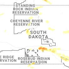
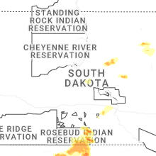


Connect with Interactive Hail Maps