

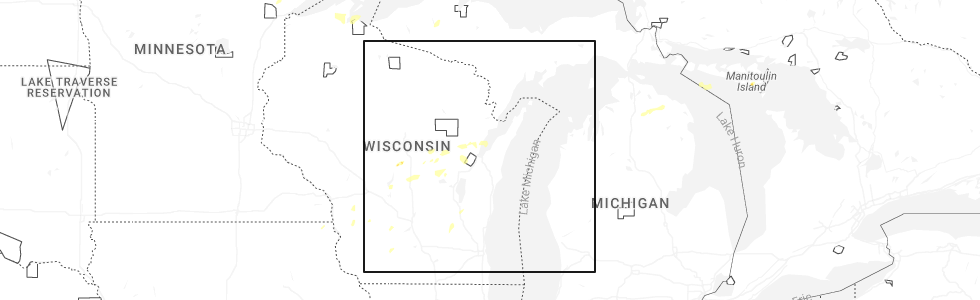
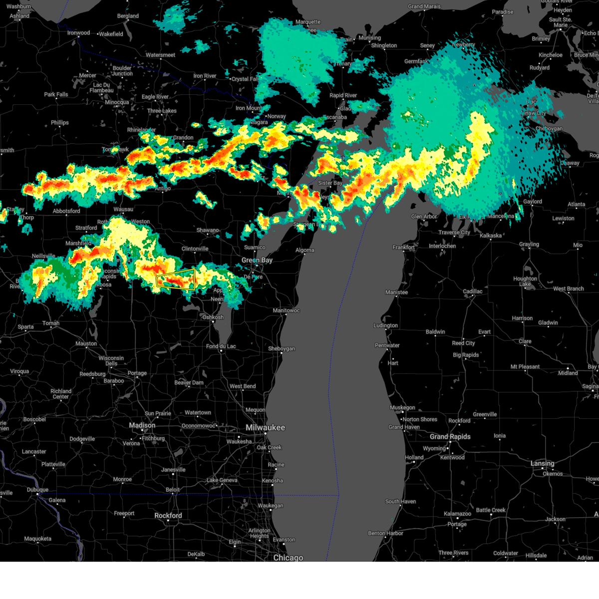
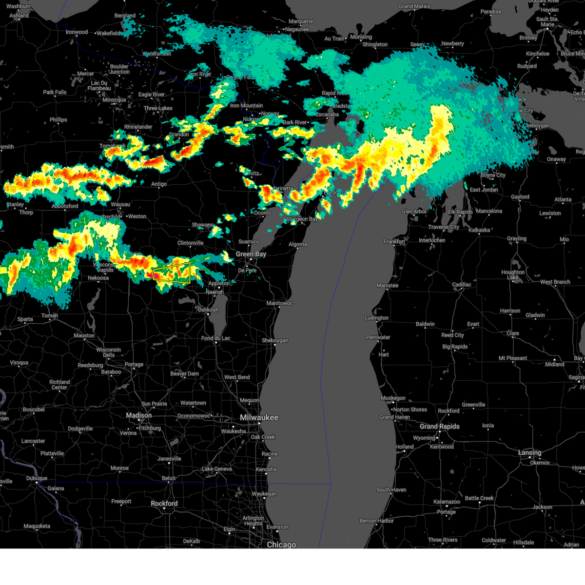
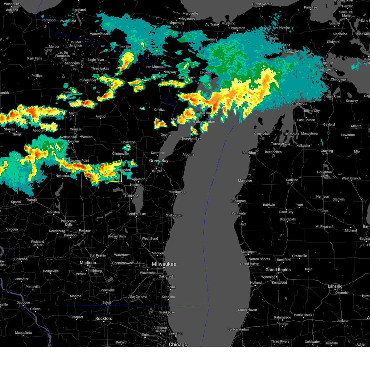
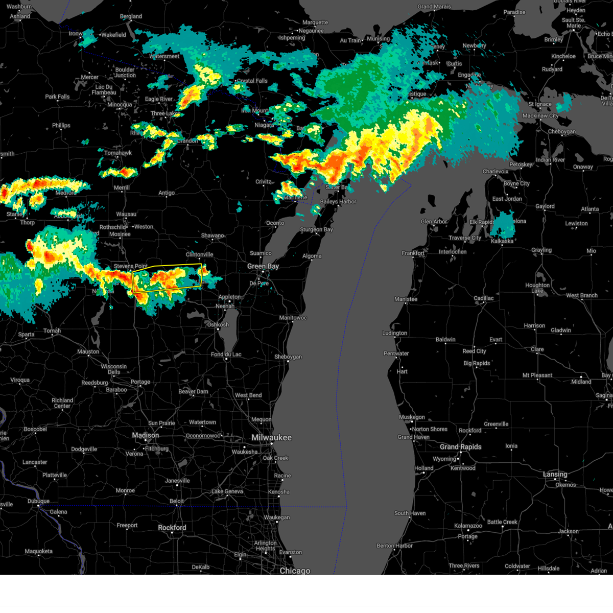
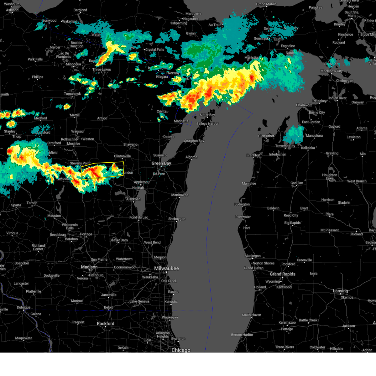
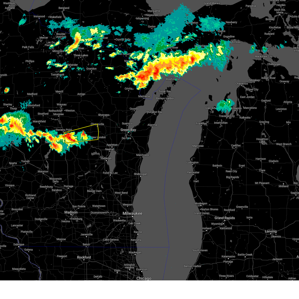
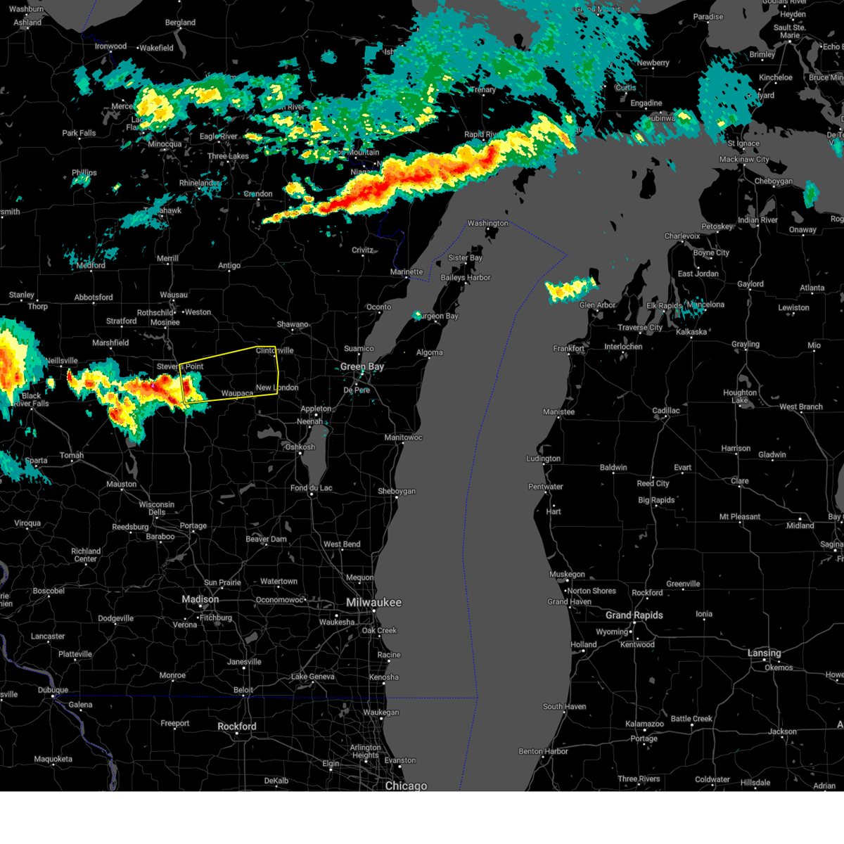
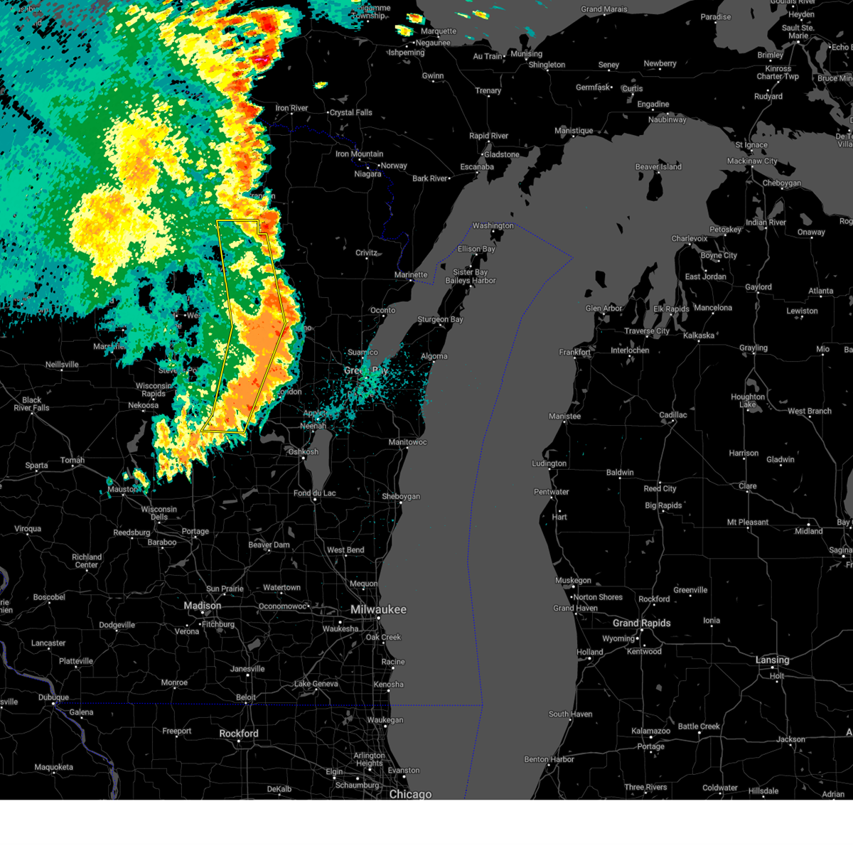
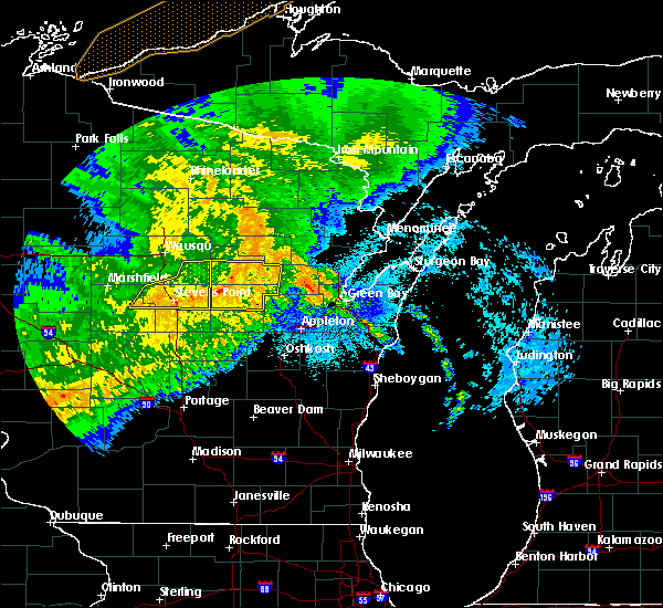
Hail Map for Ogdensburg, WI
The Ogdensburg, WI area has had 1 report of on-the-ground hail by trained spotters, and has been under severe weather warnings 21 times during the past 12 months. Doppler radar has detected hail at or near Ogdensburg, WI on 37 occasions, including 4 occasions during the past year.
| Name: | Ogdensburg, WI |
| Where Located: | 50.8 miles W of Green Bay, WI |
| Map: | Google Map for Ogdensburg, WI |
| Population: | 185 |
| Housing Units: | 98 |
| More Info: | Search Google for Ogdensburg, WI |
0
The Top Recent Hail Date for Ogdensburg, WI is Sunday, June 29, 2025 (30th out of 37)
Hail and Wind Damage Spotted near Ogdensburg, WI
| Date / Time | Report Details |
|---|---|
| 7/2/2025 4:54 PM CDT |
 The storm which prompted the warning has weakened below severe limits, and no longer poses an immediate threat to life or property. therefore, the warning will be allowed to expire. however, gusty winds are still possible with this thunderstorm. The storm which prompted the warning has weakened below severe limits, and no longer poses an immediate threat to life or property. therefore, the warning will be allowed to expire. however, gusty winds are still possible with this thunderstorm.
|
| 7/2/2025 4:46 PM CDT |
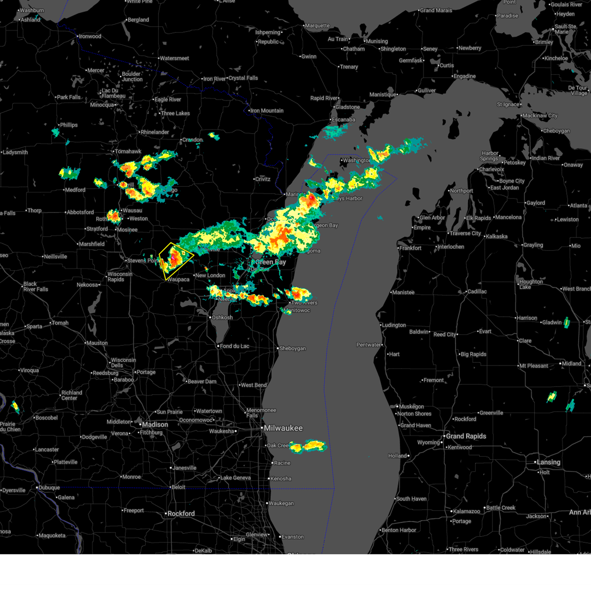
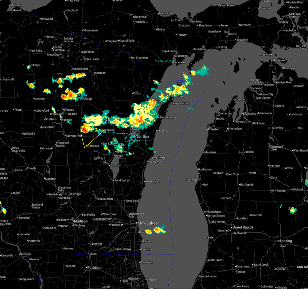
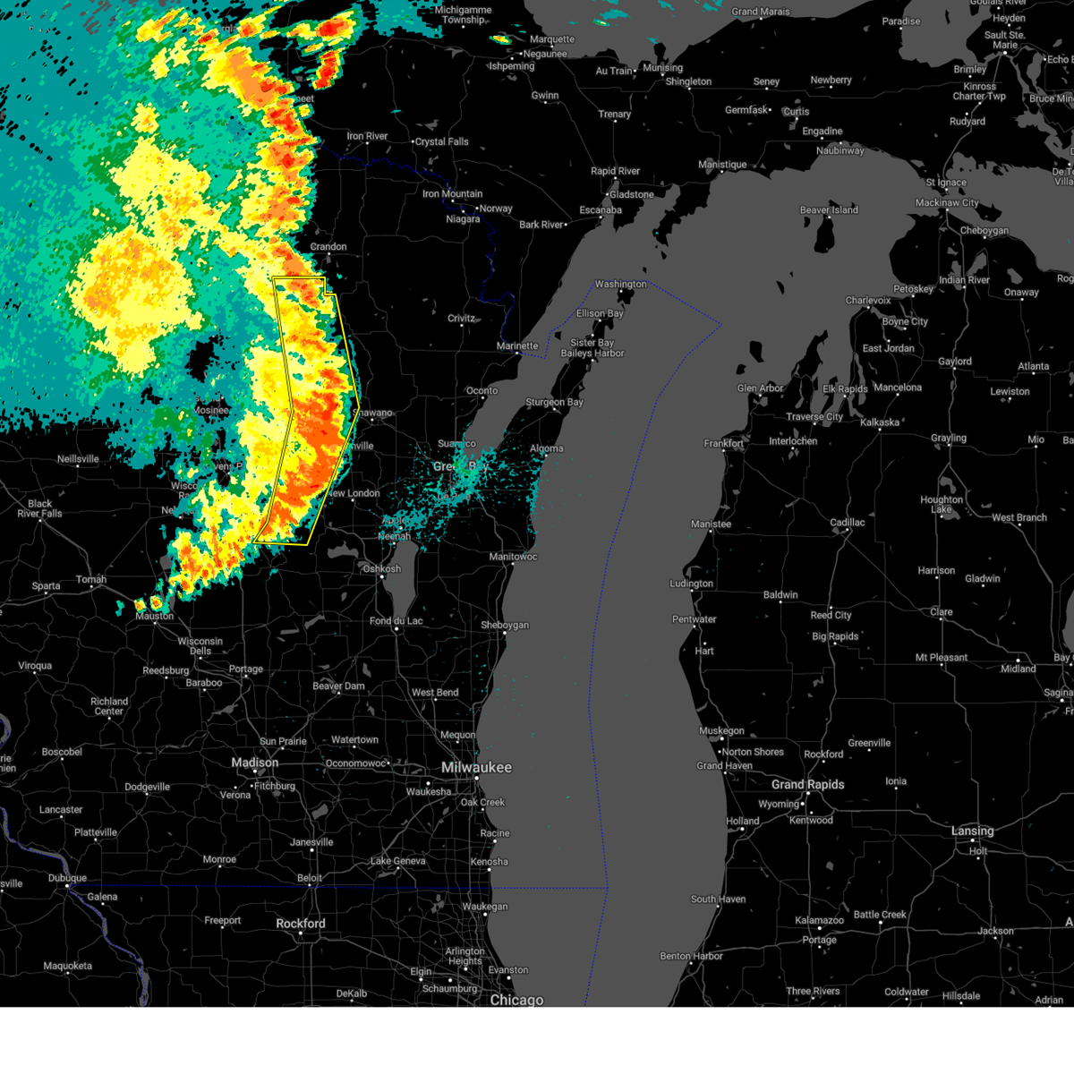
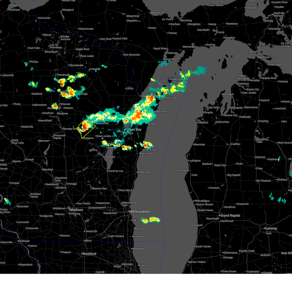 At 445 pm cdt, a severe thunderstorm was located 13 miles north of waupaca, moving southeast at 30 mph (radar indicated). Hazards include 60 mph wind gusts and penny size hail. Expect damage to roofs, siding, and trees. Locations impacted include, waupaca, manawa, iola, ogdensburg, big falls, schmidt corner, and symco. At 445 pm cdt, a severe thunderstorm was located 13 miles north of waupaca, moving southeast at 30 mph (radar indicated). Hazards include 60 mph wind gusts and penny size hail. Expect damage to roofs, siding, and trees. Locations impacted include, waupaca, manawa, iola, ogdensburg, big falls, schmidt corner, and symco.
|
| 7/2/2025 4:36 PM CDT |
 At 435 pm cdt, a severe thunderstorm was located 13 miles northeast of amherst, or 17 miles north of waupaca, moving southeast at 30 mph (radar indicated). Hazards include 60 mph wind gusts and penny size hail. Expect damage to roofs, siding, and trees. Locations impacted include, waupaca, clintonville, chain o' lakes-king, manawa, iola, king, scandinavia, ogdensburg, big falls, and schmidt corner. At 435 pm cdt, a severe thunderstorm was located 13 miles northeast of amherst, or 17 miles north of waupaca, moving southeast at 30 mph (radar indicated). Hazards include 60 mph wind gusts and penny size hail. Expect damage to roofs, siding, and trees. Locations impacted include, waupaca, clintonville, chain o' lakes-king, manawa, iola, king, scandinavia, ogdensburg, big falls, and schmidt corner.
|
| 7/2/2025 4:36 PM CDT |
 the severe thunderstorm warning has been cancelled and is no longer in effect the severe thunderstorm warning has been cancelled and is no longer in effect
|
| 7/2/2025 4:19 PM CDT |
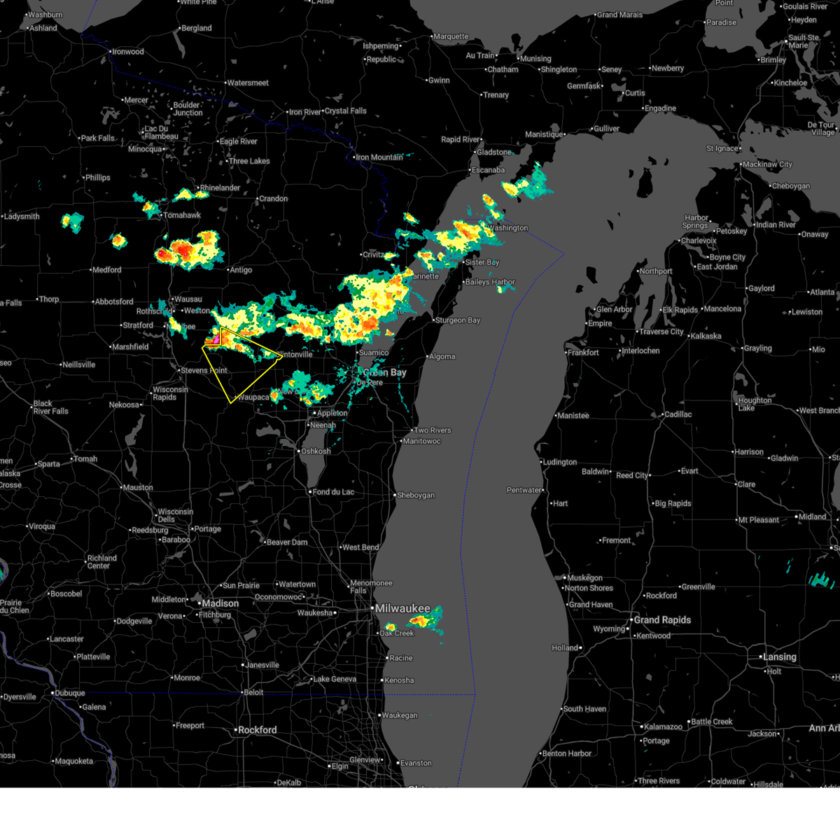 Svrgrb the national weather service in green bay has issued a * severe thunderstorm warning for, northeastern portage county in central wisconsin, northern waupaca county in northeastern wisconsin, western shawano county in northeastern wisconsin, * until 500 pm cdt. * at 419 pm cdt, a severe thunderstorm was located 9 miles southeast of bevent, or 19 miles northeast of stevens point, moving southeast at 30 mph (radar indicated). Hazards include 60 mph wind gusts and penny size hail. Expect damage to roofs, siding, and trees. This severe thunderstorm will remain over mainly rural areas of northeastern portage, northern waupaca and western shawano counties, including the following locations, buckbee, schmidt corner, split rock, rosholt, scandinavia, northland, ogdensburg, king, norske, and iola. Svrgrb the national weather service in green bay has issued a * severe thunderstorm warning for, northeastern portage county in central wisconsin, northern waupaca county in northeastern wisconsin, western shawano county in northeastern wisconsin, * until 500 pm cdt. * at 419 pm cdt, a severe thunderstorm was located 9 miles southeast of bevent, or 19 miles northeast of stevens point, moving southeast at 30 mph (radar indicated). Hazards include 60 mph wind gusts and penny size hail. Expect damage to roofs, siding, and trees. This severe thunderstorm will remain over mainly rural areas of northeastern portage, northern waupaca and western shawano counties, including the following locations, buckbee, schmidt corner, split rock, rosholt, scandinavia, northland, ogdensburg, king, norske, and iola.
|
| 6/23/2025 2:53 PM CDT |
 The storm which prompted the warning has moved out of the area. therefore, the warning will be allowed to expire. a severe thunderstorm watch remains in effect until 900 pm cdt for central, northeastern and east central wisconsin. The storm which prompted the warning has moved out of the area. therefore, the warning will be allowed to expire. a severe thunderstorm watch remains in effect until 900 pm cdt for central, northeastern and east central wisconsin.
|
| 6/23/2025 2:30 PM CDT |
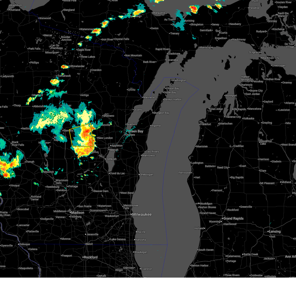
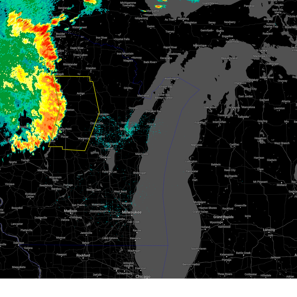
 At 230 pm cdt, a severe thunderstorm was located over amherst, or 11 miles northwest of waupaca, moving east at 45 mph (radar indicated). Hazards include 70 mph wind gusts and penny size hail. Expect considerable tree damage. damage is likely to mobile homes, roofs, and outbuildings. This severe thunderstorm will remain over mainly rural areas of southeastern portage and western waupaca counties, including the following locations, rural, schmidt corner, lind center, emmons creek barrens, scandinavia, sheridan, northland, nelsonville, ogdensburg, and fancher. At 230 pm cdt, a severe thunderstorm was located over amherst, or 11 miles northwest of waupaca, moving east at 45 mph (radar indicated). Hazards include 70 mph wind gusts and penny size hail. Expect considerable tree damage. damage is likely to mobile homes, roofs, and outbuildings. This severe thunderstorm will remain over mainly rural areas of southeastern portage and western waupaca counties, including the following locations, rural, schmidt corner, lind center, emmons creek barrens, scandinavia, sheridan, northland, nelsonville, ogdensburg, and fancher.
|
| 6/23/2025 2:12 PM CDT |
 Svrgrb the national weather service in green bay has issued a * severe thunderstorm warning for, southeastern portage county in central wisconsin, western waupaca county in northeastern wisconsin, * until 300 pm cdt. * at 212 pm cdt, a severe thunderstorm was located 7 miles south of whiting, or 10 miles south of stevens point, moving east at 45 mph (radar indicated). Hazards include 70 mph wind gusts and penny size hail. Expect considerable tree damage. damage is likely to mobile homes, roofs, and outbuildings. this severe thunderstorm will be near, amherst around 225 pm cdt. Other locations impacted by this severe thunderstorm include schmidt corner, coddington, scandinavia, nelsonville, king, iola, plover, symco, custer, and manawa. Svrgrb the national weather service in green bay has issued a * severe thunderstorm warning for, southeastern portage county in central wisconsin, western waupaca county in northeastern wisconsin, * until 300 pm cdt. * at 212 pm cdt, a severe thunderstorm was located 7 miles south of whiting, or 10 miles south of stevens point, moving east at 45 mph (radar indicated). Hazards include 70 mph wind gusts and penny size hail. Expect considerable tree damage. damage is likely to mobile homes, roofs, and outbuildings. this severe thunderstorm will be near, amherst around 225 pm cdt. Other locations impacted by this severe thunderstorm include schmidt corner, coddington, scandinavia, nelsonville, king, iola, plover, symco, custer, and manawa.
|
| 3/28/2025 9:16 PM CDT |
 The storm which prompted the warning continues to move through waupaca county. a new severe thunderstorm warning has been issued. The storm which prompted the warning continues to move through waupaca county. a new severe thunderstorm warning has been issued.
|
| 3/28/2025 9:01 PM CDT |
 the severe thunderstorm warning has been cancelled and is no longer in effect the severe thunderstorm warning has been cancelled and is no longer in effect
|
| 3/28/2025 9:01 PM CDT |
 At 901 pm cdt, a severe thunderstorm was located near waupaca, moving east at 40 mph (radar indicated). Hazards include half dollar size hail. Damage to vehicles is expected. Locations impacted include, sheridan, waupaca, king, royalton, northport, chain o' lakes-king, weyauwega, and manawa. At 901 pm cdt, a severe thunderstorm was located near waupaca, moving east at 40 mph (radar indicated). Hazards include half dollar size hail. Damage to vehicles is expected. Locations impacted include, sheridan, waupaca, king, royalton, northport, chain o' lakes-king, weyauwega, and manawa.
|
| 3/28/2025 8:42 PM CDT |
 Svrgrb the national weather service in green bay has issued a * severe thunderstorm warning for, southeastern portage county in central wisconsin, southern waupaca county in northeastern wisconsin, * until 915 pm cdt. * at 839 pm cdt, a severe thunderstorm was located near hartman creek state park, or 11 miles west of waupaca, moving east at 35 mph (radar indicated). Hazards include quarter size hail. damage to vehicles is expected Svrgrb the national weather service in green bay has issued a * severe thunderstorm warning for, southeastern portage county in central wisconsin, southern waupaca county in northeastern wisconsin, * until 915 pm cdt. * at 839 pm cdt, a severe thunderstorm was located near hartman creek state park, or 11 miles west of waupaca, moving east at 35 mph (radar indicated). Hazards include quarter size hail. damage to vehicles is expected
|
| 3/28/2025 8:31 PM CDT |
 The storm which prompted the warning has weakened below severe limits, and no longer poses an immediate threat to life or property. therefore, the warning has been allowed to expire. The storm which prompted the warning has weakened below severe limits, and no longer poses an immediate threat to life or property. therefore, the warning has been allowed to expire.
|
| 3/28/2025 8:20 PM CDT |
 At 819 pm cdt, a severe thunderstorm was located near amherst, or 8 miles northwest of waupaca, moving east at 40 mph (trained weather spotters). Hazards include quarter size hail. Damage to vehicles is expected. Locations impacted include, fitzgerald corners, northport, scandinavia, nelsonville, iola, plover, symco, custer, manawa, and standing rock park. At 819 pm cdt, a severe thunderstorm was located near amherst, or 8 miles northwest of waupaca, moving east at 40 mph (trained weather spotters). Hazards include quarter size hail. Damage to vehicles is expected. Locations impacted include, fitzgerald corners, northport, scandinavia, nelsonville, iola, plover, symco, custer, manawa, and standing rock park.
|
| 3/28/2025 8:04 PM CDT |
 At 803 pm cdt, a severe thunderstorm was located 10 miles north of waupaca, moving east at 50 mph (trained weather spotters). Hazards include half dollar size hail. Damage to vehicles is expected. Locations impacted include, fitzgerald corners, northport, scandinavia, nelsonville, iola, plover, symco, custer, manawa, and standing rock park. At 803 pm cdt, a severe thunderstorm was located 10 miles north of waupaca, moving east at 50 mph (trained weather spotters). Hazards include half dollar size hail. Damage to vehicles is expected. Locations impacted include, fitzgerald corners, northport, scandinavia, nelsonville, iola, plover, symco, custer, manawa, and standing rock park.
|
| 3/28/2025 7:38 PM CDT |
 Svrgrb the national weather service in green bay has issued a * severe thunderstorm warning for, eastern portage county in central wisconsin, waupaca county in northeastern wisconsin, * until 830 pm cdt. * at 738 pm cdt, a severe thunderstorm was located near whiting, or near stevens point, moving east at 55 mph (trained weather spotters). Hazards include half dollar size hail. damage to vehicles is expected Svrgrb the national weather service in green bay has issued a * severe thunderstorm warning for, eastern portage county in central wisconsin, waupaca county in northeastern wisconsin, * until 830 pm cdt. * at 738 pm cdt, a severe thunderstorm was located near whiting, or near stevens point, moving east at 55 mph (trained weather spotters). Hazards include half dollar size hail. damage to vehicles is expected
|
| 8/27/2024 12:13 AM CDT |
 The storms which prompted the warning have moved out of the area. therefore, the warning will be allowed to expire. however, heavy rain is still possible with these thunderstorms. a severe thunderstorm watch remains in effect until 400 am cdt for central, north central and northeastern wisconsin. remember, a severe thunderstorm warning still remains in effect for portions of these counties until 1245 am. The storms which prompted the warning have moved out of the area. therefore, the warning will be allowed to expire. however, heavy rain is still possible with these thunderstorms. a severe thunderstorm watch remains in effect until 400 am cdt for central, north central and northeastern wisconsin. remember, a severe thunderstorm warning still remains in effect for portions of these counties until 1245 am.
|
| 8/27/2024 12:00 AM CDT |
 the severe thunderstorm warning has been cancelled and is no longer in effect the severe thunderstorm warning has been cancelled and is no longer in effect
|
| 8/27/2024 12:00 AM CDT |
 At 1159 pm cdt, severe thunderstorms were located along a line extending from near ma ka ja wan scout reservation to 6 miles southwest of keshena to 6 miles south of waupaca, moving east at 45 mph (radar indicated). Hazards include 60 mph wind gusts. Expect damage to roofs, siding, and trees. Locations impacted include, antigo, waupaca, wittenberg, pearson, hartman creek state park, veterans memorial county park, chain o' lakes-king, neopit, ma ka ja wan scout reservation, and manawa. At 1159 pm cdt, severe thunderstorms were located along a line extending from near ma ka ja wan scout reservation to 6 miles southwest of keshena to 6 miles south of waupaca, moving east at 45 mph (radar indicated). Hazards include 60 mph wind gusts. Expect damage to roofs, siding, and trees. Locations impacted include, antigo, waupaca, wittenberg, pearson, hartman creek state park, veterans memorial county park, chain o' lakes-king, neopit, ma ka ja wan scout reservation, and manawa.
|
| 8/26/2024 11:53 PM CDT |
 Svrgrb the national weather service in green bay has issued a * severe thunderstorm warning for, southern forest county in northeastern wisconsin, menominee county in northeastern wisconsin, northern winnebago county in east central wisconsin, northeastern waushara county in central wisconsin, waupaca county in northeastern wisconsin, oconto county in northeastern wisconsin, outagamie county in northeastern wisconsin, central langlade county in north central wisconsin, shawano county in northeastern wisconsin, * until 1245 am cdt. * at 1153 pm cdt, severe thunderstorms were located along a line extending from near crandon to near shawano to near napowan scout camp, moving east at 55 mph (radar indicated). Hazards include 60 mph wind gusts and penny size hail. expect damage to roofs, siding, and trees Svrgrb the national weather service in green bay has issued a * severe thunderstorm warning for, southern forest county in northeastern wisconsin, menominee county in northeastern wisconsin, northern winnebago county in east central wisconsin, northeastern waushara county in central wisconsin, waupaca county in northeastern wisconsin, oconto county in northeastern wisconsin, outagamie county in northeastern wisconsin, central langlade county in north central wisconsin, shawano county in northeastern wisconsin, * until 1245 am cdt. * at 1153 pm cdt, severe thunderstorms were located along a line extending from near crandon to near shawano to near napowan scout camp, moving east at 55 mph (radar indicated). Hazards include 60 mph wind gusts and penny size hail. expect damage to roofs, siding, and trees
|
| 8/26/2024 11:08 PM CDT |
 Svrgrb the national weather service in green bay has issued a * severe thunderstorm warning for, southeastern wood county in central wisconsin, portage county in central wisconsin, eastern lincoln county in north central wisconsin, eastern marathon county in central wisconsin, western menominee county in northeastern wisconsin, northern waushara county in central wisconsin, waupaca county in northeastern wisconsin, langlade county in north central wisconsin, western shawano county in northeastern wisconsin, * until 1215 am cdt. * at 1108 pm cdt, severe thunderstorms were located along a line extending from near gilbert to near weston to lake wazeecha, moving east at 45 mph (radar indicated). Hazards include 60 mph wind gusts. expect damage to roofs, siding, and trees Svrgrb the national weather service in green bay has issued a * severe thunderstorm warning for, southeastern wood county in central wisconsin, portage county in central wisconsin, eastern lincoln county in north central wisconsin, eastern marathon county in central wisconsin, western menominee county in northeastern wisconsin, northern waushara county in central wisconsin, waupaca county in northeastern wisconsin, langlade county in north central wisconsin, western shawano county in northeastern wisconsin, * until 1215 am cdt. * at 1108 pm cdt, severe thunderstorms were located along a line extending from near gilbert to near weston to lake wazeecha, moving east at 45 mph (radar indicated). Hazards include 60 mph wind gusts. expect damage to roofs, siding, and trees
|
| 5/21/2024 9:17 PM CDT |
 The storms which prompted the warning have moved out of the warned area. therefore, the warning will be allowed to expire. a tornado watch remains in effect until midnight cdt for central, north central, northeastern and east central wisconsin. remember, a severe thunderstorm warning still remains in effect for eastern menominee, eastern shawano, eastern outagamie, eastern winnebago counties. The storms which prompted the warning have moved out of the warned area. therefore, the warning will be allowed to expire. a tornado watch remains in effect until midnight cdt for central, north central, northeastern and east central wisconsin. remember, a severe thunderstorm warning still remains in effect for eastern menominee, eastern shawano, eastern outagamie, eastern winnebago counties.
|
| 5/21/2024 8:38 PM CDT |
 At 837 pm cdt, severe thunderstorms were located along a line extending from near antigo to 7 miles east of wittenberg to near napowan scout camp, moving east at 60 mph (radar indicated). Hazards include 70 mph wind gusts. Expect considerable tree damage. damage is likely to mobile homes, roofs, and outbuildings. Locations impacted include, appleton, oshkosh, shawano, antigo, waupaca, wautoma, menasha, new london, clintonville, and redgranite. At 837 pm cdt, severe thunderstorms were located along a line extending from near antigo to 7 miles east of wittenberg to near napowan scout camp, moving east at 60 mph (radar indicated). Hazards include 70 mph wind gusts. Expect considerable tree damage. damage is likely to mobile homes, roofs, and outbuildings. Locations impacted include, appleton, oshkosh, shawano, antigo, waupaca, wautoma, menasha, new london, clintonville, and redgranite.
|
| 5/21/2024 8:38 PM CDT |
 the severe thunderstorm warning has been cancelled and is no longer in effect the severe thunderstorm warning has been cancelled and is no longer in effect
|
| 5/21/2024 8:18 PM CDT |
 Svrgrb the national weather service in green bay has issued a * severe thunderstorm warning for, eastern portage county in central wisconsin, eastern marathon county in central wisconsin, menominee county in northeastern wisconsin, winnebago county in east central wisconsin, waushara county in central wisconsin, waupaca county in northeastern wisconsin, western outagamie county in northeastern wisconsin, southern langlade county in north central wisconsin, shawano county in northeastern wisconsin, * until 915 pm cdt. * at 817 pm cdt, severe thunderstorms were located along a line extending from 12 miles northeast of wausau to near bevent to 7 miles southwest of plainfield, moving east at 60 mph (radar indicated). Hazards include 70 mph wind gusts. Expect considerable tree damage. Damage is likely to mobile homes, roofs, and outbuildings. Svrgrb the national weather service in green bay has issued a * severe thunderstorm warning for, eastern portage county in central wisconsin, eastern marathon county in central wisconsin, menominee county in northeastern wisconsin, winnebago county in east central wisconsin, waushara county in central wisconsin, waupaca county in northeastern wisconsin, western outagamie county in northeastern wisconsin, southern langlade county in north central wisconsin, shawano county in northeastern wisconsin, * until 915 pm cdt. * at 817 pm cdt, severe thunderstorms were located along a line extending from 12 miles northeast of wausau to near bevent to 7 miles southwest of plainfield, moving east at 60 mph (radar indicated). Hazards include 70 mph wind gusts. Expect considerable tree damage. Damage is likely to mobile homes, roofs, and outbuildings.
|
| 8/11/2023 8:21 PM CDT |
 The severe thunderstorm warning for eastern portage, southeastern marathon, waushara and waupaca counties will expire at 830 pm cdt, the storms which prompted the warning have weakened below severe limits, and no longer pose an immediate threat to life or property. therefore, the warning will be allowed to expire. however gusty winds and heavy rain are still possible with these thunderstorms. a severe thunderstorm watch remains in effect until 100 am cdt for central, northeastern and east central wisconsin. The severe thunderstorm warning for eastern portage, southeastern marathon, waushara and waupaca counties will expire at 830 pm cdt, the storms which prompted the warning have weakened below severe limits, and no longer pose an immediate threat to life or property. therefore, the warning will be allowed to expire. however gusty winds and heavy rain are still possible with these thunderstorms. a severe thunderstorm watch remains in effect until 100 am cdt for central, northeastern and east central wisconsin.
|
| 8/11/2023 8:11 PM CDT |
 At 811 pm cdt, severe thunderstorms were located along a line extending from 9 miles north of amherst to hartman creek state park to 6 miles south of plainfield, moving southeast at 45 mph (radar indicated). Hazards include 60 mph wind gusts. Expect damage to roofs, siding, and trees. these severe storms will be near, hartman creek state park and chain o` lakes-king around 815 pm cdt. waupaca around 825 pm cdt. wautoma around 830 pm cdt. fremont around 835 pm cdt. redgranite around 840 pm cdt. new london around 845 pm cdt. other locations impacted by these severe thunderstorms include schmidt corner, northport, coddington, ellis, nelsonville, king, iola, symco, custer and manawa. hail threat, radar indicated max hail size, <. 75 in wind threat, radar indicated max wind gust, 60 mph. At 811 pm cdt, severe thunderstorms were located along a line extending from 9 miles north of amherst to hartman creek state park to 6 miles south of plainfield, moving southeast at 45 mph (radar indicated). Hazards include 60 mph wind gusts. Expect damage to roofs, siding, and trees. these severe storms will be near, hartman creek state park and chain o` lakes-king around 815 pm cdt. waupaca around 825 pm cdt. wautoma around 830 pm cdt. fremont around 835 pm cdt. redgranite around 840 pm cdt. new london around 845 pm cdt. other locations impacted by these severe thunderstorms include schmidt corner, northport, coddington, ellis, nelsonville, king, iola, symco, custer and manawa. hail threat, radar indicated max hail size, <. 75 in wind threat, radar indicated max wind gust, 60 mph.
|
| 8/11/2023 7:50 PM CDT |
 At 750 pm cdt, severe thunderstorms were located along a line extending from near bevent to near whiting to 6 miles south of lake wazeecha, moving southeast at 45 mph (trained weather spotters). Hazards include 60 mph wind gusts. Expect damage to roofs, siding, and trees. severe thunderstorms will be near, amherst around 800 pm cdt. plainfield and hartman creek state park around 810 pm cdt. chain o` lakes-king around 815 pm cdt. waupaca around 820 pm cdt. wautoma around 825 pm cdt. redgranite, fremont and napowan scout camp around 830 pm cdt. other locations impacted by these severe thunderstorms include schmidt corner, northport, coddington, kellner, ellis, nelsonville, king, iola, symco and custer. hail threat, radar indicated max hail size, <. 75 in wind threat, radar indicated max wind gust, 60 mph. At 750 pm cdt, severe thunderstorms were located along a line extending from near bevent to near whiting to 6 miles south of lake wazeecha, moving southeast at 45 mph (trained weather spotters). Hazards include 60 mph wind gusts. Expect damage to roofs, siding, and trees. severe thunderstorms will be near, amherst around 800 pm cdt. plainfield and hartman creek state park around 810 pm cdt. chain o` lakes-king around 815 pm cdt. waupaca around 820 pm cdt. wautoma around 825 pm cdt. redgranite, fremont and napowan scout camp around 830 pm cdt. other locations impacted by these severe thunderstorms include schmidt corner, northport, coddington, kellner, ellis, nelsonville, king, iola, symco and custer. hail threat, radar indicated max hail size, <. 75 in wind threat, radar indicated max wind gust, 60 mph.
|
| 7/16/2023 7:40 PM CDT |
 At 740 pm cdt, a severe thunderstorm was located over waupaca, moving east at 45 mph (radar indicated). Hazards include 60 mph wind gusts and quarter size hail. Hail damage to vehicles is expected. expect wind damage to roofs, siding, and trees. this severe storm will be near, fremont around 800 pm cdt. new london around 805 pm cdt. other locations impacted by this severe thunderstorm include rural, sheridan, lind center, king, royalton, northport, readfield, scandinavia, weyauwega and ogdensburg. hail threat, radar indicated max hail size, 1. 00 in wind threat, radar indicated max wind gust, 60 mph. At 740 pm cdt, a severe thunderstorm was located over waupaca, moving east at 45 mph (radar indicated). Hazards include 60 mph wind gusts and quarter size hail. Hail damage to vehicles is expected. expect wind damage to roofs, siding, and trees. this severe storm will be near, fremont around 800 pm cdt. new london around 805 pm cdt. other locations impacted by this severe thunderstorm include rural, sheridan, lind center, king, royalton, northport, readfield, scandinavia, weyauwega and ogdensburg. hail threat, radar indicated max hail size, 1. 00 in wind threat, radar indicated max wind gust, 60 mph.
|
| 7/16/2023 7:29 PM CDT |
 At 729 pm cdt, a severe thunderstorm was located near amherst, or 9 miles northwest of waupaca, moving east at 45 mph (radar indicated). Hazards include 60 mph wind gusts and quarter size hail. Hail damage to vehicles is expected. expect wind damage to roofs, siding, and trees. this severe thunderstorm will be near, chain o` lakes-king around 740 pm cdt. waupaca around 745 pm cdt. fremont around 800 pm cdt. new london around 805 pm cdt. other locations impacted by this severe thunderstorm include rural, lind center, northport, emmons creek barrens, scandinavia, sheridan, nelsonville, king, royalton and readfield. hail threat, radar indicated max hail size, 1. 00 in wind threat, radar indicated max wind gust, 60 mph. At 729 pm cdt, a severe thunderstorm was located near amherst, or 9 miles northwest of waupaca, moving east at 45 mph (radar indicated). Hazards include 60 mph wind gusts and quarter size hail. Hail damage to vehicles is expected. expect wind damage to roofs, siding, and trees. this severe thunderstorm will be near, chain o` lakes-king around 740 pm cdt. waupaca around 745 pm cdt. fremont around 800 pm cdt. new london around 805 pm cdt. other locations impacted by this severe thunderstorm include rural, lind center, northport, emmons creek barrens, scandinavia, sheridan, nelsonville, king, royalton and readfield. hail threat, radar indicated max hail size, 1. 00 in wind threat, radar indicated max wind gust, 60 mph.
|
| 6/15/2022 5:48 PM CDT |
 At 548 pm cdt, severe thunderstorms were located along a line extending from 10 miles northeast of wittenberg to 8 miles south of neopit to 10 miles northwest of new london, moving northeast at 70 mph (trained weather spotters). Hazards include 70 mph wind gusts. Expect considerable tree damage. damage is likely to mobile homes, roofs, and outbuildings. Locations impacted include, shawano, waupaca, new london, clintonville, fremont, embarrass, big smokey falls, hartman creek state park, navarino wildlife area and south branch. At 548 pm cdt, severe thunderstorms were located along a line extending from 10 miles northeast of wittenberg to 8 miles south of neopit to 10 miles northwest of new london, moving northeast at 70 mph (trained weather spotters). Hazards include 70 mph wind gusts. Expect considerable tree damage. damage is likely to mobile homes, roofs, and outbuildings. Locations impacted include, shawano, waupaca, new london, clintonville, fremont, embarrass, big smokey falls, hartman creek state park, navarino wildlife area and south branch.
|
| 6/15/2022 5:33 PM CDT |
 At 533 pm cdt, severe thunderstorms were located along a line extending from near wittenberg to 12 miles east of bevent to near chain o` lakes-king, moving northeast at 60 mph (radar indicated). Hazards include 70 mph wind gusts. Expect considerable tree damage. damage is likely to mobile homes, roofs, and outbuildings. Locations impacted include, neopit, clintonville, keshena, embarrass, south branch, big smokey falls, legend lake and navarino wildlife area. At 533 pm cdt, severe thunderstorms were located along a line extending from near wittenberg to 12 miles east of bevent to near chain o` lakes-king, moving northeast at 60 mph (radar indicated). Hazards include 70 mph wind gusts. Expect considerable tree damage. damage is likely to mobile homes, roofs, and outbuildings. Locations impacted include, neopit, clintonville, keshena, embarrass, south branch, big smokey falls, legend lake and navarino wildlife area.
|
| 6/15/2022 5:22 PM CDT |
 At 522 pm cdt, severe thunderstorms were located along a line extending from near bevent to 12 miles southwest of wittenberg to 7 miles southwest of hartman creek state park, moving northeast at 55 mph (radar indicated). Hazards include 60 mph wind gusts. Expect damage to roofs, siding, and trees. severe thunderstorms will be near, chain o` lakes-king around 530 pm cdt. waupaca and wittenberg around 535 pm cdt. other locations in the path of these severe thunderstorms include shawano, neopit, clintonville, keshena, big smokey falls, legend lake, south branch and navarino wildlife area. hail threat, radar indicated max hail size, <. 75 in wind threat, radar indicated max wind gust, 60 mph. At 522 pm cdt, severe thunderstorms were located along a line extending from near bevent to 12 miles southwest of wittenberg to 7 miles southwest of hartman creek state park, moving northeast at 55 mph (radar indicated). Hazards include 60 mph wind gusts. Expect damage to roofs, siding, and trees. severe thunderstorms will be near, chain o` lakes-king around 530 pm cdt. waupaca and wittenberg around 535 pm cdt. other locations in the path of these severe thunderstorms include shawano, neopit, clintonville, keshena, big smokey falls, legend lake, south branch and navarino wildlife area. hail threat, radar indicated max hail size, <. 75 in wind threat, radar indicated max wind gust, 60 mph.
|
| 4/12/2022 5:39 PM CDT |
 The severe thunderstorm warning for eastern portage, central waushara and western waupaca counties will expire at 545 pm cdt, the storm which prompted the warning has moved out of the area. therefore, the warning will be allowed to expire. remember, a severe thunderstorm warning still remains in effect for portions of portage and waushara counties. The severe thunderstorm warning for eastern portage, central waushara and western waupaca counties will expire at 545 pm cdt, the storm which prompted the warning has moved out of the area. therefore, the warning will be allowed to expire. remember, a severe thunderstorm warning still remains in effect for portions of portage and waushara counties.
|
| 4/12/2022 5:23 PM CDT |
 At 523 pm cdt, a severe thunderstorm was located over waupaca, moving east at 55 mph (radar indicated). Hazards include 60 mph wind gusts and quarter size hail. Hail damage to vehicles is expected. Expect wind damage to roofs, siding, and trees. At 523 pm cdt, a severe thunderstorm was located over waupaca, moving east at 55 mph (radar indicated). Hazards include 60 mph wind gusts and quarter size hail. Hail damage to vehicles is expected. Expect wind damage to roofs, siding, and trees.
|
| 4/12/2022 5:17 PM CDT |
 At 517 pm cdt, a severe thunderstorm was located near amherst, or 10 miles northwest of waupaca, moving east at 55 mph (trained weather spotters). Hazards include 60 mph wind gusts and quarter size hail. Hail damage to vehicles is expected. expect wind damage to roofs, siding, and trees. locations impacted include, waupaca, wautoma, redgranite, amherst, chain o` lakes-king, napowan scout camp, hartman creek state park, silver lake, pine river and iola. hail threat, observed max hail size, 1. 00 in wind threat, radar indicated max wind gust, 60 mph. At 517 pm cdt, a severe thunderstorm was located near amherst, or 10 miles northwest of waupaca, moving east at 55 mph (trained weather spotters). Hazards include 60 mph wind gusts and quarter size hail. Hail damage to vehicles is expected. expect wind damage to roofs, siding, and trees. locations impacted include, waupaca, wautoma, redgranite, amherst, chain o` lakes-king, napowan scout camp, hartman creek state park, silver lake, pine river and iola. hail threat, observed max hail size, 1. 00 in wind threat, radar indicated max wind gust, 60 mph.
|
| 4/12/2022 5:05 PM CDT |
 At 504 pm cdt, a severe thunderstorm was located 7 miles west of amherst, or 10 miles southeast of stevens point, moving east at 55 mph (trained weather spotters). Hazards include 60 mph wind gusts and quarter size hail. Hail damage to vehicles is expected. expect wind damage to roofs, siding, and trees. locations impacted include, stevens point, waupaca, wautoma, redgranite, whiting, amherst, plainfield, napowan scout camp, hartman creek state park and chain o` lakes-king. hail threat, observed max hail size, 1. 00 in wind threat, radar indicated max wind gust, 60 mph. At 504 pm cdt, a severe thunderstorm was located 7 miles west of amherst, or 10 miles southeast of stevens point, moving east at 55 mph (trained weather spotters). Hazards include 60 mph wind gusts and quarter size hail. Hail damage to vehicles is expected. expect wind damage to roofs, siding, and trees. locations impacted include, stevens point, waupaca, wautoma, redgranite, whiting, amherst, plainfield, napowan scout camp, hartman creek state park and chain o` lakes-king. hail threat, observed max hail size, 1. 00 in wind threat, radar indicated max wind gust, 60 mph.
|
| 4/12/2022 4:49 PM CDT |
 At 449 pm cdt, a severe thunderstorm was located near lake wazeecha, or 7 miles southeast of wisconsin rapids, moving east at 55 mph (trained weather spotters). Hazards include 60 mph wind gusts and quarter size hail. Hail damage to vehicles is expected. Expect wind damage to roofs, siding, and trees. At 449 pm cdt, a severe thunderstorm was located near lake wazeecha, or 7 miles southeast of wisconsin rapids, moving east at 55 mph (trained weather spotters). Hazards include 60 mph wind gusts and quarter size hail. Hail damage to vehicles is expected. Expect wind damage to roofs, siding, and trees.
|
| 9/7/2021 8:51 AM CDT |
 The severe thunderstorm warning for southern waupaca and western outagamie counties will expire at 900 am cdt, the storm which prompted the warning has moved out of the area. therefore, the warning will be allowed to expire. however small hail and gusty winds are still possible with this thunderstorm. remember, a severe thunderstorm warning still remains in effect for southeastern portions of the county. The severe thunderstorm warning for southern waupaca and western outagamie counties will expire at 900 am cdt, the storm which prompted the warning has moved out of the area. therefore, the warning will be allowed to expire. however small hail and gusty winds are still possible with this thunderstorm. remember, a severe thunderstorm warning still remains in effect for southeastern portions of the county.
|
| 9/7/2021 8:26 AM CDT |
 At 824 am cdt, a severe thunderstorm was located over new london, or 15 miles east of waupaca with another storm developing just south of waupaca, moving east at 55 mph (radar indicated). Hazards include 60 mph wind gusts and quarter size hail. Hail damage to vehicles is expected. expect wind damage to roofs, siding, and trees. locations impacted include, black creek. hail threat, radar indicated max hail size, 1. 00 in wind threat, radar indicated max wind gust, 60 mph. At 824 am cdt, a severe thunderstorm was located over new london, or 15 miles east of waupaca with another storm developing just south of waupaca, moving east at 55 mph (radar indicated). Hazards include 60 mph wind gusts and quarter size hail. Hail damage to vehicles is expected. expect wind damage to roofs, siding, and trees. locations impacted include, black creek. hail threat, radar indicated max hail size, 1. 00 in wind threat, radar indicated max wind gust, 60 mph.
|
| 9/7/2021 8:11 AM CDT |
 At 811 am cdt, a severe thunderstorm was located near waupaca, moving east at 55 mph (radar indicated). Hazards include 60 mph wind gusts and quarter size hail. Hail damage to vehicles is expected. expect wind damage to roofs, siding, and trees. this severe thunderstorm will be near, new london around 825 am cdt. other locations in the path of this severe thunderstorm include black creek. hail threat, radar indicated max hail size, 1. 00 in wind threat, radar indicated max wind gust, 60 mph. At 811 am cdt, a severe thunderstorm was located near waupaca, moving east at 55 mph (radar indicated). Hazards include 60 mph wind gusts and quarter size hail. Hail damage to vehicles is expected. expect wind damage to roofs, siding, and trees. this severe thunderstorm will be near, new london around 825 am cdt. other locations in the path of this severe thunderstorm include black creek. hail threat, radar indicated max hail size, 1. 00 in wind threat, radar indicated max wind gust, 60 mph.
|
| 8/8/2021 5:17 PM CDT |
 At 517 pm cdt, severe thunderstorms were located along a line extending from 11 miles south of clintonville to near new london to 6 miles west of menasha, moving northeast at 40 mph (radar indicated). Hazards include 60 mph wind gusts. Expect damage to roofs, siding, and trees. locations impacted include, appleton, waupaca, menasha, little chute, new london, fremont, neenah, greenville, dale and hortonville. hail threat, radar indicated max hail size, <. 75 in wind threat, radar indicated max wind gust, 60 mph. At 517 pm cdt, severe thunderstorms were located along a line extending from 11 miles south of clintonville to near new london to 6 miles west of menasha, moving northeast at 40 mph (radar indicated). Hazards include 60 mph wind gusts. Expect damage to roofs, siding, and trees. locations impacted include, appleton, waupaca, menasha, little chute, new london, fremont, neenah, greenville, dale and hortonville. hail threat, radar indicated max hail size, <. 75 in wind threat, radar indicated max wind gust, 60 mph.
|
| 8/8/2021 5:10 PM CDT |
 At 510 pm cdt, severe thunderstorms were located along a line extending from 10 miles north of fremont to near new london to 10 miles east of lake poygan, moving northeast at 40 mph (radar indicated). Hazards include 60 mph wind gusts. Expect damage to roofs, siding, and trees. locations impacted include, appleton, waupaca, menasha, little chute, new london, clintonville, fremont, lake poygan, neenah and greenville. hail threat, radar indicated max hail size, <. 75 in wind threat, radar indicated max wind gust, 60 mph. At 510 pm cdt, severe thunderstorms were located along a line extending from 10 miles north of fremont to near new london to 10 miles east of lake poygan, moving northeast at 40 mph (radar indicated). Hazards include 60 mph wind gusts. Expect damage to roofs, siding, and trees. locations impacted include, appleton, waupaca, menasha, little chute, new london, clintonville, fremont, lake poygan, neenah and greenville. hail threat, radar indicated max hail size, <. 75 in wind threat, radar indicated max wind gust, 60 mph.
|
| 8/8/2021 4:56 PM CDT |
 At 455 pm cdt, severe thunderstorms were located along a line extending from near waupaca to near fremont to near lake poygan, moving northeast at 40 mph (radar indicated). Hazards include 60 mph wind gusts. Expect damage to roofs, siding, and trees. locations impacted include, appleton, waupaca, menasha, little chute, new london, clintonville, fremont, lake poygan, hartman creek state park and chain o` lakes-king. hail threat, radar indicated max hail size, <. 75 in wind threat, radar indicated max wind gust, 60 mph. At 455 pm cdt, severe thunderstorms were located along a line extending from near waupaca to near fremont to near lake poygan, moving northeast at 40 mph (radar indicated). Hazards include 60 mph wind gusts. Expect damage to roofs, siding, and trees. locations impacted include, appleton, waupaca, menasha, little chute, new london, clintonville, fremont, lake poygan, hartman creek state park and chain o` lakes-king. hail threat, radar indicated max hail size, <. 75 in wind threat, radar indicated max wind gust, 60 mph.
|
| 8/8/2021 4:30 PM CDT |
 At 429 pm cdt, severe thunderstorms were located along a line extending from 7 miles north of plainfield to near redgranite to near berlin, moving northeast at 35 mph (radar indicated). Hazards include 60 mph wind gusts. expect damage to roofs, siding, and trees At 429 pm cdt, severe thunderstorms were located along a line extending from 7 miles north of plainfield to near redgranite to near berlin, moving northeast at 35 mph (radar indicated). Hazards include 60 mph wind gusts. expect damage to roofs, siding, and trees
|
| 7/28/2021 10:13 PM CDT |
 The severe thunderstorm warning for southeastern portage and waupaca counties will expire at 1015 pm cdt, a new severe thunderstorm warning has been issued for southeastern portage and waupaca counties until 1115 pm. The severe thunderstorm warning for southeastern portage and waupaca counties will expire at 1015 pm cdt, a new severe thunderstorm warning has been issued for southeastern portage and waupaca counties until 1115 pm.
|
| 7/28/2021 10:10 PM CDT |
 At 1010 pm cdt, severe thunderstorms were located along a line extending from 10 miles northeast of waupaca to hartman creek state park, moving southeast at 30 mph (radar indicated). Hazards include 60 mph wind gusts and quarter size hail. Hail damage to vehicles is expected. expect wind damage to roofs, siding, and trees. severe thunderstorms will be near, waupaca around 1025 pm cdt. new london around 1030 pm cdt. Other locations in the path of these severe thunderstorms include napowan scout camp, fremont, redgranite, lake poygan, oshkosh and rush lake. At 1010 pm cdt, severe thunderstorms were located along a line extending from 10 miles northeast of waupaca to hartman creek state park, moving southeast at 30 mph (radar indicated). Hazards include 60 mph wind gusts and quarter size hail. Hail damage to vehicles is expected. expect wind damage to roofs, siding, and trees. severe thunderstorms will be near, waupaca around 1025 pm cdt. new london around 1030 pm cdt. Other locations in the path of these severe thunderstorms include napowan scout camp, fremont, redgranite, lake poygan, oshkosh and rush lake.
|
| 7/28/2021 10:02 PM CDT |
 At 1002 pm cdt, severe thunderstorms were located along a line extending from 12 miles northeast of waupaca to near amherst, moving southeast at 30 mph (trained weather spotters). Hazards include 70 mph wind gusts and quarter size hail. Hail damage to vehicles is expected. expect considerable tree damage. wind damage is also likely to mobile homes, roofs, and outbuildings. Locations impacted include, stevens point, waupaca, new london, clintonville, amherst, fremont, chain o` lakes-king, hartman creek state park, plover and stockton. At 1002 pm cdt, severe thunderstorms were located along a line extending from 12 miles northeast of waupaca to near amherst, moving southeast at 30 mph (trained weather spotters). Hazards include 70 mph wind gusts and quarter size hail. Hail damage to vehicles is expected. expect considerable tree damage. wind damage is also likely to mobile homes, roofs, and outbuildings. Locations impacted include, stevens point, waupaca, new london, clintonville, amherst, fremont, chain o` lakes-king, hartman creek state park, plover and stockton.
|
| 7/28/2021 10:02 PM CDT |
 At 1002 pm cdt, a severe thunderstorm capable of producing a tornado was located near amherst, or 8 miles northwest of waupaca, moving southeast at 40 mph (radar indicated rotation). Hazards include tornado and ping pong ball size hail. Flying debris will be dangerous to those caught without shelter. mobile homes will be damaged or destroyed. damage to roofs, windows, and vehicles will occur. tree damage is likely. this dangerous storm will be near, hartman creek state park around 1010 pm cdt. chain o` lakes-king around 1015 pm cdt. waupaca around 1020 pm cdt. Other locations impacted by this tornadic thunderstorm include rural, sheridan, lind center, ogdensburg, king, blaine, iola, emmons creek barrens, scandinavia and weyauwega. At 1002 pm cdt, a severe thunderstorm capable of producing a tornado was located near amherst, or 8 miles northwest of waupaca, moving southeast at 40 mph (radar indicated rotation). Hazards include tornado and ping pong ball size hail. Flying debris will be dangerous to those caught without shelter. mobile homes will be damaged or destroyed. damage to roofs, windows, and vehicles will occur. tree damage is likely. this dangerous storm will be near, hartman creek state park around 1010 pm cdt. chain o` lakes-king around 1015 pm cdt. waupaca around 1020 pm cdt. Other locations impacted by this tornadic thunderstorm include rural, sheridan, lind center, ogdensburg, king, blaine, iola, emmons creek barrens, scandinavia and weyauwega.
|
| 7/28/2021 9:54 PM CDT |
 At 954 pm cdt, a severe thunderstorm capable of producing a tornado was located near amherst, or 13 miles northwest of waupaca, moving southeast at 40 mph (radar indicated rotation). Hazards include tornado and ping pong ball size hail. Flying debris will be dangerous to those caught without shelter. mobile homes will be damaged or destroyed. damage to roofs, windows, and vehicles will occur. tree damage is likely. this dangerous storm will be near, chain o` lakes-king and hartman creek state park around 1010 pm cdt. waupaca around 1020 pm cdt. Other locations impacted by this tornadic thunderstorm include rural, lind center, emmons creek barrens, scandinavia, sheridan, northland, nelsonville, ogdensburg, king and amherst junction. At 954 pm cdt, a severe thunderstorm capable of producing a tornado was located near amherst, or 13 miles northwest of waupaca, moving southeast at 40 mph (radar indicated rotation). Hazards include tornado and ping pong ball size hail. Flying debris will be dangerous to those caught without shelter. mobile homes will be damaged or destroyed. damage to roofs, windows, and vehicles will occur. tree damage is likely. this dangerous storm will be near, chain o` lakes-king and hartman creek state park around 1010 pm cdt. waupaca around 1020 pm cdt. Other locations impacted by this tornadic thunderstorm include rural, lind center, emmons creek barrens, scandinavia, sheridan, northland, nelsonville, ogdensburg, king and amherst junction.
|
| 7/28/2021 9:48 PM CDT |
 At 947 pm cdt, severe thunderstorms were located along a line extending from 14 miles west of clintonville to near amherst, moving southeast at 40 mph (trained weather spotters). Hazards include 70 mph wind gusts and quarter size hail. Hail damage to vehicles is expected. expect considerable tree damage. wind damage is also likely to mobile homes, roofs, and outbuildings. Locations impacted include, hartman creek state park, chain o` lakes-king, waupaca, new london and fremont. At 947 pm cdt, severe thunderstorms were located along a line extending from 14 miles west of clintonville to near amherst, moving southeast at 40 mph (trained weather spotters). Hazards include 70 mph wind gusts and quarter size hail. Hail damage to vehicles is expected. expect considerable tree damage. wind damage is also likely to mobile homes, roofs, and outbuildings. Locations impacted include, hartman creek state park, chain o` lakes-king, waupaca, new london and fremont.
|
| 7/28/2021 9:38 PM CDT |
 At 938 pm cdt, severe thunderstorms were located along a line extending from 9 miles southeast of wittenberg to 9 miles northeast of stevens point, moving southeast at 40 mph (trained weather spotters). Hazards include 70 mph wind gusts and quarter size hail. Hail damage to vehicles is expected. expect considerable tree damage. wind damage is also likely to mobile homes, roofs, and outbuildings. Locations impacted include, stevens point, waupaca, new london, clintonville, whiting, bevent, wittenberg, amherst, fremont and hartman creek state park. At 938 pm cdt, severe thunderstorms were located along a line extending from 9 miles southeast of wittenberg to 9 miles northeast of stevens point, moving southeast at 40 mph (trained weather spotters). Hazards include 70 mph wind gusts and quarter size hail. Hail damage to vehicles is expected. expect considerable tree damage. wind damage is also likely to mobile homes, roofs, and outbuildings. Locations impacted include, stevens point, waupaca, new london, clintonville, whiting, bevent, wittenberg, amherst, fremont and hartman creek state park.
|
| 7/28/2021 9:22 PM CDT |
 At 921 pm cdt, severe thunderstorms were located along a line extending from 6 miles east of wittenberg to near bevent, moving southeast at 50 mph (trained weather spotters). Hazards include 70 mph wind gusts and quarter size hail. Hail damage to vehicles is expected. expect considerable tree damage. Wind damage is also likely to mobile homes, roofs, and outbuildings. At 921 pm cdt, severe thunderstorms were located along a line extending from 6 miles east of wittenberg to near bevent, moving southeast at 50 mph (trained weather spotters). Hazards include 70 mph wind gusts and quarter size hail. Hail damage to vehicles is expected. expect considerable tree damage. Wind damage is also likely to mobile homes, roofs, and outbuildings.
|
| 7/27/2021 12:54 AM CDT |
 The severe thunderstorm warning for waupaca and outagamie counties will expire at 100 am cdt, the storms which prompted the warning have moved out of the area. therefore, the warning will be allowed to expire. however heavy rain is still possible with these thunderstorms. The severe thunderstorm warning for waupaca and outagamie counties will expire at 100 am cdt, the storms which prompted the warning have moved out of the area. therefore, the warning will be allowed to expire. however heavy rain is still possible with these thunderstorms.
|
| 7/27/2021 12:34 AM CDT |
 At 1233 am cdt, severe thunderstorms were located along a line extending from near pulaski to 6 miles east of new london to near waupaca, moving southeast at 55 mph (radar indicated). Hazards include 60 mph wind gusts. Expect damage to roofs, siding, and trees. these severe storms will be near, appleton around 1245 am cdt. kimberly and darboy around 1250 am cdt. Other locations impacted by these severe thunderstorms include nichols, fitzgerald corners, mackville, leeman, schmidt corner, northport, sugar bush, rose lawn, freedom and scandinavia. At 1233 am cdt, severe thunderstorms were located along a line extending from near pulaski to 6 miles east of new london to near waupaca, moving southeast at 55 mph (radar indicated). Hazards include 60 mph wind gusts. Expect damage to roofs, siding, and trees. these severe storms will be near, appleton around 1245 am cdt. kimberly and darboy around 1250 am cdt. Other locations impacted by these severe thunderstorms include nichols, fitzgerald corners, mackville, leeman, schmidt corner, northport, sugar bush, rose lawn, freedom and scandinavia.
|
| 7/26/2021 11:58 PM CDT |
 At 1157 pm cdt, severe thunderstorms were located along a line extending from near neopit to 9 miles southeast of wittenberg to near bevent, moving southeast at 55 mph (radar indicated). Hazards include 70 mph wind gusts and penny size hail. Expect considerable tree damage. damage is likely to mobile homes, roofs, and outbuildings. severe thunderstorms will be near, clintonville around 1215 am cdt. new london around 1230 am cdt. waupaca around 1240 am cdt. appleton around 1245 am cdt. kaukauna, little chute, kimberly and fremont around 1250 am cdt. darboy around 1255 am cdt. Other locations impacted by these severe thunderstorms include nichols, fitzgerald corners, mackville, leeman, schmidt corner, northport, sugar bush, rose lawn, north star and freedom. At 1157 pm cdt, severe thunderstorms were located along a line extending from near neopit to 9 miles southeast of wittenberg to near bevent, moving southeast at 55 mph (radar indicated). Hazards include 70 mph wind gusts and penny size hail. Expect considerable tree damage. damage is likely to mobile homes, roofs, and outbuildings. severe thunderstorms will be near, clintonville around 1215 am cdt. new london around 1230 am cdt. waupaca around 1240 am cdt. appleton around 1245 am cdt. kaukauna, little chute, kimberly and fremont around 1250 am cdt. darboy around 1255 am cdt. Other locations impacted by these severe thunderstorms include nichols, fitzgerald corners, mackville, leeman, schmidt corner, northport, sugar bush, rose lawn, north star and freedom.
|
| 7/6/2021 5:53 PM CDT |
 At 552 pm cdt, severe thunderstorms were located along a line extending from near clintonville to near waupaca to 8 miles southwest of wautoma, moving east at 30 mph (radar indicated). Hazards include 60 mph wind gusts and penny size hail. Expect damage to roofs, siding, and trees. Locations impacted include, fremont, new london and redgranite. At 552 pm cdt, severe thunderstorms were located along a line extending from near clintonville to near waupaca to 8 miles southwest of wautoma, moving east at 30 mph (radar indicated). Hazards include 60 mph wind gusts and penny size hail. Expect damage to roofs, siding, and trees. Locations impacted include, fremont, new london and redgranite.
|
| 7/6/2021 5:27 PM CDT |
 At 527 pm cdt, severe thunderstorms were located along a line extending from 13 miles south of wittenberg to near amherst to 9 miles northeast of friendship, moving east at 35 mph (radar indicated). Hazards include 60 mph wind gusts and penny size hail. Expect damage to roofs, siding, and trees. severe thunderstorms will be near, amherst around 530 pm cdt. hartman creek state park around 540 pm cdt. chain o` lakes-king around 545 pm cdt. Other locations in the path of these severe thunderstorms include clintonville, waupaca, wautoma and fremont. At 527 pm cdt, severe thunderstorms were located along a line extending from 13 miles south of wittenberg to near amherst to 9 miles northeast of friendship, moving east at 35 mph (radar indicated). Hazards include 60 mph wind gusts and penny size hail. Expect damage to roofs, siding, and trees. severe thunderstorms will be near, amherst around 530 pm cdt. hartman creek state park around 540 pm cdt. chain o` lakes-king around 545 pm cdt. Other locations in the path of these severe thunderstorms include clintonville, waupaca, wautoma and fremont.
|
| 6/24/2021 7:56 PM CDT |
 The severe thunderstorm warning for southeastern portage, waushara and waupaca counties will expire at 800 pm cdt, the storms which prompted the warning have weakened below severe limits, and no longer pose an immediate threat to life or property. therefore, the warning will be allowed to expire. however, gusty winds and heavy rain are still possible with these thunderstorms. to report severe weather, contact your nearest law enforcement agency. they will relay your report to the national weather service green bay. The severe thunderstorm warning for southeastern portage, waushara and waupaca counties will expire at 800 pm cdt, the storms which prompted the warning have weakened below severe limits, and no longer pose an immediate threat to life or property. therefore, the warning will be allowed to expire. however, gusty winds and heavy rain are still possible with these thunderstorms. to report severe weather, contact your nearest law enforcement agency. they will relay your report to the national weather service green bay.
|
| 6/24/2021 7:37 PM CDT |
 At 737 pm cdt, severe thunderstorms were located along a line extending from 9 miles northwest of new london to 6 miles west of wautoma, moving east at 30 mph (radar indicated). Hazards include 60 mph wind gusts and quarter size hail. Hail damage to vehicles is expected. expect wind damage to roofs, siding, and trees. these severe storms will be near, new london around 755 pm cdt. redgranite around 810 pm cdt. Other locations impacted by these severe thunderstorms include fitzgerald corners, coloma, northport, hancock, scandinavia, king, iola, symco, tustin and manawa. At 737 pm cdt, severe thunderstorms were located along a line extending from 9 miles northwest of new london to 6 miles west of wautoma, moving east at 30 mph (radar indicated). Hazards include 60 mph wind gusts and quarter size hail. Hail damage to vehicles is expected. expect wind damage to roofs, siding, and trees. these severe storms will be near, new london around 755 pm cdt. redgranite around 810 pm cdt. Other locations impacted by these severe thunderstorms include fitzgerald corners, coloma, northport, hancock, scandinavia, king, iola, symco, tustin and manawa.
|
| 6/24/2021 7:22 PM CDT |
 At 721 pm cdt, severe thunderstorms were located along a line extending from 7 miles north of waupaca to 11 miles southwest of plainfield, moving east at 30 mph (radar indicated). Hazards include 60 mph wind gusts and quarter size hail. Hail damage to vehicles is expected. expect wind damage to roofs, siding, and trees. these severe storms will be near, new london around 750 pm cdt. wautoma around 755 pm cdt. napowan scout camp around 805 pm cdt. redgranite around 810 pm cdt. Other locations impacted by these severe thunderstorms include fitzgerald corners, coloma, northport, hancock, scandinavia, king, iola, symco, tustin and manawa. At 721 pm cdt, severe thunderstorms were located along a line extending from 7 miles north of waupaca to 11 miles southwest of plainfield, moving east at 30 mph (radar indicated). Hazards include 60 mph wind gusts and quarter size hail. Hail damage to vehicles is expected. expect wind damage to roofs, siding, and trees. these severe storms will be near, new london around 750 pm cdt. wautoma around 755 pm cdt. napowan scout camp around 805 pm cdt. redgranite around 810 pm cdt. Other locations impacted by these severe thunderstorms include fitzgerald corners, coloma, northport, hancock, scandinavia, king, iola, symco, tustin and manawa.
|
| 6/24/2021 7:05 PM CDT |
 At 703 pm cdt, severe thunderstorms were located along a line extending from near amherst to 9 miles northeast of friendship, moving east at 30 mph (radar indicated). Hazards include 60 mph wind gusts and quarter size hail. Hail damage to vehicles is expected. expect wind damage to roofs, siding, and trees. severe thunderstorms will be near, new london around 750 pm cdt. wautoma around 755 pm cdt. redgranite and napowan scout camp around 800 pm cdt. Other locations impacted by these severe thunderstorms include fitzgerald corners, coloma, northport, coddington, hancock, scandinavia, nelsonville, king, iola and symco. At 703 pm cdt, severe thunderstorms were located along a line extending from near amherst to 9 miles northeast of friendship, moving east at 30 mph (radar indicated). Hazards include 60 mph wind gusts and quarter size hail. Hail damage to vehicles is expected. expect wind damage to roofs, siding, and trees. severe thunderstorms will be near, new london around 750 pm cdt. wautoma around 755 pm cdt. redgranite and napowan scout camp around 800 pm cdt. Other locations impacted by these severe thunderstorms include fitzgerald corners, coloma, northport, coddington, hancock, scandinavia, nelsonville, king, iola and symco.
|
| 6/24/2021 7:56 AM CDT |
 A severe thunderstorm warning remains in effect until 845 am cdt for southeastern portage. calumet. winnebago. waushara. waupaca and outagamie counties. At 755 am cdt, severe thunderstorms were located along a line extending from 6 miles north of little chute to near fremont to near chain o` lakes-king to 9 miles southwest of plainfield, moving south. A severe thunderstorm warning remains in effect until 845 am cdt for southeastern portage. calumet. winnebago. waushara. waupaca and outagamie counties. At 755 am cdt, severe thunderstorms were located along a line extending from 6 miles north of little chute to near fremont to near chain o` lakes-king to 9 miles southwest of plainfield, moving south.
|
| 6/24/2021 7:39 AM CDT |
 At 739 am cdt, severe thunderstorms were located along a line extending from near black creek to 6 miles north of fremont to near amherst to near new rome, moving southeast at 45 mph (radar indicated). Hazards include 60 mph wind gusts and quarter size hail. Hail damage to vehicles is expected. Expect wind damage to roofs, siding, and trees. At 739 am cdt, severe thunderstorms were located along a line extending from near black creek to 6 miles north of fremont to near amherst to near new rome, moving southeast at 45 mph (radar indicated). Hazards include 60 mph wind gusts and quarter size hail. Hail damage to vehicles is expected. Expect wind damage to roofs, siding, and trees.
|
| 4/6/2021 4:36 AM CDT |
 The severe thunderstorm warning for east central portage, central waupaca and western outagamie counties will expire at 445 am cdt, the storm which prompted the warning has weakened below severe limits, and no longer poses an immediate threat to life or property. therefore, the warning will be allowed to expire. The severe thunderstorm warning for east central portage, central waupaca and western outagamie counties will expire at 445 am cdt, the storm which prompted the warning has weakened below severe limits, and no longer poses an immediate threat to life or property. therefore, the warning will be allowed to expire.
|
| 4/6/2021 4:16 AM CDT |
 At 415 am cdt, a severe thunderstorm was located near amherst, or 8 miles northwest of waupaca, moving east at 40 mph (radar indicated). Hazards include quarter size hail. Damage to vehicles is expected. Locations impacted include, waupaca, new london, amherst, chain o` lakes-king, hartman creek state park, hortonville, weyauwega, royalton, manawa and iola. At 415 am cdt, a severe thunderstorm was located near amherst, or 8 miles northwest of waupaca, moving east at 40 mph (radar indicated). Hazards include quarter size hail. Damage to vehicles is expected. Locations impacted include, waupaca, new london, amherst, chain o` lakes-king, hartman creek state park, hortonville, weyauwega, royalton, manawa and iola.
|
| 4/6/2021 3:52 AM CDT |
 At 351 am cdt, a severe thunderstorm was located near whiting, or 9 miles south of stevens point, moving east at 40 mph (radar indicated). Hazards include quarter size hail. damage to vehicles is expected At 351 am cdt, a severe thunderstorm was located near whiting, or 9 miles south of stevens point, moving east at 40 mph (radar indicated). Hazards include quarter size hail. damage to vehicles is expected
|
| 6/2/2020 7:34 PM CDT |
 At 734 pm cdt, a severe thunderstorm was located near wautoma, moving east at 30 mph (radar indicated). Hazards include 70 mph wind gusts and quarter size hail. Hail damage to vehicles is expected. expect considerable tree damage. wind damage is also likely to mobile homes, roofs, and outbuildings. Locations impacted include, waupaca, wautoma, redgranite, fremont, chain o` lakes-king, napowan scout camp, hartman creek state park, silver lake, weyauwega and pine river. At 734 pm cdt, a severe thunderstorm was located near wautoma, moving east at 30 mph (radar indicated). Hazards include 70 mph wind gusts and quarter size hail. Hail damage to vehicles is expected. expect considerable tree damage. wind damage is also likely to mobile homes, roofs, and outbuildings. Locations impacted include, waupaca, wautoma, redgranite, fremont, chain o` lakes-king, napowan scout camp, hartman creek state park, silver lake, weyauwega and pine river.
|
| 6/2/2020 7:21 PM CDT |
 At 721 pm cdt, a severe thunderstorm was located near wautoma, or 11 miles northwest of wautoma, moving southeast at 45 mph (radar indicated). Hazards include 70 mph wind gusts and quarter size hail. Hail damage to vehicles is expected. expect considerable tree damage. wind damage is also likely to mobile homes, roofs, and outbuildings. Locations impacted include, waupaca, wautoma, redgranite, amherst, plainfield, fremont, napowan scout camp, hartman creek state park, chain o` lakes-king and silver lake. At 721 pm cdt, a severe thunderstorm was located near wautoma, or 11 miles northwest of wautoma, moving southeast at 45 mph (radar indicated). Hazards include 70 mph wind gusts and quarter size hail. Hail damage to vehicles is expected. expect considerable tree damage. wind damage is also likely to mobile homes, roofs, and outbuildings. Locations impacted include, waupaca, wautoma, redgranite, amherst, plainfield, fremont, napowan scout camp, hartman creek state park, chain o` lakes-king and silver lake.
|
| 6/2/2020 7:09 PM CDT |
 At 708 pm cdt, a severe thunderstorm was located near stevens point, moving east at 30 mph (radar indicated. at 701 pm, a 70 mph wind gust was reported in plover with these storms. a funnel cloud was reported northwest of waushara at 703 pm). Hazards include 70 mph wind gusts and quarter size hail. Hail damage to vehicles is expected. expect considerable tree damage. wind damage is also likely to mobile homes, roofs, and outbuildings. Locations impacted include, stevens point, waupaca, wautoma, redgranite, whiting, amherst, plainfield, fremont, napowan scout camp and hartman creek state park. At 708 pm cdt, a severe thunderstorm was located near stevens point, moving east at 30 mph (radar indicated. at 701 pm, a 70 mph wind gust was reported in plover with these storms. a funnel cloud was reported northwest of waushara at 703 pm). Hazards include 70 mph wind gusts and quarter size hail. Hail damage to vehicles is expected. expect considerable tree damage. wind damage is also likely to mobile homes, roofs, and outbuildings. Locations impacted include, stevens point, waupaca, wautoma, redgranite, whiting, amherst, plainfield, fremont, napowan scout camp and hartman creek state park.
|
| 6/2/2020 6:53 PM CDT |
 At 652 pm cdt, a severe thunderstorm was located near stevens point, moving east at 30 mph (radar indicated. at 640 pm, nickel size hail was reported just east of plainfield in northwest waushara county). Hazards include 60 mph wind gusts and half dollar size hail. Hail damage to vehicles is expected. expect wind damage to roofs, siding, and trees. Locations impacted include, stevens point, waupaca, wautoma, redgranite, whiting, amherst, plainfield, fremont, napowan scout camp and hartman creek state park. At 652 pm cdt, a severe thunderstorm was located near stevens point, moving east at 30 mph (radar indicated. at 640 pm, nickel size hail was reported just east of plainfield in northwest waushara county). Hazards include 60 mph wind gusts and half dollar size hail. Hail damage to vehicles is expected. expect wind damage to roofs, siding, and trees. Locations impacted include, stevens point, waupaca, wautoma, redgranite, whiting, amherst, plainfield, fremont, napowan scout camp and hartman creek state park.
|
| 6/2/2020 6:42 PM CDT |
 At 642 pm cdt, a cluster of severe thunderstorms was located 9 miles northwest of stevens point, moving east at 30 mph (radar indicated). Hazards include 60 mph wind gusts and half dollar size hail. Hail damage to vehicles is expected. Expect wind damage to roofs, siding, and trees. At 642 pm cdt, a cluster of severe thunderstorms was located 9 miles northwest of stevens point, moving east at 30 mph (radar indicated). Hazards include 60 mph wind gusts and half dollar size hail. Hail damage to vehicles is expected. Expect wind damage to roofs, siding, and trees.
|
| 4/20/2020 7:15 PM CDT |
 At 715 pm cdt, severe thunderstorms were located along a line extending from near navarino wildlife area to near lake poygan to near westfield, moving southeast at 55 mph (radar indicated). Hazards include 60 mph wind gusts. Expect damage to roofs, siding, and trees. these severe storms will be near, fremont, lake poygan and navarino wildlife area around 720 pm cdt. black creek around 730 pm cdt. oshkosh around 740 pm cdt. Other locations impacted by these severe thunderstorms include pickett, butte des morts, northport, rose lawn, freedom, borth, zittau, harbor springs, allenville and frazer corners. At 715 pm cdt, severe thunderstorms were located along a line extending from near navarino wildlife area to near lake poygan to near westfield, moving southeast at 55 mph (radar indicated). Hazards include 60 mph wind gusts. Expect damage to roofs, siding, and trees. these severe storms will be near, fremont, lake poygan and navarino wildlife area around 720 pm cdt. black creek around 730 pm cdt. oshkosh around 740 pm cdt. Other locations impacted by these severe thunderstorms include pickett, butte des morts, northport, rose lawn, freedom, borth, zittau, harbor springs, allenville and frazer corners.
|
| 4/20/2020 6:58 PM CDT |
 At 657 pm cdt, severe thunderstorms were located along a line extending from 10 miles northwest of embarrass to near chain o` lakes-king to 6 miles east of adams, moving southeast at 55 mph (radar indicated). Hazards include 60 mph wind gusts. Expect damage to roofs, siding, and trees. severe thunderstorms will be near, waupaca and napowan scout camp around 705 pm cdt. shawano, clintonville and embarrass around 710 pm cdt. fremont around 715 pm cdt. lake poygan and navarino wildlife area around 720 pm cdt. black creek around 730 pm cdt. oshkosh around 735 pm cdt. central lake winnebago around 745 pm cdt. Other locations impacted by these severe thunderstorms include pickett, butte des morts, northport, rose lawn, freedom, borth, whitcomb, zittau, harbor springs and allenville. At 657 pm cdt, severe thunderstorms were located along a line extending from 10 miles northwest of embarrass to near chain o` lakes-king to 6 miles east of adams, moving southeast at 55 mph (radar indicated). Hazards include 60 mph wind gusts. Expect damage to roofs, siding, and trees. severe thunderstorms will be near, waupaca and napowan scout camp around 705 pm cdt. shawano, clintonville and embarrass around 710 pm cdt. fremont around 715 pm cdt. lake poygan and navarino wildlife area around 720 pm cdt. black creek around 730 pm cdt. oshkosh around 735 pm cdt. central lake winnebago around 745 pm cdt. Other locations impacted by these severe thunderstorms include pickett, butte des morts, northport, rose lawn, freedom, borth, whitcomb, zittau, harbor springs and allenville.
|
| 9/3/2019 2:21 AM CDT |
 The severe thunderstorm warning for northern waupaca county will expire at 230 am cdt, the storms which prompted the warning have weakened below severe limits, and have exited the warned area. therefore, the warning will be allowed to expire. however heavy rain is still possible with these thunderstorms. The severe thunderstorm warning for northern waupaca county will expire at 230 am cdt, the storms which prompted the warning have weakened below severe limits, and have exited the warned area. therefore, the warning will be allowed to expire. however heavy rain is still possible with these thunderstorms.
|
| 9/3/2019 2:10 AM CDT |
 A severe thunderstorm warning remains in effect until 230 am cdt for northern waupaca county. at 209 am cdt, severe thunderstorms were located along a line extending from 7 miles east of shawano to navarino wildlife area to near clintonville, moving east at 60 mph. hazard. 60 mph wind gusts. A severe thunderstorm warning remains in effect until 230 am cdt for northern waupaca county. at 209 am cdt, severe thunderstorms were located along a line extending from 7 miles east of shawano to navarino wildlife area to near clintonville, moving east at 60 mph. hazard. 60 mph wind gusts.
|
| 9/3/2019 1:58 AM CDT |
 At 158 am cdt, severe thunderstorms were located along a line extending from near shawano to clintonville to 12 miles southwest of embarrass, moving east at 60 mph (radar indicated). Hazards include 60 mph wind gusts. Expect damage to roofs, siding, and trees. Locations impacted include, shawano, clintonville, embarrass, keshena, belle plaine, red river, manawa, iola, marion and pella. At 158 am cdt, severe thunderstorms were located along a line extending from near shawano to clintonville to 12 miles southwest of embarrass, moving east at 60 mph (radar indicated). Hazards include 60 mph wind gusts. Expect damage to roofs, siding, and trees. Locations impacted include, shawano, clintonville, embarrass, keshena, belle plaine, red river, manawa, iola, marion and pella.
|
| 9/3/2019 1:44 AM CDT |
 At 128 am cdt, severe thunderstorms were located along a line extending from 6 miles west of wittenberg to near bevent to 6 miles north of stevens point, moving east at 60 mph (radar indicated). Hazards include 60 mph wind gusts. expect damage to roofs, siding, and trees At 128 am cdt, severe thunderstorms were located along a line extending from 6 miles west of wittenberg to near bevent to 6 miles north of stevens point, moving east at 60 mph (radar indicated). Hazards include 60 mph wind gusts. expect damage to roofs, siding, and trees
|
| 9/3/2019 1:29 AM CDT |
 At 128 am cdt, severe thunderstorms were located along a line extending from 6 miles west of wittenberg to near bevent to 6 miles north of stevens point, moving east at 60 mph (radar indicated). Hazards include 60 mph wind gusts. expect damage to roofs, siding, and trees At 128 am cdt, severe thunderstorms were located along a line extending from 6 miles west of wittenberg to near bevent to 6 miles north of stevens point, moving east at 60 mph (radar indicated). Hazards include 60 mph wind gusts. expect damage to roofs, siding, and trees
|
| 8/7/2019 4:42 PM CDT | Estimated 45 to 55 mph gust. 4 to 5 inch diameter branches down and 2 trees uproote in waupaca county WI, 3.3 miles S of Ogdensburg, WI |
| 7/20/2019 11:21 AM CDT |
 The national weather service in green bay has issued a * severe thunderstorm warning for. brown county in northeastern wisconsin. kewaunee county in northeastern wisconsin. calumet county in east central wisconsin. Winnebago county in east central wisconsin. The national weather service in green bay has issued a * severe thunderstorm warning for. brown county in northeastern wisconsin. kewaunee county in northeastern wisconsin. calumet county in east central wisconsin. Winnebago county in east central wisconsin.
|
| 7/20/2019 11:12 AM CDT |
 At 1112 am cdt, severe thunderstorms were located along a line extending from near wittenberg to 12 miles west of clintonville to new london to 6 miles east of fremont to near redgranite, moving east at 60 mph (radar indicated). Hazards include 70 mph wind gusts and penny size hail. Expect considerable tree damage. damage is likely to mobile homes, roofs, and outbuildings. these severe storms will be near, new london around 1115 am cdt. appleton, menasha, berlin, clintonville, black creek and embarrass around 1125 am cdt. navarino wildlife area, rush lake and keshena around 1130 am cdt. oshkosh around 1130 am cdt. other locations impacted by these severe thunderstorms include pickett, butte des morts, northport, borth, whitcomb, zittau, harbor springs, allenville, iola and metz. People at ford festival park, and experimental aircraft association grounds should seek safe shelter immediately!. At 1112 am cdt, severe thunderstorms were located along a line extending from near wittenberg to 12 miles west of clintonville to new london to 6 miles east of fremont to near redgranite, moving east at 60 mph (radar indicated). Hazards include 70 mph wind gusts and penny size hail. Expect considerable tree damage. damage is likely to mobile homes, roofs, and outbuildings. these severe storms will be near, new london around 1115 am cdt. appleton, menasha, berlin, clintonville, black creek and embarrass around 1125 am cdt. navarino wildlife area, rush lake and keshena around 1130 am cdt. oshkosh around 1130 am cdt. other locations impacted by these severe thunderstorms include pickett, butte des morts, northport, borth, whitcomb, zittau, harbor springs, allenville, iola and metz. People at ford festival park, and experimental aircraft association grounds should seek safe shelter immediately!.
|
| 7/20/2019 11:08 AM CDT |
 The tornado warning for central waupaca county will expire at 1115 am cdt, the tornado warning that was previously in effect has been reissued and is in effect until 1130 am cdt. please refer to that bulletin for the latest severe weather information. the tornadoes are embedded in a fast moving squall. take cover immediately as this system is moving at 70 mph. this is a dangereous situation. The tornado warning for central waupaca county will expire at 1115 am cdt, the tornado warning that was previously in effect has been reissued and is in effect until 1130 am cdt. please refer to that bulletin for the latest severe weather information. the tornadoes are embedded in a fast moving squall. take cover immediately as this system is moving at 70 mph. this is a dangereous situation.
|
| 7/20/2019 11:04 AM CDT |
 At 1103 am cdt, severe thunderstorms were located along a line extending from 7 miles northwest of wittenberg to 13 miles southeast of bevent to 7 miles northeast of waupaca to near fremont to 6 miles southwest of wautoma, moving east at 55 mph (radar indicated). Hazards include 70 mph wind gusts and quarter size hail. Hail damage to vehicles is expected. expect considerable tree damage. wind damage is also likely to mobile homes, roofs, and outbuildings. these severe storms will be near, fremont and lake poygan around 1110 am cdt. new london and redgranite around 1115 am cdt. berlin and clintonville around 1125 am cdt. appleton, menasha, black creek, embarrass, rush lake and navarino wildlife area around 1130 am cdt. other locations impacted by these severe thunderstorms include pickett, butte des morts, big eau pleine county park, northport, moon, coddington, borth, fenwood, kellner and whitcomb. People at ford festival park, and experimental aircraft association grounds should seek safe shelter immediately!. At 1103 am cdt, severe thunderstorms were located along a line extending from 7 miles northwest of wittenberg to 13 miles southeast of bevent to 7 miles northeast of waupaca to near fremont to 6 miles southwest of wautoma, moving east at 55 mph (radar indicated). Hazards include 70 mph wind gusts and quarter size hail. Hail damage to vehicles is expected. expect considerable tree damage. wind damage is also likely to mobile homes, roofs, and outbuildings. these severe storms will be near, fremont and lake poygan around 1110 am cdt. new london and redgranite around 1115 am cdt. berlin and clintonville around 1125 am cdt. appleton, menasha, black creek, embarrass, rush lake and navarino wildlife area around 1130 am cdt. other locations impacted by these severe thunderstorms include pickett, butte des morts, big eau pleine county park, northport, moon, coddington, borth, fenwood, kellner and whitcomb. People at ford festival park, and experimental aircraft association grounds should seek safe shelter immediately!.
|
| 7/20/2019 11:03 AM CDT |
 The national weather service in green bay has issued a * tornado warning for. central waupaca county in northeastern wisconsin. western outagamie county in northeastern wisconsin. until 1130 am cdt. At 1102 am cdt, severe thunderstorms capable of producing both. The national weather service in green bay has issued a * tornado warning for. central waupaca county in northeastern wisconsin. western outagamie county in northeastern wisconsin. until 1130 am cdt. At 1102 am cdt, severe thunderstorms capable of producing both.
|
| 7/20/2019 10:59 AM CDT |
 At 1058 am cdt, a severe squall line capable of producing both tornadoes and extensive straight line wind damage was located 8 miles northeast of waupaca, moving east at 65 mph (radar indicated rotation). Hazards include tornado. Flying debris will be dangerous to those caught without shelter. mobile homes will be damaged or destroyed. damage to roofs, windows, and vehicles will occur. tree damage is likely. these dangerous storms will be near, new london around 1105 am cdt. Other locations impacted by this tornadic thunderstorm include fitzgerald corners, ogdensburg, royalton, northport, symco, scandinavia, manawa, iola and weyauwega. At 1058 am cdt, a severe squall line capable of producing both tornadoes and extensive straight line wind damage was located 8 miles northeast of waupaca, moving east at 65 mph (radar indicated rotation). Hazards include tornado. Flying debris will be dangerous to those caught without shelter. mobile homes will be damaged or destroyed. damage to roofs, windows, and vehicles will occur. tree damage is likely. these dangerous storms will be near, new london around 1105 am cdt. Other locations impacted by this tornadic thunderstorm include fitzgerald corners, ogdensburg, royalton, northport, symco, scandinavia, manawa, iola and weyauwega.
|
| 7/20/2019 10:46 AM CDT |
 At 1046 am cdt, severe thunderstorms capable of producing both tornadoes and extensive straight line wind damage were located near amherst, or 9 miles northwest of waupaca, moving east at 65 mph (radar indicated rotation). Hazards include tornado. Flying debris will be dangerous to those caught without shelter. mobile homes will be damaged or destroyed. damage to roofs, windows, and vehicles will occur. tree damage is likely. these dangerous storms will be near, waupaca around 1055 am cdt. new london around 1110 am cdt. Other locations impacted by this tornadic thunderstorm include fitzgerald corners, sheridan, ogdensburg, royalton, northport, amherst junction, iola, symco, scandinavia and manawa. At 1046 am cdt, severe thunderstorms capable of producing both tornadoes and extensive straight line wind damage were located near amherst, or 9 miles northwest of waupaca, moving east at 65 mph (radar indicated rotation). Hazards include tornado. Flying debris will be dangerous to those caught without shelter. mobile homes will be damaged or destroyed. damage to roofs, windows, and vehicles will occur. tree damage is likely. these dangerous storms will be near, waupaca around 1055 am cdt. new london around 1110 am cdt. Other locations impacted by this tornadic thunderstorm include fitzgerald corners, sheridan, ogdensburg, royalton, northport, amherst junction, iola, symco, scandinavia and manawa.
|
| 7/20/2019 10:34 AM CDT |
 At 1033 am cdt, severe thunderstorms were located along a line extending from 10 miles west of rib mountain to 9 miles south of mosinee to near whiting to near plainfield to 10 miles southeast of new rome, moving east at 60 mph (radar indicated). Hazards include 70 mph wind gusts and quarter size hail. Hail damage to vehicles is expected. expect considerable tree damage. wind damage is also likely to mobile homes, roofs, and outbuildings. severe thunderstorms will be near, plainfield around 1040 am cdt. amherst around 1045 am cdt. weston and hartman creek state park around 1050 am cdt. wautoma and chain o` lakes-king around 1055 am cdt. waupaca, bevent and napowan scout camp around 1100 am cdt. redgranite and wittenberg around 1105 am cdt. fremont around 1110 am cdt. new london and lake poygan around 1115 am cdt. oshkosh around 1130 am cdt. other locations impacted by these severe thunderstorms include pickett, butte des morts, big eau pleine county park, northport, moon, coddington, borth, fenwood, kellner and whitcomb. People at ford festival park, and experimental aircraft association grounds should seek safe shelter immediately!. At 1033 am cdt, severe thunderstorms were located along a line extending from 10 miles west of rib mountain to 9 miles south of mosinee to near whiting to near plainfield to 10 miles southeast of new rome, moving east at 60 mph (radar indicated). Hazards include 70 mph wind gusts and quarter size hail. Hail damage to vehicles is expected. expect considerable tree damage. wind damage is also likely to mobile homes, roofs, and outbuildings. severe thunderstorms will be near, plainfield around 1040 am cdt. amherst around 1045 am cdt. weston and hartman creek state park around 1050 am cdt. wautoma and chain o` lakes-king around 1055 am cdt. waupaca, bevent and napowan scout camp around 1100 am cdt. redgranite and wittenberg around 1105 am cdt. fremont around 1110 am cdt. new london and lake poygan around 1115 am cdt. oshkosh around 1130 am cdt. other locations impacted by these severe thunderstorms include pickett, butte des morts, big eau pleine county park, northport, moon, coddington, borth, fenwood, kellner and whitcomb. People at ford festival park, and experimental aircraft association grounds should seek safe shelter immediately!.
|
| 7/19/2019 9:10 PM CDT |
 At 910 pm cdt, severe thunderstorms were located along a line extending from 8 miles north of pulaski to near navarino wildlife area to near embarrass to 7 miles north of waupaca to 11 miles southwest of babcock, moving southeast at 45 mph (radar indicated). Hazards include 60 mph wind gusts. Expect damage to roofs, siding, and trees. severe thunderstorms will be near, clintonville and embarrass around 915 pm cdt. waupaca around 920 pm cdt. navarino wildlife area around 925 pm cdt. new london and fremont around 930 pm cdt. green bay around 935 pm cdt. black creek and bellevue town around 940 pm cdt. luxemburg around 950 pm cdt. appleton and menasha around 955 pm cdt. Other locations impacted by these severe thunderstorms include butte des morts, northport, rose lawn, coddington, freedom, borth, kellner, zittau, howard and allenville. At 910 pm cdt, severe thunderstorms were located along a line extending from 8 miles north of pulaski to near navarino wildlife area to near embarrass to 7 miles north of waupaca to 11 miles southwest of babcock, moving southeast at 45 mph (radar indicated). Hazards include 60 mph wind gusts. Expect damage to roofs, siding, and trees. severe thunderstorms will be near, clintonville and embarrass around 915 pm cdt. waupaca around 920 pm cdt. navarino wildlife area around 925 pm cdt. new london and fremont around 930 pm cdt. green bay around 935 pm cdt. black creek and bellevue town around 940 pm cdt. luxemburg around 950 pm cdt. appleton and menasha around 955 pm cdt. Other locations impacted by these severe thunderstorms include butte des morts, northport, rose lawn, coddington, freedom, borth, kellner, zittau, howard and allenville.
|
| 7/19/2019 8:43 PM CDT |
 At 842 pm cdt, severe thunderstorms were located along a line extending from 12 miles north of wittenberg to near bevent to 6 miles north of stevens point to near pittsville, moving east at 45 mph (radar indicated). Hazards include 70 mph wind gusts and quarter size hail. Hail damage to vehicles is expected. expect considerable tree damage. wind damage is also likely to mobile homes, roofs, and outbuildings. these severe storms will be near, stevens point, whiting and bevent around 850 pm cdt. wittenberg and lake wazeecha around 900 pm cdt. amherst around 905 pm cdt. neopit around 910 pm cdt. other locations impacted by these severe thunderstorms include schmidt corner, mattoon, coddington, birnamwood, tigerton, kellner, ellis, whitcomb, nelsonville and iola. People at lake wazeecha should seek safe shelter immediately!. At 842 pm cdt, severe thunderstorms were located along a line extending from 12 miles north of wittenberg to near bevent to 6 miles north of stevens point to near pittsville, moving east at 45 mph (radar indicated). Hazards include 70 mph wind gusts and quarter size hail. Hail damage to vehicles is expected. expect considerable tree damage. wind damage is also likely to mobile homes, roofs, and outbuildings. these severe storms will be near, stevens point, whiting and bevent around 850 pm cdt. wittenberg and lake wazeecha around 900 pm cdt. amherst around 905 pm cdt. neopit around 910 pm cdt. other locations impacted by these severe thunderstorms include schmidt corner, mattoon, coddington, birnamwood, tigerton, kellner, ellis, whitcomb, nelsonville and iola. People at lake wazeecha should seek safe shelter immediately!.
|
| 7/19/2019 8:23 PM CDT |
 At 823 pm cdt, severe thunderstorms were located along a line extending from 8 miles northeast of wausau to near rib mountain to 9 miles southwest of mosinee to 8 miles west of pittsville, moving east at 45 mph (radar indicated). Hazards include 70 mph wind gusts and quarter size hail. Hail damage to vehicles is expected. expect considerable tree damage. wind damage is also likely to mobile homes, roofs, and outbuildings. severe thunderstorms will be near, weston and mosinee around 830 pm cdt. stevens point and whiting around 845 pm cdt. bevent around 850 pm cdt. wisconsin rapids around 855 pm cdt. wittenberg and lake wazeecha around 900 pm cdt. amherst and neopit around 905 pm cdt. other locations impacted by these severe thunderstorms include schmidt corner, north wood county park, mattoon, moon, coddington, blenker, birnamwood, tigerton, kellner and ellis. People at lake wazeecha should seek safe shelter immediately!. At 823 pm cdt, severe thunderstorms were located along a line extending from 8 miles northeast of wausau to near rib mountain to 9 miles southwest of mosinee to 8 miles west of pittsville, moving east at 45 mph (radar indicated). Hazards include 70 mph wind gusts and quarter size hail. Hail damage to vehicles is expected. expect considerable tree damage. wind damage is also likely to mobile homes, roofs, and outbuildings. severe thunderstorms will be near, weston and mosinee around 830 pm cdt. stevens point and whiting around 845 pm cdt. bevent around 850 pm cdt. wisconsin rapids around 855 pm cdt. wittenberg and lake wazeecha around 900 pm cdt. amherst and neopit around 905 pm cdt. other locations impacted by these severe thunderstorms include schmidt corner, north wood county park, mattoon, moon, coddington, blenker, birnamwood, tigerton, kellner and ellis. People at lake wazeecha should seek safe shelter immediately!.
|
| 6/27/2019 4:42 PM CDT |
 The severe thunderstorm warning for eastern portage, eastern waushara and waupaca counties will expire at 445 pm cdt, the storms which prompted the warning have weakened below severe limits, and no longer pose an immediate threat to life or property. therefore, the warning will be allowed to expire. however gusty winds and heavy rain are still possible with these thunderstorms. a severe thunderstorm watch remains in effect until 700 pm cdt for central, northeastern and east central wisconsin. The severe thunderstorm warning for eastern portage, eastern waushara and waupaca counties will expire at 445 pm cdt, the storms which prompted the warning have weakened below severe limits, and no longer pose an immediate threat to life or property. therefore, the warning will be allowed to expire. however gusty winds and heavy rain are still possible with these thunderstorms. a severe thunderstorm watch remains in effect until 700 pm cdt for central, northeastern and east central wisconsin.
|
| 6/27/2019 4:26 PM CDT |
 At 426 pm cdt, severe thunderstorms were located along a line extending from 10 miles northeast of amherst to near waupaca to near lake poygan, moving northeast at 35 mph (radar indicated). Hazards include 60 mph wind gusts and penny size hail. Expect damage to roofs, siding, and trees. these severe storms will be near, fremont around 440 pm cdt. Other locations impacted by these severe thunderstorms include schmidt corner, north star, scandinavia, borth, ellis, nelsonville, king, norske, iola and symco. At 426 pm cdt, severe thunderstorms were located along a line extending from 10 miles northeast of amherst to near waupaca to near lake poygan, moving northeast at 35 mph (radar indicated). Hazards include 60 mph wind gusts and penny size hail. Expect damage to roofs, siding, and trees. these severe storms will be near, fremont around 440 pm cdt. Other locations impacted by these severe thunderstorms include schmidt corner, north star, scandinavia, borth, ellis, nelsonville, king, norske, iola and symco.
|
| 6/27/2019 4:08 PM CDT |
 At 407 pm cdt, severe thunderstorms were located along a line extending from near amherst to near hartman creek state park to near redgranite, moving east at 35 mph (trained weather spotters). Hazards include 60 mph wind gusts and penny size hail. Expect damage to roofs, siding, and trees. these severe storms will be near, chain o` lakes-king around 425 pm cdt. waupaca around 435 pm cdt. fremont around 440 pm cdt. Other locations impacted by these severe thunderstorms include schmidt corner, coddington, borth, kellner, ellis, nelsonville, king, iola, symco and tustin. At 407 pm cdt, severe thunderstorms were located along a line extending from near amherst to near hartman creek state park to near redgranite, moving east at 35 mph (trained weather spotters). Hazards include 60 mph wind gusts and penny size hail. Expect damage to roofs, siding, and trees. these severe storms will be near, chain o` lakes-king around 425 pm cdt. waupaca around 435 pm cdt. fremont around 440 pm cdt. Other locations impacted by these severe thunderstorms include schmidt corner, coddington, borth, kellner, ellis, nelsonville, king, iola, symco and tustin.
|
| 6/27/2019 3:51 PM CDT |
 At 351 pm cdt, severe thunderstorms were located along a line extending from near whiting to near plainfield to near wautoma, moving northeast at 30 mph (radar indicated). Hazards include 60 mph wind gusts and penny size hail. Expect damage to roofs, siding, and trees. severe thunderstorms will be near, stevens point and whiting around 355 pm cdt. wautoma around 400 pm cdt. redgranite around 415 pm cdt. napowan scout camp around 420 pm cdt. amherst and hartman creek state park around 425 pm cdt. chain o` lakes-king around 435 pm cdt. waupaca and fremont around 445 pm cdt. Other locations impacted by these severe thunderstorms include schmidt corner, coddington, borth, kellner, ellis, nelsonville, king, iola, symco and tustin. At 351 pm cdt, severe thunderstorms were located along a line extending from near whiting to near plainfield to near wautoma, moving northeast at 30 mph (radar indicated). Hazards include 60 mph wind gusts and penny size hail. Expect damage to roofs, siding, and trees. severe thunderstorms will be near, stevens point and whiting around 355 pm cdt. wautoma around 400 pm cdt. redgranite around 415 pm cdt. napowan scout camp around 420 pm cdt. amherst and hartman creek state park around 425 pm cdt. chain o` lakes-king around 435 pm cdt. waupaca and fremont around 445 pm cdt. Other locations impacted by these severe thunderstorms include schmidt corner, coddington, borth, kellner, ellis, nelsonville, king, iola, symco and tustin.
|
| 9/17/2018 7:08 PM CDT |
 At 707 pm cdt, a severe thunderstorm was located 10 miles southwest of amherst, or 11 miles southeast of stevens point, moving east at 40 mph. the storm had weakened a little in the past 10 minutes, but still appeared capable of producing damaging winds (radar indicated). Hazards include 60 mph wind gusts. Expect damage to roofs, siding, and trees. Locations impacted include, stevens point, waupaca, whiting, amherst, chain o` lakes-king, hartman creek state park, plover, iola, king and sheridan. At 707 pm cdt, a severe thunderstorm was located 10 miles southwest of amherst, or 11 miles southeast of stevens point, moving east at 40 mph. the storm had weakened a little in the past 10 minutes, but still appeared capable of producing damaging winds (radar indicated). Hazards include 60 mph wind gusts. Expect damage to roofs, siding, and trees. Locations impacted include, stevens point, waupaca, whiting, amherst, chain o` lakes-king, hartman creek state park, plover, iola, king and sheridan.
|
| 9/17/2018 6:51 PM CDT |
 At 651 pm cdt, a severe thunderstorm was located near lake wazeecha, or 10 miles east of wisconsin rapids, moving east at 45 mph (radar indicated). Hazards include 60 mph wind gusts. expect damage to roofs, siding, and trees At 651 pm cdt, a severe thunderstorm was located near lake wazeecha, or 10 miles east of wisconsin rapids, moving east at 45 mph (radar indicated). Hazards include 60 mph wind gusts. expect damage to roofs, siding, and trees
|
| 8/27/2018 9:46 PM CDT |
 At 945 pm cdt, severe thunderstorms were located along a line extending from 9 miles southeast of wittenberg to near waupaca, moving east at 55 mph (radar indicated). Hazards include 70 mph wind gusts. Expect considerable tree damage. damage is likely to mobile homes, roofs, and outbuildings. Locations impacted include, shawano, waupaca, new london, clintonville, embarrass, chain o` lakes-king, navarino wildlife area, belle plaine, royalton and red river. At 945 pm cdt, severe thunderstorms were located along a line extending from 9 miles southeast of wittenberg to near waupaca, moving east at 55 mph (radar indicated). Hazards include 70 mph wind gusts. Expect considerable tree damage. damage is likely to mobile homes, roofs, and outbuildings. Locations impacted include, shawano, waupaca, new london, clintonville, embarrass, chain o` lakes-king, navarino wildlife area, belle plaine, royalton and red river.
|
| 8/27/2018 9:35 PM CDT |
 At 935 pm cdt, severe thunderstorms were located along a line extending from hartman creek state park to 9 miles south of chain o` lakes-king to near wautoma, moving east at 60 mph (radar indicated). Hazards include 70 mph wind gusts and penny size hail. Expect considerable tree damage. damage is likely to mobile homes, roofs, and outbuildings. Locations impacted include, waupaca, wautoma, berlin, redgranite, fremont, chain o` lakes-king, hartman creek state park, silver lake, weyauwega and pine river. At 935 pm cdt, severe thunderstorms were located along a line extending from hartman creek state park to 9 miles south of chain o` lakes-king to near wautoma, moving east at 60 mph (radar indicated). Hazards include 70 mph wind gusts and penny size hail. Expect considerable tree damage. damage is likely to mobile homes, roofs, and outbuildings. Locations impacted include, waupaca, wautoma, berlin, redgranite, fremont, chain o` lakes-king, hartman creek state park, silver lake, weyauwega and pine river.
|
| 8/27/2018 9:28 PM CDT |
 At 927 pm cdt, severe thunderstorms were located along a line extending from 8 miles south of bevent to 6 miles east of plainfield, moving east at 55 mph (radar indicated). Hazards include 70 mph wind gusts. Expect considerable tree damage. Damage is likely to mobile homes, roofs, and outbuildings. At 927 pm cdt, severe thunderstorms were located along a line extending from 8 miles south of bevent to 6 miles east of plainfield, moving east at 55 mph (radar indicated). Hazards include 70 mph wind gusts. Expect considerable tree damage. Damage is likely to mobile homes, roofs, and outbuildings.
|
| 8/27/2018 9:08 PM CDT |
 At 907 pm cdt, severe thunderstorms were located along a line extending from 6 miles south of lake wazeecha to near friendship, moving east at 60 mph (radar indicated). Hazards include 70 mph wind gusts and penny size hail. Expect considerable tree damage. Damage is likely to mobile homes, roofs, and outbuildings. At 907 pm cdt, severe thunderstorms were located along a line extending from 6 miles south of lake wazeecha to near friendship, moving east at 60 mph (radar indicated). Hazards include 70 mph wind gusts and penny size hail. Expect considerable tree damage. Damage is likely to mobile homes, roofs, and outbuildings.
|
| 8/26/2018 5:09 PM CDT |
 The severe thunderstorm warning for eastern waushara and western waupaca counties will expire at 515 pm cdt, the storms which prompted the warning have moved out of the area. therefore, the warning will be allowed to expire. however, gusty winds and heavy rain are still possible with these thunderstorms. a severe thunderstorm watch remains in effect until 900 pm cdt for northeastern wisconsin. remember, a severe thunderstorm warning still remains in effect for extreme eastern waushara and eastern waupaca counties until 545 pm cdt. The severe thunderstorm warning for eastern waushara and western waupaca counties will expire at 515 pm cdt, the storms which prompted the warning have moved out of the area. therefore, the warning will be allowed to expire. however, gusty winds and heavy rain are still possible with these thunderstorms. a severe thunderstorm watch remains in effect until 900 pm cdt for northeastern wisconsin. remember, a severe thunderstorm warning still remains in effect for extreme eastern waushara and eastern waupaca counties until 545 pm cdt.
|
| 8/26/2018 5:05 PM CDT |
 At 448 pm cdt, severe thunderstorms were located along a line extending from 6 miles north of amherst to near waupaca to near green lake, moving east at 40 mph (radar indicated). Hazards include 60 mph wind gusts and nickel size hail. expect damage to roofs, siding, and trees At 448 pm cdt, severe thunderstorms were located along a line extending from 6 miles north of amherst to near waupaca to near green lake, moving east at 40 mph (radar indicated). Hazards include 60 mph wind gusts and nickel size hail. expect damage to roofs, siding, and trees
|
| 8/26/2018 4:57 PM CDT |
 At 456 pm cdt, severe thunderstorms were located along a line extending from 7 miles north of amherst to near waupaca to near berlin, moving east at 40 mph (radar indicated). Hazards include 60 mph wind gusts and nickel size hail. Expect damage to roofs, siding, and trees. Locations impacted include, waupaca, berlin, redgranite, chain o` lakes-king, weyauwega, pine river, iola, saxeville, king and lohrville. At 456 pm cdt, severe thunderstorms were located along a line extending from 7 miles north of amherst to near waupaca to near berlin, moving east at 40 mph (radar indicated). Hazards include 60 mph wind gusts and nickel size hail. Expect damage to roofs, siding, and trees. Locations impacted include, waupaca, berlin, redgranite, chain o` lakes-king, weyauwega, pine river, iola, saxeville, king and lohrville.
|
| 8/26/2018 4:49 PM CDT |
 The national weather service in green bay has issued a * severe thunderstorm warning for. winnebago county in east central wisconsin. eastern waushara county in central wisconsin. waupaca county in northeastern wisconsin. Western outagamie county in northeastern wisconsin. The national weather service in green bay has issued a * severe thunderstorm warning for. winnebago county in east central wisconsin. eastern waushara county in central wisconsin. waupaca county in northeastern wisconsin. Western outagamie county in northeastern wisconsin.
|
| 8/26/2018 4:43 PM CDT |
 At 431 pm cdt, severe thunderstorms were located along a line extending from 6 miles east of whiting to near hartman creek state park to near princeton, moving east at 25 mph (radar indicated). Hazards include 60 mph wind gusts and nickel size hail. Expect damage to roofs, siding, and trees. Locations impacted include, stevens point, waupaca, wautoma, berlin, redgranite, amherst, hartman creek state park, chain o` lakes-king, stockton and silver lake. At 431 pm cdt, severe thunderstorms were located along a line extending from 6 miles east of whiting to near hartman creek state park to near princeton, moving east at 25 mph (radar indicated). Hazards include 60 mph wind gusts and nickel size hail. Expect damage to roofs, siding, and trees. Locations impacted include, stevens point, waupaca, wautoma, berlin, redgranite, amherst, hartman creek state park, chain o` lakes-king, stockton and silver lake.
|
| 8/26/2018 4:32 PM CDT |
 At 431 pm cdt, severe thunderstorms were located along a line extending from 6 miles east of whiting to near hartman creek state park to near princeton, moving east at 25 mph (radar indicated). Hazards include 60 mph wind gusts and nickel size hail. Expect damage to roofs, siding, and trees. Locations impacted include, stevens point, waupaca, wautoma, berlin, redgranite, amherst, hartman creek state park, chain o` lakes-king, stockton and silver lake. At 431 pm cdt, severe thunderstorms were located along a line extending from 6 miles east of whiting to near hartman creek state park to near princeton, moving east at 25 mph (radar indicated). Hazards include 60 mph wind gusts and nickel size hail. Expect damage to roofs, siding, and trees. Locations impacted include, stevens point, waupaca, wautoma, berlin, redgranite, amherst, hartman creek state park, chain o` lakes-king, stockton and silver lake.
|
| 8/26/2018 4:19 PM CDT |
 The national weather service in green bay has issued a * severe thunderstorm warning for. portage county in central wisconsin. waushara county in central wisconsin. western waupaca county in northeastern wisconsin. Until 515 pm cdt. The national weather service in green bay has issued a * severe thunderstorm warning for. portage county in central wisconsin. waushara county in central wisconsin. western waupaca county in northeastern wisconsin. Until 515 pm cdt.
|
| 7/7/2017 4:49 PM CDT |
 At 447 pm cdt, a severe thunderstorm was located near ogdensburg, moving southeast at 30 mph (radar indicated). Hazards include 60 mph wind gusts and quarter size hail. Hail damage to vehicles is expected. expect wind damage to roofs, siding, and trees. locations impacted include, waupaca, new london, fremont, chain o` lakes-king, weyauwega, royalton, manawa, iola, king and scandinavia. People at iola old car show grounds should continue to seek safe shelter!. At 447 pm cdt, a severe thunderstorm was located near ogdensburg, moving southeast at 30 mph (radar indicated). Hazards include 60 mph wind gusts and quarter size hail. Hail damage to vehicles is expected. expect wind damage to roofs, siding, and trees. locations impacted include, waupaca, new london, fremont, chain o` lakes-king, weyauwega, royalton, manawa, iola, king and scandinavia. People at iola old car show grounds should continue to seek safe shelter!.
|
| 7/7/2017 4:37 PM CDT |
 At 436 pm cdt, a severe thunderstorm was located near randolph, or 11 miles north of waupaca, moving southeast at 30 mph (radar indicated). Hazards include 60 mph wind gusts and quarter size hail. Hail damage to vehicles is expected. Expect wind damage to roofs, siding, and trees. At 436 pm cdt, a severe thunderstorm was located near randolph, or 11 miles north of waupaca, moving southeast at 30 mph (radar indicated). Hazards include 60 mph wind gusts and quarter size hail. Hail damage to vehicles is expected. Expect wind damage to roofs, siding, and trees.
|
| 6/14/2017 3:27 PM CDT |
 At 327 pm cdt, severe thunderstorms were located along a line extending from near clintonville to 6 miles northeast of new london to near northern lake winnebago, moving northeast at 45 mph (radar indicated). Hazards include 70 mph wind gusts and quarter size hail. Hail damage to vehicles is expected. expect considerable tree damage. wind damage is also likely to mobile homes, roofs, and outbuildings. Locations impacted include, appleton, oshkosh, menasha, new london, clintonville, black creek, central lake winnebago, northern lake winnebago, neenah and greenville. At 327 pm cdt, severe thunderstorms were located along a line extending from near clintonville to 6 miles northeast of new london to near northern lake winnebago, moving northeast at 45 mph (radar indicated). Hazards include 70 mph wind gusts and quarter size hail. Hail damage to vehicles is expected. expect considerable tree damage. wind damage is also likely to mobile homes, roofs, and outbuildings. Locations impacted include, appleton, oshkosh, menasha, new london, clintonville, black creek, central lake winnebago, northern lake winnebago, neenah and greenville.
|
| 6/14/2017 3:19 PM CDT |
 At 316 pm cdt, severe thunderstorms were located along a line extending from 6 miles southeast of randolph to 9 miles northeast of waupaca to new london to oshkosh, moving northeast at 55 mph (law enforcement reported trees down in the city of waupaca at 305 pm and trees down on the southwest side of oshkosh at 315 pm). Hazards include 70 mph wind gusts and quarter size hail. Hail damage to vehicles is expected. expect considerable tree damage. wind damage is also likely to mobile homes, roofs, and outbuildings. Locations impacted include, appleton, oshkosh, waupaca, menasha, new london, clintonville, black creek, fremont, lake poygan and hartman creek state park. At 316 pm cdt, severe thunderstorms were located along a line extending from 6 miles southeast of randolph to 9 miles northeast of waupaca to new london to oshkosh, moving northeast at 55 mph (law enforcement reported trees down in the city of waupaca at 305 pm and trees down on the southwest side of oshkosh at 315 pm). Hazards include 70 mph wind gusts and quarter size hail. Hail damage to vehicles is expected. expect considerable tree damage. wind damage is also likely to mobile homes, roofs, and outbuildings. Locations impacted include, appleton, oshkosh, waupaca, menasha, new london, clintonville, black creek, fremont, lake poygan and hartman creek state park.
|
| 6/14/2017 3:07 PM CDT |
 At 305 pm cdt, severe thunderstorms were located along a line extending from near chain o` lakes-king to near waupaca to near fremont to near rush lake, moving northeast at 45 mph (radar indicated). Hazards include 60 mph wind gusts and quarter size hail. Hail damage to vehicles is expected. expect wind damage to roofs, siding, and trees. Locations impacted include, appleton, oshkosh, waupaca, menasha, new london, berlin, clintonville, black creek, fremont and lake poygan. At 305 pm cdt, severe thunderstorms were located along a line extending from near chain o` lakes-king to near waupaca to near fremont to near rush lake, moving northeast at 45 mph (radar indicated). Hazards include 60 mph wind gusts and quarter size hail. Hail damage to vehicles is expected. expect wind damage to roofs, siding, and trees. Locations impacted include, appleton, oshkosh, waupaca, menasha, new london, berlin, clintonville, black creek, fremont and lake poygan.
|
| 6/14/2017 2:52 PM CDT |
 At 251 pm cdt, severe thunderstorms were located along a line extending from 6 miles southwest of hartman creek state park to 8 miles southwest of chain o` lakes-king to 10 miles north of redgranite to near berlin, moving northeast at 45 mph (radar indicated). Hazards include 60 mph wind gusts and quarter size hail. Hail damage to vehicles is expected. Expect wind damage to roofs, siding, and trees. At 251 pm cdt, severe thunderstorms were located along a line extending from 6 miles southwest of hartman creek state park to 8 miles southwest of chain o` lakes-king to 10 miles north of redgranite to near berlin, moving northeast at 45 mph (radar indicated). Hazards include 60 mph wind gusts and quarter size hail. Hail damage to vehicles is expected. Expect wind damage to roofs, siding, and trees.
|
| 6/12/2017 6:48 PM CDT |
 At 647 pm cdt, severe thunderstorms were located along a line extending from near wittenberg to 8 miles southwest of clintonville to near lake poygan, moving northeast at 45 mph (trained weather spotters). Hazards include 70 mph wind gusts and nickel size hail. Expect considerable tree damage. damage is likely to mobile homes, roofs, and outbuildings. Locations impacted include, appleton, shawano, waupaca, menasha, kaukauna, little chute, new london, kimberly, clintonville and black creek. At 647 pm cdt, severe thunderstorms were located along a line extending from near wittenberg to 8 miles southwest of clintonville to near lake poygan, moving northeast at 45 mph (trained weather spotters). Hazards include 70 mph wind gusts and nickel size hail. Expect considerable tree damage. damage is likely to mobile homes, roofs, and outbuildings. Locations impacted include, appleton, shawano, waupaca, menasha, kaukauna, little chute, new london, kimberly, clintonville and black creek.
|
| 6/12/2017 6:35 PM CDT |
 At 633 pm cdt, severe thunderstorms were located along a line extending from 7 miles southeast of bevent to 6 miles north of waupaca to near berlin, moving northeast at 45 mph (trained weather spotters). Hazards include 70 mph wind gusts and nickel size hail. Expect considerable tree damage. damage is likely to mobile homes, roofs, and outbuildings. severe thunderstorms will be near, wittenberg around 650 pm cdt. clintonville around 700 pm cdt. embarrass around 705 pm cdt. menasha and navarino wildlife area around 710 pm cdt. appleton, shawano, little chute and kimberly around 715 pm cdt. Other locations impacted by these severe thunderstorms include butte des morts, leeman, mackville, schmidt corner, larsen, northport, orihula, sugar bush, rose lawn and freedom. At 633 pm cdt, severe thunderstorms were located along a line extending from 7 miles southeast of bevent to 6 miles north of waupaca to near berlin, moving northeast at 45 mph (trained weather spotters). Hazards include 70 mph wind gusts and nickel size hail. Expect considerable tree damage. damage is likely to mobile homes, roofs, and outbuildings. severe thunderstorms will be near, wittenberg around 650 pm cdt. clintonville around 700 pm cdt. embarrass around 705 pm cdt. menasha and navarino wildlife area around 710 pm cdt. appleton, shawano, little chute and kimberly around 715 pm cdt. Other locations impacted by these severe thunderstorms include butte des morts, leeman, mackville, schmidt corner, larsen, northport, orihula, sugar bush, rose lawn and freedom.
|
| 6/12/2017 6:34 PM CDT |
 At 633 pm cdt, severe thunderstorms were located along a line extending from near bevent to 7 miles north of waupaca to 6 miles northeast of redgranite, moving northeast at 45 mph (radar indicated). Hazards include 70 mph wind gusts and penny size hail. Expect considerable tree damage. damage is likely to mobile homes, roofs, and outbuildings. these severe storms will be near, fremont around 650 pm cdt. new london and clintonville around 700 pm cdt. Other locations impacted by these severe thunderstorms include fitzgerald corners, rural, buckbee, schmidt corner, lind center, northport, scandinavia, sheridan, northland and ogdensburg. At 633 pm cdt, severe thunderstorms were located along a line extending from near bevent to 7 miles north of waupaca to 6 miles northeast of redgranite, moving northeast at 45 mph (radar indicated). Hazards include 70 mph wind gusts and penny size hail. Expect considerable tree damage. damage is likely to mobile homes, roofs, and outbuildings. these severe storms will be near, fremont around 650 pm cdt. new london and clintonville around 700 pm cdt. Other locations impacted by these severe thunderstorms include fitzgerald corners, rural, buckbee, schmidt corner, lind center, northport, scandinavia, sheridan, northland and ogdensburg.
|
| 6/12/2017 6:24 PM CDT |
 At 623 pm cdt, severe thunderstorms were located along a line extending from near bevent to near chain o` lakes-king to redgranite, moving northeast at 45 mph. this line has a history of producing wind damage in portage county (public). Hazards include 60 mph wind gusts and penny size hail. Expect damage to roofs, siding, and trees. these severe storms will be near, fremont around 650 pm cdt. new london and clintonville around 700 pm cdt. Other locations impacted by these severe thunderstorms include fitzgerald corners, rural, buckbee, schmidt corner, lind center, northport, scandinavia, sheridan, northland and ogdensburg. At 623 pm cdt, severe thunderstorms were located along a line extending from near bevent to near chain o` lakes-king to redgranite, moving northeast at 45 mph. this line has a history of producing wind damage in portage county (public). Hazards include 60 mph wind gusts and penny size hail. Expect damage to roofs, siding, and trees. these severe storms will be near, fremont around 650 pm cdt. new london and clintonville around 700 pm cdt. Other locations impacted by these severe thunderstorms include fitzgerald corners, rural, buckbee, schmidt corner, lind center, northport, scandinavia, sheridan, northland and ogdensburg.
|
| 6/12/2017 6:05 PM CDT |
 At 604 pm cdt, severe thunderstorms were located along a line extending from near stevens point to 6 miles southwest of hartman creek state park to near wautoma, moving northeast at 45 mph (radar indicated). Hazards include 60 mph wind gusts and penny size hail. Expect damage to roofs, siding, and trees. severe thunderstorms will be near, hartman creek state park around 615 pm cdt. waupaca and chain o` lakes-king around 620 pm cdt. fremont around 640 pm cdt. new london and clintonville around 655 pm cdt. Other locations impacted by these severe thunderstorms include fitzgerald corners, rural, buckbee, schmidt corner, lind center, northport, scandinavia, sheridan, northland and ogdensburg. At 604 pm cdt, severe thunderstorms were located along a line extending from near stevens point to 6 miles southwest of hartman creek state park to near wautoma, moving northeast at 45 mph (radar indicated). Hazards include 60 mph wind gusts and penny size hail. Expect damage to roofs, siding, and trees. severe thunderstorms will be near, hartman creek state park around 615 pm cdt. waupaca and chain o` lakes-king around 620 pm cdt. fremont around 640 pm cdt. new london and clintonville around 655 pm cdt. Other locations impacted by these severe thunderstorms include fitzgerald corners, rural, buckbee, schmidt corner, lind center, northport, scandinavia, sheridan, northland and ogdensburg.
|
| 6/3/2017 8:04 PM CDT |
 At 802 pm cdt, severe thunderstorms were located along a line extending from 6 miles west of pulaski to black creek to near fremont, moving east at 60 mph (spotter near clintonville reported an estimated wind gust to 70 mph). Hazards include 60 to 70 mph wind gusts and penny size hail. Expect damage to roofs, siding, and trees. Locations impacted include, appleton, waupaca, kaukauna, little chute, new london, kimberly, clintonville, pulaski, black creek and fremont. At 802 pm cdt, severe thunderstorms were located along a line extending from 6 miles west of pulaski to black creek to near fremont, moving east at 60 mph (spotter near clintonville reported an estimated wind gust to 70 mph). Hazards include 60 to 70 mph wind gusts and penny size hail. Expect damage to roofs, siding, and trees. Locations impacted include, appleton, waupaca, kaukauna, little chute, new london, kimberly, clintonville, pulaski, black creek and fremont.
|
| 6/3/2017 7:54 PM CDT |
 At 754 pm cdt, severe thunderstorms were located along a line extending from near navarino wildlife area to 6 miles west of black creek to near waupaca, moving east at 50 mph (trained weather spotters). Hazards include 70 mph wind gusts and penny size hail. Expect considerable tree damage. damage is likely to mobile homes, roofs, and outbuildings. these severe storms will be near, black creek around 800 pm cdt. new london and pulaski around 805 pm cdt. appleton around 825 pm cdt. kimberly and darboy around 830 pm cdt. Other locations impacted by these severe thunderstorms include nichols, fitzgerald corners, leeman, mackville, hofa park, northport, sugar bush, rose lawn, freedom and scandinavia. At 754 pm cdt, severe thunderstorms were located along a line extending from near navarino wildlife area to 6 miles west of black creek to near waupaca, moving east at 50 mph (trained weather spotters). Hazards include 70 mph wind gusts and penny size hail. Expect considerable tree damage. damage is likely to mobile homes, roofs, and outbuildings. these severe storms will be near, black creek around 800 pm cdt. new london and pulaski around 805 pm cdt. appleton around 825 pm cdt. kimberly and darboy around 830 pm cdt. Other locations impacted by these severe thunderstorms include nichols, fitzgerald corners, leeman, mackville, hofa park, northport, sugar bush, rose lawn, freedom and scandinavia.
|
| 6/3/2017 7:44 PM CDT |
 At 744 pm cdt, severe thunderstorms were located along a line extending from navarino wildlife area to 6 miles southeast of clintonville to near waupaca, moving east at 55 mph (radar indicated). Hazards include 60 mph wind gusts and penny size hail. Expect damage to roofs, siding, and trees. severe thunderstorms will be near, navarino wildlife area around 750 pm cdt. black creek and fremont around 755 pm cdt. new london and pulaski around 800 pm cdt. appleton around 820 pm cdt. kaukauna, little chute, kimberly and darboy around 825 pm cdt. Other locations impacted by these severe thunderstorms include leeman, mackville, schmidt corner, northport, sugar bush, rose lawn, freedom, wolf river bottoms wildlife area, medina and king. At 744 pm cdt, severe thunderstorms were located along a line extending from navarino wildlife area to 6 miles southeast of clintonville to near waupaca, moving east at 55 mph (radar indicated). Hazards include 60 mph wind gusts and penny size hail. Expect damage to roofs, siding, and trees. severe thunderstorms will be near, navarino wildlife area around 750 pm cdt. black creek and fremont around 755 pm cdt. new london and pulaski around 800 pm cdt. appleton around 820 pm cdt. kaukauna, little chute, kimberly and darboy around 825 pm cdt. Other locations impacted by these severe thunderstorms include leeman, mackville, schmidt corner, northport, sugar bush, rose lawn, freedom, wolf river bottoms wildlife area, medina and king.
|
| 5/17/2017 9:53 PM CDT |
 At 953 pm cdt, severe thunderstorms were located along a line extending from near weston to near randolph to near new london to near oakfield, moving northeast at 65 mph (radar indicated). Hazards include 60 mph wind gusts. Expect damage to roofs, siding, and trees. locations impacted include, appleton, oshkosh, shawano, waupaca, menasha, little chute, new london, kimberly, clintonville and randolph. A tornado watch remains in effect until 100 am cdt for central, north central, northeastern and east central wisconsin. At 953 pm cdt, severe thunderstorms were located along a line extending from near weston to near randolph to near new london to near oakfield, moving northeast at 65 mph (radar indicated). Hazards include 60 mph wind gusts. Expect damage to roofs, siding, and trees. locations impacted include, appleton, oshkosh, shawano, waupaca, menasha, little chute, new london, kimberly, clintonville and randolph. A tornado watch remains in effect until 100 am cdt for central, north central, northeastern and east central wisconsin.
|
| 5/17/2017 9:43 PM CDT |
 At 943 pm cdt, severe thunderstorms were located along a line extending from 7 miles east of mosinee to 6 miles south of randolph to near fremont to near horicon, moving northeast at 60 mph (radar indicated). Hazards include 70 mph wind gusts and nickel size hail. Expect considerable tree damage. damage is likely to mobile homes, roofs, and outbuildings. locations impacted include, appleton, oshkosh, stevens point, shawano, waupaca, menasha, little chute, new london, kimberly and clintonville. A tornado watch remains in effect until 100 am cdt for central, north central, northeastern and east central wisconsin. At 943 pm cdt, severe thunderstorms were located along a line extending from 7 miles east of mosinee to 6 miles south of randolph to near fremont to near horicon, moving northeast at 60 mph (radar indicated). Hazards include 70 mph wind gusts and nickel size hail. Expect considerable tree damage. damage is likely to mobile homes, roofs, and outbuildings. locations impacted include, appleton, oshkosh, stevens point, shawano, waupaca, menasha, little chute, new london, kimberly and clintonville. A tornado watch remains in effect until 100 am cdt for central, north central, northeastern and east central wisconsin.
|
| 5/17/2017 9:26 PM CDT |
 At 925 pm cdt, severe thunderstorms were located along a line extending from whiting to 10 miles northeast of wautoma to near princeton to near waterloo, moving northeast at 65 mph (radar indicated). Hazards include 70 mph wind gusts. Expect considerable tree damage. Damage is likely to mobile homes, roofs, and outbuildings. At 925 pm cdt, severe thunderstorms were located along a line extending from whiting to 10 miles northeast of wautoma to near princeton to near waterloo, moving northeast at 65 mph (radar indicated). Hazards include 70 mph wind gusts. Expect considerable tree damage. Damage is likely to mobile homes, roofs, and outbuildings.
|
| 5/16/2017 3:41 PM CDT |
 At 341 pm cdt, a severe thunderstorm was located 7 miles west of clintonville, or 18 miles southwest of shawano, moving east at 30 mph (radar indicated). Hazards include 60 mph wind gusts and quarter size hail. Hail damage to vehicles is expected. expect wind damage to roofs, siding, and trees. this severe storm will be near, clintonville around 355 pm cdt. embarrass around 400 pm cdt. Other locations impacted by this severe thunderstorm include fitzgerald corners, buckbee, schmidt corner, northport, scandinavia, adams beach, northland, ogdensburg, royalton and iola. At 341 pm cdt, a severe thunderstorm was located 7 miles west of clintonville, or 18 miles southwest of shawano, moving east at 30 mph (radar indicated). Hazards include 60 mph wind gusts and quarter size hail. Hail damage to vehicles is expected. expect wind damage to roofs, siding, and trees. this severe storm will be near, clintonville around 355 pm cdt. embarrass around 400 pm cdt. Other locations impacted by this severe thunderstorm include fitzgerald corners, buckbee, schmidt corner, northport, scandinavia, adams beach, northland, ogdensburg, royalton and iola.
|
| 5/16/2017 3:26 PM CDT |
 At 326 pm cdt, a severe thunderstorm was located 12 miles east of randolph, or 20 miles north of waupaca, moving east at 30 mph (radar indicated). Hazards include 60 mph wind gusts and quarter size hail. Hail damage to vehicles is expected. expect wind damage to roofs, siding, and trees. this severe thunderstorm will be near, clintonville and embarrass around 400 pm cdt. Other locations impacted by this severe thunderstorm include fitzgerald corners, buckbee, schmidt corner, northport, scandinavia, adams beach, sheridan, northland, ogdensburg and royalton. At 326 pm cdt, a severe thunderstorm was located 12 miles east of randolph, or 20 miles north of waupaca, moving east at 30 mph (radar indicated). Hazards include 60 mph wind gusts and quarter size hail. Hail damage to vehicles is expected. expect wind damage to roofs, siding, and trees. this severe thunderstorm will be near, clintonville and embarrass around 400 pm cdt. Other locations impacted by this severe thunderstorm include fitzgerald corners, buckbee, schmidt corner, northport, scandinavia, adams beach, sheridan, northland, ogdensburg and royalton.
|
| 3/6/2017 11:24 PM CST |
 The severe thunderstorm warning for southeastern portage, central waushara, waupaca, northwestern outagamie and central shawano counties will expire at 1130 pm cst, the storms which prompted the warning have weakened, therefore the warning will be allowed to expire. however gusty winds to around 50 mph and heavy rain are still possible with these thunderstorms. The severe thunderstorm warning for southeastern portage, central waushara, waupaca, northwestern outagamie and central shawano counties will expire at 1130 pm cst, the storms which prompted the warning have weakened, therefore the warning will be allowed to expire. however gusty winds to around 50 mph and heavy rain are still possible with these thunderstorms.
|
| 3/6/2017 11:10 PM CST |
 At 1109 pm cst, severe thunderstorms were located along a line extending from near legend lake to 6 miles south of clintonville to wautoma, moving northeast at 55 mph (radar indicated). Hazards include 60 mph wind gusts. Expect damage to roofs, siding, and trees. these severe storms will be near, clintonville around 1115 pm cst. embarrass around 1120 pm cst. waupaca around 1130 pm cst. Other locations impacted by these severe thunderstorms include fitzgerald corners, northport, sugar bush, scandinavia, thornton, king, bear creek, iola, symco and belle plaine. At 1109 pm cst, severe thunderstorms were located along a line extending from near legend lake to 6 miles south of clintonville to wautoma, moving northeast at 55 mph (radar indicated). Hazards include 60 mph wind gusts. Expect damage to roofs, siding, and trees. these severe storms will be near, clintonville around 1115 pm cst. embarrass around 1120 pm cst. waupaca around 1130 pm cst. Other locations impacted by these severe thunderstorms include fitzgerald corners, northport, sugar bush, scandinavia, thornton, king, bear creek, iola, symco and belle plaine.
|
| 3/6/2017 11:00 PM CST |
 At 1059 pm cst, severe thunderstorms were located along a line extending from near shawano to 8 miles northwest of new london to 6 miles southwest of wautoma, moving northeast at 55 mph (radar indicated). Hazards include 70 mph wind gusts. Expect considerable tree damage. damage is likely to mobile homes, roofs, and outbuildings. these severe storms will be near, shawano and keshena around 1105 pm cst. clintonville and redgranite around 1115 pm cst. embarrass around 1120 pm cst. waupaca around 1130 pm cst. Other locations impacted by these severe thunderstorms include fitzgerald corners, coloma, college of menominee nation, schmidt corner, northport, sugar bush, hancock, scandinavia, thornton and gresham. At 1059 pm cst, severe thunderstorms were located along a line extending from near shawano to 8 miles northwest of new london to 6 miles southwest of wautoma, moving northeast at 55 mph (radar indicated). Hazards include 70 mph wind gusts. Expect considerable tree damage. damage is likely to mobile homes, roofs, and outbuildings. these severe storms will be near, shawano and keshena around 1105 pm cst. clintonville and redgranite around 1115 pm cst. embarrass around 1120 pm cst. waupaca around 1130 pm cst. Other locations impacted by these severe thunderstorms include fitzgerald corners, coloma, college of menominee nation, schmidt corner, northport, sugar bush, hancock, scandinavia, thornton and gresham.
|
| 3/6/2017 10:47 PM CST |
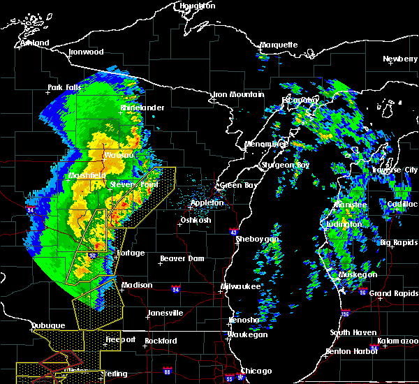 At 1046 pm cst, severe thunderstorms were located along a line extending from 7 miles west of embarrass to near waupaca to near westfield, moving northeast at 50 mph (radar indicated). Hazards include 60 mph wind gusts. Expect damage to roofs, siding, and trees. severe thunderstorms will be near, waupaca around 1050 pm cst. embarrass around 1055 pm cst. shawano, wautoma and keshena around 1105 pm cst. redgranite around 1115 pm cst. clintonville around 1120 pm cst. other locations impacted by these severe thunderstorms include fitzgerald corners, coloma, college of menominee nation, schmidt corner, northport, sugar bush, hancock, scandinavia, thornton and gresham. This extends the warning already in effect for portions of portage, waushara and waupaca counties. At 1046 pm cst, severe thunderstorms were located along a line extending from 7 miles west of embarrass to near waupaca to near westfield, moving northeast at 50 mph (radar indicated). Hazards include 60 mph wind gusts. Expect damage to roofs, siding, and trees. severe thunderstorms will be near, waupaca around 1050 pm cst. embarrass around 1055 pm cst. shawano, wautoma and keshena around 1105 pm cst. redgranite around 1115 pm cst. clintonville around 1120 pm cst. other locations impacted by these severe thunderstorms include fitzgerald corners, coloma, college of menominee nation, schmidt corner, northport, sugar bush, hancock, scandinavia, thornton and gresham. This extends the warning already in effect for portions of portage, waushara and waupaca counties.
|
| 3/6/2017 10:26 PM CST |
 At 1024 pm cst, severe thunderstorms were located along a line extending from 6 miles southeast of bevent to near amherst to 11 miles northwest of westfield, moving east at 60 mph (a trained weather spotter in plover reported a wind gust to 74 mph). Hazards include 70 mph wind gusts. Expect considerable tree damage. damage is likely to mobile homes, roofs, and outbuildings. these severe storms will be near, randolph, chain o` lakes-king and hartman creek state park around 1030 pm cst. waupaca around 1035 pm cst. wautoma around 1040 pm cst. redgranite around 1045 pm cst. Other locations impacted by these severe thunderstorms include schmidt corner, borth, ellis, nelsonville, king, iola, symco, metz, tustin and custer. At 1024 pm cst, severe thunderstorms were located along a line extending from 6 miles southeast of bevent to near amherst to 11 miles northwest of westfield, moving east at 60 mph (a trained weather spotter in plover reported a wind gust to 74 mph). Hazards include 70 mph wind gusts. Expect considerable tree damage. damage is likely to mobile homes, roofs, and outbuildings. these severe storms will be near, randolph, chain o` lakes-king and hartman creek state park around 1030 pm cst. waupaca around 1035 pm cst. wautoma around 1040 pm cst. redgranite around 1045 pm cst. Other locations impacted by these severe thunderstorms include schmidt corner, borth, ellis, nelsonville, king, iola, symco, metz, tustin and custer.
|
| 3/6/2017 10:11 PM CST |
 At 1010 pm cst, severe thunderstorms were located along a line extending from near stevens point to 8 miles south of whiting to 9 miles northeast of friendship, moving east at 65 mph (radar indicated). Hazards include 60 mph wind gusts. Expect damage to roofs, siding, and trees. severe thunderstorms will be near, randolph and amherst around 1020 pm cst. hartman creek state park around 1025 pm cst. wautoma and chain o` lakes-king around 1030 pm cst. redgranite around 1035 pm cst. other locations impacted by these severe thunderstorms include schmidt corner, coddington, borth, ellis, nelsonville, king, iola, symco, metz and tustin. This warning extends the severe thunderstorm warning already in effect for southwestern portage county. At 1010 pm cst, severe thunderstorms were located along a line extending from near stevens point to 8 miles south of whiting to 9 miles northeast of friendship, moving east at 65 mph (radar indicated). Hazards include 60 mph wind gusts. Expect damage to roofs, siding, and trees. severe thunderstorms will be near, randolph and amherst around 1020 pm cst. hartman creek state park around 1025 pm cst. wautoma and chain o` lakes-king around 1030 pm cst. redgranite around 1035 pm cst. other locations impacted by these severe thunderstorms include schmidt corner, coddington, borth, ellis, nelsonville, king, iola, symco, metz and tustin. This warning extends the severe thunderstorm warning already in effect for southwestern portage county.
|
| 9/21/2016 3:04 AM CDT |
 At 303 am cdt, severe thunderstorms were located along a line extending from 11 miles northwest of clintonville to 6 miles northeast of waupaca to near berlin, moving east at 40 mph (radar indicated). Hazards include 60 mph wind gusts and penny size hail. Expect damage to roofs. siding. and trees. these severe storms will be near, new london around 320 am cdt. clintonville and embarrass around 330 am cdt. Other locations impacted by these severe thunderstorms include tustin, poy sippi, northport, pine river, king, big falls, mount morris, blaine, readfield and nelsonville. At 303 am cdt, severe thunderstorms were located along a line extending from 11 miles northwest of clintonville to 6 miles northeast of waupaca to near berlin, moving east at 40 mph (radar indicated). Hazards include 60 mph wind gusts and penny size hail. Expect damage to roofs. siding. and trees. these severe storms will be near, new london around 320 am cdt. clintonville and embarrass around 330 am cdt. Other locations impacted by these severe thunderstorms include tustin, poy sippi, northport, pine river, king, big falls, mount morris, blaine, readfield and nelsonville.
|
| 9/21/2016 2:42 AM CDT |
 At 240 am cdt, severe thunderstorms were located along a line extending from 9 miles north of amherst to wautoma, moving east at 40 mph (radar indicated). Hazards include 60 mph wind gusts and nickel size hail. Expect damage to roofs. siding. and trees. severe thunderstorms will be near, randolph around 255 am cdt. redgranite around 305 am cdt. berlin around 315 am cdt. clintonville around 325 am cdt. Other locations impacted by these severe thunderstorms include ellis, tustin, poy sippi, northport, pine river, king, big falls, polonia, mount morris and jordan. At 240 am cdt, severe thunderstorms were located along a line extending from 9 miles north of amherst to wautoma, moving east at 40 mph (radar indicated). Hazards include 60 mph wind gusts and nickel size hail. Expect damage to roofs. siding. and trees. severe thunderstorms will be near, randolph around 255 am cdt. redgranite around 305 am cdt. berlin around 315 am cdt. clintonville around 325 am cdt. Other locations impacted by these severe thunderstorms include ellis, tustin, poy sippi, northport, pine river, king, big falls, polonia, mount morris and jordan.
|
| 7/27/2016 10:52 AM CDT | Trees down. time estimated by rada in waupaca county WI, 0.2 miles WNW of Ogdensburg, WI |
| 7/27/2016 10:42 AM CDT | Trees down at intersection of hwy 161 and netzler road. time estimated by rada in waupaca county WI, 3.8 miles SSE of Ogdensburg, WI |
| 7/21/2016 8:08 AM CDT |
 At 808 am cdt, severe thunderstorms were located along a line extending from near navarino wildlife area to near chain o` lakes-king, moving southeast at 45 mph (radar indicated). Hazards include 70 mph wind gusts and quarter size hail. Hail damage to vehicles is expected. expect considerable tree damage. wind damage is also likely to mobile homes, roofs, and outbuildings. These severe thunderstorms will remain over mainly rural areas of waupaca county, including the following locations: royalton, northport, weyauwega, king, fitzgerald corners, manawa, rural, lind center, scandinavia and symco. At 808 am cdt, severe thunderstorms were located along a line extending from near navarino wildlife area to near chain o` lakes-king, moving southeast at 45 mph (radar indicated). Hazards include 70 mph wind gusts and quarter size hail. Hail damage to vehicles is expected. expect considerable tree damage. wind damage is also likely to mobile homes, roofs, and outbuildings. These severe thunderstorms will remain over mainly rural areas of waupaca county, including the following locations: royalton, northport, weyauwega, king, fitzgerald corners, manawa, rural, lind center, scandinavia and symco.
|
| 7/21/2016 7:37 AM CDT |
 At 737 am cdt, severe thunderstorms were located along a line extending from 9 miles east of wittenberg to near whiting, moving southeast at 45 mph (radar indicated). Hazards include 70 mph wind gusts and quarter size hail. Hail damage to vehicles is expected. expect considerable tree damage. wind damage is also likely to mobile homes, roofs, and outbuildings. these severe storms will be near, clintonville, embarrass, hartman creek state park and chain o` lakes-king around 800 am cdt. waupaca around 810 am cdt. Other locations impacted by these severe thunderstorms include norske, adams beach, buckbee, royalton, northport, weyauwega, schmidt corner, king, fitzgerald corners and big falls. At 737 am cdt, severe thunderstorms were located along a line extending from 9 miles east of wittenberg to near whiting, moving southeast at 45 mph (radar indicated). Hazards include 70 mph wind gusts and quarter size hail. Hail damage to vehicles is expected. expect considerable tree damage. wind damage is also likely to mobile homes, roofs, and outbuildings. these severe storms will be near, clintonville, embarrass, hartman creek state park and chain o` lakes-king around 800 am cdt. waupaca around 810 am cdt. Other locations impacted by these severe thunderstorms include norske, adams beach, buckbee, royalton, northport, weyauwega, schmidt corner, king, fitzgerald corners and big falls.
|
| 7/21/2016 7:16 AM CDT |
 At 715 am cdt, severe thunderstorms were located along a line extending from 9 miles north of wittenberg to 9 miles northwest of stevens point, moving southeast at 45 mph (radar indicated). Hazards include 70 mph wind gusts and quarter size hail. Hail damage to vehicles is expected. expect considerable tree damage. wind damage is also likely to mobile homes, roofs, and outbuildings. severe thunderstorms will be near, embarrass around 755 am cdt. clintonville, hartman creek state park and chain o` lakes-king around 800 am cdt. waupaca around 810 am cdt. Other locations impacted by these severe thunderstorms include norske, adams beach, buckbee, royalton, northport, weyauwega, schmidt corner, king, fitzgerald corners and big falls. At 715 am cdt, severe thunderstorms were located along a line extending from 9 miles north of wittenberg to 9 miles northwest of stevens point, moving southeast at 45 mph (radar indicated). Hazards include 70 mph wind gusts and quarter size hail. Hail damage to vehicles is expected. expect considerable tree damage. wind damage is also likely to mobile homes, roofs, and outbuildings. severe thunderstorms will be near, embarrass around 755 am cdt. clintonville, hartman creek state park and chain o` lakes-king around 800 am cdt. waupaca around 810 am cdt. Other locations impacted by these severe thunderstorms include norske, adams beach, buckbee, royalton, northport, weyauwega, schmidt corner, king, fitzgerald corners and big falls.
|
| 6/10/2016 7:29 PM CDT |
 At 728 pm cdt, severe thunderstorms were located along a line extending from 8 miles north of embarrass to near waupaca, moving southeast at 40 mph (radar indicated). Hazards include 60 mph wind gusts and penny size hail. Expect damage to roofs. siding. and trees. these severe storms will be near, fremont around 735 pm cdt. Other locations impacted by these severe thunderstorms include buckbee, royalton, caroline, pella, northport, leopolis, weyauwega, fitzgerald corners, manawa and lind center. At 728 pm cdt, severe thunderstorms were located along a line extending from 8 miles north of embarrass to near waupaca, moving southeast at 40 mph (radar indicated). Hazards include 60 mph wind gusts and penny size hail. Expect damage to roofs. siding. and trees. these severe storms will be near, fremont around 735 pm cdt. Other locations impacted by these severe thunderstorms include buckbee, royalton, caroline, pella, northport, leopolis, weyauwega, fitzgerald corners, manawa and lind center.
|
| 6/10/2016 6:59 PM CDT |
 At 658 pm cdt, severe thunderstorms were located along a line extending from wittenberg to near plainfield, moving east at 45 mph (radar indicated). Hazards include 60 mph wind gusts and quarter size hail. Hail damage to vehicles is expected. expect wind damage to roofs, siding, and trees. severe thunderstorms will be near, wittenberg around 715 pm cdt. chain o` lakes-king around 725 pm cdt. waupaca around 730 pm cdt. fremont around 740 pm cdt. new london around 745 pm cdt. Other locations impacted by these severe thunderstorms include caroline, pella, northport, leopolis, schmidt corner, king, big falls, manawa, lind center and whitcomb. At 658 pm cdt, severe thunderstorms were located along a line extending from wittenberg to near plainfield, moving east at 45 mph (radar indicated). Hazards include 60 mph wind gusts and quarter size hail. Hail damage to vehicles is expected. expect wind damage to roofs, siding, and trees. severe thunderstorms will be near, wittenberg around 715 pm cdt. chain o` lakes-king around 725 pm cdt. waupaca around 730 pm cdt. fremont around 740 pm cdt. new london around 745 pm cdt. Other locations impacted by these severe thunderstorms include caroline, pella, northport, leopolis, schmidt corner, king, big falls, manawa, lind center and whitcomb.
|
| 6/5/2016 5:16 PM CDT |
 At 516 pm cdt, severe thunderstorms were located along a line extending from shawano to 8 miles northwest of new london to near hartman creek state park, moving southeast at 50 mph (radar indicated). Hazards include 60 mph wind gusts and penny size hail. Expect damage to roofs. siding. and trees. these severe storms will be near, new london and navarino wildlife area around 525 pm cdt. appleton around 545 pm cdt. Other locations impacted by these severe thunderstorms include leeman, pella, northport, king, navarino, shiocton, readfield, nichols, dale and buckbee. At 516 pm cdt, severe thunderstorms were located along a line extending from shawano to 8 miles northwest of new london to near hartman creek state park, moving southeast at 50 mph (radar indicated). Hazards include 60 mph wind gusts and penny size hail. Expect damage to roofs. siding. and trees. these severe storms will be near, new london and navarino wildlife area around 525 pm cdt. appleton around 545 pm cdt. Other locations impacted by these severe thunderstorms include leeman, pella, northport, king, navarino, shiocton, readfield, nichols, dale and buckbee.
|
| 6/5/2016 5:01 PM CDT |
 At 500 pm cdt, severe thunderstorms were located along a line extending from near neopit to 12 miles east of randolph to 6 miles east of whiting, moving southeast at 45 mph (radar indicated). Hazards include 70 mph wind gusts and penny size hail. Expect considerable tree damage. damage is likely to mobile homes, roofs, and outbuildings. severe thunderstorms will be near, keshena around 515 pm cdt. shawano, clintonville and hartman creek state park around 520 pm cdt. chain o` lakes-king around 525 pm cdt. waupaca around 535 pm cdt. black creek and fremont around 545 pm cdt. new london around 550 pm cdt. other locations impacted by these severe thunderstorms include leeman, college of menominee nation, pella, northport, king, navarino, big falls, shiocton, polonia and jordan. This warning replaces the severe thunderstorm warning that was already in effect for portions of shawano, portage and waupaca counties. At 500 pm cdt, severe thunderstorms were located along a line extending from near neopit to 12 miles east of randolph to 6 miles east of whiting, moving southeast at 45 mph (radar indicated). Hazards include 70 mph wind gusts and penny size hail. Expect considerable tree damage. damage is likely to mobile homes, roofs, and outbuildings. severe thunderstorms will be near, keshena around 515 pm cdt. shawano, clintonville and hartman creek state park around 520 pm cdt. chain o` lakes-king around 525 pm cdt. waupaca around 535 pm cdt. black creek and fremont around 545 pm cdt. new london around 550 pm cdt. other locations impacted by these severe thunderstorms include leeman, college of menominee nation, pella, northport, king, navarino, big falls, shiocton, polonia and jordan. This warning replaces the severe thunderstorm warning that was already in effect for portions of shawano, portage and waupaca counties.
|
| 8/2/2015 5:00 PM CDT |
 At 500 pm cdt, a severe thunderstorm was located 12 miles southwest of clintonville, or 12 miles northeast of waupaca, moving southeast at 40 mph (radar indicated). Hazards include 60 mph wind gusts and quarter size hail. Hail damage to vehicles is expected. expect wind damage to roofs, siding and trees. this severe storm will be near, new london around 515 pm cdt. Other locations impacted by this severe thunderstorm include northport, big falls, manawa, fitzgerald corners, bear creek, sugar bush, iola, symco, wolf river bottoms wildlife area and ogdensburg. At 500 pm cdt, a severe thunderstorm was located 12 miles southwest of clintonville, or 12 miles northeast of waupaca, moving southeast at 40 mph (radar indicated). Hazards include 60 mph wind gusts and quarter size hail. Hail damage to vehicles is expected. expect wind damage to roofs, siding and trees. this severe storm will be near, new london around 515 pm cdt. Other locations impacted by this severe thunderstorm include northport, big falls, manawa, fitzgerald corners, bear creek, sugar bush, iola, symco, wolf river bottoms wildlife area and ogdensburg.
|
| 8/2/2015 4:50 PM CDT |
 At 449 pm cdt, a severe thunderstorm was located 11 miles southeast of randolph, or 15 miles north of waupaca, moving southeast at 40 mph (radar indicated). Hazards include 60 mph wind gusts and quarter size hail. Hail damage to vehicles is expected. expect wind damage to roofs, siding and trees. this severe thunderstorm will be near, new london around 515 pm cdt. Other locations impacted by this severe thunderstorm include weyauwega, northport, big falls, manawa, fitzgerald corners, bear creek, sugar bush, iola, symco and wolf river bottoms wildlife area. At 449 pm cdt, a severe thunderstorm was located 11 miles southeast of randolph, or 15 miles north of waupaca, moving southeast at 40 mph (radar indicated). Hazards include 60 mph wind gusts and quarter size hail. Hail damage to vehicles is expected. expect wind damage to roofs, siding and trees. this severe thunderstorm will be near, new london around 515 pm cdt. Other locations impacted by this severe thunderstorm include weyauwega, northport, big falls, manawa, fitzgerald corners, bear creek, sugar bush, iola, symco and wolf river bottoms wildlife area.
|
| 8/2/2015 3:57 PM CDT |
 At 356 pm cdt, severe thunderstorms were located along a line extending from 5 miles west of green bay to 8 miles northeast of black creek to 7 miles north of new london to near waupaca to near plainfield, moving east at 55 mph (trained weather spotters). Hazards include golf ball size hail and 60 mph wind gusts. People and animals outdoors will be injured. expect hail damage to roofs, siding, windows and vehicles. expect wind damage to roofs, siding and trees. these severe storms will be near, green bay around 400 pm cdt. black creek and bellevue town around 415 pm cdt. kaukauna and lake poygan around 425 pm cdt. appleton, menasha and darboy around 430 pm cdt. Other locations impacted by these severe thunderstorms include holland, greenville, metz, northport, manawa, boom bay, chicago corners, rivermoor, de pere and hortonville. At 356 pm cdt, severe thunderstorms were located along a line extending from 5 miles west of green bay to 8 miles northeast of black creek to 7 miles north of new london to near waupaca to near plainfield, moving east at 55 mph (trained weather spotters). Hazards include golf ball size hail and 60 mph wind gusts. People and animals outdoors will be injured. expect hail damage to roofs, siding, windows and vehicles. expect wind damage to roofs, siding and trees. these severe storms will be near, green bay around 400 pm cdt. black creek and bellevue town around 415 pm cdt. kaukauna and lake poygan around 425 pm cdt. appleton, menasha and darboy around 430 pm cdt. Other locations impacted by these severe thunderstorms include holland, greenville, metz, northport, manawa, boom bay, chicago corners, rivermoor, de pere and hortonville.
|
| 8/2/2015 3:47 PM CDT |
 At 347 pm cdt, severe thunderstorms were located along a line extending from 7 miles south of pulaski to 5 miles north of black creek to 10 miles southwest of clintonville to near hartman creek state park to near plainfield, moving southeast at 35 mph (trained weather spotters). Hazards include golf ball size hail and 70 mph wind gusts. People and animals outdoors will be injured. expect hail damage to roofs, siding, windows and vehicles. expect considerable tree damage. wind damage is also likely to mobile homes, roofs and outbuildings. these severe storms will be near, black creek around 350 pm cdt. waupaca around 400 pm cdt. green bay and new london around 405 pm cdt. bellevue town around 415 pm cdt. fremont and lake poygan around 420 pm cdt. appleton around 430 pm cdt. Other locations impacted by these severe thunderstorms include holland, greenville, metz, northport, manawa, boom bay, chicago corners, rivermoor, de pere and hortonville. At 347 pm cdt, severe thunderstorms were located along a line extending from 7 miles south of pulaski to 5 miles north of black creek to 10 miles southwest of clintonville to near hartman creek state park to near plainfield, moving southeast at 35 mph (trained weather spotters). Hazards include golf ball size hail and 70 mph wind gusts. People and animals outdoors will be injured. expect hail damage to roofs, siding, windows and vehicles. expect considerable tree damage. wind damage is also likely to mobile homes, roofs and outbuildings. these severe storms will be near, black creek around 350 pm cdt. waupaca around 400 pm cdt. green bay and new london around 405 pm cdt. bellevue town around 415 pm cdt. fremont and lake poygan around 420 pm cdt. appleton around 430 pm cdt. Other locations impacted by these severe thunderstorms include holland, greenville, metz, northport, manawa, boom bay, chicago corners, rivermoor, de pere and hortonville.
|
| 8/2/2015 3:28 PM CDT |
 At 327 pm cdt, severe thunderstorms were located along a line extending from 13 miles west of clintonville to near amherst to near new rome, moving east at 55 mph (trained weather spotters). Hazards include 70 mph wind gusts and quarter size hail. Hail damage to vehicles is expected. expect considerable tree damage. wind damage is also likely to mobile homes, roofs and outbuildings. severe thunderstorms will be near, chain o` lakes-king around 335 pm cdt. waupaca and clintonville around 340 pm cdt. plainfield around 345 pm cdt. new london around 355 pm cdt. black creek around 400 pm cdt. appleton and menasha around 415 pm cdt. green bay, kaukauna, little chute, kimberly, darboy and lake poygan around 420 pm cdt. bellevue town around 425 pm cdt. Other locations impacted by these severe thunderstorms include holland, greenville, metz, northport, manawa, boom bay, chicago corners, rivermoor, de pere and hortonville. At 327 pm cdt, severe thunderstorms were located along a line extending from 13 miles west of clintonville to near amherst to near new rome, moving east at 55 mph (trained weather spotters). Hazards include 70 mph wind gusts and quarter size hail. Hail damage to vehicles is expected. expect considerable tree damage. wind damage is also likely to mobile homes, roofs and outbuildings. severe thunderstorms will be near, chain o` lakes-king around 335 pm cdt. waupaca and clintonville around 340 pm cdt. plainfield around 345 pm cdt. new london around 355 pm cdt. black creek around 400 pm cdt. appleton and menasha around 415 pm cdt. green bay, kaukauna, little chute, kimberly, darboy and lake poygan around 420 pm cdt. bellevue town around 425 pm cdt. Other locations impacted by these severe thunderstorms include holland, greenville, metz, northport, manawa, boom bay, chicago corners, rivermoor, de pere and hortonville.
|
| 8/2/2015 3:15 PM CDT |
 At 314 pm cdt, severe thunderstorms were located along a line extending from near randolph to near whiting to near wisconsin rapids, moving east at 50 mph (trained weather spotters). Hazards include 70 mph wind gusts and quarter size hail. Hail damage to vehicles is expected. expect considerable tree damage. wind damage is also likely to mobile homes, roofs and outbuildings. these severe storms will be near, amherst around 325 pm cdt. chain o` lakes-king around 330 pm cdt. Other locations impacted by these severe thunderstorms include arnott, big falls, manawa, fitzgerald corners, nelsonville, bancroft, custer, walker, iola and ellis. At 314 pm cdt, severe thunderstorms were located along a line extending from near randolph to near whiting to near wisconsin rapids, moving east at 50 mph (trained weather spotters). Hazards include 70 mph wind gusts and quarter size hail. Hail damage to vehicles is expected. expect considerable tree damage. wind damage is also likely to mobile homes, roofs and outbuildings. these severe storms will be near, amherst around 325 pm cdt. chain o` lakes-king around 330 pm cdt. Other locations impacted by these severe thunderstorms include arnott, big falls, manawa, fitzgerald corners, nelsonville, bancroft, custer, walker, iola and ellis.
|
| 8/2/2015 3:03 PM CDT |
 At 302 pm cdt, severe thunderstorms were located along a line extending from near randolph to stevens point to 7 miles west of wisconsin rapids, moving east at 55 mph (radar indicated). Hazards include 60 mph wind gusts and quarter size hail. Hail damage to vehicles is expected. expect wind damage to roofs, siding and trees. severe thunderstorms will be near, randolph around 310 pm cdt. amherst around 320 pm cdt. waupaca and chain o` lakes-king around 330 pm cdt. Other locations impacted by these severe thunderstorms include arnott, big falls, manawa, fitzgerald corners, nelsonville, bancroft, custer, walker, iola and ellis. At 302 pm cdt, severe thunderstorms were located along a line extending from near randolph to stevens point to 7 miles west of wisconsin rapids, moving east at 55 mph (radar indicated). Hazards include 60 mph wind gusts and quarter size hail. Hail damage to vehicles is expected. expect wind damage to roofs, siding and trees. severe thunderstorms will be near, randolph around 310 pm cdt. amherst around 320 pm cdt. waupaca and chain o` lakes-king around 330 pm cdt. Other locations impacted by these severe thunderstorms include arnott, big falls, manawa, fitzgerald corners, nelsonville, bancroft, custer, walker, iola and ellis.
|
| 7/18/2015 5:14 AM CDT |
 At 512 am cdt, severe thunderstorms were located along a line extending from 10 miles northwest of embarrass to near fremont to near green lake, moving east at 45 mph (law enforcement). Hazards include 60 mph wind gusts. Expect damage to roofs. siding and trees. severe thunderstorms will be near, new london, clintonville, embarrass and rush lake around 525 am cdt. appleton, menasha and oshkosh around 545 am cdt. kaukauna, little chute, kimberly and darboy around 555 am cdt. other locations impacted by these severe thunderstorms include greenville, metz, northport, adams beach, manawa, boom bay, rivermoor, omro, hortonville and wolf river bottoms wildlife area. People attending rock usa and eaa should seek safe shelter immediately!. At 512 am cdt, severe thunderstorms were located along a line extending from 10 miles northwest of embarrass to near fremont to near green lake, moving east at 45 mph (law enforcement). Hazards include 60 mph wind gusts. Expect damage to roofs. siding and trees. severe thunderstorms will be near, new london, clintonville, embarrass and rush lake around 525 am cdt. appleton, menasha and oshkosh around 545 am cdt. kaukauna, little chute, kimberly and darboy around 555 am cdt. other locations impacted by these severe thunderstorms include greenville, metz, northport, adams beach, manawa, boom bay, rivermoor, omro, hortonville and wolf river bottoms wildlife area. People attending rock usa and eaa should seek safe shelter immediately!.
|
| 7/18/2015 5:01 AM CDT |
 At 501 am cdt, severe thunderstorms were located along a line extending from 6 miles west of neopit to 8 miles northeast of amherst to 6 miles south of hartman creek state park to near redgranite, moving east at 40 mph (radar indicated). Hazards include 60 mph wind gusts and nickel size hail. Expect damage to roofs. siding and trees. Locations impacted include, waupaca, wautoma, berlin, redgranite, wittenberg, amherst, fremont, hartman creek state park, neopit, chain o` lakes-king, silver lake, weyauwega, pine river, royalton, manawa, iola, marion, dakota, mount morris and saxeville. At 501 am cdt, severe thunderstorms were located along a line extending from 6 miles west of neopit to 8 miles northeast of amherst to 6 miles south of hartman creek state park to near redgranite, moving east at 40 mph (radar indicated). Hazards include 60 mph wind gusts and nickel size hail. Expect damage to roofs. siding and trees. Locations impacted include, waupaca, wautoma, berlin, redgranite, wittenberg, amherst, fremont, hartman creek state park, neopit, chain o` lakes-king, silver lake, weyauwega, pine river, royalton, manawa, iola, marion, dakota, mount morris and saxeville.
|
| 7/18/2015 4:45 AM CDT |
 At 444 am cdt, severe thunderstorms were located along a line extending from 11 miles south of antigo to near amherst to near plainfield to near wautoma, moving southeast at 45 mph (radar indicated). Hazards include 60 mph wind gusts and nickel size hail. Expect damage to roofs. siding and trees. Locations impacted include, stevens point, antigo, waupaca, wautoma, berlin, redgranite, randolph, whiting, bevent, wittenberg, amherst, plainfield, fremont, hartman creek state park, neopit, chain o` lakes-king, plover, stockton, silver lake and weyauwega. At 444 am cdt, severe thunderstorms were located along a line extending from 11 miles south of antigo to near amherst to near plainfield to near wautoma, moving southeast at 45 mph (radar indicated). Hazards include 60 mph wind gusts and nickel size hail. Expect damage to roofs. siding and trees. Locations impacted include, stevens point, antigo, waupaca, wautoma, berlin, redgranite, randolph, whiting, bevent, wittenberg, amherst, plainfield, fremont, hartman creek state park, neopit, chain o` lakes-king, plover, stockton, silver lake and weyauwega.
|
| 7/18/2015 4:40 AM CDT |
 At 440 am cdt, severe thunderstorms were located along a line extending from 8 miles west of neopit to 8 miles southeast of randolph to near hartman creek state park to near wautoma, moving east at 40 mph (radar indicated). Hazards include 60 mph wind gusts and nickel size hail. Expect damage to roofs. siding and trees. Locations impacted include, wausau, stevens point, wisconsin rapids, antigo, waupaca, wautoma, weston, rib mountain, berlin, mosinee, redgranite, randolph, whiting, bevent, wittenberg, amherst, plainfield, fremont, hartman creek state park and neopit. At 440 am cdt, severe thunderstorms were located along a line extending from 8 miles west of neopit to 8 miles southeast of randolph to near hartman creek state park to near wautoma, moving east at 40 mph (radar indicated). Hazards include 60 mph wind gusts and nickel size hail. Expect damage to roofs. siding and trees. Locations impacted include, wausau, stevens point, wisconsin rapids, antigo, waupaca, wautoma, weston, rib mountain, berlin, mosinee, redgranite, randolph, whiting, bevent, wittenberg, amherst, plainfield, fremont, hartman creek state park and neopit.
|
| 7/18/2015 4:33 AM CDT |
 At 432 am cdt, severe thunderstorms were located along a line extending from 9 miles southeast of antigo to near randolph to near hartman creek state park to near wautoma, moving east around 40 mph (radar indicated). Hazards include 60 mph wind gusts and nickel size hail. Expect damage to roofs. siding and trees. Locations impacted include, wausau, stevens point, wisconsin rapids, antigo, waupaca, wautoma, weston, rib mountain, berlin, mosinee, redgranite, randolph, whiting, bevent, wittenberg, amherst, plainfield, fremont, hartman creek state park and neopit. At 432 am cdt, severe thunderstorms were located along a line extending from 9 miles southeast of antigo to near randolph to near hartman creek state park to near wautoma, moving east around 40 mph (radar indicated). Hazards include 60 mph wind gusts and nickel size hail. Expect damage to roofs. siding and trees. Locations impacted include, wausau, stevens point, wisconsin rapids, antigo, waupaca, wautoma, weston, rib mountain, berlin, mosinee, redgranite, randolph, whiting, bevent, wittenberg, amherst, plainfield, fremont, hartman creek state park and neopit.
|
| 7/18/2015 4:15 AM CDT |
 At 414 am cdt, severe thunderstorms were located along a line extending from 7 miles southeast of merrill to 8 miles west of whiting to near adams, moving east at 40 mph (radar indicated). Hazards include 60 mph wind gusts and nickel size hail. Expect damage to roofs. siding and trees. severe thunderstorms will be near, stevens point and whiting around 430 am cdt. amherst around 445 am cdt. antigo around 450 am cdt. hartman creek state park around 455 am cdt. chain o` lakes-king around 500 am cdt. waupaca and neopit around 510 am cdt. other locations impacted by these severe thunderstorms include elderon, custer, marion, meehan, rudolph, hatley, elmhurst, lyndhurst, symco and phlox. People camping for the wisconsin aquaskier tournament should seek safe shelter immediately!. At 414 am cdt, severe thunderstorms were located along a line extending from 7 miles southeast of merrill to 8 miles west of whiting to near adams, moving east at 40 mph (radar indicated). Hazards include 60 mph wind gusts and nickel size hail. Expect damage to roofs. siding and trees. severe thunderstorms will be near, stevens point and whiting around 430 am cdt. amherst around 445 am cdt. antigo around 450 am cdt. hartman creek state park around 455 am cdt. chain o` lakes-king around 500 am cdt. waupaca and neopit around 510 am cdt. other locations impacted by these severe thunderstorms include elderon, custer, marion, meehan, rudolph, hatley, elmhurst, lyndhurst, symco and phlox. People camping for the wisconsin aquaskier tournament should seek safe shelter immediately!.
|
| 7/13/2015 7:06 PM CDT |
 The severe thunderstorm warning for southwestern waupaca county will expire at 715 pm cdt, the storm which prompted the warning has weakened below severe limits, and no longer pose an immediate threat to life or property. therefore the warning will be allowed to expire. however gusty winds and heavy rain are still possible with this thunderstorm. The severe thunderstorm warning for southwestern waupaca county will expire at 715 pm cdt, the storm which prompted the warning has weakened below severe limits, and no longer pose an immediate threat to life or property. therefore the warning will be allowed to expire. however gusty winds and heavy rain are still possible with this thunderstorm.
|
| 7/13/2015 6:57 PM CDT |
 At 657 pm cdt, a severe thunderstorm was located near fremont, or 7 miles east of waupaca, moving east at 40 mph (radar indicated). Hazards include 60 mph wind gusts and quarter size hail. Hail damage to vehicles is expected. expect wind damage to roofs, siding and trees. this severe storm will be near, new london around 705 pm cdt. Other locations impacted by this severe thunderstorm include weyauwega, northport, manawa, lind center, royalton, readfield, rural, scandinavia, sheridan and king. At 657 pm cdt, a severe thunderstorm was located near fremont, or 7 miles east of waupaca, moving east at 40 mph (radar indicated). Hazards include 60 mph wind gusts and quarter size hail. Hail damage to vehicles is expected. expect wind damage to roofs, siding and trees. this severe storm will be near, new london around 705 pm cdt. Other locations impacted by this severe thunderstorm include weyauwega, northport, manawa, lind center, royalton, readfield, rural, scandinavia, sheridan and king.
|
| 7/13/2015 6:51 PM CDT |
 At 650 pm cdt, a severe thunderstorm was located over waupaca, moving east at 40 mph (radar indicated). Hazards include 60 mph wind gusts and quarter size hail. Hail damage to vehicles is expected. expect wind damage to roofs, siding and trees. this severe storm will be near, fremont around 700 pm cdt. new london around 710 pm cdt. Other locations impacted by this severe thunderstorm include standing rock park, arnott, weyauwega, northport, manawa, lind center, sheridan, emmons creek barrens, ogdensburg and almond. At 650 pm cdt, a severe thunderstorm was located over waupaca, moving east at 40 mph (radar indicated). Hazards include 60 mph wind gusts and quarter size hail. Hail damage to vehicles is expected. expect wind damage to roofs, siding and trees. this severe storm will be near, fremont around 700 pm cdt. new london around 710 pm cdt. Other locations impacted by this severe thunderstorm include standing rock park, arnott, weyauwega, northport, manawa, lind center, sheridan, emmons creek barrens, ogdensburg and almond.
|
| 7/13/2015 6:32 PM CDT |
 At 632 pm cdt, severe thunderstorms were located along a line extending from near amherst to hartman creek state park to 6 miles southwest of chain o` lakes-king, moving east at 30 mph (radar indicated). Hazards include 60 mph wind gusts and quarter size hail. Hail damage to vehicles is expected. expect wind damage to roofs, siding and trees. these severe storms will be near, hartman creek state park around 635 pm cdt. chain o` lakes-king around 640 pm cdt. waupaca around 655 pm cdt. fremont around 710 pm cdt. new london around 715 pm cdt. Other locations impacted by these severe thunderstorms include standing rock park, arnott, weyauwega, northport, manawa, bancroft, lind center, sheridan, amherst junction and emmons creek barrens. At 632 pm cdt, severe thunderstorms were located along a line extending from near amherst to hartman creek state park to 6 miles southwest of chain o` lakes-king, moving east at 30 mph (radar indicated). Hazards include 60 mph wind gusts and quarter size hail. Hail damage to vehicles is expected. expect wind damage to roofs, siding and trees. these severe storms will be near, hartman creek state park around 635 pm cdt. chain o` lakes-king around 640 pm cdt. waupaca around 655 pm cdt. fremont around 710 pm cdt. new london around 715 pm cdt. Other locations impacted by these severe thunderstorms include standing rock park, arnott, weyauwega, northport, manawa, bancroft, lind center, sheridan, amherst junction and emmons creek barrens.
|
| 7/13/2015 6:19 PM CDT |
 At 618 pm cdt, a severe thunderstorm was located 8 miles northeast of plainfield, or 15 miles southeast of stevens point, moving east at 40 mph (radar indicated). Hazards include 60 mph wind gusts and quarter size hail. Hail damage to vehicles is expected. expect wind damage to roofs, siding and trees. this severe thunderstorm will be near, hartman creek state park around 630 pm cdt. chain o` lakes-king around 635 pm cdt. waupaca around 645 pm cdt. fremont around 655 pm cdt. new london around 705 pm cdt. Other locations impacted by this severe thunderstorm include standing rock park, arnott, weyauwega, northport, manawa, bancroft, lind center, sheridan, amherst junction and emmons creek barrens. At 618 pm cdt, a severe thunderstorm was located 8 miles northeast of plainfield, or 15 miles southeast of stevens point, moving east at 40 mph (radar indicated). Hazards include 60 mph wind gusts and quarter size hail. Hail damage to vehicles is expected. expect wind damage to roofs, siding and trees. this severe thunderstorm will be near, hartman creek state park around 630 pm cdt. chain o` lakes-king around 635 pm cdt. waupaca around 645 pm cdt. fremont around 655 pm cdt. new london around 705 pm cdt. Other locations impacted by this severe thunderstorm include standing rock park, arnott, weyauwega, northport, manawa, bancroft, lind center, sheridan, amherst junction and emmons creek barrens.
|
| 7/13/2015 3:49 AM CDT |
 At 348 am cdt, severe thunderstorms were located along a line extending from 6 miles southeast of legend lake to 6 miles north of oshkosh, moving east at 40 mph (radar indicated). Hazards include 60 mph wind gusts and penny size hail. Expect damage to roofs. siding and trees. Locations impacted include, shawano, waupaca, new london, clintonville, fremont, embarrass, keshena, weyauwega, belle plaine, royalton, red river, manawa, marion, pella, gresham, bowler, ogdensburg, big falls, northport and adams beach. At 348 am cdt, severe thunderstorms were located along a line extending from 6 miles southeast of legend lake to 6 miles north of oshkosh, moving east at 40 mph (radar indicated). Hazards include 60 mph wind gusts and penny size hail. Expect damage to roofs. siding and trees. Locations impacted include, shawano, waupaca, new london, clintonville, fremont, embarrass, keshena, weyauwega, belle plaine, royalton, red river, manawa, marion, pella, gresham, bowler, ogdensburg, big falls, northport and adams beach.
|
| 7/13/2015 3:20 AM CDT |
 At 320 am cdt, severe thunderstorms were located along a line extending from 10 miles north of wittenberg to 7 miles south of hartman creek state park, moving southeast at 40 mph (radar indicated). Hazards include 60 mph wind gusts and penny size hail. Expect damage to roofs. siding and trees. Locations impacted include, shawano, waupaca, new london, clintonville, wittenberg, fremont, embarrass, hartman creek state park, chain o` lakes-king, keshena, weyauwega, belle plaine, royalton, red river, manawa, iola, marion, pella, king and birnamwood. At 320 am cdt, severe thunderstorms were located along a line extending from 10 miles north of wittenberg to 7 miles south of hartman creek state park, moving southeast at 40 mph (radar indicated). Hazards include 60 mph wind gusts and penny size hail. Expect damage to roofs. siding and trees. Locations impacted include, shawano, waupaca, new london, clintonville, wittenberg, fremont, embarrass, hartman creek state park, chain o` lakes-king, keshena, weyauwega, belle plaine, royalton, red river, manawa, iola, marion, pella, king and birnamwood.
|
| 7/13/2015 3:06 AM CDT |
 At 305 am cdt, severe thunderstorms were located along a line extending from 11 miles south of antigo to 6 miles southwest of hartman creek state park, moving southeast at 40 mph (radar indicated). Hazards include 60 mph wind gusts and penny size hail. Expect damage to roofs. Siding and trees. At 305 am cdt, severe thunderstorms were located along a line extending from 11 miles south of antigo to 6 miles southwest of hartman creek state park, moving southeast at 40 mph (radar indicated). Hazards include 60 mph wind gusts and penny size hail. Expect damage to roofs. Siding and trees.
|
| 9/1/2013 8:10 AM CDT | Quarter sized hail reported 4.8 miles SSW of Ogdensburg, WI, on hwy 161 between iola and symco. |
| 6/21/2013 7:50 AM CDT | Several trees down on cars. time estimated based on rada in waupaca county WI, 0.2 miles WNW of Ogdensburg, WI |
Hail Maps for Ogdensburg, WI
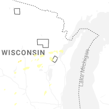
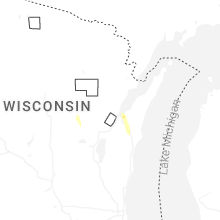
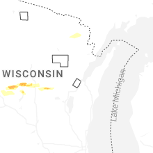


Connect with Interactive Hail Maps