

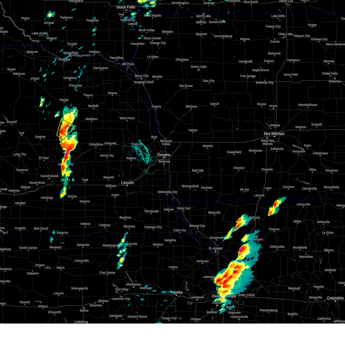
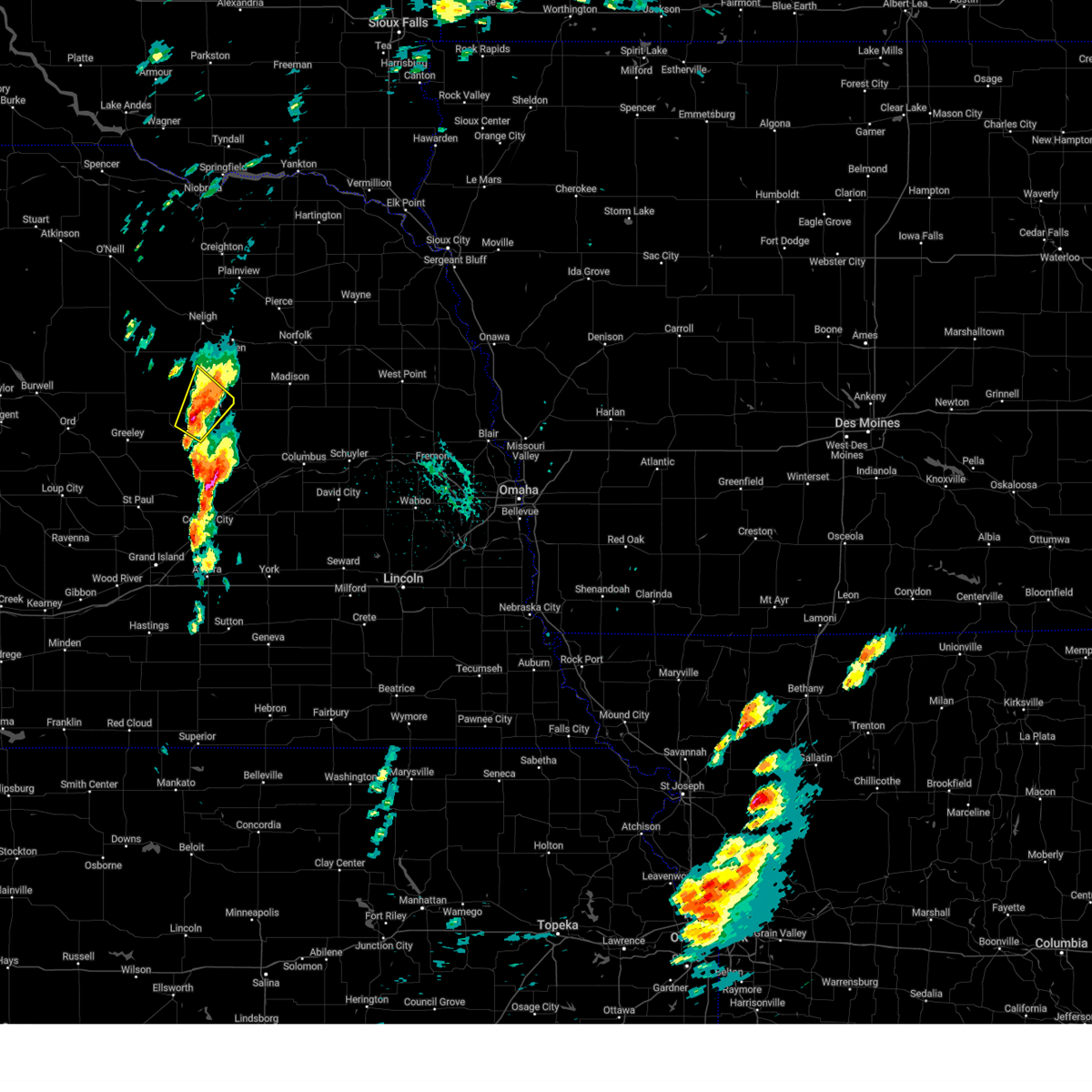
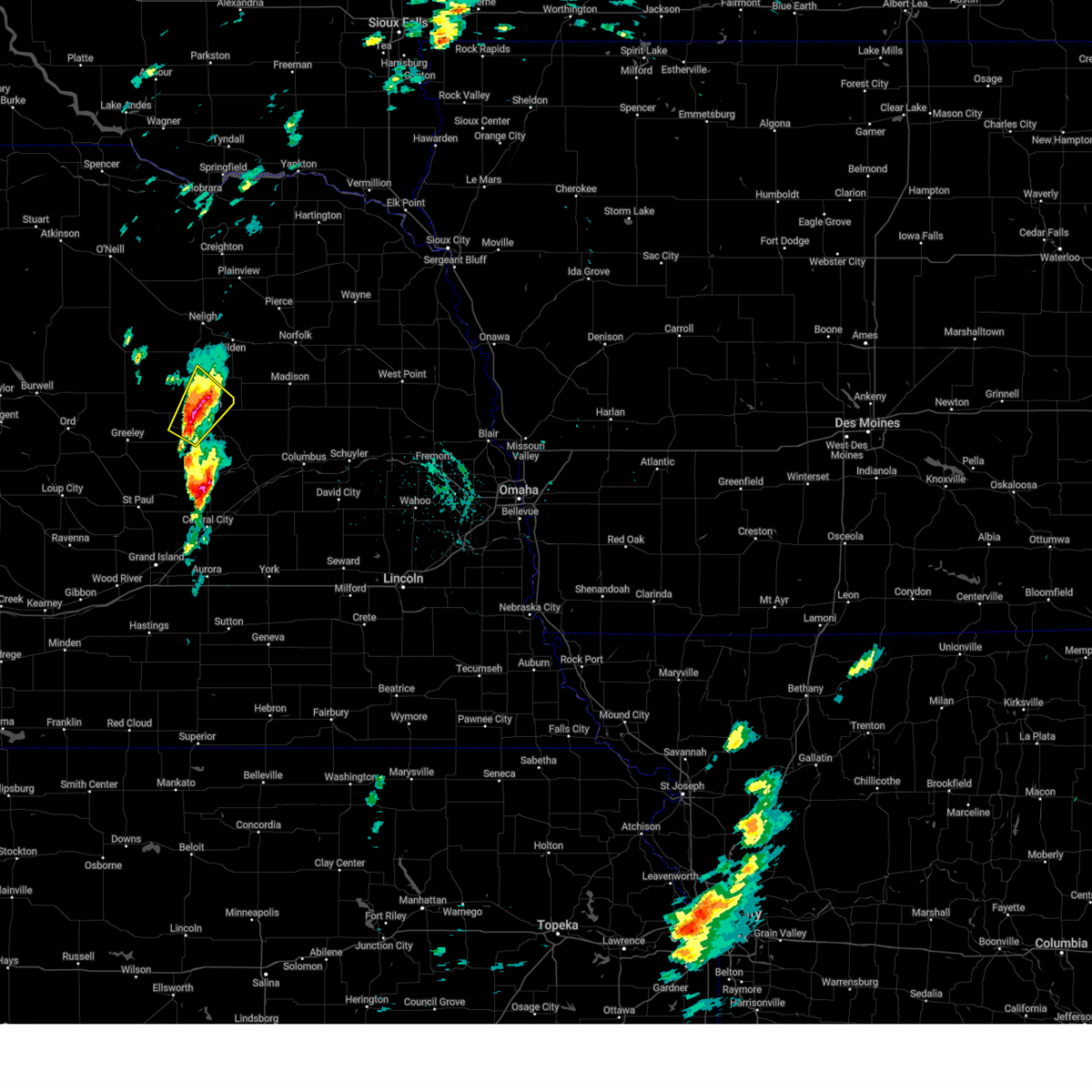
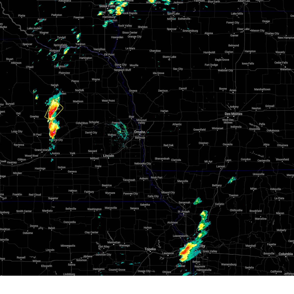
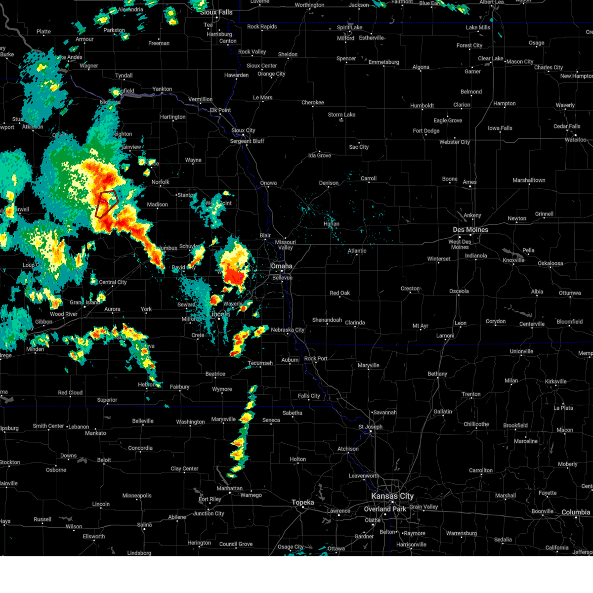
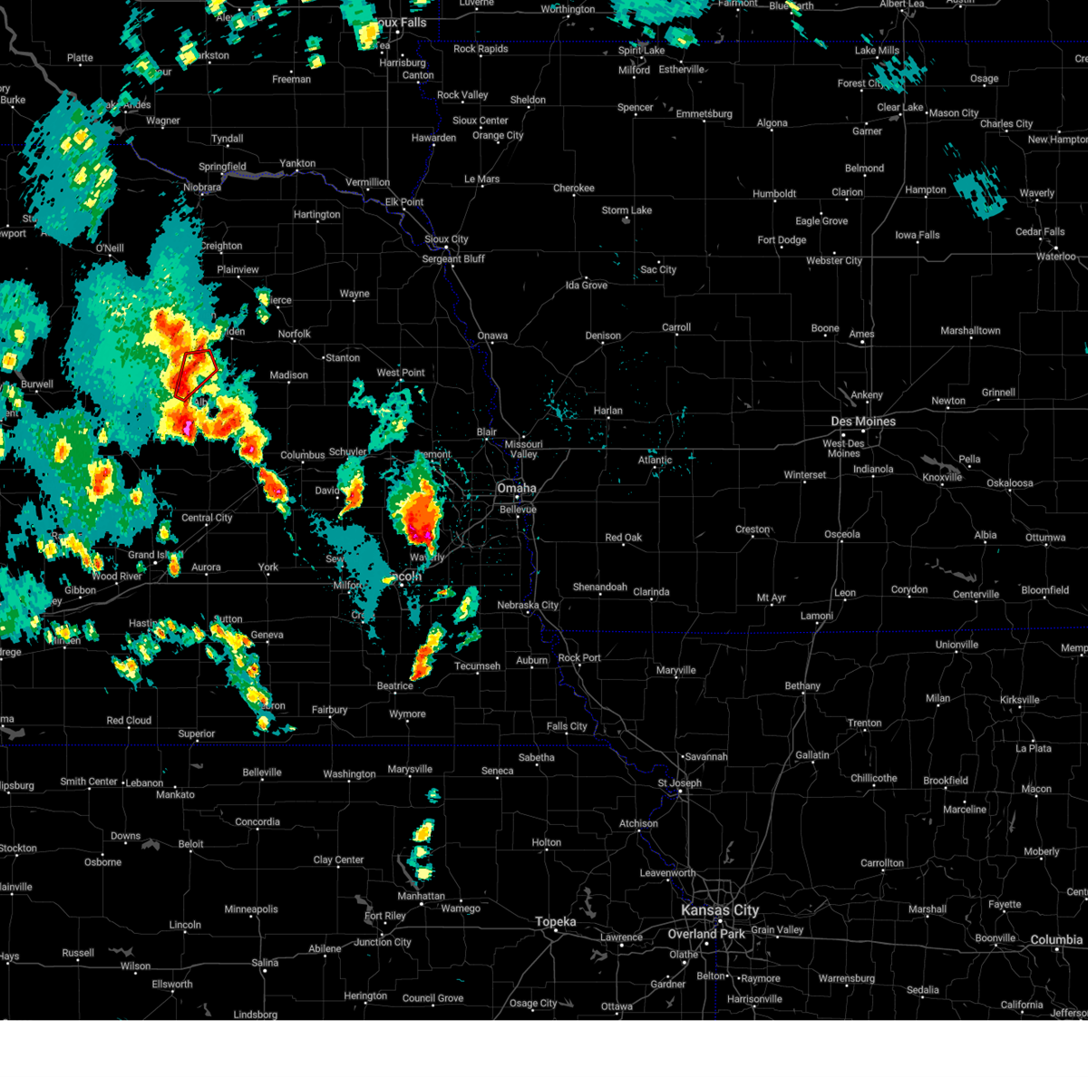
Hail Map for Petersburg, NE
The Petersburg, NE area has had 12 reports of on-the-ground hail by trained spotters, and has been under severe weather warnings 11 times during the past 12 months. Doppler radar has detected hail at or near Petersburg, NE on 86 occasions, including 6 occasions during the past year.
| Name: | Petersburg, NE |
| Where Located: | 50.9 miles SE of Oneill, NE |
| Map: | Google Map for Petersburg, NE |
| Population: | 333 |
| Housing Units: | 168 |
| More Info: | Search Google for Petersburg, NE |
2
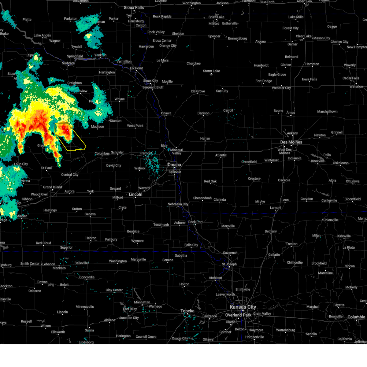
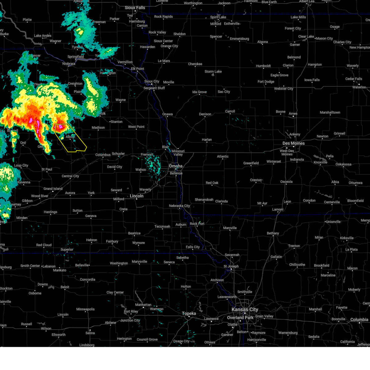
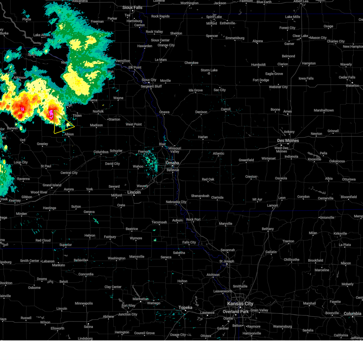
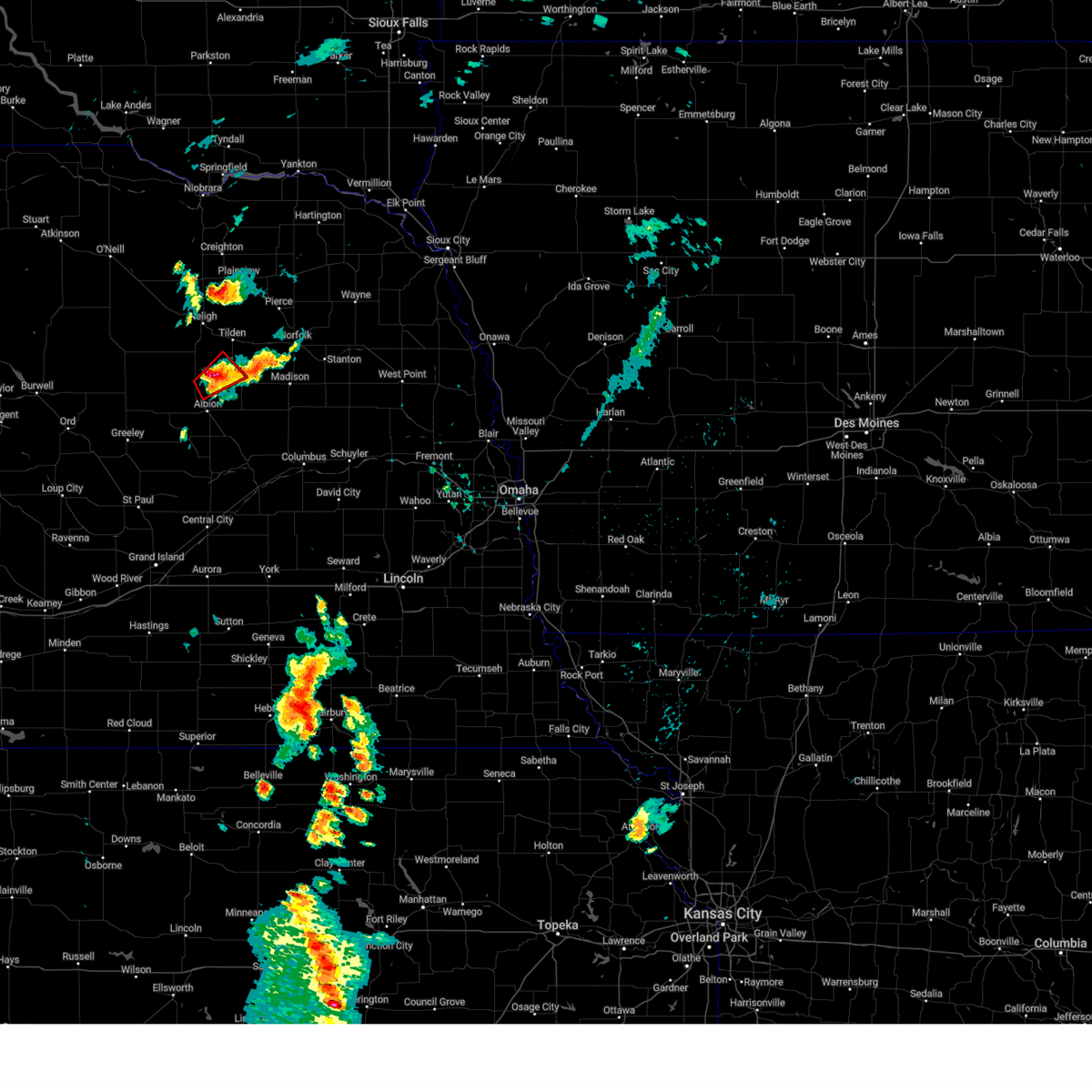
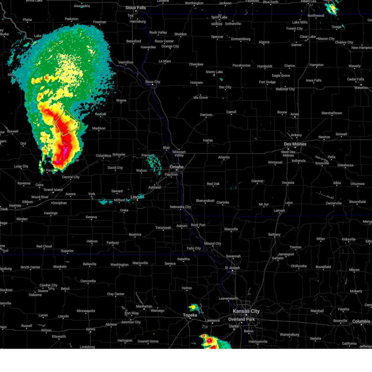
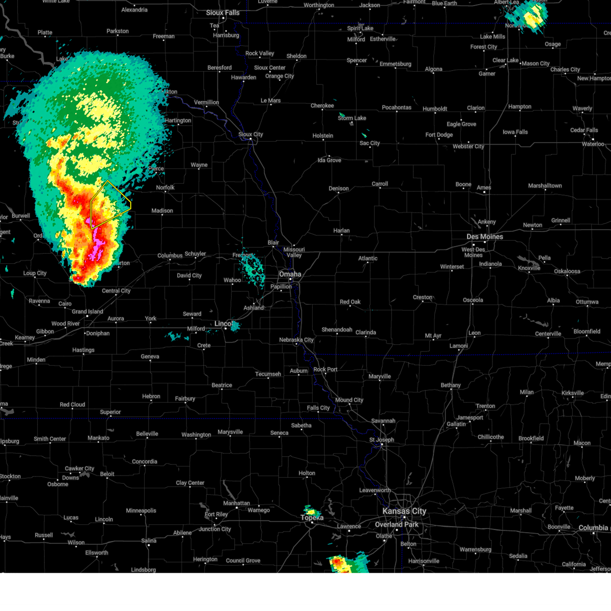
The Top Recent Hail Date for Petersburg, NE is Wednesday, August 7, 2024 (10th out of 86)

Hail and Wind Damage Spotted near Petersburg, NE
| Date / Time | Report Details |
|---|---|
| 5/19/2025 2:46 PM CDT |
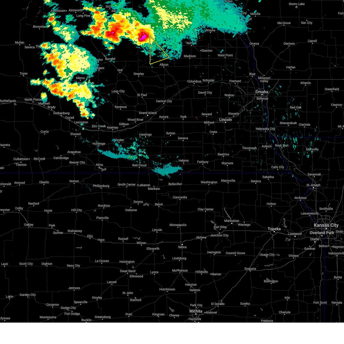
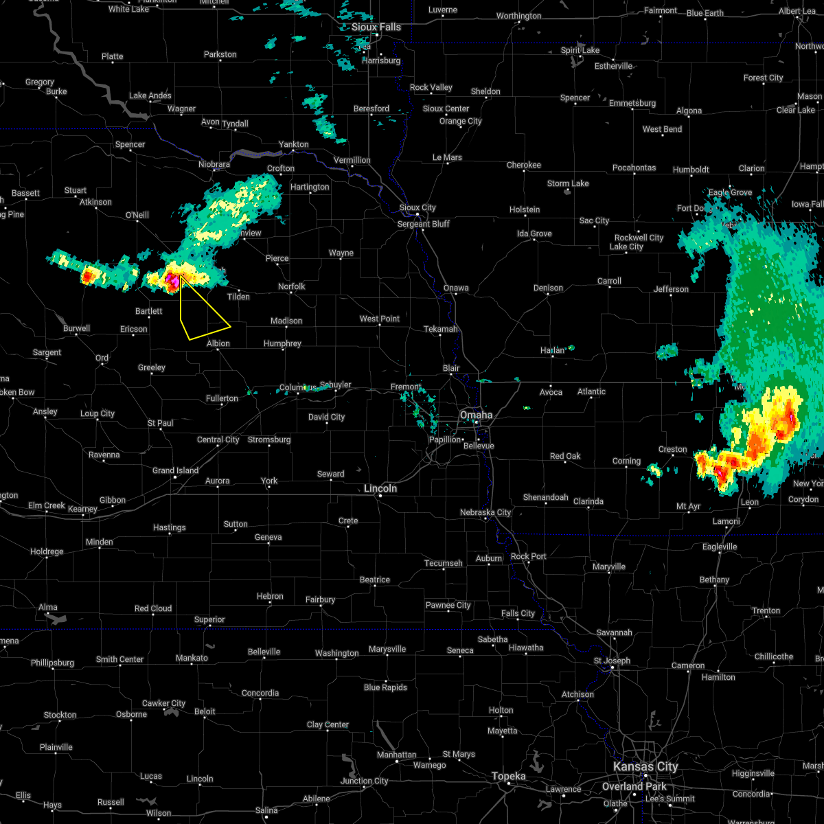
 At 246 pm cdt, a severe thunderstorm was located near albion, moving northeast at 15 mph (radar indicated). Hazards include 60 mph wind gusts and quarter size hail. Hail damage to vehicles is expected. expect wind damage to roofs, siding, and trees. This severe storm will be near, albion around 250 pm cdt. At 246 pm cdt, a severe thunderstorm was located near albion, moving northeast at 15 mph (radar indicated). Hazards include 60 mph wind gusts and quarter size hail. Hail damage to vehicles is expected. expect wind damage to roofs, siding, and trees. This severe storm will be near, albion around 250 pm cdt.
|
| 5/19/2025 2:38 PM CDT |
 At 238 pm cdt, a severe thunderstorm was located 3 miles west of albion, moving northeast at 15 mph (radar indicated). Hazards include 60 mph wind gusts and quarter size hail. Hail damage to vehicles is expected. expect wind damage to roofs, siding, and trees. This severe storm will be near, albion around 245 pm cdt. At 238 pm cdt, a severe thunderstorm was located 3 miles west of albion, moving northeast at 15 mph (radar indicated). Hazards include 60 mph wind gusts and quarter size hail. Hail damage to vehicles is expected. expect wind damage to roofs, siding, and trees. This severe storm will be near, albion around 245 pm cdt.
|
| 5/19/2025 2:30 PM CDT |
 At 230 pm cdt, a severe thunderstorm was located 4 miles west of albion, moving northeast at 15 mph (radar indicated). Hazards include 60 mph wind gusts and quarter size hail. Hail damage to vehicles is expected. expect wind damage to roofs, siding, and trees. This severe storm will be near, albion around 235 pm cdt. At 230 pm cdt, a severe thunderstorm was located 4 miles west of albion, moving northeast at 15 mph (radar indicated). Hazards include 60 mph wind gusts and quarter size hail. Hail damage to vehicles is expected. expect wind damage to roofs, siding, and trees. This severe storm will be near, albion around 235 pm cdt.
|
| 5/19/2025 2:25 PM CDT |
 At 225 pm cdt, a severe thunderstorm was located 5 miles southwest of albion, moving northeast at 20 mph (radar indicated). Hazards include 60 mph wind gusts and quarter size hail. Hail damage to vehicles is expected. expect wind damage to roofs, siding, and trees. This severe storm will be near, albion around 230 pm cdt. At 225 pm cdt, a severe thunderstorm was located 5 miles southwest of albion, moving northeast at 20 mph (radar indicated). Hazards include 60 mph wind gusts and quarter size hail. Hail damage to vehicles is expected. expect wind damage to roofs, siding, and trees. This severe storm will be near, albion around 230 pm cdt.
|
| 5/19/2025 2:18 PM CDT |
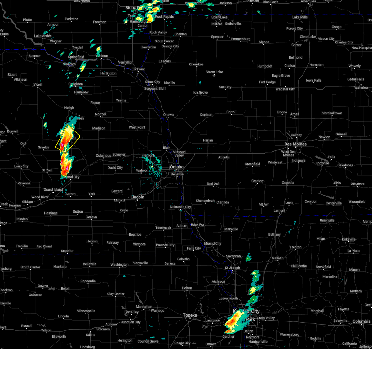 Svroax the national weather service in omaha has issued a * severe thunderstorm warning for, central boone county in northeastern nebraska, * until 300 pm cdt. * at 218 pm cdt, a severe thunderstorm was located 4 miles north of cedar rapids, or 9 miles southwest of albion, moving northeast at 20 mph (radar indicated). Hazards include 60 mph wind gusts and quarter size hail. Hail damage to vehicles is expected. expect wind damage to roofs, siding, and trees. This severe thunderstorm will be near, albion around 235 pm cdt. Svroax the national weather service in omaha has issued a * severe thunderstorm warning for, central boone county in northeastern nebraska, * until 300 pm cdt. * at 218 pm cdt, a severe thunderstorm was located 4 miles north of cedar rapids, or 9 miles southwest of albion, moving northeast at 20 mph (radar indicated). Hazards include 60 mph wind gusts and quarter size hail. Hail damage to vehicles is expected. expect wind damage to roofs, siding, and trees. This severe thunderstorm will be near, albion around 235 pm cdt.
|
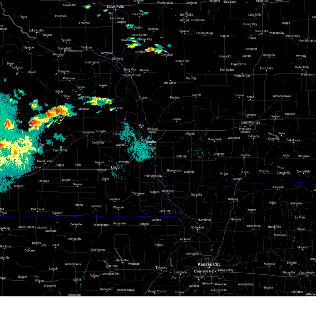
| 8/18/2024 8:03 AM CDT |
 the severe thunderstorm warning has been cancelled and is no longer in effect the severe thunderstorm warning has been cancelled and is no longer in effect
|
| 8/18/2024 7:40 AM CDT |
 Svroax the national weather service in omaha has issued a * severe thunderstorm warning for, west central platte county in northeastern nebraska, boone county in northeastern nebraska, * until 830 am cdt. * at 740 am cdt, a severe thunderstorm was located 3 miles west of petersburg, or 12 miles northwest of albion, moving southeast at 40 mph (radar indicated). Hazards include quarter size hail. Damage to vehicles is expected. this severe thunderstorm will be near, albion around 750 am cdt. st. edward around 805 am cdt. Other locations impacted by this severe thunderstorm include loretto and the highway 14 and 56 junction. Svroax the national weather service in omaha has issued a * severe thunderstorm warning for, west central platte county in northeastern nebraska, boone county in northeastern nebraska, * until 830 am cdt. * at 740 am cdt, a severe thunderstorm was located 3 miles west of petersburg, or 12 miles northwest of albion, moving southeast at 40 mph (radar indicated). Hazards include quarter size hail. Damage to vehicles is expected. this severe thunderstorm will be near, albion around 750 am cdt. st. edward around 805 am cdt. Other locations impacted by this severe thunderstorm include loretto and the highway 14 and 56 junction.
|
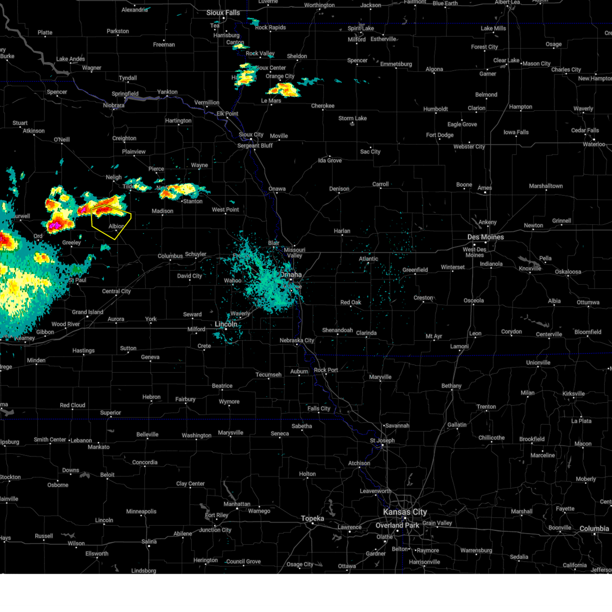
| 8/18/2024 7:23 AM CDT |
 At 722 am cdt, a severe thunderstorm was located 10 miles west of elgin, or 16 miles southwest of neligh, moving southeast at 40 mph (radar indicated). Hazards include 60 mph wind gusts and quarter size hail. Hail damage to vehicles is expected. expect wind damage to roofs, siding, and trees. Locations impacted include, petersburg. At 722 am cdt, a severe thunderstorm was located 10 miles west of elgin, or 16 miles southwest of neligh, moving southeast at 40 mph (radar indicated). Hazards include 60 mph wind gusts and quarter size hail. Hail damage to vehicles is expected. expect wind damage to roofs, siding, and trees. Locations impacted include, petersburg.
|
| 8/18/2024 7:01 AM CDT |
 Svroax the national weather service in omaha has issued a * severe thunderstorm warning for, southwestern antelope county in northeastern nebraska, northern boone county in northeastern nebraska, * until 745 am cdt. * at 701 am cdt, a severe thunderstorm was located 9 miles southwest of ewing, or 20 miles west of neligh, moving southeast at 45 mph (radar indicated). Hazards include 60 mph wind gusts and half dollar size hail. Hail damage to vehicles is expected. Expect wind damage to roofs, siding, and trees. Svroax the national weather service in omaha has issued a * severe thunderstorm warning for, southwestern antelope county in northeastern nebraska, northern boone county in northeastern nebraska, * until 745 am cdt. * at 701 am cdt, a severe thunderstorm was located 9 miles southwest of ewing, or 20 miles west of neligh, moving southeast at 45 mph (radar indicated). Hazards include 60 mph wind gusts and half dollar size hail. Hail damage to vehicles is expected. Expect wind damage to roofs, siding, and trees.
|
| 8/7/2024 10:53 PM CDT |
 At 1052 pm cdt, a severe thunderstorm was located near petersburg, or 9 miles north of albion, moving southeast at 20 mph (radar indicated). Hazards include 60 mph wind gusts and quarter size hail. Hail damage to vehicles is expected. expect wind damage to roofs, siding, and trees. Locations impacted include, albion, petersburg, and loretto. At 1052 pm cdt, a severe thunderstorm was located near petersburg, or 9 miles north of albion, moving southeast at 20 mph (radar indicated). Hazards include 60 mph wind gusts and quarter size hail. Hail damage to vehicles is expected. expect wind damage to roofs, siding, and trees. Locations impacted include, albion, petersburg, and loretto.
|
| 8/7/2024 10:35 PM CDT |
 Svroax the national weather service in omaha has issued a * severe thunderstorm warning for, northern boone county in northeastern nebraska, * until 1115 pm cdt. * at 1035 pm cdt, a severe thunderstorm was located 4 miles west of petersburg, or 14 miles northwest of albion, moving southeast at 20 mph (radar indicated). Hazards include 60 mph wind gusts and quarter size hail. Hail damage to vehicles is expected. Expect wind damage to roofs, siding, and trees. Svroax the national weather service in omaha has issued a * severe thunderstorm warning for, northern boone county in northeastern nebraska, * until 1115 pm cdt. * at 1035 pm cdt, a severe thunderstorm was located 4 miles west of petersburg, or 14 miles northwest of albion, moving southeast at 20 mph (radar indicated). Hazards include 60 mph wind gusts and quarter size hail. Hail damage to vehicles is expected. Expect wind damage to roofs, siding, and trees.
|
| 6/15/2024 4:54 PM CDT |
 Toroax the national weather service in omaha has issued a * tornado warning for, west central madison county in northeastern nebraska, southeastern antelope county in northeastern nebraska, northeastern boone county in northeastern nebraska, * until 530 pm cdt. * at 452 pm cdt, a severe thunderstorm capable of producing a tornado was located 3 miles east of petersburg, or 10 miles north of albion, moving northeast at 20 mph. there is an additional area of rotation approximately 6 miles north of albion (radar indicated rotation). Hazards include tornado and quarter size hail. Flying debris will be dangerous to those caught without shelter. mobile homes will be damaged or destroyed. damage to roofs, windows, and vehicles will occur. tree damage is likely. This tornadic thunderstorm will remain over mainly rural areas of west central madison, southeastern antelope and northeastern boone counties. Toroax the national weather service in omaha has issued a * tornado warning for, west central madison county in northeastern nebraska, southeastern antelope county in northeastern nebraska, northeastern boone county in northeastern nebraska, * until 530 pm cdt. * at 452 pm cdt, a severe thunderstorm capable of producing a tornado was located 3 miles east of petersburg, or 10 miles north of albion, moving northeast at 20 mph. there is an additional area of rotation approximately 6 miles north of albion (radar indicated rotation). Hazards include tornado and quarter size hail. Flying debris will be dangerous to those caught without shelter. mobile homes will be damaged or destroyed. damage to roofs, windows, and vehicles will occur. tree damage is likely. This tornadic thunderstorm will remain over mainly rural areas of west central madison, southeastern antelope and northeastern boone counties.
|
| 5/24/2024 12:33 AM CDT |
 At 1231 am cdt, severe thunderstorms were located along a line extending from 3 miles southwest of meadow grove to 3 miles south of belgrade, moving northeast at 40 mph (public. at 1214 am, a private weather station recorded a 66 mph wind gust 4 miles east of albion). Hazards include 70 mph wind gusts and half dollar size hail. Hail damage to vehicles is expected. expect considerable tree damage. wind damage is also likely to mobile homes, roofs, and outbuildings. locations impacted include, albion, battle creek, newman grove, st. Edward, elgin, cedar rapids, petersburg, meadow grove, monroe, lindsay, primrose, cornlea, loretto, and the highway 14 and 56 junction. At 1231 am cdt, severe thunderstorms were located along a line extending from 3 miles southwest of meadow grove to 3 miles south of belgrade, moving northeast at 40 mph (public. at 1214 am, a private weather station recorded a 66 mph wind gust 4 miles east of albion). Hazards include 70 mph wind gusts and half dollar size hail. Hail damage to vehicles is expected. expect considerable tree damage. wind damage is also likely to mobile homes, roofs, and outbuildings. locations impacted include, albion, battle creek, newman grove, st. Edward, elgin, cedar rapids, petersburg, meadow grove, monroe, lindsay, primrose, cornlea, loretto, and the highway 14 and 56 junction.
|
| 5/24/2024 12:31 AM CDT |
 At 1230 am cdt, severe thunderstorms were located along a line extending from 2 miles southwest of meadow grove to 3 miles south of belgrade, moving northeast at 40 mph (radar indicated). Hazards include 60 mph wind gusts and half dollar size hail. Hail damage to vehicles is expected. expect wind damage to roofs, siding, and trees. locations impacted include, albion, battle creek, newman grove, st. Edward, elgin, cedar rapids, petersburg, meadow grove, monroe, lindsay, primrose, cornlea, loretto, and the highway 14 and 56 junction. At 1230 am cdt, severe thunderstorms were located along a line extending from 2 miles southwest of meadow grove to 3 miles south of belgrade, moving northeast at 40 mph (radar indicated). Hazards include 60 mph wind gusts and half dollar size hail. Hail damage to vehicles is expected. expect wind damage to roofs, siding, and trees. locations impacted include, albion, battle creek, newman grove, st. Edward, elgin, cedar rapids, petersburg, meadow grove, monroe, lindsay, primrose, cornlea, loretto, and the highway 14 and 56 junction.
|
| 5/24/2024 12:17 AM CDT |
 Svroax the national weather service in omaha has issued a * severe thunderstorm warning for, western madison county in northeastern nebraska, western platte county in northeastern nebraska, southeastern antelope county in northeastern nebraska, boone county in northeastern nebraska, * until 100 am cdt. * at 1217 am cdt, severe thunderstorms were located along a line extending from 7 miles southwest of tilden to 8 miles northeast of palmer, moving northeast at 40 mph (radar indicated). Hazards include 60 mph wind gusts and half dollar size hail. Hail damage to vehicles is expected. Expect wind damage to roofs, siding, and trees. Svroax the national weather service in omaha has issued a * severe thunderstorm warning for, western madison county in northeastern nebraska, western platte county in northeastern nebraska, southeastern antelope county in northeastern nebraska, boone county in northeastern nebraska, * until 100 am cdt. * at 1217 am cdt, severe thunderstorms were located along a line extending from 7 miles southwest of tilden to 8 miles northeast of palmer, moving northeast at 40 mph (radar indicated). Hazards include 60 mph wind gusts and half dollar size hail. Hail damage to vehicles is expected. Expect wind damage to roofs, siding, and trees.
|
| 5/21/2024 4:47 AM CDT |
 Svroax the national weather service in omaha has issued a * severe thunderstorm warning for, madison county in northeastern nebraska, northwestern platte county in northeastern nebraska, southwestern pierce county in northeastern nebraska, southeastern antelope county in northeastern nebraska, northeastern boone county in northeastern nebraska, * until 515 am cdt. * at 447 am cdt, severe thunderstorms were located along a line extending from 4 miles south of elgin to 7 miles east of petersburg to 4 miles southwest of newman grove, moving northeast at 40 mph (radar indicated). Hazards include 60 mph wind gusts and penny size hail. expect damage to roofs, siding, and trees Svroax the national weather service in omaha has issued a * severe thunderstorm warning for, madison county in northeastern nebraska, northwestern platte county in northeastern nebraska, southwestern pierce county in northeastern nebraska, southeastern antelope county in northeastern nebraska, northeastern boone county in northeastern nebraska, * until 515 am cdt. * at 447 am cdt, severe thunderstorms were located along a line extending from 4 miles south of elgin to 7 miles east of petersburg to 4 miles southwest of newman grove, moving northeast at 40 mph (radar indicated). Hazards include 60 mph wind gusts and penny size hail. expect damage to roofs, siding, and trees
|
| 4/26/2024 3:56 PM CDT |
 the severe thunderstorm warning has been cancelled and is no longer in effect the severe thunderstorm warning has been cancelled and is no longer in effect
|
| 4/26/2024 3:21 PM CDT |
 the tornado warning has been cancelled and is no longer in effect the tornado warning has been cancelled and is no longer in effect
|
| 4/26/2024 3:20 PM CDT |
 Svroax the national weather service in omaha has issued a * severe thunderstorm warning for, northwestern madison county in northeastern nebraska, southwestern pierce county in northeastern nebraska, antelope county in northeastern nebraska, central boone county in northeastern nebraska, * until 415 pm cdt. * at 320 pm cdt, severe thunderstorms were located along a line extending from clearwater to 4 miles southwest of albion, moving northeast at 25 mph (radar indicated). Hazards include 70 mph wind gusts and quarter size hail. Hail damage to vehicles is expected. expect considerable tree damage. Wind damage is also likely to mobile homes, roofs, and outbuildings. Svroax the national weather service in omaha has issued a * severe thunderstorm warning for, northwestern madison county in northeastern nebraska, southwestern pierce county in northeastern nebraska, antelope county in northeastern nebraska, central boone county in northeastern nebraska, * until 415 pm cdt. * at 320 pm cdt, severe thunderstorms were located along a line extending from clearwater to 4 miles southwest of albion, moving northeast at 25 mph (radar indicated). Hazards include 70 mph wind gusts and quarter size hail. Hail damage to vehicles is expected. expect considerable tree damage. Wind damage is also likely to mobile homes, roofs, and outbuildings.
|
| 4/26/2024 3:08 PM CDT |
 Toroax the national weather service in omaha has issued a * tornado warning for, south central antelope county in northeastern nebraska, northwestern boone county in northeastern nebraska, * until 400 pm cdt. * at 308 pm cdt, a severe thunderstorm capable of producing a tornado was located 6 miles southwest of petersburg, or 10 miles northwest of albion, moving northeast at 20 mph (radar indicated rotation). Hazards include tornado and ping pong ball size hail. Flying debris will be dangerous to those caught without shelter. mobile homes will be damaged or destroyed. damage to roofs, windows, and vehicles will occur. tree damage is likely. this dangerous storm will be near, petersburg around 315 pm cdt. Other locations in the path of this tornadic thunderstorm include elgin. Toroax the national weather service in omaha has issued a * tornado warning for, south central antelope county in northeastern nebraska, northwestern boone county in northeastern nebraska, * until 400 pm cdt. * at 308 pm cdt, a severe thunderstorm capable of producing a tornado was located 6 miles southwest of petersburg, or 10 miles northwest of albion, moving northeast at 20 mph (radar indicated rotation). Hazards include tornado and ping pong ball size hail. Flying debris will be dangerous to those caught without shelter. mobile homes will be damaged or destroyed. damage to roofs, windows, and vehicles will occur. tree damage is likely. this dangerous storm will be near, petersburg around 315 pm cdt. Other locations in the path of this tornadic thunderstorm include elgin.
|
| 4/26/2024 2:59 PM CDT |
 At 259 pm cdt, a confirmed tornado was located 8 miles north of primrose, or 10 miles west of albion, moving northeast at 25 mph (weather spotters confirmed tornado). Hazards include damaging tornado and ping pong ball size hail. Flying debris will be dangerous to those caught without shelter. mobile homes will be damaged or destroyed. damage to roofs, windows, and vehicles will occur. tree damage is likely. Locations impacted include, petersburg. At 259 pm cdt, a confirmed tornado was located 8 miles north of primrose, or 10 miles west of albion, moving northeast at 25 mph (weather spotters confirmed tornado). Hazards include damaging tornado and ping pong ball size hail. Flying debris will be dangerous to those caught without shelter. mobile homes will be damaged or destroyed. damage to roofs, windows, and vehicles will occur. tree damage is likely. Locations impacted include, petersburg.
|
| 4/26/2024 2:46 PM CDT |
 At 246 pm cdt, a severe thunderstorm capable of producing a tornado was located 3 miles north of primrose, or 12 miles west of albion, moving northeast at 15 mph (radar indicated rotation). Hazards include tornado and golf ball size hail. Flying debris will be dangerous to those caught without shelter. mobile homes will be damaged or destroyed. damage to roofs, windows, and vehicles will occur. tree damage is likely. This tornadic thunderstorm will remain over mainly rural areas of northern boone county, including the following locations, loretto. At 246 pm cdt, a severe thunderstorm capable of producing a tornado was located 3 miles north of primrose, or 12 miles west of albion, moving northeast at 15 mph (radar indicated rotation). Hazards include tornado and golf ball size hail. Flying debris will be dangerous to those caught without shelter. mobile homes will be damaged or destroyed. damage to roofs, windows, and vehicles will occur. tree damage is likely. This tornadic thunderstorm will remain over mainly rural areas of northern boone county, including the following locations, loretto.
|
| 4/26/2024 2:29 PM CDT |
 Toroax the national weather service in omaha has issued a * tornado warning for, northern boone county in northeastern nebraska, * until 315 pm cdt. * at 228 pm cdt, a severe thunderstorm capable of producing a tornado was located 3 miles southwest of primrose, or 16 miles southwest of albion, moving northeast at 25 mph (radar indicated rotation). Hazards include tornado and golf ball size hail. Flying debris will be dangerous to those caught without shelter. mobile homes will be damaged or destroyed. damage to roofs, windows, and vehicles will occur. tree damage is likely. This dangerous storm will be near, primrose around 235 pm cdt. Toroax the national weather service in omaha has issued a * tornado warning for, northern boone county in northeastern nebraska, * until 315 pm cdt. * at 228 pm cdt, a severe thunderstorm capable of producing a tornado was located 3 miles southwest of primrose, or 16 miles southwest of albion, moving northeast at 25 mph (radar indicated rotation). Hazards include tornado and golf ball size hail. Flying debris will be dangerous to those caught without shelter. mobile homes will be damaged or destroyed. damage to roofs, windows, and vehicles will occur. tree damage is likely. This dangerous storm will be near, primrose around 235 pm cdt.
|
| 4/16/2024 4:33 AM CDT |
 At 432 am cdt, severe thunderstorms were located along a line extending from 7 miles east of petersburg to 12 miles northeast of bartlett, moving north at 55 mph (radar indicated). Hazards include 60 mph wind gusts and quarter size hail. Hail damage to vehicles is expected. expect wind damage to roofs, siding, and trees. Locations impacted include, neligh, tilden, elgin, clearwater, orchard, petersburg, oakdale, brunswick, royal, ashfall fossil beds state historical park, and grove lake recreation area. At 432 am cdt, severe thunderstorms were located along a line extending from 7 miles east of petersburg to 12 miles northeast of bartlett, moving north at 55 mph (radar indicated). Hazards include 60 mph wind gusts and quarter size hail. Hail damage to vehicles is expected. expect wind damage to roofs, siding, and trees. Locations impacted include, neligh, tilden, elgin, clearwater, orchard, petersburg, oakdale, brunswick, royal, ashfall fossil beds state historical park, and grove lake recreation area.
|
| 4/16/2024 4:17 AM CDT |
 Svroax the national weather service in omaha has issued a * severe thunderstorm warning for, northwestern madison county in northeastern nebraska, southwestern pierce county in northeastern nebraska, antelope county in northeastern nebraska, southwestern knox county in northeastern nebraska, boone county in northeastern nebraska, * until 500 am cdt. * at 416 am cdt, severe thunderstorms were located along a line extending from 4 miles south of albion to 6 miles southeast of bartlett, moving north at 55 mph (radar indicated). Hazards include 60 mph wind gusts and quarter size hail. Hail damage to vehicles is expected. Expect wind damage to roofs, siding, and trees. Svroax the national weather service in omaha has issued a * severe thunderstorm warning for, northwestern madison county in northeastern nebraska, southwestern pierce county in northeastern nebraska, antelope county in northeastern nebraska, southwestern knox county in northeastern nebraska, boone county in northeastern nebraska, * until 500 am cdt. * at 416 am cdt, severe thunderstorms were located along a line extending from 4 miles south of albion to 6 miles southeast of bartlett, moving north at 55 mph (radar indicated). Hazards include 60 mph wind gusts and quarter size hail. Hail damage to vehicles is expected. Expect wind damage to roofs, siding, and trees.
|
| 10/3/2023 6:26 PM CDT |
 The severe thunderstorm warning for southwestern madison, northwestern platte, south central antelope and boone counties will expire at 630 pm cdt, the storm which prompted the warning has weakened below severe limits, and has exited the warned area. therefore, the warning will be allowed to expire. a severe thunderstorm watch remains in effect until 1100 pm cdt for northeastern nebraska. to report severe weather, contact your nearest law enforcement agency. they will relay your report to the national weather service omaha. The severe thunderstorm warning for southwestern madison, northwestern platte, south central antelope and boone counties will expire at 630 pm cdt, the storm which prompted the warning has weakened below severe limits, and has exited the warned area. therefore, the warning will be allowed to expire. a severe thunderstorm watch remains in effect until 1100 pm cdt for northeastern nebraska. to report severe weather, contact your nearest law enforcement agency. they will relay your report to the national weather service omaha.
|
| 10/3/2023 6:02 PM CDT |
 At 602 pm cdt, a severe thunderstorm was located over primrose, or 11 miles west of albion, moving northeast at 45 mph (radar indicated). Hazards include 60 mph wind gusts. Expect damage to roofs, siding, and trees. this severe storm will be near, petersburg around 620 pm cdt. other locations impacted by this severe thunderstorm include loretto. hail threat, radar indicated max hail size, <. 75 in wind threat, radar indicated max wind gust, 60 mph. At 602 pm cdt, a severe thunderstorm was located over primrose, or 11 miles west of albion, moving northeast at 45 mph (radar indicated). Hazards include 60 mph wind gusts. Expect damage to roofs, siding, and trees. this severe storm will be near, petersburg around 620 pm cdt. other locations impacted by this severe thunderstorm include loretto. hail threat, radar indicated max hail size, <. 75 in wind threat, radar indicated max wind gust, 60 mph.
|
| 10/3/2023 5:47 PM CDT |
 At 547 pm cdt, a severe thunderstorm was located 8 miles north of wolbach, or 22 miles southwest of albion, moving northeast at 45 mph (radar indicated). Hazards include 60 mph wind gusts and quarter size hail. Hail damage to vehicles is expected. expect wind damage to roofs, siding, and trees. this severe thunderstorm will be near, primrose around 555 pm cdt. petersburg around 620 pm cdt. other locations impacted by this severe thunderstorm include loretto and the highway 14 and 56 junction. hail threat, radar indicated max hail size, 1. 00 in wind threat, radar indicated max wind gust, 60 mph. At 547 pm cdt, a severe thunderstorm was located 8 miles north of wolbach, or 22 miles southwest of albion, moving northeast at 45 mph (radar indicated). Hazards include 60 mph wind gusts and quarter size hail. Hail damage to vehicles is expected. expect wind damage to roofs, siding, and trees. this severe thunderstorm will be near, primrose around 555 pm cdt. petersburg around 620 pm cdt. other locations impacted by this severe thunderstorm include loretto and the highway 14 and 56 junction. hail threat, radar indicated max hail size, 1. 00 in wind threat, radar indicated max wind gust, 60 mph.
|
| 9/23/2023 8:05 AM CDT |
 At 804 am cdt, a severe thunderstorm was located 3 miles south of elgin, or 13 miles south of neligh, moving northeast at 40 mph (radar indicated). Hazards include quarter size hail. Damage to vehicles is expected. locations impacted include, elgin and petersburg. hail threat, radar indicated max hail size, 1. 00 in wind threat, radar indicated max wind gust, <50 mph. At 804 am cdt, a severe thunderstorm was located 3 miles south of elgin, or 13 miles south of neligh, moving northeast at 40 mph (radar indicated). Hazards include quarter size hail. Damage to vehicles is expected. locations impacted include, elgin and petersburg. hail threat, radar indicated max hail size, 1. 00 in wind threat, radar indicated max wind gust, <50 mph.
|
| 9/23/2023 7:46 AM CDT |
 At 745 am cdt, a severe thunderstorm was located 8 miles northeast of spalding, or 16 miles northwest of albion, moving northeast at 40 mph (radar indicated). Hazards include half dollar size hail. damage to vehicles is expected At 745 am cdt, a severe thunderstorm was located 8 miles northeast of spalding, or 16 miles northwest of albion, moving northeast at 40 mph (radar indicated). Hazards include half dollar size hail. damage to vehicles is expected
|
| 7/17/2023 6:19 AM CDT |
 At 618 am cdt, a severe thunderstorm was located 4 miles southwest of petersburg, or 9 miles northwest of albion, moving southeast at 45 mph (radar indicated). Hazards include ping pong ball size hail. People and animals outdoors will be injured. expect damage to roofs, siding, windows, and vehicles. locations impacted include, albion. hail threat, radar indicated max hail size, 1. 50 in wind threat, radar indicated max wind gust, <50 mph. At 618 am cdt, a severe thunderstorm was located 4 miles southwest of petersburg, or 9 miles northwest of albion, moving southeast at 45 mph (radar indicated). Hazards include ping pong ball size hail. People and animals outdoors will be injured. expect damage to roofs, siding, windows, and vehicles. locations impacted include, albion. hail threat, radar indicated max hail size, 1. 50 in wind threat, radar indicated max wind gust, <50 mph.
|
| 7/17/2023 6:08 AM CDT |
 At 608 am cdt, a severe thunderstorm was located 8 miles west of petersburg, or 17 miles northwest of albion, moving southeast at 45 mph (radar indicated). Hazards include quarter size hail. Damage to vehicles is expected. this severe thunderstorm will be near, petersburg around 620 am cdt. other locations in the path of this severe thunderstorm include albion. hail threat, radar indicated max hail size, 1. 00 in wind threat, radar indicated max wind gust, <50 mph. At 608 am cdt, a severe thunderstorm was located 8 miles west of petersburg, or 17 miles northwest of albion, moving southeast at 45 mph (radar indicated). Hazards include quarter size hail. Damage to vehicles is expected. this severe thunderstorm will be near, petersburg around 620 am cdt. other locations in the path of this severe thunderstorm include albion. hail threat, radar indicated max hail size, 1. 00 in wind threat, radar indicated max wind gust, <50 mph.
|
| 7/12/2023 5:13 AM CDT |
 At 512 am cdt, a severe thunderstorm was located 5 miles northwest of albion, moving southeast at 55 mph (radar indicated). Hazards include 60 mph wind gusts and quarter size hail. Hail damage to vehicles is expected. expect wind damage to roofs, siding, and trees. this severe thunderstorm will be near, st. edward around 530 am cdt. monroe around 545 am cdt. platte center around 550 am cdt. duncan and lakeview around 555 am cdt. columbus around 600 am cdt. other locations impacted by this severe thunderstorm include loretto, central community college, college view trailer park, the highway 14 and 56 junction, lake babcock, camp pawnee, lake ocaonee, circle h trailer park and lake north. hail threat, radar indicated max hail size, 1. 00 in wind threat, radar indicated max wind gust, 60 mph. At 512 am cdt, a severe thunderstorm was located 5 miles northwest of albion, moving southeast at 55 mph (radar indicated). Hazards include 60 mph wind gusts and quarter size hail. Hail damage to vehicles is expected. expect wind damage to roofs, siding, and trees. this severe thunderstorm will be near, st. edward around 530 am cdt. monroe around 545 am cdt. platte center around 550 am cdt. duncan and lakeview around 555 am cdt. columbus around 600 am cdt. other locations impacted by this severe thunderstorm include loretto, central community college, college view trailer park, the highway 14 and 56 junction, lake babcock, camp pawnee, lake ocaonee, circle h trailer park and lake north. hail threat, radar indicated max hail size, 1. 00 in wind threat, radar indicated max wind gust, 60 mph.
|
| 7/12/2023 4:59 AM CDT |
 At 459 am cdt, severe thunderstorms were located along a line extending from 5 miles northwest of martinsburg to 5 miles northwest of pilger to 3 miles north of primrose, moving southeast at 70 mph (radar indicated). Hazards include 70 mph wind gusts and quarter size hail. Hail damage to vehicles is expected. expect considerable tree damage. wind damage is also likely to mobile homes, roofs, and outbuildings. these severe thunderstorms will remain over mainly rural areas of madison, wayne, southern pierce, southern antelope, eastern cedar, northern boone and northwestern stanton counties, including the following locations, loretto, willow creek state recreation area, obert, the highway 84 and 15 junction, brooky bottom, camp assurance and sholes. thunderstorm damage threat, considerable hail threat, radar indicated max hail size, 1. 00 in wind threat, observed max wind gust, 70 mph. At 459 am cdt, severe thunderstorms were located along a line extending from 5 miles northwest of martinsburg to 5 miles northwest of pilger to 3 miles north of primrose, moving southeast at 70 mph (radar indicated). Hazards include 70 mph wind gusts and quarter size hail. Hail damage to vehicles is expected. expect considerable tree damage. wind damage is also likely to mobile homes, roofs, and outbuildings. these severe thunderstorms will remain over mainly rural areas of madison, wayne, southern pierce, southern antelope, eastern cedar, northern boone and northwestern stanton counties, including the following locations, loretto, willow creek state recreation area, obert, the highway 84 and 15 junction, brooky bottom, camp assurance and sholes. thunderstorm damage threat, considerable hail threat, radar indicated max hail size, 1. 00 in wind threat, observed max wind gust, 70 mph.
|
| 7/12/2023 4:41 AM CDT |
 At 441 am cdt, severe thunderstorms were located along a line extending from 5 miles south of wynot to 7 miles southeast of bartlett, moving southeast at 55 mph (radar indicated). Hazards include 70 mph wind gusts and quarter size hail. Hail damage to vehicles is expected. expect considerable tree damage. wind damage is also likely to mobile homes, roofs, and outbuildings. these severe thunderstorms will remain over mainly rural areas of madison, wayne, pierce, antelope, cedar, northern boone and northwestern stanton counties, including the following locations, loretto, mclean, brunswick, the highway 84 and 15 junction, magnet, pleasant valley, brooky bottom, bow valley, menominee and camp assurance. thunderstorm damage threat, considerable hail threat, radar indicated max hail size, 1. 00 in wind threat, radar indicated max wind gust, 70 mph. At 441 am cdt, severe thunderstorms were located along a line extending from 5 miles south of wynot to 7 miles southeast of bartlett, moving southeast at 55 mph (radar indicated). Hazards include 70 mph wind gusts and quarter size hail. Hail damage to vehicles is expected. expect considerable tree damage. wind damage is also likely to mobile homes, roofs, and outbuildings. these severe thunderstorms will remain over mainly rural areas of madison, wayne, pierce, antelope, cedar, northern boone and northwestern stanton counties, including the following locations, loretto, mclean, brunswick, the highway 84 and 15 junction, magnet, pleasant valley, brooky bottom, bow valley, menominee and camp assurance. thunderstorm damage threat, considerable hail threat, radar indicated max hail size, 1. 00 in wind threat, radar indicated max wind gust, 70 mph.
|
| 7/12/2023 4:20 AM CDT |
 At 420 am cdt, severe thunderstorms were located along a line extending from 5 miles northeast of crofton to 11 miles northwest of ericson, moving southeast at 55 mph (radar indicated). Hazards include 70 mph wind gusts and quarter size hail. Hail damage to vehicles is expected. expect considerable tree damage. wind damage is also likely to mobile homes, roofs, and outbuildings. severe thunderstorms will be near, yankton and crofton around 425 am cdt. fordyce and st. helena around 430 am cdt. hartington and wynot around 435 am cdt. thunderstorm damage threat, considerable hail threat, radar indicated max hail size, 1. 00 in wind threat, radar indicated max wind gust, 70 mph. At 420 am cdt, severe thunderstorms were located along a line extending from 5 miles northeast of crofton to 11 miles northwest of ericson, moving southeast at 55 mph (radar indicated). Hazards include 70 mph wind gusts and quarter size hail. Hail damage to vehicles is expected. expect considerable tree damage. wind damage is also likely to mobile homes, roofs, and outbuildings. severe thunderstorms will be near, yankton and crofton around 425 am cdt. fordyce and st. helena around 430 am cdt. hartington and wynot around 435 am cdt. thunderstorm damage threat, considerable hail threat, radar indicated max hail size, 1. 00 in wind threat, radar indicated max wind gust, 70 mph.
|
| 7/10/2023 6:41 PM CDT |
 At 640 pm cdt, a severe thunderstorm was located 4 miles east of petersburg, or 12 miles north of albion, moving southeast at 35 mph (radar indicated). Hazards include 60 mph wind gusts and quarter size hail. Hail damage to vehicles is expected. expect wind damage to roofs, siding, and trees. this severe thunderstorm will be near, albion around 655 pm cdt. newman grove around 700 pm cdt. other locations in the path of this severe thunderstorm include st. edward. hail threat, radar indicated max hail size, 1. 00 in wind threat, radar indicated max wind gust, 60 mph. At 640 pm cdt, a severe thunderstorm was located 4 miles east of petersburg, or 12 miles north of albion, moving southeast at 35 mph (radar indicated). Hazards include 60 mph wind gusts and quarter size hail. Hail damage to vehicles is expected. expect wind damage to roofs, siding, and trees. this severe thunderstorm will be near, albion around 655 pm cdt. newman grove around 700 pm cdt. other locations in the path of this severe thunderstorm include st. edward. hail threat, radar indicated max hail size, 1. 00 in wind threat, radar indicated max wind gust, 60 mph.
|
| 7/10/2023 5:58 PM CDT |
 At 558 pm cdt, a severe thunderstorm was located 3 miles north of elgin, or 7 miles south of neligh, moving southeast at 40 mph (radar indicated). Hazards include 60 mph wind gusts and quarter size hail. Hail damage to vehicles is expected. expect wind damage to roofs, siding, and trees. this severe thunderstorm will be near, petersburg around 610 pm cdt. hail threat, radar indicated max hail size, 1. 00 in wind threat, radar indicated max wind gust, 60 mph. At 558 pm cdt, a severe thunderstorm was located 3 miles north of elgin, or 7 miles south of neligh, moving southeast at 40 mph (radar indicated). Hazards include 60 mph wind gusts and quarter size hail. Hail damage to vehicles is expected. expect wind damage to roofs, siding, and trees. this severe thunderstorm will be near, petersburg around 610 pm cdt. hail threat, radar indicated max hail size, 1. 00 in wind threat, radar indicated max wind gust, 60 mph.
|
| 6/24/2023 3:05 AM CDT |
 At 305 am cdt, severe thunderstorms were located along a line extending from 9 miles southwest of creighton to 2 miles southeast of elgin to 4 miles northeast of cedar rapids, moving east at 60 mph (trained weather spotters). Hazards include 70 mph wind gusts and quarter size hail. Hail damage to vehicles is expected. expect considerable tree damage. wind damage is also likely to mobile homes, roofs, and outbuildings. locations impacted include, oakdale, plainview, tilden, st. edward, meadow grove, osmond, lindsay, battle creek, norfolk, humphrey, hadar and creston. thunderstorm damage threat, considerable hail threat, radar indicated max hail size, 1. 00 in wind threat, radar indicated max wind gust, 70 mph. At 305 am cdt, severe thunderstorms were located along a line extending from 9 miles southwest of creighton to 2 miles southeast of elgin to 4 miles northeast of cedar rapids, moving east at 60 mph (trained weather spotters). Hazards include 70 mph wind gusts and quarter size hail. Hail damage to vehicles is expected. expect considerable tree damage. wind damage is also likely to mobile homes, roofs, and outbuildings. locations impacted include, oakdale, plainview, tilden, st. edward, meadow grove, osmond, lindsay, battle creek, norfolk, humphrey, hadar and creston. thunderstorm damage threat, considerable hail threat, radar indicated max hail size, 1. 00 in wind threat, radar indicated max wind gust, 70 mph.
|
| 6/24/2023 2:45 AM CDT |
 At 245 am cdt, severe thunderstorms were located along a line extending from 4 miles south of page to 10 miles northeast of bartlett to 6 miles south of spalding, moving east at 55 mph (trained weather spotters). Hazards include 70 mph wind gusts and quarter size hail. Hail damage to vehicles is expected. expect considerable tree damage. wind damage is also likely to mobile homes, roofs, and outbuildings. severe thunderstorms will be near, cedar rapids, orchard and primrose around 255 am cdt. elgin and petersburg around 300 am cdt. albion around 305 am cdt. other locations in the path of these severe thunderstorms include oakdale, tilden, st. edward, plainview, meadow grove, lindsay, battle creek, osmond and humphrey. thunderstorm damage threat, considerable hail threat, radar indicated max hail size, 1. 00 in wind threat, radar indicated max wind gust, 70 mph. At 245 am cdt, severe thunderstorms were located along a line extending from 4 miles south of page to 10 miles northeast of bartlett to 6 miles south of spalding, moving east at 55 mph (trained weather spotters). Hazards include 70 mph wind gusts and quarter size hail. Hail damage to vehicles is expected. expect considerable tree damage. wind damage is also likely to mobile homes, roofs, and outbuildings. severe thunderstorms will be near, cedar rapids, orchard and primrose around 255 am cdt. elgin and petersburg around 300 am cdt. albion around 305 am cdt. other locations in the path of these severe thunderstorms include oakdale, tilden, st. edward, plainview, meadow grove, lindsay, battle creek, osmond and humphrey. thunderstorm damage threat, considerable hail threat, radar indicated max hail size, 1. 00 in wind threat, radar indicated max wind gust, 70 mph.
|
| 5/29/2023 9:11 PM CDT |
 The severe thunderstorm warning for northern boone county will expire at 915 pm cdt, the storms which prompted the warning have weakened below severe limits, and no longer pose an immediate threat to life or property. therefore, the warning will be allowed to expire. to report severe weather, contact your nearest law enforcement agency. they will relay your report to the national weather service omaha. The severe thunderstorm warning for northern boone county will expire at 915 pm cdt, the storms which prompted the warning have weakened below severe limits, and no longer pose an immediate threat to life or property. therefore, the warning will be allowed to expire. to report severe weather, contact your nearest law enforcement agency. they will relay your report to the national weather service omaha.
|
| 5/29/2023 8:35 PM CDT |
 At 835 pm cdt, severe thunderstorms were located along a line extending from 9 miles west of petersburg to 3 miles northeast of spalding, moving east at 20 mph (radar indicated). Hazards include 60 mph wind gusts and quarter size hail. Hail damage to vehicles is expected. Expect wind damage to roofs, siding, and trees. At 835 pm cdt, severe thunderstorms were located along a line extending from 9 miles west of petersburg to 3 miles northeast of spalding, moving east at 20 mph (radar indicated). Hazards include 60 mph wind gusts and quarter size hail. Hail damage to vehicles is expected. Expect wind damage to roofs, siding, and trees.
|
| 5/12/2023 3:10 PM CDT |
 At 309 pm cdt, a severe thunderstorm capable of producing a tornado was located 4 miles southwest of albion, moving northwest at 25 mph (radar indicated rotation). Hazards include tornado and quarter size hail. Flying debris will be dangerous to those caught without shelter. mobile homes will be damaged or destroyed. damage to roofs, windows, and vehicles will occur. tree damage is likely. Locations impacted include, petersburg. At 309 pm cdt, a severe thunderstorm capable of producing a tornado was located 4 miles southwest of albion, moving northwest at 25 mph (radar indicated rotation). Hazards include tornado and quarter size hail. Flying debris will be dangerous to those caught without shelter. mobile homes will be damaged or destroyed. damage to roofs, windows, and vehicles will occur. tree damage is likely. Locations impacted include, petersburg.
|
| 5/12/2023 2:47 PM CDT |
 At 246 pm cdt, a severe thunderstorm capable of producing a tornado was located 4 miles north of belgrade, or 11 miles south of albion, moving north at 30 mph (radar indicated rotation). Hazards include tornado and quarter size hail. Flying debris will be dangerous to those caught without shelter. mobile homes will be damaged or destroyed. damage to roofs, windows, and vehicles will occur. tree damage is likely. this dangerous storm will be near, cedar rapids around 255 pm cdt. Other locations in the path of this tornadic thunderstorm include albion and petersburg. At 246 pm cdt, a severe thunderstorm capable of producing a tornado was located 4 miles north of belgrade, or 11 miles south of albion, moving north at 30 mph (radar indicated rotation). Hazards include tornado and quarter size hail. Flying debris will be dangerous to those caught without shelter. mobile homes will be damaged or destroyed. damage to roofs, windows, and vehicles will occur. tree damage is likely. this dangerous storm will be near, cedar rapids around 255 pm cdt. Other locations in the path of this tornadic thunderstorm include albion and petersburg.
|
| 5/7/2023 5:12 AM CDT |
 At 512 am cdt, a severe thunderstorm was located 5 miles southwest of elgin, or 15 miles southwest of neligh, moving east at 30 mph (radar indicated). Hazards include 60 mph wind gusts and quarter size hail. Hail damage to vehicles is expected. expect wind damage to roofs, siding, and trees. locations impacted include, elgin and petersburg. hail threat, radar indicated max hail size, 1. 00 in wind threat, radar indicated max wind gust, 60 mph. At 512 am cdt, a severe thunderstorm was located 5 miles southwest of elgin, or 15 miles southwest of neligh, moving east at 30 mph (radar indicated). Hazards include 60 mph wind gusts and quarter size hail. Hail damage to vehicles is expected. expect wind damage to roofs, siding, and trees. locations impacted include, elgin and petersburg. hail threat, radar indicated max hail size, 1. 00 in wind threat, radar indicated max wind gust, 60 mph.
|
| 5/7/2023 4:59 AM CDT |
 At 458 am cdt, a severe thunderstorm was located 11 miles west of elgin, or 18 miles southwest of neligh, moving east at 35 mph (radar indicated). Hazards include 60 mph wind gusts and quarter size hail. Hail damage to vehicles is expected. Expect wind damage to roofs, siding, and trees. At 458 am cdt, a severe thunderstorm was located 11 miles west of elgin, or 18 miles southwest of neligh, moving east at 35 mph (radar indicated). Hazards include 60 mph wind gusts and quarter size hail. Hail damage to vehicles is expected. Expect wind damage to roofs, siding, and trees.
|
| 5/7/2023 4:13 AM CDT |
 At 412 am cdt, a severe thunderstorm was located over elgin, or 9 miles south of neligh, moving east at 45 mph (radar indicated). Hazards include golf ball size hail and 60 mph wind gusts. People and animals outdoors will be injured. expect hail damage to roofs, siding, windows, and vehicles. expect wind damage to roofs, siding, and trees. this severe storm will be near, oakdale around 420 am cdt. other locations in the path of this severe thunderstorm include tilden. thunderstorm damage threat, considerable hail threat, radar indicated max hail size, 1. 75 in wind threat, radar indicated max wind gust, 60 mph. At 412 am cdt, a severe thunderstorm was located over elgin, or 9 miles south of neligh, moving east at 45 mph (radar indicated). Hazards include golf ball size hail and 60 mph wind gusts. People and animals outdoors will be injured. expect hail damage to roofs, siding, windows, and vehicles. expect wind damage to roofs, siding, and trees. this severe storm will be near, oakdale around 420 am cdt. other locations in the path of this severe thunderstorm include tilden. thunderstorm damage threat, considerable hail threat, radar indicated max hail size, 1. 75 in wind threat, radar indicated max wind gust, 60 mph.
|
| 5/7/2023 4:02 AM CDT |
 At 401 am cdt, a severe thunderstorm was located 5 miles west of elgin, or 12 miles southwest of neligh, moving east at 45 mph (radar indicated). Hazards include golf ball size hail and 60 mph wind gusts. People and animals outdoors will be injured. expect hail damage to roofs, siding, windows, and vehicles. expect wind damage to roofs, siding, and trees. this severe storm will be near, elgin around 410 am cdt. other locations in the path of this severe thunderstorm include neligh, oakdale and tilden. thunderstorm damage threat, considerable hail threat, radar indicated max hail size, 1. 75 in wind threat, radar indicated max wind gust, 60 mph. At 401 am cdt, a severe thunderstorm was located 5 miles west of elgin, or 12 miles southwest of neligh, moving east at 45 mph (radar indicated). Hazards include golf ball size hail and 60 mph wind gusts. People and animals outdoors will be injured. expect hail damage to roofs, siding, windows, and vehicles. expect wind damage to roofs, siding, and trees. this severe storm will be near, elgin around 410 am cdt. other locations in the path of this severe thunderstorm include neligh, oakdale and tilden. thunderstorm damage threat, considerable hail threat, radar indicated max hail size, 1. 75 in wind threat, radar indicated max wind gust, 60 mph.
|
| 5/7/2023 3:51 AM CDT |
 At 351 am cdt, a severe thunderstorm was located 12 miles west of elgin, or 18 miles southwest of neligh, moving northeast at 45 mph (radar indicated). Hazards include 60 mph wind gusts and quarter size hail. Hail damage to vehicles is expected. expect wind damage to roofs, siding, and trees. this severe thunderstorm will be near, elgin around 405 am cdt. other locations in the path of this severe thunderstorm include neligh, oakdale and tilden. hail threat, radar indicated max hail size, 1. 00 in wind threat, radar indicated max wind gust, 60 mph. At 351 am cdt, a severe thunderstorm was located 12 miles west of elgin, or 18 miles southwest of neligh, moving northeast at 45 mph (radar indicated). Hazards include 60 mph wind gusts and quarter size hail. Hail damage to vehicles is expected. expect wind damage to roofs, siding, and trees. this severe thunderstorm will be near, elgin around 405 am cdt. other locations in the path of this severe thunderstorm include neligh, oakdale and tilden. hail threat, radar indicated max hail size, 1. 00 in wind threat, radar indicated max wind gust, 60 mph.
|
| 7/11/2022 12:54 AM CDT |
 At 1253 am cdt, severe thunderstorms were located along a line extending from 3 miles east of elgin to 3 miles west of st. edward, moving northeast at 55 mph (automated weather observing system). Hazards include 60 mph wind gusts. Expect damage to roofs, siding, and trees. these severe storms will be near, oakdale around 100 am cdt. tilden around 105 am cdt. other locations in the path of these severe thunderstorms include newman grove and lindsay. hail threat, radar indicated max hail size, <. 75 in wind threat, observed max wind gust, 60 mph. At 1253 am cdt, severe thunderstorms were located along a line extending from 3 miles east of elgin to 3 miles west of st. edward, moving northeast at 55 mph (automated weather observing system). Hazards include 60 mph wind gusts. Expect damage to roofs, siding, and trees. these severe storms will be near, oakdale around 100 am cdt. tilden around 105 am cdt. other locations in the path of these severe thunderstorms include newman grove and lindsay. hail threat, radar indicated max hail size, <. 75 in wind threat, observed max wind gust, 60 mph.
|
| 7/11/2022 12:46 AM CDT |
 At 1245 am cdt, severe thunderstorms were located along a line extending from 5 miles southwest of elgin to 4 miles southeast of cedar rapids, moving northeast at 55 mph (radar indicated). Hazards include 60 mph wind gusts. Expect damage to roofs, siding, and trees. these severe storms will be near, petersburg around 1250 am cdt. other locations in the path of these severe thunderstorms include st. edward, elgin, oakdale, tilden, newman grove and lindsay. hail threat, radar indicated max hail size, <. 75 in wind threat, radar indicated max wind gust, 60 mph. At 1245 am cdt, severe thunderstorms were located along a line extending from 5 miles southwest of elgin to 4 miles southeast of cedar rapids, moving northeast at 55 mph (radar indicated). Hazards include 60 mph wind gusts. Expect damage to roofs, siding, and trees. these severe storms will be near, petersburg around 1250 am cdt. other locations in the path of these severe thunderstorms include st. edward, elgin, oakdale, tilden, newman grove and lindsay. hail threat, radar indicated max hail size, <. 75 in wind threat, radar indicated max wind gust, 60 mph.
|
| 7/11/2022 12:32 AM CDT |
 At 1232 am cdt, severe thunderstorms were located along a line extending from 8 miles southeast of bartlett to 5 miles northeast of wolbach, moving northeast at 45 mph (radar indicated). Hazards include 60 mph wind gusts. Expect damage to roofs, siding, and trees. severe thunderstorms will be near, cedar rapids around 1245 am cdt. petersburg around 1250 am cdt. other locations in the path of these severe thunderstorms include elgin, st. edward, oakdale, tilden, newman grove and lindsay. hail threat, radar indicated max hail size, <. 75 in wind threat, radar indicated max wind gust, 60 mph. At 1232 am cdt, severe thunderstorms were located along a line extending from 8 miles southeast of bartlett to 5 miles northeast of wolbach, moving northeast at 45 mph (radar indicated). Hazards include 60 mph wind gusts. Expect damage to roofs, siding, and trees. severe thunderstorms will be near, cedar rapids around 1245 am cdt. petersburg around 1250 am cdt. other locations in the path of these severe thunderstorms include elgin, st. edward, oakdale, tilden, newman grove and lindsay. hail threat, radar indicated max hail size, <. 75 in wind threat, radar indicated max wind gust, 60 mph.
|
| 6/6/2022 2:40 PM CDT |
 At 240 pm cdt, a severe thunderstorm was located 5 miles southeast of petersburg, or 6 miles north of albion, moving southeast at 30 mph (radar indicated). Hazards include tennis ball size hail and 60 mph wind gusts. People and animals outdoors will be injured. expect hail damage to roofs, siding, windows, and vehicles. expect wind damage to roofs, siding, and trees. locations impacted include, albion, petersburg and loretto. thunderstorm damage threat, considerable hail threat, radar indicated max hail size, 2. 50 in wind threat, radar indicated max wind gust, 60 mph. At 240 pm cdt, a severe thunderstorm was located 5 miles southeast of petersburg, or 6 miles north of albion, moving southeast at 30 mph (radar indicated). Hazards include tennis ball size hail and 60 mph wind gusts. People and animals outdoors will be injured. expect hail damage to roofs, siding, windows, and vehicles. expect wind damage to roofs, siding, and trees. locations impacted include, albion, petersburg and loretto. thunderstorm damage threat, considerable hail threat, radar indicated max hail size, 2. 50 in wind threat, radar indicated max wind gust, 60 mph.
|
| 6/6/2022 2:35 PM CDT | Half Dollar sized hail reported 1.4 miles NE of Petersburg, NE |
| 6/6/2022 2:33 PM CDT | Golf Ball sized hail reported 0.2 miles N of Petersburg, NE, hail to at least golf ball size shattered a police vehicle windshield and one side window. |
| 6/6/2022 2:32 PM CDT |
 At 231 pm cdt, a severe thunderstorm was located over petersburg, or 11 miles northwest of albion, moving southeast at 30 mph (radar indicated. at 227 pm 1" hail was reported in petersburg). Hazards include tennis ball size hail and 60 mph wind gusts. People and animals outdoors will be injured. expect hail damage to roofs, siding, windows, and vehicles. expect wind damage to roofs, siding, and trees. locations impacted include, albion. thunderstorm damage threat, considerable hail threat, radar indicated max hail size, 2. 50 in wind threat, radar indicated max wind gust, 60 mph. At 231 pm cdt, a severe thunderstorm was located over petersburg, or 11 miles northwest of albion, moving southeast at 30 mph (radar indicated. at 227 pm 1" hail was reported in petersburg). Hazards include tennis ball size hail and 60 mph wind gusts. People and animals outdoors will be injured. expect hail damage to roofs, siding, windows, and vehicles. expect wind damage to roofs, siding, and trees. locations impacted include, albion. thunderstorm damage threat, considerable hail threat, radar indicated max hail size, 2. 50 in wind threat, radar indicated max wind gust, 60 mph.
|
| 6/6/2022 2:29 PM CDT | Golf Ball sized hail reported 1.1 miles ENE of Petersburg, NE, significant tree and crop damage from golf ball size hail. hail covering the ground. |
| 6/6/2022 2:28 PM CDT | Quarter sized hail reported 0.2 miles N of Petersburg, NE, hail just began. quarter size hail so far. |
| 6/6/2022 2:22 PM CDT |
 At 222 pm cdt, a severe thunderstorm was located 3 miles northwest of petersburg, or 15 miles northwest of albion, moving southeast at 30 mph (radar indicated). Hazards include 60 mph wind gusts and half dollar size hail. Hail damage to vehicles is expected. expect wind damage to roofs, siding, and trees. locations impacted include, petersburg. hail threat, radar indicated max hail size, 1. 25 in wind threat, radar indicated max wind gust, 60 mph. At 222 pm cdt, a severe thunderstorm was located 3 miles northwest of petersburg, or 15 miles northwest of albion, moving southeast at 30 mph (radar indicated). Hazards include 60 mph wind gusts and half dollar size hail. Hail damage to vehicles is expected. expect wind damage to roofs, siding, and trees. locations impacted include, petersburg. hail threat, radar indicated max hail size, 1. 25 in wind threat, radar indicated max wind gust, 60 mph.
|
| 6/6/2022 2:21 PM CDT |
 At 221 pm cdt, a severe thunderstorm was located 4 miles northwest of petersburg, or 15 miles northwest of albion, moving southeast at 30 mph (radar indicated). Hazards include 60 mph wind gusts and half dollar size hail. Hail damage to vehicles is expected. expect wind damage to roofs, siding, and trees. this severe thunderstorm will be near, petersburg around 230 pm cdt. other locations in the path of this severe thunderstorm include albion. hail threat, radar indicated max hail size, 1. 25 in wind threat, radar indicated max wind gust, 60 mph. At 221 pm cdt, a severe thunderstorm was located 4 miles northwest of petersburg, or 15 miles northwest of albion, moving southeast at 30 mph (radar indicated). Hazards include 60 mph wind gusts and half dollar size hail. Hail damage to vehicles is expected. expect wind damage to roofs, siding, and trees. this severe thunderstorm will be near, petersburg around 230 pm cdt. other locations in the path of this severe thunderstorm include albion. hail threat, radar indicated max hail size, 1. 25 in wind threat, radar indicated max wind gust, 60 mph.
|
| 6/6/2022 2:10 PM CDT |
 At 210 pm cdt, a severe thunderstorm was located 7 miles west of elgin, or 15 miles southwest of neligh, moving southeast at 30 mph (radar indicated). Hazards include 60 mph wind gusts and half dollar size hail. Hail damage to vehicles is expected. expect wind damage to roofs, siding, and trees. locations impacted include, petersburg. hail threat, radar indicated max hail size, 1. 25 in wind threat, radar indicated max wind gust, 60 mph. At 210 pm cdt, a severe thunderstorm was located 7 miles west of elgin, or 15 miles southwest of neligh, moving southeast at 30 mph (radar indicated). Hazards include 60 mph wind gusts and half dollar size hail. Hail damage to vehicles is expected. expect wind damage to roofs, siding, and trees. locations impacted include, petersburg. hail threat, radar indicated max hail size, 1. 25 in wind threat, radar indicated max wind gust, 60 mph.
|
| 6/6/2022 1:52 PM CDT |
 At 151 pm cdt, a severe thunderstorm was located 10 miles southwest of clearwater, or 16 miles west of neligh, moving southeast at 30 mph (radar indicated). Hazards include 60 mph wind gusts and half dollar size hail. Hail damage to vehicles is expected. Expect wind damage to roofs, siding, and trees. At 151 pm cdt, a severe thunderstorm was located 10 miles southwest of clearwater, or 16 miles west of neligh, moving southeast at 30 mph (radar indicated). Hazards include 60 mph wind gusts and half dollar size hail. Hail damage to vehicles is expected. Expect wind damage to roofs, siding, and trees.
|
| 5/30/2022 12:21 PM CDT |
 The severe thunderstorm warning for northern boone county will expire at 1230 pm cdt, the storm which prompted the warning has moved out of the area. therefore, the warning will be allowed to expire. a tornado watch remains in effect until 600 pm cdt for northeastern nebraska. The severe thunderstorm warning for northern boone county will expire at 1230 pm cdt, the storm which prompted the warning has moved out of the area. therefore, the warning will be allowed to expire. a tornado watch remains in effect until 600 pm cdt for northeastern nebraska.
|
| 5/30/2022 12:05 PM CDT |
 At 1204 pm cdt, a severe thunderstorm was located 5 miles northwest of albion, moving north at 65 mph (radar indicated). Hazards include 60 mph wind gusts and quarter size hail. Hail damage to vehicles is expected. expect wind damage to roofs, siding, and trees. locations impacted include, petersburg and loretto. hail threat, radar indicated max hail size, 1. 00 in wind threat, radar indicated max wind gust, 60 mph. At 1204 pm cdt, a severe thunderstorm was located 5 miles northwest of albion, moving north at 65 mph (radar indicated). Hazards include 60 mph wind gusts and quarter size hail. Hail damage to vehicles is expected. expect wind damage to roofs, siding, and trees. locations impacted include, petersburg and loretto. hail threat, radar indicated max hail size, 1. 00 in wind threat, radar indicated max wind gust, 60 mph.
|
| 5/30/2022 11:56 AM CDT |
 At 1156 am cdt, a severe thunderstorm was located 4 miles northeast of cedar rapids, or 6 miles southwest of albion, moving north at 60 mph (radar indicated). Hazards include 60 mph wind gusts and quarter size hail. Hail damage to vehicles is expected. expect wind damage to roofs, siding, and trees. locations impacted include, albion, petersburg and loretto. hail threat, radar indicated max hail size, 1. 00 in wind threat, radar indicated max wind gust, 60 mph. At 1156 am cdt, a severe thunderstorm was located 4 miles northeast of cedar rapids, or 6 miles southwest of albion, moving north at 60 mph (radar indicated). Hazards include 60 mph wind gusts and quarter size hail. Hail damage to vehicles is expected. expect wind damage to roofs, siding, and trees. locations impacted include, albion, petersburg and loretto. hail threat, radar indicated max hail size, 1. 00 in wind threat, radar indicated max wind gust, 60 mph.
|
| 5/30/2022 11:50 AM CDT |
 At 1150 am cdt, a severe thunderstorm was located over cedar rapids, or 12 miles southwest of albion, moving north at 60 mph (radar indicated). Hazards include 60 mph wind gusts and quarter size hail. Hail damage to vehicles is expected. expect wind damage to roofs, siding, and trees. locations impacted include, albion and petersburg. hail threat, radar indicated max hail size, 1. 00 in wind threat, radar indicated max wind gust, 60 mph. At 1150 am cdt, a severe thunderstorm was located over cedar rapids, or 12 miles southwest of albion, moving north at 60 mph (radar indicated). Hazards include 60 mph wind gusts and quarter size hail. Hail damage to vehicles is expected. expect wind damage to roofs, siding, and trees. locations impacted include, albion and petersburg. hail threat, radar indicated max hail size, 1. 00 in wind threat, radar indicated max wind gust, 60 mph.
|
| 5/30/2022 11:38 AM CDT |
 At 1138 am cdt, severe thunderstorms were located along a line extending from 3 miles west of spalding to 8 miles southwest of belgrade, moving north at 65 mph (radar indicated). Hazards include 60 mph wind gusts and quarter size hail. Hail damage to vehicles is expected. expect wind damage to roofs, siding, and trees. severe thunderstorms will be near, primrose around 1150 am cdt. other locations in the path of these severe thunderstorms include albion and petersburg. hail threat, radar indicated max hail size, 1. 00 in wind threat, radar indicated max wind gust, 60 mph. At 1138 am cdt, severe thunderstorms were located along a line extending from 3 miles west of spalding to 8 miles southwest of belgrade, moving north at 65 mph (radar indicated). Hazards include 60 mph wind gusts and quarter size hail. Hail damage to vehicles is expected. expect wind damage to roofs, siding, and trees. severe thunderstorms will be near, primrose around 1150 am cdt. other locations in the path of these severe thunderstorms include albion and petersburg. hail threat, radar indicated max hail size, 1. 00 in wind threat, radar indicated max wind gust, 60 mph.
|
| 5/12/2022 3:19 PM CDT |
 At 319 pm cdt, a severe thunderstorm was located 6 miles southwest of petersburg, or 9 miles northwest of albion, and is nearly stationary (radar indicated). Hazards include 70 mph wind gusts and ping pong ball size hail. People and animals outdoors will be injured. expect hail damage to roofs, siding, windows, and vehicles. expect considerable tree damage. wind damage is also likely to mobile homes, roofs, and outbuildings. locations impacted include, petersburg and elgin. thunderstorm damage threat, considerable hail threat, radar indicated max hail size, 1. 50 in wind threat, radar indicated max wind gust, 70 mph. At 319 pm cdt, a severe thunderstorm was located 6 miles southwest of petersburg, or 9 miles northwest of albion, and is nearly stationary (radar indicated). Hazards include 70 mph wind gusts and ping pong ball size hail. People and animals outdoors will be injured. expect hail damage to roofs, siding, windows, and vehicles. expect considerable tree damage. wind damage is also likely to mobile homes, roofs, and outbuildings. locations impacted include, petersburg and elgin. thunderstorm damage threat, considerable hail threat, radar indicated max hail size, 1. 50 in wind threat, radar indicated max wind gust, 70 mph.
|
| 5/12/2022 3:01 PM CDT |
 At 301 pm cdt, a severe thunderstorm was located 6 miles east of greeley, or 22 miles southwest of albion, moving northeast at 65 mph (radar indicated). Hazards include 70 mph wind gusts and ping pong ball size hail. People and animals outdoors will be injured. expect hail damage to roofs, siding, windows, and vehicles. expect considerable tree damage. wind damage is also likely to mobile homes, roofs, and outbuildings. this severe thunderstorm will be near, primrose around 310 pm cdt. other locations in the path of this severe thunderstorm include petersburg and elgin. thunderstorm damage threat, considerable hail threat, radar indicated max hail size, 1. 50 in wind threat, radar indicated max wind gust, 70 mph. At 301 pm cdt, a severe thunderstorm was located 6 miles east of greeley, or 22 miles southwest of albion, moving northeast at 65 mph (radar indicated). Hazards include 70 mph wind gusts and ping pong ball size hail. People and animals outdoors will be injured. expect hail damage to roofs, siding, windows, and vehicles. expect considerable tree damage. wind damage is also likely to mobile homes, roofs, and outbuildings. this severe thunderstorm will be near, primrose around 310 pm cdt. other locations in the path of this severe thunderstorm include petersburg and elgin. thunderstorm damage threat, considerable hail threat, radar indicated max hail size, 1. 50 in wind threat, radar indicated max wind gust, 70 mph.
|
| 8/28/2021 8:43 PM CDT |
 The severe thunderstorm warning for southwestern pierce, southeastern antelope and northern boone counties will expire at 845 pm cdt, the storm which prompted the warning was moving out of the area. therefore, the warning will be allowed to expire. however gusty winds are still possible with this thunderstorm. a severe thunderstorm watch remains in effect until 900 pm cdt for northeastern nebraska. The severe thunderstorm warning for southwestern pierce, southeastern antelope and northern boone counties will expire at 845 pm cdt, the storm which prompted the warning was moving out of the area. therefore, the warning will be allowed to expire. however gusty winds are still possible with this thunderstorm. a severe thunderstorm watch remains in effect until 900 pm cdt for northeastern nebraska.
|
| 8/28/2021 8:26 PM CDT |
 At 826 pm cdt, a severe thunderstorm was located 7 miles northeast of petersburg, or 28 miles west of norfolk, moving east at 30 mph (radar indicated). Hazards include 60 mph wind gusts and nickel size hail. Expect damage to roofs, siding, and trees. locations impacted include, albion, neligh, plainview, elgin, petersburg, oakdale, tilden and loretto. hail threat, radar indicated max hail size, 0. 88 in wind threat, radar indicated max wind gust, 60 mph. At 826 pm cdt, a severe thunderstorm was located 7 miles northeast of petersburg, or 28 miles west of norfolk, moving east at 30 mph (radar indicated). Hazards include 60 mph wind gusts and nickel size hail. Expect damage to roofs, siding, and trees. locations impacted include, albion, neligh, plainview, elgin, petersburg, oakdale, tilden and loretto. hail threat, radar indicated max hail size, 0. 88 in wind threat, radar indicated max wind gust, 60 mph.
|
| 8/28/2021 8:13 PM CDT |
 At 813 pm cdt, a severe thunderstorm was located near petersburg, or 34 miles west of norfolk, moving east at 30 mph (radar indicated). Hazards include 60 mph wind gusts and quarter size hail. Hail damage to vehicles is expected. expect wind damage to roofs, siding, and trees. locations impacted include, albion, neligh, plainview, elgin, clearwater, petersburg, oakdale, tilden, brunswick, royal and loretto. hail threat, radar indicated max hail size, 1. 00 in wind threat, radar indicated max wind gust, 60 mph. At 813 pm cdt, a severe thunderstorm was located near petersburg, or 34 miles west of norfolk, moving east at 30 mph (radar indicated). Hazards include 60 mph wind gusts and quarter size hail. Hail damage to vehicles is expected. expect wind damage to roofs, siding, and trees. locations impacted include, albion, neligh, plainview, elgin, clearwater, petersburg, oakdale, tilden, brunswick, royal and loretto. hail threat, radar indicated max hail size, 1. 00 in wind threat, radar indicated max wind gust, 60 mph.
|
| 8/28/2021 8:08 PM CDT |
 At 807 pm cdt, a severe thunderstorm was located 7 miles west of elgin, or 38 miles southeast of o`neill, moving east at 30 mph (radar indicated). Hazards include 60 mph wind gusts and quarter size hail. Hail damage to vehicles is expected. expect wind damage to roofs, siding, and trees. locations impacted include, albion, neligh, plainview, elgin, clearwater, orchard, petersburg, oakdale, tilden, brunswick, royal, loretto and ashfall fossil beds state historical park. hail threat, radar indicated max hail size, 1. 00 in wind threat, radar indicated max wind gust, 60 mph. At 807 pm cdt, a severe thunderstorm was located 7 miles west of elgin, or 38 miles southeast of o`neill, moving east at 30 mph (radar indicated). Hazards include 60 mph wind gusts and quarter size hail. Hail damage to vehicles is expected. expect wind damage to roofs, siding, and trees. locations impacted include, albion, neligh, plainview, elgin, clearwater, orchard, petersburg, oakdale, tilden, brunswick, royal, loretto and ashfall fossil beds state historical park. hail threat, radar indicated max hail size, 1. 00 in wind threat, radar indicated max wind gust, 60 mph.
|
| 8/28/2021 7:57 PM CDT |
 At 757 pm cdt, a severe thunderstorm was located 12 miles west of elgin, or 35 miles southeast of o`neill, moving east at 25 mph (radar indicated). Hazards include 60 mph wind gusts and quarter size hail. Hail damage to vehicles is expected. expect wind damage to roofs, siding, and trees. locations impacted include, elgin and oakdale. hail threat, radar indicated max hail size, 1. 00 in wind threat, radar indicated max wind gust, 60 mph. At 757 pm cdt, a severe thunderstorm was located 12 miles west of elgin, or 35 miles southeast of o`neill, moving east at 25 mph (radar indicated). Hazards include 60 mph wind gusts and quarter size hail. Hail damage to vehicles is expected. expect wind damage to roofs, siding, and trees. locations impacted include, elgin and oakdale. hail threat, radar indicated max hail size, 1. 00 in wind threat, radar indicated max wind gust, 60 mph.
|
| 8/28/2021 7:42 PM CDT |
 At 742 pm cdt, severe thunderstorms were located along a line extending from 6 miles north of orchard to 4 miles south of ericson, moving east at 25 mph (radar indicated). Hazards include 60 mph wind gusts and quarter size hail. Hail damage to vehicles is expected. expect wind damage to roofs, siding, and trees. severe thunderstorms will be near, orchard around 745 pm cdt. other locations in the path of these severe thunderstorms include creighton, plainview and albion. hail threat, radar indicated max hail size, 1. 00 in wind threat, radar indicated max wind gust, 60 mph. At 742 pm cdt, severe thunderstorms were located along a line extending from 6 miles north of orchard to 4 miles south of ericson, moving east at 25 mph (radar indicated). Hazards include 60 mph wind gusts and quarter size hail. Hail damage to vehicles is expected. expect wind damage to roofs, siding, and trees. severe thunderstorms will be near, orchard around 745 pm cdt. other locations in the path of these severe thunderstorms include creighton, plainview and albion. hail threat, radar indicated max hail size, 1. 00 in wind threat, radar indicated max wind gust, 60 mph.
|
| 6/24/2021 1:25 AM CDT |
 At 124 am cdt, a severe thunderstorm was located 5 miles west of pilger, or 13 miles east of norfolk, moving east at 35 mph. this is a very dangerous storm with a history of producing 80 mph gusts and uprooting trees (radar indicated). Hazards include 80 mph wind gusts and penny size hail. Flying debris will be dangerous to those caught without shelter. mobile homes will be heavily damaged. expect considerable damage to roofs, windows, and vehicles. extensive tree damage and power outages are likely. locations impacted include, norfolk, columbus, madison, pierce, albion, stanton, battle creek, newman grove, st. Edward, winside, leigh, cedar rapids, pilger, platte center, petersburg, meadow grove, hadar, hoskins, monroe and lindsay. At 124 am cdt, a severe thunderstorm was located 5 miles west of pilger, or 13 miles east of norfolk, moving east at 35 mph. this is a very dangerous storm with a history of producing 80 mph gusts and uprooting trees (radar indicated). Hazards include 80 mph wind gusts and penny size hail. Flying debris will be dangerous to those caught without shelter. mobile homes will be heavily damaged. expect considerable damage to roofs, windows, and vehicles. extensive tree damage and power outages are likely. locations impacted include, norfolk, columbus, madison, pierce, albion, stanton, battle creek, newman grove, st. Edward, winside, leigh, cedar rapids, pilger, platte center, petersburg, meadow grove, hadar, hoskins, monroe and lindsay.
|
| 6/24/2021 1:08 AM CDT |
 At 107 am cdt, a severe thunderstorm was located near norfolk, moving east at 35 mph. this is a very dangerous storm (a 84 mph gust was recorded at the albion airport at 12:55am). Hazards include 80 mph wind gusts and penny size hail. Flying debris will be dangerous to those caught without shelter. mobile homes will be heavily damaged. expect considerable damage to roofs, windows, and vehicles. extensive tree damage and power outages are likely. Locations impacted include, stanton and pilger. At 107 am cdt, a severe thunderstorm was located near norfolk, moving east at 35 mph. this is a very dangerous storm (a 84 mph gust was recorded at the albion airport at 12:55am). Hazards include 80 mph wind gusts and penny size hail. Flying debris will be dangerous to those caught without shelter. mobile homes will be heavily damaged. expect considerable damage to roofs, windows, and vehicles. extensive tree damage and power outages are likely. Locations impacted include, stanton and pilger.
|
| 6/24/2021 1:06 AM CDT |
 At 105 am cdt, a severe thunderstorm was located over petersburg, or 34 miles west of norfolk, moving southeast at 45 mph. this is a very dangerous storm (a 84 mph gust was reported at the albion airport at 12:55am). Hazards include 80 mph wind gusts and penny size hail. Flying debris will be dangerous to those caught without shelter. mobile homes will be heavily damaged. expect considerable damage to roofs, windows, and vehicles. extensive tree damage and power outages are likely. locations impacted include, albion, newman grove, st. Edward, elgin, petersburg, lindsay, loretto and the highway 14 and 56 junction. At 105 am cdt, a severe thunderstorm was located over petersburg, or 34 miles west of norfolk, moving southeast at 45 mph. this is a very dangerous storm (a 84 mph gust was reported at the albion airport at 12:55am). Hazards include 80 mph wind gusts and penny size hail. Flying debris will be dangerous to those caught without shelter. mobile homes will be heavily damaged. expect considerable damage to roofs, windows, and vehicles. extensive tree damage and power outages are likely. locations impacted include, albion, newman grove, st. Edward, elgin, petersburg, lindsay, loretto and the highway 14 and 56 junction.
|
| 6/24/2021 12:58 AM CDT |
 At 1257 am cdt, a severe thunderstorm was located near norfolk, moving east at 35 mph. this is a very dangerous storm (law enforcement). Hazards include 80 mph wind gusts and penny size hail. Flying debris will be dangerous to those caught without shelter. mobile homes will be heavily damaged. expect considerable damage to roofs, windows, and vehicles. extensive tree damage and power outages are likely. this severe thunderstorm will be near, hoskins around 110 am cdt. Other locations in the path of this severe thunderstorm include stanton and pilger. At 1257 am cdt, a severe thunderstorm was located near norfolk, moving east at 35 mph. this is a very dangerous storm (law enforcement). Hazards include 80 mph wind gusts and penny size hail. Flying debris will be dangerous to those caught without shelter. mobile homes will be heavily damaged. expect considerable damage to roofs, windows, and vehicles. extensive tree damage and power outages are likely. this severe thunderstorm will be near, hoskins around 110 am cdt. Other locations in the path of this severe thunderstorm include stanton and pilger.
|
| 6/24/2021 12:40 AM CDT |
 At 1239 am cdt, a severe thunderstorm was located 10 miles northeast of bartlett, or 35 miles south of o`neill, moving southeast at 45 mph (radar indicated). Hazards include 75 mph wind gusts and penny size hail. Expect considerable tree damage. Damage is likely to mobile homes, roofs, and outbuildings. At 1239 am cdt, a severe thunderstorm was located 10 miles northeast of bartlett, or 35 miles south of o`neill, moving southeast at 45 mph (radar indicated). Hazards include 75 mph wind gusts and penny size hail. Expect considerable tree damage. Damage is likely to mobile homes, roofs, and outbuildings.
|
| 6/11/2021 7:11 AM CDT |
 The severe thunderstorm warning for central boone county will expire at 715 am cdt, the storm which prompted the warning has weakened below severe limits, and no longer poses an immediate threat to life or property. therefore, the warning will be allowed to expire. however small hail and gusty winds are still possible with this thunderstorm. a severe thunderstorm watch remains in effect until 1100 am cdt for northeastern nebraska. The severe thunderstorm warning for central boone county will expire at 715 am cdt, the storm which prompted the warning has weakened below severe limits, and no longer poses an immediate threat to life or property. therefore, the warning will be allowed to expire. however small hail and gusty winds are still possible with this thunderstorm. a severe thunderstorm watch remains in effect until 1100 am cdt for northeastern nebraska.
|
| 6/11/2021 6:56 AM CDT |
 At 656 am cdt, a severe thunderstorm was located 6 miles northwest of albion, or 40 miles southwest of norfolk, moving east at 15 mph (trained weather spotters). Hazards include quarter size hail. Damage to vehicles is expected. This severe thunderstorm will remain over mainly rural areas of central boone county, including the following locations, loretto. At 656 am cdt, a severe thunderstorm was located 6 miles northwest of albion, or 40 miles southwest of norfolk, moving east at 15 mph (trained weather spotters). Hazards include quarter size hail. Damage to vehicles is expected. This severe thunderstorm will remain over mainly rural areas of central boone county, including the following locations, loretto.
|
| 6/11/2021 6:45 AM CDT |
 At 645 am cdt, a severe thunderstorm was located 9 miles southwest of petersburg, or 40 miles east of ord, moving east at 20 mph (radar indicated). Hazards include 60 mph wind gusts and quarter size hail. Hail damage to vehicles is expected. expect wind damage to roofs, siding, and trees. This severe thunderstorm will remain over mainly rural areas of central boone county, including the following locations, loretto. At 645 am cdt, a severe thunderstorm was located 9 miles southwest of petersburg, or 40 miles east of ord, moving east at 20 mph (radar indicated). Hazards include 60 mph wind gusts and quarter size hail. Hail damage to vehicles is expected. expect wind damage to roofs, siding, and trees. This severe thunderstorm will remain over mainly rural areas of central boone county, including the following locations, loretto.
|
| 8/16/2020 3:48 PM CDT |
 At 348 pm cdt, a severe thunderstorm was located 8 miles west of elgin, or 36 miles southeast of o`neill, moving southeast at 30 mph (radar indicated). Hazards include 60 mph wind gusts and quarter size hail. Hail damage to vehicles is expected. Expect wind damage to roofs, siding, and trees. At 348 pm cdt, a severe thunderstorm was located 8 miles west of elgin, or 36 miles southeast of o`neill, moving southeast at 30 mph (radar indicated). Hazards include 60 mph wind gusts and quarter size hail. Hail damage to vehicles is expected. Expect wind damage to roofs, siding, and trees.
|
| 7/8/2020 11:08 PM CDT |
 The severe thunderstorm warning for southwestern madison, northwestern platte and boone counties will expire at 1115 pm cdt, the storms which prompted the warning have weakened. therefore, the warning will be allowed to expire. however small hail and gusty winds to near 50 mph will still possible with these thunderstorms. a severe thunderstorm watch remains in effect until midnight cdt for northeastern nebraska. a severe thunderstorm watch also remains in effect until 500 am cdt for northeastern nebraska. The severe thunderstorm warning for southwestern madison, northwestern platte and boone counties will expire at 1115 pm cdt, the storms which prompted the warning have weakened. therefore, the warning will be allowed to expire. however small hail and gusty winds to near 50 mph will still possible with these thunderstorms. a severe thunderstorm watch remains in effect until midnight cdt for northeastern nebraska. a severe thunderstorm watch also remains in effect until 500 am cdt for northeastern nebraska.
|
| 7/8/2020 10:55 PM CDT |
 At 1054 pm cdt, severe thunderstorms were located along a line extending from 4 miles southwest of newman grove to near belgrade to 6 miles east of wolbach, moving south at 40 mph. the strongest storms are expected to affect the southern half of boone county (radar indicated). Hazards include 60 mph wind gusts and nickel size hail. Expect damage to roofs, siding, and trees. locations impacted include, albion, newman grove, st. Edward, cedar rapids, petersburg, lindsay, primrose, loretto and the highway 14 and 56 junction. At 1054 pm cdt, severe thunderstorms were located along a line extending from 4 miles southwest of newman grove to near belgrade to 6 miles east of wolbach, moving south at 40 mph. the strongest storms are expected to affect the southern half of boone county (radar indicated). Hazards include 60 mph wind gusts and nickel size hail. Expect damage to roofs, siding, and trees. locations impacted include, albion, newman grove, st. Edward, cedar rapids, petersburg, lindsay, primrose, loretto and the highway 14 and 56 junction.
|
| 7/8/2020 10:45 PM CDT |
 At 1043 pm cdt, the leading edge of an area of severe thunderstorms was located along a line extending from 7 miles north of newman grove to 5 miles north of st. edward to 6 miles southwest of cedar rapids, moving southeast at 30 mph. the strongest storms in this area were just north of primrose (radar indicated). Hazards include 60 mph wind gusts and nickel size hail. Expect damage to roofs, siding, and trees. locations impacted include, albion, newman grove, st. Edward, cedar rapids, petersburg, lindsay, primrose, loretto and the highway 14 and 56 junction. At 1043 pm cdt, the leading edge of an area of severe thunderstorms was located along a line extending from 7 miles north of newman grove to 5 miles north of st. edward to 6 miles southwest of cedar rapids, moving southeast at 30 mph. the strongest storms in this area were just north of primrose (radar indicated). Hazards include 60 mph wind gusts and nickel size hail. Expect damage to roofs, siding, and trees. locations impacted include, albion, newman grove, st. Edward, cedar rapids, petersburg, lindsay, primrose, loretto and the highway 14 and 56 junction.
|
| 7/8/2020 10:35 PM CDT |
 At 1035 pm cdt, the leading edge of an severe thunderstorms were located along a line extending from near meadow grove to near newman grove to near cedar rapids, moving east at 45 mph. the strongest part of the area was about 10 miles west of albion (radar indicated). Hazards include 60 mph wind gusts and nickel size hail. Expect damage to roofs, siding, and trees. locations impacted include, albion, newman grove, st. Edward, cedar rapids, petersburg, lindsay, primrose, loretto and the highway 14 and 56 junction. At 1035 pm cdt, the leading edge of an severe thunderstorms were located along a line extending from near meadow grove to near newman grove to near cedar rapids, moving east at 45 mph. the strongest part of the area was about 10 miles west of albion (radar indicated). Hazards include 60 mph wind gusts and nickel size hail. Expect damage to roofs, siding, and trees. locations impacted include, albion, newman grove, st. Edward, cedar rapids, petersburg, lindsay, primrose, loretto and the highway 14 and 56 junction.
|
| 7/8/2020 10:24 PM CDT |
 At 1024 pm cdt, severe thunderstorms were located along a line extending from 4 miles southwest of meadow grove to 4 miles north of albion to 6 miles northwest of cedar rapids, moving east at 45 mph (radar indicated). Hazards include 60 mph wind gusts and nickel size hail. expect damage to roofs, siding, and trees At 1024 pm cdt, severe thunderstorms were located along a line extending from 4 miles southwest of meadow grove to 4 miles north of albion to 6 miles northwest of cedar rapids, moving east at 45 mph (radar indicated). Hazards include 60 mph wind gusts and nickel size hail. expect damage to roofs, siding, and trees
|
| 7/6/2020 8:44 PM CDT |
 At 844 pm cdt, severe thunderstorms were located along a line extending from near lindsay to 4 miles southwest of newman grove to 7 miles west of petersburg, moving south at 20 mph (radar indicated). Hazards include 60 mph wind gusts. Expect damage to roofs, siding, and trees. Locations impacted include, newman grove, petersburg, lindsay and loretto. At 844 pm cdt, severe thunderstorms were located along a line extending from near lindsay to 4 miles southwest of newman grove to 7 miles west of petersburg, moving south at 20 mph (radar indicated). Hazards include 60 mph wind gusts. Expect damage to roofs, siding, and trees. Locations impacted include, newman grove, petersburg, lindsay and loretto.
|
| 7/6/2020 8:41 PM CDT |
 At 841 pm cdt, severe thunderstorms were located along a line extending from 4 miles northeast of lindsay to 4 miles southwest of newman grove to 7 miles west of petersburg, moving south at 25 mph (radar indicated). Hazards include 60 mph wind gusts and quarter size hail. Hail damage to vehicles is expected. expect wind damage to roofs, siding, and trees. Locations impacted include, newman grove, petersburg, lindsay and loretto. At 841 pm cdt, severe thunderstorms were located along a line extending from 4 miles northeast of lindsay to 4 miles southwest of newman grove to 7 miles west of petersburg, moving south at 25 mph (radar indicated). Hazards include 60 mph wind gusts and quarter size hail. Hail damage to vehicles is expected. expect wind damage to roofs, siding, and trees. Locations impacted include, newman grove, petersburg, lindsay and loretto.
|
| 7/6/2020 8:36 PM CDT |
 At 836 pm cdt, severe thunderstorms were located along a line extending from 5 miles north of lindsay to 8 miles west of petersburg, moving south at 20 mph (radar indicated). Hazards include 60 mph wind gusts and quarter size hail. Hail damage to vehicles is expected. expect wind damage to roofs, siding, and trees. Locations impacted include, newman grove, petersburg, lindsay and loretto. At 836 pm cdt, severe thunderstorms were located along a line extending from 5 miles north of lindsay to 8 miles west of petersburg, moving south at 20 mph (radar indicated). Hazards include 60 mph wind gusts and quarter size hail. Hail damage to vehicles is expected. expect wind damage to roofs, siding, and trees. Locations impacted include, newman grove, petersburg, lindsay and loretto.
|
| 7/6/2020 8:26 PM CDT |
 At 826 pm cdt, severe thunderstorms were located along a line extending from 9 miles northeast of newman grove to 9 miles west of elgin, moving south at 20 mph (radar indicated). Hazards include 60 mph wind gusts and quarter size hail. Hail damage to vehicles is expected. expect wind damage to roofs, siding, and trees. Locations impacted include, madison, newman grove, elgin, petersburg, lindsay and loretto. At 826 pm cdt, severe thunderstorms were located along a line extending from 9 miles northeast of newman grove to 9 miles west of elgin, moving south at 20 mph (radar indicated). Hazards include 60 mph wind gusts and quarter size hail. Hail damage to vehicles is expected. expect wind damage to roofs, siding, and trees. Locations impacted include, madison, newman grove, elgin, petersburg, lindsay and loretto.
|
| 7/6/2020 8:12 PM CDT |
 At 812 pm cdt, severe thunderstorms were located along a line extending from 7 miles south of meadow grove to 6 miles west of elgin, moving south at 20 mph (radar indicated). Hazards include 60 mph wind gusts and quarter size hail. Hail damage to vehicles is expected. Expect wind damage to roofs, siding, and trees. At 812 pm cdt, severe thunderstorms were located along a line extending from 7 miles south of meadow grove to 6 miles west of elgin, moving south at 20 mph (radar indicated). Hazards include 60 mph wind gusts and quarter size hail. Hail damage to vehicles is expected. Expect wind damage to roofs, siding, and trees.
|
| 6/30/2020 9:39 PM CDT |
 At 938 pm cdt, a severe thunderstorm was located near albion, or 41 miles northwest of columbus, moving east at 15 mph (radar indicated). Hazards include 60 mph wind gusts and quarter size hail. Hail damage to vehicles is expected. expect wind damage to roofs, siding, and trees. locations impacted include, albion, st. Edward, cedar rapids, petersburg, loretto and the highway 14 and 56 junction. At 938 pm cdt, a severe thunderstorm was located near albion, or 41 miles northwest of columbus, moving east at 15 mph (radar indicated). Hazards include 60 mph wind gusts and quarter size hail. Hail damage to vehicles is expected. expect wind damage to roofs, siding, and trees. locations impacted include, albion, st. Edward, cedar rapids, petersburg, loretto and the highway 14 and 56 junction.
|
| 6/30/2020 9:24 PM CDT |
 At 924 pm cdt, a severe thunderstorm was located 8 miles west of petersburg, or 38 miles northeast of ord, moving east at 15 mph (radar indicated). Hazards include 60 mph wind gusts and half dollar size hail. Hail damage to vehicles is expected. expect wind damage to roofs, siding, and trees. Locations impacted include, petersburg and loretto. At 924 pm cdt, a severe thunderstorm was located 8 miles west of petersburg, or 38 miles northeast of ord, moving east at 15 mph (radar indicated). Hazards include 60 mph wind gusts and half dollar size hail. Hail damage to vehicles is expected. expect wind damage to roofs, siding, and trees. Locations impacted include, petersburg and loretto.
|
| 6/30/2020 9:19 PM CDT |
 At 919 pm cdt, a severe thunderstorm was located 8 miles north of cedar rapids, or 38 miles east of ord, moving east at 15 mph (radar indicated). Hazards include 60 mph wind gusts and half dollar size hail. Hail damage to vehicles is expected. Expect wind damage to roofs, siding, and trees. At 919 pm cdt, a severe thunderstorm was located 8 miles north of cedar rapids, or 38 miles east of ord, moving east at 15 mph (radar indicated). Hazards include 60 mph wind gusts and half dollar size hail. Hail damage to vehicles is expected. Expect wind damage to roofs, siding, and trees.
|
| 6/30/2020 9:11 PM CDT |
 At 910 pm cdt, a severe thunderstorm was located 11 miles west of petersburg, or 37 miles northeast of ord, moving east at 15 mph (radar indicated). Hazards include 60 mph wind gusts and quarter size hail. Hail damage to vehicles is expected. expect wind damage to roofs, siding, and trees. Locations impacted include, petersburg and loretto. At 910 pm cdt, a severe thunderstorm was located 11 miles west of petersburg, or 37 miles northeast of ord, moving east at 15 mph (radar indicated). Hazards include 60 mph wind gusts and quarter size hail. Hail damage to vehicles is expected. expect wind damage to roofs, siding, and trees. Locations impacted include, petersburg and loretto.
|
| 6/30/2020 9:00 PM CDT |
 The national weather service in omaha has issued a * severe thunderstorm warning for. southwestern antelope county in northeastern nebraska. northwestern boone county in northeastern nebraska. until 930 pm cdt. At 900 pm cdt, a severe thunderstorm was located 10 miles east of. The national weather service in omaha has issued a * severe thunderstorm warning for. southwestern antelope county in northeastern nebraska. northwestern boone county in northeastern nebraska. until 930 pm cdt. At 900 pm cdt, a severe thunderstorm was located 10 miles east of.
|
| 5/24/2020 2:41 AM CDT |
 The severe thunderstorm warning for western madison, northwestern platte, southern antelope and boone counties will expire at 245 am cdt, the storms which prompted the warning have weakened below severe limits, and no longer pose an immediate threat to life or property. therefore, the warning will be allowed to expire. however gusty winds are still possible with these thunderstorms. a severe thunderstorm watch remains in effect until 600 am cdt for northeastern nebraska. to report severe weather, contact your nearest law enforcement agency. they will relay your report to the national weather service omaha. The severe thunderstorm warning for western madison, northwestern platte, southern antelope and boone counties will expire at 245 am cdt, the storms which prompted the warning have weakened below severe limits, and no longer pose an immediate threat to life or property. therefore, the warning will be allowed to expire. however gusty winds are still possible with these thunderstorms. a severe thunderstorm watch remains in effect until 600 am cdt for northeastern nebraska. to report severe weather, contact your nearest law enforcement agency. they will relay your report to the national weather service omaha.
|
| 5/24/2020 2:36 AM CDT |
 At 236 am cdt, severe thunderstorms were located along a line extending from 4 miles southwest of oakdale to 7 miles northeast of albion to belgrade, moving east at 50 mph (radar indicated). Hazards include 60 mph wind gusts and penny size hail. Expect damage to roofs, siding, and trees. locations impacted include, albion, newman grove, st. Edward, elgin, cedar rapids, petersburg, oakdale, tilden, primrose, loretto and the highway 14 and 56 junction. At 236 am cdt, severe thunderstorms were located along a line extending from 4 miles southwest of oakdale to 7 miles northeast of albion to belgrade, moving east at 50 mph (radar indicated). Hazards include 60 mph wind gusts and penny size hail. Expect damage to roofs, siding, and trees. locations impacted include, albion, newman grove, st. Edward, elgin, cedar rapids, petersburg, oakdale, tilden, primrose, loretto and the highway 14 and 56 junction.
|
| 5/24/2020 2:18 AM CDT |
 At 217 am cdt, severe thunderstorms were located along a line extending from 6 miles west of elgin to 8 miles northeast of wolbach, moving east at 35 mph (radar indicated. this storm has a history of producing 80 mph wind gusts in wheeler county). Hazards include 70 mph wind gusts and penny size hail. Expect considerable tree damage. damage is likely to mobile homes, roofs, and outbuildings. locations impacted include, albion, newman grove, st. Edward, elgin, cedar rapids, petersburg, oakdale, tilden, primrose, loretto and the highway 14 and 56 junction. At 217 am cdt, severe thunderstorms were located along a line extending from 6 miles west of elgin to 8 miles northeast of wolbach, moving east at 35 mph (radar indicated. this storm has a history of producing 80 mph wind gusts in wheeler county). Hazards include 70 mph wind gusts and penny size hail. Expect considerable tree damage. damage is likely to mobile homes, roofs, and outbuildings. locations impacted include, albion, newman grove, st. Edward, elgin, cedar rapids, petersburg, oakdale, tilden, primrose, loretto and the highway 14 and 56 junction.
|
| 5/24/2020 1:56 AM CDT |
 At 154 am cdt, severe thunderstorms were located along a line extending from 9 miles northeast of bartlett to 6 miles south of greeley, moving east at 35 mph (radar indicated. this storm has a history of producing winds gusts over 50 mph). Hazards include 60 mph wind gusts and penny size hail. expect damage to roofs, siding, and trees At 154 am cdt, severe thunderstorms were located along a line extending from 9 miles northeast of bartlett to 6 miles south of greeley, moving east at 35 mph (radar indicated. this storm has a history of producing winds gusts over 50 mph). Hazards include 60 mph wind gusts and penny size hail. expect damage to roofs, siding, and trees
|
| 9/30/2019 11:37 PM CDT |
 At 1137 pm cdt, a severe thunderstorm was located over elgin, or 34 miles west of norfolk, moving northeast at 50 mph (radar indicated). Hazards include 60 mph wind gusts and quarter size hail. Hail damage to vehicles is expected. expect wind damage to roofs, siding, and trees. Locations impacted include, neligh, elgin, petersburg and oakdale. At 1137 pm cdt, a severe thunderstorm was located over elgin, or 34 miles west of norfolk, moving northeast at 50 mph (radar indicated). Hazards include 60 mph wind gusts and quarter size hail. Hail damage to vehicles is expected. expect wind damage to roofs, siding, and trees. Locations impacted include, neligh, elgin, petersburg and oakdale.
|
| 9/30/2019 11:29 PM CDT |
 At 1129 pm cdt, a severe thunderstorm was located 6 miles southwest of elgin, or 40 miles west of norfolk, moving northeast at 55 mph (radar indicated). Hazards include 60 mph wind gusts and quarter size hail. Hail damage to vehicles is expected. Expect wind damage to roofs, siding, and trees. At 1129 pm cdt, a severe thunderstorm was located 6 miles southwest of elgin, or 40 miles west of norfolk, moving northeast at 55 mph (radar indicated). Hazards include 60 mph wind gusts and quarter size hail. Hail damage to vehicles is expected. Expect wind damage to roofs, siding, and trees.
|
| 7/5/2019 4:03 AM CDT |
 At 403 am cdt, severe thunderstorms were located along a line extending from 8 miles northeast of amelia to 12 miles north of bartlett to 7 miles southeast of ericson, moving east at 35 mph (radar indicated). Hazards include 60 mph wind gusts. expect damage to roofs, siding, and trees At 403 am cdt, severe thunderstorms were located along a line extending from 8 miles northeast of amelia to 12 miles north of bartlett to 7 miles southeast of ericson, moving east at 35 mph (radar indicated). Hazards include 60 mph wind gusts. expect damage to roofs, siding, and trees
|
| 6/26/2019 4:10 AM CDT |
 The severe thunderstorm warning for northern boone county will expire at 415 am cdt, the storm which prompted the warning has weakened below severe limits, and no longer poses an immediate threat to life or property. therefore, the warning will be allowed to expire. however gusty winds and heavy rain are still possible with this thunderstorm. a severe thunderstorm watch remains in effect until 1000 am cdt for northeastern nebraska. The severe thunderstorm warning for northern boone county will expire at 415 am cdt, the storm which prompted the warning has weakened below severe limits, and no longer poses an immediate threat to life or property. therefore, the warning will be allowed to expire. however gusty winds and heavy rain are still possible with this thunderstorm. a severe thunderstorm watch remains in effect until 1000 am cdt for northeastern nebraska.
|
| 6/26/2019 3:36 AM CDT |
 At 336 am cdt, a severe thunderstorm was located near petersburg, or 39 miles west of norfolk, moving east at 40 mph (radar indicated). Hazards include 60 mph wind gusts and half dollar size hail. Hail damage to vehicles is expected. expect wind damage to roofs, siding, and trees. Locations impacted include, albion, petersburg and loretto. At 336 am cdt, a severe thunderstorm was located near petersburg, or 39 miles west of norfolk, moving east at 40 mph (radar indicated). Hazards include 60 mph wind gusts and half dollar size hail. Hail damage to vehicles is expected. expect wind damage to roofs, siding, and trees. Locations impacted include, albion, petersburg and loretto.
|
| 6/26/2019 3:30 AM CDT |
 At 329 am cdt, a severe thunderstorm was located 8 miles west of petersburg, or 38 miles east of ord, moving east at 40 mph (radar indicated). Hazards include 60 mph wind gusts and quarter size hail. Hail damage to vehicles is expected. Expect wind damage to roofs, siding, and trees. At 329 am cdt, a severe thunderstorm was located 8 miles west of petersburg, or 38 miles east of ord, moving east at 40 mph (radar indicated). Hazards include 60 mph wind gusts and quarter size hail. Hail damage to vehicles is expected. Expect wind damage to roofs, siding, and trees.
|
| 6/21/2019 8:34 PM CDT | Quarter sized hail reported 5 miles N of Petersburg, NE, reported at loreto... ne. |
| 7/19/2018 12:05 AM CDT |
 At 1204 am cdt, severe thunderstorms were located along a line extending from near meadow grove to 8 miles north of newman grove to 3 miles south of petersburg, moving southeast at 50 mph (radar indicated). Hazards include 60 mph wind gusts and nickel size hail. Expect damage to roofs, siding, and trees. Locations impacted include, albion, newman grove, petersburg, meadow grove, tilden and loretto. At 1204 am cdt, severe thunderstorms were located along a line extending from near meadow grove to 8 miles north of newman grove to 3 miles south of petersburg, moving southeast at 50 mph (radar indicated). Hazards include 60 mph wind gusts and nickel size hail. Expect damage to roofs, siding, and trees. Locations impacted include, albion, newman grove, petersburg, meadow grove, tilden and loretto.
|
| 7/18/2018 11:43 PM CDT |
 At 1143 pm cdt, severe thunderstorms were located along a line extending from near neligh to near elgin to 12 miles east of bartlett, moving southeast at 50 mph (radar indicated). Hazards include 70 mph wind gusts and quarter size hail. this storm has a history of wind damage. Hail damage to vehicles is expected. expect considerable tree damage. Wind damage is also likely to mobile homes, roofs, and outbuildings. At 1143 pm cdt, severe thunderstorms were located along a line extending from near neligh to near elgin to 12 miles east of bartlett, moving southeast at 50 mph (radar indicated). Hazards include 70 mph wind gusts and quarter size hail. this storm has a history of wind damage. Hail damage to vehicles is expected. expect considerable tree damage. Wind damage is also likely to mobile homes, roofs, and outbuildings.
|
| 7/5/2018 12:25 AM CDT |
 The severe thunderstorm warning for boone county will expire at 1230 am cdt, the storms which prompted the warning have weakened below severe limits, and no longer pose an immediate threat to life or property. therefore, the warning will be allowed to expire. however gusty winds are still possible with these thunderstorms. The severe thunderstorm warning for boone county will expire at 1230 am cdt, the storms which prompted the warning have weakened below severe limits, and no longer pose an immediate threat to life or property. therefore, the warning will be allowed to expire. however gusty winds are still possible with these thunderstorms.
|
| 7/5/2018 12:04 AM CDT |
 At 1147 pm cdt, severe thunderstorms were located along a line extending from 10 miles east of bartlett to spalding to 8 miles northeast of greeley to 4 miles north of cotesfield, moving east at 35 mph (radar indicated). Hazards include 60 mph wind gusts. expect damage to roofs, siding, and trees At 1147 pm cdt, severe thunderstorms were located along a line extending from 10 miles east of bartlett to spalding to 8 miles northeast of greeley to 4 miles north of cotesfield, moving east at 35 mph (radar indicated). Hazards include 60 mph wind gusts. expect damage to roofs, siding, and trees
|
| 7/4/2018 11:47 PM CDT |
 At 1147 pm cdt, severe thunderstorms were located along a line extending from 10 miles east of bartlett to spalding to 8 miles northeast of greeley to 4 miles north of cotesfield, moving east at 35 mph (radar indicated). Hazards include 60 mph wind gusts. expect damage to roofs, siding, and trees At 1147 pm cdt, severe thunderstorms were located along a line extending from 10 miles east of bartlett to spalding to 8 miles northeast of greeley to 4 miles north of cotesfield, moving east at 35 mph (radar indicated). Hazards include 60 mph wind gusts. expect damage to roofs, siding, and trees
|
| 7/4/2018 10:13 PM CDT |
 The severe thunderstorm warning for southern antelope and northern boone counties will expire at 1015 pm cdt, the storm which prompted the warning has weakened below severe limits, and no longer poses an immediate threat to life or property. therefore, the warning will be allowed to expire. however small hail and gusty winds are still possible with this thunderstorm. The severe thunderstorm warning for southern antelope and northern boone counties will expire at 1015 pm cdt, the storm which prompted the warning has weakened below severe limits, and no longer poses an immediate threat to life or property. therefore, the warning will be allowed to expire. however small hail and gusty winds are still possible with this thunderstorm.
|
| 7/4/2018 10:04 PM CDT |
 At 1004 pm cdt, a severe thunderstorm was located 6 miles east of bartlett, or 33 miles northeast of ord, moving east at 30 mph (radar indicated). Hazards include 60 mph wind gusts and quarter size hail. Hail damage to vehicles is expected. expect wind damage to roofs, siding, and trees. Locations impacted include, albion, elgin, petersburg and loretto. At 1004 pm cdt, a severe thunderstorm was located 6 miles east of bartlett, or 33 miles northeast of ord, moving east at 30 mph (radar indicated). Hazards include 60 mph wind gusts and quarter size hail. Hail damage to vehicles is expected. expect wind damage to roofs, siding, and trees. Locations impacted include, albion, elgin, petersburg and loretto.
|
| 7/4/2018 9:49 PM CDT |
 At 949 pm cdt, a severe thunderstorm was located near petersburg, or 34 miles southwest of norfolk, moving east at 30 mph. there was another storm farther to the west that could also move into western boone county before 1015 pm (radar indicated). Hazards include 60 mph wind gusts and quarter size hail. Hail damage to vehicles is expected. expect wind damage to roofs, siding, and trees. Locations impacted include, albion, elgin, petersburg and loretto. At 949 pm cdt, a severe thunderstorm was located near petersburg, or 34 miles southwest of norfolk, moving east at 30 mph. there was another storm farther to the west that could also move into western boone county before 1015 pm (radar indicated). Hazards include 60 mph wind gusts and quarter size hail. Hail damage to vehicles is expected. expect wind damage to roofs, siding, and trees. Locations impacted include, albion, elgin, petersburg and loretto.
|
| 7/4/2018 9:39 PM CDT |
 At 938 pm cdt, a severe thunderstorm was located near petersburg, or 38 miles west of norfolk, moving east at 30 mph (radar indicated). Hazards include 60 mph wind gusts and quarter size hail. Hail damage to vehicles is expected. expect wind damage to roofs, siding, and trees. Locations impacted include, albion, elgin, petersburg and loretto. At 938 pm cdt, a severe thunderstorm was located near petersburg, or 38 miles west of norfolk, moving east at 30 mph (radar indicated). Hazards include 60 mph wind gusts and quarter size hail. Hail damage to vehicles is expected. expect wind damage to roofs, siding, and trees. Locations impacted include, albion, elgin, petersburg and loretto.
|
| 7/4/2018 9:31 PM CDT |
 At 931 pm cdt, a severe thunderstorm was located 5 miles southwest of petersburg, or 41 miles east of ord, moving east at 35 mph (radar indicated). Hazards include 60 mph wind gusts and half dollar size hail. Hail damage to vehicles is expected. expect wind damage to roofs, siding, and trees. Locations impacted include, albion, elgin, petersburg and loretto. At 931 pm cdt, a severe thunderstorm was located 5 miles southwest of petersburg, or 41 miles east of ord, moving east at 35 mph (radar indicated). Hazards include 60 mph wind gusts and half dollar size hail. Hail damage to vehicles is expected. expect wind damage to roofs, siding, and trees. Locations impacted include, albion, elgin, petersburg and loretto.
|
| 7/4/2018 9:30 PM CDT |
 At 930 pm cdt, a severe thunderstorm was located 6 miles southwest of petersburg, or 40 miles east of ord, moving east at 30 mph (radar indicated). Hazards include 60 mph wind gusts and half dollar size hail. Hail damage to vehicles is expected. Expect wind damage to roofs, siding, and trees. At 930 pm cdt, a severe thunderstorm was located 6 miles southwest of petersburg, or 40 miles east of ord, moving east at 30 mph (radar indicated). Hazards include 60 mph wind gusts and half dollar size hail. Hail damage to vehicles is expected. Expect wind damage to roofs, siding, and trees.
|
| 7/4/2018 9:24 PM CDT |
 At 924 pm cdt, a severe thunderstorm was located 9 miles west of petersburg, or 37 miles northeast of ord, moving east at 30 mph (radar indicated). Hazards include 60 mph wind gusts and half dollar size hail. Hail damage to vehicles is expected. expect wind damage to roofs, siding, and trees. Locations impacted include, albion, elgin, petersburg and loretto. At 924 pm cdt, a severe thunderstorm was located 9 miles west of petersburg, or 37 miles northeast of ord, moving east at 30 mph (radar indicated). Hazards include 60 mph wind gusts and half dollar size hail. Hail damage to vehicles is expected. expect wind damage to roofs, siding, and trees. Locations impacted include, albion, elgin, petersburg and loretto.
|
| 7/4/2018 9:18 PM CDT |
 At 917 pm cdt, a severe thunderstorm was located 8 miles north of spalding, or 35 miles northeast of ord, moving east at 35 mph (radar indicated). Hazards include 60 mph wind gusts and quarter size hail. Hail damage to vehicles is expected. Expect wind damage to roofs, siding, and trees. At 917 pm cdt, a severe thunderstorm was located 8 miles north of spalding, or 35 miles northeast of ord, moving east at 35 mph (radar indicated). Hazards include 60 mph wind gusts and quarter size hail. Hail damage to vehicles is expected. Expect wind damage to roofs, siding, and trees.
|
| 6/28/2018 7:54 AM CDT |
 The severe thunderstorm warning for southeastern antelope and northeastern boone counties will expire at 800 am cdt, the storms which prompted the warning have moved out of the area. therefore, the warning will be allowed to expire. however small hail, gusty winds and heavy rain are still possible with these thunderstorms. to report severe weather, contact your nearest law enforcement agency. they will relay your report to the national weather service omaha. The severe thunderstorm warning for southeastern antelope and northeastern boone counties will expire at 800 am cdt, the storms which prompted the warning have moved out of the area. therefore, the warning will be allowed to expire. however small hail, gusty winds and heavy rain are still possible with these thunderstorms. to report severe weather, contact your nearest law enforcement agency. they will relay your report to the national weather service omaha.
|
| 6/28/2018 7:47 AM CDT |
 At 747 am cdt, severe thunderstorms were located along a line extending from 7 miles northeast of oakdale to 4 miles west of newman grove, moving east at 35 mph (radar indicated). Hazards include 60 mph wind gusts and quarter size hail. Hail damage to vehicles is expected. expect wind damage to roofs, siding, and trees. Locations impacted include, albion, neligh, elgin, petersburg, oakdale and loretto. At 747 am cdt, severe thunderstorms were located along a line extending from 7 miles northeast of oakdale to 4 miles west of newman grove, moving east at 35 mph (radar indicated). Hazards include 60 mph wind gusts and quarter size hail. Hail damage to vehicles is expected. expect wind damage to roofs, siding, and trees. Locations impacted include, albion, neligh, elgin, petersburg, oakdale and loretto.
|
| 6/28/2018 7:42 AM CDT |
 At 742 am cdt, severe thunderstorms were located along a line extending from 7 miles northwest of meadow grove to 5 miles west of newman grove, moving east at 40 mph. these are very dangerous storms (radar indicated). Hazards include 80 mph wind gusts and half dollar size hail. Flying debris will be dangerous to those caught without shelter. mobile homes will be heavily damaged. expect considerable damage to roofs, windows, and vehicles. extensive tree damage and power outages are likely. locations impacted include, albion, neligh, st. Edward, elgin, clearwater, petersburg, oakdale and loretto. At 742 am cdt, severe thunderstorms were located along a line extending from 7 miles northwest of meadow grove to 5 miles west of newman grove, moving east at 40 mph. these are very dangerous storms (radar indicated). Hazards include 80 mph wind gusts and half dollar size hail. Flying debris will be dangerous to those caught without shelter. mobile homes will be heavily damaged. expect considerable damage to roofs, windows, and vehicles. extensive tree damage and power outages are likely. locations impacted include, albion, neligh, st. Edward, elgin, clearwater, petersburg, oakdale and loretto.
|
| 6/28/2018 7:36 AM CDT |
 At 735 am cdt, severe thunderstorms were located along a line extending from 5 miles northeast of oakdale to 5 miles northeast of albion, moving east at 40 mph. wind damage was reported in petersburg. these are very dangerous storms (radar indicated). Hazards include 80 mph wind gusts and half dollar size hail. Flying debris will be dangerous to those caught without shelter. mobile homes will be heavily damaged. expect considerable damage to roofs, windows, and vehicles. extensive tree damage and power outages are likely. locations impacted include, albion, neligh, st. Edward, elgin, clearwater, orchard, petersburg, oakdale, brunswick, royal, primrose, loretto and the highway 14 and 56 junction. At 735 am cdt, severe thunderstorms were located along a line extending from 5 miles northeast of oakdale to 5 miles northeast of albion, moving east at 40 mph. wind damage was reported in petersburg. these are very dangerous storms (radar indicated). Hazards include 80 mph wind gusts and half dollar size hail. Flying debris will be dangerous to those caught without shelter. mobile homes will be heavily damaged. expect considerable damage to roofs, windows, and vehicles. extensive tree damage and power outages are likely. locations impacted include, albion, neligh, st. Edward, elgin, clearwater, orchard, petersburg, oakdale, brunswick, royal, primrose, loretto and the highway 14 and 56 junction.
|
| 6/28/2018 7:34 AM CDT | Quarter sized hail reported 0.5 miles S of Petersburg, NE, 1 inch hail and large tree limbs down. |
| 6/28/2018 7:34 AM CDT | One two foot diameter ash tree blown down. a lot of tree limbs down. from fire dept and emergency manage in boone county NE, 0.2 miles N of Petersburg, NE |
| 6/28/2018 7:33 AM CDT |
 At 735 am cdt, severe thunderstorms were located along a line extending from 5 miles northeast of oakdale to 5 miles northeast of albion, moving east at 40 mph. wind damage was reported in petersburg. these are very dangerous storms (radar indicated). Hazards include 80 mph wind gusts and half dollar size hail. Flying debris will be dangerous to those caught without shelter. mobile homes will be heavily damaged. expect considerable damage to roofs, windows, and vehicles. extensive tree damage and power outages are likely. locations impacted include, albion, neligh, st. Edward, elgin, clearwater, orchard, petersburg, oakdale, brunswick, royal, primrose, loretto and the highway 14 and 56 junction. At 735 am cdt, severe thunderstorms were located along a line extending from 5 miles northeast of oakdale to 5 miles northeast of albion, moving east at 40 mph. wind damage was reported in petersburg. these are very dangerous storms (radar indicated). Hazards include 80 mph wind gusts and half dollar size hail. Flying debris will be dangerous to those caught without shelter. mobile homes will be heavily damaged. expect considerable damage to roofs, windows, and vehicles. extensive tree damage and power outages are likely. locations impacted include, albion, neligh, st. Edward, elgin, clearwater, orchard, petersburg, oakdale, brunswick, royal, primrose, loretto and the highway 14 and 56 junction.
|
| 6/28/2018 7:22 AM CDT |
 At 720 am cdt, severe thunderstorms were located along a line extending from near neligh to 7 miles southwest of petersburg, moving east at 45 mph. these are very dangerous storms (radar indicated). Hazards include 80 mph wind gusts and two inch hail. Flying debris will be dangerous to those caught without shelter. mobile homes will be heavily damaged. expect considerable damage to roofs, windows, and vehicles. extensive tree damage and power outages are likely. locations impacted include, albion, neligh, st. Edward, elgin, clearwater, orchard, petersburg, oakdale, brunswick, royal, primrose, loretto and the highway 14 and 56 junction. At 720 am cdt, severe thunderstorms were located along a line extending from near neligh to 7 miles southwest of petersburg, moving east at 45 mph. these are very dangerous storms (radar indicated). Hazards include 80 mph wind gusts and two inch hail. Flying debris will be dangerous to those caught without shelter. mobile homes will be heavily damaged. expect considerable damage to roofs, windows, and vehicles. extensive tree damage and power outages are likely. locations impacted include, albion, neligh, st. Edward, elgin, clearwater, orchard, petersburg, oakdale, brunswick, royal, primrose, loretto and the highway 14 and 56 junction.
|
| 6/28/2018 7:16 AM CDT |
 At 716 am cdt, severe thunderstorms were located along a line extending from near clearwater to 6 miles northeast of spalding, moving east at 40 mph (radar indicated). Hazards include two inch hail and 70 mph wind gusts. People and animals outdoors will be injured. expect hail damage to roofs, siding, windows, and vehicles. expect considerable tree damage. wind damage is also likely to mobile homes, roofs, and outbuildings. locations impacted include, albion, neligh, st. Edward, elgin, clearwater, orchard, petersburg, oakdale, brunswick, royal, primrose, loretto and the highway 14 and 56 junction. At 716 am cdt, severe thunderstorms were located along a line extending from near clearwater to 6 miles northeast of spalding, moving east at 40 mph (radar indicated). Hazards include two inch hail and 70 mph wind gusts. People and animals outdoors will be injured. expect hail damage to roofs, siding, windows, and vehicles. expect considerable tree damage. wind damage is also likely to mobile homes, roofs, and outbuildings. locations impacted include, albion, neligh, st. Edward, elgin, clearwater, orchard, petersburg, oakdale, brunswick, royal, primrose, loretto and the highway 14 and 56 junction.
|
| 6/28/2018 7:11 AM CDT |
 At 710 am cdt, severe thunderstorms were located along a line extending from 5 miles northwest of clearwater to 5 miles north of spalding, moving east at 40 mph (radar indicated). Hazards include 70 mph wind gusts and quarter size hail. Hail damage to vehicles is expected. expect considerable tree damage. wind damage is also likely to mobile homes, roofs, and outbuildings. locations impacted include, albion, neligh, st. Edward, elgin, clearwater, orchard, petersburg, oakdale, brunswick, royal, primrose, loretto and the highway 14 and 56 junction. At 710 am cdt, severe thunderstorms were located along a line extending from 5 miles northwest of clearwater to 5 miles north of spalding, moving east at 40 mph (radar indicated). Hazards include 70 mph wind gusts and quarter size hail. Hail damage to vehicles is expected. expect considerable tree damage. wind damage is also likely to mobile homes, roofs, and outbuildings. locations impacted include, albion, neligh, st. Edward, elgin, clearwater, orchard, petersburg, oakdale, brunswick, royal, primrose, loretto and the highway 14 and 56 junction.
|
| 6/28/2018 7:00 AM CDT |
 At 700 am cdt, severe thunderstorms were located along a line extending from 5 miles southwest of ewing to 8 miles east of ericson, moving east at 35 mph (radar indicated). Hazards include 70 mph wind gusts and quarter size hail. Hail damage to vehicles is expected. expect considerable tree damage. Wind damage is also likely to mobile homes, roofs, and outbuildings. At 700 am cdt, severe thunderstorms were located along a line extending from 5 miles southwest of ewing to 8 miles east of ericson, moving east at 35 mph (radar indicated). Hazards include 70 mph wind gusts and quarter size hail. Hail damage to vehicles is expected. expect considerable tree damage. Wind damage is also likely to mobile homes, roofs, and outbuildings.
|
| 6/9/2018 1:19 AM CDT |
 At 1255 am cdt, severe thunderstorms were located along a line extending from 6 miles northwest of elgin to 8 miles west of petersburg to spalding to near north loup, moving southeast at 45 mph (radar indicated). Hazards include 60 mph wind gusts. expect damage to roofs, siding, and trees At 1255 am cdt, severe thunderstorms were located along a line extending from 6 miles northwest of elgin to 8 miles west of petersburg to spalding to near north loup, moving southeast at 45 mph (radar indicated). Hazards include 60 mph wind gusts. expect damage to roofs, siding, and trees
|
| 6/9/2018 12:55 AM CDT |
 At 1255 am cdt, severe thunderstorms were located along a line extending from 6 miles northwest of elgin to 8 miles west of petersburg to spalding to near north loup, moving southeast at 45 mph (radar indicated). Hazards include 60 mph wind gusts. expect damage to roofs, siding, and trees At 1255 am cdt, severe thunderstorms were located along a line extending from 6 miles northwest of elgin to 8 miles west of petersburg to spalding to near north loup, moving southeast at 45 mph (radar indicated). Hazards include 60 mph wind gusts. expect damage to roofs, siding, and trees
|
| 6/6/2018 6:14 PM CDT |
 At 613 pm cdt, severe thunderstorms were located along a line extending from near petersburg to near newman grove, and are nearly stationary (radar indicated). Hazards include 60 mph wind gusts and penny size hail. Expect damage to roofs, siding, and trees. Locations impacted include, albion, newman grove, petersburg, lindsay and loretto. At 613 pm cdt, severe thunderstorms were located along a line extending from near petersburg to near newman grove, and are nearly stationary (radar indicated). Hazards include 60 mph wind gusts and penny size hail. Expect damage to roofs, siding, and trees. Locations impacted include, albion, newman grove, petersburg, lindsay and loretto.
|
| 6/6/2018 6:00 PM CDT |
 At 600 pm cdt, severe thunderstorms were located along a line extending from 8 miles northwest of petersburg to near newman grove, moving north at 10 mph (radar indicated). Hazards include 60 mph wind gusts and quarter size hail. Hail damage to vehicles is expected. Expect wind damage to roofs, siding, and trees. At 600 pm cdt, severe thunderstorms were located along a line extending from 8 miles northwest of petersburg to near newman grove, moving north at 10 mph (radar indicated). Hazards include 60 mph wind gusts and quarter size hail. Hail damage to vehicles is expected. Expect wind damage to roofs, siding, and trees.
|
| 6/6/2018 5:42 PM CDT | Quarter sized hail reported 0.5 miles S of Petersburg, NE, quarter sized hail and strong winds reported. no wind speed estimate given. |
| 6/6/2018 5:39 PM CDT |
 At 538 pm cdt, a severe thunderstorm was located over petersburg, or 37 miles west of norfolk, and is nearly stationary (radar indicated). Hazards include ping pong ball size hail and 60 mph wind gusts. People and animals outdoors will be injured. expect hail damage to roofs, siding, windows, and vehicles. expect wind damage to roofs, siding, and trees. Locations impacted include, albion, petersburg and loretto. At 538 pm cdt, a severe thunderstorm was located over petersburg, or 37 miles west of norfolk, and is nearly stationary (radar indicated). Hazards include ping pong ball size hail and 60 mph wind gusts. People and animals outdoors will be injured. expect hail damage to roofs, siding, windows, and vehicles. expect wind damage to roofs, siding, and trees. Locations impacted include, albion, petersburg and loretto.
|
| 6/6/2018 5:22 PM CDT |
 At 521 pm cdt, a severe thunderstorm was located over petersburg, or 35 miles southwest of norfolk, moving southeast at 5 mph (radar indicated). Hazards include 60 mph wind gusts and half dollar size hail. Hail damage to vehicles is expected. Expect wind damage to roofs, siding, and trees. At 521 pm cdt, a severe thunderstorm was located over petersburg, or 35 miles southwest of norfolk, moving southeast at 5 mph (radar indicated). Hazards include 60 mph wind gusts and half dollar size hail. Hail damage to vehicles is expected. Expect wind damage to roofs, siding, and trees.
|
| 9/15/2017 9:04 PM CDT |
 At 903 pm cdt, a severe thunderstorm was located from near loretto to albion, or about 35 miles southwest of norfolk, moving northeast at 45 mph. a second storm was near cedar rapids (radar indicated). Hazards include quarter size hail. Damage to vehicles is expected. locations impacted include, albion, st. Edward, cedar rapids, petersburg, primrose, loretto and the highway 14 and 56 junction. At 903 pm cdt, a severe thunderstorm was located from near loretto to albion, or about 35 miles southwest of norfolk, moving northeast at 45 mph. a second storm was near cedar rapids (radar indicated). Hazards include quarter size hail. Damage to vehicles is expected. locations impacted include, albion, st. Edward, cedar rapids, petersburg, primrose, loretto and the highway 14 and 56 junction.
|
| 9/15/2017 8:58 PM CDT |
 At 857 pm cdt, a severe thunderstorm was located near albion, or 39 miles southwest of norfolk, moving northeast at 50 mph. other storms developing south of cedar rapids could also produce hail (radar indicated). Hazards include 60 mph wind gusts and half dollar size hail. Hail damage to vehicles is expected. expect wind damage to roofs, siding, and trees. locations impacted include, albion, st. Edward, cedar rapids, petersburg, primrose, loretto and the highway 14 and 56 junction. At 857 pm cdt, a severe thunderstorm was located near albion, or 39 miles southwest of norfolk, moving northeast at 50 mph. other storms developing south of cedar rapids could also produce hail (radar indicated). Hazards include 60 mph wind gusts and half dollar size hail. Hail damage to vehicles is expected. expect wind damage to roofs, siding, and trees. locations impacted include, albion, st. Edward, cedar rapids, petersburg, primrose, loretto and the highway 14 and 56 junction.
|
| 9/15/2017 8:54 PM CDT |
 At 853 pm cdt, a severe thunderstorm was located 5 miles west of albion, or 42 miles east of ord, moving northeast at 45 mph (radar indicated). Hazards include half dollar size hail. Damage to vehicles is expected. locations impacted include, albion, st. Edward, cedar rapids, petersburg, primrose, loretto and the highway 14 and 56 junction. At 853 pm cdt, a severe thunderstorm was located 5 miles west of albion, or 42 miles east of ord, moving northeast at 45 mph (radar indicated). Hazards include half dollar size hail. Damage to vehicles is expected. locations impacted include, albion, st. Edward, cedar rapids, petersburg, primrose, loretto and the highway 14 and 56 junction.
|
| 9/15/2017 8:46 PM CDT |
 At 845 pm cdt, a severe thunderstorm was located 4 miles northwest of cedar rapids, or 37 miles east of ord, moving northeast at 45 mph (radar indicated). Hazards include quarter size hail. damage to vehicles is expected At 845 pm cdt, a severe thunderstorm was located 4 miles northwest of cedar rapids, or 37 miles east of ord, moving northeast at 45 mph (radar indicated). Hazards include quarter size hail. damage to vehicles is expected
|
| 7/10/2017 11:00 PM CDT |
 At 1059 pm cdt, a severe thunderstorm was located 9 miles northeast of spalding, or 37 miles east of ord, moving east at 25 mph (radar indicated). Hazards include 60 mph wind gusts and half dollar size hail. Hail damage to vehicles is expected. expect wind damage to roofs, siding, and trees. Locations impacted include, elgin, petersburg and loretto. At 1059 pm cdt, a severe thunderstorm was located 9 miles northeast of spalding, or 37 miles east of ord, moving east at 25 mph (radar indicated). Hazards include 60 mph wind gusts and half dollar size hail. Hail damage to vehicles is expected. expect wind damage to roofs, siding, and trees. Locations impacted include, elgin, petersburg and loretto.
|
| 7/10/2017 10:44 PM CDT |
 At 1043 pm cdt, a severe thunderstorm was located 8 miles north of spalding, or 30 miles northeast of ord, moving east at 25 mph (radar indicated). Hazards include 60 mph wind gusts and half dollar size hail. Hail damage to vehicles is expected. Expect wind damage to roofs, siding, and trees. At 1043 pm cdt, a severe thunderstorm was located 8 miles north of spalding, or 30 miles northeast of ord, moving east at 25 mph (radar indicated). Hazards include 60 mph wind gusts and half dollar size hail. Hail damage to vehicles is expected. Expect wind damage to roofs, siding, and trees.
|
| 6/27/2017 6:21 PM CDT |
 At 1120 pm cdt, severe thunderstorms were located along a line extending from 6 miles northeast of clearwater to 3 miles northwest of belgrade, moving east at 45 mph (radar indicated). Hazards include 60 mph wind gusts and quarter size hail. Hail damage to vehicles is expected. expect wind damage to roofs, siding, and trees. locations impacted include, albion, neligh, st. edward, elgin, clearwater, cedar rapids, orchard, petersburg, oakdale, tilden, brunswick, royal, primrose, loretto and the highway 14 and 56 junction. this includes the following highways, highway 275 in nebraska between mile markers 25 and 53. Highway 20 in nebraska between mile markers 329 and 352. At 1120 pm cdt, severe thunderstorms were located along a line extending from 6 miles northeast of clearwater to 3 miles northwest of belgrade, moving east at 45 mph (radar indicated). Hazards include 60 mph wind gusts and quarter size hail. Hail damage to vehicles is expected. expect wind damage to roofs, siding, and trees. locations impacted include, albion, neligh, st. edward, elgin, clearwater, cedar rapids, orchard, petersburg, oakdale, tilden, brunswick, royal, primrose, loretto and the highway 14 and 56 junction. this includes the following highways, highway 275 in nebraska between mile markers 25 and 53. Highway 20 in nebraska between mile markers 329 and 352.
|
| 6/27/2017 6:06 PM CDT |
 At 1106 pm cdt, severe thunderstorms were located along a line extending from near ewing to 7 miles northeast of wolbach, moving east at 45 mph (radar indicated). Hazards include 60 mph wind gusts and quarter size hail. Hail damage to vehicles is expected. Expect wind damage to roofs, siding, and trees. At 1106 pm cdt, severe thunderstorms were located along a line extending from near ewing to 7 miles northeast of wolbach, moving east at 45 mph (radar indicated). Hazards include 60 mph wind gusts and quarter size hail. Hail damage to vehicles is expected. Expect wind damage to roofs, siding, and trees.
|
| 7/6/2016 11:23 PM CDT |
 At 1122 pm cdt, a severe thunderstorm was located 7 miles northwest of newman grove, or 30 miles southwest of norfolk, moving east at 45 mph. a wind gust of 55 mph was reported at albion municipal airport (radar indicated). Hazards include 70 mph wind gusts. Expect considerable tree damage. damage is likely to mobile homes, roofs and outbuildings. Locations impacted include, albion, petersburg and loretto. At 1122 pm cdt, a severe thunderstorm was located 7 miles northwest of newman grove, or 30 miles southwest of norfolk, moving east at 45 mph. a wind gust of 55 mph was reported at albion municipal airport (radar indicated). Hazards include 70 mph wind gusts. Expect considerable tree damage. damage is likely to mobile homes, roofs and outbuildings. Locations impacted include, albion, petersburg and loretto.
|
| 7/6/2016 11:02 PM CDT |
 At 1101 pm cdt, a severe thunderstorm was located 7 miles west of petersburg, or 39 miles northeast of ord, moving east at 45 mph. the strongest part of the storm was crossing the western boone county line at 1100 pm cdt (radar indicated). Hazards include 70 mph wind gusts. Expect considerable tree damage. damage is likely to mobile homes, roofs and outbuildings. Locations impacted include, albion, neligh, elgin, petersburg, oakdale and loretto. At 1101 pm cdt, a severe thunderstorm was located 7 miles west of petersburg, or 39 miles northeast of ord, moving east at 45 mph. the strongest part of the storm was crossing the western boone county line at 1100 pm cdt (radar indicated). Hazards include 70 mph wind gusts. Expect considerable tree damage. damage is likely to mobile homes, roofs and outbuildings. Locations impacted include, albion, neligh, elgin, petersburg, oakdale and loretto.
|
| 7/6/2016 10:53 PM CDT |
 At 1052 pm cdt, a severe thunderstorm was located 11 miles east of bartlett, or 35 miles northeast of ord, moving east at 55 mph (radar indicated). Hazards include 70 mph wind gusts. Expect considerable tree damage. Damage is likely to mobile homes, roofs and outbuildings. At 1052 pm cdt, a severe thunderstorm was located 11 miles east of bartlett, or 35 miles northeast of ord, moving east at 55 mph (radar indicated). Hazards include 70 mph wind gusts. Expect considerable tree damage. Damage is likely to mobile homes, roofs and outbuildings.
|
| 6/18/2016 12:20 AM CDT | Barn was destroye in boone county NE, 0.9 miles N of Petersburg, NE |
| 6/18/2016 12:01 AM CDT |
 At 1201 am cdt, severe thunderstorms were located along a line extending from 9 miles west of petersburg to 3 miles south of nickerson, moving south at 15 mph (radar indicated). Hazards include 60 mph wind gusts. Expect damage to roofs. Siding and trees. At 1201 am cdt, severe thunderstorms were located along a line extending from 9 miles west of petersburg to 3 miles south of nickerson, moving south at 15 mph (radar indicated). Hazards include 60 mph wind gusts. Expect damage to roofs. Siding and trees.
|
| 6/17/2016 11:53 PM CDT |
 A severe thunderstorm warning remains in effect until midnight cdt for antelope. northern boone. madison. north central platte and pierce counties. at 1152 pm cdt. severe thunderstorms were located along a line extending from 10 miles east of cumminsville to 4 miles northeast of madison. Moving south at 20 mph. A severe thunderstorm warning remains in effect until midnight cdt for antelope. northern boone. madison. north central platte and pierce counties. at 1152 pm cdt. severe thunderstorms were located along a line extending from 10 miles east of cumminsville to 4 miles northeast of madison. Moving south at 20 mph.
|
| 6/17/2016 11:53 PM CDT |
 At 1152 pm cdt, severe thunderstorms were located along a line extending from 10 miles east of cumminsville to 4 miles northeast of madison, moving south at 20 mph (spotter reported. at 1150 pm large trees were reported down in meadow grove). Hazards include 60 mph wind gusts. Expect damage to roofs. siding and trees. locations impacted include, norfolk, madison, pierce, neligh, plainview, battle creek, newman grove, elgin, clearwater, orchard, petersburg, oakdale, meadow grove, hadar, tilden, brunswick, royal, foster, willow creek state recreation area and loretto. this includes the following highways, highway 275 in nebraska between mile markers 25 and 74. highway 81 in nebraska between milemarkers 136 and 177. Highway 20 in nebraska between mile markers 329 and 357. At 1152 pm cdt, severe thunderstorms were located along a line extending from 10 miles east of cumminsville to 4 miles northeast of madison, moving south at 20 mph (spotter reported. at 1150 pm large trees were reported down in meadow grove). Hazards include 60 mph wind gusts. Expect damage to roofs. siding and trees. locations impacted include, norfolk, madison, pierce, neligh, plainview, battle creek, newman grove, elgin, clearwater, orchard, petersburg, oakdale, meadow grove, hadar, tilden, brunswick, royal, foster, willow creek state recreation area and loretto. this includes the following highways, highway 275 in nebraska between mile markers 25 and 74. highway 81 in nebraska between milemarkers 136 and 177. Highway 20 in nebraska between mile markers 329 and 357.
|
| 6/17/2016 11:31 PM CDT |
 At 1131 pm cdt, severe thunderstorms were located along a line extending from 5 miles south of knievels corner to 5 miles southeast of norfolk, moving south at 20 mph (radar indicated). Hazards include 60 mph wind gusts. Expect damage to roofs. Siding and trees. At 1131 pm cdt, severe thunderstorms were located along a line extending from 5 miles south of knievels corner to 5 miles southeast of norfolk, moving south at 20 mph (radar indicated). Hazards include 60 mph wind gusts. Expect damage to roofs. Siding and trees.
|
| 6/17/2016 11:31 PM CDT |
 The national weather service in omaha has issued a * severe thunderstorm warning for. antelope county in northeastern nebraska. northern boone county in northeastern nebraska. madison county in northeastern nebraska. North central platte county in northeastern nebraska. The national weather service in omaha has issued a * severe thunderstorm warning for. antelope county in northeastern nebraska. northern boone county in northeastern nebraska. madison county in northeastern nebraska. North central platte county in northeastern nebraska.
|
| 7/31/2015 2:20 PM CDT |
 At 220 pm cdt, a severe thunderstorm was located near petersburg, or 38 miles southwest of norfolk, moving southeast at 25 mph (radar indicated). Hazards include 60 mph wind gusts and quarter size hail. Hail damage to vehicles is expected. expect wind damage to roofs, siding and trees. locations impacted include, albion, newman grove, st. Edward, petersburg and loretto. At 220 pm cdt, a severe thunderstorm was located near petersburg, or 38 miles southwest of norfolk, moving southeast at 25 mph (radar indicated). Hazards include 60 mph wind gusts and quarter size hail. Hail damage to vehicles is expected. expect wind damage to roofs, siding and trees. locations impacted include, albion, newman grove, st. Edward, petersburg and loretto.
|
| 7/31/2015 2:13 PM CDT |
 At 213 pm cdt, a severe thunderstorm was located near petersburg, or 40 miles southwest of norfolk, moving southeast at 25 mph (radar indicated). Hazards include 60 mph wind gusts and quarter size hail. Hail damage to vehicles is expected. Expect wind damage to roofs, siding and trees. At 213 pm cdt, a severe thunderstorm was located near petersburg, or 40 miles southwest of norfolk, moving southeast at 25 mph (radar indicated). Hazards include 60 mph wind gusts and quarter size hail. Hail damage to vehicles is expected. Expect wind damage to roofs, siding and trees.
|
| 7/17/2015 9:56 PM CDT |
 The severe thunderstorm warning for central boone county will expire at 1000 pm cdt, the storms which prompted the warning have weakened somewhat, thus the warning for boone county will be allowed to expire at 10 pm cdt. however small hail, .gusty winds and heavy rain are still possible with thunderstorms across boone county now, and moving in from the southwest. a severe thunderstorm watch remains in effect until 200 am cdt for northeastern nebraska. to report severe weather, contact your nearest law enforcement agency. they will relay your report to the national weather service omaha. The severe thunderstorm warning for central boone county will expire at 1000 pm cdt, the storms which prompted the warning have weakened somewhat, thus the warning for boone county will be allowed to expire at 10 pm cdt. however small hail, .gusty winds and heavy rain are still possible with thunderstorms across boone county now, and moving in from the southwest. a severe thunderstorm watch remains in effect until 200 am cdt for northeastern nebraska. to report severe weather, contact your nearest law enforcement agency. they will relay your report to the national weather service omaha.
|
| 7/17/2015 9:38 PM CDT |
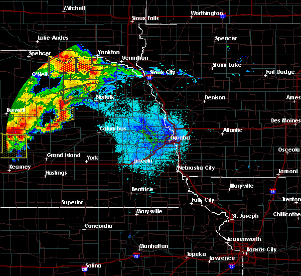 At 937 pm cdt, a severe thunderstorm was located over albion, or 39 miles northwest of columbus, moving east at 35 mph (radar indicated). Hazards include ping pong ball size hail and 60 mph wind gusts. People and animals outdoors will be injured. expect hail damage to roofs, siding, windows and vehicles. expect wind damage to roofs, siding and trees. locations impacted include, albion, petersburg and loretto. dime size hail was reported near petersburg with these storms. But the strongest part of the storm was approaching albion where much larger hail is likely. At 937 pm cdt, a severe thunderstorm was located over albion, or 39 miles northwest of columbus, moving east at 35 mph (radar indicated). Hazards include ping pong ball size hail and 60 mph wind gusts. People and animals outdoors will be injured. expect hail damage to roofs, siding, windows and vehicles. expect wind damage to roofs, siding and trees. locations impacted include, albion, petersburg and loretto. dime size hail was reported near petersburg with these storms. But the strongest part of the storm was approaching albion where much larger hail is likely.
|
| 7/17/2015 9:27 PM CDT |
 At 927 pm cdt, a severe thunderstorm was located near albion, or 41 miles southwest of norfolk, moving east at 30 mph (radar indicated). Hazards include ping pong ball size hail and 60 mph wind gusts. People and animals outdoors will be injured. expect hail damage to roofs, siding, windows and vehicles. Expect wind damage to roofs, siding and trees. At 927 pm cdt, a severe thunderstorm was located near albion, or 41 miles southwest of norfolk, moving east at 30 mph (radar indicated). Hazards include ping pong ball size hail and 60 mph wind gusts. People and animals outdoors will be injured. expect hail damage to roofs, siding, windows and vehicles. Expect wind damage to roofs, siding and trees.
|
| 7/11/2015 2:52 AM CDT |
 The severe thunderstorm warning for southeastern antelope, northeastern boone and madison counties will expire at 300 am cdt, the storm which prompted the warning has weakened below severe limits, and no longer poses an immediate threat to life or property. therefore the warning will be allowed to expire. however small. The severe thunderstorm warning for southeastern antelope, northeastern boone and madison counties will expire at 300 am cdt, the storm which prompted the warning has weakened below severe limits, and no longer poses an immediate threat to life or property. therefore the warning will be allowed to expire. however small.
|
| 7/11/2015 2:41 AM CDT |
 At 240 am cdt, a severe thunderstorm was located 7 miles northwest of newman grove, or 25 miles southwest of norfolk, moving east at 30 mph (radar indicated). Hazards include quarter size hail. Damage to vehicles is expected. locations impacted include, norfolk, madison, battle creek, newman grove, elgin, petersburg, oakdale, meadow grove, tilden and loretto. this includes the following highways, highway 275 in nebraska between mile markers 48 and 74. Highway 81 in nebraska between milemarkers 137 and 160. At 240 am cdt, a severe thunderstorm was located 7 miles northwest of newman grove, or 25 miles southwest of norfolk, moving east at 30 mph (radar indicated). Hazards include quarter size hail. Damage to vehicles is expected. locations impacted include, norfolk, madison, battle creek, newman grove, elgin, petersburg, oakdale, meadow grove, tilden and loretto. this includes the following highways, highway 275 in nebraska between mile markers 48 and 74. Highway 81 in nebraska between milemarkers 137 and 160.
|
| 7/11/2015 2:31 AM CDT |
 At 230 am cdt, a severe thunderstorm was located 9 miles northwest of newman grove, or 27 miles southwest of norfolk, moving east at 30 mph (radar indicated). Hazards include 60 mph wind gusts and quarter size hail. Hail damage to vehicles is expected. expect wind damage to roofs, siding and trees. locations impacted include, norfolk, madison, battle creek, newman grove, elgin, petersburg, oakdale, meadow grove, tilden and loretto. this includes the following highways, highway 275 in nebraska between mile markers 48 and 74. Highway 81 in nebraska between milemarkers 137 and 160. At 230 am cdt, a severe thunderstorm was located 9 miles northwest of newman grove, or 27 miles southwest of norfolk, moving east at 30 mph (radar indicated). Hazards include 60 mph wind gusts and quarter size hail. Hail damage to vehicles is expected. expect wind damage to roofs, siding and trees. locations impacted include, norfolk, madison, battle creek, newman grove, elgin, petersburg, oakdale, meadow grove, tilden and loretto. this includes the following highways, highway 275 in nebraska between mile markers 48 and 74. Highway 81 in nebraska between milemarkers 137 and 160.
|
| 7/11/2015 2:14 AM CDT |
 At 213 am cdt, a severe thunderstorm was located 7 miles northeast of petersburg, or 28 miles west of norfolk, moving east at 50 mph (radar indicated). Hazards include 60 mph wind gusts and quarter size hail. Hail damage to vehicles is expected. Expect wind damage to roofs, siding and trees. At 213 am cdt, a severe thunderstorm was located 7 miles northeast of petersburg, or 28 miles west of norfolk, moving east at 50 mph (radar indicated). Hazards include 60 mph wind gusts and quarter size hail. Hail damage to vehicles is expected. Expect wind damage to roofs, siding and trees.
|
| 6/10/2015 7:24 PM CDT |
 A severe thunderstorm warning remains in effect until 745 pm cdt for antelope and northern boone counties. at 723 pm cdt. severe thunderstorms were located along a line extending from 9 miles east of orchard to near petersburg. moving northeast at 40 mph. hazard. 60 mph wind gusts and penny size hail. A severe thunderstorm warning remains in effect until 745 pm cdt for antelope and northern boone counties. at 723 pm cdt. severe thunderstorms were located along a line extending from 9 miles east of orchard to near petersburg. moving northeast at 40 mph. hazard. 60 mph wind gusts and penny size hail.
|
| 6/10/2015 7:12 PM CDT |
 At 712 pm cdt, severe thunderstorms were located along a line extending from near orchard to petersburg, moving northeast at 50 mph (radar indicated). Hazards include 60 mph wind gusts and penny size hail. Expect damage to roofs. siding and trees. locations impacted include, neligh, elgin, clearwater, orchard, petersburg, oakdale, tilden, brunswick and royal. this includes the following highways, highway 275 in nebraska between mile markers 25 and 53. Highway 20 in nebraska between mile markers 329 and 352. At 712 pm cdt, severe thunderstorms were located along a line extending from near orchard to petersburg, moving northeast at 50 mph (radar indicated). Hazards include 60 mph wind gusts and penny size hail. Expect damage to roofs. siding and trees. locations impacted include, neligh, elgin, clearwater, orchard, petersburg, oakdale, tilden, brunswick and royal. this includes the following highways, highway 275 in nebraska between mile markers 25 and 53. Highway 20 in nebraska between mile markers 329 and 352.
|
| 6/10/2015 7:02 PM CDT |
 At 701 pm cdt, a severe thunderstorm was located 8 miles south of knievels corner, or 36 miles southeast of oneill, moving northeast at 45 mph. this storm produced wind damage in wheeler county (radar indicated). Hazards include 60 mph wind gusts and penny size hail. Expect damage to roofs. Siding and trees. At 701 pm cdt, a severe thunderstorm was located 8 miles south of knievels corner, or 36 miles southeast of oneill, moving northeast at 45 mph. this storm produced wind damage in wheeler county (radar indicated). Hazards include 60 mph wind gusts and penny size hail. Expect damage to roofs. Siding and trees.
|
| 6/10/2015 7:01 PM CDT | Tree damage reporte in wheeler county NE, 11.5 miles E of Petersburg, NE |
| 7/31/2014 5:45 PM CDT | Quarter sized hail reported 0.2 miles N of Petersburg, NE |
| 6/16/2014 9:34 PM CDT | Golf Ball sized hail reported 4.1 miles SE of Petersburg, NE, hail coverning the ground. ranging from quarter to golf ball size. |
| 4/14/2012 12:36 PM CDT | Tea Cup sized hail reported 9.3 miles W of Petersburg, NE |
| 1/1/0001 12:00 AM | Half Dollar sized hail reported 0.2 miles N of Petersburg, NE |
| 1/1/0001 12:00 AM | Wind gust strong enough to blow a 200 lb tank across a gas station parking lo in boone county NE, 0.2 miles N of Petersburg, NE |
| 1/1/0001 12:00 AM | Golf Ball sized hail reported 13.8 miles WNW of Petersburg, NE |
Hail Maps for Petersburg, NE
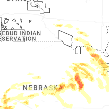


Connect with Interactive Hail Maps