

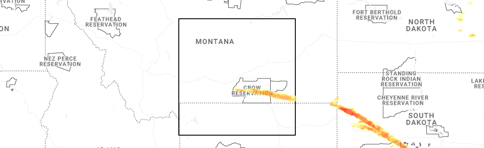
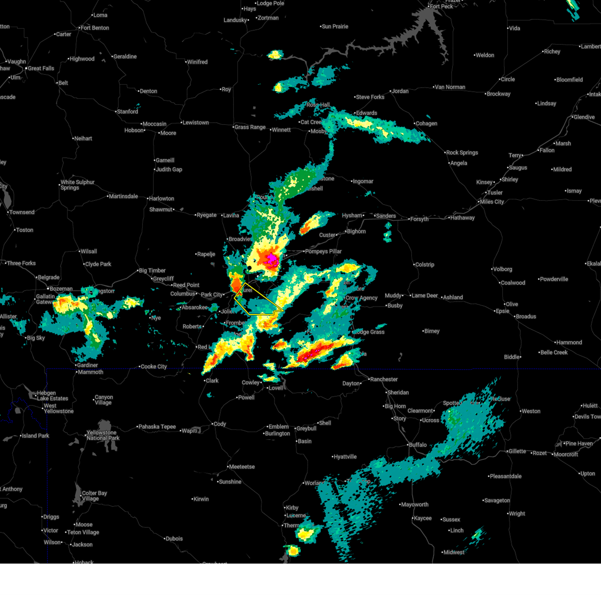
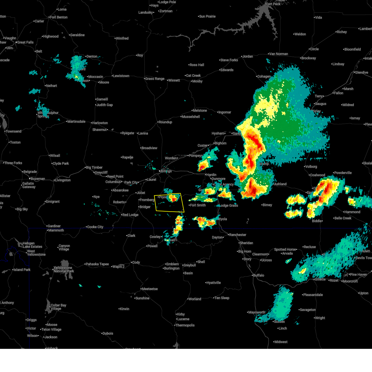
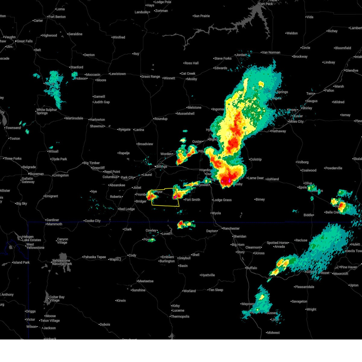
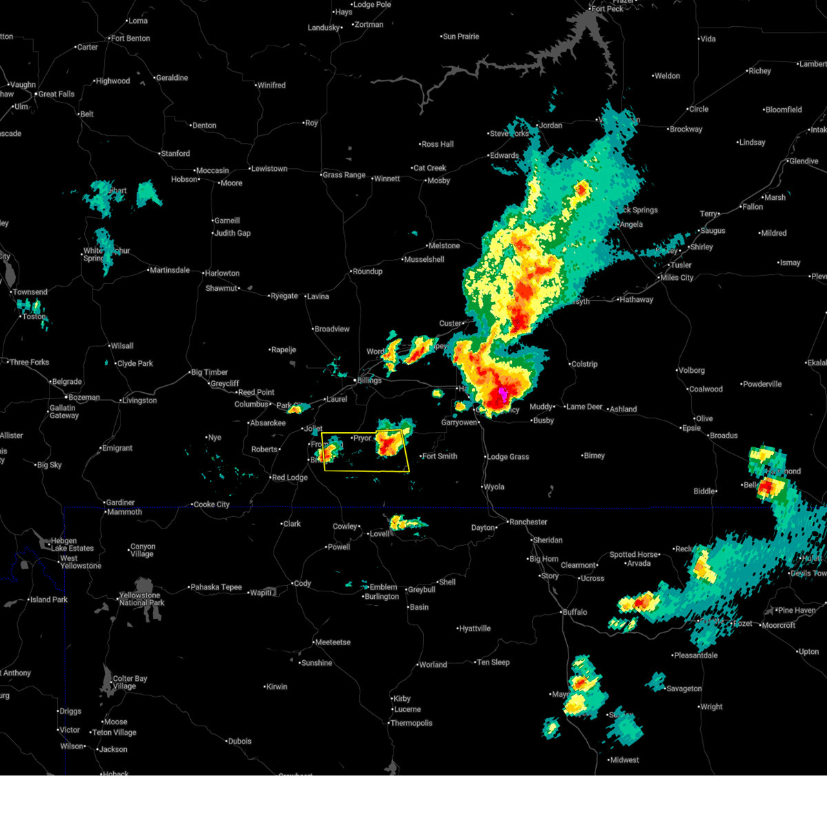
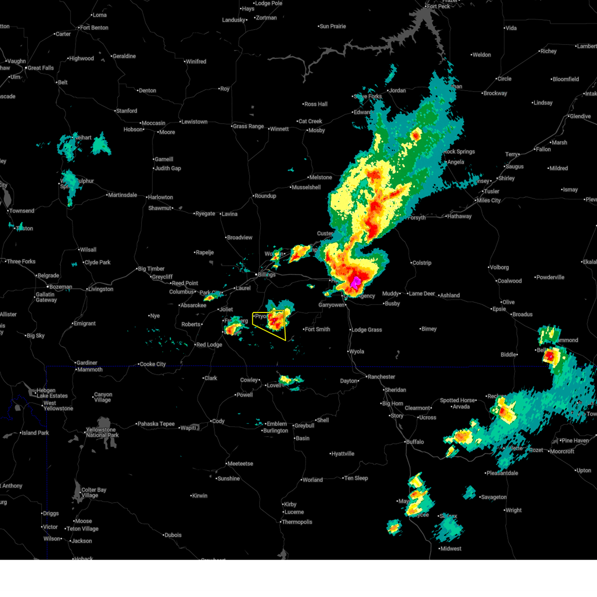
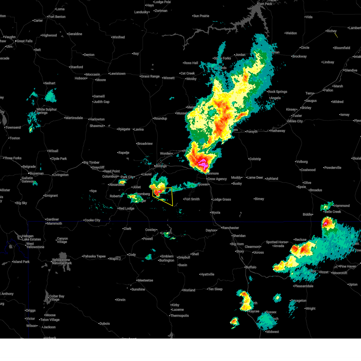
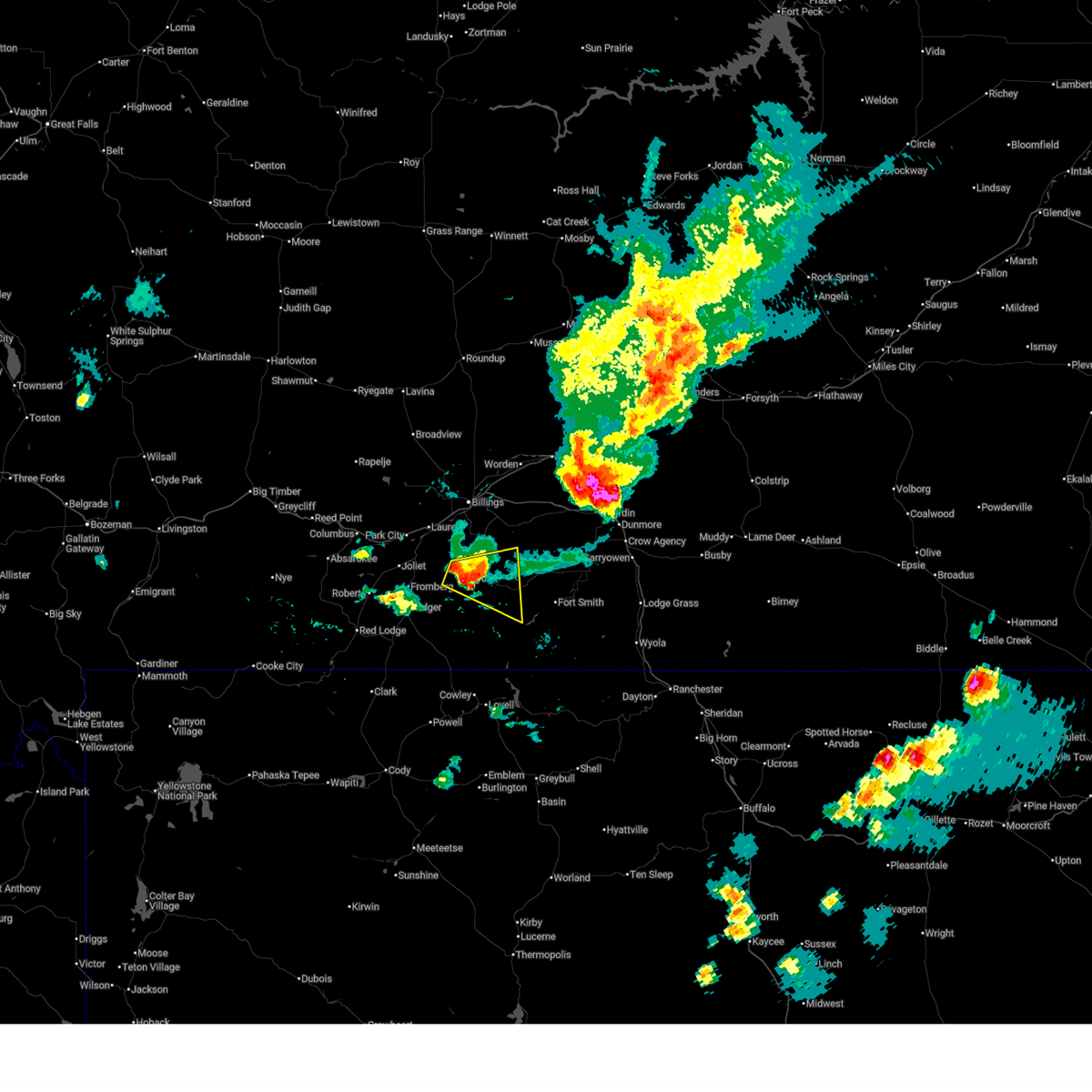
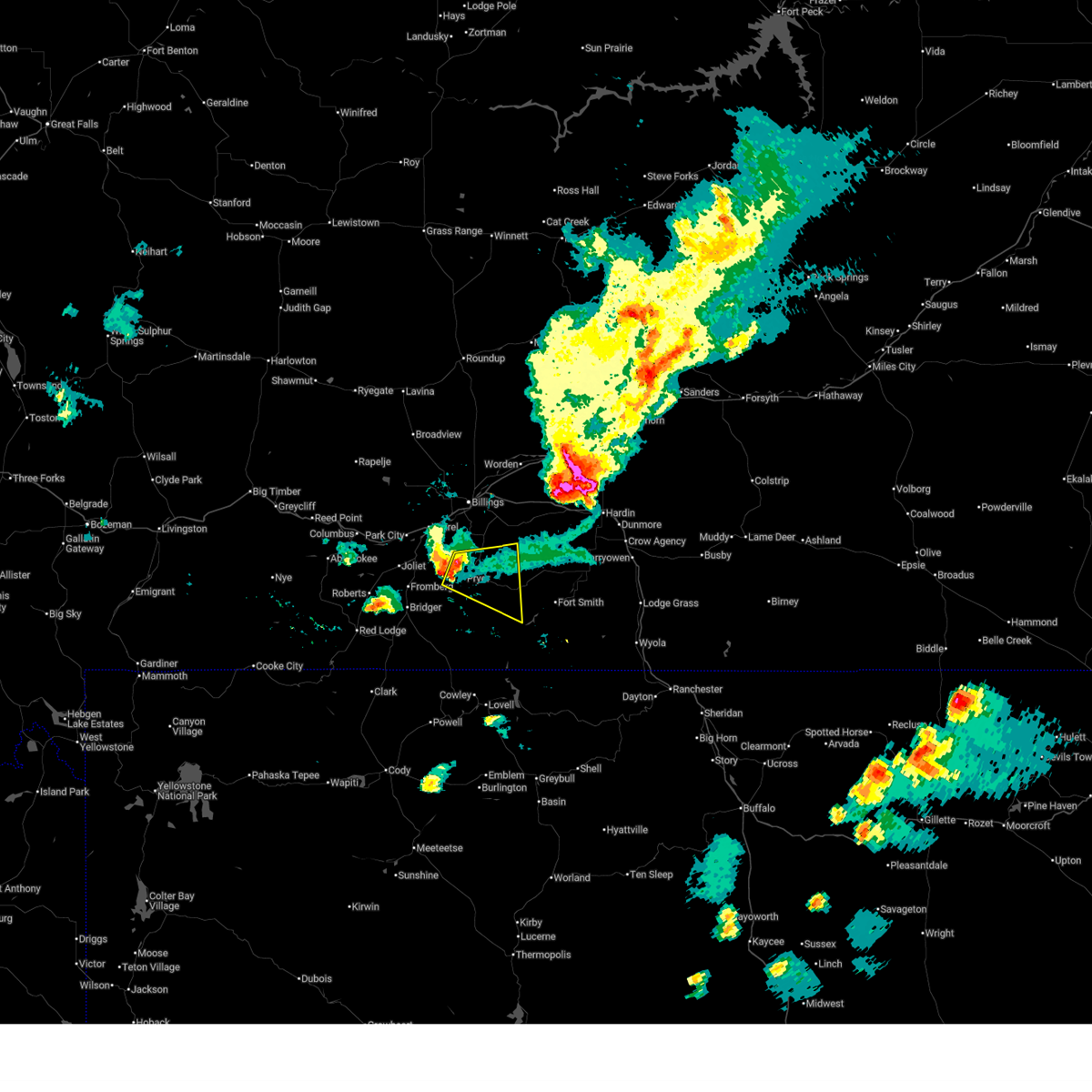
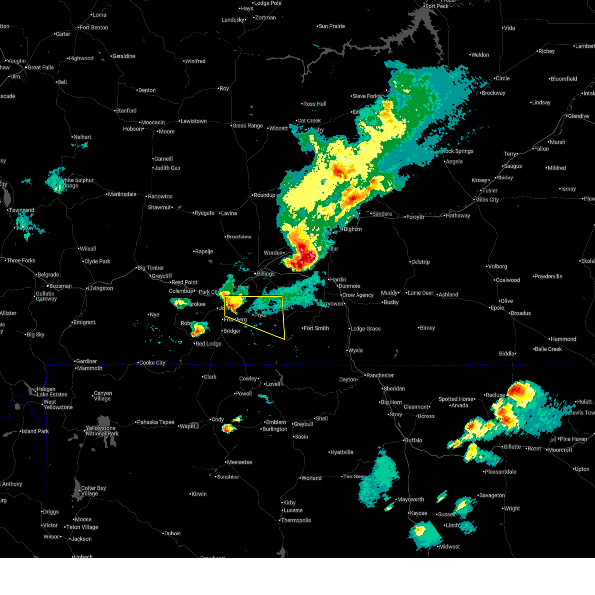
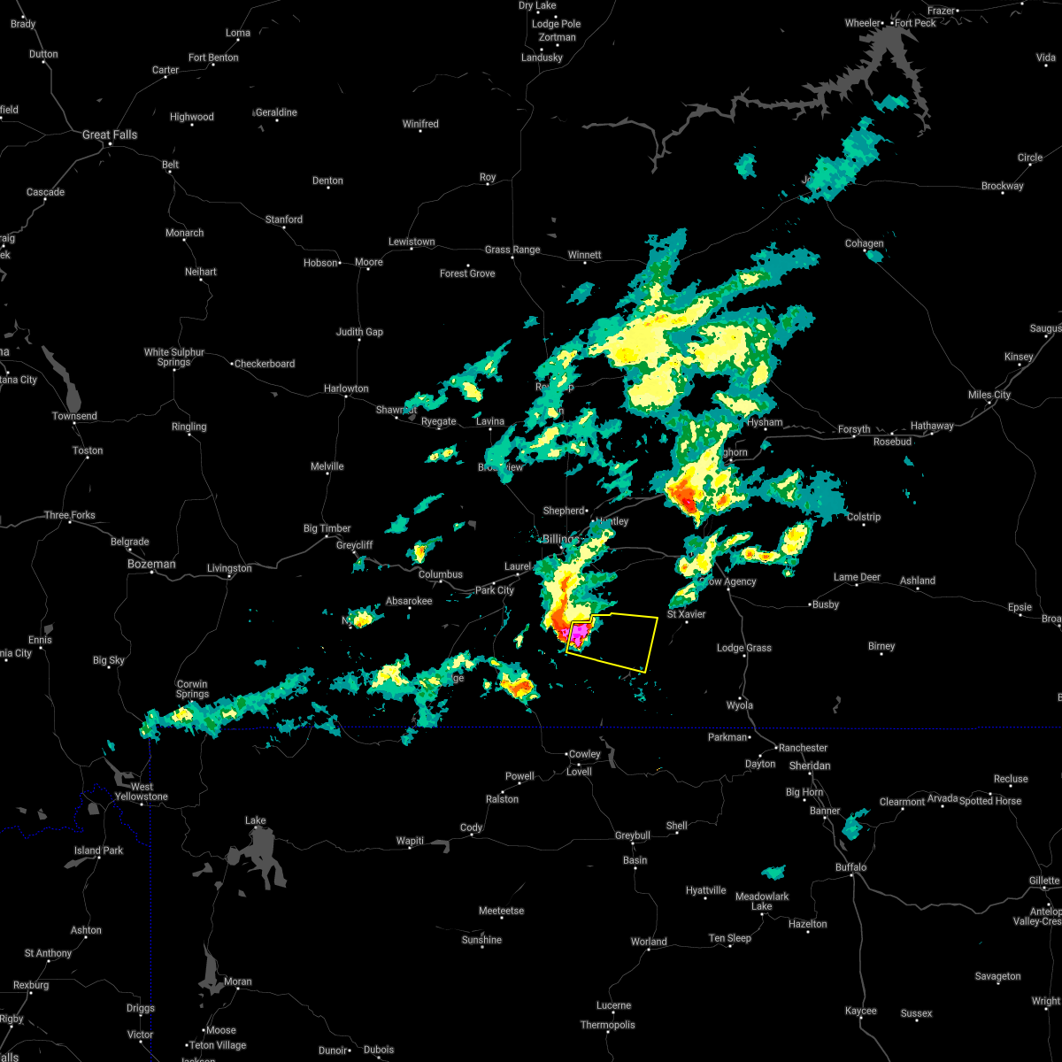
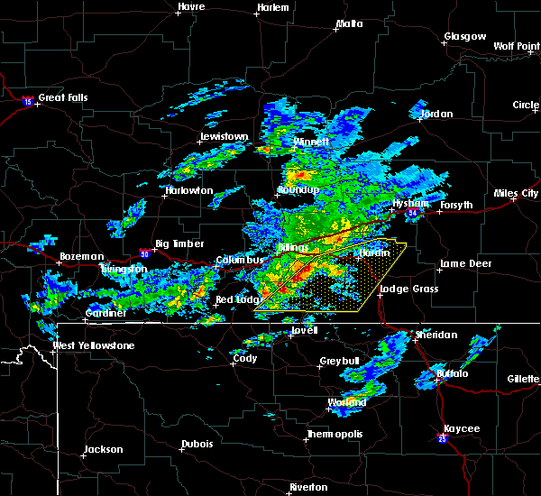
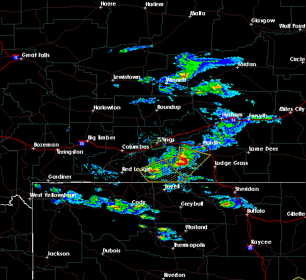
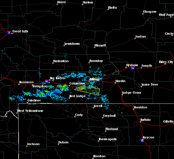
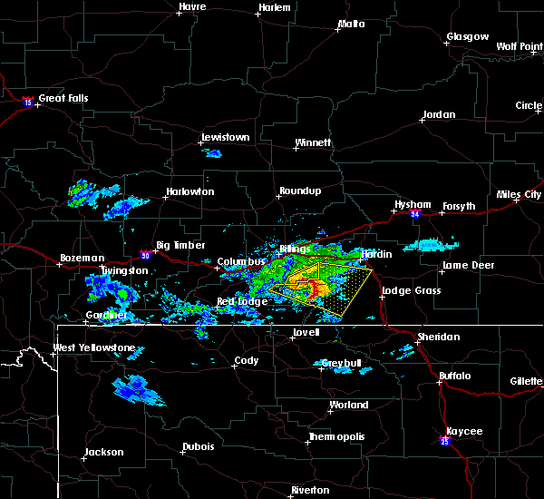
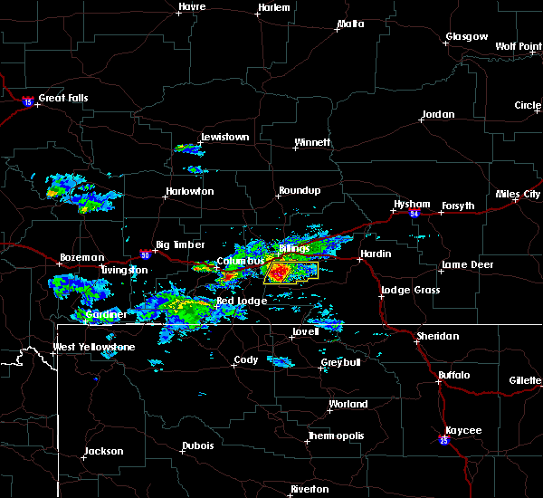
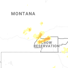
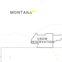
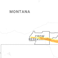
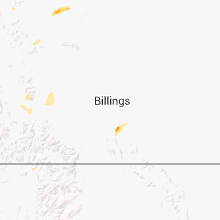
Hail Map for Pryor, MT
The Pryor, MT area has had 5 reports of on-the-ground hail by trained spotters, and has been under severe weather warnings 2 times during the past 12 months. Doppler radar has detected hail at or near Pryor, MT on 46 occasions, including 5 occasions during the past year.
| Name: | Pryor, MT |
| Where Located: | 26.3 miles S of Billings, MT |
| Map: | Google Map for Pryor, MT |
| Population: | 618 |
| Housing Units: | 198 |
| More Info: | Search Google for Pryor, MT |
3
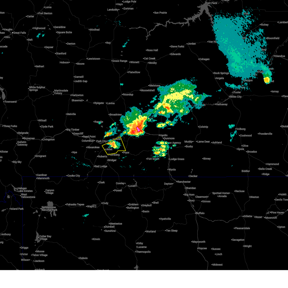
The Top Recent Hail Date for Pryor, MT is Saturday, June 28, 2025 (6th out of 46)
Hail and Wind Damage Spotted near Pryor, MT
| Date / Time | Report Details |
|---|---|
| 7/28/2025 11:13 PM MDT |
 the severe thunderstorm warning has been cancelled and is no longer in effect the severe thunderstorm warning has been cancelled and is no longer in effect
|
| 7/28/2025 10:54 PM MDT |
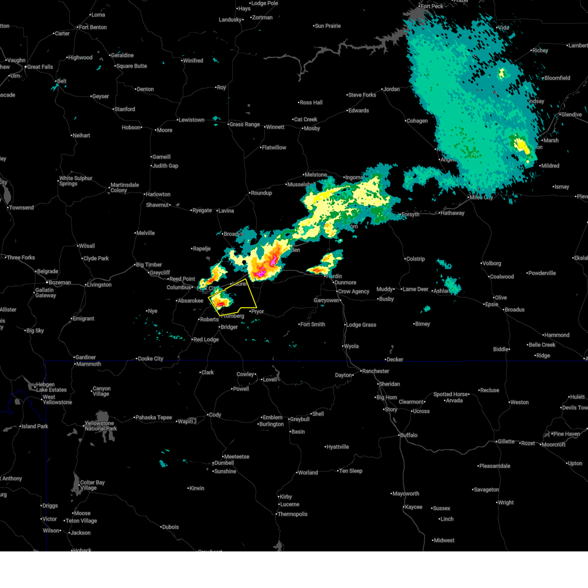 Svrbyz the national weather service in billings has issued a * severe thunderstorm warning for, north central carbon county in south central montana, southwestern yellowstone county in south central montana, * until 1145 pm mdt. * at 1054 pm mdt, a severe thunderstorm was located near joliet, or 20 miles southeast of columbus, moving east at 25 mph (radar indicated). Hazards include half dollar size hail. damage to vehicles is expected Svrbyz the national weather service in billings has issued a * severe thunderstorm warning for, north central carbon county in south central montana, southwestern yellowstone county in south central montana, * until 1145 pm mdt. * at 1054 pm mdt, a severe thunderstorm was located near joliet, or 20 miles southeast of columbus, moving east at 25 mph (radar indicated). Hazards include half dollar size hail. damage to vehicles is expected
|
| 6/16/2025 5:43 PM MDT |
 The storm which prompted the warning has weakened below severe limits, and no longer poses an immediate threat to life or property. therefore, the warning will be allowed to expire. The storm which prompted the warning has weakened below severe limits, and no longer poses an immediate threat to life or property. therefore, the warning will be allowed to expire.
|
| 6/16/2025 5:15 PM MDT |
 Svrbyz the national weather service in billings has issued a * severe thunderstorm warning for, southwestern yellowstone county in south central montana, * until 545 pm mdt. * at 515 pm mdt, a severe thunderstorm was located near laurel, or 13 miles southwest of billings, moving southeast at 35 mph (public reported). Hazards include quarter size hail. damage to vehicles is expected Svrbyz the national weather service in billings has issued a * severe thunderstorm warning for, southwestern yellowstone county in south central montana, * until 545 pm mdt. * at 515 pm mdt, a severe thunderstorm was located near laurel, or 13 miles southwest of billings, moving southeast at 35 mph (public reported). Hazards include quarter size hail. damage to vehicles is expected
|
| 6/13/2025 8:34 PM MDT |
 the severe thunderstorm warning has been cancelled and is no longer in effect the severe thunderstorm warning has been cancelled and is no longer in effect
|
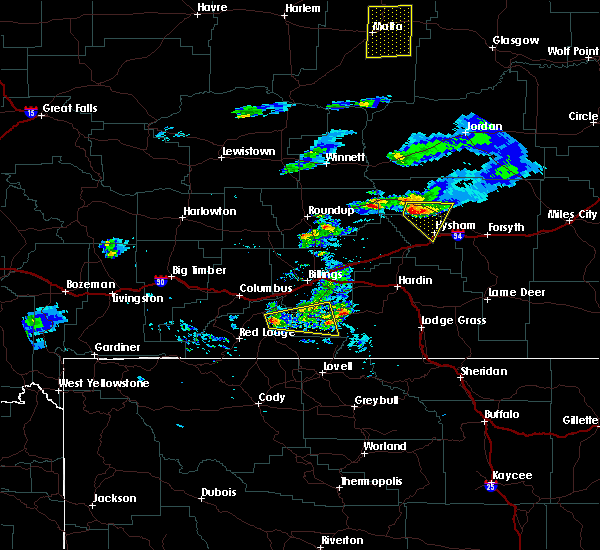
| 6/13/2025 8:08 PM MDT |
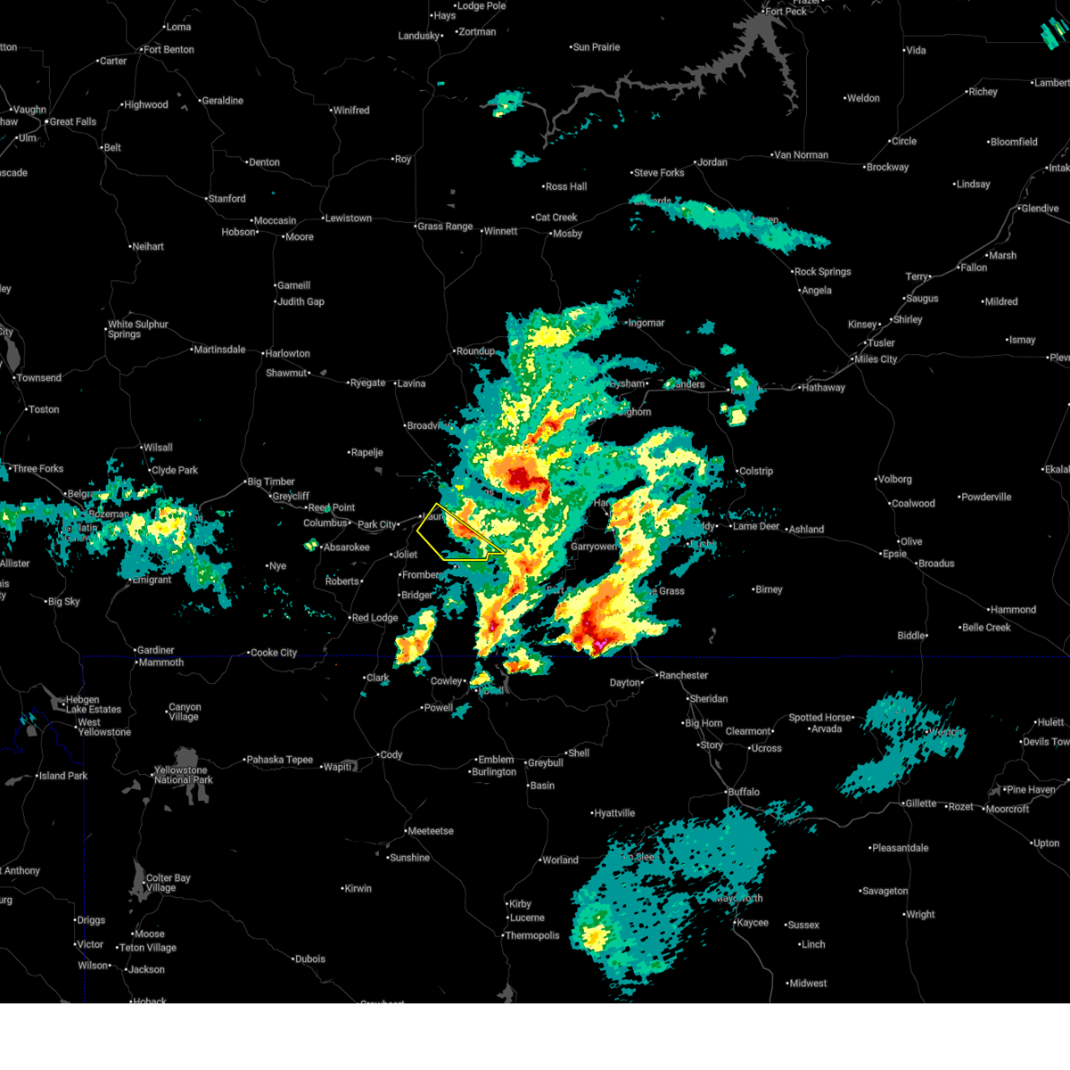
 At 808 pm mdt, a severe thunderstorm was located 6 miles southeast of pryor, or 31 miles south of billings, moving east at 15 mph (radar indicated). Hazards include 60 mph wind gusts and quarter size hail. Hail damage to vehicles is expected. expect wind damage to roofs, siding, and trees. Locations impacted include, pryor, bighorn lake and crow indian reservation. At 808 pm mdt, a severe thunderstorm was located 6 miles southeast of pryor, or 31 miles south of billings, moving east at 15 mph (radar indicated). Hazards include 60 mph wind gusts and quarter size hail. Hail damage to vehicles is expected. expect wind damage to roofs, siding, and trees. Locations impacted include, pryor, bighorn lake and crow indian reservation.
|
| 6/13/2025 8:08 PM MDT |
 the severe thunderstorm warning has been cancelled and is no longer in effect the severe thunderstorm warning has been cancelled and is no longer in effect
|
| 6/13/2025 7:44 PM MDT |
 Svrbyz the national weather service in billings has issued a * severe thunderstorm warning for, southwestern big horn county in south central montana, central carbon county in south central montana, * until 845 pm mdt. * at 744 pm mdt, a severe thunderstorm was located 9 miles southwest of pryor, or 30 miles east of red lodge, moving east at 30 mph (radar indicated). Hazards include ping pong ball size hail and 60 mph wind gusts. People and animals outdoors will be injured. expect hail damage to roofs, siding, windows, and vehicles. Expect wind damage to roofs, siding, and trees. Svrbyz the national weather service in billings has issued a * severe thunderstorm warning for, southwestern big horn county in south central montana, central carbon county in south central montana, * until 845 pm mdt. * at 744 pm mdt, a severe thunderstorm was located 9 miles southwest of pryor, or 30 miles east of red lodge, moving east at 30 mph (radar indicated). Hazards include ping pong ball size hail and 60 mph wind gusts. People and animals outdoors will be injured. expect hail damage to roofs, siding, windows, and vehicles. Expect wind damage to roofs, siding, and trees.
|
| 6/13/2025 7:36 PM MDT |
 The storm which prompted the warning has weakened below severe limits, and no longer poses an immediate threat to life or property. therefore, the warning has been allowed to expire. a severe thunderstorm watch remains in effect until 900 pm mdt for a portion of south central montana. The storm which prompted the warning has weakened below severe limits, and no longer poses an immediate threat to life or property. therefore, the warning has been allowed to expire. a severe thunderstorm watch remains in effect until 900 pm mdt for a portion of south central montana.
|
| 6/13/2025 7:20 PM MDT |
 the severe thunderstorm warning has been cancelled and is no longer in effect the severe thunderstorm warning has been cancelled and is no longer in effect
|
| 6/13/2025 7:20 PM MDT |
 At 720 pm mdt, a severe thunderstorm was located 10 miles east of pryor, or 30 miles south of billings, moving east at 40 mph (radar indicated). Hazards include golf ball size hail and 60 mph wind gusts. People and animals outdoors will be injured. expect hail damage to roofs, siding, windows, and vehicles. expect wind damage to roofs, siding, and trees. Locations impacted include, pryor and crow indian reservation. At 720 pm mdt, a severe thunderstorm was located 10 miles east of pryor, or 30 miles south of billings, moving east at 40 mph (radar indicated). Hazards include golf ball size hail and 60 mph wind gusts. People and animals outdoors will be injured. expect hail damage to roofs, siding, windows, and vehicles. expect wind damage to roofs, siding, and trees. Locations impacted include, pryor and crow indian reservation.
|
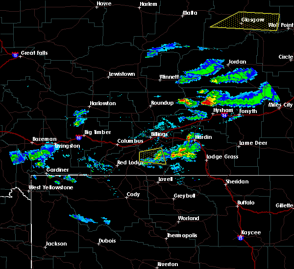
| 6/13/2025 7:15 PM MDT | Hen Egg sized hail reported 1.8 miles S of Pryor, MT |
| 6/13/2025 7:14 PM MDT |
 At 714 pm mdt, a severe thunderstorm was located 6 miles east of pryor, or 28 miles south of billings, moving east at 40 mph (public reported). Hazards include tennis ball size hail and 60 mph wind gusts. People and animals outdoors will be injured. expect hail damage to roofs, siding, windows, and vehicles. expect wind damage to roofs, siding, and trees. locations impacted include, pryor and crow indian reservation. The public reported tennis ball size hail in pryor at 708 pm. At 714 pm mdt, a severe thunderstorm was located 6 miles east of pryor, or 28 miles south of billings, moving east at 40 mph (public reported). Hazards include tennis ball size hail and 60 mph wind gusts. People and animals outdoors will be injured. expect hail damage to roofs, siding, windows, and vehicles. expect wind damage to roofs, siding, and trees. locations impacted include, pryor and crow indian reservation. The public reported tennis ball size hail in pryor at 708 pm.
|
| 6/13/2025 7:11 PM MDT | Tennis Ball sized hail reported 2.1 miles SSW of Pryor, MT, report from mping: tennis ball (2.50 in.). |
| 6/13/2025 7:10 PM MDT | Baseball sized hail reported 1.8 miles S of Pryor, MT |
| 6/13/2025 7:09 PM MDT |
 the severe thunderstorm warning has been cancelled and is no longer in effect the severe thunderstorm warning has been cancelled and is no longer in effect
|
| 6/13/2025 7:09 PM MDT |
 At 709 pm mdt, a severe thunderstorm was located near pryor, or 26 miles south of billings, moving east at 40 mph (radar indicated). Hazards include ping pong ball size hail and 60 mph wind gusts. People and animals outdoors will be injured. expect hail damage to roofs, siding, windows, and vehicles. expect wind damage to roofs, siding, and trees. Locations impacted include, pryor and crow indian reservation. At 709 pm mdt, a severe thunderstorm was located near pryor, or 26 miles south of billings, moving east at 40 mph (radar indicated). Hazards include ping pong ball size hail and 60 mph wind gusts. People and animals outdoors will be injured. expect hail damage to roofs, siding, windows, and vehicles. expect wind damage to roofs, siding, and trees. Locations impacted include, pryor and crow indian reservation.
|
| 6/13/2025 7:08 PM MDT | Tennis Ball sized hail reported 1.1 miles S of Pryor, MT |
| 6/13/2025 6:46 PM MDT |
 Svrbyz the national weather service in billings has issued a * severe thunderstorm warning for, southwestern big horn county in south central montana, north central carbon county in south central montana, southwestern yellowstone county in south central montana, * until 730 pm mdt. * at 646 pm mdt, a severe thunderstorm was located 12 miles south of laurel, or 22 miles southwest of billings, moving east at 40 mph (radar indicated). Hazards include ping pong ball size hail and 60 mph wind gusts. People and animals outdoors will be injured. expect hail damage to roofs, siding, windows, and vehicles. Expect wind damage to roofs, siding, and trees. Svrbyz the national weather service in billings has issued a * severe thunderstorm warning for, southwestern big horn county in south central montana, north central carbon county in south central montana, southwestern yellowstone county in south central montana, * until 730 pm mdt. * at 646 pm mdt, a severe thunderstorm was located 12 miles south of laurel, or 22 miles southwest of billings, moving east at 40 mph (radar indicated). Hazards include ping pong ball size hail and 60 mph wind gusts. People and animals outdoors will be injured. expect hail damage to roofs, siding, windows, and vehicles. Expect wind damage to roofs, siding, and trees.
|
| 9/7/2022 4:28 PM MDT |
 At 427 pm mdt, severe thunderstorms were located along a line extending from 10 miles northeast of ryegate to 9 miles northwest of pryor, moving northeast at 35 mph (radar indicated. gusts to 58 mph have been reported along this line). Hazards include 60 mph wind gusts. Expect damage to roofs, siding, and trees. severe thunderstorms will be near, billings around 435 pm mdt roundup around 510 pm mdt. other locations impacted by these severe thunderstorms include laurel, pompeys pillar, acton, musselshell, lavina, klein, broadview and comanche. this replaces the warning previously in effect for this area. hail threat, radar indicated max hail size, <. 75 in wind threat, radar indicated max wind gust, 60 mph. At 427 pm mdt, severe thunderstorms were located along a line extending from 10 miles northeast of ryegate to 9 miles northwest of pryor, moving northeast at 35 mph (radar indicated. gusts to 58 mph have been reported along this line). Hazards include 60 mph wind gusts. Expect damage to roofs, siding, and trees. severe thunderstorms will be near, billings around 435 pm mdt roundup around 510 pm mdt. other locations impacted by these severe thunderstorms include laurel, pompeys pillar, acton, musselshell, lavina, klein, broadview and comanche. this replaces the warning previously in effect for this area. hail threat, radar indicated max hail size, <. 75 in wind threat, radar indicated max wind gust, 60 mph.
|
| 9/7/2022 4:17 PM MDT |
 At 416 pm mdt, a severe thunderstorm was located 9 miles south of laurel, or 21 miles southwest of billings, moving east at 45 mph (radar indicated. a gust to 58 mph was reported near molt with this activity). Hazards include 60 mph wind gusts. Expect damage to roofs, siding, and trees. locations impacted include, laurel, joliet, fromberg, pryor, edgar, park city, rockvale, boyd and silesia. hail threat, radar indicated max hail size, <. 75 in wind threat, observed max wind gust, 60 mph. At 416 pm mdt, a severe thunderstorm was located 9 miles south of laurel, or 21 miles southwest of billings, moving east at 45 mph (radar indicated. a gust to 58 mph was reported near molt with this activity). Hazards include 60 mph wind gusts. Expect damage to roofs, siding, and trees. locations impacted include, laurel, joliet, fromberg, pryor, edgar, park city, rockvale, boyd and silesia. hail threat, radar indicated max hail size, <. 75 in wind threat, observed max wind gust, 60 mph.
|
| 9/7/2022 4:02 PM MDT |
 At 401 pm mdt, a severe thunderstorm was located over joliet, or 16 miles southeast of columbus, moving east at 40 mph (radar indicated). Hazards include 60 mph wind gusts. expect damage to roofs, siding, and trees At 401 pm mdt, a severe thunderstorm was located over joliet, or 16 miles southeast of columbus, moving east at 40 mph (radar indicated). Hazards include 60 mph wind gusts. expect damage to roofs, siding, and trees
|
| 7/14/2022 4:27 PM MDT |
 At 427 pm mdt, a severe thunderstorm was located near pryor, or 31 miles south of billings, moving east at 35 mph (radar indicated). Hazards include 60 mph wind gusts and quarter size hail. Hail damage to vehicles is expected. Expect wind damage to roofs, siding, and trees. At 427 pm mdt, a severe thunderstorm was located near pryor, or 31 miles south of billings, moving east at 35 mph (radar indicated). Hazards include 60 mph wind gusts and quarter size hail. Hail damage to vehicles is expected. Expect wind damage to roofs, siding, and trees.
|
| 7/14/2022 4:04 PM MDT |
 At 404 pm mdt, a severe thunderstorm was located 8 miles east of fromberg, or 27 miles northeast of red lodge, moving east at 35 mph (radar indicated). Hazards include 60 mph wind gusts and quarter size hail. Hail damage to vehicles is expected. expect wind damage to roofs, siding, and trees. locations impacted include, bridger, fromberg, pryor and edgar. hail threat, radar indicated max hail size, 1. 00 in wind threat, radar indicated max wind gust, 60 mph. At 404 pm mdt, a severe thunderstorm was located 8 miles east of fromberg, or 27 miles northeast of red lodge, moving east at 35 mph (radar indicated). Hazards include 60 mph wind gusts and quarter size hail. Hail damage to vehicles is expected. expect wind damage to roofs, siding, and trees. locations impacted include, bridger, fromberg, pryor and edgar. hail threat, radar indicated max hail size, 1. 00 in wind threat, radar indicated max wind gust, 60 mph.
|
| 7/14/2022 3:43 PM MDT |
 At 342 pm mdt, a severe thunderstorm was located near joliet, or 19 miles southeast of columbus, moving east at 35 mph (radar indicated). Hazards include 60 mph wind gusts and quarter size hail. Hail damage to vehicles is expected. Expect wind damage to roofs, siding, and trees. At 342 pm mdt, a severe thunderstorm was located near joliet, or 19 miles southeast of columbus, moving east at 35 mph (radar indicated). Hazards include 60 mph wind gusts and quarter size hail. Hail damage to vehicles is expected. Expect wind damage to roofs, siding, and trees.
|
| 7/3/2022 6:09 PM MDT |
 At 608 pm mdt, a severe thunderstorm was located near billings, moving east at 30 mph. an associated gust front is out ahead of it, moving east and southeast at 40 mph (radar indicated). Hazards include 60 mph wind gusts. Expect damage to roofs, siding, and trees. locations impacted include, billings, lockwood, billings heights, billings west end and huntley. hail threat, radar indicated max hail size, <. 75 in wind threat, radar indicated max wind gust, 60 mph. At 608 pm mdt, a severe thunderstorm was located near billings, moving east at 30 mph. an associated gust front is out ahead of it, moving east and southeast at 40 mph (radar indicated). Hazards include 60 mph wind gusts. Expect damage to roofs, siding, and trees. locations impacted include, billings, lockwood, billings heights, billings west end and huntley. hail threat, radar indicated max hail size, <. 75 in wind threat, radar indicated max wind gust, 60 mph.
|
| 7/3/2022 5:37 PM MDT |
 At 536 pm mdt, a severe thunderstorm was located near laurel, or 13 miles west of billings, moving southeast at 30 mph (radar indicated). Hazards include 70 mph wind gusts. Expect considerable tree damage. Damage is likely to mobile homes, roofs, and outbuildings. At 536 pm mdt, a severe thunderstorm was located near laurel, or 13 miles west of billings, moving southeast at 30 mph (radar indicated). Hazards include 70 mph wind gusts. Expect considerable tree damage. Damage is likely to mobile homes, roofs, and outbuildings.
|
| 7/1/2022 9:49 PM MDT |
 At 942 pm mdt, a severe thunderstorm was located 11 miles east of laurel, or 12 miles south of billings, moving southeast at 25 mph (radar indicated. at 918 pm mdt quarter sized hail (1 inch in diameter) was reported in laurel). Hazards include 60 mph wind gusts and quarter size hail. Hail damage to vehicles is expected. expect wind damage to roofs, siding, and trees. locations impacted include, billings and lockwood. hail threat, radar indicated max hail size, 1. 00 in wind threat, radar indicated max wind gust, 60 mph. At 942 pm mdt, a severe thunderstorm was located 11 miles east of laurel, or 12 miles south of billings, moving southeast at 25 mph (radar indicated. at 918 pm mdt quarter sized hail (1 inch in diameter) was reported in laurel). Hazards include 60 mph wind gusts and quarter size hail. Hail damage to vehicles is expected. expect wind damage to roofs, siding, and trees. locations impacted include, billings and lockwood. hail threat, radar indicated max hail size, 1. 00 in wind threat, radar indicated max wind gust, 60 mph.
|
| 7/1/2022 9:13 PM MDT |
 At 913 pm mdt, a severe thunderstorm was located over laurel, or 14 miles southwest of billings, moving southeast at 25 mph (radar indicated). Hazards include 60 mph wind gusts and quarter size hail. Hail damage to vehicles is expected. Expect wind damage to roofs, siding, and trees. At 913 pm mdt, a severe thunderstorm was located over laurel, or 14 miles southwest of billings, moving southeast at 25 mph (radar indicated). Hazards include 60 mph wind gusts and quarter size hail. Hail damage to vehicles is expected. Expect wind damage to roofs, siding, and trees.
|
| 7/7/2021 7:24 PM MDT |
 At 723 pm mdt, severe thunderstorms were located along a line extending from 12 miles southwest of flatwillow to near worden to 8 miles southeast of lockwood to 8 miles south of pryor, moving east at 40 mph (radar indicated. at 710 pm a gust of 73 mph was reported at the billings airport). Hazards include 75 mph wind gusts. Expect considerable tree damage. Damage is likely to mobile homes, roofs, and outbuildings. At 723 pm mdt, severe thunderstorms were located along a line extending from 12 miles southwest of flatwillow to near worden to 8 miles southeast of lockwood to 8 miles south of pryor, moving east at 40 mph (radar indicated. at 710 pm a gust of 73 mph was reported at the billings airport). Hazards include 75 mph wind gusts. Expect considerable tree damage. Damage is likely to mobile homes, roofs, and outbuildings.
|
| 7/7/2021 7:17 PM MDT |
 At 715 pm mdt, severe thunderstorms were located along a line extending from 15 miles southwest of flatwillow to 17 miles south of roundup to near lockwood to 6 miles southwest of pryor, moving east at 45 mph (radar indicated. at 710 pm a gust of 73 mph was reported at the billings airport). Hazards include 75 mph wind gusts. Expect considerable tree damage. damage is likely to mobile homes, roofs, and outbuildings. Locations impacted include, billings, roundup, laurel, fromberg, lockwood, huntley, pryor, shepherd, billings heights, worden, billings west end, ballantine, broadview, edgar, silesia, acton, rockvale, klein and comanche. At 715 pm mdt, severe thunderstorms were located along a line extending from 15 miles southwest of flatwillow to 17 miles south of roundup to near lockwood to 6 miles southwest of pryor, moving east at 45 mph (radar indicated. at 710 pm a gust of 73 mph was reported at the billings airport). Hazards include 75 mph wind gusts. Expect considerable tree damage. damage is likely to mobile homes, roofs, and outbuildings. Locations impacted include, billings, roundup, laurel, fromberg, lockwood, huntley, pryor, shepherd, billings heights, worden, billings west end, ballantine, broadview, edgar, silesia, acton, rockvale, klein and comanche.
|
| 7/7/2021 7:01 PM MDT |
 At 700 pm mdt, severe thunderstorms were located along a line extending from 23 miles south of grass range to 19 miles southwest of roundup to near billings west end to fromberg, moving east at 50 mph (radar indicated. 68 mph wind gust reported in molt with this line of severe storms). Hazards include 70 mph wind gusts and penny size hail. Expect considerable tree damage. damage is likely to mobile homes, roofs, and outbuildings. Locations impacted include, billings, roundup, laurel, bridger, joliet, fromberg, lockwood, huntley, pryor, shepherd, billings heights, worden, billings west end, ballantine, broadview, lavina, edgar, molt, silesia and acton. At 700 pm mdt, severe thunderstorms were located along a line extending from 23 miles south of grass range to 19 miles southwest of roundup to near billings west end to fromberg, moving east at 50 mph (radar indicated. 68 mph wind gust reported in molt with this line of severe storms). Hazards include 70 mph wind gusts and penny size hail. Expect considerable tree damage. damage is likely to mobile homes, roofs, and outbuildings. Locations impacted include, billings, roundup, laurel, bridger, joliet, fromberg, lockwood, huntley, pryor, shepherd, billings heights, worden, billings west end, ballantine, broadview, lavina, edgar, molt, silesia and acton.
|
| 7/7/2021 6:35 PM MDT |
 At 634 pm mdt, severe thunderstorms were located along a line extending from 24 miles north of deadmans basin reservoir to 9 miles southeast of ryegate to 10 miles east of columbus to 12 miles north of red lodge, moving east at 50 mph (radar indicated). Hazards include 60 mph wind gusts. penny size hail is possible with the strongest storms along this line. expect damage to roofs, siding, and trees At 634 pm mdt, severe thunderstorms were located along a line extending from 24 miles north of deadmans basin reservoir to 9 miles southeast of ryegate to 10 miles east of columbus to 12 miles north of red lodge, moving east at 50 mph (radar indicated). Hazards include 60 mph wind gusts. penny size hail is possible with the strongest storms along this line. expect damage to roofs, siding, and trees
|
| 5/28/2021 4:51 PM MDT |
 At 450 pm mdt, a severe thunderstorm was located 7 miles east of pryor, or 27 miles south of billings, moving east at 35 mph (radar indicated). Hazards include 60 mph wind gusts and quarter size hail. Hail damage to vehicles is expected. Expect wind damage to roofs, siding, and trees. At 450 pm mdt, a severe thunderstorm was located 7 miles east of pryor, or 27 miles south of billings, moving east at 35 mph (radar indicated). Hazards include 60 mph wind gusts and quarter size hail. Hail damage to vehicles is expected. Expect wind damage to roofs, siding, and trees.
|
| 7/1/2019 6:55 PM MDT |
 The severe thunderstorm warning for west central big horn, central carbon and south central yellowstone counties will expire at 700 pm mdt, the storm which prompted the warning has weakened below severe limits, and no longer poses an immediate threat to life or property. therefore, the warning will be allowed to expire. however small hail and gusty winds are still possible with this thunderstorm. a severe thunderstorm watch remains in effect until midnight mdt for south central montana. The severe thunderstorm warning for west central big horn, central carbon and south central yellowstone counties will expire at 700 pm mdt, the storm which prompted the warning has weakened below severe limits, and no longer poses an immediate threat to life or property. therefore, the warning will be allowed to expire. however small hail and gusty winds are still possible with this thunderstorm. a severe thunderstorm watch remains in effect until midnight mdt for south central montana.
|
| 7/1/2019 6:35 PM MDT |
 At 634 pm mdt, a severe thunderstorm was located near pryor, or 26 miles south of billings, moving east at 35 mph (radar indicated). Hazards include 60 mph wind gusts and quarter size hail. Hail damage to vehicles is expected. expect wind damage to roofs, siding, and trees. Locations impacted include, pryor and crow indian reservation. At 634 pm mdt, a severe thunderstorm was located near pryor, or 26 miles south of billings, moving east at 35 mph (radar indicated). Hazards include 60 mph wind gusts and quarter size hail. Hail damage to vehicles is expected. expect wind damage to roofs, siding, and trees. Locations impacted include, pryor and crow indian reservation.
|
| 7/1/2019 6:15 PM MDT |
 At 614 pm mdt, a severe thunderstorm was located over fromberg, or 23 miles northeast of red lodge, moving east at 35 mph (radar indicated). Hazards include 60 mph wind gusts and quarter size hail. Hail damage to vehicles is expected. Expect wind damage to roofs, siding, and trees. At 614 pm mdt, a severe thunderstorm was located over fromberg, or 23 miles northeast of red lodge, moving east at 35 mph (radar indicated). Hazards include 60 mph wind gusts and quarter size hail. Hail damage to vehicles is expected. Expect wind damage to roofs, siding, and trees.
|
| 7/1/2019 5:42 PM MDT |
 At 542 pm mdt, a severe thunderstorm was located 11 miles west of bridger, or 11 miles northeast of red lodge, moving east at 20 mph (radar indicated). Hazards include 60 mph wind gusts and quarter size hail. Hail damage to vehicles is expected. expect wind damage to roofs, siding, and trees. Locations impacted include, bridger, fromberg, pryor and roberts. At 542 pm mdt, a severe thunderstorm was located 11 miles west of bridger, or 11 miles northeast of red lodge, moving east at 20 mph (radar indicated). Hazards include 60 mph wind gusts and quarter size hail. Hail damage to vehicles is expected. expect wind damage to roofs, siding, and trees. Locations impacted include, bridger, fromberg, pryor and roberts.
|
| 7/1/2019 5:17 PM MDT |
 At 517 pm mdt, a severe thunderstorm was located 11 miles north of red lodge, moving east at 30 mph (radar indicated). Hazards include 60 mph wind gusts and quarter size hail. Hail damage to vehicles is expected. Expect wind damage to roofs, siding, and trees. At 517 pm mdt, a severe thunderstorm was located 11 miles north of red lodge, moving east at 30 mph (radar indicated). Hazards include 60 mph wind gusts and quarter size hail. Hail damage to vehicles is expected. Expect wind damage to roofs, siding, and trees.
|
| 6/25/2019 3:50 PM MDT |
 At 350 pm mdt, a severe thunderstorm was located near pryor, or 21 miles south of billings, moving east at 35 mph (radar indicated). Hazards include 60 mph wind gusts and quarter size hail. Hail damage to vehicles is expected. expect wind damage to roofs, siding, and trees. locations impacted include, pryor, bighorn lake and crow indian reservation. This warning does not include the city of billings. At 350 pm mdt, a severe thunderstorm was located near pryor, or 21 miles south of billings, moving east at 35 mph (radar indicated). Hazards include 60 mph wind gusts and quarter size hail. Hail damage to vehicles is expected. expect wind damage to roofs, siding, and trees. locations impacted include, pryor, bighorn lake and crow indian reservation. This warning does not include the city of billings.
|
| 6/25/2019 3:29 PM MDT |
 At 329 pm mdt, a severe thunderstorm was located 9 miles west of pryor, or 24 miles southwest of billings, moving east at 35 mph (radar indicated). Hazards include 60 mph wind gusts and quarter size hail. Hail damage to vehicles is expected. Expect wind damage to roofs, siding, and trees. At 329 pm mdt, a severe thunderstorm was located 9 miles west of pryor, or 24 miles southwest of billings, moving east at 35 mph (radar indicated). Hazards include 60 mph wind gusts and quarter size hail. Hail damage to vehicles is expected. Expect wind damage to roofs, siding, and trees.
|
| 8/3/2018 4:51 PM MDT |
 At 451 pm mdt, severe thunderstorms were located along a line extending from 17 miles southeast of ballantine to 14 miles south of pryor, moving east at 55 mph (radar indicated). Hazards include 70 mph wind gusts. Expect considerable tree damage. Damage is likely to mobile homes, roofs, and outbuildings. At 451 pm mdt, severe thunderstorms were located along a line extending from 17 miles southeast of ballantine to 14 miles south of pryor, moving east at 55 mph (radar indicated). Hazards include 70 mph wind gusts. Expect considerable tree damage. Damage is likely to mobile homes, roofs, and outbuildings.
|
| 7/27/2018 5:32 PM MDT |
 At 531 pm mdt, a severe thunderstorm was located 15 miles southeast of bridger, or 27 miles northwest of lovell, moving southeast at 40 mph (radar indicated). Hazards include golf ball size hail and 60 mph wind gusts. People and animals outdoors will be injured. expect hail damage to roofs, siding, windows, and vehicles. expect wind damage to roofs, siding, and trees. Locations impacted include, pryor, warren and bighorn lake. At 531 pm mdt, a severe thunderstorm was located 15 miles southeast of bridger, or 27 miles northwest of lovell, moving southeast at 40 mph (radar indicated). Hazards include golf ball size hail and 60 mph wind gusts. People and animals outdoors will be injured. expect hail damage to roofs, siding, windows, and vehicles. expect wind damage to roofs, siding, and trees. Locations impacted include, pryor, warren and bighorn lake.
|
| 7/27/2018 5:12 PM MDT |
 At 512 pm mdt, a severe thunderstorm was located near bridger, or 22 miles northeast of red lodge, moving southeast at 40 mph (radar indicated). Hazards include ping pong ball size hail and 60 mph wind gusts. People and animals outdoors will be injured. expect hail damage to roofs, siding, windows, and vehicles. Expect wind damage to roofs, siding, and trees. At 512 pm mdt, a severe thunderstorm was located near bridger, or 22 miles northeast of red lodge, moving southeast at 40 mph (radar indicated). Hazards include ping pong ball size hail and 60 mph wind gusts. People and animals outdoors will be injured. expect hail damage to roofs, siding, windows, and vehicles. Expect wind damage to roofs, siding, and trees.
|
| 7/2/2018 7:55 PM MDT |
 At 753 pm mdt, a severe thunderstorm was located over laurel, or 16 miles southwest of billings, moving east at 35 mph (radar indicated). Hazards include ping pong ball size hail and 60 mph wind gusts. People and animals outdoors will be injured. expect hail damage to roofs, siding, windows, and vehicles. expect wind damage to roofs, siding, and trees. this severe thunderstorm will be near, billings around 810 pm mdt. lockwood around 825 pm mdt. other locations impacted by this severe thunderstorm include park city, rockvale, silesia and crow indian reservation. this storm has a history of producing quarter size hail. This replaces the previous warning for yellowstone, carbon and stillwater counties. At 753 pm mdt, a severe thunderstorm was located over laurel, or 16 miles southwest of billings, moving east at 35 mph (radar indicated). Hazards include ping pong ball size hail and 60 mph wind gusts. People and animals outdoors will be injured. expect hail damage to roofs, siding, windows, and vehicles. expect wind damage to roofs, siding, and trees. this severe thunderstorm will be near, billings around 810 pm mdt. lockwood around 825 pm mdt. other locations impacted by this severe thunderstorm include park city, rockvale, silesia and crow indian reservation. this storm has a history of producing quarter size hail. This replaces the previous warning for yellowstone, carbon and stillwater counties.
|
| 6/26/2018 5:36 PM MDT |
 The severe thunderstorm warning for western big horn, north central carbon and southwestern yellowstone counties will expire at 545 pm mdt, the storm which prompted the warning has weakened below severe limits, and no longer poses an immediate threat to life or property. therefore, the warning will be allowed to expire. The severe thunderstorm warning for western big horn, north central carbon and southwestern yellowstone counties will expire at 545 pm mdt, the storm which prompted the warning has weakened below severe limits, and no longer poses an immediate threat to life or property. therefore, the warning will be allowed to expire.
|
| 6/26/2018 5:17 PM MDT |
 At 516 pm mdt, a severe thunderstorm was located 9 miles east of joliet, or 23 miles southwest of billings, moving east at 40 mph (trained weather spotters). Hazards include 60 mph wind gusts and quarter size hail. Hail damage to vehicles is expected. expect wind damage to roofs, siding, and trees. locations impacted include, joliet, pryor, edgar, rockvale, silesia and crow indian reservation. This warning does not include the city of billings. At 516 pm mdt, a severe thunderstorm was located 9 miles east of joliet, or 23 miles southwest of billings, moving east at 40 mph (trained weather spotters). Hazards include 60 mph wind gusts and quarter size hail. Hail damage to vehicles is expected. expect wind damage to roofs, siding, and trees. locations impacted include, joliet, pryor, edgar, rockvale, silesia and crow indian reservation. This warning does not include the city of billings.
|
| 6/26/2018 4:51 PM MDT |
 At 450 pm mdt, a severe thunderstorm was located near joliet, or 10 miles southeast of columbus, moving east at 50 mph (trained weather spotters). Hazards include 60 mph wind gusts and quarter size hail. Hail damage to vehicles is expected. Expect wind damage to roofs, siding, and trees. At 450 pm mdt, a severe thunderstorm was located near joliet, or 10 miles southeast of columbus, moving east at 50 mph (trained weather spotters). Hazards include 60 mph wind gusts and quarter size hail. Hail damage to vehicles is expected. Expect wind damage to roofs, siding, and trees.
|
| 7/16/2017 3:53 PM MDT |
 The severe thunderstorm warning for stillwater, central carbon, yellowstone and central sweet grass counties will expire at 400 pm mdt, winds have weakened below severe limits over the past half hour along the outflow boundary, and are moving out of the warned area. therefore, the warning will be allowed to expire. however, gusty winds of 30 to 45 mph will remain possible through 430 pm mdt across this area. The severe thunderstorm warning for stillwater, central carbon, yellowstone and central sweet grass counties will expire at 400 pm mdt, winds have weakened below severe limits over the past half hour along the outflow boundary, and are moving out of the warned area. therefore, the warning will be allowed to expire. however, gusty winds of 30 to 45 mph will remain possible through 430 pm mdt across this area.
|
| 7/16/2017 3:20 PM MDT |
 At 316 pm mdt, a severe thunderstorm was located 5 miles east of billings, moving east at 40 mph. other severe storms extended southwest to the nye area (billings airport). Hazards include 60 mph wind gusts. Expect damage to roofs, siding, and trees. Locations impacted include, billings, columbus, laurel, joliet, fromberg, lockwood, worden, huntley, shepherd, billings heights, billings west end, absarokee, ballantine, broadview, reed point, halfbreed lake wildlife, pompeys pillar, edgar, silesia and cooney reservoir state park. At 316 pm mdt, a severe thunderstorm was located 5 miles east of billings, moving east at 40 mph. other severe storms extended southwest to the nye area (billings airport). Hazards include 60 mph wind gusts. Expect damage to roofs, siding, and trees. Locations impacted include, billings, columbus, laurel, joliet, fromberg, lockwood, worden, huntley, shepherd, billings heights, billings west end, absarokee, ballantine, broadview, reed point, halfbreed lake wildlife, pompeys pillar, edgar, silesia and cooney reservoir state park.
|
| 7/16/2017 2:58 PM MDT |
 At 255 pm mdt, severe thunderstorms were located 9 miles northwest of billings west end, to 15 miles south of fishtail. these storms were moving east at 40 mph. this replaces the warning previously in effect for this area (radar indicated). Hazards include 60 mph wind gusts and half-inch hail. expect damage to roofs, siding, and trees At 255 pm mdt, severe thunderstorms were located 9 miles northwest of billings west end, to 15 miles south of fishtail. these storms were moving east at 40 mph. this replaces the warning previously in effect for this area (radar indicated). Hazards include 60 mph wind gusts and half-inch hail. expect damage to roofs, siding, and trees
|
| 7/9/2017 4:57 PM MDT |
 The severe thunderstorm warning for yellowstone county will expire at 500 pm mdt. the severe winds which prompted the warning have weakened below severe limits, and are exiting the warned area. therefore, the warning will be allowed to expire. To report severe weather, contact your nearest law enforcement. The severe thunderstorm warning for yellowstone county will expire at 500 pm mdt. the severe winds which prompted the warning have weakened below severe limits, and are exiting the warned area. therefore, the warning will be allowed to expire. To report severe weather, contact your nearest law enforcement.
|
| 7/9/2017 4:42 PM MDT |
 At 439 pm mdt, a line of severe thunderstorm wind gusts was located from 15 miles northwest of shepherd to near lockwood 8 miles north of pryor, moving east at 40 mph (radar indicated). Hazards include 50 to 65 mph wind gusts. Expect damage to roofs, siding, and trees. Locations impacted include, billings, laurel, lockwood, huntley, shepherd, billings heights, worden, billings west end, ballantine, broadview, acton, comanche and crow indian reservation. At 439 pm mdt, a line of severe thunderstorm wind gusts was located from 15 miles northwest of shepherd to near lockwood 8 miles north of pryor, moving east at 40 mph (radar indicated). Hazards include 50 to 65 mph wind gusts. Expect damage to roofs, siding, and trees. Locations impacted include, billings, laurel, lockwood, huntley, shepherd, billings heights, worden, billings west end, ballantine, broadview, acton, comanche and crow indian reservation.
|
| 7/9/2017 4:27 PM MDT |
 At 424 pm mdt, a severe thunderstorm wind gusts were located over western yellowstone county, or near billings, moving east at 40 mph (radar indicated. at 4pm strong wind gusts of 50 to 60 mph were reported near columbus in stillwater county). Hazards include 55-65 mph wind gusts. Expect damage to roofs, siding, and trees. Locations impacted include, billings, laurel, lockwood, huntley, shepherd, billings heights, worden, billings west end, ballantine, broadview, molt, silesia, acton, park city, comanche and crow indian reservation. At 424 pm mdt, a severe thunderstorm wind gusts were located over western yellowstone county, or near billings, moving east at 40 mph (radar indicated. at 4pm strong wind gusts of 50 to 60 mph were reported near columbus in stillwater county). Hazards include 55-65 mph wind gusts. Expect damage to roofs, siding, and trees. Locations impacted include, billings, laurel, lockwood, huntley, shepherd, billings heights, worden, billings west end, ballantine, broadview, molt, silesia, acton, park city, comanche and crow indian reservation.
|
| 7/9/2017 4:05 PM MDT |
 At 404 pm mdt, a line of severe thunderstorm wind gusts were located from 11 miles northwest of laurel, or 19 miles west of billings, moving east at 40 mph (radar indicated). Hazards include 55 to 65 mph wind gusts. expect damage to roofs, siding, and trees At 404 pm mdt, a line of severe thunderstorm wind gusts were located from 11 miles northwest of laurel, or 19 miles west of billings, moving east at 40 mph (radar indicated). Hazards include 55 to 65 mph wind gusts. expect damage to roofs, siding, and trees
|
| 7/6/2017 5:59 PM MDT |
 At 556 pm mdt, severe thunderstorm wind gusts were located along a line extending from melstone to 12 miles west of hardin to 12 miles southeast of pryor, moving east at 45 mph (radar indicated. gusts to 60 mph were reported in the billings area as this activity moved through). Hazards include 55 to 65 mph wind gusts. Expect damage to roofs, siding, and trees. locations impacted include, hardin, hysham, custer, melstone, pryor, worden, fort smith, crow agency, ballantine, musselshell, pompeys pillar, bighorn, ingomar, st. xavier and crow indian reservation. This does not include the city of billings. At 556 pm mdt, severe thunderstorm wind gusts were located along a line extending from melstone to 12 miles west of hardin to 12 miles southeast of pryor, moving east at 45 mph (radar indicated. gusts to 60 mph were reported in the billings area as this activity moved through). Hazards include 55 to 65 mph wind gusts. Expect damage to roofs, siding, and trees. locations impacted include, hardin, hysham, custer, melstone, pryor, worden, fort smith, crow agency, ballantine, musselshell, pompeys pillar, bighorn, ingomar, st. xavier and crow indian reservation. This does not include the city of billings.
|
| 7/6/2017 5:43 PM MDT |
 At 541 pm mdt, a line of severe thunderstorm winds was located from 14 miles west of melstone to 11 miles south of ballantine to 8 miles southwest of pryor, moving east at 45 mph (radar indicated. damaging wind gusts to 60 mph have been reported with these storms in the billings area). Hazards include 55 to 65 mph wind gusts. expect damage to roofs, siding, and trees At 541 pm mdt, a line of severe thunderstorm winds was located from 14 miles west of melstone to 11 miles south of ballantine to 8 miles southwest of pryor, moving east at 45 mph (radar indicated. damaging wind gusts to 60 mph have been reported with these storms in the billings area). Hazards include 55 to 65 mph wind gusts. expect damage to roofs, siding, and trees
|
| 7/15/2016 8:43 PM MDT |
 At 841 pm mdt, severe thunderstorms were located along a line extending from 18 miles northwest of billings heights to near pryor, moving east at 30 mph (radar indicated). Hazards include 60 mph wind gusts and nickel size hail. Expect frequent lightning. 60 mph wind gusts and heavy downpours. street flooding is possible. Locations impacted include, billings, laurel, billings heights, lockwood, billings west end, shepherd, huntley, broadview, acton, comanche and crow indian reservation. At 841 pm mdt, severe thunderstorms were located along a line extending from 18 miles northwest of billings heights to near pryor, moving east at 30 mph (radar indicated). Hazards include 60 mph wind gusts and nickel size hail. Expect frequent lightning. 60 mph wind gusts and heavy downpours. street flooding is possible. Locations impacted include, billings, laurel, billings heights, lockwood, billings west end, shepherd, huntley, broadview, acton, comanche and crow indian reservation.
|
| 7/15/2016 8:15 PM MDT |
 At 812 pm mdt, severe thunderstorms were located along a line extending from 20 miles southeast of ryegate to near fromberg, moving east at 35 mph (radar indicated). Hazards include 60 mph wind gusts and quarter size hail. deadly lightning!. People outside should move to safety. Very heavy rain and hail are expected along with frequent lightning. At 812 pm mdt, severe thunderstorms were located along a line extending from 20 miles southeast of ryegate to near fromberg, moving east at 35 mph (radar indicated). Hazards include 60 mph wind gusts and quarter size hail. deadly lightning!. People outside should move to safety. Very heavy rain and hail are expected along with frequent lightning.
|
| 6/16/2015 7:11 PM MDT |
 The severe thunderstorm warning for south central yellowstone county will expire at 715 pm mdt, the storm which prompted the warning has moved out of yellowstone county, .so the warning will be allowed to expire. to report severe weather, contact your nearest law enforcement agency. they will relay your report to the national weather service in billings. The severe thunderstorm warning for south central yellowstone county will expire at 715 pm mdt, the storm which prompted the warning has moved out of yellowstone county, .so the warning will be allowed to expire. to report severe weather, contact your nearest law enforcement agency. they will relay your report to the national weather service in billings.
|
| 6/16/2015 6:52 PM MDT |
 At 651 pm mdt, a severe thunderstorm was located 9 miles northwest of fort smith, or 33 miles southwest of hardin, moving southeast at 30 mph (radar indicated). Hazards include ping pong ball size hail and 60 mph wind gusts. People and animals outdoors will be injured. expect hail damage to roofs, siding, windows and vehicles. expect wind damage to roofs, siding and trees. locations impacted include, fort smith, crow agency, pryor, st. Xavier and crow indian reservation. At 651 pm mdt, a severe thunderstorm was located 9 miles northwest of fort smith, or 33 miles southwest of hardin, moving southeast at 30 mph (radar indicated). Hazards include ping pong ball size hail and 60 mph wind gusts. People and animals outdoors will be injured. expect hail damage to roofs, siding, windows and vehicles. expect wind damage to roofs, siding and trees. locations impacted include, fort smith, crow agency, pryor, st. Xavier and crow indian reservation.
|
| 6/16/2015 6:50 PM MDT |
 At 649 pm mdt, a severe thunderstorm was located 14 miles east of pryor, or 23 miles southeast of billings, moving east at 20 mph (radar indicated). Hazards include ping pong ball size hail and 60 mph wind gusts. People and animals outdoors will be injured. expect hail damage to roofs, siding, windows and vehicles. expect wind damage to roofs, siding and trees. locations impacted include, portions of the crow indian reservation. This warning does not include the city of billings. At 649 pm mdt, a severe thunderstorm was located 14 miles east of pryor, or 23 miles southeast of billings, moving east at 20 mph (radar indicated). Hazards include ping pong ball size hail and 60 mph wind gusts. People and animals outdoors will be injured. expect hail damage to roofs, siding, windows and vehicles. expect wind damage to roofs, siding and trees. locations impacted include, portions of the crow indian reservation. This warning does not include the city of billings.
|
| 6/16/2015 6:34 PM MDT |
 At 633 pm mdt, a severe thunderstorm was located 11 miles northeast of pryor, or 21 miles southeast of billings, moving southeast at 30 mph (radar indicated). Hazards include ping pong ball size hail and 60 mph wind gusts. People and animals outdoors will be injured. expect hail damage to roofs, siding, windows and vehicles. expect wind damage to roofs, siding and trees. locations impacted include, pryor and portions of the crow indian reservation. This warning does not include the city of billings. At 633 pm mdt, a severe thunderstorm was located 11 miles northeast of pryor, or 21 miles southeast of billings, moving southeast at 30 mph (radar indicated). Hazards include ping pong ball size hail and 60 mph wind gusts. People and animals outdoors will be injured. expect hail damage to roofs, siding, windows and vehicles. expect wind damage to roofs, siding and trees. locations impacted include, pryor and portions of the crow indian reservation. This warning does not include the city of billings.
|
| 6/16/2015 6:32 PM MDT |
 At 632 pm mdt, a severe thunderstorm was located 10 miles northeast of pryor, or 21 miles south of billings, moving southeast at 30 mph (radar indicated). Hazards include ping pong ball size hail and 60 mph wind gusts. People and animals outdoors will be injured. expect hail damage to roofs, siding, windows and vehicles. Expect wind damage to roofs, siding and trees. At 632 pm mdt, a severe thunderstorm was located 10 miles northeast of pryor, or 21 miles south of billings, moving southeast at 30 mph (radar indicated). Hazards include ping pong ball size hail and 60 mph wind gusts. People and animals outdoors will be injured. expect hail damage to roofs, siding, windows and vehicles. Expect wind damage to roofs, siding and trees.
|
| 6/16/2015 6:20 PM MDT |
 At 620 pm mdt, a severe thunderstorm was located 9 miles northeast of pryor, or 15 miles south of billings, moving southeast at 30 mph (radar indicated). Hazards include ping pong ball size hail and 60 mph wind gusts. People and animals outdoors will be injured. expect hail damage to roofs, siding, windows and vehicles. Expect wind damage to roofs, siding and trees. At 620 pm mdt, a severe thunderstorm was located 9 miles northeast of pryor, or 15 miles south of billings, moving southeast at 30 mph (radar indicated). Hazards include ping pong ball size hail and 60 mph wind gusts. People and animals outdoors will be injured. expect hail damage to roofs, siding, windows and vehicles. Expect wind damage to roofs, siding and trees.
|
| 7/13/2013 6:30 PM MDT | Quarter sized hail reported 1.8 miles S of Pryor, MT, mostly dime sized hail with a few quarter sized hailstones. also 55 mph convective wind gusts. |
Hail Maps for Pryor, MT


Connect with Interactive Hail Maps