

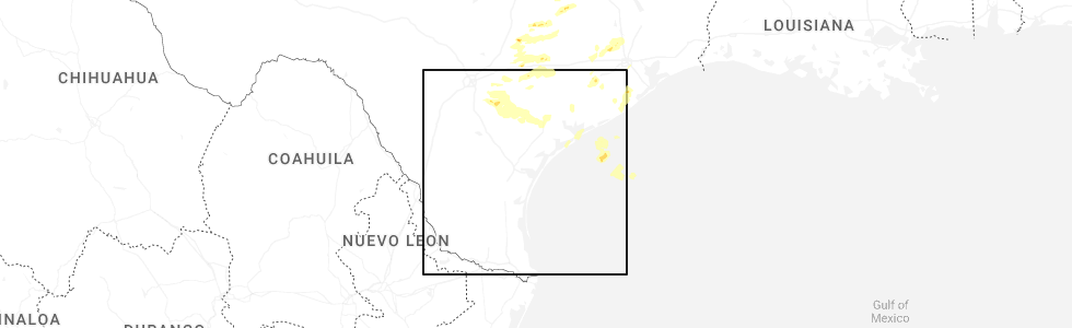
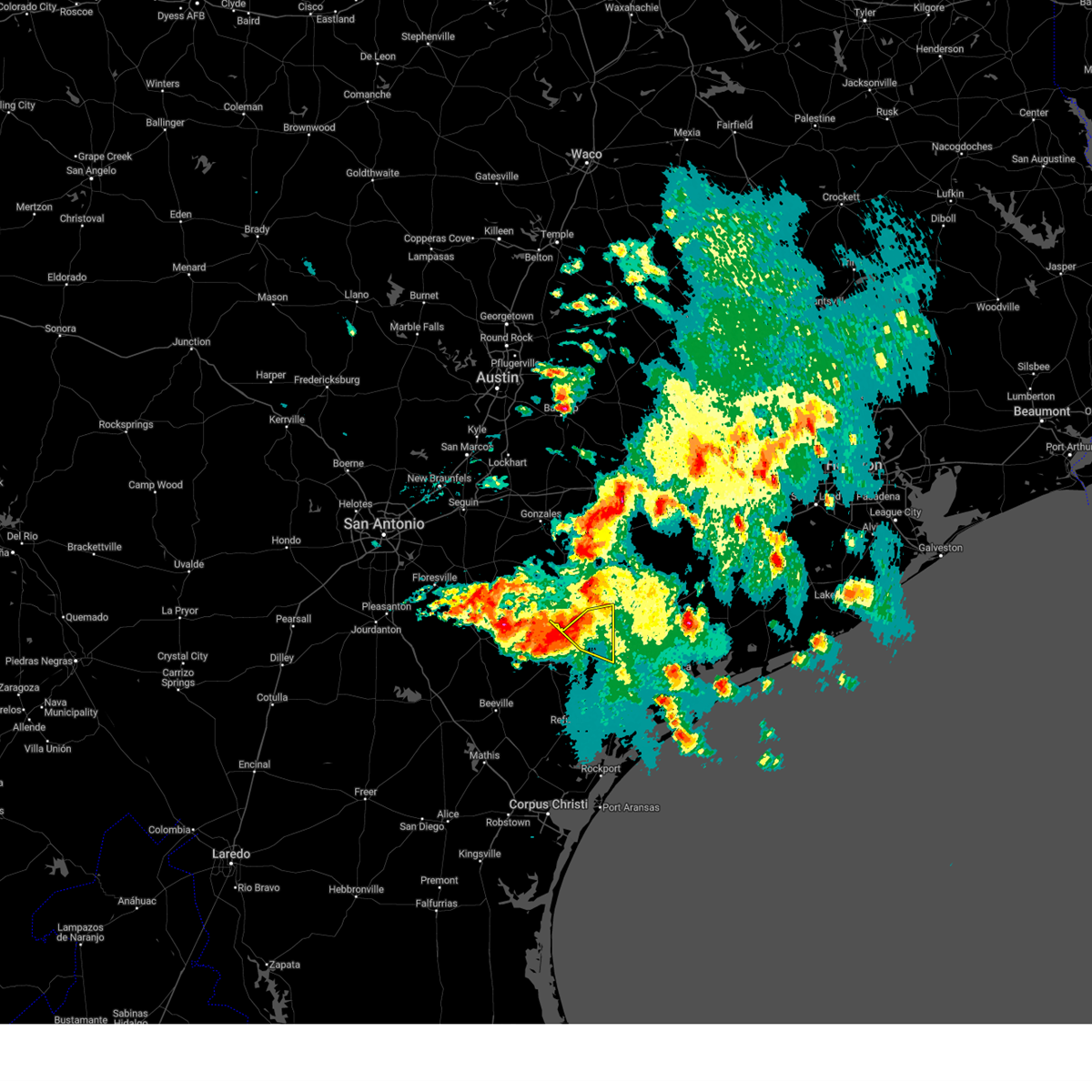
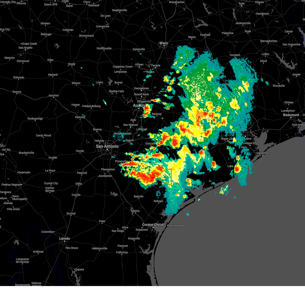
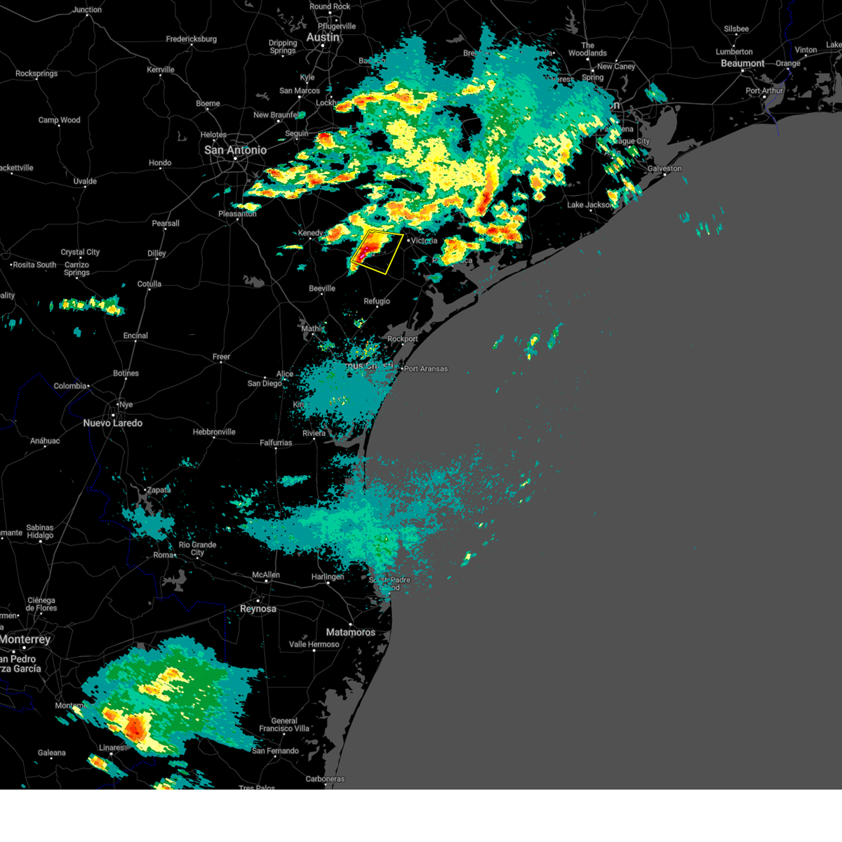
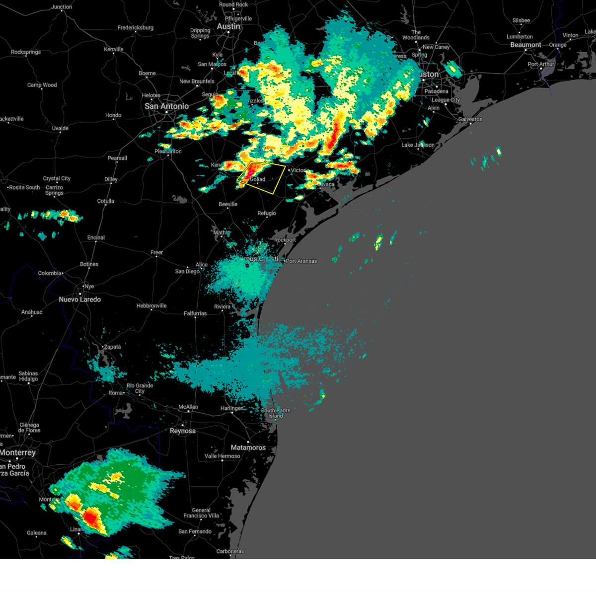
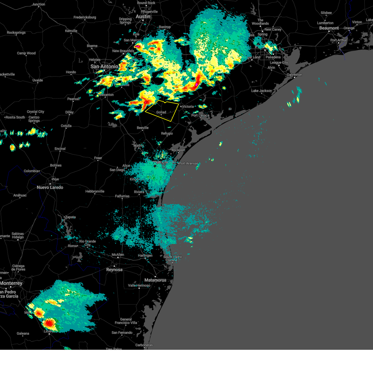
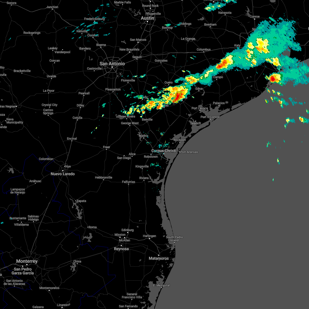
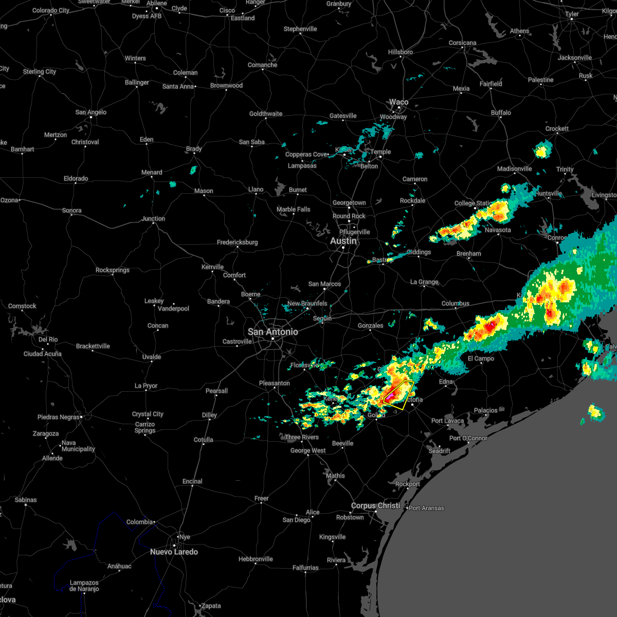
Hail Map for Quail Creek, TX
The Quail Creek, TX area has had 1 report of on-the-ground hail by trained spotters, and has been under severe weather warnings 6 times during the past 12 months. Doppler radar has detected hail at or near Quail Creek, TX on 24 occasions, including 1 occasion during the past year.
| Name: | Quail Creek, TX |
| Where Located: | 70.7 miles NNE of Corpus Christi, TX |
| Map: | Google Map for Quail Creek, TX |
| Population: | 1628 |
| Housing Units: | 590 |
| More Info: | Search Google for Quail Creek, TX |
0
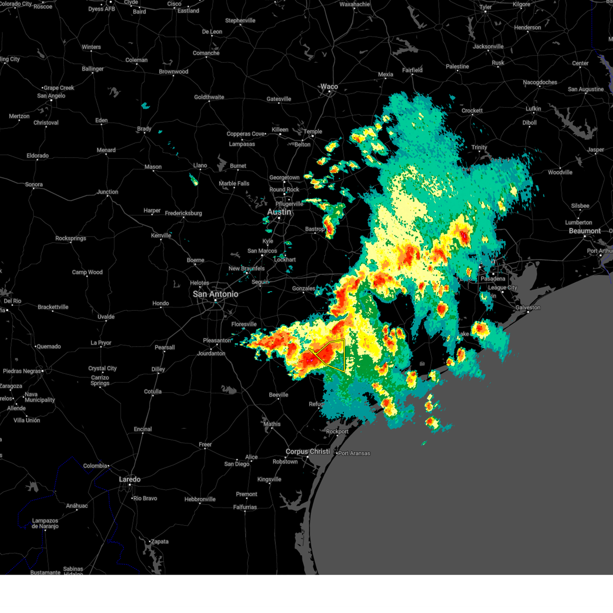
The Top Recent Hail Date for Quail Creek, TX is Tuesday, December 24, 2024 (24th out of 24)
Hail and Wind Damage Spotted near Quail Creek, TX
| Date / Time | Report Details |
|---|---|
| 5/6/2025 8:33 PM CDT | the severe thunderstorm warning has been cancelled and is no longer in effect |
| 5/6/2025 8:21 PM CDT |
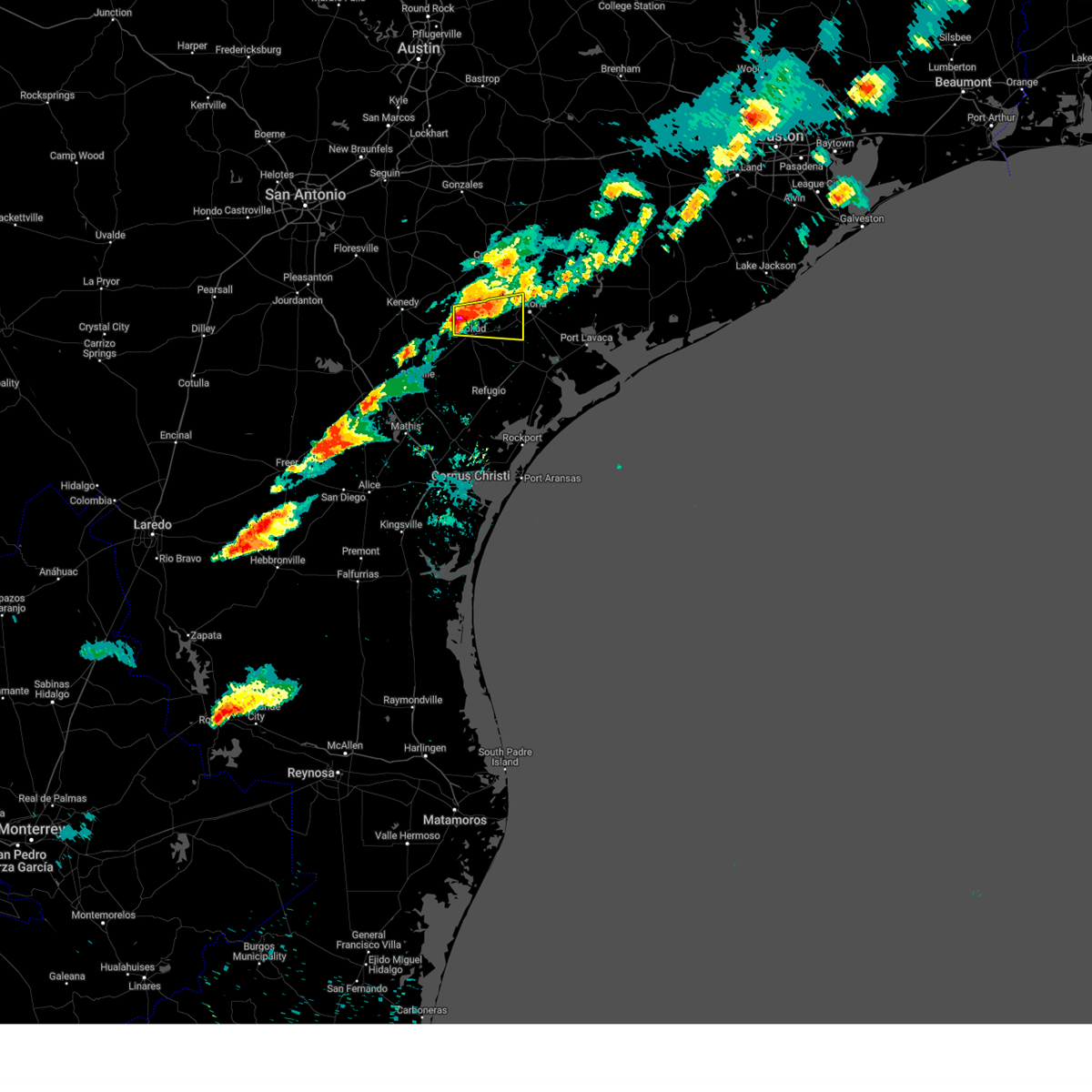 At 820 pm cdt, a severe thunderstorm was located near weesatche, or near goliad, moving east at 25 mph (radar indicated). Hazards include 60 mph wind gusts and quarter size hail. Hail damage to vehicles is expected. expect wind damage to roofs, siding, and trees. locations impacted include, goliad, fannin, schroeder, coleto creek park, ander, oak village, and weesatche. this includes the following highways, us highway 183 between mile markers 630 and 642. us highway 59 between mile markers 644 and 666. us highway 77 between mile markers 580 and 584. Us highway 87 near mile marker 804. At 820 pm cdt, a severe thunderstorm was located near weesatche, or near goliad, moving east at 25 mph (radar indicated). Hazards include 60 mph wind gusts and quarter size hail. Hail damage to vehicles is expected. expect wind damage to roofs, siding, and trees. locations impacted include, goliad, fannin, schroeder, coleto creek park, ander, oak village, and weesatche. this includes the following highways, us highway 183 between mile markers 630 and 642. us highway 59 between mile markers 644 and 666. us highway 77 between mile markers 580 and 584. Us highway 87 near mile marker 804.
|
| 5/6/2025 8:12 PM CDT |
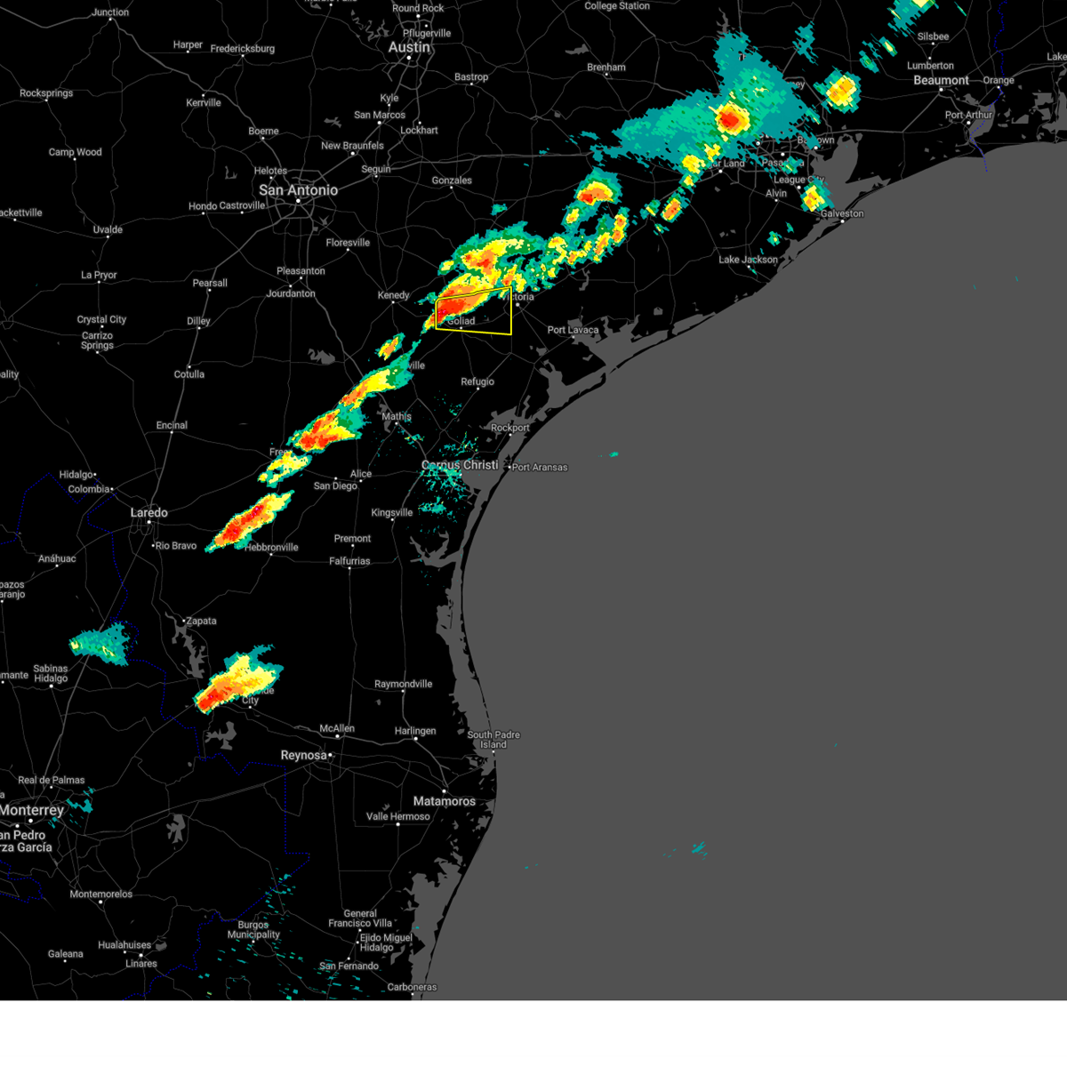 Svrcrp the national weather service in corpus christi has issued a * severe thunderstorm warning for, southwestern victoria county in south central texas, northeastern goliad county in south central texas, * until 900 pm cdt. * at 812 pm cdt, a severe thunderstorm was located near weesatche, or 8 miles northwest of goliad, moving east at 25 mph (radar indicated). Hazards include ping pong ball size hail and 60 mph wind gusts. People and animals outdoors will be injured. expect hail damage to roofs, siding, windows, and vehicles. Expect wind damage to roofs, siding, and trees. Svrcrp the national weather service in corpus christi has issued a * severe thunderstorm warning for, southwestern victoria county in south central texas, northeastern goliad county in south central texas, * until 900 pm cdt. * at 812 pm cdt, a severe thunderstorm was located near weesatche, or 8 miles northwest of goliad, moving east at 25 mph (radar indicated). Hazards include ping pong ball size hail and 60 mph wind gusts. People and animals outdoors will be injured. expect hail damage to roofs, siding, windows, and vehicles. Expect wind damage to roofs, siding, and trees.
|
| 12/25/2024 12:56 AM CST |
 The storm which prompted the warning has weakened below severe limits, and no longer poses an immediate threat to life or property. therefore, the warning will be allowed to expire. however, small hail, gusty winds and heavy rain are still possible with this thunderstorm. a severe thunderstorm watch remains in effect until 600 am cst for south central texas. The storm which prompted the warning has weakened below severe limits, and no longer poses an immediate threat to life or property. therefore, the warning will be allowed to expire. however, small hail, gusty winds and heavy rain are still possible with this thunderstorm. a severe thunderstorm watch remains in effect until 600 am cst for south central texas.
|
| 12/25/2024 12:44 AM CST |
 At 1243 am cst, a severe thunderstorm was located near mission valley, or 10 miles west of victoria, moving east at 20 mph (radar indicated). Hazards include 60 mph wind gusts and penny size hail. Expect damage to roofs, siding, and trees. locations impacted include, victoria, victoria riverside park, schroeder, victoria college, victoria mall, saxet lakes, mission valley, victoria detar hospital north, nursery, ball airport area, and downtown victoria. this includes the following highways, us highway 183 near mile marker 626. us highway 59 between mile markers 638 and 646. us highway 77 between mile markers 564 and 586. Us highway 87 between mile markers 796 and 814. At 1243 am cst, a severe thunderstorm was located near mission valley, or 10 miles west of victoria, moving east at 20 mph (radar indicated). Hazards include 60 mph wind gusts and penny size hail. Expect damage to roofs, siding, and trees. locations impacted include, victoria, victoria riverside park, schroeder, victoria college, victoria mall, saxet lakes, mission valley, victoria detar hospital north, nursery, ball airport area, and downtown victoria. this includes the following highways, us highway 183 near mile marker 626. us highway 59 between mile markers 638 and 646. us highway 77 between mile markers 564 and 586. Us highway 87 between mile markers 796 and 814.
|
| 12/25/2024 12:10 AM CST |
 Svrcrp the national weather service in corpus christi has issued a * severe thunderstorm warning for, northwestern victoria county in south central texas, northeastern goliad county in south central texas, * until 100 am cst. * at 1209 am cst, a severe thunderstorm was located over ander, or 13 miles southeast of yorktown, moving east at 25 mph (radar indicated). Hazards include 60 mph wind gusts and penny size hail. expect damage to roofs, siding, and trees Svrcrp the national weather service in corpus christi has issued a * severe thunderstorm warning for, northwestern victoria county in south central texas, northeastern goliad county in south central texas, * until 100 am cst. * at 1209 am cst, a severe thunderstorm was located over ander, or 13 miles southeast of yorktown, moving east at 25 mph (radar indicated). Hazards include 60 mph wind gusts and penny size hail. expect damage to roofs, siding, and trees
|
| 5/13/2024 2:25 PM CDT |
 Svrcrp the national weather service in corpus christi has issued a * severe thunderstorm warning for, central victoria county in south central texas, * until 315 pm cdt. * at 224 pm cdt, a severe thunderstorm was located over victoria detar hospital north, or over victoria, moving northeast at 30 mph (radar indicated). Hazards include 60 mph wind gusts and quarter size hail. Hail damage to vehicles is expected. Expect wind damage to roofs, siding, and trees. Svrcrp the national weather service in corpus christi has issued a * severe thunderstorm warning for, central victoria county in south central texas, * until 315 pm cdt. * at 224 pm cdt, a severe thunderstorm was located over victoria detar hospital north, or over victoria, moving northeast at 30 mph (radar indicated). Hazards include 60 mph wind gusts and quarter size hail. Hail damage to vehicles is expected. Expect wind damage to roofs, siding, and trees.
|
| 4/21/2024 1:59 AM CDT |
 At 158 am cdt, a severe thunderstorm was located over fannin, or 7 miles east of goliad, moving east at 40 mph (radar indicated). Hazards include two inch hail. People and animals outdoors will be injured. expect damage to roofs, siding, windows, and vehicles. locations impacted include, goliad, fannin, schroeder, coleto creek park, ander, and oak village. this includes the following highways, us highway 183 between mile markers 632 and 646. us highway 59 between mile markers 646 and 670. Us highway 77 between mile markers 580 and 582. At 158 am cdt, a severe thunderstorm was located over fannin, or 7 miles east of goliad, moving east at 40 mph (radar indicated). Hazards include two inch hail. People and animals outdoors will be injured. expect damage to roofs, siding, windows, and vehicles. locations impacted include, goliad, fannin, schroeder, coleto creek park, ander, and oak village. this includes the following highways, us highway 183 between mile markers 632 and 646. us highway 59 between mile markers 646 and 670. Us highway 77 between mile markers 580 and 582.
|
| 4/21/2024 1:44 AM CDT |
 At 143 am cdt, a severe thunderstorm was located near goliad, moving east at 40 mph (radar indicated). Hazards include quarter size hail. Damage to vehicles is expected. locations impacted include, goliad, fannin, schroeder, coleto creek park, ander, oak village, weesatche, and weser. this includes the following highways, us highway 183 between mile markers 628 and 646. us highway 59 between mile markers 646 and 670. Us highway 77 between mile markers 580 and 582. At 143 am cdt, a severe thunderstorm was located near goliad, moving east at 40 mph (radar indicated). Hazards include quarter size hail. Damage to vehicles is expected. locations impacted include, goliad, fannin, schroeder, coleto creek park, ander, oak village, weesatche, and weser. this includes the following highways, us highway 183 between mile markers 628 and 646. us highway 59 between mile markers 646 and 670. Us highway 77 between mile markers 580 and 582.
|
| 4/21/2024 1:25 AM CDT |
 Svrcrp the national weather service in corpus christi has issued a * severe thunderstorm warning for, southwestern victoria county in south central texas, northern goliad county in south central texas, * until 215 am cdt. * at 124 am cdt, a severe thunderstorm was located near charco, or 13 miles southwest of yorktown, moving east at 40 mph (radar indicated). Hazards include quarter size hail. damage to vehicles is expected Svrcrp the national weather service in corpus christi has issued a * severe thunderstorm warning for, southwestern victoria county in south central texas, northern goliad county in south central texas, * until 215 am cdt. * at 124 am cdt, a severe thunderstorm was located near charco, or 13 miles southwest of yorktown, moving east at 40 mph (radar indicated). Hazards include quarter size hail. damage to vehicles is expected
|
| 10/5/2023 8:30 AM CDT |
 At 830 am cdt, severe thunderstorms were located along a line extending from 6 miles south of edna to near placedo to near mcfaddin, moving southeast at 35 mph (radar indicated). Hazards include 60 mph wind gusts. Expect damage to roofs, siding, and trees. locations impacted include, victoria, goliad, mcfaddin, guadalupe, fannin, point comfort, victoria colony creek country club, long mott, victoria riverside park, victoria college, victoria mall, saxet lakes, green lake, brentwood subdivision, inez, salem, telferner, tivoli, downtown victoria, and alamo beach. this includes the following highways, us highway 183 between mile markers 638 and 640. us highway 59 between mile markers 624 and 664. us highway 77 between mile markers 562 and 606. us highway 87 between mile markers 804 and 840. hail threat, radar indicated max hail size, <. 75 in wind threat, radar indicated max wind gust, 60 mph. At 830 am cdt, severe thunderstorms were located along a line extending from 6 miles south of edna to near placedo to near mcfaddin, moving southeast at 35 mph (radar indicated). Hazards include 60 mph wind gusts. Expect damage to roofs, siding, and trees. locations impacted include, victoria, goliad, mcfaddin, guadalupe, fannin, point comfort, victoria colony creek country club, long mott, victoria riverside park, victoria college, victoria mall, saxet lakes, green lake, brentwood subdivision, inez, salem, telferner, tivoli, downtown victoria, and alamo beach. this includes the following highways, us highway 183 between mile markers 638 and 640. us highway 59 between mile markers 624 and 664. us highway 77 between mile markers 562 and 606. us highway 87 between mile markers 804 and 840. hail threat, radar indicated max hail size, <. 75 in wind threat, radar indicated max wind gust, 60 mph.
|
| 10/5/2023 8:13 AM CDT |
 At 813 am cdt, severe thunderstorms were located along a line extending from near inez to near telferner to coleto creek park, moving southeast at 35 mph (radar indicated). Hazards include 60 mph wind gusts. expect damage to roofs, siding, and trees At 813 am cdt, severe thunderstorms were located along a line extending from near inez to near telferner to coleto creek park, moving southeast at 35 mph (radar indicated). Hazards include 60 mph wind gusts. expect damage to roofs, siding, and trees
|
| 6/21/2023 10:19 PM CDT |
 At 1019 pm cdt, a severe thunderstorm was located near nursery, or 10 miles north of victoria, moving southeast at 25 mph (radar indicated). Hazards include 60 mph wind gusts and quarter size hail. Hail damage to vehicles is expected. expect wind damage to roofs, siding, and trees. locations impacted include, victoria, guadalupe, fordtran, victoria colony creek country club, schroeder, dacosta, wood hi, bloomington, mission valley, victoria detar hospital north, nursery, victoria riverside park, victoria college, victoria mall, saxet lakes, brentwood subdivision, inez, salem, victoria regional airport and telferner. this includes the following highways, us highway 183 near mile marker 626. us highway 59 between mile markers 622 and 648. us highway 77 between mile markers 560 and 590. us highway 87 between mile markers 798 and 822. hail threat, radar indicated max hail size, 1. 00 in wind threat, radar indicated max wind gust, 60 mph. At 1019 pm cdt, a severe thunderstorm was located near nursery, or 10 miles north of victoria, moving southeast at 25 mph (radar indicated). Hazards include 60 mph wind gusts and quarter size hail. Hail damage to vehicles is expected. expect wind damage to roofs, siding, and trees. locations impacted include, victoria, guadalupe, fordtran, victoria colony creek country club, schroeder, dacosta, wood hi, bloomington, mission valley, victoria detar hospital north, nursery, victoria riverside park, victoria college, victoria mall, saxet lakes, brentwood subdivision, inez, salem, victoria regional airport and telferner. this includes the following highways, us highway 183 near mile marker 626. us highway 59 between mile markers 622 and 648. us highway 77 between mile markers 560 and 590. us highway 87 between mile markers 798 and 822. hail threat, radar indicated max hail size, 1. 00 in wind threat, radar indicated max wind gust, 60 mph.
|
| 6/21/2023 10:02 PM CDT |
 At 1001 pm cdt, a severe thunderstorm was located near thomaston, or 10 miles east of cuero, moving southeast at 25 mph (radar indicated). Hazards include 60 mph wind gusts and quarter size hail. Hail damage to vehicles is expected. expect wind damage to roofs, siding, and trees. locations impacted include, victoria, guadalupe, fordtran, victoria colony creek country club, schroeder, dacosta, wood hi, bloomington, mission valley, victoria detar hospital north, nursery, victoria riverside park, victoria college, victoria mall, saxet lakes, brentwood subdivision, inez, salem, victoria regional airport and telferner. this includes the following highways, us highway 183 near mile marker 626. us highway 59 between mile markers 622 and 648. us highway 77 between mile markers 560 and 590. us highway 87 between mile markers 798 and 822. hail threat, radar indicated max hail size, 1. 00 in wind threat, radar indicated max wind gust, 60 mph. At 1001 pm cdt, a severe thunderstorm was located near thomaston, or 10 miles east of cuero, moving southeast at 25 mph (radar indicated). Hazards include 60 mph wind gusts and quarter size hail. Hail damage to vehicles is expected. expect wind damage to roofs, siding, and trees. locations impacted include, victoria, guadalupe, fordtran, victoria colony creek country club, schroeder, dacosta, wood hi, bloomington, mission valley, victoria detar hospital north, nursery, victoria riverside park, victoria college, victoria mall, saxet lakes, brentwood subdivision, inez, salem, victoria regional airport and telferner. this includes the following highways, us highway 183 near mile marker 626. us highway 59 between mile markers 622 and 648. us highway 77 between mile markers 560 and 590. us highway 87 between mile markers 798 and 822. hail threat, radar indicated max hail size, 1. 00 in wind threat, radar indicated max wind gust, 60 mph.
|
| 6/21/2023 9:48 PM CDT |
 At 947 pm cdt, a severe thunderstorm was located near cuero, moving southeast at 25 mph (radar indicated). Hazards include 60 mph wind gusts and quarter size hail. Hail damage to vehicles is expected. Expect wind damage to roofs, siding, and trees. At 947 pm cdt, a severe thunderstorm was located near cuero, moving southeast at 25 mph (radar indicated). Hazards include 60 mph wind gusts and quarter size hail. Hail damage to vehicles is expected. Expect wind damage to roofs, siding, and trees.
|
| 4/28/2023 8:32 PM CDT |
 At 831 pm cdt, severe thunderstorms were located along a line extending from 7 miles northeast of fordtran to near ander, moving southeast at 45 mph (radar indicated). Hazards include 60 mph wind gusts and quarter size hail. Hail damage to vehicles is expected. Expect wind damage to roofs, siding, and trees. At 831 pm cdt, severe thunderstorms were located along a line extending from 7 miles northeast of fordtran to near ander, moving southeast at 45 mph (radar indicated). Hazards include 60 mph wind gusts and quarter size hail. Hail damage to vehicles is expected. Expect wind damage to roofs, siding, and trees.
|
| 1/8/2023 12:37 AM CST |
 At 1237 am cst, a severe thunderstorm was located over victoria college, or over victoria, moving east at 25 mph (radar indicated). Hazards include 60 mph wind gusts and nickel size hail. Expect damage to roofs, siding, and trees. locations impacted include, victoria, guadalupe, victoria colony creek country club, wood hi, victoria detar hospital north, victoria riverside park, victoria college, victoria mall, saxet lakes, brentwood subdivision, inez, victoria regional airport, telferner, ball airport area and downtown victoria. this includes the following highways, us highway 59 between mile markers 622 and 638. us highway 77 between mile markers 572 and 576. us highway 87 between mile markers 806 and 818. hail threat, radar indicated max hail size, 0. 88 in wind threat, radar indicated max wind gust, 60 mph. At 1237 am cst, a severe thunderstorm was located over victoria college, or over victoria, moving east at 25 mph (radar indicated). Hazards include 60 mph wind gusts and nickel size hail. Expect damage to roofs, siding, and trees. locations impacted include, victoria, guadalupe, victoria colony creek country club, wood hi, victoria detar hospital north, victoria riverside park, victoria college, victoria mall, saxet lakes, brentwood subdivision, inez, victoria regional airport, telferner, ball airport area and downtown victoria. this includes the following highways, us highway 59 between mile markers 622 and 638. us highway 77 between mile markers 572 and 576. us highway 87 between mile markers 806 and 818. hail threat, radar indicated max hail size, 0. 88 in wind threat, radar indicated max wind gust, 60 mph.
|
| 1/8/2023 12:21 AM CST |
 The severe thunderstorm warning for northwestern victoria county will expire at 1230 am cst, the storm which prompted the warning has moved out of the area. therefore, the warning will be allowed to expire. however gusty winds are still possible with this thunderstorm. remember, a severe thunderstorm warning still remains in effect for central victoria county. The severe thunderstorm warning for northwestern victoria county will expire at 1230 am cst, the storm which prompted the warning has moved out of the area. therefore, the warning will be allowed to expire. however gusty winds are still possible with this thunderstorm. remember, a severe thunderstorm warning still remains in effect for central victoria county.
|
| 1/8/2023 12:15 AM CST |
 At 1214 am cst, a severe thunderstorm was located near nursery, or 10 miles northwest of victoria, moving east at 20 mph (radar indicated). Hazards include 60 mph wind gusts and penny size hail. Expect damage to roofs, siding, and trees. locations impacted include, nursery. this includes the following highways, us highway 77 near mile marker 582. us highway 87 between mile markers 800 and 804. hail threat, radar indicated max hail size, 0. 75 in wind threat, radar indicated max wind gust, 60 mph. At 1214 am cst, a severe thunderstorm was located near nursery, or 10 miles northwest of victoria, moving east at 20 mph (radar indicated). Hazards include 60 mph wind gusts and penny size hail. Expect damage to roofs, siding, and trees. locations impacted include, nursery. this includes the following highways, us highway 77 near mile marker 582. us highway 87 between mile markers 800 and 804. hail threat, radar indicated max hail size, 0. 75 in wind threat, radar indicated max wind gust, 60 mph.
|
| 1/8/2023 12:04 AM CST |
 At 1203 am cst, a severe thunderstorm was located near nursery, or 7 miles west of victoria, moving east at 25 mph (radar indicated). Hazards include 60 mph wind gusts and quarter size hail. Hail damage to vehicles is expected. Expect wind damage to roofs, siding, and trees. At 1203 am cst, a severe thunderstorm was located near nursery, or 7 miles west of victoria, moving east at 25 mph (radar indicated). Hazards include 60 mph wind gusts and quarter size hail. Hail damage to vehicles is expected. Expect wind damage to roofs, siding, and trees.
|
| 1/7/2023 11:52 PM CST |
 At 1151 pm cst, a severe thunderstorm was located over thomaston, or 11 miles southeast of cuero, moving east at 20 mph (radar indicated). Hazards include 60 mph wind gusts and quarter size hail. Hail damage to vehicles is expected. expect wind damage to roofs, siding, and trees. locations impacted include, mission valley, schroeder and nursery. this includes the following highways, us highway 77 near mile marker 582. us highway 87 between mile markers 796 and 804. hail threat, radar indicated max hail size, 1. 00 in wind threat, radar indicated max wind gust, 60 mph. At 1151 pm cst, a severe thunderstorm was located over thomaston, or 11 miles southeast of cuero, moving east at 20 mph (radar indicated). Hazards include 60 mph wind gusts and quarter size hail. Hail damage to vehicles is expected. expect wind damage to roofs, siding, and trees. locations impacted include, mission valley, schroeder and nursery. this includes the following highways, us highway 77 near mile marker 582. us highway 87 between mile markers 796 and 804. hail threat, radar indicated max hail size, 1. 00 in wind threat, radar indicated max wind gust, 60 mph.
|
| 7/14/2022 5:42 PM CDT |
 At 541 pm cdt, severe thunderstorms were located along a line extending from near placedo to near oak village to near goliad, moving south at 25 mph. at 509 pm cdt, kvct reported a peak wind gust of 58 mph (radar indicated). Hazards include 60 mph wind gusts. Expect damage to roofs, siding, and trees. locations impacted include, victoria, guadalupe, fannin, victoria riverside park, schroeder, placedo, coleto creek park, dacosta, saxet lakes, oak village, bloomington and downtown victoria. this includes the following highways, us highway 183 between mile markers 632 and 634. us highway 59 between mile markers 636 and 664. us highway 77 between mile markers 580 and 594. us highway 87 between mile markers 812 and 830. hail threat, radar indicated max hail size, <. 75 in wind threat, observed max wind gust, 60 mph. At 541 pm cdt, severe thunderstorms were located along a line extending from near placedo to near oak village to near goliad, moving south at 25 mph. at 509 pm cdt, kvct reported a peak wind gust of 58 mph (radar indicated). Hazards include 60 mph wind gusts. Expect damage to roofs, siding, and trees. locations impacted include, victoria, guadalupe, fannin, victoria riverside park, schroeder, placedo, coleto creek park, dacosta, saxet lakes, oak village, bloomington and downtown victoria. this includes the following highways, us highway 183 between mile markers 632 and 634. us highway 59 between mile markers 636 and 664. us highway 77 between mile markers 580 and 594. us highway 87 between mile markers 812 and 830. hail threat, radar indicated max hail size, <. 75 in wind threat, observed max wind gust, 60 mph.
|
| 7/14/2022 5:12 PM CDT |
 At 512 pm cdt, severe thunderstorms were located along a line extending from near inez to victoria detar hospital north to near ander, moving south at 20 mph (radar indicated). Hazards include 60 mph wind gusts and penny size hail. expect damage to roofs, siding, and trees At 512 pm cdt, severe thunderstorms were located along a line extending from near inez to victoria detar hospital north to near ander, moving south at 20 mph (radar indicated). Hazards include 60 mph wind gusts and penny size hail. expect damage to roofs, siding, and trees
|
| 5/22/2022 2:48 AM CDT |
 At 245 am cdt, a severe thunderstorm was located over victoria mall, or near victoria, moving east at 30 mph (radar indicated). Hazards include 60 mph wind gusts. expect damage to roofs, siding, and trees At 245 am cdt, a severe thunderstorm was located over victoria mall, or near victoria, moving east at 30 mph (radar indicated). Hazards include 60 mph wind gusts. expect damage to roofs, siding, and trees
|
| 6/14/2021 6:05 PM CDT |
 The severe thunderstorm warning for southwestern victoria, east central goliad and north central refugio counties will expire at 615 pm cdt, the storm which prompted the warning has weakened below severe limits, and no longer poses an immediate threat to life or property. therefore, the warning will be allowed to expire. however gusty winds are still possible with this thunderstorm. The severe thunderstorm warning for southwestern victoria, east central goliad and north central refugio counties will expire at 615 pm cdt, the storm which prompted the warning has weakened below severe limits, and no longer poses an immediate threat to life or property. therefore, the warning will be allowed to expire. however gusty winds are still possible with this thunderstorm.
|
| 6/14/2021 5:39 PM CDT |
 At 539 pm cdt, a severe thunderstorm was located over saxet lakes, or near victoria, moving southwest at 30 mph (radar indicated). Hazards include 60 mph wind gusts and quarter size hail. Hail damage to vehicles is expected. Expect wind damage to roofs, siding, and trees. At 539 pm cdt, a severe thunderstorm was located over saxet lakes, or near victoria, moving southwest at 30 mph (radar indicated). Hazards include 60 mph wind gusts and quarter size hail. Hail damage to vehicles is expected. Expect wind damage to roofs, siding, and trees.
|
| 6/5/2021 7:57 PM CDT |
 At 756 pm cdt, a severe thunderstorm was located over guadalupe, or just south of victoria, moving east at 20 mph (radar indicated). Hazards include 60 mph wind gusts and nickel size hail. Expect damage to roofs, siding, and trees. locations impacted include, victoria, guadalupe, placedo, dacosta, saxet lakes and bloomington. this includes the following highways, us highway 59 between mile markers 638 and 645. us highway 77 between mile markers 586 and 590. us highway 87 between mile markers 816 and 824. Precautionary/preparedness actions, for your protection move to an interior room on the lowest floor of a building. At 756 pm cdt, a severe thunderstorm was located over guadalupe, or just south of victoria, moving east at 20 mph (radar indicated). Hazards include 60 mph wind gusts and nickel size hail. Expect damage to roofs, siding, and trees. locations impacted include, victoria, guadalupe, placedo, dacosta, saxet lakes and bloomington. this includes the following highways, us highway 59 between mile markers 638 and 645. us highway 77 between mile markers 586 and 590. us highway 87 between mile markers 816 and 824. Precautionary/preparedness actions, for your protection move to an interior room on the lowest floor of a building.
|
| 6/5/2021 7:46 PM CDT |
 At 746 pm cdt, a severe thunderstorm was located near saxet lakes, or near victoria, moving east at 20 mph (radar indicated). Hazards include 60 mph wind gusts and quarter size hail. Hail damage to vehicles is expected. Expect wind damage to roofs, siding, and trees. At 746 pm cdt, a severe thunderstorm was located near saxet lakes, or near victoria, moving east at 20 mph (radar indicated). Hazards include 60 mph wind gusts and quarter size hail. Hail damage to vehicles is expected. Expect wind damage to roofs, siding, and trees.
|
| 8/2/2020 8:38 PM CDT |
 At 838 pm cdt, severe thunderstorms were located along a line extending from near goliad to near mcfaddin to near port lavaca, moving south at 20 mph (radar indicated). Hazards include 60 mph wind gusts and quarter size hail. Hail damage to vehicles is expected. expect wind damage to roofs, siding, and trees. Locations impacted include, victoria, goliad, mcfaddin, guadalupe, fannin, schroeder, dacosta, ander, bloomington, weesatche, weser, coleto creek park, saxet lakes, oak village and charco. At 838 pm cdt, severe thunderstorms were located along a line extending from near goliad to near mcfaddin to near port lavaca, moving south at 20 mph (radar indicated). Hazards include 60 mph wind gusts and quarter size hail. Hail damage to vehicles is expected. expect wind damage to roofs, siding, and trees. Locations impacted include, victoria, goliad, mcfaddin, guadalupe, fannin, schroeder, dacosta, ander, bloomington, weesatche, weser, coleto creek park, saxet lakes, oak village and charco.
|
| 8/2/2020 8:17 PM CDT |
 At 817 pm cdt, severe thunderstorms were located along a line extending from near weesatche to near oak village to 8 miles northwest of point comfort, moving south at 20 mph (radar indicated). Hazards include 60 mph wind gusts and quarter size hail. Hail damage to vehicles is expected. Expect wind damage to roofs, siding, and trees. At 817 pm cdt, severe thunderstorms were located along a line extending from near weesatche to near oak village to 8 miles northwest of point comfort, moving south at 20 mph (radar indicated). Hazards include 60 mph wind gusts and quarter size hail. Hail damage to vehicles is expected. Expect wind damage to roofs, siding, and trees.
|
| 5/16/2020 2:04 AM CDT |
 At 203 am cdt, severe thunderstorms were located along a line extending from 9 miles southwest of speaks to near quintana, moving east at 35 mph (radar indicated). Hazards include 60 mph wind gusts and penny size hail. Expect damage to roofs, siding, and trees. Locations impacted include, victoria, refugio, woodsboro, mcfaddin, guadalupe, fannin, quintana, victoria colony creek country club, nursery, victoria riverside park, victoria college, victoria mall, saxet lakes, inez, salem, telferner, tivoli, downtown victoria, dacosta and wood hi. At 203 am cdt, severe thunderstorms were located along a line extending from 9 miles southwest of speaks to near quintana, moving east at 35 mph (radar indicated). Hazards include 60 mph wind gusts and penny size hail. Expect damage to roofs, siding, and trees. Locations impacted include, victoria, refugio, woodsboro, mcfaddin, guadalupe, fannin, quintana, victoria colony creek country club, nursery, victoria riverside park, victoria college, victoria mall, saxet lakes, inez, salem, telferner, tivoli, downtown victoria, dacosta and wood hi.
|
| 5/16/2020 1:09 AM CDT |
 At 108 am cdt, severe thunderstorms were located along a line extending from near cuero to near papalote, moving east at 35 mph (radar indicated). Hazards include 60 mph wind gusts and penny size hail. expect damage to roofs, siding, and trees At 108 am cdt, severe thunderstorms were located along a line extending from near cuero to near papalote, moving east at 35 mph (radar indicated). Hazards include 60 mph wind gusts and penny size hail. expect damage to roofs, siding, and trees
|
| 3/20/2020 1:11 PM CDT |
 At 111 pm cdt, a severe thunderstorm was located over victoria detar hospital north, or near victoria, moving northeast at 55 mph (radar indicated). Hazards include 60 mph wind gusts and quarter size hail. Hail damage to vehicles is expected. Expect wind damage to roofs, siding, and trees. At 111 pm cdt, a severe thunderstorm was located over victoria detar hospital north, or near victoria, moving northeast at 55 mph (radar indicated). Hazards include 60 mph wind gusts and quarter size hail. Hail damage to vehicles is expected. Expect wind damage to roofs, siding, and trees.
|
| 3/20/2020 1:08 PM CDT | Quarter sized hail reported 8.5 miles SE of Quail Creek, TX, public reported quarter size hail near mission valley... tx. |
| 6/6/2019 6:18 PM CDT |
 At 617 pm cdt, a severe thunderstorm was located near mission valley, or 13 miles west of victoria, moving southeast at 30 mph (radar indicated). Hazards include 60 mph wind gusts and half dollar size hail. Hail damage to vehicles is expected. Expect wind damage to roofs, siding, and trees. At 617 pm cdt, a severe thunderstorm was located near mission valley, or 13 miles west of victoria, moving southeast at 30 mph (radar indicated). Hazards include 60 mph wind gusts and half dollar size hail. Hail damage to vehicles is expected. Expect wind damage to roofs, siding, and trees.
|
| 5/9/2019 11:41 PM CDT |
 At 1140 pm cdt, severe thunderstorms were located along a line extending from 8 miles northeast of salem to 18 miles east of key allegro, moving east at 35 mph (radar indicated). Hazards include 60 mph wind gusts and penny size hail. expect damage to roofs, siding, and trees At 1140 pm cdt, severe thunderstorms were located along a line extending from 8 miles northeast of salem to 18 miles east of key allegro, moving east at 35 mph (radar indicated). Hazards include 60 mph wind gusts and penny size hail. expect damage to roofs, siding, and trees
|
| 5/9/2019 11:30 PM CDT |
 At 1129 pm cdt, severe thunderstorms were located along a line extending from 9 miles northwest of point comfort to near aransas national wildlife refuge, moving east at 40 mph (radar indicated). Hazards include 60 mph wind gusts and penny size hail. Expect damage to roofs, siding, and trees. Locations impacted include, victoria, port lavaca, seadrift, mcfaddin, guadalupe, point comfort, quintana, victoria colony creek country club, alamo beach, dacosta, wood hi, bloomington, long mott, victoria riverside park, placedo, victoria college, saxet lakes, green lake, holiday beach and tivoli. At 1129 pm cdt, severe thunderstorms were located along a line extending from 9 miles northwest of point comfort to near aransas national wildlife refuge, moving east at 40 mph (radar indicated). Hazards include 60 mph wind gusts and penny size hail. Expect damage to roofs, siding, and trees. Locations impacted include, victoria, port lavaca, seadrift, mcfaddin, guadalupe, point comfort, quintana, victoria colony creek country club, alamo beach, dacosta, wood hi, bloomington, long mott, victoria riverside park, placedo, victoria college, saxet lakes, green lake, holiday beach and tivoli.
|
| 5/9/2019 10:56 PM CDT |
 At 1055 pm cdt, severe thunderstorms were located along a line extending from near saxet lakes to near quintana, moving east at 40 mph (radar indicated). Hazards include 60 mph wind gusts and quarter size hail. Hail damage to vehicles is expected. Expect wind damage to roofs, siding, and trees. At 1055 pm cdt, severe thunderstorms were located along a line extending from near saxet lakes to near quintana, moving east at 40 mph (radar indicated). Hazards include 60 mph wind gusts and quarter size hail. Hail damage to vehicles is expected. Expect wind damage to roofs, siding, and trees.
|
| 5/9/2019 10:39 PM CDT |
 At 1039 pm cdt, severe thunderstorms were located along a line extending from near oak village to 9 miles northwest of quintana, moving east at 45 mph (radar indicated). Hazards include 60 mph wind gusts and quarter size hail. Hail damage to vehicles is expected. expect wind damage to roofs, siding, and trees. Locations impacted include, victoria, goliad, mcfaddin, guadalupe, fannin, victoria colony creek country club, schroeder, dacosta, ander, wood hi, bloomington, weesatche, weser, victoria riverside park, coleto creek park, victoria college, saxet lakes, oak village, charco and downtown victoria. At 1039 pm cdt, severe thunderstorms were located along a line extending from near oak village to 9 miles northwest of quintana, moving east at 45 mph (radar indicated). Hazards include 60 mph wind gusts and quarter size hail. Hail damage to vehicles is expected. expect wind damage to roofs, siding, and trees. Locations impacted include, victoria, goliad, mcfaddin, guadalupe, fannin, victoria colony creek country club, schroeder, dacosta, ander, wood hi, bloomington, weesatche, weser, victoria riverside park, coleto creek park, victoria college, saxet lakes, oak village, charco and downtown victoria.
|
| 5/9/2019 10:15 PM CDT |
 At 1014 pm cdt, severe thunderstorms were located along a line extending from near weesatche to near berclair, moving east at 40 mph (radar indicated). Hazards include 60 mph wind gusts and penny size hail. expect damage to roofs, siding, and trees At 1014 pm cdt, severe thunderstorms were located along a line extending from near weesatche to near berclair, moving east at 40 mph (radar indicated). Hazards include 60 mph wind gusts and penny size hail. expect damage to roofs, siding, and trees
|
| 5/3/2019 11:13 PM CDT |
 A severe thunderstorm warning remains in effect until 1130 pm cdt for northwestern calhoun. victoria. goliad. central live oak. northwestern refugio and bee counties. at 1113 pm cdt, severe thunderstorms were located along a line extending from near placedo to lagarto, moving southeast at 30 mph. hazard. 60 mph wind gusts and quarter size hail. A severe thunderstorm warning remains in effect until 1130 pm cdt for northwestern calhoun. victoria. goliad. central live oak. northwestern refugio and bee counties. at 1113 pm cdt, severe thunderstorms were located along a line extending from near placedo to lagarto, moving southeast at 30 mph. hazard. 60 mph wind gusts and quarter size hail.
|
| 5/3/2019 11:13 PM CDT |
 At 1113 pm cdt, severe thunderstorms were located along a line extending from near placedo to lagarto, moving southeast at 30 mph (radar indicated). Hazards include 60 mph wind gusts and quarter size hail. Hail damage to vehicles is expected. expect wind damage to roofs, siding, and trees. Locations impacted include, victoria, beeville, george west, goliad, three rivers, mcfaddin, skidmore, guadalupe, fannin, victoria colony creek country club, river creek acres, nursery, victoria riverside park, victoria college, victoria mall, saxet lakes, argenta, karon, mount lucas and salem. At 1113 pm cdt, severe thunderstorms were located along a line extending from near placedo to lagarto, moving southeast at 30 mph (radar indicated). Hazards include 60 mph wind gusts and quarter size hail. Hail damage to vehicles is expected. expect wind damage to roofs, siding, and trees. Locations impacted include, victoria, beeville, george west, goliad, three rivers, mcfaddin, skidmore, guadalupe, fannin, victoria colony creek country club, river creek acres, nursery, victoria riverside park, victoria college, victoria mall, saxet lakes, argenta, karon, mount lucas and salem.
|
| 5/3/2019 10:41 PM CDT |
 At 1041 pm cdt, severe thunderstorms were located along a line extending from near telferner to george west, moving southeast at 30 mph (radar indicated). Hazards include 60 mph wind gusts and quarter size hail. Hail damage to vehicles is expected. Expect wind damage to roofs, siding, and trees. At 1041 pm cdt, severe thunderstorms were located along a line extending from near telferner to george west, moving southeast at 30 mph (radar indicated). Hazards include 60 mph wind gusts and quarter size hail. Hail damage to vehicles is expected. Expect wind damage to roofs, siding, and trees.
|
| 5/3/2019 10:26 PM CDT |
 At 1026 pm cdt, severe thunderstorms were located along a line extending from 7 miles northeast of salem to near simmons, moving southeast at 35 mph (radar indicated). Hazards include 60 mph wind gusts and nickel size hail. Expect damage to roofs, siding, and trees. Locations impacted include, victoria, beeville, george west, goliad, three rivers, guadalupe, fannin, victoria colony creek country club, weesatche, river creek acres, weser, nursery, victoria riverside park, victoria college, victoria mall, saxet lakes, karon, inez, salem and normanna. At 1026 pm cdt, severe thunderstorms were located along a line extending from 7 miles northeast of salem to near simmons, moving southeast at 35 mph (radar indicated). Hazards include 60 mph wind gusts and nickel size hail. Expect damage to roofs, siding, and trees. Locations impacted include, victoria, beeville, george west, goliad, three rivers, guadalupe, fannin, victoria colony creek country club, weesatche, river creek acres, weser, nursery, victoria riverside park, victoria college, victoria mall, saxet lakes, karon, inez, salem and normanna.
|
| 5/3/2019 9:53 PM CDT |
 At 952 pm cdt, severe thunderstorms were located along a line extending from 6 miles west of ezzell to near crowther, moving southeast at 35 mph (radar indicated). Hazards include 60 mph wind gusts and penny size hail. expect damage to roofs, siding, and trees At 952 pm cdt, severe thunderstorms were located along a line extending from 6 miles west of ezzell to near crowther, moving southeast at 35 mph (radar indicated). Hazards include 60 mph wind gusts and penny size hail. expect damage to roofs, siding, and trees
|
| 4/24/2019 7:06 PM CDT |
 At 705 pm cdt, severe thunderstorms were located along a line extending from near schroeder to near woodsboro, moving east at 40 mph (radar indicated). Hazards include 60 mph wind gusts and nickel size hail. Expect damage to roofs, siding, and trees. Locations impacted include, victoria, mcfaddin, guadalupe, fannin, quintana, victoria colony creek country club, nursery, victoria riverside park, victoria college, victoria mall, saxet lakes, green lake, inez, salem, telferner, tivoli, downtown victoria, fordtran, schroeder and dacosta. At 705 pm cdt, severe thunderstorms were located along a line extending from near schroeder to near woodsboro, moving east at 40 mph (radar indicated). Hazards include 60 mph wind gusts and nickel size hail. Expect damage to roofs, siding, and trees. Locations impacted include, victoria, mcfaddin, guadalupe, fannin, quintana, victoria colony creek country club, nursery, victoria riverside park, victoria college, victoria mall, saxet lakes, green lake, inez, salem, telferner, tivoli, downtown victoria, fordtran, schroeder and dacosta.
|
| 4/24/2019 6:53 PM CDT |
 At 652 pm cdt, severe thunderstorms were located along a line extending from near schroeder to 9 miles northeast of papalote, moving east at 40 mph (radar indicated). Hazards include 60 mph wind gusts and quarter size hail. Hail damage to vehicles is expected. Expect wind damage to roofs, siding, and trees. At 652 pm cdt, severe thunderstorms were located along a line extending from near schroeder to 9 miles northeast of papalote, moving east at 40 mph (radar indicated). Hazards include 60 mph wind gusts and quarter size hail. Hail damage to vehicles is expected. Expect wind damage to roofs, siding, and trees.
|
| 4/24/2019 6:44 PM CDT |
 At 644 pm cdt, a severe thunderstorm was located near berclair, or 12 miles southwest of goliad, moving east at 30 mph (radar indicated). Hazards include 70 mph wind gusts and half dollar size hail. Hail damage to vehicles is expected. expect considerable tree damage. wind damage is also likely to mobile homes, roofs, and outbuildings. Locations impacted include, victoria, beeville, refugio, goliad, mcfaddin, skidmore, guadalupe, fannin, quintana, victoria colony creek country club, weesatche, weser, nursery, victoria riverside park, victoria college, victoria mall, saxet lakes, inez, salem and normanna. At 644 pm cdt, a severe thunderstorm was located near berclair, or 12 miles southwest of goliad, moving east at 30 mph (radar indicated). Hazards include 70 mph wind gusts and half dollar size hail. Hail damage to vehicles is expected. expect considerable tree damage. wind damage is also likely to mobile homes, roofs, and outbuildings. Locations impacted include, victoria, beeville, refugio, goliad, mcfaddin, skidmore, guadalupe, fannin, quintana, victoria colony creek country club, weesatche, weser, nursery, victoria riverside park, victoria college, victoria mall, saxet lakes, inez, salem and normanna.
|
| 4/24/2019 6:20 PM CDT |
 At 619 pm cdt, severe thunderstorms were located along a line extending from near weser to near beeville, moving east at 40 mph (radar indicated). Hazards include 60 mph wind gusts and quarter size hail. Hail damage to vehicles is expected. Expect wind damage to roofs, siding, and trees. At 619 pm cdt, severe thunderstorms were located along a line extending from near weser to near beeville, moving east at 40 mph (radar indicated). Hazards include 60 mph wind gusts and quarter size hail. Hail damage to vehicles is expected. Expect wind damage to roofs, siding, and trees.
|
| 4/18/2019 2:20 AM CDT |
 At 220 am cdt, severe thunderstorms were located along a line extending from near yoakum to near thomaston to near berclair, moving east at 55 mph (radar indicated). Hazards include 60 mph wind gusts and penny size hail. Expect damage to roofs, siding, and trees. Locations impacted include, victoria, goliad, fannin, victoria colony creek country club, weesatche, weser, nursery, victoria riverside park, victoria college, victoria mall, saxet lakes, inez, salem, telferner, charco, blanconia, downtown victoria, fordtran, schroeder and ander. At 220 am cdt, severe thunderstorms were located along a line extending from near yoakum to near thomaston to near berclair, moving east at 55 mph (radar indicated). Hazards include 60 mph wind gusts and penny size hail. Expect damage to roofs, siding, and trees. Locations impacted include, victoria, goliad, fannin, victoria colony creek country club, weesatche, weser, nursery, victoria riverside park, victoria college, victoria mall, saxet lakes, inez, salem, telferner, charco, blanconia, downtown victoria, fordtran, schroeder and ander.
|
| 4/18/2019 2:00 AM CDT |
 At 159 am cdt, severe thunderstorms were located along a line extending from 7 miles northwest of hochheim to 7 miles north of yorktown to near kenedy, moving east at 55 mph (radar indicated). Hazards include 60 mph wind gusts and penny size hail. expect damage to roofs, siding, and trees At 159 am cdt, severe thunderstorms were located along a line extending from 7 miles northwest of hochheim to 7 miles north of yorktown to near kenedy, moving east at 55 mph (radar indicated). Hazards include 60 mph wind gusts and penny size hail. expect damage to roofs, siding, and trees
|
| 4/7/2019 8:55 AM CDT |
 At 855 am cdt, severe thunderstorms were located along a line extending from near weesatche to ander to near schroeder to 6 miles north of coleto creek park to near oak village, moving northeast at 30 mph (radar indicated). Hazards include 60 mph wind gusts and quarter size hail. Hail damage to vehicles is expected. Expect wind damage to roofs, siding, and trees. At 855 am cdt, severe thunderstorms were located along a line extending from near weesatche to ander to near schroeder to 6 miles north of coleto creek park to near oak village, moving northeast at 30 mph (radar indicated). Hazards include 60 mph wind gusts and quarter size hail. Hail damage to vehicles is expected. Expect wind damage to roofs, siding, and trees.
|
| 4/7/2019 8:15 AM CDT |
 At 814 am cdt, severe thunderstorms were located along a line extending from 6 miles southeast of charco to near refugio to near taft to near naval air station cabaniss field, moving east at 40 mph (radar indicated). Hazards include 60 mph wind gusts and penny size hail. expect damage to roofs, siding, and trees At 814 am cdt, severe thunderstorms were located along a line extending from 6 miles southeast of charco to near refugio to near taft to near naval air station cabaniss field, moving east at 40 mph (radar indicated). Hazards include 60 mph wind gusts and penny size hail. expect damage to roofs, siding, and trees
|
| 4/14/2018 2:07 AM CDT |
 At 207 am cdt, severe thunderstorms were located along a line extending from near point comfort to 7 miles south of berclair to san patricio, moving southeast at 50 mph (radar indicated). Hazards include 60 mph wind gusts. Expect damage to roofs, siding, and trees. Locations impacted include, victoria, portland, beeville, port lavaca, rockport, sinton, mathis, taft, refugio, goliad, woodsboro, seadrift, mcfaddin, port oconnor, skidmore, guadalupe, lamar, fannin, ingleside and aransas pass. At 207 am cdt, severe thunderstorms were located along a line extending from near point comfort to 7 miles south of berclair to san patricio, moving southeast at 50 mph (radar indicated). Hazards include 60 mph wind gusts. Expect damage to roofs, siding, and trees. Locations impacted include, victoria, portland, beeville, port lavaca, rockport, sinton, mathis, taft, refugio, goliad, woodsboro, seadrift, mcfaddin, port oconnor, skidmore, guadalupe, lamar, fannin, ingleside and aransas pass.
|
| 4/14/2018 1:45 AM CDT |
 At 144 am cdt, severe thunderstorms were located along a line extending from near inez to pettus to near mount lucas, moving southeast at 50 mph (radar indicated). Hazards include 60 mph wind gusts and penny size hail. expect damage to roofs, siding, and trees At 144 am cdt, severe thunderstorms were located along a line extending from near inez to pettus to near mount lucas, moving southeast at 50 mph (radar indicated). Hazards include 60 mph wind gusts and penny size hail. expect damage to roofs, siding, and trees
|
| 3/29/2018 12:47 AM CDT |
 At 1247 am cdt, severe thunderstorms were located along a line extending from near schroeder to sinton to 9 miles east of ben bolt, moving east at 45 mph (radar indicated). Hazards include 70 mph wind gusts and penny size hail. Expect considerable tree damage. damage is likely to mobile homes, roofs, and outbuildings. Locations impacted include, corpus christi, victoria, portland, robstown, sinton, mathis, taft, refugio, goliad, woodsboro, driscoll, mcfaddin, corpus christi international airport, skidmore, guadalupe, fannin, bishop, odem, gregory and orange grove. At 1247 am cdt, severe thunderstorms were located along a line extending from near schroeder to sinton to 9 miles east of ben bolt, moving east at 45 mph (radar indicated). Hazards include 70 mph wind gusts and penny size hail. Expect considerable tree damage. damage is likely to mobile homes, roofs, and outbuildings. Locations impacted include, corpus christi, victoria, portland, robstown, sinton, mathis, taft, refugio, goliad, woodsboro, driscoll, mcfaddin, corpus christi international airport, skidmore, guadalupe, fannin, bishop, odem, gregory and orange grove.
|
| 3/29/2018 12:33 AM CDT |
 At 1232 am cdt, severe thunderstorms were located along a line extending from near weesatche to near west sinton to near alice acres, moving east at 45 mph (radar indicated). Hazards include 70 mph wind gusts and penny size hail. Expect considerable tree damage. damage is likely to mobile homes, roofs, and outbuildings. Locations impacted include, corpus christi, victoria, alice, portland, beeville, robstown, sinton, mathis, san diego, taft, refugio, george west, goliad, woodsboro, driscoll, mcfaddin, corpus christi international airport, skidmore, guadalupe and fannin. At 1232 am cdt, severe thunderstorms were located along a line extending from near weesatche to near west sinton to near alice acres, moving east at 45 mph (radar indicated). Hazards include 70 mph wind gusts and penny size hail. Expect considerable tree damage. damage is likely to mobile homes, roofs, and outbuildings. Locations impacted include, corpus christi, victoria, alice, portland, beeville, robstown, sinton, mathis, san diego, taft, refugio, george west, goliad, woodsboro, driscoll, mcfaddin, corpus christi international airport, skidmore, guadalupe and fannin.
|
| 3/29/2018 12:14 AM CDT |
 At 1213 am cdt, severe thunderstorms were located along a line extending from near charco to near sandia to near benavides, moving east at 45 mph (radar indicated). Hazards include 70 mph wind gusts. Expect considerable tree damage. Damage is likely to mobile homes, roofs, and outbuildings. At 1213 am cdt, severe thunderstorms were located along a line extending from near charco to near sandia to near benavides, moving east at 45 mph (radar indicated). Hazards include 70 mph wind gusts. Expect considerable tree damage. Damage is likely to mobile homes, roofs, and outbuildings.
|
| 7/15/2017 7:00 PM CDT |
 At 700 pm cdt, a severe thunderstorm was located near saxet lakes, or 7 miles southwest of victoria, moving southwest at 10 mph (radar indicated). Hazards include 60 mph wind gusts and quarter size hail. Hail damage to vehicles is expected. expect wind damage to roofs, siding, and trees. Locations impacted include, victoria, fannin, victoria riverside park, coleto creek park, victoria college, saxet lakes, oak village, victoria detar hospital north and downtown victoria. At 700 pm cdt, a severe thunderstorm was located near saxet lakes, or 7 miles southwest of victoria, moving southwest at 10 mph (radar indicated). Hazards include 60 mph wind gusts and quarter size hail. Hail damage to vehicles is expected. expect wind damage to roofs, siding, and trees. Locations impacted include, victoria, fannin, victoria riverside park, coleto creek park, victoria college, saxet lakes, oak village, victoria detar hospital north and downtown victoria.
|
| 7/15/2017 6:33 PM CDT |
 At 632 pm cdt, a severe thunderstorm was located over victoria riverside park, or over victoria, moving southwest at 10 mph (radar indicated). Hazards include 60 mph wind gusts and quarter size hail. Hail damage to vehicles is expected. Expect wind damage to roofs, siding, and trees. At 632 pm cdt, a severe thunderstorm was located over victoria riverside park, or over victoria, moving southwest at 10 mph (radar indicated). Hazards include 60 mph wind gusts and quarter size hail. Hail damage to vehicles is expected. Expect wind damage to roofs, siding, and trees.
|
| 6/4/2017 7:10 PM CDT |
 The severe thunderstorm warning for northwestern victoria and northeastern goliad counties will expire at 715 pm cdt, the storm which prompted the warning has weakened below severe limits, and no longer poses an immediate threat to life or property. therefore the warning will be allowed to expire. however gusty winds and heavy rain are still possible with this thunderstorm. The severe thunderstorm warning for northwestern victoria and northeastern goliad counties will expire at 715 pm cdt, the storm which prompted the warning has weakened below severe limits, and no longer poses an immediate threat to life or property. therefore the warning will be allowed to expire. however gusty winds and heavy rain are still possible with this thunderstorm.
|
| 6/4/2017 6:25 PM CDT |
 At 625 pm cdt, a severe thunderstorm was located near goliad, moving northeast at 25 mph (radar indicated). Hazards include ping pong ball size hail and 60 mph wind gusts. People and animals outdoors will be injured. expect hail damage to roofs, siding, windows, and vehicles. Expect wind damage to roofs, siding, and trees. At 625 pm cdt, a severe thunderstorm was located near goliad, moving northeast at 25 mph (radar indicated). Hazards include ping pong ball size hail and 60 mph wind gusts. People and animals outdoors will be injured. expect hail damage to roofs, siding, windows, and vehicles. Expect wind damage to roofs, siding, and trees.
|
| 6/19/2016 4:47 AM CDT |
 At 447 am cdt, severe thunderstorms were located along a line extending from near tivoli to near ander, moving southwest at 50 mph (radar indicated). Hazards include 60 mph wind gusts. Expect damage to roofs. siding. and trees. Locations impacted include, victoria, port lavaca, mcfaddin, guadalupe, fannin, point comfort, point comfort, victoria detar hospital north, dacosta, coleto creek park, nursery, wood hi, victoria regional airport, downtown victoria, kamey, tivoli, kamay, victoria colony creek country club, victoria college and saxet lakes. At 447 am cdt, severe thunderstorms were located along a line extending from near tivoli to near ander, moving southwest at 50 mph (radar indicated). Hazards include 60 mph wind gusts. Expect damage to roofs. siding. and trees. Locations impacted include, victoria, port lavaca, mcfaddin, guadalupe, fannin, point comfort, point comfort, victoria detar hospital north, dacosta, coleto creek park, nursery, wood hi, victoria regional airport, downtown victoria, kamey, tivoli, kamay, victoria colony creek country club, victoria college and saxet lakes.
|
| 6/19/2016 4:10 AM CDT |
 At 410 am cdt, a severe thunderstorm was located over guadalupe, or near victoria, moving southwest at 55 mph (radar indicated). Hazards include 60 mph wind gusts. Expect damage to roofs. siding. And trees. At 410 am cdt, a severe thunderstorm was located over guadalupe, or near victoria, moving southwest at 55 mph (radar indicated). Hazards include 60 mph wind gusts. Expect damage to roofs. siding. And trees.
|
| 5/27/2016 7:20 PM CDT |
 At 719 pm cdt, severe thunderstorms were located along a line extending from inez to near victoria regional airport to near saxet lakes, moving southeast at 20 mph (radar indicated). Hazards include 60 mph wind gusts and quarter size hail. Hail damage to vehicles is expected. expect wind damage to roofs, siding, and trees. Locations impacted include, victoria, guadalupe, victoria detar hospital north, salem, dacosta, inez, nursery, victoria mall, wood hi, victoria regional airport, downtown victoria, victoria riverside park, fordtran, telferner, victoria colony creek country club, victoria college, mission valley, saxet lakes and placedo. At 719 pm cdt, severe thunderstorms were located along a line extending from inez to near victoria regional airport to near saxet lakes, moving southeast at 20 mph (radar indicated). Hazards include 60 mph wind gusts and quarter size hail. Hail damage to vehicles is expected. expect wind damage to roofs, siding, and trees. Locations impacted include, victoria, guadalupe, victoria detar hospital north, salem, dacosta, inez, nursery, victoria mall, wood hi, victoria regional airport, downtown victoria, victoria riverside park, fordtran, telferner, victoria colony creek country club, victoria college, mission valley, saxet lakes and placedo.
|
| 5/27/2016 6:40 PM CDT |
 At 639 pm cdt, severe thunderstorms were located along a line extending from near fordtran to near nursery to near mission valley, moving southeast at 20 mph (radar indicated). Hazards include 60 mph wind gusts and quarter size hail. Hail damage to vehicles is expected. Expect wind damage to roofs, siding, and trees. At 639 pm cdt, severe thunderstorms were located along a line extending from near fordtran to near nursery to near mission valley, moving southeast at 20 mph (radar indicated). Hazards include 60 mph wind gusts and quarter size hail. Hail damage to vehicles is expected. Expect wind damage to roofs, siding, and trees.
|
| 3/18/2016 11:53 PM CDT |
 At 1151 pm cdt, a strong to severe thunderstorm was located over victoria colony creek country club, or over victoria, moving southeast at 15 mph. this storm has weakened slightly, but could still become severe. we will monitor and re-issue a warning if the storm intensifies again (radar indicated). Hazards include 50 to 60 mph wind gusts and dime to quarter size hail. Hail damage to vehicles is expected. expect wind damage to roofs, siding, and trees. Locations impacted include, victoria, guadalupe, victoria detar hospital north, salem, dacosta, inez, nursery, victoria mall, wood hi, victoria regional airport, downtown victoria, victoria riverside park, telferner, victoria colony creek country club, victoria college, mission valley, saxet lakes and placedo. At 1151 pm cdt, a strong to severe thunderstorm was located over victoria colony creek country club, or over victoria, moving southeast at 15 mph. this storm has weakened slightly, but could still become severe. we will monitor and re-issue a warning if the storm intensifies again (radar indicated). Hazards include 50 to 60 mph wind gusts and dime to quarter size hail. Hail damage to vehicles is expected. expect wind damage to roofs, siding, and trees. Locations impacted include, victoria, guadalupe, victoria detar hospital north, salem, dacosta, inez, nursery, victoria mall, wood hi, victoria regional airport, downtown victoria, victoria riverside park, telferner, victoria colony creek country club, victoria college, mission valley, saxet lakes and placedo.
|
| 3/18/2016 11:34 PM CDT |
 At 1133 pm cdt, a severe thunderstorm was located near thomaston, or 12 miles northwest of victoria, moving northeast at 20 mph. another strong to severe storm is approaching the victoria area. take cover now! (radar indicated). Hazards include 60 mph wind gusts and quarter size hail. Hail damage to vehicles is expected. expect wind damage to roofs, siding, and trees. Locations impacted include, victoria, guadalupe, victoria detar hospital north, salem, dacosta, inez, nursery, victoria mall, wood hi, victoria regional airport, downtown victoria, victoria riverside park, fordtran, telferner, victoria colony creek country club, victoria college, mission valley, saxet lakes and placedo. At 1133 pm cdt, a severe thunderstorm was located near thomaston, or 12 miles northwest of victoria, moving northeast at 20 mph. another strong to severe storm is approaching the victoria area. take cover now! (radar indicated). Hazards include 60 mph wind gusts and quarter size hail. Hail damage to vehicles is expected. expect wind damage to roofs, siding, and trees. Locations impacted include, victoria, guadalupe, victoria detar hospital north, salem, dacosta, inez, nursery, victoria mall, wood hi, victoria regional airport, downtown victoria, victoria riverside park, fordtran, telferner, victoria colony creek country club, victoria college, mission valley, saxet lakes and placedo.
|
| 3/18/2016 11:11 PM CDT |
 At 1110 pm cdt, a severe thunderstorm was located over nursery, or 10 miles northwest of victoria, moving northeast at 15 mph (radar indicated). Hazards include 60 mph wind gusts and quarter size hail. Hail damage to vehicles is expected. Expect wind damage to roofs, siding, and trees. At 1110 pm cdt, a severe thunderstorm was located over nursery, or 10 miles northwest of victoria, moving northeast at 15 mph (radar indicated). Hazards include 60 mph wind gusts and quarter size hail. Hail damage to vehicles is expected. Expect wind damage to roofs, siding, and trees.
|
| 3/18/2016 10:55 PM CDT |
 At 1054 pm cdt, a strong to severe thunderstorm was located over schroeder, or 12 miles west of victoria, moving southeast at 15 mph. this storm has weakened slightly, but could re-intensify before the storm moves out of the area (radar indicated). Hazards include quarter size hail. Damage to vehicles is expected. Locations impacted include, victoria, fannin, schroeder, ander, coleto creek park, oak village, mission valley and saxet lakes. At 1054 pm cdt, a strong to severe thunderstorm was located over schroeder, or 12 miles west of victoria, moving southeast at 15 mph. this storm has weakened slightly, but could re-intensify before the storm moves out of the area (radar indicated). Hazards include quarter size hail. Damage to vehicles is expected. Locations impacted include, victoria, fannin, schroeder, ander, coleto creek park, oak village, mission valley and saxet lakes.
|
| 3/18/2016 10:37 PM CDT |
 At 1037 pm cdt, a severe thunderstorm was located over schroeder, or 14 miles northeast of goliad, moving southeast at 15 mph (radar indicated). Hazards include quarter size hail. damage to vehicles is expected At 1037 pm cdt, a severe thunderstorm was located over schroeder, or 14 miles northeast of goliad, moving southeast at 15 mph (radar indicated). Hazards include quarter size hail. damage to vehicles is expected
|
| 3/9/2016 8:55 AM CST |
 At 854 am cst, severe thunderstorms were located along a line extending from near cuero to 7 miles southeast of fannin to near tivoli, moving northeast at 40 mph (radar indicated). Hazards include 60 mph wind gusts. Expect damage to roofs. siding. and trees. Locations impacted include, victoria, port lavaca, seadrift, mcfaddin, guadalupe, fannin, victoria detar hospital north, long mott, dacosta, coleto creek park, nursery, wood hi, victoria regional airport, downtown victoria, kamey, tivoli, kamay, victoria colony creek country club, victoria college and saxet lakes. At 854 am cst, severe thunderstorms were located along a line extending from near cuero to 7 miles southeast of fannin to near tivoli, moving northeast at 40 mph (radar indicated). Hazards include 60 mph wind gusts. Expect damage to roofs. siding. and trees. Locations impacted include, victoria, port lavaca, seadrift, mcfaddin, guadalupe, fannin, victoria detar hospital north, long mott, dacosta, coleto creek park, nursery, wood hi, victoria regional airport, downtown victoria, kamey, tivoli, kamay, victoria colony creek country club, victoria college and saxet lakes.
|
| 3/9/2016 8:33 AM CST |
 At 832 am cst, severe thunderstorms were located along a line extending from weser to 6 miles east of blanconia to near holiday beach, moving northeast at 40 mph (radar indicated). Hazards include 60 mph wind gusts. Expect damage to roofs. siding. And trees. At 832 am cst, severe thunderstorms were located along a line extending from weser to 6 miles east of blanconia to near holiday beach, moving northeast at 40 mph (radar indicated). Hazards include 60 mph wind gusts. Expect damage to roofs. siding. And trees.
|
| 5/25/2015 10:59 PM CDT | At 1057 pm cdt, doppler radar indicated a severe thunderstorm capable of producing quarter size hail and damaging winds in excess of 60 mph. this storm was located near victoria detar hospital north, or near victoria, moving east at 20 mph. locations impacted include, victoria, guadalupe, victoria detar hospital north, inez, nursery, victoria mall, wood hi, victoria regional airport, downtown victoria, victoria riverside park, telferner, victoria colony creek country club, victoria college and saxet lakes. a tornado watch remains in effect until 200 am cdt for south central texas. |
| 5/25/2015 10:43 PM CDT | At 1043 pm cdt, doppler radar indicated a severe thunderstorm capable of producing half dollar size hail and damaging winds in excess of 60 mph. this storm was located near schroeder, or 10 miles west of victoria, and moving east at 30 mph. |
| 5/25/2015 10:32 PM CDT | At 1032 pm cdt, doppler radar indicated a severe thunderstorm capable of producing a tornado. this dangerous storm was located near schroeder, or 12 miles northeast of goliad, moving east at 25 mph. in addition to a possible tornado, this storm is capabale of producing golfball size hail and wind gusts to around 70 mph. locations impacted include, victoria, schroeder, ander, weser, oak village, nursery, mission valley and saxet lakes. |
| 5/25/2015 10:25 PM CDT | At 1024 pm cdt, doppler radar indicated a severe thunderstorm capable of producing a tornado. this dangerous storm was located near ander, or 10 miles north of goliad, moving east at 25 mph. in addition to a possible tornado, this storm is also capable of producing quarter size hail and damaging wind gusts around 60 mph. locations impacted include, victoria, schroeder, ander, weser, oak village, nursery, mission valley and saxet lakes. |
| 5/25/2015 10:08 PM CDT | At 1008 pm cdt, doppler radar indicated a severe thunderstorm capable of producing a tornado. this dangerous storm was located near weesatche, or 8 miles north of goliad, and moving east at 25 mph. |
| 5/24/2015 2:58 AM CDT | At 257 am cdt, doppler radar indicated a line of severe thunderstorms capable of producing damaging winds in excess of 60 mph. these storms were located along a line extending from near downtown victoria to near kamay to 7 miles south of aransas nwr, moving northeast at 45 mph. locations impacted include, victoria, port lavaca, seadrift, mcfaddin, guadalupe, victoria detar hospital north, long mott, dacosta, wood hi, downtown victoria, victoria regional airport, kamey, tivoli, kamay, victoria colony creek country club, victoria college, placedo, green lake, saxet lakes and inez. |
| 5/24/2015 2:28 AM CDT | At 227 am cdt, doppler radar indicated a line of severe thunderstorms capable of producing destructive winds in excess of 70 mph. these storms were located along a line extending from 7 miles northwest of quintana to 7 miles north of holiday beach to near port aransas, and moving northeast at 50 mph. |
| 5/15/2015 1:40 PM CDT | At 140 pm cdt, trained weather spotters reported a funnel cloud near mcfaddin. a tornado may develop at any time. doppler radar showed this dangerous storm moving northeast at 15 mph. |
| 4/22/2015 4:44 PM CDT | At 442 pm cdt, doppler radar indicated a severe thunderstorm capable of producing large destructive hail up to baseball size and damaging winds in excess of 60 mph. this storm was located near coleto creek park, or 11 miles northwest of mcfaddin, and moving east-southeast at 50 mph. |
| 5/31/2014 5:40 PM CDT | Tree down across fm622. very strong wind and pea size hail in town of schroeder in goliad county TX, 8.3 miles E of Quail Creek, TX |
Hail Maps for Quail Creek, TX


Connect with Interactive Hail Maps