

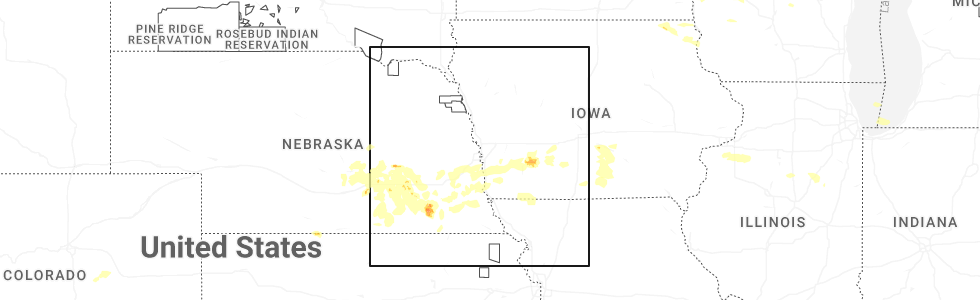
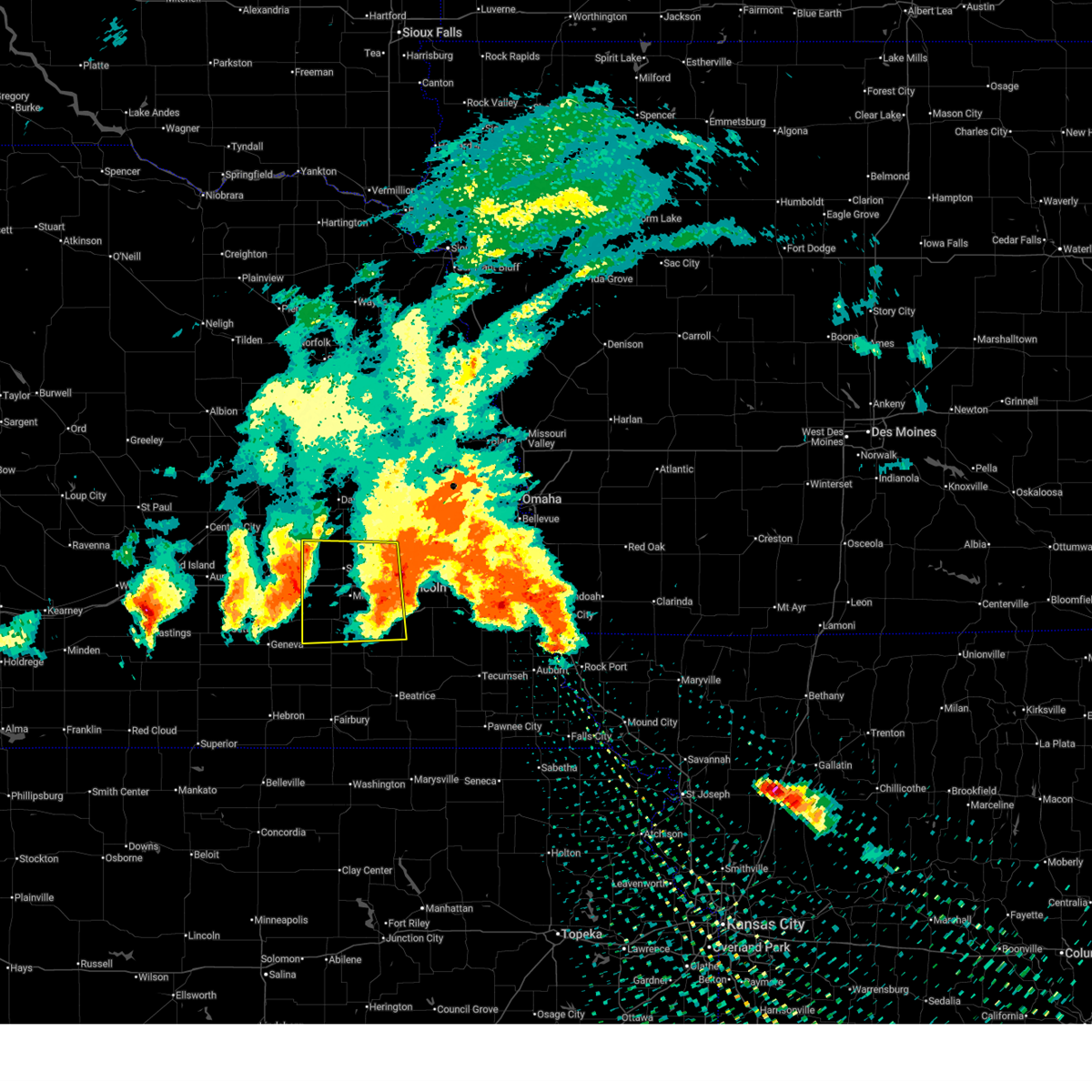
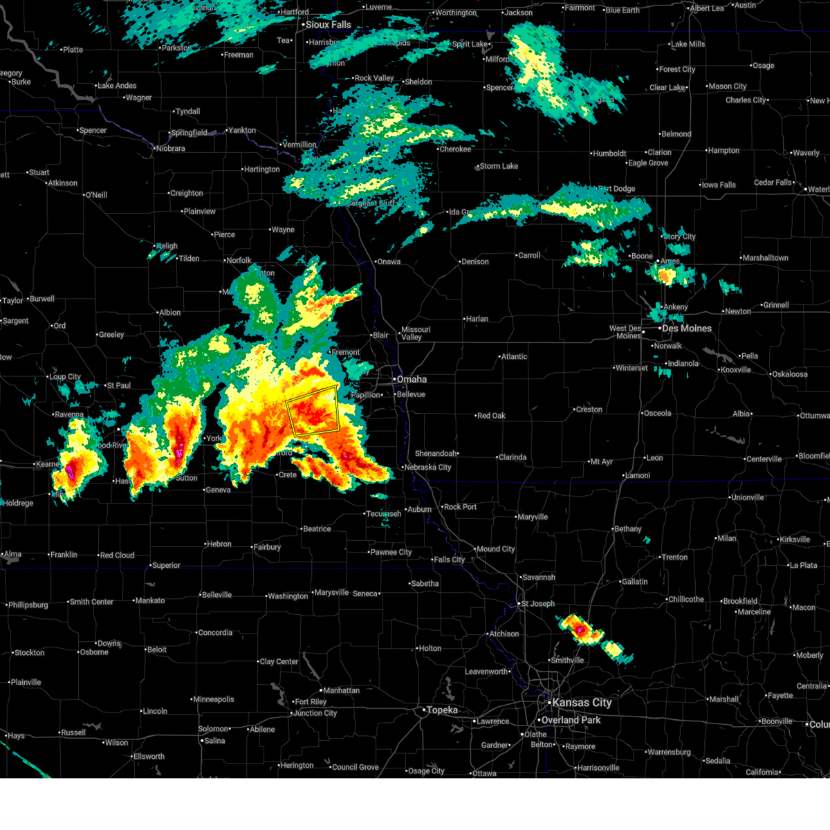
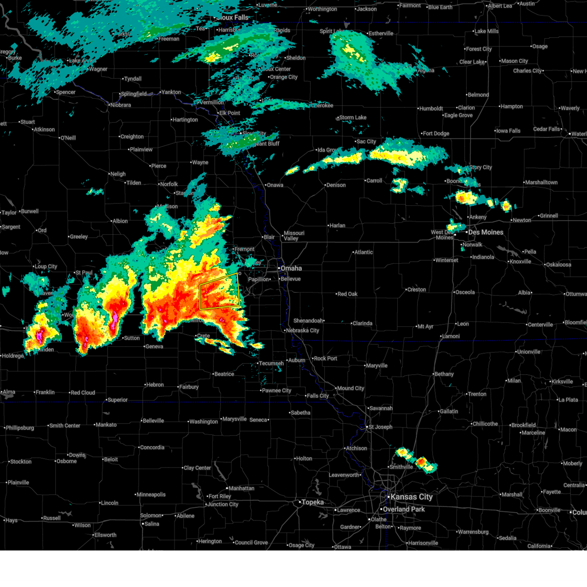
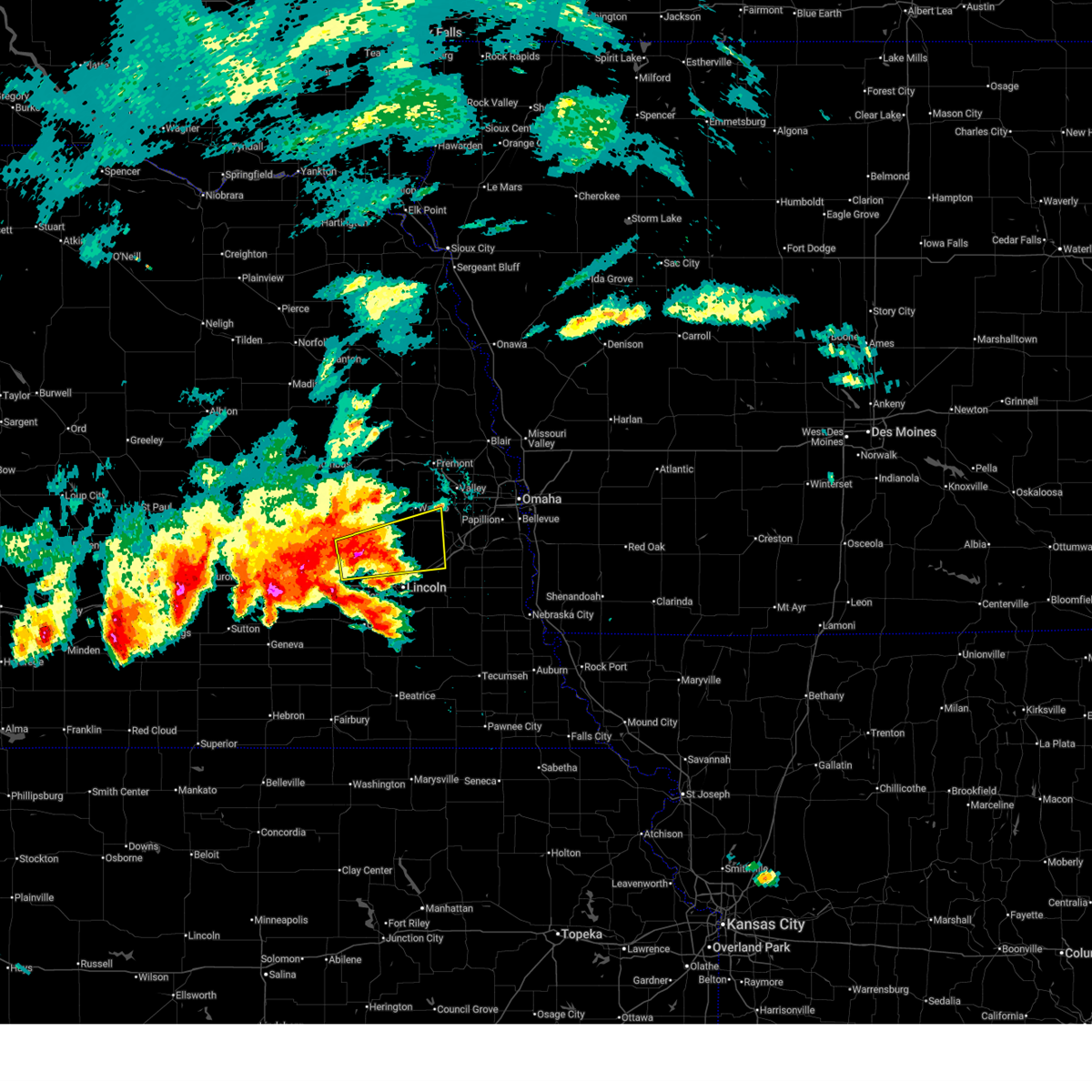
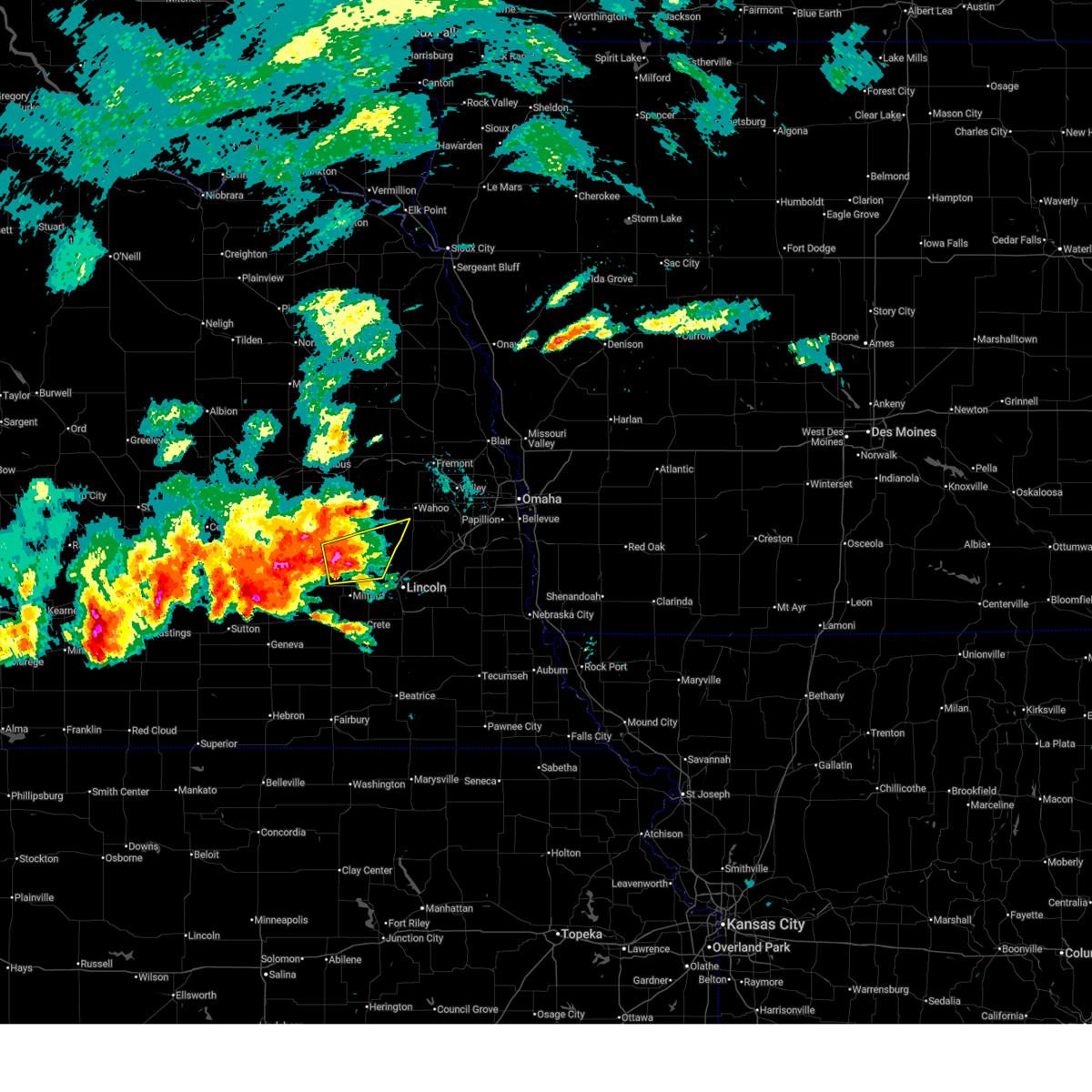
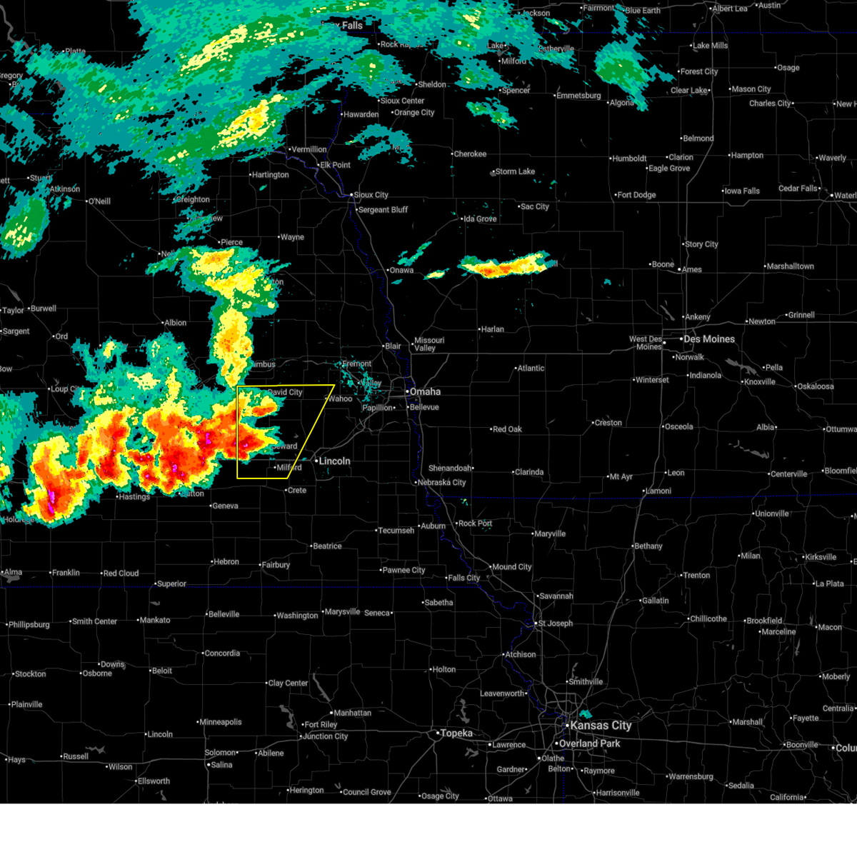
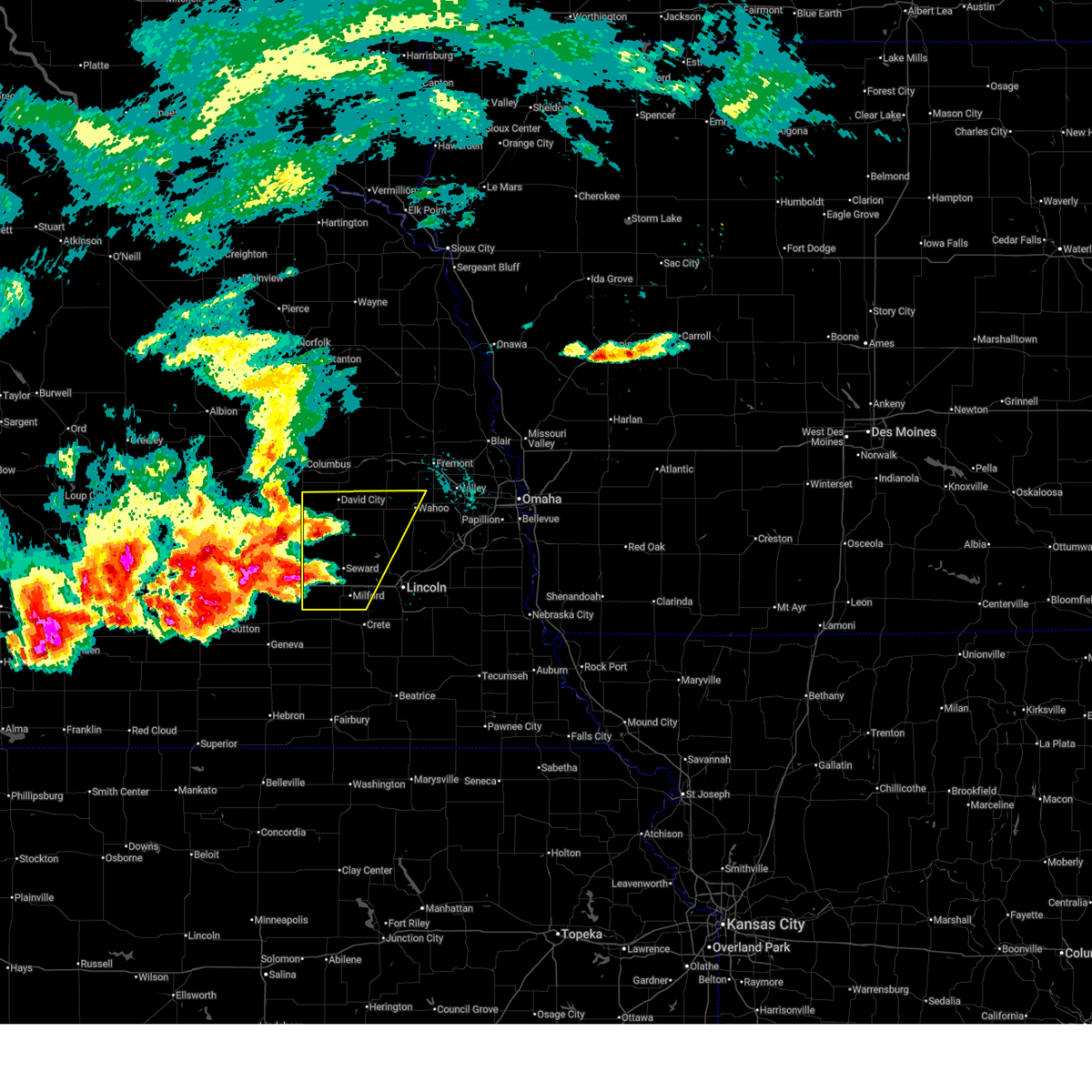
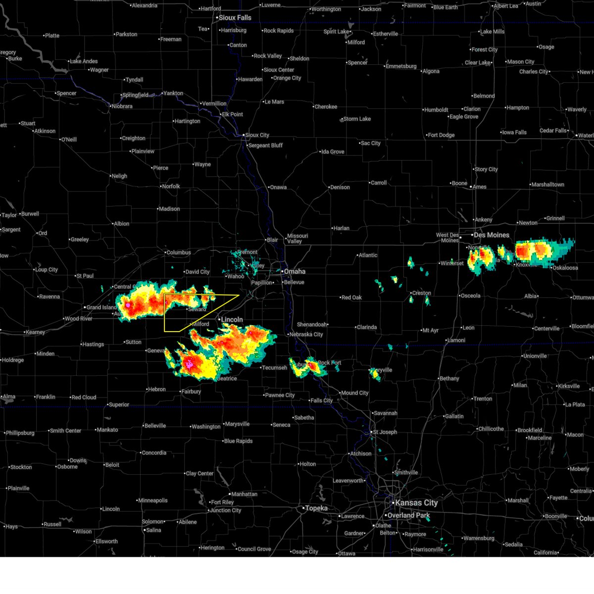
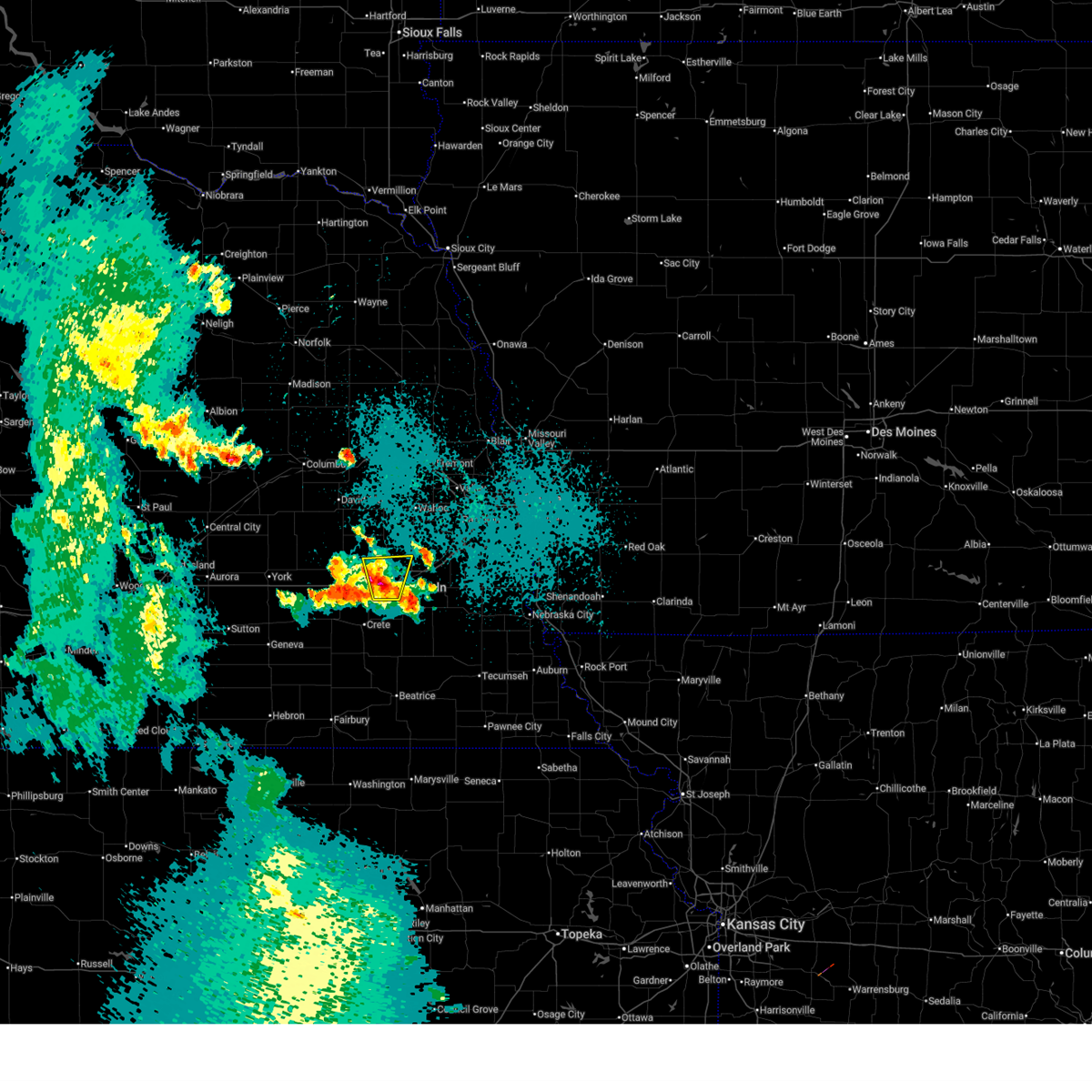
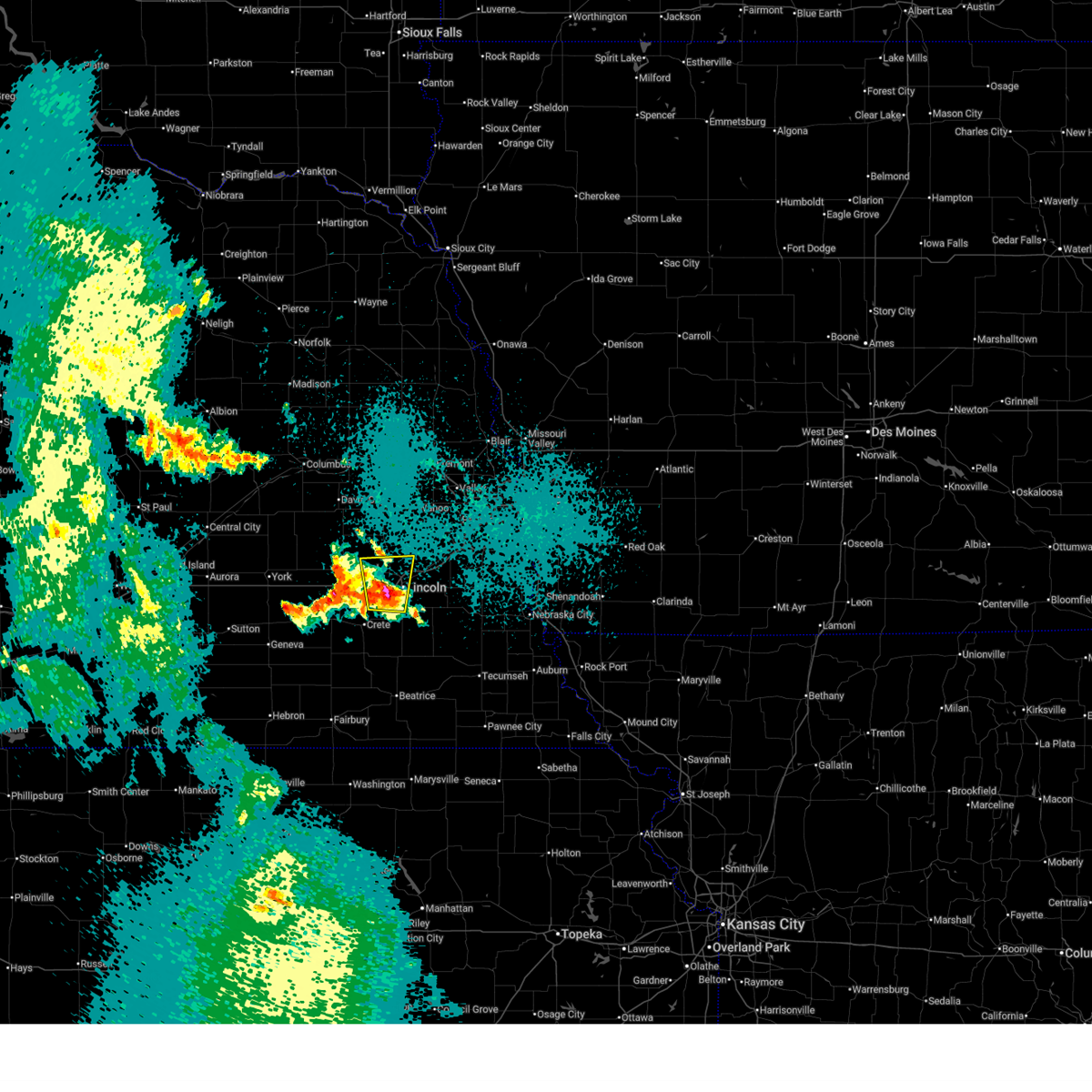
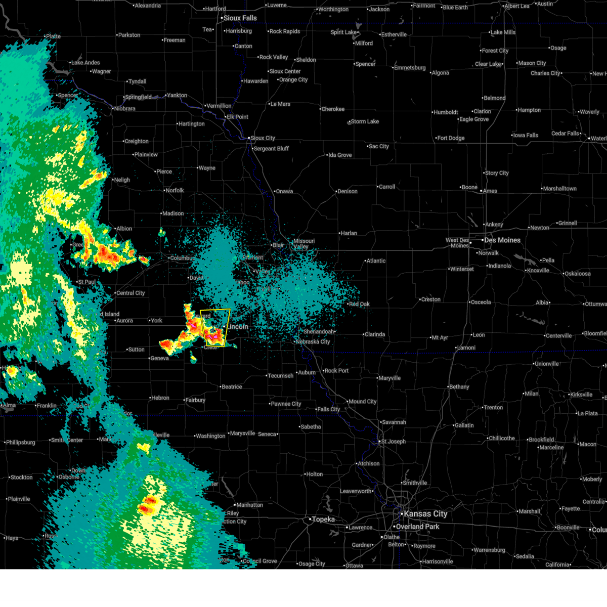
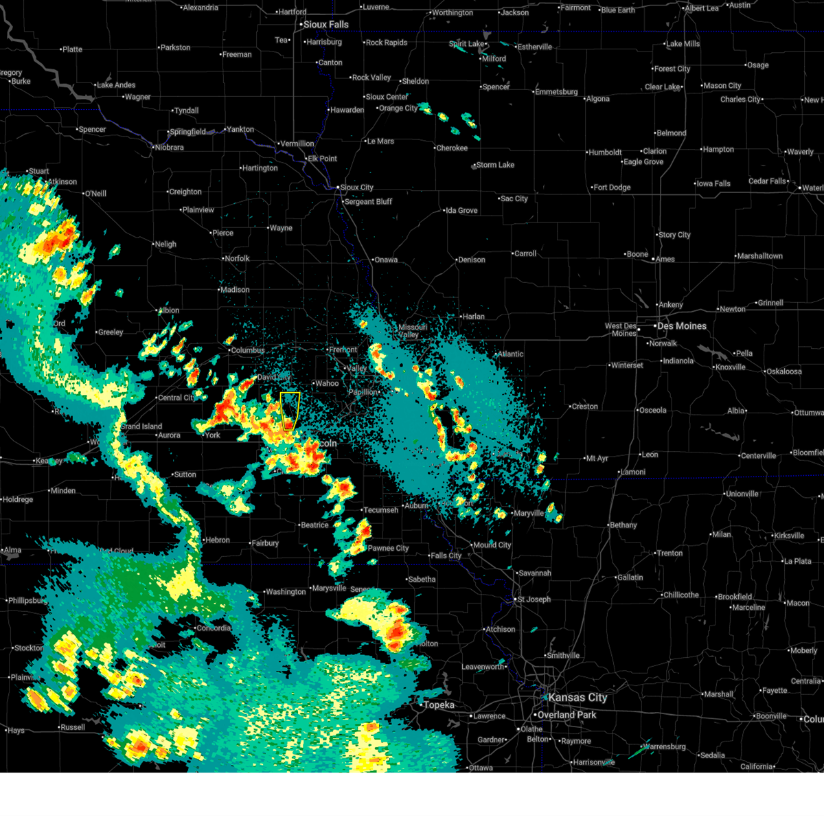
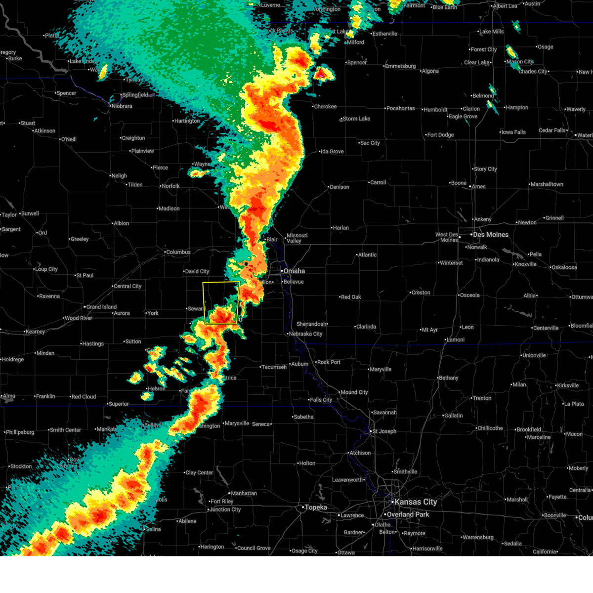
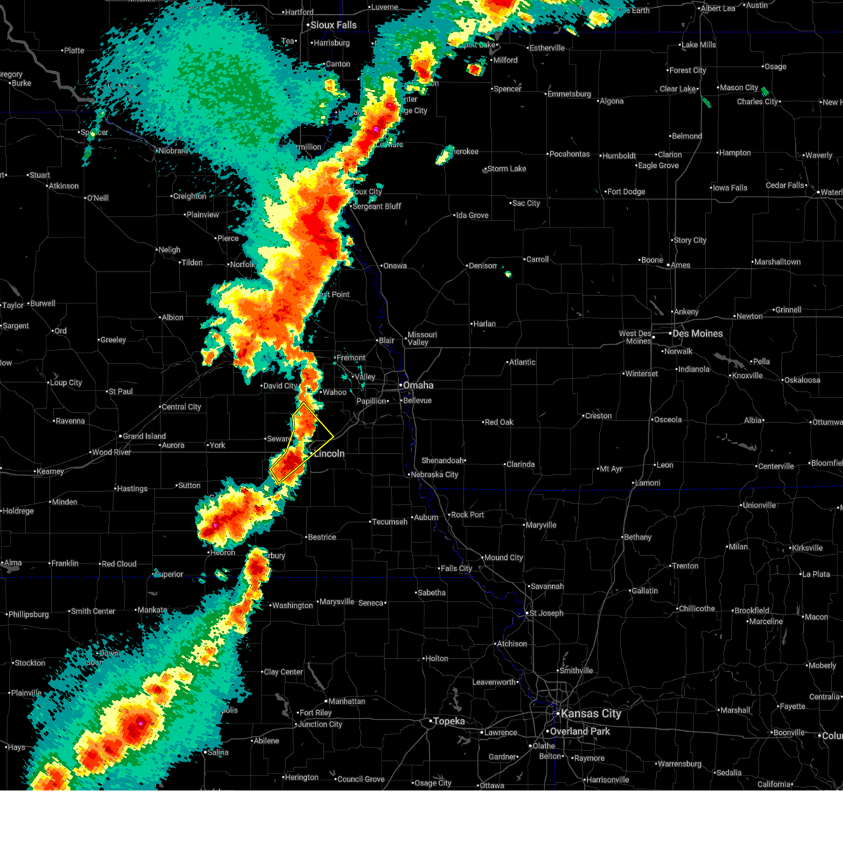
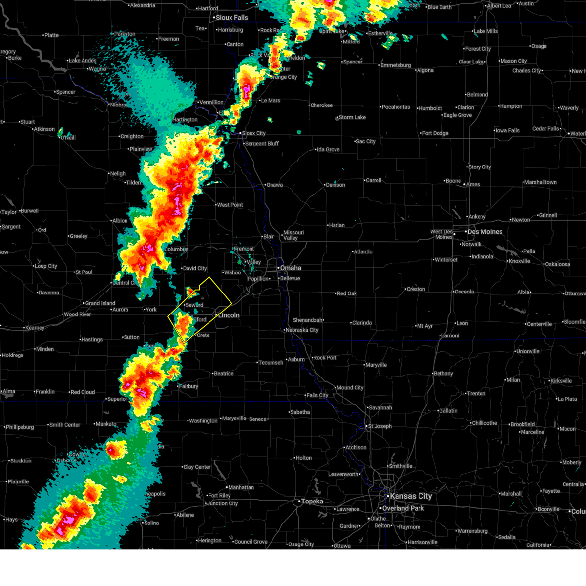
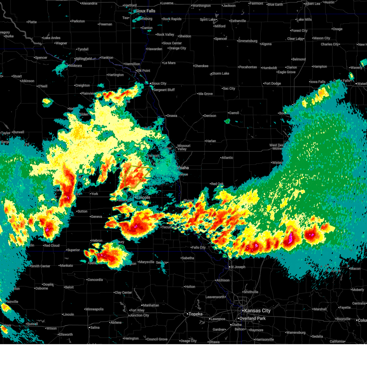
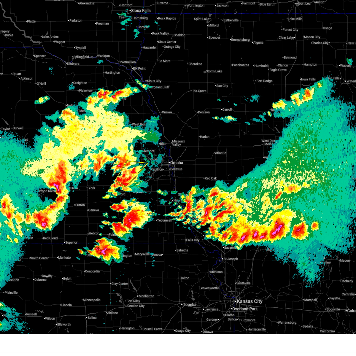
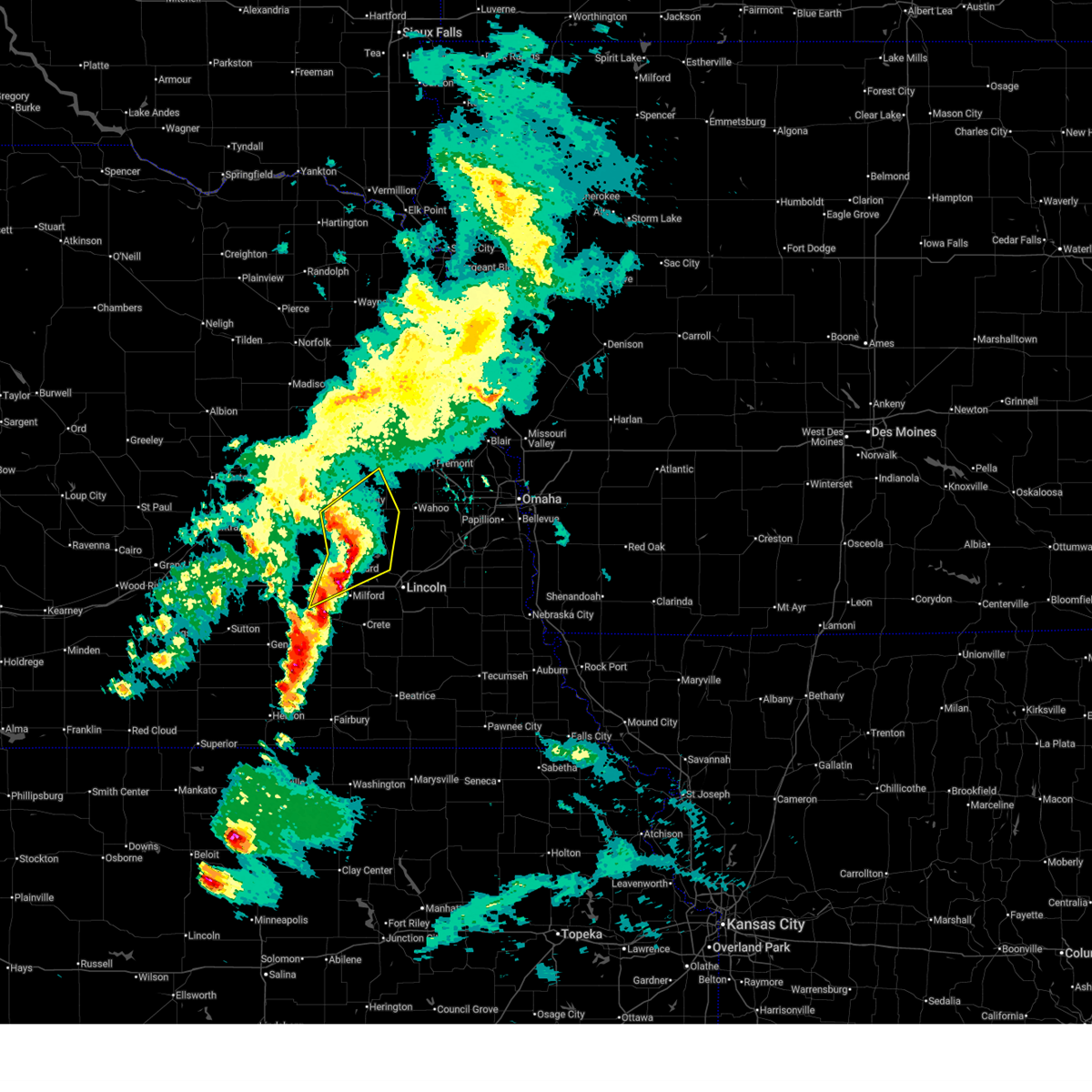
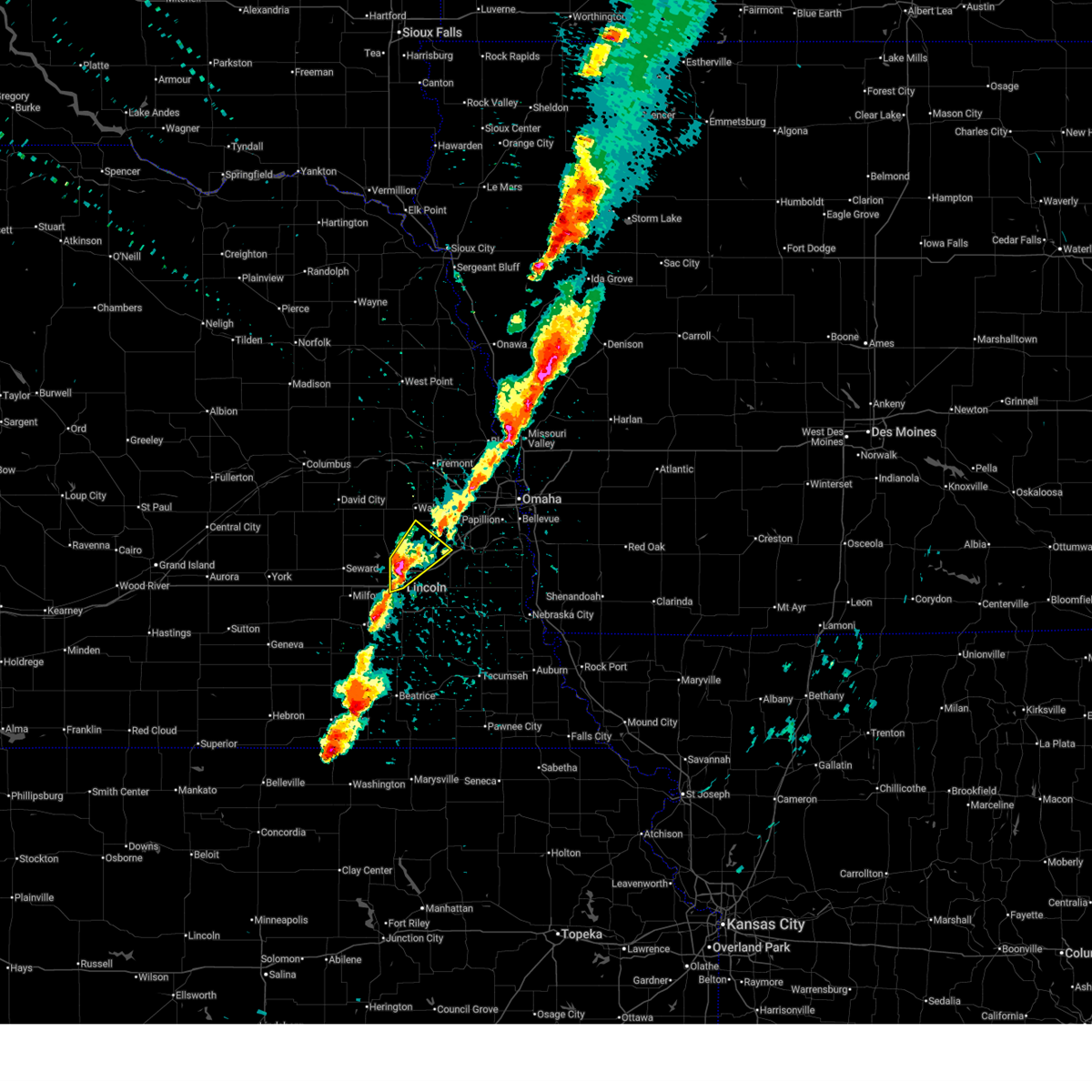
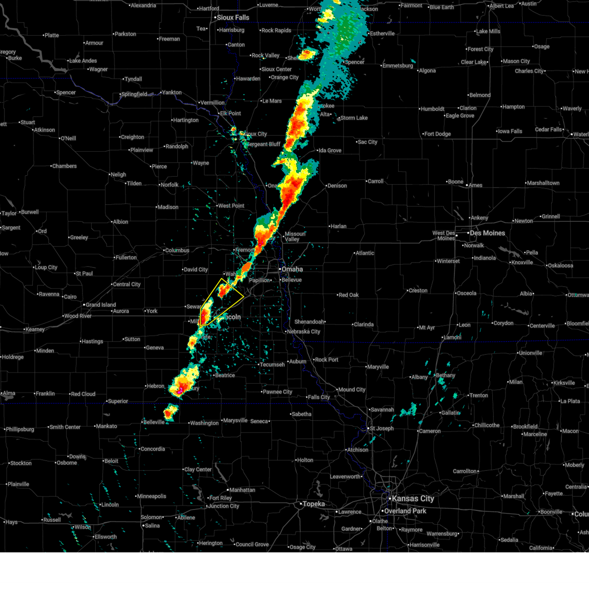
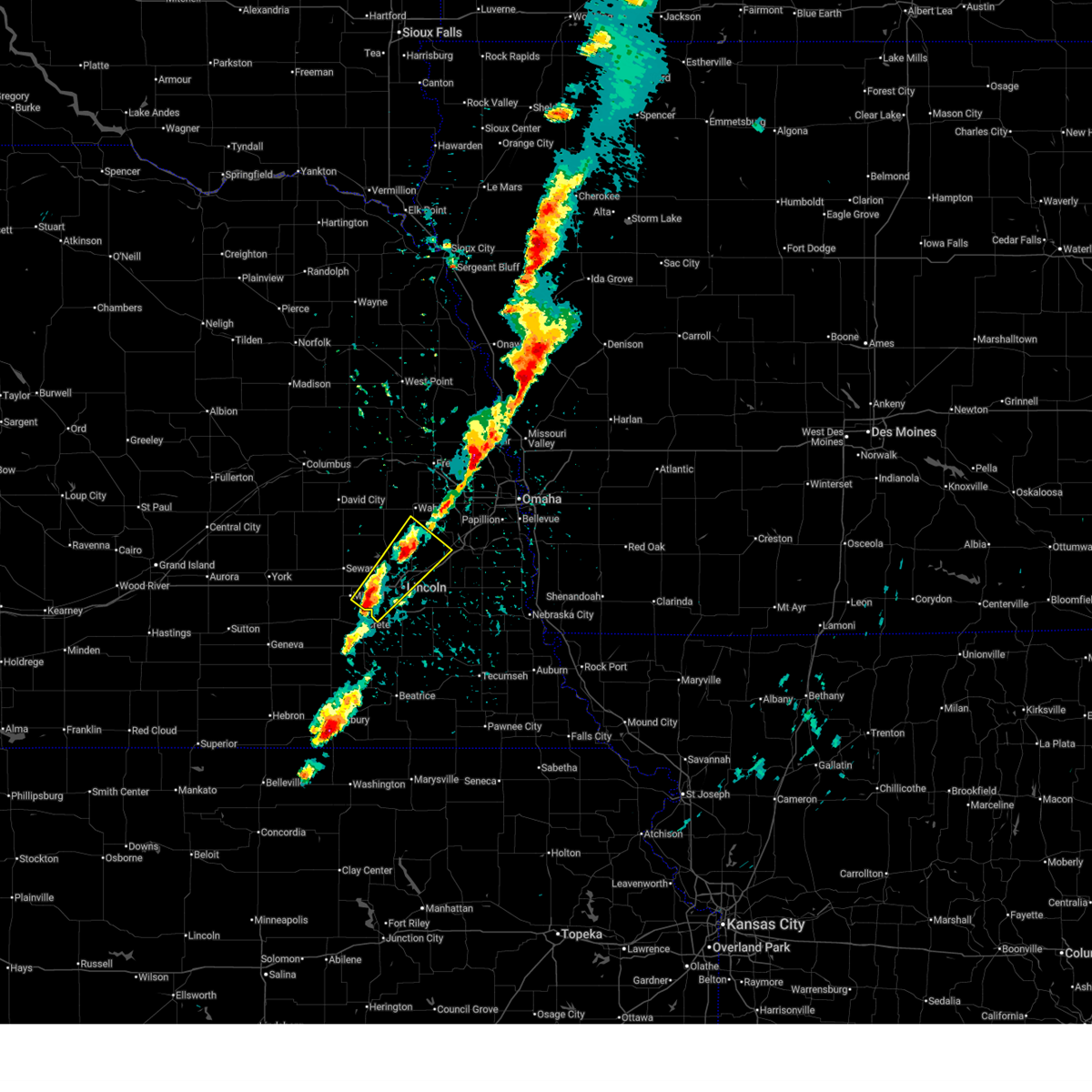
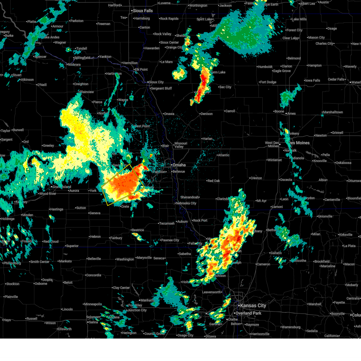
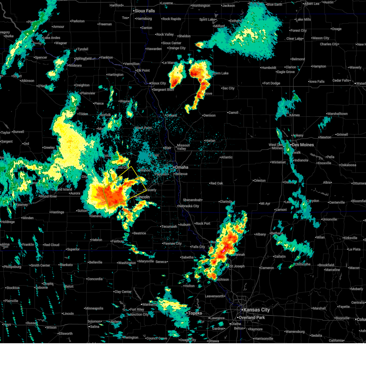
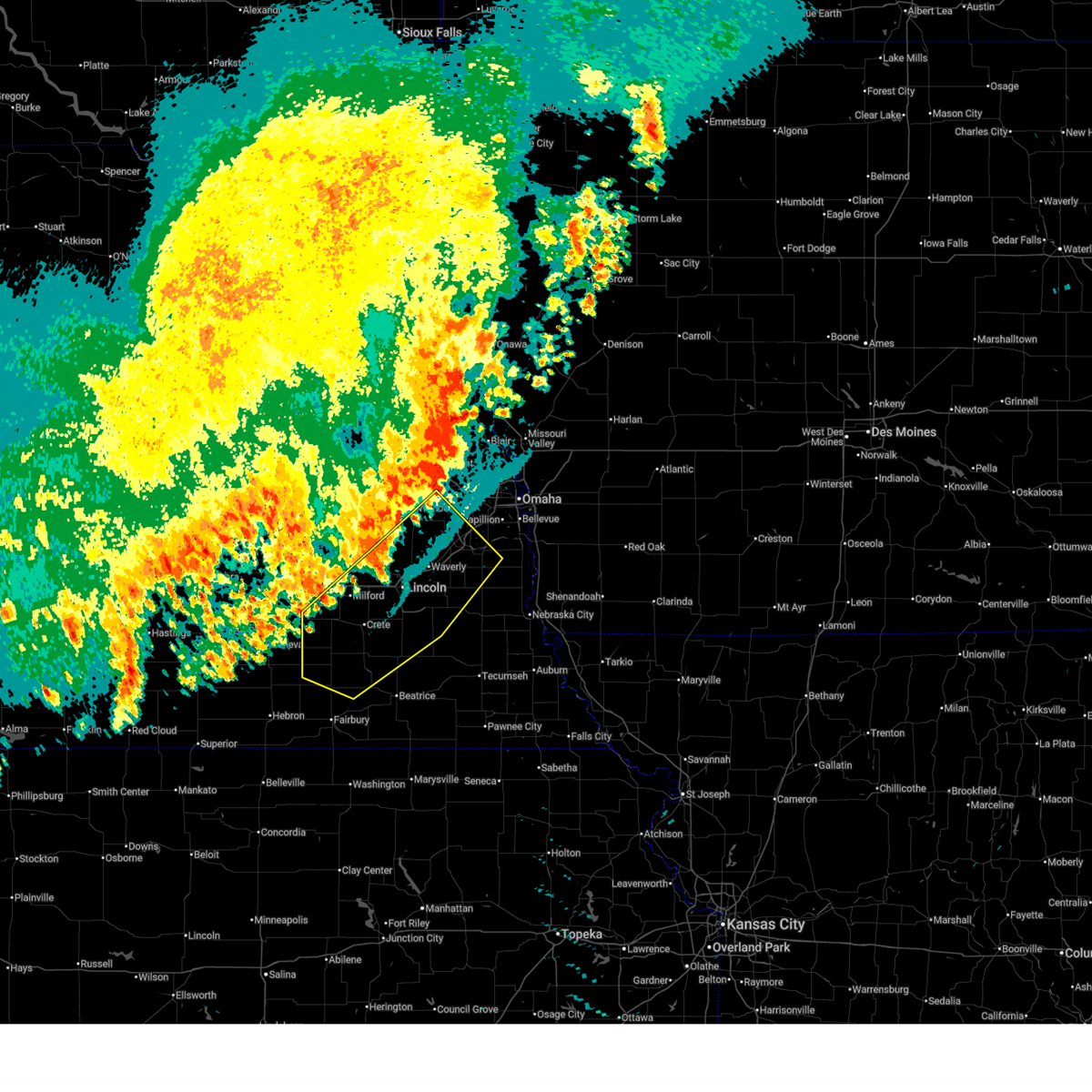
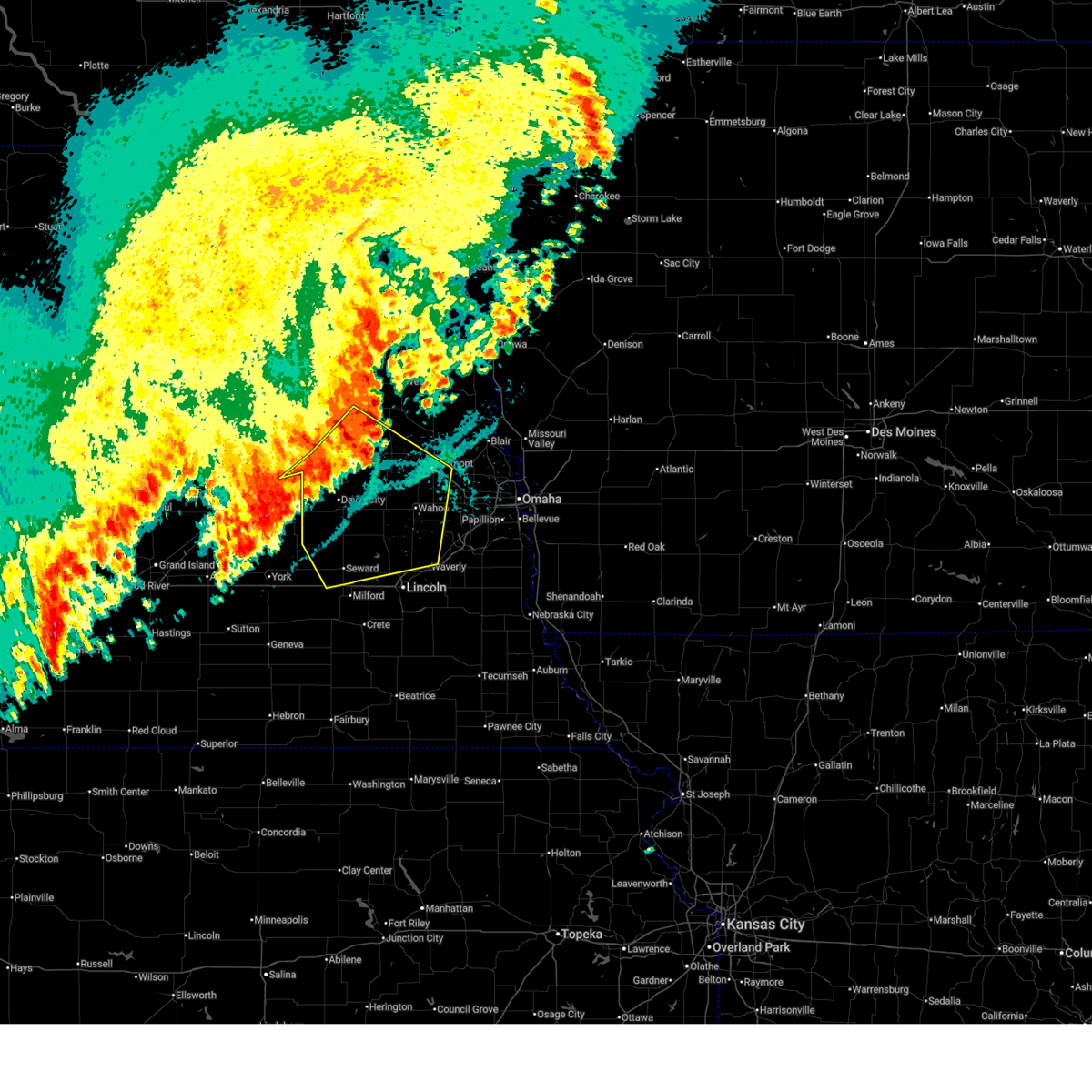
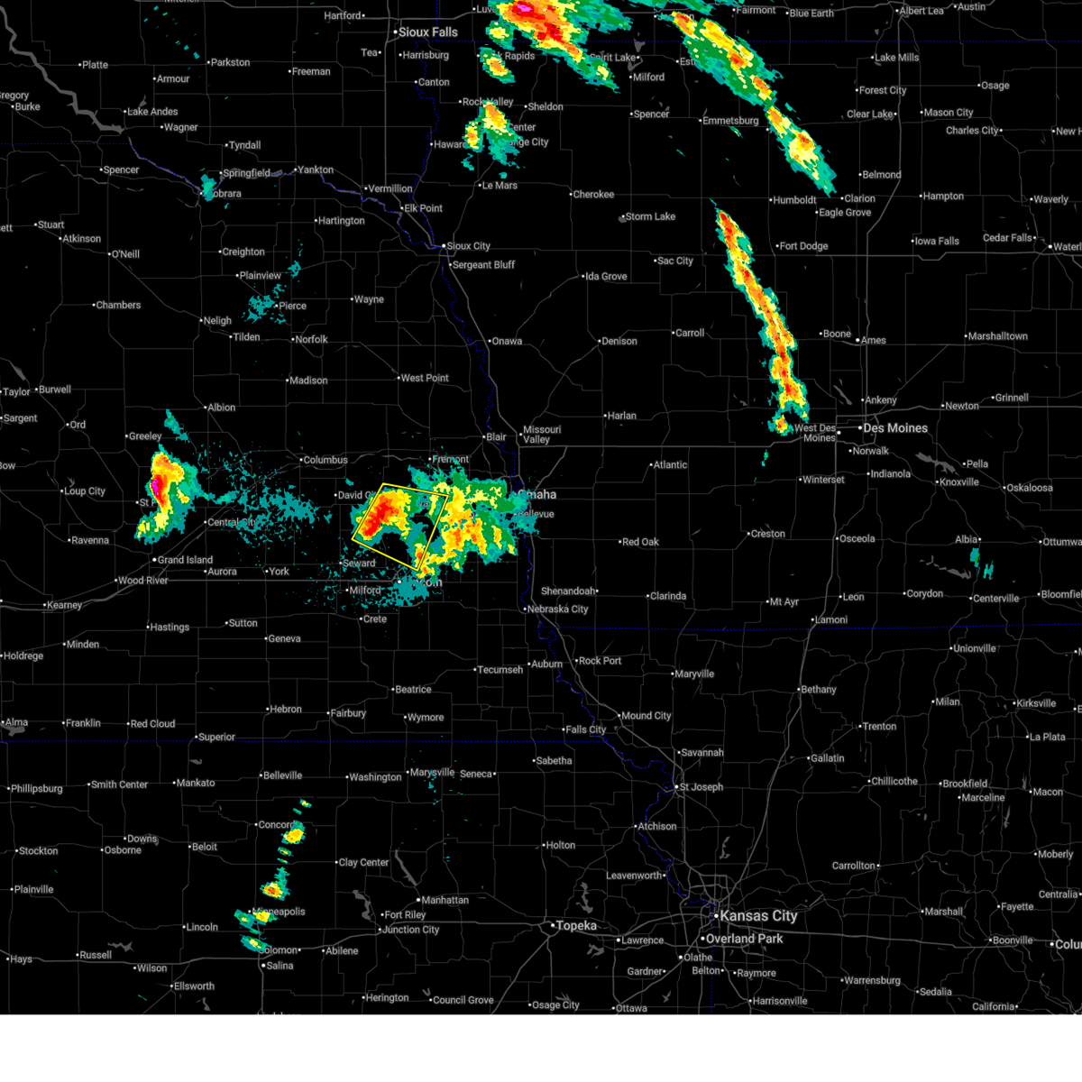
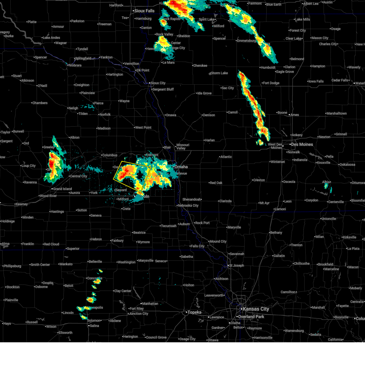
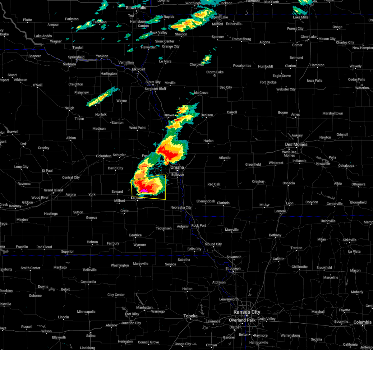
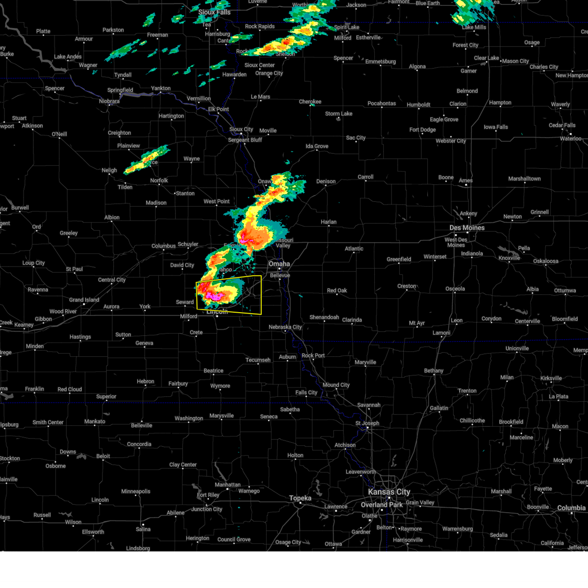
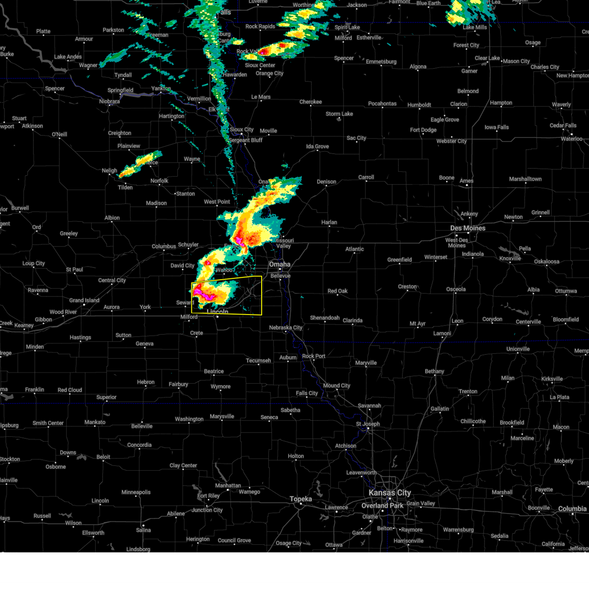
Hail Map for Raymond, NE
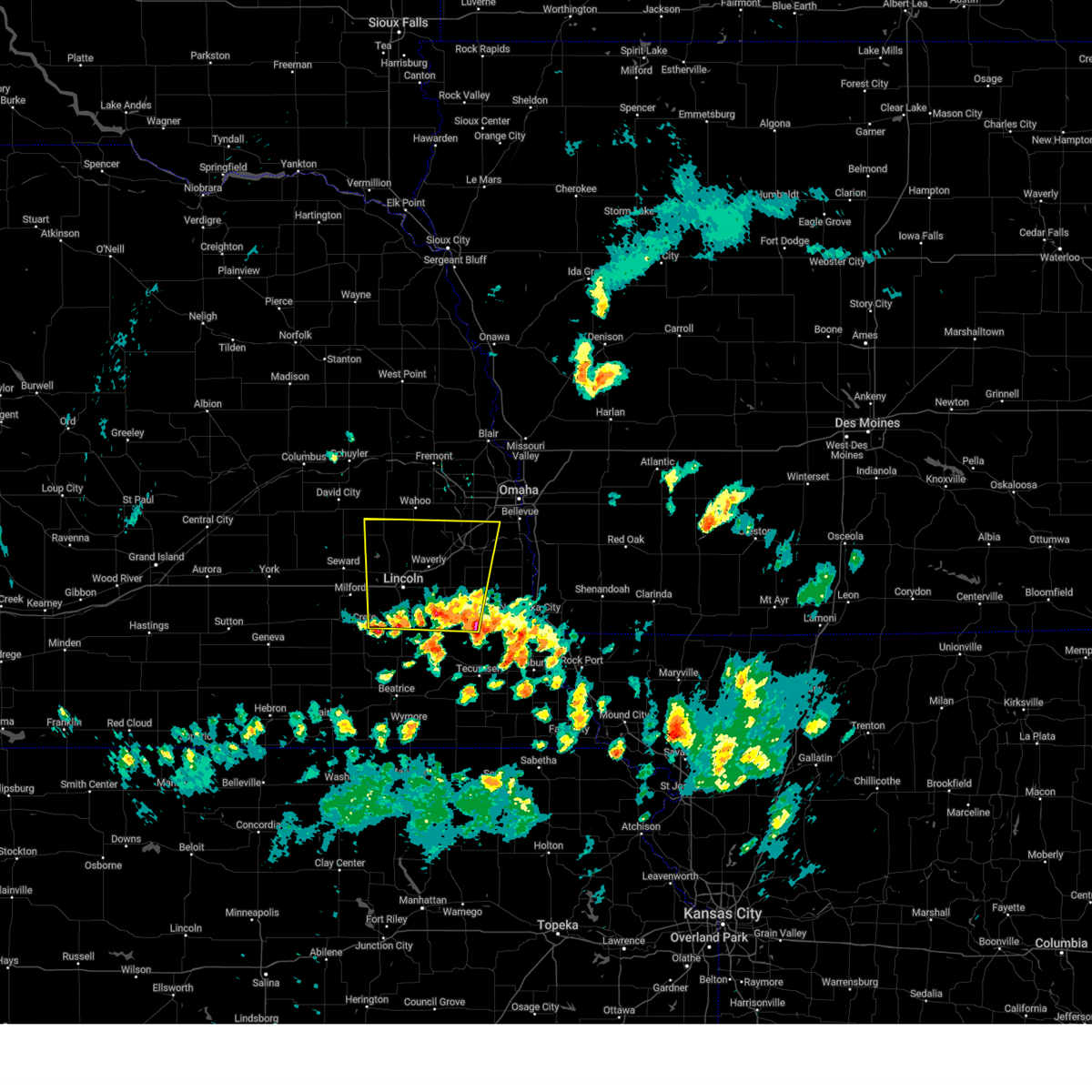
The Raymond, NE area has had 15 reports of on-the-ground hail by trained spotters, and has been under severe weather warnings 45 times during the past 12 months. Doppler radar has detected hail at or near Raymond, NE on 100 occasions, including 10 occasions during the past year.
| Name: | Raymond, NE |
| Where Located: | 48.7 miles WSW of Omaha, NE |
| Map: | Google Map for Raymond, NE |
| Population: | 167 |
| Housing Units: | 76 |
| More Info: | Search Google for Raymond, NE |
1
The Top Recent Hail Date for Raymond, NE is Friday, June 5, 2026 (40th out of 100)
Hail and Wind Damage Spotted near Raymond, NE
| Date / Time | Report Details |
|---|---|
| 6/11/2026 5:18 AM CDT |
 the severe thunderstorm warning has been cancelled and is no longer in effect the severe thunderstorm warning has been cancelled and is no longer in effect
|
| 6/11/2026 5:04 AM CDT |
 At 504 am cdt, severe thunderstorms were located along a line extending from 2 miles west of garland to 5 miles northwest of dorchester, moving east at 55 mph (radar indicated). Hazards include 60 mph wind gusts and penny size hail. Expect damage to roofs, siding, and trees. locations impacted include, milford, malcolm, garland, pleasant dale, western lincoln, raymond, emerald, lincoln airport and pioneers park. This includes interstate 80 in nebraska between mile markers 371 and 399. At 504 am cdt, severe thunderstorms were located along a line extending from 2 miles west of garland to 5 miles northwest of dorchester, moving east at 55 mph (radar indicated). Hazards include 60 mph wind gusts and penny size hail. Expect damage to roofs, siding, and trees. locations impacted include, milford, malcolm, garland, pleasant dale, western lincoln, raymond, emerald, lincoln airport and pioneers park. This includes interstate 80 in nebraska between mile markers 371 and 399.
|
| 6/11/2026 4:46 AM CDT |
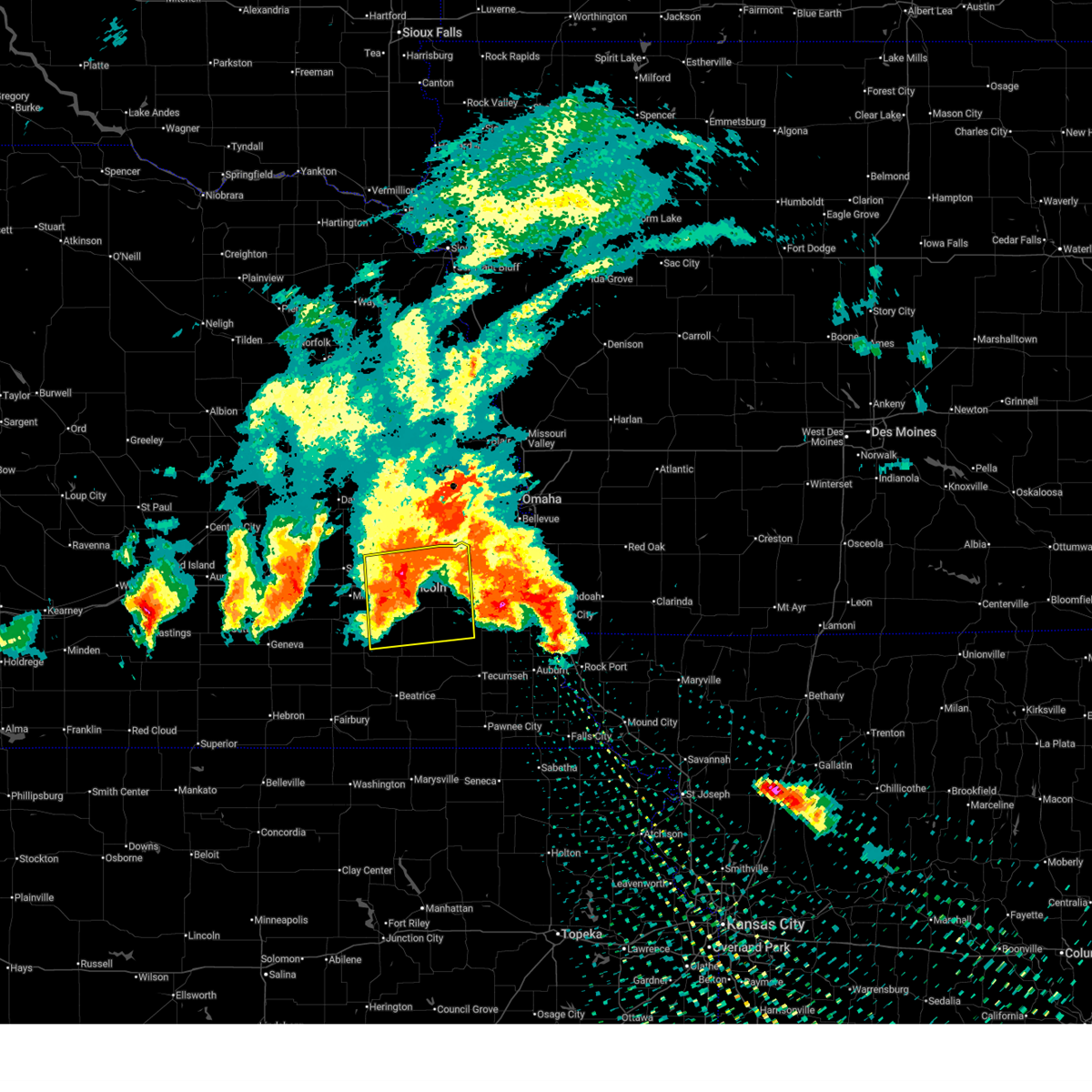 At 446 am cdt, a severe thunderstorm was located 3 miles south of walton, or 7 miles southeast of lincoln, moving east at 60 mph (weather instrument measurement measured 70 mph gust in lincoln, nebraska at 4:37 am). Hazards include 70 mph wind gusts and quarter size hail. Hail damage to vehicles is expected. expect considerable tree damage. wind damage is also likely to mobile homes, roofs, and outbuildings. this severe storm will be near, eagle around 450 am cdt. palmyra around 455 am cdt. This includes interstate 80 in nebraska between mile markers 388 and 426. At 446 am cdt, a severe thunderstorm was located 3 miles south of walton, or 7 miles southeast of lincoln, moving east at 60 mph (weather instrument measurement measured 70 mph gust in lincoln, nebraska at 4:37 am). Hazards include 70 mph wind gusts and quarter size hail. Hail damage to vehicles is expected. expect considerable tree damage. wind damage is also likely to mobile homes, roofs, and outbuildings. this severe storm will be near, eagle around 450 am cdt. palmyra around 455 am cdt. This includes interstate 80 in nebraska between mile markers 388 and 426.
|
| 6/11/2026 4:45 AM CDT |
 Svroax the national weather service in omaha has issued a * severe thunderstorm warning for, western lancaster county in southeastern nebraska, seward county in southeastern nebraska, northern saline county in southeastern nebraska, * until 530 am cdt. * at 445 am cdt, a severe thunderstorm was located near beaver crossing, or 14 miles southwest of seward, moving east at 60 mph (radar indicated). Hazards include 60 mph wind gusts and nickel size hail. Expect damage to roofs, siding, and trees. this severe thunderstorm will be near, beaver crossing and goehner around 450 am cdt. milford around 455 am cdt. pleasant dale around 505 am cdt. other locations in the path of this severe thunderstorm include northwestern lincoln, emerald, lincoln airport and pioneers park. This includes interstate 80 in nebraska between mile markers 366 and 399. Svroax the national weather service in omaha has issued a * severe thunderstorm warning for, western lancaster county in southeastern nebraska, seward county in southeastern nebraska, northern saline county in southeastern nebraska, * until 530 am cdt. * at 445 am cdt, a severe thunderstorm was located near beaver crossing, or 14 miles southwest of seward, moving east at 60 mph (radar indicated). Hazards include 60 mph wind gusts and nickel size hail. Expect damage to roofs, siding, and trees. this severe thunderstorm will be near, beaver crossing and goehner around 450 am cdt. milford around 455 am cdt. pleasant dale around 505 am cdt. other locations in the path of this severe thunderstorm include northwestern lincoln, emerald, lincoln airport and pioneers park. This includes interstate 80 in nebraska between mile markers 366 and 399.
|
| 6/11/2026 4:22 AM CDT |
 At 422 am cdt, a severe thunderstorm was located over davey, or 13 miles north of lincoln, moving east at 35 mph (radar indicated). Hazards include 60 mph wind gusts and half dollar size hail. Hail damage to vehicles is expected. expect wind damage to roofs, siding, and trees. locations impacted include, waverly, ceresco, valparaiso, greenwood, raymond, davey, ithaca, and memphis state recreation area. This includes interstate 80 in nebraska near mile marker 405, and between mile markers 414 and 415. At 422 am cdt, a severe thunderstorm was located over davey, or 13 miles north of lincoln, moving east at 35 mph (radar indicated). Hazards include 60 mph wind gusts and half dollar size hail. Hail damage to vehicles is expected. expect wind damage to roofs, siding, and trees. locations impacted include, waverly, ceresco, valparaiso, greenwood, raymond, davey, ithaca, and memphis state recreation area. This includes interstate 80 in nebraska near mile marker 405, and between mile markers 414 and 415.
|
| 6/11/2026 4:14 AM CDT |
 the severe thunderstorm warning has been cancelled and is no longer in effect the severe thunderstorm warning has been cancelled and is no longer in effect
|
| 6/11/2026 4:14 AM CDT |
 At 413 am cdt, a severe thunderstorm was located near raymond, or 13 miles north of lincoln, moving east at 35 mph (trained weather spotters reported hail two inches in diameter in extreme northwest lancaster county at 4:00 am). Hazards include two inch hail and 60 mph wind gusts. People and animals outdoors will be injured. expect hail damage to roofs, siding, windows, and vehicles. expect wind damage to roofs, siding, and trees. this severe storm will be near, ceresco and davey around 420 am cdt. This includes interstate 80 in nebraska between mile markers 405 and 407, and between mile markers 411 and 415. At 413 am cdt, a severe thunderstorm was located near raymond, or 13 miles north of lincoln, moving east at 35 mph (trained weather spotters reported hail two inches in diameter in extreme northwest lancaster county at 4:00 am). Hazards include two inch hail and 60 mph wind gusts. People and animals outdoors will be injured. expect hail damage to roofs, siding, windows, and vehicles. expect wind damage to roofs, siding, and trees. this severe storm will be near, ceresco and davey around 420 am cdt. This includes interstate 80 in nebraska between mile markers 405 and 407, and between mile markers 411 and 415.
|
| 6/11/2026 4:05 AM CDT |
 At 404 am cdt, a severe thunderstorm was located 4 miles west of raymond, or 12 miles east of seward, moving east at 35 mph (trained weather spotters reported hail two inches in diameter in extreme northwest lancaster county at 4:00 am). Hazards include two inch hail and 60 mph wind gusts. People and animals outdoors will be injured. expect hail damage to roofs, siding, windows, and vehicles. expect wind damage to roofs, siding, and trees. this severe storm will be near, raymond around 410 am cdt. other locations in the path of this severe thunderstorm include davey and ceresco. This includes interstate 80 in nebraska between mile markers 405 and 407, and between mile markers 411 and 415. At 404 am cdt, a severe thunderstorm was located 4 miles west of raymond, or 12 miles east of seward, moving east at 35 mph (trained weather spotters reported hail two inches in diameter in extreme northwest lancaster county at 4:00 am). Hazards include two inch hail and 60 mph wind gusts. People and animals outdoors will be injured. expect hail damage to roofs, siding, windows, and vehicles. expect wind damage to roofs, siding, and trees. this severe storm will be near, raymond around 410 am cdt. other locations in the path of this severe thunderstorm include davey and ceresco. This includes interstate 80 in nebraska between mile markers 405 and 407, and between mile markers 411 and 415.
|
| 6/11/2026 4:00 AM CDT | Tennis Ball sized hail reported 7.3 miles ESE of Raymond, NE |
| 6/11/2026 3:52 AM CDT |
 At 352 am cdt, a severe thunderstorm was located 4 miles southeast of dwight, or 12 miles northeast of seward, moving northeast at 50 mph (radar indicated). Hazards include 60 mph wind gusts and half dollar size hail. Hail damage to vehicles is expected. expect wind damage to roofs, siding, and trees. Locations impacted include, seward, valparaiso, malcolm, garland, dwight, bee, raymond, and branched oak state recreation area. At 352 am cdt, a severe thunderstorm was located 4 miles southeast of dwight, or 12 miles northeast of seward, moving northeast at 50 mph (radar indicated). Hazards include 60 mph wind gusts and half dollar size hail. Hail damage to vehicles is expected. expect wind damage to roofs, siding, and trees. Locations impacted include, seward, valparaiso, malcolm, garland, dwight, bee, raymond, and branched oak state recreation area.
|
| 6/11/2026 3:52 AM CDT |
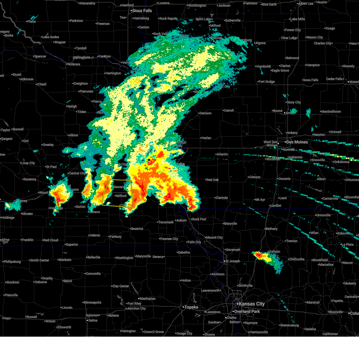
 Svroax the national weather service in omaha has issued a * severe thunderstorm warning for, northern lancaster county in southeastern nebraska, northeastern seward county in southeastern nebraska, southeastern butler county in east central nebraska, southern saunders county in east central nebraska, west central cass county in southeastern nebraska, * until 430 am cdt. * at 352 am cdt, a severe thunderstorm was located over garland, or 6 miles northeast of seward, moving east at 35 mph (radar indicated). Hazards include ping pong ball size hail and 60 mph wind gusts. People and animals outdoors will be injured. expect hail damage to roofs, siding, windows, and vehicles. expect wind damage to roofs, siding, and trees. this severe thunderstorm will be near, raymond around 405 am cdt. other locations in the path of this severe thunderstorm include davey and ceresco. This includes interstate 80 in nebraska between mile markers 405 and 407, and between mile markers 411 and 415. Svroax the national weather service in omaha has issued a * severe thunderstorm warning for, northern lancaster county in southeastern nebraska, northeastern seward county in southeastern nebraska, southeastern butler county in east central nebraska, southern saunders county in east central nebraska, west central cass county in southeastern nebraska, * until 430 am cdt. * at 352 am cdt, a severe thunderstorm was located over garland, or 6 miles northeast of seward, moving east at 35 mph (radar indicated). Hazards include ping pong ball size hail and 60 mph wind gusts. People and animals outdoors will be injured. expect hail damage to roofs, siding, windows, and vehicles. expect wind damage to roofs, siding, and trees. this severe thunderstorm will be near, raymond around 405 am cdt. other locations in the path of this severe thunderstorm include davey and ceresco. This includes interstate 80 in nebraska between mile markers 405 and 407, and between mile markers 411 and 415.
|
| 6/11/2026 3:44 AM CDT |
 At 344 am cdt, a severe thunderstorm was located over bee, or 5 miles north of seward, moving northeast at 50 mph (radar indicated). Hazards include 60 mph wind gusts and half dollar size hail. Hail damage to vehicles is expected. expect wind damage to roofs, siding, and trees. Locations impacted include, seward, valparaiso, malcolm, staplehurst, garland, dwight, bee, raymond, and branched oak state recreation area. At 344 am cdt, a severe thunderstorm was located over bee, or 5 miles north of seward, moving northeast at 50 mph (radar indicated). Hazards include 60 mph wind gusts and half dollar size hail. Hail damage to vehicles is expected. expect wind damage to roofs, siding, and trees. Locations impacted include, seward, valparaiso, malcolm, staplehurst, garland, dwight, bee, raymond, and branched oak state recreation area.
|
| 6/11/2026 3:23 AM CDT |
 At 323 am cdt, severe thunderstorms were located along a line extending from 3 miles southwest of hampton to 3 miles east of utica, moving east at 50 mph (radar indicated). Hazards include ping pong ball size hail and 60 mph wind gusts. People and animals outdoors will be injured. expect hail damage to roofs, siding, windows, and vehicles. expect wind damage to roofs, siding, and trees. these severe storms will be near, seward, utica, and staplehurst around 330 am cdt. other locations in the path of these severe thunderstorms include garland, bee and raymond. This includes interstate 80 in nebraska between mile markers 366 and 390. At 323 am cdt, severe thunderstorms were located along a line extending from 3 miles southwest of hampton to 3 miles east of utica, moving east at 50 mph (radar indicated). Hazards include ping pong ball size hail and 60 mph wind gusts. People and animals outdoors will be injured. expect hail damage to roofs, siding, windows, and vehicles. expect wind damage to roofs, siding, and trees. these severe storms will be near, seward, utica, and staplehurst around 330 am cdt. other locations in the path of these severe thunderstorms include garland, bee and raymond. This includes interstate 80 in nebraska between mile markers 366 and 390.
|
| 6/11/2026 3:13 AM CDT |
 Svroax the national weather service in omaha has issued a * severe thunderstorm warning for, northwestern lancaster county in southeastern nebraska, seward county in southeastern nebraska, butler county in east central nebraska, southwestern saunders county in east central nebraska, * until 400 am cdt. * at 313 am cdt, severe thunderstorms were located along a line extending from 5 miles northeast of giltner to 3 miles southeast of waco, moving northeast at 50 mph (radar indicated). Hazards include 60 mph wind gusts and half dollar size hail. Hail damage to vehicles is expected. expect wind damage to roofs, siding, and trees. severe thunderstorms will be near, utica around 320 am cdt. staplehurst around 325 am cdt. other locations in the path of these severe thunderstorms include bee, ulysses, dwight, surprise and brainard. This includes interstate 80 in nebraska between mile markers 366 and 390. Svroax the national weather service in omaha has issued a * severe thunderstorm warning for, northwestern lancaster county in southeastern nebraska, seward county in southeastern nebraska, butler county in east central nebraska, southwestern saunders county in east central nebraska, * until 400 am cdt. * at 313 am cdt, severe thunderstorms were located along a line extending from 5 miles northeast of giltner to 3 miles southeast of waco, moving northeast at 50 mph (radar indicated). Hazards include 60 mph wind gusts and half dollar size hail. Hail damage to vehicles is expected. expect wind damage to roofs, siding, and trees. severe thunderstorms will be near, utica around 320 am cdt. staplehurst around 325 am cdt. other locations in the path of these severe thunderstorms include bee, ulysses, dwight, surprise and brainard. This includes interstate 80 in nebraska between mile markers 366 and 390.
|
| 6/5/2026 8:45 PM CDT |
 Svroax the national weather service in omaha has issued a * severe thunderstorm warning for, northern lancaster county in southeastern nebraska, seward county in southeastern nebraska, * until 930 pm cdt. * at 845 pm cdt, severe thunderstorms were located along a line extending from 3 miles northwest of raymond to 3 miles west of garland to near utica, moving southeast at 20 mph (radar indicated). Hazards include 60 mph wind gusts and quarter size hail. Hail damage to vehicles is expected. expect wind damage to roofs, siding, and trees. severe thunderstorms will be near, seward, malcolm, garland, raymond, and goehner around 850 pm cdt. beaver crossing and davey around 900 pm cdt. other locations in the path of these severe thunderstorms include milford. This includes interstate 80 in nebraska between mile markers 366 and 385. Svroax the national weather service in omaha has issued a * severe thunderstorm warning for, northern lancaster county in southeastern nebraska, seward county in southeastern nebraska, * until 930 pm cdt. * at 845 pm cdt, severe thunderstorms were located along a line extending from 3 miles northwest of raymond to 3 miles west of garland to near utica, moving southeast at 20 mph (radar indicated). Hazards include 60 mph wind gusts and quarter size hail. Hail damage to vehicles is expected. expect wind damage to roofs, siding, and trees. severe thunderstorms will be near, seward, malcolm, garland, raymond, and goehner around 850 pm cdt. beaver crossing and davey around 900 pm cdt. other locations in the path of these severe thunderstorms include milford. This includes interstate 80 in nebraska between mile markers 366 and 385.
|
| 6/2/2026 2:36 AM CDT |
 At 235 am cdt, a severe thunderstorm was located near lincoln airport, or 4 miles west of lincoln, moving north at 10 mph (public report of quarter sized hail 5 miles west of lincoln, ne at 2:34 am). Hazards include 60 mph wind gusts and quarter size hail. Hail damage to vehicles is expected. expect wind damage to roofs, siding, and trees. this severe storm will be near, northwestern lincoln and lincoln airport around 240 am cdt. This includes interstate 80 in nebraska between mile markers 390 and 403. At 235 am cdt, a severe thunderstorm was located near lincoln airport, or 4 miles west of lincoln, moving north at 10 mph (public report of quarter sized hail 5 miles west of lincoln, ne at 2:34 am). Hazards include 60 mph wind gusts and quarter size hail. Hail damage to vehicles is expected. expect wind damage to roofs, siding, and trees. this severe storm will be near, northwestern lincoln and lincoln airport around 240 am cdt. This includes interstate 80 in nebraska between mile markers 390 and 403.
|
| 6/2/2026 2:21 AM CDT |
 At 221 am cdt, a severe thunderstorm was located near pioneers park, or 5 miles west of lincoln, moving north at 20 mph (radar indicated). Hazards include 60 mph wind gusts and quarter size hail. Hail damage to vehicles is expected. expect wind damage to roofs, siding, and trees. this severe storm will be near, northwestern lincoln, emerald, and lincoln airport around 225 am cdt. other locations in the path of this severe thunderstorm include raymond. This includes interstate 80 in nebraska between mile markers 388 and 403. At 221 am cdt, a severe thunderstorm was located near pioneers park, or 5 miles west of lincoln, moving north at 20 mph (radar indicated). Hazards include 60 mph wind gusts and quarter size hail. Hail damage to vehicles is expected. expect wind damage to roofs, siding, and trees. this severe storm will be near, northwestern lincoln, emerald, and lincoln airport around 225 am cdt. other locations in the path of this severe thunderstorm include raymond. This includes interstate 80 in nebraska between mile markers 388 and 403.
|
| 6/2/2026 2:13 AM CDT |
 Svroax the national weather service in omaha has issued a * severe thunderstorm warning for, western lancaster county in southeastern nebraska, southeastern seward county in southeastern nebraska, * until 300 am cdt. * at 213 am cdt, a severe thunderstorm was located 5 miles southwest of pioneers park, or 10 miles southwest of lincoln, moving north at 10 mph (radar indicated). Hazards include 60 mph wind gusts and quarter size hail. Hail damage to vehicles is expected. expect wind damage to roofs, siding, and trees. this severe thunderstorm will be near, pioneers park around 225 am cdt. This includes interstate 80 in nebraska between mile markers 388 and 403. Svroax the national weather service in omaha has issued a * severe thunderstorm warning for, western lancaster county in southeastern nebraska, southeastern seward county in southeastern nebraska, * until 300 am cdt. * at 213 am cdt, a severe thunderstorm was located 5 miles southwest of pioneers park, or 10 miles southwest of lincoln, moving north at 10 mph (radar indicated). Hazards include 60 mph wind gusts and quarter size hail. Hail damage to vehicles is expected. expect wind damage to roofs, siding, and trees. this severe thunderstorm will be near, pioneers park around 225 am cdt. This includes interstate 80 in nebraska between mile markers 388 and 403.
|
| 5/30/2026 10:41 PM CDT |
 Svroax the national weather service in omaha has issued a * severe thunderstorm warning for, northwestern lancaster county in southeastern nebraska, southwestern saunders county in east central nebraska, * until 1130 pm cdt. * at 1040 pm cdt, a severe thunderstorm was located 3 miles northwest of raymond, or 14 miles east of seward, moving north at 25 mph (radar indicated). Hazards include 60 mph wind gusts and quarter size hail. Hail damage to vehicles is expected. expect wind damage to roofs, siding, and trees. This severe thunderstorm will be near, valparaiso around 1045 pm cdt. Svroax the national weather service in omaha has issued a * severe thunderstorm warning for, northwestern lancaster county in southeastern nebraska, southwestern saunders county in east central nebraska, * until 1130 pm cdt. * at 1040 pm cdt, a severe thunderstorm was located 3 miles northwest of raymond, or 14 miles east of seward, moving north at 25 mph (radar indicated). Hazards include 60 mph wind gusts and quarter size hail. Hail damage to vehicles is expected. expect wind damage to roofs, siding, and trees. This severe thunderstorm will be near, valparaiso around 1045 pm cdt.
|
| 5/17/2026 8:01 PM CDT |
 Svroax the national weather service in omaha has issued a * severe thunderstorm warning for, northern lancaster county in southeastern nebraska, southwestern saunders county in east central nebraska, * until 845 pm cdt. * at 800 pm cdt, a severe thunderstorm was located near ceresco, or 13 miles south of wahoo, moving north at 45 mph (weather instrument measurement). Hazards include 70 mph wind gusts and quarter size hail. Hail damage to vehicles is expected. expect considerable tree damage. wind damage is also likely to mobile homes, roofs, and outbuildings. this severe thunderstorm will be near, ceresco around 805 pm cdt. This includes interstate 80 in nebraska between mile markers 392 and 412. Svroax the national weather service in omaha has issued a * severe thunderstorm warning for, northern lancaster county in southeastern nebraska, southwestern saunders county in east central nebraska, * until 845 pm cdt. * at 800 pm cdt, a severe thunderstorm was located near ceresco, or 13 miles south of wahoo, moving north at 45 mph (weather instrument measurement). Hazards include 70 mph wind gusts and quarter size hail. Hail damage to vehicles is expected. expect considerable tree damage. wind damage is also likely to mobile homes, roofs, and outbuildings. this severe thunderstorm will be near, ceresco around 805 pm cdt. This includes interstate 80 in nebraska between mile markers 392 and 412.
|
| 5/17/2026 7:31 PM CDT |
 Svroax the national weather service in omaha has issued a * severe thunderstorm warning for, sarpy county in east central nebraska, northeastern lancaster county in southeastern nebraska, southeastern douglas county in east central nebraska, southeastern saunders county in east central nebraska, northern cass county in southeastern nebraska, * until 830 pm cdt. * at 731 pm cdt, a severe thunderstorm was located over northeastern lincoln, moving northeast at 45 mph (emergency management). Hazards include 60 mph wind gusts and quarter size hail. Hail damage to vehicles is expected. expect wind damage to roofs, siding, and trees. this severe thunderstorm will be near, northeastern lincoln and waverly around 735 pm cdt. greenwood around 745 pm cdt. other locations in the path of this severe thunderstorm include ashland, gretna, springfield, wehrspann lake, papillion, la vista, chalco, prairie queen recreation area, walnut creek recreation area, southern omaha, bellevue, ralston, south omaha, offutt afb and aksarben. people attending fricke field, the omaha cinco de mayo celebration, papillion lavista south high school, werner park, and tal anderson field should seek safe shelter immediately! this includes the following highways, interstate 29 near mile marker 58. interstate 80 in iowa near mile marker 1. Interstate 80 in nebraska between mile markers 397 and 454. Svroax the national weather service in omaha has issued a * severe thunderstorm warning for, sarpy county in east central nebraska, northeastern lancaster county in southeastern nebraska, southeastern douglas county in east central nebraska, southeastern saunders county in east central nebraska, northern cass county in southeastern nebraska, * until 830 pm cdt. * at 731 pm cdt, a severe thunderstorm was located over northeastern lincoln, moving northeast at 45 mph (emergency management). Hazards include 60 mph wind gusts and quarter size hail. Hail damage to vehicles is expected. expect wind damage to roofs, siding, and trees. this severe thunderstorm will be near, northeastern lincoln and waverly around 735 pm cdt. greenwood around 745 pm cdt. other locations in the path of this severe thunderstorm include ashland, gretna, springfield, wehrspann lake, papillion, la vista, chalco, prairie queen recreation area, walnut creek recreation area, southern omaha, bellevue, ralston, south omaha, offutt afb and aksarben. people attending fricke field, the omaha cinco de mayo celebration, papillion lavista south high school, werner park, and tal anderson field should seek safe shelter immediately! this includes the following highways, interstate 29 near mile marker 58. interstate 80 in iowa near mile marker 1. Interstate 80 in nebraska between mile markers 397 and 454.
|
| 5/17/2026 7:21 PM CDT |
 At 721 pm cdt, severe thunderstorms were located along a line extending from 3 miles west of ceresco to 6 miles southwest of pioneers park, moving northeast at 45 mph (trained weather spotters reported nickel size hail near malcolm with this storm). Hazards include 60 mph wind gusts and quarter size hail. Hail damage to vehicles is expected. expect wind damage to roofs, siding, and trees. locations impacted include, northern lincoln, raymond, davey, emerald, lincoln airport, pioneers park and waverly. This includes interstate 80 in nebraska between mile markers 390 and 409. At 721 pm cdt, severe thunderstorms were located along a line extending from 3 miles west of ceresco to 6 miles southwest of pioneers park, moving northeast at 45 mph (trained weather spotters reported nickel size hail near malcolm with this storm). Hazards include 60 mph wind gusts and quarter size hail. Hail damage to vehicles is expected. expect wind damage to roofs, siding, and trees. locations impacted include, northern lincoln, raymond, davey, emerald, lincoln airport, pioneers park and waverly. This includes interstate 80 in nebraska between mile markers 390 and 409.
|
| 5/17/2026 6:48 PM CDT |
 Svroax the national weather service in omaha has issued a * severe thunderstorm warning for, northern lancaster county in southeastern nebraska, southeastern seward county in southeastern nebraska, northeastern saline county in southeastern nebraska, southwestern saunders county in east central nebraska, * until 730 pm cdt. * at 648 pm cdt, a severe thunderstorm was located 3 miles southwest of milford, or 12 miles south of seward, moving northeast at 50 mph (radar indicated). Hazards include 60 mph wind gusts and quarter size hail. Hail damage to vehicles is expected. expect wind damage to roofs, siding, and trees. this severe thunderstorm will be near, milford and pleasant dale around 655 pm cdt. malcolm around 705 pm cdt. other locations in the path of this severe thunderstorm include raymond and davey. This includes interstate 80 in nebraska between mile markers 371 and 409. Svroax the national weather service in omaha has issued a * severe thunderstorm warning for, northern lancaster county in southeastern nebraska, southeastern seward county in southeastern nebraska, northeastern saline county in southeastern nebraska, southwestern saunders county in east central nebraska, * until 730 pm cdt. * at 648 pm cdt, a severe thunderstorm was located 3 miles southwest of milford, or 12 miles south of seward, moving northeast at 50 mph (radar indicated). Hazards include 60 mph wind gusts and quarter size hail. Hail damage to vehicles is expected. expect wind damage to roofs, siding, and trees. this severe thunderstorm will be near, milford and pleasant dale around 655 pm cdt. malcolm around 705 pm cdt. other locations in the path of this severe thunderstorm include raymond and davey. This includes interstate 80 in nebraska between mile markers 371 and 409.
|
| 5/16/2026 9:10 PM CDT |
 At 910 pm cdt, a severe thunderstorm was located 4 miles southeast of valparaiso, or 15 miles north of lincoln, moving northeast at 30 mph (emergency management). Hazards include 60 mph wind gusts and quarter size hail. Hail damage to vehicles is expected. expect wind damage to roofs, siding, and trees. this severe storm will be near, valparaiso around 915 pm cdt. Other locations in the path of this severe thunderstorm include weston, wahoo and malmo. At 910 pm cdt, a severe thunderstorm was located 4 miles southeast of valparaiso, or 15 miles north of lincoln, moving northeast at 30 mph (emergency management). Hazards include 60 mph wind gusts and quarter size hail. Hail damage to vehicles is expected. expect wind damage to roofs, siding, and trees. this severe storm will be near, valparaiso around 915 pm cdt. Other locations in the path of this severe thunderstorm include weston, wahoo and malmo.
|
| 5/16/2026 9:04 PM CDT |
 Svroax the national weather service in omaha has issued a * severe thunderstorm warning for, northwestern lancaster county in southeastern nebraska, northeastern seward county in southeastern nebraska, southeastern butler county in east central nebraska, southern saunders county in east central nebraska, * until 1000 pm cdt. * at 904 pm cdt, a severe thunderstorm was located near raymond, or 13 miles northwest of lincoln, moving northeast at 30 mph (emergency management. this storm has a history of producing large hail). Hazards include 60 mph wind gusts and quarter size hail. Hail damage to vehicles is expected. expect wind damage to roofs, siding, and trees. this severe thunderstorm will be near, valparaiso around 910 pm cdt. Other locations in the path of this severe thunderstorm include weston, wahoo and malmo. Svroax the national weather service in omaha has issued a * severe thunderstorm warning for, northwestern lancaster county in southeastern nebraska, northeastern seward county in southeastern nebraska, southeastern butler county in east central nebraska, southern saunders county in east central nebraska, * until 1000 pm cdt. * at 904 pm cdt, a severe thunderstorm was located near raymond, or 13 miles northwest of lincoln, moving northeast at 30 mph (emergency management. this storm has a history of producing large hail). Hazards include 60 mph wind gusts and quarter size hail. Hail damage to vehicles is expected. expect wind damage to roofs, siding, and trees. this severe thunderstorm will be near, valparaiso around 910 pm cdt. Other locations in the path of this severe thunderstorm include weston, wahoo and malmo.
|
| 4/25/2026 6:14 PM CDT |
 Svroax the national weather service in omaha has issued a * severe thunderstorm warning for, northwestern lancaster county in southeastern nebraska, central seward county in southeastern nebraska, southeastern butler county in east central nebraska, southwestern saunders county in east central nebraska, * until 700 pm cdt. * at 614 pm cdt, severe thunderstorms were located along a line extending from near david city to 2 miles east of bee to 4 miles northwest of milford, moving northeast at 25 mph (radar indicated). Hazards include 60 mph wind gusts and quarter size hail. Hail damage to vehicles is expected. expect wind damage to roofs, siding, and trees. severe thunderstorms will be near, seward, david city, brainard, garland, and dwight around 620 pm cdt. valparaiso and bruno around 630 pm cdt. other locations in the path of these severe thunderstorms include abie and malcolm. This includes interstate 80 in nebraska between mile markers 371 and 382. Svroax the national weather service in omaha has issued a * severe thunderstorm warning for, northwestern lancaster county in southeastern nebraska, central seward county in southeastern nebraska, southeastern butler county in east central nebraska, southwestern saunders county in east central nebraska, * until 700 pm cdt. * at 614 pm cdt, severe thunderstorms were located along a line extending from near david city to 2 miles east of bee to 4 miles northwest of milford, moving northeast at 25 mph (radar indicated). Hazards include 60 mph wind gusts and quarter size hail. Hail damage to vehicles is expected. expect wind damage to roofs, siding, and trees. severe thunderstorms will be near, seward, david city, brainard, garland, and dwight around 620 pm cdt. valparaiso and bruno around 630 pm cdt. other locations in the path of these severe thunderstorms include abie and malcolm. This includes interstate 80 in nebraska between mile markers 371 and 382.
|
| 4/23/2026 2:43 PM CDT |
 At 241 pm cdt, a severe thunderstorm was located 4 miles northeast of lincoln airport, or 6 miles north of lincoln, moving northeast at 40 mph (public reported golf ball size hail with this storm southwest of lincoln, and quarter size hail near the lincoln airport). Hazards include golf ball size hail and 60 mph wind gusts. People and animals outdoors will be injured. expect hail damage to roofs, siding, windows, and vehicles. expect wind damage to roofs, siding, and trees. this severe storm will be near, davey around 245 pm cdt. This includes interstate 80 in nebraska between mile markers 395 and 409. At 241 pm cdt, a severe thunderstorm was located 4 miles northeast of lincoln airport, or 6 miles north of lincoln, moving northeast at 40 mph (public reported golf ball size hail with this storm southwest of lincoln, and quarter size hail near the lincoln airport). Hazards include golf ball size hail and 60 mph wind gusts. People and animals outdoors will be injured. expect hail damage to roofs, siding, windows, and vehicles. expect wind damage to roofs, siding, and trees. this severe storm will be near, davey around 245 pm cdt. This includes interstate 80 in nebraska between mile markers 395 and 409.
|
| 4/23/2026 2:27 PM CDT |
 the severe thunderstorm warning has been cancelled and is no longer in effect the severe thunderstorm warning has been cancelled and is no longer in effect
|
| 4/23/2026 2:27 PM CDT |
 At 226 pm cdt, a severe thunderstorm was located near lincoln airport, or 6 miles northwest of lincoln, moving northeast at 35 mph (public. at 225 pm, golf ball sized hail was reported near sw 126th and van dorn, just east of pleasant dale). Hazards include golf ball size hail and 60 mph wind gusts. People and animals outdoors will be injured. expect hail damage to roofs, siding, windows, and vehicles. expect wind damage to roofs, siding, and trees. this severe storm will be near, northern lincoln and raymond around 230 pm cdt. davey around 235 pm cdt. other locations in the path of this severe thunderstorm include ceresco. This includes interstate 80 in nebraska between mile markers 390 and 409. At 226 pm cdt, a severe thunderstorm was located near lincoln airport, or 6 miles northwest of lincoln, moving northeast at 35 mph (public. at 225 pm, golf ball sized hail was reported near sw 126th and van dorn, just east of pleasant dale). Hazards include golf ball size hail and 60 mph wind gusts. People and animals outdoors will be injured. expect hail damage to roofs, siding, windows, and vehicles. expect wind damage to roofs, siding, and trees. this severe storm will be near, northern lincoln and raymond around 230 pm cdt. davey around 235 pm cdt. other locations in the path of this severe thunderstorm include ceresco. This includes interstate 80 in nebraska between mile markers 390 and 409.
|
| 4/23/2026 2:21 PM CDT |
 Svroax the national weather service in omaha has issued a * severe thunderstorm warning for, northern lancaster county in southeastern nebraska, southeastern seward county in southeastern nebraska, south central saunders county in east central nebraska, west central cass county in southeastern nebraska, * until 300 pm cdt. * at 220 pm cdt, a severe thunderstorm was located near pleasant dale, or 11 miles west of lincoln, moving northeast at 30 mph (public report of golf ball sized hail in pleasant dale at 2:17 pm). Hazards include golf ball size hail and 60 mph wind gusts. People and animals outdoors will be injured. expect hail damage to roofs, siding, windows, and vehicles. expect wind damage to roofs, siding, and trees. this severe thunderstorm will be near, northwestern lincoln, emerald, and pioneers park around 225 pm cdt. lincoln airport around 230 pm cdt. other locations in the path of this severe thunderstorm include davey. This includes interstate 80 in nebraska between mile markers 388 and 412. Svroax the national weather service in omaha has issued a * severe thunderstorm warning for, northern lancaster county in southeastern nebraska, southeastern seward county in southeastern nebraska, south central saunders county in east central nebraska, west central cass county in southeastern nebraska, * until 300 pm cdt. * at 220 pm cdt, a severe thunderstorm was located near pleasant dale, or 11 miles west of lincoln, moving northeast at 30 mph (public report of golf ball sized hail in pleasant dale at 2:17 pm). Hazards include golf ball size hail and 60 mph wind gusts. People and animals outdoors will be injured. expect hail damage to roofs, siding, windows, and vehicles. expect wind damage to roofs, siding, and trees. this severe thunderstorm will be near, northwestern lincoln, emerald, and pioneers park around 225 pm cdt. lincoln airport around 230 pm cdt. other locations in the path of this severe thunderstorm include davey. This includes interstate 80 in nebraska between mile markers 388 and 412.
|
| 11/17/2025 9:02 PM CST | the severe thunderstorm warning has been cancelled and is no longer in effect |
| 11/17/2025 8:54 PM CST | At 854 pm cst, a severe thunderstorm was located 3 miles west of malcolm, or 8 miles east of seward, moving northeast at 30 mph (radar indicated). Hazards include quarter size hail. Damage to vehicles is expected. this severe storm will be near, malcolm around 900 pm cst. Raymond around 905 pm cst. |
| 11/17/2025 8:49 PM CST | Svroax the national weather service in omaha has issued a * severe thunderstorm warning for, northwestern lancaster county in southeastern nebraska, east central seward county in southeastern nebraska, * until 915 pm cst. * at 848 pm cst, a severe thunderstorm was located 4 miles northwest of pleasant dale, or 7 miles southeast of seward, moving northeast at 30 mph (radar indicated). Hazards include quarter size hail. Damage to vehicles is expected. this severe thunderstorm will be near, malcolm around 855 pm cst. raymond around 905 pm cst. This includes interstate 80 in nebraska between mile markers 382 and 388. |
| 9/14/2025 4:22 PM CDT | At 422 pm cdt, a severe thunderstorm was located near raymond, or 10 miles north of lincoln, moving north at 35 mph (emergency management reported quarter sized hail northwest of lincoln, nebraska at 4:11 pm). Hazards include 60 mph wind gusts and quarter size hail. Hail damage to vehicles is expected. expect wind damage to roofs, siding, and trees. this severe storm will be near, davey around 425 pm cdt. ceresco around 430 pm cdt. This includes interstate 80 in nebraska near mile marker 403. |
| 9/14/2025 4:13 PM CDT | Svroax the national weather service in omaha has issued a * severe thunderstorm warning for, northwestern lancaster county in southeastern nebraska, southwestern saunders county in east central nebraska, * until 445 pm cdt. * at 412 pm cdt, a severe thunderstorm was located over northwestern lincoln, moving north at 35 mph (emergency management reported quarter sized hail northwest of lincoln, nebraska at 4:11 pm). Hazards include 60 mph wind gusts and quarter size hail. Hail damage to vehicles is expected. expect wind damage to roofs, siding, and trees. this severe thunderstorm will be near, raymond around 420 pm cdt. davey around 425 pm cdt. other locations in the path of this severe thunderstorm include ceresco. This includes interstate 80 in nebraska between mile markers 395 and 405. |
| 8/9/2025 5:22 AM CDT | Measured by public weather station. appears justified based on upstream reports near lincol in lancaster county NE, 4 miles WNW of Raymond, NE |
| 8/9/2025 5:22 AM CDT |
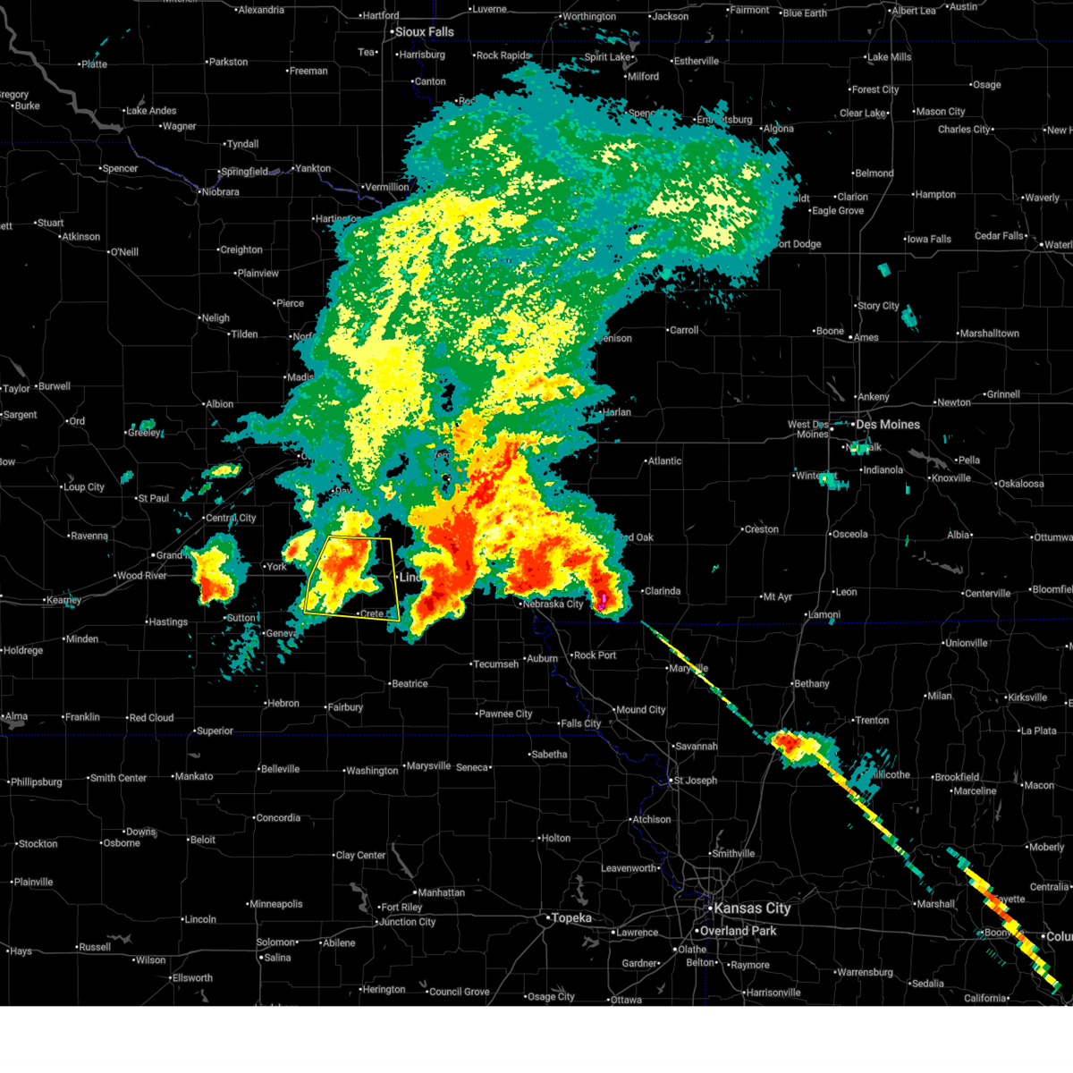
 At 520 am cdt, a severe thunderstorm was located 3 miles southeast of ceresco, or 12 miles south of wahoo, moving northeast at 55 mph. this is a destructive storm for raymond, valparaiso, ceresco (weather instrument measurement. at 512 am, an 82 mph wind gust was recorded at the lincoln airport). Hazards include 80 mph wind gusts and quarter size hail. Flying debris will be dangerous to those caught without shelter. mobile homes will be heavily damaged. expect considerable damage to roofs, windows, and vehicles. extensive tree damage and power outages are likely. This severe thunderstorm will remain over mainly rural areas of northern lancaster, seward, southeastern butler, north central saline and southwestern saunders counties, including the following locations, branched oak state recreation area, blue river state recreation area, tamora, and pawnee state recreation area. At 520 am cdt, a severe thunderstorm was located 3 miles southeast of ceresco, or 12 miles south of wahoo, moving northeast at 55 mph. this is a destructive storm for raymond, valparaiso, ceresco (weather instrument measurement. at 512 am, an 82 mph wind gust was recorded at the lincoln airport). Hazards include 80 mph wind gusts and quarter size hail. Flying debris will be dangerous to those caught without shelter. mobile homes will be heavily damaged. expect considerable damage to roofs, windows, and vehicles. extensive tree damage and power outages are likely. This severe thunderstorm will remain over mainly rural areas of northern lancaster, seward, southeastern butler, north central saline and southwestern saunders counties, including the following locations, branched oak state recreation area, blue river state recreation area, tamora, and pawnee state recreation area.
|
| 8/9/2025 5:20 AM CDT | Measured by public weather statio in lancaster county NE, 1.5 miles SW of Raymond, NE |
| 8/9/2025 5:19 AM CDT | Measured by public weather statio in lancaster county NE, 3.3 miles W of Raymond, NE |
| 8/9/2025 5:07 AM CDT | Trained spotter reported wind gusts estimated up to 80 mph and extensive tree damage. time estimated from rada in lancaster county NE, 5.1 miles E of Raymond, NE |
| 8/9/2025 5:07 AM CDT |
 At 505 am cdt, a severe thunderstorm was located near raymond, or 11 miles northwest of lincoln, moving northeast at 60 mph. this is a destructive storm for the northern lincoln metro, malcolm, raymond, ceresco (radar indicated). Hazards include 80 mph wind gusts and quarter size hail. Flying debris will be dangerous to those caught without shelter. mobile homes will be heavily damaged. expect considerable damage to roofs, windows, and vehicles. extensive tree damage and power outages are likely. this severe storm will be near, raymond and davey around 510 am cdt. Ceresco around 515 am cdt. At 505 am cdt, a severe thunderstorm was located near raymond, or 11 miles northwest of lincoln, moving northeast at 60 mph. this is a destructive storm for the northern lincoln metro, malcolm, raymond, ceresco (radar indicated). Hazards include 80 mph wind gusts and quarter size hail. Flying debris will be dangerous to those caught without shelter. mobile homes will be heavily damaged. expect considerable damage to roofs, windows, and vehicles. extensive tree damage and power outages are likely. this severe storm will be near, raymond and davey around 510 am cdt. Ceresco around 515 am cdt.
|
| 8/9/2025 4:57 AM CDT |
 Svroax the national weather service in omaha has issued a * severe thunderstorm warning for, northern lancaster county in southeastern nebraska, seward county in southeastern nebraska, southeastern butler county in east central nebraska, north central saline county in southeastern nebraska, southwestern saunders county in east central nebraska, * until 545 am cdt. * at 456 am cdt, a severe thunderstorm was located 4 miles south of garland, or 5 miles southeast of seward, moving northeast at 55 mph. this is a destructive storm for seward and northen portions of the lincoln metro area (radar indicated). Hazards include 80 mph wind gusts and quarter size hail. Flying debris will be dangerous to those caught without shelter. mobile homes will be heavily damaged. expect considerable damage to roofs, windows, and vehicles. extensive tree damage and power outages are likely. this severe thunderstorm will be near, malcolm and garland around 500 am cdt. raymond around 505 am cdt. davey around 510 am cdt. ceresco around 515 am cdt. This includes interstate 80 in nebraska between mile markers 369 and 412. Svroax the national weather service in omaha has issued a * severe thunderstorm warning for, northern lancaster county in southeastern nebraska, seward county in southeastern nebraska, southeastern butler county in east central nebraska, north central saline county in southeastern nebraska, southwestern saunders county in east central nebraska, * until 545 am cdt. * at 456 am cdt, a severe thunderstorm was located 4 miles south of garland, or 5 miles southeast of seward, moving northeast at 55 mph. this is a destructive storm for seward and northen portions of the lincoln metro area (radar indicated). Hazards include 80 mph wind gusts and quarter size hail. Flying debris will be dangerous to those caught without shelter. mobile homes will be heavily damaged. expect considerable damage to roofs, windows, and vehicles. extensive tree damage and power outages are likely. this severe thunderstorm will be near, malcolm and garland around 500 am cdt. raymond around 505 am cdt. davey around 510 am cdt. ceresco around 515 am cdt. This includes interstate 80 in nebraska between mile markers 369 and 412.
|
| 7/15/2025 11:44 PM CDT |
 At 1144 pm cdt, severe thunderstorms were located along a line extending from 5 miles north of ashland to 5 miles north of western, moving east at 40 mph (weather instrument measurement). Hazards include 70 mph wind gusts. Expect considerable tree damage. damage is likely to mobile homes, roofs, and outbuildings. Locations impacted include, lincoln, gretna, crete, waverly, ashland, greenwood, holmes lake park, pioneers park, wilber, sprague, walton, roca, eagle, murdock, clatonia and hallam. At 1144 pm cdt, severe thunderstorms were located along a line extending from 5 miles north of ashland to 5 miles north of western, moving east at 40 mph (weather instrument measurement). Hazards include 70 mph wind gusts. Expect considerable tree damage. damage is likely to mobile homes, roofs, and outbuildings. Locations impacted include, lincoln, gretna, crete, waverly, ashland, greenwood, holmes lake park, pioneers park, wilber, sprague, walton, roca, eagle, murdock, clatonia and hallam.
|
| 7/15/2025 11:44 PM CDT |
 the severe thunderstorm warning has been cancelled and is no longer in effect the severe thunderstorm warning has been cancelled and is no longer in effect
|
| 7/15/2025 11:41 PM CDT | Personal weather statio in lancaster county NE, 4.9 miles W of Raymond, NE |
| 7/15/2025 11:29 PM CDT |
 Svroax the national weather service in omaha has issued a * severe thunderstorm warning for, southwestern sarpy county in east central nebraska, lancaster county in southeastern nebraska, seward county in southeastern nebraska, northeastern jefferson county in southeastern nebraska, northwestern otoe county in southeastern nebraska, southeastern butler county in east central nebraska, saline county in southeastern nebraska, saunders county in east central nebraska, northwestern gage county in southeastern nebraska, western cass county in southeastern nebraska, * until midnight cdt. * at 1128 pm cdt, severe thunderstorms were located along a line extending from near mead to 5 miles south of friend, moving southeast at 40 mph (public). Hazards include 60 mph wind gusts. Expect damage to roofs, siding, and trees. severe thunderstorms will be near, lincoln, crete, dorchester, pleasant dale, davey, emerald, lincoln airport, and pioneers park around 1135 pm cdt. waverly and ashland around 1140 pm cdt. greenwood, western, and holmes lake park around 1145 pm cdt. other locations in the path of these severe thunderstorms include wilber, swanton and walton. This includes interstate 80 in nebraska between mile markers 366 and 432. Svroax the national weather service in omaha has issued a * severe thunderstorm warning for, southwestern sarpy county in east central nebraska, lancaster county in southeastern nebraska, seward county in southeastern nebraska, northeastern jefferson county in southeastern nebraska, northwestern otoe county in southeastern nebraska, southeastern butler county in east central nebraska, saline county in southeastern nebraska, saunders county in east central nebraska, northwestern gage county in southeastern nebraska, western cass county in southeastern nebraska, * until midnight cdt. * at 1128 pm cdt, severe thunderstorms were located along a line extending from near mead to 5 miles south of friend, moving southeast at 40 mph (public). Hazards include 60 mph wind gusts. Expect damage to roofs, siding, and trees. severe thunderstorms will be near, lincoln, crete, dorchester, pleasant dale, davey, emerald, lincoln airport, and pioneers park around 1135 pm cdt. waverly and ashland around 1140 pm cdt. greenwood, western, and holmes lake park around 1145 pm cdt. other locations in the path of these severe thunderstorms include wilber, swanton and walton. This includes interstate 80 in nebraska between mile markers 366 and 432.
|
| 7/15/2025 11:21 PM CDT |
 At 1120 pm cdt, severe thunderstorms were located along a line extending from near morse bluff to 2 miles west of weston to 2 miles northwest of dwight, moving east at 40 mph (law enforcement). Hazards include 60 mph wind gusts. Expect damage to roofs, siding, and trees. Locations impacted include, fremont, seward, wahoo, david city, waverly, north bend, ceresco, cedar bluffs, valparaiso, mead, malcolm, brainard, inglewood, weston, prague, staplehurst, garland, dwight, bee, and ulysses. At 1120 pm cdt, severe thunderstorms were located along a line extending from near morse bluff to 2 miles west of weston to 2 miles northwest of dwight, moving east at 40 mph (law enforcement). Hazards include 60 mph wind gusts. Expect damage to roofs, siding, and trees. Locations impacted include, fremont, seward, wahoo, david city, waverly, north bend, ceresco, cedar bluffs, valparaiso, mead, malcolm, brainard, inglewood, weston, prague, staplehurst, garland, dwight, bee, and ulysses.
|
| 7/15/2025 11:21 PM CDT |
 the severe thunderstorm warning has been cancelled and is no longer in effect the severe thunderstorm warning has been cancelled and is no longer in effect
|
| 7/15/2025 11:08 PM CDT |
 the severe thunderstorm warning has been cancelled and is no longer in effect the severe thunderstorm warning has been cancelled and is no longer in effect
|
| 7/15/2025 11:08 PM CDT |
 At 1108 pm cdt, severe thunderstorms were located along a line extending from 4 miles west of north bend to 4 miles southeast of bruno to 6 miles south of david city, moving east at 40 mph (law enforcement). Hazards include 60 mph wind gusts. Expect damage to roofs, siding, and trees. Locations impacted include, north bend, brainard, weston, prague, morse bluff, malmo, cedar bluffs, wahoo, colon, fremont, inglewood, woodcliff and mead. At 1108 pm cdt, severe thunderstorms were located along a line extending from 4 miles west of north bend to 4 miles southeast of bruno to 6 miles south of david city, moving east at 40 mph (law enforcement). Hazards include 60 mph wind gusts. Expect damage to roofs, siding, and trees. Locations impacted include, north bend, brainard, weston, prague, morse bluff, malmo, cedar bluffs, wahoo, colon, fremont, inglewood, woodcliff and mead.
|
| 7/15/2025 10:51 PM CDT |
 Svroax the national weather service in omaha has issued a * severe thunderstorm warning for, colfax county in northeastern nebraska, southeastern platte county in northeastern nebraska, northern lancaster county in southeastern nebraska, southwestern dodge county in east central nebraska, northern seward county in southeastern nebraska, northwestern douglas county in east central nebraska, butler county in east central nebraska, saunders county in east central nebraska, * until 1130 pm cdt. * at 1051 pm cdt, severe thunderstorms were located along a line extending from 6 miles north of schuyler to near octavia to 3 miles north of rising city, moving southeast at 40 mph (law enforcement). Hazards include 60 mph wind gusts. Expect damage to roofs, siding, and trees. severe thunderstorms will be near, david city, schuyler, rising city, octavia, bruno, linwood, and abie around 1055 pm cdt. brainard around 1100 pm cdt. north bend and prague around 1105 pm cdt. dwight and morse bluff around 1110 pm cdt. other locations in the path of these severe thunderstorms include weston, malmo and valparaiso. This includes interstate 80 in nebraska between mile markers 373 and 377. Svroax the national weather service in omaha has issued a * severe thunderstorm warning for, colfax county in northeastern nebraska, southeastern platte county in northeastern nebraska, northern lancaster county in southeastern nebraska, southwestern dodge county in east central nebraska, northern seward county in southeastern nebraska, northwestern douglas county in east central nebraska, butler county in east central nebraska, saunders county in east central nebraska, * until 1130 pm cdt. * at 1051 pm cdt, severe thunderstorms were located along a line extending from 6 miles north of schuyler to near octavia to 3 miles north of rising city, moving southeast at 40 mph (law enforcement). Hazards include 60 mph wind gusts. Expect damage to roofs, siding, and trees. severe thunderstorms will be near, david city, schuyler, rising city, octavia, bruno, linwood, and abie around 1055 pm cdt. brainard around 1100 pm cdt. north bend and prague around 1105 pm cdt. dwight and morse bluff around 1110 pm cdt. other locations in the path of these severe thunderstorms include weston, malmo and valparaiso. This includes interstate 80 in nebraska between mile markers 373 and 377.
|
| 6/19/2025 11:42 PM CDT |
 At 1141 pm cdt, a severe thunderstorm was located near valparaiso, or 13 miles southwest of wahoo, moving southeast at 20 mph (radar indicated). Hazards include 60 mph wind gusts and quarter size hail. Hail damage to vehicles is expected. expect wind damage to roofs, siding, and trees. this severe storm will be near, valparaiso around 1145 pm cdt. Other locations in the path of this severe thunderstorm include ceresco. At 1141 pm cdt, a severe thunderstorm was located near valparaiso, or 13 miles southwest of wahoo, moving southeast at 20 mph (radar indicated). Hazards include 60 mph wind gusts and quarter size hail. Hail damage to vehicles is expected. expect wind damage to roofs, siding, and trees. this severe storm will be near, valparaiso around 1145 pm cdt. Other locations in the path of this severe thunderstorm include ceresco.
|
| 6/19/2025 11:33 PM CDT |
 Svroax the national weather service in omaha has issued a * severe thunderstorm warning for, northern lancaster county in southeastern nebraska, northeastern seward county in southeastern nebraska, southeastern butler county in east central nebraska, southern saunders county in east central nebraska, * until 1215 am cdt. * at 1132 pm cdt, a severe thunderstorm was located 5 miles southeast of brainard, or 13 miles southeast of david city, moving southeast at 20 mph (radar indicated). Hazards include 60 mph wind gusts and quarter size hail. Hail damage to vehicles is expected. expect wind damage to roofs, siding, and trees. this severe thunderstorm will be near, valparaiso around 1140 pm cdt. This includes interstate 80 in nebraska between mile markers 405 and 407. Svroax the national weather service in omaha has issued a * severe thunderstorm warning for, northern lancaster county in southeastern nebraska, northeastern seward county in southeastern nebraska, southeastern butler county in east central nebraska, southern saunders county in east central nebraska, * until 1215 am cdt. * at 1132 pm cdt, a severe thunderstorm was located 5 miles southeast of brainard, or 13 miles southeast of david city, moving southeast at 20 mph (radar indicated). Hazards include 60 mph wind gusts and quarter size hail. Hail damage to vehicles is expected. expect wind damage to roofs, siding, and trees. this severe thunderstorm will be near, valparaiso around 1140 pm cdt. This includes interstate 80 in nebraska between mile markers 405 and 407.
|
| 4/17/2025 6:52 PM CDT |
 the severe thunderstorm warning has been cancelled and is no longer in effect the severe thunderstorm warning has been cancelled and is no longer in effect
|
| 4/17/2025 6:52 PM CDT |
 At 651 pm cdt, a severe thunderstorm was located 3 miles east of davey, or 11 miles north of lincoln, moving east at 50 mph (radar indicated). Hazards include two inch hail and 60 mph wind gusts. People and animals outdoors will be injured. expect hail damage to roofs, siding, windows, and vehicles. expect wind damage to roofs, siding, and trees. this severe storm will be near, waverly and greenwood around 655 pm cdt. Other locations in the path of this severe thunderstorm include murdock and louisville. At 651 pm cdt, a severe thunderstorm was located 3 miles east of davey, or 11 miles north of lincoln, moving east at 50 mph (radar indicated). Hazards include two inch hail and 60 mph wind gusts. People and animals outdoors will be injured. expect hail damage to roofs, siding, windows, and vehicles. expect wind damage to roofs, siding, and trees. this severe storm will be near, waverly and greenwood around 655 pm cdt. Other locations in the path of this severe thunderstorm include murdock and louisville.
|
| 4/17/2025 6:42 PM CDT |
 At 641 pm cdt, a severe thunderstorm was located near raymond, or 12 miles north of lincoln, moving east at 50 mph (radar indicated). Hazards include two inch hail and 60 mph wind gusts. People and animals outdoors will be injured. expect hail damage to roofs, siding, windows, and vehicles. expect wind damage to roofs, siding, and trees. this severe storm will be near, davey around 645 pm cdt. Other locations in the path of this severe thunderstorm include greenwood, ashland and louisville. At 641 pm cdt, a severe thunderstorm was located near raymond, or 12 miles north of lincoln, moving east at 50 mph (radar indicated). Hazards include two inch hail and 60 mph wind gusts. People and animals outdoors will be injured. expect hail damage to roofs, siding, windows, and vehicles. expect wind damage to roofs, siding, and trees. this severe storm will be near, davey around 645 pm cdt. Other locations in the path of this severe thunderstorm include greenwood, ashland and louisville.
|
| 4/17/2025 6:38 PM CDT | Quarter sized hail reported 0.3 miles SSW of Raymond, NE |
| 4/17/2025 6:33 PM CDT |
 Svroax the national weather service in omaha has issued a * severe thunderstorm warning for, western sarpy county in east central nebraska, northern lancaster county in southeastern nebraska, northeastern seward county in southeastern nebraska, southeastern butler county in east central nebraska, southern saunders county in east central nebraska, western cass county in southeastern nebraska, * until 715 pm cdt. * at 632 pm cdt, a severe thunderstorm was located 5 miles north of malcolm, or 12 miles northeast of seward, moving east at 45 mph (radar indicated. at 630 pm cdt, two-inch diameter hail was reported in bee). Hazards include two inch hail and 60 mph wind gusts. People and animals outdoors will be injured. expect hail damage to roofs, siding, windows, and vehicles. expect wind damage to roofs, siding, and trees. this severe thunderstorm will be near, raymond and davey around 640 pm cdt. ceresco around 645 pm cdt. other locations in the path of this severe thunderstorm include greenwood and ashland. This includes interstate 80 in nebraska between mile markers 401 and 437. Svroax the national weather service in omaha has issued a * severe thunderstorm warning for, western sarpy county in east central nebraska, northern lancaster county in southeastern nebraska, northeastern seward county in southeastern nebraska, southeastern butler county in east central nebraska, southern saunders county in east central nebraska, western cass county in southeastern nebraska, * until 715 pm cdt. * at 632 pm cdt, a severe thunderstorm was located 5 miles north of malcolm, or 12 miles northeast of seward, moving east at 45 mph (radar indicated. at 630 pm cdt, two-inch diameter hail was reported in bee). Hazards include two inch hail and 60 mph wind gusts. People and animals outdoors will be injured. expect hail damage to roofs, siding, windows, and vehicles. expect wind damage to roofs, siding, and trees. this severe thunderstorm will be near, raymond and davey around 640 pm cdt. ceresco around 645 pm cdt. other locations in the path of this severe thunderstorm include greenwood and ashland. This includes interstate 80 in nebraska between mile markers 401 and 437.
|
| 4/17/2025 6:30 PM CDT | Hen Egg sized hail reported 7.3 miles ESE of Raymond, NE |
| 3/14/2025 4:56 PM CDT |
 The storms which prompted the warning have weakened below severe limits, and no longer pose an immediate threat to life or property. therefore, the warning will be allowed to expire. however, small hail and gusty winds are still possible with these thunderstorms. a severe thunderstorm watch remains in effect until 1000 pm cdt for southeastern and east central nebraska. The storms which prompted the warning have weakened below severe limits, and no longer pose an immediate threat to life or property. therefore, the warning will be allowed to expire. however, small hail and gusty winds are still possible with these thunderstorms. a severe thunderstorm watch remains in effect until 1000 pm cdt for southeastern and east central nebraska.
|
| 3/14/2025 4:29 PM CDT |
 At 428 pm cdt, severe thunderstorms were located along a line extending from 2 miles southeast of pleasant dale to 4 miles northeast of unadilla, moving north at 55 mph (radar indicated). Hazards include 70 mph wind gusts and quarter size hail. Hail damage to vehicles is expected. expect considerable tree damage. wind damage is also likely to mobile homes, roofs, and outbuildings. Locations impacted include, lincoln airport, davey, murdock, denton, panama, syracuse, memphis, wagon train state recreation area, camp carol joy holling, lincoln, unadilla, eagle, elmwood, greenwood, yankee hill lake, cedar creek, pawnee state recreation area, walton, bennet, and gretna. At 428 pm cdt, severe thunderstorms were located along a line extending from 2 miles southeast of pleasant dale to 4 miles northeast of unadilla, moving north at 55 mph (radar indicated). Hazards include 70 mph wind gusts and quarter size hail. Hail damage to vehicles is expected. expect considerable tree damage. wind damage is also likely to mobile homes, roofs, and outbuildings. Locations impacted include, lincoln airport, davey, murdock, denton, panama, syracuse, memphis, wagon train state recreation area, camp carol joy holling, lincoln, unadilla, eagle, elmwood, greenwood, yankee hill lake, cedar creek, pawnee state recreation area, walton, bennet, and gretna.
|
| 3/14/2025 4:09 PM CDT |
 Svroax the national weather service in omaha has issued a * severe thunderstorm warning for, southwestern sarpy county in east central nebraska, lancaster county in southeastern nebraska, eastern seward county in southeastern nebraska, northwestern otoe county in southeastern nebraska, northeastern saline county in southeastern nebraska, southeastern butler county in east central nebraska, southern saunders county in east central nebraska, western cass county in southeastern nebraska, * until 500 pm cdt. * at 409 pm cdt, severe thunderstorms were located along a line extending from 4 miles east of crete to 2 miles south of syracuse, moving north at 45 mph (radar indicated). Hazards include 60 mph wind gusts and quarter size hail. Hail damage to vehicles is expected. Expect wind damage to roofs, siding, and trees. Svroax the national weather service in omaha has issued a * severe thunderstorm warning for, southwestern sarpy county in east central nebraska, lancaster county in southeastern nebraska, eastern seward county in southeastern nebraska, northwestern otoe county in southeastern nebraska, northeastern saline county in southeastern nebraska, southeastern butler county in east central nebraska, southern saunders county in east central nebraska, western cass county in southeastern nebraska, * until 500 pm cdt. * at 409 pm cdt, severe thunderstorms were located along a line extending from 4 miles east of crete to 2 miles south of syracuse, moving north at 45 mph (radar indicated). Hazards include 60 mph wind gusts and quarter size hail. Hail damage to vehicles is expected. Expect wind damage to roofs, siding, and trees.
|
| 7/31/2024 5:08 PM CDT | Storm damage reported in lancaster county NE, 4.9 miles W of Raymond, NE |
| 7/31/2024 5:02 PM CDT |
 At 501 pm cdt, severe thunderstorms were located along a line extending from 3 miles northeast of ceresco to 3 miles north of walton to 2 miles southwest of panama, moving east at 30 mph. these are destructive storms for lancaster, saunders, otoe, and cass counties (public. these storms have produced widespread damage to trees and powerlines in lancaster county). Hazards include 80 mph wind gusts and quarter size hail. Flying debris will be dangerous to those caught without shelter. mobile homes will be heavily damaged. expect considerable damage to roofs, windows, and vehicles. extensive tree damage and power outages are likely. Locations impacted include, lincoln, wahoo, waverly, ashland, hickman, eagle, ceresco, bennet, firth, valparaiso, greenwood, palmyra, malcolm, panama, roca, hallam, douglas, raymond, davey, and ithaca. At 501 pm cdt, severe thunderstorms were located along a line extending from 3 miles northeast of ceresco to 3 miles north of walton to 2 miles southwest of panama, moving east at 30 mph. these are destructive storms for lancaster, saunders, otoe, and cass counties (public. these storms have produced widespread damage to trees and powerlines in lancaster county). Hazards include 80 mph wind gusts and quarter size hail. Flying debris will be dangerous to those caught without shelter. mobile homes will be heavily damaged. expect considerable damage to roofs, windows, and vehicles. extensive tree damage and power outages are likely. Locations impacted include, lincoln, wahoo, waverly, ashland, hickman, eagle, ceresco, bennet, firth, valparaiso, greenwood, palmyra, malcolm, panama, roca, hallam, douglas, raymond, davey, and ithaca.
|
| 7/31/2024 4:55 PM CDT |
 Svroax the national weather service in omaha has issued a * severe thunderstorm warning for, lancaster county in southeastern nebraska, western otoe county in southeastern nebraska, southern saunders county in east central nebraska, southwestern cass county in southeastern nebraska, * until 600 pm cdt. * at 453 pm cdt, severe thunderstorms were located along a line extending from near valparaiso to lincoln to 3 miles northeast of hallam, moving east at 25 mph. these are destructive storms for lancaster, saunders, cass, and otoe counties (public. we have received numerous observations of 70 to 80 mph gusts in lancaster county, including in lincoln). Hazards include 80 mph wind gusts and quarter size hail. Flying debris will be dangerous to those caught without shelter. mobile homes will be heavily damaged. expect considerable damage to roofs, windows, and vehicles. Extensive tree damage and power outages are likely. Svroax the national weather service in omaha has issued a * severe thunderstorm warning for, lancaster county in southeastern nebraska, western otoe county in southeastern nebraska, southern saunders county in east central nebraska, southwestern cass county in southeastern nebraska, * until 600 pm cdt. * at 453 pm cdt, severe thunderstorms were located along a line extending from near valparaiso to lincoln to 3 miles northeast of hallam, moving east at 25 mph. these are destructive storms for lancaster, saunders, cass, and otoe counties (public. we have received numerous observations of 70 to 80 mph gusts in lancaster county, including in lincoln). Hazards include 80 mph wind gusts and quarter size hail. Flying debris will be dangerous to those caught without shelter. mobile homes will be heavily damaged. expect considerable damage to roofs, windows, and vehicles. Extensive tree damage and power outages are likely.
|
| 7/31/2024 4:48 PM CDT | Storm damage reported in lancaster county NE, 4 miles WNW of Raymond, NE |
| 7/31/2024 4:46 PM CDT |
 At 446 pm cdt, severe thunderstorms were located along a line extending from 4 miles west of ceresco to lincoln to 4 miles northwest of hallam, moving east at 50 mph (law enforcement. at 442 pm a downed tree and downed powerlines were reported in crete). Hazards include 70 mph wind gusts and quarter size hail. Hail damage to vehicles is expected. expect considerable tree damage. wind damage is also likely to mobile homes, roofs, and outbuildings. Locations impacted include, lincoln, waverly, hickman, bennet, firth, malcolm, panama, roca, hallam, raymond, davey, sprague, lincoln airport, emerald, walton, holmes lake park, pioneers park, denton, branched oak state recreation area, and stagecoach state recreation area. At 446 pm cdt, severe thunderstorms were located along a line extending from 4 miles west of ceresco to lincoln to 4 miles northwest of hallam, moving east at 50 mph (law enforcement. at 442 pm a downed tree and downed powerlines were reported in crete). Hazards include 70 mph wind gusts and quarter size hail. Hail damage to vehicles is expected. expect considerable tree damage. wind damage is also likely to mobile homes, roofs, and outbuildings. Locations impacted include, lincoln, waverly, hickman, bennet, firth, malcolm, panama, roca, hallam, raymond, davey, sprague, lincoln airport, emerald, walton, holmes lake park, pioneers park, denton, branched oak state recreation area, and stagecoach state recreation area.
|
| 7/31/2024 4:29 PM CDT |
 Svroax the national weather service in omaha has issued a * severe thunderstorm warning for, lancaster county in southeastern nebraska, * until 530 pm cdt. * at 428 pm cdt, severe thunderstorms were located along a line extending from 3 miles east of bee to near milford to 8 miles south of dorchester, moving east at 50 mph (public. at 420 pm, a 63 mph wind gust was observed 6 miles southwest of friend). Hazards include 70 mph wind gusts and quarter size hail. Hail damage to vehicles is expected. expect considerable tree damage. Wind damage is also likely to mobile homes, roofs, and outbuildings. Svroax the national weather service in omaha has issued a * severe thunderstorm warning for, lancaster county in southeastern nebraska, * until 530 pm cdt. * at 428 pm cdt, severe thunderstorms were located along a line extending from 3 miles east of bee to near milford to 8 miles south of dorchester, moving east at 50 mph (public. at 420 pm, a 63 mph wind gust was observed 6 miles southwest of friend). Hazards include 70 mph wind gusts and quarter size hail. Hail damage to vehicles is expected. expect considerable tree damage. Wind damage is also likely to mobile homes, roofs, and outbuildings.
|
| 7/2/2024 11:39 AM CDT |
 At 1139 am cdt, a severe thunderstorm was located 4 miles northeast of lincoln airport, or 6 miles north of lincoln, moving northeast at 55 mph (public). Hazards include 60 mph wind gusts and quarter size hail. Hail damage to vehicles is expected. expect wind damage to roofs, siding, and trees. Locations impacted include, lincoln, waverly, raymond, davey, lincoln airport, and pioneers park. At 1139 am cdt, a severe thunderstorm was located 4 miles northeast of lincoln airport, or 6 miles north of lincoln, moving northeast at 55 mph (public). Hazards include 60 mph wind gusts and quarter size hail. Hail damage to vehicles is expected. expect wind damage to roofs, siding, and trees. Locations impacted include, lincoln, waverly, raymond, davey, lincoln airport, and pioneers park.
|
| 7/2/2024 11:33 AM CDT |
 Svroax the national weather service in omaha has issued a * severe thunderstorm warning for, northern lancaster county in southeastern nebraska, * until 1215 pm cdt. * at 1133 am cdt, a severe thunderstorm was located over northwestern lincoln, moving northeast at 55 mph (radar indicated). Hazards include 60 mph wind gusts and quarter size hail. Hail damage to vehicles is expected. Expect wind damage to roofs, siding, and trees. Svroax the national weather service in omaha has issued a * severe thunderstorm warning for, northern lancaster county in southeastern nebraska, * until 1215 pm cdt. * at 1133 am cdt, a severe thunderstorm was located over northwestern lincoln, moving northeast at 55 mph (radar indicated). Hazards include 60 mph wind gusts and quarter size hail. Hail damage to vehicles is expected. Expect wind damage to roofs, siding, and trees.
|
| 7/1/2024 11:05 PM CDT |
 At 1105 pm cdt, severe thunderstorms were located along a line extending from 5 miles southeast of ceresco to 4 miles north of walton to 2 miles west of roca, moving east at 40 mph (radar indicated). Hazards include 60 mph wind gusts and quarter size hail. Hail damage to vehicles is expected. expect wind damage to roofs, siding, and trees. Locations impacted include, lincoln, crete, waverly, ashland, hickman, eagle, bennet, elmwood, greenwood, palmyra, panama, murdock, roca, hallam, raymond, davey, sprague, lincoln airport, emerald, and walton. At 1105 pm cdt, severe thunderstorms were located along a line extending from 5 miles southeast of ceresco to 4 miles north of walton to 2 miles west of roca, moving east at 40 mph (radar indicated). Hazards include 60 mph wind gusts and quarter size hail. Hail damage to vehicles is expected. expect wind damage to roofs, siding, and trees. Locations impacted include, lincoln, crete, waverly, ashland, hickman, eagle, bennet, elmwood, greenwood, palmyra, panama, murdock, roca, hallam, raymond, davey, sprague, lincoln airport, emerald, and walton.
|
| 7/1/2024 10:48 PM CDT |
 Svroax the national weather service in omaha has issued a * severe thunderstorm warning for, lancaster county in southeastern nebraska, northwestern otoe county in southeastern nebraska, east central saline county in southeastern nebraska, southeastern saunders county in east central nebraska, western cass county in southeastern nebraska, * until 1130 pm cdt. * at 1047 pm cdt, severe thunderstorms were located along a line extending from near raymond to near emerald to 2 miles east of crete, moving northeast at 45 mph (radar indicated). Hazards include 60 mph wind gusts and quarter size hail. Hail damage to vehicles is expected. Expect wind damage to roofs, siding, and trees. Svroax the national weather service in omaha has issued a * severe thunderstorm warning for, lancaster county in southeastern nebraska, northwestern otoe county in southeastern nebraska, east central saline county in southeastern nebraska, southeastern saunders county in east central nebraska, western cass county in southeastern nebraska, * until 1130 pm cdt. * at 1047 pm cdt, severe thunderstorms were located along a line extending from near raymond to near emerald to 2 miles east of crete, moving northeast at 45 mph (radar indicated). Hazards include 60 mph wind gusts and quarter size hail. Hail damage to vehicles is expected. Expect wind damage to roofs, siding, and trees.
|
| 6/18/2024 6:28 PM CDT |
 the severe thunderstorm warning has been cancelled and is no longer in effect the severe thunderstorm warning has been cancelled and is no longer in effect
|
| 6/18/2024 6:15 PM CDT |
 At 614 pm cdt, severe thunderstorms were located along a line extending from 2 miles east of wahoo to 2 miles northeast of davey to lincoln, moving east at 35 mph (radar indicated). Hazards include 60 mph wind gusts. Expect damage to roofs, siding, and trees. Locations impacted include, lincoln, wahoo, waverly, ashland, yutan, ceresco, mead, weston, raymond, davey, ithaca, lincoln airport, walton, holmes lake park, emerald, pioneers park, denton, memphis, two rivers state recreation area, and lake wanahoo recreation area. At 614 pm cdt, severe thunderstorms were located along a line extending from 2 miles east of wahoo to 2 miles northeast of davey to lincoln, moving east at 35 mph (radar indicated). Hazards include 60 mph wind gusts. Expect damage to roofs, siding, and trees. Locations impacted include, lincoln, wahoo, waverly, ashland, yutan, ceresco, mead, weston, raymond, davey, ithaca, lincoln airport, walton, holmes lake park, emerald, pioneers park, denton, memphis, two rivers state recreation area, and lake wanahoo recreation area.
|
| 6/18/2024 6:15 PM CDT |
 the severe thunderstorm warning has been cancelled and is no longer in effect the severe thunderstorm warning has been cancelled and is no longer in effect
|
| 6/18/2024 5:58 PM CDT |
 The current warning has been replaced by a new severe thunderstorm warning. therefore, the warning will be allowed to expire. a severe thunderstorm watch remains in effect until 800 pm cdt for southeastern and east central nebraska. to report severe weather, contact your nearest law enforcement agency. they will relay your report to the national weather service omaha. remember, a severe thunderstorm warning still remains in effect for butler, seward, saunders, and lancaster counties. The current warning has been replaced by a new severe thunderstorm warning. therefore, the warning will be allowed to expire. a severe thunderstorm watch remains in effect until 800 pm cdt for southeastern and east central nebraska. to report severe weather, contact your nearest law enforcement agency. they will relay your report to the national weather service omaha. remember, a severe thunderstorm warning still remains in effect for butler, seward, saunders, and lancaster counties.
|
| 6/18/2024 5:54 PM CDT |
 Svroax the national weather service in omaha has issued a * severe thunderstorm warning for, lancaster county in southeastern nebraska, northeastern seward county in southeastern nebraska, southeastern butler county in east central nebraska, saunders county in east central nebraska, * until 645 pm cdt. * at 553 pm cdt, severe thunderstorms were located along a line extending from 6 miles west of weston to 2 miles west of valparaiso to 3 miles northwest of malcolm, moving east at 35 mph (radar indicated). Hazards include 60 mph wind gusts and penny size hail. expect damage to roofs, siding, and trees Svroax the national weather service in omaha has issued a * severe thunderstorm warning for, lancaster county in southeastern nebraska, northeastern seward county in southeastern nebraska, southeastern butler county in east central nebraska, saunders county in east central nebraska, * until 645 pm cdt. * at 553 pm cdt, severe thunderstorms were located along a line extending from 6 miles west of weston to 2 miles west of valparaiso to 3 miles northwest of malcolm, moving east at 35 mph (radar indicated). Hazards include 60 mph wind gusts and penny size hail. expect damage to roofs, siding, and trees
|
| 6/18/2024 5:43 PM CDT |
 At 543 pm cdt, severe thunderstorms were located along a line extending from near brainard to near dwight to near garland, moving east at 35 mph (radar indicated). Hazards include 60 mph wind gusts and penny size hail. Expect damage to roofs, siding, and trees. these severe storms will be near, valparaiso and malcolm around 550 pm cdt. raymond around 555 pm cdt. Other locations impacted by these severe thunderstorms include branched oak state recreation area and pawnee state recreation area. At 543 pm cdt, severe thunderstorms were located along a line extending from near brainard to near dwight to near garland, moving east at 35 mph (radar indicated). Hazards include 60 mph wind gusts and penny size hail. Expect damage to roofs, siding, and trees. these severe storms will be near, valparaiso and malcolm around 550 pm cdt. raymond around 555 pm cdt. Other locations impacted by these severe thunderstorms include branched oak state recreation area and pawnee state recreation area.
|
| 6/18/2024 5:19 PM CDT |
 Svroax the national weather service in omaha has issued a * severe thunderstorm warning for, northwestern lancaster county in southeastern nebraska, seward county in southeastern nebraska, southern butler county in east central nebraska, southwestern saunders county in east central nebraska, * until 600 pm cdt. * at 519 pm cdt, severe thunderstorms were located along a line extending from 3 miles northeast of surprise to 5 miles southwest of ulysses to 2 miles east of utica, moving east at 35 mph (radar indicated). Hazards include 60 mph wind gusts and penny size hail. Expect damage to roofs, siding, and trees. severe thunderstorms will be near, staplehurst and ulysses around 525 pm cdt. seward and bee around 530 pm cdt. brainard and dwight around 535 pm cdt. garland around 540 pm cdt. other locations impacted by these severe thunderstorms include branched oak state recreation area, garrison, tamora, and pawnee state recreation area. This includes interstate 80 in nebraska between mile markers 366 and 392. Svroax the national weather service in omaha has issued a * severe thunderstorm warning for, northwestern lancaster county in southeastern nebraska, seward county in southeastern nebraska, southern butler county in east central nebraska, southwestern saunders county in east central nebraska, * until 600 pm cdt. * at 519 pm cdt, severe thunderstorms were located along a line extending from 3 miles northeast of surprise to 5 miles southwest of ulysses to 2 miles east of utica, moving east at 35 mph (radar indicated). Hazards include 60 mph wind gusts and penny size hail. Expect damage to roofs, siding, and trees. severe thunderstorms will be near, staplehurst and ulysses around 525 pm cdt. seward and bee around 530 pm cdt. brainard and dwight around 535 pm cdt. garland around 540 pm cdt. other locations impacted by these severe thunderstorms include branched oak state recreation area, garrison, tamora, and pawnee state recreation area. This includes interstate 80 in nebraska between mile markers 366 and 392.
|
| 6/7/2024 8:48 PM CDT |
 At 848 pm cdt, a severe thunderstorm was located near eagle, or 12 miles east of lincoln, moving east at 40 mph (radar indicated). Hazards include 60 mph wind gusts. Expect damage to roofs, siding, and trees. Locations impacted include, lincoln, waverly, ashland, eagle, ceresco, bennet, elmwood, greenwood, palmyra, murdock, raymond, davey, lincoln airport, walton, holmes lake park, pioneers park, alvo, yankee hill lake, mahoney state park, and camp carol joy holling. At 848 pm cdt, a severe thunderstorm was located near eagle, or 12 miles east of lincoln, moving east at 40 mph (radar indicated). Hazards include 60 mph wind gusts. Expect damage to roofs, siding, and trees. Locations impacted include, lincoln, waverly, ashland, eagle, ceresco, bennet, elmwood, greenwood, palmyra, murdock, raymond, davey, lincoln airport, walton, holmes lake park, pioneers park, alvo, yankee hill lake, mahoney state park, and camp carol joy holling.
|
| 6/7/2024 8:43 PM CDT |
 At 842 pm cdt, a severe thunderstorm was located 4 miles southeast of waverly, or 13 miles northeast of lincoln, moving east at 45 mph (radar indicated). Hazards include 60 mph wind gusts. Expect damage to roofs, siding, and trees. Locations impacted include, lincoln, waverly, ashland, eagle, ceresco, bennet, elmwood, valparaiso, greenwood, palmyra, malcolm, murdock, raymond, davey, lincoln airport, emerald, walton, holmes lake park, pioneers park, and denton. At 842 pm cdt, a severe thunderstorm was located 4 miles southeast of waverly, or 13 miles northeast of lincoln, moving east at 45 mph (radar indicated). Hazards include 60 mph wind gusts. Expect damage to roofs, siding, and trees. Locations impacted include, lincoln, waverly, ashland, eagle, ceresco, bennet, elmwood, valparaiso, greenwood, palmyra, malcolm, murdock, raymond, davey, lincoln airport, emerald, walton, holmes lake park, pioneers park, and denton.
|
| 6/7/2024 8:35 PM CDT |
 At 835 pm cdt, a severe thunderstorm was located over waverly, or 9 miles northeast of lincoln, moving east at 45 mph (trained weather spotters). Hazards include 60 mph wind gusts. Expect damage to roofs, siding, and trees. Locations impacted include, lincoln, waverly, ashland, eagle, ceresco, bennet, elmwood, valparaiso, greenwood, palmyra, malcolm, weston, murdock, raymond, davey, ithaca, lincoln airport, emerald, walton, and holmes lake park. At 835 pm cdt, a severe thunderstorm was located over waverly, or 9 miles northeast of lincoln, moving east at 45 mph (trained weather spotters). Hazards include 60 mph wind gusts. Expect damage to roofs, siding, and trees. Locations impacted include, lincoln, waverly, ashland, eagle, ceresco, bennet, elmwood, valparaiso, greenwood, palmyra, malcolm, weston, murdock, raymond, davey, ithaca, lincoln airport, emerald, walton, and holmes lake park.
|
| 6/7/2024 8:35 PM CDT |
 the severe thunderstorm warning has been cancelled and is no longer in effect the severe thunderstorm warning has been cancelled and is no longer in effect
|
| 6/7/2024 8:27 PM CDT | Storm damage reported in lancaster county NE, 7.3 miles ESE of Raymond, NE |
| 6/7/2024 8:26 PM CDT |
 At 826 pm cdt, a severe thunderstorm was located 3 miles south of davey, or 8 miles north of lincoln, moving east at 45 mph (trained weather spotters). Hazards include 60 mph wind gusts. Expect damage to roofs, siding, and trees. Locations impacted include, lincoln, seward, waverly, ashland, milford, eagle, ceresco, bennet, elmwood, valparaiso, greenwood, palmyra, malcolm, brainard, weston, murdock, garland, pleasant dale, dwight, and bee. At 826 pm cdt, a severe thunderstorm was located 3 miles south of davey, or 8 miles north of lincoln, moving east at 45 mph (trained weather spotters). Hazards include 60 mph wind gusts. Expect damage to roofs, siding, and trees. Locations impacted include, lincoln, seward, waverly, ashland, milford, eagle, ceresco, bennet, elmwood, valparaiso, greenwood, palmyra, malcolm, brainard, weston, murdock, garland, pleasant dale, dwight, and bee.
|
| 6/7/2024 8:22 PM CDT |
 At 821 pm cdt, a severe thunderstorm was located over raymond, or 10 miles north of lincoln, moving east at 45 mph (radar indicated). Hazards include 60 mph wind gusts. Expect damage to roofs, siding, and trees. Locations impacted include, lincoln, seward, waverly, ashland, milford, eagle, ceresco, bennet, elmwood, valparaiso, greenwood, palmyra, malcolm, brainard, weston, murdock, garland, pleasant dale, dwight, and bee. At 821 pm cdt, a severe thunderstorm was located over raymond, or 10 miles north of lincoln, moving east at 45 mph (radar indicated). Hazards include 60 mph wind gusts. Expect damage to roofs, siding, and trees. Locations impacted include, lincoln, seward, waverly, ashland, milford, eagle, ceresco, bennet, elmwood, valparaiso, greenwood, palmyra, malcolm, brainard, weston, murdock, garland, pleasant dale, dwight, and bee.
|
| 6/7/2024 8:08 PM CDT |
 Svroax the national weather service in omaha has issued a * severe thunderstorm warning for, lancaster county in southeastern nebraska, eastern seward county in southeastern nebraska, northwestern otoe county in southeastern nebraska, southeastern butler county in east central nebraska, southern saunders county in east central nebraska, western cass county in southeastern nebraska, * until 915 pm cdt. * at 807 pm cdt, a severe thunderstorm was located 4 miles north of garland, or 9 miles northeast of seward, moving east at 45 mph (radar indicated). Hazards include 60 mph wind gusts. expect damage to roofs, siding, and trees Svroax the national weather service in omaha has issued a * severe thunderstorm warning for, lancaster county in southeastern nebraska, eastern seward county in southeastern nebraska, northwestern otoe county in southeastern nebraska, southeastern butler county in east central nebraska, southern saunders county in east central nebraska, western cass county in southeastern nebraska, * until 915 pm cdt. * at 807 pm cdt, a severe thunderstorm was located 4 miles north of garland, or 9 miles northeast of seward, moving east at 45 mph (radar indicated). Hazards include 60 mph wind gusts. expect damage to roofs, siding, and trees
|
| 6/2/2024 11:43 PM CDT |
 Toroax the national weather service in omaha has issued a * tornado warning for, northwestern lancaster county in southeastern nebraska, northeastern seward county in southeastern nebraska, southeastern butler county in east central nebraska, southwestern saunders county in east central nebraska, * until 1230 am cdt. * at 1143 pm cdt, a severe thunderstorm capable of producing a tornado was located 4 miles northeast of goehner, or 4 miles southwest of seward, moving northeast at 35 mph (radar indicated rotation). Hazards include tornado. Flying debris will be dangerous to those caught without shelter. mobile homes will be damaged or destroyed. damage to roofs, windows, and vehicles will occur. tree damage is likely. this dangerous storm will be near, seward around 1150 pm cdt. garland around 1155 pm cdt. Other locations in the path of this tornadic thunderstorm include valparaiso. Toroax the national weather service in omaha has issued a * tornado warning for, northwestern lancaster county in southeastern nebraska, northeastern seward county in southeastern nebraska, southeastern butler county in east central nebraska, southwestern saunders county in east central nebraska, * until 1230 am cdt. * at 1143 pm cdt, a severe thunderstorm capable of producing a tornado was located 4 miles northeast of goehner, or 4 miles southwest of seward, moving northeast at 35 mph (radar indicated rotation). Hazards include tornado. Flying debris will be dangerous to those caught without shelter. mobile homes will be damaged or destroyed. damage to roofs, windows, and vehicles will occur. tree damage is likely. this dangerous storm will be near, seward around 1150 pm cdt. garland around 1155 pm cdt. Other locations in the path of this tornadic thunderstorm include valparaiso.
|
| 5/24/2024 2:18 AM CDT |
 the severe thunderstorm warning has been cancelled and is no longer in effect the severe thunderstorm warning has been cancelled and is no longer in effect
|
| 5/24/2024 2:18 AM CDT |
 At 218 am cdt, severe thunderstorms were located along a line extending from 3 miles southeast of craig to 5 miles southwest of kennard to lincoln, moving east at 55 mph (radar indicated). Hazards include 70 mph wind gusts and quarter size hail. Hail damage to vehicles is expected. expect considerable tree damage. wind damage is also likely to mobile homes, roofs, and outbuildings. Locations impacted include, omaha, lincoln, western council bluffs, bellevue, fremont, papillion, blair, ralston, wahoo, gretna, bennington, boys town, elkhorn, millard, offutt afb, la vista, carter lake, waverly, missouri valley, and ashland. At 218 am cdt, severe thunderstorms were located along a line extending from 3 miles southeast of craig to 5 miles southwest of kennard to lincoln, moving east at 55 mph (radar indicated). Hazards include 70 mph wind gusts and quarter size hail. Hail damage to vehicles is expected. expect considerable tree damage. wind damage is also likely to mobile homes, roofs, and outbuildings. Locations impacted include, omaha, lincoln, western council bluffs, bellevue, fremont, papillion, blair, ralston, wahoo, gretna, bennington, boys town, elkhorn, millard, offutt afb, la vista, carter lake, waverly, missouri valley, and ashland.
|
| 5/24/2024 1:53 AM CDT |
 Svroax the national weather service in omaha has issued a * severe thunderstorm warning for, western pottawattamie county in southwestern iowa, southwestern harrison county in southwestern iowa, southern burt county in east central nebraska, northeastern colfax county in northeastern nebraska, lancaster county in southeastern nebraska, eastern seward county in southeastern nebraska, douglas county in east central nebraska, saunders county in east central nebraska, sarpy county in east central nebraska, washington county in east central nebraska, dodge county in east central nebraska, northwestern otoe county in southeastern nebraska, southeastern butler county in east central nebraska, cass county in southeastern nebraska, * until 245 am cdt. * at 153 am cdt, severe thunderstorms were located along a line extending from 4 miles northeast of snyder to 2 miles west of cedar bluffs to near pleasant dale, moving east at 55 mph (radar indicated). Hazards include 70 mph wind gusts and quarter size hail. Hail damage to vehicles is expected. expect considerable tree damage. Wind damage is also likely to mobile homes, roofs, and outbuildings. Svroax the national weather service in omaha has issued a * severe thunderstorm warning for, western pottawattamie county in southwestern iowa, southwestern harrison county in southwestern iowa, southern burt county in east central nebraska, northeastern colfax county in northeastern nebraska, lancaster county in southeastern nebraska, eastern seward county in southeastern nebraska, douglas county in east central nebraska, saunders county in east central nebraska, sarpy county in east central nebraska, washington county in east central nebraska, dodge county in east central nebraska, northwestern otoe county in southeastern nebraska, southeastern butler county in east central nebraska, cass county in southeastern nebraska, * until 245 am cdt. * at 153 am cdt, severe thunderstorms were located along a line extending from 4 miles northeast of snyder to 2 miles west of cedar bluffs to near pleasant dale, moving east at 55 mph (radar indicated). Hazards include 70 mph wind gusts and quarter size hail. Hail damage to vehicles is expected. expect considerable tree damage. Wind damage is also likely to mobile homes, roofs, and outbuildings.
|
| 5/24/2024 1:21 AM CDT |
 Svroax the national weather service in omaha has issued a * severe thunderstorm warning for, lancaster county in southeastern nebraska, jefferson county in southeastern nebraska, seward county in southeastern nebraska, saline county in southeastern nebraska, southern butler county in east central nebraska, southwestern saunders county in east central nebraska, western gage county in southeastern nebraska, * until 200 am cdt. * at 121 am cdt, severe thunderstorms were located along a line extending from 3 miles northeast of gresham to 4 miles northwest of hebron, moving east at 55 mph (radar indicated). Hazards include 70 mph wind gusts and quarter size hail. Hail damage to vehicles is expected. expect considerable tree damage. Wind damage is also likely to mobile homes, roofs, and outbuildings. Svroax the national weather service in omaha has issued a * severe thunderstorm warning for, lancaster county in southeastern nebraska, jefferson county in southeastern nebraska, seward county in southeastern nebraska, saline county in southeastern nebraska, southern butler county in east central nebraska, southwestern saunders county in east central nebraska, western gage county in southeastern nebraska, * until 200 am cdt. * at 121 am cdt, severe thunderstorms were located along a line extending from 3 miles northeast of gresham to 4 miles northwest of hebron, moving east at 55 mph (radar indicated). Hazards include 70 mph wind gusts and quarter size hail. Hail damage to vehicles is expected. expect considerable tree damage. Wind damage is also likely to mobile homes, roofs, and outbuildings.
|
| 5/21/2024 5:24 AM CDT |
 At 524 am cdt, severe thunderstorms were located along a line extending from 3 miles east of david city to 2 miles east of friend, moving east at 60 mph (radar indicated). Hazards include 60 mph wind gusts. Expect damage to roofs, siding, and trees. Locations impacted include, seward, david city, crete, milford, friend, dorchester, valparaiso, beaver crossing, malcolm, brainard, weston, prague, staplehurst, garland, pleasant dale, dwight, bee, ulysses, raymond, and goehner. At 524 am cdt, severe thunderstorms were located along a line extending from 3 miles east of david city to 2 miles east of friend, moving east at 60 mph (radar indicated). Hazards include 60 mph wind gusts. Expect damage to roofs, siding, and trees. Locations impacted include, seward, david city, crete, milford, friend, dorchester, valparaiso, beaver crossing, malcolm, brainard, weston, prague, staplehurst, garland, pleasant dale, dwight, bee, ulysses, raymond, and goehner.
|
| 5/21/2024 5:03 AM CDT |
 Svroax the national weather service in omaha has issued a * severe thunderstorm warning for, northwestern lancaster county in southeastern nebraska, seward county in southeastern nebraska, northern saline county in southeastern nebraska, butler county in east central nebraska, western saunders county in east central nebraska, * until 545 am cdt. * at 502 am cdt, severe thunderstorms were located along a line extending from 5 miles south of shelby to 4 miles southeast of mccool junction, moving east at 60 mph (public. at 456 am cdt, a 66 mph wind gust was reported 3 miles southwest of fairmont). Hazards include 70 mph wind gusts. Expect considerable tree damage. Damage is likely to mobile homes, roofs, and outbuildings. Svroax the national weather service in omaha has issued a * severe thunderstorm warning for, northwestern lancaster county in southeastern nebraska, seward county in southeastern nebraska, northern saline county in southeastern nebraska, butler county in east central nebraska, western saunders county in east central nebraska, * until 545 am cdt. * at 502 am cdt, severe thunderstorms were located along a line extending from 5 miles south of shelby to 4 miles southeast of mccool junction, moving east at 60 mph (public. at 456 am cdt, a 66 mph wind gust was reported 3 miles southwest of fairmont). Hazards include 70 mph wind gusts. Expect considerable tree damage. Damage is likely to mobile homes, roofs, and outbuildings.
|
| 5/20/2024 7:56 PM CDT |
 Svroax the national weather service in omaha has issued a * severe thunderstorm warning for, northwestern lancaster county in southeastern nebraska, southern saunders county in east central nebraska, * until 900 pm cdt. * at 756 pm cdt, a severe thunderstorm was located 5 miles northwest of davey, or 14 miles southwest of wahoo, moving north at 25 mph (radar indicated). Hazards include 60 mph wind gusts and quarter size hail. Hail damage to vehicles is expected. Expect wind damage to roofs, siding, and trees. Svroax the national weather service in omaha has issued a * severe thunderstorm warning for, northwestern lancaster county in southeastern nebraska, southern saunders county in east central nebraska, * until 900 pm cdt. * at 756 pm cdt, a severe thunderstorm was located 5 miles northwest of davey, or 14 miles southwest of wahoo, moving north at 25 mph (radar indicated). Hazards include 60 mph wind gusts and quarter size hail. Hail damage to vehicles is expected. Expect wind damage to roofs, siding, and trees.
|
| 5/19/2024 6:17 AM CDT |
 At 616 am cdt, a severe thunderstorm was located over davey, or 12 miles north of lincoln, moving east at 35 mph (radar indicated). Hazards include quarter size hail. Damage to vehicles is expected. Locations impacted include, waverly, ceresco, raymond, and davey. At 616 am cdt, a severe thunderstorm was located over davey, or 12 miles north of lincoln, moving east at 35 mph (radar indicated). Hazards include quarter size hail. Damage to vehicles is expected. Locations impacted include, waverly, ceresco, raymond, and davey.
|
| 5/19/2024 6:17 AM CDT |
 the severe thunderstorm warning has been cancelled and is no longer in effect the severe thunderstorm warning has been cancelled and is no longer in effect
|
| 5/19/2024 6:07 AM CDT |
 Svroax the national weather service in omaha has issued a * severe thunderstorm warning for, northern lancaster county in southeastern nebraska, northeastern seward county in southeastern nebraska, south central saunders county in east central nebraska, * until 630 am cdt. * at 607 am cdt, a severe thunderstorm was located over raymond, or 13 miles northwest of lincoln, moving east at 35 mph (radar indicated). Hazards include quarter size hail. damage to vehicles is expected Svroax the national weather service in omaha has issued a * severe thunderstorm warning for, northern lancaster county in southeastern nebraska, northeastern seward county in southeastern nebraska, south central saunders county in east central nebraska, * until 630 am cdt. * at 607 am cdt, a severe thunderstorm was located over raymond, or 13 miles northwest of lincoln, moving east at 35 mph (radar indicated). Hazards include quarter size hail. damage to vehicles is expected
|
| 4/26/2024 3:22 PM CDT |
 Svroax the national weather service in omaha has issued a * severe thunderstorm warning for, northwestern lancaster county in southeastern nebraska, central saunders county in east central nebraska, * until 400 pm cdt. * at 322 pm cdt, a severe thunderstorm was located over raymond, or 12 miles northwest of lincoln, moving north at 45 mph (radar indicated). Hazards include ping pong ball size hail. People and animals outdoors will be injured. Expect damage to roofs, siding, windows, and vehicles. Svroax the national weather service in omaha has issued a * severe thunderstorm warning for, northwestern lancaster county in southeastern nebraska, central saunders county in east central nebraska, * until 400 pm cdt. * at 322 pm cdt, a severe thunderstorm was located over raymond, or 12 miles northwest of lincoln, moving north at 45 mph (radar indicated). Hazards include ping pong ball size hail. People and animals outdoors will be injured. Expect damage to roofs, siding, windows, and vehicles.
|
| 4/26/2024 2:50 PM CDT |
 At 250 pm cdt, a severe thunderstorm capable of producing a tornado was located near davey, or 13 miles north of lincoln, moving north at 50 mph. this storm has a history of producing a tornado near the lincoln airport (radar indicated rotation). Hazards include tornado and golf ball size hail. Flying debris will be dangerous to those caught without shelter. mobile homes will be damaged or destroyed. damage to roofs, windows, and vehicles will occur. tree damage is likely. Locations impacted include, northwestern lincoln, ceresco, weston, raymond, davey, and lincoln airport. At 250 pm cdt, a severe thunderstorm capable of producing a tornado was located near davey, or 13 miles north of lincoln, moving north at 50 mph. this storm has a history of producing a tornado near the lincoln airport (radar indicated rotation). Hazards include tornado and golf ball size hail. Flying debris will be dangerous to those caught without shelter. mobile homes will be damaged or destroyed. damage to roofs, windows, and vehicles will occur. tree damage is likely. Locations impacted include, northwestern lincoln, ceresco, weston, raymond, davey, and lincoln airport.
|
| 4/26/2024 2:49 PM CDT |
 At 248 pm cdt, a severe thunderstorm capable of producing a tornado was located 4 miles northeast of lincoln airport, or 5 miles north of lincoln, moving northeast at 30 mph. this storm has a history of producing a tornado near the lincoln airport (radar indicated rotation). Hazards include tornado and ping pong ball size hail. Flying debris will be dangerous to those caught without shelter. mobile homes will be damaged or destroyed. damage to roofs, windows, and vehicles will occur. tree damage is likely. this dangerous storm will be near, davey around 255 pm cdt. Other locations in the path of this tornadic thunderstorm include ceresco. At 248 pm cdt, a severe thunderstorm capable of producing a tornado was located 4 miles northeast of lincoln airport, or 5 miles north of lincoln, moving northeast at 30 mph. this storm has a history of producing a tornado near the lincoln airport (radar indicated rotation). Hazards include tornado and ping pong ball size hail. Flying debris will be dangerous to those caught without shelter. mobile homes will be damaged or destroyed. damage to roofs, windows, and vehicles will occur. tree damage is likely. this dangerous storm will be near, davey around 255 pm cdt. Other locations in the path of this tornadic thunderstorm include ceresco.
|
| 4/26/2024 2:38 PM CDT |
 At 238 pm cdt, a severe thunderstorm capable of producing a tornado was located over northwestern lincoln, moving northeast at 30 mph (radar indicated rotation). Hazards include tornado and ping pong ball size hail. Flying debris will be dangerous to those caught without shelter. mobile homes will be damaged or destroyed. damage to roofs, windows, and vehicles will occur. tree damage is likely. this dangerous storm will be near, northern lincoln around 245 pm cdt. davey around 250 pm cdt. Other locations in the path of this tornadic thunderstorm include ceresco. At 238 pm cdt, a severe thunderstorm capable of producing a tornado was located over northwestern lincoln, moving northeast at 30 mph (radar indicated rotation). Hazards include tornado and ping pong ball size hail. Flying debris will be dangerous to those caught without shelter. mobile homes will be damaged or destroyed. damage to roofs, windows, and vehicles will occur. tree damage is likely. this dangerous storm will be near, northern lincoln around 245 pm cdt. davey around 250 pm cdt. Other locations in the path of this tornadic thunderstorm include ceresco.
|
| 4/26/2024 2:38 PM CDT |
 At 237 pm cdt, a severe thunderstorm capable of producing a tornado was located over northwestern lincoln, moving north at 50 mph (radar indicated rotation). Hazards include tornado and golf ball size hail. Flying debris will be dangerous to those caught without shelter. mobile homes will be damaged or destroyed. damage to roofs, windows, and vehicles will occur. tree damage is likely. Locations impacted include, northwestern lincoln, ceresco, valparaiso, weston, raymond, davey, lincoln airport, emerald, and pioneers park. At 237 pm cdt, a severe thunderstorm capable of producing a tornado was located over northwestern lincoln, moving north at 50 mph (radar indicated rotation). Hazards include tornado and golf ball size hail. Flying debris will be dangerous to those caught without shelter. mobile homes will be damaged or destroyed. damage to roofs, windows, and vehicles will occur. tree damage is likely. Locations impacted include, northwestern lincoln, ceresco, valparaiso, weston, raymond, davey, lincoln airport, emerald, and pioneers park.
|
| 4/26/2024 2:31 PM CDT |
 Toroax the national weather service in omaha has issued a * tornado warning for, northern lancaster county in southeastern nebraska, south central saunders county in east central nebraska, west central cass county in southeastern nebraska, * until 315 pm cdt. * at 231 pm cdt, a severe thunderstorm capable of producing a tornado was located over pioneers park, or 4 miles southwest of lincoln, moving northeast at 30 mph (radar indicated rotation). Hazards include tornado and ping pong ball size hail. Flying debris will be dangerous to those caught without shelter. mobile homes will be damaged or destroyed. damage to roofs, windows, and vehicles will occur. tree damage is likely. this dangerous storm will be near, lincoln, lincoln airport, and pioneers park around 235 pm cdt. Other locations in the path of this tornadic thunderstorm include davey and ceresco. Toroax the national weather service in omaha has issued a * tornado warning for, northern lancaster county in southeastern nebraska, south central saunders county in east central nebraska, west central cass county in southeastern nebraska, * until 315 pm cdt. * at 231 pm cdt, a severe thunderstorm capable of producing a tornado was located over pioneers park, or 4 miles southwest of lincoln, moving northeast at 30 mph (radar indicated rotation). Hazards include tornado and ping pong ball size hail. Flying debris will be dangerous to those caught without shelter. mobile homes will be damaged or destroyed. damage to roofs, windows, and vehicles will occur. tree damage is likely. this dangerous storm will be near, lincoln, lincoln airport, and pioneers park around 235 pm cdt. Other locations in the path of this tornadic thunderstorm include davey and ceresco.
|
| 4/26/2024 2:30 PM CDT |
 the tornado warning has been cancelled and is no longer in effect the tornado warning has been cancelled and is no longer in effect
|
| 4/26/2024 2:30 PM CDT |
 At 230 pm cdt, a severe thunderstorm capable of producing a tornado was located over pioneers park, or 5 miles southwest of lincoln, moving northeast at 35 mph (radar indicated rotation). Hazards include tornado and golf ball size hail. Flying debris will be dangerous to those caught without shelter. mobile homes will be damaged or destroyed. damage to roofs, windows, and vehicles will occur. tree damage is likely. Locations impacted include, northwestern lincoln, lincoln airport, emerald, pioneers park, davey and ceresco. At 230 pm cdt, a severe thunderstorm capable of producing a tornado was located over pioneers park, or 5 miles southwest of lincoln, moving northeast at 35 mph (radar indicated rotation). Hazards include tornado and golf ball size hail. Flying debris will be dangerous to those caught without shelter. mobile homes will be damaged or destroyed. damage to roofs, windows, and vehicles will occur. tree damage is likely. Locations impacted include, northwestern lincoln, lincoln airport, emerald, pioneers park, davey and ceresco.
|
| 4/26/2024 2:11 PM CDT |
 At 211 pm cdt, a severe thunderstorm capable of producing a tornado was located over crete, or 20 miles southwest of lincoln, moving north at 40 mph (radar indicated rotation). Hazards include tornado and golf ball size hail. Flying debris will be dangerous to those caught without shelter. mobile homes will be damaged or destroyed. damage to roofs, windows, and vehicles will occur. tree damage is likely. this dangerous storm will be near, pleasant dale around 225 pm cdt. Other locations in the path of this tornadic thunderstorm include emerald and malcolm. At 211 pm cdt, a severe thunderstorm capable of producing a tornado was located over crete, or 20 miles southwest of lincoln, moving north at 40 mph (radar indicated rotation). Hazards include tornado and golf ball size hail. Flying debris will be dangerous to those caught without shelter. mobile homes will be damaged or destroyed. damage to roofs, windows, and vehicles will occur. tree damage is likely. this dangerous storm will be near, pleasant dale around 225 pm cdt. Other locations in the path of this tornadic thunderstorm include emerald and malcolm.
|
| 4/26/2024 2:08 PM CDT |
 Toroax the national weather service in omaha has issued a * tornado warning for, western lancaster county in southeastern nebraska, eastern seward county in southeastern nebraska, southeastern butler county in east central nebraska, southwestern saunders county in east central nebraska, * until 300 pm cdt. * at 207 pm cdt, a severe thunderstorm capable of producing a tornado was located 5 miles south of pleasant dale, or 12 miles southwest of lincoln, moving north at 50 mph (radar indicated rotation). Hazards include tornado and golf ball size hail. Flying debris will be dangerous to those caught without shelter. mobile homes will be damaged or destroyed. damage to roofs, windows, and vehicles will occur. tree damage is likely. this dangerous storm will be near, northwestern lincoln, pleasant dale, and emerald around 215 pm cdt. malcolm around 220 pm cdt. raymond around 225 pm cdt. Other locations in the path of this tornadic thunderstorm include valparaiso and weston. Toroax the national weather service in omaha has issued a * tornado warning for, western lancaster county in southeastern nebraska, eastern seward county in southeastern nebraska, southeastern butler county in east central nebraska, southwestern saunders county in east central nebraska, * until 300 pm cdt. * at 207 pm cdt, a severe thunderstorm capable of producing a tornado was located 5 miles south of pleasant dale, or 12 miles southwest of lincoln, moving north at 50 mph (radar indicated rotation). Hazards include tornado and golf ball size hail. Flying debris will be dangerous to those caught without shelter. mobile homes will be damaged or destroyed. damage to roofs, windows, and vehicles will occur. tree damage is likely. this dangerous storm will be near, northwestern lincoln, pleasant dale, and emerald around 215 pm cdt. malcolm around 220 pm cdt. raymond around 225 pm cdt. Other locations in the path of this tornadic thunderstorm include valparaiso and weston.
|
| 4/16/2024 5:12 AM CDT |
 The current severe thunderstorm warning will expire and a subsequent warning has been issued. a tornado watch remains in effect until 800 am cdt for southeastern and east central nebraska. remember, a severe thunderstorm warning still remains in effect for eastern seward, northwest lancaster, southwest saunders and southeast butler counties until 600 am. The current severe thunderstorm warning will expire and a subsequent warning has been issued. a tornado watch remains in effect until 800 am cdt for southeastern and east central nebraska. remember, a severe thunderstorm warning still remains in effect for eastern seward, northwest lancaster, southwest saunders and southeast butler counties until 600 am.
|
| 4/16/2024 5:10 AM CDT |
 Svroax the national weather service in omaha has issued a * severe thunderstorm warning for, northwestern lancaster county in southeastern nebraska, eastern seward county in southeastern nebraska, southeastern butler county in east central nebraska, southwestern saunders county in east central nebraska, * until 600 am cdt. * at 509 am cdt, severe thunderstorms were located along a line extending from 2 miles southwest of bee to 4 miles northwest of pleasant dale to 4 miles northwest of crete, moving north at 40 mph (radar indicated). Hazards include 60 mph wind gusts. expect damage to roofs, siding, and trees Svroax the national weather service in omaha has issued a * severe thunderstorm warning for, northwestern lancaster county in southeastern nebraska, eastern seward county in southeastern nebraska, southeastern butler county in east central nebraska, southwestern saunders county in east central nebraska, * until 600 am cdt. * at 509 am cdt, severe thunderstorms were located along a line extending from 2 miles southwest of bee to 4 miles northwest of pleasant dale to 4 miles northwest of crete, moving north at 40 mph (radar indicated). Hazards include 60 mph wind gusts. expect damage to roofs, siding, and trees
|
| 4/16/2024 4:47 AM CDT |
 At 447 am cdt, severe thunderstorms were located along a line extending from 3 miles southwest of ulysses to 2 miles south of seward to 3 miles east of dorchester, moving northeast at 40 mph (radar indicated). Hazards include 60 mph wind gusts. Expect damage to roofs, siding, and trees. Locations impacted include, seward, milford, dorchester, valparaiso, malcolm, brainard, staplehurst, garland, pleasant dale, dwight, bee, ulysses, raymond, goehner, bruno, garrison, branched oak state recreation area, pawnee state recreation area, blue river state recreation area, and tamora. At 447 am cdt, severe thunderstorms were located along a line extending from 3 miles southwest of ulysses to 2 miles south of seward to 3 miles east of dorchester, moving northeast at 40 mph (radar indicated). Hazards include 60 mph wind gusts. Expect damage to roofs, siding, and trees. Locations impacted include, seward, milford, dorchester, valparaiso, malcolm, brainard, staplehurst, garland, pleasant dale, dwight, bee, ulysses, raymond, goehner, bruno, garrison, branched oak state recreation area, pawnee state recreation area, blue river state recreation area, and tamora.
|
| 4/16/2024 4:25 AM CDT |
 Svroax the national weather service in omaha has issued a * severe thunderstorm warning for, northwestern lancaster county in southeastern nebraska, seward county in southeastern nebraska, north central saline county in southeastern nebraska, butler county in east central nebraska, southwestern saunders county in east central nebraska, * until 515 am cdt. * at 425 am cdt, severe thunderstorms were located along a line extending from 4 miles south of gresham to 3 miles southeast of utica to 6 miles southwest of dorchester, moving northeast at 50 mph (radar indicated). Hazards include 60 mph wind gusts. expect damage to roofs, siding, and trees Svroax the national weather service in omaha has issued a * severe thunderstorm warning for, northwestern lancaster county in southeastern nebraska, seward county in southeastern nebraska, north central saline county in southeastern nebraska, butler county in east central nebraska, southwestern saunders county in east central nebraska, * until 515 am cdt. * at 425 am cdt, severe thunderstorms were located along a line extending from 4 miles south of gresham to 3 miles southeast of utica to 6 miles southwest of dorchester, moving northeast at 50 mph (radar indicated). Hazards include 60 mph wind gusts. expect damage to roofs, siding, and trees
|
| 10/3/2023 8:05 PM CDT |
 At 805 pm cdt, severe thunderstorms were located along a line extending from 5 miles south of weston to 3 miles east of raymond to emerald, moving east at 40 mph (radar indicated). Hazards include 60 mph wind gusts and penny size hail. Expect damage to roofs, siding, and trees. locations impacted include, northwestern lincoln, seward, milford, ceresco, valparaiso, malcolm, garland, pleasant dale, bee, raymond, davey, lincoln airport, emerald, branched oak state recreation area, and pawnee state recreation area. hail threat, radar indicated max hail size, 0. 75 in wind threat, radar indicated max wind gust, 60 mph. At 805 pm cdt, severe thunderstorms were located along a line extending from 5 miles south of weston to 3 miles east of raymond to emerald, moving east at 40 mph (radar indicated). Hazards include 60 mph wind gusts and penny size hail. Expect damage to roofs, siding, and trees. locations impacted include, northwestern lincoln, seward, milford, ceresco, valparaiso, malcolm, garland, pleasant dale, bee, raymond, davey, lincoln airport, emerald, branched oak state recreation area, and pawnee state recreation area. hail threat, radar indicated max hail size, 0. 75 in wind threat, radar indicated max wind gust, 60 mph.
|
| 10/3/2023 7:44 PM CDT |
 At 743 pm cdt, severe thunderstorms were located along a line extending from 2 miles east of dwight to 3 miles south of garland to 2 miles southwest of milford, moving east at 50 mph (radar indicated). Hazards include 60 mph wind gusts and penny size hail. expect damage to roofs, siding, and trees At 743 pm cdt, severe thunderstorms were located along a line extending from 2 miles east of dwight to 3 miles south of garland to 2 miles southwest of milford, moving east at 50 mph (radar indicated). Hazards include 60 mph wind gusts and penny size hail. expect damage to roofs, siding, and trees
|
| 7/29/2023 8:51 AM CDT |
 At 851 am cdt, severe thunderstorms were located along a line extending from 4 miles northeast of roca to 2 miles southwest of unadilla to 2 miles east of tecumseh to 4 miles northeast of summerfield, moving east at 45 mph (radar indicated). Hazards include 70 mph wind gusts and nickel size hail. Expect considerable tree damage. damage is likely to mobile homes, roofs, and outbuildings. locations impacted include, lincoln, waverly, hickman, eagle, bennet, firth, adams, greenwood, palmyra, sterling, malcolm, panama, roca, hallam, pleasant dale, douglas, raymond, sprague, burchard, and liberty. thunderstorm damage threat, considerable hail threat, radar indicated max hail size, 0. 88 in wind threat, observed max wind gust, 70 mph. At 851 am cdt, severe thunderstorms were located along a line extending from 4 miles northeast of roca to 2 miles southwest of unadilla to 2 miles east of tecumseh to 4 miles northeast of summerfield, moving east at 45 mph (radar indicated). Hazards include 70 mph wind gusts and nickel size hail. Expect considerable tree damage. damage is likely to mobile homes, roofs, and outbuildings. locations impacted include, lincoln, waverly, hickman, eagle, bennet, firth, adams, greenwood, palmyra, sterling, malcolm, panama, roca, hallam, pleasant dale, douglas, raymond, sprague, burchard, and liberty. thunderstorm damage threat, considerable hail threat, radar indicated max hail size, 0. 88 in wind threat, observed max wind gust, 70 mph.
|
| 7/29/2023 8:30 AM CDT |
 At 830 am cdt, severe thunderstorms were located along a line extending from 2 miles southeast of pleasant dale to near panama to 2 miles northwest of barneston, moving east at 45 mph (radar indicated). Hazards include 70 mph wind gusts and nickel size hail. Expect considerable tree damage. damage is likely to mobile homes, roofs, and outbuildings. locations impacted include, lincoln, beatrice, tecumseh, crete, waverly, wilber, hickman, wymore, eagle, bennet, firth, adams, greenwood, palmyra, de witt, cortland, sterling, plymouth, malcolm, and blue springs. thunderstorm damage threat, considerable hail threat, radar indicated max hail size, 0. 88 in wind threat, observed max wind gust, 70 mph. At 830 am cdt, severe thunderstorms were located along a line extending from 2 miles southeast of pleasant dale to near panama to 2 miles northwest of barneston, moving east at 45 mph (radar indicated). Hazards include 70 mph wind gusts and nickel size hail. Expect considerable tree damage. damage is likely to mobile homes, roofs, and outbuildings. locations impacted include, lincoln, beatrice, tecumseh, crete, waverly, wilber, hickman, wymore, eagle, bennet, firth, adams, greenwood, palmyra, de witt, cortland, sterling, plymouth, malcolm, and blue springs. thunderstorm damage threat, considerable hail threat, radar indicated max hail size, 0. 88 in wind threat, observed max wind gust, 70 mph.
|
| 7/29/2023 8:23 AM CDT |
 At 823 am cdt, severe thunderstorms were located along a line extending from 3 miles north of pleasant dale to 4 miles southwest of adams to 3 miles northwest of odell, moving east at 45 mph (weather instrument measurement). Hazards include 70 mph wind gusts and quarter size hail. Hail damage to vehicles is expected. expect considerable tree damage. wind damage is also likely to mobile homes, roofs, and outbuildings. locations impacted include, lincoln, beatrice, tecumseh, crete, waverly, wilber, hickman, wymore, eagle, bennet, firth, adams, greenwood, palmyra, de witt, cortland, sterling, plymouth, malcolm, and blue springs. thunderstorm damage threat, considerable hail threat, radar indicated max hail size, 1. 00 in wind threat, observed max wind gust, 70 mph. At 823 am cdt, severe thunderstorms were located along a line extending from 3 miles north of pleasant dale to 4 miles southwest of adams to 3 miles northwest of odell, moving east at 45 mph (weather instrument measurement). Hazards include 70 mph wind gusts and quarter size hail. Hail damage to vehicles is expected. expect considerable tree damage. wind damage is also likely to mobile homes, roofs, and outbuildings. locations impacted include, lincoln, beatrice, tecumseh, crete, waverly, wilber, hickman, wymore, eagle, bennet, firth, adams, greenwood, palmyra, de witt, cortland, sterling, plymouth, malcolm, and blue springs. thunderstorm damage threat, considerable hail threat, radar indicated max hail size, 1. 00 in wind threat, observed max wind gust, 70 mph.
|
| 7/29/2023 8:09 AM CDT |
 At 809 am cdt, severe thunderstorms were located along a line extending from 4 miles south of seward to 4 miles northwest of pickrell to 2 miles east of endicott, moving east at 50 mph (public). Hazards include 70 mph wind gusts and quarter size hail. Hail damage to vehicles is expected. expect considerable tree damage. wind damage is also likely to mobile homes, roofs, and outbuildings. locations impacted include, lincoln, beatrice, tecumseh, crete, waverly, wilber, hickman, wymore, eagle, bennet, firth, adams, greenwood, palmyra, de witt, cortland, sterling, plymouth, malcolm, and blue springs. thunderstorm damage threat, considerable hail threat, radar indicated max hail size, 1. 00 in wind threat, observed max wind gust, 70 mph. At 809 am cdt, severe thunderstorms were located along a line extending from 4 miles south of seward to 4 miles northwest of pickrell to 2 miles east of endicott, moving east at 50 mph (public). Hazards include 70 mph wind gusts and quarter size hail. Hail damage to vehicles is expected. expect considerable tree damage. wind damage is also likely to mobile homes, roofs, and outbuildings. locations impacted include, lincoln, beatrice, tecumseh, crete, waverly, wilber, hickman, wymore, eagle, bennet, firth, adams, greenwood, palmyra, de witt, cortland, sterling, plymouth, malcolm, and blue springs. thunderstorm damage threat, considerable hail threat, radar indicated max hail size, 1. 00 in wind threat, observed max wind gust, 70 mph.
|
| 7/29/2023 7:53 AM CDT |
 At 752 am cdt, severe thunderstorms were located along a line extending from 3 miles east of utica to 2 miles southeast of swanton to 3 miles northeast of reynolds, moving east at 45 mph (radar indicated). Hazards include 70 mph wind gusts and penny size hail. Expect considerable tree damage. Damage is likely to mobile homes, roofs, and outbuildings. At 752 am cdt, severe thunderstorms were located along a line extending from 3 miles east of utica to 2 miles southeast of swanton to 3 miles northeast of reynolds, moving east at 45 mph (radar indicated). Hazards include 70 mph wind gusts and penny size hail. Expect considerable tree damage. Damage is likely to mobile homes, roofs, and outbuildings.
|
| 7/12/2023 6:50 AM CDT |
 At 650 am cdt, severe thunderstorms were located along a line extending from 2 miles east of audubon to 6 miles south of atlantic to 2 miles south of randolph to 2 miles north of unadilla, moving southeast at 65 mph (public). Hazards include 70 mph wind gusts. Expect considerable tree damage. damage is likely to mobile homes, roofs, and outbuildings. locations impacted include, eastern omaha, lincoln, council bluffs, bellevue, papillion, red oak, harlan, gretna, offutt afb, la vista, plattsmouth, glenwood, carter lake, waverly, syracuse, springfield, oakland, malvern, sidney and louisville. people attending westfair amphitheater should seek safe shelter immediately! thunderstorm damage threat, considerable hail threat, radar indicated max hail size, <. 75 in wind threat, observed max wind gust, 70 mph. At 650 am cdt, severe thunderstorms were located along a line extending from 2 miles east of audubon to 6 miles south of atlantic to 2 miles south of randolph to 2 miles north of unadilla, moving southeast at 65 mph (public). Hazards include 70 mph wind gusts. Expect considerable tree damage. damage is likely to mobile homes, roofs, and outbuildings. locations impacted include, eastern omaha, lincoln, council bluffs, bellevue, papillion, red oak, harlan, gretna, offutt afb, la vista, plattsmouth, glenwood, carter lake, waverly, syracuse, springfield, oakland, malvern, sidney and louisville. people attending westfair amphitheater should seek safe shelter immediately! thunderstorm damage threat, considerable hail threat, radar indicated max hail size, <. 75 in wind threat, observed max wind gust, 70 mph.
|
| 7/12/2023 6:33 AM CDT |
 At 633 am cdt, severe thunderstorms were located along a line extending from 3 miles northeast of irwin to 4 miles southeast of avoca to 2 miles southeast of plattsmouth to 3 miles north of walton, moving southeast at 65 mph (weather instrument measurement). Hazards include 70 mph wind gusts. Expect considerable tree damage. damage is likely to mobile homes, roofs, and outbuildings. locations impacted include, tabor, elmwood, sidney, unadilla, randolph and syracuse. people attending westfair amphitheater should seek safe shelter immediately! thunderstorm damage threat, considerable hail threat, radar indicated max hail size, <. 75 in wind threat, observed max wind gust, 70 mph. At 633 am cdt, severe thunderstorms were located along a line extending from 3 miles northeast of irwin to 4 miles southeast of avoca to 2 miles southeast of plattsmouth to 3 miles north of walton, moving southeast at 65 mph (weather instrument measurement). Hazards include 70 mph wind gusts. Expect considerable tree damage. damage is likely to mobile homes, roofs, and outbuildings. locations impacted include, tabor, elmwood, sidney, unadilla, randolph and syracuse. people attending westfair amphitheater should seek safe shelter immediately! thunderstorm damage threat, considerable hail threat, radar indicated max hail size, <. 75 in wind threat, observed max wind gust, 70 mph.
|
| 7/12/2023 6:05 AM CDT |
 At 605 am cdt, severe thunderstorms were located along a line extending from 2 miles east of ute to near logan to 5 miles southeast of yutan to 2 miles southwest of dwight, moving southeast at 65 mph (weather instrument measurement). Hazards include 70 mph wind gusts. Expect considerable tree damage. damage is likely to mobile homes, roofs, and outbuildings. severe thunderstorms will be near, gretna, millard, logan, ute and zorinsky lake around 610 am cdt. springfield, neola, valparaiso, persia, prairie queen recreation area, wehrspann lake, walnut creek recreation area and chalco around 615 am cdt. papillion, louisville, shelby, minden, cedar creek, malcolm and raymond around 620 am cdt. bellevue, offutt afb, avoca, defiance, davey and lincoln airport around 625 am cdt. other locations in the path of these severe thunderstorms include lincoln, plattsmouth, waverly, walnut, murray, irwin, hancock, beaver lake, holmes lake park, pacific junction, walton, tabor, eagle, bennet, elmwood and palmyra. people attending westfair amphitheater should seek safe shelter immediately! this includes the following highways, interstate 29 between mile markers 15 and 82. interstate 80 in iowa between mile markers 1 and 48. interstate 80 in nebraska between mile markers 382 and 454. thunderstorm damage threat, considerable hail threat, radar indicated max hail size, <. 75 in wind threat, observed max wind gust, 70 mph. At 605 am cdt, severe thunderstorms were located along a line extending from 2 miles east of ute to near logan to 5 miles southeast of yutan to 2 miles southwest of dwight, moving southeast at 65 mph (weather instrument measurement). Hazards include 70 mph wind gusts. Expect considerable tree damage. damage is likely to mobile homes, roofs, and outbuildings. severe thunderstorms will be near, gretna, millard, logan, ute and zorinsky lake around 610 am cdt. springfield, neola, valparaiso, persia, prairie queen recreation area, wehrspann lake, walnut creek recreation area and chalco around 615 am cdt. papillion, louisville, shelby, minden, cedar creek, malcolm and raymond around 620 am cdt. bellevue, offutt afb, avoca, defiance, davey and lincoln airport around 625 am cdt. other locations in the path of these severe thunderstorms include lincoln, plattsmouth, waverly, walnut, murray, irwin, hancock, beaver lake, holmes lake park, pacific junction, walton, tabor, eagle, bennet, elmwood and palmyra. people attending westfair amphitheater should seek safe shelter immediately! this includes the following highways, interstate 29 between mile markers 15 and 82. interstate 80 in iowa between mile markers 1 and 48. interstate 80 in nebraska between mile markers 382 and 454. thunderstorm damage threat, considerable hail threat, radar indicated max hail size, <. 75 in wind threat, observed max wind gust, 70 mph.
|
| 7/12/2023 5:41 AM CDT |
 At 541 am cdt, severe thunderstorms were located along a line extending from 4 miles southwest of morse bluff to 6 miles north of shelby, moving southeast at 45 mph (radar indicated). Hazards include 60 mph wind gusts. Expect damage to roofs, siding, and trees. severe thunderstorms will be near, rising city around 550 am cdt. surprise around 600 am cdt. ulysses around 605 am cdt. staplehurst around 615 am cdt. seward around 620 am cdt. other locations impacted by these severe thunderstorms include branched oak state recreation area, garrison and tamora. people attending county fairgrounds at david city should seek safe shelter immediately! hail threat, radar indicated max hail size, <. 75 in wind threat, radar indicated max wind gust, 60 mph. At 541 am cdt, severe thunderstorms were located along a line extending from 4 miles southwest of morse bluff to 6 miles north of shelby, moving southeast at 45 mph (radar indicated). Hazards include 60 mph wind gusts. Expect damage to roofs, siding, and trees. severe thunderstorms will be near, rising city around 550 am cdt. surprise around 600 am cdt. ulysses around 605 am cdt. staplehurst around 615 am cdt. seward around 620 am cdt. other locations impacted by these severe thunderstorms include branched oak state recreation area, garrison and tamora. people attending county fairgrounds at david city should seek safe shelter immediately! hail threat, radar indicated max hail size, <. 75 in wind threat, radar indicated max wind gust, 60 mph.
|
| 7/4/2023 7:02 PM CDT |
 At 702 pm cdt, severe thunderstorms were located along a line extending from 2 miles east of wahoo to near malcolm to near beaver crossing, moving southeast at 25 mph (radar indicated). Hazards include 60 mph wind gusts and quarter size hail. Hail damage to vehicles is expected. expect wind damage to roofs, siding, and trees. locations impacted include, seward, wahoo, utica, valparaiso, malcolm, weston, prague, staplehurst, garland, dwight, bee, raymond, goehner, malmo, branched oak state recreation area, lake wanahoo recreation area, czechland lake and tamora. people attending seward should seek safe shelter immediately! hail threat, radar indicated max hail size, 1. 00 in wind threat, radar indicated max wind gust, 60 mph. At 702 pm cdt, severe thunderstorms were located along a line extending from 2 miles east of wahoo to near malcolm to near beaver crossing, moving southeast at 25 mph (radar indicated). Hazards include 60 mph wind gusts and quarter size hail. Hail damage to vehicles is expected. expect wind damage to roofs, siding, and trees. locations impacted include, seward, wahoo, utica, valparaiso, malcolm, weston, prague, staplehurst, garland, dwight, bee, raymond, goehner, malmo, branched oak state recreation area, lake wanahoo recreation area, czechland lake and tamora. people attending seward should seek safe shelter immediately! hail threat, radar indicated max hail size, 1. 00 in wind threat, radar indicated max wind gust, 60 mph.
|
| 7/4/2023 6:56 PM CDT |
 At 655 pm cdt, severe thunderstorms were located along a line extending from 2 miles north of wahoo to ceresco to near malcolm to 3 miles east of cordova, moving southeast at 30 mph (radar indicated). Hazards include 60 mph wind gusts and quarter size hail. Hail damage to vehicles is expected. expect wind damage to roofs, siding, and trees. these severe storms will be near, malcolm and raymond around 700 pm cdt. other locations in the path of these severe thunderstorms include friend, pleasant dale, davey, emerald, lincoln airport, dorchester, pioneers park, lincoln, waverly, holmes lake park, walton and ashland. people attending seward should seek safe shelter immediately! hail threat, radar indicated max hail size, 1. 00 in wind threat, radar indicated max wind gust, 60 mph. At 655 pm cdt, severe thunderstorms were located along a line extending from 2 miles north of wahoo to ceresco to near malcolm to 3 miles east of cordova, moving southeast at 30 mph (radar indicated). Hazards include 60 mph wind gusts and quarter size hail. Hail damage to vehicles is expected. expect wind damage to roofs, siding, and trees. these severe storms will be near, malcolm and raymond around 700 pm cdt. other locations in the path of these severe thunderstorms include friend, pleasant dale, davey, emerald, lincoln airport, dorchester, pioneers park, lincoln, waverly, holmes lake park, walton and ashland. people attending seward should seek safe shelter immediately! hail threat, radar indicated max hail size, 1. 00 in wind threat, radar indicated max wind gust, 60 mph.
|
| 7/4/2023 6:50 PM CDT |
 At 649 pm cdt, severe thunderstorms were located along a line extending from 2 miles south of colon to 3 miles north of malcolm to 3 miles northwest of beaver crossing, moving southeast at 25 mph (radar indicated). Hazards include 70 mph wind gusts and quarter size hail. Hail damage to vehicles is expected. expect considerable tree damage. wind damage is also likely to mobile homes, roofs, and outbuildings. locations impacted include, malcolm and raymond. people attending seward should seek safe shelter immediately! thunderstorm damage threat, considerable hail threat, radar indicated max hail size, 1. 00 in wind threat, radar indicated max wind gust, 70 mph. At 649 pm cdt, severe thunderstorms were located along a line extending from 2 miles south of colon to 3 miles north of malcolm to 3 miles northwest of beaver crossing, moving southeast at 25 mph (radar indicated). Hazards include 70 mph wind gusts and quarter size hail. Hail damage to vehicles is expected. expect considerable tree damage. wind damage is also likely to mobile homes, roofs, and outbuildings. locations impacted include, malcolm and raymond. people attending seward should seek safe shelter immediately! thunderstorm damage threat, considerable hail threat, radar indicated max hail size, 1. 00 in wind threat, radar indicated max wind gust, 70 mph.
|
| 7/4/2023 6:43 PM CDT |
 At 643 pm cdt, severe thunderstorms were located along a line extending from 4 miles northeast of malmo to 4 miles southeast of weston to 3 miles northeast of garland to 3 miles west of beaver crossing, moving southeast at 30 mph (radar indicated). Hazards include 70 mph wind gusts and quarter size hail. Hail damage to vehicles is expected. expect considerable tree damage. wind damage is also likely to mobile homes, roofs, and outbuildings. severe thunderstorms will be near, ceresco, malcolm and raymond around 655 pm cdt. davey around 700 pm cdt. other locations in the path of these severe thunderstorms include friend, mead, pleasant dale, emerald, lincoln airport, ithaca, waverly, dorchester, pioneers park, lincoln, holmes lake park, ashland, greenwood and walton. people attending the seward fourth of july celebration should seek safe shelter immediately! this includes interstate 80 in nebraska between mile markers 369 and 415. thunderstorm damage threat, considerable hail threat, radar indicated max hail size, 1. 00 in wind threat, radar indicated max wind gust, 70 mph. At 643 pm cdt, severe thunderstorms were located along a line extending from 4 miles northeast of malmo to 4 miles southeast of weston to 3 miles northeast of garland to 3 miles west of beaver crossing, moving southeast at 30 mph (radar indicated). Hazards include 70 mph wind gusts and quarter size hail. Hail damage to vehicles is expected. expect considerable tree damage. wind damage is also likely to mobile homes, roofs, and outbuildings. severe thunderstorms will be near, ceresco, malcolm and raymond around 655 pm cdt. davey around 700 pm cdt. other locations in the path of these severe thunderstorms include friend, mead, pleasant dale, emerald, lincoln airport, ithaca, waverly, dorchester, pioneers park, lincoln, holmes lake park, ashland, greenwood and walton. people attending the seward fourth of july celebration should seek safe shelter immediately! this includes interstate 80 in nebraska between mile markers 369 and 415. thunderstorm damage threat, considerable hail threat, radar indicated max hail size, 1. 00 in wind threat, radar indicated max wind gust, 70 mph.
|
| 7/4/2023 6:38 PM CDT |
 At 637 pm cdt, severe thunderstorms were located along a line extending from 5 miles southeast of morse bluff to 5 miles southwest of valparaiso to utica, moving southeast at 30 mph (radar indicated). Hazards include 70 mph wind gusts and quarter size hail. Hail damage to vehicles is expected. expect considerable tree damage. wind damage is also likely to mobile homes, roofs, and outbuildings. these severe storms will be near, garland around 645 pm cdt. other locations in the path of these severe thunderstorms include malcolm, raymond, goehner, weston and wahoo. people attending seward should seek safe shelter immediately! thunderstorm damage threat, considerable hail threat, radar indicated max hail size, 1. 00 in wind threat, radar indicated max wind gust, 70 mph. At 637 pm cdt, severe thunderstorms were located along a line extending from 5 miles southeast of morse bluff to 5 miles southwest of valparaiso to utica, moving southeast at 30 mph (radar indicated). Hazards include 70 mph wind gusts and quarter size hail. Hail damage to vehicles is expected. expect considerable tree damage. wind damage is also likely to mobile homes, roofs, and outbuildings. these severe storms will be near, garland around 645 pm cdt. other locations in the path of these severe thunderstorms include malcolm, raymond, goehner, weston and wahoo. people attending seward should seek safe shelter immediately! thunderstorm damage threat, considerable hail threat, radar indicated max hail size, 1. 00 in wind threat, radar indicated max wind gust, 70 mph.
|
| 7/4/2023 6:26 PM CDT |
 At 625 pm cdt, severe thunderstorms were located along a line extending from near north bend to 4 miles southeast of brainard to 3 miles east of gresham, moving southeast at 25 mph (trained weather spotters). Hazards include 60 mph wind gusts and quarter size hail. Hail damage to vehicles is expected. expect wind damage to roofs, siding, and trees. severe thunderstorms will be near, dwight around 630 pm cdt. utica and valparaiso around 640 pm cdt. prague and staplehurst around 645 pm cdt. other locations in the path of these severe thunderstorms include garland, malmo, goehner, malcolm, raymond and wahoo. people attending the seward fourth of july celebration should seek safe shelter immediately! this includes interstate 80 in nebraska between mile markers 366 and 373. hail threat, radar indicated max hail size, 1. 00 in wind threat, radar indicated max wind gust, 60 mph. At 625 pm cdt, severe thunderstorms were located along a line extending from near north bend to 4 miles southeast of brainard to 3 miles east of gresham, moving southeast at 25 mph (trained weather spotters). Hazards include 60 mph wind gusts and quarter size hail. Hail damage to vehicles is expected. expect wind damage to roofs, siding, and trees. severe thunderstorms will be near, dwight around 630 pm cdt. utica and valparaiso around 640 pm cdt. prague and staplehurst around 645 pm cdt. other locations in the path of these severe thunderstorms include garland, malmo, goehner, malcolm, raymond and wahoo. people attending the seward fourth of july celebration should seek safe shelter immediately! this includes interstate 80 in nebraska between mile markers 366 and 373. hail threat, radar indicated max hail size, 1. 00 in wind threat, radar indicated max wind gust, 60 mph.
|
| 5/12/2023 5:16 PM CDT |
 At 516 pm cdt, a severe thunderstorm was located near valparaiso, or 16 miles southwest of wahoo, moving north at 50 mph (trained weather spotters). Hazards include 60 mph wind gusts and quarter size hail. Hail damage to vehicles is expected. expect wind damage to roofs, siding, and trees. locations impacted include, weston, malmo, prague and abie. hail threat, observed max hail size, 1. 00 in wind threat, radar indicated max wind gust, 60 mph. At 516 pm cdt, a severe thunderstorm was located near valparaiso, or 16 miles southwest of wahoo, moving north at 50 mph (trained weather spotters). Hazards include 60 mph wind gusts and quarter size hail. Hail damage to vehicles is expected. expect wind damage to roofs, siding, and trees. locations impacted include, weston, malmo, prague and abie. hail threat, observed max hail size, 1. 00 in wind threat, radar indicated max wind gust, 60 mph.
|
| 5/12/2023 4:58 PM CDT |
 At 458 pm cdt, a severe thunderstorm was located near raymond, or 12 miles northwest of lincoln, moving north at 35 mph (trained weather spotters). Hazards include 60 mph wind gusts and quarter size hail. Hail damage to vehicles is expected. expect wind damage to roofs, siding, and trees. this severe thunderstorm will be near, valparaiso around 515 pm cdt. other locations in the path of this severe thunderstorm include weston, malmo, bruno, prague and abie. hail threat, observed max hail size, 1. 00 in wind threat, radar indicated max wind gust, 60 mph. At 458 pm cdt, a severe thunderstorm was located near raymond, or 12 miles northwest of lincoln, moving north at 35 mph (trained weather spotters). Hazards include 60 mph wind gusts and quarter size hail. Hail damage to vehicles is expected. expect wind damage to roofs, siding, and trees. this severe thunderstorm will be near, valparaiso around 515 pm cdt. other locations in the path of this severe thunderstorm include weston, malmo, bruno, prague and abie. hail threat, observed max hail size, 1. 00 in wind threat, radar indicated max wind gust, 60 mph.
|
| 5/12/2023 3:42 PM CDT |
 At 341 pm cdt, a pair of severe thunderstorms were located near malcolm, or 10 miles northwest of lincoln, moving north at 35 mph (radar indicated). Hazards include 60 mph wind gusts and half dollar size hail. Hail damage to vehicles is expected. expect wind damage to roofs, siding, and trees. this severe thunderstorm will be near, valparaiso around 400 pm cdt. other locations in the path of this severe thunderstorm include brainard, weston, prague, bruno, abie and linwood. hail threat, radar indicated max hail size, 1. 25 in wind threat, radar indicated max wind gust, 60 mph. At 341 pm cdt, a pair of severe thunderstorms were located near malcolm, or 10 miles northwest of lincoln, moving north at 35 mph (radar indicated). Hazards include 60 mph wind gusts and half dollar size hail. Hail damage to vehicles is expected. expect wind damage to roofs, siding, and trees. this severe thunderstorm will be near, valparaiso around 400 pm cdt. other locations in the path of this severe thunderstorm include brainard, weston, prague, bruno, abie and linwood. hail threat, radar indicated max hail size, 1. 25 in wind threat, radar indicated max wind gust, 60 mph.
|
| 5/7/2023 8:56 PM CDT |
 At 855 pm cdt, a severe thunderstorm was located 3 miles northeast of raymond, or 13 miles north of lincoln, moving northeast at 30 mph (radar indicated). Hazards include quarter size hail. Damage to vehicles is expected. this severe thunderstorm will be near, davey around 900 pm cdt. ceresco around 910 pm cdt. other locations in the path of this severe thunderstorm include ithaca. hail threat, radar indicated max hail size, 1. 00 in wind threat, radar indicated max wind gust, <50 mph. At 855 pm cdt, a severe thunderstorm was located 3 miles northeast of raymond, or 13 miles north of lincoln, moving northeast at 30 mph (radar indicated). Hazards include quarter size hail. Damage to vehicles is expected. this severe thunderstorm will be near, davey around 900 pm cdt. ceresco around 910 pm cdt. other locations in the path of this severe thunderstorm include ithaca. hail threat, radar indicated max hail size, 1. 00 in wind threat, radar indicated max wind gust, <50 mph.
|
| 5/7/2023 8:42 PM CDT |
 At 842 pm cdt, a severe thunderstorm was located near ithaca, or 7 miles southeast of wahoo, moving northeast at 50 mph (radar indicated). Hazards include tennis ball size hail. People and animals outdoors will be injured. expect damage to roofs, siding, windows, and vehicles. locations impacted include, yutan and mead. thunderstorm damage threat, considerable hail threat, observed max hail size, 2. 50 in wind threat, radar indicated max wind gust, <50 mph. At 842 pm cdt, a severe thunderstorm was located near ithaca, or 7 miles southeast of wahoo, moving northeast at 50 mph (radar indicated). Hazards include tennis ball size hail. People and animals outdoors will be injured. expect damage to roofs, siding, windows, and vehicles. locations impacted include, yutan and mead. thunderstorm damage threat, considerable hail threat, observed max hail size, 2. 50 in wind threat, radar indicated max wind gust, <50 mph.
|
| 5/7/2023 8:32 PM CDT |
 At 831 pm cdt, a severe thunderstorm was located near davey, or 13 miles south of wahoo, moving northeast at 40 mph (radar indicated). Hazards include tennis ball size hail. People and animals outdoors will be injured. expect damage to roofs, siding, windows, and vehicles. this severe storm will be near, ceresco around 835 pm cdt. other locations in the path of this severe thunderstorm include ithaca, mead and yutan. thunderstorm damage threat, considerable hail threat, observed max hail size, 2. 50 in wind threat, radar indicated max wind gust, <50 mph. At 831 pm cdt, a severe thunderstorm was located near davey, or 13 miles south of wahoo, moving northeast at 40 mph (radar indicated). Hazards include tennis ball size hail. People and animals outdoors will be injured. expect damage to roofs, siding, windows, and vehicles. this severe storm will be near, ceresco around 835 pm cdt. other locations in the path of this severe thunderstorm include ithaca, mead and yutan. thunderstorm damage threat, considerable hail threat, observed max hail size, 2. 50 in wind threat, radar indicated max wind gust, <50 mph.
|
| 5/7/2023 8:23 PM CDT |
 At 822 pm cdt, a severe thunderstorm was located near raymond, or 8 miles northwest of lincoln, moving northeast at 50 mph (radar indicated). Hazards include tennis ball size hail. People and animals outdoors will be injured. expect damage to roofs, siding, windows, and vehicles. this severe storm will be near, davey around 830 pm cdt. ceresco around 835 pm cdt. other locations in the path of this severe thunderstorm include wahoo, ithaca, mead and yutan. thunderstorm damage threat, considerable hail threat, observed max hail size, 2. 50 in wind threat, radar indicated max wind gust, <50 mph. At 822 pm cdt, a severe thunderstorm was located near raymond, or 8 miles northwest of lincoln, moving northeast at 50 mph (radar indicated). Hazards include tennis ball size hail. People and animals outdoors will be injured. expect damage to roofs, siding, windows, and vehicles. this severe storm will be near, davey around 830 pm cdt. ceresco around 835 pm cdt. other locations in the path of this severe thunderstorm include wahoo, ithaca, mead and yutan. thunderstorm damage threat, considerable hail threat, observed max hail size, 2. 50 in wind threat, radar indicated max wind gust, <50 mph.
|
| 5/7/2023 8:21 PM CDT |
 At 820 pm cdt, a severe thunderstorm was located 3 miles south of raymond, or 8 miles northwest of lincoln, moving northeast at 50 mph (radar indicated). Hazards include ping pong ball size hail. People and animals outdoors will be injured. expect damage to roofs, siding, windows, and vehicles. this severe thunderstorm will be near, davey around 830 pm cdt. ceresco around 840 pm cdt. other locations in the path of this severe thunderstorm include wahoo, ithaca, mead and yutan. this includes interstate 80 in nebraska between mile markers 395 and 407. hail threat, observed max hail size, 1. 50 in wind threat, radar indicated max wind gust, <50 mph. At 820 pm cdt, a severe thunderstorm was located 3 miles south of raymond, or 8 miles northwest of lincoln, moving northeast at 50 mph (radar indicated). Hazards include ping pong ball size hail. People and animals outdoors will be injured. expect damage to roofs, siding, windows, and vehicles. this severe thunderstorm will be near, davey around 830 pm cdt. ceresco around 840 pm cdt. other locations in the path of this severe thunderstorm include wahoo, ithaca, mead and yutan. this includes interstate 80 in nebraska between mile markers 395 and 407. hail threat, observed max hail size, 1. 50 in wind threat, radar indicated max wind gust, <50 mph.
|
| 5/7/2023 8:18 PM CDT | Tennis Ball sized hail reported 2.7 miles NNE of Raymond, NE, report of ping pong to tennis ball size hail at hwy 79 and bluff road. |
| 4/18/2023 11:36 PM CDT |
 At 1135 pm cdt, a severe thunderstorm was located 4 miles north of raymond, or 15 miles southwest of wahoo, moving northeast at 45 mph (radar indicated). Hazards include quarter size hail. Damage to vehicles is expected. this severe thunderstorm will be near, ceresco around 1145 pm cdt. ithaca around 1155 pm cdt. other locations in the path of this severe thunderstorm include mead and yutan. hail threat, radar indicated max hail size, 1. 00 in wind threat, radar indicated max wind gust, <50 mph. At 1135 pm cdt, a severe thunderstorm was located 4 miles north of raymond, or 15 miles southwest of wahoo, moving northeast at 45 mph (radar indicated). Hazards include quarter size hail. Damage to vehicles is expected. this severe thunderstorm will be near, ceresco around 1145 pm cdt. ithaca around 1155 pm cdt. other locations in the path of this severe thunderstorm include mead and yutan. hail threat, radar indicated max hail size, 1. 00 in wind threat, radar indicated max wind gust, <50 mph.
|
| 4/18/2023 11:31 PM CDT | Half Dollar sized hail reported 7.3 miles ESE of Raymond, NE |
| 4/18/2023 11:30 PM CDT | Quarter sized hail reported 3.5 miles E of Raymond, NE, nickel to quarter sized hail. |
| 8/19/2022 3:12 PM CDT |
 At 312 pm cdt, a severe thunderstorm was located near malcolm, or 9 miles east of seward, moving southeast at 25 mph (radar indicated). Hazards include 60 mph wind gusts and quarter size hail. Hail damage to vehicles is expected. expect wind damage to roofs, siding, and trees. this severe thunderstorm will be near, malcolm around 315 pm cdt. raymond around 320 pm cdt. emerald around 325 pm cdt. lincoln airport around 330 pm cdt. other locations in the path of this severe thunderstorm include pioneers park, lincoln, holmes lake park and walton. people attending lancaster event center should seek safe shelter immediately! this includes interstate 80 in nebraska between mile markers 388 and 409. hail threat, radar indicated max hail size, 1. 00 in wind threat, radar indicated max wind gust, 60 mph. At 312 pm cdt, a severe thunderstorm was located near malcolm, or 9 miles east of seward, moving southeast at 25 mph (radar indicated). Hazards include 60 mph wind gusts and quarter size hail. Hail damage to vehicles is expected. expect wind damage to roofs, siding, and trees. this severe thunderstorm will be near, malcolm around 315 pm cdt. raymond around 320 pm cdt. emerald around 325 pm cdt. lincoln airport around 330 pm cdt. other locations in the path of this severe thunderstorm include pioneers park, lincoln, holmes lake park and walton. people attending lancaster event center should seek safe shelter immediately! this includes interstate 80 in nebraska between mile markers 388 and 409. hail threat, radar indicated max hail size, 1. 00 in wind threat, radar indicated max wind gust, 60 mph.
|
| 6/17/2022 2:41 AM CDT |
 At 241 am cdt, a severe thunderstorm was located over malcolm, or 11 miles east of seward, moving southeast at 35 mph (radar indicated). Hazards include quarter size hail. Damage to vehicles is expected. locations impacted include, malcolm, garland, raymond, branched oak state recreation area and pawnee state recreation area. hail threat, radar indicated max hail size, 1. 00 in wind threat, radar indicated max wind gust, <50 mph. At 241 am cdt, a severe thunderstorm was located over malcolm, or 11 miles east of seward, moving southeast at 35 mph (radar indicated). Hazards include quarter size hail. Damage to vehicles is expected. locations impacted include, malcolm, garland, raymond, branched oak state recreation area and pawnee state recreation area. hail threat, radar indicated max hail size, 1. 00 in wind threat, radar indicated max wind gust, <50 mph.
|
| 6/17/2022 2:23 AM CDT |
 At 223 am cdt, a severe thunderstorm was located near bee, or 4 miles northeast of seward, moving southeast at 30 mph (radar indicated). Hazards include half dollar size hail. Damage to vehicles is expected. locations impacted include, garland, malcolm and raymond. hail threat, radar indicated max hail size, 1. 25 in wind threat, radar indicated max wind gust, <50 mph. At 223 am cdt, a severe thunderstorm was located near bee, or 4 miles northeast of seward, moving southeast at 30 mph (radar indicated). Hazards include half dollar size hail. Damage to vehicles is expected. locations impacted include, garland, malcolm and raymond. hail threat, radar indicated max hail size, 1. 25 in wind threat, radar indicated max wind gust, <50 mph.
|
| 6/17/2022 2:10 AM CDT |
 At 210 am cdt, a severe thunderstorm was located 3 miles west of bee, or 7 miles north of seward, moving southeast at 35 mph (radar indicated). Hazards include half dollar size hail. Damage to vehicles is expected. this severe thunderstorm will be near, bee around 215 am cdt. seward around 220 am cdt. garland around 225 am cdt. other locations in the path of this severe thunderstorm include malcolm and raymond. this includes interstate 80 in nebraska between mile markers 388 and 390. hail threat, radar indicated max hail size, 1. 25 in wind threat, radar indicated max wind gust, <50 mph. At 210 am cdt, a severe thunderstorm was located 3 miles west of bee, or 7 miles north of seward, moving southeast at 35 mph (radar indicated). Hazards include half dollar size hail. Damage to vehicles is expected. this severe thunderstorm will be near, bee around 215 am cdt. seward around 220 am cdt. garland around 225 am cdt. other locations in the path of this severe thunderstorm include malcolm and raymond. this includes interstate 80 in nebraska between mile markers 388 and 390. hail threat, radar indicated max hail size, 1. 25 in wind threat, radar indicated max wind gust, <50 mph.
|
| 6/17/2022 1:04 AM CDT |
 At 104 am cdt, a severe thunderstorm was located over malcolm, or 10 miles northwest of lincoln, moving southeast at 40 mph (radar indicated). Hazards include quarter size hail. Damage to vehicles is expected. this severe thunderstorm will be near, lincoln airport around 110 am cdt. pioneers park around 115 am cdt. lincoln and holmes lake park around 120 am cdt. other locations in the path of this severe thunderstorm include walton and bennet. this includes interstate 80 in nebraska between mile markers 390 and 414. hail threat, radar indicated max hail size, 1. 00 in wind threat, radar indicated max wind gust, <50 mph. At 104 am cdt, a severe thunderstorm was located over malcolm, or 10 miles northwest of lincoln, moving southeast at 40 mph (radar indicated). Hazards include quarter size hail. Damage to vehicles is expected. this severe thunderstorm will be near, lincoln airport around 110 am cdt. pioneers park around 115 am cdt. lincoln and holmes lake park around 120 am cdt. other locations in the path of this severe thunderstorm include walton and bennet. this includes interstate 80 in nebraska between mile markers 390 and 414. hail threat, radar indicated max hail size, 1. 00 in wind threat, radar indicated max wind gust, <50 mph.
|
| 6/16/2022 9:26 PM CDT |
 At 925 pm cdt, a severe thunderstorm was located 3 miles northwest of emerald, or 10 miles west of lincoln, moving east at 35 mph. this storm has a history of producing 1.25 to 1.75 inch hail (radar indicated). Hazards include golf ball size hail and 60 mph wind gusts. People and animals outdoors will be injured. expect hail damage to roofs, siding, windows, and vehicles. expect wind damage to roofs, siding, and trees. this severe storm will be near, emerald around 930 pm cdt. lincoln airport and pioneers park around 935 pm cdt. other locations in the path of this severe thunderstorm include lincoln, holmes lake park, walton, waverly and eagle. thunderstorm damage threat, considerable hail threat, observed max hail size, 1. 75 in wind threat, radar indicated max wind gust, 60 mph. At 925 pm cdt, a severe thunderstorm was located 3 miles northwest of emerald, or 10 miles west of lincoln, moving east at 35 mph. this storm has a history of producing 1.25 to 1.75 inch hail (radar indicated). Hazards include golf ball size hail and 60 mph wind gusts. People and animals outdoors will be injured. expect hail damage to roofs, siding, windows, and vehicles. expect wind damage to roofs, siding, and trees. this severe storm will be near, emerald around 930 pm cdt. lincoln airport and pioneers park around 935 pm cdt. other locations in the path of this severe thunderstorm include lincoln, holmes lake park, walton, waverly and eagle. thunderstorm damage threat, considerable hail threat, observed max hail size, 1. 75 in wind threat, radar indicated max wind gust, 60 mph.
|
| 6/16/2022 9:21 PM CDT |
 At 921 pm cdt, a severe thunderstorm was located 3 miles north of pleasant dale, or 9 miles southeast of seward, moving east at 35 mph (radar indicated). Hazards include golf ball size hail and 60 mph wind gusts. People and animals outdoors will be injured. expect hail damage to roofs, siding, windows, and vehicles. expect wind damage to roofs, siding, and trees. this severe thunderstorm will be near, malcolm and emerald around 930 pm cdt. lincoln airport and pioneers park around 935 pm cdt. other locations in the path of this severe thunderstorm include lincoln, holmes lake park, walton, waverly and eagle. this includes interstate 80 in nebraska between mile markers 385 and 418. thunderstorm damage threat, considerable hail threat, radar indicated max hail size, 1. 75 in wind threat, radar indicated max wind gust, 60 mph. At 921 pm cdt, a severe thunderstorm was located 3 miles north of pleasant dale, or 9 miles southeast of seward, moving east at 35 mph (radar indicated). Hazards include golf ball size hail and 60 mph wind gusts. People and animals outdoors will be injured. expect hail damage to roofs, siding, windows, and vehicles. expect wind damage to roofs, siding, and trees. this severe thunderstorm will be near, malcolm and emerald around 930 pm cdt. lincoln airport and pioneers park around 935 pm cdt. other locations in the path of this severe thunderstorm include lincoln, holmes lake park, walton, waverly and eagle. this includes interstate 80 in nebraska between mile markers 385 and 418. thunderstorm damage threat, considerable hail threat, radar indicated max hail size, 1. 75 in wind threat, radar indicated max wind gust, 60 mph.
|
| 6/15/2022 1:23 AM CDT |
 At 122 am cdt, a severe thunderstorm was located over valparaiso, or 14 miles southwest of wahoo, moving northeast at 50 mph (radar indicated). Hazards include golf ball size hail and 60 mph wind gusts. People and animals outdoors will be injured. expect hail damage to roofs, siding, windows, and vehicles. expect wind damage to roofs, siding, and trees. this severe storm will be near, ceresco and weston around 130 am cdt. other locations in the path of this severe thunderstorm include wahoo, ithaca, mead, colon, yutan and leshara. thunderstorm damage threat, considerable hail threat, radar indicated max hail size, 1. 75 in wind threat, radar indicated max wind gust, 60 mph. At 122 am cdt, a severe thunderstorm was located over valparaiso, or 14 miles southwest of wahoo, moving northeast at 50 mph (radar indicated). Hazards include golf ball size hail and 60 mph wind gusts. People and animals outdoors will be injured. expect hail damage to roofs, siding, windows, and vehicles. expect wind damage to roofs, siding, and trees. this severe storm will be near, ceresco and weston around 130 am cdt. other locations in the path of this severe thunderstorm include wahoo, ithaca, mead, colon, yutan and leshara. thunderstorm damage threat, considerable hail threat, radar indicated max hail size, 1. 75 in wind threat, radar indicated max wind gust, 60 mph.
|
| 6/15/2022 1:12 AM CDT |
 At 111 am cdt, a severe thunderstorm was located 4 miles east of bee, or 9 miles northeast of seward, moving northeast at 50 mph (radar indicated). Hazards include two inch hail and 70 mph wind gusts. People and animals outdoors will be injured. expect hail damage to roofs, siding, windows, and vehicles. expect considerable tree damage. wind damage is also likely to mobile homes, roofs, and outbuildings. this severe thunderstorm will be near, valparaiso around 120 am cdt. ceresco and weston around 130 am cdt. other locations in the path of this severe thunderstorm include wahoo, ithaca, colon, mead, yutan and leshara. thunderstorm damage threat, considerable hail threat, radar indicated max hail size, 2. 00 in wind threat, radar indicated max wind gust, 70 mph. At 111 am cdt, a severe thunderstorm was located 4 miles east of bee, or 9 miles northeast of seward, moving northeast at 50 mph (radar indicated). Hazards include two inch hail and 70 mph wind gusts. People and animals outdoors will be injured. expect hail damage to roofs, siding, windows, and vehicles. expect considerable tree damage. wind damage is also likely to mobile homes, roofs, and outbuildings. this severe thunderstorm will be near, valparaiso around 120 am cdt. ceresco and weston around 130 am cdt. other locations in the path of this severe thunderstorm include wahoo, ithaca, colon, mead, yutan and leshara. thunderstorm damage threat, considerable hail threat, radar indicated max hail size, 2. 00 in wind threat, radar indicated max wind gust, 70 mph.
|
| 6/14/2022 11:01 PM CDT |
 At 1101 pm cdt, a severe thunderstorm was located near raymond, or 11 miles north of lincoln, moving east at 35 mph (radar indicated). Hazards include two inch hail and 60 mph wind gusts. People and animals outdoors will be injured. expect hail damage to roofs, siding, windows, and vehicles. expect wind damage to roofs, siding, and trees. this severe thunderstorm will be near, ceresco and davey around 1110 pm cdt. other locations in the path of this severe thunderstorm include greenwood, ashland and gretna. this includes interstate 80 in nebraska between mile markers 418 and 435. thunderstorm damage threat, considerable hail threat, observed max hail size, 2. 00 in wind threat, radar indicated max wind gust, 60 mph. At 1101 pm cdt, a severe thunderstorm was located near raymond, or 11 miles north of lincoln, moving east at 35 mph (radar indicated). Hazards include two inch hail and 60 mph wind gusts. People and animals outdoors will be injured. expect hail damage to roofs, siding, windows, and vehicles. expect wind damage to roofs, siding, and trees. this severe thunderstorm will be near, ceresco and davey around 1110 pm cdt. other locations in the path of this severe thunderstorm include greenwood, ashland and gretna. this includes interstate 80 in nebraska between mile markers 418 and 435. thunderstorm damage threat, considerable hail threat, observed max hail size, 2. 00 in wind threat, radar indicated max wind gust, 60 mph.
|
| 6/14/2022 11:00 PM CDT | Golf Ball sized hail reported 0.9 miles S of Raymond, NE |
| 6/14/2022 10:57 PM CDT |
 At 1057 pm cdt, a severe thunderstorm capable of producing a tornado was located 3 miles southeast of raymond, or 8 miles north of lincoln, moving east at 40 mph (radar indicated rotation). Hazards include tornado and two inch hail. Flying debris will be dangerous to those caught without shelter. mobile homes will be damaged or destroyed. damage to roofs, windows, and vehicles will occur. tree damage is likely. this dangerous storm will be near, davey around 1105 pm cdt. Waverly around 1110 pm cdt. At 1057 pm cdt, a severe thunderstorm capable of producing a tornado was located 3 miles southeast of raymond, or 8 miles north of lincoln, moving east at 40 mph (radar indicated rotation). Hazards include tornado and two inch hail. Flying debris will be dangerous to those caught without shelter. mobile homes will be damaged or destroyed. damage to roofs, windows, and vehicles will occur. tree damage is likely. this dangerous storm will be near, davey around 1105 pm cdt. Waverly around 1110 pm cdt.
|
| 6/14/2022 10:51 PM CDT |
 At 1050 pm cdt, a confirmed tornado was located 3 miles southeast of malcolm, or 8 miles northwest of lincoln, moving east at 40 mph (law enforcement confirmed tornado). Hazards include damaging tornado and tennis ball size hail. Flying debris will be dangerous to those caught without shelter. mobile homes will be damaged or destroyed. damage to roofs, windows, and vehicles will occur. tree damage is likely. this tornado will be near, lincoln airport around 1055 pm cdt. Other locations in the path of this tornadic thunderstorm include northern lincoln, davey and waverly. At 1050 pm cdt, a confirmed tornado was located 3 miles southeast of malcolm, or 8 miles northwest of lincoln, moving east at 40 mph (law enforcement confirmed tornado). Hazards include damaging tornado and tennis ball size hail. Flying debris will be dangerous to those caught without shelter. mobile homes will be damaged or destroyed. damage to roofs, windows, and vehicles will occur. tree damage is likely. this tornado will be near, lincoln airport around 1055 pm cdt. Other locations in the path of this tornadic thunderstorm include northern lincoln, davey and waverly.
|
| 6/14/2022 10:43 PM CDT |
 At 1042 pm cdt, a confirmed tornado was located near malcolm, or 9 miles east of seward, moving east at 40 mph (at 1040 pm, law enforcement confirmed a tornado at the seward-lancaster county line). Hazards include damaging tornado and three inch hail. Flying debris will be dangerous to those caught without shelter. mobile homes will be damaged or destroyed. damage to roofs, windows, and vehicles will occur. tree damage is likely. this tornado will be near, malcolm around 1045 pm cdt. emerald around 1050 pm cdt. raymond and lincoln airport around 1055 pm cdt. Other locations in the path of this tornadic thunderstorm include davey, northern lincoln and waverly. At 1042 pm cdt, a confirmed tornado was located near malcolm, or 9 miles east of seward, moving east at 40 mph (at 1040 pm, law enforcement confirmed a tornado at the seward-lancaster county line). Hazards include damaging tornado and three inch hail. Flying debris will be dangerous to those caught without shelter. mobile homes will be damaged or destroyed. damage to roofs, windows, and vehicles will occur. tree damage is likely. this tornado will be near, malcolm around 1045 pm cdt. emerald around 1050 pm cdt. raymond and lincoln airport around 1055 pm cdt. Other locations in the path of this tornadic thunderstorm include davey, northern lincoln and waverly.
|
| 6/14/2022 10:38 PM CDT |
 At 1038 pm cdt, a severe thunderstorm capable of producing a tornado was located 3 miles south of garland, or 6 miles east of seward, moving east at 40 mph (radar indicated rotation). Hazards include tornado and three inch hail. Flying debris will be dangerous to those caught without shelter. mobile homes will be damaged or destroyed. damage to roofs, windows, and vehicles will occur. tree damage is likely. this dangerous storm will be near, malcolm around 1045 pm cdt. emerald around 1050 pm cdt. Other locations in the path of this tornadic thunderstorm include raymond, lincoln airport, davey, northern lincoln and waverly. At 1038 pm cdt, a severe thunderstorm capable of producing a tornado was located 3 miles south of garland, or 6 miles east of seward, moving east at 40 mph (radar indicated rotation). Hazards include tornado and three inch hail. Flying debris will be dangerous to those caught without shelter. mobile homes will be damaged or destroyed. damage to roofs, windows, and vehicles will occur. tree damage is likely. this dangerous storm will be near, malcolm around 1045 pm cdt. emerald around 1050 pm cdt. Other locations in the path of this tornadic thunderstorm include raymond, lincoln airport, davey, northern lincoln and waverly.
|
| 6/14/2022 10:30 PM CDT |
 At 1030 pm cdt, a severe thunderstorm capable of producing a tornado was located over seward, moving east at 40 mph (radar indicated rotation). Hazards include tornado and tennis ball size hail. Flying debris will be dangerous to those caught without shelter. mobile homes will be damaged or destroyed. damage to roofs, windows, and vehicles will occur. tree damage is likely. this dangerous storm will be near, garland and pleasant dale around 1040 pm cdt. malcolm around 1045 pm cdt. emerald around 1050 pm cdt. Other locations in the path of this tornadic thunderstorm include raymond, lincoln airport, lincoln, davey, walton and waverly. At 1030 pm cdt, a severe thunderstorm capable of producing a tornado was located over seward, moving east at 40 mph (radar indicated rotation). Hazards include tornado and tennis ball size hail. Flying debris will be dangerous to those caught without shelter. mobile homes will be damaged or destroyed. damage to roofs, windows, and vehicles will occur. tree damage is likely. this dangerous storm will be near, garland and pleasant dale around 1040 pm cdt. malcolm around 1045 pm cdt. emerald around 1050 pm cdt. Other locations in the path of this tornadic thunderstorm include raymond, lincoln airport, lincoln, davey, walton and waverly.
|
| 4/29/2022 8:31 PM CDT |
 At 831 pm cdt, severe thunderstorms were located along a line extending from near scribner to 9 miles northwest of waverly, moving east at 50 mph (radar indicated). Hazards include 60 mph wind gusts. Expect damage to roofs, siding, and trees. locations impacted include, hooper. hail threat, radar indicated max hail size, <. 75 in wind threat, radar indicated max wind gust, 60 mph. At 831 pm cdt, severe thunderstorms were located along a line extending from near scribner to 9 miles northwest of waverly, moving east at 50 mph (radar indicated). Hazards include 60 mph wind gusts. Expect damage to roofs, siding, and trees. locations impacted include, hooper. hail threat, radar indicated max hail size, <. 75 in wind threat, radar indicated max wind gust, 60 mph.
|
| 4/29/2022 8:07 PM CDT |
 At 807 pm cdt, severe thunderstorms were located along a line extending from 6 miles north of schuyler to garland, moving northeast at 40 mph (radar indicated). Hazards include 60 mph wind gusts. Expect damage to roofs, siding, and trees. severe thunderstorms will be near, schuyler around 810 pm cdt. dwight around 815 pm cdt. valparaiso around 825 pm cdt. other locations in the path of these severe thunderstorms include wahoo and hooper. hail threat, radar indicated max hail size, <. 75 in wind threat, radar indicated max wind gust, 60 mph. At 807 pm cdt, severe thunderstorms were located along a line extending from 6 miles north of schuyler to garland, moving northeast at 40 mph (radar indicated). Hazards include 60 mph wind gusts. Expect damage to roofs, siding, and trees. severe thunderstorms will be near, schuyler around 810 pm cdt. dwight around 815 pm cdt. valparaiso around 825 pm cdt. other locations in the path of these severe thunderstorms include wahoo and hooper. hail threat, radar indicated max hail size, <. 75 in wind threat, radar indicated max wind gust, 60 mph.
|
| 4/22/2022 1:00 AM CDT |
 At 1259 am cdt, a severe thunderstorm was located 7 miles southeast of valparaiso, or 12 miles north of lincoln, moving northeast at 35 mph (radar indicated). Hazards include 60 mph wind gusts and quarter size hail. Hail damage to vehicles is expected. Expect wind damage to roofs, siding, and trees. At 1259 am cdt, a severe thunderstorm was located 7 miles southeast of valparaiso, or 12 miles north of lincoln, moving northeast at 35 mph (radar indicated). Hazards include 60 mph wind gusts and quarter size hail. Hail damage to vehicles is expected. Expect wind damage to roofs, siding, and trees.
|
| 4/12/2022 7:21 PM CDT |
 At 721 pm cdt, severe thunderstorms were located along a line extending from near cedar bluffs to 4 miles west of crete, moving east at 35 mph (radar indicated). Hazards include 70 mph wind gusts and quarter size hail. Hail damage to vehicles is expected. expect considerable tree damage. Wind damage is also likely to mobile homes, roofs, and outbuildings. At 721 pm cdt, severe thunderstorms were located along a line extending from near cedar bluffs to 4 miles west of crete, moving east at 35 mph (radar indicated). Hazards include 70 mph wind gusts and quarter size hail. Hail damage to vehicles is expected. expect considerable tree damage. Wind damage is also likely to mobile homes, roofs, and outbuildings.
|
| 4/12/2022 7:10 PM CDT |
 At 710 pm cdt, severe thunderstorms were located along a line extending from 4 miles northwest of mead to 6 miles northeast of pleasant dale, moving east at 35 mph (radar indicated). Hazards include 70 mph wind gusts and quarter size hail. Hail damage to vehicles is expected. expect considerable tree damage. wind damage is also likely to mobile homes, roofs, and outbuildings. Locations impacted include, wahoo, mead, yutan, valley, lincoln, waterloo, waverly and greenwood. At 710 pm cdt, severe thunderstorms were located along a line extending from 4 miles northwest of mead to 6 miles northeast of pleasant dale, moving east at 35 mph (radar indicated). Hazards include 70 mph wind gusts and quarter size hail. Hail damage to vehicles is expected. expect considerable tree damage. wind damage is also likely to mobile homes, roofs, and outbuildings. Locations impacted include, wahoo, mead, yutan, valley, lincoln, waterloo, waverly and greenwood.
|
| 4/12/2022 6:50 PM CDT |
 At 650 pm cdt, a confirmed tornado was located southwest of seward, or 23 miles west of lincoln, moving northeast at 40 mph (weather spotters confirmed tornado). Hazards include damaging tornado and ping pong ball size hail. Flying debris will be dangerous to those caught without shelter. mobile homes will be damaged or destroyed. damage to roofs, windows, and vehicles will occur. tree damage is likely. the tornado will be near, bee around 700 pm cdt. garland around 705 pm cdt. Other locations in the path of this tornadic thunderstorm include valparaiso. At 650 pm cdt, a confirmed tornado was located southwest of seward, or 23 miles west of lincoln, moving northeast at 40 mph (weather spotters confirmed tornado). Hazards include damaging tornado and ping pong ball size hail. Flying debris will be dangerous to those caught without shelter. mobile homes will be damaged or destroyed. damage to roofs, windows, and vehicles will occur. tree damage is likely. the tornado will be near, bee around 700 pm cdt. garland around 705 pm cdt. Other locations in the path of this tornadic thunderstorm include valparaiso.
|
| 4/12/2022 6:44 PM CDT |
 At 643 pm cdt, severe thunderstorms were located along a line extending from near prague to 5 miles southwest of seward, moving east at 45 mph (radar indicated). Hazards include 60 mph wind gusts and half dollar size hail. Hail damage to vehicles is expected. expect wind damage to roofs, siding, and trees. severe thunderstorms will be near, weston and prague around 650 pm cdt. wahoo and garland around 700 pm cdt. other locations in the path of these severe thunderstorms include pleasant dale, mead, yutan, valley, lincoln, waterloo and waverly. This includes interstate 80 in nebraska between mile markers 366 and 414. At 643 pm cdt, severe thunderstorms were located along a line extending from near prague to 5 miles southwest of seward, moving east at 45 mph (radar indicated). Hazards include 60 mph wind gusts and half dollar size hail. Hail damage to vehicles is expected. expect wind damage to roofs, siding, and trees. severe thunderstorms will be near, weston and prague around 650 pm cdt. wahoo and garland around 700 pm cdt. other locations in the path of these severe thunderstorms include pleasant dale, mead, yutan, valley, lincoln, waterloo and waverly. This includes interstate 80 in nebraska between mile markers 366 and 414.
|
| 8/7/2021 9:37 PM CDT |
 At 937 pm cdt, a severe thunderstorm was located near garland, or 17 miles northwest of lincoln, moving northeast at 30 mph (radar indicated). Hazards include 60 mph wind gusts and quarter size hail. Hail damage to vehicles is expected. expect wind damage to roofs, siding, and trees. this severe thunderstorm will be near, valparaiso around 955 pm cdt. other locations in the path of this severe thunderstorm include weston and wahoo. hail threat, radar indicated max hail size, 1. 00 in wind threat, radar indicated max wind gust, 60 mph. At 937 pm cdt, a severe thunderstorm was located near garland, or 17 miles northwest of lincoln, moving northeast at 30 mph (radar indicated). Hazards include 60 mph wind gusts and quarter size hail. Hail damage to vehicles is expected. expect wind damage to roofs, siding, and trees. this severe thunderstorm will be near, valparaiso around 955 pm cdt. other locations in the path of this severe thunderstorm include weston and wahoo. hail threat, radar indicated max hail size, 1. 00 in wind threat, radar indicated max wind gust, 60 mph.
|
| 7/10/2021 12:31 AM CDT |
 At 1230 am cdt, severe thunderstorms were located along a line extending from omaha to 5 miles southeast of sterling, moving east at 60 mph (trained weather spotters). Hazards include 75 mph wind gusts and penny size hail. Expect considerable tree damage. damage is likely to mobile homes, roofs, and outbuildings. Locations impacted include, southern omaha, lincoln, council bluffs, bellevue, papillion, la vista, plattsmouth, ralston, gretna, waverly, ashland, syracuse, tecumseh, hickman, springfield, yutan, louisville, weeping water, bennet and elmwood. At 1230 am cdt, severe thunderstorms were located along a line extending from omaha to 5 miles southeast of sterling, moving east at 60 mph (trained weather spotters). Hazards include 75 mph wind gusts and penny size hail. Expect considerable tree damage. damage is likely to mobile homes, roofs, and outbuildings. Locations impacted include, southern omaha, lincoln, council bluffs, bellevue, papillion, la vista, plattsmouth, ralston, gretna, waverly, ashland, syracuse, tecumseh, hickman, springfield, yutan, louisville, weeping water, bennet and elmwood.
|
| 7/10/2021 12:25 AM CDT |
 At 1224 am cdt, severe thunderstorms were located along a line extending from 4 miles west of millard to 5 miles southwest of sterling, moving east at 55 mph (public). Hazards include 70 mph wind gusts and penny size hail. Expect considerable tree damage. damage is likely to mobile homes, roofs, and outbuildings. Locations impacted include, southern omaha, lincoln, council bluffs, bellevue, papillion, la vista, plattsmouth, ralston, gretna, waverly, ashland, syracuse, tecumseh, hickman, springfield, yutan, louisville, weeping water, bennet and elmwood. At 1224 am cdt, severe thunderstorms were located along a line extending from 4 miles west of millard to 5 miles southwest of sterling, moving east at 55 mph (public). Hazards include 70 mph wind gusts and penny size hail. Expect considerable tree damage. damage is likely to mobile homes, roofs, and outbuildings. Locations impacted include, southern omaha, lincoln, council bluffs, bellevue, papillion, la vista, plattsmouth, ralston, gretna, waverly, ashland, syracuse, tecumseh, hickman, springfield, yutan, louisville, weeping water, bennet and elmwood.
|
| 7/10/2021 12:06 AM CDT |
 At 1206 am cdt, severe thunderstorms were located along a line extending from weston to 5 miles southeast of western, moving east at 45 mph (radar indicated). Hazards include 75 mph wind gusts and penny size hail. Expect considerable tree damage. damage is likely to mobile homes, roofs, and outbuildings. Locations impacted include, northwestern lincoln, seward, crete, milford, wilber, friend, dorchester, valparaiso, de witt, beaver crossing, brainard, weston, staplehurst, western, garland, pleasant dale, dwight, bee, ulysses and malcolm. At 1206 am cdt, severe thunderstorms were located along a line extending from weston to 5 miles southeast of western, moving east at 45 mph (radar indicated). Hazards include 75 mph wind gusts and penny size hail. Expect considerable tree damage. damage is likely to mobile homes, roofs, and outbuildings. Locations impacted include, northwestern lincoln, seward, crete, milford, wilber, friend, dorchester, valparaiso, de witt, beaver crossing, brainard, weston, staplehurst, western, garland, pleasant dale, dwight, bee, ulysses and malcolm.
|
| 7/9/2021 11:55 PM CDT |
 At 1154 pm cdt, severe thunderstorms were located along a line extending from weston to de witt, moving east at 60 mph (radar indicated). Hazards include 75 mph wind gusts and penny size hail. Expect considerable tree damage. damage is likely to mobile homes, roofs, and outbuildings. severe thunderstorms will be near, weston around 1200 am cdt. yutan around 1210 am cdt. other locations in the path of these severe thunderstorms include gretna, elkhorn, sterling, millard, papillion, la vista, ralston, tecumseh, bellevue, cook and council bluffs. this includes the following highways, interstate 29 between mile markers 37 and 53. interstate 80 in iowa between mile markers 1 and 5. Interstate 80 in nebraska between mile markers 395 and 454. At 1154 pm cdt, severe thunderstorms were located along a line extending from weston to de witt, moving east at 60 mph (radar indicated). Hazards include 75 mph wind gusts and penny size hail. Expect considerable tree damage. damage is likely to mobile homes, roofs, and outbuildings. severe thunderstorms will be near, weston around 1200 am cdt. yutan around 1210 am cdt. other locations in the path of these severe thunderstorms include gretna, elkhorn, sterling, millard, papillion, la vista, ralston, tecumseh, bellevue, cook and council bluffs. this includes the following highways, interstate 29 between mile markers 37 and 53. interstate 80 in iowa between mile markers 1 and 5. Interstate 80 in nebraska between mile markers 395 and 454.
|
| 7/9/2021 11:43 PM CDT |
 At 1143 pm cdt, severe thunderstorms were located along a line extending from near brainard to 4 miles south of ohiowa, moving east at 50 mph (radar indicated). Hazards include 75 mph wind gusts and penny size hail. Expect considerable tree damage. damage is likely to mobile homes, roofs, and outbuildings. Locations impacted include, brainard, valparaiso, weston and de witt. At 1143 pm cdt, severe thunderstorms were located along a line extending from near brainard to 4 miles south of ohiowa, moving east at 50 mph (radar indicated). Hazards include 75 mph wind gusts and penny size hail. Expect considerable tree damage. damage is likely to mobile homes, roofs, and outbuildings. Locations impacted include, brainard, valparaiso, weston and de witt.
|
| 7/9/2021 11:26 PM CDT |
 At 1125 pm cdt, severe thunderstorms were located along a line extending from 4 miles east of rising city to near grafton, moving east at 45 mph (radar indicated). Hazards include 75 mph wind gusts. Expect considerable tree damage. damage is likely to mobile homes, roofs, and outbuildings. severe thunderstorms will be near, rising city around 1130 pm cdt. brainard around 1140 pm cdt. other locations in the path of these severe thunderstorms include valparaiso, friend, weston, dorchester, crete and wilber. This includes interstate 80 in nebraska between mile markers 366 and 395. At 1125 pm cdt, severe thunderstorms were located along a line extending from 4 miles east of rising city to near grafton, moving east at 45 mph (radar indicated). Hazards include 75 mph wind gusts. Expect considerable tree damage. damage is likely to mobile homes, roofs, and outbuildings. severe thunderstorms will be near, rising city around 1130 pm cdt. brainard around 1140 pm cdt. other locations in the path of these severe thunderstorms include valparaiso, friend, weston, dorchester, crete and wilber. This includes interstate 80 in nebraska between mile markers 366 and 395.
|
| 6/24/2021 2:37 AM CDT |
 At 236 am cdt, severe thunderstorms were located along a line extending from near ashland to 4 miles southwest of dorchester, moving southeast at 55 mph (radar indicated). Hazards include 60 mph wind gusts. Expect damage to roofs, siding, and trees. these severe storms will be near, louisville around 240 am cdt. Other locations in the path of these severe thunderstorms include elmwood, murdock, wilber, weeping water and de witt. At 236 am cdt, severe thunderstorms were located along a line extending from near ashland to 4 miles southwest of dorchester, moving southeast at 55 mph (radar indicated). Hazards include 60 mph wind gusts. Expect damage to roofs, siding, and trees. these severe storms will be near, louisville around 240 am cdt. Other locations in the path of these severe thunderstorms include elmwood, murdock, wilber, weeping water and de witt.
|
| 6/24/2021 2:24 AM CDT |
 At 223 am cdt, severe thunderstorms were located along a line extending from 7 miles southeast of mead to 4 miles south of beaver crossing, moving southeast at 55 mph (radar indicated). Hazards include 60 mph wind gusts. Expect damage to roofs, siding, and trees. severe thunderstorms will be near, greenwood around 235 am cdt. louisville and murdock around 240 am cdt. other locations in the path of these severe thunderstorms include wilber, elmwood, weeping water and de witt. This includes interstate 80 in nebraska between mile markers 369 and 426. At 223 am cdt, severe thunderstorms were located along a line extending from 7 miles southeast of mead to 4 miles south of beaver crossing, moving southeast at 55 mph (radar indicated). Hazards include 60 mph wind gusts. Expect damage to roofs, siding, and trees. severe thunderstorms will be near, greenwood around 235 am cdt. louisville and murdock around 240 am cdt. other locations in the path of these severe thunderstorms include wilber, elmwood, weeping water and de witt. This includes interstate 80 in nebraska between mile markers 369 and 426.
|
| 6/24/2021 1:55 AM CDT |
 At 155 am cdt, severe thunderstorms were located along a line extending from 7 miles southeast of schuyler to 4 miles north of gresham, moving southeast at 50 mph (radar indicated). Hazards include 65 mph wind gusts. Expect damage to roofs, siding, and trees. severe thunderstorms will be near, prague and ulysses around 205 am cdt. weston, staplehurst and bee around 215 am cdt. other locations in the path of these severe thunderstorms include seward, wahoo, mead, garland, milford and pleasant dale. This includes interstate 80 in nebraska between mile markers 366 and 388. At 155 am cdt, severe thunderstorms were located along a line extending from 7 miles southeast of schuyler to 4 miles north of gresham, moving southeast at 50 mph (radar indicated). Hazards include 65 mph wind gusts. Expect damage to roofs, siding, and trees. severe thunderstorms will be near, prague and ulysses around 205 am cdt. weston, staplehurst and bee around 215 am cdt. other locations in the path of these severe thunderstorms include seward, wahoo, mead, garland, milford and pleasant dale. This includes interstate 80 in nebraska between mile markers 366 and 388.
|
| 6/11/2021 9:13 AM CDT |
 At 913 am cdt, severe thunderstorms were located along a line extending from 9 miles south of wahoo to 5 miles north of pleasant dale, moving southeast at 40 mph (radar indicated). Hazards include 60 mph wind gusts. Expect damage to roofs, siding, and trees. Locations impacted include, northern lincoln, valparaiso, garland, ceresco, malcolm, raymond, davey and branched oak state recreation area. At 913 am cdt, severe thunderstorms were located along a line extending from 9 miles south of wahoo to 5 miles north of pleasant dale, moving southeast at 40 mph (radar indicated). Hazards include 60 mph wind gusts. Expect damage to roofs, siding, and trees. Locations impacted include, northern lincoln, valparaiso, garland, ceresco, malcolm, raymond, davey and branched oak state recreation area.
|
| 6/11/2021 9:00 AM CDT |
 At 900 am cdt, severe thunderstorms were located along a line extending from weston to garland, moving east at 45 mph (radar indicated). Hazards include 60 mph wind gusts. expect damage to roofs, siding, and trees At 900 am cdt, severe thunderstorms were located along a line extending from weston to garland, moving east at 45 mph (radar indicated). Hazards include 60 mph wind gusts. expect damage to roofs, siding, and trees
|
| 10/11/2020 10:12 PM CDT |
 The severe thunderstorm warning for lancaster, eastern seward, southeastern butler, southern saunders and southwestern cass counties will expire at 1015 pm cdt, the storms which prompted the warning have moved out of the area. therefore, the warning will be allowed to expire. a severe thunderstorm watch remains in effect until midnight cdt for southeastern and east central nebraska. remember, a severe thunderstorm warning still remains in effect for eastern lancaster county until 1030 pm cdt. The severe thunderstorm warning for lancaster, eastern seward, southeastern butler, southern saunders and southwestern cass counties will expire at 1015 pm cdt, the storms which prompted the warning have moved out of the area. therefore, the warning will be allowed to expire. a severe thunderstorm watch remains in effect until midnight cdt for southeastern and east central nebraska. remember, a severe thunderstorm warning still remains in effect for eastern lancaster county until 1030 pm cdt.
|
| 10/11/2020 9:56 PM CDT |
 At 955 pm cdt, severe thunderstorms were located along a line extending from 4 miles south of mead to 8 miles south of lincoln, moving east at 50 mph (trained weather spotters). Hazards include 75 mph wind gusts. Expect considerable tree damage. damage is likely to mobile homes, roofs, and outbuildings. locations impacted include, lincoln, wahoo, waverly, yutan, valparaiso, mead, greenwood, weston, pleasant dale, eagle, ceresco, malcolm, denton, raymond, davey, ithaca, memphis, branched oak state recreation area, pawnee state recreation area and memphis state recreation area. This includes interstate 80 in nebraska between mile markers 388 and 415. At 955 pm cdt, severe thunderstorms were located along a line extending from 4 miles south of mead to 8 miles south of lincoln, moving east at 50 mph (trained weather spotters). Hazards include 75 mph wind gusts. Expect considerable tree damage. damage is likely to mobile homes, roofs, and outbuildings. locations impacted include, lincoln, wahoo, waverly, yutan, valparaiso, mead, greenwood, weston, pleasant dale, eagle, ceresco, malcolm, denton, raymond, davey, ithaca, memphis, branched oak state recreation area, pawnee state recreation area and memphis state recreation area. This includes interstate 80 in nebraska between mile markers 388 and 415.
|
| 10/11/2020 9:40 PM CDT |
 At 939 pm cdt, severe thunderstorms were located along a line extending from 6 miles southwest of cedar bluffs to 4 miles north of pleasant dale, moving east at 55 mph (trained weather spotters). Hazards include 65 mph wind gusts. Expect damage to roofs, siding, and trees. locations impacted include, lincoln, wahoo, waverly, yutan, valparaiso, mead, greenwood, weston, pleasant dale, eagle, ceresco, malcolm, denton, raymond, davey, ithaca, memphis, branched oak state recreation area, pawnee state recreation area and memphis state recreation area. This includes interstate 80 in nebraska between mile markers 388 and 415. At 939 pm cdt, severe thunderstorms were located along a line extending from 6 miles southwest of cedar bluffs to 4 miles north of pleasant dale, moving east at 55 mph (trained weather spotters). Hazards include 65 mph wind gusts. Expect damage to roofs, siding, and trees. locations impacted include, lincoln, wahoo, waverly, yutan, valparaiso, mead, greenwood, weston, pleasant dale, eagle, ceresco, malcolm, denton, raymond, davey, ithaca, memphis, branched oak state recreation area, pawnee state recreation area and memphis state recreation area. This includes interstate 80 in nebraska between mile markers 388 and 415.
|
| 10/11/2020 9:27 PM CDT |
 At 926 pm cdt, severe thunderstorms were located along a line extending from 4 miles southwest of prague to near milford, moving northeast at 45 mph (radar indicated). Hazards include 60 mph wind gusts. expect damage to roofs, siding, and trees At 926 pm cdt, severe thunderstorms were located along a line extending from 4 miles southwest of prague to near milford, moving northeast at 45 mph (radar indicated). Hazards include 60 mph wind gusts. expect damage to roofs, siding, and trees
|
| 8/16/2020 6:08 PM CDT |
 At 608 pm cdt, a severe thunderstorm was located 9 miles northwest of lincoln, moving southeast at 45 mph (radar indicated). Hazards include 60 mph wind gusts and quarter size hail. Hail damage to vehicles is expected. Expect wind damage to roofs, siding, and trees. At 608 pm cdt, a severe thunderstorm was located 9 miles northwest of lincoln, moving southeast at 45 mph (radar indicated). Hazards include 60 mph wind gusts and quarter size hail. Hail damage to vehicles is expected. Expect wind damage to roofs, siding, and trees.
|
| 8/16/2020 5:44 PM CDT |
 At 544 pm cdt, a severe thunderstorm was located near brainard, or 21 miles southeast of columbus, moving southeast at 30 mph (trained weather spotters). Hazards include 60 mph wind gusts and quarter size hail. Hail damage to vehicles is expected. Expect wind damage to roofs, siding, and trees. At 544 pm cdt, a severe thunderstorm was located near brainard, or 21 miles southeast of columbus, moving southeast at 30 mph (trained weather spotters). Hazards include 60 mph wind gusts and quarter size hail. Hail damage to vehicles is expected. Expect wind damage to roofs, siding, and trees.
|
| 8/16/2020 5:26 PM CDT |
 At 526 pm cdt, a severe thunderstorm was located 6 miles southwest of lincoln, moving south at 50 mph (radar indicated). Hazards include 70 mph wind gusts and quarter size hail. Hail damage to vehicles is expected. expect considerable tree damage. wind damage is also likely to mobile homes, roofs, and outbuildings. locations impacted include, lincoln, waverly, hickman, bennet, firth, greenwood, panama, hallam, eagle, malcolm, roca, denton, raymond, davey, sprague, stagecoach state recreation area, wagon train state recreation area, olive creek state recreation area, conestoga state recreation area and bluestem state recreation area. This includes interstate 80 in nebraska between mile markers 392 and 415. At 526 pm cdt, a severe thunderstorm was located 6 miles southwest of lincoln, moving south at 50 mph (radar indicated). Hazards include 70 mph wind gusts and quarter size hail. Hail damage to vehicles is expected. expect considerable tree damage. wind damage is also likely to mobile homes, roofs, and outbuildings. locations impacted include, lincoln, waverly, hickman, bennet, firth, greenwood, panama, hallam, eagle, malcolm, roca, denton, raymond, davey, sprague, stagecoach state recreation area, wagon train state recreation area, olive creek state recreation area, conestoga state recreation area and bluestem state recreation area. This includes interstate 80 in nebraska between mile markers 392 and 415.
|
| 8/16/2020 5:14 PM CDT |
 At 513 pm cdt, a severe thunderstorm was located over northwestern lincoln, moving south at 50 mph (radar indicated). Hazards include 70 mph wind gusts and quarter size hail. Hail damage to vehicles is expected. expect considerable tree damage. wind damage is also likely to mobile homes, roofs, and outbuildings. locations impacted include, lincoln, waverly, hickman, bennet, firth, valparaiso, greenwood, panama, hallam, eagle, ceresco, malcolm, roca, denton, raymond, davey, ithaca, sprague, branched oak state recreation area and stagecoach state recreation area. This includes interstate 80 in nebraska between mile markers 392 and 415. At 513 pm cdt, a severe thunderstorm was located over northwestern lincoln, moving south at 50 mph (radar indicated). Hazards include 70 mph wind gusts and quarter size hail. Hail damage to vehicles is expected. expect considerable tree damage. wind damage is also likely to mobile homes, roofs, and outbuildings. locations impacted include, lincoln, waverly, hickman, bennet, firth, valparaiso, greenwood, panama, hallam, eagle, ceresco, malcolm, roca, denton, raymond, davey, ithaca, sprague, branched oak state recreation area and stagecoach state recreation area. This includes interstate 80 in nebraska between mile markers 392 and 415.
|
| 8/16/2020 5:02 PM CDT |
 At 502 pm cdt, a severe thunderstorm was located 5 miles south of valparaiso, or 14 miles northwest of lincoln, moving south at 50 mph (radar indicated). Hazards include 60 mph wind gusts and quarter size hail. Hail damage to vehicles is expected. Expect wind damage to roofs, siding, and trees. At 502 pm cdt, a severe thunderstorm was located 5 miles south of valparaiso, or 14 miles northwest of lincoln, moving south at 50 mph (radar indicated). Hazards include 60 mph wind gusts and quarter size hail. Hail damage to vehicles is expected. Expect wind damage to roofs, siding, and trees.
|
| 7/9/2020 1:27 AM CDT |
 The severe thunderstorm warning for lancaster and southwestern saunders counties will expire at 130 am cdt, the storms which prompted the warning have mostly pushed eastward. however, winds of 50 to 55 mph may still occur with these storms in lancaster county until around 145 am cdt. the warning will be allowed to expire. a severe thunderstorm watch remains in effect until 500 am cdt for southeastern and east central nebraska. The severe thunderstorm warning for lancaster and southwestern saunders counties will expire at 130 am cdt, the storms which prompted the warning have mostly pushed eastward. however, winds of 50 to 55 mph may still occur with these storms in lancaster county until around 145 am cdt. the warning will be allowed to expire. a severe thunderstorm watch remains in effect until 500 am cdt for southeastern and east central nebraska.
|
| 7/9/2020 1:12 AM CDT |
 At 111 am cdt, severe thunderstorms were located along a line extending from 9 miles west of ashland to 5 miles north of bennet to 4 miles east of firth, moving east at 45 mph (radar indicated). Hazards include 75 mph wind gusts. Expect considerable tree damage. damage is likely to mobile homes, roofs, and outbuildings. locations impacted include, lincoln, waverly, hickman, bennet, firth, valparaiso, panama, hallam, ceresco, malcolm, roca, denton, raymond, davey, ithaca, sprague, branched oak state recreation area, pawnee state recreation area, stagecoach state recreation area and wagon train state recreation area. This includes interstate 80 in nebraska between mile markers 390 and 414. At 111 am cdt, severe thunderstorms were located along a line extending from 9 miles west of ashland to 5 miles north of bennet to 4 miles east of firth, moving east at 45 mph (radar indicated). Hazards include 75 mph wind gusts. Expect considerable tree damage. damage is likely to mobile homes, roofs, and outbuildings. locations impacted include, lincoln, waverly, hickman, bennet, firth, valparaiso, panama, hallam, ceresco, malcolm, roca, denton, raymond, davey, ithaca, sprague, branched oak state recreation area, pawnee state recreation area, stagecoach state recreation area and wagon train state recreation area. This includes interstate 80 in nebraska between mile markers 390 and 414.
|
| 7/9/2020 1:04 AM CDT |
 At 103 am cdt, severe thunderstorms were located along a line extending from 8 miles southeast of weston to lincoln to firth, moving east at 50 mph (radar indicated). Hazards include 75 mph wind gusts. Expect considerable tree damage. damage is likely to mobile homes, roofs, and outbuildings. locations impacted include, lincoln, seward, crete, waverly, milford, hickman, bennet, firth, dorchester, valparaiso, panama, garland, hallam, pleasant dale, dwight, bee, ceresco, malcolm, roca and denton. This includes interstate 80 in nebraska between mile markers 379 and 414. At 103 am cdt, severe thunderstorms were located along a line extending from 8 miles southeast of weston to lincoln to firth, moving east at 50 mph (radar indicated). Hazards include 75 mph wind gusts. Expect considerable tree damage. damage is likely to mobile homes, roofs, and outbuildings. locations impacted include, lincoln, seward, crete, waverly, milford, hickman, bennet, firth, dorchester, valparaiso, panama, garland, hallam, pleasant dale, dwight, bee, ceresco, malcolm, roca and denton. This includes interstate 80 in nebraska between mile markers 379 and 414.
|
| 7/9/2020 12:58 AM CDT |
 At 1256 am cdt, severe thunderstorms were located along a line extending from near valparaiso to near lincoln to near hallam, moving east at 50 mph. the strongest winds are along the leading edge of these storms but strong winds are occurring back behind the leading edge of the line as well (radar indicated). Hazards include 70 mph wind gusts. Expect considerable tree damage. damage is likely to mobile homes, roofs, and outbuildings. locations impacted include, lincoln, seward, crete, waverly, milford, hickman, bennet, firth, dorchester, valparaiso, panama, garland, hallam, pleasant dale, dwight, bee, ceresco, malcolm, roca and denton. This includes interstate 80 in nebraska between mile markers 379 and 414. At 1256 am cdt, severe thunderstorms were located along a line extending from near valparaiso to near lincoln to near hallam, moving east at 50 mph. the strongest winds are along the leading edge of these storms but strong winds are occurring back behind the leading edge of the line as well (radar indicated). Hazards include 70 mph wind gusts. Expect considerable tree damage. damage is likely to mobile homes, roofs, and outbuildings. locations impacted include, lincoln, seward, crete, waverly, milford, hickman, bennet, firth, dorchester, valparaiso, panama, garland, hallam, pleasant dale, dwight, bee, ceresco, malcolm, roca and denton. This includes interstate 80 in nebraska between mile markers 379 and 414.
|
| 7/9/2020 12:48 AM CDT |
 At 1248 am cdt, severe thunderstorms were located along a line extending from valparaiso to 5 miles east of pleasant dale to 5 miles northeast of wilber, moving east at 60 mph (radar indicated). Hazards include 70 mph wind gusts. Expect considerable tree damage. damage is likely to mobile homes, roofs, and outbuildings. locations impacted include, lincoln, seward, crete, waverly, milford, hickman, bennet, firth, dorchester, valparaiso, panama, garland, hallam, pleasant dale, dwight, bee, ceresco, malcolm, roca and denton. This includes interstate 80 in nebraska between mile markers 379 and 414. At 1248 am cdt, severe thunderstorms were located along a line extending from valparaiso to 5 miles east of pleasant dale to 5 miles northeast of wilber, moving east at 60 mph (radar indicated). Hazards include 70 mph wind gusts. Expect considerable tree damage. damage is likely to mobile homes, roofs, and outbuildings. locations impacted include, lincoln, seward, crete, waverly, milford, hickman, bennet, firth, dorchester, valparaiso, panama, garland, hallam, pleasant dale, dwight, bee, ceresco, malcolm, roca and denton. This includes interstate 80 in nebraska between mile markers 379 and 414.
|
| 7/9/2020 12:38 AM CDT |
 At 1238 am cdt, severe thunderstorms were located along a line extending from dwight to milford to 8 miles south of dorchester, moving east at 45 mph (radar indicated). Hazards include 65 mph wind gusts. expect damage to roofs, siding, and trees At 1238 am cdt, severe thunderstorms were located along a line extending from dwight to milford to 8 miles south of dorchester, moving east at 45 mph (radar indicated). Hazards include 65 mph wind gusts. expect damage to roofs, siding, and trees
|
| 6/4/2020 11:41 PM CDT |
 At 1140 pm cdt, severe thunderstorms were located along a line extending from 5 miles northwest of waverly to 6 miles northwest of hickman, moving southeast at 50 mph. lincoln will experience the strongest part of this storm (trained weather spotters. 69 mph wind gust was measured at the lincoln airport). Hazards include 75 mph wind gusts and nickel size hail. Expect considerable tree damage. damage is likely to mobile homes, roofs, and outbuildings. locations impacted include, lincoln, waverly, hickman, bennet, valparaiso, panama, ceresco, malcolm, roca, denton, raymond, davey, sprague, branched oak state recreation area, pawnee state recreation area, stagecoach state recreation area, wagon train state recreation area and conestoga state recreation area. This includes interstate 80 in nebraska between mile markers 390 and 414. At 1140 pm cdt, severe thunderstorms were located along a line extending from 5 miles northwest of waverly to 6 miles northwest of hickman, moving southeast at 50 mph. lincoln will experience the strongest part of this storm (trained weather spotters. 69 mph wind gust was measured at the lincoln airport). Hazards include 75 mph wind gusts and nickel size hail. Expect considerable tree damage. damage is likely to mobile homes, roofs, and outbuildings. locations impacted include, lincoln, waverly, hickman, bennet, valparaiso, panama, ceresco, malcolm, roca, denton, raymond, davey, sprague, branched oak state recreation area, pawnee state recreation area, stagecoach state recreation area, wagon train state recreation area and conestoga state recreation area. This includes interstate 80 in nebraska between mile markers 390 and 414.
|
| 6/4/2020 11:31 PM CDT | Personal weather statio in lancaster county NE, 4.7 miles WNW of Raymond, NE |
| 6/4/2020 11:31 PM CDT |
 At 1128 pm cdt, severe thunderstorms were located along a line extending from 5 miles southeast of valparaiso to 5 miles southeast of pleasant dale, moving southeast at 45 mph. the strongest portion of the storm is likely to impact lincoln (trained weather spottersreported 60 mph wind in seward with this storm). Hazards include 70 mph wind gusts and quarter size hail. Hail damage to vehicles is expected. expect considerable tree damage. wind damage is also likely to mobile homes, roofs, and outbuildings. these severe storms will be near, northwest lincoln around 1130 pm cdt lincoln and waverly around 1140 pm cdt. hickman and bennet around 1150 pm cdt. panama around 1155 pm cdt. other locations impacted by these severe thunderstorms include davey, branched oak state recreation area, sprague, malcolm, raymond, pawnee state recreation area, stagecoach state recreation area, denton, wagon train state recreation area and ceresco. This includes interstate 80 in nebraska between mile markers 385 and 414. At 1128 pm cdt, severe thunderstorms were located along a line extending from 5 miles southeast of valparaiso to 5 miles southeast of pleasant dale, moving southeast at 45 mph. the strongest portion of the storm is likely to impact lincoln (trained weather spottersreported 60 mph wind in seward with this storm). Hazards include 70 mph wind gusts and quarter size hail. Hail damage to vehicles is expected. expect considerable tree damage. wind damage is also likely to mobile homes, roofs, and outbuildings. these severe storms will be near, northwest lincoln around 1130 pm cdt lincoln and waverly around 1140 pm cdt. hickman and bennet around 1150 pm cdt. panama around 1155 pm cdt. other locations impacted by these severe thunderstorms include davey, branched oak state recreation area, sprague, malcolm, raymond, pawnee state recreation area, stagecoach state recreation area, denton, wagon train state recreation area and ceresco. This includes interstate 80 in nebraska between mile markers 385 and 414.
|
| 6/4/2020 11:13 PM CDT |
 At 1112 pm cdt, severe thunderstorms were located along a line extending from dwight to near seward, moving southeast at 45 mph (radar indicated. this storm has a history of producing up to 60 mph winds). Hazards include 65 mph wind gusts and quarter size hail. Hail damage to vehicles is expected. expect wind damage to roofs, siding, and trees. severe thunderstorms will be near, valparaiso and pleasant dale around 1125 pm cdt. lincoln around 1145 pm cdt. waverly around 1150 pm cdt. hickman around 1155 pm cdt. bennet and panama around 1200 am cdt. other locations impacted by these severe thunderstorms include davey, branched oak state recreation area, sprague, malcolm, raymond, pawnee state recreation area, stagecoach state recreation area, denton, wagon train state recreation area and ceresco. This includes interstate 80 in nebraska between mile markers 385 and 414. At 1112 pm cdt, severe thunderstorms were located along a line extending from dwight to near seward, moving southeast at 45 mph (radar indicated. this storm has a history of producing up to 60 mph winds). Hazards include 65 mph wind gusts and quarter size hail. Hail damage to vehicles is expected. expect wind damage to roofs, siding, and trees. severe thunderstorms will be near, valparaiso and pleasant dale around 1125 pm cdt. lincoln around 1145 pm cdt. waverly around 1150 pm cdt. hickman around 1155 pm cdt. bennet and panama around 1200 am cdt. other locations impacted by these severe thunderstorms include davey, branched oak state recreation area, sprague, malcolm, raymond, pawnee state recreation area, stagecoach state recreation area, denton, wagon train state recreation area and ceresco. This includes interstate 80 in nebraska between mile markers 385 and 414.
|
| 6/3/2020 11:20 PM CDT |
 At 1120 pm cdt, a severe thunderstorm was located 5 miles northwest of bennet, or 7 miles southeast of lincoln, moving southeast at 40 mph (radar indicated). Hazards include 65 mph wind gusts. Expect damage to roofs, siding, and trees. locations impacted include, lincoln, bennet, eagle, malcolm, raymond, branched oak state recreation area and pawnee state recreation area. This includes interstate 80 in nebraska between mile markers 385 and 409. At 1120 pm cdt, a severe thunderstorm was located 5 miles northwest of bennet, or 7 miles southeast of lincoln, moving southeast at 40 mph (radar indicated). Hazards include 65 mph wind gusts. Expect damage to roofs, siding, and trees. locations impacted include, lincoln, bennet, eagle, malcolm, raymond, branched oak state recreation area and pawnee state recreation area. This includes interstate 80 in nebraska between mile markers 385 and 409.
|
| 6/3/2020 10:53 PM CDT |
 At 1053 pm cdt, a severe thunderstorm was located over northwestern lincoln, moving southeast at 45 mph (radar indicated). Hazards include 65 mph wind gusts. expect damage to roofs, siding, and trees At 1053 pm cdt, a severe thunderstorm was located over northwestern lincoln, moving southeast at 45 mph (radar indicated). Hazards include 65 mph wind gusts. expect damage to roofs, siding, and trees
|
| 5/24/2020 4:54 AM CDT |
 At 454 am cdt, severe thunderstorms were located along a line extending from near yutan to near waverly to near hallam, moving southeast at 35 mph (radar indicated). Hazards include 75 mph wind gusts and penny size hail. Expect considerable tree damage. Damage is likely to mobile homes, roofs, and outbuildings. At 454 am cdt, severe thunderstorms were located along a line extending from near yutan to near waverly to near hallam, moving southeast at 35 mph (radar indicated). Hazards include 75 mph wind gusts and penny size hail. Expect considerable tree damage. Damage is likely to mobile homes, roofs, and outbuildings.
|
| 8/12/2019 2:08 AM CDT |
 The severe thunderstorm warning for lancaster, seward, jefferson, saline and gage counties will expire at 215 am cdt, the storms which prompted the warning have weakened below severe limits, and no longer pose an immediate threat to life or property. therefore, the warning will be allowed to expire. however gusty winds and heavy rain are still possible with these thunderstorms. a severe thunderstorm watch remains in effect until 500 am cdt for southeastern nebraska. The severe thunderstorm warning for lancaster, seward, jefferson, saline and gage counties will expire at 215 am cdt, the storms which prompted the warning have weakened below severe limits, and no longer pose an immediate threat to life or property. therefore, the warning will be allowed to expire. however gusty winds and heavy rain are still possible with these thunderstorms. a severe thunderstorm watch remains in effect until 500 am cdt for southeastern nebraska.
|
| 8/12/2019 2:03 AM CDT |
 At 202 am cdt, severe thunderstorms were located along a line extending from 4 miles northeast of beaver crossing to 4 miles northeast of wilber to near diller, moving east at 50 mph (radar indicated). Hazards include 60 mph wind gusts. Expect damage to roofs, siding, and trees. locations impacted include, lincoln, beatrice, seward, crete, fairbury, milford, wilber, hickman, wymore, friend, utica, firth, dorchester, de witt, cortland, plymouth, beaver crossing, blue springs, odell and diller. This includes interstate 80 in nebraska between mile markers 366 and 407. At 202 am cdt, severe thunderstorms were located along a line extending from 4 miles northeast of beaver crossing to 4 miles northeast of wilber to near diller, moving east at 50 mph (radar indicated). Hazards include 60 mph wind gusts. Expect damage to roofs, siding, and trees. locations impacted include, lincoln, beatrice, seward, crete, fairbury, milford, wilber, hickman, wymore, friend, utica, firth, dorchester, de witt, cortland, plymouth, beaver crossing, blue springs, odell and diller. This includes interstate 80 in nebraska between mile markers 366 and 407.
|
| 8/12/2019 1:46 AM CDT |
 At 146 am cdt, severe thunderstorms were located along a line extending from 5 miles west of beaver crossing to 6 miles north of western to 6 miles east of mahaska, moving east at 45 mph (radar indicated). Hazards include 60 mph wind gusts. Expect damage to roofs, siding, and trees. locations impacted include, lincoln, beatrice, seward, crete, fairbury, milford, wilber, hickman, wymore, friend, utica, firth, dorchester, de witt, cortland, plymouth, beaver crossing, blue springs, odell and diller. This includes interstate 80 in nebraska between mile markers 366 and 407. At 146 am cdt, severe thunderstorms were located along a line extending from 5 miles west of beaver crossing to 6 miles north of western to 6 miles east of mahaska, moving east at 45 mph (radar indicated). Hazards include 60 mph wind gusts. Expect damage to roofs, siding, and trees. locations impacted include, lincoln, beatrice, seward, crete, fairbury, milford, wilber, hickman, wymore, friend, utica, firth, dorchester, de witt, cortland, plymouth, beaver crossing, blue springs, odell and diller. This includes interstate 80 in nebraska between mile markers 366 and 407.
|
| 8/12/2019 1:19 AM CDT |
 The national weather service in omaha has issued a * severe thunderstorm warning for. lancaster county in southeastern nebraska. seward county in southeastern nebraska. jefferson county in southeastern nebraska. Saline county in southeastern nebraska. The national weather service in omaha has issued a * severe thunderstorm warning for. lancaster county in southeastern nebraska. seward county in southeastern nebraska. jefferson county in southeastern nebraska. Saline county in southeastern nebraska.
|
| 6/21/2019 3:13 AM CDT |
 At 313 am cdt, a severe thunderstorm was located near lincoln, moving northeast at 45 mph (radar indicated). Hazards include 60 mph wind gusts. expect damage to roofs, siding, and trees At 313 am cdt, a severe thunderstorm was located near lincoln, moving northeast at 45 mph (radar indicated). Hazards include 60 mph wind gusts. expect damage to roofs, siding, and trees
|
| 6/21/2019 2:37 AM CDT |
 At 236 am cdt, a severe thunderstorm was located near milford, or 22 miles west of lincoln, moving northeast at 45 mph (radar indicated). Hazards include 65 mph wind gusts. expect damage to roofs, siding, and trees At 236 am cdt, a severe thunderstorm was located near milford, or 22 miles west of lincoln, moving northeast at 45 mph (radar indicated). Hazards include 65 mph wind gusts. expect damage to roofs, siding, and trees
|
| 5/28/2019 3:36 AM CDT |
 At 336 am cdt, a severe thunderstorm was located over valparaiso, or 19 miles north of lincoln, moving east at 35 mph (radar indicated). Hazards include 60 mph wind gusts and quarter size hail. Hail damage to vehicles is expected. Expect wind damage to roofs, siding, and trees. At 336 am cdt, a severe thunderstorm was located over valparaiso, or 19 miles north of lincoln, moving east at 35 mph (radar indicated). Hazards include 60 mph wind gusts and quarter size hail. Hail damage to vehicles is expected. Expect wind damage to roofs, siding, and trees.
|
| 5/5/2019 5:46 PM CDT |
 At 545 pm cdt, a severe thunderstorm capable of producing a tornado was located over northwestern lincoln, moving southeast at 25 mph (radar indicated rotation). Hazards include tornado and golf ball size hail. Flying debris will be dangerous to those caught without shelter. mobile homes will be damaged or destroyed. damage to roofs, windows, and vehicles will occur. tree damage is likely. This includes interstate 80 in nebraska between mile markers 390 and 403. At 545 pm cdt, a severe thunderstorm capable of producing a tornado was located over northwestern lincoln, moving southeast at 25 mph (radar indicated rotation). Hazards include tornado and golf ball size hail. Flying debris will be dangerous to those caught without shelter. mobile homes will be damaged or destroyed. damage to roofs, windows, and vehicles will occur. tree damage is likely. This includes interstate 80 in nebraska between mile markers 390 and 403.
|
| 5/5/2019 5:40 PM CDT |
 At 539 pm cdt, a severe thunderstorm capable of producing a tornado was located over northwestern lincoln, moving southeast at 25 mph (radar indicated rotation). Hazards include tornado and golf ball size hail. Flying debris will be dangerous to those caught without shelter. mobile homes will be damaged or destroyed. damage to roofs, windows, and vehicles will occur. tree damage is likely. this dangerous storm will be near, lincoln around 545 pm cdt. other locations impacted by this tornadic thunderstorm include denton, raymond, conestoga state recreation area and pawnee state recreation area. This includes interstate 80 in nebraska between mile markers 390 and 403. At 539 pm cdt, a severe thunderstorm capable of producing a tornado was located over northwestern lincoln, moving southeast at 25 mph (radar indicated rotation). Hazards include tornado and golf ball size hail. Flying debris will be dangerous to those caught without shelter. mobile homes will be damaged or destroyed. damage to roofs, windows, and vehicles will occur. tree damage is likely. this dangerous storm will be near, lincoln around 545 pm cdt. other locations impacted by this tornadic thunderstorm include denton, raymond, conestoga state recreation area and pawnee state recreation area. This includes interstate 80 in nebraska between mile markers 390 and 403.
|
| 5/5/2019 5:31 PM CDT |
 At 529 pm cdt, severe thunderstorms were located along a line extending from lincoln to pleasant dale to near beaver crossing, moving southeast at 25 mph (radar indicated). Hazards include ping pong ball size hail and 60 mph wind gusts. brief funnels are also possible. People and animals outdoors will be injured. expect hail damage to roofs, siding, windows, and vehicles. expect wind damage to roofs, siding, and trees. locations impacted include, lincoln, seward, crete, milford, dorchester, garland, pleasant dale, malcolm, denton, raymond, davey, goehner, branched oak state recreation area, pawnee state recreation area, blue river state recreation area, walnut creek recreation area, conestoga state recreation area and tamora. This includes interstate 80 in nebraska between mile markers 371 and 409. At 529 pm cdt, severe thunderstorms were located along a line extending from lincoln to pleasant dale to near beaver crossing, moving southeast at 25 mph (radar indicated). Hazards include ping pong ball size hail and 60 mph wind gusts. brief funnels are also possible. People and animals outdoors will be injured. expect hail damage to roofs, siding, windows, and vehicles. expect wind damage to roofs, siding, and trees. locations impacted include, lincoln, seward, crete, milford, dorchester, garland, pleasant dale, malcolm, denton, raymond, davey, goehner, branched oak state recreation area, pawnee state recreation area, blue river state recreation area, walnut creek recreation area, conestoga state recreation area and tamora. This includes interstate 80 in nebraska between mile markers 371 and 409.
|
| 5/5/2019 5:22 PM CDT |
 At 521 pm cdt, severe thunderstorms were located along a line extending from 6 miles northwest of lincoln to near pleasant dale to beaver crossing, moving southeast at 25 mph (radar indicated). Hazards include ping pong ball size hail and 60 mph wind gusts. People and animals outdoors will be injured. expect hail damage to roofs, siding, windows, and vehicles. Expect wind damage to roofs, siding, and trees. At 521 pm cdt, severe thunderstorms were located along a line extending from 6 miles northwest of lincoln to near pleasant dale to beaver crossing, moving southeast at 25 mph (radar indicated). Hazards include ping pong ball size hail and 60 mph wind gusts. People and animals outdoors will be injured. expect hail damage to roofs, siding, windows, and vehicles. Expect wind damage to roofs, siding, and trees.
|
| 5/5/2019 5:15 PM CDT |
 At 515 pm cdt, a severe thunderstorm was located near valparaiso, or 13 miles northwest of lincoln, moving east at 15 mph (radar indicated). Hazards include 60 mph wind gusts and half dollar size hail. Hail damage to vehicles is expected. expect wind damage to roofs, siding, and trees. Locations impacted include, garland, bee, malcolm, raymond and branched oak state recreation area. At 515 pm cdt, a severe thunderstorm was located near valparaiso, or 13 miles northwest of lincoln, moving east at 15 mph (radar indicated). Hazards include 60 mph wind gusts and half dollar size hail. Hail damage to vehicles is expected. expect wind damage to roofs, siding, and trees. Locations impacted include, garland, bee, malcolm, raymond and branched oak state recreation area.
|
| 5/5/2019 5:10 PM CDT | Golf Ball sized hail reported 7.3 miles ESE of Raymond, NE |
| 5/5/2019 4:57 PM CDT |
 The national weather service in omaha has issued a * severe thunderstorm warning for. northwestern lancaster county in southeastern nebraska. northeastern seward county in southeastern nebraska. southeastern butler county in east central nebraska. Southwestern saunders county in east central nebraska. The national weather service in omaha has issued a * severe thunderstorm warning for. northwestern lancaster county in southeastern nebraska. northeastern seward county in southeastern nebraska. southeastern butler county in east central nebraska. Southwestern saunders county in east central nebraska.
|
| 5/5/2019 4:45 PM CDT | Golf Ball sized hail reported 7.8 miles ESE of Raymond, NE |
| 5/5/2019 4:40 PM CDT |
 At 439 pm cdt, a severe thunderstorm was located over dwight, or 22 miles northwest of lincoln, moving southeast at 5 mph. another severe thunderstorm was located near ceresco, moving east at 10 mph (radar indicated). Hazards include golf ball size hail. People and animals outdoors will be injured. expect damage to roofs, siding, windows, and vehicles. locations impacted include, northeastern lincoln, valparaiso, garland, dwight, bee, ceresco, malcolm, raymond, davey and branched oak state recreation area. This includes interstate 80 in nebraska between mile markers 403 and 409. At 439 pm cdt, a severe thunderstorm was located over dwight, or 22 miles northwest of lincoln, moving southeast at 5 mph. another severe thunderstorm was located near ceresco, moving east at 10 mph (radar indicated). Hazards include golf ball size hail. People and animals outdoors will be injured. expect damage to roofs, siding, windows, and vehicles. locations impacted include, northeastern lincoln, valparaiso, garland, dwight, bee, ceresco, malcolm, raymond, davey and branched oak state recreation area. This includes interstate 80 in nebraska between mile markers 403 and 409.
|
| 5/5/2019 4:26 PM CDT |
 At 425 pm cdt, a severe thunderstorm was located near valparaiso, or 17 miles north of lincoln, moving east at 20 mph. another severe thunderstorm was located just south of dwight, also moving east at 20 mph (radar indicated). Hazards include golf ball size hail. People and animals outdoors will be injured. Expect damage to roofs, siding, windows, and vehicles. At 425 pm cdt, a severe thunderstorm was located near valparaiso, or 17 miles north of lincoln, moving east at 20 mph. another severe thunderstorm was located just south of dwight, also moving east at 20 mph (radar indicated). Hazards include golf ball size hail. People and animals outdoors will be injured. Expect damage to roofs, siding, windows, and vehicles.
|
| 4/21/2019 11:20 PM CDT |
 At 1119 pm cdt, a severe thunderstorm was located near lincoln, moving northeast at 40 mph (radar indicated). Hazards include 60 mph wind gusts and quarter size hail. Hail damage to vehicles is expected. expect wind damage to roofs, siding, and trees. locations impacted include, lincoln, waverly, raymond, davey and conestoga state recreation area. This includes interstate 80 in nebraska between mile markers 395 and 412. At 1119 pm cdt, a severe thunderstorm was located near lincoln, moving northeast at 40 mph (radar indicated). Hazards include 60 mph wind gusts and quarter size hail. Hail damage to vehicles is expected. expect wind damage to roofs, siding, and trees. locations impacted include, lincoln, waverly, raymond, davey and conestoga state recreation area. This includes interstate 80 in nebraska between mile markers 395 and 412.
|
| 4/21/2019 11:04 PM CDT |
 At 1104 pm cdt, a severe thunderstorm was located over southwestern lincoln, moving northeast at 30 mph (radar indicated). Hazards include 60 mph wind gusts and quarter size hail. Hail damage to vehicles is expected. Expect wind damage to roofs, siding, and trees. At 1104 pm cdt, a severe thunderstorm was located over southwestern lincoln, moving northeast at 30 mph (radar indicated). Hazards include 60 mph wind gusts and quarter size hail. Hail damage to vehicles is expected. Expect wind damage to roofs, siding, and trees.
|
| 4/10/2019 9:34 PM CDT |
 At 933 pm cdt, severe thunderstorms were located along a line extending from near lincoln to hickman, moving north at 25 mph (radar indicated). Hazards include 60 mph wind gusts and quarter size hail. Hail damage to vehicles is expected. expect wind damage to roofs, siding, and trees. locations impacted include, lincoln, gretna, waverly, ashland, hickman, springfield, louisville, bennet, elmwood, firth, valparaiso, greenwood, palmyra, cedar creek, panama, murdock, eagle, ceresco, raymond and davey. This includes interstate 80 in nebraska between mile markers 401 and 437. At 933 pm cdt, severe thunderstorms were located along a line extending from near lincoln to hickman, moving north at 25 mph (radar indicated). Hazards include 60 mph wind gusts and quarter size hail. Hail damage to vehicles is expected. expect wind damage to roofs, siding, and trees. locations impacted include, lincoln, gretna, waverly, ashland, hickman, springfield, louisville, bennet, elmwood, firth, valparaiso, greenwood, palmyra, cedar creek, panama, murdock, eagle, ceresco, raymond and davey. This includes interstate 80 in nebraska between mile markers 401 and 437.
|
| 4/10/2019 9:03 PM CDT |
 At 903 pm cdt, severe thunderstorms were located along a line extending from 6 miles south of lincoln to near cortland, moving north at 40 mph (radar indicated). Hazards include golf ball size hail and 60 mph wind gusts. People and animals outdoors will be injured. expect hail damage to roofs, siding, windows, and vehicles. Expect wind damage to roofs, siding, and trees. At 903 pm cdt, severe thunderstorms were located along a line extending from 6 miles south of lincoln to near cortland, moving north at 40 mph (radar indicated). Hazards include golf ball size hail and 60 mph wind gusts. People and animals outdoors will be injured. expect hail damage to roofs, siding, windows, and vehicles. Expect wind damage to roofs, siding, and trees.
|
| 9/1/2018 9:19 PM CDT |
 At 918 pm cdt, severe thunderstorms were located along a line extending from 3 miles east of pleasant dale to lincoln to 5 miles northwest of bennet, moving northeast at 55 mph. these are very dangerous storms (trained weather spotters). Hazards include 80 mph wind gusts. Flying debris will be dangerous to those caught without shelter. mobile homes will be heavily damaged. expect considerable damage to roofs, windows, and vehicles. Extensive tree damage and power outages are likely. At 918 pm cdt, severe thunderstorms were located along a line extending from 3 miles east of pleasant dale to lincoln to 5 miles northwest of bennet, moving northeast at 55 mph. these are very dangerous storms (trained weather spotters). Hazards include 80 mph wind gusts. Flying debris will be dangerous to those caught without shelter. mobile homes will be heavily damaged. expect considerable damage to roofs, windows, and vehicles. Extensive tree damage and power outages are likely.
|
| 7/1/2018 1:07 AM CDT |
 The severe thunderstorm warning for southern colfax, northwestern lancaster, eastern seward, butler and western saunders counties will expire at 115 am cdt, the storms which prompted the warning have weakened below severe limits, and no longer pose an immediate threat to life or property. therefore, the warning will be allowed to expire. however gusty winds and heavy rain are still possible with these thunderstorms. The severe thunderstorm warning for southern colfax, northwestern lancaster, eastern seward, butler and western saunders counties will expire at 115 am cdt, the storms which prompted the warning have weakened below severe limits, and no longer pose an immediate threat to life or property. therefore, the warning will be allowed to expire. however gusty winds and heavy rain are still possible with these thunderstorms.
|
| 7/1/2018 12:52 AM CDT |
 At 1251 am cdt, severe thunderstorms were located along a line extending from 5 miles south of schuyler to near valparaiso to 5 miles south of lincoln, moving east at 40 mph (radar indicated). Hazards include 60 mph wind gusts. Expect damage to roofs, siding, and trees. locations impacted include, lincoln, seward, schuyler, david city, milford, valparaiso, bellwood, brainard, weston, prague, garland, pleasant dale, dwight, bee, malcolm, denton, raymond, davey, octavia and bruno. This includes interstate 80 in nebraska between mile markers 382 and 405. At 1251 am cdt, severe thunderstorms were located along a line extending from 5 miles south of schuyler to near valparaiso to 5 miles south of lincoln, moving east at 40 mph (radar indicated). Hazards include 60 mph wind gusts. Expect damage to roofs, siding, and trees. locations impacted include, lincoln, seward, schuyler, david city, milford, valparaiso, bellwood, brainard, weston, prague, garland, pleasant dale, dwight, bee, malcolm, denton, raymond, davey, octavia and bruno. This includes interstate 80 in nebraska between mile markers 382 and 405.
|
| 7/1/2018 12:39 AM CDT |
 The national weather service in omaha has issued a * severe thunderstorm warning for. southern colfax county in northeastern nebraska. northwestern lancaster county in southeastern nebraska. eastern seward county in southeastern nebraska. Butler county in east central nebraska. The national weather service in omaha has issued a * severe thunderstorm warning for. southern colfax county in northeastern nebraska. northwestern lancaster county in southeastern nebraska. eastern seward county in southeastern nebraska. Butler county in east central nebraska.
|
| 6/30/2018 8:09 PM CDT |
 The severe thunderstorm warning for northern lancaster and south central saunders counties will expire at 815 pm cdt, the storm which prompted the warning has weakened below severe limits, and no longer poses an immediate threat to life or property. therefore, the warning will be allowed to expire. however gusty winds and heavy rain are still possible with this thunderstorm. a severe thunderstorm watch remains in effect until 900 pm cdt for southeastern and east central nebraska. The severe thunderstorm warning for northern lancaster and south central saunders counties will expire at 815 pm cdt, the storm which prompted the warning has weakened below severe limits, and no longer poses an immediate threat to life or property. therefore, the warning will be allowed to expire. however gusty winds and heavy rain are still possible with this thunderstorm. a severe thunderstorm watch remains in effect until 900 pm cdt for southeastern and east central nebraska.
|
| 6/30/2018 7:42 PM CDT |
 At 742 pm cdt, a severe thunderstorm was located over northwestern lincoln, moving northeast at 35 mph (radar indicated). Hazards include 60 mph wind gusts. expect damage to roofs, siding, and trees At 742 pm cdt, a severe thunderstorm was located over northwestern lincoln, moving northeast at 35 mph (radar indicated). Hazards include 60 mph wind gusts. expect damage to roofs, siding, and trees
|
| 6/30/2018 7:07 PM CDT |
 At 707 pm cdt, severe thunderstorms were located along a line extending from 5 miles northwest of lincoln to near nehawka, moving northeast at 35 mph (radar indicated). Hazards include 70 mph wind gusts. Expect considerable tree damage. Damage is likely to mobile homes, roofs, and outbuildings. At 707 pm cdt, severe thunderstorms were located along a line extending from 5 miles northwest of lincoln to near nehawka, moving northeast at 35 mph (radar indicated). Hazards include 70 mph wind gusts. Expect considerable tree damage. Damage is likely to mobile homes, roofs, and outbuildings.
|
| 6/9/2018 2:53 AM CDT |
 At 253 am cdt, severe thunderstorms were located along a line extending from 4 miles west of brainard to 5 miles east of beaver crossing to 3 miles northwest of bruning, moving east at 40 mph (radar indicated). Hazards include 60 mph wind gusts. expect damage to roofs, siding, and trees At 253 am cdt, severe thunderstorms were located along a line extending from 4 miles west of brainard to 5 miles east of beaver crossing to 3 miles northwest of bruning, moving east at 40 mph (radar indicated). Hazards include 60 mph wind gusts. expect damage to roofs, siding, and trees
|
| 6/6/2018 8:54 PM CDT |
 At 854 pm cdt, severe thunderstorms were located along a line extending from 3 miles north of weston to near dwight, moving southeast at 35 mph (radar indicated). Hazards include 60 mph wind gusts and quarter size hail. Hail damage to vehicles is expected. expect wind damage to roofs, siding, and trees. Locations impacted include, seward, wahoo, valparaiso, brainard, weston, staplehurst, garland, dwight, bee, ceresco, malcolm, raymond, davey, malmo and branched oak state recreation area. At 854 pm cdt, severe thunderstorms were located along a line extending from 3 miles north of weston to near dwight, moving southeast at 35 mph (radar indicated). Hazards include 60 mph wind gusts and quarter size hail. Hail damage to vehicles is expected. expect wind damage to roofs, siding, and trees. Locations impacted include, seward, wahoo, valparaiso, brainard, weston, staplehurst, garland, dwight, bee, ceresco, malcolm, raymond, davey, malmo and branched oak state recreation area.
|
| 6/6/2018 8:41 PM CDT |
 At 840 pm cdt, severe thunderstorms were located along a line extending from near prague to 4 miles northeast of ulysses, moving southeast at 40 mph (radar indicated). Hazards include 60 mph wind gusts and quarter size hail. Hail damage to vehicles is expected. Expect wind damage to roofs, siding, and trees. At 840 pm cdt, severe thunderstorms were located along a line extending from near prague to 4 miles northeast of ulysses, moving southeast at 40 mph (radar indicated). Hazards include 60 mph wind gusts and quarter size hail. Hail damage to vehicles is expected. Expect wind damage to roofs, siding, and trees.
|
| 5/11/2018 2:14 AM CDT |
 At 214 am cdt, severe thunderstorms were located along a line extending from 6 miles west of brainard to 4 miles east of beaver crossing to near gilead, moving east at 45 mph (radar indicated). Hazards include 60 mph wind gusts. Expect damage to roofs, siding, and trees. locations impacted include, northwestern lincoln, seward, crete, fairbury, milford, wilber, friend, utica, dorchester, valparaiso, de witt, plymouth, beaver crossing, staplehurst, western, garland, pleasant dale, dwight, bee and ulysses. this includes the following highways, highway 136 in nebraska between mile markers 144 and 162. highway 92 in nebraska near mile marker 409. Interstate 80 in nebraska between mile markers 366 and 395. At 214 am cdt, severe thunderstorms were located along a line extending from 6 miles west of brainard to 4 miles east of beaver crossing to near gilead, moving east at 45 mph (radar indicated). Hazards include 60 mph wind gusts. Expect damage to roofs, siding, and trees. locations impacted include, northwestern lincoln, seward, crete, fairbury, milford, wilber, friend, utica, dorchester, valparaiso, de witt, plymouth, beaver crossing, staplehurst, western, garland, pleasant dale, dwight, bee and ulysses. this includes the following highways, highway 136 in nebraska between mile markers 144 and 162. highway 92 in nebraska near mile marker 409. Interstate 80 in nebraska between mile markers 366 and 395.
|
| 5/11/2018 1:57 AM CDT |
 At 155 am cdt, severe thunderstorms were located along a line extending from 3 miles west of bellwood to 4 miles south of waco to near deshler, moving east at 45 mph (radar indicated. strongest winds of 60 mph have been reported with this line of storms with near zero visibility in blowing dust along the thunderstorm gust front out ahead of the thunderstorms). Hazards include 60 mph wind gusts. expect damage to roofs, siding, and trees At 155 am cdt, severe thunderstorms were located along a line extending from 3 miles west of bellwood to 4 miles south of waco to near deshler, moving east at 45 mph (radar indicated. strongest winds of 60 mph have been reported with this line of storms with near zero visibility in blowing dust along the thunderstorm gust front out ahead of the thunderstorms). Hazards include 60 mph wind gusts. expect damage to roofs, siding, and trees
|
| 6/27/2017 7:43 PM CDT |
 At 1242 am cdt, severe thunderstorms were located along a line extending from 5 miles northwest of prague to 4 miles northeast of garland to 3 miles south of beaver crossing, moving east at 55 mph (radar indicated). Hazards include 60 mph wind gusts. Expect damage to roofs, siding, and trees. locations impacted include, lincoln, seward, wahoo, milford, valparaiso, mead, beaver crossing, brainard, weston, prague, garland, pleasant dale, dwight, bee, ceresco, malcolm, roca, denton, raymond and davey. this includes the following highways, highway 77 in nebraska between mile markers 51 and 108. highway 92 in nebraska between mile markers 425 and 452. Interstate 80 in nebraska between mile markers 371 and 407. At 1242 am cdt, severe thunderstorms were located along a line extending from 5 miles northwest of prague to 4 miles northeast of garland to 3 miles south of beaver crossing, moving east at 55 mph (radar indicated). Hazards include 60 mph wind gusts. Expect damage to roofs, siding, and trees. locations impacted include, lincoln, seward, wahoo, milford, valparaiso, mead, beaver crossing, brainard, weston, prague, garland, pleasant dale, dwight, bee, ceresco, malcolm, roca, denton, raymond and davey. this includes the following highways, highway 77 in nebraska between mile markers 51 and 108. highway 92 in nebraska between mile markers 425 and 452. Interstate 80 in nebraska between mile markers 371 and 407.
|
| 6/27/2017 7:35 PM CDT |
 At 1235 am cdt, severe thunderstorms were located along a line extending from 8 miles northwest of prague to near bee to 6 miles northwest of dorchester, moving east at 55 mph (radar indicated). Hazards include 60 mph wind gusts. expect damage to roofs, siding, and trees At 1235 am cdt, severe thunderstorms were located along a line extending from 8 miles northwest of prague to near bee to 6 miles northwest of dorchester, moving east at 55 mph (radar indicated). Hazards include 60 mph wind gusts. expect damage to roofs, siding, and trees
|
| 6/16/2017 8:15 PM CDT | Major tree damag in lancaster county NE, 4.7 miles ESE of Raymond, NE |
| 6/16/2017 7:43 PM CDT |
 At 743 pm cdt, a severe thunderstorm was located 4 miles northwest of david city, or 13 miles southeast of columbus, moving southeast at 40 mph (radar indicated). Hazards include 60 mph wind gusts and quarter size hail. Hail damage to vehicles is expected. Expect wind damage to roofs, siding, and trees. At 743 pm cdt, a severe thunderstorm was located 4 miles northwest of david city, or 13 miles southeast of columbus, moving southeast at 40 mph (radar indicated). Hazards include 60 mph wind gusts and quarter size hail. Hail damage to vehicles is expected. Expect wind damage to roofs, siding, and trees.
|
| 6/16/2017 7:07 PM CDT |
 At 706 pm cdt, severe thunderstorms were located along a line extending from 4 miles northwest of pisgah to near shelby, moving southeast at 35 mph (radar indicated). Hazards include 70 mph wind gusts and quarter size hail. Hail damage to vehicles is expected. expect considerable tree damage. Wind damage is also likely to mobile homes, roofs, and outbuildings. At 706 pm cdt, severe thunderstorms were located along a line extending from 4 miles northwest of pisgah to near shelby, moving southeast at 35 mph (radar indicated). Hazards include 70 mph wind gusts and quarter size hail. Hail damage to vehicles is expected. expect considerable tree damage. Wind damage is also likely to mobile homes, roofs, and outbuildings.
|
| 6/13/2017 11:37 PM CDT |
 The severe thunderstorm warning for southern colfax, northern lancaster, southwestern dodge, northeastern seward, eastern butler and saunders counties will expire at 1145 pm cdt, the storms which prompted the warning have weakened below severe limits, and no longer pose an immediate threat to life or property. therefore the warning will be allowed to expire. however small hail, gusty winds and heavy rain are still possible with these thunderstorms. a severe thunderstorm watch remains in effect until 100 am cdt for southeastern, northeastern and east central nebraska. The severe thunderstorm warning for southern colfax, northern lancaster, southwestern dodge, northeastern seward, eastern butler and saunders counties will expire at 1145 pm cdt, the storms which prompted the warning have weakened below severe limits, and no longer pose an immediate threat to life or property. therefore the warning will be allowed to expire. however small hail, gusty winds and heavy rain are still possible with these thunderstorms. a severe thunderstorm watch remains in effect until 100 am cdt for southeastern, northeastern and east central nebraska.
|
| 6/13/2017 11:31 PM CDT |
 At 1130 pm cdt, severe thunderstorms were located along a line extending from near schuyler to near north bend to 3 miles north of wahoo to 7 miles southeast of valparaiso, moving northeast at 45 mph (trained weather spotters). Hazards include 60 mph wind gusts. Expect damage to roofs, siding, and trees. locations impacted include, schuyler, wahoo, waverly, north bend, cedar bluffs, valparaiso, mead, weston, prague, ceresco, raymond, davey, ithaca, morse bluff, octavia, malmo, colon, bruno, rogers and linwood. this includes the following highways, highway 30 in nebraska between mile markers 387 and 420. highway 77 in nebraska near mile marker 74, and between mile markers 81 and 100. Highway 92 in nebraska between mile markers 433 and 452. At 1130 pm cdt, severe thunderstorms were located along a line extending from near schuyler to near north bend to 3 miles north of wahoo to 7 miles southeast of valparaiso, moving northeast at 45 mph (trained weather spotters). Hazards include 60 mph wind gusts. Expect damage to roofs, siding, and trees. locations impacted include, schuyler, wahoo, waverly, north bend, cedar bluffs, valparaiso, mead, weston, prague, ceresco, raymond, davey, ithaca, morse bluff, octavia, malmo, colon, bruno, rogers and linwood. this includes the following highways, highway 30 in nebraska between mile markers 387 and 420. highway 77 in nebraska near mile marker 74, and between mile markers 81 and 100. Highway 92 in nebraska between mile markers 433 and 452.
|
| 6/13/2017 11:14 PM CDT |
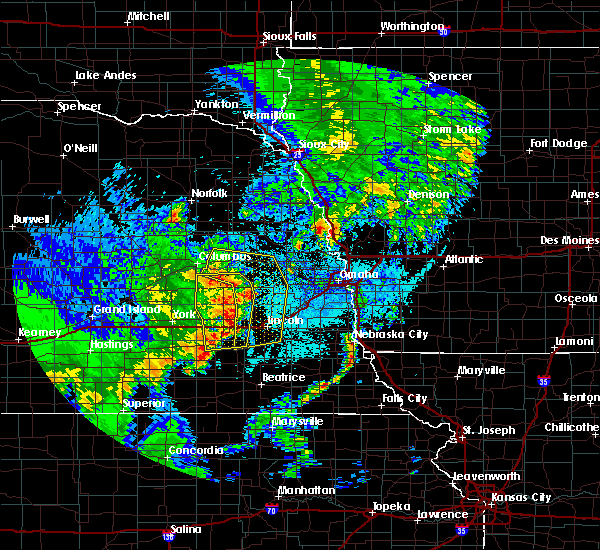 At 1112 pm cdt, severe thunderstorms were located along a line extending from near bellwood to 6 miles west of prague to near valparaiso to 6 miles southeast of pleasant dale, moving northeast at 40 mph (trained weather spotters). Hazards include 60 mph wind gusts. expect damage to roofs, siding, and trees At 1112 pm cdt, severe thunderstorms were located along a line extending from near bellwood to 6 miles west of prague to near valparaiso to 6 miles southeast of pleasant dale, moving northeast at 40 mph (trained weather spotters). Hazards include 60 mph wind gusts. expect damage to roofs, siding, and trees
|
| 6/13/2017 9:55 PM CDT |
 The severe thunderstorm warning for northwestern lancaster, seward, butler and western saunders counties will expire at 1000 pm cdt, the storms which prompted the warning have weakened below severe limits, and no longer pose an immediate threat to life or property. therefore the warning will be allowed to expire. however nickel size hail, gusty winds and heavy rain are still possible with these thunderstorms. a severe thunderstorm watch remains in effect until 100 am cdt for southeastern and east central nebraska. The severe thunderstorm warning for northwestern lancaster, seward, butler and western saunders counties will expire at 1000 pm cdt, the storms which prompted the warning have weakened below severe limits, and no longer pose an immediate threat to life or property. therefore the warning will be allowed to expire. however nickel size hail, gusty winds and heavy rain are still possible with these thunderstorms. a severe thunderstorm watch remains in effect until 100 am cdt for southeastern and east central nebraska.
|
| 6/13/2017 9:47 PM CDT |
 At 946 pm cdt, severe thunderstorms were located along a line extending from 3 miles southwest of cedar bluffs to near valparaiso to 5 miles west of milford, moving east at 25 mph (radar indicated). Hazards include 60 mph wind gusts and quarter size hail. Hail damage to vehicles is expected. expect wind damage to roofs, siding, and trees. locations impacted include, seward, david city, milford, utica, valparaiso, beaver crossing, brainard, weston, prague, staplehurst, garland, pleasant dale, dwight, bee, ulysses, malcolm, raymond, goehner, cordova and octavia. this includes the following highways, highway 92 in nebraska between mile markers 419 and 446. Interstate 80 in nebraska between mile markers 366 and 390. At 946 pm cdt, severe thunderstorms were located along a line extending from 3 miles southwest of cedar bluffs to near valparaiso to 5 miles west of milford, moving east at 25 mph (radar indicated). Hazards include 60 mph wind gusts and quarter size hail. Hail damage to vehicles is expected. expect wind damage to roofs, siding, and trees. locations impacted include, seward, david city, milford, utica, valparaiso, beaver crossing, brainard, weston, prague, staplehurst, garland, pleasant dale, dwight, bee, ulysses, malcolm, raymond, goehner, cordova and octavia. this includes the following highways, highway 92 in nebraska between mile markers 419 and 446. Interstate 80 in nebraska between mile markers 366 and 390.
|
| 6/13/2017 9:37 PM CDT |
 At 936 pm cdt, severe thunderstorms were located along a line extending from 5 miles south of north bend to near dwight to 3 miles north of beaver crossing, moving east at 25 mph (radar indicated). Hazards include 60 mph wind gusts and quarter size hail. Hail damage to vehicles is expected. expect wind damage to roofs, siding, and trees. locations impacted include, seward, david city, milford, utica, valparaiso, beaver crossing, brainard, weston, prague, staplehurst, garland, pleasant dale, dwight, bee, ulysses, malcolm, raymond, goehner, cordova and octavia. this includes the following highways, highway 92 in nebraska between mile markers 419 and 446. Interstate 80 in nebraska between mile markers 366 and 390. At 936 pm cdt, severe thunderstorms were located along a line extending from 5 miles south of north bend to near dwight to 3 miles north of beaver crossing, moving east at 25 mph (radar indicated). Hazards include 60 mph wind gusts and quarter size hail. Hail damage to vehicles is expected. expect wind damage to roofs, siding, and trees. locations impacted include, seward, david city, milford, utica, valparaiso, beaver crossing, brainard, weston, prague, staplehurst, garland, pleasant dale, dwight, bee, ulysses, malcolm, raymond, goehner, cordova and octavia. this includes the following highways, highway 92 in nebraska between mile markers 419 and 446. Interstate 80 in nebraska between mile markers 366 and 390.
|
| 6/13/2017 9:27 PM CDT |
 At 926 pm cdt, severe thunderstorms were located along a line extending from 6 miles northeast of north bend to near dwight to 4 miles south of seward, moving east at 30 mph (radar indicated). Hazards include 60 mph wind gusts and quarter size hail. Hail damage to vehicles is expected. Expect wind damage to roofs, siding, and trees. At 926 pm cdt, severe thunderstorms were located along a line extending from 6 miles northeast of north bend to near dwight to 4 miles south of seward, moving east at 30 mph (radar indicated). Hazards include 60 mph wind gusts and quarter size hail. Hail damage to vehicles is expected. Expect wind damage to roofs, siding, and trees.
|
| 6/13/2017 9:18 PM CDT |
 At 918 pm cdt, severe thunderstorms were located along a line extending from 4 miles southwest of snyder to 5 miles southwest of prague to 4 miles west of beaver crossing, moving east at 35 mph (radar indicated). Hazards include 60 mph wind gusts and half dollar size hail. Hail damage to vehicles is expected. expect wind damage to roofs, siding, and trees. locations impacted include, fremont, seward, schuyler, wahoo, david city, milford, north bend, utica, hooper, cedar bluffs, valparaiso, bellwood, beaver crossing, rising city, brainard, inglewood, weston, prague, staplehurst and garland. this includes the following highways, highway 275 in nebraska between mile markers 135 and 140. highway 30 in nebraska between mile markers 387 and 426. highway 77 in nebraska between mile markers 90 and 93, and between mile markers 108 and 126. highway 92 in nebraska between mile markers 412 and 452. Interstate 80 in nebraska between mile markers 366 and 392. At 918 pm cdt, severe thunderstorms were located along a line extending from 4 miles southwest of snyder to 5 miles southwest of prague to 4 miles west of beaver crossing, moving east at 35 mph (radar indicated). Hazards include 60 mph wind gusts and half dollar size hail. Hail damage to vehicles is expected. expect wind damage to roofs, siding, and trees. locations impacted include, fremont, seward, schuyler, wahoo, david city, milford, north bend, utica, hooper, cedar bluffs, valparaiso, bellwood, beaver crossing, rising city, brainard, inglewood, weston, prague, staplehurst and garland. this includes the following highways, highway 275 in nebraska between mile markers 135 and 140. highway 30 in nebraska between mile markers 387 and 426. highway 77 in nebraska between mile markers 90 and 93, and between mile markers 108 and 126. highway 92 in nebraska between mile markers 412 and 452. Interstate 80 in nebraska between mile markers 366 and 392.
|
| 6/13/2017 9:07 PM CDT |
 At 906 pm cdt, severe thunderstorms were located along a line extending from 6 miles south of howells to 5 miles east of david city to 3 miles southwest of beaver crossing, moving east at 40 mph (radar indicated). Hazards include 60 mph wind gusts and quarter size hail. Hail damage to vehicles is expected. Expect wind damage to roofs, siding, and trees. At 906 pm cdt, severe thunderstorms were located along a line extending from 6 miles south of howells to 5 miles east of david city to 3 miles southwest of beaver crossing, moving east at 40 mph (radar indicated). Hazards include 60 mph wind gusts and quarter size hail. Hail damage to vehicles is expected. Expect wind damage to roofs, siding, and trees.
|
| 5/17/2017 2:49 AM CDT |
 At 249 am cdt, severe thunderstorms were located along a line extending from near weston to 4 miles north of lincoln to 4 miles northeast of hallam, moving east at 50 mph (radar indicated). Hazards include 60 mph wind gusts. Expect damage to roofs, siding, and trees. locations impacted include, lincoln, wahoo, waverly, hickman, bennet, valparaiso, weston, panama, ceresco, roca, raymond, davey, ithaca, sprague, malmo, colon, stagecoach state recreation area, wagon train state recreation area and bluestem state recreation area. this includes the following highways, highway 2 in nebraska between mile markers 466 and 472. highway 77 in nebraska between mile markers 48 and 97. highway 92 in nebraska between mile markers 438 and 452. Interstate 80 in nebraska between mile markers 395 and 412. At 249 am cdt, severe thunderstorms were located along a line extending from near weston to 4 miles north of lincoln to 4 miles northeast of hallam, moving east at 50 mph (radar indicated). Hazards include 60 mph wind gusts. Expect damage to roofs, siding, and trees. locations impacted include, lincoln, wahoo, waverly, hickman, bennet, valparaiso, weston, panama, ceresco, roca, raymond, davey, ithaca, sprague, malmo, colon, stagecoach state recreation area, wagon train state recreation area and bluestem state recreation area. this includes the following highways, highway 2 in nebraska between mile markers 466 and 472. highway 77 in nebraska between mile markers 48 and 97. highway 92 in nebraska between mile markers 438 and 452. Interstate 80 in nebraska between mile markers 395 and 412.
|
| 5/17/2017 2:41 AM CDT |
 At 241 am cdt, severe thunderstorms were located along a line extending from 6 miles west of weston to 6 miles northwest of lincoln to 4 miles northwest of hallam, moving east at 40 mph (radar indicated). Hazards include 60 mph wind gusts. Expect damage to roofs, siding, and trees. locations impacted include, lincoln, wahoo, waverly, hickman, bennet, firth, valparaiso, weston, panama, hallam, ceresco, malcolm, roca, denton, raymond, davey, ithaca, sprague, malmo and colon. people attending sherman field and haymarket park should seek safe shelter immediately! this includes the following highways, highway 2 in nebraska between mile markers 466 and 472. highway 77 in nebraska between mile markers 42 and 97. highway 92 in nebraska between mile markers 433 and 452. Interstate 80 in nebraska between mile markers 390 and 412. At 241 am cdt, severe thunderstorms were located along a line extending from 6 miles west of weston to 6 miles northwest of lincoln to 4 miles northwest of hallam, moving east at 40 mph (radar indicated). Hazards include 60 mph wind gusts. Expect damage to roofs, siding, and trees. locations impacted include, lincoln, wahoo, waverly, hickman, bennet, firth, valparaiso, weston, panama, hallam, ceresco, malcolm, roca, denton, raymond, davey, ithaca, sprague, malmo and colon. people attending sherman field and haymarket park should seek safe shelter immediately! this includes the following highways, highway 2 in nebraska between mile markers 466 and 472. highway 77 in nebraska between mile markers 42 and 97. highway 92 in nebraska between mile markers 433 and 452. Interstate 80 in nebraska between mile markers 390 and 412.
|
| 5/17/2017 2:27 AM CDT |
 At 227 am cdt, severe thunderstorms were located along a line extending from near bee to 3 miles northwest of pleasant dale to 5 miles northwest of wilber, moving east at 50 mph (radar indicated). Hazards include 60 mph wind gusts. expect damage to roofs, siding, and trees At 227 am cdt, severe thunderstorms were located along a line extending from near bee to 3 miles northwest of pleasant dale to 5 miles northwest of wilber, moving east at 50 mph (radar indicated). Hazards include 60 mph wind gusts. expect damage to roofs, siding, and trees
|
| 5/16/2017 8:45 PM CDT |
 At 844 pm cdt, severe thunderstorms were located along a line extending from 4 miles south of valparaiso to near hickman, moving northeast at 45 mph (radar indicated). Hazards include 60 mph wind gusts and nickel size hail. Expect damage to roofs, siding, and trees. locations impacted include, lincoln, hickman, panama, garland, hallam, pleasant dale, malcolm, roca, denton, raymond, sprague, branched oak state recreation area, pawnee state recreation area, stagecoach state recreation area, wagon train state recreation area, conestoga state recreation area and bluestem state recreation area. People attending sherman field and haymarket park should seek safe shelter immediately!. At 844 pm cdt, severe thunderstorms were located along a line extending from 4 miles south of valparaiso to near hickman, moving northeast at 45 mph (radar indicated). Hazards include 60 mph wind gusts and nickel size hail. Expect damage to roofs, siding, and trees. locations impacted include, lincoln, hickman, panama, garland, hallam, pleasant dale, malcolm, roca, denton, raymond, sprague, branched oak state recreation area, pawnee state recreation area, stagecoach state recreation area, wagon train state recreation area, conestoga state recreation area and bluestem state recreation area. People attending sherman field and haymarket park should seek safe shelter immediately!.
|
| 5/16/2017 8:40 PM CDT |
 At 840 pm cdt, severe thunderstorms were located along a line extending from 6 miles east of garland to near hickman, moving northeast at 45 mph (radar indicated). Hazards include 60 mph wind gusts and nickel size hail. Expect damage to roofs, siding, and trees. locations impacted include, lincoln, seward, crete, milford, hickman, panama, garland, hallam, pleasant dale, malcolm, roca, denton, raymond, sprague, branched oak state recreation area, pawnee state recreation area, stagecoach state recreation area, walnut creek recreation area, wagon train state recreation area and olive creek state recreation area. People attending sherman field and haymarket park should seek safe shelter immediately!. At 840 pm cdt, severe thunderstorms were located along a line extending from 6 miles east of garland to near hickman, moving northeast at 45 mph (radar indicated). Hazards include 60 mph wind gusts and nickel size hail. Expect damage to roofs, siding, and trees. locations impacted include, lincoln, seward, crete, milford, hickman, panama, garland, hallam, pleasant dale, malcolm, roca, denton, raymond, sprague, branched oak state recreation area, pawnee state recreation area, stagecoach state recreation area, walnut creek recreation area, wagon train state recreation area and olive creek state recreation area. People attending sherman field and haymarket park should seek safe shelter immediately!.
|
| 5/16/2017 8:35 PM CDT |
 At 834 pm cdt, a severe thunderstorm was located 4 miles east of pleasant dale, or 8 miles west of lincoln, moving northeast at 60 mph (radar indicated). Hazards include 60 mph wind gusts and nickel size hail. Expect damage to roofs, siding, and trees. locations impacted include, lincoln, seward, crete, milford, hickman, panama, garland, hallam, pleasant dale, malcolm, roca, denton, raymond, sprague, branched oak state recreation area, pawnee state recreation area, stagecoach state recreation area, walnut creek recreation area, wagon train state recreation area and olive creek state recreation area. people attending sherman field and haymarket park should seek safe shelter immediately! this includes the following highways, highway 2 in nebraska near mile marker 466. highway 77 in nebraska between mile markers 45 and 63. Interstate 80 in nebraska between mile markers 379 and 401. At 834 pm cdt, a severe thunderstorm was located 4 miles east of pleasant dale, or 8 miles west of lincoln, moving northeast at 60 mph (radar indicated). Hazards include 60 mph wind gusts and nickel size hail. Expect damage to roofs, siding, and trees. locations impacted include, lincoln, seward, crete, milford, hickman, panama, garland, hallam, pleasant dale, malcolm, roca, denton, raymond, sprague, branched oak state recreation area, pawnee state recreation area, stagecoach state recreation area, walnut creek recreation area, wagon train state recreation area and olive creek state recreation area. people attending sherman field and haymarket park should seek safe shelter immediately! this includes the following highways, highway 2 in nebraska near mile marker 466. highway 77 in nebraska between mile markers 45 and 63. Interstate 80 in nebraska between mile markers 379 and 401.
|
| 5/16/2017 8:27 PM CDT |
 At 827 pm cdt, a severe thunderstorm was located 4 miles south of pleasant dale, or 13 miles southwest of lincoln, moving northeast at 60 mph (radar indicated). Hazards include 60 mph wind gusts and nickel size hail. expect damage to roofs, siding, and trees At 827 pm cdt, a severe thunderstorm was located 4 miles south of pleasant dale, or 13 miles southwest of lincoln, moving northeast at 60 mph (radar indicated). Hazards include 60 mph wind gusts and nickel size hail. expect damage to roofs, siding, and trees
|
| 5/16/2017 6:03 PM CDT |
 At 602 pm cdt, severe thunderstorms were located along a line extending from 4 miles southeast of inglewood to lincoln, moving east at 35 mph. the strongest winds were likely from near mead to west of leshara, moving toward yutan and valley (radar indicated). Hazards include 70 mph wind gusts and half dollar size hail. Hail damage to vehicles is expected. expect considerable tree damage. wind damage is also likely to mobile homes, roofs, and outbuildings. locations impacted include, northeastern lincoln, wahoo, gretna, waverly, ashland, valley, yutan, waterloo, elmwood, cedar bluffs, mead, greenwood, inglewood, elkhorn, murdock, bennington, ceresco, raymond, davey and washington. this includes the following highways, highway 275 in nebraska between mile markers 156 and 167. highway 77 in nebraska between mile markers 71 and 112. highway 92 in nebraska between mile markers 446 and 466. Interstate 80 in nebraska between mile markers 401 and 435. At 602 pm cdt, severe thunderstorms were located along a line extending from 4 miles southeast of inglewood to lincoln, moving east at 35 mph. the strongest winds were likely from near mead to west of leshara, moving toward yutan and valley (radar indicated). Hazards include 70 mph wind gusts and half dollar size hail. Hail damage to vehicles is expected. expect considerable tree damage. wind damage is also likely to mobile homes, roofs, and outbuildings. locations impacted include, northeastern lincoln, wahoo, gretna, waverly, ashland, valley, yutan, waterloo, elmwood, cedar bluffs, mead, greenwood, inglewood, elkhorn, murdock, bennington, ceresco, raymond, davey and washington. this includes the following highways, highway 275 in nebraska between mile markers 156 and 167. highway 77 in nebraska between mile markers 71 and 112. highway 92 in nebraska between mile markers 446 and 466. Interstate 80 in nebraska between mile markers 401 and 435.
|
| 5/16/2017 5:53 PM CDT |
 At 553 pm cdt, severe thunderstorms were located along a line extending from 3 miles south of inglewood to lincoln, moving east at 35 mph. outflow winds may reach 60 to 65 mph (radar indicated). Hazards include 60 mph wind gusts. expect damage to roofs, siding, and trees At 553 pm cdt, severe thunderstorms were located along a line extending from 3 miles south of inglewood to lincoln, moving east at 35 mph. outflow winds may reach 60 to 65 mph (radar indicated). Hazards include 60 mph wind gusts. expect damage to roofs, siding, and trees
|
| 5/16/2017 5:43 PM CDT |
 At 543 pm cdt, a severe thunderstorm was located 6 miles south of valparaiso, or 13 miles northwest of lincoln, moving northeast at 45 mph (radar indicated). Hazards include 60 mph wind gusts and quarter size hail. Hail damage to vehicles is expected. expect wind damage to roofs, siding, and trees. locations impacted include, northwestern lincoln, pleasant dale, malcolm, raymond, davey, branched oak state recreation area and pawnee state recreation area. This includes interstate 80 in nebraska between mile markers 388 and 397. At 543 pm cdt, a severe thunderstorm was located 6 miles south of valparaiso, or 13 miles northwest of lincoln, moving northeast at 45 mph (radar indicated). Hazards include 60 mph wind gusts and quarter size hail. Hail damage to vehicles is expected. expect wind damage to roofs, siding, and trees. locations impacted include, northwestern lincoln, pleasant dale, malcolm, raymond, davey, branched oak state recreation area and pawnee state recreation area. This includes interstate 80 in nebraska between mile markers 388 and 397.
|
| 5/16/2017 5:39 PM CDT |
 At 539 pm cdt, a severe thunderstorm was located 6 miles east of garland, or 12 miles northwest of lincoln, moving northeast at 40 mph (radar indicated). Hazards include 60 mph wind gusts and quarter size hail. Hail damage to vehicles is expected. expect wind damage to roofs, siding, and trees. locations impacted include, northwestern lincoln, milford, garland, pleasant dale, malcolm, raymond, davey, branched oak state recreation area, pawnee state recreation area and conestoga state recreation area. This includes interstate 80 in nebraska between mile markers 382 and 397. At 539 pm cdt, a severe thunderstorm was located 6 miles east of garland, or 12 miles northwest of lincoln, moving northeast at 40 mph (radar indicated). Hazards include 60 mph wind gusts and quarter size hail. Hail damage to vehicles is expected. expect wind damage to roofs, siding, and trees. locations impacted include, northwestern lincoln, milford, garland, pleasant dale, malcolm, raymond, davey, branched oak state recreation area, pawnee state recreation area and conestoga state recreation area. This includes interstate 80 in nebraska between mile markers 382 and 397.
|
| 5/16/2017 5:26 PM CDT |
 At 526 pm cdt, severe thunderstorms were located along a line extending from 4 miles northwest of valparaiso to 4 miles west of milford, moving northeast at 40 mph (radar indicated). Hazards include 60 mph wind gusts and quarter size hail. Hail damage to vehicles is expected. Expect wind damage to roofs, siding, and trees. At 526 pm cdt, severe thunderstorms were located along a line extending from 4 miles northwest of valparaiso to 4 miles west of milford, moving northeast at 40 mph (radar indicated). Hazards include 60 mph wind gusts and quarter size hail. Hail damage to vehicles is expected. Expect wind damage to roofs, siding, and trees.
|
| 5/16/2017 5:22 PM CDT |
 At 521 pm cdt, a severe thunderstorm was located near bee, or 21 miles northwest of lincoln, moving northeast at 40 mph. storms were part of a larger area that extended from goehner to seward and dwight. this warning may need to be extended. quarter size hail was reported in seward at 515 pm (radar indicated). Hazards include 60 mph wind gusts and half dollar size hail. Hail damage to vehicles is expected. expect wind damage to roofs, siding, and trees. locations impacted include, seward, utica, valparaiso, beaver crossing, staplehurst, garland, dwight, bee, ulysses, malcolm, raymond, goehner, cordova, branched oak state recreation area and tamora. this includes the following highways, highway 92 in nebraska near mile marker 433. Interstate 80 in nebraska between mile markers 366 and 382. At 521 pm cdt, a severe thunderstorm was located near bee, or 21 miles northwest of lincoln, moving northeast at 40 mph. storms were part of a larger area that extended from goehner to seward and dwight. this warning may need to be extended. quarter size hail was reported in seward at 515 pm (radar indicated). Hazards include 60 mph wind gusts and half dollar size hail. Hail damage to vehicles is expected. expect wind damage to roofs, siding, and trees. locations impacted include, seward, utica, valparaiso, beaver crossing, staplehurst, garland, dwight, bee, ulysses, malcolm, raymond, goehner, cordova, branched oak state recreation area and tamora. this includes the following highways, highway 92 in nebraska near mile marker 433. Interstate 80 in nebraska between mile markers 366 and 382.
|
| 5/16/2017 5:10 PM CDT |
 At 509 pm cdt, a severe thunderstorm was located near staplehurst, or 24 miles east of york, moving northeast at 25 mph. this was part of a larger area of severe storms that extended southwest toward beaver crossing and northeast toward dwight (radar indicated). Hazards include ping pong ball size hail and 60 mph wind gusts. People and animals outdoors will be injured. expect hail damage to roofs, siding, windows, and vehicles. expect wind damage to roofs, siding, and trees. locations impacted include, seward, utica, valparaiso, beaver crossing, staplehurst, garland, dwight, bee, ulysses, malcolm, raymond, goehner, cordova, branched oak state recreation area and tamora. this includes the following highways, highway 92 in nebraska near mile marker 433. Interstate 80 in nebraska between mile markers 366 and 382. At 509 pm cdt, a severe thunderstorm was located near staplehurst, or 24 miles east of york, moving northeast at 25 mph. this was part of a larger area of severe storms that extended southwest toward beaver crossing and northeast toward dwight (radar indicated). Hazards include ping pong ball size hail and 60 mph wind gusts. People and animals outdoors will be injured. expect hail damage to roofs, siding, windows, and vehicles. expect wind damage to roofs, siding, and trees. locations impacted include, seward, utica, valparaiso, beaver crossing, staplehurst, garland, dwight, bee, ulysses, malcolm, raymond, goehner, cordova, branched oak state recreation area and tamora. this includes the following highways, highway 92 in nebraska near mile marker 433. Interstate 80 in nebraska between mile markers 366 and 382.
|
| 5/16/2017 5:01 PM CDT |
 At 452 pm cdt, a severe thunderstorm was located 6 miles southwest of seward, or 19 miles east of york, moving northeast at 40 mph (radar indicated). Hazards include 60 mph wind gusts and half dollar size hail. Hail damage to vehicles is expected. Expect wind damage to roofs, siding, and trees. At 452 pm cdt, a severe thunderstorm was located 6 miles southwest of seward, or 19 miles east of york, moving northeast at 40 mph (radar indicated). Hazards include 60 mph wind gusts and half dollar size hail. Hail damage to vehicles is expected. Expect wind damage to roofs, siding, and trees.
|
| 5/16/2017 4:52 PM CDT |
 The national weather service in omaha has issued a * severe thunderstorm warning for. northwestern lancaster county in southeastern nebraska. seward county in southeastern nebraska. northwestern saline county in southeastern nebraska. Southeastern butler county in east central nebraska. The national weather service in omaha has issued a * severe thunderstorm warning for. northwestern lancaster county in southeastern nebraska. seward county in southeastern nebraska. northwestern saline county in southeastern nebraska. Southeastern butler county in east central nebraska.
|
| 5/16/2017 4:52 PM CDT |
 At 452 pm cdt, a severe thunderstorm was located 6 miles southwest of seward, or 19 miles east of york, moving northeast at 40 mph (radar indicated). Hazards include 60 mph wind gusts and half dollar size hail. Hail damage to vehicles is expected. Expect wind damage to roofs, siding, and trees. At 452 pm cdt, a severe thunderstorm was located 6 miles southwest of seward, or 19 miles east of york, moving northeast at 40 mph (radar indicated). Hazards include 60 mph wind gusts and half dollar size hail. Hail damage to vehicles is expected. Expect wind damage to roofs, siding, and trees.
|
| 4/19/2017 5:13 PM CDT |
 At 513 pm cdt, a severe thunderstorm was located 5 miles east of pleasant dale, or 6 miles west of lincoln, moving northeast at 45 mph (trained weather spotters). Hazards include golf ball size hail and 60 mph wind gusts. People and animals outdoors will be injured. expect hail damage to roofs, siding, windows, and vehicles. expect wind damage to roofs, siding, and trees. locations impacted include, lincoln, malcolm, denton, raymond, conestoga state recreation area and pawnee state recreation area. this includes the following highways, highway 77 in nebraska between mile markers 60 and 63. interstate 80 in nebraska between mile markers 390 and 405. A tornado watch remains in effect until 1000 pm cdt for southeastern nebraska. At 513 pm cdt, a severe thunderstorm was located 5 miles east of pleasant dale, or 6 miles west of lincoln, moving northeast at 45 mph (trained weather spotters). Hazards include golf ball size hail and 60 mph wind gusts. People and animals outdoors will be injured. expect hail damage to roofs, siding, windows, and vehicles. expect wind damage to roofs, siding, and trees. locations impacted include, lincoln, malcolm, denton, raymond, conestoga state recreation area and pawnee state recreation area. this includes the following highways, highway 77 in nebraska between mile markers 60 and 63. interstate 80 in nebraska between mile markers 390 and 405. A tornado watch remains in effect until 1000 pm cdt for southeastern nebraska.
|
| 4/19/2017 5:05 PM CDT |
 At 505 pm cdt, a severe thunderstorm was located near pleasant dale, or 12 miles west of lincoln, moving northeast at 40 mph (radar indicated). Hazards include golf ball size hail. People and animals outdoors will be injured. expect damage to roofs, siding, windows, and vehicles. locations impacted include, lincoln, pleasant dale, malcolm, denton, raymond, pawnee state recreation area and conestoga state recreation area. this includes the following highways, highway 77 in nebraska between mile markers 60 and 63. interstate 80 in nebraska between mile markers 385 and 405. A tornado watch remains in effect until 1000 pm cdt for southeastern nebraska. At 505 pm cdt, a severe thunderstorm was located near pleasant dale, or 12 miles west of lincoln, moving northeast at 40 mph (radar indicated). Hazards include golf ball size hail. People and animals outdoors will be injured. expect damage to roofs, siding, windows, and vehicles. locations impacted include, lincoln, pleasant dale, malcolm, denton, raymond, pawnee state recreation area and conestoga state recreation area. this includes the following highways, highway 77 in nebraska between mile markers 60 and 63. interstate 80 in nebraska between mile markers 385 and 405. A tornado watch remains in effect until 1000 pm cdt for southeastern nebraska.
|
| 4/19/2017 4:55 PM CDT |
 At 454 pm cdt, a severe thunderstorm was located near milford, or 18 miles west of lincoln, moving northeast at 45 mph (radar indicated). Hazards include golf ball size hail. People and animals outdoors will be injured. Expect damage to roofs, siding, windows, and vehicles. At 454 pm cdt, a severe thunderstorm was located near milford, or 18 miles west of lincoln, moving northeast at 45 mph (radar indicated). Hazards include golf ball size hail. People and animals outdoors will be injured. Expect damage to roofs, siding, windows, and vehicles.
|
| 7/7/2016 2:02 AM CDT |
 At 201 am cdt, a severe thunderstorm was located 4 miles east of bee, or 20 miles northwest of lincoln, moving northeast at 55 mph (radar indicated). Hazards include 70 mph wind gusts and quarter size hail. Hail damage to vehicles is expected. expect considerable tree damage. wind damage is also likely to mobile homes, roofs and outbuildings. Locations impacted include, lincoln, seward, crete, milford, dorchester, valparaiso, weston , staplehurst, garland, pleasant dale, dwight, bee, ulysses, ceresco, malcolm, roca, denton, raymond, davey and sprague. At 201 am cdt, a severe thunderstorm was located 4 miles east of bee, or 20 miles northwest of lincoln, moving northeast at 55 mph (radar indicated). Hazards include 70 mph wind gusts and quarter size hail. Hail damage to vehicles is expected. expect considerable tree damage. wind damage is also likely to mobile homes, roofs and outbuildings. Locations impacted include, lincoln, seward, crete, milford, dorchester, valparaiso, weston , staplehurst, garland, pleasant dale, dwight, bee, ulysses, ceresco, malcolm, roca, denton, raymond, davey and sprague.
|
| 7/7/2016 1:34 AM CDT |
 At 134 am cdt, a severe thunderstorm was located near waco, or 8 miles east of york, moving east at 55 mph (radar indicated). Hazards include 70 mph wind gusts and quarter size hail. Hail damage to vehicles is expected. expect considerable tree damage. Wind damage is also likely to mobile homes, roofs and outbuildings. At 134 am cdt, a severe thunderstorm was located near waco, or 8 miles east of york, moving east at 55 mph (radar indicated). Hazards include 70 mph wind gusts and quarter size hail. Hail damage to vehicles is expected. expect considerable tree damage. Wind damage is also likely to mobile homes, roofs and outbuildings.
|
| 7/7/2016 1:04 AM CDT |
 At 104 am cdt, a severe thunderstorm was located 4 miles southeast of dwight, or 20 miles northwest of lincoln, moving northeast at 25 mph (radar indicated). Hazards include quarter size hail. damage to vehicles is expected At 104 am cdt, a severe thunderstorm was located 4 miles southeast of dwight, or 20 miles northwest of lincoln, moving northeast at 25 mph (radar indicated). Hazards include quarter size hail. damage to vehicles is expected
|
| 9/18/2015 10:48 AM CDT |
 At 1047 am cdt, a severe thunderstorm was located 9 miles north of lincoln, moving northeast at 35 mph (radar indicated). Hazards include quarter size hail. Damage to vehicles is expected. locations impacted include, northern lincoln, waverly, malcolm, raymond, davey and branched oak state recreation area. this includes the following highways, highway 77 in nebraska between milemarkers 71 and 81. Interstate 80 in nebraska between mile markers 401 and 414. At 1047 am cdt, a severe thunderstorm was located 9 miles north of lincoln, moving northeast at 35 mph (radar indicated). Hazards include quarter size hail. Damage to vehicles is expected. locations impacted include, northern lincoln, waverly, malcolm, raymond, davey and branched oak state recreation area. this includes the following highways, highway 77 in nebraska between milemarkers 71 and 81. Interstate 80 in nebraska between mile markers 401 and 414.
|
| 9/18/2015 10:40 AM CDT |
 At 1040 am cdt, a severe thunderstorm was located 9 miles northwest of lincoln, moving northeast at 35 mph (radar indicated). Hazards include quarter size hail. Damage to vehicles is expected. locations impacted include, lincoln, waverly, malcolm, raymond, davey, branched oak state recreation area and pawnee state recreation area. this includes the following highways, highway 77 in nebraska between milemarkers 63 and 81. Interstate 80 in nebraska between mile markers 390 and 414. At 1040 am cdt, a severe thunderstorm was located 9 miles northwest of lincoln, moving northeast at 35 mph (radar indicated). Hazards include quarter size hail. Damage to vehicles is expected. locations impacted include, lincoln, waverly, malcolm, raymond, davey, branched oak state recreation area and pawnee state recreation area. this includes the following highways, highway 77 in nebraska between milemarkers 63 and 81. Interstate 80 in nebraska between mile markers 390 and 414.
|
| 9/18/2015 10:31 AM CDT |
 At 1031 am cdt, a severe thunderstorm was located 5 miles southeast of garland, or 12 miles northwest of lincoln, moving northeast at 35 mph (radar indicated). Hazards include quarter size hail. damage to vehicles is expected At 1031 am cdt, a severe thunderstorm was located 5 miles southeast of garland, or 12 miles northwest of lincoln, moving northeast at 35 mph (radar indicated). Hazards include quarter size hail. damage to vehicles is expected
|
| 9/18/2015 10:24 AM CDT |
 The severe thunderstorm warning for northwestern lancaster, southwestern saunders, southeastern butler and northern seward counties will expire at 1030 am cdt, the severe thunderstorm which prompted the warning has weakened. therefore the warning will be allowed to expire. however small. The severe thunderstorm warning for northwestern lancaster, southwestern saunders, southeastern butler and northern seward counties will expire at 1030 am cdt, the severe thunderstorm which prompted the warning has weakened. therefore the warning will be allowed to expire. however small.
|
| 9/18/2015 10:20 AM CDT |
 At 1020 am cdt, a severe thunderstorm was located 4 miles southeast of seward, or 18 miles west of lincoln, moving east at 40 mph (radar indicated). Hazards include quarter size hail. Damage to vehicles is expected. locations impacted include, seward, valparaiso, staplehurst, garland, dwight, bee, malcolm, raymond, tamora and branched oak state recreation area. This includes interstate 80 in nebraska between mile markers 375 and 379. At 1020 am cdt, a severe thunderstorm was located 4 miles southeast of seward, or 18 miles west of lincoln, moving east at 40 mph (radar indicated). Hazards include quarter size hail. Damage to vehicles is expected. locations impacted include, seward, valparaiso, staplehurst, garland, dwight, bee, malcolm, raymond, tamora and branched oak state recreation area. This includes interstate 80 in nebraska between mile markers 375 and 379.
|
| 9/18/2015 9:56 AM CDT |
 At 955 am cdt, a severe thunderstorm was located near utica, or 12 miles east of york, moving northeast at 45 mph (radar indicated). Hazards include quarter size hail. damage to vehicles is expected At 955 am cdt, a severe thunderstorm was located near utica, or 12 miles east of york, moving northeast at 45 mph (radar indicated). Hazards include quarter size hail. damage to vehicles is expected
|
| 7/25/2015 12:22 AM CDT |
 At 1221 am cdt, a severe thunderstorm was located over northeastern lincoln, moving northeast at 10 mph (radar indicated). Hazards include 60 mph wind gusts and quarter size hail. Hail damage to vehicles is expected. expect wind damage to roofs, siding and trees. winds gusted to 58 mph at the lincoln airport at 1211 am cdt. Locations impacted include, lincoln, waverly, bennet, elmwood, greenwood, palmyra, unadilla, murdock, douglas, eagle, roca, raymond, davey, alvo, south bend, schramm park state recreation area, mahoney state park and wagon train state recreation area. At 1221 am cdt, a severe thunderstorm was located over northeastern lincoln, moving northeast at 10 mph (radar indicated). Hazards include 60 mph wind gusts and quarter size hail. Hail damage to vehicles is expected. expect wind damage to roofs, siding and trees. winds gusted to 58 mph at the lincoln airport at 1211 am cdt. Locations impacted include, lincoln, waverly, bennet, elmwood, greenwood, palmyra, unadilla, murdock, douglas, eagle, roca, raymond, davey, alvo, south bend, schramm park state recreation area, mahoney state park and wagon train state recreation area.
|
| 7/25/2015 12:09 AM CDT |
 At 1208 am cdt, severe thunderstorms were located along a line extending from bee to near pleasant dale to near wilber, moving east at 35 mph (radar indicated). Hazards include 60 mph wind gusts. Expect damage to roofs. siding and trees. Locations impacted include, seward, crete, milford, wilber, dorchester, staplehurst, clatonia, garland, hallam, pleasant dale, dwight, bee, ulysses, malcolm, denton, raymond, tobias, branched oak state recreation area, blue river state recreation area and pawnee state recreation area. At 1208 am cdt, severe thunderstorms were located along a line extending from bee to near pleasant dale to near wilber, moving east at 35 mph (radar indicated). Hazards include 60 mph wind gusts. Expect damage to roofs. siding and trees. Locations impacted include, seward, crete, milford, wilber, dorchester, staplehurst, clatonia, garland, hallam, pleasant dale, dwight, bee, ulysses, malcolm, denton, raymond, tobias, branched oak state recreation area, blue river state recreation area and pawnee state recreation area.
|
| 7/25/2015 12:06 AM CDT |
 At 1206 am cdt, a severe thunderstorm was located over northeastern lincoln, moving northeast at 10 mph (radar indicated). Hazards include 60 mph wind gusts and quarter size hail. Hail damage to vehicles is expected. Expect wind damage to roofs, siding and trees. At 1206 am cdt, a severe thunderstorm was located over northeastern lincoln, moving northeast at 10 mph (radar indicated). Hazards include 60 mph wind gusts and quarter size hail. Hail damage to vehicles is expected. Expect wind damage to roofs, siding and trees.
|
| 7/24/2015 11:48 PM CDT |
 At 1147 pm cdt, severe thunderstorms were located along a line extending from near ulysses to near milford to 6 miles southeast of milligan, moving east at 40 mph (radar indicated). Hazards include 60 mph wind gusts. Expect damage to roofs. siding and trees. Locations impacted include, seward, crete, milford, wilber, dorchester, staplehurst, clatonia, garland, hallam, pleasant dale, dwight, bee, ulysses, malcolm, denton, raymond, tobias, branched oak state recreation area, blue river state recreation area and pawnee state recreation area. At 1147 pm cdt, severe thunderstorms were located along a line extending from near ulysses to near milford to 6 miles southeast of milligan, moving east at 40 mph (radar indicated). Hazards include 60 mph wind gusts. Expect damage to roofs. siding and trees. Locations impacted include, seward, crete, milford, wilber, dorchester, staplehurst, clatonia, garland, hallam, pleasant dale, dwight, bee, ulysses, malcolm, denton, raymond, tobias, branched oak state recreation area, blue river state recreation area and pawnee state recreation area.
|
| 7/24/2015 11:44 PM CDT |
 At 1144 pm cdt, severe thunderstorms were located along a line extending from near ulysses to near western, moving east at 40 mph (radar indicated). Hazards include 60 mph wind gusts. Expect damage to roofs. siding and trees. Locations impacted include, seward, crete, milford, wilber, friend, utica, dorchester, valparaiso, de witt, beaver crossing, staplehurst, western, clatonia, garland, hallam, pleasant dale, dwight, bee, ulysses and malcolm. At 1144 pm cdt, severe thunderstorms were located along a line extending from near ulysses to near western, moving east at 40 mph (radar indicated). Hazards include 60 mph wind gusts. Expect damage to roofs. siding and trees. Locations impacted include, seward, crete, milford, wilber, friend, utica, dorchester, valparaiso, de witt, beaver crossing, staplehurst, western, clatonia, garland, hallam, pleasant dale, dwight, bee, ulysses and malcolm.
|
| 7/24/2015 11:28 PM CDT |
 At 1128 pm cdt, severe thunderstorms were located along a line extending from near shelby to near bruning, moving east at 40 mph (radar indicated). Hazards include 60 mph wind gusts. Expect damage to roofs. Siding and trees. At 1128 pm cdt, severe thunderstorms were located along a line extending from near shelby to near bruning, moving east at 40 mph (radar indicated). Hazards include 60 mph wind gusts. Expect damage to roofs. Siding and trees.
|
| 5/6/2015 8:49 PM CDT | At 849 pm cdt, a severe thunderstorm capable of producing a tornado was located 8 miles north of lincoln, moving northeast at 40 mph (radar indicated rotation). Hazards include tornado. Flying debris will be dangerous to those caught without shelter. mobile homes will be damaged or destroyed. damage to roofs, windows and vehicles will occur. tree damage is likely. this tornadic thunderstorm will remain over mainly rural areas of central lancaster county, including the following locations, conestoga state recreation area, raymond, pawnee state recreation area and denton. this includes the following highways, highway 77 in nebraska between milemarkers 60 and 77. interstate 80 in nebraska between mile markers 390 and 411. Radar indicated. |
| 5/6/2015 8:33 PM CDT | At 832 pm cdt, a severe thunderstorm capable of producing a tornado was located near pleasant dale, or near lincoln, moving northeast at 15 mph (radar indicated rotation). Hazards include tornado. Flying debris will be dangerous to those caught without shelter. mobile homes will be damaged or destroyed. damage to roofs, windows and vehicles will occur. tree damage is likely. this dangerous storm will be near, lincoln around 900 pm cdt. other locations impacted by this tornadic thunderstorm include conestoga state recreation area, raymond, pawnee state recreation area and denton. this includes the following highways, highway 77 in nebraska between milemarkers 60 and 77. interstate 80 in nebraska between mile markers 390 and 411. Radar indicated. |
| 5/6/2015 8:18 PM CDT | At 817 pm cdt, a severe thunderstorm was located 7 miles southeast of pleasant dale, or 10 miles southwest of lincoln, moving northeast at 40 mph (radar indicated). Hazards include 70 mph wind gusts and quarter size hail. Hail damage to vehicles is expected. expect considerable tree damage. wind damage is also likely to mobile homes, roofs and outbuildings. locations impacted include, lincoln, crete, wahoo, waverly, ashland, greenwood, pleasant dale, ceresco, malcolm, roca, denton, raymond, davey, ithaca, sprague, memphis, branched oak state recreation area, pawnee state recreation area, mahoney state park and bluestem state recreation area. this includes the following highways, highway 77 in nebraska between milemarkers 51 and 93. highway 92 in nebraska mile marker 446 and near mile marker 446. interstate 80 in nebraska between mile markers 385 and 426. a tornado watch remains in effect until 900 pm cdt for southeastern nebraska. 1. 00in. |
| 5/6/2015 7:55 PM CDT | At 755 pm cdt, a severe thunderstorm was located near crete, or 22 miles southwest of lincoln, moving northeast at 50 mph (radar indicated). Hazards include 60 mph wind gusts and quarter size hail. Hail damage to vehicles is expected. Expect wind damage to roofs, siding and trees. |
| 6/16/2014 10:34 AM CDT | Tea Cup sized hail reported 0.3 miles SSW of Raymond, NE, measured 3 inch hail |
| 6/16/2014 10:20 AM CDT | Tea Cup sized hail reported 0.3 miles SSW of Raymond, NE, 3.5 inch hail measured |
| 6/16/2014 10:15 AM CDT | Hen Egg sized hail reported 0.3 miles SSW of Raymond, NE, measured 1 to 2 inch hail |
| 6/16/2014 10:12 AM CDT | Tea Cup sized hail reported 0.3 miles SSW of Raymond, NE, 3.5 inch |
| 5/19/2012 6:28 PM CDT | Quarter sized hail reported 5.5 miles ESE of Raymond, NE |
| 1/1/0001 12:00 AM | Quarter sized hail reported 3.7 miles S of Raymond, NE |
Hail Maps for Raymond, NE
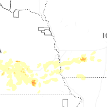


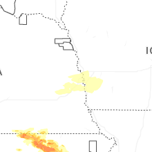
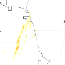
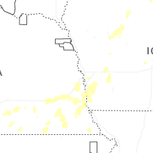
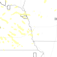
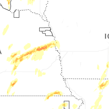


Connect with Interactive Hail Maps