

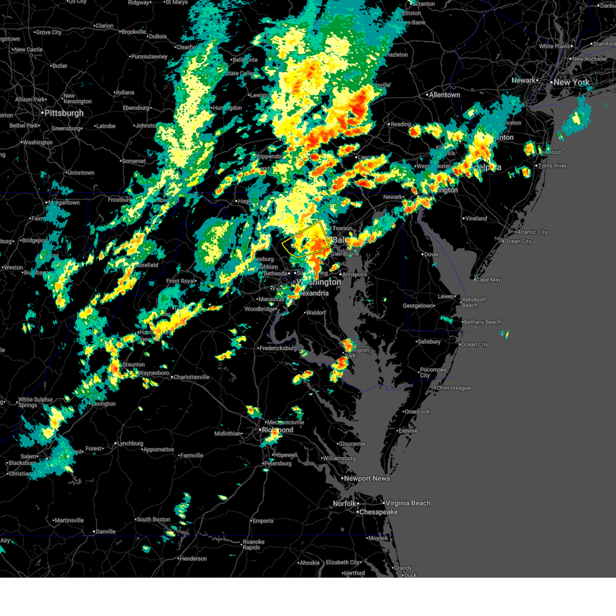
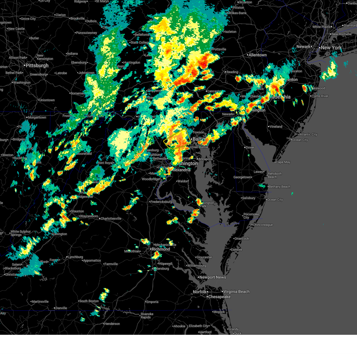
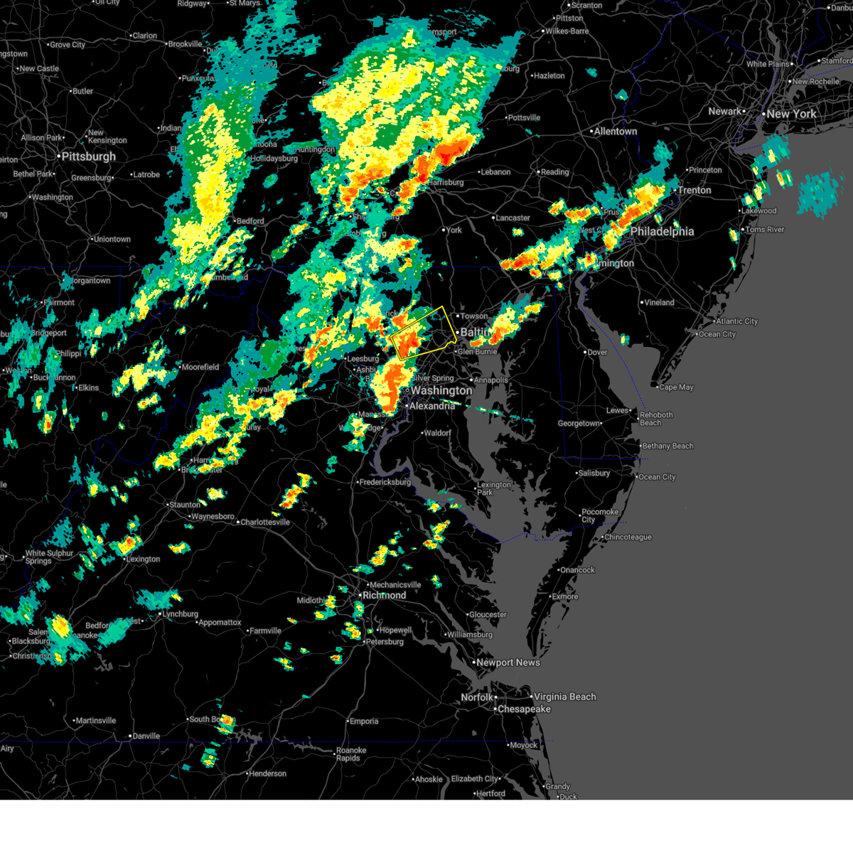
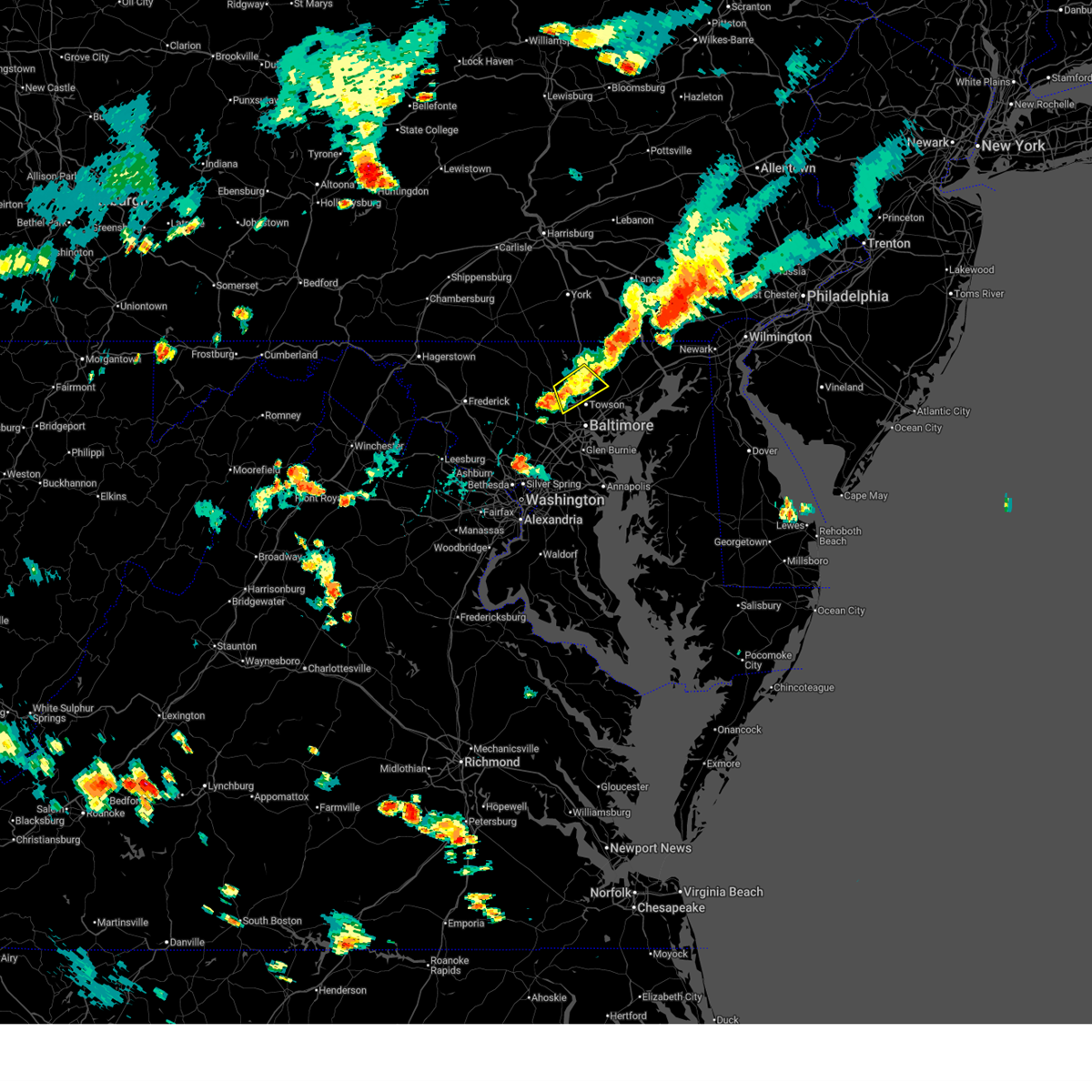
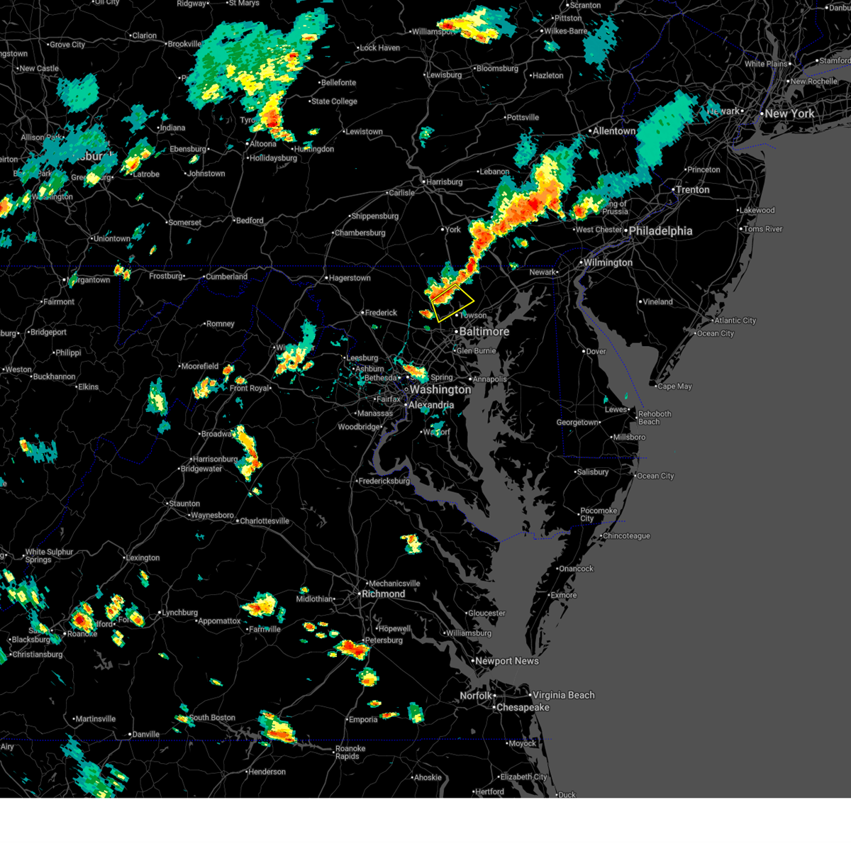
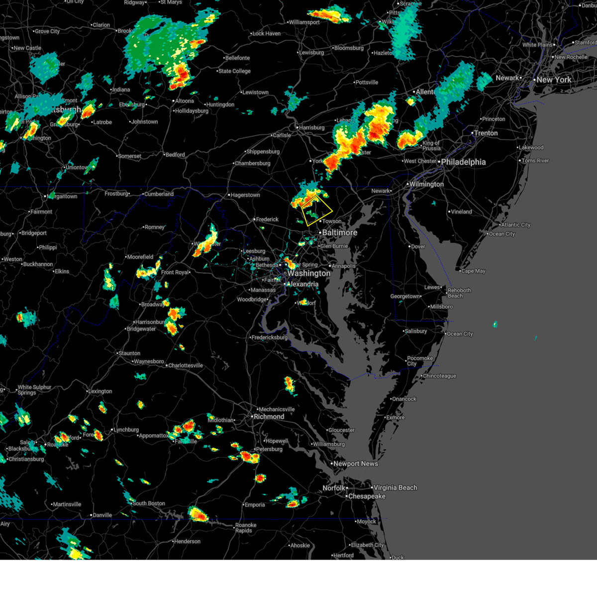
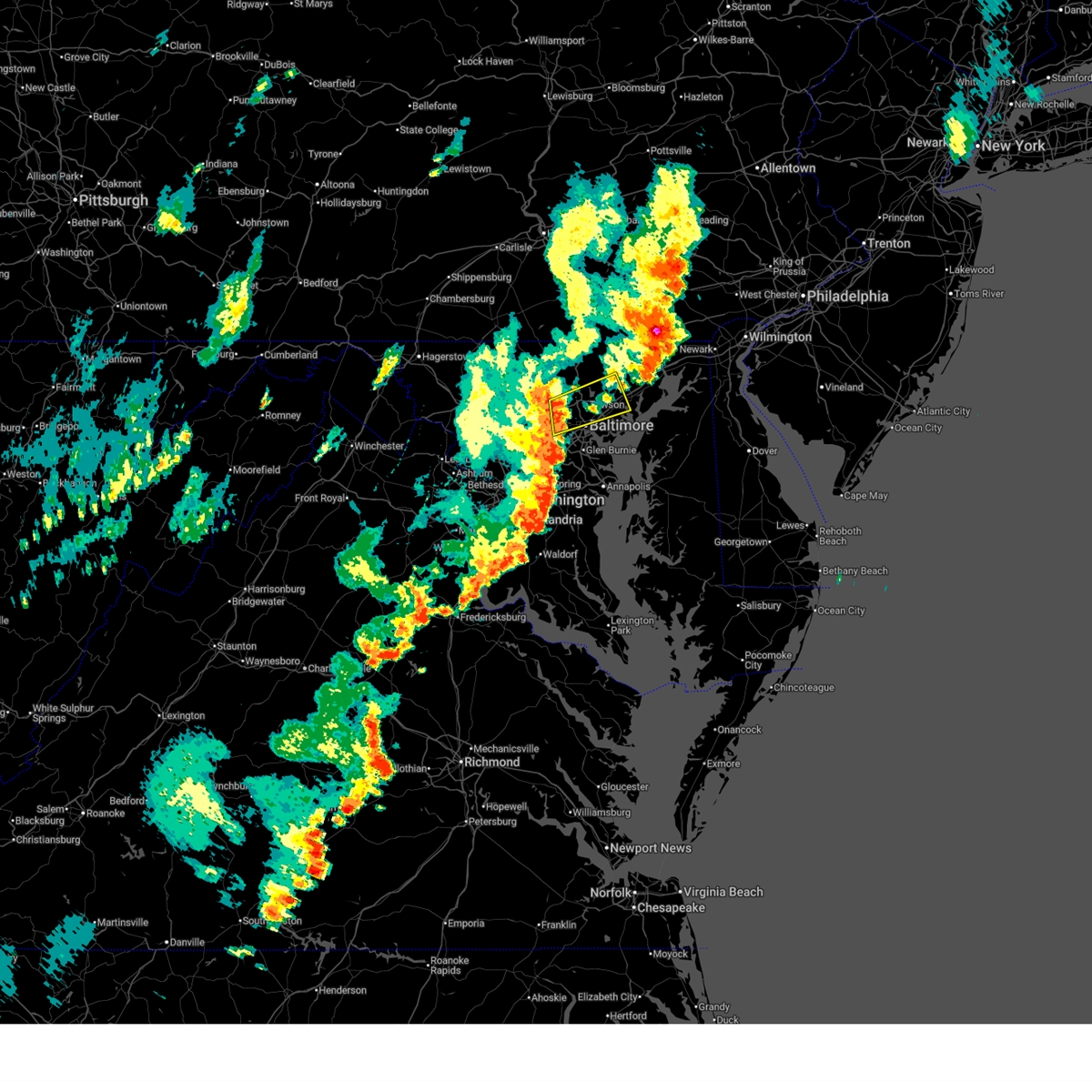
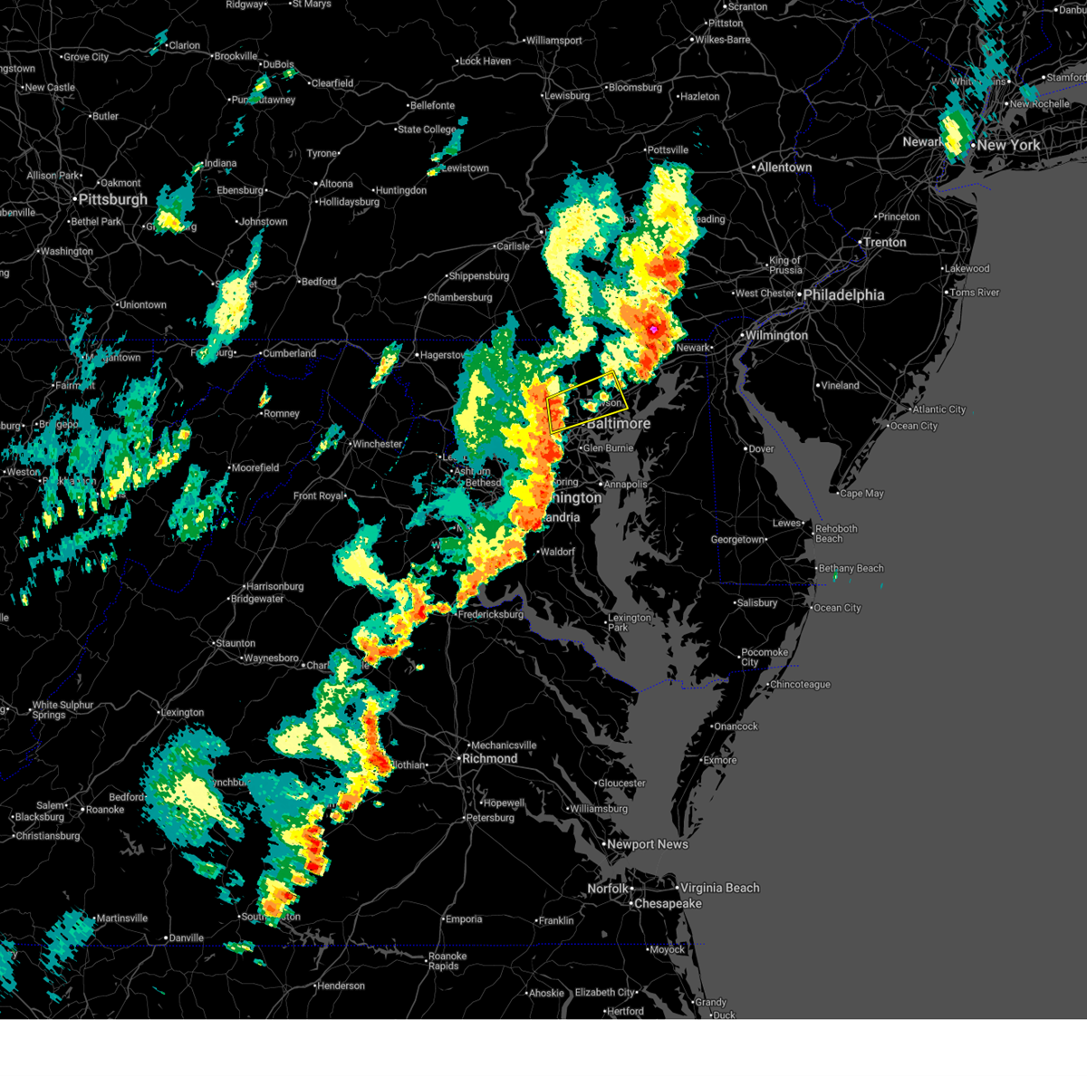
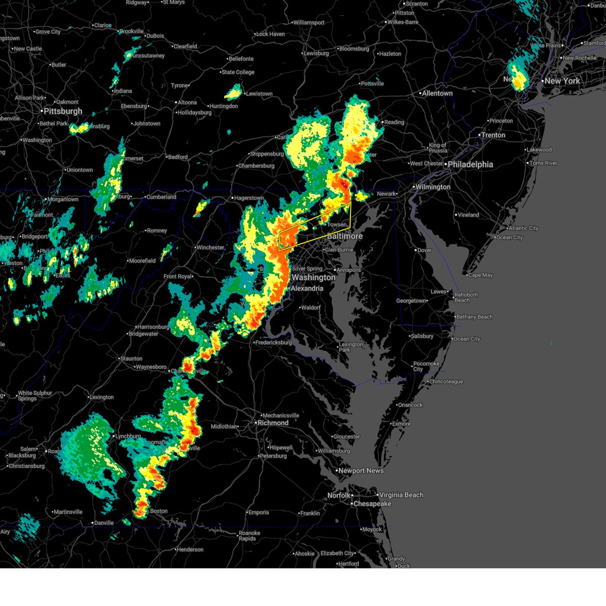
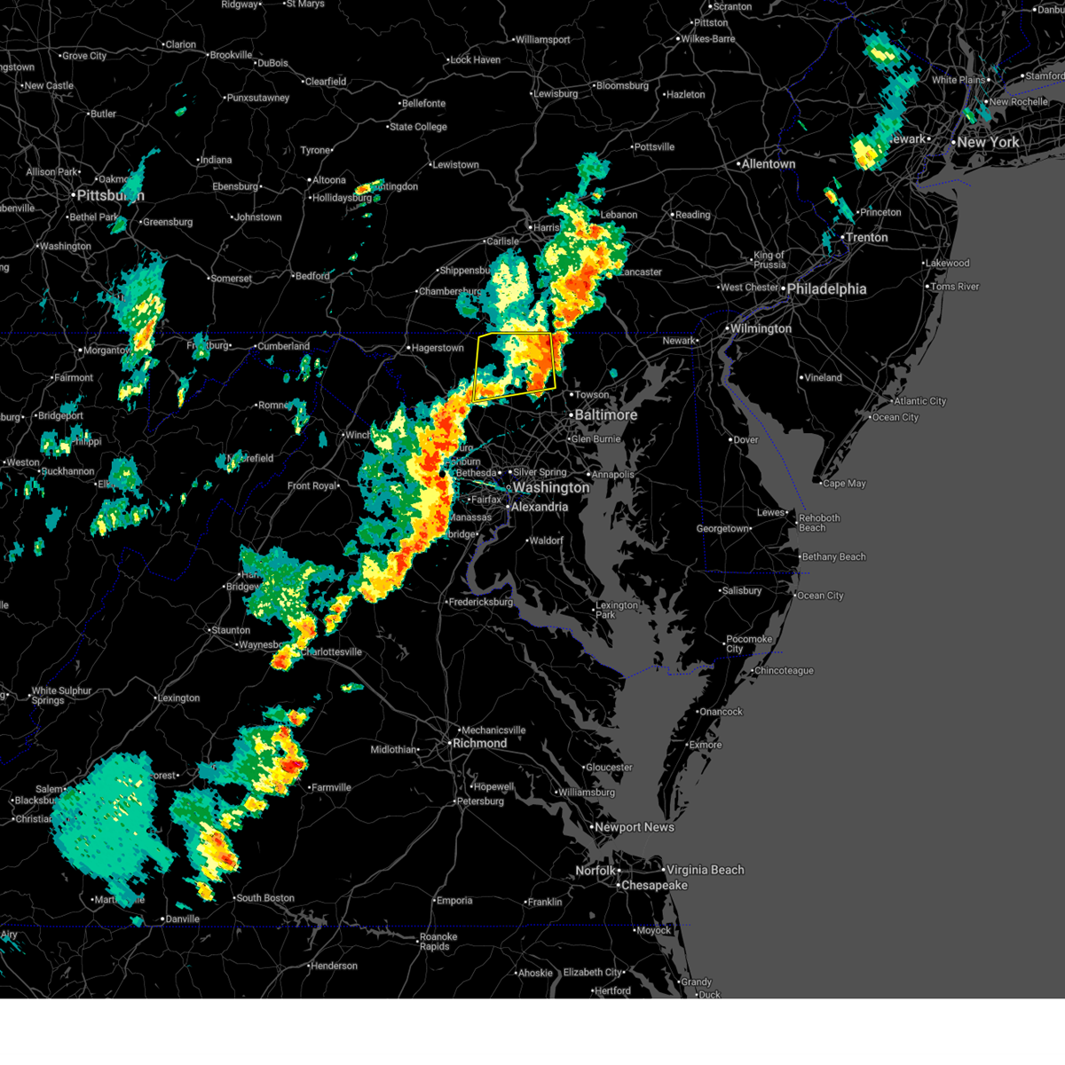
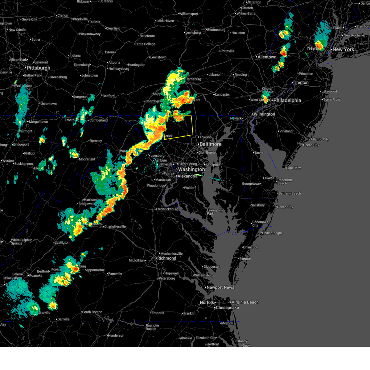
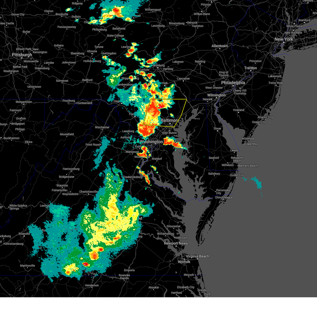
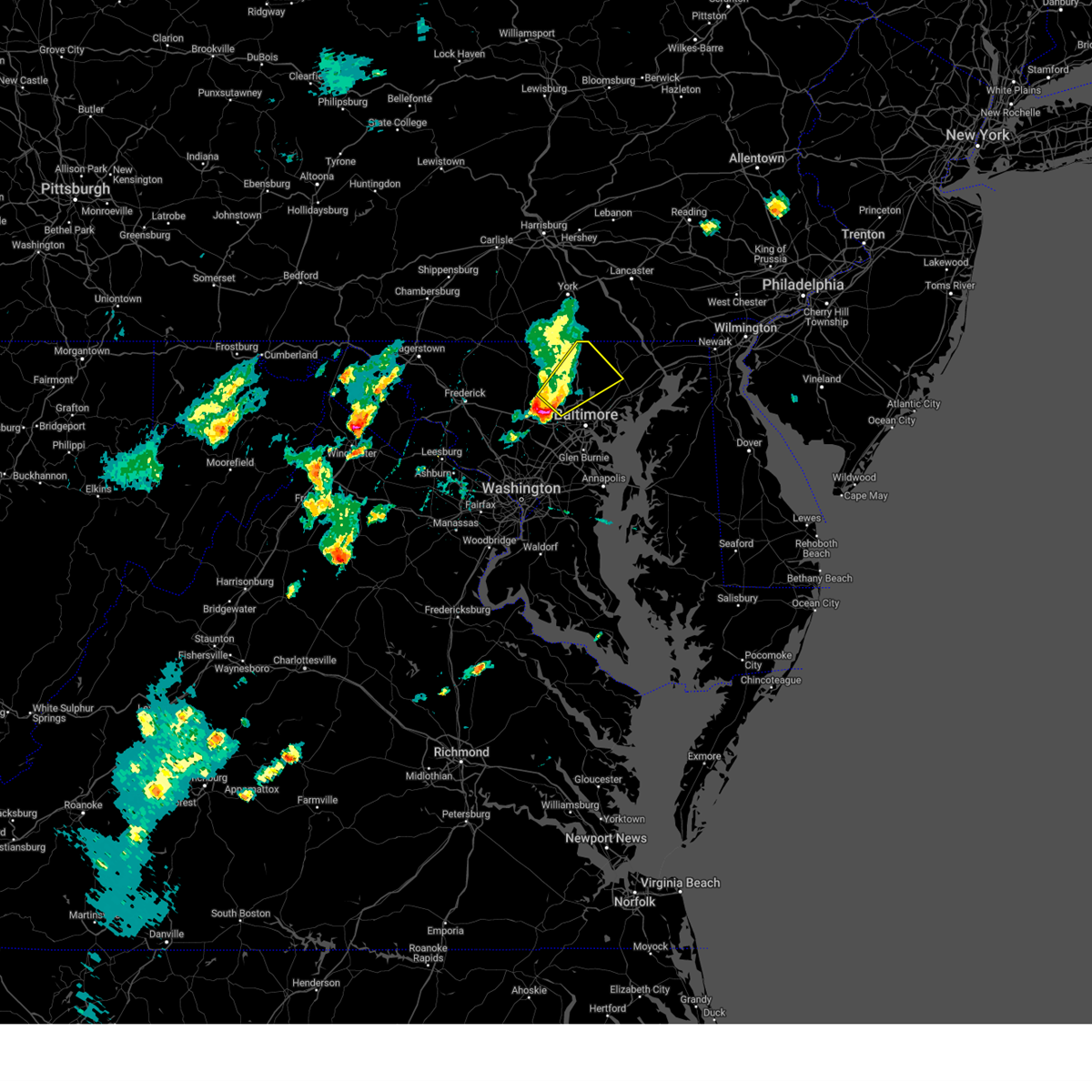
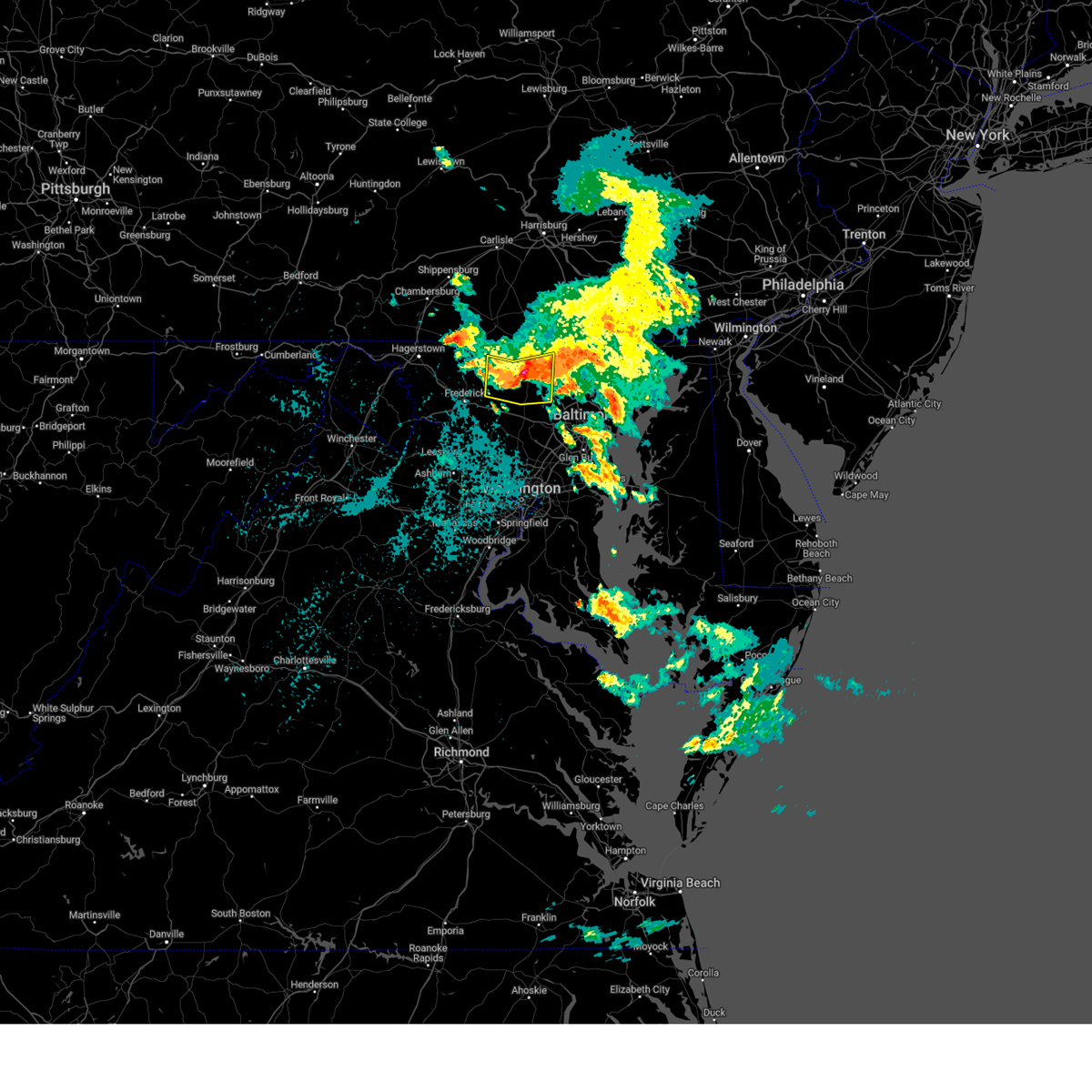
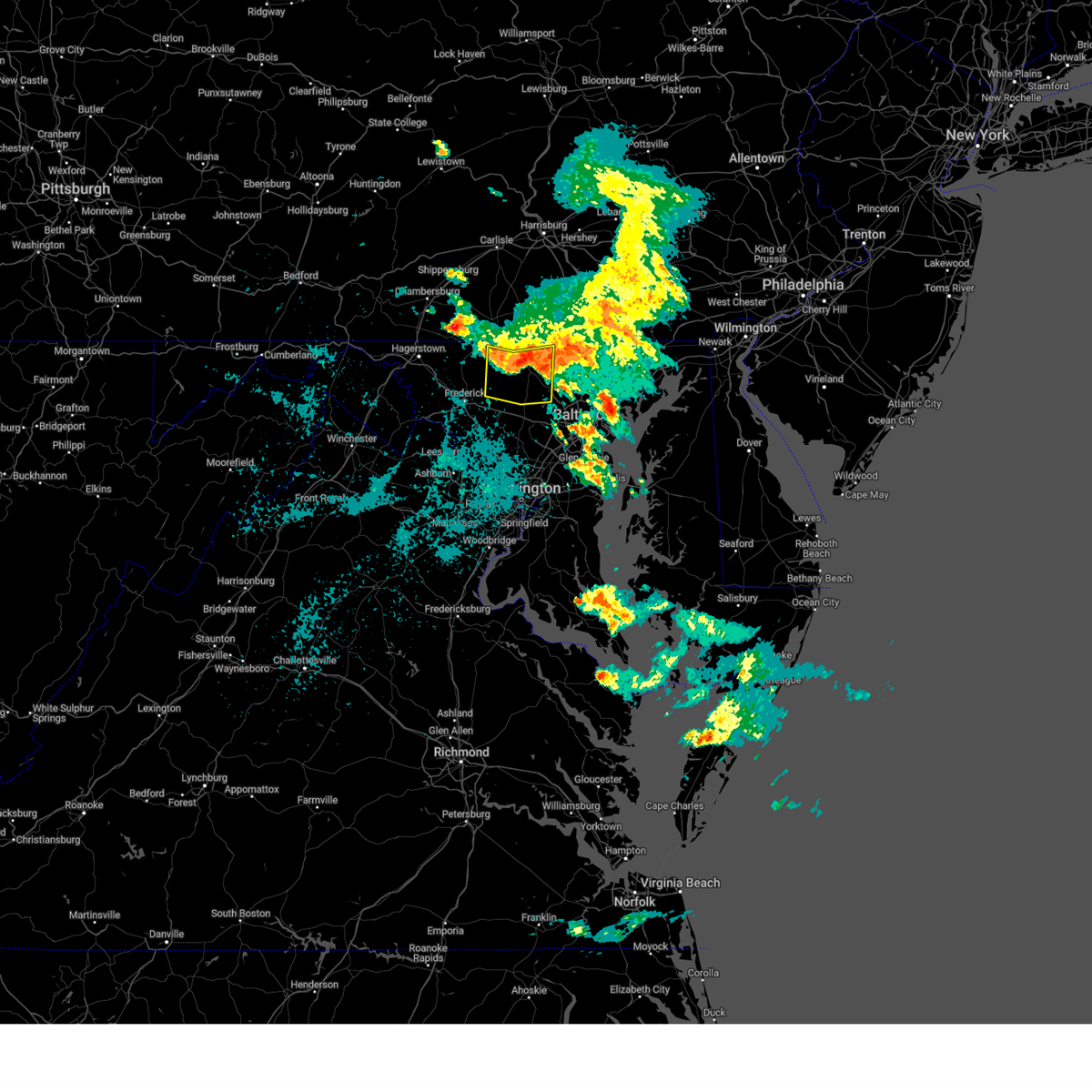
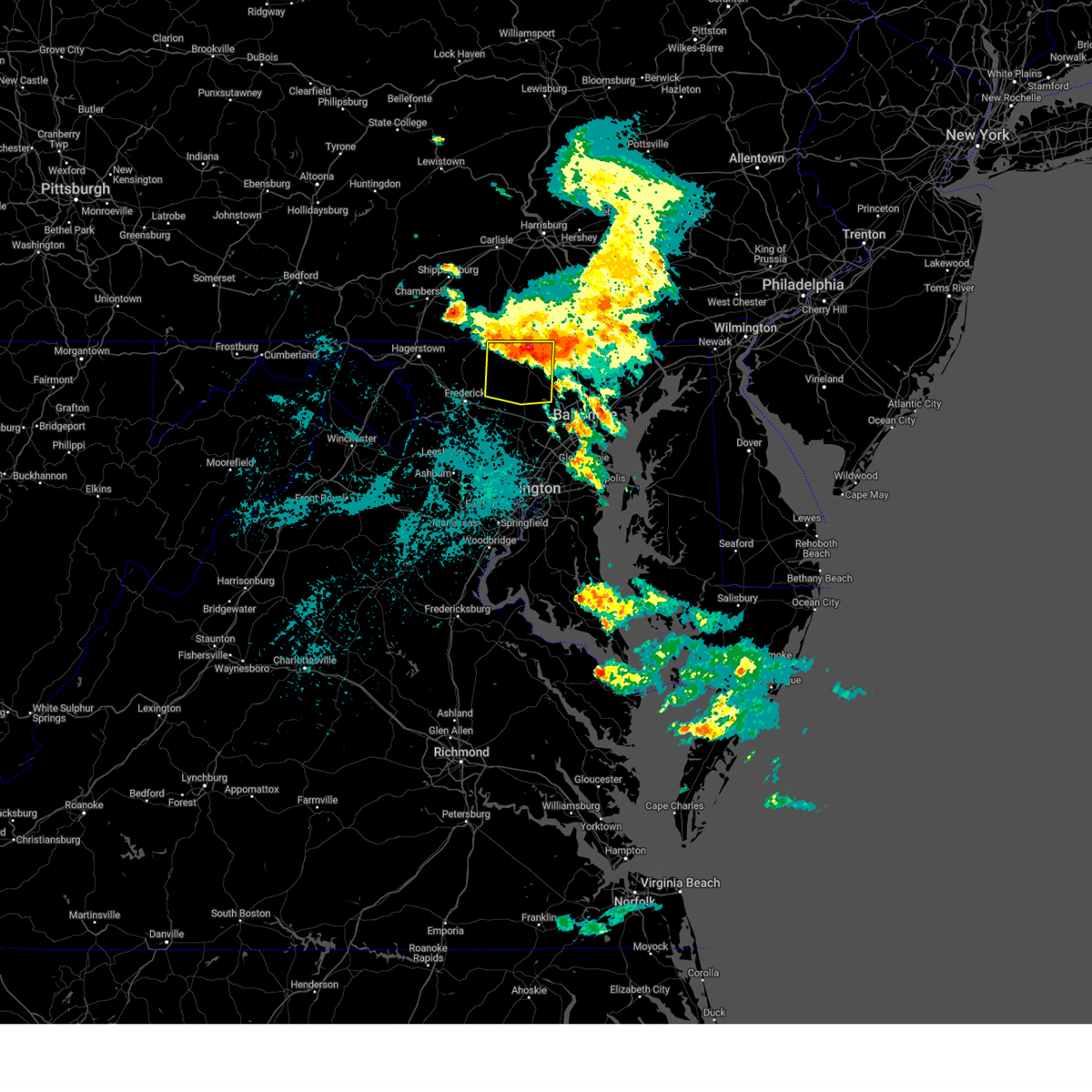
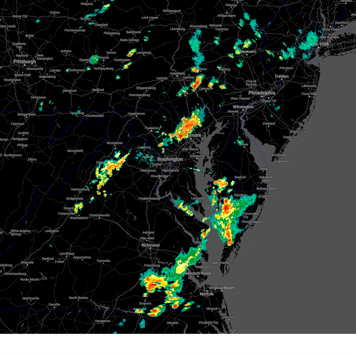
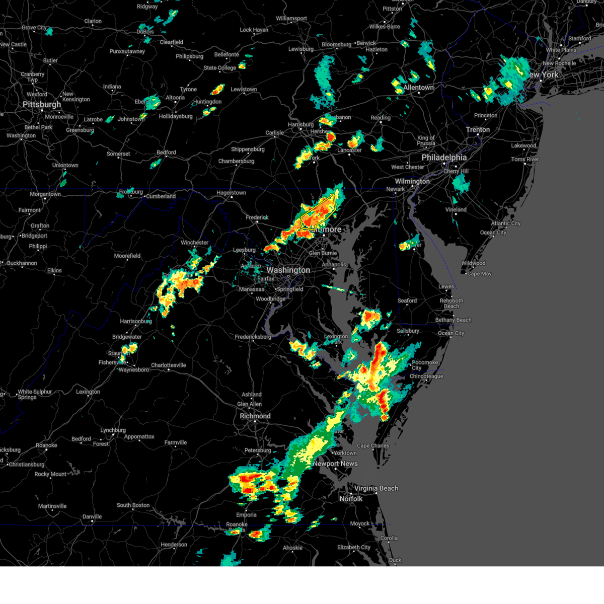
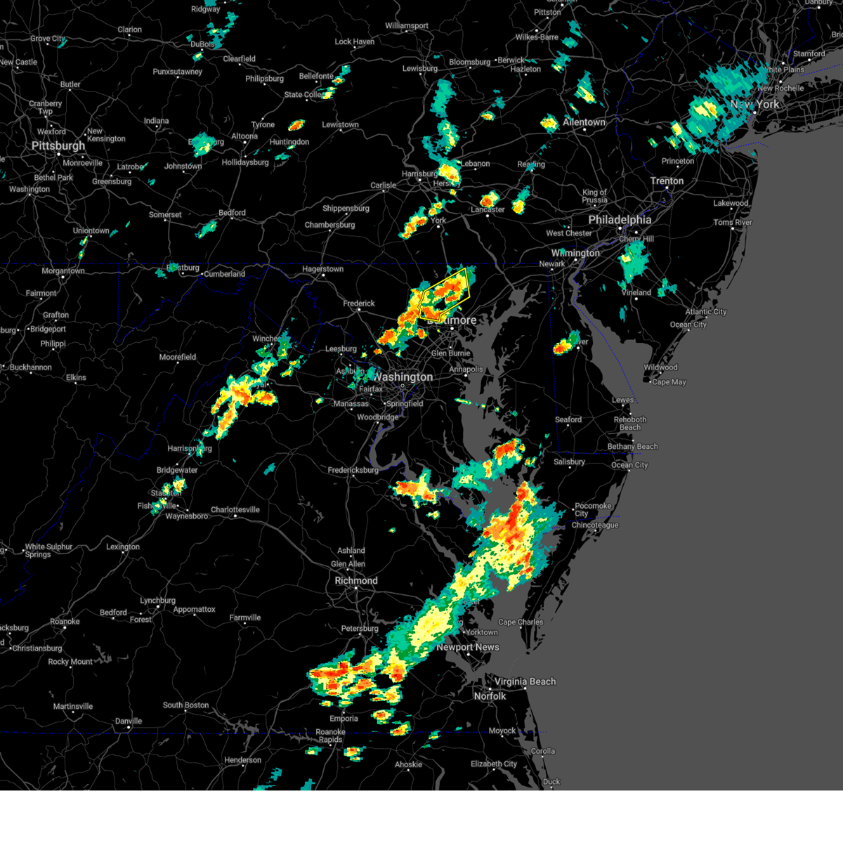
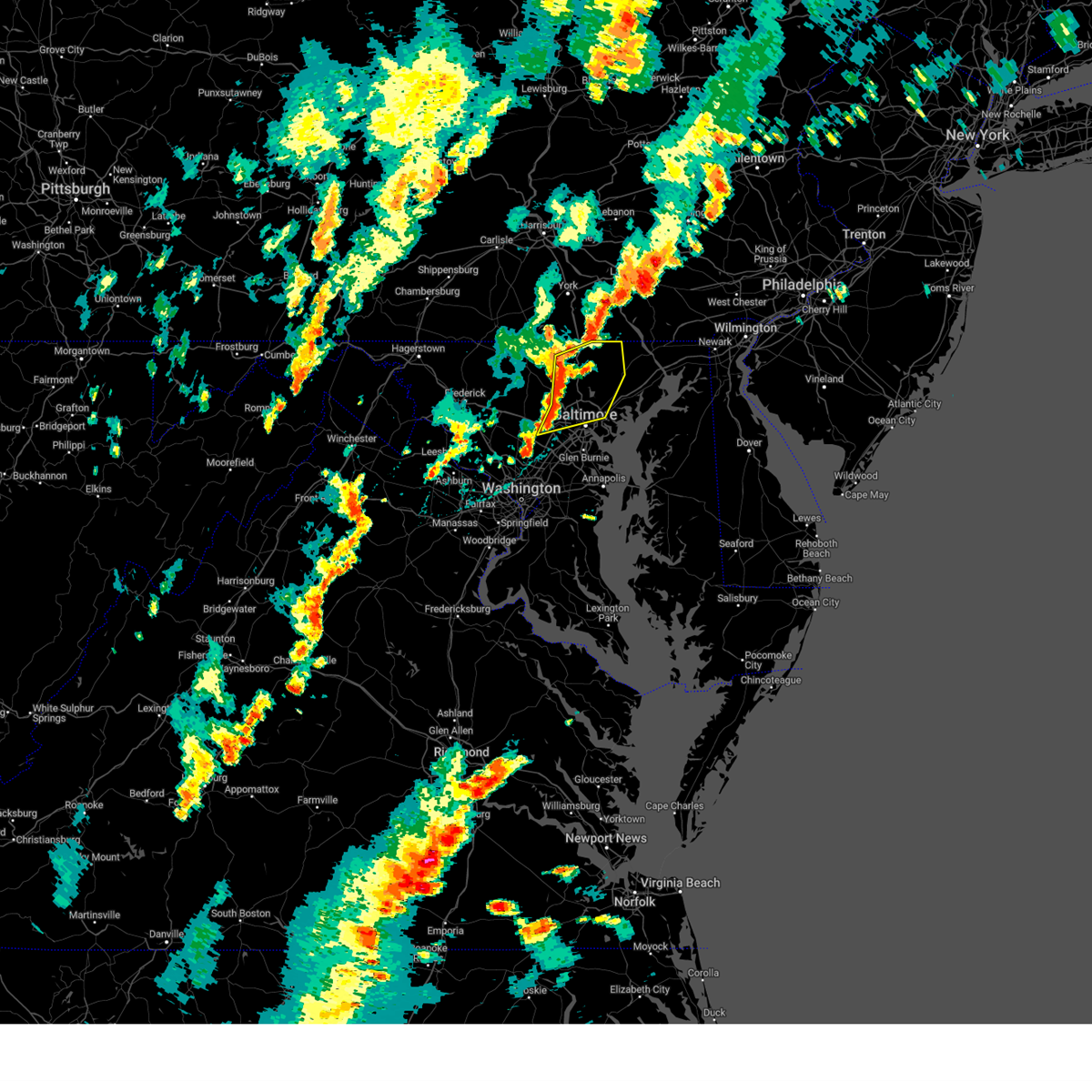
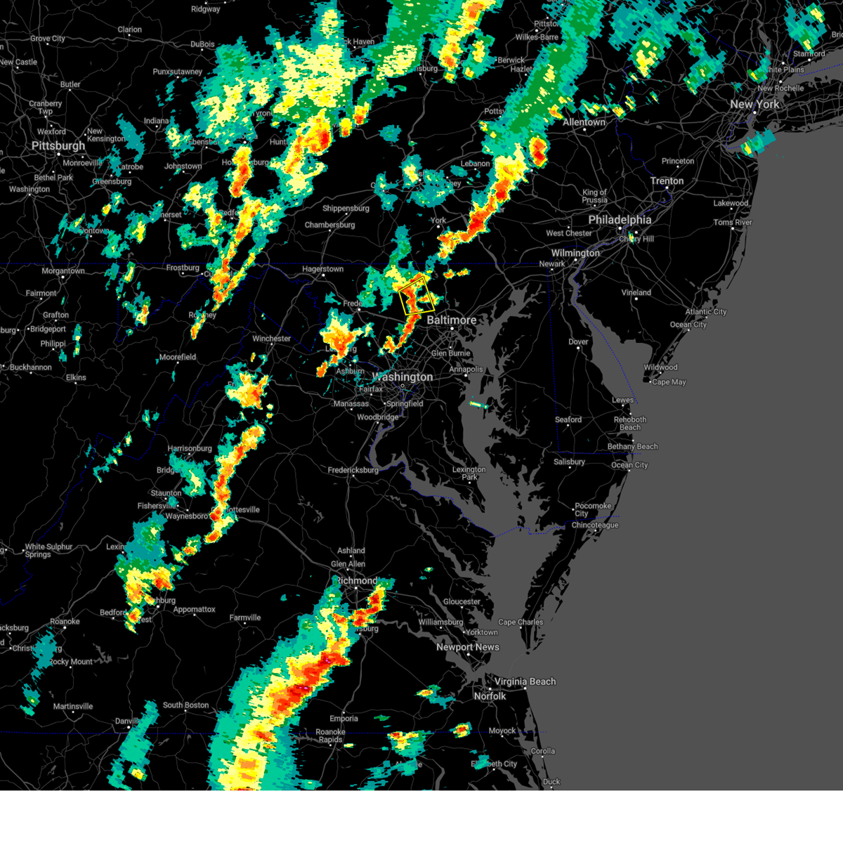
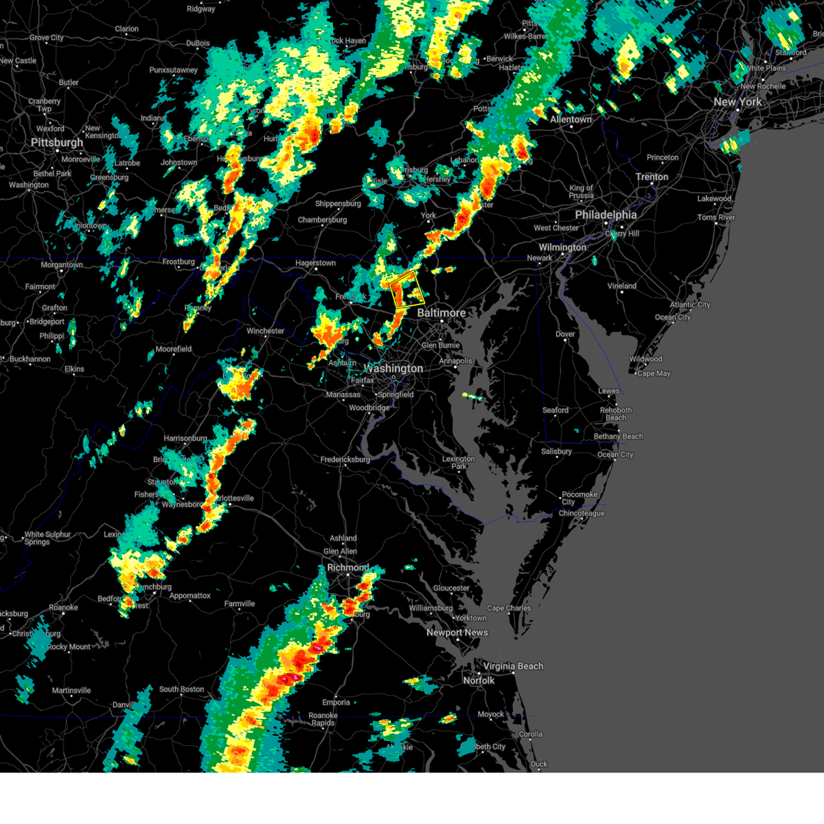
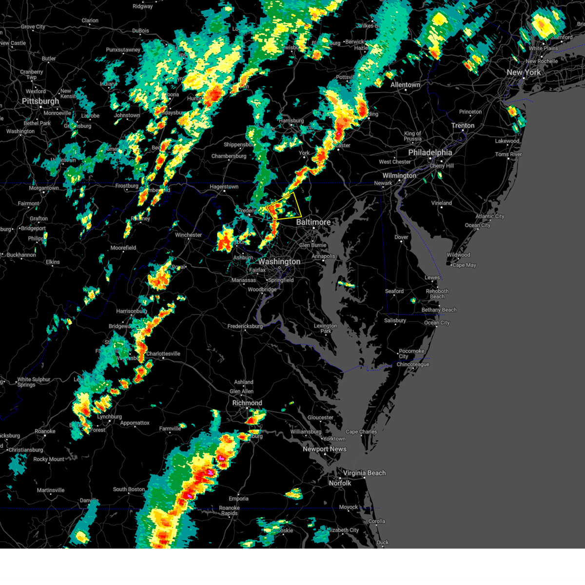
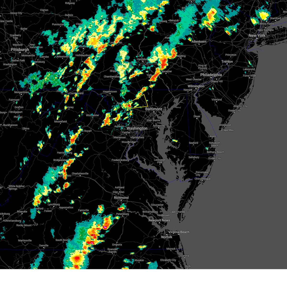
Hail Map for Reisterstown, MD
The Reisterstown, MD area has had 4 reports of on-the-ground hail by trained spotters, and has been under severe weather warnings 31 times during the past 12 months. Doppler radar has detected hail at or near Reisterstown, MD on 44 occasions, including 2 occasions during the past year.
| Name: | Reisterstown, MD |
| Where Located: | 15.7 miles NW of Baltimore, MD |
| Map: | Google Map for Reisterstown, MD |
| Population: | 25968 |
| Housing Units: | 10594 |
| More Info: | Search Google for Reisterstown, MD |
1
The Top Recent Hail Date for Reisterstown, MD is Saturday, May 3, 2025 (9th out of 44)

Hail and Wind Damage Spotted near Reisterstown, MD
| Date / Time | Report Details |
|---|---|
| 7/1/2025 3:58 PM EDT |
 The storm which prompted the warning has weakened below severe limits, and no longer poses an immediate threat to life or property. therefore, the warning will be allowed to expire. a severe thunderstorm watch remains in effect until 900 pm edt for central, northern and north central maryland. to report severe weather, contact your nearest law enforcement agency. they will relay your report to the national weather service sterling virginia. The storm which prompted the warning has weakened below severe limits, and no longer poses an immediate threat to life or property. therefore, the warning will be allowed to expire. a severe thunderstorm watch remains in effect until 900 pm edt for central, northern and north central maryland. to report severe weather, contact your nearest law enforcement agency. they will relay your report to the national weather service sterling virginia.
|
| 7/1/2025 3:47 PM EDT |
 At 347 pm edt, a severe thunderstorm was located over ellicott city, or near historic ellicott city, moving east at 15 mph (radar indicated). Hazards include 60 mph wind gusts. Damaging winds will cause some trees and large branches to fall. this could injure those outdoors, as well as damage homes and vehicles. roadways may become blocked by downed trees. localized power outages are possible. unsecured light objects may become projectiles. Locations impacted include, baltimore, columbia, olney, pikesville, elkridge, historic ellicott city, ellicott city, catonsville, woodlawn, randallstown, owings mills, eldersburg, milford mill, lochearn, arbutus, brooklyn park, savage-guilford, scaggsville, ilchester, and linthicum. At 347 pm edt, a severe thunderstorm was located over ellicott city, or near historic ellicott city, moving east at 15 mph (radar indicated). Hazards include 60 mph wind gusts. Damaging winds will cause some trees and large branches to fall. this could injure those outdoors, as well as damage homes and vehicles. roadways may become blocked by downed trees. localized power outages are possible. unsecured light objects may become projectiles. Locations impacted include, baltimore, columbia, olney, pikesville, elkridge, historic ellicott city, ellicott city, catonsville, woodlawn, randallstown, owings mills, eldersburg, milford mill, lochearn, arbutus, brooklyn park, savage-guilford, scaggsville, ilchester, and linthicum.
|
| 7/1/2025 3:15 PM EDT |
 Svrlwx the national weather service in sterling virginia has issued a * severe thunderstorm warning for, southeastern carroll county in north central maryland, western baltimore city in northern maryland, howard county in central maryland, northeastern montgomery county in central maryland, southwestern baltimore county in northern maryland, * until 400 pm edt. * at 314 pm edt, a severe thunderstorm was located near columbia, moving northeast at 20 mph (radar indicated). Hazards include 60 mph wind gusts. Damaging winds will cause some trees and large branches to fall. this could injure those outdoors, as well as damage homes and vehicles. roadways may become blocked by downed trees. localized power outages are possible. Unsecured light objects may become projectiles. Svrlwx the national weather service in sterling virginia has issued a * severe thunderstorm warning for, southeastern carroll county in north central maryland, western baltimore city in northern maryland, howard county in central maryland, northeastern montgomery county in central maryland, southwestern baltimore county in northern maryland, * until 400 pm edt. * at 314 pm edt, a severe thunderstorm was located near columbia, moving northeast at 20 mph (radar indicated). Hazards include 60 mph wind gusts. Damaging winds will cause some trees and large branches to fall. this could injure those outdoors, as well as damage homes and vehicles. roadways may become blocked by downed trees. localized power outages are possible. Unsecured light objects may become projectiles.
|
| 6/26/2025 7:01 PM EDT |
 The storms which prompted the warning have weakened below severe limits, and have exited the warned area. therefore, the warning has been allowed to expire. a severe thunderstorm watch remains in effect until 1000 pm edt for northern maryland. The storms which prompted the warning have weakened below severe limits, and have exited the warned area. therefore, the warning has been allowed to expire. a severe thunderstorm watch remains in effect until 1000 pm edt for northern maryland.
|
| 6/26/2025 6:46 PM EDT |
 At 645 pm edt, severe thunderstorms were located along a line extending from near cockeysville to near owings mills, moving southeast at 15 mph (radar indicated). Hazards include 60 mph wind gusts. Damaging winds will cause some trees and large branches to fall. this could injure those outdoors, as well as damage homes and vehicles. roadways may become blocked by downed trees. localized power outages are possible. unsecured light objects may become projectiles. Locations impacted include, pikesville, cockeysville, towson, randallstown, owings mills, milford mill, reisterstown, lochearn, mays chapel, timonium, hampton, lutherville-timonium, garrison, lutherville, long green, riderwood, brooklandville, mcdonogh, phoenix, and jacksonville. At 645 pm edt, severe thunderstorms were located along a line extending from near cockeysville to near owings mills, moving southeast at 15 mph (radar indicated). Hazards include 60 mph wind gusts. Damaging winds will cause some trees and large branches to fall. this could injure those outdoors, as well as damage homes and vehicles. roadways may become blocked by downed trees. localized power outages are possible. unsecured light objects may become projectiles. Locations impacted include, pikesville, cockeysville, towson, randallstown, owings mills, milford mill, reisterstown, lochearn, mays chapel, timonium, hampton, lutherville-timonium, garrison, lutherville, long green, riderwood, brooklandville, mcdonogh, phoenix, and jacksonville.
|
| 6/26/2025 6:22 PM EDT |
 Svrlwx the national weather service in sterling virginia has issued a * severe thunderstorm warning for, central baltimore county in northern maryland, * until 700 pm edt. * at 622 pm edt, severe thunderstorms were located along a line extending from 9 miles west of jarrettsville to near reisterstown, moving southeast at 15 mph (radar indicated). Hazards include 60 mph wind gusts. Damaging winds will cause some trees and large branches to fall. this could injure those outdoors, as well as damage homes and vehicles. roadways may become blocked by downed trees. localized power outages are possible. Unsecured light objects may become projectiles. Svrlwx the national weather service in sterling virginia has issued a * severe thunderstorm warning for, central baltimore county in northern maryland, * until 700 pm edt. * at 622 pm edt, severe thunderstorms were located along a line extending from 9 miles west of jarrettsville to near reisterstown, moving southeast at 15 mph (radar indicated). Hazards include 60 mph wind gusts. Damaging winds will cause some trees and large branches to fall. this could injure those outdoors, as well as damage homes and vehicles. roadways may become blocked by downed trees. localized power outages are possible. Unsecured light objects may become projectiles.
|
| 6/19/2025 4:41 PM EDT |
 At 440 pm edt, a severe thunderstorm was located over pikesville, moving east at 40 mph (emergency management reports a history of downed trees with this line of storms). Hazards include 60 mph wind gusts. Damaging winds will cause some trees and large branches to fall. this could injure those outdoors, as well as damage homes and vehicles. roadways may become blocked by downed trees. localized power outages are possible. unsecured light objects may become projectiles. Locations impacted include, baltimore, pikesville, middle river, cockeysville, historic ellicott city, ellicott city, towson, catonsville, woodlawn, randallstown, parkville, owings mills, bel air north, carney, milford mill, perry hall, reisterstown, lochearn, rosedale, and rossville. At 440 pm edt, a severe thunderstorm was located over pikesville, moving east at 40 mph (emergency management reports a history of downed trees with this line of storms). Hazards include 60 mph wind gusts. Damaging winds will cause some trees and large branches to fall. this could injure those outdoors, as well as damage homes and vehicles. roadways may become blocked by downed trees. localized power outages are possible. unsecured light objects may become projectiles. Locations impacted include, baltimore, pikesville, middle river, cockeysville, historic ellicott city, ellicott city, towson, catonsville, woodlawn, randallstown, parkville, owings mills, bel air north, carney, milford mill, perry hall, reisterstown, lochearn, rosedale, and rossville.
|
| 6/19/2025 4:41 PM EDT |
 the severe thunderstorm warning has been cancelled and is no longer in effect the severe thunderstorm warning has been cancelled and is no longer in effect
|
| 6/19/2025 4:20 PM EDT |
 Svrlwx the national weather service in sterling virginia has issued a * severe thunderstorm warning for, south central carroll county in north central maryland, baltimore city in northern maryland, northern howard county in central maryland, northeastern montgomery county in central maryland, central harford county in northern maryland, central baltimore county in northern maryland, * until 500 pm edt. * at 419 pm edt, a severe thunderstorm was located near sykesville, or 7 miles northwest of historic ellicott city, moving east at 55 mph (emergency management reports a history of downed trees with this line of storms). Hazards include 60 mph wind gusts. Damaging winds will cause some trees and large branches to fall. this could injure those outdoors, as well as damage homes and vehicles. roadways may become blocked by downed trees. localized power outages are possible. Unsecured light objects may become projectiles. Svrlwx the national weather service in sterling virginia has issued a * severe thunderstorm warning for, south central carroll county in north central maryland, baltimore city in northern maryland, northern howard county in central maryland, northeastern montgomery county in central maryland, central harford county in northern maryland, central baltimore county in northern maryland, * until 500 pm edt. * at 419 pm edt, a severe thunderstorm was located near sykesville, or 7 miles northwest of historic ellicott city, moving east at 55 mph (emergency management reports a history of downed trees with this line of storms). Hazards include 60 mph wind gusts. Damaging winds will cause some trees and large branches to fall. this could injure those outdoors, as well as damage homes and vehicles. roadways may become blocked by downed trees. localized power outages are possible. Unsecured light objects may become projectiles.
|
| 6/19/2025 3:57 PM EDT |
 The storm which prompted the warning has moved out of the area. therefore, the warning will be allowed to expire. however, heavy rain is still possible with this thunderstorm. a severe thunderstorm watch remains in effect until 900 pm edt for northern and north central maryland. to report severe weather, contact your nearest law enforcement agency. they will relay your report to the national weather service sterling virginia. The storm which prompted the warning has moved out of the area. therefore, the warning will be allowed to expire. however, heavy rain is still possible with this thunderstorm. a severe thunderstorm watch remains in effect until 900 pm edt for northern and north central maryland. to report severe weather, contact your nearest law enforcement agency. they will relay your report to the national weather service sterling virginia.
|
| 6/19/2025 3:45 PM EDT | Numerous trees blew down along md-25 falls road near knox avenue and shawan roa in baltimore county MD, 5.8 miles WSW of Reisterstown, MD |
| 6/19/2025 3:40 PM EDT | Trees blew down on md-91 emory road at springhurst cour in carroll county MD, 4.8 miles SE of Reisterstown, MD |
| 6/19/2025 3:14 PM EDT |
 Svrlwx the national weather service in sterling virginia has issued a * severe thunderstorm warning for, carroll county in north central maryland, northeastern frederick county in north central maryland, northwestern baltimore county in northern maryland, * until 400 pm edt. * at 314 pm edt, a severe thunderstorm was located near walkersville, or 8 miles northeast of frederick, moving east at 45 mph (emergency management reports a history of downed trees with this line of storms). Hazards include 60 mph wind gusts. Damaging winds will cause some trees and large branches to fall. this could injure those outdoors, as well as damage homes and vehicles. roadways may become blocked by downed trees. localized power outages are possible. Unsecured light objects may become projectiles. Svrlwx the national weather service in sterling virginia has issued a * severe thunderstorm warning for, carroll county in north central maryland, northeastern frederick county in north central maryland, northwestern baltimore county in northern maryland, * until 400 pm edt. * at 314 pm edt, a severe thunderstorm was located near walkersville, or 8 miles northeast of frederick, moving east at 45 mph (emergency management reports a history of downed trees with this line of storms). Hazards include 60 mph wind gusts. Damaging winds will cause some trees and large branches to fall. this could injure those outdoors, as well as damage homes and vehicles. roadways may become blocked by downed trees. localized power outages are possible. Unsecured light objects may become projectiles.
|
| 5/16/2025 5:34 PM EDT | Quarter sized hail reported 2.3 miles S of Reisterstown, MD |
| 5/16/2025 5:31 PM EDT |
 At 530 pm edt, severe thunderstorms were located along a line extending from near manchester to near reisterstown to near ellicott city, moving east at 35 mph (law enforcement reported numerous downed trees. trained spotter reported golf ball sized hail in westminster). Hazards include golf ball size hail and 70 mph wind gusts. Expect wind damage to trees and power lines. hail is large enough to dent and damage vehicles. some hail damage to roofs, siding, and windows is possible. Locations impacted include, nottingham, carrollton, henryton, owings mills, parkville, hampstead, riderwood, gaither, dundalk, eastpoint, halethorpe, mcdonogh, sykesville, street, upper falls, rossville, monkton, ellicott city, benson, and lisbon. At 530 pm edt, severe thunderstorms were located along a line extending from near manchester to near reisterstown to near ellicott city, moving east at 35 mph (law enforcement reported numerous downed trees. trained spotter reported golf ball sized hail in westminster). Hazards include golf ball size hail and 70 mph wind gusts. Expect wind damage to trees and power lines. hail is large enough to dent and damage vehicles. some hail damage to roofs, siding, and windows is possible. Locations impacted include, nottingham, carrollton, henryton, owings mills, parkville, hampstead, riderwood, gaither, dundalk, eastpoint, halethorpe, mcdonogh, sykesville, street, upper falls, rossville, monkton, ellicott city, benson, and lisbon.
|
| 5/16/2025 5:12 PM EDT | Svrlwx the national weather service in sterling virginia has issued a * severe thunderstorm warning for, carroll county in north central maryland, baltimore city in northern maryland, northern anne arundel county in central maryland, northern howard county in central maryland, north central montgomery county in central maryland, northwestern harford county in northern maryland, eastern frederick county in north central maryland, baltimore county in northern maryland, northwestern cecil county in northeastern maryland, * until 615 pm edt. * at 512 pm edt, severe thunderstorms were located along a line extending from manchester to near gamber to mount airy, moving east at 35 mph (law enforcement has reported significant tree damage in frederick county maryland. a trained spotter reported golf ball sized hail in westminster). Hazards include golf ball size hail and 70 mph wind gusts. Expect wind damage to trees and power lines. hail is large enough to dent and damage vehicles. Some hail damage to roofs, siding, and windows is possible. |
| 5/3/2025 4:33 PM EDT |
 Svrlwx the national weather service in sterling virginia has issued a * severe thunderstorm warning for, east central carroll county in north central maryland, northwestern baltimore city in northern maryland, west central harford county in northern maryland, northern baltimore county in northern maryland, * until 515 pm edt. * at 433 pm edt, a severe thunderstorm was located over randallstown, or 8 miles west of pikesville, moving northeast at 35 mph (radar indicated). Hazards include 60 mph wind gusts and quarter size hail. Damaging winds will cause some trees and large branches to fall. this could injure those outdoors, as well as damage homes and vehicles. roadways may become blocked by downed trees. localized power outages are possible. Unsecured light objects may become projectiles. Svrlwx the national weather service in sterling virginia has issued a * severe thunderstorm warning for, east central carroll county in north central maryland, northwestern baltimore city in northern maryland, west central harford county in northern maryland, northern baltimore county in northern maryland, * until 515 pm edt. * at 433 pm edt, a severe thunderstorm was located over randallstown, or 8 miles west of pikesville, moving northeast at 35 mph (radar indicated). Hazards include 60 mph wind gusts and quarter size hail. Damaging winds will cause some trees and large branches to fall. this could injure those outdoors, as well as damage homes and vehicles. roadways may become blocked by downed trees. localized power outages are possible. Unsecured light objects may become projectiles.
|
| 4/5/2025 10:22 PM EDT |
 The storm which prompted the warning has weakened below severe limits, and no longer poses an immediate threat to life or property. therefore, the warning has been allowed to expire. however, small hail is still possible with this thunderstorm. The storm which prompted the warning has weakened below severe limits, and no longer poses an immediate threat to life or property. therefore, the warning has been allowed to expire. however, small hail is still possible with this thunderstorm.
|
| 4/5/2025 10:00 PM EDT |
 At 1000 pm edt, a severe thunderstorm was located near westminster, moving east at 30 mph (radar indicated). Hazards include 60 mph wind gusts and quarter size hail. Damaging winds will cause some trees and large branches to fall. this could injure those outdoors, as well as damage homes and vehicles. roadways may become blocked by downed trees. localized power outages are possible. unsecured light objects may become projectiles. Locations impacted include, westminster, finksburg, carrollton, upperco, hampstead, new windsor, boring, patapsco, reese, manchester, wagners mill, millers, greenmount, and reisterstown. At 1000 pm edt, a severe thunderstorm was located near westminster, moving east at 30 mph (radar indicated). Hazards include 60 mph wind gusts and quarter size hail. Damaging winds will cause some trees and large branches to fall. this could injure those outdoors, as well as damage homes and vehicles. roadways may become blocked by downed trees. localized power outages are possible. unsecured light objects may become projectiles. Locations impacted include, westminster, finksburg, carrollton, upperco, hampstead, new windsor, boring, patapsco, reese, manchester, wagners mill, millers, greenmount, and reisterstown.
|
| 4/5/2025 10:00 PM EDT |
 the severe thunderstorm warning has been cancelled and is no longer in effect the severe thunderstorm warning has been cancelled and is no longer in effect
|
| 4/5/2025 9:40 PM EDT |
 Svrlwx the national weather service in sterling virginia has issued a * severe thunderstorm warning for, central carroll county in north central maryland, east central frederick county in north central maryland, west central baltimore county in northern maryland, * until 1015 pm edt. * at 940 pm edt, a severe thunderstorm was located 8 miles north of mount airy, or 8 miles southwest of westminster, moving east at 35 mph (radar indicated). Hazards include 60 mph wind gusts and quarter size hail. Damaging winds will cause some trees and large branches to fall. this could injure those outdoors, as well as damage homes and vehicles. roadways may become blocked by downed trees. localized power outages are possible. Unsecured light objects may become projectiles. Svrlwx the national weather service in sterling virginia has issued a * severe thunderstorm warning for, central carroll county in north central maryland, east central frederick county in north central maryland, west central baltimore county in northern maryland, * until 1015 pm edt. * at 940 pm edt, a severe thunderstorm was located 8 miles north of mount airy, or 8 miles southwest of westminster, moving east at 35 mph (radar indicated). Hazards include 60 mph wind gusts and quarter size hail. Damaging winds will cause some trees and large branches to fall. this could injure those outdoors, as well as damage homes and vehicles. roadways may become blocked by downed trees. localized power outages are possible. Unsecured light objects may become projectiles.
|
| 9/22/2024 2:04 AM EDT |
 At 204 am edt, severe thunderstorms were located along a line extending from near reisterstown to near gamber to 8 miles north of mount airy, moving south at 25 mph (radar indicated). Hazards include 60 mph wind gusts and quarter size hail. Damaging winds will cause some trees and large branches to fall. this could injure those outdoors, as well as damage homes and vehicles. roadways may become blocked by downed trees. localized power outages are possible. unsecured light objects may become projectiles. Locations impacted include, westminster, eldersburg, reisterstown, oakland, gamber, libertytown, finksburg, carrollton, upperco, winfield, louisville, patapsco, reese, and unionville. At 204 am edt, severe thunderstorms were located along a line extending from near reisterstown to near gamber to 8 miles north of mount airy, moving south at 25 mph (radar indicated). Hazards include 60 mph wind gusts and quarter size hail. Damaging winds will cause some trees and large branches to fall. this could injure those outdoors, as well as damage homes and vehicles. roadways may become blocked by downed trees. localized power outages are possible. unsecured light objects may become projectiles. Locations impacted include, westminster, eldersburg, reisterstown, oakland, gamber, libertytown, finksburg, carrollton, upperco, winfield, louisville, patapsco, reese, and unionville.
|
| 9/22/2024 1:59 AM EDT |
 At 158 am edt, severe thunderstorms were located along a line extending from near gamber to 6 miles south of westminster to 9 miles south of taneytown, moving south at 25 mph (radar indicated and mesonet measured wind gust). Hazards include 60 mph wind gusts and quarter size hail. Damaging winds will cause some trees and large branches to fall. this could injure those outdoors, as well as damage homes and vehicles. roadways may become blocked by downed trees. localized power outages are possible. unsecured light objects may become projectiles. Locations impacted include, westminster, eldersburg, reisterstown, hampstead, manchester, oakland, gamber, new windsor, union bridge, libertytown, finksburg, carrollton, upperco, winfield, louisville, linwood, uniontown, keysville, unionville, and ladiesburg. At 158 am edt, severe thunderstorms were located along a line extending from near gamber to 6 miles south of westminster to 9 miles south of taneytown, moving south at 25 mph (radar indicated and mesonet measured wind gust). Hazards include 60 mph wind gusts and quarter size hail. Damaging winds will cause some trees and large branches to fall. this could injure those outdoors, as well as damage homes and vehicles. roadways may become blocked by downed trees. localized power outages are possible. unsecured light objects may become projectiles. Locations impacted include, westminster, eldersburg, reisterstown, hampstead, manchester, oakland, gamber, new windsor, union bridge, libertytown, finksburg, carrollton, upperco, winfield, louisville, linwood, uniontown, keysville, unionville, and ladiesburg.
|
| 9/22/2024 1:47 AM EDT |
 At 147 am edt, severe thunderstorms were located along a line extending from near hampstead to near westminster to near taneytown, moving south at 30 mph (radar indicated). Hazards include 60 mph wind gusts and quarter size hail. Damaging winds will cause some trees and large branches to fall. this could injure those outdoors, as well as damage homes and vehicles. roadways may become blocked by downed trees. localized power outages are possible. unsecured light objects may become projectiles. Locations impacted include, westminster, eldersburg, reisterstown, taneytown, hampstead, manchester, oakland, gamber, new windsor, union bridge, libertytown, finksburg, carrollton, upperco, winfield, louisville, linwood, uniontown, keysville, and unionville. At 147 am edt, severe thunderstorms were located along a line extending from near hampstead to near westminster to near taneytown, moving south at 30 mph (radar indicated). Hazards include 60 mph wind gusts and quarter size hail. Damaging winds will cause some trees and large branches to fall. this could injure those outdoors, as well as damage homes and vehicles. roadways may become blocked by downed trees. localized power outages are possible. unsecured light objects may become projectiles. Locations impacted include, westminster, eldersburg, reisterstown, taneytown, hampstead, manchester, oakland, gamber, new windsor, union bridge, libertytown, finksburg, carrollton, upperco, winfield, louisville, linwood, uniontown, keysville, and unionville.
|
| 9/22/2024 1:37 AM EDT |
 Svrlwx the national weather service in sterling virginia has issued a * severe thunderstorm warning for, carroll county in north central maryland, northeastern frederick county in north central maryland, west central baltimore county in northern maryland, * until 215 am edt. * at 137 am edt, severe thunderstorms were located along a line extending from near manchester to near westminster to near taneytown, moving south at 20 mph (radar indicated). Hazards include 60 mph wind gusts and quarter size hail. Damaging winds will cause some trees and large branches to fall. this could injure those outdoors, as well as damage homes and vehicles. roadways may become blocked by downed trees. localized power outages are possible. Unsecured light objects may become projectiles. Svrlwx the national weather service in sterling virginia has issued a * severe thunderstorm warning for, carroll county in north central maryland, northeastern frederick county in north central maryland, west central baltimore county in northern maryland, * until 215 am edt. * at 137 am edt, severe thunderstorms were located along a line extending from near manchester to near westminster to near taneytown, moving south at 20 mph (radar indicated). Hazards include 60 mph wind gusts and quarter size hail. Damaging winds will cause some trees and large branches to fall. this could injure those outdoors, as well as damage homes and vehicles. roadways may become blocked by downed trees. localized power outages are possible. Unsecured light objects may become projectiles.
|
| 8/18/2024 7:32 PM EDT |
 The storms which prompted the warning have weakened below severe limits, and no longer pose an immediate threat to life or property. therefore, the warning has been allowed to expire. however, heavy rain is still possible with these thunderstorms. a severe thunderstorm watch remains in effect until 1000 pm edt for northern and north central maryland. The storms which prompted the warning have weakened below severe limits, and no longer pose an immediate threat to life or property. therefore, the warning has been allowed to expire. however, heavy rain is still possible with these thunderstorms. a severe thunderstorm watch remains in effect until 1000 pm edt for northern and north central maryland.
|
| 8/18/2024 7:19 PM EDT |
 At 719 pm edt, severe thunderstorms were located along a line extending from randallstown to near cockeysville, moving northeast at 15 mph (radar indicated). Hazards include 60 mph wind gusts. Damaging winds will cause some trees and large branches to fall. this could injure those outdoors, as well as damage homes and vehicles. roadways may become blocked by downed trees. localized power outages are possible. unsecured light objects may become projectiles. Locations impacted include, pikesville, cockeysville, towson, randallstown, owings mills, milford mill, reisterstown, lochearn, mays chapel, timonium, fallston, jarrettsville, lutherville-timonium, garrison, lutherville, riderwood, brooklandville, mcdonogh, phoenix, and jacksonville. At 719 pm edt, severe thunderstorms were located along a line extending from randallstown to near cockeysville, moving northeast at 15 mph (radar indicated). Hazards include 60 mph wind gusts. Damaging winds will cause some trees and large branches to fall. this could injure those outdoors, as well as damage homes and vehicles. roadways may become blocked by downed trees. localized power outages are possible. unsecured light objects may become projectiles. Locations impacted include, pikesville, cockeysville, towson, randallstown, owings mills, milford mill, reisterstown, lochearn, mays chapel, timonium, fallston, jarrettsville, lutherville-timonium, garrison, lutherville, riderwood, brooklandville, mcdonogh, phoenix, and jacksonville.
|
| 8/18/2024 7:03 PM EDT |
 Svrlwx the national weather service in sterling virginia has issued a * severe thunderstorm warning for, northwestern harford county in northern maryland, northwestern baltimore county in northern maryland, * until 730 pm edt. * at 703 pm edt, severe thunderstorms were located along a line extending from owings mills to near cockeysville, moving north at 15 mph (radar indicated). Hazards include 60 mph wind gusts. Damaging winds will cause some trees and large branches to fall. this could injure those outdoors, as well as damage homes and vehicles. roadways may become blocked by downed trees. localized power outages are possible. Unsecured light objects may become projectiles. Svrlwx the national weather service in sterling virginia has issued a * severe thunderstorm warning for, northwestern harford county in northern maryland, northwestern baltimore county in northern maryland, * until 730 pm edt. * at 703 pm edt, severe thunderstorms were located along a line extending from owings mills to near cockeysville, moving north at 15 mph (radar indicated). Hazards include 60 mph wind gusts. Damaging winds will cause some trees and large branches to fall. this could injure those outdoors, as well as damage homes and vehicles. roadways may become blocked by downed trees. localized power outages are possible. Unsecured light objects may become projectiles.
|
| 8/3/2024 4:42 PM EDT |
 Svrlwx the national weather service in sterling virginia has issued a * severe thunderstorm warning for, northern baltimore city in northern maryland, northeastern howard county in central maryland, northwestern harford county in northern maryland, baltimore county in northern maryland, * until 530 pm edt. * at 442 pm edt, severe thunderstorms were located along a line extending from near hampstead to owings mills to near ellicott city, moving east at 30 mph (radar indicated). Hazards include 60 mph wind gusts. Damaging winds will cause some trees and large branches to fall. this could injure those outdoors, as well as damage homes and vehicles. roadways may become blocked by downed trees. localized power outages are possible. Unsecured light objects may become projectiles. Svrlwx the national weather service in sterling virginia has issued a * severe thunderstorm warning for, northern baltimore city in northern maryland, northeastern howard county in central maryland, northwestern harford county in northern maryland, baltimore county in northern maryland, * until 530 pm edt. * at 442 pm edt, severe thunderstorms were located along a line extending from near hampstead to owings mills to near ellicott city, moving east at 30 mph (radar indicated). Hazards include 60 mph wind gusts. Damaging winds will cause some trees and large branches to fall. this could injure those outdoors, as well as damage homes and vehicles. roadways may become blocked by downed trees. localized power outages are possible. Unsecured light objects may become projectiles.
|
| 8/3/2024 4:31 PM EDT | Large tree down on utility wires blocking both directions of old westminster pike near the intersection of baltimore blvd (md-140) in carroll county MD, 3.9 miles SE of Reisterstown, MD |
| 8/3/2024 4:29 PM EDT | Tree down in reisterstow in baltimore county MD, 1.1 miles E of Reisterstown, MD |
| 8/3/2024 4:28 PM EDT |
 The storm which prompted the warning has weakened below severe limits, and no longer poses an immediate threat to life or property. therefore, the warning will be allowed to expire. a severe thunderstorm watch remains in effect until 900 pm edt for northern and north central maryland. to report severe weather, contact your nearest law enforcement agency. they will relay your report to the national weather service sterling virginia. The storm which prompted the warning has weakened below severe limits, and no longer poses an immediate threat to life or property. therefore, the warning will be allowed to expire. a severe thunderstorm watch remains in effect until 900 pm edt for northern and north central maryland. to report severe weather, contact your nearest law enforcement agency. they will relay your report to the national weather service sterling virginia.
|
| 8/3/2024 4:21 PM EDT |
 the severe thunderstorm warning has been cancelled and is no longer in effect the severe thunderstorm warning has been cancelled and is no longer in effect
|
| 8/3/2024 4:21 PM EDT |
 At 420 pm edt, a severe thunderstorm was located over gamber, or near westminster, moving east at 30 mph (radar indicated). Hazards include 60 mph wind gusts and quarter size hail. Damaging winds will cause some trees and large branches to fall. this could injure those outdoors, as well as damage homes and vehicles. roadways may become blocked by downed trees. localized power outages are possible. unsecured light objects may become projectiles. Locations impacted include, westminster, owings mills, eldersburg, reisterstown, hampstead, oakland, gamber, garrison, finksburg, carrollton, upperco, louisville, glyndon, boring, patapsco, reese, and carrolltowne. At 420 pm edt, a severe thunderstorm was located over gamber, or near westminster, moving east at 30 mph (radar indicated). Hazards include 60 mph wind gusts and quarter size hail. Damaging winds will cause some trees and large branches to fall. this could injure those outdoors, as well as damage homes and vehicles. roadways may become blocked by downed trees. localized power outages are possible. unsecured light objects may become projectiles. Locations impacted include, westminster, owings mills, eldersburg, reisterstown, hampstead, oakland, gamber, garrison, finksburg, carrollton, upperco, louisville, glyndon, boring, patapsco, reese, and carrolltowne.
|
| 8/3/2024 4:10 PM EDT |
 At 409 pm edt, a severe thunderstorm was located near gamber, or 8 miles south of westminster, moving east at 35 mph (radar indicated). Hazards include 60 mph wind gusts and quarter size hail. Damaging winds will cause some trees and large branches to fall. this could injure those outdoors, as well as damage homes and vehicles. roadways may become blocked by downed trees. localized power outages are possible. unsecured light objects may become projectiles. Locations impacted include, westminster, owings mills, eldersburg, reisterstown, hampstead, sykesville, oakland, gamber, garrison, finksburg, carrollton, upperco, winfield, louisville, glyndon, boring, patapsco, reese, carrolltowne, and marston. At 409 pm edt, a severe thunderstorm was located near gamber, or 8 miles south of westminster, moving east at 35 mph (radar indicated). Hazards include 60 mph wind gusts and quarter size hail. Damaging winds will cause some trees and large branches to fall. this could injure those outdoors, as well as damage homes and vehicles. roadways may become blocked by downed trees. localized power outages are possible. unsecured light objects may become projectiles. Locations impacted include, westminster, owings mills, eldersburg, reisterstown, hampstead, sykesville, oakland, gamber, garrison, finksburg, carrollton, upperco, winfield, louisville, glyndon, boring, patapsco, reese, carrolltowne, and marston.
|
| 8/3/2024 3:51 PM EDT |
 Svrlwx the national weather service in sterling virginia has issued a * severe thunderstorm warning for, southeastern carroll county in north central maryland, east central frederick county in north central maryland, west central baltimore county in northern maryland, * until 430 pm edt. * at 351 pm edt, a severe thunderstorm was located near new market, or 9 miles north of damascus, moving east at 35 mph (radar indicated). Hazards include 60 mph wind gusts and quarter size hail. Damaging winds will cause some trees and large branches to fall. this could injure those outdoors, as well as damage homes and vehicles. roadways may become blocked by downed trees. localized power outages are possible. Unsecured light objects may become projectiles. Svrlwx the national weather service in sterling virginia has issued a * severe thunderstorm warning for, southeastern carroll county in north central maryland, east central frederick county in north central maryland, west central baltimore county in northern maryland, * until 430 pm edt. * at 351 pm edt, a severe thunderstorm was located near new market, or 9 miles north of damascus, moving east at 35 mph (radar indicated). Hazards include 60 mph wind gusts and quarter size hail. Damaging winds will cause some trees and large branches to fall. this could injure those outdoors, as well as damage homes and vehicles. roadways may become blocked by downed trees. localized power outages are possible. Unsecured light objects may become projectiles.
|
| 6/29/2024 10:41 PM EDT |
 The storms which prompted the warning have weakened below severe limits, and no longer pose an immediate threat to life or property. therefore, the warning will be allowed to expire. The storms which prompted the warning have weakened below severe limits, and no longer pose an immediate threat to life or property. therefore, the warning will be allowed to expire.
|
| 6/29/2024 10:15 PM EDT |
 Svrlwx the national weather service in sterling virginia has issued a * severe thunderstorm warning for, southeastern carroll county in north central maryland, northwestern howard county in central maryland, northeastern montgomery county in central maryland, southeastern frederick county in north central maryland, west central baltimore county in northern maryland, * until 1045 pm edt. * at 1015 pm edt, severe thunderstorms were located along a line extending from gamber to near green valley, moving east at 25 mph (radar indicated). Hazards include 60 mph wind gusts. Damaging winds will cause some trees and large branches to fall. this could injure those outdoors, as well as damage homes and vehicles. roadways may become blocked by downed trees. localized power outages are possible. Unsecured light objects may become projectiles. Svrlwx the national weather service in sterling virginia has issued a * severe thunderstorm warning for, southeastern carroll county in north central maryland, northwestern howard county in central maryland, northeastern montgomery county in central maryland, southeastern frederick county in north central maryland, west central baltimore county in northern maryland, * until 1045 pm edt. * at 1015 pm edt, severe thunderstorms were located along a line extending from gamber to near green valley, moving east at 25 mph (radar indicated). Hazards include 60 mph wind gusts. Damaging winds will cause some trees and large branches to fall. this could injure those outdoors, as well as damage homes and vehicles. roadways may become blocked by downed trees. localized power outages are possible. Unsecured light objects may become projectiles.
|
| 6/5/2024 8:30 PM EDT |
 At 830 pm edt, a severe thunderstorm capable of producing a tornado was located over owings mills, or near pikesville, moving northeast at 20 mph (radar indicated rotation). Hazards include tornado. For those in the direct path of a tornado touchdown, flying debris will be dangerous to those caught without shelter. damage to roofs, siding, and windows may occur. mobile homes may be damaged or destroyed. tree damage is likely. this dangerous storm will be near, pikesville, cockeysville, owings mills, reisterstown, and mays chapel around 835 pm edt. Other locations impacted by this tornadic thunderstorm include brooklandville, stevenson, and garrison. At 830 pm edt, a severe thunderstorm capable of producing a tornado was located over owings mills, or near pikesville, moving northeast at 20 mph (radar indicated rotation). Hazards include tornado. For those in the direct path of a tornado touchdown, flying debris will be dangerous to those caught without shelter. damage to roofs, siding, and windows may occur. mobile homes may be damaged or destroyed. tree damage is likely. this dangerous storm will be near, pikesville, cockeysville, owings mills, reisterstown, and mays chapel around 835 pm edt. Other locations impacted by this tornadic thunderstorm include brooklandville, stevenson, and garrison.
|
| 6/5/2024 8:26 PM EDT |
 Torlwx the national weather service in sterling virginia has issued a * tornado warning for, west central baltimore county in northern maryland, * until 900 pm edt. * at 826 pm edt, a severe thunderstorm capable of producing a tornado was located over owings mills, or near pikesville, moving east at 20 mph (radar indicated rotation). Hazards include tornado. For those in the direct path of a tornado touchdown, flying debris will be dangerous to those caught without shelter. damage to roofs, siding, and windows may occur. mobile homes may be damaged or destroyed. tree damage is likely. this dangerous storm will be near, pikesville, cockeysville, owings mills, reisterstown, and mays chapel around 830 pm edt. Other locations impacted by this tornadic thunderstorm include brooklandville, stevenson, and garrison. Torlwx the national weather service in sterling virginia has issued a * tornado warning for, west central baltimore county in northern maryland, * until 900 pm edt. * at 826 pm edt, a severe thunderstorm capable of producing a tornado was located over owings mills, or near pikesville, moving east at 20 mph (radar indicated rotation). Hazards include tornado. For those in the direct path of a tornado touchdown, flying debris will be dangerous to those caught without shelter. damage to roofs, siding, and windows may occur. mobile homes may be damaged or destroyed. tree damage is likely. this dangerous storm will be near, pikesville, cockeysville, owings mills, reisterstown, and mays chapel around 830 pm edt. Other locations impacted by this tornadic thunderstorm include brooklandville, stevenson, and garrison.
|
| 6/5/2024 8:18 PM EDT |
 At 818 pm edt, a confirmed tornado was located over reisterstown, or 9 miles northwest of pikesville, moving east at 20 mph (radar confirmed tornado). Hazards include damaging tornado. For those in the direct path of a tornado touchdown, flying debris will be dangerous to those caught without shelter. damage to roofs, siding, and windows may occur. mobile homes may be damaged or destroyed. tree damage is likely. this tornado will be near, cockeysville, reisterstown, mays chapel, timonium, and lutherville-timonium around 825 pm edt. Other locations impacted by this tornadic thunderstorm include glencoe, hunt valley, phoenix, hereford, glyndon, sparks, and butler. At 818 pm edt, a confirmed tornado was located over reisterstown, or 9 miles northwest of pikesville, moving east at 20 mph (radar confirmed tornado). Hazards include damaging tornado. For those in the direct path of a tornado touchdown, flying debris will be dangerous to those caught without shelter. damage to roofs, siding, and windows may occur. mobile homes may be damaged or destroyed. tree damage is likely. this tornado will be near, cockeysville, reisterstown, mays chapel, timonium, and lutherville-timonium around 825 pm edt. Other locations impacted by this tornadic thunderstorm include glencoe, hunt valley, phoenix, hereford, glyndon, sparks, and butler.
|
| 6/5/2024 8:18 PM EDT |
 the tornado warning has been cancelled and is no longer in effect the tornado warning has been cancelled and is no longer in effect
|
| 6/5/2024 8:09 PM EDT |
 At 808 pm edt, a confirmed tornado was located over gamber, or 9 miles southeast of westminster, moving northeast at 20 mph (radar confirmed tornado). Hazards include damaging tornado. For those in the direct path of a tornado touchdown, flying debris will be dangerous to those caught without shelter. damage to roofs, siding, and windows may occur. mobile homes may be damaged or destroyed. tree damage is likely. this tornado will be near, owings mills and reisterstown around 815 pm edt. cockeysville and mays chapel around 825 pm edt. Other locations impacted by this tornadic thunderstorm include finksburg, glencoe, hunt valley, phoenix, louisville, hereford, glyndon, sparks, boring, and butler. At 808 pm edt, a confirmed tornado was located over gamber, or 9 miles southeast of westminster, moving northeast at 20 mph (radar confirmed tornado). Hazards include damaging tornado. For those in the direct path of a tornado touchdown, flying debris will be dangerous to those caught without shelter. damage to roofs, siding, and windows may occur. mobile homes may be damaged or destroyed. tree damage is likely. this tornado will be near, owings mills and reisterstown around 815 pm edt. cockeysville and mays chapel around 825 pm edt. Other locations impacted by this tornadic thunderstorm include finksburg, glencoe, hunt valley, phoenix, louisville, hereford, glyndon, sparks, boring, and butler.
|
| 6/5/2024 8:06 PM EDT |
 Torlwx the national weather service in sterling virginia has issued a * tornado warning for, southeastern carroll county in north central maryland, northwestern baltimore county in northern maryland, * until 845 pm edt. * at 806 pm edt, a severe thunderstorm capable of producing a tornado was located over gamber, or 10 miles southeast of westminster, moving northeast at 20 mph (radar indicated rotation). Hazards include tornado. For those in the direct path of a tornado touchdown, flying debris will be dangerous to those caught without shelter. damage to roofs, siding, and windows may occur. mobile homes may be damaged or destroyed. tree damage is likely. this dangerous storm will be near, owings mills, eldersburg, reisterstown, oakland, and gamber around 810 pm edt. cockeysville and mays chapel around 825 pm edt. timonium and lutherville-timonium around 830 pm edt. Other locations impacted by this tornadic thunderstorm include finksburg, glencoe, hunt valley, phoenix, louisville, hereford, glyndon, sparks, boring, and butler. Torlwx the national weather service in sterling virginia has issued a * tornado warning for, southeastern carroll county in north central maryland, northwestern baltimore county in northern maryland, * until 845 pm edt. * at 806 pm edt, a severe thunderstorm capable of producing a tornado was located over gamber, or 10 miles southeast of westminster, moving northeast at 20 mph (radar indicated rotation). Hazards include tornado. For those in the direct path of a tornado touchdown, flying debris will be dangerous to those caught without shelter. damage to roofs, siding, and windows may occur. mobile homes may be damaged or destroyed. tree damage is likely. this dangerous storm will be near, owings mills, eldersburg, reisterstown, oakland, and gamber around 810 pm edt. cockeysville and mays chapel around 825 pm edt. timonium and lutherville-timonium around 830 pm edt. Other locations impacted by this tornadic thunderstorm include finksburg, glencoe, hunt valley, phoenix, louisville, hereford, glyndon, sparks, boring, and butler.
|
| 6/5/2024 6:17 PM EDT |
 Torlwx the national weather service in sterling virginia has issued a * tornado warning for, northeastern carroll county in north central maryland, northwestern baltimore county in northern maryland, * until 645 pm edt. * at 617 pm edt, severe thunderstorms capable of producing a tornado were located along a line extending from hampstead to near owings mills, moving northeast at 20 mph (radar indicated rotation). Hazards include tornado. For those in the direct path of a tornado touchdown, flying debris will be dangerous to those caught without shelter. damage to roofs, siding, and windows may occur. mobile homes may be damaged or destroyed. tree damage is likely. these dangerous storms will be near, cockeysville, owings mills, hampstead, and manchester around 620 pm edt. Other locations impacted by these tornadic storms include glencoe, upperco, freeland, lineboro, glyndon, sparks, boring, bentley springs, parkton, and hereford. Torlwx the national weather service in sterling virginia has issued a * tornado warning for, northeastern carroll county in north central maryland, northwestern baltimore county in northern maryland, * until 645 pm edt. * at 617 pm edt, severe thunderstorms capable of producing a tornado were located along a line extending from hampstead to near owings mills, moving northeast at 20 mph (radar indicated rotation). Hazards include tornado. For those in the direct path of a tornado touchdown, flying debris will be dangerous to those caught without shelter. damage to roofs, siding, and windows may occur. mobile homes may be damaged or destroyed. tree damage is likely. these dangerous storms will be near, cockeysville, owings mills, hampstead, and manchester around 620 pm edt. Other locations impacted by these tornadic storms include glencoe, upperco, freeland, lineboro, glyndon, sparks, boring, bentley springs, parkton, and hereford.
|
| 5/27/2024 6:55 PM EDT |
 Svrlwx the national weather service in sterling virginia has issued a * severe thunderstorm warning for, southeastern carroll county in north central maryland, baltimore city in northern maryland, northeastern anne arundel county in central maryland, northeastern howard county in central maryland, south central harford county in northern maryland, southern baltimore county in northern maryland, * until 800 pm edt. * at 655 pm edt, a severe thunderstorm was located over randallstown, or near pikesville, moving east at 25 mph (radar indicated). Hazards include 60 mph wind gusts. Damaging winds will cause some trees and large branches to fall. this could injure those outdoors, as well as damage homes and vehicles. roadways may become blocked by downed trees. localized power outages are possible. Unsecured light objects may become projectiles. Svrlwx the national weather service in sterling virginia has issued a * severe thunderstorm warning for, southeastern carroll county in north central maryland, baltimore city in northern maryland, northeastern anne arundel county in central maryland, northeastern howard county in central maryland, south central harford county in northern maryland, southern baltimore county in northern maryland, * until 800 pm edt. * at 655 pm edt, a severe thunderstorm was located over randallstown, or near pikesville, moving east at 25 mph (radar indicated). Hazards include 60 mph wind gusts. Damaging winds will cause some trees and large branches to fall. this could injure those outdoors, as well as damage homes and vehicles. roadways may become blocked by downed trees. localized power outages are possible. Unsecured light objects may become projectiles.
|
| 5/27/2024 6:44 PM EDT |
 The storm which prompted the warning has weakened below severe limits, and no longer poses an immediate threat to life or property. therefore, the warning will be allowed to expire. a tornado watch remains in effect until 1100 pm edt for northern, central and north central maryland. to report severe weather, contact your nearest law enforcement agency. they will relay your report to the national weather service sterling virginia. The storm which prompted the warning has weakened below severe limits, and no longer poses an immediate threat to life or property. therefore, the warning will be allowed to expire. a tornado watch remains in effect until 1100 pm edt for northern, central and north central maryland. to report severe weather, contact your nearest law enforcement agency. they will relay your report to the national weather service sterling virginia.
|
| 5/27/2024 6:10 PM EDT |
 Svrlwx the national weather service in sterling virginia has issued a * severe thunderstorm warning for, southeastern carroll county in north central maryland, north central howard county in central maryland, west central baltimore county in northern maryland, * until 645 pm edt. * at 610 pm edt, a severe thunderstorm was located near eldersburg, or 11 miles south of westminster, moving east at 25 mph (radar indicated). Hazards include 60 mph wind gusts and quarter size hail. Damaging winds will cause some trees and large branches to fall. this could injure those outdoors, as well as damage homes and vehicles. roadways may become blocked by downed trees. localized power outages are possible. Unsecured light objects may become projectiles. Svrlwx the national weather service in sterling virginia has issued a * severe thunderstorm warning for, southeastern carroll county in north central maryland, north central howard county in central maryland, west central baltimore county in northern maryland, * until 645 pm edt. * at 610 pm edt, a severe thunderstorm was located near eldersburg, or 11 miles south of westminster, moving east at 25 mph (radar indicated). Hazards include 60 mph wind gusts and quarter size hail. Damaging winds will cause some trees and large branches to fall. this could injure those outdoors, as well as damage homes and vehicles. roadways may become blocked by downed trees. localized power outages are possible. Unsecured light objects may become projectiles.
|
| 5/23/2024 8:11 PM EDT |
 Svrlwx the national weather service in sterling virginia has issued a * severe thunderstorm warning for, central baltimore county in northern maryland, * until 845 pm edt. * at 810 pm edt, a severe thunderstorm was located near reisterstown, or near pikesville, moving east at 25 mph (radar indicated). Hazards include 60 mph wind gusts and quarter size hail. Damaging winds will cause some trees and large branches to fall. this could injure those outdoors, as well as damage homes and vehicles. roadways may become blocked by downed trees. localized power outages are possible. Unsecured light objects may become projectiles. Svrlwx the national weather service in sterling virginia has issued a * severe thunderstorm warning for, central baltimore county in northern maryland, * until 845 pm edt. * at 810 pm edt, a severe thunderstorm was located near reisterstown, or near pikesville, moving east at 25 mph (radar indicated). Hazards include 60 mph wind gusts and quarter size hail. Damaging winds will cause some trees and large branches to fall. this could injure those outdoors, as well as damage homes and vehicles. roadways may become blocked by downed trees. localized power outages are possible. Unsecured light objects may become projectiles.
|
| 9/8/2023 8:23 PM EDT |
 At 823 pm edt, a severe thunderstorm was located over cockeysville, moving northeast at 20 mph (emergency management has reported wind damage). Hazards include 70 mph wind gusts and quarter size hail. Damaging winds will cause some trees and large branches to fall. this could injure those outdoors, as well as damage homes and vehicles. roadways may become blocked by downed trees. localized power outages are possible. unsecured light objects may become projectiles. locations impacted include, pikesville, cockeysville, randallstown, owings mills, mays chapel, timonium, lutherville-timonium, garrison, glencoe, hunt valley, sparks, brooklandville, mcdonogh, phoenix, hereford, stevenson, jacksonville, butler, and monkton. thunderstorm damage threat, considerable hail threat, radar indicated max hail size, 1. 00 in wind threat, observed max wind gust, 70 mph. At 823 pm edt, a severe thunderstorm was located over cockeysville, moving northeast at 20 mph (emergency management has reported wind damage). Hazards include 70 mph wind gusts and quarter size hail. Damaging winds will cause some trees and large branches to fall. this could injure those outdoors, as well as damage homes and vehicles. roadways may become blocked by downed trees. localized power outages are possible. unsecured light objects may become projectiles. locations impacted include, pikesville, cockeysville, randallstown, owings mills, mays chapel, timonium, lutherville-timonium, garrison, glencoe, hunt valley, sparks, brooklandville, mcdonogh, phoenix, hereford, stevenson, jacksonville, butler, and monkton. thunderstorm damage threat, considerable hail threat, radar indicated max hail size, 1. 00 in wind threat, observed max wind gust, 70 mph.
|
| 9/8/2023 8:17 PM EDT |
 At 817 pm edt, a severe thunderstorm was located over mays chapel, or over cockeysville, moving northeast at 25 mph (emergency management and trained spotters have reported quarter sized hail and wind damage in baltimore county). Hazards include 70 mph wind gusts and quarter size hail. Damaging winds will cause some trees and large branches to fall. this could injure those outdoors, as well as damage homes and vehicles. roadways may become blocked by downed trees. localized power outages are possible. unsecured light objects may become projectiles. locations impacted include, pikesville, cockeysville, randallstown, owings mills, reisterstown, mays chapel, timonium, lutherville-timonium, garrison, glencoe, hunt valley, glyndon, sparks, boring, brooklandville, mcdonogh, phoenix, hereford, stevenson, and jacksonville. thunderstorm damage threat, considerable hail threat, observed max hail size, 1. 00 in wind threat, observed max wind gust, 70 mph. At 817 pm edt, a severe thunderstorm was located over mays chapel, or over cockeysville, moving northeast at 25 mph (emergency management and trained spotters have reported quarter sized hail and wind damage in baltimore county). Hazards include 70 mph wind gusts and quarter size hail. Damaging winds will cause some trees and large branches to fall. this could injure those outdoors, as well as damage homes and vehicles. roadways may become blocked by downed trees. localized power outages are possible. unsecured light objects may become projectiles. locations impacted include, pikesville, cockeysville, randallstown, owings mills, reisterstown, mays chapel, timonium, lutherville-timonium, garrison, glencoe, hunt valley, glyndon, sparks, boring, brooklandville, mcdonogh, phoenix, hereford, stevenson, and jacksonville. thunderstorm damage threat, considerable hail threat, observed max hail size, 1. 00 in wind threat, observed max wind gust, 70 mph.
|
| 9/8/2023 8:09 PM EDT |
 At 809 pm edt, a severe thunderstorm was located over owings mills, or near pikesville, moving northeast at 20 mph (emergency management have reported wind damage to trees and power lines in howard and baltimore counties. trained spotters have reported quarter sized hail in cockeysville). Hazards include 70 mph wind gusts and quarter size hail. Damaging winds will cause some trees and large branches to fall. this could injure those outdoors, as well as damage homes and vehicles. roadways may become blocked by downed trees. localized power outages are possible. unsecured light objects may become projectiles. locations impacted include, pikesville, cockeysville, randallstown, owings mills, eldersburg, milford mill, reisterstown, lochearn, mays chapel, timonium, hampstead, manchester, oakland, gamber, lutherville-timonium, garrison, finksburg, carrollton, upperco, and louisville. thunderstorm damage threat, considerable hail threat, observed max hail size, 1. 00 in wind threat, observed max wind gust, 70 mph. At 809 pm edt, a severe thunderstorm was located over owings mills, or near pikesville, moving northeast at 20 mph (emergency management have reported wind damage to trees and power lines in howard and baltimore counties. trained spotters have reported quarter sized hail in cockeysville). Hazards include 70 mph wind gusts and quarter size hail. Damaging winds will cause some trees and large branches to fall. this could injure those outdoors, as well as damage homes and vehicles. roadways may become blocked by downed trees. localized power outages are possible. unsecured light objects may become projectiles. locations impacted include, pikesville, cockeysville, randallstown, owings mills, eldersburg, milford mill, reisterstown, lochearn, mays chapel, timonium, hampstead, manchester, oakland, gamber, lutherville-timonium, garrison, finksburg, carrollton, upperco, and louisville. thunderstorm damage threat, considerable hail threat, observed max hail size, 1. 00 in wind threat, observed max wind gust, 70 mph.
|
| 9/8/2023 8:00 PM EDT |
 At 758 pm edt, a severe thunderstorm was located over oakland, or 8 miles west of pikesville, moving northeast at 20 mph (emergency management reported hail near west friendship in howard county. a mesonet in randallstown measured a peak wind gust of 68 mph). Hazards include 70 mph wind gusts and quarter size hail. Damaging winds will cause some trees and large branches to fall. this could injure those outdoors, as well as damage homes and vehicles. roadways may become blocked by downed trees. localized power outages are possible. Unsecured light objects may become projectiles. At 758 pm edt, a severe thunderstorm was located over oakland, or 8 miles west of pikesville, moving northeast at 20 mph (emergency management reported hail near west friendship in howard county. a mesonet in randallstown measured a peak wind gust of 68 mph). Hazards include 70 mph wind gusts and quarter size hail. Damaging winds will cause some trees and large branches to fall. this could injure those outdoors, as well as damage homes and vehicles. roadways may become blocked by downed trees. localized power outages are possible. Unsecured light objects may become projectiles.
|
| 8/7/2023 5:06 PM EDT |
 At 505 pm edt, severe thunderstorms were located along a line extending from hampstead to near ellicott city to near north potomac, moving east at 55 mph (radar indicated). Hazards include 60 mph wind gusts. Damaging winds will cause some trees and large branches to fall. this could injure those outdoors, as well as damage homes and vehicles. roadways may become blocked by downed trees. localized power outages are possible. Unsecured light objects may become projectiles. At 505 pm edt, severe thunderstorms were located along a line extending from hampstead to near ellicott city to near north potomac, moving east at 55 mph (radar indicated). Hazards include 60 mph wind gusts. Damaging winds will cause some trees and large branches to fall. this could injure those outdoors, as well as damage homes and vehicles. roadways may become blocked by downed trees. localized power outages are possible. Unsecured light objects may become projectiles.
|
| 8/7/2023 5:04 PM EDT | Multiple trees down in finksburg. wires also dow in carroll county MD, 4.9 miles ESE of Reisterstown, MD |
| 8/7/2023 4:56 PM EDT |
 At 455 pm edt, severe thunderstorms were located along a line extending from near gamber to near haymarket, moving east at 55 mph (emergency management continues to report widespread wind damage with this storm). Hazards include 70 mph wind gusts. Damaging winds will cause some trees and large branches to fall. this could injure those outdoors, as well as damage homes and vehicles. roadways may become blocked by downed trees. localized power outages are possible. unsecured light objects may become projectiles. locations impacted include, germantown, frederick, rockville, bethesda, gaithersburg, reston, leesburg, olney, herndon, westminster, damascus, broadlands, lansdowne, lowes island, poolesville, mclean, american legion bridge, harry grove stadium, ellicott city and aspen hill. thunderstorm damage threat, considerable hail threat, radar indicated max hail size, <. 75 in wind threat, radar indicated max wind gust, 70 mph. At 455 pm edt, severe thunderstorms were located along a line extending from near gamber to near haymarket, moving east at 55 mph (emergency management continues to report widespread wind damage with this storm). Hazards include 70 mph wind gusts. Damaging winds will cause some trees and large branches to fall. this could injure those outdoors, as well as damage homes and vehicles. roadways may become blocked by downed trees. localized power outages are possible. unsecured light objects may become projectiles. locations impacted include, germantown, frederick, rockville, bethesda, gaithersburg, reston, leesburg, olney, herndon, westminster, damascus, broadlands, lansdowne, lowes island, poolesville, mclean, american legion bridge, harry grove stadium, ellicott city and aspen hill. thunderstorm damage threat, considerable hail threat, radar indicated max hail size, <. 75 in wind threat, radar indicated max wind gust, 70 mph.
|
| 8/7/2023 4:25 PM EDT |
 At 424 pm edt, severe thunderstorms were located along a line extending from near thurmont to 7 miles north of linden, moving east at 55 mph (emergency management reports widespread wind damage with this line of storms across md and northern va). Hazards include 70 mph wind gusts and quarter size hail. Damaging winds will cause some trees and large branches to fall. this could injure those outdoors, as well as damage homes and vehicles. roadways may become blocked by downed trees. localized power outages are possible. Unsecured light objects may become projectiles. At 424 pm edt, severe thunderstorms were located along a line extending from near thurmont to 7 miles north of linden, moving east at 55 mph (emergency management reports widespread wind damage with this line of storms across md and northern va). Hazards include 70 mph wind gusts and quarter size hail. Damaging winds will cause some trees and large branches to fall. this could injure those outdoors, as well as damage homes and vehicles. roadways may become blocked by downed trees. localized power outages are possible. Unsecured light objects may become projectiles.
|
| 7/29/2023 4:30 PM EDT |
 At 430 pm edt, severe thunderstorms were located along a line extending from near jarrettsville to near fallston to milford mill, moving east at 20 mph (radar indicated). Hazards include 60 mph wind gusts and quarter size hail. Damaging winds will cause some trees and large branches to fall. this could injure those outdoors, as well as damage homes and vehicles. roadways may become blocked by downed trees. localized power outages are possible. Unsecured light objects may become projectiles. At 430 pm edt, severe thunderstorms were located along a line extending from near jarrettsville to near fallston to milford mill, moving east at 20 mph (radar indicated). Hazards include 60 mph wind gusts and quarter size hail. Damaging winds will cause some trees and large branches to fall. this could injure those outdoors, as well as damage homes and vehicles. roadways may become blocked by downed trees. localized power outages are possible. Unsecured light objects may become projectiles.
|
| 7/28/2023 7:34 PM EDT |
 At 733 pm edt, severe thunderstorms were located along a line extending from near jarrettsville to near carney to elkridge, moving northeast at 45 mph (emergency management). Hazards include 70 mph wind gusts and quarter size hail. Damaging winds will cause some trees and large branches to fall. this could injure those outdoors, as well as damage homes and vehicles. roadways may become blocked by downed trees. localized power outages are possible. unsecured light objects may become projectiles. locations impacted include, baltimore, columbia, bowie, severn, pikesville, college park, crofton, middle river, greenbelt, cockeysville, langley park, beltsville, elkridge, riviera beach, baltimore-washington airport, fort smallwood state park, gibson island, sillery bay, millers island and north point state park. thunderstorm damage threat, considerable hail threat, radar indicated max hail size, 1. 00 in wind threat, observed max wind gust, 70 mph. At 733 pm edt, severe thunderstorms were located along a line extending from near jarrettsville to near carney to elkridge, moving northeast at 45 mph (emergency management). Hazards include 70 mph wind gusts and quarter size hail. Damaging winds will cause some trees and large branches to fall. this could injure those outdoors, as well as damage homes and vehicles. roadways may become blocked by downed trees. localized power outages are possible. unsecured light objects may become projectiles. locations impacted include, baltimore, columbia, bowie, severn, pikesville, college park, crofton, middle river, greenbelt, cockeysville, langley park, beltsville, elkridge, riviera beach, baltimore-washington airport, fort smallwood state park, gibson island, sillery bay, millers island and north point state park. thunderstorm damage threat, considerable hail threat, radar indicated max hail size, 1. 00 in wind threat, observed max wind gust, 70 mph.
|
| 7/28/2023 7:32 PM EDT |
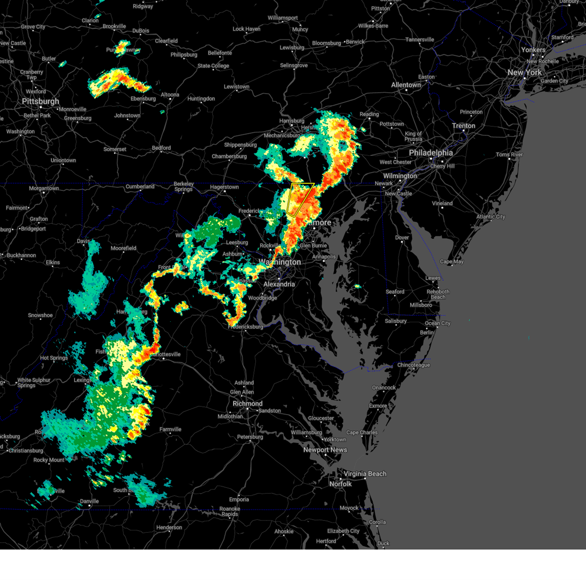 At 731 pm edt, a severe thunderstorm was located 7 miles east of hampstead, or 10 miles northwest of cockeysville, moving northeast at 35 mph (emergency management). Hazards include 70 mph wind gusts and quarter size hail. Damaging winds will cause some trees and large branches to fall. this could injure those outdoors, as well as damage homes and vehicles. roadways may become blocked by downed trees. localized power outages are possible. unsecured light objects may become projectiles. locations impacted include, eldersburg, reisterstown, hampstead, manchester, gamber, finksburg, carrollton, upperco, freeland, lineboro, louisville, glyndon, boring, bentley springs, patapsco, millers, greenmount and maryland line. thunderstorm damage threat, considerable hail threat, radar indicated max hail size, 1. 00 in wind threat, radar indicated max wind gust, 70 mph. At 731 pm edt, a severe thunderstorm was located 7 miles east of hampstead, or 10 miles northwest of cockeysville, moving northeast at 35 mph (emergency management). Hazards include 70 mph wind gusts and quarter size hail. Damaging winds will cause some trees and large branches to fall. this could injure those outdoors, as well as damage homes and vehicles. roadways may become blocked by downed trees. localized power outages are possible. unsecured light objects may become projectiles. locations impacted include, eldersburg, reisterstown, hampstead, manchester, gamber, finksburg, carrollton, upperco, freeland, lineboro, louisville, glyndon, boring, bentley springs, patapsco, millers, greenmount and maryland line. thunderstorm damage threat, considerable hail threat, radar indicated max hail size, 1. 00 in wind threat, radar indicated max wind gust, 70 mph.
|
| 7/28/2023 7:17 PM EDT |
 At 716 pm edt, a severe thunderstorm was located near reisterstown, or 7 miles west of cockeysville, moving northeast at 30 mph. this is a destructive storm for northern baltimore county (emergency management). Hazards include 80 mph wind gusts and quarter size hail. Expect considerable damage to trees and power lines. your life is at significant risk if outdoors. In addition to some trees falling into homes, wind damage is possible to roofs, sheds, open garages, and mobile homes. At 716 pm edt, a severe thunderstorm was located near reisterstown, or 7 miles west of cockeysville, moving northeast at 30 mph. this is a destructive storm for northern baltimore county (emergency management). Hazards include 80 mph wind gusts and quarter size hail. Expect considerable damage to trees and power lines. your life is at significant risk if outdoors. In addition to some trees falling into homes, wind damage is possible to roofs, sheds, open garages, and mobile homes.
|
| 7/28/2023 7:11 PM EDT | Dozens of trees down on houses and cars in reisterstow in baltimore county MD, 0.7 miles NW of Reisterstown, MD |
| 7/28/2023 7:02 PM EDT |
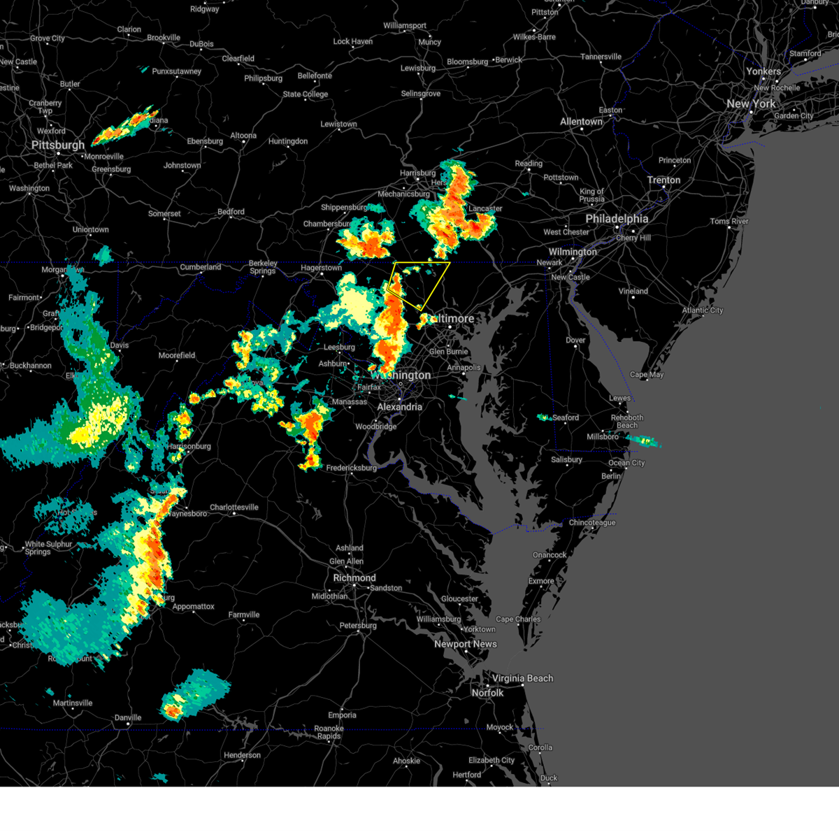 At 702 pm edt, a severe thunderstorm was located over westminster, moving northeast at 25 mph (radar indicated). Hazards include 70 mph wind gusts and quarter size hail. Damaging winds will cause some trees and large branches to fall. this could injure those outdoors, as well as damage homes and vehicles. roadways may become blocked by downed trees. localized power outages are possible. unsecured light objects may become projectiles. locations impacted include, westminster, eldersburg, reisterstown, hampstead, manchester, gamber, new windsor, finksburg, carrollton, upperco, freeland, lineboro, louisville, glyndon, boring, bentley springs, patapsco, reese, uniontown and wagners mill. thunderstorm damage threat, considerable hail threat, radar indicated max hail size, 1. 00 in wind threat, radar indicated max wind gust, 70 mph. At 702 pm edt, a severe thunderstorm was located over westminster, moving northeast at 25 mph (radar indicated). Hazards include 70 mph wind gusts and quarter size hail. Damaging winds will cause some trees and large branches to fall. this could injure those outdoors, as well as damage homes and vehicles. roadways may become blocked by downed trees. localized power outages are possible. unsecured light objects may become projectiles. locations impacted include, westminster, eldersburg, reisterstown, hampstead, manchester, gamber, new windsor, finksburg, carrollton, upperco, freeland, lineboro, louisville, glyndon, boring, bentley springs, patapsco, reese, uniontown and wagners mill. thunderstorm damage threat, considerable hail threat, radar indicated max hail size, 1. 00 in wind threat, radar indicated max wind gust, 70 mph.
|
| 7/28/2023 7:00 PM EDT |
 At 659 pm edt, severe thunderstorms were located along a line extending from near sykesville to near columbia to forest glen, moving east at 30 mph (emergency management has reported numerous instance of damage with these severe thunderstorms as they moved across montogmery county). Hazards include 60 mph wind gusts and quarter size hail. Damaging winds will cause some trees and large branches to fall. this could injure those outdoors, as well as damage homes and vehicles. roadways may become blocked by downed trees. localized power outages are possible. Unsecured light objects may become projectiles. At 659 pm edt, severe thunderstorms were located along a line extending from near sykesville to near columbia to forest glen, moving east at 30 mph (emergency management has reported numerous instance of damage with these severe thunderstorms as they moved across montogmery county). Hazards include 60 mph wind gusts and quarter size hail. Damaging winds will cause some trees and large branches to fall. this could injure those outdoors, as well as damage homes and vehicles. roadways may become blocked by downed trees. localized power outages are possible. Unsecured light objects may become projectiles.
|
| 7/28/2023 6:46 PM EDT |
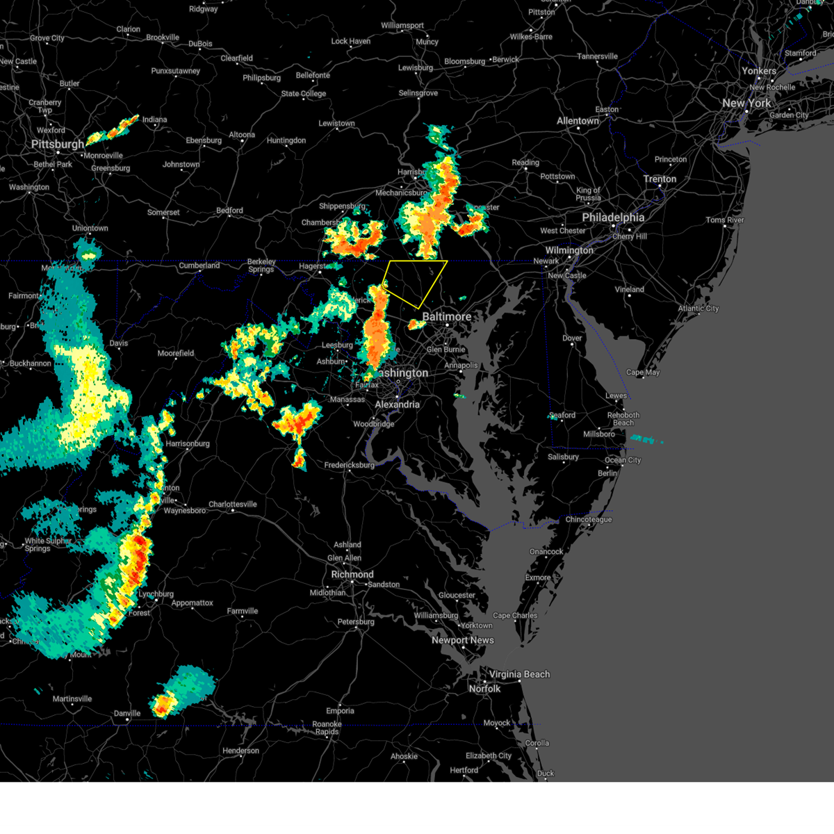 At 646 pm edt, a severe thunderstorm was located 7 miles west of gamber, or 7 miles southwest of westminster, moving northeast at 55 mph (radar indicated). Hazards include 70 mph wind gusts and quarter size hail. Damaging winds will cause some trees and large branches to fall. this could injure those outdoors, as well as damage homes and vehicles. roadways may become blocked by downed trees. localized power outages are possible. Unsecured light objects may become projectiles. At 646 pm edt, a severe thunderstorm was located 7 miles west of gamber, or 7 miles southwest of westminster, moving northeast at 55 mph (radar indicated). Hazards include 70 mph wind gusts and quarter size hail. Damaging winds will cause some trees and large branches to fall. this could injure those outdoors, as well as damage homes and vehicles. roadways may become blocked by downed trees. localized power outages are possible. Unsecured light objects may become projectiles.
|
| 7/3/2023 7:36 PM EDT | One tree into a house due to thunderstorm winds along the 1900 block of haverhill roa in baltimore county MD, 0.7 miles NW of Reisterstown, MD |
| 4/22/2023 2:47 PM EDT |
 At 247 pm edt, severe thunderstorms were located along a line extending from near reisterstown to elkridge to near upper marlboro, moving northeast at 45 mph (radar indicated). Hazards include 60 mph wind gusts. Damaging winds will cause some trees and large branches to fall. this could injure those outdoors, as well as damage homes and vehicles. roadways may become blocked by downed trees. localized power outages are possible. Unsecured light objects may become projectiles. At 247 pm edt, severe thunderstorms were located along a line extending from near reisterstown to elkridge to near upper marlboro, moving northeast at 45 mph (radar indicated). Hazards include 60 mph wind gusts. Damaging winds will cause some trees and large branches to fall. this could injure those outdoors, as well as damage homes and vehicles. roadways may become blocked by downed trees. localized power outages are possible. Unsecured light objects may become projectiles.
|
| 4/22/2023 2:33 PM EDT |
 At 232 pm edt, a severe thunderstorm was located near mount airy, or 10 miles south of westminster, moving northeast at 45 mph (radar indicated). Hazards include 60 mph wind gusts. Damaging winds will cause some trees and large branches to fall. this could injure those outdoors, as well as damage homes and vehicles. roadways may become blocked by downed trees. localized power outages are possible. unsecured light objects may become projectiles. locations impacted include, columbia, pikesville, westminster, historic ellicott city, ellicott city, woodlawn, randallstown, owings mills, eldersburg, milford mill, reisterstown, lochearn, mays chapel, mount airy, hampstead, sykesville, oakland, gamber, garrison and fulton. hail threat, radar indicated max hail size, <. 75 in wind threat, radar indicated max wind gust, 60 mph. At 232 pm edt, a severe thunderstorm was located near mount airy, or 10 miles south of westminster, moving northeast at 45 mph (radar indicated). Hazards include 60 mph wind gusts. Damaging winds will cause some trees and large branches to fall. this could injure those outdoors, as well as damage homes and vehicles. roadways may become blocked by downed trees. localized power outages are possible. unsecured light objects may become projectiles. locations impacted include, columbia, pikesville, westminster, historic ellicott city, ellicott city, woodlawn, randallstown, owings mills, eldersburg, milford mill, reisterstown, lochearn, mays chapel, mount airy, hampstead, sykesville, oakland, gamber, garrison and fulton. hail threat, radar indicated max hail size, <. 75 in wind threat, radar indicated max wind gust, 60 mph.
|
| 4/22/2023 2:18 PM EDT |
 At 218 pm edt, a severe thunderstorm was located near green valley, or near damascus, moving northeast at 45 mph (radar indicated). Hazards include 60 mph wind gusts. Damaging winds will cause some trees and large branches to fall. this could injure those outdoors, as well as damage homes and vehicles. roadways may become blocked by downed trees. localized power outages are possible. unsecured light objects may become projectiles. locations impacted include, columbia, rockville, olney, pikesville, westminster, damascus, historic ellicott city, ellicott city, aspen hill, north bethesda, woodlawn, randallstown, montgomery village, owings mills, eldersburg, milford mill, reisterstown, lochearn, white oak and redland. hail threat, radar indicated max hail size, <. 75 in wind threat, radar indicated max wind gust, 60 mph. At 218 pm edt, a severe thunderstorm was located near green valley, or near damascus, moving northeast at 45 mph (radar indicated). Hazards include 60 mph wind gusts. Damaging winds will cause some trees and large branches to fall. this could injure those outdoors, as well as damage homes and vehicles. roadways may become blocked by downed trees. localized power outages are possible. unsecured light objects may become projectiles. locations impacted include, columbia, rockville, olney, pikesville, westminster, damascus, historic ellicott city, ellicott city, aspen hill, north bethesda, woodlawn, randallstown, montgomery village, owings mills, eldersburg, milford mill, reisterstown, lochearn, white oak and redland. hail threat, radar indicated max hail size, <. 75 in wind threat, radar indicated max wind gust, 60 mph.
|
| 4/22/2023 2:02 PM EDT |
 At 202 pm edt, a severe thunderstorm was located over boyds, or near germantown, moving northeast at 45 mph (radar indicated). Hazards include 60 mph wind gusts. Damaging winds will cause some trees and large branches to fall. this could injure those outdoors, as well as damage homes and vehicles. roadways may become blocked by downed trees. localized power outages are possible. Unsecured light objects may become projectiles. At 202 pm edt, a severe thunderstorm was located over boyds, or near germantown, moving northeast at 45 mph (radar indicated). Hazards include 60 mph wind gusts. Damaging winds will cause some trees and large branches to fall. this could injure those outdoors, as well as damage homes and vehicles. roadways may become blocked by downed trees. localized power outages are possible. Unsecured light objects may become projectiles.
|
| 4/15/2023 1:44 PM EDT |
 At 143 pm edt, a severe thunderstorm was located over reisterstown, or 7 miles northwest of pikesville, moving east at 5 mph (trained weather spotters. at 140 pm edt trained weather spotters reported dime to marble size hail near reisterstown, md). Hazards include 60 mph wind gusts and quarter size hail. Damaging winds will cause some trees and large branches to fall. this could injure those outdoors, as well as damage homes and vehicles. roadways may become blocked by downed trees. localized power outages are possible. unsecured light objects may become projectiles. locations impacted include, cockeysville, reisterstown, mays chapel, hereford, glyndon, boring and butler. hail threat, observed max hail size, 1. 00 in wind threat, radar indicated max wind gust, 60 mph. At 143 pm edt, a severe thunderstorm was located over reisterstown, or 7 miles northwest of pikesville, moving east at 5 mph (trained weather spotters. at 140 pm edt trained weather spotters reported dime to marble size hail near reisterstown, md). Hazards include 60 mph wind gusts and quarter size hail. Damaging winds will cause some trees and large branches to fall. this could injure those outdoors, as well as damage homes and vehicles. roadways may become blocked by downed trees. localized power outages are possible. unsecured light objects may become projectiles. locations impacted include, cockeysville, reisterstown, mays chapel, hereford, glyndon, boring and butler. hail threat, observed max hail size, 1. 00 in wind threat, radar indicated max wind gust, 60 mph.
|
| 4/15/2023 1:36 PM EDT | Quarter sized hail reported 0.7 miles NW of Reisterstown, MD |
| 4/15/2023 1:36 PM EDT | Half Dollar sized hail reported 0.2 miles S of Reisterstown, MD, mping report of half dollar sized hail in reisterstown. |
| 4/15/2023 1:30 PM EDT |
 At 130 pm edt, a severe thunderstorm was located over reisterstown, or 9 miles northwest of pikesville, moving east at 10 mph (radar indicated). Hazards include 60 mph wind gusts and quarter size hail. Damaging winds will cause some trees and large branches to fall. this could injure those outdoors, as well as damage homes and vehicles. roadways may become blocked by downed trees. localized power outages are possible. Unsecured light objects may become projectiles. At 130 pm edt, a severe thunderstorm was located over reisterstown, or 9 miles northwest of pikesville, moving east at 10 mph (radar indicated). Hazards include 60 mph wind gusts and quarter size hail. Damaging winds will cause some trees and large branches to fall. this could injure those outdoors, as well as damage homes and vehicles. roadways may become blocked by downed trees. localized power outages are possible. Unsecured light objects may become projectiles.
|
| 4/1/2023 6:39 PM EDT |
 The severe thunderstorm warning for southeastern carroll, northwestern howard, northwestern harford and northwestern baltimore counties will expire at 645 pm edt, the storms which prompted the warning have moved out of the area. therefore, the warning will be allowed to expire. to report severe weather, contact your nearest law enforcement agency. they will relay your report to the national weather service sterling virginia. The severe thunderstorm warning for southeastern carroll, northwestern howard, northwestern harford and northwestern baltimore counties will expire at 645 pm edt, the storms which prompted the warning have moved out of the area. therefore, the warning will be allowed to expire. to report severe weather, contact your nearest law enforcement agency. they will relay your report to the national weather service sterling virginia.
|
| 4/1/2023 6:19 PM EDT |
 At 619 pm edt, severe thunderstorms were located along a line extending from near cockeysville to near mount airy, moving northeast at 65 mph (radar indicated). Hazards include 60 mph wind gusts and quarter size hail. Damaging winds will cause some trees and large branches to fall. this could injure those outdoors, as well as damage homes and vehicles. roadways may become blocked by downed trees. localized power outages are possible. unsecured light objects may become projectiles. locations impacted include, pikesville, cockeysville, ellicott city, randallstown, owings mills, bel air north, eldersburg, milford mill, reisterstown, lochearn, mays chapel, timonium, mount airy, fallston, sykesville, jarrettsville, oakland, lutherville-timonium, gamber and garrison. hail threat, radar indicated max hail size, 1. 00 in wind threat, radar indicated max wind gust, 60 mph. At 619 pm edt, severe thunderstorms were located along a line extending from near cockeysville to near mount airy, moving northeast at 65 mph (radar indicated). Hazards include 60 mph wind gusts and quarter size hail. Damaging winds will cause some trees and large branches to fall. this could injure those outdoors, as well as damage homes and vehicles. roadways may become blocked by downed trees. localized power outages are possible. unsecured light objects may become projectiles. locations impacted include, pikesville, cockeysville, ellicott city, randallstown, owings mills, bel air north, eldersburg, milford mill, reisterstown, lochearn, mays chapel, timonium, mount airy, fallston, sykesville, jarrettsville, oakland, lutherville-timonium, gamber and garrison. hail threat, radar indicated max hail size, 1. 00 in wind threat, radar indicated max wind gust, 60 mph.
|
| 2/21/2023 1:35 PM EST |
 At 135 pm est, a severe thunderstorm was located over randallstown, or near pikesville, moving east at 65 mph (radar indicated). Hazards include 60 mph wind gusts and quarter size hail. Damaging winds will cause some trees and large branches to fall. this could injure those outdoors, as well as damage homes and vehicles. roadways may become blocked by downed trees. localized power outages are possible. Unsecured light objects may become projectiles. At 135 pm est, a severe thunderstorm was located over randallstown, or near pikesville, moving east at 65 mph (radar indicated). Hazards include 60 mph wind gusts and quarter size hail. Damaging winds will cause some trees and large branches to fall. this could injure those outdoors, as well as damage homes and vehicles. roadways may become blocked by downed trees. localized power outages are possible. Unsecured light objects may become projectiles.
|
| 9/12/2022 5:12 PM EDT | Tree down near the intersection of nicodemus road and quarry view court in baltimore county MD, 1.6 miles NE of Reisterstown, MD |
| 8/4/2022 6:19 PM EDT |
 At 619 pm edt, a severe thunderstorm was located near owings mills, or near pikesville, moving east at 30 mph (radar indicated). Hazards include 60 mph wind gusts and quarter size hail. Damaging winds will cause some trees and large branches to fall. this could injure those outdoors, as well as damage homes and vehicles. roadways may become blocked by downed trees. localized power outages are possible. Unsecured light objects may become projectiles. At 619 pm edt, a severe thunderstorm was located near owings mills, or near pikesville, moving east at 30 mph (radar indicated). Hazards include 60 mph wind gusts and quarter size hail. Damaging winds will cause some trees and large branches to fall. this could injure those outdoors, as well as damage homes and vehicles. roadways may become blocked by downed trees. localized power outages are possible. Unsecured light objects may become projectiles.
|
| 7/18/2022 4:14 PM EDT |
 At 414 pm edt, severe thunderstorms were located along a line extending from hampstead to near reisterstown to near randallstown to near sykesville, moving east at 40 mph (radar indicated). Hazards include 60 mph wind gusts. Damaging winds will cause some trees and large branches to fall. this could injure those outdoors, as well as damage homes and vehicles. roadways may become blocked by downed trees. localized power outages are possible. unsecured light objects may become projectiles. locations impacted include, pikesville, westminster, ellicott city, woodlawn, randallstown, owings mills, eldersburg, milford mill, reisterstown, lochearn, hampstead, manchester, oakland, gamber, garrison, finksburg, carrollton, upperco, henryton and louisville. hail threat, radar indicated max hail size, <. 75 in wind threat, radar indicated max wind gust, 60 mph. At 414 pm edt, severe thunderstorms were located along a line extending from hampstead to near reisterstown to near randallstown to near sykesville, moving east at 40 mph (radar indicated). Hazards include 60 mph wind gusts. Damaging winds will cause some trees and large branches to fall. this could injure those outdoors, as well as damage homes and vehicles. roadways may become blocked by downed trees. localized power outages are possible. unsecured light objects may become projectiles. locations impacted include, pikesville, westminster, ellicott city, woodlawn, randallstown, owings mills, eldersburg, milford mill, reisterstown, lochearn, hampstead, manchester, oakland, gamber, garrison, finksburg, carrollton, upperco, henryton and louisville. hail threat, radar indicated max hail size, <. 75 in wind threat, radar indicated max wind gust, 60 mph.
|
| 7/18/2022 3:50 PM EDT |
 At 350 pm edt, severe thunderstorms were located along a line extending from near westminster to 7 miles west of gamber to near mount airy to damascus, moving east at 40 mph (radar indicated). Hazards include 70 mph wind gusts. Damaging winds will cause some trees and large branches to fall. this could injure those outdoors, as well as damage homes and vehicles. roadways may become blocked by downed trees. localized power outages are possible. unsecured light objects may become projectiles. locations impacted include, pikesville, westminster, damascus, ellicott city, woodlawn, randallstown, owings mills, eldersburg, milford mill, reisterstown, lochearn, mount airy, hampstead, manchester, sykesville, oakland, gamber, garrison, new windsor and union bridge. thunderstorm damage threat, considerable hail threat, radar indicated max hail size, <. 75 in wind threat, radar indicated max wind gust, 70 mph. At 350 pm edt, severe thunderstorms were located along a line extending from near westminster to 7 miles west of gamber to near mount airy to damascus, moving east at 40 mph (radar indicated). Hazards include 70 mph wind gusts. Damaging winds will cause some trees and large branches to fall. this could injure those outdoors, as well as damage homes and vehicles. roadways may become blocked by downed trees. localized power outages are possible. unsecured light objects may become projectiles. locations impacted include, pikesville, westminster, damascus, ellicott city, woodlawn, randallstown, owings mills, eldersburg, milford mill, reisterstown, lochearn, mount airy, hampstead, manchester, sykesville, oakland, gamber, garrison, new windsor and union bridge. thunderstorm damage threat, considerable hail threat, radar indicated max hail size, <. 75 in wind threat, radar indicated max wind gust, 70 mph.
|
| 7/18/2022 3:38 PM EDT |
 At 338 pm edt, severe thunderstorms were located along a line extending from 7 miles south of taneytown to 6 miles north of mount airy to near green valley to near boyds, moving east at 40 mph (radar indicated). Hazards include 60 mph wind gusts. Damaging winds will cause some trees and large branches to fall. this could injure those outdoors, as well as damage homes and vehicles. roadways may become blocked by downed trees. localized power outages are possible. Unsecured light objects may become projectiles. At 338 pm edt, severe thunderstorms were located along a line extending from 7 miles south of taneytown to 6 miles north of mount airy to near green valley to near boyds, moving east at 40 mph (radar indicated). Hazards include 60 mph wind gusts. Damaging winds will cause some trees and large branches to fall. this could injure those outdoors, as well as damage homes and vehicles. roadways may become blocked by downed trees. localized power outages are possible. Unsecured light objects may become projectiles.
|
| 7/16/2022 2:43 PM EDT |
 At 242 pm edt, severe thunderstorms were located along a line extending from near owings mills to catonsville, moving northeast at 25 mph (radar indicated). Hazards include 60 mph wind gusts. Damaging winds will cause some trees and large branches to fall. this could injure those outdoors, as well as damage homes and vehicles. roadways may become blocked by downed trees. localized power outages are possible. Unsecured light objects may become projectiles. At 242 pm edt, severe thunderstorms were located along a line extending from near owings mills to catonsville, moving northeast at 25 mph (radar indicated). Hazards include 60 mph wind gusts. Damaging winds will cause some trees and large branches to fall. this could injure those outdoors, as well as damage homes and vehicles. roadways may become blocked by downed trees. localized power outages are possible. Unsecured light objects may become projectiles.
|
| 7/12/2022 5:21 PM EDT |
 The severe thunderstorm warning for southeastern carroll and west central baltimore counties will expire at 530 pm edt, the storm which prompted the warning has weakened below severe limits, and has exited the warned area. therefore, the warning will be allowed to expire. a severe thunderstorm watch remains in effect until 1000 pm edt for northern and north central maryland. The severe thunderstorm warning for southeastern carroll and west central baltimore counties will expire at 530 pm edt, the storm which prompted the warning has weakened below severe limits, and has exited the warned area. therefore, the warning will be allowed to expire. a severe thunderstorm watch remains in effect until 1000 pm edt for northern and north central maryland.
|
| 7/12/2022 5:18 PM EDT |
 At 518 pm edt, a severe thunderstorm was located over cockeysville, moving east at 50 mph (radar indicated). Hazards include 60 mph wind gusts and quarter size hail. Damaging winds will cause some trees and large branches to fall. this could injure those outdoors, as well as damage homes and vehicles. roadways may become blocked by downed trees. localized power outages are possible. unsecured light objects may become projectiles. locations impacted include, pikesville, randallstown, owings mills, reisterstown, garrison, mcdonogh, stevenson and glyndon. hail threat, radar indicated max hail size, 1. 00 in wind threat, radar indicated max wind gust, 60 mph. At 518 pm edt, a severe thunderstorm was located over cockeysville, moving east at 50 mph (radar indicated). Hazards include 60 mph wind gusts and quarter size hail. Damaging winds will cause some trees and large branches to fall. this could injure those outdoors, as well as damage homes and vehicles. roadways may become blocked by downed trees. localized power outages are possible. unsecured light objects may become projectiles. locations impacted include, pikesville, randallstown, owings mills, reisterstown, garrison, mcdonogh, stevenson and glyndon. hail threat, radar indicated max hail size, 1. 00 in wind threat, radar indicated max wind gust, 60 mph.
|
| 7/12/2022 5:05 PM EDT |
 At 504 pm edt, a severe thunderstorm was located over reisterstown, or 10 miles northwest of pikesville, moving east at 50 mph (radar indicated). Hazards include 60 mph wind gusts and quarter size hail. Damaging winds will cause some trees and large branches to fall. this could injure those outdoors, as well as damage homes and vehicles. roadways may become blocked by downed trees. localized power outages are possible. unsecured light objects may become projectiles. locations impacted include, baltimore, pikesville, westminster, randallstown, owings mills, eldersburg, milford mill, reisterstown, lochearn, sykesville, oakland, gamber, garrison, finksburg, carrollton, upperco, henryton, winfield, louisville and granite. hail threat, radar indicated max hail size, 1. 00 in wind threat, radar indicated max wind gust, 60 mph. At 504 pm edt, a severe thunderstorm was located over reisterstown, or 10 miles northwest of pikesville, moving east at 50 mph (radar indicated). Hazards include 60 mph wind gusts and quarter size hail. Damaging winds will cause some trees and large branches to fall. this could injure those outdoors, as well as damage homes and vehicles. roadways may become blocked by downed trees. localized power outages are possible. unsecured light objects may become projectiles. locations impacted include, baltimore, pikesville, westminster, randallstown, owings mills, eldersburg, milford mill, reisterstown, lochearn, sykesville, oakland, gamber, garrison, finksburg, carrollton, upperco, henryton, winfield, louisville and granite. hail threat, radar indicated max hail size, 1. 00 in wind threat, radar indicated max wind gust, 60 mph.
|
| 7/12/2022 5:03 PM EDT | Tree down in the roadway on md-140 just east of the intersection with dede r in carroll county MD, 4.4 miles ESE of Reisterstown, MD |
| 7/12/2022 4:54 PM EDT |
 At 453 pm edt, a severe thunderstorm was located near eldersburg, or 10 miles south of westminster, moving east at 50 mph (radar indicated). Hazards include 60 mph wind gusts and quarter size hail. Damaging winds will cause some trees and large branches to fall. this could injure those outdoors, as well as damage homes and vehicles. roadways may become blocked by downed trees. localized power outages are possible. unsecured light objects may become projectiles. locations impacted include, baltimore, pikesville, westminster, randallstown, owings mills, eldersburg, milford mill, reisterstown, lochearn, mount airy, sykesville, oakland, gamber, garrison, new windsor, finksburg, carrollton, upperco, henryton and winfield. hail threat, radar indicated max hail size, 1. 00 in wind threat, radar indicated max wind gust, 60 mph. At 453 pm edt, a severe thunderstorm was located near eldersburg, or 10 miles south of westminster, moving east at 50 mph (radar indicated). Hazards include 60 mph wind gusts and quarter size hail. Damaging winds will cause some trees and large branches to fall. this could injure those outdoors, as well as damage homes and vehicles. roadways may become blocked by downed trees. localized power outages are possible. unsecured light objects may become projectiles. locations impacted include, baltimore, pikesville, westminster, randallstown, owings mills, eldersburg, milford mill, reisterstown, lochearn, mount airy, sykesville, oakland, gamber, garrison, new windsor, finksburg, carrollton, upperco, henryton and winfield. hail threat, radar indicated max hail size, 1. 00 in wind threat, radar indicated max wind gust, 60 mph.
|
| 7/12/2022 4:44 PM EDT |
 At 444 pm edt, a severe thunderstorm was located near mount airy, or 10 miles north of damascus, moving east at 50 mph (radar indicated). Hazards include 60 mph wind gusts and quarter size hail. Damaging winds will cause some trees and large branches to fall. this could injure those outdoors, as well as damage homes and vehicles. roadways may become blocked by downed trees. localized power outages are possible. Unsecured light objects may become projectiles. At 444 pm edt, a severe thunderstorm was located near mount airy, or 10 miles north of damascus, moving east at 50 mph (radar indicated). Hazards include 60 mph wind gusts and quarter size hail. Damaging winds will cause some trees and large branches to fall. this could injure those outdoors, as well as damage homes and vehicles. roadways may become blocked by downed trees. localized power outages are possible. Unsecured light objects may become projectiles.
|
| 7/12/2022 4:35 PM EDT |
 At 435 pm edt, severe thunderstorms were located along a line extending from near cockeysville to near owings mills to near eldersburg, moving east at 65 mph (radar indicated). Hazards include 60 mph wind gusts. Damaging winds will cause some trees and large branches to fall. this could injure those outdoors, as well as damage homes and vehicles. roadways may become blocked by downed trees. localized power outages are possible. Unsecured light objects may become projectiles. At 435 pm edt, severe thunderstorms were located along a line extending from near cockeysville to near owings mills to near eldersburg, moving east at 65 mph (radar indicated). Hazards include 60 mph wind gusts. Damaging winds will cause some trees and large branches to fall. this could injure those outdoors, as well as damage homes and vehicles. roadways may become blocked by downed trees. localized power outages are possible. Unsecured light objects may become projectiles.
|
| 7/1/2022 3:08 PM EDT |
 At 308 pm edt, a severe thunderstorm was located near randallstown, or 7 miles northwest of historic ellicott city, moving east at 30 mph (radar indicated). Hazards include 60 mph wind gusts and quarter size hail. Damaging winds will cause some trees and large branches to fall. this could injure those outdoors, as well as damage homes and vehicles. roadways may become blocked by downed trees. localized power outages are possible. unsecured light objects may become projectiles. locations impacted include, pikesville, historic ellicott city, ellicott city, catonsville, woodlawn, randallstown, owings mills, eldersburg, milford mill, reisterstown, lochearn, oakland, garrison, oella, henryton, west friendship, woodstock, granite, mcdonogh and daniels. hail threat, radar indicated max hail size, 1. 00 in wind threat, radar indicated max wind gust, 60 mph. At 308 pm edt, a severe thunderstorm was located near randallstown, or 7 miles northwest of historic ellicott city, moving east at 30 mph (radar indicated). Hazards include 60 mph wind gusts and quarter size hail. Damaging winds will cause some trees and large branches to fall. this could injure those outdoors, as well as damage homes and vehicles. roadways may become blocked by downed trees. localized power outages are possible. unsecured light objects may become projectiles. locations impacted include, pikesville, historic ellicott city, ellicott city, catonsville, woodlawn, randallstown, owings mills, eldersburg, milford mill, reisterstown, lochearn, oakland, garrison, oella, henryton, west friendship, woodstock, granite, mcdonogh and daniels. hail threat, radar indicated max hail size, 1. 00 in wind threat, radar indicated max wind gust, 60 mph.
|
| 7/1/2022 2:57 PM EDT |
 At 257 pm edt, a severe thunderstorm was located over sykesville, or 10 miles northwest of historic ellicott city, moving east at 30 mph (radar indicated). Hazards include 60 mph wind gusts and quarter size hail. Damaging winds will cause some trees and large branches to fall. this could injure those outdoors, as well as damage homes and vehicles. roadways may become blocked by downed trees. localized power outages are possible. Unsecured light objects may become projectiles. At 257 pm edt, a severe thunderstorm was located over sykesville, or 10 miles northwest of historic ellicott city, moving east at 30 mph (radar indicated). Hazards include 60 mph wind gusts and quarter size hail. Damaging winds will cause some trees and large branches to fall. this could injure those outdoors, as well as damage homes and vehicles. roadways may become blocked by downed trees. localized power outages are possible. Unsecured light objects may become projectiles.
|
| 7/1/2022 2:50 PM EDT | Tree down on butler rd in baltimore county MD, 6.6 miles SW of Reisterstown, MD |
| 6/8/2022 7:09 PM EDT |
 At 709 pm edt, a severe thunderstorm was located over eldersburg, or 11 miles south of westminster, moving northeast at 25 mph (radar indicated). Hazards include 60 mph wind gusts and quarter size hail. Damaging winds will cause some trees and large branches to fall. this could injure those outdoors, as well as damage homes and vehicles. roadways may become blocked by downed trees. localized power outages are possible. Unsecured light objects may become projectiles. At 709 pm edt, a severe thunderstorm was located over eldersburg, or 11 miles south of westminster, moving northeast at 25 mph (radar indicated). Hazards include 60 mph wind gusts and quarter size hail. Damaging winds will cause some trees and large branches to fall. this could injure those outdoors, as well as damage homes and vehicles. roadways may become blocked by downed trees. localized power outages are possible. Unsecured light objects may become projectiles.
|
| 5/27/2022 12:55 PM EDT |
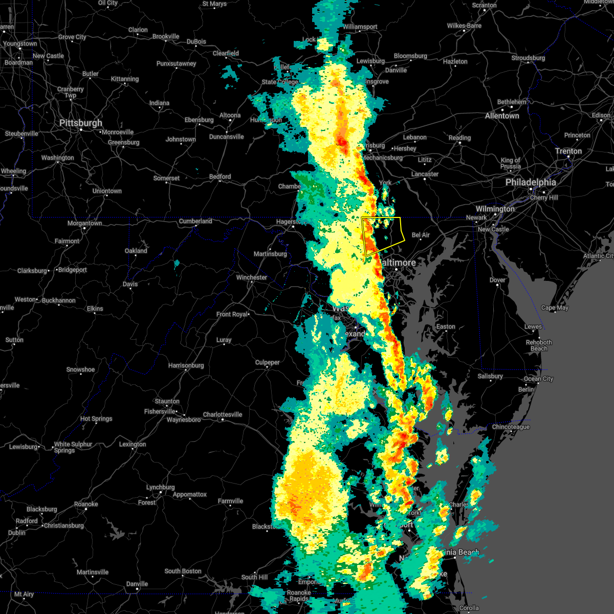 At 1255 pm edt, severe thunderstorms were located along a line extending from near manchester to near hampstead to near randallstown, moving northeast at 35 mph (radar indicated). Hazards include 60 mph wind gusts. Damaging winds will cause some trees and large branches to fall. this could injure those outdoors, as well as damage homes and vehicles. roadways may become blocked by downed trees. localized power outages are possible. unsecured light objects may become projectiles. Locations impacted include, cockeysville, eldersburg, reisterstown, hampstead, manchester, oakland, gamber, finksburg, carrollton, upperco, freeland, louisville, bentley springs, phoenix, jacksonville, butler, monkton, glencoe, lineboro and hunt valley. At 1255 pm edt, severe thunderstorms were located along a line extending from near manchester to near hampstead to near randallstown, moving northeast at 35 mph (radar indicated). Hazards include 60 mph wind gusts. Damaging winds will cause some trees and large branches to fall. this could injure those outdoors, as well as damage homes and vehicles. roadways may become blocked by downed trees. localized power outages are possible. unsecured light objects may become projectiles. Locations impacted include, cockeysville, eldersburg, reisterstown, hampstead, manchester, oakland, gamber, finksburg, carrollton, upperco, freeland, louisville, bentley springs, phoenix, jacksonville, butler, monkton, glencoe, lineboro and hunt valley.
|
| 5/27/2022 12:53 PM EDT |
 At 1253 pm edt, severe thunderstorms were located along a line extending from reisterstown to near historic ellicott city to upper marlboro, moving east at 30 mph (radar indicated). Hazards include 60 mph wind gusts. Damaging winds will cause some trees and large branches to fall. this could injure those outdoors, as well as damage homes and vehicles. roadways may become blocked by downed trees. localized power outages are possible. unsecured light objects may become projectiles. Locations impacted include, baltimore, columbia, bowie, severn, annapolis, pikesville, crofton, middle river, cockeysville, elkridge, riviera beach, largo, mayo, naval academy, upper marlboro, baltimore-washington airport, fort smallwood state park, gibson island, sillery bay and millers island. At 1253 pm edt, severe thunderstorms were located along a line extending from reisterstown to near historic ellicott city to upper marlboro, moving east at 30 mph (radar indicated). Hazards include 60 mph wind gusts. Damaging winds will cause some trees and large branches to fall. this could injure those outdoors, as well as damage homes and vehicles. roadways may become blocked by downed trees. localized power outages are possible. unsecured light objects may become projectiles. Locations impacted include, baltimore, columbia, bowie, severn, annapolis, pikesville, crofton, middle river, cockeysville, elkridge, riviera beach, largo, mayo, naval academy, upper marlboro, baltimore-washington airport, fort smallwood state park, gibson island, sillery bay and millers island.
|
| 5/27/2022 12:36 PM EDT |
 At 1235 pm edt, severe thunderstorms were located along a line extending from near littlestown to near eldersburg to near olney, moving east at 35 mph (radar indicated). Hazards include 60 mph wind gusts. Damaging winds will cause some trees and large branches to fall. this could injure those outdoors, as well as damage homes and vehicles. roadways may become blocked by downed trees. localized power outages are possible. Unsecured light objects may become projectiles. At 1235 pm edt, severe thunderstorms were located along a line extending from near littlestown to near eldersburg to near olney, moving east at 35 mph (radar indicated). Hazards include 60 mph wind gusts. Damaging winds will cause some trees and large branches to fall. this could injure those outdoors, as well as damage homes and vehicles. roadways may become blocked by downed trees. localized power outages are possible. Unsecured light objects may become projectiles.
|
| 5/27/2022 12:29 PM EDT |
 At 1229 pm edt, severe thunderstorms were located along a line extending from near sykesville to near columbia to beltsville, moving northeast at 40 mph (radar indicated). Hazards include 60 mph wind gusts. Damaging winds will cause some trees and large branches to fall. this could injure those outdoors, as well as damage homes and vehicles. roadways may become blocked by downed trees. localized power outages are possible. Unsecured light objects may become projectiles. At 1229 pm edt, severe thunderstorms were located along a line extending from near sykesville to near columbia to beltsville, moving northeast at 40 mph (radar indicated). Hazards include 60 mph wind gusts. Damaging winds will cause some trees and large branches to fall. this could injure those outdoors, as well as damage homes and vehicles. roadways may become blocked by downed trees. localized power outages are possible. Unsecured light objects may become projectiles.
|
| 3/7/2022 8:13 PM EST | Tree down on ridgelawn road in baltimore county MD, 0.5 miles N of Reisterstown, MD |
| 3/7/2022 7:48 PM EST |
 At 748 pm est, severe thunderstorms were located along a line extending from near manchester to near linganore-bartonsville, moving east at 45 mph (radar indicated). Hazards include 60 mph wind gusts. Damaging winds will cause some trees and large branches to fall. this could injure those outdoors, as well as damage homes and vehicles. roadways may become blocked by downed trees. localized power outages are possible. unsecured light objects may become projectiles. locations impacted include, frederick, pikesville, cockeysville, westminster, harry grove stadium, randallstown, owings mills, eldersburg, milford mill, reisterstown, lochearn, ballenger creek, mays chapel, mount airy, taneytown, hampstead, walkersville, manchester, sykesville and jarrettsville. hail threat, radar indicated max hail size, <. 75 in wind threat, radar indicated max wind gust, 60 mph. At 748 pm est, severe thunderstorms were located along a line extending from near manchester to near linganore-bartonsville, moving east at 45 mph (radar indicated). Hazards include 60 mph wind gusts. Damaging winds will cause some trees and large branches to fall. this could injure those outdoors, as well as damage homes and vehicles. roadways may become blocked by downed trees. localized power outages are possible. unsecured light objects may become projectiles. locations impacted include, frederick, pikesville, cockeysville, westminster, harry grove stadium, randallstown, owings mills, eldersburg, milford mill, reisterstown, lochearn, ballenger creek, mays chapel, mount airy, taneytown, hampstead, walkersville, manchester, sykesville and jarrettsville. hail threat, radar indicated max hail size, <. 75 in wind threat, radar indicated max wind gust, 60 mph.
|
| 3/7/2022 7:24 PM EST |
 At 724 pm est, severe thunderstorms were located along a line extending from near emmitsburg to braddock heights, moving east at 55 mph (radar indicated). Hazards include 60 mph wind gusts. Damaging winds will cause some trees and large branches to fall. this could injure those outdoors, as well as damage homes and vehicles. roadways may become blocked by downed trees. localized power outages are possible. Unsecured light objects may become projectiles. At 724 pm est, severe thunderstorms were located along a line extending from near emmitsburg to braddock heights, moving east at 55 mph (radar indicated). Hazards include 60 mph wind gusts. Damaging winds will cause some trees and large branches to fall. this could injure those outdoors, as well as damage homes and vehicles. roadways may become blocked by downed trees. localized power outages are possible. Unsecured light objects may become projectiles.
|
| 10/25/2021 8:18 PM EDT | Two trees down near the intersection of deer park road and ivy mill roa in baltimore county MD, 3.7 miles ENE of Reisterstown, MD |
| 9/22/2021 6:40 PM EDT |
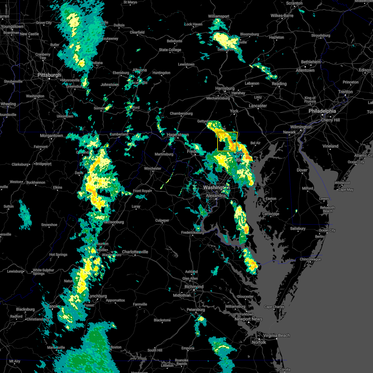 The severe thunderstorm warning for northeastern carroll and northwestern baltimore counties will expire at 645 pm edt, the storm which prompted the warning has weakened below severe limits, and no longer poses an immediate threat to life or property. therefore, the warning will be allowed to expire. however gusty winds are still possible with this thunderstorm. The severe thunderstorm warning for northeastern carroll and northwestern baltimore counties will expire at 645 pm edt, the storm which prompted the warning has weakened below severe limits, and no longer poses an immediate threat to life or property. therefore, the warning will be allowed to expire. however gusty winds are still possible with this thunderstorm.
|
| 9/22/2021 6:20 PM EDT |
 At 620 pm edt, a severe thunderstorm was located over reisterstown, or 9 miles northwest of pikesville, moving north at 50 mph (radar indicated). Hazards include 60 mph wind gusts. Damaging winds will cause some trees and large branches to fall. this could injure those outdoors, as well as damage homes and vehicles. roadways may become blocked by downed trees. localized power outages are possible. Unsecured light objects may become projectiles. At 620 pm edt, a severe thunderstorm was located over reisterstown, or 9 miles northwest of pikesville, moving north at 50 mph (radar indicated). Hazards include 60 mph wind gusts. Damaging winds will cause some trees and large branches to fall. this could injure those outdoors, as well as damage homes and vehicles. roadways may become blocked by downed trees. localized power outages are possible. Unsecured light objects may become projectiles.
|
| 9/22/2021 6:12 PM EDT |
 At 611 pm edt, a severe thunderstorm was located near ellicott city, or near historic ellicott city, moving north at 40 mph (radar indicated). Hazards include 60 mph wind gusts. Damaging winds will cause some trees and large branches to fall. this could injure those outdoors, as well as damage homes and vehicles. roadways may become blocked by downed trees. localized power outages are possible. unsecured light objects may become projectiles. locations impacted include, columbia, pikesville, elkridge, historic ellicott city, ellicott city, catonsville, woodlawn, randallstown, owings mills, eldersburg, milford mill, reisterstown, lochearn, sykesville, oakland, ilchester, garrison, henryton, west friendship and louisville. hail threat, radar indicated max hail size, <. 75 in wind threat, radar indicated max wind gust, 60 mph. At 611 pm edt, a severe thunderstorm was located near ellicott city, or near historic ellicott city, moving north at 40 mph (radar indicated). Hazards include 60 mph wind gusts. Damaging winds will cause some trees and large branches to fall. this could injure those outdoors, as well as damage homes and vehicles. roadways may become blocked by downed trees. localized power outages are possible. unsecured light objects may become projectiles. locations impacted include, columbia, pikesville, elkridge, historic ellicott city, ellicott city, catonsville, woodlawn, randallstown, owings mills, eldersburg, milford mill, reisterstown, lochearn, sykesville, oakland, ilchester, garrison, henryton, west friendship and louisville. hail threat, radar indicated max hail size, <. 75 in wind threat, radar indicated max wind gust, 60 mph.
|
| 9/22/2021 5:56 PM EDT |
 At 556 pm edt, a severe thunderstorm was located over savage-guilford, or over columbia, moving north at 40 mph (radar indicated). Hazards include 60 mph wind gusts. Damaging winds will cause some trees and large branches to fall. this could injure those outdoors, as well as damage homes and vehicles. roadways may become blocked by downed trees. localized power outages are possible. unsecured light objects may become projectiles. locations impacted include, columbia, severn, pikesville, elkridge, historic ellicott city, ellicott city, catonsville, woodlawn, randallstown, owings mills, eldersburg, milford mill, reisterstown, lochearn, laurel, fort meade, sykesville, oakland, savage-guilford and scaggsville. hail threat, radar indicated max hail size, <. 75 in wind threat, radar indicated max wind gust, 60 mph. At 556 pm edt, a severe thunderstorm was located over savage-guilford, or over columbia, moving north at 40 mph (radar indicated). Hazards include 60 mph wind gusts. Damaging winds will cause some trees and large branches to fall. this could injure those outdoors, as well as damage homes and vehicles. roadways may become blocked by downed trees. localized power outages are possible. unsecured light objects may become projectiles. locations impacted include, columbia, severn, pikesville, elkridge, historic ellicott city, ellicott city, catonsville, woodlawn, randallstown, owings mills, eldersburg, milford mill, reisterstown, lochearn, laurel, fort meade, sykesville, oakland, savage-guilford and scaggsville. hail threat, radar indicated max hail size, <. 75 in wind threat, radar indicated max wind gust, 60 mph.
|
| 9/22/2021 5:39 PM EDT |
 At 539 pm edt, a severe thunderstorm was located over goddard, or over greenbelt, moving north at 40 mph (radar indicated). Hazards include 60 mph wind gusts. Damaging winds will cause some trees and large branches to fall. this could injure those outdoors, as well as damage homes and vehicles. roadways may become blocked by downed trees. localized power outages are possible. Unsecured light objects may become projectiles. At 539 pm edt, a severe thunderstorm was located over goddard, or over greenbelt, moving north at 40 mph (radar indicated). Hazards include 60 mph wind gusts. Damaging winds will cause some trees and large branches to fall. this could injure those outdoors, as well as damage homes and vehicles. roadways may become blocked by downed trees. localized power outages are possible. Unsecured light objects may become projectiles.
|
| 8/11/2021 4:22 PM EDT |
 At 422 pm edt, severe thunderstorms were located along a line extending from near westminster to near mount airy to boyds, moving east at 20 mph (radar indicated). Hazards include 60 mph wind gusts. Damaging winds will cause some trees and large branches to fall. this could injure those outdoors, as well as damage homes and vehicles. roadways may become blocked by downed trees. localized power outages are possible. unsecured light objects may become projectiles. locations impacted include, germantown, rockville, gaithersburg, olney, westminster, damascus, poolesville, ellicott city, aspen hill, randallstown, montgomery village, owings mills, eldersburg, reisterstown, redland, mount airy, hampstead, manchester, sykesville and oakland. hail threat, radar indicated max hail size, <. 75 in wind threat, radar indicated max wind gust, 60 mph. At 422 pm edt, severe thunderstorms were located along a line extending from near westminster to near mount airy to boyds, moving east at 20 mph (radar indicated). Hazards include 60 mph wind gusts. Damaging winds will cause some trees and large branches to fall. this could injure those outdoors, as well as damage homes and vehicles. roadways may become blocked by downed trees. localized power outages are possible. unsecured light objects may become projectiles. locations impacted include, germantown, rockville, gaithersburg, olney, westminster, damascus, poolesville, ellicott city, aspen hill, randallstown, montgomery village, owings mills, eldersburg, reisterstown, redland, mount airy, hampstead, manchester, sykesville and oakland. hail threat, radar indicated max hail size, <. 75 in wind threat, radar indicated max wind gust, 60 mph.
|
| 8/11/2021 4:06 PM EDT |
 At 405 pm edt, severe thunderstorms were located along a line extending from 6 miles south of taneytown to green valley to near poolesville, moving east at 20 mph (radar indicated). Hazards include 60 mph wind gusts. Damaging winds will cause some trees and large branches to fall. this could injure those outdoors, as well as damage homes and vehicles. roadways may become blocked by downed trees. localized power outages are possible. Unsecured light objects may become projectiles. At 405 pm edt, severe thunderstorms were located along a line extending from 6 miles south of taneytown to green valley to near poolesville, moving east at 20 mph (radar indicated). Hazards include 60 mph wind gusts. Damaging winds will cause some trees and large branches to fall. this could injure those outdoors, as well as damage homes and vehicles. roadways may become blocked by downed trees. localized power outages are possible. Unsecured light objects may become projectiles.
|
| 7/29/2021 4:36 PM EDT |
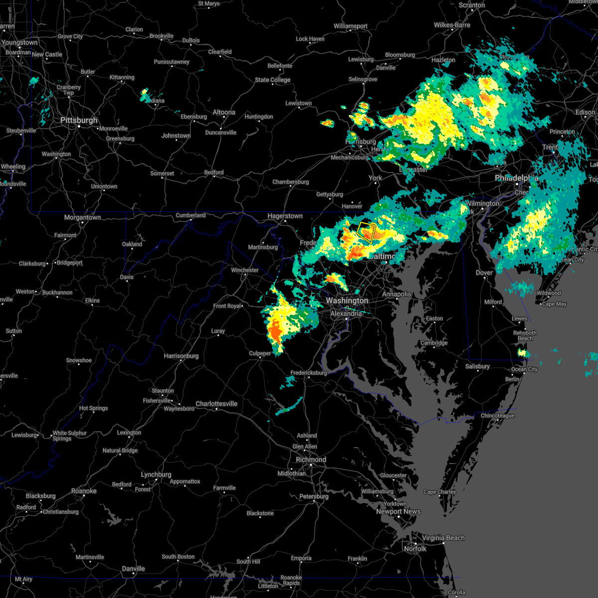 The severe thunderstorm warning for east central carroll and west central baltimore counties will expire at 445 pm edt, the storm which prompted the warning has weakened below severe limits, and no longer poses an immediate threat to life or property. therefore, the warning will be allowed to expire. a tornado watch remains in effect until 900 pm edt for northern and north central maryland. to report severe weather, contact your nearest law enforcement agency. they will relay your report to the national weather service sterling virginia. The severe thunderstorm warning for east central carroll and west central baltimore counties will expire at 445 pm edt, the storm which prompted the warning has weakened below severe limits, and no longer poses an immediate threat to life or property. therefore, the warning will be allowed to expire. a tornado watch remains in effect until 900 pm edt for northern and north central maryland. to report severe weather, contact your nearest law enforcement agency. they will relay your report to the national weather service sterling virginia.
|
| 7/29/2021 4:28 PM EDT |
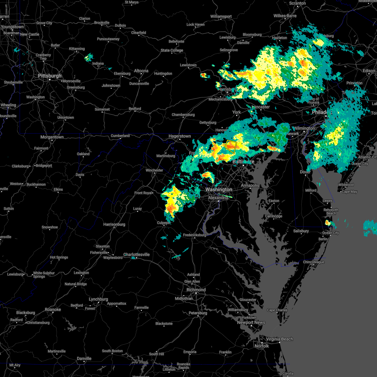 At 428 pm edt, a severe thunderstorm was located over hampstead, or 8 miles east of westminster, moving east at 25 mph (radar indicated). Hazards include 60 mph wind gusts and quarter size hail. Damaging winds will cause some trees and large branches to fall. this could injure those outdoors, as well as damage homes and vehicles. roadways may become blocked by downed trees. localized power outages are possible. unsecured light objects may become projectiles. Locations impacted include, hampstead, carrollton, glyndon, upperco, boring and patapsco. At 428 pm edt, a severe thunderstorm was located over hampstead, or 8 miles east of westminster, moving east at 25 mph (radar indicated). Hazards include 60 mph wind gusts and quarter size hail. Damaging winds will cause some trees and large branches to fall. this could injure those outdoors, as well as damage homes and vehicles. roadways may become blocked by downed trees. localized power outages are possible. unsecured light objects may become projectiles. Locations impacted include, hampstead, carrollton, glyndon, upperco, boring and patapsco.
|
| 7/29/2021 4:18 PM EDT |
 At 418 pm edt, a severe thunderstorm was located near hampstead, or near westminster, moving east at 25 mph (radar indicated). Hazards include 60 mph wind gusts and quarter size hail. Damaging winds will cause some trees and large branches to fall. this could injure those outdoors, as well as damage homes and vehicles. roadways may become blocked by downed trees. localized power outages are possible. unsecured light objects may become projectiles. Locations impacted include, westminster, reisterstown, hampstead, manchester, carrollton, upperco, patapsco, reese, millers, greenmount, glyndon and boring. At 418 pm edt, a severe thunderstorm was located near hampstead, or near westminster, moving east at 25 mph (radar indicated). Hazards include 60 mph wind gusts and quarter size hail. Damaging winds will cause some trees and large branches to fall. this could injure those outdoors, as well as damage homes and vehicles. roadways may become blocked by downed trees. localized power outages are possible. unsecured light objects may become projectiles. Locations impacted include, westminster, reisterstown, hampstead, manchester, carrollton, upperco, patapsco, reese, millers, greenmount, glyndon and boring.
|
| 7/29/2021 4:00 PM EDT |
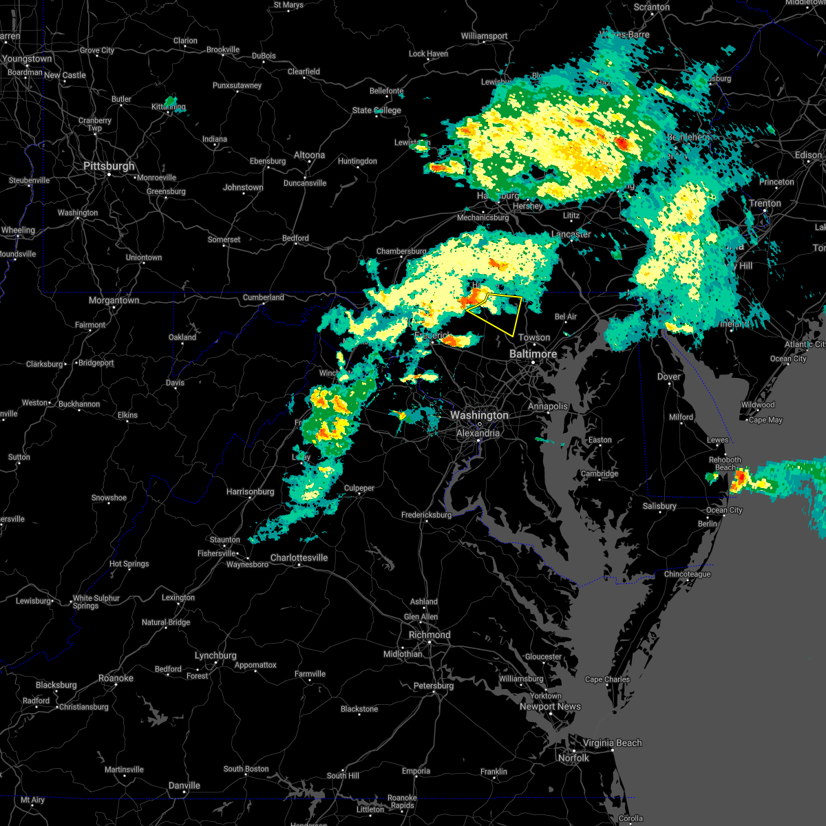 At 400 pm edt, a severe thunderstorm was located near westminster, moving east at 25 mph (radar indicated). Hazards include 60 mph wind gusts and quarter size hail. Damaging winds will cause some trees and large branches to fall. this could injure those outdoors, as well as damage homes and vehicles. roadways may become blocked by downed trees. localized power outages are possible. Unsecured light objects may become projectiles. At 400 pm edt, a severe thunderstorm was located near westminster, moving east at 25 mph (radar indicated). Hazards include 60 mph wind gusts and quarter size hail. Damaging winds will cause some trees and large branches to fall. this could injure those outdoors, as well as damage homes and vehicles. roadways may become blocked by downed trees. localized power outages are possible. Unsecured light objects may become projectiles.
|
| 7/17/2021 7:55 PM EDT |
 At 754 pm edt, severe thunderstorms were located along a line extending from near manchester to hampstead to gamber, moving east at 40 mph (radar indicated). Hazards include 60 mph wind gusts. Damaging winds will cause some trees and large branches to fall. this could injure those outdoors, as well as damage homes and vehicles. roadways may become blocked by downed trees. localized power outages are possible. Unsecured light objects may become projectiles. At 754 pm edt, severe thunderstorms were located along a line extending from near manchester to hampstead to gamber, moving east at 40 mph (radar indicated). Hazards include 60 mph wind gusts. Damaging winds will cause some trees and large branches to fall. this could injure those outdoors, as well as damage homes and vehicles. roadways may become blocked by downed trees. localized power outages are possible. Unsecured light objects may become projectiles.
|
| 7/17/2021 3:50 PM EDT |
 At 349 pm edt, a severe thunderstorm was located over montgomery village, or near germantown, moving northeast at 30 mph (radar indicated). Hazards include 60 mph wind gusts and quarter size hail. Damaging winds will cause some trees and large branches to fall. this could injure those outdoors, as well as damage homes and vehicles. roadways may become blocked by downed trees. localized power outages are possible. Unsecured light objects may become projectiles. At 349 pm edt, a severe thunderstorm was located over montgomery village, or near germantown, moving northeast at 30 mph (radar indicated). Hazards include 60 mph wind gusts and quarter size hail. Damaging winds will cause some trees and large branches to fall. this could injure those outdoors, as well as damage homes and vehicles. roadways may become blocked by downed trees. localized power outages are possible. Unsecured light objects may become projectiles.
|
| 7/17/2021 2:02 PM EDT |
 At 201 pm edt, severe thunderstorms were located along a line extending from near reisterstown to randallstown, moving east at 10 mph (radar indicated). Hazards include 60 mph wind gusts and quarter size hail. Damaging winds will cause some trees and large branches to fall. this could injure those outdoors, as well as damage homes and vehicles. roadways may become blocked by downed trees. localized power outages are possible. unsecured light objects may become projectiles. Locations impacted include, pikesville, towson, randallstown, owings mills, reisterstown, lochearn, mays chapel, garrison, ruxton, riderwood, glyndon, brooklandville, mcdonogh, stevenson and butler. At 201 pm edt, severe thunderstorms were located along a line extending from near reisterstown to randallstown, moving east at 10 mph (radar indicated). Hazards include 60 mph wind gusts and quarter size hail. Damaging winds will cause some trees and large branches to fall. this could injure those outdoors, as well as damage homes and vehicles. roadways may become blocked by downed trees. localized power outages are possible. unsecured light objects may become projectiles. Locations impacted include, pikesville, towson, randallstown, owings mills, reisterstown, lochearn, mays chapel, garrison, ruxton, riderwood, glyndon, brooklandville, mcdonogh, stevenson and butler.
|
| 7/17/2021 1:49 PM EDT |
 At 148 pm edt, a severe thunderstorm was located over reisterstown, or near pikesville, moving east at 15 mph (radar indicated). Hazards include 60 mph wind gusts and quarter size hail. Damaging winds will cause some trees and large branches to fall. this could injure those outdoors, as well as damage homes and vehicles. roadways may become blocked by downed trees. localized power outages are possible. unsecured light objects may become projectiles. Locations impacted include, pikesville, towson, randallstown, owings mills, eldersburg, reisterstown, lochearn, mays chapel, oakland, garrison, ruxton, riderwood, glyndon, brooklandville, mcdonogh, stevenson and butler. At 148 pm edt, a severe thunderstorm was located over reisterstown, or near pikesville, moving east at 15 mph (radar indicated). Hazards include 60 mph wind gusts and quarter size hail. Damaging winds will cause some trees and large branches to fall. this could injure those outdoors, as well as damage homes and vehicles. roadways may become blocked by downed trees. localized power outages are possible. unsecured light objects may become projectiles. Locations impacted include, pikesville, towson, randallstown, owings mills, eldersburg, reisterstown, lochearn, mays chapel, oakland, garrison, ruxton, riderwood, glyndon, brooklandville, mcdonogh, stevenson and butler.
|
| 7/17/2021 1:42 PM EDT | Multiple trees down near the liberty reservoi in baltimore county MD, 3.7 miles ENE of Reisterstown, MD |
| 7/17/2021 1:29 PM EDT |
 At 129 pm edt, a severe thunderstorm was located over oakland, or 10 miles northwest of historic ellicott city, moving northeast at 15 mph (radar indicated). Hazards include 60 mph wind gusts and quarter size hail. Damaging winds will cause some trees and large branches to fall. this could injure those outdoors, as well as damage homes and vehicles. roadways may become blocked by downed trees. localized power outages are possible. Unsecured light objects may become projectiles. At 129 pm edt, a severe thunderstorm was located over oakland, or 10 miles northwest of historic ellicott city, moving northeast at 15 mph (radar indicated). Hazards include 60 mph wind gusts and quarter size hail. Damaging winds will cause some trees and large branches to fall. this could injure those outdoors, as well as damage homes and vehicles. roadways may become blocked by downed trees. localized power outages are possible. Unsecured light objects may become projectiles.
|
| 6/21/2021 6:03 PM EDT |
 At 603 pm edt, severe thunderstorms were located along a line extending from oakland to ellicott city to near fairland, moving east at 40 mph (radar indicated). Hazards include 60 mph wind gusts. Damaging winds will cause some trees and large branches to fall. this could injure those outdoors, as well as damage homes and vehicles. roadways may become blocked by downed trees. localized power outages are possible. unsecured light objects may become projectiles. Locations impacted include, baltimore, columbia, severn, pikesville, cockeysville, elkridge, baltimore-washington airport, historic ellicott city, glen burnie, ellicott city, towson, catonsville, woodlawn, odenton, randallstown, owings mills, eldersburg, milford mill, reisterstown and lochearn. At 603 pm edt, severe thunderstorms were located along a line extending from oakland to ellicott city to near fairland, moving east at 40 mph (radar indicated). Hazards include 60 mph wind gusts. Damaging winds will cause some trees and large branches to fall. this could injure those outdoors, as well as damage homes and vehicles. roadways may become blocked by downed trees. localized power outages are possible. unsecured light objects may become projectiles. Locations impacted include, baltimore, columbia, severn, pikesville, cockeysville, elkridge, baltimore-washington airport, historic ellicott city, glen burnie, ellicott city, towson, catonsville, woodlawn, odenton, randallstown, owings mills, eldersburg, milford mill, reisterstown and lochearn.
|
| 6/21/2021 5:44 PM EDT |
 At 543 pm edt, severe thunderstorms were located along a line extending from near mount airy to rockville, moving east at 35 mph (radar indicated). Hazards include 60 mph wind gusts. Damaging winds will cause some trees and large branches to fall. this could injure those outdoors, as well as damage homes and vehicles. roadways may become blocked by downed trees. localized power outages are possible. Unsecured light objects may become projectiles. At 543 pm edt, severe thunderstorms were located along a line extending from near mount airy to rockville, moving east at 35 mph (radar indicated). Hazards include 60 mph wind gusts. Damaging winds will cause some trees and large branches to fall. this could injure those outdoors, as well as damage homes and vehicles. roadways may become blocked by downed trees. localized power outages are possible. Unsecured light objects may become projectiles.
|
| 6/14/2021 9:19 PM EDT |
 At 902 pm edt, a severe thunderstorm was located over sykesville, or 12 miles northeast of damascus, moving east at 25 mph (radar indicated). Hazards include 60 mph wind gusts and quarter size hail. Damaging winds will cause some trees and large branches to fall. this could injure those outdoors, as well as damage homes and vehicles. roadways may become blocked by downed trees. localized power outages are possible. Unsecured light objects may become projectiles. At 902 pm edt, a severe thunderstorm was located over sykesville, or 12 miles northeast of damascus, moving east at 25 mph (radar indicated). Hazards include 60 mph wind gusts and quarter size hail. Damaging winds will cause some trees and large branches to fall. this could injure those outdoors, as well as damage homes and vehicles. roadways may become blocked by downed trees. localized power outages are possible. Unsecured light objects may become projectiles.
|
| 6/14/2021 9:02 PM EDT |
 At 902 pm edt, a severe thunderstorm was located over sykesville, or 12 miles northeast of damascus, moving east at 25 mph (radar indicated). Hazards include 60 mph wind gusts and quarter size hail. Damaging winds will cause some trees and large branches to fall. this could injure those outdoors, as well as damage homes and vehicles. roadways may become blocked by downed trees. localized power outages are possible. Unsecured light objects may become projectiles. At 902 pm edt, a severe thunderstorm was located over sykesville, or 12 miles northeast of damascus, moving east at 25 mph (radar indicated). Hazards include 60 mph wind gusts and quarter size hail. Damaging winds will cause some trees and large branches to fall. this could injure those outdoors, as well as damage homes and vehicles. roadways may become blocked by downed trees. localized power outages are possible. Unsecured light objects may become projectiles.
|
| 6/3/2021 4:56 PM EDT |
 The severe thunderstorm warning for west central baltimore county and northwestern baltimore city will expire at 500 pm edt, the storm which prompted the warning has moved out of the area. therefore, the warning will be allowed to expire. a severe thunderstorm watch remains in effect until 900 pm edt for northern maryland. remember, a severe thunderstorm warning still remains in effect for central baltimore county and northern baltimore city. The severe thunderstorm warning for west central baltimore county and northwestern baltimore city will expire at 500 pm edt, the storm which prompted the warning has moved out of the area. therefore, the warning will be allowed to expire. a severe thunderstorm watch remains in effect until 900 pm edt for northern maryland. remember, a severe thunderstorm warning still remains in effect for central baltimore county and northern baltimore city.
|
| 6/3/2021 4:45 PM EDT |
 At 445 pm edt, a severe thunderstorm was located over pikesville, moving east at 30 mph (radar indicated). Hazards include 60 mph wind gusts and quarter size hail. Damaging winds will cause some trees and large branches to fall. this could injure those outdoors, as well as damage homes and vehicles. roadways may become blocked by downed trees. localized power outages are possible. unsecured light objects may become projectiles. Locations impacted include, baltimore, pikesville, cockeysville, towson, randallstown, owings mills, milford mill, reisterstown, lochearn, mays chapel, timonium, lutherville-timonium, garrison, lutherville, ruxton, riderwood, brooklandville, mcdonogh and stevenson. At 445 pm edt, a severe thunderstorm was located over pikesville, moving east at 30 mph (radar indicated). Hazards include 60 mph wind gusts and quarter size hail. Damaging winds will cause some trees and large branches to fall. this could injure those outdoors, as well as damage homes and vehicles. roadways may become blocked by downed trees. localized power outages are possible. unsecured light objects may become projectiles. Locations impacted include, baltimore, pikesville, cockeysville, towson, randallstown, owings mills, milford mill, reisterstown, lochearn, mays chapel, timonium, lutherville-timonium, garrison, lutherville, ruxton, riderwood, brooklandville, mcdonogh and stevenson.
|
| 6/3/2021 4:20 PM EDT |
 At 420 pm edt, a severe thunderstorm was located over sykesville, or 11 miles northwest of historic ellicott city, moving east at 30 mph (radar indicated). Hazards include 60 mph wind gusts and quarter size hail. Damaging winds will cause some trees and large branches to fall. this could injure those outdoors, as well as damage homes and vehicles. roadways may become blocked by downed trees. localized power outages are possible. Unsecured light objects may become projectiles. At 420 pm edt, a severe thunderstorm was located over sykesville, or 11 miles northwest of historic ellicott city, moving east at 30 mph (radar indicated). Hazards include 60 mph wind gusts and quarter size hail. Damaging winds will cause some trees and large branches to fall. this could injure those outdoors, as well as damage homes and vehicles. roadways may become blocked by downed trees. localized power outages are possible. Unsecured light objects may become projectiles.
|
| 6/3/2021 4:12 PM EDT |
 At 411 pm edt, a severe thunderstorm was located over reisterstown, or near pikesville, moving northeast at 20 mph (radar indicated). Hazards include 60 mph wind gusts and quarter size hail. Damaging winds will cause some trees and large branches to fall. this could injure those outdoors, as well as damage homes and vehicles. roadways may become blocked by downed trees. localized power outages are possible. Unsecured light objects may become projectiles. At 411 pm edt, a severe thunderstorm was located over reisterstown, or near pikesville, moving northeast at 20 mph (radar indicated). Hazards include 60 mph wind gusts and quarter size hail. Damaging winds will cause some trees and large branches to fall. this could injure those outdoors, as well as damage homes and vehicles. roadways may become blocked by downed trees. localized power outages are possible. Unsecured light objects may become projectiles.
|
| 5/26/2021 8:03 PM EDT | Tree blew down on md 30 south near kemp roa in baltimore county MD, 2.5 miles SSE of Reisterstown, MD |
| 5/26/2021 8:03 PM EDT | 5 trees blew down in the reiserstown/owings mills are in baltimore county MD, 1.4 miles SE of Reisterstown, MD |
| 5/26/2021 7:53 PM EDT |
 At 752 pm edt, severe thunderstorms were located along a line extending from westminster to near sykesville, moving east at 50 mph (radar indicated). Hazards include 60 mph wind gusts. Damaging winds will cause some trees and large branches to fall. this could injure those outdoors, as well as damage homes and vehicles. roadways may become blocked by downed trees. localized power outages are possible. Unsecured light objects may become projectiles. At 752 pm edt, severe thunderstorms were located along a line extending from westminster to near sykesville, moving east at 50 mph (radar indicated). Hazards include 60 mph wind gusts. Damaging winds will cause some trees and large branches to fall. this could injure those outdoors, as well as damage homes and vehicles. roadways may become blocked by downed trees. localized power outages are possible. Unsecured light objects may become projectiles.
|
| 5/3/2021 9:24 PM EDT | Tree down on southbound route 30 just north of mt. gilead roa in baltimore county MD, 3.8 miles SSE of Reisterstown, MD |
| 4/30/2021 4:54 PM EDT |
 The severe thunderstorm warning for carroll county in north central maryland, western howard and montgomery counties in central maryland, eastern frederick county in north central maryland, west central baltimore county in northern maryland and east central loudoun counties in northern virginia will expire at 500 pm edt, the showers which prompted the warning have moved out of the area. therefore, the warning will be allowed to expire. however, high winds remain possible through this evening. a high wind warning remains in effect through late tonight. The severe thunderstorm warning for carroll county in north central maryland, western howard and montgomery counties in central maryland, eastern frederick county in north central maryland, west central baltimore county in northern maryland and east central loudoun counties in northern virginia will expire at 500 pm edt, the showers which prompted the warning have moved out of the area. therefore, the warning will be allowed to expire. however, high winds remain possible through this evening. a high wind warning remains in effect through late tonight.
|
| 4/30/2021 4:47 PM EDT |
 At 446 pm edt, severe thunderstorms were located along a line extending from near thurmont to new market to near poolesville, moving east at 60 mph (radar indicated). Hazards include 60 mph wind gusts. Damaging winds will cause some trees and large branches to fall. this could injure those outdoors, as well as damage homes and vehicles. roadways may become blocked by downed trees. localized power outages are possible. unsecured light objects may become projectiles. Locations impacted include, columbia, germantown, rockville, bethesda, gaithersburg, olney, westminster, damascus, lansdowne, lowes island, thurmont, poolesville, emmitsburg, ellicott city, aspen hill, potomac, north bethesda, ashburn, randallstown and montgomery village. At 446 pm edt, severe thunderstorms were located along a line extending from near thurmont to new market to near poolesville, moving east at 60 mph (radar indicated). Hazards include 60 mph wind gusts. Damaging winds will cause some trees and large branches to fall. this could injure those outdoors, as well as damage homes and vehicles. roadways may become blocked by downed trees. localized power outages are possible. unsecured light objects may become projectiles. Locations impacted include, columbia, germantown, rockville, bethesda, gaithersburg, olney, westminster, damascus, lansdowne, lowes island, thurmont, poolesville, emmitsburg, ellicott city, aspen hill, potomac, north bethesda, ashburn, randallstown and montgomery village.
|
| 4/30/2021 4:31 PM EDT |
 At 430 pm edt, severe thunderstorms were located along a line extending from near smithsburg to braddock heights to near purcellville, moving east at 60 mph (radar indicated). Hazards include 60 mph wind gusts. Damaging winds will cause some trees and large branches to fall. this could injure those outdoors, as well as damage homes and vehicles. roadways may become blocked by downed trees. localized power outages are possible. Unsecured light objects may become projectiles. At 430 pm edt, severe thunderstorms were located along a line extending from near smithsburg to braddock heights to near purcellville, moving east at 60 mph (radar indicated). Hazards include 60 mph wind gusts. Damaging winds will cause some trees and large branches to fall. this could injure those outdoors, as well as damage homes and vehicles. roadways may become blocked by downed trees. localized power outages are possible. Unsecured light objects may become projectiles.
|
| 4/11/2021 7:57 PM EDT |
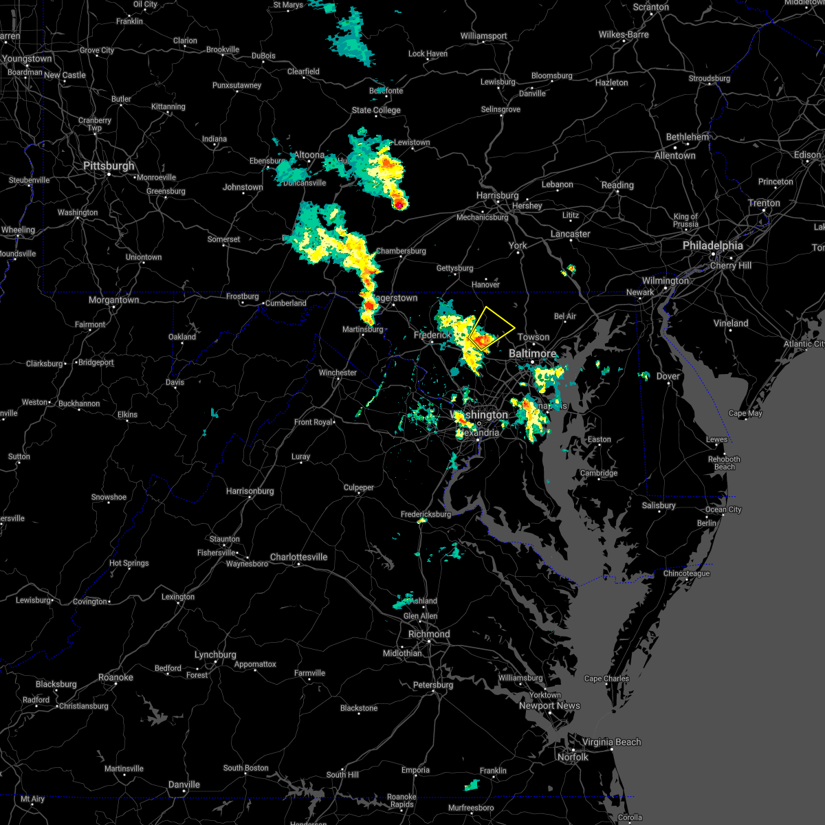 At 757 pm edt, a severe thunderstorm was located near eldersburg, or 9 miles south of westminster, moving northeast at 20 mph (radar indicated). Hazards include 60 mph wind gusts. Damaging winds will cause some trees and large branches to fall. this could injure those outdoors, as well as damage homes and vehicles. roadways may become blocked by downed trees. localized power outages are possible. unsecured light objects may become projectiles. Locations impacted include, westminster, eldersburg, reisterstown, gamber, finksburg, carrollton, patapsco, winfield, reese, louisville, glyndon and boring. At 757 pm edt, a severe thunderstorm was located near eldersburg, or 9 miles south of westminster, moving northeast at 20 mph (radar indicated). Hazards include 60 mph wind gusts. Damaging winds will cause some trees and large branches to fall. this could injure those outdoors, as well as damage homes and vehicles. roadways may become blocked by downed trees. localized power outages are possible. unsecured light objects may become projectiles. Locations impacted include, westminster, eldersburg, reisterstown, gamber, finksburg, carrollton, patapsco, winfield, reese, louisville, glyndon and boring.
|
| 4/11/2021 7:43 PM EDT |
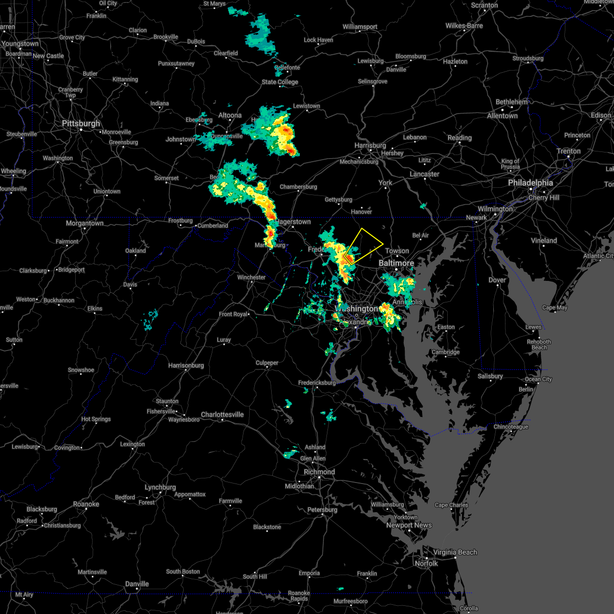 At 743 pm edt, a severe thunderstorm was located near mount airy, or 9 miles northeast of damascus, moving northeast at 20 mph (radar indicated). Hazards include 60 mph wind gusts. Damaging winds will cause some trees and large branches to fall. this could injure those outdoors, as well as damage homes and vehicles. roadways may become blocked by downed trees. localized power outages are possible. Unsecured light objects may become projectiles. At 743 pm edt, a severe thunderstorm was located near mount airy, or 9 miles northeast of damascus, moving northeast at 20 mph (radar indicated). Hazards include 60 mph wind gusts. Damaging winds will cause some trees and large branches to fall. this could injure those outdoors, as well as damage homes and vehicles. roadways may become blocked by downed trees. localized power outages are possible. Unsecured light objects may become projectiles.
|
| 3/28/2021 5:38 PM EDT |
 At 538 pm edt, severe thunderstorms were located along a line extending from near stewartstown to randallstown to olney, moving east at 45 mph (radar indicated). Hazards include 60 mph wind gusts. Damaging winds will cause some trees and large branches to fall. this could injure those outdoors, as well as damage homes and vehicles. roadways may become blocked by downed trees. localized power outages are possible. unsecured light objects may become projectiles. Locations impacted include, columbia, rockville, gaithersburg, olney, pikesville, cockeysville, historic ellicott city, ellicott city, aspen hill, potomac, north bethesda, catonsville, woodlawn, randallstown, montgomery village, owings mills, eldersburg, milford mill, reisterstown and lochearn. At 538 pm edt, severe thunderstorms were located along a line extending from near stewartstown to randallstown to olney, moving east at 45 mph (radar indicated). Hazards include 60 mph wind gusts. Damaging winds will cause some trees and large branches to fall. this could injure those outdoors, as well as damage homes and vehicles. roadways may become blocked by downed trees. localized power outages are possible. unsecured light objects may become projectiles. Locations impacted include, columbia, rockville, gaithersburg, olney, pikesville, cockeysville, historic ellicott city, ellicott city, aspen hill, potomac, north bethesda, catonsville, woodlawn, randallstown, montgomery village, owings mills, eldersburg, milford mill, reisterstown and lochearn.
|
| 3/28/2021 5:23 PM EDT |
 At 522 pm edt, severe thunderstorms with a history of producing wind damage and measured wind gusts to near 60 mph were located along a line extending from near manchester to near sykesville to germantown, moving east at 45 mph (radar indicated and observed wind). Hazards include 60 mph wind gusts. Damaging winds will cause some trees and large branches to fall. this could injure those outdoors, as well as damage homes and vehicles. roadways may become blocked by downed trees. localized power outages are possible. unsecured light objects may become projectiles. Locations impacted include, columbia, germantown, rockville, gaithersburg, olney, pikesville, cockeysville, westminster, damascus, historic ellicott city, ellicott city, aspen hill, potomac, north bethesda, catonsville, woodlawn, randallstown, montgomery village, owings mills and eldersburg. At 522 pm edt, severe thunderstorms with a history of producing wind damage and measured wind gusts to near 60 mph were located along a line extending from near manchester to near sykesville to germantown, moving east at 45 mph (radar indicated and observed wind). Hazards include 60 mph wind gusts. Damaging winds will cause some trees and large branches to fall. this could injure those outdoors, as well as damage homes and vehicles. roadways may become blocked by downed trees. localized power outages are possible. unsecured light objects may become projectiles. Locations impacted include, columbia, germantown, rockville, gaithersburg, olney, pikesville, cockeysville, westminster, damascus, historic ellicott city, ellicott city, aspen hill, potomac, north bethesda, catonsville, woodlawn, randallstown, montgomery village, owings mills and eldersburg.
|
| 3/28/2021 5:05 PM EDT |
 At 504 pm edt, severe thunderstorms with a history of producing wind damage and measured wind gusts to near 60 mph were located along a line extending from near littlestown to near boyds, moving east at 45 mph (radar indicated). Hazards include 60 mph wind gusts. Damaging winds will cause some trees and large branches to fall. this could injure those outdoors, as well as damage homes and vehicles. roadways may become blocked by downed trees. localized power outages are possible. Unsecured light objects may become projectiles. At 504 pm edt, severe thunderstorms with a history of producing wind damage and measured wind gusts to near 60 mph were located along a line extending from near littlestown to near boyds, moving east at 45 mph (radar indicated). Hazards include 60 mph wind gusts. Damaging winds will cause some trees and large branches to fall. this could injure those outdoors, as well as damage homes and vehicles. roadways may become blocked by downed trees. localized power outages are possible. Unsecured light objects may become projectiles.
|
| 11/15/2020 7:00 PM EST |
 At 700 pm est, severe thunderstorms were located along a line extending from near delta to cockeysville to near ellicott city, moving east at 40 mph (radar indicated). Hazards include 60 mph wind gusts. Damaging winds will cause some trees and large branches to fall. this could injure those outdoors, as well as damage homes and vehicles. roadways may become blocked by downed trees. localized power outages are possible. unsecured light objects may become projectiles. Locations impacted include, baltimore, columbia, severn, pikesville, middle river, cockeysville, elkridge, aberdeen, havre de grace, riviera beach, aberdeen proving ground, baltimore-washington airport, fort smallwood state park, millers island, north point state park, sparrows point, back river, historic ellicott city, glen burnie and ellicott city. At 700 pm est, severe thunderstorms were located along a line extending from near delta to cockeysville to near ellicott city, moving east at 40 mph (radar indicated). Hazards include 60 mph wind gusts. Damaging winds will cause some trees and large branches to fall. this could injure those outdoors, as well as damage homes and vehicles. roadways may become blocked by downed trees. localized power outages are possible. unsecured light objects may become projectiles. Locations impacted include, baltimore, columbia, severn, pikesville, middle river, cockeysville, elkridge, aberdeen, havre de grace, riviera beach, aberdeen proving ground, baltimore-washington airport, fort smallwood state park, millers island, north point state park, sparrows point, back river, historic ellicott city, glen burnie and ellicott city.
|
| 11/15/2020 6:28 PM EST |
 At 628 pm est, severe thunderstorms were located along a line extending from glen rock to near westminster to green valley, moving east at 30 mph (radar indicated). Hazards include 60 mph wind gusts. Damaging winds will cause some trees and large branches to fall. this could injure those outdoors, as well as damage homes and vehicles. roadways may become blocked by downed trees. localized power outages are possible. Unsecured light objects may become projectiles. At 628 pm est, severe thunderstorms were located along a line extending from glen rock to near westminster to green valley, moving east at 30 mph (radar indicated). Hazards include 60 mph wind gusts. Damaging winds will cause some trees and large branches to fall. this could injure those outdoors, as well as damage homes and vehicles. roadways may become blocked by downed trees. localized power outages are possible. Unsecured light objects may become projectiles.
|
| 9/3/2020 4:52 PM EDT |
 At 452 pm edt, a severe thunderstorm was located over lochearn, or over pikesville, moving east at 25 mph (radar indicated). Hazards include 60 mph wind gusts. Damaging winds will cause some trees and large branches to fall. this could injure those outdoors, as well as damage homes and vehicles. roadways may become blocked by downed trees. localized power outages are possible. unsecured light objects may become projectiles. Locations impacted include, baltimore, pikesville, cockeysville, ellicott city, dundalk, towson, catonsville, woodlawn, randallstown, parkville, owings mills, carney, milford mill, reisterstown, lochearn, arbutus, rosedale, mays chapel, timonium and hampton. At 452 pm edt, a severe thunderstorm was located over lochearn, or over pikesville, moving east at 25 mph (radar indicated). Hazards include 60 mph wind gusts. Damaging winds will cause some trees and large branches to fall. this could injure those outdoors, as well as damage homes and vehicles. roadways may become blocked by downed trees. localized power outages are possible. unsecured light objects may become projectiles. Locations impacted include, baltimore, pikesville, cockeysville, ellicott city, dundalk, towson, catonsville, woodlawn, randallstown, parkville, owings mills, carney, milford mill, reisterstown, lochearn, arbutus, rosedale, mays chapel, timonium and hampton.
|
| 9/3/2020 4:31 PM EDT |
 At 431 pm edt, a severe thunderstorm was located near oakland, or 8 miles northwest of historic ellicott city, moving east at 25 mph (radar indicated). Hazards include 60 mph wind gusts. Damaging winds will cause some trees and large branches to fall. this could injure those outdoors, as well as damage homes and vehicles. roadways may become blocked by downed trees. localized power outages are possible. Unsecured light objects may become projectiles. At 431 pm edt, a severe thunderstorm was located near oakland, or 8 miles northwest of historic ellicott city, moving east at 25 mph (radar indicated). Hazards include 60 mph wind gusts. Damaging winds will cause some trees and large branches to fall. this could injure those outdoors, as well as damage homes and vehicles. roadways may become blocked by downed trees. localized power outages are possible. Unsecured light objects may become projectiles.
|
| 9/2/2020 8:11 PM EDT |
 The severe thunderstorm warning for southeastern carroll, northern howard, northwestern harford and western baltimore counties will expire at 815 pm edt, the storms which prompted the warning have weakened below severe limits, and have exited the warned area. therefore, the warning will be allowed to expire. a severe thunderstorm watch remains in effect until midnight edt for northern, central and north central maryland. to report severe weather, contact your nearest law enforcement agency. they will relay your report to the national weather service sterling virginia. The severe thunderstorm warning for southeastern carroll, northern howard, northwestern harford and western baltimore counties will expire at 815 pm edt, the storms which prompted the warning have weakened below severe limits, and have exited the warned area. therefore, the warning will be allowed to expire. a severe thunderstorm watch remains in effect until midnight edt for northern, central and north central maryland. to report severe weather, contact your nearest law enforcement agency. they will relay your report to the national weather service sterling virginia.
|
| 9/2/2020 7:53 PM EDT |
 At 753 pm edt, severe thunderstorms were located along a line extending from near stewartstown to near cockeysville to near eldersburg, moving east at 30 mph (radar indicated). Hazards include 60 mph wind gusts. Damaging winds will cause some trees and large branches to fall. this could injure those outdoors, as well as damage homes and vehicles. roadways may become blocked by downed trees. localized power outages are possible. unsecured light objects may become projectiles. Locations impacted include, pikesville, cockeysville, historic ellicott city, ellicott city, towson, woodlawn, randallstown, owings mills, eldersburg, milford mill, reisterstown, lochearn, mays chapel, timonium, fallston, sykesville, jarrettsville, oakland, gamber and lutherville-timonium. At 753 pm edt, severe thunderstorms were located along a line extending from near stewartstown to near cockeysville to near eldersburg, moving east at 30 mph (radar indicated). Hazards include 60 mph wind gusts. Damaging winds will cause some trees and large branches to fall. this could injure those outdoors, as well as damage homes and vehicles. roadways may become blocked by downed trees. localized power outages are possible. unsecured light objects may become projectiles. Locations impacted include, pikesville, cockeysville, historic ellicott city, ellicott city, towson, woodlawn, randallstown, owings mills, eldersburg, milford mill, reisterstown, lochearn, mays chapel, timonium, fallston, sykesville, jarrettsville, oakland, gamber and lutherville-timonium.
|
| 9/2/2020 7:36 PM EDT |
 At 735 pm edt, severe thunderstorms were located along a line extending from near railroad to near gamber to near mount airy, moving east at 30 mph (radar indicated). Hazards include 60 mph wind gusts. Damaging winds will cause some trees and large branches to fall. this could injure those outdoors, as well as damage homes and vehicles. roadways may become blocked by downed trees. localized power outages are possible. Unsecured light objects may become projectiles. At 735 pm edt, severe thunderstorms were located along a line extending from near railroad to near gamber to near mount airy, moving east at 30 mph (radar indicated). Hazards include 60 mph wind gusts. Damaging winds will cause some trees and large branches to fall. this could injure those outdoors, as well as damage homes and vehicles. roadways may become blocked by downed trees. localized power outages are possible. Unsecured light objects may become projectiles.
|
| 8/28/2020 3:59 PM EDT |
 At 345 pm edt, a severe thunderstorm was located over eldersburg, or 10 miles south of westminster, moving east at 25 mph (radar indicated). Hazards include 60 mph wind gusts and quarter size hail. Damaging winds will cause some trees and large branches to fall. this could injure those outdoors, as well as damage homes and vehicles. roadways may become blocked by downed trees. localized power outages are possible. Unsecured light objects may become projectiles. At 345 pm edt, a severe thunderstorm was located over eldersburg, or 10 miles south of westminster, moving east at 25 mph (radar indicated). Hazards include 60 mph wind gusts and quarter size hail. Damaging winds will cause some trees and large branches to fall. this could injure those outdoors, as well as damage homes and vehicles. roadways may become blocked by downed trees. localized power outages are possible. Unsecured light objects may become projectiles.
|
| 8/28/2020 3:45 PM EDT |
 At 345 pm edt, a severe thunderstorm was located over eldersburg, or 10 miles south of westminster, moving east at 25 mph (radar indicated). Hazards include 60 mph wind gusts and quarter size hail. Damaging winds will cause some trees and large branches to fall. this could injure those outdoors, as well as damage homes and vehicles. roadways may become blocked by downed trees. localized power outages are possible. Unsecured light objects may become projectiles. At 345 pm edt, a severe thunderstorm was located over eldersburg, or 10 miles south of westminster, moving east at 25 mph (radar indicated). Hazards include 60 mph wind gusts and quarter size hail. Damaging winds will cause some trees and large branches to fall. this could injure those outdoors, as well as damage homes and vehicles. roadways may become blocked by downed trees. localized power outages are possible. Unsecured light objects may become projectiles.
|
| 8/28/2020 3:38 PM EDT |
 The severe thunderstorm warning for southeastern carroll, southeastern frederick counties in north central maryland and west central baltimore counties in northern maryland will expire at 345 pm edt, the storm which prompted the warning has weakened below severe limits, and no longer poses an immediate threat to life or property. therefore, the warning will be allowed to expire. however gusty winds are still possible with this thunderstorm. a severe thunderstorm watch remains in effect until 800 pm edt for northern, central and north central maryland. to report severe weather, contact your nearest law enforcement agency. they will relay your report to the national weather service sterling virginia. The severe thunderstorm warning for southeastern carroll, southeastern frederick counties in north central maryland and west central baltimore counties in northern maryland will expire at 345 pm edt, the storm which prompted the warning has weakened below severe limits, and no longer poses an immediate threat to life or property. therefore, the warning will be allowed to expire. however gusty winds are still possible with this thunderstorm. a severe thunderstorm watch remains in effect until 800 pm edt for northern, central and north central maryland. to report severe weather, contact your nearest law enforcement agency. they will relay your report to the national weather service sterling virginia.
|
| 8/28/2020 3:24 PM EDT |
 At 323 pm edt, a severe thunderstorm was located over sykesville, or 11 miles northeast of damascus, moving east at 35 mph (radar indicated). Hazards include 60 mph wind gusts and quarter size hail. Damaging winds will cause some trees and large branches to fall. this could injure those outdoors, as well as damage homes and vehicles. roadways may become blocked by downed trees. localized power outages are possible. unsecured light objects may become projectiles. Locations impacted include, randallstown, owings mills, eldersburg, milford mill, reisterstown, mount airy, sykesville, oakland, gamber, garrison, henryton, winfield, louisville, gaither, granite, mcdonogh, carrolltowne and marriottsville. At 323 pm edt, a severe thunderstorm was located over sykesville, or 11 miles northeast of damascus, moving east at 35 mph (radar indicated). Hazards include 60 mph wind gusts and quarter size hail. Damaging winds will cause some trees and large branches to fall. this could injure those outdoors, as well as damage homes and vehicles. roadways may become blocked by downed trees. localized power outages are possible. unsecured light objects may become projectiles. Locations impacted include, randallstown, owings mills, eldersburg, milford mill, reisterstown, mount airy, sykesville, oakland, gamber, garrison, henryton, winfield, louisville, gaither, granite, mcdonogh, carrolltowne and marriottsville.
|
| 8/28/2020 3:07 PM EDT |
 At 307 pm edt, a severe thunderstorm was located over mount airy, or 7 miles north of damascus, moving east at 35 mph (radar indicated). Hazards include 60 mph wind gusts and quarter size hail. Damaging winds will cause some trees and large branches to fall. this could injure those outdoors, as well as damage homes and vehicles. roadways may become blocked by downed trees. localized power outages are possible. Unsecured light objects may become projectiles. At 307 pm edt, a severe thunderstorm was located over mount airy, or 7 miles north of damascus, moving east at 35 mph (radar indicated). Hazards include 60 mph wind gusts and quarter size hail. Damaging winds will cause some trees and large branches to fall. this could injure those outdoors, as well as damage homes and vehicles. roadways may become blocked by downed trees. localized power outages are possible. Unsecured light objects may become projectiles.
|
| 7/22/2020 4:21 PM EDT |
 At 420 pm edt, developing severe thunderstorms were located along a line extending from near bel air north to towson to near elkridge, moving east at 15 mph (radar indicated). Hazards include 60 mph wind gusts. Damaging winds will cause some trees and large branches to fall. this could injure those outdoors, as well as damage homes and vehicles. roadways may become blocked by downed trees. localized power outages are possible. Unsecured light objects may become projectiles. At 420 pm edt, developing severe thunderstorms were located along a line extending from near bel air north to towson to near elkridge, moving east at 15 mph (radar indicated). Hazards include 60 mph wind gusts. Damaging winds will cause some trees and large branches to fall. this could injure those outdoors, as well as damage homes and vehicles. roadways may become blocked by downed trees. localized power outages are possible. Unsecured light objects may become projectiles.
|
| 7/6/2020 9:04 PM EDT |
 At 904 pm edt, severe thunderstorms were located along a line extending from codorus to near littlestown, moving southeast at 20 mph (radar indicated). Hazards include 60 mph wind gusts. Damaging winds will cause some trees and large branches to fall. this could injure those outdoors, as well as damage homes and vehicles. roadways may become blocked by downed trees. localized power outages are possible. Unsecured light objects may become projectiles. At 904 pm edt, severe thunderstorms were located along a line extending from codorus to near littlestown, moving southeast at 20 mph (radar indicated). Hazards include 60 mph wind gusts. Damaging winds will cause some trees and large branches to fall. this could injure those outdoors, as well as damage homes and vehicles. roadways may become blocked by downed trees. localized power outages are possible. Unsecured light objects may become projectiles.
|
| 6/28/2020 4:21 PM EDT |
 At 421 pm edt, a severe thunderstorm was located near gamber, or 7 miles south of westminster, moving southeast at 20 mph (radar indicated). Hazards include 60 mph wind gusts. Damaging winds will cause some trees and large branches to fall. this could injure those outdoors, as well as damage homes and vehicles. roadways may become blocked by downed trees. localized power outages are possible. Unsecured light objects may become projectiles. At 421 pm edt, a severe thunderstorm was located near gamber, or 7 miles south of westminster, moving southeast at 20 mph (radar indicated). Hazards include 60 mph wind gusts. Damaging winds will cause some trees and large branches to fall. this could injure those outdoors, as well as damage homes and vehicles. roadways may become blocked by downed trees. localized power outages are possible. Unsecured light objects may become projectiles.
|
| 6/22/2020 5:35 PM EDT |
 At 535 pm edt, a severe thunderstorm was located over reisterstown, or 7 miles northwest of pikesville, moving northeast at 35 mph (radar indicated). Hazards include 60 mph wind gusts. Damaging winds will cause some trees and large branches to fall. this could injure those outdoors, as well as damage homes and vehicles. roadways may become blocked by downed trees. localized power outages are possible. unsecured light objects may become projectiles. Locations impacted include, pikesville, cockeysville, ellicott city, randallstown, owings mills, eldersburg, milford mill, reisterstown, lochearn, mays chapel, timonium, fallston, hampstead, jarrettsville, oakland, gamber, lutherville-timonium, garrison, finksburg and carrollton. At 535 pm edt, a severe thunderstorm was located over reisterstown, or 7 miles northwest of pikesville, moving northeast at 35 mph (radar indicated). Hazards include 60 mph wind gusts. Damaging winds will cause some trees and large branches to fall. this could injure those outdoors, as well as damage homes and vehicles. roadways may become blocked by downed trees. localized power outages are possible. unsecured light objects may become projectiles. Locations impacted include, pikesville, cockeysville, ellicott city, randallstown, owings mills, eldersburg, milford mill, reisterstown, lochearn, mays chapel, timonium, fallston, hampstead, jarrettsville, oakland, gamber, lutherville-timonium, garrison, finksburg and carrollton.
|
| 6/22/2020 5:18 PM EDT |
 At 518 pm edt, a severe thunderstorm was located near sykesville, or 7 miles northwest of historic ellicott city, moving northeast at 30 mph (radar indicated). Hazards include 60 mph wind gusts. Damaging winds will cause some trees and large branches to fall. this could injure those outdoors, as well as damage homes and vehicles. roadways may become blocked by downed trees. localized power outages are possible. unsecured light objects may become projectiles. Locations impacted include, pikesville, cockeysville, ellicott city, randallstown, owings mills, eldersburg, milford mill, reisterstown, lochearn, mays chapel, timonium, fallston, hampstead, sykesville, jarrettsville, oakland, gamber, lutherville-timonium, garrison and carrollton. At 518 pm edt, a severe thunderstorm was located near sykesville, or 7 miles northwest of historic ellicott city, moving northeast at 30 mph (radar indicated). Hazards include 60 mph wind gusts. Damaging winds will cause some trees and large branches to fall. this could injure those outdoors, as well as damage homes and vehicles. roadways may become blocked by downed trees. localized power outages are possible. unsecured light objects may become projectiles. Locations impacted include, pikesville, cockeysville, ellicott city, randallstown, owings mills, eldersburg, milford mill, reisterstown, lochearn, mays chapel, timonium, fallston, hampstead, sykesville, jarrettsville, oakland, gamber, lutherville-timonium, garrison and carrollton.
|
| 6/22/2020 4:54 PM EDT |
 At 454 pm edt, severe thunderstorms were located along a line extending from near mount airy to near sykesville to near ellicott city, moving northeast at 35 mph (radar indicated). Hazards include 60 mph wind gusts. Damaging winds will cause some trees and large branches to fall. this could injure those outdoors, as well as damage homes and vehicles. roadways may become blocked by downed trees. localized power outages are possible. Unsecured light objects may become projectiles. At 454 pm edt, severe thunderstorms were located along a line extending from near mount airy to near sykesville to near ellicott city, moving northeast at 35 mph (radar indicated). Hazards include 60 mph wind gusts. Damaging winds will cause some trees and large branches to fall. this could injure those outdoors, as well as damage homes and vehicles. roadways may become blocked by downed trees. localized power outages are possible. Unsecured light objects may become projectiles.
|
| 4/13/2020 2:12 PM EDT |
 At 211 pm edt, severe thunderstorms were located along a line extending from near shrewsbury to gamber, moving east at 50 mph (radar indicated). Hazards include 60 to 70 mph wind gusts. Damaging winds will cause some trees and large branches to fall. this could injure those outdoors, as well as damage homes and vehicles. roadways may become blocked by downed trees. localized power outages are possible. unsecured light objects may become projectiles. Locations impacted include, pikesville, cockeysville, towson, randallstown, parkville, owings mills, bel air north, eldersburg, carney, perry hall, reisterstown, mays chapel, timonium, fallston, hampstead, hampton, sykesville, jarrettsville, oakland and lutherville-timonium. At 211 pm edt, severe thunderstorms were located along a line extending from near shrewsbury to gamber, moving east at 50 mph (radar indicated). Hazards include 60 to 70 mph wind gusts. Damaging winds will cause some trees and large branches to fall. this could injure those outdoors, as well as damage homes and vehicles. roadways may become blocked by downed trees. localized power outages are possible. unsecured light objects may become projectiles. Locations impacted include, pikesville, cockeysville, towson, randallstown, parkville, owings mills, bel air north, eldersburg, carney, perry hall, reisterstown, mays chapel, timonium, fallston, hampstead, hampton, sykesville, jarrettsville, oakland and lutherville-timonium.
|
| 4/13/2020 2:00 PM EDT |
 At 200 pm edt, severe thunderstorms were located along a line extending from near manchester to 6 miles northwest of eldersburg, moving east at 50 mph (radar indicated). Hazards include 60 mph wind gusts. Damaging winds will cause some trees and large branches to fall. this could injure those outdoors, as well as damage homes and vehicles. roadways may become blocked by downed trees. localized power outages are possible. Unsecured light objects may become projectiles. At 200 pm edt, severe thunderstorms were located along a line extending from near manchester to 6 miles northwest of eldersburg, moving east at 50 mph (radar indicated). Hazards include 60 mph wind gusts. Damaging winds will cause some trees and large branches to fall. this could injure those outdoors, as well as damage homes and vehicles. roadways may become blocked by downed trees. localized power outages are possible. Unsecured light objects may become projectiles.
|
| 4/9/2020 1:16 PM EDT |
 At 116 pm edt, a severe thunderstorm was located near westminster, moving east at 40 mph (radar indicated). Hazards include 60 mph wind gusts. Damaging winds will cause some trees and large branches to fall. this could injure those outdoors, as well as damage homes and vehicles. roadways may become blocked by downed trees. localized power outages are possible. Unsecured light objects may become projectiles. At 116 pm edt, a severe thunderstorm was located near westminster, moving east at 40 mph (radar indicated). Hazards include 60 mph wind gusts. Damaging winds will cause some trees and large branches to fall. this could injure those outdoors, as well as damage homes and vehicles. roadways may become blocked by downed trees. localized power outages are possible. Unsecured light objects may become projectiles.
|
| 4/9/2020 12:24 PM EDT |
 At 1224 pm edt, severe thunderstorms were located along a line extending from near railroad to near mount airy, moving east at 65 mph (radar indicated). Hazards include 60 mph wind gusts. Damaging winds will cause some trees and large branches to fall. this could injure those outdoors, as well as damage homes and vehicles. roadways may become blocked by downed trees. localized power outages are possible. Unsecured light objects may become projectiles. At 1224 pm edt, severe thunderstorms were located along a line extending from near railroad to near mount airy, moving east at 65 mph (radar indicated). Hazards include 60 mph wind gusts. Damaging winds will cause some trees and large branches to fall. this could injure those outdoors, as well as damage homes and vehicles. roadways may become blocked by downed trees. localized power outages are possible. Unsecured light objects may become projectiles.
|
| 4/9/2020 12:16 PM EDT |
 At 1216 pm edt, severe thunderstorms were located along a line extending from manchester to new market, moving east at 50 mph (radar indicated). Hazards include 60 mph wind gusts. Damaging winds will cause some trees and large branches to fall. this could injure those outdoors, as well as damage homes and vehicles. roadways may become blocked by downed trees. localized power outages are possible. unsecured light objects may become projectiles. Locations impacted include, frederick, westminster, damascus, harry grove stadium, ellicott city, randallstown, owings mills, eldersburg, reisterstown, ballenger creek, mount airy, taneytown, hampstead, walkersville, manchester, sykesville, braddock heights, oakland, new market and green valley. At 1216 pm edt, severe thunderstorms were located along a line extending from manchester to new market, moving east at 50 mph (radar indicated). Hazards include 60 mph wind gusts. Damaging winds will cause some trees and large branches to fall. this could injure those outdoors, as well as damage homes and vehicles. roadways may become blocked by downed trees. localized power outages are possible. unsecured light objects may become projectiles. Locations impacted include, frederick, westminster, damascus, harry grove stadium, ellicott city, randallstown, owings mills, eldersburg, reisterstown, ballenger creek, mount airy, taneytown, hampstead, walkersville, manchester, sykesville, braddock heights, oakland, new market and green valley.
|
| 4/9/2020 11:51 AM EDT |
 At 1151 am edt, severe thunderstorms were located along a line extending from near emmitsburg to near brunswick, moving east at 50 mph (radar indicated). Hazards include 60 mph wind gusts. Damaging winds will cause some trees and large branches to fall. this could injure those outdoors, as well as damage homes and vehicles. roadways may become blocked by downed trees. localized power outages are possible. Unsecured light objects may become projectiles. At 1151 am edt, severe thunderstorms were located along a line extending from near emmitsburg to near brunswick, moving east at 50 mph (radar indicated). Hazards include 60 mph wind gusts. Damaging winds will cause some trees and large branches to fall. this could injure those outdoors, as well as damage homes and vehicles. roadways may become blocked by downed trees. localized power outages are possible. Unsecured light objects may become projectiles.
|
| 4/8/2020 3:53 AM EDT |
 At 353 am edt, severe thunderstorms were located along a line extending from near hampstead to near gamber to mount airy, moving southeast at 45 mph (radar indicated). Hazards include 60 mph wind gusts and quarter size hail. Damaging winds will cause some trees and large branches to fall. this could injure those outdoors, as well as damage homes and vehicles. roadways may become blocked by downed trees. localized power outages are possible. Unsecured light objects may become projectiles. At 353 am edt, severe thunderstorms were located along a line extending from near hampstead to near gamber to mount airy, moving southeast at 45 mph (radar indicated). Hazards include 60 mph wind gusts and quarter size hail. Damaging winds will cause some trees and large branches to fall. this could injure those outdoors, as well as damage homes and vehicles. roadways may become blocked by downed trees. localized power outages are possible. Unsecured light objects may become projectiles.
|
| 3/3/2020 11:49 PM EST |
 At 1148 pm est, severe thunderstorms were located along a line extending from lutherville-timonium to near laurel, moving east at 60 mph (radar indicated). Hazards include 60 mph wind gusts. Damaging winds will cause some trees and large branches to fall. this could injure those outdoors, as well as damage homes and vehicles. roadways may become blocked by downed trees. localized power outages are possible. Unsecured light objects may become projectiles. At 1148 pm est, severe thunderstorms were located along a line extending from lutherville-timonium to near laurel, moving east at 60 mph (radar indicated). Hazards include 60 mph wind gusts. Damaging winds will cause some trees and large branches to fall. this could injure those outdoors, as well as damage homes and vehicles. roadways may become blocked by downed trees. localized power outages are possible. Unsecured light objects may become projectiles.
|
| 2/7/2020 8:25 AM EST |
 The severe thunderstorm warning for southeastern carroll, northeastern howard and southwestern baltimore counties will expire at 830 am est, the storms which prompted the warning has weakened below severe limits, and no longer poses an immediate threat to life or property. therefore, the warning will be allowed to expire. however gusty winds are still possible with these thunderstorms. The severe thunderstorm warning for southeastern carroll, northeastern howard and southwestern baltimore counties will expire at 830 am est, the storms which prompted the warning has weakened below severe limits, and no longer poses an immediate threat to life or property. therefore, the warning will be allowed to expire. however gusty winds are still possible with these thunderstorms.
|
| 2/7/2020 8:16 AM EST |
 At 815 am est, a severe thunderstorm was located over randallstown, or near historic ellicott city, moving east at 50 mph (radar indicated). Hazards include 60 mph wind gusts. Damaging winds will cause some trees and large branches to fall. this could injure those outdoors, as well as damage homes and vehicles. roadways may become blocked by downed trees. localized power outages are possible. unsecured light objects may become projectiles. Locations impacted include, columbia, pikesville, historic ellicott city, ellicott city, catonsville, woodlawn, randallstown, owings mills, eldersburg, milford mill, reisterstown, lochearn, arbutus, oakland, ilchester, garrison, highland, clarksville, henryton and woodstock. At 815 am est, a severe thunderstorm was located over randallstown, or near historic ellicott city, moving east at 50 mph (radar indicated). Hazards include 60 mph wind gusts. Damaging winds will cause some trees and large branches to fall. this could injure those outdoors, as well as damage homes and vehicles. roadways may become blocked by downed trees. localized power outages are possible. unsecured light objects may become projectiles. Locations impacted include, columbia, pikesville, historic ellicott city, ellicott city, catonsville, woodlawn, randallstown, owings mills, eldersburg, milford mill, reisterstown, lochearn, arbutus, oakland, ilchester, garrison, highland, clarksville, henryton and woodstock.
|
| 2/7/2020 7:56 AM EST |
 At 756 am est, a severe thunderstorm was located near damascus, moving east at 50 mph (radar indicated). Hazards include 60 mph wind gusts. Damaging winds will cause some trees and large branches to fall. this could injure those outdoors, as well as damage homes and vehicles. roadways may become blocked by downed trees. localized power outages are possible. Unsecured light objects may become projectiles. At 756 am est, a severe thunderstorm was located near damascus, moving east at 50 mph (radar indicated). Hazards include 60 mph wind gusts. Damaging winds will cause some trees and large branches to fall. this could injure those outdoors, as well as damage homes and vehicles. roadways may become blocked by downed trees. localized power outages are possible. Unsecured light objects may become projectiles.
|
| 8/22/2019 8:02 PM EDT |
 A severe thunderstorm warning remains in effect until 815 pm edt for west central baltimore county. at 802 pm edt, severe thunderstorms were located along a line extending from cockeysville to near oakland, moving east at 25 mph. hazard. 60 mph wind gusts. source. Radar indicated. A severe thunderstorm warning remains in effect until 815 pm edt for west central baltimore county. at 802 pm edt, severe thunderstorms were located along a line extending from cockeysville to near oakland, moving east at 25 mph. hazard. 60 mph wind gusts. source. Radar indicated.
|
| 8/22/2019 7:35 PM EDT |
 A severe thunderstorm warning remains in effect until 815 pm edt for southeastern carroll and west central baltimore counties. at 735 pm edt, severe thunderstorms were located along a line extending from near reisterstown to near eldersburg, moving east at 25 mph. hazard. 60 mph wind gusts. A severe thunderstorm warning remains in effect until 815 pm edt for southeastern carroll and west central baltimore counties. at 735 pm edt, severe thunderstorms were located along a line extending from near reisterstown to near eldersburg, moving east at 25 mph. hazard. 60 mph wind gusts.
|
| 8/22/2019 7:27 PM EDT |
 At 727 pm edt, severe thunderstorms were located along a line extending from near hampstead to near eldersburg, moving southeast at 25 mph (radar indicated). Hazards include 60 mph wind gusts. Damaging winds will cause some trees and large branches to fall. this could injure those outdoors, as well as damage homes and vehicles. roadways may become blocked by downed trees. localized power outages are possible. Unsecured light objects may become projectiles. At 727 pm edt, severe thunderstorms were located along a line extending from near hampstead to near eldersburg, moving southeast at 25 mph (radar indicated). Hazards include 60 mph wind gusts. Damaging winds will cause some trees and large branches to fall. this could injure those outdoors, as well as damage homes and vehicles. roadways may become blocked by downed trees. localized power outages are possible. Unsecured light objects may become projectiles.
|
| 8/7/2019 2:53 PM EDT |
 The severe thunderstorm warning for east central carroll and northwestern baltimore counties will expire at 300 pm edt, the storm which prompted the warning has moved out of the area. therefore, the warning will be allowed to expire. however small hail, gusty winds and heavy rain are still possible with this thunderstorm. a severe thunderstorm watch remains in effect until 800 pm edt for northern and north central maryland. The severe thunderstorm warning for east central carroll and northwestern baltimore counties will expire at 300 pm edt, the storm which prompted the warning has moved out of the area. therefore, the warning will be allowed to expire. however small hail, gusty winds and heavy rain are still possible with this thunderstorm. a severe thunderstorm watch remains in effect until 800 pm edt for northern and north central maryland.
|
| 8/7/2019 2:46 PM EDT |
 At 246 pm edt, a severe thunderstorm was located near reisterstown, or 9 miles west of cockeysville, moving northeast at 25 mph (radar indicated). Hazards include 60 mph wind gusts and quarter size hail. Damaging winds will cause some trees and large branches to fall. this could injure those outdoors, as well as damage homes and vehicles. roadways may become blocked by downed trees. localized power outages are possible. unsecured light objects may become projectiles. Locations impacted include, cockeysville, owings mills, reisterstown, mays chapel, timonium, hampstead, lutherville-timonium, garrison, finksburg, upperco, glyndon, boring, patapsco and butler. At 246 pm edt, a severe thunderstorm was located near reisterstown, or 9 miles west of cockeysville, moving northeast at 25 mph (radar indicated). Hazards include 60 mph wind gusts and quarter size hail. Damaging winds will cause some trees and large branches to fall. this could injure those outdoors, as well as damage homes and vehicles. roadways may become blocked by downed trees. localized power outages are possible. unsecured light objects may become projectiles. Locations impacted include, cockeysville, owings mills, reisterstown, mays chapel, timonium, hampstead, lutherville-timonium, garrison, finksburg, upperco, glyndon, boring, patapsco and butler.
|
| 8/7/2019 2:18 PM EDT |
 At 218 pm edt, a severe thunderstorm was located over eldersburg, or 10 miles south of westminster, moving northeast at 25 mph (radar indicated). Hazards include 60 mph wind gusts and quarter size hail. Damaging winds will cause some trees and large branches to fall. this could injure those outdoors, as well as damage homes and vehicles. roadways may become blocked by downed trees. localized power outages are possible. Unsecured light objects may become projectiles. At 218 pm edt, a severe thunderstorm was located over eldersburg, or 10 miles south of westminster, moving northeast at 25 mph (radar indicated). Hazards include 60 mph wind gusts and quarter size hail. Damaging winds will cause some trees and large branches to fall. this could injure those outdoors, as well as damage homes and vehicles. roadways may become blocked by downed trees. localized power outages are possible. Unsecured light objects may become projectiles.
|
| 7/22/2019 3:47 PM EDT |
 At 347 pm edt, severe thunderstorms with a history of producing wind damage and measured wind gusts to nearly 60 mph were located along a line extending from near westminster to near oakland, moving northeast at 50 mph (radar indicated). Hazards include 60 to 75 mph wind gusts. Damaging winds will cause some trees and large branches to fall. this could injure those outdoors, as well as damage homes and vehicles. roadways may become blocked by downed trees. localized power outages are possible. unsecured light objects may become projectiles. Locations impacted include, pikesville, cockeysville, aberdeen, havre de grace, towson, bel air south, randallstown, parkville, owings mills, bel air north, carney, milford mill, perry hall, reisterstown, lochearn, mays chapel, timonium, white marsh, fallston and riverside. At 347 pm edt, severe thunderstorms with a history of producing wind damage and measured wind gusts to nearly 60 mph were located along a line extending from near westminster to near oakland, moving northeast at 50 mph (radar indicated). Hazards include 60 to 75 mph wind gusts. Damaging winds will cause some trees and large branches to fall. this could injure those outdoors, as well as damage homes and vehicles. roadways may become blocked by downed trees. localized power outages are possible. unsecured light objects may become projectiles. Locations impacted include, pikesville, cockeysville, aberdeen, havre de grace, towson, bel air south, randallstown, parkville, owings mills, bel air north, carney, milford mill, perry hall, reisterstown, lochearn, mays chapel, timonium, white marsh, fallston and riverside.
|
| 7/22/2019 3:45 PM EDT | Tree down blocking all lanes of falls rd at knox ave in baltimore county MD, 5.8 miles WSW of Reisterstown, MD |
| 7/22/2019 3:38 PM EDT | All lanes of md rt. 30 between glen falls rd. and rt. 91 closed due to trees and wires down across the roadwa in baltimore county MD, 4.6 miles SSE of Reisterstown, MD |
| 7/22/2019 3:38 PM EDT | Widespread tree damage of several snapped and uprooted large trees and branches from 1417 emory church rd to 1427 emory church rd. a barn on the other side of the road in carroll county MD, 5.7 miles SSE of Reisterstown, MD |
| 7/22/2019 3:37 PM EDT |
 At 336 pm edt, severe thunderstorms with a history of producing wind damage and measured wind gusts to near 60 mph were located along a line extending from westminster to sykesville, moving northeast at 50 mph. these are dangerous storms! (radar indicated). Hazards include 60 to 80 mph wind gusts. Damaging winds will cause some trees and large branches to fall. this could injure those outdoors, as well as damage homes and vehicles. roadways may become blocked by downed trees. localized power outages are possible. unsecured light objects may become projectiles. Locations impacted include, pikesville, cockeysville, westminster, aberdeen, havre de grace, towson, bel air south, randallstown, parkville, owings mills, bel air north, eldersburg, carney, milford mill, perry hall, reisterstown, lochearn, mays chapel, timonium and white marsh. At 336 pm edt, severe thunderstorms with a history of producing wind damage and measured wind gusts to near 60 mph were located along a line extending from westminster to sykesville, moving northeast at 50 mph. these are dangerous storms! (radar indicated). Hazards include 60 to 80 mph wind gusts. Damaging winds will cause some trees and large branches to fall. this could injure those outdoors, as well as damage homes and vehicles. roadways may become blocked by downed trees. localized power outages are possible. unsecured light objects may become projectiles. Locations impacted include, pikesville, cockeysville, westminster, aberdeen, havre de grace, towson, bel air south, randallstown, parkville, owings mills, bel air north, eldersburg, carney, milford mill, perry hall, reisterstown, lochearn, mays chapel, timonium and white marsh.
|
| 7/22/2019 3:34 PM EDT | *** 1 fatal *** a tree fell onto a man causing a fatality around the 2900 block of bloom roa in carroll county MD, 4.9 miles ESE of Reisterstown, MD |
| 7/22/2019 3:23 PM EDT |
 At 322 pm edt, severe thunderstorms with a history of producing wind damage and measured wind gusts to nearly 60 mph were located along a line extending from 9 miles northeast of new market to near mount airy, moving northeast at 50 mph (radar indicated). Hazards include 60 to 75 mph wind gusts. Damaging winds will cause some trees and large branches to fall. this could injure those outdoors, as well as damage homes and vehicles. roadways may become blocked by downed trees. localized power outages are possible. Unsecured light objects may become projectiles. At 322 pm edt, severe thunderstorms with a history of producing wind damage and measured wind gusts to nearly 60 mph were located along a line extending from 9 miles northeast of new market to near mount airy, moving northeast at 50 mph (radar indicated). Hazards include 60 to 75 mph wind gusts. Damaging winds will cause some trees and large branches to fall. this could injure those outdoors, as well as damage homes and vehicles. roadways may become blocked by downed trees. localized power outages are possible. Unsecured light objects may become projectiles.
|
| 7/21/2019 8:57 PM EDT |
 At 857 pm edt, severe thunderstorms were located along a line extending from near jarrettsville to near pikesville to near randallstown, moving east at 20 mph (radar indicated). Hazards include 60 mph wind gusts. Damaging winds will cause some trees and large branches to fall. this could injure those outdoors, as well as damage homes and vehicles. roadways may become blocked by downed trees. localized power outages are possible. unsecured light objects may become projectiles. Locations impacted include, pikesville, cockeysville, towson, owings mills, reisterstown, mays chapel, timonium, fallston, hampton, jarrettsville, lutherville-timonium, garrison, lutherville, riderwood, brooklandville, phoenix, jacksonville, butler, monkton and glencoe. At 857 pm edt, severe thunderstorms were located along a line extending from near jarrettsville to near pikesville to near randallstown, moving east at 20 mph (radar indicated). Hazards include 60 mph wind gusts. Damaging winds will cause some trees and large branches to fall. this could injure those outdoors, as well as damage homes and vehicles. roadways may become blocked by downed trees. localized power outages are possible. unsecured light objects may become projectiles. Locations impacted include, pikesville, cockeysville, towson, owings mills, reisterstown, mays chapel, timonium, fallston, hampton, jarrettsville, lutherville-timonium, garrison, lutherville, riderwood, brooklandville, phoenix, jacksonville, butler, monkton and glencoe.
|
| 7/21/2019 8:40 PM EDT | Tree down at the intersection of shawan road and falls road in baltimore county MD, 5.8 miles WSW of Reisterstown, MD |
| 7/21/2019 8:26 PM EDT |
 At 825 pm edt, severe thunderstorms were located along a line extending from near railroad to near gamber to near sykesville, moving east at 20 mph (radar indicated). Hazards include 60 mph wind gusts. Damaging winds will cause some trees and large branches to fall. this could injure those outdoors, as well as damage homes and vehicles. roadways may become blocked by downed trees. localized power outages are possible. Unsecured light objects may become projectiles. At 825 pm edt, severe thunderstorms were located along a line extending from near railroad to near gamber to near sykesville, moving east at 20 mph (radar indicated). Hazards include 60 mph wind gusts. Damaging winds will cause some trees and large branches to fall. this could injure those outdoors, as well as damage homes and vehicles. roadways may become blocked by downed trees. localized power outages are possible. Unsecured light objects may become projectiles.
|
| 7/17/2019 5:46 PM EDT |
 At 546 pm edt, severe thunderstorms were located along a line extending from near gamber to owings mills to woodlawn, moving northeast at 35 mph (radar indicated). Hazards include 60 mph wind gusts. Damaging winds will cause some trees and large branches to fall. this could injure those outdoors, as well as damage homes and vehicles. roadways may become blocked by downed trees. localized power outages are possible. Unsecured light objects may become projectiles. At 546 pm edt, severe thunderstorms were located along a line extending from near gamber to owings mills to woodlawn, moving northeast at 35 mph (radar indicated). Hazards include 60 mph wind gusts. Damaging winds will cause some trees and large branches to fall. this could injure those outdoors, as well as damage homes and vehicles. roadways may become blocked by downed trees. localized power outages are possible. Unsecured light objects may become projectiles.
|
| 7/17/2019 5:40 PM EDT |
 At 540 pm edt, a severe thunderstorm was located over oakland, or 9 miles west of pikesville, moving northeast at 40 mph (radar indicated). Hazards include 60 mph wind gusts. Damaging winds will cause some trees and large branches to fall. this could injure those outdoors, as well as damage homes and vehicles. roadways may become blocked by downed trees. localized power outages are possible. unsecured light objects may become projectiles. Locations impacted include, pikesville, historic ellicott city, ellicott city, woodlawn, randallstown, owings mills, eldersburg, milford mill, reisterstown, lochearn, sykesville, oakland, gamber, garrison, finksburg, carrollton, upperco, henryton, west friendship and winfield. At 540 pm edt, a severe thunderstorm was located over oakland, or 9 miles west of pikesville, moving northeast at 40 mph (radar indicated). Hazards include 60 mph wind gusts. Damaging winds will cause some trees and large branches to fall. this could injure those outdoors, as well as damage homes and vehicles. roadways may become blocked by downed trees. localized power outages are possible. unsecured light objects may become projectiles. Locations impacted include, pikesville, historic ellicott city, ellicott city, woodlawn, randallstown, owings mills, eldersburg, milford mill, reisterstown, lochearn, sykesville, oakland, gamber, garrison, finksburg, carrollton, upperco, henryton, west friendship and winfield.
|
| 7/17/2019 5:12 PM EDT |
 At 512 pm edt, a severe thunderstorm was located over damascus, moving northeast at 40 mph (radar indicated). Hazards include 60 mph wind gusts. Damaging winds will cause some trees and large branches to fall. this could injure those outdoors, as well as damage homes and vehicles. roadways may become blocked by downed trees. localized power outages are possible. Unsecured light objects may become projectiles. At 512 pm edt, a severe thunderstorm was located over damascus, moving northeast at 40 mph (radar indicated). Hazards include 60 mph wind gusts. Damaging winds will cause some trees and large branches to fall. this could injure those outdoors, as well as damage homes and vehicles. roadways may become blocked by downed trees. localized power outages are possible. Unsecured light objects may become projectiles.
|
| 7/2/2019 7:40 PM EDT |
 The severe thunderstorm warning for southeastern carroll, northeastern howard and southwestern baltimore counties will expire at 745 pm edt, the storms which prompted the warning have weakened below severe limits, and no longer pose an immediate threat to life or property. therefore, the warning will be allowed to expire. however heavy rain is still possible as additional thunderstorms affect the area. The severe thunderstorm warning for southeastern carroll, northeastern howard and southwestern baltimore counties will expire at 745 pm edt, the storms which prompted the warning have weakened below severe limits, and no longer pose an immediate threat to life or property. therefore, the warning will be allowed to expire. however heavy rain is still possible as additional thunderstorms affect the area.
|
| 7/2/2019 7:31 PM EDT |
 At 731 pm edt, severe thunderstorms were located along a line extending from near owings mills to ellicott city to near sykesville, moving southeast at 40 mph (radar indicated). Hazards include 60 mph wind gusts. Damaging winds will cause some trees and large branches to fall. this could injure those outdoors, as well as damage homes and vehicles. roadways may become blocked by downed trees. localized power outages are possible. unsecured light objects may become projectiles. Locations impacted include, columbia, pikesville, ellicott city, catonsville, woodlawn, randallstown, owings mills, eldersburg, milford mill, reisterstown, lochearn, sykesville, garrison, henryton, west friendship, woodstock, gaither, granite, mcdonogh and oella. At 731 pm edt, severe thunderstorms were located along a line extending from near owings mills to ellicott city to near sykesville, moving southeast at 40 mph (radar indicated). Hazards include 60 mph wind gusts. Damaging winds will cause some trees and large branches to fall. this could injure those outdoors, as well as damage homes and vehicles. roadways may become blocked by downed trees. localized power outages are possible. unsecured light objects may become projectiles. Locations impacted include, columbia, pikesville, ellicott city, catonsville, woodlawn, randallstown, owings mills, eldersburg, milford mill, reisterstown, lochearn, sykesville, garrison, henryton, west friendship, woodstock, gaither, granite, mcdonogh and oella.
|
| 7/2/2019 7:18 PM EDT |
 At 718 pm edt, severe thunderstorms were located along a line extending from reisterstown to near sykesville, moving southeast at 30 mph (radar indicated). Hazards include 60 mph wind gusts. Damaging winds will cause some trees and large branches to fall. this could injure those outdoors, as well as damage homes and vehicles. roadways may become blocked by downed trees. localized power outages are possible. unsecured light objects may become projectiles. Locations impacted include, columbia, pikesville, ellicott city, catonsville, woodlawn, randallstown, owings mills, eldersburg, milford mill, reisterstown, lochearn, mount airy, sykesville, oakland, gamber, garrison, finksburg, henryton, west friendship and winfield. At 718 pm edt, severe thunderstorms were located along a line extending from reisterstown to near sykesville, moving southeast at 30 mph (radar indicated). Hazards include 60 mph wind gusts. Damaging winds will cause some trees and large branches to fall. this could injure those outdoors, as well as damage homes and vehicles. roadways may become blocked by downed trees. localized power outages are possible. unsecured light objects may become projectiles. Locations impacted include, columbia, pikesville, ellicott city, catonsville, woodlawn, randallstown, owings mills, eldersburg, milford mill, reisterstown, lochearn, mount airy, sykesville, oakland, gamber, garrison, finksburg, henryton, west friendship and winfield.
|
| 7/2/2019 6:59 PM EDT |
 At 659 pm edt, a severe thunderstorm was located 7 miles north of mount airy, or 9 miles southwest of westminster, moving southeast at 35 mph (radar indicated). Hazards include 60 mph wind gusts. Damaging winds will cause some trees and large branches to fall. this could injure those outdoors, as well as damage homes and vehicles. roadways may become blocked by downed trees. localized power outages are possible. Unsecured light objects may become projectiles. At 659 pm edt, a severe thunderstorm was located 7 miles north of mount airy, or 9 miles southwest of westminster, moving southeast at 35 mph (radar indicated). Hazards include 60 mph wind gusts. Damaging winds will cause some trees and large branches to fall. this could injure those outdoors, as well as damage homes and vehicles. roadways may become blocked by downed trees. localized power outages are possible. Unsecured light objects may become projectiles.
|
| 6/29/2019 11:05 PM EDT |
 At 1105 pm edt, a severe thunderstorm was located near hampstead, or 10 miles east of westminster, moving east at 40 mph (radar indicated). Hazards include 60 mph wind gusts. Damaging winds will cause some trees and large branches to fall. this could injure those outdoors, as well as damage homes and vehicles. roadways may become blocked by downed trees. localized power outages are possible. unsecured light objects may become projectiles. Locations impacted include, pikesville, cockeysville, towson, owings mills, reisterstown, mays chapel, timonium, hampstead, hampton, manchester, lutherville-timonium, lutherville, finksburg, carrollton, upperco, riderwood, brooklandville, phoenix, jacksonville and butler. At 1105 pm edt, a severe thunderstorm was located near hampstead, or 10 miles east of westminster, moving east at 40 mph (radar indicated). Hazards include 60 mph wind gusts. Damaging winds will cause some trees and large branches to fall. this could injure those outdoors, as well as damage homes and vehicles. roadways may become blocked by downed trees. localized power outages are possible. unsecured light objects may become projectiles. Locations impacted include, pikesville, cockeysville, towson, owings mills, reisterstown, mays chapel, timonium, hampstead, hampton, manchester, lutherville-timonium, lutherville, finksburg, carrollton, upperco, riderwood, brooklandville, phoenix, jacksonville and butler.
|
| 6/29/2019 10:47 PM EDT |
 At 1047 pm edt, a severe thunderstorm was located over westminster, moving east at 35 mph (radar indicated). Hazards include 60 mph wind gusts and quarter size hail. Damaging winds will cause some trees and large branches to fall. this could injure those outdoors, as well as damage homes and vehicles. roadways may become blocked by downed trees. localized power outages are possible. Unsecured light objects may become projectiles. At 1047 pm edt, a severe thunderstorm was located over westminster, moving east at 35 mph (radar indicated). Hazards include 60 mph wind gusts and quarter size hail. Damaging winds will cause some trees and large branches to fall. this could injure those outdoors, as well as damage homes and vehicles. roadways may become blocked by downed trees. localized power outages are possible. Unsecured light objects may become projectiles.
|
| 5/30/2019 3:43 PM EDT |
 The severe thunderstorm warning for southeastern carroll, howard, northeastern montgomery and southwestern baltimore counties will expire at 345 pm edt, the storm which prompted the warning has moved out of the area. therefore, the warning will be allowed to expire. a severe thunderstorm watch remains in effect until 900 pm edt for northern, central and north central maryland. remember, a severe thunderstorm warning still remains in effect for portions of howard and baltimore counties. The severe thunderstorm warning for southeastern carroll, howard, northeastern montgomery and southwestern baltimore counties will expire at 345 pm edt, the storm which prompted the warning has moved out of the area. therefore, the warning will be allowed to expire. a severe thunderstorm watch remains in effect until 900 pm edt for northern, central and north central maryland. remember, a severe thunderstorm warning still remains in effect for portions of howard and baltimore counties.
|
| 5/30/2019 3:23 PM EDT |
 At 323 pm edt, a severe thunderstorm capable of producing a tornado was located near sykesville, or 9 miles northwest of columbia, moving east at 45 mph (radar indicated). Hazards include ping pong ball size hail and 60 mph wind gusts and a tornado. Damaging winds will cause some trees and large branches to fall. this could injure those outdoors, as well as damage homes and vehicles. roadways may become blocked by downed trees. localized power outages are possible. unsecured light objects may become projectiles. a tornado warning is also in effect for this storm. Locations impacted include, columbia, pikesville, damascus, ellicott city, catonsville, woodlawn, randallstown, owings mills, eldersburg, milford mill, lochearn, sykesville, oakland, savage-guilford, scaggsville, ilchester, garrison, savage, highland and clarksville. At 323 pm edt, a severe thunderstorm capable of producing a tornado was located near sykesville, or 9 miles northwest of columbia, moving east at 45 mph (radar indicated). Hazards include ping pong ball size hail and 60 mph wind gusts and a tornado. Damaging winds will cause some trees and large branches to fall. this could injure those outdoors, as well as damage homes and vehicles. roadways may become blocked by downed trees. localized power outages are possible. unsecured light objects may become projectiles. a tornado warning is also in effect for this storm. Locations impacted include, columbia, pikesville, damascus, ellicott city, catonsville, woodlawn, randallstown, owings mills, eldersburg, milford mill, lochearn, sykesville, oakland, savage-guilford, scaggsville, ilchester, garrison, savage, highland and clarksville.
|
| 5/30/2019 3:14 PM EDT |
 At 314 pm edt, a severe thunderstorm was located near sykesville, or 9 miles northeast of damascus, moving east at 45 mph (radar indicated). Hazards include ping pong ball size hail and 60 mph wind gusts. Damaging winds will cause some trees and large branches to fall. this could injure those outdoors, as well as damage homes and vehicles. roadways may become blocked by downed trees. localized power outages are possible. unsecured light objects may become projectiles. Locations impacted include, columbia, pikesville, damascus, ellicott city, catonsville, woodlawn, randallstown, owings mills, eldersburg, milford mill, reisterstown, lochearn, mount airy, sykesville, oakland, savage-guilford, green valley, scaggsville, ilchester and clarksburg. At 314 pm edt, a severe thunderstorm was located near sykesville, or 9 miles northeast of damascus, moving east at 45 mph (radar indicated). Hazards include ping pong ball size hail and 60 mph wind gusts. Damaging winds will cause some trees and large branches to fall. this could injure those outdoors, as well as damage homes and vehicles. roadways may become blocked by downed trees. localized power outages are possible. unsecured light objects may become projectiles. Locations impacted include, columbia, pikesville, damascus, ellicott city, catonsville, woodlawn, randallstown, owings mills, eldersburg, milford mill, reisterstown, lochearn, mount airy, sykesville, oakland, savage-guilford, green valley, scaggsville, ilchester and clarksburg.
|
| 5/30/2019 2:53 PM EDT |
 At 253 pm edt, a severe thunderstorm was located over linganore-bartonsville, or near harry grove stadium, moving east at 45 mph (radar indicated). Hazards include ping pong ball size hail and 60 mph wind gusts. Damaging winds will cause some trees and large branches to fall. this could injure those outdoors, as well as damage homes and vehicles. roadways may become blocked by downed trees. localized power outages are possible. Unsecured light objects may become projectiles. At 253 pm edt, a severe thunderstorm was located over linganore-bartonsville, or near harry grove stadium, moving east at 45 mph (radar indicated). Hazards include ping pong ball size hail and 60 mph wind gusts. Damaging winds will cause some trees and large branches to fall. this could injure those outdoors, as well as damage homes and vehicles. roadways may become blocked by downed trees. localized power outages are possible. Unsecured light objects may become projectiles.
|
| 5/29/2019 5:38 PM EDT |
 At 538 pm edt, a severe thunderstorm was located over lochearn, or over pikesville, moving east at 40 mph (radar indicated). Hazards include 60 mph wind gusts and half dollar size hail. Damaging winds will cause some trees and large branches to fall. this could injure those outdoors, as well as damage homes and vehicles. roadways may become blocked by downed trees. localized power outages are possible. Unsecured light objects may become projectiles. At 538 pm edt, a severe thunderstorm was located over lochearn, or over pikesville, moving east at 40 mph (radar indicated). Hazards include 60 mph wind gusts and half dollar size hail. Damaging winds will cause some trees and large branches to fall. this could injure those outdoors, as well as damage homes and vehicles. roadways may become blocked by downed trees. localized power outages are possible. Unsecured light objects may become projectiles.
|
| 5/29/2019 5:38 PM EDT |
 At 537 pm edt, a severe thunderstorm was located over lutherville-timonium, or near cockeysville, moving east at 40 mph (trained weather spotters report of history of damaging wind gusts with this storm in carroll county md). Hazards include 60 mph wind gusts and half dollar size hail. Damaging winds will cause some trees and large branches to fall. this could injure those outdoors, as well as damage homes and vehicles. roadways may become blocked by downed trees. localized power outages are possible. unsecured light objects may become projectiles. Locations impacted include, baltimore, pikesville, cockeysville, towson, randallstown, parkville, owings mills, carney, milford mill, reisterstown, lochearn, rosedale, mays chapel, timonium, hampton, lutherville-timonium, garrison, lutherville, riderwood and brooklandville. At 537 pm edt, a severe thunderstorm was located over lutherville-timonium, or near cockeysville, moving east at 40 mph (trained weather spotters report of history of damaging wind gusts with this storm in carroll county md). Hazards include 60 mph wind gusts and half dollar size hail. Damaging winds will cause some trees and large branches to fall. this could injure those outdoors, as well as damage homes and vehicles. roadways may become blocked by downed trees. localized power outages are possible. unsecured light objects may become projectiles. Locations impacted include, baltimore, pikesville, cockeysville, towson, randallstown, parkville, owings mills, carney, milford mill, reisterstown, lochearn, rosedale, mays chapel, timonium, hampton, lutherville-timonium, garrison, lutherville, riderwood and brooklandville.
|
| 5/29/2019 5:14 PM EDT |
 At 514 pm edt, a severe thunderstorm was located over eldersburg, or 8 miles west of the city of baltimore, moving east at 40 mph (radar indicated). Hazards include 60 mph wind gusts and half dollar size hail. Damaging winds will cause some trees and large branches to fall. this could injure those outdoors, as well as damage homes and vehicles. roadways may become blocked by downed trees. localized power outages are possible. Unsecured light objects may become projectiles. At 514 pm edt, a severe thunderstorm was located over eldersburg, or 8 miles west of the city of baltimore, moving east at 40 mph (radar indicated). Hazards include 60 mph wind gusts and half dollar size hail. Damaging winds will cause some trees and large branches to fall. this could injure those outdoors, as well as damage homes and vehicles. roadways may become blocked by downed trees. localized power outages are possible. Unsecured light objects may become projectiles.
|
| 5/26/2019 8:59 PM EDT |
 At 858 pm edt, a severe thunderstorm was located near sykesville, or 11 miles northeast of damascus, moving east at 40 mph (emergency management reported trees down in frederick county in lewistown at 826 pm). Hazards include 60 mph wind gusts and quarter size hail. Damaging winds will cause some trees and large branches to fall. this could injure those outdoors, as well as damage homes and vehicles. roadways may become blocked by downed trees. localized power outages are possible. Unsecured light objects may become projectiles. At 858 pm edt, a severe thunderstorm was located near sykesville, or 11 miles northeast of damascus, moving east at 40 mph (emergency management reported trees down in frederick county in lewistown at 826 pm). Hazards include 60 mph wind gusts and quarter size hail. Damaging winds will cause some trees and large branches to fall. this could injure those outdoors, as well as damage homes and vehicles. roadways may become blocked by downed trees. localized power outages are possible. Unsecured light objects may become projectiles.
|
| 5/25/2019 11:36 PM EDT |
 The severe thunderstorm warning for southeastern carroll, howard and southwestern baltimore counties will expire at 1145 pm edt, the storm which prompted the warning has weakened below severe limits, and no longer poses an immediate threat to life or property. therefore, the warning will be allowed to expire. however heavy rain is still possible with this thunderstorm. The severe thunderstorm warning for southeastern carroll, howard and southwestern baltimore counties will expire at 1145 pm edt, the storm which prompted the warning has weakened below severe limits, and no longer poses an immediate threat to life or property. therefore, the warning will be allowed to expire. however heavy rain is still possible with this thunderstorm.
|
| 5/25/2019 11:27 PM EDT |
 At 1126 pm edt, a severe thunderstorm was located near sykesville, or 10 miles northeast of damascus, moving east at 40 mph (radar indicated). Hazards include 60 mph wind gusts and quarter size hail. Damaging winds will cause some trees and large branches to fall. this could injure those outdoors, as well as damage homes and vehicles. roadways may become blocked by downed trees. localized power outages are possible. unsecured light objects may become projectiles. Locations impacted include, columbia, pikesville, ellicott city, catonsville, woodlawn, randallstown, owings mills, eldersburg, milford mill, reisterstown, lochearn, mount airy, sykesville, oakland, gamber, savage-guilford, ilchester, garrison, savage and henryton. At 1126 pm edt, a severe thunderstorm was located near sykesville, or 10 miles northeast of damascus, moving east at 40 mph (radar indicated). Hazards include 60 mph wind gusts and quarter size hail. Damaging winds will cause some trees and large branches to fall. this could injure those outdoors, as well as damage homes and vehicles. roadways may become blocked by downed trees. localized power outages are possible. unsecured light objects may become projectiles. Locations impacted include, columbia, pikesville, ellicott city, catonsville, woodlawn, randallstown, owings mills, eldersburg, milford mill, reisterstown, lochearn, mount airy, sykesville, oakland, gamber, savage-guilford, ilchester, garrison, savage and henryton.
|
| 5/25/2019 11:16 PM EDT |
 At 1116 pm edt, a severe thunderstorm was located over mount airy, or 8 miles north of damascus, moving east at 35 mph (radar indicated). Hazards include 60 mph wind gusts and quarter size hail. Damaging winds will cause some trees and large branches to fall. this could injure those outdoors, as well as damage homes and vehicles. roadways may become blocked by downed trees. localized power outages are possible. unsecured light objects may become projectiles. Locations impacted include, columbia, pikesville, damascus, ellicott city, catonsville, woodlawn, randallstown, owings mills, eldersburg, milford mill, reisterstown, lochearn, mount airy, sykesville, oakland, new market, savage-guilford, green valley, gamber and linganore-bartonsville. At 1116 pm edt, a severe thunderstorm was located over mount airy, or 8 miles north of damascus, moving east at 35 mph (radar indicated). Hazards include 60 mph wind gusts and quarter size hail. Damaging winds will cause some trees and large branches to fall. this could injure those outdoors, as well as damage homes and vehicles. roadways may become blocked by downed trees. localized power outages are possible. unsecured light objects may become projectiles. Locations impacted include, columbia, pikesville, damascus, ellicott city, catonsville, woodlawn, randallstown, owings mills, eldersburg, milford mill, reisterstown, lochearn, mount airy, sykesville, oakland, new market, savage-guilford, green valley, gamber and linganore-bartonsville.
|
| 5/25/2019 11:03 PM EDT |
 At 1103 pm edt, a severe thunderstorm was located over linganore-bartonsville, or near frederick, moving east at 40 mph (radar indicated). Hazards include 60 mph wind gusts and quarter size hail. Damaging winds will cause some trees and large branches to fall. this could injure those outdoors, as well as damage homes and vehicles. roadways may become blocked by downed trees. localized power outages are possible. Unsecured light objects may become projectiles. At 1103 pm edt, a severe thunderstorm was located over linganore-bartonsville, or near frederick, moving east at 40 mph (radar indicated). Hazards include 60 mph wind gusts and quarter size hail. Damaging winds will cause some trees and large branches to fall. this could injure those outdoors, as well as damage homes and vehicles. roadways may become blocked by downed trees. localized power outages are possible. Unsecured light objects may become projectiles.
|
| 4/26/2019 3:08 PM EDT |
 At 308 pm edt, severe thunderstorms were located along a line extending from near railroad to pikesville, moving northeast at 40 mph (radar indicated). Hazards include 60 mph wind gusts. Damaging winds will cause some trees and large branches to fall. this could injure those outdoors, as well as damage homes and vehicles. roadways may become blocked by downed trees. localized power outages are possible. Unsecured light objects may become projectiles. At 308 pm edt, severe thunderstorms were located along a line extending from near railroad to pikesville, moving northeast at 40 mph (radar indicated). Hazards include 60 mph wind gusts. Damaging winds will cause some trees and large branches to fall. this could injure those outdoors, as well as damage homes and vehicles. roadways may become blocked by downed trees. localized power outages are possible. Unsecured light objects may become projectiles.
|
| 4/26/2019 2:37 PM EDT |
 At 237 pm edt, a severe thunderstorm was located near sykesville, or 9 miles northwest of columbia, moving northeast at 35 mph (radar indicated). Hazards include 60 mph wind gusts. Damaging winds will cause some trees and large branches to fall. this could injure those outdoors, as well as damage homes and vehicles. roadways may become blocked by downed trees. localized power outages are possible. Unsecured light objects may become projectiles. At 237 pm edt, a severe thunderstorm was located near sykesville, or 9 miles northwest of columbia, moving northeast at 35 mph (radar indicated). Hazards include 60 mph wind gusts. Damaging winds will cause some trees and large branches to fall. this could injure those outdoors, as well as damage homes and vehicles. roadways may become blocked by downed trees. localized power outages are possible. Unsecured light objects may become projectiles.
|
| 4/15/2019 2:30 AM EDT |
 At 229 am edt, severe thunderstorms were located along a line extending from near eldersburg to near fairland, moving northeast at 60 mph (radar indicated). Hazards include 60 mph wind gusts. Damaging winds will cause some trees and large branches to fall. this could injure those outdoors, as well as damage homes and vehicles. roadways may become blocked by downed trees. localized power outages are possible. unsecured light objects may become projectiles. Locations impacted include, baltimore, columbia, pikesville, middle river, cockeysville, elkridge, millers island, north point state park, sparrows point, back river, glen burnie, ellicott city, dundalk, towson, catonsville, essex, woodlawn, randallstown, parkville and owings mills. At 229 am edt, severe thunderstorms were located along a line extending from near eldersburg to near fairland, moving northeast at 60 mph (radar indicated). Hazards include 60 mph wind gusts. Damaging winds will cause some trees and large branches to fall. this could injure those outdoors, as well as damage homes and vehicles. roadways may become blocked by downed trees. localized power outages are possible. unsecured light objects may become projectiles. Locations impacted include, baltimore, columbia, pikesville, middle river, cockeysville, elkridge, millers island, north point state park, sparrows point, back river, glen burnie, ellicott city, dundalk, towson, catonsville, essex, woodlawn, randallstown, parkville and owings mills.
|
| 4/15/2019 2:15 AM EDT |
 At 215 am edt, severe thunderstorms were located along a line extending from near green valley to rockville, moving northeast at 60 mph (radar indicated). Hazards include 60 mph wind gusts. Damaging winds will cause some trees and large branches to fall. this could injure those outdoors, as well as damage homes and vehicles. roadways may become blocked by downed trees. localized power outages are possible. Unsecured light objects may become projectiles. At 215 am edt, severe thunderstorms were located along a line extending from near green valley to rockville, moving northeast at 60 mph (radar indicated). Hazards include 60 mph wind gusts. Damaging winds will cause some trees and large branches to fall. this could injure those outdoors, as well as damage homes and vehicles. roadways may become blocked by downed trees. localized power outages are possible. Unsecured light objects may become projectiles.
|
| 12/21/2018 5:24 PM EST |
 The severe thunderstorm warning for northeastern carroll, northwestern harford and northwestern baltimore counties will expire at 530 pm est, the severe thunderstorm which prompted the warning has moved out of the warned area. therefore, the warning will be allowed to expire. The severe thunderstorm warning for northeastern carroll, northwestern harford and northwestern baltimore counties will expire at 530 pm est, the severe thunderstorm which prompted the warning has moved out of the warned area. therefore, the warning will be allowed to expire.
|
| 12/21/2018 5:12 PM EST |
 At 512 pm est, a severe thunderstorm was located over glen rock, or 9 miles east of parkville, moving northeast at 45 mph (radar indicated). Hazards include 60 mph wind gusts. Damaging winds will cause some trees and large branches to fall. this could injure those outdoors, as well as damage homes and vehicles. roadways may become blocked by downed trees. localized power outages are possible. unsecured light objects may become projectiles. Locations impacted include, westminster, reisterstown, hampstead, manchester, finksburg, carrollton, freeland, upperco, lineboro, glyndon, boring, bentley springs, patapsco, reese, parkton, millers, greenmount and maryland line. At 512 pm est, a severe thunderstorm was located over glen rock, or 9 miles east of parkville, moving northeast at 45 mph (radar indicated). Hazards include 60 mph wind gusts. Damaging winds will cause some trees and large branches to fall. this could injure those outdoors, as well as damage homes and vehicles. roadways may become blocked by downed trees. localized power outages are possible. unsecured light objects may become projectiles. Locations impacted include, westminster, reisterstown, hampstead, manchester, finksburg, carrollton, freeland, upperco, lineboro, glyndon, boring, bentley springs, patapsco, reese, parkton, millers, greenmount and maryland line.
|
| 12/21/2018 4:54 PM EST |
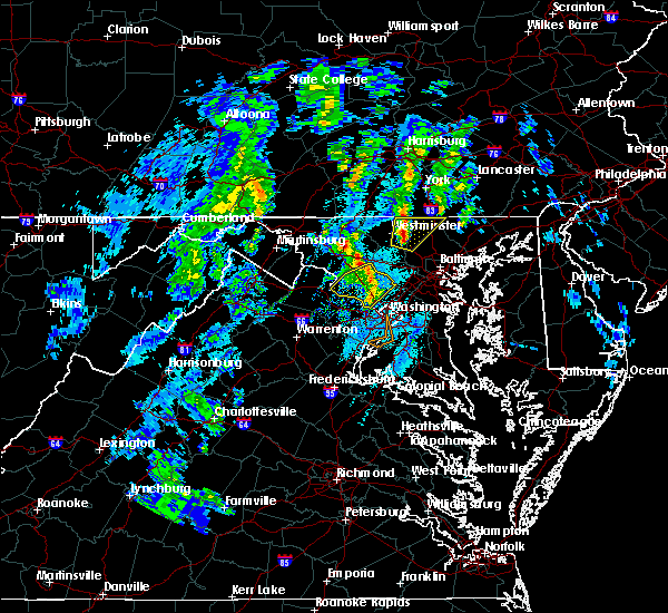 At 453 pm est, a severe thunderstorm was located over hampstead, or near westminster, moving northeast at 45 mph (radar indicated). Hazards include 60 mph wind gusts and quarter size hail. quarter size hail has been reported with this storm in westminster. Damaging winds will cause some trees and large branches to fall. this could injure those outdoors, as well as damage homes and vehicles. roadways may become blocked by downed trees. localized power outages are possible. unsecured light objects may become projectiles. Locations impacted include, westminster, reisterstown, hampstead, manchester, finksburg, carrollton, freeland, upperco, lineboro, glyndon, boring, bentley springs, patapsco, reese, parkton, millers, greenmount and maryland line. At 453 pm est, a severe thunderstorm was located over hampstead, or near westminster, moving northeast at 45 mph (radar indicated). Hazards include 60 mph wind gusts and quarter size hail. quarter size hail has been reported with this storm in westminster. Damaging winds will cause some trees and large branches to fall. this could injure those outdoors, as well as damage homes and vehicles. roadways may become blocked by downed trees. localized power outages are possible. unsecured light objects may become projectiles. Locations impacted include, westminster, reisterstown, hampstead, manchester, finksburg, carrollton, freeland, upperco, lineboro, glyndon, boring, bentley springs, patapsco, reese, parkton, millers, greenmount and maryland line.
|
| 12/21/2018 4:52 PM EST |
 At 452 pm est, a severe thunderstorm was located near hampstead, or near westminster, moving northeast at 45 mph (radar indicated). Hazards include 60 mph wind gusts and quarter size hail. Damaging winds will cause some trees and large branches to fall. this could injure those outdoors, as well as damage homes and vehicles. roadways may become blocked by downed trees. localized power outages are possible. unsecured light objects may become projectiles. Locations impacted include, westminster, reisterstown, hampstead, manchester, finksburg, carrollton, freeland, upperco, lineboro, glyndon, boring, bentley springs, patapsco, reese, parkton, millers, greenmount and maryland line. At 452 pm est, a severe thunderstorm was located near hampstead, or near westminster, moving northeast at 45 mph (radar indicated). Hazards include 60 mph wind gusts and quarter size hail. Damaging winds will cause some trees and large branches to fall. this could injure those outdoors, as well as damage homes and vehicles. roadways may become blocked by downed trees. localized power outages are possible. unsecured light objects may become projectiles. Locations impacted include, westminster, reisterstown, hampstead, manchester, finksburg, carrollton, freeland, upperco, lineboro, glyndon, boring, bentley springs, patapsco, reese, parkton, millers, greenmount and maryland line.
|
| 12/21/2018 4:45 PM EST |
 At 445 pm est, a severe thunderstorm was located near gamber, or near westminster, moving northeast at 45 mph (radar indicated). Hazards include 60 mph wind gusts. Damaging winds will cause some trees and large branches to fall. this could injure those outdoors, as well as damage homes and vehicles. roadways may become blocked by downed trees. localized power outages are possible. Unsecured light objects may become projectiles. At 445 pm est, a severe thunderstorm was located near gamber, or near westminster, moving northeast at 45 mph (radar indicated). Hazards include 60 mph wind gusts. Damaging winds will cause some trees and large branches to fall. this could injure those outdoors, as well as damage homes and vehicles. roadways may become blocked by downed trees. localized power outages are possible. Unsecured light objects may become projectiles.
|
| 8/8/2018 10:39 PM EDT |
 The severe thunderstorm warning for southeastern carroll and west central baltimore counties will expire at 1045 pm edt, the storms which prompted the warning have moved out of the area. therefore the warning will be allowed to expire. however gusty winds and heavy rain are still possible with these thunderstorms. The severe thunderstorm warning for southeastern carroll and west central baltimore counties will expire at 1045 pm edt, the storms which prompted the warning have moved out of the area. therefore the warning will be allowed to expire. however gusty winds and heavy rain are still possible with these thunderstorms.
|
| 8/8/2018 10:12 PM EDT |
 At 1012 pm edt, severe thunderstorms were located along a line extending from near gamber to near sykesville, moving east at 25 mph (radar indicated). Hazards include 60 mph wind gusts. Damaging winds will cause some trees and large branches to fall. this could injure those outdoors, as well as damage homes and vehicles. roadways may become blocked by downed trees. localized power outages are possible. unsecured light objects may become projectiles. Locations impacted include, randallstown, owings mills, eldersburg, milford mill, reisterstown, sykesville, oakland, gamber, garrison, mcdonogh, louisville and carrolltowne. At 1012 pm edt, severe thunderstorms were located along a line extending from near gamber to near sykesville, moving east at 25 mph (radar indicated). Hazards include 60 mph wind gusts. Damaging winds will cause some trees and large branches to fall. this could injure those outdoors, as well as damage homes and vehicles. roadways may become blocked by downed trees. localized power outages are possible. unsecured light objects may become projectiles. Locations impacted include, randallstown, owings mills, eldersburg, milford mill, reisterstown, sykesville, oakland, gamber, garrison, mcdonogh, louisville and carrolltowne.
|
| 8/8/2018 10:11 PM EDT |
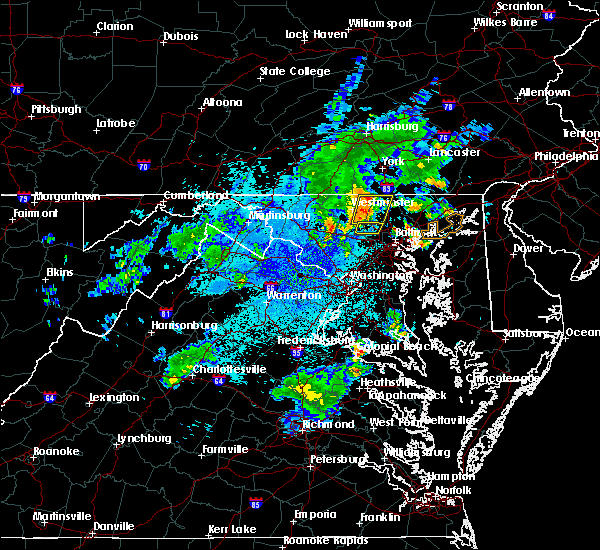 At 1011 pm edt, severe thunderstorms were located along a line extending from near manchester to gamber, moving east at 35 mph (radar indicated). Hazards include 60 mph wind gusts. Damaging winds will cause some trees and large branches to fall. this could injure those outdoors, as well as damage homes and vehicles. roadways may become blocked by downed trees. localized power outages are possible. unsecured light objects may become projectiles. Locations impacted include, westminster, eldersburg, reisterstown, hampstead, manchester, gamber, finksburg, carrollton, freeland, upperco, lineboro, glyndon, boring, bentley springs, patapsco, reese, parkton, millers, greenmount and maryland line. At 1011 pm edt, severe thunderstorms were located along a line extending from near manchester to gamber, moving east at 35 mph (radar indicated). Hazards include 60 mph wind gusts. Damaging winds will cause some trees and large branches to fall. this could injure those outdoors, as well as damage homes and vehicles. roadways may become blocked by downed trees. localized power outages are possible. unsecured light objects may become projectiles. Locations impacted include, westminster, eldersburg, reisterstown, hampstead, manchester, gamber, finksburg, carrollton, freeland, upperco, lineboro, glyndon, boring, bentley springs, patapsco, reese, parkton, millers, greenmount and maryland line.
|
| 8/8/2018 10:00 PM EDT |
 At 959 pm edt, severe thunderstorms were located along a line extending from 6 miles west of gamber to near mount airy, moving east at 25 mph (radar indicated). Hazards include 60 mph wind gusts. Damaging winds will cause some trees and large branches to fall. this could injure those outdoors, as well as damage homes and vehicles. roadways may become blocked by downed trees. localized power outages are possible. Unsecured light objects may become projectiles. At 959 pm edt, severe thunderstorms were located along a line extending from 6 miles west of gamber to near mount airy, moving east at 25 mph (radar indicated). Hazards include 60 mph wind gusts. Damaging winds will cause some trees and large branches to fall. this could injure those outdoors, as well as damage homes and vehicles. roadways may become blocked by downed trees. localized power outages are possible. Unsecured light objects may become projectiles.
|
| 8/8/2018 9:55 PM EDT |
 At 955 pm edt, severe thunderstorms were located along a line extending from near parkville to 6 miles west of gamber, moving east at 35 mph (radar indicated). Hazards include 60 mph wind gusts. Damaging winds will cause some trees and large branches to fall. this could injure those outdoors, as well as damage homes and vehicles. roadways may become blocked by downed trees. localized power outages are possible. unsecured light objects may become projectiles. Locations impacted include, westminster, eldersburg, reisterstown, hampstead, manchester, gamber, new windsor, finksburg, carrollton, freeland, upperco, bentley springs, uniontown, butler, lineboro, glyndon, boring, patapsco, reese and parkton. At 955 pm edt, severe thunderstorms were located along a line extending from near parkville to 6 miles west of gamber, moving east at 35 mph (radar indicated). Hazards include 60 mph wind gusts. Damaging winds will cause some trees and large branches to fall. this could injure those outdoors, as well as damage homes and vehicles. roadways may become blocked by downed trees. localized power outages are possible. unsecured light objects may become projectiles. Locations impacted include, westminster, eldersburg, reisterstown, hampstead, manchester, gamber, new windsor, finksburg, carrollton, freeland, upperco, bentley springs, uniontown, butler, lineboro, glyndon, boring, patapsco, reese and parkton.
|
| 8/8/2018 9:38 PM EDT |
 At 938 pm edt, severe thunderstorms were located along a line extending from near littlestown to 8 miles east of walkersville, moving east at 35 mph (radar indicated). Hazards include 60 mph wind gusts. Damaging winds will cause some trees and large branches to fall. this could injure those outdoors, as well as damage homes and vehicles. roadways may become blocked by downed trees. localized power outages are possible. Unsecured light objects may become projectiles. At 938 pm edt, severe thunderstorms were located along a line extending from near littlestown to 8 miles east of walkersville, moving east at 35 mph (radar indicated). Hazards include 60 mph wind gusts. Damaging winds will cause some trees and large branches to fall. this could injure those outdoors, as well as damage homes and vehicles. roadways may become blocked by downed trees. localized power outages are possible. Unsecured light objects may become projectiles.
|
| 7/27/2018 5:14 PM EDT |
 At 513 pm edt, a severe thunderstorm was located near cockeysville, moving northeast at 20 mph (radar indicated). Hazards include 60 mph wind gusts. Damaging winds will cause some trees and large branches to fall. this could injure those outdoors, as well as damage homes and vehicles. roadways may become blocked by downed trees. localized power outages are possible. unsecured light objects may become projectiles. Locations impacted include, pikesville, cockeysville, towson, randallstown, owings mills, reisterstown, lochearn, mays chapel, timonium, hampton, kingsville, lutherville-timonium, garrison, lutherville, glen arm, fork, long green, riderwood, brooklandville and mcdonogh. At 513 pm edt, a severe thunderstorm was located near cockeysville, moving northeast at 20 mph (radar indicated). Hazards include 60 mph wind gusts. Damaging winds will cause some trees and large branches to fall. this could injure those outdoors, as well as damage homes and vehicles. roadways may become blocked by downed trees. localized power outages are possible. unsecured light objects may become projectiles. Locations impacted include, pikesville, cockeysville, towson, randallstown, owings mills, reisterstown, lochearn, mays chapel, timonium, hampton, kingsville, lutherville-timonium, garrison, lutherville, glen arm, fork, long green, riderwood, brooklandville and mcdonogh.
|
| 7/27/2018 4:52 PM EDT |
 At 452 pm edt, a severe thunderstorm was located over owings mills, or near pikesville, moving northeast at 20 mph (radar indicated). Hazards include 60 mph wind gusts. Damaging winds will cause some trees and large branches to fall. this could injure those outdoors, as well as damage homes and vehicles. roadways may become blocked by downed trees. localized power outages are possible. Unsecured light objects may become projectiles. At 452 pm edt, a severe thunderstorm was located over owings mills, or near pikesville, moving northeast at 20 mph (radar indicated). Hazards include 60 mph wind gusts. Damaging winds will cause some trees and large branches to fall. this could injure those outdoors, as well as damage homes and vehicles. roadways may become blocked by downed trees. localized power outages are possible. Unsecured light objects may become projectiles.
|
| 7/22/2018 2:53 PM EDT |
 At 252 pm edt, severe thunderstorms were located along a line extending from near savage-guilford to ferndale to bodkin point, moving north at 40 mph (radar indicated). Hazards include 60 mph wind gusts. Damaging winds will cause some trees and large branches to fall. this could injure those outdoors, as well as damage homes and vehicles. roadways may become blocked by downed trees. localized power outages are possible. Unsecured light objects may become projectiles. At 252 pm edt, severe thunderstorms were located along a line extending from near savage-guilford to ferndale to bodkin point, moving north at 40 mph (radar indicated). Hazards include 60 mph wind gusts. Damaging winds will cause some trees and large branches to fall. this could injure those outdoors, as well as damage homes and vehicles. roadways may become blocked by downed trees. localized power outages are possible. Unsecured light objects may become projectiles.
|
| 6/24/2018 6:37 PM EDT |
 The severe thunderstorm warning for carroll county in north central maryland, northwestern harford county in northern maryland, frederick county in north central maryland and northwestern baltimore counties in northern maryland will expire at 645 pm edt, the storms which prompted the warning have weakened. therefore, the warning will be allowed to expire. The severe thunderstorm warning for carroll county in north central maryland, northwestern harford county in northern maryland, frederick county in north central maryland and northwestern baltimore counties in northern maryland will expire at 645 pm edt, the storms which prompted the warning have weakened. therefore, the warning will be allowed to expire.
|
| 6/24/2018 6:17 PM EDT |
 At 616 pm edt, severe thunderstorms were located along a line extending from stewartstown to near new market to near brunswick, moving southeast at 40 mph (radar indicated). Hazards include 60 mph wind gusts. Damaging winds will cause some trees and large branches to fall. this could injure those outdoors, as well as damage homes and vehicles. roadways may become blocked by downed trees. localized power outages are possible. unsecured light objects may become projectiles. Locations impacted include, frederick, cockeysville, westminster, harry grove stadium, owings mills, eldersburg, reisterstown, ballenger creek, mount airy, fallston, taneytown, hampstead, brunswick, walkersville, manchester, sykesville, jarrettsville, braddock heights, oakland and new market. At 616 pm edt, severe thunderstorms were located along a line extending from stewartstown to near new market to near brunswick, moving southeast at 40 mph (radar indicated). Hazards include 60 mph wind gusts. Damaging winds will cause some trees and large branches to fall. this could injure those outdoors, as well as damage homes and vehicles. roadways may become blocked by downed trees. localized power outages are possible. unsecured light objects may become projectiles. Locations impacted include, frederick, cockeysville, westminster, harry grove stadium, owings mills, eldersburg, reisterstown, ballenger creek, mount airy, fallston, taneytown, hampstead, brunswick, walkersville, manchester, sykesville, jarrettsville, braddock heights, oakland and new market.
|
| 6/24/2018 5:58 PM EDT |
 The national weather service in sterling virginia has issued a * severe thunderstorm warning for. southeastern washington county in north central maryland. carroll county in north central maryland. northwestern harford county in northern maryland. Frederick county in north central maryland. The national weather service in sterling virginia has issued a * severe thunderstorm warning for. southeastern washington county in north central maryland. carroll county in north central maryland. northwestern harford county in northern maryland. Frederick county in north central maryland.
|
| 5/15/2018 7:25 PM EDT |
 At 724 pm edt, severe thunderstorms were located along a line extending from near aberdeen proving ground to near point of rocks, moving south at 20 mph (radar indicated). Hazards include 60 mph wind gusts and quarter size hail. Damaging winds will cause some trees and large branches to fall. this could injure those outdoors, as well as damage homes and vehicles. roadways may become blocked by downed trees. localized power outages are possible. unsecured light objects may become projectiles. Locations impacted include, baltimore, columbia, germantown, frederick, pikesville, middle river, cockeysville, damascus, aberdeen, havre de grace, aberdeen proving ground, harry grove stadium, back river, ellicott city, dundalk, towson, bel air south, catonsville, essex and woodlawn. At 724 pm edt, severe thunderstorms were located along a line extending from near aberdeen proving ground to near point of rocks, moving south at 20 mph (radar indicated). Hazards include 60 mph wind gusts and quarter size hail. Damaging winds will cause some trees and large branches to fall. this could injure those outdoors, as well as damage homes and vehicles. roadways may become blocked by downed trees. localized power outages are possible. unsecured light objects may become projectiles. Locations impacted include, baltimore, columbia, germantown, frederick, pikesville, middle river, cockeysville, damascus, aberdeen, havre de grace, aberdeen proving ground, harry grove stadium, back river, ellicott city, dundalk, towson, bel air south, catonsville, essex and woodlawn.
|
| 5/15/2018 6:55 PM EDT |
 At 655 pm edt, severe thunderstorms were located along a line extending from havre de grace to near brunswick, moving south at 20 mph (radar indicated). Hazards include 60 mph wind gusts and quarter size hail. Damaging winds will cause some trees and large branches to fall. this could injure those outdoors, as well as damage homes and vehicles. roadways may become blocked by downed trees. localized power outages are possible. Unsecured light objects may become projectiles. At 655 pm edt, severe thunderstorms were located along a line extending from havre de grace to near brunswick, moving south at 20 mph (radar indicated). Hazards include 60 mph wind gusts and quarter size hail. Damaging winds will cause some trees and large branches to fall. this could injure those outdoors, as well as damage homes and vehicles. roadways may become blocked by downed trees. localized power outages are possible. Unsecured light objects may become projectiles.
|
| 5/12/2018 7:57 PM EDT |
 At 756 pm edt, severe thunderstorms were located along a line extending from near delta to catonsville, moving southeast at 30 mph (radar indicated. this storm has a history of producing large hail. the most intense portion of the storm is heading into downtown baltimore city). Hazards include damaging wind gusts of 60 to 75 mph wind gusts and quarter to golf ball size hail. Damaging winds will cause some trees and large branches to fall. this could injure those outdoors, as well as damage homes and vehicles. roadways may become blocked by downed trees. localized power outages are possible. unsecured light objects may become projectiles. locations impacted include, baltimore, pikesville, middle river, cockeysville, aberdeen, havre de grace, aberdeen proving ground, millers island, north point state park, sparrows point, back river, ellicott city, dundalk, towson, bel air south, catonsville, essex, woodlawn, randallstown and parkville. A tornado watch remains in effect until 100 am edt for central and northern maryland. At 756 pm edt, severe thunderstorms were located along a line extending from near delta to catonsville, moving southeast at 30 mph (radar indicated. this storm has a history of producing large hail. the most intense portion of the storm is heading into downtown baltimore city). Hazards include damaging wind gusts of 60 to 75 mph wind gusts and quarter to golf ball size hail. Damaging winds will cause some trees and large branches to fall. this could injure those outdoors, as well as damage homes and vehicles. roadways may become blocked by downed trees. localized power outages are possible. unsecured light objects may become projectiles. locations impacted include, baltimore, pikesville, middle river, cockeysville, aberdeen, havre de grace, aberdeen proving ground, millers island, north point state park, sparrows point, back river, ellicott city, dundalk, towson, bel air south, catonsville, essex, woodlawn, randallstown and parkville. A tornado watch remains in effect until 100 am edt for central and northern maryland.
|
| 5/12/2018 7:44 PM EDT |
 At 743 pm edt, severe thunderstorms were located along a line extending from near delta to near ellicott city, moving southeast at 30 mph (radar indicated. these storms have a history of producing large hail). Hazards include quarter to golf ball size hail and 60 mph wind gusts. Damaging winds will cause some trees and large branches to fall. this could injure those outdoors, as well as damage homes and vehicles. roadways may become blocked by downed trees. localized power outages are possible. Unsecured light objects may become projectiles. At 743 pm edt, severe thunderstorms were located along a line extending from near delta to near ellicott city, moving southeast at 30 mph (radar indicated. these storms have a history of producing large hail). Hazards include quarter to golf ball size hail and 60 mph wind gusts. Damaging winds will cause some trees and large branches to fall. this could injure those outdoors, as well as damage homes and vehicles. roadways may become blocked by downed trees. localized power outages are possible. Unsecured light objects may become projectiles.
|
| 5/10/2018 5:51 PM EDT |
 The severe thunderstorm warning for northwestern baltimore county will expire at 600 pm edt, the storm which prompted the warning has weakened below severe limits, and no longer pose an immediate threat to life or property. therefore the warning will be allowed to expire. a severe thunderstorm watch remains in effect until 700 pm edt for northern and north central maryland. The severe thunderstorm warning for northwestern baltimore county will expire at 600 pm edt, the storm which prompted the warning has weakened below severe limits, and no longer pose an immediate threat to life or property. therefore the warning will be allowed to expire. a severe thunderstorm watch remains in effect until 700 pm edt for northern and north central maryland.
|
| 5/10/2018 5:38 PM EDT |
 At 537 pm edt, a severe thunderstorm was located over reisterstown, or 8 miles northwest of pikesville, moving east at 40 mph (radar indicated). Hazards include 60 mph wind gusts and quarter size hail. Damaging winds will cause some trees and large branches to fall. this could injure those outdoors, as well as damage homes and vehicles. roadways may become blocked by downed trees. localized power outages are possible. unsecured light objects may become projectiles. Locations impacted include, cockeysville, owings mills, reisterstown, mays chapel, timonium, hampton, lutherville-timonium, garrison, lutherville, glencoe, upperco, hunt valley, long green, glyndon, sparks, boring, bentley springs, parkton, phoenix and hereford. At 537 pm edt, a severe thunderstorm was located over reisterstown, or 8 miles northwest of pikesville, moving east at 40 mph (radar indicated). Hazards include 60 mph wind gusts and quarter size hail. Damaging winds will cause some trees and large branches to fall. this could injure those outdoors, as well as damage homes and vehicles. roadways may become blocked by downed trees. localized power outages are possible. unsecured light objects may become projectiles. Locations impacted include, cockeysville, owings mills, reisterstown, mays chapel, timonium, hampton, lutherville-timonium, garrison, lutherville, glencoe, upperco, hunt valley, long green, glyndon, sparks, boring, bentley springs, parkton, phoenix and hereford.
|
| 5/10/2018 5:31 PM EDT |
 At 530 pm edt, a severe thunderstorm was located over gamber, or 10 miles southeast of westminster, moving northeast at 40 mph (radar indicated). Hazards include ping pong ball size hail and 60 mph wind gusts. Damaging winds will cause some trees and large branches to fall. this could injure those outdoors, as well as damage homes and vehicles. roadways may become blocked by downed trees. localized power outages are possible. unsecured light objects may become projectiles. Locations impacted include, pikesville, cockeysville, towson, owings mills, eldersburg, reisterstown, mays chapel, timonium, hampstead, hampton, oakland, gamber, lutherville-timonium, garrison, lutherville, finksburg, carrollton, freeland, upperco and louisville. At 530 pm edt, a severe thunderstorm was located over gamber, or 10 miles southeast of westminster, moving northeast at 40 mph (radar indicated). Hazards include ping pong ball size hail and 60 mph wind gusts. Damaging winds will cause some trees and large branches to fall. this could injure those outdoors, as well as damage homes and vehicles. roadways may become blocked by downed trees. localized power outages are possible. unsecured light objects may become projectiles. Locations impacted include, pikesville, cockeysville, towson, owings mills, eldersburg, reisterstown, mays chapel, timonium, hampstead, hampton, oakland, gamber, lutherville-timonium, garrison, lutherville, finksburg, carrollton, freeland, upperco and louisville.
|
| 5/10/2018 5:17 PM EDT |
 At 517 pm edt, a severe thunderstorm was located near mount airy, or 9 miles northeast of damascus, moving east at 30 mph (radar indicated). Hazards include 60 mph wind gusts and quarter size hail. Damaging winds will cause some trees and large branches to fall. this could injure those outdoors, as well as damage homes and vehicles. roadways may become blocked by downed trees. localized power outages are possible. Unsecured light objects may become projectiles. At 517 pm edt, a severe thunderstorm was located near mount airy, or 9 miles northeast of damascus, moving east at 30 mph (radar indicated). Hazards include 60 mph wind gusts and quarter size hail. Damaging winds will cause some trees and large branches to fall. this could injure those outdoors, as well as damage homes and vehicles. roadways may become blocked by downed trees. localized power outages are possible. Unsecured light objects may become projectiles.
|
| 8/3/2017 5:35 PM EDT |
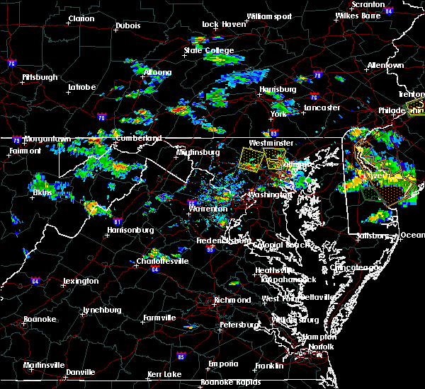 At 534 pm edt, a severe thunderstorm was located near mount airy, or 8 miles northeast of damascus, moving north at 10 mph. another developing thunderstorm was about 2 miles south of marriottsville that could become severe (radar indicated). Hazards include 60 mph wind gusts and quarter size hail. Damaging winds will cause some trees and large branches to fall. this could injure those outdoors, as well as damage homes and vehicles. roadways may become blocked by downed trees. localized power outages are possible. Unsecured light objects may become projectiles. At 534 pm edt, a severe thunderstorm was located near mount airy, or 8 miles northeast of damascus, moving north at 10 mph. another developing thunderstorm was about 2 miles south of marriottsville that could become severe (radar indicated). Hazards include 60 mph wind gusts and quarter size hail. Damaging winds will cause some trees and large branches to fall. this could injure those outdoors, as well as damage homes and vehicles. roadways may become blocked by downed trees. localized power outages are possible. Unsecured light objects may become projectiles.
|
| 7/24/2017 8:25 PM EDT |
 At 825 pm edt, a severe thunderstorm was located over oakland, or 10 miles west of pikesville, moving east at 25 mph (radar indicated). Hazards include 60 mph wind gusts and quarter size hail. Damaging winds will cause some trees and large branches to fall. this could injure those outdoors, as well as damage homes and vehicles. roadways may become blocked by downed trees. localized power outages are possible. Unsecured light objects may become projectiles. At 825 pm edt, a severe thunderstorm was located over oakland, or 10 miles west of pikesville, moving east at 25 mph (radar indicated). Hazards include 60 mph wind gusts and quarter size hail. Damaging winds will cause some trees and large branches to fall. this could injure those outdoors, as well as damage homes and vehicles. roadways may become blocked by downed trees. localized power outages are possible. Unsecured light objects may become projectiles.
|
| 7/17/2017 3:58 PM EDT | Tree down near rt 140 and glen falls rd in baltimore county MD, 3.5 miles SE of Reisterstown, MD |
| 7/17/2017 3:56 PM EDT |
 The severe thunderstorm warning for southeastern carroll and west central baltimore counties will expire at 400 pm edt, the storm which prompted the warning has weakened below severe limits, and no longer pose an immediate threat to life or property. therefore the warning will be allowed to expire. however small hail and heavy rain are still possible with this thunderstorm. The severe thunderstorm warning for southeastern carroll and west central baltimore counties will expire at 400 pm edt, the storm which prompted the warning has weakened below severe limits, and no longer pose an immediate threat to life or property. therefore the warning will be allowed to expire. however small hail and heavy rain are still possible with this thunderstorm.
|
| 7/17/2017 3:34 PM EDT |
 At 333 pm edt, a severe thunderstorm was located over reisterstown, or 8 miles northwest of pikesville, moving northeast at 5 mph (radar indicated). Hazards include 60 mph wind gusts and quarter size hail. Damaging winds will cause some trees and large branches to fall. this could injure those outdoors, as well as damage homes and vehicles. roadways may become blocked by downed trees. localized power outages are possible. unsecured light objects may become projectiles. Locations impacted include, pikesville, randallstown, owings mills, eldersburg, reisterstown, mays chapel, hampstead, oakland, gamber, garrison, finksburg, carrollton, upperco, louisville, glyndon, boring, patapsco, stevenson and mcdonogh. At 333 pm edt, a severe thunderstorm was located over reisterstown, or 8 miles northwest of pikesville, moving northeast at 5 mph (radar indicated). Hazards include 60 mph wind gusts and quarter size hail. Damaging winds will cause some trees and large branches to fall. this could injure those outdoors, as well as damage homes and vehicles. roadways may become blocked by downed trees. localized power outages are possible. unsecured light objects may become projectiles. Locations impacted include, pikesville, randallstown, owings mills, eldersburg, reisterstown, mays chapel, hampstead, oakland, gamber, garrison, finksburg, carrollton, upperco, louisville, glyndon, boring, patapsco, stevenson and mcdonogh.
|
| 7/17/2017 3:13 PM EDT |
 At 313 pm edt, a severe thunderstorm was located over gamber, or 10 miles northwest of pikesville, and is nearly stationary (radar indicated). Hazards include 60 mph wind gusts and quarter size hail. Damaging winds will cause some trees and large branches to fall. this could injure those outdoors, as well as damage homes and vehicles. roadways may become blocked by downed trees. localized power outages are possible. Unsecured light objects may become projectiles. At 313 pm edt, a severe thunderstorm was located over gamber, or 10 miles northwest of pikesville, and is nearly stationary (radar indicated). Hazards include 60 mph wind gusts and quarter size hail. Damaging winds will cause some trees and large branches to fall. this could injure those outdoors, as well as damage homes and vehicles. roadways may become blocked by downed trees. localized power outages are possible. Unsecured light objects may become projectiles.
|
| 7/1/2017 3:56 PM EDT |
 At 356 pm edt, a severe thunderstorm was located near cockeysville, moving east at 35 mph (radar indicated). Hazards include 60 mph wind gusts. Damaging winds will cause some trees and large branches to fall. this could injure those outdoors, as well as damage homes and vehicles. roadways may become blocked by downed trees. localized power outages are possible. Unsecured light objects may become projectiles. At 356 pm edt, a severe thunderstorm was located near cockeysville, moving east at 35 mph (radar indicated). Hazards include 60 mph wind gusts. Damaging winds will cause some trees and large branches to fall. this could injure those outdoors, as well as damage homes and vehicles. roadways may become blocked by downed trees. localized power outages are possible. Unsecured light objects may become projectiles.
|
| 5/25/2017 7:21 PM EDT |
 At 721 pm edt, a severe thunderstorm was located near mays chapel, or near cockeysville, moving northeast at 20 mph (radar indicated). Hazards include 60 mph wind gusts and quarter size hail. Damaging winds will cause some trees and large branches to fall. this could injure those outdoors, as well as damage homes and vehicles. roadways may become blocked by downed trees. localized power outages are possible. unsecured light objects may become projectiles. Locations impacted include, pikesville, cockeysville, towson, owings mills, reisterstown, mays chapel, timonium, fallston, lutherville-timonium, garrison, lutherville, long green, brooklandville, bentley springs, phoenix, jacksonville, butler, monkton, glencoe and baldwin. At 721 pm edt, a severe thunderstorm was located near mays chapel, or near cockeysville, moving northeast at 20 mph (radar indicated). Hazards include 60 mph wind gusts and quarter size hail. Damaging winds will cause some trees and large branches to fall. this could injure those outdoors, as well as damage homes and vehicles. roadways may become blocked by downed trees. localized power outages are possible. unsecured light objects may become projectiles. Locations impacted include, pikesville, cockeysville, towson, owings mills, reisterstown, mays chapel, timonium, fallston, lutherville-timonium, garrison, lutherville, long green, brooklandville, bentley springs, phoenix, jacksonville, butler, monkton, glencoe and baldwin.
|
| 5/25/2017 7:02 PM EDT |
 At 702 pm edt, a severe thunderstorm was located over owings mills, or near pikesville, moving northeast at 20 mph (radar indicated). Hazards include 60 mph wind gusts and quarter size hail. Damaging winds will cause some trees and large branches to fall. this could injure those outdoors, as well as damage homes and vehicles. roadways may become blocked by downed trees. localized power outages are possible. Unsecured light objects may become projectiles. At 702 pm edt, a severe thunderstorm was located over owings mills, or near pikesville, moving northeast at 20 mph (radar indicated). Hazards include 60 mph wind gusts and quarter size hail. Damaging winds will cause some trees and large branches to fall. this could injure those outdoors, as well as damage homes and vehicles. roadways may become blocked by downed trees. localized power outages are possible. Unsecured light objects may become projectiles.
|
| 4/6/2017 2:38 PM EDT |
 At 237 pm edt, severe thunderstorms were located along a line extending from gamber to near owings mills to pikesville, moving northeast at 45 mph (radar indicated). Hazards include 60 mph wind gusts. Damaging winds will cause some trees and large branches to fall. this could injure those outdoors, as well as damage homes and vehicles. roadways may become blocked by downed trees. localized power outages are possible. unsecured light objects may become projectiles. Locations impacted include, pikesville, randallstown, owings mills, reisterstown, lochearn, gamber, garrison, finksburg, glyndon, boring, mcdonogh, patapsco, reese, stevenson and butler. At 237 pm edt, severe thunderstorms were located along a line extending from gamber to near owings mills to pikesville, moving northeast at 45 mph (radar indicated). Hazards include 60 mph wind gusts. Damaging winds will cause some trees and large branches to fall. this could injure those outdoors, as well as damage homes and vehicles. roadways may become blocked by downed trees. localized power outages are possible. unsecured light objects may become projectiles. Locations impacted include, pikesville, randallstown, owings mills, reisterstown, lochearn, gamber, garrison, finksburg, glyndon, boring, mcdonogh, patapsco, reese, stevenson and butler.
|
| 4/6/2017 2:23 PM EDT |
 At 222 pm edt, severe thunderstorms were located along a line extending from near sykesville to near randallstown to ellicott city, moving northeast at 45 mph (radar indicated). Hazards include 60 mph wind gusts. Damaging winds will cause some trees and large branches to fall. this could injure those outdoors, as well as damage homes and vehicles. roadways may become blocked by downed trees. localized power outages are possible. unsecured light objects may become projectiles. Locations impacted include, columbia, pikesville, ellicott city, woodlawn, randallstown, owings mills, eldersburg, milford mill, reisterstown, lochearn, sykesville, oakland, gamber, garrison, clarksville, finksburg, henryton, west friendship, winfield and louisville. At 222 pm edt, severe thunderstorms were located along a line extending from near sykesville to near randallstown to ellicott city, moving northeast at 45 mph (radar indicated). Hazards include 60 mph wind gusts. Damaging winds will cause some trees and large branches to fall. this could injure those outdoors, as well as damage homes and vehicles. roadways may become blocked by downed trees. localized power outages are possible. unsecured light objects may become projectiles. Locations impacted include, columbia, pikesville, ellicott city, woodlawn, randallstown, owings mills, eldersburg, milford mill, reisterstown, lochearn, sykesville, oakland, gamber, garrison, clarksville, finksburg, henryton, west friendship, winfield and louisville.
|
| 4/6/2017 1:57 PM EDT |
 At 157 pm edt, severe thunderstorms were located along a line extending from gaithersburg to rossmoor to colesville, moving northeast at 45 mph (radar indicated). Hazards include 60 mph wind gusts. Damaging winds will cause some trees and large branches to fall. this could injure those outdoors, as well as damage homes and vehicles. roadways may become blocked by downed trees. localized power outages are possible. Unsecured light objects may become projectiles. At 157 pm edt, severe thunderstorms were located along a line extending from gaithersburg to rossmoor to colesville, moving northeast at 45 mph (radar indicated). Hazards include 60 mph wind gusts. Damaging winds will cause some trees and large branches to fall. this could injure those outdoors, as well as damage homes and vehicles. roadways may become blocked by downed trees. localized power outages are possible. Unsecured light objects may become projectiles.
|
| 3/1/2017 2:05 PM EST |
 At 204 pm est, severe thunderstorms were located along a line extending from near delta to near kingsville to lake shore, moving east at 60 mph (radar indicated). Hazards include 60 mph wind gusts. Damaging winds will cause some trees and large branches to fall. this could injure those outdoors, as well as damage homes and vehicles. roadways may become blocked by downed trees. localized power outages are possible. unsecured light objects may become projectiles. Locations impacted include, baltimore, severn, pikesville, middle river, cockeysville, aberdeen, havre de grace, riviera beach, aberdeen proving ground, baltimore-washington airport, fort smallwood state park, gibson island, sillery bay, millers island, north point state park, sparrows point, pinehurst, bodkin point, back river and glen burnie. At 204 pm est, severe thunderstorms were located along a line extending from near delta to near kingsville to lake shore, moving east at 60 mph (radar indicated). Hazards include 60 mph wind gusts. Damaging winds will cause some trees and large branches to fall. this could injure those outdoors, as well as damage homes and vehicles. roadways may become blocked by downed trees. localized power outages are possible. unsecured light objects may become projectiles. Locations impacted include, baltimore, severn, pikesville, middle river, cockeysville, aberdeen, havre de grace, riviera beach, aberdeen proving ground, baltimore-washington airport, fort smallwood state park, gibson island, sillery bay, millers island, north point state park, sparrows point, pinehurst, bodkin point, back river and glen burnie.
|
| 3/1/2017 1:54 PM EST |
 The severe thunderstorm warning for carroll, howard, northeastern montgomery, western baltimore and north central prince georges counties will expire at 200 pm est, the storms which prompted the warning have moved out of the area. therefore the warning will be allowed to expire. a severe thunderstorm watch remains in effect until 500 pm est for central, northern and north central maryland. remember, a severe thunderstorm warning still remains in effect for portions of carroll, baltimore, howard, montgomery and prince georges counties until 2:45 pm. The severe thunderstorm warning for carroll, howard, northeastern montgomery, western baltimore and north central prince georges counties will expire at 200 pm est, the storms which prompted the warning have moved out of the area. therefore the warning will be allowed to expire. a severe thunderstorm watch remains in effect until 500 pm est for central, northern and north central maryland. remember, a severe thunderstorm warning still remains in effect for portions of carroll, baltimore, howard, montgomery and prince georges counties until 2:45 pm.
|
| 3/1/2017 1:47 PM EST |
 At 147 pm est, severe thunderstorms were located along a line extending from near stewartstown to towson to near fort meade, moving east at 60 mph (radar indicated). Hazards include 60 mph wind gusts. Damaging winds will cause some trees and large branches to fall. this could injure those outdoors, as well as damage homes and vehicles. roadways may become blocked by downed trees. localized power outages are possible. Unsecured light objects may become projectiles. At 147 pm est, severe thunderstorms were located along a line extending from near stewartstown to towson to near fort meade, moving east at 60 mph (radar indicated). Hazards include 60 mph wind gusts. Damaging winds will cause some trees and large branches to fall. this could injure those outdoors, as well as damage homes and vehicles. roadways may become blocked by downed trees. localized power outages are possible. Unsecured light objects may become projectiles.
|
| 3/1/2017 1:46 PM EST |
 At 146 pm est, severe thunderstorms were located along a line extending from pennville to near gamber to olney, moving east at 50 mph (radar indicated). Hazards include 60 mph wind gusts. Damaging winds will cause some trees and large branches to fall. this could injure those outdoors, as well as damage homes and vehicles. roadways may become blocked by downed trees. localized power outages are possible. unsecured light objects may become projectiles. Locations impacted include, columbia, olney, pikesville, cockeysville, westminster, elkridge, ellicott city, aspen hill, catonsville, woodlawn, randallstown, owings mills, eldersburg, milford mill, reisterstown, lochearn, laurel, fairland, colesville and hampstead. At 146 pm est, severe thunderstorms were located along a line extending from pennville to near gamber to olney, moving east at 50 mph (radar indicated). Hazards include 60 mph wind gusts. Damaging winds will cause some trees and large branches to fall. this could injure those outdoors, as well as damage homes and vehicles. roadways may become blocked by downed trees. localized power outages are possible. unsecured light objects may become projectiles. Locations impacted include, columbia, olney, pikesville, cockeysville, westminster, elkridge, ellicott city, aspen hill, catonsville, woodlawn, randallstown, owings mills, eldersburg, milford mill, reisterstown, lochearn, laurel, fairland, colesville and hampstead.
|
| 3/1/2017 1:41 PM EST |
 At 140 pm est, severe thunderstorms were located along a line extending from littlestown to 6 miles northeast of mount airy to redland, moving east at 50 mph (radar indicated). Hazards include 60 mph wind gusts. Damaging winds will cause some trees and large branches to fall. this could injure those outdoors, as well as damage homes and vehicles. roadways may become blocked by downed trees. localized power outages are possible. unsecured light objects may become projectiles. Locations impacted include, columbia, germantown, rockville, gaithersburg, olney, pikesville, cockeysville, westminster, beltsville, elkridge, damascus, ellicott city, aspen hill, catonsville, woodlawn, randallstown, montgomery village, owings mills, eldersburg and milford mill. At 140 pm est, severe thunderstorms were located along a line extending from littlestown to 6 miles northeast of mount airy to redland, moving east at 50 mph (radar indicated). Hazards include 60 mph wind gusts. Damaging winds will cause some trees and large branches to fall. this could injure those outdoors, as well as damage homes and vehicles. roadways may become blocked by downed trees. localized power outages are possible. unsecured light objects may become projectiles. Locations impacted include, columbia, germantown, rockville, gaithersburg, olney, pikesville, cockeysville, westminster, beltsville, elkridge, damascus, ellicott city, aspen hill, catonsville, woodlawn, randallstown, montgomery village, owings mills, eldersburg and milford mill.
|
| 3/1/2017 1:32 PM EST |
 At 132 pm est, severe thunderstorms were located along a line extending from near taneytown to near new market to near north potomac, moving east at 60 mph (radar indicated). Hazards include 60 mph wind gusts. Damaging winds will cause some trees and large branches to fall. this could injure those outdoors, as well as damage homes and vehicles. roadways may become blocked by downed trees. localized power outages are possible. unsecured light objects may become projectiles. Locations impacted include, columbia, germantown, rockville, gaithersburg, olney, pikesville, cockeysville, westminster, elkridge, damascus, ellicott city, aspen hill, catonsville, woodlawn, randallstown, montgomery village, owings mills, eldersburg, milford mill and reisterstown. At 132 pm est, severe thunderstorms were located along a line extending from near taneytown to near new market to near north potomac, moving east at 60 mph (radar indicated). Hazards include 60 mph wind gusts. Damaging winds will cause some trees and large branches to fall. this could injure those outdoors, as well as damage homes and vehicles. roadways may become blocked by downed trees. localized power outages are possible. unsecured light objects may become projectiles. Locations impacted include, columbia, germantown, rockville, gaithersburg, olney, pikesville, cockeysville, westminster, elkridge, damascus, ellicott city, aspen hill, catonsville, woodlawn, randallstown, montgomery village, owings mills, eldersburg, milford mill and reisterstown.
|
| 3/1/2017 1:14 PM EST |
 At 113 pm est, severe thunderstorms were located along a line extending from emmitsburg to frederick to lansdowne, moving east at 50 mph (radar indicated). Hazards include 60 mph wind gusts. Damaging winds will cause some trees and large branches to fall. this could injure those outdoors, as well as damage homes and vehicles. roadways may become blocked by downed trees. localized power outages are possible. Unsecured light objects may become projectiles. At 113 pm est, severe thunderstorms were located along a line extending from emmitsburg to frederick to lansdowne, moving east at 50 mph (radar indicated). Hazards include 60 mph wind gusts. Damaging winds will cause some trees and large branches to fall. this could injure those outdoors, as well as damage homes and vehicles. roadways may become blocked by downed trees. localized power outages are possible. Unsecured light objects may become projectiles.
|
| 2/12/2017 10:47 PM EST |
 At 1046 pm est, severe thunderstorms were located along a line extending from near hampstead to near damascus, moving east at 55 mph (radar indicated). Hazards include 60 mph wind gusts. Damaging winds will cause some trees and large branches to fall. this could injure those outdoors, as well as damage homes and vehicles. roadways may become blocked by downed trees. localized power outages are possible. unsecured light objects may become projectiles. Locations impacted include, baltimore, columbia, germantown, severn, olney, pikesville, middle river, cockeysville, elkridge, damascus, aberdeen, havre de grace, riviera beach, aberdeen proving ground, baltimore-washington airport, fort smallwood state park, gibson island, sillery bay, millers island and north point state park. At 1046 pm est, severe thunderstorms were located along a line extending from near hampstead to near damascus, moving east at 55 mph (radar indicated). Hazards include 60 mph wind gusts. Damaging winds will cause some trees and large branches to fall. this could injure those outdoors, as well as damage homes and vehicles. roadways may become blocked by downed trees. localized power outages are possible. unsecured light objects may become projectiles. Locations impacted include, baltimore, columbia, germantown, severn, olney, pikesville, middle river, cockeysville, elkridge, damascus, aberdeen, havre de grace, riviera beach, aberdeen proving ground, baltimore-washington airport, fort smallwood state park, gibson island, sillery bay, millers island and north point state park.
|
| 2/12/2017 10:29 PM EST |
 At 1029 pm est, severe thunderstorms were located along a line extending from near littlestown to near point of rocks, moving east at 55 mph (radar indicated). Hazards include 60 mph wind gusts. Damaging winds will cause some trees and large branches to fall. this could injure those outdoors, as well as damage homes and vehicles. roadways may become blocked by downed trees. localized power outages are possible. Unsecured light objects may become projectiles. At 1029 pm est, severe thunderstorms were located along a line extending from near littlestown to near point of rocks, moving east at 55 mph (radar indicated). Hazards include 60 mph wind gusts. Damaging winds will cause some trees and large branches to fall. this could injure those outdoors, as well as damage homes and vehicles. roadways may become blocked by downed trees. localized power outages are possible. Unsecured light objects may become projectiles.
|
| 8/16/2016 4:10 PM EDT |
 At 409 pm edt, a severe thunderstorm was located near hampstead, or 7 miles east of westminster, moving east at 30 mph (radar indicated). Hazards include 60 mph wind gusts. Damaging winds will cause some trees and large branches to fall. this could injure those outdoors, as well as damage homes and vehicles. roadways may become blocked by downed trees. localized power outages are possible. unsecured light objects may become projectiles. Locations impacted include, cockeysville, reisterstown, timonium, hampstead, manchester, gamber, lutherville-timonium, parkton, upperco, greenmount, phoenix, finksburg, glyndon, jacksonville, millers, patapsco, monkton, hunt valley, bentley springs and hereford. At 409 pm edt, a severe thunderstorm was located near hampstead, or 7 miles east of westminster, moving east at 30 mph (radar indicated). Hazards include 60 mph wind gusts. Damaging winds will cause some trees and large branches to fall. this could injure those outdoors, as well as damage homes and vehicles. roadways may become blocked by downed trees. localized power outages are possible. unsecured light objects may become projectiles. Locations impacted include, cockeysville, reisterstown, timonium, hampstead, manchester, gamber, lutherville-timonium, parkton, upperco, greenmount, phoenix, finksburg, glyndon, jacksonville, millers, patapsco, monkton, hunt valley, bentley springs and hereford.
|
| 8/16/2016 3:55 PM EDT |
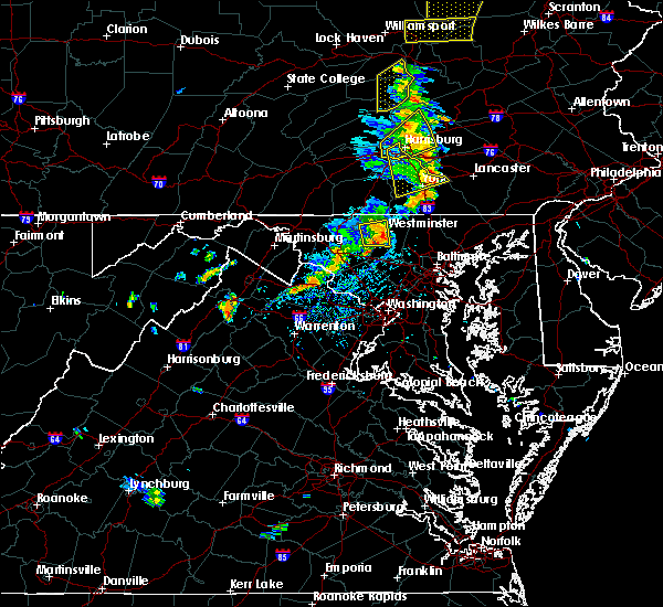 At 354 pm edt, a severe thunderstorm was located over westminster, moving east at 30 mph (radar indicated). Hazards include 60 mph wind gusts. Damaging winds will cause some trees and large branches to fall. this could injure those outdoors, as well as damage homes and vehicles. roadways may become blocked by downed trees. localized power outages are possible. Unsecured light objects may become projectiles. At 354 pm edt, a severe thunderstorm was located over westminster, moving east at 30 mph (radar indicated). Hazards include 60 mph wind gusts. Damaging winds will cause some trees and large branches to fall. this could injure those outdoors, as well as damage homes and vehicles. roadways may become blocked by downed trees. localized power outages are possible. Unsecured light objects may become projectiles.
|
| 7/18/2016 3:38 PM EDT |
 At 338 pm edt, severe thunderstorms were located along a line extending from near manchester to near hampstead to near gamber, moving east at 35 mph (radar indicated). Hazards include 60 mph wind gusts. Damaging winds will cause some trees and large branches to fall. this could injure those outdoors, as well as damage homes and vehicles. roadways may become blocked by downed trees. localized power outages are possible. Unsecured light objects may become projectiles. At 338 pm edt, severe thunderstorms were located along a line extending from near manchester to near hampstead to near gamber, moving east at 35 mph (radar indicated). Hazards include 60 mph wind gusts. Damaging winds will cause some trees and large branches to fall. this could injure those outdoors, as well as damage homes and vehicles. roadways may become blocked by downed trees. localized power outages are possible. Unsecured light objects may become projectiles.
|
| 6/28/2016 5:51 PM EDT |
 The severe thunderstorm warning for northern anne arundel, southern baltimore, southern carroll, and northeastern howard counties and baltimore city will expire at 600 pm edt, the storms which prompted the warning have weakened below severe limits, and no longer pose an immediate threat to life or property. therefore the warning will be allowed to expire. however gusty winds are still possible with these thunderstorms. a severe thunderstorm watch remains in effect until 1000 pm edt for north central, northern and central maryland. The severe thunderstorm warning for northern anne arundel, southern baltimore, southern carroll, and northeastern howard counties and baltimore city will expire at 600 pm edt, the storms which prompted the warning have weakened below severe limits, and no longer pose an immediate threat to life or property. therefore the warning will be allowed to expire. however gusty winds are still possible with these thunderstorms. a severe thunderstorm watch remains in effect until 1000 pm edt for north central, northern and central maryland.
|
| 6/28/2016 5:41 PM EDT |
 At 541 pm edt, severe thunderstorms were located along a line extending from near owings mills to near ellicott city to near damascus, moving southeast at 20 mph (radar indicated). Hazards include 60 mph wind gusts. Damaging winds will cause some trees and large branches to fall. this could injure those outdoors, as well as damage homes and vehicles. roadways may become blocked by downed trees. localized power outages are possible. unsecured light objects may become projectiles. Locations impacted include, baltimore, columbia, pikesville, cockeysville, elkridge, baltimore-washington airport, glen burnie, ellicott city, dundalk, towson, catonsville, woodlawn, randallstown, parkville, owings mills, eldersburg, carney, milford mill, perry hall and reisterstown. At 541 pm edt, severe thunderstorms were located along a line extending from near owings mills to near ellicott city to near damascus, moving southeast at 20 mph (radar indicated). Hazards include 60 mph wind gusts. Damaging winds will cause some trees and large branches to fall. this could injure those outdoors, as well as damage homes and vehicles. roadways may become blocked by downed trees. localized power outages are possible. unsecured light objects may become projectiles. Locations impacted include, baltimore, columbia, pikesville, cockeysville, elkridge, baltimore-washington airport, glen burnie, ellicott city, dundalk, towson, catonsville, woodlawn, randallstown, parkville, owings mills, eldersburg, carney, milford mill, perry hall and reisterstown.
|
| 6/28/2016 5:18 PM EDT |
 At 518 pm edt, severe thunderstorms were located along a line extending from near gamber to near sykesville, moving southeast at 25 mph (radar indicated). Hazards include 60 mph wind gusts. Damaging winds will cause some trees and large branches to fall. this could injure those outdoors, as well as damage homes and vehicles. roadways may become blocked by downed trees. localized power outages are possible. Unsecured light objects may become projectiles. At 518 pm edt, severe thunderstorms were located along a line extending from near gamber to near sykesville, moving southeast at 25 mph (radar indicated). Hazards include 60 mph wind gusts. Damaging winds will cause some trees and large branches to fall. this could injure those outdoors, as well as damage homes and vehicles. roadways may become blocked by downed trees. localized power outages are possible. Unsecured light objects may become projectiles.
|
| 6/21/2016 1:40 PM EDT |
 At 139 pm edt, severe thunderstorms were located along a line extending from gamber to near damascus, moving southeast at 30 mph. these are very dangerous storms (radar indicated). Hazards include 80 mph wind gusts and half dollar size hail. Expect considerable damage to trees and power lines. your life is at significant risk if outdoors. in addition to some trees falling into homes, wind damage is possible to roofs, sheds, open garages, and mobile homes. Locations impacted include, baltimore, columbia, germantown, rockville, gaithersburg, bowie, severn, olney, pikesville, college park, crofton, middle river, greenbelt, langley park, beltsville, elkridge, damascus, riviera beach, bladensburg and back river. At 139 pm edt, severe thunderstorms were located along a line extending from gamber to near damascus, moving southeast at 30 mph. these are very dangerous storms (radar indicated). Hazards include 80 mph wind gusts and half dollar size hail. Expect considerable damage to trees and power lines. your life is at significant risk if outdoors. in addition to some trees falling into homes, wind damage is possible to roofs, sheds, open garages, and mobile homes. Locations impacted include, baltimore, columbia, germantown, rockville, gaithersburg, bowie, severn, olney, pikesville, college park, crofton, middle river, greenbelt, langley park, beltsville, elkridge, damascus, riviera beach, bladensburg and back river.
|
| 6/21/2016 1:30 PM EDT |
 At 130 pm edt, severe thunderstorms were located along a line extending from near gamber to 6 miles southwest of green valley, moving southeast at 30 mph (radar indicated). Hazards include 70 mph wind gusts and quarter size hail. Damaging winds will cause some trees and large branches to fall. this could injure those outdoors, as well as damage homes and vehicles. roadways may become blocked by downed trees. localized power outages are possible. unsecured light objects may become projectiles. Locations impacted include, baltimore, columbia, germantown, rockville, gaithersburg, bowie, severn, olney, pikesville, college park, crofton, middle river, greenbelt, langley park, beltsville, elkridge, damascus, riviera beach, bladensburg and back river. At 130 pm edt, severe thunderstorms were located along a line extending from near gamber to 6 miles southwest of green valley, moving southeast at 30 mph (radar indicated). Hazards include 70 mph wind gusts and quarter size hail. Damaging winds will cause some trees and large branches to fall. this could injure those outdoors, as well as damage homes and vehicles. roadways may become blocked by downed trees. localized power outages are possible. unsecured light objects may become projectiles. Locations impacted include, baltimore, columbia, germantown, rockville, gaithersburg, bowie, severn, olney, pikesville, college park, crofton, middle river, greenbelt, langley park, beltsville, elkridge, damascus, riviera beach, bladensburg and back river.
|
| 6/21/2016 1:19 PM EDT |
 At 118 pm edt, severe thunderstorms were located along a line extending from near gamber to near ballenger creek, moving southeast at 30 mph (radar indicated). Hazards include 60 mph wind gusts. frequent lightning is also occurring with this storm. Damaging winds will cause some trees and large branches to fall. this could injure those outdoors, as well as damage homes and vehicles. roadways may become blocked by downed trees. localized power outages are possible. Unsecured light objects may become projectiles. At 118 pm edt, severe thunderstorms were located along a line extending from near gamber to near ballenger creek, moving southeast at 30 mph (radar indicated). Hazards include 60 mph wind gusts. frequent lightning is also occurring with this storm. Damaging winds will cause some trees and large branches to fall. this could injure those outdoors, as well as damage homes and vehicles. roadways may become blocked by downed trees. localized power outages are possible. Unsecured light objects may become projectiles.
|
| 6/8/2016 10:50 AM EDT |
 At 1048 am edt, showers with damaging wind gusts were located along a line extending from near delta to near mays chapel to near sykesville, moving east at 60 mph (radar indicated). Hazards include 60 mph wind gusts. Damaging winds will cause some trees and large branches to fall. this could injure those outdoors, as well as damage homes and vehicles. roadways may become blocked by downed trees. localized power outages are possible. unsecured light objects may become projectiles. Locations impacted include, baltimore, pikesville, middle river, cockeysville, aberdeen, havre de grace, aberdeen proving ground, back river, millers island, north point state park, sparrows point, ellicott city, dundalk, towson, bel air south, catonsville, essex, woodlawn, randallstown and parkville. At 1048 am edt, showers with damaging wind gusts were located along a line extending from near delta to near mays chapel to near sykesville, moving east at 60 mph (radar indicated). Hazards include 60 mph wind gusts. Damaging winds will cause some trees and large branches to fall. this could injure those outdoors, as well as damage homes and vehicles. roadways may become blocked by downed trees. localized power outages are possible. unsecured light objects may become projectiles. Locations impacted include, baltimore, pikesville, middle river, cockeysville, aberdeen, havre de grace, aberdeen proving ground, back river, millers island, north point state park, sparrows point, ellicott city, dundalk, towson, bel air south, catonsville, essex, woodlawn, randallstown and parkville.
|
| 6/8/2016 10:28 AM EDT |
 At 1027 am edt, strong showers with damaging winds were located along a line extending from near manchester to near westminster to near new market, moving southeast at 35 mph (radar indicated). Hazards include 60 mph wind gusts. Damaging winds will cause some trees and large branches to fall. this could injure those outdoors, as well as damage homes and vehicles. roadways may become blocked by downed trees. localized power outages are possible. Unsecured light objects may become projectiles. At 1027 am edt, strong showers with damaging winds were located along a line extending from near manchester to near westminster to near new market, moving southeast at 35 mph (radar indicated). Hazards include 60 mph wind gusts. Damaging winds will cause some trees and large branches to fall. this could injure those outdoors, as well as damage homes and vehicles. roadways may become blocked by downed trees. localized power outages are possible. Unsecured light objects may become projectiles.
|
| 6/5/2016 4:24 PM EDT |
 The severe thunderstorm warning for baltimore county in northern maryland, carroll county in north central maryland, howard county in central maryland, northwestern harford county in northern maryland, northern montgomery county in central maryland and southeastern frederick counties in north central maryland and baltimore city will expire at 430 pm edt, the storms which prompted the warning have moved out of the area. therefore the warning will be allowed to expire. however gusty winds and heavy rain are still possible with these thunderstorms. a severe thunderstorm watch remains in effect until 1000 pm edt for northern maryland, and northern virginia. The severe thunderstorm warning for baltimore county in northern maryland, carroll county in north central maryland, howard county in central maryland, northwestern harford county in northern maryland, northern montgomery county in central maryland and southeastern frederick counties in north central maryland and baltimore city will expire at 430 pm edt, the storms which prompted the warning have moved out of the area. therefore the warning will be allowed to expire. however gusty winds and heavy rain are still possible with these thunderstorms. a severe thunderstorm watch remains in effect until 1000 pm edt for northern maryland, and northern virginia.
|
| 6/5/2016 4:22 PM EDT |
 At 422 pm edt, severe thunderstorms were located along a line extending from near stewartstown to near cockeysville to near montgomery village, moving east at 50 mph (radar indicated). Hazards include 60 mph wind gusts. Damaging winds will cause some trees and large branches to fall. this could injure those outdoors, as well as damage homes and vehicles. roadways may become blocked by downed trees. localized power outages are possible. Unsecured light objects may become projectiles. At 422 pm edt, severe thunderstorms were located along a line extending from near stewartstown to near cockeysville to near montgomery village, moving east at 50 mph (radar indicated). Hazards include 60 mph wind gusts. Damaging winds will cause some trees and large branches to fall. this could injure those outdoors, as well as damage homes and vehicles. roadways may become blocked by downed trees. localized power outages are possible. Unsecured light objects may become projectiles.
|
| 6/5/2016 3:52 PM EDT |
 At 351 pm edt, severe thunderstorms were located along a line extending from near littlestown to near mount airy to near point of rocks, moving east at 40 mph (radar indicated). Hazards include 60 mph wind gusts. Damaging winds will cause some trees and large branches to fall. this could injure those outdoors, as well as damage homes and vehicles. roadways may become blocked by downed trees. localized power outages are possible. Unsecured light objects may become projectiles. At 351 pm edt, severe thunderstorms were located along a line extending from near littlestown to near mount airy to near point of rocks, moving east at 40 mph (radar indicated). Hazards include 60 mph wind gusts. Damaging winds will cause some trees and large branches to fall. this could injure those outdoors, as well as damage homes and vehicles. roadways may become blocked by downed trees. localized power outages are possible. Unsecured light objects may become projectiles.
|
| 4/7/2016 5:04 PM EDT |
 At 504 pm edt, doppler radar indicated a severe thunderstorm capable of producing damaging winds in excess of 60 mph. this storm was located over reisterstown, or 7 miles northwest of pikesville, and moving northeast at 45 mph. At 504 pm edt, doppler radar indicated a severe thunderstorm capable of producing damaging winds in excess of 60 mph. this storm was located over reisterstown, or 7 miles northwest of pikesville, and moving northeast at 45 mph.
|
| 2/24/2016 6:39 PM EST |
 At 638 pm est, trained weather spotters reported a line of severe thunderstorms producing damaging winds in excess of 60 mph. these storms were located along a line extending from near stewartstown to fells point, and moving east at 55 mph. At 638 pm est, trained weather spotters reported a line of severe thunderstorms producing damaging winds in excess of 60 mph. these storms were located along a line extending from near stewartstown to fells point, and moving east at 55 mph.
|
| 2/24/2016 6:24 PM EST |
 At 623 pm est, doppler radar indicated a line of severe thunderstorms capable of producing damaging winds in excess of 60 mph. these storms were located along a line extending from 6 miles northeast of manchester to near catonsville, moving east at 45 mph. locations impacted include, baltimore, aberdeen, bel air, union square, guilford, howard park, baltimore inner harbor, locust point, camden yards, roland park, fallstaff, cockeysville, pikesville, gwynns falls, middle river, clifton park, columbia, hampstead, manchester and oakland. a tornado watch remains in effect until 1100 pm est for northern maryland. At 623 pm est, doppler radar indicated a line of severe thunderstorms capable of producing damaging winds in excess of 60 mph. these storms were located along a line extending from 6 miles northeast of manchester to near catonsville, moving east at 45 mph. locations impacted include, baltimore, aberdeen, bel air, union square, guilford, howard park, baltimore inner harbor, locust point, camden yards, roland park, fallstaff, cockeysville, pikesville, gwynns falls, middle river, clifton park, columbia, hampstead, manchester and oakland. a tornado watch remains in effect until 1100 pm est for northern maryland.
|
| 2/24/2016 5:54 PM EST |
 At 554 pm est, doppler radar indicated a line of severe thunderstorms capable of producing damaging winds in excess of 60 mph. these storms were located along a line extending from near littlestown to montgomery village, moving east at 50 mph. locations impacted include, baltimore, rockville, gaithersburg, westminster, aberdeen, bel air, union square, guilford, howard park, olney, baltimore inner harbor, damascus, locust point, camden yards, germantown, gwynns falls, clifton park, roland park, fallstaff and cockeysville. a tornado watch remains in effect until 1100 pm est for northern maryland. At 554 pm est, doppler radar indicated a line of severe thunderstorms capable of producing damaging winds in excess of 60 mph. these storms were located along a line extending from near littlestown to montgomery village, moving east at 50 mph. locations impacted include, baltimore, rockville, gaithersburg, westminster, aberdeen, bel air, union square, guilford, howard park, olney, baltimore inner harbor, damascus, locust point, camden yards, germantown, gwynns falls, clifton park, roland park, fallstaff and cockeysville. a tornado watch remains in effect until 1100 pm est for northern maryland.
|
| 2/24/2016 5:46 PM EST |
 At 545 pm est, doppler radar indicated a line of severe thunderstorms capable of producing damaging winds in excess of 60 mph. these storms were located along a line extending from near littlestown to near damascus, and moving northeast at 50 mph. At 545 pm est, doppler radar indicated a line of severe thunderstorms capable of producing damaging winds in excess of 60 mph. these storms were located along a line extending from near littlestown to near damascus, and moving northeast at 50 mph.
|
| 10/28/2015 9:00 PM EDT |
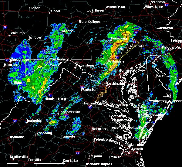 At 900 pm edt, doppler radar indicated a severe thunderstorm capable of producing damaging winds in excess of 60 mph. this storm was located over shrewsbury, or near dallastown, moving northeast at 55 mph. locations impacted include, westminster, hampstead, manchester, reisterstown, parkton, upperco, lineboro, freeland, greenmount, finksburg, glyndon, millers, reese, patapsco, bentley springs, boring, carrollton and maryland line. At 900 pm edt, doppler radar indicated a severe thunderstorm capable of producing damaging winds in excess of 60 mph. this storm was located over shrewsbury, or near dallastown, moving northeast at 55 mph. locations impacted include, westminster, hampstead, manchester, reisterstown, parkton, upperco, lineboro, freeland, greenmount, finksburg, glyndon, millers, reese, patapsco, bentley springs, boring, carrollton and maryland line.
|
| 10/28/2015 8:44 PM EDT |
 At 843 pm edt, doppler radar indicated a severe thunderstorm capable of producing damaging winds in excess of 60 mph. this storm was located over hampstead, or 9 miles east of westminster, and moving northeast at 55 mph. At 843 pm edt, doppler radar indicated a severe thunderstorm capable of producing damaging winds in excess of 60 mph. this storm was located over hampstead, or 9 miles east of westminster, and moving northeast at 55 mph.
|
| 10/9/2015 5:26 PM EDT |
 At 525 pm edt, doppler radar indicated a severe thunderstorm capable of producing damaging winds in excess of 60 mph. this storm was located near sykesville, or 12 miles south of westminster, and moving east at 35 mph. At 525 pm edt, doppler radar indicated a severe thunderstorm capable of producing damaging winds in excess of 60 mph. this storm was located near sykesville, or 12 miles south of westminster, and moving east at 35 mph.
|
| 8/4/2015 4:49 AM EDT |
 At 449 am edt, doppler radar indicated a severe thunderstorm capable of producing quarter size hail and damaging winds in excess of 60 mph. this storm was located near olney, and moving east at 45 mph. At 449 am edt, doppler radar indicated a severe thunderstorm capable of producing quarter size hail and damaging winds in excess of 60 mph. this storm was located near olney, and moving east at 45 mph.
|
| 7/1/2015 1:24 AM EDT |
 At 124 am edt, doppler radar indicated a severe thunderstorm capable of producing damaging winds in excess of 60 mph. this storm was located over odenton, or near severn, and moving northeast at 50 mph. At 124 am edt, doppler radar indicated a severe thunderstorm capable of producing damaging winds in excess of 60 mph. this storm was located over odenton, or near severn, and moving northeast at 50 mph.
|
| 6/23/2015 6:24 PM EDT |
 The severe thunderstorm warning for central carroll, northwestern baltimore and east central frederick counties will expire at 630 pm edt, the storm which prompted the warning has moved out of the area. therefore the warning will be allowed to expire. however heavy rain is still possible with this thunderstorm. The severe thunderstorm warning for central carroll, northwestern baltimore and east central frederick counties will expire at 630 pm edt, the storm which prompted the warning has moved out of the area. therefore the warning will be allowed to expire. however heavy rain is still possible with this thunderstorm.
|
| 6/23/2015 6:18 PM EDT |
 At 618 pm edt, doppler radar indicated a line of severe thunderstorms capable of producing quarter size hail and destructive winds in excess of 70 mph. these storms were located along a line extending from near westminster to near purcellville, moving east at 25 mph. locations impacted include, rockville, gaithersburg, leesburg, college park, greenbelt, poolesville, crofton, severn, elkridge, broadlands, olney, damascus, lowes island, lansdowne, langley park, germantown, columbia, byrd stadium, beltsville and baltimore-washington airport. At 618 pm edt, doppler radar indicated a line of severe thunderstorms capable of producing quarter size hail and destructive winds in excess of 70 mph. these storms were located along a line extending from near westminster to near purcellville, moving east at 25 mph. locations impacted include, rockville, gaithersburg, leesburg, college park, greenbelt, poolesville, crofton, severn, elkridge, broadlands, olney, damascus, lowes island, lansdowne, langley park, germantown, columbia, byrd stadium, beltsville and baltimore-washington airport.
|
| 6/23/2015 6:14 PM EDT |
 At 613 pm edt, doppler radar indicated a line of severe thunderstorms capable of producing half dollar size hail and destructive winds in excess of 70 mph. these storms were located along a line extending from near charlestown to howard park, and moving southeast at 20 mph. At 613 pm edt, doppler radar indicated a line of severe thunderstorms capable of producing half dollar size hail and destructive winds in excess of 70 mph. these storms were located along a line extending from near charlestown to howard park, and moving southeast at 20 mph.
|
| 6/23/2015 6:05 PM EDT |
 At 605 pm edt, doppler radar indicated a line of severe thunderstorms capable of producing large damaging hail up to golf ball size and destructive winds in excess of 70 mph. these storms were located along a line extending from near north east to howard park, moving southeast at 30 mph. locations impacted include, baltimore, aberdeen, bel air, union square, guilford, howard park, baltimore inner harbor, back river, locust point, camden yards, roland park, fallstaff, cockeysville, fells point, pikesville, gwynns falls, middle river, clifton park, sparrows point and north point state park. At 605 pm edt, doppler radar indicated a line of severe thunderstorms capable of producing large damaging hail up to golf ball size and destructive winds in excess of 70 mph. these storms were located along a line extending from near north east to howard park, moving southeast at 30 mph. locations impacted include, baltimore, aberdeen, bel air, union square, guilford, howard park, baltimore inner harbor, back river, locust point, camden yards, roland park, fallstaff, cockeysville, fells point, pikesville, gwynns falls, middle river, clifton park, sparrows point and north point state park.
|
| 6/23/2015 6:01 PM EDT |
 At 600 pm edt, doppler radar indicated a line of severe thunderstorms capable of producing quarter size hail and destructive winds in excess of 70 mph. these storms were located along a line extending from near westminster to round hill, and moving east at 25 mph. At 600 pm edt, doppler radar indicated a line of severe thunderstorms capable of producing quarter size hail and destructive winds in excess of 70 mph. these storms were located along a line extending from near westminster to round hill, and moving east at 25 mph.
|
| 6/23/2015 5:51 PM EDT |
 At 551 pm edt, doppler radar indicated a severe thunderstorm capable of producing quarter size hail and damaging winds in excess of 60 mph. this storm was located 8 miles southwest of westminster, and moving east at 30 mph. At 551 pm edt, doppler radar indicated a severe thunderstorm capable of producing quarter size hail and damaging winds in excess of 60 mph. this storm was located 8 miles southwest of westminster, and moving east at 30 mph.
|
| 6/23/2015 5:45 PM EDT |
 At 544 pm edt, doppler radar indicated a line of severe thunderstorms capable of producing large damaging hail up to golf ball size and destructive winds in excess of 70 mph. these storms were located along a line extending from woodlawn to randallstown, and moving southeast at 30 mph. At 544 pm edt, doppler radar indicated a line of severe thunderstorms capable of producing large damaging hail up to golf ball size and destructive winds in excess of 70 mph. these storms were located along a line extending from woodlawn to randallstown, and moving southeast at 30 mph.
|
| 6/23/2015 5:30 PM EDT |
 At 529 pm edt, doppler radar indicated a line of severe thunderstorms capable of producing half dollar size hail and destructive winds in excess of 70 mph. these storms were located along a line extending from delta to hampton, moving east at 40 mph. locations impacted include, aberdeen, bel air, cockeysville, riverside, reisterstown, fallston, carney, perryman, bel air south, hampton, jarrettsville, white marsh, perry hall, mays chapel, kingsville, bel air north, lutherville-timonium, pleasant hills, timonium and owings mills. At 529 pm edt, doppler radar indicated a line of severe thunderstorms capable of producing half dollar size hail and destructive winds in excess of 70 mph. these storms were located along a line extending from delta to hampton, moving east at 40 mph. locations impacted include, aberdeen, bel air, cockeysville, riverside, reisterstown, fallston, carney, perryman, bel air south, hampton, jarrettsville, white marsh, perry hall, mays chapel, kingsville, bel air north, lutherville-timonium, pleasant hills, timonium and owings mills.
|
| 6/23/2015 5:11 PM EDT |
 At 511 pm edt, doppler radar indicated a line of severe thunderstorms capable of producing quarter size hail and damaging winds in excess of 60 mph. these storms were located along a line extending from near stewartstown to near reisterstown, and moving east at 40 mph. At 511 pm edt, doppler radar indicated a line of severe thunderstorms capable of producing quarter size hail and damaging winds in excess of 60 mph. these storms were located along a line extending from near stewartstown to near reisterstown, and moving east at 40 mph.
|
| 6/8/2015 7:24 PM EDT | At 724 pm edt, doppler radar indicated a line of severe thunderstorms capable of producing quarter size hail and damaging winds in excess of 60 mph. these storms were located along a line extending from near new freedom to near sykesville, moving east at 35 mph. locations impacted include, hampstead, sykesville, oakland, eldersburg, owings mills, randallstown, reisterstown, gamber, ellicott city, milford mill, louisville, freeland, greenmount, finksburg, glyndon, reese, garrison, gaither, bentley springs and carrolltowne. a tornado watch remains in effect until 800 pm edt for northern maryland. |
| 6/8/2015 6:54 PM EDT | At 653 pm edt, doppler radar indicated a line of severe thunderstorms capable of producing quarter size hail and damaging winds in excess of 60 mph. these storms were located along a line extending from near manchester to green valley, and moving east at 40 mph. |
| 5/31/2015 8:17 PM EDT | At 816 pm edt, doppler radar indicated a severe thunderstorm capable of producing quarter size hail and damaging winds in excess of 60 mph. this storm was located near hampstead, or 9 miles northwest of cockeysville, moving northeast at 30 mph. locations impacted include, cockeysville, reisterstown, owings mills, upperco, phoenix, glyndon, patapsco, hunt valley, hereford, sparks, boring, glencoe, butler and garrison. |
| 5/31/2015 7:54 PM EDT | At 753 pm edt, doppler radar indicated a severe thunderstorm capable of producing quarter size hail and damaging winds in excess of 60 mph. this storm was located over gamber, or 9 miles southeast of westminster, and moving northeast at 30 mph. |
| 7/9/2014 3:42 PM EDT | Trees down at sandymount elementary schoo in carroll county MD, 4.9 miles ESE of Reisterstown, MD |
| 6/25/2013 10:04 PM EDT | Storm damage reported in baltimore county MD, 3.1 miles SSE of Reisterstown, MD |
| 6/13/2013 8:42 AM EDT | Large tree limb six inch diameter down in baltimore county MD, 3.1 miles SSE of Reisterstown, MD |
| 6/22/2012 6:36 PM EDT | 3 inch tree limb brought down onto porch from measured 50 mph wind gus in baltimore county MD, 1.4 miles SE of Reisterstown, MD |
| 6/22/2012 6:30 PM EDT | Part of a large tree approximately two and one half feet in diameter onto house along marshall wood r in baltimore county MD, 1.2 miles ENE of Reisterstown, MD |
| 6/22/2012 6:30 PM EDT | Several small branches half inch to one inch onto vehicle along marshall wood r in baltimore county MD, 1.2 miles ENE of Reisterstown, MD |
| 1/1/0001 12:00 AM | Quarter sized hail reported 5.3 miles SSW of Reisterstown, MD |
| 1/1/0001 12:00 AM | Trees down near route 14 in carroll county MD, 4.9 miles ESE of Reisterstown, MD |
Hail Maps for Reisterstown, MD


Connect with Interactive Hail Maps