

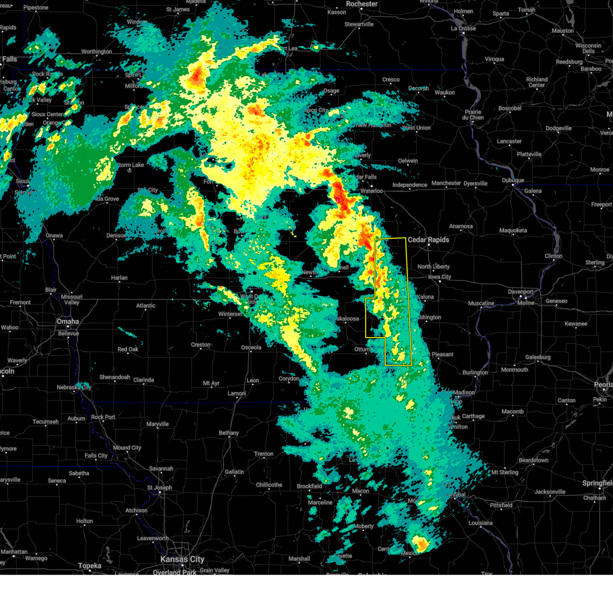
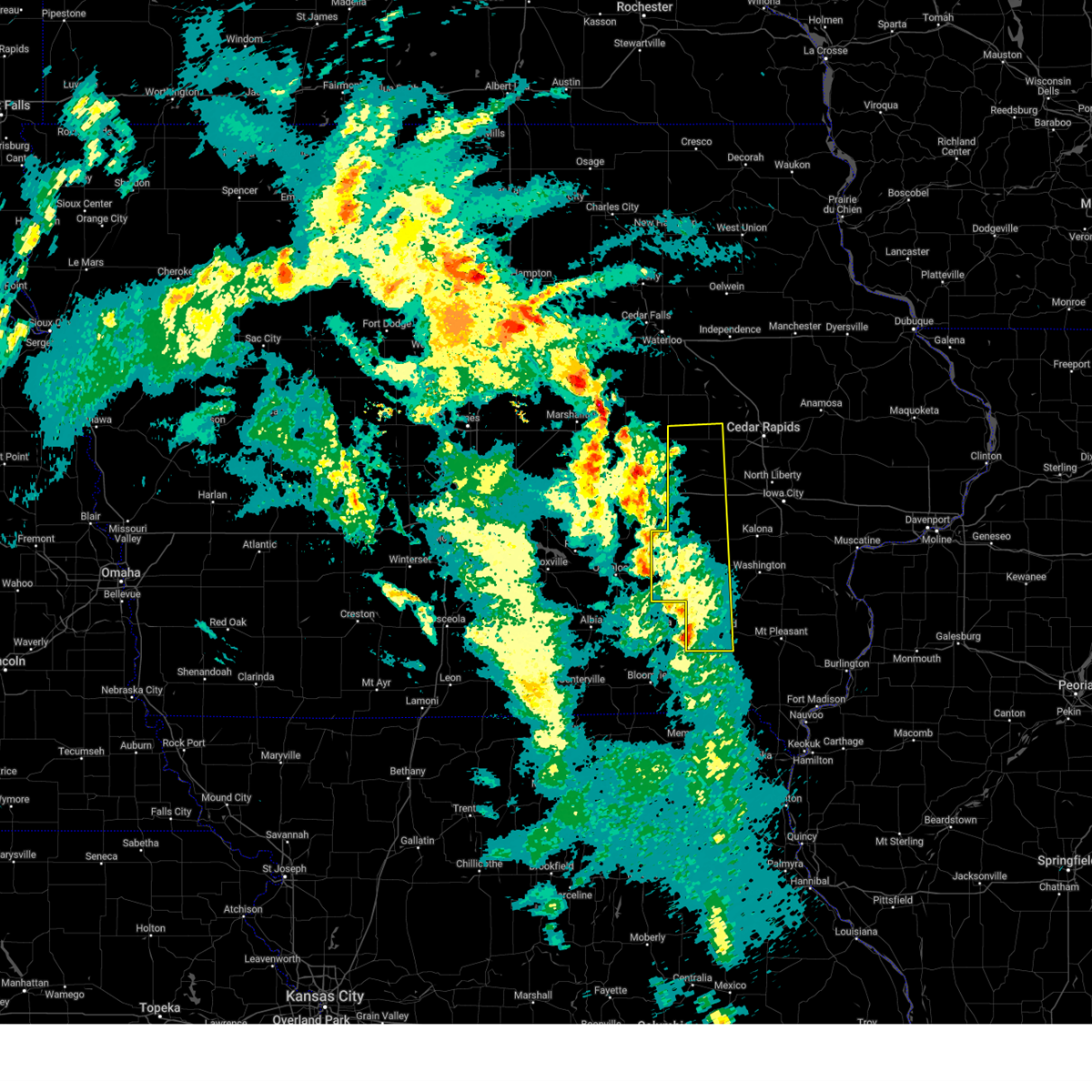
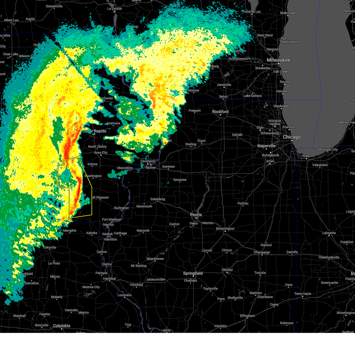
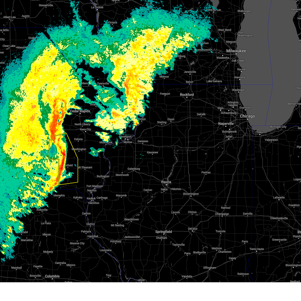
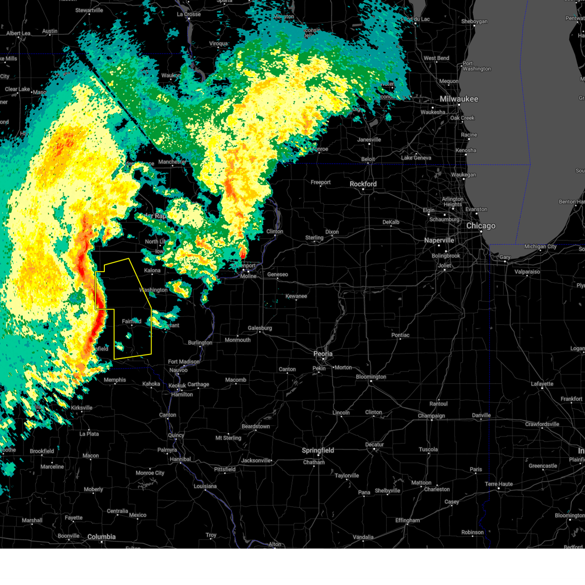
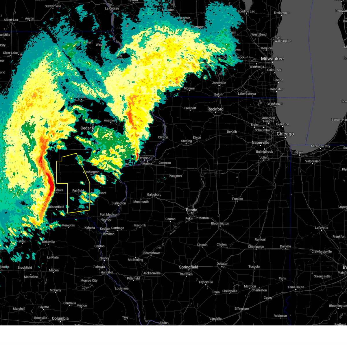
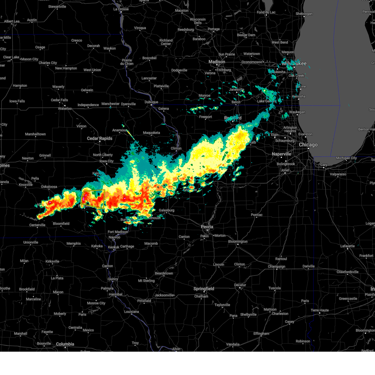
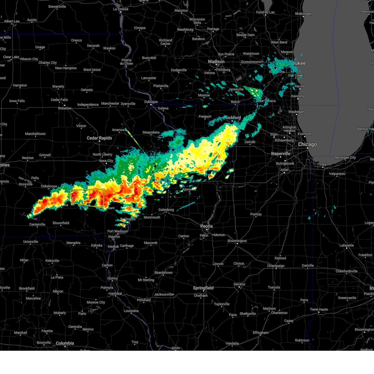
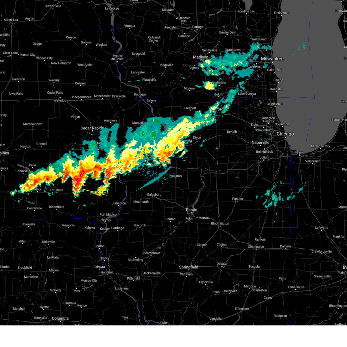
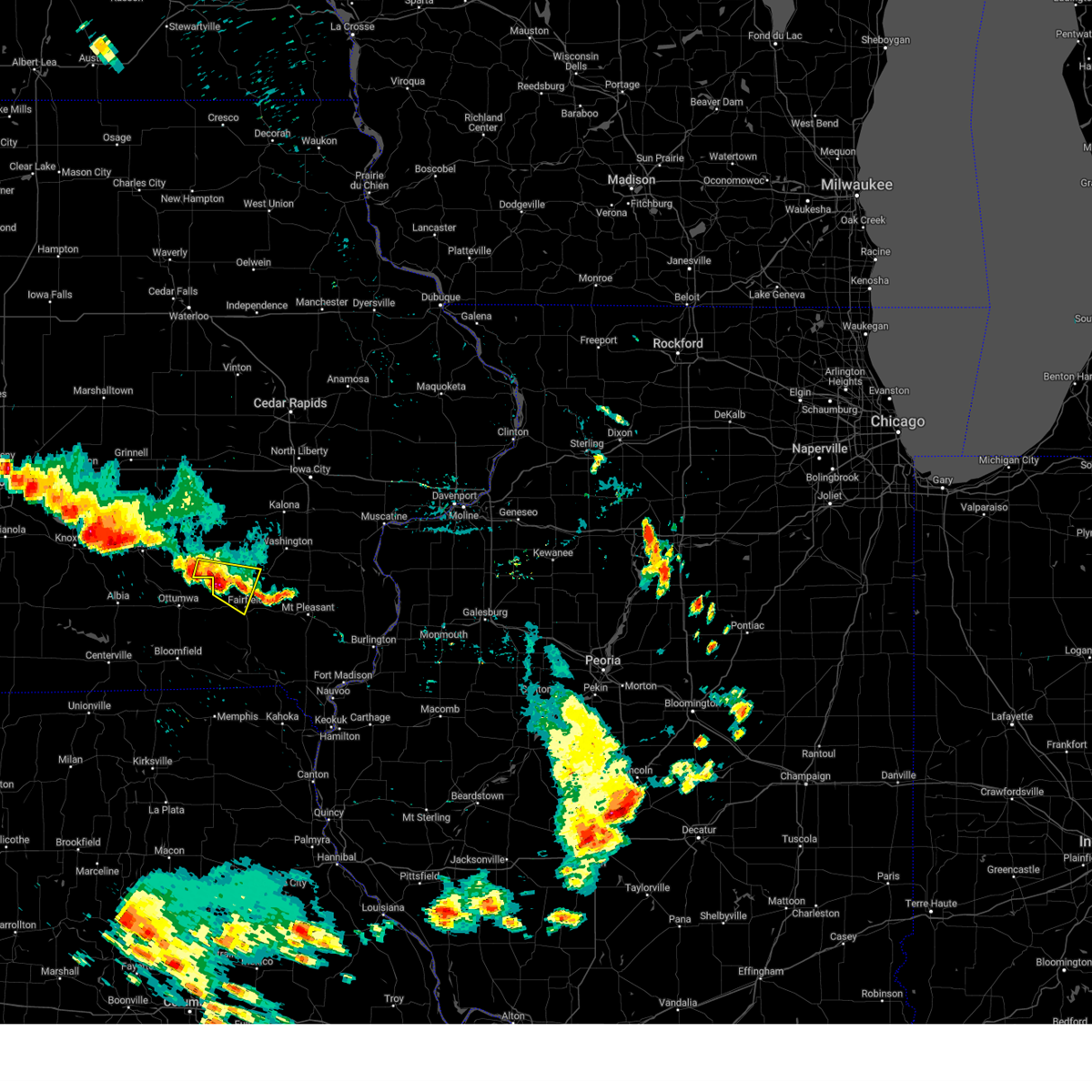
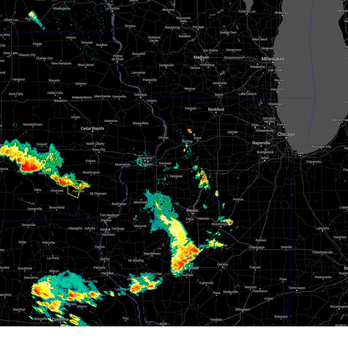
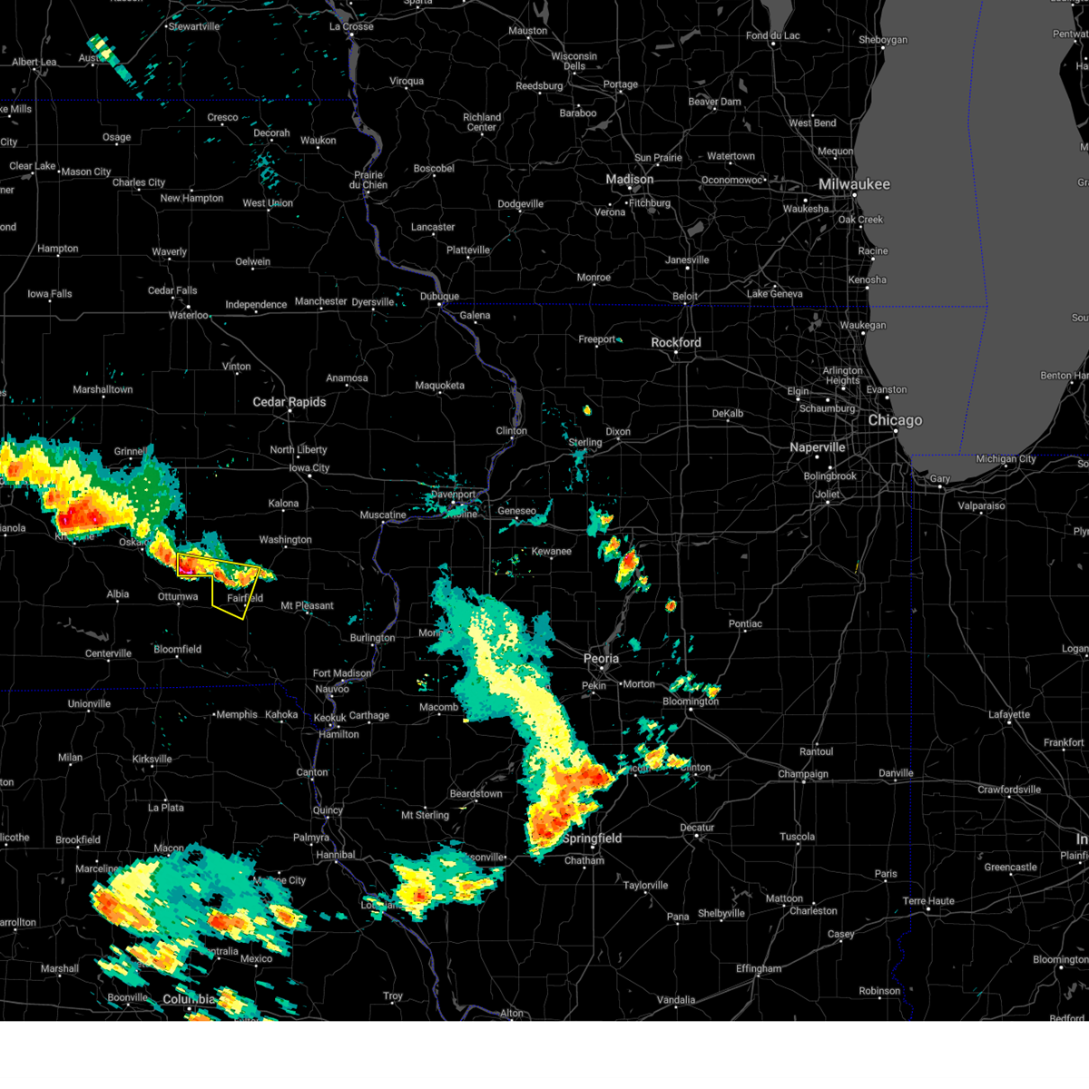
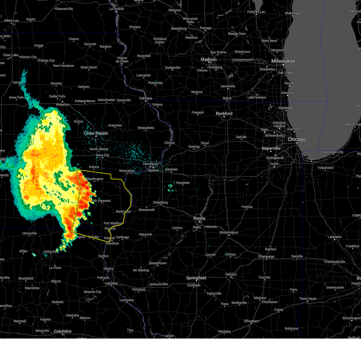
Hail Map for Richland, IA
The Richland, IA area has had 0 reports of on-the-ground hail by trained spotters, and has been under severe weather warnings 27 times during the past 12 months. Doppler radar has detected hail at or near Richland, IA on 54 occasions, including 5 occasions during the past year.
| Name: | Richland, IA |
| Where Located: | 54.7 miles NNW of Kahoka, MO |
| Map: | Google Map for Richland, IA |
| Population: | 584 |
| Housing Units: | 262 |
| More Info: | Search Google for Richland, IA |
5
The Top Recent Hail Date for Richland, IA is Thursday, October 3, 2024 (4th out of 54)

Hail and Wind Damage Spotted near Richland, IA
| Date / Time | Report Details |
|---|---|
| 3/14/2025 7:16 PM CDT |
 At 715 pm cdt, a severe thunderstorm was located near north english, or 13 miles north of sigourney, moving north at 60 mph (radar indicated). Hazards include 70 mph wind gusts. Expect considerable tree damage. damage is likely to mobile homes, roofs, and outbuildings. locations impacted include, newhall, parnell, richland, pekin, jefferson county park, what cheer, high amana, lake darling state park, iowa county fairgrounds, hedrick, abingdon, thornburg, keokuk county fairgrounds, belle plaine, conroy, hayesville, west amana, perlee, lake iowa park, and keswick. This includes interstate 80 in iowa between mile markers 205 and 224. At 715 pm cdt, a severe thunderstorm was located near north english, or 13 miles north of sigourney, moving north at 60 mph (radar indicated). Hazards include 70 mph wind gusts. Expect considerable tree damage. damage is likely to mobile homes, roofs, and outbuildings. locations impacted include, newhall, parnell, richland, pekin, jefferson county park, what cheer, high amana, lake darling state park, iowa county fairgrounds, hedrick, abingdon, thornburg, keokuk county fairgrounds, belle plaine, conroy, hayesville, west amana, perlee, lake iowa park, and keswick. This includes interstate 80 in iowa between mile markers 205 and 224.
|
| 3/14/2025 6:49 PM CDT |
 Svrdvn the national weather service in the quad cities has issued a * severe thunderstorm warning for, keokuk county in southeastern iowa, western washington county in southeastern iowa, southwestern benton county in east central iowa, jefferson county in southeastern iowa, iowa county in east central iowa, * until 745 pm cdt. * at 648 pm cdt, a severe thunderstorm was located over linby, or 12 miles northwest of fairfield, moving north at 60 mph (radar indicated). Hazards include 70 mph wind gusts. Expect considerable tree damage. Damage is likely to mobile homes, roofs, and outbuildings. Svrdvn the national weather service in the quad cities has issued a * severe thunderstorm warning for, keokuk county in southeastern iowa, western washington county in southeastern iowa, southwestern benton county in east central iowa, jefferson county in southeastern iowa, iowa county in east central iowa, * until 745 pm cdt. * at 648 pm cdt, a severe thunderstorm was located over linby, or 12 miles northwest of fairfield, moving north at 60 mph (radar indicated). Hazards include 70 mph wind gusts. Expect considerable tree damage. Damage is likely to mobile homes, roofs, and outbuildings.
|
| 10/30/2024 8:57 PM CDT |
 The storms which prompted the warning have weakened below severe limits, and no longer pose an immediate threat to life or property. therefore, the warning will be allowed to expire. however, gusty winds are still possible with these thunderstorms. The storms which prompted the warning have weakened below severe limits, and no longer pose an immediate threat to life or property. therefore, the warning will be allowed to expire. however, gusty winds are still possible with these thunderstorms.
|
| 10/30/2024 8:50 PM CDT |
 At 850 pm cdt, severe thunderstorms were located along a line extending from near webster to richland to near milton, moving east at 45 mph (radar indicated). Hazards include 60 mph wind gusts. Expect damage to roofs, siding, and trees. Locations impacted include, fairfield, sigourney, keosauqua, north english, hedrick, brighton, what cheer, richland, batavia, birmingham, delta, libertyville, stockport, lockridge, maharishi vedic city, keswick, south english, packwood, parnell, and millersburg. At 850 pm cdt, severe thunderstorms were located along a line extending from near webster to richland to near milton, moving east at 45 mph (radar indicated). Hazards include 60 mph wind gusts. Expect damage to roofs, siding, and trees. Locations impacted include, fairfield, sigourney, keosauqua, north english, hedrick, brighton, what cheer, richland, batavia, birmingham, delta, libertyville, stockport, lockridge, maharishi vedic city, keswick, south english, packwood, parnell, and millersburg.
|
| 10/30/2024 8:31 PM CDT |
 At 831 pm cdt, severe thunderstorms were located along a line extending from gibson to martinsburg to near bloomfield municipal airport, moving east at 45 mph (radar indicated). Hazards include 60 mph wind gusts. Expect damage to roofs, siding, and trees. Locations impacted include, fairfield, sigourney, keosauqua, north english, hedrick, brighton, what cheer, richland, batavia, birmingham, delta, libertyville, stockport, lockridge, maharishi vedic city, keswick, south english, packwood, parnell, and millersburg. At 831 pm cdt, severe thunderstorms were located along a line extending from gibson to martinsburg to near bloomfield municipal airport, moving east at 45 mph (radar indicated). Hazards include 60 mph wind gusts. Expect damage to roofs, siding, and trees. Locations impacted include, fairfield, sigourney, keosauqua, north english, hedrick, brighton, what cheer, richland, batavia, birmingham, delta, libertyville, stockport, lockridge, maharishi vedic city, keswick, south english, packwood, parnell, and millersburg.
|
| 10/30/2024 8:19 PM CDT |
 Svrdvn the national weather service in the quad cities has issued a * severe thunderstorm warning for, van buren county in southeastern iowa, keokuk county in southeastern iowa, western washington county in southeastern iowa, jefferson county in southeastern iowa, southwestern iowa county in east central iowa, * until 900 pm cdt. * at 818 pm cdt, severe thunderstorms were located along a line extending from near new sharon to near ottumwa industrial airport to near moulton, moving east at 45 mph (radar indicated). Hazards include 60 mph wind gusts. expect damage to roofs, siding, and trees Svrdvn the national weather service in the quad cities has issued a * severe thunderstorm warning for, van buren county in southeastern iowa, keokuk county in southeastern iowa, western washington county in southeastern iowa, jefferson county in southeastern iowa, southwestern iowa county in east central iowa, * until 900 pm cdt. * at 818 pm cdt, severe thunderstorms were located along a line extending from near new sharon to near ottumwa industrial airport to near moulton, moving east at 45 mph (radar indicated). Hazards include 60 mph wind gusts. expect damage to roofs, siding, and trees
|
| 10/4/2024 4:12 AM CDT |
 At 411 am cdt, a severe thunderstorm was located over lake darling state park, or 11 miles north of fairfield, moving east at 40 mph (radar indicated). Hazards include quarter size hail. Damage to vehicles is expected. this severe storm will be near, brighton, pleasant plain, coppock, perlee, east pleasant plain, germanville, and lake darling state park around 415 am cdt. Other locations in the path of this severe thunderstorm include wayland, merrimac, noble, mac coon access and trenton. At 411 am cdt, a severe thunderstorm was located over lake darling state park, or 11 miles north of fairfield, moving east at 40 mph (radar indicated). Hazards include quarter size hail. Damage to vehicles is expected. this severe storm will be near, brighton, pleasant plain, coppock, perlee, east pleasant plain, germanville, and lake darling state park around 415 am cdt. Other locations in the path of this severe thunderstorm include wayland, merrimac, noble, mac coon access and trenton.
|
| 10/4/2024 3:56 AM CDT |
 Svrdvn the national weather service in the quad cities has issued a * severe thunderstorm warning for, northwestern henry county in southeastern iowa, southeastern keokuk county in southeastern iowa, southern washington county in southeastern iowa, northern jefferson county in southeastern iowa, * until 445 am cdt. * at 356 am cdt, a severe thunderstorm was located over pekin, or 11 miles south of sigourney, moving east at 40 mph (radar indicated). Hazards include quarter size hail. Damage to vehicles is expected. this severe thunderstorm will be near, richland, packwood, ollie, and rubio around 400 am cdt. pleasant plain, perlee, and lake darling state park around 405 am cdt. brighton and east pleasant plain around 410 am cdt. coppock and germanville around 415 am cdt. Other locations in the path of this severe thunderstorm include wayland, salina, merrimac, noble, mac coon access and trenton. Svrdvn the national weather service in the quad cities has issued a * severe thunderstorm warning for, northwestern henry county in southeastern iowa, southeastern keokuk county in southeastern iowa, southern washington county in southeastern iowa, northern jefferson county in southeastern iowa, * until 445 am cdt. * at 356 am cdt, a severe thunderstorm was located over pekin, or 11 miles south of sigourney, moving east at 40 mph (radar indicated). Hazards include quarter size hail. Damage to vehicles is expected. this severe thunderstorm will be near, richland, packwood, ollie, and rubio around 400 am cdt. pleasant plain, perlee, and lake darling state park around 405 am cdt. brighton and east pleasant plain around 410 am cdt. coppock and germanville around 415 am cdt. Other locations in the path of this severe thunderstorm include wayland, salina, merrimac, noble, mac coon access and trenton.
|
| 10/4/2024 3:23 AM CDT |
 Svrdvn the national weather service in the quad cities has issued a * severe thunderstorm warning for, northern henry county in southeastern iowa, northwestern des moines county in southeastern iowa, southwestern louisa county in southeastern iowa, southeastern keokuk county in southeastern iowa, southern washington county in southeastern iowa, northeastern jefferson county in southeastern iowa, * until 415 am cdt. * at 322 am cdt, a severe thunderstorm was located over richland, or 11 miles north of fairfield, moving east at 30 mph (radar indicated). Hazards include quarter size hail. Damage to vehicles is expected. this severe thunderstorm will be near, brighton, pleasant plain, perlee, east pleasant plain, germanville, and lake darling state park around 330 am cdt. coppock around 335 am cdt. wayland and merrimac around 340 am cdt. Other locations in the path of this severe thunderstorm include noble, crawfordsville, olds, trenton and swedesburg. Svrdvn the national weather service in the quad cities has issued a * severe thunderstorm warning for, northern henry county in southeastern iowa, northwestern des moines county in southeastern iowa, southwestern louisa county in southeastern iowa, southeastern keokuk county in southeastern iowa, southern washington county in southeastern iowa, northeastern jefferson county in southeastern iowa, * until 415 am cdt. * at 322 am cdt, a severe thunderstorm was located over richland, or 11 miles north of fairfield, moving east at 30 mph (radar indicated). Hazards include quarter size hail. Damage to vehicles is expected. this severe thunderstorm will be near, brighton, pleasant plain, perlee, east pleasant plain, germanville, and lake darling state park around 330 am cdt. coppock around 335 am cdt. wayland and merrimac around 340 am cdt. Other locations in the path of this severe thunderstorm include noble, crawfordsville, olds, trenton and swedesburg.
|
| 7/30/2024 3:21 PM CDT | The storm which prompted the warning has weakened below severe limits, and no longer poses an immediate threat to life or property. therefore, the warning will be allowed to expire. however, small hail, gusty winds and heavy rain are still possible with this thunderstorm. a severe thunderstorm watch remains in effect until 400 pm cdt for southeastern iowa. |
| 7/30/2024 3:01 PM CDT |
 At 301 pm cdt, a severe thunderstorm was located over abingdon, or 10 miles northwest of fairfield, moving east at 35 mph (radar indicated). Hazards include 60 mph wind gusts and quarter size hail. Hail damage to vehicles is expected. expect wind damage to roofs, siding, and trees. Locations impacted include, fairfield, hedrick, richland, maharishi vedic city, packwood, martinsburg, abingdon, ollie, fairfield municipal airport, linby, pekin, jefferson county fairgrounds, jefferson county park, brookville, and lake darling state park. At 301 pm cdt, a severe thunderstorm was located over abingdon, or 10 miles northwest of fairfield, moving east at 35 mph (radar indicated). Hazards include 60 mph wind gusts and quarter size hail. Hail damage to vehicles is expected. expect wind damage to roofs, siding, and trees. Locations impacted include, fairfield, hedrick, richland, maharishi vedic city, packwood, martinsburg, abingdon, ollie, fairfield municipal airport, linby, pekin, jefferson county fairgrounds, jefferson county park, brookville, and lake darling state park.
|
| 7/30/2024 2:52 PM CDT |
 At 251 pm cdt, a severe thunderstorm was located near martinsburg, or 12 miles northeast of ottumwa, moving east at 35 mph (radar indicated). Hazards include 60 mph wind gusts and quarter size hail. Hail damage to vehicles is expected. expect wind damage to roofs, siding, and trees. Locations impacted include, fairfield, hedrick, richland, maharishi vedic city, packwood, martinsburg, abingdon, ollie, fairfield municipal airport, linby, pekin, jefferson county fairgrounds, jefferson county park, brookville, and lake darling state park. At 251 pm cdt, a severe thunderstorm was located near martinsburg, or 12 miles northeast of ottumwa, moving east at 35 mph (radar indicated). Hazards include 60 mph wind gusts and quarter size hail. Hail damage to vehicles is expected. expect wind damage to roofs, siding, and trees. Locations impacted include, fairfield, hedrick, richland, maharishi vedic city, packwood, martinsburg, abingdon, ollie, fairfield municipal airport, linby, pekin, jefferson county fairgrounds, jefferson county park, brookville, and lake darling state park.
|
| 7/30/2024 2:41 PM CDT |
 Svrdvn the national weather service in the quad cities has issued a * severe thunderstorm warning for, southern keokuk county in southeastern iowa, southwestern washington county in southeastern iowa, western jefferson county in southeastern iowa, * until 330 pm cdt. * at 241 pm cdt, a severe thunderstorm was located over hedrick, or 11 miles north of ottumwa, moving east at 35 mph (radar indicated). Hazards include 60 mph wind gusts and quarter size hail. Hail damage to vehicles is expected. Expect wind damage to roofs, siding, and trees. Svrdvn the national weather service in the quad cities has issued a * severe thunderstorm warning for, southern keokuk county in southeastern iowa, southwestern washington county in southeastern iowa, western jefferson county in southeastern iowa, * until 330 pm cdt. * at 241 pm cdt, a severe thunderstorm was located over hedrick, or 11 miles north of ottumwa, moving east at 35 mph (radar indicated). Hazards include 60 mph wind gusts and quarter size hail. Hail damage to vehicles is expected. Expect wind damage to roofs, siding, and trees.
|
| 7/30/2024 11:21 AM CDT |
 The storms which prompted the warning have weakened below severe limits, and no longer pose an immediate threat to life or property. therefore, the warning will be allowed to expire. however, gusty winds and heavy rain are still possible with these thunderstorms. a severe thunderstorm watch remains in effect until 400 pm cdt for southeastern iowa. The storms which prompted the warning have weakened below severe limits, and no longer pose an immediate threat to life or property. therefore, the warning will be allowed to expire. however, gusty winds and heavy rain are still possible with these thunderstorms. a severe thunderstorm watch remains in effect until 400 pm cdt for southeastern iowa.
|
| 7/30/2024 11:10 AM CDT |
 At 1109 am cdt, severe thunderstorms were located along a line extending from near keswick to near hayesville to near ottumwa to near albia municipal airport, moving east at 45 mph (radar indicated). Hazards include 60 mph wind gusts and quarter size hail. Hail damage to vehicles is expected. expect wind damage to roofs, siding, and trees. Locations impacted include, sigourney, hedrick, what cheer, richland, batavia, delta, keswick, south english, packwood, harper, martinsburg, kinross, hayesville, abingdon, keota, ollie, webster, thornburg, gibson, and pekin. At 1109 am cdt, severe thunderstorms were located along a line extending from near keswick to near hayesville to near ottumwa to near albia municipal airport, moving east at 45 mph (radar indicated). Hazards include 60 mph wind gusts and quarter size hail. Hail damage to vehicles is expected. expect wind damage to roofs, siding, and trees. Locations impacted include, sigourney, hedrick, what cheer, richland, batavia, delta, keswick, south english, packwood, harper, martinsburg, kinross, hayesville, abingdon, keota, ollie, webster, thornburg, gibson, and pekin.
|
| 7/30/2024 10:51 AM CDT |
 Svrdvn the national weather service in the quad cities has issued a * severe thunderstorm warning for, keokuk county in southeastern iowa, northwestern jefferson county in southeastern iowa, * until 1130 am cdt. * at 1050 am cdt, severe thunderstorms were located along a line extending from near barnes city to rose hill to near eddyville to near melrose, moving east at 45 mph (radar indicated). Hazards include 60 mph wind gusts and quarter size hail. Hail damage to vehicles is expected. Expect wind damage to roofs, siding, and trees. Svrdvn the national weather service in the quad cities has issued a * severe thunderstorm warning for, keokuk county in southeastern iowa, northwestern jefferson county in southeastern iowa, * until 1130 am cdt. * at 1050 am cdt, severe thunderstorms were located along a line extending from near barnes city to rose hill to near eddyville to near melrose, moving east at 45 mph (radar indicated). Hazards include 60 mph wind gusts and quarter size hail. Hail damage to vehicles is expected. Expect wind damage to roofs, siding, and trees.
|
| 7/30/2024 5:03 AM CDT |
 Svrdvn the national weather service in the quad cities has issued a * severe thunderstorm warning for, henry county in southeastern iowa, des moines county in southeastern iowa, van buren county in southeastern iowa, louisa county in southeastern iowa, eastern keokuk county in southeastern iowa, washington county in southeastern iowa, jefferson county in southeastern iowa, lee county in southeastern iowa, northeastern scotland county in northeastern missouri, northern clark county in northeastern missouri, * until 545 am cdt. * at 502 am cdt, severe thunderstorms were located along a line extending from near keota to near washington county fairgrounds to near lockridge to near bentonsport/vernon to azen, moving east at 45 mph (radar indicated). Hazards include 60 mph wind gusts. Expect damage to roofs, siding, and trees. severe thunderstorms will be near, mount pleasant, washington, wayland, bonaparte, salem, olds, hillsboro, rome, westwood, and coppock around 510 am cdt. ainsworth, crawfordsville, croton, battle of athens campground, mt hamill, shimek state forest, mount pleasant municipal arpt, primrose, henry county fairgrounds, and marr park around 515 am cdt. winfield, donnellson, franklin, st. paul, cotter, wyman, pilot grove, revere, haskins, and peaksville around 520 am cdt. other locations in the path of these severe thunderstorms include new london, west point, columbus city, mount union, lowell, cairo, marsh, geode state park, argyle, vincennes, fort madison, columbus junction, danville, morning sun, denmark, new boston, st. Francisville, fredonia, sawyer, pleasant grove, montrose and fort madison municipal arpt. Svrdvn the national weather service in the quad cities has issued a * severe thunderstorm warning for, henry county in southeastern iowa, des moines county in southeastern iowa, van buren county in southeastern iowa, louisa county in southeastern iowa, eastern keokuk county in southeastern iowa, washington county in southeastern iowa, jefferson county in southeastern iowa, lee county in southeastern iowa, northeastern scotland county in northeastern missouri, northern clark county in northeastern missouri, * until 545 am cdt. * at 502 am cdt, severe thunderstorms were located along a line extending from near keota to near washington county fairgrounds to near lockridge to near bentonsport/vernon to azen, moving east at 45 mph (radar indicated). Hazards include 60 mph wind gusts. Expect damage to roofs, siding, and trees. severe thunderstorms will be near, mount pleasant, washington, wayland, bonaparte, salem, olds, hillsboro, rome, westwood, and coppock around 510 am cdt. ainsworth, crawfordsville, croton, battle of athens campground, mt hamill, shimek state forest, mount pleasant municipal arpt, primrose, henry county fairgrounds, and marr park around 515 am cdt. winfield, donnellson, franklin, st. paul, cotter, wyman, pilot grove, revere, haskins, and peaksville around 520 am cdt. other locations in the path of these severe thunderstorms include new london, west point, columbus city, mount union, lowell, cairo, marsh, geode state park, argyle, vincennes, fort madison, columbus junction, danville, morning sun, denmark, new boston, st. Francisville, fredonia, sawyer, pleasant grove, montrose and fort madison municipal arpt.
|
| 7/30/2024 4:50 AM CDT |
 At 450 am cdt, a severe thunderstorm was located over talleyrand, or 10 miles east of sigourney, moving east at 45 mph (radar indicated). Hazards include 60 mph wind gusts and quarter size hail. Hail damage to vehicles is expected. expect wind damage to roofs, siding, and trees. Locations impacted include, washington, sigourney, wellman, hedrick, brighton, what cheer, richland, delta, keswick, south english, harper, martinsburg, kinross, hayesville, coppock, keota, ollie, west chester, webster, and thornburg. At 450 am cdt, a severe thunderstorm was located over talleyrand, or 10 miles east of sigourney, moving east at 45 mph (radar indicated). Hazards include 60 mph wind gusts and quarter size hail. Hail damage to vehicles is expected. expect wind damage to roofs, siding, and trees. Locations impacted include, washington, sigourney, wellman, hedrick, brighton, what cheer, richland, delta, keswick, south english, harper, martinsburg, kinross, hayesville, coppock, keota, ollie, west chester, webster, and thornburg.
|
| 7/30/2024 4:44 AM CDT |
 Svrdvn the national weather service in the quad cities has issued a * severe thunderstorm warning for, keokuk county in southeastern iowa, western washington county in southeastern iowa, * until 530 am cdt. * at 443 am cdt, a severe thunderstorm was located near keokuk county expo, or near sigourney, moving east at 45 mph (radar indicated). Hazards include 60 mph wind gusts. expect damage to roofs, siding, and trees Svrdvn the national weather service in the quad cities has issued a * severe thunderstorm warning for, keokuk county in southeastern iowa, western washington county in southeastern iowa, * until 530 am cdt. * at 443 am cdt, a severe thunderstorm was located near keokuk county expo, or near sigourney, moving east at 45 mph (radar indicated). Hazards include 60 mph wind gusts. expect damage to roofs, siding, and trees
|
| 7/15/2024 7:14 PM CDT | The storms which prompted the warning have moved out of the area. therefore, the warning will be allowed to expire. however, gusty winds and heavy rain are still possible with these thunderstorms. a severe thunderstorm watch remains in effect until 1100 pm cdt for southeastern and east central iowa. |
| 7/15/2024 6:59 PM CDT |
 At 659 pm cdt, severe thunderstorms were located along a line extending from near haskins to packwood, moving southeast at 45 mph (radar indicated). Hazards include 70 mph wind gusts and penny size hail. Expect considerable tree damage. damage is likely to mobile homes, roofs, and outbuildings. locations impacted include, iowa city, washington, sigourney, coralville, north liberty, kalona, solon, tiffin, wellman, lone tree, university heights, north english, riverside, oxford, hedrick, hills, what cheer, richland, delta, and keswick. this includes the following highways, interstate 80 in iowa between mile markers 228 and 253. Interstate 380 between mile markers 1 and 9. At 659 pm cdt, severe thunderstorms were located along a line extending from near haskins to packwood, moving southeast at 45 mph (radar indicated). Hazards include 70 mph wind gusts and penny size hail. Expect considerable tree damage. damage is likely to mobile homes, roofs, and outbuildings. locations impacted include, iowa city, washington, sigourney, coralville, north liberty, kalona, solon, tiffin, wellman, lone tree, university heights, north english, riverside, oxford, hedrick, hills, what cheer, richland, delta, and keswick. this includes the following highways, interstate 80 in iowa between mile markers 228 and 253. Interstate 380 between mile markers 1 and 9.
|
| 7/15/2024 6:59 PM CDT |
 the severe thunderstorm warning has been cancelled and is no longer in effect the severe thunderstorm warning has been cancelled and is no longer in effect
|
| 7/15/2024 6:47 PM CDT |
 At 646 pm cdt, severe thunderstorms were located along a line extending from near richmond to near pekin, moving southeast at 65 mph (trained weather spotters. a wind gust was estimated of at least 70 mph in sigourney at 645 pm cdt). Hazards include 70 mph wind gusts and penny size hail. Expect considerable tree damage. damage is likely to mobile homes, roofs, and outbuildings. locations impacted include, iowa city, washington, marengo, sigourney, coralville, north liberty, williamsburg, kalona, solon, tiffin, walford, wellman, lone tree, university heights, north english, riverside, victor, swisher, oxford, and hedrick. this includes the following highways, interstate 80 in iowa between mile markers 206 and 253. Interstate 380 between mile markers 1 and 12. At 646 pm cdt, severe thunderstorms were located along a line extending from near richmond to near pekin, moving southeast at 65 mph (trained weather spotters. a wind gust was estimated of at least 70 mph in sigourney at 645 pm cdt). Hazards include 70 mph wind gusts and penny size hail. Expect considerable tree damage. damage is likely to mobile homes, roofs, and outbuildings. locations impacted include, iowa city, washington, marengo, sigourney, coralville, north liberty, williamsburg, kalona, solon, tiffin, walford, wellman, lone tree, university heights, north english, riverside, victor, swisher, oxford, and hedrick. this includes the following highways, interstate 80 in iowa between mile markers 206 and 253. Interstate 380 between mile markers 1 and 12.
|
| 7/15/2024 6:44 PM CDT |
 At 643 pm cdt, severe thunderstorms were located along a line extending from near amish to near hayesville, moving southeast at 45 mph (trained weather spotters. at 643 pm winds were estimated to 60 mph just north of south english). Hazards include 70 mph wind gusts and penny size hail. Expect considerable tree damage. damage is likely to mobile homes, roofs, and outbuildings. locations impacted include, iowa city, washington, marengo, sigourney, coralville, north liberty, williamsburg, kalona, solon, tiffin, walford, wellman, lone tree, university heights, north english, riverside, victor, swisher, oxford, and hedrick. this includes the following highways, interstate 80 in iowa between mile markers 206 and 253. Interstate 380 between mile markers 1 and 12. At 643 pm cdt, severe thunderstorms were located along a line extending from near amish to near hayesville, moving southeast at 45 mph (trained weather spotters. at 643 pm winds were estimated to 60 mph just north of south english). Hazards include 70 mph wind gusts and penny size hail. Expect considerable tree damage. damage is likely to mobile homes, roofs, and outbuildings. locations impacted include, iowa city, washington, marengo, sigourney, coralville, north liberty, williamsburg, kalona, solon, tiffin, walford, wellman, lone tree, university heights, north english, riverside, victor, swisher, oxford, and hedrick. this includes the following highways, interstate 80 in iowa between mile markers 206 and 253. Interstate 380 between mile markers 1 and 12.
|
| 7/15/2024 6:36 PM CDT | At 636 pm cdt, severe thunderstorms were located along a line extending from near amish to delta, moving southeast at 50 mph (radar indicated). Hazards include 70 mph wind gusts and penny size hail. Expect considerable tree damage. damage is likely to mobile homes, roofs, and outbuildings. locations impacted include, iowa city, washington, marengo, sigourney, coralville, north liberty, williamsburg, kalona, solon, tiffin, walford, wellman, lone tree, university heights, north english, riverside, victor, swisher, oxford, and hedrick. this includes the following highways, interstate 80 in iowa between mile markers 206 and 253. Interstate 380 between mile markers 1 and 12. |
| 7/15/2024 6:19 PM CDT |
 At 618 pm cdt, severe thunderstorms were located along a line extending from upper south amana to barnes city, moving southeast at 45 mph (trained weather spotters. at 610 pm a 70 mph wind gust was estimated in swisher). Hazards include 70 mph wind gusts and penny size hail. Expect considerable tree damage. damage is likely to mobile homes, roofs, and outbuildings. locations impacted include, iowa city, washington, marengo, sigourney, coralville, north liberty, williamsburg, kalona, solon, tiffin, walford, wellman, lone tree, university heights, north english, riverside, victor, swisher, oxford, and hedrick. this includes the following highways, interstate 80 in iowa between mile markers 205 and 253. Interstate 380 between mile markers 1 and 12. At 618 pm cdt, severe thunderstorms were located along a line extending from upper south amana to barnes city, moving southeast at 45 mph (trained weather spotters. at 610 pm a 70 mph wind gust was estimated in swisher). Hazards include 70 mph wind gusts and penny size hail. Expect considerable tree damage. damage is likely to mobile homes, roofs, and outbuildings. locations impacted include, iowa city, washington, marengo, sigourney, coralville, north liberty, williamsburg, kalona, solon, tiffin, walford, wellman, lone tree, university heights, north english, riverside, victor, swisher, oxford, and hedrick. this includes the following highways, interstate 80 in iowa between mile markers 205 and 253. Interstate 380 between mile markers 1 and 12.
|
| 7/15/2024 6:10 PM CDT | Svrdvn the national weather service in the quad cities has issued a * severe thunderstorm warning for, keokuk county in southeastern iowa, johnson county in east central iowa, washington county in southeastern iowa, southeastern benton county in east central iowa, northwestern jefferson county in southeastern iowa, southwestern linn county in east central iowa, iowa county in east central iowa, * until 715 pm cdt. * at 610 pm cdt, severe thunderstorms were located along a line extending from near iowa county fairgrounds to montezuma, moving southeast at 45 mph (radar indicated). Hazards include 70 mph wind gusts and penny size hail. Expect considerable tree damage. Damage is likely to mobile homes, roofs, and outbuildings. |
| 7/2/2024 6:21 PM CDT |
 At 621 pm cdt, severe thunderstorms were located along a line extending from near washington to near mac coon access to collett, moving east at 45 mph (radar indicated). Hazards include 60 mph wind gusts. Expect damage to roofs, siding, and trees. Locations impacted include, washington, wayland, ainsworth, birmingham, stockport, lockridge, rome, coppock, washington airport, glasgow, crawfordsville, olds, westwood, cotter, haskins, swedesburg, morris park, mount pleasant, wyman, water works park, oakland mills, oakland mills park, mount pleasant municipal arpt and henry county fairgrounds. At 621 pm cdt, severe thunderstorms were located along a line extending from near washington to near mac coon access to collett, moving east at 45 mph (radar indicated). Hazards include 60 mph wind gusts. Expect damage to roofs, siding, and trees. Locations impacted include, washington, wayland, ainsworth, birmingham, stockport, lockridge, rome, coppock, washington airport, glasgow, crawfordsville, olds, westwood, cotter, haskins, swedesburg, morris park, mount pleasant, wyman, water works park, oakland mills, oakland mills park, mount pleasant municipal arpt and henry county fairgrounds.
|
| 7/2/2024 6:04 PM CDT |
 At 604 pm cdt, severe thunderstorms were located along a line extending from richland to libertyville to near selma, moving east at 30 mph (radar indicated). Hazards include 60 mph wind gusts. Expect damage to roofs, siding, and trees. these severe storms will be near, fairfield, brighton, birmingham, libertyville, pleasant plain, leando, douds, selma, collett, and fairfield municipal airport around 610 pm cdt. salina around 615 pm cdt. lockridge, coppock, glasgow, germanville, kilbourn, and round prairie park around 620 pm cdt. wayland, stockport, merrimac, mac coon access, and morris park around 625 pm cdt. rome, noble, and mount zion around 630 pm cdt. westwood, utica, and trenton around 635 pm cdt. mount pleasant, crawfordsville, olds, hillsboro, oakland mills, swedesburg, oakland mills park, and water works park around 640 pm cdt. henry county fairgrounds around 645 pm cdt. Other locations impacted by these severe thunderstorms include henry county fairgrounds, oakland mills, west chester, washington airport, glasgow, morris park, utica, mount zion, germanville, and selma. At 604 pm cdt, severe thunderstorms were located along a line extending from richland to libertyville to near selma, moving east at 30 mph (radar indicated). Hazards include 60 mph wind gusts. Expect damage to roofs, siding, and trees. these severe storms will be near, fairfield, brighton, birmingham, libertyville, pleasant plain, leando, douds, selma, collett, and fairfield municipal airport around 610 pm cdt. salina around 615 pm cdt. lockridge, coppock, glasgow, germanville, kilbourn, and round prairie park around 620 pm cdt. wayland, stockport, merrimac, mac coon access, and morris park around 625 pm cdt. rome, noble, and mount zion around 630 pm cdt. westwood, utica, and trenton around 635 pm cdt. mount pleasant, crawfordsville, olds, hillsboro, oakland mills, swedesburg, oakland mills park, and water works park around 640 pm cdt. henry county fairgrounds around 645 pm cdt. Other locations impacted by these severe thunderstorms include henry county fairgrounds, oakland mills, west chester, washington airport, glasgow, morris park, utica, mount zion, germanville, and selma.
|
| 7/2/2024 5:49 PM CDT |
 Svrdvn the national weather service in the quad cities has issued a * severe thunderstorm warning for, western henry county in southeastern iowa, northern van buren county in southeastern iowa, west central louisa county in southeastern iowa, southeastern keokuk county in southeastern iowa, southern washington county in southeastern iowa, jefferson county in southeastern iowa, * until 645 pm cdt. * at 548 pm cdt, severe thunderstorms were located along a line extending from ollie to batavia to near floris, moving east at 30 mph (radar indicated). Hazards include 60 mph wind gusts. Expect damage to roofs, siding, and trees. severe thunderstorms will be near, fairfield, richland, libertyville, maharishi vedic city, packwood, selma, brookville, fairfield municipal airport, rubio, and jefferson county park around 555 pm cdt. douds, collett, and lake darling state park around 600 pm cdt. pleasant plain, leando, perlee, and east pleasant plain around 605 pm cdt. brighton, birmingham, salina, and beckwith around 610 pm cdt. germanville around 615 pm cdt. lockridge, coppock, glasgow, kilbourn, mac coon access, and round prairie park around 620 pm cdt. wayland, stockport, merrimac, mount zion, and morris park around 625 pm cdt. rome and noble around 630 pm cdt. Other locations impacted by these severe thunderstorms include henry county fairgrounds, oakland mills, west chester, washington airport, glasgow, morris park, utica, mount zion, germanville, and selma. Svrdvn the national weather service in the quad cities has issued a * severe thunderstorm warning for, western henry county in southeastern iowa, northern van buren county in southeastern iowa, west central louisa county in southeastern iowa, southeastern keokuk county in southeastern iowa, southern washington county in southeastern iowa, jefferson county in southeastern iowa, * until 645 pm cdt. * at 548 pm cdt, severe thunderstorms were located along a line extending from ollie to batavia to near floris, moving east at 30 mph (radar indicated). Hazards include 60 mph wind gusts. Expect damage to roofs, siding, and trees. severe thunderstorms will be near, fairfield, richland, libertyville, maharishi vedic city, packwood, selma, brookville, fairfield municipal airport, rubio, and jefferson county park around 555 pm cdt. douds, collett, and lake darling state park around 600 pm cdt. pleasant plain, leando, perlee, and east pleasant plain around 605 pm cdt. brighton, birmingham, salina, and beckwith around 610 pm cdt. germanville around 615 pm cdt. lockridge, coppock, glasgow, kilbourn, mac coon access, and round prairie park around 620 pm cdt. wayland, stockport, merrimac, mount zion, and morris park around 625 pm cdt. rome and noble around 630 pm cdt. Other locations impacted by these severe thunderstorms include henry county fairgrounds, oakland mills, west chester, washington airport, glasgow, morris park, utica, mount zion, germanville, and selma.
|
| 7/2/2024 5:45 PM CDT |
 At 545 pm cdt, severe thunderstorms were located along a line extending from kinross to near packwood, moving east at 35 mph (radar indicated). Hazards include 60 mph wind gusts. Expect damage to roofs, siding, and trees. these severe storms will be near, richland, keota, lake darling state park, rubio, and talleyrand around 550 pm cdt. brighton and west chester around 555 pm cdt. Other locations impacted by these severe thunderstorms include ollie, keota, west chester, lake darling state park, lancaster, talleyrand, pekin, and rubio. At 545 pm cdt, severe thunderstorms were located along a line extending from kinross to near packwood, moving east at 35 mph (radar indicated). Hazards include 60 mph wind gusts. Expect damage to roofs, siding, and trees. these severe storms will be near, richland, keota, lake darling state park, rubio, and talleyrand around 550 pm cdt. brighton and west chester around 555 pm cdt. Other locations impacted by these severe thunderstorms include ollie, keota, west chester, lake darling state park, lancaster, talleyrand, pekin, and rubio.
|
| 7/2/2024 5:31 PM CDT |
 At 530 pm cdt, severe thunderstorms were located along a line extending from near webster to near pekin, moving east at 35 mph (radar indicated). Hazards include 60 mph wind gusts. Expect damage to roofs, siding, and trees. these severe storms will be near, harper, ollie, and pekin around 535 pm cdt. richland, keota, and talleyrand around 540 pm cdt. rubio around 545 pm cdt. west chester and lake darling state park around 550 pm cdt. brighton around 555 pm cdt. Other locations impacted by these severe thunderstorms include ollie, yenruogis county park, keota, west chester, lake darling state park, lancaster, talleyrand, keokuk county expo, pekin, and rubio. At 530 pm cdt, severe thunderstorms were located along a line extending from near webster to near pekin, moving east at 35 mph (radar indicated). Hazards include 60 mph wind gusts. Expect damage to roofs, siding, and trees. these severe storms will be near, harper, ollie, and pekin around 535 pm cdt. richland, keota, and talleyrand around 540 pm cdt. rubio around 545 pm cdt. west chester and lake darling state park around 550 pm cdt. brighton around 555 pm cdt. Other locations impacted by these severe thunderstorms include ollie, yenruogis county park, keota, west chester, lake darling state park, lancaster, talleyrand, keokuk county expo, pekin, and rubio.
|
| 7/2/2024 5:06 PM CDT |
 Svrdvn the national weather service in the quad cities has issued a * severe thunderstorm warning for, keokuk county in southeastern iowa, southwestern washington county in southeastern iowa, * until 600 pm cdt. * at 506 pm cdt, severe thunderstorms were located along a line extending from near coal creek to near ottumwa industrial airport, moving east at 35 mph (radar indicated). Hazards include 60 mph wind gusts. Expect damage to roofs, siding, and trees. severe thunderstorms will be near, hedrick, what cheer, delta, and keokuk county fairgrounds around 510 pm cdt. sigourney, martinsburg, hayesville, and yenruogis county park around 515 pm cdt. lancaster, lake belva deer park, and keokuk county expo around 520 pm cdt. pekin around 525 pm cdt. harper and ollie around 530 pm cdt. richland, keota, and talleyrand around 540 pm cdt. lake darling state park and rubio around 545 pm cdt. Other locations impacted by these severe thunderstorms include ollie, yenruogis county park, keota, west chester, lake darling state park, lancaster, talleyrand, keokuk county fairgrounds, keokuk county expo, and pekin. Svrdvn the national weather service in the quad cities has issued a * severe thunderstorm warning for, keokuk county in southeastern iowa, southwestern washington county in southeastern iowa, * until 600 pm cdt. * at 506 pm cdt, severe thunderstorms were located along a line extending from near coal creek to near ottumwa industrial airport, moving east at 35 mph (radar indicated). Hazards include 60 mph wind gusts. Expect damage to roofs, siding, and trees. severe thunderstorms will be near, hedrick, what cheer, delta, and keokuk county fairgrounds around 510 pm cdt. sigourney, martinsburg, hayesville, and yenruogis county park around 515 pm cdt. lancaster, lake belva deer park, and keokuk county expo around 520 pm cdt. pekin around 525 pm cdt. harper and ollie around 530 pm cdt. richland, keota, and talleyrand around 540 pm cdt. lake darling state park and rubio around 545 pm cdt. Other locations impacted by these severe thunderstorms include ollie, yenruogis county park, keota, west chester, lake darling state park, lancaster, talleyrand, keokuk county fairgrounds, keokuk county expo, and pekin.
|
| 5/24/2024 6:57 AM CDT |
 At 657 am cdt, severe thunderstorms were located along a line extending from palisades-kepler state park to nichols to near glasgow, moving east at 60 mph (radar indicated). Hazards include 70 mph wind gusts and penny size hail. Expect considerable tree damage. damage is likely to mobile homes, roofs, and outbuildings. locations impacted include, davenport, iowa city, muscatine, fairfield, mount pleasant, washington, tipton, west branch, wapello, columbus junction, durant, coralville, north liberty, west liberty, wilton, kalona, solon, tiffin, new london, and walcott. this includes the following highways, interstate 80 in iowa between mile markers 222 and 292. interstate 380 between mile markers 1 and 11. Interstate 280 between mile markers 1 and 8. At 657 am cdt, severe thunderstorms were located along a line extending from palisades-kepler state park to nichols to near glasgow, moving east at 60 mph (radar indicated). Hazards include 70 mph wind gusts and penny size hail. Expect considerable tree damage. damage is likely to mobile homes, roofs, and outbuildings. locations impacted include, davenport, iowa city, muscatine, fairfield, mount pleasant, washington, tipton, west branch, wapello, columbus junction, durant, coralville, north liberty, west liberty, wilton, kalona, solon, tiffin, new london, and walcott. this includes the following highways, interstate 80 in iowa between mile markers 222 and 292. interstate 380 between mile markers 1 and 11. Interstate 280 between mile markers 1 and 8.
|
| 5/24/2024 6:38 AM CDT |
 Svrdvn the national weather service in the quad cities has issued a * severe thunderstorm warning for, southwestern rock island county in northwestern illinois, northwestern mercer county in northwestern illinois, southeastern keokuk county in southeastern iowa, cedar county in east central iowa, washington county in southeastern iowa, muscatine county in east central iowa, jefferson county in southeastern iowa, henry county in southeastern iowa, northwestern des moines county in southeastern iowa, louisa county in southeastern iowa, western scott county in east central iowa, johnson county in east central iowa, southwestern clinton county in east central iowa, eastern iowa county in east central iowa, * until 745 am cdt. * at 638 am cdt, severe thunderstorms were located along a line extending from near walford to near richmond to near libertyville, moving east at 55 mph (radar indicated). Hazards include 70 mph wind gusts and penny size hail. Expect considerable tree damage. Damage is likely to mobile homes, roofs, and outbuildings. Svrdvn the national weather service in the quad cities has issued a * severe thunderstorm warning for, southwestern rock island county in northwestern illinois, northwestern mercer county in northwestern illinois, southeastern keokuk county in southeastern iowa, cedar county in east central iowa, washington county in southeastern iowa, muscatine county in east central iowa, jefferson county in southeastern iowa, henry county in southeastern iowa, northwestern des moines county in southeastern iowa, louisa county in southeastern iowa, western scott county in east central iowa, johnson county in east central iowa, southwestern clinton county in east central iowa, eastern iowa county in east central iowa, * until 745 am cdt. * at 638 am cdt, severe thunderstorms were located along a line extending from near walford to near richmond to near libertyville, moving east at 55 mph (radar indicated). Hazards include 70 mph wind gusts and penny size hail. Expect considerable tree damage. Damage is likely to mobile homes, roofs, and outbuildings.
|
| 5/24/2024 6:33 AM CDT |
 At 633 am cdt, severe thunderstorms were located along a line extending from near watkins to near west chester to near brookville, moving east at 55 mph (radar indicated). Hazards include 70 mph wind gusts and nickel size hail. Expect considerable tree damage. damage is likely to mobile homes, roofs, and outbuildings. locations impacted include, iowa city, fairfield, washington, marengo, sigourney, coralville, north liberty, williamsburg, kalona, tiffin, wellman, university heights, north english, riverside, victor, swisher, oxford, hedrick, hills, and brighton. this includes the following highways, interstate 80 in iowa between mile markers 205 and 242. Interstate 380 between mile markers 1 and 11. At 633 am cdt, severe thunderstorms were located along a line extending from near watkins to near west chester to near brookville, moving east at 55 mph (radar indicated). Hazards include 70 mph wind gusts and nickel size hail. Expect considerable tree damage. damage is likely to mobile homes, roofs, and outbuildings. locations impacted include, iowa city, fairfield, washington, marengo, sigourney, coralville, north liberty, williamsburg, kalona, tiffin, wellman, university heights, north english, riverside, victor, swisher, oxford, hedrick, hills, and brighton. this includes the following highways, interstate 80 in iowa between mile markers 205 and 242. Interstate 380 between mile markers 1 and 11.
|
| 5/24/2024 6:15 AM CDT |
 At 614 am cdt, severe thunderstorms were located along a line extending from near koszta to harper to near ottumwa, moving east at 55 mph (radar indicated). Hazards include 70 mph wind gusts and nickel size hail. Expect considerable tree damage. damage is likely to mobile homes, roofs, and outbuildings. locations impacted include, iowa city, fairfield, washington, marengo, sigourney, coralville, north liberty, williamsburg, kalona, tiffin, wellman, university heights, north english, riverside, victor, swisher, oxford, hedrick, hills, and brighton. this includes the following highways, interstate 80 in iowa between mile markers 205 and 242. Interstate 380 between mile markers 1 and 11. At 614 am cdt, severe thunderstorms were located along a line extending from near koszta to harper to near ottumwa, moving east at 55 mph (radar indicated). Hazards include 70 mph wind gusts and nickel size hail. Expect considerable tree damage. damage is likely to mobile homes, roofs, and outbuildings. locations impacted include, iowa city, fairfield, washington, marengo, sigourney, coralville, north liberty, williamsburg, kalona, tiffin, wellman, university heights, north english, riverside, victor, swisher, oxford, hedrick, hills, and brighton. this includes the following highways, interstate 80 in iowa between mile markers 205 and 242. Interstate 380 between mile markers 1 and 11.
|
| 5/24/2024 6:05 AM CDT |
 Svrdvn the national weather service in the quad cities has issued a * severe thunderstorm warning for, keokuk county in southeastern iowa, western johnson county in east central iowa, washington county in southeastern iowa, jefferson county in southeastern iowa, iowa county in east central iowa, * until 645 am cdt. * at 605 am cdt, severe thunderstorms were located along a line extending from holiday lake to sigourney to near blakesburg, moving east at 55 mph (radar indicated). Hazards include 70 mph wind gusts and nickel size hail. Expect considerable tree damage. Damage is likely to mobile homes, roofs, and outbuildings. Svrdvn the national weather service in the quad cities has issued a * severe thunderstorm warning for, keokuk county in southeastern iowa, western johnson county in east central iowa, washington county in southeastern iowa, jefferson county in southeastern iowa, iowa county in east central iowa, * until 645 am cdt. * at 605 am cdt, severe thunderstorms were located along a line extending from holiday lake to sigourney to near blakesburg, moving east at 55 mph (radar indicated). Hazards include 70 mph wind gusts and nickel size hail. Expect considerable tree damage. Damage is likely to mobile homes, roofs, and outbuildings.
|
| 5/24/2024 3:59 AM CDT |
 At 359 am cdt, a severe thunderstorm was located over talleyrand, or 10 miles east of sigourney, moving northeast at 45 mph (radar indicated). Hazards include golf ball size hail and 60 mph wind gusts. People and animals outdoors will be injured. expect hail damage to roofs, siding, windows, and vehicles. expect wind damage to roofs, siding, and trees. this severe storm will be near, wellman, kinross, keota, and west chester around 405 am cdt. Other locations impacted by this severe thunderstorm include ollie, yenruogis county park, keota, west chester, lancaster, talleyrand, keokuk county expo, pekin, rubio, and lake belva deer park. At 359 am cdt, a severe thunderstorm was located over talleyrand, or 10 miles east of sigourney, moving northeast at 45 mph (radar indicated). Hazards include golf ball size hail and 60 mph wind gusts. People and animals outdoors will be injured. expect hail damage to roofs, siding, windows, and vehicles. expect wind damage to roofs, siding, and trees. this severe storm will be near, wellman, kinross, keota, and west chester around 405 am cdt. Other locations impacted by this severe thunderstorm include ollie, yenruogis county park, keota, west chester, lancaster, talleyrand, keokuk county expo, pekin, rubio, and lake belva deer park.
|
| 5/24/2024 3:59 AM CDT |
 the severe thunderstorm warning has been cancelled and is no longer in effect the severe thunderstorm warning has been cancelled and is no longer in effect
|
| 5/24/2024 3:55 AM CDT |
 At 354 am cdt, a severe thunderstorm was located near talleyrand, or 8 miles southeast of sigourney, moving northeast at 45 mph (radar indicated). Hazards include ping pong ball size hail and 60 mph wind gusts. People and animals outdoors will be injured. expect hail damage to roofs, siding, windows, and vehicles. expect wind damage to roofs, siding, and trees. this severe storm will be near, harper, kinross, keota, west chester, and talleyrand around 400 am cdt. wellman around 405 am cdt. Other locations impacted by this severe thunderstorm include ollie, yenruogis county park, keota, west chester, linby, lancaster, talleyrand, keokuk county expo, pekin, and rubio. At 354 am cdt, a severe thunderstorm was located near talleyrand, or 8 miles southeast of sigourney, moving northeast at 45 mph (radar indicated). Hazards include ping pong ball size hail and 60 mph wind gusts. People and animals outdoors will be injured. expect hail damage to roofs, siding, windows, and vehicles. expect wind damage to roofs, siding, and trees. this severe storm will be near, harper, kinross, keota, west chester, and talleyrand around 400 am cdt. wellman around 405 am cdt. Other locations impacted by this severe thunderstorm include ollie, yenruogis county park, keota, west chester, linby, lancaster, talleyrand, keokuk county expo, pekin, and rubio.
|
| 5/24/2024 3:47 AM CDT |
 At 347 am cdt, a severe thunderstorm was located over ollie, or 8 miles southeast of sigourney, moving northeast at 45 mph (radar indicated). Hazards include 60 mph wind gusts and quarter size hail. Hail damage to vehicles is expected. expect wind damage to roofs, siding, and trees. this severe storm will be near, harper, keota, rubio, and talleyrand around 355 am cdt. kinross and west chester around 400 am cdt. wellman around 405 am cdt. Other locations impacted by this severe thunderstorm include ollie, yenruogis county park, keota, west chester, linby, lancaster, talleyrand, keokuk county expo, pekin, and rubio. At 347 am cdt, a severe thunderstorm was located over ollie, or 8 miles southeast of sigourney, moving northeast at 45 mph (radar indicated). Hazards include 60 mph wind gusts and quarter size hail. Hail damage to vehicles is expected. expect wind damage to roofs, siding, and trees. this severe storm will be near, harper, keota, rubio, and talleyrand around 355 am cdt. kinross and west chester around 400 am cdt. wellman around 405 am cdt. Other locations impacted by this severe thunderstorm include ollie, yenruogis county park, keota, west chester, linby, lancaster, talleyrand, keokuk county expo, pekin, and rubio.
|
| 5/24/2024 3:37 AM CDT |
 Svrdvn the national weather service in the quad cities has issued a * severe thunderstorm warning for, keokuk county in southeastern iowa, northwestern washington county in southeastern iowa, northwestern jefferson county in southeastern iowa, * until 415 am cdt. * at 336 am cdt, a severe thunderstorm was located near agency, or near ottumwa, moving northeast at 45 mph (radar indicated). Hazards include 60 mph wind gusts and nickel size hail. Expect damage to roofs, siding, and trees. this severe thunderstorm will be near, hedrick, martinsburg, abingdon, linby, and pekin around 340 am cdt. packwood, hayesville, and ollie around 345 am cdt. sigourney and lancaster around 350 am cdt. richland and keokuk county expo around 355 am cdt. harper, keota, talleyrand, and lake belva deer park around 400 am cdt. south english around 405 am cdt. Other locations impacted by this severe thunderstorm include ollie, yenruogis county park, keota, west chester, linby, lancaster, talleyrand, keokuk county expo, pekin, and rubio. Svrdvn the national weather service in the quad cities has issued a * severe thunderstorm warning for, keokuk county in southeastern iowa, northwestern washington county in southeastern iowa, northwestern jefferson county in southeastern iowa, * until 415 am cdt. * at 336 am cdt, a severe thunderstorm was located near agency, or near ottumwa, moving northeast at 45 mph (radar indicated). Hazards include 60 mph wind gusts and nickel size hail. Expect damage to roofs, siding, and trees. this severe thunderstorm will be near, hedrick, martinsburg, abingdon, linby, and pekin around 340 am cdt. packwood, hayesville, and ollie around 345 am cdt. sigourney and lancaster around 350 am cdt. richland and keokuk county expo around 355 am cdt. harper, keota, talleyrand, and lake belva deer park around 400 am cdt. south english around 405 am cdt. Other locations impacted by this severe thunderstorm include ollie, yenruogis county park, keota, west chester, linby, lancaster, talleyrand, keokuk county expo, pekin, and rubio.
|
| 5/7/2024 3:13 AM CDT |
 The storms which prompted the warning have weakened below severe limits, and no longer pose an immediate threat to life or property. therefore, the warning will be allowed to expire. however, gusty winds and heavy rain are still possible with these thunderstorms. The storms which prompted the warning have weakened below severe limits, and no longer pose an immediate threat to life or property. therefore, the warning will be allowed to expire. however, gusty winds and heavy rain are still possible with these thunderstorms.
|
| 5/7/2024 2:58 AM CDT |
 At 258 am cdt, severe thunderstorms were located along a line extending from hartwick to near packwood to near granger, moving northeast at 50 mph (radar indicated). Hazards include 60 mph wind gusts and penny size hail. Expect damage to roofs, siding, and trees. Locations impacted include, fairfield, kahoka, sigourney, memphis, keosauqua, hedrick, brighton, what cheer, richland, batavia, birmingham, milton, bonaparte, delta, libertyville, stockport, lockridge, maharishi vedic city, keswick, and wyaconda. At 258 am cdt, severe thunderstorms were located along a line extending from hartwick to near packwood to near granger, moving northeast at 50 mph (radar indicated). Hazards include 60 mph wind gusts and penny size hail. Expect damage to roofs, siding, and trees. Locations impacted include, fairfield, kahoka, sigourney, memphis, keosauqua, hedrick, brighton, what cheer, richland, batavia, birmingham, milton, bonaparte, delta, libertyville, stockport, lockridge, maharishi vedic city, keswick, and wyaconda.
|
| 5/7/2024 2:36 AM CDT |
 At 235 am cdt, severe thunderstorms were located along a line extending from near montezuma to near floris to near bible grove, moving northeast at 40 mph (radar indicated). Hazards include 60 mph wind gusts. Expect damage to roofs, siding, and trees. Locations impacted include, fairfield, kahoka, sigourney, memphis, keosauqua, hedrick, brighton, what cheer, richland, batavia, birmingham, milton, bonaparte, delta, libertyville, stockport, lockridge, maharishi vedic city, keswick, and wyaconda. At 235 am cdt, severe thunderstorms were located along a line extending from near montezuma to near floris to near bible grove, moving northeast at 40 mph (radar indicated). Hazards include 60 mph wind gusts. Expect damage to roofs, siding, and trees. Locations impacted include, fairfield, kahoka, sigourney, memphis, keosauqua, hedrick, brighton, what cheer, richland, batavia, birmingham, milton, bonaparte, delta, libertyville, stockport, lockridge, maharishi vedic city, keswick, and wyaconda.
|
| 5/7/2024 2:25 AM CDT |
 At 225 am cdt, severe thunderstorms were located along a line extending from near new sharon to near drakesville to near hurdland, moving northeast at 50 mph (radar indicated). Hazards include 60 mph wind gusts. Expect damage to roofs, siding, and trees. Locations impacted include, fairfield, kahoka, sigourney, memphis, keosauqua, hedrick, brighton, what cheer, richland, batavia, birmingham, milton, bonaparte, delta, libertyville, stockport, lockridge, maharishi vedic city, keswick, and wyaconda. At 225 am cdt, severe thunderstorms were located along a line extending from near new sharon to near drakesville to near hurdland, moving northeast at 50 mph (radar indicated). Hazards include 60 mph wind gusts. Expect damage to roofs, siding, and trees. Locations impacted include, fairfield, kahoka, sigourney, memphis, keosauqua, hedrick, brighton, what cheer, richland, batavia, birmingham, milton, bonaparte, delta, libertyville, stockport, lockridge, maharishi vedic city, keswick, and wyaconda.
|
| 5/7/2024 2:17 AM CDT |
 Svrdvn the national weather service in the quad cities has issued a * severe thunderstorm warning for, van buren county in southeastern iowa, keokuk county in southeastern iowa, western washington county in southeastern iowa, jefferson county in southeastern iowa, scotland county in northeastern missouri, clark county in northeastern missouri, * until 315 am cdt. * at 216 am cdt, severe thunderstorms were located along a line extending from near leighton to near lake wapello state park to near brashear, moving northeast at 50 mph (radar indicated). Hazards include 60 mph wind gusts. expect damage to roofs, siding, and trees Svrdvn the national weather service in the quad cities has issued a * severe thunderstorm warning for, van buren county in southeastern iowa, keokuk county in southeastern iowa, western washington county in southeastern iowa, jefferson county in southeastern iowa, scotland county in northeastern missouri, clark county in northeastern missouri, * until 315 am cdt. * at 216 am cdt, severe thunderstorms were located along a line extending from near leighton to near lake wapello state park to near brashear, moving northeast at 50 mph (radar indicated). Hazards include 60 mph wind gusts. expect damage to roofs, siding, and trees
|
| 4/27/2024 7:13 PM CDT |
 At 713 pm cdt, severe thunderstorms were located along a line extending from near holbrook to near keota to richland, moving east at 45 mph (radar indicated). Hazards include 60 mph wind gusts and quarter size hail. Hail damage to vehicles is expected. expect wind damage to roofs, siding, and trees. Locations impacted include, iowa city, washington, kalona, wellman, north english, riverside, hills, brighton, richland, ainsworth, crawfordsville, south english, harper, kinross, coppock, richmond, keota, ollie, west chester, and frytown. At 713 pm cdt, severe thunderstorms were located along a line extending from near holbrook to near keota to richland, moving east at 45 mph (radar indicated). Hazards include 60 mph wind gusts and quarter size hail. Hail damage to vehicles is expected. expect wind damage to roofs, siding, and trees. Locations impacted include, iowa city, washington, kalona, wellman, north english, riverside, hills, brighton, richland, ainsworth, crawfordsville, south english, harper, kinross, coppock, richmond, keota, ollie, west chester, and frytown.
|
| 4/27/2024 7:08 PM CDT |
 At 708 pm cdt, severe thunderstorms were located along a line extending from near north english to keota to near richland, moving east at 60 mph (radar indicated). Hazards include 60 mph wind gusts and quarter size hail. Hail damage to vehicles is expected. expect wind damage to roofs, siding, and trees. locations impacted include, sigourney, williamsburg, north english, hedrick, what cheer, richland, delta, keswick, south english, parnell, millersburg, harper, martinsburg, kinross, hayesville, conroy, keota, ollie, webster, and thornburg. This includes interstate 80 in iowa between mile markers 211 and 226. At 708 pm cdt, severe thunderstorms were located along a line extending from near north english to keota to near richland, moving east at 60 mph (radar indicated). Hazards include 60 mph wind gusts and quarter size hail. Hail damage to vehicles is expected. expect wind damage to roofs, siding, and trees. locations impacted include, sigourney, williamsburg, north english, hedrick, what cheer, richland, delta, keswick, south english, parnell, millersburg, harper, martinsburg, kinross, hayesville, conroy, keota, ollie, webster, and thornburg. This includes interstate 80 in iowa between mile markers 211 and 226.
|
| 4/27/2024 7:03 PM CDT |
 Svrdvn the national weather service in the quad cities has issued a * severe thunderstorm warning for, keokuk county in southeastern iowa, southwestern johnson county in east central iowa, washington county in southeastern iowa, southeastern iowa county in east central iowa, * until 745 pm cdt. * at 702 pm cdt, severe thunderstorms were located along a line extending from near millersburg to near harper to pekin, moving east at 45 mph (radar indicated). Hazards include 60 mph wind gusts and quarter size hail. Hail damage to vehicles is expected. Expect wind damage to roofs, siding, and trees. Svrdvn the national weather service in the quad cities has issued a * severe thunderstorm warning for, keokuk county in southeastern iowa, southwestern johnson county in east central iowa, washington county in southeastern iowa, southeastern iowa county in east central iowa, * until 745 pm cdt. * at 702 pm cdt, severe thunderstorms were located along a line extending from near millersburg to near harper to pekin, moving east at 45 mph (radar indicated). Hazards include 60 mph wind gusts and quarter size hail. Hail damage to vehicles is expected. Expect wind damage to roofs, siding, and trees.
|
| 4/27/2024 6:51 PM CDT |
 At 650 pm cdt, severe thunderstorms were located along a line extending from gibson to near delta to near agency, moving east at 55 mph (radar indicated). Hazards include 70 mph wind gusts and quarter size hail. Hail damage to vehicles is expected. expect considerable tree damage. wind damage is also likely to mobile homes, roofs, and outbuildings. locations impacted include, sigourney, williamsburg, north english, hedrick, what cheer, richland, delta, keswick, south english, parnell, millersburg, harper, martinsburg, kinross, hayesville, conroy, keota, ollie, webster, and thornburg. This includes interstate 80 in iowa between mile markers 211 and 226. At 650 pm cdt, severe thunderstorms were located along a line extending from gibson to near delta to near agency, moving east at 55 mph (radar indicated). Hazards include 70 mph wind gusts and quarter size hail. Hail damage to vehicles is expected. expect considerable tree damage. wind damage is also likely to mobile homes, roofs, and outbuildings. locations impacted include, sigourney, williamsburg, north english, hedrick, what cheer, richland, delta, keswick, south english, parnell, millersburg, harper, martinsburg, kinross, hayesville, conroy, keota, ollie, webster, and thornburg. This includes interstate 80 in iowa between mile markers 211 and 226.
|
| 4/27/2024 6:35 PM CDT |
 Svrdvn the national weather service in the quad cities has issued a * severe thunderstorm warning for, keokuk county in southeastern iowa, southern iowa county in east central iowa, * until 715 pm cdt. * at 635 pm cdt, severe thunderstorms were located along a line extending from new sharon to rose hill to chillicothe, moving east at 60 mph (radar indicated). Hazards include 70 mph wind gusts and quarter size hail. Hail damage to vehicles is expected. expect considerable tree damage. Wind damage is also likely to mobile homes, roofs, and outbuildings. Svrdvn the national weather service in the quad cities has issued a * severe thunderstorm warning for, keokuk county in southeastern iowa, southern iowa county in east central iowa, * until 715 pm cdt. * at 635 pm cdt, severe thunderstorms were located along a line extending from new sharon to rose hill to chillicothe, moving east at 60 mph (radar indicated). Hazards include 70 mph wind gusts and quarter size hail. Hail damage to vehicles is expected. expect considerable tree damage. Wind damage is also likely to mobile homes, roofs, and outbuildings.
|
| 4/16/2024 3:48 PM CDT |
 At 348 pm cdt, severe thunderstorms were located along a line extending from near parnell to wellman to near washington county fairgrounds, moving northeast at 65 mph (radar indicated). Hazards include 60 mph wind gusts. Expect damage to roofs, siding, and trees. Locations impacted include, washington, kalona, wellman, riverside, brighton, richland, ainsworth, kinross, coppock, richmond, keota, west chester, washington airport, marr park, haskins, lake darling state park, talleyrand, washington county fairgrounds, and rubio. At 348 pm cdt, severe thunderstorms were located along a line extending from near parnell to wellman to near washington county fairgrounds, moving northeast at 65 mph (radar indicated). Hazards include 60 mph wind gusts. Expect damage to roofs, siding, and trees. Locations impacted include, washington, kalona, wellman, riverside, brighton, richland, ainsworth, kinross, coppock, richmond, keota, west chester, washington airport, marr park, haskins, lake darling state park, talleyrand, washington county fairgrounds, and rubio.
|
| 4/16/2024 3:34 PM CDT |
 At 334 pm cdt, severe thunderstorms were located along a line extending from webster to near talleyrand to near maharishi vedic city, moving northeast at 55 mph (radar indicated). Hazards include 60 mph wind gusts. Expect damage to roofs, siding, and trees. Locations impacted include, washington, sigourney, kalona, wellman, riverside, brighton, richland, ainsworth, keswick, south english, harper, kinross, hayesville, coppock, richmond, keota, ollie, west chester, webster, and washington airport. At 334 pm cdt, severe thunderstorms were located along a line extending from webster to near talleyrand to near maharishi vedic city, moving northeast at 55 mph (radar indicated). Hazards include 60 mph wind gusts. Expect damage to roofs, siding, and trees. Locations impacted include, washington, sigourney, kalona, wellman, riverside, brighton, richland, ainsworth, keswick, south english, harper, kinross, hayesville, coppock, richmond, keota, ollie, west chester, webster, and washington airport.
|
| 4/16/2024 3:29 PM CDT |
 At 329 pm cdt, severe thunderstorms were located along a line extending from yenruogis county park to near ollie to maharishi vedic city, moving northeast at 65 mph (radar indicated). Hazards include 60 mph wind gusts. Expect damage to roofs, siding, and trees. Locations impacted include, washington, sigourney, kalona, wellman, riverside, hedrick, brighton, richland, ainsworth, delta, keswick, south english, harper, martinsburg, kinross, hayesville, coppock, richmond, keota, and ollie. At 329 pm cdt, severe thunderstorms were located along a line extending from yenruogis county park to near ollie to maharishi vedic city, moving northeast at 65 mph (radar indicated). Hazards include 60 mph wind gusts. Expect damage to roofs, siding, and trees. Locations impacted include, washington, sigourney, kalona, wellman, riverside, hedrick, brighton, richland, ainsworth, delta, keswick, south english, harper, martinsburg, kinross, hayesville, coppock, richmond, keota, and ollie.
|
| 4/16/2024 3:17 PM CDT |
 Svrdvn the national weather service in the quad cities has issued a * severe thunderstorm warning for, keokuk county in southeastern iowa, washington county in southeastern iowa, * until 400 pm cdt. * at 316 pm cdt, severe thunderstorms were located along a line extending from near fremont to near martinsburg to near eldon, moving northeast at 65 mph (radar indicated). Hazards include 60 mph wind gusts. expect damage to roofs, siding, and trees Svrdvn the national weather service in the quad cities has issued a * severe thunderstorm warning for, keokuk county in southeastern iowa, washington county in southeastern iowa, * until 400 pm cdt. * at 316 pm cdt, severe thunderstorms were located along a line extending from near fremont to near martinsburg to near eldon, moving northeast at 65 mph (radar indicated). Hazards include 60 mph wind gusts. expect damage to roofs, siding, and trees
|
| 6/29/2023 10:40 AM CDT |
 At 1039 am cdt, severe thunderstorms were located along a line extending from near pekin to near fairfield municipal airport to collett, moving northeast at 40 mph (radar indicated). Hazards include 60 mph wind gusts. Expect damage to roofs, siding, and trees. locations impacted include, burlington, fairfield, washington, wapello, columbus junction, west burlington, new london, mediapolis, winfield, wayland, danville, morning sun, brighton, richland, ainsworth, grandview, batavia, columbus city, letts and middletown. hail threat, radar indicated max hail size, <. 75 in wind threat, radar indicated max wind gust, 60 mph. At 1039 am cdt, severe thunderstorms were located along a line extending from near pekin to near fairfield municipal airport to collett, moving northeast at 40 mph (radar indicated). Hazards include 60 mph wind gusts. Expect damage to roofs, siding, and trees. locations impacted include, burlington, fairfield, washington, wapello, columbus junction, west burlington, new london, mediapolis, winfield, wayland, danville, morning sun, brighton, richland, ainsworth, grandview, batavia, columbus city, letts and middletown. hail threat, radar indicated max hail size, <. 75 in wind threat, radar indicated max wind gust, 60 mph.
|
| 6/29/2023 10:33 AM CDT |
 At 1033 am cdt, severe thunderstorms were located along a line extending from near west chester to near ainsworth to near mount pleasant municipal arpt, moving northeast at 35 mph (radar indicated). Hazards include 60 mph wind gusts. Expect damage to roofs, siding, and trees. locations impacted include, burlington, fairfield, washington, wapello, columbus junction, west burlington, new london, mediapolis, winfield, wayland, danville, morning sun, brighton, richland, ainsworth, grandview, batavia, columbus city, letts and salem. hail threat, radar indicated max hail size, <. 75 in wind threat, radar indicated max wind gust, 60 mph. At 1033 am cdt, severe thunderstorms were located along a line extending from near west chester to near ainsworth to near mount pleasant municipal arpt, moving northeast at 35 mph (radar indicated). Hazards include 60 mph wind gusts. Expect damage to roofs, siding, and trees. locations impacted include, burlington, fairfield, washington, wapello, columbus junction, west burlington, new london, mediapolis, winfield, wayland, danville, morning sun, brighton, richland, ainsworth, grandview, batavia, columbus city, letts and salem. hail threat, radar indicated max hail size, <. 75 in wind threat, radar indicated max wind gust, 60 mph.
|
| 6/29/2023 10:20 AM CDT |
 At 1020 am cdt, severe thunderstorms were located along a line extending from near washington county fairgrounds to near noble to salem, moving northeast at 35 mph (radar indicated). Hazards include 60 mph wind gusts. Expect damage to roofs, siding, and trees. locations impacted include, burlington, fairfield, mount pleasant, washington, wapello, columbus junction, west burlington, new london, mediapolis, winfield, wayland, danville, morning sun, brighton, richland, ainsworth, grandview, batavia, columbus city and letts. hail threat, radar indicated max hail size, <. 75 in wind threat, radar indicated max wind gust, 60 mph. At 1020 am cdt, severe thunderstorms were located along a line extending from near washington county fairgrounds to near noble to salem, moving northeast at 35 mph (radar indicated). Hazards include 60 mph wind gusts. Expect damage to roofs, siding, and trees. locations impacted include, burlington, fairfield, mount pleasant, washington, wapello, columbus junction, west burlington, new london, mediapolis, winfield, wayland, danville, morning sun, brighton, richland, ainsworth, grandview, batavia, columbus city and letts. hail threat, radar indicated max hail size, <. 75 in wind threat, radar indicated max wind gust, 60 mph.
|
| 6/29/2023 10:10 AM CDT |
 At 1010 am cdt, severe thunderstorms were located along a line extending from rubio to wayland to near hillsboro, moving northeast at 45 mph (radar indicated). Hazards include 60 mph wind gusts. expect damage to roofs, siding, and trees At 1010 am cdt, severe thunderstorms were located along a line extending from rubio to wayland to near hillsboro, moving northeast at 45 mph (radar indicated). Hazards include 60 mph wind gusts. expect damage to roofs, siding, and trees
|
| 5/7/2023 5:54 PM CDT |
 At 554 pm cdt, severe thunderstorms were located along a line extending from near sigourney to hedrick, moving east at 40 mph (radar indicated). Hazards include 60 mph wind gusts and quarter size hail. Hail damage to vehicles is expected. expect wind damage to roofs, siding, and trees. these severe storms will be near, keokuk county expo and lake belva deer park around 600 pm cdt. other locations in the path of these severe thunderstorms include pekin, lancaster, harper, ollie, linby, packwood, keota, richland, talleyrand, rubio, pleasant plain, west chester, perlee, east pleasant plain, lake darling state park, brighton and salina. hail threat, radar indicated max hail size, 1. 00 in wind threat, radar indicated max wind gust, 60 mph. At 554 pm cdt, severe thunderstorms were located along a line extending from near sigourney to hedrick, moving east at 40 mph (radar indicated). Hazards include 60 mph wind gusts and quarter size hail. Hail damage to vehicles is expected. expect wind damage to roofs, siding, and trees. these severe storms will be near, keokuk county expo and lake belva deer park around 600 pm cdt. other locations in the path of these severe thunderstorms include pekin, lancaster, harper, ollie, linby, packwood, keota, richland, talleyrand, rubio, pleasant plain, west chester, perlee, east pleasant plain, lake darling state park, brighton and salina. hail threat, radar indicated max hail size, 1. 00 in wind threat, radar indicated max wind gust, 60 mph.
|
| 5/7/2023 5:42 PM CDT |
 At 541 pm cdt, severe thunderstorms were located along a line extending from keokuk county fairgrounds to fremont, moving east at 40 mph (radar indicated). Hazards include ping pong ball size hail and 60 mph wind gusts. People and animals outdoors will be injured. expect hail damage to roofs, siding, windows, and vehicles. expect wind damage to roofs, siding, and trees. severe thunderstorms will be near, delta and keswick around 550 pm cdt. sigourney, hedrick, hayesville, webster and yenruogis county park around 555 pm cdt. martinsburg, keokuk county expo and lake belva deer park around 600 pm cdt. other locations in the path of these severe thunderstorms include pekin, linby, lancaster, packwood, harper, ollie, richland, keota, talleyrand, pleasant plain, west chester, perlee, rubio, lake darling state park, brighton, salina and east pleasant plain. hail threat, radar indicated max hail size, 1. 50 in wind threat, radar indicated max wind gust, 60 mph. At 541 pm cdt, severe thunderstorms were located along a line extending from keokuk county fairgrounds to fremont, moving east at 40 mph (radar indicated). Hazards include ping pong ball size hail and 60 mph wind gusts. People and animals outdoors will be injured. expect hail damage to roofs, siding, windows, and vehicles. expect wind damage to roofs, siding, and trees. severe thunderstorms will be near, delta and keswick around 550 pm cdt. sigourney, hedrick, hayesville, webster and yenruogis county park around 555 pm cdt. martinsburg, keokuk county expo and lake belva deer park around 600 pm cdt. other locations in the path of these severe thunderstorms include pekin, linby, lancaster, packwood, harper, ollie, richland, keota, talleyrand, pleasant plain, west chester, perlee, rubio, lake darling state park, brighton, salina and east pleasant plain. hail threat, radar indicated max hail size, 1. 50 in wind threat, radar indicated max wind gust, 60 mph.
|
| 4/4/2023 7:50 AM CDT |
 At 750 am cdt, a severe thunderstorm was located over talleyrand, or 12 miles west of washington, moving northeast at 50 mph (radar indicated). Hazards include quarter size hail. Damage to vehicles is expected. this severe storm will be near, washington county fairgrounds around 755 am cdt. other locations in the path of this severe thunderstorm include west chester, wellman, richmond, kalona and amish. hail threat, radar indicated max hail size, 1. 00 in wind threat, radar indicated max wind gust, <50 mph. At 750 am cdt, a severe thunderstorm was located over talleyrand, or 12 miles west of washington, moving northeast at 50 mph (radar indicated). Hazards include quarter size hail. Damage to vehicles is expected. this severe storm will be near, washington county fairgrounds around 755 am cdt. other locations in the path of this severe thunderstorm include west chester, wellman, richmond, kalona and amish. hail threat, radar indicated max hail size, 1. 00 in wind threat, radar indicated max wind gust, <50 mph.
|
| 4/4/2023 7:38 AM CDT |
 At 738 am cdt, a severe thunderstorm was located over ollie, or 12 miles north of fairfield, moving northeast at 50 mph (radar indicated). Hazards include quarter size hail. Damage to vehicles is expected. this severe thunderstorm will be near, rubio and lake darling state park around 745 am cdt. talleyrand around 750 am cdt. keota and washington county fairgrounds around 755 am cdt. other locations in the path of this severe thunderstorm include west chester, wellman, richmond, amish and kalona. hail threat, radar indicated max hail size, 1. 00 in wind threat, radar indicated max wind gust, <50 mph. At 738 am cdt, a severe thunderstorm was located over ollie, or 12 miles north of fairfield, moving northeast at 50 mph (radar indicated). Hazards include quarter size hail. Damage to vehicles is expected. this severe thunderstorm will be near, rubio and lake darling state park around 745 am cdt. talleyrand around 750 am cdt. keota and washington county fairgrounds around 755 am cdt. other locations in the path of this severe thunderstorm include west chester, wellman, richmond, amish and kalona. hail threat, radar indicated max hail size, 1. 00 in wind threat, radar indicated max wind gust, <50 mph.
|
| 8/29/2022 9:33 AM CDT | At 933 am cdt, severe thunderstorms were located along a line extending from near marr park to near fairfield, moving east at 55 mph (radar indicated). Hazards include 60 mph wind gusts and quarter size hail. Hail damage to vehicles is expected. expect wind damage to roofs, siding, and trees. these severe storms will be near, ainsworth, haskins and marr park around 940 am cdt. rome around 945 am cdt. other locations in the path of these severe thunderstorms include wayland, coppock, trenton, olds, swedesburg, noble and crawfordsville. hail threat, radar indicated max hail size, 1. 00 in wind threat, radar indicated max wind gust, 60 mph. |
| 8/29/2022 9:27 AM CDT | At 927 am cdt, severe thunderstorms were located along a line extending from washington airport to near batavia, moving east at 45 mph (radar indicated). Hazards include 60 mph wind gusts and quarter size hail. Hail damage to vehicles is expected. expect wind damage to roofs, siding, and trees. these severe storms will be near, washington, marr park and washington airport around 930 am cdt. ainsworth, crawfordsville and haskins around 935 am cdt. other locations in the path of these severe thunderstorms include fairfield, beckwith, perlee, round prairie park, lockridge, salina, glasgow, east pleasant plain, rome, mac coon access, merrimac, germanville, westwood, coppock, trenton, mount pleasant, wayland and noble. hail threat, radar indicated max hail size, 1. 00 in wind threat, radar indicated max wind gust, 60 mph. |
| 8/29/2022 9:19 AM CDT | At 919 am cdt, severe thunderstorms were located along a line extending from near washington county fairgrounds to eldon, moving east at 60 mph (radar indicated). Hazards include 60 mph wind gusts and quarter size hail. Hail damage to vehicles is expected. expect wind damage to roofs, siding, and trees. these severe storms will be near, washington, washington airport, washington county fairgrounds and noble around 925 am cdt. ainsworth, crawfordsville, marr park, haskins and collett around 930 am cdt. other locations in the path of these severe thunderstorms include fairfield, maharishi vedic city, jefferson county park, jefferson county fairgrounds, fairfield municipal airport, beckwith, salina, perlee, round prairie park, lockridge, glasgow, germanville, rome, westwood, mac coon access, merrimac, water works park, oakland mills, oakland mills park, mount pleasant, trenton, henry county fairgrounds, olds, swedesburg and mount pleasant municipal arpt. hail threat, radar indicated max hail size, 1. 00 in wind threat, radar indicated max wind gust, 60 mph. |
| 8/29/2022 9:11 AM CDT | At 911 am cdt, a severe thunderstorm was located over batavia, or 11 miles east of ottumwa, moving east at 45 mph (radar indicated). Hazards include 60 mph wind gusts and quarter size hail. Hail damage to vehicles is expected. expect wind damage to roofs, siding, and trees. this severe thunderstorm will be near, abingdon around 915 am cdt. libertyville, packwood, brookville and linby around 920 am cdt. maharishi vedic city, fairfield municipal airport, jefferson county fairgrounds and jefferson county park around 925 am cdt. fairfield and perlee around 930 am cdt. other locations in the path of this severe thunderstorm include pleasant plain, salina, east pleasant plain, beckwith, lake darling state park, brighton, lockridge, germanville, mac coon access, coppock, merrimac, wayland, noble and trenton. hail threat, radar indicated max hail size, 1. 00 in wind threat, radar indicated max wind gust, 60 mph. |
| 7/5/2022 10:01 PM CDT |
 At 959 pm cdt, severe thunderstorms were located along a line extending from near noble to birmingham to 7 miles northeast of lancaster, moving south at 65 mph (radar indicated. at 10 pm, 55 to 58 mph were reported from ottumwa airport, through fairfield iowa airport). Hazards include 60 mph wind gusts. Expect damage to roofs, siding, and trees. locations impacted include, fairfield, mount pleasant, washington, kahoka, memphis, keosauqua, new london, winfield, west point, wayland, donnellson, brighton, richland, ainsworth, batavia, birmingham, milton, bonaparte, salem and libertyville. hail threat, radar indicated max hail size, <. 75 in wind threat, radar indicated max wind gust, 60 mph. At 959 pm cdt, severe thunderstorms were located along a line extending from near noble to birmingham to 7 miles northeast of lancaster, moving south at 65 mph (radar indicated. at 10 pm, 55 to 58 mph were reported from ottumwa airport, through fairfield iowa airport). Hazards include 60 mph wind gusts. Expect damage to roofs, siding, and trees. locations impacted include, fairfield, mount pleasant, washington, kahoka, memphis, keosauqua, new london, winfield, west point, wayland, donnellson, brighton, richland, ainsworth, batavia, birmingham, milton, bonaparte, salem and libertyville. hail threat, radar indicated max hail size, <. 75 in wind threat, radar indicated max wind gust, 60 mph.
|
| 7/5/2022 9:53 PM CDT |
 At 952 pm cdt, severe thunderstorms were located along a line extending from near marr park to near fairfield to near bloomfield municipal airport, moving south at 65 mph (radar indicated). Hazards include 60 mph wind gusts. expect damage to roofs, siding, and trees At 952 pm cdt, severe thunderstorms were located along a line extending from near marr park to near fairfield to near bloomfield municipal airport, moving south at 65 mph (radar indicated). Hazards include 60 mph wind gusts. expect damage to roofs, siding, and trees
|
| 6/21/2022 8:05 PM CDT |
 The severe thunderstorm warning for northwestern henry, southeastern keokuk, washington and jefferson counties will expire at 815 pm cdt, the storms which prompted the warning have weakened below severe limits, and no longer pose an immediate threat to life or property. therefore, the warning will be allowed to expire. however gusty winds and heavy rain are still possible with these thunderstorms. to report severe weather, contact your nearest law enforcement agency. they will relay your report to the national weather service the quad cities. The severe thunderstorm warning for northwestern henry, southeastern keokuk, washington and jefferson counties will expire at 815 pm cdt, the storms which prompted the warning have weakened below severe limits, and no longer pose an immediate threat to life or property. therefore, the warning will be allowed to expire. however gusty winds and heavy rain are still possible with these thunderstorms. to report severe weather, contact your nearest law enforcement agency. they will relay your report to the national weather service the quad cities.
|
| 6/21/2022 7:53 PM CDT |
 At 753 pm cdt, severe thunderstorms were located along a line extending from near west chester to batavia, moving east at 35 mph (radar indicated). Hazards include 60 mph wind gusts. Expect damage to roofs, siding, and trees. locations impacted include, fairfield, washington, wayland, brighton, richland, ainsworth, batavia, libertyville, lockridge, maharishi vedic city, packwood, pleasant plain, coppock, abingdon, keota, ollie, west chester, washington airport, glasgow and germanville. hail threat, radar indicated max hail size, <. 75 in wind threat, radar indicated max wind gust, 60 mph. At 753 pm cdt, severe thunderstorms were located along a line extending from near west chester to batavia, moving east at 35 mph (radar indicated). Hazards include 60 mph wind gusts. Expect damage to roofs, siding, and trees. locations impacted include, fairfield, washington, wayland, brighton, richland, ainsworth, batavia, libertyville, lockridge, maharishi vedic city, packwood, pleasant plain, coppock, abingdon, keota, ollie, west chester, washington airport, glasgow and germanville. hail threat, radar indicated max hail size, <. 75 in wind threat, radar indicated max wind gust, 60 mph.
|
| 6/21/2022 7:44 PM CDT |
 At 744 pm cdt, severe thunderstorms were located along a line extending from keota to near batavia, moving east at 35 mph (radar indicated). Hazards include 60 mph wind gusts. expect damage to roofs, siding, and trees At 744 pm cdt, severe thunderstorms were located along a line extending from keota to near batavia, moving east at 35 mph (radar indicated). Hazards include 60 mph wind gusts. expect damage to roofs, siding, and trees
|
| 12/15/2021 8:44 PM CST |
 At 844 pm cst, severe thunderstorms were located along a line extending from near kinross to near memphis, moving northeast at 55 mph (radar indicated). Hazards include 70 mph wind gusts. Expect considerable tree damage. damage is likely to mobile homes, roofs, and outbuildings. these severe storms will be near, kinross around 850 pm cst. other locations in the path of these severe thunderstorms include cantril and granger. thunderstorm damage threat, considerable hail threat, radar indicated max hail size, <. 75 in wind threat, radar indicated max wind gust, 70 mph. At 844 pm cst, severe thunderstorms were located along a line extending from near kinross to near memphis, moving northeast at 55 mph (radar indicated). Hazards include 70 mph wind gusts. Expect considerable tree damage. damage is likely to mobile homes, roofs, and outbuildings. these severe storms will be near, kinross around 850 pm cst. other locations in the path of these severe thunderstorms include cantril and granger. thunderstorm damage threat, considerable hail threat, radar indicated max hail size, <. 75 in wind threat, radar indicated max wind gust, 70 mph.
|
| 12/15/2021 8:34 PM CST |
 At 833 pm cst, severe thunderstorms were located along a line extending from near kinross to memphis, moving northeast at 55 mph (radar indicated). Hazards include 70 mph wind gusts. Expect considerable tree damage. damage is likely to mobile homes, roofs, and outbuildings. severe thunderstorms will be near, kinross around 840 pm cst. thunderstorm damage threat, considerable hail threat, radar indicated max hail size, <. 75 in wind threat, radar indicated max wind gust, 70 mph. At 833 pm cst, severe thunderstorms were located along a line extending from near kinross to memphis, moving northeast at 55 mph (radar indicated). Hazards include 70 mph wind gusts. Expect considerable tree damage. damage is likely to mobile homes, roofs, and outbuildings. severe thunderstorms will be near, kinross around 840 pm cst. thunderstorm damage threat, considerable hail threat, radar indicated max hail size, <. 75 in wind threat, radar indicated max wind gust, 70 mph.
|
| 12/15/2021 8:00 PM CST |
 At 759 pm cst, severe thunderstorms were located along a line extending from near hayesville to 7 miles north of downing, moving east at 40 mph (trained weather spotters. a gust of 82 mph was measured by the automated equipment at the ottumwa airport at 754 pm). Hazards include 70 mph wind gusts and penny size hail. Expect considerable tree damage. damage is likely to mobile homes, roofs, and outbuildings. Locations impacted include, fairfield, sigourney, memphis, keosauqua, hedrick, what cheer, richland, batavia, birmingham, milton, delta, libertyville, maharishi vedic city, keswick, cantril, south english, packwood, harper, martinsburg and rutledge. At 759 pm cst, severe thunderstorms were located along a line extending from near hayesville to 7 miles north of downing, moving east at 40 mph (trained weather spotters. a gust of 82 mph was measured by the automated equipment at the ottumwa airport at 754 pm). Hazards include 70 mph wind gusts and penny size hail. Expect considerable tree damage. damage is likely to mobile homes, roofs, and outbuildings. Locations impacted include, fairfield, sigourney, memphis, keosauqua, hedrick, what cheer, richland, batavia, birmingham, milton, delta, libertyville, maharishi vedic city, keswick, cantril, south english, packwood, harper, martinsburg and rutledge.
|
| 12/15/2021 7:52 PM CST |
 At 751 pm cst, severe thunderstorms were located along a line extending from 6 miles southwest of delta to near lancaster, moving east at 40 mph (radar indicated). Hazards include 70 mph wind gusts and penny size hail. Expect considerable tree damage. damage is likely to mobile homes, roofs, and outbuildings. Locations impacted include, fairfield, sigourney, memphis, keosauqua, hedrick, what cheer, richland, batavia, birmingham, milton, delta, libertyville, maharishi vedic city, keswick, cantril, south english, packwood, harper, martinsburg and rutledge. At 751 pm cst, severe thunderstorms were located along a line extending from 6 miles southwest of delta to near lancaster, moving east at 40 mph (radar indicated). Hazards include 70 mph wind gusts and penny size hail. Expect considerable tree damage. damage is likely to mobile homes, roofs, and outbuildings. Locations impacted include, fairfield, sigourney, memphis, keosauqua, hedrick, what cheer, richland, batavia, birmingham, milton, delta, libertyville, maharishi vedic city, keswick, cantril, south english, packwood, harper, martinsburg and rutledge.
|
| 12/15/2021 7:39 PM CST |
 At 738 pm cst, severe thunderstorms were located along a line extending from near oskaloosa to 7 miles northwest of lancaster, moving east at 40 mph (radar indicated). Hazards include 70 mph wind gusts and penny size hail. Expect considerable tree damage. damage is likely to mobile homes, roofs, and outbuildings. Locations impacted include, fairfield, sigourney, memphis, keosauqua, hedrick, what cheer, richland, batavia, birmingham, milton, delta, libertyville, maharishi vedic city, keswick, cantril, south english, packwood, harper, martinsburg and rutledge. At 738 pm cst, severe thunderstorms were located along a line extending from near oskaloosa to 7 miles northwest of lancaster, moving east at 40 mph (radar indicated). Hazards include 70 mph wind gusts and penny size hail. Expect considerable tree damage. damage is likely to mobile homes, roofs, and outbuildings. Locations impacted include, fairfield, sigourney, memphis, keosauqua, hedrick, what cheer, richland, batavia, birmingham, milton, delta, libertyville, maharishi vedic city, keswick, cantril, south english, packwood, harper, martinsburg and rutledge.
|
| 9/20/2021 7:37 PM CDT |
 At 737 pm cdt, a severe thunderstorm was located over brighton, or 11 miles southwest of washington, moving northeast at 40 mph (radar indicated). Hazards include 60 mph wind gusts and penny size hail. Expect damage to roofs, siding, and trees. locations impacted include, fairfield, washington, wayland, brighton, ainsworth, lockridge, crawfordsville, olds, rome, pleasant plain, coppock, washington airport, germanville, haskins, lake darling state park, swedesburg, noble, perlee, east pleasant plain and marr park. hail threat, radar indicated max hail size, 0. 75 in wind threat, radar indicated max wind gust, 60 mph. At 737 pm cdt, a severe thunderstorm was located over brighton, or 11 miles southwest of washington, moving northeast at 40 mph (radar indicated). Hazards include 60 mph wind gusts and penny size hail. Expect damage to roofs, siding, and trees. locations impacted include, fairfield, washington, wayland, brighton, ainsworth, lockridge, crawfordsville, olds, rome, pleasant plain, coppock, washington airport, germanville, haskins, lake darling state park, swedesburg, noble, perlee, east pleasant plain and marr park. hail threat, radar indicated max hail size, 0. 75 in wind threat, radar indicated max wind gust, 60 mph.
|
| 9/20/2021 7:29 PM CDT |
 At 729 pm cdt, a severe thunderstorm was located over pleasant plain, or 8 miles northeast of fairfield, moving northeast at 40 mph (trained weather spotters). Hazards include 70 mph wind gusts and penny size hail. Expect considerable tree damage. damage is likely to mobile homes, roofs, and outbuildings. this severe storm will be near, brighton around 735 pm cdt. coppock around 740 pm cdt. other locations in the path of this severe thunderstorm include wayland, washington, olds, crawfordsville and ainsworth. thunderstorm damage threat, considerable hail threat, radar indicated max hail size, 0. 75 in wind threat, radar indicated max wind gust, 70 mph. At 729 pm cdt, a severe thunderstorm was located over pleasant plain, or 8 miles northeast of fairfield, moving northeast at 40 mph (trained weather spotters). Hazards include 70 mph wind gusts and penny size hail. Expect considerable tree damage. damage is likely to mobile homes, roofs, and outbuildings. this severe storm will be near, brighton around 735 pm cdt. coppock around 740 pm cdt. other locations in the path of this severe thunderstorm include wayland, washington, olds, crawfordsville and ainsworth. thunderstorm damage threat, considerable hail threat, radar indicated max hail size, 0. 75 in wind threat, radar indicated max wind gust, 70 mph.
|
| 9/20/2021 7:22 PM CDT |
 At 721 pm cdt, a severe thunderstorm was located near pleasant plain, or near fairfield, moving northeast at 40 mph (radar indicated). Hazards include 60 mph wind gusts and penny size hail. Expect damage to roofs, siding, and trees. this severe storm will be near, pleasant plain around 730 pm cdt. other locations in the path of this severe thunderstorm include brighton, coppock, wayland, washington, olds, crawfordsville and ainsworth. hail threat, radar indicated max hail size, 0. 75 in wind threat, radar indicated max wind gust, 60 mph. At 721 pm cdt, a severe thunderstorm was located near pleasant plain, or near fairfield, moving northeast at 40 mph (radar indicated). Hazards include 60 mph wind gusts and penny size hail. Expect damage to roofs, siding, and trees. this severe storm will be near, pleasant plain around 730 pm cdt. other locations in the path of this severe thunderstorm include brighton, coppock, wayland, washington, olds, crawfordsville and ainsworth. hail threat, radar indicated max hail size, 0. 75 in wind threat, radar indicated max wind gust, 60 mph.
|
| 9/20/2021 7:13 PM CDT |
 At 713 pm cdt, a severe thunderstorm was located over maharishi vedic city, or near fairfield, moving northeast at 40 mph (radar indicated). Hazards include 60 mph wind gusts and penny size hail. Expect damage to roofs, siding, and trees. this severe thunderstorm will be near, pleasant plain around 725 pm cdt. brighton around 730 pm cdt. other locations in the path of this severe thunderstorm include coppock, wayland, washington, crawfordsville and ainsworth. hail threat, radar indicated max hail size, 0. 75 in wind threat, radar indicated max wind gust, 60 mph. At 713 pm cdt, a severe thunderstorm was located over maharishi vedic city, or near fairfield, moving northeast at 40 mph (radar indicated). Hazards include 60 mph wind gusts and penny size hail. Expect damage to roofs, siding, and trees. this severe thunderstorm will be near, pleasant plain around 725 pm cdt. brighton around 730 pm cdt. other locations in the path of this severe thunderstorm include coppock, wayland, washington, crawfordsville and ainsworth. hail threat, radar indicated max hail size, 0. 75 in wind threat, radar indicated max wind gust, 60 mph.
|
| 8/26/2021 11:40 PM CDT |
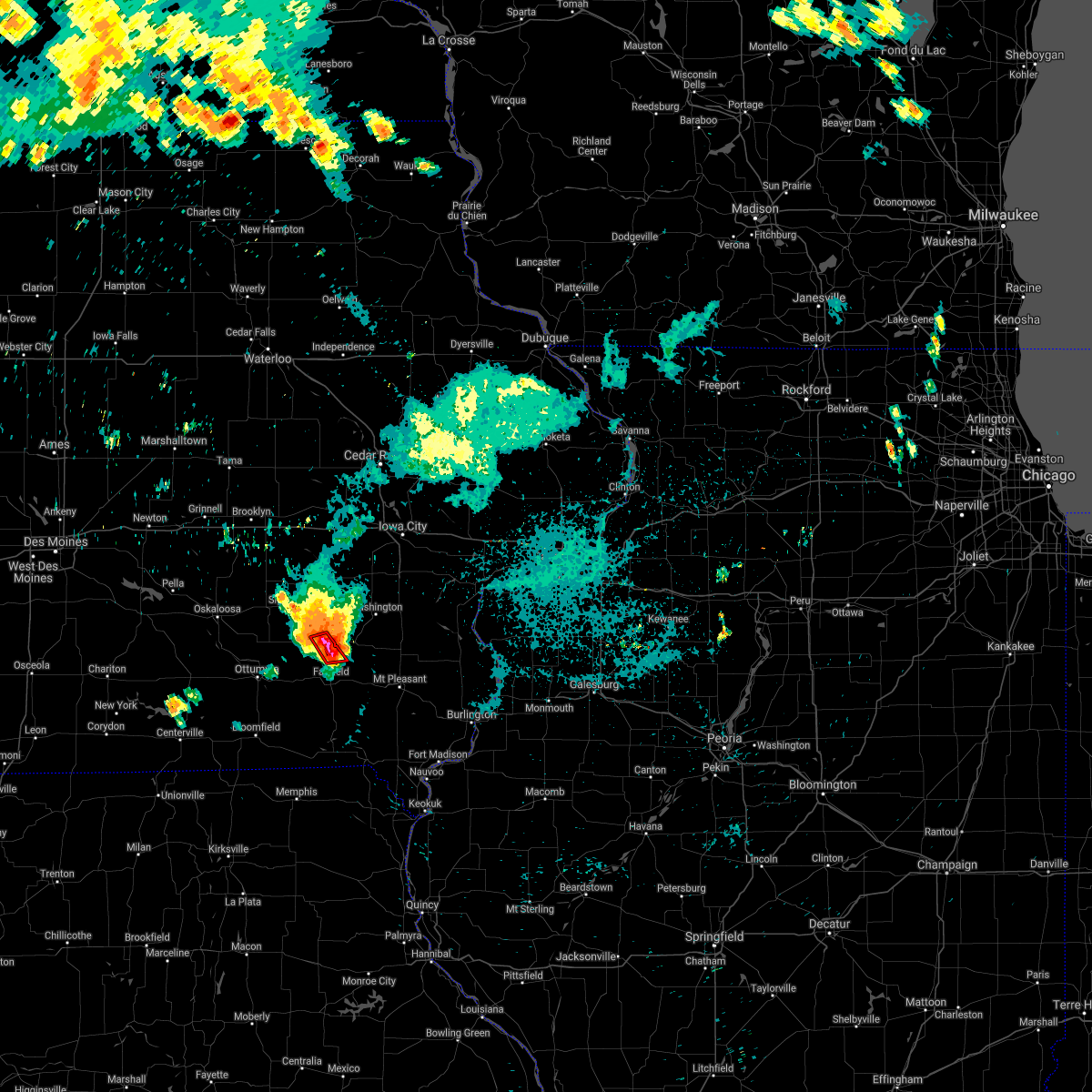 At 1140 pm cdt, a severe thunderstorm capable of producing a tornado was located near richland, or 10 miles north of fairfield, moving southeast at 20 mph (radar indicated rotation). Hazards include tornado and ping pong ball size hail. Flying debris will be dangerous to those caught without shelter. mobile homes will be damaged or destroyed. damage to roofs, windows, and vehicles will occur. tree damage is likely. Locations impacted include, richland and ollie. At 1140 pm cdt, a severe thunderstorm capable of producing a tornado was located near richland, or 10 miles north of fairfield, moving southeast at 20 mph (radar indicated rotation). Hazards include tornado and ping pong ball size hail. Flying debris will be dangerous to those caught without shelter. mobile homes will be damaged or destroyed. damage to roofs, windows, and vehicles will occur. tree damage is likely. Locations impacted include, richland and ollie.
|
| 8/26/2021 11:26 PM CDT |
 At 1125 pm cdt, a severe thunderstorm capable of producing a tornado was located over packwood, or 11 miles northwest of fairfield, moving southeast at 20 mph (radar indicated rotation). Hazards include tornado and golf ball size hail. Flying debris will be dangerous to those caught without shelter. mobile homes will be damaged or destroyed. damage to roofs, windows, and vehicles will occur. tree damage is likely. Locations impacted include, maharishi vedic city. At 1125 pm cdt, a severe thunderstorm capable of producing a tornado was located over packwood, or 11 miles northwest of fairfield, moving southeast at 20 mph (radar indicated rotation). Hazards include tornado and golf ball size hail. Flying debris will be dangerous to those caught without shelter. mobile homes will be damaged or destroyed. damage to roofs, windows, and vehicles will occur. tree damage is likely. Locations impacted include, maharishi vedic city.
|
| 8/26/2021 11:20 PM CDT |
 At 1120 pm cdt, a severe thunderstorm capable of producing a tornado was located near packwood, or 12 miles southeast of sigourney, moving southeast at 20 mph (radar indicated rotation). Hazards include tornado. Flying debris will be dangerous to those caught without shelter. mobile homes will be damaged or destroyed. damage to roofs, windows, and vehicles will occur. tree damage is likely. this dangerous storm will be near, richland and packwood around 1130 pm cdt. Other locations in the path of this tornadic thunderstorm include maharishi vedic city. At 1120 pm cdt, a severe thunderstorm capable of producing a tornado was located near packwood, or 12 miles southeast of sigourney, moving southeast at 20 mph (radar indicated rotation). Hazards include tornado. Flying debris will be dangerous to those caught without shelter. mobile homes will be damaged or destroyed. damage to roofs, windows, and vehicles will occur. tree damage is likely. this dangerous storm will be near, richland and packwood around 1130 pm cdt. Other locations in the path of this tornadic thunderstorm include maharishi vedic city.
|
| 8/26/2021 11:05 PM CDT |
 At 1104 pm cdt, severe thunderstorms were located along a line extending from near harper to near ottumwa, moving southeast at 20 mph. these are destructive storms for sigourney, lancaster, hayesville , martinburg, ollie, hendrick, and harper, (trained weather spotters). Hazards include 80 mph wind gusts and golf ball size hail. Flying debris will be dangerous to those caught without shelter. mobile homes will be heavily damaged. expect considerable damage to roofs, windows, and vehicles. extensive tree damage and power outages are likely. Locations impacted include, sigourney, hedrick, what cheer, richland, delta, keswick, south english, harper, martinsburg, hayesville, keota, ollie, webster, lancaster, keokuk county expo, pekin, lake belva deer park, yenruogis county park and talleyrand. At 1104 pm cdt, severe thunderstorms were located along a line extending from near harper to near ottumwa, moving southeast at 20 mph. these are destructive storms for sigourney, lancaster, hayesville , martinburg, ollie, hendrick, and harper, (trained weather spotters). Hazards include 80 mph wind gusts and golf ball size hail. Flying debris will be dangerous to those caught without shelter. mobile homes will be heavily damaged. expect considerable damage to roofs, windows, and vehicles. extensive tree damage and power outages are likely. Locations impacted include, sigourney, hedrick, what cheer, richland, delta, keswick, south english, harper, martinsburg, hayesville, keota, ollie, webster, lancaster, keokuk county expo, pekin, lake belva deer park, yenruogis county park and talleyrand.
|
| 8/26/2021 10:52 PM CDT |
 At 1050 pm cdt, severe thunderstorms were located along a line extending from near harper to near ottumwa, moving southeast at 15 mph. these are destructive storms for sigourney, lancaster, hayesville , martinburg, ollie, hendrick, and harper, (trained weather spotters). Hazards include 80 mph wind gusts and golf ball size hail. Flying debris will be dangerous to those caught without shelter. mobile homes will be heavily damaged. expect considerable damage to roofs, windows, and vehicles. extensive tree damage and power outages are likely. Locations impacted include, sigourney, hedrick, what cheer, richland, delta, keswick, south english, harper, martinsburg, hayesville, keota, ollie, webster, lancaster, keokuk county expo, pekin, lake belva deer park, yenruogis county park and talleyrand. At 1050 pm cdt, severe thunderstorms were located along a line extending from near harper to near ottumwa, moving southeast at 15 mph. these are destructive storms for sigourney, lancaster, hayesville , martinburg, ollie, hendrick, and harper, (trained weather spotters). Hazards include 80 mph wind gusts and golf ball size hail. Flying debris will be dangerous to those caught without shelter. mobile homes will be heavily damaged. expect considerable damage to roofs, windows, and vehicles. extensive tree damage and power outages are likely. Locations impacted include, sigourney, hedrick, what cheer, richland, delta, keswick, south english, harper, martinsburg, hayesville, keota, ollie, webster, lancaster, keokuk county expo, pekin, lake belva deer park, yenruogis county park and talleyrand.
|
| 8/26/2021 10:43 PM CDT |
 At 1042 pm cdt, severe thunderstorms were located along a line extending from harper to near ottumwa, moving southeast at 20 mph (radar indicated). Hazards include golf ball size hail and 70 mph wind gusts. People and animals outdoors will be injured. expect hail damage to roofs, siding, windows, and vehicles. expect considerable tree damage. Wind damage is also likely to mobile homes, roofs, and outbuildings. At 1042 pm cdt, severe thunderstorms were located along a line extending from harper to near ottumwa, moving southeast at 20 mph (radar indicated). Hazards include golf ball size hail and 70 mph wind gusts. People and animals outdoors will be injured. expect hail damage to roofs, siding, windows, and vehicles. expect considerable tree damage. Wind damage is also likely to mobile homes, roofs, and outbuildings.
|
| 6/19/2021 12:12 AM CDT |
 At 1212 am cdt, severe thunderstorms were located along a line extending from near brighton to near birmingham to 6 miles west of milton, moving east at 35 mph (radar indicated). Hazards include 60 mph wind gusts and quarter size hail. Hail damage to vehicles is expected. expect wind damage to roofs, siding, and trees. severe thunderstorms will be near, birmingham and pleasant plain around 1215 am cdt. brighton and stockport around 1220 am cdt. lockridge around 1225 am cdt. hillsboro and coppock around 1230 am cdt. Other locations in the path of these severe thunderstorms include keosauqua, bentonsport/vernon and bonaparte. At 1212 am cdt, severe thunderstorms were located along a line extending from near brighton to near birmingham to 6 miles west of milton, moving east at 35 mph (radar indicated). Hazards include 60 mph wind gusts and quarter size hail. Hail damage to vehicles is expected. expect wind damage to roofs, siding, and trees. severe thunderstorms will be near, birmingham and pleasant plain around 1215 am cdt. brighton and stockport around 1220 am cdt. lockridge around 1225 am cdt. hillsboro and coppock around 1230 am cdt. Other locations in the path of these severe thunderstorms include keosauqua, bentonsport/vernon and bonaparte.
|
| 8/10/2020 12:52 PM CDT |
 At 1252 pm cdt, severe thunderstorms were located along a line extending from near rome to cantril, moving east at 50 mph (trained weather spotters). Hazards include 60 mph wind gusts. Expect damage to roofs, siding, and trees. Locations impacted include, fairfield, keosauqua, brighton, richland, batavia, birmingham, milton, bonaparte, libertyville, stockport, lockridge, maharishi vedic city, cantril, packwood, pleasant plain, abingdon, douds, bentonsport/vernon, leando and farmington. At 1252 pm cdt, severe thunderstorms were located along a line extending from near rome to cantril, moving east at 50 mph (trained weather spotters). Hazards include 60 mph wind gusts. Expect damage to roofs, siding, and trees. Locations impacted include, fairfield, keosauqua, brighton, richland, batavia, birmingham, milton, bonaparte, libertyville, stockport, lockridge, maharishi vedic city, cantril, packwood, pleasant plain, abingdon, douds, bentonsport/vernon, leando and farmington.
|
| 8/10/2020 12:05 PM CDT |
 At 1205 pm cdt, severe thunderstorms were located along a line extending from near hedrick to near lake sundown, moving east at 45 mph (radar indicated). Hazards include 60 mph wind gusts. expect damage to roofs, siding, and trees At 1205 pm cdt, severe thunderstorms were located along a line extending from near hedrick to near lake sundown, moving east at 45 mph (radar indicated). Hazards include 60 mph wind gusts. expect damage to roofs, siding, and trees
|
| 7/11/2020 8:06 PM CDT |
 The severe thunderstorm warning for southeastern keokuk and northeastern jefferson counties will expire at 815 pm cdt, the storm which prompted the warning has weakened below severe limits, and no longer poses an immediate threat to life or property. therefore, the warning will be allowed to expire. a severe thunderstorm watch remains in effect until midnight cdt for southeastern iowa. The severe thunderstorm warning for southeastern keokuk and northeastern jefferson counties will expire at 815 pm cdt, the storm which prompted the warning has weakened below severe limits, and no longer poses an immediate threat to life or property. therefore, the warning will be allowed to expire. a severe thunderstorm watch remains in effect until midnight cdt for southeastern iowa.
|
| 7/11/2020 7:50 PM CDT |
 At 750 pm cdt, a severe thunderstorm was located near richland, or 8 miles north of fairfield, moving southeast at 40 mph (radar indicated). Hazards include 60 mph wind gusts and quarter size hail. Hail damage to vehicles is expected. expect wind damage to roofs, siding, and trees. Locations impacted include, fairfield, richland, maharishi vedic city, fairfield municipal airport, salina and perlee. At 750 pm cdt, a severe thunderstorm was located near richland, or 8 miles north of fairfield, moving southeast at 40 mph (radar indicated). Hazards include 60 mph wind gusts and quarter size hail. Hail damage to vehicles is expected. expect wind damage to roofs, siding, and trees. Locations impacted include, fairfield, richland, maharishi vedic city, fairfield municipal airport, salina and perlee.
|
| 7/11/2020 7:25 PM CDT |
 At 724 pm cdt, a severe thunderstorm was located over hayesville, or over sigourney, moving southeast at 40 mph (radar indicated). Hazards include 60 mph wind gusts and quarter size hail. Hail damage to vehicles is expected. Expect wind damage to roofs, siding, and trees. At 724 pm cdt, a severe thunderstorm was located over hayesville, or over sigourney, moving southeast at 40 mph (radar indicated). Hazards include 60 mph wind gusts and quarter size hail. Hail damage to vehicles is expected. Expect wind damage to roofs, siding, and trees.
|
| 7/11/2020 6:52 PM CDT |
 At 651 pm cdt, a severe thunderstorm was located over kinross, or 13 miles northeast of sigourney, moving southeast at 35 mph (radar indicated). Hazards include 60 mph wind gusts and quarter size hail. Hail damage to vehicles is expected. Expect wind damage to roofs, siding, and trees. At 651 pm cdt, a severe thunderstorm was located over kinross, or 13 miles northeast of sigourney, moving southeast at 35 mph (radar indicated). Hazards include 60 mph wind gusts and quarter size hail. Hail damage to vehicles is expected. Expect wind damage to roofs, siding, and trees.
|
| 5/14/2020 7:34 PM CDT |
 At 733 pm cdt, severe thunderstorms were located along a line extending from 6 miles northeast of richland to libertyville, moving east at 25 mph (radar indicated). Hazards include 70 mph wind gusts and quarter size hail. Hail damage to vehicles is expected. expect considerable tree damage. wind damage is also likely to mobile homes, roofs, and outbuildings. Locations impacted include, fairfield, washington, brighton, richland, batavia, libertyville, maharishi vedic city, packwood, pleasant plain, abingdon, ollie, germanville, jefferson county park, lake darling state park, washington county fairgrounds, fairfield municipal airport, perlee, linby, east pleasant plain and jefferson county fairgrounds. At 733 pm cdt, severe thunderstorms were located along a line extending from 6 miles northeast of richland to libertyville, moving east at 25 mph (radar indicated). Hazards include 70 mph wind gusts and quarter size hail. Hail damage to vehicles is expected. expect considerable tree damage. wind damage is also likely to mobile homes, roofs, and outbuildings. Locations impacted include, fairfield, washington, brighton, richland, batavia, libertyville, maharishi vedic city, packwood, pleasant plain, abingdon, ollie, germanville, jefferson county park, lake darling state park, washington county fairgrounds, fairfield municipal airport, perlee, linby, east pleasant plain and jefferson county fairgrounds.
|
| 5/14/2020 7:30 PM CDT | 4 inch diameter branch down. spotter estimated winds from the rfd to be near 75 mph. time estimate in keokuk county IA, 0.9 miles WSW of Richland, IA |
| 5/14/2020 7:26 PM CDT |
 The severe thunderstorm warning for southern keokuk and northwestern jefferson counties will expire at 730 pm cdt, the storm which prompted the warning has moved out of the area. therefore, the warning will be allowed to expire. however heavy rain is still possible with additional thunderstorms moving into the area. a severe thunderstorm watch remains in effect until 100 am cdt for southeastern iowa. The severe thunderstorm warning for southern keokuk and northwestern jefferson counties will expire at 730 pm cdt, the storm which prompted the warning has moved out of the area. therefore, the warning will be allowed to expire. however heavy rain is still possible with additional thunderstorms moving into the area. a severe thunderstorm watch remains in effect until 100 am cdt for southeastern iowa.
|
| 5/14/2020 7:24 PM CDT |
 At 723 pm cdt, severe thunderstorms were located along a line extending from near richland to batavia, moving east at 20 mph (radar indicated). Hazards include 60 mph wind gusts and quarter size hail. Hail damage to vehicles is expected. Expect wind damage to roofs, siding, and trees. At 723 pm cdt, severe thunderstorms were located along a line extending from near richland to batavia, moving east at 20 mph (radar indicated). Hazards include 60 mph wind gusts and quarter size hail. Hail damage to vehicles is expected. Expect wind damage to roofs, siding, and trees.
|
| 5/14/2020 7:14 PM CDT |
 At 713 pm cdt, a severe thunderstorm was located near hayesville, or near sigourney, moving east at 30 mph (radar indicated). Hazards include 60 mph wind gusts and quarter size hail. Hail damage to vehicles is expected. expect wind damage to roofs, siding, and trees. Locations impacted include, hedrick, richland, packwood, martinsburg, hayesville, abingdon, keota, ollie, linby, lancaster, talleyrand and pekin. At 713 pm cdt, a severe thunderstorm was located near hayesville, or near sigourney, moving east at 30 mph (radar indicated). Hazards include 60 mph wind gusts and quarter size hail. Hail damage to vehicles is expected. expect wind damage to roofs, siding, and trees. Locations impacted include, hedrick, richland, packwood, martinsburg, hayesville, abingdon, keota, ollie, linby, lancaster, talleyrand and pekin.
|
| 5/14/2020 7:01 PM CDT |
 At 659 pm cdt, a severe thunderstorm was located near hayesville, or 8 miles southwest of sigourney, moving east at 30 mph (radar indicated). Hazards include 60 mph wind gusts and quarter size hail. at 655 pm, a 58 mph wind gust was reported at the oskaloosa airport. a report of broken tree limbs and power poles was also recieved from fremont. Hail damage to vehicles is expected. expect wind damage to roofs, siding, and trees. Locations impacted include, sigourney, hedrick, richland, delta, packwood, harper, martinsburg, hayesville, abingdon, keota, ollie, linby, lancaster, keokuk county expo, pekin, yenruogis county park and talleyrand. At 659 pm cdt, a severe thunderstorm was located near hayesville, or 8 miles southwest of sigourney, moving east at 30 mph (radar indicated). Hazards include 60 mph wind gusts and quarter size hail. at 655 pm, a 58 mph wind gust was reported at the oskaloosa airport. a report of broken tree limbs and power poles was also recieved from fremont. Hail damage to vehicles is expected. expect wind damage to roofs, siding, and trees. Locations impacted include, sigourney, hedrick, richland, delta, packwood, harper, martinsburg, hayesville, abingdon, keota, ollie, linby, lancaster, keokuk county expo, pekin, yenruogis county park and talleyrand.
|
| 5/14/2020 6:52 PM CDT |
 At 651 pm cdt, a severe thunderstorm was located near hedrick, or 10 miles southwest of sigourney, moving east at 30 mph (radar indicated). Hazards include 60 mph wind gusts and quarter size hail. Hail damage to vehicles is expected. expect wind damage to roofs, siding, and trees. Locations impacted include, sigourney, hedrick, what cheer, richland, delta, keswick, south english, packwood, harper, martinsburg, kinross, hayesville, abingdon, keota, ollie, webster, thornburg, pekin, keokuk county fairgrounds and linby. At 651 pm cdt, a severe thunderstorm was located near hedrick, or 10 miles southwest of sigourney, moving east at 30 mph (radar indicated). Hazards include 60 mph wind gusts and quarter size hail. Hail damage to vehicles is expected. expect wind damage to roofs, siding, and trees. Locations impacted include, sigourney, hedrick, what cheer, richland, delta, keswick, south english, packwood, harper, martinsburg, kinross, hayesville, abingdon, keota, ollie, webster, thornburg, pekin, keokuk county fairgrounds and linby.
|
| 5/14/2020 6:42 PM CDT |
 At 641 pm cdt, a severe thunderstorm was located 8 miles southwest of delta, or 9 miles east of oskaloosa, moving east at 30 mph (radar indicated). Hazards include 60 mph wind gusts and quarter size hail. Hail damage to vehicles is expected. expect wind damage to roofs, siding, and trees. Locations impacted include, sigourney, hedrick, what cheer, richland, delta, keswick, south english, packwood, harper, martinsburg, kinross, hayesville, abingdon, keota, ollie, webster, thornburg, pekin, keokuk county fairgrounds and linby. At 641 pm cdt, a severe thunderstorm was located 8 miles southwest of delta, or 9 miles east of oskaloosa, moving east at 30 mph (radar indicated). Hazards include 60 mph wind gusts and quarter size hail. Hail damage to vehicles is expected. expect wind damage to roofs, siding, and trees. Locations impacted include, sigourney, hedrick, what cheer, richland, delta, keswick, south english, packwood, harper, martinsburg, kinross, hayesville, abingdon, keota, ollie, webster, thornburg, pekin, keokuk county fairgrounds and linby.
|
| 5/14/2020 6:33 PM CDT |
 At 632 pm cdt, a severe thunderstorm was located near oskaloosa, moving east at 30 mph (radar indicated). Hazards include 60 mph wind gusts and quarter size hail. Hail damage to vehicles is expected. Expect wind damage to roofs, siding, and trees. At 632 pm cdt, a severe thunderstorm was located near oskaloosa, moving east at 30 mph (radar indicated). Hazards include 60 mph wind gusts and quarter size hail. Hail damage to vehicles is expected. Expect wind damage to roofs, siding, and trees.
|
| 8/20/2019 7:27 AM CDT |
 The severe thunderstorm warning for northwestern henry, northwestern louisa, eastern keokuk, johnson, washington, western muscatine, jefferson and southeastern iowa counties will expire at 730 am cdt, the storms which prompted the warning have moved out of the area. therefore, the warning will be allowed to expire. however gusty winds and heavy rain are still possible with these thunderstorms. a severe thunderstorm watch remains in effect until 300 pm cdt for southeastern and east central iowa. The severe thunderstorm warning for northwestern henry, northwestern louisa, eastern keokuk, johnson, washington, western muscatine, jefferson and southeastern iowa counties will expire at 730 am cdt, the storms which prompted the warning have moved out of the area. therefore, the warning will be allowed to expire. however gusty winds and heavy rain are still possible with these thunderstorms. a severe thunderstorm watch remains in effect until 300 pm cdt for southeastern and east central iowa.
|
| 8/20/2019 7:18 AM CDT |
 At 716 am cdt, severe thunderstorms were located along a line extending from near oxford to 8 miles west of washington to near leando, moving east at 35 mph (radar indicated). Hazards include 60 mph wind gusts and penny size hail. 70 mph wind gusts from around keota and washington on southward. Expect damage to roofs, siding, and trees. locations impacted include, iowa city, fairfield, washington, west branch, columbus junction, coralville, north liberty, williamsburg, kalona, tiffin, wellman, lone tree, university heights, north english, riverside, wayland, oxford, hills, brighton and richland. this includes the following highways, interstate 80 in iowa between mile markers 215 and 253. Interstate 380 between mile markers 1 and 2. At 716 am cdt, severe thunderstorms were located along a line extending from near oxford to 8 miles west of washington to near leando, moving east at 35 mph (radar indicated). Hazards include 60 mph wind gusts and penny size hail. 70 mph wind gusts from around keota and washington on southward. Expect damage to roofs, siding, and trees. locations impacted include, iowa city, fairfield, washington, west branch, columbus junction, coralville, north liberty, williamsburg, kalona, tiffin, wellman, lone tree, university heights, north english, riverside, wayland, oxford, hills, brighton and richland. this includes the following highways, interstate 80 in iowa between mile markers 215 and 253. Interstate 380 between mile markers 1 and 2.
|
| 8/20/2019 7:08 AM CDT |
 At 707 am cdt, severe thunderstorms were located along a line extending from 6 miles southeast of kinross to near fairfield to near bloomfield, moving east at 60 mph (radar indicated). Hazards include 70 mph wind gusts. Expect considerable tree damage. Damage is likely to mobile homes, roofs, and outbuildings. At 707 am cdt, severe thunderstorms were located along a line extending from 6 miles southeast of kinross to near fairfield to near bloomfield, moving east at 60 mph (radar indicated). Hazards include 70 mph wind gusts. Expect considerable tree damage. Damage is likely to mobile homes, roofs, and outbuildings.
|
| 8/20/2019 6:53 AM CDT |
 A severe thunderstorm warning remains in effect until 730 am cdt for northwestern henry. northwestern louisa. keokuk. johnson. washington. western muscatine. jefferson and iowa counties. At 653 am cdt, severe thunderstorms were located along a line extending from near ladora to near harper to 7 miles northwest of bloomfield, moving east at 60 mph. A severe thunderstorm warning remains in effect until 730 am cdt for northwestern henry. northwestern louisa. keokuk. johnson. washington. western muscatine. jefferson and iowa counties. At 653 am cdt, severe thunderstorms were located along a line extending from near ladora to near harper to 7 miles northwest of bloomfield, moving east at 60 mph.
|
| 8/20/2019 6:28 AM CDT |
 At 627 am cdt, severe thunderstorms were located along a line extending from near brooklyn to near what cheer to near rathbun lake, moving east at 60 mph (radar indicated). Hazards include 60 mph wind gusts. expect damage to roofs, siding, and trees At 627 am cdt, severe thunderstorms were located along a line extending from near brooklyn to near what cheer to near rathbun lake, moving east at 60 mph (radar indicated). Hazards include 60 mph wind gusts. expect damage to roofs, siding, and trees
|
| 7/20/2019 7:39 PM CDT |
 At 739 pm cdt, severe thunderstorms were located along a line extending from 7 miles southeast of harper to near fairfield to near douds to bloomfield, moving southeast at 35 mph (radar indicated). Hazards include 60 mph wind gusts. Expect damage to roofs, siding, and trees. Locations impacted include, fairfield, brighton, richland, batavia, birmingham, milton, libertyville, maharishi vedic city, packwood, pleasant plain, hayesville, douds, abingdon, leando, ollie, pekin, selma, jefferson county park, collett and lake darling state park. At 739 pm cdt, severe thunderstorms were located along a line extending from 7 miles southeast of harper to near fairfield to near douds to bloomfield, moving southeast at 35 mph (radar indicated). Hazards include 60 mph wind gusts. Expect damage to roofs, siding, and trees. Locations impacted include, fairfield, brighton, richland, batavia, birmingham, milton, libertyville, maharishi vedic city, packwood, pleasant plain, hayesville, douds, abingdon, leando, ollie, pekin, selma, jefferson county park, collett and lake darling state park.
|
| 7/20/2019 7:37 PM CDT |
 At 737 pm cdt, a severe thunderstorm was located near fairfield, moving east at 40 mph (radar indicated). Hazards include 60 mph wind gusts. expect damage to roofs, siding, and trees At 737 pm cdt, a severe thunderstorm was located near fairfield, moving east at 40 mph (radar indicated). Hazards include 60 mph wind gusts. expect damage to roofs, siding, and trees
|
| 7/20/2019 7:34 PM CDT |
 At 734 pm cdt, severe thunderstorms were located along a line extending from near harper to near fairfield to 6 miles west of douds to bloomfield, moving southeast at 40 mph (radar indicated). Hazards include 70 mph wind gusts. Expect considerable tree damage. damage is likely to mobile homes, roofs, and outbuildings. Locations impacted include, fairfield, hedrick, brighton, richland, batavia, birmingham, milton, delta, libertyville, maharishi vedic city, packwood, martinsburg, pleasant plain, hayesville, douds, abingdon, leando, ollie, pekin and selma. At 734 pm cdt, severe thunderstorms were located along a line extending from near harper to near fairfield to 6 miles west of douds to bloomfield, moving southeast at 40 mph (radar indicated). Hazards include 70 mph wind gusts. Expect considerable tree damage. damage is likely to mobile homes, roofs, and outbuildings. Locations impacted include, fairfield, hedrick, brighton, richland, batavia, birmingham, milton, delta, libertyville, maharishi vedic city, packwood, martinsburg, pleasant plain, hayesville, douds, abingdon, leando, ollie, pekin and selma.
|
| 7/20/2019 7:24 PM CDT |
 At 723 pm cdt, severe thunderstorms were located along a line extending from near harper to near maharishi vedic city to 10 miles southeast of ottumwa to 7 miles west of bloomfield, moving east at 45 mph (radar indicated). Hazards include 70 mph wind gusts. Expect considerable tree damage. damage is likely to mobile homes, roofs, and outbuildings. Locations impacted include, fairfield, sigourney, hedrick, brighton, what cheer, richland, batavia, birmingham, milton, delta, libertyville, maharishi vedic city, packwood, martinsburg, pleasant plain, hayesville, douds, abingdon, leando and ollie. At 723 pm cdt, severe thunderstorms were located along a line extending from near harper to near maharishi vedic city to 10 miles southeast of ottumwa to 7 miles west of bloomfield, moving east at 45 mph (radar indicated). Hazards include 70 mph wind gusts. Expect considerable tree damage. damage is likely to mobile homes, roofs, and outbuildings. Locations impacted include, fairfield, sigourney, hedrick, brighton, what cheer, richland, batavia, birmingham, milton, delta, libertyville, maharishi vedic city, packwood, martinsburg, pleasant plain, hayesville, douds, abingdon, leando and ollie.
|
| 7/20/2019 7:16 PM CDT |
 At 716 pm cdt, severe thunderstorms were located along a line extending from near south english to near abingdon to 7 miles north of bloomfield to 7 miles southeast of lake sundown, moving east at 45 mph (radar indicated). Hazards include 70 mph wind gusts. Expect considerable tree damage. damage is likely to mobile homes, roofs, and outbuildings. Locations impacted include, fairfield, sigourney, hedrick, brighton, what cheer, richland, batavia, birmingham, milton, delta, libertyville, maharishi vedic city, packwood, martinsburg, pleasant plain, hayesville, douds, abingdon, leando and ollie. At 716 pm cdt, severe thunderstorms were located along a line extending from near south english to near abingdon to 7 miles north of bloomfield to 7 miles southeast of lake sundown, moving east at 45 mph (radar indicated). Hazards include 70 mph wind gusts. Expect considerable tree damage. damage is likely to mobile homes, roofs, and outbuildings. Locations impacted include, fairfield, sigourney, hedrick, brighton, what cheer, richland, batavia, birmingham, milton, delta, libertyville, maharishi vedic city, packwood, martinsburg, pleasant plain, hayesville, douds, abingdon, leando and ollie.
|
| 7/20/2019 7:12 PM CDT |
 At 711 pm cdt, severe thunderstorms were located along a line extending from near south english to near abingdon to 9 miles south of ottumwa to near lake sundown, moving east at 40 mph (radar indicated). Hazards include 70 mph wind gusts. Expect considerable tree damage. damage is likely to mobile homes, roofs, and outbuildings. Locations impacted include, fairfield, washington, sigourney, hedrick, brighton, what cheer, richland, batavia, birmingham, milton, delta, libertyville, maharishi vedic city, keswick, south english, packwood, harper, martinsburg, pleasant plain and hayesville. At 711 pm cdt, severe thunderstorms were located along a line extending from near south english to near abingdon to 9 miles south of ottumwa to near lake sundown, moving east at 40 mph (radar indicated). Hazards include 70 mph wind gusts. Expect considerable tree damage. damage is likely to mobile homes, roofs, and outbuildings. Locations impacted include, fairfield, washington, sigourney, hedrick, brighton, what cheer, richland, batavia, birmingham, milton, delta, libertyville, maharishi vedic city, keswick, south english, packwood, harper, martinsburg, pleasant plain and hayesville.
|
| 7/20/2019 7:00 PM CDT |
 At 659 pm cdt, severe thunderstorms were located along a line extending from near keswick to near hedrick to 8 miles northeast of lake sundown to near centerville, moving east at 50 mph (radar indicated). Hazards include 70 mph wind gusts. Expect considerable tree damage. damage is likely to mobile homes, roofs, and outbuildings. Locations impacted include, fairfield, washington, sigourney, hedrick, brighton, what cheer, richland, batavia, birmingham, milton, delta, libertyville, maharishi vedic city, keswick, south english, packwood, harper, martinsburg, pleasant plain and hayesville. At 659 pm cdt, severe thunderstorms were located along a line extending from near keswick to near hedrick to 8 miles northeast of lake sundown to near centerville, moving east at 50 mph (radar indicated). Hazards include 70 mph wind gusts. Expect considerable tree damage. damage is likely to mobile homes, roofs, and outbuildings. Locations impacted include, fairfield, washington, sigourney, hedrick, brighton, what cheer, richland, batavia, birmingham, milton, delta, libertyville, maharishi vedic city, keswick, south english, packwood, harper, martinsburg, pleasant plain and hayesville.
|
| 7/20/2019 6:50 PM CDT |
 At 649 pm cdt, severe thunderstorms were located along a line extending from 7 miles southeast of montezuma to near ottumwa industrial airport to 6 miles southeast of albia to near rathbun lake, moving east at 60 mph (radar indicated). Hazards include 70 mph wind gusts. Expect considerable tree damage. damage is likely to mobile homes, roofs, and outbuildings. Locations impacted include, fairfield, washington, sigourney, hedrick, brighton, what cheer, richland, batavia, birmingham, milton, delta, libertyville, maharishi vedic city, keswick, south english, packwood, harper, martinsburg, pleasant plain and hayesville. At 649 pm cdt, severe thunderstorms were located along a line extending from 7 miles southeast of montezuma to near ottumwa industrial airport to 6 miles southeast of albia to near rathbun lake, moving east at 60 mph (radar indicated). Hazards include 70 mph wind gusts. Expect considerable tree damage. damage is likely to mobile homes, roofs, and outbuildings. Locations impacted include, fairfield, washington, sigourney, hedrick, brighton, what cheer, richland, batavia, birmingham, milton, delta, libertyville, maharishi vedic city, keswick, south english, packwood, harper, martinsburg, pleasant plain and hayesville.
|
| 7/20/2019 6:40 PM CDT |
 At 639 pm cdt, severe thunderstorms were located along a line extending from near montezuma to eddyville to near albia to near rathbun lake, moving southeast at 35 mph (radar indicated). Hazards include 60 mph wind gusts. expect damage to roofs, siding, and trees At 639 pm cdt, severe thunderstorms were located along a line extending from near montezuma to eddyville to near albia to near rathbun lake, moving southeast at 35 mph (radar indicated). Hazards include 60 mph wind gusts. expect damage to roofs, siding, and trees
|
| 7/17/2019 1:50 PM CDT |
 At 149 pm cdt, severe thunderstorms were located along a line extending from 8 miles north of brighton to bloomfield, moving southeast at 40 mph (radar indicated). Hazards include 60 mph wind gusts and quarter size hail. Hail damage to vehicles is expected. Expect wind damage to roofs, siding, and trees. At 149 pm cdt, severe thunderstorms were located along a line extending from 8 miles north of brighton to bloomfield, moving southeast at 40 mph (radar indicated). Hazards include 60 mph wind gusts and quarter size hail. Hail damage to vehicles is expected. Expect wind damage to roofs, siding, and trees.
|
| 6/28/2019 10:51 AM CDT |
 At 1051 am cdt, severe thunderstorms were located along a line extending from 7 miles west of washington to near richland to maharishi vedic city, moving southeast at 25 mph (radar indicated). Hazards include 60 mph wind gusts and quarter size hail. Hail damage to vehicles is expected. expect wind damage to roofs, siding, and trees. Locations impacted include, fairfield, washington, wayland, brighton, richland, batavia, libertyville, lockridge, crawfordsville, maharishi vedic city, packwood, rome, pleasant plain, coppock, abingdon, keota, ollie, west chester, washington airport and glasgow. At 1051 am cdt, severe thunderstorms were located along a line extending from 7 miles west of washington to near richland to maharishi vedic city, moving southeast at 25 mph (radar indicated). Hazards include 60 mph wind gusts and quarter size hail. Hail damage to vehicles is expected. expect wind damage to roofs, siding, and trees. Locations impacted include, fairfield, washington, wayland, brighton, richland, batavia, libertyville, lockridge, crawfordsville, maharishi vedic city, packwood, rome, pleasant plain, coppock, abingdon, keota, ollie, west chester, washington airport and glasgow.
|
| 6/28/2019 10:45 AM CDT | Trees down. time estimated from rada in keokuk county IA, 0.4 miles SSE of Richland, IA |
| 6/28/2019 10:43 AM CDT |
 At 1043 am cdt, severe thunderstorms were located along a line extending from 8 miles east of harper to richland to abingdon, moving southeast at 25 mph (radar indicated). Hazards include 60 mph wind gusts and quarter size hail. Hail damage to vehicles is expected. expect wind damage to roofs, siding, and trees. Locations impacted include, fairfield, washington, wayland, brighton, richland, batavia, libertyville, lockridge, crawfordsville, maharishi vedic city, packwood, rome, harper, pleasant plain, kinross, coppock, abingdon, keota, ollie and west chester. At 1043 am cdt, severe thunderstorms were located along a line extending from 8 miles east of harper to richland to abingdon, moving southeast at 25 mph (radar indicated). Hazards include 60 mph wind gusts and quarter size hail. Hail damage to vehicles is expected. expect wind damage to roofs, siding, and trees. Locations impacted include, fairfield, washington, wayland, brighton, richland, batavia, libertyville, lockridge, crawfordsville, maharishi vedic city, packwood, rome, harper, pleasant plain, kinross, coppock, abingdon, keota, ollie and west chester.
|
| 6/28/2019 10:40 AM CDT | Tree down across 320th street. time estimated from rada in keokuk county IA, 1.8 miles ESE of Richland, IA |
| 6/28/2019 10:35 AM CDT |
 At 1035 am cdt, severe thunderstorms were located along a line extending from 6 miles east of harper to near richland to abingdon, moving southeast at 25 mph (radar indicated). Hazards include 60 mph wind gusts and quarter size hail. Hail damage to vehicles is expected. Expect wind damage to roofs, siding, and trees. At 1035 am cdt, severe thunderstorms were located along a line extending from 6 miles east of harper to near richland to abingdon, moving southeast at 25 mph (radar indicated). Hazards include 60 mph wind gusts and quarter size hail. Hail damage to vehicles is expected. Expect wind damage to roofs, siding, and trees.
|
| 6/15/2019 7:20 PM CDT |
 At 720 pm cdt, severe thunderstorms were located along a line extending from near lone tree to near ainsworth to near abingdon, moving east at 40 mph (radar indicated). Hazards include 60 mph wind gusts and quarter size hail. Hail damage to vehicles is expected. Expect wind damage to roofs, siding, and trees. At 720 pm cdt, severe thunderstorms were located along a line extending from near lone tree to near ainsworth to near abingdon, moving east at 40 mph (radar indicated). Hazards include 60 mph wind gusts and quarter size hail. Hail damage to vehicles is expected. Expect wind damage to roofs, siding, and trees.
|
| 6/15/2019 6:32 PM CDT |
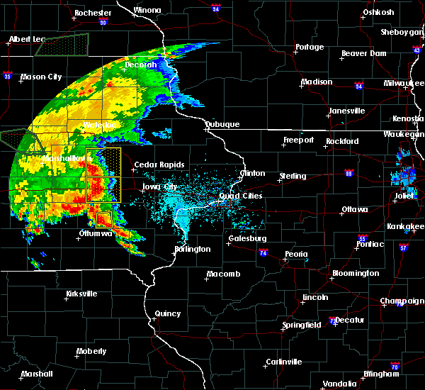 At 632 pm cdt, a severe thunderstorm was located near harper, or 8 miles southeast of sigourney, moving east at 30 mph (radar indicated). Hazards include 60 mph wind gusts and quarter size hail. Hail damage to vehicles is expected. expect wind damage to roofs, siding, and trees. Locations impacted include, richland, harper, keota, ollie and talleyrand. At 632 pm cdt, a severe thunderstorm was located near harper, or 8 miles southeast of sigourney, moving east at 30 mph (radar indicated). Hazards include 60 mph wind gusts and quarter size hail. Hail damage to vehicles is expected. expect wind damage to roofs, siding, and trees. Locations impacted include, richland, harper, keota, ollie and talleyrand.
|
| 6/15/2019 6:20 PM CDT |
 At 620 pm cdt, a severe thunderstorm was located near hayesville, or near sigourney, moving east at 35 mph (radar indicated). Hazards include 60 mph wind gusts and quarter size hail. Hail damage to vehicles is expected. expect wind damage to roofs, siding, and trees. Locations impacted include, sigourney, richland, harper, martinsburg, hayesville, keota, ollie, lancaster, talleyrand, keokuk county expo, pekin and sig-nor field airport. At 620 pm cdt, a severe thunderstorm was located near hayesville, or near sigourney, moving east at 35 mph (radar indicated). Hazards include 60 mph wind gusts and quarter size hail. Hail damage to vehicles is expected. expect wind damage to roofs, siding, and trees. Locations impacted include, sigourney, richland, harper, martinsburg, hayesville, keota, ollie, lancaster, talleyrand, keokuk county expo, pekin and sig-nor field airport.
|
| 6/15/2019 6:09 PM CDT |
 At 609 pm cdt, a severe thunderstorm was located near hayesville, or 8 miles southwest of sigourney, moving east at 35 mph (radar indicated). Hazards include 60 mph wind gusts and half dollar size hail. Hail damage to vehicles is expected. Expect wind damage to roofs, siding, and trees. At 609 pm cdt, a severe thunderstorm was located near hayesville, or 8 miles southwest of sigourney, moving east at 35 mph (radar indicated). Hazards include 60 mph wind gusts and half dollar size hail. Hail damage to vehicles is expected. Expect wind damage to roofs, siding, and trees.
|
| 5/17/2019 7:20 AM CDT |
 The severe thunderstorm warning for northern henry, southeastern keokuk, southern washington and jefferson counties will expire at 730 am cdt, the storm which prompted the warning has weakened below severe limits, and no longer poses an immediate threat to life or property. therefore, the warning will be allowed to expire. however small hail and heavy rain are still possible with this thunderstorm. The severe thunderstorm warning for northern henry, southeastern keokuk, southern washington and jefferson counties will expire at 730 am cdt, the storm which prompted the warning has weakened below severe limits, and no longer poses an immediate threat to life or property. therefore, the warning will be allowed to expire. however small hail and heavy rain are still possible with this thunderstorm.
|
| 5/17/2019 7:07 AM CDT |
 At 706 am cdt, a severe thunderstorm was located over coppock, or 11 miles south of washington, moving east at 30 mph (radar indicated). Hazards include 60 mph wind gusts and quarter size hail. Hail damage to vehicles is expected. expect wind damage to roofs, siding, and trees. Locations impacted include, fairfield, washington, winfield, wayland, brighton, richland, ainsworth, libertyville, crawfordsville, maharishi vedic city, olds, packwood, pleasant plain, coppock, abingdon, washington airport, germanville, jefferson county park, lake darling state park and swedesburg. At 706 am cdt, a severe thunderstorm was located over coppock, or 11 miles south of washington, moving east at 30 mph (radar indicated). Hazards include 60 mph wind gusts and quarter size hail. Hail damage to vehicles is expected. expect wind damage to roofs, siding, and trees. Locations impacted include, fairfield, washington, winfield, wayland, brighton, richland, ainsworth, libertyville, crawfordsville, maharishi vedic city, olds, packwood, pleasant plain, coppock, abingdon, washington airport, germanville, jefferson county park, lake darling state park and swedesburg.
|
| 5/17/2019 6:51 AM CDT |
 At 651 am cdt, a severe thunderstorm was located over pleasant plain, or 12 miles northeast of fairfield, moving east at 30 mph (radar indicated). Hazards include 60 mph wind gusts and quarter size hail. Hail damage to vehicles is expected. expect wind damage to roofs, siding, and trees. Locations impacted include, fairfield, washington, winfield, wayland, brighton, richland, ainsworth, batavia, libertyville, crawfordsville, maharishi vedic city, olds, packwood, pleasant plain, coppock, abingdon, wyman, ollie, west chester and washington airport. At 651 am cdt, a severe thunderstorm was located over pleasant plain, or 12 miles northeast of fairfield, moving east at 30 mph (radar indicated). Hazards include 60 mph wind gusts and quarter size hail. Hail damage to vehicles is expected. expect wind damage to roofs, siding, and trees. Locations impacted include, fairfield, washington, winfield, wayland, brighton, richland, ainsworth, batavia, libertyville, crawfordsville, maharishi vedic city, olds, packwood, pleasant plain, coppock, abingdon, wyman, ollie, west chester and washington airport.
|
| 5/17/2019 6:41 AM CDT |
 At 640 am cdt, a severe thunderstorm was located over richland, or 11 miles north of fairfield, moving east at 30 mph (radar indicated). Hazards include 60 mph wind gusts and quarter size hail. Hail damage to vehicles is expected. Expect wind damage to roofs, siding, and trees. At 640 am cdt, a severe thunderstorm was located over richland, or 11 miles north of fairfield, moving east at 30 mph (radar indicated). Hazards include 60 mph wind gusts and quarter size hail. Hail damage to vehicles is expected. Expect wind damage to roofs, siding, and trees.
|
| 9/25/2018 1:17 PM CDT |
 At 117 pm cdt, a severe thunderstorm was located over abingdon, or 8 miles northwest of fairfield, moving east at 45 mph (radar indicated). Hazards include 60 mph wind gusts and penny size hail. Expect damage to roofs, siding, and trees. this severe thunderstorm will be near, richland around 125 pm cdt. fairfield around 130 pm cdt. pleasant plain around 135 pm cdt. brighton and lockridge around 140 pm cdt. coppock around 145 pm cdt. wayland around 150 pm cdt. Other locations impacted by this severe thunderstorm include fairfield municipal airport, noble, washington airport, perlee, linby, east pleasant plain, pekin, merrimac, germanville and jefferson county fairgrounds. At 117 pm cdt, a severe thunderstorm was located over abingdon, or 8 miles northwest of fairfield, moving east at 45 mph (radar indicated). Hazards include 60 mph wind gusts and penny size hail. Expect damage to roofs, siding, and trees. this severe thunderstorm will be near, richland around 125 pm cdt. fairfield around 130 pm cdt. pleasant plain around 135 pm cdt. brighton and lockridge around 140 pm cdt. coppock around 145 pm cdt. wayland around 150 pm cdt. Other locations impacted by this severe thunderstorm include fairfield municipal airport, noble, washington airport, perlee, linby, east pleasant plain, pekin, merrimac, germanville and jefferson county fairgrounds.
|
| 9/1/2018 8:53 PM CDT |
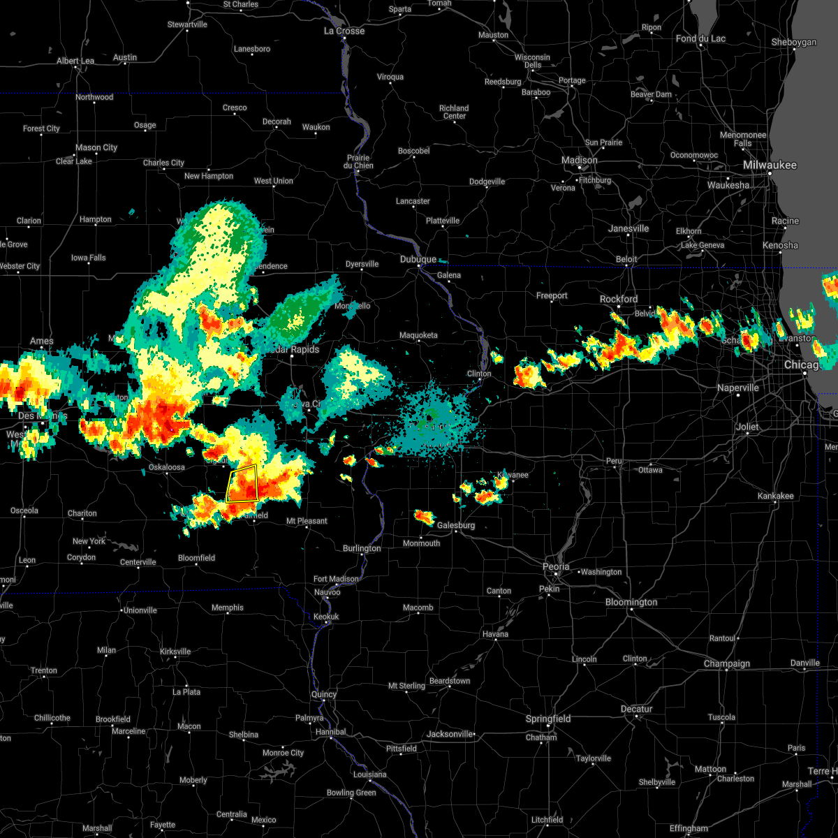 The severe thunderstorm warning for southeastern keokuk and northwestern jefferson counties will expire at 900 pm cdt, the storm which prompted the warning has weakened below severe limits, and no longer poses an immediate threat to life or property. therefore, the warning will be allowed to expire. however gusty winds and heavy rain are still possible with this thunderstorm. a severe thunderstorm watch remains in effect until 200 am cdt for southeastern iowa. The severe thunderstorm warning for southeastern keokuk and northwestern jefferson counties will expire at 900 pm cdt, the storm which prompted the warning has weakened below severe limits, and no longer poses an immediate threat to life or property. therefore, the warning will be allowed to expire. however gusty winds and heavy rain are still possible with this thunderstorm. a severe thunderstorm watch remains in effect until 200 am cdt for southeastern iowa.
|
| 9/1/2018 8:47 PM CDT |
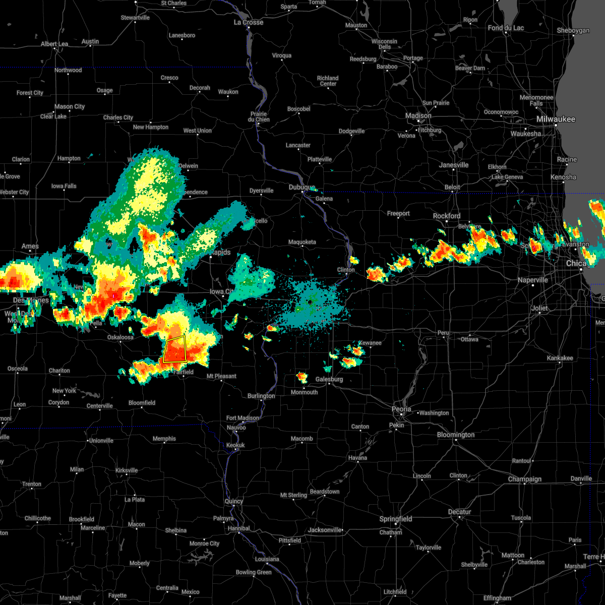 At 846 pm cdt, a severe thunderstorm was located near richland, or 13 miles southeast of sigourney, moving east at 15 mph (radar indicated). Hazards include 60 mph wind gusts. Expect damage to roofs, siding, and trees. Locations impacted include, richland, packwood, ollie, linby, talleyrand and pekin. At 846 pm cdt, a severe thunderstorm was located near richland, or 13 miles southeast of sigourney, moving east at 15 mph (radar indicated). Hazards include 60 mph wind gusts. Expect damage to roofs, siding, and trees. Locations impacted include, richland, packwood, ollie, linby, talleyrand and pekin.
|
| 9/1/2018 8:27 PM CDT |
 At 826 pm cdt, a severe thunderstorm was located near richland, or 10 miles southeast of sigourney, moving east at 15 mph (radar indicated). Hazards include 60 mph wind gusts and penny size hail. Expect damage to roofs, siding, and trees. Locations impacted include, richland, packwood, hayesville, ollie, linby, lancaster, talleyrand and pekin. At 826 pm cdt, a severe thunderstorm was located near richland, or 10 miles southeast of sigourney, moving east at 15 mph (radar indicated). Hazards include 60 mph wind gusts and penny size hail. Expect damage to roofs, siding, and trees. Locations impacted include, richland, packwood, hayesville, ollie, linby, lancaster, talleyrand and pekin.
|
| 9/1/2018 8:14 PM CDT |
 At 813 pm cdt, a severe thunderstorm was located near martinsburg, or 9 miles south of sigourney, moving east at 20 mph (radar indicated). Hazards include 60 mph wind gusts and quarter size hail. Hail damage to vehicles is expected. Expect wind damage to roofs, siding, and trees. At 813 pm cdt, a severe thunderstorm was located near martinsburg, or 9 miles south of sigourney, moving east at 20 mph (radar indicated). Hazards include 60 mph wind gusts and quarter size hail. Hail damage to vehicles is expected. Expect wind damage to roofs, siding, and trees.
|
| 8/28/2018 6:12 PM CDT |
 At 612 pm cdt, severe thunderstorms were located along a line extending from ainsworth to near brighton to near batavia, moving east at 60 mph (radar indicated). Hazards include 60 mph wind gusts and penny size hail. Expect damage to roofs, siding, and trees. Locations impacted include, fairfield, washington, wayland, brighton, richland, ainsworth, batavia, libertyville, lockridge, crawfordsville, maharishi vedic city, olds, packwood, pleasant plain, coppock, abingdon, ollie, west chester, washington airport and pekin. At 612 pm cdt, severe thunderstorms were located along a line extending from ainsworth to near brighton to near batavia, moving east at 60 mph (radar indicated). Hazards include 60 mph wind gusts and penny size hail. Expect damage to roofs, siding, and trees. Locations impacted include, fairfield, washington, wayland, brighton, richland, ainsworth, batavia, libertyville, lockridge, crawfordsville, maharishi vedic city, olds, packwood, pleasant plain, coppock, abingdon, ollie, west chester, washington airport and pekin.
|
| 8/28/2018 6:07 PM CDT |
 At 605 pm cdt, severe thunderstorms were located along a line extending from near washington to near pleasant plain to bloomfield, moving east at 60 mph (radar indicated). Hazards include 60 mph wind gusts and penny size hail. Expect damage to roofs, siding, and trees. Locations impacted include, fairfield, washington, wayland, hedrick, brighton, richland, ainsworth, batavia, libertyville, lockridge, crawfordsville, maharishi vedic city, olds, packwood, martinsburg, pleasant plain, hayesville, coppock, abingdon and ollie. At 605 pm cdt, severe thunderstorms were located along a line extending from near washington to near pleasant plain to bloomfield, moving east at 60 mph (radar indicated). Hazards include 60 mph wind gusts and penny size hail. Expect damage to roofs, siding, and trees. Locations impacted include, fairfield, washington, wayland, hedrick, brighton, richland, ainsworth, batavia, libertyville, lockridge, crawfordsville, maharishi vedic city, olds, packwood, martinsburg, pleasant plain, hayesville, coppock, abingdon and ollie.
|
| 8/28/2018 5:51 PM CDT |
 At 550 pm cdt, severe thunderstorms were located along a line extending from near harper to near abingdon to 9 miles south of lake sundown, moving east at 55 mph (radar indicated). Hazards include 70 mph wind gusts and penny size hail. Expect considerable tree damage. Damage is likely to mobile homes, roofs, and outbuildings. At 550 pm cdt, severe thunderstorms were located along a line extending from near harper to near abingdon to 9 miles south of lake sundown, moving east at 55 mph (radar indicated). Hazards include 70 mph wind gusts and penny size hail. Expect considerable tree damage. Damage is likely to mobile homes, roofs, and outbuildings.
|
| 6/28/2018 2:01 PM CDT |
 At 200 pm cdt, severe thunderstorms were located along a line extending from keswick to stockport to near memphis, moving southeast at 60 mph (radar indicated). Hazards include 70 mph wind gusts and quarter size hail. Hail damage to vehicles is expected. expect considerable tree damage. wind damage is also likely to mobile homes, roofs, and outbuildings. Locations impacted include, fairfield, sigourney, memphis, keosauqua, hedrick, what cheer, richland, batavia, birmingham, milton, delta, libertyville, maharishi vedic city, keswick, cantril, south english, packwood, harper, martinsburg and rutledge. At 200 pm cdt, severe thunderstorms were located along a line extending from keswick to stockport to near memphis, moving southeast at 60 mph (radar indicated). Hazards include 70 mph wind gusts and quarter size hail. Hail damage to vehicles is expected. expect considerable tree damage. wind damage is also likely to mobile homes, roofs, and outbuildings. Locations impacted include, fairfield, sigourney, memphis, keosauqua, hedrick, what cheer, richland, batavia, birmingham, milton, delta, libertyville, maharishi vedic city, keswick, cantril, south english, packwood, harper, martinsburg and rutledge.
|
| 6/28/2018 1:31 PM CDT |
 At 129 pm cdt, severe thunderstorms were located along a line extending from new sharon to near ottumwa to 9 miles northeast of greencastle, moving east at 55 mph (trained weather spotters). Hazards include 70 mph wind gusts and nickel size hail. Expect considerable tree damage. damage is likely to mobile homes, roofs, and outbuildings. Locations impacted include, fairfield, sigourney, memphis, keosauqua, hedrick, what cheer, richland, batavia, birmingham, milton, delta, libertyville, maharishi vedic city, keswick, cantril, south english, packwood, harper, martinsburg and rutledge. At 129 pm cdt, severe thunderstorms were located along a line extending from new sharon to near ottumwa to 9 miles northeast of greencastle, moving east at 55 mph (trained weather spotters). Hazards include 70 mph wind gusts and nickel size hail. Expect considerable tree damage. damage is likely to mobile homes, roofs, and outbuildings. Locations impacted include, fairfield, sigourney, memphis, keosauqua, hedrick, what cheer, richland, batavia, birmingham, milton, delta, libertyville, maharishi vedic city, keswick, cantril, south english, packwood, harper, martinsburg and rutledge.
|
| 6/28/2018 1:12 PM CDT |
 At 111 pm cdt, severe thunderstorms were located along a line extending from near pella to 7 miles east of unionville, moving east at 50 mph (radar indicated). Hazards include 70 mph wind gusts and nickel size hail. Expect considerable tree damage. Damage is likely to mobile homes, roofs, and outbuildings. At 111 pm cdt, severe thunderstorms were located along a line extending from near pella to 7 miles east of unionville, moving east at 50 mph (radar indicated). Hazards include 70 mph wind gusts and nickel size hail. Expect considerable tree damage. Damage is likely to mobile homes, roofs, and outbuildings.
|
| 6/20/2018 3:10 PM CDT |
 At 309 pm cdt, severe thunderstorms were located along a line extending from parnell to 6 miles northwest of washington to near fairfield, moving east at 35 mph (radar indicated). Hazards include 60 mph wind gusts. expect damage to roofs, siding, and trees At 309 pm cdt, severe thunderstorms were located along a line extending from parnell to 6 miles northwest of washington to near fairfield, moving east at 35 mph (radar indicated). Hazards include 60 mph wind gusts. expect damage to roofs, siding, and trees
|
| 5/13/2018 2:17 PM CDT |
 At 217 pm cdt, a severe thunderstorm was located over richland, or 13 miles southeast of sigourney, moving east at 40 mph (radar indicated). Hazards include 60 mph wind gusts and half dollar size hail. Hail damage to vehicles is expected. Expect wind damage to roofs, siding, and trees. At 217 pm cdt, a severe thunderstorm was located over richland, or 13 miles southeast of sigourney, moving east at 40 mph (radar indicated). Hazards include 60 mph wind gusts and half dollar size hail. Hail damage to vehicles is expected. Expect wind damage to roofs, siding, and trees.
|
| 5/2/2018 8:11 PM CDT |
 At 811 pm cdt, severe thunderstorms were located along a line extending from near parnell to near harper to near richland, moving east at 50 mph (radar indicated). Hazards include 60 mph wind gusts. Expect damage to roofs, siding, and trees. Locations impacted include, washington, sigourney, kalona, wellman, riverside, hedrick, brighton, richland, ainsworth, delta, crawfordsville, keswick, south english, harper, martinsburg, kinross, hayesville, coppock, richmond and keota. At 811 pm cdt, severe thunderstorms were located along a line extending from near parnell to near harper to near richland, moving east at 50 mph (radar indicated). Hazards include 60 mph wind gusts. Expect damage to roofs, siding, and trees. Locations impacted include, washington, sigourney, kalona, wellman, riverside, hedrick, brighton, richland, ainsworth, delta, crawfordsville, keswick, south english, harper, martinsburg, kinross, hayesville, coppock, richmond and keota.
|
| 5/2/2018 7:58 PM CDT |
 The national weather service in the quad cities has issued a * severe thunderstorm warning for. keokuk county in southeastern iowa. washington county in southeastern iowa. Until 845 pm cdt * at 758 pm cdt, severe thunderstorms were located along a line. The national weather service in the quad cities has issued a * severe thunderstorm warning for. keokuk county in southeastern iowa. washington county in southeastern iowa. Until 845 pm cdt * at 758 pm cdt, severe thunderstorms were located along a line.
|
| 7/20/2017 10:02 PM CDT |
 At 1002 pm cdt, a severe thunderstorm was located near packwood, or 8 miles north of fairfield, moving east at 20 mph (radar indicated). Hazards include 60 mph wind gusts. Expect damage to roofs, siding, and trees. Locations impacted include, fairfield, brighton, richland, maharishi vedic city, packwood, pleasant plain, fairfield municipal airport, perlee, east pleasant plain, germanville, salina, lake darling state park, rubio and beckwith. At 1002 pm cdt, a severe thunderstorm was located near packwood, or 8 miles north of fairfield, moving east at 20 mph (radar indicated). Hazards include 60 mph wind gusts. Expect damage to roofs, siding, and trees. Locations impacted include, fairfield, brighton, richland, maharishi vedic city, packwood, pleasant plain, fairfield municipal airport, perlee, east pleasant plain, germanville, salina, lake darling state park, rubio and beckwith.
|
| 7/20/2017 9:58 PM CDT |
 At 958 pm cdt, a severe thunderstorm was located over packwood, or 9 miles north of fairfield, moving east at 25 mph (radar indicated). Hazards include 60 mph wind gusts and quarter size hail. Hail damage to vehicles is expected. expect wind damage to roofs, siding, and trees. Locations impacted include, fairfield, brighton, richland, maharishi vedic city, packwood, pleasant plain, ollie, fairfield municipal airport, perlee, linby, east pleasant plain, germanville, brookville, salina, lake darling state park, rubio and beckwith. At 958 pm cdt, a severe thunderstorm was located over packwood, or 9 miles north of fairfield, moving east at 25 mph (radar indicated). Hazards include 60 mph wind gusts and quarter size hail. Hail damage to vehicles is expected. expect wind damage to roofs, siding, and trees. Locations impacted include, fairfield, brighton, richland, maharishi vedic city, packwood, pleasant plain, ollie, fairfield municipal airport, perlee, linby, east pleasant plain, germanville, brookville, salina, lake darling state park, rubio and beckwith.
|
| 7/20/2017 9:46 PM CDT |
 At 946 pm cdt, a severe thunderstorm was located over packwood, or 11 miles northwest of fairfield, moving east at 25 mph (radar indicated). Hazards include 60 mph wind gusts and quarter size hail. Hail damage to vehicles is expected. Expect wind damage to roofs, siding, and trees. At 946 pm cdt, a severe thunderstorm was located over packwood, or 11 miles northwest of fairfield, moving east at 25 mph (radar indicated). Hazards include 60 mph wind gusts and quarter size hail. Hail damage to vehicles is expected. Expect wind damage to roofs, siding, and trees.
|
| 7/11/2017 6:05 AM CDT |
 At 604 am cdt, severe thunderstorms were located along a line extending from near williamsburg to 6 miles south of wellman to maharishi vedic city, moving east at 55 mph (radar indicated). Hazards include 60 mph wind gusts. Expect damage to roofs, siding, and trees. locations impacted include, iowa city, fairfield, mount pleasant, washington, coralville, williamsburg, kalona, tiffin, wellman, lone tree, university heights, north english, riverside, wayland, hills, brighton, richland, ainsworth, lockridge and crawfordsville. This includes interstate 80 in iowa between mile markers 217 and 250. At 604 am cdt, severe thunderstorms were located along a line extending from near williamsburg to 6 miles south of wellman to maharishi vedic city, moving east at 55 mph (radar indicated). Hazards include 60 mph wind gusts. Expect damage to roofs, siding, and trees. locations impacted include, iowa city, fairfield, mount pleasant, washington, coralville, williamsburg, kalona, tiffin, wellman, lone tree, university heights, north english, riverside, wayland, hills, brighton, richland, ainsworth, lockridge and crawfordsville. This includes interstate 80 in iowa between mile markers 217 and 250.
|
| 7/11/2017 5:59 AM CDT |
 At 558 am cdt, severe thunderstorms were located along a line extending from williamsburg to near kinross to near maharishi vedic city, moving east at 55 mph (radar indicated). Hazards include 60 mph wind gusts. Expect damage to roofs, siding, and trees. locations impacted include, iowa city, fairfield, mount pleasant, washington, sigourney, coralville, williamsburg, kalona, tiffin, wellman, lone tree, university heights, north english, riverside, wayland, hills, brighton, richland, ainsworth and lockridge. This includes interstate 80 in iowa between mile markers 209 and 250. At 558 am cdt, severe thunderstorms were located along a line extending from williamsburg to near kinross to near maharishi vedic city, moving east at 55 mph (radar indicated). Hazards include 60 mph wind gusts. Expect damage to roofs, siding, and trees. locations impacted include, iowa city, fairfield, mount pleasant, washington, sigourney, coralville, williamsburg, kalona, tiffin, wellman, lone tree, university heights, north english, riverside, wayland, hills, brighton, richland, ainsworth and lockridge. This includes interstate 80 in iowa between mile markers 209 and 250.
|
| 7/11/2017 5:48 AM CDT |
 At 548 am cdt, severe thunderstorms were located along a line extending from near ladora to near harper to near hedrick, moving east at 55 mph (radar indicated). Hazards include 60 mph wind gusts. Expect damage to roofs, siding, and trees. locations impacted include, iowa city, fairfield, mount pleasant, washington, marengo, sigourney, coralville, north liberty, williamsburg, kalona, solon, tiffin, wellman, lone tree, university heights, north english, riverside, wayland, victor and swisher. this includes the following highways, interstate 80 in iowa between mile markers 205 and 252. Interstate 380 between mile markers 1 and 11. At 548 am cdt, severe thunderstorms were located along a line extending from near ladora to near harper to near hedrick, moving east at 55 mph (radar indicated). Hazards include 60 mph wind gusts. Expect damage to roofs, siding, and trees. locations impacted include, iowa city, fairfield, mount pleasant, washington, marengo, sigourney, coralville, north liberty, williamsburg, kalona, solon, tiffin, wellman, lone tree, university heights, north english, riverside, wayland, victor and swisher. this includes the following highways, interstate 80 in iowa between mile markers 205 and 252. Interstate 380 between mile markers 1 and 11.
|
| 7/11/2017 5:40 AM CDT |
 At 540 am cdt, severe thunderstorms were located along a line extending from victor to near keswick to ottumwa industrial airport, moving east at 55 mph (radar indicated). Hazards include 60 mph wind gusts. expect damage to roofs, siding, and trees At 540 am cdt, severe thunderstorms were located along a line extending from victor to near keswick to ottumwa industrial airport, moving east at 55 mph (radar indicated). Hazards include 60 mph wind gusts. expect damage to roofs, siding, and trees
|
| 6/17/2017 7:06 PM CDT |
 At 706 pm cdt, a severe thunderstorm was located near richland, or 12 miles west of washington, moving east at 50 mph (radar indicated). Hazards include 70 mph wind gusts and half dollar size hail. Hail damage to vehicles is expected. expect considerable tree damage. wind damage is also likely to mobile homes, roofs, and outbuildings. Locations impacted include, hedrick, richland, harper, martinsburg, hayesville, keota, ollie, west chester, lancaster, pekin, lake darling state park, talleyrand, washington county fairgrounds, rubio and sig-nor field airport. At 706 pm cdt, a severe thunderstorm was located near richland, or 12 miles west of washington, moving east at 50 mph (radar indicated). Hazards include 70 mph wind gusts and half dollar size hail. Hail damage to vehicles is expected. expect considerable tree damage. wind damage is also likely to mobile homes, roofs, and outbuildings. Locations impacted include, hedrick, richland, harper, martinsburg, hayesville, keota, ollie, west chester, lancaster, pekin, lake darling state park, talleyrand, washington county fairgrounds, rubio and sig-nor field airport.
|
| 6/17/2017 6:55 PM CDT |
 At 655 pm cdt, a severe thunderstorm was located near hayesville, or near sigourney, moving northeast at 50 mph (radar indicated). Hazards include 70 mph wind gusts and half dollar size hail. Hail damage to vehicles is expected. expect considerable tree damage. wind damage is also likely to mobile homes, roofs, and outbuildings. Locations impacted include, hedrick, richland, harper, martinsburg, hayesville, keota, ollie, west chester, lancaster, pekin, lake darling state park, talleyrand, washington county fairgrounds, rubio and sig-nor field airport. At 655 pm cdt, a severe thunderstorm was located near hayesville, or near sigourney, moving northeast at 50 mph (radar indicated). Hazards include 70 mph wind gusts and half dollar size hail. Hail damage to vehicles is expected. expect considerable tree damage. wind damage is also likely to mobile homes, roofs, and outbuildings. Locations impacted include, hedrick, richland, harper, martinsburg, hayesville, keota, ollie, west chester, lancaster, pekin, lake darling state park, talleyrand, washington county fairgrounds, rubio and sig-nor field airport.
|
| 6/17/2017 6:40 PM CDT |
 At 640 pm cdt, a severe thunderstorm was located near hedrick, or 12 miles north of ottumwa, moving northeast at 50 mph (radar indicated). Hazards include 70 mph wind gusts and half dollar size hail. Hail damage to vehicles is expected. expect considerable tree damage. wind damage is also likely to mobile homes, roofs, and outbuildings. Locations impacted include, hedrick, richland, harper, martinsburg, hayesville, keota, ollie, west chester, lancaster, pekin, lake darling state park, talleyrand, washington county fairgrounds, rubio and sig-nor field airport. At 640 pm cdt, a severe thunderstorm was located near hedrick, or 12 miles north of ottumwa, moving northeast at 50 mph (radar indicated). Hazards include 70 mph wind gusts and half dollar size hail. Hail damage to vehicles is expected. expect considerable tree damage. wind damage is also likely to mobile homes, roofs, and outbuildings. Locations impacted include, hedrick, richland, harper, martinsburg, hayesville, keota, ollie, west chester, lancaster, pekin, lake darling state park, talleyrand, washington county fairgrounds, rubio and sig-nor field airport.
|
| 6/17/2017 6:33 PM CDT |
 At 633 pm cdt, a severe thunderstorm was located near ottumwa industrial airport, or 9 miles north of ottumwa, moving northeast at 50 mph (radar indicated). Hazards include 70 mph wind gusts and half dollar size hail. Hail damage to vehicles is expected. expect considerable tree damage. Wind damage is also likely to mobile homes, roofs, and outbuildings. At 633 pm cdt, a severe thunderstorm was located near ottumwa industrial airport, or 9 miles north of ottumwa, moving northeast at 50 mph (radar indicated). Hazards include 70 mph wind gusts and half dollar size hail. Hail damage to vehicles is expected. expect considerable tree damage. Wind damage is also likely to mobile homes, roofs, and outbuildings.
|
| 5/17/2017 6:03 PM CDT |
 At 603 pm cdt, severe thunderstorms were located along a line extending from near kinross to near pleasant plain to near birmingham, moving northeast at 55 mph (radar indicated). Hazards include 70 mph wind gusts. Expect considerable tree damage. damage is likely to mobile homes, roofs, and outbuildings. locations impacted include, fairfield, washington, kalona, wellman, winfield, riverside, wayland, brighton, richland, ainsworth, batavia, birmingham, libertyville, lockridge, crawfordsville, maharishi vedic city, olds, packwood, rome and mount union. A tornado watch remains in effect until 1100 pm cdt for southeastern and east central iowa. At 603 pm cdt, severe thunderstorms were located along a line extending from near kinross to near pleasant plain to near birmingham, moving northeast at 55 mph (radar indicated). Hazards include 70 mph wind gusts. Expect considerable tree damage. damage is likely to mobile homes, roofs, and outbuildings. locations impacted include, fairfield, washington, kalona, wellman, winfield, riverside, wayland, brighton, richland, ainsworth, batavia, birmingham, libertyville, lockridge, crawfordsville, maharishi vedic city, olds, packwood, rome and mount union. A tornado watch remains in effect until 1100 pm cdt for southeastern and east central iowa.
|
| 5/17/2017 5:39 PM CDT |
 At 539 pm cdt, severe thunderstorms were located along a line extending from near hedrick to near batavia to near milton, moving northeast at 60 mph (radar indicated). Hazards include 60 mph wind gusts and quarter size hail. Hail damage to vehicles is expected. Expect wind damage to roofs, siding, and trees. At 539 pm cdt, severe thunderstorms were located along a line extending from near hedrick to near batavia to near milton, moving northeast at 60 mph (radar indicated). Hazards include 60 mph wind gusts and quarter size hail. Hail damage to vehicles is expected. Expect wind damage to roofs, siding, and trees.
|
| 5/17/2017 4:07 PM CDT |
 At 407 pm cdt, a severe thunderstorm capable of producing a tornado was located near kinross, or 13 miles northwest of washington, moving northeast at 45 mph (radar indicated rotation). Hazards include tornado and quarter size hail. Flying debris will be dangerous to those caught without shelter. mobile homes will be damaged or destroyed. damage to roofs, windows, and vehicles will occur. tree damage is likely. this dangerous storm will be near, wellman around 420 pm cdt. Other locations impacted by this tornadic thunderstorm include ollie, keota, linby, lancaster, talleyrand, pekin, rubio and lake belva deer park. At 407 pm cdt, a severe thunderstorm capable of producing a tornado was located near kinross, or 13 miles northwest of washington, moving northeast at 45 mph (radar indicated rotation). Hazards include tornado and quarter size hail. Flying debris will be dangerous to those caught without shelter. mobile homes will be damaged or destroyed. damage to roofs, windows, and vehicles will occur. tree damage is likely. this dangerous storm will be near, wellman around 420 pm cdt. Other locations impacted by this tornadic thunderstorm include ollie, keota, linby, lancaster, talleyrand, pekin, rubio and lake belva deer park.
|
| 5/17/2017 3:41 PM CDT |
 At 341 pm cdt, a severe thunderstorm capable of producing a tornado was located over packwood, or 9 miles northwest of fairfield, moving north at 45 mph (radar indicated rotation). Hazards include tornado and quarter size hail. Flying debris will be dangerous to those caught without shelter. mobile homes will be damaged or destroyed. damage to roofs, windows, and vehicles will occur. tree damage is likely. this dangerous storm will be near, richland around 350 pm cdt. harper around 405 pm cdt. kinross around 415 pm cdt. wellman around 420 pm cdt. Other locations impacted by this tornadic thunderstorm include ollie, keota, linby, lancaster, talleyrand, pekin, rubio and lake belva deer park. At 341 pm cdt, a severe thunderstorm capable of producing a tornado was located over packwood, or 9 miles northwest of fairfield, moving north at 45 mph (radar indicated rotation). Hazards include tornado and quarter size hail. Flying debris will be dangerous to those caught without shelter. mobile homes will be damaged or destroyed. damage to roofs, windows, and vehicles will occur. tree damage is likely. this dangerous storm will be near, richland around 350 pm cdt. harper around 405 pm cdt. kinross around 415 pm cdt. wellman around 420 pm cdt. Other locations impacted by this tornadic thunderstorm include ollie, keota, linby, lancaster, talleyrand, pekin, rubio and lake belva deer park.
|
| 5/17/2017 3:38 PM CDT |
 At 338 pm cdt, a severe thunderstorm capable of producing a tornado was located over abingdon, or 9 miles northwest of fairfield, moving north at 45 mph (radar indicated rotation). Hazards include tornado and quarter size hail. Flying debris will be dangerous to those caught without shelter. mobile homes will be damaged or destroyed. damage to roofs, windows, and vehicles will occur. tree damage is likely. this dangerous storm will be near, richland around 350 pm cdt. harper around 405 pm cdt. kinross around 415 pm cdt. wellman around 420 pm cdt. Other locations impacted by this tornadic thunderstorm include ollie, brookville, keota, linby, lancaster, talleyrand, pekin, rubio and lake belva deer park. At 338 pm cdt, a severe thunderstorm capable of producing a tornado was located over abingdon, or 9 miles northwest of fairfield, moving north at 45 mph (radar indicated rotation). Hazards include tornado and quarter size hail. Flying debris will be dangerous to those caught without shelter. mobile homes will be damaged or destroyed. damage to roofs, windows, and vehicles will occur. tree damage is likely. this dangerous storm will be near, richland around 350 pm cdt. harper around 405 pm cdt. kinross around 415 pm cdt. wellman around 420 pm cdt. Other locations impacted by this tornadic thunderstorm include ollie, brookville, keota, linby, lancaster, talleyrand, pekin, rubio and lake belva deer park.
|
| 3/6/2017 9:36 PM CST |
 At 936 pm cst, severe thunderstorms were located along a line extending from near kalona to near washington to near wayland, moving east at 60 mph (trained weather spotters. this storm has a history of producing damaging winds). Hazards include 70 mph wind gusts. Expect considerable tree damage. damage is likely to mobile homes, roofs, and outbuildings. locations impacted include, washington, kalona, wellman, riverside, brighton, richland, ainsworth, crawfordsville, kinross, coppock, richmond, keota, west chester, noble, washington airport, marr park, haskins, lake darling state park, talleyrand and washington county fairgrounds. a tornado watch remains in effect until 1000 pm cst for southeastern and east central iowa. A tornado watch also remains in effect until 400 am cst for southeastern iowa. At 936 pm cst, severe thunderstorms were located along a line extending from near kalona to near washington to near wayland, moving east at 60 mph (trained weather spotters. this storm has a history of producing damaging winds). Hazards include 70 mph wind gusts. Expect considerable tree damage. damage is likely to mobile homes, roofs, and outbuildings. locations impacted include, washington, kalona, wellman, riverside, brighton, richland, ainsworth, crawfordsville, kinross, coppock, richmond, keota, west chester, noble, washington airport, marr park, haskins, lake darling state park, talleyrand and washington county fairgrounds. a tornado watch remains in effect until 1000 pm cst for southeastern and east central iowa. A tornado watch also remains in effect until 400 am cst for southeastern iowa.
|
| 3/6/2017 9:18 PM CST |
 At 916 pm cst, severe thunderstorms were located along a line extending from near kalona to near harper to near martinsburg, moving east at 35 mph (radar indicated. trained spotters have reported 60 mph with this storm in keokuk county). Hazards include 70 mph wind gusts. Expect considerable tree damage. damage is likely to mobile homes, roofs, and outbuildings. locations impacted include, washington, sigourney, kalona, wellman, riverside, hedrick, brighton, richland, ainsworth, crawfordsville, keswick, south english, harper, martinsburg, kinross, hayesville, coppock, richmond, keota and ollie. a tornado watch remains in effect until 1000 pm cst for southeastern and east central iowa. A tornado watch also remains in effect until 400 am cst for southeastern iowa. At 916 pm cst, severe thunderstorms were located along a line extending from near kalona to near harper to near martinsburg, moving east at 35 mph (radar indicated. trained spotters have reported 60 mph with this storm in keokuk county). Hazards include 70 mph wind gusts. Expect considerable tree damage. damage is likely to mobile homes, roofs, and outbuildings. locations impacted include, washington, sigourney, kalona, wellman, riverside, hedrick, brighton, richland, ainsworth, crawfordsville, keswick, south english, harper, martinsburg, kinross, hayesville, coppock, richmond, keota and ollie. a tornado watch remains in effect until 1000 pm cst for southeastern and east central iowa. A tornado watch also remains in effect until 400 am cst for southeastern iowa.
|
| 3/6/2017 8:46 PM CST |
 At 845 pm cst, severe thunderstorms were located along a line extending from near north english to ottumwa industrial airport to 6 miles northwest of bloomfield, moving east at 45 mph (radar indicated). Hazards include 70 mph wind gusts. Expect considerable tree damage. Damage is likely to mobile homes, roofs, and outbuildings. At 845 pm cst, severe thunderstorms were located along a line extending from near north english to ottumwa industrial airport to 6 miles northwest of bloomfield, moving east at 45 mph (radar indicated). Hazards include 70 mph wind gusts. Expect considerable tree damage. Damage is likely to mobile homes, roofs, and outbuildings.
|
| 3/6/2017 8:30 PM CST |
 At 829 pm cst, severe thunderstorms were located along a line extending from near keswick to 6 miles southwest of what cheer to near eddyville, moving east at 50 mph (radar indicated). Hazards include 70 mph wind gusts. Expect considerable tree damage. damage is likely to mobile homes, roofs, and outbuildings. locations impacted include, sigourney, hedrick, what cheer, richland, delta, keswick, south english, harper, martinsburg, kinross, hayesville, keota, ollie, webster, thornburg, gibson, pekin, sigourney iowa airport, keokuk county fairgrounds and sig-nor field airport. A tornado watch remains in effect until 1000 pm cst for southeastern and east central iowa. At 829 pm cst, severe thunderstorms were located along a line extending from near keswick to 6 miles southwest of what cheer to near eddyville, moving east at 50 mph (radar indicated). Hazards include 70 mph wind gusts. Expect considerable tree damage. damage is likely to mobile homes, roofs, and outbuildings. locations impacted include, sigourney, hedrick, what cheer, richland, delta, keswick, south english, harper, martinsburg, kinross, hayesville, keota, ollie, webster, thornburg, gibson, pekin, sigourney iowa airport, keokuk county fairgrounds and sig-nor field airport. A tornado watch remains in effect until 1000 pm cst for southeastern and east central iowa.
|
| 3/6/2017 8:04 PM CST |
 At 804 pm cst, severe thunderstorms were located along a line extending from near new sharon to near oskaloosa to 10 miles west of albia, moving east at 50 mph (radar indicated). Hazards include 70 mph wind gusts. Expect considerable tree damage. Damage is likely to mobile homes, roofs, and outbuildings. At 804 pm cst, severe thunderstorms were located along a line extending from near new sharon to near oskaloosa to 10 miles west of albia, moving east at 50 mph (radar indicated). Hazards include 70 mph wind gusts. Expect considerable tree damage. Damage is likely to mobile homes, roofs, and outbuildings.
|
| 7/13/2016 1:28 PM CDT |
 At 128 pm cdt, severe thunderstorms were located along a line extending from near montezuma to near oskaloosa, moving east at 45 mph (radar indicated). Hazards include 60 mph wind gusts and penny size hail. Expect damage to roofs. siding. And trees. At 128 pm cdt, severe thunderstorms were located along a line extending from near montezuma to near oskaloosa, moving east at 45 mph (radar indicated). Hazards include 60 mph wind gusts and penny size hail. Expect damage to roofs. siding. And trees.
|
| 7/7/2016 6:51 AM CDT |
 The severe thunderstorm warning for northwestern henry, northwestern jefferson, southeastern keokuk and southern washington counties will expire at 700 am cdt, the storm which prompted the warning has weakened below severe limits, and no longer pose an immediate threat to life or property. therefore the warning will be allowed to expire. a severe thunderstorm watch remains in effect until 100 pm cdt for southeastern iowa. The severe thunderstorm warning for northwestern henry, northwestern jefferson, southeastern keokuk and southern washington counties will expire at 700 am cdt, the storm which prompted the warning has weakened below severe limits, and no longer pose an immediate threat to life or property. therefore the warning will be allowed to expire. a severe thunderstorm watch remains in effect until 100 pm cdt for southeastern iowa.
|
| 7/7/2016 6:30 AM CDT |
 At 630 am cdt, a severe thunderstorm was located over pleasant plain, or 10 miles north of fairfield, moving northeast at 35 mph (radar indicated). Hazards include 60 mph wind gusts. Expect damage to roofs. siding. and trees. Locations impacted include, fairfield, washington, wayland, brighton, richland, ainsworth, crawfordsville, maharishi vedic city, olds, packwood, pleasant plain, coppock, abingdon, ollie, marr park, haskins, lake darling state park, brookville, salina and noble. At 630 am cdt, a severe thunderstorm was located over pleasant plain, or 10 miles north of fairfield, moving northeast at 35 mph (radar indicated). Hazards include 60 mph wind gusts. Expect damage to roofs. siding. and trees. Locations impacted include, fairfield, washington, wayland, brighton, richland, ainsworth, crawfordsville, maharishi vedic city, olds, packwood, pleasant plain, coppock, abingdon, ollie, marr park, haskins, lake darling state park, brookville, salina and noble.
|
| 7/7/2016 6:15 AM CDT |
 At 614 am cdt, a severe thunderstorm was located near abingdon, or 7 miles northwest of fairfield, moving northeast at 35 mph (radar indicated). Hazards include 60 mph wind gusts. Expect damage to roofs. siding. And trees. At 614 am cdt, a severe thunderstorm was located near abingdon, or 7 miles northwest of fairfield, moving northeast at 35 mph (radar indicated). Hazards include 60 mph wind gusts. Expect damage to roofs. siding. And trees.
|
| 11/11/2015 4:57 PM CST | The severe thunderstorm warning for jefferson, eastern keokuk, van buren, western washington, clark and eastern scotland counties will expire at 500 pm cst, the storms which prompted the warning have moved out of the area. therefore the warning will be allowed to expire. a tornado watch remains in effect until 900 pm cst for southeastern iowa and northeastern missouri. |
| 11/11/2015 4:57 PM CST | The severe thunderstorm warning for jefferson. eastern keokuk. van buren. western washington. clark and eastern scotland counties will expire at 500 pm cst. the storms which prompted the warning have moved out of the area. therefore the warning will be allowed to expire. A tornado watch remains in effect until 900 pm cst for southeastern. |
| 11/11/2015 4:46 PM CST |
 At 446 pm cst, severe thunderstorms were located along a line extending from near millersburg to 6 miles east of harper to near steffenville, moving northeast at 50 mph (radar indicated). Hazards include 70 mph wind gusts and quarter size hail. Hail damage to vehicles is expected. expect considerable tree damage. wind damage is also likely to mobile homes, roofs and outbuildings. locations impacted include, fairfield, washington, kahoka, keosauqua, wellman, brighton, richland, birmingham, milton, bonaparte, libertyville, stockport, lockridge, maharishi vedic city, wyaconda, cantril, south english, harper, luray and pleasant plain. A tornado watch remains in effect until 900 pm cst for southeastern iowa and northeastern missouri. At 446 pm cst, severe thunderstorms were located along a line extending from near millersburg to 6 miles east of harper to near steffenville, moving northeast at 50 mph (radar indicated). Hazards include 70 mph wind gusts and quarter size hail. Hail damage to vehicles is expected. expect considerable tree damage. wind damage is also likely to mobile homes, roofs and outbuildings. locations impacted include, fairfield, washington, kahoka, keosauqua, wellman, brighton, richland, birmingham, milton, bonaparte, libertyville, stockport, lockridge, maharishi vedic city, wyaconda, cantril, south english, harper, luray and pleasant plain. A tornado watch remains in effect until 900 pm cst for southeastern iowa and northeastern missouri.
|
| 11/11/2015 4:36 PM CST |
 At 435 pm cst, severe thunderstorms were located along a line extending from near keswick to 6 miles south of harper to near plevna, moving northeast at 55 mph (radar indicated). Hazards include 70 mph wind gusts and quarter size hail. Hail damage to vehicles is expected. expect considerable tree damage. wind damage is also likely to mobile homes, roofs and outbuildings. locations impacted include, fairfield, washington, kahoka, sigourney, memphis, keosauqua, wellman, brighton, what cheer, richland, batavia, birmingham, milton, bonaparte, delta, libertyville, stockport, lockridge, maharishi vedic city and keswick. A tornado watch remains in effect until 900 pm cst for southeastern iowa and northeastern missouri. At 435 pm cst, severe thunderstorms were located along a line extending from near keswick to 6 miles south of harper to near plevna, moving northeast at 55 mph (radar indicated). Hazards include 70 mph wind gusts and quarter size hail. Hail damage to vehicles is expected. expect considerable tree damage. wind damage is also likely to mobile homes, roofs and outbuildings. locations impacted include, fairfield, washington, kahoka, sigourney, memphis, keosauqua, wellman, brighton, what cheer, richland, batavia, birmingham, milton, bonaparte, delta, libertyville, stockport, lockridge, maharishi vedic city and keswick. A tornado watch remains in effect until 900 pm cst for southeastern iowa and northeastern missouri.
|
| 11/11/2015 4:21 PM CST |
 At 420 pm cst, severe thunderstorms were located along a line extending from near what cheer to near abingdon to 8 miles southwest of plevna, moving northeast at 50 mph (radar indicated). Hazards include 70 mph wind gusts and quarter size hail. Hail damage to vehicles is expected. expect considerable tree damage. wind damage is also likely to mobile homes, roofs and outbuildings. locations impacted include, fairfield, washington, kahoka, sigourney, memphis, keosauqua, wellman, hedrick, brighton, what cheer, richland, batavia, birmingham, milton, bonaparte, delta, libertyville, stockport, lockridge and maharishi vedic city. A tornado watch remains in effect until 900 pm cst for southeastern iowa and northeastern missouri. At 420 pm cst, severe thunderstorms were located along a line extending from near what cheer to near abingdon to 8 miles southwest of plevna, moving northeast at 50 mph (radar indicated). Hazards include 70 mph wind gusts and quarter size hail. Hail damage to vehicles is expected. expect considerable tree damage. wind damage is also likely to mobile homes, roofs and outbuildings. locations impacted include, fairfield, washington, kahoka, sigourney, memphis, keosauqua, wellman, hedrick, brighton, what cheer, richland, batavia, birmingham, milton, bonaparte, delta, libertyville, stockport, lockridge and maharishi vedic city. A tornado watch remains in effect until 900 pm cst for southeastern iowa and northeastern missouri.
|
| 11/11/2015 4:12 PM CST |
 At 411 pm cst, severe thunderstorms were located along a line extending from 7 miles west of delta to 6 miles southeast of ottumwa to near clarence, moving northeast at 60 mph (radar indicated). Hazards include 70 mph wind gusts and quarter size hail. Hail damage to vehicles is expected. expect considerable tree damage. wind damage is also likely to mobile homes, roofs and outbuildings. locations impacted include, fairfield, washington, kahoka, sigourney, memphis, keosauqua, wellman, hedrick, brighton, what cheer, richland, batavia, birmingham, milton, bonaparte, delta, libertyville, stockport, lockridge and maharishi vedic city. A tornado watch remains in effect until 900 pm cst for southeastern iowa and northeastern missouri. At 411 pm cst, severe thunderstorms were located along a line extending from 7 miles west of delta to 6 miles southeast of ottumwa to near clarence, moving northeast at 60 mph (radar indicated). Hazards include 70 mph wind gusts and quarter size hail. Hail damage to vehicles is expected. expect considerable tree damage. wind damage is also likely to mobile homes, roofs and outbuildings. locations impacted include, fairfield, washington, kahoka, sigourney, memphis, keosauqua, wellman, hedrick, brighton, what cheer, richland, batavia, birmingham, milton, bonaparte, delta, libertyville, stockport, lockridge and maharishi vedic city. A tornado watch remains in effect until 900 pm cst for southeastern iowa and northeastern missouri.
|
| 11/11/2015 3:55 PM CST |
 At 353 pm cst, severe thunderstorms were located along a line extending from eddyville to bevier, moving northeast at 50 mph (radar indicated). Hazards include 70 mph wind gusts and nickel size hail. Expect considerable tree damage. Damage is likely to mobile homes, roofs and outbuildings. At 353 pm cst, severe thunderstorms were located along a line extending from eddyville to bevier, moving northeast at 50 mph (radar indicated). Hazards include 70 mph wind gusts and nickel size hail. Expect considerable tree damage. Damage is likely to mobile homes, roofs and outbuildings.
|
| 9/18/2015 4:05 PM CDT |
 At 405 pm cdt, a severe thunderstorm was located near maharishi vedic city, or near fairfield, moving east at 40 mph (radar indicated). Hazards include 60 mph wind gusts and quarter size hail. Hail damage to vehicles is expected. expect wind damage to roofs, siding and trees. Locations impacted include, fairfield, brighton, richland, lockridge, maharishi vedic city, packwood, pleasant plain, ollie, east pleasant plain, jefferson county fairgrounds, beckwith, lake darling state park, brookville, fairfield municipal airport, salina, mac coon access, perlee, germanville, washington county fairgrounds and jefferson county park. At 405 pm cdt, a severe thunderstorm was located near maharishi vedic city, or near fairfield, moving east at 40 mph (radar indicated). Hazards include 60 mph wind gusts and quarter size hail. Hail damage to vehicles is expected. expect wind damage to roofs, siding and trees. Locations impacted include, fairfield, brighton, richland, lockridge, maharishi vedic city, packwood, pleasant plain, ollie, east pleasant plain, jefferson county fairgrounds, beckwith, lake darling state park, brookville, fairfield municipal airport, salina, mac coon access, perlee, germanville, washington county fairgrounds and jefferson county park.
|
| 9/18/2015 4:01 PM CDT |
 At 401 pm cdt, a severe thunderstorm was located over maharishi vedic city, or near fairfield, moving east at 40 mph (radar indicated). Hazards include 60 mph wind gusts and quarter size hail. Hail damage to vehicles is expected. expect wind damage to roofs, siding and trees. Locations impacted include, fairfield, brighton, richland, lockridge, maharishi vedic city, packwood, pleasant plain, abingdon, ollie, east pleasant plain, jefferson county fairgrounds, beckwith, lake darling state park, brookville, fairfield municipal airport, salina, mac coon access, linby, perlee and germanville. At 401 pm cdt, a severe thunderstorm was located over maharishi vedic city, or near fairfield, moving east at 40 mph (radar indicated). Hazards include 60 mph wind gusts and quarter size hail. Hail damage to vehicles is expected. expect wind damage to roofs, siding and trees. Locations impacted include, fairfield, brighton, richland, lockridge, maharishi vedic city, packwood, pleasant plain, abingdon, ollie, east pleasant plain, jefferson county fairgrounds, beckwith, lake darling state park, brookville, fairfield municipal airport, salina, mac coon access, linby, perlee and germanville.
|
| 9/18/2015 3:56 PM CDT |
 At 356 pm cdt, a severe thunderstorm was located near maharishi vedic city, or 7 miles northwest of fairfield, moving east at 50 mph (radar indicated). Hazards include ping pong ball size hail and 60 mph wind gusts. People and animals outdoors will be injured. expect hail damage to roofs, siding, windows and vehicles. expect wind damage to roofs, siding and trees. Locations impacted include, fairfield, brighton, richland, batavia, libertyville, lockridge, maharishi vedic city, packwood, martinsburg, pleasant plain, abingdon, ollie, lake darling state park, brookville, salina, mac coon access, washington county fairgrounds, jefferson county park, rubio and east pleasant plain. At 356 pm cdt, a severe thunderstorm was located near maharishi vedic city, or 7 miles northwest of fairfield, moving east at 50 mph (radar indicated). Hazards include ping pong ball size hail and 60 mph wind gusts. People and animals outdoors will be injured. expect hail damage to roofs, siding, windows and vehicles. expect wind damage to roofs, siding and trees. Locations impacted include, fairfield, brighton, richland, batavia, libertyville, lockridge, maharishi vedic city, packwood, martinsburg, pleasant plain, abingdon, ollie, lake darling state park, brookville, salina, mac coon access, washington county fairgrounds, jefferson county park, rubio and east pleasant plain.
|
| 9/18/2015 3:53 PM CDT |
 At 353 pm cdt, a severe thunderstorm was located over abingdon, or 9 miles northwest of fairfield, moving east at 50 mph (radar indicated). Hazards include ping pong ball size hail and 60 mph wind gusts. People and animals outdoors will be injured. expect hail damage to roofs, siding, windows and vehicles. expect wind damage to roofs, siding and trees. Locations impacted include, fairfield, hedrick, brighton, richland, batavia, libertyville, lockridge, maharishi vedic city, packwood, martinsburg, pleasant plain, abingdon, ollie, lake darling state park, brookville, salina, mac coon access, washington county fairgrounds, jefferson county park and rubio. At 353 pm cdt, a severe thunderstorm was located over abingdon, or 9 miles northwest of fairfield, moving east at 50 mph (radar indicated). Hazards include ping pong ball size hail and 60 mph wind gusts. People and animals outdoors will be injured. expect hail damage to roofs, siding, windows and vehicles. expect wind damage to roofs, siding and trees. Locations impacted include, fairfield, hedrick, brighton, richland, batavia, libertyville, lockridge, maharishi vedic city, packwood, martinsburg, pleasant plain, abingdon, ollie, lake darling state park, brookville, salina, mac coon access, washington county fairgrounds, jefferson county park and rubio.
|
| 9/18/2015 3:47 PM CDT |
 At 347 pm cdt, a severe thunderstorm was located near abingdon, or 12 miles northeast of ottumwa, moving east at 45 mph (radar indicated). Hazards include ping pong ball size hail and 60 mph wind gusts. People and animals outdoors will be injured. expect hail damage to roofs, siding, windows and vehicles. expect wind damage to roofs, siding and trees. Locations impacted include, fairfield, hedrick, brighton, richland, batavia, libertyville, lockridge, maharishi vedic city, packwood, martinsburg, pleasant plain, abingdon, ollie, lake darling state park, brookville, salina, mac coon access, washington county fairgrounds, jefferson county park and rubio. At 347 pm cdt, a severe thunderstorm was located near abingdon, or 12 miles northeast of ottumwa, moving east at 45 mph (radar indicated). Hazards include ping pong ball size hail and 60 mph wind gusts. People and animals outdoors will be injured. expect hail damage to roofs, siding, windows and vehicles. expect wind damage to roofs, siding and trees. Locations impacted include, fairfield, hedrick, brighton, richland, batavia, libertyville, lockridge, maharishi vedic city, packwood, martinsburg, pleasant plain, abingdon, ollie, lake darling state park, brookville, salina, mac coon access, washington county fairgrounds, jefferson county park and rubio.
|
| 9/18/2015 3:39 PM CDT |
 At 339 pm cdt, a severe thunderstorm was located near ottumwa, moving east at 35 mph (radar indicated). Hazards include ping pong ball size hail and 60 mph wind gusts. People and animals outdoors will be injured. expect hail damage to roofs, siding, windows and vehicles. Expect wind damage to roofs, siding and trees. At 339 pm cdt, a severe thunderstorm was located near ottumwa, moving east at 35 mph (radar indicated). Hazards include ping pong ball size hail and 60 mph wind gusts. People and animals outdoors will be injured. expect hail damage to roofs, siding, windows and vehicles. Expect wind damage to roofs, siding and trees.
|
| 9/17/2015 11:51 AM CDT |
 At 1151 am cdt, severe thunderstorms were located along a line extending from near kalona to 7 miles south of wellman to near richland, and are nearly stationary (radar indicated). Hazards include ping pong ball size hail and 60 mph wind gusts. People and animals outdoors will be injured. expect hail damage to roofs, siding, windows and vehicles. expect wind damage to roofs, siding and trees. Locations impacted include, washington, columbus junction, kalona, wellman, lone tree, riverside, hills, brighton, richland, ainsworth, crawfordsville, cotter, coppock, richmond, wyman, keota, west chester, marr park, haskins and lake darling state park. At 1151 am cdt, severe thunderstorms were located along a line extending from near kalona to 7 miles south of wellman to near richland, and are nearly stationary (radar indicated). Hazards include ping pong ball size hail and 60 mph wind gusts. People and animals outdoors will be injured. expect hail damage to roofs, siding, windows and vehicles. expect wind damage to roofs, siding and trees. Locations impacted include, washington, columbus junction, kalona, wellman, lone tree, riverside, hills, brighton, richland, ainsworth, crawfordsville, cotter, coppock, richmond, wyman, keota, west chester, marr park, haskins and lake darling state park.
|
| 9/17/2015 11:47 AM CDT |
 At 1146 am cdt, severe thunderstorms were located along a line extending from near kalona to 6 miles southwest of richmond to near richland, moving east at 45 mph (radar indicated). Hazards include 60 mph wind gusts and quarter size hail. Hail damage to vehicles is expected. Expect wind damage to roofs, siding and trees. At 1146 am cdt, severe thunderstorms were located along a line extending from near kalona to 6 miles southwest of richmond to near richland, moving east at 45 mph (radar indicated). Hazards include 60 mph wind gusts and quarter size hail. Hail damage to vehicles is expected. Expect wind damage to roofs, siding and trees.
|
| 8/2/2015 7:54 PM CDT |
 The severe thunderstorm warning for keokuk county will expire at 800 pm cdt, the storm which prompted the warning has weakened below severe limits and exited the warned area. therefore the warning will be allowed to expire. a severe thunderstorm watch remains in effect until 1100 pm cdt for southeastern iowa. The severe thunderstorm warning for keokuk county will expire at 800 pm cdt, the storm which prompted the warning has weakened below severe limits and exited the warned area. therefore the warning will be allowed to expire. a severe thunderstorm watch remains in effect until 1100 pm cdt for southeastern iowa.
|
| 8/2/2015 7:43 PM CDT |
 At 741 pm cdt, a severe thunderstorm was located near harper, or 7 miles east of sigourney, moving east at 40 mph (radar indicated). Hazards include 60 mph wind gusts and quarter size hail. Hail damage to vehicles is expected. expect wind damage to roofs, siding and trees. Locations impacted include, harper, sigourney iowa airport, sig- nor field airport and lancaster. At 741 pm cdt, a severe thunderstorm was located near harper, or 7 miles east of sigourney, moving east at 40 mph (radar indicated). Hazards include 60 mph wind gusts and quarter size hail. Hail damage to vehicles is expected. expect wind damage to roofs, siding and trees. Locations impacted include, harper, sigourney iowa airport, sig- nor field airport and lancaster.
|
| 8/2/2015 7:34 PM CDT |
 At 730 pm cdt, a severe thunderstorm was located over sigourney, moving southeast at 40 mph (radar indicated). Hazards include 60 mph wind gusts and quarter size hail. Hail damage to vehicles is expected. expect wind damage to roofs, siding and trees. Locations impacted include, sigourney, harper, sigourney iowa airport, sig-nor field airport and lancaster. At 730 pm cdt, a severe thunderstorm was located over sigourney, moving southeast at 40 mph (radar indicated). Hazards include 60 mph wind gusts and quarter size hail. Hail damage to vehicles is expected. expect wind damage to roofs, siding and trees. Locations impacted include, sigourney, harper, sigourney iowa airport, sig-nor field airport and lancaster.
|
| 8/2/2015 7:20 PM CDT |
 At 718 pm cdt, a severe thunderstorm was located over delta, or near sigourney, moving southeast at 40 mph (radar indicated). Hazards include 60 mph wind gusts and quarter size hail. Hail damage to vehicles is expected. expect wind damage to roofs, siding and trees. Some locations impacted include, sigourney, what cheer, richland, delta, harper, martinsburg, coal creek and pekin. At 718 pm cdt, a severe thunderstorm was located over delta, or near sigourney, moving southeast at 40 mph (radar indicated). Hazards include 60 mph wind gusts and quarter size hail. Hail damage to vehicles is expected. expect wind damage to roofs, siding and trees. Some locations impacted include, sigourney, what cheer, richland, delta, harper, martinsburg, coal creek and pekin.
|
| 7/28/2015 7:27 PM CDT |
 At 727 pm cdt, severe thunderstorms were located along a line extending from near washington to near maharishi vedic city to near birmingham to near douds/leando, moving east at 45 mph (radar indicated). Hazards include 60 mph wind gusts. Expect damage to roofs. siding and trees. Locations impacted include, fairfield, washington, brighton, richland, batavia, libertyville, lockridge, maharishi vedic city, packwood, harper, pleasant plain, coppock, abingdon, keota, ollie, west chester, lake darling state park, brookville, salina and lancaster. At 727 pm cdt, severe thunderstorms were located along a line extending from near washington to near maharishi vedic city to near birmingham to near douds/leando, moving east at 45 mph (radar indicated). Hazards include 60 mph wind gusts. Expect damage to roofs. siding and trees. Locations impacted include, fairfield, washington, brighton, richland, batavia, libertyville, lockridge, maharishi vedic city, packwood, harper, pleasant plain, coppock, abingdon, keota, ollie, west chester, lake darling state park, brookville, salina and lancaster.
|
| 7/28/2015 7:12 PM CDT |
 At 712 pm cdt, severe thunderstorms were located along a line extending from near harper to packwood to near batavia to 10 miles northeast of bloomfield, moving southeast at 40 mph (radar indicated). Hazards include 70 mph wind gusts. Expect considerable tree damage. damage is likely to mobile homes, roofs and outbuildings. Locations impacted include, fairfield, washington, sigourney, hedrick, brighton, richland, batavia, libertyville, lockridge, maharishi vedic city, south english, packwood, harper, martinsburg, pleasant plain, hayesville, coppock, abingdon, keota and ollie. At 712 pm cdt, severe thunderstorms were located along a line extending from near harper to packwood to near batavia to 10 miles northeast of bloomfield, moving southeast at 40 mph (radar indicated). Hazards include 70 mph wind gusts. Expect considerable tree damage. damage is likely to mobile homes, roofs and outbuildings. Locations impacted include, fairfield, washington, sigourney, hedrick, brighton, richland, batavia, libertyville, lockridge, maharishi vedic city, south english, packwood, harper, martinsburg, pleasant plain, hayesville, coppock, abingdon, keota and ollie.
|
| 7/28/2015 6:57 PM CDT |
 At 657 pm cdt, severe thunderstorms were located along a line extending from north english to hayesville to near hedrick to ottumwa, moving east at 40 mph (radar indicated). Hazards include 70 mph wind gusts. Expect considerable tree damage. damage is likely to mobile homes, roofs and outbuildings. Locations impacted include, fairfield, washington, sigourney, kalona, wellman, hedrick, brighton, what cheer, richland, batavia, delta, libertyville, lockridge, maharishi vedic city, keswick, south english, packwood, harper, martinsburg and pleasant plain. At 657 pm cdt, severe thunderstorms were located along a line extending from north english to hayesville to near hedrick to ottumwa, moving east at 40 mph (radar indicated). Hazards include 70 mph wind gusts. Expect considerable tree damage. damage is likely to mobile homes, roofs and outbuildings. Locations impacted include, fairfield, washington, sigourney, kalona, wellman, hedrick, brighton, what cheer, richland, batavia, delta, libertyville, lockridge, maharishi vedic city, keswick, south english, packwood, harper, martinsburg and pleasant plain.
|
| 7/28/2015 6:52 PM CDT |
 At 652 pm cdt, severe thunderstorms were located along a line extending from near north english to hayesville to near hedrick to near ottumwa, moving east at 40 mph (radar indicated). Hazards include 60 mph wind gusts. Expect damage to roofs. siding and trees. Locations impacted include, fairfield, washington, sigourney, kalona, wellman, hedrick, brighton, what cheer, richland, batavia, delta, libertyville, lockridge, maharishi vedic city, keswick, south english, packwood, harper, martinsburg and pleasant plain. At 652 pm cdt, severe thunderstorms were located along a line extending from near north english to hayesville to near hedrick to near ottumwa, moving east at 40 mph (radar indicated). Hazards include 60 mph wind gusts. Expect damage to roofs. siding and trees. Locations impacted include, fairfield, washington, sigourney, kalona, wellman, hedrick, brighton, what cheer, richland, batavia, delta, libertyville, lockridge, maharishi vedic city, keswick, south english, packwood, harper, martinsburg and pleasant plain.
|
| 7/28/2015 6:39 PM CDT |
 At 639 pm cdt, severe thunderstorms were located along a line extending from millersburg to delta to near hedrick to near ottumwa industrial airport, moving east at 45 mph (radar indicated). Hazards include 60 mph wind gusts. Expect damage to roofs. Siding and trees. At 639 pm cdt, severe thunderstorms were located along a line extending from millersburg to delta to near hedrick to near ottumwa industrial airport, moving east at 45 mph (radar indicated). Hazards include 60 mph wind gusts. Expect damage to roofs. Siding and trees.
|
| 4/9/2015 3:39 PM CDT | The national weather service in the quad cities has issued a * tornado warning for. southeastern keokuk county in southeast iowa. central washington county in southeast iowa. until 415 pm cdt * at 336 pm cdt. A severe thunderstorm capable of producing a. |
| 4/9/2015 3:28 PM CDT | A severe thunderstorm warning remains in effect for southern keokuk county until 345 pm cdt. at 326 pm cdt. a severe thunderstorm was located near hayesville. and moving northeast at 40 mph. hazard. 60 mph wind gusts and quarter size hail. source. Radar indicated. |
| 4/9/2015 3:19 PM CDT | The national weather service in the quad cities has issued a * severe thunderstorm warning for. southern keokuk county in southeast iowa. until 345 pm cdt * at 317 pm cdt. a severe thunderstorm was located near hayesville. And moving east at 45 mph. |
| 4/7/2015 10:57 PM CDT | A severe thunderstorm warning remains in effect for northeastern jefferson. southeastern keokuk and southwestern washington counties until 1115 pm cdt. at 1054 pm cdt. a severe thunderstorm was located near richland. and moving northeast at 40 mph. hazard. Quarter size hail. |
| 4/7/2015 10:37 PM CDT | The national weather service in the quad cities has issued a * severe thunderstorm warning for. northern jefferson county in southeast iowa. southeastern keokuk county in southeast iowa. southwestern washington county in southeast iowa. Until 1115 pm cdt. |
| 4/17/2013 9:10 PM CDT | Storm damage reported in keokuk county IA, 0.4 miles SSE of Richland, IA |
| 6/16/2012 5:00 PM CDT | High winds and trees reported down in richlan in keokuk county IA, 0.4 miles SSE of Richland, IA |
| 1/1/0001 12:00 AM | Large tree down and is blocking roa in keokuk county IA, 0.4 miles SSE of Richland, IA |
Hail Maps for Richland, IA


Connect with Interactive Hail Maps