

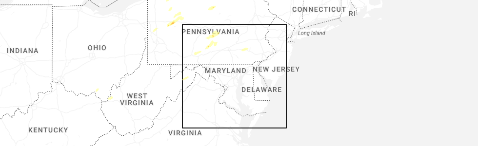
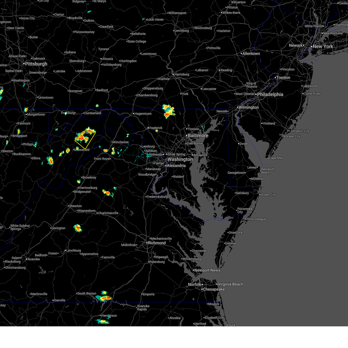
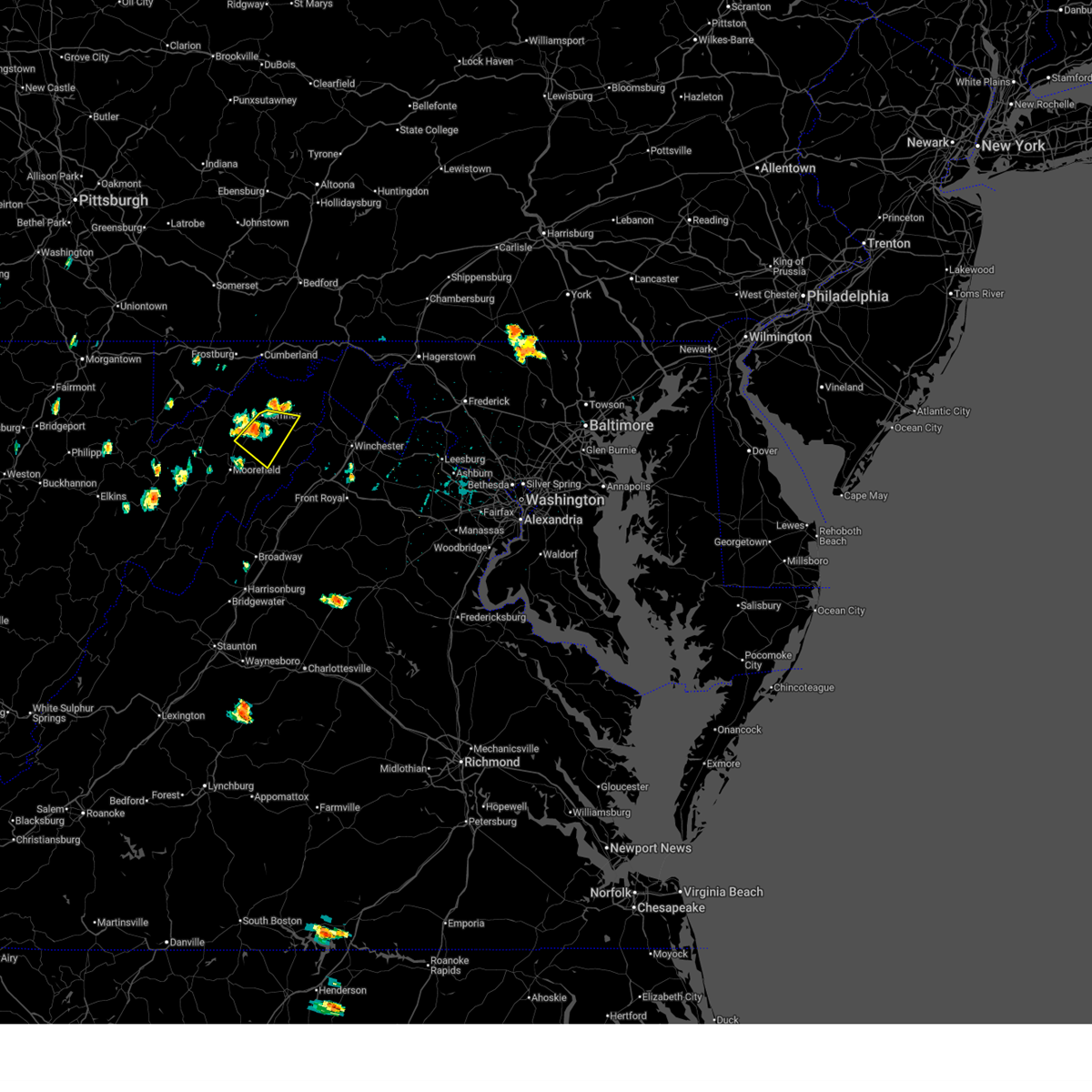
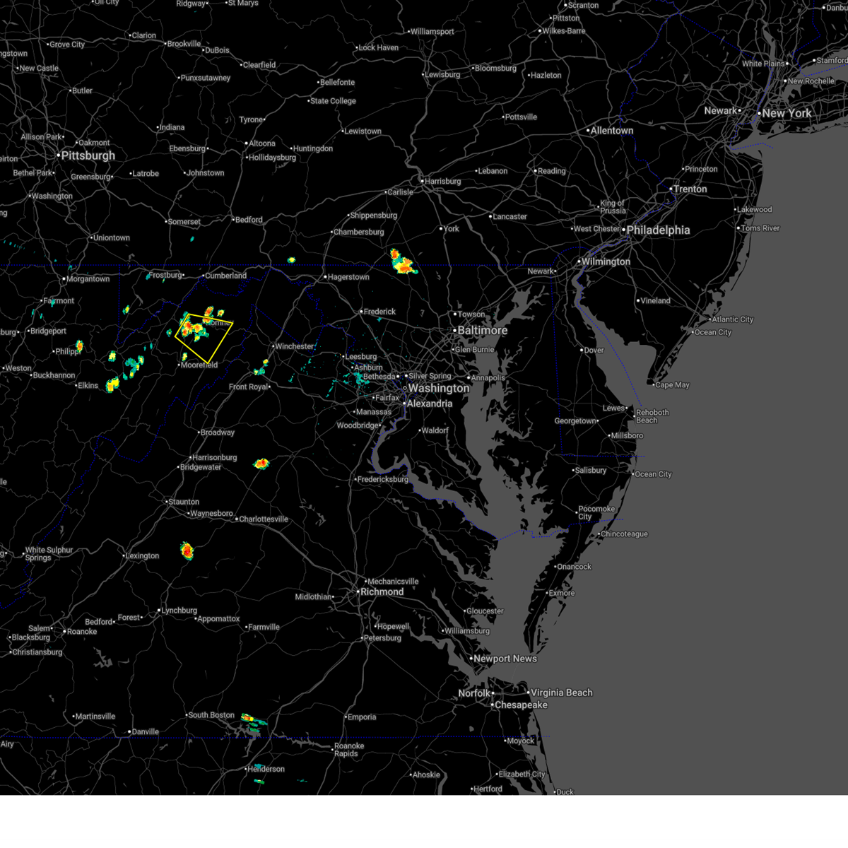
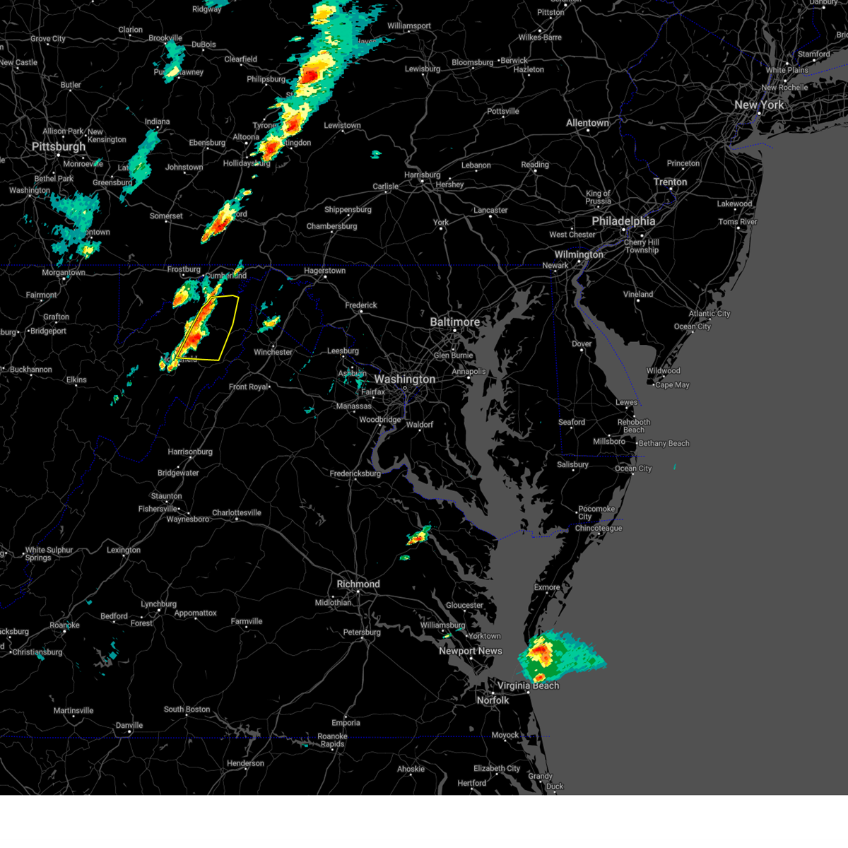
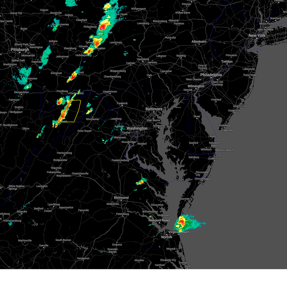
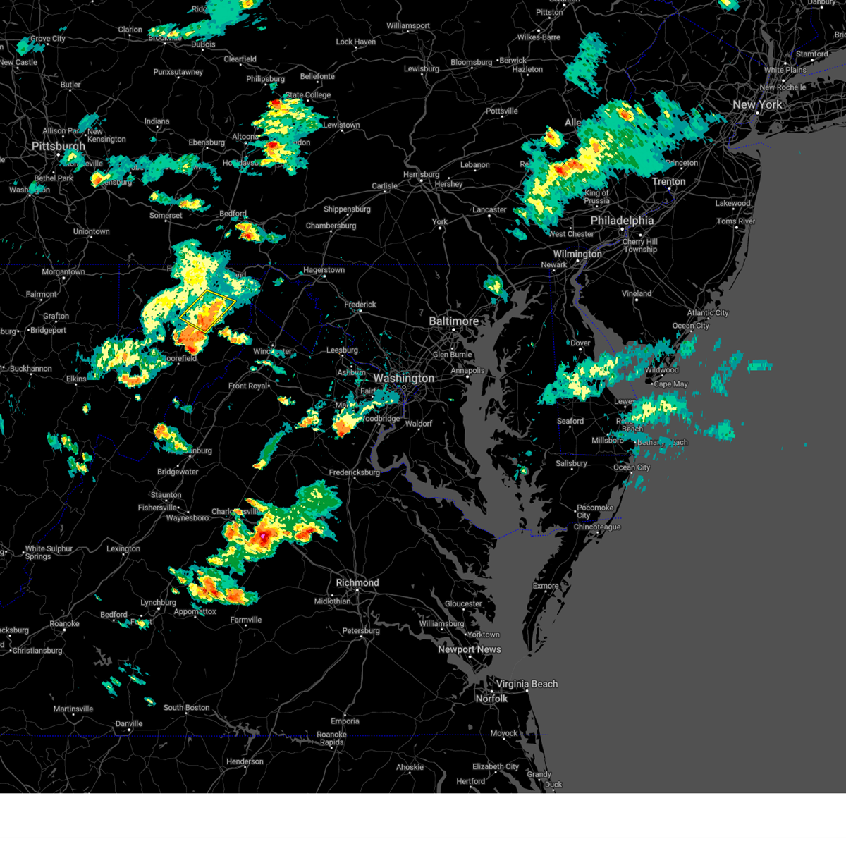
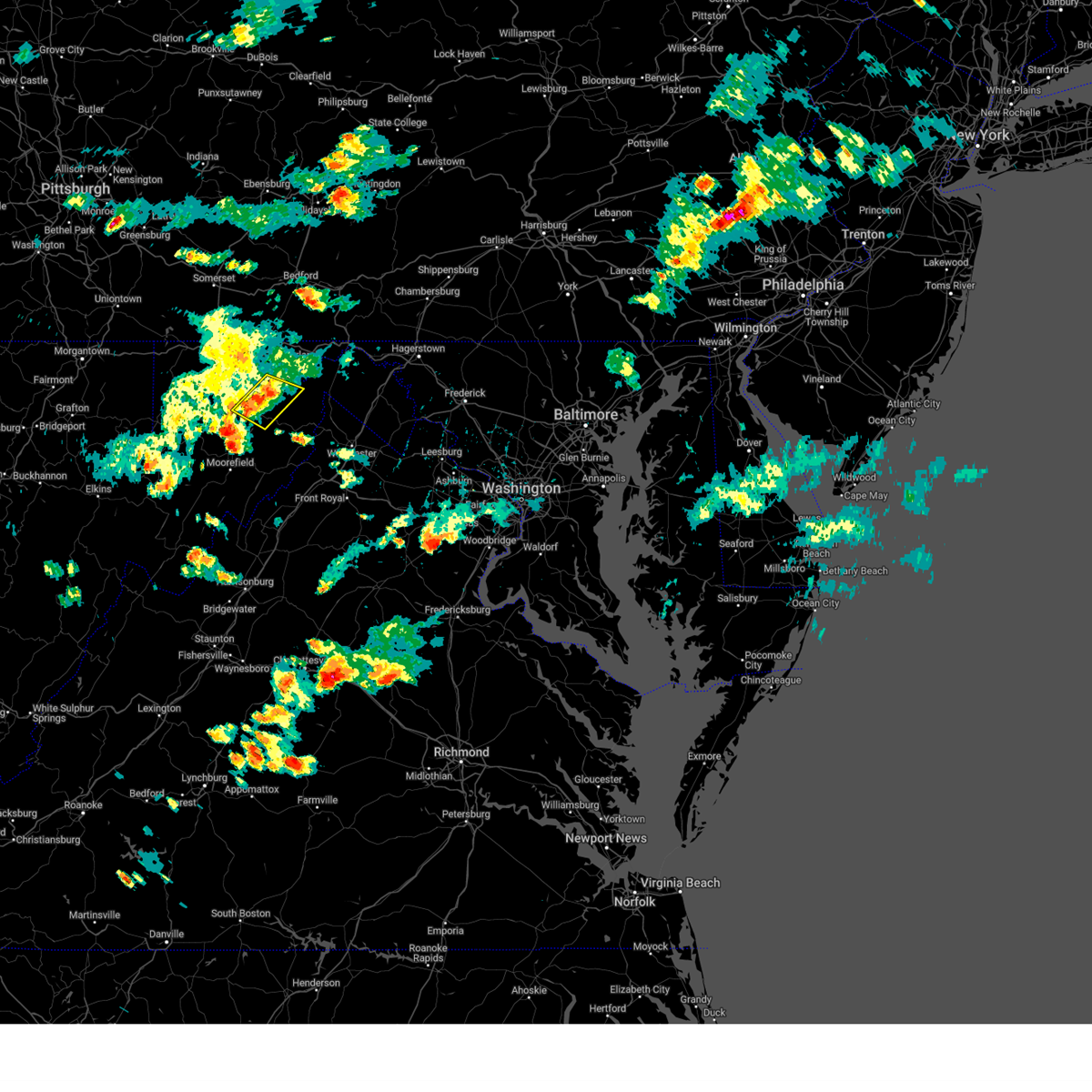
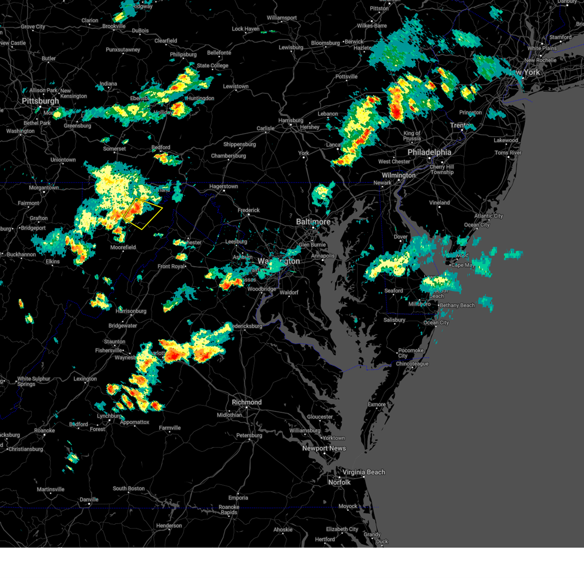
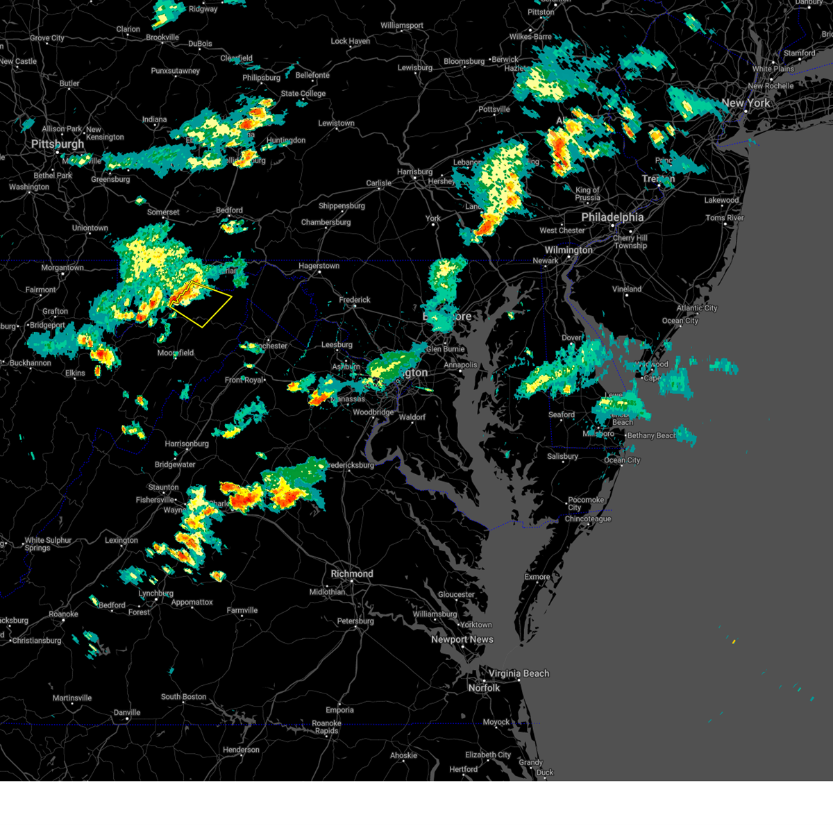
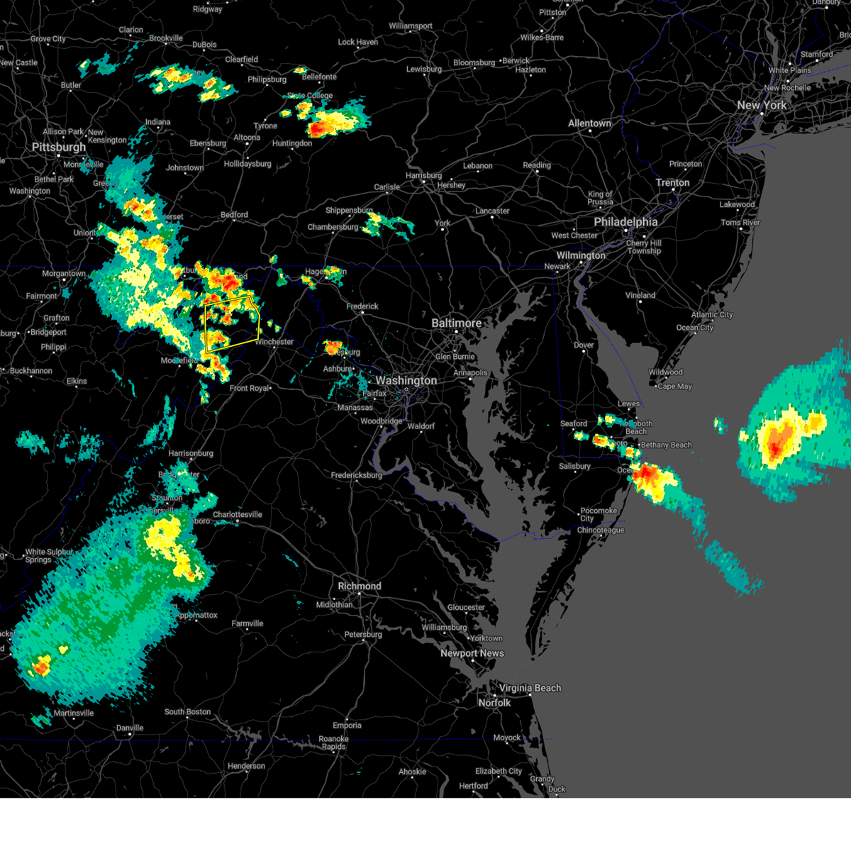
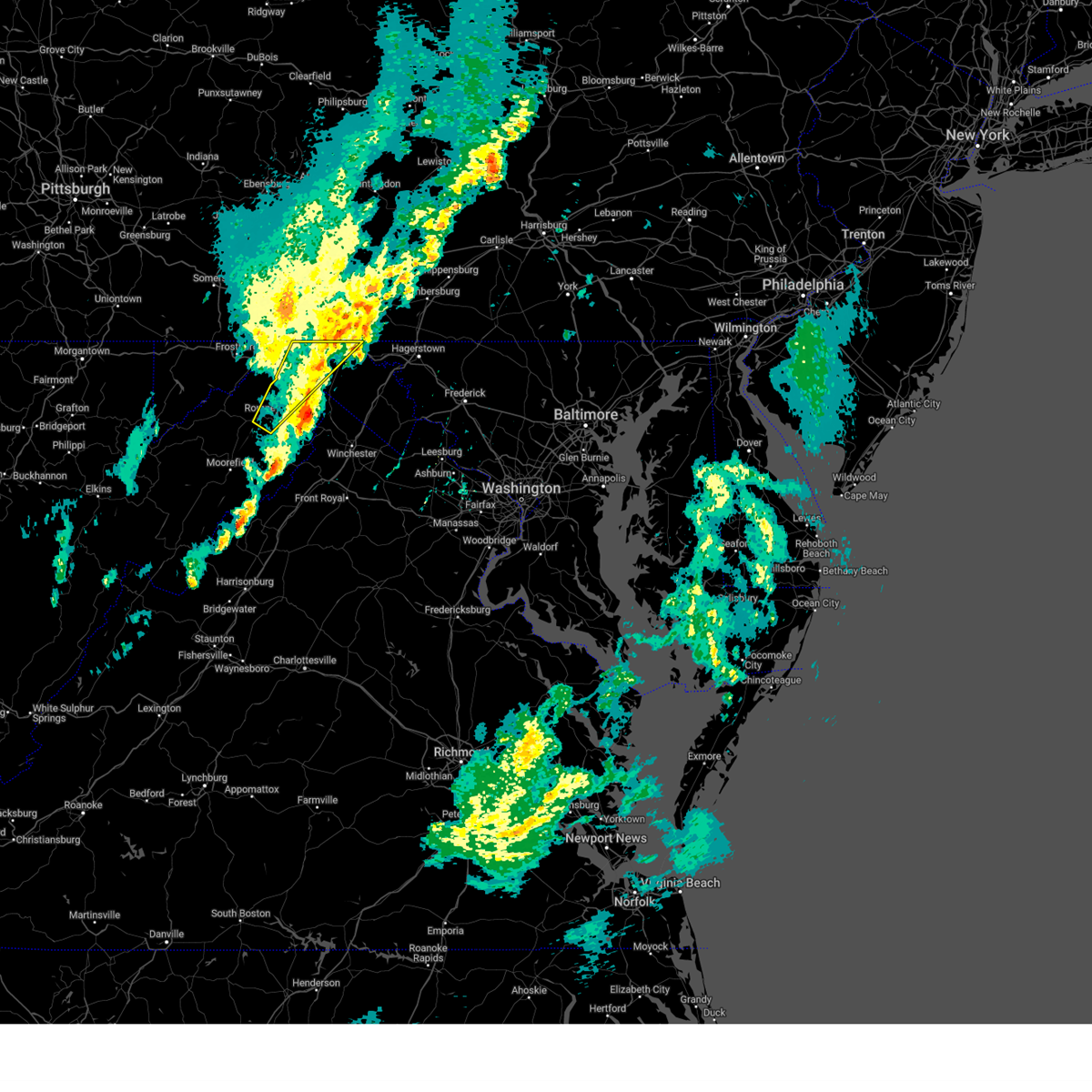
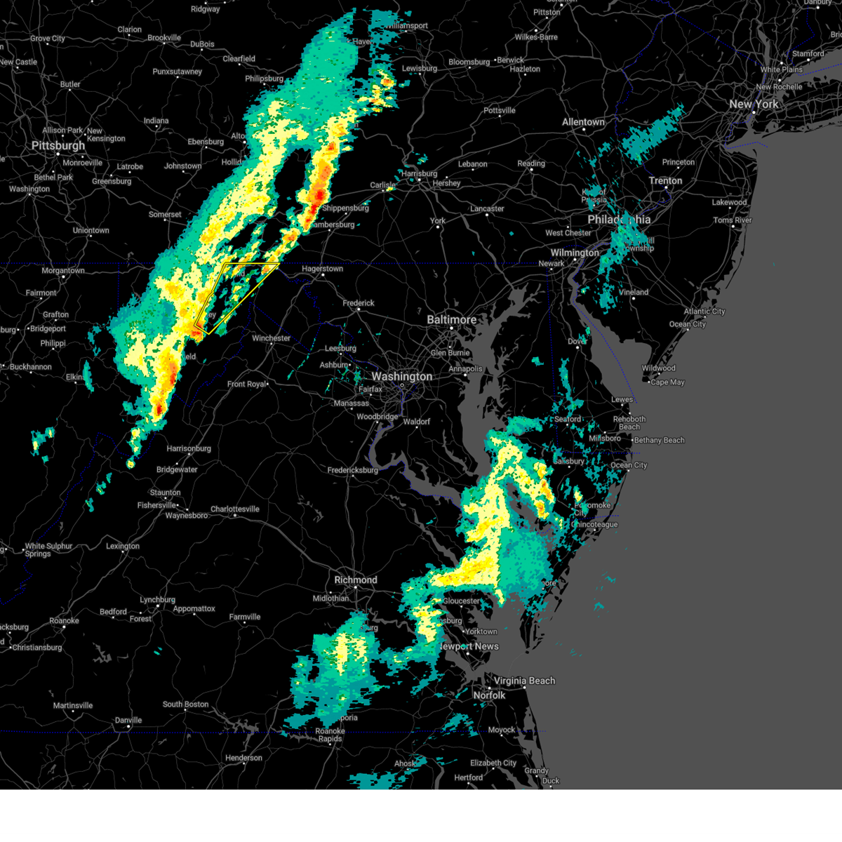
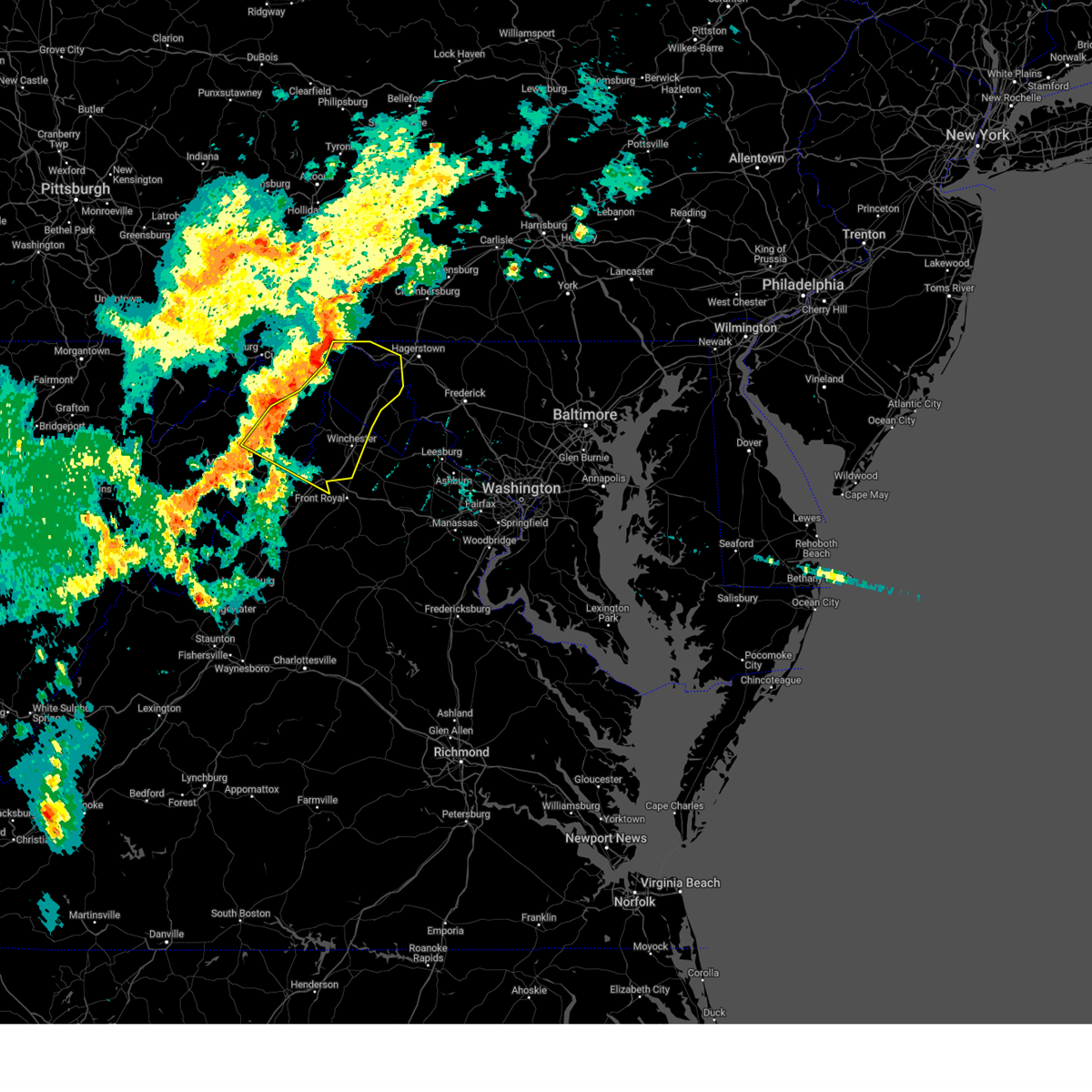
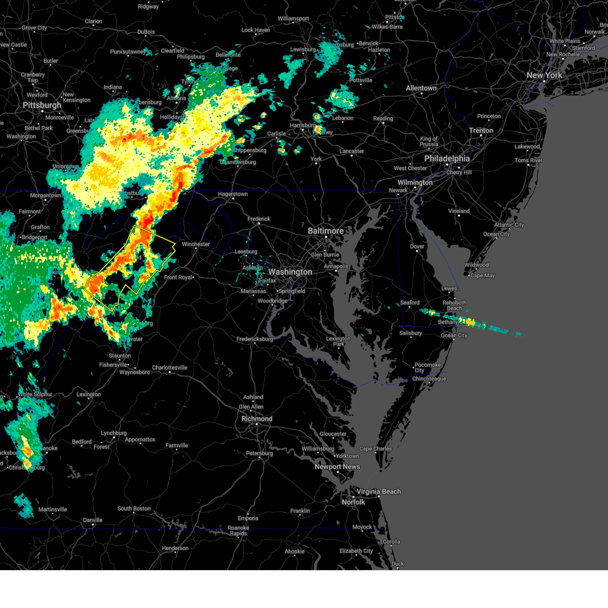
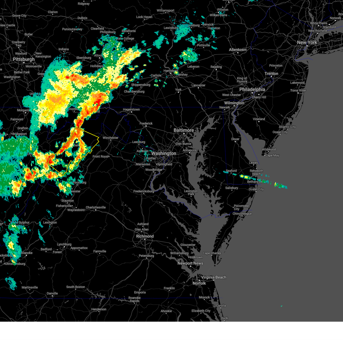
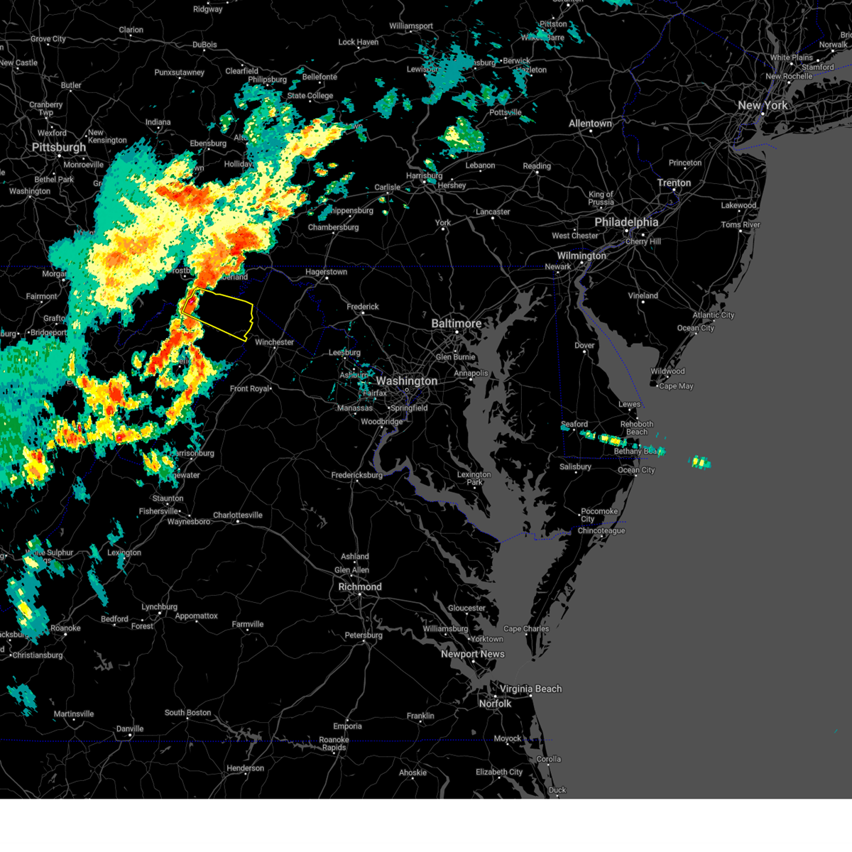
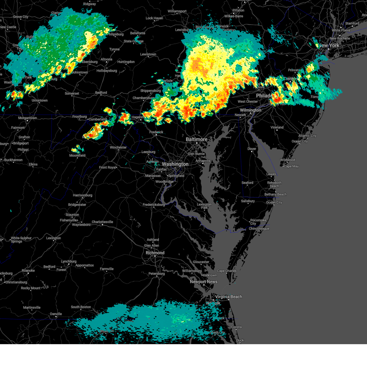
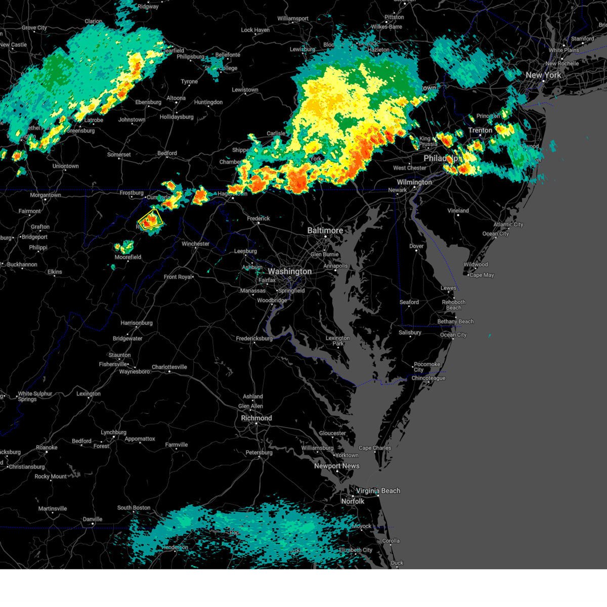
Hail Map for Romney, WV
The Romney, WV area has had 5 reports of on-the-ground hail by trained spotters, and has been under severe weather warnings 33 times during the past 12 months. Doppler radar has detected hail at or near Romney, WV on 24 occasions, including 3 occasions during the past year.
| Name: | Romney, WV |
| Where Located: | 65.4 miles ENE of Elkins, WV |
| Map: | Google Map for Romney, WV |
| Population: | 1848 |
| Housing Units: | 967 |
| More Info: | Search Google for Romney, WV |
0
The Top Recent Hail Date for Romney, WV is Monday, June 9, 2025 (14th out of 24)
Hail and Wind Damage Spotted near Romney, WV
| Date / Time | Report Details |
|---|---|
| 6/30/2025 2:52 PM EDT | Tree down on 500 block of middle ridge roa in hampshire county WV, 3.5 miles E of Romney, WV |
| 6/25/2025 1:07 PM EDT | Tree down onto powerlines at 4000 block of hickory corner rd in hampshire county WV, 0.3 miles ESE of Romney, WV |
| 6/25/2025 12:55 PM EDT |
 At 1255 pm edt, a severe thunderstorm was located 7 miles south of romney, moving southeast at 10 mph (radar indicated). Hazards include 60 mph wind gusts. Damaging winds will cause some trees and large branches to fall. this could injure those outdoors, as well as damage homes and vehicles. roadways may become blocked by downed trees. localized power outages are possible. unsecured light objects may become projectiles. Locations impacted include, romney, augusta, frenchburg, kirby, inkerman, and shanks. At 1255 pm edt, a severe thunderstorm was located 7 miles south of romney, moving southeast at 10 mph (radar indicated). Hazards include 60 mph wind gusts. Damaging winds will cause some trees and large branches to fall. this could injure those outdoors, as well as damage homes and vehicles. roadways may become blocked by downed trees. localized power outages are possible. unsecured light objects may become projectiles. Locations impacted include, romney, augusta, frenchburg, kirby, inkerman, and shanks.
|
| 6/25/2025 12:54 PM EDT | Tree down onto powerlines near 9000 block of south branch river rd in hampshire county WV, 8.2 miles NE of Romney, WV |
| 6/25/2025 12:42 PM EDT |
 the severe thunderstorm warning has been cancelled and is no longer in effect the severe thunderstorm warning has been cancelled and is no longer in effect
|
| 6/25/2025 12:42 PM EDT |
 At 1241 pm edt, a severe thunderstorm was located near romney, moving southeast at 20 mph (radar indicated). Hazards include 60 mph wind gusts and quarter size hail. Damaging winds will cause some trees and large branches to fall. this could injure those outdoors, as well as damage homes and vehicles. roadways may become blocked by downed trees. localized power outages are possible. unsecured light objects may become projectiles. Locations impacted include, romney, augusta, frenchburg, kirby, inkerman, and shanks. At 1241 pm edt, a severe thunderstorm was located near romney, moving southeast at 20 mph (radar indicated). Hazards include 60 mph wind gusts and quarter size hail. Damaging winds will cause some trees and large branches to fall. this could injure those outdoors, as well as damage homes and vehicles. roadways may become blocked by downed trees. localized power outages are possible. unsecured light objects may become projectiles. Locations impacted include, romney, augusta, frenchburg, kirby, inkerman, and shanks.
|
| 6/25/2025 12:31 PM EDT |
 Svrlwx the national weather service in sterling virginia has issued a * severe thunderstorm warning for, south central mineral county in eastern west virginia, north central hardy county in eastern west virginia, southwestern hampshire county in eastern west virginia, * until 115 pm edt. * at 1231 pm edt, a severe thunderstorm was located near romney, moving southeast at 15 mph (radar indicated). Hazards include 60 mph wind gusts and quarter size hail. Damaging winds will cause some trees and large branches to fall. this could injure those outdoors, as well as damage homes and vehicles. roadways may become blocked by downed trees. localized power outages are possible. Unsecured light objects may become projectiles. Svrlwx the national weather service in sterling virginia has issued a * severe thunderstorm warning for, south central mineral county in eastern west virginia, north central hardy county in eastern west virginia, southwestern hampshire county in eastern west virginia, * until 115 pm edt. * at 1231 pm edt, a severe thunderstorm was located near romney, moving southeast at 15 mph (radar indicated). Hazards include 60 mph wind gusts and quarter size hail. Damaging winds will cause some trees and large branches to fall. this could injure those outdoors, as well as damage homes and vehicles. roadways may become blocked by downed trees. localized power outages are possible. Unsecured light objects may become projectiles.
|
| 6/9/2025 8:41 PM EDT |
 At 841 pm edt, severe thunderstorms were located along a line extending from 8 miles east of fort ashby to 6 miles northeast of romney to 10 miles northwest of wardensville, moving northeast at 15 mph (radar indicated). Hazards include 60 mph wind gusts. Damaging winds will cause some trees and large branches to fall. this could injure those outdoors, as well as damage homes and vehicles. roadways may become blocked by downed trees. localized power outages are possible. unsecured light objects may become projectiles. Locations impacted include, augusta, yellow spring, shanks, three churches, frenchburg, higginsville, capon bridge, slanesville, bloomery, romney, points, delray, springfield, kirby, levels, wapocomo, timber ridge, high view, and lehew. At 841 pm edt, severe thunderstorms were located along a line extending from 8 miles east of fort ashby to 6 miles northeast of romney to 10 miles northwest of wardensville, moving northeast at 15 mph (radar indicated). Hazards include 60 mph wind gusts. Damaging winds will cause some trees and large branches to fall. this could injure those outdoors, as well as damage homes and vehicles. roadways may become blocked by downed trees. localized power outages are possible. unsecured light objects may become projectiles. Locations impacted include, augusta, yellow spring, shanks, three churches, frenchburg, higginsville, capon bridge, slanesville, bloomery, romney, points, delray, springfield, kirby, levels, wapocomo, timber ridge, high view, and lehew.
|
| 6/9/2025 8:33 PM EDT |
 Tornado warning and new severe thunderstorm warning in effect, to report severe weather, contact your nearest law enforcement agency. they will relay your report to the national weather service sterling virginia. remember, a severe thunderstorm warning and tornado warning still remain in effect. Tornado warning and new severe thunderstorm warning in effect, to report severe weather, contact your nearest law enforcement agency. they will relay your report to the national weather service sterling virginia. remember, a severe thunderstorm warning and tornado warning still remain in effect.
|
| 6/9/2025 8:23 PM EDT | the severe thunderstorm warning has been cancelled and is no longer in effect |
| 6/9/2025 8:23 PM EDT |
 Svrlwx the national weather service in sterling virginia has issued a * severe thunderstorm warning for, hampshire county in eastern west virginia, * until 915 pm edt. * at 823 pm edt, severe thunderstorms were located along a line extending from 7 miles east of fort ashby to near romney to 12 miles northwest of wardensville, moving east at 25 mph (radar indicated). Hazards include 60 mph wind gusts. Damaging winds will cause some trees and large branches to fall. this could injure those outdoors, as well as damage homes and vehicles. roadways may become blocked by downed trees. localized power outages are possible. Unsecured light objects may become projectiles. Svrlwx the national weather service in sterling virginia has issued a * severe thunderstorm warning for, hampshire county in eastern west virginia, * until 915 pm edt. * at 823 pm edt, severe thunderstorms were located along a line extending from 7 miles east of fort ashby to near romney to 12 miles northwest of wardensville, moving east at 25 mph (radar indicated). Hazards include 60 mph wind gusts. Damaging winds will cause some trees and large branches to fall. this could injure those outdoors, as well as damage homes and vehicles. roadways may become blocked by downed trees. localized power outages are possible. Unsecured light objects may become projectiles.
|
| 6/9/2025 8:23 PM EDT | At 823 pm edt, severe thunderstorms were located along a line extending from 7 miles east of fort ashby to near romney to 12 miles northwest of wardensville, moving east at 25 mph (radar indicated). Hazards include 60 mph wind gusts. Damaging winds will cause some trees and large branches to fall. this could injure those outdoors, as well as damage homes and vehicles. roadways may become blocked by downed trees. localized power outages are possible. unsecured light objects may become projectiles. Locations impacted include, augusta, shanks, three churches, frenchburg, higginsville, slanesville, romney, points, delray, springfield, kirby, levels, wapocomo, and green spring. |
| 6/9/2025 8:16 PM EDT |
 At 816 pm edt, severe thunderstorms were located along a line extending from near fort ashby to romney to 11 miles northeast of moorefield, moving east at 25 mph (radar indicated). Hazards include 60 mph wind gusts. Damaging winds will cause some trees and large branches to fall. this could injure those outdoors, as well as damage homes and vehicles. roadways may become blocked by downed trees. localized power outages are possible. unsecured light objects may become projectiles. Locations impacted include, augusta, bean settlement, old fields, shanks, three churches, frenchburg, higginsville, slanesville, romney, mcneill, points, delray, springfield, inkerman, kirby, levels, rio, wapocomo, and green spring. At 816 pm edt, severe thunderstorms were located along a line extending from near fort ashby to romney to 11 miles northeast of moorefield, moving east at 25 mph (radar indicated). Hazards include 60 mph wind gusts. Damaging winds will cause some trees and large branches to fall. this could injure those outdoors, as well as damage homes and vehicles. roadways may become blocked by downed trees. localized power outages are possible. unsecured light objects may become projectiles. Locations impacted include, augusta, bean settlement, old fields, shanks, three churches, frenchburg, higginsville, slanesville, romney, mcneill, points, delray, springfield, inkerman, kirby, levels, rio, wapocomo, and green spring.
|
| 6/9/2025 8:06 PM EDT |
 Svrlwx the national weather service in sterling virginia has issued a * severe thunderstorm warning for, northern hardy county in eastern west virginia, hampshire county in eastern west virginia, * until 830 pm edt. * at 805 pm edt, severe thunderstorms were located along a line extending from near fort ashby to near romney to 7 miles northeast of moorefield, moving east at 25 mph (radar indicated). Hazards include 60 mph wind gusts. Damaging winds will cause some trees and large branches to fall. this could injure those outdoors, as well as damage homes and vehicles. roadways may become blocked by downed trees. localized power outages are possible. Unsecured light objects may become projectiles. Svrlwx the national weather service in sterling virginia has issued a * severe thunderstorm warning for, northern hardy county in eastern west virginia, hampshire county in eastern west virginia, * until 830 pm edt. * at 805 pm edt, severe thunderstorms were located along a line extending from near fort ashby to near romney to 7 miles northeast of moorefield, moving east at 25 mph (radar indicated). Hazards include 60 mph wind gusts. Damaging winds will cause some trees and large branches to fall. this could injure those outdoors, as well as damage homes and vehicles. roadways may become blocked by downed trees. localized power outages are possible. Unsecured light objects may become projectiles.
|
| 6/6/2025 4:54 PM EDT |
 The storm which prompted the warning has weakened below severe limits, and has exited the warned area. therefore, the warning will be allowed to expire. to report severe weather, contact your nearest law enforcement agency. they will relay your report to the national weather service sterling virginia. The storm which prompted the warning has weakened below severe limits, and has exited the warned area. therefore, the warning will be allowed to expire. to report severe weather, contact your nearest law enforcement agency. they will relay your report to the national weather service sterling virginia.
|
| 6/6/2025 4:39 PM EDT |
 At 438 pm edt, a severe thunderstorm was located near fort ashby, or near romney, moving southeast at 20 mph (radar indicated). Hazards include 60 mph wind gusts. Damaging winds will cause some trees and large branches to fall. this could injure those outdoors, as well as damage homes and vehicles. roadways may become blocked by downed trees. localized power outages are possible. unsecured light objects may become projectiles. Locations impacted include, reeses mill, points, shanks, fort ashby, three churches, springfield, levels, headsville, higginsville, wapocomo, romney, and green spring. At 438 pm edt, a severe thunderstorm was located near fort ashby, or near romney, moving southeast at 20 mph (radar indicated). Hazards include 60 mph wind gusts. Damaging winds will cause some trees and large branches to fall. this could injure those outdoors, as well as damage homes and vehicles. roadways may become blocked by downed trees. localized power outages are possible. unsecured light objects may become projectiles. Locations impacted include, reeses mill, points, shanks, fort ashby, three churches, springfield, levels, headsville, higginsville, wapocomo, romney, and green spring.
|
| 6/6/2025 4:38 PM EDT | Trees and wires blew down in the 100 block of harley lan in hampshire county WV, 3.6 miles ESE of Romney, WV |
| 6/6/2025 4:25 PM EDT |
 At 425 pm edt, a severe thunderstorm was located over fort ashby, or 7 miles north of romney, moving southeast at 20 mph (radar indicated). Hazards include 60 mph wind gusts. Damaging winds will cause some trees and large branches to fall. this could injure those outdoors, as well as damage homes and vehicles. roadways may become blocked by downed trees. localized power outages are possible. unsecured light objects may become projectiles. Locations impacted include, shanks, fort ashby, three churches, headsville, higginsville, short gap, romney, reeses mill, points, springfield, levels, wapocomo, and green spring. At 425 pm edt, a severe thunderstorm was located over fort ashby, or 7 miles north of romney, moving southeast at 20 mph (radar indicated). Hazards include 60 mph wind gusts. Damaging winds will cause some trees and large branches to fall. this could injure those outdoors, as well as damage homes and vehicles. roadways may become blocked by downed trees. localized power outages are possible. unsecured light objects may become projectiles. Locations impacted include, shanks, fort ashby, three churches, headsville, higginsville, short gap, romney, reeses mill, points, springfield, levels, wapocomo, and green spring.
|
| 6/6/2025 4:12 PM EDT |
 Svrlwx the national weather service in sterling virginia has issued a * severe thunderstorm warning for, eastern mineral county in eastern west virginia, northwestern hampshire county in eastern west virginia, * until 500 pm edt. * at 412 pm edt, a severe thunderstorm was located near fort ashby, or near bel air, moving southeast at 20 mph (radar indicated). Hazards include 60 mph wind gusts. Damaging winds will cause some trees and large branches to fall. this could injure those outdoors, as well as damage homes and vehicles. roadways may become blocked by downed trees. localized power outages are possible. Unsecured light objects may become projectiles. Svrlwx the national weather service in sterling virginia has issued a * severe thunderstorm warning for, eastern mineral county in eastern west virginia, northwestern hampshire county in eastern west virginia, * until 500 pm edt. * at 412 pm edt, a severe thunderstorm was located near fort ashby, or near bel air, moving southeast at 20 mph (radar indicated). Hazards include 60 mph wind gusts. Damaging winds will cause some trees and large branches to fall. this could injure those outdoors, as well as damage homes and vehicles. roadways may become blocked by downed trees. localized power outages are possible. Unsecured light objects may become projectiles.
|
| 5/30/2025 6:22 PM EDT | Trees blew down onto wires along cr-7 ford hill roa in hampshire county WV, 7.4 miles WNW of Romney, WV |
| 5/16/2025 3:41 PM EDT |
 Svrlwx the national weather service in sterling virginia has issued a * severe thunderstorm warning for, north central frederick county in northwestern virginia, southwestern morgan county in the panhandle of west virginia, northeastern mineral county in eastern west virginia, northeastern hardy county in eastern west virginia, hampshire county in eastern west virginia, * until 400 pm edt. * at 340 pm edt, severe thunderstorms were located along a line extending from near fort ashby to 12 miles southwest of paw paw to 9 miles southeast of romney, moving east at 40 mph (radar indicated). Hazards include 60 mph wind gusts and quarter size hail. Damaging winds will cause some trees and large branches to fall. this could injure those outdoors, as well as damage homes and vehicles. roadways may become blocked by downed trees. localized power outages are possible. Unsecured light objects may become projectiles. Svrlwx the national weather service in sterling virginia has issued a * severe thunderstorm warning for, north central frederick county in northwestern virginia, southwestern morgan county in the panhandle of west virginia, northeastern mineral county in eastern west virginia, northeastern hardy county in eastern west virginia, hampshire county in eastern west virginia, * until 400 pm edt. * at 340 pm edt, severe thunderstorms were located along a line extending from near fort ashby to 12 miles southwest of paw paw to 9 miles southeast of romney, moving east at 40 mph (radar indicated). Hazards include 60 mph wind gusts and quarter size hail. Damaging winds will cause some trees and large branches to fall. this could injure those outdoors, as well as damage homes and vehicles. roadways may become blocked by downed trees. localized power outages are possible. Unsecured light objects may become projectiles.
|
| 3/16/2025 4:57 PM EDT |
 the severe thunderstorm warning has been cancelled and is no longer in effect the severe thunderstorm warning has been cancelled and is no longer in effect
|
| 3/16/2025 4:24 PM EDT |
 Svrlwx the national weather service in sterling virginia has issued a * severe thunderstorm warning for, northwestern washington county in north central maryland, northeastern allegany county in western maryland, northwestern morgan county in the panhandle of west virginia, northeastern hampshire county in eastern west virginia, * until 515 pm edt. * at 424 pm edt, a severe thunderstorm was located near romney, moving northeast at 65 mph (radar indicated). Hazards include 60 mph wind gusts and quarter size hail. Damaging winds will cause some trees and large branches to fall. this could injure those outdoors, as well as damage homes and vehicles. roadways may become blocked by downed trees. localized power outages are possible. Unsecured light objects may become projectiles. Svrlwx the national weather service in sterling virginia has issued a * severe thunderstorm warning for, northwestern washington county in north central maryland, northeastern allegany county in western maryland, northwestern morgan county in the panhandle of west virginia, northeastern hampshire county in eastern west virginia, * until 515 pm edt. * at 424 pm edt, a severe thunderstorm was located near romney, moving northeast at 65 mph (radar indicated). Hazards include 60 mph wind gusts and quarter size hail. Damaging winds will cause some trees and large branches to fall. this could injure those outdoors, as well as damage homes and vehicles. roadways may become blocked by downed trees. localized power outages are possible. Unsecured light objects may become projectiles.
|
| 3/16/2025 4:19 PM EDT | 911 center reported trees down across the count in hampshire county WV, 0.3 miles ESE of Romney, WV |
| 3/16/2025 4:19 PM EDT |
 the severe thunderstorm warning has been cancelled and is no longer in effect the severe thunderstorm warning has been cancelled and is no longer in effect
|
| 3/16/2025 4:19 PM EDT |
 At 418 pm edt, a severe thunderstorm was located near romney, moving northeast at 60 mph (radar indicated). Hazards include 60 mph wind gusts and quarter size hail. Damaging winds will cause some trees and large branches to fall. this could injure those outdoors, as well as damage homes and vehicles. roadways may become blocked by downed trees. localized power outages are possible. unsecured light objects may become projectiles. Locations impacted include, augusta, shanks, frenchburg, headsville, junction, wapocomo, and romney. At 418 pm edt, a severe thunderstorm was located near romney, moving northeast at 60 mph (radar indicated). Hazards include 60 mph wind gusts and quarter size hail. Damaging winds will cause some trees and large branches to fall. this could injure those outdoors, as well as damage homes and vehicles. roadways may become blocked by downed trees. localized power outages are possible. unsecured light objects may become projectiles. Locations impacted include, augusta, shanks, frenchburg, headsville, junction, wapocomo, and romney.
|
| 3/16/2025 4:08 PM EDT |
 At 408 pm edt, a severe thunderstorm was located 8 miles north of moorefield, moving northeast at 60 mph (radar indicated). Hazards include 60 mph wind gusts and quarter size hail. Damaging winds will cause some trees and large branches to fall. this could injure those outdoors, as well as damage homes and vehicles. roadways may become blocked by downed trees. localized power outages are possible. unsecured light objects may become projectiles. Locations impacted include, augusta, mcneill, old fields, shanks, purgitsville, frenchburg, headsville, junction, wapocomo, romney, russelldale, and moorefield. At 408 pm edt, a severe thunderstorm was located 8 miles north of moorefield, moving northeast at 60 mph (radar indicated). Hazards include 60 mph wind gusts and quarter size hail. Damaging winds will cause some trees and large branches to fall. this could injure those outdoors, as well as damage homes and vehicles. roadways may become blocked by downed trees. localized power outages are possible. unsecured light objects may become projectiles. Locations impacted include, augusta, mcneill, old fields, shanks, purgitsville, frenchburg, headsville, junction, wapocomo, romney, russelldale, and moorefield.
|
| 3/16/2025 4:08 PM EDT |
 the severe thunderstorm warning has been cancelled and is no longer in effect the severe thunderstorm warning has been cancelled and is no longer in effect
|
| 3/16/2025 3:56 PM EDT |
 Svrlwx the national weather service in sterling virginia has issued a * severe thunderstorm warning for, east central grant county in eastern west virginia, southeastern mineral county in eastern west virginia, northwestern hardy county in eastern west virginia, southwestern hampshire county in eastern west virginia, * until 430 pm edt. * at 356 pm edt, a severe thunderstorm was located near petersburg, moving northeast at 60 mph (radar indicated). Hazards include 60 mph wind gusts and quarter size hail. Damaging winds will cause some trees and large branches to fall. this could injure those outdoors, as well as damage homes and vehicles. roadways may become blocked by downed trees. localized power outages are possible. Unsecured light objects may become projectiles. Svrlwx the national weather service in sterling virginia has issued a * severe thunderstorm warning for, east central grant county in eastern west virginia, southeastern mineral county in eastern west virginia, northwestern hardy county in eastern west virginia, southwestern hampshire county in eastern west virginia, * until 430 pm edt. * at 356 pm edt, a severe thunderstorm was located near petersburg, moving northeast at 60 mph (radar indicated). Hazards include 60 mph wind gusts and quarter size hail. Damaging winds will cause some trees and large branches to fall. this could injure those outdoors, as well as damage homes and vehicles. roadways may become blocked by downed trees. localized power outages are possible. Unsecured light objects may become projectiles.
|
| 8/31/2024 4:54 PM EDT | One report of a tree down near capon bridg in hampshire county WV, 0.3 miles ESE of Romney, WV |
| 8/31/2024 4:44 PM EDT |
 At 444 pm edt, severe thunderstorms were located along a line extending from near berkeley springs to near greenwood to 10 miles south of paw paw to 10 miles north of wardensville, moving southeast at 35 mph (radar indicated). Hazards include 70 mph wind gusts and quarter size hail. Damaging winds will cause some trees and large branches to fall. this could injure those outdoors, as well as damage homes and vehicles. roadways may become blocked by downed trees. localized power outages are possible. unsecured light objects may become projectiles. Locations impacted include, winchester, martinsburg, strasburg, romney, hancock, millwood pike, inwood, wilson-conococheague, stephens city, berkeley springs, wardensville, star tannery, berkeley, middletown, falling waters, great cacapon, clear spring, capon bridge, hedgesville, and pecktonville. At 444 pm edt, severe thunderstorms were located along a line extending from near berkeley springs to near greenwood to 10 miles south of paw paw to 10 miles north of wardensville, moving southeast at 35 mph (radar indicated). Hazards include 70 mph wind gusts and quarter size hail. Damaging winds will cause some trees and large branches to fall. this could injure those outdoors, as well as damage homes and vehicles. roadways may become blocked by downed trees. localized power outages are possible. unsecured light objects may become projectiles. Locations impacted include, winchester, martinsburg, strasburg, romney, hancock, millwood pike, inwood, wilson-conococheague, stephens city, berkeley springs, wardensville, star tannery, berkeley, middletown, falling waters, great cacapon, clear spring, capon bridge, hedgesville, and pecktonville.
|
| 8/31/2024 4:41 PM EDT | Tree down on route 50 near shank in hampshire county WV, 4 miles WNW of Romney, WV |
| 8/31/2024 4:37 PM EDT |
 Svrlwx the national weather service in sterling virginia has issued a * severe thunderstorm warning for, northwestern washington county in north central maryland, northeastern shenandoah county in northwestern virginia, frederick county in northwestern virginia, the city of winchester in northwestern virginia, morgan county in the panhandle of west virginia, northeastern hardy county in eastern west virginia, berkeley county in the panhandle of west virginia, hampshire county in eastern west virginia, * until 515 pm edt. * at 437 pm edt, severe thunderstorms were located along a line extending from near barnes gap to near greenwood to 7 miles south of paw paw to 9 miles southeast of romney, moving southeast at 35 mph (radar indicated). Hazards include 70 mph wind gusts. Damaging winds will cause some trees and large branches to fall. this could injure those outdoors, as well as damage homes and vehicles. roadways may become blocked by downed trees. localized power outages are possible. Unsecured light objects may become projectiles. Svrlwx the national weather service in sterling virginia has issued a * severe thunderstorm warning for, northwestern washington county in north central maryland, northeastern shenandoah county in northwestern virginia, frederick county in northwestern virginia, the city of winchester in northwestern virginia, morgan county in the panhandle of west virginia, northeastern hardy county in eastern west virginia, berkeley county in the panhandle of west virginia, hampshire county in eastern west virginia, * until 515 pm edt. * at 437 pm edt, severe thunderstorms were located along a line extending from near barnes gap to near greenwood to 7 miles south of paw paw to 9 miles southeast of romney, moving southeast at 35 mph (radar indicated). Hazards include 70 mph wind gusts. Damaging winds will cause some trees and large branches to fall. this could injure those outdoors, as well as damage homes and vehicles. roadways may become blocked by downed trees. localized power outages are possible. Unsecured light objects may become projectiles.
|
| 8/31/2024 4:31 PM EDT |
 At 431 pm edt, a severe thunderstorm was located 8 miles southeast of fort ashby, or 9 miles northeast of romney, moving east at 25 mph (radar indicated). Hazards include 70 mph wind gusts. Damaging winds will cause some trees and large branches to fall. this could injure those outdoors, as well as damage homes and vehicles. roadways may become blocked by downed trees. localized power outages are possible. unsecured light objects may become projectiles. Locations impacted include, romney, fort ashby, springfield, capon bridge, green spring, three churches, headsville, higginsville, wagoner, slanesville, bloomery, reeses mill, points, largent, levels, wapocomo, timber ridge, and high view. At 431 pm edt, a severe thunderstorm was located 8 miles southeast of fort ashby, or 9 miles northeast of romney, moving east at 25 mph (radar indicated). Hazards include 70 mph wind gusts. Damaging winds will cause some trees and large branches to fall. this could injure those outdoors, as well as damage homes and vehicles. roadways may become blocked by downed trees. localized power outages are possible. unsecured light objects may become projectiles. Locations impacted include, romney, fort ashby, springfield, capon bridge, green spring, three churches, headsville, higginsville, wagoner, slanesville, bloomery, reeses mill, points, largent, levels, wapocomo, timber ridge, and high view.
|
| 8/31/2024 4:29 PM EDT |
 At 429 pm edt, severe thunderstorms were located along a line extending from near romney to 12 miles northeast of moorefield to 7 miles north of upper tract, moving east at 20 mph (radar indicated). Hazards include 60 mph wind gusts. Damaging winds will cause some trees and large branches to fall. this could injure those outdoors, as well as damage homes and vehicles. roadways may become blocked by downed trees. localized power outages are possible. unsecured light objects may become projectiles. Locations impacted include, moorefield, petersburg, romney, rough run, wardensville, upper tract, mathias, burlington, russelldale, bean settlement, yellow spring, shanks, landes, arthur, brushy run, deer run, seymourville, lahmansville, ruddle, and masonville. At 429 pm edt, severe thunderstorms were located along a line extending from near romney to 12 miles northeast of moorefield to 7 miles north of upper tract, moving east at 20 mph (radar indicated). Hazards include 60 mph wind gusts. Damaging winds will cause some trees and large branches to fall. this could injure those outdoors, as well as damage homes and vehicles. roadways may become blocked by downed trees. localized power outages are possible. unsecured light objects may become projectiles. Locations impacted include, moorefield, petersburg, romney, rough run, wardensville, upper tract, mathias, burlington, russelldale, bean settlement, yellow spring, shanks, landes, arthur, brushy run, deer run, seymourville, lahmansville, ruddle, and masonville.
|
| 8/31/2024 4:24 PM EDT | Three reports of trees down near romne in hampshire county WV, 0.3 miles ESE of Romney, WV |
| 8/31/2024 4:18 PM EDT |
 Svrlwx the national weather service in sterling virginia has issued a * severe thunderstorm warning for, northeastern pendleton county in eastern west virginia, southeastern grant county in eastern west virginia, south central mineral county in eastern west virginia, hardy county in eastern west virginia, southern hampshire county in eastern west virginia, * until 515 pm edt. * at 418 pm edt, severe thunderstorms were located along a line extending from near romney to 10 miles north of moorefield to near petersburg, moving east at 20 mph (radar indicated). Hazards include 60 mph wind gusts. Damaging winds will cause some trees and large branches to fall. this could injure those outdoors, as well as damage homes and vehicles. roadways may become blocked by downed trees. localized power outages are possible. Unsecured light objects may become projectiles. Svrlwx the national weather service in sterling virginia has issued a * severe thunderstorm warning for, northeastern pendleton county in eastern west virginia, southeastern grant county in eastern west virginia, south central mineral county in eastern west virginia, hardy county in eastern west virginia, southern hampshire county in eastern west virginia, * until 515 pm edt. * at 418 pm edt, severe thunderstorms were located along a line extending from near romney to 10 miles north of moorefield to near petersburg, moving east at 20 mph (radar indicated). Hazards include 60 mph wind gusts. Damaging winds will cause some trees and large branches to fall. this could injure those outdoors, as well as damage homes and vehicles. roadways may become blocked by downed trees. localized power outages are possible. Unsecured light objects may become projectiles.
|
| 8/31/2024 4:16 PM EDT |
 At 416 pm edt, a severe thunderstorm was located over fort ashby, or 8 miles southeast of bel air, moving east at 20 mph (radar indicated). Hazards include 70 mph wind gusts. Damaging winds will cause some trees and large branches to fall. this could injure those outdoors, as well as damage homes and vehicles. roadways may become blocked by downed trees. localized power outages are possible. unsecured light objects may become projectiles. Locations impacted include, romney, fort ashby, springfield, capon bridge, green spring, three churches, headsville, higginsville, short gap, wagoner, slanesville, bloomery, reeses mill, points, largent, levels, wapocomo, timber ridge, and high view. At 416 pm edt, a severe thunderstorm was located over fort ashby, or 8 miles southeast of bel air, moving east at 20 mph (radar indicated). Hazards include 70 mph wind gusts. Damaging winds will cause some trees and large branches to fall. this could injure those outdoors, as well as damage homes and vehicles. roadways may become blocked by downed trees. localized power outages are possible. unsecured light objects may become projectiles. Locations impacted include, romney, fort ashby, springfield, capon bridge, green spring, three churches, headsville, higginsville, short gap, wagoner, slanesville, bloomery, reeses mill, points, largent, levels, wapocomo, timber ridge, and high view.
|
| 8/31/2024 4:08 PM EDT |
 Svrlwx the national weather service in sterling virginia has issued a * severe thunderstorm warning for, northeastern mineral county in eastern west virginia, northeastern hampshire county in eastern west virginia, * until 445 pm edt. * at 407 pm edt, a severe thunderstorm was located near fort ashby, or near bel air, moving east at 20 mph (radar indicated). Hazards include 60 mph wind gusts. Damaging winds will cause some trees and large branches to fall. this could injure those outdoors, as well as damage homes and vehicles. roadways may become blocked by downed trees. localized power outages are possible. Unsecured light objects may become projectiles. Svrlwx the national weather service in sterling virginia has issued a * severe thunderstorm warning for, northeastern mineral county in eastern west virginia, northeastern hampshire county in eastern west virginia, * until 445 pm edt. * at 407 pm edt, a severe thunderstorm was located near fort ashby, or near bel air, moving east at 20 mph (radar indicated). Hazards include 60 mph wind gusts. Damaging winds will cause some trees and large branches to fall. this could injure those outdoors, as well as damage homes and vehicles. roadways may become blocked by downed trees. localized power outages are possible. Unsecured light objects may become projectiles.
|
| 8/6/2024 7:58 PM EDT | Crystal valley estates north of romney... wv noted trees down everywhere in the are in hampshire county WV, 4.5 miles SSW of Romney, WV |
| 8/6/2024 7:51 PM EDT |
 At 750 pm edt, a severe thunderstorm was located near romney, moving east at 10 mph (radar indicated). Hazards include 60 mph wind gusts. Damaging winds will cause some trees and large branches to fall. this could injure those outdoors, as well as damage homes and vehicles. roadways may become blocked by downed trees. localized power outages are possible. unsecured light objects may become projectiles. Locations impacted include, romney, springfield, green spring, points, three churches, higginsville, and wapocomo. At 750 pm edt, a severe thunderstorm was located near romney, moving east at 10 mph (radar indicated). Hazards include 60 mph wind gusts. Damaging winds will cause some trees and large branches to fall. this could injure those outdoors, as well as damage homes and vehicles. roadways may become blocked by downed trees. localized power outages are possible. unsecured light objects may become projectiles. Locations impacted include, romney, springfield, green spring, points, three churches, higginsville, and wapocomo.
|
| 8/6/2024 7:51 PM EDT |
 the severe thunderstorm warning has been cancelled and is no longer in effect the severe thunderstorm warning has been cancelled and is no longer in effect
|
| 8/6/2024 7:32 PM EDT |
 Svrlwx the national weather service in sterling virginia has issued a * severe thunderstorm warning for, east central mineral county in eastern west virginia, north central hampshire county in eastern west virginia, * until 815 pm edt. * at 731 pm edt, a severe thunderstorm was located near romney, moving northeast at 10 mph (radar indicated). Hazards include 60 mph wind gusts. Damaging winds will cause some trees and large branches to fall. this could injure those outdoors, as well as damage homes and vehicles. roadways may become blocked by downed trees. localized power outages are possible. Unsecured light objects may become projectiles. Svrlwx the national weather service in sterling virginia has issued a * severe thunderstorm warning for, east central mineral county in eastern west virginia, north central hampshire county in eastern west virginia, * until 815 pm edt. * at 731 pm edt, a severe thunderstorm was located near romney, moving northeast at 10 mph (radar indicated). Hazards include 60 mph wind gusts. Damaging winds will cause some trees and large branches to fall. this could injure those outdoors, as well as damage homes and vehicles. roadways may become blocked by downed trees. localized power outages are possible. Unsecured light objects may become projectiles.
|
| 5/26/2024 9:01 PM EDT | Trees and power lines down on vanderlip drive in hampshire county WV, 1.5 miles ENE of Romney, WV |
| 5/26/2024 9:01 PM EDT | Lightning struck at a tree which split it in half...part of the tree fell onto power line in hampshire county WV, 0.6 miles NNE of Romney, WV |
| 5/26/2024 8:53 PM EDT |
 At 850 pm edt, severe thunderstorms were located along a line extending from mount davis to near westernport to moorefield to 6 miles southwest of mathias to near broadway, moving east at 35 mph. these storms have a history of storm damage including numerous trees reported down (radar indicated. impact...damaging winds will cause some trees and large branches to fall. this could injure those outdoors, as well as damage homes and vehicles. roadways may become blocked by downed trees. localized power outages are possible. unsecured light objects may become projectiles. locations impacted include, cumberland, frostburg, keyser, woodstock, westernport, romney, bel air, luray, la vale, timberville, shenandoah, mount jackson, stanley, fort ashby, lonaconing, piedmont, basye-bryce mountain, mathias, big meadows, and ridgeley). Hazards include 60 mph wind gusts and quarter size hail. At 850 pm edt, severe thunderstorms were located along a line extending from mount davis to near westernport to moorefield to 6 miles southwest of mathias to near broadway, moving east at 35 mph. these storms have a history of storm damage including numerous trees reported down (radar indicated. impact...damaging winds will cause some trees and large branches to fall. this could injure those outdoors, as well as damage homes and vehicles. roadways may become blocked by downed trees. localized power outages are possible. unsecured light objects may become projectiles. locations impacted include, cumberland, frostburg, keyser, woodstock, westernport, romney, bel air, luray, la vale, timberville, shenandoah, mount jackson, stanley, fort ashby, lonaconing, piedmont, basye-bryce mountain, mathias, big meadows, and ridgeley). Hazards include 60 mph wind gusts and quarter size hail.
|
| 5/26/2024 8:53 PM EDT |
 the severe thunderstorm warning has been cancelled and is no longer in effect the severe thunderstorm warning has been cancelled and is no longer in effect
|
| 5/26/2024 8:17 PM EDT |
 Svrlwx the national weather service in sterling virginia has issued a * severe thunderstorm warning for, northeastern garrett county in western maryland, western allegany county in western maryland, shenandoah county in northwestern virginia, southwestern rappahannock county in northwestern virginia, northwestern madison county in northwestern virginia, northeastern rockingham county in western virginia, page county in northwestern virginia, northwestern greene county in central virginia, eastern grant county in eastern west virginia, mineral county in eastern west virginia, east central pendleton county in eastern west virginia, hardy county in eastern west virginia, western hampshire county in eastern west virginia, * until 915 pm edt. * at 817 pm edt, severe thunderstorms were located along a line extending from friendsville to near deer park to 6 miles west of rough run to near brandywine to 13 miles west of dale enterprise, moving northeast at 35 mph (radar indicated). Hazards include 60 mph wind gusts and quarter size hail. Damaging winds will cause some trees and large branches to fall. this could injure those outdoors, as well as damage homes and vehicles. roadways may become blocked by downed trees. localized power outages are possible. Unsecured light objects may become projectiles. Svrlwx the national weather service in sterling virginia has issued a * severe thunderstorm warning for, northeastern garrett county in western maryland, western allegany county in western maryland, shenandoah county in northwestern virginia, southwestern rappahannock county in northwestern virginia, northwestern madison county in northwestern virginia, northeastern rockingham county in western virginia, page county in northwestern virginia, northwestern greene county in central virginia, eastern grant county in eastern west virginia, mineral county in eastern west virginia, east central pendleton county in eastern west virginia, hardy county in eastern west virginia, western hampshire county in eastern west virginia, * until 915 pm edt. * at 817 pm edt, severe thunderstorms were located along a line extending from friendsville to near deer park to 6 miles west of rough run to near brandywine to 13 miles west of dale enterprise, moving northeast at 35 mph (radar indicated). Hazards include 60 mph wind gusts and quarter size hail. Damaging winds will cause some trees and large branches to fall. this could injure those outdoors, as well as damage homes and vehicles. roadways may become blocked by downed trees. localized power outages are possible. Unsecured light objects may become projectiles.
|
| 4/15/2024 10:50 AM EDT |
 At 1050 am edt, a severe thunderstorm was located near romney, moving east at 45 mph (radar indicated). Hazards include 60 mph wind gusts and half dollar size hail. Damaging winds will cause some trees and large branches to fall. this could injure those outdoors, as well as damage homes and vehicles. roadways may become blocked by downed trees. localized power outages are possible. unsecured light objects may become projectiles. Locations impacted include, romney, springfield, capon bridge, three churches, higginsville, wapocomo, slanesville, bloomery, and timber ridge. At 1050 am edt, a severe thunderstorm was located near romney, moving east at 45 mph (radar indicated). Hazards include 60 mph wind gusts and half dollar size hail. Damaging winds will cause some trees and large branches to fall. this could injure those outdoors, as well as damage homes and vehicles. roadways may become blocked by downed trees. localized power outages are possible. unsecured light objects may become projectiles. Locations impacted include, romney, springfield, capon bridge, three churches, higginsville, wapocomo, slanesville, bloomery, and timber ridge.
|
| 4/15/2024 10:50 AM EDT |
 the severe thunderstorm warning has been cancelled and is no longer in effect the severe thunderstorm warning has been cancelled and is no longer in effect
|
| 4/15/2024 10:40 AM EDT |
 Svrlwx the national weather service in sterling virginia has issued a * severe thunderstorm warning for, east central mineral county in eastern west virginia, central hampshire county in eastern west virginia, * until 1115 am edt. * at 1039 am edt, a severe thunderstorm was located near romney, moving east at 45 mph (radar indicated). Hazards include 60 mph wind gusts and half dollar size hail. Damaging winds will cause some trees and large branches to fall. this could injure those outdoors, as well as damage homes and vehicles. roadways may become blocked by downed trees. localized power outages are possible. Unsecured light objects may become projectiles. Svrlwx the national weather service in sterling virginia has issued a * severe thunderstorm warning for, east central mineral county in eastern west virginia, central hampshire county in eastern west virginia, * until 1115 am edt. * at 1039 am edt, a severe thunderstorm was located near romney, moving east at 45 mph (radar indicated). Hazards include 60 mph wind gusts and half dollar size hail. Damaging winds will cause some trees and large branches to fall. this could injure those outdoors, as well as damage homes and vehicles. roadways may become blocked by downed trees. localized power outages are possible. Unsecured light objects may become projectiles.
|
| 4/3/2024 1:34 AM EDT |
 Svrlwx the national weather service in sterling virginia has issued a * severe thunderstorm warning for, western allegany county in western maryland, garrett county in western maryland, northern grant county in eastern west virginia, mineral county in eastern west virginia, central hampshire county in eastern west virginia, * until 215 am edt. * at 133 am edt, a severe thunderstorm was located near thomas, moving northeast at 40 mph (radar indicated). Hazards include 60 mph wind gusts and quarter size hail. Damaging winds will cause some trees and large branches to fall. this could injure those outdoors, as well as damage homes and vehicles. roadways may become blocked by downed trees. localized power outages are possible. Unsecured light objects may become projectiles. Svrlwx the national weather service in sterling virginia has issued a * severe thunderstorm warning for, western allegany county in western maryland, garrett county in western maryland, northern grant county in eastern west virginia, mineral county in eastern west virginia, central hampshire county in eastern west virginia, * until 215 am edt. * at 133 am edt, a severe thunderstorm was located near thomas, moving northeast at 40 mph (radar indicated). Hazards include 60 mph wind gusts and quarter size hail. Damaging winds will cause some trees and large branches to fall. this could injure those outdoors, as well as damage homes and vehicles. roadways may become blocked by downed trees. localized power outages are possible. Unsecured light objects may become projectiles.
|
| 9/7/2023 11:14 AM EDT | One tree down due to thunderstorm winds along the 7200 block of jersey mountain roa in hampshire county WV, 4.3 miles WSW of Romney, WV |
| 9/7/2023 11:11 AM EDT |
 At 1110 am edt, a severe thunderstorm was located near romney, moving northeast at 20 mph (radar indicated). Hazards include 60 mph wind gusts and quarter size hail. Damaging winds will cause some trees and large branches to fall. this could injure those outdoors, as well as damage homes and vehicles. roadways may become blocked by downed trees. localized power outages are possible. Unsecured light objects may become projectiles. At 1110 am edt, a severe thunderstorm was located near romney, moving northeast at 20 mph (radar indicated). Hazards include 60 mph wind gusts and quarter size hail. Damaging winds will cause some trees and large branches to fall. this could injure those outdoors, as well as damage homes and vehicles. roadways may become blocked by downed trees. localized power outages are possible. Unsecured light objects may become projectiles.
|
| 8/7/2023 3:57 PM EDT |
 The severe thunderstorm warning for northwestern frederick county in northwestern virginia, northeastern grant county in eastern west virginia, south central morgan county in the panhandle of west virginia, southeastern mineral, northeastern hardy and hampshire counties in eastern west virginia will expire at 400 pm edt, the storms which prompted the warning have moved out of the area. therefore, the warning will be allowed to expire. a tornado watch remains in effect until 900 pm edt for northwestern virginia, and eastern and the panhandle of west virginia. to report severe weather, contact your nearest law enforcement agency. they will relay your report to the national weather service sterling virginia. The severe thunderstorm warning for northwestern frederick county in northwestern virginia, northeastern grant county in eastern west virginia, south central morgan county in the panhandle of west virginia, southeastern mineral, northeastern hardy and hampshire counties in eastern west virginia will expire at 400 pm edt, the storms which prompted the warning have moved out of the area. therefore, the warning will be allowed to expire. a tornado watch remains in effect until 900 pm edt for northwestern virginia, and eastern and the panhandle of west virginia. to report severe weather, contact your nearest law enforcement agency. they will relay your report to the national weather service sterling virginia.
|
| 8/7/2023 3:36 PM EDT |
 At 336 pm edt, severe thunderstorms were located along a line extending from near keyser to mathias, moving east at 50 mph (radar indicated). Hazards include 60 mph wind gusts and quarter size hail. Damaging winds will cause some trees and large branches to fall. this could injure those outdoors, as well as damage homes and vehicles. roadways may become blocked by downed trees. localized power outages are possible. unsecured light objects may become projectiles. locations impacted include, moorefield, romney, wardensville, capon bridge, burlington, russelldale, bean settlement, yellow spring, high view, shanks, bloomery, delray, baker, kirby, junction, wapocomo, capon springs, ridgeville, mccauley and augusta. hail threat, radar indicated max hail size, 1. 00 in wind threat, radar indicated max wind gust, 60 mph. At 336 pm edt, severe thunderstorms were located along a line extending from near keyser to mathias, moving east at 50 mph (radar indicated). Hazards include 60 mph wind gusts and quarter size hail. Damaging winds will cause some trees and large branches to fall. this could injure those outdoors, as well as damage homes and vehicles. roadways may become blocked by downed trees. localized power outages are possible. unsecured light objects may become projectiles. locations impacted include, moorefield, romney, wardensville, capon bridge, burlington, russelldale, bean settlement, yellow spring, high view, shanks, bloomery, delray, baker, kirby, junction, wapocomo, capon springs, ridgeville, mccauley and augusta. hail threat, radar indicated max hail size, 1. 00 in wind threat, radar indicated max wind gust, 60 mph.
|
| 8/7/2023 3:21 PM EDT |
 At 321 pm edt, severe thunderstorms were located along a line extending from near fort ashby to near rough run, moving east at 55 mph (radar indicated). Hazards include 60 mph wind gusts and quarter size hail. Damaging winds will cause some trees and large branches to fall. this could injure those outdoors, as well as damage homes and vehicles. roadways may become blocked by downed trees. localized power outages are possible. unsecured light objects may become projectiles. locations impacted include, moorefield, petersburg, romney, wardensville, elk garden, capon bridge, burlington, russelldale, yellow spring, arthur, new creek, lahmansville, perry, delray, williamsport, capon springs, ridgeville, old fields, purgitsville and emoryville. hail threat, radar indicated max hail size, 1. 00 in wind threat, radar indicated max wind gust, 60 mph. At 321 pm edt, severe thunderstorms were located along a line extending from near fort ashby to near rough run, moving east at 55 mph (radar indicated). Hazards include 60 mph wind gusts and quarter size hail. Damaging winds will cause some trees and large branches to fall. this could injure those outdoors, as well as damage homes and vehicles. roadways may become blocked by downed trees. localized power outages are possible. unsecured light objects may become projectiles. locations impacted include, moorefield, petersburg, romney, wardensville, elk garden, capon bridge, burlington, russelldale, yellow spring, arthur, new creek, lahmansville, perry, delray, williamsport, capon springs, ridgeville, old fields, purgitsville and emoryville. hail threat, radar indicated max hail size, 1. 00 in wind threat, radar indicated max wind gust, 60 mph.
|
| 8/7/2023 3:06 PM EDT |
 At 306 pm edt, severe thunderstorms were located along a line extending from near piedmont to upper tract, moving east at 55 mph (radar indicated). Hazards include 60 mph wind gusts and quarter size hail. Damaging winds will cause some trees and large branches to fall. this could injure those outdoors, as well as damage homes and vehicles. roadways may become blocked by downed trees. localized power outages are possible. unsecured light objects may become projectiles. locations impacted include, moorefield, petersburg, romney, bayard, rough run, wardensville, elk garden, kitzmiller, upper tract, mathias, capon bridge, burlington, gorman, russelldale, yellow spring, arthur, brushy run, new creek, lahmansville and perry. hail threat, radar indicated max hail size, 1. 00 in wind threat, radar indicated max wind gust, 60 mph. At 306 pm edt, severe thunderstorms were located along a line extending from near piedmont to upper tract, moving east at 55 mph (radar indicated). Hazards include 60 mph wind gusts and quarter size hail. Damaging winds will cause some trees and large branches to fall. this could injure those outdoors, as well as damage homes and vehicles. roadways may become blocked by downed trees. localized power outages are possible. unsecured light objects may become projectiles. locations impacted include, moorefield, petersburg, romney, bayard, rough run, wardensville, elk garden, kitzmiller, upper tract, mathias, capon bridge, burlington, gorman, russelldale, yellow spring, arthur, brushy run, new creek, lahmansville and perry. hail threat, radar indicated max hail size, 1. 00 in wind threat, radar indicated max wind gust, 60 mph.
|
| 8/7/2023 2:55 PM EDT |
 At 254 pm edt, severe thunderstorms were located along a line extending from near kitzmiller to 7 miles west of upper tract, moving east at 65 mph (radar indicated). Hazards include 60 mph wind gusts and quarter size hail. Damaging winds will cause some trees and large branches to fall. this could injure those outdoors, as well as damage homes and vehicles. roadways may become blocked by downed trees. localized power outages are possible. Unsecured light objects may become projectiles. At 254 pm edt, severe thunderstorms were located along a line extending from near kitzmiller to 7 miles west of upper tract, moving east at 65 mph (radar indicated). Hazards include 60 mph wind gusts and quarter size hail. Damaging winds will cause some trees and large branches to fall. this could injure those outdoors, as well as damage homes and vehicles. roadways may become blocked by downed trees. localized power outages are possible. Unsecured light objects may become projectiles.
|
| 8/7/2023 12:54 PM EDT |
 At 1253 pm edt, a severe thunderstorm was located 8 miles southeast of fort ashby, or 9 miles northeast of romney, moving northeast at 55 mph (radar indicated). Hazards include 60 mph wind gusts and quarter size hail. Damaging winds will cause some trees and large branches to fall. this could injure those outdoors, as well as damage homes and vehicles. roadways may become blocked by downed trees. localized power outages are possible. Unsecured light objects may become projectiles. At 1253 pm edt, a severe thunderstorm was located 8 miles southeast of fort ashby, or 9 miles northeast of romney, moving northeast at 55 mph (radar indicated). Hazards include 60 mph wind gusts and quarter size hail. Damaging winds will cause some trees and large branches to fall. this could injure those outdoors, as well as damage homes and vehicles. roadways may become blocked by downed trees. localized power outages are possible. Unsecured light objects may become projectiles.
|
| 7/21/2023 1:25 AM EDT |
 At 125 am edt, a severe thunderstorm was located near romney, moving northeast at 40 mph (radar indicated). Hazards include 60 mph wind gusts and quarter size hail. Damaging winds will cause some trees and large branches to fall. this could injure those outdoors, as well as damage homes and vehicles. roadways may become blocked by downed trees. localized power outages are possible. Unsecured light objects may become projectiles. At 125 am edt, a severe thunderstorm was located near romney, moving northeast at 40 mph (radar indicated). Hazards include 60 mph wind gusts and quarter size hail. Damaging winds will cause some trees and large branches to fall. this could injure those outdoors, as well as damage homes and vehicles. roadways may become blocked by downed trees. localized power outages are possible. Unsecured light objects may become projectiles.
|
| 7/14/2023 2:47 PM EDT |
 At 246 pm edt, a severe thunderstorm was located just southeast of romney, moving southeast at 15 mph (radar indicated). Hazards include 60 mph wind gusts and quarter size hail. Damaging winds will cause some trees and large branches to fall. this could injure those outdoors, as well as damage homes and vehicles. roadways may become blocked by downed trees. localized power outages are possible. unsecured light objects may become projectiles. locations impacted include, romney, frenchburg and shanks. hail threat, radar indicated max hail size, 1. 00 in wind threat, radar indicated max wind gust, 60 mph. At 246 pm edt, a severe thunderstorm was located just southeast of romney, moving southeast at 15 mph (radar indicated). Hazards include 60 mph wind gusts and quarter size hail. Damaging winds will cause some trees and large branches to fall. this could injure those outdoors, as well as damage homes and vehicles. roadways may become blocked by downed trees. localized power outages are possible. unsecured light objects may become projectiles. locations impacted include, romney, frenchburg and shanks. hail threat, radar indicated max hail size, 1. 00 in wind threat, radar indicated max wind gust, 60 mph.
|
| 7/14/2023 2:34 PM EDT |
 At 233 pm edt, a severe thunderstorm was located over romney, moving southeast at 15 mph (radar indicated). Hazards include 60 mph wind gusts and quarter size hail. Damaging winds will cause some trees and large branches to fall. this could injure those outdoors, as well as damage homes and vehicles. roadways may become blocked by downed trees. localized power outages are possible. Unsecured light objects may become projectiles. At 233 pm edt, a severe thunderstorm was located over romney, moving southeast at 15 mph (radar indicated). Hazards include 60 mph wind gusts and quarter size hail. Damaging winds will cause some trees and large branches to fall. this could injure those outdoors, as well as damage homes and vehicles. roadways may become blocked by downed trees. localized power outages are possible. Unsecured light objects may become projectiles.
|
| 7/1/2023 4:45 PM EDT |
 At 444 pm edt, severe thunderstorms were located along a line extending from near fort ashby to near strasburg, moving northeast at 30 mph (radar indicated). Hazards include 60 mph wind gusts and quarter size hail. Damaging winds will cause some trees and large branches to fall. this could injure those outdoors, as well as damage homes and vehicles. roadways may become blocked by downed trees. localized power outages are possible. unsecured light objects may become projectiles. locations impacted include, woodstock, romney, wardensville, star tannery, maurertown, springfield, capon bridge, toms brook, yellow spring, high view, shanks, alonzaville, points, delray, baker, kirby, wapocomo, capon springs, mccauley and augusta. hail threat, radar indicated max hail size, 1. 00 in wind threat, radar indicated max wind gust, 60 mph. At 444 pm edt, severe thunderstorms were located along a line extending from near fort ashby to near strasburg, moving northeast at 30 mph (radar indicated). Hazards include 60 mph wind gusts and quarter size hail. Damaging winds will cause some trees and large branches to fall. this could injure those outdoors, as well as damage homes and vehicles. roadways may become blocked by downed trees. localized power outages are possible. unsecured light objects may become projectiles. locations impacted include, woodstock, romney, wardensville, star tannery, maurertown, springfield, capon bridge, toms brook, yellow spring, high view, shanks, alonzaville, points, delray, baker, kirby, wapocomo, capon springs, mccauley and augusta. hail threat, radar indicated max hail size, 1. 00 in wind threat, radar indicated max wind gust, 60 mph.
|
| 7/1/2023 4:26 PM EDT |
 At 426 pm edt, severe thunderstorms were located along a line extending from near romney to woodstock, moving northeast at 25 mph (radar indicated). Hazards include 60 mph wind gusts and quarter size hail. Damaging winds will cause some trees and large branches to fall. this could injure those outdoors, as well as damage homes and vehicles. roadways may become blocked by downed trees. localized power outages are possible. Unsecured light objects may become projectiles. At 426 pm edt, severe thunderstorms were located along a line extending from near romney to woodstock, moving northeast at 25 mph (radar indicated). Hazards include 60 mph wind gusts and quarter size hail. Damaging winds will cause some trees and large branches to fall. this could injure those outdoors, as well as damage homes and vehicles. roadways may become blocked by downed trees. localized power outages are possible. Unsecured light objects may become projectiles.
|
| 6/26/2023 3:47 PM EDT |
 At 347 pm edt, a severe thunderstorm was located 7 miles south of keyser, moving east at 20 mph (radar indicated). Hazards include 60 mph wind gusts and quarter size hail. Damaging winds will cause some trees and large branches to fall. this could injure those outdoors, as well as damage homes and vehicles. roadways may become blocked by downed trees. localized power outages are possible. Unsecured light objects may become projectiles. At 347 pm edt, a severe thunderstorm was located 7 miles south of keyser, moving east at 20 mph (radar indicated). Hazards include 60 mph wind gusts and quarter size hail. Damaging winds will cause some trees and large branches to fall. this could injure those outdoors, as well as damage homes and vehicles. roadways may become blocked by downed trees. localized power outages are possible. Unsecured light objects may become projectiles.
|
| 7/23/2022 5:22 PM EDT |
 At 522 pm edt, a severe thunderstorm was located 7 miles northeast of moorefield, moving northeast at 35 mph (radar indicated). Hazards include 60 mph wind gusts and quarter size hail. Damaging winds will cause some trees and large branches to fall. this could injure those outdoors, as well as damage homes and vehicles. roadways may become blocked by downed trees. localized power outages are possible. Unsecured light objects may become projectiles. At 522 pm edt, a severe thunderstorm was located 7 miles northeast of moorefield, moving northeast at 35 mph (radar indicated). Hazards include 60 mph wind gusts and quarter size hail. Damaging winds will cause some trees and large branches to fall. this could injure those outdoors, as well as damage homes and vehicles. roadways may become blocked by downed trees. localized power outages are possible. Unsecured light objects may become projectiles.
|
| 7/23/2022 5:08 PM EDT |
 At 508 pm edt, a severe thunderstorm was located near romney, moving east at 15 mph (radar indicated). Hazards include 60 mph wind gusts and quarter size hail. Damaging winds will cause some trees and large branches to fall. this could injure those outdoors, as well as damage homes and vehicles. roadways may become blocked by downed trees. localized power outages are possible. unsecured light objects may become projectiles. locations impacted include, romney, reeses mill, headsville and wapocomo. hail threat, radar indicated max hail size, 1. 00 in wind threat, radar indicated max wind gust, 60 mph. At 508 pm edt, a severe thunderstorm was located near romney, moving east at 15 mph (radar indicated). Hazards include 60 mph wind gusts and quarter size hail. Damaging winds will cause some trees and large branches to fall. this could injure those outdoors, as well as damage homes and vehicles. roadways may become blocked by downed trees. localized power outages are possible. unsecured light objects may become projectiles. locations impacted include, romney, reeses mill, headsville and wapocomo. hail threat, radar indicated max hail size, 1. 00 in wind threat, radar indicated max wind gust, 60 mph.
|
| 7/23/2022 4:52 PM EDT |
 At 452 pm edt, a severe thunderstorm was located near keyser, moving east at 15 mph (radar indicated). Hazards include 60 mph wind gusts and quarter size hail. Damaging winds will cause some trees and large branches to fall. this could injure those outdoors, as well as damage homes and vehicles. roadways may become blocked by downed trees. localized power outages are possible. Unsecured light objects may become projectiles. At 452 pm edt, a severe thunderstorm was located near keyser, moving east at 15 mph (radar indicated). Hazards include 60 mph wind gusts and quarter size hail. Damaging winds will cause some trees and large branches to fall. this could injure those outdoors, as well as damage homes and vehicles. roadways may become blocked by downed trees. localized power outages are possible. Unsecured light objects may become projectiles.
|
| 7/12/2022 7:49 PM EDT | Numerous trees down around augusta near route 50 and ford hill roa in hampshire county WV, 7 miles WNW of Romney, WV |
| 7/12/2022 3:49 PM EDT | Numerous trees down around augusta near route 50 and ford hill roa in hampshire county WV, 7 miles WNW of Romney, WV |
| 7/12/2022 3:46 PM EDT | Tree down along ford hill roa in hampshire county WV, 8.8 miles NNW of Romney, WV |
| 7/12/2022 3:04 PM EDT |
 At 304 pm edt, severe thunderstorms were located along a line extending from near ridgeley to near keyser, moving southeast at 45 mph (radar indicated). Hazards include 60 mph wind gusts and quarter size hail. Damaging winds will cause some trees and large branches to fall. this could injure those outdoors, as well as damage homes and vehicles. roadways may become blocked by downed trees. localized power outages are possible. unsecured light objects may become projectiles. locations impacted include, romney, paw paw, fort ashby, springfield, capon bridge, green spring, oldtown, spring gap, shanks, fishers bridge, north branch, bloomery, reeses mill, points, wapocomo, augusta, patterson creek, three churches, frenchburg and headsville. hail threat, radar indicated max hail size, 1. 00 in wind threat, radar indicated max wind gust, 60 mph. At 304 pm edt, severe thunderstorms were located along a line extending from near ridgeley to near keyser, moving southeast at 45 mph (radar indicated). Hazards include 60 mph wind gusts and quarter size hail. Damaging winds will cause some trees and large branches to fall. this could injure those outdoors, as well as damage homes and vehicles. roadways may become blocked by downed trees. localized power outages are possible. unsecured light objects may become projectiles. locations impacted include, romney, paw paw, fort ashby, springfield, capon bridge, green spring, oldtown, spring gap, shanks, fishers bridge, north branch, bloomery, reeses mill, points, wapocomo, augusta, patterson creek, three churches, frenchburg and headsville. hail threat, radar indicated max hail size, 1. 00 in wind threat, radar indicated max wind gust, 60 mph.
|
| 7/12/2022 2:56 PM EDT |
 At 256 pm edt, severe thunderstorms were located along a line extending from near la vale to near piedmont, moving southeast at 45 mph (radar indicated). Hazards include 60 mph wind gusts and quarter size hail. Damaging winds will cause some trees and large branches to fall. this could injure those outdoors, as well as damage homes and vehicles. roadways may become blocked by downed trees. localized power outages are possible. Unsecured light objects may become projectiles. At 256 pm edt, severe thunderstorms were located along a line extending from near la vale to near piedmont, moving southeast at 45 mph (radar indicated). Hazards include 60 mph wind gusts and quarter size hail. Damaging winds will cause some trees and large branches to fall. this could injure those outdoors, as well as damage homes and vehicles. roadways may become blocked by downed trees. localized power outages are possible. Unsecured light objects may become projectiles.
|
| 7/1/2022 2:46 PM EDT | Tree down near sector on south branch river roa in hampshire county WV, 9.6 miles NNE of Romney, WV |
| 7/1/2022 2:22 PM EDT | Branches and wires down near old jersey mountain run near jersey mountain roa in hampshire county WV, 0.3 miles ESE of Romney, WV |
| 7/1/2022 2:18 PM EDT |
 At 217 pm edt, a severe thunderstorm was located near romney, moving east at 5 mph (radar indicated). Hazards include 60 mph wind gusts and quarter size hail. Damaging winds will cause some trees and large branches to fall. this could injure those outdoors, as well as damage homes and vehicles. roadways may become blocked by downed trees. localized power outages are possible. unsecured light objects may become projectiles. locations impacted include, romney, springfield, points, three churches, levels, higginsville, wapocomo and slanesville. hail threat, radar indicated max hail size, 1. 00 in wind threat, radar indicated max wind gust, 60 mph. At 217 pm edt, a severe thunderstorm was located near romney, moving east at 5 mph (radar indicated). Hazards include 60 mph wind gusts and quarter size hail. Damaging winds will cause some trees and large branches to fall. this could injure those outdoors, as well as damage homes and vehicles. roadways may become blocked by downed trees. localized power outages are possible. unsecured light objects may become projectiles. locations impacted include, romney, springfield, points, three churches, levels, higginsville, wapocomo and slanesville. hail threat, radar indicated max hail size, 1. 00 in wind threat, radar indicated max wind gust, 60 mph.
|
| 7/1/2022 2:09 PM EDT |
 At 208 pm edt, a severe thunderstorm was located near romney, moving east at 5 mph (radar indicated). Hazards include 60 mph wind gusts and quarter size hail. Damaging winds will cause some trees and large branches to fall. this could injure those outdoors, as well as damage homes and vehicles. roadways may become blocked by downed trees. localized power outages are possible. Unsecured light objects may become projectiles. At 208 pm edt, a severe thunderstorm was located near romney, moving east at 5 mph (radar indicated). Hazards include 60 mph wind gusts and quarter size hail. Damaging winds will cause some trees and large branches to fall. this could injure those outdoors, as well as damage homes and vehicles. roadways may become blocked by downed trees. localized power outages are possible. Unsecured light objects may become projectiles.
|
| 7/1/2022 11:24 AM EDT |
 At 1123 am edt, a severe thunderstorm was located near romney, moving east at 30 mph (radar indicated). Hazards include 60 mph wind gusts and quarter size hail. Damaging winds will cause some trees and large branches to fall. this could injure those outdoors, as well as damage homes and vehicles. roadways may become blocked by downed trees. localized power outages are possible. unsecured light objects may become projectiles. locations impacted include, romney, augusta, yellow spring, shanks, delray, frenchburg, kirby and slanesville. hail threat, radar indicated max hail size, 1. 00 in wind threat, radar indicated max wind gust, 60 mph. At 1123 am edt, a severe thunderstorm was located near romney, moving east at 30 mph (radar indicated). Hazards include 60 mph wind gusts and quarter size hail. Damaging winds will cause some trees and large branches to fall. this could injure those outdoors, as well as damage homes and vehicles. roadways may become blocked by downed trees. localized power outages are possible. unsecured light objects may become projectiles. locations impacted include, romney, augusta, yellow spring, shanks, delray, frenchburg, kirby and slanesville. hail threat, radar indicated max hail size, 1. 00 in wind threat, radar indicated max wind gust, 60 mph.
|
| 7/1/2022 11:21 AM EDT | Tree damage was reported near sector on cr-8 south branch river roa in hampshire county WV, 9.6 miles NNE of Romney, WV |
| 7/1/2022 11:08 AM EDT |
 At 1108 am edt, a severe thunderstorm was located 11 miles southwest of romney, moving east at 30 mph (radar indicated). Hazards include 60 mph wind gusts and quarter size hail. Damaging winds will cause some trees and large branches to fall. this could injure those outdoors, as well as damage homes and vehicles. roadways may become blocked by downed trees. localized power outages are possible. Unsecured light objects may become projectiles. At 1108 am edt, a severe thunderstorm was located 11 miles southwest of romney, moving east at 30 mph (radar indicated). Hazards include 60 mph wind gusts and quarter size hail. Damaging winds will cause some trees and large branches to fall. this could injure those outdoors, as well as damage homes and vehicles. roadways may become blocked by downed trees. localized power outages are possible. Unsecured light objects may become projectiles.
|
| 6/22/2022 7:46 PM EDT |
 At 746 pm edt, severe thunderstorms were located along a line extending from berkeley springs to 6 miles east of cumberland, moving south at 45 mph (radar indicated). Hazards include 60 mph wind gusts and quarter size hail. Damaging winds will cause some trees and large branches to fall. this could injure those outdoors, as well as damage homes and vehicles. roadways may become blocked by downed trees. localized power outages are possible. unsecured light objects may become projectiles. locations impacted include, romney, hancock, paw paw, greenwood, berkeley springs, springfield, great cacapon, green spring, flintstone, oldtown, little orleans, johnsons mill, valley view, fishers bridge, spohrs crossroads, pumpkin center, oakland, rock gap, bloomery and points. hail threat, radar indicated max hail size, 1. 00 in wind threat, radar indicated max wind gust, 60 mph. At 746 pm edt, severe thunderstorms were located along a line extending from berkeley springs to 6 miles east of cumberland, moving south at 45 mph (radar indicated). Hazards include 60 mph wind gusts and quarter size hail. Damaging winds will cause some trees and large branches to fall. this could injure those outdoors, as well as damage homes and vehicles. roadways may become blocked by downed trees. localized power outages are possible. unsecured light objects may become projectiles. locations impacted include, romney, hancock, paw paw, greenwood, berkeley springs, springfield, great cacapon, green spring, flintstone, oldtown, little orleans, johnsons mill, valley view, fishers bridge, spohrs crossroads, pumpkin center, oakland, rock gap, bloomery and points. hail threat, radar indicated max hail size, 1. 00 in wind threat, radar indicated max wind gust, 60 mph.
|
| 6/22/2022 7:41 PM EDT | Tree down across cumberland rd near potomac ave in hampshire county WV, 0.3 miles WSW of Romney, WV |
| 6/22/2022 7:29 PM EDT |
 At 729 pm edt, severe thunderstorms were located along a line extending from near warfordsburg to near lake gordon, moving south at 45 mph (radar indicated). Hazards include 60 mph wind gusts and quarter size hail. Damaging winds will cause some trees and large branches to fall. this could injure those outdoors, as well as damage homes and vehicles. roadways may become blocked by downed trees. localized power outages are possible. Unsecured light objects may become projectiles. At 729 pm edt, severe thunderstorms were located along a line extending from near warfordsburg to near lake gordon, moving south at 45 mph (radar indicated). Hazards include 60 mph wind gusts and quarter size hail. Damaging winds will cause some trees and large branches to fall. this could injure those outdoors, as well as damage homes and vehicles. roadways may become blocked by downed trees. localized power outages are possible. Unsecured light objects may become projectiles.
|
| 6/8/2022 6:16 PM EDT |
 At 616 pm edt, a severe thunderstorm was located over romney, moving northeast at 25 mph (radar indicated). Hazards include 60 mph wind gusts and quarter size hail. Damaging winds will cause some trees and large branches to fall. this could injure those outdoors, as well as damage homes and vehicles. roadways may become blocked by downed trees. localized power outages are possible. Unsecured light objects may become projectiles. At 616 pm edt, a severe thunderstorm was located over romney, moving northeast at 25 mph (radar indicated). Hazards include 60 mph wind gusts and quarter size hail. Damaging winds will cause some trees and large branches to fall. this could injure those outdoors, as well as damage homes and vehicles. roadways may become blocked by downed trees. localized power outages are possible. Unsecured light objects may become projectiles.
|
| 8/26/2021 4:25 PM EDT |
 At 424 pm edt, a severe thunderstorm was located near romney, moving north at 15 mph (radar indicated). Hazards include 60 mph wind gusts and quarter size hail. Damaging winds will cause some trees and large branches to fall. this could injure those outdoors, as well as damage homes and vehicles. roadways may become blocked by downed trees. localized power outages are possible. Unsecured light objects may become projectiles. At 424 pm edt, a severe thunderstorm was located near romney, moving north at 15 mph (radar indicated). Hazards include 60 mph wind gusts and quarter size hail. Damaging winds will cause some trees and large branches to fall. this could injure those outdoors, as well as damage homes and vehicles. roadways may become blocked by downed trees. localized power outages are possible. Unsecured light objects may become projectiles.
|
| 6/30/2021 4:26 PM EDT |
 At 425 pm edt, a severe thunderstorm was located over romney, moving northeast at 50 mph (radar indicated). Hazards include 60 mph wind gusts and quarter size hail. Damaging winds will cause some trees and large branches to fall. this could injure those outdoors, as well as damage homes and vehicles. roadways may become blocked by downed trees. localized power outages are possible. Unsecured light objects may become projectiles. At 425 pm edt, a severe thunderstorm was located over romney, moving northeast at 50 mph (radar indicated). Hazards include 60 mph wind gusts and quarter size hail. Damaging winds will cause some trees and large branches to fall. this could injure those outdoors, as well as damage homes and vehicles. roadways may become blocked by downed trees. localized power outages are possible. Unsecured light objects may become projectiles.
|
| 6/30/2021 4:03 PM EDT |
 At 402 pm edt, a severe thunderstorm was located 7 miles west of romney, moving northeast at 35 mph (radar indicated). Hazards include 60 mph wind gusts and quarter size hail. Damaging winds will cause some trees and large branches to fall. this could injure those outdoors, as well as damage homes and vehicles. roadways may become blocked by downed trees. localized power outages are possible. Unsecured light objects may become projectiles. At 402 pm edt, a severe thunderstorm was located 7 miles west of romney, moving northeast at 35 mph (radar indicated). Hazards include 60 mph wind gusts and quarter size hail. Damaging winds will cause some trees and large branches to fall. this could injure those outdoors, as well as damage homes and vehicles. roadways may become blocked by downed trees. localized power outages are possible. Unsecured light objects may become projectiles.
|
| 6/21/2021 3:44 PM EDT | Tree down on northwestern pike near stoney lonesome roa in hampshire county WV, 1.5 miles ENE of Romney, WV |
| 6/21/2021 3:17 PM EDT | Tree and wires down on cumberland roa in hampshire county WV, 0.8 miles SSW of Romney, WV |
| 6/21/2021 3:09 PM EDT | Multiple trees down on south branch river road south of romne in hampshire county WV, 1.8 miles NE of Romney, WV |
| 6/20/2021 7:50 PM EDT | Tree blew down onto wv-28 (cumberland road) near crystal valley driv in hampshire county WV, 4.5 miles SSW of Romney, WV |
| 6/20/2021 7:49 PM EDT |
 At 748 pm edt, a severe thunderstorm was located northwest of romney, moving northeast at 20 mph (radar indicated). Hazards include 60 mph wind gusts. Damaging winds will cause some trees and large branches to fall. this could injure those outdoors, as well as damage homes and vehicles. roadways may become blocked by downed trees. localized power outages are possible. unsecured light objects may become projectiles. Locations impacted include, romney, fort ashby, springfield, burlington, reeses mill, points, three churches, levels, headsville and wapocomo. At 748 pm edt, a severe thunderstorm was located northwest of romney, moving northeast at 20 mph (radar indicated). Hazards include 60 mph wind gusts. Damaging winds will cause some trees and large branches to fall. this could injure those outdoors, as well as damage homes and vehicles. roadways may become blocked by downed trees. localized power outages are possible. unsecured light objects may become projectiles. Locations impacted include, romney, fort ashby, springfield, burlington, reeses mill, points, three churches, levels, headsville and wapocomo.
|
| 6/20/2021 7:31 PM EDT |
 At 730 pm edt, severe thunderstorms were located along a line extending from near keyser to romney, moving northeast at 15 mph (radar indicated). Hazards include 60 mph wind gusts. Damaging winds will cause some trees and large branches to fall. this could injure those outdoors, as well as damage homes and vehicles. roadways may become blocked by downed trees. localized power outages are possible. Unsecured light objects may become projectiles. At 730 pm edt, severe thunderstorms were located along a line extending from near keyser to romney, moving northeast at 15 mph (radar indicated). Hazards include 60 mph wind gusts. Damaging winds will cause some trees and large branches to fall. this could injure those outdoors, as well as damage homes and vehicles. roadways may become blocked by downed trees. localized power outages are possible. Unsecured light objects may become projectiles.
|
| 11/15/2020 5:21 PM EST |
 At 519 pm est, gradient winds from a passing cold front will continue to produce sporadic gusts around and above 60 mph (radar indicated). Hazards include 60 mph wind gusts. Damaging gradient winds will cause some trees and large branches to fall. this could injure those outdoors, as well as damage homes and vehicles. roadways may become blocked by downed trees. localized power outages are possible. unsecured light objects may become projectiles. Locations impacted include, cumberland, frostburg, keyser, westernport, romney, hancock, bel air, paw paw, bayard, la vale, fort ashby, lonaconing, piedmont, berkeley springs, elk garden, kitzmiller, ridgeley, cresaptown, potomac park and wiley ford. At 519 pm est, gradient winds from a passing cold front will continue to produce sporadic gusts around and above 60 mph (radar indicated). Hazards include 60 mph wind gusts. Damaging gradient winds will cause some trees and large branches to fall. this could injure those outdoors, as well as damage homes and vehicles. roadways may become blocked by downed trees. localized power outages are possible. unsecured light objects may become projectiles. Locations impacted include, cumberland, frostburg, keyser, westernport, romney, hancock, bel air, paw paw, bayard, la vale, fort ashby, lonaconing, piedmont, berkeley springs, elk garden, kitzmiller, ridgeley, cresaptown, potomac park and wiley ford.
|
| 11/15/2020 4:58 PM EST |
 At 456 pm est, gradient winds from a passing cold front were located along a line extending from near frostburg to near thomas, moving east at 35 mph (radar indicated). Hazards include 60 mph wind gusts. Damaging gradint winds from a passing cold front will cause some trees and large branches to fall. this could injure those outdoors, as well as damage homes and vehicles. roadways may become blocked by downed trees. localized power outages are possible. Unsecured light objects may become projectiles. At 456 pm est, gradient winds from a passing cold front were located along a line extending from near frostburg to near thomas, moving east at 35 mph (radar indicated). Hazards include 60 mph wind gusts. Damaging gradint winds from a passing cold front will cause some trees and large branches to fall. this could injure those outdoors, as well as damage homes and vehicles. roadways may become blocked by downed trees. localized power outages are possible. Unsecured light objects may become projectiles.
|
| 8/25/2020 5:43 PM EDT | A tree was blown down onto us-50 northwestern pike near trojan wa in hampshire county WV, 3.2 miles WNW of Romney, WV |
| 8/25/2020 5:36 PM EDT | Multiple reports of trees and wires down in romne in hampshire county WV, 0.3 miles ESE of Romney, WV |
| 8/25/2020 5:32 PM EDT |
 At 532 pm edt, severe thunderstorms were located along a line extending from near paw paw to 7 miles southwest of fort ashby to near keyser, moving southeast at 30 mph (radar indicated). Hazards include 65 mph wind gusts. Damaging winds will cause some trees and large branches to fall. this could injure those outdoors, as well as damage homes and vehicles. roadways may become blocked by downed trees. localized power outages are possible. unsecured light objects may become projectiles. Locations impacted include, romney, springfield, green spring, augusta, shanks, purgitsville, three churches, frenchburg, higginsville, slanesville, bloomery, points, largent, levels, junction and wapocomo. At 532 pm edt, severe thunderstorms were located along a line extending from near paw paw to 7 miles southwest of fort ashby to near keyser, moving southeast at 30 mph (radar indicated). Hazards include 65 mph wind gusts. Damaging winds will cause some trees and large branches to fall. this could injure those outdoors, as well as damage homes and vehicles. roadways may become blocked by downed trees. localized power outages are possible. unsecured light objects may become projectiles. Locations impacted include, romney, springfield, green spring, augusta, shanks, purgitsville, three churches, frenchburg, higginsville, slanesville, bloomery, points, largent, levels, junction and wapocomo.
|
| 8/25/2020 5:19 PM EDT |
 At 518 pm edt, severe thunderstorms were located along a line extending from near paw paw to 7 miles east of westernport to near keyser, moving southeast at 25 mph (radar indicated). Hazards include 60 mph wind gusts. Damaging winds will cause some trees and large branches to fall. this could injure those outdoors, as well as damage homes and vehicles. roadways may become blocked by downed trees. localized power outages are possible. Unsecured light objects may become projectiles. At 518 pm edt, severe thunderstorms were located along a line extending from near paw paw to 7 miles east of westernport to near keyser, moving southeast at 25 mph (radar indicated). Hazards include 60 mph wind gusts. Damaging winds will cause some trees and large branches to fall. this could injure those outdoors, as well as damage homes and vehicles. roadways may become blocked by downed trees. localized power outages are possible. Unsecured light objects may become projectiles.
|
| 7/22/2020 1:18 PM EDT |
 At 118 pm edt, severe thunderstorms were located along a line extending from near romney to near moorefield, moving east at 25 mph (radar indicated). Hazards include 60 mph wind gusts. Damaging winds will cause some trees and large branches to fall. this could injure those outdoors, as well as damage homes and vehicles. roadways may become blocked by downed trees. localized power outages are possible. Unsecured light objects may become projectiles. At 118 pm edt, severe thunderstorms were located along a line extending from near romney to near moorefield, moving east at 25 mph (radar indicated). Hazards include 60 mph wind gusts. Damaging winds will cause some trees and large branches to fall. this could injure those outdoors, as well as damage homes and vehicles. roadways may become blocked by downed trees. localized power outages are possible. Unsecured light objects may become projectiles.
|
| 7/22/2020 12:41 PM EDT |
 At 1221 pm edt, severe thunderstorms were located along a line extending from near kitzmiller to 10 miles southeast of bayard to 8 miles east of davis, moving east at 25 mph (radar indicated). Hazards include 60 mph wind gusts. Damaging winds will cause some trees and large branches to fall. this could injure those outdoors, as well as damage homes and vehicles. roadways may become blocked by downed trees. localized power outages are possible. Unsecured light objects may become projectiles. At 1221 pm edt, severe thunderstorms were located along a line extending from near kitzmiller to 10 miles southeast of bayard to 8 miles east of davis, moving east at 25 mph (radar indicated). Hazards include 60 mph wind gusts. Damaging winds will cause some trees and large branches to fall. this could injure those outdoors, as well as damage homes and vehicles. roadways may become blocked by downed trees. localized power outages are possible. Unsecured light objects may become projectiles.
|
| 7/22/2020 12:21 PM EDT |
 At 1221 pm edt, severe thunderstorms were located along a line extending from near kitzmiller to 10 miles southeast of bayard to 8 miles east of davis, moving east at 25 mph (radar indicated). Hazards include 60 mph wind gusts. Damaging winds will cause some trees and large branches to fall. this could injure those outdoors, as well as damage homes and vehicles. roadways may become blocked by downed trees. localized power outages are possible. Unsecured light objects may become projectiles. At 1221 pm edt, severe thunderstorms were located along a line extending from near kitzmiller to 10 miles southeast of bayard to 8 miles east of davis, moving east at 25 mph (radar indicated). Hazards include 60 mph wind gusts. Damaging winds will cause some trees and large branches to fall. this could injure those outdoors, as well as damage homes and vehicles. roadways may become blocked by downed trees. localized power outages are possible. Unsecured light objects may become projectiles.
|
| 7/16/2020 5:27 PM EDT |
 At 526 pm edt, a severe thunderstorm was located near romney, moving northeast at 20 mph (radar indicated). Hazards include 60 mph wind gusts and quarter size hail. Damaging winds will cause some trees and large branches to fall. this could injure those outdoors, as well as damage homes and vehicles. roadways may become blocked by downed trees. localized power outages are possible. Unsecured light objects may become projectiles. At 526 pm edt, a severe thunderstorm was located near romney, moving northeast at 20 mph (radar indicated). Hazards include 60 mph wind gusts and quarter size hail. Damaging winds will cause some trees and large branches to fall. this could injure those outdoors, as well as damage homes and vehicles. roadways may become blocked by downed trees. localized power outages are possible. Unsecured light objects may become projectiles.
|
| 6/22/2020 3:31 PM EDT |
 At 331 pm edt, a severe thunderstorm was located 10 miles north of moorefield, moving northeast at 20 mph (radar indicated). Hazards include 60 mph wind gusts and quarter size hail. Damaging winds will cause some trees and large branches to fall. this could injure those outdoors, as well as damage homes and vehicles. roadways may become blocked by downed trees. localized power outages are possible. unsecured light objects may become projectiles. Locations impacted include, romney, burlington, russelldale, mcneill, old fields, shanks, purgitsville, kirby, williamsport, junction and headsville. At 331 pm edt, a severe thunderstorm was located 10 miles north of moorefield, moving northeast at 20 mph (radar indicated). Hazards include 60 mph wind gusts and quarter size hail. Damaging winds will cause some trees and large branches to fall. this could injure those outdoors, as well as damage homes and vehicles. roadways may become blocked by downed trees. localized power outages are possible. unsecured light objects may become projectiles. Locations impacted include, romney, burlington, russelldale, mcneill, old fields, shanks, purgitsville, kirby, williamsport, junction and headsville.
|
| 6/22/2020 3:11 PM EDT |
 At 310 pm edt, a severe thunderstorm was located near moorefield, moving northeast at 20 mph (radar indicated). Hazards include 60 mph wind gusts and quarter size hail. Damaging winds will cause some trees and large branches to fall. this could injure those outdoors, as well as damage homes and vehicles. roadways may become blocked by downed trees. localized power outages are possible. Unsecured light objects may become projectiles. At 310 pm edt, a severe thunderstorm was located near moorefield, moving northeast at 20 mph (radar indicated). Hazards include 60 mph wind gusts and quarter size hail. Damaging winds will cause some trees and large branches to fall. this could injure those outdoors, as well as damage homes and vehicles. roadways may become blocked by downed trees. localized power outages are possible. Unsecured light objects may become projectiles.
|
| 6/4/2020 7:25 PM EDT |
 At 725 pm edt, a severe thunderstorm was located 10 miles southwest of romney, moving east at 20 mph (radar indicated). Hazards include 60 mph wind gusts. Damaging winds will cause some trees and large branches to fall. this could injure those outdoors, as well as damage homes and vehicles. roadways may become blocked by downed trees. localized power outages are possible. unsecured light objects may become projectiles. Locations impacted include, romney, springfield, burlington, augusta, russelldale, shanks, purgitsville, three churches, frenchburg, delray, kirby, junction and wapocomo. At 725 pm edt, a severe thunderstorm was located 10 miles southwest of romney, moving east at 20 mph (radar indicated). Hazards include 60 mph wind gusts. Damaging winds will cause some trees and large branches to fall. this could injure those outdoors, as well as damage homes and vehicles. roadways may become blocked by downed trees. localized power outages are possible. unsecured light objects may become projectiles. Locations impacted include, romney, springfield, burlington, augusta, russelldale, shanks, purgitsville, three churches, frenchburg, delray, kirby, junction and wapocomo.
|
| 6/4/2020 7:03 PM EDT |
 The national weather service in sterling virginia has issued a * severe thunderstorm warning for. northeastern grant county in eastern west virginia. southeastern mineral county in eastern west virginia. north central hardy county in eastern west virginia. Central hampshire county in eastern west virginia. The national weather service in sterling virginia has issued a * severe thunderstorm warning for. northeastern grant county in eastern west virginia. southeastern mineral county in eastern west virginia. north central hardy county in eastern west virginia. Central hampshire county in eastern west virginia.
|
| 6/4/2020 4:55 PM EDT |
 At 454 pm edt, a cluster of severe thunderstorms was located near romney, moving northeast at 35 mph (radar indicated). Hazards include 60 mph wind gusts and quarter size hail. Damaging winds will cause some trees and large branches to fall. this could injure those outdoors, as well as damage homes and vehicles. roadways may become blocked by downed trees. localized power outages are possible. unsecured light objects may become projectiles. Locations impacted include, romney, paw paw, fort ashby, springfield, green spring, oldtown, spring gap, augusta, shanks, patterson creek, three churches, frenchburg, headsville, higginsville, wagoner, north branch, slanesville, points, largent and levels. At 454 pm edt, a cluster of severe thunderstorms was located near romney, moving northeast at 35 mph (radar indicated). Hazards include 60 mph wind gusts and quarter size hail. Damaging winds will cause some trees and large branches to fall. this could injure those outdoors, as well as damage homes and vehicles. roadways may become blocked by downed trees. localized power outages are possible. unsecured light objects may become projectiles. Locations impacted include, romney, paw paw, fort ashby, springfield, green spring, oldtown, spring gap, augusta, shanks, patterson creek, three churches, frenchburg, headsville, higginsville, wagoner, north branch, slanesville, points, largent and levels.
|
| 6/4/2020 4:45 PM EDT | Numerous trees down along south branch river road in romney...wv in hampshire county WV, 1.8 miles NE of Romney, WV |
| 6/4/2020 4:41 PM EDT |
 The national weather service in sterling virginia has issued a * severe thunderstorm warning for. central allegany county in western maryland. northern frederick county in northwestern virginia. southwestern morgan county in the panhandle of west virginia. Southeastern mineral county in eastern west virginia. The national weather service in sterling virginia has issued a * severe thunderstorm warning for. central allegany county in western maryland. northern frederick county in northwestern virginia. southwestern morgan county in the panhandle of west virginia. Southeastern mineral county in eastern west virginia.
|
| 6/4/2020 4:41 PM EDT |
 At 441 pm edt, a severe thunderstorm was located near romney, moving northeast at 35 mph (trained weather spotter reported damage to trees in northwestern hardy county). Hazards include 60 mph wind gusts and quarter size hail. Damaging winds will cause some trees and large branches to fall. this could injure those outdoors, as well as damage homes and vehicles. roadways may become blocked by downed trees. localized power outages are possible. Unsecured light objects may become projectiles. At 441 pm edt, a severe thunderstorm was located near romney, moving northeast at 35 mph (trained weather spotter reported damage to trees in northwestern hardy county). Hazards include 60 mph wind gusts and quarter size hail. Damaging winds will cause some trees and large branches to fall. this could injure those outdoors, as well as damage homes and vehicles. roadways may become blocked by downed trees. localized power outages are possible. Unsecured light objects may become projectiles.
|
| 4/8/2020 3:19 AM EDT |
 At 319 am edt, severe thunderstorms were located along a line extending from near paw paw to 7 miles southeast of romney to bayard, moving southeast at 40 mph (radar indicated). Hazards include 60 mph wind gusts. Damaging winds will cause some trees and large branches to fall. this could injure those outdoors, as well as damage homes and vehicles. roadways may become blocked by downed trees. localized power outages are possible. unsecured light objects may become projectiles. Locations impacted include, moorefield, petersburg, romney, bayard, burlington, gorman, russelldale, bean settlement, shanks, arthur, beechwood, hartmansville, seymourville, lahmansville, cabins, delray, fisher, medley, kline gap and kirby. At 319 am edt, severe thunderstorms were located along a line extending from near paw paw to 7 miles southeast of romney to bayard, moving southeast at 40 mph (radar indicated). Hazards include 60 mph wind gusts. Damaging winds will cause some trees and large branches to fall. this could injure those outdoors, as well as damage homes and vehicles. roadways may become blocked by downed trees. localized power outages are possible. unsecured light objects may become projectiles. Locations impacted include, moorefield, petersburg, romney, bayard, burlington, gorman, russelldale, bean settlement, shanks, arthur, beechwood, hartmansville, seymourville, lahmansville, cabins, delray, fisher, medley, kline gap and kirby.
|
| 4/8/2020 3:03 AM EDT |
 At 303 am edt, severe thunderstorms were located along a line extending from near paw paw to near fort ashby to deer park, moving southeast at 60 mph (radar indicated). Hazards include 60 mph wind gusts. Damaging winds will cause some trees and large branches to fall. this could injure those outdoors, as well as damage homes and vehicles. roadways may become blocked by downed trees. localized power outages are possible. unsecured light objects may become projectiles. Locations impacted include, keyser, moorefield, petersburg, romney, bayard, fort ashby, elk garden, kitzmiller, springfield, green spring, burlington, oldtown, gorman, russelldale, arthur, new creek, lahmansville, mccoole, cabins and delray. At 303 am edt, severe thunderstorms were located along a line extending from near paw paw to near fort ashby to deer park, moving southeast at 60 mph (radar indicated). Hazards include 60 mph wind gusts. Damaging winds will cause some trees and large branches to fall. this could injure those outdoors, as well as damage homes and vehicles. roadways may become blocked by downed trees. localized power outages are possible. unsecured light objects may become projectiles. Locations impacted include, keyser, moorefield, petersburg, romney, bayard, fort ashby, elk garden, kitzmiller, springfield, green spring, burlington, oldtown, gorman, russelldale, arthur, new creek, lahmansville, mccoole, cabins and delray.
|
| 4/8/2020 2:29 AM EDT |
 At 229 am edt, severe thunderstorms were located along a line extending from near berlin to near accident to 6 miles east of point marion, moving southeast at 65 mph (radar indicated). Hazards include 60 mph wind gusts. Damaging winds will cause some trees and large branches to fall. this could injure those outdoors, as well as damage homes and vehicles. roadways may become blocked by downed trees. localized power outages are possible. Unsecured light objects may become projectiles. At 229 am edt, severe thunderstorms were located along a line extending from near berlin to near accident to 6 miles east of point marion, moving southeast at 65 mph (radar indicated). Hazards include 60 mph wind gusts. Damaging winds will cause some trees and large branches to fall. this could injure those outdoors, as well as damage homes and vehicles. roadways may become blocked by downed trees. localized power outages are possible. Unsecured light objects may become projectiles.
|
| 3/3/2020 10:26 PM EST |
 At 1026 pm est, severe thunderstorms were located along a line extending from 6 miles southwest of claylick to 11 miles southeast of romney, moving east at 75 mph (emergency management). Hazards include 60 mph wind gusts. Damaging winds will cause some trees and large branches to fall. this could injure those outdoors, as well as damage homes and vehicles. roadways may become blocked by downed trees. localized power outages are possible. Unsecured light objects may become projectiles. At 1026 pm est, severe thunderstorms were located along a line extending from 6 miles southwest of claylick to 11 miles southeast of romney, moving east at 75 mph (emergency management). Hazards include 60 mph wind gusts. Damaging winds will cause some trees and large branches to fall. this could injure those outdoors, as well as damage homes and vehicles. roadways may become blocked by downed trees. localized power outages are possible. Unsecured light objects may become projectiles.
|
| 3/3/2020 10:18 PM EST |
 At 1018 pm est, severe thunderstorms were located along a line extending from near berkeley springs to near romney, moving east at 55 mph (trained weather spotters). Hazards include 60 mph wind gusts. Damaging winds will cause some trees and large branches to fall. this could injure those outdoors, as well as damage homes and vehicles. roadways may become blocked by downed trees. localized power outages are possible. unsecured light objects may become projectiles. Locations impacted include, romney, hancock, paw paw, greenwood, wilson-conococheague, fort ashby, berkeley springs, maugansville, springfield, great cacapon, clear spring, capon bridge, hedgesville, green spring, pecktonville, oldtown, big spring, big pool, middleburg and little orleans. At 1018 pm est, severe thunderstorms were located along a line extending from near berkeley springs to near romney, moving east at 55 mph (trained weather spotters). Hazards include 60 mph wind gusts. Damaging winds will cause some trees and large branches to fall. this could injure those outdoors, as well as damage homes and vehicles. roadways may become blocked by downed trees. localized power outages are possible. unsecured light objects may become projectiles. Locations impacted include, romney, hancock, paw paw, greenwood, wilson-conococheague, fort ashby, berkeley springs, maugansville, springfield, great cacapon, clear spring, capon bridge, hedgesville, green spring, pecktonville, oldtown, big spring, big pool, middleburg and little orleans.
|
| 3/3/2020 10:08 PM EST | Two downed trees on northwestern turnpike east of romney in hampshire county WV, 0.6 miles NNW of Romney, WV |
| 3/3/2020 10:03 PM EST |
 At 1003 pm est, severe thunderstorms were located along a line extending from 6 miles southwest of inglesmith to near keyser, moving east at 55 mph (trained weather spotters). Hazards include 60 mph wind gusts. Damaging winds will cause some trees and large branches to fall. this could injure those outdoors, as well as damage homes and vehicles. roadways may become blocked by downed trees. localized power outages are possible. Unsecured light objects may become projectiles. At 1003 pm est, severe thunderstorms were located along a line extending from 6 miles southwest of inglesmith to near keyser, moving east at 55 mph (trained weather spotters). Hazards include 60 mph wind gusts. Damaging winds will cause some trees and large branches to fall. this could injure those outdoors, as well as damage homes and vehicles. roadways may become blocked by downed trees. localized power outages are possible. Unsecured light objects may become projectiles.
|
| 10/31/2019 4:56 PM EDT |
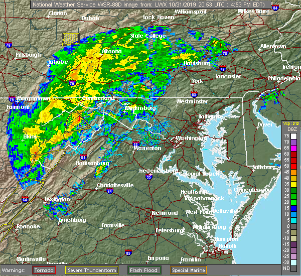 At 456 pm edt, a severe thunderstorm was located over romney, moving northeast at 55 mph (radar indicated). Hazards include 60 mph wind gusts. Damaging winds will cause some trees and large branches to fall. this could injure those outdoors, as well as damage homes and vehicles. roadways may become blocked by downed trees. localized power outages are possible. Unsecured light objects may become projectiles. At 456 pm edt, a severe thunderstorm was located over romney, moving northeast at 55 mph (radar indicated). Hazards include 60 mph wind gusts. Damaging winds will cause some trees and large branches to fall. this could injure those outdoors, as well as damage homes and vehicles. roadways may become blocked by downed trees. localized power outages are possible. Unsecured light objects may become projectiles.
|
| 10/31/2019 4:49 PM EDT |
 At 449 pm edt, severe thunderstorms were located along a line extending from near fort ashby to 6 miles southwest of romney, moving northeast at 60 mph (radar indicated). Hazards include 60 mph wind gusts. Damaging winds will cause some trees and large branches to fall. this could injure those outdoors, as well as damage homes and vehicles. roadways may become blocked by downed trees. localized power outages are possible. unsecured light objects may become projectiles. Locations impacted include, keyser, romney, burlington, russelldale, old fields, purgitsville, headsville, antioch, reeses mill, mcneill, inkerman, kirby, williamsport, junction and ridgeville. At 449 pm edt, severe thunderstorms were located along a line extending from near fort ashby to 6 miles southwest of romney, moving northeast at 60 mph (radar indicated). Hazards include 60 mph wind gusts. Damaging winds will cause some trees and large branches to fall. this could injure those outdoors, as well as damage homes and vehicles. roadways may become blocked by downed trees. localized power outages are possible. unsecured light objects may become projectiles. Locations impacted include, keyser, romney, burlington, russelldale, old fields, purgitsville, headsville, antioch, reeses mill, mcneill, inkerman, kirby, williamsport, junction and ridgeville.
|
| 10/31/2019 4:42 PM EDT |
 At 442 pm edt, severe thunderstorms were located along a line extending from near keyser to 11 miles north of moorefield, moving east at 60 mph (radar indicated). Hazards include 60 mph wind gusts. Damaging winds will cause some trees and large branches to fall. this could injure those outdoors, as well as damage homes and vehicles. roadways may become blocked by downed trees. localized power outages are possible. unsecured light objects may become projectiles. Locations impacted include, keyser, moorefield, romney, burlington, russelldale, bean settlement, arthur, new creek, seymourville, lahmansville, reeses mill, medley, kline gap, kirby, williamsport, junction, ridgeville, maysville, old fields and purgitsville. At 442 pm edt, severe thunderstorms were located along a line extending from near keyser to 11 miles north of moorefield, moving east at 60 mph (radar indicated). Hazards include 60 mph wind gusts. Damaging winds will cause some trees and large branches to fall. this could injure those outdoors, as well as damage homes and vehicles. roadways may become blocked by downed trees. localized power outages are possible. unsecured light objects may become projectiles. Locations impacted include, keyser, moorefield, romney, burlington, russelldale, bean settlement, arthur, new creek, seymourville, lahmansville, reeses mill, medley, kline gap, kirby, williamsport, junction, ridgeville, maysville, old fields and purgitsville.
|
| 10/31/2019 4:24 PM EDT |
 At 423 pm edt, severe thunderstorms were located along a line extending from 6 miles south of kitzmiller to 9 miles northwest of petersburg, moving northeast at 60 mph (radar indicated). Hazards include 60 mph wind gusts. Damaging winds will cause some trees and large branches to fall. this could injure those outdoors, as well as damage homes and vehicles. roadways may become blocked by downed trees. localized power outages are possible. unsecured light objects may become projectiles. Locations impacted include, keyser, moorefield, romney, piedmont, elk garden, kitzmiller, burlington, luke, russelldale, bean settlement, arthur, hartmansville, new creek, seymourville, lahmansville, reeses mill, medley, kline gap, kirby and williamsport. At 423 pm edt, severe thunderstorms were located along a line extending from 6 miles south of kitzmiller to 9 miles northwest of petersburg, moving northeast at 60 mph (radar indicated). Hazards include 60 mph wind gusts. Damaging winds will cause some trees and large branches to fall. this could injure those outdoors, as well as damage homes and vehicles. roadways may become blocked by downed trees. localized power outages are possible. unsecured light objects may become projectiles. Locations impacted include, keyser, moorefield, romney, piedmont, elk garden, kitzmiller, burlington, luke, russelldale, bean settlement, arthur, hartmansville, new creek, seymourville, lahmansville, reeses mill, medley, kline gap, kirby and williamsport.
|
| 10/31/2019 4:10 PM EDT |
 At 409 pm edt, severe thunderstorms were located along a line extending from near davis to 10 miles southeast of thomas, moving northeast at 60 mph (radar indicated). Hazards include 60 mph wind gusts. Damaging winds will cause some trees and large branches to fall. this could injure those outdoors, as well as damage homes and vehicles. roadways may become blocked by downed trees. localized power outages are possible. Unsecured light objects may become projectiles. At 409 pm edt, severe thunderstorms were located along a line extending from near davis to 10 miles southeast of thomas, moving northeast at 60 mph (radar indicated). Hazards include 60 mph wind gusts. Damaging winds will cause some trees and large branches to fall. this could injure those outdoors, as well as damage homes and vehicles. roadways may become blocked by downed trees. localized power outages are possible. Unsecured light objects may become projectiles.
|
| 8/20/2019 2:08 PM EDT |
 The national weather service in sterling virginia has issued a * severe thunderstorm warning for. central hampshire county in eastern west virginia. until 245 pm edt. At 208 pm edt, a severe thunderstorm was located near romney, moving east at 10 mph. The national weather service in sterling virginia has issued a * severe thunderstorm warning for. central hampshire county in eastern west virginia. until 245 pm edt. At 208 pm edt, a severe thunderstorm was located near romney, moving east at 10 mph.
|
| 8/15/2019 5:51 PM EDT |
 At 550 pm edt, a severe thunderstorm was located near romney, moving northeast at 25 mph (radar indicated). Hazards include 60 mph wind gusts and quarter size hail. Damaging winds will cause some trees and large branches to fall. this could injure those outdoors, as well as damage homes and vehicles. roadways may become blocked by downed trees. localized power outages are possible. Unsecured light objects may become projectiles. At 550 pm edt, a severe thunderstorm was located near romney, moving northeast at 25 mph (radar indicated). Hazards include 60 mph wind gusts and quarter size hail. Damaging winds will cause some trees and large branches to fall. this could injure those outdoors, as well as damage homes and vehicles. roadways may become blocked by downed trees. localized power outages are possible. Unsecured light objects may become projectiles.
|
| 7/30/2019 2:29 PM EDT |
 At 229 pm edt, a severe thunderstorm was located over romney, moving east at 20 mph (radar indicated). Hazards include 60 mph wind gusts. Damaging winds will cause some trees and large branches to fall. this could injure those outdoors, as well as damage homes and vehicles. roadways may become blocked by downed trees. localized power outages are possible. unsecured light objects may become projectiles. Locations impacted include, romney, augusta, frenchburg, shanks, three churches and wapocomo. At 229 pm edt, a severe thunderstorm was located over romney, moving east at 20 mph (radar indicated). Hazards include 60 mph wind gusts. Damaging winds will cause some trees and large branches to fall. this could injure those outdoors, as well as damage homes and vehicles. roadways may become blocked by downed trees. localized power outages are possible. unsecured light objects may become projectiles. Locations impacted include, romney, augusta, frenchburg, shanks, three churches and wapocomo.
|
| 7/30/2019 2:10 PM EDT |
 At 210 pm edt, a severe thunderstorm was located 7 miles southwest of romney, moving east at 15 mph (radar indicated). Hazards include 60 mph wind gusts. Damaging winds will cause some trees and large branches to fall. this could injure those outdoors, as well as damage homes and vehicles. roadways may become blocked by downed trees. localized power outages are possible. Unsecured light objects may become projectiles. At 210 pm edt, a severe thunderstorm was located 7 miles southwest of romney, moving east at 15 mph (radar indicated). Hazards include 60 mph wind gusts. Damaging winds will cause some trees and large branches to fall. this could injure those outdoors, as well as damage homes and vehicles. roadways may become blocked by downed trees. localized power outages are possible. Unsecured light objects may become projectiles.
|
| 4/19/2019 5:50 PM EDT |
 The severe thunderstorm warning for east central mineral and central hampshire counties will expire at 600 pm edt, the storm which prompted the warning has moved out of the area. therefore, the warning will be allowed to expire. however gusty winds are still possible with this thunderstorm. a tornado watch remains in effect until midnight edt for eastern west virginia. The severe thunderstorm warning for east central mineral and central hampshire counties will expire at 600 pm edt, the storm which prompted the warning has moved out of the area. therefore, the warning will be allowed to expire. however gusty winds are still possible with this thunderstorm. a tornado watch remains in effect until midnight edt for eastern west virginia.
|
| 4/19/2019 5:41 PM EDT |
 At 541 pm edt, a severe thunderstorm was located 7 miles southeast of fort ashby, or 7 miles northeast of romney, moving northeast at 45 mph (radar indicated). Hazards include 60 mph wind gusts. Damaging winds will cause some trees and large branches to fall. this could injure those outdoors, as well as damage homes and vehicles. roadways may become blocked by downed trees. localized power outages are possible. unsecured light objects may become projectiles. Locations impacted include, romney, fort ashby, springfield, augusta, points, shanks, three churches, frenchburg, higginsville, wapocomo and slanesville. At 541 pm edt, a severe thunderstorm was located 7 miles southeast of fort ashby, or 7 miles northeast of romney, moving northeast at 45 mph (radar indicated). Hazards include 60 mph wind gusts. Damaging winds will cause some trees and large branches to fall. this could injure those outdoors, as well as damage homes and vehicles. roadways may become blocked by downed trees. localized power outages are possible. unsecured light objects may become projectiles. Locations impacted include, romney, fort ashby, springfield, augusta, points, shanks, three churches, frenchburg, higginsville, wapocomo and slanesville.
|
| 4/19/2019 5:28 PM EDT |
 At 528 pm edt, a severe thunderstorm was located near romney, moving northeast at 45 mph (radar indicated). Hazards include 60 mph wind gusts. Damaging winds will cause some trees and large branches to fall. this could injure those outdoors, as well as damage homes and vehicles. roadways may become blocked by downed trees. localized power outages are possible. unsecured light objects may become projectiles. Locations impacted include, romney, fort ashby, springfield, augusta, bean settlement, shanks, three churches, frenchburg, headsville, higginsville, slanesville, points, inkerman, kirby, junction and wapocomo. At 528 pm edt, a severe thunderstorm was located near romney, moving northeast at 45 mph (radar indicated). Hazards include 60 mph wind gusts. Damaging winds will cause some trees and large branches to fall. this could injure those outdoors, as well as damage homes and vehicles. roadways may become blocked by downed trees. localized power outages are possible. unsecured light objects may become projectiles. Locations impacted include, romney, fort ashby, springfield, augusta, bean settlement, shanks, three churches, frenchburg, headsville, higginsville, slanesville, points, inkerman, kirby, junction and wapocomo.
|
| 4/19/2019 5:07 PM EDT |
 At 507 pm edt, a severe thunderstorm was located 7 miles north of moorefield, moving northeast at 45 mph (radar indicated). Hazards include 60 mph wind gusts. Damaging winds will cause some trees and large branches to fall. this could injure those outdoors, as well as damage homes and vehicles. roadways may become blocked by downed trees. localized power outages are possible. Unsecured light objects may become projectiles. At 507 pm edt, a severe thunderstorm was located 7 miles north of moorefield, moving northeast at 45 mph (radar indicated). Hazards include 60 mph wind gusts. Damaging winds will cause some trees and large branches to fall. this could injure those outdoors, as well as damage homes and vehicles. roadways may become blocked by downed trees. localized power outages are possible. Unsecured light objects may become projectiles.
|
| 4/14/2019 11:36 PM EDT |
 The severe thunderstorm warning for northeastern hardy and hampshire counties will expire at 1145 pm edt, the storms which prompted the warning are weakening below severe limits. therefore, the warning will be allowed to expire. a tornado watch remains in effect until 300 am edt for western maryland, northwestern virginia, and eastern and the panhandle of west virginia. to report severe weather, contact your nearest law enforcement agency. they will relay your report to the national weather service sterling virginia. The severe thunderstorm warning for northeastern hardy and hampshire counties will expire at 1145 pm edt, the storms which prompted the warning are weakening below severe limits. therefore, the warning will be allowed to expire. a tornado watch remains in effect until 300 am edt for western maryland, northwestern virginia, and eastern and the panhandle of west virginia. to report severe weather, contact your nearest law enforcement agency. they will relay your report to the national weather service sterling virginia.
|
| 4/14/2019 11:32 PM EDT |
 At 1131 pm edt, severe thunderstorms were located along a line extending from hancock to near romney, moving east at 60 mph (radar indicated). Hazards include 60 mph wind gusts. Damaging winds will cause some trees and large branches to fall. this could injure those outdoors, as well as damage homes and vehicles. roadways may become blocked by downed trees. localized power outages are possible. unsecured light objects may become projectiles. Locations impacted include, romney, springfield, capon bridge, green spring, bean settlement, yellow spring, shanks, bloomery, points, delray, kirby, wapocomo, capon springs, augusta, three churches, frenchburg, higginsville, slanesville, largent and inkerman. At 1131 pm edt, severe thunderstorms were located along a line extending from hancock to near romney, moving east at 60 mph (radar indicated). Hazards include 60 mph wind gusts. Damaging winds will cause some trees and large branches to fall. this could injure those outdoors, as well as damage homes and vehicles. roadways may become blocked by downed trees. localized power outages are possible. unsecured light objects may become projectiles. Locations impacted include, romney, springfield, capon bridge, green spring, bean settlement, yellow spring, shanks, bloomery, points, delray, kirby, wapocomo, capon springs, augusta, three churches, frenchburg, higginsville, slanesville, largent and inkerman.
|
| 4/14/2019 11:26 PM EDT |
 At 1126 pm edt, severe thunderstorms were located along a line extending from near barnes gap to near romney, moving east at 35 mph (radar indicated). Hazards include 60 mph wind gusts. Damaging winds will cause some trees and large branches to fall. this could injure those outdoors, as well as damage homes and vehicles. roadways may become blocked by downed trees. localized power outages are possible. unsecured light objects may become projectiles. Locations impacted include, romney, hancock, paw paw, greenwood, berkeley springs, springfield, great cacapon, capon bridge, green spring, pecktonville, oldtown, big pool, little orleans, yellow spring, valley view, fishers bridge, pumpkin center, oakland, delray and unger. At 1126 pm edt, severe thunderstorms were located along a line extending from near barnes gap to near romney, moving east at 35 mph (radar indicated). Hazards include 60 mph wind gusts. Damaging winds will cause some trees and large branches to fall. this could injure those outdoors, as well as damage homes and vehicles. roadways may become blocked by downed trees. localized power outages are possible. unsecured light objects may become projectiles. Locations impacted include, romney, hancock, paw paw, greenwood, berkeley springs, springfield, great cacapon, capon bridge, green spring, pecktonville, oldtown, big pool, little orleans, yellow spring, valley view, fishers bridge, pumpkin center, oakland, delray and unger.
|
| 4/14/2019 10:56 PM EDT |
 At 1056 pm edt, severe thunderstorms were located along a line extending from 9 miles east of cumberland to 8 miles north of moorefield, moving east at 60 mph (radar indicated). Hazards include 60 mph wind gusts. Damaging winds will cause some trees and large branches to fall. this could injure those outdoors, as well as damage homes and vehicles. roadways may become blocked by downed trees. localized power outages are possible. Unsecured light objects may become projectiles. At 1056 pm edt, severe thunderstorms were located along a line extending from 9 miles east of cumberland to 8 miles north of moorefield, moving east at 60 mph (radar indicated). Hazards include 60 mph wind gusts. Damaging winds will cause some trees and large branches to fall. this could injure those outdoors, as well as damage homes and vehicles. roadways may become blocked by downed trees. localized power outages are possible. Unsecured light objects may become projectiles.
|
| 4/14/2019 10:38 PM EDT |
 At 1037 pm edt, severe thunderstorms were located along a line extending from near lake gordon to near ridgeley to 10 miles southeast of elk garden, moving east at 35 mph (radar indicated). Hazards include 60 mph wind gusts. Damaging winds will cause some trees and large branches to fall. this could injure those outdoors, as well as damage homes and vehicles. roadways may become blocked by downed trees. localized power outages are possible. unsecured light objects may become projectiles. Locations impacted include, cumberland, frostburg, keyser, westernport, romney, bel air, la vale, fort ashby, lonaconing, piedmont, ridgeley, cresaptown, potomac park, wiley ford, eckhart mines, mount savage, rawlings, ellerslie, springfield and barton. At 1037 pm edt, severe thunderstorms were located along a line extending from near lake gordon to near ridgeley to 10 miles southeast of elk garden, moving east at 35 mph (radar indicated). Hazards include 60 mph wind gusts. Damaging winds will cause some trees and large branches to fall. this could injure those outdoors, as well as damage homes and vehicles. roadways may become blocked by downed trees. localized power outages are possible. unsecured light objects may become projectiles. Locations impacted include, cumberland, frostburg, keyser, westernport, romney, bel air, la vale, fort ashby, lonaconing, piedmont, ridgeley, cresaptown, potomac park, wiley ford, eckhart mines, mount savage, rawlings, ellerslie, springfield and barton.
|
| 4/14/2019 10:11 PM EDT |
 At 1011 pm edt, severe thunderstorms were located along a line extending from 6 miles east of grantsville to piedmont to near bayard, moving east at 40 mph (radar indicated). Hazards include 60 mph wind gusts. Damaging winds will cause some trees and large branches to fall. this could injure those outdoors, as well as damage homes and vehicles. roadways may become blocked by downed trees. localized power outages are possible. unsecured light objects may become projectiles. Locations impacted include, cumberland, frostburg, keyser, westernport, romney, bel air, bayard, la vale, fort ashby, lonaconing, piedmont, elk garden, kitzmiller, ridgeley, cresaptown, potomac park, wiley ford, eckhart mines, mount savage and rawlings. At 1011 pm edt, severe thunderstorms were located along a line extending from 6 miles east of grantsville to piedmont to near bayard, moving east at 40 mph (radar indicated). Hazards include 60 mph wind gusts. Damaging winds will cause some trees and large branches to fall. this could injure those outdoors, as well as damage homes and vehicles. roadways may become blocked by downed trees. localized power outages are possible. unsecured light objects may become projectiles. Locations impacted include, cumberland, frostburg, keyser, westernport, romney, bel air, bayard, la vale, fort ashby, lonaconing, piedmont, elk garden, kitzmiller, ridgeley, cresaptown, potomac park, wiley ford, eckhart mines, mount savage and rawlings.
|
| 4/14/2019 9:55 PM EDT |
 At 955 pm edt, severe thunderstorms were located along a line extending from near accident to near davis, moving east at 40 mph (radar indicated). Hazards include 60 mph wind gusts. Damaging winds will cause some trees and large branches to fall. this could injure those outdoors, as well as damage homes and vehicles. roadways may become blocked by downed trees. localized power outages are possible. Unsecured light objects may become projectiles. At 955 pm edt, severe thunderstorms were located along a line extending from near accident to near davis, moving east at 40 mph (radar indicated). Hazards include 60 mph wind gusts. Damaging winds will cause some trees and large branches to fall. this could injure those outdoors, as well as damage homes and vehicles. roadways may become blocked by downed trees. localized power outages are possible. Unsecured light objects may become projectiles.
|
| 8/21/2018 4:08 PM EDT |
 A severe thunderstorm warning remains in effect until 445 pm edt for central hampshire county. at 408 pm edt, a severe thunderstorm was located near romney, moving east at 20 mph. hazard. 60 mph wind gusts and quarter size hail. source. Radar indicated. A severe thunderstorm warning remains in effect until 445 pm edt for central hampshire county. at 408 pm edt, a severe thunderstorm was located near romney, moving east at 20 mph. hazard. 60 mph wind gusts and quarter size hail. source. Radar indicated.
|
| 8/21/2018 4:02 PM EDT | Tree down on grassy lick rd. about 2 miles south of northwest pik in hampshire county WV, 3.6 miles NNW of Romney, WV |
| 8/21/2018 4:02 PM EDT | Downed tree near the intersection of grassy lick rd and bethel church rd in hampshire county WV, 0.3 miles ESE of Romney, WV |
| 8/21/2018 3:56 PM EDT |
 At 356 pm edt, a severe thunderstorm was located near romney, moving east at 20 mph (radar indicated). Hazards include 60 mph wind gusts and quarter size hail. Damaging winds will cause some trees and large branches to fall. this could injure those outdoors, as well as damage homes and vehicles. roadways may become blocked by downed trees. localized power outages are possible. Unsecured light objects may become projectiles. At 356 pm edt, a severe thunderstorm was located near romney, moving east at 20 mph (radar indicated). Hazards include 60 mph wind gusts and quarter size hail. Damaging winds will cause some trees and large branches to fall. this could injure those outdoors, as well as damage homes and vehicles. roadways may become blocked by downed trees. localized power outages are possible. Unsecured light objects may become projectiles.
|
| 7/2/2018 5:01 PM EDT | Downed tree on three churches hollow roa in hampshire county WV, 8.3 miles WSW of Romney, WV |
| 5/14/2018 4:54 PM EDT |
 The severe thunderstorm warning for northeastern grant, mineral, northwestern hardy and northwestern hampshire counties will expire at 500 pm edt, the storms which prompted the warning have moved out of the area. therefore the warning will be allowed to expire. however gusty winds and heavy rain are still possible with additional thunderstorms over the area. a severe thunderstorm watch remains in effect until 900 pm edt for western maryland, and eastern west virginia. The severe thunderstorm warning for northeastern grant, mineral, northwestern hardy and northwestern hampshire counties will expire at 500 pm edt, the storms which prompted the warning have moved out of the area. therefore the warning will be allowed to expire. however gusty winds and heavy rain are still possible with additional thunderstorms over the area. a severe thunderstorm watch remains in effect until 900 pm edt for western maryland, and eastern west virginia.
|
| 5/14/2018 4:41 PM EDT |
 At 441 pm edt, severe thunderstorms were located along a line extending from near paw paw to 10 miles southwest of romney, moving east at 45 mph (radar indicated). Hazards include 60 mph wind gusts and quarter size hail. Damaging winds will cause some trees and large branches to fall. this could injure those outdoors, as well as damage homes and vehicles. roadways may become blocked by downed trees. localized power outages are possible. unsecured light objects may become projectiles. Locations impacted include, keyser, romney, fort ashby, springfield, green spring, burlington, russelldale, hartmansville, short gap, new creek, lahmansville, reeses mill, medley, williamsport, junction, wapocomo, ridgeville, patterson creek, purgitsville and headsville. At 441 pm edt, severe thunderstorms were located along a line extending from near paw paw to 10 miles southwest of romney, moving east at 45 mph (radar indicated). Hazards include 60 mph wind gusts and quarter size hail. Damaging winds will cause some trees and large branches to fall. this could injure those outdoors, as well as damage homes and vehicles. roadways may become blocked by downed trees. localized power outages are possible. unsecured light objects may become projectiles. Locations impacted include, keyser, romney, fort ashby, springfield, green spring, burlington, russelldale, hartmansville, short gap, new creek, lahmansville, reeses mill, medley, williamsport, junction, wapocomo, ridgeville, patterson creek, purgitsville and headsville.
|
| 5/14/2018 4:25 PM EDT | Tree and wires down near s branch river rd and hampshire park d in hampshire county WV, 3.6 miles NE of Romney, WV |
| 5/14/2018 4:12 PM EDT |
 At 412 pm edt, severe thunderstorms were located along a line extending from near ridgeley to near bayard, moving east at 45 mph (radar indicated). Hazards include 60 mph wind gusts and quarter size hail. Damaging winds will cause some trees and large branches to fall. this could injure those outdoors, as well as damage homes and vehicles. roadways may become blocked by downed trees. localized power outages are possible. Unsecured light objects may become projectiles. At 412 pm edt, severe thunderstorms were located along a line extending from near ridgeley to near bayard, moving east at 45 mph (radar indicated). Hazards include 60 mph wind gusts and quarter size hail. Damaging winds will cause some trees and large branches to fall. this could injure those outdoors, as well as damage homes and vehicles. roadways may become blocked by downed trees. localized power outages are possible. Unsecured light objects may become projectiles.
|
| 9/5/2017 2:27 PM EDT |
 At 227 pm edt, a severe thunderstorm was located over romney, moving east at 35 mph (radar indicated). Hazards include 60 mph wind gusts. Damaging winds will cause some trees and large branches to fall. this could injure those outdoors, as well as damage homes and vehicles. roadways may become blocked by downed trees. localized power outages are possible. Unsecured light objects may become projectiles. At 227 pm edt, a severe thunderstorm was located over romney, moving east at 35 mph (radar indicated). Hazards include 60 mph wind gusts. Damaging winds will cause some trees and large branches to fall. this could injure those outdoors, as well as damage homes and vehicles. roadways may become blocked by downed trees. localized power outages are possible. Unsecured light objects may become projectiles.
|
| 7/7/2017 5:39 PM EDT | Tree down on sol shanholtz road half a mile from highway 5 in hampshire county WV, 8.2 miles WNW of Romney, WV |
| 7/7/2017 5:32 PM EDT | Two trees down and canopies damaged at capocoma campgroun in hampshire county WV, 5 miles NE of Romney, WV |
| 3/1/2017 12:12 PM EST |
 At 1212 pm est, severe thunderstorms were located along a line extending from 8 miles northeast of lake gordon to 7 miles west of wardensville, moving east at 50 mph (radar indicated). Hazards include 60 mph wind gusts. Damaging winds will cause some trees and large branches to fall. this could injure those outdoors, as well as damage homes and vehicles. roadways may become blocked by downed trees. localized power outages are possible. Unsecured light objects may become projectiles. At 1212 pm est, severe thunderstorms were located along a line extending from 8 miles northeast of lake gordon to 7 miles west of wardensville, moving east at 50 mph (radar indicated). Hazards include 60 mph wind gusts. Damaging winds will cause some trees and large branches to fall. this could injure those outdoors, as well as damage homes and vehicles. roadways may become blocked by downed trees. localized power outages are possible. Unsecured light objects may become projectiles.
|
| 2/12/2017 9:26 PM EST |
 At 925 pm est, severe thunderstorms were located along a line extending from 6 miles southwest of clearville to westernport to near grafton, moving east at 45 mph (radar indicated). Hazards include 60 mph wind gusts. Damaging winds will cause some trees and large branches to fall. this could injure those outdoors, as well as damage homes and vehicles. roadways may become blocked by downed trees. localized power outages are possible. unsecured light objects may become projectiles. Locations impacted include, cumberland, frostburg, keyser, westernport, romney, hancock, bel air, paw paw, bayard, la vale, fort ashby, lonaconing, piedmont, berkeley springs, elk garden, kitzmiller, ridgeley, cresaptown, potomac park and wiley ford. At 925 pm est, severe thunderstorms were located along a line extending from 6 miles southwest of clearville to westernport to near grafton, moving east at 45 mph (radar indicated). Hazards include 60 mph wind gusts. Damaging winds will cause some trees and large branches to fall. this could injure those outdoors, as well as damage homes and vehicles. roadways may become blocked by downed trees. localized power outages are possible. unsecured light objects may become projectiles. Locations impacted include, cumberland, frostburg, keyser, westernport, romney, hancock, bel air, paw paw, bayard, la vale, fort ashby, lonaconing, piedmont, berkeley springs, elk garden, kitzmiller, ridgeley, cresaptown, potomac park and wiley ford.
|
| 2/12/2017 9:00 PM EST |
 At 900 pm est, severe thunderstorms were located along a line extending from near buffalo mills to near bittinger to near enterprise, moving southeast at 45 mph (radar indicated). Hazards include 60 mph wind gusts. Damaging winds will cause some trees and large branches to fall. this could injure those outdoors, as well as damage homes and vehicles. roadways may become blocked by downed trees. localized power outages are possible. Unsecured light objects may become projectiles. At 900 pm est, severe thunderstorms were located along a line extending from near buffalo mills to near bittinger to near enterprise, moving southeast at 45 mph (radar indicated). Hazards include 60 mph wind gusts. Damaging winds will cause some trees and large branches to fall. this could injure those outdoors, as well as damage homes and vehicles. roadways may become blocked by downed trees. localized power outages are possible. Unsecured light objects may become projectiles.
|
| 6/16/2016 6:39 PM EDT |
 At 639 pm edt, severe thunderstorms were located along a line extending from 7 miles southeast of lake gordon to 6 miles southeast of fort ashby to near rough run to 12 miles west of brandywine, moving southeast at 40 mph (radar indicated). Hazards include 60 mph wind gusts and quarter size hail. Damaging winds will cause some trees and large branches to fall. this could injure those outdoors, as well as damage homes and vehicles. roadways may become blocked by downed trees. localized power outages are possible. unsecured light objects may become projectiles. Locations impacted include, cumberland, moorefield, petersburg, romney, hancock, paw paw, brandywine, rough run, fort ashby, berkeley springs, ridgeley, upper tract, mathias, potomac park, wiley ford, franklin, springfield, great cacapon, capon bridge and green spring. At 639 pm edt, severe thunderstorms were located along a line extending from 7 miles southeast of lake gordon to 6 miles southeast of fort ashby to near rough run to 12 miles west of brandywine, moving southeast at 40 mph (radar indicated). Hazards include 60 mph wind gusts and quarter size hail. Damaging winds will cause some trees and large branches to fall. this could injure those outdoors, as well as damage homes and vehicles. roadways may become blocked by downed trees. localized power outages are possible. unsecured light objects may become projectiles. Locations impacted include, cumberland, moorefield, petersburg, romney, hancock, paw paw, brandywine, rough run, fort ashby, berkeley springs, ridgeley, upper tract, mathias, potomac park, wiley ford, franklin, springfield, great cacapon, capon bridge and green spring.
|
| 6/16/2016 6:01 PM EDT |
 At 600 pm edt, severe thunderstorms were located along a line extending from near frostburg to westernport to near bayard to near dailey, moving southeast at 45 mph (radar indicated). Hazards include 60 mph wind gusts and quarter size hail. Damaging winds will cause some trees and large branches to fall. this could injure those outdoors, as well as damage homes and vehicles. roadways may become blocked by downed trees. localized power outages are possible. Unsecured light objects may become projectiles. At 600 pm edt, severe thunderstorms were located along a line extending from near frostburg to westernport to near bayard to near dailey, moving southeast at 45 mph (radar indicated). Hazards include 60 mph wind gusts and quarter size hail. Damaging winds will cause some trees and large branches to fall. this could injure those outdoors, as well as damage homes and vehicles. roadways may become blocked by downed trees. localized power outages are possible. Unsecured light objects may become projectiles.
|
| 6/2/2016 2:56 PM EDT |
 The severe thunderstorm warning for central hampshire county will expire at 300 pm edt, the storm which prompted the warning has weakened, and no longer pose an immediate threat to life or property. therefore the warning will be allowed to expire. The severe thunderstorm warning for central hampshire county will expire at 300 pm edt, the storm which prompted the warning has weakened, and no longer pose an immediate threat to life or property. therefore the warning will be allowed to expire.
|
| 6/2/2016 2:34 PM EDT |
 At 233 pm edt, a severe thunderstorm was located over romney, moving southeast at 15 mph (radar indicated). Hazards include 60 mph wind gusts. Damaging winds will cause some trees and large branches to fall. this could injure those outdoors, as well as damage homes and vehicles. roadways may become blocked by downed trees. localized power outages are possible. unsecured light objects may become projectiles. Locations impacted include, romney, shanks, augusta and frenchburg. At 233 pm edt, a severe thunderstorm was located over romney, moving southeast at 15 mph (radar indicated). Hazards include 60 mph wind gusts. Damaging winds will cause some trees and large branches to fall. this could injure those outdoors, as well as damage homes and vehicles. roadways may become blocked by downed trees. localized power outages are possible. unsecured light objects may become projectiles. Locations impacted include, romney, shanks, augusta and frenchburg.
|
| 6/2/2016 2:12 PM EDT |
 At 211 pm edt, a severe thunderstorm was located near romney, moving southeast at 15 mph (radar indicated). Hazards include 60 mph wind gusts and quarter size hail. Damaging winds will cause some trees and large branches to fall. this could injure those outdoors, as well as damage homes and vehicles. roadways may become blocked by downed trees. localized power outages are possible. Unsecured light objects may become projectiles. At 211 pm edt, a severe thunderstorm was located near romney, moving southeast at 15 mph (radar indicated). Hazards include 60 mph wind gusts and quarter size hail. Damaging winds will cause some trees and large branches to fall. this could injure those outdoors, as well as damage homes and vehicles. roadways may become blocked by downed trees. localized power outages are possible. Unsecured light objects may become projectiles.
|
| 9/4/2015 5:53 PM EDT |
 At 553 pm edt, doppler radar indicated a severe thunderstorm capable of producing quarter size hail and damaging winds in excess of 60 mph. this storm was located near romney, moving west at 15 mph. locations impacted include, romney, fort ashby, springfield, wapocomo, headsville and reeses mill. At 553 pm edt, doppler radar indicated a severe thunderstorm capable of producing quarter size hail and damaging winds in excess of 60 mph. this storm was located near romney, moving west at 15 mph. locations impacted include, romney, fort ashby, springfield, wapocomo, headsville and reeses mill.
|
| 9/4/2015 5:37 PM EDT |
 At 537 pm edt, doppler radar indicated a severe thunderstorm capable of producing quarter size hail and damaging winds in excess of 60 mph. this storm was located near romney, and moving west at 15 mph. At 537 pm edt, doppler radar indicated a severe thunderstorm capable of producing quarter size hail and damaging winds in excess of 60 mph. this storm was located near romney, and moving west at 15 mph.
|
| 9/4/2015 4:40 PM EDT | A tree was reported down on a power line near the intersection of northwestern pike and sol shanholtz roa in hampshire county WV, 7.5 miles WNW of Romney, WV |
| 8/4/2015 2:35 AM EDT |
 At 234 am edt, doppler radar indicated a severe thunderstorm capable of producing quarter size hail and damaging winds in excess of 60 mph. this storm was located near elk garden, or 11 miles southwest of keyser, and moving east at 40 mph. At 234 am edt, doppler radar indicated a severe thunderstorm capable of producing quarter size hail and damaging winds in excess of 60 mph. this storm was located near elk garden, or 11 miles southwest of keyser, and moving east at 40 mph.
|
| 6/20/2015 4:30 PM EDT | Two trees down along u.s. 50 near dolan dr in hampshire county WV, 6.5 miles WNW of Romney, WV |
| 5/31/2015 7:30 PM EDT | Tree down on ford hill road in hampshire county WV, 8.2 miles NW of Romney, WV |
| 5/31/2015 7:28 PM EDT | At 728 pm edt, doppler radar indicated a severe thunderstorm capable of producing quarter size hail and damaging winds in excess of 60 mph. this storm was located near romney, and moving northeast at 25 mph. |
| 8/12/2014 4:00 PM EDT | Large tree down blocking grassy lick rd about one half mile from rt 50 in hampshire county WV, 2.1 miles NNW of Romney, WV |
| 7/13/2014 7:00 PM EDT | A tree was down on heide cooper roa in hampshire county WV, 5.3 miles NW of Romney, WV |
| 7/2/2014 5:45 PM EDT | Quarter sized hail reported 6.2 miles NNW of Romney, WV |
| 6/25/2014 5:26 PM EDT | Tree down at the corner of grassy lick road and briar lick road in hampshire county WV, 11 miles N of Romney, WV |
| 6/25/2014 4:26 PM EDT | Tree down at the corner of grassy lick road and briar lick road in hampshire county WV, 11 miles N of Romney, WV |
| 5/13/2014 4:38 PM EDT | A tree was reported down on powerlines on jersey mountain roa in hampshire county WV, 4 miles W of Romney, WV |
| 11/1/2013 5:30 AM EDT | Powerlines down that started a brush fire on grassy lick road in hampshire county WV, 2.4 miles NW of Romney, WV |
| 6/24/2013 2:45 PM EDT | Quarter sized hail reported 7 miles WNW of Romney, WV |
| 5/22/2013 2:45 PM EDT | Tree down along woodland way south of highway 5 in hampshire county WV, 1.3 miles NNE of Romney, WV |
| 7/4/2012 8:23 PM EDT | Tree down on power line along heide cooper rd in hampshire count in hampshire county WV, 5.9 miles NNW of Romney, WV |
| 9/27/2011 5:25 PM EDT | Half Dollar sized hail reported 0.3 miles ESE of Romney, WV |
| 9/27/2011 5:22 PM EDT | Ping Pong Ball sized hail reported 0.3 miles ESE of Romney, WV |
| 1/1/0001 12:00 AM | Tree blown dow in hampshire county WV, 3.5 miles WNW of Romney, WV |
| 9/27/2011 5:20 PM EDT | Quarter sized hail reported 2.5 miles WNW of Romney, WV |
| 1/1/0001 12:00 AM | Tree down onto south branch river roa in hampshire county WV, 3.6 miles NE of Romney, WV |
| 1/1/0001 12:00 AM | Trees down blocking road at rt 29 50 in hampshire county WV, 8.9 miles WNW of Romney, WV |
| 1/1/0001 12:00 AM | Tree down on whisper valley road in hampshire county WV, 2.6 miles SSW of Romney, WV |
Hail Maps for Romney, WV


Connect with Interactive Hail Maps