

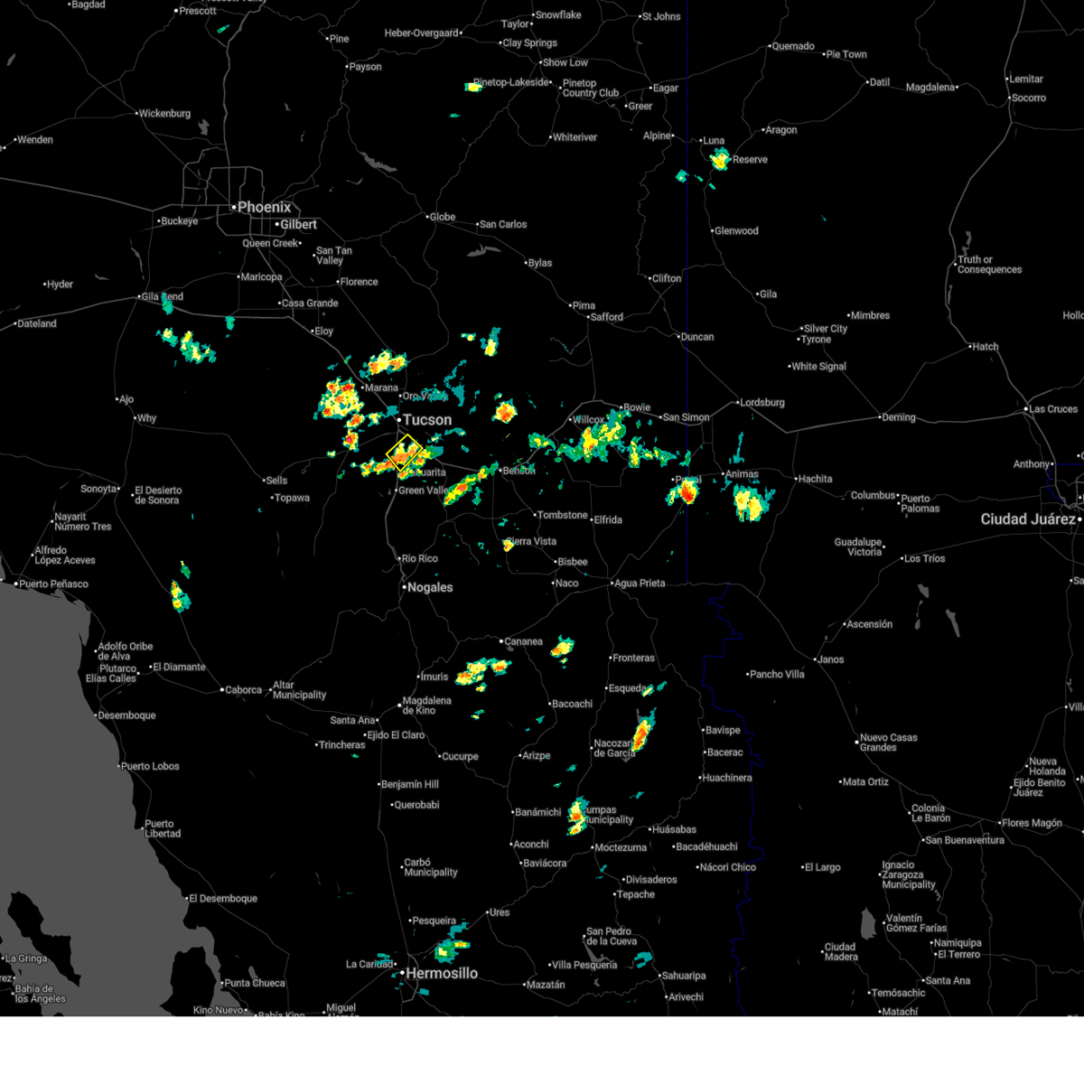
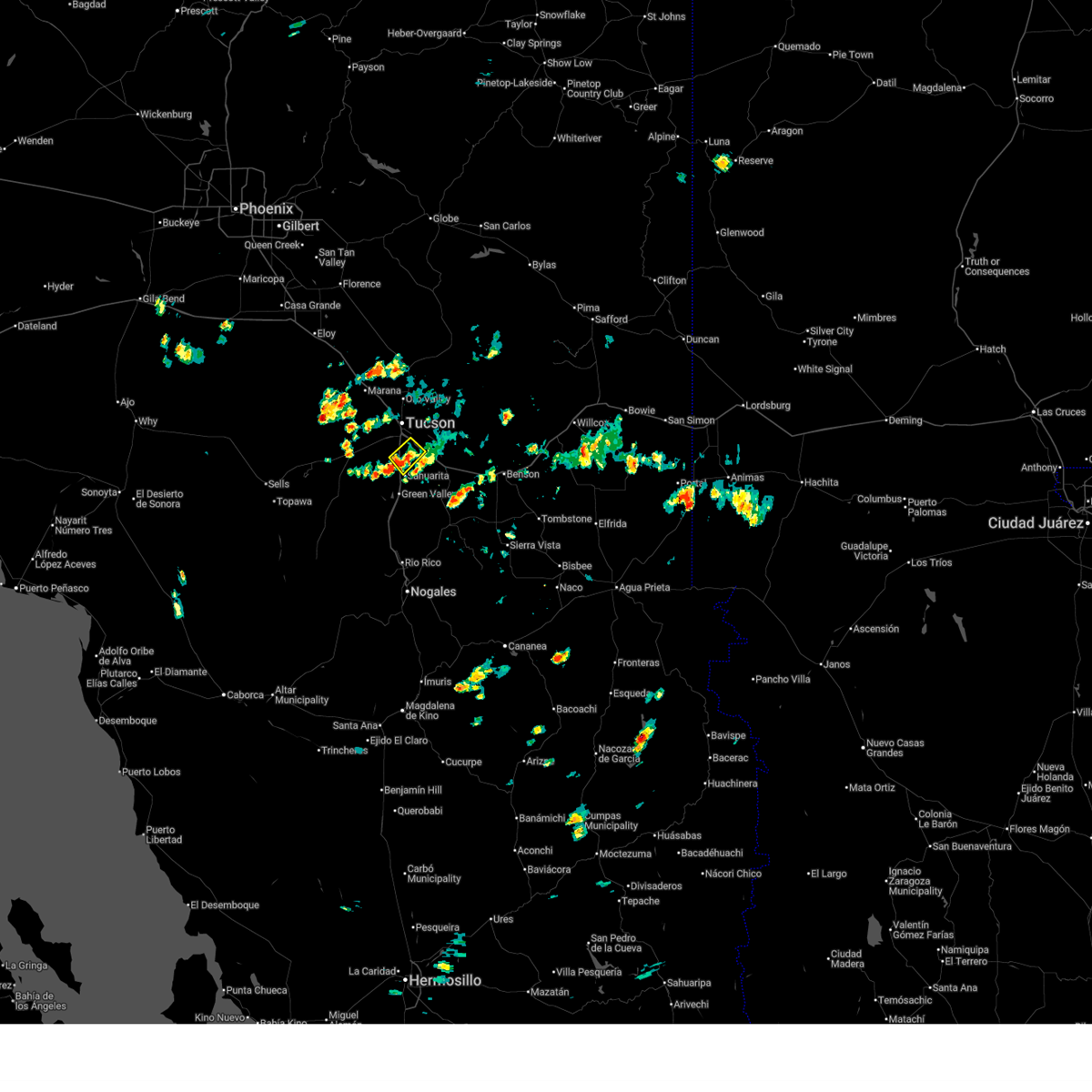
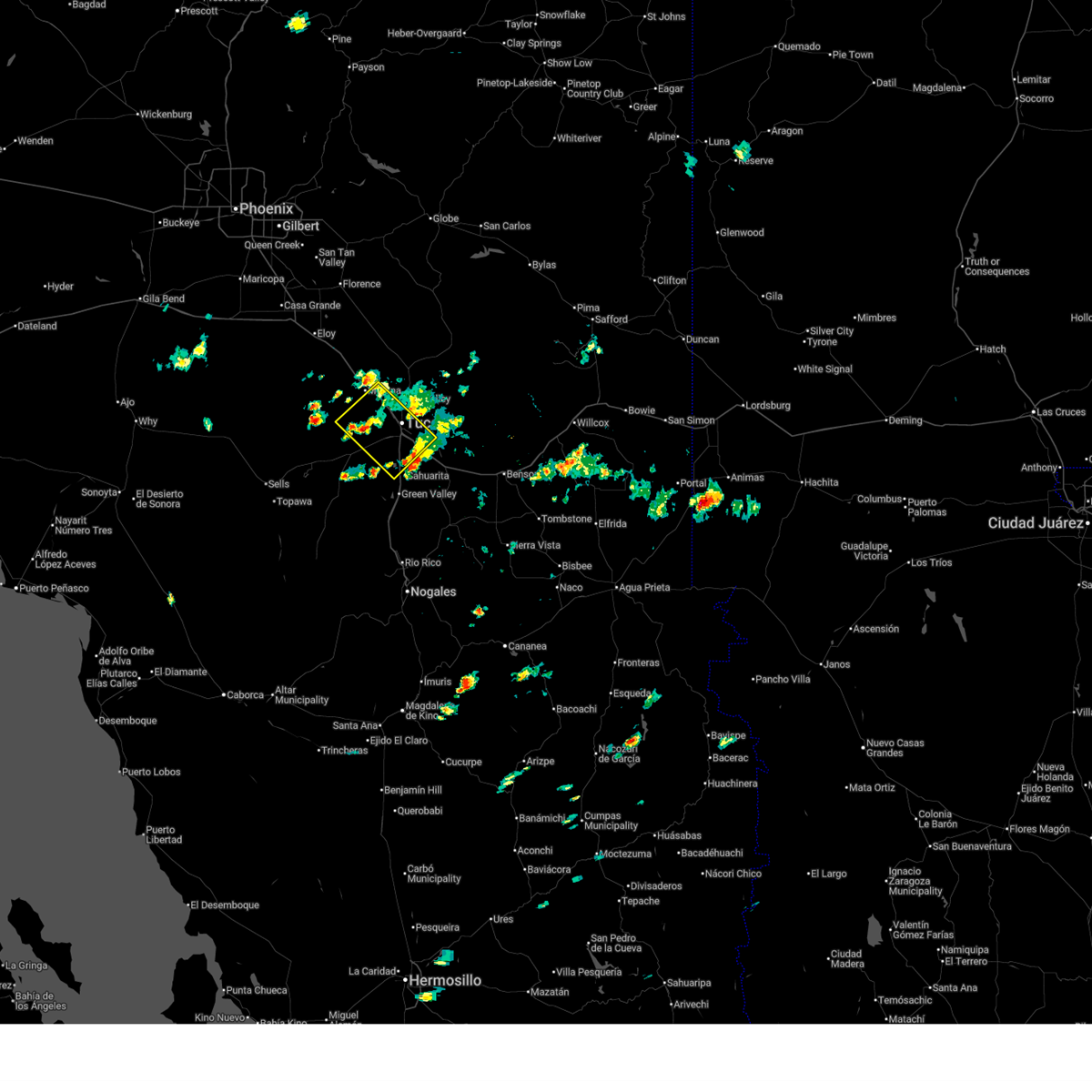
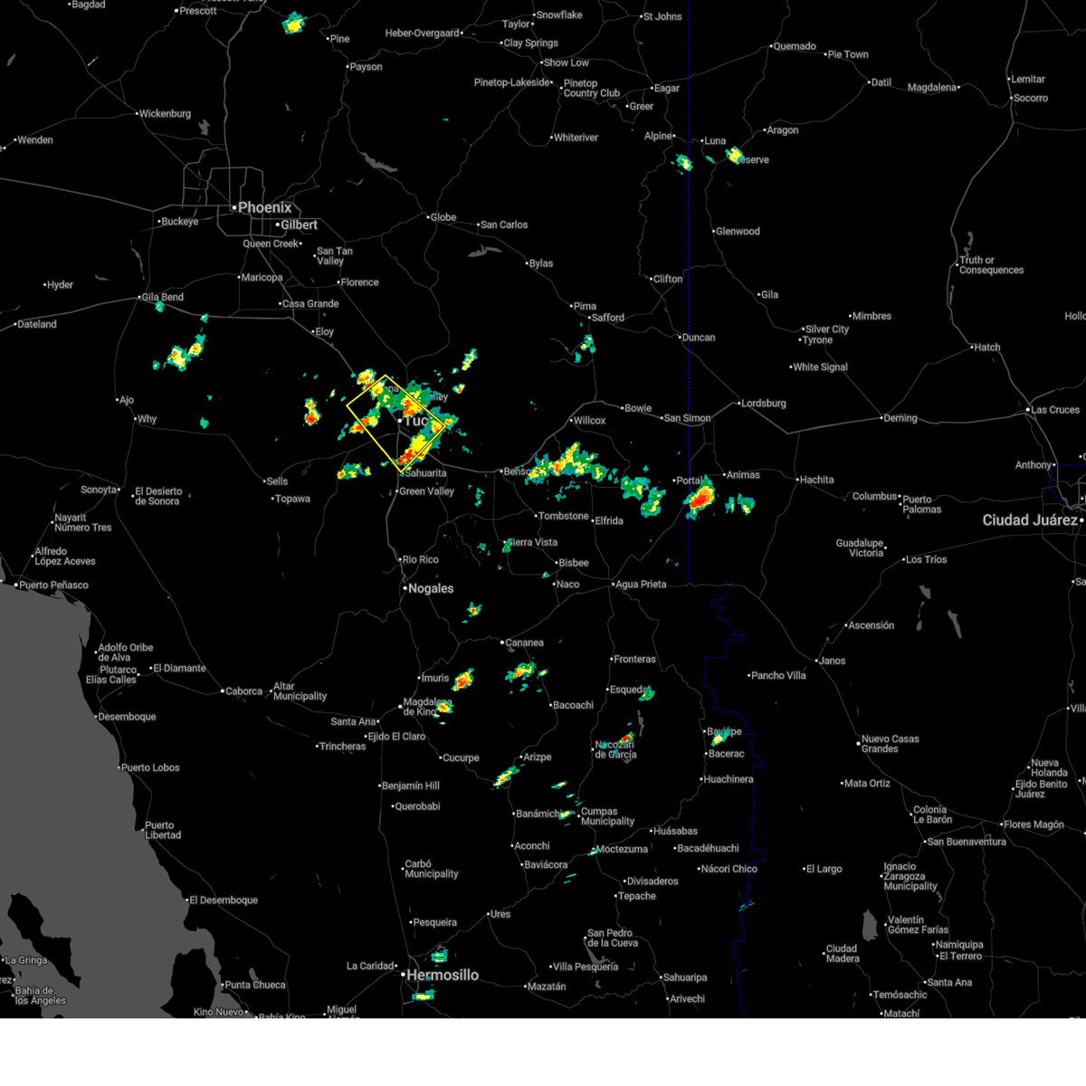
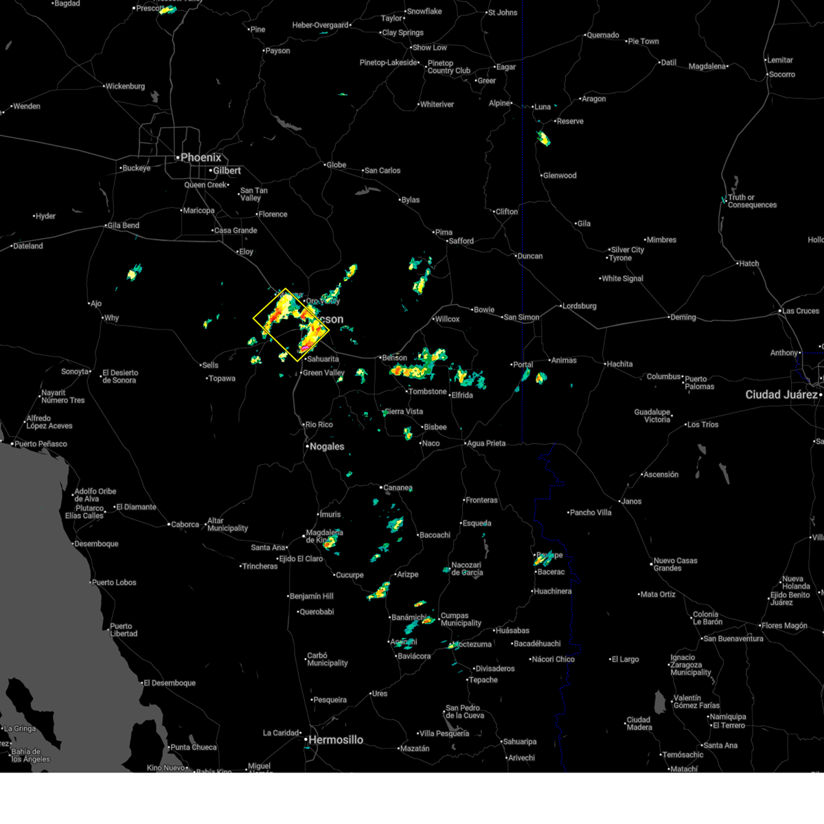
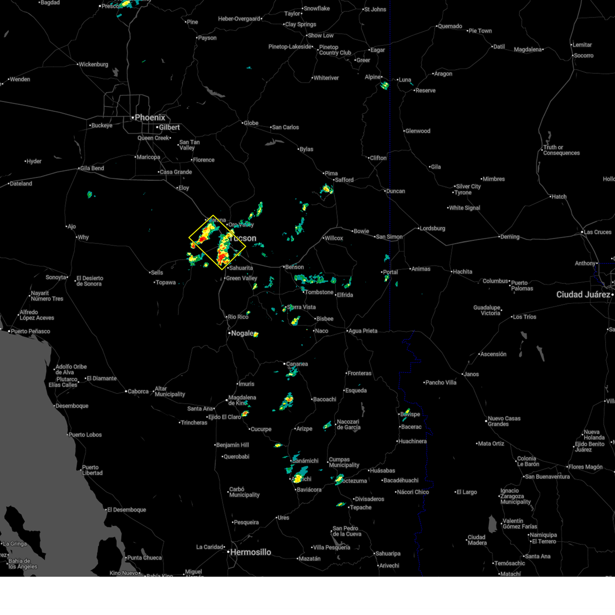
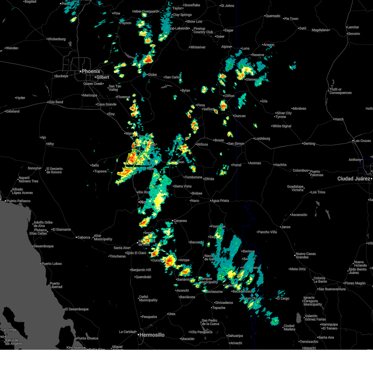
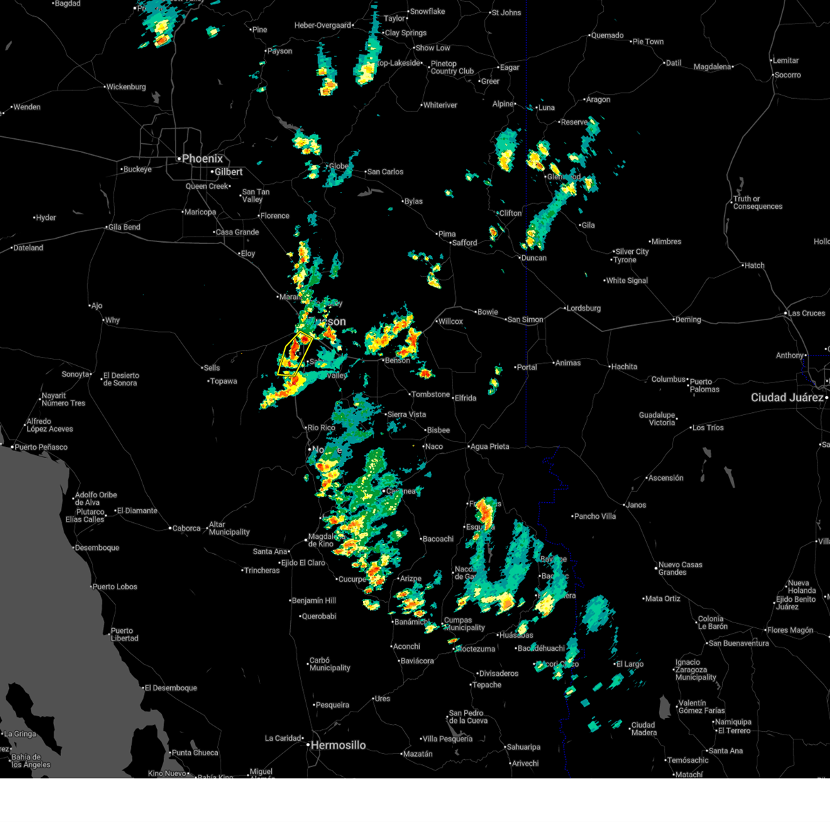
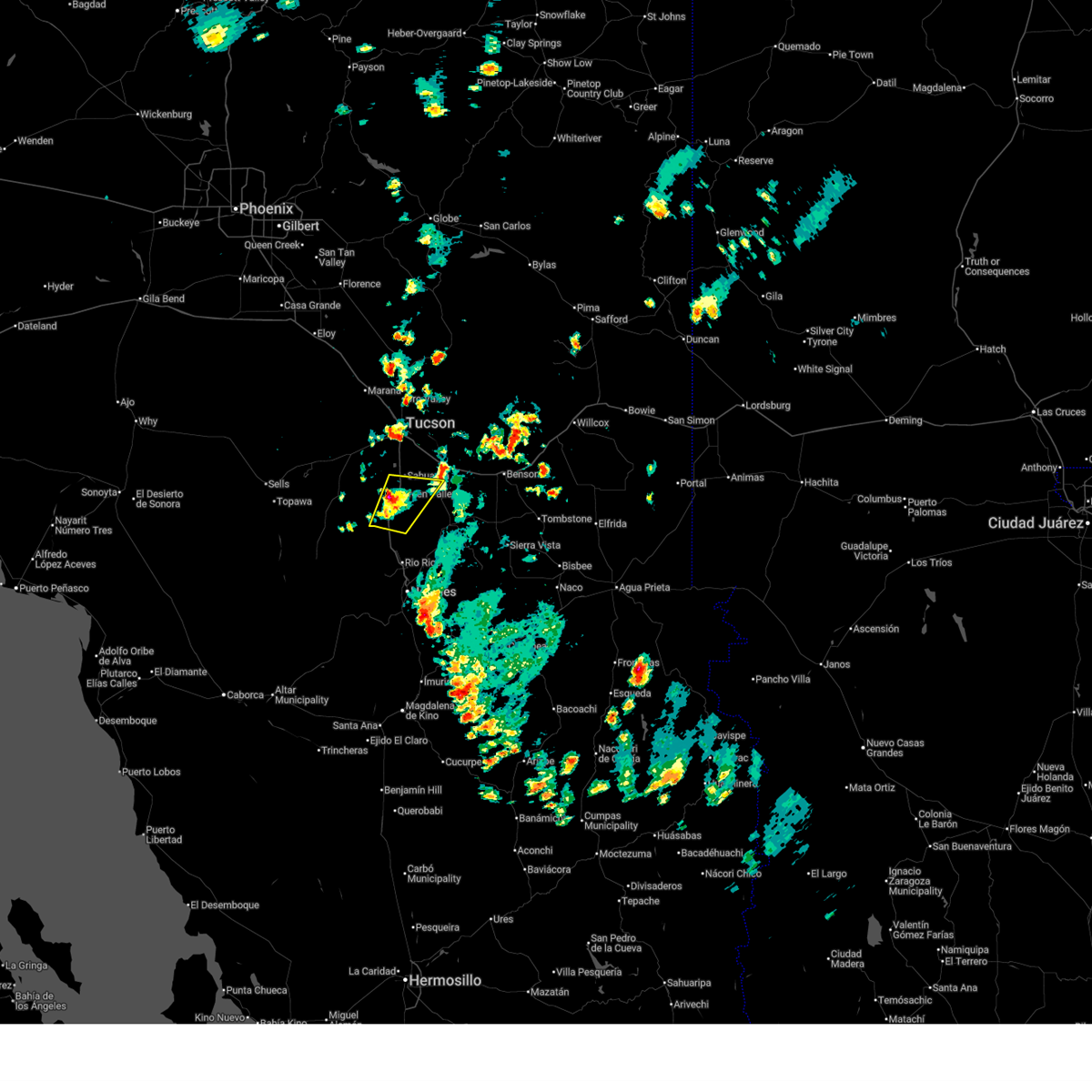
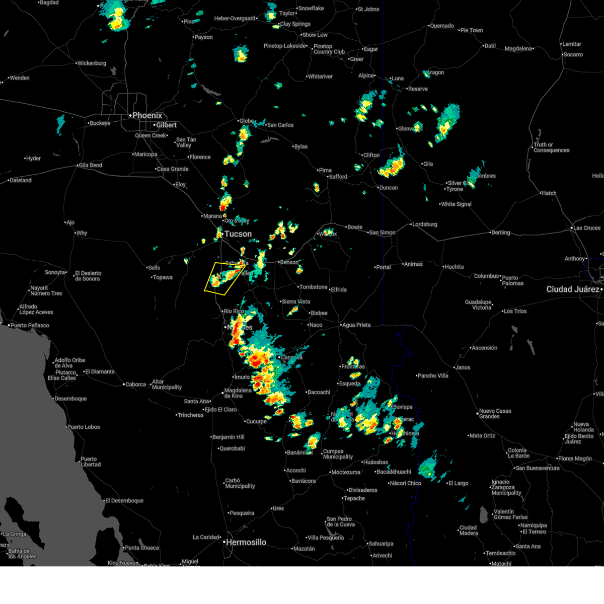
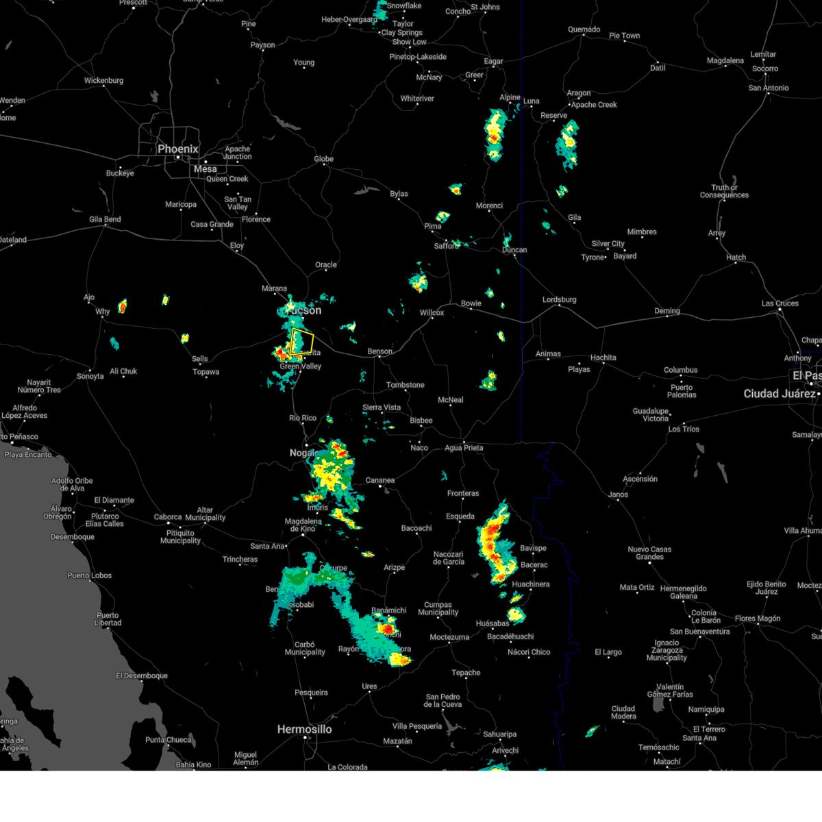
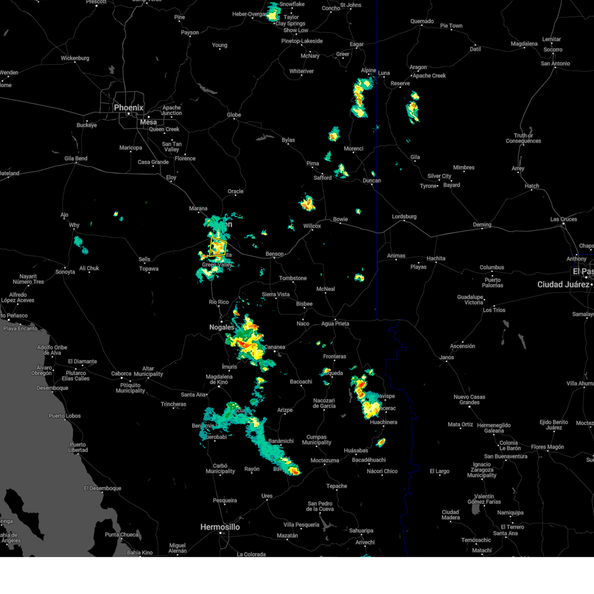
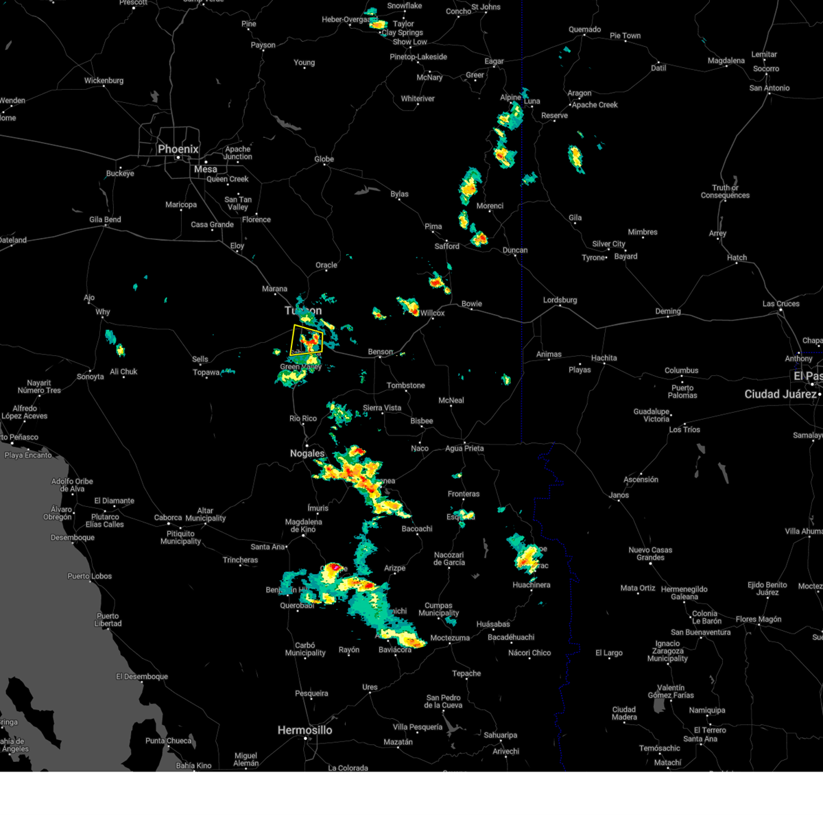
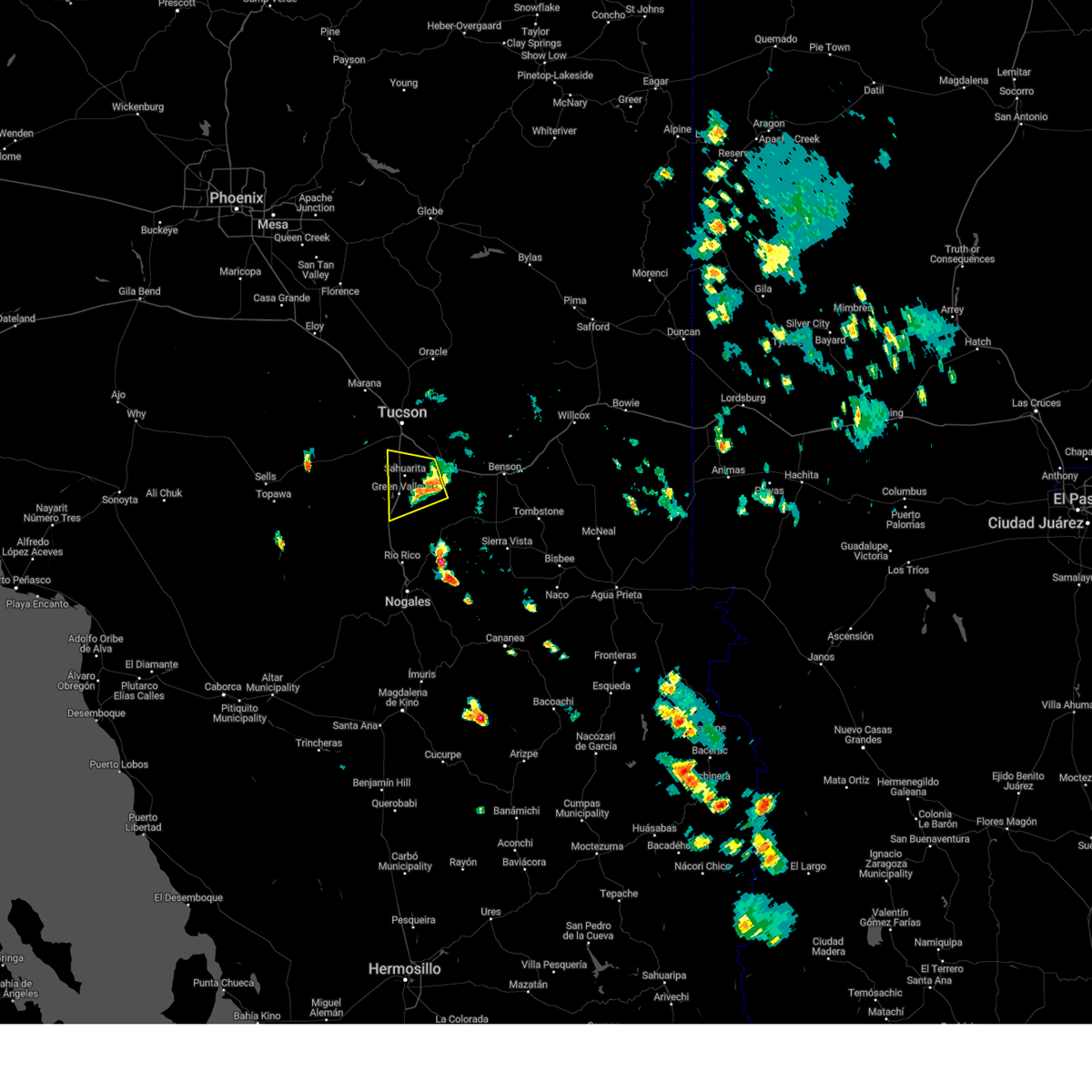
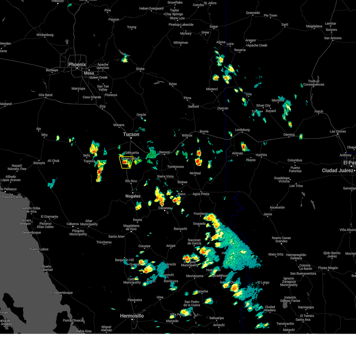
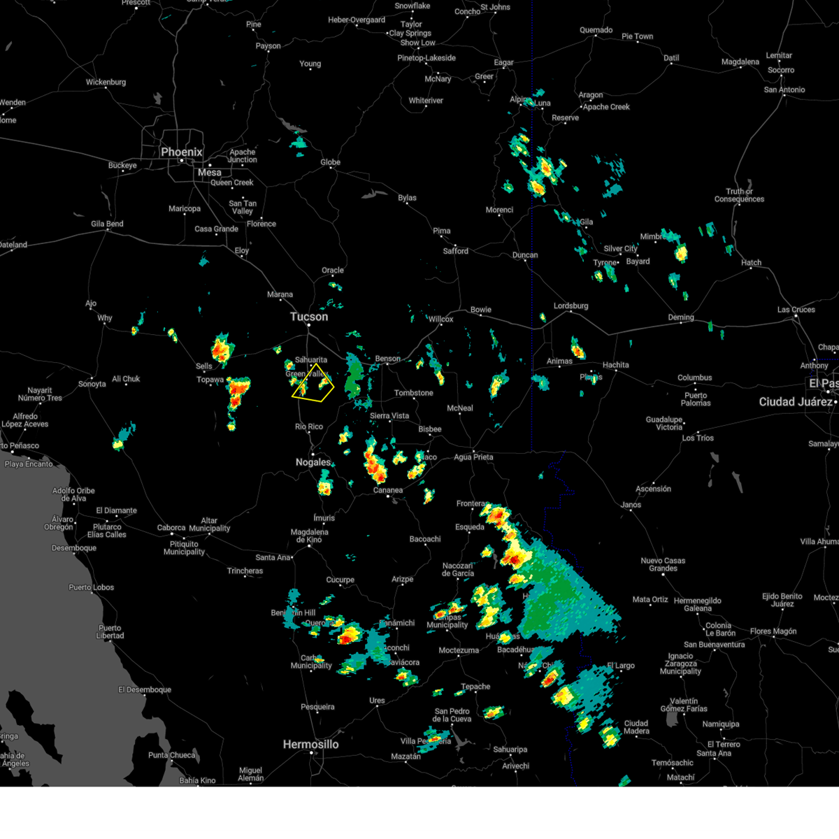
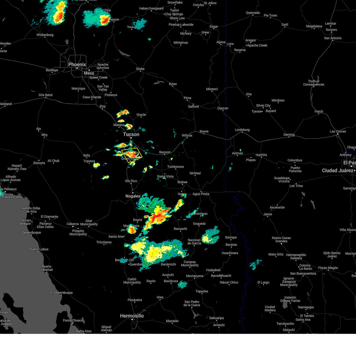
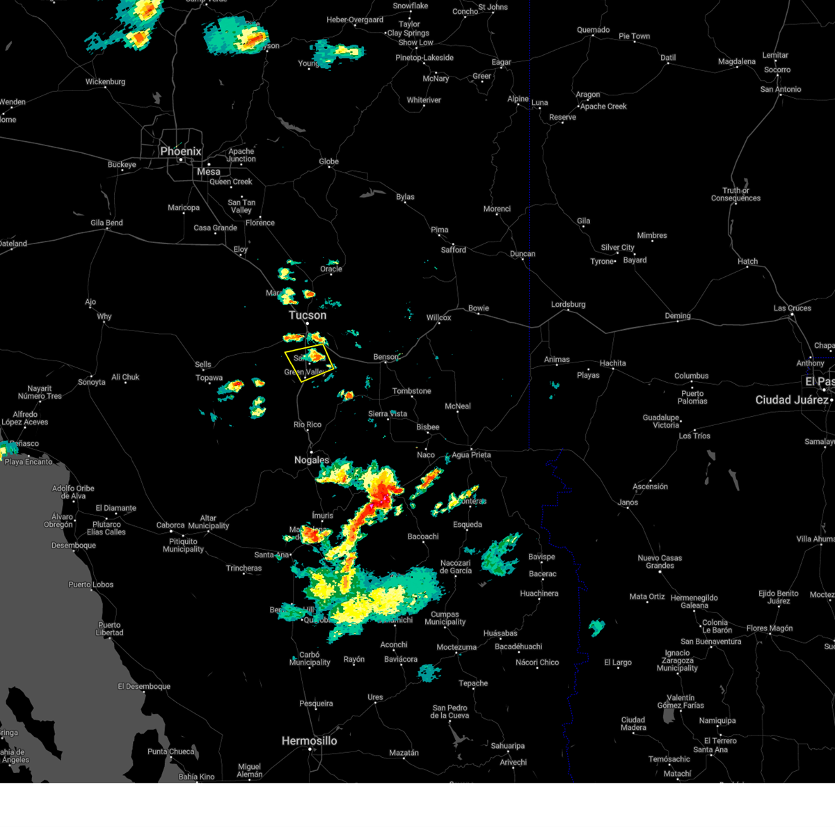
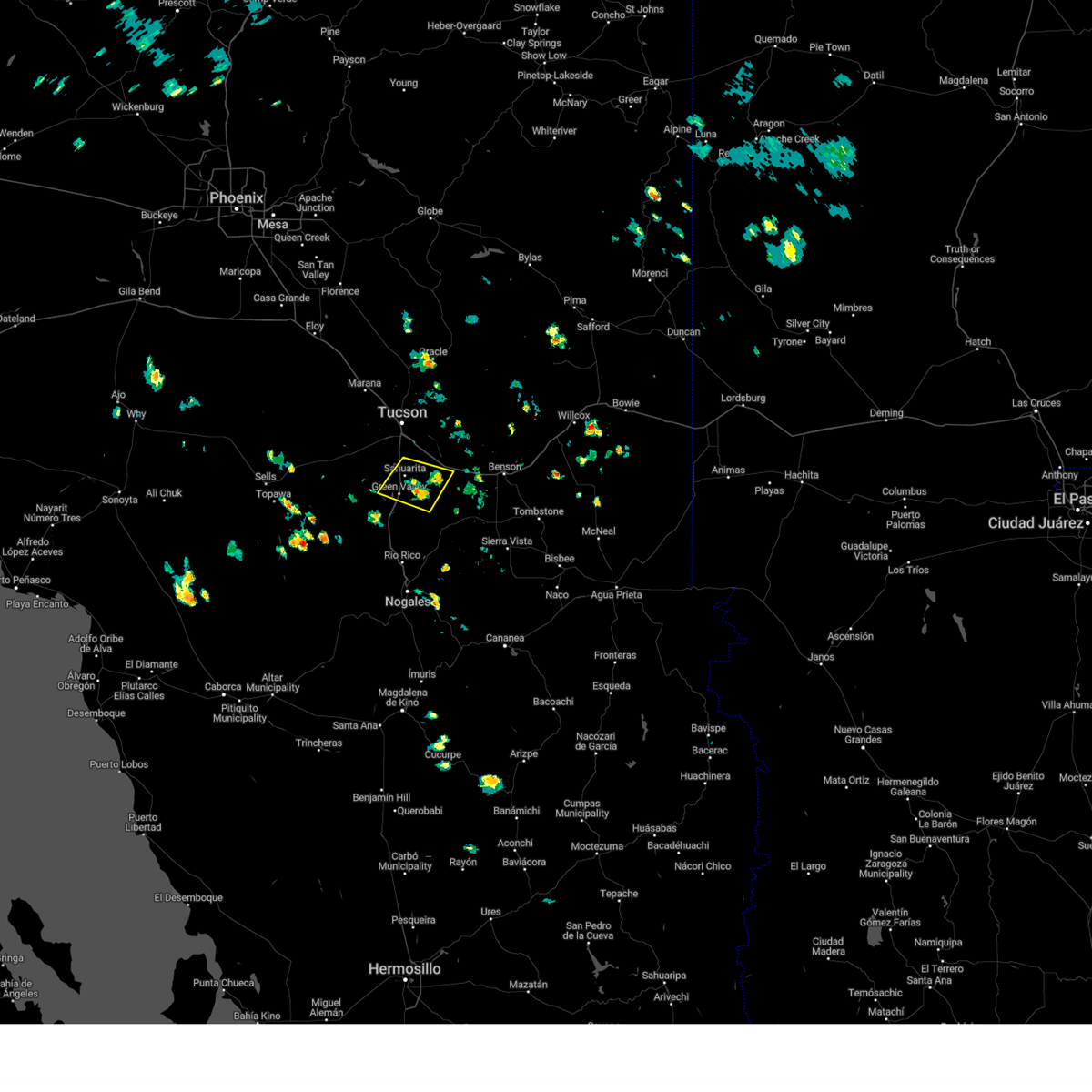
Hail Map for Sahuarita, AZ
The Sahuarita, AZ area has had 9 reports of on-the-ground hail by trained spotters, and has been under severe weather warnings 45 times during the past 12 months. Doppler radar has detected hail at or near Sahuarita, AZ on 75 occasions, including 7 occasions during the past year.
| Name: | Sahuarita, AZ |
| Where Located: | 20.4 miles S of Tucson, AZ |
| Map: | Google Map for Sahuarita, AZ |
| Population: | 25259 |
| Housing Units: | 10615 |
| More Info: | Search Google for Sahuarita, AZ |
1
The Top Recent Hail Date for Sahuarita, AZ is Thursday, July 25, 2024 (3rd out of 75)

Hail and Wind Damage Spotted near Sahuarita, AZ
| Date / Time | Report Details |
|---|---|
| 7/3/2025 3:24 PM MST |
 The storm which prompted the warning has weakened below severe limits, and no longer poses an immediate threat to life or property. therefore, the warning will be allowed to expire. however, gusty winds are still possible with this thunderstorm. to report severe weather, contact your nearest law enforcement agency. they will send your report to the national weather service office. The storm which prompted the warning has weakened below severe limits, and no longer poses an immediate threat to life or property. therefore, the warning will be allowed to expire. however, gusty winds are still possible with this thunderstorm. to report severe weather, contact your nearest law enforcement agency. they will send your report to the national weather service office.
|
| 7/3/2025 3:12 PM MST |
 At 312 pm mst, a severe thunderstorm was located 8 miles northwest of vail, moving northeast at 35 mph (radar indicated). Hazards include 60 mph wind gusts and small hail. Expect damage to roofs, siding, and trees. locations impacted include, tucson, sahuarita, san xavier community, summit and tucson international airport. this includes the following highways, interstate 19 between mile markers 49 and 57. Interstate 10 between mile markers 264 and 271. At 312 pm mst, a severe thunderstorm was located 8 miles northwest of vail, moving northeast at 35 mph (radar indicated). Hazards include 60 mph wind gusts and small hail. Expect damage to roofs, siding, and trees. locations impacted include, tucson, sahuarita, san xavier community, summit and tucson international airport. this includes the following highways, interstate 19 between mile markers 49 and 57. Interstate 10 between mile markers 264 and 271.
|
| 7/3/2025 2:48 PM MST |
 The severe thunderstorm warning that was previously in effect has been reissued for pima county and is in effect until 330 pm mst. please refer to that bulletin for the latest severe weather information. The severe thunderstorm warning that was previously in effect has been reissued for pima county and is in effect until 330 pm mst. please refer to that bulletin for the latest severe weather information.
|
| 7/3/2025 2:43 PM MST |
 Svrtwc the national weather service in tucson has issued a * severe thunderstorm warning for, northeastern pima county in southeastern arizona, * until 330 pm mst. * at 243 pm mst, a severe thunderstorm was located near catalina foothills, moving northeast at 10 mph (radar indicated). Hazards include 60 mph wind gusts and small hail. expect damage to roofs, siding, and trees Svrtwc the national weather service in tucson has issued a * severe thunderstorm warning for, northeastern pima county in southeastern arizona, * until 330 pm mst. * at 243 pm mst, a severe thunderstorm was located near catalina foothills, moving northeast at 10 mph (radar indicated). Hazards include 60 mph wind gusts and small hail. expect damage to roofs, siding, and trees
|
| 7/3/2025 2:18 PM MST |
 At 218 pm mst, a severe thunderstorm was located near saguaro national park west, moving northeast at 15 mph (radar indicated). Hazards include 60 mph wind gusts and small hail. Expect damage to roofs, siding, and trees. locations impacted include, tucson, oro valley, marana, sahuarita, davis-monthan air force base, casas adobes, drexel heights, flowing wells, south tucson, three points, pascua pueblo yaqui reservation, tortolita, san xavier community, tucson mountain park, tucson estates, valencia west, saguaro national park west, tucson international airport, catalina foothills and summit. this includes the following highways, interstate 19 between mile markers 48 and 63. route 86 between mile markers 156 and 171. route 77 between mile markers 70 and 75. Interstate 10 between mile markers 239 and 271. At 218 pm mst, a severe thunderstorm was located near saguaro national park west, moving northeast at 15 mph (radar indicated). Hazards include 60 mph wind gusts and small hail. Expect damage to roofs, siding, and trees. locations impacted include, tucson, oro valley, marana, sahuarita, davis-monthan air force base, casas adobes, drexel heights, flowing wells, south tucson, three points, pascua pueblo yaqui reservation, tortolita, san xavier community, tucson mountain park, tucson estates, valencia west, saguaro national park west, tucson international airport, catalina foothills and summit. this includes the following highways, interstate 19 between mile markers 48 and 63. route 86 between mile markers 156 and 171. route 77 between mile markers 70 and 75. Interstate 10 between mile markers 239 and 271.
|
| 7/3/2025 1:53 PM MST |
 Svrtwc the national weather service in tucson has issued a * severe thunderstorm warning for, northeastern pima county in southeastern arizona, * until 245 pm mst. * at 153 pm mst, a severe thunderstorm was located near saguaro national park west, moving northeast at 15 mph (radar indicated). Hazards include 60 mph wind gusts and small hail. expect damage to roofs, siding, and trees Svrtwc the national weather service in tucson has issued a * severe thunderstorm warning for, northeastern pima county in southeastern arizona, * until 245 pm mst. * at 153 pm mst, a severe thunderstorm was located near saguaro national park west, moving northeast at 15 mph (radar indicated). Hazards include 60 mph wind gusts and small hail. expect damage to roofs, siding, and trees
|
| 7/2/2025 3:11 PM MST |
 storm has weakened below severe limits storm has weakened below severe limits
|
| 7/2/2025 3:09 PM MST |
 At 309 pm mst, a severe thunderstorm was located near pascua pueblo yaqui reservation, moving northeast at 5 mph (radar indicated). Hazards include 60 mph wind gusts and small hail. Expect damage to roofs, siding, and trees. locations impacted include, tucson, sahuarita, drexel heights, pascua pueblo yaqui reservation, san xavier community, summit, valencia west, tucson international airport, tucson mountain park and san xavier mission. This includes interstate 19 between mile markers 49 and 60. At 309 pm mst, a severe thunderstorm was located near pascua pueblo yaqui reservation, moving northeast at 5 mph (radar indicated). Hazards include 60 mph wind gusts and small hail. Expect damage to roofs, siding, and trees. locations impacted include, tucson, sahuarita, drexel heights, pascua pueblo yaqui reservation, san xavier community, summit, valencia west, tucson international airport, tucson mountain park and san xavier mission. This includes interstate 19 between mile markers 49 and 60.
|
| 7/2/2025 2:37 PM MST |
 storm has weakened storm has weakened
|
| 7/2/2025 2:37 PM MST |
 Svrtwc the national weather service in tucson has issued a * severe thunderstorm warning for, east central pima county in southeastern arizona, * until 315 pm mst. * at 237 pm mst, a severe thunderstorm was located near pascua pueblo yaqui reservation, moving northeast at 5 mph (radar indicated). Hazards include 60 mph wind gusts and small hail. expect damage to roofs, siding, and trees Svrtwc the national weather service in tucson has issued a * severe thunderstorm warning for, east central pima county in southeastern arizona, * until 315 pm mst. * at 237 pm mst, a severe thunderstorm was located near pascua pueblo yaqui reservation, moving northeast at 5 mph (radar indicated). Hazards include 60 mph wind gusts and small hail. expect damage to roofs, siding, and trees
|
| 7/2/2025 2:10 PM MST |
 At 210 pm mst, a severe thunderstorm was located near green valley, moving northeast at 5 mph (radar indicated). Hazards include 60 mph wind gusts and small hail. Expect damage to roofs, siding, and trees. locations impacted include, sahuarita, green valley, amado and arivaca junction. This includes interstate 19 between mile markers 25 and 46. At 210 pm mst, a severe thunderstorm was located near green valley, moving northeast at 5 mph (radar indicated). Hazards include 60 mph wind gusts and small hail. Expect damage to roofs, siding, and trees. locations impacted include, sahuarita, green valley, amado and arivaca junction. This includes interstate 19 between mile markers 25 and 46.
|
| 7/2/2025 1:39 PM MST |
 Svrtwc the national weather service in tucson has issued a * severe thunderstorm warning for, southeastern pima county in southeastern arizona, north central santa cruz county in southeastern arizona, * until 230 pm mst. * at 139 pm mst, a severe thunderstorm was located 6 miles south of green valley, moving northeast at 5 mph (radar indicated). Hazards include 60 mph wind gusts and small hail. expect damage to roofs, siding, and trees Svrtwc the national weather service in tucson has issued a * severe thunderstorm warning for, southeastern pima county in southeastern arizona, north central santa cruz county in southeastern arizona, * until 230 pm mst. * at 139 pm mst, a severe thunderstorm was located 6 miles south of green valley, moving northeast at 5 mph (radar indicated). Hazards include 60 mph wind gusts and small hail. expect damage to roofs, siding, and trees
|
| 8/19/2024 5:53 PM MST |
 The storm which prompted the warning has weakened below severe limits, and has exited the warned area. therefore, the warning will be allowed to expire. The storm which prompted the warning has weakened below severe limits, and has exited the warned area. therefore, the warning will be allowed to expire.
|
| 8/19/2024 5:38 PM MST |
 At 536 pm mst, a severe thunderstorm was located over summit, or 8 miles southwest of davis-monthan air force base, moving west at 10 mph (radar indicated). Hazards include 60 mph wind gusts and quarter size hail. Hail damage to vehicles is expected. expect wind damage to roofs, siding, and trees. locations impacted include, tucson, sahuarita, drexel heights, pascua pueblo yaqui reservation, san xavier community, tucson international airport, summit, and san xavier mission. this includes the following highways, interstate 19 between mile markers 49 and 60. Route 86 near mile marker 167. At 536 pm mst, a severe thunderstorm was located over summit, or 8 miles southwest of davis-monthan air force base, moving west at 10 mph (radar indicated). Hazards include 60 mph wind gusts and quarter size hail. Hail damage to vehicles is expected. expect wind damage to roofs, siding, and trees. locations impacted include, tucson, sahuarita, drexel heights, pascua pueblo yaqui reservation, san xavier community, tucson international airport, summit, and san xavier mission. this includes the following highways, interstate 19 between mile markers 49 and 60. Route 86 near mile marker 167.
|
| 8/19/2024 5:17 PM MST |
 Svrtwc the national weather service in tucson has issued a * severe thunderstorm warning for, eastern pima county in southeastern arizona, * until 600 pm mst. * at 517 pm mst, a severe thunderstorm was located near tucson international airport, or near davis-monthan air force base, moving west at 10 mph (radar indicated). Hazards include 60 mph wind gusts and quarter size hail. Hail damage to vehicles is expected. Expect wind damage to roofs, siding, and trees. Svrtwc the national weather service in tucson has issued a * severe thunderstorm warning for, eastern pima county in southeastern arizona, * until 600 pm mst. * at 517 pm mst, a severe thunderstorm was located near tucson international airport, or near davis-monthan air force base, moving west at 10 mph (radar indicated). Hazards include 60 mph wind gusts and quarter size hail. Hail damage to vehicles is expected. Expect wind damage to roofs, siding, and trees.
|
| 8/17/2024 4:20 PM MST |
 The storm which prompted the warning has weakened below severe limits, and no longer poses an immediate threat to life or property. therefore, the warning will be allowed to expire. The storm which prompted the warning has weakened below severe limits, and no longer poses an immediate threat to life or property. therefore, the warning will be allowed to expire.
|
| 8/17/2024 3:52 PM MST | At 352 pm mst, a severe thunderstorm was located 8 miles northeast of tubac, moving north at 10 mph (radar indicated). Hazards include 60 mph wind gusts and quarter size hail. Hail damage to vehicles is expected. expect wind damage to roofs, siding, and trees. locations impacted include, sahuarita, green valley, tubac, amado, arivaca junction, and madera canyon. This includes interstate 19 between mile markers 22 and 41. |
| 8/17/2024 3:40 PM MST |
 Svrtwc the national weather service in tucson has issued a * severe thunderstorm warning for, southeastern pima county in southeastern arizona, north central santa cruz county in southeastern arizona, * until 430 pm mst. * at 339 pm mst, a severe thunderstorm was located near tubac, moving west at 5 mph (radar indicated). Hazards include 60 mph wind gusts and quarter size hail. Hail damage to vehicles is expected. Expect wind damage to roofs, siding, and trees. Svrtwc the national weather service in tucson has issued a * severe thunderstorm warning for, southeastern pima county in southeastern arizona, north central santa cruz county in southeastern arizona, * until 430 pm mst. * at 339 pm mst, a severe thunderstorm was located near tubac, moving west at 5 mph (radar indicated). Hazards include 60 mph wind gusts and quarter size hail. Hail damage to vehicles is expected. Expect wind damage to roofs, siding, and trees.
|
| 8/17/2024 3:30 PM MST |
 the severe thunderstorm warning has been cancelled and is no longer in effect the severe thunderstorm warning has been cancelled and is no longer in effect
|
| 8/17/2024 2:43 PM MST |
 Svrtwc the national weather service in tucson has issued a * severe thunderstorm warning for, east central pima county in southeastern arizona, northwestern santa cruz county in southeastern arizona, * until 345 pm mst. * at 243 pm mst, a severe thunderstorm was located near corona de tucson, or 12 miles east of sahuarita, moving west at 15 mph (radar indicated). Hazards include 60 mph wind gusts and quarter size hail. Hail damage to vehicles is expected. Expect wind damage to roofs, siding, and trees. Svrtwc the national weather service in tucson has issued a * severe thunderstorm warning for, east central pima county in southeastern arizona, northwestern santa cruz county in southeastern arizona, * until 345 pm mst. * at 243 pm mst, a severe thunderstorm was located near corona de tucson, or 12 miles east of sahuarita, moving west at 15 mph (radar indicated). Hazards include 60 mph wind gusts and quarter size hail. Hail damage to vehicles is expected. Expect wind damage to roofs, siding, and trees.
|
| 8/12/2024 4:26 PM MST |
 The storm which prompted the warning has weakened below severe limits, and no longer poses an immediate threat to life or property. therefore, the warning will be allowed to expire. however, heavy rain is still possible with this thunderstorm. The storm which prompted the warning has weakened below severe limits, and no longer poses an immediate threat to life or property. therefore, the warning will be allowed to expire. however, heavy rain is still possible with this thunderstorm.
|
| 8/12/2024 4:16 PM MST |
 At 416 pm mst, a severe thunderstorm was located near green valley, and is nearly stationary (radar indicated). Hazards include 60 mph wind gusts and quarter size hail. Hail damage to vehicles is expected. expect wind damage to roofs, siding, and trees. locations impacted include, sahuarita, green valley, east sahuarita, and arivaca junction. This includes interstate 19 between mile markers 31 and 44. At 416 pm mst, a severe thunderstorm was located near green valley, and is nearly stationary (radar indicated). Hazards include 60 mph wind gusts and quarter size hail. Hail damage to vehicles is expected. expect wind damage to roofs, siding, and trees. locations impacted include, sahuarita, green valley, east sahuarita, and arivaca junction. This includes interstate 19 between mile markers 31 and 44.
|
| 8/12/2024 3:55 PM MST |
 At 355 pm mst, a severe thunderstorm was located near green valley, and is nearly stationary (radar indicated). Hazards include 60 mph wind gusts and quarter size hail. Hail damage to vehicles is expected. expect wind damage to roofs, siding, and trees. locations impacted include, sahuarita, green valley, east sahuarita, amado, and arivaca junction. This includes interstate 19 between mile markers 30 and 41. At 355 pm mst, a severe thunderstorm was located near green valley, and is nearly stationary (radar indicated). Hazards include 60 mph wind gusts and quarter size hail. Hail damage to vehicles is expected. expect wind damage to roofs, siding, and trees. locations impacted include, sahuarita, green valley, east sahuarita, amado, and arivaca junction. This includes interstate 19 between mile markers 30 and 41.
|
| 8/12/2024 3:50 PM MST |
 Svrtwc the national weather service in tucson has issued a * severe thunderstorm warning for, east central pima county in southeastern arizona, * until 430 pm mst. * at 350 pm mst, a severe thunderstorm was located near green valley, and is nearly stationary (radar indicated). Hazards include 60 mph wind gusts and nickel size hail. expect damage to roofs, siding, and trees Svrtwc the national weather service in tucson has issued a * severe thunderstorm warning for, east central pima county in southeastern arizona, * until 430 pm mst. * at 350 pm mst, a severe thunderstorm was located near green valley, and is nearly stationary (radar indicated). Hazards include 60 mph wind gusts and nickel size hail. expect damage to roofs, siding, and trees
|
| 8/12/2024 3:32 PM MST |
 Svrtwc the national weather service in tucson has issued a * severe thunderstorm warning for, east central pima county in southeastern arizona, north central santa cruz county in southeastern arizona, * until 415 pm mst. * at 332 pm mst, a severe thunderstorm was located 10 miles southeast of green valley, moving northwest at 10 mph (radar indicated). Hazards include 60 mph wind gusts and quarter size hail. Hail damage to vehicles is expected. Expect wind damage to roofs, siding, and trees. Svrtwc the national weather service in tucson has issued a * severe thunderstorm warning for, east central pima county in southeastern arizona, north central santa cruz county in southeastern arizona, * until 415 pm mst. * at 332 pm mst, a severe thunderstorm was located 10 miles southeast of green valley, moving northwest at 10 mph (radar indicated). Hazards include 60 mph wind gusts and quarter size hail. Hail damage to vehicles is expected. Expect wind damage to roofs, siding, and trees.
|
| 8/6/2024 4:18 PM MST |
 At 417 pm mst, a severe thunderstorm was located over east sahuarita, or over sahuarita, moving southwest at 15 mph (radar indicated). Hazards include 60 mph wind gusts and quarter size hail. Hail damage to vehicles is expected. expect wind damage to roofs, siding, and trees. locations impacted include, tucson, sahuarita, green valley, corona de tucson, east sahuarita, and summit. This includes interstate 19 between mile markers 38 and 53. At 417 pm mst, a severe thunderstorm was located over east sahuarita, or over sahuarita, moving southwest at 15 mph (radar indicated). Hazards include 60 mph wind gusts and quarter size hail. Hail damage to vehicles is expected. expect wind damage to roofs, siding, and trees. locations impacted include, tucson, sahuarita, green valley, corona de tucson, east sahuarita, and summit. This includes interstate 19 between mile markers 38 and 53.
|
| 8/6/2024 3:59 PM MST |
 Svrtwc the national weather service in tucson has issued a * severe thunderstorm warning for, east central pima county in southeastern arizona, * until 445 pm mst. * at 359 pm mst, a severe thunderstorm was located near summit, or 7 miles northeast of sahuarita, moving southwest at 15 mph (radar indicated). Hazards include 60 mph wind gusts and quarter size hail. Hail damage to vehicles is expected. Expect wind damage to roofs, siding, and trees. Svrtwc the national weather service in tucson has issued a * severe thunderstorm warning for, east central pima county in southeastern arizona, * until 445 pm mst. * at 359 pm mst, a severe thunderstorm was located near summit, or 7 miles northeast of sahuarita, moving southwest at 15 mph (radar indicated). Hazards include 60 mph wind gusts and quarter size hail. Hail damage to vehicles is expected. Expect wind damage to roofs, siding, and trees.
|
| 8/3/2024 3:18 PM MST |
 At 318 pm mst, a severe thunderstorm was located near vail, or 11 miles southeast of davis-monthan air force base, moving west at 5 mph (radar indicated). Hazards include 60 mph wind gusts and penny size hail. Expect damage to roofs, siding, and trees. locations impacted include, tucson, sahuarita, davis-monthan air force base, tanque verde, vail, corona de tucson, east sahuarita, tucson international airport, summit, saguaro national park east, catalina foothills, and rita ranch. this includes the following highways, interstate 10 between mile markers 265 and 285. interstate 19 between mile markers 48 and 51. Route 83 between mile markers 56 and 58. At 318 pm mst, a severe thunderstorm was located near vail, or 11 miles southeast of davis-monthan air force base, moving west at 5 mph (radar indicated). Hazards include 60 mph wind gusts and penny size hail. Expect damage to roofs, siding, and trees. locations impacted include, tucson, sahuarita, davis-monthan air force base, tanque verde, vail, corona de tucson, east sahuarita, tucson international airport, summit, saguaro national park east, catalina foothills, and rita ranch. this includes the following highways, interstate 10 between mile markers 265 and 285. interstate 19 between mile markers 48 and 51. Route 83 between mile markers 56 and 58.
|
| 8/3/2024 2:58 PM MST |
 Svrtwc the national weather service in tucson has issued a * severe thunderstorm warning for, east central pima county in southeastern arizona, * until 400 pm mst. * at 257 pm mst, a severe thunderstorm was located near vail, or 11 miles southeast of davis-monthan air force base, moving northwest at 10 mph (radar indicated). Hazards include 60 mph wind gusts and penny size hail. expect damage to roofs, siding, and trees Svrtwc the national weather service in tucson has issued a * severe thunderstorm warning for, east central pima county in southeastern arizona, * until 400 pm mst. * at 257 pm mst, a severe thunderstorm was located near vail, or 11 miles southeast of davis-monthan air force base, moving northwest at 10 mph (radar indicated). Hazards include 60 mph wind gusts and penny size hail. expect damage to roofs, siding, and trees
|
| 8/3/2024 2:35 PM MST | At 235 pm mst, a severe thunderstorm was located over corona de tucson, or 12 miles east of sahuarita, moving northwest at 10 mph (radar indicated). Hazards include 60 mph wind gusts. Expect damage to roofs, siding, and trees. locations impacted include, sahuarita, vail, corona de tucson, east sahuarita, and summit. this includes the following highways, interstate 19 between mile markers 44 and 47. Route 83 between mile markers 55 and 57. |
| 8/3/2024 2:19 PM MST |
 Svrtwc the national weather service in tucson has issued a * severe thunderstorm warning for, east central pima county in southeastern arizona, * until 300 pm mst. * at 219 pm mst, a severe thunderstorm was located near east sahuarita, or near sahuarita, moving northwest at 15 mph (radar indicated). Hazards include 60 mph wind gusts. expect damage to roofs, siding, and trees Svrtwc the national weather service in tucson has issued a * severe thunderstorm warning for, east central pima county in southeastern arizona, * until 300 pm mst. * at 219 pm mst, a severe thunderstorm was located near east sahuarita, or near sahuarita, moving northwest at 15 mph (radar indicated). Hazards include 60 mph wind gusts. expect damage to roofs, siding, and trees
|
| 7/25/2024 7:08 PM MST |
 The storm which prompted the warning has weakened below severe limits, and no longer poses an immediate threat to life or property. therefore, the warning will be allowed to expire. however, gusty winds and heavy rain are still possible with this thunderstorm. a flash flood warning remains in effect for the green valley and sahuarita areas. The storm which prompted the warning has weakened below severe limits, and no longer poses an immediate threat to life or property. therefore, the warning will be allowed to expire. however, gusty winds and heavy rain are still possible with this thunderstorm. a flash flood warning remains in effect for the green valley and sahuarita areas.
|
| 7/25/2024 6:37 PM MST |
 At 637 pm mst, a severe thunderstorm was located near green valley, moving southwest at 15 mph (radar indicated). Hazards include 60 mph wind gusts and penny size hail. Expect damage to roofs, siding, and trees. locations impacted include, tucson, sahuarita, green valley, drexel heights, corona de tucson, three points, pascua pueblo yaqui reservation, east sahuarita, san xavier community, summit, tucson international airport, valencia west, rita ranch, san xavier mission, and arivaca junction. this includes the following highways, interstate 10 between mile markers 269 and 273. interstate 19 between mile markers 31 and 57. Route 86 between mile markers 152 and 157. At 637 pm mst, a severe thunderstorm was located near green valley, moving southwest at 15 mph (radar indicated). Hazards include 60 mph wind gusts and penny size hail. Expect damage to roofs, siding, and trees. locations impacted include, tucson, sahuarita, green valley, drexel heights, corona de tucson, three points, pascua pueblo yaqui reservation, east sahuarita, san xavier community, summit, tucson international airport, valencia west, rita ranch, san xavier mission, and arivaca junction. this includes the following highways, interstate 10 between mile markers 269 and 273. interstate 19 between mile markers 31 and 57. Route 86 between mile markers 152 and 157.
|
| 7/25/2024 6:10 PM MST |
 Svrtwc the national weather service in tucson has issued a * severe thunderstorm warning for, east central pima county in southeastern arizona, * until 715 pm mst. * at 610 pm mst, a severe thunderstorm was located over sahuarita, moving southwest at 15 mph (radar indicated). Hazards include 60 mph wind gusts and quarter size hail. Hail damage to vehicles is expected. Expect wind damage to roofs, siding, and trees. Svrtwc the national weather service in tucson has issued a * severe thunderstorm warning for, east central pima county in southeastern arizona, * until 715 pm mst. * at 610 pm mst, a severe thunderstorm was located over sahuarita, moving southwest at 15 mph (radar indicated). Hazards include 60 mph wind gusts and quarter size hail. Hail damage to vehicles is expected. Expect wind damage to roofs, siding, and trees.
|
| 7/25/2024 5:51 PM MST |
 At 550 pm mst, a severe thunderstorm was located near summit, or near sahuarita, moving southwest at 5 mph (radar indicated). Hazards include 60 mph wind gusts and quarter size hail. Hail damage to vehicles is expected. expect wind damage to roofs, siding, and trees. locations impacted include, tucson, sahuarita, davis-monthan air force base, drexel heights, vail, corona de tucson, pascua pueblo yaqui reservation, east sahuarita, san xavier community, summit, tucson international airport, valencia west, rita ranch, and san xavier mission. this includes the following highways, interstate 10 between mile markers 267 and 278. Interstate 19 between mile markers 44 and 59. At 550 pm mst, a severe thunderstorm was located near summit, or near sahuarita, moving southwest at 5 mph (radar indicated). Hazards include 60 mph wind gusts and quarter size hail. Hail damage to vehicles is expected. expect wind damage to roofs, siding, and trees. locations impacted include, tucson, sahuarita, davis-monthan air force base, drexel heights, vail, corona de tucson, pascua pueblo yaqui reservation, east sahuarita, san xavier community, summit, tucson international airport, valencia west, rita ranch, and san xavier mission. this includes the following highways, interstate 10 between mile markers 267 and 278. Interstate 19 between mile markers 44 and 59.
|
| 7/25/2024 5:34 PM MST |
 Svrtwc the national weather service in tucson has issued a * severe thunderstorm warning for, east central pima county in southeastern arizona, * until 615 pm mst. * at 534 pm mst, a severe thunderstorm was located over summit, or 8 miles north of sahuarita, moving southwest at 5 mph (radar indicated). Hazards include 60 mph wind gusts and quarter size hail. Hail damage to vehicles is expected. Expect wind damage to roofs, siding, and trees. Svrtwc the national weather service in tucson has issued a * severe thunderstorm warning for, east central pima county in southeastern arizona, * until 615 pm mst. * at 534 pm mst, a severe thunderstorm was located over summit, or 8 miles north of sahuarita, moving southwest at 5 mph (radar indicated). Hazards include 60 mph wind gusts and quarter size hail. Hail damage to vehicles is expected. Expect wind damage to roofs, siding, and trees.
|
| 7/21/2024 6:44 PM MST |
 The storms which prompted the warning south of tucson have weakened below severe limits. therefore, the warning will be allowed to expire. however, gusty winds and heavy rain are still possible with these thunderstorms. The storms which prompted the warning south of tucson have weakened below severe limits. therefore, the warning will be allowed to expire. however, gusty winds and heavy rain are still possible with these thunderstorms.
|
| 7/21/2024 6:14 PM MST |
 At 614 pm mst, a severe thunderstorm was located near and east of green valley, moving southwest at 15 mph (radar indicated). Hazards include 60 mph wind gusts. Expect damage to roofs, siding, and trees. locations impacted include, sahuarita, green valley, vail, corona de tucson, sonoita, elgin, and madera canyon. this includes the following highways, interstate 19 between mile markers 32 and 45. route 82 between mile markers 31 and 37. Route 83 between mile markers 28 and 54. At 614 pm mst, a severe thunderstorm was located near and east of green valley, moving southwest at 15 mph (radar indicated). Hazards include 60 mph wind gusts. Expect damage to roofs, siding, and trees. locations impacted include, sahuarita, green valley, vail, corona de tucson, sonoita, elgin, and madera canyon. this includes the following highways, interstate 19 between mile markers 32 and 45. route 82 between mile markers 31 and 37. Route 83 between mile markers 28 and 54.
|
| 7/21/2024 6:13 PM MST |
 the severe thunderstorm warning has been cancelled and is no longer in effect the severe thunderstorm warning has been cancelled and is no longer in effect
|
| 7/21/2024 6:01 PM MST |
 Svrtwc the national weather service in tucson has issued a * severe thunderstorm warning for, east central pima county in southeastern arizona, northeastern santa cruz county in southeastern arizona, * until 645 pm mst. * at 600 pm mst, a severe thunderstorm was located 5 to 10 miles southeast of sahuarita, moving southwest at 15 mph (radar indicated). Hazards include 60 mph wind gusts. expect damage to roofs, siding, and trees Svrtwc the national weather service in tucson has issued a * severe thunderstorm warning for, east central pima county in southeastern arizona, northeastern santa cruz county in southeastern arizona, * until 645 pm mst. * at 600 pm mst, a severe thunderstorm was located 5 to 10 miles southeast of sahuarita, moving southwest at 15 mph (radar indicated). Hazards include 60 mph wind gusts. expect damage to roofs, siding, and trees
|
| 7/21/2024 5:55 PM MST |
 Svrtwc the national weather service in tucson has issued a * severe thunderstorm warning for, east central pima county in southeastern arizona, * until 645 pm mst. * at 554 pm mst, a severe thunderstorm was located near southern tucson, or 9 miles north of sahuarita, moving south at 10 mph (radar indicated). Hazards include 60 mph wind gusts. expect damage to roofs, siding, and trees Svrtwc the national weather service in tucson has issued a * severe thunderstorm warning for, east central pima county in southeastern arizona, * until 645 pm mst. * at 554 pm mst, a severe thunderstorm was located near southern tucson, or 9 miles north of sahuarita, moving south at 10 mph (radar indicated). Hazards include 60 mph wind gusts. expect damage to roofs, siding, and trees
|
| 7/20/2024 6:26 PM MST |
 The storm which prompted the warning near sahuarita and southwest tucson has weakened below severe limits. therefore, the warning will be allowed to expire. however, gusty winds and heavy rain are still possible with this thunderstorm. The storm which prompted the warning near sahuarita and southwest tucson has weakened below severe limits. therefore, the warning will be allowed to expire. however, gusty winds and heavy rain are still possible with this thunderstorm.
|
| 7/20/2024 5:48 PM MST |
 Svrtwc the national weather service in tucson has issued a * severe thunderstorm warning for, east central pima county in southeastern arizona, * until 630 pm mst. * at 547 pm mst, a severe thunderstorm was located over summit, or 7 miles north of sahuarita, moving northwest at 10 mph (radar indicated). Hazards include 60 mph wind gusts. expect damage to roofs, siding, and trees Svrtwc the national weather service in tucson has issued a * severe thunderstorm warning for, east central pima county in southeastern arizona, * until 630 pm mst. * at 547 pm mst, a severe thunderstorm was located over summit, or 7 miles north of sahuarita, moving northwest at 10 mph (radar indicated). Hazards include 60 mph wind gusts. expect damage to roofs, siding, and trees
|
| 7/20/2024 5:41 PM MST |
 At 541 pm mst, a severe thunderstorm was located near east sahuarita, or 7 miles southeast of sahuarita, moving west at 15 mph (radar indicated). Hazards include 60 mph wind gusts. Expect damage to roofs, siding, and trees. locations impacted include, sahuarita, corona de tucson, east sahuarita, and madera canyon. This includes route 83 between mile markers 38 and 54. At 541 pm mst, a severe thunderstorm was located near east sahuarita, or 7 miles southeast of sahuarita, moving west at 15 mph (radar indicated). Hazards include 60 mph wind gusts. Expect damage to roofs, siding, and trees. locations impacted include, sahuarita, corona de tucson, east sahuarita, and madera canyon. This includes route 83 between mile markers 38 and 54.
|
| 7/20/2024 5:12 PM MST |
 Svrtwc the national weather service in tucson has issued a * severe thunderstorm warning for, east central pima county in southeastern arizona, northeastern santa cruz county in southeastern arizona, * until 600 pm mst. * at 512 pm mst, a severe thunderstorm was located near and south of corona de tucson, or 12 miles southeast of sahuarita, moving west at 15 mph (radar indicated). Hazards include 60 mph wind gusts. expect damage to roofs, siding, and trees Svrtwc the national weather service in tucson has issued a * severe thunderstorm warning for, east central pima county in southeastern arizona, northeastern santa cruz county in southeastern arizona, * until 600 pm mst. * at 512 pm mst, a severe thunderstorm was located near and south of corona de tucson, or 12 miles southeast of sahuarita, moving west at 15 mph (radar indicated). Hazards include 60 mph wind gusts. expect damage to roofs, siding, and trees
|
| 7/18/2024 7:12 PM MST |
 The storms which prompted the warning over eastern and southern tucson have weakened below severe limits. therefore, the warning will be allowed to expire. however, gusty winds are still possible with these thunderstorms. The storms which prompted the warning over eastern and southern tucson have weakened below severe limits. therefore, the warning will be allowed to expire. however, gusty winds are still possible with these thunderstorms.
|
| 7/18/2024 6:43 PM MST |
 At 642 pm mst, severe thunderstorms were located along a line extending from near catalina foothills to 6 miles southeast of davis-monthan air force base to near summit, moving west at 15 mph (radar indicated). Hazards include 60 mph wind gusts and penny size hail. Expect damage to roofs, siding, and trees. locations impacted include, tucson, sahuarita, davis-monthan air force base, casas adobes, drexel heights, flowing wells, south tucson, pascua pueblo yaqui reservation, san xavier community, sabino canyon recreation area, summit, catalina foothills, tucson international airport. this includes the following highways, interstate 10 between mile markers 250 and 280. interstate 19 between mile markers 47 and 63. route 77 between mile markers 70 and 74. Route 86 between mile markers 167 and 171. At 642 pm mst, severe thunderstorms were located along a line extending from near catalina foothills to 6 miles southeast of davis-monthan air force base to near summit, moving west at 15 mph (radar indicated). Hazards include 60 mph wind gusts and penny size hail. Expect damage to roofs, siding, and trees. locations impacted include, tucson, sahuarita, davis-monthan air force base, casas adobes, drexel heights, flowing wells, south tucson, pascua pueblo yaqui reservation, san xavier community, sabino canyon recreation area, summit, catalina foothills, tucson international airport. this includes the following highways, interstate 10 between mile markers 250 and 280. interstate 19 between mile markers 47 and 63. route 77 between mile markers 70 and 74. Route 86 between mile markers 167 and 171.
|
| 7/18/2024 6:21 PM MST |
 Svrtwc the national weather service in tucson has issued a * severe thunderstorm warning for, northeastern pima county in southeastern arizona, * until 715 pm mst. * at 617 pm mst, severe thunderstorms were located along a line extending from near tanque verde to near eastern tucson to near east sahuarita, moving west at 10 to 15 mph (radar indicated). Hazards include 60 mph wind gusts and penny size hail. expect damage to roofs, siding, and trees Svrtwc the national weather service in tucson has issued a * severe thunderstorm warning for, northeastern pima county in southeastern arizona, * until 715 pm mst. * at 617 pm mst, severe thunderstorms were located along a line extending from near tanque verde to near eastern tucson to near east sahuarita, moving west at 10 to 15 mph (radar indicated). Hazards include 60 mph wind gusts and penny size hail. expect damage to roofs, siding, and trees
|
| 7/18/2024 5:57 PM MST |
 At 556 pm mst, a severe thunderstorm was located over corona de tucson, or 12 miles east of sahuarita, moving southwest at 5 to 10 mph (radar indicated). Hazards include 60 mph wind gusts and penny size hail. Expect damage to roofs, siding, and trees. locations impacted include, sahuarita, green valley, vail, corona de tucson. this includes the following highways, interstate 10 between mile markers 279 and 281. interstate 19 between mile markers 38 and 50. Route 83 between mile markers 43 and 58. At 556 pm mst, a severe thunderstorm was located over corona de tucson, or 12 miles east of sahuarita, moving southwest at 5 to 10 mph (radar indicated). Hazards include 60 mph wind gusts and penny size hail. Expect damage to roofs, siding, and trees. locations impacted include, sahuarita, green valley, vail, corona de tucson. this includes the following highways, interstate 10 between mile markers 279 and 281. interstate 19 between mile markers 38 and 50. Route 83 between mile markers 43 and 58.
|
| 7/18/2024 5:39 PM MST |
 Svrtwc the national weather service in tucson has issued a * severe thunderstorm warning for, east central pima county in southeastern arizona, northwestern santa cruz county in southeastern arizona, * until 630 pm mst. * at 539 pm mst, a severe thunderstorm was located near corona de tucson, or 14 miles east of sahuarita, moving southwest at 5 mph (radar indicated). Hazards include 60 mph wind gusts. expect damage to roofs, siding, and trees Svrtwc the national weather service in tucson has issued a * severe thunderstorm warning for, east central pima county in southeastern arizona, northwestern santa cruz county in southeastern arizona, * until 630 pm mst. * at 539 pm mst, a severe thunderstorm was located near corona de tucson, or 14 miles east of sahuarita, moving southwest at 5 mph (radar indicated). Hazards include 60 mph wind gusts. expect damage to roofs, siding, and trees
|
| 7/15/2024 7:38 PM MST | The storm which prompted the warning has weakened below severe limits. therefore, the warning will be allowed to expire. however, gusty winds and heavy rain are still possible with this thunderstorm. |
| 7/15/2024 7:16 PM MST |
 At 715 pm mst, a severe thunderstorm was located 11 miles south and southwest of green valley, moving northwest at 15 mph (radar indicated). Hazards include 60 mph wind gusts and quarter size hail. Hail damage to vehicles is expected. expect wind damage to roofs, siding, and trees. locations impacted include, green valley, tubac, amado, and arivaca junction. This includes interstate 19 between mile markers 22 and 46. At 715 pm mst, a severe thunderstorm was located 11 miles south and southwest of green valley, moving northwest at 15 mph (radar indicated). Hazards include 60 mph wind gusts and quarter size hail. Hail damage to vehicles is expected. expect wind damage to roofs, siding, and trees. locations impacted include, green valley, tubac, amado, and arivaca junction. This includes interstate 19 between mile markers 22 and 46.
|
| 7/15/2024 6:58 PM MST |
 Svrtwc the national weather service in tucson has issued a * severe thunderstorm warning for, southeastern pima county in southeastern arizona, north central santa cruz county in southeastern arizona, * until 745 pm mst. * at 657 pm mst, a severe thunderstorm was located near tubac, moving northwest at 10 mph (radar indicated). Hazards include 60 mph wind gusts and quarter size hail. Hail damage to vehicles is expected. Expect wind damage to roofs, siding, and trees. Svrtwc the national weather service in tucson has issued a * severe thunderstorm warning for, southeastern pima county in southeastern arizona, north central santa cruz county in southeastern arizona, * until 745 pm mst. * at 657 pm mst, a severe thunderstorm was located near tubac, moving northwest at 10 mph (radar indicated). Hazards include 60 mph wind gusts and quarter size hail. Hail damage to vehicles is expected. Expect wind damage to roofs, siding, and trees.
|
| 7/14/2024 5:20 PM MST |
 At 518 pm mst, severe thunderstorms were located near east and southeast tucson along a line extending from 12 miles northeast of saguaro national park east to near tanque verde to near summit, moving west at 15 mph (radar indicated). Hazards include 60 mph wind gusts and penny size hail, along with blowing dust. Expect damage to roofs, siding, and trees. locations impacted include, tucson, sahuarita, davis-monthan air force base, tanque verde, vail, corona de tucson, south tucson, east sahuarita, san xavier community, summit, tucson international airport, saguaro national park east, catalina foothills, rita ranch, and cascabel. this includes the following highways, interstate 10 between mile markers 262 and 283. interstate 19 between mile markers 46 and 57. Route 83 between mile markers 57 and 58. At 518 pm mst, severe thunderstorms were located near east and southeast tucson along a line extending from 12 miles northeast of saguaro national park east to near tanque verde to near summit, moving west at 15 mph (radar indicated). Hazards include 60 mph wind gusts and penny size hail, along with blowing dust. Expect damage to roofs, siding, and trees. locations impacted include, tucson, sahuarita, davis-monthan air force base, tanque verde, vail, corona de tucson, south tucson, east sahuarita, san xavier community, summit, tucson international airport, saguaro national park east, catalina foothills, rita ranch, and cascabel. this includes the following highways, interstate 10 between mile markers 262 and 283. interstate 19 between mile markers 46 and 57. Route 83 between mile markers 57 and 58.
|
| 7/14/2024 5:09 PM MST |
 At 508 pm mst, severe thunderstorms were located near far southeast tucson, along a line extending from near tanque verde to near saguaro national park east to near sahuarita, moving northwest at 15 mph (radar indicated). Hazards include 60 mph wind gusts and nickel size hail. Expect damage to roofs, siding, and trees. locations impacted include, tucson, sahuarita, green valley, davis-monthan air force base, tanque verde, vail, corona de tucson, south tucson, east sahuarita, san xavier community, summit, tucson international airport, saguaro national park east, catalina foothills, rita ranch, and cascabel. this includes the following highways, interstate 10 between mile markers 262 and 284. interstate 19 between mile markers 40 and 58. Route 83 between mile markers 55 and 58. At 508 pm mst, severe thunderstorms were located near far southeast tucson, along a line extending from near tanque verde to near saguaro national park east to near sahuarita, moving northwest at 15 mph (radar indicated). Hazards include 60 mph wind gusts and nickel size hail. Expect damage to roofs, siding, and trees. locations impacted include, tucson, sahuarita, green valley, davis-monthan air force base, tanque verde, vail, corona de tucson, south tucson, east sahuarita, san xavier community, summit, tucson international airport, saguaro national park east, catalina foothills, rita ranch, and cascabel. this includes the following highways, interstate 10 between mile markers 262 and 284. interstate 19 between mile markers 40 and 58. Route 83 between mile markers 55 and 58.
|
| 7/14/2024 4:44 PM MST |
 Svrtwc the national weather service in tucson has issued a * severe thunderstorm warning for, east central pima county in southeastern arizona, northwestern cochise county in southeastern arizona, * until 545 pm mst. * at 444 pm mst, severe thunderstorms were located east of tucson, along a line extending from 14 miles northwest of dragoon to near saguaro national park east to 8 miles south of corona de tucson, moving west at 15 mph (radar indicated). Hazards include 60 mph wind gusts and penny size hail. expect damage to roofs, siding, and trees Svrtwc the national weather service in tucson has issued a * severe thunderstorm warning for, east central pima county in southeastern arizona, northwestern cochise county in southeastern arizona, * until 545 pm mst. * at 444 pm mst, severe thunderstorms were located east of tucson, along a line extending from 14 miles northwest of dragoon to near saguaro national park east to 8 miles south of corona de tucson, moving west at 15 mph (radar indicated). Hazards include 60 mph wind gusts and penny size hail. expect damage to roofs, siding, and trees
|
| 7/11/2024 5:55 PM MST |
 The storm which prompted the warning now near and south of green valley has weakened below severe limits. therefore, the warning will be allowed to expire however, gusty winds to 45 mph are still possible with this thunderstorm. The storm which prompted the warning now near and south of green valley has weakened below severe limits. therefore, the warning will be allowed to expire however, gusty winds to 45 mph are still possible with this thunderstorm.
|
| 7/11/2024 5:11 PM MST |
 Svrtwc the national weather service in tucson has issued a * severe thunderstorm warning for, east central pima county in southeastern arizona, north central santa cruz county in southeastern arizona, * until 600 pm mst. * at 510 pm mst, a severe thunderstorm was located near east sahuarita, moving southwest at 15 mph (radar indicated). Hazards include 60 mph wind gusts. expect damage to roofs, siding, and trees Svrtwc the national weather service in tucson has issued a * severe thunderstorm warning for, east central pima county in southeastern arizona, north central santa cruz county in southeastern arizona, * until 600 pm mst. * at 510 pm mst, a severe thunderstorm was located near east sahuarita, moving southwest at 15 mph (radar indicated). Hazards include 60 mph wind gusts. expect damage to roofs, siding, and trees
|
| 6/30/2024 4:05 PM MST |
 The storm which prompted the warning has weakened below severe limits, and no longer poses an immediate threat to life or property. therefore, the warning will be allowed to expire. however, gusty winds are still possible with this thunderstorm. The storm which prompted the warning has weakened below severe limits, and no longer poses an immediate threat to life or property. therefore, the warning will be allowed to expire. however, gusty winds are still possible with this thunderstorm.
|
| 6/30/2024 3:40 PM MST |
 At 340 pm mst, a severe thunderstorm was located over corona de tucson, or 12 miles east of sahuarita, moving northwest at 20 mph (radar indicated). Hazards include 60 mph wind gusts and penny size hail. Expect damage to roofs, siding, and trees. locations impacted include, sahuarita, vail, corona de tucson, and east sahuarita. this includes the following highways, interstate 10 between mile markers 275 and 287. interstate 19 between mile markers 46 and 47. Route 83 between mile markers 43 and 58. At 340 pm mst, a severe thunderstorm was located over corona de tucson, or 12 miles east of sahuarita, moving northwest at 20 mph (radar indicated). Hazards include 60 mph wind gusts and penny size hail. Expect damage to roofs, siding, and trees. locations impacted include, sahuarita, vail, corona de tucson, and east sahuarita. this includes the following highways, interstate 10 between mile markers 275 and 287. interstate 19 between mile markers 46 and 47. Route 83 between mile markers 43 and 58.
|
| 6/30/2024 3:23 PM MST |
 Svrtwc the national weather service in tucson has issued a * severe thunderstorm warning for, east central pima county in southeastern arizona, * until 415 pm mst. * at 323 pm mst, a severe thunderstorm was located near corona de tucson, or 15 miles east of sahuarita, moving northwest at 25 mph (radar indicated). Hazards include 60 mph wind gusts and quarter size hail. Hail damage to vehicles is expected. Expect wind damage to roofs, siding, and trees. Svrtwc the national weather service in tucson has issued a * severe thunderstorm warning for, east central pima county in southeastern arizona, * until 415 pm mst. * at 323 pm mst, a severe thunderstorm was located near corona de tucson, or 15 miles east of sahuarita, moving northwest at 25 mph (radar indicated). Hazards include 60 mph wind gusts and quarter size hail. Hail damage to vehicles is expected. Expect wind damage to roofs, siding, and trees.
|
| 6/21/2024 2:52 PM MST |
 Svrtwc the national weather service in tucson has issued a * severe thunderstorm warning for, northeastern pima county in southeastern arizona, * until 345 pm mst. * at 251 pm mst, a severe thunderstorm was located over tucson, moving north at 20 mph (radar indicated). Hazards include 60 mph wind gusts and quarter size hail. Hail damage to vehicles is expected. Expect wind damage to roofs, siding, and trees. Svrtwc the national weather service in tucson has issued a * severe thunderstorm warning for, northeastern pima county in southeastern arizona, * until 345 pm mst. * at 251 pm mst, a severe thunderstorm was located over tucson, moving north at 20 mph (radar indicated). Hazards include 60 mph wind gusts and quarter size hail. Hail damage to vehicles is expected. Expect wind damage to roofs, siding, and trees.
|
| 6/21/2024 2:41 PM MST |
 At 241 pm mst, a severe thunderstorm was located near summit, or near davis-monthan air force base, moving north at 15 mph (radar indicated). Hazards include 60 mph wind gusts and penny size hail. Expect damage to roofs, siding, and trees. locations impacted include, tucson, sahuarita, davis-monthan air force base, drexel heights, corona de tucson, south tucson, east sahuarita, san xavier community, summit, tucson international airport, tucson mountain park, saguaro national park east, rita ranch, and san xavier mission. this includes the following highways, interstate 10 between mile markers 261 and 278. interstate 19 between mile markers 47 and 62. Route 86 between mile markers 168 and 171. At 241 pm mst, a severe thunderstorm was located near summit, or near davis-monthan air force base, moving north at 15 mph (radar indicated). Hazards include 60 mph wind gusts and penny size hail. Expect damage to roofs, siding, and trees. locations impacted include, tucson, sahuarita, davis-monthan air force base, drexel heights, corona de tucson, south tucson, east sahuarita, san xavier community, summit, tucson international airport, tucson mountain park, saguaro national park east, rita ranch, and san xavier mission. this includes the following highways, interstate 10 between mile markers 261 and 278. interstate 19 between mile markers 47 and 62. Route 86 between mile markers 168 and 171.
|
| 6/21/2024 2:25 PM MST |
 At 225 pm mst, a severe thunderstorm was located near summit, or 8 miles northeast of sahuarita, moving north at 15 mph (radar indicated). Hazards include 60 mph wind gusts and quarter size hail. Hail damage to vehicles is expected. expect wind damage to roofs, siding, and trees. locations impacted include, tucson, sahuarita, davis-monthan air force base, drexel heights, corona de tucson, south tucson, east sahuarita, san xavier community, summit, tucson international airport, tucson mountain park, saguaro national park east, rita ranch, and san xavier mission. this includes the following highways, interstate 10 between mile markers 261 and 278. interstate 19 between mile markers 47 and 62. Route 86 between mile markers 168 and 171. At 225 pm mst, a severe thunderstorm was located near summit, or 8 miles northeast of sahuarita, moving north at 15 mph (radar indicated). Hazards include 60 mph wind gusts and quarter size hail. Hail damage to vehicles is expected. expect wind damage to roofs, siding, and trees. locations impacted include, tucson, sahuarita, davis-monthan air force base, drexel heights, corona de tucson, south tucson, east sahuarita, san xavier community, summit, tucson international airport, tucson mountain park, saguaro national park east, rita ranch, and san xavier mission. this includes the following highways, interstate 10 between mile markers 261 and 278. interstate 19 between mile markers 47 and 62. Route 86 between mile markers 168 and 171.
|
| 6/21/2024 2:10 PM MST |
 Svrtwc the national weather service in tucson has issued a * severe thunderstorm warning for, east central pima county in southeastern arizona, * until 300 pm mst. * at 210 pm mst, a severe thunderstorm was located over east sahuarita, or near sahuarita, moving north at 15 mph (radar indicated). Hazards include 60 mph wind gusts and penny size hail. expect damage to roofs, siding, and trees Svrtwc the national weather service in tucson has issued a * severe thunderstorm warning for, east central pima county in southeastern arizona, * until 300 pm mst. * at 210 pm mst, a severe thunderstorm was located over east sahuarita, or near sahuarita, moving north at 15 mph (radar indicated). Hazards include 60 mph wind gusts and penny size hail. expect damage to roofs, siding, and trees
|
| 8/21/2023 6:57 PM MST |
 At 655 pm mst, severe thunderstorms were located along a line extending from near vail to near summit to near green valley, moving northwest at 30 mph (radar indicated). Hazards include 70 mph wind gusts and penny size hail. radar is indicating 70 plus mph winds just above the surface northwest of the corona de tucson area. Expect considerable tree damage. Damage is likely to mobile homes, roofs, and outbuildings. At 655 pm mst, severe thunderstorms were located along a line extending from near vail to near summit to near green valley, moving northwest at 30 mph (radar indicated). Hazards include 70 mph wind gusts and penny size hail. radar is indicating 70 plus mph winds just above the surface northwest of the corona de tucson area. Expect considerable tree damage. Damage is likely to mobile homes, roofs, and outbuildings.
|
| 8/21/2023 6:26 PM MST |
 At 624 pm mst, severe thunderstorms were located along a line extending from near kartchner caverns state park to 6 miles west of sonoita, moving northwest at 30 mph (radar indicated). Hazards include 60 mph wind gusts with the leading gust front and quarter size hail. these storms have a history of producing 60 mph wind gusts. Hail damage to vehicles is expected. Expect wind damage to roofs, siding, and trees. At 624 pm mst, severe thunderstorms were located along a line extending from near kartchner caverns state park to 6 miles west of sonoita, moving northwest at 30 mph (radar indicated). Hazards include 60 mph wind gusts with the leading gust front and quarter size hail. these storms have a history of producing 60 mph wind gusts. Hail damage to vehicles is expected. Expect wind damage to roofs, siding, and trees.
|
| 8/21/2023 2:58 PM MST |
 At 258 pm mst, a severe thunderstorm was located over south tucson, or near tucson, moving north at 20 mph (radar indicated). Hazards include 70 mph wind gusts and ping pong ball size hail. People and animals outdoors will be injured. expect hail damage to roofs, siding, windows, and vehicles. expect considerable tree damage. wind damage is also likely to mobile homes, roofs, and outbuildings. locations impacted include, tucson, sahuarita, davis-monthan air force base, drexel heights, south tucson, pascua pueblo yaqui reservation, east sahuarita, summit, valencia west, tucson international airport, tucson estates, catalina foothills, san xavier mission and ryan airfield. thunderstorm damage threat, considerable hail threat, radar indicated max hail size, 1. 50 in wind threat, radar indicated max wind gust, 70 mph. At 258 pm mst, a severe thunderstorm was located over south tucson, or near tucson, moving north at 20 mph (radar indicated). Hazards include 70 mph wind gusts and ping pong ball size hail. People and animals outdoors will be injured. expect hail damage to roofs, siding, windows, and vehicles. expect considerable tree damage. wind damage is also likely to mobile homes, roofs, and outbuildings. locations impacted include, tucson, sahuarita, davis-monthan air force base, drexel heights, south tucson, pascua pueblo yaqui reservation, east sahuarita, summit, valencia west, tucson international airport, tucson estates, catalina foothills, san xavier mission and ryan airfield. thunderstorm damage threat, considerable hail threat, radar indicated max hail size, 1. 50 in wind threat, radar indicated max wind gust, 70 mph.
|
| 8/21/2023 2:43 PM MST |
 At 242 pm mst, a severe thunderstorm was located over san xavier community, or 8 miles southwest of tucson, moving north at 15 mph (radar indicated). Hazards include 60 mph wind gusts and quarter size hail. Hail damage to vehicles is expected. Expect wind damage to roofs, siding, and trees. At 242 pm mst, a severe thunderstorm was located over san xavier community, or 8 miles southwest of tucson, moving north at 15 mph (radar indicated). Hazards include 60 mph wind gusts and quarter size hail. Hail damage to vehicles is expected. Expect wind damage to roofs, siding, and trees.
|
| 8/21/2023 2:26 PM MST |
 At 225 pm mst, a severe thunderstorm was located near summit, or near sahuarita, moving northwest at 20 mph (radar indicated). Hazards include 60 mph wind gusts and quarter size hail. Hail damage to vehicles is expected. expect wind damage to roofs, siding, and trees. locations impacted include, tucson, sahuarita, drexel heights, south tucson, pascua pueblo yaqui reservation, east sahuarita, summit, valencia west, tucson international airport, tucson estates and san xavier mission. hail threat, radar indicated max hail size, 1. 00 in wind threat, radar indicated max wind gust, 60 mph. At 225 pm mst, a severe thunderstorm was located near summit, or near sahuarita, moving northwest at 20 mph (radar indicated). Hazards include 60 mph wind gusts and quarter size hail. Hail damage to vehicles is expected. expect wind damage to roofs, siding, and trees. locations impacted include, tucson, sahuarita, drexel heights, south tucson, pascua pueblo yaqui reservation, east sahuarita, summit, valencia west, tucson international airport, tucson estates and san xavier mission. hail threat, radar indicated max hail size, 1. 00 in wind threat, radar indicated max wind gust, 60 mph.
|
| 8/21/2023 2:07 PM MST |
 At 207 pm mst, a severe thunderstorm was located over east sahuarita, or near sahuarita, moving northwest at 25 mph (radar indicated). Hazards include 60 mph wind gusts and quarter size hail. Hail damage to vehicles is expected. Expect wind damage to roofs, siding, and trees. At 207 pm mst, a severe thunderstorm was located over east sahuarita, or near sahuarita, moving northwest at 25 mph (radar indicated). Hazards include 60 mph wind gusts and quarter size hail. Hail damage to vehicles is expected. Expect wind damage to roofs, siding, and trees.
|
| 8/18/2023 5:50 PM MST |
 At 548 pm mst, a severe thunderstorm near corona de tucson continues to move west at 20 mph (radar indicated). Hazards include 60 mph wind gusts. Expect damage to roofs, siding, and trees. locations impacted include, tucson, sahuarita, green valley, corona de tucson, tucson international airport and summit. hail threat, radar indicated max hail size, <. 75 in wind threat, radar indicated max wind gust, 60 mph. At 548 pm mst, a severe thunderstorm near corona de tucson continues to move west at 20 mph (radar indicated). Hazards include 60 mph wind gusts. Expect damage to roofs, siding, and trees. locations impacted include, tucson, sahuarita, green valley, corona de tucson, tucson international airport and summit. hail threat, radar indicated max hail size, <. 75 in wind threat, radar indicated max wind gust, 60 mph.
|
| 8/18/2023 5:14 PM MST |
 At 513 pm mst, severe thunderstorms were located along a line extending from 8 miles southeast of vail to 10 miles north of sonoita to 7 miles south of elgin, moving west-northwest at 20 mph. strong winds have been reported with these storms (radar indicated). Hazards include 60 mph wind gusts. expect damage to roofs, siding, and trees At 513 pm mst, severe thunderstorms were located along a line extending from 8 miles southeast of vail to 10 miles north of sonoita to 7 miles south of elgin, moving west-northwest at 20 mph. strong winds have been reported with these storms (radar indicated). Hazards include 60 mph wind gusts. expect damage to roofs, siding, and trees
|
| 8/8/2023 2:27 PM MST |
 The severe thunderstorm warning for northeastern pima county will expire at 230 pm mst, the storm which prompted the warning has weakened below severe limits, and no longer poses an immediate threat to life or property. therefore, the warning will be allowed to expire. however small hail and gusty winds are still possible with this thunderstorm. The severe thunderstorm warning for northeastern pima county will expire at 230 pm mst, the storm which prompted the warning has weakened below severe limits, and no longer poses an immediate threat to life or property. therefore, the warning will be allowed to expire. however small hail and gusty winds are still possible with this thunderstorm.
|
| 8/8/2023 2:01 PM MST |
 At 201 pm mst, a severe thunderstorm was located near valencia west, or 14 miles northwest of sahuarita, moving northeast at 10 mph (radar indicated). Hazards include 60 mph wind gusts and quarter size hail. Hail damage to vehicles is expected. expect wind damage to roofs, siding, and trees. locations impacted include, tucson, sahuarita, drexel heights, flowing wells, south tucson, three points, pascua pueblo yaqui reservation, east sahuarita, summit, tucson estates, valencia west, tucson international airport, san xavier mission and ryan airfield. hail threat, radar indicated max hail size, 1. 00 in wind threat, radar indicated max wind gust, 60 mph. At 201 pm mst, a severe thunderstorm was located near valencia west, or 14 miles northwest of sahuarita, moving northeast at 10 mph (radar indicated). Hazards include 60 mph wind gusts and quarter size hail. Hail damage to vehicles is expected. expect wind damage to roofs, siding, and trees. locations impacted include, tucson, sahuarita, drexel heights, flowing wells, south tucson, three points, pascua pueblo yaqui reservation, east sahuarita, summit, tucson estates, valencia west, tucson international airport, san xavier mission and ryan airfield. hail threat, radar indicated max hail size, 1. 00 in wind threat, radar indicated max wind gust, 60 mph.
|
| 8/8/2023 1:44 PM MST |
 At 144 pm mst, a severe thunderstorm was located 8 miles east of three points, or 11 miles northwest of sahuarita, moving northeast at 15 mph (radar indicated). Hazards include 60 mph wind gusts and quarter size hail. Hail damage to vehicles is expected. Expect wind damage to roofs, siding, and trees. At 144 pm mst, a severe thunderstorm was located 8 miles east of three points, or 11 miles northwest of sahuarita, moving northeast at 15 mph (radar indicated). Hazards include 60 mph wind gusts and quarter size hail. Hail damage to vehicles is expected. Expect wind damage to roofs, siding, and trees.
|
| 8/7/2023 4:29 PM MST |
 At 428 pm mst, a severe thunderstorm was located 9 miles southeast of three points, or 10 miles northwest of sahuarita, moving northeast at 10 mph (radar indicated). Hazards include 60 mph wind gusts and penny size hail. expect damage to roofs, siding, and trees At 428 pm mst, a severe thunderstorm was located 9 miles southeast of three points, or 10 miles northwest of sahuarita, moving northeast at 10 mph (radar indicated). Hazards include 60 mph wind gusts and penny size hail. expect damage to roofs, siding, and trees
|
| 7/31/2023 7:12 PM MST |
 At 710 pm mst, a line of severe thunderstorms from dove mmountain to almost three points continued to move to the northwest at 15 mph with damaging winds, frequent lightning and very heavy rains the major threats (radar indicated). Hazards include 60 mph wind gusts and penny size hail. Expect damage to roofs, siding, and trees. locations impacted include, tucson, catalina, oro valley, marana, casas adobes, drexel heights, flowing wells, saddlebrooke, three points, avra valley, pascua pueblo yaqui reservation, tortolita, tucson estates, saguaro national park west, valencia west, catalina foothills, picture rocks, dove mountain, san xavier mission and oracle junction. hail threat, radar indicated max hail size, 0. 75 in wind threat, radar indicated max wind gust, 60 mph. At 710 pm mst, a line of severe thunderstorms from dove mmountain to almost three points continued to move to the northwest at 15 mph with damaging winds, frequent lightning and very heavy rains the major threats (radar indicated). Hazards include 60 mph wind gusts and penny size hail. Expect damage to roofs, siding, and trees. locations impacted include, tucson, catalina, oro valley, marana, casas adobes, drexel heights, flowing wells, saddlebrooke, three points, avra valley, pascua pueblo yaqui reservation, tortolita, tucson estates, saguaro national park west, valencia west, catalina foothills, picture rocks, dove mountain, san xavier mission and oracle junction. hail threat, radar indicated max hail size, 0. 75 in wind threat, radar indicated max wind gust, 60 mph.
|
| 7/31/2023 6:41 PM MST |
 At 641 pm mst, severe thunderstorms were located along a line extending from near saddlebrooke to flowing wells to 7 miles south of pascua pueblo yaqui reservation, moving northwest at 15 mph (radar indicated). Hazards include 60 mph wind gusts and penny size hail. expect damage to roofs, siding, and trees At 641 pm mst, severe thunderstorms were located along a line extending from near saddlebrooke to flowing wells to 7 miles south of pascua pueblo yaqui reservation, moving northwest at 15 mph (radar indicated). Hazards include 60 mph wind gusts and penny size hail. expect damage to roofs, siding, and trees
|
| 7/31/2023 6:05 PM MST |
 At 604 pm mst, a severe thunderstorm was located over drexel heights, or 7 miles west of tucson, moving northwest at 20 mph (radar indicated). Hazards include 60 mph wind gusts and quarter size hail. Hail damage to vehicles is expected. Expect wind damage to roofs, siding, and trees. At 604 pm mst, a severe thunderstorm was located over drexel heights, or 7 miles west of tucson, moving northwest at 20 mph (radar indicated). Hazards include 60 mph wind gusts and quarter size hail. Hail damage to vehicles is expected. Expect wind damage to roofs, siding, and trees.
|
| 7/29/2023 8:55 PM MST |
 The severe thunderstorm warning for east central pima county will expire at 900 pm mst, the severe thunderstorm which prompted the warning has weakened. therefore, the warning will be allowed to expire. however gusty winds and heavy rain are still possible with this thunderstorm. The severe thunderstorm warning for east central pima county will expire at 900 pm mst, the severe thunderstorm which prompted the warning has weakened. therefore, the warning will be allowed to expire. however gusty winds and heavy rain are still possible with this thunderstorm.
|
| 7/29/2023 8:41 PM MST |
 At 840 pm mst, a severe thunderstorm was located over tanque verde, or 9 miles northeast of davis-monthan air force base, moving west at 20 mph (radar indicated). Hazards include 60 mph wind gusts and quarter size hail. Hail damage to vehicles is expected. expect wind damage to roofs, siding, and trees. locations impacted include, tucson, sahuarita, green valley, davis-monthan air force base, drexel heights, tanque verde, vail, south tucson, pascua pueblo yaqui reservation, east sahuarita, summit, tucson estates, corona de tucson, valencia west, tucson international airport, saguaro national park east, catalina foothills, rita ranch and san xavier mission. hail threat, radar indicated max hail size, 1. 00 in wind threat, radar indicated max wind gust, 60 mph. At 840 pm mst, a severe thunderstorm was located over tanque verde, or 9 miles northeast of davis-monthan air force base, moving west at 20 mph (radar indicated). Hazards include 60 mph wind gusts and quarter size hail. Hail damage to vehicles is expected. expect wind damage to roofs, siding, and trees. locations impacted include, tucson, sahuarita, green valley, davis-monthan air force base, drexel heights, tanque verde, vail, south tucson, pascua pueblo yaqui reservation, east sahuarita, summit, tucson estates, corona de tucson, valencia west, tucson international airport, saguaro national park east, catalina foothills, rita ranch and san xavier mission. hail threat, radar indicated max hail size, 1. 00 in wind threat, radar indicated max wind gust, 60 mph.
|
| 7/29/2023 8:31 PM MST |
 At 831 pm mst, a severe thunderstorm was located over davis-monthan air force base, moving southwest at 20 mph (radar indicated). Hazards include 60 mph wind gusts and quarter size hail. Hail damage to vehicles is expected. expect wind damage to roofs, siding, and trees. locations impacted include, tucson, sahuarita, green valley, davis-monthan air force base, drexel heights, tanque verde, vail, south tucson, pascua pueblo yaqui reservation, east sahuarita, summit, tucson estates, corona de tucson, valencia west, tucson international airport, saguaro national park east, catalina foothills, rita ranch and san xavier mission. hail threat, radar indicated max hail size, 1. 00 in wind threat, radar indicated max wind gust, 60 mph. At 831 pm mst, a severe thunderstorm was located over davis-monthan air force base, moving southwest at 20 mph (radar indicated). Hazards include 60 mph wind gusts and quarter size hail. Hail damage to vehicles is expected. expect wind damage to roofs, siding, and trees. locations impacted include, tucson, sahuarita, green valley, davis-monthan air force base, drexel heights, tanque verde, vail, south tucson, pascua pueblo yaqui reservation, east sahuarita, summit, tucson estates, corona de tucson, valencia west, tucson international airport, saguaro national park east, catalina foothills, rita ranch and san xavier mission. hail threat, radar indicated max hail size, 1. 00 in wind threat, radar indicated max wind gust, 60 mph.
|
| 7/29/2023 8:12 PM MST |
 At 811 pm mst, a severe thunderstorm was located over davis-monthan air force base, moving west at 20 mph (radar indicated). Hazards include 60 mph wind gusts and quarter size hail. Hail damage to vehicles is expected. Expect wind damage to roofs, siding, and trees. At 811 pm mst, a severe thunderstorm was located over davis-monthan air force base, moving west at 20 mph (radar indicated). Hazards include 60 mph wind gusts and quarter size hail. Hail damage to vehicles is expected. Expect wind damage to roofs, siding, and trees.
|
| 7/29/2023 7:07 PM MST |
 The severe thunderstorm warning for east central pima county will expire at 715 pm mst, the storm which prompted the warning has weakened below severe limits, and no longer poses an immediate threat to life or property. therefore, the warning will be allowed to expire. however gusty winds and heavy rain are still possible with this thunderstorm. The severe thunderstorm warning for east central pima county will expire at 715 pm mst, the storm which prompted the warning has weakened below severe limits, and no longer poses an immediate threat to life or property. therefore, the warning will be allowed to expire. however gusty winds and heavy rain are still possible with this thunderstorm.
|
| 7/29/2023 6:50 PM MST |
 At 650 pm mst, a severe thunderstorm was located over summit, or 8 miles north of sahuarita, moving west at 10 mph (radar indicated). Hazards include 60 mph wind gusts and quarter size hail. Hail damage to vehicles is expected. expect wind damage to roofs, siding, and trees. locations impacted include, tucson, sahuarita, drexel heights, pascua pueblo yaqui reservation, east sahuarita, tucson international airport, summit, valencia west, rita ranch and san xavier mission. hail threat, radar indicated max hail size, 1. 00 in wind threat, radar indicated max wind gust, 60 mph. At 650 pm mst, a severe thunderstorm was located over summit, or 8 miles north of sahuarita, moving west at 10 mph (radar indicated). Hazards include 60 mph wind gusts and quarter size hail. Hail damage to vehicles is expected. expect wind damage to roofs, siding, and trees. locations impacted include, tucson, sahuarita, drexel heights, pascua pueblo yaqui reservation, east sahuarita, tucson international airport, summit, valencia west, rita ranch and san xavier mission. hail threat, radar indicated max hail size, 1. 00 in wind threat, radar indicated max wind gust, 60 mph.
|
| 7/29/2023 6:29 PM MST |
 At 629 pm mst, a severe thunderstorm was located over summit, or near sahuarita, moving west at 15 mph (radar indicated). Hazards include 60 mph wind gusts and quarter size hail. Hail damage to vehicles is expected. Expect wind damage to roofs, siding, and trees. At 629 pm mst, a severe thunderstorm was located over summit, or near sahuarita, moving west at 15 mph (radar indicated). Hazards include 60 mph wind gusts and quarter size hail. Hail damage to vehicles is expected. Expect wind damage to roofs, siding, and trees.
|
| 7/29/2023 6:14 PM MST |
 At 614 pm mst, a severe thunderstorm was located near sahuarita, moving west at 15 mph (radar indicated). Hazards include 60 mph wind gusts and quarter size hail. Hail damage to vehicles is expected. expect wind damage to roofs, siding, and trees. locations impacted include, sahuarita, green valley and east sahuarita. hail threat, radar indicated max hail size, 1. 00 in wind threat, radar indicated max wind gust, 60 mph. At 614 pm mst, a severe thunderstorm was located near sahuarita, moving west at 15 mph (radar indicated). Hazards include 60 mph wind gusts and quarter size hail. Hail damage to vehicles is expected. expect wind damage to roofs, siding, and trees. locations impacted include, sahuarita, green valley and east sahuarita. hail threat, radar indicated max hail size, 1. 00 in wind threat, radar indicated max wind gust, 60 mph.
|
| 7/29/2023 5:58 PM MST |
 At 558 pm mst, a severe thunderstorm was located 8 miles south of east sahuarita, or 9 miles east of green valley, moving northwest at 10 mph (radar indicated). Hazards include 60 mph wind gusts and quarter size hail. Hail damage to vehicles is expected. Expect wind damage to roofs, siding, and trees. At 558 pm mst, a severe thunderstorm was located 8 miles south of east sahuarita, or 9 miles east of green valley, moving northwest at 10 mph (radar indicated). Hazards include 60 mph wind gusts and quarter size hail. Hail damage to vehicles is expected. Expect wind damage to roofs, siding, and trees.
|
| 7/28/2023 6:57 PM MST |
 At 657 pm mst, a severe thunderstorm was located over tucson estates, or 13 miles west of tucson, moving west at 15 mph (radar indicated). Hazards include 60 mph wind gusts and penny size hail. Expect damage to roofs, siding, and trees. locations impacted include, tucson, sahuarita, davis-monthan air force base, casas adobes, drexel heights, flowing wells, south tucson, pascua pueblo yaqui reservation, east sahuarita, summit, tucson estates, valencia west, tucson international airport, saguaro national park west, catalina foothills, san xavier mission and ryan airfield. hail threat, radar indicated max hail size, 0. 75 in wind threat, radar indicated max wind gust, 60 mph. At 657 pm mst, a severe thunderstorm was located over tucson estates, or 13 miles west of tucson, moving west at 15 mph (radar indicated). Hazards include 60 mph wind gusts and penny size hail. Expect damage to roofs, siding, and trees. locations impacted include, tucson, sahuarita, davis-monthan air force base, casas adobes, drexel heights, flowing wells, south tucson, pascua pueblo yaqui reservation, east sahuarita, summit, tucson estates, valencia west, tucson international airport, saguaro national park west, catalina foothills, san xavier mission and ryan airfield. hail threat, radar indicated max hail size, 0. 75 in wind threat, radar indicated max wind gust, 60 mph.
|
| 7/28/2023 6:31 PM MST |
 At 630 pm mst, a severe thunderstorm was located over south tucson, or near tucson, moving southwest at 20 mph (radar indicated). Hazards include golf ball size hail and 70 mph wind gusts. People and animals outdoors will be injured. expect hail damage to roofs, siding, windows, and vehicles. expect considerable tree damage. Wind damage is also likely to mobile homes, roofs, and outbuildings. At 630 pm mst, a severe thunderstorm was located over south tucson, or near tucson, moving southwest at 20 mph (radar indicated). Hazards include golf ball size hail and 70 mph wind gusts. People and animals outdoors will be injured. expect hail damage to roofs, siding, windows, and vehicles. expect considerable tree damage. Wind damage is also likely to mobile homes, roofs, and outbuildings.
|
| 7/27/2023 9:02 PM MST |
 At 901 pm mst, a severe thunderstorm was located 11 miles south of corona de tucson, or 13 miles east of green valley, moving west at 20 mph (radar indicated). Hazards include 60 mph wind gusts. expect damage to roofs, siding, and trees At 901 pm mst, a severe thunderstorm was located 11 miles south of corona de tucson, or 13 miles east of green valley, moving west at 20 mph (radar indicated). Hazards include 60 mph wind gusts. expect damage to roofs, siding, and trees
|
| 7/26/2023 7:12 PM MST |
 At 711 pm mst, a severe thunderstorm was located over valencia west, or 15 miles west of tucson, moving west at 15 to 20 mph (radar indicated). Hazards include 60 mph wind gusts and penny size hail. Expect damage to roofs, siding, and trees. locations impacted include, west tucson, marana, sahuarita, casas adobes, drexel heights, flowing wells, south tucson, pascua pueblo yaqui reservation, summit, tucson estates, saguaro national park west, corona de tucson, valencia west, tucson international airport, rita ranch and picture rocks. hail threat, radar indicated max hail size, 0. 75 in wind threat, radar indicated max wind gust, 60 mph. At 711 pm mst, a severe thunderstorm was located over valencia west, or 15 miles west of tucson, moving west at 15 to 20 mph (radar indicated). Hazards include 60 mph wind gusts and penny size hail. Expect damage to roofs, siding, and trees. locations impacted include, west tucson, marana, sahuarita, casas adobes, drexel heights, flowing wells, south tucson, pascua pueblo yaqui reservation, summit, tucson estates, saguaro national park west, corona de tucson, valencia west, tucson international airport, rita ranch and picture rocks. hail threat, radar indicated max hail size, 0. 75 in wind threat, radar indicated max wind gust, 60 mph.
|
| 7/26/2023 6:25 PM MST |
 At 623 pm mst, a severe thunderstorm was located near central to northern tucson, moving west at 15 to 20 mph. another severe thunderstorm was noted near vail (radar indicated). Hazards include 60 mph wind gusts and penny size hail. expect damage to roofs, siding, and trees At 623 pm mst, a severe thunderstorm was located near central to northern tucson, moving west at 15 to 20 mph. another severe thunderstorm was noted near vail (radar indicated). Hazards include 60 mph wind gusts and penny size hail. expect damage to roofs, siding, and trees
|
| 7/23/2023 8:09 PM MST |
 The severe thunderstorm warning for northeastern pima county will expire at 815 pm mst, the storm which prompted the warning has weakened below severe limits, and no longer poses an immediate threat to life or property. therefore, the warning will be allowed to expire. however gusty winds are still possible with this thunderstorm. The severe thunderstorm warning for northeastern pima county will expire at 815 pm mst, the storm which prompted the warning has weakened below severe limits, and no longer poses an immediate threat to life or property. therefore, the warning will be allowed to expire. however gusty winds are still possible with this thunderstorm.
|
| 7/23/2023 7:42 PM MST |
 At 742 pm mst, a severe thunderstorm was located over pascua pueblo yaqui reservation, or 12 miles southwest of tucson, moving west at 10 mph (radar indicated). Hazards include 60 mph wind gusts and blowing dust. Expect damage to roofs, siding, and trees. locations impacted include, tucson, sahuarita, drexel heights, three points, pascua pueblo yaqui reservation, valencia west, tucson estates, saguaro national park west, summit, san xavier mission and ryan airfield. hail threat, radar indicated max hail size, <. 75 in wind threat, radar indicated max wind gust, 60 mph. At 742 pm mst, a severe thunderstorm was located over pascua pueblo yaqui reservation, or 12 miles southwest of tucson, moving west at 10 mph (radar indicated). Hazards include 60 mph wind gusts and blowing dust. Expect damage to roofs, siding, and trees. locations impacted include, tucson, sahuarita, drexel heights, three points, pascua pueblo yaqui reservation, valencia west, tucson estates, saguaro national park west, summit, san xavier mission and ryan airfield. hail threat, radar indicated max hail size, <. 75 in wind threat, radar indicated max wind gust, 60 mph.
|
| 7/23/2023 7:31 PM MST |
 At 731 pm mst, a severe thunderstorm was located over pascua pueblo yaqui reservation, or 10 miles southwest of tucson, moving west at 10 mph (radar indicated). Hazards include 60 mph wind gusts. expect damage to roofs, siding, and trees At 731 pm mst, a severe thunderstorm was located over pascua pueblo yaqui reservation, or 10 miles southwest of tucson, moving west at 10 mph (radar indicated). Hazards include 60 mph wind gusts. expect damage to roofs, siding, and trees
|
| 7/19/2023 4:36 PM MST |
 At 435 pm mst, a severe thunderstorm was located near sahuarita, moving northwest at 15 mph (radar indicated). Hazards include 60 mph wind gusts and penny size hail. expect damage to roofs, siding, and trees At 435 pm mst, a severe thunderstorm was located near sahuarita, moving northwest at 15 mph (radar indicated). Hazards include 60 mph wind gusts and penny size hail. expect damage to roofs, siding, and trees
|
| 7/19/2023 4:13 PM MST |
 At 413 pm mst, a severe thunderstorm was located over sahuarita, moving west at 10 mph (radar indicated). Hazards include 60 mph wind gusts and penny size hail along with areas of blowing dust. Expect damage to roofs, siding, and trees. locations impacted include, southern tucson, sahuarita, green valley, east sahuarita, corona de tucson, tucson international airport and summit. hail threat, radar indicated max hail size, 0. 75 in wind threat, radar indicated max wind gust, 60 mph. At 413 pm mst, a severe thunderstorm was located over sahuarita, moving west at 10 mph (radar indicated). Hazards include 60 mph wind gusts and penny size hail along with areas of blowing dust. Expect damage to roofs, siding, and trees. locations impacted include, southern tucson, sahuarita, green valley, east sahuarita, corona de tucson, tucson international airport and summit. hail threat, radar indicated max hail size, 0. 75 in wind threat, radar indicated max wind gust, 60 mph.
|
| 7/19/2023 3:55 PM MST |
 At 355 pm mst, a severe thunderstorm was located near corona de tucson, or 8 miles east of sahuarita, moving northwest at 10 mph (radar indicated). Hazards include 60 mph wind gusts and penny size hail. expect damage to roofs, siding, and trees At 355 pm mst, a severe thunderstorm was located near corona de tucson, or 8 miles east of sahuarita, moving northwest at 10 mph (radar indicated). Hazards include 60 mph wind gusts and penny size hail. expect damage to roofs, siding, and trees
|
| 7/17/2023 3:24 PM MST |
 The severe thunderstorm warning for east central pima county will expire at 330 pm mst, the storm which prompted the warning has weakened below severe limits, and no longer poses an immediate threat to life or property. therefore, the warning will be allowed to expire. however gusty winds and heavy rain are still possible with this thunderstorm. The severe thunderstorm warning for east central pima county will expire at 330 pm mst, the storm which prompted the warning has weakened below severe limits, and no longer poses an immediate threat to life or property. therefore, the warning will be allowed to expire. however gusty winds and heavy rain are still possible with this thunderstorm.
|
| 7/17/2023 3:04 PM MST |
 At 304 pm mst, a severe thunderstorm was located 7 miles south of corona de tucson, or 14 miles southeast of sahuarita, moving northwest at 15 mph (radar indicated). Hazards include 60 mph wind gusts and penny size hail. Expect damage to roofs, siding, and trees. locations impacted include, sahuarita, vail, east sahuarita, corona de tucson and madera canyon. hail threat, radar indicated max hail size, 0. 75 in wind threat, radar indicated max wind gust, 60 mph. At 304 pm mst, a severe thunderstorm was located 7 miles south of corona de tucson, or 14 miles southeast of sahuarita, moving northwest at 15 mph (radar indicated). Hazards include 60 mph wind gusts and penny size hail. Expect damage to roofs, siding, and trees. locations impacted include, sahuarita, vail, east sahuarita, corona de tucson and madera canyon. hail threat, radar indicated max hail size, 0. 75 in wind threat, radar indicated max wind gust, 60 mph.
|
| 7/17/2023 2:43 PM MST |
 At 243 pm mst, a severe thunderstorm was located 9 miles south of corona de tucson, or 15 miles southeast of sahuarita, moving northwest at 15 mph (radar indicated). Hazards include 60 mph wind gusts and penny size hail. expect damage to roofs, siding, and trees At 243 pm mst, a severe thunderstorm was located 9 miles south of corona de tucson, or 15 miles southeast of sahuarita, moving northwest at 15 mph (radar indicated). Hazards include 60 mph wind gusts and penny size hail. expect damage to roofs, siding, and trees
|
| 10/7/2022 2:56 PM MST |
 The severe thunderstorm warning for east central pima county will expire at 300 pm mst, the storm which prompted the warning has weakened below severe limits, and no longer poses an immediate threat to life or property. therefore, the warning will be allowed to expire. however gusty winds and heavy rain are still possible with this thunderstorm. The severe thunderstorm warning for east central pima county will expire at 300 pm mst, the storm which prompted the warning has weakened below severe limits, and no longer poses an immediate threat to life or property. therefore, the warning will be allowed to expire. however gusty winds and heavy rain are still possible with this thunderstorm.
|
| 10/7/2022 2:44 PM MST |
 At 243 pm mst, a severe thunderstorm was located over sahuarita, and is nearly stationary (radar indicated). Hazards include 60 mph wind gusts and quarter size hail. Hail damage to vehicles is expected. expect wind damage to roofs, siding, and trees. locations impacted include, sahuarita, green valley, east sahuarita and summit. hail threat, radar indicated max hail size, 1. 00 in wind threat, radar indicated max wind gust, 60 mph. At 243 pm mst, a severe thunderstorm was located over sahuarita, and is nearly stationary (radar indicated). Hazards include 60 mph wind gusts and quarter size hail. Hail damage to vehicles is expected. expect wind damage to roofs, siding, and trees. locations impacted include, sahuarita, green valley, east sahuarita and summit. hail threat, radar indicated max hail size, 1. 00 in wind threat, radar indicated max wind gust, 60 mph.
|
| 10/7/2022 2:25 PM MST |
 At 225 pm mst, a severe thunderstorm was located over sahuarita, and is nearly stationary (radar indicated). Hazards include 60 mph wind gusts and quarter size hail. Hail damage to vehicles is expected. Expect wind damage to roofs, siding, and trees. At 225 pm mst, a severe thunderstorm was located over sahuarita, and is nearly stationary (radar indicated). Hazards include 60 mph wind gusts and quarter size hail. Hail damage to vehicles is expected. Expect wind damage to roofs, siding, and trees.
|
| 10/4/2022 12:09 PM MST |
 At 1209 pm mst, a severe thunderstorm was located over green valley, moving east at 10 mph (radar indicated). Hazards include 60 mph wind gusts and nickel size hail. Expect damage to roofs, siding, and trees. locations impacted include, sahuarita, green valley, east sahuarita and summit. hail threat, radar indicated max hail size, 0. 88 in wind threat, radar indicated max wind gust, 60 mph. At 1209 pm mst, a severe thunderstorm was located over green valley, moving east at 10 mph (radar indicated). Hazards include 60 mph wind gusts and nickel size hail. Expect damage to roofs, siding, and trees. locations impacted include, sahuarita, green valley, east sahuarita and summit. hail threat, radar indicated max hail size, 0. 88 in wind threat, radar indicated max wind gust, 60 mph.
|
| 10/4/2022 11:46 AM MST |
 At 1146 am mst, a severe thunderstorm was located near green valley, moving east at 10 mph (radar indicated). Hazards include 60 mph wind gusts and quarter size hail. Hail damage to vehicles is expected. Expect wind damage to roofs, siding, and trees. At 1146 am mst, a severe thunderstorm was located near green valley, moving east at 10 mph (radar indicated). Hazards include 60 mph wind gusts and quarter size hail. Hail damage to vehicles is expected. Expect wind damage to roofs, siding, and trees.
|
| 9/26/2022 5:27 PM MST |
 At 526 pm mst, a severe thunderstorm was located near green valley, moving west at 5 mph (radar indicated). Hazards include 60 mph wind gusts and penny size hail. expect damage to roofs, siding, and trees At 526 pm mst, a severe thunderstorm was located near green valley, moving west at 5 mph (radar indicated). Hazards include 60 mph wind gusts and penny size hail. expect damage to roofs, siding, and trees
|
| 9/12/2022 4:22 PM MST |
 The severe thunderstorm warning for east central pima and north central santa cruz counties will expire at 430 pm mst, the storm which prompted the warning near arivaca has weakened below severe limits, and has exited the warned area. therefore, the warning will be allowed to expire. however gusty winds are still possible from storms near the santa rita mountains. The severe thunderstorm warning for east central pima and north central santa cruz counties will expire at 430 pm mst, the storm which prompted the warning near arivaca has weakened below severe limits, and has exited the warned area. therefore, the warning will be allowed to expire. however gusty winds are still possible from storms near the santa rita mountains.
|
| 9/12/2022 3:50 PM MST |
 At 350 pm mst, a severe thunderstorm was located near amado, or about 8 miles north of tubac, moving northeast at 10 mph (radar indicated). Hazards include 60 mph wind gusts. expect damage to roofs, siding, and trees At 350 pm mst, a severe thunderstorm was located near amado, or about 8 miles north of tubac, moving northeast at 10 mph (radar indicated). Hazards include 60 mph wind gusts. expect damage to roofs, siding, and trees
|
| 9/12/2022 2:43 PM MST |
 The severe thunderstorm warning for east central pima and north central santa cruz counties will expire at 245 pm mst, the storms which prompted the warning near and south of green valley have weakened below severe limits. therefore, the warning will be allowed to expire. however small hail, gusty winds and heavy rain are still possible with these thunderstorms. The severe thunderstorm warning for east central pima and north central santa cruz counties will expire at 245 pm mst, the storms which prompted the warning near and south of green valley have weakened below severe limits. therefore, the warning will be allowed to expire. however small hail, gusty winds and heavy rain are still possible with these thunderstorms.
|
| 9/12/2022 2:17 PM MST |
 At 216 pm mst, a severe thunderstorm was located over green valley, moving north at 5 mph. another storm was developing near i-19 south of green valley (radar indicated). Hazards include 60 mph wind gusts and quarter size hail. Hail damage to vehicles is expected. expect wind damage to roofs, siding, and trees. locations impacted include, sahuarita, green valley, east sahuarita and arivaca junction. hail threat, radar indicated max hail size, 1. 00 in wind threat, radar indicated max wind gust, 60 mph. At 216 pm mst, a severe thunderstorm was located over green valley, moving north at 5 mph. another storm was developing near i-19 south of green valley (radar indicated). Hazards include 60 mph wind gusts and quarter size hail. Hail damage to vehicles is expected. expect wind damage to roofs, siding, and trees. locations impacted include, sahuarita, green valley, east sahuarita and arivaca junction. hail threat, radar indicated max hail size, 1. 00 in wind threat, radar indicated max wind gust, 60 mph.
|
| 9/12/2022 2:05 PM MST |
 At 205 pm mst, a severe thunderstorm was located near green valley, moving north at 5 mph (radar indicated). Hazards include 60 mph wind gusts and quarter size hail. Hail damage to vehicles is expected. Expect wind damage to roofs, siding, and trees. At 205 pm mst, a severe thunderstorm was located near green valley, moving north at 5 mph (radar indicated). Hazards include 60 mph wind gusts and quarter size hail. Hail damage to vehicles is expected. Expect wind damage to roofs, siding, and trees.
|
| 9/12/2022 12:49 PM MST |
 At 1248 pm mst, an area of severe thunderstorms was located near green valley, moving north at 15 mph, with another just east of three points (radar indicated). Hazards include 60 mph wind gusts and quarter size hail. Hail damage to vehicles is expected. Expect wind damage to roofs, siding, and trees. At 1248 pm mst, an area of severe thunderstorms was located near green valley, moving north at 15 mph, with another just east of three points (radar indicated). Hazards include 60 mph wind gusts and quarter size hail. Hail damage to vehicles is expected. Expect wind damage to roofs, siding, and trees.
|
| 9/11/2022 8:26 PM MST |
 The severe thunderstorm warning for east central pima county will expire at 830 pm mst, the storm which prompted the warning has weakened below severe limits, and has exited the warned area. therefore, the warning will be allowed to expire. however gusty winds and heavy rain are still possible with this thunderstorm. The severe thunderstorm warning for east central pima county will expire at 830 pm mst, the storm which prompted the warning has weakened below severe limits, and has exited the warned area. therefore, the warning will be allowed to expire. however gusty winds and heavy rain are still possible with this thunderstorm.
|
| 9/11/2022 8:17 PM MST |
 At 816 pm mst, a severe thunderstorm was located over green valley, moving northwest at 10 mph (trained weather spotters). Hazards include 60 mph wind gusts and quarter size hail. Hail damage to vehicles is expected. expect wind damage to roofs, siding, and trees. locations impacted include, sahuarita, green valley and east sahuarita. hail threat, radar indicated max hail size, 1. 00 in wind threat, radar indicated max wind gust, 60 mph. At 816 pm mst, a severe thunderstorm was located over green valley, moving northwest at 10 mph (trained weather spotters). Hazards include 60 mph wind gusts and quarter size hail. Hail damage to vehicles is expected. expect wind damage to roofs, siding, and trees. locations impacted include, sahuarita, green valley and east sahuarita. hail threat, radar indicated max hail size, 1. 00 in wind threat, radar indicated max wind gust, 60 mph.
|
| 9/11/2022 7:42 PM MST |
 At 742 pm mst, a severe thunderstorm was located near green valley, moving northwest at 5 mph (radar indicated). Hazards include 60 mph wind gusts and quarter size hail. Hail damage to vehicles is expected. Expect wind damage to roofs, siding, and trees. At 742 pm mst, a severe thunderstorm was located near green valley, moving northwest at 5 mph (radar indicated). Hazards include 60 mph wind gusts and quarter size hail. Hail damage to vehicles is expected. Expect wind damage to roofs, siding, and trees.
|
| 9/11/2022 6:39 PM MST |
 The severe thunderstorm warning for east central pima county will expire at 645 pm mst, the storm which prompted the warning has moved out of the area. therefore, the warning will be allowed to expire. however gusty winds are still possible with this thunderstorm. The severe thunderstorm warning for east central pima county will expire at 645 pm mst, the storm which prompted the warning has moved out of the area. therefore, the warning will be allowed to expire. however gusty winds are still possible with this thunderstorm.
|
| 9/11/2022 6:23 PM MST |
 At 623 pm mst, a severe thunderstorm was located over green valley, and is nearly stationary (trained weather spotters). Hazards include 60 mph wind gusts and quarter size hail. Hail damage to vehicles is expected. expect wind damage to roofs, siding, and trees. locations impacted include, sahuarita, green valley, east sahuarita and arivaca junction. hail threat, radar indicated max hail size, 1. 00 in wind threat, radar indicated max wind gust, 60 mph. At 623 pm mst, a severe thunderstorm was located over green valley, and is nearly stationary (trained weather spotters). Hazards include 60 mph wind gusts and quarter size hail. Hail damage to vehicles is expected. expect wind damage to roofs, siding, and trees. locations impacted include, sahuarita, green valley, east sahuarita and arivaca junction. hail threat, radar indicated max hail size, 1. 00 in wind threat, radar indicated max wind gust, 60 mph.
|
| 9/11/2022 5:53 PM MST |
 At 552 pm mst, a severe thunderstorm was located over green valley, and is nearly stationary (radar indicated). Hazards include 60 mph wind gusts and quarter size hail. Hail damage to vehicles is expected. Expect wind damage to roofs, siding, and trees. At 552 pm mst, a severe thunderstorm was located over green valley, and is nearly stationary (radar indicated). Hazards include 60 mph wind gusts and quarter size hail. Hail damage to vehicles is expected. Expect wind damage to roofs, siding, and trees.
|
| 8/23/2022 7:12 PM MST | At 712 pm mst, a severe thunderstorm was located near summit, or near sahuarita, moving south at 10 mph (radar indicated). Hazards include 60 mph wind gusts and penny size hail. expect damage to roofs, siding, and trees |
| 8/23/2022 6:58 PM MST | At 652 pm mst, a severe thunderstorm was located near san xavier community, or 9 miles north of sahuarita, moving southwest at 15 mph. at 634 pm mst, this storm produced a wind gust of 76 mph at the tucson international airport (radar indicated). Hazards include 60 mph wind gusts. Expect damage to roofs, siding, and trees. locations impacted include, tucson, drexel heights, south tucson, pascua pueblo yaqui reservation, tucson international airport, summit, valencia west and san xavier mission. hail threat, radar indicated max hail size, <. 75 in wind threat, observed max wind gust, 60 mph. |
| 8/23/2022 6:32 PM MST | At 632 pm mst, a severe thunderstorm was located over tucson international airport, or 7 miles southwest of tucson, moving southwest at 15 mph (radar indicated). Hazards include 60 mph wind gusts. expect damage to roofs, siding, and trees |
| 8/7/2022 9:37 PM MST |
 The severe thunderstorm warning for southeastern pima county will expire at 945 pm mst, the storm which prompted the warning has weakened below severe limits, and no longer poses an immediate threat to life or property. therefore, the warning will be allowed to expire. to report severe weather, contact your nearest law enforcement agency. they will relay your report to the national weather service tucson. The severe thunderstorm warning for southeastern pima county will expire at 945 pm mst, the storm which prompted the warning has weakened below severe limits, and no longer poses an immediate threat to life or property. therefore, the warning will be allowed to expire. to report severe weather, contact your nearest law enforcement agency. they will relay your report to the national weather service tucson.
|
| 8/7/2022 9:26 PM MST |
 At 925 pm mst, a severe thunderstorm was located just east of green valley, moving southwest at 15 mph (radar indicated). Hazards include 60 mph wind gusts and penny size hail. Expect damage to roofs, siding, and trees. locations impacted include, sahuarita, green valley, east sahuarita and corona de tucson. hail threat, radar indicated max hail size, 0. 75 in wind threat, radar indicated max wind gust, 60 mph. At 925 pm mst, a severe thunderstorm was located just east of green valley, moving southwest at 15 mph (radar indicated). Hazards include 60 mph wind gusts and penny size hail. Expect damage to roofs, siding, and trees. locations impacted include, sahuarita, green valley, east sahuarita and corona de tucson. hail threat, radar indicated max hail size, 0. 75 in wind threat, radar indicated max wind gust, 60 mph.
|
| 8/7/2022 9:02 PM MST |
 At 902 pm mst, a severe thunderstorm was located near corona de tucson, or 15 miles east of sahuarita, moving southwest at 10 mph (radar indicated). Hazards include 60 mph wind gusts and penny size hail. expect damage to roofs, siding, and trees At 902 pm mst, a severe thunderstorm was located near corona de tucson, or 15 miles east of sahuarita, moving southwest at 10 mph (radar indicated). Hazards include 60 mph wind gusts and penny size hail. expect damage to roofs, siding, and trees
|
| 8/6/2022 9:54 PM MST |
 The severe thunderstorm warning for eastern pima and northeastern santa cruz counties will expire at 1000 pm mst, the storm which prompted the warning has weakened below severe limits, and no longer poses an immediate threat to life or property. therefore, the warning will be allowed to expire. however gusty winds and heavy rain are still possible with this thunderstorm. The severe thunderstorm warning for eastern pima and northeastern santa cruz counties will expire at 1000 pm mst, the storm which prompted the warning has weakened below severe limits, and no longer poses an immediate threat to life or property. therefore, the warning will be allowed to expire. however gusty winds and heavy rain are still possible with this thunderstorm.
|
| 8/6/2022 9:33 PM MST |
 At 932 pm mst, a cluster of severe thunderstorms was located across the tucson metro area extending from green valley northward to tucson, moving west at 30 mph (radar indicated). Hazards include 60 mph wind gusts. Expect damage to roofs, siding, and trees. locations impacted include, tucson, sahuarita, green valley, davis-monthan air force base, casas adobes, drexel heights, flowing wells, tanque verde, vail, south tucson, three points, pascua pueblo yaqui reservation, east sahuarita, sonoita, elgin, sabino canyon recreation area, summit, tucson estates, saguaro national park west and valencia west. hail threat, radar indicated max hail size, <. 75 in wind threat, radar indicated max wind gust, 60 mph. At 932 pm mst, a cluster of severe thunderstorms was located across the tucson metro area extending from green valley northward to tucson, moving west at 30 mph (radar indicated). Hazards include 60 mph wind gusts. Expect damage to roofs, siding, and trees. locations impacted include, tucson, sahuarita, green valley, davis-monthan air force base, casas adobes, drexel heights, flowing wells, tanque verde, vail, south tucson, three points, pascua pueblo yaqui reservation, east sahuarita, sonoita, elgin, sabino canyon recreation area, summit, tucson estates, saguaro national park west and valencia west. hail threat, radar indicated max hail size, <. 75 in wind threat, radar indicated max wind gust, 60 mph.
|
| 8/6/2022 9:09 PM MST |
 At 908 pm mst, a severe thunderstorm was located near east sahuarita, or 7 miles east of sahuarita, moving west at 40 mph (radar indicated). Hazards include 60 mph wind gusts and penny size hail. expect damage to roofs, siding, and trees At 908 pm mst, a severe thunderstorm was located near east sahuarita, or 7 miles east of sahuarita, moving west at 40 mph (radar indicated). Hazards include 60 mph wind gusts and penny size hail. expect damage to roofs, siding, and trees
|
| 8/1/2022 3:23 PM MST |
 At 323 pm mst, a severe thunderstorm was located near corona de tucson, or 13 miles east of sahuarita, moving north at 5 mph (radar indicated). Hazards include 60 mph wind gusts and quarter size hail. Hail damage to vehicles is expected. expect wind damage to roofs, siding, and trees. locations impacted include, sahuarita, vail, east sahuarita, corona de tucson and madera canyon. hail threat, radar indicated max hail size, 1. 00 in wind threat, radar indicated max wind gust, 60 mph. At 323 pm mst, a severe thunderstorm was located near corona de tucson, or 13 miles east of sahuarita, moving north at 5 mph (radar indicated). Hazards include 60 mph wind gusts and quarter size hail. Hail damage to vehicles is expected. expect wind damage to roofs, siding, and trees. locations impacted include, sahuarita, vail, east sahuarita, corona de tucson and madera canyon. hail threat, radar indicated max hail size, 1. 00 in wind threat, radar indicated max wind gust, 60 mph.
|
| 8/1/2022 3:01 PM MST |
 At 301 pm mst, a severe thunderstorm was located 9 miles south of corona de tucson, or 16 miles southeast of sahuarita, moving north at 10 mph (radar indicated). Hazards include 60 mph wind gusts and quarter size hail. Hail damage to vehicles is expected. Expect wind damage to roofs, siding, and trees. At 301 pm mst, a severe thunderstorm was located 9 miles south of corona de tucson, or 16 miles southeast of sahuarita, moving north at 10 mph (radar indicated). Hazards include 60 mph wind gusts and quarter size hail. Hail damage to vehicles is expected. Expect wind damage to roofs, siding, and trees.
|
| 7/17/2022 3:23 PM MST |
 At 322 pm mst, a severe thunderstorm was located near and southeast of green valley, moving northwest at 10 mph (radar indicated). Hazards include 60 mph wind gusts and penny size hail. Expect damage to roofs, siding, and trees. locations impacted include, sahuarita, green valley, amado, madera canyon and arivaca junction. hail threat, radar indicated max hail size, 0. 75 in wind threat, radar indicated max wind gust, 60 mph. At 322 pm mst, a severe thunderstorm was located near and southeast of green valley, moving northwest at 10 mph (radar indicated). Hazards include 60 mph wind gusts and penny size hail. Expect damage to roofs, siding, and trees. locations impacted include, sahuarita, green valley, amado, madera canyon and arivaca junction. hail threat, radar indicated max hail size, 0. 75 in wind threat, radar indicated max wind gust, 60 mph.
|
| 7/17/2022 2:56 PM MST |
 At 255 pm mst, a severe thunderstorm was located near and northwest of madera canyon, or about 10 miles southeast of green valley, moving northwest at 10 mph (radar indicated). Hazards include 60 mph wind gusts and quarter size hail. Hail damage to vehicles is expected. Expect wind damage to roofs, siding, and trees. At 255 pm mst, a severe thunderstorm was located near and northwest of madera canyon, or about 10 miles southeast of green valley, moving northwest at 10 mph (radar indicated). Hazards include 60 mph wind gusts and quarter size hail. Hail damage to vehicles is expected. Expect wind damage to roofs, siding, and trees.
|
| 7/16/2022 5:28 PM MST |
 At 528 pm mst, a severe thunderstorm was located over green valley, moving west at 25 mph (radar indicated). Hazards include ping pong ball size hail and 60 mph wind gusts. People and animals outdoors will be injured. expect hail damage to roofs, siding, windows, and vehicles. Expect wind damage to roofs, siding, and trees. At 528 pm mst, a severe thunderstorm was located over green valley, moving west at 25 mph (radar indicated). Hazards include ping pong ball size hail and 60 mph wind gusts. People and animals outdoors will be injured. expect hail damage to roofs, siding, windows, and vehicles. Expect wind damage to roofs, siding, and trees.
|
| 7/16/2022 5:09 PM MST |
 At 509 pm mst, a severe thunderstorm was located near green valley, moving west at 25 mph (radar indicated). Hazards include 60 mph wind gusts and quarter size hail. Hail damage to vehicles is expected. expect wind damage to roofs, siding, and trees. this severe storm will be near, sahuarita and green valley around 515 pm mst. other locations impacted by this severe thunderstorm include madera canyon, amado and arivaca junction. hail threat, radar indicated max hail size, 1. 00 in wind threat, radar indicated max wind gust, 60 mph. At 509 pm mst, a severe thunderstorm was located near green valley, moving west at 25 mph (radar indicated). Hazards include 60 mph wind gusts and quarter size hail. Hail damage to vehicles is expected. expect wind damage to roofs, siding, and trees. this severe storm will be near, sahuarita and green valley around 515 pm mst. other locations impacted by this severe thunderstorm include madera canyon, amado and arivaca junction. hail threat, radar indicated max hail size, 1. 00 in wind threat, radar indicated max wind gust, 60 mph.
|
| 7/16/2022 4:45 PM MST |
 At 444 pm mst, a severe thunderstorm was located 8 miles southeast of green valley, moving west at 20 mph (radar indicated). Hazards include 60 mph wind gusts and quarter size hail. Hail damage to vehicles is expected. expect wind damage to roofs, siding, and trees. this severe thunderstorm will be near, sahuarita, green valley and tubac around 455 pm mst. other locations impacted by this severe thunderstorm include madera canyon, amado and arivaca junction. hail threat, radar indicated max hail size, 1. 00 in wind threat, radar indicated max wind gust, 60 mph. At 444 pm mst, a severe thunderstorm was located 8 miles southeast of green valley, moving west at 20 mph (radar indicated). Hazards include 60 mph wind gusts and quarter size hail. Hail damage to vehicles is expected. expect wind damage to roofs, siding, and trees. this severe thunderstorm will be near, sahuarita, green valley and tubac around 455 pm mst. other locations impacted by this severe thunderstorm include madera canyon, amado and arivaca junction. hail threat, radar indicated max hail size, 1. 00 in wind threat, radar indicated max wind gust, 60 mph.
|
| 7/14/2022 3:42 PM MST |
 The severe thunderstorm warning for east central pima county will expire at 345 pm mst, the storm which prompted the warning has weakened below severe limits, and no longer poses an immediate threat to life or property. therefore, the warning will be allowed to expire. however gusty winds and heavy rain are still possible with this thunderstorm. The severe thunderstorm warning for east central pima county will expire at 345 pm mst, the storm which prompted the warning has weakened below severe limits, and no longer poses an immediate threat to life or property. therefore, the warning will be allowed to expire. however gusty winds and heavy rain are still possible with this thunderstorm.
|
| 7/14/2022 3:23 PM MST |
 At 323 pm mst, a severe thunderstorm was located over summit, or 8 miles southwest of davis-monthan air force base, moving northwest at 10 mph (radar indicated). Hazards include 60 mph wind gusts and quarter size hail. Hail damage to vehicles is expected. expect wind damage to roofs, siding, and trees. locations impacted include, tucson, sahuarita, davis-monthan air force base, drexel heights, south tucson, pascua pueblo yaqui reservation, east sahuarita, valencia west, tucson international airport, summit, tucson estates and san xavier mission. hail threat, radar indicated max hail size, 1. 00 in wind threat, radar indicated max wind gust, 60 mph. At 323 pm mst, a severe thunderstorm was located over summit, or 8 miles southwest of davis-monthan air force base, moving northwest at 10 mph (radar indicated). Hazards include 60 mph wind gusts and quarter size hail. Hail damage to vehicles is expected. expect wind damage to roofs, siding, and trees. locations impacted include, tucson, sahuarita, davis-monthan air force base, drexel heights, south tucson, pascua pueblo yaqui reservation, east sahuarita, valencia west, tucson international airport, summit, tucson estates and san xavier mission. hail threat, radar indicated max hail size, 1. 00 in wind threat, radar indicated max wind gust, 60 mph.
|
| 7/14/2022 3:06 PM MST |
 At 306 pm mst, a severe thunderstorm was located over summit, or 8 miles south of davis-monthan air force base, moving northwest at 10 mph (radar indicated). Hazards include 60 mph wind gusts and quarter size hail. Hail damage to vehicles is expected. Expect wind damage to roofs, siding, and trees. At 306 pm mst, a severe thunderstorm was located over summit, or 8 miles south of davis-monthan air force base, moving northwest at 10 mph (radar indicated). Hazards include 60 mph wind gusts and quarter size hail. Hail damage to vehicles is expected. Expect wind damage to roofs, siding, and trees.
|
| 6/18/2022 4:30 PM MST |
 At 430 pm mst, a severe thunderstorm was located over sahuarita, moving north at 20 mph (radar indicated). Hazards include 60 mph wind gusts and quarter size hail. Hail damage to vehicles is expected. expect wind damage to roofs, siding, and trees. locations impacted include, sahuarita, green valley, east sahuarita and summit. hail threat, radar indicated max hail size, 1. 00 in wind threat, radar indicated max wind gust, 60 mph. At 430 pm mst, a severe thunderstorm was located over sahuarita, moving north at 20 mph (radar indicated). Hazards include 60 mph wind gusts and quarter size hail. Hail damage to vehicles is expected. expect wind damage to roofs, siding, and trees. locations impacted include, sahuarita, green valley, east sahuarita and summit. hail threat, radar indicated max hail size, 1. 00 in wind threat, radar indicated max wind gust, 60 mph.
|
| 6/18/2022 4:17 PM MST |
 At 417 pm mst, a severe thunderstorm was located over green valley, moving north at 20 mph (radar indicated). Hazards include 60 mph wind gusts and quarter size hail. Hail damage to vehicles is expected. Expect wind damage to roofs, siding, and trees. At 417 pm mst, a severe thunderstorm was located over green valley, moving north at 20 mph (radar indicated). Hazards include 60 mph wind gusts and quarter size hail. Hail damage to vehicles is expected. Expect wind damage to roofs, siding, and trees.
|
| 9/26/2021 3:39 PM MST |
 The severe thunderstorm warning for east central pima county will expire at 345 pm mst, the storm which prompted the warning has moved out of the area. therefore, the warning will be allowed to expire. however small hail and gusty winds are still possible with this thunderstorm. The severe thunderstorm warning for east central pima county will expire at 345 pm mst, the storm which prompted the warning has moved out of the area. therefore, the warning will be allowed to expire. however small hail and gusty winds are still possible with this thunderstorm.
|
| 9/26/2021 2:56 PM MST |
 At 256 pm mst, a severe thunderstorm was located 13 miles north of arivaca, or 16 miles west of green valley, moving northeast at 20 mph (radar indicated). Hazards include 60 mph wind gusts and quarter size hail. Hail damage to vehicles is expected. Expect wind damage to roofs, siding, and trees. At 256 pm mst, a severe thunderstorm was located 13 miles north of arivaca, or 16 miles west of green valley, moving northeast at 20 mph (radar indicated). Hazards include 60 mph wind gusts and quarter size hail. Hail damage to vehicles is expected. Expect wind damage to roofs, siding, and trees.
|
| 9/5/2021 5:07 PM MST |
 The severe thunderstorm warning for east central pima county will expire at 515 pm mst, the storm which prompted the warning southeast of three points has weakened below severe limits. therefore, the warning will be allowed to expire. however heavy rain is still possible with this thunderstorm. The severe thunderstorm warning for east central pima county will expire at 515 pm mst, the storm which prompted the warning southeast of three points has weakened below severe limits. therefore, the warning will be allowed to expire. however heavy rain is still possible with this thunderstorm.
|
| 9/5/2021 4:49 PM MST |
 At 448 pm mst, a severe thunderstorm was located 7 miles south of three points, or 15 miles northwest of green valley, moving west at 15 mph (radar indicated). Hazards include 60 mph wind gusts. Expect damage to roofs, siding, and trees. locations impacted include, three points, pascua pueblo yaqui reservation. hail threat, radar indicated max hail size, <. 75 in wind threat, radar indicated max wind gust, 60 mph. At 448 pm mst, a severe thunderstorm was located 7 miles south of three points, or 15 miles northwest of green valley, moving west at 15 mph (radar indicated). Hazards include 60 mph wind gusts. Expect damage to roofs, siding, and trees. locations impacted include, three points, pascua pueblo yaqui reservation. hail threat, radar indicated max hail size, <. 75 in wind threat, radar indicated max wind gust, 60 mph.
|
| 9/5/2021 4:21 PM MST |
 The severe thunderstorm warning for east central pima and north central santa cruz counties will expire at 430 pm mst, the storm near green valley which prompted the warning has moved west of the area.therefore, the warning will be allowed to expire. however gusty winds and heavy rain are still possible with this thunderstorm. The severe thunderstorm warning for east central pima and north central santa cruz counties will expire at 430 pm mst, the storm near green valley which prompted the warning has moved west of the area.therefore, the warning will be allowed to expire. however gusty winds and heavy rain are still possible with this thunderstorm.
|
| 9/5/2021 4:16 PM MST |
 At 415 pm mst, a severe thunderstorm was located 7 miles southwest of pascua pueblo yaqui reservation, or 11 miles northwest of sahuarita, moving west at 15 mph (radar indicated). Hazards include 70 mph wind gusts and penny size hail. Expect considerable tree damage. Damage is likely to mobile homes, roofs, and outbuildings. At 415 pm mst, a severe thunderstorm was located 7 miles southwest of pascua pueblo yaqui reservation, or 11 miles northwest of sahuarita, moving west at 15 mph (radar indicated). Hazards include 70 mph wind gusts and penny size hail. Expect considerable tree damage. Damage is likely to mobile homes, roofs, and outbuildings.
|
| 9/5/2021 3:37 PM MST |
 At 336 pm mst, a severe thunderstorm was located near east sahuarita, or 7 miles east of green valley, moving west and southwest at 20 mph (radar indicated). Hazards include 60 mph wind gusts and penny size hail. expect damage to roofs, siding, and trees At 336 pm mst, a severe thunderstorm was located near east sahuarita, or 7 miles east of green valley, moving west and southwest at 20 mph (radar indicated). Hazards include 60 mph wind gusts and penny size hail. expect damage to roofs, siding, and trees
|
| 8/16/2021 6:06 PM MST |
 The severe thunderstorm warning for east central pima county will expire at 615 pm mst, the storm which prompted the warning has weakened below severe limits, and no longer poses an immediate threat to life or property. therefore, the warning will be allowed to expire. however gusty winds and heavy rain are still possible with this thunderstorm. a severe thunderstorm watch remains in effect until midnight mst for southeastern arizona. to report severe weather, contact your nearest law enforcement agency. they will relay your report to the national weather service tucson. The severe thunderstorm warning for east central pima county will expire at 615 pm mst, the storm which prompted the warning has weakened below severe limits, and no longer poses an immediate threat to life or property. therefore, the warning will be allowed to expire. however gusty winds and heavy rain are still possible with this thunderstorm. a severe thunderstorm watch remains in effect until midnight mst for southeastern arizona. to report severe weather, contact your nearest law enforcement agency. they will relay your report to the national weather service tucson.
|
| 8/16/2021 5:52 PM MST |
 At 551 pm mst, a severe thunderstorm was located over east sahuarita, or near sahuarita, with another severe storm located south of rita ranch along interstate 10 and is nearly stationary or slowly moving south (radar indicated). Hazards include 60 mph wind gusts. Expect damage to roofs, siding, and trees. locations impacted include, tucson, sahuarita, green valley, vail, east sahuarita and summit. hail threat, radar indicated max hail size, <. 75 in wind threat, radar indicated max wind gust, 60 mph. At 551 pm mst, a severe thunderstorm was located over east sahuarita, or near sahuarita, with another severe storm located south of rita ranch along interstate 10 and is nearly stationary or slowly moving south (radar indicated). Hazards include 60 mph wind gusts. Expect damage to roofs, siding, and trees. locations impacted include, tucson, sahuarita, green valley, vail, east sahuarita and summit. hail threat, radar indicated max hail size, <. 75 in wind threat, radar indicated max wind gust, 60 mph.
|
| 8/16/2021 5:35 PM MST |
 At 534 pm mst, a severe thunderstorm was located over east sahuarita, or near sahuarita, with another severe storm near rita ranch and both are nearly stationary (radar indicated). Hazards include 60 mph wind gusts and quarter size hail. Hail damage to vehicles is expected. Expect wind damage to roofs, siding, and trees. At 534 pm mst, a severe thunderstorm was located over east sahuarita, or near sahuarita, with another severe storm near rita ranch and both are nearly stationary (radar indicated). Hazards include 60 mph wind gusts and quarter size hail. Hail damage to vehicles is expected. Expect wind damage to roofs, siding, and trees.
|
| 8/8/2021 9:24 PM MST |
 The severe thunderstorm warning for southeastern pima and north central santa cruz counties will expire at 930 pm mst, the storm which prompted the warning has weakened below severe limits, and no longer poses an immediate threat to life or property. therefore, the warning will be allowed to expire. The severe thunderstorm warning for southeastern pima and north central santa cruz counties will expire at 930 pm mst, the storm which prompted the warning has weakened below severe limits, and no longer poses an immediate threat to life or property. therefore, the warning will be allowed to expire.
|
| 8/8/2021 8:45 PM MST |
 At 845 pm mst, a severe thunderstorm was located over green valley, moving west at 15 mph (radar indicated). Hazards include 60 mph wind gusts. expect damage to roofs, siding, and trees At 845 pm mst, a severe thunderstorm was located over green valley, moving west at 15 mph (radar indicated). Hazards include 60 mph wind gusts. expect damage to roofs, siding, and trees
|
| 7/30/2021 8:12 PM MST |
 At 810 pm mst, a severe thunderstorm was located over summit, or 8 miles south of davis-monthan air force base, moving northwest at 15 mph (radar indicated). Hazards include 60 mph wind gusts. Expect damage to roofs, siding, and trees. locations impacted include, southern tucson, sahuarita, vail, corona de tucson, tucson international airport and summit. this includes the following highways, interstate 10 between mile markers 277 and 279. Interstate 19 between mile markers 46 and 53. At 810 pm mst, a severe thunderstorm was located over summit, or 8 miles south of davis-monthan air force base, moving northwest at 15 mph (radar indicated). Hazards include 60 mph wind gusts. Expect damage to roofs, siding, and trees. locations impacted include, southern tucson, sahuarita, vail, corona de tucson, tucson international airport and summit. this includes the following highways, interstate 10 between mile markers 277 and 279. Interstate 19 between mile markers 46 and 53.
|
| 7/30/2021 7:57 PM MST |
 At 756 pm mst, a severe thunderstorm was located near corona de tucson, or 9 miles northeast of sahuarita, moving northwest at 10 to 15 mph (radar indicated). Hazards include 60 mph wind gusts. expect damage to roofs, siding, and trees At 756 pm mst, a severe thunderstorm was located near corona de tucson, or 9 miles northeast of sahuarita, moving northwest at 10 to 15 mph (radar indicated). Hazards include 60 mph wind gusts. expect damage to roofs, siding, and trees
|
| 7/23/2021 12:20 AM MST |
 At 1217 am mst, an area of severe thunderstorms with extremely heavy rainfall was located near northwest tucson and marana, moving northwest at 15 mph (radar indicated). Hazards include 60 mph wind gusts, torrential downpours. Expect damage to roofs, siding, and trees. locations impacted include, northwest tucson, catalina, oro valley, marana, sahuarita, casas adobes, drexel heights, flowing wells, three points, avra valley, tortolita, east sahuarita, sabino canyon recreation area, summit and tucson estates. this includes the following highways, interstate 10 between mile markers 233 and 280. interstate 19 between mile markers 45 and 63. route 77 between mile markers 70 and 86. route 86 between mile markers 150 and 171. Route 286 between mile markers 44 and 45. At 1217 am mst, an area of severe thunderstorms with extremely heavy rainfall was located near northwest tucson and marana, moving northwest at 15 mph (radar indicated). Hazards include 60 mph wind gusts, torrential downpours. Expect damage to roofs, siding, and trees. locations impacted include, northwest tucson, catalina, oro valley, marana, sahuarita, casas adobes, drexel heights, flowing wells, three points, avra valley, tortolita, east sahuarita, sabino canyon recreation area, summit and tucson estates. this includes the following highways, interstate 10 between mile markers 233 and 280. interstate 19 between mile markers 45 and 63. route 77 between mile markers 70 and 86. route 86 between mile markers 150 and 171. Route 286 between mile markers 44 and 45.
|
| 7/22/2021 11:45 PM MST |
 At 1144 pm mst, an area of severe thunderstorms was located over tucson, moving northwest at 15 mph (radar indicated). Hazards include 60 mph wind gusts. expect damage to roofs, siding, and trees At 1144 pm mst, an area of severe thunderstorms was located over tucson, moving northwest at 15 mph (radar indicated). Hazards include 60 mph wind gusts. expect damage to roofs, siding, and trees
|
| 7/12/2021 8:51 PM MST |
 At 849 pm mst, a cluster of severe thunderstorms extended from near corona de tucson southwest to madera canyon, moving west at 15 mph (radar indicated). Hazards include 60 mph wind gusts and quarter size hail. Hail damage to vehicles is expected. Expect wind damage to roofs, siding, and trees. At 849 pm mst, a cluster of severe thunderstorms extended from near corona de tucson southwest to madera canyon, moving west at 15 mph (radar indicated). Hazards include 60 mph wind gusts and quarter size hail. Hail damage to vehicles is expected. Expect wind damage to roofs, siding, and trees.
|
| 7/10/2021 6:57 PM MST |
 At 655 pm mst, a cluster of severe thunderstorms was near green valley, moving west at 25 mph. strong and gusty winds along with blowing dust can be expected to accompany these storms (radar indicated). Hazards include 60 mph wind gusts and penny size hail. expect damage to roofs, siding, and trees At 655 pm mst, a cluster of severe thunderstorms was near green valley, moving west at 25 mph. strong and gusty winds along with blowing dust can be expected to accompany these storms (radar indicated). Hazards include 60 mph wind gusts and penny size hail. expect damage to roofs, siding, and trees
|
| 8/20/2020 7:01 PM MST |
 At 701 pm mst, a severe thunderstorm was located near san xavier community, or 7 miles northwest of sahuarita, moving south at 15 mph (radar indicated). Hazards include 60 mph wind gusts and quarter size hail. Hail damage to vehicles is expected. expect wind damage to roofs, siding, and trees. locations impacted include, tucson, sahuarita, drexel heights, pascua pueblo yaqui reservation, east sahuarita, tucson international airport, summit, valencia west, tucson estates and san xavier mission. this includes the following highways, interstate 19 between mile markers 45 and 61. Route 86 between mile markers 165 and 170. At 701 pm mst, a severe thunderstorm was located near san xavier community, or 7 miles northwest of sahuarita, moving south at 15 mph (radar indicated). Hazards include 60 mph wind gusts and quarter size hail. Hail damage to vehicles is expected. expect wind damage to roofs, siding, and trees. locations impacted include, tucson, sahuarita, drexel heights, pascua pueblo yaqui reservation, east sahuarita, tucson international airport, summit, valencia west, tucson estates and san xavier mission. this includes the following highways, interstate 19 between mile markers 45 and 61. Route 86 between mile markers 165 and 170.
|
| 8/20/2020 6:31 PM MST |
 At 630 pm mst, a severe thunderstorm was located over pascua pueblo yaqui reservation, or 11 miles southwest of tucson, moving south at 10 mph (radar indicated). Hazards include 60 mph wind gusts and quarter size hail. Hail damage to vehicles is expected. Expect wind damage to roofs, siding, and trees. At 630 pm mst, a severe thunderstorm was located over pascua pueblo yaqui reservation, or 11 miles southwest of tucson, moving south at 10 mph (radar indicated). Hazards include 60 mph wind gusts and quarter size hail. Hail damage to vehicles is expected. Expect wind damage to roofs, siding, and trees.
|
| 8/3/2020 2:59 PM MST |
 At 259 pm mst, a severe thunderstorm was located over tucson, moving southeast at 15 mph (radar indicated). Hazards include 60 mph wind gusts and quarter size hail. Hail damage to vehicles is expected. Expect wind damage to roofs, siding, and trees. At 259 pm mst, a severe thunderstorm was located over tucson, moving southeast at 15 mph (radar indicated). Hazards include 60 mph wind gusts and quarter size hail. Hail damage to vehicles is expected. Expect wind damage to roofs, siding, and trees.
|
| 7/23/2020 9:42 AM MST |
 The severe thunderstorm warning for east central pima and north central santa cruz counties will expire at 945 am mst, the storm which prompted the warning has weakened below severe limits, and no longer poses an immediate threat to life or property. therefore, the warning will be allowed to expire. however gusty winds and heavy rain are still possible with this thunderstorm. to report severe weather, contact your nearest law enforcement agency. they will relay your report to the national weather service tucson. The severe thunderstorm warning for east central pima and north central santa cruz counties will expire at 945 am mst, the storm which prompted the warning has weakened below severe limits, and no longer poses an immediate threat to life or property. therefore, the warning will be allowed to expire. however gusty winds and heavy rain are still possible with this thunderstorm. to report severe weather, contact your nearest law enforcement agency. they will relay your report to the national weather service tucson.
|
| 7/23/2020 9:03 AM MST |
 At 903 am mst, a severe thunderstorm was located 12 miles northwest of sonoita, or 12 miles southeast of green valley, moving west at 10 mph (radar indicated). Hazards include 60 mph wind gusts and quarter size hail. Hail damage to vehicles is expected. Expect wind damage to roofs, siding, and trees. At 903 am mst, a severe thunderstorm was located 12 miles northwest of sonoita, or 12 miles southeast of green valley, moving west at 10 mph (radar indicated). Hazards include 60 mph wind gusts and quarter size hail. Hail damage to vehicles is expected. Expect wind damage to roofs, siding, and trees.
|
| 5/31/2020 2:57 PM MST |
 At 255 pm mst, a severe thunderstorm was located near sahuarita south of tucson, moving north at 5 mph (radar indicated). Hazards include 60 mph wind gusts and penny size hail. Expect damage to roofs, siding, and trees. locations impacted include, sahuarita, corona de tucson and summit. this includes the following highways, interstate 10 between mile markers 278 and 282. interstate 19 between mile markers 37 and 50. Route 83 between mile markers 57 and 58. At 255 pm mst, a severe thunderstorm was located near sahuarita south of tucson, moving north at 5 mph (radar indicated). Hazards include 60 mph wind gusts and penny size hail. Expect damage to roofs, siding, and trees. locations impacted include, sahuarita, corona de tucson and summit. this includes the following highways, interstate 10 between mile markers 278 and 282. interstate 19 between mile markers 37 and 50. Route 83 between mile markers 57 and 58.
|
| 5/31/2020 2:34 PM MST |
 At 232 pm mst, an area of strong to severe thunderstorms was located near sahuarita, corona de tucson and green valley, moving north at 10 mph (radar indicated). Hazards include 60 mph wind gusts and penny size hail. expect damage to roofs, siding, and trees At 232 pm mst, an area of strong to severe thunderstorms was located near sahuarita, corona de tucson and green valley, moving north at 10 mph (radar indicated). Hazards include 60 mph wind gusts and penny size hail. expect damage to roofs, siding, and trees
|
| 11/29/2019 7:30 AM MST |
 At 729 am mst, severe thunderstorms were located along a line extending from 9 miles east of aravaipa canyon wilderness to near green valley, including the tucson metro area, moving east at 35 mph (radar indicated). Hazards include 60 mph wind gusts. expect damage to roofs, siding, and trees At 729 am mst, severe thunderstorms were located along a line extending from 9 miles east of aravaipa canyon wilderness to near green valley, including the tucson metro area, moving east at 35 mph (radar indicated). Hazards include 60 mph wind gusts. expect damage to roofs, siding, and trees
|
| 11/29/2019 6:58 AM MST |
 At 656 am mst, a line of scattered showers and thunderstorms extended across portions of the area, moving east at 40 mph (radar indicated). Hazards include 60 mph wind gusts. expect damage to roofs, siding, and trees At 656 am mst, a line of scattered showers and thunderstorms extended across portions of the area, moving east at 40 mph (radar indicated). Hazards include 60 mph wind gusts. expect damage to roofs, siding, and trees
|
| 8/31/2019 9:23 PM MST |
 At 922 pm mst, a severe thunderstorm was located 5 miles east of green valley, moving west at 20 mph (radar indicated). Hazards include 60 mph wind gusts, small hail and heavy rain. this storm has a history of wind damage. expect damage to roofs, siding, and trees At 922 pm mst, a severe thunderstorm was located 5 miles east of green valley, moving west at 20 mph (radar indicated). Hazards include 60 mph wind gusts, small hail and heavy rain. this storm has a history of wind damage. expect damage to roofs, siding, and trees
|
| 8/31/2019 7:59 PM MST |
 At 746 pm mst, a severe thunderstorm was located near east sahuarita, or near green valley, moving west at 15 mph (radar indicated). Hazards include 60 mph wind gusts and quarter size hail. Hail damage to vehicles is expected. Expect wind damage to roofs, siding, and trees. At 746 pm mst, a severe thunderstorm was located near east sahuarita, or near green valley, moving west at 15 mph (radar indicated). Hazards include 60 mph wind gusts and quarter size hail. Hail damage to vehicles is expected. Expect wind damage to roofs, siding, and trees.
|
| 8/31/2019 7:47 PM MST |
 At 746 pm mst, a severe thunderstorm was located near east sahuarita, or near green valley, moving west at 15 mph (radar indicated). Hazards include 60 mph wind gusts and quarter size hail. Hail damage to vehicles is expected. Expect wind damage to roofs, siding, and trees. At 746 pm mst, a severe thunderstorm was located near east sahuarita, or near green valley, moving west at 15 mph (radar indicated). Hazards include 60 mph wind gusts and quarter size hail. Hail damage to vehicles is expected. Expect wind damage to roofs, siding, and trees.
|
| 8/30/2019 4:12 PM MST |
 At 412 pm mst, a severe thunderstorm was located 7 miles southeast of green valley, moving southwest at 10 mph (radar indicated). Hazards include 60 mph wind gusts and penny size hail. Expect damage to roofs, siding, and trees. locations impacted include, sahuarita, green valley, east sahuarita, amado, madera canyon and arivaca junction. this includes the following highways, interstate 19 between mile markers 27 and 41. Route 83 between mile markers 46 and 49. At 412 pm mst, a severe thunderstorm was located 7 miles southeast of green valley, moving southwest at 10 mph (radar indicated). Hazards include 60 mph wind gusts and penny size hail. Expect damage to roofs, siding, and trees. locations impacted include, sahuarita, green valley, east sahuarita, amado, madera canyon and arivaca junction. this includes the following highways, interstate 19 between mile markers 27 and 41. Route 83 between mile markers 46 and 49.
|
| 8/30/2019 3:51 PM MST |
 At 350 pm mst, a severe thunderstorm was located 8 miles east of green valley, moving southwest at 10 mph (radar indicated). Hazards include 60 mph wind gusts and penny size hail. expect damage to roofs, siding, and trees At 350 pm mst, a severe thunderstorm was located 8 miles east of green valley, moving southwest at 10 mph (radar indicated). Hazards include 60 mph wind gusts and penny size hail. expect damage to roofs, siding, and trees
|
| 8/28/2019 5:02 PM MST |
 At 501 pm mst, severe thunderstorms were located along a line extending from near davis-monthan air force base to near east sahuarita, moving west at 20 mph (radar indicated). Hazards include 60 mph wind gusts and penny size hail. Expect damage to roofs, siding, and trees. locations impacted include, tucson, sahuarita, green valley, davis-monthan air force base, drexel heights, flowing wells, tanque verde, south tucson, three points, pascua pueblo yaqui reservation, east sahuarita, summit, tucson estates, saguaro national park west, corona de tucson, valencia west, tucson international airport, catalina foothills, rita ranch and picture rocks. this includes the following highways, interstate 10 between mile markers 253 and 278. interstate 19 between mile markers 34 and 63. route 77 between mile markers 70 and 71. Route 86 between mile markers 155 and 171. At 501 pm mst, severe thunderstorms were located along a line extending from near davis-monthan air force base to near east sahuarita, moving west at 20 mph (radar indicated). Hazards include 60 mph wind gusts and penny size hail. Expect damage to roofs, siding, and trees. locations impacted include, tucson, sahuarita, green valley, davis-monthan air force base, drexel heights, flowing wells, tanque verde, south tucson, three points, pascua pueblo yaqui reservation, east sahuarita, summit, tucson estates, saguaro national park west, corona de tucson, valencia west, tucson international airport, catalina foothills, rita ranch and picture rocks. this includes the following highways, interstate 10 between mile markers 253 and 278. interstate 19 between mile markers 34 and 63. route 77 between mile markers 70 and 71. Route 86 between mile markers 155 and 171.
|
| 8/28/2019 4:40 PM MST |
 At 440 pm mst, severe thunderstorms were located along a line extending from near davis-monthan air force base to near corona de tucson, moving west at 20 mph (radar indicated). Hazards include 60 mph wind gusts and quarter size hail. Hail damage to vehicles is expected. Expect wind damage to roofs, siding, and trees. At 440 pm mst, severe thunderstorms were located along a line extending from near davis-monthan air force base to near corona de tucson, moving west at 20 mph (radar indicated). Hazards include 60 mph wind gusts and quarter size hail. Hail damage to vehicles is expected. Expect wind damage to roofs, siding, and trees.
|
| 8/23/2019 6:27 PM MST |
 At 627 pm mst, a severe thunderstorm was located 7 miles southeast of green valley, moving east at 10 mph (radar indicated). Hazards include 60 mph wind gusts. expect damage to roofs, siding, and trees At 627 pm mst, a severe thunderstorm was located 7 miles southeast of green valley, moving east at 10 mph (radar indicated). Hazards include 60 mph wind gusts. expect damage to roofs, siding, and trees
|
| 7/29/2019 5:38 PM MST |
 At 537 pm mst, a severe thunderstorm was located near sahuarita south of tucson, moving west at 15 to 20 mph (radar indicated). Hazards include 60 mph wind gusts, small hail and heavy rain. expect damage to roofs, siding, and trees At 537 pm mst, a severe thunderstorm was located near sahuarita south of tucson, moving west at 15 to 20 mph (radar indicated). Hazards include 60 mph wind gusts, small hail and heavy rain. expect damage to roofs, siding, and trees
|
| 7/22/2019 7:07 PM MST |
 The severe thunderstorm warning for east central pima county will expire at 715 pm mst, the storm which prompted the warning has weakened below severe limits, and no longer poses an immediate threat to life or property. therefore, the warning will be allowed to expire. however heavy rain is still possible through 730 pm. a severe thunderstorm watch remains in effect until 1100 pm mst for southeastern arizona. The severe thunderstorm warning for east central pima county will expire at 715 pm mst, the storm which prompted the warning has weakened below severe limits, and no longer poses an immediate threat to life or property. therefore, the warning will be allowed to expire. however heavy rain is still possible through 730 pm. a severe thunderstorm watch remains in effect until 1100 pm mst for southeastern arizona.
|
| 7/22/2019 6:32 PM MST |
 At 632 pm mst, a severe thunderstorm was located near tucson international airport, or near davis-monthan air force base, moving west at 25 mph. davis-monthan air force base reported a wind gust of 66 mph (radar indicated). Hazards include 70 mph wind gusts and nickel size hail. Expect considerable tree damage. Damage is likely to mobile homes, roofs, and outbuildings. At 632 pm mst, a severe thunderstorm was located near tucson international airport, or near davis-monthan air force base, moving west at 25 mph. davis-monthan air force base reported a wind gust of 66 mph (radar indicated). Hazards include 70 mph wind gusts and nickel size hail. Expect considerable tree damage. Damage is likely to mobile homes, roofs, and outbuildings.
|
| 7/22/2019 4:42 PM MST |
 At 427 pm mst, a severe thunderstorm was located near tubac, moving west at 20 mph. another storm was moving into the santa ritas from the east and will impact the madera canyon area shortly with strong winds and heavy rain (radar indicated). Hazards include 60 mph wind gusts and nickel size hail. Expect damage to roofs, siding, and trees. locations impacted include, sahuarita, green valley, tubac, patagonia, sonoita, tumacacori, amado, madera canyon and arivaca junction. this includes the following highways, interstate 19 between mile markers 18 and 41. route 82 between mile markers 17 and 33. Route 83 between mile markers 31 and 43. At 427 pm mst, a severe thunderstorm was located near tubac, moving west at 20 mph. another storm was moving into the santa ritas from the east and will impact the madera canyon area shortly with strong winds and heavy rain (radar indicated). Hazards include 60 mph wind gusts and nickel size hail. Expect damage to roofs, siding, and trees. locations impacted include, sahuarita, green valley, tubac, patagonia, sonoita, tumacacori, amado, madera canyon and arivaca junction. this includes the following highways, interstate 19 between mile markers 18 and 41. route 82 between mile markers 17 and 33. Route 83 between mile markers 31 and 43.
|
| 7/22/2019 4:29 PM MST |
 At 427 pm mst, a severe thunderstorm was located near tubac, moving west at 20 mph. another storm was moving into the santa ritas from the east and will impact the madera canyon area shortly with strong winds and heavy rain (radar indicated). Hazards include 60 mph wind gusts and nickel size hail. Expect damage to roofs, siding, and trees. locations impacted include, sahuarita, green valley, tubac, patagonia, sonoita, tumacacori, amado, madera canyon and arivaca junction. this includes the following highways, interstate 19 between mile markers 18 and 41. route 82 between mile markers 17 and 33. Route 83 between mile markers 31 and 43. At 427 pm mst, a severe thunderstorm was located near tubac, moving west at 20 mph. another storm was moving into the santa ritas from the east and will impact the madera canyon area shortly with strong winds and heavy rain (radar indicated). Hazards include 60 mph wind gusts and nickel size hail. Expect damage to roofs, siding, and trees. locations impacted include, sahuarita, green valley, tubac, patagonia, sonoita, tumacacori, amado, madera canyon and arivaca junction. this includes the following highways, interstate 19 between mile markers 18 and 41. route 82 between mile markers 17 and 33. Route 83 between mile markers 31 and 43.
|
| 7/22/2019 4:12 PM MST |
 The severe thunderstorm warning for east central pima county will expire at 415 pm mst, the storms which prompted the warning near vail has weakened below severe limits, and no longer poses an immediate threat to life or property. therefore, the warning will be allowed to expire. however heavy rain is still possible with these thunderstorms and a flash flood warning remains in effect. a severe thunderstorm watch remains in effect until 1100 pm mst for southeastern arizona. The severe thunderstorm warning for east central pima county will expire at 415 pm mst, the storms which prompted the warning near vail has weakened below severe limits, and no longer poses an immediate threat to life or property. therefore, the warning will be allowed to expire. however heavy rain is still possible with these thunderstorms and a flash flood warning remains in effect. a severe thunderstorm watch remains in effect until 1100 pm mst for southeastern arizona.
|
| 7/22/2019 4:00 PM MST |
 At 358 pm mst, a severe thunderstorm was located just west of vail, or 13 miles east of sahuarita, moving west at 10 mph (radar indicated). Hazards include 60 mph wind gusts and penny size hail. Expect damage to roofs, siding, and trees. locations impacted include, southeast tucson, sahuarita, vail, east sahuarita, corona de tucson, saguaro national park east and rita ranch. this includes the following highways, interstate 10 between mile markers 269 and 291. Route 83 between mile markers 44 and 58. At 358 pm mst, a severe thunderstorm was located just west of vail, or 13 miles east of sahuarita, moving west at 10 mph (radar indicated). Hazards include 60 mph wind gusts and penny size hail. Expect damage to roofs, siding, and trees. locations impacted include, southeast tucson, sahuarita, vail, east sahuarita, corona de tucson, saguaro national park east and rita ranch. this includes the following highways, interstate 10 between mile markers 269 and 291. Route 83 between mile markers 44 and 58.
|
| 7/22/2019 3:56 PM MST |
 At 356 pm mst, a severe thunderstorm was located 9 miles northwest of patagonia, or 11 miles east of tubac, moving west at 20 mph (radar indicated). Hazards include 60 mph wind gusts and quarter size hail. Hail damage to vehicles is expected. Expect wind damage to roofs, siding, and trees. At 356 pm mst, a severe thunderstorm was located 9 miles northwest of patagonia, or 11 miles east of tubac, moving west at 20 mph (radar indicated). Hazards include 60 mph wind gusts and quarter size hail. Hail damage to vehicles is expected. Expect wind damage to roofs, siding, and trees.
|
| 7/22/2019 3:27 PM MST |
 At 325 pm mst, a severe thunderstorm was located near vail, or 12 miles east of sahuarita, moving west to northwest at 15 mph (radar indicated). Hazards include 60 mph wind gusts and penny size hail along with heavy rain. expect damage to roofs, siding, and trees At 325 pm mst, a severe thunderstorm was located near vail, or 12 miles east of sahuarita, moving west to northwest at 15 mph (radar indicated). Hazards include 60 mph wind gusts and penny size hail along with heavy rain. expect damage to roofs, siding, and trees
|
| 10/23/2018 12:43 PM MST |
 At 1243 pm mst, a severe thunderstorm was located near three points, or 20 miles south of marana, moving north at 20 mph (radar indicated). Hazards include ping pong ball size hail. People and animals outdoors will be injured. expect damage to roofs, siding, windows, and vehicles. locations impacted include, tucson, marana, green valley, sahuarita, east sahuarita, flowing wells, drexel heights, summit, tucson estates, three points, valencia west, casas adobes, avra valley, south tucson, ryan field, saguaro national park west, san xavier mission, picture rocks, tucson international airport and catalina foothills. this includes the following highways, interstate 10 between mile markers 248 and 263. interstate 19 between mile markers 38 and 63. route 77 between mile markers 70 and 75. route 86 between mile markers 145 and 171. Route 286 between mile markers 26 and 45. At 1243 pm mst, a severe thunderstorm was located near three points, or 20 miles south of marana, moving north at 20 mph (radar indicated). Hazards include ping pong ball size hail. People and animals outdoors will be injured. expect damage to roofs, siding, windows, and vehicles. locations impacted include, tucson, marana, green valley, sahuarita, east sahuarita, flowing wells, drexel heights, summit, tucson estates, three points, valencia west, casas adobes, avra valley, south tucson, ryan field, saguaro national park west, san xavier mission, picture rocks, tucson international airport and catalina foothills. this includes the following highways, interstate 10 between mile markers 248 and 263. interstate 19 between mile markers 38 and 63. route 77 between mile markers 70 and 75. route 86 between mile markers 145 and 171. Route 286 between mile markers 26 and 45.
|
| 10/23/2018 12:26 PM MST |
 At 1225 pm mst, a severe thunderstorm was located near tucson estates, or 14 miles west of tucson, moving north at 30 mph (radar indicated). Hazards include quarter size hail. Damage to vehicles is expected. locations impacted include, tucson, marana, green valley, sahuarita, east sahuarita, flowing wells, drexel heights, summit, tucson estates, three points, valencia west, casas adobes, avra valley, south tucson, ryan field, saguaro national park west, san xavier mission, picture rocks, tucson international airport and catalina foothills. this includes the following highways, interstate 10 between mile markers 248 and 263. interstate 19 between mile markers 38 and 63. route 77 between mile markers 70 and 75. route 86 between mile markers 145 and 171. Route 286 between mile markers 26 and 45. At 1225 pm mst, a severe thunderstorm was located near tucson estates, or 14 miles west of tucson, moving north at 30 mph (radar indicated). Hazards include quarter size hail. Damage to vehicles is expected. locations impacted include, tucson, marana, green valley, sahuarita, east sahuarita, flowing wells, drexel heights, summit, tucson estates, three points, valencia west, casas adobes, avra valley, south tucson, ryan field, saguaro national park west, san xavier mission, picture rocks, tucson international airport and catalina foothills. this includes the following highways, interstate 10 between mile markers 248 and 263. interstate 19 between mile markers 38 and 63. route 77 between mile markers 70 and 75. route 86 between mile markers 145 and 171. Route 286 between mile markers 26 and 45.
|
| 10/23/2018 11:56 AM MST |
 At 1155 am mst, a severe thunderstorm was located 10 miles northwest of green valley, moving north at 30 mph (radar indicated). Hazards include ping pong ball size hail and 60 mph wind gusts. People and animals outdoors will be injured. expect hail damage to roofs, siding, windows, and vehicles. Expect wind damage to roofs, siding, and trees. At 1155 am mst, a severe thunderstorm was located 10 miles northwest of green valley, moving north at 30 mph (radar indicated). Hazards include ping pong ball size hail and 60 mph wind gusts. People and animals outdoors will be injured. expect hail damage to roofs, siding, windows, and vehicles. Expect wind damage to roofs, siding, and trees.
|
| 10/23/2018 11:39 AM MST |
 At 1139 am mst, a severe thunderstorm was located near green valley, moving northeast at 25 mph (radar indicated). Hazards include 60 mph wind gusts and quarter size hail. Hail damage to vehicles is expected. expect wind damage to roofs, siding, and trees. locations impacted include, green valley, sahuarita, east sahuarita, summit, madera canyon, arivaca junction, corona de tucson and amado. This includes interstate 19 between mile markers 30 and 52. At 1139 am mst, a severe thunderstorm was located near green valley, moving northeast at 25 mph (radar indicated). Hazards include 60 mph wind gusts and quarter size hail. Hail damage to vehicles is expected. expect wind damage to roofs, siding, and trees. locations impacted include, green valley, sahuarita, east sahuarita, summit, madera canyon, arivaca junction, corona de tucson and amado. This includes interstate 19 between mile markers 30 and 52.
|
| 10/23/2018 11:20 AM MST |
 At 1120 am mst, a severe thunderstorm was located 7 miles south of green valley, moving north at 30 mph (radar indicated). Hazards include 60 mph wind gusts and quarter size hail. Hail damage to vehicles is expected. Expect wind damage to roofs, siding, and trees. At 1120 am mst, a severe thunderstorm was located 7 miles south of green valley, moving north at 30 mph (radar indicated). Hazards include 60 mph wind gusts and quarter size hail. Hail damage to vehicles is expected. Expect wind damage to roofs, siding, and trees.
|
| 10/21/2018 3:57 PM MST |
 The severe thunderstorm warning for east central pima county will expire at 400 pm mst, the storm which prompted the warning has weakened below severe limits, and no longer poses an immediate threat to life or property. therefore, the warning will be allowed to expire. however small hail and gusty winds are still possible with this thunderstorm. The severe thunderstorm warning for east central pima county will expire at 400 pm mst, the storm which prompted the warning has weakened below severe limits, and no longer poses an immediate threat to life or property. therefore, the warning will be allowed to expire. however small hail and gusty winds are still possible with this thunderstorm.
|
| 10/21/2018 3:29 PM MST |
 At 328 pm mst, a severe thunderstorm was located 8 miles northeast of east sahuarita, or 17 miles northeast of green valley, moving east at 25 mph (radar indicated). Hazards include ping pong ball size hail and 60 mph wind gusts. People and animals outdoors will be injured. expect hail damage to roofs, siding, windows, and vehicles. expect wind damage to roofs, siding, and trees. locations impacted include, green valley, sahuarita, east sahuarita, summit, rita ranch, vail and corona de tucson. this includes the following highways, interstate 10 between mile markers 271 and 290. interstate 19 between mile markers 41 and 53. Route 83 between mile markers 55 and 58. At 328 pm mst, a severe thunderstorm was located 8 miles northeast of east sahuarita, or 17 miles northeast of green valley, moving east at 25 mph (radar indicated). Hazards include ping pong ball size hail and 60 mph wind gusts. People and animals outdoors will be injured. expect hail damage to roofs, siding, windows, and vehicles. expect wind damage to roofs, siding, and trees. locations impacted include, green valley, sahuarita, east sahuarita, summit, rita ranch, vail and corona de tucson. this includes the following highways, interstate 10 between mile markers 271 and 290. interstate 19 between mile markers 41 and 53. Route 83 between mile markers 55 and 58.
|
| 10/21/2018 3:22 PM MST |
 The severe thunderstorm warning for northeastern pima county will expire at 330 pm mst, most of the storms which prompted the warning have weakened below severe limits, and no longer pose an immediate threat to life or property. thus, this warning will be allowed to expire. the strongest storm near sahuarita remains under a severe thunderstorm warning until 400 pm mst. gusty winds and heavy rain are still possible with these thunderstorms. The severe thunderstorm warning for northeastern pima county will expire at 330 pm mst, most of the storms which prompted the warning have weakened below severe limits, and no longer pose an immediate threat to life or property. thus, this warning will be allowed to expire. the strongest storm near sahuarita remains under a severe thunderstorm warning until 400 pm mst. gusty winds and heavy rain are still possible with these thunderstorms.
|
| 10/21/2018 3:10 PM MST |
 At 310 pm mst, a severe thunderstorm was located over east sahuarita, or 10 miles northeast of green valley, moving east at 25 mph (radar indicated). Hazards include ping pong ball size hail and 60 mph wind gusts. People and animals outdoors will be injured. expect hail damage to roofs, siding, windows, and vehicles. Expect wind damage to roofs, siding, and trees. At 310 pm mst, a severe thunderstorm was located over east sahuarita, or 10 miles northeast of green valley, moving east at 25 mph (radar indicated). Hazards include ping pong ball size hail and 60 mph wind gusts. People and animals outdoors will be injured. expect hail damage to roofs, siding, windows, and vehicles. Expect wind damage to roofs, siding, and trees.
|
| 10/21/2018 3:05 PM MST | Ping Pong Ball sized hail reported 3.1 miles S of Sahuarita, AZ, time estimate based on radar. |
| 10/21/2018 3:01 PM MST |
 At 301 pm mst, severe thunderstorms were located along a line extending from 15 miles south of avra valley to 6 miles north of three points to 6 miles south of valencia west to near green valley, moving northeast at 20 mph (trained weather spotters). Hazards include 60 mph wind gusts and quarter size hail. Hail damage to vehicles is expected. expect wind damage to roofs, siding, and trees. locations impacted include, tucson, oro valley, marana, green valley, sahuarita, tortolita, summit, tucson estates, avra valley, drexel-alvernon, valencia west, east sahuarita, flowing wells, littletown, drexel heights, three points, casas adobes, south tucson, ryan field and dove mountain. this includes the following highways, interstate 10 between mile markers 235 and 276. interstate 19 between mile markers 40 and 63. route 77 between mile markers 70 and 78. route 86 between mile markers 148 and 171. Route 286 between mile markers 44 and 45. At 301 pm mst, severe thunderstorms were located along a line extending from 15 miles south of avra valley to 6 miles north of three points to 6 miles south of valencia west to near green valley, moving northeast at 20 mph (trained weather spotters). Hazards include 60 mph wind gusts and quarter size hail. Hail damage to vehicles is expected. expect wind damage to roofs, siding, and trees. locations impacted include, tucson, oro valley, marana, green valley, sahuarita, tortolita, summit, tucson estates, avra valley, drexel-alvernon, valencia west, east sahuarita, flowing wells, littletown, drexel heights, three points, casas adobes, south tucson, ryan field and dove mountain. this includes the following highways, interstate 10 between mile markers 235 and 276. interstate 19 between mile markers 40 and 63. route 77 between mile markers 70 and 78. route 86 between mile markers 148 and 171. Route 286 between mile markers 44 and 45.
|
| 10/21/2018 2:44 PM MST |
 At 243 pm mst, severe thunderstorms were located along a line extending from 17 miles west of tucson estates to near three points to 8 miles southwest of valencia west to near green valley, moving northeast at 25 mph. the strongest part of the storm is just west of sahuarita and likely producing damaging hail up to two inches in diameter (radar indicated). Hazards include two inch hail and 60 mph wind gusts. People and animals outdoors will be injured. expect hail damage to roofs, siding, windows, and vehicles. expect wind damage to roofs, siding, and trees. locations impacted include, tucson, oro valley, marana, green valley, sahuarita, tortolita, summit, tucson estates, avra valley, drexel-alvernon, valencia west, east sahuarita, flowing wells, littletown, drexel heights, three points, casas adobes, south tucson, ryan field and dove mountain. this includes the following highways, interstate 10 between mile markers 235 and 276. interstate 19 between mile markers 40 and 63. route 77 between mile markers 70 and 78. route 86 between mile markers 144 and 171. Route 286 between mile markers 40 and 45. At 243 pm mst, severe thunderstorms were located along a line extending from 17 miles west of tucson estates to near three points to 8 miles southwest of valencia west to near green valley, moving northeast at 25 mph. the strongest part of the storm is just west of sahuarita and likely producing damaging hail up to two inches in diameter (radar indicated). Hazards include two inch hail and 60 mph wind gusts. People and animals outdoors will be injured. expect hail damage to roofs, siding, windows, and vehicles. expect wind damage to roofs, siding, and trees. locations impacted include, tucson, oro valley, marana, green valley, sahuarita, tortolita, summit, tucson estates, avra valley, drexel-alvernon, valencia west, east sahuarita, flowing wells, littletown, drexel heights, three points, casas adobes, south tucson, ryan field and dove mountain. this includes the following highways, interstate 10 between mile markers 235 and 276. interstate 19 between mile markers 40 and 63. route 77 between mile markers 70 and 78. route 86 between mile markers 144 and 171. Route 286 between mile markers 40 and 45.
|
| 10/21/2018 2:30 PM MST |
 At 230 pm mst, severe thunderstorms were located along a line extending from 14 miles north of kitt peak to 6 miles south of three points to 10 miles southwest of green valley, moving northeast at 20 mph (radar indicated). Hazards include 60 mph wind gusts and quarter size hail. Hail damage to vehicles is expected. Expect wind damage to roofs, siding, and trees. At 230 pm mst, severe thunderstorms were located along a line extending from 14 miles north of kitt peak to 6 miles south of three points to 10 miles southwest of green valley, moving northeast at 20 mph (radar indicated). Hazards include 60 mph wind gusts and quarter size hail. Hail damage to vehicles is expected. Expect wind damage to roofs, siding, and trees.
|
| 8/20/2018 6:15 PM MST |
 At 614 pm mst, a severe thunderstorm was located near summit, or 14 miles northeast of green valley, moving west at 5 mph (radar indicated). Hazards include 60 mph wind gusts and quarter size hail. Hail damage to vehicles is expected. expect wind damage to roofs, siding, and trees. locations impacted include, tucson, sahuarita, littletown, summit, drexel-alvernon, east sahuarita, corona de tucson, tucson international airport and san xavier mission. this includes the following highways, interstate 10 between mile markers 267 and 279. Interstate 19 between mile markers 49 and 61. At 614 pm mst, a severe thunderstorm was located near summit, or 14 miles northeast of green valley, moving west at 5 mph (radar indicated). Hazards include 60 mph wind gusts and quarter size hail. Hail damage to vehicles is expected. expect wind damage to roofs, siding, and trees. locations impacted include, tucson, sahuarita, littletown, summit, drexel-alvernon, east sahuarita, corona de tucson, tucson international airport and san xavier mission. this includes the following highways, interstate 10 between mile markers 267 and 279. Interstate 19 between mile markers 49 and 61.
|
| 8/20/2018 5:55 PM MST |
 At 555 pm mst, a severe thunderstorm was located near east sahuarita, or 15 miles northeast of green valley, moving west at 5 mph (radar indicated). Hazards include 60 mph wind gusts and quarter size hail. Hail damage to vehicles is expected. Expect wind damage to roofs, siding, and trees. At 555 pm mst, a severe thunderstorm was located near east sahuarita, or 15 miles northeast of green valley, moving west at 5 mph (radar indicated). Hazards include 60 mph wind gusts and quarter size hail. Hail damage to vehicles is expected. Expect wind damage to roofs, siding, and trees.
|
| 8/12/2018 7:26 PM MST |
 The severe thunderstorm warning for east central pima county will expire at 730 pm mst, the severe thunderstorm which prompted the warning has weakened significantly, therefore, the warning will be allowed to expire. local gusts to 40 mph (below severe thresholds) are still possible through 7:45 pm. The severe thunderstorm warning for east central pima county will expire at 730 pm mst, the severe thunderstorm which prompted the warning has weakened significantly, therefore, the warning will be allowed to expire. local gusts to 40 mph (below severe thresholds) are still possible through 7:45 pm.
|
| 8/12/2018 6:57 PM MST |
 At 654 pm mst, a severe thunderstorm was located over summit, or 6 miles southeast of the tucson international airport moving southwest at 20 mph. this storm will produce visibilities less than 1/2 mile in blowing dust in advance of a period of very heavy rain and will affect interstate 19 (radar indicated). Hazards include 60 mph wind gusts with blowing dust reducing visibilities to less than 1/2 mile. Expect damage to roofs, siding, and trees. locations impacted include, tucson, green valley, sahuarita, east sahuarita, littletown, drexel heights, summit, drexel-alvernon, valencia west, tucson estates, south tucson, rita ranch, vail, ryan field, davis-monthan air force base, san xavier mission, corona de tucson, tucson international airport and catalina foothills. this includes the following highways, interstate 10 between mile markers 259 and 282. interstate 19 between mile markers 36 and 63. route 83 between mile markers 54 and 58. Route 86 between mile markers 158 and 171. At 654 pm mst, a severe thunderstorm was located over summit, or 6 miles southeast of the tucson international airport moving southwest at 20 mph. this storm will produce visibilities less than 1/2 mile in blowing dust in advance of a period of very heavy rain and will affect interstate 19 (radar indicated). Hazards include 60 mph wind gusts with blowing dust reducing visibilities to less than 1/2 mile. Expect damage to roofs, siding, and trees. locations impacted include, tucson, green valley, sahuarita, east sahuarita, littletown, drexel heights, summit, drexel-alvernon, valencia west, tucson estates, south tucson, rita ranch, vail, ryan field, davis-monthan air force base, san xavier mission, corona de tucson, tucson international airport and catalina foothills. this includes the following highways, interstate 10 between mile markers 259 and 282. interstate 19 between mile markers 36 and 63. route 83 between mile markers 54 and 58. Route 86 between mile markers 158 and 171.
|
| 8/12/2018 6:38 PM MST |
 At 637 pm mst, a severe thunderstorm was located near littletown, or 12 miles south of tucson, moving southwest at 20 mph (radar indicated). Hazards include 60 mph wind gusts. expect damage to roofs, siding, and trees At 637 pm mst, a severe thunderstorm was located near littletown, or 12 miles south of tucson, moving southwest at 20 mph (radar indicated). Hazards include 60 mph wind gusts. expect damage to roofs, siding, and trees
|
| 8/10/2018 5:54 PM MST |
 The severe thunderstorm warning for east central pima county will expire at 600 pm mst, the storm which prompted the warning has weakened below severe limits, and no longer poses an immediate threat to life or property. therefore, the warning will be allowed to expire. however heavy rain is still occurring and an urban and small stream flood advisory remains in effect. The severe thunderstorm warning for east central pima county will expire at 600 pm mst, the storm which prompted the warning has weakened below severe limits, and no longer poses an immediate threat to life or property. therefore, the warning will be allowed to expire. however heavy rain is still occurring and an urban and small stream flood advisory remains in effect.
|
| 8/10/2018 5:35 PM MST |
 At 535 pm mst, a severe thunderstorm was located near green valley, moving southwest at 10 mph (radar indicated). Hazards include 60 mph wind gusts and quarter size hail. Hail damage to vehicles is expected. expect wind damage to roofs, siding, and trees. locations impacted include, green valley, sahuarita and east sahuarita. This includes interstate 19 between mile markers 33 and 47. At 535 pm mst, a severe thunderstorm was located near green valley, moving southwest at 10 mph (radar indicated). Hazards include 60 mph wind gusts and quarter size hail. Hail damage to vehicles is expected. expect wind damage to roofs, siding, and trees. locations impacted include, green valley, sahuarita and east sahuarita. This includes interstate 19 between mile markers 33 and 47.
|
| 8/10/2018 5:17 PM MST |
 At 517 pm mst, a severe thunderstorm was located over east sahuarita, or 7 miles northeast of green valley, moving west at 5 mph (radar indicated). Hazards include 60 mph wind gusts and quarter size hail. Hail damage to vehicles is expected. Expect wind damage to roofs, siding, and trees. At 517 pm mst, a severe thunderstorm was located over east sahuarita, or 7 miles northeast of green valley, moving west at 5 mph (radar indicated). Hazards include 60 mph wind gusts and quarter size hail. Hail damage to vehicles is expected. Expect wind damage to roofs, siding, and trees.
|
| 8/7/2018 9:38 PM MST |
 At 937 pm mst, a severe thunderstorm was located near green valley, moving west at 10 mph (radar indicated). Hazards include 60 mph wind gusts and quarter size hail. Hail damage to vehicles is expected. Expect wind damage to roofs, siding, and trees. At 937 pm mst, a severe thunderstorm was located near green valley, moving west at 10 mph (radar indicated). Hazards include 60 mph wind gusts and quarter size hail. Hail damage to vehicles is expected. Expect wind damage to roofs, siding, and trees.
|
| 8/7/2018 6:27 PM MST |
 At 624 pm mst, a severe thunderstorm was located near sahuarita, moving west at 10 mph. there is a strong thunderstorm near rita ranch that may intensify and impact area near the tucson international airport in the next 15 minutes (radar indicated). Hazards include 60 mph wind gusts and quarter size hail. Hail damage to vehicles is expected. expect wind damage to roofs, siding, and trees. locations impacted include, tucson, sahuarita, san xavier mission and tucson international airport. this includes the following highways, interstate 10 near mile marker 267. Interstate 19 between mile markers 45 and 59. At 624 pm mst, a severe thunderstorm was located near sahuarita, moving west at 10 mph. there is a strong thunderstorm near rita ranch that may intensify and impact area near the tucson international airport in the next 15 minutes (radar indicated). Hazards include 60 mph wind gusts and quarter size hail. Hail damage to vehicles is expected. expect wind damage to roofs, siding, and trees. locations impacted include, tucson, sahuarita, san xavier mission and tucson international airport. this includes the following highways, interstate 10 near mile marker 267. Interstate 19 between mile markers 45 and 59.
|
| 8/7/2018 6:05 PM MST |
 At 604 pm mst, a severe thunderstorm located between the tucson international airport and sahuarita, moving west at 10 mph (radar indicated). Hazards include 60 mph wind gusts, quarter size hail and blowing dust. Hail damage to vehicles is expected. Expect wind damage to roofs, siding, and trees. At 604 pm mst, a severe thunderstorm located between the tucson international airport and sahuarita, moving west at 10 mph (radar indicated). Hazards include 60 mph wind gusts, quarter size hail and blowing dust. Hail damage to vehicles is expected. Expect wind damage to roofs, siding, and trees.
|
| 8/7/2018 5:47 PM MST |
 At 544 pm mst, a severe thunderstorm was located 9 miles southeast of the tucson international airport, moving west southwest at 10 mph (radar indicated). Hazards include 60 mph wind gusts and quarter size hail. Hail damage to vehicles is expected. expect wind damage to roofs, siding, and trees. locations impacted include, southern portions of tucson, sahuarita, and corona de tucson. This includes interstate 19 between mile markers 50 and 53. At 544 pm mst, a severe thunderstorm was located 9 miles southeast of the tucson international airport, moving west southwest at 10 mph (radar indicated). Hazards include 60 mph wind gusts and quarter size hail. Hail damage to vehicles is expected. expect wind damage to roofs, siding, and trees. locations impacted include, southern portions of tucson, sahuarita, and corona de tucson. This includes interstate 19 between mile markers 50 and 53.
|
| 8/7/2018 5:34 PM MST |
 At 533 pm mst, a severe thunderstorm was located near summit, or 14 miles south of tucson, moving west at 10 mph (radar indicated). Hazards include 60 mph wind gusts and quarter size hail. Hail damage to vehicles is expected. Expect wind damage to roofs, siding, and trees. At 533 pm mst, a severe thunderstorm was located near summit, or 14 miles south of tucson, moving west at 10 mph (radar indicated). Hazards include 60 mph wind gusts and quarter size hail. Hail damage to vehicles is expected. Expect wind damage to roofs, siding, and trees.
|
| 7/20/2018 2:07 PM MST |
 The severe thunderstorm warning for east central pima county will expire at 215 pm mst, the storm which prompted the warning has weakened below severe limits, and no longer poses an immediate threat to life or property. therefore, the warning will be allowed to expire on time at 215 pm mst. The severe thunderstorm warning for east central pima county will expire at 215 pm mst, the storm which prompted the warning has weakened below severe limits, and no longer poses an immediate threat to life or property. therefore, the warning will be allowed to expire on time at 215 pm mst.
|
| 7/20/2018 1:52 PM MST |
 At 148 pm mst, a severe thunderstorm was near corona de tucson and moving toward the west at 10 to 15 mph. at weather spotter in corona de tucson reported dime size hail with this storm (radar indicated). Hazards include 60 mph wind gusts and quarter size hail. Hail damage to vehicles is expected. expect wind damage to roofs, siding, and trees. locally heavy rainfall may also result in minor street flooding and elevated flows in normally dry washes. locations impacted include, green valley, sahuarita, east sahuarita, corona de tucson and vail. this includes the following highways, interstate 10 between mile markers 279 and 281. interstate 19 between mile markers 37 and 49. Route 83 between mile markers 47 and 55. At 148 pm mst, a severe thunderstorm was near corona de tucson and moving toward the west at 10 to 15 mph. at weather spotter in corona de tucson reported dime size hail with this storm (radar indicated). Hazards include 60 mph wind gusts and quarter size hail. Hail damage to vehicles is expected. expect wind damage to roofs, siding, and trees. locally heavy rainfall may also result in minor street flooding and elevated flows in normally dry washes. locations impacted include, green valley, sahuarita, east sahuarita, corona de tucson and vail. this includes the following highways, interstate 10 between mile markers 279 and 281. interstate 19 between mile markers 37 and 49. Route 83 between mile markers 47 and 55.
|
| 7/20/2018 1:43 PM MST |
 At 143 pm mst, a severe thunderstorm was located 9 miles east of east sahuarita, or 16 miles northeast of green valley, moving west at 15 mph (radar indicated). Hazards include 60 mph wind gusts and quarter size hail. Hail damage to vehicles is expected. Expect wind damage to roofs, siding, and trees. At 143 pm mst, a severe thunderstorm was located 9 miles east of east sahuarita, or 16 miles northeast of green valley, moving west at 15 mph (radar indicated). Hazards include 60 mph wind gusts and quarter size hail. Hail damage to vehicles is expected. Expect wind damage to roofs, siding, and trees.
|
| 7/11/2018 1:07 PM MST |
 At 107 pm mst, a severe thunderstorm was located over sahuarita, or 9 miles north of green valley, moving northwest at 10 mph (radar indicated). Hazards include 60 mph wind gusts. Expect damage to roofs, siding, and trees. locations impacted include, green valley, sahuarita and east sahuarita. This includes interstate 19 between mile markers 35 and 49. At 107 pm mst, a severe thunderstorm was located over sahuarita, or 9 miles north of green valley, moving northwest at 10 mph (radar indicated). Hazards include 60 mph wind gusts. Expect damage to roofs, siding, and trees. locations impacted include, green valley, sahuarita and east sahuarita. This includes interstate 19 between mile markers 35 and 49.
|
| 7/11/2018 12:53 PM MST |
 At 1252 pm mst, a severe thunderstorm was located near green valley, moving west at 15 mph (radar indicated). Hazards include 60 mph wind gusts. expect damage to roofs, siding, and trees At 1252 pm mst, a severe thunderstorm was located near green valley, moving west at 15 mph (radar indicated). Hazards include 60 mph wind gusts. expect damage to roofs, siding, and trees
|
| 7/7/2018 6:40 PM MST |
 The severe thunderstorm warning for east central pima county will expire at 645 pm mst, the storm which prompted the warning has weakened below severe limits, and no longer poses an immediate threat to life or property. therefore, the warning will be allowed to expire. The severe thunderstorm warning for east central pima county will expire at 645 pm mst, the storm which prompted the warning has weakened below severe limits, and no longer poses an immediate threat to life or property. therefore, the warning will be allowed to expire.
|
| 7/7/2018 6:31 PM MST |
 At 628 pm mst, the most active area of the thunderstorm remained near santa rita and vail, or 12 miles southeast of tucson, moving southwest at 15 mph (radar indicated). Hazards include 60 mph wind gusts. Expect damage to roofs, siding, and trees. locations impacted include, sahuarita, littletown, summit, rita ranch, vail. this includes the following highways, interstate 10 between mile markers 262 and 278. Interstate 19 between mile markers 52 and 61. At 628 pm mst, the most active area of the thunderstorm remained near santa rita and vail, or 12 miles southeast of tucson, moving southwest at 15 mph (radar indicated). Hazards include 60 mph wind gusts. Expect damage to roofs, siding, and trees. locations impacted include, sahuarita, littletown, summit, rita ranch, vail. this includes the following highways, interstate 10 between mile markers 262 and 278. Interstate 19 between mile markers 52 and 61.
|
| 7/7/2018 6:02 PM MST |
 The national weather service in tucson has issued a * severe thunderstorm warning for. east central pima county in southeastern arizona. until 645 pm mst. At 601 pm mst, a severe thunderstorm was located near littletown, or 12 miles southeast of tucson, moving southwest at 15 mph. The national weather service in tucson has issued a * severe thunderstorm warning for. east central pima county in southeastern arizona. until 645 pm mst. At 601 pm mst, a severe thunderstorm was located near littletown, or 12 miles southeast of tucson, moving southwest at 15 mph.
|
| 8/13/2017 2:35 PM MST | Quarter sized hail reported 3.7 miles S of Sahuarita, AZ, trained spotter reported up to one inch diameter hail at 235pm mst. |
| 8/13/2017 2:30 PM MST |
 At 230 pm mst, a severe thunderstorm was located near east sahuarita, or 12 miles northeast of green valley, moving east at 25 mph (radar indicated). Hazards include 60 mph wind gusts and quarter size hail. Hail damage to vehicles is expected. expect wind damage to roofs, siding, and trees. Locations impacted include, green valley, sahuarita, east sahuarita, summit, corona de tucson and vail. At 230 pm mst, a severe thunderstorm was located near east sahuarita, or 12 miles northeast of green valley, moving east at 25 mph (radar indicated). Hazards include 60 mph wind gusts and quarter size hail. Hail damage to vehicles is expected. expect wind damage to roofs, siding, and trees. Locations impacted include, green valley, sahuarita, east sahuarita, summit, corona de tucson and vail.
|
| 8/13/2017 2:15 PM MST |
 At 214 pm mst, a severe thunderstorm was located over sahuarita, or near green valley, moving east at 25 mph (radar indicated). Hazards include 60 mph wind gusts and quarter size hail. Hail damage to vehicles is expected. Expect wind damage to roofs, siding, and trees. At 214 pm mst, a severe thunderstorm was located over sahuarita, or near green valley, moving east at 25 mph (radar indicated). Hazards include 60 mph wind gusts and quarter size hail. Hail damage to vehicles is expected. Expect wind damage to roofs, siding, and trees.
|
| 7/31/2017 4:07 PM MST |
 The severe thunderstorm warning for east central pima county will expire at 415 pm mst, the storm which prompted the warning has weakened below severe limits, and no longer poses an immediate threat to life or property. therefore the warning will be allowed to expire. The severe thunderstorm warning for east central pima county will expire at 415 pm mst, the storm which prompted the warning has weakened below severe limits, and no longer poses an immediate threat to life or property. therefore the warning will be allowed to expire.
|
| 7/31/2017 3:44 PM MST |
 At 344 pm mst, a severe thunderstorm was located over green valley, moving west at 15 mph (radar indicated). Hazards include 60 mph wind gusts, heavy rain and penny size hail. expect damage to roofs, siding, and trees At 344 pm mst, a severe thunderstorm was located over green valley, moving west at 15 mph (radar indicated). Hazards include 60 mph wind gusts, heavy rain and penny size hail. expect damage to roofs, siding, and trees
|
| 7/16/2017 4:38 PM MST |
 The severe thunderstorm warning for east central pima county will expire at 445 pm mst, the storm which prompted the warning has weakened below severe limits, and no longer poses an immediate threat to life or property. therefore the warning will be allowed to expire. however gusty winds are still possible with this thunderstorm. The severe thunderstorm warning for east central pima county will expire at 445 pm mst, the storm which prompted the warning has weakened below severe limits, and no longer poses an immediate threat to life or property. therefore the warning will be allowed to expire. however gusty winds are still possible with this thunderstorm.
|
| 7/16/2017 4:23 PM MST |
 At 423 pm mst, a severe thunderstorm was located near summit, or 14 miles southeast of tucson, moving west at 15 mph (radar indicated). Hazards include 60 mph wind gusts. Expect damage to roofs, siding, and trees. Locations impacted include, tucson, sahuarita, east sahuarita, littletown, summit, drexel-alvernon, drexel heights, rita ranch, vail, san xavier mission, tucson international airport, saguaro national park east and corona de tucson. At 423 pm mst, a severe thunderstorm was located near summit, or 14 miles southeast of tucson, moving west at 15 mph (radar indicated). Hazards include 60 mph wind gusts. Expect damage to roofs, siding, and trees. Locations impacted include, tucson, sahuarita, east sahuarita, littletown, summit, drexel-alvernon, drexel heights, rita ranch, vail, san xavier mission, tucson international airport, saguaro national park east and corona de tucson.
|
| 7/16/2017 3:58 PM MST |
 At 358 pm mst, a severe thunderstorm was located 9 miles east of littletown, or 15 miles southeast of tucson, moving west at 15 mph (radar indicated). Hazards include 60 mph wind gusts. expect damage to roofs, siding, and trees At 358 pm mst, a severe thunderstorm was located 9 miles east of littletown, or 15 miles southeast of tucson, moving west at 15 mph (radar indicated). Hazards include 60 mph wind gusts. expect damage to roofs, siding, and trees
|
| 7/13/2017 8:27 PM MST |
 At 824 pm mst, an area of strong to severe thunderstorms was located over tucson, moving southwest at 15 mph (radar indicated). Hazards include 60 mph wind gusts and small hail, along with locally heavy rain. Expect damage to roofs, siding, and trees. Locations impacted include, central to west tucson, flowing wells, drexel heights, tucson estates, casas adobes, south tucson, saguaro national park west, san xavier mission and catalina foothills. At 824 pm mst, an area of strong to severe thunderstorms was located over tucson, moving southwest at 15 mph (radar indicated). Hazards include 60 mph wind gusts and small hail, along with locally heavy rain. Expect damage to roofs, siding, and trees. Locations impacted include, central to west tucson, flowing wells, drexel heights, tucson estates, casas adobes, south tucson, saguaro national park west, san xavier mission and catalina foothills.
|
| 7/13/2017 8:08 PM MST |
 At 806 pm mst, a severe thunderstorm was located near north central tucson, moving southwest at 15 mph (radar indicated). Hazards include 60 mph wind gusts and penny size hail, along with heavy rain. expect damage to roofs, siding, and trees At 806 pm mst, a severe thunderstorm was located near north central tucson, moving southwest at 15 mph (radar indicated). Hazards include 60 mph wind gusts and penny size hail, along with heavy rain. expect damage to roofs, siding, and trees
|
| 7/10/2017 7:40 PM MST |
 At 724 pm mst, a severe thunderstorm was located over drexel-alvernon, or near tucson, moving south at 15 mph (radar indicated). Hazards include 60 mph wind gusts and quarter size hail. Hail damage to vehicles is expected. Expect wind damage to roofs, siding, and trees. At 724 pm mst, a severe thunderstorm was located over drexel-alvernon, or near tucson, moving south at 15 mph (radar indicated). Hazards include 60 mph wind gusts and quarter size hail. Hail damage to vehicles is expected. Expect wind damage to roofs, siding, and trees.
|
| 7/10/2017 7:24 PM MST |
 At 724 pm mst, a severe thunderstorm was located over drexel-alvernon, or near tucson, moving south at 15 mph (radar indicated). Hazards include 60 mph wind gusts and quarter size hail. Hail damage to vehicles is expected. Expect wind damage to roofs, siding, and trees. At 724 pm mst, a severe thunderstorm was located over drexel-alvernon, or near tucson, moving south at 15 mph (radar indicated). Hazards include 60 mph wind gusts and quarter size hail. Hail damage to vehicles is expected. Expect wind damage to roofs, siding, and trees.
|
| 7/9/2017 2:15 PM MST |
 At 212 pm mst, severe thunderstorms were located east to southeast of tucson and just east of vail, moving northwest at 15 mph (radar indicated). Hazards include 60 mph wind gusts, quarter size hail and brief heavy rain. Hail damage to vehicles is expected. expect wind damage to roofs, siding, and trees. Locations impacted include, tucson, tanque verde, east sahuarita, rita ranch, vail, saguaro national park east. At 212 pm mst, severe thunderstorms were located east to southeast of tucson and just east of vail, moving northwest at 15 mph (radar indicated). Hazards include 60 mph wind gusts, quarter size hail and brief heavy rain. Hail damage to vehicles is expected. expect wind damage to roofs, siding, and trees. Locations impacted include, tucson, tanque verde, east sahuarita, rita ranch, vail, saguaro national park east.
|
| 7/9/2017 1:42 PM MST |
 The national weather service in tucson has issued a * severe thunderstorm warning for. east central pima county in southeastern arizona. western cochise county in southeastern arizona. northeastern santa cruz county in southeastern arizona. Until 230 pm mst. The national weather service in tucson has issued a * severe thunderstorm warning for. east central pima county in southeastern arizona. western cochise county in southeastern arizona. northeastern santa cruz county in southeastern arizona. Until 230 pm mst.
|
| 7/9/2017 12:42 PM MST |
 At 1241 pm mst, a severe thunderstorm was located 10 miles northeast of tubac, or 11 miles southeast of green valley, moving northwest at 10 mph (radar indicated). Hazards include 60 mph wind gusts and penny size hail. Expect damage to roofs, siding, and trees. Locations impacted include, madera canyon, amado and sonoita. At 1241 pm mst, a severe thunderstorm was located 10 miles northeast of tubac, or 11 miles southeast of green valley, moving northwest at 10 mph (radar indicated). Hazards include 60 mph wind gusts and penny size hail. Expect damage to roofs, siding, and trees. Locations impacted include, madera canyon, amado and sonoita.
|
| 7/9/2017 12:18 PM MST |
 At 1217 pm mst, a severe thunderstorm was located 13 miles northeast of rio rico northeast, or about 16 miles southeast of green valley, moving northwest at 10 mph (radar indicated). Hazards include 60 mph wind gusts. expect damage to roofs, siding, and trees At 1217 pm mst, a severe thunderstorm was located 13 miles northeast of rio rico northeast, or about 16 miles southeast of green valley, moving northwest at 10 mph (radar indicated). Hazards include 60 mph wind gusts. expect damage to roofs, siding, and trees
|
| 9/30/2016 1:38 PM MST |
 At 134 pm mst, doppler radar indicated a severe thunderstorm capable of producing damaging winds in excess of 60 mph. this storm was located just south of tucson near corona de tucson, moving northeast at 15 to 20 mph into vail. this storm has generated a broad and strong outflow around 50 mph pushing northeast and east just ahead of the storm. damaging winds may impact areas between corona de tucson and vail including areas of i-10 southeast of tucson. locations impacted include, vail, rita ranch and corona de tucson. At 134 pm mst, doppler radar indicated a severe thunderstorm capable of producing damaging winds in excess of 60 mph. this storm was located just south of tucson near corona de tucson, moving northeast at 15 to 20 mph into vail. this storm has generated a broad and strong outflow around 50 mph pushing northeast and east just ahead of the storm. damaging winds may impact areas between corona de tucson and vail including areas of i-10 southeast of tucson. locations impacted include, vail, rita ranch and corona de tucson.
|
| 9/30/2016 1:26 PM MST |
 At 125 pm mst, doppler radar indicated a severe thunderstorm capable of producing damaging winds in excess of 60 mph. this storm was located just south of tucson about 10 miles east of east sahuarita, or 18 miles northeast of green valley, and moving northeast at 15 mph. At 125 pm mst, doppler radar indicated a severe thunderstorm capable of producing damaging winds in excess of 60 mph. this storm was located just south of tucson about 10 miles east of east sahuarita, or 18 miles northeast of green valley, and moving northeast at 15 mph.
|
| 9/29/2016 5:28 PM MST |
 At 528 pm mst, doppler radar indicated a severe thunderstorm capable of producing quarter size hail and damaging winds in excess of 60 mph. this storm was located near summit, or 13 miles south of tucson, and moving northeast at 15 mph. At 528 pm mst, doppler radar indicated a severe thunderstorm capable of producing quarter size hail and damaging winds in excess of 60 mph. this storm was located near summit, or 13 miles south of tucson, and moving northeast at 15 mph.
|
| 7/29/2016 7:13 PM MST |
 The severe thunderstorm warning for northeastern pima county will expire at 715 pm mst, the storms which prompted the warning have weakened below severe limits and exited the warned area to the west. therefore the warning will be allowed to expire. however gusty winds and heavy rain are still possible with these thunderstorms. The severe thunderstorm warning for northeastern pima county will expire at 715 pm mst, the storms which prompted the warning have weakened below severe limits and exited the warned area to the west. therefore the warning will be allowed to expire. however gusty winds and heavy rain are still possible with these thunderstorms.
|
| 7/29/2016 6:41 PM MST |
 The severe thunderstorm warning for east central pima county will expire at 645 pm mst, the storms which prompted the warning have weakened below severe limits, and no longer poses an immediate threat to life or property. therefore the warning will be allowed to expire. however gusty winds and heavy rain are still possible with these thunderstorms. another severe thunderstorm warning just to the north continues through 715 pm mst. The severe thunderstorm warning for east central pima county will expire at 645 pm mst, the storms which prompted the warning have weakened below severe limits, and no longer poses an immediate threat to life or property. therefore the warning will be allowed to expire. however gusty winds and heavy rain are still possible with these thunderstorms. another severe thunderstorm warning just to the north continues through 715 pm mst.
|
| 7/29/2016 6:01 PM MST |
 At 559 pm mst, doppler radar indicated a severe thunderstorm capable of producing quarter size hail and damaging winds in excess of 60 mph. this storm was located over tanque verde, or 12 miles east of tucson, and moving west at 15 mph. in addition to the strong and gusty winds and hail, expect blowing dust to accompany this storm as well. motorists should travel with caution if encountering reduced visibilities due to blowing dust. At 559 pm mst, doppler radar indicated a severe thunderstorm capable of producing quarter size hail and damaging winds in excess of 60 mph. this storm was located over tanque verde, or 12 miles east of tucson, and moving west at 15 mph. in addition to the strong and gusty winds and hail, expect blowing dust to accompany this storm as well. motorists should travel with caution if encountering reduced visibilities due to blowing dust.
|
| 7/29/2016 5:43 PM MST |
 At 542 pm mst, doppler radar indicated a severe thunderstorm capable of producing quarter size hail and damaging winds in excess of 60 mph. this storm was located near east sahuarita, or 12 miles northeast of green valley, and moving west southwest at 10 to 15 mph. At 542 pm mst, doppler radar indicated a severe thunderstorm capable of producing quarter size hail and damaging winds in excess of 60 mph. this storm was located near east sahuarita, or 12 miles northeast of green valley, and moving west southwest at 10 to 15 mph.
|
| 7/29/2016 5:07 PM MST |
 At 506 pm mst, doppler radar indicated a severe thunderstorm capable of producing quarter size hail and damaging winds in excess of 60 mph. this storm was located 18 miles southeast of tucson, and moving west at 15 to 20 mph. At 506 pm mst, doppler radar indicated a severe thunderstorm capable of producing quarter size hail and damaging winds in excess of 60 mph. this storm was located 18 miles southeast of tucson, and moving west at 15 to 20 mph.
|
| 7/29/2016 4:48 PM MST |
 At 446 pm mst, doppler radar indicated a severe thunderstorm capable of producing quarter size hail and damaging winds in excess of 60 mph. this storm was located 7 miles south of east sahuarita, or 8 miles east of green valley, and moving west at 15 to 20 mph. in addition to this storm, additional storms are developing to the north of this storm and warnings may be required farther north into the tucson metro later this afternoon. At 446 pm mst, doppler radar indicated a severe thunderstorm capable of producing quarter size hail and damaging winds in excess of 60 mph. this storm was located 7 miles south of east sahuarita, or 8 miles east of green valley, and moving west at 15 to 20 mph. in addition to this storm, additional storms are developing to the north of this storm and warnings may be required farther north into the tucson metro later this afternoon.
|
| 7/27/2016 7:39 PM MST |
 The severe thunderstorm warning for east central pima county will expire at 745 pm mst, the storm which prompted the warning has weakened below severe limits, and no longer poses an immediate threat. therefore the warning will be allowed to expire. however, gusty outflow winds of 35 to 40 mph are still possible along with brief heavy rain. The severe thunderstorm warning for east central pima county will expire at 745 pm mst, the storm which prompted the warning has weakened below severe limits, and no longer poses an immediate threat. therefore the warning will be allowed to expire. however, gusty outflow winds of 35 to 40 mph are still possible along with brief heavy rain.
|
| 7/27/2016 7:21 PM MST |
 At 720 pm mst, doppler radar indicated a severe thunderstorm capable of producing damaging winds in excess of 60 mph. this storm was located near green valley, moving southwest at 15 mph. locations impacted include, green valley, sahuarita, corona de tucson. At 720 pm mst, doppler radar indicated a severe thunderstorm capable of producing damaging winds in excess of 60 mph. this storm was located near green valley, moving southwest at 15 mph. locations impacted include, green valley, sahuarita, corona de tucson.
|
| 7/27/2016 6:57 PM MST |
 At 655 pm mst, doppler radar indicated an area of severe thunderstorms capable of producing damaging winds in excess of 60 mph. these storms were located near vail southward into corona de tucson, sahuarita and green valley, and moving southwest at 15 mph. At 655 pm mst, doppler radar indicated an area of severe thunderstorms capable of producing damaging winds in excess of 60 mph. these storms were located near vail southward into corona de tucson, sahuarita and green valley, and moving southwest at 15 mph.
|
| 7/26/2016 7:56 PM MST |
 At 754 pm mst, doppler radar indicated a severe thunderstorm capable of producing damaging winds in excess of 60 mph. this storm was located near sahuarita, or 5 miles north of green valley, moving west at 5 to 10 mph. locations impacted include, tucson, green valley, sahuarita, drexel heights, valencia west, three points, ryan field, and san xavier mission. At 754 pm mst, doppler radar indicated a severe thunderstorm capable of producing damaging winds in excess of 60 mph. this storm was located near sahuarita, or 5 miles north of green valley, moving west at 5 to 10 mph. locations impacted include, tucson, green valley, sahuarita, drexel heights, valencia west, three points, ryan field, and san xavier mission.
|
| 7/26/2016 7:34 PM MST |
 At 733 pm mst, doppler radar indicated a severe thunderstorm capable of producing damaging winds in excess of 60 mph. this storm was located near sahuarita, or 12 miles north of green valley, and moving west at 10 mph. At 733 pm mst, doppler radar indicated a severe thunderstorm capable of producing damaging winds in excess of 60 mph. this storm was located near sahuarita, or 12 miles north of green valley, and moving west at 10 mph.
|
| 10/6/2015 12:26 PM MST |
 At 1226 pm mst, doppler radar indicated a severe thunderstorm capable of producing quarter size hail and damaging winds in excess of 60 mph. this storm was located over drexel heights, and moving northeast at 40 mph. At 1226 pm mst, doppler radar indicated a severe thunderstorm capable of producing quarter size hail and damaging winds in excess of 60 mph. this storm was located over drexel heights, and moving northeast at 40 mph.
|
| 8/25/2015 1:45 PM MST |
 At 144 pm mst, doppler radar indicated a severe thunderstorm capable of producing damaging winds in excess of 60 mph. this storm was located near green valley, moving north at 15 mph. locations impacted include, green valley. At 144 pm mst, doppler radar indicated a severe thunderstorm capable of producing damaging winds in excess of 60 mph. this storm was located near green valley, moving north at 15 mph. locations impacted include, green valley.
|
| 8/25/2015 1:35 PM MST |
 At 134 pm mst, doppler radar indicated a severe thunderstorm capable of producing damaging winds in excess of 60 mph. this storm was located over green valley, and moving north at 20 mph. At 134 pm mst, doppler radar indicated a severe thunderstorm capable of producing damaging winds in excess of 60 mph. this storm was located over green valley, and moving north at 20 mph.
|
| 8/22/2015 4:55 PM MST |
 At 405 pm mst, doppler radar indicated severe thunderstorms capable of producing quarter size hail and damaging winds in excess of 60 mph. these storms were located across the city of tucson to the rincon mountains. these storms were moving south at 5 to 10 mph. At 405 pm mst, doppler radar indicated severe thunderstorms capable of producing quarter size hail and damaging winds in excess of 60 mph. these storms were located across the city of tucson to the rincon mountains. these storms were moving south at 5 to 10 mph.
|
| 8/22/2015 4:24 PM MST |
 At 422 pm mst, doppler radar indicated severe thunderstorms capable of producing quarter size hail and damaging winds in excess of 60 mph moving across the city of tucson. several spotters reported hail size of a quarter of an inch. these storms are generally moving south southeast around 5 to 10 mph. locations impacted include, tucson, tanque verde, littletown, drexel-alvernon, summit, east sahuarita, catalina foothills, seven falls, rita ranch, vail, davis-monthan air force base, sabino canyon, tucson international airport, corona de tucson and saguaro national park east. At 422 pm mst, doppler radar indicated severe thunderstorms capable of producing quarter size hail and damaging winds in excess of 60 mph moving across the city of tucson. several spotters reported hail size of a quarter of an inch. these storms are generally moving south southeast around 5 to 10 mph. locations impacted include, tucson, tanque verde, littletown, drexel-alvernon, summit, east sahuarita, catalina foothills, seven falls, rita ranch, vail, davis-monthan air force base, sabino canyon, tucson international airport, corona de tucson and saguaro national park east.
|
| 8/22/2015 4:07 PM MST |
 At 405 pm mst, doppler radar indicated severe thunderstorms capable of producing quarter size hail and damaging winds in excess of 60 mph. these storms were located across the city of tucson to the rincon mountains. these storms were moving south at 5 to 10 mph. At 405 pm mst, doppler radar indicated severe thunderstorms capable of producing quarter size hail and damaging winds in excess of 60 mph. these storms were located across the city of tucson to the rincon mountains. these storms were moving south at 5 to 10 mph.
|
| 8/11/2015 8:07 PM MST |
 At 806 pm mst, doppler radar indicated a severe thunderstorm capable of producing quarter size hail and damaging winds in excess of 60 mph. this storm was located between the tucson international airport and sahuatia moving northwest at 10 mph. At 806 pm mst, doppler radar indicated a severe thunderstorm capable of producing quarter size hail and damaging winds in excess of 60 mph. this storm was located between the tucson international airport and sahuatia moving northwest at 10 mph.
|
| 6/30/2015 10:44 PM MST |
 At 1041 pm mst, doppler radar indicated a severe thunderstorm capable of producing quarter size hail. this storm was located near arivaca junction, and moving west at 25 mph. At 1041 pm mst, doppler radar indicated a severe thunderstorm capable of producing quarter size hail. this storm was located near arivaca junction, and moving west at 25 mph.
|
| 6/30/2015 10:18 PM MST |
 At 1015 pm mst, doppler radar shows two severe storms that are likely producing or will soon produce quarter size hail. one storm was located about 15 miles west of amado and a second about 10 miles east of amado. these storms were moving west between 20 and 30 mph. locations impacted include, green valley, sahuarita, kitt peak, tumacacori-carmen, tubac, tumacacori, junction of highway 286 and arivaca road, fresnal canyon, arivaca, amado and arivaca junction. At 1015 pm mst, doppler radar shows two severe storms that are likely producing or will soon produce quarter size hail. one storm was located about 15 miles west of amado and a second about 10 miles east of amado. these storms were moving west between 20 and 30 mph. locations impacted include, green valley, sahuarita, kitt peak, tumacacori-carmen, tubac, tumacacori, junction of highway 286 and arivaca road, fresnal canyon, arivaca, amado and arivaca junction.
|
| 6/30/2015 9:49 PM MST |
 At 947 pm mst, trained weather spotters reported a severe thunderstorm producing quarter size hail. this storm was located near arivaca junction, and moving west at 30 mph. At 947 pm mst, trained weather spotters reported a severe thunderstorm producing quarter size hail. this storm was located near arivaca junction, and moving west at 30 mph.
|
| 6/30/2015 9:10 PM MST |
 At 908 pm mst, doppler radar indicated a severe thunderstorm capable of producing quarter size hail and damaging winds in excess of 60 mph. this storm was located over arivaca junction, and moving west at 30 mph. this storm has a history of producing large hail and strong winds. At 908 pm mst, doppler radar indicated a severe thunderstorm capable of producing quarter size hail and damaging winds in excess of 60 mph. this storm was located over arivaca junction, and moving west at 30 mph. this storm has a history of producing large hail and strong winds.
|
| 6/30/2015 8:45 PM MST |
 At 841 pm mst, doppler radar indicated a severe rotating thunderstorm capable of producing quarter size hail and damaging winds in excess of 60 mph near green valley. due to the rotation funnel clouds are possible. locations impacted include, sierra vista, green valley, sahuarita, benson, huachuca city, rio rico northeast, rio rico southeast, rio rico northwest, rio rico southwest, tumacacori-carmen, sierra vista southeast, east sahuarita, tubac, patagonia, canelo, patagonia lake, tumacacori, sonoita, fort huachuca and ramsey canyon preserve. At 841 pm mst, doppler radar indicated a severe rotating thunderstorm capable of producing quarter size hail and damaging winds in excess of 60 mph near green valley. due to the rotation funnel clouds are possible. locations impacted include, sierra vista, green valley, sahuarita, benson, huachuca city, rio rico northeast, rio rico southeast, rio rico northwest, rio rico southwest, tumacacori-carmen, sierra vista southeast, east sahuarita, tubac, patagonia, canelo, patagonia lake, tumacacori, sonoita, fort huachuca and ramsey canyon preserve.
|
| 6/30/2015 8:21 PM MST |
 At 820 pm mst, doppler radar indicated a severe thunderstorm capable of producing quarter size hail and damaging winds in excess of 60 mph. this storm was located near sonoita, and moving west at 20 mph. At 820 pm mst, doppler radar indicated a severe thunderstorm capable of producing quarter size hail and damaging winds in excess of 60 mph. this storm was located near sonoita, and moving west at 20 mph.
|
| 6/30/2015 8:00 PM MST | Large tree down in mobile home park in pima county AZ, 2.9 miles SW of Sahuarita, AZ |
| 6/30/2015 7:43 PM MST | Power out to nearly 1000 homes east of i-19 in pima county AZ, 2.6 miles SSW of Sahuarita, AZ |
| 6/30/2015 7:27 PM MST |
 At 727 pm mst, doppler radar indicated a severe thunderstorm capable of producing quarter size hail and damaging winds in excess of 60 mph. this storm was located near green valley, and moving west at 30 mph. At 727 pm mst, doppler radar indicated a severe thunderstorm capable of producing quarter size hail and damaging winds in excess of 60 mph. this storm was located near green valley, and moving west at 30 mph.
|
| 6/30/2015 7:15 PM MST |
 At 711 pm mst, doppler radar indicated a severe thunderstorm that has a history of producing large hail and the potential to produce damaging winds in excess of 60 mph. this storm was located near corona de tucson, moving west at 15 mph. spotters have reported golf ball size hail near corona de tucson. locations that will be impacted include, green valley, sahuarita, east sahuarita, summit, tubac, vail, amado, arivaca junction, corona de tucson, madera canyon and sonoita. At 711 pm mst, doppler radar indicated a severe thunderstorm that has a history of producing large hail and the potential to produce damaging winds in excess of 60 mph. this storm was located near corona de tucson, moving west at 15 mph. spotters have reported golf ball size hail near corona de tucson. locations that will be impacted include, green valley, sahuarita, east sahuarita, summit, tubac, vail, amado, arivaca junction, corona de tucson, madera canyon and sonoita.
|
| 6/30/2015 6:47 PM MST |
 At 645 pm mst, doppler radar indicated a severe thunderstorm capable of producing quarter size hail and damaging winds in excess of 60 mph. this storm was located near vail and corona de tucson, and moving west at 15 mph. At 645 pm mst, doppler radar indicated a severe thunderstorm capable of producing quarter size hail and damaging winds in excess of 60 mph. this storm was located near vail and corona de tucson, and moving west at 15 mph.
|
| 6/29/2015 4:53 PM MST |
 The severe thunderstorm warning for northeastern pima county will expire at 500 pm mst, the storm which prompted the warning has weakened below severe limits, and no longer poses an immediate threat to life or property. therefore the warning will be allowed to expire. The severe thunderstorm warning for northeastern pima county will expire at 500 pm mst, the storm which prompted the warning has weakened below severe limits, and no longer poses an immediate threat to life or property. therefore the warning will be allowed to expire.
|
| 6/29/2015 4:16 PM MST |
 At 412 pm mst, the public reported a severe thunderstorm producing large damaging hail up to golf ball size and damaging winds in excess of 60 mph. this storm was located just west of sahuarita, and moving northwest at 15 mph. At 412 pm mst, the public reported a severe thunderstorm producing large damaging hail up to golf ball size and damaging winds in excess of 60 mph. this storm was located just west of sahuarita, and moving northwest at 15 mph.
|
| 6/29/2015 4:01 PM MST | Golf Ball sized hail reported 4.8 miles ESE of Sahuarita, AZ, marble to golf ball size hail in two waves. strong north wind. hail damage to rv |
| 6/29/2015 3:54 PM MST |
 At 352 pm mst, doppler radar continued to indicated a severe thunderstorm capable of producing quarter size hail, heavy rain and damaging winds in excess of 60 mph. this storm was located 9 miles south of valencia west, moving northwest at 15 mph. locations impacted include, green valley, sahuarita, three points, valencia west, east sahuarita, summit, tucson estates and ryan field. At 352 pm mst, doppler radar continued to indicated a severe thunderstorm capable of producing quarter size hail, heavy rain and damaging winds in excess of 60 mph. this storm was located 9 miles south of valencia west, moving northwest at 15 mph. locations impacted include, green valley, sahuarita, three points, valencia west, east sahuarita, summit, tucson estates and ryan field.
|
| 6/29/2015 3:50 PM MST | Ping Pong Ball sized hail reported 4.3 miles ESE of Sahuarita, AZ, reported broken windows on vehicles and damage to motor homes. dime sized hail but mainly hail of ping pong ball size. report relayed via shave. |
| 6/29/2015 3:50 PM MST | Quarter sized hail reported 3 miles SE of Sahuarita, AZ, quarter sized hail reported. report relayed via shave. time of report corrected based on radar data. |
| 6/29/2015 3:40 PM MST | Half Dollar sized hail reported 1.6 miles SE of Sahuarita, AZ, hail to half dollar size. report relayed via shave. |
| 6/29/2015 3:35 PM MST | Ping Pong Ball sized hail reported 5.6 miles ESE of Sahuarita, AZ, hail to ping pong ball size. report relayed via shave. |
| 6/29/2015 3:30 PM MST |
 At 328 pm mst, doppler radar indicated a severe thunderstorm capable of producing quarter size hail, heavy rain and damaging winds in excess of 60 mph. this storm was located near sahuarita, and moving northwest at 10 mph. At 328 pm mst, doppler radar indicated a severe thunderstorm capable of producing quarter size hail, heavy rain and damaging winds in excess of 60 mph. this storm was located near sahuarita, and moving northwest at 10 mph.
|
| 9/3/2013 2:00 PM MST | Power lines down along old nogales highway and pima mine road. the highway was closed due to the downed line in pima county AZ, 5.2 miles SSW of Sahuarita, AZ |
| 7/21/2012 1:45 PM MST | Tree downed...time estimated from radar in pima county AZ, 4.4 miles S of Sahuarita, AZ |
| 7/12/2012 3:20 PM MST | 6 inch diameter tree limb down in pima county AZ, 3 miles NW of Sahuarita, AZ |
| 9/9/2011 5:49 PM MST | Quarter sized hail reported 3.9 miles N of Sahuarita, AZ |
| 9/9/2011 5:47 PM MST | Quarter sized hail reported 3.8 miles N of Sahuarita, AZ |
| 1/1/0001 12:00 AM | Several power poles down on la canada dr between sahuarita road and duval mine roa in pima county AZ, 1.8 miles E of Sahuarita, AZ |
| 1/1/0001 12:00 AM | Several large branches down. estimated winds of 60 mp in pima county AZ, 1.9 miles ENE of Sahuarita, AZ |
| 1/1/0001 12:00 AM | Three 8-12 inch diameter trees 15-20 feet tall downed near pima mine rd and nogales hwy. recorded wind gust of 43 mp in pima county AZ, 5.2 miles S of Sahuarita, AZ |
Hail Maps for Sahuarita, AZ
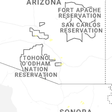


Connect with Interactive Hail Maps