

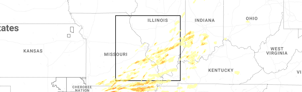
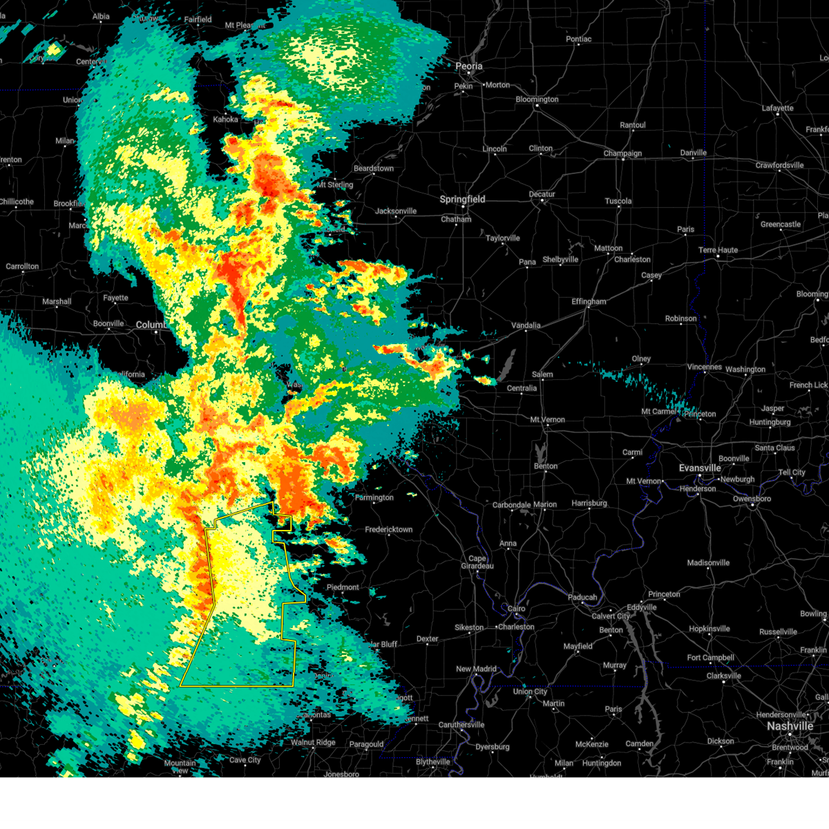
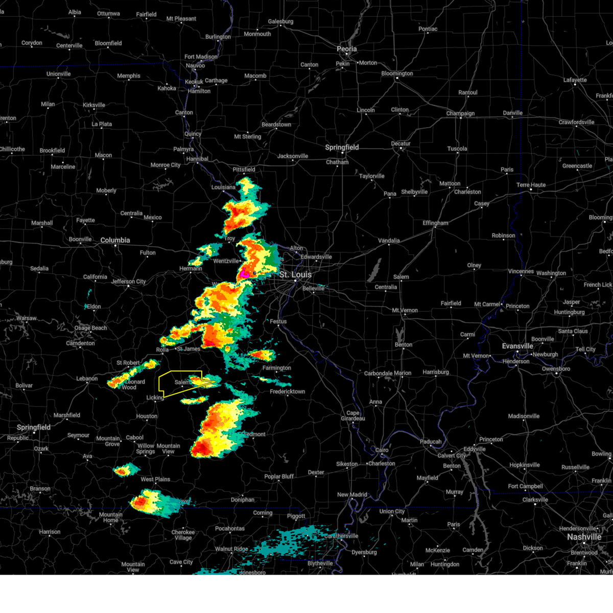
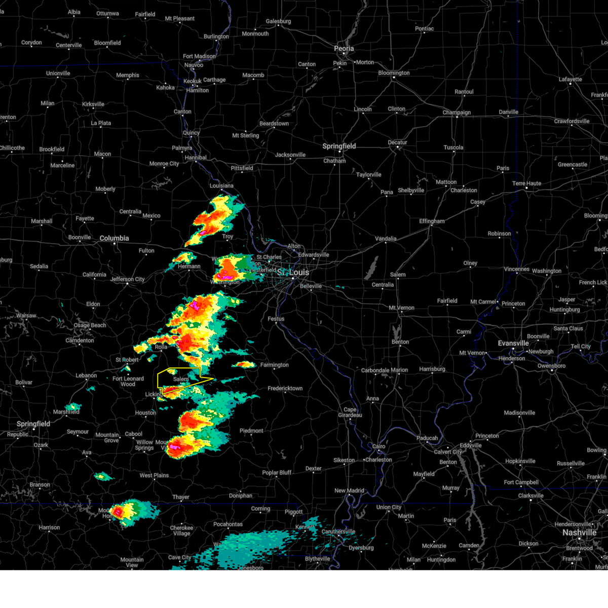
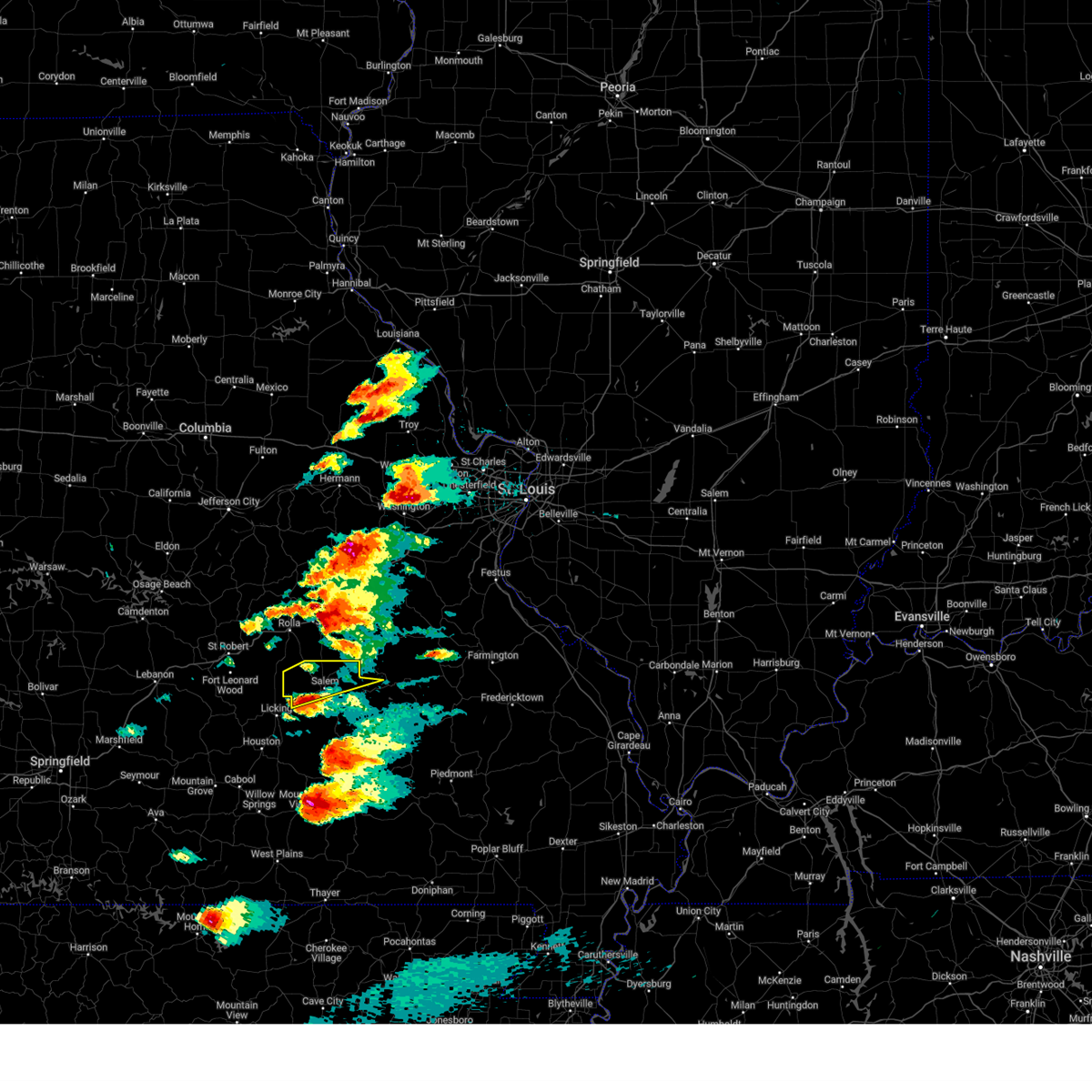
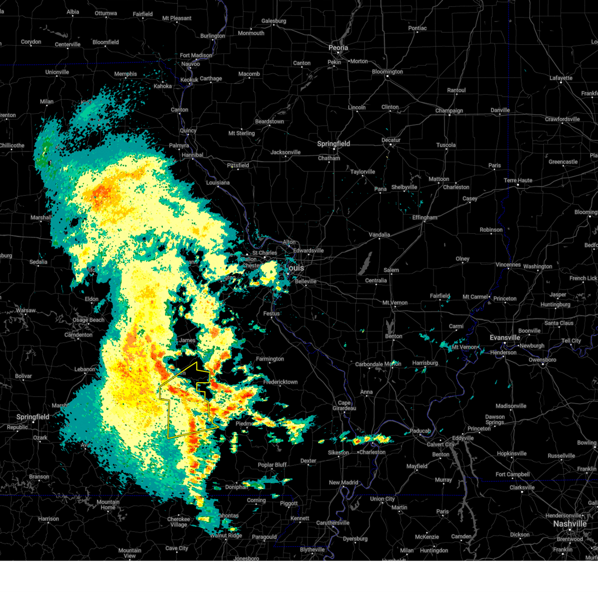
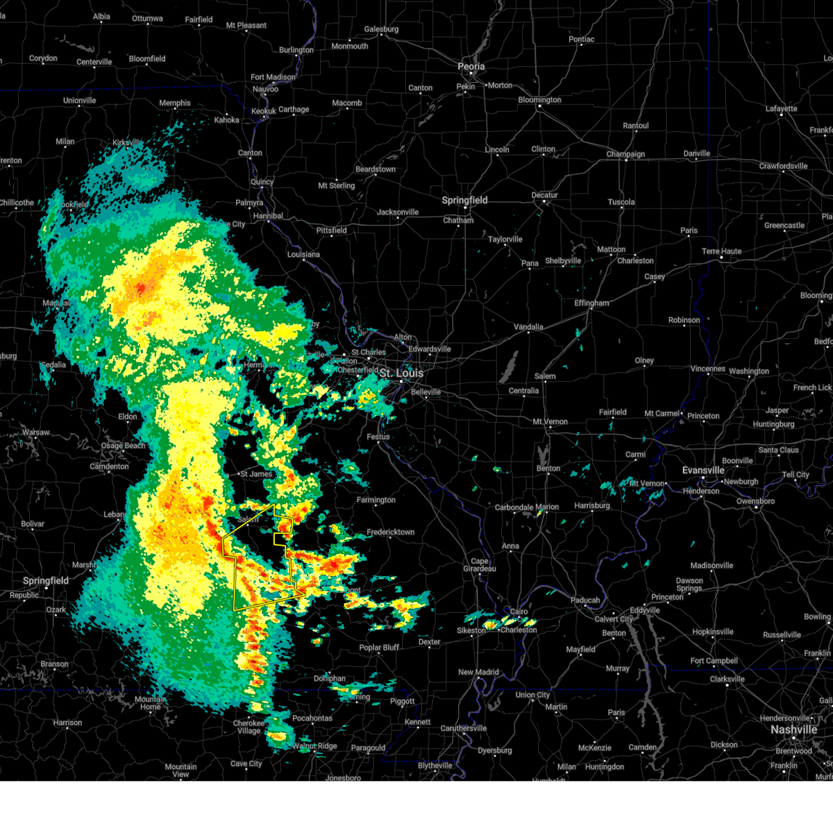
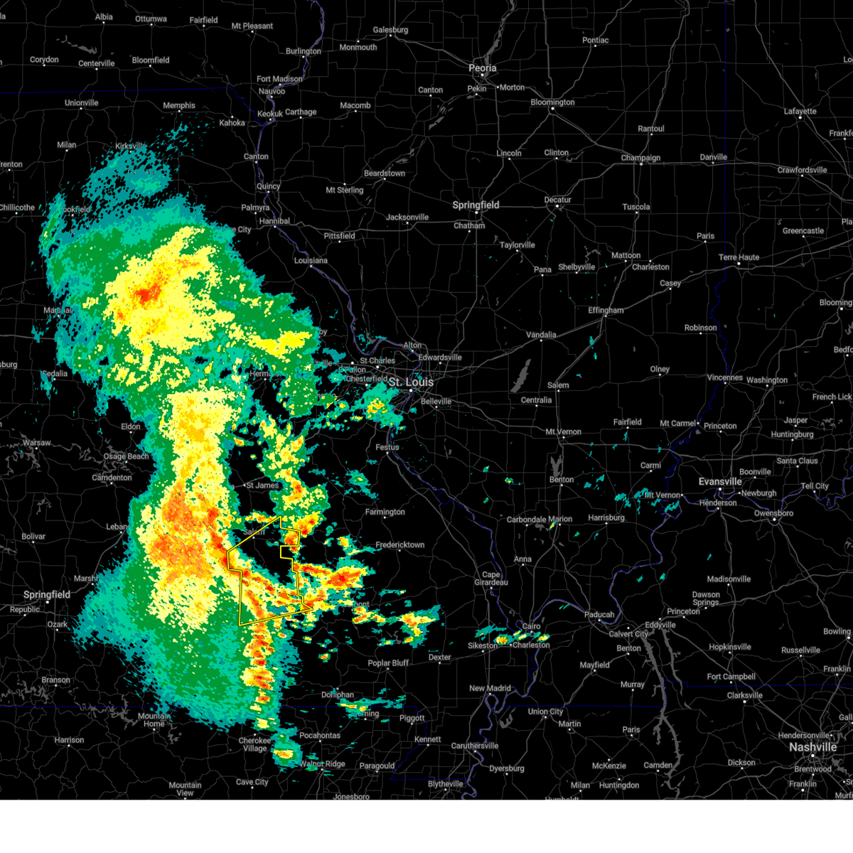
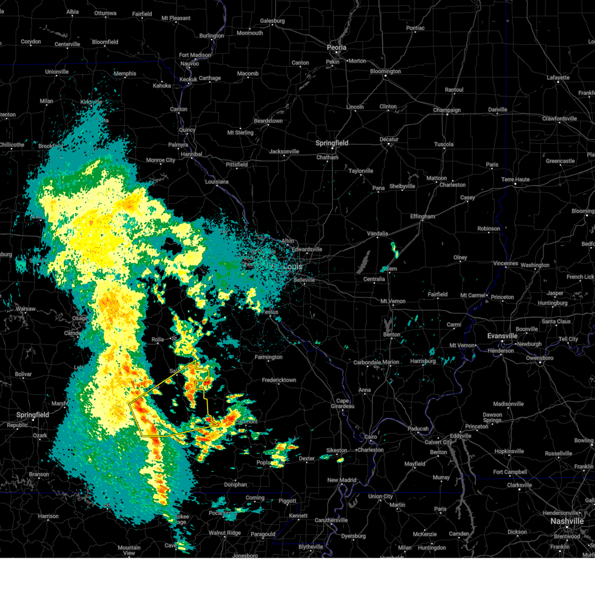
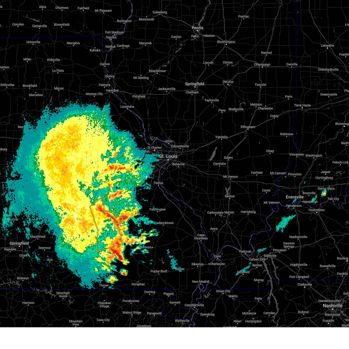
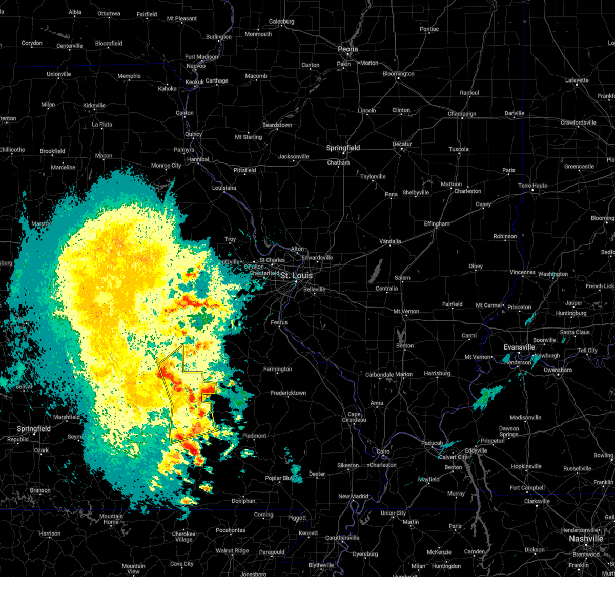
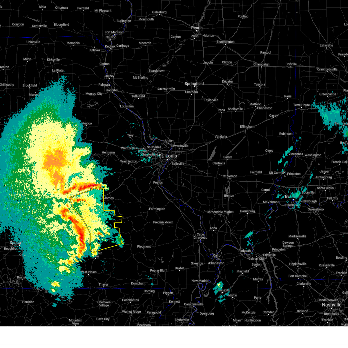
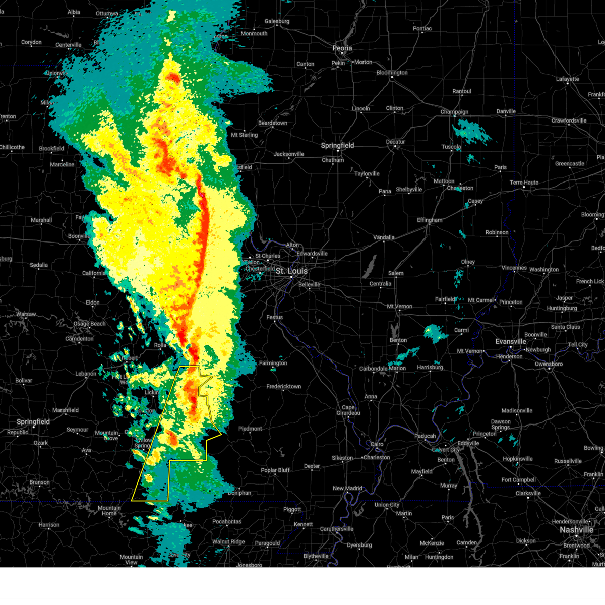
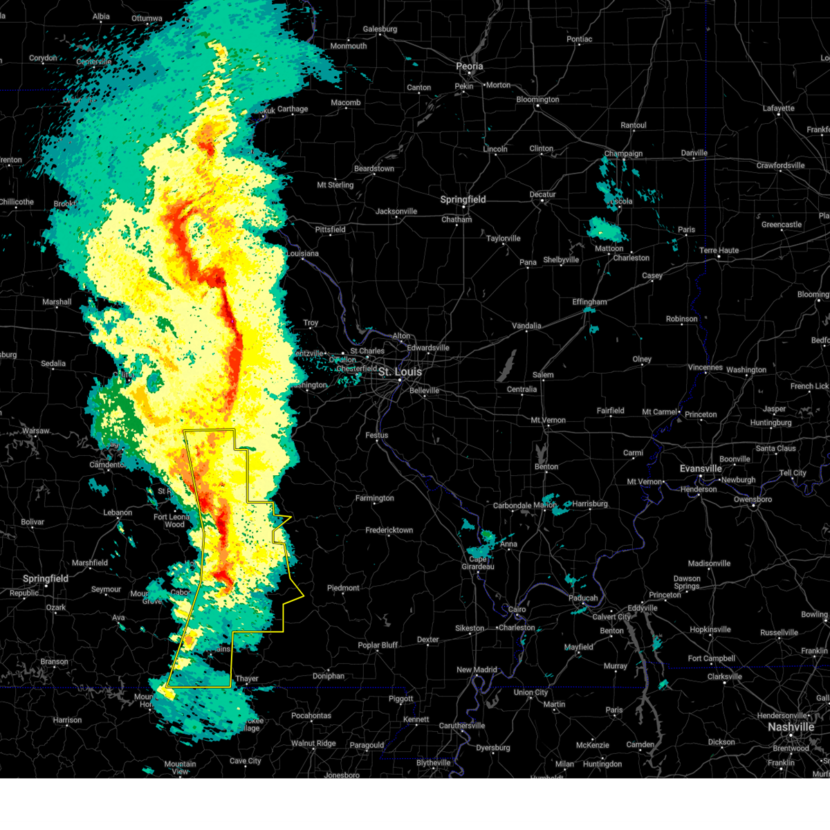
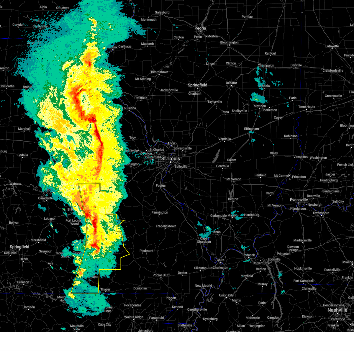
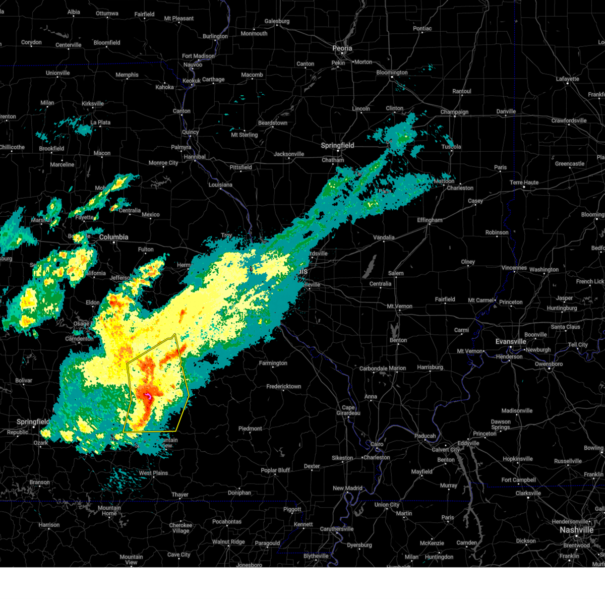
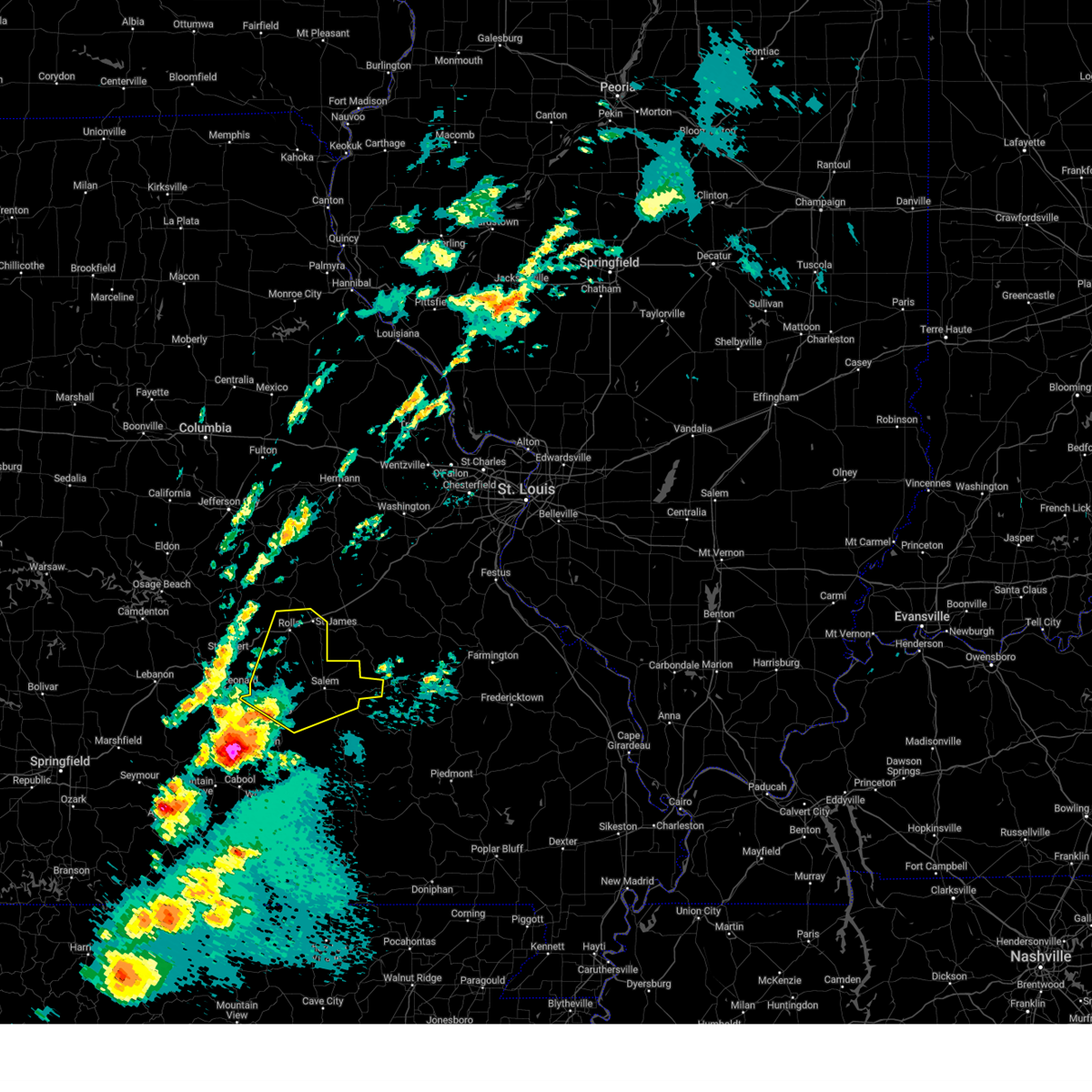
Hail Map for Salem, MO
The Salem, MO area has had 41 reports of on-the-ground hail by trained spotters, and has been under severe weather warnings 41 times during the past 12 months. Doppler radar has detected hail at or near Salem, MO on 55 occasions, including 6 occasions during the past year.
| Name: | Salem, MO |
| Where Located: | 0.5 miles NNW of Salem, MO |
| Map: | Google Map for Salem, MO |
| Population: | 4950 |
| Housing Units: | 2408 |
| More Info: | Search Google for Salem, MO |
2
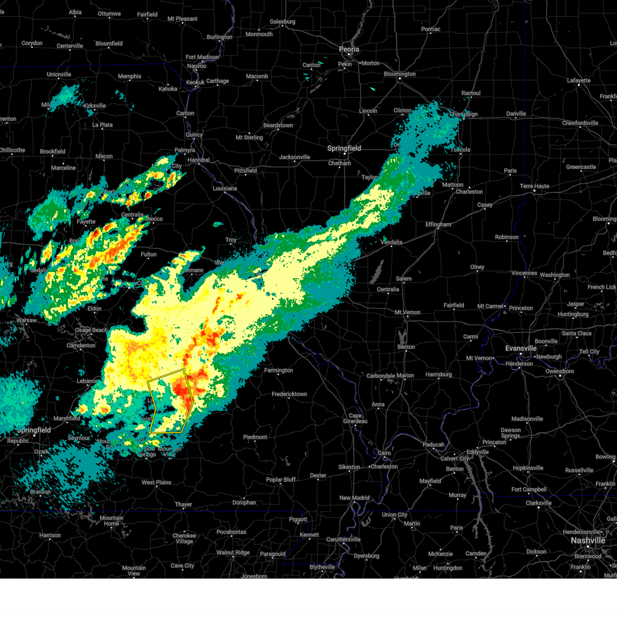
The Top Recent Hail Date for Salem, MO is Sunday, March 30, 2025 (14th out of 55)
Hail and Wind Damage Spotted near Salem, MO
| Date / Time | Report Details |
|---|---|
| 6/8/2025 8:22 PM CDT | The storm which prompted the warning has weakened below severe limits, and no longer poses an immediate threat to life or property. therefore, the warning will be allowed to expire. however, small hail is still possible with this thunderstorm. a severe thunderstorm watch remains in effect until 1000 pm cdt for south central missouri. |
| 6/8/2025 8:12 PM CDT |
 At 812 pm cdt, a severe thunderstorm was located near salem, moving east at 20 mph (radar indicated). Hazards include quarter size hail. Damage to vehicles is expected. Locations impacted include, salem, boss, howes mill, and sligo. At 812 pm cdt, a severe thunderstorm was located near salem, moving east at 20 mph (radar indicated). Hazards include quarter size hail. Damage to vehicles is expected. Locations impacted include, salem, boss, howes mill, and sligo.
|
| 6/8/2025 8:02 PM CDT | Quarter sized hail reported 3.4 miles SW of Salem, MO, report from mping - quarter 1.00 in. |
| 6/8/2025 7:51 PM CDT |
 Svrsgf the national weather service in springfield has issued a * severe thunderstorm warning for, northeastern dent county in south central missouri, * until 830 pm cdt. * at 751 pm cdt, a severe thunderstorm was located near salem, moving east at 20 mph (radar indicated). Hazards include 60 mph wind gusts and quarter size hail. Hail damage to vehicles is expected. Expect wind damage to roofs, siding, and trees. Svrsgf the national weather service in springfield has issued a * severe thunderstorm warning for, northeastern dent county in south central missouri, * until 830 pm cdt. * at 751 pm cdt, a severe thunderstorm was located near salem, moving east at 20 mph (radar indicated). Hazards include 60 mph wind gusts and quarter size hail. Hail damage to vehicles is expected. Expect wind damage to roofs, siding, and trees.
|
| 5/19/2025 10:59 PM CDT |
 The storms which prompted the warning have moved out of the area. therefore, the warning will be allowed to expire. The storms which prompted the warning have moved out of the area. therefore, the warning will be allowed to expire.
|
| 5/19/2025 10:35 PM CDT | Tree down about 10 miles east of salem on highway 3 in dent county MO, 10.5 miles W of Salem, MO |
| 5/19/2025 10:20 PM CDT | Trees and branches down on cr5080 and highway 19 south of salem. time estimated by rada in dent county MO, 2.3 miles NNW of Salem, MO |
| 5/19/2025 10:20 PM CDT | Trees down 3-4 miles south of sale in dent county MO, 3.7 miles N of Salem, MO |
| 5/19/2025 10:02 PM CDT |
 Svrsgf the national weather service in springfield has issued a * severe thunderstorm warning for, shannon county in south central missouri, dent county in south central missouri, howell county in south central missouri, eastern texas county in south central missouri, oregon county in south central missouri, * until 1100 pm cdt. * at 1001 pm cdt, severe thunderstorms were located along a line extending from 6 miles northeast of licking to 6 miles north of mountain view to near ott, moving east at 45 mph (radar indicated). Hazards include 60 mph wind gusts. expect damage to roofs, siding, and trees Svrsgf the national weather service in springfield has issued a * severe thunderstorm warning for, shannon county in south central missouri, dent county in south central missouri, howell county in south central missouri, eastern texas county in south central missouri, oregon county in south central missouri, * until 1100 pm cdt. * at 1001 pm cdt, severe thunderstorms were located along a line extending from 6 miles northeast of licking to 6 miles north of mountain view to near ott, moving east at 45 mph (radar indicated). Hazards include 60 mph wind gusts. expect damage to roofs, siding, and trees
|
| 5/16/2025 2:12 PM CDT |
 The storm which prompted the warning has moved out of the area. therefore, the warning will be allowed to expire. a tornado watch remains in effect until 700 pm cdt for south central and east central missouri. The storm which prompted the warning has moved out of the area. therefore, the warning will be allowed to expire. a tornado watch remains in effect until 700 pm cdt for south central and east central missouri.
|
| 5/16/2025 1:53 PM CDT |
 At 153 pm cdt, a severe thunderstorm was located 9 miles northeast of salem, moving northeast at 65 mph (radar indicated). Hazards include 60 mph wind gusts and quarter size hail. Hail damage to vehicles is expected. expect wind damage to roofs, siding, and trees. Locations impacted include, salem, lenox, bangert, howes, sligo, lake spring, and anutt. At 153 pm cdt, a severe thunderstorm was located 9 miles northeast of salem, moving northeast at 65 mph (radar indicated). Hazards include 60 mph wind gusts and quarter size hail. Hail damage to vehicles is expected. expect wind damage to roofs, siding, and trees. Locations impacted include, salem, lenox, bangert, howes, sligo, lake spring, and anutt.
|
| 5/16/2025 1:53 PM CDT |
 the severe thunderstorm warning has been cancelled and is no longer in effect the severe thunderstorm warning has been cancelled and is no longer in effect
|
| 5/16/2025 1:25 PM CDT |
 Svrsgf the national weather service in springfield has issued a * severe thunderstorm warning for, northern dent county in south central missouri, north central texas county in south central missouri, southern phelps county in east central missouri, * until 215 pm cdt. * at 125 pm cdt, a severe thunderstorm was located near licking, or 14 miles southeast of fort leonard wood, moving east at 65 mph (radar indicated). Hazards include 60 mph wind gusts and half dollar size hail. Hail damage to vehicles is expected. Expect wind damage to roofs, siding, and trees. Svrsgf the national weather service in springfield has issued a * severe thunderstorm warning for, northern dent county in south central missouri, north central texas county in south central missouri, southern phelps county in east central missouri, * until 215 pm cdt. * at 125 pm cdt, a severe thunderstorm was located near licking, or 14 miles southeast of fort leonard wood, moving east at 65 mph (radar indicated). Hazards include 60 mph wind gusts and half dollar size hail. Hail damage to vehicles is expected. Expect wind damage to roofs, siding, and trees.
|
| 5/16/2025 1:19 PM CDT |
 Svrsgf the national weather service in springfield has issued a * severe thunderstorm warning for, northern shannon county in south central missouri, dent county in south central missouri, eastern texas county in south central missouri, * until 200 pm cdt. * at 118 pm cdt, a severe thunderstorm was located 7 miles southeast of houston, moving east at 60 mph (radar indicated). Hazards include golf ball size hail and 60 mph wind gusts. People and animals outdoors will be injured. expect hail damage to roofs, siding, windows, and vehicles. Expect wind damage to roofs, siding, and trees. Svrsgf the national weather service in springfield has issued a * severe thunderstorm warning for, northern shannon county in south central missouri, dent county in south central missouri, eastern texas county in south central missouri, * until 200 pm cdt. * at 118 pm cdt, a severe thunderstorm was located 7 miles southeast of houston, moving east at 60 mph (radar indicated). Hazards include golf ball size hail and 60 mph wind gusts. People and animals outdoors will be injured. expect hail damage to roofs, siding, windows, and vehicles. Expect wind damage to roofs, siding, and trees.
|
| 4/30/2025 6:10 AM CDT |
 The storms which prompted the warning have weakened below severe limits, and no longer pose an immediate threat to life or property. therefore, the warning will be allowed to expire. however, gusty winds are still possible with these thunderstorms. The storms which prompted the warning have weakened below severe limits, and no longer pose an immediate threat to life or property. therefore, the warning will be allowed to expire. however, gusty winds are still possible with these thunderstorms.
|
| 4/30/2025 6:01 AM CDT |
 At 601 am cdt, severe thunderstorms were located along a line extending from 8 miles east of licking to 10 miles northeast of summersville to 7 miles west of eminence, moving northeast at 30 mph (radar indicated). Hazards include 60 mph wind gusts. Expect damage to roofs, siding, and trees. Locations impacted include, montauk, turtle, jadwin, howes mill, midridge, current river state park, ozark national scenic riverways, darien, gladden, echo bluff state park, alley spring, boss, montauk state park, round spring, west eminence, bunker, salem, eminence, akers, and stone hill. At 601 am cdt, severe thunderstorms were located along a line extending from 8 miles east of licking to 10 miles northeast of summersville to 7 miles west of eminence, moving northeast at 30 mph (radar indicated). Hazards include 60 mph wind gusts. Expect damage to roofs, siding, and trees. Locations impacted include, montauk, turtle, jadwin, howes mill, midridge, current river state park, ozark national scenic riverways, darien, gladden, echo bluff state park, alley spring, boss, montauk state park, round spring, west eminence, bunker, salem, eminence, akers, and stone hill.
|
| 4/30/2025 6:01 AM CDT |
 the severe thunderstorm warning has been cancelled and is no longer in effect the severe thunderstorm warning has been cancelled and is no longer in effect
|
| 4/30/2025 5:29 AM CDT |
 Svrsgf the national weather service in springfield has issued a * severe thunderstorm warning for, shannon county in south central missouri, dent county in south central missouri, eastern texas county in south central missouri, * until 615 am cdt. * at 528 am cdt, severe thunderstorms were located along a line extending from near houston to 10 miles southwest of summersville to near mountain view, moving northeast at 55 mph (radar indicated). Hazards include 60 mph wind gusts. expect damage to roofs, siding, and trees Svrsgf the national weather service in springfield has issued a * severe thunderstorm warning for, shannon county in south central missouri, dent county in south central missouri, eastern texas county in south central missouri, * until 615 am cdt. * at 528 am cdt, severe thunderstorms were located along a line extending from near houston to 10 miles southwest of summersville to near mountain view, moving northeast at 55 mph (radar indicated). Hazards include 60 mph wind gusts. expect damage to roofs, siding, and trees
|
| 4/29/2025 11:55 AM CDT |
 The storms which prompted the warning have weakened below severe limits, and have exited the warned area. therefore, the warning will be allowed to expire. a severe thunderstorm watch remains in effect until 300 pm cdt for south central and east central missouri. to report severe weather, contact your nearest law enforcement agency. they will relay your report to the national weather service springfield. The storms which prompted the warning have weakened below severe limits, and have exited the warned area. therefore, the warning will be allowed to expire. a severe thunderstorm watch remains in effect until 300 pm cdt for south central and east central missouri. to report severe weather, contact your nearest law enforcement agency. they will relay your report to the national weather service springfield.
|
| 4/29/2025 11:41 AM CDT |
 At 1140 am cdt, severe thunderstorms were located along a line extending from 7 miles southeast of newburg to 6 miles north of salem to 7 miles northwest of bunker to 13 miles north of eminence to near birch tree, moving east at 45 mph (radar indicated). Hazards include 60 mph wind gusts and penny size hail. Expect damage to roofs, siding, and trees. locations impacted include, jadwin, howes mill, midridge, current river state park, lake spring, gladden, anutt, bangert, echo bluff state park, boss, round spring, bunker, salem, akers, summersville, turtle, darien, howes, hartshorn, and lecoma. This includes interstate 44 near mile marker 183, and between mile markers 198 and 199. At 1140 am cdt, severe thunderstorms were located along a line extending from 7 miles southeast of newburg to 6 miles north of salem to 7 miles northwest of bunker to 13 miles north of eminence to near birch tree, moving east at 45 mph (radar indicated). Hazards include 60 mph wind gusts and penny size hail. Expect damage to roofs, siding, and trees. locations impacted include, jadwin, howes mill, midridge, current river state park, lake spring, gladden, anutt, bangert, echo bluff state park, boss, round spring, bunker, salem, akers, summersville, turtle, darien, howes, hartshorn, and lecoma. This includes interstate 44 near mile marker 183, and between mile markers 198 and 199.
|
| 4/29/2025 11:41 AM CDT |
 the severe thunderstorm warning has been cancelled and is no longer in effect the severe thunderstorm warning has been cancelled and is no longer in effect
|
| 4/29/2025 10:59 AM CDT |
 Svrsgf the national weather service in springfield has issued a * severe thunderstorm warning for, southeastern maries county in central missouri, northern shannon county in south central missouri, dent county in south central missouri, northeastern pulaski county in central missouri, eastern texas county in south central missouri, phelps county in east central missouri, * until noon cdt. * at 1058 am cdt, severe thunderstorms were located along a line extending from 7 miles southwest of waynesville to 8 miles southeast of fort leonard wood to near raymondville to 7 miles southeast of houston to willow springs, moving east at 55 mph (radar indicated). Hazards include 60 mph wind gusts and quarter size hail. Hail damage to vehicles is expected. Expect wind damage to roofs, siding, and trees. Svrsgf the national weather service in springfield has issued a * severe thunderstorm warning for, southeastern maries county in central missouri, northern shannon county in south central missouri, dent county in south central missouri, northeastern pulaski county in central missouri, eastern texas county in south central missouri, phelps county in east central missouri, * until noon cdt. * at 1058 am cdt, severe thunderstorms were located along a line extending from 7 miles southwest of waynesville to 8 miles southeast of fort leonard wood to near raymondville to 7 miles southeast of houston to willow springs, moving east at 55 mph (radar indicated). Hazards include 60 mph wind gusts and quarter size hail. Hail damage to vehicles is expected. Expect wind damage to roofs, siding, and trees.
|
| 4/20/2025 6:29 PM CDT |
 At 628 pm cdt, severe thunderstorms were located along a line extending from near bland to near cherryville to 9 miles northwest of mountain view, moving northeast at 60 mph (public). Hazards include 70 mph wind gusts and nickel size hail. Expect considerable tree damage. damage is likely to mobile homes, roofs, and outbuildings. Locations impacted include, lanton, teresita, jadwin, howes mill, midridge, current river state park, ozark national scenic riverways, pottersville, gladden, eunice, brandsville, bangert, echo bluff state park, clear springs, winona, round spring, bunker, salem, west plains, and eminence. At 628 pm cdt, severe thunderstorms were located along a line extending from near bland to near cherryville to 9 miles northwest of mountain view, moving northeast at 60 mph (public). Hazards include 70 mph wind gusts and nickel size hail. Expect considerable tree damage. damage is likely to mobile homes, roofs, and outbuildings. Locations impacted include, lanton, teresita, jadwin, howes mill, midridge, current river state park, ozark national scenic riverways, pottersville, gladden, eunice, brandsville, bangert, echo bluff state park, clear springs, winona, round spring, bunker, salem, west plains, and eminence.
|
| 4/20/2025 6:29 PM CDT |
 the severe thunderstorm warning has been cancelled and is no longer in effect the severe thunderstorm warning has been cancelled and is no longer in effect
|
| 4/20/2025 6:01 PM CDT |
 At 600 pm cdt, severe thunderstorms were located along a line extending from near doolittle to 9 miles southwest of salem to 12 miles west of west plains, moving east at 60 mph (public). Hazards include 70 mph wind gusts and nickel size hail. Expect considerable tree damage. damage is likely to mobile homes, roofs, and outbuildings. locations impacted include, lanton, jadwin, beulah, ozark national scenic riverways, caulfield, bakersfield, gladden, anutt, bangert, echo bluff state park, edgar springs, west plains, eminence, akers, pine crest, summersville, rosati, montier, turtle, and pomona. This includes interstate 44 between mile markers 171 and 200. At 600 pm cdt, severe thunderstorms were located along a line extending from near doolittle to 9 miles southwest of salem to 12 miles west of west plains, moving east at 60 mph (public). Hazards include 70 mph wind gusts and nickel size hail. Expect considerable tree damage. damage is likely to mobile homes, roofs, and outbuildings. locations impacted include, lanton, jadwin, beulah, ozark national scenic riverways, caulfield, bakersfield, gladden, anutt, bangert, echo bluff state park, edgar springs, west plains, eminence, akers, pine crest, summersville, rosati, montier, turtle, and pomona. This includes interstate 44 between mile markers 171 and 200.
|
| 4/20/2025 6:01 PM CDT |
 the severe thunderstorm warning has been cancelled and is no longer in effect the severe thunderstorm warning has been cancelled and is no longer in effect
|
| 4/20/2025 5:48 PM CDT |
 Svrsgf the national weather service in springfield has issued a * severe thunderstorm warning for, maries county in central missouri, southeastern ozark county in southwestern missouri, shannon county in south central missouri, dent county in south central missouri, howell county in south central missouri, eastern pulaski county in central missouri, eastern texas county in south central missouri, phelps county in east central missouri, * until 645 pm cdt. * at 546 pm cdt, severe thunderstorms were located along a line extending from near st. robert to near raymondville to near bakersfield, moving northeast at 65 mph (radar indicated). Hazards include 70 mph wind gusts and nickel size hail. Expect considerable tree damage. Damage is likely to mobile homes, roofs, and outbuildings. Svrsgf the national weather service in springfield has issued a * severe thunderstorm warning for, maries county in central missouri, southeastern ozark county in southwestern missouri, shannon county in south central missouri, dent county in south central missouri, howell county in south central missouri, eastern pulaski county in central missouri, eastern texas county in south central missouri, phelps county in east central missouri, * until 645 pm cdt. * at 546 pm cdt, severe thunderstorms were located along a line extending from near st. robert to near raymondville to near bakersfield, moving northeast at 65 mph (radar indicated). Hazards include 70 mph wind gusts and nickel size hail. Expect considerable tree damage. Damage is likely to mobile homes, roofs, and outbuildings.
|
| 4/20/2025 4:58 AM CDT | Quarter sized hail reported 1.6 miles SE of Salem, MO |
| 4/19/2025 12:28 AM CDT |
 The storms which prompted the warning have moved out of the area. therefore, the warning will be allowed to expire. however, heavy rain is still possible with these thunderstorms. a severe thunderstorm watch remains in effect until 300 am cdt for south central and east central missouri. The storms which prompted the warning have moved out of the area. therefore, the warning will be allowed to expire. however, heavy rain is still possible with these thunderstorms. a severe thunderstorm watch remains in effect until 300 am cdt for south central and east central missouri.
|
| 4/19/2025 12:18 AM CDT |
 Svrsgf the national weather service in springfield has issued a * severe thunderstorm warning for, northwestern shannon county in south central missouri, dent county in south central missouri, * until 100 am cdt. * at 1218 am cdt, severe thunderstorms were located along a line extending from 14 miles southeast of rolla to 8 miles south of salem to 9 miles north of summersville, moving east at 45 mph (radar indicated). Hazards include 60 mph wind gusts and quarter size hail. Hail damage to vehicles is expected. Expect wind damage to roofs, siding, and trees. Svrsgf the national weather service in springfield has issued a * severe thunderstorm warning for, northwestern shannon county in south central missouri, dent county in south central missouri, * until 100 am cdt. * at 1218 am cdt, severe thunderstorms were located along a line extending from 14 miles southeast of rolla to 8 miles south of salem to 9 miles north of summersville, moving east at 45 mph (radar indicated). Hazards include 60 mph wind gusts and quarter size hail. Hail damage to vehicles is expected. Expect wind damage to roofs, siding, and trees.
|
| 4/19/2025 12:12 AM CDT |
 the severe thunderstorm warning has been cancelled and is no longer in effect the severe thunderstorm warning has been cancelled and is no longer in effect
|
| 4/19/2025 12:12 AM CDT |
 At 1212 am cdt, severe thunderstorms were located along a line extending from near rolla to 10 miles east of licking to 11 miles northeast of willow springs, moving east at 45 mph (radar indicated). Hazards include 60 mph wind gusts and quarter size hail. Hail damage to vehicles is expected. expect wind damage to roofs, siding, and trees. Locations impacted include, lenox, montauk, jadwin, beulah, darien, lake spring, gladden, eunice, anutt, bangert, yukon, howes, hartshorn, licking, montauk state park, edgar springs, salem, akers, and raymondville. At 1212 am cdt, severe thunderstorms were located along a line extending from near rolla to 10 miles east of licking to 11 miles northeast of willow springs, moving east at 45 mph (radar indicated). Hazards include 60 mph wind gusts and quarter size hail. Hail damage to vehicles is expected. expect wind damage to roofs, siding, and trees. Locations impacted include, lenox, montauk, jadwin, beulah, darien, lake spring, gladden, eunice, anutt, bangert, yukon, howes, hartshorn, licking, montauk state park, edgar springs, salem, akers, and raymondville.
|
| 4/19/2025 12:05 AM CDT |
 the severe thunderstorm warning has been cancelled and is no longer in effect the severe thunderstorm warning has been cancelled and is no longer in effect
|
| 4/19/2025 12:05 AM CDT |
 At 1204 am cdt, severe thunderstorms were located along a line extending from near newburg to 7 miles northeast of raymondville to 8 miles north of willow springs, moving east at 45 mph (radar indicated). Hazards include 60 mph wind gusts and quarter size hail. Hail damage to vehicles is expected. expect wind damage to roofs, siding, and trees. locations impacted include, lenox, montauk, jadwin, beulah, lake spring, gladden, success, eunice, anutt, bangert, yukon, rolla, licking, edgar springs, solo, salem, akers, simmons, summersville, and st. james. This includes interstate 44 between mile markers 161 and 169, and between mile markers 178 and 197. At 1204 am cdt, severe thunderstorms were located along a line extending from near newburg to 7 miles northeast of raymondville to 8 miles north of willow springs, moving east at 45 mph (radar indicated). Hazards include 60 mph wind gusts and quarter size hail. Hail damage to vehicles is expected. expect wind damage to roofs, siding, and trees. locations impacted include, lenox, montauk, jadwin, beulah, lake spring, gladden, success, eunice, anutt, bangert, yukon, rolla, licking, edgar springs, solo, salem, akers, simmons, summersville, and st. james. This includes interstate 44 between mile markers 161 and 169, and between mile markers 178 and 197.
|
| 4/18/2025 11:43 PM CDT |
 Svrsgf the national weather service in springfield has issued a * severe thunderstorm warning for, northwestern shannon county in south central missouri, southeastern wright county in southwestern missouri, western dent county in south central missouri, southeastern pulaski county in central missouri, texas county in south central missouri, phelps county in east central missouri, * until 1230 am cdt. * at 1143 pm cdt, severe thunderstorms were located along a line extending from near st. robert to near houston to 7 miles southeast of mountain grove, moving east at 45 mph (radar indicated). Hazards include 60 mph wind gusts and quarter size hail. Hail damage to vehicles is expected. Expect wind damage to roofs, siding, and trees. Svrsgf the national weather service in springfield has issued a * severe thunderstorm warning for, northwestern shannon county in south central missouri, southeastern wright county in southwestern missouri, western dent county in south central missouri, southeastern pulaski county in central missouri, texas county in south central missouri, phelps county in east central missouri, * until 1230 am cdt. * at 1143 pm cdt, severe thunderstorms were located along a line extending from near st. robert to near houston to 7 miles southeast of mountain grove, moving east at 45 mph (radar indicated). Hazards include 60 mph wind gusts and quarter size hail. Hail damage to vehicles is expected. Expect wind damage to roofs, siding, and trees.
|
| 4/2/2025 3:04 PM CDT |
 The storm which prompted the warning has moved out of the area. therefore, the warning has been allowed to expire. a tornado watch remains in effect until 400 pm cdt for south central missouri. to report severe weather, contact your nearest law enforcement agency. they will relay your report to the national weather service springfield. The storm which prompted the warning has moved out of the area. therefore, the warning has been allowed to expire. a tornado watch remains in effect until 400 pm cdt for south central missouri. to report severe weather, contact your nearest law enforcement agency. they will relay your report to the national weather service springfield.
|
| 4/2/2025 3:03 PM CDT |
 The storm which prompted the warning has moved out of the area. therefore, the warning has been allowed to expire. a tornado watch remains in effect until 400 pm cdt for south central, central and east central missouri. to report severe weather, contact your nearest law enforcement agency. they will relay your report to the national weather service springfield. The storm which prompted the warning has moved out of the area. therefore, the warning has been allowed to expire. a tornado watch remains in effect until 400 pm cdt for south central, central and east central missouri. to report severe weather, contact your nearest law enforcement agency. they will relay your report to the national weather service springfield.
|
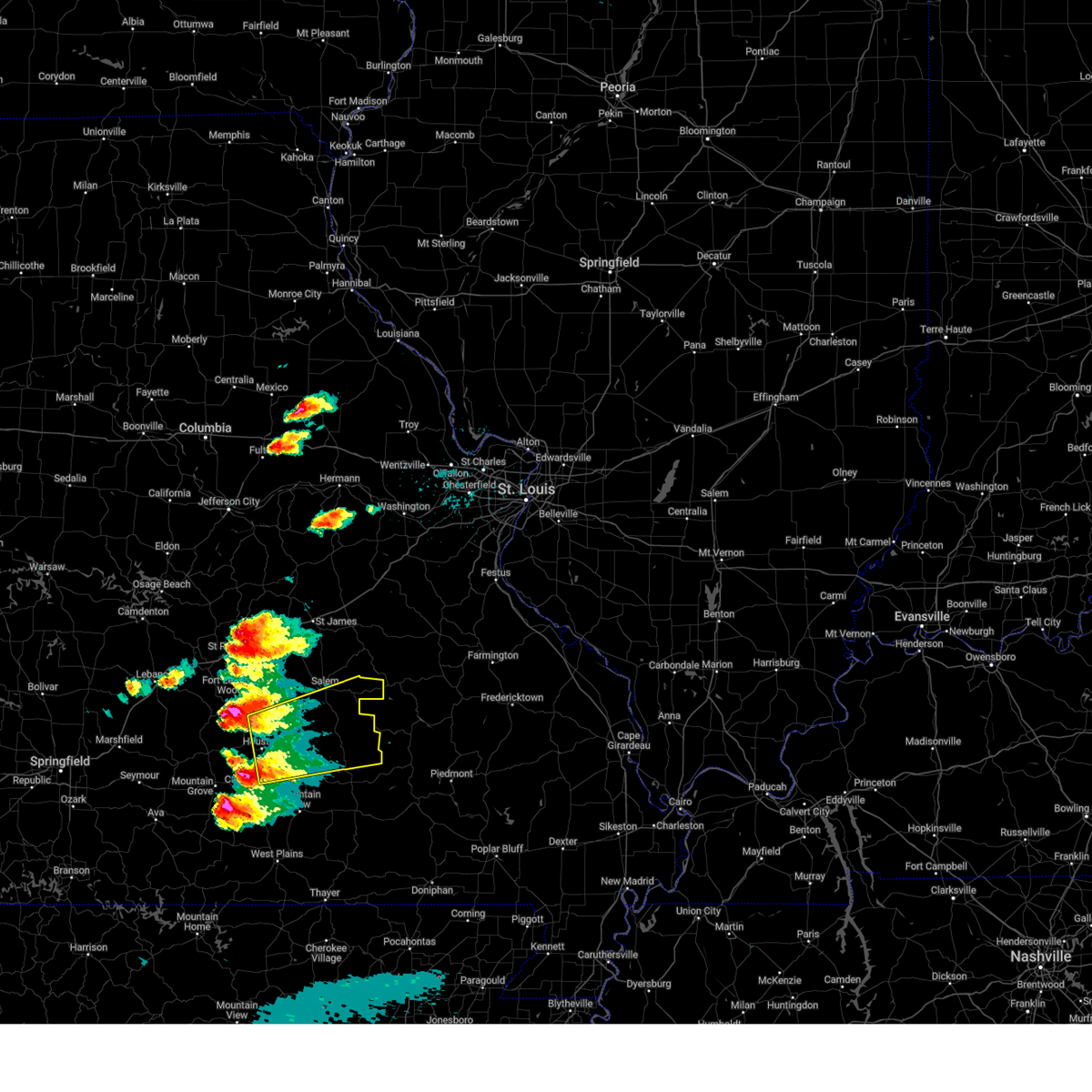
| 4/2/2025 2:43 PM CDT | At 243 pm cdt, a severe thunderstorm capable of producing a tornado was located over salem, moving northeast at 65 mph (radar indicated rotation). Hazards include tornado and two inch hail. Flying debris will be dangerous to those caught without shelter. mobile homes will be damaged or destroyed. damage to roofs, windows, and vehicles will occur. tree damage is likely. Locations impacted include, salem, boss, howes, stone hill, howes mill, and sligo. |
| 4/2/2025 2:17 PM CDT |
 Torsgf the national weather service in springfield has issued a * tornado warning for, dent county in south central missouri, * until 300 pm cdt. * at 217 pm cdt, a severe thunderstorm capable of producing a tornado was located near raymondville, or 8 miles northeast of houston, moving northeast at 55 mph (radar indicated rotation). Hazards include tornado. Flying debris will be dangerous to those caught without shelter. mobile homes will be damaged or destroyed. damage to roofs, windows, and vehicles will occur. Tree damage is likely. Torsgf the national weather service in springfield has issued a * tornado warning for, dent county in south central missouri, * until 300 pm cdt. * at 217 pm cdt, a severe thunderstorm capable of producing a tornado was located near raymondville, or 8 miles northeast of houston, moving northeast at 55 mph (radar indicated rotation). Hazards include tornado. Flying debris will be dangerous to those caught without shelter. mobile homes will be damaged or destroyed. damage to roofs, windows, and vehicles will occur. Tree damage is likely.
|
| 4/2/2025 1:59 PM CDT |
 Svrsgf the national weather service in springfield has issued a * severe thunderstorm warning for, dent county in south central missouri, northeastern texas county in south central missouri, phelps county in east central missouri, * until 300 pm cdt. * at 159 pm cdt, a severe thunderstorm was located 10 miles west of houston, moving northeast at 55 mph (radar indicated). Hazards include two inch hail and 60 mph wind gusts. People and animals outdoors will be injured. expect hail damage to roofs, siding, windows, and vehicles. Expect wind damage to roofs, siding, and trees. Svrsgf the national weather service in springfield has issued a * severe thunderstorm warning for, dent county in south central missouri, northeastern texas county in south central missouri, phelps county in east central missouri, * until 300 pm cdt. * at 159 pm cdt, a severe thunderstorm was located 10 miles west of houston, moving northeast at 55 mph (radar indicated). Hazards include two inch hail and 60 mph wind gusts. People and animals outdoors will be injured. expect hail damage to roofs, siding, windows, and vehicles. Expect wind damage to roofs, siding, and trees.
|
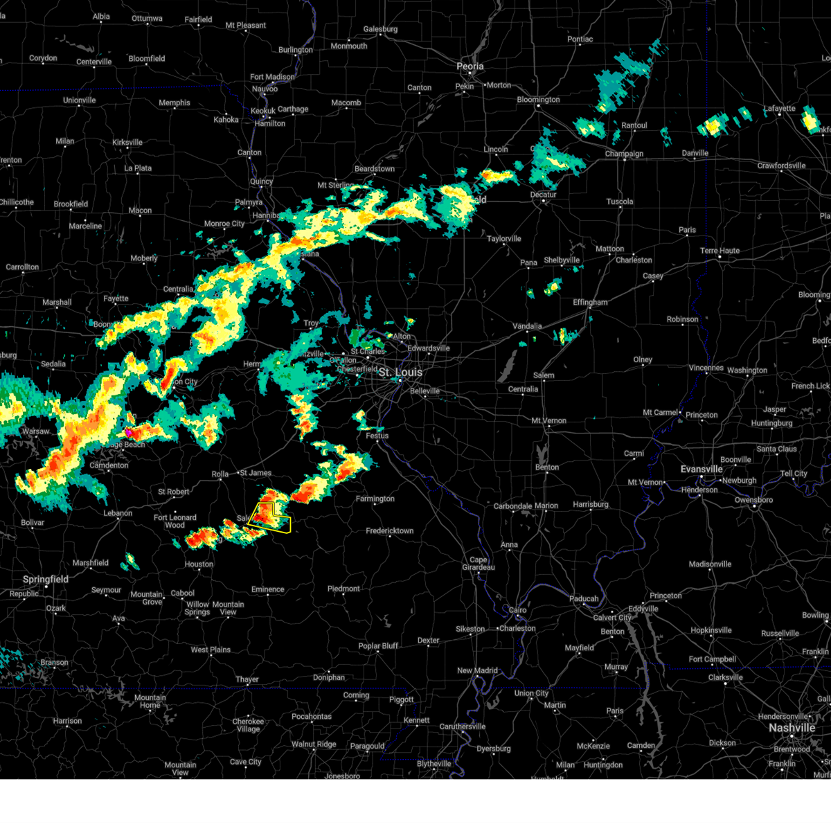
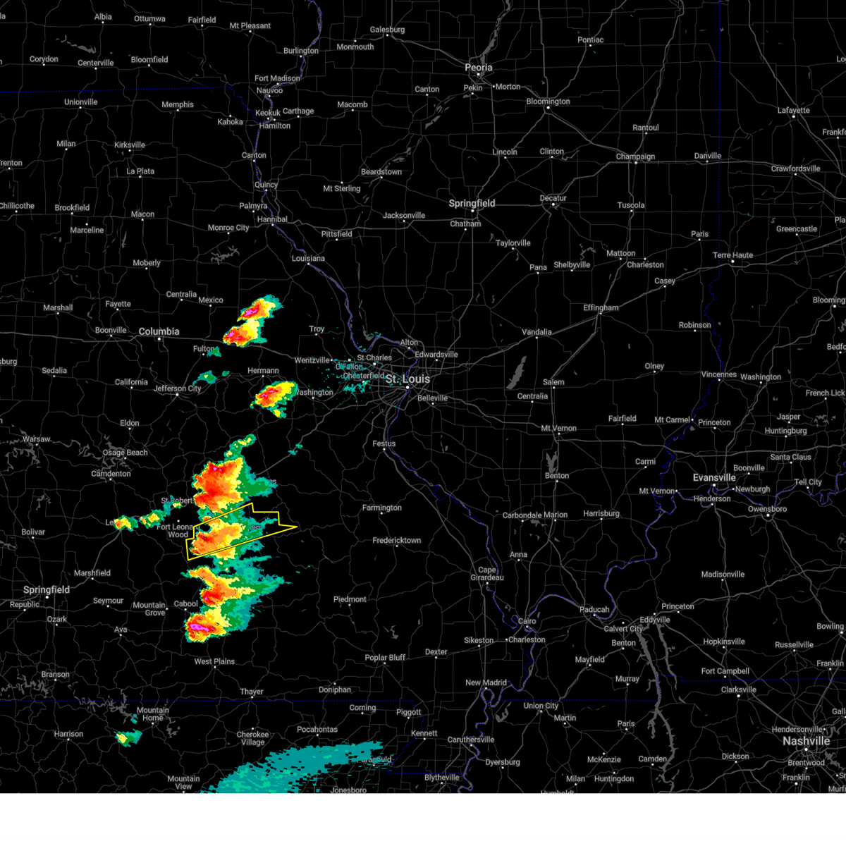
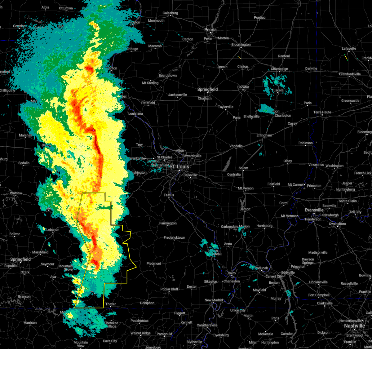
| 3/30/2025 2:45 PM CDT | Tennis Ball sized hail reported 19.8 miles NNW of Salem, MO |
| 1/1/0001 12:00 AM | Quarter sized hail reported 0.2 miles N of Salem, MO |
| 3/30/2025 2:29 PM CDT |
 At 228 pm cdt, a severe thunderstorm was located 10 miles southwest of salem, moving northeast at 55 mph (law enforcement. this storm produced quarter size hail in houston missouri). Hazards include ping pong ball size hail and 60 mph wind gusts. People and animals outdoors will be injured. expect hail damage to roofs, siding, windows, and vehicles. expect wind damage to roofs, siding, and trees. Locations impacted include, montauk, turtle, boss, jadwin, howes mill, montauk state park, darien, salem, stone hill, gladden, and bunker. At 228 pm cdt, a severe thunderstorm was located 10 miles southwest of salem, moving northeast at 55 mph (law enforcement. this storm produced quarter size hail in houston missouri). Hazards include ping pong ball size hail and 60 mph wind gusts. People and animals outdoors will be injured. expect hail damage to roofs, siding, windows, and vehicles. expect wind damage to roofs, siding, and trees. Locations impacted include, montauk, turtle, boss, jadwin, howes mill, montauk state park, darien, salem, stone hill, gladden, and bunker.
|
| 3/30/2025 2:15 PM CDT |
 Svrsgf the national weather service in springfield has issued a * severe thunderstorm warning for, dent county in south central missouri, * until 315 pm cdt. * at 214 pm cdt, a severe thunderstorm was located 7 miles northeast of raymondville, or 12 miles northeast of houston, moving northeast at 50 mph (law enforcement. this storm produced quarter size hail in houston missouri). Hazards include 60 mph wind gusts and half dollar size hail. Hail damage to vehicles is expected. Expect wind damage to roofs, siding, and trees. Svrsgf the national weather service in springfield has issued a * severe thunderstorm warning for, dent county in south central missouri, * until 315 pm cdt. * at 214 pm cdt, a severe thunderstorm was located 7 miles northeast of raymondville, or 12 miles northeast of houston, moving northeast at 50 mph (law enforcement. this storm produced quarter size hail in houston missouri). Hazards include 60 mph wind gusts and half dollar size hail. Hail damage to vehicles is expected. Expect wind damage to roofs, siding, and trees.
|
| 1/1/0001 12:00 AM | Half Dollar sized hail reported 8 miles SSW of Salem, MO, northeast of salem. |
| 3/14/2025 9:34 PM CDT |
 At 934 pm cdt, a severe thunderstorm was located over salem, moving northeast at 65 mph (radar indicated). Hazards include golf ball size hail and 70 mph wind gusts. People and animals outdoors will be injured. expect hail damage to roofs, siding, windows, and vehicles. expect considerable tree damage. wind damage is also likely to mobile homes, roofs, and outbuildings. Locations impacted include, salem. At 934 pm cdt, a severe thunderstorm was located over salem, moving northeast at 65 mph (radar indicated). Hazards include golf ball size hail and 70 mph wind gusts. People and animals outdoors will be injured. expect hail damage to roofs, siding, windows, and vehicles. expect considerable tree damage. wind damage is also likely to mobile homes, roofs, and outbuildings. Locations impacted include, salem.
|
| 3/14/2025 9:34 PM CDT |
 the severe thunderstorm warning has been cancelled and is no longer in effect the severe thunderstorm warning has been cancelled and is no longer in effect
|
| 3/14/2025 9:09 PM CDT | Svrsgf the national weather service in springfield has issued a * severe thunderstorm warning for, central dent county in south central missouri, northeastern texas county in south central missouri, * until 1000 pm cdt. * at 908 pm cdt, a severe thunderstorm was located near houston, moving northeast at 65 mph (radar indicated). Hazards include golf ball size hail and 70 mph wind gusts. People and animals outdoors will be injured. expect hail damage to roofs, siding, windows, and vehicles. expect considerable tree damage. Wind damage is also likely to mobile homes, roofs, and outbuildings. |
| 3/14/2025 9:00 PM CDT | Golf Ball sized hail reported 20.2 miles SW of Salem, MO |
| 3/14/2025 7:41 PM CDT | Svrsgf the national weather service in springfield has issued a * severe thunderstorm warning for, southern webster county in southwestern missouri, wright county in southwestern missouri, northwestern douglas county in southwestern missouri, southwestern dent county in south central missouri, northeastern christian county in southwestern missouri, south central laclede county in southwestern missouri, central texas county in south central missouri, * until 845 pm cdt. * at 741 pm cdt, a severe thunderstorm was located near hartville, or 13 miles northwest of mountain grove, moving northeast at 65 mph (radar indicated). Hazards include two inch hail and 70 mph wind gusts. People and animals outdoors will be injured. expect hail damage to roofs, siding, windows, and vehicles. expect considerable tree damage. Wind damage is also likely to mobile homes, roofs, and outbuildings. |
| 5/26/2024 6:43 PM CDT |
 the severe thunderstorm warning has been cancelled and is no longer in effect the severe thunderstorm warning has been cancelled and is no longer in effect
|
| 5/26/2024 6:43 PM CDT |
 At 643 pm cdt, a severe thunderstorm was located 12 miles south of salem, moving east at 65 mph (radar indicated). Hazards include 60 mph wind gusts and quarter size hail. Hail damage to vehicles is expected. expect wind damage to roofs, siding, and trees. Locations impacted include, montauk state park, salem, bunker, montauk, turtle, boss, jadwin, howes mill, darien, stone hill, and gladden. At 643 pm cdt, a severe thunderstorm was located 12 miles south of salem, moving east at 65 mph (radar indicated). Hazards include 60 mph wind gusts and quarter size hail. Hail damage to vehicles is expected. expect wind damage to roofs, siding, and trees. Locations impacted include, montauk state park, salem, bunker, montauk, turtle, boss, jadwin, howes mill, darien, stone hill, and gladden.
|
| 5/26/2024 6:16 PM CDT |
 Svrsgf the national weather service in springfield has issued a * severe thunderstorm warning for, dent county in south central missouri, northern texas county in south central missouri, southeastern pulaski county in central missouri, southwestern phelps county in east central missouri, * until 715 pm cdt. * at 616 pm cdt, a severe thunderstorm was located 8 miles northwest of licking, or 13 miles southeast of fort leonard wood, moving east at 40 mph (radar indicated). Hazards include 60 mph wind gusts and half dollar size hail. Hail damage to vehicles is expected. Expect wind damage to roofs, siding, and trees. Svrsgf the national weather service in springfield has issued a * severe thunderstorm warning for, dent county in south central missouri, northern texas county in south central missouri, southeastern pulaski county in central missouri, southwestern phelps county in east central missouri, * until 715 pm cdt. * at 616 pm cdt, a severe thunderstorm was located 8 miles northwest of licking, or 13 miles southeast of fort leonard wood, moving east at 40 mph (radar indicated). Hazards include 60 mph wind gusts and half dollar size hail. Hail damage to vehicles is expected. Expect wind damage to roofs, siding, and trees.
|
| 5/8/2024 5:24 PM CDT | Hen Egg sized hail reported 12.1 miles W of Salem, MO, time based on radar. |
| 5/8/2024 5:14 PM CDT |
 the severe thunderstorm warning has been cancelled and is no longer in effect the severe thunderstorm warning has been cancelled and is no longer in effect
|
| 5/8/2024 5:14 PM CDT |
 At 513 pm cdt, a severe thunderstorm was located near salem, moving northeast at 25 mph (radar indicated). Hazards include golf ball size hail and 60 mph wind gusts. People and animals outdoors will be injured. expect hail damage to roofs, siding, windows, and vehicles. expect wind damage to roofs, siding, and trees. Locations impacted include, salem, bangert, boss, howes, howes mill, stone hill, sligo, and darien. At 513 pm cdt, a severe thunderstorm was located near salem, moving northeast at 25 mph (radar indicated). Hazards include golf ball size hail and 60 mph wind gusts. People and animals outdoors will be injured. expect hail damage to roofs, siding, windows, and vehicles. expect wind damage to roofs, siding, and trees. Locations impacted include, salem, bangert, boss, howes, howes mill, stone hill, sligo, and darien.
|
| 5/8/2024 4:56 PM CDT |
 Svrsgf the national weather service in springfield has issued a * severe thunderstorm warning for, dent county in south central missouri, southeastern phelps county in east central missouri, * until 545 pm cdt. * at 456 pm cdt, a severe thunderstorm was located 8 miles west of salem, moving northeast at 25 mph (radar indicated). Hazards include two inch hail and 60 mph wind gusts. People and animals outdoors will be injured. expect hail damage to roofs, siding, windows, and vehicles. Expect wind damage to roofs, siding, and trees. Svrsgf the national weather service in springfield has issued a * severe thunderstorm warning for, dent county in south central missouri, southeastern phelps county in east central missouri, * until 545 pm cdt. * at 456 pm cdt, a severe thunderstorm was located 8 miles west of salem, moving northeast at 25 mph (radar indicated). Hazards include two inch hail and 60 mph wind gusts. People and animals outdoors will be injured. expect hail damage to roofs, siding, windows, and vehicles. Expect wind damage to roofs, siding, and trees.
|
| 5/7/2024 3:43 AM CDT |
 The storms which prompted the warning have moved out of the area. therefore, the warning will be allowed to expire. however, gusty winds are still possible with these thunderstorms. a tornado watch remains in effect until 400 am cdt for southwestern missouri. a tornado watch also remains in effect until 800 am cdt for south central and east central missouri. The storms which prompted the warning have moved out of the area. therefore, the warning will be allowed to expire. however, gusty winds are still possible with these thunderstorms. a tornado watch remains in effect until 400 am cdt for southwestern missouri. a tornado watch also remains in effect until 800 am cdt for south central and east central missouri.
|
| 5/7/2024 3:05 AM CDT |
 Svrsgf the national weather service in springfield has issued a * severe thunderstorm warning for, shannon county in south central missouri, east central douglas county in southwestern missouri, dent county in south central missouri, northern howell county in south central missouri, eastern texas county in south central missouri, northeastern phelps county in east central missouri, * until 345 am cdt. * at 304 am cdt, severe thunderstorms were located along a line extending from near st. james to licking to near cabool, moving northeast at 55 mph (radar indicated). Hazards include 60 mph wind gusts. expect damage to roofs, siding, and trees Svrsgf the national weather service in springfield has issued a * severe thunderstorm warning for, shannon county in south central missouri, east central douglas county in southwestern missouri, dent county in south central missouri, northern howell county in south central missouri, eastern texas county in south central missouri, northeastern phelps county in east central missouri, * until 345 am cdt. * at 304 am cdt, severe thunderstorms were located along a line extending from near st. james to licking to near cabool, moving northeast at 55 mph (radar indicated). Hazards include 60 mph wind gusts. expect damage to roofs, siding, and trees
|
| 4/18/2024 5:51 PM CDT | Quarter sized hail reported 2.4 miles WNW of Salem, MO, report from mping: quarter (1.00 in.). |
| 4/18/2024 5:49 PM CDT |
 At 547 pm cdt, a severe thunderstorm was located over salem, moving east at 35 mph (law enforcement reported golf ball size hail 3 miles south of salem at 546 pm). Hazards include golf ball size hail and 60 mph wind gusts. People and animals outdoors will be injured. expect hail damage to roofs, siding, windows, and vehicles. expect wind damage to roofs, siding, and trees. Locations impacted include, salem, boss, howes, stone hill, howes mill, and sligo. At 547 pm cdt, a severe thunderstorm was located over salem, moving east at 35 mph (law enforcement reported golf ball size hail 3 miles south of salem at 546 pm). Hazards include golf ball size hail and 60 mph wind gusts. People and animals outdoors will be injured. expect hail damage to roofs, siding, windows, and vehicles. expect wind damage to roofs, siding, and trees. Locations impacted include, salem, boss, howes, stone hill, howes mill, and sligo.
|
| 4/18/2024 5:48 PM CDT | Quarter sized hail reported 1.3 miles SSE of Salem, MO, cocorahs observer reported quarter size hail and minor leaf damage. |
| 4/18/2024 5:45 PM CDT | Golf Ball sized hail reported 3 miles N of Salem, MO, golf ball sized hail 3 miles south of salem reported via law enforcement. |
| 4/18/2024 5:44 PM CDT |
 At 544 pm cdt, a severe thunderstorm was located over salem, moving east at 35 mph (radar indicated). Hazards include ping pong ball size hail and 60 mph wind gusts. People and animals outdoors will be injured. expect hail damage to roofs, siding, windows, and vehicles. expect wind damage to roofs, siding, and trees. Locations impacted include, salem, boss, howes, stone hill, howes mill, and sligo. At 544 pm cdt, a severe thunderstorm was located over salem, moving east at 35 mph (radar indicated). Hazards include ping pong ball size hail and 60 mph wind gusts. People and animals outdoors will be injured. expect hail damage to roofs, siding, windows, and vehicles. expect wind damage to roofs, siding, and trees. Locations impacted include, salem, boss, howes, stone hill, howes mill, and sligo.
|
| 4/18/2024 5:35 PM CDT |
 Svrsgf the national weather service in springfield has issued a * severe thunderstorm warning for, central dent county in south central missouri, * until 615 pm cdt. * at 535 pm cdt, a severe thunderstorm was located near salem, moving east at 35 mph (radar indicated). Hazards include 60 mph wind gusts and quarter size hail. Hail damage to vehicles is expected. Expect wind damage to roofs, siding, and trees. Svrsgf the national weather service in springfield has issued a * severe thunderstorm warning for, central dent county in south central missouri, * until 615 pm cdt. * at 535 pm cdt, a severe thunderstorm was located near salem, moving east at 35 mph (radar indicated). Hazards include 60 mph wind gusts and quarter size hail. Hail damage to vehicles is expected. Expect wind damage to roofs, siding, and trees.
|
| 4/2/2024 12:39 AM CDT |
 Svrsgf the national weather service in springfield has issued a * severe thunderstorm warning for, central dent county in south central missouri, * until 100 am cdt. * at 1239 am cdt, a severe thunderstorm was located near salem, moving northeast at 50 mph (radar indicated). Hazards include 70 mph wind gusts and ping pong ball size hail. People and animals outdoors will be injured. expect hail damage to roofs, siding, windows, and vehicles. expect considerable tree damage. Wind damage is also likely to mobile homes, roofs, and outbuildings. Svrsgf the national weather service in springfield has issued a * severe thunderstorm warning for, central dent county in south central missouri, * until 100 am cdt. * at 1239 am cdt, a severe thunderstorm was located near salem, moving northeast at 50 mph (radar indicated). Hazards include 70 mph wind gusts and ping pong ball size hail. People and animals outdoors will be injured. expect hail damage to roofs, siding, windows, and vehicles. expect considerable tree damage. Wind damage is also likely to mobile homes, roofs, and outbuildings.
|
| 3/14/2024 6:20 PM CDT |
 The storms which prompted the warning have moved out of the area. therefore, the warning will be allowed to expire. a tornado watch remains in effect until 900 pm cdt for south central and east central missouri. The storms which prompted the warning have moved out of the area. therefore, the warning will be allowed to expire. a tornado watch remains in effect until 900 pm cdt for south central and east central missouri.
|
| 3/14/2024 5:54 PM CDT |
 Svrsgf the national weather service in springfield has issued a * severe thunderstorm warning for, shannon county in south central missouri, eastern dent county in south central missouri, * until 630 pm cdt. * at 553 pm cdt, severe thunderstorms were located along a line extending from near cherryville to reynolds to 8 miles north of fremont, moving east at 55 mph (law enforcement. this storm has a history of producing widespread wind damage including downing trees and removing roofs). Hazards include 70 mph wind gusts and half dollar size hail. Hail damage to vehicles is expected. expect considerable tree damage. Wind damage is also likely to mobile homes, roofs, and outbuildings. Svrsgf the national weather service in springfield has issued a * severe thunderstorm warning for, shannon county in south central missouri, eastern dent county in south central missouri, * until 630 pm cdt. * at 553 pm cdt, severe thunderstorms were located along a line extending from near cherryville to reynolds to 8 miles north of fremont, moving east at 55 mph (law enforcement. this storm has a history of producing widespread wind damage including downing trees and removing roofs). Hazards include 70 mph wind gusts and half dollar size hail. Hail damage to vehicles is expected. expect considerable tree damage. Wind damage is also likely to mobile homes, roofs, and outbuildings.
|
| 3/14/2024 5:52 PM CDT |
 At 552 pm cdt, severe thunderstorms were located along a line extending from near cherryville to reynolds to 8 miles north of fremont, moving east at 55 mph (law enforcement. this storm has a history of producing widespread wind damage including downing trees and removing roofs). Hazards include 70 mph wind gusts and half dollar size hail. Hail damage to vehicles is expected. expect considerable tree damage. wind damage is also likely to mobile homes, roofs, and outbuildings. Locations impacted include, current river state park, ozark national scenic riverways, echo bluff state park, salem, winona, birch tree, eminence, bunker, montier, turtle, howes mill, midridge, gladden, bangert, alley spring, boss, howes, round spring, west eminence, and stone hill. At 552 pm cdt, severe thunderstorms were located along a line extending from near cherryville to reynolds to 8 miles north of fremont, moving east at 55 mph (law enforcement. this storm has a history of producing widespread wind damage including downing trees and removing roofs). Hazards include 70 mph wind gusts and half dollar size hail. Hail damage to vehicles is expected. expect considerable tree damage. wind damage is also likely to mobile homes, roofs, and outbuildings. Locations impacted include, current river state park, ozark national scenic riverways, echo bluff state park, salem, winona, birch tree, eminence, bunker, montier, turtle, howes mill, midridge, gladden, bangert, alley spring, boss, howes, round spring, west eminence, and stone hill.
|
| 3/14/2024 5:52 PM CDT |
 the severe thunderstorm warning has been cancelled and is no longer in effect the severe thunderstorm warning has been cancelled and is no longer in effect
|
| 3/14/2024 5:47 PM CDT |
 At 547 pm cdt, severe thunderstorms were located along a line extending from 7 miles west of cherryville to near reynolds to near winona, moving east at 55 mph (law enforcement. this storm has a history of producing widespread wind damage including downing trees and removing roofs). Hazards include 70 mph wind gusts and half dollar size hail. Hail damage to vehicles is expected. expect considerable tree damage. wind damage is also likely to mobile homes, roofs, and outbuildings. Locations impacted include, current river state park, ozark national scenic riverways, echo bluff state park, salem, winona, birch tree, eminence, bunker, montier, teresita, jadwin, howes mill, midridge, lake spring, gladden, bangert, boss, round spring, akers, and turtle. At 547 pm cdt, severe thunderstorms were located along a line extending from 7 miles west of cherryville to near reynolds to near winona, moving east at 55 mph (law enforcement. this storm has a history of producing widespread wind damage including downing trees and removing roofs). Hazards include 70 mph wind gusts and half dollar size hail. Hail damage to vehicles is expected. expect considerable tree damage. wind damage is also likely to mobile homes, roofs, and outbuildings. Locations impacted include, current river state park, ozark national scenic riverways, echo bluff state park, salem, winona, birch tree, eminence, bunker, montier, teresita, jadwin, howes mill, midridge, lake spring, gladden, bangert, boss, round spring, akers, and turtle.
|
| 3/14/2024 5:47 PM CDT |
 the severe thunderstorm warning has been cancelled and is no longer in effect the severe thunderstorm warning has been cancelled and is no longer in effect
|
| 3/14/2024 5:32 PM CDT | Tree down on 19 highway near highway in dent county MO, 8.3 miles NNW of Salem, MO |
| 3/14/2024 5:32 PM CDT | Public weather station measured 69mph wind gust near the jadwin area. time estimated from rada in dent county MO, 11.4 miles N of Salem, MO |
| 3/14/2024 5:32 PM CDT |
 At 530 pm cdt, severe thunderstorms were located along a line extending from 11 miles southeast of rolla to 10 miles north of eminence to birch tree, moving east at 55 mph (law enforcement. this storm has a history of producing widespread wind damage including downing trees and removing roofs). Hazards include 70 mph wind gusts and half dollar size hail. Hail damage to vehicles is expected. expect considerable tree damage. wind damage is also likely to mobile homes, roofs, and outbuildings. Locations impacted include, west plains, current river state park, ozark national scenic riverways, echo bluff state park, montauk state park, salem, licking, mountain view, willow springs, winona, birch tree, eminence, pomona, summersville, bunker, raymondville, edgar springs, montier, lenox, and montauk. At 530 pm cdt, severe thunderstorms were located along a line extending from 11 miles southeast of rolla to 10 miles north of eminence to birch tree, moving east at 55 mph (law enforcement. this storm has a history of producing widespread wind damage including downing trees and removing roofs). Hazards include 70 mph wind gusts and half dollar size hail. Hail damage to vehicles is expected. expect considerable tree damage. wind damage is also likely to mobile homes, roofs, and outbuildings. Locations impacted include, west plains, current river state park, ozark national scenic riverways, echo bluff state park, montauk state park, salem, licking, mountain view, willow springs, winona, birch tree, eminence, pomona, summersville, bunker, raymondville, edgar springs, montier, lenox, and montauk.
|
| 3/14/2024 5:32 PM CDT |
 the severe thunderstorm warning has been cancelled and is no longer in effect the severe thunderstorm warning has been cancelled and is no longer in effect
|
| 3/14/2024 5:31 PM CDT | Report of multiple trees down south of salem... near the jadwin area. time estimated from rada in dent county MO, 10.7 miles N of Salem, MO |
| 3/14/2024 5:02 PM CDT |
 Svrsgf the national weather service in springfield has issued a * severe thunderstorm warning for, shannon county in south central missouri, dent county in south central missouri, northern howell county in south central missouri, texas county in south central missouri, southeastern pulaski county in central missouri, southern phelps county in east central missouri, * until 600 pm cdt. * at 501 pm cdt, severe thunderstorms were located along a line extending from fort leonard wood to 10 miles south of raymondville to 8 miles south of willow springs, moving east at 55 mph (law enforcement. this storm has a history of producing widespread wind damage including downing trees and removing roofs). Hazards include 70 mph wind gusts and half dollar size hail. Hail damage to vehicles is expected. expect considerable tree damage. Wind damage is also likely to mobile homes, roofs, and outbuildings. Svrsgf the national weather service in springfield has issued a * severe thunderstorm warning for, shannon county in south central missouri, dent county in south central missouri, northern howell county in south central missouri, texas county in south central missouri, southeastern pulaski county in central missouri, southern phelps county in east central missouri, * until 600 pm cdt. * at 501 pm cdt, severe thunderstorms were located along a line extending from fort leonard wood to 10 miles south of raymondville to 8 miles south of willow springs, moving east at 55 mph (law enforcement. this storm has a history of producing widespread wind damage including downing trees and removing roofs). Hazards include 70 mph wind gusts and half dollar size hail. Hail damage to vehicles is expected. expect considerable tree damage. Wind damage is also likely to mobile homes, roofs, and outbuildings.
|
| 9/4/2023 4:31 PM CDT |
 At 430 pm cdt, severe thunderstorms were located along a line extending from near licking to 6 miles northeast of summersville, moving northeast at 35 mph (radar indicated). Hazards include 60 mph wind gusts and penny size hail. Expect damage to roofs, siding, and trees. locations impacted include, current river state park, montauk state park, ozark national scenic riverways, salem, licking, summersville, raymondville, lenox, montauk, turtle, jadwin, darien, lake spring, gladden, eunice, anutt, hartshorn, lecoma, akers and prescott. hail threat, radar indicated max hail size, 0. 75 in wind threat, radar indicated max wind gust, 60 mph. At 430 pm cdt, severe thunderstorms were located along a line extending from near licking to 6 miles northeast of summersville, moving northeast at 35 mph (radar indicated). Hazards include 60 mph wind gusts and penny size hail. Expect damage to roofs, siding, and trees. locations impacted include, current river state park, montauk state park, ozark national scenic riverways, salem, licking, summersville, raymondville, lenox, montauk, turtle, jadwin, darien, lake spring, gladden, eunice, anutt, hartshorn, lecoma, akers and prescott. hail threat, radar indicated max hail size, 0. 75 in wind threat, radar indicated max wind gust, 60 mph.
|
| 9/4/2023 4:09 PM CDT |
 At 409 pm cdt, severe thunderstorms were located along a line extending from near houston to near summersville, moving northeast at 35 mph (radar indicated). Hazards include 60 mph wind gusts and quarter size hail. Hail damage to vehicles is expected. Expect wind damage to roofs, siding, and trees. At 409 pm cdt, severe thunderstorms were located along a line extending from near houston to near summersville, moving northeast at 35 mph (radar indicated). Hazards include 60 mph wind gusts and quarter size hail. Hail damage to vehicles is expected. Expect wind damage to roofs, siding, and trees.
|
| 8/3/2023 12:11 AM CDT |
 At 1211 am cdt, a severe thunderstorm was located 8 miles west of bunker, or 13 miles southeast of salem, moving southeast at 40 mph (radar indicated). Hazards include 60 mph wind gusts and quarter size hail. Hail damage to vehicles is expected. expect wind damage to roofs, siding, and trees. locations impacted include, montauk state park, salem, bunker, montauk, turtle, boss, jadwin, howes mill, darien, stone hill and gladden. hail threat, radar indicated max hail size, 1. 00 in wind threat, radar indicated max wind gust, 60 mph. At 1211 am cdt, a severe thunderstorm was located 8 miles west of bunker, or 13 miles southeast of salem, moving southeast at 40 mph (radar indicated). Hazards include 60 mph wind gusts and quarter size hail. Hail damage to vehicles is expected. expect wind damage to roofs, siding, and trees. locations impacted include, montauk state park, salem, bunker, montauk, turtle, boss, jadwin, howes mill, darien, stone hill and gladden. hail threat, radar indicated max hail size, 1. 00 in wind threat, radar indicated max wind gust, 60 mph.
|
| 8/2/2023 11:42 PM CDT |
 At 1142 pm cdt, a severe thunderstorm was located near salem, moving southeast at 30 mph (radar indicated). Hazards include 60 mph wind gusts and quarter size hail. Hail damage to vehicles is expected. Expect wind damage to roofs, siding, and trees. At 1142 pm cdt, a severe thunderstorm was located near salem, moving southeast at 30 mph (radar indicated). Hazards include 60 mph wind gusts and quarter size hail. Hail damage to vehicles is expected. Expect wind damage to roofs, siding, and trees.
|
| 8/2/2023 10:48 PM CDT | Corrects previous tstm wnd dmg report from 3 w howes. 4 miles nnw of salem. large tree limb snappe in dent county MO, 4.9 miles SSE of Salem, MO |
| 8/2/2023 10:44 PM CDT |
 At 1044 pm cdt, a severe thunderstorm was located near iberia, or 16 miles east of osage beach, moving southeast at 30 mph (public). Hazards include 70 mph wind gusts and quarter size hail. Hail damage to vehicles is expected. expect considerable tree damage. wind damage is also likely to mobile homes, roofs, and outbuildings. locations impacted include, rolla, lake of the ozarks, lake of the ozarks state park, salem, osage beach, st. robert, st. james, lake ozark, dixon, belle, crocker, iberia, doolittle, vienna, newburg, st. elizabeth, saint elizabeth, edgar springs, tuscumbia and bagnell. this includes interstate 44 between mile markers 162 and 169, and between mile markers 171 and 200. thunderstorm damage threat, considerable hail threat, radar indicated max hail size, 1. 00 in wind threat, observed max wind gust, 70 mph. At 1044 pm cdt, a severe thunderstorm was located near iberia, or 16 miles east of osage beach, moving southeast at 30 mph (public). Hazards include 70 mph wind gusts and quarter size hail. Hail damage to vehicles is expected. expect considerable tree damage. wind damage is also likely to mobile homes, roofs, and outbuildings. locations impacted include, rolla, lake of the ozarks, lake of the ozarks state park, salem, osage beach, st. robert, st. james, lake ozark, dixon, belle, crocker, iberia, doolittle, vienna, newburg, st. elizabeth, saint elizabeth, edgar springs, tuscumbia and bagnell. this includes interstate 44 between mile markers 162 and 169, and between mile markers 171 and 200. thunderstorm damage threat, considerable hail threat, radar indicated max hail size, 1. 00 in wind threat, observed max wind gust, 70 mph.
|
| 8/2/2023 10:08 PM CDT |
 At 1007 pm cdt, a severe thunderstorm was located over lake ozark, or near osage beach, moving southeast at 30 mph (radar indicated). Hazards include 60 mph wind gusts and quarter size hail. Hail damage to vehicles is expected. Expect wind damage to roofs, siding, and trees. At 1007 pm cdt, a severe thunderstorm was located over lake ozark, or near osage beach, moving southeast at 30 mph (radar indicated). Hazards include 60 mph wind gusts and quarter size hail. Hail damage to vehicles is expected. Expect wind damage to roofs, siding, and trees.
|
| 7/7/2023 7:09 PM CDT |
 At 709 pm cdt, a severe thunderstorm was located near salem, moving southeast at 15 mph (radar indicated). Hazards include 60 mph wind gusts and quarter size hail. Hail damage to vehicles is expected. Expect wind damage to roofs, siding, and trees. At 709 pm cdt, a severe thunderstorm was located near salem, moving southeast at 15 mph (radar indicated). Hazards include 60 mph wind gusts and quarter size hail. Hail damage to vehicles is expected. Expect wind damage to roofs, siding, and trees.
|
| 7/1/2023 2:46 PM CDT | Trees down blocking multiple roads in the cherryville area. time estimated from rada in crawford county MO, 20.2 miles SW of Salem, MO |
| 7/1/2023 2:38 PM CDT | Tree top broken off and tree branches downe in dent county MO, 4.7 miles ESE of Salem, MO |
| 7/1/2023 2:32 PM CDT |
 At 231 pm cdt, severe thunderstorms were located along a line extending from 14 miles south of st. james to near salem to 9 miles northwest of bunker, moving northeast at 65 mph (radar indicated). Hazards include 60 mph wind gusts and penny size hail. Expect damage to roofs, siding, and trees. locations impacted include, montauk state park, salem, edgar springs, lenox, montauk, turtle, jadwin, howes mill, darien, lake spring, gladden, anutt, bangert, boss, howes, lecoma, stone hill and sligo. hail threat, radar indicated max hail size, 0. 75 in wind threat, radar indicated max wind gust, 60 mph. At 231 pm cdt, severe thunderstorms were located along a line extending from 14 miles south of st. james to near salem to 9 miles northwest of bunker, moving northeast at 65 mph (radar indicated). Hazards include 60 mph wind gusts and penny size hail. Expect damage to roofs, siding, and trees. locations impacted include, montauk state park, salem, edgar springs, lenox, montauk, turtle, jadwin, howes mill, darien, lake spring, gladden, anutt, bangert, boss, howes, lecoma, stone hill and sligo. hail threat, radar indicated max hail size, 0. 75 in wind threat, radar indicated max wind gust, 60 mph.
|
| 7/1/2023 2:27 PM CDT | Quarter sized hail reported 1.7 miles NNW of Salem, MO |
| 7/1/2023 2:20 PM CDT | Report from social media has pictures showing healthy trees snapped due to thunderstorm wind damage in the rhyse are in dent county MO, 8.3 miles ENE of Salem, MO |
| 7/1/2023 2:06 PM CDT |
 At 206 pm cdt, severe thunderstorms were located along a line extending from 13 miles southeast of fort leonard wood to near licking to 8 miles east of raymondville, moving northeast at 65 mph (radar indicated). Hazards include 60 mph wind gusts and penny size hail. expect damage to roofs, siding, and trees At 206 pm cdt, severe thunderstorms were located along a line extending from 13 miles southeast of fort leonard wood to near licking to 8 miles east of raymondville, moving northeast at 65 mph (radar indicated). Hazards include 60 mph wind gusts and penny size hail. expect damage to roofs, siding, and trees
|
| 5/8/2023 7:46 PM CDT |
 At 746 pm cdt, severe thunderstorms were located along a line extending from 10 miles west of viburnum to near fort leonard wood, moving southeast at 30 mph (radar indicated). Hazards include 60 mph wind gusts and half dollar size hail. Hail damage to vehicles is expected. Expect wind damage to roofs, siding, and trees. At 746 pm cdt, severe thunderstorms were located along a line extending from 10 miles west of viburnum to near fort leonard wood, moving southeast at 30 mph (radar indicated). Hazards include 60 mph wind gusts and half dollar size hail. Hail damage to vehicles is expected. Expect wind damage to roofs, siding, and trees.
|
| 5/8/2023 7:41 PM CDT | Baseball sized hail reported 7.2 miles W of Salem, MO, via social media pic. |
| 5/8/2023 7:41 PM CDT | Tennis Ball sized hail reported 7.2 miles W of Salem, MO, corrects size of previous hail report from 5 wnw stone hill. via social media pic. |
| 5/8/2023 7:29 PM CDT |
 At 729 pm cdt, severe thunderstorms were located along a line extending from 7 miles southwest of waynesville to 6 miles east of fort leonard wood to near salem, moving southeast at 30 mph (radar indicated). Hazards include 60 mph wind gusts and half dollar size hail. Hail damage to vehicles is expected. expect wind damage to roofs, siding, and trees. locations impacted include, fort leonard wood, salem, waynesville, st. robert, edgar springs, lenox, beulah, devil`s elbow, lake spring, anutt, bangert, laquey, howes and lecoma. this includes interstate 44 between mile markers 144 and 164, and near mile marker 180. hail threat, radar indicated max hail size, 1. 25 in wind threat, radar indicated max wind gust, 60 mph. At 729 pm cdt, severe thunderstorms were located along a line extending from 7 miles southwest of waynesville to 6 miles east of fort leonard wood to near salem, moving southeast at 30 mph (radar indicated). Hazards include 60 mph wind gusts and half dollar size hail. Hail damage to vehicles is expected. expect wind damage to roofs, siding, and trees. locations impacted include, fort leonard wood, salem, waynesville, st. robert, edgar springs, lenox, beulah, devil`s elbow, lake spring, anutt, bangert, laquey, howes and lecoma. this includes interstate 44 between mile markers 144 and 164, and near mile marker 180. hail threat, radar indicated max hail size, 1. 25 in wind threat, radar indicated max wind gust, 60 mph.
|
| 5/8/2023 6:56 PM CDT |
 At 656 pm cdt, severe thunderstorms were located along a line extending from 8 miles northwest of richland to near crocker to 8 miles southeast of rolla, moving southeast at 30 mph (radar indicated). Hazards include 60 mph wind gusts and half dollar size hail. Hail damage to vehicles is expected. Expect wind damage to roofs, siding, and trees. At 656 pm cdt, severe thunderstorms were located along a line extending from 8 miles northwest of richland to near crocker to 8 miles southeast of rolla, moving southeast at 30 mph (radar indicated). Hazards include 60 mph wind gusts and half dollar size hail. Hail damage to vehicles is expected. Expect wind damage to roofs, siding, and trees.
|
| 5/8/2023 5:31 PM CDT | Tennis Ball sized hail reported 7.2 miles W of Salem, MO, corrects the time of previous hail report from 5 wnw stone hill. confirmed this round of golf ball to tennis ball size hail fell around 530pm per social media. |
| 5/8/2023 5:11 PM CDT | Quarter sized hail reported 4 miles S of Salem, MO, report from mping: quarter (1.00 in.). |
| 5/8/2023 4:45 PM CDT | Hen Egg sized hail reported 7.5 miles SW of Salem, MO, chaser looked like golf balls possibly bigger... but no bigger than 2 inches. |
| 5/8/2023 4:32 PM CDT |
 At 432 pm cdt, a severe thunderstorm was located near salem, moving east at 30 mph (radar indicated). Hazards include two inch hail and 60 mph wind gusts. People and animals outdoors will be injured. expect hail damage to roofs, siding, windows, and vehicles. expect wind damage to roofs, siding, and trees. locations impacted include, salem, bangert, boss, howes, howes mill, stone hill and sligo. thunderstorm damage threat, considerable hail threat, radar indicated max hail size, 2. 00 in wind threat, radar indicated max wind gust, 60 mph. At 432 pm cdt, a severe thunderstorm was located near salem, moving east at 30 mph (radar indicated). Hazards include two inch hail and 60 mph wind gusts. People and animals outdoors will be injured. expect hail damage to roofs, siding, windows, and vehicles. expect wind damage to roofs, siding, and trees. locations impacted include, salem, bangert, boss, howes, howes mill, stone hill and sligo. thunderstorm damage threat, considerable hail threat, radar indicated max hail size, 2. 00 in wind threat, radar indicated max wind gust, 60 mph.
|
| 5/8/2023 4:27 PM CDT |
 At 427 pm cdt, a severe thunderstorm was located 7 miles north of salem, moving east at 25 mph (radar indicated). Hazards include 60 mph wind gusts and half dollar size hail. Hail damage to vehicles is expected. Expect wind damage to roofs, siding, and trees. At 427 pm cdt, a severe thunderstorm was located 7 miles north of salem, moving east at 25 mph (radar indicated). Hazards include 60 mph wind gusts and half dollar size hail. Hail damage to vehicles is expected. Expect wind damage to roofs, siding, and trees.
|
| 4/20/2023 4:24 PM CDT |
 The severe thunderstorm warning for western dent and northeastern texas counties will expire at 430 pm cdt, the storm which prompted the warning has weakened below severe limits, and no longer poses an immediate threat to life or property. therefore, the warning will be allowed to expire. however heavy rain is still possible with this thunderstorm. a severe thunderstorm watch remains in effect until 800 pm cdt for south central and east central missouri. to report severe weather, contact your nearest law enforcement agency. they will relay your report to the national weather service springfield. The severe thunderstorm warning for western dent and northeastern texas counties will expire at 430 pm cdt, the storm which prompted the warning has weakened below severe limits, and no longer poses an immediate threat to life or property. therefore, the warning will be allowed to expire. however heavy rain is still possible with this thunderstorm. a severe thunderstorm watch remains in effect until 800 pm cdt for south central and east central missouri. to report severe weather, contact your nearest law enforcement agency. they will relay your report to the national weather service springfield.
|
| 4/20/2023 4:01 PM CDT |
 At 400 pm cdt, a severe thunderstorm was located 8 miles northeast of licking, or 11 miles west of salem, moving east at 30 mph (radar indicated). Hazards include 60 mph wind gusts and quarter size hail. Hail damage to vehicles is expected. expect wind damage to roofs, siding, and trees. this severe storm will be near, salem around 425 pm cdt. other locations impacted by this severe thunderstorm include montauk state park, lenox, montauk, jadwin, howes, darien and prescott. hail threat, radar indicated max hail size, 1. 00 in wind threat, radar indicated max wind gust, 60 mph. At 400 pm cdt, a severe thunderstorm was located 8 miles northeast of licking, or 11 miles west of salem, moving east at 30 mph (radar indicated). Hazards include 60 mph wind gusts and quarter size hail. Hail damage to vehicles is expected. expect wind damage to roofs, siding, and trees. this severe storm will be near, salem around 425 pm cdt. other locations impacted by this severe thunderstorm include montauk state park, lenox, montauk, jadwin, howes, darien and prescott. hail threat, radar indicated max hail size, 1. 00 in wind threat, radar indicated max wind gust, 60 mph.
|
| 4/20/2023 3:45 PM CDT |
 At 344 pm cdt, a severe thunderstorm was located over licking, or 15 miles north of houston, moving east at 40 mph (radar indicated). Hazards include 60 mph wind gusts and quarter size hail. Hail damage to vehicles is expected. expect wind damage to roofs, siding, and trees. this severe storm will be near, salem around 415 pm cdt. other locations impacted by this severe thunderstorm include montauk state park, lenox, bangert, montauk, jadwin, howes, beulah, darien, hazelton and prescott. hail threat, radar indicated max hail size, 1. 00 in wind threat, radar indicated max wind gust, 60 mph. At 344 pm cdt, a severe thunderstorm was located over licking, or 15 miles north of houston, moving east at 40 mph (radar indicated). Hazards include 60 mph wind gusts and quarter size hail. Hail damage to vehicles is expected. expect wind damage to roofs, siding, and trees. this severe storm will be near, salem around 415 pm cdt. other locations impacted by this severe thunderstorm include montauk state park, lenox, bangert, montauk, jadwin, howes, beulah, darien, hazelton and prescott. hail threat, radar indicated max hail size, 1. 00 in wind threat, radar indicated max wind gust, 60 mph.
|
| 4/20/2023 3:25 PM CDT |
 At 325 pm cdt, a severe thunderstorm was located 10 miles west of licking, or 13 miles southeast of fort leonard wood, moving east at 30 mph (trained weather spotters. this storm produced quarter size hail in plato). Hazards include 60 mph wind gusts and quarter size hail. Hail damage to vehicles is expected. expect wind damage to roofs, siding, and trees. this severe thunderstorm will be near, licking around 345 pm cdt. salem around 425 pm cdt. other locations impacted by this severe thunderstorm include montauk state park, edgar springs, lenox, montauk, jadwin, beulah, darien, hazelton, success and anutt. hail threat, observed max hail size, 1. 00 in wind threat, radar indicated max wind gust, 60 mph. At 325 pm cdt, a severe thunderstorm was located 10 miles west of licking, or 13 miles southeast of fort leonard wood, moving east at 30 mph (trained weather spotters. this storm produced quarter size hail in plato). Hazards include 60 mph wind gusts and quarter size hail. Hail damage to vehicles is expected. expect wind damage to roofs, siding, and trees. this severe thunderstorm will be near, licking around 345 pm cdt. salem around 425 pm cdt. other locations impacted by this severe thunderstorm include montauk state park, edgar springs, lenox, montauk, jadwin, beulah, darien, hazelton, success and anutt. hail threat, observed max hail size, 1. 00 in wind threat, radar indicated max wind gust, 60 mph.
|
| 4/15/2023 5:39 PM CDT | Quarter sized hail reported 3.1 miles SSW of Salem, MO, report from mping of quarter size. time estimated from radar. |
| 4/15/2023 5:19 PM CDT |
 At 518 pm cdt, severe thunderstorms were located along a line extending from 9 miles south of fort leonard wood to 13 miles northwest of houston to 8 miles north of mountain grove, moving northeast at 45 mph (radar indicated). Hazards include 60 mph wind gusts and quarter size hail. Hail damage to vehicles is expected. Expect wind damage to roofs, siding, and trees. At 518 pm cdt, severe thunderstorms were located along a line extending from 9 miles south of fort leonard wood to 13 miles northwest of houston to 8 miles north of mountain grove, moving northeast at 45 mph (radar indicated). Hazards include 60 mph wind gusts and quarter size hail. Hail damage to vehicles is expected. Expect wind damage to roofs, siding, and trees.
|
| 4/5/2023 8:08 AM CDT |
 At 808 am cdt, a severe thunderstorm was located near salem, moving northeast at 75 mph (radar indicated). Hazards include 60 mph wind gusts and quarter size hail. Hail damage to vehicles is expected. Expect wind damage to roofs, siding, and trees. At 808 am cdt, a severe thunderstorm was located near salem, moving northeast at 75 mph (radar indicated). Hazards include 60 mph wind gusts and quarter size hail. Hail damage to vehicles is expected. Expect wind damage to roofs, siding, and trees.
|
| 3/31/2023 5:10 PM CDT | Quarter sized hail reported 6.5 miles WNW of Salem, MO, delayed report via social media. |
| 3/31/2023 1:08 PM CDT | Golf Ball sized hail reported 11.4 miles N of Salem, MO, public business in jadwin. |
| 3/23/2023 8:23 PM CDT | Half Dollar sized hail reported 19.8 miles NNW of Salem, MO |
| 2/16/2023 2:39 AM CST |
 The severe thunderstorm warning for eastern dent county will expire at 245 am cst, the storms which prompted the warning have moved out of the area. therefore, the warning will be allowed to expire. a severe thunderstorm watch remains in effect until 500 am cst for south central missouri. to report severe weather, contact your nearest law enforcement agency. they will relay your report to the national weather service springfield. The severe thunderstorm warning for eastern dent county will expire at 245 am cst, the storms which prompted the warning have moved out of the area. therefore, the warning will be allowed to expire. a severe thunderstorm watch remains in effect until 500 am cst for south central missouri. to report severe weather, contact your nearest law enforcement agency. they will relay your report to the national weather service springfield.
|
| 2/16/2023 2:33 AM CST |
 At 233 am cst, severe thunderstorms were located along a line extending from near cuba to 8 miles southwest of viburnum to 8 miles northwest of eminence, moving east at 45 mph (radar indicated). Hazards include 60 mph wind gusts and nickel size hail. Expect damage to roofs, siding, and trees. locations impacted include, salem, bunker, bangert, turtle, boss, howes, howes mill, stone hill, sligo and gladden. hail threat, radar indicated max hail size, 0. 88 in wind threat, radar indicated max wind gust, 60 mph. At 233 am cst, severe thunderstorms were located along a line extending from near cuba to 8 miles southwest of viburnum to 8 miles northwest of eminence, moving east at 45 mph (radar indicated). Hazards include 60 mph wind gusts and nickel size hail. Expect damage to roofs, siding, and trees. locations impacted include, salem, bunker, bangert, turtle, boss, howes, howes mill, stone hill, sligo and gladden. hail threat, radar indicated max hail size, 0. 88 in wind threat, radar indicated max wind gust, 60 mph.
|
| 2/16/2023 2:01 AM CST |
 At 201 am cst, severe thunderstorms were located along a line extending from near doolittle to 9 miles southwest of salem to 9 miles west of summersville, moving east at 45 mph (radar indicated). Hazards include 60 mph wind gusts and nickel size hail. expect damage to roofs, siding, and trees At 201 am cst, severe thunderstorms were located along a line extending from near doolittle to 9 miles southwest of salem to 9 miles west of summersville, moving east at 45 mph (radar indicated). Hazards include 60 mph wind gusts and nickel size hail. expect damage to roofs, siding, and trees
|
| 11/4/2022 10:19 PM CDT |
 At 1018 pm cdt, severe thunderstorms were located along a line extending from near rolla to 13 miles southeast of newburg to near licking, moving northeast at 50 mph (radar indicated). Hazards include 60 mph wind gusts. Expect damage to roofs, siding, and trees. locations impacted include, rolla, salem, st. james, newburg, lenox, lake spring, anutt, bangert, howes, northwye, lecoma, sligo and rosati. this includes interstate 44 between mile markers 180 and 200. hail threat, radar indicated max hail size, <. 75 in wind threat, radar indicated max wind gust, 60 mph. At 1018 pm cdt, severe thunderstorms were located along a line extending from near rolla to 13 miles southeast of newburg to near licking, moving northeast at 50 mph (radar indicated). Hazards include 60 mph wind gusts. Expect damage to roofs, siding, and trees. locations impacted include, rolla, salem, st. james, newburg, lenox, lake spring, anutt, bangert, howes, northwye, lecoma, sligo and rosati. this includes interstate 44 between mile markers 180 and 200. hail threat, radar indicated max hail size, <. 75 in wind threat, radar indicated max wind gust, 60 mph.
|
| 11/4/2022 9:59 PM CDT |
 At 959 pm cdt, severe thunderstorms were located along a line extending from 6 miles southeast of st. robert to 10 miles northwest of licking to 6 miles west of houston, moving northeast at 55 mph (radar indicated). Hazards include 60 mph wind gusts. expect damage to roofs, siding, and trees At 959 pm cdt, severe thunderstorms were located along a line extending from 6 miles southeast of st. robert to 10 miles northwest of licking to 6 miles west of houston, moving northeast at 55 mph (radar indicated). Hazards include 60 mph wind gusts. expect damage to roofs, siding, and trees
|
| 8/20/2022 4:11 PM CDT |
 At 411 pm cdt, a severe thunderstorm was located near salem, moving east at 25 mph (radar indicated). Hazards include 60 mph wind gusts and penny size hail. Expect damage to roofs, siding, and trees. locations impacted include, salem, turtle, boss, howes, howes mill, darien, stone hill, sligo, hail threat, radar indicated max hail size, 0. 75 in wind threat, radar indicated max wind gust, 60 mph. At 411 pm cdt, a severe thunderstorm was located near salem, moving east at 25 mph (radar indicated). Hazards include 60 mph wind gusts and penny size hail. Expect damage to roofs, siding, and trees. locations impacted include, salem, turtle, boss, howes, howes mill, darien, stone hill, sligo, hail threat, radar indicated max hail size, 0. 75 in wind threat, radar indicated max wind gust, 60 mph.
|
| 8/20/2022 4:01 PM CDT | Quarter sized hail reported 4.4 miles E of Salem, MO |
| 8/20/2022 3:58 PM CDT |
 At 357 pm cdt, a severe thunderstorm was located over salem, moving east at 25 mph (radar indicated). Hazards include 60 mph wind gusts and penny size hail. Expect damage to roofs, siding, and trees. locations impacted include, salem, turtle, boss, howes, howes mill, darien, stone hill, sligo, hail threat, radar indicated max hail size, 0. 75 in wind threat, radar indicated max wind gust, 60 mph. At 357 pm cdt, a severe thunderstorm was located over salem, moving east at 25 mph (radar indicated). Hazards include 60 mph wind gusts and penny size hail. Expect damage to roofs, siding, and trees. locations impacted include, salem, turtle, boss, howes, howes mill, darien, stone hill, sligo, hail threat, radar indicated max hail size, 0. 75 in wind threat, radar indicated max wind gust, 60 mph.
|
| 8/20/2022 3:30 PM CDT |
 At 330 pm cdt, a severe thunderstorm was located 9 miles northeast of licking, or 13 miles west of salem, moving east at 25 mph (radar indicated). Hazards include 60 mph wind gusts and penny size hail. expect damage to roofs, siding, and trees At 330 pm cdt, a severe thunderstorm was located 9 miles northeast of licking, or 13 miles west of salem, moving east at 25 mph (radar indicated). Hazards include 60 mph wind gusts and penny size hail. expect damage to roofs, siding, and trees
|
| 8/20/2022 1:40 PM CDT | A large tree was reported down on highway 19 blocking the roa in shannon county MO, 21.1 miles NNW of Salem, MO |
| 8/20/2022 1:40 PM CDT | Report of a tree that fell onto a powerline on highway a near chrisco cemetery. time estimated from rada in shannon county MO, 19.9 miles NNW of Salem, MO |
| 5/19/2022 3:40 PM CDT |
 At 340 pm cdt, severe thunderstorms were located along a line extending from 10 miles west of bunker to 9 miles northeast of summersville to 7 miles northwest of mountain view, moving east at 35 mph (radar indicated). Hazards include 60 mph wind gusts and quarter size hail. Hail damage to vehicles is expected. Expect wind damage to roofs, siding, and trees. At 340 pm cdt, severe thunderstorms were located along a line extending from 10 miles west of bunker to 9 miles northeast of summersville to 7 miles northwest of mountain view, moving east at 35 mph (radar indicated). Hazards include 60 mph wind gusts and quarter size hail. Hail damage to vehicles is expected. Expect wind damage to roofs, siding, and trees.
|
| 5/19/2022 3:33 PM CDT |
 At 333 pm cdt, severe thunderstorms were located along a line extending from 6 miles southeast of st. james to 9 miles east of salem to 17 miles west of bunker to near summersville, moving northeast at 35 mph (radar indicated). Hazards include 70 mph wind gusts and nickel size hail. Expect considerable tree damage. damage is likely to mobile homes, roofs, and outbuildings. locations impacted include, rolla, current river state park, echo bluff state park, montauk state park, ozark national scenic riverways, salem, st. James, licking, doolittle, newburg, bunker, raymondville, edgar springs, lenox, montauk, jadwin, howes mill, lake spring, gladden, eunice, this includes interstate 44 between mile markers 171 and 200. At 333 pm cdt, severe thunderstorms were located along a line extending from 6 miles southeast of st. james to 9 miles east of salem to 17 miles west of bunker to near summersville, moving northeast at 35 mph (radar indicated). Hazards include 70 mph wind gusts and nickel size hail. Expect considerable tree damage. damage is likely to mobile homes, roofs, and outbuildings. locations impacted include, rolla, current river state park, echo bluff state park, montauk state park, ozark national scenic riverways, salem, st. James, licking, doolittle, newburg, bunker, raymondville, edgar springs, lenox, montauk, jadwin, howes mill, lake spring, gladden, eunice, this includes interstate 44 between mile markers 171 and 200.
|
| 5/19/2022 3:03 PM CDT |
 At 303 pm cdt, severe thunderstorms were located along a line extending from near newburg to near licking to raymondville to near mountain grove, moving east at 60 mph (radar indicated). Hazards include 70 mph wind gusts and penny size hail. Expect considerable tree damage. Damage is likely to mobile homes, roofs, and outbuildings. At 303 pm cdt, severe thunderstorms were located along a line extending from near newburg to near licking to raymondville to near mountain grove, moving east at 60 mph (radar indicated). Hazards include 70 mph wind gusts and penny size hail. Expect considerable tree damage. Damage is likely to mobile homes, roofs, and outbuildings.
|
| 5/19/2022 10:08 AM CDT |
 At 1008 am cdt, severe thunderstorms were located along a line extending from 6 miles northwest of linn to 8 miles southeast of bland to 9 miles north of salem, moving northeast at 50 mph (radar indicated). Hazards include 60 mph wind gusts and quarter size hail. Hail damage to vehicles is expected. expect wind damage to roofs, siding, and trees. locations impacted include, rolla, salem, st. james, belle, doolittle, vienna, newburg, edgar springs, lenox, vichy, lake spring, anutt, bangert, howes, northwye, lecoma, sligo, rosati, this includes interstate 44 between mile markers 175 and 200. hail threat, radar indicated max hail size, 1. 00 in wind threat, radar indicated max wind gust, 60 mph. At 1008 am cdt, severe thunderstorms were located along a line extending from 6 miles northwest of linn to 8 miles southeast of bland to 9 miles north of salem, moving northeast at 50 mph (radar indicated). Hazards include 60 mph wind gusts and quarter size hail. Hail damage to vehicles is expected. expect wind damage to roofs, siding, and trees. locations impacted include, rolla, salem, st. james, belle, doolittle, vienna, newburg, edgar springs, lenox, vichy, lake spring, anutt, bangert, howes, northwye, lecoma, sligo, rosati, this includes interstate 44 between mile markers 175 and 200. hail threat, radar indicated max hail size, 1. 00 in wind threat, radar indicated max wind gust, 60 mph.
|
| 5/19/2022 9:57 AM CDT |
 At 956 am cdt, severe thunderstorms were located along a line extending from near westphalia to 9 miles south of belle to 6 miles northwest of salem, moving east at 55 mph (radar indicated). Hazards include 60 mph wind gusts and quarter size hail. Hail damage to vehicles is expected. expect wind damage to roofs, siding, and trees. locations impacted include, rolla, salem, st. james, belle, doolittle, vienna, newburg, edgar springs, brinktown, lenox, beulah, vichy, lake spring, anutt, bangert, howes, northwye, lecoma, jerome, sligo, this includes interstate 44 between mile markers 166 and 169, and between mile markers 171 and 200. hail threat, radar indicated max hail size, 1. 00 in wind threat, radar indicated max wind gust, 60 mph. At 956 am cdt, severe thunderstorms were located along a line extending from near westphalia to 9 miles south of belle to 6 miles northwest of salem, moving east at 55 mph (radar indicated). Hazards include 60 mph wind gusts and quarter size hail. Hail damage to vehicles is expected. expect wind damage to roofs, siding, and trees. locations impacted include, rolla, salem, st. james, belle, doolittle, vienna, newburg, edgar springs, brinktown, lenox, beulah, vichy, lake spring, anutt, bangert, howes, northwye, lecoma, jerome, sligo, this includes interstate 44 between mile markers 166 and 169, and between mile markers 171 and 200. hail threat, radar indicated max hail size, 1. 00 in wind threat, radar indicated max wind gust, 60 mph.
|
| 5/19/2022 9:39 AM CDT |
 At 939 am cdt, severe thunderstorms were located along a line extending from near hickory hill to 6 miles south of vienna to 9 miles north of licking, moving northeast at 55 mph (radar indicated). Hazards include 60 mph wind gusts and quarter size hail. Hail damage to vehicles is expected. Expect wind damage to roofs, siding, and trees. At 939 am cdt, severe thunderstorms were located along a line extending from near hickory hill to 6 miles south of vienna to 9 miles north of licking, moving northeast at 55 mph (radar indicated). Hazards include 60 mph wind gusts and quarter size hail. Hail damage to vehicles is expected. Expect wind damage to roofs, siding, and trees.
|
| 11/14/2020 8:51 PM CST |
 The severe thunderstorm warning for northern dent, southeastern pulaski and phelps counties will expire at 900 pm cst, the storms which prompted the warning have weakened below severe limits, and no longer pose an immediate threat to life or property. therefore, the warning will be allowed to expire. however gusty winds are still possible with these thunderstorms. a tornado watch remains in effect until midnight cst for south central, central, southwestern and east central missouri. The severe thunderstorm warning for northern dent, southeastern pulaski and phelps counties will expire at 900 pm cst, the storms which prompted the warning have weakened below severe limits, and no longer pose an immediate threat to life or property. therefore, the warning will be allowed to expire. however gusty winds are still possible with these thunderstorms. a tornado watch remains in effect until midnight cst for south central, central, southwestern and east central missouri.
|
| 11/14/2020 8:47 PM CST |
 At 847 pm cst, severe thunderstorms were located along a line extending from near dittmer to near cherryville, moving east at 45 mph (radar indicated). Hazards include 60 mph wind gusts and quarter size hail. Hail damage to vehicles is expected. expect wind damage to roofs, siding, and trees. locations impacted include, rolla, fort leonard wood, salem, st. James, edgar springs, lenox, beulah, howes mill, lake spring, anutt, bangert, boss, howes, northwye, lecoma, stone hill, sligo, rosati, this includes interstate 44 between mile markers 180 and 200. At 847 pm cst, severe thunderstorms were located along a line extending from near dittmer to near cherryville, moving east at 45 mph (radar indicated). Hazards include 60 mph wind gusts and quarter size hail. Hail damage to vehicles is expected. expect wind damage to roofs, siding, and trees. locations impacted include, rolla, fort leonard wood, salem, st. James, edgar springs, lenox, beulah, howes mill, lake spring, anutt, bangert, boss, howes, northwye, lecoma, stone hill, sligo, rosati, this includes interstate 44 between mile markers 180 and 200.
|
| 11/14/2020 8:08 PM CST |
 At 807 pm cst, severe thunderstorms were located along a line extending from near bland to fort leonard wood, moving east at 75 mph (radar indicated). Hazards include 60 mph wind gusts and quarter size hail. Hail damage to vehicles is expected. Expect wind damage to roofs, siding, and trees. At 807 pm cst, severe thunderstorms were located along a line extending from near bland to fort leonard wood, moving east at 75 mph (radar indicated). Hazards include 60 mph wind gusts and quarter size hail. Hail damage to vehicles is expected. Expect wind damage to roofs, siding, and trees.
|
| 8/31/2020 1:05 PM CDT |
 The severe thunderstorm warning for dent and northern texas counties will expire at 115 pm cdt, the storms which prompted the warning have weakened below severe limits, and have exited the warned area. therefore, the warning will be allowed to expire. a severe thunderstorm watch remains in effect until 200 pm cdt for south central and east central missouri. The severe thunderstorm warning for dent and northern texas counties will expire at 115 pm cdt, the storms which prompted the warning have weakened below severe limits, and have exited the warned area. therefore, the warning will be allowed to expire. a severe thunderstorm watch remains in effect until 200 pm cdt for south central and east central missouri.
|
| 8/31/2020 12:48 PM CDT |
 At 1247 pm cdt, severe thunderstorms were located along a line extending from 12 miles south of st. james to near salem to 8 miles east of licking to near houston, moving southeast at 35 mph (radar indicated). Hazards include 60 mph wind gusts. Expect damage to roofs, siding, and trees. Locations impacted include, ozark national scenic riverways, montauk state park, salem, licking, bunker, montauk, turtle, jadwin, howes mill, darien, hazelton, gladden, success, bangert, boss, howes, stone hill, sligo, prescott,. At 1247 pm cdt, severe thunderstorms were located along a line extending from 12 miles south of st. james to near salem to 8 miles east of licking to near houston, moving southeast at 35 mph (radar indicated). Hazards include 60 mph wind gusts. Expect damage to roofs, siding, and trees. Locations impacted include, ozark national scenic riverways, montauk state park, salem, licking, bunker, montauk, turtle, jadwin, howes mill, darien, hazelton, gladden, success, bangert, boss, howes, stone hill, sligo, prescott,.
|
| 8/31/2020 12:12 PM CDT |
 At 1212 pm cdt, severe thunderstorms were located along a line extending from near dixon to 9 miles east of st. robert to fort leonard wood to 14 miles southeast of lebanon, moving southeast at 40 mph (radar indicated). Hazards include 60 mph wind gusts. expect damage to roofs, siding, and trees At 1212 pm cdt, severe thunderstorms were located along a line extending from near dixon to 9 miles east of st. robert to fort leonard wood to 14 miles southeast of lebanon, moving southeast at 40 mph (radar indicated). Hazards include 60 mph wind gusts. expect damage to roofs, siding, and trees
|
| 8/10/2020 6:36 PM CDT |
 The severe thunderstorm warning for central dent county will expire at 645 pm cdt, the storm which prompted the warning has weakened below severe limits, and no longer poses an immediate threat to life or property. therefore, the warning will be allowed to expire. The severe thunderstorm warning for central dent county will expire at 645 pm cdt, the storm which prompted the warning has weakened below severe limits, and no longer poses an immediate threat to life or property. therefore, the warning will be allowed to expire.
|
| 8/10/2020 6:05 PM CDT | Half Dollar sized hail reported 0.5 miles S of Salem, MO, dispatch office reported hail the size of a half dollar. time based on radar. |
| 8/10/2020 5:47 PM CDT |
 At 547 pm cdt, a severe thunderstorm was located over salem, moving east at 10 mph (radar indicated). Hazards include 60 mph wind gusts and nickel size hail. expect damage to roofs, siding, and trees At 547 pm cdt, a severe thunderstorm was located over salem, moving east at 10 mph (radar indicated). Hazards include 60 mph wind gusts and nickel size hail. expect damage to roofs, siding, and trees
|
| 4/20/2020 6:39 PM CDT |
 At 639 pm cdt, a severe thunderstorm was located 11 miles northwest of licking, or 11 miles southeast of fort leonard wood, moving east at 50 mph (radar indicated). Hazards include 60 mph wind gusts and quarter size hail. Hail damage to vehicles is expected. Expect wind damage to roofs, siding, and trees. At 639 pm cdt, a severe thunderstorm was located 11 miles northwest of licking, or 11 miles southeast of fort leonard wood, moving east at 50 mph (radar indicated). Hazards include 60 mph wind gusts and quarter size hail. Hail damage to vehicles is expected. Expect wind damage to roofs, siding, and trees.
|
| 3/27/2020 6:16 PM CDT | Golf Ball sized hail reported 17.5 miles N of Salem, MO, report from the public of quarter to golf ball size hail on county road 359 just south of the intersection with highway kk. |
| 3/2/2020 5:45 PM CST |
 At 544 pm cst, a severe thunderstorm was located 7 miles southeast of salem, moving northeast at 25 mph (radar indicated). Hazards include quarter size hail. damage to vehicles is expected At 544 pm cst, a severe thunderstorm was located 7 miles southeast of salem, moving northeast at 25 mph (radar indicated). Hazards include quarter size hail. damage to vehicles is expected
|
| 10/21/2019 3:13 AM CDT |
 At 313 am cdt, severe thunderstorms were located along a line extending from 6 miles southeast of rolla to near salem to 10 miles west of bunker to near eminence, moving northeast at 65 mph (radar indicated). Hazards include 60 mph wind gusts. Expect damage to roofs, siding, and trees. Locations impacted include, current river state park, ozark national scenic riverways, echo bluff state park, salem, eminence, bunker, turtle, howes mill, midridge, lake spring, gladden, anutt, bangert, boss, howes, lecoma, round spring, west eminence, stone hill, sligo,. At 313 am cdt, severe thunderstorms were located along a line extending from 6 miles southeast of rolla to near salem to 10 miles west of bunker to near eminence, moving northeast at 65 mph (radar indicated). Hazards include 60 mph wind gusts. Expect damage to roofs, siding, and trees. Locations impacted include, current river state park, ozark national scenic riverways, echo bluff state park, salem, eminence, bunker, turtle, howes mill, midridge, lake spring, gladden, anutt, bangert, boss, howes, lecoma, round spring, west eminence, stone hill, sligo,.
|
| 10/21/2019 3:02 AM CDT |
 At 302 am cdt, severe thunderstorms were located along a line extending from 12 miles south of rolla to 14 miles north of summersville to 6 miles southwest of eminence, moving east at 60 mph (radar indicated). Hazards include 60 mph wind gusts. Expect damage to roofs, siding, and trees. Locations impacted include, current river state park, ozark national scenic riverways, echo bluff state park, montauk state park, salem, eminence, bunker, edgar springs, lenox, montauk, jadwin, howes mill, midridge, lake spring, gladden, anutt, bangert, boss, round spring, akers,. At 302 am cdt, severe thunderstorms were located along a line extending from 12 miles south of rolla to 14 miles north of summersville to 6 miles southwest of eminence, moving east at 60 mph (radar indicated). Hazards include 60 mph wind gusts. Expect damage to roofs, siding, and trees. Locations impacted include, current river state park, ozark national scenic riverways, echo bluff state park, montauk state park, salem, eminence, bunker, edgar springs, lenox, montauk, jadwin, howes mill, midridge, lake spring, gladden, anutt, bangert, boss, round spring, akers,.
|
| 10/21/2019 2:46 AM CDT |
 At 246 am cdt, a severe thunderstorm capable of producing a tornado was located near licking, or 9 miles north of houston, moving northeast at 60 mph (radar indicated rotation). Hazards include tornado. Flying debris will be dangerous to those caught without shelter. mobile homes will be damaged or destroyed. damage to roofs, windows, and vehicles will occur. Tree damage is likely. At 246 am cdt, a severe thunderstorm capable of producing a tornado was located near licking, or 9 miles north of houston, moving northeast at 60 mph (radar indicated rotation). Hazards include tornado. Flying debris will be dangerous to those caught without shelter. mobile homes will be damaged or destroyed. damage to roofs, windows, and vehicles will occur. Tree damage is likely.
|
| 10/21/2019 2:38 AM CDT |
 At 238 am cdt, severe thunderstorms were located along a line extending from 8 miles south of fort leonard wood to near houston to near willow springs, moving east at 55 mph (radar indicated). Hazards include 60 mph wind gusts. expect damage to roofs, siding, and trees At 238 am cdt, severe thunderstorms were located along a line extending from 8 miles south of fort leonard wood to near houston to near willow springs, moving east at 55 mph (radar indicated). Hazards include 60 mph wind gusts. expect damage to roofs, siding, and trees
|
| 8/26/2019 3:18 PM CDT |
 At 317 pm cdt, severe thunderstorms were located along a line extending from 7 miles west of viburnum to 7 miles southeast of salem to 7 miles northeast of raymondville, moving east at 45 mph (public. these storms have a history of downing trees and powerlines). Hazards include 60 mph wind gusts and quarter size hail. Hail damage to vehicles is expected. expect wind damage to roofs, siding, and trees. Locations impacted include, current river state park, ozark national scenic riverways, echo bluff state park, montauk state park, salem, eminence, bunker, montauk, turtle, jadwin, howes mill, midridge, darien, gladden, boss, round spring, akers, stone hill,. At 317 pm cdt, severe thunderstorms were located along a line extending from 7 miles west of viburnum to 7 miles southeast of salem to 7 miles northeast of raymondville, moving east at 45 mph (public. these storms have a history of downing trees and powerlines). Hazards include 60 mph wind gusts and quarter size hail. Hail damage to vehicles is expected. expect wind damage to roofs, siding, and trees. Locations impacted include, current river state park, ozark national scenic riverways, echo bluff state park, montauk state park, salem, eminence, bunker, montauk, turtle, jadwin, howes mill, midridge, darien, gladden, boss, round spring, akers, stone hill,.
|
| 8/26/2019 3:10 PM CDT |
 At 310 pm cdt, severe thunderstorms were located along a line extending from 7 miles south of cherryville to near salem to near licking, moving east at 45 mph (radar indicated). Hazards include 60 mph wind gusts and quarter size hail. Hail damage to vehicles is expected. Expect wind damage to roofs, siding, and trees. At 310 pm cdt, severe thunderstorms were located along a line extending from 7 miles south of cherryville to near salem to near licking, moving east at 45 mph (radar indicated). Hazards include 60 mph wind gusts and quarter size hail. Hail damage to vehicles is expected. Expect wind damage to roofs, siding, and trees.
|
| 8/26/2019 3:02 PM CDT |
 At 301 pm cdt, severe thunderstorms were located along a line extending from 8 miles southwest of cherryville to near salem to near licking, moving east at 55 mph (public. this storm has produced damage to tree limbs and shingles). Hazards include 60 mph wind gusts and quarter size hail. Hail damage to vehicles is expected. expect wind damage to roofs, siding, and trees. Locations impacted include, current river state park, ozark national scenic riverways, echo bluff state park, montauk state park, salem, licking, eminence, bunker, lenox, montauk, jadwin, howes mill, midridge, lake spring, gladden, anutt, bangert, boss, round spring, akers,. At 301 pm cdt, severe thunderstorms were located along a line extending from 8 miles southwest of cherryville to near salem to near licking, moving east at 55 mph (public. this storm has produced damage to tree limbs and shingles). Hazards include 60 mph wind gusts and quarter size hail. Hail damage to vehicles is expected. expect wind damage to roofs, siding, and trees. Locations impacted include, current river state park, ozark national scenic riverways, echo bluff state park, montauk state park, salem, licking, eminence, bunker, lenox, montauk, jadwin, howes mill, midridge, lake spring, gladden, anutt, bangert, boss, round spring, akers,.
|
| 8/26/2019 2:46 PM CDT |
 At 244 pm cdt, severe thunderstorms were located along a line extending from 11 miles south of newburg to 7 miles northwest of licking, moving east at 45 mph (public). Hazards include 60 mph wind gusts and quarter size hail. these storms have downed tree limbs and removed shingles from a home. Hail damage to vehicles is expected. expect wind damage to roofs, siding, and trees. Locations impacted include, current river state park, ozark national scenic riverways, echo bluff state park, montauk state park, salem, licking, eminence, bunker, edgar springs, lenox, montauk, jadwin, beulah, howes mill, midridge, lake spring, gladden, anutt, bangert, boss,. At 244 pm cdt, severe thunderstorms were located along a line extending from 11 miles south of newburg to 7 miles northwest of licking, moving east at 45 mph (public). Hazards include 60 mph wind gusts and quarter size hail. these storms have downed tree limbs and removed shingles from a home. Hail damage to vehicles is expected. expect wind damage to roofs, siding, and trees. Locations impacted include, current river state park, ozark national scenic riverways, echo bluff state park, montauk state park, salem, licking, eminence, bunker, edgar springs, lenox, montauk, jadwin, beulah, howes mill, midridge, lake spring, gladden, anutt, bangert, boss,.
|
| 8/26/2019 2:40 PM CDT |
 At 238 pm cdt, severe thunderstorms were located along a line extending from 10 miles south of newburg to 10 miles northwest of licking, moving east at 45 mph (public. these storms have downed tree limbs and removed shingles from a home). Hazards include 60 mph wind gusts and quarter size hail. Hail damage to vehicles is expected. expect wind damage to roofs, siding, and trees. Locations impacted include, eastern fort leonard wood, current river state park, ozark national scenic riverways, echo bluff state park, montauk state park, salem, licking, eminence, bunker, edgar springs, lenox, montauk, jadwin, beulah, howes mill, midridge, lake spring, gladden, anutt, bangert, this includes interstate 44 near mile marker 164. At 238 pm cdt, severe thunderstorms were located along a line extending from 10 miles south of newburg to 10 miles northwest of licking, moving east at 45 mph (public. these storms have downed tree limbs and removed shingles from a home). Hazards include 60 mph wind gusts and quarter size hail. Hail damage to vehicles is expected. expect wind damage to roofs, siding, and trees. Locations impacted include, eastern fort leonard wood, current river state park, ozark national scenic riverways, echo bluff state park, montauk state park, salem, licking, eminence, bunker, edgar springs, lenox, montauk, jadwin, beulah, howes mill, midridge, lake spring, gladden, anutt, bangert, this includes interstate 44 near mile marker 164.
|
| 8/26/2019 2:20 PM CDT |
 At 220 pm cdt, severe thunderstorms were located along a line extending from st. robert to fort leonard wood, moving east at 45 mph (radar indicated). Hazards include 60 mph wind gusts and quarter size hail. Hail damage to vehicles is expected. Expect wind damage to roofs, siding, and trees. At 220 pm cdt, severe thunderstorms were located along a line extending from st. robert to fort leonard wood, moving east at 45 mph (radar indicated). Hazards include 60 mph wind gusts and quarter size hail. Hail damage to vehicles is expected. Expect wind damage to roofs, siding, and trees.
|
| 8/20/2019 3:55 PM CDT |
 The severe thunderstorm warning for dent and southern phelps counties will expire at 400 pm cdt, the storms which prompted the warning have weakened below severe limits, and no longer pose an immediate threat to life or property. therefore, the warning will be allowed to expire. The severe thunderstorm warning for dent and southern phelps counties will expire at 400 pm cdt, the storms which prompted the warning have weakened below severe limits, and no longer pose an immediate threat to life or property. therefore, the warning will be allowed to expire.
|
| 8/20/2019 3:19 PM CDT |
 At 318 pm cdt, severe thunderstorms were located along a line extending from 11 miles northeast of licking to 8 miles west of viburnum, moving southeast at 20 mph (radar indicated). Hazards include 60 mph wind gusts and quarter size hail. Hail damage to vehicles is expected. Expect wind damage to roofs, siding, and trees. At 318 pm cdt, severe thunderstorms were located along a line extending from 11 miles northeast of licking to 8 miles west of viburnum, moving southeast at 20 mph (radar indicated). Hazards include 60 mph wind gusts and quarter size hail. Hail damage to vehicles is expected. Expect wind damage to roofs, siding, and trees.
|
| 6/21/2019 2:21 PM CDT | Several reports of limbs and objects down in/around salem. reports via social media. time estimated by rada in dent county MO, 0.5 miles S of Salem, MO |
| 6/21/2019 2:21 PM CDT |
 At 221 pm cdt, a severe thunderstorm was located near licking, or 17 miles west of salem, moving east at 30 mph (radar indicated). Hazards include 60 mph wind gusts and penny size hail. expect damage to roofs, siding, and trees At 221 pm cdt, a severe thunderstorm was located near licking, or 17 miles west of salem, moving east at 30 mph (radar indicated). Hazards include 60 mph wind gusts and penny size hail. expect damage to roofs, siding, and trees
|
| 5/21/2019 5:04 PM CDT |
 At 441 pm cdt, severe thunderstorms were located along a line extending from 9 miles west of salem to 11 miles south of mountain view, moving east at 40 mph (radar indicated). Hazards include 60 mph wind gusts and quarter size hail. Hail damage to vehicles is expected. Expect wind damage to roofs, siding, and trees. At 441 pm cdt, severe thunderstorms were located along a line extending from 9 miles west of salem to 11 miles south of mountain view, moving east at 40 mph (radar indicated). Hazards include 60 mph wind gusts and quarter size hail. Hail damage to vehicles is expected. Expect wind damage to roofs, siding, and trees.
|
| 5/21/2019 4:41 PM CDT |
 The national weather service in springfield has issued a * severe thunderstorm warning for. shannon county in south central missouri. dent county in south central missouri. northern oregon county in south central missouri. Until 530 pm cdt. The national weather service in springfield has issued a * severe thunderstorm warning for. shannon county in south central missouri. dent county in south central missouri. northern oregon county in south central missouri. Until 530 pm cdt.
|
| 5/21/2019 1:26 AM CDT |
 The severe thunderstorm warning for northwestern shannon, southeastern wright, dent and texas counties will expire at 130 am cdt, the storms which prompted the warning have weakened below severe limits, and no longer pose an immediate threat to life or property. therefore, the warning will be allowed to expire. however heavy rain is still possible with these thunderstorms. a tornado watch remains in effect until 800 am cdt for south central and southwestern missouri. a severe thunderstorm watch remains in effect until 400 am cdt for south central and east central missouri. The severe thunderstorm warning for northwestern shannon, southeastern wright, dent and texas counties will expire at 130 am cdt, the storms which prompted the warning have weakened below severe limits, and no longer pose an immediate threat to life or property. therefore, the warning will be allowed to expire. however heavy rain is still possible with these thunderstorms. a tornado watch remains in effect until 800 am cdt for south central and southwestern missouri. a severe thunderstorm watch remains in effect until 400 am cdt for south central and east central missouri.
|
| 5/21/2019 12:28 AM CDT |
 At 1228 am cdt, severe thunderstorms were located along a line extending from near st. james to 7 miles northeast of raymondville to norwood, moving east at 40 mph (radar indicated). Hazards include 60 mph wind gusts and quarter size hail. Hail damage to vehicles is expected. Expect wind damage to roofs, siding, and trees. At 1228 am cdt, severe thunderstorms were located along a line extending from near st. james to 7 miles northeast of raymondville to norwood, moving east at 40 mph (radar indicated). Hazards include 60 mph wind gusts and quarter size hail. Hail damage to vehicles is expected. Expect wind damage to roofs, siding, and trees.
|
| 5/18/2019 6:09 PM CDT |
 At 609 pm cdt, severe thunderstorms were located along a line extending from rolla to 11 miles southwest of bunker to near alton, moving east at 35 mph (trained weather spotters). Hazards include 60 mph wind gusts. Expect damage to roofs, siding, and trees. locations impacted include, rolla, current river state park, ozark national scenic riverways, echo bluff state park, salem, st. James, winona, alton, birch tree, eminence, bunker, howes mill, midridge, gladden, bangert, boss, round spring, turtle, wilderness, couch, this includes interstate 44 between mile markers 186 and 199. At 609 pm cdt, severe thunderstorms were located along a line extending from rolla to 11 miles southwest of bunker to near alton, moving east at 35 mph (trained weather spotters). Hazards include 60 mph wind gusts. Expect damage to roofs, siding, and trees. locations impacted include, rolla, current river state park, ozark national scenic riverways, echo bluff state park, salem, st. James, winona, alton, birch tree, eminence, bunker, howes mill, midridge, gladden, bangert, boss, round spring, turtle, wilderness, couch, this includes interstate 44 between mile markers 186 and 199.
|
| 5/18/2019 5:51 PM CDT |
 At 550 pm cdt, severe thunderstorms were located along a line extending from near newburg to 10 miles northeast of summersville to near thayer, moving east at 35 mph (trained weather spotters). Hazards include 60 mph wind gusts. Expect damage to roofs, siding, and trees. locations impacted include, rolla, current river state park, ozark national scenic riverways, echo bluff state park, grand gulf state park, montauk state park, salem, st. James, thayer, winona, alton, birch tree, doolittle, eminence, summersville, newburg, bunker, koshkonong, edgar springs, montier, this includes interstate 44 between mile markers 179 and 199. At 550 pm cdt, severe thunderstorms were located along a line extending from near newburg to 10 miles northeast of summersville to near thayer, moving east at 35 mph (trained weather spotters). Hazards include 60 mph wind gusts. Expect damage to roofs, siding, and trees. locations impacted include, rolla, current river state park, ozark national scenic riverways, echo bluff state park, grand gulf state park, montauk state park, salem, st. James, thayer, winona, alton, birch tree, doolittle, eminence, summersville, newburg, bunker, koshkonong, edgar springs, montier, this includes interstate 44 between mile markers 179 and 199.
|
| 5/18/2019 5:38 PM CDT | Report of tree limbs and a few trees down at montauk state park. time estimated from rada in dent county MO, 14.8 miles NNE of Salem, MO |
| 5/18/2019 5:36 PM CDT |
 At 536 pm cdt, severe thunderstorms were located along a line extending from 6 miles east of st. robert to 7 miles northwest of summersville to 6 miles west of thayer, moving east at 35 mph (trained weather spotters). Hazards include 60 mph wind gusts. Expect damage to roofs, siding, and trees. locations impacted include, rolla, northeastern fort leonard wood, west plains, ozark national scenic riverways, echo bluff state park, current river state park, grand gulf state park, montauk state park, salem, st. robert, st. James, licking, mountain view, thayer, winona, alton, birch tree, doolittle, eminence, summersville, this includes interstate 44 between mile markers 161 and 169, and between mile markers 179 and 199. At 536 pm cdt, severe thunderstorms were located along a line extending from 6 miles east of st. robert to 7 miles northwest of summersville to 6 miles west of thayer, moving east at 35 mph (trained weather spotters). Hazards include 60 mph wind gusts. Expect damage to roofs, siding, and trees. locations impacted include, rolla, northeastern fort leonard wood, west plains, ozark national scenic riverways, echo bluff state park, current river state park, grand gulf state park, montauk state park, salem, st. robert, st. James, licking, mountain view, thayer, winona, alton, birch tree, doolittle, eminence, summersville, this includes interstate 44 between mile markers 161 and 169, and between mile markers 179 and 199.
|
| 5/18/2019 5:15 PM CDT |
 At 515 pm cdt, severe thunderstorms were located along a line extending from near waynesville to 7 miles south of houston to near sturkie, moving east at 35 mph (trained weather spotters). Hazards include 60 mph wind gusts. expect damage to roofs, siding, and trees At 515 pm cdt, severe thunderstorms were located along a line extending from near waynesville to 7 miles south of houston to near sturkie, moving east at 35 mph (trained weather spotters). Hazards include 60 mph wind gusts. expect damage to roofs, siding, and trees
|
| 5/7/2019 8:17 PM CDT | Golf Ball sized hail reported 24.1 miles NNW of Salem, MO, quarter to golf ball size hail was reported. |
| 4/17/2019 10:59 PM CDT |
 At 1058 pm cdt, a severe thunderstorm was located near licking, or 12 miles northeast of houston, moving northeast at 50 mph (radar indicated). Hazards include quarter size hail. Damage to vehicles is expected. Locations impacted include, montauk state park, salem, montauk, turtle, jadwin, howes mill, darien, gladden, bangert, boss, howes, stone hill, sligo,. At 1058 pm cdt, a severe thunderstorm was located near licking, or 12 miles northeast of houston, moving northeast at 50 mph (radar indicated). Hazards include quarter size hail. Damage to vehicles is expected. Locations impacted include, montauk state park, salem, montauk, turtle, jadwin, howes mill, darien, gladden, bangert, boss, howes, stone hill, sligo,.
|
| 4/17/2019 10:57 PM CDT |
 At 1056 pm cdt, a severe thunderstorm was located near raymondville, or 10 miles northeast of houston, moving northeast at 50 mph (radar indicated). Hazards include 60 mph wind gusts. expect damage to roofs, siding, and trees At 1056 pm cdt, a severe thunderstorm was located near raymondville, or 10 miles northeast of houston, moving northeast at 50 mph (radar indicated). Hazards include 60 mph wind gusts. expect damage to roofs, siding, and trees
|
| 3/24/2019 6:41 PM CDT | Quarter sized hail reported 12.4 miles SW of Salem, MO, report via social media. |
| 2/6/2019 12:52 AM CST |
 At 1251 am cst, a severe thunderstorm was located near salem, moving east at 45 mph (radar indicated). Hazards include 60 mph wind gusts and quarter size hail. Hail damage to vehicles is expected. expect wind damage to roofs, siding, and trees. Locations impacted include, salem, turtle, boss, jadwin, howes, howes mill, stone hill, sligo, gladden,. At 1251 am cst, a severe thunderstorm was located near salem, moving east at 45 mph (radar indicated). Hazards include 60 mph wind gusts and quarter size hail. Hail damage to vehicles is expected. expect wind damage to roofs, siding, and trees. Locations impacted include, salem, turtle, boss, jadwin, howes, howes mill, stone hill, sligo, gladden,.
|
| 2/6/2019 12:30 AM CST |
 At 1230 am cst, a severe thunderstorm was located over licking, or 15 miles northeast of houston, moving east at 50 mph (radar indicated). Hazards include 60 mph wind gusts and quarter size hail. Hail damage to vehicles is expected. Expect wind damage to roofs, siding, and trees. At 1230 am cst, a severe thunderstorm was located over licking, or 15 miles northeast of houston, moving east at 50 mph (radar indicated). Hazards include 60 mph wind gusts and quarter size hail. Hail damage to vehicles is expected. Expect wind damage to roofs, siding, and trees.
|
| 12/1/2018 3:08 AM CST |
 The severe thunderstorm warning for maries, dent and northern phelps counties will expire at 315 am cst, the storms which prompted the warning have weakened below severe limits, and have exited the warned area. therefore, the warning will be allowed to expire. however heavy rain is still possible with these thunderstorms. to report severe weather, contact your nearest law enforcement agency. they will relay your report to the national weather service springfield. The severe thunderstorm warning for maries, dent and northern phelps counties will expire at 315 am cst, the storms which prompted the warning have weakened below severe limits, and have exited the warned area. therefore, the warning will be allowed to expire. however heavy rain is still possible with these thunderstorms. to report severe weather, contact your nearest law enforcement agency. they will relay your report to the national weather service springfield.
|
| 12/1/2018 2:49 AM CST |
 At 249 am cst, severe thunderstorms were located along a line extending from 6 miles northwest of vienna to near rolla to near salem, moving northeast at 65 mph (radar indicated). Hazards include 60 mph wind gusts. Expect damage to roofs, siding, and trees. locations impacted include, rolla, salem, st. james, belle, doolittle, vienna, howes mill, vichy, lake spring, bangert, boss, howes, northwye, lecoma, stone hill, sligo, rosati, gladden, this includes interstate 44 between mile markers 184 and 200. A tornado watch remains in effect until 500 am cst for south central missouri. At 249 am cst, severe thunderstorms were located along a line extending from 6 miles northwest of vienna to near rolla to near salem, moving northeast at 65 mph (radar indicated). Hazards include 60 mph wind gusts. Expect damage to roofs, siding, and trees. locations impacted include, rolla, salem, st. james, belle, doolittle, vienna, howes mill, vichy, lake spring, bangert, boss, howes, northwye, lecoma, stone hill, sligo, rosati, gladden, this includes interstate 44 between mile markers 184 and 200. A tornado watch remains in effect until 500 am cst for south central missouri.
|
| 12/1/2018 2:12 AM CST |
 At 212 am cst, severe thunderstorms were located along a line extending from near richland to near summersville, moving northeast at 50 mph (radar indicated). Hazards include 60 mph wind gusts. expect damage to roofs, siding, and trees At 212 am cst, severe thunderstorms were located along a line extending from near richland to near summersville, moving northeast at 50 mph (radar indicated). Hazards include 60 mph wind gusts. expect damage to roofs, siding, and trees
|
| 6/26/2018 5:26 PM CDT |
 The severe thunderstorm warning for northwestern dent, east central laclede, southern pulaski and phelps counties will expire at 530 pm cdt, the storms which prompted the warning have weakened below severe limits, and have exited the warned area. therefore the warning will be allowed to expire. a severe thunderstorm watch remains in effect until 900 pm cdt for south central, central, southwestern and east central missouri. The severe thunderstorm warning for northwestern dent, east central laclede, southern pulaski and phelps counties will expire at 530 pm cdt, the storms which prompted the warning have weakened below severe limits, and have exited the warned area. therefore the warning will be allowed to expire. a severe thunderstorm watch remains in effect until 900 pm cdt for south central, central, southwestern and east central missouri.
|
| 6/26/2018 5:00 PM CDT |
 At 500 pm cdt, severe thunderstorms were located along a line extending from near doolittle to fort leonard wood to 14 miles south of waynesville, moving east at 20 mph (radar indicated). Hazards include 60 mph wind gusts and penny size hail. Expect damage to roofs, siding, and trees. locations impacted include, rolla, fort leonard wood, salem, st. robert, st. James, edgar springs, lenox, beulah, devil`s elbow, lake spring, anutt, bangert, laquey, northwye, lecoma, dry knob, rosati, this includes interstate 44 between mile markers 161 and 168, and between mile markers 180 and 200. At 500 pm cdt, severe thunderstorms were located along a line extending from near doolittle to fort leonard wood to 14 miles south of waynesville, moving east at 20 mph (radar indicated). Hazards include 60 mph wind gusts and penny size hail. Expect damage to roofs, siding, and trees. locations impacted include, rolla, fort leonard wood, salem, st. robert, st. James, edgar springs, lenox, beulah, devil`s elbow, lake spring, anutt, bangert, laquey, northwye, lecoma, dry knob, rosati, this includes interstate 44 between mile markers 161 and 168, and between mile markers 180 and 200.
|
| 6/26/2018 4:41 PM CDT |
 At 441 pm cdt, severe thunderstorms were located along a line extending from 8 miles north of doolittle to near waynesville to near lebanon, moving southeast at 30 mph (radar indicated). Hazards include 60 mph wind gusts and penny size hail. expect damage to roofs, siding, and trees At 441 pm cdt, severe thunderstorms were located along a line extending from 8 miles north of doolittle to near waynesville to near lebanon, moving southeast at 30 mph (radar indicated). Hazards include 60 mph wind gusts and penny size hail. expect damage to roofs, siding, and trees
|
| 6/26/2018 2:42 PM CDT |
 At 242 pm cdt, a severe thunderstorm was located near salem, moving east at 35 mph (radar indicated). Hazards include 60 mph wind gusts and quarter size hail. Hail damage to vehicles is expected. Expect wind damage to roofs, siding, and trees. At 242 pm cdt, a severe thunderstorm was located near salem, moving east at 35 mph (radar indicated). Hazards include 60 mph wind gusts and quarter size hail. Hail damage to vehicles is expected. Expect wind damage to roofs, siding, and trees.
|
| 6/26/2018 2:34 PM CDT |
 At 233 pm cdt, a severe thunderstorm was located near salem, moving east at 35 mph (radar indicated). Hazards include 60 mph wind gusts and quarter size hail. Hail damage to vehicles is expected. expect wind damage to roofs, siding, and trees. Locations impacted include, salem, turtle, boss, howes, stone hill, howes mill,. At 233 pm cdt, a severe thunderstorm was located near salem, moving east at 35 mph (radar indicated). Hazards include 60 mph wind gusts and quarter size hail. Hail damage to vehicles is expected. expect wind damage to roofs, siding, and trees. Locations impacted include, salem, turtle, boss, howes, stone hill, howes mill,.
|
| 6/26/2018 2:26 PM CDT |
 At 226 pm cdt, a severe thunderstorm was located 7 miles southwest of salem, moving northeast at 35 mph (radar indicated). Hazards include 60 mph wind gusts and quarter size hail. Hail damage to vehicles is expected. expect wind damage to roofs, siding, and trees. Locations impacted include, salem, lenox, turtle, boss, howes, howes mill, stone hill, anutt,. At 226 pm cdt, a severe thunderstorm was located 7 miles southwest of salem, moving northeast at 35 mph (radar indicated). Hazards include 60 mph wind gusts and quarter size hail. Hail damage to vehicles is expected. expect wind damage to roofs, siding, and trees. Locations impacted include, salem, lenox, turtle, boss, howes, howes mill, stone hill, anutt,.
|
| 6/26/2018 1:56 PM CDT |
 At 155 pm cdt, a severe thunderstorm was located over salem, moving east at 15 mph (radar indicated). Hazards include 60 mph wind gusts and half dollar size hail. Hail damage to vehicles is expected. Expect wind damage to roofs, siding, and trees. At 155 pm cdt, a severe thunderstorm was located over salem, moving east at 15 mph (radar indicated). Hazards include 60 mph wind gusts and half dollar size hail. Hail damage to vehicles is expected. Expect wind damage to roofs, siding, and trees.
|
| 6/26/2018 1:47 PM CDT |
 At 147 pm cdt, a severe thunderstorm was located over salem, moving east at 25 mph (radar indicated). Hazards include golf ball size hail and 60 mph wind gusts. People and animals outdoors will be injured. expect hail damage to roofs, siding, windows, and vehicles. expect wind damage to roofs, siding, and trees. Locations impacted include, salem, lenox, bangert, boss, howes, howes mill, lecoma, stone hill, sligo, lake spring, anutt,. At 147 pm cdt, a severe thunderstorm was located over salem, moving east at 25 mph (radar indicated). Hazards include golf ball size hail and 60 mph wind gusts. People and animals outdoors will be injured. expect hail damage to roofs, siding, windows, and vehicles. expect wind damage to roofs, siding, and trees. Locations impacted include, salem, lenox, bangert, boss, howes, howes mill, lecoma, stone hill, sligo, lake spring, anutt,.
|
| 6/26/2018 1:38 PM CDT |
 At 137 pm cdt, a severe thunderstorm was located near salem, moving east at 25 mph (radar indicated). Hazards include 60 mph wind gusts and half dollar size hail. Hail damage to vehicles is expected. expect wind damage to roofs, siding, and trees. Locations impacted include, salem, lenox, bangert, boss, howes, howes mill, lecoma, stone hill, sligo, lake spring, anutt,. At 137 pm cdt, a severe thunderstorm was located near salem, moving east at 25 mph (radar indicated). Hazards include 60 mph wind gusts and half dollar size hail. Hail damage to vehicles is expected. expect wind damage to roofs, siding, and trees. Locations impacted include, salem, lenox, bangert, boss, howes, howes mill, lecoma, stone hill, sligo, lake spring, anutt,.
|
| 6/26/2018 1:14 PM CDT |
 At 114 pm cdt, a severe thunderstorm was located 14 miles south of newburg, or 15 miles west of salem, moving east at 25 mph (radar indicated). Hazards include ping pong ball size hail and 60 mph wind gusts. People and animals outdoors will be injured. expect hail damage to roofs, siding, windows, and vehicles. expect wind damage to roofs, siding, and trees. Locations impacted include, salem, edgar springs, lenox, bangert, boss, howes, howes mill, lecoma, stone hill, sligo, lake spring, anutt,. At 114 pm cdt, a severe thunderstorm was located 14 miles south of newburg, or 15 miles west of salem, moving east at 25 mph (radar indicated). Hazards include ping pong ball size hail and 60 mph wind gusts. People and animals outdoors will be injured. expect hail damage to roofs, siding, windows, and vehicles. expect wind damage to roofs, siding, and trees. Locations impacted include, salem, edgar springs, lenox, bangert, boss, howes, howes mill, lecoma, stone hill, sligo, lake spring, anutt,.
|
| 6/26/2018 1:08 PM CDT |
 At 108 pm cdt, a severe thunderstorm was located 13 miles south of newburg, or 15 miles east of fort leonard wood, moving east at 25 mph (radar indicated). Hazards include 60 mph wind gusts and quarter size hail. Hail damage to vehicles is expected. Expect wind damage to roofs, siding, and trees. At 108 pm cdt, a severe thunderstorm was located 13 miles south of newburg, or 15 miles east of fort leonard wood, moving east at 25 mph (radar indicated). Hazards include 60 mph wind gusts and quarter size hail. Hail damage to vehicles is expected. Expect wind damage to roofs, siding, and trees.
|
| 6/14/2018 3:25 PM CDT |
 At 325 pm cdt, a severe thunderstorm was located 12 miles east of fort leonard wood, moving northeast at 15 mph (radar indicated). Hazards include 60 mph wind gusts and quarter size hail. Hail damage to vehicles is expected. Expect wind damage to roofs, siding, and trees. At 325 pm cdt, a severe thunderstorm was located 12 miles east of fort leonard wood, moving northeast at 15 mph (radar indicated). Hazards include 60 mph wind gusts and quarter size hail. Hail damage to vehicles is expected. Expect wind damage to roofs, siding, and trees.
|
| 6/14/2018 2:55 PM CDT |
 At 255 pm cdt, a severe thunderstorm was located 10 miles northwest of salem, moving southeast at 15 mph (radar indicated). Hazards include ping pong ball size hail and 60 mph wind gusts. People and animals outdoors will be injured. expect hail damage to roofs, siding, windows, and vehicles. Expect wind damage to roofs, siding, and trees. At 255 pm cdt, a severe thunderstorm was located 10 miles northwest of salem, moving southeast at 15 mph (radar indicated). Hazards include ping pong ball size hail and 60 mph wind gusts. People and animals outdoors will be injured. expect hail damage to roofs, siding, windows, and vehicles. Expect wind damage to roofs, siding, and trees.
|
| 6/14/2018 2:51 PM CDT |
 At 251 pm cdt, a severe thunderstorm was located 10 miles northwest of salem, moving southeast at 10 mph (radar indicated). Hazards include ping pong ball size hail and 60 mph wind gusts. People and animals outdoors will be injured. expect hail damage to roofs, siding, windows, and vehicles. expect wind damage to roofs, siding, and trees. Locations impacted include, rolla, salem, edgar springs, lenox, bangert, jadwin, howes, beulah, lecoma, darien, lake spring, anutt, this includes interstate 44 between mile markers 181 and 183. At 251 pm cdt, a severe thunderstorm was located 10 miles northwest of salem, moving southeast at 10 mph (radar indicated). Hazards include ping pong ball size hail and 60 mph wind gusts. People and animals outdoors will be injured. expect hail damage to roofs, siding, windows, and vehicles. expect wind damage to roofs, siding, and trees. Locations impacted include, rolla, salem, edgar springs, lenox, bangert, jadwin, howes, beulah, lecoma, darien, lake spring, anutt, this includes interstate 44 between mile markers 181 and 183.
|
| 6/14/2018 2:34 PM CDT |
 At 234 pm cdt, a severe thunderstorm was located 12 miles northwest of salem, moving southeast at 15 mph (radar indicated). Hazards include 60 mph wind gusts and quarter size hail. Hail damage to vehicles is expected. Expect wind damage to roofs, siding, and trees. At 234 pm cdt, a severe thunderstorm was located 12 miles northwest of salem, moving southeast at 15 mph (radar indicated). Hazards include 60 mph wind gusts and quarter size hail. Hail damage to vehicles is expected. Expect wind damage to roofs, siding, and trees.
|
| 6/2/2018 5:38 PM CDT |
 At 537 pm cdt, a severe thunderstorm was located near salem, moving southeast at 25 mph. this storm has a history of producing large hail (radar indicated). Hazards include 60 mph wind gusts and half dollar size hail. Hail damage to vehicles is expected. expect wind damage to roofs, siding, and trees. Locations impacted include, salem, howes, lecoma, anutt,. At 537 pm cdt, a severe thunderstorm was located near salem, moving southeast at 25 mph. this storm has a history of producing large hail (radar indicated). Hazards include 60 mph wind gusts and half dollar size hail. Hail damage to vehicles is expected. expect wind damage to roofs, siding, and trees. Locations impacted include, salem, howes, lecoma, anutt,.
|
| 6/2/2018 5:33 PM CDT | Quarter sized hail reported 7.2 miles E of Salem, MO, social media post. pea to quarter sized hail. time estimated based on radar. |
| 6/2/2018 5:29 PM CDT |
 At 529 pm cdt, a severe thunderstorm was located near salem, moving northeast at 20 mph (radar indicated). Hazards include golf ball size hail and 60 mph wind gusts. People and animals outdoors will be injured. expect hail damage to roofs, siding, windows, and vehicles. expect wind damage to roofs, siding, and trees. Locations impacted include, montauk state park, salem, montauk, turtle, jadwin, howes, darien, gladden,. At 529 pm cdt, a severe thunderstorm was located near salem, moving northeast at 20 mph (radar indicated). Hazards include golf ball size hail and 60 mph wind gusts. People and animals outdoors will be injured. expect hail damage to roofs, siding, windows, and vehicles. expect wind damage to roofs, siding, and trees. Locations impacted include, montauk state park, salem, montauk, turtle, jadwin, howes, darien, gladden,.
|
| 6/2/2018 5:23 PM CDT |
 At 506 pm cdt, a severe thunderstorm was located 9 miles southeast of newburg, or 11 miles south of rolla, moving east at 20 mph (radar indicated). Hazards include 60 mph wind gusts and quarter size hail. Hail damage to vehicles is expected. expect wind damage to roofs, siding, and trees. Locations impacted include, salem, bangert, howes, lake spring, lecoma, anutt, this includes interstate 44 between mile markers 181 and 183. At 506 pm cdt, a severe thunderstorm was located 9 miles southeast of newburg, or 11 miles south of rolla, moving east at 20 mph (radar indicated). Hazards include 60 mph wind gusts and quarter size hail. Hail damage to vehicles is expected. expect wind damage to roofs, siding, and trees. Locations impacted include, salem, bangert, howes, lake spring, lecoma, anutt, this includes interstate 44 between mile markers 181 and 183.
|
| 6/2/2018 5:19 PM CDT |
 At 518 pm cdt, a severe thunderstorm was located 9 miles southwest of salem, moving northeast at 20 mph (radar indicated). Hazards include 60 mph wind gusts and half dollar size hail. Hail damage to vehicles is expected. expect wind damage to roofs, siding, and trees. Locations impacted include, montauk state park, salem, montauk, turtle, jadwin, howes, darien, gladden,. At 518 pm cdt, a severe thunderstorm was located 9 miles southwest of salem, moving northeast at 20 mph (radar indicated). Hazards include 60 mph wind gusts and half dollar size hail. Hail damage to vehicles is expected. expect wind damage to roofs, siding, and trees. Locations impacted include, montauk state park, salem, montauk, turtle, jadwin, howes, darien, gladden,.
|
| 6/2/2018 5:07 PM CDT |
 At 506 pm cdt, a severe thunderstorm was located 9 miles southeast of newburg, or 11 miles south of rolla, moving east at 20 mph (radar indicated). Hazards include 60 mph wind gusts and quarter size hail. Hail damage to vehicles is expected. expect wind damage to roofs, siding, and trees. Locations impacted include, salem, bangert, howes, lake spring, lecoma, anutt, this includes interstate 44 between mile markers 181 and 183. At 506 pm cdt, a severe thunderstorm was located 9 miles southeast of newburg, or 11 miles south of rolla, moving east at 20 mph (radar indicated). Hazards include 60 mph wind gusts and quarter size hail. Hail damage to vehicles is expected. expect wind damage to roofs, siding, and trees. Locations impacted include, salem, bangert, howes, lake spring, lecoma, anutt, this includes interstate 44 between mile markers 181 and 183.
|
| 6/2/2018 5:03 PM CDT |
 At 451 pm cdt, a severe thunderstorm was located over licking, or 14 miles northeast of houston, moving northeast at 20 mph (radar indicated). Hazards include 60 mph wind gusts and quarter size hail. Hail damage to vehicles is expected. Expect wind damage to roofs, siding, and trees. At 451 pm cdt, a severe thunderstorm was located over licking, or 14 miles northeast of houston, moving northeast at 20 mph (radar indicated). Hazards include 60 mph wind gusts and quarter size hail. Hail damage to vehicles is expected. Expect wind damage to roofs, siding, and trees.
|
| 6/2/2018 4:59 PM CDT |
 At 459 pm cdt, a severe thunderstorm was located 8 miles south of newburg, or 12 miles southwest of rolla, moving east at 20 mph (radar indicated). Hazards include 60 mph wind gusts and quarter size hail. Hail damage to vehicles is expected. Expect wind damage to roofs, siding, and trees. At 459 pm cdt, a severe thunderstorm was located 8 miles south of newburg, or 12 miles southwest of rolla, moving east at 20 mph (radar indicated). Hazards include 60 mph wind gusts and quarter size hail. Hail damage to vehicles is expected. Expect wind damage to roofs, siding, and trees.
|
| 6/2/2018 4:52 PM CDT |
 At 451 pm cdt, a severe thunderstorm was located over licking, or 14 miles northeast of houston, moving northeast at 20 mph (radar indicated). Hazards include 60 mph wind gusts and quarter size hail. Hail damage to vehicles is expected. Expect wind damage to roofs, siding, and trees. At 451 pm cdt, a severe thunderstorm was located over licking, or 14 miles northeast of houston, moving northeast at 20 mph (radar indicated). Hazards include 60 mph wind gusts and quarter size hail. Hail damage to vehicles is expected. Expect wind damage to roofs, siding, and trees.
|
| 5/31/2018 9:06 PM CDT |
 At 854 pm cdt, a severe thunderstorm was located 8 miles south of salem, moving east at 35 mph (radar indicated). Hazards include ping pong ball size hail and 60 mph wind gusts. People and animals outdoors will be injured. expect hail damage to roofs, siding, windows, and vehicles. expect wind damage to roofs, siding, and trees. Locations impacted include, montauk state park, salem, bunker, montauk, turtle, boss, jadwin, howes mill, darien, stone hill, gladden,. At 854 pm cdt, a severe thunderstorm was located 8 miles south of salem, moving east at 35 mph (radar indicated). Hazards include ping pong ball size hail and 60 mph wind gusts. People and animals outdoors will be injured. expect hail damage to roofs, siding, windows, and vehicles. expect wind damage to roofs, siding, and trees. Locations impacted include, montauk state park, salem, bunker, montauk, turtle, boss, jadwin, howes mill, darien, stone hill, gladden,.
|
| 5/31/2018 8:54 PM CDT |
 At 854 pm cdt, a severe thunderstorm was located 8 miles south of salem, moving east at 35 mph (radar indicated). Hazards include ping pong ball size hail and 60 mph wind gusts. People and animals outdoors will be injured. expect hail damage to roofs, siding, windows, and vehicles. expect wind damage to roofs, siding, and trees. Locations impacted include, montauk state park, salem, bunker, montauk, turtle, boss, jadwin, howes mill, darien, stone hill, gladden,. At 854 pm cdt, a severe thunderstorm was located 8 miles south of salem, moving east at 35 mph (radar indicated). Hazards include ping pong ball size hail and 60 mph wind gusts. People and animals outdoors will be injured. expect hail damage to roofs, siding, windows, and vehicles. expect wind damage to roofs, siding, and trees. Locations impacted include, montauk state park, salem, bunker, montauk, turtle, boss, jadwin, howes mill, darien, stone hill, gladden,.
|
| 5/31/2018 8:38 PM CDT |
 At 838 pm cdt, a severe thunderstorm was located 8 miles east of licking, or 12 miles southwest of salem, moving east at 20 mph (radar indicated). Hazards include ping pong ball size hail and 60 mph wind gusts. People and animals outdoors will be injured. expect hail damage to roofs, siding, windows, and vehicles. Expect wind damage to roofs, siding, and trees. At 838 pm cdt, a severe thunderstorm was located 8 miles east of licking, or 12 miles southwest of salem, moving east at 20 mph (radar indicated). Hazards include ping pong ball size hail and 60 mph wind gusts. People and animals outdoors will be injured. expect hail damage to roofs, siding, windows, and vehicles. Expect wind damage to roofs, siding, and trees.
|
| 5/31/2018 7:19 PM CDT |
 The national weather service in springfield has issued a * severe thunderstorm warning for. northeastern dent county in south central missouri. Until 745 pm cdt * at 719 pm cdt, a severe thunderstorm was located near salem, moving east at 25 mph. The national weather service in springfield has issued a * severe thunderstorm warning for. northeastern dent county in south central missouri. Until 745 pm cdt * at 719 pm cdt, a severe thunderstorm was located near salem, moving east at 25 mph.
|
| 5/31/2018 6:32 PM CDT |
 At 632 pm cdt, a severe thunderstorm was located near licking, or 13 miles northeast of houston, moving east at 20 mph (radar indicated). Hazards include 60 mph wind gusts and quarter size hail. Hail damage to vehicles is expected. Expect wind damage to roofs, siding, and trees. At 632 pm cdt, a severe thunderstorm was located near licking, or 13 miles northeast of houston, moving east at 20 mph (radar indicated). Hazards include 60 mph wind gusts and quarter size hail. Hail damage to vehicles is expected. Expect wind damage to roofs, siding, and trees.
|
| 5/20/2018 9:26 PM CDT |
 At 925 pm cdt, severe thunderstorms were located along a line extending from 11 miles south of newburg to 14 miles south of rolla to near salem to near raymondville, moving northeast at 35 mph (radar indicated). Hazards include 60 mph wind gusts. Expect damage to roofs, siding, and trees. locations impacted include, rolla, montauk state park, salem, st. James, edgar springs, lenox, montauk, jadwin, darien, lake spring, anutt, bangert, howes, northwye, lecoma, sligo, rosati, this includes interstate 44 between mile markers 181 and 200. At 925 pm cdt, severe thunderstorms were located along a line extending from 11 miles south of newburg to 14 miles south of rolla to near salem to near raymondville, moving northeast at 35 mph (radar indicated). Hazards include 60 mph wind gusts. Expect damage to roofs, siding, and trees. locations impacted include, rolla, montauk state park, salem, st. James, edgar springs, lenox, montauk, jadwin, darien, lake spring, anutt, bangert, howes, northwye, lecoma, sligo, rosati, this includes interstate 44 between mile markers 181 and 200.
|
| 5/20/2018 9:13 PM CDT |
 At 912 pm cdt, severe thunderstorms were located along a line extending from 9 miles east of fort leonard wood to 7 miles northeast of licking to raymondville, moving northeast at 35 mph (radar indicated). Hazards include 60 mph wind gusts. Expect damage to roofs, siding, and trees. locations impacted include, rolla, montauk state park, salem, st. James, licking, houston, raymondville, edgar springs, lenox, montauk, beulah, darien, lake spring, anutt, bangert, howes, northwye, lecoma, sligo, prescott, this includes interstate 44 between mile markers 180 and 200. At 912 pm cdt, severe thunderstorms were located along a line extending from 9 miles east of fort leonard wood to 7 miles northeast of licking to raymondville, moving northeast at 35 mph (radar indicated). Hazards include 60 mph wind gusts. Expect damage to roofs, siding, and trees. locations impacted include, rolla, montauk state park, salem, st. James, licking, houston, raymondville, edgar springs, lenox, montauk, beulah, darien, lake spring, anutt, bangert, howes, northwye, lecoma, sligo, prescott, this includes interstate 44 between mile markers 180 and 200.
|
| 5/20/2018 8:49 PM CDT |
 At 849 pm cdt, severe thunderstorms were located along a line extending from fort leonard wood to 11 miles west of licking to 6 miles north of houston to 6 miles northeast of cabool, moving northeast at 35 mph (radar indicated). Hazards include 60 mph wind gusts. expect damage to roofs, siding, and trees At 849 pm cdt, severe thunderstorms were located along a line extending from fort leonard wood to 11 miles west of licking to 6 miles north of houston to 6 miles northeast of cabool, moving northeast at 35 mph (radar indicated). Hazards include 60 mph wind gusts. expect damage to roofs, siding, and trees
|
| 5/19/2018 2:50 PM CDT | Power pole was snapped and lines down on the west side of tow in dent county MO, 0.2 miles N of Salem, MO |
| 5/19/2018 2:21 PM CDT |
 At 220 pm cdt, a severe thunderstorm was located near salem, moving east at 40 mph (radar indicated). Hazards include 60 mph wind gusts and quarter size hail. Hail damage to vehicles is expected. expect wind damage to roofs, siding, and trees. Locations impacted include, montauk state park, salem, bunker, turtle, boss, jadwin, howes mill, darien, stone hill, gladden,. At 220 pm cdt, a severe thunderstorm was located near salem, moving east at 40 mph (radar indicated). Hazards include 60 mph wind gusts and quarter size hail. Hail damage to vehicles is expected. expect wind damage to roofs, siding, and trees. Locations impacted include, montauk state park, salem, bunker, turtle, boss, jadwin, howes mill, darien, stone hill, gladden,.
|
| 5/19/2018 2:07 PM CDT |
 At 206 pm cdt, a severe thunderstorm was located 7 miles northeast of licking, or 12 miles southwest of salem, moving east at 40 mph (radar indicated). Hazards include 60 mph wind gusts and quarter size hail. Hail damage to vehicles is expected. Expect wind damage to roofs, siding, and trees. At 206 pm cdt, a severe thunderstorm was located 7 miles northeast of licking, or 12 miles southwest of salem, moving east at 40 mph (radar indicated). Hazards include 60 mph wind gusts and quarter size hail. Hail damage to vehicles is expected. Expect wind damage to roofs, siding, and trees.
|
| 5/3/2018 3:46 AM CDT |
 At 346 am cdt, severe thunderstorms were located along a line extending from near salem to near ott, moving east at 50 mph (radar indicated). Hazards include 60 mph wind gusts and penny size hail. expect damage to roofs, siding, and trees At 346 am cdt, severe thunderstorms were located along a line extending from near salem to near ott, moving east at 50 mph (radar indicated). Hazards include 60 mph wind gusts and penny size hail. expect damage to roofs, siding, and trees
|
| 4/13/2018 9:07 PM CDT |
 The severe thunderstorm warning for central dent and east central phelps counties will expire at 915 pm cdt, the storm which prompted the warning has moved out of the area. therefore the warning will be allowed to expire. however gusty winds are still possible with this thunderstorm. a tornado watch remains in effect until 100 am cdt for south central and east central missouri. The severe thunderstorm warning for central dent and east central phelps counties will expire at 915 pm cdt, the storm which prompted the warning has moved out of the area. therefore the warning will be allowed to expire. however gusty winds are still possible with this thunderstorm. a tornado watch remains in effect until 100 am cdt for south central and east central missouri.
|
| 4/13/2018 8:57 PM CDT |
 At 856 pm cdt, a severe thunderstorm was located 8 miles north of salem, moving northeast at 50 mph (radar indicated). Hazards include 60 mph wind gusts and quarter size hail. Hail damage to vehicles is expected. expect wind damage to roofs, siding, and trees. Locations impacted include, montauk state park, salem, bangert, jadwin, howes, darien, stone hill, sligo, lake spring, rosati, a tornado watch remains in effect until 100 am cdt for south central and east central missouri. At 856 pm cdt, a severe thunderstorm was located 8 miles north of salem, moving northeast at 50 mph (radar indicated). Hazards include 60 mph wind gusts and quarter size hail. Hail damage to vehicles is expected. expect wind damage to roofs, siding, and trees. Locations impacted include, montauk state park, salem, bangert, jadwin, howes, darien, stone hill, sligo, lake spring, rosati, a tornado watch remains in effect until 100 am cdt for south central and east central missouri.
|
| 4/13/2018 8:48 PM CDT | A couple trees and power lines down in sale in dent county MO, 0.2 miles N of Salem, MO |
| 4/13/2018 8:26 PM CDT |
 At 826 pm cdt, a severe thunderstorm was located near licking, or 17 miles southeast of fort leonard wood, moving northeast at 30 mph (radar indicated). Hazards include 60 mph wind gusts and quarter size hail. Hail damage to vehicles is expected. Expect wind damage to roofs, siding, and trees. At 826 pm cdt, a severe thunderstorm was located near licking, or 17 miles southeast of fort leonard wood, moving northeast at 30 mph (radar indicated). Hazards include 60 mph wind gusts and quarter size hail. Hail damage to vehicles is expected. Expect wind damage to roofs, siding, and trees.
|
| 4/3/2018 2:37 PM CDT | Quarter sized hail reported 12.7 miles W of Salem, MO, delayed report-quarter size hail report via social media video. time estimated via radar. |
| 10/22/2017 3:45 AM CDT |
 At 345 am cdt, severe thunderstorms were located along a line extending from 7 miles northeast of licking to 9 miles north of summersville to near sturkie, moving east at 30 mph (radar indicated). Hazards include 60 mph wind gusts. Expect damage to roofs, siding, and trees. Locations impacted include, west plains, grand gulf state park, montauk state park, current river state park, salem, licking, mountain view, thayer, willow springs, birch tree, pomona, summersville, raymondville, south fork, koshkonong, brandsville, montier, thomasville, lenox, lanton,. At 345 am cdt, severe thunderstorms were located along a line extending from 7 miles northeast of licking to 9 miles north of summersville to near sturkie, moving east at 30 mph (radar indicated). Hazards include 60 mph wind gusts. Expect damage to roofs, siding, and trees. Locations impacted include, west plains, grand gulf state park, montauk state park, current river state park, salem, licking, mountain view, thayer, willow springs, birch tree, pomona, summersville, raymondville, south fork, koshkonong, brandsville, montier, thomasville, lenox, lanton,.
|
| 10/22/2017 3:11 AM CDT |
 At 309 am cdt, severe thunderstorms were located along a line extending from 8 miles southeast of fort leonard wood to 6 miles south of houston to near bakersfield, moving east at 30 mph (radar indicated). Hazards include 60 mph wind gusts. expect damage to roofs, siding, and trees At 309 am cdt, severe thunderstorms were located along a line extending from 8 miles southeast of fort leonard wood to 6 miles south of houston to near bakersfield, moving east at 30 mph (radar indicated). Hazards include 60 mph wind gusts. expect damage to roofs, siding, and trees
|
| 5/27/2017 7:22 PM CDT |
 The severe thunderstorm warning for dent and southern phelps counties will expire at 730 pm cdt, the storms which prompted the warning have moved out of the area. therefore the warning will be allowed to expire. a tornado watch remains in effect until 200 am cdt for south central missouri. a severe thunderstorm watch remains in effect until 200 am cdt for south central, central and east central missouri. The severe thunderstorm warning for dent and southern phelps counties will expire at 730 pm cdt, the storms which prompted the warning have moved out of the area. therefore the warning will be allowed to expire. a tornado watch remains in effect until 200 am cdt for south central missouri. a severe thunderstorm watch remains in effect until 200 am cdt for south central, central and east central missouri.
|
| 5/27/2017 7:05 PM CDT |
 At 705 pm cdt, severe thunderstorms were located along a line extending from 12 miles south of newburg to 9 miles east of salem, moving south at 45 mph (radar indicated). Hazards include quarter size hail. Damage to vehicles is expected. locations impacted include, salem, edgar springs, lenox, beulah, howes mill, lake spring, anutt, bangert, boss, howes, lecoma, stone hill, sligo, this includes interstate 44 near mile marker 169, and between mile markers 180 and 183. A tornado watch remains in effect until 200 am cdt for south central missouri. At 705 pm cdt, severe thunderstorms were located along a line extending from 12 miles south of newburg to 9 miles east of salem, moving south at 45 mph (radar indicated). Hazards include quarter size hail. Damage to vehicles is expected. locations impacted include, salem, edgar springs, lenox, beulah, howes mill, lake spring, anutt, bangert, boss, howes, lecoma, stone hill, sligo, this includes interstate 44 near mile marker 169, and between mile markers 180 and 183. A tornado watch remains in effect until 200 am cdt for south central missouri.
|
| 5/27/2017 6:31 PM CDT |
 At 631 pm cdt, several severe thunderstorms were located along a line extending from near vienna to 11 miles northeast of licking, moving east at 40 mph (radar indicated). Hazards include quarter size hail. damage to vehicles is expected At 631 pm cdt, several severe thunderstorms were located along a line extending from near vienna to 11 miles northeast of licking, moving east at 40 mph (radar indicated). Hazards include quarter size hail. damage to vehicles is expected
|
| 5/27/2017 4:40 PM CDT |
 The severe thunderstorm warning for shannon, dent and east central texas counties will expire at 445 pm cdt, the storms which prompted the warning have moved out of the area. therefore the warning will be allowed to expire. a tornado watch remains in effect until 700 pm cdt for south central and east central missouri. remember, a severe thunderstorm warning still remains in effect for southern shannon county until 500 pm cdt. The severe thunderstorm warning for shannon, dent and east central texas counties will expire at 445 pm cdt, the storms which prompted the warning have moved out of the area. therefore the warning will be allowed to expire. a tornado watch remains in effect until 700 pm cdt for south central and east central missouri. remember, a severe thunderstorm warning still remains in effect for southern shannon county until 500 pm cdt.
|
| 5/27/2017 4:30 PM CDT |
 At 430 pm cdt, severe thunderstorms were located along a line extending from near bourbon to 6 miles north of courtois to near reynolds to 6 miles northwest of eminence, moving east at 65 mph (emergency management. widespread wind damage has been reported with these thunderstorms in the salem area). Hazards include 70 mph wind gusts and half dollar size hail. Hail damage to vehicles is expected. expect considerable tree damage. wind damage is also likely to mobile homes, roofs, and outbuildings. Locations impacted include, current river state park, salem, eminence, summersville, bunker, turtle, jadwin, howes mill, midridge, darien, gladden, bangert, alley spring, boss, hartshorn, howes, round spring, west eminence, akers, pine crest, a tornado watch remains in effect until 700 pm cdt for south central and east central missouri. At 430 pm cdt, severe thunderstorms were located along a line extending from near bourbon to 6 miles north of courtois to near reynolds to 6 miles northwest of eminence, moving east at 65 mph (emergency management. widespread wind damage has been reported with these thunderstorms in the salem area). Hazards include 70 mph wind gusts and half dollar size hail. Hail damage to vehicles is expected. expect considerable tree damage. wind damage is also likely to mobile homes, roofs, and outbuildings. Locations impacted include, current river state park, salem, eminence, summersville, bunker, turtle, jadwin, howes mill, midridge, darien, gladden, bangert, alley spring, boss, hartshorn, howes, round spring, west eminence, akers, pine crest, a tornado watch remains in effect until 700 pm cdt for south central and east central missouri.
|
| 5/27/2017 4:25 PM CDT |
 The tornado warning for northeastern dent and east central phelps counties will expire at 430 pm cdt, the storms which prompted the warning have moved out of the area. therefore the warning will be allowed to expire. however gusty winds are still possible with these thunderstorms and a severe thunderstorm warning remains in effect for the area. a tornado watch remains in effect until 700 pm cdt for south central and east central missouri. The tornado warning for northeastern dent and east central phelps counties will expire at 430 pm cdt, the storms which prompted the warning have moved out of the area. therefore the warning will be allowed to expire. however gusty winds are still possible with these thunderstorms and a severe thunderstorm warning remains in effect for the area. a tornado watch remains in effect until 700 pm cdt for south central and east central missouri.
|
| 5/27/2017 4:14 PM CDT |
 At 414 pm cdt, severe thunderstorms capable of producing tornadoes were located along a line extending from 6 miles northwest of cuba to near anthonies mill to 8 miles west of viburnum, moving northeast at 90 mph (radar indicated rotation. this line has a history of producing several tornadoes this afternoon). Hazards include tornado and half dollar size hail. Flying debris will be dangerous to those caught without shelter. mobile homes will be damaged or destroyed. damage to roofs, windows, and vehicles will occur. tree damage is likely. locations impacted include, salem, st. James, bangert, boss, howes, howes mill, stone hill, sligo,. At 414 pm cdt, severe thunderstorms capable of producing tornadoes were located along a line extending from 6 miles northwest of cuba to near anthonies mill to 8 miles west of viburnum, moving northeast at 90 mph (radar indicated rotation. this line has a history of producing several tornadoes this afternoon). Hazards include tornado and half dollar size hail. Flying debris will be dangerous to those caught without shelter. mobile homes will be damaged or destroyed. damage to roofs, windows, and vehicles will occur. tree damage is likely. locations impacted include, salem, st. James, bangert, boss, howes, howes mill, stone hill, sligo,.
|
| 5/27/2017 4:13 PM CDT |
 At 412 pm cdt, severe thunderstorms were located along a line extending from 9 miles south of bland to near cherryville to 7 miles west of bunker to near summersville, moving east at 65 mph (emergency management. this line of storms has a history of producing large hail and damaging wind gusts over the last several hours). Hazards include 70 mph wind gusts and half dollar size hail. Hail damage to vehicles is expected. expect considerable tree damage. wind damage is also likely to mobile homes, roofs, and outbuildings. locations impacted include, rolla, current river state park, montauk state park, salem, st. james, licking, houston, doolittle, eminence, summersville, newburg, bunker, raymondville, edgar springs, lenox, montauk, jadwin, beulah, howes mill, midridge, this includes interstate 44 between mile markers 177 and 200. A tornado watch remains in effect until 700 pm cdt for south central, central and east central missouri. At 412 pm cdt, severe thunderstorms were located along a line extending from 9 miles south of bland to near cherryville to 7 miles west of bunker to near summersville, moving east at 65 mph (emergency management. this line of storms has a history of producing large hail and damaging wind gusts over the last several hours). Hazards include 70 mph wind gusts and half dollar size hail. Hail damage to vehicles is expected. expect considerable tree damage. wind damage is also likely to mobile homes, roofs, and outbuildings. locations impacted include, rolla, current river state park, montauk state park, salem, st. james, licking, houston, doolittle, eminence, summersville, newburg, bunker, raymondville, edgar springs, lenox, montauk, jadwin, beulah, howes mill, midridge, this includes interstate 44 between mile markers 177 and 200. A tornado watch remains in effect until 700 pm cdt for south central, central and east central missouri.
|
| 5/27/2017 4:10 PM CDT | National park service rangers report 3 large trees across highway 19 about 1 mile north of echo bluff state par in shannon county MO, 23.2 miles NNW of Salem, MO |
| 5/27/2017 4:00 PM CDT | Numerous trees and power lines down across the city. also reports of e80 mph wind gust. numerous power outage in dent county MO, 0.5 miles S of Salem, MO |
| 5/27/2017 4:00 PM CDT | Numerous trees and power lines down across the city. also reports of e80 mph wind gust. numerous power outage in dent county MO, 0.5 miles S of Salem, MO |
| 5/27/2017 3:49 PM CDT |
 At 348 pm cdt, severe thunderstorms capable of producing a tornado were located along a line extending from 8 miles southwest of newburg to 13 miles northwest of salem to near raymondville, moving northeast at 90 mph (radar indicated rotation. this line has a history of producing multiple tornadoes this afternoon). Hazards include tornado and half dollar size hail. Flying debris will be dangerous to those caught without shelter. mobile homes will be damaged or destroyed. damage to roofs, windows, and vehicles will occur. Tree damage is likely. At 348 pm cdt, severe thunderstorms capable of producing a tornado were located along a line extending from 8 miles southwest of newburg to 13 miles northwest of salem to near raymondville, moving northeast at 90 mph (radar indicated rotation. this line has a history of producing multiple tornadoes this afternoon). Hazards include tornado and half dollar size hail. Flying debris will be dangerous to those caught without shelter. mobile homes will be damaged or destroyed. damage to roofs, windows, and vehicles will occur. Tree damage is likely.
|
| 5/27/2017 3:45 PM CDT |
 The national weather service in springfield has issued a * severe thunderstorm warning for. southern maries county in central missouri. shannon county in south central missouri. southeastern wright county in southwestern missouri. Dent county in south central missouri. The national weather service in springfield has issued a * severe thunderstorm warning for. southern maries county in central missouri. shannon county in south central missouri. southeastern wright county in southwestern missouri. Dent county in south central missouri.
|
| 5/27/2017 1:36 PM CDT |
 At 135 pm cdt, a severe thunderstorm capable of producing a tornado was located 7 miles south of salem, moving east at 30 mph (radar indicated rotation). Hazards include tornado and golf ball size hail. Flying debris will be dangerous to those caught without shelter. mobile homes will be damaged or destroyed. damage to roofs, windows, and vehicles will occur. tree damage is likely. Locations impacted include, salem, turtle, boss, howes mill, darien, stone hill, gladden,. At 135 pm cdt, a severe thunderstorm capable of producing a tornado was located 7 miles south of salem, moving east at 30 mph (radar indicated rotation). Hazards include tornado and golf ball size hail. Flying debris will be dangerous to those caught without shelter. mobile homes will be damaged or destroyed. damage to roofs, windows, and vehicles will occur. tree damage is likely. Locations impacted include, salem, turtle, boss, howes mill, darien, stone hill, gladden,.
|
| 5/27/2017 1:30 PM CDT | Ping Pong Ball sized hail reported 0.2 miles N of Salem, MO, ping pong hail in salem... mo. |
| 5/27/2017 1:25 PM CDT |
 At 125 pm cdt, a severe thunderstorm capable of producing a tornado was located near salem, moving east at 30 mph (radar indicated rotation). Hazards include tornado and golf ball size hail. Flying debris will be dangerous to those caught without shelter. mobile homes will be damaged or destroyed. damage to roofs, windows, and vehicles will occur. Tree damage is likely. At 125 pm cdt, a severe thunderstorm capable of producing a tornado was located near salem, moving east at 30 mph (radar indicated rotation). Hazards include tornado and golf ball size hail. Flying debris will be dangerous to those caught without shelter. mobile homes will be damaged or destroyed. damage to roofs, windows, and vehicles will occur. Tree damage is likely.
|
| 5/27/2017 1:15 PM CDT |
 At 114 pm cdt, a severe thunderstorm was located near salem, moving east at 30 mph (radar indicated). Hazards include ping pong ball size hail and 60 mph wind gusts. People and animals outdoors will be injured. expect hail damage to roofs, siding, windows, and vehicles. expect wind damage to roofs, siding, and trees. Locations impacted include, salem, bangert, boss, howes, howes mill, stone hill, sligo, a tornado watch remains in effect until 700 pm cdt for south central and east central missouri. At 114 pm cdt, a severe thunderstorm was located near salem, moving east at 30 mph (radar indicated). Hazards include ping pong ball size hail and 60 mph wind gusts. People and animals outdoors will be injured. expect hail damage to roofs, siding, windows, and vehicles. expect wind damage to roofs, siding, and trees. Locations impacted include, salem, bangert, boss, howes, howes mill, stone hill, sligo, a tornado watch remains in effect until 700 pm cdt for south central and east central missouri.
|
| 5/27/2017 1:00 PM CDT |
 At 100 pm cdt, a severe thunderstorm was located 7 miles west of salem, moving east at 30 mph (radar indicated). Hazards include 60 mph wind gusts and half dollar size hail. Hail damage to vehicles is expected. expect wind damage to roofs, siding, and trees. Locations impacted include, salem, lenox, bangert, boss, howes, howes mill, lecoma, stone hill, sligo, lake spring, anutt, a tornado watch remains in effect until 700 pm cdt for south central and east central missouri. At 100 pm cdt, a severe thunderstorm was located 7 miles west of salem, moving east at 30 mph (radar indicated). Hazards include 60 mph wind gusts and half dollar size hail. Hail damage to vehicles is expected. expect wind damage to roofs, siding, and trees. Locations impacted include, salem, lenox, bangert, boss, howes, howes mill, lecoma, stone hill, sligo, lake spring, anutt, a tornado watch remains in effect until 700 pm cdt for south central and east central missouri.
|
| 5/27/2017 12:41 PM CDT |
 At 1241 pm cdt, a severe thunderstorm was located 12 miles south of newburg, or 14 miles south of rolla, moving east at 35 mph (radar indicated). Hazards include 60 mph wind gusts and half dollar size hail. Hail damage to vehicles is expected. Expect wind damage to roofs, siding, and trees. At 1241 pm cdt, a severe thunderstorm was located 12 miles south of newburg, or 14 miles south of rolla, moving east at 35 mph (radar indicated). Hazards include 60 mph wind gusts and half dollar size hail. Hail damage to vehicles is expected. Expect wind damage to roofs, siding, and trees.
|
| 4/29/2017 12:36 AM CDT |
 The severe thunderstorm warning for southeastern dent county will expire at 1245 am cdt, the storm which prompted the warning has moved out of the area. therefore the warning will be allowed to expire. a severe thunderstorm watch remains in effect until 500 am cdt for south central missouri. The severe thunderstorm warning for southeastern dent county will expire at 1245 am cdt, the storm which prompted the warning has moved out of the area. therefore the warning will be allowed to expire. a severe thunderstorm watch remains in effect until 500 am cdt for south central missouri.
|
| 4/28/2017 11:57 PM CDT |
 At 1157 pm cdt, a severe thunderstorm was located 10 miles southwest of salem, moving northeast at 40 mph (radar indicated). Hazards include quarter size hail. Damage to vehicles is expected. Locations impacted include, montauk state park, salem, bunker, montauk, turtle, boss, jadwin, howes mill, darien, stone hill, gladden,. At 1157 pm cdt, a severe thunderstorm was located 10 miles southwest of salem, moving northeast at 40 mph (radar indicated). Hazards include quarter size hail. Damage to vehicles is expected. Locations impacted include, montauk state park, salem, bunker, montauk, turtle, boss, jadwin, howes mill, darien, stone hill, gladden,.
|
| 4/28/2017 11:39 PM CDT |
 At 1139 pm cdt, a severe thunderstorm was located near licking, or 9 miles northeast of houston, moving east at 40 mph (radar indicated). Hazards include quarter size hail. damage to vehicles is expected At 1139 pm cdt, a severe thunderstorm was located near licking, or 9 miles northeast of houston, moving east at 40 mph (radar indicated). Hazards include quarter size hail. damage to vehicles is expected
|
| 4/28/2017 11:16 PM CDT |
 At 1116 pm cdt, a severe thunderstorm was located 13 miles south of salem, moving east at 50 mph (radar indicated). Hazards include half dollar size hail. Damage to vehicles is expected. Locations impacted include, current river state park, montauk state park, salem, bunker, turtle, jadwin, howes mill, midridge, darien, gladden, boss, round spring, akers, stone hill,. At 1116 pm cdt, a severe thunderstorm was located 13 miles south of salem, moving east at 50 mph (radar indicated). Hazards include half dollar size hail. Damage to vehicles is expected. Locations impacted include, current river state park, montauk state park, salem, bunker, turtle, jadwin, howes mill, midridge, darien, gladden, boss, round spring, akers, stone hill,.
|
| 4/28/2017 10:56 PM CDT |
 At 1055 pm cdt, a severe thunderstorm was located over raymondville, or 7 miles east of houston, moving east at 40 mph (radar indicated). Hazards include 60 mph wind gusts and half dollar size hail. Hail damage to vehicles is expected. expect wind damage to roofs, siding, and trees. Locations impacted include, current river state park, montauk state park, salem, licking, houston, summersville, bunker, raymondville, montauk, jadwin, howes mill, midridge, gladden, eunice, yukon, boss, round spring, solo, akers, turtle,. At 1055 pm cdt, a severe thunderstorm was located over raymondville, or 7 miles east of houston, moving east at 40 mph (radar indicated). Hazards include 60 mph wind gusts and half dollar size hail. Hail damage to vehicles is expected. expect wind damage to roofs, siding, and trees. Locations impacted include, current river state park, montauk state park, salem, licking, houston, summersville, bunker, raymondville, montauk, jadwin, howes mill, midridge, gladden, eunice, yukon, boss, round spring, solo, akers, turtle,.
|
| 4/28/2017 10:43 PM CDT |
 At 1042 pm cdt, a severe thunderstorm was located over houston, moving northeast at 50 mph (radar indicated). Hazards include quarter size hail. damage to vehicles is expected At 1042 pm cdt, a severe thunderstorm was located over houston, moving northeast at 50 mph (radar indicated). Hazards include quarter size hail. damage to vehicles is expected
|
| 4/10/2017 5:27 PM CDT |
 At 526 pm cdt, a severe thunderstorm was located near salem, moving northeast at 40 mph (radar indicated). Hazards include 60 mph wind gusts and quarter size hail. Hail damage to vehicles is expected. expect wind damage to roofs, siding, and trees. Locations impacted include, salem, turtle, boss, howes, howes mill, stone hill, sligo, gladden,. At 526 pm cdt, a severe thunderstorm was located near salem, moving northeast at 40 mph (radar indicated). Hazards include 60 mph wind gusts and quarter size hail. Hail damage to vehicles is expected. expect wind damage to roofs, siding, and trees. Locations impacted include, salem, turtle, boss, howes, howes mill, stone hill, sligo, gladden,.
|
| 4/10/2017 5:25 PM CDT | Quarter sized hail reported 9.9 miles N of Salem, MO, social media pictures and video of penny to quarter size hail 10 miles south of salem. time estimated by radar. |
| 4/10/2017 5:18 PM CDT |
 At 517 pm cdt, a severe thunderstorm was located 8 miles south of salem, moving northeast at 40 mph (radar indicated). Hazards include 60 mph wind gusts and quarter size hail. Hail damage to vehicles is expected. Expect wind damage to roofs, siding, and trees. At 517 pm cdt, a severe thunderstorm was located 8 miles south of salem, moving northeast at 40 mph (radar indicated). Hazards include 60 mph wind gusts and quarter size hail. Hail damage to vehicles is expected. Expect wind damage to roofs, siding, and trees.
|
| 4/4/2017 11:04 PM CDT |
 At 1101 pm cdt, severe thunderstorms were located along a line extending from 12 miles south of bland to 7 miles southeast of st. james to 11 miles southwest of cherryville to 7 miles south of salem, moving northeast at 50 mph (radar indicated). Hazards include 60 mph wind gusts and quarter size hail. Hail damage to vehicles is expected. expect wind damage to roofs, siding, and trees. locations impacted include, rolla, montauk state park, salem, st. James, licking, lenox, montauk, turtle, jadwin, howes mill, darien, vichy, lake spring, gladden, anutt, bangert, boss, howes, northwye, lecoma, this includes interstate 44 between mile markers 184 and 200. At 1101 pm cdt, severe thunderstorms were located along a line extending from 12 miles south of bland to 7 miles southeast of st. james to 11 miles southwest of cherryville to 7 miles south of salem, moving northeast at 50 mph (radar indicated). Hazards include 60 mph wind gusts and quarter size hail. Hail damage to vehicles is expected. expect wind damage to roofs, siding, and trees. locations impacted include, rolla, montauk state park, salem, st. James, licking, lenox, montauk, turtle, jadwin, howes mill, darien, vichy, lake spring, gladden, anutt, bangert, boss, howes, northwye, lecoma, this includes interstate 44 between mile markers 184 and 200.
|
| 4/4/2017 10:46 PM CDT |
 At 1046 pm cdt, severe thunderstorms were located along a line extending from 6 miles north of rolla to 10 miles southwest of st. james to 6 miles west of salem to near licking, moving northeast at 50 mph (radar indicated). Hazards include 60 mph wind gusts and quarter size hail. Hail damage to vehicles is expected. expect wind damage to roofs, siding, and trees. locations impacted include, rolla, montauk state park, salem, st. James, licking, doolittle, newburg, edgar springs, lenox, montauk, jadwin, beulah, howes mill, lake spring, gladden, anutt, bangert, boss, rosati, turtle, this includes interstate 44 between mile markers 173 and 200. At 1046 pm cdt, severe thunderstorms were located along a line extending from 6 miles north of rolla to 10 miles southwest of st. james to 6 miles west of salem to near licking, moving northeast at 50 mph (radar indicated). Hazards include 60 mph wind gusts and quarter size hail. Hail damage to vehicles is expected. expect wind damage to roofs, siding, and trees. locations impacted include, rolla, montauk state park, salem, st. James, licking, doolittle, newburg, edgar springs, lenox, montauk, jadwin, beulah, howes mill, lake spring, gladden, anutt, bangert, boss, rosati, turtle, this includes interstate 44 between mile markers 173 and 200.
|
| 4/4/2017 10:29 PM CDT |
 At 1029 pm cdt, severe thunderstorms were located along a line extending from near dixon to 8 miles east of fort leonard wood to 8 miles northwest of licking to 8 miles northwest of houston, moving northeast at 50 mph (radar indicated). Hazards include 60 mph wind gusts and quarter size hail. Hail damage to vehicles is expected. Expect wind damage to roofs, siding, and trees. At 1029 pm cdt, severe thunderstorms were located along a line extending from near dixon to 8 miles east of fort leonard wood to 8 miles northwest of licking to 8 miles northwest of houston, moving northeast at 50 mph (radar indicated). Hazards include 60 mph wind gusts and quarter size hail. Hail damage to vehicles is expected. Expect wind damage to roofs, siding, and trees.
|
| 3/29/2017 11:00 PM CDT | Troop i and dent county law enforcement reported heavy damage to a house in the area near short bend off highway 19 and county road 3340. another home in the area was a in dent county MO, 8.7 miles SW of Salem, MO |
| 3/24/2017 10:24 PM CDT |
 At 1024 pm cdt, a severe thunderstorm was located near salem, moving northeast at 70 mph (radar indicated). Hazards include 60 mph wind gusts and penny size hail. Expect damage to roofs, siding, and trees. Locations impacted include, montauk state park, salem, darien, montauk, jadwin,. At 1024 pm cdt, a severe thunderstorm was located near salem, moving northeast at 70 mph (radar indicated). Hazards include 60 mph wind gusts and penny size hail. Expect damage to roofs, siding, and trees. Locations impacted include, montauk state park, salem, darien, montauk, jadwin,.
|
| 3/24/2017 10:09 PM CDT |
 At 1009 pm cdt, a severe thunderstorm was located near raymondville, or 11 miles east of houston, moving northeast at 70 mph (radar indicated). Hazards include 60 mph wind gusts and penny size hail. expect damage to roofs, siding, and trees At 1009 pm cdt, a severe thunderstorm was located near raymondville, or 11 miles east of houston, moving northeast at 70 mph (radar indicated). Hazards include 60 mph wind gusts and penny size hail. expect damage to roofs, siding, and trees
|
| 3/9/2017 4:21 PM CST |
 At 421 pm cst, a severe thunderstorm was located 12 miles south of fort leonard wood, moving east at 50 mph (radar indicated). Hazards include quarter size hail. damage to vehicles is expected At 421 pm cst, a severe thunderstorm was located 12 miles south of fort leonard wood, moving east at 50 mph (radar indicated). Hazards include quarter size hail. damage to vehicles is expected
|
| 3/7/2017 1:06 AM CST |
 The severe thunderstorm warning for southern dent county will expire at 115 am cst, the storm which prompted the warning has weakened below severe limits, and have exited the warned area. therefore, the warning will be allowed to expire. a tornado watch remains in effect until 300 am cst for south central missouri. The severe thunderstorm warning for southern dent county will expire at 115 am cst, the storm which prompted the warning has weakened below severe limits, and have exited the warned area. therefore, the warning will be allowed to expire. a tornado watch remains in effect until 300 am cst for south central missouri.
|
| 3/7/2017 12:45 AM CST |
 At 1245 am cst, a severe thunderstorm was located 10 miles southeast of salem, moving east at 40 mph (radar indicated). Hazards include 60 mph wind gusts and nickel size hail. Expect damage to roofs, siding, and trees. Locations impacted include, montauk state park, salem, bunker, montauk, turtle, boss, jadwin, howes mill, darien, stone hill, gladden, a tornado watch remains in effect until 300 am cst for south central missouri. At 1245 am cst, a severe thunderstorm was located 10 miles southeast of salem, moving east at 40 mph (radar indicated). Hazards include 60 mph wind gusts and nickel size hail. Expect damage to roofs, siding, and trees. Locations impacted include, montauk state park, salem, bunker, montauk, turtle, boss, jadwin, howes mill, darien, stone hill, gladden, a tornado watch remains in effect until 300 am cst for south central missouri.
|
| 3/7/2017 12:12 AM CST |
 At 1212 am cst, a severe thunderstorm was located 7 miles northeast of licking, or 14 miles west of salem, moving east at 55 mph (radar indicated). Hazards include 60 mph wind gusts and nickel size hail. expect damage to roofs, siding, and trees At 1212 am cst, a severe thunderstorm was located 7 miles northeast of licking, or 14 miles west of salem, moving east at 55 mph (radar indicated). Hazards include 60 mph wind gusts and nickel size hail. expect damage to roofs, siding, and trees
|
| 3/1/2017 1:31 AM CST |
 At 131 am cst, severe thunderstorms were located along a line extending from near st. robert to 18 miles southwest of fort leonard wood, moving northeast at 105 mph (radar indicated). Hazards include 60 mph wind gusts and quarter size hail. Hail damage to vehicles is expected. Expect wind damage to roofs, siding, and trees. At 131 am cst, severe thunderstorms were located along a line extending from near st. robert to 18 miles southwest of fort leonard wood, moving northeast at 105 mph (radar indicated). Hazards include 60 mph wind gusts and quarter size hail. Hail damage to vehicles is expected. Expect wind damage to roofs, siding, and trees.
|
| 2/28/2017 6:05 PM CST | Quarter sized hail reported 19.8 miles NNW of Salem, MO, dime to quarter size hail covered the ground and lasted for about 15 minutes near shannondale community church on highway 19. |
| 2/28/2017 5:37 PM CST |
 At 536 pm cst, severe thunderstorms were located along a line extending from near raymondville to 7 miles northwest of summersville, moving east at 65 mph (radar indicated. this storm has a history of producing half dollar to ping pong size hail). Hazards include 60 mph wind gusts and half dollar size hail. Hail damage to vehicles is expected. Expect wind damage to roofs, siding, and trees. At 536 pm cst, severe thunderstorms were located along a line extending from near raymondville to 7 miles northwest of summersville, moving east at 65 mph (radar indicated. this storm has a history of producing half dollar to ping pong size hail). Hazards include 60 mph wind gusts and half dollar size hail. Hail damage to vehicles is expected. Expect wind damage to roofs, siding, and trees.
|
| 2/28/2017 4:08 PM CST |
 The severe thunderstorm warning for dent county will expire at 415 pm cst, the storm which prompted the warning has moved out of the area. therefore the warning will be allowed to expire. a tornado watch remains in effect until 900 pm cst for south central missouri. The severe thunderstorm warning for dent county will expire at 415 pm cst, the storm which prompted the warning has moved out of the area. therefore the warning will be allowed to expire. a tornado watch remains in effect until 900 pm cst for south central missouri.
|
| 2/28/2017 3:50 PM CST | Quarter sized hail reported 0.5 miles S of Salem, MO, 1.00" hail reported by the public and relayed by the media. |
| 2/28/2017 3:50 PM CST | Half Dollar sized hail reported 0.5 miles S of Salem, MO, 1.25" size hail observed in salem. report via public. |
| 2/28/2017 3:35 PM CST | Ping Pong Ball sized hail reported 12.8 miles NE of Salem, MO, . |
| 2/28/2017 3:34 PM CST |
 At 334 pm cst, a severe thunderstorm was located 8 miles east of licking, or 14 miles southwest of salem, moving northeast at 65 mph (radar indicated). Hazards include ping pong ball size hail and 60 mph wind gusts. People and animals outdoors will be injured. expect hail damage to roofs, siding, windows, and vehicles. expect wind damage to roofs, siding, and trees. Locations impacted include, montauk state park, salem, bunker, montauk, turtle, jadwin, howes mill, darien, gladden, bangert, boss, howes, stone hill, sligo, a tornado watch remains in effect until 900 pm cst for south central missouri. At 334 pm cst, a severe thunderstorm was located 8 miles east of licking, or 14 miles southwest of salem, moving northeast at 65 mph (radar indicated). Hazards include ping pong ball size hail and 60 mph wind gusts. People and animals outdoors will be injured. expect hail damage to roofs, siding, windows, and vehicles. expect wind damage to roofs, siding, and trees. Locations impacted include, montauk state park, salem, bunker, montauk, turtle, jadwin, howes mill, darien, gladden, bangert, boss, howes, stone hill, sligo, a tornado watch remains in effect until 900 pm cst for south central missouri.
|
| 2/28/2017 3:30 PM CST |
 At 330 pm cst, a severe thunderstorm was located near licking, or 12 miles northeast of houston, moving northeast at 60 mph (radar indicated). Hazards include 60 mph wind gusts and quarter size hail. Hail damage to vehicles is expected. Expect wind damage to roofs, siding, and trees. At 330 pm cst, a severe thunderstorm was located near licking, or 12 miles northeast of houston, moving northeast at 60 mph (radar indicated). Hazards include 60 mph wind gusts and quarter size hail. Hail damage to vehicles is expected. Expect wind damage to roofs, siding, and trees.
|
| 2/28/2017 2:35 PM CST | Quarter sized hail reported 9.4 miles SSE of Salem, MO, 1.00 hail reported by the public in hobson heights. time estimated based on radar. |
| 2/28/2017 2:21 PM CST |
 At 217 pm cst, a severe thunderstorm was located 13 miles north of licking, or 16 miles east of fort leonard wood, moving northeast at 55 mph (radar indicated). Hazards include 60 mph wind gusts and quarter size hail. Hail damage to vehicles is expected. expect wind damage to roofs, siding, and trees. Locations impacted include, salem, edgar springs, lenox, bangert, howes, lecoma, sligo, lake spring, anutt,. At 217 pm cst, a severe thunderstorm was located 13 miles north of licking, or 16 miles east of fort leonard wood, moving northeast at 55 mph (radar indicated). Hazards include 60 mph wind gusts and quarter size hail. Hail damage to vehicles is expected. expect wind damage to roofs, siding, and trees. Locations impacted include, salem, edgar springs, lenox, bangert, howes, lecoma, sligo, lake spring, anutt,.
|
| 2/28/2017 2:04 PM CST |
 At 203 pm cst, a severe thunderstorm was located 8 miles southeast of fort leonard wood, moving northeast at 55 mph (radar indicated). Hazards include 60 mph wind gusts and quarter size hail. Hail damage to vehicles is expected. Expect wind damage to roofs, siding, and trees. At 203 pm cst, a severe thunderstorm was located 8 miles southeast of fort leonard wood, moving northeast at 55 mph (radar indicated). Hazards include 60 mph wind gusts and quarter size hail. Hail damage to vehicles is expected. Expect wind damage to roofs, siding, and trees.
|
| 10/19/2016 4:28 PM CDT | Half Dollar sized hail reported 10.7 miles N of Salem, MO |
| 10/19/2016 3:54 PM CDT |
 At 354 pm cdt, a severe thunderstorm was located 9 miles west of salem, moving east at 25 mph (radar indicated). Hazards include 60 mph wind gusts and quarter size hail. Hail damage to vehicles is expected. expect wind damage to roofs, siding, and trees. Locations impacted include, salem, lecoma, lenox, bangert, anutt, sligo, lake spring, howes,. At 354 pm cdt, a severe thunderstorm was located 9 miles west of salem, moving east at 25 mph (radar indicated). Hazards include 60 mph wind gusts and quarter size hail. Hail damage to vehicles is expected. expect wind damage to roofs, siding, and trees. Locations impacted include, salem, lecoma, lenox, bangert, anutt, sligo, lake spring, howes,.
|
| 10/19/2016 3:41 PM CDT |
 At 341 pm cdt, a severe thunderstorm was located 12 miles north of licking, moving east at 30 mph (radar indicated). Hazards include ping pong ball size hail and 60 mph wind gusts. People and animals outdoors will be injured. expect hail damage to roofs, siding, windows, and vehicles. expect wind damage to roofs, siding, and trees. Locations impacted include, salem, edgar springs, lecoma, lenox, bangert, beulah, anutt, sligo, lake spring and howes. At 341 pm cdt, a severe thunderstorm was located 12 miles north of licking, moving east at 30 mph (radar indicated). Hazards include ping pong ball size hail and 60 mph wind gusts. People and animals outdoors will be injured. expect hail damage to roofs, siding, windows, and vehicles. expect wind damage to roofs, siding, and trees. Locations impacted include, salem, edgar springs, lecoma, lenox, bangert, beulah, anutt, sligo, lake spring and howes.
|
| 10/19/2016 3:27 PM CDT |
 At 327 pm cdt, a severe thunderstorm was located 11 miles east of fort leonard wood, moving northeast at 30 mph (radar indicated). Hazards include 60 mph wind gusts and half dollar size hail. Hail damage to vehicles is expected. Expect wind damage to roofs, siding, and trees. At 327 pm cdt, a severe thunderstorm was located 11 miles east of fort leonard wood, moving northeast at 30 mph (radar indicated). Hazards include 60 mph wind gusts and half dollar size hail. Hail damage to vehicles is expected. Expect wind damage to roofs, siding, and trees.
|
| 9/9/2016 6:25 PM CDT |
 At 624 pm cdt, a severe thunderstorm was located 8 miles northwest of licking, or 13 miles southeast of fort leonard wood, moving northeast at 25 mph (radar indicated). Hazards include 60 mph wind gusts and nickel size hail. Expect damage to roofs. siding. And trees. At 624 pm cdt, a severe thunderstorm was located 8 miles northwest of licking, or 13 miles southeast of fort leonard wood, moving northeast at 25 mph (radar indicated). Hazards include 60 mph wind gusts and nickel size hail. Expect damage to roofs. siding. And trees.
|
| 7/15/2016 1:09 PM CDT |
 At 109 pm cdt, a severe thunderstorm was located 11 miles northwest of salem, moving northeast at 30 mph (radar indicated). Hazards include 60 mph wind gusts and quarter size hail. Hail damage to vehicles is expected. Expect wind damage to roofs, siding, and trees. At 109 pm cdt, a severe thunderstorm was located 11 miles northwest of salem, moving northeast at 30 mph (radar indicated). Hazards include 60 mph wind gusts and quarter size hail. Hail damage to vehicles is expected. Expect wind damage to roofs, siding, and trees.
|
| 7/13/2016 2:55 PM CDT | Trees and power lines down in crawford county MO, 20.2 miles SW of Salem, MO |
| 7/9/2016 6:02 PM CDT |
 At 602 pm cdt, a severe thunderstorm was located near salem, moving south at 10 mph (radar indicated). Hazards include 60 mph wind gusts and quarter size hail. Hail damage to vehicles is expected. Expect wind damage to roofs, siding, and trees. At 602 pm cdt, a severe thunderstorm was located near salem, moving south at 10 mph (radar indicated). Hazards include 60 mph wind gusts and quarter size hail. Hail damage to vehicles is expected. Expect wind damage to roofs, siding, and trees.
|
| 7/6/2016 11:08 AM CDT |
 The severe thunderstorm warning for eastern shannon and eastern dent counties will expire at 1115 am cdt, the storms which prompted the warning have moved out of the area. therefore the warning will be allowed to expire. however gusty winds are still possible with these thunderstorms. a severe thunderstorm watch remains in effect until 500 pm cdt for south central missouri. The severe thunderstorm warning for eastern shannon and eastern dent counties will expire at 1115 am cdt, the storms which prompted the warning have moved out of the area. therefore the warning will be allowed to expire. however gusty winds are still possible with these thunderstorms. a severe thunderstorm watch remains in effect until 500 pm cdt for south central missouri.
|
| 7/6/2016 11:02 AM CDT |
 At 1102 am cdt, severe thunderstorms were located along a line extending from near salem to 6 miles southwest of reynolds to fremont, moving east at 55 mph (radar indicated). Hazards include 60 mph wind gusts and nickel size hail. Expect damage to roofs. siding. and trees. Locations impacted include, salem, winona, bunker, midridge, stone hill, howes mill, boss, howes, turtle,. At 1102 am cdt, severe thunderstorms were located along a line extending from near salem to 6 miles southwest of reynolds to fremont, moving east at 55 mph (radar indicated). Hazards include 60 mph wind gusts and nickel size hail. Expect damage to roofs. siding. and trees. Locations impacted include, salem, winona, bunker, midridge, stone hill, howes mill, boss, howes, turtle,.
|
| 7/6/2016 10:56 AM CDT |
 At 1055 am cdt, severe thunderstorms were located along a line extending from salem to 10 miles southwest of reynolds to near winona, moving east at 40 mph (radar indicated). Hazards include 60 mph wind gusts and nickel size hail. Expect damage to roofs. siding. and trees. Locations impacted include, salem, winona, birch tree, eminence, bunker, midridge, stone hill, howes mill, gladden, boss, howes, turtle,. At 1055 am cdt, severe thunderstorms were located along a line extending from salem to 10 miles southwest of reynolds to near winona, moving east at 40 mph (radar indicated). Hazards include 60 mph wind gusts and nickel size hail. Expect damage to roofs. siding. and trees. Locations impacted include, salem, winona, birch tree, eminence, bunker, midridge, stone hill, howes mill, gladden, boss, howes, turtle,.
|
| 7/6/2016 10:46 AM CDT |
 A severe thunderstorm warning remains in effect until 1115 am cdt for shannon. dent and northeastern texas counties. at 1045 am cdt. severe thunderstorms were located along a line extending from salem to 10 miles northeast of eminence to 7 miles south of winona. moving east at 55 mph. hazard. 60 mph wind gusts and penny size hail. A severe thunderstorm warning remains in effect until 1115 am cdt for shannon. dent and northeastern texas counties. at 1045 am cdt. severe thunderstorms were located along a line extending from salem to 10 miles northeast of eminence to 7 miles south of winona. moving east at 55 mph. hazard. 60 mph wind gusts and penny size hail.
|
| 7/6/2016 10:23 AM CDT |
 At 1023 am cdt, severe thunderstorms were located along a line extending from near licking to near summersville to 10 miles south of mountain view, moving east at 55 mph (radar indicated). Hazards include 60 mph wind gusts and penny size hail. Expect damage to roofs. siding. And trees. At 1023 am cdt, severe thunderstorms were located along a line extending from near licking to near summersville to 10 miles south of mountain view, moving east at 55 mph (radar indicated). Hazards include 60 mph wind gusts and penny size hail. Expect damage to roofs. siding. And trees.
|
| 5/10/2016 6:10 AM CDT |
 At 610 am cdt, a severe thunderstorm was located near salem, moving east at 45 mph (radar indicated). Hazards include quarter size hail. damage to vehicles is expected At 610 am cdt, a severe thunderstorm was located near salem, moving east at 45 mph (radar indicated). Hazards include quarter size hail. damage to vehicles is expected
|
| 4/30/2016 7:40 PM CDT | Half Dollar sized hail reported 2.3 miles WSW of Salem, MO, estimate based on photo. 1.25 inch hail. |
| 4/30/2016 7:30 PM CDT |
 At 729 pm cdt, severe thunderstorms were located along a line extending from near salem to near raymondville, moving northeast at 30 mph (radar indicated). Hazards include quarter size hail. Damage to vehicles is expected. Locations impacted include, montauk state park, salem, raymondville, stone hill, gladden, sligo, darien, eunice, turtle, yukon, jadwin, akers, montauk,. At 729 pm cdt, severe thunderstorms were located along a line extending from near salem to near raymondville, moving northeast at 30 mph (radar indicated). Hazards include quarter size hail. Damage to vehicles is expected. Locations impacted include, montauk state park, salem, raymondville, stone hill, gladden, sligo, darien, eunice, turtle, yukon, jadwin, akers, montauk,.
|
| 4/30/2016 7:17 PM CDT |
 At 716 pm cdt, severe thunderstorms were located along a line extending from near salem to 7 miles south of houston, moving northeast at 30 mph (radar indicated). Hazards include quarter size hail. damage to vehicles is expected At 716 pm cdt, severe thunderstorms were located along a line extending from near salem to 7 miles south of houston, moving northeast at 30 mph (radar indicated). Hazards include quarter size hail. damage to vehicles is expected
|
| 7/1/2015 11:57 PM CDT | The severe thunderstorm warning for northern texas, pulaski, phelps, maries, and dent counties will expire at midnight cdt, the line of storms which prompted the warning has weakened below severe limits, and no longer poses an immediate threat to life or property. however, heavy rain is still possible with these thunderstorms. a tornado watch remains in effect until midnight cdt thursday morning for southeast kansas and southern missouri. |
| 7/1/2015 10:55 PM CDT |
 At 1052 pm cdt, severe thunderstorms were located along a line extending from 6 miles east of vienna to dixon to richland, and moving southeast at 35 mph (radar indicated). Hazards include 70 mph wind gusts and quarter size hail. Hail damage to vehicles is expected. expect considerable tree damage. Wind damage is also likely to mobile homes, roofs and outbuildings. At 1052 pm cdt, severe thunderstorms were located along a line extending from 6 miles east of vienna to dixon to richland, and moving southeast at 35 mph (radar indicated). Hazards include 70 mph wind gusts and quarter size hail. Hail damage to vehicles is expected. expect considerable tree damage. Wind damage is also likely to mobile homes, roofs and outbuildings.
|
| 4/9/2015 6:09 PM CDT | A severe thunderstorm warning remains in effect for north central texas. southwestern phelps and dent counties until 645 pm cdt. at 609 pm cdt. a severe thunderstorm was located near licking. and moving east at 60 mph. hazard. 60 mph wind gusts and quarter size hail. source. Radar indicated. |
| 4/9/2015 5:58 PM CDT | The national weather service in springfield has issued a * severe thunderstorm warning for. dent county in south central missouri. southern phelps county in east central missouri. northern texas county in south central missouri. Until 645 pm cdt. |
| 4/2/2015 5:50 PM CDT | A severe thunderstorm warning remains in effect for southern dent county until 630 pm cdt. at 549 pm cdt. a severe thunderstorm was located 2 miles north of jadwin. and moving east at 25 mph. hazard. 60 mph wind gusts and half dollar size hail. source. Radar indicated. |
| 4/2/2015 5:38 PM CDT | A severe thunderstorm warning remains in effect for southern dent county until 630 pm cdt. at 536 pm cdt. a severe thunderstorm was located 11 miles southwest of salem. and moving east at 25 mph. hazard. 60 mph wind gusts and half dollar size hail. source. Radar indicated. |
| 4/2/2015 5:25 PM CDT | The national weather service in springfield has issued a * severe thunderstorm warning for. dent county in south central missouri. south central phelps county in east central missouri. northeastern texas county in south central missouri. Until 630 pm cdt. |
| 10/2/2014 2:24 PM CDT | Tree reported down in salem blocking roa in dent county MO, 0.5 miles S of Salem, MO |
| 5/9/2014 11:30 AM CDT | Ping Pong Ball sized hail reported 1.1 miles NNW of Salem, MO, picture from social media showed ping pong sized hail |
| 4/10/2013 6:50 PM CDT | Several large trees were reported across county rd 2240. roof and deck damage were also reported to a home in the are in dent county MO, 3 miles SSE of Salem, MO |
| 9/6/2012 3:23 PM CDT | Half of a metal roof was blown off of a building near highway 32 and highway 72 and two signs were blown down near highway 72 and highway h. the salem missouri em estim in dent county MO, 1.1 miles E of Salem, MO |
| 4/15/2012 6:05 PM CDT | Shed blown around and tree down over road on county road 224 in dent county MO, 3 miles ESE of Salem, MO |
| 4/15/2012 6:05 PM CDT | A couple of trees down over roadwa in dent county MO, 10.7 miles N of Salem, MO |
| 3/15/2012 3:50 PM CDT | Emergency manager reported power lines down...15 homes without power for aproximately three hour in dent county MO, 9.6 miles SW of Salem, MO |
| 3/15/2012 3:50 PM CDT | Emergency manager reported power lines down...15 homes without power for aproximately three our in dent county MO, 9.6 miles SW of Salem, MO |
| 1/1/0001 12:00 AM | Several trees blown down. minor roof damage to outbuildin in dent county MO, 11.4 miles WNW of Salem, MO |
| 1/1/0001 12:00 AM | Emergency manager estimated wind gusts up to 60 mph. several trees and power lines blown down in the city of salem. one tree fell on hous in dent county MO, 0.5 miles S of Salem, MO |
| 1/1/0001 12:00 AM | Tree down and blocking higway 1 in dent county MO, 0.9 miles N of Salem, MO |
| 1/1/0001 12:00 AM | Tree down across highway 19 north in dent county MO, 2.2 miles SSW of Salem, MO |
| 1/1/0001 12:00 AM | Tree down across highway 68 just north of highway u in dent county MO, 4.7 miles S of Salem, MO |
| 1/1/0001 12:00 AM | Golf Ball sized hail reported 15.9 miles NNE of Salem, MO |
| 1/1/0001 12:00 AM | Power lines and trees down north of gladden. one tree is blocking hwy 68 north of gladden. time estimated from rada in dent county MO, 9 miles NNW of Salem, MO |
| 1/1/0001 12:00 AM | Quarter sized hail reported 13 miles NNW of Salem, MO, relayed report. |
| 1/1/0001 12:00 AM | Quarter sized hail reported 16.1 miles N of Salem, MO |
| 1/1/0001 12:00 AM | Golf Ball sized hail reported 12.2 miles SE of Salem, MO |
Hail Maps for Salem, MO

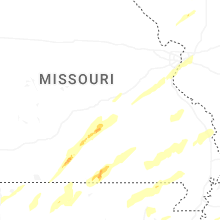


Connect with Interactive Hail Maps