

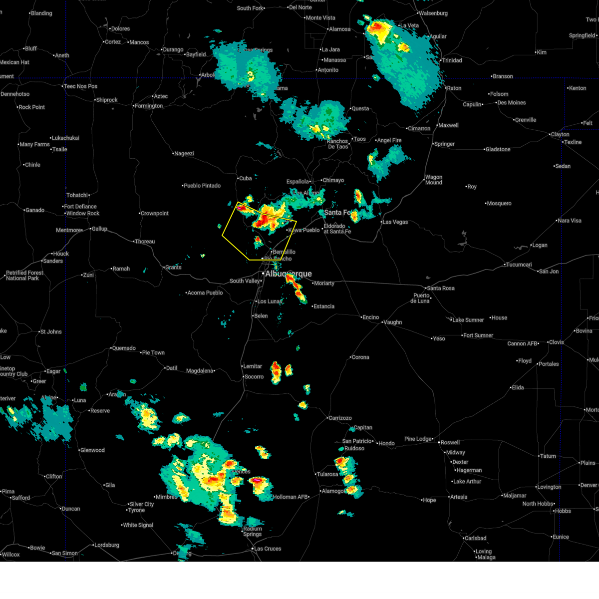
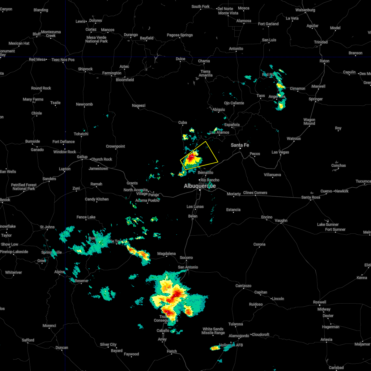
Hail Map for San Ysidro, NM
The San Ysidro, NM area has had 1 report of on-the-ground hail by trained spotters, and has been under severe weather warnings 7 times during the past 12 months. Doppler radar has detected hail at or near San Ysidro, NM on 47 occasions, including 3 occasions during the past year.
| Name: | San Ysidro, NM |
| Where Located: | 45.5 miles NNW of El Paso, TX |
| Map: | Google Map for San Ysidro, NM |
| Population: | 2090 |
| Housing Units: | 833 |
| More Info: | Search Google for San Ysidro, NM |
0
The Top Recent Hail Date for San Ysidro, NM is Sunday, July 13, 2025 (47th out of 47)
Hail and Wind Damage Spotted near San Ysidro, NM
| Date / Time | Report Details |
|---|---|
| 7/13/2025 4:13 PM MDT |
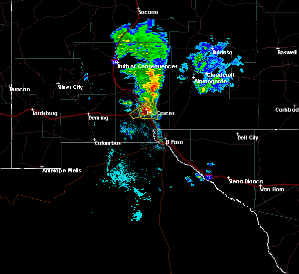
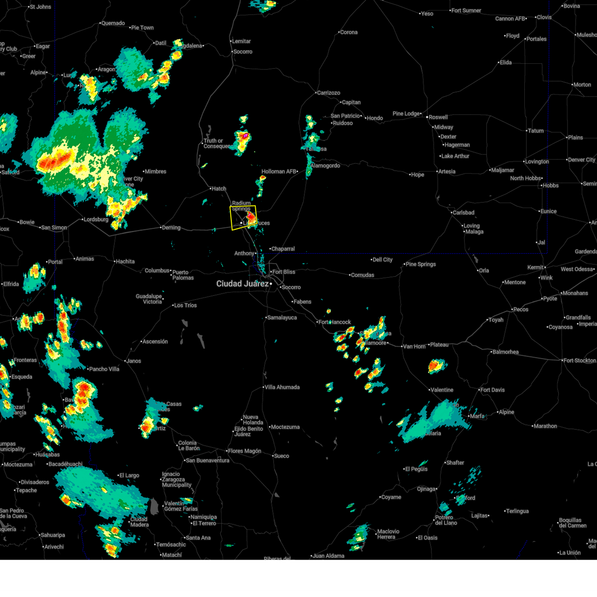 Svrepz the national weather service in el paso has issued a * severe thunderstorm warning for, central dona ana county in south central new mexico, * until 500 pm mdt. * at 413 pm mdt, a severe thunderstorm was located 6 miles east of dona ana and las cruces, moving west at 10 mph (radar indicated). Hazards include 60 mph wind gusts and quarter size hail. Hail damage to vehicles is expected. Expect wind damage to roofs, siding, and trees. Svrepz the national weather service in el paso has issued a * severe thunderstorm warning for, central dona ana county in south central new mexico, * until 500 pm mdt. * at 413 pm mdt, a severe thunderstorm was located 6 miles east of dona ana and las cruces, moving west at 10 mph (radar indicated). Hazards include 60 mph wind gusts and quarter size hail. Hail damage to vehicles is expected. Expect wind damage to roofs, siding, and trees.
|
| 7/12/2025 6:12 PM MDT |
 The storms which prompted the warning have weakened below severe limits, and no longer pose an immediate threat to life or property. therefore, the warning will be allowed to expire. however, small hail and gusty winds are still possible with these thunderstorms. The storms which prompted the warning have weakened below severe limits, and no longer pose an immediate threat to life or property. therefore, the warning will be allowed to expire. however, small hail and gusty winds are still possible with these thunderstorms.
|
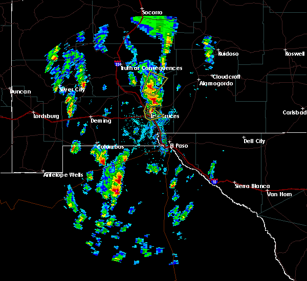
| 7/12/2025 6:03 PM MDT |
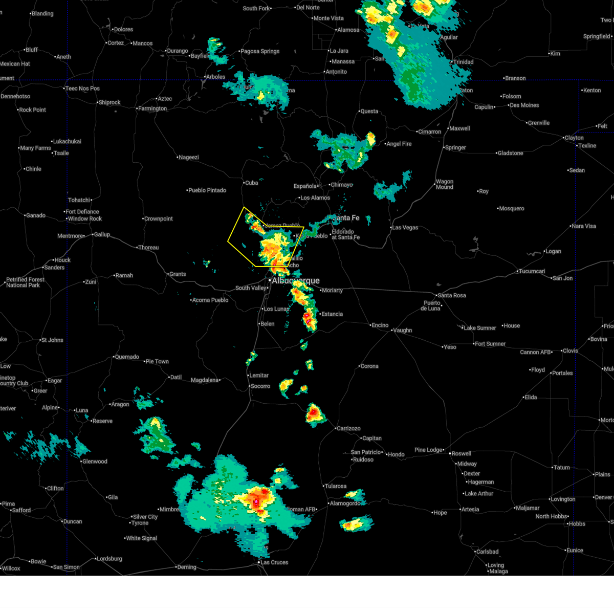
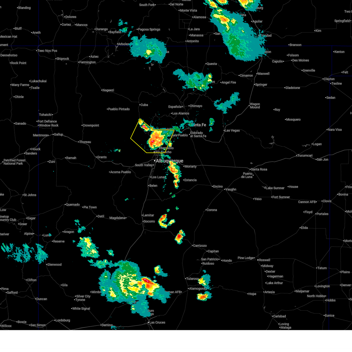 At 603 pm mdt, severe thunderstorms were located along a line from near san felipe pueblo to 14 miles northwest of torreon, moving south at 15 mph (radar indicated). Hazards include 60 mph wind gusts and small hail. Expect damage to roofs, siding, and trees. locations impacted include, rio rancho, bernalillo, corrales, santo domingo pueblo, san ysidro, zia pueblo, mariposa, jemez pueblo, northern meadows and rio rancho city center. this includes the following highways, highway 550 between mile markers 1 and 46. Interstate 25 between mile markers 236 and 258. At 603 pm mdt, severe thunderstorms were located along a line from near san felipe pueblo to 14 miles northwest of torreon, moving south at 15 mph (radar indicated). Hazards include 60 mph wind gusts and small hail. Expect damage to roofs, siding, and trees. locations impacted include, rio rancho, bernalillo, corrales, santo domingo pueblo, san ysidro, zia pueblo, mariposa, jemez pueblo, northern meadows and rio rancho city center. this includes the following highways, highway 550 between mile markers 1 and 46. Interstate 25 between mile markers 236 and 258.
|
| 7/12/2025 5:32 PM MDT |
 Svrabq the national weather service in albuquerque has issued a * severe thunderstorm warning for, southeastern sandoval county in north central new mexico, * until 615 pm mdt. * at 532 pm mdt, severe thunderstorms were located along a line from near santo domingo pueblo to 14 miles southeast of torreon navajo mission, moving south at 15 mph (radar indicated). Hazards include 60 mph wind gusts and quarter size hail. Hail damage to vehicles is expected. Expect wind damage to roofs, siding, and trees. Svrabq the national weather service in albuquerque has issued a * severe thunderstorm warning for, southeastern sandoval county in north central new mexico, * until 615 pm mdt. * at 532 pm mdt, severe thunderstorms were located along a line from near santo domingo pueblo to 14 miles southeast of torreon navajo mission, moving south at 15 mph (radar indicated). Hazards include 60 mph wind gusts and quarter size hail. Hail damage to vehicles is expected. Expect wind damage to roofs, siding, and trees.
|
| 7/21/2024 6:30 PM MDT |
 At 629 pm mdt, severe thunderstorms were located along a line extending from 10 miles northwest of jemez pueblo to near torreon to 8 miles southeast of marquez, moving southeast at 40 mph (radar indicated). Hazards include 60 mph wind gusts. Expect damage to roofs, siding, and trees. locations impacted include, northwestern albuquerque, rio rancho, san ysidro, mesita, northern meadows, mariposa, zia pueblo, rio rancho city center, jemez pueblo, and tohajiilee. this includes the following highways, interstate 40 between mile markers 116 and 146. Highway 550 between mile markers 5 and 45. At 629 pm mdt, severe thunderstorms were located along a line extending from 10 miles northwest of jemez pueblo to near torreon to 8 miles southeast of marquez, moving southeast at 40 mph (radar indicated). Hazards include 60 mph wind gusts. Expect damage to roofs, siding, and trees. locations impacted include, northwestern albuquerque, rio rancho, san ysidro, mesita, northern meadows, mariposa, zia pueblo, rio rancho city center, jemez pueblo, and tohajiilee. this includes the following highways, interstate 40 between mile markers 116 and 146. Highway 550 between mile markers 5 and 45.
|
| 7/21/2024 6:30 PM MDT |
 the severe thunderstorm warning has been cancelled and is no longer in effect the severe thunderstorm warning has been cancelled and is no longer in effect
|
| 7/21/2024 6:12 PM MDT |
 Svrabq the national weather service in albuquerque has issued a * severe thunderstorm warning for, northeastern cibola county in west central new mexico, east central mckinley county in west central new mexico, northwestern valencia county in central new mexico, south central sandoval county in north central new mexico, bernalillo county in central new mexico, * until 700 pm mdt. * at 612 pm mdt, severe thunderstorms were located along a line extending from 12 miles southwest of fenton lake state park to 9 miles northwest of torreon to marquez, moving south at 45 mph (radar indicated). Hazards include 60 mph wind gusts. expect damage to roofs, siding, and trees Svrabq the national weather service in albuquerque has issued a * severe thunderstorm warning for, northeastern cibola county in west central new mexico, east central mckinley county in west central new mexico, northwestern valencia county in central new mexico, south central sandoval county in north central new mexico, bernalillo county in central new mexico, * until 700 pm mdt. * at 612 pm mdt, severe thunderstorms were located along a line extending from 12 miles southwest of fenton lake state park to 9 miles northwest of torreon to marquez, moving south at 45 mph (radar indicated). Hazards include 60 mph wind gusts. expect damage to roofs, siding, and trees
|
| 7/8/2024 5:08 PM MDT |
 The storm which prompted the warning has weakened below severe limits, and no longer poses an immediate threat to life or property. therefore, the warning will be allowed to expire. however, small hail is still possible with this thunderstorm. The storm which prompted the warning has weakened below severe limits, and no longer poses an immediate threat to life or property. therefore, the warning will be allowed to expire. however, small hail is still possible with this thunderstorm.
|
| 7/8/2024 4:58 PM MDT |
 At 458 pm mdt, a severe thunderstorm was located over san ysidro, or 19 miles north of rio rancho, moving south at 20 mph (radar indicated). Hazards include 60 mph wind gusts and half dollar size hail. Hail damage to vehicles is expected. expect wind damage to roofs, siding, and trees. locations impacted include, san ysidro, zia pueblo, jemez pueblo, canon, and ponderosa. This includes highway 550 between mile markers 9 and 37. At 458 pm mdt, a severe thunderstorm was located over san ysidro, or 19 miles north of rio rancho, moving south at 20 mph (radar indicated). Hazards include 60 mph wind gusts and half dollar size hail. Hail damage to vehicles is expected. expect wind damage to roofs, siding, and trees. locations impacted include, san ysidro, zia pueblo, jemez pueblo, canon, and ponderosa. This includes highway 550 between mile markers 9 and 37.
|
| 7/8/2024 4:40 PM MDT |
 Svrabq the national weather service in albuquerque has issued a * severe thunderstorm warning for, south central sandoval county in north central new mexico, * until 515 pm mdt. * at 440 pm mdt, a severe thunderstorm was located near jemez pueblo, or 25 miles north of rio rancho, moving south at 20 mph (radar indicated). Hazards include 60 mph wind gusts and half dollar size hail. Hail damage to vehicles is expected. Expect wind damage to roofs, siding, and trees. Svrabq the national weather service in albuquerque has issued a * severe thunderstorm warning for, south central sandoval county in north central new mexico, * until 515 pm mdt. * at 440 pm mdt, a severe thunderstorm was located near jemez pueblo, or 25 miles north of rio rancho, moving south at 20 mph (radar indicated). Hazards include 60 mph wind gusts and half dollar size hail. Hail damage to vehicles is expected. Expect wind damage to roofs, siding, and trees.
|
| 6/29/2024 9:32 PM MDT |
 The warning has been allowed to expire. however, heavy rain and flash flooding is still possible with this thunderstorm. The warning has been allowed to expire. however, heavy rain and flash flooding is still possible with this thunderstorm.
|
| 6/29/2024 9:31 PM MDT |
 The warning has been allowed to expire. however, heavy rain and flash flooding is still possible with this thunderstorm. The warning has been allowed to expire. however, heavy rain and flash flooding is still possible with this thunderstorm.
|
| 6/29/2024 9:00 PM MDT |
 Svrabq the national weather service in albuquerque has issued a * severe thunderstorm warning for, southeastern sandoval county in north central new mexico, bernalillo county in central new mexico, * until 930 pm mdt. * at 859 pm mdt, a severe thunderstorm was located over southern rio rancho, moving north at 15 mph (radar indicated). Hazards include 60 mph wind gusts and penny size hail. expect damage to roofs, siding, and trees Svrabq the national weather service in albuquerque has issued a * severe thunderstorm warning for, southeastern sandoval county in north central new mexico, bernalillo county in central new mexico, * until 930 pm mdt. * at 859 pm mdt, a severe thunderstorm was located over southern rio rancho, moving north at 15 mph (radar indicated). Hazards include 60 mph wind gusts and penny size hail. expect damage to roofs, siding, and trees
|
| 6/29/2024 3:59 PM MDT |
 The storm which prompted the warning has weakened below severe limits, and no longer poses an immediate threat to life or property. therefore, the warning will be allowed to expire. however, heavy rain is still possible with this thunderstorm. The storm which prompted the warning has weakened below severe limits, and no longer poses an immediate threat to life or property. therefore, the warning will be allowed to expire. however, heavy rain is still possible with this thunderstorm.
|
| 6/29/2024 3:36 PM MDT |
 Svrepz the national weather service in el paso has issued a * severe thunderstorm warning for, central dona ana county in south central new mexico, * until 400 pm mdt. * at 335 pm mdt, a severe thunderstorm was located over dona ana, moving north at 15 mph (radar indicated). Hazards include 60 mph wind gusts and half dollar size hail. Hail damage to vehicles is expected. Expect wind damage to roofs, siding, and trees. Svrepz the national weather service in el paso has issued a * severe thunderstorm warning for, central dona ana county in south central new mexico, * until 400 pm mdt. * at 335 pm mdt, a severe thunderstorm was located over dona ana, moving north at 15 mph (radar indicated). Hazards include 60 mph wind gusts and half dollar size hail. Hail damage to vehicles is expected. Expect wind damage to roofs, siding, and trees.
|
| 5/11/2024 1:15 PM MDT |
 Svrabq the national weather service in albuquerque has issued a * severe thunderstorm warning for, east central sandoval county in north central new mexico, * until 215 pm mdt. * at 114 pm mdt, a severe thunderstorm was located over zia pueblo, or 17 miles north of rio rancho, moving northeast at 20 mph (radar indicated). Hazards include 60 mph wind gusts and quarter size hail. Hail damage to vehicles is expected. Expect wind damage to roofs, siding, and trees. Svrabq the national weather service in albuquerque has issued a * severe thunderstorm warning for, east central sandoval county in north central new mexico, * until 215 pm mdt. * at 114 pm mdt, a severe thunderstorm was located over zia pueblo, or 17 miles north of rio rancho, moving northeast at 20 mph (radar indicated). Hazards include 60 mph wind gusts and quarter size hail. Hail damage to vehicles is expected. Expect wind damage to roofs, siding, and trees.
|
| 5/11/2024 12:53 PM MDT |
 the severe thunderstorm warning has been cancelled and is no longer in effect the severe thunderstorm warning has been cancelled and is no longer in effect
|
| 5/11/2024 12:32 PM MDT |
 Svrabq the national weather service in albuquerque has issued a * severe thunderstorm warning for, south central sandoval county in north central new mexico, * until 130 pm mdt. * at 1232 pm mdt, a severe thunderstorm was located 10 miles northeast of marquez, or 27 miles northeast of laguna pueblo, moving northeast at 25 mph (radar indicated). Hazards include 60 mph wind gusts and quarter size hail. Hail damage to vehicles is expected. Expect wind damage to roofs, siding, and trees. Svrabq the national weather service in albuquerque has issued a * severe thunderstorm warning for, south central sandoval county in north central new mexico, * until 130 pm mdt. * at 1232 pm mdt, a severe thunderstorm was located 10 miles northeast of marquez, or 27 miles northeast of laguna pueblo, moving northeast at 25 mph (radar indicated). Hazards include 60 mph wind gusts and quarter size hail. Hail damage to vehicles is expected. Expect wind damage to roofs, siding, and trees.
|
| 10/2/2023 5:35 PM MDT |
 At 532 pm mdt, a severe thunderstorm was located near san miguel, moving northeast at 30 mph (radar indicated). Hazards include 60 mph wind gusts. expect damage to roofs, siding, and trees At 532 pm mdt, a severe thunderstorm was located near san miguel, moving northeast at 30 mph (radar indicated). Hazards include 60 mph wind gusts. expect damage to roofs, siding, and trees
|
| 6/6/2023 6:35 PM MDT |
 The severe thunderstorm warning for west central dona ana county will expire at 645 pm mdt, the storm which prompted the warning has weakened below severe limits, and no longer poses an immediate threat to life or property. therefore, the warning will be allowed to expire. however heavy rain is still possible with this thunderstorm. The severe thunderstorm warning for west central dona ana county will expire at 645 pm mdt, the storm which prompted the warning has weakened below severe limits, and no longer poses an immediate threat to life or property. therefore, the warning will be allowed to expire. however heavy rain is still possible with this thunderstorm.
|
| 6/6/2023 6:27 PM MDT |
 At 627 pm mdt, a severe thunderstorm was located 6 miles southwest of radium springs, moving northeast at 20 mph (radar indicated). Hazards include 60 mph wind gusts and half dollar size hail. Hail damage to vehicles is expected. expect wind damage to roofs, siding, and trees. this severe thunderstorm will remain over mainly rural areas of west central dona ana county. hail threat, radar indicated max hail size, 1. 25 in wind threat, radar indicated max wind gust, 60 mph. At 627 pm mdt, a severe thunderstorm was located 6 miles southwest of radium springs, moving northeast at 20 mph (radar indicated). Hazards include 60 mph wind gusts and half dollar size hail. Hail damage to vehicles is expected. expect wind damage to roofs, siding, and trees. this severe thunderstorm will remain over mainly rural areas of west central dona ana county. hail threat, radar indicated max hail size, 1. 25 in wind threat, radar indicated max wind gust, 60 mph.
|
| 6/6/2023 6:05 PM MDT |
 At 605 pm mdt, a severe thunderstorm was located 5 miles northeast of las cruces, moving northeast at 20 mph (radar indicated). Hazards include 60 mph wind gusts and quarter size hail. Hail damage to vehicles is expected. Expect wind damage to roofs, siding, and trees. At 605 pm mdt, a severe thunderstorm was located 5 miles northeast of las cruces, moving northeast at 20 mph (radar indicated). Hazards include 60 mph wind gusts and quarter size hail. Hail damage to vehicles is expected. Expect wind damage to roofs, siding, and trees.
|
| 6/6/2023 5:55 PM MDT |
 At 555 pm mdt, a severe thunderstorm was located 14 miles west of fairacres, moving northeast at 20 mph (radar indicated). Hazards include 60 mph wind gusts and half dollar size hail. Hail damage to vehicles is expected. Expect wind damage to roofs, siding, and trees. At 555 pm mdt, a severe thunderstorm was located 14 miles west of fairacres, moving northeast at 20 mph (radar indicated). Hazards include 60 mph wind gusts and half dollar size hail. Hail damage to vehicles is expected. Expect wind damage to roofs, siding, and trees.
|
| 6/6/2023 5:36 PM MDT |
 At 535 pm mdt, severe thunderstorms were located along a line extending from 10 miles south of afton to 10 miles southwest of la union to 4 miles west of santa teresa to near west el paso, moving north at 45 mph (radar indicated). Hazards include 70 mph wind gusts with dust blow visibility of 1/4 mile. Expect considerable tree damage. damage is likely to mobile homes, roofs, and outbuildings. locations impacted include, west el paso, central el paso, northeast el paso, chaparral, las cruces, santa teresa, anthony, vado, sunland park, nmsu main campus, dona ana, canutillo, afton, anthony gap, berino, vinton, mesilla, san miguel, westway and fort bliss. this includes the following highways, interstate 10 in new mexico between mile markers 129 and 164. interstate 10 in texas between mile markers 1 and 23. interstate 25 in new mexico between mile markers 1 and 11. highway 70 in new mexico between mile markers 150 and 153. highway 54 in new mexico near mile marker 1. thunderstorm damage threat, considerable hail threat, radar indicated max hail size, <. 75 in wind threat, radar indicated max wind gust, 70 mph. At 535 pm mdt, severe thunderstorms were located along a line extending from 10 miles south of afton to 10 miles southwest of la union to 4 miles west of santa teresa to near west el paso, moving north at 45 mph (radar indicated). Hazards include 70 mph wind gusts with dust blow visibility of 1/4 mile. Expect considerable tree damage. damage is likely to mobile homes, roofs, and outbuildings. locations impacted include, west el paso, central el paso, northeast el paso, chaparral, las cruces, santa teresa, anthony, vado, sunland park, nmsu main campus, dona ana, canutillo, afton, anthony gap, berino, vinton, mesilla, san miguel, westway and fort bliss. this includes the following highways, interstate 10 in new mexico between mile markers 129 and 164. interstate 10 in texas between mile markers 1 and 23. interstate 25 in new mexico between mile markers 1 and 11. highway 70 in new mexico between mile markers 150 and 153. highway 54 in new mexico near mile marker 1. thunderstorm damage threat, considerable hail threat, radar indicated max hail size, <. 75 in wind threat, radar indicated max wind gust, 70 mph.
|
| 6/6/2023 5:22 PM MDT |
 At 520 pm mdt, strong thunderstorms with very strong outflow winds were located along a line extending from 17 miles south of afton to 16 miles southwest of la union to 8 miles southwest of santa teresa to 5 miles south of sunland park, moving north at 45 mph (radar indicated). Hazards include 70 mph wind gusts. Expect considerable tree damage. Damage is likely to mobile homes, roofs, and outbuildings. At 520 pm mdt, strong thunderstorms with very strong outflow winds were located along a line extending from 17 miles south of afton to 16 miles southwest of la union to 8 miles southwest of santa teresa to 5 miles south of sunland park, moving north at 45 mph (radar indicated). Hazards include 70 mph wind gusts. Expect considerable tree damage. Damage is likely to mobile homes, roofs, and outbuildings.
|
| 6/8/2022 4:52 PM MDT |
 The severe thunderstorm warning for southeastern sandoval county will expire at 500 pm mdt, the storm which prompted the warning has weakened below severe limits, and no longer poses an immediate threat to life or property. therefore, the warning will be allowed to expire. however gusty winds and heavy rain are still possible with this thunderstorm. The severe thunderstorm warning for southeastern sandoval county will expire at 500 pm mdt, the storm which prompted the warning has weakened below severe limits, and no longer poses an immediate threat to life or property. therefore, the warning will be allowed to expire. however gusty winds and heavy rain are still possible with this thunderstorm.
|
| 6/8/2022 4:31 PM MDT |
 At 431 pm mdt, a severe thunderstorm was located over zia pueblo, or 17 miles northwest of bernalillo, moving northeast at 35 mph (radar indicated). Hazards include 60 mph wind gusts and quarter size hail. Hail damage to vehicles is expected. expect wind damage to roofs, siding, and trees. locations impacted include, santo domingo pueblo, san ysidro, zia pueblo, kewa pueblo, jemez pueblo and ponderosa. this includes highway 550 between mile markers 12 and 32. hail threat, radar indicated max hail size, 1. 00 in wind threat, radar indicated max wind gust, 60 mph. At 431 pm mdt, a severe thunderstorm was located over zia pueblo, or 17 miles northwest of bernalillo, moving northeast at 35 mph (radar indicated). Hazards include 60 mph wind gusts and quarter size hail. Hail damage to vehicles is expected. expect wind damage to roofs, siding, and trees. locations impacted include, santo domingo pueblo, san ysidro, zia pueblo, kewa pueblo, jemez pueblo and ponderosa. this includes highway 550 between mile markers 12 and 32. hail threat, radar indicated max hail size, 1. 00 in wind threat, radar indicated max wind gust, 60 mph.
|
| 6/8/2022 4:28 PM MDT | Quarter sized hail reported 1 miles NE of San Ysidro, NM, from speedway gas station employee. |
| 6/8/2022 4:09 PM MDT |
 At 408 pm mdt, a severe thunderstorm was located 12 miles southwest of san ysidro, or 19 miles northwest of rio rancho, moving northeast at 35 mph (radar indicated). Hazards include 60 mph wind gusts and half dollar size hail. Hail damage to vehicles is expected. Expect wind damage to roofs, siding, and trees. At 408 pm mdt, a severe thunderstorm was located 12 miles southwest of san ysidro, or 19 miles northwest of rio rancho, moving northeast at 35 mph (radar indicated). Hazards include 60 mph wind gusts and half dollar size hail. Hail damage to vehicles is expected. Expect wind damage to roofs, siding, and trees.
|
| 9/26/2021 4:43 PM MDT |
 The severe thunderstorm warning for west central dona ana county will expire at 445 pm mdt, the storm which prompted the warning has moved out of the area. therefore, the warning will be allowed to expire. The severe thunderstorm warning for west central dona ana county will expire at 445 pm mdt, the storm which prompted the warning has moved out of the area. therefore, the warning will be allowed to expire.
|
| 9/26/2021 4:10 PM MDT |
 At 409 pm mdt, a severe thunderstorm was located 4 miles west of radium springs, moving northeast at 35 mph (radar indicated). Hazards include golf ball size hail and 60 mph wind gusts. People and animals outdoors will be injured. expect hail damage to roofs, siding, windows, and vehicles. expect wind damage to roofs, siding, and trees. locations impacted include, leasburg, rincon, las cruces, radium springs, dona ana, east mesa, portions of jornada experimental range, hill, northeast las cruces, corralitos, fort selden state historic site and leasburg dam state park. this includes the following highways, interstate 25 in new mexico near mile marker 1, and between mile markers 7 and 34. highway 70 in new mexico between mile markers 153 and 157. thunderstorm damage threat, considerable hail threat, radar indicated max hail size, 1. 75 in wind threat, radar indicated max wind gust, 60 mph. At 409 pm mdt, a severe thunderstorm was located 4 miles west of radium springs, moving northeast at 35 mph (radar indicated). Hazards include golf ball size hail and 60 mph wind gusts. People and animals outdoors will be injured. expect hail damage to roofs, siding, windows, and vehicles. expect wind damage to roofs, siding, and trees. locations impacted include, leasburg, rincon, las cruces, radium springs, dona ana, east mesa, portions of jornada experimental range, hill, northeast las cruces, corralitos, fort selden state historic site and leasburg dam state park. this includes the following highways, interstate 25 in new mexico near mile marker 1, and between mile markers 7 and 34. highway 70 in new mexico between mile markers 153 and 157. thunderstorm damage threat, considerable hail threat, radar indicated max hail size, 1. 75 in wind threat, radar indicated max wind gust, 60 mph.
|
| 9/26/2021 3:54 PM MDT |
 At 354 pm mdt, a severe thunderstorm was located 14 miles southwest of radium springs, moving northeast at 35 mph (radar indicated). Hazards include 60 mph wind gusts and quarter size hail. Hail damage to vehicles is expected. Expect wind damage to roofs, siding, and trees. At 354 pm mdt, a severe thunderstorm was located 14 miles southwest of radium springs, moving northeast at 35 mph (radar indicated). Hazards include 60 mph wind gusts and quarter size hail. Hail damage to vehicles is expected. Expect wind damage to roofs, siding, and trees.
|
| 7/23/2021 3:26 PM MDT |
 At 326 pm mdt, a severe thunderstorm was located over fairacres, moving east at 15 mph (radar indicated). Hazards include 60 mph wind gusts and quarter size hail. Hail damage to vehicles is expected. Expect wind damage to roofs, siding, and trees. At 326 pm mdt, a severe thunderstorm was located over fairacres, moving east at 15 mph (radar indicated). Hazards include 60 mph wind gusts and quarter size hail. Hail damage to vehicles is expected. Expect wind damage to roofs, siding, and trees.
|
| 7/11/2021 7:14 PM MDT |
 At 713 pm mdt, severe thunderstorms were located along a line extending from 3 miles northeast of nmsu main campus to 6 miles southeast of talavera to 10 miles southwest of orogrande, moving south at 25 mph (radar indicated). Hazards include 70 mph wind gusts and ping pong ball size hail. near zero visibilities have been reported around las cruces ahead of the rain. People and animals outdoors will be injured. expect hail damage to roofs, siding, windows, and vehicles. expect considerable tree damage. wind damage is also likely to mobile homes, roofs, and outbuildings. locations impacted include, chaparral, las cruces, vado, anthony, white sands missile range headquarters, nmsu main campus, dona ana, berino, mesilla, san miguel, mesquite, chamberino, fairacres, mcgregor range base, talavera, la mesa, afton generating plant, high valley, east mesa and san pablo. this includes the following highways, interstate 10 in new mexico between mile markers 138 and 162. interstate 25 in new mexico between mile markers 1 and 10. highway 70 in new mexico between mile markers 150 and 154. Highway 54 in new mexico between mile markers 3 and 19. At 713 pm mdt, severe thunderstorms were located along a line extending from 3 miles northeast of nmsu main campus to 6 miles southeast of talavera to 10 miles southwest of orogrande, moving south at 25 mph (radar indicated). Hazards include 70 mph wind gusts and ping pong ball size hail. near zero visibilities have been reported around las cruces ahead of the rain. People and animals outdoors will be injured. expect hail damage to roofs, siding, windows, and vehicles. expect considerable tree damage. wind damage is also likely to mobile homes, roofs, and outbuildings. locations impacted include, chaparral, las cruces, vado, anthony, white sands missile range headquarters, nmsu main campus, dona ana, berino, mesilla, san miguel, mesquite, chamberino, fairacres, mcgregor range base, talavera, la mesa, afton generating plant, high valley, east mesa and san pablo. this includes the following highways, interstate 10 in new mexico between mile markers 138 and 162. interstate 25 in new mexico between mile markers 1 and 10. highway 70 in new mexico between mile markers 150 and 154. Highway 54 in new mexico between mile markers 3 and 19.
|
| 7/11/2021 7:00 PM MDT |
 At 700 pm mdt, severe thunderstorms were located along a line extending from 6 miles west of organ to 4 miles southwest of white sands missile range headquarters to 10 miles west of orogrande, moving south at 25 mph (radar indicated). Hazards include 70 mph wind gusts and ping pong ball size hail. People and animals outdoors will be injured. expect hail damage to roofs, siding, windows, and vehicles. expect considerable tree damage. Wind damage is also likely to mobile homes, roofs, and outbuildings. At 700 pm mdt, severe thunderstorms were located along a line extending from 6 miles west of organ to 4 miles southwest of white sands missile range headquarters to 10 miles west of orogrande, moving south at 25 mph (radar indicated). Hazards include 70 mph wind gusts and ping pong ball size hail. People and animals outdoors will be injured. expect hail damage to roofs, siding, windows, and vehicles. expect considerable tree damage. Wind damage is also likely to mobile homes, roofs, and outbuildings.
|
| 7/10/2021 4:02 PM MDT |
 At 402 pm mdt, a severe thunderstorm was located near san ysidro, or 19 miles northwest of rio rancho, moving southwest at 15 mph (radar indicated). Hazards include ping pong ball size hail and 60 mph wind gusts. People and animals outdoors will be injured. expect hail damage to roofs, siding, windows, and vehicles. expect wind damage to roofs, siding, and trees. locations impacted include, northwestern rio rancho, san ysidro, northern meadows and zia pueblo. This includes highway 550 between mile markers 15 and 32. At 402 pm mdt, a severe thunderstorm was located near san ysidro, or 19 miles northwest of rio rancho, moving southwest at 15 mph (radar indicated). Hazards include ping pong ball size hail and 60 mph wind gusts. People and animals outdoors will be injured. expect hail damage to roofs, siding, windows, and vehicles. expect wind damage to roofs, siding, and trees. locations impacted include, northwestern rio rancho, san ysidro, northern meadows and zia pueblo. This includes highway 550 between mile markers 15 and 32.
|
| 7/10/2021 3:48 PM MDT |
 At 348 pm mdt, a severe thunderstorm was located over san ysidro, or 20 miles northwest of rio rancho, moving southwest at 15 mph (radar indicated). Hazards include 60 mph wind gusts and quarter size hail. Hail damage to vehicles is expected. Expect wind damage to roofs, siding, and trees. At 348 pm mdt, a severe thunderstorm was located over san ysidro, or 20 miles northwest of rio rancho, moving southwest at 15 mph (radar indicated). Hazards include 60 mph wind gusts and quarter size hail. Hail damage to vehicles is expected. Expect wind damage to roofs, siding, and trees.
|
| 5/31/2021 1:05 PM MDT |
 At 105 pm mdt, a severe thunderstorm was located near san ysidro, or 18 miles northwest of rio rancho, moving east at 10 mph (radar indicated). Hazards include 60 mph wind gusts and quarter size hail. Hail damage to vehicles is expected. Expect wind damage to roofs, siding, and trees. At 105 pm mdt, a severe thunderstorm was located near san ysidro, or 18 miles northwest of rio rancho, moving east at 10 mph (radar indicated). Hazards include 60 mph wind gusts and quarter size hail. Hail damage to vehicles is expected. Expect wind damage to roofs, siding, and trees.
|
| 3/18/2020 10:43 PM MDT |
 At 1041 pm mdt, severe thunderstorms were approaching the las cruces area and surrounding locations, moving northeast at 50 mph (radar indicated). Hazards include 60 mph wind gusts and penny size hail. expect damage to roofs, siding, and trees At 1041 pm mdt, severe thunderstorms were approaching the las cruces area and surrounding locations, moving northeast at 50 mph (radar indicated). Hazards include 60 mph wind gusts and penny size hail. expect damage to roofs, siding, and trees
|
| 6/4/2019 3:55 PM MDT |
 At 354 pm mdt, severe thunderstorms were located along a line extending from 4 miles northwest of chaparral to 5 miles west of afton, moving northeast at 25 mph (radar indicated). Hazards include 60 mph wind gusts and penny size hail. expect damage to roofs, siding, and trees At 354 pm mdt, severe thunderstorms were located along a line extending from 4 miles northwest of chaparral to 5 miles west of afton, moving northeast at 25 mph (radar indicated). Hazards include 60 mph wind gusts and penny size hail. expect damage to roofs, siding, and trees
|
| 6/4/2019 3:47 PM MDT |
 At 346 pm mdt, a severe thunderstorm was located 6 miles northeast of dona ana, moving northeast at 20 mph (radar indicated). Hazards include 60 mph wind gusts and quarter size hail. Hail damage to vehicles is expected. expect wind damage to roofs, siding, and trees. Locations impacted include, leasburg, las cruces, jornada range, dona ana, nmsu main campus, mesilla, fairacres, organ, east mesa, picacho, portions of jornada experimental range, hill, northeast las cruces, dripping springs, aguirre springs and portions of organ mountains desert peaks national monument. At 346 pm mdt, a severe thunderstorm was located 6 miles northeast of dona ana, moving northeast at 20 mph (radar indicated). Hazards include 60 mph wind gusts and quarter size hail. Hail damage to vehicles is expected. expect wind damage to roofs, siding, and trees. Locations impacted include, leasburg, las cruces, jornada range, dona ana, nmsu main campus, mesilla, fairacres, organ, east mesa, picacho, portions of jornada experimental range, hill, northeast las cruces, dripping springs, aguirre springs and portions of organ mountains desert peaks national monument.
|
| 6/4/2019 3:23 PM MDT |
 At 323 pm mdt, a severe thunderstorm was located near dona ana, moving northeast at 10 mph (radar indicated). Hazards include 60 mph wind gusts and quarter size hail. Hail damage to vehicles is expected. Expect wind damage to roofs, siding, and trees. At 323 pm mdt, a severe thunderstorm was located near dona ana, moving northeast at 10 mph (radar indicated). Hazards include 60 mph wind gusts and quarter size hail. Hail damage to vehicles is expected. Expect wind damage to roofs, siding, and trees.
|
| 10/31/2018 12:23 PM MDT |
 At 1220 pm mdt, a severe thunderstorm was located 17 miles northwest of las cruces, moving southeast at 20 mph (radar indicated). Hazards include 60 mph wind gusts and quarter size hail. Hail damage to vehicles is possible. Expect wind damage to roofs, siding, and trees. At 1220 pm mdt, a severe thunderstorm was located 17 miles northwest of las cruces, moving southeast at 20 mph (radar indicated). Hazards include 60 mph wind gusts and quarter size hail. Hail damage to vehicles is possible. Expect wind damage to roofs, siding, and trees.
|
| 7/31/2018 8:00 PM MDT |
 The national weather service in albuquerque has issued a * severe thunderstorm warning for. south central sandoval county in north central new mexico. bernalillo county in central new mexico. until 845 pm mdt. At 759 pm mdt, a severe thunderstorm was located over zia pueblo,. The national weather service in albuquerque has issued a * severe thunderstorm warning for. south central sandoval county in north central new mexico. bernalillo county in central new mexico. until 845 pm mdt. At 759 pm mdt, a severe thunderstorm was located over zia pueblo,.
|
| 7/31/2018 7:31 PM MDT |
 At 731 pm mdt, a severe thunderstorm was located near jemez pueblo, or 26 miles north of bernalillo, moving south at 20 mph (radar indicated). Hazards include golf ball size hail and 70 mph wind gusts. People and animals outdoors will be injured. expect hail damage to roofs, siding, windows, and vehicles. expect considerable tree damage. wind damage is also likely to mobile homes, roofs, and outbuildings. Locations impacted include, jemez springs, san ysidro, jemez state monument, jemez pueblo, ponderosa and zia pueblo. At 731 pm mdt, a severe thunderstorm was located near jemez pueblo, or 26 miles north of bernalillo, moving south at 20 mph (radar indicated). Hazards include golf ball size hail and 70 mph wind gusts. People and animals outdoors will be injured. expect hail damage to roofs, siding, windows, and vehicles. expect considerable tree damage. wind damage is also likely to mobile homes, roofs, and outbuildings. Locations impacted include, jemez springs, san ysidro, jemez state monument, jemez pueblo, ponderosa and zia pueblo.
|
| 7/31/2018 7:08 PM MDT |
 At 708 pm mdt, a severe thunderstorm was located over jemez springs, or 20 miles southwest of los alamos, moving south at 20 mph (radar indicated). Hazards include golf ball size hail and 70 mph wind gusts. People and animals outdoors will be injured. expect hail damage to roofs, siding, windows, and vehicles. expect considerable tree damage. Wind damage is also likely to mobile homes, roofs, and outbuildings. At 708 pm mdt, a severe thunderstorm was located over jemez springs, or 20 miles southwest of los alamos, moving south at 20 mph (radar indicated). Hazards include golf ball size hail and 70 mph wind gusts. People and animals outdoors will be injured. expect hail damage to roofs, siding, windows, and vehicles. expect considerable tree damage. Wind damage is also likely to mobile homes, roofs, and outbuildings.
|
| 7/31/2018 6:52 PM MDT |
 At 652 pm mdt, a severe thunderstorm was located near jemez springs, or 22 miles southwest of los alamos, moving southwest at 30 mph (radar indicated). Hazards include two inch hail and 70 mph wind gusts. People and animals outdoors will be injured. expect hail damage to roofs, siding, windows, and vehicles. expect considerable tree damage. wind damage is also likely to mobile homes, roofs, and outbuildings. Locations impacted include, jemez springs, san ysidro, zia pueblo, jemez state monument, jemez pueblo and ponderosa. At 652 pm mdt, a severe thunderstorm was located near jemez springs, or 22 miles southwest of los alamos, moving southwest at 30 mph (radar indicated). Hazards include two inch hail and 70 mph wind gusts. People and animals outdoors will be injured. expect hail damage to roofs, siding, windows, and vehicles. expect considerable tree damage. wind damage is also likely to mobile homes, roofs, and outbuildings. Locations impacted include, jemez springs, san ysidro, zia pueblo, jemez state monument, jemez pueblo and ponderosa.
|
| 7/31/2018 6:29 PM MDT |
 The national weather service in albuquerque has issued a * severe thunderstorm warning for. east central sandoval county in north central new mexico. until 715 pm mdt. At 629 pm mdt, a severe thunderstorm was located 8 miles east of fenton lake state park, or 15 miles west of los alamos, moving. The national weather service in albuquerque has issued a * severe thunderstorm warning for. east central sandoval county in north central new mexico. until 715 pm mdt. At 629 pm mdt, a severe thunderstorm was located 8 miles east of fenton lake state park, or 15 miles west of los alamos, moving.
|
| 5/21/2018 3:22 PM MDT |
 At 322 pm mdt, severe thunderstorms were located along a line extending from near jemez pueblo to near la bajada, moving northeast at 35 mph (radar indicated). Hazards include 70 mph wind gusts and quarter size hail. Hail damage to vehicles is expected. expect considerable tree damage. wind damage is also likely to mobile homes, roofs, and outbuildings. locations impacted include, santo domingo pueblo, jemez springs, san ysidro, san felipe pueblo, kewa pueblo, cochiti pueblo, la bajada, jemez pueblo, zia pueblo and jemez state monument. This includes interstate 25 between mile markers 249 and 273. At 322 pm mdt, severe thunderstorms were located along a line extending from near jemez pueblo to near la bajada, moving northeast at 35 mph (radar indicated). Hazards include 70 mph wind gusts and quarter size hail. Hail damage to vehicles is expected. expect considerable tree damage. wind damage is also likely to mobile homes, roofs, and outbuildings. locations impacted include, santo domingo pueblo, jemez springs, san ysidro, san felipe pueblo, kewa pueblo, cochiti pueblo, la bajada, jemez pueblo, zia pueblo and jemez state monument. This includes interstate 25 between mile markers 249 and 273.
|
| 5/21/2018 3:05 PM MDT |
 At 304 pm mdt, severe thunderstorms were located along a line extending from 7 miles west of san ysidro to 7 miles northwest of golden, moving north at 40 mph (radar indicated). Hazards include 70 mph wind gusts and quarter size hail. Hail damage to vehicles is expected. expect considerable tree damage. wind damage is also likely to mobile homes, roofs, and outbuildings. locations impacted include, rio rancho, bernalillo, santo domingo pueblo, jemez springs, san ysidro, mariposa, san felipe pueblo, coronado state monument, jemez pueblo and santa ana pueblo. This includes interstate 25 between mile markers 239 and 273. At 304 pm mdt, severe thunderstorms were located along a line extending from 7 miles west of san ysidro to 7 miles northwest of golden, moving north at 40 mph (radar indicated). Hazards include 70 mph wind gusts and quarter size hail. Hail damage to vehicles is expected. expect considerable tree damage. wind damage is also likely to mobile homes, roofs, and outbuildings. locations impacted include, rio rancho, bernalillo, santo domingo pueblo, jemez springs, san ysidro, mariposa, san felipe pueblo, coronado state monument, jemez pueblo and santa ana pueblo. This includes interstate 25 between mile markers 239 and 273.
|
| 5/21/2018 2:44 PM MDT |
 At 243 pm mdt, severe thunderstorms were located along a line extending from 12 miles northeast of marquez to sandia park, moving north at 35 mph (radar indicated). Hazards include 60 mph wind gusts and quarter size hail. Hail damage to vehicles is expected. Expect wind damage to roofs, siding, and trees. At 243 pm mdt, severe thunderstorms were located along a line extending from 12 miles northeast of marquez to sandia park, moving north at 35 mph (radar indicated). Hazards include 60 mph wind gusts and quarter size hail. Hail damage to vehicles is expected. Expect wind damage to roofs, siding, and trees.
|
| 10/5/2017 3:25 PM MDT |
 At 324 pm mdt, a severe thunderstorm was located near san ysidro, or 17 miles northwest of rio rancho, moving east at 30 mph (radar indicated). Hazards include 60 mph wind gusts and quarter size hail. Hail damage to vehicles is expected. Expect wind damage to roofs, siding, and trees. At 324 pm mdt, a severe thunderstorm was located near san ysidro, or 17 miles northwest of rio rancho, moving east at 30 mph (radar indicated). Hazards include 60 mph wind gusts and quarter size hail. Hail damage to vehicles is expected. Expect wind damage to roofs, siding, and trees.
|
| 9/30/2017 4:10 PM MDT |
 The severe thunderstorm warning for central sandoval county will expire at 415 pm mdt, the storm which prompted the warning has weakened below severe limits, and no longer poses an immediate threat to life or property. therefore the warning will be allowed to expire. however small hail, gusty winds and heavy rain are still possible with this thunderstorm. The severe thunderstorm warning for central sandoval county will expire at 415 pm mdt, the storm which prompted the warning has weakened below severe limits, and no longer poses an immediate threat to life or property. therefore the warning will be allowed to expire. however small hail, gusty winds and heavy rain are still possible with this thunderstorm.
|
| 9/30/2017 3:53 PM MDT |
 At 353 pm mdt, a severe thunderstorm was located near san ysidro, or 23 miles north of rio rancho, moving east at 20 mph (radar indicated). Hazards include 60 mph wind gusts and quarter size hail. Hail damage to vehicles is expected. expect wind damage to roofs, siding, and trees. Locations impacted include, jemez springs, san ysidro, zia pueblo, jemez state monument, jemez pueblo and ponderosa. At 353 pm mdt, a severe thunderstorm was located near san ysidro, or 23 miles north of rio rancho, moving east at 20 mph (radar indicated). Hazards include 60 mph wind gusts and quarter size hail. Hail damage to vehicles is expected. expect wind damage to roofs, siding, and trees. Locations impacted include, jemez springs, san ysidro, zia pueblo, jemez state monument, jemez pueblo and ponderosa.
|
| 9/30/2017 3:52 PM MDT |
 At 352 pm mdt, a severe thunderstorm was located near mariposa, or 11 miles north of rio rancho, moving east at 20 mph (radar indicated). Hazards include 60 mph wind gusts and quarter size hail. Hail damage to vehicles is expected. expect wind damage to roofs, siding, and trees. Locations impacted include, rio rancho, corrales, san ysidro, northern meadows, mariposa, zia pueblo and rio rancho city center. At 352 pm mdt, a severe thunderstorm was located near mariposa, or 11 miles north of rio rancho, moving east at 20 mph (radar indicated). Hazards include 60 mph wind gusts and quarter size hail. Hail damage to vehicles is expected. expect wind damage to roofs, siding, and trees. Locations impacted include, rio rancho, corrales, san ysidro, northern meadows, mariposa, zia pueblo and rio rancho city center.
|
| 9/30/2017 3:36 PM MDT |
 At 336 pm mdt, a severe thunderstorm was located near san ysidro, or 25 miles northwest of rio rancho, moving east at 20 mph (radar indicated). Hazards include 60 mph wind gusts and half dollar size hail. Hail damage to vehicles is expected. expect wind damage to roofs, siding, and trees. Locations impacted include, jemez springs, san ysidro, zia pueblo, jemez state monument, jemez pueblo and ponderosa. At 336 pm mdt, a severe thunderstorm was located near san ysidro, or 25 miles northwest of rio rancho, moving east at 20 mph (radar indicated). Hazards include 60 mph wind gusts and half dollar size hail. Hail damage to vehicles is expected. expect wind damage to roofs, siding, and trees. Locations impacted include, jemez springs, san ysidro, zia pueblo, jemez state monument, jemez pueblo and ponderosa.
|
| 9/30/2017 3:29 PM MDT |
 At 329 pm mdt, a severe thunderstorm was located 9 miles northwest of northern meadows, or 13 miles northwest of rio rancho, moving east at 20 mph (radar indicated). Hazards include 60 mph wind gusts and half dollar size hail. Hail damage to vehicles is expected. expect wind damage to roofs, siding, and trees. Locations impacted include, rio rancho, corrales, san ysidro, northern meadows, mariposa, zia pueblo and rio rancho city center. At 329 pm mdt, a severe thunderstorm was located 9 miles northwest of northern meadows, or 13 miles northwest of rio rancho, moving east at 20 mph (radar indicated). Hazards include 60 mph wind gusts and half dollar size hail. Hail damage to vehicles is expected. expect wind damage to roofs, siding, and trees. Locations impacted include, rio rancho, corrales, san ysidro, northern meadows, mariposa, zia pueblo and rio rancho city center.
|
| 9/30/2017 3:16 PM MDT |
 At 316 pm mdt, a severe thunderstorm was located 12 miles west of san ysidro, or 29 miles south of cuba, moving east at 20 mph (radar indicated). Hazards include 60 mph wind gusts and quarter size hail. Hail damage to vehicles is expected. Expect wind damage to roofs, siding, and trees. At 316 pm mdt, a severe thunderstorm was located 12 miles west of san ysidro, or 29 miles south of cuba, moving east at 20 mph (radar indicated). Hazards include 60 mph wind gusts and quarter size hail. Hail damage to vehicles is expected. Expect wind damage to roofs, siding, and trees.
|
| 9/30/2017 3:15 PM MDT |
 At 315 pm mdt, a severe thunderstorm was located 13 miles west of northern meadows, or 17 miles northwest of rio rancho, moving east at 20 mph (radar indicated). Hazards include 60 mph wind gusts and quarter size hail. Hail damage to vehicles is expected. Expect wind damage to roofs, siding, and trees. At 315 pm mdt, a severe thunderstorm was located 13 miles west of northern meadows, or 17 miles northwest of rio rancho, moving east at 20 mph (radar indicated). Hazards include 60 mph wind gusts and quarter size hail. Hail damage to vehicles is expected. Expect wind damage to roofs, siding, and trees.
|
| 8/13/2017 4:26 PM MDT |
 The severe thunderstorm warning for east central dona ana county will expire at 430 pm mdt, the storm which prompted the warning has weakened below severe limits, and no longer poses an immediate threat to life or property. therefore the warning will be allowed to expire. however gusty winds are still possible with this thunderstorm. The severe thunderstorm warning for east central dona ana county will expire at 430 pm mdt, the storm which prompted the warning has weakened below severe limits, and no longer poses an immediate threat to life or property. therefore the warning will be allowed to expire. however gusty winds are still possible with this thunderstorm.
|
| 8/13/2017 4:03 PM MDT |
 At 402 pm mdt, a severe thunderstorm was located near east mesa, or 7 miles northeast of las cruces, moving east at 20 mph (radar indicated). Hazards include 60 mph wind gusts and quarter size hail. Hail damage to vehicles is expected. expect wind damage to roofs, siding, and trees. Locations impacted include, east mesa, dona ana, organ, talavera, dripping springs, soledad canyon, aguirre springs and twin peaks. At 402 pm mdt, a severe thunderstorm was located near east mesa, or 7 miles northeast of las cruces, moving east at 20 mph (radar indicated). Hazards include 60 mph wind gusts and quarter size hail. Hail damage to vehicles is expected. expect wind damage to roofs, siding, and trees. Locations impacted include, east mesa, dona ana, organ, talavera, dripping springs, soledad canyon, aguirre springs and twin peaks.
|
| 8/13/2017 3:46 PM MDT |
 At 346 pm mdt, a severe thunderstorm was located over east mesa, or 4 miles north of las cruces, moving east at 20 mph (radar indicated). Hazards include quarter size hail. damage to vehicles is expected At 346 pm mdt, a severe thunderstorm was located over east mesa, or 4 miles north of las cruces, moving east at 20 mph (radar indicated). Hazards include quarter size hail. damage to vehicles is expected
|
| 7/1/2017 4:31 PM MDT |
 At 431 pm mdt, a severe thunderstorm was located 7 miles southwest of san ysidro, or 19 miles northwest of rio rancho, moving east at 25 mph (radar indicated). Hazards include 60 mph wind gusts and quarter size hail. Hail damage to vehicles is expected. expect wind damage to roofs, siding, and trees. Locations impacted include, san ysidro, zia pueblo, jemez pueblo and ponderosa. At 431 pm mdt, a severe thunderstorm was located 7 miles southwest of san ysidro, or 19 miles northwest of rio rancho, moving east at 25 mph (radar indicated). Hazards include 60 mph wind gusts and quarter size hail. Hail damage to vehicles is expected. expect wind damage to roofs, siding, and trees. Locations impacted include, san ysidro, zia pueblo, jemez pueblo and ponderosa.
|
| 7/1/2017 4:14 PM MDT |
 At 414 pm mdt, a severe thunderstorm was located 14 miles west of san ysidro, or 25 miles northwest of rio rancho, moving east at 20 mph (radar indicated). Hazards include 60 mph wind gusts and quarter size hail. Hail damage to vehicles is expected. Expect wind damage to roofs, siding, and trees. At 414 pm mdt, a severe thunderstorm was located 14 miles west of san ysidro, or 25 miles northwest of rio rancho, moving east at 20 mph (radar indicated). Hazards include 60 mph wind gusts and quarter size hail. Hail damage to vehicles is expected. Expect wind damage to roofs, siding, and trees.
|
| 1/14/2017 6:07 PM MST |
 At 606 pm mst, a severe thunderstorm was located over las cruces. moving northeast at 40 mph (public). Hazards include 60 mph wind gusts and quarter size hail. Hail damage to vehicles is expected. Expect wind damage to roofs, siding, and trees. At 606 pm mst, a severe thunderstorm was located over las cruces. moving northeast at 40 mph (public). Hazards include 60 mph wind gusts and quarter size hail. Hail damage to vehicles is expected. Expect wind damage to roofs, siding, and trees.
|
| 1/14/2017 5:37 PM MST |
 At 535 pm mst, a severe thunderstorm was located near afton moving northeast at 40 mph (radar indicated). Hazards include 60 mph wind gusts and quarter size hail. Hail damage to vehicles is expected. Expect wind damage to roofs, siding, and trees. At 535 pm mst, a severe thunderstorm was located near afton moving northeast at 40 mph (radar indicated). Hazards include 60 mph wind gusts and quarter size hail. Hail damage to vehicles is expected. Expect wind damage to roofs, siding, and trees.
|
| 11/4/2016 9:27 PM MDT |
 At 926 pm mdt, a severe thunderstorm was located over nmsu main campus, or near las cruces, moving east at 20 mph (radar indicated). Hazards include quarter size hail. damage to vehicles is expected At 926 pm mdt, a severe thunderstorm was located over nmsu main campus, or near las cruces, moving east at 20 mph (radar indicated). Hazards include quarter size hail. damage to vehicles is expected
|
| 11/4/2016 8:54 PM MDT |
 At 854 pm mdt, a severe thunderstorm was located 6 miles southwest of fairacres, or 10 miles west of las cruces, moving northeast at 40 mph (radar indicated). Hazards include quarter size hail. damage to vehicles is expected At 854 pm mdt, a severe thunderstorm was located 6 miles southwest of fairacres, or 10 miles west of las cruces, moving northeast at 40 mph (radar indicated). Hazards include quarter size hail. damage to vehicles is expected
|
| 11/4/2016 7:30 PM MDT |
 At 730 pm mdt, a severe thunderstorm was located near dona ana, or 6 miles east of leasburg, moving east at 25 mph (trained weather spotters). Hazards include quarter size hail. Damage to vehicles is expected. Locations impacted include, radium springs, leasburg, las cruces, dona ana, talavera, fairacres, northeast las cruces, hill, east mesa, portions of jornada experimental range, leasburg dam state park, and fort selden state historic site. At 730 pm mdt, a severe thunderstorm was located near dona ana, or 6 miles east of leasburg, moving east at 25 mph (trained weather spotters). Hazards include quarter size hail. Damage to vehicles is expected. Locations impacted include, radium springs, leasburg, las cruces, dona ana, talavera, fairacres, northeast las cruces, hill, east mesa, portions of jornada experimental range, leasburg dam state park, and fort selden state historic site.
|
| 11/4/2016 7:06 PM MDT |
 At 706 pm mdt, a severe thunderstorm was located 5 miles southwest of leasburg, moving east at 25 mph (radar indicated). Hazards include 60 mph wind gusts and quarter size hail. Hail damage to vehicles is expected. Expect wind damage to roofs, siding, and trees. At 706 pm mdt, a severe thunderstorm was located 5 miles southwest of leasburg, moving east at 25 mph (radar indicated). Hazards include 60 mph wind gusts and quarter size hail. Hail damage to vehicles is expected. Expect wind damage to roofs, siding, and trees.
|
| 10/9/2016 11:52 PM MDT |
 At 1150 pm mdt, severe thunderstorms were located over 10 miles northwest of las cruces moving southeast at 25 mph (radar indicated). Hazards include 60 mph wind gusts and quarter size hail. Hail damage to vehicles is expected. Expect wind damage to roofs, siding, and trees. At 1150 pm mdt, severe thunderstorms were located over 10 miles northwest of las cruces moving southeast at 25 mph (radar indicated). Hazards include 60 mph wind gusts and quarter size hail. Hail damage to vehicles is expected. Expect wind damage to roofs, siding, and trees.
|
| 8/27/2016 6:13 PM MDT |
 At 612 pm mdt, a severe thunderstorm was located near dona ana, or 5 miles northwest of las cruces, moving east at 25 mph (radar indicated). Hazards include 60 mph wind gusts and quarter size hail. Hail damage to vehicles is expected. Expect wind damage to roofs, siding, and trees. At 612 pm mdt, a severe thunderstorm was located near dona ana, or 5 miles northwest of las cruces, moving east at 25 mph (radar indicated). Hazards include 60 mph wind gusts and quarter size hail. Hail damage to vehicles is expected. Expect wind damage to roofs, siding, and trees.
|
| 7/29/2016 4:55 PM MDT |
 The severe thunderstorm warning for southeastern sandoval county will expire at 500 pm mdt, the storm which prompted the warning has weakened below severe limits, and no longer pose an immediate threat to life or property. therefore the warning will be allowed to expire. however small hail, gusty winds and heavy rain are still possible with this thunderstorm. The severe thunderstorm warning for southeastern sandoval county will expire at 500 pm mdt, the storm which prompted the warning has weakened below severe limits, and no longer pose an immediate threat to life or property. therefore the warning will be allowed to expire. however small hail, gusty winds and heavy rain are still possible with this thunderstorm.
|
| 7/29/2016 4:38 PM MDT |
 At 438 pm mdt, a severe thunderstorm was located near zia pueblo, or 13 miles north of rio rancho, moving southeast at 30 mph (trained weather spotters). Hazards include 60 mph wind gusts and quarter size hail. Hail damage to vehicles is expected. expect wind damage to roofs, siding, and trees. Locations impacted include, northwestern rio rancho, san ysidro, zia pueblo, san felipe pueblo, mariposa, jemez pueblo, ponderosa and algodones. At 438 pm mdt, a severe thunderstorm was located near zia pueblo, or 13 miles north of rio rancho, moving southeast at 30 mph (trained weather spotters). Hazards include 60 mph wind gusts and quarter size hail. Hail damage to vehicles is expected. expect wind damage to roofs, siding, and trees. Locations impacted include, northwestern rio rancho, san ysidro, zia pueblo, san felipe pueblo, mariposa, jemez pueblo, ponderosa and algodones.
|
| 7/29/2016 4:20 PM MDT |
 At 419 pm mdt, a severe thunderstorm was located over jemez pueblo, or 22 miles northwest of bernalillo, moving south at 25 mph (trained weather spotters). Hazards include 60 mph wind gusts and quarter size hail. Hail damage to vehicles is expected. Expect wind damage to roofs, siding, and trees. At 419 pm mdt, a severe thunderstorm was located over jemez pueblo, or 22 miles northwest of bernalillo, moving south at 25 mph (trained weather spotters). Hazards include 60 mph wind gusts and quarter size hail. Hail damage to vehicles is expected. Expect wind damage to roofs, siding, and trees.
|
| 6/5/2016 7:56 PM MDT | The severe thunderstorm warning for west central dona ana county will expire at 800 pm mdt. the storm which prompted the warning has weakened below severe limits and exited the warned area. therefore the warning will be allowed to expire. However gusty winds are still possible with this thunderstorm. |
| 6/5/2016 7:38 PM MDT |
 At 736 pm mdt, a severe thunderstorm was located 7 miles southwest of corralitos, or 17 miles hwest of las cruces and was moving south at 15 mph (radar indicated). Hazards include 60 mph wind gusts and penny size hail. Expect damage to roofs. siding. and trees. Locations impacted include, las cruces, mesilla, talavera, fairacres, nmsu main campus, dona ana, corralitos, lookout peak. At 736 pm mdt, a severe thunderstorm was located 7 miles southwest of corralitos, or 17 miles hwest of las cruces and was moving south at 15 mph (radar indicated). Hazards include 60 mph wind gusts and penny size hail. Expect damage to roofs. siding. and trees. Locations impacted include, las cruces, mesilla, talavera, fairacres, nmsu main campus, dona ana, corralitos, lookout peak.
|
| 6/5/2016 7:17 PM MDT |
 At 717 pm mdt, a severe thunderstorm was located 5 miles northwest of corralitos, or 12 miles southwest of leasburg, moving southeast at 15 mph (radar indicated). Hazards include 60 mph wind gusts and penny size hail. Expect damage to roofs. siding. And trees. At 717 pm mdt, a severe thunderstorm was located 5 miles northwest of corralitos, or 12 miles southwest of leasburg, moving southeast at 15 mph (radar indicated). Hazards include 60 mph wind gusts and penny size hail. Expect damage to roofs. siding. And trees.
|
| 5/18/2016 4:07 PM MDT |
 At 407 pm mdt, a severe thunderstorm was located over nmsu main campus, or 4 miles southeast of las cruces, moving east at 25 mph (radar indicated. at 405 pm quarter inch hail was reported at the new mexico state university bookstore). Hazards include 60 mph wind gusts and quarter size hail. Hail damage to vehicles is expected. expect wind damage to roofs, siding, and trees. Locations impacted include, las cruces, san miguel, mesilla, talavera, la mesa, nmsu main campus, san miguel in dona ana county, mesquite, east mesa, fairacres, vado. At 407 pm mdt, a severe thunderstorm was located over nmsu main campus, or 4 miles southeast of las cruces, moving east at 25 mph (radar indicated. at 405 pm quarter inch hail was reported at the new mexico state university bookstore). Hazards include 60 mph wind gusts and quarter size hail. Hail damage to vehicles is expected. expect wind damage to roofs, siding, and trees. Locations impacted include, las cruces, san miguel, mesilla, talavera, la mesa, nmsu main campus, san miguel in dona ana county, mesquite, east mesa, fairacres, vado.
|
| 5/18/2016 3:50 PM MDT |
 At 349 pm mdt, a severe thunderstorm was located near fairacres, or 5 miles southwest of las cruces, moving southeast at 30 mph (radar indicated). Hazards include 60 mph wind gusts and quarter size hail. Hail damage to vehicles is expected. Expect wind damage to roofs, siding, and trees. At 349 pm mdt, a severe thunderstorm was located near fairacres, or 5 miles southwest of las cruces, moving southeast at 30 mph (radar indicated). Hazards include 60 mph wind gusts and quarter size hail. Hail damage to vehicles is expected. Expect wind damage to roofs, siding, and trees.
|
| 10/21/2015 1:37 PM MDT |
 At 134 pm mdt, a severe thunderstorm was located near las cruces, moving northeast at 20 mph. another storm was located just north of jornada range, moving northeast at 20 mph (trained weather spotters). Hazards include golf ball size hail. People and animals outdoors will be injured. Expect damage to roofs, siding, windows and vehicles. At 134 pm mdt, a severe thunderstorm was located near las cruces, moving northeast at 20 mph. another storm was located just north of jornada range, moving northeast at 20 mph (trained weather spotters). Hazards include golf ball size hail. People and animals outdoors will be injured. Expect damage to roofs, siding, windows and vehicles.
|
| 10/21/2015 1:25 PM MDT |
 At 124 pm mdt, a severe thunderstorm was located over nmsu main campus, or over las cruces, moving northeast at 20 mph (trained weather spotters). Hazards include ping pong ball size hail and 60 mph wind gusts. People and animals outdoors will be injured. expect hail damage to roofs, siding, windows and vehicles. expect wind damage to roofs, siding and trees. locations impacted include, las cruces, mesilla, talavera, fairacres, nmsu main campus, dona ana, east mesa, soledad canyon, twin peaks. At 124 pm mdt, trained spotters reported golf ball sized hail in mesilla. At 124 pm mdt, a severe thunderstorm was located over nmsu main campus, or over las cruces, moving northeast at 20 mph (trained weather spotters). Hazards include ping pong ball size hail and 60 mph wind gusts. People and animals outdoors will be injured. expect hail damage to roofs, siding, windows and vehicles. expect wind damage to roofs, siding and trees. locations impacted include, las cruces, mesilla, talavera, fairacres, nmsu main campus, dona ana, east mesa, soledad canyon, twin peaks. At 124 pm mdt, trained spotters reported golf ball sized hail in mesilla.
|
| 10/21/2015 1:15 PM MDT |
 At 114 pm mdt, a severe thunderstorm was located over mesilla, or near las cruces, moving northeast at 20 mph (trained weather spotters). Hazards include ping pong ball size hail and 60 mph wind gusts. People and animals outdoors will be injured. expect hail damage to roofs, siding, windows and vehicles. expect wind damage to roofs, siding and trees. locations impacted include, las cruces, mesilla, talavera, fairacres, nmsu main campus, dona ana, east mesa, soledad canyon, twin peaks. Trained spotters recently reported quarter size hail and torrential rainfall in las cruces. At 114 pm mdt, a severe thunderstorm was located over mesilla, or near las cruces, moving northeast at 20 mph (trained weather spotters). Hazards include ping pong ball size hail and 60 mph wind gusts. People and animals outdoors will be injured. expect hail damage to roofs, siding, windows and vehicles. expect wind damage to roofs, siding and trees. locations impacted include, las cruces, mesilla, talavera, fairacres, nmsu main campus, dona ana, east mesa, soledad canyon, twin peaks. Trained spotters recently reported quarter size hail and torrential rainfall in las cruces.
|
| 10/21/2015 12:55 PM MDT |
 At 1253 pm mdt, a severe thunderstorm was located 5 miles southwest of mesilla, or 9 miles southwest of las cruces, moving northeast at 20 mph. there are two strong portions of this storm, one currently over the west mesa, and another southwest of mesilla (radar indicated). Hazards include golf ball size hail and 60 mph wind gusts. People and animals outdoors will be injured. expect hail damage to roofs, siding, windows and vehicles. expect wind damage to roofs, siding and trees. Locations impacted include, las cruces, mesilla, fairacres, nmsu main campus, dona ana, east mesa, soledad canyon, twin peaks. At 1253 pm mdt, a severe thunderstorm was located 5 miles southwest of mesilla, or 9 miles southwest of las cruces, moving northeast at 20 mph. there are two strong portions of this storm, one currently over the west mesa, and another southwest of mesilla (radar indicated). Hazards include golf ball size hail and 60 mph wind gusts. People and animals outdoors will be injured. expect hail damage to roofs, siding, windows and vehicles. expect wind damage to roofs, siding and trees. Locations impacted include, las cruces, mesilla, fairacres, nmsu main campus, dona ana, east mesa, soledad canyon, twin peaks.
|
| 10/21/2015 12:43 PM MDT |
 At 1242 pm mdt, a severe thunderstorm was located 9 miles southwest of mesilla, or 13 miles southwest of las cruces, moving northeast at 20 mph (radar indicated). Hazards include 60 mph wind gusts and quarter size hail. Hail damage to vehicles is expected. Expect wind damage to roofs, siding and trees. At 1242 pm mdt, a severe thunderstorm was located 9 miles southwest of mesilla, or 13 miles southwest of las cruces, moving northeast at 20 mph (radar indicated). Hazards include 60 mph wind gusts and quarter size hail. Hail damage to vehicles is expected. Expect wind damage to roofs, siding and trees.
|
| 10/3/2015 2:27 PM MDT |
 At 227 pm mdt, a severe thunderstorm was located over mesilla, or near las cruces, moving northeast at 30 mph (radar indicated). Hazards include golf ball size hail and 70 mph wind gusts. People and animals outdoors will be injured. expect hail damage to roofs, siding, windows and vehicles. expect considerable tree damage. Wind damage is also likely to mobile homes, roofs and outbuildings. At 227 pm mdt, a severe thunderstorm was located over mesilla, or near las cruces, moving northeast at 30 mph (radar indicated). Hazards include golf ball size hail and 70 mph wind gusts. People and animals outdoors will be injured. expect hail damage to roofs, siding, windows and vehicles. expect considerable tree damage. Wind damage is also likely to mobile homes, roofs and outbuildings.
|
| 10/3/2015 1:53 PM MDT |
 At 152 pm mdt, a severe thunderstorm was located near organ, or 16 miles northeast of las cruces, moving northeast at 25 mph (broadcast media). Hazards include at 150 pm...quarter size hail was reported in west las cruces. Hail damage to vehicles is expected. expect wind damage to roofs, siding and trees. Locations impacted include, las cruces, mesilla, talavera, nmsu main campus, dona ana, fairacres, organ, corralitos, east mesa, twin peaks, aguirre springs, soledad canyon, dripping springs. At 152 pm mdt, a severe thunderstorm was located near organ, or 16 miles northeast of las cruces, moving northeast at 25 mph (broadcast media). Hazards include at 150 pm...quarter size hail was reported in west las cruces. Hail damage to vehicles is expected. expect wind damage to roofs, siding and trees. Locations impacted include, las cruces, mesilla, talavera, nmsu main campus, dona ana, fairacres, organ, corralitos, east mesa, twin peaks, aguirre springs, soledad canyon, dripping springs.
|
| 10/3/2015 1:33 PM MDT |
 At 133 pm mdt, a severe thunderstorm was located over las cruces, moving northeast at 55 mph (radar indicated). Hazards include 60 mph wind gusts and quarter size hail. Hail damage to vehicles is expected. Expect wind damage to roofs, siding and trees. At 133 pm mdt, a severe thunderstorm was located over las cruces, moving northeast at 55 mph (radar indicated). Hazards include 60 mph wind gusts and quarter size hail. Hail damage to vehicles is expected. Expect wind damage to roofs, siding and trees.
|
| 8/10/2015 10:54 PM MDT |
 At 1052 pm mdt, a severe thunderstorm was located over south central dona ana county near san miguel (radar indicated). Hazards include 60 mph wind gusts and quarter size hail. Hail damage to vehicles is expected. Expect wind damage to roofs, siding and trees. At 1052 pm mdt, a severe thunderstorm was located over south central dona ana county near san miguel (radar indicated). Hazards include 60 mph wind gusts and quarter size hail. Hail damage to vehicles is expected. Expect wind damage to roofs, siding and trees.
|
| 7/10/2015 2:58 PM MDT |
 At 258 pm mdt, a severe thunderstorm was located near dona ana, or 6 miles north of las cruces, moving northeast at 20 mph (radar indicated). Hazards include 60 mph wind gusts and nickel size hail. Expect damage to roofs. Siding and trees. At 258 pm mdt, a severe thunderstorm was located near dona ana, or 6 miles north of las cruces, moving northeast at 20 mph (radar indicated). Hazards include 60 mph wind gusts and nickel size hail. Expect damage to roofs. Siding and trees.
|
| 7/10/2015 2:44 PM MDT |
 At 244 pm mdt, a severe thunderstorm was located near fairacres, or 5 miles northwest of las cruces, moving northeast at 15 mph (radar indicated). Hazards include 60 mph wind gusts and penny size hail. Expect damage to roofs. siding and trees. Locations impacted include, las cruces, leasburg, fairacres, dona ana, radium springs, and lookout peak. At 244 pm mdt, a severe thunderstorm was located near fairacres, or 5 miles northwest of las cruces, moving northeast at 15 mph (radar indicated). Hazards include 60 mph wind gusts and penny size hail. Expect damage to roofs. siding and trees. Locations impacted include, las cruces, leasburg, fairacres, dona ana, radium springs, and lookout peak.
|
| 7/10/2015 2:14 PM MDT |
 At 214 pm mdt, a severe thunderstorm was located over corralitos, or 11 miles southwest of leasburg, moving northeast at 15 mph (radar indicated). Hazards include 60 mph wind gusts and nickel size hail. Expect damage to roofs. Siding and trees. At 214 pm mdt, a severe thunderstorm was located over corralitos, or 11 miles southwest of leasburg, moving northeast at 15 mph (radar indicated). Hazards include 60 mph wind gusts and nickel size hail. Expect damage to roofs. Siding and trees.
|
| 7/7/2015 3:26 PM MDT |
 At 324 pm mdt, a severe thunderstorm was located near leasburg, moving southeast at 35 mph. strong outflow winds from this storm were travelling well out ahead of the parent thunderstorm. expect strong winds well ahead of any rain (radar indicated). Hazards include 60 mph wind gusts. Expect damage to roofs. Siding and trees. At 324 pm mdt, a severe thunderstorm was located near leasburg, moving southeast at 35 mph. strong outflow winds from this storm were travelling well out ahead of the parent thunderstorm. expect strong winds well ahead of any rain (radar indicated). Hazards include 60 mph wind gusts. Expect damage to roofs. Siding and trees.
|
| 6/27/2015 5:26 PM MDT |
 At 525 pm mdt, a severe thunderstorm was located 10 miles northwest of jemez pueblo, or 23 miles south of cuba, moving southwest at 15 mph (radar indicated). Hazards include 60 mph wind gusts and half dollar size hail. Hail damage to vehicles is expected. expect wind damage to roofs, siding and trees. locations impacted include, jemez springs, san ysidro, zia pueblo, jemez pueblo and ponderosa. Other locations affected include paliza campground and vista linda campground. At 525 pm mdt, a severe thunderstorm was located 10 miles northwest of jemez pueblo, or 23 miles south of cuba, moving southwest at 15 mph (radar indicated). Hazards include 60 mph wind gusts and half dollar size hail. Hail damage to vehicles is expected. expect wind damage to roofs, siding and trees. locations impacted include, jemez springs, san ysidro, zia pueblo, jemez pueblo and ponderosa. Other locations affected include paliza campground and vista linda campground.
|
| 6/27/2015 5:00 PM MDT |
 At 459 pm mdt, a severe thunderstorm was located near jemez springs, or 22 miles southeast of cuba, moving south at 20 mph (radar indicated). Hazards include half dollar size hail and 60 mph wind gusts. Hail damage to vehicles is expected. expect wind damage to roofs, siding and trees. this severe thunderstorm will be near, jemez pueblo around 525 pm mdt. zia pueblo around 540 pm mdt. san ysidro around 545 pm mdt. Other locations impacted by this severe thunderstorm include ponderosa. At 459 pm mdt, a severe thunderstorm was located near jemez springs, or 22 miles southeast of cuba, moving south at 20 mph (radar indicated). Hazards include half dollar size hail and 60 mph wind gusts. Hail damage to vehicles is expected. expect wind damage to roofs, siding and trees. this severe thunderstorm will be near, jemez pueblo around 525 pm mdt. zia pueblo around 540 pm mdt. san ysidro around 545 pm mdt. Other locations impacted by this severe thunderstorm include ponderosa.
|
| 5/30/2015 6:00 PM MDT | At 548 pm mdt, a severe thunderstorm was reported, producing quarter size hail, and damaging winds in excess of 60 mph. this storm was located 12 miles east of leasburg, moving southeast at 5 mph. radar indicates this storm continues to pulse between strong and severe. locations impacted include, leasburg, las cruces, chaparral, anthony, east mesa, talavera, berino, san miguel, san miguel in dona ana county, fairacres, lookout peak, twin peaks, aguirre springs, soledad canyon,. |
| 5/30/2015 6:00 PM MDT | At 548 pm mdt, a severe thunderstorm was reported, producing quarter size hail, and damaging winds in excess of 60 mph. this storm was located 12 miles east of leasburg, moving southeast at 5 mph. radar indicates this storm continues to pulse between strong and severe. locations impacted include, leasburg, las cruces, chaparral, anthony, east mesa, talavera, berino, san miguel, san miguel in dona ana county, fairacres, lookout peak, twin peaks, aguirre springs, soledad canyon,. |
| 5/30/2015 5:23 PM MDT | At 516 pm mdt, national weather service meteorologists detected a severe thunderstorm capable of producing quarter size hail, and damaging winds in excess of 60 mph. this storm was located 11 miles northeast of leasburg, moving southeast at 5 mph. |
| 5/30/2015 5:23 PM MDT | At 516 pm mdt, national weather service meteorologists detected a severe thunderstorm capable of producing quarter size hail, and damaging winds in excess of 60 mph. this storm was located 11 miles northeast of leasburg, moving southeast at 5 mph. |
Hail Maps for San Ysidro, NM


Connect with Interactive Hail Maps