

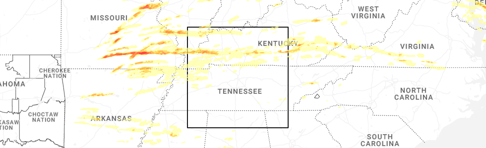
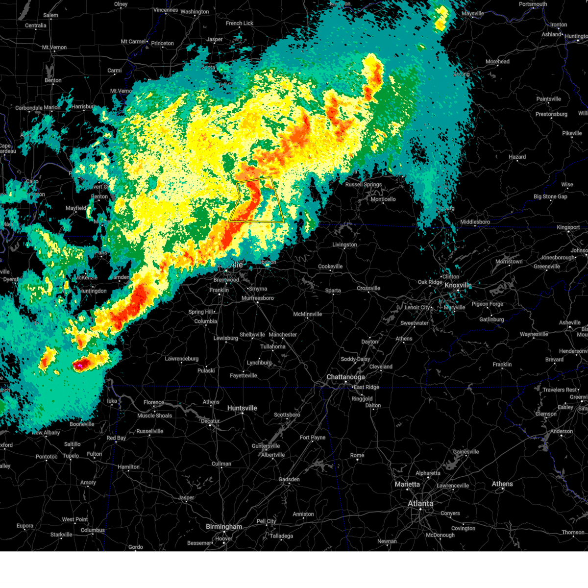
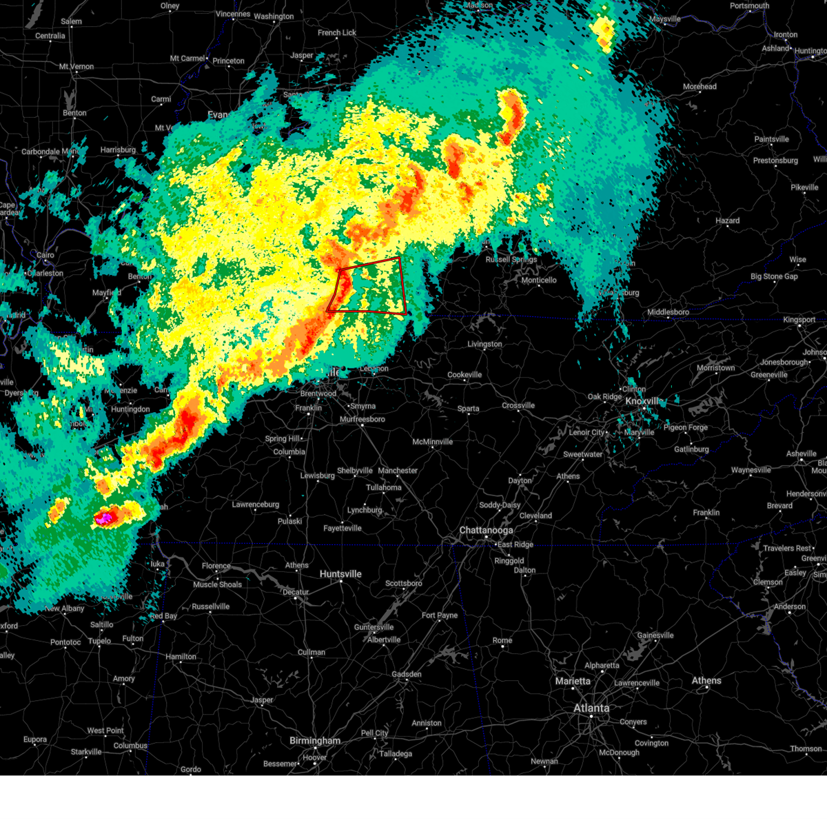
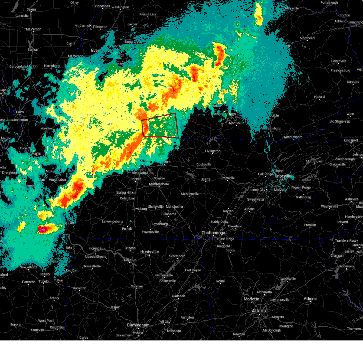
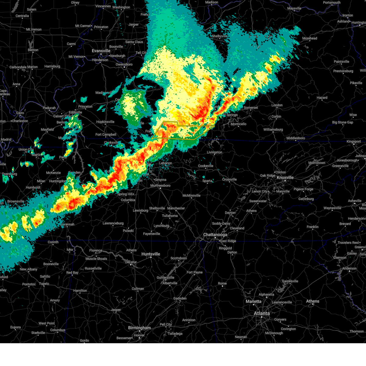
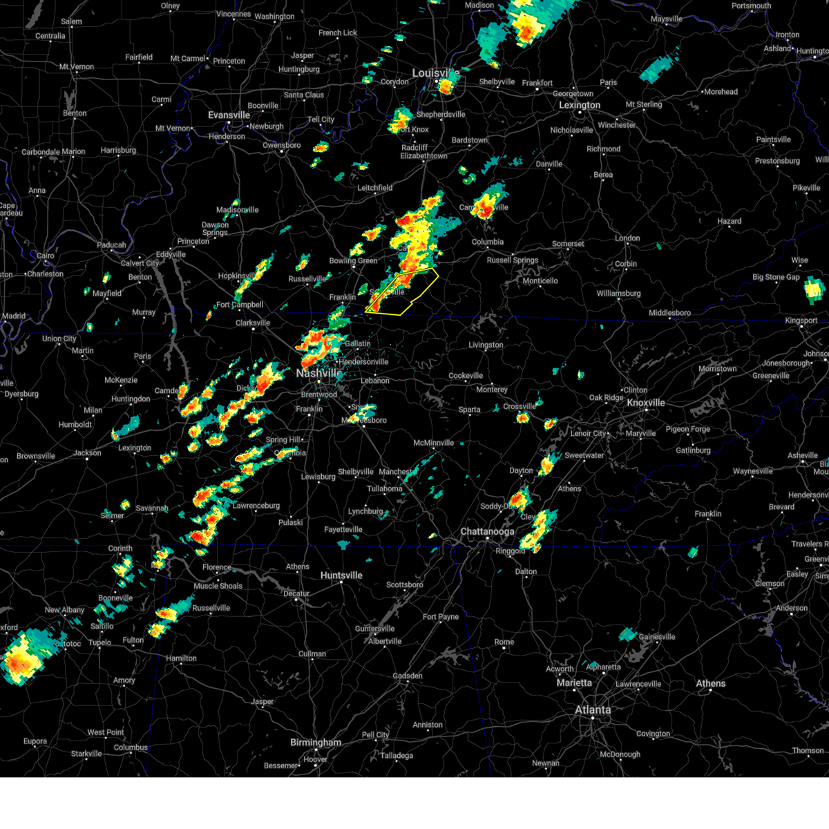
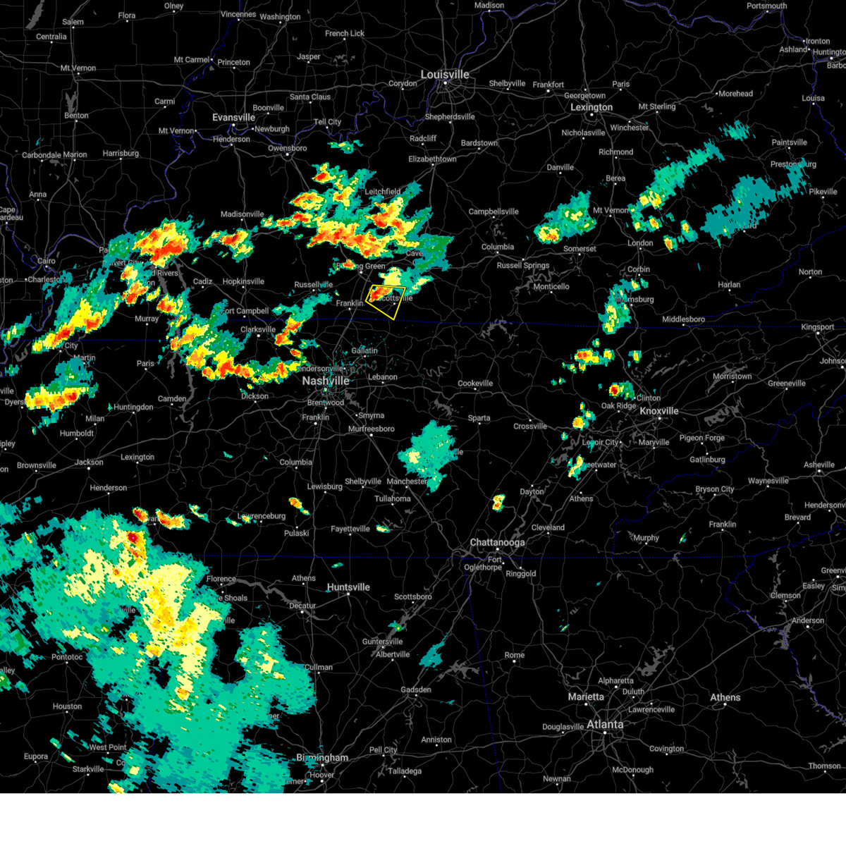
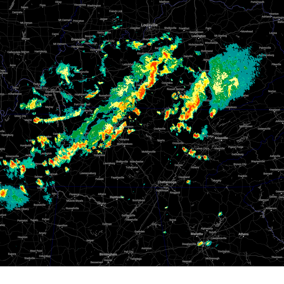
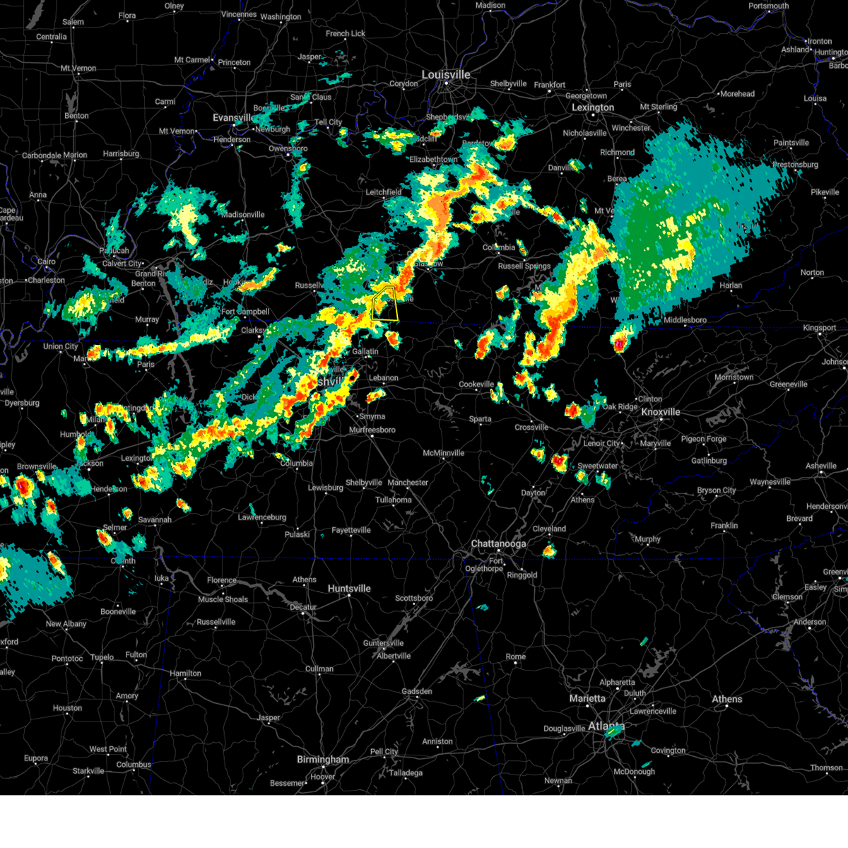
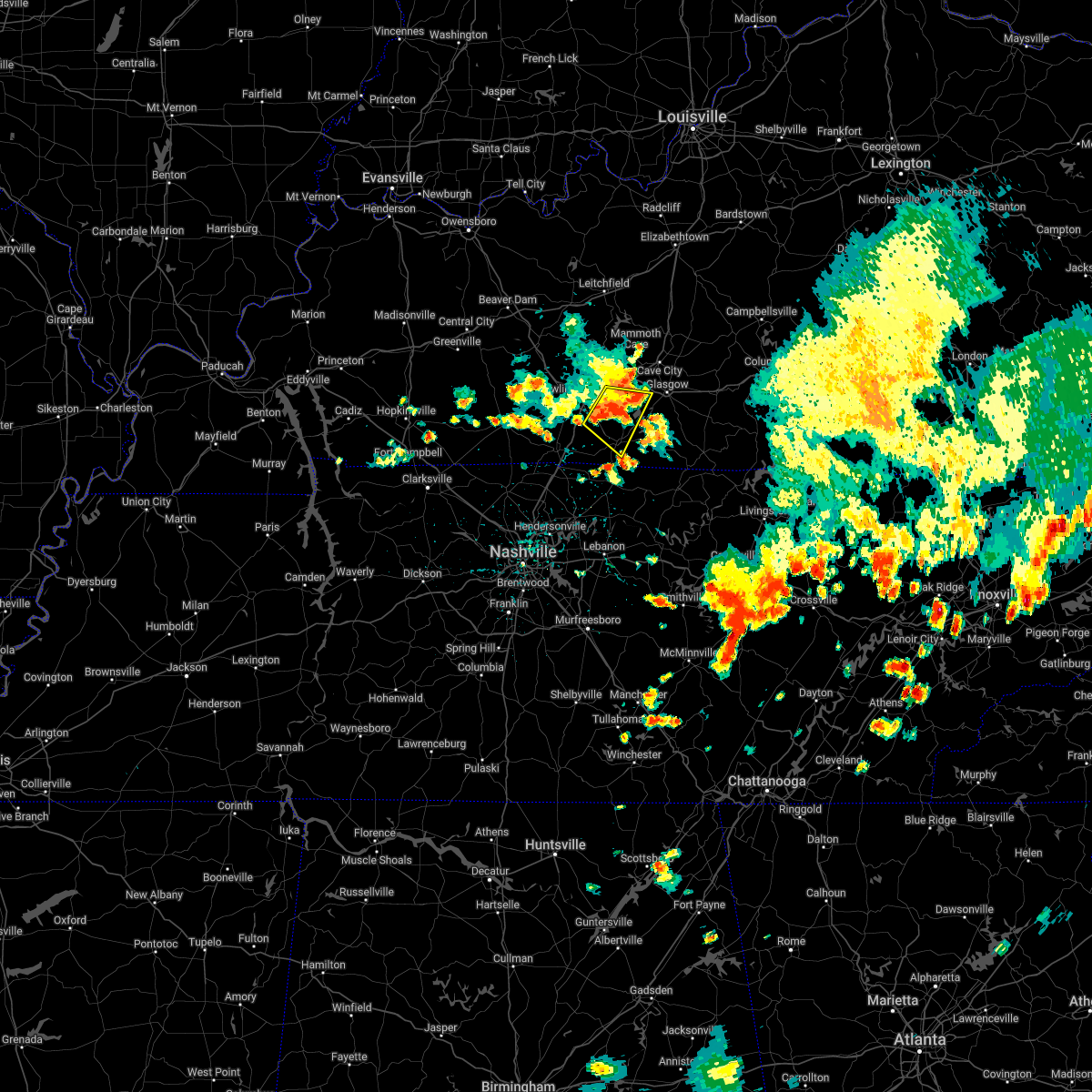
Hail Map for Scottsville, KY
The Scottsville, KY area has had 13 reports of on-the-ground hail by trained spotters, and has been under severe weather warnings 24 times during the past 12 months. Doppler radar has detected hail at or near Scottsville, KY on 72 occasions, including 5 occasions during the past year.
| Name: | Scottsville, KY |
| Where Located: | 51.5 miles NE of Nashville, TN |
| Map: | Google Map for Scottsville, KY |
| Population: | 4226 |
| Housing Units: | 2066 |
| More Info: | Search Google for Scottsville, KY |
4
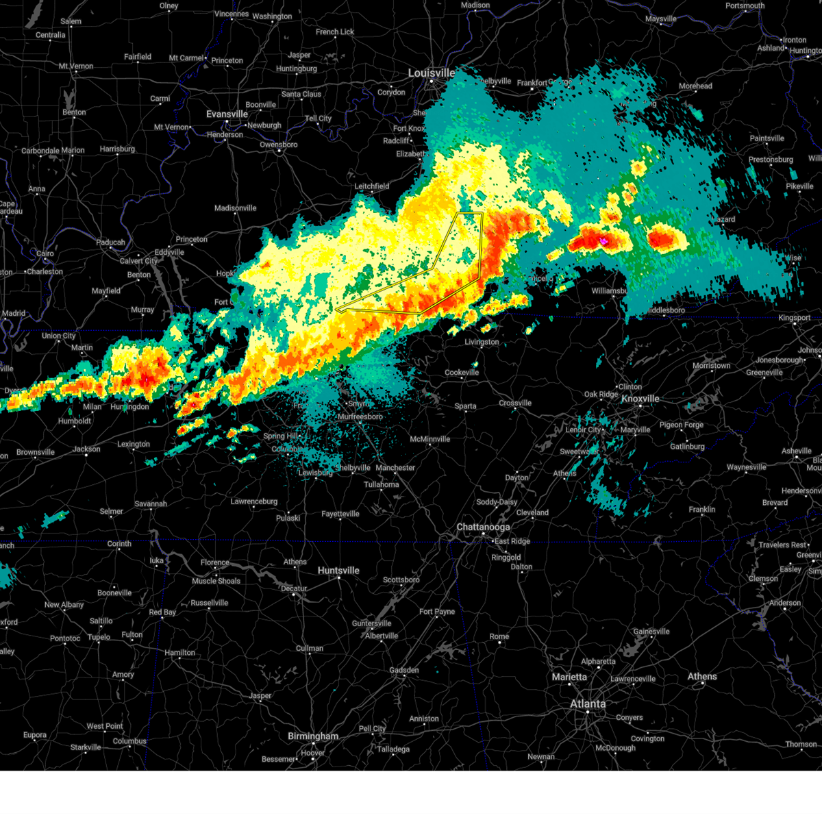
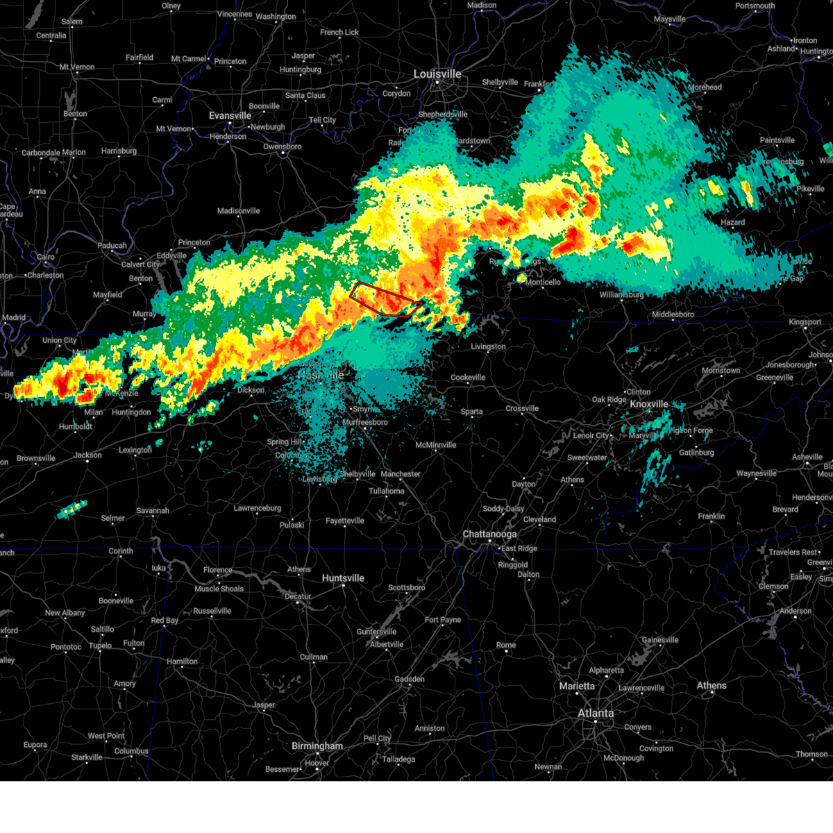
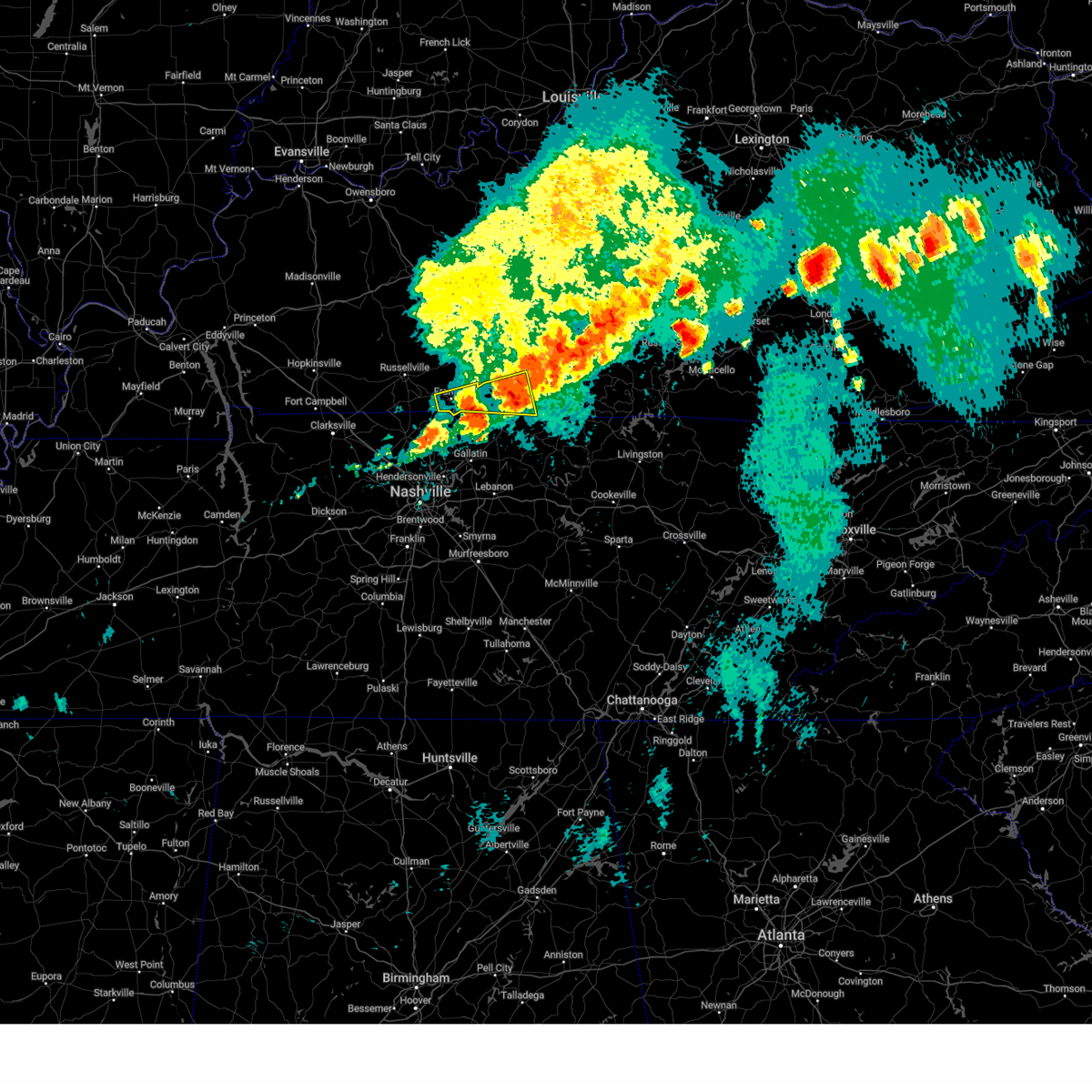
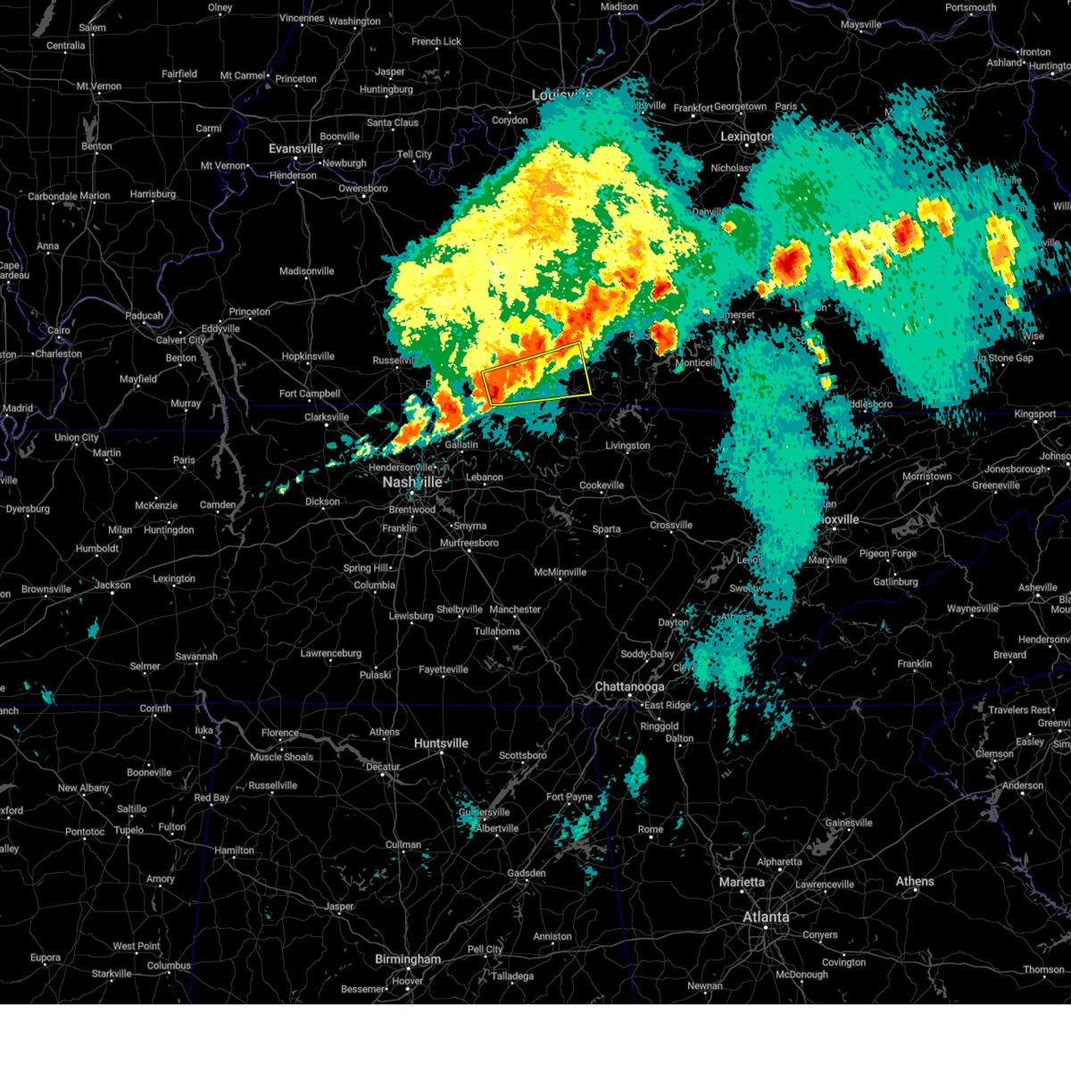
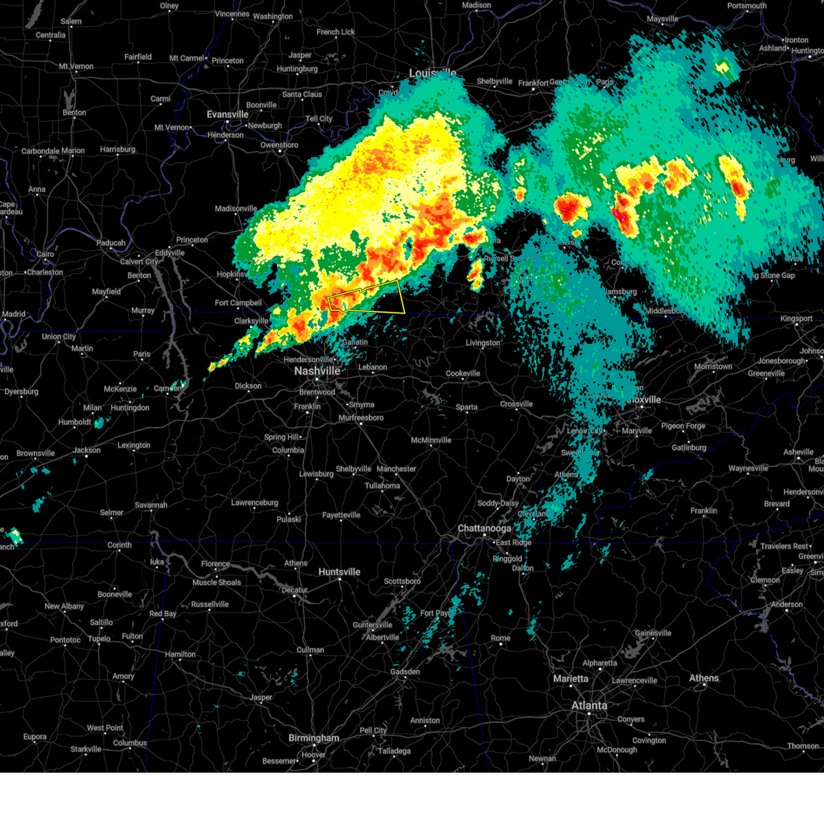
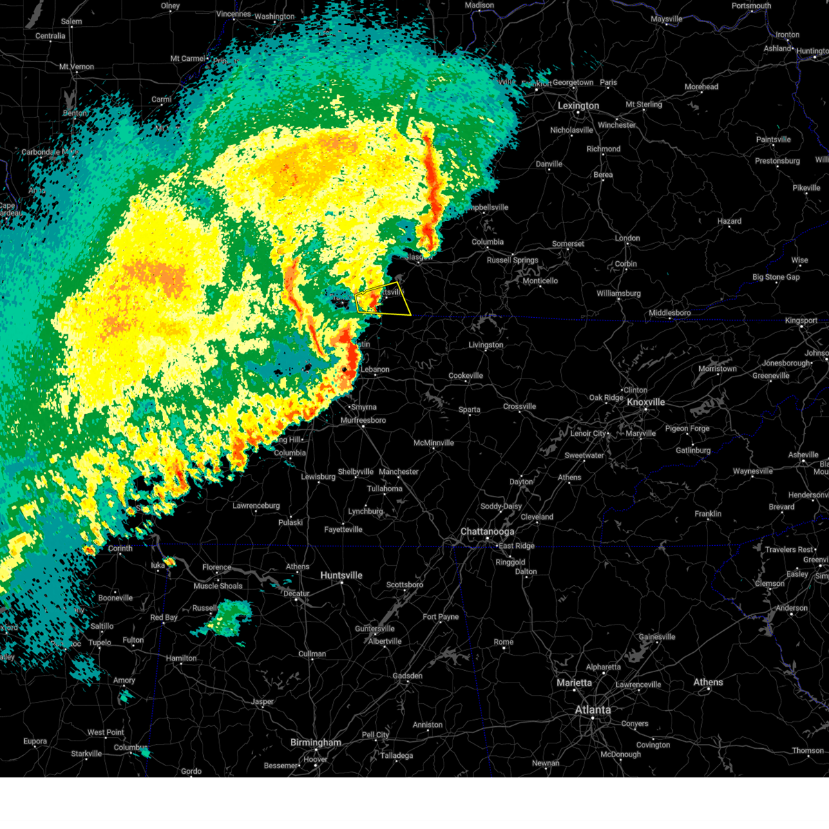
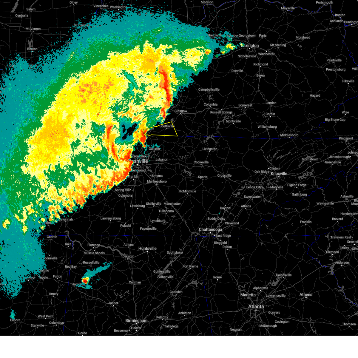
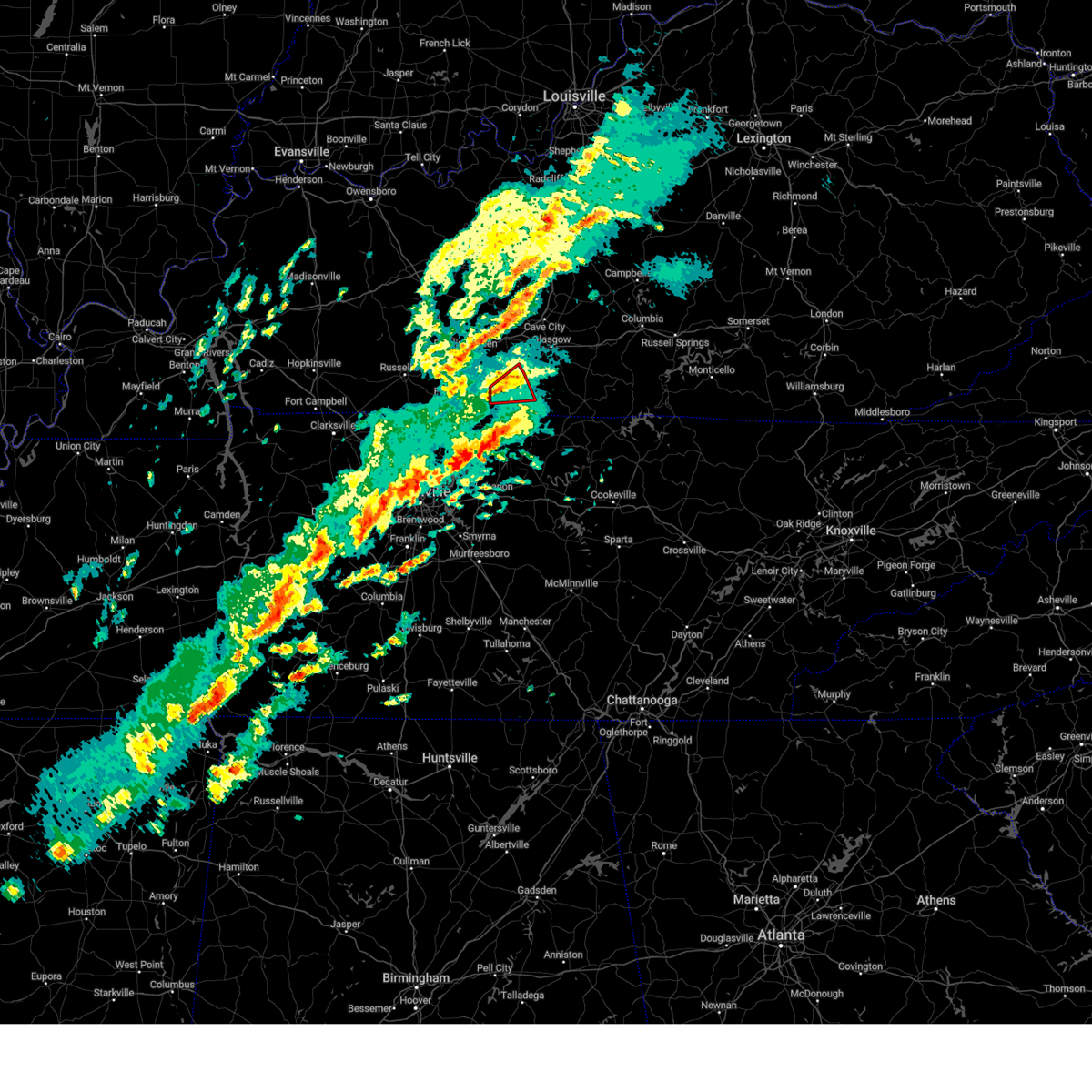
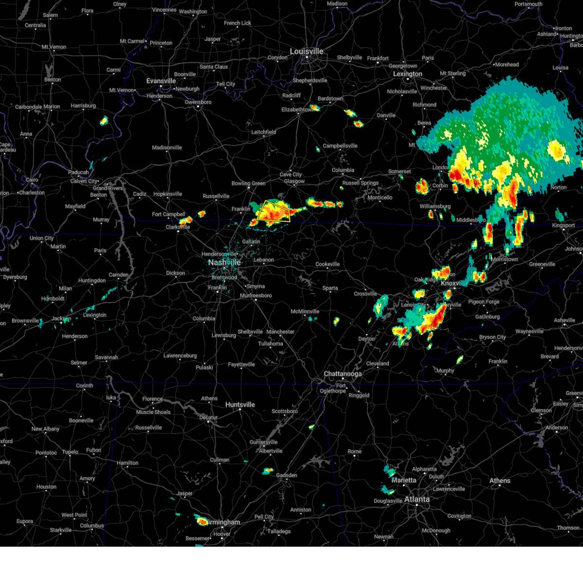
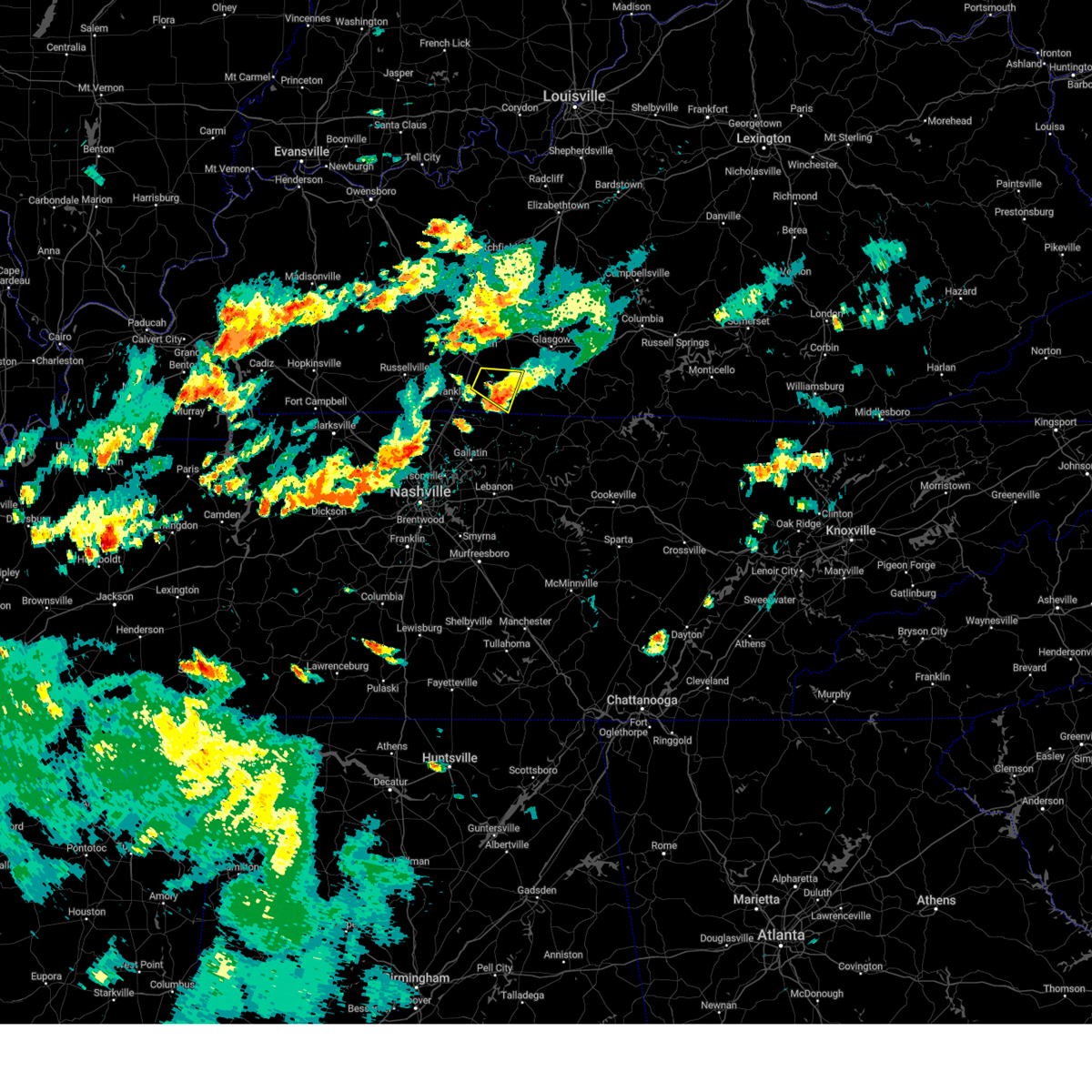
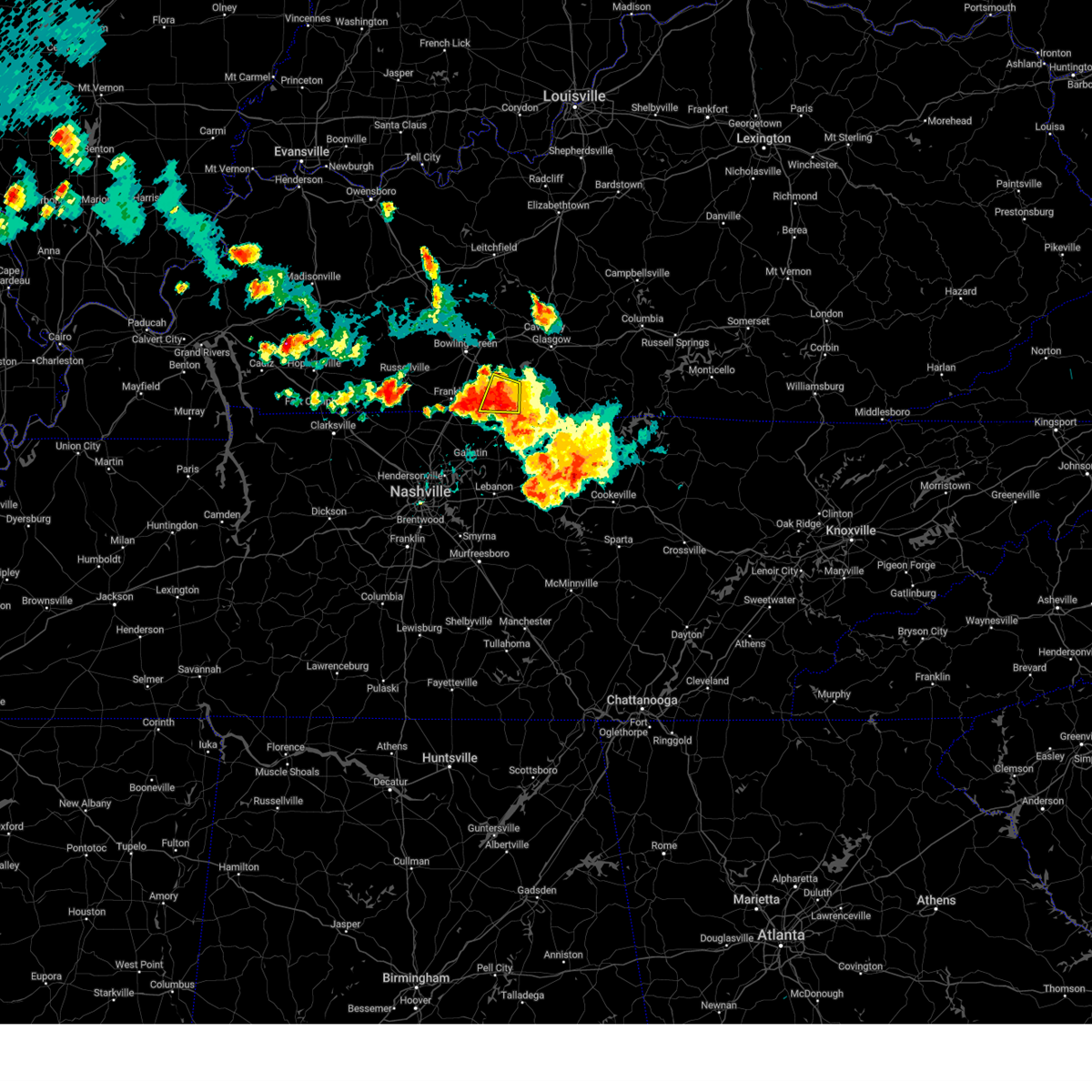
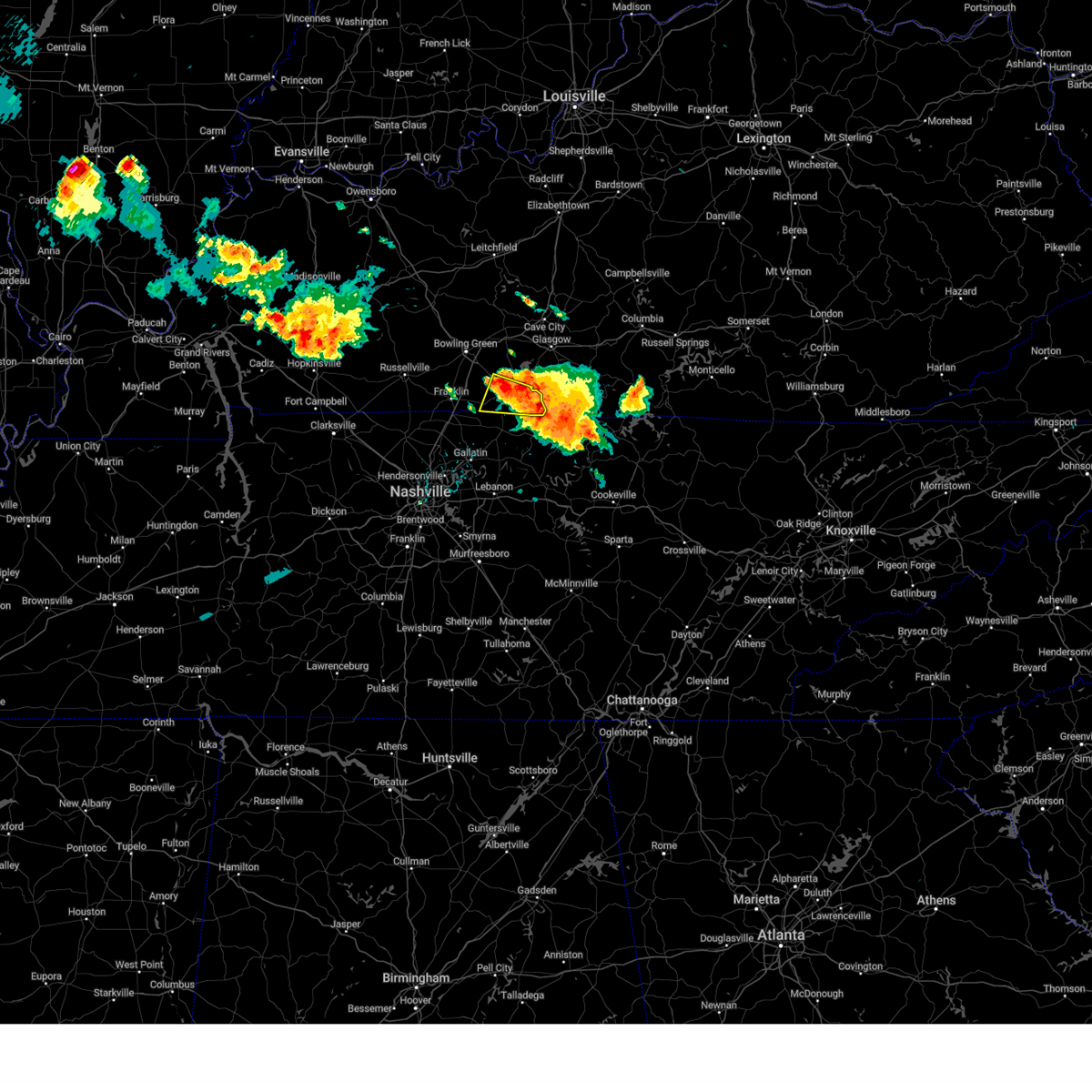
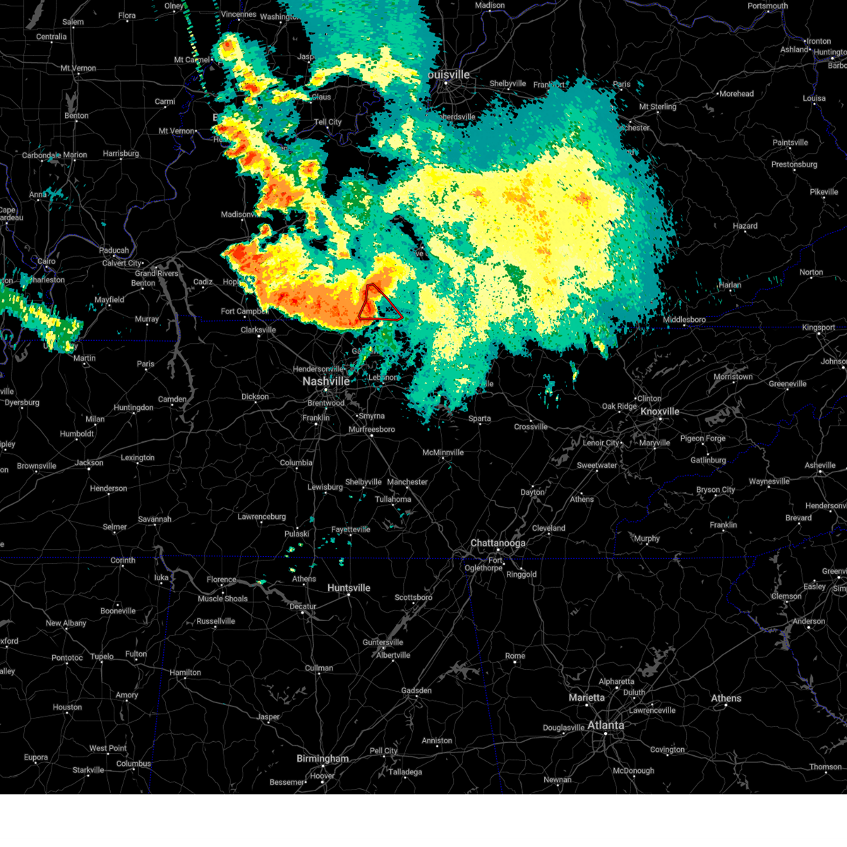
The Top Recent Hail Date for Scottsville, KY is Friday, May 16, 2025 (10th out of 72)
Hail and Wind Damage Spotted near Scottsville, KY
| Date / Time | Report Details |
|---|---|
| 5/16/2025 11:14 PM CDT |
 The storms which prompted the warning have moved out of the area. therefore, the warning will be allowed to expire. however, gusty winds are still possible with these thunderstorms. a tornado watch remains in effect until 300 am edt/200 am cdt/ for south central and central kentucky. to report severe weather, contact your nearest law enforcement agency. they will relay your report to the national weather service louisville. The storms which prompted the warning have moved out of the area. therefore, the warning will be allowed to expire. however, gusty winds are still possible with these thunderstorms. a tornado watch remains in effect until 300 am edt/200 am cdt/ for south central and central kentucky. to report severe weather, contact your nearest law enforcement agency. they will relay your report to the national weather service louisville.
|
| 5/16/2025 10:56 PM CDT | the severe thunderstorm warning has been cancelled and is no longer in effect |
| 5/16/2025 10:56 PM CDT | At 1156 pm edt/1056 pm cdt/, severe thunderstorms were located along a line extending from 7 miles northeast of three springs to 8 miles south of edmonton to 9 miles north of lafayette, moving east at 60 mph (radar indicated). Hazards include 70 mph wind gusts. Expect considerable tree damage. damage is likely to mobile homes, roofs, and outbuildings. Locations impacted include, campbellsville, scottsville, tompkinsville, greensburg, edmonton, fountain run, pickett, black jack, node, and bliss. |
| 5/16/2025 10:46 PM CDT |
 The storm which prompted the warning has weakened below severe limits, and has exited the warned area. therefore, the warning has been allowed to expire. a tornado watch remains in effect until midnight cdt for south central kentucky. a tornado watch also remains in effect until 200 am cdt for south central kentucky. to report severe weather, contact your nearest law enforcement agency. they will relay your report to the national weather service louisville. The storm which prompted the warning has weakened below severe limits, and has exited the warned area. therefore, the warning has been allowed to expire. a tornado watch remains in effect until midnight cdt for south central kentucky. a tornado watch also remains in effect until 200 am cdt for south central kentucky. to report severe weather, contact your nearest law enforcement agency. they will relay your report to the national weather service louisville.
|
| 5/16/2025 10:26 PM CDT | Svrlmk the national weather service in louisville has issued a * severe thunderstorm warning for, green county in central kentucky, northwestern monroe county in south central kentucky, southeastern simpson county in south central kentucky, hart county in central kentucky, south central taylor county in central kentucky, allen county in south central kentucky, east central warren county in south central kentucky, northwestern cumberland county in south central kentucky, barren county in south central kentucky, southwestern adair county in south central kentucky, metcalfe county in south central kentucky, eastern edmonson county in south central kentucky, * until 1215 am edt/1115 pm cdt/. * at 1125 pm edt/1025 pm cdt/, severe thunderstorms were located along a line extending from near brownsville to 7 miles north of scottsville to near portland, moving east at 60 mph (radar indicated). Hazards include 70 mph wind gusts. Expect considerable tree damage. Damage is likely to mobile homes, roofs, and outbuildings. |
| 5/16/2025 10:21 PM CDT | Torlmk the national weather service in louisville has issued a * tornado warning for, western monroe county in south central kentucky, east central simpson county in south central kentucky, allen county in south central kentucky, south central warren county in south central kentucky, * until 1045 pm cdt. * at 1021 pm cdt, a severe thunderstorm capable of producing a tornado was located 11 miles west of scottsville, moving southeast at 55 mph (radar indicated rotation). Hazards include tornado. Flying debris will be dangerous to those caught without shelter. mobile homes will be damaged or destroyed. damage to roofs, windows, and vehicles will occur. tree damage is likely. this dangerous storm will be near, scottsville around 1030 pm cdt. Other locations impacted by this tornadic thunderstorm include allen springs, oak forest, west fork, clare, mount zion, mcelroy ford, alonzo, red hill, butlersville, and halfway. |
| 5/16/2025 10:59 AM CDT |
 The storm which prompted the warning has moved out of the area. therefore, the warning will be allowed to expire. a severe thunderstorm watch remains in effect until 1100 am cdt for south central kentucky. remember, a severe thunderstorm warning still remains in effect for portions of allen county until 1115 am cdt. The storm which prompted the warning has moved out of the area. therefore, the warning will be allowed to expire. a severe thunderstorm watch remains in effect until 1100 am cdt for south central kentucky. remember, a severe thunderstorm warning still remains in effect for portions of allen county until 1115 am cdt.
|
| 5/16/2025 10:53 AM CDT |
 Svrlmk the national weather service in louisville has issued a * severe thunderstorm warning for, central monroe county in south central kentucky, allen county in south central kentucky, southern barren county in south central kentucky, southwestern metcalfe county in south central kentucky, * until 1115 am cdt. * at 1053 am cdt, a severe thunderstorm was located over scottsville, moving east at 65 mph (radar indicated). Hazards include 60 mph wind gusts and quarter size hail. Hail damage to vehicles is expected. Expect wind damage to roofs, siding, and trees. Svrlmk the national weather service in louisville has issued a * severe thunderstorm warning for, central monroe county in south central kentucky, allen county in south central kentucky, southern barren county in south central kentucky, southwestern metcalfe county in south central kentucky, * until 1115 am cdt. * at 1053 am cdt, a severe thunderstorm was located over scottsville, moving east at 65 mph (radar indicated). Hazards include 60 mph wind gusts and quarter size hail. Hail damage to vehicles is expected. Expect wind damage to roofs, siding, and trees.
|
| 5/16/2025 10:34 AM CDT |
 Svrlmk the national weather service in louisville has issued a * severe thunderstorm warning for, southern simpson county in south central kentucky, allen county in south central kentucky, * until 1100 am cdt. * at 1034 am cdt, a severe thunderstorm was located near portland, moving east at 65 mph (radar indicated). Hazards include 60 mph wind gusts and quarter size hail. Hail damage to vehicles is expected. Expect wind damage to roofs, siding, and trees. Svrlmk the national weather service in louisville has issued a * severe thunderstorm warning for, southern simpson county in south central kentucky, allen county in south central kentucky, * until 1100 am cdt. * at 1034 am cdt, a severe thunderstorm was located near portland, moving east at 65 mph (radar indicated). Hazards include 60 mph wind gusts and quarter size hail. Hail damage to vehicles is expected. Expect wind damage to roofs, siding, and trees.
|
| 4/5/2025 5:28 PM CDT |
 The storm which prompted the warning has moved out of the area. therefore, the warning will be allowed to expire. a tornado watch remains in effect until 900 pm cdt for south central kentucky. The storm which prompted the warning has moved out of the area. therefore, the warning will be allowed to expire. a tornado watch remains in effect until 900 pm cdt for south central kentucky.
|
| 4/5/2025 5:27 PM CDT | Multiple trees and power poles down near the 400 block of brownsford roa in allen county KY, 1.7 miles W of Scottsville, KY |
| 4/5/2025 5:26 PM CDT | Svrlmk the national weather service in louisville has issued a * severe thunderstorm warning for, western monroe county in south central kentucky, southeastern allen county in south central kentucky, southern barren county in south central kentucky, southwestern metcalfe county in south central kentucky, * until 600 pm cdt. * at 526 pm cdt, a severe thunderstorm was located near scottsville, moving east at 50 mph (radar indicated). Hazards include 60 mph wind gusts and quarter size hail. Hail damage to vehicles is expected. Expect wind damage to roofs, siding, and trees. |
| 4/5/2025 5:24 PM CDT | Multiple trees down near the 3900 block of old gallatin roa in allen county KY, 3.3 miles NNE of Scottsville, KY |
| 4/5/2025 5:13 PM CDT | At 512 pm cdt, a severe thunderstorm was located 8 miles northwest of westmoreland, moving east at 35 mph (radar indicated). Hazards include 60 mph wind gusts and quarter size hail. Hail damage to vehicles is expected. expect wind damage to roofs, siding, and trees. Locations impacted include, scottsville, oak forest, west fork, maynard, clare, mount zion, mcelroy ford, alonzo, red hill, and butlersville. |
| 4/5/2025 4:58 PM CDT |
 Svrlmk the national weather service in louisville has issued a * severe thunderstorm warning for, southeastern simpson county in south central kentucky, allen county in south central kentucky, * until 530 pm cdt. * at 457 pm cdt, a severe thunderstorm was located over portland, moving east at 35 mph (radar indicated). Hazards include 60 mph wind gusts and quarter size hail. Hail damage to vehicles is expected. Expect wind damage to roofs, siding, and trees. Svrlmk the national weather service in louisville has issued a * severe thunderstorm warning for, southeastern simpson county in south central kentucky, allen county in south central kentucky, * until 530 pm cdt. * at 457 pm cdt, a severe thunderstorm was located over portland, moving east at 35 mph (radar indicated). Hazards include 60 mph wind gusts and quarter size hail. Hail damage to vehicles is expected. Expect wind damage to roofs, siding, and trees.
|
| 4/3/2025 1:07 AM CDT | The storm which prompted the warning has weakened below severe limits, and has exited the warned area. therefore, the warning has been allowed to expire. however, gusty winds and heavy rain are still possible with this thunderstorm. a tornado watch remains in effect until 600 am cdt for south central kentucky. to report severe weather, contact your nearest law enforcement agency. they will relay your report to the national weather service louisville. |
| 4/3/2025 1:03 AM CDT | The storm which prompted the warning has weakened below severe limits, and has exited the warned area. therefore, the warning has been allowed to expire. however, gusty winds and heavy rain are still possible with this thunderstorm. a tornado watch remains in effect until 600 am cdt for south central kentucky. to report severe weather, contact your nearest law enforcement agency. they will relay your report to the national weather service louisville. |
| 4/3/2025 12:41 AM CDT |
 the severe thunderstorm warning has been cancelled and is no longer in effect the severe thunderstorm warning has been cancelled and is no longer in effect
|
| 4/3/2025 12:41 AM CDT |
 At 1241 am cdt, a severe thunderstorm was located 12 miles west of scottsville, moving east at 65 mph (radar indicated). Hazards include 70 mph wind gusts. Expect considerable tree damage. damage is likely to mobile homes, roofs, and outbuildings. Locations impacted include, bowling green, scottsville, plum springs, crestmoor, memphis junction, mount victor, franklin, smiths grove, woodburn, and oakland. At 1241 am cdt, a severe thunderstorm was located 12 miles west of scottsville, moving east at 65 mph (radar indicated). Hazards include 70 mph wind gusts. Expect considerable tree damage. damage is likely to mobile homes, roofs, and outbuildings. Locations impacted include, bowling green, scottsville, plum springs, crestmoor, memphis junction, mount victor, franklin, smiths grove, woodburn, and oakland.
|
| 4/3/2025 12:39 AM CDT |
 the tornado warning has been cancelled and is no longer in effect the tornado warning has been cancelled and is no longer in effect
|
| 4/3/2025 12:39 AM CDT |
 At 1239 am cdt, a severe thunderstorm capable of producing a tornado was located 10 miles southeast of memphis junction, moving east at 70 mph (radar indicated rotation). Hazards include tornado. Flying debris will be dangerous to those caught without shelter. mobile homes will be damaged or destroyed. damage to roofs, windows, and vehicles will occur. tree damage is likely. Locations impacted include, bowling green, scottsville, memphis junction, franklin, woodburn, three forks, red cross, hardcastle, rich pond, and greenhill. At 1239 am cdt, a severe thunderstorm capable of producing a tornado was located 10 miles southeast of memphis junction, moving east at 70 mph (radar indicated rotation). Hazards include tornado. Flying debris will be dangerous to those caught without shelter. mobile homes will be damaged or destroyed. damage to roofs, windows, and vehicles will occur. tree damage is likely. Locations impacted include, bowling green, scottsville, memphis junction, franklin, woodburn, three forks, red cross, hardcastle, rich pond, and greenhill.
|
| 4/3/2025 12:30 AM CDT |
 Torlmk the national weather service in louisville has issued a * tornado warning for, east central logan county in south central kentucky, simpson county in south central kentucky, allen county in south central kentucky, southern warren county in south central kentucky, southwestern barren county in south central kentucky, * until 100 am cdt. * at 1230 am cdt, a severe thunderstorm capable of producing a tornado was located 13 miles southwest of memphis junction, moving east at 65 mph (radar indicated rotation). Hazards include tornado. Flying debris will be dangerous to those caught without shelter. mobile homes will be damaged or destroyed. damage to roofs, windows, and vehicles will occur. tree damage is likely. This tornadic thunderstorm will remain over mainly rural areas of east central logan, simpson, allen, southern warren and southwestern barren counties, including the following locations, franklin, three forks, red cross, hardcastle, rich pond, greenhill, settle, raley ford, alonzo, and butlersville. Torlmk the national weather service in louisville has issued a * tornado warning for, east central logan county in south central kentucky, simpson county in south central kentucky, allen county in south central kentucky, southern warren county in south central kentucky, southwestern barren county in south central kentucky, * until 100 am cdt. * at 1230 am cdt, a severe thunderstorm capable of producing a tornado was located 13 miles southwest of memphis junction, moving east at 65 mph (radar indicated rotation). Hazards include tornado. Flying debris will be dangerous to those caught without shelter. mobile homes will be damaged or destroyed. damage to roofs, windows, and vehicles will occur. tree damage is likely. This tornadic thunderstorm will remain over mainly rural areas of east central logan, simpson, allen, southern warren and southwestern barren counties, including the following locations, franklin, three forks, red cross, hardcastle, rich pond, greenhill, settle, raley ford, alonzo, and butlersville.
|
| 4/3/2025 12:14 AM CDT | Svrlmk the national weather service in louisville has issued a * severe thunderstorm warning for, logan county in south central kentucky, simpson county in south central kentucky, allen county in south central kentucky, warren county in south central kentucky, * until 100 am cdt. * at 1213 am cdt, a severe thunderstorm was located 7 miles southwest of russellville, moving east at 60 mph (radar indicated). Hazards include 60 mph wind gusts. expect damage to roofs, siding, and trees |
| 3/30/2025 10:50 PM CDT |
 Svrlmk the national weather service in louisville has issued a * severe thunderstorm warning for, monroe county in south central kentucky, southeastern simpson county in south central kentucky, allen county in south central kentucky, southeastern warren county in south central kentucky, west central cumberland county in south central kentucky, southern barren county in south central kentucky, * until 1130 pm cdt. * at 1049 pm cdt, severe thunderstorms were located along a line extending from 11 miles southwest of glasgow to near portland, moving east at 55 mph (radar indicated). Hazards include 60 mph wind gusts. expect damage to roofs, siding, and trees Svrlmk the national weather service in louisville has issued a * severe thunderstorm warning for, monroe county in south central kentucky, southeastern simpson county in south central kentucky, allen county in south central kentucky, southeastern warren county in south central kentucky, west central cumberland county in south central kentucky, southern barren county in south central kentucky, * until 1130 pm cdt. * at 1049 pm cdt, severe thunderstorms were located along a line extending from 11 miles southwest of glasgow to near portland, moving east at 55 mph (radar indicated). Hazards include 60 mph wind gusts. expect damage to roofs, siding, and trees
|
| 3/30/2025 10:06 PM CDT | Svrlmk the national weather service in louisville has issued a * severe thunderstorm warning for, southeastern logan county in south central kentucky, simpson county in south central kentucky, hart county in central kentucky, western allen county in south central kentucky, northeastern butler county in south central kentucky, southeastern grayson county in central kentucky, warren county in south central kentucky, northern barren county in south central kentucky, edmonson county in south central kentucky, * until 1045 pm cdt. * at 1005 pm cdt, severe thunderstorms were located along a line extending from 12 miles northwest of brownsville to 8 miles north of plum springs to 11 miles south of russellville, moving east at 60 mph (radar indicated). Hazards include 60 mph wind gusts and penny size hail. expect damage to roofs, siding, and trees |
| 9/24/2024 2:10 PM CDT | Trees down near old glasgow roa in allen county KY, 4.7 miles SW of Scottsville, KY |
| 9/24/2024 2:06 PM CDT | A few trees down in downtown scottsvill in allen county KY, 0.6 miles W of Scottsville, KY |
| 9/24/2024 1:54 PM CDT |
 Svrlmk the national weather service in louisville has issued a * severe thunderstorm warning for, southeastern allen county in south central kentucky, southern barren county in south central kentucky, * until 230 pm cdt. * at 154 pm cdt, severe thunderstorms were located along a line extending from 12 miles southwest of glasgow to 7 miles southwest of scottsville, moving east at 35 mph (radar indicated). Hazards include 60 mph wind gusts and quarter size hail. Hail damage to vehicles is expected. Expect wind damage to roofs, siding, and trees. Svrlmk the national weather service in louisville has issued a * severe thunderstorm warning for, southeastern allen county in south central kentucky, southern barren county in south central kentucky, * until 230 pm cdt. * at 154 pm cdt, severe thunderstorms were located along a line extending from 12 miles southwest of glasgow to 7 miles southwest of scottsville, moving east at 35 mph (radar indicated). Hazards include 60 mph wind gusts and quarter size hail. Hail damage to vehicles is expected. Expect wind damage to roofs, siding, and trees.
|
| 9/24/2024 1:50 PM CDT | Trees down on jw york roa in allen county KY, 6.4 miles SW of Scottsville, KY |
| 6/26/2024 6:20 PM CDT |
 Svrlmk the national weather service in louisville has issued a * severe thunderstorm warning for, monroe county in south central kentucky, central allen county in south central kentucky, west central cumberland county in south central kentucky, barren county in south central kentucky, southwestern metcalfe county in south central kentucky, * until 700 pm cdt. * at 620 pm cdt, severe thunderstorms were located along a line extending from 7 miles west of scottsville to near red boiling springs, moving northeast at 40 mph (radar indicated). Hazards include 60 mph wind gusts. expect damage to roofs, siding, and trees Svrlmk the national weather service in louisville has issued a * severe thunderstorm warning for, monroe county in south central kentucky, central allen county in south central kentucky, west central cumberland county in south central kentucky, barren county in south central kentucky, southwestern metcalfe county in south central kentucky, * until 700 pm cdt. * at 620 pm cdt, severe thunderstorms were located along a line extending from 7 miles west of scottsville to near red boiling springs, moving northeast at 40 mph (radar indicated). Hazards include 60 mph wind gusts. expect damage to roofs, siding, and trees
|
| 6/26/2024 6:09 PM CDT |
 At 609 pm cdt, severe thunderstorms were located along a line extending from 11 miles southwest of memphis junction to near westmoreland to 6 miles south of red boiling springs, moving northeast at 35 mph (radar indicated). Hazards include 60 mph wind gusts. Expect damage to roofs, siding, and trees. Locations impacted include, bowling green, scottsville, franklin, woodburn, black jack, west fork, rich pond, clare, geddes, and mcelroy ford. At 609 pm cdt, severe thunderstorms were located along a line extending from 11 miles southwest of memphis junction to near westmoreland to 6 miles south of red boiling springs, moving northeast at 35 mph (radar indicated). Hazards include 60 mph wind gusts. Expect damage to roofs, siding, and trees. Locations impacted include, bowling green, scottsville, franklin, woodburn, black jack, west fork, rich pond, clare, geddes, and mcelroy ford.
|
| 6/26/2024 5:42 PM CDT |
 Svrlmk the national weather service in louisville has issued a * severe thunderstorm warning for, simpson county in south central kentucky, southwestern allen county in south central kentucky, southwestern warren county in south central kentucky, * until 630 pm cdt. * at 542 pm cdt, severe thunderstorms were located along a line extending from near cross plains to near gallatin to carthage, moving northeast at 30 mph (radar indicated). Hazards include 60 mph wind gusts. expect damage to roofs, siding, and trees Svrlmk the national weather service in louisville has issued a * severe thunderstorm warning for, simpson county in south central kentucky, southwestern allen county in south central kentucky, southwestern warren county in south central kentucky, * until 630 pm cdt. * at 542 pm cdt, severe thunderstorms were located along a line extending from near cross plains to near gallatin to carthage, moving northeast at 30 mph (radar indicated). Hazards include 60 mph wind gusts. expect damage to roofs, siding, and trees
|
| 5/26/2024 10:40 PM CDT |
 Svrlmk the national weather service in louisville has issued a * severe thunderstorm warning for, west central monroe county in south central kentucky, southeastern simpson county in south central kentucky, hart county in central kentucky, allen county in south central kentucky, southeastern warren county in south central kentucky, barren county in south central kentucky, eastern edmonson county in south central kentucky, * until 1115 pm cdt. * at 1040 pm cdt, severe thunderstorms were located along a line extending from 12 miles northwest of munfordville to 6 miles northwest of portland, moving east at 50 mph (radar indicated). Hazards include 60 mph wind gusts and quarter size hail. Hail damage to vehicles is expected. Expect wind damage to roofs, siding, and trees. Svrlmk the national weather service in louisville has issued a * severe thunderstorm warning for, west central monroe county in south central kentucky, southeastern simpson county in south central kentucky, hart county in central kentucky, allen county in south central kentucky, southeastern warren county in south central kentucky, barren county in south central kentucky, eastern edmonson county in south central kentucky, * until 1115 pm cdt. * at 1040 pm cdt, severe thunderstorms were located along a line extending from 12 miles northwest of munfordville to 6 miles northwest of portland, moving east at 50 mph (radar indicated). Hazards include 60 mph wind gusts and quarter size hail. Hail damage to vehicles is expected. Expect wind damage to roofs, siding, and trees.
|
| 5/26/2024 10:43 AM CDT |
 The storms which prompted the warning have moved out of the area. therefore, the warning will be allowed to expire. however, gusty winds are still possible with these thunderstorms. a tornado watch remains in effect until 300 pm cdt for south central kentucky. The storms which prompted the warning have moved out of the area. therefore, the warning will be allowed to expire. however, gusty winds are still possible with these thunderstorms. a tornado watch remains in effect until 300 pm cdt for south central kentucky.
|
| 5/26/2024 10:20 AM CDT | Storm damage reported in allen county KY, 7.4 miles NW of Scottsville, KY |
| 5/26/2024 10:10 AM CDT |
 Svrlmk the national weather service in louisville has issued a * severe thunderstorm warning for, western monroe county in south central kentucky, allen county in south central kentucky, southeastern warren county in south central kentucky, southern barren county in south central kentucky, * until 1045 am cdt. * at 1010 am cdt, severe thunderstorms were located along a line extending from 7 miles southeast of mount victor to 6 miles northwest of westmoreland, moving east at 70 mph (radar indicated). Hazards include 60 mph wind gusts. expect damage to roofs, siding, and trees Svrlmk the national weather service in louisville has issued a * severe thunderstorm warning for, western monroe county in south central kentucky, allen county in south central kentucky, southeastern warren county in south central kentucky, southern barren county in south central kentucky, * until 1045 am cdt. * at 1010 am cdt, severe thunderstorms were located along a line extending from 7 miles southeast of mount victor to 6 miles northwest of westmoreland, moving east at 70 mph (radar indicated). Hazards include 60 mph wind gusts. expect damage to roofs, siding, and trees
|
| 5/23/2024 3:15 PM CDT | Allen county emergency management reported that several trees along a 4 to 5 mile swath were downed along the southern city limits of scottsville. appears to be straigh in allen county KY, 1.4 miles NW of Scottsville, KY |
| 4/2/2024 11:29 AM CDT |
 The storm which prompted the warning has weakened below severe limits, and no longer poses an immediate threat to life or property. therefore, the warning will be allowed to expire. however, small hail, gusty winds and heavy rain are still possible with this thunderstorm. a tornado watch remains in effect until 300 pm cdt for south central kentucky. to report severe weather, contact your nearest law enforcement agency. they will relay your report to the national weather service louisville. The storm which prompted the warning has weakened below severe limits, and no longer poses an immediate threat to life or property. therefore, the warning will be allowed to expire. however, small hail, gusty winds and heavy rain are still possible with this thunderstorm. a tornado watch remains in effect until 300 pm cdt for south central kentucky. to report severe weather, contact your nearest law enforcement agency. they will relay your report to the national weather service louisville.
|
| 4/2/2024 11:12 AM CDT |
 At 1112 am cdt, a severe thunderstorm was located 7 miles north of scottsville, moving northeast at 60 mph (radar indicated). Hazards include 60 mph wind gusts and quarter size hail. Hail damage to vehicles is expected. expect wind damage to roofs, siding, and trees. Locations impacted include, glasgow, scottsville, cave city, smiths grove, park city, oakland, three forks, red cross, hardcastle, and lecta. At 1112 am cdt, a severe thunderstorm was located 7 miles north of scottsville, moving northeast at 60 mph (radar indicated). Hazards include 60 mph wind gusts and quarter size hail. Hail damage to vehicles is expected. expect wind damage to roofs, siding, and trees. Locations impacted include, glasgow, scottsville, cave city, smiths grove, park city, oakland, three forks, red cross, hardcastle, and lecta.
|
| 4/2/2024 11:12 AM CDT |
 the severe thunderstorm warning has been cancelled and is no longer in effect the severe thunderstorm warning has been cancelled and is no longer in effect
|
| 4/2/2024 11:02 AM CDT |
 Svrlmk the national weather service in louisville has issued a * severe thunderstorm warning for, southeastern simpson county in south central kentucky, northwestern allen county in south central kentucky, southeastern warren county in south central kentucky, central barren county in south central kentucky, southeastern edmonson county in south central kentucky, * until 1130 am cdt. * at 1102 am cdt, a severe thunderstorm was located 10 miles west of scottsville, moving northeast at 60 mph (radar indicated). Hazards include 60 mph wind gusts and quarter size hail. Hail damage to vehicles is expected. Expect wind damage to roofs, siding, and trees. Svrlmk the national weather service in louisville has issued a * severe thunderstorm warning for, southeastern simpson county in south central kentucky, northwestern allen county in south central kentucky, southeastern warren county in south central kentucky, central barren county in south central kentucky, southeastern edmonson county in south central kentucky, * until 1130 am cdt. * at 1102 am cdt, a severe thunderstorm was located 10 miles west of scottsville, moving northeast at 60 mph (radar indicated). Hazards include 60 mph wind gusts and quarter size hail. Hail damage to vehicles is expected. Expect wind damage to roofs, siding, and trees.
|
| 3/6/2024 10:06 AM EST |
 Torlmk the national weather service in louisville has issued a * this is a test message. tornado warning for, meade county in central kentucky, larue county in central kentucky, jessamine county in central kentucky, nicholas county in central kentucky, adair county in south central kentucky, bourbon county in central kentucky, warren county in south central kentucky, cumberland county in south central kentucky, henry county in central kentucky, russell county in south central kentucky, taylor county in central kentucky, jefferson county in central kentucky, hardin county in central kentucky, spencer county in central kentucky, scott county in central kentucky, hancock county in central kentucky, trimble county in central kentucky, monroe county in south central kentucky, metcalfe county in south central kentucky, shelby county in central kentucky, logan county in south central kentucky, nelson county in central kentucky, anderson county in central kentucky, clark county in central kentucky, marion county in central kentucky, simpson county in south central kentucky, grayson county in central kentucky, casey county in central kentucky, franklin county in central kentucky, edmonson county in south central kentucky, lincoln county in central kentucky, woodford county in central kentucky, butler county in south central kentucky, madison county in central kentucky, barren county in south central kentucky, ohio county in central kentucky, oldham county in central kentucky, garrard county in central kentucky, hart county in central kentucky, bullitt county in central kentucky, harrison county in central kentucky, mercer county in central kentucky, clinton county in south central kentucky, green county in central kentucky, allen county in south central kentucky, washington county in central kentucky, boyle county in central kentucky, breckinridge county in central kentucky, fayette county in central kentucky, * this is a test message. until 1030 am est/930 am cst/. * this is a test message. Torlmk the national weather service in louisville has issued a * this is a test message. tornado warning for, meade county in central kentucky, larue county in central kentucky, jessamine county in central kentucky, nicholas county in central kentucky, adair county in south central kentucky, bourbon county in central kentucky, warren county in south central kentucky, cumberland county in south central kentucky, henry county in central kentucky, russell county in south central kentucky, taylor county in central kentucky, jefferson county in central kentucky, hardin county in central kentucky, spencer county in central kentucky, scott county in central kentucky, hancock county in central kentucky, trimble county in central kentucky, monroe county in south central kentucky, metcalfe county in south central kentucky, shelby county in central kentucky, logan county in south central kentucky, nelson county in central kentucky, anderson county in central kentucky, clark county in central kentucky, marion county in central kentucky, simpson county in south central kentucky, grayson county in central kentucky, casey county in central kentucky, franklin county in central kentucky, edmonson county in south central kentucky, lincoln county in central kentucky, woodford county in central kentucky, butler county in south central kentucky, madison county in central kentucky, barren county in south central kentucky, ohio county in central kentucky, oldham county in central kentucky, garrard county in central kentucky, hart county in central kentucky, bullitt county in central kentucky, harrison county in central kentucky, mercer county in central kentucky, clinton county in south central kentucky, green county in central kentucky, allen county in south central kentucky, washington county in central kentucky, boyle county in central kentucky, breckinridge county in central kentucky, fayette county in central kentucky, * this is a test message. until 1030 am est/930 am cst/. * this is a test message.
|
| 12/9/2023 5:23 PM CST |
 At 522 pm cst, a severe thunderstorm capable of producing a tornado was located near scottsville, moving northeast at 30 mph (radar indicated rotation). Hazards include tornado. Flying debris will be dangerous to those caught without shelter. mobile homes will be damaged or destroyed. damage to roofs, windows, and vehicles will occur. tree damage is likely. Locations impacted include, scottsville, rodemer, oak forest, west fork, maynard, walnut hill, yesse, petroleum, halifax and chapel hill. At 522 pm cst, a severe thunderstorm capable of producing a tornado was located near scottsville, moving northeast at 30 mph (radar indicated rotation). Hazards include tornado. Flying debris will be dangerous to those caught without shelter. mobile homes will be damaged or destroyed. damage to roofs, windows, and vehicles will occur. tree damage is likely. Locations impacted include, scottsville, rodemer, oak forest, west fork, maynard, walnut hill, yesse, petroleum, halifax and chapel hill.
|
| 12/9/2023 5:12 PM CST |
 At 512 pm cst, a severe thunderstorm capable of producing a tornado was located 9 miles west of scottsville, moving northeast at 30 mph (radar indicated rotation). Hazards include tornado. Flying debris will be dangerous to those caught without shelter. mobile homes will be damaged or destroyed. damage to roofs, windows, and vehicles will occur. Tree damage is likely. At 512 pm cst, a severe thunderstorm capable of producing a tornado was located 9 miles west of scottsville, moving northeast at 30 mph (radar indicated rotation). Hazards include tornado. Flying debris will be dangerous to those caught without shelter. mobile homes will be damaged or destroyed. damage to roofs, windows, and vehicles will occur. Tree damage is likely.
|
| 7/29/2023 3:25 PM CDT |
 The severe thunderstorm warning for allen county will expire at 330 pm cdt, the storm which prompted the warning has moved out of the area. therefore, the warning will be allowed to expire. however, heavy rain is still possible with this thunderstorm. to report severe weather, contact your nearest law enforcement agency. they will relay your report to the national weather service louisville. The severe thunderstorm warning for allen county will expire at 330 pm cdt, the storm which prompted the warning has moved out of the area. therefore, the warning will be allowed to expire. however, heavy rain is still possible with this thunderstorm. to report severe weather, contact your nearest law enforcement agency. they will relay your report to the national weather service louisville.
|
| 7/29/2023 3:09 PM CDT |
 At 308 pm cdt, a severe thunderstorm was located near scottsville, moving southeast at 20 mph (radar indicated). Hazards include 60 mph wind gusts and quarter size hail. Hail damage to vehicles is expected. expect wind damage to roofs, siding, and trees. locations impacted include, scottsville, fleet, rodemer, oak forest, west fork, maynard, petroleum, halifax, alonzo and chapel hill. hail threat, radar indicated max hail size, 1. 00 in wind threat, radar indicated max wind gust, 60 mph. At 308 pm cdt, a severe thunderstorm was located near scottsville, moving southeast at 20 mph (radar indicated). Hazards include 60 mph wind gusts and quarter size hail. Hail damage to vehicles is expected. expect wind damage to roofs, siding, and trees. locations impacted include, scottsville, fleet, rodemer, oak forest, west fork, maynard, petroleum, halifax, alonzo and chapel hill. hail threat, radar indicated max hail size, 1. 00 in wind threat, radar indicated max wind gust, 60 mph.
|
| 7/29/2023 3:02 PM CDT | Trees were down on multiple county road in allen county KY, 5.1 miles NNE of Scottsville, KY |
| 7/29/2023 2:59 PM CDT |
 At 259 pm cdt, a severe thunderstorm was located near scottsville, moving southeast at 20 mph (radar indicated). Hazards include 60 mph wind gusts and quarter size hail. Hail damage to vehicles is expected. Expect wind damage to roofs, siding, and trees. At 259 pm cdt, a severe thunderstorm was located near scottsville, moving southeast at 20 mph (radar indicated). Hazards include 60 mph wind gusts and quarter size hail. Hail damage to vehicles is expected. Expect wind damage to roofs, siding, and trees.
|
| 7/29/2023 2:48 PM CDT | Scattered trees and power lines down including on walker street. some city vehicles were damaged from the falling tree in allen county KY, 0.6 miles W of Scottsville, KY |
| 7/18/2023 4:05 PM CDT |
 At 404 pm cdt, severe thunderstorms were located along a line extending from 6 miles northwest of brownsville to near westmoreland to near nashville, moving east at 45 mph (radar indicated). Hazards include 60 mph wind gusts. Expect damage to roofs, siding, and trees. locations impacted include, bowling green, scottsville, brownsville, plum springs, mount victor, smiths grove, oakland, chalybeate, hardcastle and girkin. hail threat, radar indicated max hail size, <. 75 in wind threat, radar indicated max wind gust, 60 mph. At 404 pm cdt, severe thunderstorms were located along a line extending from 6 miles northwest of brownsville to near westmoreland to near nashville, moving east at 45 mph (radar indicated). Hazards include 60 mph wind gusts. Expect damage to roofs, siding, and trees. locations impacted include, bowling green, scottsville, brownsville, plum springs, mount victor, smiths grove, oakland, chalybeate, hardcastle and girkin. hail threat, radar indicated max hail size, <. 75 in wind threat, radar indicated max wind gust, 60 mph.
|
| 7/18/2023 3:51 PM CDT |
 At 350 pm cdt, severe thunderstorms were located along a line extending from 9 miles east of morgantown to near portland to near ashland city, moving east at 55 mph (radar indicated). Hazards include 60 mph wind gusts. Expect damage to roofs, siding, and trees. locations impacted include, bowling green, scottsville, morgantown, brownsville, plum springs, crestmoor, memphis junction, mount victor, smiths grove and woodburn. hail threat, radar indicated max hail size, <. 75 in wind threat, radar indicated max wind gust, 60 mph. At 350 pm cdt, severe thunderstorms were located along a line extending from 9 miles east of morgantown to near portland to near ashland city, moving east at 55 mph (radar indicated). Hazards include 60 mph wind gusts. Expect damage to roofs, siding, and trees. locations impacted include, bowling green, scottsville, morgantown, brownsville, plum springs, crestmoor, memphis junction, mount victor, smiths grove and woodburn. hail threat, radar indicated max hail size, <. 75 in wind threat, radar indicated max wind gust, 60 mph.
|
| 7/18/2023 3:15 PM CDT |
 At 314 pm cdt, severe thunderstorms were located along a line extending from 6 miles east of powderly to 8 miles northwest of springfield to 7 miles northeast of mcewen, moving east at 45 mph (radar indicated). Hazards include 60 mph wind gusts. expect damage to roofs, siding, and trees At 314 pm cdt, severe thunderstorms were located along a line extending from 6 miles east of powderly to 8 miles northwest of springfield to 7 miles northeast of mcewen, moving east at 45 mph (radar indicated). Hazards include 60 mph wind gusts. expect damage to roofs, siding, and trees
|
| 7/8/2023 3:28 PM CDT |
 The severe thunderstorm warning for northeastern simpson, western allen and south central warren counties will expire at 330 pm cdt, the storm which prompted the warning has weakened below severe limits, and no longer poses an immediate threat to life or property. therefore, the warning will be allowed to expire. however gusty winds and heavy rain are still possible with this thunderstorm. The severe thunderstorm warning for northeastern simpson, western allen and south central warren counties will expire at 330 pm cdt, the storm which prompted the warning has weakened below severe limits, and no longer poses an immediate threat to life or property. therefore, the warning will be allowed to expire. however gusty winds and heavy rain are still possible with this thunderstorm.
|
| 7/8/2023 2:56 PM CDT |
 At 256 pm cdt, a severe thunderstorm was located 8 miles southeast of three springs, moving east at 20 mph (radar indicated). Hazards include 60 mph wind gusts and quarter size hail. Hail damage to vehicles is expected. Expect wind damage to roofs, siding, and trees. At 256 pm cdt, a severe thunderstorm was located 8 miles southeast of three springs, moving east at 20 mph (radar indicated). Hazards include 60 mph wind gusts and quarter size hail. Hail damage to vehicles is expected. Expect wind damage to roofs, siding, and trees.
|
| 6/30/2023 7:27 PM CDT |
 At 727 pm cdt, severe thunderstorms were located along a line extending from 12 miles southeast of three springs to near scottsville, moving west at 15 mph (radar indicated). Hazards include 60 mph wind gusts and quarter size hail. Hail damage to vehicles is expected. expect wind damage to roofs, siding, and trees. locations impacted include, scottsville, fleet, rodemer, west fork, petroleum, halifax, alonzo, chapel hill, forest springs, and butlersville. hail threat, radar indicated max hail size, 1. 00 in wind threat, radar indicated max wind gust, 60 mph. At 727 pm cdt, severe thunderstorms were located along a line extending from 12 miles southeast of three springs to near scottsville, moving west at 15 mph (radar indicated). Hazards include 60 mph wind gusts and quarter size hail. Hail damage to vehicles is expected. expect wind damage to roofs, siding, and trees. locations impacted include, scottsville, fleet, rodemer, west fork, petroleum, halifax, alonzo, chapel hill, forest springs, and butlersville. hail threat, radar indicated max hail size, 1. 00 in wind threat, radar indicated max wind gust, 60 mph.
|
| 6/30/2023 7:00 PM CDT |
 At 659 pm cdt, severe thunderstorms were located along a line extending from 6 miles northwest of scottsville to 10 miles north of lafayette, moving south at 10 mph (public). Hazards include 60 mph wind gusts and quarter size hail. these storms have had a history of damaging winds and large hail. Hail damage to vehicles is expected. Expect wind damage to roofs, siding, and trees. At 659 pm cdt, severe thunderstorms were located along a line extending from 6 miles northwest of scottsville to 10 miles north of lafayette, moving south at 10 mph (public). Hazards include 60 mph wind gusts and quarter size hail. these storms have had a history of damaging winds and large hail. Hail damage to vehicles is expected. Expect wind damage to roofs, siding, and trees.
|
| 6/30/2023 6:56 PM CDT | Quarter sized hail reported 0.1 miles N of Scottsville, KY |
| 6/30/2023 6:48 PM CDT |
 At 647 pm cdt, severe thunderstorms were located along a line extending from 6 miles northwest of scottsville to near tompkinsville, moving southeast at 20 mph (radar indicated). Hazards include golf ball size hail and 60 mph wind gusts. this line of storms has a history of damaging winds and large hail. People and animals outdoors will be injured. expect hail damage to roofs, siding, windows, and vehicles. expect wind damage to roofs, siding, and trees. locations impacted include, scottsville, tompkinsville, gamaliel, fountain run, allen springs, oak forest, gum tree, west fork, maynard, and harlan crossroads. thunderstorm damage threat, considerable hail threat, radar indicated max hail size, 1. 75 in wind threat, radar indicated max wind gust, 60 mph. At 647 pm cdt, severe thunderstorms were located along a line extending from 6 miles northwest of scottsville to near tompkinsville, moving southeast at 20 mph (radar indicated). Hazards include golf ball size hail and 60 mph wind gusts. this line of storms has a history of damaging winds and large hail. People and animals outdoors will be injured. expect hail damage to roofs, siding, windows, and vehicles. expect wind damage to roofs, siding, and trees. locations impacted include, scottsville, tompkinsville, gamaliel, fountain run, allen springs, oak forest, gum tree, west fork, maynard, and harlan crossroads. thunderstorm damage threat, considerable hail threat, radar indicated max hail size, 1. 75 in wind threat, radar indicated max wind gust, 60 mph.
|
| 6/30/2023 6:39 PM CDT | Quarter sized hail reported 0.6 miles W of Scottsville, KY |
| 6/30/2023 6:38 PM CDT | Tree down in yar in allen county KY, 8 miles WNW of Scottsville, KY |
| 6/30/2023 6:32 PM CDT |
 At 630 pm cdt, severe thunderstorms were located along a line extending from 7 miles southeast of three springs to 6 miles northwest of tompkinsville, moving southeast at 20 mph (radar indicated). Hazards include 60 mph wind gusts and half dollar size hail. Hail damage to vehicles is expected. Expect wind damage to roofs, siding, and trees. At 630 pm cdt, severe thunderstorms were located along a line extending from 7 miles southeast of three springs to 6 miles northwest of tompkinsville, moving southeast at 20 mph (radar indicated). Hazards include 60 mph wind gusts and half dollar size hail. Hail damage to vehicles is expected. Expect wind damage to roofs, siding, and trees.
|
| 6/30/2023 6:16 PM CDT | Ping Pong Ball sized hail reported 10.3 miles SW of Scottsville, KY |
| 6/29/2023 11:56 AM CDT |
 The tornado warning for southeastern simpson, southwestern allen and south central warren counties will expire at noon cdt, the tornado threat has diminished and the tornado warning has been cancelled. however, large hail and damaging winds remain likely and a severe thunderstorm warning remains in effect for the area. a severe thunderstorm watch remains in effect until 100 pm cdt for south central kentucky. The tornado warning for southeastern simpson, southwestern allen and south central warren counties will expire at noon cdt, the tornado threat has diminished and the tornado warning has been cancelled. however, large hail and damaging winds remain likely and a severe thunderstorm warning remains in effect for the area. a severe thunderstorm watch remains in effect until 100 pm cdt for south central kentucky.
|
| 6/29/2023 11:48 AM CDT |
 At 1148 am cdt, a severe thunderstorm capable of producing a tornado was located 9 miles south of three springs, moving southeast at 30 mph (radar indicated rotation). Hazards include tornado and quarter size hail. Flying debris will be dangerous to those caught without shelter. mobile homes will be damaged or destroyed. damage to roofs, windows, and vehicles will occur. tree damage is likely. Locations impacted include, scottsville, fleet, allen springs, rodemer, west fork, clare, mcelroy ford, petroleum, alonzo and chapel hill. At 1148 am cdt, a severe thunderstorm capable of producing a tornado was located 9 miles south of three springs, moving southeast at 30 mph (radar indicated rotation). Hazards include tornado and quarter size hail. Flying debris will be dangerous to those caught without shelter. mobile homes will be damaged or destroyed. damage to roofs, windows, and vehicles will occur. tree damage is likely. Locations impacted include, scottsville, fleet, allen springs, rodemer, west fork, clare, mcelroy ford, petroleum, alonzo and chapel hill.
|
| 6/29/2023 11:44 AM CDT |
 At 1143 am cdt, severe thunderstorms were located along a line extending from near elkton to 10 miles south of memphis junction to plum springs, moving southeast at 35mph (radar indicated). Hazards include 70 mph wind gusts. Expect considerable tree damage. damage is likely to mobile homes, roofs, and outbuildings. moved out of the warned area. At 1143 am cdt, severe thunderstorms were located along a line extending from near elkton to 10 miles south of memphis junction to plum springs, moving southeast at 35mph (radar indicated). Hazards include 70 mph wind gusts. Expect considerable tree damage. damage is likely to mobile homes, roofs, and outbuildings. moved out of the warned area.
|
| 6/29/2023 11:39 AM CDT |
 At 1139 am cdt, a severe thunderstorm capable of producing a tornado was located 9 miles south of three springs, moving southeast at 35 mph (radar indicated rotation). Hazards include tornado and half dollar size hail. Flying debris will be dangerous to those caught without shelter. mobile homes will be damaged or destroyed. damage to roofs, windows, and vehicles will occur. tree damage is likely. Locations impacted include, scottsville, woodburn, allen springs, west fork, clare, mcelroy ford, alonzo, butlersville, trammel and new roe. At 1139 am cdt, a severe thunderstorm capable of producing a tornado was located 9 miles south of three springs, moving southeast at 35 mph (radar indicated rotation). Hazards include tornado and half dollar size hail. Flying debris will be dangerous to those caught without shelter. mobile homes will be damaged or destroyed. damage to roofs, windows, and vehicles will occur. tree damage is likely. Locations impacted include, scottsville, woodburn, allen springs, west fork, clare, mcelroy ford, alonzo, butlersville, trammel and new roe.
|
| 6/29/2023 11:26 AM CDT |
 At 1126 am cdt, a severe thunderstorm capable of producing a tornado was located near memphis junction, moving southeast at 35 mph (radar indicated rotation). Hazards include tornado and half dollar size hail. Flying debris will be dangerous to those caught without shelter. mobile homes will be damaged or destroyed. damage to roofs, windows, and vehicles will occur. Tree damage is likely. At 1126 am cdt, a severe thunderstorm capable of producing a tornado was located near memphis junction, moving southeast at 35 mph (radar indicated rotation). Hazards include tornado and half dollar size hail. Flying debris will be dangerous to those caught without shelter. mobile homes will be damaged or destroyed. damage to roofs, windows, and vehicles will occur. Tree damage is likely.
|
| 6/29/2023 11:16 AM CDT |
 At 1115 am cdt, a severe thunderstorm was located 11 miles northeast of russellville, moving southeast at 45 mph. there are three areas of rotation we are vigilantly watching around these damaging winds (radar indicated). Hazards include 70 mph wind gusts. Expect considerable tree damage. damage is likely to mobile homes, roofs, and outbuildings. Locations impacted include, bowling green, russellville, scottsville, plum springs, memphis junction, mount victor, crestmoor, anderson, casey and auburn. At 1115 am cdt, a severe thunderstorm was located 11 miles northeast of russellville, moving southeast at 45 mph. there are three areas of rotation we are vigilantly watching around these damaging winds (radar indicated). Hazards include 70 mph wind gusts. Expect considerable tree damage. damage is likely to mobile homes, roofs, and outbuildings. Locations impacted include, bowling green, russellville, scottsville, plum springs, memphis junction, mount victor, crestmoor, anderson, casey and auburn.
|
| 6/29/2023 11:11 AM CDT |
 At 1110 am cdt, a severe thunderstorm was located 11 miles southeast of dunmor, moving southeast at 45 mph (radar indicated). Hazards include 70 mph wind gusts. Expect considerable tree damage. Damage is likely to mobile homes, roofs, and outbuildings. At 1110 am cdt, a severe thunderstorm was located 11 miles southeast of dunmor, moving southeast at 45 mph (radar indicated). Hazards include 70 mph wind gusts. Expect considerable tree damage. Damage is likely to mobile homes, roofs, and outbuildings.
|
| 6/26/2023 12:44 AM CDT |
 At 1243 am cdt, a severe thunderstorm was located near scottsville, moving east at 40 mph (radar indicated). Hazards include 60 mph wind gusts and quarter size hail. Hail damage to vehicles is expected. Expect wind damage to roofs, siding, and trees. At 1243 am cdt, a severe thunderstorm was located near scottsville, moving east at 40 mph (radar indicated). Hazards include 60 mph wind gusts and quarter size hail. Hail damage to vehicles is expected. Expect wind damage to roofs, siding, and trees.
|
| 6/26/2023 12:31 AM CDT |
 At 1231 am cdt, a severe thunderstorm capable of producing a tornado was located over scottsville, moving southeast at 40 mph (radar indicated rotation). Hazards include tornado and half dollar size hail. Flying debris will be dangerous to those caught without shelter. mobile homes will be damaged or destroyed. damage to roofs, windows, and vehicles will occur. tree damage is likely. Locations impacted include, scottsville, allen springs, rodemer, oak forest, west fork, maynard, clare, mcelroy ford, petroleum and halifax. At 1231 am cdt, a severe thunderstorm capable of producing a tornado was located over scottsville, moving southeast at 40 mph (radar indicated rotation). Hazards include tornado and half dollar size hail. Flying debris will be dangerous to those caught without shelter. mobile homes will be damaged or destroyed. damage to roofs, windows, and vehicles will occur. tree damage is likely. Locations impacted include, scottsville, allen springs, rodemer, oak forest, west fork, maynard, clare, mcelroy ford, petroleum and halifax.
|
| 6/26/2023 12:21 AM CDT |
 At 1221 am cdt, a severe thunderstorm capable of producing a tornado was located 8 miles west of scottsville, moving southeast at 40 mph (radar indicated rotation). Hazards include tornado and half dollar size hail. Flying debris will be dangerous to those caught without shelter. mobile homes will be damaged or destroyed. damage to roofs, windows, and vehicles will occur. Tree damage is likely. At 1221 am cdt, a severe thunderstorm capable of producing a tornado was located 8 miles west of scottsville, moving southeast at 40 mph (radar indicated rotation). Hazards include tornado and half dollar size hail. Flying debris will be dangerous to those caught without shelter. mobile homes will be damaged or destroyed. damage to roofs, windows, and vehicles will occur. Tree damage is likely.
|
| 6/25/2023 11:53 PM CDT |
 At 1153 pm cdt, severe thunderstorms were located along a line extending from 6 miles southwest of three springs to 11 miles north of lafayette, moving south at 35 mph (radar indicated). Hazards include 60 mph wind gusts. expect damage to roofs, siding, and trees At 1153 pm cdt, severe thunderstorms were located along a line extending from 6 miles southwest of three springs to 11 miles north of lafayette, moving south at 35 mph (radar indicated). Hazards include 60 mph wind gusts. expect damage to roofs, siding, and trees
|
| 6/25/2023 11:43 PM CDT |
 At 1142 pm cdt, severe thunderstorms were located along a line extending from near russellville to near bowling green to 10 miles northeast of scottsville, moving southeast at 25 mph (kentucky mesonet). Hazards include 60 mph wind gusts and penny size hail. Expect damage to roofs, siding, and trees. the kentucky mesonet station near plum springs just reported a 63 mph wind gust. locations impacted include, bowling green, russellville, scottsville, plum springs, crestmoor, memphis junction, mount victor, auburn, adairville and woodburn. hail threat, radar indicated max hail size, 0. 75 in wind threat, observed max wind gust, 60 mph. At 1142 pm cdt, severe thunderstorms were located along a line extending from near russellville to near bowling green to 10 miles northeast of scottsville, moving southeast at 25 mph (kentucky mesonet). Hazards include 60 mph wind gusts and penny size hail. Expect damage to roofs, siding, and trees. the kentucky mesonet station near plum springs just reported a 63 mph wind gust. locations impacted include, bowling green, russellville, scottsville, plum springs, crestmoor, memphis junction, mount victor, auburn, adairville and woodburn. hail threat, radar indicated max hail size, 0. 75 in wind threat, observed max wind gust, 60 mph.
|
| 6/25/2023 11:28 PM CDT |
 At 1128 pm cdt, severe thunderstorms were located along a line extending from 9 miles northwest of russellville to 7 miles northwest of bowling green to 12 miles east of plum springs, moving southeast at 25 mph (kentucky mesonet). Hazards include 60 mph wind gusts and penny size hail. Expect damage to roofs, siding, and trees. The kentucky mesonet station in butler county reported a 60 mph wind gust at 1120 pm cdt. At 1128 pm cdt, severe thunderstorms were located along a line extending from 9 miles northwest of russellville to 7 miles northwest of bowling green to 12 miles east of plum springs, moving southeast at 25 mph (kentucky mesonet). Hazards include 60 mph wind gusts and penny size hail. Expect damage to roofs, siding, and trees. The kentucky mesonet station in butler county reported a 60 mph wind gust at 1120 pm cdt.
|
| 6/11/2023 5:53 PM CDT |
 The severe thunderstorm warning for western allen county will expire at 600 pm cdt, the storm which prompted the warning has weakened below severe limits, and no longer poses an immediate threat to life or property. therefore, the warning will be allowed to expire. a severe thunderstorm watch remains in effect until 1000 pm cdt for south central kentucky. The severe thunderstorm warning for western allen county will expire at 600 pm cdt, the storm which prompted the warning has weakened below severe limits, and no longer poses an immediate threat to life or property. therefore, the warning will be allowed to expire. a severe thunderstorm watch remains in effect until 1000 pm cdt for south central kentucky.
|
| 6/11/2023 5:46 PM CDT |
 At 545 pm cdt, a severe thunderstorm was located near scottsville, moving east at 40 mph (radar indicated). Hazards include 60 mph wind gusts. Expect damage to roofs, siding, and trees. locations impacted include, scottsville, fleet, allen springs, rodemer, west fork, settle, raley ford, petroleum, halifax and alonzo. hail threat, radar indicated max hail size, <. 75 in wind threat, radar indicated max wind gust, 60 mph. At 545 pm cdt, a severe thunderstorm was located near scottsville, moving east at 40 mph (radar indicated). Hazards include 60 mph wind gusts. Expect damage to roofs, siding, and trees. locations impacted include, scottsville, fleet, allen springs, rodemer, west fork, settle, raley ford, petroleum, halifax and alonzo. hail threat, radar indicated max hail size, <. 75 in wind threat, radar indicated max wind gust, 60 mph.
|
| 6/11/2023 5:37 PM CDT |
 At 536 pm cdt, a severe thunderstorm was located 8 miles northeast of portland, moving east at 40 mph (radar indicated). Hazards include 60 mph wind gusts. Expect damage to roofs, siding, and trees. locations impacted include, scottsville, allen springs, west fork, clare, geddes, settle, mcelroy ford, raley ford, alonzo and butlersville. hail threat, radar indicated max hail size, <. 75 in wind threat, radar indicated max wind gust, 60 mph. At 536 pm cdt, a severe thunderstorm was located 8 miles northeast of portland, moving east at 40 mph (radar indicated). Hazards include 60 mph wind gusts. Expect damage to roofs, siding, and trees. locations impacted include, scottsville, allen springs, west fork, clare, geddes, settle, mcelroy ford, raley ford, alonzo and butlersville. hail threat, radar indicated max hail size, <. 75 in wind threat, radar indicated max wind gust, 60 mph.
|
| 6/11/2023 5:21 PM CDT |
 At 520 pm cdt, a severe thunderstorm was located near portland, moving east at 40 mph (radar indicated). Hazards include 60 mph wind gusts and quarter size hail. Hail damage to vehicles is expected. Expect wind damage to roofs, siding, and trees. At 520 pm cdt, a severe thunderstorm was located near portland, moving east at 40 mph (radar indicated). Hazards include 60 mph wind gusts and quarter size hail. Hail damage to vehicles is expected. Expect wind damage to roofs, siding, and trees.
|
| 4/5/2023 4:26 PM CDT |
 At 525 pm edt/425 pm cdt/, severe thunderstorms were located along a line extending from 6 miles southeast of hodgenville to 6 miles north of westmoreland, moving east at 45 mph (radar indicated). Hazards include 60 mph wind gusts. Expect damage to roofs, siding, and trees. locations impacted include, glasgow, scottsville, hodgenville, munfordville, horse cave, cave city, park city, bonnieville, fountain run and boundary oak. hail threat, radar indicated max hail size, <. 75 in wind threat, radar indicated max wind gust, 60 mph. At 525 pm edt/425 pm cdt/, severe thunderstorms were located along a line extending from 6 miles southeast of hodgenville to 6 miles north of westmoreland, moving east at 45 mph (radar indicated). Hazards include 60 mph wind gusts. Expect damage to roofs, siding, and trees. locations impacted include, glasgow, scottsville, hodgenville, munfordville, horse cave, cave city, park city, bonnieville, fountain run and boundary oak. hail threat, radar indicated max hail size, <. 75 in wind threat, radar indicated max wind gust, 60 mph.
|
| 4/5/2023 3:57 PM CDT |
 At 457 pm edt/357 pm cdt/, severe thunderstorms were located along a line extending from 13 miles east of leitchfield to near portland, moving east at 45 mph (radar indicated). Hazards include 60 mph wind gusts. expect damage to roofs, siding, and trees At 457 pm edt/357 pm cdt/, severe thunderstorms were located along a line extending from 13 miles east of leitchfield to near portland, moving east at 45 mph (radar indicated). Hazards include 60 mph wind gusts. expect damage to roofs, siding, and trees
|
| 4/5/2023 3:29 PM CDT |
 At 429 pm edt/329 pm cdt/, severe thunderstorms were located along a line extending from 8 miles northwest of leitchfield to 9 miles northwest of cross plains, moving east at 65 mph (radar indicated). Hazards include 60 mph wind gusts. Expect damage to roofs, siding, and trees. severe thunderstorms will be near, leitchfield around 335 pm cdt. hail threat, radar indicated max hail size, <. 75 in wind threat, radar indicated max wind gust, 60 mph. At 429 pm edt/329 pm cdt/, severe thunderstorms were located along a line extending from 8 miles northwest of leitchfield to 9 miles northwest of cross plains, moving east at 65 mph (radar indicated). Hazards include 60 mph wind gusts. Expect damage to roofs, siding, and trees. severe thunderstorms will be near, leitchfield around 335 pm cdt. hail threat, radar indicated max hail size, <. 75 in wind threat, radar indicated max wind gust, 60 mph.
|
| 3/24/2023 11:27 PM CDT |
 At 1126 pm cdt, severe thunderstorms were located along a line extending from plum springs to 8 miles northwest of scottsville to 7 miles west of westmoreland, moving northeast at 55 mph (radar indicated). Hazards include 60 mph wind gusts. Expect damage to roofs, siding, and trees. locations impacted include, scottsville. hail threat, radar indicated max hail size, <. 75 in wind threat, radar indicated max wind gust, 60 mph. At 1126 pm cdt, severe thunderstorms were located along a line extending from plum springs to 8 miles northwest of scottsville to 7 miles west of westmoreland, moving northeast at 55 mph (radar indicated). Hazards include 60 mph wind gusts. Expect damage to roofs, siding, and trees. locations impacted include, scottsville. hail threat, radar indicated max hail size, <. 75 in wind threat, radar indicated max wind gust, 60 mph.
|
| 3/24/2023 11:09 PM CDT |
 At 1108 pm cdt, severe thunderstorms were located along a line extending from 8 miles west of memphis junction to 6 miles north of portland to near white house, moving east at 55 mph (radar indicated). Hazards include 70 mph wind gusts. Expect considerable tree damage. damage is likely to mobile homes, roofs, and outbuildings. severe thunderstorms will be near, memphis junction around 1115 pm cdt. Other locations in the path of these severe thunderstorms include bowling green and scottsville. At 1108 pm cdt, severe thunderstorms were located along a line extending from 8 miles west of memphis junction to 6 miles north of portland to near white house, moving east at 55 mph (radar indicated). Hazards include 70 mph wind gusts. Expect considerable tree damage. damage is likely to mobile homes, roofs, and outbuildings. severe thunderstorms will be near, memphis junction around 1115 pm cdt. Other locations in the path of these severe thunderstorms include bowling green and scottsville.
|
| 3/3/2023 12:07 PM CST |
 At 1207 pm cst, severe thunderstorms were located along a line extending from 8 miles southeast of brownsville to near scottsville to westmoreland, moving northeast at 70 mph (radar indicated). Hazards include 70 mph wind gusts. Expect considerable tree damage. damage is likely to mobile homes, roofs, and outbuildings. These severe thunderstorms will remain over mainly rural areas of western allen, southeastern warren and southeastern edmonson counties, including the following locations, hardcastle, allen springs, west fork, greenhill, settle, yesse, loving, oakland, tuckertown and raley ford. At 1207 pm cst, severe thunderstorms were located along a line extending from 8 miles southeast of brownsville to near scottsville to westmoreland, moving northeast at 70 mph (radar indicated). Hazards include 70 mph wind gusts. Expect considerable tree damage. damage is likely to mobile homes, roofs, and outbuildings. These severe thunderstorms will remain over mainly rural areas of western allen, southeastern warren and southeastern edmonson counties, including the following locations, hardcastle, allen springs, west fork, greenhill, settle, yesse, loving, oakland, tuckertown and raley ford.
|
| 3/3/2023 11:39 AM CST |
 At 1138 am cst, severe thunderstorms were located along a line extending from 10 miles north of portland to white house to lakewood, moving northeast at 70 mph (radar indicated). Hazards include 70 mph wind gusts. Expect considerable tree damage. damage is likely to mobile homes, roofs, and outbuildings. severe thunderstorms will be near, mount victor around 1150 am cst. bowling green around 1155 am cst. Other locations in the path of these severe thunderstorms include scottsville. At 1138 am cst, severe thunderstorms were located along a line extending from 10 miles north of portland to white house to lakewood, moving northeast at 70 mph (radar indicated). Hazards include 70 mph wind gusts. Expect considerable tree damage. damage is likely to mobile homes, roofs, and outbuildings. severe thunderstorms will be near, mount victor around 1150 am cst. bowling green around 1155 am cst. Other locations in the path of these severe thunderstorms include scottsville.
|
| 1/3/2023 7:41 AM CST |
 At 740 am cst, a severe thunderstorm was located near scottsville, moving northeast at 40 mph (radar indicated). Hazards include 60 mph wind gusts and penny size hail. Expect damage to roofs, siding, and trees. Locations impacted include, scottsville, dry fork, rodemer, oak forest, maynard, austin, tracy, petroleum, lamb and etoile. At 740 am cst, a severe thunderstorm was located near scottsville, moving northeast at 40 mph (radar indicated). Hazards include 60 mph wind gusts and penny size hail. Expect damage to roofs, siding, and trees. Locations impacted include, scottsville, dry fork, rodemer, oak forest, maynard, austin, tracy, petroleum, lamb and etoile.
|
| 1/3/2023 7:29 AM CST |
 At 728 am cst, a severe thunderstorm was located near scottsville, moving northeast at 50 mph (radar indicated). Hazards include 60 mph wind gusts and penny size hail. Expect damage to roofs, siding, and trees. This severe thunderstorm will remain over mainly rural areas of northwestern monroe, southeastern allen and southwestern barren counties, including the following locations, dry fork, rodemer, oak forest, maynard, austin, tracy, petroleum, lamb, etoile and peter creek. At 728 am cst, a severe thunderstorm was located near scottsville, moving northeast at 50 mph (radar indicated). Hazards include 60 mph wind gusts and penny size hail. Expect damage to roofs, siding, and trees. This severe thunderstorm will remain over mainly rural areas of northwestern monroe, southeastern allen and southwestern barren counties, including the following locations, dry fork, rodemer, oak forest, maynard, austin, tracy, petroleum, lamb, etoile and peter creek.
|
| 1/3/2023 7:04 AM CST |
 At 704 am cst, a severe thunderstorm was located 8 miles northwest of scottsville, moving northeast at 55 mph (radar indicated). Hazards include 60 mph wind gusts. Expect damage to roofs, siding, and trees. Locations impacted include, scottsville, allen springs, black jack, west fork, clare, geddes, settle, yesse, mcelroy ford and raley ford. At 704 am cst, a severe thunderstorm was located 8 miles northwest of scottsville, moving northeast at 55 mph (radar indicated). Hazards include 60 mph wind gusts. Expect damage to roofs, siding, and trees. Locations impacted include, scottsville, allen springs, black jack, west fork, clare, geddes, settle, yesse, mcelroy ford and raley ford.
|
| 1/3/2023 6:42 AM CST |
 At 641 am cst, a severe thunderstorm was located over portland, moving northeast at 55 mph (radar indicated). Hazards include 60 mph wind gusts. expect damage to roofs, siding, and trees At 641 am cst, a severe thunderstorm was located over portland, moving northeast at 55 mph (radar indicated). Hazards include 60 mph wind gusts. expect damage to roofs, siding, and trees
|
| 7/21/2022 2:26 AM CDT |
 At 226 am cdt, a severe thunderstorm was located near scottsville, moving southeast at 25 mph (radar indicated). Hazards include 60 mph wind gusts and penny size hail. Expect damage to roofs, siding, and trees. this severe thunderstorm will remain over mainly rural areas of southwestern monroe, eastern allen and southwestern barren counties, including the following locations, rodemer, oak forest, maynard, freetown, gamaliel, austin, tracy, lamb, forest springs and amos. hail threat, radar indicated max hail size, 0. 75 in wind threat, radar indicated max wind gust, 60 mph. At 226 am cdt, a severe thunderstorm was located near scottsville, moving southeast at 25 mph (radar indicated). Hazards include 60 mph wind gusts and penny size hail. Expect damage to roofs, siding, and trees. this severe thunderstorm will remain over mainly rural areas of southwestern monroe, eastern allen and southwestern barren counties, including the following locations, rodemer, oak forest, maynard, freetown, gamaliel, austin, tracy, lamb, forest springs and amos. hail threat, radar indicated max hail size, 0. 75 in wind threat, radar indicated max wind gust, 60 mph.
|
| 7/21/2022 2:19 AM CDT | Trees down along scottsville road near the county borde in barren county KY, 9.9 miles SW of Scottsville, KY |
| 7/21/2022 2:07 AM CDT |
 At 206 am cdt, a severe thunderstorm was located near scottsville, moving southeast at 25 mph (radar indicated). Hazards include 60 mph wind gusts and penny size hail. Expect damage to roofs, siding, and trees. this severe thunderstorm will be near, scottsville around 220 am cdt. hail threat, radar indicated max hail size, 0. 75 in wind threat, radar indicated max wind gust, 60 mph. At 206 am cdt, a severe thunderstorm was located near scottsville, moving southeast at 25 mph (radar indicated). Hazards include 60 mph wind gusts and penny size hail. Expect damage to roofs, siding, and trees. this severe thunderstorm will be near, scottsville around 220 am cdt. hail threat, radar indicated max hail size, 0. 75 in wind threat, radar indicated max wind gust, 60 mph.
|
| 7/8/2022 4:27 PM CDT | Call center reported one call from a driver who saw a tree fall off old glasgow road... just off of hwy 98. it may have hit a structure there... but he was not certai in allen county KY, 1.1 miles W of Scottsville, KY |
| 7/8/2022 4:25 PM CDT |
 At 424 pm cdt, a severe thunderstorm was located 9 miles north of scottsville, moving southeast at 25 mph (radar indicated). Hazards include 60 mph wind gusts and penny size hail. Expect damage to roofs, siding, and trees. locations impacted include, scottsville, red cross, hardcastle, allen springs, west fork, greenhill, settle, yesse, raley ford and butlersville. hail threat, radar indicated max hail size, 0. 75 in wind threat, radar indicated max wind gust, 60 mph. At 424 pm cdt, a severe thunderstorm was located 9 miles north of scottsville, moving southeast at 25 mph (radar indicated). Hazards include 60 mph wind gusts and penny size hail. Expect damage to roofs, siding, and trees. locations impacted include, scottsville, red cross, hardcastle, allen springs, west fork, greenhill, settle, yesse, raley ford and butlersville. hail threat, radar indicated max hail size, 0. 75 in wind threat, radar indicated max wind gust, 60 mph.
|
| 7/8/2022 4:08 PM CDT |
 At 407 pm cdt, a severe thunderstorm was located near mount victor, moving southeast at 25 mph (radar indicated). Hazards include 60 mph wind gusts and penny size hail. expect damage to roofs, siding, and trees At 407 pm cdt, a severe thunderstorm was located near mount victor, moving southeast at 25 mph (radar indicated). Hazards include 60 mph wind gusts and penny size hail. expect damage to roofs, siding, and trees
|
| 7/8/2022 1:19 PM CDT |
 At 119 pm cdt, a severe thunderstorm was located 12 miles east of scottsville, moving east at 15 mph (radar indicated). Hazards include 60 mph wind gusts. Expect damage to roofs, siding, and trees. this severe thunderstorm will remain over mainly rural areas of western monroe, southern allen and southeastern barren counties, including the following locations, oak forest, gum tree, maynard, gamaliel, austin, lamb, alonzo, flippin, emberton and new roe. hail threat, radar indicated max hail size, <. 75 in wind threat, radar indicated max wind gust, 60 mph. At 119 pm cdt, a severe thunderstorm was located 12 miles east of scottsville, moving east at 15 mph (radar indicated). Hazards include 60 mph wind gusts. Expect damage to roofs, siding, and trees. this severe thunderstorm will remain over mainly rural areas of western monroe, southern allen and southeastern barren counties, including the following locations, oak forest, gum tree, maynard, gamaliel, austin, lamb, alonzo, flippin, emberton and new roe. hail threat, radar indicated max hail size, <. 75 in wind threat, radar indicated max wind gust, 60 mph.
|
| 4/13/2022 6:43 PM CDT |
 At 643 pm cdt, severe thunderstorms were located along a line extending from plum springs to near portland, moving east at 60 mph (radar indicated). Hazards include 70 mph wind gusts and penny size hail. Expect considerable tree damage. damage is likely to mobile homes, roofs, and outbuildings. severe thunderstorms will be near, bowling green and mount victor around 650 pm cdt. Other locations in the path of these severe thunderstorms include scottsville. At 643 pm cdt, severe thunderstorms were located along a line extending from plum springs to near portland, moving east at 60 mph (radar indicated). Hazards include 70 mph wind gusts and penny size hail. Expect considerable tree damage. damage is likely to mobile homes, roofs, and outbuildings. severe thunderstorms will be near, bowling green and mount victor around 650 pm cdt. Other locations in the path of these severe thunderstorms include scottsville.
|
| 2/22/2022 9:41 AM CST |
 At 941 am cst, severe thunderstorms were located along a line extending from 7 miles south of glasgow to 6 miles northeast of westmoreland, moving east at 45 mph (radar indicated). Hazards include 60 mph wind gusts. Expect damage to roofs, siding, and trees. Locations impacted include, scottsville, gamaliel, fountain run, gum tree, austin, settle, raley ford, alonzo, emberton and butlersville. At 941 am cst, severe thunderstorms were located along a line extending from 7 miles south of glasgow to 6 miles northeast of westmoreland, moving east at 45 mph (radar indicated). Hazards include 60 mph wind gusts. Expect damage to roofs, siding, and trees. Locations impacted include, scottsville, gamaliel, fountain run, gum tree, austin, settle, raley ford, alonzo, emberton and butlersville.
|
| 2/22/2022 9:29 AM CST | Small building knocked down and a car displaced about 40 fee in allen county KY, 0.1 miles N of Scottsville, KY |
| 2/22/2022 9:23 AM CST |
 At 923 am cst, severe thunderstorms were located along a line extending from 11 miles northeast of scottsville to 8 miles east of portland, moving east at 45 mph (radar indicated). Hazards include 60 mph wind gusts. Expect damage to roofs, siding, and trees. These severe thunderstorms will remain over mainly rural areas of western monroe, southeastern simpson, allen, southern barren and southwestern metcalfe counties, including the following locations, gum tree, austin, settle, raley ford, alonzo, emberton, butlersville, new roe, fountain run and fleet. At 923 am cst, severe thunderstorms were located along a line extending from 11 miles northeast of scottsville to 8 miles east of portland, moving east at 45 mph (radar indicated). Hazards include 60 mph wind gusts. Expect damage to roofs, siding, and trees. These severe thunderstorms will remain over mainly rural areas of western monroe, southeastern simpson, allen, southern barren and southwestern metcalfe counties, including the following locations, gum tree, austin, settle, raley ford, alonzo, emberton, butlersville, new roe, fountain run and fleet.
|
| 2/22/2022 8:56 AM CST |
 At 855 am cst, severe thunderstorms were located along a line extending from 9 miles southwest of three springs to near cross plains, moving east at 50 mph (radar indicated). Hazards include 60 mph wind gusts. expect damage to roofs, siding, and trees At 855 am cst, severe thunderstorms were located along a line extending from 9 miles southwest of three springs to near cross plains, moving east at 50 mph (radar indicated). Hazards include 60 mph wind gusts. expect damage to roofs, siding, and trees
|
| 12/11/2021 3:47 AM CST |
 At 447 am est/347 am cst/, severe thunderstorms were located along a line extending from 14 miles east of leitchfield to 8 miles northwest of westmoreland, moving east at 50 mph (radar indicated). Hazards include 60 mph wind gusts. Expect damage to roofs, siding, and trees. these severe thunderstorms will remain over mainly rural areas of larue, southwestern marion, hart, northwestern taylor, southeastern grayson, south central hardin, eastern edmonson, green, monroe, allen, southeastern warren, barren and metcalfe counties, including the following locations, logsdon valley, node, broad ford, haywood, austin, settle, new roe, lone star, pascal and oil city. hail threat, radar indicated max hail size, <. 75 in wind threat, radar indicated max wind gust, 60 mph. At 447 am est/347 am cst/, severe thunderstorms were located along a line extending from 14 miles east of leitchfield to 8 miles northwest of westmoreland, moving east at 50 mph (radar indicated). Hazards include 60 mph wind gusts. Expect damage to roofs, siding, and trees. these severe thunderstorms will remain over mainly rural areas of larue, southwestern marion, hart, northwestern taylor, southeastern grayson, south central hardin, eastern edmonson, green, monroe, allen, southeastern warren, barren and metcalfe counties, including the following locations, logsdon valley, node, broad ford, haywood, austin, settle, new roe, lone star, pascal and oil city. hail threat, radar indicated max hail size, <. 75 in wind threat, radar indicated max wind gust, 60 mph.
|
| 3/25/2021 5:14 PM CDT | Report with photo of a tree down on a home in northwestern allen count in allen county KY, 8.3 miles S of Scottsville, KY |
| 3/25/2021 4:59 PM CDT |
 At 458 pm cdt, a severe thunderstorm was located near portland, moving northeast at 75 mph (radar indicated). Hazards include 60 mph wind gusts and quarter size hail. Hail damage to vehicles is expected. Expect wind damage to roofs, siding, and trees. At 458 pm cdt, a severe thunderstorm was located near portland, moving northeast at 75 mph (radar indicated). Hazards include 60 mph wind gusts and quarter size hail. Hail damage to vehicles is expected. Expect wind damage to roofs, siding, and trees.
|
| 2/28/2021 7:07 PM CST |
 The national weather service in louisville has issued a * severe thunderstorm warning for. western monroe county in south central kentucky. allen county in south central kentucky. southeastern barren county in south central kentucky. Until 745 pm cst. The national weather service in louisville has issued a * severe thunderstorm warning for. western monroe county in south central kentucky. allen county in south central kentucky. southeastern barren county in south central kentucky. Until 745 pm cst.
|
| 2/28/2021 9:45 AM CST |
 At 944 am cst, a severe thunderstorm was located over three springs, moving east at 60 mph (radar indicated). Hazards include 60 mph wind gusts. Expect damage to roofs, siding, and trees. Locations impacted include, bowling green, scottsville, crestmoor, memphis junction, woodburn, hardcastle, allen springs, west fork, rich pond and greenhill. At 944 am cst, a severe thunderstorm was located over three springs, moving east at 60 mph (radar indicated). Hazards include 60 mph wind gusts. Expect damage to roofs, siding, and trees. Locations impacted include, bowling green, scottsville, crestmoor, memphis junction, woodburn, hardcastle, allen springs, west fork, rich pond and greenhill.
|
| 2/28/2021 9:38 AM CST |
 At 937 am cst, a severe thunderstorm was located near memphis junction, moving east at 60 mph (radar indicated). Hazards include 60 mph wind gusts. expect damage to roofs, siding, and trees At 937 am cst, a severe thunderstorm was located near memphis junction, moving east at 60 mph (radar indicated). Hazards include 60 mph wind gusts. expect damage to roofs, siding, and trees
|
| 8/29/2020 3:50 PM CDT | Low lying roads floode in allen county KY, 0.6 miles W of Scottsville, KY |
| 8/29/2020 3:45 PM CDT | Tree down on unoccupied car at the intersection of old hartsville road and stovall road. time estimated using rada in allen county KY, 2.2 miles NNW of Scottsville, KY |
| 8/29/2020 3:41 PM CDT | Tree down in southwest park subdivision. time estimated using rada in allen county KY, 1 miles NE of Scottsville, KY |
| 8/14/2020 6:54 PM CDT |
 The severe thunderstorm warning for southeastern allen county will expire at 700 pm cdt, the storm which prompted the warning has weakened below severe limits, and no longer poses an immediate threat to life or property. therefore, the warning will be allowed to expire. however gusty winds and heavy rain are still possible with this thunderstorm. report severe weather to local law enforcement, post your report to the national weather service louisville facebook page, or tweet your report using hashtag l, m, k, spotter. The severe thunderstorm warning for southeastern allen county will expire at 700 pm cdt, the storm which prompted the warning has weakened below severe limits, and no longer poses an immediate threat to life or property. therefore, the warning will be allowed to expire. however gusty winds and heavy rain are still possible with this thunderstorm. report severe weather to local law enforcement, post your report to the national weather service louisville facebook page, or tweet your report using hashtag l, m, k, spotter.
|
| 8/14/2020 6:40 PM CDT |
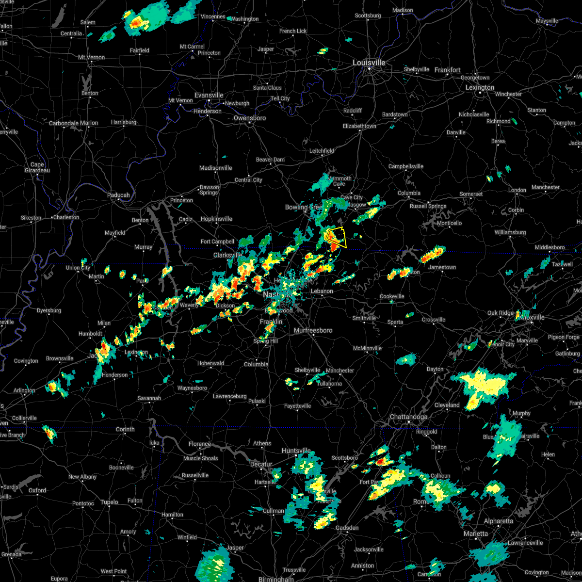 At 640 pm cdt, a severe thunderstorm was located over scottsville, moving east at 20 mph (radar indicated). Hazards include 60 mph wind gusts and quarter size hail. Hail damage to vehicles is expected. expect wind damage to roofs, siding, and trees. Locations impacted include, scottsville, rodemer, oak forest, maynard and holland. At 640 pm cdt, a severe thunderstorm was located over scottsville, moving east at 20 mph (radar indicated). Hazards include 60 mph wind gusts and quarter size hail. Hail damage to vehicles is expected. expect wind damage to roofs, siding, and trees. Locations impacted include, scottsville, rodemer, oak forest, maynard and holland.
|
| 8/14/2020 6:37 PM CDT | Trees down on side streets around hwy 100. specifically walker way and lone oak dr. in allen county KY, 1.4 miles NE of Scottsville, KY |
| 8/14/2020 6:36 PM CDT | Observer called to say a big tree had fallen on power lines and was burnin in allen county KY, 1.7 miles E of Scottsville, KY |
| 8/14/2020 6:26 PM CDT |
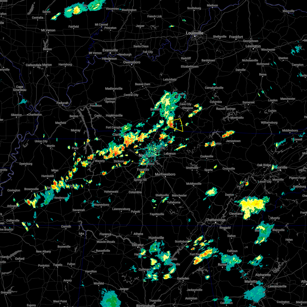 At 626 pm cdt, a severe thunderstorm was located over scottsville, moving east at 15 mph (radar indicated). Hazards include 60 mph wind gusts and quarter size hail. Hail damage to vehicles is expected. Expect wind damage to roofs, siding, and trees. At 626 pm cdt, a severe thunderstorm was located over scottsville, moving east at 15 mph (radar indicated). Hazards include 60 mph wind gusts and quarter size hail. Hail damage to vehicles is expected. Expect wind damage to roofs, siding, and trees.
|
| 7/5/2020 3:30 PM CDT | Tree and barn damage from storms. report relayed via twitter. time of report estimated by rada in allen county KY, 8.2 miles S of Scottsville, KY |
| 4/8/2020 9:59 PM CDT |
 A severe thunderstorm warning remains in effect until 1015 pm cdt for southeastern simpson. allen and southeastern warren counties. at 959 pm cdt, a severe thunderstorm was located near scottsville, moving east at 50 mph. hazard. 60 mph wind gusts and penny size hail. source. Radar indicated. A severe thunderstorm warning remains in effect until 1015 pm cdt for southeastern simpson. allen and southeastern warren counties. at 959 pm cdt, a severe thunderstorm was located near scottsville, moving east at 50 mph. hazard. 60 mph wind gusts and penny size hail. source. Radar indicated.
|
| 4/8/2020 9:28 PM CDT |
 At 928 pm cdt, a severe thunderstorm was located 10 miles southeast of russellville, moving east at 50 mph (radar indicated). Hazards include 60 mph wind gusts and quarter size hail. Hail damage to vehicles is expected. Expect wind damage to roofs, siding, and trees. At 928 pm cdt, a severe thunderstorm was located 10 miles southeast of russellville, moving east at 50 mph (radar indicated). Hazards include 60 mph wind gusts and quarter size hail. Hail damage to vehicles is expected. Expect wind damage to roofs, siding, and trees.
|
| 3/20/2020 5:31 AM CDT |
 At 531 am cdt, a severe thunderstorm was located 11 miles north of portland, moving east at 50 mph (radar indicated). Hazards include 60 mph wind gusts and half dollar size hail. Hail damage to vehicles is expected. Expect wind damage to roofs, siding, and trees. At 531 am cdt, a severe thunderstorm was located 11 miles north of portland, moving east at 50 mph (radar indicated). Hazards include 60 mph wind gusts and half dollar size hail. Hail damage to vehicles is expected. Expect wind damage to roofs, siding, and trees.
|
| 3/3/2020 12:56 AM CST |
 The severe thunderstorm warning for northeastern allen and central barren counties will expire at 100 am cst, the storm which prompted the warning is weakening and moving out of the area. therefore, the warning will be allowed to expire. no severe weather reports have been received from the area at this time. The severe thunderstorm warning for northeastern allen and central barren counties will expire at 100 am cst, the storm which prompted the warning is weakening and moving out of the area. therefore, the warning will be allowed to expire. no severe weather reports have been received from the area at this time.
|
| 3/3/2020 12:30 AM CST |
 At 1230 am cst, a severe thunderstorm was located 8 miles north of scottsville, moving east at 40 mph (radar indicated). Hazards include 60 mph wind gusts and nickel size hail. expect damage to roofs, siding, and trees At 1230 am cst, a severe thunderstorm was located 8 miles north of scottsville, moving east at 40 mph (radar indicated). Hazards include 60 mph wind gusts and nickel size hail. expect damage to roofs, siding, and trees
|
| 3/3/2020 12:23 AM CST | Multiple trees down near cemetery road and shockley roa in allen county KY, 7.5 miles S of Scottsville, KY |
| 1/11/2020 9:27 AM CST |
 The severe thunderstorm warning for simpson, western allen and southern warren counties will expire at 930 am cst, the storms which prompted the warning have weakened below severe limits. however gusty winds and heavy rain are still possible. a tornado watch remains in effect until 100 pm cst for south central kentucky. The severe thunderstorm warning for simpson, western allen and southern warren counties will expire at 930 am cst, the storms which prompted the warning have weakened below severe limits. however gusty winds and heavy rain are still possible. a tornado watch remains in effect until 100 pm cst for south central kentucky.
|
| 1/11/2020 9:07 AM CST |
 At 906 am cst, severe thunderstorms were located along a line extending from near three springs to portland, moving northeast at 40 mph (radar indicated). Hazards include 60 mph wind gusts. expect damage to roofs, siding, and trees At 906 am cst, severe thunderstorms were located along a line extending from near three springs to portland, moving northeast at 40 mph (radar indicated). Hazards include 60 mph wind gusts. expect damage to roofs, siding, and trees
|
| 6/21/2019 8:08 PM CDT |
 The tornado warning for northwestern allen and southeastern warren counties will expire at 815 pm cdt, the storm which prompted the warning has weakened below severe limits, and no longer appears capable of producing a tornado. therefore, the warning will be allowed to expire. a severe thunderstorm watch remains in effect until 1000 pm cdt for south central kentucky. The tornado warning for northwestern allen and southeastern warren counties will expire at 815 pm cdt, the storm which prompted the warning has weakened below severe limits, and no longer appears capable of producing a tornado. therefore, the warning will be allowed to expire. a severe thunderstorm watch remains in effect until 1000 pm cdt for south central kentucky.
|
| 6/21/2019 8:00 PM CDT | Tree down. reported at bewley town runaway drive kentuck in barren county KY, 9.1 miles WSW of Scottsville, KY |
| 6/21/2019 8:00 PM CDT | *** 1 fatal *** a tree killed a man when it fell on his truck on washington school roa in allen county KY, 3.9 miles WSW of Scottsville, KY |
| 6/21/2019 7:58 PM CDT |
 At 758 pm cdt, a severe thunderstorm was located near scottsville, moving east at 45 mph (radar indicated). Hazards include 70 mph wind gusts. Expect considerable tree damage. Damage is likely to mobile homes, roofs, and outbuildings. At 758 pm cdt, a severe thunderstorm was located near scottsville, moving east at 45 mph (radar indicated). Hazards include 70 mph wind gusts. Expect considerable tree damage. Damage is likely to mobile homes, roofs, and outbuildings.
|
| 6/21/2019 7:48 PM CDT |
 At 746 pm cdt, a severe thunderstorm capable of producing a tornado was located 8 miles west of scottsville, moving east at 45 mph (radar indicated rotation). Hazards include tornado. Flying debris will be dangerous to those caught without shelter. mobile homes will be damaged or destroyed. damage to roofs, windows, and vehicles will occur. tree damage is likely. Locations impacted include, scottsville, allen springs, west fork, settle, yesse, raley ford, halifax, claypool, alvaton and gainesville. At 746 pm cdt, a severe thunderstorm capable of producing a tornado was located 8 miles west of scottsville, moving east at 45 mph (radar indicated rotation). Hazards include tornado. Flying debris will be dangerous to those caught without shelter. mobile homes will be damaged or destroyed. damage to roofs, windows, and vehicles will occur. tree damage is likely. Locations impacted include, scottsville, allen springs, west fork, settle, yesse, raley ford, halifax, claypool, alvaton and gainesville.
|
| 6/21/2019 7:38 PM CDT |
 At 738 pm cdt, a severe thunderstorm capable of producing a tornado was located 7 miles south of three springs, moving northeast at 45 mph (radar indicated rotation). Hazards include tornado. Flying debris will be dangerous to those caught without shelter. mobile homes will be damaged or destroyed. damage to roofs, windows, and vehicles will occur. Tree damage is likely. At 738 pm cdt, a severe thunderstorm capable of producing a tornado was located 7 miles south of three springs, moving northeast at 45 mph (radar indicated rotation). Hazards include tornado. Flying debris will be dangerous to those caught without shelter. mobile homes will be damaged or destroyed. damage to roofs, windows, and vehicles will occur. Tree damage is likely.
|
| 6/21/2019 7:18 PM CDT |
 At 717 pm cdt, a severe thunderstorm was located 7 miles northeast of russellville, moving east at 45 mph. this storm has a long history of producing wind damage (radar indicated). Hazards include 70 mph wind gusts. Expect considerable tree damage. Damage is likely to mobile homes, roofs, and outbuildings. At 717 pm cdt, a severe thunderstorm was located 7 miles northeast of russellville, moving east at 45 mph. this storm has a long history of producing wind damage (radar indicated). Hazards include 70 mph wind gusts. Expect considerable tree damage. Damage is likely to mobile homes, roofs, and outbuildings.
|
| 3/30/2019 6:51 PM CDT |
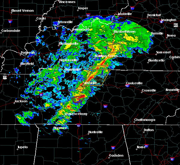 At 651 pm cdt, severe thunderstorms were located along a line extending from 8 miles southwest of scottsville to 6 miles northwest of westmoreland to 7 miles north of gallatin, moving east at 50 mph (radar indicated). Hazards include 70 mph wind gusts. Expect considerable tree damage. damage is likely to mobile homes, roofs, and outbuildings. Locations impacted include, scottsville, fleet, new roe, rodemer, adolphus, petroleum, alonzo, chapel hill and forest springs. At 651 pm cdt, severe thunderstorms were located along a line extending from 8 miles southwest of scottsville to 6 miles northwest of westmoreland to 7 miles north of gallatin, moving east at 50 mph (radar indicated). Hazards include 70 mph wind gusts. Expect considerable tree damage. damage is likely to mobile homes, roofs, and outbuildings. Locations impacted include, scottsville, fleet, new roe, rodemer, adolphus, petroleum, alonzo, chapel hill and forest springs.
|
| 3/30/2019 6:34 PM CDT |
 At 633 pm cdt, severe thunderstorms were located along a line extending from near portland to 7 miles northeast of cross plains to white house, moving east at 50 mph (radar indicated). Hazards include 70 mph wind gusts. Expect considerable tree damage. Damage is likely to mobile homes, roofs, and outbuildings. At 633 pm cdt, severe thunderstorms were located along a line extending from near portland to 7 miles northeast of cross plains to white house, moving east at 50 mph (radar indicated). Hazards include 70 mph wind gusts. Expect considerable tree damage. Damage is likely to mobile homes, roofs, and outbuildings.
|
| 8/8/2018 11:21 AM CDT |
 At 1121 am cdt, a severe thunderstorm was located 11 miles south of glasgow, moving east at 30 mph (radar indicated). Hazards include 60 mph wind gusts and quarter size hail. Hail damage to vehicles is expected. expect wind damage to roofs, siding, and trees. Locations impacted include, scottsville, dry fork, eighty eight, oak forest, maynard, lucas, austin, tracy, forest springs and amos. At 1121 am cdt, a severe thunderstorm was located 11 miles south of glasgow, moving east at 30 mph (radar indicated). Hazards include 60 mph wind gusts and quarter size hail. Hail damage to vehicles is expected. expect wind damage to roofs, siding, and trees. Locations impacted include, scottsville, dry fork, eighty eight, oak forest, maynard, lucas, austin, tracy, forest springs and amos.
|
| 8/8/2018 11:15 AM CDT |
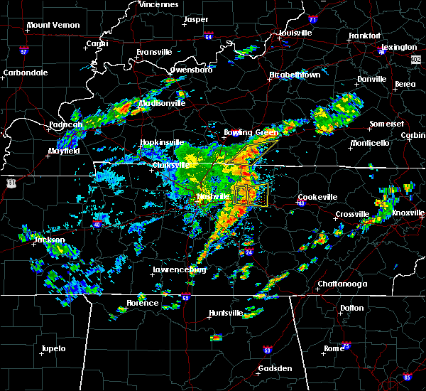 At 1115 am cdt, severe thunderstorms were located along a line extending from 10 miles northeast of scottsville to westmoreland, moving east at 30 mph (radar indicated). Hazards include 60 mph wind gusts and quarter size hail. Hail damage to vehicles is expected. expect wind damage to roofs, siding, and trees. Locations impacted include, scottsville, dry fork, eighty eight, fleet, rodemer, oak forest, maynard, lucas, austin and tracy. At 1115 am cdt, severe thunderstorms were located along a line extending from 10 miles northeast of scottsville to westmoreland, moving east at 30 mph (radar indicated). Hazards include 60 mph wind gusts and quarter size hail. Hail damage to vehicles is expected. expect wind damage to roofs, siding, and trees. Locations impacted include, scottsville, dry fork, eighty eight, fleet, rodemer, oak forest, maynard, lucas, austin and tracy.
|
| 8/8/2018 11:07 AM CDT |
 At 1107 am cdt, severe thunderstorms were located along a line extending from near scottsville to 8 miles west of westmoreland, moving northeast at 20 mph (radar indicated). Hazards include 60 mph wind gusts. Expect damage to roofs, siding, and trees. Locations impacted include, scottsville, eighty eight, oak forest, west fork, maynard, clare, austin, yesse, alonzo and butlersville. At 1107 am cdt, severe thunderstorms were located along a line extending from near scottsville to 8 miles west of westmoreland, moving northeast at 20 mph (radar indicated). Hazards include 60 mph wind gusts. Expect damage to roofs, siding, and trees. Locations impacted include, scottsville, eighty eight, oak forest, west fork, maynard, clare, austin, yesse, alonzo and butlersville.
|
| 8/8/2018 10:54 AM CDT |
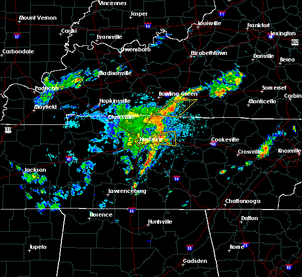 At 1054 am cdt, severe thunderstorms were located along a line extending from scottsville to 9 miles southeast of portland, moving northeast at 20 mph (radar indicated). Hazards include 60 mph wind gusts. expect damage to roofs, siding, and trees At 1054 am cdt, severe thunderstorms were located along a line extending from scottsville to 9 miles southeast of portland, moving northeast at 20 mph (radar indicated). Hazards include 60 mph wind gusts. expect damage to roofs, siding, and trees
|
| 6/27/2018 4:36 PM CDT |
 At 436 pm cdt, a severe thunderstorm was located near scottsville, moving east at 25 mph (radar indicated). Hazards include 60 mph wind gusts. expect damage to roofs, siding, and trees At 436 pm cdt, a severe thunderstorm was located near scottsville, moving east at 25 mph (radar indicated). Hazards include 60 mph wind gusts. expect damage to roofs, siding, and trees
|
| 6/27/2018 2:09 PM CDT | Trees dow in allen county KY, 6 miles WNW of Scottsville, KY |
| 6/27/2018 2:00 PM CDT | Trees down in scottsvill in allen county KY, 0.6 miles W of Scottsville, KY |
| 6/27/2018 1:53 PM CDT |
 At 152 pm cdt, severe thunderstorms were located along a line extending from 8 miles east of scottsville to 8 miles southwest of edmonton, moving southeast at 40 mph (radar indicated). Hazards include 60 mph wind gusts. expect damage to roofs, siding, and trees At 152 pm cdt, severe thunderstorms were located along a line extending from 8 miles east of scottsville to 8 miles southwest of edmonton, moving southeast at 40 mph (radar indicated). Hazards include 60 mph wind gusts. expect damage to roofs, siding, and trees
|
| 6/26/2018 1:13 PM CDT |
 At 112 pm cdt, severe thunderstorms were located along a line extending from 11 miles east of scottsville to near westmoreland, moving east at 35 mph (radar indicated). Hazards include 60 mph wind gusts. expect damage to roofs, siding, and trees At 112 pm cdt, severe thunderstorms were located along a line extending from 11 miles east of scottsville to near westmoreland, moving east at 35 mph (radar indicated). Hazards include 60 mph wind gusts. expect damage to roofs, siding, and trees
|
| 6/26/2018 12:50 PM CDT | Trees reported down at franklin rd and chapel hill rd scottsville... k in allen county KY, 6 miles ENE of Scottsville, KY |
| 6/26/2018 12:48 PM CDT |
 At 1248 pm cdt, severe thunderstorms were located along a line extending from 12 miles east of plum springs to near portland, moving east at 30 mph (radar indicated). Hazards include 60 mph wind gusts. expect damage to roofs, siding, and trees At 1248 pm cdt, severe thunderstorms were located along a line extending from 12 miles east of plum springs to near portland, moving east at 30 mph (radar indicated). Hazards include 60 mph wind gusts. expect damage to roofs, siding, and trees
|
| 6/24/2018 3:08 PM CDT |
 The severe thunderstorm warning for northwestern allen and southeastern warren counties will expire at 315 pm cdt, the storm which prompted the warning has weakened below severe limits, and has exited the warned area. therefore, the warning will be allowed to expire. report severe weather to local law enforcement, post your report to the national weather service louisville facebook page, or tweet your report using hashtag l, m, k, spotter. The severe thunderstorm warning for northwestern allen and southeastern warren counties will expire at 315 pm cdt, the storm which prompted the warning has weakened below severe limits, and has exited the warned area. therefore, the warning will be allowed to expire. report severe weather to local law enforcement, post your report to the national weather service louisville facebook page, or tweet your report using hashtag l, m, k, spotter.
|
| 6/24/2018 2:52 PM CDT |
 At 252 pm cdt, a severe thunderstorm was located 7 miles east of three springs, moving east at 30 mph (radar indicated). Hazards include 60 mph wind gusts and penny size hail. Expect damage to roofs, siding, and trees. Locations impacted include, allen springs, west fork, greenhill, settle, yesse, raley ford, halifax, claypool, alvaton, and butlersville. At 252 pm cdt, a severe thunderstorm was located 7 miles east of three springs, moving east at 30 mph (radar indicated). Hazards include 60 mph wind gusts and penny size hail. Expect damage to roofs, siding, and trees. Locations impacted include, allen springs, west fork, greenhill, settle, yesse, raley ford, halifax, claypool, alvaton, and butlersville.
|
| 6/24/2018 2:40 PM CDT |
 At 239 pm cdt, a severe thunderstorm was located near three springs, moving east at 30 mph (radar indicated). Hazards include 60 mph wind gusts and nickel size hail. expect damage to roofs, siding, and trees At 239 pm cdt, a severe thunderstorm was located near three springs, moving east at 30 mph (radar indicated). Hazards include 60 mph wind gusts and nickel size hail. expect damage to roofs, siding, and trees
|
| 5/31/2018 6:17 PM CDT |
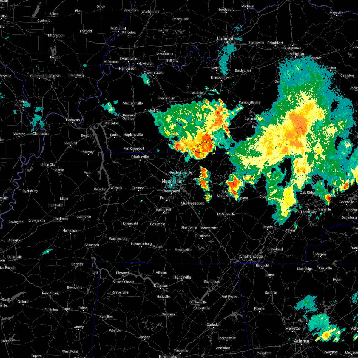 At 617 pm cdt, a severe thunderstorm was located 10 miles southeast of scottsville, moving east at 45 mph (radar indicated). Hazards include 60 mph wind gusts. Expect damage to roofs, siding, and trees. Locations impacted include, scottsville, fleet, rodemer, oak forest, maynard, adolphus, petroleum, chapel hill, forest springs and holland. At 617 pm cdt, a severe thunderstorm was located 10 miles southeast of scottsville, moving east at 45 mph (radar indicated). Hazards include 60 mph wind gusts. Expect damage to roofs, siding, and trees. Locations impacted include, scottsville, fleet, rodemer, oak forest, maynard, adolphus, petroleum, chapel hill, forest springs and holland.
|
| 5/31/2018 6:06 PM CDT | Trees down across maysville roa in allen county KY, 1.8 miles WNW of Scottsville, KY |
| 5/31/2018 5:57 PM CDT |
 At 557 pm cdt, a severe thunderstorm was located near scottsville, moving east at 45 mph (radar indicated). Hazards include 60 mph wind gusts. expect damage to roofs, siding, and trees At 557 pm cdt, a severe thunderstorm was located near scottsville, moving east at 45 mph (radar indicated). Hazards include 60 mph wind gusts. expect damage to roofs, siding, and trees
|
| 5/31/2018 4:26 PM CDT |
 At 425 pm cdt, a cluster of severe thunderstorms were located over eastern allen and southern barren counties, moving east-southeast at 20 to 25 mph (radar indicated). Hazards include 60 mph wind gusts and quarter size hail. Hail damage to vehicles is expected. expect wind damage to roofs, siding, and trees. locations impacted include, scottsville, fountain run, dry fork, oak forest, maynard, austin, nobob, yesse, tracy and halifax. frequent and dangerous cloud-to-ground lightning and torrential rainfall also are occurring. Watch out for flooded roads as well. At 425 pm cdt, a cluster of severe thunderstorms were located over eastern allen and southern barren counties, moving east-southeast at 20 to 25 mph (radar indicated). Hazards include 60 mph wind gusts and quarter size hail. Hail damage to vehicles is expected. expect wind damage to roofs, siding, and trees. locations impacted include, scottsville, fountain run, dry fork, oak forest, maynard, austin, nobob, yesse, tracy and halifax. frequent and dangerous cloud-to-ground lightning and torrential rainfall also are occurring. Watch out for flooded roads as well.
|
| 5/31/2018 4:09 PM CDT |
 At 409 pm cdt, severe thunderstorms were located near scottsville, moving east-southeast at 20 mph (radar indicated). Hazards include 60 mph wind gusts and quarter size hail. Hail damage to vehicles is expected. Expect wind damage to roofs, siding, and trees. At 409 pm cdt, severe thunderstorms were located near scottsville, moving east-southeast at 20 mph (radar indicated). Hazards include 60 mph wind gusts and quarter size hail. Hail damage to vehicles is expected. Expect wind damage to roofs, siding, and trees.
|
| 4/3/2018 9:48 PM CDT |
 At 948 pm cdt, a severe thunderstorm was located over scottsville, moving east at 70 mph (radar indicated). Hazards include 60 mph wind gusts. Expect damage to roofs, siding, and trees. locations impacted include, scottsville, allen springs, oak forest, west fork, maynard, clare, austin, settle, yesse and raley ford. A tornado watch remains in effect until midnight cdt for south central kentucky. At 948 pm cdt, a severe thunderstorm was located over scottsville, moving east at 70 mph (radar indicated). Hazards include 60 mph wind gusts. Expect damage to roofs, siding, and trees. locations impacted include, scottsville, allen springs, oak forest, west fork, maynard, clare, austin, settle, yesse and raley ford. A tornado watch remains in effect until midnight cdt for south central kentucky.
|
| 4/3/2018 9:34 PM CDT |
 At 934 pm cdt, a severe thunderstorm was located 8 miles northeast of portland, moving east at 65 mph (radar indicated). Hazards include 60 mph wind gusts. expect damage to roofs, siding, and trees At 934 pm cdt, a severe thunderstorm was located 8 miles northeast of portland, moving east at 65 mph (radar indicated). Hazards include 60 mph wind gusts. expect damage to roofs, siding, and trees
|
| 2/24/2018 10:15 PM CST |
 At 1014 pm cst, a severe thunderstorm was located near scottsville, moving east at 50 mph (radar indicated). Hazards include 60 mph wind gusts. expect damage to roofs, siding, and trees At 1014 pm cst, a severe thunderstorm was located near scottsville, moving east at 50 mph (radar indicated). Hazards include 60 mph wind gusts. expect damage to roofs, siding, and trees
|
| 2/24/2018 10:11 PM CST |
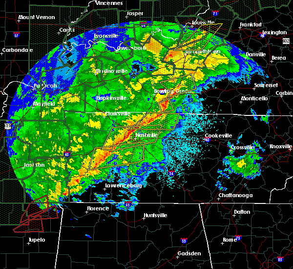 At 1011 pm cst, a severe thunderstorm was located over scottsville, moving east at 50 mph (radar indicated). Hazards include 70 mph wind gusts. Expect considerable tree damage. damage is likely to mobile homes, roofs, and outbuildings. locations impacted include, scottsville, rodemer, oak forest, west fork, settle, yesse, petroleum, halifax, chapel hill and gainesville. A tornado watch remains in effect until 200 am cst for south central kentucky. At 1011 pm cst, a severe thunderstorm was located over scottsville, moving east at 50 mph (radar indicated). Hazards include 70 mph wind gusts. Expect considerable tree damage. damage is likely to mobile homes, roofs, and outbuildings. locations impacted include, scottsville, rodemer, oak forest, west fork, settle, yesse, petroleum, halifax, chapel hill and gainesville. A tornado watch remains in effect until 200 am cst for south central kentucky.
|
| 2/24/2018 10:02 PM CST |
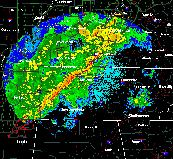 At 1002 pm cst, a severe thunderstorm was located 10 miles west of scottsville, moving east at 55 mph (radar indicated). Hazards include 70 mph wind gusts. Expect considerable tree damage. damage is likely to mobile homes, roofs, and outbuildings. locations impacted include, scottsville, allen springs, oak forest, west fork, clare, settle, yesse, mcelroy ford, raley ford and alonzo. A tornado watch remains in effect until 200 am cst for south central kentucky. At 1002 pm cst, a severe thunderstorm was located 10 miles west of scottsville, moving east at 55 mph (radar indicated). Hazards include 70 mph wind gusts. Expect considerable tree damage. damage is likely to mobile homes, roofs, and outbuildings. locations impacted include, scottsville, allen springs, oak forest, west fork, clare, settle, yesse, mcelroy ford, raley ford and alonzo. A tornado watch remains in effect until 200 am cst for south central kentucky.
|
| 2/24/2018 9:44 PM CST |
 At 944 pm cst, a severe thunderstorm was located near cross plains, moving east at 50 mph (radar indicated). Hazards include 70 mph wind gusts. Expect considerable tree damage. Damage is likely to mobile homes, roofs, and outbuildings. At 944 pm cst, a severe thunderstorm was located near cross plains, moving east at 50 mph (radar indicated). Hazards include 70 mph wind gusts. Expect considerable tree damage. Damage is likely to mobile homes, roofs, and outbuildings.
|
| 6/15/2017 11:05 AM CDT |
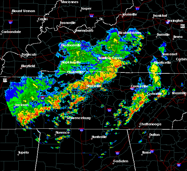 The severe thunderstorm warning for southern allen county will expire at 1115 am cdt, the storm which prompted the warning has weakened below severe limits, and no longer poses an immediate threat to life or property. therefore the warning will be allowed to expire. however gusty winds are still possible with this thunderstorm. report severe weather to local law enforcement, post your report to the national weather service louisville facebook page, or tweet your report using hashtag l, m, k, spotter. The severe thunderstorm warning for southern allen county will expire at 1115 am cdt, the storm which prompted the warning has weakened below severe limits, and no longer poses an immediate threat to life or property. therefore the warning will be allowed to expire. however gusty winds are still possible with this thunderstorm. report severe weather to local law enforcement, post your report to the national weather service louisville facebook page, or tweet your report using hashtag l, m, k, spotter.
|
| 6/15/2017 10:51 AM CDT |
 At 1050 am cdt, a severe thunderstorm was located near scottsville, moving east at 25 mph (radar indicated). Hazards include 60 mph wind gusts and penny size hail. Expect damage to roofs, siding, and trees. Locations impacted include, scottsville, fleet, rodemer, oak forest, adolphus, petroleum, chapel hill, forest springs, holland and amos. At 1050 am cdt, a severe thunderstorm was located near scottsville, moving east at 25 mph (radar indicated). Hazards include 60 mph wind gusts and penny size hail. Expect damage to roofs, siding, and trees. Locations impacted include, scottsville, fleet, rodemer, oak forest, adolphus, petroleum, chapel hill, forest springs, holland and amos.
|
| 6/15/2017 10:38 AM CDT |
 At 1038 am cdt, a severe thunderstorm was located near scottsville, moving east at 20 mph (radar indicated). Hazards include 60 mph wind gusts and penny size hail. expect damage to roofs, siding, and trees At 1038 am cdt, a severe thunderstorm was located near scottsville, moving east at 20 mph (radar indicated). Hazards include 60 mph wind gusts and penny size hail. expect damage to roofs, siding, and trees
|
| 5/19/2017 5:40 AM CDT |
 At 540 am cdt, a severe thunderstorm was located near scottsville, moving northeast at 40 mph (radar indicated). Hazards include 60 mph wind gusts and penny size hail. expect damage to roofs, siding, and trees At 540 am cdt, a severe thunderstorm was located near scottsville, moving northeast at 40 mph (radar indicated). Hazards include 60 mph wind gusts and penny size hail. expect damage to roofs, siding, and trees
|
| 4/30/2017 4:02 PM CDT | Tree down on port oliver roa in allen county KY, 8.2 miles SSW of Scottsville, KY |
| 4/30/2017 3:58 PM CDT | 2 or 3 trees down on smiths grove roa in allen county KY, 2.1 miles SSW of Scottsville, KY |
| 4/30/2017 3:52 PM CDT |
 At 352 pm cdt, a severe thunderstorm was located over scottsville, moving northeast at 60 mph (radar indicated). Hazards include 60 mph wind gusts. expect damage to roofs, siding, and trees At 352 pm cdt, a severe thunderstorm was located over scottsville, moving northeast at 60 mph (radar indicated). Hazards include 60 mph wind gusts. expect damage to roofs, siding, and trees
|
| 4/30/2017 3:49 PM CDT |
 At 349 pm cdt, a severe thunderstorm was located near scottsville, moving north at 60 mph (radar indicated). Hazards include 60 mph wind gusts. Expect damage to roofs, siding, and trees. Locations impacted include, scottsville, hardcastle, allen springs, west fork, clare, greenhill, settle, yesse, raley ford and alonzo. At 349 pm cdt, a severe thunderstorm was located near scottsville, moving north at 60 mph (radar indicated). Hazards include 60 mph wind gusts. Expect damage to roofs, siding, and trees. Locations impacted include, scottsville, hardcastle, allen springs, west fork, clare, greenhill, settle, yesse, raley ford and alonzo.
|
| 4/30/2017 3:37 PM CDT |
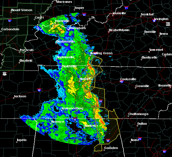 At 337 pm cdt, a severe thunderstorm was located near westmoreland, moving northeast at 60 mph (radar indicated). Hazards include 60 mph wind gusts. expect damage to roofs, siding, and trees At 337 pm cdt, a severe thunderstorm was located near westmoreland, moving northeast at 60 mph (radar indicated). Hazards include 60 mph wind gusts. expect damage to roofs, siding, and trees
|
| 4/5/2017 4:56 PM CDT |
 The severe thunderstorm warning for southeastern simpson, allen, southeastern warren and southwestern barren counties will expire at 500 pm cdt, the storms which prompted the warning have weakened below severe limits, and no longer pose an immediate threat to life or property. therefore the warning will be allowed to expire. a tornado watch remains in effect until 900 pm cdt for south central kentucky. report severe weather to local law enforcement, post your report to the national weather service louisville facebook page, or tweet your report using hashtag l, m, k, spotter. The severe thunderstorm warning for southeastern simpson, allen, southeastern warren and southwestern barren counties will expire at 500 pm cdt, the storms which prompted the warning have weakened below severe limits, and no longer pose an immediate threat to life or property. therefore the warning will be allowed to expire. a tornado watch remains in effect until 900 pm cdt for south central kentucky. report severe weather to local law enforcement, post your report to the national weather service louisville facebook page, or tweet your report using hashtag l, m, k, spotter.
|
| 4/5/2017 4:44 PM CDT |
 At 444 pm cdt, severe thunderstorms were located along a line extending from 12 miles west of glasgow to near portland, moving northeast at 10 mph (radar indicated). Hazards include 60 mph wind gusts and half dollar size hail. Hail damage to vehicles is expected. expect wind damage to roofs, siding, and trees. locations impacted include, glasgow, scottsville, red cross, allen springs, west fork, maynard, clare, greenhill, haywood and settle. A tornado watch remains in effect until 900 pm cdt for south central kentucky. At 444 pm cdt, severe thunderstorms were located along a line extending from 12 miles west of glasgow to near portland, moving northeast at 10 mph (radar indicated). Hazards include 60 mph wind gusts and half dollar size hail. Hail damage to vehicles is expected. expect wind damage to roofs, siding, and trees. locations impacted include, glasgow, scottsville, red cross, allen springs, west fork, maynard, clare, greenhill, haywood and settle. A tornado watch remains in effect until 900 pm cdt for south central kentucky.
|
| 4/5/2017 4:32 PM CDT |
 At 432 pm cdt, severe thunderstorms were located along a line extending from 10 miles west of glasgow to near portland, moving northeast at 60 mph (radar indicated). Hazards include 60 mph wind gusts and half dollar size hail. Hail damage to vehicles is expected. Expect wind damage to roofs, siding, and trees. At 432 pm cdt, severe thunderstorms were located along a line extending from 10 miles west of glasgow to near portland, moving northeast at 60 mph (radar indicated). Hazards include 60 mph wind gusts and half dollar size hail. Hail damage to vehicles is expected. Expect wind damage to roofs, siding, and trees.
|
| 3/30/2017 8:25 PM CDT |
 At 825 pm cdt, a severe thunderstorm was located 8 miles north of lafayette, moving north at 50 mph (radar indicated). Hazards include 60 mph wind gusts and quarter size hail. Hail damage to vehicles is expected. Expect wind damage to roofs, siding, and trees. At 825 pm cdt, a severe thunderstorm was located 8 miles north of lafayette, moving north at 50 mph (radar indicated). Hazards include 60 mph wind gusts and quarter size hail. Hail damage to vehicles is expected. Expect wind damage to roofs, siding, and trees.
|
| 3/27/2017 4:29 PM CDT |
 At 428 pm cdt, severe thunderstorms were located along a line extending from near plum springs to 9 miles southeast of mount victor to 9 miles northwest of westmoreland, moving east at 50 mph (radar indicated). Hazards include 60 mph wind gusts and quarter size hail. Hail damage to vehicles is expected. Expect wind damage to roofs, siding, and trees. At 428 pm cdt, severe thunderstorms were located along a line extending from near plum springs to 9 miles southeast of mount victor to 9 miles northwest of westmoreland, moving east at 50 mph (radar indicated). Hazards include 60 mph wind gusts and quarter size hail. Hail damage to vehicles is expected. Expect wind damage to roofs, siding, and trees.
|
| 3/1/2017 7:33 AM CST |
 At 833 am est/733 am cst/, severe thunderstorms were located along a line extending from 7 miles east of campbellsville to 7 miles northwest of glasgow to near westmoreland, moving east at 50 mph (radar indicated). Hazards include 60 mph wind gusts. Expect damage to roofs, siding, and trees. locations impacted include, glasgow, campbellsville, columbia, scottsville, tompkinsville, greensburg, edmonton, leslie, gamaliel and fountain run. a tornado watch remains in effect until 900 am est/800 am cst/ for central kentucky. A tornado watch also remains in effect until 1100 am est/1000 am cst/ for south central and central kentucky. At 833 am est/733 am cst/, severe thunderstorms were located along a line extending from 7 miles east of campbellsville to 7 miles northwest of glasgow to near westmoreland, moving east at 50 mph (radar indicated). Hazards include 60 mph wind gusts. Expect damage to roofs, siding, and trees. locations impacted include, glasgow, campbellsville, columbia, scottsville, tompkinsville, greensburg, edmonton, leslie, gamaliel and fountain run. a tornado watch remains in effect until 900 am est/800 am cst/ for central kentucky. A tornado watch also remains in effect until 1100 am est/1000 am cst/ for south central and central kentucky.
|
| 3/1/2017 7:30 AM CST | Kentucky mesonet sit in allen county KY, 0.6 miles E of Scottsville, KY |
| 3/1/2017 7:09 AM CST |
 At 808 am est/708 am cst/, severe thunderstorms were located along a line extending from near campbellsville to near plum springs to 6 miles north of cross plains, moving east at 50 mph (radar indicated). Hazards include 60 mph wind gusts. expect damage to roofs, siding, and trees At 808 am est/708 am cst/, severe thunderstorms were located along a line extending from near campbellsville to near plum springs to 6 miles north of cross plains, moving east at 50 mph (radar indicated). Hazards include 60 mph wind gusts. expect damage to roofs, siding, and trees
|
| 3/1/2017 6:52 AM CST |
 At 651 am cst, severe thunderstorms were located along a line extending from 10 miles east of dunmor to 10 miles north of springfield, moving east at 50 mph (radar indicated). Hazards include 60 mph wind gusts. Expect damage to roofs, siding, and trees. locations impacted include, bowling green, glasgow, russellville, scottsville, plum springs, memphis junction, mount victor, delafield, crestmoor and anderson. a tornado watch remains in effect until 800 am cst for south central and central kentucky. A tornado watch also remains in effect until 1000 am cst for south central and central kentucky. At 651 am cst, severe thunderstorms were located along a line extending from 10 miles east of dunmor to 10 miles north of springfield, moving east at 50 mph (radar indicated). Hazards include 60 mph wind gusts. Expect damage to roofs, siding, and trees. locations impacted include, bowling green, glasgow, russellville, scottsville, plum springs, memphis junction, mount victor, delafield, crestmoor and anderson. a tornado watch remains in effect until 800 am cst for south central and central kentucky. A tornado watch also remains in effect until 1000 am cst for south central and central kentucky.
|
| 3/1/2017 6:29 AM CST |
 At 629 am cst, severe thunderstorms were located along a line extending from near weir to near guthrie, moving east at 65 mph (radar indicated). Hazards include 70 mph wind gusts and nickel size hail. Expect considerable tree damage. Damage is likely to mobile homes, roofs, and outbuildings. At 629 am cst, severe thunderstorms were located along a line extending from near weir to near guthrie, moving east at 65 mph (radar indicated). Hazards include 70 mph wind gusts and nickel size hail. Expect considerable tree damage. Damage is likely to mobile homes, roofs, and outbuildings.
|
| 7/14/2016 12:56 PM CDT | The severe thunderstorm warning for southeastern simpson and southern allen counties will expire at 100 pm cdt, the storms which prompted the warning have weakened below severe limits, and no longer pose an immediate threat to life or property. therefore the warning will be allowed to expire. however gusty winds and heavy rain are still possible with these thunderstorms. report severe weather to local law enforcement, post your report to the national weather service louisville facebook page, or tweet your report using hashtag l, m, k, spotter. |
| 7/14/2016 12:53 PM CDT | Tree down on durham springs roa in allen county KY, 3.1 miles WSW of Scottsville, KY |
| 7/14/2016 12:52 PM CDT | Tree down on dover church roa in allen county KY, 2.9 miles N of Scottsville, KY |
| 7/14/2016 12:50 PM CDT | Tree down on holland roa in allen county KY, 3.6 miles WNW of Scottsville, KY |
| 7/14/2016 12:48 PM CDT | Tree down on pope road. some of the trees down in the county have also taken down power line in allen county KY, 7.3 miles E of Scottsville, KY |
| 7/14/2016 12:47 PM CDT | Tree down on squire lyles roa in allen county KY, 6.1 miles E of Scottsville, KY |
| 7/14/2016 12:47 PM CDT | Tree down on old franklin roa in allen county KY, 5.6 miles E of Scottsville, KY |
| 7/14/2016 12:47 PM CDT |
 At 1247 pm cdt, severe thunderstorms were located along a line extending from near scottsville to 7 miles northwest of westmoreland, moving east at 35 mph (radar indicated). Hazards include 60 mph wind gusts and quarter size hail. Hail damage to vehicles is expected. expect wind damage to roofs, siding, and trees. Locations impacted include, scottsville, clare, halifax, pope, alonzo, mcelroy ford, forest springs, rodemer, petroleum and adolphus. At 1247 pm cdt, severe thunderstorms were located along a line extending from near scottsville to 7 miles northwest of westmoreland, moving east at 35 mph (radar indicated). Hazards include 60 mph wind gusts and quarter size hail. Hail damage to vehicles is expected. expect wind damage to roofs, siding, and trees. Locations impacted include, scottsville, clare, halifax, pope, alonzo, mcelroy ford, forest springs, rodemer, petroleum and adolphus.
|
| 7/14/2016 12:24 PM CDT |
 At 1224 pm cdt, severe thunderstorms were located along a line extending from near three springs to near portland, moving east at 40 mph (radar indicated). Hazards include 60 mph wind gusts and quarter size hail. Hail damage to vehicles is expected. Expect wind damage to roofs, siding, and trees. At 1224 pm cdt, severe thunderstorms were located along a line extending from near three springs to near portland, moving east at 40 mph (radar indicated). Hazards include 60 mph wind gusts and quarter size hail. Hail damage to vehicles is expected. Expect wind damage to roofs, siding, and trees.
|
| 7/8/2016 9:22 PM CDT |
 At 922 pm cdt, a severe thunderstorm was located 13 miles east of scottsville, moving east at 30 mph (radar indicated). Hazards include 60 mph wind gusts. Expect damage to roofs. siding. and trees. Locations impacted include, glasgow, scottsville, smiths grove, oakland, fountain run, cedar springs, railton, kepler, settle and dry fork. At 922 pm cdt, a severe thunderstorm was located 13 miles east of scottsville, moving east at 30 mph (radar indicated). Hazards include 60 mph wind gusts. Expect damage to roofs. siding. and trees. Locations impacted include, glasgow, scottsville, smiths grove, oakland, fountain run, cedar springs, railton, kepler, settle and dry fork.
|
| 7/8/2016 8:59 PM CDT | Trees down countywid in allen county KY, 4 miles ENE of Scottsville, KY |
| 7/8/2016 8:56 PM CDT |
 At 856 pm cdt, a severe thunderstorm was located near scottsville, moving east at 30 mph (radar indicated). Hazards include 60 mph wind gusts. Expect damage to roofs. siding. And trees. At 856 pm cdt, a severe thunderstorm was located near scottsville, moving east at 30 mph (radar indicated). Hazards include 60 mph wind gusts. Expect damage to roofs. siding. And trees.
|
| 7/7/2016 3:21 PM CDT |
 At 321 pm cdt, severe thunderstorms were located along and behind a line extending from near glasgow to 12 miles northwest of red boiling springs to near lafayette, moving east at 50 mph (radar indicated). Hazards include 70 mph wind gusts. Expect considerable tree damage. Damage is likely to mobile homes, roofs, and outbuildings. At 321 pm cdt, severe thunderstorms were located along and behind a line extending from near glasgow to 12 miles northwest of red boiling springs to near lafayette, moving east at 50 mph (radar indicated). Hazards include 70 mph wind gusts. Expect considerable tree damage. Damage is likely to mobile homes, roofs, and outbuildings.
|
| 7/7/2016 3:00 PM CDT | Multiple trees and power lines downed throughout the county. many roads closed due to high wate in allen county KY, 0.1 miles N of Scottsville, KY |
| 7/7/2016 2:53 PM CDT |
 At 251 pm cdt, severe thunderstorms were located along a line extending from plum springs to near portland, moving east at 55 mph. a spotter in simpson county reported several trees down with winds around 60 mph in and around franklin. radar showed the stronges winds heading toward hicory flat and gold city (radar indicated). Hazards include 70 mph wind gusts. Expect considerable tree damage. damage is likely to mobile homes, roofs, and outbuildings. Locations impacted include, bowling green, glasgow, scottsville, plum springs, crestmoor, mount victor, delafield, memphis junction, woodburn and cedar springs. At 251 pm cdt, severe thunderstorms were located along a line extending from plum springs to near portland, moving east at 55 mph. a spotter in simpson county reported several trees down with winds around 60 mph in and around franklin. radar showed the stronges winds heading toward hicory flat and gold city (radar indicated). Hazards include 70 mph wind gusts. Expect considerable tree damage. damage is likely to mobile homes, roofs, and outbuildings. Locations impacted include, bowling green, glasgow, scottsville, plum springs, crestmoor, mount victor, delafield, memphis junction, woodburn and cedar springs.
|
| 7/7/2016 2:43 PM CDT |
 At 243 pm cdt, severe thunderstorms were located along a line extending from delafield to 6 miles north of cross plains, moving east at 55 mph. numerous trees and power lines were reported down in logan county from these storms (radar indicated). Hazards include 70 mph wind gusts. Expect considerable tree damage. Damage is likely to mobile homes, roofs, and outbuildings. At 243 pm cdt, severe thunderstorms were located along a line extending from delafield to 6 miles north of cross plains, moving east at 55 mph. numerous trees and power lines were reported down in logan county from these storms (radar indicated). Hazards include 70 mph wind gusts. Expect considerable tree damage. Damage is likely to mobile homes, roofs, and outbuildings.
|
| 7/6/2016 4:14 PM CDT |
 At 413 pm cdt, severe thunderstorms were located along a line extending from 6 miles south of columbia to near scottsville, moving southeast at 40 mph (radar indicated). Hazards include 60 mph wind gusts and penny size hail. Expect damage to roofs. siding. And trees. At 413 pm cdt, severe thunderstorms were located along a line extending from 6 miles south of columbia to near scottsville, moving southeast at 40 mph (radar indicated). Hazards include 60 mph wind gusts and penny size hail. Expect damage to roofs. siding. And trees.
|
| 7/6/2016 4:11 PM CDT |
 The severe thunderstorm warning for central warren, southeastern simpson, west central barren and allen counties will expire at 415 pm cdt, the storms which prompted the warning have moved out of the area. therefore the warning will be allowed to expire. a severe thunderstorm watch remains in effect until 900 pm cdt for south central kentucky. report severe weather to local law enforcement, post your report to the national weather service louisville facebook page, or tweet your report using hashtag l, m, k, spotter. The severe thunderstorm warning for central warren, southeastern simpson, west central barren and allen counties will expire at 415 pm cdt, the storms which prompted the warning have moved out of the area. therefore the warning will be allowed to expire. a severe thunderstorm watch remains in effect until 900 pm cdt for south central kentucky. report severe weather to local law enforcement, post your report to the national weather service louisville facebook page, or tweet your report using hashtag l, m, k, spotter.
|
| 7/6/2016 4:05 PM CDT |
 At 405 pm cdt, severe thunderstorms were located along a line extending from 9 miles southeast of brownsville to 9 miles north of scottsville to near westmoreland, moving east at 60 mph (radar indicated). Hazards include 60 mph wind gusts. Expect damage to roofs. siding. and trees. Locations impacted include, bowling green, scottsville, plum springs, mount victor, cedar springs, railton, kepler, settle, halifax and mcelroy ford. At 405 pm cdt, severe thunderstorms were located along a line extending from 9 miles southeast of brownsville to 9 miles north of scottsville to near westmoreland, moving east at 60 mph (radar indicated). Hazards include 60 mph wind gusts. Expect damage to roofs. siding. and trees. Locations impacted include, bowling green, scottsville, plum springs, mount victor, cedar springs, railton, kepler, settle, halifax and mcelroy ford.
|
| 7/6/2016 3:53 PM CDT |
 At 352 pm cdt, severe thunderstorms were located along a line extending from 6 miles north of plum springs to near three springs to near portland, moving east at 60 mph (radar indicated). Hazards include 60 mph wind gusts. Expect damage to roofs. siding. and trees. Locations impacted include, bowling green, scottsville, plum springs, crestmoor, mount victor, delafield, memphis junction, woodburn, cedar springs and railton. At 352 pm cdt, severe thunderstorms were located along a line extending from 6 miles north of plum springs to near three springs to near portland, moving east at 60 mph (radar indicated). Hazards include 60 mph wind gusts. Expect damage to roofs. siding. and trees. Locations impacted include, bowling green, scottsville, plum springs, crestmoor, mount victor, delafield, memphis junction, woodburn, cedar springs and railton.
|
| 7/6/2016 3:51 PM CDT |
 At 351 pm cdt, severe thunderstorms were located along a line extending from near munfordville to 12 miles west of tompkinsville, moving east at 45 mph (radar indicated). Hazards include 60 mph wind gusts and penny size hail. Expect damage to roofs. siding. And trees. At 351 pm cdt, severe thunderstorms were located along a line extending from near munfordville to 12 miles west of tompkinsville, moving east at 45 mph (radar indicated). Hazards include 60 mph wind gusts and penny size hail. Expect damage to roofs. siding. And trees.
|
| 7/6/2016 3:29 PM CDT |
 At 328 pm cdt, severe thunderstorms were located along a line extending from 7 miles southwest of morgantown to 9 miles northeast of russellville to 9 miles north of springfield, moving east at 55 mph (radar indicated). Hazards include 60 mph wind gusts. Expect damage to roofs. siding. And trees. At 328 pm cdt, severe thunderstorms were located along a line extending from 7 miles southwest of morgantown to 9 miles northeast of russellville to 9 miles north of springfield, moving east at 55 mph (radar indicated). Hazards include 60 mph wind gusts. Expect damage to roofs. siding. And trees.
|
| 6/21/2016 4:21 PM CDT |
 The severe thunderstorm warning for southwestern monroe, south central barren and southeastern allen counties will expire at 430 pm cdt, the storm which prompted the warning has weakened below severe limits, and no longer pose an immediate threat to life or property. therefore the warning will be allowed to expire. The severe thunderstorm warning for southwestern monroe, south central barren and southeastern allen counties will expire at 430 pm cdt, the storm which prompted the warning has weakened below severe limits, and no longer pose an immediate threat to life or property. therefore the warning will be allowed to expire.
|
| 6/21/2016 4:10 PM CDT |
 At 410 pm cdt, a severe thunderstorm was located 10 miles east of scottsville, moving southeast at 30 mph (radar indicated). Hazards include 60 mph wind gusts and nickel size hail. Expect damage to roofs. siding. and trees. Locations impacted include, fountain run, akersville, jeffrey, maynard, oak forest, amos, flippin, lamb and holland. At 410 pm cdt, a severe thunderstorm was located 10 miles east of scottsville, moving southeast at 30 mph (radar indicated). Hazards include 60 mph wind gusts and nickel size hail. Expect damage to roofs. siding. and trees. Locations impacted include, fountain run, akersville, jeffrey, maynard, oak forest, amos, flippin, lamb and holland.
|
| 6/21/2016 3:58 PM CDT |
 At 358 pm cdt, a severe thunderstorm was located near scottsville, moving southeast at 25 mph (radar indicated). Hazards include 60 mph wind gusts and nickel size hail. Expect damage to roofs. siding. And trees. At 358 pm cdt, a severe thunderstorm was located near scottsville, moving southeast at 25 mph (radar indicated). Hazards include 60 mph wind gusts and nickel size hail. Expect damage to roofs. siding. And trees.
|
| 6/15/2016 3:51 PM CDT |
 At 351 pm cdt, a severe thunderstorm was located 7 miles northwest of scottsville, moving southeast at 35 mph (radar indicated). Hazards include 60 mph wind gusts. Expect damage to roofs. siding. and trees. Locations impacted include, bowling green, scottsville, cedar springs, hays, railton, kepler, settle, gainesville, hardcastle and halifax. At 351 pm cdt, a severe thunderstorm was located 7 miles northwest of scottsville, moving southeast at 35 mph (radar indicated). Hazards include 60 mph wind gusts. Expect damage to roofs. siding. and trees. Locations impacted include, bowling green, scottsville, cedar springs, hays, railton, kepler, settle, gainesville, hardcastle and halifax.
|
| 6/15/2016 3:13 PM CDT |
 At 312 pm cdt, a severe thunderstorm was located 8 miles east of morgantown, moving southeast at 35 mph (radar indicated). Hazards include 60 mph wind gusts. Expect damage to roofs. siding. And trees. At 312 pm cdt, a severe thunderstorm was located 8 miles east of morgantown, moving southeast at 35 mph (radar indicated). Hazards include 60 mph wind gusts. Expect damage to roofs. siding. And trees.
|
| 6/3/2016 7:15 PM CDT |
 At 715 pm cdt, a severe thunderstorm was located near scottsville, moving northeast at 15 mph (radar indicated). Hazards include 60 mph wind gusts and quarter size hail. Hail damage to vehicles is expected. Expect wind damage to roofs, siding, and trees. At 715 pm cdt, a severe thunderstorm was located near scottsville, moving northeast at 15 mph (radar indicated). Hazards include 60 mph wind gusts and quarter size hail. Hail damage to vehicles is expected. Expect wind damage to roofs, siding, and trees.
|
| 6/3/2016 6:58 PM CDT |
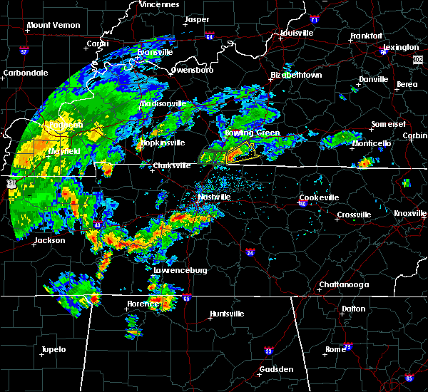 At 658 pm cdt, a severe thunderstorm was located 9 miles west of scottsville, moving northeast at 10 mph (radar indicated). Hazards include 60 mph wind gusts and quarter size hail. Hail damage to vehicles is expected. expect wind damage to roofs, siding, and trees. Locations impacted include, scottsville, cedar springs, new roe, clare, maynard, settle, mount aerial, gainesville, oak forest and meador. At 658 pm cdt, a severe thunderstorm was located 9 miles west of scottsville, moving northeast at 10 mph (radar indicated). Hazards include 60 mph wind gusts and quarter size hail. Hail damage to vehicles is expected. expect wind damage to roofs, siding, and trees. Locations impacted include, scottsville, cedar springs, new roe, clare, maynard, settle, mount aerial, gainesville, oak forest and meador.
|
| 6/3/2016 6:49 PM CDT |
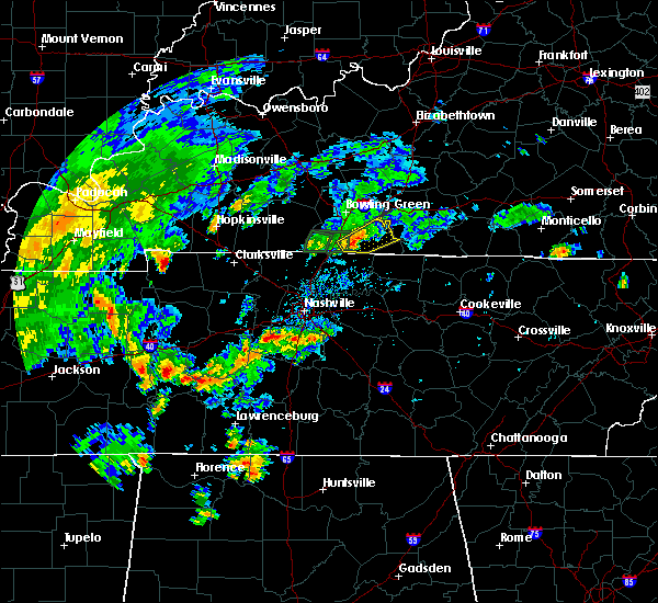 At 648 pm cdt, a severe thunderstorm was located 10 miles west of scottsville, moving northeast at 10 mph (radar indicated). Hazards include 60 mph wind gusts and quarter size hail. Hail damage to vehicles is expected. expect wind damage to roofs, siding, and trees. Locations impacted include, scottsville, cedar springs, clare, settle, gainesville, halifax, pope, alonzo, mcelroy ford and rodemer. At 648 pm cdt, a severe thunderstorm was located 10 miles west of scottsville, moving northeast at 10 mph (radar indicated). Hazards include 60 mph wind gusts and quarter size hail. Hail damage to vehicles is expected. expect wind damage to roofs, siding, and trees. Locations impacted include, scottsville, cedar springs, clare, settle, gainesville, halifax, pope, alonzo, mcelroy ford and rodemer.
|
| 6/3/2016 6:42 PM CDT |
 At 642 pm cdt, a severe thunderstorm was located 10 miles southwest of scottsville, moving northeast at 10 mph (radar indicated). Hazards include 60 mph wind gusts and quarter size hail. Hail damage to vehicles is expected. Expect wind damage to roofs, siding, and trees. At 642 pm cdt, a severe thunderstorm was located 10 miles southwest of scottsville, moving northeast at 10 mph (radar indicated). Hazards include 60 mph wind gusts and quarter size hail. Hail damage to vehicles is expected. Expect wind damage to roofs, siding, and trees.
|
| 4/27/2016 7:12 PM CDT |
 At 711 pm cdt, severe thunderstorms were located along a line extending from 8 miles north of morgantown to 6 miles north of delafield to 6 miles west of westmoreland, moving northeast at 25 mph (radar indicated). Hazards include 60 mph wind gusts and penny size hail. Expect damage to roofs. siding. and trees. locations impacted include, bowling green, leitchfield, scottsville, brownsville, plum springs, crestmoor, mount victor, delafield, memphis junction and casey. A tornado watch remains in effect until 1100 pm cdt for south central kentucky. At 711 pm cdt, severe thunderstorms were located along a line extending from 8 miles north of morgantown to 6 miles north of delafield to 6 miles west of westmoreland, moving northeast at 25 mph (radar indicated). Hazards include 60 mph wind gusts and penny size hail. Expect damage to roofs. siding. and trees. locations impacted include, bowling green, leitchfield, scottsville, brownsville, plum springs, crestmoor, mount victor, delafield, memphis junction and casey. A tornado watch remains in effect until 1100 pm cdt for south central kentucky.
|
| 4/27/2016 6:51 PM CDT |
 At 650 pm cdt, severe thunderstorms were located along a line extending from 6 miles northwest of morgantown to 7 miles west of delafield to near portland, moving northeast at 25 mph (radar indicated). Hazards include 60 mph wind gusts and penny size hail. Expect damage to roofs. siding. And trees. At 650 pm cdt, severe thunderstorms were located along a line extending from 6 miles northwest of morgantown to 7 miles west of delafield to near portland, moving northeast at 25 mph (radar indicated). Hazards include 60 mph wind gusts and penny size hail. Expect damage to roofs. siding. And trees.
|
| 4/6/2016 6:01 PM CDT | A few small tree limbs dow in allen county KY, 5.7 miles NE of Scottsville, KY |
| 4/6/2016 5:56 PM CDT |
 At 556 pm cdt, a severe thunderstorm was located 9 miles east of scottsville, moving northeast at 55 mph (radar indicated). Hazards include 60 mph wind gusts. Expect damage to roofs. siding. and trees. Locations impacted include, glasgow, scottsville, gamaliel, fountain run, cedar springs, akersville, dry fork, gainesville, halifax and haywood. At 556 pm cdt, a severe thunderstorm was located 9 miles east of scottsville, moving northeast at 55 mph (radar indicated). Hazards include 60 mph wind gusts. Expect damage to roofs. siding. and trees. Locations impacted include, glasgow, scottsville, gamaliel, fountain run, cedar springs, akersville, dry fork, gainesville, halifax and haywood.
|
| 4/6/2016 5:40 PM CDT |
 At 540 pm cdt, a severe thunderstorm was located near scottsville, moving northeast at 55 mph (radar indicated). Hazards include 60 mph wind gusts. Expect damage to roofs. siding. And trees. At 540 pm cdt, a severe thunderstorm was located near scottsville, moving northeast at 55 mph (radar indicated). Hazards include 60 mph wind gusts. Expect damage to roofs. siding. And trees.
|
| 12/23/2015 8:12 PM CST | The severe thunderstorm warning for south central warren and western allen counties will expire at 815 pm cst, the storm which prompted the warning has weakened below severe limits, and no longer pose an immediate threat to life or property. therefore the warning will be allowed to expire. a severe thunderstorm watch remains in effect until 200 am cst for south central kentucky. |
| 12/23/2015 8:03 PM CST | At 802 pm cst, a severe thunderstorm was located near scottsville, moving northeast at 55 mph (radar indicated). Hazards include 60 mph wind gusts. Expect damage to roofs. siding and trees. Locations impacted include, scottsville, clare, hardcastle, halifax, pope, alonzo, rodemer, petroleum, alvaton, new roe, motley, mount aerial, boyce, west fork, butlersville, greenhill, chapel hill, gotts, allen springs and raley ford. |
| 12/23/2015 7:39 PM CST | At 739 pm cst, a severe thunderstorm was located near portland, moving northeast at 55 mph (radar indicated). Hazards include 60 mph wind gusts. Expect damage to roofs. Siding and trees. |
| 7/14/2015 10:46 PM CDT |
 At 1044 pm cdt, severe thunderstorms were located along a line extending from 8 miles northeast of portland to 7 miles south of scottsville to red boiling spring, and moving southeast at 35 mph (law enforcement reported trees down in scottsville). Hazards include 60 mph wind gusts. Expect damage to roofs. siding and trees. Locations impacted include, mainly rural areas of extreme southwestern allen county. At 1044 pm cdt, severe thunderstorms were located along a line extending from 8 miles northeast of portland to 7 miles south of scottsville to red boiling spring, and moving southeast at 35 mph (law enforcement reported trees down in scottsville). Hazards include 60 mph wind gusts. Expect damage to roofs. siding and trees. Locations impacted include, mainly rural areas of extreme southwestern allen county.
|
| 7/14/2015 10:40 PM CDT | Two trees dow in allen county KY, 0.1 miles N of Scottsville, KY |
| 7/14/2015 10:35 PM CDT |
 At 1034 pm cdt, severe thunderstorms were located along a line extending from 5 miles east of franklin to scottsville to 6 miles north of lafayette, and moving southeast at 35 mph (radar indicated). Hazards include 60 mph wind gusts. Expect damage to roofs. Siding and trees. At 1034 pm cdt, severe thunderstorms were located along a line extending from 5 miles east of franklin to scottsville to 6 miles north of lafayette, and moving southeast at 35 mph (radar indicated). Hazards include 60 mph wind gusts. Expect damage to roofs. Siding and trees.
|
| 6/29/2015 5:47 PM CDT | The severe thunderstorm warning for allen, southern warren, simpson and southern logan counties will expire at 650 pm edt/550 pm cdt/, the line of storms which prompted the warning has weakened below severe limits, and no longer poses an immediate threat to life or property. however, heavy rain is still possible with these thunderstorms. |
| 6/29/2015 5:08 PM CDT |
 At 503 pm cdt, developing severe thunderstorms were located along a line extending from greenwood to 8 miles north of franklin to 5 miles south of russellville to 11 miles northwest of elkton, and moving southeast at 25 mph (radar indicated). Hazards include 60 mph wind gusts and penny size hail. Expect damage to roofs. Siding and trees. At 503 pm cdt, developing severe thunderstorms were located along a line extending from greenwood to 8 miles north of franklin to 5 miles south of russellville to 11 miles northwest of elkton, and moving southeast at 25 mph (radar indicated). Hazards include 60 mph wind gusts and penny size hail. Expect damage to roofs. Siding and trees.
|
| 6/21/2015 4:57 PM CDT | Quarter sized hail reported 11.6 miles S of Scottsville, KY, reported near barren river dam. corrected for the time. |
| 6/21/2015 4:25 PM CDT | Quarter sized hail reported 11.6 miles S of Scottsville, KY, reported near barren river dam. |
| 6/19/2015 6:54 PM CDT |
 At 651 pm cdt, a severe thunderstorm was located 5 miles east of scottsville, and moving northeast at 40 mph (radar indicated). Hazards include 60 mph wind gusts. Expect damage to roofs. siding and trees. Locations impacted include, meador, tracy, austin, port oliver ford, peter creek, finney, cooktown, lucas, berry store, rocky hill, railton, roseville, red cross, haywood, bristletown and beckton. At 651 pm cdt, a severe thunderstorm was located 5 miles east of scottsville, and moving northeast at 40 mph (radar indicated). Hazards include 60 mph wind gusts. Expect damage to roofs. siding and trees. Locations impacted include, meador, tracy, austin, port oliver ford, peter creek, finney, cooktown, lucas, berry store, rocky hill, railton, roseville, red cross, haywood, bristletown and beckton.
|
| 6/19/2015 6:39 PM CDT |
 At 636 pm cdt, a severe thunderstorm was located 6 miles north of westmoreland, and moving northeast at 35 mph (radar indicated). Hazards include 60 mph wind gusts. Expect damage to roofs. Siding and trees. At 636 pm cdt, a severe thunderstorm was located 6 miles north of westmoreland, and moving northeast at 35 mph (radar indicated). Hazards include 60 mph wind gusts. Expect damage to roofs. Siding and trees.
|
| 6/18/2015 1:47 PM CDT | At 145 pm cdt, a severe thunderstorm was located 7 miles west of scottsville, and moving northeast at 20 mph (radar indicated). Hazards include 60 mph wind gusts and nickel size hail. Expect damage to roofs. siding and trees. Locations impacted include, scottsville, halfway, west fork, allen springs, halifax, raley ford, yesse and settle. |
| 6/18/2015 1:37 PM CDT | Trees down across trice road. time estimated based on rada in allen county KY, 8.9 miles E of Scottsville, KY |
| 6/18/2015 1:37 PM CDT | At 135 pm cdt, a severe thunderstorm was located 9 miles west of scottsville, and moving northeast at 20 mph (radar indicated). Hazards include 60 mph wind gusts and half dollar size hail. Hail damage to vehicles is expected. Expect wind damage to roofs, siding and trees. |
| 6/8/2015 3:46 PM CDT | The severe thunderstorm warning for western allen county will expire at 450 pm edt /350 pm cdt/, the storm which prompted the warning has weakened below severe limits, and no longer poses an immediate threat to life or property. a severe thunderstorm watch remains in effect until 7 pm cdt. |
| 6/8/2015 3:42 PM CDT | At 338 pm cdt, a severe thunderstorm was located 8 miles west of scottsville, moving east at 45 mph (radar indicated). Hazards include 60 mph wind gusts. Expect damage to roofs. siding and trees. The severe thunderstorm will affect mainly rural areas of western allen county, including butlersville. |
| 6/8/2015 3:20 PM CDT |
 At 317 pm cdt, a severe thunderstorm was located near franklin, and moving east at 45 mph (radar indicated). Hazards include 60 mph wind gusts and penny size hail. Expect damage to roofs. siding and trees. the severe thunderstorm will be near, scottsville around 350 pm cdt. Other locations in the warning include peden mill, hillsdale, gold city, hickory flat, highland, bornes ford, temperance, eubanks ford, clare and new roe. At 317 pm cdt, a severe thunderstorm was located near franklin, and moving east at 45 mph (radar indicated). Hazards include 60 mph wind gusts and penny size hail. Expect damage to roofs. siding and trees. the severe thunderstorm will be near, scottsville around 350 pm cdt. Other locations in the warning include peden mill, hillsdale, gold city, hickory flat, highland, bornes ford, temperance, eubanks ford, clare and new roe.
|
| 6/8/2015 1:34 PM CDT |
 At 132 pm cdt, a severe thunderstorm was located 5 miles southeast of scottsville, and moving east at 50 mph (radar indicated). Hazards include 60 mph wind gusts. Expect damage to roofs. siding and trees. Locations impacted include, oak forest, amos, maynard, holland, mount zion and walnut hill. At 132 pm cdt, a severe thunderstorm was located 5 miles southeast of scottsville, and moving east at 50 mph (radar indicated). Hazards include 60 mph wind gusts. Expect damage to roofs. siding and trees. Locations impacted include, oak forest, amos, maynard, holland, mount zion and walnut hill.
|
| 6/8/2015 1:10 PM CDT |
 At 107 pm cdt, a severe thunderstorm was located 7 miles southeast of franklin, and moving east at 40 mph (radar indicated). Hazards include 60 mph wind gusts. Expect damage to roofs. Siding and trees. At 107 pm cdt, a severe thunderstorm was located 7 miles southeast of franklin, and moving east at 40 mph (radar indicated). Hazards include 60 mph wind gusts. Expect damage to roofs. Siding and trees.
|
| 6/8/2015 1:08 PM CDT |
 At 105 pm cdt, a severe thunderstorm was located 6 miles east of franklin, and moving east at 30 mph. at 102 pm cdt, half dollar size hail was reported 3 miles south of franklin by a trained spotter (radar indicated). Hazards include 60 mph wind gusts and half dollar size hail. Hail damage to vehicles is expected. expect wind damage to roofs, siding and trees. Locations impacted include, scottsville, highland, gold city, bornes ford, eubanks ford, temperance, mcelroy ford, clare, new roe, mount aerial, alonzo, pope, chapel hill, red hill, trammel, fleet, butlersville, west fork, petroleum and halfway. At 105 pm cdt, a severe thunderstorm was located 6 miles east of franklin, and moving east at 30 mph. at 102 pm cdt, half dollar size hail was reported 3 miles south of franklin by a trained spotter (radar indicated). Hazards include 60 mph wind gusts and half dollar size hail. Hail damage to vehicles is expected. expect wind damage to roofs, siding and trees. Locations impacted include, scottsville, highland, gold city, bornes ford, eubanks ford, temperance, mcelroy ford, clare, new roe, mount aerial, alonzo, pope, chapel hill, red hill, trammel, fleet, butlersville, west fork, petroleum and halfway.
|
| 6/8/2015 1:01 PM CDT |
 At 1257 pm cdt, a severe thunderstorm was located near franklin, and moving east at 30 mph (radar indicated). Hazards include 60 mph wind gusts and penny size hail. Expect damage to roofs. siding and trees. Locations impacted include, scottsville, hickory flat, hillsdale, highland, gold city, bornes ford, eubanks ford, temperance, mcelroy ford, clare, new roe, mount aerial, alonzo, pope, red hill, trammel, chapel hill, butlersville, fleet and halfway. At 1257 pm cdt, a severe thunderstorm was located near franklin, and moving east at 30 mph (radar indicated). Hazards include 60 mph wind gusts and penny size hail. Expect damage to roofs. siding and trees. Locations impacted include, scottsville, hickory flat, hillsdale, highland, gold city, bornes ford, eubanks ford, temperance, mcelroy ford, clare, new roe, mount aerial, alonzo, pope, red hill, trammel, chapel hill, butlersville, fleet and halfway.
|
| 6/8/2015 12:36 PM CDT |
 At 1231 pm cdt, a severe thunderstorm was located 9 miles west of franklin, and moving east at 30 mph (radar indicated). Hazards include 60 mph wind gusts and penny size hail. Expect damage to roofs. Siding and trees. At 1231 pm cdt, a severe thunderstorm was located 9 miles west of franklin, and moving east at 30 mph (radar indicated). Hazards include 60 mph wind gusts and penny size hail. Expect damage to roofs. Siding and trees.
|
| 4/10/2015 2:42 AM CDT | A severe thunderstorm warning remains in effect for western barren and allen counties until 250 am cdt. at 241 am cdt. a severe thunderstorm was located 8 miles northeast of scottsville. and moving east at 45 mph. hazard. 60 mph wind gusts. source. Radar indicated. |
| 4/10/2015 2:19 AM CDT | The national weather service in louisville has issued a * severe thunderstorm warning for. allen county in south central kentucky. western barren county in south central kentucky. eastern simpson county in south central kentucky. Southeastern warren county in south central kentucky. |
| 10/6/2014 4:45 PM CDT | Quarter sized hail reported 6.8 miles S of Scottsville, KY, quarter sized hail reported near the town of yesse. |
| 10/6/2014 4:42 PM CDT | Golf Ball sized hail reported 9.6 miles S of Scottsville, KY |
| 7/1/2014 9:26 PM CDT | Some trees down on roads across county. time estimated from rada in allen county KY, 0.1 miles N of Scottsville, KY |
| 2/20/2014 8:33 PM CST | Trees reported dow in allen county KY, 6.5 miles ESE of Scottsville, KY |
| 2/20/2014 8:32 PM CST | Trees reported down in the cit in allen county KY, 0.1 miles N of Scottsville, KY |
| 2/20/2014 8:32 PM CST | Trees reported dow in allen county KY, 4.9 miles NE of Scottsville, KY |
| 1/30/2013 4:40 AM CST | Several trees blown down blocking hwy 1533 in allen county KY, 10.3 miles S of Scottsville, KY |
| 1/30/2013 3:42 AM CST | Trees down across the count in allen county KY, 0.1 miles N of Scottsville, KY |
| 1/30/2013 3:40 AM CST | Several trees blown down blocking hwy 1533 in allen county KY, 10.3 miles S of Scottsville, KY |
| 1/30/2013 3:39 AM CST | Barn shifted off of foundation...portions of sheds blown several hundred feet...numerous trees down in allen county KY, 6.1 miles S of Scottsville, KY |
| 1/30/2013 3:38 AM CST | Three homes lost their roofs and fifteen trees down in allen county KY, 7.5 miles S of Scottsville, KY |
| 1/30/2013 2:43 AM CST | 50-70 mph winds downed trees and damaged barns. part of 16 mile long 1.5 mile wide path of straight line wind damag in barren county KY, 10.2 miles SW of Scottsville, KY |
| 7/8/2012 7:25 PM CDT | The county road crew reported several trees down across state highways 2160 and 100 in scottsville. another tree fell across kentucky highway 482 at the 8 mile marke in allen county KY, 0.1 miles N of Scottsville, KY |
| 7/2/2012 4:29 PM CDT | Trees down at several locations in scottsville in allen county KY, 0.1 miles N of Scottsville, KY |
| 4/26/2012 3:47 PM CDT | Half Dollar sized hail reported 0.1 miles N of Scottsville, KY |
| 3/15/2012 3:38 PM CDT | Quarter sized hail reported 2 miles S of Scottsville, KY |
| 1/1/0001 12:00 AM | Scattered trees down around the county in allen county KY, 0.1 miles N of Scottsville, KY |
| 1/1/0001 12:00 AM | Property damage at claire rd... walkers chapel... perrytown rd are in allen county KY, 7.2 miles ENE of Scottsville, KY |
| 1/1/0001 12:00 AM | Damage reported along new buck creek... old buck creek rd near petroleu in allen county KY, 5.4 miles NE of Scottsville, KY |
| 1/1/0001 12:00 AM | Quarter sized hail reported 8 miles WNW of Scottsville, KY |
| 1/1/0001 12:00 AM | Quarter sized hail reported 6.9 miles NNW of Scottsville, KY, fell near forest springs. |
| 1/1/0001 12:00 AM | 2 trees down in allen county KY, 2 miles S of Scottsville, KY |
| 1/1/0001 12:00 AM | Numerous trees and power lines down in the city and the surrounding are in allen county KY, 0.1 miles N of Scottsville, KY |
| 1/1/0001 12:00 AM | Spotter reports damage to trailer with trees down near 31e and cartertown rd. estimated winds to be around 70 to 80 mph in allen county KY, 0.1 miles N of Scottsville, KY |
| 1/1/0001 12:00 AM | Quarter sized hail reported 0.1 miles N of Scottsville, KY, spotter reports quarter sized hail and relays several reports of trees down...including one that had fallen on a moving vehicle on old hartsville road |
| 1/1/0001 12:00 AM | Spotter reports quarter sized hail and relays several reports of trees down...including one that had fallen on a moving vehicle on old hartsville road in allen county KY, 0.1 miles N of Scottsville, KY |
| 1/1/0001 12:00 AM | Quarter sized hail reported 6.9 miles SW of Scottsville, KY, quarter sized hail reported near cedar springs |
Hail Maps for Scottsville, KY


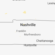


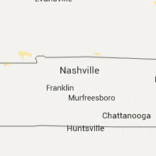


Connect with Interactive Hail Maps