

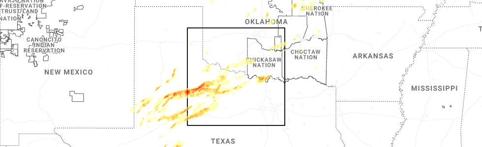
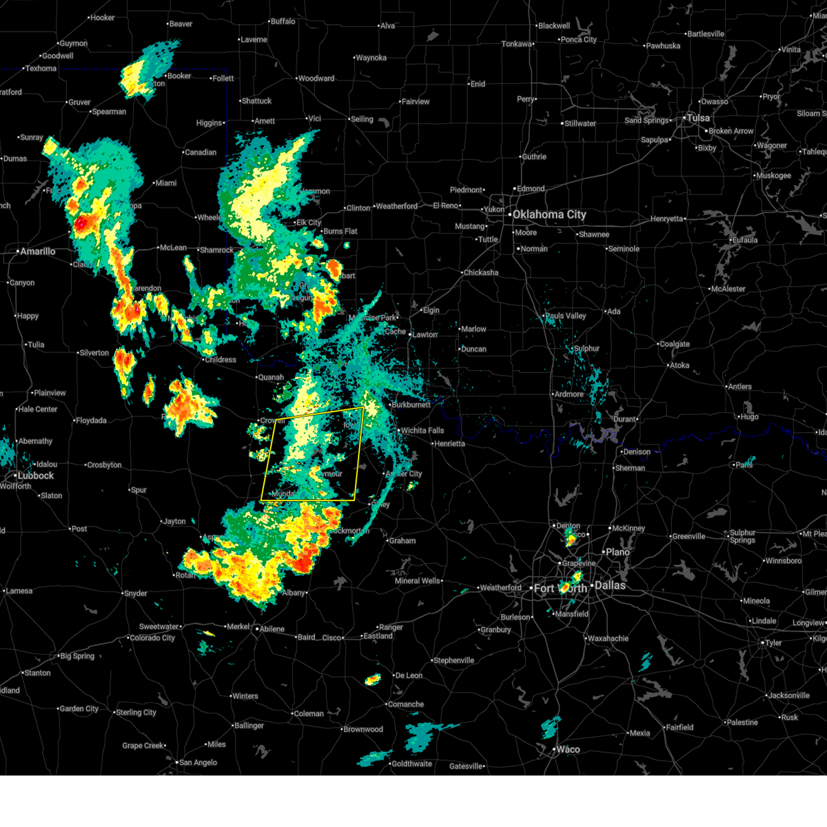
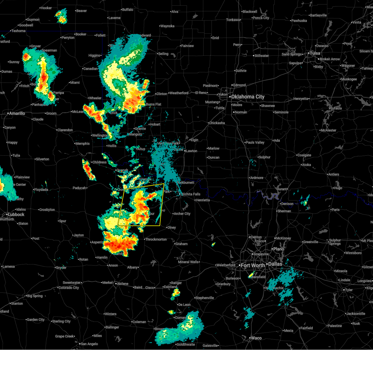
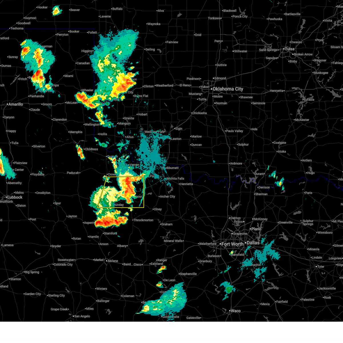
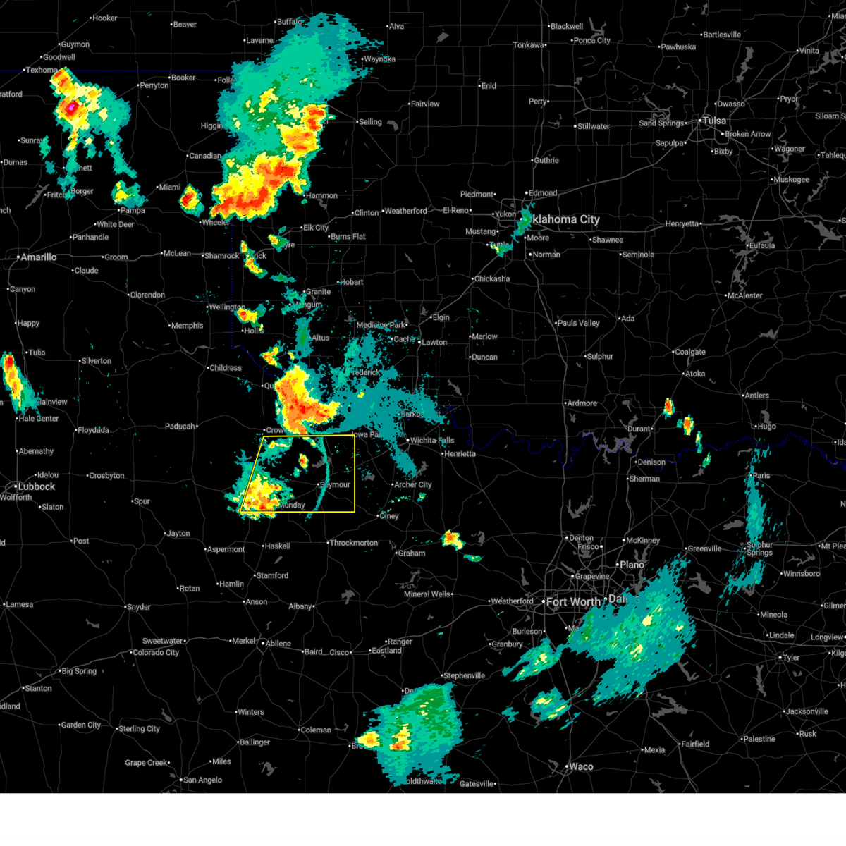
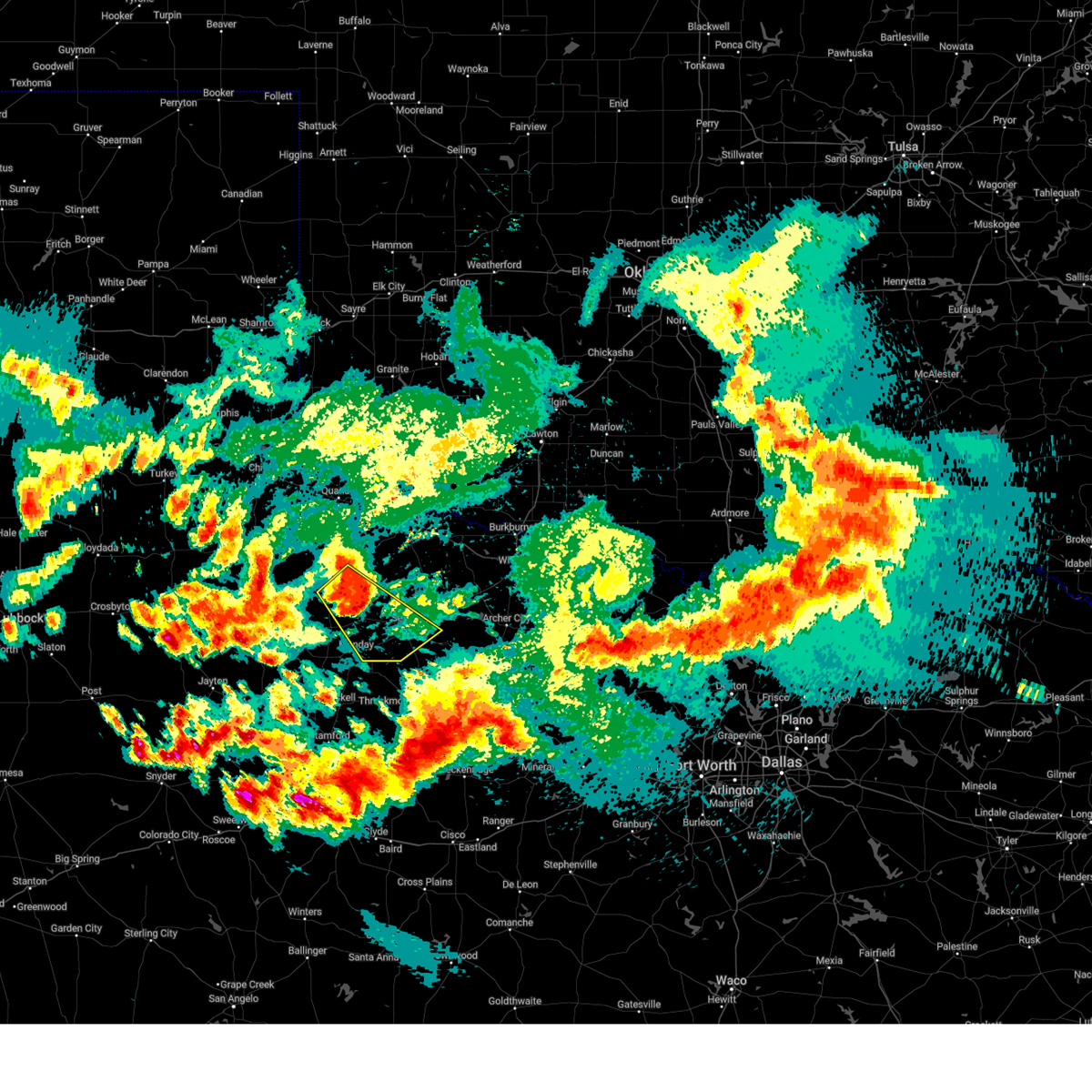
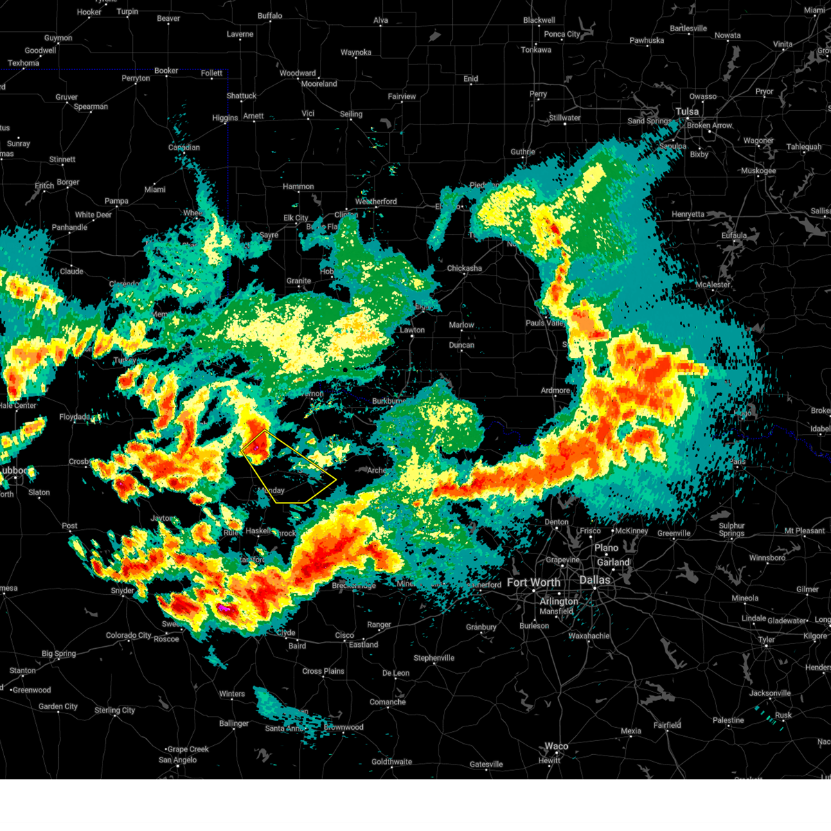
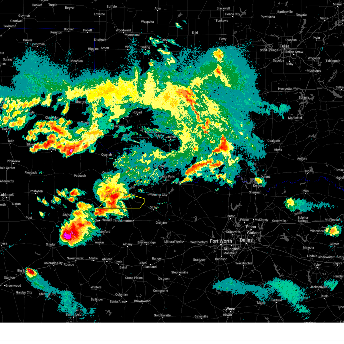
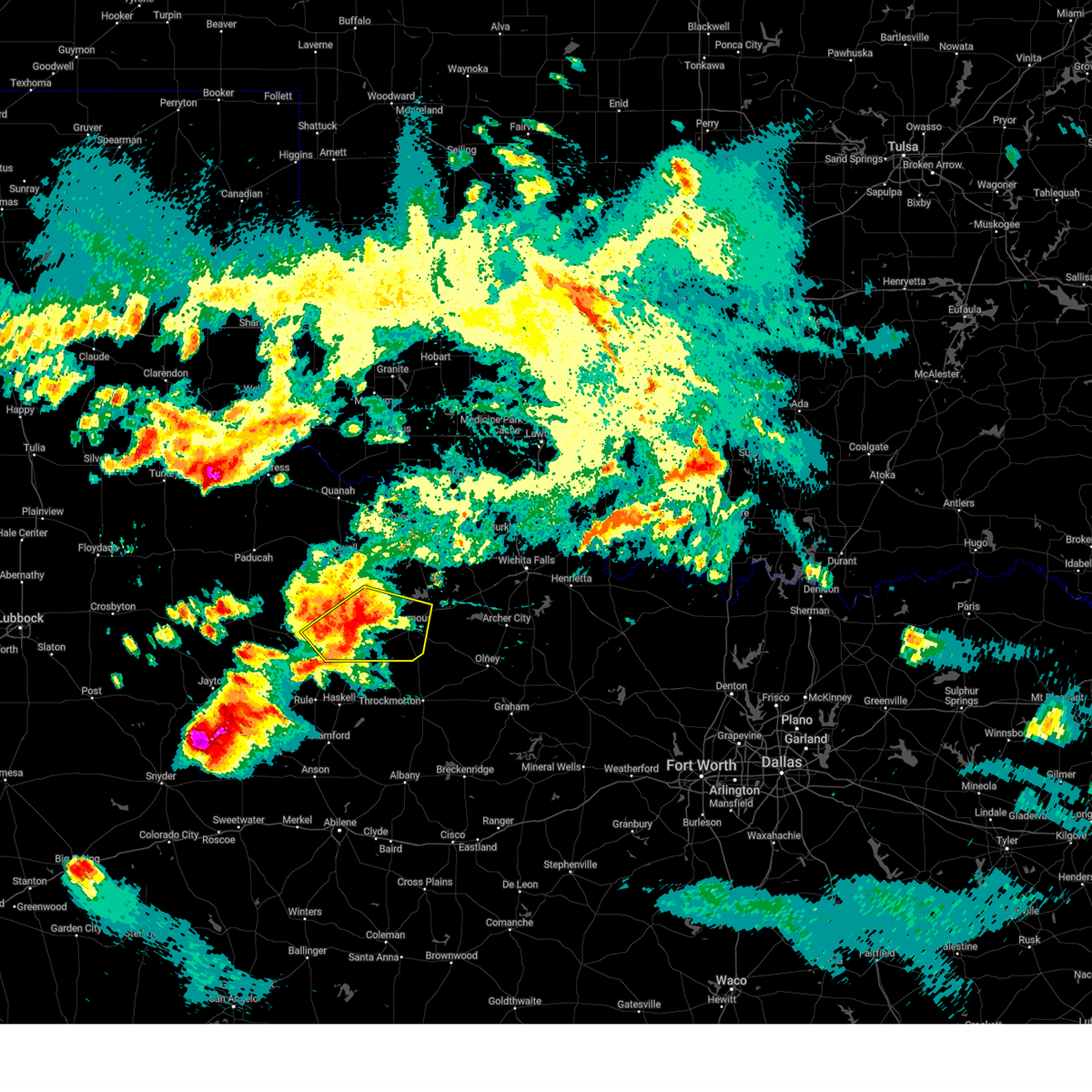
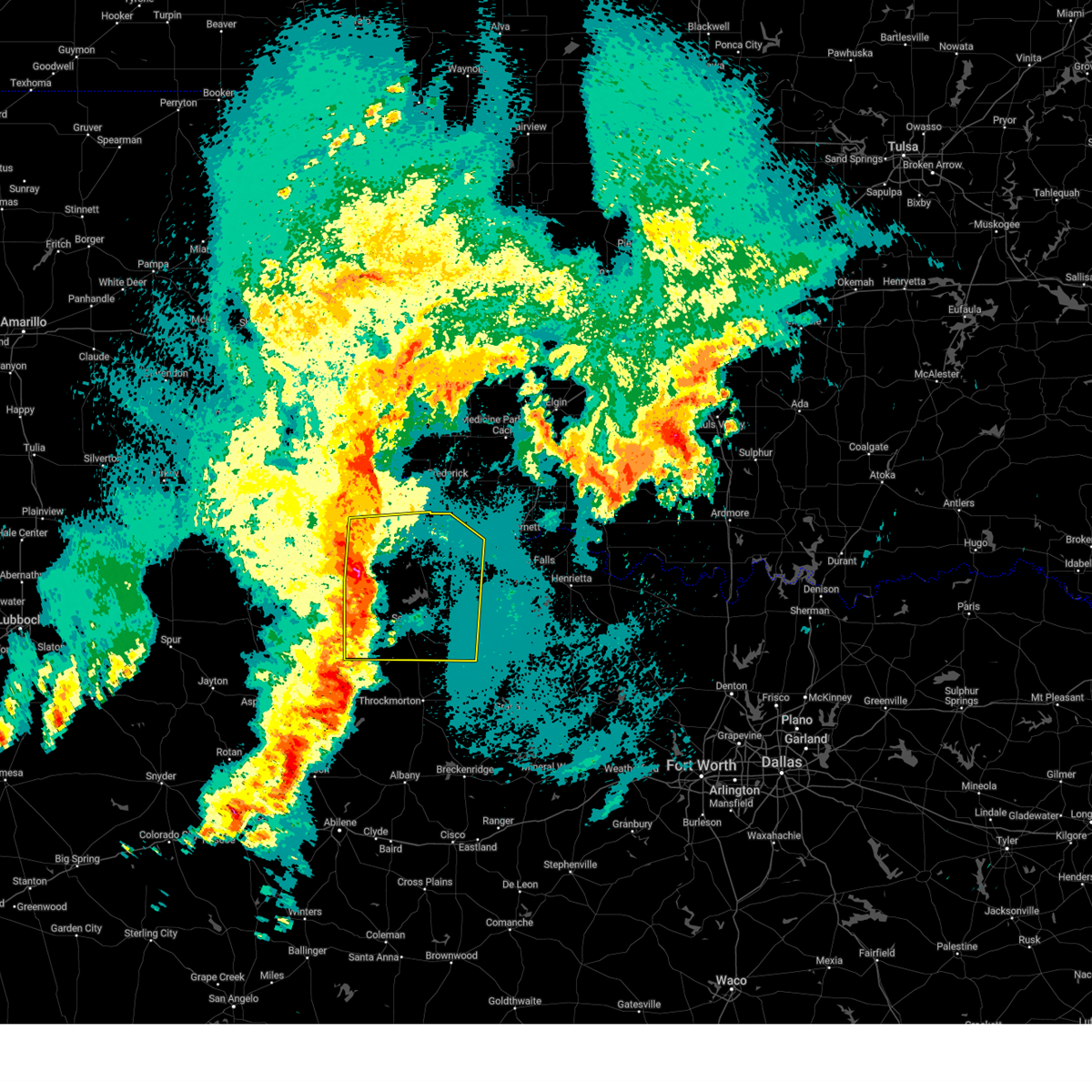
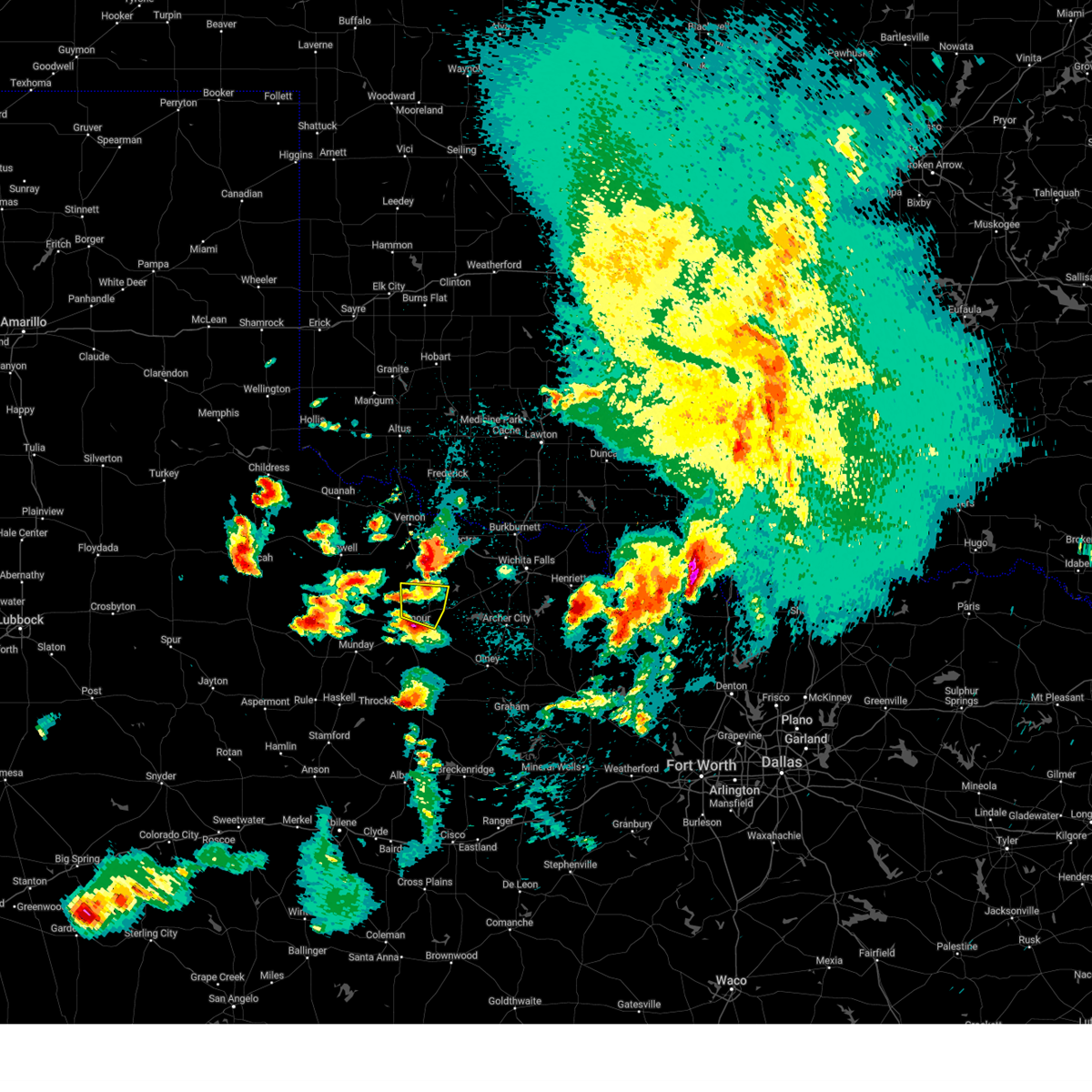
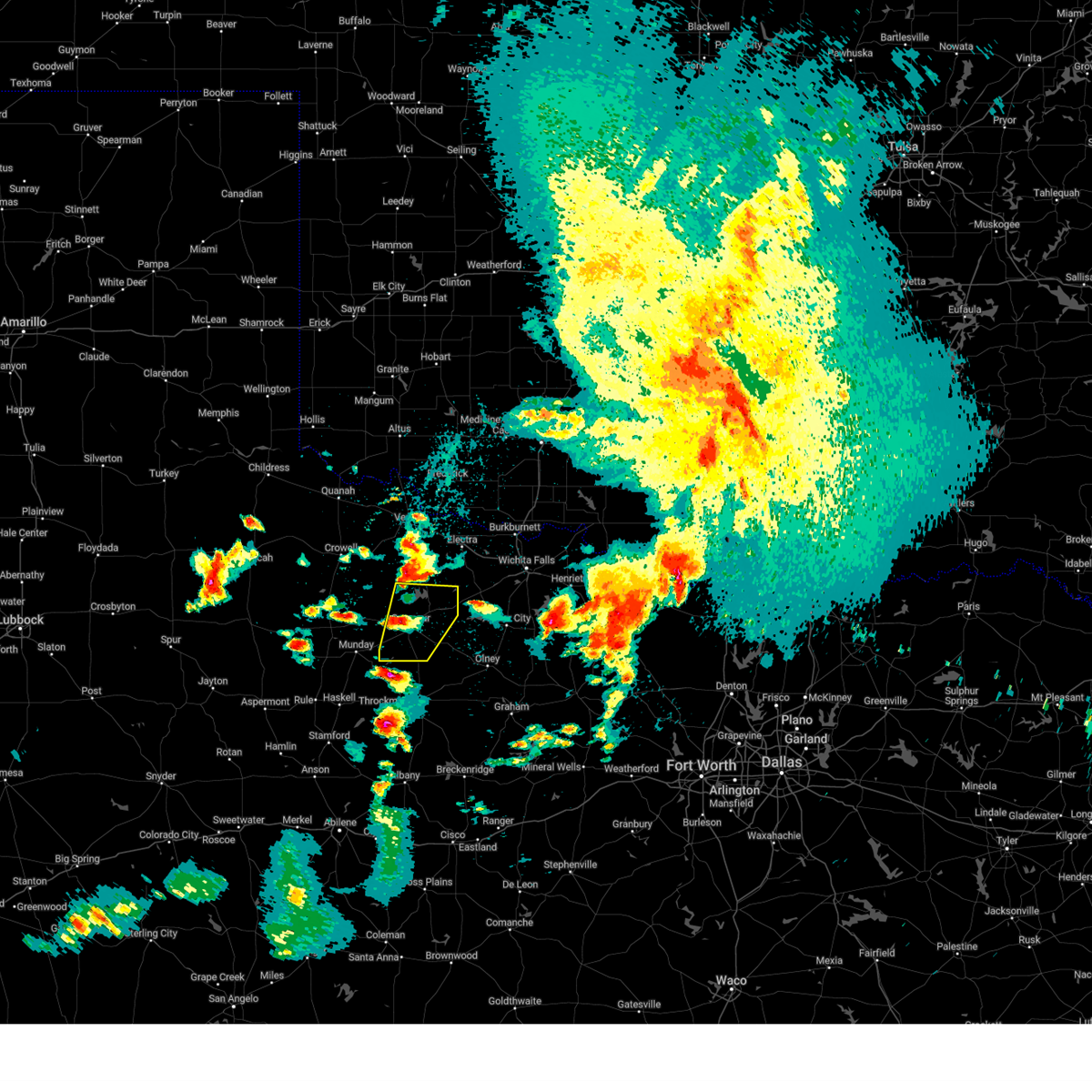
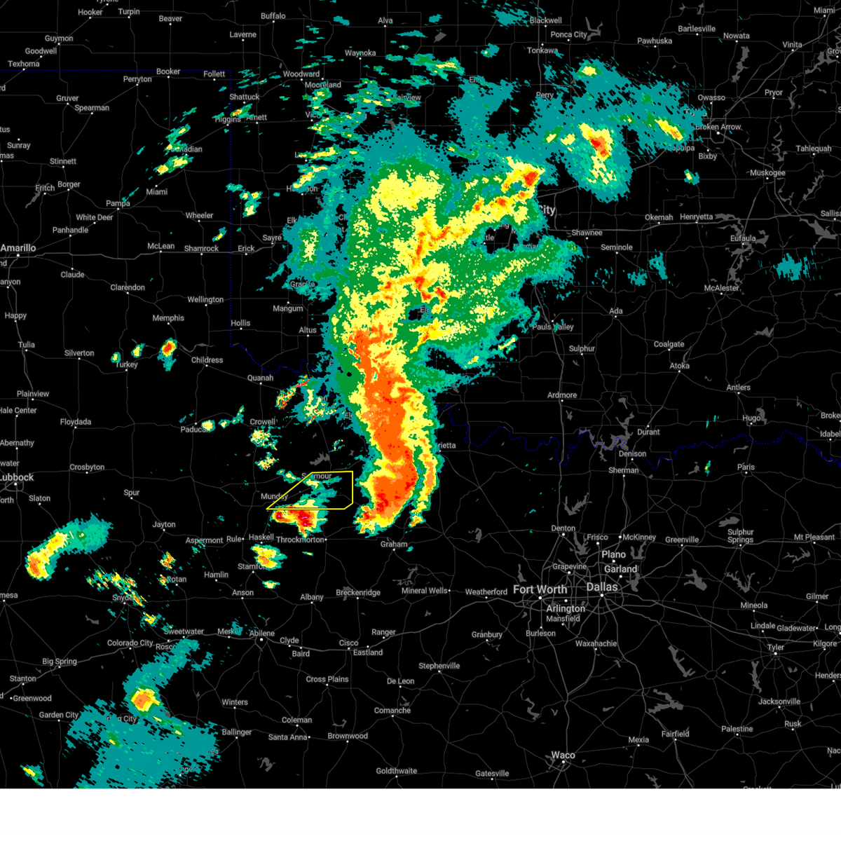
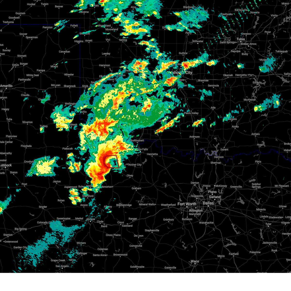
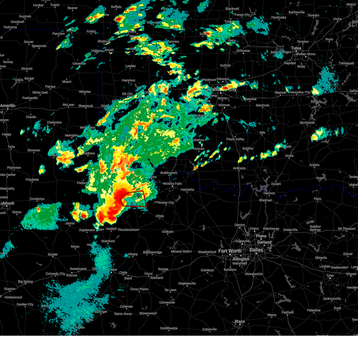
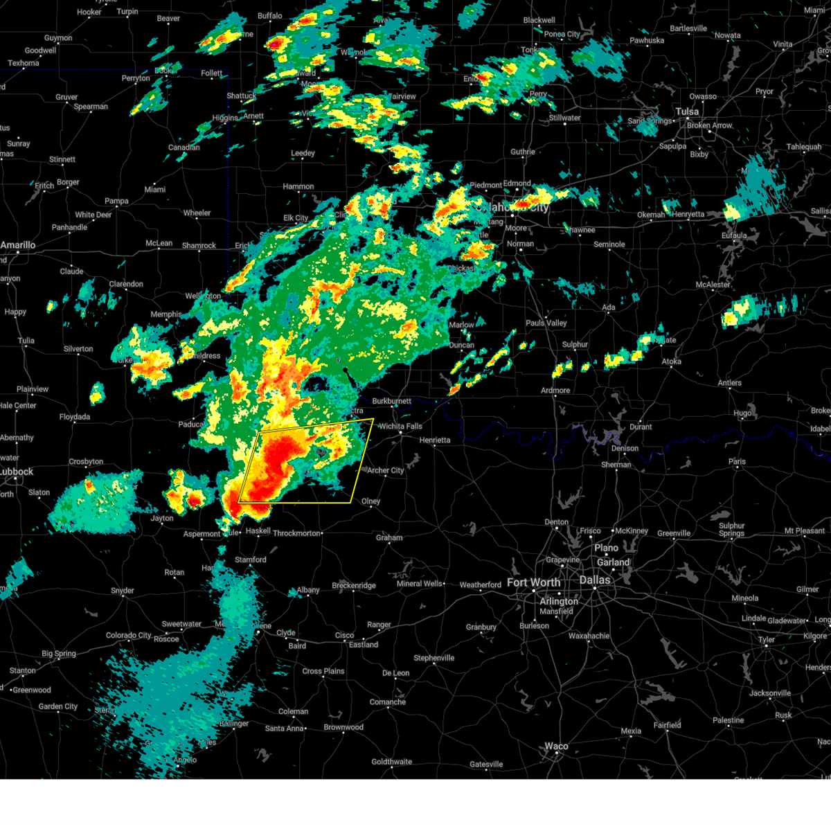
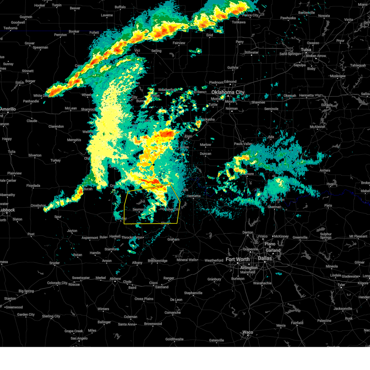
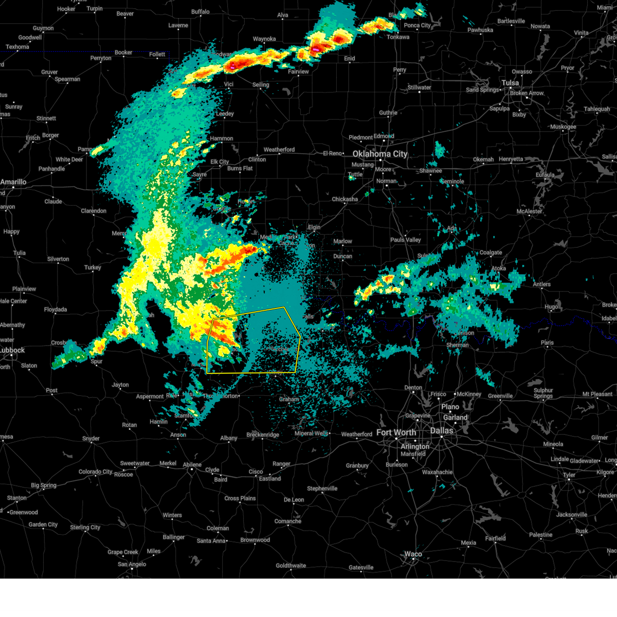
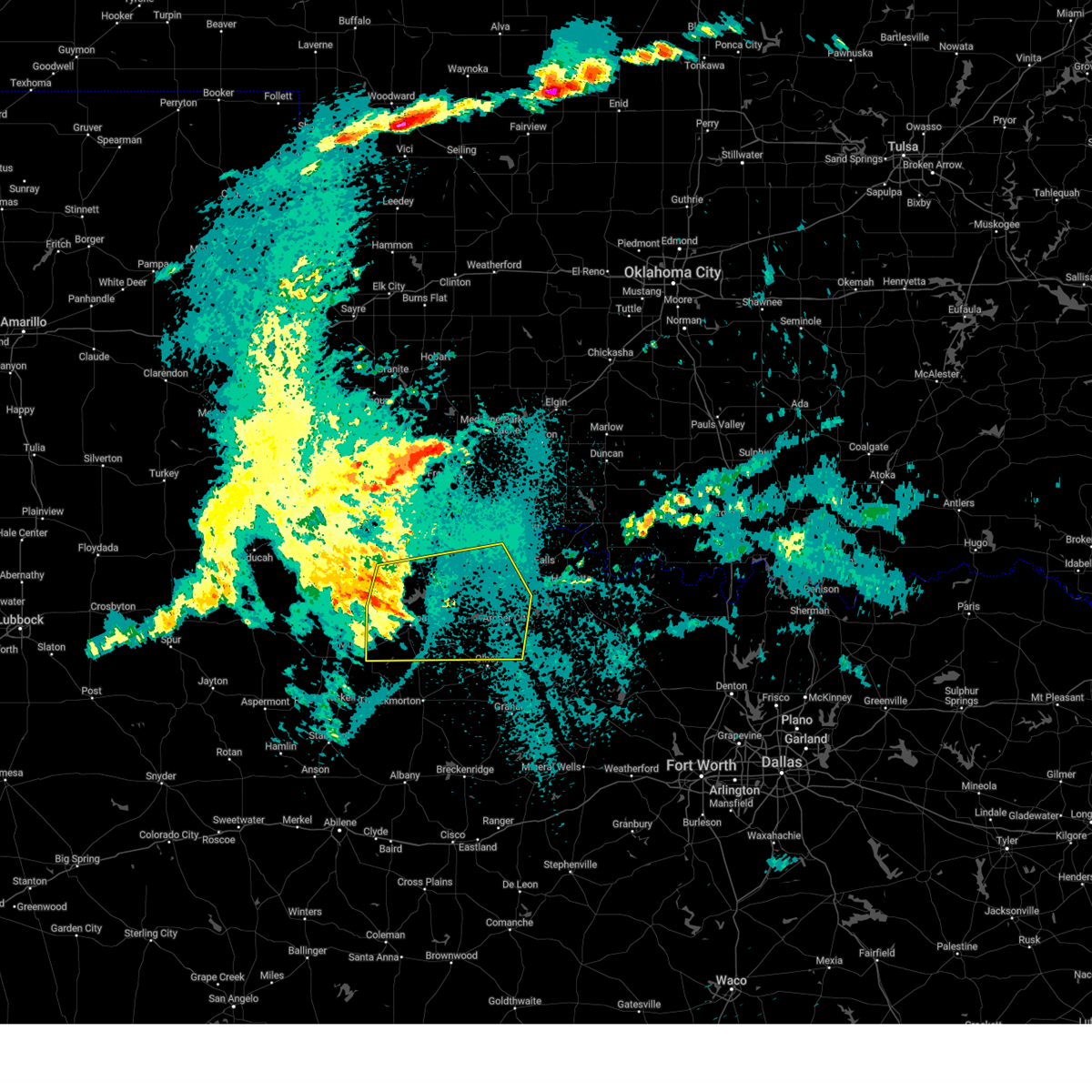
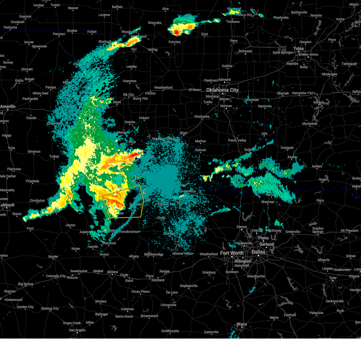
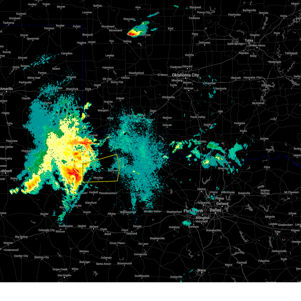
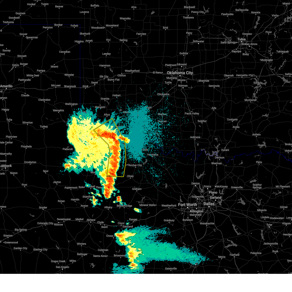
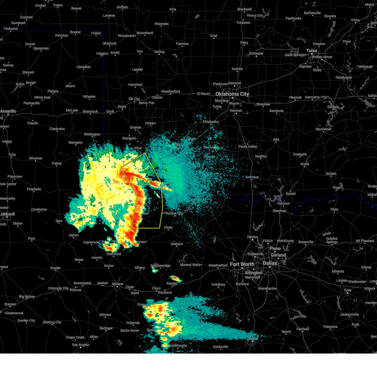
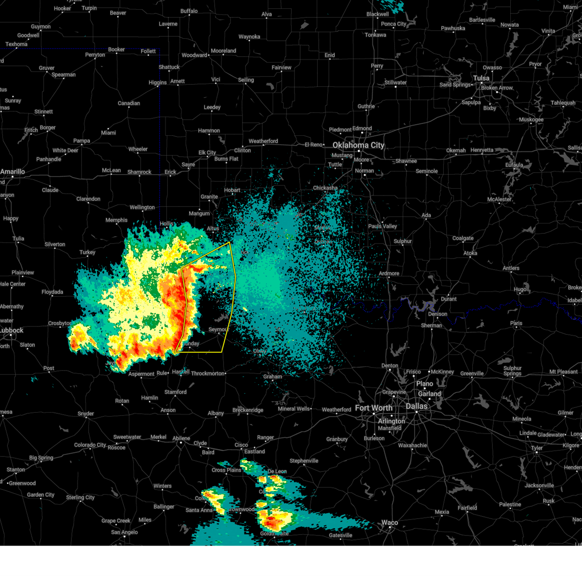
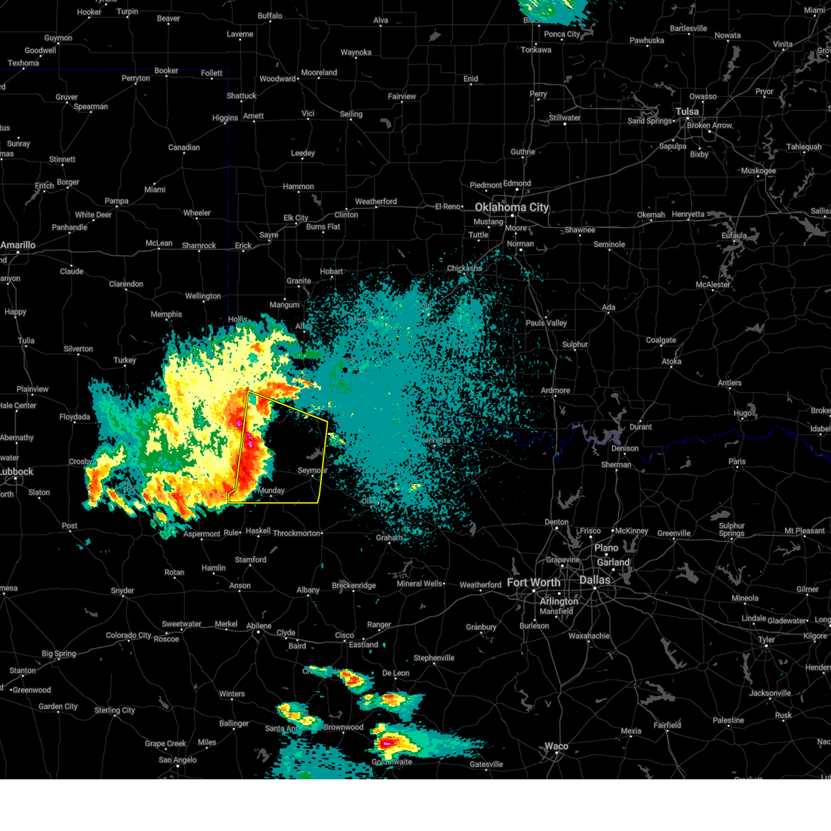
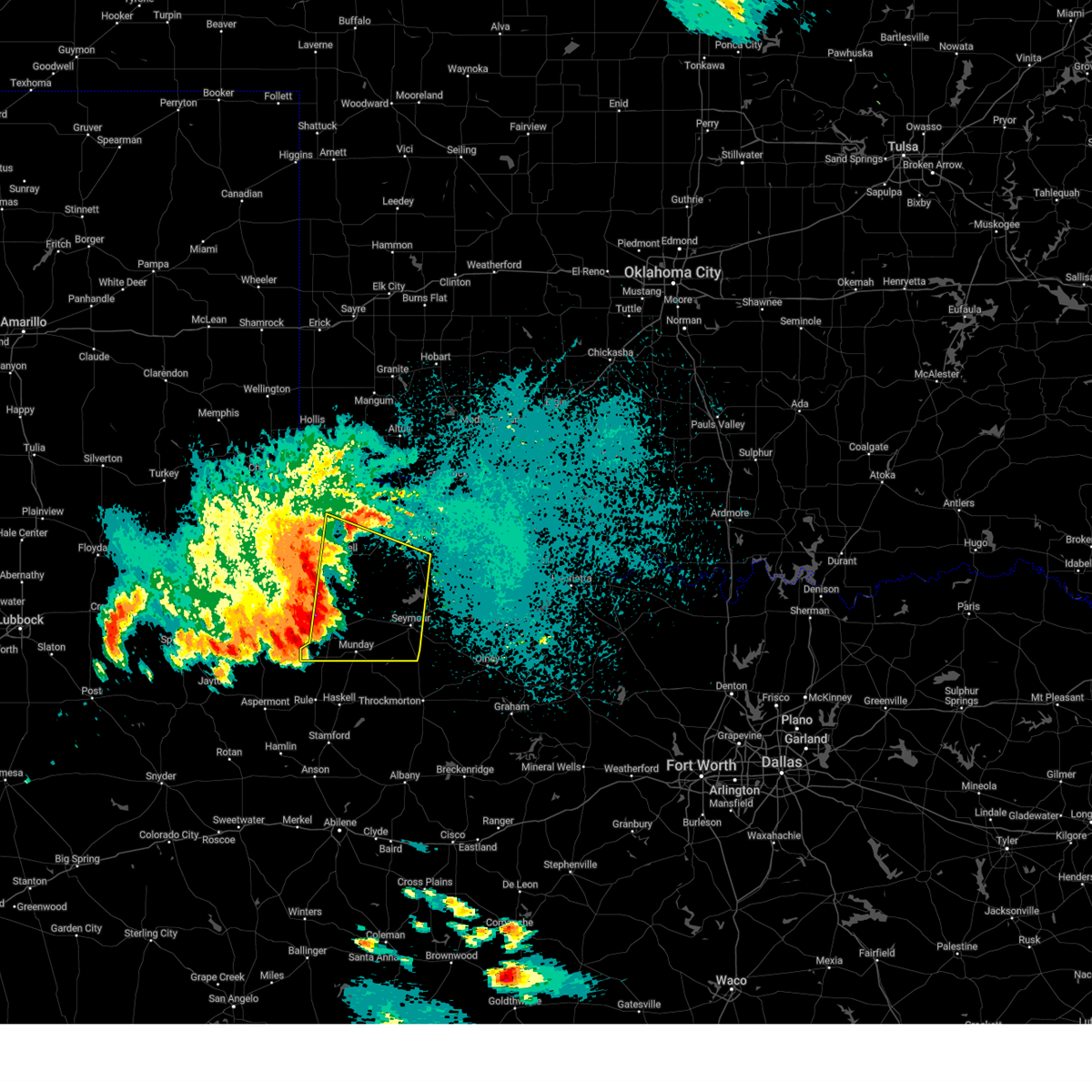
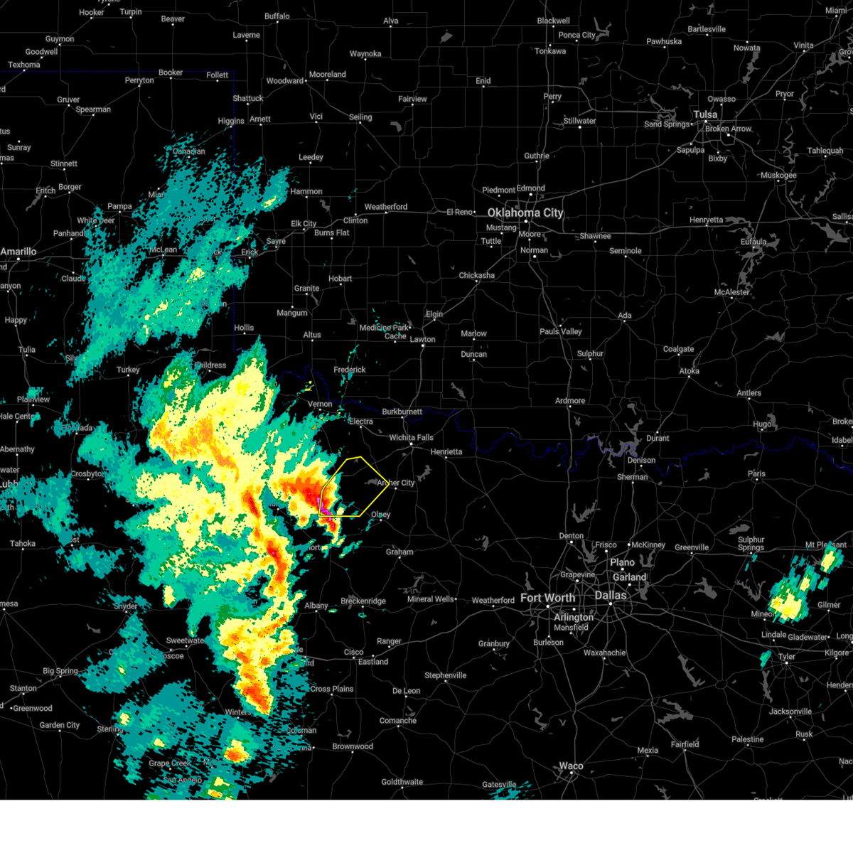
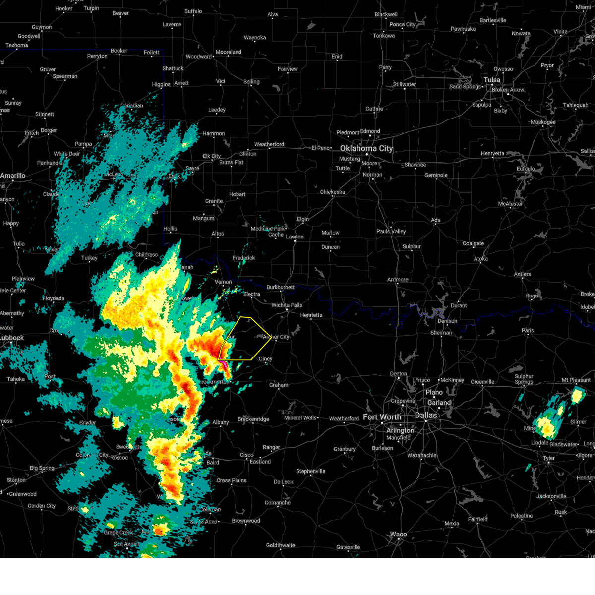
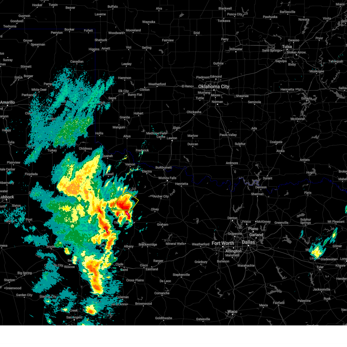
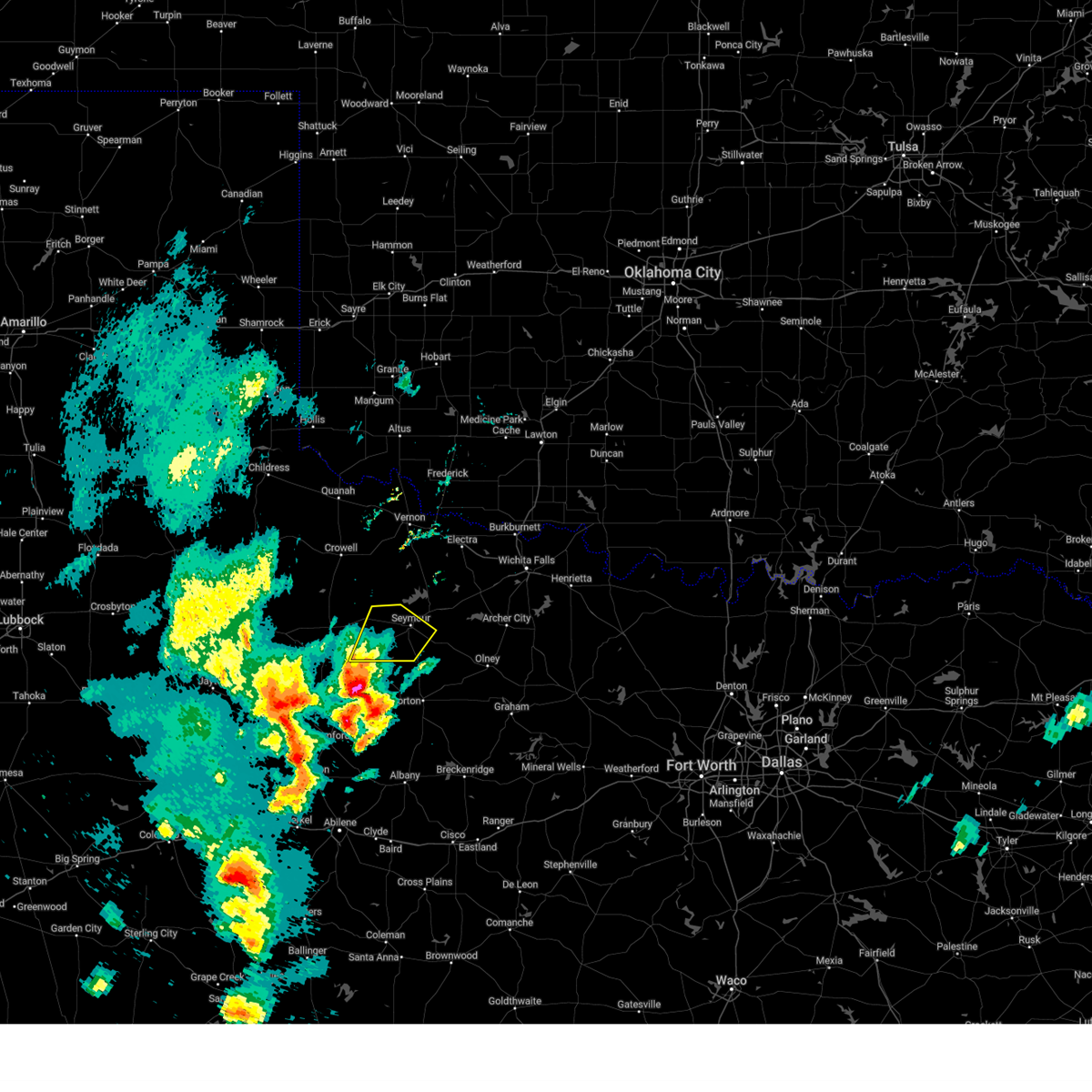
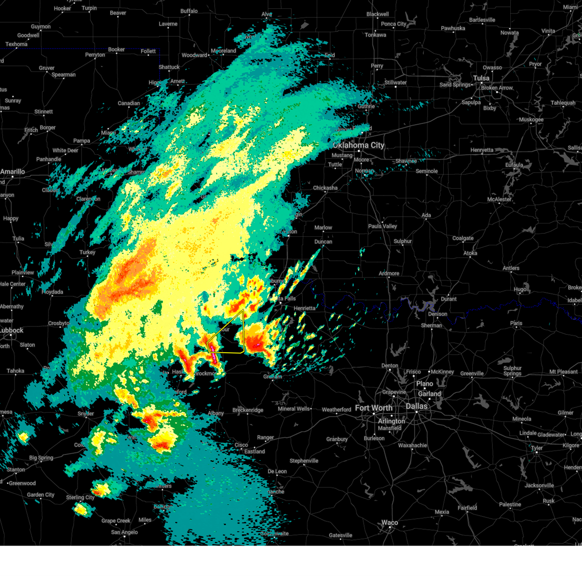
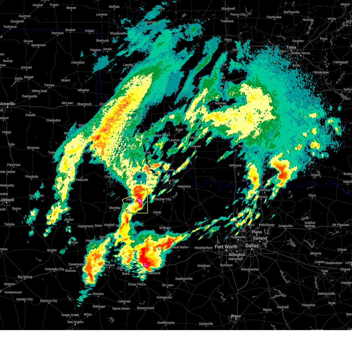
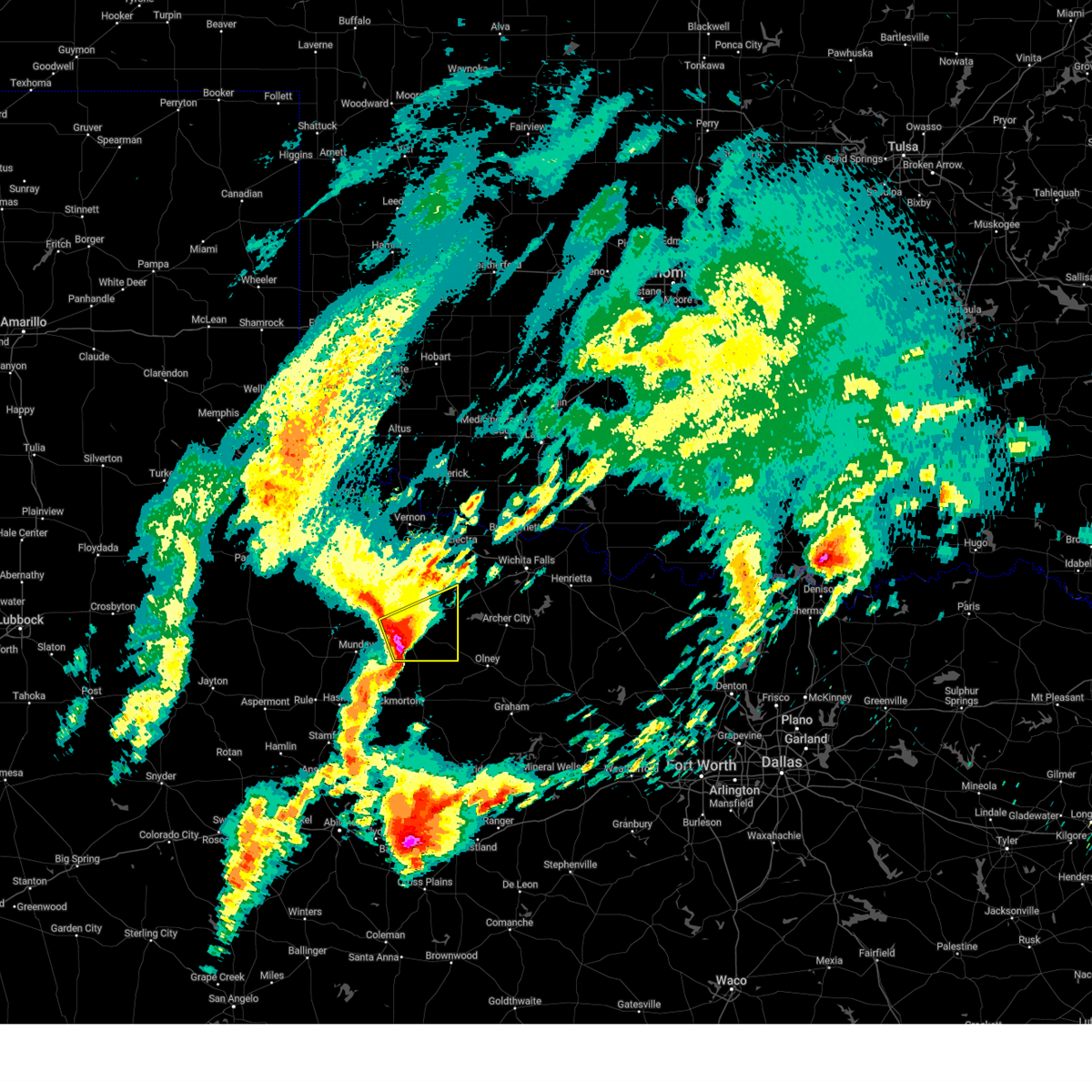
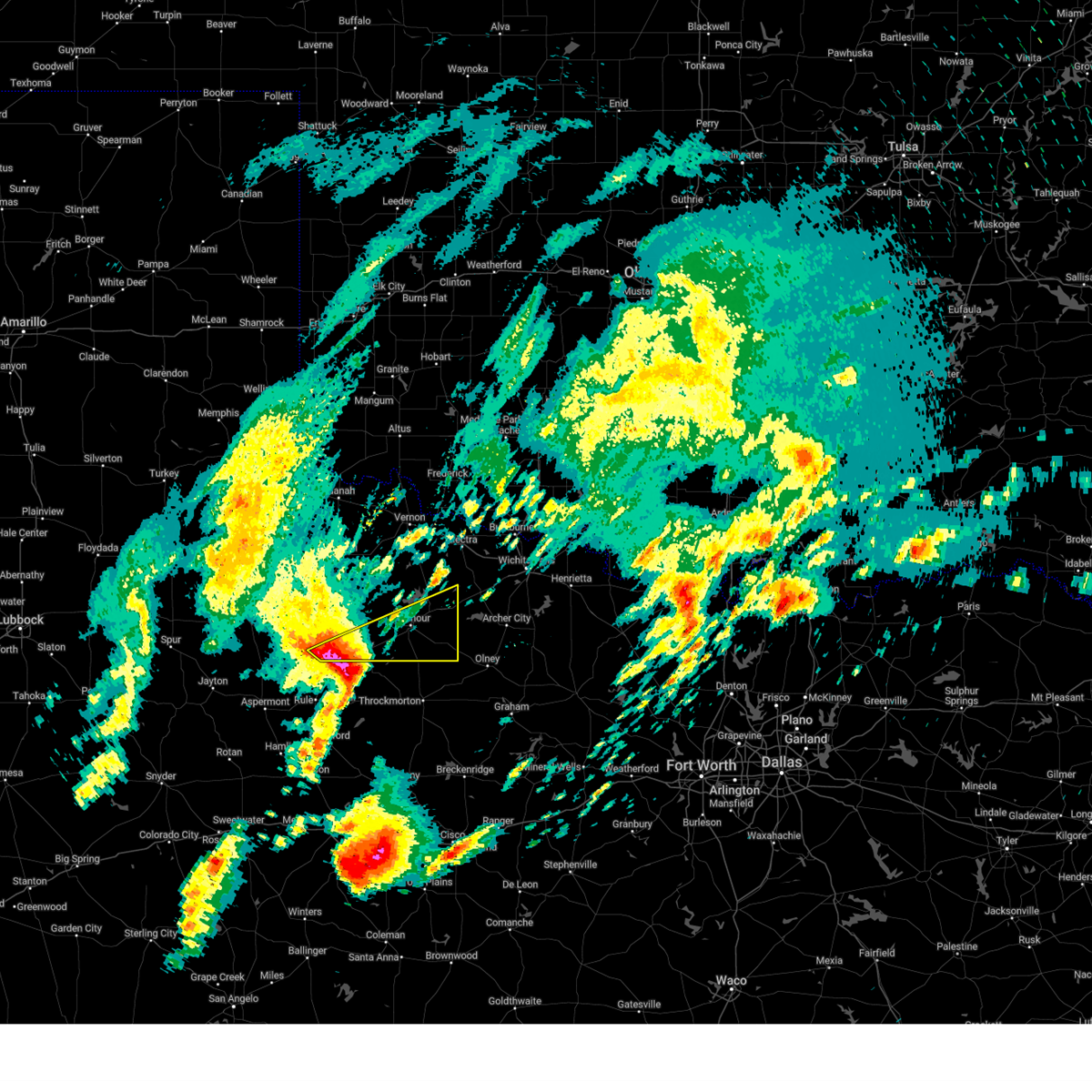
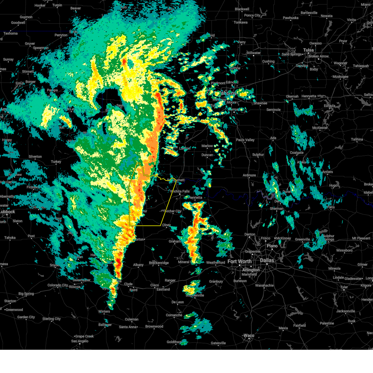
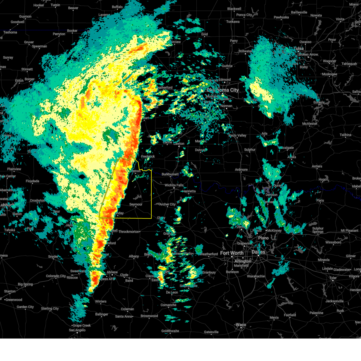
Hail Map for Seymour, TX
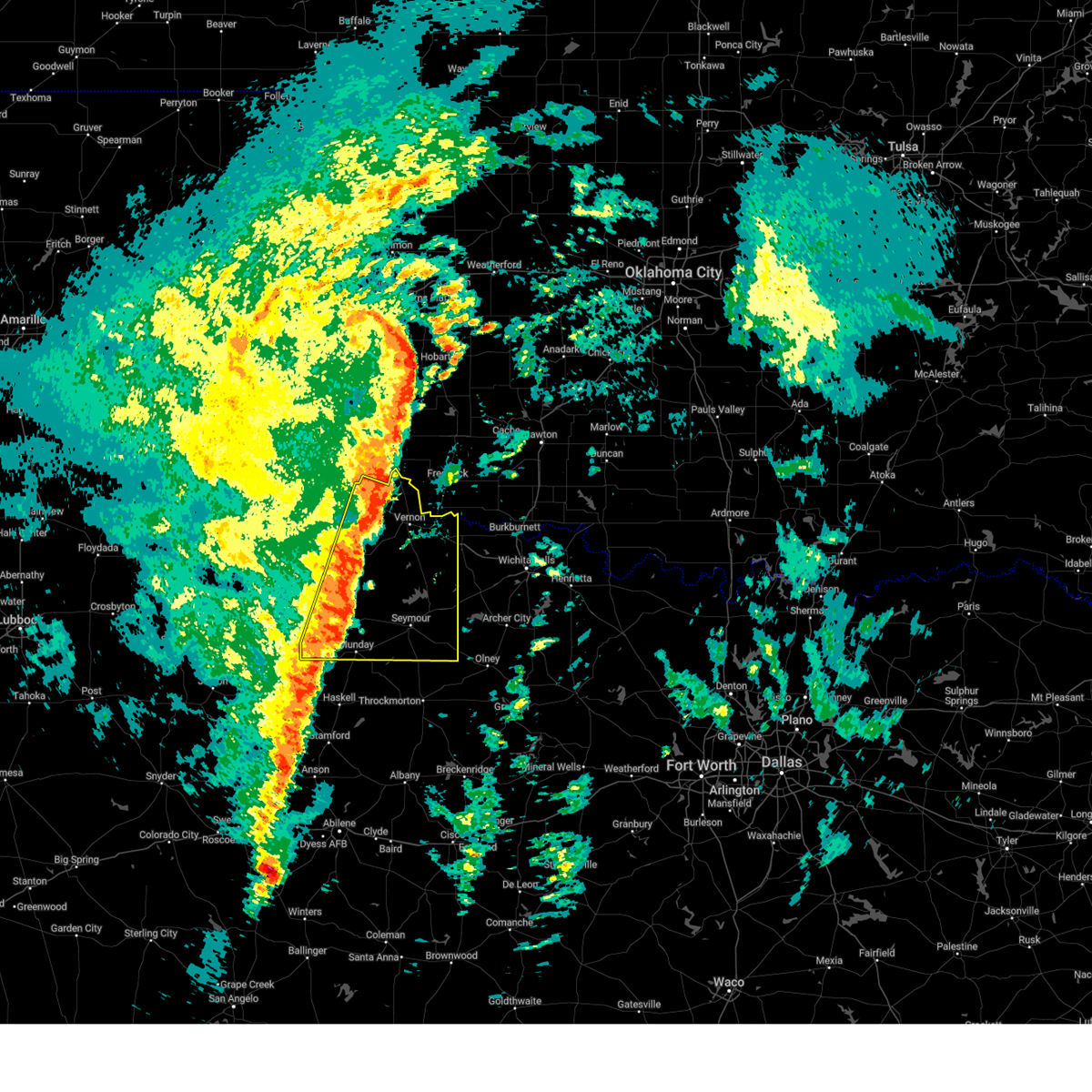
The Seymour, TX area has had 58 reports of on-the-ground hail by trained spotters, and has been under severe weather warnings 54 times during the past 12 months. Doppler radar has detected hail at or near Seymour, TX on 105 occasions, including 3 occasions during the past year.
| Name: | Seymour, TX |
| Where Located: | 48.8 miles WSW of Wichita Falls, TX |
| Map: | Google Map for Seymour, TX |
| Population: | 2740 |
| Housing Units: | 1451 |
| More Info: | Search Google for Seymour, TX |
2
The Top Recent Hail Date for Seymour, TX is Tuesday, April 29, 2025 (6th out of 105)
Hail and Wind Damage Spotted near Seymour, TX
| Date / Time | Report Details |
|---|---|
| 7/9/2025 12:28 AM CDT |
 The storms which prompted the warning have weakened below severe limits, therefore the warning will be allowed to expire. The storms which prompted the warning have weakened below severe limits, therefore the warning will be allowed to expire.
|
| 7/8/2025 11:46 PM CDT |
 Svroun the national weather service in norman has issued a * severe thunderstorm warning for, western archer county in northern texas, southwestern wichita county in northern texas, southeastern foard county in northern texas, eastern knox county in northern texas, southern wilbarger county in northern texas, baylor county in northern texas, * until 1230 am cdt. * at 1145 pm cdt, severe thunderstorms were located along a line extending from 8 miles southeast of grayback to near millers creek reservoir, moving east at 30 mph (radar indicated). Hazards include 70 mph wind gusts and quarter size hail. Hail damage to vehicles is expected. expect considerable tree damage. Wind damage is also likely to mobile homes, roofs, and outbuildings. Svroun the national weather service in norman has issued a * severe thunderstorm warning for, western archer county in northern texas, southwestern wichita county in northern texas, southeastern foard county in northern texas, eastern knox county in northern texas, southern wilbarger county in northern texas, baylor county in northern texas, * until 1230 am cdt. * at 1145 pm cdt, severe thunderstorms were located along a line extending from 8 miles southeast of grayback to near millers creek reservoir, moving east at 30 mph (radar indicated). Hazards include 70 mph wind gusts and quarter size hail. Hail damage to vehicles is expected. expect considerable tree damage. Wind damage is also likely to mobile homes, roofs, and outbuildings.
|
| 7/8/2025 11:45 PM CDT | Storm damage reported in baylor county TX, 2.5 miles SE of Seymour, TX |
| 7/8/2025 11:40 PM CDT | Storm damage reported in baylor county TX, 2.5 miles SE of Seymour, TX |
| 7/8/2025 11:35 PM CDT | Storm damage reported in baylor county TX, 2.5 miles SE of Seymour, TX |
| 7/8/2025 11:34 PM CDT |
 At 1133 pm cdt, severe thunderstorms were located along a line extending from near truscott to 5 miles northeast of mabelle, moving south at 35 mph (radar indicated). Hazards include 70 mph wind gusts. Expect considerable tree damage. damage is likely to mobile homes, roofs, and outbuildings. Locations impacted include, seymour, munday, knox city, benjamin, goree, red springs, lake diversion, westover, gilliland, bomarton, lake kemp, mabelle, vera, and rhineland. At 1133 pm cdt, severe thunderstorms were located along a line extending from near truscott to 5 miles northeast of mabelle, moving south at 35 mph (radar indicated). Hazards include 70 mph wind gusts. Expect considerable tree damage. damage is likely to mobile homes, roofs, and outbuildings. Locations impacted include, seymour, munday, knox city, benjamin, goree, red springs, lake diversion, westover, gilliland, bomarton, lake kemp, mabelle, vera, and rhineland.
|
| 7/8/2025 11:30 PM CDT | Storm damage reported in baylor county TX, 2.5 miles SE of Seymour, TX |
| 7/8/2025 11:24 PM CDT | Storm damage reported in baylor county TX, 2.5 miles SE of Seymour, TX |
| 7/8/2025 11:02 PM CDT |
 Svroun the national weather service in norman has issued a * severe thunderstorm warning for, southeastern foard county in northern texas, knox county in northern texas, southern wilbarger county in northern texas, baylor county in northern texas, * until 1145 pm cdt. * at 1102 pm cdt, severe thunderstorms were located along a line extending from near crowell to 6 miles south of harrold, moving south at 35 mph (radar indicated). Hazards include 70 mph wind gusts. Expect considerable tree damage. Damage is likely to mobile homes, roofs, and outbuildings. Svroun the national weather service in norman has issued a * severe thunderstorm warning for, southeastern foard county in northern texas, knox county in northern texas, southern wilbarger county in northern texas, baylor county in northern texas, * until 1145 pm cdt. * at 1102 pm cdt, severe thunderstorms were located along a line extending from near crowell to 6 miles south of harrold, moving south at 35 mph (radar indicated). Hazards include 70 mph wind gusts. Expect considerable tree damage. Damage is likely to mobile homes, roofs, and outbuildings.
|
| 6/8/2025 9:25 PM CDT |
 At 925 pm cdt, a severe thunderstorm was located near gilliland, moving southeast at 45 mph (truscott mesonet site reported 68 mph at 925 pm cdt). Hazards include 70 mph wind gusts and quarter size hail. Hail damage to vehicles is expected. expect considerable tree damage. wind damage is also likely to mobile homes, roofs, and outbuildings. Locations impacted include, seymour, munday, goree, red springs, vera, truscott, gilliland, rhineland, and bomarton. At 925 pm cdt, a severe thunderstorm was located near gilliland, moving southeast at 45 mph (truscott mesonet site reported 68 mph at 925 pm cdt). Hazards include 70 mph wind gusts and quarter size hail. Hail damage to vehicles is expected. expect considerable tree damage. wind damage is also likely to mobile homes, roofs, and outbuildings. Locations impacted include, seymour, munday, goree, red springs, vera, truscott, gilliland, rhineland, and bomarton.
|
| 6/8/2025 9:17 PM CDT |
 Svroun the national weather service in norman has issued a * severe thunderstorm warning for, southeastern foard county in northern texas, eastern knox county in northern texas, southwestern baylor county in northern texas, * until 1000 pm cdt. * at 917 pm cdt, a severe thunderstorm was located 5 miles northeast of truscott, moving southeast at 45 mph (radar indicated). Hazards include ping pong ball size hail and 60 mph wind gusts. People and animals outdoors will be injured. expect hail damage to roofs, siding, windows, and vehicles. Expect wind damage to roofs, siding, and trees. Svroun the national weather service in norman has issued a * severe thunderstorm warning for, southeastern foard county in northern texas, eastern knox county in northern texas, southwestern baylor county in northern texas, * until 1000 pm cdt. * at 917 pm cdt, a severe thunderstorm was located 5 miles northeast of truscott, moving southeast at 45 mph (radar indicated). Hazards include ping pong ball size hail and 60 mph wind gusts. People and animals outdoors will be injured. expect hail damage to roofs, siding, windows, and vehicles. Expect wind damage to roofs, siding, and trees.
|
| 6/8/2025 7:57 PM CDT |
 Svroun the national weather service in norman has issued a * severe thunderstorm warning for, southeastern knox county in northern texas, southern baylor county in northern texas, * until 845 pm cdt. * at 757 pm cdt, severe thunderstorms were located along a line extending from near munday to 3 miles east of vera, moving southeast at 30 mph (radar indicated). Hazards include 60 mph wind gusts and quarter size hail. Hail damage to vehicles is expected. Expect wind damage to roofs, siding, and trees. Svroun the national weather service in norman has issued a * severe thunderstorm warning for, southeastern knox county in northern texas, southern baylor county in northern texas, * until 845 pm cdt. * at 757 pm cdt, severe thunderstorms were located along a line extending from near munday to 3 miles east of vera, moving southeast at 30 mph (radar indicated). Hazards include 60 mph wind gusts and quarter size hail. Hail damage to vehicles is expected. Expect wind damage to roofs, siding, and trees.
|
| 6/8/2025 7:49 PM CDT |
 At 749 pm cdt, severe thunderstorms were located along a line extending from 4 miles northwest of red springs to near vera to near rhineland to 3 miles south of benjamin, moving southeast at 35 mph (trained weather spotters). Hazards include 70 mph wind gusts and nickel size hail. Expect considerable tree damage. damage is likely to mobile homes, roofs, and outbuildings. Locations impacted include, seymour, munday, knox city, benjamin, goree, red springs, mabelle, vera, gilliland, rhineland, bomarton, and southwestern lake kemp. At 749 pm cdt, severe thunderstorms were located along a line extending from 4 miles northwest of red springs to near vera to near rhineland to 3 miles south of benjamin, moving southeast at 35 mph (trained weather spotters). Hazards include 70 mph wind gusts and nickel size hail. Expect considerable tree damage. damage is likely to mobile homes, roofs, and outbuildings. Locations impacted include, seymour, munday, knox city, benjamin, goree, red springs, mabelle, vera, gilliland, rhineland, bomarton, and southwestern lake kemp.
|
| 6/8/2025 7:49 PM CDT |
 the severe thunderstorm warning has been cancelled and is no longer in effect the severe thunderstorm warning has been cancelled and is no longer in effect
|
| 6/8/2025 7:36 PM CDT | At 735 pm cdt, severe thunderstorms were located along a line extending from 8 miles north of vera to 3 miles southeast of gilliland to 6 miles northeast of benjamin to 10 miles southwest of truscott, moving southeast at 35 mph. these are destructive storms for truscott, gilliland, benjamin, knox city, munday, red springs, seymour, lake kemp, mabelle (the truscott mesonet station reported an 80 mph wind gust at 7:25pm). Hazards include 80 mph wind gusts and half dollar size hail. Flying debris will be dangerous to those caught without shelter. mobile homes will be heavily damaged. expect considerable damage to roofs, windows, and vehicles. extensive tree damage and power outages are likely. Locations impacted include, seymour, munday, knox city, benjamin, goree, red springs, gilliland, bomarton, lake kemp, mabelle, vera, truscott, and rhineland. |
| 6/8/2025 7:21 PM CDT | At 720 pm cdt, severe thunderstorms were located along a line extending from 8 miles south of crowell to near truscott to 8 miles northwest of benjamin to 17 miles west of gilliland, moving east at 30 mph. these are destructive storms for gilliland, benjamin, knox city, munday, red springs, seymour, lake kemp, mabelle (trained weather spotters). Hazards include 80 mph wind gusts and ping pong ball size hail. Flying debris will be dangerous to those caught without shelter. mobile homes will be heavily damaged. expect considerable damage to roofs, windows, and vehicles. extensive tree damage and power outages are likely. Locations impacted include, seymour, munday, knox city, benjamin, goree, red springs, gilliland, bomarton, lake kemp, mabelle, vera, truscott, and rhineland. |
| 6/8/2025 7:16 PM CDT | Svroun the national weather service in norman has issued a * severe thunderstorm warning for, southern foard county in northern texas, knox county in northern texas, southwestern wilbarger county in northern texas, baylor county in northern texas, * until 800 pm cdt. * at 715 pm cdt, severe thunderstorms were located along a line extending from 8 miles south of crowell to near truscott to 9 miles northwest of benjamin to 17 miles southeast of chalk, moving southeast at 45 mph. these are destructive storms for truscott, gilliland, benjamin, knox city, munday, red springs, seymour, lake kemp, mabelle (74 mph wind gust was reported at truscott). Hazards include 80 mph wind gusts and golf ball size hail. Flying debris will be dangerous to those caught without shelter. mobile homes will be heavily damaged. expect considerable damage to roofs, windows, and vehicles. Extensive tree damage and power outages are likely. |
| 4/30/2025 4:30 AM CDT |
 Svroun the national weather service in norman has issued a * severe thunderstorm warning for, western archer county in northern texas, southwestern wichita county in northern texas, southeastern foard county in northern texas, eastern knox county in northern texas, wilbarger county in northern texas, baylor county in northern texas, southeastern hardeman county in northern texas, * until 515 am cdt. * at 430 am cdt, severe thunderstorms were located along a line extending from near thalia to 13 miles northeast of gilliland to near goree, moving northeast at 45 mph (radar indicated). Hazards include 60 mph wind gusts and penny size hail. expect damage to roofs, siding, and trees Svroun the national weather service in norman has issued a * severe thunderstorm warning for, western archer county in northern texas, southwestern wichita county in northern texas, southeastern foard county in northern texas, eastern knox county in northern texas, wilbarger county in northern texas, baylor county in northern texas, southeastern hardeman county in northern texas, * until 515 am cdt. * at 430 am cdt, severe thunderstorms were located along a line extending from near thalia to 13 miles northeast of gilliland to near goree, moving northeast at 45 mph (radar indicated). Hazards include 60 mph wind gusts and penny size hail. expect damage to roofs, siding, and trees
|
| 4/29/2025 11:03 PM CDT |
 At 1103 pm cdt, a severe thunderstorm was located near lake kemp, moving northeast at 45 mph (radar indicated). Hazards include 60 mph wind gusts and quarter size hail. Hail damage to vehicles is expected. expect wind damage to roofs, siding, and trees. Locations impacted include, mabelle, lake kemp, and southwestern lake diversion. At 1103 pm cdt, a severe thunderstorm was located near lake kemp, moving northeast at 45 mph (radar indicated). Hazards include 60 mph wind gusts and quarter size hail. Hail damage to vehicles is expected. expect wind damage to roofs, siding, and trees. Locations impacted include, mabelle, lake kemp, and southwestern lake diversion.
|
| 4/29/2025 10:31 PM CDT |
 Svroun the national weather service in norman has issued a * severe thunderstorm warning for, baylor county in northern texas, * until 1115 pm cdt. * at 1031 pm cdt, a severe thunderstorm was located near millers creek reservoir, moving northeast at 50 mph (radar indicated). Hazards include 60 mph wind gusts and half dollar size hail. Hail damage to vehicles is expected. Expect wind damage to roofs, siding, and trees. Svroun the national weather service in norman has issued a * severe thunderstorm warning for, baylor county in northern texas, * until 1115 pm cdt. * at 1031 pm cdt, a severe thunderstorm was located near millers creek reservoir, moving northeast at 50 mph (radar indicated). Hazards include 60 mph wind gusts and half dollar size hail. Hail damage to vehicles is expected. Expect wind damage to roofs, siding, and trees.
|
| 4/29/2025 8:21 PM CDT |
 Svroun the national weather service in norman has issued a * severe thunderstorm warning for, southeastern knox county in northern texas, southern baylor county in northern texas, * until 900 pm cdt. * at 820 pm cdt, severe thunderstorms were located 5 miles southeast of munday and near millers creek reservoir, moving northeast at 40 mph (radar indicated). Hazards include 60 mph wind gusts and quarter size hail. Hail damage to vehicles is expected. Expect wind damage to roofs, siding, and trees. Svroun the national weather service in norman has issued a * severe thunderstorm warning for, southeastern knox county in northern texas, southern baylor county in northern texas, * until 900 pm cdt. * at 820 pm cdt, severe thunderstorms were located 5 miles southeast of munday and near millers creek reservoir, moving northeast at 40 mph (radar indicated). Hazards include 60 mph wind gusts and quarter size hail. Hail damage to vehicles is expected. Expect wind damage to roofs, siding, and trees.
|
| 4/29/2025 7:31 PM CDT | Quarter sized hail reported 18.3 miles WSW of Seymour, TX, report from mping: quarter (1.00 in.). |
| 4/29/2025 7:26 PM CDT | At 725 pm cdt, severe thunderstorms were located along a line extending from 8 miles southwest of electra to 7 miles southwest of westover, moving east at 30 mph. these are destructive storms for dundee, mankins, and lake kickapoo (radar indicated). Hazards include 80 mph wind gusts and tennis ball size hail. Flying debris will be dangerous to those caught without shelter. mobile homes will be heavily damaged. expect considerable damage to roofs, windows, and vehicles. extensive tree damage and power outages are likely. Locations impacted include, western wichita falls, burkburnett, seymour, iowa park, electra, holliday, megargel, lake diversion, dundee, westover, lake kemp, mabelle, mankins, lake kickapoo, grayback, and pleasant valley. |
| 4/29/2025 7:17 PM CDT | At 717 pm cdt, a severe thunderstorm capable of producing a tornado was located near mabelle, moving east at 25 mph (radar indicated rotation). Hazards include tornado and tennis ball size hail. Flying debris will be dangerous to those caught without shelter. mobile homes will be damaged or destroyed. damage to roofs, windows, and vehicles will occur. tree damage is likely. Locations impacted include, seymour, mabelle, and lake kemp. |
| 4/29/2025 7:10 PM CDT |
 Svroun the national weather service in norman has issued a * severe thunderstorm warning for, western archer county in northern texas, southern wichita county in northern texas, southern wilbarger county in northern texas, baylor county in northern texas, * until 800 pm cdt. * at 710 pm cdt, severe thunderstorms were located along a line extending from 8 miles southeast of grayback to 7 miles east of millers creek reservoir, moving east at 30 mph. these are destructive storms for lake diversion and dundee (radar indicated). Hazards include 80 mph wind gusts and tennis ball size hail. Flying debris will be dangerous to those caught without shelter. mobile homes will be heavily damaged. expect considerable damage to roofs, windows, and vehicles. Extensive tree damage and power outages are likely. Svroun the national weather service in norman has issued a * severe thunderstorm warning for, western archer county in northern texas, southern wichita county in northern texas, southern wilbarger county in northern texas, baylor county in northern texas, * until 800 pm cdt. * at 710 pm cdt, severe thunderstorms were located along a line extending from 8 miles southeast of grayback to 7 miles east of millers creek reservoir, moving east at 30 mph. these are destructive storms for lake diversion and dundee (radar indicated). Hazards include 80 mph wind gusts and tennis ball size hail. Flying debris will be dangerous to those caught without shelter. mobile homes will be heavily damaged. expect considerable damage to roofs, windows, and vehicles. Extensive tree damage and power outages are likely.
|
| 4/29/2025 7:08 PM CDT | Storm damage reported in baylor county TX, 2.5 miles SE of Seymour, TX |
| 4/29/2025 7:05 PM CDT |
 At 704 pm cdt, a severe thunderstorm capable of producing a tornado was located 4 miles north of seymour, moving east at 30 mph (radar indicated rotation). Hazards include tornado and tennis ball size hail. Flying debris will be dangerous to those caught without shelter. mobile homes will be damaged or destroyed. damage to roofs, windows, and vehicles will occur. tree damage is likely. Locations impacted include, seymour, mabelle, and lake kemp. At 704 pm cdt, a severe thunderstorm capable of producing a tornado was located 4 miles north of seymour, moving east at 30 mph (radar indicated rotation). Hazards include tornado and tennis ball size hail. Flying debris will be dangerous to those caught without shelter. mobile homes will be damaged or destroyed. damage to roofs, windows, and vehicles will occur. tree damage is likely. Locations impacted include, seymour, mabelle, and lake kemp.
|
| 4/29/2025 7:01 PM CDT | Tennis Ball sized hail reported 2 miles SW of Seymour, TX, report from mping: tennis ball (2.50 in.). |
| 4/29/2025 6:54 PM CDT | At 654 pm cdt, a severe thunderstorm capable of producing a tornado was located 5 miles northwest of seymour, moving east at 30 mph (radar indicated rotation). Hazards include tornado and golf ball size hail. Flying debris will be dangerous to those caught without shelter. mobile homes will be damaged or destroyed. damage to roofs, windows, and vehicles will occur. tree damage is likely. Locations impacted include, seymour, mabelle, and lake kemp. |
| 4/29/2025 6:54 PM CDT | the tornado warning has been cancelled and is no longer in effect |
| 4/29/2025 6:52 PM CDT | At 651 pm cdt, severe thunderstorms were located along a line extending from 8 miles north of lake kemp to 7 miles southwest of millers creek reservoir, moving east at 30 mph. these are destructive storms for seymour, lake kemp, and mabelle (radar indicated). Hazards include 90 mph wind gusts and golf ball size hail. You are in a life-threatening situation. flying debris may be deadly to those caught without shelter. mobile homes will be heavily damaged or destroyed. homes and businesses will have substantial roof and window damage. expect extensive tree damage and power outages. Locations impacted include, seymour, munday, megargel, goree, red springs, lake diversion, dundee, westover, bomarton, lake kemp, mabelle, vera, rhineland, and lake kickapoo. |
| 4/29/2025 6:45 PM CDT | Trees snapped... power lines snapped... roof damage to bar in baylor county TX, 0.7 miles NNW of Seymour, TX |
| 4/29/2025 6:42 PM CDT | At 641 pm cdt, a large and extremely dangerous tornado was located near red springs, moving east at 20 mph. this is a particularly dangerous situation. take cover now! (radar indicated rotation). Hazards include damaging tornado. You are in a life-threatening situation. flying debris may be deadly to those caught without shelter. mobile homes will be destroyed. considerable damage to homes, businesses, and vehicles is likely and complete destruction is possible. Locations impacted include, seymour, red springs, lake kemp, and mabelle. |
| 4/29/2025 6:40 PM CDT | Storm damage reported in baylor county TX, 3.8 miles SSE of Seymour, TX |
| 4/29/2025 6:38 PM CDT |
 Toroun the national weather service in norman has issued a * tornado warning for, east central knox county in northern texas, northern baylor county in northern texas, * until 730 pm cdt. * at 638 pm cdt, a severe thunderstorm capable of producing a tornado was located near red springs, moving east at 25 mph (radar indicated rotation). Hazards include tornado and hail up to two inches in diameter. Flying debris will be dangerous to those caught without shelter. mobile homes will be damaged or destroyed. damage to roofs, windows, and vehicles will occur. Tree damage is likely. Toroun the national weather service in norman has issued a * tornado warning for, east central knox county in northern texas, northern baylor county in northern texas, * until 730 pm cdt. * at 638 pm cdt, a severe thunderstorm capable of producing a tornado was located near red springs, moving east at 25 mph (radar indicated rotation). Hazards include tornado and hail up to two inches in diameter. Flying debris will be dangerous to those caught without shelter. mobile homes will be damaged or destroyed. damage to roofs, windows, and vehicles will occur. Tree damage is likely.
|
| 4/29/2025 6:32 PM CDT |
 Svroun the national weather service in norman has issued a * severe thunderstorm warning for, western archer county in northern texas, southwestern wichita county in northern texas, southeastern foard county in northern texas, knox county in northern texas, southern wilbarger county in northern texas, baylor county in northern texas, * until 715 pm cdt. * at 631 pm cdt, severe thunderstorms were located along a line extending from 10 miles northwest of lake kemp to 4 miles south of munday, moving east at 35 mph. these are destructive storms for goree, seymour, and lake kemp (multiple wind gusts over 90 mph have been measured). Hazards include 90 mph wind gusts and two inch hail. You are in a life-threatening situation. flying debris may be deadly to those caught without shelter. mobile homes will be heavily damaged or destroyed. homes and businesses will have substantial roof and window damage. Expect extensive tree damage and power outages. Svroun the national weather service in norman has issued a * severe thunderstorm warning for, western archer county in northern texas, southwestern wichita county in northern texas, southeastern foard county in northern texas, knox county in northern texas, southern wilbarger county in northern texas, baylor county in northern texas, * until 715 pm cdt. * at 631 pm cdt, severe thunderstorms were located along a line extending from 10 miles northwest of lake kemp to 4 miles south of munday, moving east at 35 mph. these are destructive storms for goree, seymour, and lake kemp (multiple wind gusts over 90 mph have been measured). Hazards include 90 mph wind gusts and two inch hail. You are in a life-threatening situation. flying debris may be deadly to those caught without shelter. mobile homes will be heavily damaged or destroyed. homes and businesses will have substantial roof and window damage. Expect extensive tree damage and power outages.
|
| 4/29/2025 6:11 PM CDT | Svroun the national weather service in norman has issued a * severe thunderstorm warning for, southeastern foard county in northern texas, northeastern knox county in northern texas, southwestern wilbarger county in northern texas, northwestern baylor county in northern texas, * until 700 pm cdt. * at 611 pm cdt, a severe thunderstorm was located near gilliland, moving east at 25 mph (radar indicated). Hazards include tennis ball size hail and 70 mph wind gusts. People and animals outdoors will be injured. expect hail damage to roofs, siding, windows, and vehicles. expect considerable tree damage. Wind damage is also likely to mobile homes, roofs, and outbuildings. |
| 4/29/2025 4:14 AM CDT |
 the severe thunderstorm warning has been cancelled and is no longer in effect the severe thunderstorm warning has been cancelled and is no longer in effect
|
| 4/29/2025 3:45 AM CDT | Storm damage reported in baylor county TX, 2.5 miles SE of Seymour, TX |
| 4/29/2025 3:43 AM CDT |
 At 343 am cdt, severe thunderstorms were located along a line extending from 5 miles north of lake kemp to near mabelle to 11 miles east of millers creek reservoir, moving east at 60 mph (radar indicated). Hazards include 70 mph wind gusts. Expect considerable tree damage. damage is likely to mobile homes, roofs, and outbuildings. Locations impacted include, southwestern wichita falls, seymour, archer city, iowa park, holliday, scotland, megargel, goree, red springs, lake diversion, dundee, westover, bomarton, lake kemp, mabelle, mankins, lake kickapoo, lakeside city, and pleasant valley. At 343 am cdt, severe thunderstorms were located along a line extending from 5 miles north of lake kemp to near mabelle to 11 miles east of millers creek reservoir, moving east at 60 mph (radar indicated). Hazards include 70 mph wind gusts. Expect considerable tree damage. damage is likely to mobile homes, roofs, and outbuildings. Locations impacted include, southwestern wichita falls, seymour, archer city, iowa park, holliday, scotland, megargel, goree, red springs, lake diversion, dundee, westover, bomarton, lake kemp, mabelle, mankins, lake kickapoo, lakeside city, and pleasant valley.
|
| 4/29/2025 3:38 AM CDT |
 Svroun the national weather service in norman has issued a * severe thunderstorm warning for, archer county in northern texas, southwestern wichita county in northern texas, southeastern foard county in northern texas, southeastern knox county in northern texas, southern wilbarger county in northern texas, baylor county in northern texas, * until 430 am cdt. * at 338 am cdt, severe thunderstorms were located along a line extending from 5 miles north of lake kemp to near mabelle to 11 miles east of millers creek reservoir, moving east at 60 mph (radar indicated). Hazards include 60 mph wind gusts. expect damage to roofs, siding, and trees Svroun the national weather service in norman has issued a * severe thunderstorm warning for, archer county in northern texas, southwestern wichita county in northern texas, southeastern foard county in northern texas, southeastern knox county in northern texas, southern wilbarger county in northern texas, baylor county in northern texas, * until 430 am cdt. * at 338 am cdt, severe thunderstorms were located along a line extending from 5 miles north of lake kemp to near mabelle to 11 miles east of millers creek reservoir, moving east at 60 mph (radar indicated). Hazards include 60 mph wind gusts. expect damage to roofs, siding, and trees
|
| 4/29/2025 3:26 AM CDT |
 At 325 am cdt, a severe thunderstorm was located near red springs, moving east at 60 mph (mesonet observed). Hazards include 60 mph wind gusts. Expect damage to roofs, siding, and trees. Locations impacted include, seymour, munday, benjamin, goree, red springs, lake kemp, mabelle, vera, truscott, gilliland, rhineland, and bomarton. At 325 am cdt, a severe thunderstorm was located near red springs, moving east at 60 mph (mesonet observed). Hazards include 60 mph wind gusts. Expect damage to roofs, siding, and trees. Locations impacted include, seymour, munday, benjamin, goree, red springs, lake kemp, mabelle, vera, truscott, gilliland, rhineland, and bomarton.
|
| 4/29/2025 3:02 AM CDT |
 Svroun the national weather service in norman has issued a * severe thunderstorm warning for, southeastern foard county in northern texas, knox county in northern texas, southwestern wilbarger county in northern texas, baylor county in northern texas, * until 345 am cdt. * at 302 am cdt, a severe thunderstorm was located 6 miles west of benjamin, moving east at 55 mph (radar indicated). Hazards include 60 mph wind gusts and penny size hail. expect damage to roofs, siding, and trees Svroun the national weather service in norman has issued a * severe thunderstorm warning for, southeastern foard county in northern texas, knox county in northern texas, southwestern wilbarger county in northern texas, baylor county in northern texas, * until 345 am cdt. * at 302 am cdt, a severe thunderstorm was located 6 miles west of benjamin, moving east at 55 mph (radar indicated). Hazards include 60 mph wind gusts and penny size hail. expect damage to roofs, siding, and trees
|
| 4/23/2025 1:21 AM CDT |
 At 120 am cdt, severe thunderstorms were located along a line extending from near fargo to 4 miles west of davidson to 8 miles northwest of lake diversion to 7 miles southeast of seymour, moving northeast at 55 mph (radar indicated). Hazards include an area of 65 to 70 mph wind gusts and quarter size hail are approaching davidson, south of frederick. down the remaining line, wind gusts up to 60 mph are possible with nickel size hail. Hail damage to vehicles is expected. expect considerable tree damage. wind damage is also likely to mobile homes, roofs, and outbuildings. Locations impacted include, vernon, seymour, electra, tipton, chillicothe, davidson, megargel, elmer, lake diversion, dundee, westover, harrold, lake kemp, mabelle, fargo, humphreys, odell, oklaunion, grayback, and lake kickapoo. At 120 am cdt, severe thunderstorms were located along a line extending from near fargo to 4 miles west of davidson to 8 miles northwest of lake diversion to 7 miles southeast of seymour, moving northeast at 55 mph (radar indicated). Hazards include an area of 65 to 70 mph wind gusts and quarter size hail are approaching davidson, south of frederick. down the remaining line, wind gusts up to 60 mph are possible with nickel size hail. Hail damage to vehicles is expected. expect considerable tree damage. wind damage is also likely to mobile homes, roofs, and outbuildings. Locations impacted include, vernon, seymour, electra, tipton, chillicothe, davidson, megargel, elmer, lake diversion, dundee, westover, harrold, lake kemp, mabelle, fargo, humphreys, odell, oklaunion, grayback, and lake kickapoo.
|
| 4/23/2025 12:55 AM CDT |
 Svroun the national weather service in norman has issued a * severe thunderstorm warning for, southeastern jackson county in southwestern oklahoma, southwestern tillman county in southwestern oklahoma, western archer county in northern texas, western wichita county in northern texas, wilbarger county in northern texas, baylor county in northern texas, east central hardeman county in northern texas, * until 145 am cdt. * at 1255 am cdt, severe thunderstorms were located along a line extending from near chillicothe to 7 miles southwest of grayback to 3 miles southeast of bomarton, moving northeast at 20 mph (radar indicated). Hazards include 60 mph wind gusts and quarter size hail. Hail damage to vehicles is expected. Expect wind damage to roofs, siding, and trees. Svroun the national weather service in norman has issued a * severe thunderstorm warning for, southeastern jackson county in southwestern oklahoma, southwestern tillman county in southwestern oklahoma, western archer county in northern texas, western wichita county in northern texas, wilbarger county in northern texas, baylor county in northern texas, east central hardeman county in northern texas, * until 145 am cdt. * at 1255 am cdt, severe thunderstorms were located along a line extending from near chillicothe to 7 miles southwest of grayback to 3 miles southeast of bomarton, moving northeast at 20 mph (radar indicated). Hazards include 60 mph wind gusts and quarter size hail. Hail damage to vehicles is expected. Expect wind damage to roofs, siding, and trees.
|
| 4/23/2025 12:09 AM CDT |
 Svroun the national weather service in norman has issued a * severe thunderstorm warning for, southeastern jackson county in southwestern oklahoma, southwestern tillman county in southwestern oklahoma, southeastern foard county in northern texas, eastern knox county in northern texas, wilbarger county in northern texas, baylor county in northern texas, southeastern hardeman county in northern texas, * until 100 am cdt. * at 1209 am cdt, severe thunderstorms were located along a line extending from 3 miles southwest of medicine mound to 3 miles southwest of thalia to 4 miles west of vera to 5 miles northeast of knox city, moving northeast at 35 mph (radar indicated). Hazards include 60 mph wind gusts and nickel size hail. expect damage to roofs, siding, and trees Svroun the national weather service in norman has issued a * severe thunderstorm warning for, southeastern jackson county in southwestern oklahoma, southwestern tillman county in southwestern oklahoma, southeastern foard county in northern texas, eastern knox county in northern texas, wilbarger county in northern texas, baylor county in northern texas, southeastern hardeman county in northern texas, * until 100 am cdt. * at 1209 am cdt, severe thunderstorms were located along a line extending from 3 miles southwest of medicine mound to 3 miles southwest of thalia to 4 miles west of vera to 5 miles northeast of knox city, moving northeast at 35 mph (radar indicated). Hazards include 60 mph wind gusts and nickel size hail. expect damage to roofs, siding, and trees
|
| 4/22/2025 11:50 PM CDT |
 At 1150 pm cdt, severe thunderstorms were located along a line extending from 5 miles southwest of crowell to 3 miles south of truscott to 6 miles northwest of knox city to 13 miles west of o'brien, moving east at 30 mph (radar indicated). Hazards include 60 mph wind gusts and quarter size hail. Hail damage to vehicles is expected. expect wind damage to roofs, siding, and trees. Locations impacted include, seymour, munday, knox city, crowell, benjamin, goree, red springs, thalia, gilliland, bomarton, margaret, lake kemp, vera, truscott, grayback, rhineland, rayland, and copper breaks state park. At 1150 pm cdt, severe thunderstorms were located along a line extending from 5 miles southwest of crowell to 3 miles south of truscott to 6 miles northwest of knox city to 13 miles west of o'brien, moving east at 30 mph (radar indicated). Hazards include 60 mph wind gusts and quarter size hail. Hail damage to vehicles is expected. expect wind damage to roofs, siding, and trees. Locations impacted include, seymour, munday, knox city, crowell, benjamin, goree, red springs, thalia, gilliland, bomarton, margaret, lake kemp, vera, truscott, grayback, rhineland, rayland, and copper breaks state park.
|
| 4/22/2025 11:37 PM CDT |
 Svroun the national weather service in norman has issued a * severe thunderstorm warning for, foard county in northern texas, knox county in northern texas, southwestern wilbarger county in northern texas, western baylor county in northern texas, southeastern hardeman county in northern texas, * until 1215 am cdt. * at 1135 pm cdt, severe thunderstorms were located along a line extending from 7 miles southwest of crowell to near truscott to 8 miles northwest of knox city to 15 miles west of o'brien, moving southeast at 40 mph (radar indicated). Hazards include ping pong ball size hail and 60 mph wind gusts are possible for the segment from truscott to near benjamin. north of truscott, quarter size hail and 60 mph are possible. People and animals outdoors will be injured. expect hail damage to roofs, siding, windows, and vehicles. Expect wind damage to roofs, siding, and trees. Svroun the national weather service in norman has issued a * severe thunderstorm warning for, foard county in northern texas, knox county in northern texas, southwestern wilbarger county in northern texas, western baylor county in northern texas, southeastern hardeman county in northern texas, * until 1215 am cdt. * at 1135 pm cdt, severe thunderstorms were located along a line extending from 7 miles southwest of crowell to near truscott to 8 miles northwest of knox city to 15 miles west of o'brien, moving southeast at 40 mph (radar indicated). Hazards include ping pong ball size hail and 60 mph wind gusts are possible for the segment from truscott to near benjamin. north of truscott, quarter size hail and 60 mph are possible. People and animals outdoors will be injured. expect hail damage to roofs, siding, windows, and vehicles. Expect wind damage to roofs, siding, and trees.
|
| 4/5/2025 1:06 AM CDT | At 106 am cdt, a severe thunderstorm was located 4 miles northwest of westover, moving northeast at 50 mph (radar indicated). Hazards include tennis ball size hail. People and animals outdoors will be injured. expect damage to roofs, siding, windows, and vehicles. Locations impacted include, megargel, dundee, westover, mabelle, lake kickapoo, and lake diversion. |
| 4/5/2025 1:00 AM CDT |
 At 100 am cdt, a severe thunderstorm was located 7 miles southeast of seymour, moving northeast at 40 mph (radar indicated). Hazards include two inch hail. People and animals outdoors will be injured. expect damage to roofs, siding, windows, and vehicles. Locations impacted include, megargel, dundee, westover, mabelle, lake kickapoo, and lake diversion. At 100 am cdt, a severe thunderstorm was located 7 miles southeast of seymour, moving northeast at 40 mph (radar indicated). Hazards include two inch hail. People and animals outdoors will be injured. expect damage to roofs, siding, windows, and vehicles. Locations impacted include, megargel, dundee, westover, mabelle, lake kickapoo, and lake diversion.
|
| 4/5/2025 12:56 AM CDT |
 At 1256 am cdt, a severe thunderstorm was located 8 miles south of seymour, moving northeast at 40 mph (radar indicated). Hazards include ping pong ball size hail. People and animals outdoors will be injured. expect damage to roofs, siding, windows, and vehicles. Locations impacted include, megargel, mabelle, lake diversion, dundee, westover, lake kickapoo, and seymour. At 1256 am cdt, a severe thunderstorm was located 8 miles south of seymour, moving northeast at 40 mph (radar indicated). Hazards include ping pong ball size hail. People and animals outdoors will be injured. expect damage to roofs, siding, windows, and vehicles. Locations impacted include, megargel, mabelle, lake diversion, dundee, westover, lake kickapoo, and seymour.
|
| 4/5/2025 12:55 AM CDT |
 At 1255 am cdt, a severe thunderstorm was located 4 miles southwest of seymour, moving northeast at 40 mph (radar indicated). Hazards include quarter size hail. Damage to vehicles is expected. Locations impacted include, red springs, seymour, and bomarton. At 1255 am cdt, a severe thunderstorm was located 4 miles southwest of seymour, moving northeast at 40 mph (radar indicated). Hazards include quarter size hail. Damage to vehicles is expected. Locations impacted include, red springs, seymour, and bomarton.
|
| 4/5/2025 12:55 AM CDT |
 the severe thunderstorm warning has been cancelled and is no longer in effect the severe thunderstorm warning has been cancelled and is no longer in effect
|
| 4/5/2025 12:52 AM CDT |
 Svroun the national weather service in norman has issued a * severe thunderstorm warning for, western archer county in northern texas, eastern baylor county in northern texas, * until 130 am cdt. * at 1252 am cdt, a severe thunderstorm was located 8 miles northeast of millers creek reservoir, moving northeast at 40 mph (radar indicated). Hazards include quarter size hail. damage to vehicles is expected Svroun the national weather service in norman has issued a * severe thunderstorm warning for, western archer county in northern texas, eastern baylor county in northern texas, * until 130 am cdt. * at 1252 am cdt, a severe thunderstorm was located 8 miles northeast of millers creek reservoir, moving northeast at 40 mph (radar indicated). Hazards include quarter size hail. damage to vehicles is expected
|
| 4/5/2025 12:46 AM CDT |
 At 1246 am cdt, a severe thunderstorm was located near bomarton, moving northeast at 40 mph (radar indicated). Hazards include quarter size hail. Damage to vehicles is expected. Locations impacted include, red springs, seymour, goree, munday, and bomarton. At 1246 am cdt, a severe thunderstorm was located near bomarton, moving northeast at 40 mph (radar indicated). Hazards include quarter size hail. Damage to vehicles is expected. Locations impacted include, red springs, seymour, goree, munday, and bomarton.
|
| 4/5/2025 12:23 AM CDT |
 Svroun the national weather service in norman has issued a * severe thunderstorm warning for, southeastern knox county in northern texas, southwestern baylor county in northern texas, * until 115 am cdt. * at 1223 am cdt, a severe thunderstorm was located 4 miles east of weinert, moving northeast at 40 mph (radar indicated). Hazards include quarter size hail. damage to vehicles is expected Svroun the national weather service in norman has issued a * severe thunderstorm warning for, southeastern knox county in northern texas, southwestern baylor county in northern texas, * until 115 am cdt. * at 1223 am cdt, a severe thunderstorm was located 4 miles east of weinert, moving northeast at 40 mph (radar indicated). Hazards include quarter size hail. damage to vehicles is expected
|
| 4/4/2025 2:52 AM CDT |
 Svroun the national weather service in norman has issued a * severe thunderstorm warning for, southeastern baylor county in northern texas, * until 330 am cdt. * at 251 am cdt, severe thunderstorms were located along a line extending from 6 miles northeast of millers creek reservoir to 9 miles northwest of throckmorton, moving northeast at 40 mph (radar indicated). Hazards include 60 mph wind gusts and quarter size hail. Hail damage to vehicles is expected. Expect wind damage to roofs, siding, and trees. Svroun the national weather service in norman has issued a * severe thunderstorm warning for, southeastern baylor county in northern texas, * until 330 am cdt. * at 251 am cdt, severe thunderstorms were located along a line extending from 6 miles northeast of millers creek reservoir to 9 miles northwest of throckmorton, moving northeast at 40 mph (radar indicated). Hazards include 60 mph wind gusts and quarter size hail. Hail damage to vehicles is expected. Expect wind damage to roofs, siding, and trees.
|
| 4/3/2025 5:56 AM CDT |
 The storm which prompted the warning has weakened below severe limits, therefore the warning will be allowed to expire. however, hail to the size of nickels will still be possible with this thunderstorm. The storm which prompted the warning has weakened below severe limits, therefore the warning will be allowed to expire. however, hail to the size of nickels will still be possible with this thunderstorm.
|
| 4/3/2025 5:36 AM CDT |
 At 535 am cdt, a severe thunderstorm was located 4 miles southeast of seymour, moving east-northeast at 65 mph (radar indicated). Hazards include 60 mph wind gusts and quarter size hail. Hail damage to vehicles is expected. expect wind damage to roofs, siding, and trees. Locations impacted include, red springs, westover, mabelle, seymour, lake diversion, and lake kemp. At 535 am cdt, a severe thunderstorm was located 4 miles southeast of seymour, moving east-northeast at 65 mph (radar indicated). Hazards include 60 mph wind gusts and quarter size hail. Hail damage to vehicles is expected. expect wind damage to roofs, siding, and trees. Locations impacted include, red springs, westover, mabelle, seymour, lake diversion, and lake kemp.
|
| 4/3/2025 5:36 AM CDT |
 the severe thunderstorm warning has been cancelled and is no longer in effect the severe thunderstorm warning has been cancelled and is no longer in effect
|
| 4/3/2025 5:26 AM CDT | At 526 am cdt, a severe thunderstorm was located near bomarton, moving east-northeast at 45 mph (radar indicated). Hazards include 60 mph wind gusts and quarter size hail. Hail damage to vehicles is expected. expect wind damage to roofs, siding, and trees. Locations impacted include, red springs, mabelle, goree, lake diversion, westover, seymour, bomarton, and lake kemp. |
| 4/3/2025 5:09 AM CDT |
 Svroun the national weather service in norman has issued a * severe thunderstorm warning for, southern knox county in northern texas, baylor county in northern texas, * until 600 am cdt. * at 509 am cdt, a severe thunderstorm was located near munday, moving east-northeast at 65 mph (radar indicated). Hazards include 60 mph wind gusts and quarter size hail. Hail damage to vehicles is expected. Expect wind damage to roofs, siding, and trees. Svroun the national weather service in norman has issued a * severe thunderstorm warning for, southern knox county in northern texas, baylor county in northern texas, * until 600 am cdt. * at 509 am cdt, a severe thunderstorm was located near munday, moving east-northeast at 65 mph (radar indicated). Hazards include 60 mph wind gusts and quarter size hail. Hail damage to vehicles is expected. Expect wind damage to roofs, siding, and trees.
|
| 11/18/2024 4:41 AM CST |
 Svroun the national weather service in norman has issued a * severe thunderstorm warning for, western archer county in northern texas, wichita county in northern texas, wilbarger county in northern texas, baylor county in northern texas, * until 530 am cst. * at 441 am cst, severe thunderstorms were located along a line extending from 3 miles south of davidson to 5 miles northeast of millers creek reservoir, moving northeast at 50 mph (radar indicated). Hazards include 60 mph wind gusts and quarter size hail. Hail damage to vehicles is expected. Expect wind damage to roofs, siding, and trees. Svroun the national weather service in norman has issued a * severe thunderstorm warning for, western archer county in northern texas, wichita county in northern texas, wilbarger county in northern texas, baylor county in northern texas, * until 530 am cst. * at 441 am cst, severe thunderstorms were located along a line extending from 3 miles south of davidson to 5 miles northeast of millers creek reservoir, moving northeast at 50 mph (radar indicated). Hazards include 60 mph wind gusts and quarter size hail. Hail damage to vehicles is expected. Expect wind damage to roofs, siding, and trees.
|
| 11/18/2024 4:03 AM CST |
 At 402 am cst, severe thunderstorms were located along a line extending from 5 miles north of fargo to near munday, moving northeast at 65 mph (radar indicated). Hazards include 60 mph wind gusts and penny size hail. Expect damage to roofs, siding, and trees. Locations impacted include, vernon, seymour, munday, knox city, crowell, benjamin, chillicothe, goree, lake diversion, westover, bomarton, margaret, lockett, mabelle, vera, medicine mound, fargo, odell, red springs, and thalia. At 402 am cst, severe thunderstorms were located along a line extending from 5 miles north of fargo to near munday, moving northeast at 65 mph (radar indicated). Hazards include 60 mph wind gusts and penny size hail. Expect damage to roofs, siding, and trees. Locations impacted include, vernon, seymour, munday, knox city, crowell, benjamin, chillicothe, goree, lake diversion, westover, bomarton, margaret, lockett, mabelle, vera, medicine mound, fargo, odell, red springs, and thalia.
|
| 11/18/2024 3:47 AM CST |
 Svroun the national weather service in norman has issued a * severe thunderstorm warning for, southeastern foard county in northern texas, knox county in northern texas, wilbarger county in northern texas, baylor county in northern texas, southeastern hardeman county in northern texas, * until 445 am cst. * at 347 am cst, severe thunderstorms were located along a line extending from 4 miles east of odell to 3 miles east of knox city, moving northeast at 90 mph (radar indicated). Hazards include 60 mph wind gusts and penny size hail. expect damage to roofs, siding, and trees Svroun the national weather service in norman has issued a * severe thunderstorm warning for, southeastern foard county in northern texas, knox county in northern texas, wilbarger county in northern texas, baylor county in northern texas, southeastern hardeman county in northern texas, * until 445 am cst. * at 347 am cst, severe thunderstorms were located along a line extending from 4 miles east of odell to 3 miles east of knox city, moving northeast at 90 mph (radar indicated). Hazards include 60 mph wind gusts and penny size hail. expect damage to roofs, siding, and trees
|
| 9/15/2024 7:07 PM CDT | Seymour mesone in baylor county TX, 2.6 miles SE of Seymour, TX |
| 7/7/2024 11:03 PM CDT |
 Svroun the national weather service in norman has issued a * severe thunderstorm warning for, baylor county in northern texas, * until 1145 pm cdt. * at 1102 pm cdt, severe thunderstorms were located along a line extending from 5 miles northwest of lake kemp to 8 miles east of millers creek reservoir, moving east at 15 mph (mesonet. 60 mph winds have been reporting near seymour). Hazards include 60 mph wind gusts and penny size hail. expect damage to roofs, siding, and trees Svroun the national weather service in norman has issued a * severe thunderstorm warning for, baylor county in northern texas, * until 1145 pm cdt. * at 1102 pm cdt, severe thunderstorms were located along a line extending from 5 miles northwest of lake kemp to 8 miles east of millers creek reservoir, moving east at 15 mph (mesonet. 60 mph winds have been reporting near seymour). Hazards include 60 mph wind gusts and penny size hail. expect damage to roofs, siding, and trees
|
| 7/7/2024 10:55 PM CDT | Storm damage reported in baylor county TX, 2.6 miles SE of Seymour, TX |
| 6/2/2024 2:42 PM CDT |
 Svroun the national weather service in norman has issued a * severe thunderstorm warning for, southwestern archer county in northern texas, southeastern baylor county in northern texas, * until 330 pm cdt. * at 242 pm cdt, a severe thunderstorm was located 6 miles southeast of seymour, moving east at 25 mph (radar indicated). Hazards include 60 mph wind gusts. expect damage to roofs, siding, and trees Svroun the national weather service in norman has issued a * severe thunderstorm warning for, southwestern archer county in northern texas, southeastern baylor county in northern texas, * until 330 pm cdt. * at 242 pm cdt, a severe thunderstorm was located 6 miles southeast of seymour, moving east at 25 mph (radar indicated). Hazards include 60 mph wind gusts. expect damage to roofs, siding, and trees
|
| 6/2/2024 2:05 PM CDT |
 Svroun the national weather service in norman has issued a * severe thunderstorm warning for, southeastern knox county in northern texas, baylor county in northern texas, * until 245 pm cdt. * at 205 pm cdt, severe thunderstorms were located along a line extending from 4 miles northeast of red springs to 3 miles north of millers creek reservoir to near rochester, moving southeast at 25 mph (radar indicated). Hazards include 60 mph wind gusts and quarter size hail. Hail damage to vehicles is expected. Expect wind damage to roofs, siding, and trees. Svroun the national weather service in norman has issued a * severe thunderstorm warning for, southeastern knox county in northern texas, baylor county in northern texas, * until 245 pm cdt. * at 205 pm cdt, severe thunderstorms were located along a line extending from 4 miles northeast of red springs to 3 miles north of millers creek reservoir to near rochester, moving southeast at 25 mph (radar indicated). Hazards include 60 mph wind gusts and quarter size hail. Hail damage to vehicles is expected. Expect wind damage to roofs, siding, and trees.
|
| 5/30/2024 5:36 AM CDT |
 Svroun the national weather service in norman has issued a * severe thunderstorm warning for, southeastern foard county in northern texas, knox county in northern texas, southern wilbarger county in northern texas, northern baylor county in northern texas, * until 615 am cdt. * at 535 am cdt, severe thunderstorms were located along a line extending from 9 miles south of lockett to 7 miles north of vera to 4 miles northwest of benjamin, moving east at 25 mph (radar indicated). Hazards include 60 mph wind gusts and quarter size hail. Hail damage to vehicles is expected. Expect wind damage to roofs, siding, and trees. Svroun the national weather service in norman has issued a * severe thunderstorm warning for, southeastern foard county in northern texas, knox county in northern texas, southern wilbarger county in northern texas, northern baylor county in northern texas, * until 615 am cdt. * at 535 am cdt, severe thunderstorms were located along a line extending from 9 miles south of lockett to 7 miles north of vera to 4 miles northwest of benjamin, moving east at 25 mph (radar indicated). Hazards include 60 mph wind gusts and quarter size hail. Hail damage to vehicles is expected. Expect wind damage to roofs, siding, and trees.
|
| 5/28/2024 12:15 AM CDT |
 the severe thunderstorm warning has been cancelled and is no longer in effect the severe thunderstorm warning has been cancelled and is no longer in effect
|
| 5/28/2024 12:01 AM CDT |
 At 1201 am cdt, a severe thunderstorm was located just southwest of mabelle, moving northeast at 30 mph (radar indicated). Hazards include 60 mph wind gusts and half dollar size hail. Hail damage to vehicles is expected. expect wind damage to roofs, siding, and trees. Locations impacted include, seymour, lake kemp, mabelle, and lake diversion. At 1201 am cdt, a severe thunderstorm was located just southwest of mabelle, moving northeast at 30 mph (radar indicated). Hazards include 60 mph wind gusts and half dollar size hail. Hail damage to vehicles is expected. expect wind damage to roofs, siding, and trees. Locations impacted include, seymour, lake kemp, mabelle, and lake diversion.
|
| 5/27/2024 11:49 PM CDT | Quarter sized hail reported 0.7 miles NNW of Seymour, TX |
| 5/27/2024 11:44 PM CDT |
 Svroun the national weather service in norman has issued a * severe thunderstorm warning for, central baylor county in northern texas, * until 1230 am cdt. * at 1144 pm cdt, a severe thunderstorm was located just southwest of seymour, moving northeast at 25 mph. seymour is in the path of this storm (radar indicated). Hazards include 60 mph wind gusts and half dollar size hail. Hail damage to vehicles is expected. Expect wind damage to roofs, siding, and trees. Svroun the national weather service in norman has issued a * severe thunderstorm warning for, central baylor county in northern texas, * until 1230 am cdt. * at 1144 pm cdt, a severe thunderstorm was located just southwest of seymour, moving northeast at 25 mph. seymour is in the path of this storm (radar indicated). Hazards include 60 mph wind gusts and half dollar size hail. Hail damage to vehicles is expected. Expect wind damage to roofs, siding, and trees.
|
| 5/25/2024 4:56 PM CDT |
 Toroun the national weather service in norman has issued a * tornado warning for, northwestern archer county in northern texas, southwestern wichita county in northern texas, eastern baylor county in northern texas, * until 545 pm cdt. * at 456 pm cdt, a severe thunderstorm capable of producing a tornado was located 4 miles south of mabelle, moving northeast at 50 mph (radar indicated rotation). Hazards include tornado and hail up to two inches in diameter. Flying debris will be dangerous to those caught without shelter. mobile homes will be damaged or destroyed. damage to roofs, windows, and vehicles will occur. Tree damage is likely. Toroun the national weather service in norman has issued a * tornado warning for, northwestern archer county in northern texas, southwestern wichita county in northern texas, eastern baylor county in northern texas, * until 545 pm cdt. * at 456 pm cdt, a severe thunderstorm capable of producing a tornado was located 4 miles south of mabelle, moving northeast at 50 mph (radar indicated rotation). Hazards include tornado and hail up to two inches in diameter. Flying debris will be dangerous to those caught without shelter. mobile homes will be damaged or destroyed. damage to roofs, windows, and vehicles will occur. Tree damage is likely.
|
| 5/25/2024 4:35 PM CDT |
 Svroun the national weather service in norman has issued a * severe thunderstorm warning for, northwestern archer county in northern texas, eastern baylor county in northern texas, * until 515 pm cdt. * at 434 pm cdt, a severe thunderstorm was located 7 miles east of millers creek reservoir, moving northeast at 55 mph (radar indicated). Hazards include ping pong ball size hail and 60 mph wind gusts. People and animals outdoors will be injured. expect hail damage to roofs, siding, windows, and vehicles. Expect wind damage to roofs, siding, and trees. Svroun the national weather service in norman has issued a * severe thunderstorm warning for, northwestern archer county in northern texas, eastern baylor county in northern texas, * until 515 pm cdt. * at 434 pm cdt, a severe thunderstorm was located 7 miles east of millers creek reservoir, moving northeast at 55 mph (radar indicated). Hazards include ping pong ball size hail and 60 mph wind gusts. People and animals outdoors will be injured. expect hail damage to roofs, siding, windows, and vehicles. Expect wind damage to roofs, siding, and trees.
|
| 5/25/2024 3:36 PM CDT |
 At 335 pm cdt, a severe thunderstorm was located 5 miles west of westover, moving northeast at 35 mph (radar indicated). Hazards include golf ball size hail and 60 mph wind gusts. People and animals outdoors will be injured. expect hail damage to roofs, siding, windows, and vehicles. expect wind damage to roofs, siding, and trees. Locations impacted include, megargel, dundee, westover, mabelle, lake kickapoo, and lake diversion. At 335 pm cdt, a severe thunderstorm was located 5 miles west of westover, moving northeast at 35 mph (radar indicated). Hazards include golf ball size hail and 60 mph wind gusts. People and animals outdoors will be injured. expect hail damage to roofs, siding, windows, and vehicles. expect wind damage to roofs, siding, and trees. Locations impacted include, megargel, dundee, westover, mabelle, lake kickapoo, and lake diversion.
|
| 5/25/2024 3:22 PM CDT |
 At 322 pm cdt, a severe thunderstorm was located 10 miles east of millers creek reservoir, moving east at 30 mph (radar indicated). Hazards include two inch hail and 60 mph wind gusts. People and animals outdoors will be injured. expect hail damage to roofs, siding, windows, and vehicles. expect wind damage to roofs, siding, and trees. Locations impacted include, seymour, megargel, mabelle, lake diversion, dundee, westover, and lake kickapoo. At 322 pm cdt, a severe thunderstorm was located 10 miles east of millers creek reservoir, moving east at 30 mph (radar indicated). Hazards include two inch hail and 60 mph wind gusts. People and animals outdoors will be injured. expect hail damage to roofs, siding, windows, and vehicles. expect wind damage to roofs, siding, and trees. Locations impacted include, seymour, megargel, mabelle, lake diversion, dundee, westover, and lake kickapoo.
|
| 5/25/2024 3:20 PM CDT | Quarter sized hail reported 5.5 miles NW of Seymour, TX |
| 5/25/2024 3:19 PM CDT |
 At 319 pm cdt, a severe thunderstorm was located 6 miles west of lake kemp, moving northeast at 40 mph (radar indicated). Hazards include golf ball size hail and 60 mph wind gusts. People and animals outdoors will be injured. expect hail damage to roofs, siding, windows, and vehicles. expect wind damage to roofs, siding, and trees. Locations impacted include, grayback and lake kemp. At 319 pm cdt, a severe thunderstorm was located 6 miles west of lake kemp, moving northeast at 40 mph (radar indicated). Hazards include golf ball size hail and 60 mph wind gusts. People and animals outdoors will be injured. expect hail damage to roofs, siding, windows, and vehicles. expect wind damage to roofs, siding, and trees. Locations impacted include, grayback and lake kemp.
|
| 5/25/2024 3:19 PM CDT |
 the severe thunderstorm warning has been cancelled and is no longer in effect the severe thunderstorm warning has been cancelled and is no longer in effect
|
| 5/25/2024 3:17 PM CDT |
 At 316 pm cdt, a severe thunderstorm was located 9 miles south of seymour, moving northeast at 35 mph (radar indicated). Hazards include two inch hail and 60 mph wind gusts. People and animals outdoors will be injured. expect hail damage to roofs, siding, windows, and vehicles. expect wind damage to roofs, siding, and trees. Locations impacted include, seymour, megargel, mabelle, lake diversion, dundee, westover, and lake kickapoo. At 316 pm cdt, a severe thunderstorm was located 9 miles south of seymour, moving northeast at 35 mph (radar indicated). Hazards include two inch hail and 60 mph wind gusts. People and animals outdoors will be injured. expect hail damage to roofs, siding, windows, and vehicles. expect wind damage to roofs, siding, and trees. Locations impacted include, seymour, megargel, mabelle, lake diversion, dundee, westover, and lake kickapoo.
|
| 5/25/2024 3:12 PM CDT |
 Svroun the national weather service in norman has issued a * severe thunderstorm warning for, western archer county in northern texas, central baylor county in northern texas, * until 400 pm cdt. * at 312 pm cdt, a severe thunderstorm was located 6 miles northeast of millers creek reservoir, moving northeast at 35 mph (radar indicated). Hazards include golf ball size hail and 60 mph wind gusts. People and animals outdoors will be injured. expect hail damage to roofs, siding, windows, and vehicles. Expect wind damage to roofs, siding, and trees. Svroun the national weather service in norman has issued a * severe thunderstorm warning for, western archer county in northern texas, central baylor county in northern texas, * until 400 pm cdt. * at 312 pm cdt, a severe thunderstorm was located 6 miles northeast of millers creek reservoir, moving northeast at 35 mph (radar indicated). Hazards include golf ball size hail and 60 mph wind gusts. People and animals outdoors will be injured. expect hail damage to roofs, siding, windows, and vehicles. Expect wind damage to roofs, siding, and trees.
|
| 5/25/2024 3:10 PM CDT |
 Svroun the national weather service in norman has issued a * severe thunderstorm warning for, southwestern wichita county in northern texas, east central knox county in northern texas, southeastern wilbarger county in northern texas, northern baylor county in northern texas, * until 400 pm cdt. * at 310 pm cdt, a severe thunderstorm was located 5 miles north of red springs, moving northeast at 40 mph (radar indicated). Hazards include ping pong ball size hail and 60 mph wind gusts. People and animals outdoors will be injured. expect hail damage to roofs, siding, windows, and vehicles. Expect wind damage to roofs, siding, and trees. Svroun the national weather service in norman has issued a * severe thunderstorm warning for, southwestern wichita county in northern texas, east central knox county in northern texas, southeastern wilbarger county in northern texas, northern baylor county in northern texas, * until 400 pm cdt. * at 310 pm cdt, a severe thunderstorm was located 5 miles north of red springs, moving northeast at 40 mph (radar indicated). Hazards include ping pong ball size hail and 60 mph wind gusts. People and animals outdoors will be injured. expect hail damage to roofs, siding, windows, and vehicles. Expect wind damage to roofs, siding, and trees.
|
| 5/25/2024 3:00 PM CDT |
 At 300 pm cdt, a severe thunderstorm was located near red springs, moving northeast at 35 mph (radar indicated). Hazards include 60 mph wind gusts and half dollar size hail. Hail damage to vehicles is expected. expect wind damage to roofs, siding, and trees. Locations impacted include, seymour, munday, goree, red springs, lake kemp, mabelle, and bomarton. At 300 pm cdt, a severe thunderstorm was located near red springs, moving northeast at 35 mph (radar indicated). Hazards include 60 mph wind gusts and half dollar size hail. Hail damage to vehicles is expected. expect wind damage to roofs, siding, and trees. Locations impacted include, seymour, munday, goree, red springs, lake kemp, mabelle, and bomarton.
|
| 5/25/2024 2:50 PM CDT |
 Svroun the national weather service in norman has issued a * severe thunderstorm warning for, southeastern knox county in northern texas, baylor county in northern texas, * until 315 pm cdt. * at 250 pm cdt, a severe thunderstorm was located 4 miles northwest of bomarton, moving northeast at 35 mph (radar indicated). Hazards include 60 mph wind gusts and quarter size hail. Hail damage to vehicles is expected. Expect wind damage to roofs, siding, and trees. Svroun the national weather service in norman has issued a * severe thunderstorm warning for, southeastern knox county in northern texas, baylor county in northern texas, * until 315 pm cdt. * at 250 pm cdt, a severe thunderstorm was located 4 miles northwest of bomarton, moving northeast at 35 mph (radar indicated). Hazards include 60 mph wind gusts and quarter size hail. Hail damage to vehicles is expected. Expect wind damage to roofs, siding, and trees.
|
| 5/22/2024 8:06 PM CDT |
 Svroun the national weather service in norman has issued a * severe thunderstorm warning for, northwestern archer county in northern texas, southwestern wichita county in northern texas, southeastern wilbarger county in northern texas, northeastern baylor county in northern texas, * until 830 pm cdt. * at 806 pm cdt, a severe thunderstorm was located 4 miles north of seymour, moving northeast at 50 mph (radar indicated). Hazards include 60 mph wind gusts and quarter size hail. Hail damage to vehicles is expected. Expect wind damage to roofs, siding, and trees. Svroun the national weather service in norman has issued a * severe thunderstorm warning for, northwestern archer county in northern texas, southwestern wichita county in northern texas, southeastern wilbarger county in northern texas, northeastern baylor county in northern texas, * until 830 pm cdt. * at 806 pm cdt, a severe thunderstorm was located 4 miles north of seymour, moving northeast at 50 mph (radar indicated). Hazards include 60 mph wind gusts and quarter size hail. Hail damage to vehicles is expected. Expect wind damage to roofs, siding, and trees.
|
| 5/22/2024 7:55 PM CDT |
 the severe thunderstorm warning has been cancelled and is no longer in effect the severe thunderstorm warning has been cancelled and is no longer in effect
|
| 5/22/2024 7:46 PM CDT |
 Svroun the national weather service in norman has issued a * severe thunderstorm warning for, east central knox county in northern texas, central baylor county in northern texas, * until 815 pm cdt. * at 745 pm cdt, a severe thunderstorm was located near bomarton, moving northeast at 35 mph (radar indicated). Hazards include 60 mph wind gusts and quarter size hail. Hail damage to vehicles is expected. Expect wind damage to roofs, siding, and trees. Svroun the national weather service in norman has issued a * severe thunderstorm warning for, east central knox county in northern texas, central baylor county in northern texas, * until 815 pm cdt. * at 745 pm cdt, a severe thunderstorm was located near bomarton, moving northeast at 35 mph (radar indicated). Hazards include 60 mph wind gusts and quarter size hail. Hail damage to vehicles is expected. Expect wind damage to roofs, siding, and trees.
|
| 5/16/2024 5:11 AM CDT |
 Svroun the national weather service in norman has issued a * severe thunderstorm warning for, southeastern foard county in northern texas, knox county in northern texas, baylor county in northern texas, * until 600 am cdt. * at 510 am cdt, severe thunderstorms were located along a line extending from 11 miles south of thalia to 3 miles east of rochester, moving east at 55 mph (radar indicated). Hazards include 60 mph wind gusts and half dollar size hail. Hail damage to vehicles is expected. Expect wind damage to roofs, siding, and trees. Svroun the national weather service in norman has issued a * severe thunderstorm warning for, southeastern foard county in northern texas, knox county in northern texas, baylor county in northern texas, * until 600 am cdt. * at 510 am cdt, severe thunderstorms were located along a line extending from 11 miles south of thalia to 3 miles east of rochester, moving east at 55 mph (radar indicated). Hazards include 60 mph wind gusts and half dollar size hail. Hail damage to vehicles is expected. Expect wind damage to roofs, siding, and trees.
|
| 4/27/2024 8:50 PM CDT | Quarter sized hail reported 0.7 miles NNW of Seymour, TX, nwschat report. |
| 4/27/2024 8:25 PM CDT |
 Svroun the national weather service in norman has issued a * severe thunderstorm warning for, west central clay county in northern texas, archer county in northern texas, southwestern wichita county in northern texas, southeastern knox county in northern texas, baylor county in northern texas, * until 915 pm cdt. * at 825 pm cdt, severe thunderstorms were located along a line extending from near wichita falls to 4 miles north of millers creek reservoir, moving east at 30 mph (radar indicated). Hazards include 60 mph wind gusts and quarter size hail. Hail damage to vehicles is expected. Expect wind damage to roofs, siding, and trees. Svroun the national weather service in norman has issued a * severe thunderstorm warning for, west central clay county in northern texas, archer county in northern texas, southwestern wichita county in northern texas, southeastern knox county in northern texas, baylor county in northern texas, * until 915 pm cdt. * at 825 pm cdt, severe thunderstorms were located along a line extending from near wichita falls to 4 miles north of millers creek reservoir, moving east at 30 mph (radar indicated). Hazards include 60 mph wind gusts and quarter size hail. Hail damage to vehicles is expected. Expect wind damage to roofs, siding, and trees.
|
| 4/27/2024 7:42 PM CDT |
 Svroun the national weather service in norman has issued a * severe thunderstorm warning for, archer county in northern texas, southeastern knox county in northern texas, baylor county in northern texas, * until 830 pm cdt. * at 742 pm cdt, severe thunderstorms were located along a line extending from near lake diversion to near o'brien, moving south at 5 mph (radar indicated). Hazards include ping pong ball size hail and 60 mph wind gusts. People and animals outdoors will be injured. expect hail damage to roofs, siding, windows, and vehicles. Expect wind damage to roofs, siding, and trees. Svroun the national weather service in norman has issued a * severe thunderstorm warning for, archer county in northern texas, southeastern knox county in northern texas, baylor county in northern texas, * until 830 pm cdt. * at 742 pm cdt, severe thunderstorms were located along a line extending from near lake diversion to near o'brien, moving south at 5 mph (radar indicated). Hazards include ping pong ball size hail and 60 mph wind gusts. People and animals outdoors will be injured. expect hail damage to roofs, siding, windows, and vehicles. Expect wind damage to roofs, siding, and trees.
|
| 4/27/2024 6:57 PM CDT |
 Svroun the national weather service in norman has issued a * severe thunderstorm warning for, northwestern archer county in northern texas, southern knox county in northern texas, baylor county in northern texas, * until 745 pm cdt. * at 657 pm cdt, a severe thunderstorm was located near munday, moving east at 60 mph (radar indicated). Hazards include 60 mph wind gusts and quarter size hail. Hail damage to vehicles is expected. Expect wind damage to roofs, siding, and trees. Svroun the national weather service in norman has issued a * severe thunderstorm warning for, northwestern archer county in northern texas, southern knox county in northern texas, baylor county in northern texas, * until 745 pm cdt. * at 657 pm cdt, a severe thunderstorm was located near munday, moving east at 60 mph (radar indicated). Hazards include 60 mph wind gusts and quarter size hail. Hail damage to vehicles is expected. Expect wind damage to roofs, siding, and trees.
|
| 4/27/2024 6:28 PM CDT |
 At 628 pm cdt, a severe thunderstorm was located 4 miles southeast of vera, moving northeast at 35 mph (radar indicated). Hazards include 60 mph wind gusts and quarter size hail. Hail damage to vehicles is expected. expect wind damage to roofs, siding, and trees. Locations impacted include, seymour, electra, goree, red springs, lake kemp, mabelle, vera, lake diversion, dundee, rhineland, and bomarton. At 628 pm cdt, a severe thunderstorm was located 4 miles southeast of vera, moving northeast at 35 mph (radar indicated). Hazards include 60 mph wind gusts and quarter size hail. Hail damage to vehicles is expected. expect wind damage to roofs, siding, and trees. Locations impacted include, seymour, electra, goree, red springs, lake kemp, mabelle, vera, lake diversion, dundee, rhineland, and bomarton.
|
| 4/27/2024 6:13 PM CDT |
 Svroun the national weather service in norman has issued a * severe thunderstorm warning for, northwestern archer county in northern texas, southwestern wichita county in northern texas, southeastern knox county in northern texas, southeastern wilbarger county in northern texas, baylor county in northern texas, * until 700 pm cdt. * at 613 pm cdt, a severe thunderstorm was located 5 miles west of munday, moving northeast at 25 mph (radar indicated). Hazards include 60 mph wind gusts and quarter size hail. Hail damage to vehicles is expected. Expect wind damage to roofs, siding, and trees. Svroun the national weather service in norman has issued a * severe thunderstorm warning for, northwestern archer county in northern texas, southwestern wichita county in northern texas, southeastern knox county in northern texas, southeastern wilbarger county in northern texas, baylor county in northern texas, * until 700 pm cdt. * at 613 pm cdt, a severe thunderstorm was located 5 miles west of munday, moving northeast at 25 mph (radar indicated). Hazards include 60 mph wind gusts and quarter size hail. Hail damage to vehicles is expected. Expect wind damage to roofs, siding, and trees.
|
| 4/27/2024 5:43 PM CDT |
 At 543 pm cdt, a severe thunderstorm was located 5 miles southwest of rhineland, moving east at 20 mph (trained weather spotters reported half dollar hail in knox city). Hazards include 60 mph wind gusts and half dollar size hail. Hail damage to vehicles is expected. expect wind damage to roofs, siding, and trees. Locations impacted include, seymour, munday, knox city, goree, red springs, lake kemp, mabelle, vera, rhineland, bomarton, and lake diversion. At 543 pm cdt, a severe thunderstorm was located 5 miles southwest of rhineland, moving east at 20 mph (trained weather spotters reported half dollar hail in knox city). Hazards include 60 mph wind gusts and half dollar size hail. Hail damage to vehicles is expected. expect wind damage to roofs, siding, and trees. Locations impacted include, seymour, munday, knox city, goree, red springs, lake kemp, mabelle, vera, rhineland, bomarton, and lake diversion.
|
| 4/27/2024 5:31 PM CDT |
 Svroun the national weather service in norman has issued a * severe thunderstorm warning for, southern knox county in northern texas, south central wilbarger county in northern texas, northwestern baylor county in northern texas, * until 615 pm cdt. * at 530 pm cdt, a severe thunderstorm was located near knox city, moving east at 20 mph (radar indicated). Hazards include 60 mph wind gusts and half dollar size hail. Hail damage to vehicles is expected. Expect wind damage to roofs, siding, and trees. Svroun the national weather service in norman has issued a * severe thunderstorm warning for, southern knox county in northern texas, south central wilbarger county in northern texas, northwestern baylor county in northern texas, * until 615 pm cdt. * at 530 pm cdt, a severe thunderstorm was located near knox city, moving east at 20 mph (radar indicated). Hazards include 60 mph wind gusts and half dollar size hail. Hail damage to vehicles is expected. Expect wind damage to roofs, siding, and trees.
|
| 4/27/2024 5:10 PM CDT |
 At 510 pm cdt, a severe thunderstorm was located over southwestern lake kemp, moving northeast at 40 mph (radar indicated). Hazards include golf ball size hail and 60 mph wind gusts. People and animals outdoors will be injured. expect hail damage to roofs, siding, windows, and vehicles. expect wind damage to roofs, siding, and trees. Locations impacted include, seymour, lake kemp, mabelle, and southwestern lake diversion. At 510 pm cdt, a severe thunderstorm was located over southwestern lake kemp, moving northeast at 40 mph (radar indicated). Hazards include golf ball size hail and 60 mph wind gusts. People and animals outdoors will be injured. expect hail damage to roofs, siding, windows, and vehicles. expect wind damage to roofs, siding, and trees. Locations impacted include, seymour, lake kemp, mabelle, and southwestern lake diversion.
|
| 4/27/2024 5:02 PM CDT |
 Svroun the national weather service in norman has issued a * severe thunderstorm warning for, south central wilbarger county in northern texas, northern baylor county in northern texas, * until 530 pm cdt. * at 502 pm cdt, a severe thunderstorm was located near lake kemp, moving northeast at 55 mph (radar indicated). Hazards include 60 mph wind gusts and quarter size hail. Hail damage to vehicles is expected. Expect wind damage to roofs, siding, and trees. Svroun the national weather service in norman has issued a * severe thunderstorm warning for, south central wilbarger county in northern texas, northern baylor county in northern texas, * until 530 pm cdt. * at 502 pm cdt, a severe thunderstorm was located near lake kemp, moving northeast at 55 mph (radar indicated). Hazards include 60 mph wind gusts and quarter size hail. Hail damage to vehicles is expected. Expect wind damage to roofs, siding, and trees.
|
| 4/27/2024 4:45 PM CDT |
 Svroun the national weather service in norman has issued a * severe thunderstorm warning for, southeastern knox county in northern texas, northwestern baylor county in northern texas, * until 530 pm cdt. * at 444 pm cdt, a severe thunderstorm was located near rhineland, moving northeast at 35 mph (radar indicated). Hazards include 60 mph wind gusts and quarter size hail. Hail damage to vehicles is expected. Expect wind damage to roofs, siding, and trees. Svroun the national weather service in norman has issued a * severe thunderstorm warning for, southeastern knox county in northern texas, northwestern baylor county in northern texas, * until 530 pm cdt. * at 444 pm cdt, a severe thunderstorm was located near rhineland, moving northeast at 35 mph (radar indicated). Hazards include 60 mph wind gusts and quarter size hail. Hail damage to vehicles is expected. Expect wind damage to roofs, siding, and trees.
|
| 4/27/2024 4:32 PM CDT |
 At 431 pm cdt, a large and extremely dangerous tornado was located over southwestern lake kemp, moving northeast at 25 mph. this is a particularly dangerous situation. take cover now! (radar indicated rotation). Hazards include damaging tornado. You are in a life-threatening situation. flying debris may be deadly to those caught without shelter. mobile homes will be destroyed. considerable damage to homes, businesses, and vehicles is likely and complete destruction is possible. Locations impacted include, mabelle, lake diversion, and lake kemp. At 431 pm cdt, a large and extremely dangerous tornado was located over southwestern lake kemp, moving northeast at 25 mph. this is a particularly dangerous situation. take cover now! (radar indicated rotation). Hazards include damaging tornado. You are in a life-threatening situation. flying debris may be deadly to those caught without shelter. mobile homes will be destroyed. considerable damage to homes, businesses, and vehicles is likely and complete destruction is possible. Locations impacted include, mabelle, lake diversion, and lake kemp.
|
| 4/27/2024 4:14 PM CDT |
 Toroun the national weather service in norman has issued a * tornado warning for, southeastern wilbarger county in northern texas, northern baylor county in northern texas, * until 500 pm cdt. * at 413 pm cdt, a confirmed large and extremely dangerous tornado was located 5 miles northeast of red springs, moving northeast at 35 mph. this is a particularly dangerous situation. take cover now! (weather spotters confirmed tornado). Hazards include damaging tornado. You are in a life-threatening situation. flying debris may be deadly to those caught without shelter. mobile homes will be destroyed. Considerable damage to homes, businesses, and vehicles is likely and complete destruction is possible. Toroun the national weather service in norman has issued a * tornado warning for, southeastern wilbarger county in northern texas, northern baylor county in northern texas, * until 500 pm cdt. * at 413 pm cdt, a confirmed large and extremely dangerous tornado was located 5 miles northeast of red springs, moving northeast at 35 mph. this is a particularly dangerous situation. take cover now! (weather spotters confirmed tornado). Hazards include damaging tornado. You are in a life-threatening situation. flying debris may be deadly to those caught without shelter. mobile homes will be destroyed. Considerable damage to homes, businesses, and vehicles is likely and complete destruction is possible.
|
| 4/27/2024 4:13 PM CDT | Quarter sized hail reported 7.3 miles E of Seymour, TX, report from mping... time is radar estimated. |
| 4/27/2024 4:02 PM CDT |
 At 401 pm cdt, a large and extremely dangerous tornado was located near red springs, moving northeast at 25 mph. this is a particularly dangerous situation. take cover now! (radar indicated rotation). Hazards include damaging tornado. You are in a life-threatening situation. flying debris may be deadly to those caught without shelter. mobile homes will be destroyed. considerable damage to homes, businesses, and vehicles is likely and complete destruction is possible. Locations impacted include, red springs and bomarton. At 401 pm cdt, a large and extremely dangerous tornado was located near red springs, moving northeast at 25 mph. this is a particularly dangerous situation. take cover now! (radar indicated rotation). Hazards include damaging tornado. You are in a life-threatening situation. flying debris may be deadly to those caught without shelter. mobile homes will be destroyed. considerable damage to homes, businesses, and vehicles is likely and complete destruction is possible. Locations impacted include, red springs and bomarton.
|
| 4/27/2024 3:41 PM CDT |
 Toroun the national weather service in norman has issued a * tornado warning for, southeastern knox county in northern texas, southwestern baylor county in northern texas, * until 430 pm cdt. * at 341 pm cdt, a large and extremely dangerous tornado was located near rhineland, moving northeast at 25 mph. this is a particularly dangerous situation. take cover now! (radar indicated rotation). Hazards include damaging tornado. You are in a life-threatening situation. flying debris may be deadly to those caught without shelter. mobile homes will be destroyed. Considerable damage to homes, businesses, and vehicles is likely and complete destruction is possible. Toroun the national weather service in norman has issued a * tornado warning for, southeastern knox county in northern texas, southwestern baylor county in northern texas, * until 430 pm cdt. * at 341 pm cdt, a large and extremely dangerous tornado was located near rhineland, moving northeast at 25 mph. this is a particularly dangerous situation. take cover now! (radar indicated rotation). Hazards include damaging tornado. You are in a life-threatening situation. flying debris may be deadly to those caught without shelter. mobile homes will be destroyed. Considerable damage to homes, businesses, and vehicles is likely and complete destruction is possible.
|
| 4/26/2024 2:26 AM CDT |
 At 224 am cdt, severe thunderstorms were located along a line extending from 3 miles south of grayback to near seymour, moving east-northeast at 65 mph (radar indicated). Hazards include 60 mph wind gusts and quarter size hail. Hail damage to vehicles is expected. expect wind damage to roofs, siding, and trees. Locations impacted include, lake kemp, mabelle, harrold, grayback, and lake diversion. At 224 am cdt, severe thunderstorms were located along a line extending from 3 miles south of grayback to near seymour, moving east-northeast at 65 mph (radar indicated). Hazards include 60 mph wind gusts and quarter size hail. Hail damage to vehicles is expected. expect wind damage to roofs, siding, and trees. Locations impacted include, lake kemp, mabelle, harrold, grayback, and lake diversion.
|
| 4/26/2024 2:26 AM CDT |
 the severe thunderstorm warning has been cancelled and is no longer in effect the severe thunderstorm warning has been cancelled and is no longer in effect
|
| 4/26/2024 1:58 AM CDT |
 Svroun the national weather service in norman has issued a * severe thunderstorm warning for, southeastern foard county in northern texas, northeastern knox county in northern texas, southern wilbarger county in northern texas, northern baylor county in northern texas, * until 245 am cdt. * at 158 am cdt, a severe thunderstorm was located 12 miles northeast of vera, moving east-northeast at 55 mph (radar indicated). Hazards include 60 mph wind gusts and penny size hail. expect damage to roofs, siding, and trees Svroun the national weather service in norman has issued a * severe thunderstorm warning for, southeastern foard county in northern texas, northeastern knox county in northern texas, southern wilbarger county in northern texas, northern baylor county in northern texas, * until 245 am cdt. * at 158 am cdt, a severe thunderstorm was located 12 miles northeast of vera, moving east-northeast at 55 mph (radar indicated). Hazards include 60 mph wind gusts and penny size hail. expect damage to roofs, siding, and trees
|
| 4/20/2024 2:27 AM CDT |
 The storm which prompted the warning has weakened below severe limits, therefore the warning will be allowed to expire. however, small hail is still possible with this thunderstorm. The storm which prompted the warning has weakened below severe limits, therefore the warning will be allowed to expire. however, small hail is still possible with this thunderstorm.
|
| 4/20/2024 2:15 AM CDT |
 At 214 am cdt, a severe thunderstorm was located over northeastern lake kemp, moving northeast at 50 mph (radar indicated). Hazards include quarter size hail. Damage to vehicles is expected. Locations impacted include, dundee, lake kemp, mabelle, and lake diversion. At 214 am cdt, a severe thunderstorm was located over northeastern lake kemp, moving northeast at 50 mph (radar indicated). Hazards include quarter size hail. Damage to vehicles is expected. Locations impacted include, dundee, lake kemp, mabelle, and lake diversion.
|
| 4/20/2024 2:15 AM CDT |
 the severe thunderstorm warning has been cancelled and is no longer in effect the severe thunderstorm warning has been cancelled and is no longer in effect
|
| 4/20/2024 1:57 AM CDT |
 At 157 am cdt, a severe thunderstorm was located near red springs, moving northeast at 40 mph (radar indicated). Hazards include half dollar size hail. Damage to vehicles is expected. Locations impacted include, seymour, red springs, lake kemp, mabelle, lake diversion, dundee, and bomarton. At 157 am cdt, a severe thunderstorm was located near red springs, moving northeast at 40 mph (radar indicated). Hazards include half dollar size hail. Damage to vehicles is expected. Locations impacted include, seymour, red springs, lake kemp, mabelle, lake diversion, dundee, and bomarton.
|
| 4/20/2024 1:45 AM CDT |
 Svroun the national weather service in norman has issued a * severe thunderstorm warning for, west central archer county in northern texas, southeastern knox county in northern texas, south central wilbarger county in northern texas, baylor county in northern texas, * until 230 am cdt. * at 145 am cdt, a severe thunderstorm was located near bomarton, moving northeast at 35 mph (radar indicated). Hazards include quarter size hail. damage to vehicles is expected Svroun the national weather service in norman has issued a * severe thunderstorm warning for, west central archer county in northern texas, southeastern knox county in northern texas, south central wilbarger county in northern texas, baylor county in northern texas, * until 230 am cdt. * at 145 am cdt, a severe thunderstorm was located near bomarton, moving northeast at 35 mph (radar indicated). Hazards include quarter size hail. damage to vehicles is expected
|
| 4/9/2024 10:56 AM CDT |
 At 1055 am cdt, severe thunderstorms were located along a line extending from 6 miles southwest of lake diversion to 6 miles southwest of lake kickapoo to 4 miles southeast of megargel, moving east at 35 mph (radar indicated). Hazards include 60 mph wind gusts. Expect damage to roofs, siding, and trees. Locations impacted include, archer city, holliday, megargel, mabelle, lake diversion, dundee, mankins, westover, lake kickapoo, and southeastern lake kemp. At 1055 am cdt, severe thunderstorms were located along a line extending from 6 miles southwest of lake diversion to 6 miles southwest of lake kickapoo to 4 miles southeast of megargel, moving east at 35 mph (radar indicated). Hazards include 60 mph wind gusts. Expect damage to roofs, siding, and trees. Locations impacted include, archer city, holliday, megargel, mabelle, lake diversion, dundee, mankins, westover, lake kickapoo, and southeastern lake kemp.
|
| 4/9/2024 10:43 AM CDT |
 Svroun the national weather service in norman has issued a * severe thunderstorm warning for, western archer county in northern texas, eastern baylor county in northern texas, * until 1115 am cdt. * at 1043 am cdt, severe thunderstorms were located along a line extending from 3 miles northwest of mabelle to 3 miles north of westover to 6 miles north of elbert, moving east at 35 mph (radar indicated). Hazards include 60 mph wind gusts. expect damage to roofs, siding, and trees Svroun the national weather service in norman has issued a * severe thunderstorm warning for, western archer county in northern texas, eastern baylor county in northern texas, * until 1115 am cdt. * at 1043 am cdt, severe thunderstorms were located along a line extending from 3 miles northwest of mabelle to 3 miles north of westover to 6 miles north of elbert, moving east at 35 mph (radar indicated). Hazards include 60 mph wind gusts. expect damage to roofs, siding, and trees
|
| 4/9/2024 10:37 AM CDT |
 At 1036 am cdt, severe thunderstorms were located along a line extending from 3 miles south of lake kemp to 5 miles southeast of mabelle to 4 miles southwest of westover, moving northeast at 40 mph (radar indicated). Hazards include 60 mph wind gusts. Expect damage to roofs, siding, and trees. Locations impacted include, seymour, lake kemp, westover, and mabelle. At 1036 am cdt, severe thunderstorms were located along a line extending from 3 miles south of lake kemp to 5 miles southeast of mabelle to 4 miles southwest of westover, moving northeast at 40 mph (radar indicated). Hazards include 60 mph wind gusts. Expect damage to roofs, siding, and trees. Locations impacted include, seymour, lake kemp, westover, and mabelle.
|
| 4/9/2024 10:27 AM CDT |
 At 1026 am cdt, severe thunderstorms were located along a line extending from 4 miles northeast of red springs to 3 miles southeast of seymour to 11 miles southwest of westover, moving northeast at 35 mph (radar indicated). Hazards include 60 mph wind gusts and penny size hail. Expect damage to roofs, siding, and trees. Locations impacted include, seymour, red springs, lake kemp, westover, and mabelle. At 1026 am cdt, severe thunderstorms were located along a line extending from 4 miles northeast of red springs to 3 miles southeast of seymour to 11 miles southwest of westover, moving northeast at 35 mph (radar indicated). Hazards include 60 mph wind gusts and penny size hail. Expect damage to roofs, siding, and trees. Locations impacted include, seymour, red springs, lake kemp, westover, and mabelle.
|
| 4/9/2024 10:27 AM CDT |
 the severe thunderstorm warning has been cancelled and is no longer in effect the severe thunderstorm warning has been cancelled and is no longer in effect
|
| 4/9/2024 10:11 AM CDT |
 Svroun the national weather service in norman has issued a * severe thunderstorm warning for, east central knox county in northern texas, baylor county in northern texas, * until 1045 am cdt. * at 1011 am cdt, severe thunderstorms were located along a line extending from near red springs to 5 miles east of bomarton to 7 miles southeast of millers creek reservoir, moving northeast at 30 mph (radar indicated). Hazards include 60 mph wind gusts and penny size hail. expect damage to roofs, siding, and trees Svroun the national weather service in norman has issued a * severe thunderstorm warning for, east central knox county in northern texas, baylor county in northern texas, * until 1045 am cdt. * at 1011 am cdt, severe thunderstorms were located along a line extending from near red springs to 5 miles east of bomarton to 7 miles southeast of millers creek reservoir, moving northeast at 30 mph (radar indicated). Hazards include 60 mph wind gusts and penny size hail. expect damage to roofs, siding, and trees
|
| 4/9/2024 9:53 AM CDT |
 The storms which prompted the warning have weakened below severe limits, therefore the warning will be allowed to expire. however, gusty winds are still possible with these thunderstorms. The storms which prompted the warning have weakened below severe limits, therefore the warning will be allowed to expire. however, gusty winds are still possible with these thunderstorms.
|
| 4/9/2024 9:36 AM CDT |
 At 936 am cdt, severe thunderstorms were located along a line extending from 5 miles southwest of thalia to 11 miles west of lake kemp to near red springs, moving northeast at 30 mph (radar indicated). Hazards include 60 mph wind gusts and penny size hail. Expect damage to roofs, siding, and trees. Locations impacted include, red springs, lockett, lake kemp, mabelle, thalia, southwestern lake diversion, and rayland. At 936 am cdt, severe thunderstorms were located along a line extending from 5 miles southwest of thalia to 11 miles west of lake kemp to near red springs, moving northeast at 30 mph (radar indicated). Hazards include 60 mph wind gusts and penny size hail. Expect damage to roofs, siding, and trees. Locations impacted include, red springs, lockett, lake kemp, mabelle, thalia, southwestern lake diversion, and rayland.
|
| 4/9/2024 9:19 AM CDT |
 Svroun the national weather service in norman has issued a * severe thunderstorm warning for, southern foard county in northern texas, northeastern knox county in northern texas, southwestern wilbarger county in northern texas, northern baylor county in northern texas, * until 1000 am cdt. * at 917 am cdt, severe thunderstorms were located along a line extending from 7 miles south of crowell to 4 miles northwest of red springs, moving east at 30 mph (radar indicated. these storms have a history of damaging wind gusts ranging from 55 to 80 mph). Hazards include 60 mph wind gusts and penny size hail. expect damage to roofs, siding, and trees Svroun the national weather service in norman has issued a * severe thunderstorm warning for, southern foard county in northern texas, northeastern knox county in northern texas, southwestern wilbarger county in northern texas, northern baylor county in northern texas, * until 1000 am cdt. * at 917 am cdt, severe thunderstorms were located along a line extending from 7 miles south of crowell to 4 miles northwest of red springs, moving east at 30 mph (radar indicated. these storms have a history of damaging wind gusts ranging from 55 to 80 mph). Hazards include 60 mph wind gusts and penny size hail. expect damage to roofs, siding, and trees
|
| 3/24/2024 7:13 PM CDT |
 Svroun the national weather service in norman has issued a * severe thunderstorm warning for, central baylor county in northern texas, * until 800 pm cdt. * at 713 pm cdt, a severe thunderstorm was located 4 miles east of bomarton, moving east at 45 mph (radar indicated). Hazards include 60 mph wind gusts and quarter size hail. Hail damage to vehicles is expected. Expect wind damage to roofs, siding, and trees. Svroun the national weather service in norman has issued a * severe thunderstorm warning for, central baylor county in northern texas, * until 800 pm cdt. * at 713 pm cdt, a severe thunderstorm was located 4 miles east of bomarton, moving east at 45 mph (radar indicated). Hazards include 60 mph wind gusts and quarter size hail. Hail damage to vehicles is expected. Expect wind damage to roofs, siding, and trees.
|
| 10/4/2023 5:59 PM CDT |
 At 558 pm cdt, severe thunderstorms were located along a line extending from 4 miles northeast of lake kemp to 7 miles southeast of seymour to 10 miles east of millers creek reservoir, moving east at 45 mph (radar indicated). Hazards include golf ball size hail and 60 mph wind gusts. People and animals outdoors will be injured. expect hail damage to roofs, siding, windows, and vehicles. expect wind damage to roofs, siding, and trees. locations impacted include, seymour, lake kemp, westover, mabelle, and lake diversion. thunderstorm damage threat, considerable hail threat, radar indicated max hail size, 1. 75 in wind threat, radar indicated max wind gust, 60 mph. At 558 pm cdt, severe thunderstorms were located along a line extending from 4 miles northeast of lake kemp to 7 miles southeast of seymour to 10 miles east of millers creek reservoir, moving east at 45 mph (radar indicated). Hazards include golf ball size hail and 60 mph wind gusts. People and animals outdoors will be injured. expect hail damage to roofs, siding, windows, and vehicles. expect wind damage to roofs, siding, and trees. locations impacted include, seymour, lake kemp, westover, mabelle, and lake diversion. thunderstorm damage threat, considerable hail threat, radar indicated max hail size, 1. 75 in wind threat, radar indicated max wind gust, 60 mph.
|
| 10/4/2023 5:58 PM CDT | Quarter sized hail reported 0.7 miles NNE of Seymour, TX, report from mping: quarter (1.00 in.). |
| 10/4/2023 5:49 PM CDT |
 At 549 pm cdt, severe thunderstorms were located along a line extending from 6 miles northwest of lake kemp to 3 miles south of seymour to 4 miles southeast of bomarton, moving east at 45 mph (radar indicated). Hazards include golf ball size hail and 60 mph wind gusts. People and animals outdoors will be injured. expect hail damage to roofs, siding, windows, and vehicles. expect wind damage to roofs, siding, and trees. locations impacted include, seymour, red springs, lake kemp, mabelle, lake diversion, westover, and bomarton. thunderstorm damage threat, considerable hail threat, radar indicated max hail size, 1. 75 in wind threat, radar indicated max wind gust, 60 mph. At 549 pm cdt, severe thunderstorms were located along a line extending from 6 miles northwest of lake kemp to 3 miles south of seymour to 4 miles southeast of bomarton, moving east at 45 mph (radar indicated). Hazards include golf ball size hail and 60 mph wind gusts. People and animals outdoors will be injured. expect hail damage to roofs, siding, windows, and vehicles. expect wind damage to roofs, siding, and trees. locations impacted include, seymour, red springs, lake kemp, mabelle, lake diversion, westover, and bomarton. thunderstorm damage threat, considerable hail threat, radar indicated max hail size, 1. 75 in wind threat, radar indicated max wind gust, 60 mph.
|
| 10/4/2023 5:30 PM CDT |
 At 530 pm cdt, severe thunderstorms were located along a line extending from 7 miles south of thalia to 4 miles southeast of vera to near rhineland, moving east at 45 mph (radar indicated). Hazards include 60 mph wind gusts and half dollar size hail. Hail damage to vehicles is expected. Expect wind damage to roofs, siding, and trees. At 530 pm cdt, severe thunderstorms were located along a line extending from 7 miles south of thalia to 4 miles southeast of vera to near rhineland, moving east at 45 mph (radar indicated). Hazards include 60 mph wind gusts and half dollar size hail. Hail damage to vehicles is expected. Expect wind damage to roofs, siding, and trees.
|
| 9/19/2023 8:06 PM CDT | Half Dollar sized hail reported 13.2 miles SSW of Seymour, TX |
| 9/19/2023 7:42 PM CDT |
 At 742 pm cdt, a severe thunderstorm was located near bomarton, moving southeast at 25 mph (radar indicated). Hazards include 60 mph wind gusts and quarter size hail. Hail damage to vehicles is expected. Expect wind damage to roofs, siding, and trees. At 742 pm cdt, a severe thunderstorm was located near bomarton, moving southeast at 25 mph (radar indicated). Hazards include 60 mph wind gusts and quarter size hail. Hail damage to vehicles is expected. Expect wind damage to roofs, siding, and trees.
|
| 9/5/2023 11:17 PM CDT |
 At 1117 pm cdt, a severe thunderstorm was located 8 miles south of seymour, moving east at 25 mph (radar indicated). Hazards include 60 mph wind gusts and penny size hail. expect damage to roofs, siding, and trees At 1117 pm cdt, a severe thunderstorm was located 8 miles south of seymour, moving east at 25 mph (radar indicated). Hazards include 60 mph wind gusts and penny size hail. expect damage to roofs, siding, and trees
|
| 8/10/2023 10:11 PM CDT |
 At 1011 pm cdt, a severe thunderstorm was located over mabelle, moving east at 20 mph (radar indicated). Hazards include 60 mph wind gusts and quarter size hail. Hail damage to vehicles is expected. Expect wind damage to roofs, siding, and trees. At 1011 pm cdt, a severe thunderstorm was located over mabelle, moving east at 20 mph (radar indicated). Hazards include 60 mph wind gusts and quarter size hail. Hail damage to vehicles is expected. Expect wind damage to roofs, siding, and trees.
|
| 8/10/2023 9:34 PM CDT |
 At 934 pm cdt, a severe thunderstorm was located 6 miles northeast of vera, moving east at 25 mph (radar indicated). Hazards include 60 mph wind gusts and half dollar size hail. Hail damage to vehicles is expected. Expect wind damage to roofs, siding, and trees. At 934 pm cdt, a severe thunderstorm was located 6 miles northeast of vera, moving east at 25 mph (radar indicated). Hazards include 60 mph wind gusts and half dollar size hail. Hail damage to vehicles is expected. Expect wind damage to roofs, siding, and trees.
|
| 8/7/2023 10:52 PM CDT | Golf Ball sized hail reported 1.3 miles N of Seymour, TX |
| 8/7/2023 10:47 PM CDT | Quarter sized hail reported 1.1 miles NE of Seymour, TX |
| 8/7/2023 10:47 PM CDT |
 At 1046 pm cdt, a severe thunderstorm was located near seymour, moving east-southeast at 20 mph (radar indicated). Hazards include golf ball size hail and 60 mph wind gusts. People and animals outdoors will be injured. expect hail damage to roofs, siding, windows, and vehicles. Expect wind damage to roofs, siding, and trees. At 1046 pm cdt, a severe thunderstorm was located near seymour, moving east-southeast at 20 mph (radar indicated). Hazards include golf ball size hail and 60 mph wind gusts. People and animals outdoors will be injured. expect hail damage to roofs, siding, windows, and vehicles. Expect wind damage to roofs, siding, and trees.
|
| 8/7/2023 10:42 PM CDT |
 At 1041 pm cdt, a severe thunderstorm was located near seymour, moving east at 25 mph. large hail can be expected in seymour (radar indicated). Hazards include golf ball size hail and 60 mph wind gusts. People and animals outdoors will be injured. expect hail damage to roofs, siding, windows, and vehicles. expect wind damage to roofs, siding, and trees. locations impacted include, seymour, mabelle, and lake kemp. thunderstorm damage threat, considerable hail threat, radar indicated max hail size, 1. 75 in wind threat, radar indicated max wind gust, 60 mph. At 1041 pm cdt, a severe thunderstorm was located near seymour, moving east at 25 mph. large hail can be expected in seymour (radar indicated). Hazards include golf ball size hail and 60 mph wind gusts. People and animals outdoors will be injured. expect hail damage to roofs, siding, windows, and vehicles. expect wind damage to roofs, siding, and trees. locations impacted include, seymour, mabelle, and lake kemp. thunderstorm damage threat, considerable hail threat, radar indicated max hail size, 1. 75 in wind threat, radar indicated max wind gust, 60 mph.
|
| 8/7/2023 10:33 PM CDT |
 At 1033 pm cdt, a severe thunderstorm was located near seymour, moving east at 25 mph (radar indicated). Hazards include ping pong ball size hail and 60 mph wind gusts. People and animals outdoors will be injured. expect hail damage to roofs, siding, windows, and vehicles. expect wind damage to roofs, siding, and trees. locations impacted include, seymour, red springs, lake kemp, and mabelle. hail threat, radar indicated max hail size, 1. 50 in wind threat, radar indicated max wind gust, 60 mph. At 1033 pm cdt, a severe thunderstorm was located near seymour, moving east at 25 mph (radar indicated). Hazards include ping pong ball size hail and 60 mph wind gusts. People and animals outdoors will be injured. expect hail damage to roofs, siding, windows, and vehicles. expect wind damage to roofs, siding, and trees. locations impacted include, seymour, red springs, lake kemp, and mabelle. hail threat, radar indicated max hail size, 1. 50 in wind threat, radar indicated max wind gust, 60 mph.
|
| 8/7/2023 10:19 PM CDT |
 At 1019 pm cdt, a severe thunderstorm was located 5 miles north of red springs, moving east at 25 mph (radar indicated). Hazards include 60 mph wind gusts and quarter size hail. Hail damage to vehicles is expected. Expect wind damage to roofs, siding, and trees. At 1019 pm cdt, a severe thunderstorm was located 5 miles north of red springs, moving east at 25 mph (radar indicated). Hazards include 60 mph wind gusts and quarter size hail. Hail damage to vehicles is expected. Expect wind damage to roofs, siding, and trees.
|
| 6/23/2023 11:53 PM CDT |
 At 1153 pm cdt, severe thunderstorms were located along a line extending from 4 miles northeast of vernon to 3 miles east of lake diversion to near megargel, moving east at 50 mph (radar indicated). Hazards include 70 mph wind gusts and nickel size hail. Expect considerable tree damage. damage is likely to mobile homes, roofs, and outbuildings. locations impacted include, wichita falls, vernon, seymour, archer city, iowa park, electra, holliday, scotland, windthorst, davidson, megargel, lake diversion, westover, bomarton, lockett, mabelle, mankins, dundee, harrold, and lake kemp. thunderstorm damage threat, considerable hail threat, radar indicated max hail size, 0. 88 in wind threat, radar indicated max wind gust, 70 mph. At 1153 pm cdt, severe thunderstorms were located along a line extending from 4 miles northeast of vernon to 3 miles east of lake diversion to near megargel, moving east at 50 mph (radar indicated). Hazards include 70 mph wind gusts and nickel size hail. Expect considerable tree damage. damage is likely to mobile homes, roofs, and outbuildings. locations impacted include, wichita falls, vernon, seymour, archer city, iowa park, electra, holliday, scotland, windthorst, davidson, megargel, lake diversion, westover, bomarton, lockett, mabelle, mankins, dundee, harrold, and lake kemp. thunderstorm damage threat, considerable hail threat, radar indicated max hail size, 0. 88 in wind threat, radar indicated max wind gust, 70 mph.
|
| 6/23/2023 11:38 PM CDT |
 At 1137 pm cdt, severe thunderstorms were located along a line extending from 4 miles northwest of lockett to 5 miles north of mabelle to 9 miles southwest of westover, moving east at 45 mph (radar indicated. at 1130 pm cdt, the seymour west texas mesonet site measured a 72 mph wind gust). Hazards include 70 mph wind gusts and half dollar size hail. Hail damage to vehicles is expected. expect considerable tree damage. Wind damage is also likely to mobile homes, roofs, and outbuildings. At 1137 pm cdt, severe thunderstorms were located along a line extending from 4 miles northwest of lockett to 5 miles north of mabelle to 9 miles southwest of westover, moving east at 45 mph (radar indicated. at 1130 pm cdt, the seymour west texas mesonet site measured a 72 mph wind gust). Hazards include 70 mph wind gusts and half dollar size hail. Hail damage to vehicles is expected. expect considerable tree damage. Wind damage is also likely to mobile homes, roofs, and outbuildings.
|
| 6/23/2023 11:32 PM CDT |
 At 1131 pm cdt, severe thunderstorms were located along a line extending from 5 miles east of thalia to near lake kemp to 7 miles southeast of seymour, moving east at 45 mph (radar indicated. at 1125 pm cdt, the seymour west texas mesonet site measured a 69 mph wind gust). Hazards include 70 mph wind gusts and half dollar size hail. Hail damage to vehicles is expected. expect considerable tree damage. wind damage is also likely to mobile homes, roofs, and outbuildings. locations impacted include, vernon, seymour, munday, crowell, goree, red springs, thalia, westover, gilliland, bomarton, lockett, lake kemp, mabelle, vera, grayback, rhineland, southwestern lake diversion, and rayland. thunderstorm damage threat, considerable hail threat, radar indicated max hail size, 1. 25 in wind threat, observed max wind gust, 70 mph. At 1131 pm cdt, severe thunderstorms were located along a line extending from 5 miles east of thalia to near lake kemp to 7 miles southeast of seymour, moving east at 45 mph (radar indicated. at 1125 pm cdt, the seymour west texas mesonet site measured a 69 mph wind gust). Hazards include 70 mph wind gusts and half dollar size hail. Hail damage to vehicles is expected. expect considerable tree damage. wind damage is also likely to mobile homes, roofs, and outbuildings. locations impacted include, vernon, seymour, munday, crowell, goree, red springs, thalia, westover, gilliland, bomarton, lockett, lake kemp, mabelle, vera, grayback, rhineland, southwestern lake diversion, and rayland. thunderstorm damage threat, considerable hail threat, radar indicated max hail size, 1. 25 in wind threat, observed max wind gust, 70 mph.
|
| 6/23/2023 11:30 PM CDT | Storm damage reported in baylor county TX, 2.5 miles SE of Seymour, TX |
| 6/23/2023 11:25 PM CDT | Storm damage reported in baylor county TX, 2.5 miles SE of Seymour, TX |
| 6/23/2023 11:21 PM CDT |
 At 1120 pm cdt, severe thunderstorms were located along a line extending from near thalia to 7 miles west of lake kemp to 7 miles northeast of millers creek reservoir, moving east at 45 mph (radar indicated. at 1110 pm cdt, the hefner west texas mesonet site measured a 67 mph wind gust). Hazards include 70 mph wind gusts and half dollar size hail. Hail damage to vehicles is expected. expect considerable tree damage. wind damage is also likely to mobile homes, roofs, and outbuildings. locations impacted include, vernon, seymour, munday, crowell, goree, red springs, thalia, westover, gilliland, bomarton, lockett, lake kemp, mabelle, vera, grayback, rhineland, southwestern lake diversion, and rayland. thunderstorm damage threat, considerable hail threat, radar indicated max hail size, 1. 25 in wind threat, observed max wind gust, 70 mph. At 1120 pm cdt, severe thunderstorms were located along a line extending from near thalia to 7 miles west of lake kemp to 7 miles northeast of millers creek reservoir, moving east at 45 mph (radar indicated. at 1110 pm cdt, the hefner west texas mesonet site measured a 67 mph wind gust). Hazards include 70 mph wind gusts and half dollar size hail. Hail damage to vehicles is expected. expect considerable tree damage. wind damage is also likely to mobile homes, roofs, and outbuildings. locations impacted include, vernon, seymour, munday, crowell, goree, red springs, thalia, westover, gilliland, bomarton, lockett, lake kemp, mabelle, vera, grayback, rhineland, southwestern lake diversion, and rayland. thunderstorm damage threat, considerable hail threat, radar indicated max hail size, 1. 25 in wind threat, observed max wind gust, 70 mph.
|
| 6/23/2023 11:11 PM CDT |
 At 1110 pm cdt, severe thunderstorms were located along a line extending from 5 miles southeast of crowell to 4 miles northeast of vera to near millers creek reservoir, moving east at 40 mph (radar indicated. at 1105 pm cdt, the hefner west texas mesonet site measured a 58 mph wind gust). Hazards include 70 mph wind gusts and half dollar size hail. Hail damage to vehicles is expected. expect considerable tree damage. wind damage is also likely to mobile homes, roofs, and outbuildings. locations impacted include, vernon, seymour, munday, crowell, goree, red springs, thalia, westover, gilliland, bomarton, lockett, lake kemp, mabelle, vera, grayback, rhineland, southwestern lake diversion, and rayland. thunderstorm damage threat, considerable hail threat, radar indicated max hail size, 1. 25 in wind threat, observed max wind gust, 70 mph. At 1110 pm cdt, severe thunderstorms were located along a line extending from 5 miles southeast of crowell to 4 miles northeast of vera to near millers creek reservoir, moving east at 40 mph (radar indicated. at 1105 pm cdt, the hefner west texas mesonet site measured a 58 mph wind gust). Hazards include 70 mph wind gusts and half dollar size hail. Hail damage to vehicles is expected. expect considerable tree damage. wind damage is also likely to mobile homes, roofs, and outbuildings. locations impacted include, vernon, seymour, munday, crowell, goree, red springs, thalia, westover, gilliland, bomarton, lockett, lake kemp, mabelle, vera, grayback, rhineland, southwestern lake diversion, and rayland. thunderstorm damage threat, considerable hail threat, radar indicated max hail size, 1. 25 in wind threat, observed max wind gust, 70 mph.
|
| 6/23/2023 11:04 PM CDT |
 At 1103 pm cdt, severe thunderstorms were located along a line extending from 6 miles south of crowell to near vera to 4 miles west of millers creek reservoir, moving east at 40 mph (radar indicated). Hazards include 70 mph wind gusts and half dollar size hail. Hail damage to vehicles is expected. expect considerable tree damage. Wind damage is also likely to mobile homes, roofs, and outbuildings. At 1103 pm cdt, severe thunderstorms were located along a line extending from 6 miles south of crowell to near vera to 4 miles west of millers creek reservoir, moving east at 40 mph (radar indicated). Hazards include 70 mph wind gusts and half dollar size hail. Hail damage to vehicles is expected. expect considerable tree damage. Wind damage is also likely to mobile homes, roofs, and outbuildings.
|
| 5/23/2023 11:45 PM CDT |
 At 1144 pm cdt, severe thunderstorms were located along a line extending from 4 miles northwest of lake diversion to 5 miles west of lake kickapoo to 4 miles southwest of megargel, moving east at 40 mph (radar indicated). Hazards include 70 mph wind gusts and penny size hail. Expect considerable tree damage. damage is likely to mobile homes, roofs, and outbuildings. locations impacted include, seymour, megargel, lake kemp, mabelle, lake diversion, dundee, and westover. thunderstorm damage threat, considerable hail threat, radar indicated max hail size, 0. 75 in wind threat, radar indicated max wind gust, 70 mph. At 1144 pm cdt, severe thunderstorms were located along a line extending from 4 miles northwest of lake diversion to 5 miles west of lake kickapoo to 4 miles southwest of megargel, moving east at 40 mph (radar indicated). Hazards include 70 mph wind gusts and penny size hail. Expect considerable tree damage. damage is likely to mobile homes, roofs, and outbuildings. locations impacted include, seymour, megargel, lake kemp, mabelle, lake diversion, dundee, and westover. thunderstorm damage threat, considerable hail threat, radar indicated max hail size, 0. 75 in wind threat, radar indicated max wind gust, 70 mph.
|
| 5/23/2023 11:20 PM CDT | West texas mesone in baylor county TX, 2.5 miles SE of Seymour, TX |
| 5/23/2023 11:15 PM CDT | West texas mesonet. corrected for earlier tim in baylor county TX, 2.5 miles SE of Seymour, TX |
| 5/23/2023 11:15 PM CDT |
 At 1115 pm cdt, severe thunderstorms were located along a line extending from 8 miles northwest of lake kemp to near millers creek reservoir, moving east at 30 mph (radar indicated). Hazards include 70 mph wind gusts and quarter size hail. Hail damage to vehicles is expected. expect considerable tree damage. Wind damage is also likely to mobile homes, roofs, and outbuildings. At 1115 pm cdt, severe thunderstorms were located along a line extending from 8 miles northwest of lake kemp to near millers creek reservoir, moving east at 30 mph (radar indicated). Hazards include 70 mph wind gusts and quarter size hail. Hail damage to vehicles is expected. expect considerable tree damage. Wind damage is also likely to mobile homes, roofs, and outbuildings.
|
| 5/23/2023 11:10 PM CDT | West texas mesone in baylor county TX, 2.5 miles SE of Seymour, TX |
| 5/12/2023 6:46 PM CDT | Golf Ball sized hail reported 9.2 miles WSW of Seymour, TX, report via twitter. |
| 5/12/2023 6:18 PM CDT |
 At 618 pm cdt, a severe thunderstorm was located near mabelle, moving east at 20 mph (radar indicated). Hazards include ping pong ball size hail and 60 mph wind gusts. People and animals outdoors will be injured. expect hail damage to roofs, siding, windows, and vehicles. expect wind damage to roofs, siding, and trees. locations impacted include, seymour, dundee, lake kemp, mabelle, and lake diversion. hail threat, radar indicated max hail size, 1. 50 in wind threat, radar indicated max wind gust, 60 mph. At 618 pm cdt, a severe thunderstorm was located near mabelle, moving east at 20 mph (radar indicated). Hazards include ping pong ball size hail and 60 mph wind gusts. People and animals outdoors will be injured. expect hail damage to roofs, siding, windows, and vehicles. expect wind damage to roofs, siding, and trees. locations impacted include, seymour, dundee, lake kemp, mabelle, and lake diversion. hail threat, radar indicated max hail size, 1. 50 in wind threat, radar indicated max wind gust, 60 mph.
|
| 5/12/2023 6:09 PM CDT |
 At 608 pm cdt, a severe thunderstorm was located 4 miles south of lake kemp, moving northeast at 10 mph (radar indicated). Hazards include ping pong ball size hail and 60 mph wind gusts. People and animals outdoors will be injured. expect hail damage to roofs, siding, windows, and vehicles. expect wind damage to roofs, siding, and trees. locations impacted include, seymour, dundee, lake kemp, mabelle, and lake diversion. hail threat, radar indicated max hail size, 1. 50 in wind threat, radar indicated max wind gust, 60 mph. At 608 pm cdt, a severe thunderstorm was located 4 miles south of lake kemp, moving northeast at 10 mph (radar indicated). Hazards include ping pong ball size hail and 60 mph wind gusts. People and animals outdoors will be injured. expect hail damage to roofs, siding, windows, and vehicles. expect wind damage to roofs, siding, and trees. locations impacted include, seymour, dundee, lake kemp, mabelle, and lake diversion. hail threat, radar indicated max hail size, 1. 50 in wind threat, radar indicated max wind gust, 60 mph.
|
| 5/12/2023 5:47 PM CDT |
 At 547 pm cdt, a severe thunderstorm was located 5 miles north of seymour, moving northeast at 25 mph (radar indicated). Hazards include ping pong ball size hail and 60 mph wind gusts. People and animals outdoors will be injured. expect hail damage to roofs, siding, windows, and vehicles. Expect wind damage to roofs, siding, and trees. At 547 pm cdt, a severe thunderstorm was located 5 miles north of seymour, moving northeast at 25 mph (radar indicated). Hazards include ping pong ball size hail and 60 mph wind gusts. People and animals outdoors will be injured. expect hail damage to roofs, siding, windows, and vehicles. Expect wind damage to roofs, siding, and trees.
|
| 5/12/2023 5:30 PM CDT | Ping Pong Ball sized hail reported 11.9 miles E of Seymour, TX |
| 5/6/2023 6:06 PM CDT |
 At 606 pm cdt, a severe thunderstorm was located 4 miles southwest of lake kemp, moving northeast at 10 mph (emergency management). Hazards include golf ball size hail and 70 mph wind gusts. People and animals outdoors will be injured. expect hail damage to roofs, siding, windows, and vehicles. expect considerable tree damage. wind damage is also likely to mobile homes, roofs, and outbuildings. locations impacted include, seymour, red springs, lake kemp, and mabelle. thunderstorm damage threat, considerable hail threat, observed max hail size, 1. 75 in wind threat, radar indicated max wind gust, 70 mph. At 606 pm cdt, a severe thunderstorm was located 4 miles southwest of lake kemp, moving northeast at 10 mph (emergency management). Hazards include golf ball size hail and 70 mph wind gusts. People and animals outdoors will be injured. expect hail damage to roofs, siding, windows, and vehicles. expect considerable tree damage. wind damage is also likely to mobile homes, roofs, and outbuildings. locations impacted include, seymour, red springs, lake kemp, and mabelle. thunderstorm damage threat, considerable hail threat, observed max hail size, 1. 75 in wind threat, radar indicated max wind gust, 70 mph.
|
| 5/6/2023 6:05 PM CDT | Golf Ball sized hail reported 6.2 miles SE of Seymour, TX, hail duration lasted for 30 minutes. |
| 5/6/2023 5:39 PM CDT |
 At 539 pm cdt, a severe thunderstorm was located 5 miles northeast of red springs, moving northeast at 10 mph (radar indicated). Hazards include two inch hail and 70 mph wind gusts. People and animals outdoors will be injured. expect hail damage to roofs, siding, windows, and vehicles. expect considerable tree damage. Wind damage is also likely to mobile homes, roofs, and outbuildings. At 539 pm cdt, a severe thunderstorm was located 5 miles northeast of red springs, moving northeast at 10 mph (radar indicated). Hazards include two inch hail and 70 mph wind gusts. People and animals outdoors will be injured. expect hail damage to roofs, siding, windows, and vehicles. expect considerable tree damage. Wind damage is also likely to mobile homes, roofs, and outbuildings.
|
| 5/6/2023 5:27 PM CDT |
 At 527 pm cdt, a severe thunderstorm was located 6 miles north of red springs, moving northeast at 25 mph (radar indicated). Hazards include two inch hail and 70 mph wind gusts. People and animals outdoors will be injured. expect hail damage to roofs, siding, windows, and vehicles. expect considerable tree damage. wind damage is also likely to mobile homes, roofs, and outbuildings. locations impacted include, seymour, red springs, and lake kemp. thunderstorm damage threat, considerable hail threat, radar indicated max hail size, 2. 00 in wind threat, radar indicated max wind gust, 70 mph. At 527 pm cdt, a severe thunderstorm was located 6 miles north of red springs, moving northeast at 25 mph (radar indicated). Hazards include two inch hail and 70 mph wind gusts. People and animals outdoors will be injured. expect hail damage to roofs, siding, windows, and vehicles. expect considerable tree damage. wind damage is also likely to mobile homes, roofs, and outbuildings. locations impacted include, seymour, red springs, and lake kemp. thunderstorm damage threat, considerable hail threat, radar indicated max hail size, 2. 00 in wind threat, radar indicated max wind gust, 70 mph.
|
| 5/6/2023 5:15 PM CDT |
 At 515 pm cdt, a severe thunderstorm was located 4 miles north of red springs, moving northeast at 25 mph (radar indicated). Hazards include golf ball size hail and 70 mph wind gusts. People and animals outdoors will be injured. expect hail damage to roofs, siding, windows, and vehicles. expect considerable tree damage. wind damage is also likely to mobile homes, roofs, and outbuildings. locations impacted include, seymour, red springs, and lake kemp. thunderstorm damage threat, considerable hail threat, radar indicated max hail size, 1. 75 in wind threat, radar indicated max wind gust, 70 mph. At 515 pm cdt, a severe thunderstorm was located 4 miles north of red springs, moving northeast at 25 mph (radar indicated). Hazards include golf ball size hail and 70 mph wind gusts. People and animals outdoors will be injured. expect hail damage to roofs, siding, windows, and vehicles. expect considerable tree damage. wind damage is also likely to mobile homes, roofs, and outbuildings. locations impacted include, seymour, red springs, and lake kemp. thunderstorm damage threat, considerable hail threat, radar indicated max hail size, 1. 75 in wind threat, radar indicated max wind gust, 70 mph.
|
| 5/6/2023 5:07 PM CDT |
 At 507 pm cdt, a severe thunderstorm was located near red springs, moving northeast at 30 mph (radar indicated). Hazards include 60 mph wind gusts and half dollar size hail. Hail damage to vehicles is expected. Expect wind damage to roofs, siding, and trees. At 507 pm cdt, a severe thunderstorm was located near red springs, moving northeast at 30 mph (radar indicated). Hazards include 60 mph wind gusts and half dollar size hail. Hail damage to vehicles is expected. Expect wind damage to roofs, siding, and trees.
|
| 5/4/2023 4:55 PM CDT | Storm damage reported in baylor county TX, 2.5 miles SE of Seymour, TX |
| 5/4/2023 4:50 PM CDT |
 At 450 pm cdt, a severe thunderstorm was located 4 miles southwest of mabelle, moving east at 35 mph (radar indicated). Hazards include ping pong ball size hail and 60 mph wind gusts. People and animals outdoors will be injured. expect hail damage to roofs, siding, windows, and vehicles. expect wind damage to roofs, siding, and trees. locations impacted include, seymour, dundee, mabelle, and lake kickapoo. hail threat, radar indicated max hail size, 1. 50 in wind threat, radar indicated max wind gust, 60 mph. At 450 pm cdt, a severe thunderstorm was located 4 miles southwest of mabelle, moving east at 35 mph (radar indicated). Hazards include ping pong ball size hail and 60 mph wind gusts. People and animals outdoors will be injured. expect hail damage to roofs, siding, windows, and vehicles. expect wind damage to roofs, siding, and trees. locations impacted include, seymour, dundee, mabelle, and lake kickapoo. hail threat, radar indicated max hail size, 1. 50 in wind threat, radar indicated max wind gust, 60 mph.
|
| 5/4/2023 4:43 PM CDT |
 At 443 pm cdt, a severe thunderstorm was located near seymour, moving east at 35 mph (radar indicated). Hazards include 60 mph wind gusts and quarter size hail. Hail damage to vehicles is expected. Expect wind damage to roofs, siding, and trees. At 443 pm cdt, a severe thunderstorm was located near seymour, moving east at 35 mph (radar indicated). Hazards include 60 mph wind gusts and quarter size hail. Hail damage to vehicles is expected. Expect wind damage to roofs, siding, and trees.
|
| 3/23/2023 8:40 PM CDT |
 At 840 pm cdt, a severe thunderstorm was located near seymour, moving east-northeast at 35 mph (radar indicated). Hazards include ping pong ball size hail and 60 mph wind gusts. People and animals outdoors will be injured. expect hail damage to roofs, siding, windows, and vehicles. Expect wind damage to roofs, siding, and trees. At 840 pm cdt, a severe thunderstorm was located near seymour, moving east-northeast at 35 mph (radar indicated). Hazards include ping pong ball size hail and 60 mph wind gusts. People and animals outdoors will be injured. expect hail damage to roofs, siding, windows, and vehicles. Expect wind damage to roofs, siding, and trees.
|
| 3/23/2023 8:31 PM CDT |
 At 831 pm cdt, a severe thunderstorm was located near red springs, moving east at 45 mph (radar indicated). Hazards include ping pong ball size hail and 60 mph wind gusts. People and animals outdoors will be injured. expect hail damage to roofs, siding, windows, and vehicles. expect wind damage to roofs, siding, and trees. locations impacted include, seymour, red springs, lake kemp and bomarton. hail threat, radar indicated max hail size, 1. 50 in wind threat, radar indicated max wind gust, 60 mph. At 831 pm cdt, a severe thunderstorm was located near red springs, moving east at 45 mph (radar indicated). Hazards include ping pong ball size hail and 60 mph wind gusts. People and animals outdoors will be injured. expect hail damage to roofs, siding, windows, and vehicles. expect wind damage to roofs, siding, and trees. locations impacted include, seymour, red springs, lake kemp and bomarton. hail threat, radar indicated max hail size, 1. 50 in wind threat, radar indicated max wind gust, 60 mph.
|
| 3/23/2023 8:14 PM CDT |
 At 814 pm cdt, a severe thunderstorm was located 4 miles south of vera, moving east at 45 mph (radar indicated). Hazards include tennis ball size hail and 60 mph wind gusts. People and animals outdoors will be injured. expect hail damage to roofs, siding, windows, and vehicles. expect wind damage to roofs, siding, and trees. locations impacted include, seymour, red springs, lake kemp, mabelle, vera, rhineland and bomarton. thunderstorm damage threat, considerable hail threat, radar indicated max hail size, 2. 50 in wind threat, radar indicated max wind gust, 60 mph. At 814 pm cdt, a severe thunderstorm was located 4 miles south of vera, moving east at 45 mph (radar indicated). Hazards include tennis ball size hail and 60 mph wind gusts. People and animals outdoors will be injured. expect hail damage to roofs, siding, windows, and vehicles. expect wind damage to roofs, siding, and trees. locations impacted include, seymour, red springs, lake kemp, mabelle, vera, rhineland and bomarton. thunderstorm damage threat, considerable hail threat, radar indicated max hail size, 2. 50 in wind threat, radar indicated max wind gust, 60 mph.
|
| 3/23/2023 8:06 PM CDT |
 At 805 pm cdt, a severe thunderstorm was located near rhineland, moving northeast at 45 mph (radar indicated). Hazards include 60 mph wind gusts and half dollar size hail. Hail damage to vehicles is expected. Expect wind damage to roofs, siding, and trees. At 805 pm cdt, a severe thunderstorm was located near rhineland, moving northeast at 45 mph (radar indicated). Hazards include 60 mph wind gusts and half dollar size hail. Hail damage to vehicles is expected. Expect wind damage to roofs, siding, and trees.
|
| 2/26/2023 8:35 PM CST | Storm damage reported in baylor county TX, 2.5 miles SE of Seymour, TX |
| 2/26/2023 8:30 PM CST |
 At 830 pm cst, severe thunderstorms were located along a line extending from 3 miles north of lake kemp to 4 miles south of millers creek reservoir, moving northeast at 65 mph (radar indicated). Hazards include 60 mph wind gusts and penny size hail. expect damage to roofs, siding, and trees At 830 pm cst, severe thunderstorms were located along a line extending from 3 miles north of lake kemp to 4 miles south of millers creek reservoir, moving northeast at 65 mph (radar indicated). Hazards include 60 mph wind gusts and penny size hail. expect damage to roofs, siding, and trees
|
| 2/26/2023 8:21 PM CST |
 At 820 pm cst, severe thunderstorms were located along a line extending from 8 miles south of lockett to 8 miles north of red springs to near goree, moving east at 70 mph (radar indicated. at 810 pm, a weather station near knox city reported 58 mph winds). Hazards include 60 mph wind gusts and nickel size hail. Expect damage to roofs, siding, and trees. locations impacted include, seymour, munday, goree, red springs, lake kemp, vera, grayback, rhineland and bomarton. hail threat, radar indicated max hail size, 0. 88 in wind threat, radar indicated max wind gust, 60 mph. At 820 pm cst, severe thunderstorms were located along a line extending from 8 miles south of lockett to 8 miles north of red springs to near goree, moving east at 70 mph (radar indicated. at 810 pm, a weather station near knox city reported 58 mph winds). Hazards include 60 mph wind gusts and nickel size hail. Expect damage to roofs, siding, and trees. locations impacted include, seymour, munday, goree, red springs, lake kemp, vera, grayback, rhineland and bomarton. hail threat, radar indicated max hail size, 0. 88 in wind threat, radar indicated max wind gust, 60 mph.
|
| 2/26/2023 7:48 PM CST |
 At 747 pm cst, severe thunderstorms were located along a line extending from 11 miles northwest of truscott to 13 miles west of benjamin to 14 miles northeast of swenson, moving east at 70 mph (radar indicated). Hazards include 70 mph wind gusts and nickel size hail. Expect considerable tree damage. Damage is likely to mobile homes, roofs, and outbuildings. At 747 pm cst, severe thunderstorms were located along a line extending from 11 miles northwest of truscott to 13 miles west of benjamin to 14 miles northeast of swenson, moving east at 70 mph (radar indicated). Hazards include 70 mph wind gusts and nickel size hail. Expect considerable tree damage. Damage is likely to mobile homes, roofs, and outbuildings.
|
| 6/8/2022 10:04 AM CDT |
 At 1003 am cdt, severe thunderstorms were located along a line extending from 6 miles southwest of ryan to 8 miles west of westover, moving southeast at 35 mph (trained weather spotters reported a 68 mph wind gust southwest of wichita falls). Hazards include 70 mph wind gusts. Expect considerable tree damage. Damage is likely to mobile homes, roofs, and outbuildings. At 1003 am cdt, severe thunderstorms were located along a line extending from 6 miles southwest of ryan to 8 miles west of westover, moving southeast at 35 mph (trained weather spotters reported a 68 mph wind gust southwest of wichita falls). Hazards include 70 mph wind gusts. Expect considerable tree damage. Damage is likely to mobile homes, roofs, and outbuildings.
|
| 6/8/2022 10:01 AM CDT |
 At 1000 am cdt, severe thunderstorms were located along a line extending from 6 miles east of waurika to 6 miles northwest of scotland to 3 miles north of bomarton, moving southeast at 25 mph (trained weather spotters measured 68 mph wind gust southwest of wichita falls). Hazards include 70 mph wind gusts and penny size hail. Expect considerable tree damage. damage is likely to mobile homes, roofs, and outbuildings. locations impacted include, wichita falls, burkburnett, henrietta, seymour, waurika, archer city, munday, knox city, benjamin, iowa park, holliday, comanche, temple, ryan, petrolia, scotland, byers, dean, randlett and windthorst. thunderstorm damage threat, considerable hail threat, radar indicated max hail size, 0. 75 in wind threat, observed max wind gust, 70 mph. At 1000 am cdt, severe thunderstorms were located along a line extending from 6 miles east of waurika to 6 miles northwest of scotland to 3 miles north of bomarton, moving southeast at 25 mph (trained weather spotters measured 68 mph wind gust southwest of wichita falls). Hazards include 70 mph wind gusts and penny size hail. Expect considerable tree damage. damage is likely to mobile homes, roofs, and outbuildings. locations impacted include, wichita falls, burkburnett, henrietta, seymour, waurika, archer city, munday, knox city, benjamin, iowa park, holliday, comanche, temple, ryan, petrolia, scotland, byers, dean, randlett and windthorst. thunderstorm damage threat, considerable hail threat, radar indicated max hail size, 0. 75 in wind threat, observed max wind gust, 70 mph.
|
| 6/8/2022 9:09 AM CDT |
 At 908 am cdt, severe thunderstorms were located along a line extending from 9 miles south of sterling to 6 miles southwest of grandfield to near margaret, moving south at 35 mph (there have been several measured wind gusts of 60 mph or higher along and behind this line of thunderstorms). Hazards include 60 mph wind gusts and penny size hail. expect damage to roofs, siding, and trees At 908 am cdt, severe thunderstorms were located along a line extending from 9 miles south of sterling to 6 miles southwest of grandfield to near margaret, moving south at 35 mph (there have been several measured wind gusts of 60 mph or higher along and behind this line of thunderstorms). Hazards include 60 mph wind gusts and penny size hail. expect damage to roofs, siding, and trees
|
| 6/1/2022 9:59 PM CDT | Ping Pong Ball sized hail reported 17.8 miles WNW of Seymour, TX |
| 6/1/2022 9:12 PM CDT |
 At 912 pm cdt, a severe thunderstorm was located 4 miles southwest of mabelle, moving southeast at 10 mph (radar indicated). Hazards include quarter size hail. damage to vehicles is expected At 912 pm cdt, a severe thunderstorm was located 4 miles southwest of mabelle, moving southeast at 10 mph (radar indicated). Hazards include quarter size hail. damage to vehicles is expected
|
| 6/1/2022 8:52 PM CDT |
 At 852 pm cdt, a severe thunderstorm was located near seymour, moving southeast at 15 mph (radar indicated). Hazards include quarter size hail. Damage to vehicles is expected. locations impacted include, seymour, mabelle and southern lake kemp. hail threat, radar indicated max hail size, 1. 00 in wind threat, radar indicated max wind gust, <50 mph. At 852 pm cdt, a severe thunderstorm was located near seymour, moving southeast at 15 mph (radar indicated). Hazards include quarter size hail. Damage to vehicles is expected. locations impacted include, seymour, mabelle and southern lake kemp. hail threat, radar indicated max hail size, 1. 00 in wind threat, radar indicated max wind gust, <50 mph.
|
| 6/1/2022 8:25 PM CDT |
 At 825 pm cdt, a severe thunderstorm was located 5 miles southwest of lake kemp, moving southeast at 15 mph (radar indicated). Hazards include 60 mph wind gusts and half dollar size hail. Hail damage to vehicles is expected. Expect wind damage to roofs, siding, and trees. At 825 pm cdt, a severe thunderstorm was located 5 miles southwest of lake kemp, moving southeast at 15 mph (radar indicated). Hazards include 60 mph wind gusts and half dollar size hail. Hail damage to vehicles is expected. Expect wind damage to roofs, siding, and trees.
|
| 6/1/2022 6:29 PM CDT |
 At 629 pm cdt, a severe thunderstorm was located near vera, moving southeast at 15 mph (radar indicated). Hazards include 60 mph wind gusts and quarter size hail. Hail damage to vehicles is expected. Expect wind damage to roofs, siding, and trees. At 629 pm cdt, a severe thunderstorm was located near vera, moving southeast at 15 mph (radar indicated). Hazards include 60 mph wind gusts and quarter size hail. Hail damage to vehicles is expected. Expect wind damage to roofs, siding, and trees.
|
| 5/28/2022 9:40 PM CDT |
 At 940 pm cdt, a severe thunderstorm was located near vera, moving east at 30 mph (radar indicated). Hazards include 60 mph wind gusts. expect damage to roofs, siding, and trees At 940 pm cdt, a severe thunderstorm was located near vera, moving east at 30 mph (radar indicated). Hazards include 60 mph wind gusts. expect damage to roofs, siding, and trees
|
| 5/28/2022 8:37 PM CDT |
 The severe thunderstorm warning for northwestern archer, southwestern wichita, southeastern wilbarger and northeastern baylor counties will expire at 845 pm cdt, the storm which prompted the warning has weakened below severe limits, therefore the warning will be allowed to expire. The severe thunderstorm warning for northwestern archer, southwestern wichita, southeastern wilbarger and northeastern baylor counties will expire at 845 pm cdt, the storm which prompted the warning has weakened below severe limits, therefore the warning will be allowed to expire.
|
| 5/28/2022 8:30 PM CDT |
 At 830 pm cdt, a severe thunderstorm was located 5 miles northeast of mabelle, moving east at 30 mph (radar indicated). Hazards include 60 mph wind gusts and nickel size hail. Expect damage to roofs, siding, and trees. locations impacted include, dundee, lake kemp, mabelle, lake diversion and lake kickapoo. hail threat, radar indicated max hail size, 0. 88 in wind threat, radar indicated max wind gust, 60 mph. At 830 pm cdt, a severe thunderstorm was located 5 miles northeast of mabelle, moving east at 30 mph (radar indicated). Hazards include 60 mph wind gusts and nickel size hail. Expect damage to roofs, siding, and trees. locations impacted include, dundee, lake kemp, mabelle, lake diversion and lake kickapoo. hail threat, radar indicated max hail size, 0. 88 in wind threat, radar indicated max wind gust, 60 mph.
|
| 5/28/2022 7:56 PM CDT |
 At 756 pm cdt, a severe thunderstorm was located 6 miles north of red springs, moving east at 30 mph (radar indicated). Hazards include 60 mph wind gusts and quarter size hail. Hail damage to vehicles is expected. Expect wind damage to roofs, siding, and trees. At 756 pm cdt, a severe thunderstorm was located 6 miles north of red springs, moving east at 30 mph (radar indicated). Hazards include 60 mph wind gusts and quarter size hail. Hail damage to vehicles is expected. Expect wind damage to roofs, siding, and trees.
|
| 5/16/2022 11:58 PM CDT |
 At 1158 pm cdt, severe thunderstorms were located along a line extending from near altus air force base to 6 miles west of frederick to 4 miles east of grayback to 4 miles northwest of seymour, moving east at 50 mph (radar indicated). Hazards include 60 mph wind gusts and penny size hail. Expect damage to roofs, siding, and trees. locations impacted include, altus, vernon, frederick, electra, snyder, grandfield, tipton, chillicothe, olustee, mountain park, indiahoma, davidson, manitou, elmer, headrick, hollister, friendship, loveland, altus air force base and lake diversion. hail threat, radar indicated max hail size, 0. 75 in wind threat, radar indicated max wind gust, 60 mph. At 1158 pm cdt, severe thunderstorms were located along a line extending from near altus air force base to 6 miles west of frederick to 4 miles east of grayback to 4 miles northwest of seymour, moving east at 50 mph (radar indicated). Hazards include 60 mph wind gusts and penny size hail. Expect damage to roofs, siding, and trees. locations impacted include, altus, vernon, frederick, electra, snyder, grandfield, tipton, chillicothe, olustee, mountain park, indiahoma, davidson, manitou, elmer, headrick, hollister, friendship, loveland, altus air force base and lake diversion. hail threat, radar indicated max hail size, 0. 75 in wind threat, radar indicated max wind gust, 60 mph.
|
| 5/16/2022 11:40 PM CDT |
 At 1140 pm cdt, severe thunderstorms were located along a line extending from 4 miles northwest of olustee to near fargo to 7 miles southwest of grayback to 4 miles southwest of red springs, moving east at 50 mph (radar indicated). Hazards include 60 mph wind gusts and penny size hail. expect damage to roofs, siding, and trees At 1140 pm cdt, severe thunderstorms were located along a line extending from 4 miles northwest of olustee to near fargo to 7 miles southwest of grayback to 4 miles southwest of red springs, moving east at 50 mph (radar indicated). Hazards include 60 mph wind gusts and penny size hail. expect damage to roofs, siding, and trees
|
| 5/16/2022 11:37 PM CDT |
 At 1137 pm cdt, severe thunderstorms were located along a line extending from 5 miles northwest of olustee to 4 miles south of elmer to 4 miles northeast of vernon to 6 miles west of grayback to 7 miles north of red springs, moving east at 50 mph (radar indicated). Hazards include 60 mph wind gusts and penny size hail. Expect damage to roofs, siding, and trees. locations impacted include, altus, vernon, quanah, crowell, benjamin, tipton, chillicothe, olustee, eldorado, davidson, elmer, altus air force base, margaret, lockett, vera, fargo, medicine mound, humphreys, odell and red springs. hail threat, radar indicated max hail size, 0. 75 in wind threat, radar indicated max wind gust, 60 mph. At 1137 pm cdt, severe thunderstorms were located along a line extending from 5 miles northwest of olustee to 4 miles south of elmer to 4 miles northeast of vernon to 6 miles west of grayback to 7 miles north of red springs, moving east at 50 mph (radar indicated). Hazards include 60 mph wind gusts and penny size hail. Expect damage to roofs, siding, and trees. locations impacted include, altus, vernon, quanah, crowell, benjamin, tipton, chillicothe, olustee, eldorado, davidson, elmer, altus air force base, margaret, lockett, vera, fargo, medicine mound, humphreys, odell and red springs. hail threat, radar indicated max hail size, 0. 75 in wind threat, radar indicated max wind gust, 60 mph.
|
| 5/16/2022 11:07 PM CDT |
 At 1107 pm cdt, severe thunderstorms were located along a line extending from 11 miles south of hollis to near quanah to 5 miles northwest of margaret to 6 miles south of crowell to 3 miles northwest of benjamin, moving east at 50 mph (radar indicated). Hazards include 70 mph wind gusts and penny size hail. Expect considerable tree damage. Damage is likely to mobile homes, roofs, and outbuildings. At 1107 pm cdt, severe thunderstorms were located along a line extending from 11 miles south of hollis to near quanah to 5 miles northwest of margaret to 6 miles south of crowell to 3 miles northwest of benjamin, moving east at 50 mph (radar indicated). Hazards include 70 mph wind gusts and penny size hail. Expect considerable tree damage. Damage is likely to mobile homes, roofs, and outbuildings.
|
| 7/11/2021 2:58 AM CDT |
 At 257 am cdt, severe thunderstorms were located along a line extending from 13 miles northwest of truscott to 3 miles north of vera to 7 miles south of mabelle, moving south at 30 mph (radar indicated). Hazards include 60 mph wind gusts. expect damage to roofs, siding, and trees At 257 am cdt, severe thunderstorms were located along a line extending from 13 miles northwest of truscott to 3 miles north of vera to 7 miles south of mabelle, moving south at 30 mph (radar indicated). Hazards include 60 mph wind gusts. expect damage to roofs, siding, and trees
|
| 7/11/2021 2:47 AM CDT |
 At 247 am cdt, severe thunderstorms were located along a line extending from 12 miles west of crowell to 10 miles northeast of gilliland to near mabelle, moving south at 25 mph (radar indicated). Hazards include 60 mph wind gusts. Expect damage to roofs, siding, and trees. Locations impacted include, seymour, crowell, benjamin, goree, red springs, thalia, gilliland, bomarton, lake kemp, mabelle, vera, truscott and rhineland. At 247 am cdt, severe thunderstorms were located along a line extending from 12 miles west of crowell to 10 miles northeast of gilliland to near mabelle, moving south at 25 mph (radar indicated). Hazards include 60 mph wind gusts. Expect damage to roofs, siding, and trees. Locations impacted include, seymour, crowell, benjamin, goree, red springs, thalia, gilliland, bomarton, lake kemp, mabelle, vera, truscott and rhineland.
|
| 7/11/2021 2:05 AM CDT |
 At 205 am cdt, severe thunderstorms were located along a line extending from 7 miles southwest of goodlett to 6 miles east of margaret to near grayback, moving south at 30 mph (radar indicated). Hazards include 60 mph wind gusts. expect damage to roofs, siding, and trees At 205 am cdt, severe thunderstorms were located along a line extending from 7 miles southwest of goodlett to 6 miles east of margaret to near grayback, moving south at 30 mph (radar indicated). Hazards include 60 mph wind gusts. expect damage to roofs, siding, and trees
|
| 6/13/2021 9:03 PM CDT |
 At 901 pm cdt, a severe thunderstorm was located near goree, moving south at 20 mph (radar indicated). Hazards include golf ball size hail and 70 mph wind gusts. People and animals outdoors will be injured. expect hail damage to roofs, siding, windows, and vehicles. expect considerable tree damage. wind damage is also likely to mobile homes, roofs, and outbuildings. locations impacted include, seymour, munday, crowell, benjamin, goree, red springs, vera, thalia, gilliland, rhineland, bomarton and southwestern lake kemp. the storm east of munday likely has the larger hail and stronger winds. Other severe storms were still moving south through the eastern half of knox county. At 901 pm cdt, a severe thunderstorm was located near goree, moving south at 20 mph (radar indicated). Hazards include golf ball size hail and 70 mph wind gusts. People and animals outdoors will be injured. expect hail damage to roofs, siding, windows, and vehicles. expect considerable tree damage. wind damage is also likely to mobile homes, roofs, and outbuildings. locations impacted include, seymour, munday, crowell, benjamin, goree, red springs, vera, thalia, gilliland, rhineland, bomarton and southwestern lake kemp. the storm east of munday likely has the larger hail and stronger winds. Other severe storms were still moving south through the eastern half of knox county.
|
| 6/13/2021 8:41 PM CDT |
 At 836 pm cdt, severe thunderstorms were located about 10 miles south of thalia, just northeast of vera, and near red springs, moving south at 20 mph (radar indicated). Hazards include ping pong ball size hail and 60 mph wind gusts. People and animals outdoors will be injured. expect hail damage to roofs, siding, windows, and vehicles. Expect wind damage to roofs, siding, and trees. At 836 pm cdt, severe thunderstorms were located about 10 miles south of thalia, just northeast of vera, and near red springs, moving south at 20 mph (radar indicated). Hazards include ping pong ball size hail and 60 mph wind gusts. People and animals outdoors will be injured. expect hail damage to roofs, siding, windows, and vehicles. Expect wind damage to roofs, siding, and trees.
|
| 6/13/2021 8:09 PM CDT |
 At 808 pm cdt, severe thunderstorm were located just southwest of rayland, 8 miles south of thalia, and 6 miles north of red springs moving south at 30 mph (radar indicated). Hazards include ping pong ball size hail and 60 mph wind gusts. People and animals outdoors will be injured. expect hail damage to roofs, siding, windows, and vehicles. Expect wind damage to roofs, siding, and trees. At 808 pm cdt, severe thunderstorm were located just southwest of rayland, 8 miles south of thalia, and 6 miles north of red springs moving south at 30 mph (radar indicated). Hazards include ping pong ball size hail and 60 mph wind gusts. People and animals outdoors will be injured. expect hail damage to roofs, siding, windows, and vehicles. Expect wind damage to roofs, siding, and trees.
|
| 6/13/2021 7:25 PM CDT |
 At 725 pm cdt, a severe thunderstorm was located 6 miles southeast of thalia, moving south at 30 mph (radar indicated). Hazards include 60 mph wind gusts and quarter size hail. Hail damage to vehicles is expected. Expect wind damage to roofs, siding, and trees. At 725 pm cdt, a severe thunderstorm was located 6 miles southeast of thalia, moving south at 30 mph (radar indicated). Hazards include 60 mph wind gusts and quarter size hail. Hail damage to vehicles is expected. Expect wind damage to roofs, siding, and trees.
|
| 6/7/2021 4:15 AM CDT |
 At 415 am cdt, severe thunderstorms were located along a line extending from 6 miles east of grayback to near lake diversion to 4 miles southwest of westover, and are nearly stationary (radar indicated). Hazards include ping pong ball size hail and 60 mph wind gusts. People and animals outdoors will be injured. expect hail damage to roofs, siding, windows, and vehicles. expect wind damage to roofs, siding, and trees. Locations impacted include, wichita falls, burkburnett, seymour, archer city, iowa park, electra, holliday, scotland, megargel, sheppard afb, lake diversion, dundee, westover, harrold, lake kemp, mabelle, oklaunion, mankins, grayback and lake kickapoo. At 415 am cdt, severe thunderstorms were located along a line extending from 6 miles east of grayback to near lake diversion to 4 miles southwest of westover, and are nearly stationary (radar indicated). Hazards include ping pong ball size hail and 60 mph wind gusts. People and animals outdoors will be injured. expect hail damage to roofs, siding, windows, and vehicles. expect wind damage to roofs, siding, and trees. Locations impacted include, wichita falls, burkburnett, seymour, archer city, iowa park, electra, holliday, scotland, megargel, sheppard afb, lake diversion, dundee, westover, harrold, lake kemp, mabelle, oklaunion, mankins, grayback and lake kickapoo.
|
| 6/7/2021 3:47 AM CDT |
 At 346 am cdt, severe thunderstorms were located along a line extending from near lockett to 8 miles southwest of grayback to near red springs, moving east at 60 mph (radar indicated). Hazards include ping pong ball size hail and 60 mph wind gusts. People and animals outdoors will be injured. expect hail damage to roofs, siding, windows, and vehicles. Expect wind damage to roofs, siding, and trees. At 346 am cdt, severe thunderstorms were located along a line extending from near lockett to 8 miles southwest of grayback to near red springs, moving east at 60 mph (radar indicated). Hazards include ping pong ball size hail and 60 mph wind gusts. People and animals outdoors will be injured. expect hail damage to roofs, siding, windows, and vehicles. Expect wind damage to roofs, siding, and trees.
|
| 5/17/2021 8:00 PM CDT |
 At 759 pm cdt, a severe thunderstorm was located 4 miles northwest of westover, moving northeast at 25 mph (radar indicated). Hazards include ping pong ball size hail and 60 mph wind gusts. People and animals outdoors will be injured. expect hail damage to roofs, siding, windows, and vehicles. Expect wind damage to roofs, siding, and trees. At 759 pm cdt, a severe thunderstorm was located 4 miles northwest of westover, moving northeast at 25 mph (radar indicated). Hazards include ping pong ball size hail and 60 mph wind gusts. People and animals outdoors will be injured. expect hail damage to roofs, siding, windows, and vehicles. Expect wind damage to roofs, siding, and trees.
|
| 5/17/2021 7:52 PM CDT |
 At 752 pm cdt, a severe thunderstorm was located near bomarton, moving east at 25 mph (radar indicated). Hazards include golf ball size hail and 60 mph wind gusts. People and animals outdoors will be injured. expect hail damage to roofs, siding, windows, and vehicles. expect wind damage to roofs, siding, and trees. Locations impacted include, seymour, goree, red springs, mabelle, bomarton and southeastern lake kemp. At 752 pm cdt, a severe thunderstorm was located near bomarton, moving east at 25 mph (radar indicated). Hazards include golf ball size hail and 60 mph wind gusts. People and animals outdoors will be injured. expect hail damage to roofs, siding, windows, and vehicles. expect wind damage to roofs, siding, and trees. Locations impacted include, seymour, goree, red springs, mabelle, bomarton and southeastern lake kemp.
|
| 5/17/2021 7:44 PM CDT |
 At 744 pm cdt, a severe thunderstorm was located near goree, moving northeast at 25 mph (radar indicated). Hazards include golf ball size hail and 60 mph wind gusts. People and animals outdoors will be injured. expect hail damage to roofs, siding, windows, and vehicles. expect wind damage to roofs, siding, and trees. Locations impacted include, seymour, goree, red springs, mabelle, bomarton and southeastern lake kemp. At 744 pm cdt, a severe thunderstorm was located near goree, moving northeast at 25 mph (radar indicated). Hazards include golf ball size hail and 60 mph wind gusts. People and animals outdoors will be injured. expect hail damage to roofs, siding, windows, and vehicles. expect wind damage to roofs, siding, and trees. Locations impacted include, seymour, goree, red springs, mabelle, bomarton and southeastern lake kemp.
|
| 5/17/2021 7:33 PM CDT |
 At 733 pm cdt, a severe thunderstorm was located over goree, moving east at 30 mph (radar indicated). Hazards include two inch hail and 60 mph wind gusts. People and animals outdoors will be injured. expect hail damage to roofs, siding, windows, and vehicles. Expect wind damage to roofs, siding, and trees. At 733 pm cdt, a severe thunderstorm was located over goree, moving east at 30 mph (radar indicated). Hazards include two inch hail and 60 mph wind gusts. People and animals outdoors will be injured. expect hail damage to roofs, siding, windows, and vehicles. Expect wind damage to roofs, siding, and trees.
|
| 5/17/2021 12:32 AM CDT |
 At 1232 am cdt, severe thunderstorms were located along a line extending from near harrold to near lake diversion to 5 miles south of mabelle, moving east at 45 mph (radar indicated). Hazards include ping pong ball size hail and 60 mph wind gusts. People and animals outdoors will be injured. expect hail damage to roofs, siding, windows, and vehicles. expect wind damage to roofs, siding, and trees. Locations impacted include, iowa park, electra, holliday, grandfield, davidson, loveland, lake diversion, dundee, harrold, lake kemp, mabelle, oklaunion, mankins, grayback, lake kickapoo, pleasant valley and haynesville. At 1232 am cdt, severe thunderstorms were located along a line extending from near harrold to near lake diversion to 5 miles south of mabelle, moving east at 45 mph (radar indicated). Hazards include ping pong ball size hail and 60 mph wind gusts. People and animals outdoors will be injured. expect hail damage to roofs, siding, windows, and vehicles. expect wind damage to roofs, siding, and trees. Locations impacted include, iowa park, electra, holliday, grandfield, davidson, loveland, lake diversion, dundee, harrold, lake kemp, mabelle, oklaunion, mankins, grayback, lake kickapoo, pleasant valley and haynesville.
|
| 5/17/2021 12:14 AM CDT |
 At 1213 am cdt, severe thunderstorms were located along a line extending from 3 miles southwest of oklaunion to 4 miles northwest of lake kemp to 4 miles south of vera, moving east at 35 mph (radar indicated). Hazards include 60 mph wind gusts and quarter size hail. Hail damage to vehicles is expected. Expect wind damage to roofs, siding, and trees. At 1213 am cdt, severe thunderstorms were located along a line extending from 3 miles southwest of oklaunion to 4 miles northwest of lake kemp to 4 miles south of vera, moving east at 35 mph (radar indicated). Hazards include 60 mph wind gusts and quarter size hail. Hail damage to vehicles is expected. Expect wind damage to roofs, siding, and trees.
|
| 5/16/2021 11:38 PM CDT |
 At 1138 pm cdt, a severe thunderstorm was located near red springs, moving northeast at 30 mph (radar indicated). Hazards include ping pong ball size hail. People and animals outdoors will be injured. Expect damage to roofs, siding, windows, and vehicles. At 1138 pm cdt, a severe thunderstorm was located near red springs, moving northeast at 30 mph (radar indicated). Hazards include ping pong ball size hail. People and animals outdoors will be injured. Expect damage to roofs, siding, windows, and vehicles.
|
| 5/16/2021 11:27 PM CDT |
 At 1127 pm cdt, a severe thunderstorm was located 4 miles north of goree, moving northeast at 20 mph (radar indicated). Hazards include ping pong ball size hail. People and animals outdoors will be injured. expect damage to roofs, siding, windows, and vehicles. Locations impacted include, seymour, goree, red springs, rhineland and bomarton. At 1127 pm cdt, a severe thunderstorm was located 4 miles north of goree, moving northeast at 20 mph (radar indicated). Hazards include ping pong ball size hail. People and animals outdoors will be injured. expect damage to roofs, siding, windows, and vehicles. Locations impacted include, seymour, goree, red springs, rhineland and bomarton.
|
| 5/16/2021 11:06 PM CDT |
 At 1105 pm cdt, a severe thunderstorm was located near munday, moving northeast at 25 mph (radar indicated). Hazards include ping pong ball size hail. People and animals outdoors will be injured. Expect damage to roofs, siding, windows, and vehicles. At 1105 pm cdt, a severe thunderstorm was located near munday, moving northeast at 25 mph (radar indicated). Hazards include ping pong ball size hail. People and animals outdoors will be injured. Expect damage to roofs, siding, windows, and vehicles.
|
| 4/27/2021 8:12 PM CDT |
 At 811 pm cdt, a severe thunderstorm was located 6 miles north of red springs, moving northeast at 35 mph (radar indicated). Hazards include 60 mph wind gusts and quarter size hail. Hail damage to vehicles is expected. expect wind damage to roofs, siding, and trees. Locations impacted include, red springs, lake kemp, grayback and bomarton. At 811 pm cdt, a severe thunderstorm was located 6 miles north of red springs, moving northeast at 35 mph (radar indicated). Hazards include 60 mph wind gusts and quarter size hail. Hail damage to vehicles is expected. expect wind damage to roofs, siding, and trees. Locations impacted include, red springs, lake kemp, grayback and bomarton.
|
| 4/27/2021 7:58 PM CDT |
 At 758 pm cdt, a severe thunderstorm was located near vera, moving northeast at 35 mph (radar indicated). Hazards include ping pong ball size hail and 60 mph wind gusts. People and animals outdoors will be injured. expect hail damage to roofs, siding, windows, and vehicles. Expect wind damage to roofs, siding, and trees. At 758 pm cdt, a severe thunderstorm was located near vera, moving northeast at 35 mph (radar indicated). Hazards include ping pong ball size hail and 60 mph wind gusts. People and animals outdoors will be injured. expect hail damage to roofs, siding, windows, and vehicles. Expect wind damage to roofs, siding, and trees.
|
| 4/23/2021 6:15 PM CDT | Half Dollar sized hail reported 1.1 miles SW of Seymour, TX |
| 4/23/2021 6:08 PM CDT |
 At 608 pm cdt, a severe thunderstorm was located 4 miles northwest of seymour, moving east at 30 mph (radar indicated). Hazards include two inch hail and 60 mph wind gusts. People and animals outdoors will be injured. expect hail damage to roofs, siding, windows, and vehicles. Expect wind damage to roofs, siding, and trees. At 608 pm cdt, a severe thunderstorm was located 4 miles northwest of seymour, moving east at 30 mph (radar indicated). Hazards include two inch hail and 60 mph wind gusts. People and animals outdoors will be injured. expect hail damage to roofs, siding, windows, and vehicles. Expect wind damage to roofs, siding, and trees.
|
| 4/23/2021 6:04 PM CDT |
 At 604 pm cdt, a severe thunderstorm was located near red springs, moving east at 30 mph (radar indicated). Hazards include two inch hail and 60 mph wind gusts. People and animals outdoors will be injured. expect hail damage to roofs, siding, windows, and vehicles. expect wind damage to roofs, siding, and trees. Locations impacted include, seymour, red springs and southwestern lake kemp. At 604 pm cdt, a severe thunderstorm was located near red springs, moving east at 30 mph (radar indicated). Hazards include two inch hail and 60 mph wind gusts. People and animals outdoors will be injured. expect hail damage to roofs, siding, windows, and vehicles. expect wind damage to roofs, siding, and trees. Locations impacted include, seymour, red springs and southwestern lake kemp.
|
| 4/23/2021 5:37 PM CDT |
 At 537 pm cdt, a severe thunderstorm was located near vera, moving east at 30 mph (radar indicated). Hazards include two inch hail and 60 mph wind gusts. People and animals outdoors will be injured. expect hail damage to roofs, siding, windows, and vehicles. expect wind damage to roofs, siding, and trees. Locations impacted include, seymour, red springs, vera, rhineland, bomarton and southwestern lake kemp. At 537 pm cdt, a severe thunderstorm was located near vera, moving east at 30 mph (radar indicated). Hazards include two inch hail and 60 mph wind gusts. People and animals outdoors will be injured. expect hail damage to roofs, siding, windows, and vehicles. expect wind damage to roofs, siding, and trees. Locations impacted include, seymour, red springs, vera, rhineland, bomarton and southwestern lake kemp.
|
| 4/23/2021 5:23 PM CDT |
 At 523 pm cdt, a severe thunderstorm was located near rhineland, moving east at 30 mph (radar indicated). Hazards include 60 mph wind gusts and quarter size hail. Hail damage to vehicles is expected. Expect wind damage to roofs, siding, and trees. At 523 pm cdt, a severe thunderstorm was located near rhineland, moving east at 30 mph (radar indicated). Hazards include 60 mph wind gusts and quarter size hail. Hail damage to vehicles is expected. Expect wind damage to roofs, siding, and trees.
|
| 4/14/2021 2:08 PM CDT |
 At 208 pm cdt, a severe thunderstorm was located near seymour, moving east at 30 mph (radar indicated). Hazards include up to quarter size hail. Damage to vehicles is possible. Locations impacted include, seymour and mabelle. At 208 pm cdt, a severe thunderstorm was located near seymour, moving east at 30 mph (radar indicated). Hazards include up to quarter size hail. Damage to vehicles is possible. Locations impacted include, seymour and mabelle.
|
| 4/14/2021 1:56 PM CDT |
 At 155 pm cdt, a severe thunderstorm was located near bomarton, moving east at 30 mph (radar indicated). Hazards include quarter size hail. damage to vehicles is possible At 155 pm cdt, a severe thunderstorm was located near bomarton, moving east at 30 mph (radar indicated). Hazards include quarter size hail. damage to vehicles is possible
|
| 1/25/2021 12:02 AM CST | Report of semi blown over... carport damaged... barn destroyed... and power polls snapped on 205 on the north side of seymour. time estimated by rada in baylor county TX, 0.3 miles WSW of Seymour, TX |
| 1/25/2021 12:00 AM CST | Storm damage reported in baylor county TX, 3 miles SE of Seymour, TX |
| 9/8/2020 6:12 PM CDT |
 The severe thunderstorm warning for southeastern wilbarger and northeastern baylor counties will expire at 615 pm cdt, the storms which prompted the warning have weakened below severe limits, therefore the warning will be allowed to expire. however gusty winds are still possible with these thunderstorms. The severe thunderstorm warning for southeastern wilbarger and northeastern baylor counties will expire at 615 pm cdt, the storms which prompted the warning have weakened below severe limits, therefore the warning will be allowed to expire. however gusty winds are still possible with these thunderstorms.
|
| 9/8/2020 5:50 PM CDT |
 At 550 pm cdt, severe thunderstorms were located along a line extending from 5 miles southwest of grayback to 7 miles northeast of lake kemp to 4 miles north of seymour, moving east at 30 mph (radar indicated). Hazards include 60 mph wind gusts. Expect damage to roofs, siding, and trees. Locations impacted include, lake kemp, harrold, grayback and lake diversion. At 550 pm cdt, severe thunderstorms were located along a line extending from 5 miles southwest of grayback to 7 miles northeast of lake kemp to 4 miles north of seymour, moving east at 30 mph (radar indicated). Hazards include 60 mph wind gusts. Expect damage to roofs, siding, and trees. Locations impacted include, lake kemp, harrold, grayback and lake diversion.
|
| 9/8/2020 5:30 PM CDT |
 At 530 pm cdt, severe thunderstorms were located along a line extending from 12 miles southwest of grayback to 3 miles west of lake kemp to 3 miles northwest of seymour, moving northeast at 25 mph (radar indicated). Hazards include 60 mph wind gusts. expect damage to roofs, siding, and trees At 530 pm cdt, severe thunderstorms were located along a line extending from 12 miles southwest of grayback to 3 miles west of lake kemp to 3 miles northwest of seymour, moving northeast at 25 mph (radar indicated). Hazards include 60 mph wind gusts. expect damage to roofs, siding, and trees
|
| 8/16/2020 7:39 PM CDT |
 At 738 pm cdt, a severe thunderstorm was located near westover, moving east at 15 mph. this is a very dangerous storm (the seymour mesonet measured an 86 mph wind gust. in addition, trained weather spotters reported damage in seymour). Hazards include 90 mph wind gusts and quarter size hail. You are in a life-threatening situation. flying debris may be deadly to those caught without shelter. mobile homes will be heavily damaged or destroyed. homes and businesses will have substantial roof and window damage. expect extensive tree damage and power outages. Locations impacted include, seymour, lake kemp, mabelle, westover and lake diversion. At 738 pm cdt, a severe thunderstorm was located near westover, moving east at 15 mph. this is a very dangerous storm (the seymour mesonet measured an 86 mph wind gust. in addition, trained weather spotters reported damage in seymour). Hazards include 90 mph wind gusts and quarter size hail. You are in a life-threatening situation. flying debris may be deadly to those caught without shelter. mobile homes will be heavily damaged or destroyed. homes and businesses will have substantial roof and window damage. expect extensive tree damage and power outages. Locations impacted include, seymour, lake kemp, mabelle, westover and lake diversion.
|
| 8/16/2020 7:25 PM CDT | Storm damage reported in baylor county TX, 3 miles SE of Seymour, TX |
| 8/16/2020 7:25 PM CDT | Roof blown off structure on main street in seymour. several tree limbs dow in baylor county TX, 0.3 miles WSW of Seymour, TX |
| 8/16/2020 7:24 PM CDT |
 At 724 pm cdt, a severe thunderstorm was located near seymour, and is nearly stationary. this is a very dangerous storm (the seymour mesonet measured an 82 mph wind gust). Hazards include 80 mph wind gusts and quarter size hail. Flying debris will be dangerous to those caught without shelter. mobile homes will be heavily damaged. expect considerable damage to roofs, windows, and vehicles. extensive tree damage and power outages are likely. Locations impacted include, seymour, red springs, lake kemp, mabelle, lake diversion, westover and bomarton. At 724 pm cdt, a severe thunderstorm was located near seymour, and is nearly stationary. this is a very dangerous storm (the seymour mesonet measured an 82 mph wind gust). Hazards include 80 mph wind gusts and quarter size hail. Flying debris will be dangerous to those caught without shelter. mobile homes will be heavily damaged. expect considerable damage to roofs, windows, and vehicles. extensive tree damage and power outages are likely. Locations impacted include, seymour, red springs, lake kemp, mabelle, lake diversion, westover and bomarton.
|
| 8/16/2020 7:20 PM CDT |
 At 719 pm cdt, a severe thunderstorm was located near seymour, and is nearly stationary (the seymour mesonet had measured a 64 mph wind gust). Hazards include 60 mph wind gusts and quarter size hail. Hail damage to vehicles is expected. Expect wind damage to roofs, siding, and trees. At 719 pm cdt, a severe thunderstorm was located near seymour, and is nearly stationary (the seymour mesonet had measured a 64 mph wind gust). Hazards include 60 mph wind gusts and quarter size hail. Hail damage to vehicles is expected. Expect wind damage to roofs, siding, and trees.
|
| 8/16/2020 7:14 PM CDT | Storm damage reported in baylor county TX, 7.3 miles WSW of Seymour, TX |
| 8/16/2020 7:11 PM CDT |
 At 710 pm cdt, severe thunderstorms were located along a line extending from 3 miles west of mabelle to 7 miles southeast of crowell, and are nearly stationary (the seymour mesonet measured a 59 mph wind gust). Hazards include 60 mph wind gusts and quarter size hail. Hail damage to vehicles is expected. expect wind damage to roofs, siding, and trees. Locations impacted include, seymour, crowell, lake kemp, mabelle and gilliland. At 710 pm cdt, severe thunderstorms were located along a line extending from 3 miles west of mabelle to 7 miles southeast of crowell, and are nearly stationary (the seymour mesonet measured a 59 mph wind gust). Hazards include 60 mph wind gusts and quarter size hail. Hail damage to vehicles is expected. expect wind damage to roofs, siding, and trees. Locations impacted include, seymour, crowell, lake kemp, mabelle and gilliland.
|
| 8/16/2020 7:10 PM CDT | Storm damage reported in baylor county TX, 3 miles SE of Seymour, TX |
| 8/16/2020 7:05 PM CDT | Storm damage reported in baylor county TX, 3 miles SE of Seymour, TX |
| 8/16/2020 6:54 PM CDT |
 At 654 pm cdt, severe thunderstorms were located along a line extending from 4 miles south of lake kemp to 6 miles southeast of crowell, and are nearly stationary (radar indicated). Hazards include 60 mph wind gusts and quarter size hail. Hail damage to vehicles is expected. Expect wind damage to roofs, siding, and trees. At 654 pm cdt, severe thunderstorms were located along a line extending from 4 miles south of lake kemp to 6 miles southeast of crowell, and are nearly stationary (radar indicated). Hazards include 60 mph wind gusts and quarter size hail. Hail damage to vehicles is expected. Expect wind damage to roofs, siding, and trees.
|
| 5/23/2020 9:39 PM CDT |
 At 939 pm cdt, severe thunderstorms were located along a line extending from 3 miles west of grayback to 3 miles northeast of millers creek reservoir, moving east at 40 mph (radar indicated). Hazards include 60 mph wind gusts and nickel size hail. Expect damage to roofs, siding, and trees. Locations impacted include, vernon, frederick, seymour, munday, davidson, goree, megargel, red springs, lake diversion, westover, harrold, bomarton, lockett, lake kemp, mabelle, vera, oklaunion, grayback, thalia and rayland. At 939 pm cdt, severe thunderstorms were located along a line extending from 3 miles west of grayback to 3 miles northeast of millers creek reservoir, moving east at 40 mph (radar indicated). Hazards include 60 mph wind gusts and nickel size hail. Expect damage to roofs, siding, and trees. Locations impacted include, vernon, frederick, seymour, munday, davidson, goree, megargel, red springs, lake diversion, westover, harrold, bomarton, lockett, lake kemp, mabelle, vera, oklaunion, grayback, thalia and rayland.
|
| 5/23/2020 9:20 PM CDT |
 At 919 pm cdt, severe thunderstorms were located along a line extending from 7 miles south of lockett to 4 miles southeast of goree, moving east at 40 mph (radar indicated). Hazards include 60 mph wind gusts and nickel size hail. expect damage to roofs, siding, and trees At 919 pm cdt, severe thunderstorms were located along a line extending from 7 miles south of lockett to 4 miles southeast of goree, moving east at 40 mph (radar indicated). Hazards include 60 mph wind gusts and nickel size hail. expect damage to roofs, siding, and trees
|
| 5/22/2020 11:31 PM CDT |
 At 1130 pm cdt, severe thunderstorms were located along a line extending from 11 miles southeast of thalia to 9 miles south of seymour, moving east at 25 mph. additional storms are located near lake kickapoo (radar indicated). Hazards include 60 mph wind gusts and quarter size hail. Hail damage to vehicles is expected. Expect wind damage to roofs, siding, and trees. At 1130 pm cdt, severe thunderstorms were located along a line extending from 11 miles southeast of thalia to 9 miles south of seymour, moving east at 25 mph. additional storms are located near lake kickapoo (radar indicated). Hazards include 60 mph wind gusts and quarter size hail. Hail damage to vehicles is expected. Expect wind damage to roofs, siding, and trees.
|
| 5/15/2020 7:40 PM CDT | Estimated 60 mph west wind 735-740... then 65 mph north wind till 074 in baylor county TX, 11.7 miles SSW of Seymour, TX |
| 5/15/2020 7:21 PM CDT |
 The national weather service in norman has issued a * severe thunderstorm warning for. southeastern wilbarger county in northern texas. baylor county in northern texas. until 815 pm cdt. At 721 pm cdt, severe thunderstorms were located along a line. The national weather service in norman has issued a * severe thunderstorm warning for. southeastern wilbarger county in northern texas. baylor county in northern texas. until 815 pm cdt. At 721 pm cdt, severe thunderstorms were located along a line.
|
| 5/7/2020 8:05 PM CDT | Tea Cup sized hail reported 15.5 miles WSW of Seymour, TX, spotternetwork report. |
| 5/7/2020 8:01 PM CDT | Baseball sized hail reported 12.3 miles WSW of Seymour, TX, report from mping. |
| 5/7/2020 7:55 PM CDT | Baseball sized hail reported 11 miles SSW of Seymour, TX, twitter picture... also hail damage: siding and window damage to houses. |
| 5/7/2020 7:45 PM CDT | Hen Egg sized hail reported 11.7 miles SSW of Seymour, TX |
| 5/7/2020 7:45 PM CDT | Storm damage reported in baylor county TX, 11.7 miles SSW of Seymour, TX |
| 5/7/2020 7:25 PM CDT |
 At 724 pm cdt, a severe thunderstorm was located 6 miles west of grayback, moving southeast at 45 mph. this is a very dangerous storm (radar indicated). Hazards include three inch hail and 70 mph wind gusts. People and animals outdoors will be severely injured. Expect shattered windows, extensive damage to roofs, siding, and vehicles. At 724 pm cdt, a severe thunderstorm was located 6 miles west of grayback, moving southeast at 45 mph. this is a very dangerous storm (radar indicated). Hazards include three inch hail and 70 mph wind gusts. People and animals outdoors will be severely injured. Expect shattered windows, extensive damage to roofs, siding, and vehicles.
|
| 4/27/2020 11:13 PM CDT |
 At 1112 pm cdt, a severe thunderstorm was located near westover, moving east at 35 mph. a second severe thunderstorm was located over seymour, moving east at 35 mph (radar indicated). Hazards include ping pong ball size hail and 60 mph wind gusts. People and animals outdoors will be injured. expect hail damage to roofs, siding, windows, and vehicles. Expect wind damage to roofs, siding, and trees. At 1112 pm cdt, a severe thunderstorm was located near westover, moving east at 35 mph. a second severe thunderstorm was located over seymour, moving east at 35 mph (radar indicated). Hazards include ping pong ball size hail and 60 mph wind gusts. People and animals outdoors will be injured. expect hail damage to roofs, siding, windows, and vehicles. Expect wind damage to roofs, siding, and trees.
|
| 4/21/2020 10:45 PM CDT | Ping Pong Ball sized hail reported 11.7 miles SSW of Seymour, TX |
| 4/21/2020 10:32 PM CDT |
 At 1032 pm cdt, a severe thunderstorm was located 7 miles northeast of red springs, moving northeast at 55 mph (radar indicated). Hazards include golf ball size hail and 60 mph wind gusts. People and animals outdoors will be injured. expect hail damage to roofs, siding, windows, and vehicles. Expect wind damage to roofs, siding, and trees. At 1032 pm cdt, a severe thunderstorm was located 7 miles northeast of red springs, moving northeast at 55 mph (radar indicated). Hazards include golf ball size hail and 60 mph wind gusts. People and animals outdoors will be injured. expect hail damage to roofs, siding, windows, and vehicles. Expect wind damage to roofs, siding, and trees.
|
| 4/21/2020 10:05 PM CDT |
 At 1005 pm cdt, a severe thunderstorm was located near munday, moving northeast at 50 mph (radar indicated). Hazards include golf ball size hail and 60 mph wind gusts. People and animals outdoors will be injured. expect hail damage to roofs, siding, windows, and vehicles. expect wind damage to roofs, siding, and trees. Locations impacted include, munday, knox city, goree, red springs, vera, gilliland, rhineland and bomarton. At 1005 pm cdt, a severe thunderstorm was located near munday, moving northeast at 50 mph (radar indicated). Hazards include golf ball size hail and 60 mph wind gusts. People and animals outdoors will be injured. expect hail damage to roofs, siding, windows, and vehicles. expect wind damage to roofs, siding, and trees. Locations impacted include, munday, knox city, goree, red springs, vera, gilliland, rhineland and bomarton.
|
| 4/21/2020 9:40 PM CDT |
 At 940 pm cdt, a severe thunderstorm was located 4 miles north of rule, moving northeast at 50 mph (radar indicated). Hazards include golf ball size hail and 60 mph wind gusts. People and animals outdoors will be injured. expect hail damage to roofs, siding, windows, and vehicles. Expect wind damage to roofs, siding, and trees. At 940 pm cdt, a severe thunderstorm was located 4 miles north of rule, moving northeast at 50 mph (radar indicated). Hazards include golf ball size hail and 60 mph wind gusts. People and animals outdoors will be injured. expect hail damage to roofs, siding, windows, and vehicles. Expect wind damage to roofs, siding, and trees.
|
| 3/19/2020 5:21 AM CDT |
 At 521 am cdt, a severe thunderstorm was located near mabelle, moving northeast at 45 mph (radar indicated). Hazards include 60 mph wind gusts and quarter size hail. Hail damage to vehicles is expected. expect wind damage to roofs, siding, and trees. Locations impacted include, seymour, lake kemp, mabelle and lake diversion. At 521 am cdt, a severe thunderstorm was located near mabelle, moving northeast at 45 mph (radar indicated). Hazards include 60 mph wind gusts and quarter size hail. Hail damage to vehicles is expected. expect wind damage to roofs, siding, and trees. Locations impacted include, seymour, lake kemp, mabelle and lake diversion.
|
| 3/19/2020 5:12 AM CDT |
 At 512 am cdt, severe thunderstorms were located along a line extending from near lake kemp to 4 miles southeast of red springs, moving northeast at 45 mph (radar indicated). Hazards include 60 mph wind gusts and quarter size hail. Hail damage to vehicles is expected. Expect wind damage to roofs, siding, and trees. At 512 am cdt, severe thunderstorms were located along a line extending from near lake kemp to 4 miles southeast of red springs, moving northeast at 45 mph (radar indicated). Hazards include 60 mph wind gusts and quarter size hail. Hail damage to vehicles is expected. Expect wind damage to roofs, siding, and trees.
|
| 3/17/2020 4:23 PM CDT |
 At 423 pm cdt, a severe thunderstorm was located 8 miles west of westover, moving northeast at 20 mph (radar indicated). Hazards include 70 mph wind gusts and quarter size hail. Hail damage to vehicles is expected. expect considerable tree damage. wind damage is also likely to mobile homes, roofs, and outbuildings. Locations impacted include, seymour, westover and mabelle. At 423 pm cdt, a severe thunderstorm was located 8 miles west of westover, moving northeast at 20 mph (radar indicated). Hazards include 70 mph wind gusts and quarter size hail. Hail damage to vehicles is expected. expect considerable tree damage. wind damage is also likely to mobile homes, roofs, and outbuildings. Locations impacted include, seymour, westover and mabelle.
|
| 3/17/2020 4:13 PM CDT |
 At 412 pm cdt, a severe thunderstorm was located 8 miles south of seymour, moving northeast at 20 mph (radar indicated). Hazards include 60 mph wind gusts and quarter size hail. Hail damage to vehicles is expected. Expect wind damage to roofs, siding, and trees. At 412 pm cdt, a severe thunderstorm was located 8 miles south of seymour, moving northeast at 20 mph (radar indicated). Hazards include 60 mph wind gusts and quarter size hail. Hail damage to vehicles is expected. Expect wind damage to roofs, siding, and trees.
|
| 8/29/2019 5:31 PM CDT | Quarter sized hail reported 15.3 miles SSW of Seymour, TX |
| 7/7/2019 7:16 PM CDT |
 At 713 pm cdt, a severe thunderstorm was located 5 miles north of seymour, moving northeast at 20 mph. this storm will move across lake kemp by 7:30 pm. another small cluster of storms is approaching westover and megarel from the south. winds to 60 mph are possible with these storms (radar indicated). Hazards include 60 mph wind gusts. Expect damage to roofs, siding, and trees. Locations impacted include, seymour, archer city, megargel, red springs, lake kemp, mabelle, westover, lake kickapoo, bomarton and southwestern lake diversion. At 713 pm cdt, a severe thunderstorm was located 5 miles north of seymour, moving northeast at 20 mph. this storm will move across lake kemp by 7:30 pm. another small cluster of storms is approaching westover and megarel from the south. winds to 60 mph are possible with these storms (radar indicated). Hazards include 60 mph wind gusts. Expect damage to roofs, siding, and trees. Locations impacted include, seymour, archer city, megargel, red springs, lake kemp, mabelle, westover, lake kickapoo, bomarton and southwestern lake diversion.
|
| 7/7/2019 7:02 PM CDT |
 The national weather service in norman has issued a * severe thunderstorm warning for. southwestern archer county in northern texas. baylor county in northern texas. until 745 pm cdt. At 701 pm cdt, a severe thunderstorm was located near seymour,. The national weather service in norman has issued a * severe thunderstorm warning for. southwestern archer county in northern texas. baylor county in northern texas. until 745 pm cdt. At 701 pm cdt, a severe thunderstorm was located near seymour,.
|
| 6/23/2019 5:23 PM CDT | Half Dollar sized hail reported 14.7 miles W of Seymour, TX |
| 6/23/2019 4:31 PM CDT | Tennis Ball sized hail reported 8.2 miles SW of Seymour, TX |
| 6/23/2019 4:24 PM CDT |
 At 424 pm cdt, severe thunderstorms were located along a line extending from 4 miles west of dundee to 4 miles southwest of mabelle, moving east at 10 mph (radar indicated). Hazards include 60 mph wind gusts and quarter size hail. Hail damage to vehicles is expected. Expect wind damage to roofs, siding, and trees. At 424 pm cdt, severe thunderstorms were located along a line extending from 4 miles west of dundee to 4 miles southwest of mabelle, moving east at 10 mph (radar indicated). Hazards include 60 mph wind gusts and quarter size hail. Hail damage to vehicles is expected. Expect wind damage to roofs, siding, and trees.
|
| 6/23/2019 3:46 PM CDT |
 At 345 pm cdt, severe thunderstorms were located near dundee, 4 miles southwest of lake kickapoo, near westover, and just north of seymour. these storms were moving northeast at 40 mph (radar indicated). Hazards include 60 mph wind gusts and quarter size hail. Hail damage to vehicles is expected. Expect wind damage to roofs, siding, and trees. At 345 pm cdt, severe thunderstorms were located near dundee, 4 miles southwest of lake kickapoo, near westover, and just north of seymour. these storms were moving northeast at 40 mph (radar indicated). Hazards include 60 mph wind gusts and quarter size hail. Hail damage to vehicles is expected. Expect wind damage to roofs, siding, and trees.
|
| 6/15/2019 11:39 PM CDT |
 At 1138 pm cdt, severe thunderstorms were located along a line extending from 4 miles west of iowa park to near dundee to 7 miles west of westover, moving northeast at 45 mph (radar indicated). Hazards include 60 mph wind gusts and quarter size hail. Hail damage to vehicles is expected. expect wind damage to roofs, siding, and trees. Locations impacted include, wichita falls, seymour, iowa park, electra, holliday, megargel, sheppard afb, lake diversion, dundee, westover, eastern lake kemp, mabelle, mankins, lake kickapoo, lakeside city and pleasant valley. At 1138 pm cdt, severe thunderstorms were located along a line extending from 4 miles west of iowa park to near dundee to 7 miles west of westover, moving northeast at 45 mph (radar indicated). Hazards include 60 mph wind gusts and quarter size hail. Hail damage to vehicles is expected. expect wind damage to roofs, siding, and trees. Locations impacted include, wichita falls, seymour, iowa park, electra, holliday, megargel, sheppard afb, lake diversion, dundee, westover, eastern lake kemp, mabelle, mankins, lake kickapoo, lakeside city and pleasant valley.
|
| 6/15/2019 10:56 PM CDT |
 At 1055 pm cdt, severe thunderstorms were located along a line extending from 5 miles northeast of lake kemp to 7 miles north of red springs to near vera, moving east at 40 mph (radar indicated). Hazards include 60 mph wind gusts and quarter size hail. Hail damage to vehicles is expected. Expect wind damage to roofs, siding, and trees. At 1055 pm cdt, severe thunderstorms were located along a line extending from 5 miles northeast of lake kemp to 7 miles north of red springs to near vera, moving east at 40 mph (radar indicated). Hazards include 60 mph wind gusts and quarter size hail. Hail damage to vehicles is expected. Expect wind damage to roofs, siding, and trees.
|
| 6/12/2019 7:25 AM CDT |
 At 725 am cdt, severe thunderstorms were located along a line extending from near seymour to near vera, moving southeast at 30 mph (radar indicated). Hazards include ping pong ball size hail and 60 mph wind gusts. People and animals outdoors will be injured. expect hail damage to roofs, siding, windows, and vehicles. Expect wind damage to roofs, siding, and trees. At 725 am cdt, severe thunderstorms were located along a line extending from near seymour to near vera, moving southeast at 30 mph (radar indicated). Hazards include ping pong ball size hail and 60 mph wind gusts. People and animals outdoors will be injured. expect hail damage to roofs, siding, windows, and vehicles. Expect wind damage to roofs, siding, and trees.
|
| 6/12/2019 4:31 AM CDT |
 At 431 am cdt, a severe thunderstorm was located 7 miles south of thalia, moving southeast at 35 mph (radar indicated). Hazards include quarter size hail. damage to vehicles is expected At 431 am cdt, a severe thunderstorm was located 7 miles south of thalia, moving southeast at 35 mph (radar indicated). Hazards include quarter size hail. damage to vehicles is expected
|
| 6/1/2019 8:44 PM CDT |
 At 844 pm cdt, a severe thunderstorm was located 9 miles south of seymour, moving east at 25 mph (radar indicated). Hazards include golf ball size hail and 70 mph wind gusts. People and animals outdoors will be injured. expect hail damage to roofs, siding, windows, and vehicles. expect considerable tree damage. wind damage is also likely to mobile homes, roofs, and outbuildings. Locations impacted include, seymour and westover. At 844 pm cdt, a severe thunderstorm was located 9 miles south of seymour, moving east at 25 mph (radar indicated). Hazards include golf ball size hail and 70 mph wind gusts. People and animals outdoors will be injured. expect hail damage to roofs, siding, windows, and vehicles. expect considerable tree damage. wind damage is also likely to mobile homes, roofs, and outbuildings. Locations impacted include, seymour and westover.
|
| 6/1/2019 8:33 PM CDT |
 At 832 pm cdt, a severe thunderstorm was located 7 miles south of seymour, moving east at 25 mph (radar indicated). Hazards include two inch hail and 70 mph wind gusts. People and animals outdoors will be injured. expect hail damage to roofs, siding, windows, and vehicles. expect considerable tree damage. wind damage is also likely to mobile homes, roofs, and outbuildings. Locations impacted include, seymour, westover and bomarton. At 832 pm cdt, a severe thunderstorm was located 7 miles south of seymour, moving east at 25 mph (radar indicated). Hazards include two inch hail and 70 mph wind gusts. People and animals outdoors will be injured. expect hail damage to roofs, siding, windows, and vehicles. expect considerable tree damage. wind damage is also likely to mobile homes, roofs, and outbuildings. Locations impacted include, seymour, westover and bomarton.
|
| 6/1/2019 8:26 PM CDT |
 At 826 pm cdt, a severe thunderstorm was located 6 miles east of bomarton, moving east at 25 mph (radar indicated). Hazards include 60 mph wind gusts and quarter size hail. Hail damage to vehicles is expected. Expect wind damage to roofs, siding, and trees. At 826 pm cdt, a severe thunderstorm was located 6 miles east of bomarton, moving east at 25 mph (radar indicated). Hazards include 60 mph wind gusts and quarter size hail. Hail damage to vehicles is expected. Expect wind damage to roofs, siding, and trees.
|
| 5/22/2019 6:25 PM CDT | Quarter sized hail reported 12.9 miles SSW of Seymour, TX |
| 5/22/2019 6:08 PM CDT |
 At 608 pm cdt, a severe thunderstorm was located 4 miles southwest of lake kemp, moving northeast at 30 mph (radar indicated). Hazards include 60 mph wind gusts and quarter size hail. Hail damage to vehicles is expected. Expect wind damage to roofs, siding, and trees. At 608 pm cdt, a severe thunderstorm was located 4 miles southwest of lake kemp, moving northeast at 30 mph (radar indicated). Hazards include 60 mph wind gusts and quarter size hail. Hail damage to vehicles is expected. Expect wind damage to roofs, siding, and trees.
|
| 5/21/2019 1:25 AM CDT |
 At 125 am cdt, severe thunderstorms were located along a line extending from near oklaunion to 3 miles northeast of dundee, moving northeast at 60 mph (radar indicated). Hazards include 70 mph wind gusts and ping pong ball size hail. People and animals outdoors will be injured. expect hail damage to roofs, siding, windows, and vehicles. expect considerable tree damage. wind damage is also likely to mobile homes, roofs, and outbuildings. Locations impacted include, wichita falls, burkburnett, seymour, iowa park, electra, holliday, grandfield, davidson, hollister, loveland, sheppard afb, lake diversion, dundee, harrold, lake kemp, mabelle, oklaunion, mankins, lake kickapoo and grayback. At 125 am cdt, severe thunderstorms were located along a line extending from near oklaunion to 3 miles northeast of dundee, moving northeast at 60 mph (radar indicated). Hazards include 70 mph wind gusts and ping pong ball size hail. People and animals outdoors will be injured. expect hail damage to roofs, siding, windows, and vehicles. expect considerable tree damage. wind damage is also likely to mobile homes, roofs, and outbuildings. Locations impacted include, wichita falls, burkburnett, seymour, iowa park, electra, holliday, grandfield, davidson, hollister, loveland, sheppard afb, lake diversion, dundee, harrold, lake kemp, mabelle, oklaunion, mankins, lake kickapoo and grayback.
|
| 5/21/2019 1:03 AM CDT |
 At 103 am cdt, the leading edge of a line of severe thunderstorms was located from 7 miles southeast of thalia to 4 miles east of seymour, moving northeast at 60 mph (radar indicated). Hazards include ping pong ball size hail and 60 mph wind gusts. People and animals outdoors will be injured. expect hail damage to roofs, siding, windows, and vehicles. Expect wind damage to roofs, siding, and trees. At 103 am cdt, the leading edge of a line of severe thunderstorms was located from 7 miles southeast of thalia to 4 miles east of seymour, moving northeast at 60 mph (radar indicated). Hazards include ping pong ball size hail and 60 mph wind gusts. People and animals outdoors will be injured. expect hail damage to roofs, siding, windows, and vehicles. Expect wind damage to roofs, siding, and trees.
|
| 5/20/2019 11:28 PM CDT |
 At 1128 pm cdt, a severe thunderstorm was located near munday, moving northeast at 50 mph (radar indicated). Hazards include 60 mph wind gusts and quarter size hail. Hail damage to vehicles is expected. Expect wind damage to roofs, siding, and trees. At 1128 pm cdt, a severe thunderstorm was located near munday, moving northeast at 50 mph (radar indicated). Hazards include 60 mph wind gusts and quarter size hail. Hail damage to vehicles is expected. Expect wind damage to roofs, siding, and trees.
|
| 5/20/2019 11:08 PM CDT |
 At 1108 pm cdt, a severe thunderstorm was located 8 miles north of lake kemp, moving northeast at 45 mph (radar indicated). Hazards include 60 mph wind gusts and quarter size hail. Hail damage to vehicles is expected. expect wind damage to roofs, siding, and trees. Locations impacted include, lake kemp, mabelle, grayback and southwestern lake diversion. At 1108 pm cdt, a severe thunderstorm was located 8 miles north of lake kemp, moving northeast at 45 mph (radar indicated). Hazards include 60 mph wind gusts and quarter size hail. Hail damage to vehicles is expected. expect wind damage to roofs, siding, and trees. Locations impacted include, lake kemp, mabelle, grayback and southwestern lake diversion.
|
| 5/20/2019 10:40 PM CDT |
 At 1040 pm cdt, a severe thunderstorm was located 5 miles southwest of red springs, moving northeast at 50 mph (radar indicated). Hazards include 60 mph wind gusts and quarter size hail. Hail damage to vehicles is expected. Expect wind damage to roofs, siding, and trees. At 1040 pm cdt, a severe thunderstorm was located 5 miles southwest of red springs, moving northeast at 50 mph (radar indicated). Hazards include 60 mph wind gusts and quarter size hail. Hail damage to vehicles is expected. Expect wind damage to roofs, siding, and trees.
|
| 5/3/2019 7:51 PM CDT |
 At 751 pm cdt, a severe thunderstorm was located near red springs, moving southeast at 20 mph (radar indicated). Hazards include ping pong ball size hail and 60 mph wind gusts. People and animals outdoors will be injured. expect hail damage to roofs, siding, windows, and vehicles. Expect wind damage to roofs, siding, and trees. At 751 pm cdt, a severe thunderstorm was located near red springs, moving southeast at 20 mph (radar indicated). Hazards include ping pong ball size hail and 60 mph wind gusts. People and animals outdoors will be injured. expect hail damage to roofs, siding, windows, and vehicles. Expect wind damage to roofs, siding, and trees.
|
| 5/1/2019 2:24 PM CDT |
 At 224 pm cdt, a severe thunderstorm was located 4 miles north of seymour, moving north at 25 mph (radar indicated). Hazards include ping pong ball size hail. People and animals outdoors will be injured. expect damage to roofs, siding, windows, and vehicles. Locations impacted include, seymour, mabelle and lake kemp. At 224 pm cdt, a severe thunderstorm was located 4 miles north of seymour, moving north at 25 mph (radar indicated). Hazards include ping pong ball size hail. People and animals outdoors will be injured. expect damage to roofs, siding, windows, and vehicles. Locations impacted include, seymour, mabelle and lake kemp.
|
| 5/1/2019 2:05 PM CDT | Half Dollar sized hail reported 0.3 miles WSW of Seymour, TX |
| 5/1/2019 8:58 AM CDT |
 At 157 pm cdt, a severe thunderstorm was located 5 miles southwest of seymour, moving north at 20 mph (radar indicated). Hazards include golf ball size hail. People and animals outdoors will be injured. Expect damage to roofs, siding, windows, and vehicles. At 157 pm cdt, a severe thunderstorm was located 5 miles southwest of seymour, moving north at 20 mph (radar indicated). Hazards include golf ball size hail. People and animals outdoors will be injured. Expect damage to roofs, siding, windows, and vehicles.
|
| 7/30/2018 4:55 AM CDT | Storm damage reported in baylor county TX, 2.5 miles SE of Seymour, TX |
| 6/7/2018 6:44 PM CDT |
 At 643 pm cdt, severe thunderstorms were located along a line extending from 6 miles northeast of vera to near munday to near knox city, moving south at 20 mph (radar indicated. the public reported 60 to 70 mph winds in knox city at 640 pm cdt). Hazards include 70 mph wind gusts and nickel size hail. Expect considerable tree damage. damage is likely to mobile homes, roofs, and outbuildings. Locations impacted include, seymour, munday, knox city, benjamin, goree, red springs, vera, rhineland, bomarton and southwestern lake kemp. At 643 pm cdt, severe thunderstorms were located along a line extending from 6 miles northeast of vera to near munday to near knox city, moving south at 20 mph (radar indicated. the public reported 60 to 70 mph winds in knox city at 640 pm cdt). Hazards include 70 mph wind gusts and nickel size hail. Expect considerable tree damage. damage is likely to mobile homes, roofs, and outbuildings. Locations impacted include, seymour, munday, knox city, benjamin, goree, red springs, vera, rhineland, bomarton and southwestern lake kemp.
|
| 6/7/2018 6:33 PM CDT |
 At 632 pm cdt, severe thunderstorms were located along a line extending from 10 miles south of thalia to near vera to near knox city, moving southeast at 20 mph (radar indicated). Hazards include 70 mph wind gusts and nickel size hail. Expect considerable tree damage. damage is likely to mobile homes, roofs, and outbuildings. Locations impacted include, seymour, munday, knox city, benjamin, goree, red springs, mabelle, vera, gilliland, rhineland, bomarton and lake kemp. At 632 pm cdt, severe thunderstorms were located along a line extending from 10 miles south of thalia to near vera to near knox city, moving southeast at 20 mph (radar indicated). Hazards include 70 mph wind gusts and nickel size hail. Expect considerable tree damage. damage is likely to mobile homes, roofs, and outbuildings. Locations impacted include, seymour, munday, knox city, benjamin, goree, red springs, mabelle, vera, gilliland, rhineland, bomarton and lake kemp.
|
| 6/7/2018 6:13 PM CDT |
 At 613 pm cdt, severe thunderstorms were located along a line extending from 9 miles southeast of thalia to near rhineland, moving southeast at 30 mph (radar indicated). Hazards include 70 mph wind gusts and quarter size hail. Expect considerable tree damage. Wind damage is also likely to mobile homes, roofs, and outbuildings. At 613 pm cdt, severe thunderstorms were located along a line extending from 9 miles southeast of thalia to near rhineland, moving southeast at 30 mph (radar indicated). Hazards include 70 mph wind gusts and quarter size hail. Expect considerable tree damage. Wind damage is also likely to mobile homes, roofs, and outbuildings.
|
| 5/25/2018 8:19 PM CDT |
 At 818 pm cdt, severe thunderstorms were located along a line extending from 6 miles west of dundee to 6 miles southeast of seymour to 3 miles east of millers creek reservoir, moving southeast at 30 mph (radar indicated). Hazards include 70 mph wind gusts and ping pong ball size hail. People and animals outdoors will be injured. expect hail damage to roofs, siding, windows, and vehicles. expect considerable tree damage. wind damage is also likely to mobile homes, roofs, and outbuildings. Locations impacted include, seymour, eastern lake kemp, westover, mabelle, bomarton and southwestern lake diversion. At 818 pm cdt, severe thunderstorms were located along a line extending from 6 miles west of dundee to 6 miles southeast of seymour to 3 miles east of millers creek reservoir, moving southeast at 30 mph (radar indicated). Hazards include 70 mph wind gusts and ping pong ball size hail. People and animals outdoors will be injured. expect hail damage to roofs, siding, windows, and vehicles. expect considerable tree damage. wind damage is also likely to mobile homes, roofs, and outbuildings. Locations impacted include, seymour, eastern lake kemp, westover, mabelle, bomarton and southwestern lake diversion.
|
| 5/25/2018 8:03 PM CDT |
 At 803 pm cdt, severe thunderstorms were located along a line extending from 6 miles east of lake kemp to 4 miles east of seymour to near bomarton, moving southeast at 35 mph (radar indicated). Hazards include 70 mph wind gusts and quarter size hail. Hail damage to vehicles is expected. expect considerable tree damage. Wind damage is also likely to mobile homes, roofs, and outbuildings. At 803 pm cdt, severe thunderstorms were located along a line extending from 6 miles east of lake kemp to 4 miles east of seymour to near bomarton, moving southeast at 35 mph (radar indicated). Hazards include 70 mph wind gusts and quarter size hail. Hail damage to vehicles is expected. expect considerable tree damage. Wind damage is also likely to mobile homes, roofs, and outbuildings.
|
| 5/15/2018 7:32 PM CDT |
 At 732 pm cdt, a severe thunderstorm was located near seymour, moving northeast at 10 mph (radar indicated). Hazards include 70 mph wind gusts and half dollar size hail. Hail damage to vehicles is expected. expect considerable tree damage. Wind damage is also likely to mobile homes, roofs, and outbuildings. At 732 pm cdt, a severe thunderstorm was located near seymour, moving northeast at 10 mph (radar indicated). Hazards include 70 mph wind gusts and half dollar size hail. Hail damage to vehicles is expected. expect considerable tree damage. Wind damage is also likely to mobile homes, roofs, and outbuildings.
|
| 5/3/2018 4:54 AM CDT |
 At 453 am cdt, severe thunderstorms were located along a line extending from near chillicothe to near vera, moving east at 45 mph (radar indicated). Hazards include 60 mph wind gusts and quarter size hail. Hail damage to vehicles is expected. Expect wind damage to roofs, siding, and trees. At 453 am cdt, severe thunderstorms were located along a line extending from near chillicothe to near vera, moving east at 45 mph (radar indicated). Hazards include 60 mph wind gusts and quarter size hail. Hail damage to vehicles is expected. Expect wind damage to roofs, siding, and trees.
|
| 5/2/2018 11:23 PM CDT |
 At 1123 pm cdt, a severe thunderstorm was located 8 miles east of gilliland, moving northeast at 60 mph (radar indicated). Hazards include 70 mph wind gusts and quarter size hail. Hail damage to vehicles is expected. expect considerable tree damage. wind damage is also likely to mobile homes, roofs, and outbuildings. Locations impacted include, benjamin, goree, red springs, lake kemp, vera, thalia, gilliland, rhineland and bomarton. At 1123 pm cdt, a severe thunderstorm was located 8 miles east of gilliland, moving northeast at 60 mph (radar indicated). Hazards include 70 mph wind gusts and quarter size hail. Hail damage to vehicles is expected. expect considerable tree damage. wind damage is also likely to mobile homes, roofs, and outbuildings. Locations impacted include, benjamin, goree, red springs, lake kemp, vera, thalia, gilliland, rhineland and bomarton.
|
| 5/2/2018 11:00 PM CDT |
 At 1100 pm cdt, a severe thunderstorm was located 5 miles northeast of knox city, moving northeast at 60 mph (radar indicated). Hazards include 60 mph wind gusts and quarter size hail. Hail damage to vehicles is expected. Expect wind damage to roofs, siding, and trees. At 1100 pm cdt, a severe thunderstorm was located 5 miles northeast of knox city, moving northeast at 60 mph (radar indicated). Hazards include 60 mph wind gusts and quarter size hail. Hail damage to vehicles is expected. Expect wind damage to roofs, siding, and trees.
|
| 5/2/2018 6:37 PM CDT |
 At 636 pm cdt, severe thunderstorms were located along a line extending from 4 miles northwest of lake kemp to 8 miles southwest of westover, moving east at 45 mph (radar indicated). Hazards include 70 mph wind gusts and nickel size hail. Expect considerable tree damage. Damage is likely to mobile homes, roofs, and outbuildings. At 636 pm cdt, severe thunderstorms were located along a line extending from 4 miles northwest of lake kemp to 8 miles southwest of westover, moving east at 45 mph (radar indicated). Hazards include 70 mph wind gusts and nickel size hail. Expect considerable tree damage. Damage is likely to mobile homes, roofs, and outbuildings.
|
| 3/26/2018 2:51 PM CDT |
 At 251 pm cdt, severe thunderstorms were located along a line extending from near mabelle to 8 miles northeast of millers creek reservoir, moving northeast at 40 mph (radar indicated). Hazards include 60 mph wind gusts and half dollar size hail. Hail damage to vehicles is expected. expect wind damage to roofs, siding, and trees. Locations impacted include, seymour, mabelle, lake diversion, dundee, mankins, lake kickapoo and eastern lake kemp. At 251 pm cdt, severe thunderstorms were located along a line extending from near mabelle to 8 miles northeast of millers creek reservoir, moving northeast at 40 mph (radar indicated). Hazards include 60 mph wind gusts and half dollar size hail. Hail damage to vehicles is expected. expect wind damage to roofs, siding, and trees. Locations impacted include, seymour, mabelle, lake diversion, dundee, mankins, lake kickapoo and eastern lake kemp.
|
| 3/26/2018 2:50 PM CDT | Quarter sized hail reported 2 miles SW of Seymour, TX |
| 3/26/2018 2:41 PM CDT |
 At 240 pm cdt, a severe thunderstorm was located 6 miles east of seymour, moving northeast at 35 mph (radar indicated). Hazards include 60 mph wind gusts and half dollar size hail. Hail damage to vehicles is expected. Expect wind damage to roofs, siding, and trees. At 240 pm cdt, a severe thunderstorm was located 6 miles east of seymour, moving northeast at 35 mph (radar indicated). Hazards include 60 mph wind gusts and half dollar size hail. Hail damage to vehicles is expected. Expect wind damage to roofs, siding, and trees.
|
| 3/26/2018 2:06 PM CDT | Quarter sized hail reported 13.2 miles SSW of Seymour, TX |
| 3/26/2018 2:00 PM CDT |
 At 159 pm cdt, a severe thunderstorm was located over southern lake kemp, moving northeast at 35 mph (radar indicated). Hazards include half dollar size hail. Damage to vehicles is expected. Locations impacted include, mabelle, lake diversion and lake kemp. At 159 pm cdt, a severe thunderstorm was located over southern lake kemp, moving northeast at 35 mph (radar indicated). Hazards include half dollar size hail. Damage to vehicles is expected. Locations impacted include, mabelle, lake diversion and lake kemp.
|
| 3/26/2018 1:52 PM CDT | Golf Ball sized hail reported 3 miles SE of Seymour, TX |
| 3/26/2018 1:52 PM CDT |
 At 151 pm cdt, a severe thunderstorm was located 5 miles north of seymour, moving northeast at 35 mph (radar indicated). Hazards include 60 mph wind gusts and half dollar size hail. Hail damage to vehicles is expected. expect wind damage to roofs, siding, and trees. Locations impacted include, seymour, red springs, lake kemp, mabelle and lake diversion. At 151 pm cdt, a severe thunderstorm was located 5 miles north of seymour, moving northeast at 35 mph (radar indicated). Hazards include 60 mph wind gusts and half dollar size hail. Hail damage to vehicles is expected. expect wind damage to roofs, siding, and trees. Locations impacted include, seymour, red springs, lake kemp, mabelle and lake diversion.
|
| 3/26/2018 1:41 PM CDT |
 At 141 pm cdt, severe thunderstorms were located along a line extending from 5 miles west of lake kemp to 3 miles north of bomarton, moving northeast at 35 mph (radar indicated). Hazards include golf ball size hail and 60 mph wind gusts. People and animals outdoors will be injured. expect hail damage to roofs, siding, windows, and vehicles. expect wind damage to roofs, siding, and trees. Locations impacted include, seymour, red springs, lake kemp, mabelle, lake diversion and bomarton. At 141 pm cdt, severe thunderstorms were located along a line extending from 5 miles west of lake kemp to 3 miles north of bomarton, moving northeast at 35 mph (radar indicated). Hazards include golf ball size hail and 60 mph wind gusts. People and animals outdoors will be injured. expect hail damage to roofs, siding, windows, and vehicles. expect wind damage to roofs, siding, and trees. Locations impacted include, seymour, red springs, lake kemp, mabelle, lake diversion and bomarton.
|
| 3/26/2018 1:33 PM CDT |
 At 133 pm cdt, severe thunderstorms were located along a line extending from 6 miles northeast of red springs to near bomarton, moving northeast at 30 mph (radar indicated). Hazards include golf ball size hail and 60 mph wind gusts. People and animals outdoors will be injured. expect hail damage to roofs, siding, windows, and vehicles. expect wind damage to roofs, siding, and trees. Locations impacted include, seymour, goree, red springs, lake kemp, mabelle, lake diversion and bomarton. At 133 pm cdt, severe thunderstorms were located along a line extending from 6 miles northeast of red springs to near bomarton, moving northeast at 30 mph (radar indicated). Hazards include golf ball size hail and 60 mph wind gusts. People and animals outdoors will be injured. expect hail damage to roofs, siding, windows, and vehicles. expect wind damage to roofs, siding, and trees. Locations impacted include, seymour, goree, red springs, lake kemp, mabelle, lake diversion and bomarton.
|
| 3/26/2018 1:26 PM CDT |
 At 126 pm cdt, severe thunderstorms were located along a line extending from 7 miles west of lake kemp to 3 miles northwest of goree, moving northeast at 35 mph (radar indicated). Hazards include ping pong ball size hail and 60 mph wind gusts. People and animals outdoors will be injured. expect hail damage to roofs, siding, windows, and vehicles. Expect wind damage to roofs, siding, and trees. At 126 pm cdt, severe thunderstorms were located along a line extending from 7 miles west of lake kemp to 3 miles northwest of goree, moving northeast at 35 mph (radar indicated). Hazards include ping pong ball size hail and 60 mph wind gusts. People and animals outdoors will be injured. expect hail damage to roofs, siding, windows, and vehicles. Expect wind damage to roofs, siding, and trees.
|
| 2/22/2018 8:21 AM CST |
 The severe thunderstorm warning for east central knox and northwestern baylor counties will expire at 830 am cst, the storm which prompted the warning has weakened below severe limits, and no longer poses an immediate threat to life or property. therefore the warning will be allowed to expire. however, small hail as well as moderate to heavy freezing rain and sleet can be expected with this thunderstorm. The severe thunderstorm warning for east central knox and northwestern baylor counties will expire at 830 am cst, the storm which prompted the warning has weakened below severe limits, and no longer poses an immediate threat to life or property. therefore the warning will be allowed to expire. however, small hail as well as moderate to heavy freezing rain and sleet can be expected with this thunderstorm.
|
| 2/22/2018 8:09 AM CST |
 At 808 am cst, a severe thunderstorm was located near bomarton, moving northeast at 55 mph (radar indicated). Hazards include quarter size hail. Damage to vehicles is expected. Locations impacted include, red springs, bomarton and southwestern lake kemp. At 808 am cst, a severe thunderstorm was located near bomarton, moving northeast at 55 mph (radar indicated). Hazards include quarter size hail. Damage to vehicles is expected. Locations impacted include, red springs, bomarton and southwestern lake kemp.
|
| 2/22/2018 8:00 AM CST |
 At 800 am cst, a severe thunderstorm was located near goree, moving northeast at 45 mph (radar indicated). Hazards include quarter size hail. damage to vehicles is expected At 800 am cst, a severe thunderstorm was located near goree, moving northeast at 45 mph (radar indicated). Hazards include quarter size hail. damage to vehicles is expected
|
| 10/21/2017 8:57 PM CDT |
 At 857 pm cdt, severe thunderstorms were located along a line extending from near electra to near lake diversion to 3 miles northwest of millers creek reservoir, moving northeast at 65 mph (radar indicated). Hazards include 60 mph wind gusts and quarter size hail. Hail damage to vehicles is expected. Expect wind damage to roofs, siding, and trees. At 857 pm cdt, severe thunderstorms were located along a line extending from near electra to near lake diversion to 3 miles northwest of millers creek reservoir, moving northeast at 65 mph (radar indicated). Hazards include 60 mph wind gusts and quarter size hail. Hail damage to vehicles is expected. Expect wind damage to roofs, siding, and trees.
|
| 10/21/2017 8:20 PM CDT |
 At 820 pm cdt, severe thunderstorms were located along a line extending from 12 miles northwest of lake kemp to near rhineland, moving northeast at 55 mph (radar indicated). Hazards include ping pong ball size hail and 60 mph wind gusts. People and animals outdoors will be injured. expect hail damage to roofs, siding, windows, and vehicles. Expect wind damage to roofs, siding, and trees. At 820 pm cdt, severe thunderstorms were located along a line extending from 12 miles northwest of lake kemp to near rhineland, moving northeast at 55 mph (radar indicated). Hazards include ping pong ball size hail and 60 mph wind gusts. People and animals outdoors will be injured. expect hail damage to roofs, siding, windows, and vehicles. Expect wind damage to roofs, siding, and trees.
|
| 9/20/2017 8:21 PM CDT |
 The severe thunderstorm warning for central baylor county will expire at 830 pm cdt, the storm which prompted the warning has weakened below severe limits, therefore the warning will be allowed to expire. however gusty winds are still possible with this thunderstorm as it moves through northeastern baylor county. The severe thunderstorm warning for central baylor county will expire at 830 pm cdt, the storm which prompted the warning has weakened below severe limits, therefore the warning will be allowed to expire. however gusty winds are still possible with this thunderstorm as it moves through northeastern baylor county.
|
| 9/20/2017 8:00 PM CDT | Storm damage reported in baylor county TX, 0.3 miles WSW of Seymour, TX |
| 9/20/2017 7:58 PM CDT |
 At 758 pm cdt, a severe thunderstorm was located near seymour, moving northeast at 25 mph (radar indicated). Hazards include 60 mph wind gusts and quarter size hail. Hail damage to vehicles is expected. Expect wind damage to roofs, siding, and trees. At 758 pm cdt, a severe thunderstorm was located near seymour, moving northeast at 25 mph (radar indicated). Hazards include 60 mph wind gusts and quarter size hail. Hail damage to vehicles is expected. Expect wind damage to roofs, siding, and trees.
|
| 9/19/2017 11:13 PM CDT |
 At 1113 pm cdt, a severe thunderstorm was located near seymour, moving northeast at 5 mph (radar indicated). Hazards include ping pong ball size hail and 60 mph wind gusts. People and animals outdoors will be injured. expect hail damage to roofs, siding, windows, and vehicles. Expect wind damage to roofs, siding, and trees. At 1113 pm cdt, a severe thunderstorm was located near seymour, moving northeast at 5 mph (radar indicated). Hazards include ping pong ball size hail and 60 mph wind gusts. People and animals outdoors will be injured. expect hail damage to roofs, siding, windows, and vehicles. Expect wind damage to roofs, siding, and trees.
|
| 9/19/2017 11:01 PM CDT |
 At 1100 pm cdt, a severe thunderstorm was located just west of seymour, moving east at 10 mph (radar indicated). Hazards include ping pong ball size hail and 60 mph wind gusts. People and animals outdoors will be injured. expect hail damage to roofs, siding, windows, and vehicles. expect wind damage to roofs, siding, and trees. Locations impacted include, seymour. At 1100 pm cdt, a severe thunderstorm was located just west of seymour, moving east at 10 mph (radar indicated). Hazards include ping pong ball size hail and 60 mph wind gusts. People and animals outdoors will be injured. expect hail damage to roofs, siding, windows, and vehicles. expect wind damage to roofs, siding, and trees. Locations impacted include, seymour.
|
| 9/19/2017 10:37 PM CDT |
 At 1036 pm cdt, a severe thunderstorm was located 4 miles west of seymour, moving east at 10 mph. another strong thunderstorm is located about 10 miles south of seymour that may also become severe (radar indicated). Hazards include 60 mph wind gusts and half dollar size hail. Hail damage to vehicles is expected. Expect wind damage to roofs, siding, and trees. At 1036 pm cdt, a severe thunderstorm was located 4 miles west of seymour, moving east at 10 mph. another strong thunderstorm is located about 10 miles south of seymour that may also become severe (radar indicated). Hazards include 60 mph wind gusts and half dollar size hail. Hail damage to vehicles is expected. Expect wind damage to roofs, siding, and trees.
|
| 8/12/2017 7:06 PM CDT |
 The severe thunderstorm warning for southeastern baylor county will expire at 715 pm cdt, the storm which prompted the warning has weakened below severe limits, therefore the warning will be allowed to expire. The severe thunderstorm warning for southeastern baylor county will expire at 715 pm cdt, the storm which prompted the warning has weakened below severe limits, therefore the warning will be allowed to expire.
|
| 8/12/2017 6:27 PM CDT |
 At 627 pm cdt, a severe thunderstorm was located 5 miles south of seymour, moving east at 25 mph (radar indicated). Hazards include 60 mph wind gusts and quarter size hail. Hail damage to vehicles is expected. Expect wind damage to roofs, siding, and trees. At 627 pm cdt, a severe thunderstorm was located 5 miles south of seymour, moving east at 25 mph (radar indicated). Hazards include 60 mph wind gusts and quarter size hail. Hail damage to vehicles is expected. Expect wind damage to roofs, siding, and trees.
|
| 8/12/2017 5:22 PM CDT |
 At 521 pm cdt, a severe thunderstorm was located near lake kemp, moving east at 20 mph. another severe storm was located in northeast knox county that will soon move into northwest baylor county (radar indicated). Hazards include 60 mph wind gusts and quarter size hail. Hail damage to vehicles is expected. expect wind damage to roofs, siding, and trees. Locations impacted include, red springs, lake kemp, mabelle and lake diversion. At 521 pm cdt, a severe thunderstorm was located near lake kemp, moving east at 20 mph. another severe storm was located in northeast knox county that will soon move into northwest baylor county (radar indicated). Hazards include 60 mph wind gusts and quarter size hail. Hail damage to vehicles is expected. expect wind damage to roofs, siding, and trees. Locations impacted include, red springs, lake kemp, mabelle and lake diversion.
|
| 8/12/2017 4:58 PM CDT |
 At 458 pm cdt, a severe thunderstorm was located 8 miles northeast of red springs, moving east at 15 mph. another severe storm was located near gilliland in knox county that will move into northern baylor county (radar indicated). Hazards include 60 mph wind gusts and quarter size hail. Hail damage to vehicles is expected. Expect wind damage to roofs, siding, and trees. At 458 pm cdt, a severe thunderstorm was located 8 miles northeast of red springs, moving east at 15 mph. another severe storm was located near gilliland in knox county that will move into northern baylor county (radar indicated). Hazards include 60 mph wind gusts and quarter size hail. Hail damage to vehicles is expected. Expect wind damage to roofs, siding, and trees.
|
| 8/6/2017 4:42 PM CDT |
 At 441 pm cdt, a severe thunderstorm was located 4 miles west of lake kickapoo, moving southeast at 5 mph. another severe storm was located near seymour, moving southeast at 15 mph (radar indicated). Hazards include 60 mph wind gusts and quarter size hail. Hail damage to vehicles is expected. expect wind damage to roofs, siding, and trees. Locations impacted include, seymour, westover, mabelle, lake kickapoo and southern lake kemp. At 441 pm cdt, a severe thunderstorm was located 4 miles west of lake kickapoo, moving southeast at 5 mph. another severe storm was located near seymour, moving southeast at 15 mph (radar indicated). Hazards include 60 mph wind gusts and quarter size hail. Hail damage to vehicles is expected. expect wind damage to roofs, siding, and trees. Locations impacted include, seymour, westover, mabelle, lake kickapoo and southern lake kemp.
|
| 8/6/2017 4:09 PM CDT |
 At 408 pm cdt, a severe thunderstorm was located 6 miles south of dundee, moving southeast at 5 mph. another severe thunderstorm was located near and just southwest of lake kemp moving southeast at 15 mph (radar indicated). Hazards include 70 mph wind gusts and half dollar size hail. Hail damage to vehicles is expected. expect considerable tree damage. Wind damage is also likely to mobile homes, roofs, and outbuildings. At 408 pm cdt, a severe thunderstorm was located 6 miles south of dundee, moving southeast at 5 mph. another severe thunderstorm was located near and just southwest of lake kemp moving southeast at 15 mph (radar indicated). Hazards include 70 mph wind gusts and half dollar size hail. Hail damage to vehicles is expected. expect considerable tree damage. Wind damage is also likely to mobile homes, roofs, and outbuildings.
|
| 8/6/2017 3:58 PM CDT |
 At 358 pm cdt, a severe thunderstorm was located 4 miles southwest of lake kemp, moving southeast at 10 mph (radar indicated). Hazards include 60 to 65 mph wind gusts and half dollar size hail. Hail damage to vehicles is expected. expect wind damage to roofs, siding, and trees. Locations impacted include, mabelle, lake kemp and lake diversion. At 358 pm cdt, a severe thunderstorm was located 4 miles southwest of lake kemp, moving southeast at 10 mph (radar indicated). Hazards include 60 to 65 mph wind gusts and half dollar size hail. Hail damage to vehicles is expected. expect wind damage to roofs, siding, and trees. Locations impacted include, mabelle, lake kemp and lake diversion.
|
| 8/6/2017 3:32 PM CDT |
 At 331 pm cdt, a severe thunderstorm was located near lake kemp, moving southeast at 15 mph (radar indicated). Hazards include 60 mph wind gusts and half dollar size hail. Hail damage to vehicles is expected. Expect wind damage to roofs, siding, and trees. At 331 pm cdt, a severe thunderstorm was located near lake kemp, moving southeast at 15 mph (radar indicated). Hazards include 60 mph wind gusts and half dollar size hail. Hail damage to vehicles is expected. Expect wind damage to roofs, siding, and trees.
|
| 7/4/2017 12:09 AM CDT |
 The severe thunderstorm warning for jefferson, southeastern cotton, clay, archer, southeastern wichita and northeastern baylor counties will expire at 1215 am cdt, the storms which prompted the warning have weakened below severe limits, and no longer pose an immediate threat to life or property. therefore the warning will be allowed to expire. however heavy rain is still possible with these thunderstorms. The severe thunderstorm warning for jefferson, southeastern cotton, clay, archer, southeastern wichita and northeastern baylor counties will expire at 1215 am cdt, the storms which prompted the warning have weakened below severe limits, and no longer pose an immediate threat to life or property. therefore the warning will be allowed to expire. however heavy rain is still possible with these thunderstorms.
|
| 7/3/2017 11:49 PM CDT |
 At 1148 pm cdt, severe thunderstorms were located along a line extending from 5 miles northeast of byers to 5 miles northwest of scotland to 5 miles northwest of westover, moving east at 45 mph (radar indicated). Hazards include 60 mph wind gusts and quarter size hail. Hail damage to vehicles is expected. expect wind damage to roofs, siding, and trees. Locations impacted include, wichita falls, henrietta, seymour, waurika, archer city, iowa park, holliday, ryan, petrolia, scotland, byers, dean, windthorst, terral, megargel, jolly, hastings, sugden, lake diversion and westover. At 1148 pm cdt, severe thunderstorms were located along a line extending from 5 miles northeast of byers to 5 miles northwest of scotland to 5 miles northwest of westover, moving east at 45 mph (radar indicated). Hazards include 60 mph wind gusts and quarter size hail. Hail damage to vehicles is expected. expect wind damage to roofs, siding, and trees. Locations impacted include, wichita falls, henrietta, seymour, waurika, archer city, iowa park, holliday, ryan, petrolia, scotland, byers, dean, windthorst, terral, megargel, jolly, hastings, sugden, lake diversion and westover.
|
| 7/3/2017 11:32 PM CDT |
 At 1132 pm cdt, severe thunderstorms were located along a line extending from 8 miles northwest of petrolia to near holliday to 4 miles northwest of seymour, moving east at 45 mph (radar indicated). Hazards include 60 mph wind gusts and quarter size hail. Hail damage to vehicles is expected. Expect wind damage to roofs, siding, and trees. At 1132 pm cdt, severe thunderstorms were located along a line extending from 8 miles northwest of petrolia to near holliday to 4 miles northwest of seymour, moving east at 45 mph (radar indicated). Hazards include 60 mph wind gusts and quarter size hail. Hail damage to vehicles is expected. Expect wind damage to roofs, siding, and trees.
|
| 5/23/2017 12:19 AM CDT |
 At 1218 am cdt, a severe thunderstorm was located near seymour, moving southeast at 25 mph. the most dangerous part of the storm will pass just east of seymour (radar indicated). Hazards include 70 mph wind gusts and ping pong ball size hail. People and animals outdoors will be injured. expect hail damage to roofs, siding, windows, and vehicles. expect considerable tree damage. wind damage is also likely to mobile homes, roofs, and outbuildings. Locations impacted include, seymour, megargel, westover and mabelle. At 1218 am cdt, a severe thunderstorm was located near seymour, moving southeast at 25 mph. the most dangerous part of the storm will pass just east of seymour (radar indicated). Hazards include 70 mph wind gusts and ping pong ball size hail. People and animals outdoors will be injured. expect hail damage to roofs, siding, windows, and vehicles. expect considerable tree damage. wind damage is also likely to mobile homes, roofs, and outbuildings. Locations impacted include, seymour, megargel, westover and mabelle.
|
| 5/23/2017 12:01 AM CDT |
 At 1200 am cdt, a severe thunderstorm was located 5 miles southwest of lake kemp, moving southeast at 25 mph. this storm will primarily impact locations between seymour and mabelle (radar indicated). Hazards include golf ball size hail and 70 mph wind gusts. People and animals outdoors will be injured. expect hail damage to roofs, siding, windows, and vehicles. expect considerable tree damage. Wind damage is also likely to mobile homes, roofs, and outbuildings. At 1200 am cdt, a severe thunderstorm was located 5 miles southwest of lake kemp, moving southeast at 25 mph. this storm will primarily impact locations between seymour and mabelle (radar indicated). Hazards include golf ball size hail and 70 mph wind gusts. People and animals outdoors will be injured. expect hail damage to roofs, siding, windows, and vehicles. expect considerable tree damage. Wind damage is also likely to mobile homes, roofs, and outbuildings.
|
| 5/19/2017 3:17 PM CDT |
 At 317 pm cdt, a severe thunderstorm was located 4 miles north of seymour, moving northeast at 30 mph (radar indicated). Hazards include 60 mph wind gusts and quarter size hail. Hail damage to vehicles is expected. expect wind damage to roofs, siding, and trees. Locations impacted include, seymour, dundee, lake kemp, mabelle and lake diversion. At 317 pm cdt, a severe thunderstorm was located 4 miles north of seymour, moving northeast at 30 mph (radar indicated). Hazards include 60 mph wind gusts and quarter size hail. Hail damage to vehicles is expected. expect wind damage to roofs, siding, and trees. Locations impacted include, seymour, dundee, lake kemp, mabelle and lake diversion.
|
| 5/19/2017 3:06 PM CDT |
 At 305 pm cdt, a severe thunderstorm was located 4 miles west of seymour, moving northeast at 35 mph (radar indicated). Hazards include 60 mph wind gusts and half dollar size hail. Hail damage to vehicles is expected. Expect wind damage to roofs, siding, and trees. At 305 pm cdt, a severe thunderstorm was located 4 miles west of seymour, moving northeast at 35 mph (radar indicated). Hazards include 60 mph wind gusts and half dollar size hail. Hail damage to vehicles is expected. Expect wind damage to roofs, siding, and trees.
|
| 5/19/2017 2:37 PM CDT | Quarter sized hail reported 7.9 miles SSW of Seymour, TX |
| 5/19/2017 2:11 PM CDT |
 At 211 pm cdt, severe thunderstorms were located along a line extending from 3 miles north of red springs to near mabelle, moving northeast at 40 mph (radar indicated). Hazards include 60 mph wind gusts and half dollar size hail. Hail damage to vehicles is expected. expect wind damage to roofs, siding, and trees. Locations impacted include, seymour, red springs, lake kemp, vera, rhineland, bomarton and southwestern lake diversion. At 211 pm cdt, severe thunderstorms were located along a line extending from 3 miles north of red springs to near mabelle, moving northeast at 40 mph (radar indicated). Hazards include 60 mph wind gusts and half dollar size hail. Hail damage to vehicles is expected. expect wind damage to roofs, siding, and trees. Locations impacted include, seymour, red springs, lake kemp, vera, rhineland, bomarton and southwestern lake diversion.
|
| 5/19/2017 1:54 PM CDT |
 At 153 pm cdt, a severe thunderstorm was located near red springs, moving northeast at 25 mph (radar indicated). Hazards include ping pong ball size hail and 60 mph wind gusts. People and animals outdoors will be injured. expect hail damage to roofs, siding, windows, and vehicles. Expect wind damage to roofs, siding, and trees. At 153 pm cdt, a severe thunderstorm was located near red springs, moving northeast at 25 mph (radar indicated). Hazards include ping pong ball size hail and 60 mph wind gusts. People and animals outdoors will be injured. expect hail damage to roofs, siding, windows, and vehicles. Expect wind damage to roofs, siding, and trees.
|
| 5/18/2017 7:34 PM CDT |
 At 733 pm cdt, severe thunderstorms were located along a line extending from 8 miles southwest of lindsay to near loco to 3 miles east of byers to 4 miles northwest of westover, moving east at 35 mph (radar indicated). Hazards include 70 mph wind gusts and ping pong ball size hail. People and animals outdoors will be injured. expect hail damage to roofs, siding, windows, and vehicles. expect considerable tree damage. Wind damage is also likely to mobile homes, roofs, and outbuildings. At 733 pm cdt, severe thunderstorms were located along a line extending from 8 miles southwest of lindsay to near loco to 3 miles east of byers to 4 miles northwest of westover, moving east at 35 mph (radar indicated). Hazards include 70 mph wind gusts and ping pong ball size hail. People and animals outdoors will be injured. expect hail damage to roofs, siding, windows, and vehicles. expect considerable tree damage. Wind damage is also likely to mobile homes, roofs, and outbuildings.
|
| 5/18/2017 7:17 PM CDT |
 At 717 pm cdt, severe thunderstorms were located along a line extending from 7 miles east of duncan to 4 miles east of addington to near byers to 5 miles southeast of iowa park to 7 miles west of westover, moving east at 35 mph (radar indicated). Hazards include golf ball size hail and 70 mph wind gusts. People and animals outdoors will be injured. expect hail damage to roofs, siding, windows, and vehicles. expect considerable tree damage. wind damage is also likely to mobile homes, roofs, and outbuildings. locations impacted include, wichita falls, lawton, duncan, burkburnett, marlow, seymour, walters, waurika, archer city, iowa park, electra, elgin, holliday, comanche, geronimo, rush springs, bray, fletcher, grandfield and temple. This includes interstate 44 between mile markers 0 and 42, and between mile markers 57 and 61. At 717 pm cdt, severe thunderstorms were located along a line extending from 7 miles east of duncan to 4 miles east of addington to near byers to 5 miles southeast of iowa park to 7 miles west of westover, moving east at 35 mph (radar indicated). Hazards include golf ball size hail and 70 mph wind gusts. People and animals outdoors will be injured. expect hail damage to roofs, siding, windows, and vehicles. expect considerable tree damage. wind damage is also likely to mobile homes, roofs, and outbuildings. locations impacted include, wichita falls, lawton, duncan, burkburnett, marlow, seymour, walters, waurika, archer city, iowa park, electra, elgin, holliday, comanche, geronimo, rush springs, bray, fletcher, grandfield and temple. This includes interstate 44 between mile markers 0 and 42, and between mile markers 57 and 61.
|
| 5/18/2017 6:55 PM CDT |
 At 654 pm cdt, severe thunderstorms were located along a line extending from 4 miles west of marlow to near corum to 3 miles southwest of randlett to 5 miles southwest of iowa park to 9 miles west of westover, moving northeast at 35 mph (radar indicated). Hazards include golf ball size hail and 70 mph wind gusts. People and animals outdoors will be injured. expect hail damage to roofs, siding, windows, and vehicles. expect considerable tree damage. Wind damage is also likely to mobile homes, roofs, and outbuildings. At 654 pm cdt, severe thunderstorms were located along a line extending from 4 miles west of marlow to near corum to 3 miles southwest of randlett to 5 miles southwest of iowa park to 9 miles west of westover, moving northeast at 35 mph (radar indicated). Hazards include golf ball size hail and 70 mph wind gusts. People and animals outdoors will be injured. expect hail damage to roofs, siding, windows, and vehicles. expect considerable tree damage. Wind damage is also likely to mobile homes, roofs, and outbuildings.
|
| 5/18/2017 6:27 PM CDT |
 At 627 pm cdt, severe thunderstorms were located along a line extending from near millers creek reservoir to near megargel, moving northeast at 60 mph (radar indicated). Hazards include ping pong ball size hail and 60 mph wind gusts. People and animals outdoors will be injured. expect hail damage to roofs, siding, windows, and vehicles. Expect wind damage to roofs, siding, and trees. At 627 pm cdt, severe thunderstorms were located along a line extending from near millers creek reservoir to near megargel, moving northeast at 60 mph (radar indicated). Hazards include ping pong ball size hail and 60 mph wind gusts. People and animals outdoors will be injured. expect hail damage to roofs, siding, windows, and vehicles. Expect wind damage to roofs, siding, and trees.
|
| 5/18/2017 5:56 PM CDT |
 At 556 pm cdt, a severe thunderstorm was located 5 miles west of lake kemp, moving northeast at 30 mph (radar indicated). Hazards include 60 mph wind gusts and half dollar size hail. Hail damage to vehicles is expected. Expect wind damage to roofs, siding, and trees. At 556 pm cdt, a severe thunderstorm was located 5 miles west of lake kemp, moving northeast at 30 mph (radar indicated). Hazards include 60 mph wind gusts and half dollar size hail. Hail damage to vehicles is expected. Expect wind damage to roofs, siding, and trees.
|
| 4/21/2017 12:10 AM CDT | Hen Egg sized hail reported 20 miles SSW of Seymour, TX |
| 3/28/2017 11:12 PM CDT |
 At 1112 pm cdt, severe thunderstorms were located along a line extending from 4 miles southeast of medicine mound to 9 miles southwest of grayback to 8 miles southeast of seymour, moving northeast at 45 mph (radar indicated). Hazards include 70 mph wind gusts and half dollar size hail. Hail damage to vehicles is expected. expect considerable tree damage. Wind damage is also likely to mobile homes, roofs, and outbuildings. At 1112 pm cdt, severe thunderstorms were located along a line extending from 4 miles southeast of medicine mound to 9 miles southwest of grayback to 8 miles southeast of seymour, moving northeast at 45 mph (radar indicated). Hazards include 70 mph wind gusts and half dollar size hail. Hail damage to vehicles is expected. expect considerable tree damage. Wind damage is also likely to mobile homes, roofs, and outbuildings.
|
| 3/28/2017 8:11 PM CDT | Tennis Ball sized hail reported 2 miles N of Seymour, TX |
| 3/28/2017 7:54 PM CDT | Tennis Ball sized hail reported 0.3 miles WSW of Seymour, TX |
| 3/28/2017 7:53 PM CDT | Quarter sized hail reported 0.3 miles WSW of Seymour, TX |
| 3/28/2017 7:53 PM CDT |
 At 750 pm cdt, severe thunderstorms were located near seymour and 5 miles west of mabelle, moving northeast at 45 mph. winds of 74 mph were recorded at the west texas mesonet site 3 miles northwest of seymour. the storm also has a history of producing hail larger than baseballs. these are very dangerous storms (radar indicated). Hazards include 80 mph wind gusts and baseball size hail. Flying debris will be dangerous to those caught without shelter. mobile homes will be heavily damaged. expect considerable damage to roofs, windows, and vehicles. extensive tree damage and power outages are likely. Locations impacted include, seymour, red springs and lake kemp. At 750 pm cdt, severe thunderstorms were located near seymour and 5 miles west of mabelle, moving northeast at 45 mph. winds of 74 mph were recorded at the west texas mesonet site 3 miles northwest of seymour. the storm also has a history of producing hail larger than baseballs. these are very dangerous storms (radar indicated). Hazards include 80 mph wind gusts and baseball size hail. Flying debris will be dangerous to those caught without shelter. mobile homes will be heavily damaged. expect considerable damage to roofs, windows, and vehicles. extensive tree damage and power outages are likely. Locations impacted include, seymour, red springs and lake kemp.
|
| 3/28/2017 7:45 PM CDT | Storm damage reported in baylor county TX, 3 miles SE of Seymour, TX |
| 3/28/2017 7:40 PM CDT |
 At 739 pm cdt, severe thunderstorms were located near bomarton and 5 miles north of seymour, moving northeast at 45 mph. the storm near bomarton has a history of producing hail larger than baseballs. these are very dangerous storms (radar indicated). Hazards include baseball size hail and 70 mph wind gusts. People and animals outdoors will be severely injured. Expect shattered windows, extensive damage to roofs, siding, and vehicles. At 739 pm cdt, severe thunderstorms were located near bomarton and 5 miles north of seymour, moving northeast at 45 mph. the storm near bomarton has a history of producing hail larger than baseballs. these are very dangerous storms (radar indicated). Hazards include baseball size hail and 70 mph wind gusts. People and animals outdoors will be severely injured. Expect shattered windows, extensive damage to roofs, siding, and vehicles.
|
| 3/28/2017 7:30 PM CDT |
 At 729 pm cdt, severe thunderstorms were located near goree and near red springs, moving northeast at 40 mph (radar indicated). Hazards include golf ball size hail and 70 mph wind gusts. People and animals outdoors will be injured. expect hail damage to roofs, siding, windows, and vehicles. expect considerable tree damage. wind damage is also likely to mobile homes, roofs, and outbuildings. Locations impacted include, seymour, munday, goree, red springs, lake kemp and bomarton. At 729 pm cdt, severe thunderstorms were located near goree and near red springs, moving northeast at 40 mph (radar indicated). Hazards include golf ball size hail and 70 mph wind gusts. People and animals outdoors will be injured. expect hail damage to roofs, siding, windows, and vehicles. expect considerable tree damage. wind damage is also likely to mobile homes, roofs, and outbuildings. Locations impacted include, seymour, munday, goree, red springs, lake kemp and bomarton.
|
| 3/28/2017 6:54 PM CDT |
 At 654 pm cdt, a severe thunderstorm was located over goree, moving north at 50 mph (radar indicated). Hazards include golf ball size hail and 70 mph wind gusts. People and animals outdoors will be injured. expect hail damage to roofs, siding, windows, and vehicles. expect considerable tree damage. Wind damage is also likely to mobile homes, roofs, and outbuildings. At 654 pm cdt, a severe thunderstorm was located over goree, moving north at 50 mph (radar indicated). Hazards include golf ball size hail and 70 mph wind gusts. People and animals outdoors will be injured. expect hail damage to roofs, siding, windows, and vehicles. expect considerable tree damage. Wind damage is also likely to mobile homes, roofs, and outbuildings.
|
| 11/2/2016 7:57 PM CDT |
 At 757 pm cdt, a severe thunderstorm was located 4 miles north of goree, moving east at 35 mph (radar indicated). Hazards include 60 mph wind gusts and quarter size hail. Hail damage to vehicles is expected. expect wind damage to roofs, siding, and trees. Locations impacted include, seymour, munday, goree, red springs, vera, rhineland, bomarton and southwestern lake kemp. At 757 pm cdt, a severe thunderstorm was located 4 miles north of goree, moving east at 35 mph (radar indicated). Hazards include 60 mph wind gusts and quarter size hail. Hail damage to vehicles is expected. expect wind damage to roofs, siding, and trees. Locations impacted include, seymour, munday, goree, red springs, vera, rhineland, bomarton and southwestern lake kemp.
|
| 11/2/2016 7:37 PM CDT |
 At 737 pm cdt, a severe thunderstorm was located 4 miles west of rhineland, moving east at 35 mph (radar indicated). Hazards include 60 mph wind gusts and quarter size hail. Hail damage to vehicles is expected. Expect wind damage to roofs, siding, and trees. At 737 pm cdt, a severe thunderstorm was located 4 miles west of rhineland, moving east at 35 mph (radar indicated). Hazards include 60 mph wind gusts and quarter size hail. Hail damage to vehicles is expected. Expect wind damage to roofs, siding, and trees.
|
| 10/19/2016 8:55 PM CDT |
 The national weather service in norman has issued a * severe thunderstorm warning for. baylor county in northern texas. until 945 pm cdt * at 855 pm cdt. a severe thunderstorm was located near seymour. Moving east at 20 mph. The national weather service in norman has issued a * severe thunderstorm warning for. baylor county in northern texas. until 945 pm cdt * at 855 pm cdt. a severe thunderstorm was located near seymour. Moving east at 20 mph.
|
| 10/5/2016 7:11 PM CDT |
 At 711 pm cdt, a severe thunderstorm was located 5 miles south of mabelle, moving northeast at 20 mph (radar indicated). Hazards include ping pong ball size hail and 60 mph wind gusts. People and animals outdoors will be injured. expect hail damage to roofs, siding, windows, and vehicles. expect wind damage to roofs, siding, and trees. Locations impacted include, seymour and mabelle. At 711 pm cdt, a severe thunderstorm was located 5 miles south of mabelle, moving northeast at 20 mph (radar indicated). Hazards include ping pong ball size hail and 60 mph wind gusts. People and animals outdoors will be injured. expect hail damage to roofs, siding, windows, and vehicles. expect wind damage to roofs, siding, and trees. Locations impacted include, seymour and mabelle.
|
| 10/5/2016 6:41 PM CDT |
 At 640 pm cdt, a severe thunderstorm was located 5 miles southwest of seymour, moving northeast at 20 mph (radar indicated). Hazards include ping pong ball size hail and 60 mph wind gusts. People and animals outdoors will be injured. expect hail damage to roofs, siding, windows, and vehicles. Expect wind damage to roofs, siding, and trees. At 640 pm cdt, a severe thunderstorm was located 5 miles southwest of seymour, moving northeast at 20 mph (radar indicated). Hazards include ping pong ball size hail and 60 mph wind gusts. People and animals outdoors will be injured. expect hail damage to roofs, siding, windows, and vehicles. Expect wind damage to roofs, siding, and trees.
|
| 10/5/2016 6:25 PM CDT | Quarter sized hail reported 11.4 miles ENE of Seymour, TX |
| 10/5/2016 6:24 PM CDT |
 At 623 pm cdt, a severe thunderstorm was located 4 miles northeast of bomarton, moving northeast at 20 mph (radar indicated). Hazards include golf ball size hail and 60 mph wind gusts. People and animals outdoors will be injured. expect hail damage to roofs, siding, windows, and vehicles. expect wind damage to roofs, siding, and trees. Locations impacted include, seymour and bomarton. At 623 pm cdt, a severe thunderstorm was located 4 miles northeast of bomarton, moving northeast at 20 mph (radar indicated). Hazards include golf ball size hail and 60 mph wind gusts. People and animals outdoors will be injured. expect hail damage to roofs, siding, windows, and vehicles. expect wind damage to roofs, siding, and trees. Locations impacted include, seymour and bomarton.
|
| 10/5/2016 6:01 PM CDT |
 At 601 pm cdt, a severe thunderstorm was located near goree, moving northeast at 20 mph (radar indicated). Hazards include 60 mph wind gusts and quarter size hail. Hail damage to vehicles is expected. Expect wind damage to roofs, siding, and trees. At 601 pm cdt, a severe thunderstorm was located near goree, moving northeast at 20 mph (radar indicated). Hazards include 60 mph wind gusts and quarter size hail. Hail damage to vehicles is expected. Expect wind damage to roofs, siding, and trees.
|
| 9/15/2016 3:50 PM CDT |
 At 350 pm cdt, a severe thunderstorm was located near seymour, moving northeast at 20 mph (radar indicated). Hazards include 60 mph wind gusts and quarter size hail. Hail damage to vehicles is expected. expect wind damage to roofs, siding, and trees. Locations impacted include, seymour, red springs, lake kemp and mabelle. At 350 pm cdt, a severe thunderstorm was located near seymour, moving northeast at 20 mph (radar indicated). Hazards include 60 mph wind gusts and quarter size hail. Hail damage to vehicles is expected. expect wind damage to roofs, siding, and trees. Locations impacted include, seymour, red springs, lake kemp and mabelle.
|
| 9/15/2016 3:41 PM CDT |
 At 340 pm cdt, a severe thunderstorm was located near bomarton, moving north at 25 mph (radar indicated). Hazards include 60 mph wind gusts and quarter size hail. Hail damage to vehicles is expected. Expect wind damage to roofs, siding, and trees. At 340 pm cdt, a severe thunderstorm was located near bomarton, moving north at 25 mph (radar indicated). Hazards include 60 mph wind gusts and quarter size hail. Hail damage to vehicles is expected. Expect wind damage to roofs, siding, and trees.
|
| 7/15/2016 11:59 PM CDT |
 At 1159 pm cdt, the leading edge of winds from a line of severe thunderstorms was located along a line extending from 5 miles east of manitou to 5 miles northwest of oklaunion to 11 miles northwest of truscott, moving southeast at 45 mph (radar indicated). Hazards include 60 mph wind gusts and nickel size hail. Expect damage to roofs. siding. And trees. At 1159 pm cdt, the leading edge of winds from a line of severe thunderstorms was located along a line extending from 5 miles east of manitou to 5 miles northwest of oklaunion to 11 miles northwest of truscott, moving southeast at 45 mph (radar indicated). Hazards include 60 mph wind gusts and nickel size hail. Expect damage to roofs. siding. And trees.
|
| 7/9/2016 7:19 PM CDT |
 At 719 pm cdt, a severe thunderstorm was located 4 miles west of westover, moving southwest at 10 mph (radar indicated). Hazards include 60 mph wind gusts and quarter size hail. Hail damage to vehicles is expected. expect wind damage to roofs, siding, and trees. Locations impacted include, seymour and westover. At 719 pm cdt, a severe thunderstorm was located 4 miles west of westover, moving southwest at 10 mph (radar indicated). Hazards include 60 mph wind gusts and quarter size hail. Hail damage to vehicles is expected. expect wind damage to roofs, siding, and trees. Locations impacted include, seymour and westover.
|
| 7/9/2016 7:13 PM CDT | Also reduced visibility due to flying dust in baylor county TX, 2.2 miles ENE of Seymour, TX |
| 7/9/2016 6:57 PM CDT |
 At 657 pm cdt, a severe thunderstorm was located 4 miles south of mabelle, and is nearly stationary (radar indicated). Hazards include 70 mph wind gusts and half dollar size hail. Hail damage to vehicles is expected. expect considerable tree damage. Wind damage is also likely to mobile homes, roofs, and outbuildings. At 657 pm cdt, a severe thunderstorm was located 4 miles south of mabelle, and is nearly stationary (radar indicated). Hazards include 70 mph wind gusts and half dollar size hail. Hail damage to vehicles is expected. expect considerable tree damage. Wind damage is also likely to mobile homes, roofs, and outbuildings.
|
| 7/6/2016 9:59 PM CDT |
 At 957 pm cdt, the leading edge of winds from severe thunderstorms was located along a line extending from electra to lake kemp to truscott, moving southeast at 40 mph. winds of 60 mph will be possible. the severe storms are located near copper breaks state park and crowell where quarter size hail is also possible (radar indicated). Hazards include 60 mph wind gusts and quarter size hail. Hail damage to vehicles is expected. expect wind damage to roofs, siding, and trees. Locations impacted include, wichita falls, vernon, burkburnett, seymour, quanah, crowell, benjamin, iowa park, electra, holliday, chillicothe, kamay, harrold, truscott, mankins, red springs, vera, margaret, fargo and odell. At 957 pm cdt, the leading edge of winds from severe thunderstorms was located along a line extending from electra to lake kemp to truscott, moving southeast at 40 mph. winds of 60 mph will be possible. the severe storms are located near copper breaks state park and crowell where quarter size hail is also possible (radar indicated). Hazards include 60 mph wind gusts and quarter size hail. Hail damage to vehicles is expected. expect wind damage to roofs, siding, and trees. Locations impacted include, wichita falls, vernon, burkburnett, seymour, quanah, crowell, benjamin, iowa park, electra, holliday, chillicothe, kamay, harrold, truscott, mankins, red springs, vera, margaret, fargo and odell.
|
| 7/6/2016 9:39 PM CDT |
 At 938 pm cdt, the leading edge of winds from a line of severe thunderstorms was located along a line extending from 4 miles southeast of davidson to 9 miles south of lockett to 12 miles northwest of truscott, moving southeast at 50 mph. winds of 70 mph have been measured with these storms. the winds will occur well before the arrival of the thunderstorms (radar indicated). Hazards include 70 mph wind gusts and quarter size hail. Hail damage to vehicles is expected. expect considerable tree damage. Wind damage is also likely to mobile homes, roofs, and outbuildings. At 938 pm cdt, the leading edge of winds from a line of severe thunderstorms was located along a line extending from 4 miles southeast of davidson to 9 miles south of lockett to 12 miles northwest of truscott, moving southeast at 50 mph. winds of 70 mph have been measured with these storms. the winds will occur well before the arrival of the thunderstorms (radar indicated). Hazards include 70 mph wind gusts and quarter size hail. Hail damage to vehicles is expected. expect considerable tree damage. Wind damage is also likely to mobile homes, roofs, and outbuildings.
|
| 6/28/2016 10:49 PM CDT |
 At 1049 pm cdt, severe thunderstorms were located along a line extending from 6 miles northwest of lake kemp to 12 miles east of chalk, moving south at 35 mph (radar indicated). Hazards include 60 mph wind gusts and quarter size hail. Hail damage to vehicles is expected. expect wind damage to roofs, siding, and trees. Locations impacted include, seymour, munday, knox city, crowell, benjamin, goree, truscott, red springs, vera, lake kemp, mabelle, thalia, rhineland, gilliland and bomarton. At 1049 pm cdt, severe thunderstorms were located along a line extending from 6 miles northwest of lake kemp to 12 miles east of chalk, moving south at 35 mph (radar indicated). Hazards include 60 mph wind gusts and quarter size hail. Hail damage to vehicles is expected. expect wind damage to roofs, siding, and trees. Locations impacted include, seymour, munday, knox city, crowell, benjamin, goree, truscott, red springs, vera, lake kemp, mabelle, thalia, rhineland, gilliland and bomarton.
|
| 6/28/2016 10:12 PM CDT |
 At 1011 pm cdt, severe thunderstorms were located along a line extending from 5 miles northwest of oklaunion to 7 miles south of goodlett, moving southwest at 35 mph (radar indicated). Hazards include 70 mph wind gusts and quarter size hail. Hail damage to vehicles is expected. expect considerable tree damage. Wind damage is also likely to mobile homes, roofs, and outbuildings. At 1011 pm cdt, severe thunderstorms were located along a line extending from 5 miles northwest of oklaunion to 7 miles south of goodlett, moving southwest at 35 mph (radar indicated). Hazards include 70 mph wind gusts and quarter size hail. Hail damage to vehicles is expected. expect considerable tree damage. Wind damage is also likely to mobile homes, roofs, and outbuildings.
|
| 6/4/2016 4:42 PM CDT |
 At 441 pm cdt, severe thunderstorms were located along a line extending from 7 miles west of westover to near seymour, moving south-southwest at 35 mph (radar indicated). Hazards include 60 mph wind gusts. Expect damage to roofs. siding. and trees. Locations impacted include, seymour and bomarton. At 441 pm cdt, severe thunderstorms were located along a line extending from 7 miles west of westover to near seymour, moving south-southwest at 35 mph (radar indicated). Hazards include 60 mph wind gusts. Expect damage to roofs. siding. and trees. Locations impacted include, seymour and bomarton.
|
| 6/4/2016 4:22 PM CDT |
 At 422 pm cdt, a severe thunderstorm was located near mabelle, moving southwest at 35 mph (radar indicated). Hazards include 60 mph wind gusts and quarter size hail. Hail damage to vehicles is expected. Expect wind damage to roofs, siding, and trees. At 422 pm cdt, a severe thunderstorm was located near mabelle, moving southwest at 35 mph (radar indicated). Hazards include 60 mph wind gusts and quarter size hail. Hail damage to vehicles is expected. Expect wind damage to roofs, siding, and trees.
|
| 5/29/2016 9:08 PM CDT |
 At 908 pm cdt, a severe thunderstorm was located near bomarton, moving east at 30 mph (radar indicated). Hazards include 60 mph wind gusts and half dollar size hail. Hail damage to vehicles is expected. expect wind damage to roofs, siding, and trees. Locations impacted include, seymour, goree and bomarton. At 908 pm cdt, a severe thunderstorm was located near bomarton, moving east at 30 mph (radar indicated). Hazards include 60 mph wind gusts and half dollar size hail. Hail damage to vehicles is expected. expect wind damage to roofs, siding, and trees. Locations impacted include, seymour, goree and bomarton.
|
| 5/29/2016 8:49 PM CDT |
 At 849 pm cdt, a severe thunderstorm was located over munday, moving east at 25 mph (radar indicated). Hazards include golf ball size hail and 60 mph wind gusts. People and animals outdoors will be injured. expect hail damage to roofs, siding, windows, and vehicles. expect wind damage to roofs, siding, and trees. Locations impacted include, seymour, munday, goree, rhineland and bomarton. At 849 pm cdt, a severe thunderstorm was located over munday, moving east at 25 mph (radar indicated). Hazards include golf ball size hail and 60 mph wind gusts. People and animals outdoors will be injured. expect hail damage to roofs, siding, windows, and vehicles. expect wind damage to roofs, siding, and trees. Locations impacted include, seymour, munday, goree, rhineland and bomarton.
|
| 5/29/2016 8:31 PM CDT |
 At 830 pm cdt, a severe thunderstorm was located 5 miles west of munday, moving east at 35 mph (radar indicated). Hazards include golf ball size hail and 70 mph wind gusts. People and animals outdoors will be injured. expect hail damage to roofs, siding, windows, and vehicles. expect considerable tree damage. wind damage is also likely to mobile homes, roofs, and outbuildings. Locations impacted include, seymour, munday, knox city, benjamin, goree, rhineland and bomarton. At 830 pm cdt, a severe thunderstorm was located 5 miles west of munday, moving east at 35 mph (radar indicated). Hazards include golf ball size hail and 70 mph wind gusts. People and animals outdoors will be injured. expect hail damage to roofs, siding, windows, and vehicles. expect considerable tree damage. wind damage is also likely to mobile homes, roofs, and outbuildings. Locations impacted include, seymour, munday, knox city, benjamin, goree, rhineland and bomarton.
|
| 5/29/2016 8:26 PM CDT |
 At 826 pm cdt, a severe thunderstorm was located near knox city, moving east at 35 to 45 mph (radar indicated). Hazards include 60 mph wind gusts and half dollar size hail. Hail damage to vehicles is expected. Expect wind damage to roofs, siding, and trees. At 826 pm cdt, a severe thunderstorm was located near knox city, moving east at 35 to 45 mph (radar indicated). Hazards include 60 mph wind gusts and half dollar size hail. Hail damage to vehicles is expected. Expect wind damage to roofs, siding, and trees.
|
| 5/29/2016 7:44 PM CDT |
 At 743 pm cdt, a large severe thunderstorm extended from near seymour to 5 miles northeast of millers creek reservoir, moving east at 25 mph. the strongest part of the storm will pass south of seymour toward megargel (radar indicated). Hazards include tennis ball size hail and 70 mph wind gusts. People and animals outdoors will be injured. expect hail damage to roofs, siding, windows, and vehicles. expect considerable tree damage. Wind damage is also likely to mobile homes, roofs, and outbuildings. At 743 pm cdt, a large severe thunderstorm extended from near seymour to 5 miles northeast of millers creek reservoir, moving east at 25 mph. the strongest part of the storm will pass south of seymour toward megargel (radar indicated). Hazards include tennis ball size hail and 70 mph wind gusts. People and animals outdoors will be injured. expect hail damage to roofs, siding, windows, and vehicles. expect considerable tree damage. Wind damage is also likely to mobile homes, roofs, and outbuildings.
|
| 5/29/2016 7:32 PM CDT |
 At 730 pm cdt, a very dangerous severe thunderstorm extended from near red springs to 3 miles north of millers creek reservoir, moving east at 30 mph. this is a very dangerous storm (radar indicated). Hazards include 80 mph wind gusts and baseball size hail. Flying debris will be dangerous to those caught without shelter. mobile homes will be heavily damaged. expect considerable damage to roofs, windows, and vehicles. extensive tree damage and power outages are likely. Locations impacted include, seymour, goree, red springs, lake kemp, mabelle and bomarton. At 730 pm cdt, a very dangerous severe thunderstorm extended from near red springs to 3 miles north of millers creek reservoir, moving east at 30 mph. this is a very dangerous storm (radar indicated). Hazards include 80 mph wind gusts and baseball size hail. Flying debris will be dangerous to those caught without shelter. mobile homes will be heavily damaged. expect considerable damage to roofs, windows, and vehicles. extensive tree damage and power outages are likely. Locations impacted include, seymour, goree, red springs, lake kemp, mabelle and bomarton.
|
| 5/29/2016 7:20 PM CDT |
 At 717 pm cdt, a dangerous thunderstorm was located from near goree to bomarton and red springs. this storm is moving east around 20mph. the strongest part of this storm will track over bomarton and should stay just south of seymour. this is a very dangerous storm (radar indicated). Hazards include 80 mph wind gusts and tennis ball size hail. Flying debris will be dangerous to those caught without shelter. mobile homes will be heavily damaged. expect considerable damage to roofs, windows, and vehicles. extensive tree damage and power outages are likely. Locations impacted include, seymour, benjamin, goree, lake kemp, mabelle, red springs, vera, rhineland, gilliland and bomarton. At 717 pm cdt, a dangerous thunderstorm was located from near goree to bomarton and red springs. this storm is moving east around 20mph. the strongest part of this storm will track over bomarton and should stay just south of seymour. this is a very dangerous storm (radar indicated). Hazards include 80 mph wind gusts and tennis ball size hail. Flying debris will be dangerous to those caught without shelter. mobile homes will be heavily damaged. expect considerable damage to roofs, windows, and vehicles. extensive tree damage and power outages are likely. Locations impacted include, seymour, benjamin, goree, lake kemp, mabelle, red springs, vera, rhineland, gilliland and bomarton.
|
| 5/29/2016 7:15 PM CDT | Half Dollar sized hail reported 8.4 miles E of Seymour, TX |
| 5/29/2016 7:15 PM CDT | Storm damage reported in baylor county TX, 8.4 miles E of Seymour, TX |
| 5/29/2016 6:56 PM CDT |
 At 653 pm cdt, a small cluster of severe thunderstorms were located from 5 miles west of vera to 2 miles north of red springs to 7 miles south of thailia. the generally storm motion was south and east at 25 to 35 mph (radar indicated). Hazards include 70 mph wind gusts and half dollar size hail. Hail damage to vehicles is expected. expect considerable tree damage. Wind damage is also likely to mobile homes, roofs, and outbuildings. At 653 pm cdt, a small cluster of severe thunderstorms were located from 5 miles west of vera to 2 miles north of red springs to 7 miles south of thailia. the generally storm motion was south and east at 25 to 35 mph (radar indicated). Hazards include 70 mph wind gusts and half dollar size hail. Hail damage to vehicles is expected. expect considerable tree damage. Wind damage is also likely to mobile homes, roofs, and outbuildings.
|
| 5/28/2016 9:47 PM CDT |
 At 946 pm cdt, a severe thunderstorm was located 6 miles south of mabelle, moving east at 30 mph (radar indicated). Hazards include 60 mph wind gusts and half dollar size hail. Hail damage to vehicles is expected. expect wind damage to roofs, siding, and trees. Locations impacted include, seymour, megargel, westover, mabelle, southeastern lake kemp and southwestern lake diversion. At 946 pm cdt, a severe thunderstorm was located 6 miles south of mabelle, moving east at 30 mph (radar indicated). Hazards include 60 mph wind gusts and half dollar size hail. Hail damage to vehicles is expected. expect wind damage to roofs, siding, and trees. Locations impacted include, seymour, megargel, westover, mabelle, southeastern lake kemp and southwestern lake diversion.
|
| 5/28/2016 9:11 PM CDT |
 At 910 pm cdt, a severe thunderstorm was located near bomarton, moving east at 30 mph (radar indicated). Hazards include 60 mph wind gusts and half dollar size hail. Hail damage to vehicles is expected. Expect wind damage to roofs, siding, and trees. At 910 pm cdt, a severe thunderstorm was located near bomarton, moving east at 30 mph (radar indicated). Hazards include 60 mph wind gusts and half dollar size hail. Hail damage to vehicles is expected. Expect wind damage to roofs, siding, and trees.
|
| 5/8/2016 5:30 PM CDT | Half Dollar sized hail reported 11.7 miles SSW of Seymour, TX |
| 5/8/2016 5:28 PM CDT |
 At 528 pm cdt, a severe thunderstorm was located 6 miles northeast of red springs, moving northeast at 25 mph (radar indicated). Hazards include tennis ball size hail and 60 mph wind gusts. People and animals outdoors will be injured. expect hail damage to roofs, siding, windows, and vehicles. expect wind damage to roofs, siding, and trees. Locations impacted include, lake kemp, mabelle and lake diversion. At 528 pm cdt, a severe thunderstorm was located 6 miles northeast of red springs, moving northeast at 25 mph (radar indicated). Hazards include tennis ball size hail and 60 mph wind gusts. People and animals outdoors will be injured. expect hail damage to roofs, siding, windows, and vehicles. expect wind damage to roofs, siding, and trees. Locations impacted include, lake kemp, mabelle and lake diversion.
|
| 5/8/2016 5:17 PM CDT |
 At 517 pm cdt, a severe thunderstorm was located 4 miles north of seymour, moving northeast at 30 mph (radar indicated). Hazards include 60 mph wind gusts and quarter size hail. Hail damage to vehicles is expected. Expect wind damage to roofs, siding, and trees. At 517 pm cdt, a severe thunderstorm was located 4 miles north of seymour, moving northeast at 30 mph (radar indicated). Hazards include 60 mph wind gusts and quarter size hail. Hail damage to vehicles is expected. Expect wind damage to roofs, siding, and trees.
|
| 4/26/2016 6:26 PM CDT |
 At 625 pm cdt, severe thunderstorms were located along a line extending from 3 miles northwest of odell to 3 miles northwest of lockett to 12 miles southeast of thalia to near red springs to 3 miles northwest of millers creek reservoir, moving east at 45 mph (radar indicated). Hazards include 60 to 65 mph wind gusts and half dollar to ping pong size hail. Hail damage to vehicles is expected. Expect wind damage to roofs, siding, and trees. At 625 pm cdt, severe thunderstorms were located along a line extending from 3 miles northwest of odell to 3 miles northwest of lockett to 12 miles southeast of thalia to near red springs to 3 miles northwest of millers creek reservoir, moving east at 45 mph (radar indicated). Hazards include 60 to 65 mph wind gusts and half dollar to ping pong size hail. Hail damage to vehicles is expected. Expect wind damage to roofs, siding, and trees.
|
| 4/26/2016 5:48 PM CDT |
 At 548 pm cdt, severe thunderstorms were located along a line extending from near gilliland to 3 miles northwest of rochester, moving northeast at 45 mph (radar indicated). Hazards include 60 mph wind gusts and quarter size hail. Hail damage to vehicles is expected. Expect wind damage to roofs, siding, and trees. At 548 pm cdt, severe thunderstorms were located along a line extending from near gilliland to 3 miles northwest of rochester, moving northeast at 45 mph (radar indicated). Hazards include 60 mph wind gusts and quarter size hail. Hail damage to vehicles is expected. Expect wind damage to roofs, siding, and trees.
|
| 4/19/2016 9:30 PM CDT |
 At 929 pm cdt, a severe thunderstorm was located 9 miles east of millers creek reservoir, moving east at 35 mph (radar indicated). Hazards include 60 mph wind gusts and half dollar size hail. Hail damage to vehicles is expected. expect wind damage to roofs, siding, and trees. Locations impacted include, megargel, westover and lake kickapoo. At 929 pm cdt, a severe thunderstorm was located 9 miles east of millers creek reservoir, moving east at 35 mph (radar indicated). Hazards include 60 mph wind gusts and half dollar size hail. Hail damage to vehicles is expected. expect wind damage to roofs, siding, and trees. Locations impacted include, megargel, westover and lake kickapoo.
|
| 4/19/2016 9:08 PM CDT |
 At 908 pm cdt, a severe thunderstorm was located near goree, moving east at 35 mph (radar indicated). Hazards include 60 mph wind gusts and half dollar size hail. Hail damage to vehicles is expected. Expect wind damage to roofs, siding, and trees. At 908 pm cdt, a severe thunderstorm was located near goree, moving east at 35 mph (radar indicated). Hazards include 60 mph wind gusts and half dollar size hail. Hail damage to vehicles is expected. Expect wind damage to roofs, siding, and trees.
|
| 4/19/2016 8:36 PM CDT |
 At 836 pm cdt, a severe thunderstorm was located 5 miles northeast of red springs, moving east at 30 mph (radar indicated). Hazards include 60 mph wind gusts and half dollar size hail. Hail damage to vehicles is expected. expect wind damage to roofs, siding, and trees. Locations impacted include, seymour, red springs, lake kemp, mabelle and lake diversion. At 836 pm cdt, a severe thunderstorm was located 5 miles northeast of red springs, moving east at 30 mph (radar indicated). Hazards include 60 mph wind gusts and half dollar size hail. Hail damage to vehicles is expected. expect wind damage to roofs, siding, and trees. Locations impacted include, seymour, red springs, lake kemp, mabelle and lake diversion.
|
| 4/19/2016 8:19 PM CDT |
 At 819 pm cdt, a severe thunderstorm was located 4 miles northwest of red springs, moving east at 30 mph (radar indicated). Hazards include 60 mph wind gusts and half dollar size hail. Hail damage to vehicles is expected. Expect wind damage to roofs, siding, and trees. At 819 pm cdt, a severe thunderstorm was located 4 miles northwest of red springs, moving east at 30 mph (radar indicated). Hazards include 60 mph wind gusts and half dollar size hail. Hail damage to vehicles is expected. Expect wind damage to roofs, siding, and trees.
|
| 4/19/2016 6:59 PM CDT | Quarter sized hail reported 12.7 miles WSW of Seymour, TX |
| 4/19/2016 6:43 PM CDT |
 At 643 pm cdt, a severe thunderstorm was located near mabelle, moving east at 40 mph (radar indicated). Hazards include tennis ball size hail and 70 mph wind gusts. People and animals outdoors will be injured. expect hail damage to roofs, siding, windows, and vehicles. expect considerable tree damage. wind damage is also likely to mobile homes, roofs, and outbuildings. Locations impacted include, seymour, lake kemp and mabelle. At 643 pm cdt, a severe thunderstorm was located near mabelle, moving east at 40 mph (radar indicated). Hazards include tennis ball size hail and 70 mph wind gusts. People and animals outdoors will be injured. expect hail damage to roofs, siding, windows, and vehicles. expect considerable tree damage. wind damage is also likely to mobile homes, roofs, and outbuildings. Locations impacted include, seymour, lake kemp and mabelle.
|
| 4/19/2016 6:35 PM CDT | West texas mesonet m61 mph wind gus in baylor county TX, 3 miles SE of Seymour, TX |
| 4/19/2016 6:30 PM CDT |
 At 630 pm cdt, a severe thunderstorm was located 7 miles north of seymour, moving east at 35 mph (radar indicated). Hazards include tennis ball size hail and 70 mph wind gusts. People and animals outdoors will be injured. expect hail damage to roofs, siding, windows, and vehicles. expect considerable tree damage. wind damage is also likely to mobile homes, roofs, and outbuildings. Locations impacted include, seymour, red springs, lake kemp and mabelle. At 630 pm cdt, a severe thunderstorm was located 7 miles north of seymour, moving east at 35 mph (radar indicated). Hazards include tennis ball size hail and 70 mph wind gusts. People and animals outdoors will be injured. expect hail damage to roofs, siding, windows, and vehicles. expect considerable tree damage. wind damage is also likely to mobile homes, roofs, and outbuildings. Locations impacted include, seymour, red springs, lake kemp and mabelle.
|
| 4/19/2016 6:15 PM CDT |
 At 614 pm cdt, a severe thunderstorm was located 5 miles northwest of red springs, moving east at 30 mph. this is a very dangerous storm (radar indicated). Hazards include baseball size hail and 70 mph wind gusts. People and animals outdoors will be severely injured. expect shattered windows, extensive damage to roofs, siding, and vehicles. Locations impacted include, seymour, red springs, vera, lake kemp, mabelle and bomarton. At 614 pm cdt, a severe thunderstorm was located 5 miles northwest of red springs, moving east at 30 mph. this is a very dangerous storm (radar indicated). Hazards include baseball size hail and 70 mph wind gusts. People and animals outdoors will be severely injured. expect shattered windows, extensive damage to roofs, siding, and vehicles. Locations impacted include, seymour, red springs, vera, lake kemp, mabelle and bomarton.
|
| 4/19/2016 6:04 PM CDT |
 At 604 pm cdt, a severe thunderstorm was located 4 miles north of vera, moving east at 25 mph. this is a very dangerous storm (radar indicated). Hazards include baseball size hail and 70 mph wind gusts. People and animals outdoors will be severely injured. expect shattered windows, extensive damage to roofs, siding, and vehicles. Locations impacted include, seymour, benjamin, lake kemp, mabelle, red springs, vera, rhineland, gilliland and bomarton. At 604 pm cdt, a severe thunderstorm was located 4 miles north of vera, moving east at 25 mph. this is a very dangerous storm (radar indicated). Hazards include baseball size hail and 70 mph wind gusts. People and animals outdoors will be severely injured. expect shattered windows, extensive damage to roofs, siding, and vehicles. Locations impacted include, seymour, benjamin, lake kemp, mabelle, red springs, vera, rhineland, gilliland and bomarton.
|
| 4/19/2016 5:55 PM CDT |
 At 555 pm cdt, a severe thunderstorm was located near gilliland, moving east at 25 mph (radar indicated). Hazards include two inch hail and 70 mph wind gusts. People and animals outdoors will be injured. expect hail damage to roofs, siding, windows, and vehicles. expect considerable tree damage. Wind damage is also likely to mobile homes, roofs, and outbuildings. At 555 pm cdt, a severe thunderstorm was located near gilliland, moving east at 25 mph (radar indicated). Hazards include two inch hail and 70 mph wind gusts. People and animals outdoors will be injured. expect hail damage to roofs, siding, windows, and vehicles. expect considerable tree damage. Wind damage is also likely to mobile homes, roofs, and outbuildings.
|
| 12/26/2015 11:57 AM CST |
 At 1157 am cst, a severe thunderstorm was located near seymour, moving north at 45 mph (radar indicated). Hazards include quarter size hail. Damage to vehicles is expected. Locations impacted include, seymour, grayback, lake kemp and mabelle. At 1157 am cst, a severe thunderstorm was located near seymour, moving north at 45 mph (radar indicated). Hazards include quarter size hail. Damage to vehicles is expected. Locations impacted include, seymour, grayback, lake kemp and mabelle.
|
| 12/26/2015 11:47 AM CST |
 At 1147 am cst, a severe thunderstorm was located 4 miles south of seymour, moving north at 45 mph (radar indicated). Hazards include quarter size hail. damage to vehicles is expected At 1147 am cst, a severe thunderstorm was located 4 miles south of seymour, moving north at 45 mph (radar indicated). Hazards include quarter size hail. damage to vehicles is expected
|
| 5/28/2015 5:21 PM CDT | At 520 pm cdt, severe thunderstorms were located along a line extending from 6 miles south of vernon to 6 miles west of lake diversion to 3 miles southwest of westover, moving east at 30 mph (radar indicated). Hazards include 70 mph wind gusts and half dollar size hail. Hail damage to vehicles is expected. expect considerable tree damage. wind damage is also likely to mobile homes, roofs and outbuildings. Locations impacted include, vernon, seymour, electra, megargel, kamay, grayback, harrold, mankins, lockett, lake kemp, dundee, mabelle, lake diversion, lake kickapoo, westover, oklaunion and haynesville. |
| 5/28/2015 5:00 PM CDT | At 459 pm cdt, severe thunderstorms were located along a line extending from 3 miles south of lockett to near lake kemp to 9 miles south of seymour, moving east at 30 mph (radar indicated. at 450 pm 70 mph winds were reported near seymour). Hazards include 70 mph wind gusts and half dollar size hail. Hail damage to vehicles is expected. expect considerable tree damage. Wind damage is also likely to mobile homes, roofs and outbuildings. |
| 5/28/2015 4:50 PM CDT | Storm damage reported in baylor county TX, 0.7 miles NNW of Seymour, TX |
| 5/28/2015 4:36 PM CDT | At 436 pm cdt, severe thunderstorms were located along a line extending from 3 miles northwest of thalia to 14 miles northeast of gilliland to near red springs to near munday, moving east at 20 mph (radar indicated). Hazards include 60 mph wind gusts and half dollar size hail. Hail damage to vehicles is expected. expect wind damage to roofs, siding and trees. Locations impacted include, vernon, seymour, munday, knox city, crowell, benjamin, goree, red springs, vera, lockett, margaret, lake kemp, thalia, rhineland, gilliland, bomarton, rayland and copper breaks state park. |
| 5/28/2015 4:26 PM CDT | At 426 pm cdt, severe thunderstorms were located along a line extending from 3 miles south of margaret to 7 miles northeast of gilliland to 4 miles northeast of knox city, moving east at 25 mph (radar indicated). Hazards include 70 mph wind gusts and half dollar size hail. Hail damage to vehicles is expected. expect considerable tree damage. wind damage is also likely to mobile homes, roofs and outbuildings. Locations impacted include, vernon, seymour, munday, knox city, crowell, benjamin, goree, red springs, vera, lockett, margaret, lake kemp, thalia, rhineland, gilliland, bomarton, rayland and copper breaks state park. |
| 5/28/2015 4:12 PM CDT | At 411 pm cdt, severe thunderstorms were located along a line extending from near crowell to 5 miles west of vera to 3 miles west of o`brien, moving east at 25 mph (radar indicated). Hazards include 70 mph wind gusts and ping pong ball size hail. People and animals outdoors will be injured. expect hail damage to roofs, siding, windows and vehicles. expect considerable tree damage. Wind damage is also likely to mobile homes, roofs and outbuildings. |
| 5/25/2015 12:20 PM CDT | At 1220 pm cdt, severe thunderstorms were located 10 miles north of red springs and 3 miles west of westover, moving northeast at 40 mph (radar indicated). Hazards include 70 mph wind gusts and ping pong ball size hail. People and animals outdoors will be injured. expect hail damage to roofs, siding, windows and vehicles. expect considerable tree damage. wind damage is also likely to mobile homes, roofs and outbuildings. Locations impacted include, seymour, red springs, lake diversion, westover, lake kemp and mabelle. |
| 5/25/2015 11:41 AM CDT | At 1141 am cdt, severe thunderstorms were located along a line extending from near munday to near throckmorton, moving north at 45 mph (radar indicated). Hazards include 70 mph wind gusts and ping pong ball size hail. People and animals outdoors will be injured. expect hail damage to roofs, siding, windows and vehicles. expect considerable tree damage. Wind damage is also likely to mobile homes, roofs and outbuildings. |
| 5/20/2015 12:14 AM CDT | At 1213 am cdt, severe thunderstorms were located along a line extending from near petrolia to 7 miles south of wichita falls to 4 miles southwest of lake kickapoo to near seymour, moving east at 30 mph. another storm was located north of scotland, and was moving north at around 25 mph. this storm will eventually merge with the line of storms to the north (radar indicated). Hazards include 60 mph wind gusts and quarter size hail. Hail damage to vehicles is expected. expect wind damage to roofs, siding and trees. Locations impacted include, southeastern wichita falls, henrietta, seymour, archer city, petrolia, scotland, dean, windthorst, bellevue, megargel, jolly, lake arrowhead, newport, bluegrove, lake kickapoo, westover, lakeside city, buffalo springs, shannon and vashti. |
| 5/19/2015 11:57 PM CDT | At 1157 pm cdt, severe thunderstorms were located along a line extending from near sheppard afb to 4 miles south of holliday to 7 miles southwest of lake kickapoo to 7 miles west of westover, moving southeast at 25 mph (radar indicated). Hazards include 60 mph wind gusts and quarter size hail. Hail damage to vehicles is expected. Expect wind damage to roofs, siding and trees. |
| 5/19/2015 11:57 PM CDT | At 1157 pm cdt, severe thunderstorms were located along a line extending from near sheppard afb to 4 miles south of holliday to 7 miles southwest of lake kickapoo to 7 miles west of westover, moving southeast at 25 mph (radar indicated). Hazards include 60 mph wind gusts and quarter size hail. Hail damage to vehicles is expected. Expect wind damage to roofs, siding and trees. |
| 5/19/2015 11:57 PM CDT | At 1157 pm cdt, severe thunderstorms were located along a line extending from near sheppard afb to 4 miles south of holliday to 7 miles southwest of lake kickapoo to 7 miles west of westover, moving southeast at 25 mph (radar indicated). Hazards include 60 mph wind gusts and quarter size hail. Hail damage to vehicles is expected. Expect wind damage to roofs, siding and trees. |
| 5/19/2015 6:27 PM CDT | At 626 pm cdt, a severe thunderstorm was located 9 miles west of westover, moving northeast at 25 mph (radar indicated). Hazards include 60 mph wind gusts and quarter size hail. Hail damage to vehicles is expected. Expect wind damage to roofs, siding and trees. |
| 5/16/2015 8:18 PM CDT | At 818 pm cdt, severe thunderstorms were located along a line extending from 5 miles west of burkburnett to near mabelle, moving northeast at 50 mph (radar indicated). Hazards include 60 mph wind gusts and half dollar size hail. Hail damage to vehicles is expected. Expect wind damage to roofs, siding and trees. |
| 5/16/2015 8:18 PM CDT | At 818 pm cdt, severe thunderstorms were located along a line extending from 5 miles west of burkburnett to near mabelle, moving northeast at 50 mph (radar indicated). Hazards include 60 mph wind gusts and half dollar size hail. Hail damage to vehicles is expected. Expect wind damage to roofs, siding and trees. |
| 5/16/2015 7:37 PM CDT | At 736 pm cdt, severe thunderstorms were located along a line extending from 7 miles west of grayback to 6 miles northwest of lake kemp to 4 miles northeast of red springs, moving northeast at 60 mph (radar indicated). Hazards include 60 mph wind gusts and half dollar size hail. Hail damage to vehicles is expected. Expect wind damage to roofs, siding and trees. |
| 5/16/2015 6:46 PM CDT | At 646 pm cdt, a severe thunderstorm was located near red springs, moving northeast at 25 mph (radar indicated). Hazards include golf ball size hail and 60 mph wind gusts. People and animals outdoors will be injured. expect hail damage to roofs, siding, windows and vehicles. Expect wind damage to roofs, siding and trees. |
| 5/16/2015 6:29 PM CDT | At 629 pm cdt, a severe thunderstorm was located 5 miles southeast of vera, moving northeast at 45 mph (radar indicated). Hazards include ping pong ball size hail and 60 mph wind gusts. People and animals outdoors will be injured. expect hail damage to roofs, siding, windows and vehicles. expect wind damage to roofs, siding and trees. locations impacted include, seymour, munday, goree, red springs, vera, rhineland, bomarton and southwestern lake kemp. 1. 50in. |
| 5/16/2015 6:03 PM CDT | At 603 pm cdt, a severe thunderstorm was located near knox city, moving northeast at 40 mph (radar indicated). Hazards include 60 mph wind gusts and half dollar size hail. Hail damage to vehicles is expected. Expect wind damage to roofs, siding and trees. |
| 5/10/2015 3:54 AM CDT | At 354 am cdt, a severe thunderstorm was located near vera, moving north at 40 mph (radar indicated). Hazards include 60 mph wind gusts and half dollar size hail. Hail damage to vehicles is expected. Expect wind damage to roofs, siding and trees. |
| 5/7/2015 3:45 PM CDT | Half Dollar sized hail reported 10.6 miles S of Seymour, TX |
| 5/7/2015 3:14 PM CDT | Tennis Ball sized hail reported 12.2 miles SW of Seymour, TX |
| 5/7/2015 3:05 PM CDT | At 305 pm cdt, severe thunderstorms were located along a line extending from 12 miles west of lake kemp to 3 miles southeast of mabelle, moving northeast at 25 mph (radar indicated). Hazards include 60 mph wind gusts and quarter size hail. Hail damage to vehicles is expected. Expect wind damage to roofs, siding and trees. |
| 5/7/2015 3:00 PM CDT | At 300 pm cdt, a severe thunderstorm was located near mabelle, moving northeast at 25 mph (radar indicated). Hazards include 60 mph wind gusts and quarter size hail. Hail damage to vehicles is expected. expect wind damage to roofs, siding and trees. locations impacted include, seymour, lake kemp, mabelle and southwestern lake diversion. 1. 00in. |
| 5/7/2015 2:31 PM CDT | At 231 pm cdt, a severe thunderstorm was located 4 miles northeast of bomarton, moving northeast at 35 mph (radar indicated). Hazards include 60 mph wind gusts and half dollar size hail. Hail damage to vehicles is expected. Expect wind damage to roofs, siding and trees. |
| 5/7/2015 12:06 AM CDT | At 1206 am cdt, severe thunderstorms were located along a line extending from near mabelle to 4 miles south of mankins to 3 miles northwest of archer city, moving northeast at 30 mph. these are very dangerous storms (radar indicated). Hazards include baseball size hail and 60 mph wind gusts. People and animals outdoors will be severely injured. expect shattered windows, extensive damage to roofs, siding and vehicles. locations impacted include, southwestern wichita falls, seymour, archer city, holliday, scotland, kamay, mankins, lake kemp, dundee, mabelle, lake diversion, lake kickapoo, southwestern lake arrowhead and lakeside city. 2. 75in. |
| 5/6/2015 11:59 PM CDT | At 1158 pm cdt, severe thunderstorms were located along a line extending from 3 miles northeast of seymour to near dundee to 5 miles southeast of lake kickapoo, moving northeast at 30 mph (radar indicated). Hazards include golf ball size hail and 60 mph wind gusts. People and animals outdoors will be injured. expect hail damage to roofs, siding, windows and vehicles. expect wind damage to roofs, siding and trees. locations impacted include, southwestern wichita falls, seymour, archer city, holliday, scotland, kamay, mankins, lake kemp, dundee, mabelle, lake diversion, lake kickapoo, southwestern lake arrowhead and lakeside city. 1. 75in. |
| 5/6/2015 11:56 PM CDT | At 1156 pm cdt, severe thunderstorms were located along a line extending from near lake kemp to 3 miles south of dundee to 5 miles southeast of lake kickapoo, moving northeast at 30 mph (radar indicated). Hazards include 60 mph wind gusts and half dollar size hail. Hail damage to vehicles is expected. expect wind damage to roofs, siding and trees. locations impacted include, southwestern wichita falls, seymour, archer city, holliday, scotland, kamay, mankins, lake kemp, dundee, mabelle, lake diversion, lake kickapoo, southwestern lake arrowhead and lakeside city. 1. 25in. |
| 5/6/2015 11:40 PM CDT | At 1140 pm cdt, severe thunderstorms were located along a line extending from 6 miles northeast of red springs to 7 miles east of mabelle to 7 miles south of lake kickapoo, moving northeast at 30 mph (radar indicated). Hazards include ping pong ball size hail and 60 mph wind gusts. People and animals outdoors will be injured. expect hail damage to roofs, siding, windows and vehicles. Expect wind damage to roofs, siding and trees. |
| 5/6/2015 11:20 PM CDT | At 1120 pm cdt, a severe thunderstorm was located 4 miles north of red springs, moving northeast at 30 mph (radar indicated). Hazards include two inch hail and 70 mph wind gusts. People and animals outdoors will be injured. expect hail damage to roofs, siding, windows and vehicles. expect considerable tree damage. wind damage is also likely to mobile homes, roofs and outbuildings. locations impacted include, seymour, red springs, lake kemp and mabelle. 2. 00in. |
| 5/6/2015 11:03 PM CDT | At 1103 pm cdt, a severe thunderstorm was located near vera, moving northeast at 35 mph (radar indicated). Hazards include two inch hail and 60 mph wind gusts. People and animals outdoors will be injured. expect hail damage to roofs, siding, windows and vehicles. Expect wind damage to roofs, siding and trees. |
| 5/6/2015 10:53 PM CDT | At 1053 pm cdt, a severe thunderstorm was located 6 miles southwest of westover, moving northeast at 15 mph (radar indicated). Hazards include tennis ball size hail and 70 mph wind gusts. People and animals outdoors will be injured. expect hail damage to roofs, siding, windows and vehicles. expect considerable tree damage. Wind damage is also likely to mobile homes, roofs and outbuildings. |
| 5/6/2015 6:24 PM CDT | At 624 pm cdt, severe thunderstorms were located along a line extending from 3 miles northeast of mabelle to 3 miles east of olney, moving northeast at 20 mph (radar indicated). Hazards include 70 mph wind gusts and half dollar size hail. Hail damage to vehicles is expected. expect considerable tree damage. Wind damage is also likely to mobile homes, roofs and outbuildings. |
| 5/6/2015 6:06 PM CDT | At 606 pm cdt, a severe thunderstorm was located near seymour, moving north at 35 mph (radar indicated). Hazards include golf ball size hail and 70 mph wind gusts. People and animals outdoors will be injured. expect hail damage to roofs, siding, windows and vehicles. expect considerable tree damage. wind damage is also likely to mobile homes, roofs and outbuildings. locations impacted include, seymour, mabelle and westover. 1. 75in. |
| 5/6/2015 5:48 PM CDT | At 548 pm cdt, a severe thunderstorm was located 5 miles east of millers creek reservoir, moving north at 30 mph (radar indicated). Hazards include golf ball size hail and 70 mph wind gusts. People and animals outdoors will be injured. expect hail damage to roofs, siding, windows and vehicles. expect considerable tree damage. Wind damage is also likely to mobile homes, roofs and outbuildings. |
| 5/6/2015 5:44 PM CDT | At 544 pm cdt, a severe thunderstorm was located near lake kemp, moving northeast at 25 mph (radar indicated). Hazards include 70 mph wind gusts and quarter size hail. Hail damage to vehicles is expected. expect considerable tree damage. wind damage is also likely to mobile homes, roofs and outbuildings. locations impacted include, mabelle and lake kemp. 1. 00in. |
| 5/6/2015 5:15 PM CDT | At 515 pm cdt, a severe thunderstorm was located 4 miles southeast of red springs, moving northeast at 25 mph (radar indicated). Hazards include golf ball size hail and 70 mph wind gusts. People and animals outdoors will be injured. expect hail damage to roofs, siding, windows and vehicles. expect considerable tree damage. Wind damage is also likely to mobile homes, roofs and outbuildings. |
| 5/6/2015 4:54 PM CDT | At 454 pm cdt, a severe thunderstorm was located near bomarton, moving northeast at 35 mph (radar indicated). Hazards include 70 mph wind gusts and ping pong ball size hail. People and animals outdoors will be injured. expect hail damage to roofs, siding, windows and vehicles. expect considerable tree damage. Wind damage is also likely to mobile homes, roofs and outbuildings. |
| 4/8/2015 9:32 PM CDT | A severe thunderstorm warning remains in effect until 1000 pm cdt for southern hardeman. western baylor. knox. southwestern wilbarger and foard counties. at 931 pm cdt. severe thunderstorms were located along a line extending from 12 miles northwest of crowell to near truscott to 6 miles northwest of o`brien. Moving northeast at 60 mph. |
| 4/8/2015 9:04 PM CDT | The national weather service in norman has issued a * severe thunderstorm warning for. southern hardeman county in northern texas. western baylor county in northern texas. knox county in northern texas. Southwestern wilbarger county in northern texas. |
| 6/24/2014 2:10 PM CDT | Storm damage reported in baylor county TX, 2.5 miles SE of Seymour, TX |
| 5/7/2014 4:30 PM CDT | Golf Ball sized hail reported 16.2 miles WNW of Seymour, TX |
| 5/7/2014 3:20 PM CDT | Half Dollar sized hail reported 16.2 miles WNW of Seymour, TX |
| 4/23/2014 7:04 PM CDT | Golf Ball sized hail reported 14 miles SSW of Seymour, TX |
| 8/15/2013 3:45 PM CDT | Quarter sized hail reported 15.7 miles WNW of Seymour, TX |
| 8/8/2013 4:32 PM CDT | Rood damage to two homes and approximately one-half mile stretch of power lines blown dow in baylor county TX, 0.7 miles NNE of Seymour, TX |
| 5/1/2013 7:00 PM CDT | Golf Ball sized hail reported 16.7 miles WSW of Seymour, TX |
| 5/1/2013 6:20 PM CDT | Quarter sized hail reported 11.4 miles SSW of Seymour, TX |
| 4/9/2013 5:40 PM CDT | Quarter sized hail reported 9.9 miles ESE of Seymour, TX |
| 9/25/2012 8:16 PM CDT | Half Dollar sized hail reported 25.6 miles ESE of Seymour, TX |
| 8/25/2012 5:10 PM CDT | Storm damage reported in baylor county TX, 3 miles SE of Seymour, TX |
| 5/30/2012 8:45 PM CDT | Quarter sized hail reported 14.1 miles NNW of Seymour, TX, quarter size hail reported along highway 183 near throckmorton and baylor county line. |
| 5/30/2012 8:45 PM CDT | Baseball sized hail reported 12 miles NNW of Seymour, TX |
| 5/30/2012 8:10 PM CDT | Golf Ball sized hail reported 11.8 miles NE of Seymour, TX |
| 5/30/2012 7:24 PM CDT | Baseball sized hail reported 35.3 miles ESE of Seymour, TX |
| 5/28/2012 6:40 PM CDT | Storm damage reported in baylor county TX, 3 miles SE of Seymour, TX |
| 5/28/2012 6:36 PM CDT | Hen Egg sized hail reported 3.9 miles SE of Seymour, TX |
| 4/30/2012 11:05 PM CDT | Storm damage reported in baylor county TX, 3 miles SE of Seymour, TX |
| 4/2/2012 10:02 PM CDT | Quarter sized hail reported 16 miles E of Seymour, TX |
| 3/18/2012 6:32 PM CDT | Quarter sized hail reported 35.3 miles ESE of Seymour, TX |
| 3/18/2012 5:10 PM CDT | Half Dollar sized hail reported 40.5 miles ESE of Seymour, TX |
| 10/12/2011 12:25 AM CDT | Golf Ball sized hail reported 15.7 miles WNW of Seymour, TX |
| 1/1/0001 12:00 AM | Quarter sized hail reported 0.3 miles WSW of Seymour, TX |
| 1/1/0001 12:00 AM | Quarter sized hail reported 4.1 miles N of Seymour, TX, kswo-tv viewer. |
Hail Maps for Seymour, TX

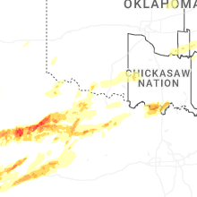


Connect with Interactive Hail Maps