

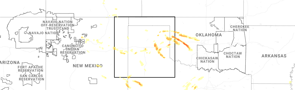
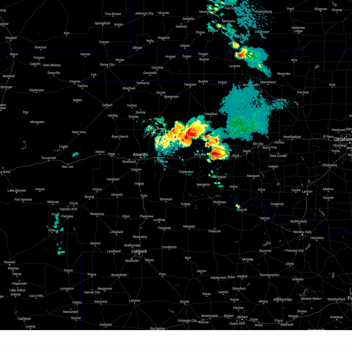
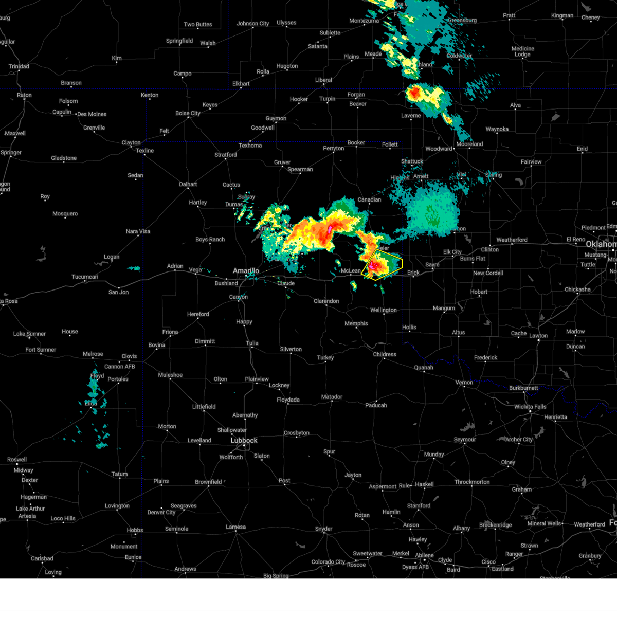
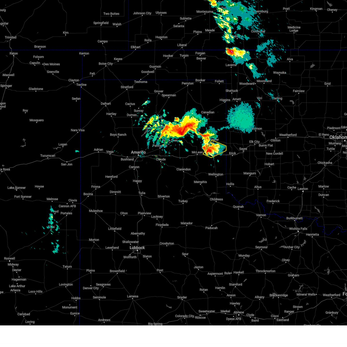
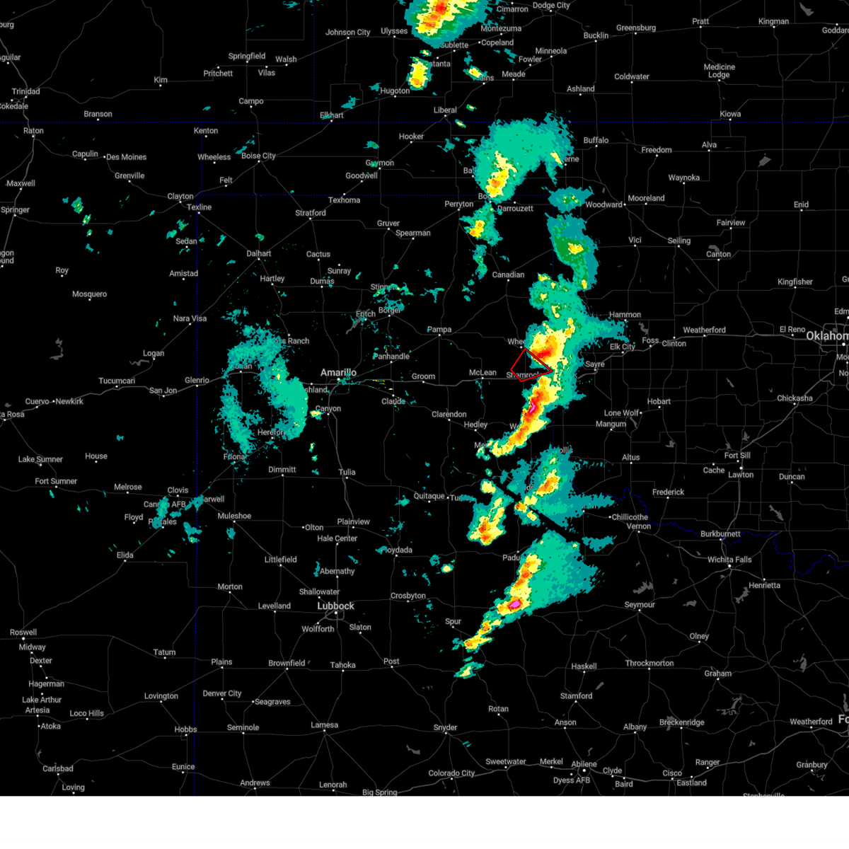
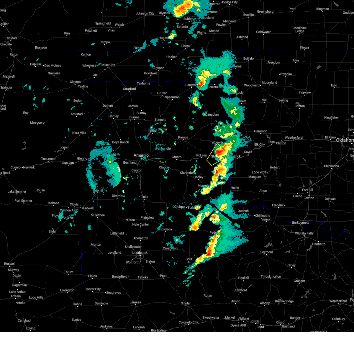
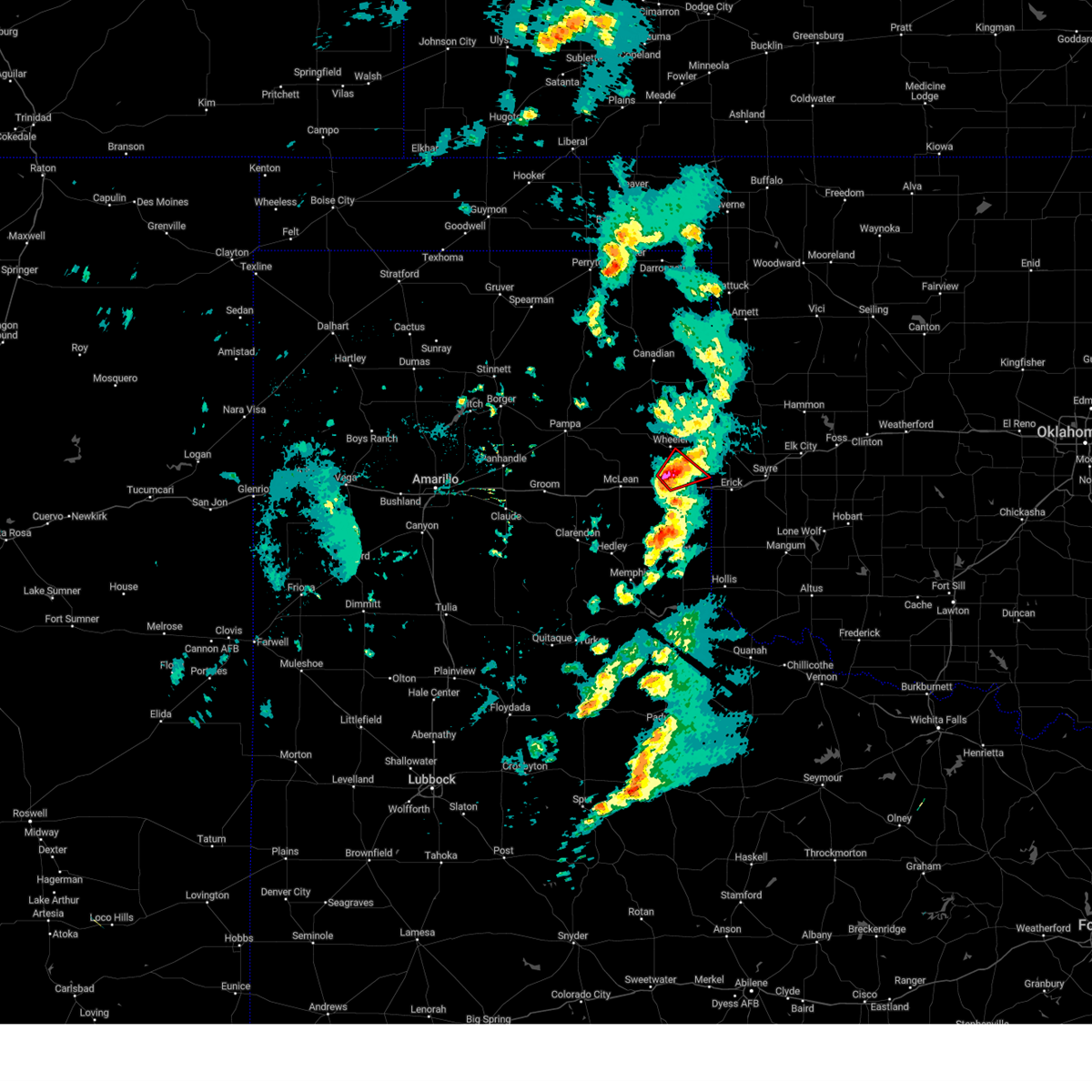
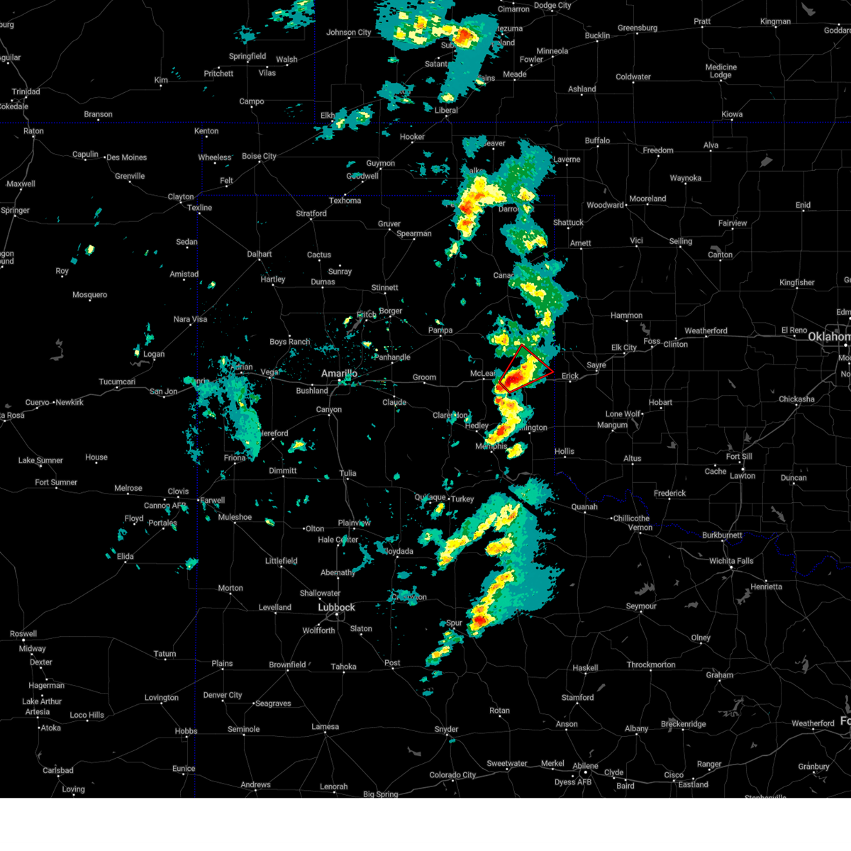
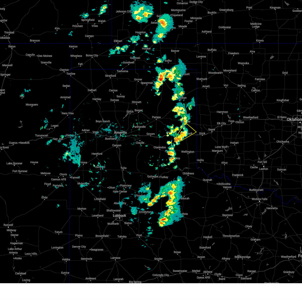
Hail Map for Shamrock, TX
The Shamrock, TX area has had 35 reports of on-the-ground hail by trained spotters, and has been under severe weather warnings 4 times during the past 12 months. Doppler radar has detected hail at or near Shamrock, TX on 77 occasions, including 1 occasion during the past year.
| Name: | Shamrock, TX |
| Where Located: | 54.3 miles N of Childress, TX |
| Map: | Google Map for Shamrock, TX |
| Population: | 1910 |
| Housing Units: | 1023 |
| More Info: | Search Google for Shamrock, TX |
0
The Top Recent Hail Date for Shamrock, TX is Monday, May 26, 2025 (76th out of 77)
Hail and Wind Damage Spotted near Shamrock, TX
| Date / Time | Report Details |
|---|---|
| 6/8/2025 6:53 PM CDT |
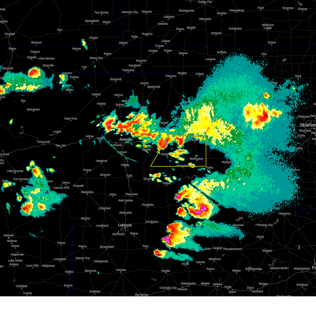 Svrama the national weather service in amarillo has issued a * severe thunderstorm warning for, southeastern armstrong county in the panhandle of texas, southern wheeler county in the panhandle of texas, southeastern gray county in the panhandle of texas, collingsworth county in the panhandle of texas, donley county in the panhandle of texas, * until 830 pm cdt. * at 653 pm cdt, severe thunderstorms were located along a line extending from 4 miles northeast of lake mcclellan to 7 miles southwest of greenbelt lake, moving east at 30 mph (radar indicated). Hazards include 60 mph wind gusts and half dollar size hail. Minor damage to roofs, siding, and trees is possible. Hail damage to vehicles is expected. Svrama the national weather service in amarillo has issued a * severe thunderstorm warning for, southeastern armstrong county in the panhandle of texas, southern wheeler county in the panhandle of texas, southeastern gray county in the panhandle of texas, collingsworth county in the panhandle of texas, donley county in the panhandle of texas, * until 830 pm cdt. * at 653 pm cdt, severe thunderstorms were located along a line extending from 4 miles northeast of lake mcclellan to 7 miles southwest of greenbelt lake, moving east at 30 mph (radar indicated). Hazards include 60 mph wind gusts and half dollar size hail. Minor damage to roofs, siding, and trees is possible. Hail damage to vehicles is expected.
|
| 6/7/2025 1:31 AM CDT |
 the severe thunderstorm warning has been cancelled and is no longer in effect the severe thunderstorm warning has been cancelled and is no longer in effect
|
| 6/7/2025 1:31 AM CDT |
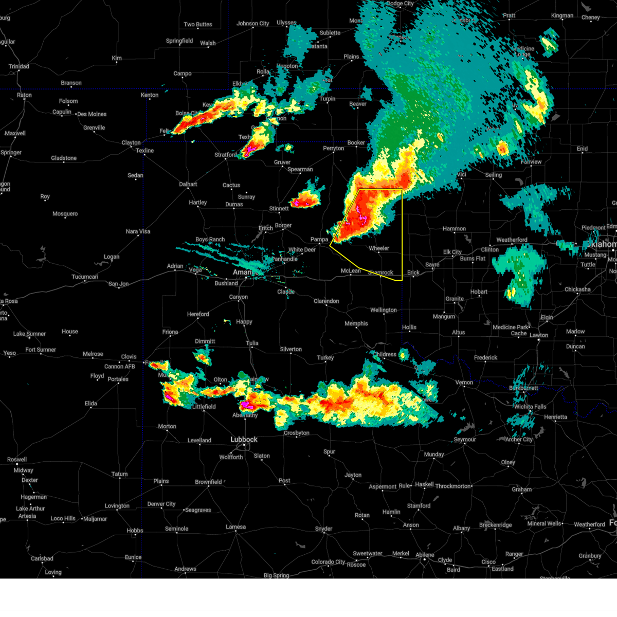 At 129 am cdt, automated weather equipment reported a severe thunderstorm was located 5 miles northwest of briscoe, or 17 miles south of canadian, moving southeast at 45 mph. this is a destructive storm for mobeetie, briscoe, wheeler, and allison (automated weather equipment). Hazards include 90 mph wind gusts and half dollar size hail. You are in a life-threatening situation. flying debris may be deadly to those caught without shelter. mobile homes will be heavily damaged or destroyed. homes and businesses will have substantial roof and window damage. expect extensive tree damage and power outages. Locations impacted include, new mobeetie, canadian, twitty, allison, glazier, lake marvin, kellerville, miami, lora, mobeetie, wheeler, codman, and briscoe. At 129 am cdt, automated weather equipment reported a severe thunderstorm was located 5 miles northwest of briscoe, or 17 miles south of canadian, moving southeast at 45 mph. this is a destructive storm for mobeetie, briscoe, wheeler, and allison (automated weather equipment). Hazards include 90 mph wind gusts and half dollar size hail. You are in a life-threatening situation. flying debris may be deadly to those caught without shelter. mobile homes will be heavily damaged or destroyed. homes and businesses will have substantial roof and window damage. expect extensive tree damage and power outages. Locations impacted include, new mobeetie, canadian, twitty, allison, glazier, lake marvin, kellerville, miami, lora, mobeetie, wheeler, codman, and briscoe.
|
| 6/7/2025 1:22 AM CDT |
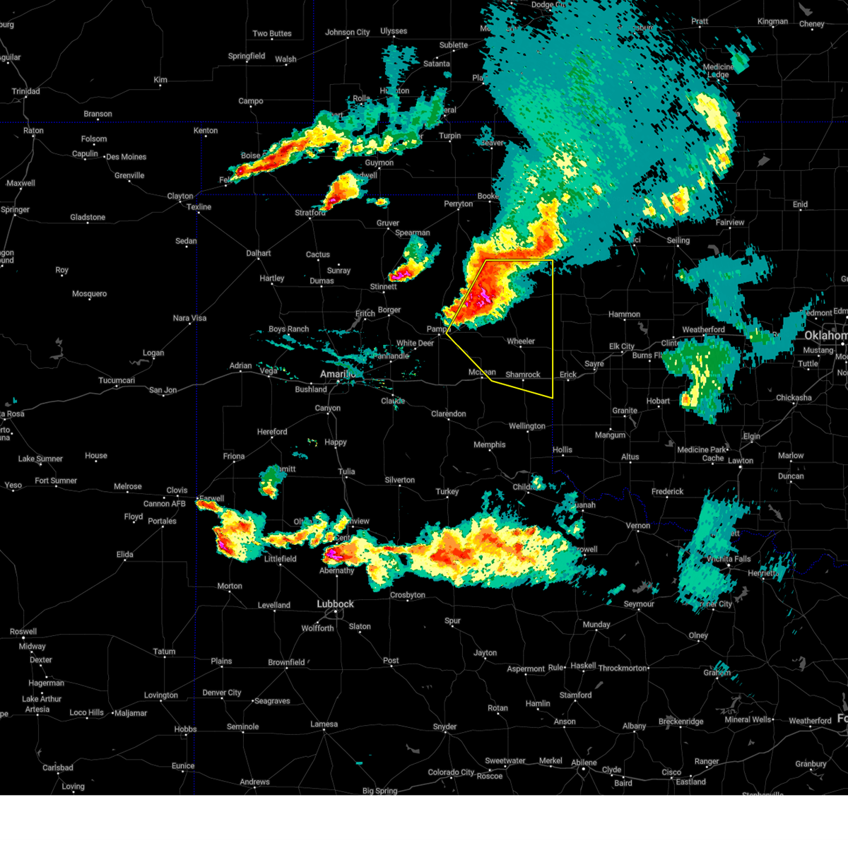 Svrama the national weather service in amarillo has issued a * severe thunderstorm warning for, wheeler county in the panhandle of texas, northeastern gray county in the panhandle of texas, northeastern collingsworth county in the panhandle of texas, eastern roberts county in the panhandle of texas, hemphill county in the panhandle of texas, * until 215 am cdt. * at 122 am cdt, a severe thunderstorm was located 8 miles east of lora, or 12 miles east of miami, moving southeast at 45 mph (radar indicated). Hazards include 70 mph wind gusts and half dollar size hail. Expect some tree damage. damage is likely to mobile homes, roofs, and outbuildings. Hail damage to vehicles is expected. Svrama the national weather service in amarillo has issued a * severe thunderstorm warning for, wheeler county in the panhandle of texas, northeastern gray county in the panhandle of texas, northeastern collingsworth county in the panhandle of texas, eastern roberts county in the panhandle of texas, hemphill county in the panhandle of texas, * until 215 am cdt. * at 122 am cdt, a severe thunderstorm was located 8 miles east of lora, or 12 miles east of miami, moving southeast at 45 mph (radar indicated). Hazards include 70 mph wind gusts and half dollar size hail. Expect some tree damage. damage is likely to mobile homes, roofs, and outbuildings. Hail damage to vehicles is expected.
|
| 10/9/2024 7:32 PM CDT | 62 mph wind gust observed from a decaying thunderstorm at the dozier mesone in collingsworth county TX, 12.5 miles NE of Shamrock, TX |
| 7/3/2024 12:21 AM CDT |
 the severe thunderstorm warning has been cancelled and is no longer in effect the severe thunderstorm warning has been cancelled and is no longer in effect
|
| 7/3/2024 12:04 AM CDT |
 At 1204 am cdt, a severe thunderstorm was located near samnorwood, or 7 miles south of shamrock, moving northeast at 20 mph (radar indicated). Hazards include 60 mph wind gusts. Minor damage to roofs, siding, and trees is possible. Locations impacted include, shamrock, dozier, lutie, lela, and samnorwood. At 1204 am cdt, a severe thunderstorm was located near samnorwood, or 7 miles south of shamrock, moving northeast at 20 mph (radar indicated). Hazards include 60 mph wind gusts. Minor damage to roofs, siding, and trees is possible. Locations impacted include, shamrock, dozier, lutie, lela, and samnorwood.
|
| 7/2/2024 11:46 PM CDT |
 Svrama the national weather service in amarillo has issued a * severe thunderstorm warning for, southeastern wheeler county in the panhandle of texas, northern collingsworth county in the panhandle of texas, * until 1245 am cdt. * at 1146 pm cdt, a severe thunderstorm was located over dozier, or 12 miles southwest of shamrock, moving northeast at 20 mph (radar indicated). Hazards include 70 mph wind gusts. Expect some tree damage. Damage is likely to mobile homes, roofs, and outbuildings. Svrama the national weather service in amarillo has issued a * severe thunderstorm warning for, southeastern wheeler county in the panhandle of texas, northern collingsworth county in the panhandle of texas, * until 1245 am cdt. * at 1146 pm cdt, a severe thunderstorm was located over dozier, or 12 miles southwest of shamrock, moving northeast at 20 mph (radar indicated). Hazards include 70 mph wind gusts. Expect some tree damage. Damage is likely to mobile homes, roofs, and outbuildings.
|
| 7/2/2024 11:40 PM CDT | Storm damage reported in collingsworth county TX, 12.5 miles NE of Shamrock, TX |
| 6/2/2024 6:50 AM CDT |
 At 649 am cdt, a severe thunderstorm was located over twitty, or 4 miles north of shamrock, moving east at 15 mph (radar indicated). Hazards include 60 mph wind gusts and half dollar size hail. Minor damage to roofs, siding, and trees is possible. hail damage to vehicles is expected. Locations impacted include, shamrock, twitty, and lela. At 649 am cdt, a severe thunderstorm was located over twitty, or 4 miles north of shamrock, moving east at 15 mph (radar indicated). Hazards include 60 mph wind gusts and half dollar size hail. Minor damage to roofs, siding, and trees is possible. hail damage to vehicles is expected. Locations impacted include, shamrock, twitty, and lela.
|
| 6/2/2024 6:33 AM CDT |
 At 633 am cdt, a severe thunderstorm was located over twitty, or 8 miles north of shamrock, moving northeast at 10 mph (radar indicated). Hazards include 60 mph wind gusts and half dollar size hail. Minor damage to roofs, siding, and trees is possible. hail damage to vehicles is expected. Locations impacted include, shamrock, wheeler, lela, and twitty. At 633 am cdt, a severe thunderstorm was located over twitty, or 8 miles north of shamrock, moving northeast at 10 mph (radar indicated). Hazards include 60 mph wind gusts and half dollar size hail. Minor damage to roofs, siding, and trees is possible. hail damage to vehicles is expected. Locations impacted include, shamrock, wheeler, lela, and twitty.
|
| 6/2/2024 6:17 AM CDT |
 Svrama the national weather service in amarillo has issued a * severe thunderstorm warning for, southern wheeler county in the panhandle of texas, * until 715 am cdt. * at 617 am cdt, a severe thunderstorm was located near twitty, or 7 miles northwest of shamrock, moving northeast at 15 mph (radar indicated). Hazards include ping pong ball size hail and 60 mph wind gusts. Minor damage to roofs, siding, and trees is possible. people and animals outdoors will be injured. Expect hail damage to roofs, siding, windows, and vehicles. Svrama the national weather service in amarillo has issued a * severe thunderstorm warning for, southern wheeler county in the panhandle of texas, * until 715 am cdt. * at 617 am cdt, a severe thunderstorm was located near twitty, or 7 miles northwest of shamrock, moving northeast at 15 mph (radar indicated). Hazards include ping pong ball size hail and 60 mph wind gusts. Minor damage to roofs, siding, and trees is possible. people and animals outdoors will be injured. Expect hail damage to roofs, siding, windows, and vehicles.
|
| 5/30/2024 8:53 PM CDT | Golf Ball sized hail reported 11.5 miles N of Shamrock, TX |
| 4/27/2024 10:45 AM CDT |
 the severe thunderstorm warning has been cancelled and is no longer in effect the severe thunderstorm warning has been cancelled and is no longer in effect
|
| 4/27/2024 10:45 AM CDT |
 At 1045 am cdt, a severe thunderstorm was located near texola, or 12 miles east of shamrock, moving northeast at 55 mph (radar indicated). Hazards include 60 mph wind gusts and half dollar size hail. Minor damage to roofs, siding, and trees is possible. hail damage to vehicles is expected. Locations impacted include, wellington, shamrock, dodson, lutie, twitty, allison, and samnorwood. At 1045 am cdt, a severe thunderstorm was located near texola, or 12 miles east of shamrock, moving northeast at 55 mph (radar indicated). Hazards include 60 mph wind gusts and half dollar size hail. Minor damage to roofs, siding, and trees is possible. hail damage to vehicles is expected. Locations impacted include, wellington, shamrock, dodson, lutie, twitty, allison, and samnorwood.
|
| 4/27/2024 10:38 AM CDT |
 At 1038 am cdt, a severe thunderstorm was located 6 miles southwest of texola, or 9 miles east of shamrock, moving northeast at 55 mph (radar indicated). Hazards include 60 mph wind gusts and half dollar size hail. Minor damage to roofs, siding, and trees is possible. hail damage to vehicles is expected. Locations impacted include, wellington, shamrock, dodson, lutie, twitty, allison, dozier, quail, and samnorwood. At 1038 am cdt, a severe thunderstorm was located 6 miles southwest of texola, or 9 miles east of shamrock, moving northeast at 55 mph (radar indicated). Hazards include 60 mph wind gusts and half dollar size hail. Minor damage to roofs, siding, and trees is possible. hail damage to vehicles is expected. Locations impacted include, wellington, shamrock, dodson, lutie, twitty, allison, dozier, quail, and samnorwood.
|
| 4/27/2024 10:24 AM CDT |
 At 1024 am cdt, a severe thunderstorm was located over lutie, or 10 miles north of wellington, moving northeast at 60 mph (radar indicated). Hazards include 60 mph wind gusts and half dollar size hail. Minor damage to roofs, siding, and trees is possible. hail damage to vehicles is expected. Locations impacted include, shamrock, lutie, twitty, dozier, lela, quail, and samnorwood. At 1024 am cdt, a severe thunderstorm was located over lutie, or 10 miles north of wellington, moving northeast at 60 mph (radar indicated). Hazards include 60 mph wind gusts and half dollar size hail. Minor damage to roofs, siding, and trees is possible. hail damage to vehicles is expected. Locations impacted include, shamrock, lutie, twitty, dozier, lela, quail, and samnorwood.
|
| 4/27/2024 10:24 AM CDT |
 the severe thunderstorm warning has been cancelled and is no longer in effect the severe thunderstorm warning has been cancelled and is no longer in effect
|
| 4/27/2024 10:20 AM CDT |
 Svrama the national weather service in amarillo has issued a * severe thunderstorm warning for, eastern wheeler county in the panhandle of texas, collingsworth county in the panhandle of texas, southeastern hemphill county in the panhandle of texas, * until 1115 am cdt. * at 1020 am cdt, a severe thunderstorm was located 6 miles south of allison, or 22 miles northeast of shamrock, moving northeast at 45 mph (radar indicated). Hazards include 60 mph wind gusts and half dollar size hail. Minor damage to roofs, siding, and trees is possible. Hail damage to vehicles is expected. Svrama the national weather service in amarillo has issued a * severe thunderstorm warning for, eastern wheeler county in the panhandle of texas, collingsworth county in the panhandle of texas, southeastern hemphill county in the panhandle of texas, * until 1115 am cdt. * at 1020 am cdt, a severe thunderstorm was located 6 miles south of allison, or 22 miles northeast of shamrock, moving northeast at 45 mph (radar indicated). Hazards include 60 mph wind gusts and half dollar size hail. Minor damage to roofs, siding, and trees is possible. Hail damage to vehicles is expected.
|
| 4/27/2024 10:05 AM CDT |
 At 1004 am cdt, a severe thunderstorm was located over samnorwood, or 10 miles south of shamrock, moving north at 55 mph (radar indicated). Hazards include 60 mph wind gusts and half dollar size hail. Minor damage to roofs, siding, and trees is possible. hail damage to vehicles is expected. Locations impacted include, shamrock, wheeler, hedley, lutie, twitty, dozier, lela, quail, and samnorwood. At 1004 am cdt, a severe thunderstorm was located over samnorwood, or 10 miles south of shamrock, moving north at 55 mph (radar indicated). Hazards include 60 mph wind gusts and half dollar size hail. Minor damage to roofs, siding, and trees is possible. hail damage to vehicles is expected. Locations impacted include, shamrock, wheeler, hedley, lutie, twitty, dozier, lela, quail, and samnorwood.
|
| 4/27/2024 10:05 AM CDT |
 the severe thunderstorm warning has been cancelled and is no longer in effect the severe thunderstorm warning has been cancelled and is no longer in effect
|
| 4/27/2024 9:48 AM CDT |
 At 947 am cdt, a severe thunderstorm was located over shamrock, moving northeast at 50 mph. another severe thunderstorm is located southwest of shamrock (radar indicated). Hazards include 60 mph wind gusts and half dollar size hail. Minor damage to roofs, siding, and trees is possible. hail damage to vehicles is expected. Locations impacted include, shamrock, hedley, lutie, twitty, dozier, lela, quail, and samnorwood. At 947 am cdt, a severe thunderstorm was located over shamrock, moving northeast at 50 mph. another severe thunderstorm is located southwest of shamrock (radar indicated). Hazards include 60 mph wind gusts and half dollar size hail. Minor damage to roofs, siding, and trees is possible. hail damage to vehicles is expected. Locations impacted include, shamrock, hedley, lutie, twitty, dozier, lela, quail, and samnorwood.
|
| 4/27/2024 9:38 AM CDT |
 At 937 am cdt, a severe thunderstorm was located 4 miles north of samnorwood, or 6 miles south of shamrock, moving northeast at 55 mph (radar indicated). Hazards include 60 mph wind gusts and half dollar size hail. Minor damage to roofs, siding, and trees is possible. hail damage to vehicles is expected. Locations impacted include, shamrock, hedley, lutie, twitty, dozier, lela, quail, and samnorwood. At 937 am cdt, a severe thunderstorm was located 4 miles north of samnorwood, or 6 miles south of shamrock, moving northeast at 55 mph (radar indicated). Hazards include 60 mph wind gusts and half dollar size hail. Minor damage to roofs, siding, and trees is possible. hail damage to vehicles is expected. Locations impacted include, shamrock, hedley, lutie, twitty, dozier, lela, quail, and samnorwood.
|
| 4/27/2024 9:23 AM CDT |
 Svrama the national weather service in amarillo has issued a * severe thunderstorm warning for, southern wheeler county in the panhandle of texas, southeastern gray county in the panhandle of texas, collingsworth county in the panhandle of texas, eastern donley county in the panhandle of texas, * until 1030 am cdt. * at 922 am cdt, a severe thunderstorm was located 6 miles south of hedley, or 8 miles west of memphis, moving northeast at 45 mph (radar indicated). Hazards include 60 mph wind gusts and quarter size hail. Minor damage to roofs, siding, and trees is possible. Hail damage to vehicles is expected. Svrama the national weather service in amarillo has issued a * severe thunderstorm warning for, southern wheeler county in the panhandle of texas, southeastern gray county in the panhandle of texas, collingsworth county in the panhandle of texas, eastern donley county in the panhandle of texas, * until 1030 am cdt. * at 922 am cdt, a severe thunderstorm was located 6 miles south of hedley, or 8 miles west of memphis, moving northeast at 45 mph (radar indicated). Hazards include 60 mph wind gusts and quarter size hail. Minor damage to roofs, siding, and trees is possible. Hail damage to vehicles is expected.
|
| 3/24/2024 3:40 PM CDT |
 The storm which prompted the warning has moved out of the area. therefore, the tornado warning will be allowed to expire. remember, a severe thunderstorm warning still remains in effect for wheeler county. The storm which prompted the warning has moved out of the area. therefore, the tornado warning will be allowed to expire. remember, a severe thunderstorm warning still remains in effect for wheeler county.
|
| 3/24/2024 3:30 PM CDT |
 Remember, a tornado warning still remains in effect for wheeler county. Remember, a tornado warning still remains in effect for wheeler county.
|
| 3/24/2024 3:28 PM CDT |
 At 327 pm cdt, a severe thunderstorm capable of producing a tornado was located over twitty, or 6 miles north of shamrock, moving northeast at 30 mph (radar indicated rotation). Hazards include tornado and golf ball size hail. Flying debris will be dangerous to those caught without shelter. mobile homes will be damaged or destroyed. damage to roofs, windows, and vehicles will occur. tree damage is likely. Locations impacted include, shamrock and twitty. At 327 pm cdt, a severe thunderstorm capable of producing a tornado was located over twitty, or 6 miles north of shamrock, moving northeast at 30 mph (radar indicated rotation). Hazards include tornado and golf ball size hail. Flying debris will be dangerous to those caught without shelter. mobile homes will be damaged or destroyed. damage to roofs, windows, and vehicles will occur. tree damage is likely. Locations impacted include, shamrock and twitty.
|
| 3/24/2024 3:28 PM CDT |
 the tornado warning has been cancelled and is no longer in effect the tornado warning has been cancelled and is no longer in effect
|
| 3/24/2024 3:14 PM CDT |
 Torama the national weather service in amarillo has issued a * tornado warning for, southeastern wheeler county in the panhandle of texas, north central collingsworth county in the panhandle of texas, * until 345 pm cdt. * at 314 pm cdt, a severe thunderstorm capable of producing a tornado was located over lela, or 5 miles west of shamrock, moving northeast at 30 mph (radar indicated rotation). Hazards include tornado and golf ball size hail. Flying debris will be dangerous to those caught without shelter. mobile homes will be damaged or destroyed. damage to roofs, windows, and vehicles will occur. Tree damage is likely. Torama the national weather service in amarillo has issued a * tornado warning for, southeastern wheeler county in the panhandle of texas, north central collingsworth county in the panhandle of texas, * until 345 pm cdt. * at 314 pm cdt, a severe thunderstorm capable of producing a tornado was located over lela, or 5 miles west of shamrock, moving northeast at 30 mph (radar indicated rotation). Hazards include tornado and golf ball size hail. Flying debris will be dangerous to those caught without shelter. mobile homes will be damaged or destroyed. damage to roofs, windows, and vehicles will occur. Tree damage is likely.
|
| 3/24/2024 3:05 PM CDT |
 Svrama the national weather service in amarillo has issued a * severe thunderstorm warning for, southern wheeler county in the panhandle of texas, north central collingsworth county in the panhandle of texas, * until 330 pm cdt. * at 304 pm cdt, a severe thunderstorm was located near lela, or 8 miles west of shamrock, moving northeast at 30 mph (radar indicated). Hazards include golf ball size hail and 70 mph wind gusts. Expect some tree damage. damage is likely to mobile homes, roofs, and outbuildings. people and animals outdoors will be injured. Expect hail damage to roofs, siding, windows, and vehicles. Svrama the national weather service in amarillo has issued a * severe thunderstorm warning for, southern wheeler county in the panhandle of texas, north central collingsworth county in the panhandle of texas, * until 330 pm cdt. * at 304 pm cdt, a severe thunderstorm was located near lela, or 8 miles west of shamrock, moving northeast at 30 mph (radar indicated). Hazards include golf ball size hail and 70 mph wind gusts. Expect some tree damage. damage is likely to mobile homes, roofs, and outbuildings. people and animals outdoors will be injured. Expect hail damage to roofs, siding, windows, and vehicles.
|
| 10/4/2023 1:08 PM CDT |
 At 108 pm cdt, a severe thunderstorm was located 4 miles west of greenbelt lake, or 6 miles northwest of clarendon, moving northeast at 45 mph (radar indicated). Hazards include 60 mph wind gusts and quarter size hail. Minor damage to roofs, siding, and trees is possible. Hail damage to vehicles is expected. At 108 pm cdt, a severe thunderstorm was located 4 miles west of greenbelt lake, or 6 miles northwest of clarendon, moving northeast at 45 mph (radar indicated). Hazards include 60 mph wind gusts and quarter size hail. Minor damage to roofs, siding, and trees is possible. Hail damage to vehicles is expected.
|
| 9/11/2023 12:55 AM CDT |
 At 1255 am cdt, severe thunderstorms were located along a line extending from 4 miles east of twitty to 7 miles southwest of wellington, moving east at 40 mph (radar indicated). Hazards include 70 mph wind gusts. Expect some tree damage. damage is likely to mobile homes, roofs, and outbuildings. locations impacted include, wellington, shamrock, wheeler, dodson, lutie, twitty, dozier, lela, quail, and samnorwood. thunderstorm damage threat, considerable hail threat, radar indicated max hail size, <. 75 in wind threat, radar indicated max wind gust, 70 mph. At 1255 am cdt, severe thunderstorms were located along a line extending from 4 miles east of twitty to 7 miles southwest of wellington, moving east at 40 mph (radar indicated). Hazards include 70 mph wind gusts. Expect some tree damage. damage is likely to mobile homes, roofs, and outbuildings. locations impacted include, wellington, shamrock, wheeler, dodson, lutie, twitty, dozier, lela, quail, and samnorwood. thunderstorm damage threat, considerable hail threat, radar indicated max hail size, <. 75 in wind threat, radar indicated max wind gust, 70 mph.
|
| 9/11/2023 12:45 AM CDT |
 At 1244 am cdt, severe thunderstorms were located along a line extending from twitty to 9 miles east of memphis, moving east at 40 mph (radar indicated). Hazards include 70 mph wind gusts. Expect some tree damage. damage is likely to mobile homes, roofs, and outbuildings. locations impacted include, wellington, shamrock, wheeler, dodson, lutie, twitty, dozier, lela, quail, and samnorwood. thunderstorm damage threat, considerable hail threat, radar indicated max hail size, <. 75 in wind threat, radar indicated max wind gust, 70 mph. At 1244 am cdt, severe thunderstorms were located along a line extending from twitty to 9 miles east of memphis, moving east at 40 mph (radar indicated). Hazards include 70 mph wind gusts. Expect some tree damage. damage is likely to mobile homes, roofs, and outbuildings. locations impacted include, wellington, shamrock, wheeler, dodson, lutie, twitty, dozier, lela, quail, and samnorwood. thunderstorm damage threat, considerable hail threat, radar indicated max hail size, <. 75 in wind threat, radar indicated max wind gust, 70 mph.
|
| 9/11/2023 12:22 AM CDT |
 At 1220 am cdt, automated weather equipment reported severe thunderstorms were located along a line extending from near kellerville to 6 miles south of hedley, moving east at 40 mph. these are destructive storms for eastern donley and gray counties and for wheeler and collingsworth counties (automated weather equipment. at 1214 am cdt, automated weather equipment recorded an 83 mph wind gust at mclean. additionally, a 77 mph gust was recorded at goodnight at 1132 pm cdt with these storms). Hazards include 80 mph wind gusts. Flying debris will be dangerous to those caught without shelter. mobile homes will be heavily damaged. expect considerable damage to roofs, windows, and vehicles. tree damage and power outages are likely. locations impacted include, wellington, shamrock, wheeler, mclean, hedley, dodson, lutie, twitty, lela, quail, samnorwood, kellerville, and dozier. thunderstorm damage threat, destructive hail threat, radar indicated max hail size, <. 75 in wind threat, observed max wind gust, 80 mph. At 1220 am cdt, automated weather equipment reported severe thunderstorms were located along a line extending from near kellerville to 6 miles south of hedley, moving east at 40 mph. these are destructive storms for eastern donley and gray counties and for wheeler and collingsworth counties (automated weather equipment. at 1214 am cdt, automated weather equipment recorded an 83 mph wind gust at mclean. additionally, a 77 mph gust was recorded at goodnight at 1132 pm cdt with these storms). Hazards include 80 mph wind gusts. Flying debris will be dangerous to those caught without shelter. mobile homes will be heavily damaged. expect considerable damage to roofs, windows, and vehicles. tree damage and power outages are likely. locations impacted include, wellington, shamrock, wheeler, mclean, hedley, dodson, lutie, twitty, lela, quail, samnorwood, kellerville, and dozier. thunderstorm damage threat, destructive hail threat, radar indicated max hail size, <. 75 in wind threat, observed max wind gust, 80 mph.
|
| 9/11/2023 12:14 AM CDT |
 At 1214 am cdt, severe thunderstorms were located along a line extending from 7 miles west of kellerville to 6 miles south of hedley, moving east at 40 mph (radar indicated). Hazards include 60 mph wind gusts. Minor damage to roofs, siding, and trees is possible. locations impacted include, wellington, clarendon, shamrock, wheeler, mclean, lefors, howardwick, hedley, dodson, lutie, lelia lake, lake mcclellan, twitty, lela, quail, samnorwood, kellerville, dozier, alanreed, and greenbelt lake. hail threat, radar indicated max hail size, <. 75 in wind threat, radar indicated max wind gust, 60 mph. At 1214 am cdt, severe thunderstorms were located along a line extending from 7 miles west of kellerville to 6 miles south of hedley, moving east at 40 mph (radar indicated). Hazards include 60 mph wind gusts. Minor damage to roofs, siding, and trees is possible. locations impacted include, wellington, clarendon, shamrock, wheeler, mclean, lefors, howardwick, hedley, dodson, lutie, lelia lake, lake mcclellan, twitty, lela, quail, samnorwood, kellerville, dozier, alanreed, and greenbelt lake. hail threat, radar indicated max hail size, <. 75 in wind threat, radar indicated max wind gust, 60 mph.
|
| 9/11/2023 12:01 AM CDT |
 At 1200 am cdt, automated weather equipment reported severe thunderstorms were located along a line extending from 6 miles south of lefors to 5 miles northeast of brice, moving east at 35 mph (automated weather equipment. at 1154 pm cdt, automated weather equipment recorded a 58 mph wind gust 2 miles west southwest of clarendon). Hazards include 70 mph wind gusts. Expect some tree damage. damage is likely to mobile homes, roofs, and outbuildings. locations impacted include, wellington, clarendon, shamrock, wheeler, mclean, lefors, howardwick, hedley, dodson, lutie, lelia lake, lake mcclellan, twitty, lela, quail, samnorwood, kellerville, dozier, alanreed, and greenbelt lake. thunderstorm damage threat, considerable hail threat, radar indicated max hail size, <. 75 in wind threat, observed max wind gust, 70 mph. At 1200 am cdt, automated weather equipment reported severe thunderstorms were located along a line extending from 6 miles south of lefors to 5 miles northeast of brice, moving east at 35 mph (automated weather equipment. at 1154 pm cdt, automated weather equipment recorded a 58 mph wind gust 2 miles west southwest of clarendon). Hazards include 70 mph wind gusts. Expect some tree damage. damage is likely to mobile homes, roofs, and outbuildings. locations impacted include, wellington, clarendon, shamrock, wheeler, mclean, lefors, howardwick, hedley, dodson, lutie, lelia lake, lake mcclellan, twitty, lela, quail, samnorwood, kellerville, dozier, alanreed, and greenbelt lake. thunderstorm damage threat, considerable hail threat, radar indicated max hail size, <. 75 in wind threat, observed max wind gust, 70 mph.
|
| 9/10/2023 11:45 PM CDT |
 At 1144 pm cdt, automated weather equipment reported severe thunderstorms were located along a line extending from 9 miles south of kingsmill to 9 miles northwest of brice, moving east at 40 mph (automated weather equipment. at 1136 pm cdt, automated weather equipment recorded a 67 mph gust 4 miles east of palo duro). Hazards include 70 mph wind gusts and penny size hail. Expect some tree damage. damage is likely to mobile homes, roofs, and outbuildings. locations impacted include, wellington, clarendon, shamrock, wheeler, mclean, lefors, howardwick, hedley, dodson, lutie, lelia lake, lake mcclellan, twitty, lela, quail, samnorwood, kellerville, dozier, alanreed, and greenbelt lake. thunderstorm damage threat, considerable hail threat, radar indicated max hail size, 0. 75in wind threat, observed max wind gust, 70 mph. At 1144 pm cdt, automated weather equipment reported severe thunderstorms were located along a line extending from 9 miles south of kingsmill to 9 miles northwest of brice, moving east at 40 mph (automated weather equipment. at 1136 pm cdt, automated weather equipment recorded a 67 mph gust 4 miles east of palo duro). Hazards include 70 mph wind gusts and penny size hail. Expect some tree damage. damage is likely to mobile homes, roofs, and outbuildings. locations impacted include, wellington, clarendon, shamrock, wheeler, mclean, lefors, howardwick, hedley, dodson, lutie, lelia lake, lake mcclellan, twitty, lela, quail, samnorwood, kellerville, dozier, alanreed, and greenbelt lake. thunderstorm damage threat, considerable hail threat, radar indicated max hail size, 0. 75in wind threat, observed max wind gust, 70 mph.
|
| 9/10/2023 11:41 PM CDT |
 At 1140 pm cdt, severe thunderstorms were located along a line extending from 9 miles south of kingsmill to 10 miles northwest of brice, moving east at 40 mph (radar indicated). Hazards include 60 mph wind gusts and penny size hail. minor damage to roofs, siding, and trees is possible At 1140 pm cdt, severe thunderstorms were located along a line extending from 9 miles south of kingsmill to 10 miles northwest of brice, moving east at 40 mph (radar indicated). Hazards include 60 mph wind gusts and penny size hail. minor damage to roofs, siding, and trees is possible
|
| 8/13/2023 5:25 PM CDT |
 At 525 pm cdt, severe thunderstorms were located along a line extending from near allison to 8 miles west of sweetwater to 7 miles west of dozier, moving northeast at 15 mph (radar indicated). Hazards include 60 mph wind gusts and quarter size hail. Minor damage to roofs, siding, and trees is possible. hail damage to vehicles is expected. locations impacted include, shamrock, briscoe, wheeler, allison, lela, and twitty. hail threat, radar indicated max hail size, 1. 00in wind threat, radar indicated max wind gust, 60 mph. At 525 pm cdt, severe thunderstorms were located along a line extending from near allison to 8 miles west of sweetwater to 7 miles west of dozier, moving northeast at 15 mph (radar indicated). Hazards include 60 mph wind gusts and quarter size hail. Minor damage to roofs, siding, and trees is possible. hail damage to vehicles is expected. locations impacted include, shamrock, briscoe, wheeler, allison, lela, and twitty. hail threat, radar indicated max hail size, 1. 00in wind threat, radar indicated max wind gust, 60 mph.
|
| 8/13/2023 5:15 PM CDT |
 At 514 pm cdt, severe thunderstorms were located along a line extending from allison to 9 miles northeast of twitty to 9 miles west of dozier, moving northeast at 30 mph (radar indicated). Hazards include 60 mph wind gusts. Minor damage to roofs, siding, and trees is possible. locations impacted include, shamrock, briscoe, wheeler, mclean, lutie, twitty, allison, dozier, lela, samnorwood, and kellerville. hail threat, radar indicated max hail size, <. 75 in wind threat, radar indicated max wind gust, 60 mph. At 514 pm cdt, severe thunderstorms were located along a line extending from allison to 9 miles northeast of twitty to 9 miles west of dozier, moving northeast at 30 mph (radar indicated). Hazards include 60 mph wind gusts. Minor damage to roofs, siding, and trees is possible. locations impacted include, shamrock, briscoe, wheeler, mclean, lutie, twitty, allison, dozier, lela, samnorwood, and kellerville. hail threat, radar indicated max hail size, <. 75 in wind threat, radar indicated max wind gust, 60 mph.
|
| 8/13/2023 4:57 PM CDT |
 At 457 pm cdt, severe thunderstorms were located along a line extending from 6 miles northeast of wheeler to 11 miles northwest of quail, moving northeast at 15 mph (radar indicated). Hazards include 60 mph wind gusts and nickel size hail. Minor damage to roofs, siding, and trees is possible. locations impacted include, shamrock, briscoe, wheeler, mclean, lutie, twitty, allison, dozier, lela, samnorwood, and kellerville. hail threat, radar indicated max hail size, 0. 88in wind threat, radar indicated max wind gust, 60 mph. At 457 pm cdt, severe thunderstorms were located along a line extending from 6 miles northeast of wheeler to 11 miles northwest of quail, moving northeast at 15 mph (radar indicated). Hazards include 60 mph wind gusts and nickel size hail. Minor damage to roofs, siding, and trees is possible. locations impacted include, shamrock, briscoe, wheeler, mclean, lutie, twitty, allison, dozier, lela, samnorwood, and kellerville. hail threat, radar indicated max hail size, 0. 88in wind threat, radar indicated max wind gust, 60 mph.
|
| 8/13/2023 4:45 PM CDT |
 At 445 pm cdt, severe thunderstorms were located along a line extending from 6 miles northeast of wheeler to 9 miles north of hedley, moving northeast at 15 mph (radar indicated). Hazards include 60 mph wind gusts and penny size hail. Minor damage to roofs, siding, and trees is possible. locations impacted include, shamrock, briscoe, wheeler, mclean, lutie, twitty, allison, dozier, lela, samnorwood, and kellerville. hail threat, radar indicated max hail size, 0. 75in wind threat, radar indicated max wind gust, 60 mph. At 445 pm cdt, severe thunderstorms were located along a line extending from 6 miles northeast of wheeler to 9 miles north of hedley, moving northeast at 15 mph (radar indicated). Hazards include 60 mph wind gusts and penny size hail. Minor damage to roofs, siding, and trees is possible. locations impacted include, shamrock, briscoe, wheeler, mclean, lutie, twitty, allison, dozier, lela, samnorwood, and kellerville. hail threat, radar indicated max hail size, 0. 75in wind threat, radar indicated max wind gust, 60 mph.
|
| 8/13/2023 4:31 PM CDT |
 At 430 pm cdt, severe thunderstorms were located along a line extending from 3 miles east of wheeler to 6 miles north of hedley, moving northeast at 15 mph (radar indicated). Hazards include 60 mph wind gusts and penny size hail. minor damage to roofs, siding, and trees is possible At 430 pm cdt, severe thunderstorms were located along a line extending from 3 miles east of wheeler to 6 miles north of hedley, moving northeast at 15 mph (radar indicated). Hazards include 60 mph wind gusts and penny size hail. minor damage to roofs, siding, and trees is possible
|
| 8/8/2023 11:28 PM CDT |
 At 1128 pm cdt, severe thunderstorms were located along a line extending from 8 miles east of twitty to 6 miles southeast of lutie to 10 miles south of wellington to 8 miles north of tell, moving east at 25 mph (radar indicated). Hazards include 70 mph wind gusts and penny size hail. Expect some tree damage. damage is likely to mobile homes, roofs, and outbuildings. locations impacted include, wellington, shamrock, dodson, lutie, twitty, dozier, lela, quail and samnorwood. thunderstorm damage threat, considerable hail threat, radar indicated max hail size, 0. 75in wind threat, radar indicated max wind gust, 70 mph. At 1128 pm cdt, severe thunderstorms were located along a line extending from 8 miles east of twitty to 6 miles southeast of lutie to 10 miles south of wellington to 8 miles north of tell, moving east at 25 mph (radar indicated). Hazards include 70 mph wind gusts and penny size hail. Expect some tree damage. damage is likely to mobile homes, roofs, and outbuildings. locations impacted include, wellington, shamrock, dodson, lutie, twitty, dozier, lela, quail and samnorwood. thunderstorm damage threat, considerable hail threat, radar indicated max hail size, 0. 75in wind threat, radar indicated max wind gust, 70 mph.
|
| 8/8/2023 10:45 PM CDT |
 At 1045 pm cdt, severe thunderstorms were located along a line extending from 6 miles southwest of wheeler to 4 miles southwest of dozier to 3 miles northeast of memphis to 13 miles southeast of brice, moving east at 25 mph (radar indicated). Hazards include 70 mph wind gusts and penny size hail. Expect some tree damage. Damage is likely to mobile homes, roofs, and outbuildings. At 1045 pm cdt, severe thunderstorms were located along a line extending from 6 miles southwest of wheeler to 4 miles southwest of dozier to 3 miles northeast of memphis to 13 miles southeast of brice, moving east at 25 mph (radar indicated). Hazards include 70 mph wind gusts and penny size hail. Expect some tree damage. Damage is likely to mobile homes, roofs, and outbuildings.
|
| 7/9/2023 1:46 AM CDT |
 At 146 am cdt, automated weather equipment reported severe thunderstorms were located along a line extending from durham to 3 miles southeast of new mobeetie to 8 miles west of lefors, moving southeast at 60 mph (automated weather equipment. at 131 am cdt, a 69 mph wind gust was recorded 10 miles east of miami). Hazards include 70 mph wind gusts. Expect some tree damage. damage is likely to mobile homes, roofs, and outbuildings. locations impacted include, pampa, shamrock, miami, briscoe, wheeler, mclean, lefors, new mobeetie, lake mcclellan, twitty, allison, lela, lake marvin, kellerville, lora, alanreed, codman and mobeetie. thunderstorm damage threat, considerable hail threat, radar indicated max hail size, <. 75 in wind threat, observed max wind gust, 70 mph. At 146 am cdt, automated weather equipment reported severe thunderstorms were located along a line extending from durham to 3 miles southeast of new mobeetie to 8 miles west of lefors, moving southeast at 60 mph (automated weather equipment. at 131 am cdt, a 69 mph wind gust was recorded 10 miles east of miami). Hazards include 70 mph wind gusts. Expect some tree damage. damage is likely to mobile homes, roofs, and outbuildings. locations impacted include, pampa, shamrock, miami, briscoe, wheeler, mclean, lefors, new mobeetie, lake mcclellan, twitty, allison, lela, lake marvin, kellerville, lora, alanreed, codman and mobeetie. thunderstorm damage threat, considerable hail threat, radar indicated max hail size, <. 75 in wind threat, observed max wind gust, 70 mph.
|
| 7/9/2023 1:40 AM CDT |
 At 140 am cdt, automated weather equipment reported severe thunderstorms were located along a line extending from 5 miles north of durham to near new mobeetie to 5 miles southeast of kingsmill, moving southeast at 60 mph (automated weather equipment. at 131 am cdt, a 69 mph wind gust was recorded 10 miles east of miami). Hazards include 70 mph wind gusts. Expect some tree damage. damage is likely to mobile homes, roofs, and outbuildings. locations impacted include, pampa, canadian, shamrock, miami, briscoe, wheeler, mclean, lefors, new mobeetie, lake mcclellan, twitty, allison, lela, glazier, lake marvin, kellerville, lora, alanreed, codman and mobeetie. thunderstorm damage threat, considerable hail threat, radar indicated max hail size, <. 75 in wind threat, observed max wind gust, 70 mph. At 140 am cdt, automated weather equipment reported severe thunderstorms were located along a line extending from 5 miles north of durham to near new mobeetie to 5 miles southeast of kingsmill, moving southeast at 60 mph (automated weather equipment. at 131 am cdt, a 69 mph wind gust was recorded 10 miles east of miami). Hazards include 70 mph wind gusts. Expect some tree damage. damage is likely to mobile homes, roofs, and outbuildings. locations impacted include, pampa, canadian, shamrock, miami, briscoe, wheeler, mclean, lefors, new mobeetie, lake mcclellan, twitty, allison, lela, glazier, lake marvin, kellerville, lora, alanreed, codman and mobeetie. thunderstorm damage threat, considerable hail threat, radar indicated max hail size, <. 75 in wind threat, observed max wind gust, 70 mph.
|
| 7/9/2023 1:35 AM CDT |
 At 135 am cdt, automated weather equipment reported severe thunderstorms were located along a line extending from 8 miles north of durham to 5 miles north of new mobeetie to 3 miles southwest of pampa, moving southeast at 60 mph (automated weather equipment. at 127 am cdt, a 66 mph wind gust was recorded 10 miles east of miami). Hazards include 70 mph wind gusts. Expect some tree damage. damage is likely to mobile homes, roofs, and outbuildings. locations impacted include, pampa, canadian, shamrock, miami, briscoe, wheeler, mclean, lefors, new mobeetie, lake mcclellan, twitty, allison, lela, glazier, lake marvin, kellerville, lora, alanreed, codman and mobeetie. thunderstorm damage threat, considerable hail threat, radar indicated max hail size, <. 75 in wind threat, observed max wind gust, 70 mph. At 135 am cdt, automated weather equipment reported severe thunderstorms were located along a line extending from 8 miles north of durham to 5 miles north of new mobeetie to 3 miles southwest of pampa, moving southeast at 60 mph (automated weather equipment. at 127 am cdt, a 66 mph wind gust was recorded 10 miles east of miami). Hazards include 70 mph wind gusts. Expect some tree damage. damage is likely to mobile homes, roofs, and outbuildings. locations impacted include, pampa, canadian, shamrock, miami, briscoe, wheeler, mclean, lefors, new mobeetie, lake mcclellan, twitty, allison, lela, glazier, lake marvin, kellerville, lora, alanreed, codman and mobeetie. thunderstorm damage threat, considerable hail threat, radar indicated max hail size, <. 75 in wind threat, observed max wind gust, 70 mph.
|
| 7/9/2023 1:30 AM CDT |
 At 130 am cdt, automated weather equipment reported severe thunderstorms were located along a line extending from 9 miles north of durham to 6 miles north of new mobeetie to 3 miles southwest of pampa, moving southeast at 60 mph (automated weather equipment. at 122 am cdt, a 63 mph was recorded 6 miles east of canadian). Hazards include 60 mph wind gusts and penny size hail. Minor damage to roofs, siding, and trees is possible. locations impacted include, pampa, canadian, shamrock, miami, briscoe, wheeler, mclean, lefors, new mobeetie, lake mcclellan, twitty, allison, lela, glazier, lake marvin, kellerville, lora, alanreed, codman and mobeetie. hail threat, radar indicated max hail size, 0. 75in wind threat, observed max wind gust, 60 mph. At 130 am cdt, automated weather equipment reported severe thunderstorms were located along a line extending from 9 miles north of durham to 6 miles north of new mobeetie to 3 miles southwest of pampa, moving southeast at 60 mph (automated weather equipment. at 122 am cdt, a 63 mph was recorded 6 miles east of canadian). Hazards include 60 mph wind gusts and penny size hail. Minor damage to roofs, siding, and trees is possible. locations impacted include, pampa, canadian, shamrock, miami, briscoe, wheeler, mclean, lefors, new mobeetie, lake mcclellan, twitty, allison, lela, glazier, lake marvin, kellerville, lora, alanreed, codman and mobeetie. hail threat, radar indicated max hail size, 0. 75in wind threat, observed max wind gust, 60 mph.
|
| 7/9/2023 1:17 AM CDT |
 At 117 am cdt, severe thunderstorms were located along a line extending from near higgins to near lora to 7 miles northeast of skellytown, moving southeast at 60 mph (radar indicated). Hazards include 60 mph wind gusts and penny size hail. minor damage to roofs, siding, and trees is possible At 117 am cdt, severe thunderstorms were located along a line extending from near higgins to near lora to 7 miles northeast of skellytown, moving southeast at 60 mph (radar indicated). Hazards include 60 mph wind gusts and penny size hail. minor damage to roofs, siding, and trees is possible
|
| 7/7/2023 8:10 PM CDT |
 At 809 pm cdt, severe thunderstorms were located along a line extending from 7 miles southwest of texola to 5 miles southeast of lutie to 7 miles southwest of wellington, moving east at 35 mph (radar indicated). Hazards include 70 mph wind gusts and quarter size hail. Expect some tree damage. damage is likely to mobile homes, roofs, and outbuildings. hail damage to vehicles is expected. Locations impacted include, wellington, shamrock, wheeler, dodson, lutie, twitty, dozier, lela, quail and samnorwood. At 809 pm cdt, severe thunderstorms were located along a line extending from 7 miles southwest of texola to 5 miles southeast of lutie to 7 miles southwest of wellington, moving east at 35 mph (radar indicated). Hazards include 70 mph wind gusts and quarter size hail. Expect some tree damage. damage is likely to mobile homes, roofs, and outbuildings. hail damage to vehicles is expected. Locations impacted include, wellington, shamrock, wheeler, dodson, lutie, twitty, dozier, lela, quail and samnorwood.
|
| 7/7/2023 7:56 PM CDT |
 At 756 pm cdt, severe thunderstorms were located along a line extending from 4 miles southeast of shamrock to 6 miles east of hedley, moving east at 50 mph (radar indicated). Hazards include 70 mph wind gusts and penny size hail. Expect some tree damage. Damage is likely to mobile homes, roofs, and outbuildings. At 756 pm cdt, severe thunderstorms were located along a line extending from 4 miles southeast of shamrock to 6 miles east of hedley, moving east at 50 mph (radar indicated). Hazards include 70 mph wind gusts and penny size hail. Expect some tree damage. Damage is likely to mobile homes, roofs, and outbuildings.
|
| 7/7/2023 7:42 PM CDT |
 At 742 pm cdt, a severe thunderstorm was located over lela, or 5 miles west of shamrock, moving east at 45 mph (radar indicated). Hazards include 70 mph wind gusts and penny size hail. Expect some tree damage. damage is likely to mobile homes, roofs, and outbuildings. Locations impacted include, shamrock, wheeler, mclean, lefors, howardwick, lake mcclellan, twitty, dozier, lela, alanreed, samnorwood and kellerville. At 742 pm cdt, a severe thunderstorm was located over lela, or 5 miles west of shamrock, moving east at 45 mph (radar indicated). Hazards include 70 mph wind gusts and penny size hail. Expect some tree damage. damage is likely to mobile homes, roofs, and outbuildings. Locations impacted include, shamrock, wheeler, mclean, lefors, howardwick, lake mcclellan, twitty, dozier, lela, alanreed, samnorwood and kellerville.
|
| 7/7/2023 7:20 PM CDT |
 At 719 pm cdt, a severe thunderstorm was located 5 miles east of mclean, or 14 miles west of shamrock, moving east at 65 mph (radar indicated. a mesonet recorded 60 mph wind gusts at lake mcclellan). Hazards include 70 mph wind gusts and penny size hail. Expect some tree damage. damage is likely to mobile homes, roofs, and outbuildings. Locations impacted include, shamrock, wheeler, mclean, groom, lefors, howardwick, lake mcclellan, twitty, lela, samnorwood, kellerville, goodnight, dozier and alanreed. At 719 pm cdt, a severe thunderstorm was located 5 miles east of mclean, or 14 miles west of shamrock, moving east at 65 mph (radar indicated. a mesonet recorded 60 mph wind gusts at lake mcclellan). Hazards include 70 mph wind gusts and penny size hail. Expect some tree damage. damage is likely to mobile homes, roofs, and outbuildings. Locations impacted include, shamrock, wheeler, mclean, groom, lefors, howardwick, lake mcclellan, twitty, lela, samnorwood, kellerville, goodnight, dozier and alanreed.
|
| 7/7/2023 7:12 PM CDT |
 At 711 pm cdt, a severe thunderstorm was located near mclean, or 23 miles west of shamrock, moving east at 75 mph (radar indicated). Hazards include 70 mph wind gusts and penny size hail. Expect some tree damage. damage is likely to mobile homes, roofs, and outbuildings. Locations impacted include, shamrock, wheeler, mclean, groom, lefors, howardwick, lutie, lake mcclellan, twitty, lela, samnorwood, kellerville, goodnight, dozier, alanreed and greenbelt lake. At 711 pm cdt, a severe thunderstorm was located near mclean, or 23 miles west of shamrock, moving east at 75 mph (radar indicated). Hazards include 70 mph wind gusts and penny size hail. Expect some tree damage. damage is likely to mobile homes, roofs, and outbuildings. Locations impacted include, shamrock, wheeler, mclean, groom, lefors, howardwick, lutie, lake mcclellan, twitty, lela, samnorwood, kellerville, goodnight, dozier, alanreed and greenbelt lake.
|
| 7/7/2023 7:05 PM CDT |
 At 704 pm cdt, a severe thunderstorm was located over alanreed, or 22 miles north of clarendon, moving east at 65 mph (radar indicated). Hazards include 70 mph wind gusts and penny size hail. Expect some tree damage. Damage is likely to mobile homes, roofs, and outbuildings. At 704 pm cdt, a severe thunderstorm was located over alanreed, or 22 miles north of clarendon, moving east at 65 mph (radar indicated). Hazards include 70 mph wind gusts and penny size hail. Expect some tree damage. Damage is likely to mobile homes, roofs, and outbuildings.
|
| 7/5/2023 7:56 PM CDT |
 The severe thunderstorm warning for southeastern wheeler and northwestern collingsworth counties will expire at 800 pm cdt, the storm which prompted the warning has moved out of the area. therefore, the warning will be allowed to expire. however gusty winds and heavy rain are still possible with this thunderstorm. The severe thunderstorm warning for southeastern wheeler and northwestern collingsworth counties will expire at 800 pm cdt, the storm which prompted the warning has moved out of the area. therefore, the warning will be allowed to expire. however gusty winds and heavy rain are still possible with this thunderstorm.
|
| 7/5/2023 7:26 PM CDT |
 At 724 pm cdt, a severe thunderstorm was located over lutie, or 12 miles north of wellington, moving southeast at 35 mph. this is a destructive storm for central collingsorth county (trained weather spotters reported trees blown down near fm 1547). Hazards include 80 mph wind gusts and half dollar size hail. Flying debris will be dangerous to those caught without shelter. mobile homes will be heavily damaged. expect considerable damage to roofs, windows, and vehicles. tree damage and power outages are likely. hail damage to vehicles is expected. locations impacted include, shamrock, dozier, quail and samnorwood. thunderstorm damage threat, destructive hail threat, radar indicated max hail size, 1. 25 in wind threat, observed max wind gust, 80 mph. At 724 pm cdt, a severe thunderstorm was located over lutie, or 12 miles north of wellington, moving southeast at 35 mph. this is a destructive storm for central collingsorth county (trained weather spotters reported trees blown down near fm 1547). Hazards include 80 mph wind gusts and half dollar size hail. Flying debris will be dangerous to those caught without shelter. mobile homes will be heavily damaged. expect considerable damage to roofs, windows, and vehicles. tree damage and power outages are likely. hail damage to vehicles is expected. locations impacted include, shamrock, dozier, quail and samnorwood. thunderstorm damage threat, destructive hail threat, radar indicated max hail size, 1. 25 in wind threat, observed max wind gust, 80 mph.
|
| 7/5/2023 7:20 PM CDT | Snapped tree limbs and power pole down along highway 83. chaser reported possible tornad in collingsworth county TX, 5.3 miles N of Shamrock, TX |
| 7/5/2023 7:17 PM CDT |
 At 716 pm cdt, a severe thunderstorm was located over dozier, or 8 miles southwest of shamrock, moving southeast at 25 mph. this is a destructive storm for central and eastern portions of collingsworth county (automated weather equipment). Hazards include 80 mph wind gusts and two inch hail. Flying debris will be dangerous to those caught without shelter. mobile homes will be heavily damaged. expect considerable damage to roofs, windows, and vehicles. tree damage and power outages are likely. people and animals outdoors will be injured. Expect hail damage to roofs, siding, windows, and vehicles. At 716 pm cdt, a severe thunderstorm was located over dozier, or 8 miles southwest of shamrock, moving southeast at 25 mph. this is a destructive storm for central and eastern portions of collingsworth county (automated weather equipment). Hazards include 80 mph wind gusts and two inch hail. Flying debris will be dangerous to those caught without shelter. mobile homes will be heavily damaged. expect considerable damage to roofs, windows, and vehicles. tree damage and power outages are likely. people and animals outdoors will be injured. Expect hail damage to roofs, siding, windows, and vehicles.
|
| 7/5/2023 7:04 PM CDT |
 At 703 pm cdt, a severe thunderstorm was located 5 miles northwest of dozier, or 11 miles southwest of shamrock, moving southeast at 25 mph (radar indicated). Hazards include two inch hail and 70 mph wind gusts. Expect some tree damage. damage is likely to mobile homes, roofs, and outbuildings. people and animals outdoors will be injured. expect hail damage to roofs, siding, windows, and vehicles. locations impacted include, shamrock, dozier, lela, quail and samnorwood. thunderstorm damage threat, considerable hail threat, radar indicated max hail size, 2. 00 in wind threat, radar indicated max wind gust, 70 mph. At 703 pm cdt, a severe thunderstorm was located 5 miles northwest of dozier, or 11 miles southwest of shamrock, moving southeast at 25 mph (radar indicated). Hazards include two inch hail and 70 mph wind gusts. Expect some tree damage. damage is likely to mobile homes, roofs, and outbuildings. people and animals outdoors will be injured. expect hail damage to roofs, siding, windows, and vehicles. locations impacted include, shamrock, dozier, lela, quail and samnorwood. thunderstorm damage threat, considerable hail threat, radar indicated max hail size, 2. 00 in wind threat, radar indicated max wind gust, 70 mph.
|
| 7/5/2023 6:48 PM CDT |
 At 647 pm cdt, a severe thunderstorm was located 4 miles southeast of mclean, or 16 miles west of shamrock, moving southeast at 15 mph (radar indicated). Hazards include golf ball size hail and 70 mph wind gusts. Expect some tree damage. damage is likely to mobile homes, roofs, and outbuildings. people and animals outdoors will be injured. Expect hail damage to roofs, siding, windows, and vehicles. At 647 pm cdt, a severe thunderstorm was located 4 miles southeast of mclean, or 16 miles west of shamrock, moving southeast at 15 mph (radar indicated). Hazards include golf ball size hail and 70 mph wind gusts. Expect some tree damage. damage is likely to mobile homes, roofs, and outbuildings. people and animals outdoors will be injured. Expect hail damage to roofs, siding, windows, and vehicles.
|
| 7/5/2023 6:42 PM CDT |
 At 642 pm cdt, severe thunderstorms were located along a line extending from 6 miles northeast of kellerville to 3 miles east of mclean, moving southeast at 15 mph (radar indicated). Hazards include two inch hail and 60 mph wind gusts. Minor damage to roofs, siding, and trees is possible. people and animals outdoors will be injured. expect hail damage to roofs, siding, windows, and vehicles. locations impacted include, shamrock, wheeler, mclean, lela, twitty and kellerville. thunderstorm damage threat, considerable hail threat, radar indicated max hail size, 2. 00 in wind threat, radar indicated max wind gust, 60 mph. At 642 pm cdt, severe thunderstorms were located along a line extending from 6 miles northeast of kellerville to 3 miles east of mclean, moving southeast at 15 mph (radar indicated). Hazards include two inch hail and 60 mph wind gusts. Minor damage to roofs, siding, and trees is possible. people and animals outdoors will be injured. expect hail damage to roofs, siding, windows, and vehicles. locations impacted include, shamrock, wheeler, mclean, lela, twitty and kellerville. thunderstorm damage threat, considerable hail threat, radar indicated max hail size, 2. 00 in wind threat, radar indicated max wind gust, 60 mph.
|
| 7/5/2023 6:01 PM CDT |
 At 600 pm cdt, severe thunderstorms were located along a line extending from 5 miles west of new mobeetie to 5 miles east of mclean, moving east at 15 mph (radar indicated). Hazards include two inch hail and 60 mph wind gusts. Minor damage to roofs, siding, and trees is possible. people and animals outdoors will be injured. expect hail damage to roofs, siding, windows, and vehicles. locations impacted include, shamrock, briscoe, wheeler, mclean, new mobeetie, twitty, lela, kellerville and mobeetie. thunderstorm damage threat, considerable hail threat, radar indicated max hail size, 2. 00 in wind threat, radar indicated max wind gust, 60 mph. At 600 pm cdt, severe thunderstorms were located along a line extending from 5 miles west of new mobeetie to 5 miles east of mclean, moving east at 15 mph (radar indicated). Hazards include two inch hail and 60 mph wind gusts. Minor damage to roofs, siding, and trees is possible. people and animals outdoors will be injured. expect hail damage to roofs, siding, windows, and vehicles. locations impacted include, shamrock, briscoe, wheeler, mclean, new mobeetie, twitty, lela, kellerville and mobeetie. thunderstorm damage threat, considerable hail threat, radar indicated max hail size, 2. 00 in wind threat, radar indicated max wind gust, 60 mph.
|
| 7/5/2023 5:52 PM CDT |
 At 552 pm cdt, severe thunderstorms were located along a line extending from 7 miles west of new mobeetie to 3 miles northeast of mclean, moving east at 15 mph (radar indicated). Hazards include 60 mph wind gusts and quarter size hail. Minor damage to roofs, siding, and trees is possible. Hail damage to vehicles is expected. At 552 pm cdt, severe thunderstorms were located along a line extending from 7 miles west of new mobeetie to 3 miles northeast of mclean, moving east at 15 mph (radar indicated). Hazards include 60 mph wind gusts and quarter size hail. Minor damage to roofs, siding, and trees is possible. Hail damage to vehicles is expected.
|
| 6/30/2023 5:25 PM CDT |
 At 524 pm cdt, severe thunderstorms were located along a line extending from 4 miles southeast of briscoe to 3 miles west of texola to 8 miles south of quail, moving east at 40 mph (radar indicated). Hazards include 60 mph wind gusts. Minor damage to roofs, siding, and trees is possible. locations impacted include, wellington, shamrock, briscoe, wheeler, dodson, lutie, twitty, allison, dozier, lela, quail and samnorwood. hail threat, radar indicated max hail size, <. 75 in wind threat, radar indicated max wind gust, 60 mph. At 524 pm cdt, severe thunderstorms were located along a line extending from 4 miles southeast of briscoe to 3 miles west of texola to 8 miles south of quail, moving east at 40 mph (radar indicated). Hazards include 60 mph wind gusts. Minor damage to roofs, siding, and trees is possible. locations impacted include, wellington, shamrock, briscoe, wheeler, dodson, lutie, twitty, allison, dozier, lela, quail and samnorwood. hail threat, radar indicated max hail size, <. 75 in wind threat, radar indicated max wind gust, 60 mph.
|
| 6/30/2023 5:05 PM CDT |
 At 504 pm cdt, severe thunderstorms were located along a line extending from mobeetie to shamrock to 4 miles northwest of memphis, moving east at 40 mph (radar indicated). Hazards include 60 mph wind gusts. Minor damage to roofs, siding, and trees is possible. locations impacted include, wellington, shamrock, briscoe, wheeler, mclean, hedley, dodson, lutie, twitty, allison, lela, quail, samnorwood, kellerville, dozier and mobeetie. hail threat, radar indicated max hail size, <. 75 in wind threat, radar indicated max wind gust, 60 mph. At 504 pm cdt, severe thunderstorms were located along a line extending from mobeetie to shamrock to 4 miles northwest of memphis, moving east at 40 mph (radar indicated). Hazards include 60 mph wind gusts. Minor damage to roofs, siding, and trees is possible. locations impacted include, wellington, shamrock, briscoe, wheeler, mclean, hedley, dodson, lutie, twitty, allison, lela, quail, samnorwood, kellerville, dozier and mobeetie. hail threat, radar indicated max hail size, <. 75 in wind threat, radar indicated max wind gust, 60 mph.
|
| 6/30/2023 4:46 PM CDT |
 At 445 pm cdt, severe thunderstorms were located along a line extending from 4 miles northwest of new mobeetie to 5 miles west of lela to 5 miles northeast of brice, moving east at 40 mph (automated weather equipment. at 440 pm cdt, automated weather equipment recorded a 64 mph wind gust at mclean). Hazards include 70 mph wind gusts. Expect some tree damage. Damage is likely to mobile homes, roofs, and outbuildings. At 445 pm cdt, severe thunderstorms were located along a line extending from 4 miles northwest of new mobeetie to 5 miles west of lela to 5 miles northeast of brice, moving east at 40 mph (automated weather equipment. at 440 pm cdt, automated weather equipment recorded a 64 mph wind gust at mclean). Hazards include 70 mph wind gusts. Expect some tree damage. Damage is likely to mobile homes, roofs, and outbuildings.
|
| 6/27/2023 3:49 AM CDT |
 At 348 am cdt, severe thunderstorms were located along a line extending from 4 miles southeast of new mobeetie to 4 miles south of shamrock to 3 miles south of quail, moving east at 45 mph (radar indicated). Hazards include 70 mph wind gusts. Expect some tree damage. Damage is likely to mobile homes, roofs, and outbuildings. At 348 am cdt, severe thunderstorms were located along a line extending from 4 miles southeast of new mobeetie to 4 miles south of shamrock to 3 miles south of quail, moving east at 45 mph (radar indicated). Hazards include 70 mph wind gusts. Expect some tree damage. Damage is likely to mobile homes, roofs, and outbuildings.
|
| 6/22/2023 4:56 PM CDT |
 At 455 pm cdt, a severe thunderstorm was located 6 miles southwest of dozier, or 17 miles southwest of shamrock, moving southeast at 20 mph (radar indicated). Hazards include two inch hail and 60 mph wind gusts. Minor damage to roofs, siding, and trees is possible. people and animals outdoors will be injured. expect hail damage to roofs, siding, windows, and vehicles. locations impacted include, shamrock, dodson, dozier, lutie, lela and samnorwood. thunderstorm damage threat, considerable hail threat, radar indicated max hail size, 2. 00 in wind threat, radar indicated max wind gust, 60 mph. At 455 pm cdt, a severe thunderstorm was located 6 miles southwest of dozier, or 17 miles southwest of shamrock, moving southeast at 20 mph (radar indicated). Hazards include two inch hail and 60 mph wind gusts. Minor damage to roofs, siding, and trees is possible. people and animals outdoors will be injured. expect hail damage to roofs, siding, windows, and vehicles. locations impacted include, shamrock, dodson, dozier, lutie, lela and samnorwood. thunderstorm damage threat, considerable hail threat, radar indicated max hail size, 2. 00 in wind threat, radar indicated max wind gust, 60 mph.
|
| 6/22/2023 4:53 PM CDT |
 At 453 pm cdt, a severe thunderstorm was located 6 miles west of dozier, or 16 miles southwest of shamrock, moving southeast at 20 mph (radar indicated). Hazards include two inch hail and 60 mph wind gusts. Minor damage to roofs, siding, and trees is possible. people and animals outdoors will be injured. expect hail damage to roofs, siding, windows, and vehicles. locations impacted include, shamrock, dodson, dozier, lutie, lela and samnorwood. thunderstorm damage threat, considerable hail threat, radar indicated max hail size, 2. 00 in wind threat, radar indicated max wind gust, 60 mph. At 453 pm cdt, a severe thunderstorm was located 6 miles west of dozier, or 16 miles southwest of shamrock, moving southeast at 20 mph (radar indicated). Hazards include two inch hail and 60 mph wind gusts. Minor damage to roofs, siding, and trees is possible. people and animals outdoors will be injured. expect hail damage to roofs, siding, windows, and vehicles. locations impacted include, shamrock, dodson, dozier, lutie, lela and samnorwood. thunderstorm damage threat, considerable hail threat, radar indicated max hail size, 2. 00 in wind threat, radar indicated max wind gust, 60 mph.
|
| 6/22/2023 4:41 PM CDT |
 At 440 pm cdt, a severe thunderstorm was located 10 miles west of dozier, or 18 miles southwest of shamrock, moving southeast at 15 mph (radar indicated). Hazards include two inch hail and 60 mph wind gusts. Minor damage to roofs, siding, and trees is possible. people and animals outdoors will be injured. expect hail damage to roofs, siding, windows, and vehicles. locations impacted include, shamrock, dodson, dozier, lutie, lela and samnorwood. thunderstorm damage threat, considerable hail threat, radar indicated max hail size, 2. 00 in wind threat, radar indicated max wind gust, 60 mph. At 440 pm cdt, a severe thunderstorm was located 10 miles west of dozier, or 18 miles southwest of shamrock, moving southeast at 15 mph (radar indicated). Hazards include two inch hail and 60 mph wind gusts. Minor damage to roofs, siding, and trees is possible. people and animals outdoors will be injured. expect hail damage to roofs, siding, windows, and vehicles. locations impacted include, shamrock, dodson, dozier, lutie, lela and samnorwood. thunderstorm damage threat, considerable hail threat, radar indicated max hail size, 2. 00 in wind threat, radar indicated max wind gust, 60 mph.
|
| 6/22/2023 4:34 PM CDT |
 At 434 pm cdt, a severe thunderstorm was located 9 miles west of dozier, or 17 miles southwest of shamrock, moving southeast at 20 mph (radar indicated). Hazards include golf ball size hail and 60 mph wind gusts. Minor damage to roofs, siding, and trees is possible. people and animals outdoors will be injured. expect hail damage to roofs, siding, windows, and vehicles. locations impacted include, shamrock, dodson, dozier, lutie, lela and samnorwood. thunderstorm damage threat, considerable hail threat, radar indicated max hail size, 1. 75 in wind threat, radar indicated max wind gust, 60 mph. At 434 pm cdt, a severe thunderstorm was located 9 miles west of dozier, or 17 miles southwest of shamrock, moving southeast at 20 mph (radar indicated). Hazards include golf ball size hail and 60 mph wind gusts. Minor damage to roofs, siding, and trees is possible. people and animals outdoors will be injured. expect hail damage to roofs, siding, windows, and vehicles. locations impacted include, shamrock, dodson, dozier, lutie, lela and samnorwood. thunderstorm damage threat, considerable hail threat, radar indicated max hail size, 1. 75 in wind threat, radar indicated max wind gust, 60 mph.
|
| 6/22/2023 4:22 PM CDT |
 At 422 pm cdt, a severe thunderstorm was located 6 miles southeast of mclean, or 17 miles west of shamrock, moving southeast at 20 mph (radar indicated). Hazards include ping pong ball size hail and 60 mph wind gusts. Minor damage to roofs, siding, and trees is possible. people and animals outdoors will be injured. expect hail damage to roofs, siding, windows, and vehicles. locations impacted include, shamrock, mclean, dodson, lutie, dozier, lela and samnorwood. hail threat, radar indicated max hail size, 1. 50 in wind threat, radar indicated max wind gust, 60 mph. At 422 pm cdt, a severe thunderstorm was located 6 miles southeast of mclean, or 17 miles west of shamrock, moving southeast at 20 mph (radar indicated). Hazards include ping pong ball size hail and 60 mph wind gusts. Minor damage to roofs, siding, and trees is possible. people and animals outdoors will be injured. expect hail damage to roofs, siding, windows, and vehicles. locations impacted include, shamrock, mclean, dodson, lutie, dozier, lela and samnorwood. hail threat, radar indicated max hail size, 1. 50 in wind threat, radar indicated max wind gust, 60 mph.
|
| 6/22/2023 4:12 PM CDT |
 At 412 pm cdt, a severe thunderstorm was located near mclean, or 17 miles west of shamrock, moving southeast at 20 mph (radar indicated). Hazards include 60 mph wind gusts and half dollar size hail. Minor damage to roofs, siding, and trees is possible. Hail damage to vehicles is expected. At 412 pm cdt, a severe thunderstorm was located near mclean, or 17 miles west of shamrock, moving southeast at 20 mph (radar indicated). Hazards include 60 mph wind gusts and half dollar size hail. Minor damage to roofs, siding, and trees is possible. Hail damage to vehicles is expected.
|
| 6/17/2023 9:42 PM CDT |
 At 941 pm cdt, severe thunderstorms were located along a line extending from lake marvin to 3 miles northwest of briscoe to 7 miles west of new mobeetie, moving east at 50 mph (radar indicated). Hazards include golf ball size hail and 60 mph wind gusts. Minor damage to roofs, siding, and trees is possible. people and animals outdoors will be injured. expect hail damage to roofs, siding, windows, and vehicles. locations impacted include, canadian, shamrock, miami, briscoe, wheeler, mclean, new mobeetie, twitty, allison, lela, glazier, lake marvin, kellerville, lora, alanreed and mobeetie. thunderstorm damage threat, considerable hail threat, radar indicated max hail size, 1. 75 in wind threat, radar indicated max wind gust, 60 mph. At 941 pm cdt, severe thunderstorms were located along a line extending from lake marvin to 3 miles northwest of briscoe to 7 miles west of new mobeetie, moving east at 50 mph (radar indicated). Hazards include golf ball size hail and 60 mph wind gusts. Minor damage to roofs, siding, and trees is possible. people and animals outdoors will be injured. expect hail damage to roofs, siding, windows, and vehicles. locations impacted include, canadian, shamrock, miami, briscoe, wheeler, mclean, new mobeetie, twitty, allison, lela, glazier, lake marvin, kellerville, lora, alanreed and mobeetie. thunderstorm damage threat, considerable hail threat, radar indicated max hail size, 1. 75 in wind threat, radar indicated max wind gust, 60 mph.
|
| 6/17/2023 9:30 PM CDT |
 At 930 pm cdt, severe thunderstorms were located along a line extending from glazier to near miami to 3 miles south of codman, moving east at 45 mph (radar indicated). Hazards include 60 mph wind gusts and quarter size hail. Minor damage to roofs, siding, and trees is possible. hail damage to vehicles is expected. locations impacted include, canadian, shamrock, miami, briscoe, wheeler, mclean, lefors, new mobeetie, lake mcclellan, twitty, allison, lela, glazier, lake marvin, kellerville, lora, alanreed, codman and mobeetie. hail threat, radar indicated max hail size, 1. 00in wind threat, radar indicated max wind gust, 60 mph. At 930 pm cdt, severe thunderstorms were located along a line extending from glazier to near miami to 3 miles south of codman, moving east at 45 mph (radar indicated). Hazards include 60 mph wind gusts and quarter size hail. Minor damage to roofs, siding, and trees is possible. hail damage to vehicles is expected. locations impacted include, canadian, shamrock, miami, briscoe, wheeler, mclean, lefors, new mobeetie, lake mcclellan, twitty, allison, lela, glazier, lake marvin, kellerville, lora, alanreed, codman and mobeetie. hail threat, radar indicated max hail size, 1. 00in wind threat, radar indicated max wind gust, 60 mph.
|
| 6/17/2023 9:07 PM CDT |
 At 907 pm cdt, severe thunderstorms were located along a line extending from 12 miles northwest of canadian to 4 miles west of pampa, moving southeast at 35 mph (radar indicated). Hazards include 60 mph wind gusts and quarter size hail. Minor damage to roofs, siding, and trees is possible. hail damage to vehicles is expected. locations impacted include, pampa, canadian, shamrock, miami, briscoe, wheeler, mclean, lefors, new mobeetie, lake mcclellan, twitty, allison, lela, glazier, lake marvin, kellerville, lora, kingsmill, alanreed and codman. hail threat, radar indicated max hail size, 1. 00in wind threat, radar indicated max wind gust, 60 mph. At 907 pm cdt, severe thunderstorms were located along a line extending from 12 miles northwest of canadian to 4 miles west of pampa, moving southeast at 35 mph (radar indicated). Hazards include 60 mph wind gusts and quarter size hail. Minor damage to roofs, siding, and trees is possible. hail damage to vehicles is expected. locations impacted include, pampa, canadian, shamrock, miami, briscoe, wheeler, mclean, lefors, new mobeetie, lake mcclellan, twitty, allison, lela, glazier, lake marvin, kellerville, lora, kingsmill, alanreed and codman. hail threat, radar indicated max hail size, 1. 00in wind threat, radar indicated max wind gust, 60 mph.
|
| 6/17/2023 8:56 PM CDT |
 At 856 pm cdt, severe thunderstorms were located along a line extending from 4 miles southwest of lipscomb to 4 miles northwest of kingsmill, moving east at 45 mph (radar indicated). Hazards include 60 mph wind gusts and quarter size hail. Minor damage to roofs, siding, and trees is possible. hail damage to vehicles is expected. locations impacted include, pampa, lipscomb, canadian, shamrock, miami, briscoe, wheeler, white deer, mclean, groom, lefors, skellytown, higgins, wolf creek park, lake mcclellan, twitty, lake marvin, kingsmill, alanreed and codman. hail threat, radar indicated max hail size, 1. 00in wind threat, radar indicated max wind gust, 60 mph. At 856 pm cdt, severe thunderstorms were located along a line extending from 4 miles southwest of lipscomb to 4 miles northwest of kingsmill, moving east at 45 mph (radar indicated). Hazards include 60 mph wind gusts and quarter size hail. Minor damage to roofs, siding, and trees is possible. hail damage to vehicles is expected. locations impacted include, pampa, lipscomb, canadian, shamrock, miami, briscoe, wheeler, white deer, mclean, groom, lefors, skellytown, higgins, wolf creek park, lake mcclellan, twitty, lake marvin, kingsmill, alanreed and codman. hail threat, radar indicated max hail size, 1. 00in wind threat, radar indicated max wind gust, 60 mph.
|
| 6/17/2023 8:40 PM CDT |
 At 840 pm cdt, severe thunderstorms were located along a line extending from 6 miles east of wolf creek park to 7 miles west of skellytown, moving east at 50 mph (radar indicated). Hazards include 70 mph wind gusts and quarter size hail. Expect some tree damage. damage is likely to mobile homes, roofs, and outbuildings. Hail damage to vehicles is expected. At 840 pm cdt, severe thunderstorms were located along a line extending from 6 miles east of wolf creek park to 7 miles west of skellytown, moving east at 50 mph (radar indicated). Hazards include 70 mph wind gusts and quarter size hail. Expect some tree damage. damage is likely to mobile homes, roofs, and outbuildings. Hail damage to vehicles is expected.
|
| 6/13/2023 9:06 PM CDT | Softball sized hail reported 5.4 miles E of Shamrock, TX, picture sent into social media. report of stones fell before arriving to the location and had melted an unknown amount. |
| 6/13/2023 8:41 PM CDT | Quarter sized hail reported 10.1 miles N of Shamrock, TX, time estimated from radar. |
| 6/13/2023 8:41 PM CDT |
 At 840 pm cdt, a severe thunderstorm was located 4 miles northeast of lutie, or 11 miles southeast of shamrock, moving southeast at 50 mph. this is a destructive storm for northeastern collingsworth and southeastern wheeler counties (radar indicated). Hazards include 80 mph wind gusts and three inch hail. People and animals outdoors will be severely injured. expect shattered windows, extensive damage to roofs, siding, and vehicles. locations impacted include, shamrock, dozier, lutie and samnorwood. thunderstorm damage threat, destructive hail threat, radar indicated max hail size, 3. 00 in wind threat, radar indicated max wind gust, 80 mph. At 840 pm cdt, a severe thunderstorm was located 4 miles northeast of lutie, or 11 miles southeast of shamrock, moving southeast at 50 mph. this is a destructive storm for northeastern collingsworth and southeastern wheeler counties (radar indicated). Hazards include 80 mph wind gusts and three inch hail. People and animals outdoors will be severely injured. expect shattered windows, extensive damage to roofs, siding, and vehicles. locations impacted include, shamrock, dozier, lutie and samnorwood. thunderstorm damage threat, destructive hail threat, radar indicated max hail size, 3. 00 in wind threat, radar indicated max wind gust, 80 mph.
|
| 6/13/2023 8:31 PM CDT | Golf Ball sized hail reported 0.9 miles SSE of Shamrock, TX, measured up to golf ball sized hail. |
| 6/13/2023 8:31 PM CDT |
 At 830 pm cdt, a severe thunderstorm was located 7 miles southeast of shamrock, moving southeast at 55 mph. this is a destructive storm for rural areas of northeastern collingsworth and southeastern wheeler counties (radar indicated). Hazards include 80 mph wind gusts and two inch hail. Flying debris will be dangerous to those caught without shelter. mobile homes will be heavily damaged. expect considerable damage to roofs, windows, and vehicles. tree damage and power outages are likely. people and animals outdoors will be injured. expect hail damage to roofs, siding, windows, and vehicles. locations impacted include, shamrock, dozier, lutie, lela, samnorwood and twitty. thunderstorm damage threat, destructive hail threat, radar indicated max hail size, 2. 00 in wind threat, radar indicated max wind gust, 80 mph. At 830 pm cdt, a severe thunderstorm was located 7 miles southeast of shamrock, moving southeast at 55 mph. this is a destructive storm for rural areas of northeastern collingsworth and southeastern wheeler counties (radar indicated). Hazards include 80 mph wind gusts and two inch hail. Flying debris will be dangerous to those caught without shelter. mobile homes will be heavily damaged. expect considerable damage to roofs, windows, and vehicles. tree damage and power outages are likely. people and animals outdoors will be injured. expect hail damage to roofs, siding, windows, and vehicles. locations impacted include, shamrock, dozier, lutie, lela, samnorwood and twitty. thunderstorm damage threat, destructive hail threat, radar indicated max hail size, 2. 00 in wind threat, radar indicated max wind gust, 80 mph.
|
| 6/13/2023 8:20 PM CDT | Tea Cup sized hail reported 5.4 miles E of Shamrock, TX, picture sent through social media. few stones bigger than baseball. time estimated by radar. |
| 6/13/2023 8:14 PM CDT |
 At 814 pm cdt, a severe thunderstorm was located 4 miles west of lela, or 10 miles west of shamrock, moving southeast at 60 mph (radar indicated). Hazards include 70 mph wind gusts and half dollar size hail. Expect some tree damage. damage is likely to mobile homes, roofs, and outbuildings. Hail damage to vehicles is expected. At 814 pm cdt, a severe thunderstorm was located 4 miles west of lela, or 10 miles west of shamrock, moving southeast at 60 mph (radar indicated). Hazards include 70 mph wind gusts and half dollar size hail. Expect some tree damage. damage is likely to mobile homes, roofs, and outbuildings. Hail damage to vehicles is expected.
|
| 6/12/2023 6:52 AM CDT |
 At 651 am cdt, two severe thunderstorms, the first located near twitty and the second 6 miles west of lela, were moving east at 45 mph (radar indicated). Hazards include 60 mph wind gusts and quarter size hail. Minor damage to roofs, siding, and trees is possible. hail damage to vehicles is expected. locations impacted include, shamrock, dozier, lutie, lela, samnorwood and twitty. hail threat, radar indicated max hail size, 1. 00in wind threat, radar indicated max wind gust, 60 mph. At 651 am cdt, two severe thunderstorms, the first located near twitty and the second 6 miles west of lela, were moving east at 45 mph (radar indicated). Hazards include 60 mph wind gusts and quarter size hail. Minor damage to roofs, siding, and trees is possible. hail damage to vehicles is expected. locations impacted include, shamrock, dozier, lutie, lela, samnorwood and twitty. hail threat, radar indicated max hail size, 1. 00in wind threat, radar indicated max wind gust, 60 mph.
|
| 6/12/2023 6:37 AM CDT |
 At 637 am cdt, severe thunderstorms were located along a line extending from 3 miles east of kellerville to 3 miles west of mclean, moving east at 40 mph (radar indicated). Hazards include 60 mph wind gusts and half dollar size hail. Minor damage to roofs, siding, and trees is possible. hail damage to vehicles is expected. locations impacted include, shamrock, wheeler, mclean, lutie, twitty, dozier, lela, alanreed, samnorwood and kellerville. hail threat, radar indicated max hail size, 1. 25 in wind threat, radar indicated max wind gust, 60 mph. At 637 am cdt, severe thunderstorms were located along a line extending from 3 miles east of kellerville to 3 miles west of mclean, moving east at 40 mph (radar indicated). Hazards include 60 mph wind gusts and half dollar size hail. Minor damage to roofs, siding, and trees is possible. hail damage to vehicles is expected. locations impacted include, shamrock, wheeler, mclean, lutie, twitty, dozier, lela, alanreed, samnorwood and kellerville. hail threat, radar indicated max hail size, 1. 25 in wind threat, radar indicated max wind gust, 60 mph.
|
| 6/12/2023 6:25 AM CDT |
 At 624 am cdt, severe thunderstorms were located along a line extending from 3 miles northwest of kellerville to 4 miles northwest of alanreed, moving east at 40 mph (radar indicated). Hazards include 60 mph wind gusts and quarter size hail. Minor damage to roofs, siding, and trees is possible. hail damage to vehicles is expected. locations impacted include, shamrock, wheeler, mclean, lefors, lutie, lake mcclellan, twitty, dozier, lela, alanreed, samnorwood and kellerville. hail threat, radar indicated max hail size, 1. 00in wind threat, radar indicated max wind gust, 60 mph. At 624 am cdt, severe thunderstorms were located along a line extending from 3 miles northwest of kellerville to 4 miles northwest of alanreed, moving east at 40 mph (radar indicated). Hazards include 60 mph wind gusts and quarter size hail. Minor damage to roofs, siding, and trees is possible. hail damage to vehicles is expected. locations impacted include, shamrock, wheeler, mclean, lefors, lutie, lake mcclellan, twitty, dozier, lela, alanreed, samnorwood and kellerville. hail threat, radar indicated max hail size, 1. 00in wind threat, radar indicated max wind gust, 60 mph.
|
| 6/12/2023 6:11 AM CDT |
 At 611 am cdt, severe thunderstorms were located along a line extending from 5 miles east of lefors to 5 miles northwest of lake mcclellan, moving east at 35 mph (radar indicated). Hazards include ping pong ball size hail and 60 mph wind gusts. Minor damage to roofs, siding, and trees is possible. people and animals outdoors will be injured. expect hail damage to roofs, siding, windows, and vehicles. locations impacted include, shamrock, briscoe, wheeler, mclean, lefors, lutie, new mobeetie, lake mcclellan, twitty, allison, lela, samnorwood, kellerville, dozier, alanreed and mobeetie. hail threat, radar indicated max hail size, 1. 50 in wind threat, radar indicated max wind gust, 60 mph. At 611 am cdt, severe thunderstorms were located along a line extending from 5 miles east of lefors to 5 miles northwest of lake mcclellan, moving east at 35 mph (radar indicated). Hazards include ping pong ball size hail and 60 mph wind gusts. Minor damage to roofs, siding, and trees is possible. people and animals outdoors will be injured. expect hail damage to roofs, siding, windows, and vehicles. locations impacted include, shamrock, briscoe, wheeler, mclean, lefors, lutie, new mobeetie, lake mcclellan, twitty, allison, lela, samnorwood, kellerville, dozier, alanreed and mobeetie. hail threat, radar indicated max hail size, 1. 50 in wind threat, radar indicated max wind gust, 60 mph.
|
| 6/12/2023 5:54 AM CDT |
 At 554 am cdt, severe thunderstorms were located along a line extending from 5 miles southeast of pampa to 6 miles south of white deer, moving east at 40 mph (broadcast media. at 540 am cdt, golf ball hail was reported in panhandle). Hazards include two inch hail and 60 mph wind gusts. Minor damage to roofs, siding, and trees is possible. people and animals outdoors will be injured. Expect hail damage to roofs, siding, windows, and vehicles. At 554 am cdt, severe thunderstorms were located along a line extending from 5 miles southeast of pampa to 6 miles south of white deer, moving east at 40 mph (broadcast media. at 540 am cdt, golf ball hail was reported in panhandle). Hazards include two inch hail and 60 mph wind gusts. Minor damage to roofs, siding, and trees is possible. people and animals outdoors will be injured. Expect hail damage to roofs, siding, windows, and vehicles.
|
| 6/2/2023 5:22 PM CDT |
 The severe thunderstorm warning for lipscomb, wheeler, eastern gray, roberts, hemphill and ochiltree counties will expire at 530 pm cdt, the storm which prompted the warning has weakened below severe limits, and no longer poses an immediate threat to life or property. therefore, the warning will be allowed to expire. however gusty winds and heavy rain are still possible with this thunderstorm. a tornado watch remains in effect until 800 pm cdt for the panhandle of texas. remember, a severe thunderstorm warning still remains in effect for ochiltree and lipscomb counties until 630 pm. The severe thunderstorm warning for lipscomb, wheeler, eastern gray, roberts, hemphill and ochiltree counties will expire at 530 pm cdt, the storm which prompted the warning has weakened below severe limits, and no longer poses an immediate threat to life or property. therefore, the warning will be allowed to expire. however gusty winds and heavy rain are still possible with this thunderstorm. a tornado watch remains in effect until 800 pm cdt for the panhandle of texas. remember, a severe thunderstorm warning still remains in effect for ochiltree and lipscomb counties until 630 pm.
|
| 6/2/2023 5:00 PM CDT |
 At 500 pm cdt, a severe thunderstorm was located 8 miles southwest of wolf creek park, or 19 miles south of perryton, moving north at 40 mph (radar indicated). Hazards include 60 mph wind gusts. Minor damage to roofs, siding, and trees is possible. locations impacted include, perryton, lipscomb, canadian, shamrock, miami, briscoe, wheeler, mclean, lefors, higgins, wolf creek park, new mobeetie, twitty, farnsworth, allison, lela, glazier, lake marvin, kellerville and lora. hail threat, radar indicated max hail size, <. 75 in wind threat, radar indicated max wind gust, 60 mph. At 500 pm cdt, a severe thunderstorm was located 8 miles southwest of wolf creek park, or 19 miles south of perryton, moving north at 40 mph (radar indicated). Hazards include 60 mph wind gusts. Minor damage to roofs, siding, and trees is possible. locations impacted include, perryton, lipscomb, canadian, shamrock, miami, briscoe, wheeler, mclean, lefors, higgins, wolf creek park, new mobeetie, twitty, farnsworth, allison, lela, glazier, lake marvin, kellerville and lora. hail threat, radar indicated max hail size, <. 75 in wind threat, radar indicated max wind gust, 60 mph.
|
| 6/2/2023 4:22 PM CDT |
 At 422 pm cdt, a severe thunderstorm was located 9 miles southeast of wolf creek park, or 16 miles northwest of canadian, moving north at 30 mph (radar indicated). Hazards include 60 mph wind gusts and quarter size hail. Minor damage to roofs, siding, and trees is possible. hail damage to vehicles is expected. locations impacted include, perryton, lipscomb, canadian, shamrock, miami, briscoe, wheeler, mclean, lefors, higgins, wolf creek park, new mobeetie, twitty, farnsworth, allison, lela, glazier, lake marvin, kellerville and lora. hail threat, radar indicated max hail size, 1. 00in wind threat, radar indicated max wind gust, 60 mph. At 422 pm cdt, a severe thunderstorm was located 9 miles southeast of wolf creek park, or 16 miles northwest of canadian, moving north at 30 mph (radar indicated). Hazards include 60 mph wind gusts and quarter size hail. Minor damage to roofs, siding, and trees is possible. hail damage to vehicles is expected. locations impacted include, perryton, lipscomb, canadian, shamrock, miami, briscoe, wheeler, mclean, lefors, higgins, wolf creek park, new mobeetie, twitty, farnsworth, allison, lela, glazier, lake marvin, kellerville and lora. hail threat, radar indicated max hail size, 1. 00in wind threat, radar indicated max wind gust, 60 mph.
|
| 6/2/2023 4:04 PM CDT |
 At 403 pm cdt, a severe thunderstorm was located 8 miles east of lora, or 12 miles south of canadian, moving east at 20 mph (radar indicated). Hazards include 60 mph wind gusts and quarter size hail. Minor damage to roofs, siding, and trees is possible. Hail damage to vehicles is expected. At 403 pm cdt, a severe thunderstorm was located 8 miles east of lora, or 12 miles south of canadian, moving east at 20 mph (radar indicated). Hazards include 60 mph wind gusts and quarter size hail. Minor damage to roofs, siding, and trees is possible. Hail damage to vehicles is expected.
|
| 5/22/2023 4:55 PM CDT |
 At 455 pm cdt, a severe thunderstorm was located 6 miles southeast of shamrock, moving northeast at 15 mph (radar indicated). Hazards include ping pong ball size hail and 60 mph wind gusts. Minor damage to roofs, siding, and trees is possible. people and animals outdoors will be injured. Expect hail damage to roofs, siding, windows, and vehicles. At 455 pm cdt, a severe thunderstorm was located 6 miles southeast of shamrock, moving northeast at 15 mph (radar indicated). Hazards include ping pong ball size hail and 60 mph wind gusts. Minor damage to roofs, siding, and trees is possible. people and animals outdoors will be injured. Expect hail damage to roofs, siding, windows, and vehicles.
|
| 2/26/2023 6:54 PM CST |
 At 653 pm cst, severe thunderstorms were located along a line extending from 5 miles southeast of briscoe to 4 miles northeast of samnorwood to 5 miles southwest of wellington, moving east at 60 mph. these are destructive storms for wheeler, shamrock, and wellington (automated weather equipment. at 637 pm cst, 114 mph wind gusts were recorded in memphis). Hazards include 100 mph wind gusts and quarter size hail. You are in a life-threatening situation. flying debris may be deadly to those caught without shelter. mobile homes will be destroyed. expect considerable damage to homes and businesses. Expect extensive tree damage and power outages. At 653 pm cst, severe thunderstorms were located along a line extending from 5 miles southeast of briscoe to 4 miles northeast of samnorwood to 5 miles southwest of wellington, moving east at 60 mph. these are destructive storms for wheeler, shamrock, and wellington (automated weather equipment. at 637 pm cst, 114 mph wind gusts were recorded in memphis). Hazards include 100 mph wind gusts and quarter size hail. You are in a life-threatening situation. flying debris may be deadly to those caught without shelter. mobile homes will be destroyed. expect considerable damage to homes and businesses. Expect extensive tree damage and power outages.
|
| 2/26/2023 6:50 PM CST | Power lines were brought down in shamroc in wheeler county TX, 0.3 miles SE of Shamrock, TX |
| 2/26/2023 6:48 PM CST | Reported at the dozier 3w mesonet sit in collingsworth county TX, 11 miles NE of Shamrock, TX |
| 2/26/2023 6:45 PM CST |
 At 644 pm cst, automated weather equipment reported severe thunderstorms were located along a line extending from 6 miles northwest of briscoe to 3 miles west of lela to 7 miles northeast of memphis, moving east at 60 mph. these are destructive storms for wellington, quail, dozier, samnorwood, and lutie (automated weather equipment). Hazards include 80 mph wind gusts and quarter size hail. Flying debris will be dangerous to those caught without shelter. mobile homes will be heavily damaged. expect considerable damage to roofs, windows, and vehicles. tree damage and power outages are likely. hail damage to vehicles is expected. Locations impacted include, wellington, shamrock, briscoe, wheeler, dodson, lutie, new mobeetie, twitty, allison, lela, quail, samnorwood, kellerville, dozier and mobeetie. At 644 pm cst, automated weather equipment reported severe thunderstorms were located along a line extending from 6 miles northwest of briscoe to 3 miles west of lela to 7 miles northeast of memphis, moving east at 60 mph. these are destructive storms for wellington, quail, dozier, samnorwood, and lutie (automated weather equipment). Hazards include 80 mph wind gusts and quarter size hail. Flying debris will be dangerous to those caught without shelter. mobile homes will be heavily damaged. expect considerable damage to roofs, windows, and vehicles. tree damage and power outages are likely. hail damage to vehicles is expected. Locations impacted include, wellington, shamrock, briscoe, wheeler, dodson, lutie, new mobeetie, twitty, allison, lela, quail, samnorwood, kellerville, dozier and mobeetie.
|
| 2/26/2023 6:43 PM CST |
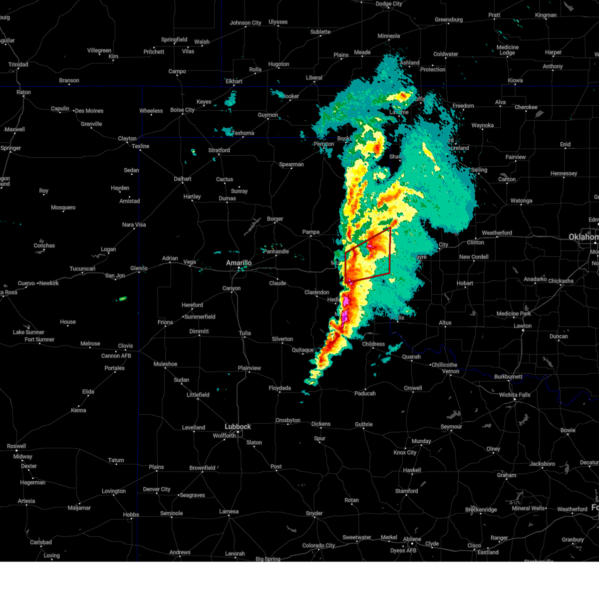 At 643 pm cst, a severe thunderstorm capable of producing a tornado was located 9 miles east of wheeler, or 15 miles northeast of shamrock, moving northeast at 60 mph (radar indicated rotation). Hazards include tornado and quarter size hail. Flying debris will be dangerous to those caught without shelter. mobile homes will be damaged or destroyed. damage to roofs, windows, and vehicles will occur. tree damage is likely. Locations impacted include, shamrock, wheeler, lela, twitty and kellerville. At 643 pm cst, a severe thunderstorm capable of producing a tornado was located 9 miles east of wheeler, or 15 miles northeast of shamrock, moving northeast at 60 mph (radar indicated rotation). Hazards include tornado and quarter size hail. Flying debris will be dangerous to those caught without shelter. mobile homes will be damaged or destroyed. damage to roofs, windows, and vehicles will occur. tree damage is likely. Locations impacted include, shamrock, wheeler, lela, twitty and kellerville.
|
| 2/26/2023 6:37 PM CST |
 At 637 pm cst, a severe thunderstorm capable of producing a tornado was located near twitty, or 10 miles north of shamrock, moving northeast at 75 mph (radar indicated rotation). Hazards include tornado and quarter size hail. Flying debris will be dangerous to those caught without shelter. mobile homes will be damaged or destroyed. damage to roofs, windows, and vehicles will occur. tree damage is likely. Locations impacted include, shamrock, wheeler, mclean, twitty, lela, alanreed and kellerville. At 637 pm cst, a severe thunderstorm capable of producing a tornado was located near twitty, or 10 miles north of shamrock, moving northeast at 75 mph (radar indicated rotation). Hazards include tornado and quarter size hail. Flying debris will be dangerous to those caught without shelter. mobile homes will be damaged or destroyed. damage to roofs, windows, and vehicles will occur. tree damage is likely. Locations impacted include, shamrock, wheeler, mclean, twitty, lela, alanreed and kellerville.
|
| 2/26/2023 6:25 PM CST |
 At 623 pm cst, automated weather equipment reported severe thunderstorms were located along a line extending from 4 miles southeast of codman to alanreed to 7 miles northeast of brice, moving east at 60 mph. these are destructive storms for hedley, mclean, shamrock, wellington, lela, dozier, samnorwood, lutie, and quail (automated weather equipment. at 615 pm cst, automated weather equipment recorded a 78 mph wind gust at clarendon). Hazards include 80 mph wind gusts and quarter size hail. Flying debris will be dangerous to those caught without shelter. mobile homes will be heavily damaged. expect considerable damage to roofs, windows, and vehicles. tree damage and power outages are likely. hail damage to vehicles is expected. Locations impacted include, wellington, clarendon, shamrock, briscoe, wheeler, mclean, lefors, howardwick, hedley, dodson, lutie, lelia lake, new mobeetie, lake mcclellan, twitty, allison, lela, quail, samnorwood and kellerville. At 623 pm cst, automated weather equipment reported severe thunderstorms were located along a line extending from 4 miles southeast of codman to alanreed to 7 miles northeast of brice, moving east at 60 mph. these are destructive storms for hedley, mclean, shamrock, wellington, lela, dozier, samnorwood, lutie, and quail (automated weather equipment. at 615 pm cst, automated weather equipment recorded a 78 mph wind gust at clarendon). Hazards include 80 mph wind gusts and quarter size hail. Flying debris will be dangerous to those caught without shelter. mobile homes will be heavily damaged. expect considerable damage to roofs, windows, and vehicles. tree damage and power outages are likely. hail damage to vehicles is expected. Locations impacted include, wellington, clarendon, shamrock, briscoe, wheeler, mclean, lefors, howardwick, hedley, dodson, lutie, lelia lake, new mobeetie, lake mcclellan, twitty, allison, lela, quail, samnorwood and kellerville.
|
| 2/26/2023 6:22 PM CST |
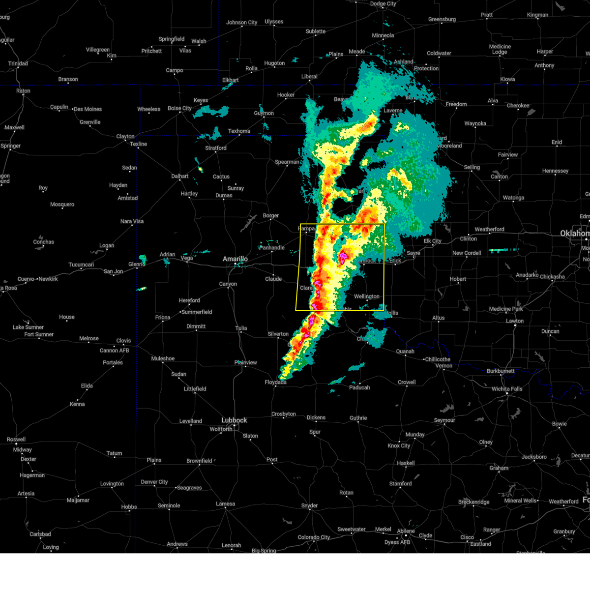 At 621 pm cst, automated weather equipment reported severe thunderstorms were located along a line extending from 3 miles south of codman to near alanreed to 5 miles northeast of brice, moving east at 60 mph (automated weather equipment. at 610 pm cst, automated weather equipment at ja ranch recorded a 66 mph wind gust). Hazards include 70 mph wind gusts and quarter size hail. Expect some tree damage. damage is likely to mobile homes, roofs, and outbuildings. hail damage to vehicles is expected. locations impacted include, pampa, wellington, clarendon, shamrock, briscoe, wheeler, mclean, lefors, howardwick, hedley, dodson, lelia lake, lake mcclellan, twitty, dozier, alanreed, greenbelt lake, lutie, new mobeetie and allison. thunderstorm damage threat, considerable hail threat, radar indicated max hail size, 1. 00in wind threat, radar indicated max wind gust, 70 mph. At 621 pm cst, automated weather equipment reported severe thunderstorms were located along a line extending from 3 miles south of codman to near alanreed to 5 miles northeast of brice, moving east at 60 mph (automated weather equipment. at 610 pm cst, automated weather equipment at ja ranch recorded a 66 mph wind gust). Hazards include 70 mph wind gusts and quarter size hail. Expect some tree damage. damage is likely to mobile homes, roofs, and outbuildings. hail damage to vehicles is expected. locations impacted include, pampa, wellington, clarendon, shamrock, briscoe, wheeler, mclean, lefors, howardwick, hedley, dodson, lelia lake, lake mcclellan, twitty, dozier, alanreed, greenbelt lake, lutie, new mobeetie and allison. thunderstorm damage threat, considerable hail threat, radar indicated max hail size, 1. 00in wind threat, radar indicated max wind gust, 70 mph.
|
| 2/26/2023 6:14 PM CST |
 At 614 pm cst, a severe thunderstorm capable of producing a tornado was located over mclean, or 18 miles west of shamrock, moving northeast at 60 mph (radar indicated rotation). Hazards include tornado and golf ball size hail. Flying debris will be dangerous to those caught without shelter. mobile homes will be damaged or destroyed. damage to roofs, windows, and vehicles will occur. tree damage is likely. Locations impacted include, shamrock, wheeler, mclean, twitty, lela, alanreed and kellerville. At 614 pm cst, a severe thunderstorm capable of producing a tornado was located over mclean, or 18 miles west of shamrock, moving northeast at 60 mph (radar indicated rotation). Hazards include tornado and golf ball size hail. Flying debris will be dangerous to those caught without shelter. mobile homes will be damaged or destroyed. damage to roofs, windows, and vehicles will occur. tree damage is likely. Locations impacted include, shamrock, wheeler, mclean, twitty, lela, alanreed and kellerville.
|
| 2/26/2023 6:13 PM CST |
 At 613 pm cst, severe thunderstorms were located along a line extending from 5 miles west of codman to 6 miles southwest of lefors to 8 miles northwest of brice, moving east at 60 mph (radar indicated). Hazards include 70 mph wind gusts and penny size hail. Expect some tree damage. damage is likely to mobile homes, roofs, and outbuildings. locations impacted include, pampa, wellington, clarendon, shamrock, briscoe, wheeler, mclean, lefors, howardwick, hedley, dodson, lelia lake, lake mcclellan, twitty, dozier, alanreed, greenbelt lake, lutie, new mobeetie and allison. thunderstorm damage threat, considerable hail threat, radar indicated max hail size, 0. 75in wind threat, radar indicated max wind gust, 70 mph. At 613 pm cst, severe thunderstorms were located along a line extending from 5 miles west of codman to 6 miles southwest of lefors to 8 miles northwest of brice, moving east at 60 mph (radar indicated). Hazards include 70 mph wind gusts and penny size hail. Expect some tree damage. damage is likely to mobile homes, roofs, and outbuildings. locations impacted include, pampa, wellington, clarendon, shamrock, briscoe, wheeler, mclean, lefors, howardwick, hedley, dodson, lelia lake, lake mcclellan, twitty, dozier, alanreed, greenbelt lake, lutie, new mobeetie and allison. thunderstorm damage threat, considerable hail threat, radar indicated max hail size, 0. 75in wind threat, radar indicated max wind gust, 70 mph.
|
| 2/26/2023 6:11 PM CST |
 At 610 pm cst, a severe thunderstorm capable of producing a tornado was located 5 miles southwest of mclean, or 20 miles northeast of clarendon, moving northeast at 60 mph (radar indicated rotation). Hazards include tornado and quarter size hail. Flying debris will be dangerous to those caught without shelter. mobile homes will be damaged or destroyed. damage to roofs, windows, and vehicles will occur. Tree damage is likely. At 610 pm cst, a severe thunderstorm capable of producing a tornado was located 5 miles southwest of mclean, or 20 miles northeast of clarendon, moving northeast at 60 mph (radar indicated rotation). Hazards include tornado and quarter size hail. Flying debris will be dangerous to those caught without shelter. mobile homes will be damaged or destroyed. damage to roofs, windows, and vehicles will occur. Tree damage is likely.
|
| 2/26/2023 5:55 PM CST |
 At 554 pm cst, severe thunderstorms were located along a line extending from 4 miles north of skellytown to 5 miles south of white deer to 15 miles northeast of vigo park, moving east at 60 mph (radar indicated). Hazards include 70 mph wind gusts and penny size hail. Expect some tree damage. Damage is likely to mobile homes, roofs, and outbuildings. At 554 pm cst, severe thunderstorms were located along a line extending from 4 miles north of skellytown to 5 miles south of white deer to 15 miles northeast of vigo park, moving east at 60 mph (radar indicated). Hazards include 70 mph wind gusts and penny size hail. Expect some tree damage. Damage is likely to mobile homes, roofs, and outbuildings.
|
| 12/12/2022 11:39 PM CST |
 The severe thunderstorm warning for southeastern wheeler and collingsworth counties will expire at 1145 pm cst, the storms which prompted the warning have weakened below severe limits, and no longer pose an immediate threat to life or property. therefore, the warning will be allowed to expire. however small hail and heavy rain are still possible with these thunderstorms. a tornado watch remains in effect until 100 am cst for the panhandle of texas. The severe thunderstorm warning for southeastern wheeler and collingsworth counties will expire at 1145 pm cst, the storms which prompted the warning have weakened below severe limits, and no longer pose an immediate threat to life or property. therefore, the warning will be allowed to expire. however small hail and heavy rain are still possible with these thunderstorms. a tornado watch remains in effect until 100 am cst for the panhandle of texas.
|
| 12/12/2022 11:29 PM CST |
 At 1129 pm cst, severe thunderstorms were located along a line extending from near twitty to 5 miles northeast of memphis, moving northeast at 30 mph (radar indicated). Hazards include quarter size hail. Damage to vehicles is expected. locations impacted include, wellington, shamrock, dodson, lutie, twitty, dozier, lela, quail and samnorwood. hail threat, radar indicated max hail size, 1. 00in wind threat, radar indicated max wind gust, <50 mph. At 1129 pm cst, severe thunderstorms were located along a line extending from near twitty to 5 miles northeast of memphis, moving northeast at 30 mph (radar indicated). Hazards include quarter size hail. Damage to vehicles is expected. locations impacted include, wellington, shamrock, dodson, lutie, twitty, dozier, lela, quail and samnorwood. hail threat, radar indicated max hail size, 1. 00in wind threat, radar indicated max wind gust, <50 mph.
|
| 12/12/2022 10:41 PM CST |
 At 1041 pm cst, a severe thunderstorm was located over lelia lake, or 6 miles east of clarendon, moving east at 50 mph (radar indicated). Hazards include quarter size hail. damage to vehicles is expected At 1041 pm cst, a severe thunderstorm was located over lelia lake, or 6 miles east of clarendon, moving east at 50 mph (radar indicated). Hazards include quarter size hail. damage to vehicles is expected
|
| 6/9/2022 11:12 PM CDT |
 At 1112 pm cdt, severe thunderstorms were located along a line extending from 7 miles east of lutie to 6 miles northwest of wellington to 7 miles northeast of memphis, moving east at 45 mph (radar indicated). Hazards include 60 mph wind gusts and quarter size hail. Minor damage to roofs, siding, and trees is possible. hail damage to vehicles is expected. locations impacted include, wellington, shamrock, hedley, dodson, lutie, dozier, lela, samnorwood and quail. hail threat, radar indicated max hail size, 1. 00in wind threat, radar indicated max wind gust, 60 mph. At 1112 pm cdt, severe thunderstorms were located along a line extending from 7 miles east of lutie to 6 miles northwest of wellington to 7 miles northeast of memphis, moving east at 45 mph (radar indicated). Hazards include 60 mph wind gusts and quarter size hail. Minor damage to roofs, siding, and trees is possible. hail damage to vehicles is expected. locations impacted include, wellington, shamrock, hedley, dodson, lutie, dozier, lela, samnorwood and quail. hail threat, radar indicated max hail size, 1. 00in wind threat, radar indicated max wind gust, 60 mph.
|
| 6/9/2022 10:57 PM CDT |
 At 1056 pm cdt, severe thunderstorms were located along a line extending from 7 miles southwest of texola to 7 miles north of quail to 5 miles northwest of memphis, moving east at 40 mph (radar indicated). Hazards include ping pong ball size hail and 60 mph wind gusts. Minor damage to roofs, siding, and trees is possible. people and animals outdoors will be injured. Expect hail damage to roofs, siding, windows, and vehicles. At 1056 pm cdt, severe thunderstorms were located along a line extending from 7 miles southwest of texola to 7 miles north of quail to 5 miles northwest of memphis, moving east at 40 mph (radar indicated). Hazards include ping pong ball size hail and 60 mph wind gusts. Minor damage to roofs, siding, and trees is possible. people and animals outdoors will be injured. Expect hail damage to roofs, siding, windows, and vehicles.
|
| 6/9/2022 10:24 PM CDT |
 At 1024 pm cdt, severe thunderstorms were located along a line extending from 9 miles west of sweetwater to 7 miles south of mclean to 9 miles southwest of clarendon, moving southeast at 30 mph (radar indicated). Hazards include 60 mph wind gusts and half dollar size hail. Minor damage to roofs, siding, and trees is possible. hail damage to vehicles is expected. locations impacted include, clarendon, shamrock, briscoe, wheeler, mclean, howardwick, hedley, lutie, lelia lake, new mobeetie, lake mcclellan, twitty, allison, lela, samnorwood, quail, kellerville, goodnight, dozier and alanreed. hail threat, radar indicated max hail size, 1. 25 in wind threat, radar indicated max wind gust, 60 mph. At 1024 pm cdt, severe thunderstorms were located along a line extending from 9 miles west of sweetwater to 7 miles south of mclean to 9 miles southwest of clarendon, moving southeast at 30 mph (radar indicated). Hazards include 60 mph wind gusts and half dollar size hail. Minor damage to roofs, siding, and trees is possible. hail damage to vehicles is expected. locations impacted include, clarendon, shamrock, briscoe, wheeler, mclean, howardwick, hedley, lutie, lelia lake, new mobeetie, lake mcclellan, twitty, allison, lela, samnorwood, quail, kellerville, goodnight, dozier and alanreed. hail threat, radar indicated max hail size, 1. 25 in wind threat, radar indicated max wind gust, 60 mph.
|
| 6/9/2022 10:15 PM CDT |
 At 1014 pm cdt, severe thunderstorms were located along a line extending from 8 miles south of allison to 4 miles southwest of mclean to 9 miles west of clarendon, moving east at 35 mph (radar indicated). Hazards include 60 mph wind gusts and quarter size hail. Minor damage to roofs, siding, and trees is possible. hail damage to vehicles is expected. locations impacted include, clarendon, shamrock, briscoe, wheeler, mclean, groom, lefors, howardwick, hedley, lutie, lelia lake, new mobeetie, lake mcclellan, twitty, allison, lela, samnorwood, quail, kellerville and goodnight. hail threat, radar indicated max hail size, 1. 00in wind threat, radar indicated max wind gust, 60 mph. At 1014 pm cdt, severe thunderstorms were located along a line extending from 8 miles south of allison to 4 miles southwest of mclean to 9 miles west of clarendon, moving east at 35 mph (radar indicated). Hazards include 60 mph wind gusts and quarter size hail. Minor damage to roofs, siding, and trees is possible. hail damage to vehicles is expected. locations impacted include, clarendon, shamrock, briscoe, wheeler, mclean, groom, lefors, howardwick, hedley, lutie, lelia lake, new mobeetie, lake mcclellan, twitty, allison, lela, samnorwood, quail, kellerville and goodnight. hail threat, radar indicated max hail size, 1. 00in wind threat, radar indicated max wind gust, 60 mph.
|
| 6/9/2022 9:43 PM CDT |
 At 942 pm cdt, severe thunderstorms were located along a line extending from 7 miles east of lefors to 7 miles northeast of groom to 5 miles northwest of goodnight, moving southeast at 30 mph (radar indicated). Hazards include 70 mph wind gusts and quarter size hail. Expect some tree damage. damage is likely to mobile homes, roofs, and outbuildings. Hail damage to vehicles is expected. At 942 pm cdt, severe thunderstorms were located along a line extending from 7 miles east of lefors to 7 miles northeast of groom to 5 miles northwest of goodnight, moving southeast at 30 mph (radar indicated). Hazards include 70 mph wind gusts and quarter size hail. Expect some tree damage. damage is likely to mobile homes, roofs, and outbuildings. Hail damage to vehicles is expected.
|
| 6/8/2022 7:42 AM CDT |
 At 742 am cdt, severe thunderstorms were located along a line extending from 8 miles northwest of vinson to 7 miles northeast of lelia lake to 11 miles west of brice, moving east at 45 mph (radar indicated). Hazards include 70 mph wind gusts. Expect some tree damage. Damage is likely to mobile homes, roofs, and outbuildings. At 742 am cdt, severe thunderstorms were located along a line extending from 8 miles northwest of vinson to 7 miles northeast of lelia lake to 11 miles west of brice, moving east at 45 mph (radar indicated). Hazards include 70 mph wind gusts. Expect some tree damage. Damage is likely to mobile homes, roofs, and outbuildings.
|
| 6/8/2022 6:36 AM CDT |
 At 636 am cdt, severe thunderstorms were located along a line extending from 7 miles north of sweetwater to 5 miles north of lefors to 7 miles west of panhandle to 8 miles northeast of bushland, moving southeast at 55 mph (radar indicated). Hazards include 70 mph wind gusts and quarter size hail. Expect some tree damage. damage is likely to mobile homes, roofs, and outbuildings. Hail damage to vehicles is expected. At 636 am cdt, severe thunderstorms were located along a line extending from 7 miles north of sweetwater to 5 miles north of lefors to 7 miles west of panhandle to 8 miles northeast of bushland, moving southeast at 55 mph (radar indicated). Hazards include 70 mph wind gusts and quarter size hail. Expect some tree damage. damage is likely to mobile homes, roofs, and outbuildings. Hail damage to vehicles is expected.
|
| 6/8/2022 6:02 AM CDT |
 At 602 am cdt, severe thunderstorms were located along a line extending from near lake marvin to 11 miles northeast of borger to 6 miles west of four way, moving south at 30 mph (radar indicated). Hazards include 70 mph wind gusts and half dollar size hail. Expect some tree damage. damage is likely to mobile homes, roofs, and outbuildings. Hail damage to vehicles is expected. At 602 am cdt, severe thunderstorms were located along a line extending from near lake marvin to 11 miles northeast of borger to 6 miles west of four way, moving south at 30 mph (radar indicated). Hazards include 70 mph wind gusts and half dollar size hail. Expect some tree damage. damage is likely to mobile homes, roofs, and outbuildings. Hail damage to vehicles is expected.
|
| 6/1/2022 9:54 PM CDT |
 At 953 pm cdt, a severe thunderstorm was located 6 miles west of lela, or 12 miles west of shamrock, moving east at 30 mph (radar indicated). Hazards include quarter size hail. damage to vehicles is expected At 953 pm cdt, a severe thunderstorm was located 6 miles west of lela, or 12 miles west of shamrock, moving east at 30 mph (radar indicated). Hazards include quarter size hail. damage to vehicles is expected
|
| 5/31/2022 5:33 PM CDT |
 At 533 pm cdt, a severe thunderstorm was located over wellington, moving northeast at 25 mph (radar indicated). Hazards include two inch hail and 60 mph wind gusts. Minor damage to roofs, siding, and trees is possible. people and animals outdoors will be injured. expect hail damage to roofs, siding, windows, and vehicles. locations impacted include, wellington, shamrock, dodson, lutie, twitty, dozier, lela, samnorwood and quail. thunderstorm damage threat, considerable hail threat, radar indicated max hail size, 2. 00 in wind threat, radar indicated max wind gust, 60 mph. At 533 pm cdt, a severe thunderstorm was located over wellington, moving northeast at 25 mph (radar indicated). Hazards include two inch hail and 60 mph wind gusts. Minor damage to roofs, siding, and trees is possible. people and animals outdoors will be injured. expect hail damage to roofs, siding, windows, and vehicles. locations impacted include, wellington, shamrock, dodson, lutie, twitty, dozier, lela, samnorwood and quail. thunderstorm damage threat, considerable hail threat, radar indicated max hail size, 2. 00 in wind threat, radar indicated max wind gust, 60 mph.
|
| 5/31/2022 5:25 PM CDT | Quarter sized hail reported 0.3 miles SE of Shamrock, TX |
| 5/31/2022 5:13 PM CDT |
 At 513 pm cdt, a severe thunderstorm was located 10 miles southwest of wellington, moving northeast at 25 mph (radar indicated). Hazards include two inch hail and 60 mph wind gusts. Minor damage to roofs, siding, and trees is possible. people and animals outdoors will be injured. Expect hail damage to roofs, siding, windows, and vehicles. At 513 pm cdt, a severe thunderstorm was located 10 miles southwest of wellington, moving northeast at 25 mph (radar indicated). Hazards include two inch hail and 60 mph wind gusts. Minor damage to roofs, siding, and trees is possible. people and animals outdoors will be injured. Expect hail damage to roofs, siding, windows, and vehicles.
|
| 5/10/2022 8:27 PM CDT |
 At 826 pm cdt, severe thunderstorms were located along a line extending from 16 miles north of codman to 6 miles southeast of miami to 5 miles southwest of kellerville to 7 miles north of brice, moving northeast at 55 mph (radar indicated). Hazards include 70 mph wind gusts and quarter size hail. Expect some tree damage. damage is likely to mobile homes, roofs, and outbuildings. Hail damage to vehicles is expected. At 826 pm cdt, severe thunderstorms were located along a line extending from 16 miles north of codman to 6 miles southeast of miami to 5 miles southwest of kellerville to 7 miles north of brice, moving northeast at 55 mph (radar indicated). Hazards include 70 mph wind gusts and quarter size hail. Expect some tree damage. damage is likely to mobile homes, roofs, and outbuildings. Hail damage to vehicles is expected.
|
| 10/23/2021 7:43 PM CDT |
 At 743 pm cdt, a severe thunderstorm was located over shamrock, moving northeast at 25 mph (radar indicated). Hazards include 60 mph wind gusts and quarter size hail. Minor damage to roofs, siding, and trees is possible. hail damage to vehicles is expected. locations impacted include, shamrock, lela and twitty. hail threat, radar indicated max hail size, 1. 00in wind threat, radar indicated max wind gust, 60 mph. At 743 pm cdt, a severe thunderstorm was located over shamrock, moving northeast at 25 mph (radar indicated). Hazards include 60 mph wind gusts and quarter size hail. Minor damage to roofs, siding, and trees is possible. hail damage to vehicles is expected. locations impacted include, shamrock, lela and twitty. hail threat, radar indicated max hail size, 1. 00in wind threat, radar indicated max wind gust, 60 mph.
|
| 10/23/2021 7:28 PM CDT |
 At 728 pm cdt, a severe thunderstorm was located near lela, or 7 miles west of shamrock, moving northeast at 25 mph (radar indicated). Hazards include 60 mph wind gusts and quarter size hail. Minor damage to roofs, siding, and trees is possible. hail damage to vehicles is expected. locations impacted include, shamrock, lela and twitty. hail threat, radar indicated max hail size, 1. 00in wind threat, radar indicated max wind gust, 60 mph. At 728 pm cdt, a severe thunderstorm was located near lela, or 7 miles west of shamrock, moving northeast at 25 mph (radar indicated). Hazards include 60 mph wind gusts and quarter size hail. Minor damage to roofs, siding, and trees is possible. hail damage to vehicles is expected. locations impacted include, shamrock, lela and twitty. hail threat, radar indicated max hail size, 1. 00in wind threat, radar indicated max wind gust, 60 mph.
|
| 10/23/2021 7:16 PM CDT |
 At 716 pm cdt, a severe thunderstorm was located 6 miles northwest of dozier, or 12 miles southwest of shamrock, moving northeast at 25 mph (radar indicated). Hazards include 60 mph wind gusts and half dollar size hail. Minor damage to roofs, siding, and trees is possible. Hail damage to vehicles is expected. At 716 pm cdt, a severe thunderstorm was located 6 miles northwest of dozier, or 12 miles southwest of shamrock, moving northeast at 25 mph (radar indicated). Hazards include 60 mph wind gusts and half dollar size hail. Minor damage to roofs, siding, and trees is possible. Hail damage to vehicles is expected.
|
| 10/13/2021 1:08 AM CDT |
 At 108 am cdt, a severe thunderstorm capable of producing a tornado was located near lela, or near shamrock, moving northeast at 65 mph (radar indicated rotation). Hazards include tornado and quarter size hail. Flying debris will be dangerous to those caught without shelter. mobile homes will be damaged or destroyed. damage to roofs, windows, and vehicles will occur. tree damage is likely. Locations impacted include, shamrock, lela and twitty. At 108 am cdt, a severe thunderstorm capable of producing a tornado was located near lela, or near shamrock, moving northeast at 65 mph (radar indicated rotation). Hazards include tornado and quarter size hail. Flying debris will be dangerous to those caught without shelter. mobile homes will be damaged or destroyed. damage to roofs, windows, and vehicles will occur. tree damage is likely. Locations impacted include, shamrock, lela and twitty.
|
| 10/13/2021 1:07 AM CDT |
 At 106 am cdt, a severe thunderstorm was located 4 miles north of lela, or 8 miles northwest of shamrock, moving northeast at 60 mph (radar indicated). Hazards include 70 mph wind gusts and quarter size hail. Expect some tree damage. damage is likely to mobile homes, roofs, and outbuildings. hail damage to vehicles is expected. locations impacted include, shamrock, briscoe, wheeler, new mobeetie, twitty, allison, lela, kellerville and mobeetie. thunderstorm damage threat, considerable hail threat, radar indicated max hail size, 1. 00in wind threat, radar indicated max wind gust, 70 mph. At 106 am cdt, a severe thunderstorm was located 4 miles north of lela, or 8 miles northwest of shamrock, moving northeast at 60 mph (radar indicated). Hazards include 70 mph wind gusts and quarter size hail. Expect some tree damage. damage is likely to mobile homes, roofs, and outbuildings. hail damage to vehicles is expected. locations impacted include, shamrock, briscoe, wheeler, new mobeetie, twitty, allison, lela, kellerville and mobeetie. thunderstorm damage threat, considerable hail threat, radar indicated max hail size, 1. 00in wind threat, radar indicated max wind gust, 70 mph.
|
| 10/13/2021 12:57 AM CDT |
 At 1257 am cdt, a severe thunderstorm capable of producing a tornado was located 8 miles southeast of mclean, or 13 miles west of shamrock, moving northeast at 65 mph (radar indicated rotation). Hazards include tornado and quarter size hail. Flying debris will be dangerous to those caught without shelter. mobile homes will be damaged or destroyed. damage to roofs, windows, and vehicles will occur. Tree damage is likely. At 1257 am cdt, a severe thunderstorm capable of producing a tornado was located 8 miles southeast of mclean, or 13 miles west of shamrock, moving northeast at 65 mph (radar indicated rotation). Hazards include tornado and quarter size hail. Flying debris will be dangerous to those caught without shelter. mobile homes will be damaged or destroyed. damage to roofs, windows, and vehicles will occur. Tree damage is likely.
|
| 10/13/2021 12:54 AM CDT |
 At 1254 am cdt, a severe thunderstorm was located 4 miles southeast of mclean, or 16 miles west of shamrock, moving northeast at 65 mph (radar indicated). Hazards include 70 mph wind gusts and quarter size hail. Expect some tree damage. damage is likely to mobile homes, roofs, and outbuildings. hail damage to vehicles is expected. locations impacted include, shamrock, briscoe, wheeler, mclean, new mobeetie, twitty, allison, dozier, lela, alanreed, kellerville and mobeetie. thunderstorm damage threat, considerable hail threat, radar indicated max hail size, 1. 00in wind threat, radar indicated max wind gust, 70 mph. At 1254 am cdt, a severe thunderstorm was located 4 miles southeast of mclean, or 16 miles west of shamrock, moving northeast at 65 mph (radar indicated). Hazards include 70 mph wind gusts and quarter size hail. Expect some tree damage. damage is likely to mobile homes, roofs, and outbuildings. hail damage to vehicles is expected. locations impacted include, shamrock, briscoe, wheeler, mclean, new mobeetie, twitty, allison, dozier, lela, alanreed, kellerville and mobeetie. thunderstorm damage threat, considerable hail threat, radar indicated max hail size, 1. 00in wind threat, radar indicated max wind gust, 70 mph.
|
| 10/13/2021 12:50 AM CDT |
 At 1249 am cdt, a severe thunderstorm was located 5 miles south of mclean, or 21 miles northeast of clarendon, moving northeast at 80 mph (radar indicated). Hazards include 60 mph wind gusts and quarter size hail. Minor damage to roofs, siding, and trees is possible. Hail damage to vehicles is expected. At 1249 am cdt, a severe thunderstorm was located 5 miles south of mclean, or 21 miles northeast of clarendon, moving northeast at 80 mph (radar indicated). Hazards include 60 mph wind gusts and quarter size hail. Minor damage to roofs, siding, and trees is possible. Hail damage to vehicles is expected.
|
| 7/25/2021 5:08 PM CDT |
 At 507 pm cdt, a severe thunderstorm was located 7 miles southeast of mclean, or 13 miles west of shamrock, moving northeast at 10 mph (radar indicated). Hazards include 60 mph wind gusts and quarter size hail. Minor damage to roofs, siding, and trees is possible. Hail damage to vehicles is expected. At 507 pm cdt, a severe thunderstorm was located 7 miles southeast of mclean, or 13 miles west of shamrock, moving northeast at 10 mph (radar indicated). Hazards include 60 mph wind gusts and quarter size hail. Minor damage to roofs, siding, and trees is possible. Hail damage to vehicles is expected.
|
| 6/26/2021 1:20 AM CDT |
 The severe thunderstorm warning for southern wheeler, collingsworth and southeastern donley counties will expire at 130 am cdt, the storms which prompted the warning have moved out of the area. therefore, the warning will be allowed to expire. a severe thunderstorm watch remains in effect until 300 am cdt for the panhandle of texas. to report severe weather, contact your nearest law enforcement agency. they will relay your report to the national weather service amarillo. The severe thunderstorm warning for southern wheeler, collingsworth and southeastern donley counties will expire at 130 am cdt, the storms which prompted the warning have moved out of the area. therefore, the warning will be allowed to expire. a severe thunderstorm watch remains in effect until 300 am cdt for the panhandle of texas. to report severe weather, contact your nearest law enforcement agency. they will relay your report to the national weather service amarillo.
|
| 6/26/2021 12:26 AM CDT |
 At 1225 am cdt, severe thunderstorms were located along a line extending from 4 miles southwest of wheeler to 6 miles west of dozier to 5 miles northwest of memphis, moving east at 35 mph (automated weather equipment. at 1215 am cdt, automated weather equipment recorded a 68 mph wind gust 1 mile east of mclean). Hazards include 70 mph wind gusts and quarter size hail. Expect some tree damage. damage is likely to mobile homes, roofs, and outbuildings. Hail damage to vehicles is expected. At 1225 am cdt, severe thunderstorms were located along a line extending from 4 miles southwest of wheeler to 6 miles west of dozier to 5 miles northwest of memphis, moving east at 35 mph (automated weather equipment. at 1215 am cdt, automated weather equipment recorded a 68 mph wind gust 1 mile east of mclean). Hazards include 70 mph wind gusts and quarter size hail. Expect some tree damage. damage is likely to mobile homes, roofs, and outbuildings. Hail damage to vehicles is expected.
|
| 6/26/2021 12:21 AM CDT |
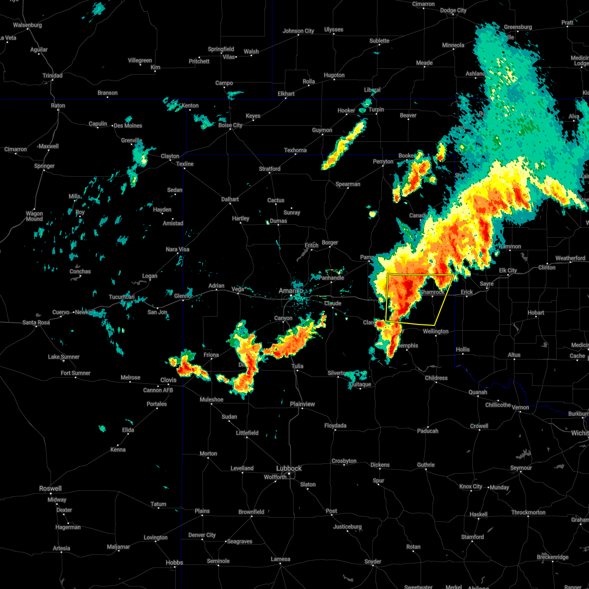 At 1220 am cdt, automated weather equipment reported a severe thunderstorm was located 5 miles east of mclean, or 15 miles west of shamrock, moving east at 30 mph (automated weather equipment. at 1215 am cdt, automated weather equipment recorded a 68 mph wind gust 1 mile east of mclean). Hazards include 70 mph wind gusts and quarter size hail. Expect some tree damage. damage is likely to mobile homes, roofs, and outbuildings. hail damage to vehicles is expected. Locations impacted include, shamrock, mclean, lutie, twitty, dozier, lela, alanreed, samnorwood and kellerville. At 1220 am cdt, automated weather equipment reported a severe thunderstorm was located 5 miles east of mclean, or 15 miles west of shamrock, moving east at 30 mph (automated weather equipment. at 1215 am cdt, automated weather equipment recorded a 68 mph wind gust 1 mile east of mclean). Hazards include 70 mph wind gusts and quarter size hail. Expect some tree damage. damage is likely to mobile homes, roofs, and outbuildings. hail damage to vehicles is expected. Locations impacted include, shamrock, mclean, lutie, twitty, dozier, lela, alanreed, samnorwood and kellerville.
|
| 6/26/2021 12:14 AM CDT |
 At 1214 am cdt, automated weather equipment reported a severe thunderstorm was located over mclean, or 18 miles west of shamrock, moving east at 45 mph (automated weather equipment). Hazards include 60 mph wind gusts and quarter size hail. Minor damage to roofs, siding, and trees is possible. hail damage to vehicles is expected. Locations impacted include, shamrock, mclean, howardwick, lutie, lake mcclellan, twitty, dozier, lela, alanreed, samnorwood, kellerville and greenbelt lake. At 1214 am cdt, automated weather equipment reported a severe thunderstorm was located over mclean, or 18 miles west of shamrock, moving east at 45 mph (automated weather equipment). Hazards include 60 mph wind gusts and quarter size hail. Minor damage to roofs, siding, and trees is possible. hail damage to vehicles is expected. Locations impacted include, shamrock, mclean, howardwick, lutie, lake mcclellan, twitty, dozier, lela, alanreed, samnorwood, kellerville and greenbelt lake.
|
| 6/25/2021 11:57 PM CDT |
 At 1157 pm cdt, automated weather equipment reported a severe thunderstorm was located near lake mcclellan, or 21 miles south of pampa, moving east at 30 mph (automated weather equipment. at 1149 pm cdt, automated weather equipment recorded a 63 mph wind gust 2 miles northwest of lake mcclellan). Hazards include two inch hail and 60 mph wind gusts. Minor damage to roofs, siding, and trees is possible. people and animals outdoors will be injured. expect hail damage to roofs, siding, windows, and vehicles. Locations impacted include, shamrock, mclean, howardwick, lutie, lake mcclellan, twitty, dozier, lela, alanreed, samnorwood, kellerville and greenbelt lake. At 1157 pm cdt, automated weather equipment reported a severe thunderstorm was located near lake mcclellan, or 21 miles south of pampa, moving east at 30 mph (automated weather equipment. at 1149 pm cdt, automated weather equipment recorded a 63 mph wind gust 2 miles northwest of lake mcclellan). Hazards include two inch hail and 60 mph wind gusts. Minor damage to roofs, siding, and trees is possible. people and animals outdoors will be injured. expect hail damage to roofs, siding, windows, and vehicles. Locations impacted include, shamrock, mclean, howardwick, lutie, lake mcclellan, twitty, dozier, lela, alanreed, samnorwood, kellerville and greenbelt lake.
|
| 6/25/2021 11:55 PM CDT |
 At 1155 pm cdt, a severe thunderstorm was located over lake mcclellan, or 21 miles north of clarendon, moving east at 30 mph (radar indicated). Hazards include two inch hail and 60 mph wind gusts. Minor damage to roofs, siding, and trees is possible. people and animals outdoors will be injured. expect hail damage to roofs, siding, windows, and vehicles. Locations impacted include, shamrock, mclean, howardwick, lutie, lake mcclellan, twitty, dozier, lela, alanreed, samnorwood, kellerville and greenbelt lake. At 1155 pm cdt, a severe thunderstorm was located over lake mcclellan, or 21 miles north of clarendon, moving east at 30 mph (radar indicated). Hazards include two inch hail and 60 mph wind gusts. Minor damage to roofs, siding, and trees is possible. people and animals outdoors will be injured. expect hail damage to roofs, siding, windows, and vehicles. Locations impacted include, shamrock, mclean, howardwick, lutie, lake mcclellan, twitty, dozier, lela, alanreed, samnorwood, kellerville and greenbelt lake.
|
| 6/25/2021 11:45 PM CDT |
 At 1145 pm cdt, severe thunderstorms were located along a line extending from 4 miles south of lefors to 3 miles northwest of lake mcclellan to 5 miles northeast of goodnight, moving east at 30 mph (radar indicated). Hazards include 60 mph wind gusts and quarter size hail. Minor damage to roofs, siding, and trees is possible. Hail damage to vehicles is expected. At 1145 pm cdt, severe thunderstorms were located along a line extending from 4 miles south of lefors to 3 miles northwest of lake mcclellan to 5 miles northeast of goodnight, moving east at 30 mph (radar indicated). Hazards include 60 mph wind gusts and quarter size hail. Minor damage to roofs, siding, and trees is possible. Hail damage to vehicles is expected.
|
| 6/25/2021 8:01 PM CDT |
 At 801 pm cdt, severe thunderstorms were located along a line extending from 5 miles south of allison to near texola to 5 miles northeast of samnorwood, moving east at 30 mph (radar indicated). Hazards include 70 mph wind gusts and quarter size hail. Expect some tree damage. damage is likely to mobile homes, roofs, and outbuildings. hail damage to vehicles is expected. Locations impacted include, shamrock, wheeler, allison, dozier, lela and twitty. At 801 pm cdt, severe thunderstorms were located along a line extending from 5 miles south of allison to near texola to 5 miles northeast of samnorwood, moving east at 30 mph (radar indicated). Hazards include 70 mph wind gusts and quarter size hail. Expect some tree damage. damage is likely to mobile homes, roofs, and outbuildings. hail damage to vehicles is expected. Locations impacted include, shamrock, wheeler, allison, dozier, lela and twitty.
|
| 6/25/2021 7:58 PM CDT |
 At 757 pm cdt, severe thunderstorms were located along a line extending from allison to 7 miles northwest of texola to samnorwood, moving east at 35 mph (radar indicated). Hazards include 60 mph wind gusts and quarter size hail. Minor damage to roofs, siding, and trees is possible. hail damage to vehicles is expected. Locations impacted include, shamrock, wheeler, lutie, twitty, allison, dozier, lela and samnorwood. At 757 pm cdt, severe thunderstorms were located along a line extending from allison to 7 miles northwest of texola to samnorwood, moving east at 35 mph (radar indicated). Hazards include 60 mph wind gusts and quarter size hail. Minor damage to roofs, siding, and trees is possible. hail damage to vehicles is expected. Locations impacted include, shamrock, wheeler, lutie, twitty, allison, dozier, lela and samnorwood.
|
| 6/25/2021 7:39 PM CDT |
 At 738 pm cdt, severe thunderstorms were located along a line extending from briscoe to twitty to near dozier, moving east at 35 mph (automated weather equipment. at 725 pm cdt, automated weather equipment recorded a 65 mph wind gust in mclean). Hazards include 70 mph wind gusts and quarter size hail. Expect some tree damage. damage is likely to mobile homes, roofs, and outbuildings. Hail damage to vehicles is expected. At 738 pm cdt, severe thunderstorms were located along a line extending from briscoe to twitty to near dozier, moving east at 35 mph (automated weather equipment. at 725 pm cdt, automated weather equipment recorded a 65 mph wind gust in mclean). Hazards include 70 mph wind gusts and quarter size hail. Expect some tree damage. damage is likely to mobile homes, roofs, and outbuildings. Hail damage to vehicles is expected.
|
| 6/25/2021 7:30 PM CDT |
 At 729 pm cdt, automated weather equipment reported a severe thunderstorm was located 5 miles east of mclean, or 14 miles west of shamrock, moving east at 35 mph (automated weather equipment. at 725 pm cdt, automated weather equipment recorded a 65 mph wind gust at mclean). Hazards include 70 mph wind gusts and quarter size hail. Expect some tree damage. damage is likely to mobile homes, roofs, and outbuildings. hail damage to vehicles is expected. Locations impacted include, shamrock, briscoe, wheeler, mclean, lutie, new mobeetie, twitty, allison, lela, samnorwood, kellerville, dozier, alanreed and mobeetie. At 729 pm cdt, automated weather equipment reported a severe thunderstorm was located 5 miles east of mclean, or 14 miles west of shamrock, moving east at 35 mph (automated weather equipment. at 725 pm cdt, automated weather equipment recorded a 65 mph wind gust at mclean). Hazards include 70 mph wind gusts and quarter size hail. Expect some tree damage. damage is likely to mobile homes, roofs, and outbuildings. hail damage to vehicles is expected. Locations impacted include, shamrock, briscoe, wheeler, mclean, lutie, new mobeetie, twitty, allison, lela, samnorwood, kellerville, dozier, alanreed and mobeetie.
|
| 6/25/2021 7:27 PM CDT |
 At 727 pm cdt, automated weather equipment reported a severe thunderstorm was located 4 miles northeast of mclean, or 16 miles west of shamrock, moving east at 30 mph (automated weather equipment. at 720 pm cdt, automated weather equipment recorded a 61 mph wind gust in mclean). Hazards include 70 mph wind gusts and quarter size hail. Expect some tree damage. damage is likely to mobile homes, roofs, and outbuildings. hail damage to vehicles is expected. Locations impacted include, shamrock, briscoe, wheeler, mclean, lutie, new mobeetie, twitty, allison, lela, samnorwood, kellerville, dozier, alanreed and mobeetie. At 727 pm cdt, automated weather equipment reported a severe thunderstorm was located 4 miles northeast of mclean, or 16 miles west of shamrock, moving east at 30 mph (automated weather equipment. at 720 pm cdt, automated weather equipment recorded a 61 mph wind gust in mclean). Hazards include 70 mph wind gusts and quarter size hail. Expect some tree damage. damage is likely to mobile homes, roofs, and outbuildings. hail damage to vehicles is expected. Locations impacted include, shamrock, briscoe, wheeler, mclean, lutie, new mobeetie, twitty, allison, lela, samnorwood, kellerville, dozier, alanreed and mobeetie.
|
| 6/25/2021 7:03 PM CDT |
 At 703 pm cdt, severe thunderstorms were located along a line extending from 6 miles southeast of codman to 4 miles northwest of mclean to 8 miles south of alanreed, moving east at 35 mph. these are very dangerous storms (radar indicated). Hazards include 80 mph wind gusts and quarter size hail. Flying debris will be dangerous to those caught without shelter. mobile homes will be heavily damaged. expect considerable damage to roofs, windows, and vehicles. tree damage and power outages are likely. hail damage to vehicles is expected. Locations impacted include, shamrock, briscoe, wheeler, mclean, lefors, lutie, new mobeetie, lake mcclellan, twitty, allison, lela, samnorwood, kellerville, dozier, alanreed and mobeetie. At 703 pm cdt, severe thunderstorms were located along a line extending from 6 miles southeast of codman to 4 miles northwest of mclean to 8 miles south of alanreed, moving east at 35 mph. these are very dangerous storms (radar indicated). Hazards include 80 mph wind gusts and quarter size hail. Flying debris will be dangerous to those caught without shelter. mobile homes will be heavily damaged. expect considerable damage to roofs, windows, and vehicles. tree damage and power outages are likely. hail damage to vehicles is expected. Locations impacted include, shamrock, briscoe, wheeler, mclean, lefors, lutie, new mobeetie, lake mcclellan, twitty, allison, lela, samnorwood, kellerville, dozier, alanreed and mobeetie.
|
| 6/25/2021 6:52 PM CDT |
 At 651 pm cdt, severe thunderstorms were located along a line extending from 5 miles southwest of codman to 6 miles north of alanreed to 5 miles northeast of howardwick, moving east at 35 mph (automated weather equipment. at 639 pm cdt, automated weather equipment recorded a 72 mph wind gust at lake mcclellan). Hazards include 70 mph wind gusts and quarter size hail. Expect some tree damage. damage is likely to mobile homes, roofs, and outbuildings. Hail damage to vehicles is expected. At 651 pm cdt, severe thunderstorms were located along a line extending from 5 miles southwest of codman to 6 miles north of alanreed to 5 miles northeast of howardwick, moving east at 35 mph (automated weather equipment. at 639 pm cdt, automated weather equipment recorded a 72 mph wind gust at lake mcclellan). Hazards include 70 mph wind gusts and quarter size hail. Expect some tree damage. damage is likely to mobile homes, roofs, and outbuildings. Hail damage to vehicles is expected.
|
| 8/16/2020 3:44 PM CDT |
 At 344 pm cdt, a severe thunderstorm was located 11 miles south of alanreed, or 15 miles northeast of clarendon, moving south at 15 mph (radar indicated). Hazards include golf ball size hail and 70 mph wind gusts. Expect some tree damage. damage is likely to mobile homes, roofs, and outbuildings. people and animals outdoors will be injured. expect hail damage to roofs, siding, windows, and vehicles. Locations impacted include, shamrock, mclean, lefors, lutie, lake mcclellan, dozier, lela, alanreed, samnorwood and kellerville. At 344 pm cdt, a severe thunderstorm was located 11 miles south of alanreed, or 15 miles northeast of clarendon, moving south at 15 mph (radar indicated). Hazards include golf ball size hail and 70 mph wind gusts. Expect some tree damage. damage is likely to mobile homes, roofs, and outbuildings. people and animals outdoors will be injured. expect hail damage to roofs, siding, windows, and vehicles. Locations impacted include, shamrock, mclean, lefors, lutie, lake mcclellan, dozier, lela, alanreed, samnorwood and kellerville.
|
| 8/16/2020 2:43 PM CDT |
 At 242 pm cdt, a severe thunderstorm was located 7 miles south of miami, moving south at 20 mph (radar indicated). Hazards include golf ball size hail and 70 mph wind gusts. Expect some tree damage. damage is likely to mobile homes, roofs, and outbuildings. people and animals outdoors will be injured. Expect hail damage to roofs, siding, windows, and vehicles. At 242 pm cdt, a severe thunderstorm was located 7 miles south of miami, moving south at 20 mph (radar indicated). Hazards include golf ball size hail and 70 mph wind gusts. Expect some tree damage. damage is likely to mobile homes, roofs, and outbuildings. people and animals outdoors will be injured. Expect hail damage to roofs, siding, windows, and vehicles.
|
| 8/10/2020 9:11 PM CDT |
 At 911 pm cdt, severe thunderstorms were located along a line extending from 8 miles northeast of sweetwater to shamrock to 10 miles south of mclean, moving southeast at 45 mph (radar indicated). Hazards include 60 mph wind gusts. Minor damage to roofs, siding, and trees is possible. Locations impacted include, shamrock, briscoe, wheeler, new mobeetie, twitty, allison, dozier, lela, samnorwood, kellerville and mobeetie. At 911 pm cdt, severe thunderstorms were located along a line extending from 8 miles northeast of sweetwater to shamrock to 10 miles south of mclean, moving southeast at 45 mph (radar indicated). Hazards include 60 mph wind gusts. Minor damage to roofs, siding, and trees is possible. Locations impacted include, shamrock, briscoe, wheeler, new mobeetie, twitty, allison, dozier, lela, samnorwood, kellerville and mobeetie.
|
| 8/10/2020 9:02 PM CDT | Dozier mesonet measured 62 mph wind gus in collingsworth county TX, 12.5 miles NE of Shamrock, TX |
| 8/10/2020 8:37 PM CDT |
 At 836 pm cdt, severe thunderstorms were located along a line extending from 6 miles northeast of briscoe to 5 miles west of kellerville to 3 miles northwest of lake mcclellan, moving southeast at 45 mph (radar indicated). Hazards include 70 mph wind gusts. Expect some tree damage. Damage is likely to mobile homes, roofs, and outbuildings. At 836 pm cdt, severe thunderstorms were located along a line extending from 6 miles northeast of briscoe to 5 miles west of kellerville to 3 miles northwest of lake mcclellan, moving southeast at 45 mph (radar indicated). Hazards include 70 mph wind gusts. Expect some tree damage. Damage is likely to mobile homes, roofs, and outbuildings.
|
| 6/21/2020 11:48 PM CDT |
 At 1147 pm cdt, two severe thunderstorms, the first located 8 miles south of allison and the second located 5 miles east of new mobeetie, were moving southeast at 20 mph (radar indicated). Hazards include 60 mph wind gusts and quarter size hail. Minor damage to roofs, siding, and trees is possible. hail damage to vehicles is expected. Locations impacted include, briscoe, wheeler, new mobeetie, twitty and mobeetie. At 1147 pm cdt, two severe thunderstorms, the first located 8 miles south of allison and the second located 5 miles east of new mobeetie, were moving southeast at 20 mph (radar indicated). Hazards include 60 mph wind gusts and quarter size hail. Minor damage to roofs, siding, and trees is possible. hail damage to vehicles is expected. Locations impacted include, briscoe, wheeler, new mobeetie, twitty and mobeetie.
|
| 6/21/2020 11:29 PM CDT |
 At 1128 pm cdt, two severe thunderstorms, the first located 5 miles southeast of briscoe and the second 4 miles northwest of new mobeetie, were moving southeast at 20 mph (radar indicated). Hazards include 60 mph wind gusts and quarter size hail. Minor damage to roofs, siding, and trees is possible. hail damage to vehicles is expected. Locations impacted include, shamrock, briscoe, wheeler, new mobeetie, twitty, lela, kellerville and mobeetie. At 1128 pm cdt, two severe thunderstorms, the first located 5 miles southeast of briscoe and the second 4 miles northwest of new mobeetie, were moving southeast at 20 mph (radar indicated). Hazards include 60 mph wind gusts and quarter size hail. Minor damage to roofs, siding, and trees is possible. hail damage to vehicles is expected. Locations impacted include, shamrock, briscoe, wheeler, new mobeetie, twitty, lela, kellerville and mobeetie.
|
| 6/21/2020 11:04 PM CDT |
 At 1103 pm cdt, a severe thunderstorm was located 5 miles southeast of codman, or 7 miles south of miami, moving south at 30 mph (radar indicated). Hazards include ping pong ball size hail and 60 mph wind gusts. Minor damage to roofs, siding, and trees is possible. people and animals outdoors will be injured. Expect hail damage to roofs, siding, windows, and vehicles. At 1103 pm cdt, a severe thunderstorm was located 5 miles southeast of codman, or 7 miles south of miami, moving south at 30 mph (radar indicated). Hazards include ping pong ball size hail and 60 mph wind gusts. Minor damage to roofs, siding, and trees is possible. people and animals outdoors will be injured. Expect hail damage to roofs, siding, windows, and vehicles.
|
| 6/4/2020 7:35 PM CDT |
 At 735 pm cdt, a severe thunderstorm was located 8 miles south of texola, or 15 miles southeast of shamrock, moving southeast at 40 mph (radar indicated). Hazards include 60 mph wind gusts and quarter size hail. Minor damage to roofs, siding, and trees is possible. hail damage to vehicles is expected. Locations impacted include, shamrock, dozier, lutie, lela and samnorwood. At 735 pm cdt, a severe thunderstorm was located 8 miles south of texola, or 15 miles southeast of shamrock, moving southeast at 40 mph (radar indicated). Hazards include 60 mph wind gusts and quarter size hail. Minor damage to roofs, siding, and trees is possible. hail damage to vehicles is expected. Locations impacted include, shamrock, dozier, lutie, lela and samnorwood.
|
| 6/4/2020 7:24 PM CDT |
 At 724 pm cdt, a severe thunderstorm was located 4 miles north of texola, or 15 miles east of shamrock, moving southeast at 35 mph (radar indicated). Hazards include 60 mph wind gusts and quarter size hail. Minor damage to roofs, siding, and trees is possible. hail damage to vehicles is expected. Locations impacted include, shamrock, dozier, lutie, lela, samnorwood and twitty. At 724 pm cdt, a severe thunderstorm was located 4 miles north of texola, or 15 miles east of shamrock, moving southeast at 35 mph (radar indicated). Hazards include 60 mph wind gusts and quarter size hail. Minor damage to roofs, siding, and trees is possible. hail damage to vehicles is expected. Locations impacted include, shamrock, dozier, lutie, lela, samnorwood and twitty.
|
| 6/4/2020 7:17 PM CDT |
 At 717 pm cdt, a severe thunderstorm was located 7 miles northwest of texola, or 13 miles northeast of shamrock, moving southeast at 40 mph (radar indicated). Hazards include 60 mph wind gusts and quarter size hail. Minor damage to roofs, siding, and trees is possible. hail damage to vehicles is expected. Locations impacted include, shamrock, wheeler, lutie, twitty, dozier, lela and samnorwood. At 717 pm cdt, a severe thunderstorm was located 7 miles northwest of texola, or 13 miles northeast of shamrock, moving southeast at 40 mph (radar indicated). Hazards include 60 mph wind gusts and quarter size hail. Minor damage to roofs, siding, and trees is possible. hail damage to vehicles is expected. Locations impacted include, shamrock, wheeler, lutie, twitty, dozier, lela and samnorwood.
|
| 6/4/2020 7:06 PM CDT |
 At 705 pm cdt, a severe thunderstorm was located 7 miles northeast of twitty, or 13 miles northeast of shamrock, moving southeast at 40 mph (radar indicated). Hazards include 60 mph wind gusts and quarter size hail. Minor damage to roofs, siding, and trees is possible. hail damage to vehicles is expected. Locations impacted include, shamrock, briscoe, wheeler, lutie, new mobeetie, twitty, allison, dozier, lela, samnorwood, kellerville and mobeetie. At 705 pm cdt, a severe thunderstorm was located 7 miles northeast of twitty, or 13 miles northeast of shamrock, moving southeast at 40 mph (radar indicated). Hazards include 60 mph wind gusts and quarter size hail. Minor damage to roofs, siding, and trees is possible. hail damage to vehicles is expected. Locations impacted include, shamrock, briscoe, wheeler, lutie, new mobeetie, twitty, allison, dozier, lela, samnorwood, kellerville and mobeetie.
|
| 6/4/2020 6:45 PM CDT |
 At 645 pm cdt, a severe thunderstorm was located over briscoe, or 20 miles southeast of miami, moving southeast at 40 mph (radar indicated). Hazards include 60 mph wind gusts and quarter size hail. Minor damage to roofs, siding, and trees is possible. hail damage to vehicles is expected. Locations impacted include, shamrock, briscoe, wheeler, lutie, new mobeetie, twitty, allison, dozier, lela, samnorwood, kellerville and mobeetie. At 645 pm cdt, a severe thunderstorm was located over briscoe, or 20 miles southeast of miami, moving southeast at 40 mph (radar indicated). Hazards include 60 mph wind gusts and quarter size hail. Minor damage to roofs, siding, and trees is possible. hail damage to vehicles is expected. Locations impacted include, shamrock, briscoe, wheeler, lutie, new mobeetie, twitty, allison, dozier, lela, samnorwood, kellerville and mobeetie.
|
| 6/4/2020 6:35 PM CDT |
 At 635 pm cdt, a severe thunderstorm was located 5 miles northwest of briscoe, or 15 miles east of miami, moving southeast at 40 mph (radar indicated). Hazards include 60 mph wind gusts and quarter size hail. Minor damage to roofs, siding, and trees is possible. Hail damage to vehicles is expected. At 635 pm cdt, a severe thunderstorm was located 5 miles northwest of briscoe, or 15 miles east of miami, moving southeast at 40 mph (radar indicated). Hazards include 60 mph wind gusts and quarter size hail. Minor damage to roofs, siding, and trees is possible. Hail damage to vehicles is expected.
|
| 5/24/2020 8:38 PM CDT |
 At 838 pm cdt, severe thunderstorms were located along a line extending from 3 miles northeast of shamrock to 10 miles northeast of hedley to 9 miles west of brice, moving southeast at 10 mph (radar indicated). Hazards include 60 mph wind gusts and half dollar size hail. Minor damage to roofs, siding, and trees is possible. Hail damage to vehicles is expected. At 838 pm cdt, severe thunderstorms were located along a line extending from 3 miles northeast of shamrock to 10 miles northeast of hedley to 9 miles west of brice, moving southeast at 10 mph (radar indicated). Hazards include 60 mph wind gusts and half dollar size hail. Minor damage to roofs, siding, and trees is possible. Hail damage to vehicles is expected.
|
| 5/23/2020 8:13 PM CDT | Storm damage reported in collingsworth county TX, 12.5 miles NE of Shamrock, TX |
| 5/23/2020 6:43 PM CDT |
 At 643 pm cdt, severe thunderstorms were located along a line extending from near briscoe to near lelia lake, moving east at 25 mph (radar indicated). Hazards include 60 mph wind gusts and quarter size hail. Minor damage to roofs, siding, and trees is possible. Hail damage to vehicles is expected. At 643 pm cdt, severe thunderstorms were located along a line extending from near briscoe to near lelia lake, moving east at 25 mph (radar indicated). Hazards include 60 mph wind gusts and quarter size hail. Minor damage to roofs, siding, and trees is possible. Hail damage to vehicles is expected.
|
| 5/13/2020 4:55 PM CDT |
 At 454 pm cdt, a severe thunderstorm was located near twitty, or 7 miles north of shamrock, moving northeast at 30 mph (radar indicated). Hazards include 60 mph wind gusts and quarter size hail. Minor damage to roofs, siding, and trees is possible. hail damage to vehicles is expected. Locations impacted include, shamrock, wheeler, lela, kellerville and twitty. At 454 pm cdt, a severe thunderstorm was located near twitty, or 7 miles north of shamrock, moving northeast at 30 mph (radar indicated). Hazards include 60 mph wind gusts and quarter size hail. Minor damage to roofs, siding, and trees is possible. hail damage to vehicles is expected. Locations impacted include, shamrock, wheeler, lela, kellerville and twitty.
|
| 5/13/2020 4:48 PM CDT |
 At 448 pm cdt, a severe thunderstorm was located 4 miles north of lela, or 7 miles northwest of shamrock, moving northeast at 30 mph (radar indicated). Hazards include 60 mph wind gusts and quarter size hail. Minor damage to roofs, siding, and trees is possible. hail damage to vehicles is expected. Locations impacted include, shamrock, wheeler, lela, kellerville and twitty. At 448 pm cdt, a severe thunderstorm was located 4 miles north of lela, or 7 miles northwest of shamrock, moving northeast at 30 mph (radar indicated). Hazards include 60 mph wind gusts and quarter size hail. Minor damage to roofs, siding, and trees is possible. hail damage to vehicles is expected. Locations impacted include, shamrock, wheeler, lela, kellerville and twitty.
|
| 5/13/2020 4:39 PM CDT |
 At 439 pm cdt, a severe thunderstorm was located near lela, or 8 miles west of shamrock, moving northeast at 35 mph (radar indicated). Hazards include 60 mph wind gusts and quarter size hail. Minor damage to roofs, siding, and trees is possible. hail damage to vehicles is expected. Locations impacted include, shamrock, wheeler, dozier, lela, kellerville and twitty. At 439 pm cdt, a severe thunderstorm was located near lela, or 8 miles west of shamrock, moving northeast at 35 mph (radar indicated). Hazards include 60 mph wind gusts and quarter size hail. Minor damage to roofs, siding, and trees is possible. hail damage to vehicles is expected. Locations impacted include, shamrock, wheeler, dozier, lela, kellerville and twitty.
|
| 5/13/2020 4:31 PM CDT |
 At 430 pm cdt, a severe thunderstorm was located 6 miles west of lela, or 12 miles west of shamrock, moving northeast at 35 mph (radar indicated). Hazards include 60 mph wind gusts and quarter size hail. Minor damage to roofs, siding, and trees is possible. hail damage to vehicles is expected. Locations impacted include, shamrock, briscoe, wheeler, lutie, new mobeetie, twitty, dozier, lela, samnorwood, kellerville and mobeetie. At 430 pm cdt, a severe thunderstorm was located 6 miles west of lela, or 12 miles west of shamrock, moving northeast at 35 mph (radar indicated). Hazards include 60 mph wind gusts and quarter size hail. Minor damage to roofs, siding, and trees is possible. hail damage to vehicles is expected. Locations impacted include, shamrock, briscoe, wheeler, lutie, new mobeetie, twitty, dozier, lela, samnorwood, kellerville and mobeetie.
|
| 5/13/2020 4:20 PM CDT |
 At 420 pm cdt, a severe thunderstorm was located 4 miles east of mclean, or 15 miles west of shamrock, moving northeast at 30 mph (radar indicated). Hazards include 60 mph wind gusts and quarter size hail. Minor damage to roofs, siding, and trees is possible. hail damage to vehicles is expected. Locations impacted include, shamrock, briscoe, wheeler, mclean, lutie, new mobeetie, twitty, dozier, lela, samnorwood, kellerville and mobeetie. At 420 pm cdt, a severe thunderstorm was located 4 miles east of mclean, or 15 miles west of shamrock, moving northeast at 30 mph (radar indicated). Hazards include 60 mph wind gusts and quarter size hail. Minor damage to roofs, siding, and trees is possible. hail damage to vehicles is expected. Locations impacted include, shamrock, briscoe, wheeler, mclean, lutie, new mobeetie, twitty, dozier, lela, samnorwood, kellerville and mobeetie.
|
| 5/13/2020 4:14 PM CDT |
 At 414 pm cdt, a severe thunderstorm was located over mclean, or 18 miles west of shamrock, moving northeast at 30 mph (radar indicated). Hazards include 60 mph wind gusts and half dollar size hail. Minor damage to roofs, siding, and trees is possible. hail damage to vehicles is expected. Locations impacted include, shamrock, briscoe, wheeler, mclean, lutie, new mobeetie, twitty, lela, samnorwood, kellerville, dozier, alanreed and mobeetie. At 414 pm cdt, a severe thunderstorm was located over mclean, or 18 miles west of shamrock, moving northeast at 30 mph (radar indicated). Hazards include 60 mph wind gusts and half dollar size hail. Minor damage to roofs, siding, and trees is possible. hail damage to vehicles is expected. Locations impacted include, shamrock, briscoe, wheeler, mclean, lutie, new mobeetie, twitty, lela, samnorwood, kellerville, dozier, alanreed and mobeetie.
|
| 5/13/2020 4:06 PM CDT |
 At 406 pm cdt, a severe thunderstorm was located 5 miles southwest of mclean, or 21 miles northeast of clarendon, moving northeast at 30 mph (radar indicated). Hazards include 60 mph wind gusts and half dollar size hail. Minor damage to roofs, siding, and trees is possible. hail damage to vehicles is expected. Locations impacted include, shamrock, briscoe, wheeler, mclean, lutie, new mobeetie, twitty, lela, samnorwood, kellerville, dozier, alanreed and mobeetie. At 406 pm cdt, a severe thunderstorm was located 5 miles southwest of mclean, or 21 miles northeast of clarendon, moving northeast at 30 mph (radar indicated). Hazards include 60 mph wind gusts and half dollar size hail. Minor damage to roofs, siding, and trees is possible. hail damage to vehicles is expected. Locations impacted include, shamrock, briscoe, wheeler, mclean, lutie, new mobeetie, twitty, lela, samnorwood, kellerville, dozier, alanreed and mobeetie.
|
| 5/13/2020 3:59 PM CDT |
 At 359 pm cdt, a severe thunderstorm was located 6 miles southeast of alanreed, or 18 miles northeast of clarendon, moving northeast at 25 mph (radar indicated). Hazards include 60 mph wind gusts and half dollar size hail. Minor damage to roofs, siding, and trees is possible. hail damage to vehicles is expected. Locations impacted include, shamrock, briscoe, wheeler, mclean, lutie, new mobeetie, twitty, lela, samnorwood, kellerville, dozier, alanreed and mobeetie. At 359 pm cdt, a severe thunderstorm was located 6 miles southeast of alanreed, or 18 miles northeast of clarendon, moving northeast at 25 mph (radar indicated). Hazards include 60 mph wind gusts and half dollar size hail. Minor damage to roofs, siding, and trees is possible. hail damage to vehicles is expected. Locations impacted include, shamrock, briscoe, wheeler, mclean, lutie, new mobeetie, twitty, lela, samnorwood, kellerville, dozier, alanreed and mobeetie.
|
| 5/13/2020 3:52 PM CDT |
 At 351 pm cdt, a severe thunderstorm was located 8 miles south of alanreed, or 15 miles northeast of clarendon, moving northeast at 25 mph (radar indicated). Hazards include 60 mph wind gusts and half dollar size hail. Minor damage to roofs, siding, and trees is possible. Hail damage to vehicles is expected. At 351 pm cdt, a severe thunderstorm was located 8 miles south of alanreed, or 15 miles northeast of clarendon, moving northeast at 25 mph (radar indicated). Hazards include 60 mph wind gusts and half dollar size hail. Minor damage to roofs, siding, and trees is possible. Hail damage to vehicles is expected.
|
| 8/27/2019 2:22 PM CDT |
 At 222 pm cdt, a severe thunderstorm was located 4 miles southeast of shamrock, moving southeast at 30 mph (radar indicated). Hazards include 60 mph wind gusts and quarter size hail. Minor damage to roofs, siding, and trees is possible. hail damage to vehicles is expected. Locations impacted include, shamrock, dozier, lutie and samnorwood. At 222 pm cdt, a severe thunderstorm was located 4 miles southeast of shamrock, moving southeast at 30 mph (radar indicated). Hazards include 60 mph wind gusts and quarter size hail. Minor damage to roofs, siding, and trees is possible. hail damage to vehicles is expected. Locations impacted include, shamrock, dozier, lutie and samnorwood.
|
| 8/27/2019 2:12 PM CDT |
 At 212 pm cdt, a severe thunderstorm was located over shamrock, moving southeast at 30 mph (radar indicated). Hazards include 60 mph wind gusts and quarter size hail. Minor damage to roofs, siding, and trees is possible. hail damage to vehicles is expected. Locations impacted include, shamrock, dozier, lutie, lela, samnorwood and twitty. At 212 pm cdt, a severe thunderstorm was located over shamrock, moving southeast at 30 mph (radar indicated). Hazards include 60 mph wind gusts and quarter size hail. Minor damage to roofs, siding, and trees is possible. hail damage to vehicles is expected. Locations impacted include, shamrock, dozier, lutie, lela, samnorwood and twitty.
|
| 8/27/2019 2:06 PM CDT |
 At 206 pm cdt, a severe thunderstorm was located over lela, or near shamrock, moving southeast at 30 mph (radar indicated). Hazards include 60 mph wind gusts and quarter size hail. Minor damage to roofs, siding, and trees is possible. hail damage to vehicles is expected. Locations impacted include, shamrock, dozier, lutie, lela, samnorwood and twitty. At 206 pm cdt, a severe thunderstorm was located over lela, or near shamrock, moving southeast at 30 mph (radar indicated). Hazards include 60 mph wind gusts and quarter size hail. Minor damage to roofs, siding, and trees is possible. hail damage to vehicles is expected. Locations impacted include, shamrock, dozier, lutie, lela, samnorwood and twitty.
|
| 8/27/2019 2:00 PM CDT |
 At 200 pm cdt, a severe thunderstorm was located over lela, or 7 miles northwest of shamrock, moving southeast at 25 mph (radar indicated). Hazards include 60 mph wind gusts and quarter size hail. Minor damage to roofs, siding, and trees is possible. Hail damage to vehicles is expected. At 200 pm cdt, a severe thunderstorm was located over lela, or 7 miles northwest of shamrock, moving southeast at 25 mph (radar indicated). Hazards include 60 mph wind gusts and quarter size hail. Minor damage to roofs, siding, and trees is possible. Hail damage to vehicles is expected.
|
| 8/27/2019 1:49 PM CDT |
 At 149 pm cdt, a severe thunderstorm was located 6 miles northwest of lela, or 11 miles west of shamrock, moving southeast at 25 mph (radar indicated). Hazards include 60 mph wind gusts and quarter size hail. Minor damage to roofs, siding, and trees is possible. hail damage to vehicles is expected. Locations impacted include, shamrock, mclean, lela and twitty. At 149 pm cdt, a severe thunderstorm was located 6 miles northwest of lela, or 11 miles west of shamrock, moving southeast at 25 mph (radar indicated). Hazards include 60 mph wind gusts and quarter size hail. Minor damage to roofs, siding, and trees is possible. hail damage to vehicles is expected. Locations impacted include, shamrock, mclean, lela and twitty.
|
| 8/27/2019 1:45 PM CDT |
 At 144 pm cdt, a severe thunderstorm was located 4 miles south of kellerville, or 14 miles northwest of shamrock, moving southeast at 25 mph (radar indicated). Hazards include 60 mph wind gusts and half dollar size hail. Minor damage to roofs, siding, and trees is possible. hail damage to vehicles is expected. Locations impacted include, shamrock, wheeler, mclean, lela, kellerville and twitty. At 144 pm cdt, a severe thunderstorm was located 4 miles south of kellerville, or 14 miles northwest of shamrock, moving southeast at 25 mph (radar indicated). Hazards include 60 mph wind gusts and half dollar size hail. Minor damage to roofs, siding, and trees is possible. hail damage to vehicles is expected. Locations impacted include, shamrock, wheeler, mclean, lela, kellerville and twitty.
|
| 8/27/2019 1:35 PM CDT |
 At 135 pm cdt, a severe thunderstorm was located near kellerville, or 19 miles northwest of shamrock, moving southeast at 25 mph (radar indicated). Hazards include 60 mph wind gusts and half dollar size hail. Minor damage to roofs, siding, and trees is possible. hail damage to vehicles is expected. Locations impacted include, shamrock, wheeler, mclean, twitty, lela, alanreed, kellerville, new mobeetie and mobeetie. At 135 pm cdt, a severe thunderstorm was located near kellerville, or 19 miles northwest of shamrock, moving southeast at 25 mph (radar indicated). Hazards include 60 mph wind gusts and half dollar size hail. Minor damage to roofs, siding, and trees is possible. hail damage to vehicles is expected. Locations impacted include, shamrock, wheeler, mclean, twitty, lela, alanreed, kellerville, new mobeetie and mobeetie.
|
| 8/27/2019 1:26 PM CDT |
 At 126 pm cdt, a severe thunderstorm was located 5 miles west of kellerville, or 20 miles south of miami, moving southeast at 25 mph (radar indicated). Hazards include 60 mph wind gusts and quarter size hail. Minor damage to roofs, siding, and trees is possible. hail damage to vehicles is expected. Locations impacted include, shamrock, wheeler, mclean, lela, kellerville and twitty. At 126 pm cdt, a severe thunderstorm was located 5 miles west of kellerville, or 20 miles south of miami, moving southeast at 25 mph (radar indicated). Hazards include 60 mph wind gusts and quarter size hail. Minor damage to roofs, siding, and trees is possible. hail damage to vehicles is expected. Locations impacted include, shamrock, wheeler, mclean, lela, kellerville and twitty.
|
| 8/27/2019 1:19 PM CDT |
 At 119 pm cdt, a severe thunderstorm was located 7 miles west of kellerville, or 19 miles south of miami, moving southeast at 25 mph (radar indicated). Hazards include 60 mph wind gusts and half dollar size hail. Minor damage to roofs, siding, and trees is possible. hail damage to vehicles is expected. Locations impacted include, shamrock, wheeler, mclean, new mobeetie, twitty, lela, alanreed, kellerville and mobeetie. At 119 pm cdt, a severe thunderstorm was located 7 miles west of kellerville, or 19 miles south of miami, moving southeast at 25 mph (radar indicated). Hazards include 60 mph wind gusts and half dollar size hail. Minor damage to roofs, siding, and trees is possible. hail damage to vehicles is expected. Locations impacted include, shamrock, wheeler, mclean, new mobeetie, twitty, lela, alanreed, kellerville and mobeetie.
|
| 8/27/2019 1:12 PM CDT |
 At 112 pm cdt, a severe thunderstorm was located 7 miles east of lefors, or 17 miles south of miami, moving southeast at 25 mph (radar indicated). Hazards include 70 mph wind gusts and ping pong ball size hail. Expect some tree damage. damage is likely to mobile homes, roofs, and outbuildings. people and animals outdoors will be injured. expect hail damage to roofs, siding, windows, and vehicles. Locations impacted include, shamrock, wheeler, mclean, lefors, new mobeetie, twitty, lela, alanreed, kellerville and mobeetie. At 112 pm cdt, a severe thunderstorm was located 7 miles east of lefors, or 17 miles south of miami, moving southeast at 25 mph (radar indicated). Hazards include 70 mph wind gusts and ping pong ball size hail. Expect some tree damage. damage is likely to mobile homes, roofs, and outbuildings. people and animals outdoors will be injured. expect hail damage to roofs, siding, windows, and vehicles. Locations impacted include, shamrock, wheeler, mclean, lefors, new mobeetie, twitty, lela, alanreed, kellerville and mobeetie.
|
| 8/27/2019 1:04 PM CDT |
 At 104 pm cdt, a severe thunderstorm was located 5 miles northeast of lefors, or 14 miles east of pampa, moving southeast at 25 mph (radar indicated). Hazards include golf ball size hail and 70 mph wind gusts. Expect some tree damage. damage is likely to mobile homes, roofs, and outbuildings. people and animals outdoors will be injured. expect hail damage to roofs, siding, windows, and vehicles. Locations impacted include, shamrock, wheeler, mclean, lefors, new mobeetie, twitty, lela, alanreed, kellerville and mobeetie. At 104 pm cdt, a severe thunderstorm was located 5 miles northeast of lefors, or 14 miles east of pampa, moving southeast at 25 mph (radar indicated). Hazards include golf ball size hail and 70 mph wind gusts. Expect some tree damage. damage is likely to mobile homes, roofs, and outbuildings. people and animals outdoors will be injured. expect hail damage to roofs, siding, windows, and vehicles. Locations impacted include, shamrock, wheeler, mclean, lefors, new mobeetie, twitty, lela, alanreed, kellerville and mobeetie.
|
| 8/27/2019 12:58 PM CDT |
 At 1257 pm cdt, a severe thunderstorm was located 5 miles northeast of lefors, or 13 miles east of pampa, moving southeast at 25 mph (radar indicated). Hazards include 60 mph wind gusts and half dollar size hail. Minor damage to roofs, siding, and trees is possible. hail damage to vehicles is expected. Locations impacted include, shamrock, wheeler, mclean, lefors, new mobeetie, twitty, lela, alanreed, kellerville and mobeetie. At 1257 pm cdt, a severe thunderstorm was located 5 miles northeast of lefors, or 13 miles east of pampa, moving southeast at 25 mph (radar indicated). Hazards include 60 mph wind gusts and half dollar size hail. Minor damage to roofs, siding, and trees is possible. hail damage to vehicles is expected. Locations impacted include, shamrock, wheeler, mclean, lefors, new mobeetie, twitty, lela, alanreed, kellerville and mobeetie.
|
| 8/27/2019 12:45 PM CDT |
 At 1245 pm cdt, a severe thunderstorm was located 6 miles south of codman, or 9 miles east of pampa, moving southeast at 25 mph (radar indicated). Hazards include 60 mph wind gusts and half dollar size hail. Minor damage to roofs, siding, and trees is possible. Hail damage to vehicles is expected. At 1245 pm cdt, a severe thunderstorm was located 6 miles south of codman, or 9 miles east of pampa, moving southeast at 25 mph (radar indicated). Hazards include 60 mph wind gusts and half dollar size hail. Minor damage to roofs, siding, and trees is possible. Hail damage to vehicles is expected.
|
| 8/16/2019 9:42 PM CDT |
 The severe thunderstorm warning for western wheeler and southeastern gray counties will expire at 945 pm cdt, the storm which prompted the warning has weakened below severe limits, and no longer poses an immediate threat to life or property. therefore, the warning will be allowed to expire. however gusty winds are still possible with this thunderstorm. The severe thunderstorm warning for western wheeler and southeastern gray counties will expire at 945 pm cdt, the storm which prompted the warning has weakened below severe limits, and no longer poses an immediate threat to life or property. therefore, the warning will be allowed to expire. however gusty winds are still possible with this thunderstorm.
|
| 8/16/2019 9:30 PM CDT |
 At 929 pm cdt, a severe thunderstorm was located near wheeler, or 12 miles north of shamrock, moving east at 35 mph (radar indicated). Hazards include 60 mph wind gusts. Minor damage to roofs, siding, and trees is possible. Locations impacted include, shamrock, wheeler, mclean, new mobeetie, lake mcclellan, twitty, lela, alanreed, kellerville and mobeetie. At 929 pm cdt, a severe thunderstorm was located near wheeler, or 12 miles north of shamrock, moving east at 35 mph (radar indicated). Hazards include 60 mph wind gusts. Minor damage to roofs, siding, and trees is possible. Locations impacted include, shamrock, wheeler, mclean, new mobeetie, lake mcclellan, twitty, lela, alanreed, kellerville and mobeetie.
|
| 8/16/2019 9:02 PM CDT |
 At 837 pm cdt, severe thunderstorms were located along a line extending from 4 miles south of miami to 5 miles north of alanreed, moving east at 25 mph (radar indicated). Hazards include 60 mph wind gusts and penny size hail. minor damage to roofs, siding, and trees is possible At 837 pm cdt, severe thunderstorms were located along a line extending from 4 miles south of miami to 5 miles north of alanreed, moving east at 25 mph (radar indicated). Hazards include 60 mph wind gusts and penny size hail. minor damage to roofs, siding, and trees is possible
|
| 8/16/2019 8:37 PM CDT |
 At 837 pm cdt, severe thunderstorms were located along a line extending from 4 miles south of miami to 5 miles north of alanreed, moving east at 25 mph (radar indicated). Hazards include 60 mph wind gusts and penny size hail. minor damage to roofs, siding, and trees is possible At 837 pm cdt, severe thunderstorms were located along a line extending from 4 miles south of miami to 5 miles north of alanreed, moving east at 25 mph (radar indicated). Hazards include 60 mph wind gusts and penny size hail. minor damage to roofs, siding, and trees is possible
|
| 6/23/2019 1:05 AM CDT |
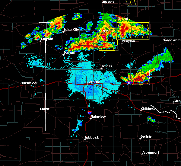 At 105 am cdt, a severe thunderstorm capable of producing a tornado was located 4 miles northeast of lela, or 5 miles northwest of shamrock, moving east at 30 mph (radar indicated rotation). Hazards include tornado and baseball size hail. Flying debris will be dangerous to those caught without shelter. mobile homes will be damaged or destroyed. damage to roofs, windows, and vehicles will occur. tree damage is likely. Locations impacted include, twitty. At 105 am cdt, a severe thunderstorm capable of producing a tornado was located 4 miles northeast of lela, or 5 miles northwest of shamrock, moving east at 30 mph (radar indicated rotation). Hazards include tornado and baseball size hail. Flying debris will be dangerous to those caught without shelter. mobile homes will be damaged or destroyed. damage to roofs, windows, and vehicles will occur. tree damage is likely. Locations impacted include, twitty.
|
| 6/23/2019 12:58 AM CDT |
 At 1257 am cdt, a severe thunderstorm was located 6 miles southeast of kellerville, or 11 miles northwest of shamrock, moving northeast at 25 mph. this is a very dangerous storm (radar indicated). Hazards include baseball size hail and 70 mph wind gusts. People and animals outdoors will be severely injured. expect shattered windows, extensive damage to roofs, siding, and vehicles. Locations impacted include, shamrock, wheeler, lela, kellerville and twitty. At 1257 am cdt, a severe thunderstorm was located 6 miles southeast of kellerville, or 11 miles northwest of shamrock, moving northeast at 25 mph. this is a very dangerous storm (radar indicated). Hazards include baseball size hail and 70 mph wind gusts. People and animals outdoors will be severely injured. expect shattered windows, extensive damage to roofs, siding, and vehicles. Locations impacted include, shamrock, wheeler, lela, kellerville and twitty.
|
| 6/23/2019 12:50 AM CDT |
 At 1250 am cdt, a severe thunderstorm capable of producing a tornado was located 4 miles west of lela, or 9 miles west of shamrock, moving east at 20 mph (radar indicated rotation). Hazards include tornado and baseball size hail. Flying debris will be dangerous to those caught without shelter. mobile homes will be damaged or destroyed. damage to roofs, windows, and vehicles will occur. Tree damage is likely. At 1250 am cdt, a severe thunderstorm capable of producing a tornado was located 4 miles west of lela, or 9 miles west of shamrock, moving east at 20 mph (radar indicated rotation). Hazards include tornado and baseball size hail. Flying debris will be dangerous to those caught without shelter. mobile homes will be damaged or destroyed. damage to roofs, windows, and vehicles will occur. Tree damage is likely.
|
| 6/23/2019 12:44 AM CDT |
 At 1244 am cdt, a severe thunderstorm was located 6 miles south of kellerville, or 13 miles west of shamrock, moving east at 20 mph. this is a very dangerous storm (radar indicated). Hazards include baseball size hail and 70 mph wind gusts. People and animals outdoors will be severely injured. expect shattered windows, extensive damage to roofs, siding, and vehicles. Locations impacted include, shamrock, briscoe, wheeler, mclean, new mobeetie, lake mcclellan, twitty, lela, alanreed, kellerville and mobeetie. At 1244 am cdt, a severe thunderstorm was located 6 miles south of kellerville, or 13 miles west of shamrock, moving east at 20 mph. this is a very dangerous storm (radar indicated). Hazards include baseball size hail and 70 mph wind gusts. People and animals outdoors will be severely injured. expect shattered windows, extensive damage to roofs, siding, and vehicles. Locations impacted include, shamrock, briscoe, wheeler, mclean, new mobeetie, lake mcclellan, twitty, lela, alanreed, kellerville and mobeetie.
|
| 6/23/2019 12:16 AM CDT |
 At 1216 am cdt, a severe thunderstorm was located near alanreed, or 23 miles southeast of pampa, moving northeast at 25 mph (radar indicated). Hazards include two inch hail and 70 mph wind gusts. Expect some tree damage. damage is likely to mobile homes, roofs, and outbuildings. people and animals outdoors will be injured. Expect hail damage to roofs, siding, windows, and vehicles. At 1216 am cdt, a severe thunderstorm was located near alanreed, or 23 miles southeast of pampa, moving northeast at 25 mph (radar indicated). Hazards include two inch hail and 70 mph wind gusts. Expect some tree damage. damage is likely to mobile homes, roofs, and outbuildings. people and animals outdoors will be injured. Expect hail damage to roofs, siding, windows, and vehicles.
|
| 6/23/2019 12:11 AM CDT |
 At 1210 am cdt, a severe thunderstorm was located 5 miles northeast of mclean, or 15 miles west of shamrock, moving northeast at 25 mph (radar indicated). Hazards include 60 mph wind gusts and half dollar size hail. Minor damage to roofs, siding, and trees is possible. hail damage to vehicles is expected. Locations impacted include, shamrock, briscoe, wheeler, mclean, twitty, lela and kellerville. At 1210 am cdt, a severe thunderstorm was located 5 miles northeast of mclean, or 15 miles west of shamrock, moving northeast at 25 mph (radar indicated). Hazards include 60 mph wind gusts and half dollar size hail. Minor damage to roofs, siding, and trees is possible. hail damage to vehicles is expected. Locations impacted include, shamrock, briscoe, wheeler, mclean, twitty, lela and kellerville.
|
| 6/23/2019 12:00 AM CDT |
 At 1200 am cdt, a severe thunderstorm was located over mclean, or 18 miles west of shamrock, moving northeast at 30 mph (public). Hazards include 60 mph wind gusts and quarter size hail. Minor damage to roofs, siding, and trees is possible. Hail damage to vehicles is expected. At 1200 am cdt, a severe thunderstorm was located over mclean, or 18 miles west of shamrock, moving northeast at 30 mph (public). Hazards include 60 mph wind gusts and quarter size hail. Minor damage to roofs, siding, and trees is possible. Hail damage to vehicles is expected.
|
| 6/18/2019 10:39 PM CDT | Quarter sized hail reported 11.1 miles NNE of Shamrock, TX |
| 6/18/2019 10:27 PM CDT |
 A severe thunderstorm warning remains in effect until 1115 pm cdt for wheeler and collingsworth counties. at 1026 pm cdt, a severe thunderstorm was located 6 miles southwest of lela, or 11 miles west of shamrock, moving southeast at 40 mph. this is a very dangerous storm. hazard. Baseball size hail and 70 mph wind gusts. A severe thunderstorm warning remains in effect until 1115 pm cdt for wheeler and collingsworth counties. at 1026 pm cdt, a severe thunderstorm was located 6 miles southwest of lela, or 11 miles west of shamrock, moving southeast at 40 mph. this is a very dangerous storm. hazard. Baseball size hail and 70 mph wind gusts.
|
| 6/18/2019 10:15 PM CDT |
 At 1015 pm cdt, a severe thunderstorm was located near mclean, or 16 miles west of shamrock, moving southeast at 40 mph (radar indicated). Hazards include 70 mph wind gusts and ping pong ball size hail. Expect some tree damage. damage is likely to mobile homes, roofs, and outbuildings. people and animals outdoors will be injured. Expect hail damage to roofs, siding, windows, and vehicles. At 1015 pm cdt, a severe thunderstorm was located near mclean, or 16 miles west of shamrock, moving southeast at 40 mph (radar indicated). Hazards include 70 mph wind gusts and ping pong ball size hail. Expect some tree damage. damage is likely to mobile homes, roofs, and outbuildings. people and animals outdoors will be injured. Expect hail damage to roofs, siding, windows, and vehicles.
|
| 6/15/2019 8:50 PM CDT |
 The severe thunderstorm warning for southeastern wheeler and collingsworth counties will expire at 900 pm cdt, the storm which prompted the warning has moved out of the area. therefore, the warning will be allowed to expire. however small hail, gusty winds and heavy rain are still possible on the back side of this thunderstorm. a severe thunderstorm watch remains in effect until 1000 pm cdt for the panhandle of texas. to report severe weather, contact your nearest law enforcement agency. they will relay your report to the national weather service amarillo. The severe thunderstorm warning for southeastern wheeler and collingsworth counties will expire at 900 pm cdt, the storm which prompted the warning has moved out of the area. therefore, the warning will be allowed to expire. however small hail, gusty winds and heavy rain are still possible on the back side of this thunderstorm. a severe thunderstorm watch remains in effect until 1000 pm cdt for the panhandle of texas. to report severe weather, contact your nearest law enforcement agency. they will relay your report to the national weather service amarillo.
|
| 6/15/2019 8:19 PM CDT |
 At 807 pm cdt, a severe thunderstorm was located 6 miles east of quail, or 8 miles northwest of wellington, moving east at 30 mph (radar indicated). Hazards include 60 mph wind gusts and quarter size hail. Minor damage to roofs, siding, and trees is possible. Hail damage to vehicles is expected. At 807 pm cdt, a severe thunderstorm was located 6 miles east of quail, or 8 miles northwest of wellington, moving east at 30 mph (radar indicated). Hazards include 60 mph wind gusts and quarter size hail. Minor damage to roofs, siding, and trees is possible. Hail damage to vehicles is expected.
|
| 6/15/2019 8:07 PM CDT |
 At 807 pm cdt, a severe thunderstorm was located 6 miles east of quail, or 8 miles northwest of wellington, moving east at 30 mph (radar indicated). Hazards include 60 mph wind gusts and quarter size hail. Minor damage to roofs, siding, and trees is possible. Hail damage to vehicles is expected. At 807 pm cdt, a severe thunderstorm was located 6 miles east of quail, or 8 miles northwest of wellington, moving east at 30 mph (radar indicated). Hazards include 60 mph wind gusts and quarter size hail. Minor damage to roofs, siding, and trees is possible. Hail damage to vehicles is expected.
|
| 5/27/2019 12:07 AM CDT |
 The severe thunderstorm warning for wheeler, southeastern gray, northern collingsworth and northeastern donley counties will expire at 1215 am cdt, the storms which prompted the warning have weakened below severe limits, and no longer pose an immediate threat to life or property. therefore, the warning will be allowed to expire. a tornado watch remains in effect until 200 am cdt for the panhandle of texas. The severe thunderstorm warning for wheeler, southeastern gray, northern collingsworth and northeastern donley counties will expire at 1215 am cdt, the storms which prompted the warning have weakened below severe limits, and no longer pose an immediate threat to life or property. therefore, the warning will be allowed to expire. a tornado watch remains in effect until 200 am cdt for the panhandle of texas.
|
| 5/26/2019 11:49 PM CDT |
 At 1149 pm cdt, severe thunderstorms were located along a line extending from 6 miles southeast of miami to mclean, moving northeast at 55 mph (radar indicated). Hazards include 70 mph wind gusts and penny size hail. Expect some tree damage. damage is likely to mobile homes, roofs, and outbuildings. locations impacted include, shamrock, wheeler, mclean, lefors, twitty, dozier, lela, alanreed, samnorwood and kellerville. A tornado watch remains in effect until 200 am cdt for the panhandle of texas. At 1149 pm cdt, severe thunderstorms were located along a line extending from 6 miles southeast of miami to mclean, moving northeast at 55 mph (radar indicated). Hazards include 70 mph wind gusts and penny size hail. Expect some tree damage. damage is likely to mobile homes, roofs, and outbuildings. locations impacted include, shamrock, wheeler, mclean, lefors, twitty, dozier, lela, alanreed, samnorwood and kellerville. A tornado watch remains in effect until 200 am cdt for the panhandle of texas.
|
| 5/26/2019 11:24 PM CDT |
 At 1124 pm cdt, severe thunderstorms were located along a line extending from near lefors to 6 miles east of goodnight, moving northeast at 60 mph (radar indicated). Hazards include 70 mph wind gusts and nickel size hail. Expect some tree damage. damage is likely to mobile homes, roofs, and outbuildings. locations impacted include, wellington, clarendon, shamrock, wheeler, mclean, lefors, howardwick, hedley, lutie, lelia lake, lake mcclellan, twitty, lela, quail, samnorwood, kellerville, dozier, alanreed and greenbelt lake. A tornado watch remains in effect until 200 am cdt for the panhandle of texas. At 1124 pm cdt, severe thunderstorms were located along a line extending from near lefors to 6 miles east of goodnight, moving northeast at 60 mph (radar indicated). Hazards include 70 mph wind gusts and nickel size hail. Expect some tree damage. damage is likely to mobile homes, roofs, and outbuildings. locations impacted include, wellington, clarendon, shamrock, wheeler, mclean, lefors, howardwick, hedley, lutie, lelia lake, lake mcclellan, twitty, lela, quail, samnorwood, kellerville, dozier, alanreed and greenbelt lake. A tornado watch remains in effect until 200 am cdt for the panhandle of texas.
|
| 5/26/2019 11:13 PM CDT |
 At 1113 pm cdt, severe thunderstorms were located along a line extending from 7 miles southwest of lefors to 5 miles south of goodnight, moving northeast at 60 mph (radar indicated). Hazards include 70 mph wind gusts. Expect some tree damage. Damage is likely to mobile homes, roofs, and outbuildings. At 1113 pm cdt, severe thunderstorms were located along a line extending from 7 miles southwest of lefors to 5 miles south of goodnight, moving northeast at 60 mph (radar indicated). Hazards include 70 mph wind gusts. Expect some tree damage. Damage is likely to mobile homes, roofs, and outbuildings.
|
| 5/25/2019 8:06 PM CDT |
 At 806 pm cdt, a severe thunderstorm was located 5 miles northwest of wellington, moving northeast at 55 mph (radar indicated). Hazards include 60 mph wind gusts. minor damage to roofs, siding, and trees is possible At 806 pm cdt, a severe thunderstorm was located 5 miles northwest of wellington, moving northeast at 55 mph (radar indicated). Hazards include 60 mph wind gusts. minor damage to roofs, siding, and trees is possible
|
| 5/20/2019 9:08 PM CDT |
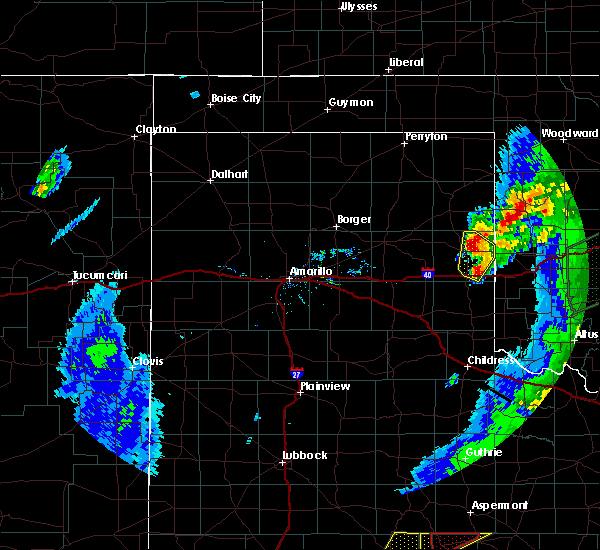 At 901 pm cdt, a severe thunderstorm was located 5 miles northeast of twitty, or 11 miles northeast of shamrock, moving northeast at 65 mph (radar indicated). Hazards include 60 mph wind gusts and quarter size hail. Minor damage to roofs, siding, and trees is possible. hail damage to vehicles is expected. Locations impacted include, shamrock, wheeler, lela and twitty. At 901 pm cdt, a severe thunderstorm was located 5 miles northeast of twitty, or 11 miles northeast of shamrock, moving northeast at 65 mph (radar indicated). Hazards include 60 mph wind gusts and quarter size hail. Minor damage to roofs, siding, and trees is possible. hail damage to vehicles is expected. Locations impacted include, shamrock, wheeler, lela and twitty.
|
| 5/20/2019 9:02 PM CDT |
 At 901 pm cdt, a severe thunderstorm was located 5 miles northeast of twitty, or 11 miles northeast of shamrock, moving northeast at 65 mph (radar indicated). Hazards include 60 mph wind gusts and quarter size hail. Minor damage to roofs, siding, and trees is possible. hail damage to vehicles is expected. Locations impacted include, shamrock, wheeler, lela and twitty. At 901 pm cdt, a severe thunderstorm was located 5 miles northeast of twitty, or 11 miles northeast of shamrock, moving northeast at 65 mph (radar indicated). Hazards include 60 mph wind gusts and quarter size hail. Minor damage to roofs, siding, and trees is possible. hail damage to vehicles is expected. Locations impacted include, shamrock, wheeler, lela and twitty.
|
| 5/20/2019 8:53 PM CDT |
 At 852 pm cdt, a severe thunderstorm was located over twitty, or 7 miles north of shamrock, moving northeast at 60 mph (radar indicated). Hazards include 60 mph wind gusts and quarter size hail. Minor damage to roofs, siding, and trees is possible. hail damage to vehicles is expected. Locations impacted include, shamrock, briscoe, wheeler, twitty, dozier, lela and samnorwood. At 852 pm cdt, a severe thunderstorm was located over twitty, or 7 miles north of shamrock, moving northeast at 60 mph (radar indicated). Hazards include 60 mph wind gusts and quarter size hail. Minor damage to roofs, siding, and trees is possible. hail damage to vehicles is expected. Locations impacted include, shamrock, briscoe, wheeler, twitty, dozier, lela and samnorwood.
|
| 5/20/2019 8:44 PM CDT |
 At 844 pm cdt, a severe thunderstorm was located over lela, or 6 miles west of shamrock, moving north at 60 mph (radar indicated). Hazards include 60 mph wind gusts and quarter size hail. Minor damage to roofs, siding, and trees is possible. hail damage to vehicles is expected. Locations impacted include, shamrock, briscoe, wheeler, new mobeetie, twitty, dozier, lela, samnorwood, kellerville and mobeetie. At 844 pm cdt, a severe thunderstorm was located over lela, or 6 miles west of shamrock, moving north at 60 mph (radar indicated). Hazards include 60 mph wind gusts and quarter size hail. Minor damage to roofs, siding, and trees is possible. hail damage to vehicles is expected. Locations impacted include, shamrock, briscoe, wheeler, new mobeetie, twitty, dozier, lela, samnorwood, kellerville and mobeetie.
|
| 5/20/2019 8:38 PM CDT |
 At 838 pm cdt, a severe thunderstorm was located 4 miles northwest of dozier, or 11 miles southwest of shamrock, moving northeast at 55 mph (radar indicated). Hazards include 60 mph wind gusts and half dollar size hail. Minor damage to roofs, siding, and trees is possible. hail damage to vehicles is expected. Locations impacted include, shamrock, briscoe, wheeler, mclean, new mobeetie, twitty, dozier, lela, samnorwood, kellerville and mobeetie. At 838 pm cdt, a severe thunderstorm was located 4 miles northwest of dozier, or 11 miles southwest of shamrock, moving northeast at 55 mph (radar indicated). Hazards include 60 mph wind gusts and half dollar size hail. Minor damage to roofs, siding, and trees is possible. hail damage to vehicles is expected. Locations impacted include, shamrock, briscoe, wheeler, mclean, new mobeetie, twitty, dozier, lela, samnorwood, kellerville and mobeetie.
|
| 5/20/2019 8:30 PM CDT |
 At 821 pm cdt, a severe thunderstorm was located 6 miles north of hedley, or 15 miles east of clarendon, moving northeast at 70 mph (radar indicated). Hazards include golf ball size hail and 60 mph wind gusts. Minor damage to roofs, siding, and trees is possible. people and animals outdoors will be injured. expect hail damage to roofs, siding, windows, and vehicles. Locations impacted include, shamrock, briscoe, wheeler, mclean, hedley, lelia lake, new mobeetie, twitty, lela, quail, samnorwood, kellerville, dozier, alanreed and mobeetie. At 821 pm cdt, a severe thunderstorm was located 6 miles north of hedley, or 15 miles east of clarendon, moving northeast at 70 mph (radar indicated). Hazards include golf ball size hail and 60 mph wind gusts. Minor damage to roofs, siding, and trees is possible. people and animals outdoors will be injured. expect hail damage to roofs, siding, windows, and vehicles. Locations impacted include, shamrock, briscoe, wheeler, mclean, hedley, lelia lake, new mobeetie, twitty, lela, quail, samnorwood, kellerville, dozier, alanreed and mobeetie.
|
| 5/20/2019 8:21 PM CDT |
 At 821 pm cdt, a severe thunderstorm was located 6 miles north of hedley, or 15 miles east of clarendon, moving northeast at 70 mph (radar indicated). Hazards include golf ball size hail and 60 mph wind gusts. Minor damage to roofs, siding, and trees is possible. people and animals outdoors will be injured. expect hail damage to roofs, siding, windows, and vehicles. Locations impacted include, shamrock, briscoe, wheeler, mclean, hedley, lelia lake, new mobeetie, twitty, lela, quail, samnorwood, kellerville, dozier, alanreed and mobeetie. At 821 pm cdt, a severe thunderstorm was located 6 miles north of hedley, or 15 miles east of clarendon, moving northeast at 70 mph (radar indicated). Hazards include golf ball size hail and 60 mph wind gusts. Minor damage to roofs, siding, and trees is possible. people and animals outdoors will be injured. expect hail damage to roofs, siding, windows, and vehicles. Locations impacted include, shamrock, briscoe, wheeler, mclean, hedley, lelia lake, new mobeetie, twitty, lela, quail, samnorwood, kellerville, dozier, alanreed and mobeetie.
|
| 5/20/2019 8:13 PM CDT |
 At 813 pm cdt, a severe thunderstorm was located near hedley, or 10 miles southeast of clarendon, moving northeast at 60 mph (radar indicated). Hazards include ping pong ball size hail and 60 mph wind gusts. Minor damage to roofs, siding, and trees is possible. people and animals outdoors will be injured. Expect hail damage to roofs, siding, windows, and vehicles. At 813 pm cdt, a severe thunderstorm was located near hedley, or 10 miles southeast of clarendon, moving northeast at 60 mph (radar indicated). Hazards include ping pong ball size hail and 60 mph wind gusts. Minor damage to roofs, siding, and trees is possible. people and animals outdoors will be injured. Expect hail damage to roofs, siding, windows, and vehicles.
|
| 5/20/2019 5:03 PM CDT |
 At 503 pm cdt, a severe thunderstorm was located 7 miles west of twitty, or 10 miles northwest of shamrock, moving northeast at 40 mph (radar indicated). Hazards include quarter size hail. damage to vehicles is expected At 503 pm cdt, a severe thunderstorm was located 7 miles west of twitty, or 10 miles northwest of shamrock, moving northeast at 40 mph (radar indicated). Hazards include quarter size hail. damage to vehicles is expected
|
| 5/20/2019 3:57 PM CDT |
 At 356 pm cdt, a severe thunderstorm was located over dozier, or 12 miles south of shamrock, moving northeast at 50 mph (radar indicated). Hazards include ping pong ball size hail and 60 mph wind gusts. Minor damage to roofs, siding, and trees is possible. people and animals outdoors will be injured. Expect hail damage to roofs, siding, windows, and vehicles. At 356 pm cdt, a severe thunderstorm was located over dozier, or 12 miles south of shamrock, moving northeast at 50 mph (radar indicated). Hazards include ping pong ball size hail and 60 mph wind gusts. Minor damage to roofs, siding, and trees is possible. people and animals outdoors will be injured. Expect hail damage to roofs, siding, windows, and vehicles.
|
| 5/7/2019 9:00 PM CDT |
 The national weather service in amarillo has issued a * severe thunderstorm warning for. southeastern wheeler county in the panhandle of texas. northeastern collingsworth county in the panhandle of texas. until 1015 pm cdt. At 859 pm cdt, a severe thunderstorm was located near lutie, or 10. The national weather service in amarillo has issued a * severe thunderstorm warning for. southeastern wheeler county in the panhandle of texas. northeastern collingsworth county in the panhandle of texas. until 1015 pm cdt. At 859 pm cdt, a severe thunderstorm was located near lutie, or 10.
|
| 5/7/2019 7:42 PM CDT | Quarter sized hail reported 0.9 miles SSE of Shamrock, TX |
| 5/7/2019 5:26 PM CDT |
 At 526 pm cdt, a severe thunderstorm was located near wheeler, or 13 miles north of shamrock, moving north at 35 mph (radar indicated). Hazards include 60 mph wind gusts and quarter size hail. Minor damage to roofs, siding, and trees is possible. Hail damage to vehicles is expected. At 526 pm cdt, a severe thunderstorm was located near wheeler, or 13 miles north of shamrock, moving north at 35 mph (radar indicated). Hazards include 60 mph wind gusts and quarter size hail. Minor damage to roofs, siding, and trees is possible. Hail damage to vehicles is expected.
|
| 5/2/2019 2:27 AM CDT |
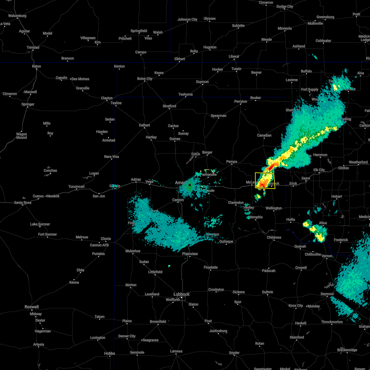 The severe thunderstorm warning for southwestern wheeler county will expire at 230 am cdt. the storm which prompted the warning has weakened below severe limits, and no longer poses an immediate threat to life or property. therefore, the warning will be allowed to expire. However small hail is still possible with this thunderstorm. The severe thunderstorm warning for southwestern wheeler county will expire at 230 am cdt. the storm which prompted the warning has weakened below severe limits, and no longer poses an immediate threat to life or property. therefore, the warning will be allowed to expire. However small hail is still possible with this thunderstorm.
|
| 5/2/2019 2:13 AM CDT |
 At 212 am cdt, a severe thunderstorm was located 6 miles northeast of mclean, or 14 miles west of shamrock, moving east at 20 mph (radar indicated). Hazards include quarter size hail. Damage to vehicles is expected. Locations impacted include, shamrock, lela, kellerville and twitty. At 212 am cdt, a severe thunderstorm was located 6 miles northeast of mclean, or 14 miles west of shamrock, moving east at 20 mph (radar indicated). Hazards include quarter size hail. Damage to vehicles is expected. Locations impacted include, shamrock, lela, kellerville and twitty.
|
| 5/2/2019 1:52 AM CDT |
 At 152 am cdt, a severe thunderstorm was located near mclean, or 21 miles west of shamrock, moving east at 20 mph (radar indicated). Hazards include golf ball size hail and 60 mph wind gusts. Minor damage to roofs, siding, and trees is possible. people and animals outdoors will be injured. Expect hail damage to roofs, siding, windows, and vehicles. At 152 am cdt, a severe thunderstorm was located near mclean, or 21 miles west of shamrock, moving east at 20 mph (radar indicated). Hazards include golf ball size hail and 60 mph wind gusts. Minor damage to roofs, siding, and trees is possible. people and animals outdoors will be injured. Expect hail damage to roofs, siding, windows, and vehicles.
|
| 4/30/2019 11:00 AM CDT | Quarter sized hail reported 11.7 miles W of Shamrock, TX, public report of quarter size hail. |
| 4/17/2019 5:35 PM CDT | Half Dollar sized hail reported 13.4 miles W of Shamrock, TX, late report received of hail along interstate 40 near the oklahoma and texas state line. |
| 4/17/2019 5:17 PM CDT |
 At 517 pm cdt, a severe thunderstorm was located near shamrock, moving east at 25 mph (radar indicated). Hazards include ping pong ball size hail. People and animals outdoors will be injured. Expect damage to roofs, siding, windows, and vehicles. At 517 pm cdt, a severe thunderstorm was located near shamrock, moving east at 25 mph (radar indicated). Hazards include ping pong ball size hail. People and animals outdoors will be injured. Expect damage to roofs, siding, windows, and vehicles.
|
| 4/17/2019 4:55 PM CDT | Golf Ball sized hail reported 9.1 miles NE of Shamrock, TX, late report of golf ball size hail. |
| 4/17/2019 3:22 PM CDT |
 At 322 pm cdt, a severe thunderstorm was located over mclean, or 18 miles west of shamrock, moving northeast at 35 mph (law enforcement). Hazards include golf ball size hail. People and animals outdoors will be injured. expect damage to roofs, siding, windows, and vehicles. hail may accumulate on roadways causing hazardous travel. Locations impacted include, shamrock, wheeler, mclean, new mobeetie, twitty, lela, alanreed, kellerville and mobeetie. At 322 pm cdt, a severe thunderstorm was located over mclean, or 18 miles west of shamrock, moving northeast at 35 mph (law enforcement). Hazards include golf ball size hail. People and animals outdoors will be injured. expect damage to roofs, siding, windows, and vehicles. hail may accumulate on roadways causing hazardous travel. Locations impacted include, shamrock, wheeler, mclean, new mobeetie, twitty, lela, alanreed, kellerville and mobeetie.
|
| 4/17/2019 3:14 PM CDT |
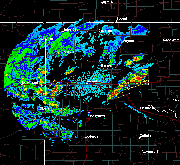 At 312 pm cdt, a severe thunderstorm was located 4 miles north of twitty, or 11 miles north of shamrock, moving northeast at 25 mph (trained weather spotters and radar indicated). Hazards include two inch hail and accumulating small hail. trained spotters reported two inch hail 3 miles north of twitty at 0311 pm cdt. People and animals outdoors will be injured. expect damage to roofs, siding, windows, and vehicles. Locations impacted include, wheeler, allison, lela and twitty. At 312 pm cdt, a severe thunderstorm was located 4 miles north of twitty, or 11 miles north of shamrock, moving northeast at 25 mph (trained weather spotters and radar indicated). Hazards include two inch hail and accumulating small hail. trained spotters reported two inch hail 3 miles north of twitty at 0311 pm cdt. People and animals outdoors will be injured. expect damage to roofs, siding, windows, and vehicles. Locations impacted include, wheeler, allison, lela and twitty.
|
| 4/17/2019 3:11 PM CDT | Hen Egg sized hail reported 9.2 miles S of Shamrock, TX |
| 4/17/2019 3:04 PM CDT |
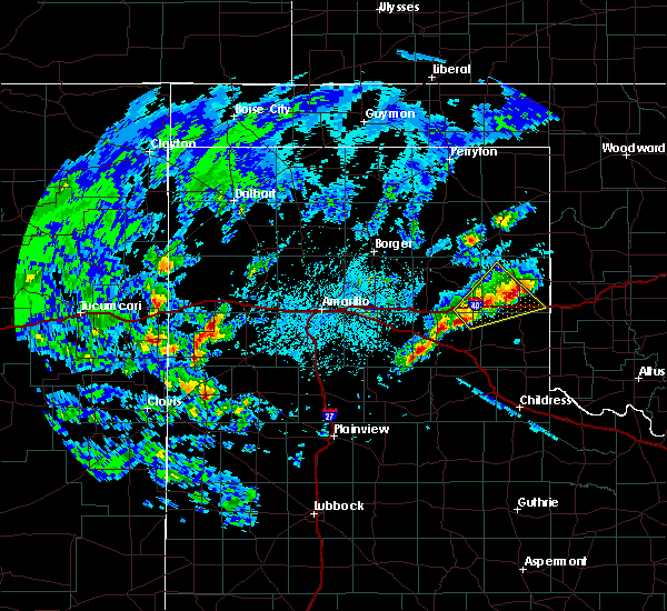 At 304 pm cdt, a severe thunderstorm was located over twitty, or 8 miles north of shamrock, moving northeast at 20 mph (radar indicated). Hazards include two inch hail. People and animals outdoors will be injured. Expect damage to roofs, siding, windows, and vehicles. At 304 pm cdt, a severe thunderstorm was located over twitty, or 8 miles north of shamrock, moving northeast at 20 mph (radar indicated). Hazards include two inch hail. People and animals outdoors will be injured. Expect damage to roofs, siding, windows, and vehicles.
|
| 4/17/2019 2:49 PM CDT |
 At 249 pm cdt, a severe thunderstorm was located 4 miles southeast of mclean, or 18 miles west of shamrock, moving northeast at 30 mph (law enforcement and radar indicated). Hazards include golf ball size hail. People and animals outdoors will be injured. expect damage to roofs, siding, windows, and vehicles. hail may accumulate on roadways causing hazardous travel. Locations impacted include, shamrock, wheeler, mclean, new mobeetie, twitty, lela, alanreed, kellerville and mobeetie. At 249 pm cdt, a severe thunderstorm was located 4 miles southeast of mclean, or 18 miles west of shamrock, moving northeast at 30 mph (law enforcement and radar indicated). Hazards include golf ball size hail. People and animals outdoors will be injured. expect damage to roofs, siding, windows, and vehicles. hail may accumulate on roadways causing hazardous travel. Locations impacted include, shamrock, wheeler, mclean, new mobeetie, twitty, lela, alanreed, kellerville and mobeetie.
|
| 4/17/2019 2:36 PM CDT |
 At 236 pm cdt, a severe thunderstorm was located 7 miles southeast of alanreed, or 18 miles northeast of clarendon, moving northeast at 30 mph (radar indicated). Hazards include tennis ball size hail. People and animals outdoors will be injured. expect damage to roofs, siding, windows, and vehicles. Hail may accumulate on roadways causing hazardous travel. At 236 pm cdt, a severe thunderstorm was located 7 miles southeast of alanreed, or 18 miles northeast of clarendon, moving northeast at 30 mph (radar indicated). Hazards include tennis ball size hail. People and animals outdoors will be injured. expect damage to roofs, siding, windows, and vehicles. Hail may accumulate on roadways causing hazardous travel.
|
| 4/3/2019 9:25 PM CDT |
 The severe thunderstorm warning for southeastern wheeler and northeastern collingsworth counties will expire at 930 pm cdt, the storm which prompted the warning has weakened, and will no longer poses an immediate threat to life or property.therefore, the warning will be allowed to expire. however small hail is still possible with this thunderstorm as it moves across southern wheeler and northern collingsworth counties. a severe thunderstorm watch remains in effect until 1000 pm cdt for the panhandle of texas. The severe thunderstorm warning for southeastern wheeler and northeastern collingsworth counties will expire at 930 pm cdt, the storm which prompted the warning has weakened, and will no longer poses an immediate threat to life or property.therefore, the warning will be allowed to expire. however small hail is still possible with this thunderstorm as it moves across southern wheeler and northern collingsworth counties. a severe thunderstorm watch remains in effect until 1000 pm cdt for the panhandle of texas.
|
| 4/3/2019 9:15 PM CDT |
 At 914 pm cdt, a severe thunderstorm was located near lela, or 4 miles southwest of shamrock, moving east at 25 mph (radar indicated). Hazards include 60 mph wind gusts and half dollar size hail. Minor damage to roofs, siding, and trees is possible. hail damage to vehicles is expected. Locations impacted include, shamrock, lela and twitty. At 914 pm cdt, a severe thunderstorm was located near lela, or 4 miles southwest of shamrock, moving east at 25 mph (radar indicated). Hazards include 60 mph wind gusts and half dollar size hail. Minor damage to roofs, siding, and trees is possible. hail damage to vehicles is expected. Locations impacted include, shamrock, lela and twitty.
|
| 4/3/2019 9:02 PM CDT |
 At 901 pm cdt, a severe thunderstorm was located 6 miles southwest of lela, or 10 miles west of shamrock, moving east at 25 mph (radar indicated). Hazards include 60 mph wind gusts and half dollar size hail. Minor damage to roofs, siding, and trees is possible. hail damage to vehicles is expected. Locations impacted include, shamrock, wheeler, lela and twitty. At 901 pm cdt, a severe thunderstorm was located 6 miles southwest of lela, or 10 miles west of shamrock, moving east at 25 mph (radar indicated). Hazards include 60 mph wind gusts and half dollar size hail. Minor damage to roofs, siding, and trees is possible. hail damage to vehicles is expected. Locations impacted include, shamrock, wheeler, lela and twitty.
|
| 4/3/2019 8:49 PM CDT |
 At 848 pm cdt, a severe thunderstorm was located 5 miles southeast of mclean, or 16 miles west of shamrock, moving east at 25 mph (radar indicated). Hazards include 60 mph wind gusts and half dollar size hail. Minor damage to roofs, siding, and trees is possible. Hail damage to vehicles is expected. At 848 pm cdt, a severe thunderstorm was located 5 miles southeast of mclean, or 16 miles west of shamrock, moving east at 25 mph (radar indicated). Hazards include 60 mph wind gusts and half dollar size hail. Minor damage to roofs, siding, and trees is possible. Hail damage to vehicles is expected.
|
| 3/22/2019 11:12 PM CDT |
 At 1112 pm cdt, a severe thunderstorm was located over shamrock, moving east at 30 mph (radar indicated). Hazards include 60 mph wind gusts and penny size hail. Minor damage to roofs, siding, and trees is possible. Locations impacted include, shamrock and twitty. At 1112 pm cdt, a severe thunderstorm was located over shamrock, moving east at 30 mph (radar indicated). Hazards include 60 mph wind gusts and penny size hail. Minor damage to roofs, siding, and trees is possible. Locations impacted include, shamrock and twitty.
|
| 3/22/2019 10:59 PM CDT |
 At 1058 pm cdt, a severe thunderstorm was located 4 miles south of lela, or 7 miles southwest of shamrock, moving east at 30 mph (radar indicated). Hazards include 60 mph wind gusts and penny size hail. Minor damage to roofs, siding, and trees is possible. Locations impacted include, shamrock, lela and twitty. At 1058 pm cdt, a severe thunderstorm was located 4 miles south of lela, or 7 miles southwest of shamrock, moving east at 30 mph (radar indicated). Hazards include 60 mph wind gusts and penny size hail. Minor damage to roofs, siding, and trees is possible. Locations impacted include, shamrock, lela and twitty.
|
| 3/22/2019 10:51 PM CDT |
 At 1051 pm cdt, severe thunderstorms were located along a line extending from 5 miles north of kellerville to 7 miles southwest of lela, moving east at 35 mph (radar indicated). Hazards include 60 mph wind gusts and quarter size hail. Minor damage to roofs, siding, and trees is possible. hail damage to vehicles is expected. Locations impacted include, shamrock, briscoe, wheeler, mclean, new mobeetie, twitty, allison, lela, kellerville, dozier and mobeetie. At 1051 pm cdt, severe thunderstorms were located along a line extending from 5 miles north of kellerville to 7 miles southwest of lela, moving east at 35 mph (radar indicated). Hazards include 60 mph wind gusts and quarter size hail. Minor damage to roofs, siding, and trees is possible. hail damage to vehicles is expected. Locations impacted include, shamrock, briscoe, wheeler, mclean, new mobeetie, twitty, allison, lela, kellerville, dozier and mobeetie.
|
| 3/22/2019 10:33 PM CDT |
 At 1033 pm cdt, severe thunderstorms were located along a line extending from 6 miles east of lefors to 8 miles south of mclean, moving east at 30 mph (radar indicated). Hazards include 60 mph wind gusts and quarter size hail. Minor damage to roofs, siding, and trees is possible. hail damage to vehicles is expected. Locations impacted include, shamrock, briscoe, wheeler, mclean, lefors, new mobeetie, twitty, allison, lela, kellerville, dozier, alanreed and mobeetie. At 1033 pm cdt, severe thunderstorms were located along a line extending from 6 miles east of lefors to 8 miles south of mclean, moving east at 30 mph (radar indicated). Hazards include 60 mph wind gusts and quarter size hail. Minor damage to roofs, siding, and trees is possible. hail damage to vehicles is expected. Locations impacted include, shamrock, briscoe, wheeler, mclean, lefors, new mobeetie, twitty, allison, lela, kellerville, dozier, alanreed and mobeetie.
|
| 3/22/2019 10:30 PM CDT |
 At 1029 pm cdt, severe thunderstorms were located along a line extending from 5 miles southeast of lefors to 9 miles southeast of alanreed, moving east at 30 mph (radar indicated). Hazards include golf ball size hail and 60 mph wind gusts. Minor damage to roofs, siding, and trees is possible. people and animals outdoors will be injured. Expect hail damage to roofs, siding, windows, and vehicles. At 1029 pm cdt, severe thunderstorms were located along a line extending from 5 miles southeast of lefors to 9 miles southeast of alanreed, moving east at 30 mph (radar indicated). Hazards include golf ball size hail and 60 mph wind gusts. Minor damage to roofs, siding, and trees is possible. people and animals outdoors will be injured. Expect hail damage to roofs, siding, windows, and vehicles.
|
| 6/29/2018 11:12 PM CDT |
 The severe thunderstorm warning for wheeler, eastern gray, collingsworth, southeastern hemphill and eastern donley counties will expire at 1115 pm cdt, the storm which prompted the warning has weakened below severe limits, and no longer poses an immediate threat to life or property. therefore, the warning will be allowed to expire. however gusty winds are still possible with this thunderstorm. The severe thunderstorm warning for wheeler, eastern gray, collingsworth, southeastern hemphill and eastern donley counties will expire at 1115 pm cdt, the storm which prompted the warning has weakened below severe limits, and no longer poses an immediate threat to life or property. therefore, the warning will be allowed to expire. however gusty winds are still possible with this thunderstorm.
|
| 6/29/2018 11:02 PM CDT |
 At 1102 pm cdt, a severe thunderstorm was located 5 miles northwest of memphis, moving east at 25 mph (radar indicated). Hazards include 60 mph wind gusts. Minor damage to roofs, siding, and trees is possible. Locations impacted include, wellington, shamrock, briscoe, wheeler, mclean, hedley, dodson, lutie, lelia lake, new mobeetie, twitty, allison, lela, quail, samnorwood, kellerville, dozier and mobeetie. At 1102 pm cdt, a severe thunderstorm was located 5 miles northwest of memphis, moving east at 25 mph (radar indicated). Hazards include 60 mph wind gusts. Minor damage to roofs, siding, and trees is possible. Locations impacted include, wellington, shamrock, briscoe, wheeler, mclean, hedley, dodson, lutie, lelia lake, new mobeetie, twitty, allison, lela, quail, samnorwood, kellerville, dozier and mobeetie.
|
| 6/29/2018 10:53 PM CDT |
 At 1053 pm cdt, severe thunderstorms were located along a line extending from briscoe to 6 miles northwest of memphis, moving northeast at 35 mph (radar indicated). Hazards include 60 mph wind gusts. Minor damage to roofs, siding, and trees is possible. Locations impacted include, wellington, shamrock, briscoe, wheeler, mclean, hedley, dodson, lutie, lelia lake, new mobeetie, twitty, allison, lela, quail, samnorwood, kellerville, dozier and mobeetie. At 1053 pm cdt, severe thunderstorms were located along a line extending from briscoe to 6 miles northwest of memphis, moving northeast at 35 mph (radar indicated). Hazards include 60 mph wind gusts. Minor damage to roofs, siding, and trees is possible. Locations impacted include, wellington, shamrock, briscoe, wheeler, mclean, hedley, dodson, lutie, lelia lake, new mobeetie, twitty, allison, lela, quail, samnorwood, kellerville, dozier and mobeetie.
|
| 6/29/2018 10:28 PM CDT |
 At 1028 pm cdt, severe thunderstorms were located along a line extending from 5 miles southwest of new mobeetie to 8 miles northwest of quail, moving east at 25 mph (radar indicated). Hazards include 60 mph wind gusts. Minor damage to roofs, siding, and trees is possible. Locations impacted include, wellington, shamrock, briscoe, wheeler, mclean, hedley, dodson, lutie, lelia lake, new mobeetie, twitty, allison, lela, quail, samnorwood, kellerville, dozier and mobeetie. At 1028 pm cdt, severe thunderstorms were located along a line extending from 5 miles southwest of new mobeetie to 8 miles northwest of quail, moving east at 25 mph (radar indicated). Hazards include 60 mph wind gusts. Minor damage to roofs, siding, and trees is possible. Locations impacted include, wellington, shamrock, briscoe, wheeler, mclean, hedley, dodson, lutie, lelia lake, new mobeetie, twitty, allison, lela, quail, samnorwood, kellerville, dozier and mobeetie.
|
| 6/29/2018 10:05 PM CDT |
 At 1004 pm cdt, severe thunderstorms were located along a line extending from 5 miles west of new mobeetie to 5 miles north of hedley, moving east at 20 mph (radar indicated). Hazards include 60 mph wind gusts. Minor damage to roofs, siding, and trees is possible. Locations impacted include, wellington, shamrock, briscoe, wheeler, mclean, hedley, dodson, lutie, lelia lake, new mobeetie, twitty, allison, lela, quail, samnorwood, kellerville, dozier and mobeetie. At 1004 pm cdt, severe thunderstorms were located along a line extending from 5 miles west of new mobeetie to 5 miles north of hedley, moving east at 20 mph (radar indicated). Hazards include 60 mph wind gusts. Minor damage to roofs, siding, and trees is possible. Locations impacted include, wellington, shamrock, briscoe, wheeler, mclean, hedley, dodson, lutie, lelia lake, new mobeetie, twitty, allison, lela, quail, samnorwood, kellerville, dozier and mobeetie.
|
| 6/29/2018 9:38 PM CDT |
 At 938 pm cdt, severe thunderstorms were located along a line extending from 7 miles northeast of lefors to 5 miles northeast of lelia lake, moving east at 40 mph (radar indicated). Hazards include 60 mph wind gusts. minor damage to roofs, siding, and trees is possible At 938 pm cdt, severe thunderstorms were located along a line extending from 7 miles northeast of lefors to 5 miles northeast of lelia lake, moving east at 40 mph (radar indicated). Hazards include 60 mph wind gusts. minor damage to roofs, siding, and trees is possible
|
| 6/25/2018 2:07 AM CDT |
 The severe thunderstorm warning for wheeler, collingsworth and southeastern donley counties will expire at 215 am cdt, the storms which prompted the warning have weakened below severe limits, and no longer pose an immediate threat to life or property. therefore the warning will be allowed to expire. however heavy rain is still possible with these thunderstorms. a severe thunderstorm watch remains in effect until 400 am cdt for the panhandle of texas. The severe thunderstorm warning for wheeler, collingsworth and southeastern donley counties will expire at 215 am cdt, the storms which prompted the warning have weakened below severe limits, and no longer pose an immediate threat to life or property. therefore the warning will be allowed to expire. however heavy rain is still possible with these thunderstorms. a severe thunderstorm watch remains in effect until 400 am cdt for the panhandle of texas.
|
| 6/25/2018 1:35 AM CDT |
 At 135 am cdt, severe thunderstorms were located along a line extending from 9 miles west of sweetwater to 3 miles north of quail, moving northeast at 35 mph (radar indicated). Hazards include 60 mph wind gusts and quarter size hail. Minor damage to roofs, siding, and trees is possible. hail damage to vehicles is expected. Locations impacted include, wellington, shamrock, wheeler, hedley, dodson, lutie, twitty, dozier, lela, quail and samnorwood. At 135 am cdt, severe thunderstorms were located along a line extending from 9 miles west of sweetwater to 3 miles north of quail, moving northeast at 35 mph (radar indicated). Hazards include 60 mph wind gusts and quarter size hail. Minor damage to roofs, siding, and trees is possible. hail damage to vehicles is expected. Locations impacted include, wellington, shamrock, wheeler, hedley, dodson, lutie, twitty, dozier, lela, quail and samnorwood.
|
| 6/25/2018 1:19 AM CDT |
 The national weather service in amarillo has issued a * severe thunderstorm warning for. wheeler county in the panhandle of texas. collingsworth county in the panhandle of texas. southeastern donley county in the panhandle of texas. Until 215 am cdt. The national weather service in amarillo has issued a * severe thunderstorm warning for. wheeler county in the panhandle of texas. collingsworth county in the panhandle of texas. southeastern donley county in the panhandle of texas. Until 215 am cdt.
|
| 6/22/2018 10:55 PM CDT |
 The severe thunderstorm warning for wheeler, southeastern gray, western collingsworth, southeastern hemphill and eastern donley counties will expire at 1100 pm cdt, the storms which prompted the warning have moved out of the area. therefore the warning will be allowed to expire. a severe thunderstorm watch remains in effect until midnight cdt for the panhandle of texas. The severe thunderstorm warning for wheeler, southeastern gray, western collingsworth, southeastern hemphill and eastern donley counties will expire at 1100 pm cdt, the storms which prompted the warning have moved out of the area. therefore the warning will be allowed to expire. a severe thunderstorm watch remains in effect until midnight cdt for the panhandle of texas.
|
| 6/22/2018 10:25 PM CDT | Storm damage reported in collingsworth county TX, 12.5 miles NE of Shamrock, TX |
| 6/22/2018 10:22 PM CDT |
 At 1022 pm cdt, severe thunderstorms were located along a line extending from 8 miles east of twitty to 6 miles northwest of quail, moving southeast at 45 mph (radar indicated). Hazards include 70 mph wind gusts and quarter size hail. Expect some tree damage. damage is likely to mobile homes, roofs, and outbuildings. hail damage to vehicles is expected. Locations impacted include, shamrock, briscoe, wheeler, mclean, hedley, lelia lake, twitty, allison, lela, quail, samnorwood, kellerville, dozier and alanreed. At 1022 pm cdt, severe thunderstorms were located along a line extending from 8 miles east of twitty to 6 miles northwest of quail, moving southeast at 45 mph (radar indicated). Hazards include 70 mph wind gusts and quarter size hail. Expect some tree damage. damage is likely to mobile homes, roofs, and outbuildings. hail damage to vehicles is expected. Locations impacted include, shamrock, briscoe, wheeler, mclean, hedley, lelia lake, twitty, allison, lela, quail, samnorwood, kellerville, dozier and alanreed.
|
| 6/22/2018 10:10 PM CDT |
 At 1009 pm cdt, severe thunderstorms were located along a line extending from near wheeler to 11 miles north of hedley, moving southeast at 45 mph (radar indicated). Hazards include 70 mph wind gusts. Expect some tree damage. damage is likely to mobile homes, roofs, and outbuildings. Locations impacted include, shamrock, briscoe, wheeler, mclean, hedley, lelia lake, twitty, allison, lela, quail, samnorwood, kellerville, dozier and alanreed. At 1009 pm cdt, severe thunderstorms were located along a line extending from near wheeler to 11 miles north of hedley, moving southeast at 45 mph (radar indicated). Hazards include 70 mph wind gusts. Expect some tree damage. damage is likely to mobile homes, roofs, and outbuildings. Locations impacted include, shamrock, briscoe, wheeler, mclean, hedley, lelia lake, twitty, allison, lela, quail, samnorwood, kellerville, dozier and alanreed.
|
| 6/22/2018 9:54 PM CDT |
 At 954 pm cdt, severe thunderstorms were located along a line extending from near new mobeetie to 7 miles northeast of howardwick, moving southeast at 45 mph (radar indicated). Hazards include 60 mph wind gusts. minor damage to roofs, siding, and trees is possible At 954 pm cdt, severe thunderstorms were located along a line extending from near new mobeetie to 7 miles northeast of howardwick, moving southeast at 45 mph (radar indicated). Hazards include 60 mph wind gusts. minor damage to roofs, siding, and trees is possible
|
| 5/29/2018 7:13 PM CDT |
 At 712 pm cdt, a severe thunderstorm was located over texola, or 14 miles east of shamrock, moving southeast at 25 mph. this is a very dangerous storm (public). Hazards include baseball size hail and 60 mph wind gusts. People and animals outdoors will be severely injured. expect shattered windows, extensive damage to roofs, siding, and vehicles. Locations impacted include, shamrock, wheeler and twitty. At 712 pm cdt, a severe thunderstorm was located over texola, or 14 miles east of shamrock, moving southeast at 25 mph. this is a very dangerous storm (public). Hazards include baseball size hail and 60 mph wind gusts. People and animals outdoors will be severely injured. expect shattered windows, extensive damage to roofs, siding, and vehicles. Locations impacted include, shamrock, wheeler and twitty.
|
| 5/29/2018 7:02 PM CDT |
 At 702 pm cdt, a severe thunderstorm was located 4 miles northwest of texola, or 11 miles east of shamrock, moving southeast at 25 mph. this is a very dangerous storm (public). Hazards include baseball size hail and 60 mph wind gusts. People and animals outdoors will be severely injured. expect shattered windows, extensive damage to roofs, siding, and vehicles. Locations impacted include, shamrock, wheeler, lela and twitty. At 702 pm cdt, a severe thunderstorm was located 4 miles northwest of texola, or 11 miles east of shamrock, moving southeast at 25 mph. this is a very dangerous storm (public). Hazards include baseball size hail and 60 mph wind gusts. People and animals outdoors will be severely injured. expect shattered windows, extensive damage to roofs, siding, and vehicles. Locations impacted include, shamrock, wheeler, lela and twitty.
|
| 5/29/2018 6:54 PM CDT |
 At 653 pm cdt, a severe thunderstorm was located 7 miles east of twitty, or 10 miles northeast of shamrock, moving southeast at 25 mph (radar indicated). Hazards include tennis ball size hail and 60 mph wind gusts. Minor damage to roofs, siding, and trees is possible. people and animals outdoors will be injured. expect hail damage to roofs, siding, windows, and vehicles. Locations impacted include, shamrock, wheeler, lela and twitty. At 653 pm cdt, a severe thunderstorm was located 7 miles east of twitty, or 10 miles northeast of shamrock, moving southeast at 25 mph (radar indicated). Hazards include tennis ball size hail and 60 mph wind gusts. Minor damage to roofs, siding, and trees is possible. people and animals outdoors will be injured. expect hail damage to roofs, siding, windows, and vehicles. Locations impacted include, shamrock, wheeler, lela and twitty.
|
| 5/29/2018 6:26 PM CDT |
 At 626 pm cdt, a severe thunderstorm was located 4 miles south of wheeler, or 11 miles north of shamrock, moving southeast at 25 mph. this is a very dangerous storm (radar indicated). Hazards include three inch hail and 60 mph wind gusts. People and animals outdoors will be severely injured. Expect shattered windows, extensive damage to roofs, siding, and vehicles. At 626 pm cdt, a severe thunderstorm was located 4 miles south of wheeler, or 11 miles north of shamrock, moving southeast at 25 mph. this is a very dangerous storm (radar indicated). Hazards include three inch hail and 60 mph wind gusts. People and animals outdoors will be severely injured. Expect shattered windows, extensive damage to roofs, siding, and vehicles.
|
| 5/18/2018 8:06 PM CDT |
 At 806 pm cdt, a severe thunderstorm was located 4 miles north of wellington, moving northeast at 20 mph (radar indicated). Hazards include 60 mph wind gusts and half dollar size hail. Minor damage to roofs, siding, and trees is possible. Hail damage to vehicles is expected. At 806 pm cdt, a severe thunderstorm was located 4 miles north of wellington, moving northeast at 20 mph (radar indicated). Hazards include 60 mph wind gusts and half dollar size hail. Minor damage to roofs, siding, and trees is possible. Hail damage to vehicles is expected.
|
| 5/16/2018 7:41 PM CDT |
 At 740 pm cdt, a severe thunderstorm was located 8 miles east of lefors, or 17 miles south of miami, moving south at 10 mph (radar indicated). Hazards include ping pong ball size hail and 60 mph wind gusts. Minor damage to roofs, siding, and trees is possible. people and animals outdoors will be injured. Expect hail damage to roofs, siding, windows, and vehicles. At 740 pm cdt, a severe thunderstorm was located 8 miles east of lefors, or 17 miles south of miami, moving south at 10 mph (radar indicated). Hazards include ping pong ball size hail and 60 mph wind gusts. Minor damage to roofs, siding, and trees is possible. people and animals outdoors will be injured. Expect hail damage to roofs, siding, windows, and vehicles.
|
| 5/16/2018 12:51 AM CDT |
 At 1251 am cdt, severe thunderstorms were located along a line extending from 6 miles south of sweetwater to 3 miles south of mclean, moving southeast at 35 mph (radar indicated). Hazards include 60 mph wind gusts and half dollar size hail. Minor damage to roofs, siding, and trees is possible. hail damage to vehicles is expected. Locations impacted include, shamrock, wheeler, lutie, twitty, dozier, lela, quail and samnorwood. At 1251 am cdt, severe thunderstorms were located along a line extending from 6 miles south of sweetwater to 3 miles south of mclean, moving southeast at 35 mph (radar indicated). Hazards include 60 mph wind gusts and half dollar size hail. Minor damage to roofs, siding, and trees is possible. hail damage to vehicles is expected. Locations impacted include, shamrock, wheeler, lutie, twitty, dozier, lela, quail and samnorwood.
|
| 5/16/2018 12:43 AM CDT |
 At 1243 am cdt, severe thunderstorms were located along a line extending from 4 miles southwest of sweetwater to 3 miles west of mclean, moving southeast at 35 mph (radar indicated). Hazards include ping pong ball size hail and 60 mph wind gusts. Minor damage to roofs, siding, and trees is possible. people and animals outdoors will be injured. expect hail damage to roofs, siding, windows, and vehicles. Locations impacted include, shamrock, wheeler, mclean, lutie, twitty, dozier, lela, quail, samnorwood and kellerville. At 1243 am cdt, severe thunderstorms were located along a line extending from 4 miles southwest of sweetwater to 3 miles west of mclean, moving southeast at 35 mph (radar indicated). Hazards include ping pong ball size hail and 60 mph wind gusts. Minor damage to roofs, siding, and trees is possible. people and animals outdoors will be injured. expect hail damage to roofs, siding, windows, and vehicles. Locations impacted include, shamrock, wheeler, mclean, lutie, twitty, dozier, lela, quail, samnorwood and kellerville.
|
| 5/16/2018 12:33 AM CDT |
 At 1233 am cdt, severe thunderstorms were located along a line extending from 4 miles west of sweetwater to 5 miles northeast of alanreed, moving southeast at 35 mph (radar indicated). Hazards include ping pong ball size hail and 60 mph wind gusts. Minor damage to roofs, siding, and trees is possible. people and animals outdoors will be injured. expect hail damage to roofs, siding, windows, and vehicles. Locations impacted include, shamrock, briscoe, wheeler, mclean, lefors, lutie, new mobeetie, twitty, allison, lela, quail, samnorwood, kellerville, dozier and mobeetie. At 1233 am cdt, severe thunderstorms were located along a line extending from 4 miles west of sweetwater to 5 miles northeast of alanreed, moving southeast at 35 mph (radar indicated). Hazards include ping pong ball size hail and 60 mph wind gusts. Minor damage to roofs, siding, and trees is possible. people and animals outdoors will be injured. expect hail damage to roofs, siding, windows, and vehicles. Locations impacted include, shamrock, briscoe, wheeler, mclean, lefors, lutie, new mobeetie, twitty, allison, lela, quail, samnorwood, kellerville, dozier and mobeetie.
|
| 5/16/2018 12:25 AM CDT |
 At 1224 am cdt, severe thunderstorms were located along a line extending from 8 miles southeast of allison to 7 miles southeast of lefors, moving southeast at 35 mph (radar indicated). Hazards include ping pong ball size hail and 60 mph wind gusts. Minor damage to roofs, siding, and trees is possible. people and animals outdoors will be injured. Expect hail damage to roofs, siding, windows, and vehicles. At 1224 am cdt, severe thunderstorms were located along a line extending from 8 miles southeast of allison to 7 miles southeast of lefors, moving southeast at 35 mph (radar indicated). Hazards include ping pong ball size hail and 60 mph wind gusts. Minor damage to roofs, siding, and trees is possible. people and animals outdoors will be injured. Expect hail damage to roofs, siding, windows, and vehicles.
|
| 5/14/2018 6:39 PM CDT | Storm damage reported in collingsworth county TX, 12.5 miles NE of Shamrock, TX |
| 5/14/2018 6:35 PM CDT | Part of a roof blown off of a church buildin in collingsworth county TX, 10.8 miles NNE of Shamrock, TX |
| 5/14/2018 5:56 PM CDT |
 The severe thunderstorm warning for southern wheeler, collingsworth and eastern donley counties will expire at 600 pm cdt, the storm which prompted the warning has weakened below severe limits, and no longer poses an immediate threat to life or property. therefore the warning will be allowed to expire. however heavy rain is still possible with this thunderstorm. The severe thunderstorm warning for southern wheeler, collingsworth and eastern donley counties will expire at 600 pm cdt, the storm which prompted the warning has weakened below severe limits, and no longer poses an immediate threat to life or property. therefore the warning will be allowed to expire. however heavy rain is still possible with this thunderstorm.
|
| 5/14/2018 5:47 PM CDT |
 At 547 pm cdt, a severe thunderstorm was located 6 miles northeast of memphis, moving north at 20 mph (radar indicated). Hazards include 60 mph wind gusts and quarter size hail. Minor damage to roofs, siding, and trees is possible. hail damage to vehicles is expected. Locations impacted include, wellington, shamrock, hedley, dodson, lutie, lelia lake, dozier, lela, quail and samnorwood. At 547 pm cdt, a severe thunderstorm was located 6 miles northeast of memphis, moving north at 20 mph (radar indicated). Hazards include 60 mph wind gusts and quarter size hail. Minor damage to roofs, siding, and trees is possible. hail damage to vehicles is expected. Locations impacted include, wellington, shamrock, hedley, dodson, lutie, lelia lake, dozier, lela, quail and samnorwood.
|
| 5/14/2018 5:35 PM CDT |
 At 534 pm cdt, a severe thunderstorm was located over hedley, or 10 miles northwest of memphis, moving northeast at 30 mph (radar indicated). Hazards include 60 mph wind gusts and quarter size hail. Minor damage to roofs, siding, and trees is possible. hail damage to vehicles is expected. Locations impacted include, wellington, shamrock, hedley, dodson, lutie, lelia lake, dozier, lela, quail and samnorwood. At 534 pm cdt, a severe thunderstorm was located over hedley, or 10 miles northwest of memphis, moving northeast at 30 mph (radar indicated). Hazards include 60 mph wind gusts and quarter size hail. Minor damage to roofs, siding, and trees is possible. hail damage to vehicles is expected. Locations impacted include, wellington, shamrock, hedley, dodson, lutie, lelia lake, dozier, lela, quail and samnorwood.
|
| 5/14/2018 5:26 PM CDT |
 At 526 pm cdt, a severe thunderstorm was located 4 miles northwest of memphis, moving northeast at 15 mph (radar indicated). Hazards include 60 mph wind gusts and quarter size hail. Minor damage to roofs, siding, and trees is possible. hail damage to vehicles is expected. Locations impacted include, wellington, shamrock, hedley, dodson, lutie, lelia lake, dozier, lela, quail and samnorwood. At 526 pm cdt, a severe thunderstorm was located 4 miles northwest of memphis, moving northeast at 15 mph (radar indicated). Hazards include 60 mph wind gusts and quarter size hail. Minor damage to roofs, siding, and trees is possible. hail damage to vehicles is expected. Locations impacted include, wellington, shamrock, hedley, dodson, lutie, lelia lake, dozier, lela, quail and samnorwood.
|
| 5/14/2018 5:17 PM CDT |
 At 517 pm cdt, a severe thunderstorm was located near memphis, moving east at 15 mph (radar indicated). Hazards include 60 mph wind gusts and half dollar size hail. Minor damage to roofs, siding, and trees is possible. hail damage to vehicles is expected. Locations impacted include, wellington, shamrock, hedley, dodson, lutie, lelia lake, dozier, lela, quail and samnorwood. At 517 pm cdt, a severe thunderstorm was located near memphis, moving east at 15 mph (radar indicated). Hazards include 60 mph wind gusts and half dollar size hail. Minor damage to roofs, siding, and trees is possible. hail damage to vehicles is expected. Locations impacted include, wellington, shamrock, hedley, dodson, lutie, lelia lake, dozier, lela, quail and samnorwood.
|
| 5/14/2018 5:02 PM CDT |
 At 502 pm cdt, a severe thunderstorm was located over mclean, or 22 miles west of shamrock, moving northeast at 20 mph (radar indicated). Hazards include 60 mph wind gusts and quarter size hail. Minor damage to roofs, siding, and trees is possible. hail damage to vehicles is expected. Locations impacted include, shamrock, briscoe, wheeler, mclean, new mobeetie, twitty, allison, lela, alanreed, kellerville and mobeetie. At 502 pm cdt, a severe thunderstorm was located over mclean, or 22 miles west of shamrock, moving northeast at 20 mph (radar indicated). Hazards include 60 mph wind gusts and quarter size hail. Minor damage to roofs, siding, and trees is possible. hail damage to vehicles is expected. Locations impacted include, shamrock, briscoe, wheeler, mclean, new mobeetie, twitty, allison, lela, alanreed, kellerville and mobeetie.
|
| 5/14/2018 4:55 PM CDT |
 At 455 pm cdt, a severe thunderstorm was located near hedley, or 8 miles northwest of memphis, moving east at 15 mph (radar indicated). Hazards include 60 mph wind gusts and half dollar size hail. Minor damage to roofs, siding, and trees is possible. hail damage to vehicles is expected. Locations impacted include, wellington, shamrock, hedley, dodson, lutie, lelia lake, dozier, lela, quail and samnorwood. At 455 pm cdt, a severe thunderstorm was located near hedley, or 8 miles northwest of memphis, moving east at 15 mph (radar indicated). Hazards include 60 mph wind gusts and half dollar size hail. Minor damage to roofs, siding, and trees is possible. hail damage to vehicles is expected. Locations impacted include, wellington, shamrock, hedley, dodson, lutie, lelia lake, dozier, lela, quail and samnorwood.
|
| 5/14/2018 4:50 PM CDT |
 At 449 pm cdt, a severe thunderstorm was located over alanreed, or 20 miles northeast of clarendon, moving northeast at 20 mph (radar indicated). Hazards include 60 mph wind gusts and quarter size hail. Minor damage to roofs, siding, and trees is possible. hail damage to vehicles is expected. Locations impacted include, shamrock, briscoe, wheeler, mclean, new mobeetie, twitty, allison, lela, alanreed, kellerville and mobeetie. At 449 pm cdt, a severe thunderstorm was located over alanreed, or 20 miles northeast of clarendon, moving northeast at 20 mph (radar indicated). Hazards include 60 mph wind gusts and quarter size hail. Minor damage to roofs, siding, and trees is possible. hail damage to vehicles is expected. Locations impacted include, shamrock, briscoe, wheeler, mclean, new mobeetie, twitty, allison, lela, alanreed, kellerville and mobeetie.
|
| 5/14/2018 4:37 PM CDT |
 At 437 pm cdt, a severe thunderstorm was located over hedley, or 12 miles southeast of clarendon, moving northeast at 15 mph (radar indicated). Hazards include golf ball size hail and 60 mph wind gusts. Minor damage to roofs, siding, and trees is possible. people and animals outdoors will be injured. expect hail damage to roofs, siding, windows, and vehicles. Locations impacted include, wellington, shamrock, hedley, dodson, lutie, lelia lake, dozier, lela, quail and samnorwood. At 437 pm cdt, a severe thunderstorm was located over hedley, or 12 miles southeast of clarendon, moving northeast at 15 mph (radar indicated). Hazards include golf ball size hail and 60 mph wind gusts. Minor damage to roofs, siding, and trees is possible. people and animals outdoors will be injured. expect hail damage to roofs, siding, windows, and vehicles. Locations impacted include, wellington, shamrock, hedley, dodson, lutie, lelia lake, dozier, lela, quail and samnorwood.
|
| 5/14/2018 4:35 PM CDT |
 At 434 pm cdt, a severe thunderstorm was located over wheeler, or 16 miles north of shamrock, moving east at 25 mph. another severe thunderstorm was near mclean, moving east at 25 mph (radar indicated). Hazards include golf ball size hail and 60 mph wind gusts. Minor damage to roofs, siding, and trees is possible. people and animals outdoors will be injured. expect hail damage to roofs, siding, windows, and vehicles. Locations impacted include, shamrock, briscoe, wheeler, mclean, new mobeetie, twitty, allison, lela, alanreed, kellerville and mobeetie. At 434 pm cdt, a severe thunderstorm was located over wheeler, or 16 miles north of shamrock, moving east at 25 mph. another severe thunderstorm was near mclean, moving east at 25 mph (radar indicated). Hazards include golf ball size hail and 60 mph wind gusts. Minor damage to roofs, siding, and trees is possible. people and animals outdoors will be injured. expect hail damage to roofs, siding, windows, and vehicles. Locations impacted include, shamrock, briscoe, wheeler, mclean, new mobeetie, twitty, allison, lela, alanreed, kellerville and mobeetie.
|
| 5/14/2018 4:29 PM CDT |
 The national weather service in amarillo has issued a * severe thunderstorm warning for. southern wheeler county in the panhandle of texas. collingsworth county in the panhandle of texas. eastern donley county in the panhandle of texas. Until 600 pm cdt. The national weather service in amarillo has issued a * severe thunderstorm warning for. southern wheeler county in the panhandle of texas. collingsworth county in the panhandle of texas. eastern donley county in the panhandle of texas. Until 600 pm cdt.
|
| 5/14/2018 4:18 PM CDT |
 At 417 pm cdt, a severe thunderstorm was located over alanreed, or 20 miles northeast of clarendon, moving northeast at 25 mph. another severe thunderstorm was located near wheeler, moving northeast at 15 mph (radar indicated). Hazards include golf ball size hail and 60 mph wind gusts. Minor damage to roofs, siding, and trees is possible. people and animals outdoors will be injured. expect hail damage to roofs, siding, windows, and vehicles. Locations impacted include, shamrock, briscoe, wheeler, mclean, new mobeetie, twitty, allison, lela, alanreed, kellerville and mobeetie. At 417 pm cdt, a severe thunderstorm was located over alanreed, or 20 miles northeast of clarendon, moving northeast at 25 mph. another severe thunderstorm was located near wheeler, moving northeast at 15 mph (radar indicated). Hazards include golf ball size hail and 60 mph wind gusts. Minor damage to roofs, siding, and trees is possible. people and animals outdoors will be injured. expect hail damage to roofs, siding, windows, and vehicles. Locations impacted include, shamrock, briscoe, wheeler, mclean, new mobeetie, twitty, allison, lela, alanreed, kellerville and mobeetie.
|
| 5/14/2018 4:00 PM CDT |
 At 348 pm cdt, a severe thunderstorm was located 4 miles north of mclean, or 19 miles west of shamrock, moving northeast at 15 mph (radar indicated). Hazards include ping pong ball size hail and 60 mph wind gusts. Minor damage to roofs, siding, and trees is possible. people and animals outdoors will be injured. Expect hail damage to roofs, siding, windows, and vehicles. At 348 pm cdt, a severe thunderstorm was located 4 miles north of mclean, or 19 miles west of shamrock, moving northeast at 15 mph (radar indicated). Hazards include ping pong ball size hail and 60 mph wind gusts. Minor damage to roofs, siding, and trees is possible. people and animals outdoors will be injured. Expect hail damage to roofs, siding, windows, and vehicles.
|
| 5/14/2018 3:49 PM CDT |
 At 348 pm cdt, a severe thunderstorm was located 4 miles north of mclean, or 19 miles west of shamrock, moving northeast at 15 mph (radar indicated). Hazards include ping pong ball size hail and 60 mph wind gusts. Minor damage to roofs, siding, and trees is possible. people and animals outdoors will be injured. Expect hail damage to roofs, siding, windows, and vehicles. At 348 pm cdt, a severe thunderstorm was located 4 miles north of mclean, or 19 miles west of shamrock, moving northeast at 15 mph (radar indicated). Hazards include ping pong ball size hail and 60 mph wind gusts. Minor damage to roofs, siding, and trees is possible. people and animals outdoors will be injured. Expect hail damage to roofs, siding, windows, and vehicles.
|
| 5/13/2018 6:53 PM CDT |
 At 652 pm cdt, a severe thunderstorm was located 6 miles east of hedley, or 9 miles north of memphis, moving northeast at 30 mph (radar indicated). Hazards include 60 mph wind gusts and half dollar size hail. Minor damage to roofs, siding, and trees is possible. Hail damage to vehicles is expected. At 652 pm cdt, a severe thunderstorm was located 6 miles east of hedley, or 9 miles north of memphis, moving northeast at 30 mph (radar indicated). Hazards include 60 mph wind gusts and half dollar size hail. Minor damage to roofs, siding, and trees is possible. Hail damage to vehicles is expected.
|
| 5/13/2018 6:13 PM CDT |
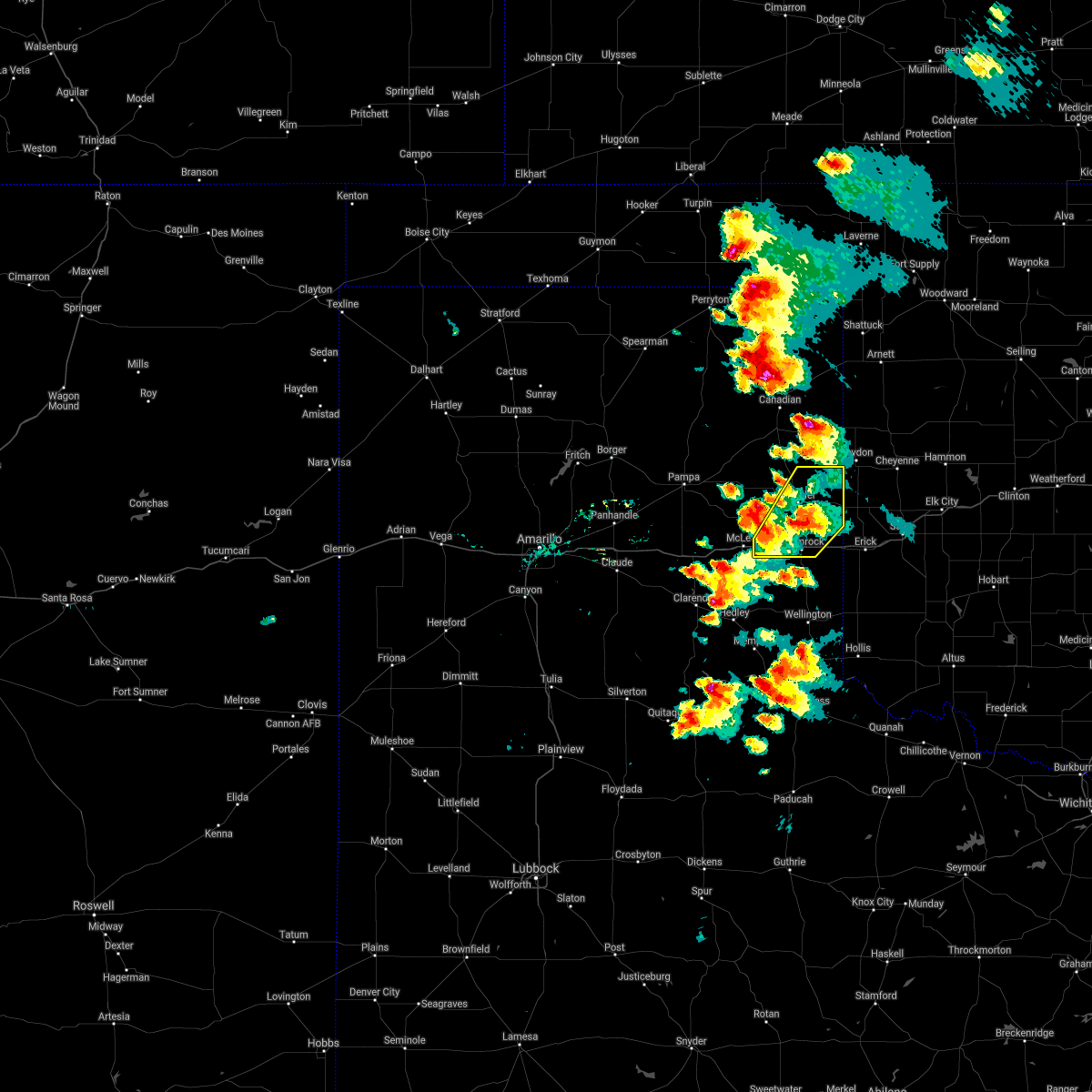 The severe thunderstorm warning for wheeler county will expire at 615 pm cdt. the storm which prompted the warning has weakened below severe limits, and no longer poses an immediate threat to life or property. therefore the warning will be allowed to expire. However small hail is still possible with this thunderstorm. The severe thunderstorm warning for wheeler county will expire at 615 pm cdt. the storm which prompted the warning has weakened below severe limits, and no longer poses an immediate threat to life or property. therefore the warning will be allowed to expire. However small hail is still possible with this thunderstorm.
|
| 5/13/2018 6:02 PM CDT |
 At 602 pm cdt, a severe thunderstorm was located near wheeler, or 14 miles north of shamrock, moving northeast at 20 mph (radar indicated). Hazards include 60 mph wind gusts and quarter size hail. Minor damage to roofs, siding, and trees is possible. hail damage to vehicles is expected. Locations impacted include, shamrock, briscoe, wheeler, allison, lela and twitty. At 602 pm cdt, a severe thunderstorm was located near wheeler, or 14 miles north of shamrock, moving northeast at 20 mph (radar indicated). Hazards include 60 mph wind gusts and quarter size hail. Minor damage to roofs, siding, and trees is possible. hail damage to vehicles is expected. Locations impacted include, shamrock, briscoe, wheeler, allison, lela and twitty.
|
| 5/13/2018 5:35 PM CDT | Tennis Ball sized hail reported 7.7 miles E of Shamrock, TX |
| 5/13/2018 5:35 PM CDT | Tea Cup sized hail reported 7.7 miles E of Shamrock, TX, picture of hail sent via twitter. |
| 5/13/2018 5:20 PM CDT |
 At 519 pm cdt, a severe thunderstorm was located over lela, or 4 miles west of shamrock, moving northeast at 20 mph (radar indicated). Hazards include 60 mph wind gusts and quarter size hail. Minor damage to roofs, siding, and trees is possible. Hail damage to vehicles is expected. At 519 pm cdt, a severe thunderstorm was located over lela, or 4 miles west of shamrock, moving northeast at 20 mph (radar indicated). Hazards include 60 mph wind gusts and quarter size hail. Minor damage to roofs, siding, and trees is possible. Hail damage to vehicles is expected.
|
| 5/11/2018 7:51 PM CDT |
 At 750 pm cdt, severe thunderstorms were located along a line extending from 4 miles east of allison to 6 miles west of sweetwater to 4 miles northwest of texola, moving northeast at 25 mph (radar indicated). Hazards include 60 mph wind gusts and penny size hail. Minor damage to roofs, siding, and trees is possible. Locations impacted include, shamrock, wheeler, allison, lela and twitty. At 750 pm cdt, severe thunderstorms were located along a line extending from 4 miles east of allison to 6 miles west of sweetwater to 4 miles northwest of texola, moving northeast at 25 mph (radar indicated). Hazards include 60 mph wind gusts and penny size hail. Minor damage to roofs, siding, and trees is possible. Locations impacted include, shamrock, wheeler, allison, lela and twitty.
|
| 5/11/2018 7:30 PM CDT |
 At 730 pm cdt, severe thunderstorms were located along a line extending from 3 miles southwest of allison to 8 miles northeast of twitty to dozier, moving northeast at 30 mph (radar indicated). Hazards include 70 mph wind gusts and quarter size hail. Expect some tree damage. damage is likely to mobile homes, roofs, and outbuildings. Hail damage to vehicles is expected. At 730 pm cdt, severe thunderstorms were located along a line extending from 3 miles southwest of allison to 8 miles northeast of twitty to dozier, moving northeast at 30 mph (radar indicated). Hazards include 70 mph wind gusts and quarter size hail. Expect some tree damage. damage is likely to mobile homes, roofs, and outbuildings. Hail damage to vehicles is expected.
|
| 5/11/2018 6:30 PM CDT |
 At 630 pm cdt, a severe thunderstorm was located over wheeler, or 16 miles north of shamrock, moving northeast at 20 mph (radar indicated). Hazards include 70 mph wind gusts and quarter size hail. Expect some tree damage. damage is likely to mobile homes, roofs, and outbuildings. hail damage to vehicles is expected. Locations impacted include, shamrock, briscoe, wheeler, new mobeetie, twitty, allison, lela, kellerville and mobeetie. At 630 pm cdt, a severe thunderstorm was located over wheeler, or 16 miles north of shamrock, moving northeast at 20 mph (radar indicated). Hazards include 70 mph wind gusts and quarter size hail. Expect some tree damage. damage is likely to mobile homes, roofs, and outbuildings. hail damage to vehicles is expected. Locations impacted include, shamrock, briscoe, wheeler, new mobeetie, twitty, allison, lela, kellerville and mobeetie.
|
| 5/11/2018 6:05 PM CDT |
 At 605 pm cdt, a severe thunderstorm was located 4 miles northeast of kellerville, or 17 miles northwest of shamrock, moving northeast at 20 mph (radar indicated). Hazards include 60 mph wind gusts and quarter size hail. Minor damage to roofs, siding, and trees is possible. Hail damage to vehicles is expected. At 605 pm cdt, a severe thunderstorm was located 4 miles northeast of kellerville, or 17 miles northwest of shamrock, moving northeast at 20 mph (radar indicated). Hazards include 60 mph wind gusts and quarter size hail. Minor damage to roofs, siding, and trees is possible. Hail damage to vehicles is expected.
|
| 10/6/2017 11:23 PM CDT |
 At 1123 pm cdt, severe thunderstorms were located along a line extending from 7 miles north of sweetwater to texola to 5 miles southwest of wellington, moving east at 50 mph (radar indicated). Hazards include 70 mph wind gusts and penny size hail. Expect some tree damage. damage is likely to mobile homes, roofs, and outbuildings. Locations impacted include, wellington, shamrock, wheeler, dodson, lutie, twitty, allison, dozier, lela, quail and samnorwood. At 1123 pm cdt, severe thunderstorms were located along a line extending from 7 miles north of sweetwater to texola to 5 miles southwest of wellington, moving east at 50 mph (radar indicated). Hazards include 70 mph wind gusts and penny size hail. Expect some tree damage. damage is likely to mobile homes, roofs, and outbuildings. Locations impacted include, wellington, shamrock, wheeler, dodson, lutie, twitty, allison, dozier, lela, quail and samnorwood.
|
| 10/6/2017 10:58 PM CDT |
 At 1058 pm cdt, severe thunderstorms were located along a line extending from 4 miles north of wheeler to near lela to 4 miles south of hedley, moving east at 50 mph (radar indicated). Hazards include 70 mph wind gusts and nickel size hail. Expect some tree damage. Damage is likely to mobile homes, roofs, and outbuildings. At 1058 pm cdt, severe thunderstorms were located along a line extending from 4 miles north of wheeler to near lela to 4 miles south of hedley, moving east at 50 mph (radar indicated). Hazards include 70 mph wind gusts and nickel size hail. Expect some tree damage. Damage is likely to mobile homes, roofs, and outbuildings.
|
| 10/6/2017 10:40 PM CDT |
 A severe thunderstorm warning remains in effect until 1100 pm cdt for wheeler and gray counties. at 1039 pm cdt, a severe thunderstorm was located near mclean, or 17 miles west of shamrock, moving east at 60 mph. this is a very dangerous storm. hazard. 80 mph wind gusts and quarter size hail. A severe thunderstorm warning remains in effect until 1100 pm cdt for wheeler and gray counties. at 1039 pm cdt, a severe thunderstorm was located near mclean, or 17 miles west of shamrock, moving east at 60 mph. this is a very dangerous storm. hazard. 80 mph wind gusts and quarter size hail.
|
| 10/6/2017 10:03 PM CDT |
 At 1002 pm cdt, a severe thunderstorm was located 9 miles northeast of groom, or 16 miles south of pampa, moving east at 60 mph (radar indicated). Hazards include 70 mph wind gusts and quarter size hail. Expect some tree damage. damage is likely to mobile homes, roofs, and outbuildings. Hail damage to vehicles is expected. At 1002 pm cdt, a severe thunderstorm was located 9 miles northeast of groom, or 16 miles south of pampa, moving east at 60 mph (radar indicated). Hazards include 70 mph wind gusts and quarter size hail. Expect some tree damage. damage is likely to mobile homes, roofs, and outbuildings. Hail damage to vehicles is expected.
|
| 8/13/2017 6:19 PM CDT |
 At 618 pm cdt, a severe thunderstorm was located near wheeler, or 19 miles north of shamrock, moving southeast at 25 mph (radar indicated). Hazards include 60 mph wind gusts and nickel size hail. minor damage to roofs, siding, and trees is possible At 618 pm cdt, a severe thunderstorm was located near wheeler, or 19 miles north of shamrock, moving southeast at 25 mph (radar indicated). Hazards include 60 mph wind gusts and nickel size hail. minor damage to roofs, siding, and trees is possible
|
| 6/13/2017 11:20 PM CDT |
 At 1120 pm cdt, a severe thunderstorm was located over texola, or 12 miles east of shamrock, moving east at 30 mph (radar indicated). Hazards include ping pong ball size hail. People and animals outdoors will be injured. expect damage to roofs, siding, windows, and vehicles. Locations impacted include, shamrock, dozier, samnorwood and twitty. At 1120 pm cdt, a severe thunderstorm was located over texola, or 12 miles east of shamrock, moving east at 30 mph (radar indicated). Hazards include ping pong ball size hail. People and animals outdoors will be injured. expect damage to roofs, siding, windows, and vehicles. Locations impacted include, shamrock, dozier, samnorwood and twitty.
|
| 6/13/2017 10:53 PM CDT |
 At 1053 pm cdt, a severe thunderstorm was located over shamrock, moving northeast at 50 mph (radar indicated). Hazards include ping pong ball size hail. People and animals outdoors will be injured. Expect damage to roofs, siding, windows, and vehicles. At 1053 pm cdt, a severe thunderstorm was located over shamrock, moving northeast at 50 mph (radar indicated). Hazards include ping pong ball size hail. People and animals outdoors will be injured. Expect damage to roofs, siding, windows, and vehicles.
|
| 6/13/2017 6:31 PM CDT |
 At 630 pm cdt, severe thunderstorms were located along a line extending from 6 miles southwest of lela to 4 miles northeast of memphis, moving northeast at 30 mph (radar indicated). Hazards include tennis ball size hail and 60 mph wind gusts. Minor damage to roofs, siding, and trees is possible. people and animals outdoors will be injured. expect hail damage to roofs, siding, windows, and vehicles. Locations impacted include, wellington, shamrock, dodson, lutie, twitty, dozier, lela, quail and samnorwood. At 630 pm cdt, severe thunderstorms were located along a line extending from 6 miles southwest of lela to 4 miles northeast of memphis, moving northeast at 30 mph (radar indicated). Hazards include tennis ball size hail and 60 mph wind gusts. Minor damage to roofs, siding, and trees is possible. people and animals outdoors will be injured. expect hail damage to roofs, siding, windows, and vehicles. Locations impacted include, wellington, shamrock, dodson, lutie, twitty, dozier, lela, quail and samnorwood.
|
| 6/13/2017 6:11 PM CDT |
 At 611 pm cdt, severe thunderstorms were located along a line extending from 10 miles south of mclean to 4 miles west of memphis, moving east at 35 mph (radar indicated). Hazards include 60 mph wind gusts and half dollar size hail. Minor damage to roofs, siding, and trees is possible. Hail damage to vehicles is expected. At 611 pm cdt, severe thunderstorms were located along a line extending from 10 miles south of mclean to 4 miles west of memphis, moving east at 35 mph (radar indicated). Hazards include 60 mph wind gusts and half dollar size hail. Minor damage to roofs, siding, and trees is possible. Hail damage to vehicles is expected.
|
| 5/16/2017 10:07 PM CDT |
 At 1007 pm cdt, a severe thunderstorm was located 5 miles southeast of twitty, or 5 miles northeast of shamrock, moving northeast at 50 mph (radar indicated). Hazards include 60 mph wind gusts and quarter size hail. Minor damage to roofs, siding, and trees is possible. hail damage to vehicles is expected. This severe thunderstorm will remain over mainly rural areas of southeastern wheeler and northeastern collingsworth counties. At 1007 pm cdt, a severe thunderstorm was located 5 miles southeast of twitty, or 5 miles northeast of shamrock, moving northeast at 50 mph (radar indicated). Hazards include 60 mph wind gusts and quarter size hail. Minor damage to roofs, siding, and trees is possible. hail damage to vehicles is expected. This severe thunderstorm will remain over mainly rural areas of southeastern wheeler and northeastern collingsworth counties.
|
| 5/16/2017 9:47 PM CDT |
 At 947 pm cdt, a severe thunderstorm was located near texola, or 12 miles east of shamrock, moving northeast at 45 mph (radar indicated). Hazards include 60 mph wind gusts and quarter size hail. Minor damage to roofs, siding, and trees is possible. hail damage to vehicles is expected. Locations impacted include, shamrock, lutie, samnorwood and twitty. At 947 pm cdt, a severe thunderstorm was located near texola, or 12 miles east of shamrock, moving northeast at 45 mph (radar indicated). Hazards include 60 mph wind gusts and quarter size hail. Minor damage to roofs, siding, and trees is possible. hail damage to vehicles is expected. Locations impacted include, shamrock, lutie, samnorwood and twitty.
|
| 5/16/2017 9:14 PM CDT |
 At 914 pm cdt, a severe thunderstorm was located 4 miles north of wellington, moving north at 45 mph (radar indicated). Hazards include 60 mph wind gusts and quarter size hail. Minor damage to roofs, siding, and trees is possible. Hail damage to vehicles is expected. At 914 pm cdt, a severe thunderstorm was located 4 miles north of wellington, moving north at 45 mph (radar indicated). Hazards include 60 mph wind gusts and quarter size hail. Minor damage to roofs, siding, and trees is possible. Hail damage to vehicles is expected.
|
| 5/16/2017 5:30 PM CDT | Half Dollar sized hail reported 14.3 miles N of Shamrock, TX |
| 3/28/2017 6:19 PM CDT |
 At 619 pm cdt, a confirmed tornado was located 4 miles northeast of lutie, or 10 miles south of shamrock, moving northeast at 35 mph (weather spotters confirmed tornado). Hazards include damaging tornado and golf ball size hail. Flying debris will be dangerous to those caught without shelter. mobile homes will be damaged or destroyed. damage to roofs, windows, and vehicles will occur. tree damage is likely. Locations impacted include, shamrock, samnorwood and lutie. At 619 pm cdt, a confirmed tornado was located 4 miles northeast of lutie, or 10 miles south of shamrock, moving northeast at 35 mph (weather spotters confirmed tornado). Hazards include damaging tornado and golf ball size hail. Flying debris will be dangerous to those caught without shelter. mobile homes will be damaged or destroyed. damage to roofs, windows, and vehicles will occur. tree damage is likely. Locations impacted include, shamrock, samnorwood and lutie.
|
| 3/28/2017 6:01 PM CDT |
 At 601 pm cdt, a confirmed tornado was located 6 miles northwest of wellington, moving northeast at 35 mph (weather spotters confirmed tornado). Hazards include damaging tornado and golf ball size hail. Flying debris will be dangerous to those caught without shelter. mobile homes will be damaged or destroyed. damage to roofs, windows, and vehicles will occur. tree damage is likely. Locations impacted include, wellington, shamrock, lutie, quail and samnorwood. At 601 pm cdt, a confirmed tornado was located 6 miles northwest of wellington, moving northeast at 35 mph (weather spotters confirmed tornado). Hazards include damaging tornado and golf ball size hail. Flying debris will be dangerous to those caught without shelter. mobile homes will be damaged or destroyed. damage to roofs, windows, and vehicles will occur. tree damage is likely. Locations impacted include, wellington, shamrock, lutie, quail and samnorwood.
|
| 3/28/2017 5:58 PM CDT |
 At 557 pm cdt, a severe thunderstorm capable of producing a tornado was located 5 miles northwest of wellington, moving northeast at 35 mph (radar indicated rotation). Hazards include tornado and golf ball size hail. Flying debris will be dangerous to those caught without shelter. mobile homes will be damaged or destroyed. damage to roofs, windows, and vehicles will occur. Tree damage is likely. At 557 pm cdt, a severe thunderstorm capable of producing a tornado was located 5 miles northwest of wellington, moving northeast at 35 mph (radar indicated rotation). Hazards include tornado and golf ball size hail. Flying debris will be dangerous to those caught without shelter. mobile homes will be damaged or destroyed. damage to roofs, windows, and vehicles will occur. Tree damage is likely.
|
| 9/17/2016 2:25 PM CDT |
 At 225 pm cdt, severe thunderstorms were located along a line extending from 5 miles west of sweetwater to 4 miles south of texola to near wellington, moving east at 30 mph (radar indicated). Hazards include 60 mph wind gusts and quarter size hail. Minor damage to roofs. siding. and trees is possible. hail damage to vehicles is expected. locations impacted include, wellington, shamrock, dodson, lutie, dozier, allison, twitty, samnorwood and quail. This includes interstate 40 between mile markers 158 and 176. At 225 pm cdt, severe thunderstorms were located along a line extending from 5 miles west of sweetwater to 4 miles south of texola to near wellington, moving east at 30 mph (radar indicated). Hazards include 60 mph wind gusts and quarter size hail. Minor damage to roofs. siding. and trees is possible. hail damage to vehicles is expected. locations impacted include, wellington, shamrock, dodson, lutie, dozier, allison, twitty, samnorwood and quail. This includes interstate 40 between mile markers 158 and 176.
|
| 9/17/2016 2:11 PM CDT |
 At 210 pm cdt, a severe thunderstorm was located 7 miles east of shamrock, moving east at 45 mph (radar indicated). Hazards include 60 mph wind gusts and quarter size hail. Minor damage to roofs. siding. and trees is possible. hail damage to vehicles is expected. locations impacted include, wellington, shamrock, briscoe, wheeler, dodson, lutie, dozier, allison, lela, twitty, samnorwood and quail. This includes interstate 40 between mile markers 154 and 176. At 210 pm cdt, a severe thunderstorm was located 7 miles east of shamrock, moving east at 45 mph (radar indicated). Hazards include 60 mph wind gusts and quarter size hail. Minor damage to roofs. siding. and trees is possible. hail damage to vehicles is expected. locations impacted include, wellington, shamrock, briscoe, wheeler, dodson, lutie, dozier, allison, lela, twitty, samnorwood and quail. This includes interstate 40 between mile markers 154 and 176.
|
| 9/17/2016 1:52 PM CDT |
 At 151 pm cdt, a severe thunderstorm was located over lela, or 6 miles west of shamrock, moving east at 45 mph (radar indicated). Hazards include 60 mph wind gusts and half dollar size hail. Minor damage to roofs. siding. and trees is possible. hail damage to vehicles is expected. locations impacted include, wellington, shamrock, briscoe, wheeler, mclean, lefors, hedley, dodson, lutie, lela, lelia lake, twitty, samnorwood, quail, dozier, allison, alanreed, new mobeetie, kellerville and mobeetie. This includes interstate 40 between mile markers 130 and 176. At 151 pm cdt, a severe thunderstorm was located over lela, or 6 miles west of shamrock, moving east at 45 mph (radar indicated). Hazards include 60 mph wind gusts and half dollar size hail. Minor damage to roofs. siding. and trees is possible. hail damage to vehicles is expected. locations impacted include, wellington, shamrock, briscoe, wheeler, mclean, lefors, hedley, dodson, lutie, lela, lelia lake, twitty, samnorwood, quail, dozier, allison, alanreed, new mobeetie, kellerville and mobeetie. This includes interstate 40 between mile markers 130 and 176.
|
| 9/17/2016 1:34 PM CDT |
 At 134 pm cdt, a severe thunderstorm was located over mclean, or 20 miles west of shamrock, moving east at 45 mph (radar indicated). Hazards include 70 mph wind gusts and ping pong ball size hail. Expect some tree damage. damage is likely to mobile homes, roofs, and outbuildings. people and animals outdoors will be injured. Expect hail damage to roofs, siding, windows, and vehicles. At 134 pm cdt, a severe thunderstorm was located over mclean, or 20 miles west of shamrock, moving east at 45 mph (radar indicated). Hazards include 70 mph wind gusts and ping pong ball size hail. Expect some tree damage. damage is likely to mobile homes, roofs, and outbuildings. people and animals outdoors will be injured. Expect hail damage to roofs, siding, windows, and vehicles.
|
| 7/15/2016 10:18 PM CDT |
 At 1017 pm cdt, severe thunderstorms were located along a line extending from near texola to 4 miles northeast of memphis, moving east-southeast at 40 mph (radar indicated). Hazards include 70 mph wind gusts and penny size hail. Expect some tree damage. damage is likely to mobile homes. roofs, and outbuildings. locations impacted include, wellington, shamrock, hedley, lutie, dozier, lela, lelia lake, twitty, samnorwood and quail. This includes interstate 40 between mile markers 154 and 176. At 1017 pm cdt, severe thunderstorms were located along a line extending from near texola to 4 miles northeast of memphis, moving east-southeast at 40 mph (radar indicated). Hazards include 70 mph wind gusts and penny size hail. Expect some tree damage. damage is likely to mobile homes. roofs, and outbuildings. locations impacted include, wellington, shamrock, hedley, lutie, dozier, lela, lelia lake, twitty, samnorwood and quail. This includes interstate 40 between mile markers 154 and 176.
|
| 7/15/2016 10:06 PM CDT |
 At 1006 pm cdt, severe thunderstorms were located along a line extending from 3 miles west of texola to 5 miles southeast of hedley, moving southeast at 45 mph (radar indicated). Hazards include 60 mph wind gusts and penny size hail. Minor damage to roofs. siding. and trees is possible. locations impacted include, wellington, clarendon, shamrock, wheeler, hedley, lutie, lela, lelia lake, twitty, quail, samnorwood, dozier and kellerville. This includes interstate 40 between mile markers 147 and 176. At 1006 pm cdt, severe thunderstorms were located along a line extending from 3 miles west of texola to 5 miles southeast of hedley, moving southeast at 45 mph (radar indicated). Hazards include 60 mph wind gusts and penny size hail. Minor damage to roofs. siding. and trees is possible. locations impacted include, wellington, clarendon, shamrock, wheeler, hedley, lutie, lela, lelia lake, twitty, quail, samnorwood, dozier and kellerville. This includes interstate 40 between mile markers 147 and 176.
|
| 7/15/2016 9:48 PM CDT |
 At 947 pm cdt, severe thunderstorms were located along a line extending from 7 miles northeast of twitty to 6 miles northeast of lelia lake, moving east at 40 mph (radar indicated). Hazards include 60 mph wind gusts and penny size hail. Minor damage to roofs. siding. and trees is possible. Locations impacted include, wellington, clarendon, shamrock, briscoe, wheeler, mclean, lefors, howardwick, hedley, lutie, lake mcclellan, lela, lelia lake, twitty, samnorwood, quail, dozier, allison, greenbelt lake and alanreed. At 947 pm cdt, severe thunderstorms were located along a line extending from 7 miles northeast of twitty to 6 miles northeast of lelia lake, moving east at 40 mph (radar indicated). Hazards include 60 mph wind gusts and penny size hail. Minor damage to roofs. siding. and trees is possible. Locations impacted include, wellington, clarendon, shamrock, briscoe, wheeler, mclean, lefors, howardwick, hedley, lutie, lake mcclellan, lela, lelia lake, twitty, samnorwood, quail, dozier, allison, greenbelt lake and alanreed.
|
| 7/15/2016 9:30 PM CDT |
 At 930 pm cdt, severe thunderstorms were located along a line extending from 3 miles east of briscoe to 4 miles southwest of alanreed, moving east at 40 mph (radar indicated). Hazards include 60 mph wind gusts and penny size hail. Minor damage to roofs. siding. And trees is possible. At 930 pm cdt, severe thunderstorms were located along a line extending from 3 miles east of briscoe to 4 miles southwest of alanreed, moving east at 40 mph (radar indicated). Hazards include 60 mph wind gusts and penny size hail. Minor damage to roofs. siding. And trees is possible.
|
| 5/29/2016 4:55 PM CDT | The severe thunderstorm warning for collingsworth, armstrong, carson, southern wheeler, southern gray and donley counties will expire at 500 pm cdt, the storms which prompted the warning have weakened below severe limits, and no longer pose an immediate threat to life or property. therefore the warning will be allowed to expire. however heavy rain is still possible with these thunderstorms. a severe thunderstorm watch remains in effect until 1000 pm cdt for central texas. remember, a severe thunderstorm warning still remains in effect for the texas panhandle until 10 pm. |
| 5/29/2016 4:42 PM CDT |
 At 442 pm cdt, severe thunderstorms were located along a line extending from 6 miles northeast of twitty to 6 miles north of wayside, moving east at 15 mph (radar indicated). Hazards include golf ball size hail and 60 mph wind gusts. Minor damage to roofs. siding. and trees is possible. people and animals outdoors will be injured. expect hail damage to roofs, siding, windows, and vehicles. locations impacted include, panhandle, wellington, clarendon, shamrock, claude, white deer, mclean, groom, howardwick, hedley, dodson, lutie, lake mcclellan, lela, lelia lake, twitty, goodnight, samnorwood, quail and wayside. This includes interstate 40 between mile markers 84 and 176. At 442 pm cdt, severe thunderstorms were located along a line extending from 6 miles northeast of twitty to 6 miles north of wayside, moving east at 15 mph (radar indicated). Hazards include golf ball size hail and 60 mph wind gusts. Minor damage to roofs. siding. and trees is possible. people and animals outdoors will be injured. expect hail damage to roofs, siding, windows, and vehicles. locations impacted include, panhandle, wellington, clarendon, shamrock, claude, white deer, mclean, groom, howardwick, hedley, dodson, lutie, lake mcclellan, lela, lelia lake, twitty, goodnight, samnorwood, quail and wayside. This includes interstate 40 between mile markers 84 and 176.
|
| 5/29/2016 3:56 PM CDT |
 At 356 pm cdt, severe thunderstorms were located along a line extending from 8 miles southeast of allison to 4 miles southwest of groom, moving east at 20 mph (radar indicated). Hazards include golf ball size hail and 60 mph wind gusts. Minor damage to roofs. siding. and trees is possible. people and animals outdoors will be injured. Expect hail damage to roofs, siding, windows, and vehicles. At 356 pm cdt, severe thunderstorms were located along a line extending from 8 miles southeast of allison to 4 miles southwest of groom, moving east at 20 mph (radar indicated). Hazards include golf ball size hail and 60 mph wind gusts. Minor damage to roofs. siding. and trees is possible. people and animals outdoors will be injured. Expect hail damage to roofs, siding, windows, and vehicles.
|
| 5/16/2016 11:31 PM CDT |
 At 1131 pm cdt, severe thunderstorms were located along a line extending from 3 miles southeast of mclean to clarendon to 11 miles northeast of wayside, moving southeast at 20 mph (radar indicated). Hazards include 60 mph wind gusts and quarter size hail. Minor damage to roofs. siding. and trees is possible. hail damage to vehicles is expected. Locations impacted include, wellington, clarendon, shamrock, mclean, howardwick, hedley, dodson, lutie, lela, lelia lake, samnorwood, quail, dozier and greenbelt lake. At 1131 pm cdt, severe thunderstorms were located along a line extending from 3 miles southeast of mclean to clarendon to 11 miles northeast of wayside, moving southeast at 20 mph (radar indicated). Hazards include 60 mph wind gusts and quarter size hail. Minor damage to roofs. siding. and trees is possible. hail damage to vehicles is expected. Locations impacted include, wellington, clarendon, shamrock, mclean, howardwick, hedley, dodson, lutie, lela, lelia lake, samnorwood, quail, dozier and greenbelt lake.
|
| 5/16/2016 11:18 PM CDT |
 At 1117 pm cdt, severe thunderstorms were located along a line extending from alanreed to greenbelt lake to 10 miles northeast of wayside, moving southeast at 20 mph (radar indicated). Hazards include 60 mph wind gusts and half dollar size hail. Minor damage to roofs. siding. and trees is possible. hail damage to vehicles is expected. hail may accumulate on roadways causing hazardous travel. Locations impacted include, wellington, clarendon, shamrock, mclean, howardwick, hedley, dodson, lutie, lela, lelia lake, goodnight, samnorwood, quail, dozier, greenbelt lake and alanreed. At 1117 pm cdt, severe thunderstorms were located along a line extending from alanreed to greenbelt lake to 10 miles northeast of wayside, moving southeast at 20 mph (radar indicated). Hazards include 60 mph wind gusts and half dollar size hail. Minor damage to roofs. siding. and trees is possible. hail damage to vehicles is expected. hail may accumulate on roadways causing hazardous travel. Locations impacted include, wellington, clarendon, shamrock, mclean, howardwick, hedley, dodson, lutie, lela, lelia lake, goodnight, samnorwood, quail, dozier, greenbelt lake and alanreed.
|
| 5/16/2016 11:03 PM CDT |
 At 1101 pm cdt, severe thunderstorms were located along a line extending from 7 miles southeast of lefors to howardwick to 10 miles northeast of wayside, moving southeast at 25 mph. another severe thunderstorm was located just east of shamrock and was also moving southeast at 25 mph (radar indicated). Hazards include 60 mph wind gusts and half dollar size hail. Minor damage to roofs. siding. and trees is possible. hail damage to vehicles is expected. hail may accumulate on roadways causing hazardous travel. Locations impacted include, clarendon, shamrock, mclean, howardwick, hedley, dodson, lutie, lake mcclellan, lela, lelia lake, twitty, goodnight, samnorwood, quail, dozier, greenbelt lake, alanreed and kellerville. At 1101 pm cdt, severe thunderstorms were located along a line extending from 7 miles southeast of lefors to howardwick to 10 miles northeast of wayside, moving southeast at 25 mph. another severe thunderstorm was located just east of shamrock and was also moving southeast at 25 mph (radar indicated). Hazards include 60 mph wind gusts and half dollar size hail. Minor damage to roofs. siding. and trees is possible. hail damage to vehicles is expected. hail may accumulate on roadways causing hazardous travel. Locations impacted include, clarendon, shamrock, mclean, howardwick, hedley, dodson, lutie, lake mcclellan, lela, lelia lake, twitty, goodnight, samnorwood, quail, dozier, greenbelt lake, alanreed and kellerville.
|
| 5/16/2016 10:47 PM CDT |
 At 1047 pm cdt, severe thunderstorms were located along a line extending from near shamrock to near lake mcclellan to 9 miles southwest of claude, moving southeast at 30 mph (radar indicated). Hazards include ping pong ball size hail and 60 mph wind gusts. Minor damage to roofs. siding. and trees is possible. people and animals outdoors will be injured. expect hail damage to roofs, siding, windows, and vehicles. Hail may accumulate on roadways causing hazardous travel. At 1047 pm cdt, severe thunderstorms were located along a line extending from near shamrock to near lake mcclellan to 9 miles southwest of claude, moving southeast at 30 mph (radar indicated). Hazards include ping pong ball size hail and 60 mph wind gusts. Minor damage to roofs. siding. and trees is possible. people and animals outdoors will be injured. expect hail damage to roofs, siding, windows, and vehicles. Hail may accumulate on roadways causing hazardous travel.
|
| 5/16/2016 10:28 PM CDT |
 At 1026 pm cdt, one severe thunderstorm was located 6 miles north of lela and another thunderstorm was located 8 miles southeast of white deer. both storms are moving east at 35 mph (radar indicated). Hazards include golf ball size hail and 60 mph wind gusts. Minor damage to roofs. siding. and trees is possible. people and animals outdoors will be injured. expect hail damage to roofs, siding, windows, and vehicles. hail may accumulate on roadways causing hazardous travel. these thunderstorms have caused hail accumulation on interstate 40 which has impacted travel. Locations impacted include, shamrock, mclean, lefors, kingsmill, lela, twitty and kellerville. At 1026 pm cdt, one severe thunderstorm was located 6 miles north of lela and another thunderstorm was located 8 miles southeast of white deer. both storms are moving east at 35 mph (radar indicated). Hazards include golf ball size hail and 60 mph wind gusts. Minor damage to roofs. siding. and trees is possible. people and animals outdoors will be injured. expect hail damage to roofs, siding, windows, and vehicles. hail may accumulate on roadways causing hazardous travel. these thunderstorms have caused hail accumulation on interstate 40 which has impacted travel. Locations impacted include, shamrock, mclean, lefors, kingsmill, lela, twitty and kellerville.
|
| 5/16/2016 10:11 PM CDT |
 At 1010 pm cdt, severe thunderstorms were located along a line extending from 3 miles west of strong city to 5 miles west of sweetwater to near kellerville, moving southeast at 40 mph (radar indicated). Hazards include 70 mph wind gusts and quarter size hail. Expect some tree damage. damage is likely to mobile homes. roofs, and outbuildings. hail damage to vehicles is expected. Locations impacted include, shamrock, wheeler, mclean, lefors, kingsmill, lela, twitty and kellerville. At 1010 pm cdt, severe thunderstorms were located along a line extending from 3 miles west of strong city to 5 miles west of sweetwater to near kellerville, moving southeast at 40 mph (radar indicated). Hazards include 70 mph wind gusts and quarter size hail. Expect some tree damage. damage is likely to mobile homes. roofs, and outbuildings. hail damage to vehicles is expected. Locations impacted include, shamrock, wheeler, mclean, lefors, kingsmill, lela, twitty and kellerville.
|
| 5/16/2016 9:55 PM CDT |
 At 954 pm cdt, severe thunderstorms were located along a line extending from 5 miles south of crawford to 6 miles east of wheeler to 8 miles northwest of mclean, moving southeast at 40 mph (radar indicated). Hazards include 70 mph wind gusts and quarter size hail. Expect some tree damage. damage is likely to mobile homes. roofs, and outbuildings. hail damage to vehicles is expected. Locations impacted include, shamrock, briscoe, wheeler, mclean, lefors, allison, kingsmill, lela, twitty, new mobeetie, kellerville and mobeetie. At 954 pm cdt, severe thunderstorms were located along a line extending from 5 miles south of crawford to 6 miles east of wheeler to 8 miles northwest of mclean, moving southeast at 40 mph (radar indicated). Hazards include 70 mph wind gusts and quarter size hail. Expect some tree damage. damage is likely to mobile homes. roofs, and outbuildings. hail damage to vehicles is expected. Locations impacted include, shamrock, briscoe, wheeler, mclean, lefors, allison, kingsmill, lela, twitty, new mobeetie, kellerville and mobeetie.
|
| 5/16/2016 9:39 PM CDT |
 At 939 pm cdt, severe thunderstorms were located along a line extending from 5 miles southwest of crawford to 5 miles northeast of wheeler to 6 miles southeast of lefors, moving southeast at 50 mph (radar indicated). Hazards include 70 mph wind gusts and quarter size hail. Expect some tree damage. damage is likely to mobile homes. roofs, and outbuildings. hail damage to vehicles is expected. Locations impacted include, pampa, shamrock, miami, briscoe, wheeler, mclean, lefors, codman, lela, twitty, lake marvin, allison, kingsmill, new mobeetie, kellerville and mobeetie. At 939 pm cdt, severe thunderstorms were located along a line extending from 5 miles southwest of crawford to 5 miles northeast of wheeler to 6 miles southeast of lefors, moving southeast at 50 mph (radar indicated). Hazards include 70 mph wind gusts and quarter size hail. Expect some tree damage. damage is likely to mobile homes. roofs, and outbuildings. hail damage to vehicles is expected. Locations impacted include, pampa, shamrock, miami, briscoe, wheeler, mclean, lefors, codman, lela, twitty, lake marvin, allison, kingsmill, new mobeetie, kellerville and mobeetie.
|
| 5/16/2016 9:25 PM CDT |
 At 925 pm cdt, severe thunderstorms were located along a line extending from 5 miles east of lake marvin to 5 miles northwest of lefors, moving southeast at 40 mph (radar indicated). Hazards include 70 mph wind gusts and half dollar size hail. Expect some tree damage. damage is likely to mobile homes, roofs, and outbuildings. Hail damage to vehicles is expected. At 925 pm cdt, severe thunderstorms were located along a line extending from 5 miles east of lake marvin to 5 miles northwest of lefors, moving southeast at 40 mph (radar indicated). Hazards include 70 mph wind gusts and half dollar size hail. Expect some tree damage. damage is likely to mobile homes, roofs, and outbuildings. Hail damage to vehicles is expected.
|
| 5/13/2016 5:06 PM CDT |
 At 505 pm cdt, a severe thunderstorm was located near lela, or 8 miles west of shamrock, moving southeast at 25 mph. at 500 pm cdt, the public reported hail was accumulating on interstate 40 between exit 152 and 157 west of lela (public). Hazards include 70 mph wind gusts and ping pong ball size hail. Expect some tree damage. damage is likely to mobile homes. roofs, and outbuildings. people and animals outdoors will be injured. expect hail damage to roofs, siding, windows, and vehicles. hail may accumulate on roadways causing hazardous travel. Locations impacted include, shamrock, lela, dozier and samnorwood. At 505 pm cdt, a severe thunderstorm was located near lela, or 8 miles west of shamrock, moving southeast at 25 mph. at 500 pm cdt, the public reported hail was accumulating on interstate 40 between exit 152 and 157 west of lela (public). Hazards include 70 mph wind gusts and ping pong ball size hail. Expect some tree damage. damage is likely to mobile homes. roofs, and outbuildings. people and animals outdoors will be injured. expect hail damage to roofs, siding, windows, and vehicles. hail may accumulate on roadways causing hazardous travel. Locations impacted include, shamrock, lela, dozier and samnorwood.
|
| 5/13/2016 5:00 PM CDT |
 At 459 pm cdt, a severe thunderstorm was located 4 miles west of lela, or 10 miles west of shamrock, moving east at 25 mph. this storm has a history of producing ping pong ball sized hail (radar indicated). Hazards include 70 mph wind gusts and ping pong ball size hail. Expect some tree damage. damage is likely to mobile homes. roofs, and outbuildings. people and animals outdoors will be injured. expect hail damage to roofs, siding, windows, and vehicles. hail may accumulate on roadways causing hazardous travel. Locations impacted include, shamrock, lela, dozier, kellerville and samnorwood. At 459 pm cdt, a severe thunderstorm was located 4 miles west of lela, or 10 miles west of shamrock, moving east at 25 mph. this storm has a history of producing ping pong ball sized hail (radar indicated). Hazards include 70 mph wind gusts and ping pong ball size hail. Expect some tree damage. damage is likely to mobile homes. roofs, and outbuildings. people and animals outdoors will be injured. expect hail damage to roofs, siding, windows, and vehicles. hail may accumulate on roadways causing hazardous travel. Locations impacted include, shamrock, lela, dozier, kellerville and samnorwood.
|
| 5/13/2016 4:56 PM CDT | Quarter sized hail reported 0.3 miles SE of Shamrock, TX |
| 5/13/2016 4:48 PM CDT | Quarter sized hail reported 0.9 miles SSE of Shamrock, TX, quarter sized hail reported...no accumulation on area roadways. |
| 5/13/2016 4:48 PM CDT |
 At 448 pm cdt, a severe thunderstorm was located 6 miles east of twitty, or 10 miles northeast of shamrock, moving southeast at 25 mph. a second severe storm was located near shamrock moving southeast at 25 mph (radar indicated). Hazards include golf ball size hail and 70 mph wind gusts. Expect some tree damage. damage is likely to mobile homes, roofs, and outbuildings. people and animals outdoors will be injured. Expect hail damage to roofs, siding, windows, and vehicles. At 448 pm cdt, a severe thunderstorm was located 6 miles east of twitty, or 10 miles northeast of shamrock, moving southeast at 25 mph. a second severe storm was located near shamrock moving southeast at 25 mph (radar indicated). Hazards include golf ball size hail and 70 mph wind gusts. Expect some tree damage. damage is likely to mobile homes, roofs, and outbuildings. people and animals outdoors will be injured. Expect hail damage to roofs, siding, windows, and vehicles.
|
| 5/13/2016 4:39 PM CDT |
 At 439 pm cdt, a severe thunderstorm was located 5 miles east of mclean, or 14 miles west of shamrock, moving southeast at 25 mph. at 437 pm cdt, trained spotters reported ping pong ball sized hail accumulating up to one inch 5 miles northeast of mcclean (trained weather spotters). Hazards include ping pong ball size hail and 60 mph wind gusts. Minor damage to roofs. siding. and trees is possible. people and animals outdoors will be injured. expect hail damage to roofs, siding, windows, and vehicles. Locations impacted include, shamrock, lela, dozier, kellerville and samnorwood. At 439 pm cdt, a severe thunderstorm was located 5 miles east of mclean, or 14 miles west of shamrock, moving southeast at 25 mph. at 437 pm cdt, trained spotters reported ping pong ball sized hail accumulating up to one inch 5 miles northeast of mcclean (trained weather spotters). Hazards include ping pong ball size hail and 60 mph wind gusts. Minor damage to roofs. siding. and trees is possible. people and animals outdoors will be injured. expect hail damage to roofs, siding, windows, and vehicles. Locations impacted include, shamrock, lela, dozier, kellerville and samnorwood.
|
| 5/13/2016 4:27 PM CDT |
 At 427 pm cdt, a severe thunderstorm was located 4 miles northeast of mclean, or 18 miles west of shamrock, moving east at 30 mph (radar indicated). Hazards include ping pong ball size hail and 60 mph wind gusts. Minor damage to roofs. siding. and trees is possible. people and animals outdoors will be injured. Expect hail damage to roofs, siding, windows, and vehicles. At 427 pm cdt, a severe thunderstorm was located 4 miles northeast of mclean, or 18 miles west of shamrock, moving east at 30 mph (radar indicated). Hazards include ping pong ball size hail and 60 mph wind gusts. Minor damage to roofs. siding. and trees is possible. people and animals outdoors will be injured. Expect hail damage to roofs, siding, windows, and vehicles.
|
| 11/16/2015 9:41 PM CST |
 At 941 pm cst, severe thunderstorms were located extending from near twitty to wellington, moving northeast at 50 mph (radar indicated). Hazards include 60 mph wind gusts. Minor damage to roofs. siding and trees is possible. locations impacted include, wellington, shamrock, wheeler, dodson, lutie, allison, twitty and samnorwood. A tornado watch remains in effect until 300 am cst for central texas. At 941 pm cst, severe thunderstorms were located extending from near twitty to wellington, moving northeast at 50 mph (radar indicated). Hazards include 60 mph wind gusts. Minor damage to roofs. siding and trees is possible. locations impacted include, wellington, shamrock, wheeler, dodson, lutie, allison, twitty and samnorwood. A tornado watch remains in effect until 300 am cst for central texas.
|
| 11/16/2015 9:17 PM CST |
 At 916 pm cst, severe thunderstorms were located extending from near lela to near quail, moving northeast at 55 mph (radar indicated). Hazards include 70 mph wind gusts and nickel size hail. Expect some tree damage. damage is likely to mobile homes, roofs and outbuildings. locations impacted include, wellington, shamrock, wheeler, dodson, lutie, allison, dozier, lela, twitty, samnorwood and quail. A tornado watch remains in effect until 300 am cst. At 916 pm cst, severe thunderstorms were located extending from near lela to near quail, moving northeast at 55 mph (radar indicated). Hazards include 70 mph wind gusts and nickel size hail. Expect some tree damage. damage is likely to mobile homes, roofs and outbuildings. locations impacted include, wellington, shamrock, wheeler, dodson, lutie, allison, dozier, lela, twitty, samnorwood and quail. A tornado watch remains in effect until 300 am cst.
|
| 11/16/2015 9:03 PM CST |
 At 903 pm cst, severe thunderstorms were located extending from 12 miles north of hedley to near memphis, moving northeast at 70 mph (radar indicated). Hazards include 70 mph wind gusts and nickel size hail. Expect some tree damage. Damage is likely to mobile homes, roofs and outbuildings. At 903 pm cst, severe thunderstorms were located extending from 12 miles north of hedley to near memphis, moving northeast at 70 mph (radar indicated). Hazards include 70 mph wind gusts and nickel size hail. Expect some tree damage. Damage is likely to mobile homes, roofs and outbuildings.
|
| 9/20/2015 5:11 PM CDT |
 At 511 pm cdt, a severe thunderstorm was located near kellerville, or 13 miles west of shamrock, moving southeast at 25 mph (radar indicated). Hazards include ping pong ball size hail and 60 mph wind gusts. People and animals outdoors will be injured. expect hail damage to roofs, siding, windows and vehicles. minor wind damage to roofs, siding and trees is possible. Locations impacted include, shamrock, mclean, lela, twitty and kellerville. At 511 pm cdt, a severe thunderstorm was located near kellerville, or 13 miles west of shamrock, moving southeast at 25 mph (radar indicated). Hazards include ping pong ball size hail and 60 mph wind gusts. People and animals outdoors will be injured. expect hail damage to roofs, siding, windows and vehicles. minor wind damage to roofs, siding and trees is possible. Locations impacted include, shamrock, mclean, lela, twitty and kellerville.
|
| 9/20/2015 4:53 PM CDT |
 At 453 pm cdt, a severe thunderstorm was located over kellerville, or 19 miles northwest of shamrock, moving southeast at 20 mph (radar indicated). Hazards include 60 mph wind gusts and quarter size hail. Hail damage to vehicles is expected. Minor wind damage to roofs, siding and trees is possible. At 453 pm cdt, a severe thunderstorm was located over kellerville, or 19 miles northwest of shamrock, moving southeast at 20 mph (radar indicated). Hazards include 60 mph wind gusts and quarter size hail. Hail damage to vehicles is expected. Minor wind damage to roofs, siding and trees is possible.
|
| 8/19/2015 12:47 AM CDT |
 At 1247 am cdt, a severe thunderstorm was located near lela, or 8 miles northwest of shamrock, moving east at 25 mph (radar indicated). Hazards include 60 mph wind gusts and quarter size hail. Hail damage to vehicles is expected. minor wind damage to roofs, siding and trees is possible. Locations impacted include, shamrock, lela and twitty. At 1247 am cdt, a severe thunderstorm was located near lela, or 8 miles northwest of shamrock, moving east at 25 mph (radar indicated). Hazards include 60 mph wind gusts and quarter size hail. Hail damage to vehicles is expected. minor wind damage to roofs, siding and trees is possible. Locations impacted include, shamrock, lela and twitty.
|
| 8/19/2015 12:33 AM CDT |
 At 1233 am cdt, a severe thunderstorm was located near kellerville, or 15 miles northwest of shamrock, moving east at 25 mph (radar indicated). Hazards include golf ball size hail and 60 mph wind gusts. People and animals outdoors will be injured. expect hail damage to roofs, siding, windows and vehicles. minor wind damage to roofs, siding and trees is possible. Locations impacted include, wheeler, mclean, lela, twitty, dozier and kellerville. At 1233 am cdt, a severe thunderstorm was located near kellerville, or 15 miles northwest of shamrock, moving east at 25 mph (radar indicated). Hazards include golf ball size hail and 60 mph wind gusts. People and animals outdoors will be injured. expect hail damage to roofs, siding, windows and vehicles. minor wind damage to roofs, siding and trees is possible. Locations impacted include, wheeler, mclean, lela, twitty, dozier and kellerville.
|
| 8/19/2015 12:22 AM CDT |
 At 1222 am cdt, a severe thunderstorm was located near kellerville, or 20 miles northwest of shamrock, moving east at 25 mph (radar indicated). Hazards include golf ball size hail and 60 mph wind gusts. People and animals outdoors will be injured. expect hail damage to roofs, siding, windows and vehicles. minor wind damage to roofs, siding and trees is possible. Locations impacted include, wheeler, mclean, dozier, lela, twitty, new mobeetie, kellerville and mobeetie. At 1222 am cdt, a severe thunderstorm was located near kellerville, or 20 miles northwest of shamrock, moving east at 25 mph (radar indicated). Hazards include golf ball size hail and 60 mph wind gusts. People and animals outdoors will be injured. expect hail damage to roofs, siding, windows and vehicles. minor wind damage to roofs, siding and trees is possible. Locations impacted include, wheeler, mclean, dozier, lela, twitty, new mobeetie, kellerville and mobeetie.
|
| 8/18/2015 11:54 PM CDT |
 At 1154 pm cdt, a severe thunderstorm was located over lefors, or 13 miles southeast of pampa, moving east at 25 mph (radar indicated). Hazards include 60 mph wind gusts and quarter size hail. Hail damage to vehicles is expected. Minor wind damage to roofs, siding and trees is possible. At 1154 pm cdt, a severe thunderstorm was located over lefors, or 13 miles southeast of pampa, moving east at 25 mph (radar indicated). Hazards include 60 mph wind gusts and quarter size hail. Hail damage to vehicles is expected. Minor wind damage to roofs, siding and trees is possible.
|
| 6/7/2015 9:06 PM CDT | The severe thunderstorm warning for collingsworth, wheeler and hemphill counties will expire at 915 pm cdt, the line of storms which prompted the warning has weakened and moved out of the warned area. however, heavy rain is still possible with these thunderstorms. |
| 6/7/2015 8:58 PM CDT | At 854 pm cdt, severe thunderstorms were located along a line extending from 8 miles southwest of durham to 7 miles southeast of mclean, and moving southeast at 30 mph (radar indicated). Hazards include 60 mph wind gusts. Minor damage to roofs. Siding and trees is possible. |
| 6/7/2015 8:42 PM CDT | At 838 pm cdt, severe thunderstorms were located along a line extending from 6 miles south of lake marvin to 7 miles north of lela to 8 miles west of howardwick, and moving southeast at 30 mph (radar indicated). Hazards include 60 mph wind gusts. Minor damage to roofs. Siding and trees is possible. |
| 6/7/2015 8:25 PM CDT | At 822 pm cdt, severe thunderstorms were located along a line extending from 6 miles west of durham to new mobeetie to 6 miles southeast of groom, and moving southeast at 30 mph (radar indicated). Hazards include 60 mph wind gusts. Minor damage to roofs. Siding and trees is possible. |
| 6/7/2015 8:01 PM CDT | At 759 pm cdt, severe thunderstorms were located along a line extending from 6 miles south of higgins to 9 miles east of lora to 9 miles southeast of kingsmill, and moving southeast at 30 mph (radar indicated). Hazards include 70 mph wind gusts. Expect some tree damage. damage is likely to mobile homes. Roofs and outbuildings. |
| 6/7/2015 7:45 PM CDT | At 742 pm cdt, severe thunderstorms were located along a line extending from 9 miles southeast of follett to 6 miles southeast of canadian to kingsmill, and moving southeast at 30 mph (radar indicated). Hazards include 70 mph wind gusts. Expect some tree damage. Damage is likely to mobile homes, roofs and outbuildings. |
| 5/16/2015 4:12 PM CDT | The severe thunderstorm warning for north central collingsworth and eastern wheeler counties will expire at 415 pm cdt. the storm which prompted the warning has weakened below severe limits. and no longer poses an immediate threat to life or property. however. Gusty winds and heavy rain are still possible with this thunderstorm. |
| 5/16/2015 3:40 PM CDT | At 332 pm cdt, a severe thunderstorm was located near twitty, and moving northeast at 35 mph (radar indicated). Hazards include 60 mph wind gusts and half dollar size hail. Hail damage to vehicles is expected. minor wind damage to roofs, siding and trees is possible. the severe thunderstorm will affect mainly rural areas of eastern wheeler and north central collingsworth counties. 1. 25in. |
| 5/16/2015 3:27 PM CDT | At 324 pm cdt, a severe thunderstorm capable of producing a tornado was located near twitty, and moving northeast at 35 mph (radar indicated rotation). Hazards include tornado and baseball size hail. Flying debris will be dangerous to those caught without shelter. mobile homes will be damaged or destroyed. damage to roofs, windows and vehicles will occur. tree damage is likely. this dangerous storm will affect mainly rural areas of eastern wheeler county. Radar indicated. |
| 5/16/2015 3:06 PM CDT | At 305 pm cdt, a severe thunderstorm capable of producing a tornado was located near dozier, and moving northeast at 40 mph (radar indicated rotation). Hazards include tornado and baseball size hail. Flying debris will be dangerous to those caught without shelter. mobile homes will be damaged or destroyed. damage to roofs, windows and vehicles will occur. tree damage is likely. this dangerous storm will be near, lela around 315 pm cdt. shamrock around 320 pm cdt. twitty around 325 pm cdt. Radar indicated. |
| 5/9/2015 6:27 PM CDT | At 624 pm cdt, a severe thunderstorm was located near twitty, and moving east at 50 mph (radar indicated). Hazards include 60 mph wind gusts and half dollar size hail. Hail damage to vehicles is expected. Minor wind damage to roofs, siding and trees is possible. |
| 4/17/2015 1:37 AM CDT | At 134 am cdt, severe thunderstorms were located along a line extending from 8 miles north of allison to twitty to quail, and moving east at 40 mph (radar indicated). Hazards include 60 mph wind gusts and quarter size hail. Hail damage to vehicles is expected. Minor wind damage to roofs, siding and trees is possible. |
| 4/17/2015 1:17 AM CDT | At 113 am cdt, severe thunderstorms were located along a line extending from 9 miles north of allison to lela to hedley, and moving east at 30 mph (radar indicated). Hazards include ping pong ball size hail and 60 mph wind gusts. People and animals outdoors will be injured. expect hail damage to roofs, siding, windows and vehicles. Minor wind damage to roofs, siding and trees is possible. |
| 4/17/2015 12:51 AM CDT | At 1249 am cdt, severe thunderstorms were located along a line extending from 9 miles east of lora to kellerville to 7 miles north of hedley, and moving east at 30 mph (radar indicated). Hazards include golf ball size hail and 60 mph wind gusts. People and animals outdoors will be injured. expect hail damage to roofs, siding, windows and vehicles. Minor wind damage to roofs, siding and trees is possible. |
| 4/11/2015 9:45 PM CDT | Golf Ball sized hail reported 5.1 miles WSW of Shamrock, TX |
| 4/11/2015 9:41 PM CDT | A severe thunderstorm warning remains in effect for northeastern collingsworth and southeastern wheeler counties until 1000 pm cdt. at 940 pm cdt. a severe thunderstorm was located 6 miles southeast of twitty. and moving east at 30 mph. hazard. golf ball size hail and 60 mph wind gusts. source. Radar indicated. |
| 4/11/2015 9:28 PM CDT | The national weather service in amarillo has issued a * severe thunderstorm warning for. northeastern collingsworth county in the panhandle of texas. southeastern wheeler county in the panhandle of texas. until 1000 pm cdt * at 927 pm cdt. a severe thunderstorm was located near twitty. And. |
| 4/11/2015 9:15 PM CDT | A severe thunderstorm warning remains in effect for northeastern collingsworth and wheeler counties until 930 pm cdt. at 913 pm cdt. a severe thunderstorm was located near twitty. and moving east at 30 mph. hazard. golf ball size hail and 60 mph wind gusts. source. Radar indicated. |
| 4/11/2015 8:58 PM CDT | A severe thunderstorm warning remains in effect for northeastern collingsworth. wheeler. southern hemphill and east central gray counties until 930 pm cdt. at 856 pm cdt. a severe thunderstorm was located near kellerville. and moving east at 50 mph. hazard. Golf ball size hail and 60 mph wind gusts. |
| 4/11/2015 8:40 PM CDT | A severe thunderstorm warning remains in effect for northeastern collingsworth. wheeler. southern hemphill and eastern gray counties until 930 pm cdt. at 838 pm cdt. a severe thunderstorm was located 8 miles east of lefors. and moving east at 30 mph. hazard. Golf ball size hail and 60 mph wind gusts. |
| 4/11/2015 8:26 PM CDT | The national weather service in amarillo has issued a * severe thunderstorm warning for. northeastern collingsworth county in the panhandle of texas. gray county in the panhandle of texas. southern hemphill county in the panhandle of texas. Wheeler county in the panhandle of texas. |
| 4/23/2014 4:41 PM CDT | Quarter sized hail reported 4.8 miles SSE of Shamrock, TX, quarter size hail continuing |
| 4/23/2014 4:38 PM CDT | Quarter sized hail reported 4.8 miles SSE of Shamrock, TX, 50 mph winds also reported from this storm |
| 4/20/2014 4:10 PM CDT | Quarter sized hail reported 5.7 miles S of Shamrock, TX |
| 5/8/2013 5:50 PM CDT | Golf Ball sized hail reported 0.3 miles SE of Shamrock, TX, hail already mostly melted |
| 5/8/2013 5:49 PM CDT | Golf Ball sized hail reported 0.3 miles SE of Shamrock, TX |
| 6/1/2012 7:26 PM CDT | Multiple horse trailers flipped over. report relayed by nss in wheeler county TX, 6.6 miles W of Shamrock, TX |
| 6/1/2012 7:12 PM CDT | Quarter sized hail reported 4.2 miles E of Shamrock, TX, report relayed by nssl |
| 6/1/2012 6:45 PM CDT | Quarter sized hail reported 8.4 miles ESE of Shamrock, TX, report relayed by nssl |
| 6/1/2012 6:45 PM CDT | Golf Ball sized hail reported 3.9 miles SSW of Shamrock, TX, report relayed by nssl |
| 6/1/2012 6:44 PM CDT | Quarter sized hail reported 7.1 miles W of Shamrock, TX, relayed by nssl |
| 6/1/2012 6:42 PM CDT | Ping Pong Ball sized hail reported 4.4 miles S of Shamrock, TX, report relayed by nssl |
| 6/1/2012 6:15 PM CDT | Golf Ball sized hail reported 9.6 miles SE of Shamrock, TX, report relayed by nssl |
| 6/1/2012 6:00 PM CDT | Golf Ball sized hail reported 10.1 miles ESE of Shamrock, TX, report relayed by nssl |
| 4/29/2012 12:10 AM CDT | Hen Egg sized hail reported 0.3 miles SE of Shamrock, TX |
| 4/29/2012 12:06 AM CDT | Tennis Ball sized hail reported 0.3 miles SE of Shamrock, TX |
| 4/28/2012 11:58 PM CDT | Golf Ball sized hail reported 0.9 miles ENE of Shamrock, TX |
| 4/2/2012 8:42 PM CDT | Quarter sized hail reported 2.2 miles WSW of Shamrock, TX |
| 10/11/2011 8:03 PM CDT | Quarter sized hail reported 10.6 miles NE of Shamrock, TX, quarter hail at private residence. |
Hail Maps for Shamrock, TX


Connect with Interactive Hail Maps