

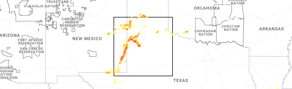
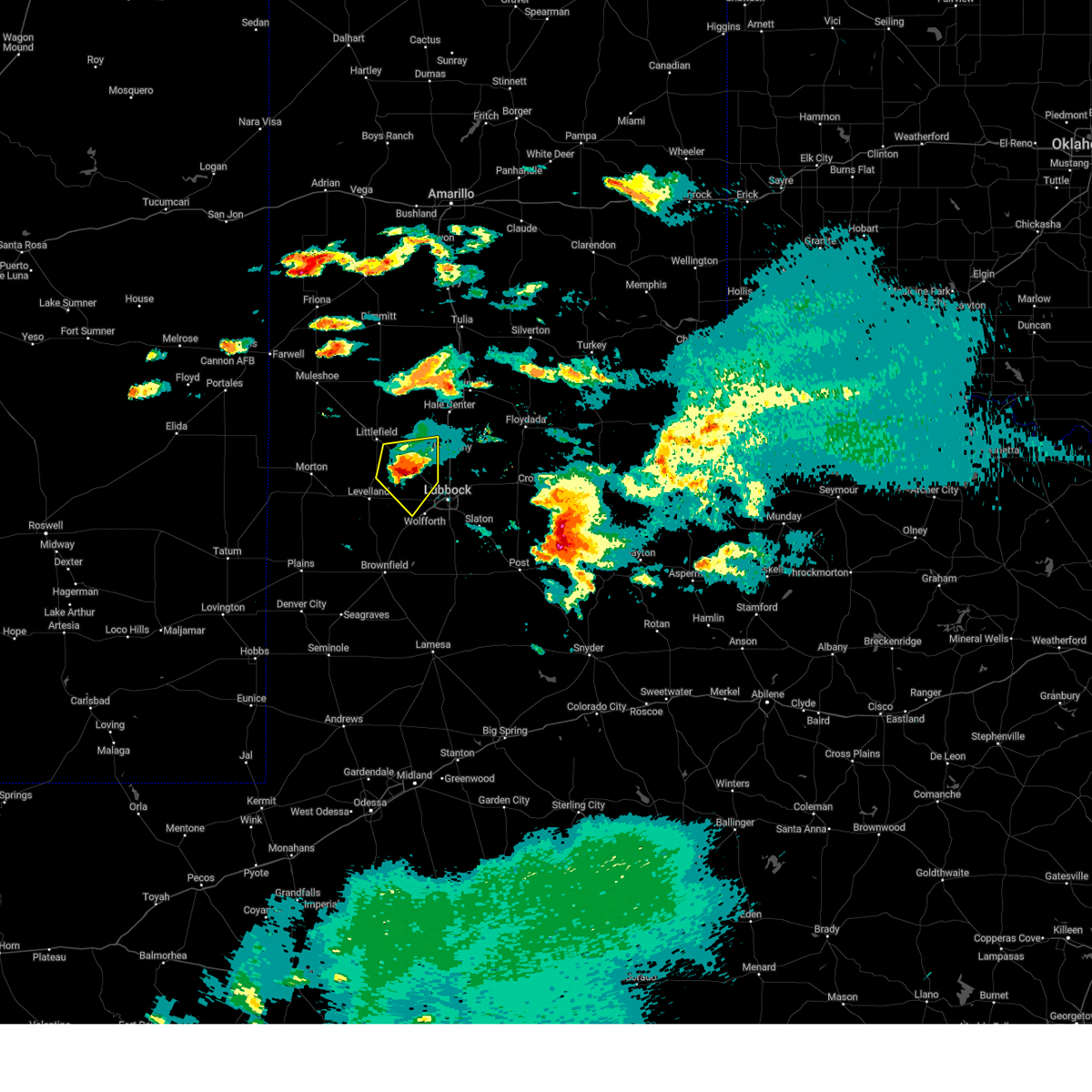
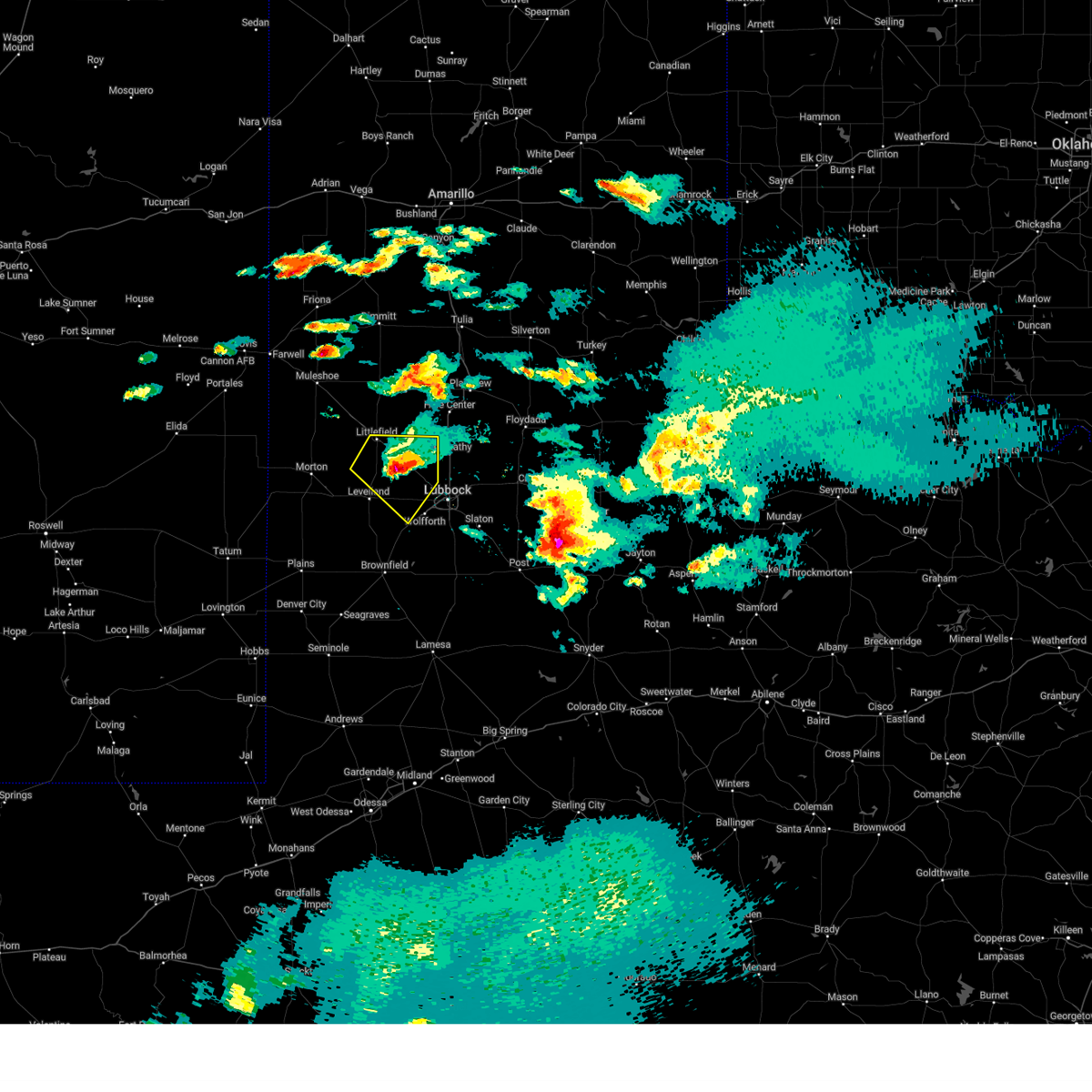
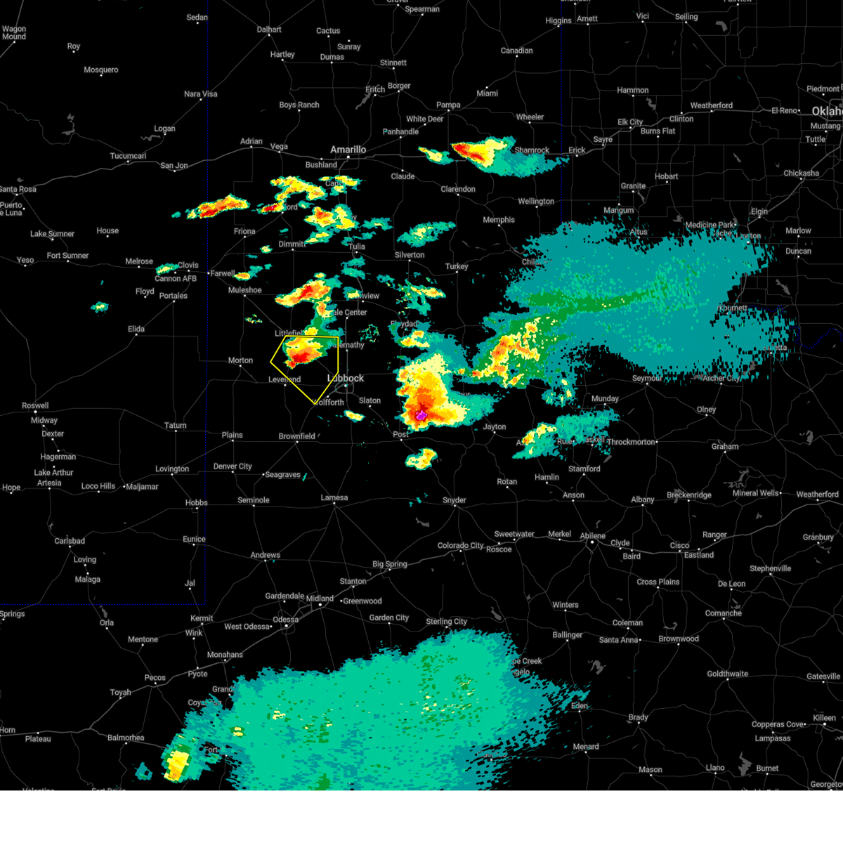
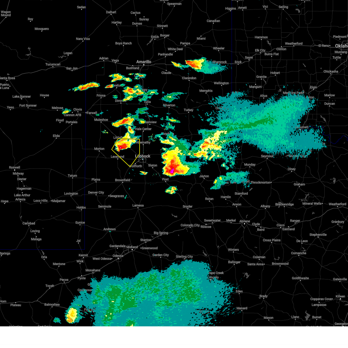
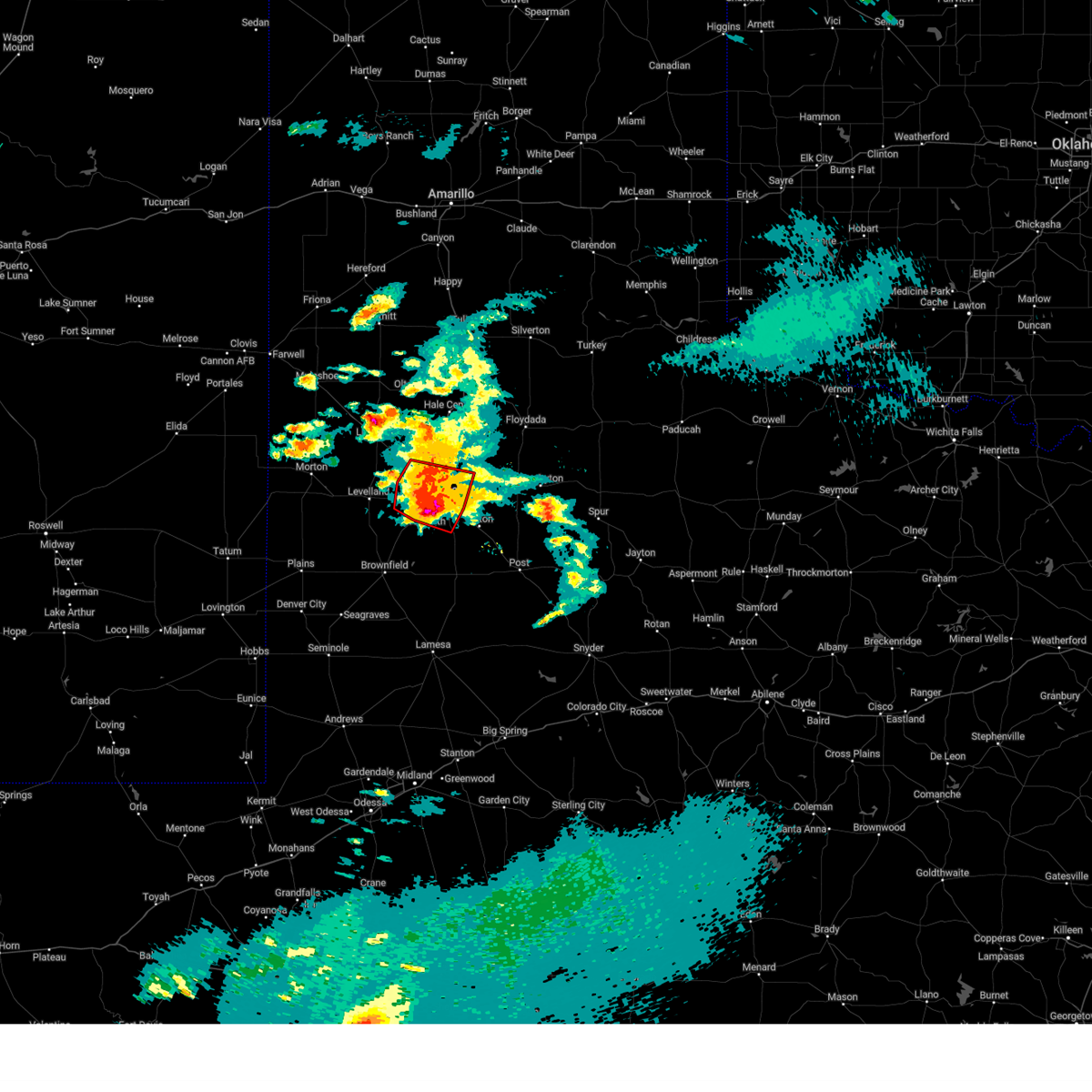
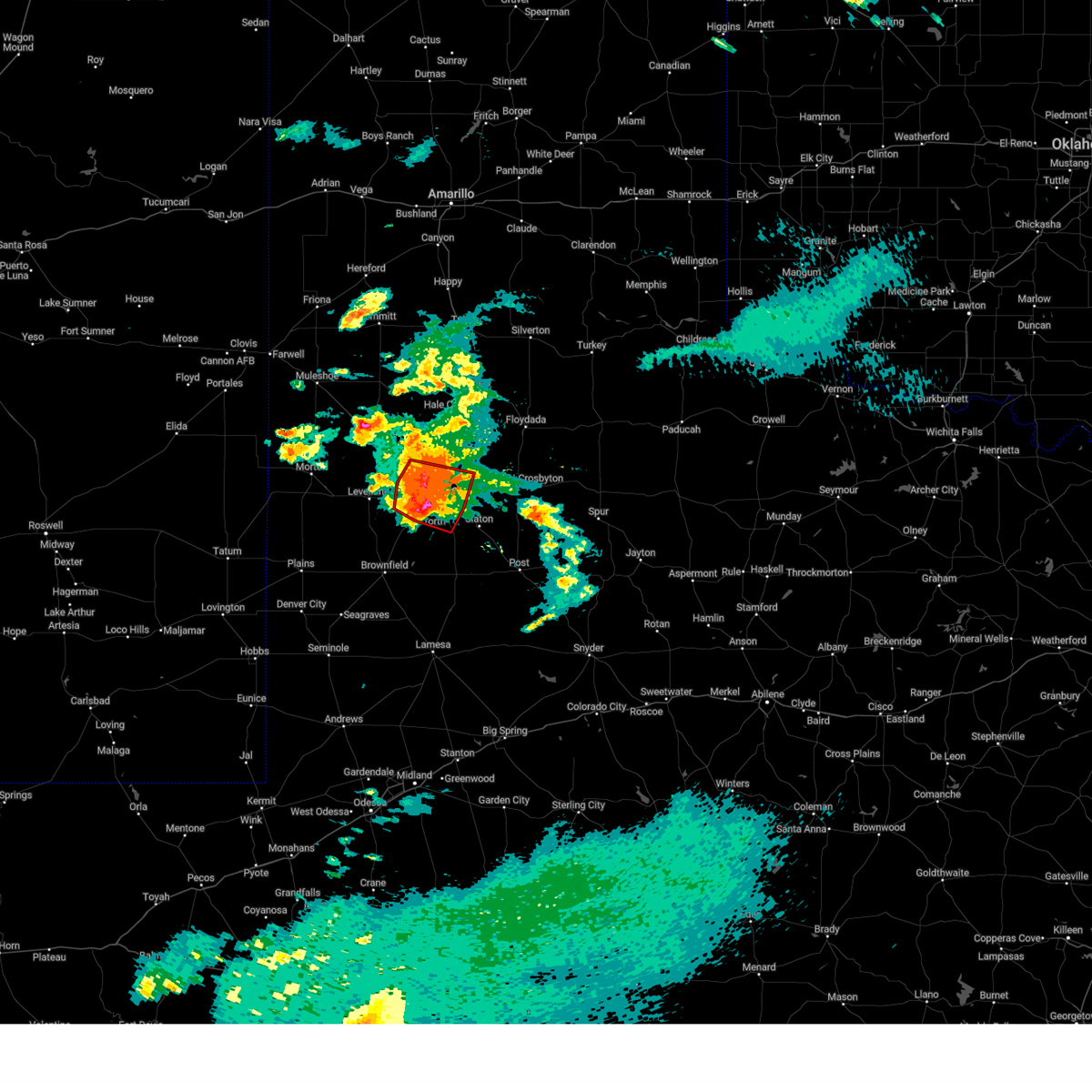
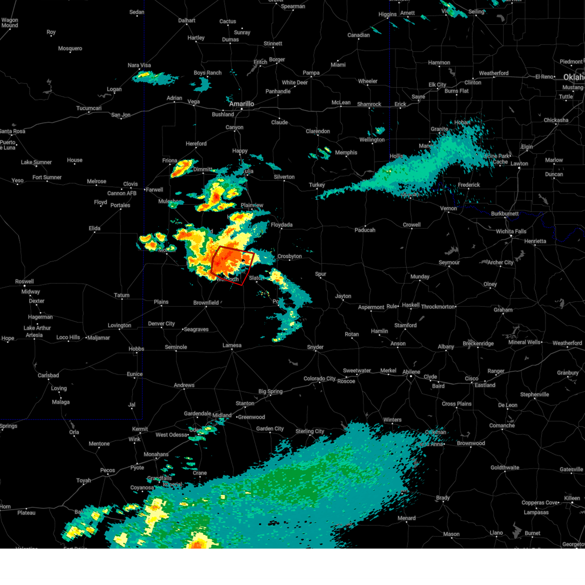
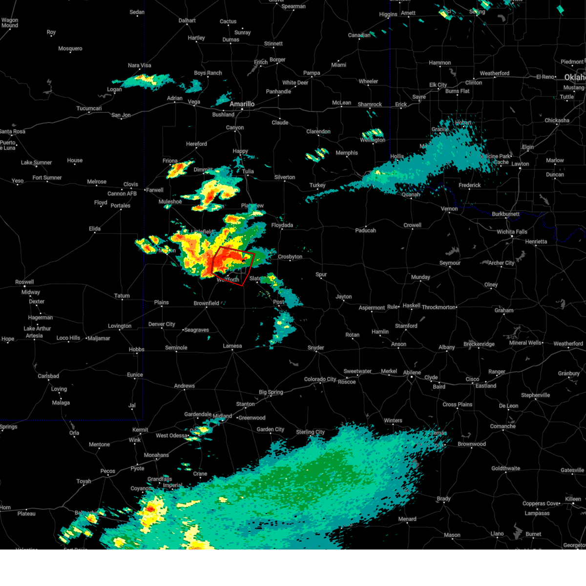
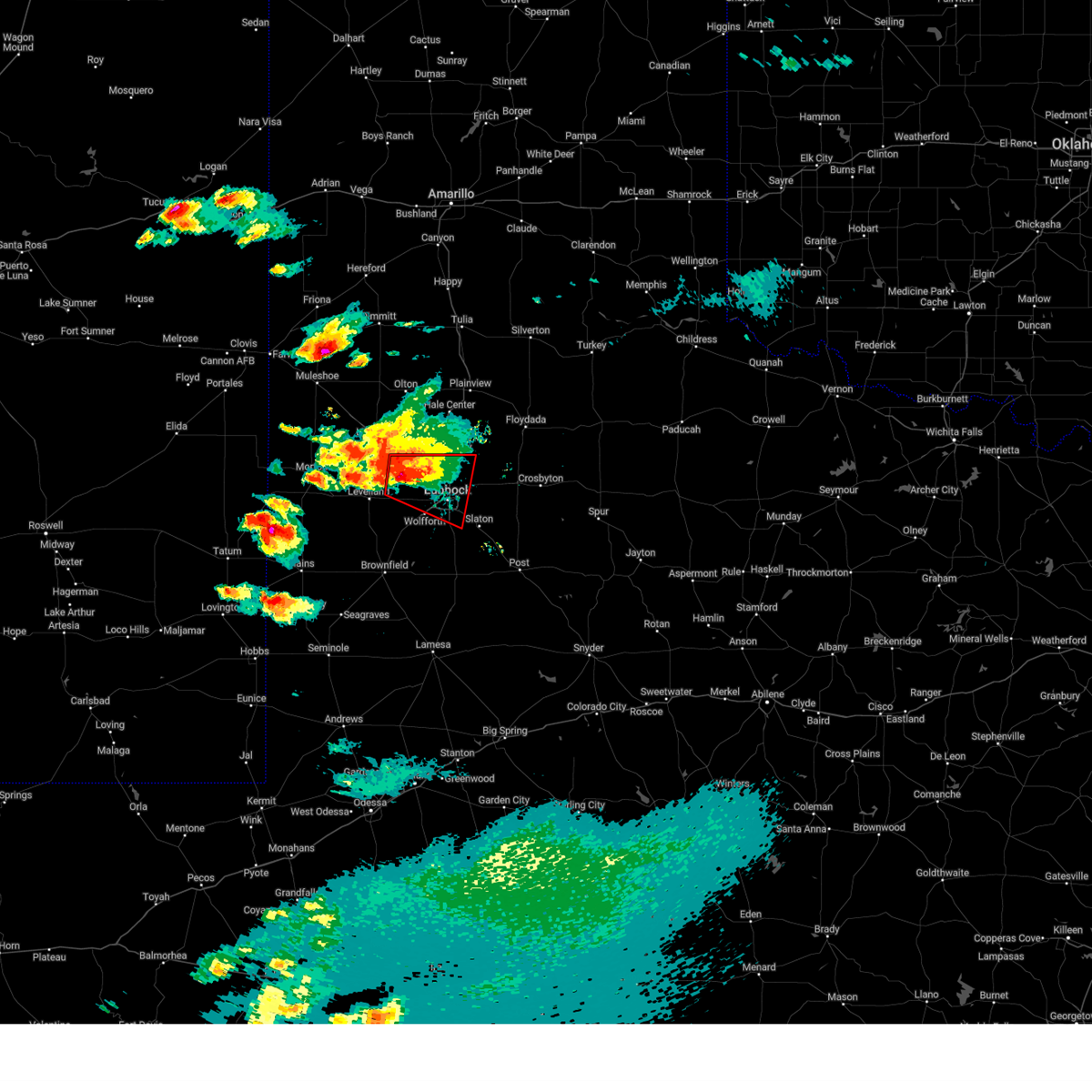
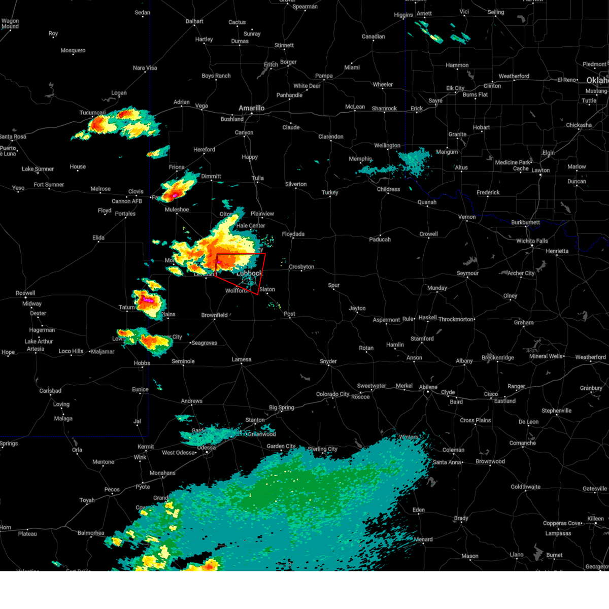
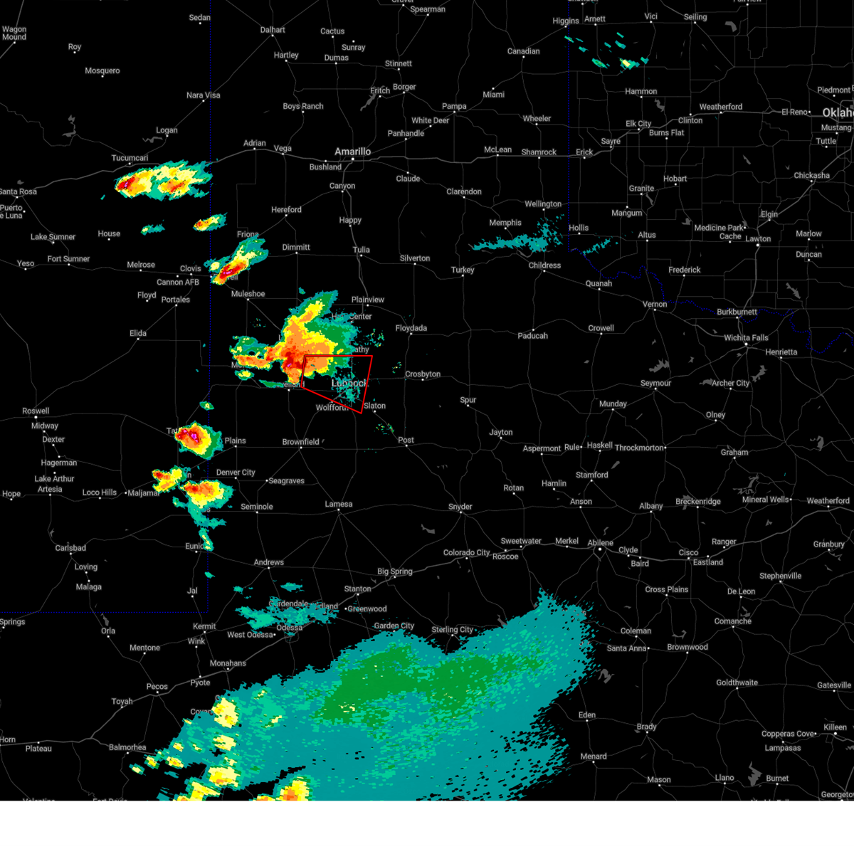
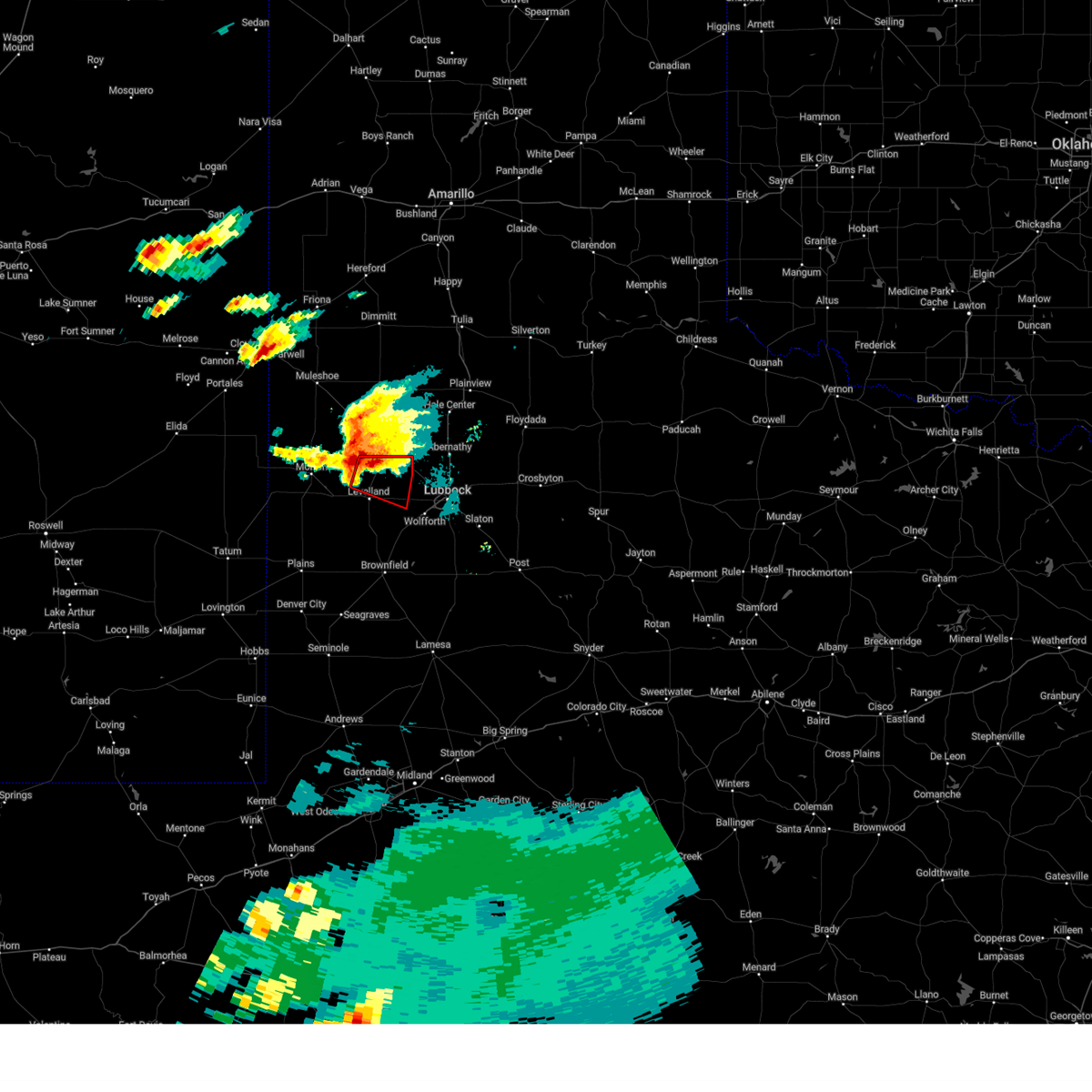
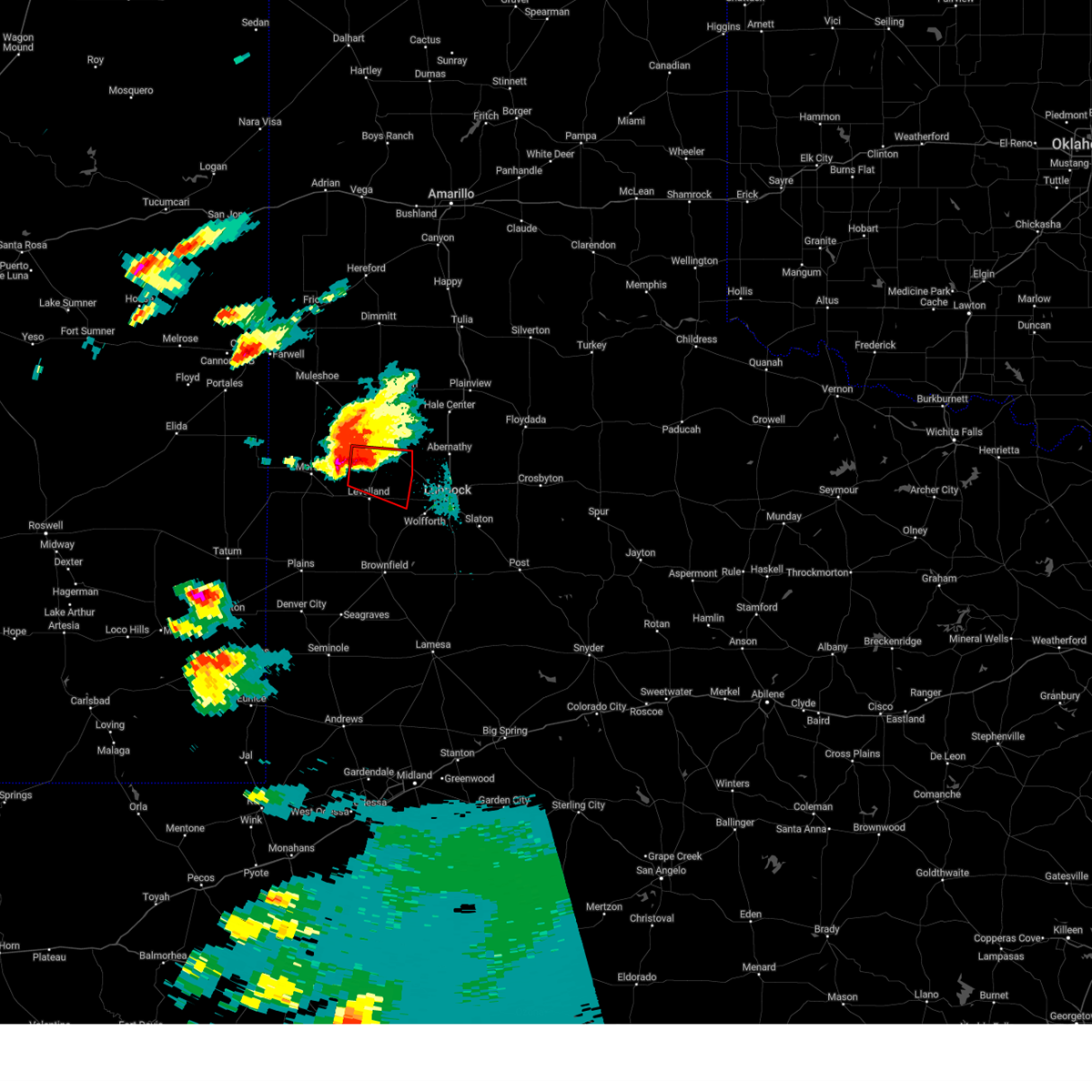
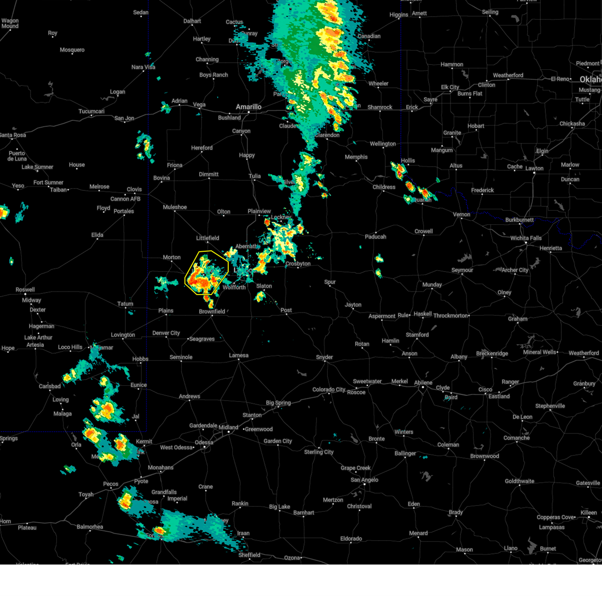
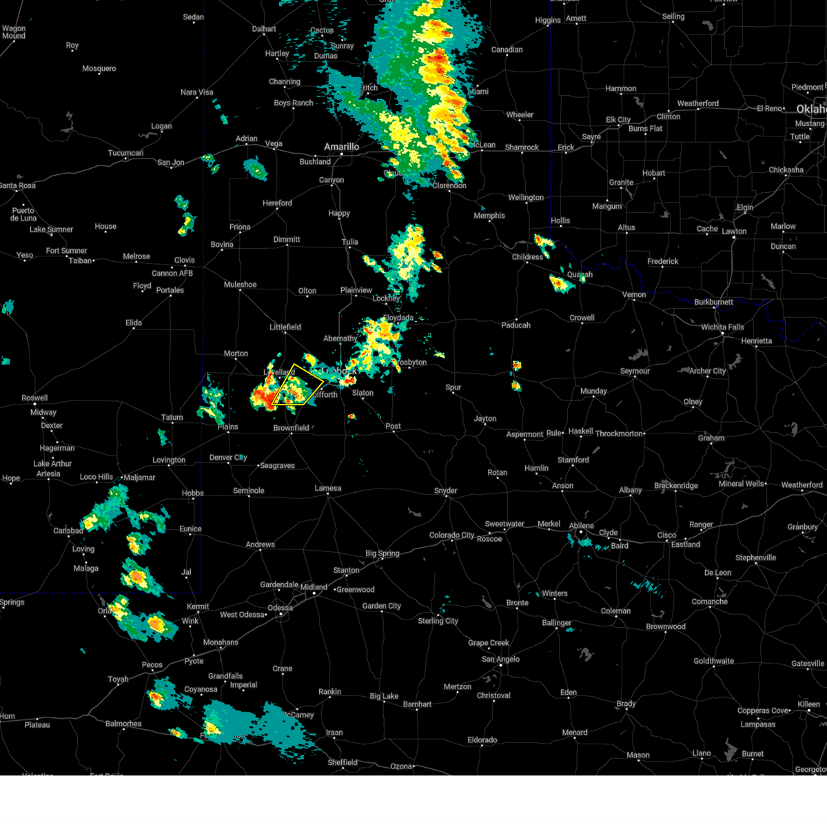
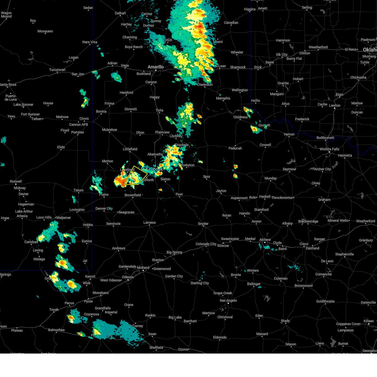
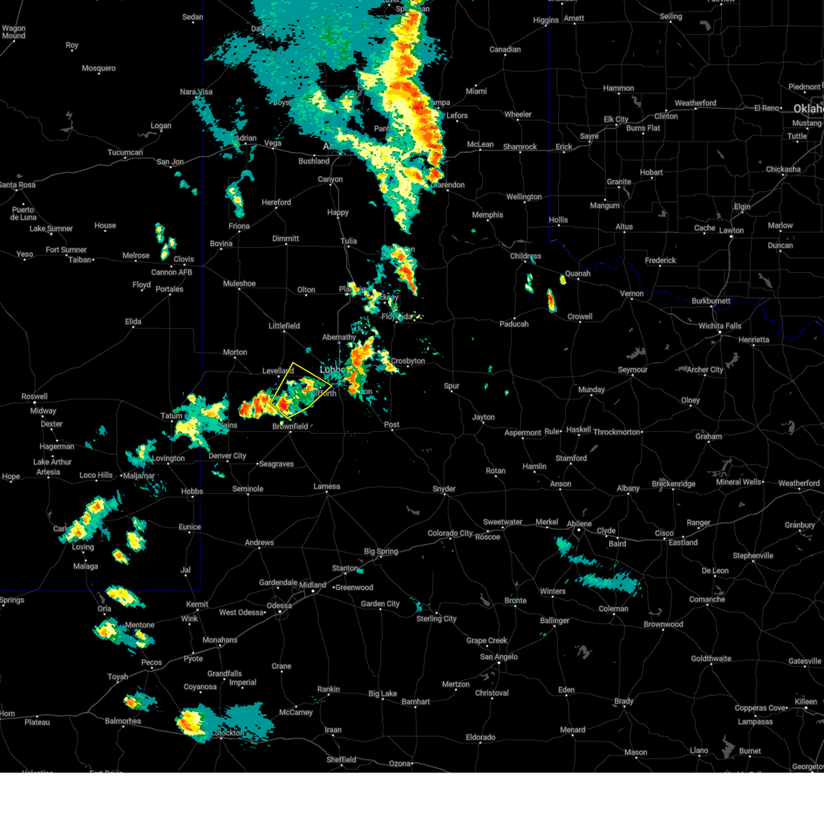
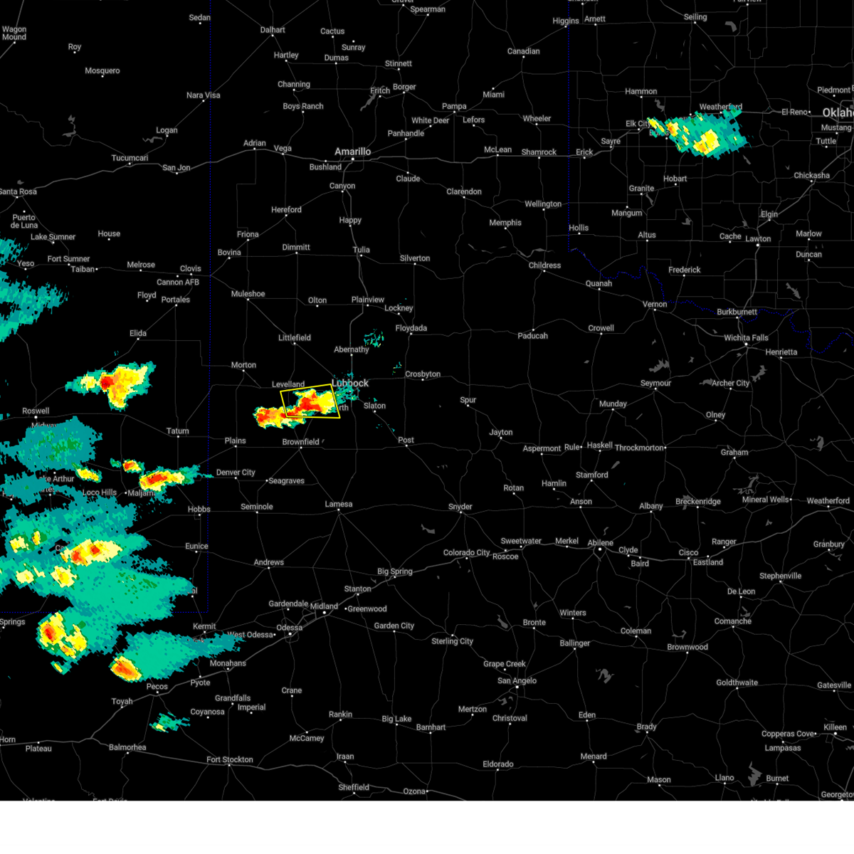
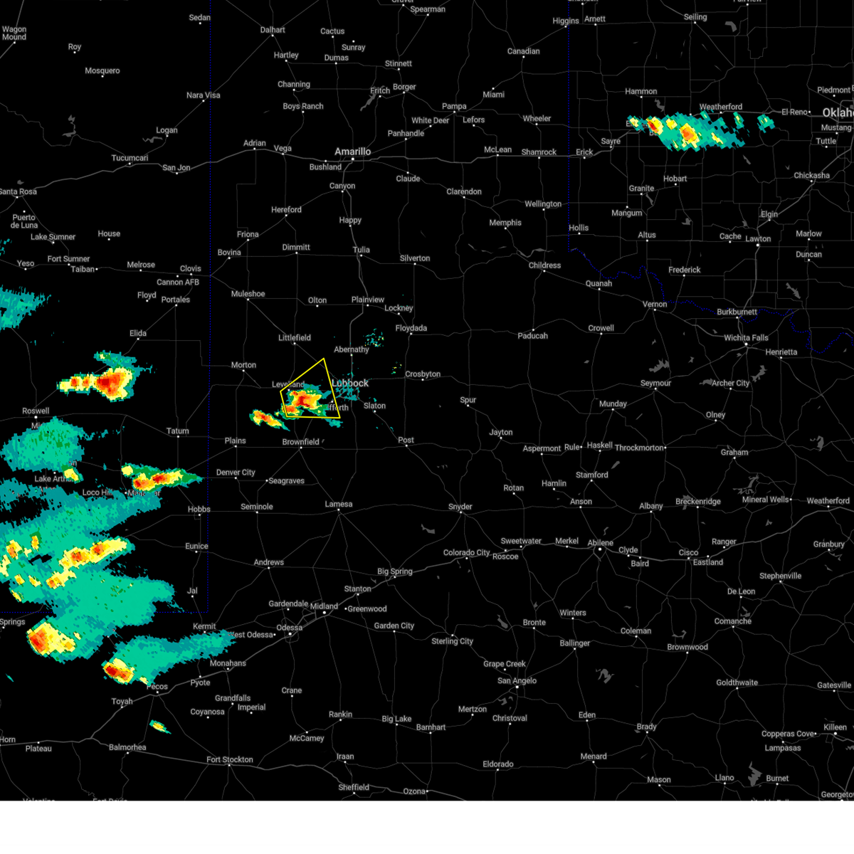
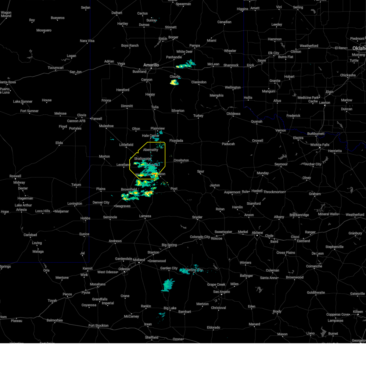
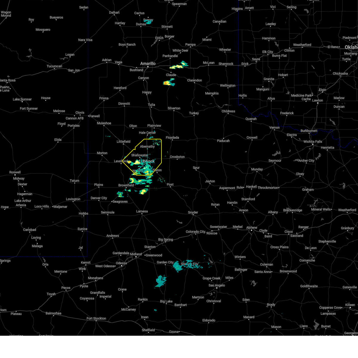
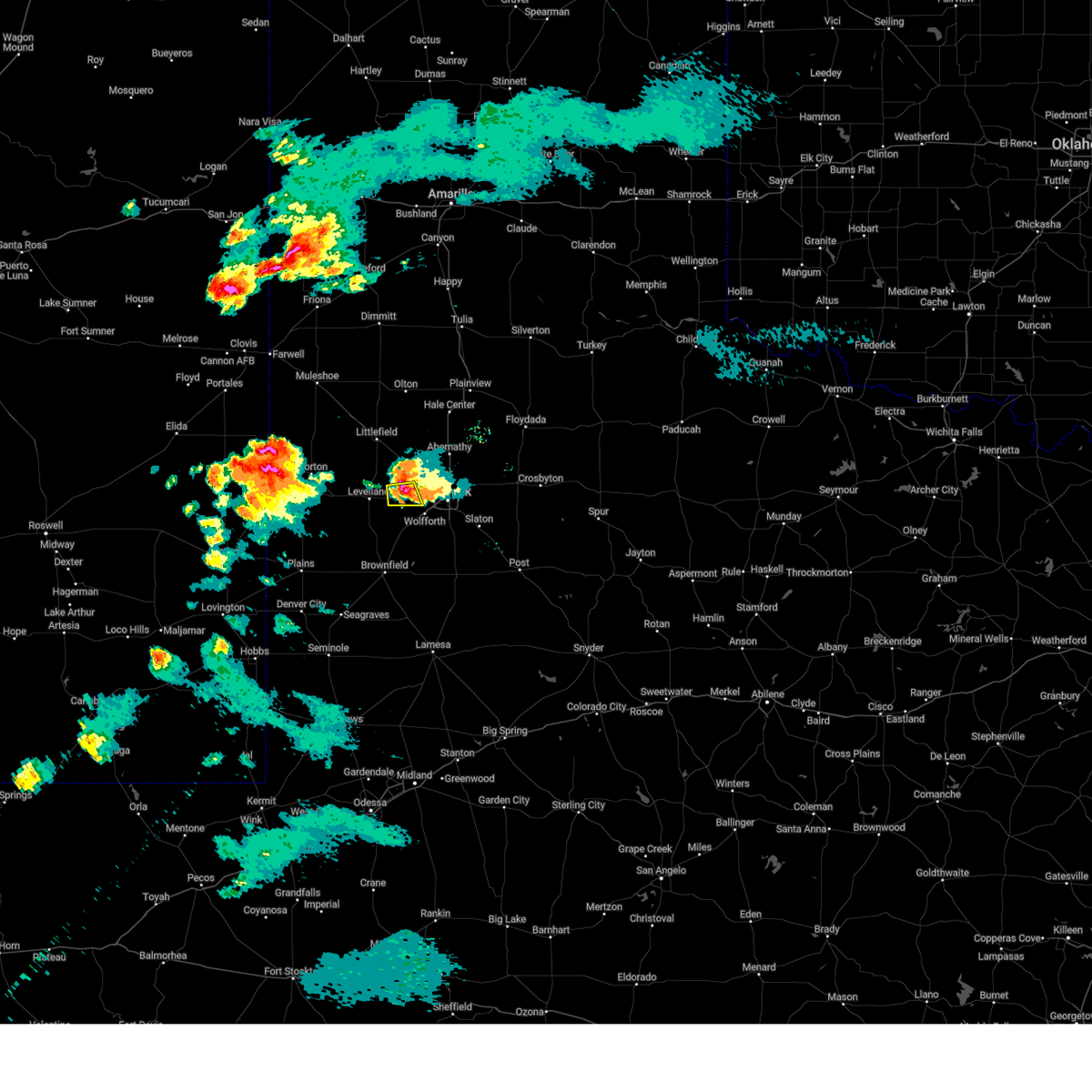
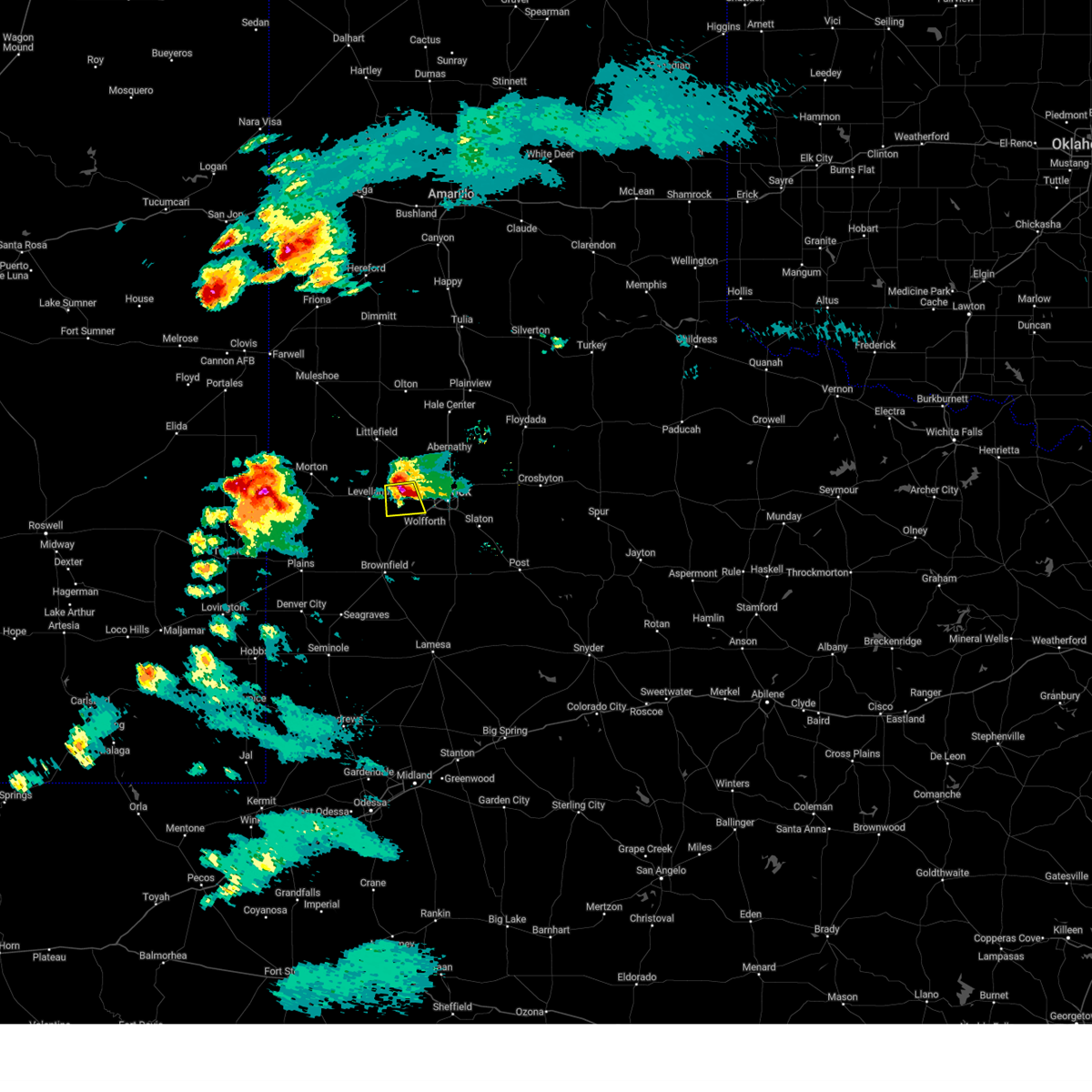
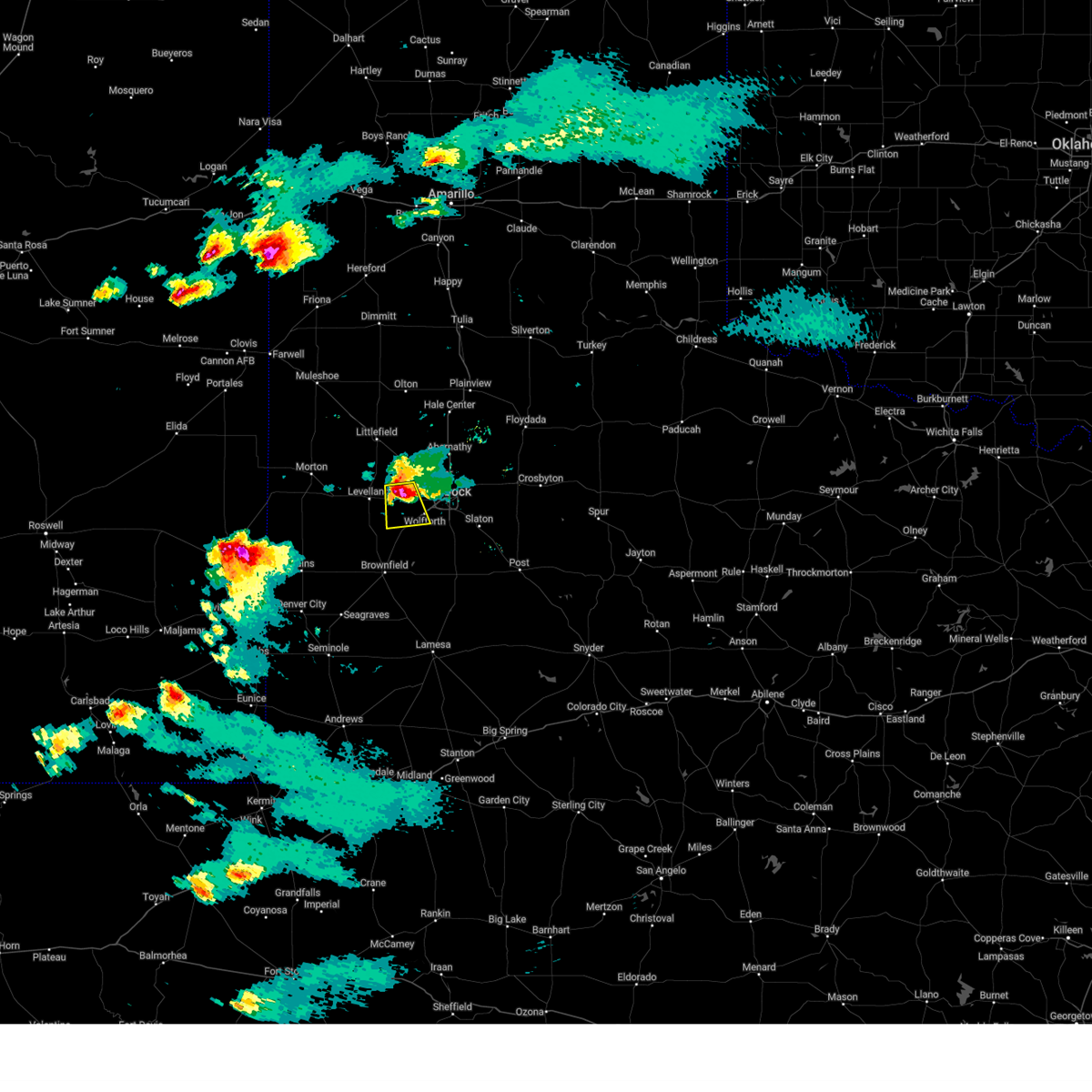
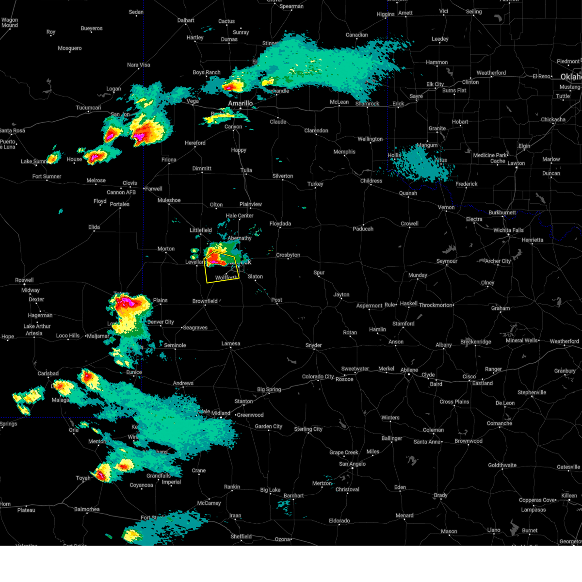
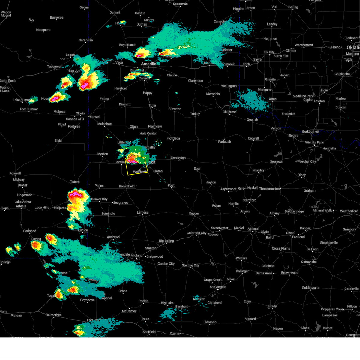
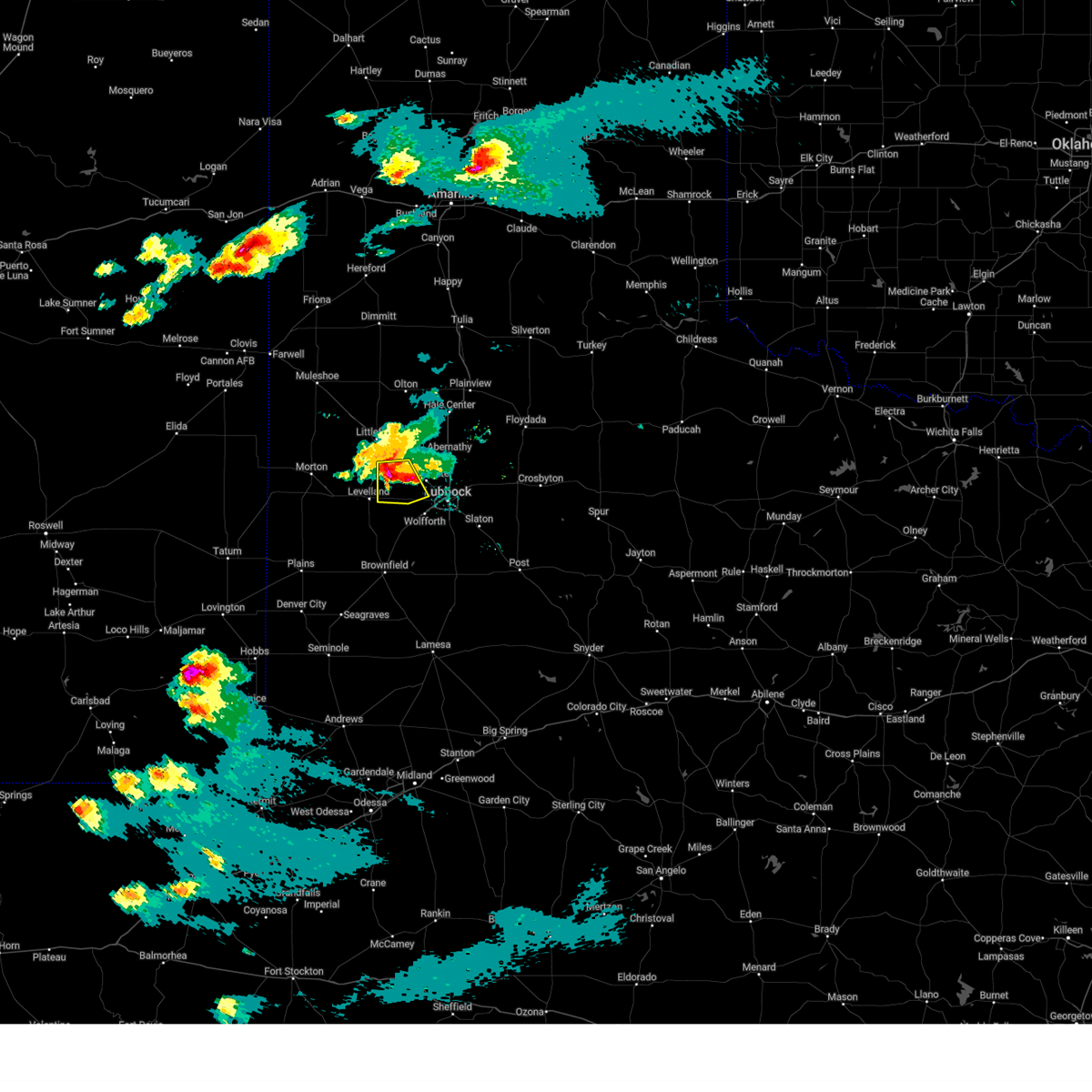
Hail Map for Smyer, TX
The Smyer, TX area has had 9 reports of on-the-ground hail by trained spotters, and has been under severe weather warnings 59 times during the past 12 months. Doppler radar has detected hail at or near Smyer, TX on 98 occasions, including 7 occasions during the past year.
| Name: | Smyer, TX |
| Where Located: | 17.7 miles W of Lubbock, TX |
| Map: | Google Map for Smyer, TX |
| Population: | 474 |
| Housing Units: | 194 |
| More Info: | Search Google for Smyer, TX |
1
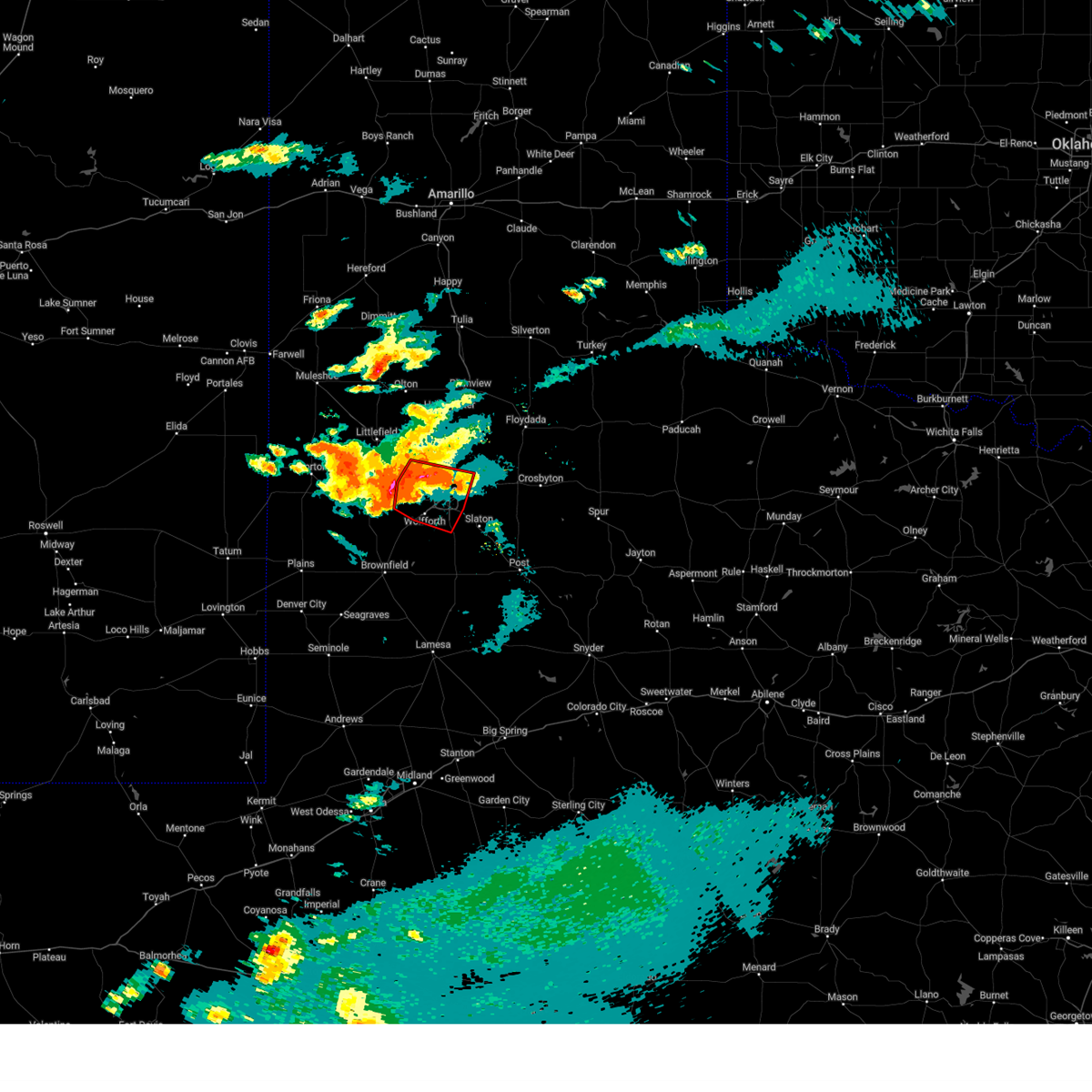
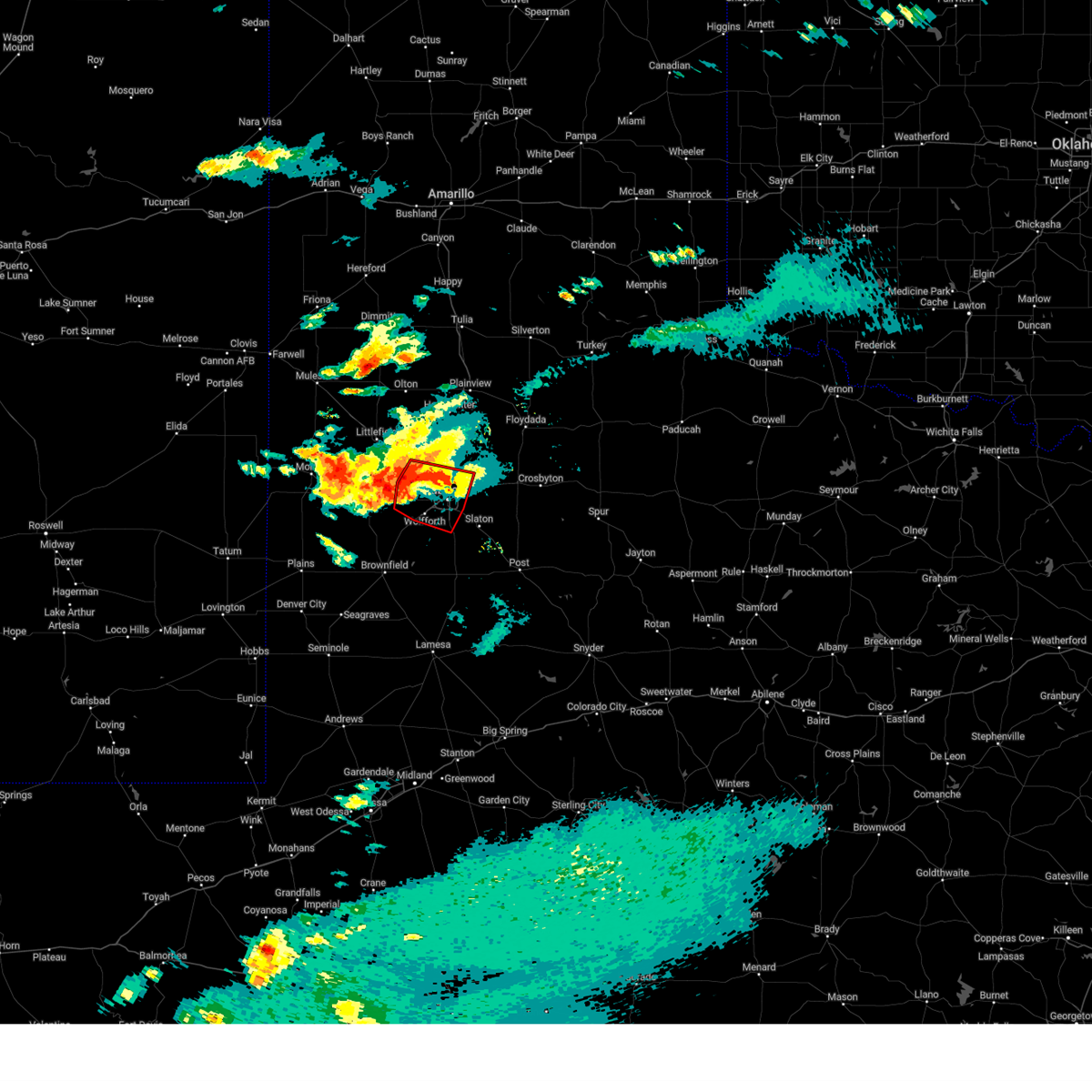
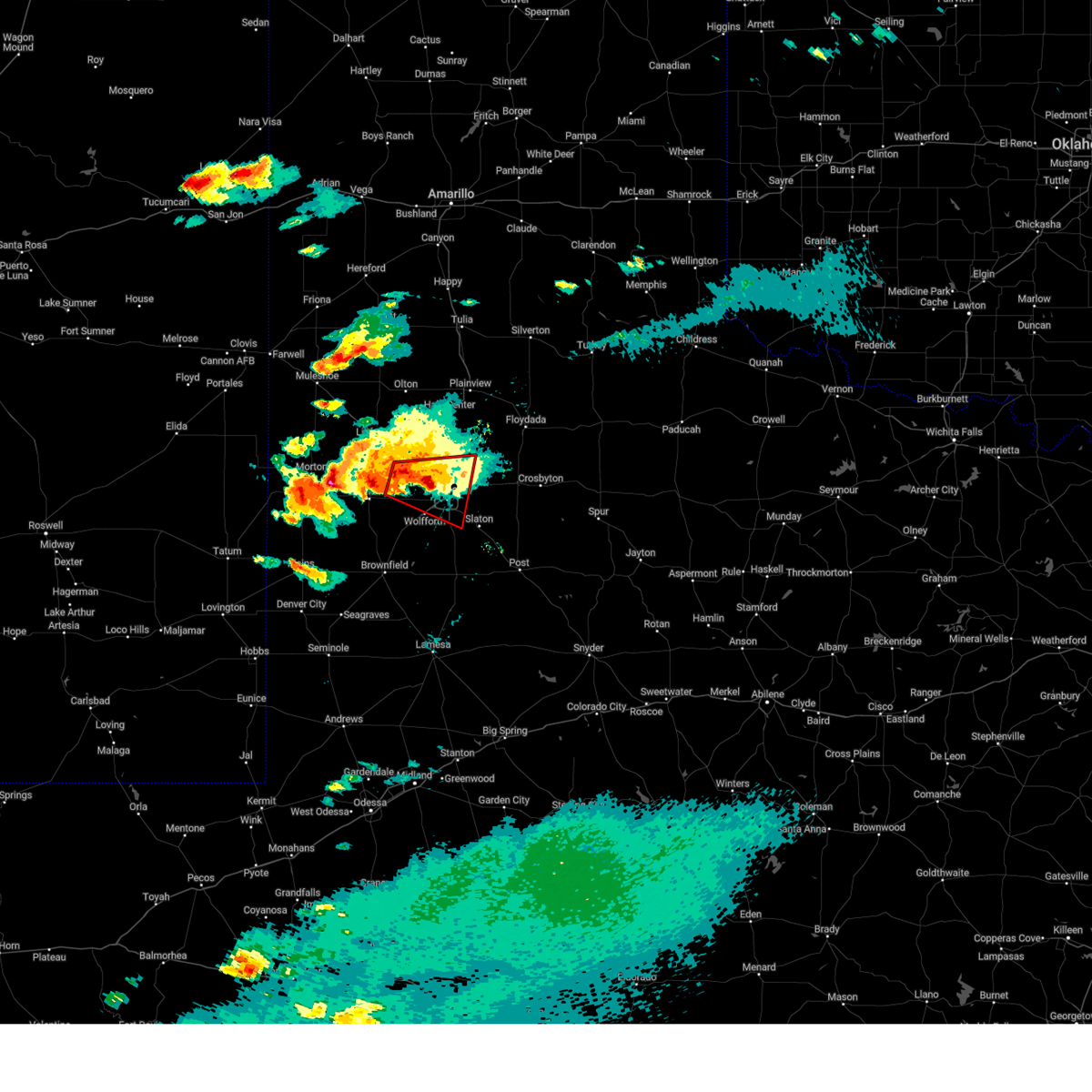
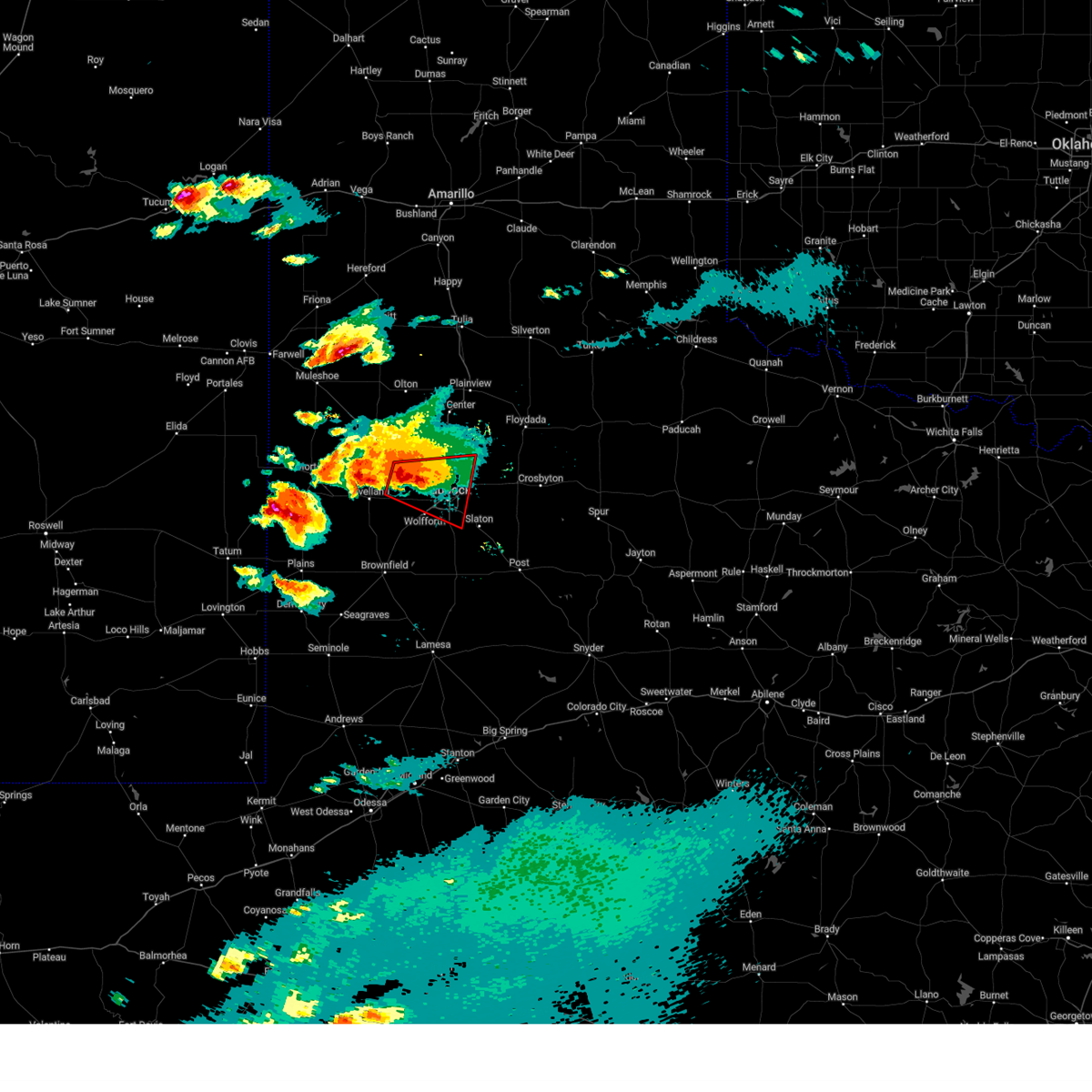
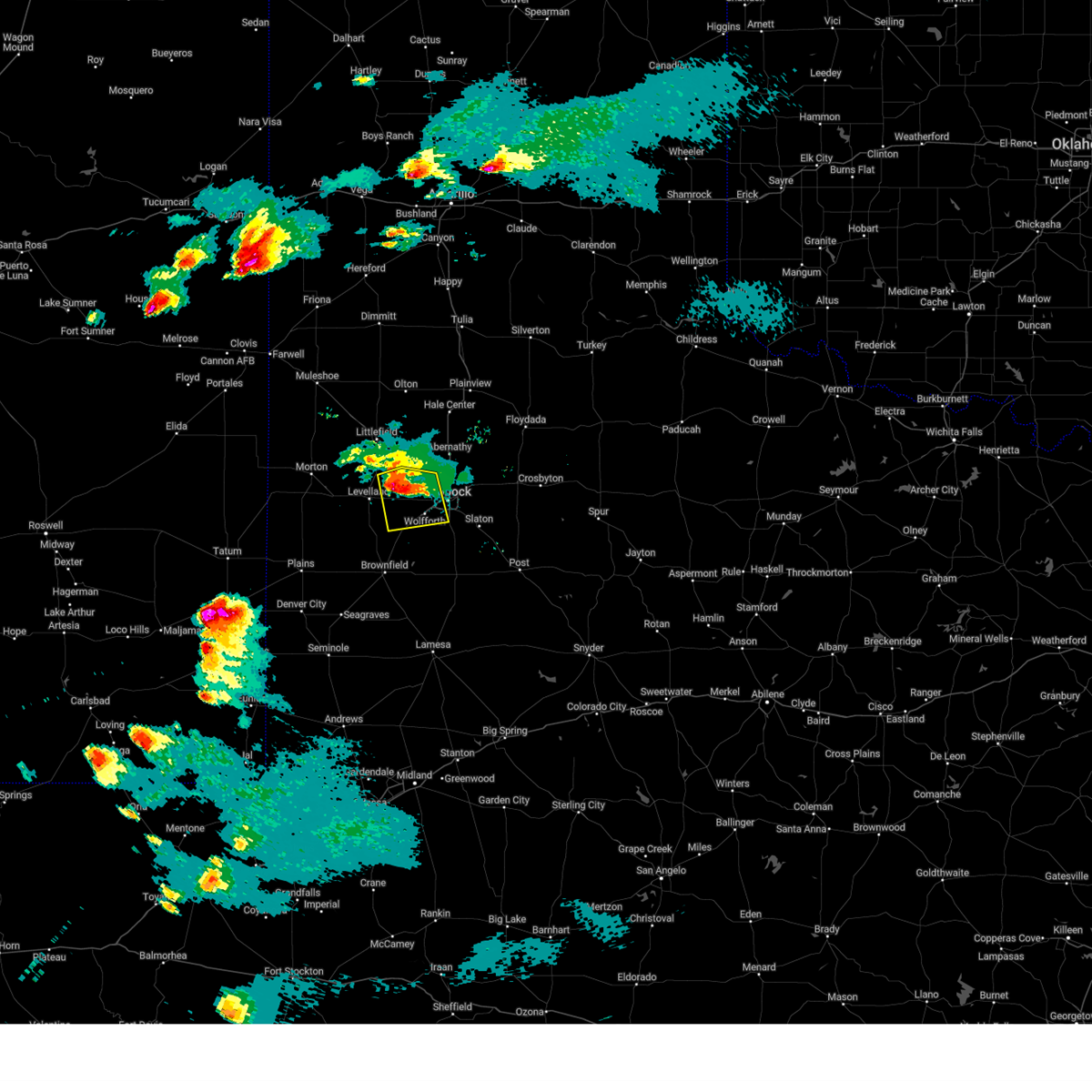
The Top Recent Hail Date for Smyer, TX is Friday, April 25, 2025 (13th out of 98)
Hail and Wind Damage Spotted near Smyer, TX
| Date / Time | Report Details |
|---|---|
| 6/13/2025 9:35 PM CDT |
 At 935 pm cdt, severe thunderstorms were located along a line extending from 7 miles southwest of reese center to 4 miles south of locketville to 8 miles west of denver city, moving southeast at 40 mph (radar indicated). Hazards include 70 mph wind gusts. Expect considerable tree damage. damage is likely to mobile homes, roofs, and outbuildings. Locations impacted include, lubbock, brownfield, denver city, tahoka, plains, wolfforth, o'donnell, new moore, tokio, locketville, slide, meadow, wilson, smyer, ropesville, new home, and wellman. At 935 pm cdt, severe thunderstorms were located along a line extending from 7 miles southwest of reese center to 4 miles south of locketville to 8 miles west of denver city, moving southeast at 40 mph (radar indicated). Hazards include 70 mph wind gusts. Expect considerable tree damage. damage is likely to mobile homes, roofs, and outbuildings. Locations impacted include, lubbock, brownfield, denver city, tahoka, plains, wolfforth, o'donnell, new moore, tokio, locketville, slide, meadow, wilson, smyer, ropesville, new home, and wellman.
|
| 6/13/2025 9:15 PM CDT |
 Svrlub the national weather service in lubbock texas has issued a * severe thunderstorm warning for, southwestern lubbock county in northwestern texas, lynn county in northwestern texas, terry county in northwestern texas, southeastern hockley county in northwestern texas, yoakum county in northwestern texas, * until 1015 pm cdt. * at 915 pm cdt, severe thunderstorms were located along a line extending from 6 miles southeast of whitharral to 5 miles southeast of sundown to 15 miles southeast of mcdonald, moving southeast at 40 mph (radar indicated). Hazards include 70 mph wind gusts. Expect considerable tree damage. Damage is likely to mobile homes, roofs, and outbuildings. Svrlub the national weather service in lubbock texas has issued a * severe thunderstorm warning for, southwestern lubbock county in northwestern texas, lynn county in northwestern texas, terry county in northwestern texas, southeastern hockley county in northwestern texas, yoakum county in northwestern texas, * until 1015 pm cdt. * at 915 pm cdt, severe thunderstorms were located along a line extending from 6 miles southeast of whitharral to 5 miles southeast of sundown to 15 miles southeast of mcdonald, moving southeast at 40 mph (radar indicated). Hazards include 70 mph wind gusts. Expect considerable tree damage. Damage is likely to mobile homes, roofs, and outbuildings.
|
| 6/5/2025 10:00 PM CDT |
 At 959 pm cdt, a severe thunderstorm was located 5 miles west of shallowater, or 14 miles northwest of lubbock, moving east at 25 mph. this is a destructive storm for northwestern lubbock, northeastern hockley, southwestern hale, and southeastern lamb counties (radar indicated). Hazards include baseball size hail and 70 mph wind gusts. People and animals outdoors will be severely injured. expect shattered windows, extensive damage to roofs, siding, and vehicles. Locations impacted include, lubbock, shallowater, anton, reese center, and smyer. At 959 pm cdt, a severe thunderstorm was located 5 miles west of shallowater, or 14 miles northwest of lubbock, moving east at 25 mph. this is a destructive storm for northwestern lubbock, northeastern hockley, southwestern hale, and southeastern lamb counties (radar indicated). Hazards include baseball size hail and 70 mph wind gusts. People and animals outdoors will be severely injured. expect shattered windows, extensive damage to roofs, siding, and vehicles. Locations impacted include, lubbock, shallowater, anton, reese center, and smyer.
|
| 6/5/2025 9:50 PM CDT |
 At 950 pm cdt, a severe thunderstorm was located 5 miles south of anton, or 16 miles northeast of levelland, moving southeast at 30 mph (radar indicated). Hazards include tennis ball size hail and 70 mph wind gusts. People and animals outdoors will be injured. expect hail damage to roofs, siding, windows, and vehicles. expect considerable tree damage. wind damage is also likely to mobile homes, roofs, and outbuildings. Locations impacted include, lubbock, shallowater, anton, reese center, and smyer. At 950 pm cdt, a severe thunderstorm was located 5 miles south of anton, or 16 miles northeast of levelland, moving southeast at 30 mph (radar indicated). Hazards include tennis ball size hail and 70 mph wind gusts. People and animals outdoors will be injured. expect hail damage to roofs, siding, windows, and vehicles. expect considerable tree damage. wind damage is also likely to mobile homes, roofs, and outbuildings. Locations impacted include, lubbock, shallowater, anton, reese center, and smyer.
|
| 6/5/2025 9:43 PM CDT |
 At 942 pm cdt, a severe thunderstorm was located 5 miles southwest of anton, or 13 miles southeast of littlefield, moving east at 20 mph (radar indicated). Hazards include tennis ball size hail and 70 mph wind gusts. People and animals outdoors will be injured. expect hail damage to roofs, siding, windows, and vehicles. expect considerable tree damage. wind damage is also likely to mobile homes, roofs, and outbuildings. Locations impacted include, lubbock, littlefield, shallowater, anton, spade, whitharral, reese center, smyer, and opdyke west. At 942 pm cdt, a severe thunderstorm was located 5 miles southwest of anton, or 13 miles southeast of littlefield, moving east at 20 mph (radar indicated). Hazards include tennis ball size hail and 70 mph wind gusts. People and animals outdoors will be injured. expect hail damage to roofs, siding, windows, and vehicles. expect considerable tree damage. wind damage is also likely to mobile homes, roofs, and outbuildings. Locations impacted include, lubbock, littlefield, shallowater, anton, spade, whitharral, reese center, smyer, and opdyke west.
|
| 6/5/2025 9:36 PM CDT |
 At 935 pm cdt, a severe thunderstorm was located 4 miles northeast of whitharral, or 11 miles south of littlefield, moving east at 20 mph (radar indicated). Hazards include tennis ball size hail and 60 mph wind gusts. People and animals outdoors will be injured. expect hail damage to roofs, siding, windows, and vehicles. expect wind damage to roofs, siding, and trees. Locations impacted include, lubbock, littlefield, shallowater, anton, spade, whitharral, reese center, smyer, and opdyke west. At 935 pm cdt, a severe thunderstorm was located 4 miles northeast of whitharral, or 11 miles south of littlefield, moving east at 20 mph (radar indicated). Hazards include tennis ball size hail and 60 mph wind gusts. People and animals outdoors will be injured. expect hail damage to roofs, siding, windows, and vehicles. expect wind damage to roofs, siding, and trees. Locations impacted include, lubbock, littlefield, shallowater, anton, spade, whitharral, reese center, smyer, and opdyke west.
|
| 6/5/2025 9:31 PM CDT |
 At 931 pm cdt, a severe thunderstorm was located near whitharral, or 10 miles south of littlefield, moving southeast at 20 mph (radar indicated). Hazards include ping pong ball size hail and 60 mph wind gusts. People and animals outdoors will be injured. expect hail damage to roofs, siding, windows, and vehicles. expect wind damage to roofs, siding, and trees. Locations impacted include, lubbock, littlefield, shallowater, anton, spade, whitharral, reese center, smyer, and opdyke west. At 931 pm cdt, a severe thunderstorm was located near whitharral, or 10 miles south of littlefield, moving southeast at 20 mph (radar indicated). Hazards include ping pong ball size hail and 60 mph wind gusts. People and animals outdoors will be injured. expect hail damage to roofs, siding, windows, and vehicles. expect wind damage to roofs, siding, and trees. Locations impacted include, lubbock, littlefield, shallowater, anton, spade, whitharral, reese center, smyer, and opdyke west.
|
| 6/5/2025 9:27 PM CDT |
 Svrlub the national weather service in lubbock texas has issued a * severe thunderstorm warning for, northwestern lubbock county in northwestern texas, northeastern hockley county in northwestern texas, southwestern hale county in northwestern texas, southeastern lamb county in northwestern texas, * until 1030 pm cdt. * at 927 pm cdt, a severe thunderstorm was located 4 miles north of whitharral, or 8 miles south of littlefield, moving east at 20 mph (radar indicated). Hazards include 60 mph wind gusts and half dollar size hail. Hail damage to vehicles is expected. Expect wind damage to roofs, siding, and trees. Svrlub the national weather service in lubbock texas has issued a * severe thunderstorm warning for, northwestern lubbock county in northwestern texas, northeastern hockley county in northwestern texas, southwestern hale county in northwestern texas, southeastern lamb county in northwestern texas, * until 1030 pm cdt. * at 927 pm cdt, a severe thunderstorm was located 4 miles north of whitharral, or 8 miles south of littlefield, moving east at 20 mph (radar indicated). Hazards include 60 mph wind gusts and half dollar size hail. Hail damage to vehicles is expected. Expect wind damage to roofs, siding, and trees.
|
| 6/5/2025 8:13 PM CDT |
 At 812 pm cdt, a severe thunderstorm capable of producing a tornado was located over texas tech university, or over lubbock, moving east at 25 mph. there are indications of wind driven large hail near wolfforth (radar indicated rotation). Hazards include tornado and softball size hail. Flying debris will be dangerous to those caught without shelter. mobile homes will be damaged or destroyed. damage to roofs, windows, and vehicles will occur. tree damage is likely. this dangerous storm will be near, lubbock and downtown lubbock around 820 pm cdt. lubbock international airport around 825 pm cdt. Other locations impacted by this tornadic thunderstorm include smyer, new deal, and lubbock science spectrum. At 812 pm cdt, a severe thunderstorm capable of producing a tornado was located over texas tech university, or over lubbock, moving east at 25 mph. there are indications of wind driven large hail near wolfforth (radar indicated rotation). Hazards include tornado and softball size hail. Flying debris will be dangerous to those caught without shelter. mobile homes will be damaged or destroyed. damage to roofs, windows, and vehicles will occur. tree damage is likely. this dangerous storm will be near, lubbock and downtown lubbock around 820 pm cdt. lubbock international airport around 825 pm cdt. Other locations impacted by this tornadic thunderstorm include smyer, new deal, and lubbock science spectrum.
|
| 6/5/2025 8:07 PM CDT |
 At 806 pm cdt, a severe thunderstorm capable of producing a tornado was located 4 miles west of texas tech university, or 4 miles northwest of lubbock, moving east at 25 mph. large hail was also indicated southwest of reese center and southeast of smyer (radar indicated rotation). Hazards include tornado and tennis ball size hail. Flying debris will be dangerous to those caught without shelter. mobile homes will be damaged or destroyed. damage to roofs, windows, and vehicles will occur. tree damage is likely. this dangerous storm will be near, lubbock and texas tech university around 810 pm cdt. downtown lubbock around 815 pm cdt. lubbock international airport around 820 pm cdt. Other locations impacted by this tornadic thunderstorm include smyer, new deal, and lubbock science spectrum. At 806 pm cdt, a severe thunderstorm capable of producing a tornado was located 4 miles west of texas tech university, or 4 miles northwest of lubbock, moving east at 25 mph. large hail was also indicated southwest of reese center and southeast of smyer (radar indicated rotation). Hazards include tornado and tennis ball size hail. Flying debris will be dangerous to those caught without shelter. mobile homes will be damaged or destroyed. damage to roofs, windows, and vehicles will occur. tree damage is likely. this dangerous storm will be near, lubbock and texas tech university around 810 pm cdt. downtown lubbock around 815 pm cdt. lubbock international airport around 820 pm cdt. Other locations impacted by this tornadic thunderstorm include smyer, new deal, and lubbock science spectrum.
|
| 6/5/2025 8:01 PM CDT |
 At 800 pm cdt, a severe thunderstorm capable of producing a tornado was located 4 miles east of reese center, or 5 miles northwest of lubbock, moving east at 15 mph. a second core with large hail was indicated just southeast of smyer (radar indicated rotation). Hazards include tornado and two inch hail. Flying debris will be dangerous to those caught without shelter. mobile homes will be damaged or destroyed. damage to roofs, windows, and vehicles will occur. tree damage is likely. this dangerous storm will be near, lubbock around 805 pm cdt. texas tech university and lubbock south plains mall around 810 pm cdt. downtown lubbock around 815 pm cdt. Other locations impacted by this tornadic thunderstorm include smyer, new deal, and lubbock science spectrum. At 800 pm cdt, a severe thunderstorm capable of producing a tornado was located 4 miles east of reese center, or 5 miles northwest of lubbock, moving east at 15 mph. a second core with large hail was indicated just southeast of smyer (radar indicated rotation). Hazards include tornado and two inch hail. Flying debris will be dangerous to those caught without shelter. mobile homes will be damaged or destroyed. damage to roofs, windows, and vehicles will occur. tree damage is likely. this dangerous storm will be near, lubbock around 805 pm cdt. texas tech university and lubbock south plains mall around 810 pm cdt. downtown lubbock around 815 pm cdt. Other locations impacted by this tornadic thunderstorm include smyer, new deal, and lubbock science spectrum.
|
| 6/5/2025 7:54 PM CDT |
 At 753 pm cdt, a confirmed tornado was located over reese center, or 6 miles west of lubbock, moving southeast at 45 mph. the west texas mesonet station at smyer gusted to 109 mph at 746pm (weather spotters confirmed tornado). Hazards include damaging tornado and ping pong ball size hail. Flying debris will be dangerous to those caught without shelter. mobile homes will be damaged or destroyed. damage to roofs, windows, and vehicles will occur. tree damage is likely. this tornado will be near, lubbock and lubbock south plains mall around 800 pm cdt. woodrow around 805 pm cdt. Other locations impacted by this tornadic thunderstorm include smyer, new deal, and lubbock science spectrum. At 753 pm cdt, a confirmed tornado was located over reese center, or 6 miles west of lubbock, moving southeast at 45 mph. the west texas mesonet station at smyer gusted to 109 mph at 746pm (weather spotters confirmed tornado). Hazards include damaging tornado and ping pong ball size hail. Flying debris will be dangerous to those caught without shelter. mobile homes will be damaged or destroyed. damage to roofs, windows, and vehicles will occur. tree damage is likely. this tornado will be near, lubbock and lubbock south plains mall around 800 pm cdt. woodrow around 805 pm cdt. Other locations impacted by this tornadic thunderstorm include smyer, new deal, and lubbock science spectrum.
|
| 6/5/2025 7:51 PM CDT |
 At 748 pm cdt, a confirmed tornado was located over reese center, or 8 miles west of lubbock, moving east at 15 mph. the wind gusted to 95 mph at smyer at 740pm. wind gusts to 62 mph were reported at reese center at the same time. the circulation is becoming re- established at this time just east of reese center (weather spotters confirmed tornado). Hazards include damaging tornado and ping pong ball size hail. Flying debris will be dangerous to those caught without shelter. mobile homes will be damaged or destroyed. damage to roofs, windows, and vehicles will occur. tree damage is likely. this tornado will be near, lubbock and wolfforth around 755 pm cdt. lubbock south plains mall around 800 pm cdt. texas tech university around 810 pm cdt. downtown lubbock around 820 pm cdt. Other locations impacted by this tornadic thunderstorm include smyer, new deal, and lubbock science spectrum. At 748 pm cdt, a confirmed tornado was located over reese center, or 8 miles west of lubbock, moving east at 15 mph. the wind gusted to 95 mph at smyer at 740pm. wind gusts to 62 mph were reported at reese center at the same time. the circulation is becoming re- established at this time just east of reese center (weather spotters confirmed tornado). Hazards include damaging tornado and ping pong ball size hail. Flying debris will be dangerous to those caught without shelter. mobile homes will be damaged or destroyed. damage to roofs, windows, and vehicles will occur. tree damage is likely. this tornado will be near, lubbock and wolfforth around 755 pm cdt. lubbock south plains mall around 800 pm cdt. texas tech university around 810 pm cdt. downtown lubbock around 820 pm cdt. Other locations impacted by this tornadic thunderstorm include smyer, new deal, and lubbock science spectrum.
|
| 6/5/2025 7:46 PM CDT | Peak gust of 109 mph. gust of 107 mph also measured at 747 p in hockley county TX, 0.4 miles ESE of Smyer, TX |
| 6/5/2025 7:44 PM CDT |
 At 744 pm cdt, a confirmed tornado was located over reese center, or 9 miles west of lubbock, moving east at 15 mph (weather spotters confirmed tornado). Hazards include damaging tornado and ping pong ball size hail. Flying debris will be dangerous to those caught without shelter. mobile homes will be damaged or destroyed. damage to roofs, windows, and vehicles will occur. tree damage is likely. this tornado will be near, lubbock, wolfforth, and reese center around 750 pm cdt. lubbock south plains mall around 800 pm cdt. texas tech university around 810 pm cdt. downtown lubbock around 820 pm cdt. Other locations impacted by this tornadic thunderstorm include smyer, new deal, and lubbock science spectrum. At 744 pm cdt, a confirmed tornado was located over reese center, or 9 miles west of lubbock, moving east at 15 mph (weather spotters confirmed tornado). Hazards include damaging tornado and ping pong ball size hail. Flying debris will be dangerous to those caught without shelter. mobile homes will be damaged or destroyed. damage to roofs, windows, and vehicles will occur. tree damage is likely. this tornado will be near, lubbock, wolfforth, and reese center around 750 pm cdt. lubbock south plains mall around 800 pm cdt. texas tech university around 810 pm cdt. downtown lubbock around 820 pm cdt. Other locations impacted by this tornadic thunderstorm include smyer, new deal, and lubbock science spectrum.
|
| 6/5/2025 7:40 PM CDT | Gusts ranging from 63 to 95 mph observed from 738 pm to 745 p in hockley county TX, 0.4 miles ESE of Smyer, TX |
| 6/5/2025 7:39 PM CDT |
 Torlub the national weather service in lubbock texas has issued a * tornado warning for, western lubbock county in northwestern texas, east central hockley county in northwestern texas, * until 845 pm cdt. * at 738 pm cdt, a confirmed large and extremely dangerous tornado was located over reese center, or 11 miles west of lubbock, moving southeast at 10 mph. this is a particularly dangerous situation. take cover now! (weather spotters confirmed tornado). Hazards include damaging tornado. You are in a life-threatening situation. flying debris may be deadly to those caught without shelter. mobile homes will be destroyed. considerable damage to homes, businesses, and vehicles is likely and complete destruction is possible. the tornado will be near, lubbock and reese center around 745 pm cdt. wolfforth around 755 pm cdt. lubbock south plains mall around 815 pm cdt. Other locations impacted by this tornadic thunderstorm include smyer, new deal, and lubbock science spectrum. Torlub the national weather service in lubbock texas has issued a * tornado warning for, western lubbock county in northwestern texas, east central hockley county in northwestern texas, * until 845 pm cdt. * at 738 pm cdt, a confirmed large and extremely dangerous tornado was located over reese center, or 11 miles west of lubbock, moving southeast at 10 mph. this is a particularly dangerous situation. take cover now! (weather spotters confirmed tornado). Hazards include damaging tornado. You are in a life-threatening situation. flying debris may be deadly to those caught without shelter. mobile homes will be destroyed. considerable damage to homes, businesses, and vehicles is likely and complete destruction is possible. the tornado will be near, lubbock and reese center around 745 pm cdt. wolfforth around 755 pm cdt. lubbock south plains mall around 815 pm cdt. Other locations impacted by this tornadic thunderstorm include smyer, new deal, and lubbock science spectrum.
|
| 6/5/2025 7:25 PM CDT | At 724 pm cdt, a confirmed tornado was located near reese center, or 12 miles west of lubbock, moving east at 10 mph. a pair of tornadoes was observed at 722 pm near reese center (weather spotters confirmed tornado). Hazards include damaging tornado and ping pong ball size hail. Flying debris will be dangerous to those caught without shelter. mobile homes will be damaged or destroyed. damage to roofs, windows, and vehicles will occur. tree damage is likely. this tornado will be near, lubbock and reese center around 730 pm cdt. Other locations impacted by this tornadic thunderstorm include smyer, new deal, and lubbock science spectrum. |
| 6/5/2025 7:21 PM CDT |
 At 721 pm cdt, a confirmed tornado was located 4 miles northwest of reese center, or 13 miles west of lubbock, moving east at 15 mph (weather spotters confirmed tornado). Hazards include damaging tornado and ping pong ball size hail. Flying debris will be dangerous to those caught without shelter. mobile homes will be damaged or destroyed. damage to roofs, windows, and vehicles will occur. tree damage is likely. this tornado will be near, lubbock and reese center around 725 pm cdt. shallowater around 745 pm cdt. Other locations impacted by this tornadic thunderstorm include smyer, new deal, and lubbock science spectrum. At 721 pm cdt, a confirmed tornado was located 4 miles northwest of reese center, or 13 miles west of lubbock, moving east at 15 mph (weather spotters confirmed tornado). Hazards include damaging tornado and ping pong ball size hail. Flying debris will be dangerous to those caught without shelter. mobile homes will be damaged or destroyed. damage to roofs, windows, and vehicles will occur. tree damage is likely. this tornado will be near, lubbock and reese center around 725 pm cdt. shallowater around 745 pm cdt. Other locations impacted by this tornadic thunderstorm include smyer, new deal, and lubbock science spectrum.
|
| 6/5/2025 7:18 PM CDT |
 At 717 pm cdt, a confirmed tornado was located near reese center, or 12 miles west of lubbock, moving east at 20 mph. the circulation is nearly stationary just west of reese center. however, the tornado could resume forward movement toward the east at any time (weather spotters confirmed tornado). Hazards include damaging tornado and ping pong ball size hail. Flying debris will be dangerous to those caught without shelter. mobile homes will be damaged or destroyed. damage to roofs, windows, and vehicles will occur. tree damage is likely. this tornado will be near, lubbock and reese center around 725 pm cdt. shallowater around 735 pm cdt. texas tech university around 745 pm cdt. downtown lubbock around 750 pm cdt. lubbock international airport around 800 pm cdt. Other locations impacted by this tornadic thunderstorm include smyer, new deal, and lubbock science spectrum. At 717 pm cdt, a confirmed tornado was located near reese center, or 12 miles west of lubbock, moving east at 20 mph. the circulation is nearly stationary just west of reese center. however, the tornado could resume forward movement toward the east at any time (weather spotters confirmed tornado). Hazards include damaging tornado and ping pong ball size hail. Flying debris will be dangerous to those caught without shelter. mobile homes will be damaged or destroyed. damage to roofs, windows, and vehicles will occur. tree damage is likely. this tornado will be near, lubbock and reese center around 725 pm cdt. shallowater around 735 pm cdt. texas tech university around 745 pm cdt. downtown lubbock around 750 pm cdt. lubbock international airport around 800 pm cdt. Other locations impacted by this tornadic thunderstorm include smyer, new deal, and lubbock science spectrum.
|
| 6/5/2025 7:14 PM CDT |
 At 713 pm cdt, a confirmed tornado was located 4 miles northwest of reese center, or 13 miles west of lubbock, moving east at 20 mph (weather spotters confirmed tornado). Hazards include damaging tornado and ping pong ball size hail. Flying debris will be dangerous to those caught without shelter. mobile homes will be damaged or destroyed. damage to roofs, windows, and vehicles will occur. tree damage is likely. this tornado will be near, lubbock and reese center around 720 pm cdt. shallowater around 735 pm cdt. texas tech university around 745 pm cdt. Other locations impacted by this tornadic thunderstorm include smyer, new deal, and lubbock science spectrum. At 713 pm cdt, a confirmed tornado was located 4 miles northwest of reese center, or 13 miles west of lubbock, moving east at 20 mph (weather spotters confirmed tornado). Hazards include damaging tornado and ping pong ball size hail. Flying debris will be dangerous to those caught without shelter. mobile homes will be damaged or destroyed. damage to roofs, windows, and vehicles will occur. tree damage is likely. this tornado will be near, lubbock and reese center around 720 pm cdt. shallowater around 735 pm cdt. texas tech university around 745 pm cdt. Other locations impacted by this tornadic thunderstorm include smyer, new deal, and lubbock science spectrum.
|
| 6/5/2025 7:07 PM CDT |
 At 706 pm cdt, a confirmed tornado was located 4 miles northwest of reese center, or 12 miles northwest of lubbock, moving east at 15 mph (weather spotters confirmed tornado). Hazards include damaging tornado and golf ball size hail. Flying debris will be dangerous to those caught without shelter. mobile homes will be damaged or destroyed. damage to roofs, windows, and vehicles will occur. tree damage is likely. this tornado will be near, lubbock and reese center around 710 pm cdt. shallowater around 715 pm cdt. texas tech university around 740 pm cdt. downtown lubbock around 745 pm cdt. Other locations impacted by this tornadic thunderstorm include smyer, new deal, and lubbock science spectrum. At 706 pm cdt, a confirmed tornado was located 4 miles northwest of reese center, or 12 miles northwest of lubbock, moving east at 15 mph (weather spotters confirmed tornado). Hazards include damaging tornado and golf ball size hail. Flying debris will be dangerous to those caught without shelter. mobile homes will be damaged or destroyed. damage to roofs, windows, and vehicles will occur. tree damage is likely. this tornado will be near, lubbock and reese center around 710 pm cdt. shallowater around 715 pm cdt. texas tech university around 740 pm cdt. downtown lubbock around 745 pm cdt. Other locations impacted by this tornadic thunderstorm include smyer, new deal, and lubbock science spectrum.
|
| 6/5/2025 7:04 PM CDT |
 At 703 pm cdt, a severe thunderstorm capable of producing a tornado was located near reese center, or 11 miles northwest of lubbock, moving east at 30 mph. this storm is undergoing a new cycle of circulation along the hockley and lubbock county line (radar indicated rotation). Hazards include tornado and golf ball size hail. Flying debris will be dangerous to those caught without shelter. mobile homes will be damaged or destroyed. damage to roofs, windows, and vehicles will occur. tree damage is likely. this dangerous storm will be near, lubbock, shallowater, and reese center around 710 pm cdt. texas tech university around 720 pm cdt. downtown lubbock around 725 pm cdt. lubbock international airport around 730 pm cdt. Other locations impacted by this tornadic thunderstorm include smyer, new deal, and lubbock science spectrum. At 703 pm cdt, a severe thunderstorm capable of producing a tornado was located near reese center, or 11 miles northwest of lubbock, moving east at 30 mph. this storm is undergoing a new cycle of circulation along the hockley and lubbock county line (radar indicated rotation). Hazards include tornado and golf ball size hail. Flying debris will be dangerous to those caught without shelter. mobile homes will be damaged or destroyed. damage to roofs, windows, and vehicles will occur. tree damage is likely. this dangerous storm will be near, lubbock, shallowater, and reese center around 710 pm cdt. texas tech university around 720 pm cdt. downtown lubbock around 725 pm cdt. lubbock international airport around 730 pm cdt. Other locations impacted by this tornadic thunderstorm include smyer, new deal, and lubbock science spectrum.
|
| 6/5/2025 7:01 PM CDT |
 At 700 pm cdt, a severe thunderstorm capable of producing a tornado was located 8 miles southeast of whitharral, or 11 miles northeast of levelland, moving east at 30 mph (radar indicated rotation). Hazards include tornado and golf ball size hail. Flying debris will be dangerous to those caught without shelter. mobile homes will be damaged or destroyed. damage to roofs, windows, and vehicles will occur. tree damage is likely. this dangerous storm will be near, reese center around 710 pm cdt. lubbock and shallowater around 720 pm cdt. texas tech university around 735 pm cdt. Other locations impacted by this tornadic thunderstorm include smyer, new deal, and lubbock science spectrum. At 700 pm cdt, a severe thunderstorm capable of producing a tornado was located 8 miles southeast of whitharral, or 11 miles northeast of levelland, moving east at 30 mph (radar indicated rotation). Hazards include tornado and golf ball size hail. Flying debris will be dangerous to those caught without shelter. mobile homes will be damaged or destroyed. damage to roofs, windows, and vehicles will occur. tree damage is likely. this dangerous storm will be near, reese center around 710 pm cdt. lubbock and shallowater around 720 pm cdt. texas tech university around 735 pm cdt. Other locations impacted by this tornadic thunderstorm include smyer, new deal, and lubbock science spectrum.
|
| 6/5/2025 6:54 PM CDT |
 Torlub the national weather service in lubbock texas has issued a * tornado warning for, western lubbock county in northwestern texas, northeastern hockley county in northwestern texas, * until 745 pm cdt. * at 654 pm cdt, a severe thunderstorm capable of producing a tornado was located 4 miles northwest of reese center, or 12 miles northwest of lubbock, moving east at 25 mph (radar indicated rotation). Hazards include tornado and golf ball size hail. Flying debris will be dangerous to those caught without shelter. mobile homes will be damaged or destroyed. damage to roofs, windows, and vehicles will occur. tree damage is likely. this dangerous storm will be near, lubbock, shallowater, and reese center around 700 pm cdt. texas tech university around 715 pm cdt. downtown lubbock around 720 pm cdt. lubbock international airport around 725 pm cdt. Other locations impacted by this tornadic thunderstorm include smyer, new deal, and lubbock science spectrum. Torlub the national weather service in lubbock texas has issued a * tornado warning for, western lubbock county in northwestern texas, northeastern hockley county in northwestern texas, * until 745 pm cdt. * at 654 pm cdt, a severe thunderstorm capable of producing a tornado was located 4 miles northwest of reese center, or 12 miles northwest of lubbock, moving east at 25 mph (radar indicated rotation). Hazards include tornado and golf ball size hail. Flying debris will be dangerous to those caught without shelter. mobile homes will be damaged or destroyed. damage to roofs, windows, and vehicles will occur. tree damage is likely. this dangerous storm will be near, lubbock, shallowater, and reese center around 700 pm cdt. texas tech university around 715 pm cdt. downtown lubbock around 720 pm cdt. lubbock international airport around 725 pm cdt. Other locations impacted by this tornadic thunderstorm include smyer, new deal, and lubbock science spectrum.
|
| 6/5/2025 6:42 PM CDT | At 642 pm cdt, a confirmed large and extremely dangerous tornado was located 4 miles southeast of whitharral, or 8 miles northeast of levelland, moving east at 30 mph. this is a particularly dangerous situation. take cover now! (weather spotters confirmed tornado). Hazards include damaging tornado. You are in a life-threatening situation. flying debris may be deadly to those caught without shelter. mobile homes will be destroyed. considerable damage to homes, businesses, and vehicles is likely and complete destruction is possible. Locations impacted include, levelland, anton, whitharral, smyer, and opdyke west. |
| 6/5/2025 6:37 PM CDT | The tornadic thunderstorm which prompted the warning has moved out of the warned area. therefore, the warning has been cancelled. a tornado watch remains in effect until 1000 pm cdt for northwestern texas. |
| 6/5/2025 6:37 PM CDT | At 637 pm cdt, a confirmed large and extremely dangerous tornado was located near whitharral, or 7 miles north of levelland, moving southeast at 25 mph. a tornado was reported four miles north of levelland at 635 pm. this is a particularly dangerous situation. take cover now! (weather spotters confirmed tornado). Hazards include damaging tornado. You are in a life-threatening situation. flying debris may be deadly to those caught without shelter. mobile homes will be destroyed. considerable damage to homes, businesses, and vehicles is likely and complete destruction is possible. Locations impacted include, levelland, anton, whitharral, smyer, and opdyke west. |
| 6/5/2025 6:35 PM CDT |
 At 635 pm cdt, a severe thunderstorm capable of producing a tornado was located near whitharral, or 7 miles north of levelland, moving southeast at 25 mph (radar indicated rotation). Hazards include tornado and tennis ball size hail. Flying debris will be dangerous to those caught without shelter. mobile homes will be damaged or destroyed. damage to roofs, windows, and vehicles will occur. tree damage is likely. This tornadic thunderstorm will remain over mainly rural areas of northern hockley county, including the following locations, smyer and opdyke west. At 635 pm cdt, a severe thunderstorm capable of producing a tornado was located near whitharral, or 7 miles north of levelland, moving southeast at 25 mph (radar indicated rotation). Hazards include tornado and tennis ball size hail. Flying debris will be dangerous to those caught without shelter. mobile homes will be damaged or destroyed. damage to roofs, windows, and vehicles will occur. tree damage is likely. This tornadic thunderstorm will remain over mainly rural areas of northern hockley county, including the following locations, smyer and opdyke west.
|
| 6/5/2025 6:35 PM CDT |
 the tornado warning has been cancelled and is no longer in effect the tornado warning has been cancelled and is no longer in effect
|
| 6/5/2025 6:27 PM CDT |
 Torlub the national weather service in lubbock texas has issued a * tornado warning for, northern hockley county in northwestern texas, southeastern lamb county in northwestern texas, * until 700 pm cdt. * at 626 pm cdt, a severe thunderstorm capable of producing a tornado was located near whitharral, or 9 miles north of levelland, moving east at 35 mph. this storm has a history of producing large tornadoes and hail to the size of softballs (radar indicated rotation). Hazards include tornado and tennis ball size hail. Flying debris will be dangerous to those caught without shelter. mobile homes will be damaged or destroyed. damage to roofs, windows, and vehicles will occur. tree damage is likely. this dangerous storm will be near, whitharral around 630 pm cdt. Other locations impacted by this tornadic thunderstorm include smyer and opdyke west. Torlub the national weather service in lubbock texas has issued a * tornado warning for, northern hockley county in northwestern texas, southeastern lamb county in northwestern texas, * until 700 pm cdt. * at 626 pm cdt, a severe thunderstorm capable of producing a tornado was located near whitharral, or 9 miles north of levelland, moving east at 35 mph. this storm has a history of producing large tornadoes and hail to the size of softballs (radar indicated rotation). Hazards include tornado and tennis ball size hail. Flying debris will be dangerous to those caught without shelter. mobile homes will be damaged or destroyed. damage to roofs, windows, and vehicles will occur. tree damage is likely. this dangerous storm will be near, whitharral around 630 pm cdt. Other locations impacted by this tornadic thunderstorm include smyer and opdyke west.
|
| 6/2/2025 6:18 PM CDT |
 the severe thunderstorm warning has been cancelled and is no longer in effect the severe thunderstorm warning has been cancelled and is no longer in effect
|
| 6/2/2025 6:04 PM CDT |
 At 603 pm cdt, a severe thunderstorm was located near whitharral, or 7 miles north of levelland, moving northeast at 20 mph (radar indicated). Hazards include 60 mph wind gusts and quarter size hail. Hail damage to vehicles is expected. expect wind damage to roofs, siding, and trees. Locations impacted include, levelland, whitharral, smyer, and opdyke west. At 603 pm cdt, a severe thunderstorm was located near whitharral, or 7 miles north of levelland, moving northeast at 20 mph (radar indicated). Hazards include 60 mph wind gusts and quarter size hail. Hail damage to vehicles is expected. expect wind damage to roofs, siding, and trees. Locations impacted include, levelland, whitharral, smyer, and opdyke west.
|
| 6/2/2025 5:59 PM CDT | Storm damage reported in hockley county TX, 0.4 miles ESE of Smyer, TX |
| 6/2/2025 5:48 PM CDT |
 At 548 pm cdt, a severe thunderstorm was located 6 miles west of levelland, moving northeast at 15 mph (radar indicated). Hazards include 60 mph wind gusts and quarter size hail. Hail damage to vehicles is expected. expect wind damage to roofs, siding, and trees. Locations impacted include, levelland, whitharral, smyer, and opdyke west. At 548 pm cdt, a severe thunderstorm was located 6 miles west of levelland, moving northeast at 15 mph (radar indicated). Hazards include 60 mph wind gusts and quarter size hail. Hail damage to vehicles is expected. expect wind damage to roofs, siding, and trees. Locations impacted include, levelland, whitharral, smyer, and opdyke west.
|
| 6/2/2025 5:35 PM CDT |
 Svrlub the national weather service in lubbock texas has issued a * severe thunderstorm warning for, hockley county in northwestern texas, * until 630 pm cdt. * at 535 pm cdt, a severe thunderstorm was located 5 miles north of sundown, or 8 miles west of levelland, moving northeast at 15 mph (radar indicated). Hazards include 60 mph wind gusts and quarter size hail. Hail damage to vehicles is expected. Expect wind damage to roofs, siding, and trees. Svrlub the national weather service in lubbock texas has issued a * severe thunderstorm warning for, hockley county in northwestern texas, * until 630 pm cdt. * at 535 pm cdt, a severe thunderstorm was located 5 miles north of sundown, or 8 miles west of levelland, moving northeast at 15 mph (radar indicated). Hazards include 60 mph wind gusts and quarter size hail. Hail damage to vehicles is expected. Expect wind damage to roofs, siding, and trees.
|
| 6/2/2025 5:25 PM CDT |
 the severe thunderstorm warning has been cancelled and is no longer in effect the severe thunderstorm warning has been cancelled and is no longer in effect
|
| 6/2/2025 5:23 PM CDT |
 the severe thunderstorm warning has been cancelled and is no longer in effect the severe thunderstorm warning has been cancelled and is no longer in effect
|
| 6/2/2025 5:23 PM CDT |
 At 523 pm cdt, a severe thunderstorm was located 5 miles north of locketville, or 8 miles southeast of levelland, moving northeast at 20 mph (radar indicated). Hazards include 60 mph wind gusts and nickel size hail. Expect damage to roofs, siding, and trees. Locations impacted include, lubbock, levelland, reese center, smyer, ropesville, and opdyke west. At 523 pm cdt, a severe thunderstorm was located 5 miles north of locketville, or 8 miles southeast of levelland, moving northeast at 20 mph (radar indicated). Hazards include 60 mph wind gusts and nickel size hail. Expect damage to roofs, siding, and trees. Locations impacted include, lubbock, levelland, reese center, smyer, ropesville, and opdyke west.
|
| 6/2/2025 5:00 PM CDT |
 Svrlub the national weather service in lubbock texas has issued a * severe thunderstorm warning for, southwestern lubbock county in northwestern texas, northeastern terry county in northwestern texas, southeastern hockley county in northwestern texas, * until 600 pm cdt. * at 459 pm cdt, a severe thunderstorm was located over locketville, or 12 miles south of levelland, moving northeast at 25 mph (radar indicated). Hazards include 60 mph wind gusts and nickel size hail. expect damage to roofs, siding, and trees Svrlub the national weather service in lubbock texas has issued a * severe thunderstorm warning for, southwestern lubbock county in northwestern texas, northeastern terry county in northwestern texas, southeastern hockley county in northwestern texas, * until 600 pm cdt. * at 459 pm cdt, a severe thunderstorm was located over locketville, or 12 miles south of levelland, moving northeast at 25 mph (radar indicated). Hazards include 60 mph wind gusts and nickel size hail. expect damage to roofs, siding, and trees
|
| 5/29/2025 4:09 PM CDT |
 At 408 pm cdt, a severe thunderstorm was located 9 miles northeast of locketville, or 11 miles southeast of levelland, moving southeast at 20 mph (radar indicated). Hazards include 60 mph wind gusts and quarter size hail. Hail damage to vehicles is expected. expect wind damage to roofs, siding, and trees. Locations impacted include, levelland, wolfforth, reese center, smyer, ropesville, and opdyke west. At 408 pm cdt, a severe thunderstorm was located 9 miles northeast of locketville, or 11 miles southeast of levelland, moving southeast at 20 mph (radar indicated). Hazards include 60 mph wind gusts and quarter size hail. Hail damage to vehicles is expected. expect wind damage to roofs, siding, and trees. Locations impacted include, levelland, wolfforth, reese center, smyer, ropesville, and opdyke west.
|
| 5/29/2025 3:55 PM CDT |
 Svrlub the national weather service in lubbock texas has issued a * severe thunderstorm warning for, southwestern lubbock county in northwestern texas, eastern hockley county in northwestern texas, * until 430 pm cdt. * at 354 pm cdt, a severe thunderstorm was located 7 miles southeast of levelland, moving east at 20 mph (radar indicated). Hazards include 60 mph wind gusts and quarter size hail. Hail damage to vehicles is expected. Expect wind damage to roofs, siding, and trees. Svrlub the national weather service in lubbock texas has issued a * severe thunderstorm warning for, southwestern lubbock county in northwestern texas, eastern hockley county in northwestern texas, * until 430 pm cdt. * at 354 pm cdt, a severe thunderstorm was located 7 miles southeast of levelland, moving east at 20 mph (radar indicated). Hazards include 60 mph wind gusts and quarter size hail. Hail damage to vehicles is expected. Expect wind damage to roofs, siding, and trees.
|
| 4/27/2025 6:21 PM CDT |
 At 620 pm cdt, a severe thunderstorm was located near lubbock international airport, or 6 miles north of lubbock, moving northeast at 30 mph (west texas mesonet near reese center gusted to 75 mph at 612 pm cdt). Hazards include 70 mph wind gusts. Expect considerable tree damage. damage is likely to mobile homes, roofs, and outbuildings. Locations impacted include, lubbock south plains mall, smyer, abernathy, new deal, buffalo springs, ransom canyon, idalou, wolfforth, texas tech university, lubbock international airport, petersburg, slide, downtown lubbock, shallowater, lubbock, woodrow, lubbock science spectrum, and reese center. At 620 pm cdt, a severe thunderstorm was located near lubbock international airport, or 6 miles north of lubbock, moving northeast at 30 mph (west texas mesonet near reese center gusted to 75 mph at 612 pm cdt). Hazards include 70 mph wind gusts. Expect considerable tree damage. damage is likely to mobile homes, roofs, and outbuildings. Locations impacted include, lubbock south plains mall, smyer, abernathy, new deal, buffalo springs, ransom canyon, idalou, wolfforth, texas tech university, lubbock international airport, petersburg, slide, downtown lubbock, shallowater, lubbock, woodrow, lubbock science spectrum, and reese center.
|
| 4/27/2025 6:15 PM CDT |
 Svrlub the national weather service in lubbock texas has issued a * severe thunderstorm warning for, lubbock county in northwestern texas, northeastern hockley county in northwestern texas, southern hale county in northwestern texas, * until 645 pm cdt. * at 614 pm cdt, a severe thunderstorm was located 4 miles west of texas tech university, or 4 miles northwest of lubbock, moving northeast at 30 mph (west texas mesonet near smyer measured a wind gust of 64 mph). Hazards include 70 mph wind gusts. Expect considerable tree damage. Damage is likely to mobile homes, roofs, and outbuildings. Svrlub the national weather service in lubbock texas has issued a * severe thunderstorm warning for, lubbock county in northwestern texas, northeastern hockley county in northwestern texas, southern hale county in northwestern texas, * until 645 pm cdt. * at 614 pm cdt, a severe thunderstorm was located 4 miles west of texas tech university, or 4 miles northwest of lubbock, moving northeast at 30 mph (west texas mesonet near smyer measured a wind gust of 64 mph). Hazards include 70 mph wind gusts. Expect considerable tree damage. Damage is likely to mobile homes, roofs, and outbuildings.
|
| 4/27/2025 6:09 PM CDT | Storm damage reported in hockley county TX, 0.4 miles ESE of Smyer, TX |
| 4/25/2025 8:38 PM CDT |
 At 838 pm cdt, a severe thunderstorm with a history of producing large hail was located 6 miles west of reese center, or 12 miles east of levelland, and is nearly stationary (radar indicated). Hazards include golf ball size hail and 60 mph wind gusts. People and animals outdoors will be injured. expect hail damage to roofs, siding, windows, and vehicles. expect wind damage to roofs, siding, and trees. Locations impacted include, smyer and reese center. At 838 pm cdt, a severe thunderstorm with a history of producing large hail was located 6 miles west of reese center, or 12 miles east of levelland, and is nearly stationary (radar indicated). Hazards include golf ball size hail and 60 mph wind gusts. People and animals outdoors will be injured. expect hail damage to roofs, siding, windows, and vehicles. expect wind damage to roofs, siding, and trees. Locations impacted include, smyer and reese center.
|
| 4/25/2025 8:24 PM CDT |
 At 821 pm cdt, a severe thunderstorm was located 7 miles west of reese center, or 10 miles east of levelland, and is nearly stationary. hail with this storm broke windows in smyer (public). Hazards include two inch hail and 60 mph wind gusts. People and animals outdoors will be injured. expect hail damage to roofs, siding, windows, and vehicles. expect wind damage to roofs, siding, and trees. Locations impacted include, smyer, wolfforth, and reese center. At 821 pm cdt, a severe thunderstorm was located 7 miles west of reese center, or 10 miles east of levelland, and is nearly stationary. hail with this storm broke windows in smyer (public). Hazards include two inch hail and 60 mph wind gusts. People and animals outdoors will be injured. expect hail damage to roofs, siding, windows, and vehicles. expect wind damage to roofs, siding, and trees. Locations impacted include, smyer, wolfforth, and reese center.
|
| 4/25/2025 8:20 PM CDT | Hen Egg sized hail reported 0.8 miles S of Smyer, TX, damage to houses. possible wind driven hail. |
| 4/25/2025 7:56 PM CDT |
 Svrlub the national weather service in lubbock texas has issued a * severe thunderstorm warning for, southwestern lubbock county in northwestern texas, southeastern hockley county in northwestern texas, * until 900 pm cdt. * at 756 pm cdt, a severe thunderstorm was located 8 miles west of reese center, or 10 miles east of levelland, and is moving south at 5 mph (radar indicated). Hazards include two inch hail and 60 mph wind gusts. People and animals outdoors will be injured. expect hail damage to roofs, siding, windows, and vehicles. Expect wind damage to roofs, siding, and trees. Svrlub the national weather service in lubbock texas has issued a * severe thunderstorm warning for, southwestern lubbock county in northwestern texas, southeastern hockley county in northwestern texas, * until 900 pm cdt. * at 756 pm cdt, a severe thunderstorm was located 8 miles west of reese center, or 10 miles east of levelland, and is moving south at 5 mph (radar indicated). Hazards include two inch hail and 60 mph wind gusts. People and animals outdoors will be injured. expect hail damage to roofs, siding, windows, and vehicles. Expect wind damage to roofs, siding, and trees.
|
| 4/25/2025 7:47 PM CDT |
 At 747 pm cdt, a severe thunderstorm was located 6 miles west of reese center, or 12 miles east of levelland, moving southeast at 5 mph (radar indicated). Hazards include golf ball size hail and 60 mph wind gusts. People and animals outdoors will be injured. expect hail damage to roofs, siding, windows, and vehicles. expect wind damage to roofs, siding, and trees. Locations impacted include, lubbock south plains mall, smyer, shallowater, lubbock, wolfforth, lubbock science spectrum, and reese center. At 747 pm cdt, a severe thunderstorm was located 6 miles west of reese center, or 12 miles east of levelland, moving southeast at 5 mph (radar indicated). Hazards include golf ball size hail and 60 mph wind gusts. People and animals outdoors will be injured. expect hail damage to roofs, siding, windows, and vehicles. expect wind damage to roofs, siding, and trees. Locations impacted include, lubbock south plains mall, smyer, shallowater, lubbock, wolfforth, lubbock science spectrum, and reese center.
|
| 4/25/2025 7:33 PM CDT |
 At 733 pm cdt, a severe thunderstorm was located 4 miles west of reese center, or 13 miles west of lubbock, moving southeast at 10 mph (radar indicated). Hazards include golf ball size hail and 60 mph wind gusts. People and animals outdoors will be injured. expect hail damage to roofs, siding, windows, and vehicles. expect wind damage to roofs, siding, and trees. Locations impacted include, lubbock south plains mall, smyer, shallowater, lubbock, wolfforth, lubbock science spectrum, and reese center. At 733 pm cdt, a severe thunderstorm was located 4 miles west of reese center, or 13 miles west of lubbock, moving southeast at 10 mph (radar indicated). Hazards include golf ball size hail and 60 mph wind gusts. People and animals outdoors will be injured. expect hail damage to roofs, siding, windows, and vehicles. expect wind damage to roofs, siding, and trees. Locations impacted include, lubbock south plains mall, smyer, shallowater, lubbock, wolfforth, lubbock science spectrum, and reese center.
|
| 4/25/2025 7:20 PM CDT |
 At 719 pm cdt, a severe thunderstorm was located 4 miles west of reese center, or 13 miles west of lubbock, moving southeast at 15 mph (radar indicated). Hazards include golf ball size hail and 60 mph wind gusts. People and animals outdoors will be injured. expect hail damage to roofs, siding, windows, and vehicles. expect wind damage to roofs, siding, and trees. Locations impacted include, lubbock south plains mall, smyer, shallowater, lubbock, wolfforth, lubbock science spectrum, and reese center. At 719 pm cdt, a severe thunderstorm was located 4 miles west of reese center, or 13 miles west of lubbock, moving southeast at 15 mph (radar indicated). Hazards include golf ball size hail and 60 mph wind gusts. People and animals outdoors will be injured. expect hail damage to roofs, siding, windows, and vehicles. expect wind damage to roofs, siding, and trees. Locations impacted include, lubbock south plains mall, smyer, shallowater, lubbock, wolfforth, lubbock science spectrum, and reese center.
|
| 4/25/2025 7:13 PM CDT |
 At 713 pm cdt, a severe thunderstorm was located 6 miles northwest of reese center, or 13 miles east of levelland, moving southeast at 15 mph (trained weather spotters reported hail in excess of two inches in diameter 3 miles north of smyer). Hazards include tennis ball size hail and 60 mph wind gusts. People and animals outdoors will be injured. expect hail damage to roofs, siding, windows, and vehicles. expect wind damage to roofs, siding, and trees. Locations impacted include, texas tech university, lubbock international airport, downtown lubbock, lubbock south plains mall, smyer, new deal, shallowater, lubbock, wolfforth, lubbock science spectrum, and reese center. At 713 pm cdt, a severe thunderstorm was located 6 miles northwest of reese center, or 13 miles east of levelland, moving southeast at 15 mph (trained weather spotters reported hail in excess of two inches in diameter 3 miles north of smyer). Hazards include tennis ball size hail and 60 mph wind gusts. People and animals outdoors will be injured. expect hail damage to roofs, siding, windows, and vehicles. expect wind damage to roofs, siding, and trees. Locations impacted include, texas tech university, lubbock international airport, downtown lubbock, lubbock south plains mall, smyer, new deal, shallowater, lubbock, wolfforth, lubbock science spectrum, and reese center.
|
| 4/25/2025 7:07 PM CDT | Baseball sized hail reported 3.1 miles SSE of Smyer, TX, report from mping: baseball (2.75 in.). |
| 4/25/2025 7:07 PM CDT |
 At 707 pm cdt, a severe thunderstorm was located 7 miles northwest of reese center, or 13 miles northeast of levelland, moving southeast at 10 mph (trained weather spotters reported hail over two inches in diameter 7 miles north of smyer). Hazards include tennis ball size hail and 60 mph wind gusts. People and animals outdoors will be injured. expect hail damage to roofs, siding, windows, and vehicles. expect wind damage to roofs, siding, and trees. Locations impacted include, texas tech university, lubbock international airport, downtown lubbock, lubbock south plains mall, smyer, new deal, shallowater, lubbock, wolfforth, lubbock science spectrum, and reese center. At 707 pm cdt, a severe thunderstorm was located 7 miles northwest of reese center, or 13 miles northeast of levelland, moving southeast at 10 mph (trained weather spotters reported hail over two inches in diameter 7 miles north of smyer). Hazards include tennis ball size hail and 60 mph wind gusts. People and animals outdoors will be injured. expect hail damage to roofs, siding, windows, and vehicles. expect wind damage to roofs, siding, and trees. Locations impacted include, texas tech university, lubbock international airport, downtown lubbock, lubbock south plains mall, smyer, new deal, shallowater, lubbock, wolfforth, lubbock science spectrum, and reese center.
|
| 4/25/2025 6:58 PM CDT |
 Svrlub the national weather service in lubbock texas has issued a * severe thunderstorm warning for, western lubbock county in northwestern texas, eastern hockley county in northwestern texas, * until 800 pm cdt. * at 658 pm cdt, a severe thunderstorm was located near shallowater, or 12 miles northwest of lubbock, moving southeast at 20 mph (radar indicated). Hazards include tennis ball size hail and 60 mph wind gusts. People and animals outdoors will be injured. expect hail damage to roofs, siding, windows, and vehicles. Expect wind damage to roofs, siding, and trees. Svrlub the national weather service in lubbock texas has issued a * severe thunderstorm warning for, western lubbock county in northwestern texas, eastern hockley county in northwestern texas, * until 800 pm cdt. * at 658 pm cdt, a severe thunderstorm was located near shallowater, or 12 miles northwest of lubbock, moving southeast at 20 mph (radar indicated). Hazards include tennis ball size hail and 60 mph wind gusts. People and animals outdoors will be injured. expect hail damage to roofs, siding, windows, and vehicles. Expect wind damage to roofs, siding, and trees.
|
| 4/25/2025 6:43 PM CDT |
 the severe thunderstorm warning has been cancelled and is no longer in effect the severe thunderstorm warning has been cancelled and is no longer in effect
|
| 4/25/2025 6:43 PM CDT |
 At 643 pm cdt, a severe thunderstorm was located 7 miles east of whitharral, or 12 miles northeast of levelland, moving southeast at 20 mph. this is a destructive storm for northeastern hockley county (radar indicated). Hazards include baseball size hail and 60 mph wind gusts. People and animals outdoors will be severely injured. expect shattered windows, extensive damage to roofs, siding, and vehicles. Locations impacted include, smyer, opdyke west, and reese center. At 643 pm cdt, a severe thunderstorm was located 7 miles east of whitharral, or 12 miles northeast of levelland, moving southeast at 20 mph. this is a destructive storm for northeastern hockley county (radar indicated). Hazards include baseball size hail and 60 mph wind gusts. People and animals outdoors will be severely injured. expect shattered windows, extensive damage to roofs, siding, and vehicles. Locations impacted include, smyer, opdyke west, and reese center.
|
| 4/25/2025 6:31 PM CDT |
 At 630 pm cdt, a severe thunderstorm was located 5 miles east of whitharral, or 13 miles northeast of levelland, moving southeast at 15 mph (public reported ping pong ball size hail between shallowater and anton). Hazards include two inch hail and 60 mph wind gusts. People and animals outdoors will be injured. expect hail damage to roofs, siding, windows, and vehicles. expect wind damage to roofs, siding, and trees. Locations impacted include, anton, opdyke west, whitharral, smyer, reese center, levelland, and lubbock. At 630 pm cdt, a severe thunderstorm was located 5 miles east of whitharral, or 13 miles northeast of levelland, moving southeast at 15 mph (public reported ping pong ball size hail between shallowater and anton). Hazards include two inch hail and 60 mph wind gusts. People and animals outdoors will be injured. expect hail damage to roofs, siding, windows, and vehicles. expect wind damage to roofs, siding, and trees. Locations impacted include, anton, opdyke west, whitharral, smyer, reese center, levelland, and lubbock.
|
| 4/25/2025 6:26 PM CDT |
 At 626 pm cdt, a severe thunderstorm was located over whitharral, or 11 miles south of littlefield, and is nearly stationary (radar indicated). Hazards include two inch hail and 60 mph wind gusts. People and animals outdoors will be injured. expect hail damage to roofs, siding, windows, and vehicles. expect wind damage to roofs, siding, and trees. Locations impacted include, anton, opdyke west, whitharral, smyer, reese center, levelland, and lubbock. At 626 pm cdt, a severe thunderstorm was located over whitharral, or 11 miles south of littlefield, and is nearly stationary (radar indicated). Hazards include two inch hail and 60 mph wind gusts. People and animals outdoors will be injured. expect hail damage to roofs, siding, windows, and vehicles. expect wind damage to roofs, siding, and trees. Locations impacted include, anton, opdyke west, whitharral, smyer, reese center, levelland, and lubbock.
|
| 4/25/2025 6:18 PM CDT |
 At 617 pm cdt, a severe thunderstorm was located over whitharral, or 11 miles south of littlefield, moving southeast at 10 mph (radar indicated). Hazards include two inch hail and 60 mph wind gusts. People and animals outdoors will be injured. expect hail damage to roofs, siding, windows, and vehicles. expect wind damage to roofs, siding, and trees. Locations impacted include, anton, opdyke west, whitharral, smyer, reese center, levelland, and lubbock. At 617 pm cdt, a severe thunderstorm was located over whitharral, or 11 miles south of littlefield, moving southeast at 10 mph (radar indicated). Hazards include two inch hail and 60 mph wind gusts. People and animals outdoors will be injured. expect hail damage to roofs, siding, windows, and vehicles. expect wind damage to roofs, siding, and trees. Locations impacted include, anton, opdyke west, whitharral, smyer, reese center, levelland, and lubbock.
|
| 4/25/2025 6:04 PM CDT |
 At 604 pm cdt, a severe thunderstorm was located 4 miles east of whitharral, or 11 miles south of littlefield, moving south at 10 mph (public reported tennis ball size hail just southwest of anton). Hazards include tennis ball size hail and 60 mph wind gusts. People and animals outdoors will be injured. expect hail damage to roofs, siding, windows, and vehicles. expect wind damage to roofs, siding, and trees. Locations impacted include, anton, opdyke west, whitharral, smyer, reese center, levelland, and lubbock. At 604 pm cdt, a severe thunderstorm was located 4 miles east of whitharral, or 11 miles south of littlefield, moving south at 10 mph (public reported tennis ball size hail just southwest of anton). Hazards include tennis ball size hail and 60 mph wind gusts. People and animals outdoors will be injured. expect hail damage to roofs, siding, windows, and vehicles. expect wind damage to roofs, siding, and trees. Locations impacted include, anton, opdyke west, whitharral, smyer, reese center, levelland, and lubbock.
|
| 4/25/2025 6:00 PM CDT |
 Svrlub the national weather service in lubbock texas has issued a * severe thunderstorm warning for, west central lubbock county in northwestern texas, northeastern hockley county in northwestern texas, south central lamb county in northwestern texas, * until 700 pm cdt. * at 600 pm cdt, a severe thunderstorm was located 4 miles northeast of whitharral, or 11 miles southeast of littlefield, moving southeast at 10 mph (radar indicated). Hazards include tennis ball size hail and 60 mph wind gusts. People and animals outdoors will be injured. expect hail damage to roofs, siding, windows, and vehicles. Expect wind damage to roofs, siding, and trees. Svrlub the national weather service in lubbock texas has issued a * severe thunderstorm warning for, west central lubbock county in northwestern texas, northeastern hockley county in northwestern texas, south central lamb county in northwestern texas, * until 700 pm cdt. * at 600 pm cdt, a severe thunderstorm was located 4 miles northeast of whitharral, or 11 miles southeast of littlefield, moving southeast at 10 mph (radar indicated). Hazards include tennis ball size hail and 60 mph wind gusts. People and animals outdoors will be injured. expect hail damage to roofs, siding, windows, and vehicles. Expect wind damage to roofs, siding, and trees.
|
| 4/19/2025 10:26 PM CDT |
 At 1025 pm cdt, severe thunderstorms were located along a line extending from 5 miles northwest of shallowater to 5 miles southeast of woodrow to 7 miles northeast of o'donnell, moving northeast at 45 mph (public. quarter to half dollar size hail was reported east of ropesville). Hazards include quarter size hail. Damage to vehicles is expected. Locations impacted include, grassland, lake alan henry, lubbock south plains mall, justiceburg, new deal, slaton, buffalo springs, kalgary, idalou, crosbyton, slide, o'donnell, lubbock, woodrow, lubbock science spectrum, reese center, cone, post, wilson, and ransom canyon. At 1025 pm cdt, severe thunderstorms were located along a line extending from 5 miles northwest of shallowater to 5 miles southeast of woodrow to 7 miles northeast of o'donnell, moving northeast at 45 mph (public. quarter to half dollar size hail was reported east of ropesville). Hazards include quarter size hail. Damage to vehicles is expected. Locations impacted include, grassland, lake alan henry, lubbock south plains mall, justiceburg, new deal, slaton, buffalo springs, kalgary, idalou, crosbyton, slide, o'donnell, lubbock, woodrow, lubbock science spectrum, reese center, cone, post, wilson, and ransom canyon.
|
| 4/19/2025 10:17 PM CDT | Svrlub the national weather service in lubbock texas has issued a * severe thunderstorm warning for, lubbock county in northwestern texas, lynn county in northwestern texas, garza county in northwestern texas, crosby county in northwestern texas, northeastern hockley county in northwestern texas, * until 1115 pm cdt. * at 1016 pm cdt, severe thunderstorms were located along a line extending from 6 miles south of anton to 5 miles southeast of slide to near o'donnell, moving northeast at 45 mph (radar indicated). Hazards include quarter size hail. damage to vehicles is expected |
| 8/15/2024 7:54 PM CDT | Storm damage reported in hockley county TX, 0.2 miles SW of Smyer, TX |
| 7/4/2024 6:20 PM CDT |
 At 620 pm cdt, a severe thunderstorm was located 8 miles west of reese center, or 10 miles east of levelland, moving northeast at 15 mph (radar indicated). Hazards include 60 mph wind gusts and quarter size hail. Hail damage to vehicles is expected. expect wind damage to roofs, siding, and trees. Locations impacted include, levelland, smyer, ropesville, and opdyke west. At 620 pm cdt, a severe thunderstorm was located 8 miles west of reese center, or 10 miles east of levelland, moving northeast at 15 mph (radar indicated). Hazards include 60 mph wind gusts and quarter size hail. Hail damage to vehicles is expected. expect wind damage to roofs, siding, and trees. Locations impacted include, levelland, smyer, ropesville, and opdyke west.
|
| 7/4/2024 6:04 PM CDT |
 At 604 pm cdt, a severe thunderstorm was located 7 miles east of levelland, moving east at 25 mph (radar indicated). Hazards include 70 mph wind gusts and quarter size hail. Hail damage to vehicles is expected. expect considerable tree damage. wind damage is also likely to mobile homes, roofs, and outbuildings. Locations impacted include, levelland, whitharral, smyer, ropesville, and opdyke west. At 604 pm cdt, a severe thunderstorm was located 7 miles east of levelland, moving east at 25 mph (radar indicated). Hazards include 70 mph wind gusts and quarter size hail. Hail damage to vehicles is expected. expect considerable tree damage. wind damage is also likely to mobile homes, roofs, and outbuildings. Locations impacted include, levelland, whitharral, smyer, ropesville, and opdyke west.
|
| 7/4/2024 5:53 PM CDT |
 At 550 pm cdt, a severe thunderstorm was located 5 miles north of levelland, moving northeast at 15 mph. this is a destructive storm for hockley county (west texas mesonet. at 5:38 pm cdt a wind gust of 80 mph was recorded by the west texas mesonet in levelland). Hazards include 80 mph wind gusts and quarter size hail. Flying debris will be dangerous to those caught without shelter. mobile homes will be heavily damaged. expect considerable damage to roofs, windows, and vehicles. extensive tree damage and power outages are likely. Locations impacted include, levelland, sundown, whitharral, smyer, ropesville, and opdyke west. At 550 pm cdt, a severe thunderstorm was located 5 miles north of levelland, moving northeast at 15 mph. this is a destructive storm for hockley county (west texas mesonet. at 5:38 pm cdt a wind gust of 80 mph was recorded by the west texas mesonet in levelland). Hazards include 80 mph wind gusts and quarter size hail. Flying debris will be dangerous to those caught without shelter. mobile homes will be heavily damaged. expect considerable damage to roofs, windows, and vehicles. extensive tree damage and power outages are likely. Locations impacted include, levelland, sundown, whitharral, smyer, ropesville, and opdyke west.
|
| 7/4/2024 5:38 PM CDT |
 At 537 pm cdt, a severe thunderstorm was located 4 miles northwest of levelland, moving northeast at 15 mph (west texas mesonet). Hazards include 70 mph wind gusts and quarter size hail. Hail damage to vehicles is expected. expect considerable tree damage. wind damage is also likely to mobile homes, roofs, and outbuildings. Locations impacted include, levelland, sundown, whitharral, smyer, ropesville, and opdyke west. At 537 pm cdt, a severe thunderstorm was located 4 miles northwest of levelland, moving northeast at 15 mph (west texas mesonet). Hazards include 70 mph wind gusts and quarter size hail. Hail damage to vehicles is expected. expect considerable tree damage. wind damage is also likely to mobile homes, roofs, and outbuildings. Locations impacted include, levelland, sundown, whitharral, smyer, ropesville, and opdyke west.
|
| 7/4/2024 5:35 PM CDT |
 Svrlub the national weather service in lubbock texas has issued a * severe thunderstorm warning for, hockley county in northwestern texas, * until 630 pm cdt. * at 534 pm cdt, a severe thunderstorm was located 4 miles northwest of levelland, moving northeast at 15 mph (radar indicated). Hazards include 60 mph wind gusts and quarter size hail. Hail damage to vehicles is expected. Expect wind damage to roofs, siding, and trees. Svrlub the national weather service in lubbock texas has issued a * severe thunderstorm warning for, hockley county in northwestern texas, * until 630 pm cdt. * at 534 pm cdt, a severe thunderstorm was located 4 miles northwest of levelland, moving northeast at 15 mph (radar indicated). Hazards include 60 mph wind gusts and quarter size hail. Hail damage to vehicles is expected. Expect wind damage to roofs, siding, and trees.
|
| 6/15/2024 8:43 PM CDT |
 At 842 pm cdt, a severe thunderstorm was located 5 miles north of locketville, or 8 miles south of levelland, moving southeast at 15 mph (radar indicated). Hazards include 60 mph wind gusts and half dollar size hail. Hail damage to vehicles is expected. expect wind damage to roofs, siding, and trees. Locations impacted include, levelland, sundown, smyer, ropesville, and opdyke west. At 842 pm cdt, a severe thunderstorm was located 5 miles north of locketville, or 8 miles south of levelland, moving southeast at 15 mph (radar indicated). Hazards include 60 mph wind gusts and half dollar size hail. Hail damage to vehicles is expected. expect wind damage to roofs, siding, and trees. Locations impacted include, levelland, sundown, smyer, ropesville, and opdyke west.
|
| 6/15/2024 8:43 PM CDT |
 the severe thunderstorm warning has been cancelled and is no longer in effect the severe thunderstorm warning has been cancelled and is no longer in effect
|
| 6/15/2024 8:29 PM CDT |
 At 828 pm cdt, a severe thunderstorm was located 5 miles south of levelland, moving southeast at 20 mph. at 820 pm cdt, the west texas mesonet station near levellend gusted to 62 mph (west texas mesonet). Hazards include ping pong ball size hail and 60 mph wind gusts. People and animals outdoors will be injured. expect hail damage to roofs, siding, windows, and vehicles. expect wind damage to roofs, siding, and trees. Locations impacted include, levelland, sundown, smyer, whiteface, ropesville, and opdyke west. At 828 pm cdt, a severe thunderstorm was located 5 miles south of levelland, moving southeast at 20 mph. at 820 pm cdt, the west texas mesonet station near levellend gusted to 62 mph (west texas mesonet). Hazards include ping pong ball size hail and 60 mph wind gusts. People and animals outdoors will be injured. expect hail damage to roofs, siding, windows, and vehicles. expect wind damage to roofs, siding, and trees. Locations impacted include, levelland, sundown, smyer, whiteface, ropesville, and opdyke west.
|
| 6/15/2024 8:22 PM CDT |
 At 822 pm cdt, a severe thunderstorm was located 4 miles south of levelland, moving southeast at 15 mph (radar indicated). Hazards include ping pong ball size hail and 60 mph wind gusts. People and animals outdoors will be injured. expect hail damage to roofs, siding, windows, and vehicles. expect wind damage to roofs, siding, and trees. Locations impacted include, levelland, sundown, smyer, whiteface, ropesville, and opdyke west. At 822 pm cdt, a severe thunderstorm was located 4 miles south of levelland, moving southeast at 15 mph (radar indicated). Hazards include ping pong ball size hail and 60 mph wind gusts. People and animals outdoors will be injured. expect hail damage to roofs, siding, windows, and vehicles. expect wind damage to roofs, siding, and trees. Locations impacted include, levelland, sundown, smyer, whiteface, ropesville, and opdyke west.
|
| 6/15/2024 8:14 PM CDT |
 Svrlub the national weather service in lubbock texas has issued a * severe thunderstorm warning for, western lubbock county in northwestern texas, southeastern cochran county in northwestern texas, hockley county in northwestern texas, * until 900 pm cdt. * at 814 pm cdt, a severe thunderstorm was located over levelland, moving east at 15 mph (radar indicated). Hazards include 60 mph wind gusts and quarter size hail. Hail damage to vehicles is expected. Expect wind damage to roofs, siding, and trees. Svrlub the national weather service in lubbock texas has issued a * severe thunderstorm warning for, western lubbock county in northwestern texas, southeastern cochran county in northwestern texas, hockley county in northwestern texas, * until 900 pm cdt. * at 814 pm cdt, a severe thunderstorm was located over levelland, moving east at 15 mph (radar indicated). Hazards include 60 mph wind gusts and quarter size hail. Hail damage to vehicles is expected. Expect wind damage to roofs, siding, and trees.
|
| 5/31/2024 10:26 PM CDT |
 At 1025 pm cdt, a severe thunderstorm was located over slide, or 8 miles southwest of lubbock, moving southeast at 35 mph. this is a destructive storm for wolfforth, slide, woodrow, and new home (west texas mesonet in wolfforth measured a 78 mph wind gust). Hazards include 80 mph wind gusts and quarter size hail. Flying debris will be dangerous to those caught without shelter. mobile homes will be heavily damaged. expect considerable damage to roofs, windows, and vehicles. extensive tree damage and power outages are likely. Locations impacted include, lubbock, wolfforth, slide, woodrow, meadow, wilson, smyer, ropesville, and new home. At 1025 pm cdt, a severe thunderstorm was located over slide, or 8 miles southwest of lubbock, moving southeast at 35 mph. this is a destructive storm for wolfforth, slide, woodrow, and new home (west texas mesonet in wolfforth measured a 78 mph wind gust). Hazards include 80 mph wind gusts and quarter size hail. Flying debris will be dangerous to those caught without shelter. mobile homes will be heavily damaged. expect considerable damage to roofs, windows, and vehicles. extensive tree damage and power outages are likely. Locations impacted include, lubbock, wolfforth, slide, woodrow, meadow, wilson, smyer, ropesville, and new home.
|
| 5/31/2024 10:16 PM CDT |
 At 1016 pm cdt, a severe thunderstorm was located over wolfforth, or 9 miles southwest of lubbock, moving southeast at 35 mph. this is a destructive storm for wolfforth, ropesville, and meadow (west texas mesonet in reese center measured a gust to 81 mph). Hazards include 80 mph wind gusts and quarter size hail. Flying debris will be dangerous to those caught without shelter. mobile homes will be heavily damaged. expect considerable damage to roofs, windows, and vehicles. extensive tree damage and power outages are likely. Locations impacted include, lubbock, wolfforth, slide, woodrow, meadow, wilson, smyer, ropesville, and new home. At 1016 pm cdt, a severe thunderstorm was located over wolfforth, or 9 miles southwest of lubbock, moving southeast at 35 mph. this is a destructive storm for wolfforth, ropesville, and meadow (west texas mesonet in reese center measured a gust to 81 mph). Hazards include 80 mph wind gusts and quarter size hail. Flying debris will be dangerous to those caught without shelter. mobile homes will be heavily damaged. expect considerable damage to roofs, windows, and vehicles. extensive tree damage and power outages are likely. Locations impacted include, lubbock, wolfforth, slide, woodrow, meadow, wilson, smyer, ropesville, and new home.
|
| 5/31/2024 10:07 PM CDT |
 Svrlub the national weather service in lubbock texas has issued a * severe thunderstorm warning for, southwestern lubbock county in northwestern texas, northwestern lynn county in northwestern texas, northeastern terry county in northwestern texas, southeastern hockley county in northwestern texas, * until 1045 pm cdt. * at 1006 pm cdt, a severe thunderstorm was located 5 miles southwest of reese center, or 13 miles west of lubbock, moving southeast at 35 mph. this is a destructive storm for smyer, wolfforth, and ropesville (west texas mesonet in smyer gusted to 81 mph). Hazards include 80 mph wind gusts and quarter size hail. Flying debris will be dangerous to those caught without shelter. mobile homes will be heavily damaged. expect considerable damage to roofs, windows, and vehicles. Extensive tree damage and power outages are likely. Svrlub the national weather service in lubbock texas has issued a * severe thunderstorm warning for, southwestern lubbock county in northwestern texas, northwestern lynn county in northwestern texas, northeastern terry county in northwestern texas, southeastern hockley county in northwestern texas, * until 1045 pm cdt. * at 1006 pm cdt, a severe thunderstorm was located 5 miles southwest of reese center, or 13 miles west of lubbock, moving southeast at 35 mph. this is a destructive storm for smyer, wolfforth, and ropesville (west texas mesonet in smyer gusted to 81 mph). Hazards include 80 mph wind gusts and quarter size hail. Flying debris will be dangerous to those caught without shelter. mobile homes will be heavily damaged. expect considerable damage to roofs, windows, and vehicles. Extensive tree damage and power outages are likely.
|
| 5/31/2024 10:03 PM CDT |
 the severe thunderstorm warning has been cancelled and is no longer in effect the severe thunderstorm warning has been cancelled and is no longer in effect
|
| 5/31/2024 10:03 PM CDT |
 At 1003 pm cdt, a severe thunderstorm was located 6 miles southeast of levelland, moving southeast at 35 mph (radar indicated). Hazards include 70 mph wind gusts and quarter size hail. Hail damage to vehicles is expected. expect considerable tree damage. wind damage is also likely to mobile homes, roofs, and outbuildings. Locations impacted include, levelland, sundown, locketville, meadow, smyer, whiteface, ropesville, and opdyke west. At 1003 pm cdt, a severe thunderstorm was located 6 miles southeast of levelland, moving southeast at 35 mph (radar indicated). Hazards include 70 mph wind gusts and quarter size hail. Hail damage to vehicles is expected. expect considerable tree damage. wind damage is also likely to mobile homes, roofs, and outbuildings. Locations impacted include, levelland, sundown, locketville, meadow, smyer, whiteface, ropesville, and opdyke west.
|
| 5/31/2024 10:00 PM CDT |
 At 959 pm cdt, a severe thunderstorm was located near shallowater, or 9 miles southwest of abernathy, moving east at 40 mph. this is a destructive storm for western and central lubbock county, including the city of lubbock! (west texas mesonet. wind gusts between 80 and 90 mph have been measured by mesonets at anton and smyer). Hazards include 90 mph wind gusts and quarter size hail. You are in a life-threatening situation. flying debris may be deadly to those caught without shelter. mobile homes will be heavily damaged or destroyed. homes and businesses will have substantial roof and window damage. expect extensive tree damage and power outages. Locations impacted include, lubbock, slaton, abernathy, wolfforth, shallowater, idalou, anton, ransom canyon, lubbock south plains mall, texas tech university, lubbock international airport, whitharral, downtown lubbock, reese center, new deal, smyer, buffalo springs, and lubbock science spectrum. At 959 pm cdt, a severe thunderstorm was located near shallowater, or 9 miles southwest of abernathy, moving east at 40 mph. this is a destructive storm for western and central lubbock county, including the city of lubbock! (west texas mesonet. wind gusts between 80 and 90 mph have been measured by mesonets at anton and smyer). Hazards include 90 mph wind gusts and quarter size hail. You are in a life-threatening situation. flying debris may be deadly to those caught without shelter. mobile homes will be heavily damaged or destroyed. homes and businesses will have substantial roof and window damage. expect extensive tree damage and power outages. Locations impacted include, lubbock, slaton, abernathy, wolfforth, shallowater, idalou, anton, ransom canyon, lubbock south plains mall, texas tech university, lubbock international airport, whitharral, downtown lubbock, reese center, new deal, smyer, buffalo springs, and lubbock science spectrum.
|
| 5/31/2024 9:53 PM CDT |
 Svrlub the national weather service in lubbock texas has issued a * severe thunderstorm warning for, east central cochran county in northwestern texas, northern terry county in northwestern texas, hockley county in northwestern texas, * until 1100 pm cdt. * at 952 pm cdt, a severe thunderstorm was located 8 miles west of levelland, moving southeast at 25 mph (radar indicated). Hazards include 70 mph wind gusts and quarter size hail. Hail damage to vehicles is expected. expect considerable tree damage. Wind damage is also likely to mobile homes, roofs, and outbuildings. Svrlub the national weather service in lubbock texas has issued a * severe thunderstorm warning for, east central cochran county in northwestern texas, northern terry county in northwestern texas, hockley county in northwestern texas, * until 1100 pm cdt. * at 952 pm cdt, a severe thunderstorm was located 8 miles west of levelland, moving southeast at 25 mph (radar indicated). Hazards include 70 mph wind gusts and quarter size hail. Hail damage to vehicles is expected. expect considerable tree damage. Wind damage is also likely to mobile homes, roofs, and outbuildings.
|
| 5/31/2024 9:52 PM CDT | West texas mesone in hockley county TX, 0.4 miles ESE of Smyer, TX |
| 5/31/2024 9:51 PM CDT |
 At 950 pm cdt, a severe thunderstorm was located near shallowater, or 8 miles north of lubbock, moving east at 40 mph. this is a destructive storm for northeastern hockley county! (west texas mesonet. at 939 pm cdt, a wind gust of 91 mph was measured by the anton mesonet). Hazards include 90 mph wind gusts and quarter size hail. You are in a life-threatening situation. flying debris may be deadly to those caught without shelter. mobile homes will be heavily damaged or destroyed. homes and businesses will have substantial roof and window damage. expect extensive tree damage and power outages. Locations impacted include, levelland, anton, whitharral, smyer, and opdyke west. At 950 pm cdt, a severe thunderstorm was located near shallowater, or 8 miles north of lubbock, moving east at 40 mph. this is a destructive storm for northeastern hockley county! (west texas mesonet. at 939 pm cdt, a wind gust of 91 mph was measured by the anton mesonet). Hazards include 90 mph wind gusts and quarter size hail. You are in a life-threatening situation. flying debris may be deadly to those caught without shelter. mobile homes will be heavily damaged or destroyed. homes and businesses will have substantial roof and window damage. expect extensive tree damage and power outages. Locations impacted include, levelland, anton, whitharral, smyer, and opdyke west.
|
| 5/31/2024 9:46 PM CDT |
 At 946 pm cdt, a severe thunderstorm was located 5 miles south of anton, or 16 miles northeast of levelland, moving east at 40 mph. this is a destructive storm for western and central lubbock county, including the city of lubbock! (west texas mesonet. at 939 pm cdt, a wind gust of 91 mph was measured by the anton mesonet). Hazards include 90 mph wind gusts and quarter size hail. You are in a life-threatening situation. flying debris may be deadly to those caught without shelter. mobile homes will be heavily damaged or destroyed. homes and businesses will have substantial roof and window damage. expect extensive tree damage and power outages. Locations impacted include, lubbock, slaton, abernathy, wolfforth, shallowater, idalou, anton, ransom canyon, lubbock south plains mall, texas tech university, lubbock international airport, whitharral, downtown lubbock, reese center, new deal, smyer, buffalo springs, and lubbock science spectrum. At 946 pm cdt, a severe thunderstorm was located 5 miles south of anton, or 16 miles northeast of levelland, moving east at 40 mph. this is a destructive storm for western and central lubbock county, including the city of lubbock! (west texas mesonet. at 939 pm cdt, a wind gust of 91 mph was measured by the anton mesonet). Hazards include 90 mph wind gusts and quarter size hail. You are in a life-threatening situation. flying debris may be deadly to those caught without shelter. mobile homes will be heavily damaged or destroyed. homes and businesses will have substantial roof and window damage. expect extensive tree damage and power outages. Locations impacted include, lubbock, slaton, abernathy, wolfforth, shallowater, idalou, anton, ransom canyon, lubbock south plains mall, texas tech university, lubbock international airport, whitharral, downtown lubbock, reese center, new deal, smyer, buffalo springs, and lubbock science spectrum.
|
| 5/31/2024 9:45 PM CDT |
 At 944 pm cdt, a severe thunderstorm was located 4 miles south of anton, or 15 miles southeast of littlefield, moving east at 40 mph. this is a destructive storm for western and central lubbock county, including the city of lubbock! (radar indicated). Hazards include 90 mph wind gusts and quarter size hail. You are in a life-threatening situation. flying debris may be deadly to those caught without shelter. mobile homes will be heavily damaged or destroyed. homes and businesses will have substantial roof and window damage. expect extensive tree damage and power outages. Locations impacted include, lubbock, slaton, abernathy, wolfforth, shallowater, idalou, anton, ransom canyon, lubbock south plains mall, texas tech university, lubbock international airport, whitharral, downtown lubbock, reese center, new deal, smyer, buffalo springs, and lubbock science spectrum. At 944 pm cdt, a severe thunderstorm was located 4 miles south of anton, or 15 miles southeast of littlefield, moving east at 40 mph. this is a destructive storm for western and central lubbock county, including the city of lubbock! (radar indicated). Hazards include 90 mph wind gusts and quarter size hail. You are in a life-threatening situation. flying debris may be deadly to those caught without shelter. mobile homes will be heavily damaged or destroyed. homes and businesses will have substantial roof and window damage. expect extensive tree damage and power outages. Locations impacted include, lubbock, slaton, abernathy, wolfforth, shallowater, idalou, anton, ransom canyon, lubbock south plains mall, texas tech university, lubbock international airport, whitharral, downtown lubbock, reese center, new deal, smyer, buffalo springs, and lubbock science spectrum.
|
| 5/31/2024 9:42 PM CDT |
 At 941 pm cdt, a severe thunderstorm was located 5 miles south of anton, or 15 miles northeast of levelland, moving east at 40 mph. this is a destructive storm for northeastern hockley county (west texas mesonet. at 935 pm cdt, a wind gust of 87 mph was measured by the anton mesonet). Hazards include 80 mph wind gusts and quarter size hail. Flying debris will be dangerous to those caught without shelter. mobile homes will be heavily damaged. expect considerable damage to roofs, windows, and vehicles. extensive tree damage and power outages are likely. Locations impacted include, levelland, anton, spade, whitharral, smyer, and opdyke west. At 941 pm cdt, a severe thunderstorm was located 5 miles south of anton, or 15 miles northeast of levelland, moving east at 40 mph. this is a destructive storm for northeastern hockley county (west texas mesonet. at 935 pm cdt, a wind gust of 87 mph was measured by the anton mesonet). Hazards include 80 mph wind gusts and quarter size hail. Flying debris will be dangerous to those caught without shelter. mobile homes will be heavily damaged. expect considerable damage to roofs, windows, and vehicles. extensive tree damage and power outages are likely. Locations impacted include, levelland, anton, spade, whitharral, smyer, and opdyke west.
|
| 5/31/2024 9:39 PM CDT |
 Svrlub the national weather service in lubbock texas has issued a * severe thunderstorm warning for, lubbock county in northwestern texas, northeastern hockley county in northwestern texas, southwestern hale county in northwestern texas, southeastern lamb county in northwestern texas, * until 1045 pm cdt. * at 938 pm cdt, a severe thunderstorm was located 5 miles southwest of anton, or 12 miles southeast of littlefield, moving east at 40 mph. this is a destructive storm for western and central lubbock county, including the city of lubbock (radar indicated). Hazards include 80 mph wind gusts and quarter size hail. Flying debris will be dangerous to those caught without shelter. mobile homes will be heavily damaged. expect considerable damage to roofs, windows, and vehicles. Extensive tree damage and power outages are likely. Svrlub the national weather service in lubbock texas has issued a * severe thunderstorm warning for, lubbock county in northwestern texas, northeastern hockley county in northwestern texas, southwestern hale county in northwestern texas, southeastern lamb county in northwestern texas, * until 1045 pm cdt. * at 938 pm cdt, a severe thunderstorm was located 5 miles southwest of anton, or 12 miles southeast of littlefield, moving east at 40 mph. this is a destructive storm for western and central lubbock county, including the city of lubbock (radar indicated). Hazards include 80 mph wind gusts and quarter size hail. Flying debris will be dangerous to those caught without shelter. mobile homes will be heavily damaged. expect considerable damage to roofs, windows, and vehicles. Extensive tree damage and power outages are likely.
|
| 5/31/2024 9:36 PM CDT |
 At 935 pm cdt, a severe thunderstorm was located 5 miles east of whitharral, or 11 miles southeast of littlefield, moving east at 40 mph. this is a destructive storm for northeastern hockley county (trained weather spotters. a wind gust of 76 mph was measured 5 miles west of anton). Hazards include 80 mph wind gusts and quarter size hail. Flying debris will be dangerous to those caught without shelter. mobile homes will be heavily damaged. expect considerable damage to roofs, windows, and vehicles. extensive tree damage and power outages are likely. Locations impacted include, littlefield, anton, spade, whitharral, smyer, and opdyke west. At 935 pm cdt, a severe thunderstorm was located 5 miles east of whitharral, or 11 miles southeast of littlefield, moving east at 40 mph. this is a destructive storm for northeastern hockley county (trained weather spotters. a wind gust of 76 mph was measured 5 miles west of anton). Hazards include 80 mph wind gusts and quarter size hail. Flying debris will be dangerous to those caught without shelter. mobile homes will be heavily damaged. expect considerable damage to roofs, windows, and vehicles. extensive tree damage and power outages are likely. Locations impacted include, littlefield, anton, spade, whitharral, smyer, and opdyke west.
|
| 5/31/2024 9:31 PM CDT |
 At 930 pm cdt, a severe thunderstorm was located near whitharral, or 8 miles south of littlefield, moving east at 35 mph. this is a destructive storm for northeastern hockley county (trained weather spotters. a wind gust of 76 mph was measured 5 miles west of anton). Hazards include 80 mph wind gusts and quarter size hail. Flying debris will be dangerous to those caught without shelter. mobile homes will be heavily damaged. expect considerable damage to roofs, windows, and vehicles. extensive tree damage and power outages are likely. Locations impacted include, littlefield, anton, spade, whitharral, smyer, and opdyke west. At 930 pm cdt, a severe thunderstorm was located near whitharral, or 8 miles south of littlefield, moving east at 35 mph. this is a destructive storm for northeastern hockley county (trained weather spotters. a wind gust of 76 mph was measured 5 miles west of anton). Hazards include 80 mph wind gusts and quarter size hail. Flying debris will be dangerous to those caught without shelter. mobile homes will be heavily damaged. expect considerable damage to roofs, windows, and vehicles. extensive tree damage and power outages are likely. Locations impacted include, littlefield, anton, spade, whitharral, smyer, and opdyke west.
|
| 5/31/2024 9:29 PM CDT |
 At 929 pm cdt, a severe thunderstorm was located near whitharral, or 8 miles south of littlefield, moving east at 35 mph (radar indicated). Hazards include 70 mph wind gusts and quarter size hail. Hail damage to vehicles is expected. expect considerable tree damage. wind damage is also likely to mobile homes, roofs, and outbuildings. Locations impacted include, littlefield, anton, spade, whitharral, smyer, and opdyke west. At 929 pm cdt, a severe thunderstorm was located near whitharral, or 8 miles south of littlefield, moving east at 35 mph (radar indicated). Hazards include 70 mph wind gusts and quarter size hail. Hail damage to vehicles is expected. expect considerable tree damage. wind damage is also likely to mobile homes, roofs, and outbuildings. Locations impacted include, littlefield, anton, spade, whitharral, smyer, and opdyke west.
|
| 5/31/2024 9:22 PM CDT |
 Svrlub the national weather service in lubbock texas has issued a * severe thunderstorm warning for, northern hockley county in northwestern texas, southeastern lamb county in northwestern texas, * until 1015 pm cdt. * at 922 pm cdt, a severe thunderstorm was located 7 miles east of pep, or 9 miles southwest of littlefield, moving east at 30 mph (radar indicated). Hazards include 60 mph wind gusts and quarter size hail. Hail damage to vehicles is expected. Expect wind damage to roofs, siding, and trees. Svrlub the national weather service in lubbock texas has issued a * severe thunderstorm warning for, northern hockley county in northwestern texas, southeastern lamb county in northwestern texas, * until 1015 pm cdt. * at 922 pm cdt, a severe thunderstorm was located 7 miles east of pep, or 9 miles southwest of littlefield, moving east at 30 mph (radar indicated). Hazards include 60 mph wind gusts and quarter size hail. Hail damage to vehicles is expected. Expect wind damage to roofs, siding, and trees.
|
| 5/29/2024 2:06 AM CDT |
 At 205 am cdt, a severe thunderstorm was located 10 miles southwest of wolfforth, or 16 miles southeast of levelland, moving southeast at 35 mph (radar indicated). Hazards include ping pong ball size hail and 60 mph wind gusts. People and animals outdoors will be injured. expect hail damage to roofs, siding, windows, and vehicles. expect wind damage to roofs, siding, and trees. Locations impacted include, lubbock, wolfforth, lubbock south plains mall, reese center, meadow, smyer, and ropesville. At 205 am cdt, a severe thunderstorm was located 10 miles southwest of wolfforth, or 16 miles southeast of levelland, moving southeast at 35 mph (radar indicated). Hazards include ping pong ball size hail and 60 mph wind gusts. People and animals outdoors will be injured. expect hail damage to roofs, siding, windows, and vehicles. expect wind damage to roofs, siding, and trees. Locations impacted include, lubbock, wolfforth, lubbock south plains mall, reese center, meadow, smyer, and ropesville.
|
| 5/29/2024 1:57 AM CDT |
 At 156 am cdt, a severe thunderstorm was located 7 miles northeast of locketville, or 11 miles southeast of levelland, moving southeast at 35 mph (radar indicated). Hazards include 70 mph wind gusts and ping pong ball size hail. People and animals outdoors will be injured. expect hail damage to roofs, siding, windows, and vehicles. expect considerable tree damage. wind damage is also likely to mobile homes, roofs, and outbuildings. Locations impacted include, lubbock, levelland, wolfforth, locketville, lubbock south plains mall, reese center, meadow, smyer, ropesville, and opdyke west. At 156 am cdt, a severe thunderstorm was located 7 miles northeast of locketville, or 11 miles southeast of levelland, moving southeast at 35 mph (radar indicated). Hazards include 70 mph wind gusts and ping pong ball size hail. People and animals outdoors will be injured. expect hail damage to roofs, siding, windows, and vehicles. expect considerable tree damage. wind damage is also likely to mobile homes, roofs, and outbuildings. Locations impacted include, lubbock, levelland, wolfforth, locketville, lubbock south plains mall, reese center, meadow, smyer, ropesville, and opdyke west.
|
| 5/29/2024 1:39 AM CDT |
 Svrlub the national weather service in lubbock texas has issued a * severe thunderstorm warning for, southwestern lubbock county in northwestern texas, northeastern terry county in northwestern texas, hockley county in northwestern texas, * until 230 am cdt. * at 138 am cdt, a severe thunderstorm was located over levelland, moving southeast at 30 mph (radar indicated). Hazards include 70 mph wind gusts and ping pong ball size hail. People and animals outdoors will be injured. expect hail damage to roofs, siding, windows, and vehicles. expect considerable tree damage. Wind damage is also likely to mobile homes, roofs, and outbuildings. Svrlub the national weather service in lubbock texas has issued a * severe thunderstorm warning for, southwestern lubbock county in northwestern texas, northeastern terry county in northwestern texas, hockley county in northwestern texas, * until 230 am cdt. * at 138 am cdt, a severe thunderstorm was located over levelland, moving southeast at 30 mph (radar indicated). Hazards include 70 mph wind gusts and ping pong ball size hail. People and animals outdoors will be injured. expect hail damage to roofs, siding, windows, and vehicles. expect considerable tree damage. Wind damage is also likely to mobile homes, roofs, and outbuildings.
|
| 5/28/2024 7:24 PM CDT |
 At 723 pm cdt, a severe thunderstorm was located2 miles west of wolfforth, or 10 miles southwest of lubbock, moving east-southeast at 35 mph (radar indicated). Hazards include tennis ball size hail and 60 mph wind gusts. People and animals outdoors will be injured. expect hail damage to roofs, siding, windows, and vehicles. expect wind damage to roofs, siding, and trees. Locations impacted include, lubbock, wolfforth, texas tech university, slide, lubbock south plains mall, reese center, smyer, and lubbock science spectrum. At 723 pm cdt, a severe thunderstorm was located2 miles west of wolfforth, or 10 miles southwest of lubbock, moving east-southeast at 35 mph (radar indicated). Hazards include tennis ball size hail and 60 mph wind gusts. People and animals outdoors will be injured. expect hail damage to roofs, siding, windows, and vehicles. expect wind damage to roofs, siding, and trees. Locations impacted include, lubbock, wolfforth, texas tech university, slide, lubbock south plains mall, reese center, smyer, and lubbock science spectrum.
|
| 5/28/2024 7:00 PM CDT |
 Svrlub the national weather service in lubbock texas has issued a * severe thunderstorm warning for, southwestern lubbock county in northwestern texas, northwestern lynn county in northwestern texas, southeastern hockley county in northwestern texas, * until 745 pm cdt. * at 700 pm cdt, a severe thunderstorm was located 7 miles east of levelland, moving east at 30 mph (radar indicated). Hazards include tennis ball size hail and 60 mph wind gusts. People and animals outdoors will be injured. expect hail damage to roofs, siding, windows, and vehicles. Expect wind damage to roofs, siding, and trees. Svrlub the national weather service in lubbock texas has issued a * severe thunderstorm warning for, southwestern lubbock county in northwestern texas, northwestern lynn county in northwestern texas, southeastern hockley county in northwestern texas, * until 745 pm cdt. * at 700 pm cdt, a severe thunderstorm was located 7 miles east of levelland, moving east at 30 mph (radar indicated). Hazards include tennis ball size hail and 60 mph wind gusts. People and animals outdoors will be injured. expect hail damage to roofs, siding, windows, and vehicles. Expect wind damage to roofs, siding, and trees.
|
| 5/28/2024 6:54 PM CDT |
 At 652 pm cdt, a severe thunderstorm with a history of producing destructive hail was located over opdyke west, or 5 miles east of levelland, moving east-southeast at 30 mph. this is a destructive storm for opdyke west and smyer (radar indicated). Hazards include baseball size hail and 60 mph wind gusts. People and animals outdoors will be severely injured. expect shattered windows, extensive damage to roofs, siding, and vehicles. Locations impacted include, levelland, smyer, and opdyke west. At 652 pm cdt, a severe thunderstorm with a history of producing destructive hail was located over opdyke west, or 5 miles east of levelland, moving east-southeast at 30 mph. this is a destructive storm for opdyke west and smyer (radar indicated). Hazards include baseball size hail and 60 mph wind gusts. People and animals outdoors will be severely injured. expect shattered windows, extensive damage to roofs, siding, and vehicles. Locations impacted include, levelland, smyer, and opdyke west.
|
| 5/28/2024 6:33 PM CDT |
 At 632 pm cdt, a severe thunderstorm was located 5 miles northwest of levelland, moving southeast at 20 mph. giant hail to 5 inches in diameter was reported with this storm northwest of levelland. this is a destructive storm for levelland and smyer! (trained weather spotters). Hazards include dvd size hail and 60 mph wind gusts. People and animals outdoors will be severely injured. expect shattered windows, extensive damage to roofs, siding, and vehicles. Locations impacted include, levelland, smyer, and opdyke west. At 632 pm cdt, a severe thunderstorm was located 5 miles northwest of levelland, moving southeast at 20 mph. giant hail to 5 inches in diameter was reported with this storm northwest of levelland. this is a destructive storm for levelland and smyer! (trained weather spotters). Hazards include dvd size hail and 60 mph wind gusts. People and animals outdoors will be severely injured. expect shattered windows, extensive damage to roofs, siding, and vehicles. Locations impacted include, levelland, smyer, and opdyke west.
|
| 5/28/2024 6:20 PM CDT |
 At 618 pm cdt, a severe thunderstorm was located 10 miles northwest of levelland, moving southeast at 30 mph. giant hail to 4.5 inches in diameter was reported near pettit with this storm! this is a destructive storm for levelland and smyer! (trained weather spotters). Hazards include grapefruit size hail and 60 mph wind gusts. People and animals outdoors will be severely injured. expect shattered windows, extensive damage to roofs, siding, and vehicles. Locations impacted include, levelland, whitharral, smyer, and opdyke west. At 618 pm cdt, a severe thunderstorm was located 10 miles northwest of levelland, moving southeast at 30 mph. giant hail to 4.5 inches in diameter was reported near pettit with this storm! this is a destructive storm for levelland and smyer! (trained weather spotters). Hazards include grapefruit size hail and 60 mph wind gusts. People and animals outdoors will be severely injured. expect shattered windows, extensive damage to roofs, siding, and vehicles. Locations impacted include, levelland, whitharral, smyer, and opdyke west.
|
| 5/28/2024 6:09 PM CDT |
 Svrlub the national weather service in lubbock texas has issued a * severe thunderstorm warning for, central hockley county in northwestern texas, * until 700 pm cdt. * at 608 pm cdt, a severe thunderstorm was located 8 miles south of pep, or 11 miles east of morton, moving southeast at 30 mph. this is a destructive storm for levelland and rural areas of northwest hockley county (trained weather spotters). Hazards include three inch hail and 60 mph wind gusts. People and animals outdoors will be severely injured. Expect shattered windows, extensive damage to roofs, siding, and vehicles. Svrlub the national weather service in lubbock texas has issued a * severe thunderstorm warning for, central hockley county in northwestern texas, * until 700 pm cdt. * at 608 pm cdt, a severe thunderstorm was located 8 miles south of pep, or 11 miles east of morton, moving southeast at 30 mph. this is a destructive storm for levelland and rural areas of northwest hockley county (trained weather spotters). Hazards include three inch hail and 60 mph wind gusts. People and animals outdoors will be severely injured. Expect shattered windows, extensive damage to roofs, siding, and vehicles.
|
| 5/28/2024 4:21 PM CDT |
 At 421 pm cdt, a severe thunderstorm was located 6 miles southwest of reese center, or 12 miles east of levelland, moving east at 20 mph (radar indicated). Hazards include 60 mph wind gusts and quarter size hail. Hail damage to vehicles is expected. expect wind damage to roofs, siding, and trees. Locations impacted include, lubbock, wolfforth, shallowater, lubbock south plains mall, reese center, and smyer. At 421 pm cdt, a severe thunderstorm was located 6 miles southwest of reese center, or 12 miles east of levelland, moving east at 20 mph (radar indicated). Hazards include 60 mph wind gusts and quarter size hail. Hail damage to vehicles is expected. expect wind damage to roofs, siding, and trees. Locations impacted include, lubbock, wolfforth, shallowater, lubbock south plains mall, reese center, and smyer.
|
| 5/28/2024 4:14 PM CDT |
 Svrlub the national weather service in lubbock texas has issued a * severe thunderstorm warning for, southwestern lubbock county in northwestern texas, southeastern hockley county in northwestern texas, * until 515 pm cdt. * at 413 pm cdt, a severe thunderstorm was located 8 miles southwest of reese center, or 10 miles east of levelland, moving east at 20 mph (radar indicated). Hazards include 60 mph wind gusts and quarter size hail. Hail damage to vehicles is expected. Expect wind damage to roofs, siding, and trees. Svrlub the national weather service in lubbock texas has issued a * severe thunderstorm warning for, southwestern lubbock county in northwestern texas, southeastern hockley county in northwestern texas, * until 515 pm cdt. * at 413 pm cdt, a severe thunderstorm was located 8 miles southwest of reese center, or 10 miles east of levelland, moving east at 20 mph (radar indicated). Hazards include 60 mph wind gusts and quarter size hail. Hail damage to vehicles is expected. Expect wind damage to roofs, siding, and trees.
|
| 5/16/2024 5:52 PM CDT |
 The storms which prompted the warning have moved out of the area. therefore, the warning will be allowed to expire. however, gusty winds up to 50 mph are still possible on the back side of this line of thunderstorms. The storms which prompted the warning have moved out of the area. therefore, the warning will be allowed to expire. however, gusty winds up to 50 mph are still possible on the back side of this line of thunderstorms.
|
| 5/16/2024 5:42 PM CDT |
 At 541 pm cdt, severe thunderstorms were located along a line extending from 3 miles east of anton to 5 miles west of wolfforth, moving east at 30 mph (radar indicated). Hazards include 60 mph wind gusts. Expect damage to roofs, siding, and trees. Locations impacted include, levelland, anton, whitharral, smyer, and opdyke west. At 541 pm cdt, severe thunderstorms were located along a line extending from 3 miles east of anton to 5 miles west of wolfforth, moving east at 30 mph (radar indicated). Hazards include 60 mph wind gusts. Expect damage to roofs, siding, and trees. Locations impacted include, levelland, anton, whitharral, smyer, and opdyke west.
|
| 5/16/2024 5:27 PM CDT |
 At 527 pm cdt, severe thunderstorms were located along a line extending from 6 miles northwest of whitharral to 4 miles south of sundown, moving east at 40 mph. earlier these storms produced a measured wind gust to 61 mph northwest of levelland (radar indicated). Hazards include 60 mph wind gusts. Expect damage to roofs, siding, and trees. Locations impacted include, levelland, anton, whitharral, smyer, ropesville, and opdyke west. At 527 pm cdt, severe thunderstorms were located along a line extending from 6 miles northwest of whitharral to 4 miles south of sundown, moving east at 40 mph. earlier these storms produced a measured wind gust to 61 mph northwest of levelland (radar indicated). Hazards include 60 mph wind gusts. Expect damage to roofs, siding, and trees. Locations impacted include, levelland, anton, whitharral, smyer, ropesville, and opdyke west.
|
| 5/16/2024 5:15 PM CDT |
 Svrlub the national weather service in lubbock texas has issued a * severe thunderstorm warning for, hockley county in northwestern texas, * until 600 pm cdt. * at 514 pm cdt, severe thunderstorms were located along a line extending from 7 miles southwest of littlefield to 7 miles northeast of tokio, moving east at 35 mph (radar indicated). Hazards include 60 mph wind gusts. expect damage to roofs, siding, and trees Svrlub the national weather service in lubbock texas has issued a * severe thunderstorm warning for, hockley county in northwestern texas, * until 600 pm cdt. * at 514 pm cdt, severe thunderstorms were located along a line extending from 7 miles southwest of littlefield to 7 miles northeast of tokio, moving east at 35 mph (radar indicated). Hazards include 60 mph wind gusts. expect damage to roofs, siding, and trees
|
| 5/1/2024 6:43 PM CDT | At 642 pm cdt, a severe thunderstorm was located near wolfforth, or 5 miles west of lubbock, moving north at 35 mph. at 6:31 pm, the west texas mesonet station near wolfforth reported a 69 mph wind gust (west texas mesonet). Hazards include 70 mph wind gusts and quarter size hail. Hail damage to vehicles is expected. expect considerable tree damage. wind damage is also likely to mobile homes, roofs, and outbuildings. this storm is producing also blowing dust that may cause visibility to drop to near zero at times. Locations impacted include, lubbock, wolfforth, shallowater, texas tech university, slide, downtown lubbock, lubbock south plains mall, reese center, smyer, new home, and lubbock science spectrum. |
| 5/1/2024 6:37 PM CDT | At 637 pm cdt, a severe thunderstorm was located over wolfforth, or 9 miles southwest of lubbock, moving north at 35 mph (west texas mesonet). Hazards include 60 mph wind gusts and quarter size hail. Hail damage to vehicles is expected. expect wind damage to roofs, siding, and trees. Locations impacted include, lubbock, wolfforth, shallowater, lubbock south plains mall, texas tech university, slide, downtown lubbock, reese center, meadow, smyer, ropesville, new home, and lubbock science spectrum. |
| 5/1/2024 6:27 PM CDT | At 627 pm cdt, a severe thunderstorm was located 8 miles west of slide, or 15 miles southwest of lubbock, moving north at 35 mph (radar indicated). Hazards include 60 mph wind gusts and quarter size hail. Hail damage to vehicles is expected. expect wind damage to roofs, siding, and trees. this storm is producing also blowing dust that may cause visibility to drop to near zero at times. Locations impacted include, lubbock, levelland, brownfield, wolfforth, shallowater, lubbock south plains mall, texas tech university, locketville, slide, downtown lubbock, reese center, meadow, smyer, ropesville, and new home. |
| 5/1/2024 6:15 PM CDT | Svrlub the national weather service in lubbock texas has issued a * severe thunderstorm warning for, southwestern lubbock county in northwestern texas, northwestern lynn county in northwestern texas, northeastern terry county in northwestern texas, southeastern hockley county in northwestern texas, * until 700 pm cdt. * at 615 pm cdt, a severe thunderstorm was located 9 miles southeast of locketville, or 11 miles northeast of brownfield, moving north at 30 mph (radar indicated). Hazards include ping pong ball size hail and 60 mph wind gusts. People and animals outdoors will be injured. expect hail damage to roofs, siding, windows, and vehicles. Expect wind damage to roofs, siding, and trees. |
| 10/4/2023 5:28 PM CDT |
 At 527 pm cdt, a severe thunderstorm was located near reese center, or 12 miles west of lubbock, moving east at 40 mph (emergency management. two inch hail was reported along highway 114 near the hockley and lubbock county line). Hazards include two inch hail and 70 mph wind gusts. People and animals outdoors will be injured. expect hail damage to roofs, siding, windows, and vehicles. expect considerable tree damage. wind damage is also likely to mobile homes, roofs, and outbuildings. locations impacted include, lubbock, wolfforth, shallowater, lubbock international airport, texas tech university, downtown lubbock, lubbock south plains mall, woodrow, reese center, new deal, smyer, and lubbock science spectrum. thunderstorm damage threat, considerable hail threat, observed max hail size, 2. 00 in wind threat, radar indicated max wind gust, 70 mph. At 527 pm cdt, a severe thunderstorm was located near reese center, or 12 miles west of lubbock, moving east at 40 mph (emergency management. two inch hail was reported along highway 114 near the hockley and lubbock county line). Hazards include two inch hail and 70 mph wind gusts. People and animals outdoors will be injured. expect hail damage to roofs, siding, windows, and vehicles. expect considerable tree damage. wind damage is also likely to mobile homes, roofs, and outbuildings. locations impacted include, lubbock, wolfforth, shallowater, lubbock international airport, texas tech university, downtown lubbock, lubbock south plains mall, woodrow, reese center, new deal, smyer, and lubbock science spectrum. thunderstorm damage threat, considerable hail threat, observed max hail size, 2. 00 in wind threat, radar indicated max wind gust, 70 mph.
|
| 10/4/2023 5:22 PM CDT |
 At 522 pm cdt, a severe thunderstorm was located 7 miles west of reese center, or 11 miles east of levelland, moving east at 40 mph (radar indicated). Hazards include 70 mph wind gusts and ping pong ball size hail. People and animals outdoors will be injured. expect hail damage to roofs, siding, windows, and vehicles. expect considerable tree damage. wind damage is also likely to mobile homes, roofs, and outbuildings. locations impacted include, lubbock, wolfforth, shallowater, lubbock international airport, texas tech university, downtown lubbock, lubbock south plains mall, woodrow, reese center, new deal, smyer, and lubbock science spectrum. thunderstorm damage threat, considerable hail threat, radar indicated max hail size, 1. 50 in wind threat, radar indicated max wind gust, 70 mph. At 522 pm cdt, a severe thunderstorm was located 7 miles west of reese center, or 11 miles east of levelland, moving east at 40 mph (radar indicated). Hazards include 70 mph wind gusts and ping pong ball size hail. People and animals outdoors will be injured. expect hail damage to roofs, siding, windows, and vehicles. expect considerable tree damage. wind damage is also likely to mobile homes, roofs, and outbuildings. locations impacted include, lubbock, wolfforth, shallowater, lubbock international airport, texas tech university, downtown lubbock, lubbock south plains mall, woodrow, reese center, new deal, smyer, and lubbock science spectrum. thunderstorm damage threat, considerable hail threat, radar indicated max hail size, 1. 50 in wind threat, radar indicated max wind gust, 70 mph.
|
| 10/4/2023 5:17 PM CDT |
 At 517 pm cdt, a severe thunderstorm was located 8 miles east of levelland, moving east at 40 mph (radar indicated). Hazards include golf ball size hail and 70 mph wind gusts. People and animals outdoors will be injured. expect hail damage to roofs, siding, windows, and vehicles. expect considerable tree damage. Wind damage is also likely to mobile homes, roofs, and outbuildings. At 517 pm cdt, a severe thunderstorm was located 8 miles east of levelland, moving east at 40 mph (radar indicated). Hazards include golf ball size hail and 70 mph wind gusts. People and animals outdoors will be injured. expect hail damage to roofs, siding, windows, and vehicles. expect considerable tree damage. Wind damage is also likely to mobile homes, roofs, and outbuildings.
|
| 7/13/2023 9:43 PM CDT | At 943 pm cdt, severe thunderstorms were located along a line extending from 4 miles southwest of hale center to lubbock international airport to 10 miles east of locketville, moving east at 30 mph (west texas mesonet. at 932 pm cdt, the west texas mesonet near shallowater measured a wind gust of 64 mph). Hazards include 60 mph wind gusts. Expect damage to roofs, siding, and trees. locations impacted include, lubbock, slaton, floydada, abernathy, hale center, wolfforth, shallowater, idalou, ralls, petersburg, lorenzo, ransom canyon, cotton center, lubbock south plains mall, slide, woodrow, reese center, cone, texas tech university, and lubbock international airport. hail threat, radar indicated max hail size, <. 75 in wind threat, radar indicated max wind gust, 60 mph. |
| 7/13/2023 9:38 PM CDT |
 At 937 pm cdt, severe thunderstorms were located along a line extending from 4 miles southwest of hale center to near lubbock international airport to 8 miles east of locketville, moving east at 30 mph (west texas mesonet. at 929 pm cdt, the west texas mesonet near shallowater measured a wind gust of 60 mph). Hazards include 60 mph wind gusts. expect damage to roofs, siding, and trees At 937 pm cdt, severe thunderstorms were located along a line extending from 4 miles southwest of hale center to near lubbock international airport to 8 miles east of locketville, moving east at 30 mph (west texas mesonet. at 929 pm cdt, the west texas mesonet near shallowater measured a wind gust of 60 mph). Hazards include 60 mph wind gusts. expect damage to roofs, siding, and trees
|
| 7/7/2023 7:15 PM CDT |
 At 715 pm cdt, severe thunderstorms were located along a line extending from 6 miles southwest of flomot to 3 miles south of ralls to 6 miles west of slide, moving southeast at 40 mph (radar indicated). Hazards include 60 mph wind gusts. Expect damage to roofs, siding, and trees. locations impacted include, lubbock, slaton, floydada, abernathy, crosbyton, matador, wolfforth, shallowater, idalou, ralls, lockney, petersburg, lorenzo, ransom canyon, dougherty, lubbock south plains mall, aiken, slide, northfield and woodrow. hail threat, radar indicated max hail size, <. 75 in wind threat, radar indicated max wind gust, 60 mph. At 715 pm cdt, severe thunderstorms were located along a line extending from 6 miles southwest of flomot to 3 miles south of ralls to 6 miles west of slide, moving southeast at 40 mph (radar indicated). Hazards include 60 mph wind gusts. Expect damage to roofs, siding, and trees. locations impacted include, lubbock, slaton, floydada, abernathy, crosbyton, matador, wolfforth, shallowater, idalou, ralls, lockney, petersburg, lorenzo, ransom canyon, dougherty, lubbock south plains mall, aiken, slide, northfield and woodrow. hail threat, radar indicated max hail size, <. 75 in wind threat, radar indicated max wind gust, 60 mph.
|
| 7/7/2023 7:00 PM CDT |
 At 700 pm cdt, severe thunderstorms were located along a line extending from 11 miles west of brice to 8 miles west of flomot to 3 miles north of cone to downtown lubbock, moving east at 60 mph (radar indicated). Hazards include 60 mph wind gusts. Expect damage to roofs, siding, and trees. locations impacted include, lubbock, plainview, levelland, slaton, tulia, floydada, abernathy, memphis, hale center, crosbyton, silverton, matador, turkey, caprock canyon state park, wolfforth, shallowater, idalou, ralls, lockney and sundown. hail threat, radar indicated max hail size, <. 75 in wind threat, radar indicated max wind gust, 60 mph. At 700 pm cdt, severe thunderstorms were located along a line extending from 11 miles west of brice to 8 miles west of flomot to 3 miles north of cone to downtown lubbock, moving east at 60 mph (radar indicated). Hazards include 60 mph wind gusts. Expect damage to roofs, siding, and trees. locations impacted include, lubbock, plainview, levelland, slaton, tulia, floydada, abernathy, memphis, hale center, crosbyton, silverton, matador, turkey, caprock canyon state park, wolfforth, shallowater, idalou, ralls, lockney and sundown. hail threat, radar indicated max hail size, <. 75 in wind threat, radar indicated max wind gust, 60 mph.
|
| 7/7/2023 6:31 PM CDT |
 At 631 pm cdt, severe thunderstorms were located along a line extending from 4 miles northwest of vigo park to 4 miles northwest of aiken to abernathy to 6 miles southeast of levelland, moving east at 60 mph (radar indicated). Hazards include 70 mph wind gusts. Expect considerable tree damage. Damage is likely to mobile homes, roofs, and outbuildings. At 631 pm cdt, severe thunderstorms were located along a line extending from 4 miles northwest of vigo park to 4 miles northwest of aiken to abernathy to 6 miles southeast of levelland, moving east at 60 mph (radar indicated). Hazards include 70 mph wind gusts. Expect considerable tree damage. Damage is likely to mobile homes, roofs, and outbuildings.
|
| 7/7/2023 6:17 PM CDT |
 At 616 pm cdt, severe thunderstorms were located along a line extending from 3 miles northeast of anton to sundown to 4 miles southwest of plains, moving east at 40 mph (radar indicated). Hazards include 70 mph wind gusts. Expect considerable tree damage. damage is likely to mobile homes, roofs, and outbuildings. locations impacted include, levelland, denver city, abernathy, morton, plains, shallowater, sundown, anton, bronco, tokio, locketville, whitharral, pep, lehman, reese center, smyer, whiteface and opdyke west. thunderstorm damage threat, considerable hail threat, radar indicated max hail size, <. 75 in wind threat, radar indicated max wind gust, 70 mph. At 616 pm cdt, severe thunderstorms were located along a line extending from 3 miles northeast of anton to sundown to 4 miles southwest of plains, moving east at 40 mph (radar indicated). Hazards include 70 mph wind gusts. Expect considerable tree damage. damage is likely to mobile homes, roofs, and outbuildings. locations impacted include, levelland, denver city, abernathy, morton, plains, shallowater, sundown, anton, bronco, tokio, locketville, whitharral, pep, lehman, reese center, smyer, whiteface and opdyke west. thunderstorm damage threat, considerable hail threat, radar indicated max hail size, <. 75 in wind threat, radar indicated max wind gust, 70 mph.
|
| 7/7/2023 6:11 PM CDT |
 At 611 pm cdt, severe thunderstorms were located along a line extending from near anton to sundown to 5 miles southwest of plains, moving east at 40 mph (radar indicated). Hazards include 70 mph wind gusts. Expect considerable tree damage. damage is likely to mobile homes, roofs, and outbuildings. locations impacted include, levelland, denver city, abernathy, morton, plains, shallowater, sundown, anton, bronco, tokio, locketville, whitharral, pep, lehman, reese center, smyer, whiteface and opdyke west. thunderstorm damage threat, considerable hail threat, radar indicated max hail size, <. 75 in wind threat, radar indicated max wind gust, 70 mph. At 611 pm cdt, severe thunderstorms were located along a line extending from near anton to sundown to 5 miles southwest of plains, moving east at 40 mph (radar indicated). Hazards include 70 mph wind gusts. Expect considerable tree damage. damage is likely to mobile homes, roofs, and outbuildings. locations impacted include, levelland, denver city, abernathy, morton, plains, shallowater, sundown, anton, bronco, tokio, locketville, whitharral, pep, lehman, reese center, smyer, whiteface and opdyke west. thunderstorm damage threat, considerable hail threat, radar indicated max hail size, <. 75 in wind threat, radar indicated max wind gust, 70 mph.
|
| 7/7/2023 5:54 PM CDT |
 At 554 pm cdt, severe thunderstorms were located along a line extending from 4 miles south of littlefield to 10 miles west of sundown to 7 miles south of bronco, moving east at 40 mph (radar indicated). Hazards include 70 mph wind gusts. Expect considerable tree damage. Damage is likely to mobile homes, roofs, and outbuildings. At 554 pm cdt, severe thunderstorms were located along a line extending from 4 miles south of littlefield to 10 miles west of sundown to 7 miles south of bronco, moving east at 40 mph (radar indicated). Hazards include 70 mph wind gusts. Expect considerable tree damage. Damage is likely to mobile homes, roofs, and outbuildings.
|
| 6/23/2023 6:02 PM CDT |
 At 602 pm cdt, a severe thunderstorm was located over lubbock south plains mall, or 4 miles west of lubbock, moving east at 20 mph (radar indicated). Hazards include golf ball size hail and 60 mph wind gusts. People and animals outdoors will be injured. expect hail damage to roofs, siding, windows, and vehicles. expect wind damage to roofs, siding, and trees. locations impacted include, lubbock, slaton, wolfforth, shallowater, idalou, ransom canyon, lubbock south plains mall, texas tech university, lubbock international airport, slide, downtown lubbock, woodrow, reese center, new deal, smyer, buffalo springs, ropesville and lubbock science spectrum. thunderstorm damage threat, considerable hail threat, radar indicated max hail size, 1. 75 in wind threat, radar indicated max wind gust, 60 mph. At 602 pm cdt, a severe thunderstorm was located over lubbock south plains mall, or 4 miles west of lubbock, moving east at 20 mph (radar indicated). Hazards include golf ball size hail and 60 mph wind gusts. People and animals outdoors will be injured. expect hail damage to roofs, siding, windows, and vehicles. expect wind damage to roofs, siding, and trees. locations impacted include, lubbock, slaton, wolfforth, shallowater, idalou, ransom canyon, lubbock south plains mall, texas tech university, lubbock international airport, slide, downtown lubbock, woodrow, reese center, new deal, smyer, buffalo springs, ropesville and lubbock science spectrum. thunderstorm damage threat, considerable hail threat, radar indicated max hail size, 1. 75 in wind threat, radar indicated max wind gust, 60 mph.
|
| 6/23/2023 6:00 PM CDT | Quarter sized hail reported 0.8 miles W of Smyer, TX |
| 6/23/2023 5:54 PM CDT |
 At 554 pm cdt, a severe thunderstorm was located over wolfforth, or 6 miles west of lubbock, moving east at 20 mph (radar indicated). Hazards include 60 mph wind gusts and quarter size hail. Hail damage to vehicles is expected. expect wind damage to roofs, siding, and trees. locations impacted include, lubbock, slaton, wolfforth, shallowater, idalou, ransom canyon, lubbock south plains mall, texas tech university, lubbock international airport, slide, downtown lubbock, woodrow, reese center, new deal, smyer, buffalo springs, ropesville and lubbock science spectrum. hail threat, radar indicated max hail size, 1. 00 in wind threat, radar indicated max wind gust, 60 mph. At 554 pm cdt, a severe thunderstorm was located over wolfforth, or 6 miles west of lubbock, moving east at 20 mph (radar indicated). Hazards include 60 mph wind gusts and quarter size hail. Hail damage to vehicles is expected. expect wind damage to roofs, siding, and trees. locations impacted include, lubbock, slaton, wolfforth, shallowater, idalou, ransom canyon, lubbock south plains mall, texas tech university, lubbock international airport, slide, downtown lubbock, woodrow, reese center, new deal, smyer, buffalo springs, ropesville and lubbock science spectrum. hail threat, radar indicated max hail size, 1. 00 in wind threat, radar indicated max wind gust, 60 mph.
|
| 6/23/2023 5:37 PM CDT |
 At 536 pm cdt, a severe thunderstorm was located 7 miles southwest of reese center, or 13 miles east of levelland, moving east at 20 mph (radar indicated). Hazards include 60 mph wind gusts and half dollar size hail. Hail damage to vehicles is expected. Expect wind damage to roofs, siding, and trees. At 536 pm cdt, a severe thunderstorm was located 7 miles southwest of reese center, or 13 miles east of levelland, moving east at 20 mph (radar indicated). Hazards include 60 mph wind gusts and half dollar size hail. Hail damage to vehicles is expected. Expect wind damage to roofs, siding, and trees.
|
| 6/2/2023 2:35 PM CDT |
 At 234 pm cdt, a severe thunderstorm was located 4 miles north of cotton center, or 7 miles west of hale center, moving east at 35 mph (radar indicated). Hazards include 60 mph wind gusts and quarter size hail. Hail damage to vehicles is expected. expect wind damage to roofs, siding, and trees. locations impacted include, plainview, levelland, littlefield, hale center, olton, anton, cotton center, fieldton, spade, halfway, whitharral, pep, lehman, smyer, whiteface, opdyke west and edmonson. hail threat, radar indicated max hail size, 1. 00 in wind threat, radar indicated max wind gust, 60 mph. At 234 pm cdt, a severe thunderstorm was located 4 miles north of cotton center, or 7 miles west of hale center, moving east at 35 mph (radar indicated). Hazards include 60 mph wind gusts and quarter size hail. Hail damage to vehicles is expected. expect wind damage to roofs, siding, and trees. locations impacted include, plainview, levelland, littlefield, hale center, olton, anton, cotton center, fieldton, spade, halfway, whitharral, pep, lehman, smyer, whiteface, opdyke west and edmonson. hail threat, radar indicated max hail size, 1. 00 in wind threat, radar indicated max wind gust, 60 mph.
|
| 6/2/2023 2:17 PM CDT |
 At 217 pm cdt, a severe thunderstorm was located 7 miles south of olton, moving east at 30 mph (radar indicated). Hazards include 60 mph wind gusts and quarter size hail. Hail damage to vehicles is expected. Expect wind damage to roofs, siding, and trees. At 217 pm cdt, a severe thunderstorm was located 7 miles south of olton, moving east at 30 mph (radar indicated). Hazards include 60 mph wind gusts and quarter size hail. Hail damage to vehicles is expected. Expect wind damage to roofs, siding, and trees.
|
| 5/25/2023 1:09 AM CDT |
 At 108 am cdt, severe thunderstorms were located along a line extending from 5 miles north of locketville to near shallowater, moving south at 30 mph (west texas mesonet). Hazards include 60 mph wind gusts. Expect damage to roofs, siding, and trees. locations impacted include, lubbock, levelland, wolfforth, shallowater, lubbock south plains mall, texas tech university, locketville, slide, woodrow, reese center, meadow, smyer, ropesville, opdyke west and lubbock science spectrum. hail threat, radar indicated max hail size, <. 75 in wind threat, observed max wind gust, 60 mph. At 108 am cdt, severe thunderstorms were located along a line extending from 5 miles north of locketville to near shallowater, moving south at 30 mph (west texas mesonet). Hazards include 60 mph wind gusts. Expect damage to roofs, siding, and trees. locations impacted include, lubbock, levelland, wolfforth, shallowater, lubbock south plains mall, texas tech university, locketville, slide, woodrow, reese center, meadow, smyer, ropesville, opdyke west and lubbock science spectrum. hail threat, radar indicated max hail size, <. 75 in wind threat, observed max wind gust, 60 mph.
|
| 5/25/2023 12:57 AM CDT |
 At 1255 am cdt, severe thunderstorms were located along a line extending from 5 miles southeast of levelland to 4 miles northeast of shallowater, moving southeast at 30 mph. the west texas mesonet near anton recorded a 60 mph wind gust at 1248 am (west texas mesonet). Hazards include 70 mph wind gusts and penny size hail. Expect considerable tree damage. damage is likely to mobile homes, roofs, and outbuildings. locations impacted include, lubbock, levelland, wolfforth, shallowater, anton, spade, lubbock south plains mall, texas tech university, locketville, slide, whitharral, woodrow, reese center, meadow, smyer, ropesville, opdyke west and lubbock science spectrum. thunderstorm damage threat, considerable hail threat, radar indicated max hail size, 0. 75 in wind threat, observed max wind gust, 70 mph. At 1255 am cdt, severe thunderstorms were located along a line extending from 5 miles southeast of levelland to 4 miles northeast of shallowater, moving southeast at 30 mph. the west texas mesonet near anton recorded a 60 mph wind gust at 1248 am (west texas mesonet). Hazards include 70 mph wind gusts and penny size hail. Expect considerable tree damage. damage is likely to mobile homes, roofs, and outbuildings. locations impacted include, lubbock, levelland, wolfforth, shallowater, anton, spade, lubbock south plains mall, texas tech university, locketville, slide, whitharral, woodrow, reese center, meadow, smyer, ropesville, opdyke west and lubbock science spectrum. thunderstorm damage threat, considerable hail threat, radar indicated max hail size, 0. 75 in wind threat, observed max wind gust, 70 mph.
|
| 5/25/2023 12:38 AM CDT |
 At 1237 am cdt, severe thunderstorms were located along a line extending from 4 miles north of levelland to 5 miles northeast of anton, moving southeast at 35 mph (radar indicated). Hazards include 70 mph wind gusts and penny size hail. Expect considerable tree damage. Damage is likely to mobile homes, roofs, and outbuildings. At 1237 am cdt, severe thunderstorms were located along a line extending from 4 miles north of levelland to 5 miles northeast of anton, moving southeast at 35 mph (radar indicated). Hazards include 70 mph wind gusts and penny size hail. Expect considerable tree damage. Damage is likely to mobile homes, roofs, and outbuildings.
|
| 5/23/2023 6:52 PM CDT |
 At 651 pm cdt, a severe thunderstorm was located 4 miles southwest of cotton center, or 12 miles northwest of abernathy, moving north at 20 mph (radar indicated). Hazards include 60 mph wind gusts and half dollar size hail. Hail damage to vehicles is expected. expect wind damage to roofs, siding, and trees. locations impacted include, shallowater, reese center and smyer. hail threat, radar indicated max hail size, 1. 25 in wind threat, radar indicated max wind gust, 60 mph. At 651 pm cdt, a severe thunderstorm was located 4 miles southwest of cotton center, or 12 miles northwest of abernathy, moving north at 20 mph (radar indicated). Hazards include 60 mph wind gusts and half dollar size hail. Hail damage to vehicles is expected. expect wind damage to roofs, siding, and trees. locations impacted include, shallowater, reese center and smyer. hail threat, radar indicated max hail size, 1. 25 in wind threat, radar indicated max wind gust, 60 mph.
|
| 5/23/2023 6:46 PM CDT |
 At 645 pm cdt, a severe thunderstorm was located 5 miles southwest of cotton center, or 12 miles northwest of abernathy, moving north at 30 mph (radar indicated). Hazards include 60 mph wind gusts and half dollar size hail. Hail damage to vehicles is expected. expect wind damage to roofs, siding, and trees. locations impacted include, levelland, shallowater, anton, whitharral, spade, reese center, smyer and opdyke west. hail threat, radar indicated max hail size, 1. 25 in wind threat, radar indicated max wind gust, 60 mph. At 645 pm cdt, a severe thunderstorm was located 5 miles southwest of cotton center, or 12 miles northwest of abernathy, moving north at 30 mph (radar indicated). Hazards include 60 mph wind gusts and half dollar size hail. Hail damage to vehicles is expected. expect wind damage to roofs, siding, and trees. locations impacted include, levelland, shallowater, anton, whitharral, spade, reese center, smyer and opdyke west. hail threat, radar indicated max hail size, 1. 25 in wind threat, radar indicated max wind gust, 60 mph.
|
| 5/23/2023 6:40 PM CDT |
 At 639 pm cdt, a severe thunderstorm was located 6 miles southeast of spade, or 12 miles west of abernathy, moving north at 30 mph. a second storm was located between levelland and whitarral moving east near 15 mph (radar indicated). Hazards include tennis ball size hail and 60 mph wind gusts. People and animals outdoors will be injured. expect hail damage to roofs, siding, windows, and vehicles. expect wind damage to roofs, siding, and trees. locations impacted include, lubbock, levelland, wolfforth, shallowater, anton, whitharral, reese center, spade, smyer and opdyke west. thunderstorm damage threat, considerable hail threat, radar indicated max hail size, 2. 50 in wind threat, radar indicated max wind gust, 60 mph. At 639 pm cdt, a severe thunderstorm was located 6 miles southeast of spade, or 12 miles west of abernathy, moving north at 30 mph. a second storm was located between levelland and whitarral moving east near 15 mph (radar indicated). Hazards include tennis ball size hail and 60 mph wind gusts. People and animals outdoors will be injured. expect hail damage to roofs, siding, windows, and vehicles. expect wind damage to roofs, siding, and trees. locations impacted include, lubbock, levelland, wolfforth, shallowater, anton, whitharral, reese center, spade, smyer and opdyke west. thunderstorm damage threat, considerable hail threat, radar indicated max hail size, 2. 50 in wind threat, radar indicated max wind gust, 60 mph.
|
| 5/23/2023 6:30 PM CDT |
 At 629 pm cdt, a severe thunderstorm was located 5 miles east of anton, or 13 miles west of abernathy, moving north at 30 mph. this is a destructive storm for areas east of anton and north of shallowater. a second severe storm was located near whitharrel moving east near 15 mph. this second storm is capable of two inch hail (radar indicated). Hazards include softball size hail and 60 mph wind gusts. People and animals outdoors will be severely injured. Expect shattered windows, extensive damage to roofs, siding, and vehicles. At 629 pm cdt, a severe thunderstorm was located 5 miles east of anton, or 13 miles west of abernathy, moving north at 30 mph. this is a destructive storm for areas east of anton and north of shallowater. a second severe storm was located near whitharrel moving east near 15 mph. this second storm is capable of two inch hail (radar indicated). Hazards include softball size hail and 60 mph wind gusts. People and animals outdoors will be severely injured. Expect shattered windows, extensive damage to roofs, siding, and vehicles.
|
| 5/23/2023 6:20 PM CDT |
 At 619 pm cdt, a severe thunderstorm was located 4 miles east of anton, or 13 miles west of abernathy, moving north at 25 mph. this is a destructive storm for hwy 84 between anton and shallowater (radar indicated). Hazards include softball size hail and 60 mph wind gusts. People and animals outdoors will be severely injured. expect shattered windows, extensive damage to roofs, siding, and vehicles. locations impacted include, anton, spade, reese center and smyer. thunderstorm damage threat, destructive hail threat, radar indicated max hail size, 4. 00 in wind threat, radar indicated max wind gust, 60 mph. At 619 pm cdt, a severe thunderstorm was located 4 miles east of anton, or 13 miles west of abernathy, moving north at 25 mph. this is a destructive storm for hwy 84 between anton and shallowater (radar indicated). Hazards include softball size hail and 60 mph wind gusts. People and animals outdoors will be severely injured. expect shattered windows, extensive damage to roofs, siding, and vehicles. locations impacted include, anton, spade, reese center and smyer. thunderstorm damage threat, destructive hail threat, radar indicated max hail size, 4. 00 in wind threat, radar indicated max wind gust, 60 mph.
|
| 5/23/2023 6:06 PM CDT |
 At 605 pm cdt, a severe thunderstorm was located 5 miles southeast of anton, or 16 miles west of abernathy, moving north at 25 mph. this is a destructive storm for hwy 84 between anton and shallowater (radar indicated). Hazards include softball size hail and 60 mph wind gusts. People and animals outdoors will be severely injured. expect shattered windows, extensive damage to roofs, siding, and vehicles. locations impacted include, anton, spade, reese center and smyer. thunderstorm damage threat, destructive hail threat, radar indicated max hail size, 4. 00 in wind threat, radar indicated max wind gust, 60 mph. At 605 pm cdt, a severe thunderstorm was located 5 miles southeast of anton, or 16 miles west of abernathy, moving north at 25 mph. this is a destructive storm for hwy 84 between anton and shallowater (radar indicated). Hazards include softball size hail and 60 mph wind gusts. People and animals outdoors will be severely injured. expect shattered windows, extensive damage to roofs, siding, and vehicles. locations impacted include, anton, spade, reese center and smyer. thunderstorm damage threat, destructive hail threat, radar indicated max hail size, 4. 00 in wind threat, radar indicated max wind gust, 60 mph.
|
| 5/23/2023 5:57 PM CDT |
 At 556 pm cdt, a severe thunderstorm was located 8 miles south of anton, or 15 miles northeast of levelland, moving north at 25 mph. this is a destructive storm for anton (radar indicated). Hazards include baseball size hail and 60 mph wind gusts. People and animals outdoors will be severely injured. expect shattered windows, extensive damage to roofs, siding, and vehicles. locations impacted include, anton, spade, reese center and smyer. thunderstorm damage threat, destructive hail threat, radar indicated max hail size, 2. 75 in wind threat, radar indicated max wind gust, 60 mph. At 556 pm cdt, a severe thunderstorm was located 8 miles south of anton, or 15 miles northeast of levelland, moving north at 25 mph. this is a destructive storm for anton (radar indicated). Hazards include baseball size hail and 60 mph wind gusts. People and animals outdoors will be severely injured. expect shattered windows, extensive damage to roofs, siding, and vehicles. locations impacted include, anton, spade, reese center and smyer. thunderstorm damage threat, destructive hail threat, radar indicated max hail size, 2. 75 in wind threat, radar indicated max wind gust, 60 mph.
|
| 5/23/2023 5:56 PM CDT |
 At 555 pm cdt, a severe thunderstorm was located 8 miles northwest of reese center, or 15 miles northeast of levelland, moving north at 25 mph. this is a destructive storm for anton (radar indicated). Hazards include baseball size hail and 60 mph wind gusts. People and animals outdoors will be severely injured. expect shattered windows, extensive damage to roofs, siding, and vehicles. locations impacted include, anton, spade, reese center and smyer. thunderstorm damage threat, destructive hail threat, radar indicated max hail size, 2. 75 in wind threat, radar indicated max wind gust, 60 mph. At 555 pm cdt, a severe thunderstorm was located 8 miles northwest of reese center, or 15 miles northeast of levelland, moving north at 25 mph. this is a destructive storm for anton (radar indicated). Hazards include baseball size hail and 60 mph wind gusts. People and animals outdoors will be severely injured. expect shattered windows, extensive damage to roofs, siding, and vehicles. locations impacted include, anton, spade, reese center and smyer. thunderstorm damage threat, destructive hail threat, radar indicated max hail size, 2. 75 in wind threat, radar indicated max wind gust, 60 mph.
|
| 5/23/2023 5:50 PM CDT |
 At 549 pm cdt, a severe thunderstorm was located 8 miles northwest of reese center, or 12 miles northeast of levelland, moving north at 25 mph (radar indicated). Hazards include two inch hail and 60 mph wind gusts. People and animals outdoors will be injured. expect hail damage to roofs, siding, windows, and vehicles. expect wind damage to roofs, siding, and trees. locations impacted include, anton, spade, reese center and smyer. thunderstorm damage threat, considerable hail threat, radar indicated max hail size, 2. 00 in wind threat, radar indicated max wind gust, 60 mph. At 549 pm cdt, a severe thunderstorm was located 8 miles northwest of reese center, or 12 miles northeast of levelland, moving north at 25 mph (radar indicated). Hazards include two inch hail and 60 mph wind gusts. People and animals outdoors will be injured. expect hail damage to roofs, siding, windows, and vehicles. expect wind damage to roofs, siding, and trees. locations impacted include, anton, spade, reese center and smyer. thunderstorm damage threat, considerable hail threat, radar indicated max hail size, 2. 00 in wind threat, radar indicated max wind gust, 60 mph.
|
| 5/23/2023 5:44 PM CDT |
 At 544 pm cdt, a severe thunderstorm was located 8 miles west of reese center, or 10 miles east of levelland, moving north at 25 mph (radar indicated). Hazards include ping pong ball size hail and 60 mph wind gusts. People and animals outdoors will be injured. expect hail damage to roofs, siding, windows, and vehicles. Expect wind damage to roofs, siding, and trees. At 544 pm cdt, a severe thunderstorm was located 8 miles west of reese center, or 10 miles east of levelland, moving north at 25 mph (radar indicated). Hazards include ping pong ball size hail and 60 mph wind gusts. People and animals outdoors will be injured. expect hail damage to roofs, siding, windows, and vehicles. Expect wind damage to roofs, siding, and trees.
|
| 5/2/2023 9:20 PM CDT |
 The severe thunderstorm warning for northeastern terry and southeastern hockley counties will expire at 930 pm cdt, the storm which prompted the warning has weakened below severe limits, and no longer poses an immediate threat to life or property. therefore, the warning will be allowed to expire. however, gusty winds and heavy rain are still possible with this thunderstorm. The severe thunderstorm warning for northeastern terry and southeastern hockley counties will expire at 930 pm cdt, the storm which prompted the warning has weakened below severe limits, and no longer poses an immediate threat to life or property. therefore, the warning will be allowed to expire. however, gusty winds and heavy rain are still possible with this thunderstorm.
|
| 5/2/2023 9:03 PM CDT |
 At 903 pm cdt, a severe thunderstorm was located 5 miles north of locketville, or 9 miles southeast of levelland, moving northeast at 30 mph (radar indicated). Hazards include 60 mph wind gusts and nickel size hail. expect damage to roofs, siding, and trees At 903 pm cdt, a severe thunderstorm was located 5 miles north of locketville, or 9 miles southeast of levelland, moving northeast at 30 mph (radar indicated). Hazards include 60 mph wind gusts and nickel size hail. expect damage to roofs, siding, and trees
|
| 4/9/2023 7:29 PM CDT |
 At 728 pm cdt, severe thunderstorms were located along a line extending from 3 miles southeast of lubbock to near wolfforth to 6 miles southwest of reese center, moving southeast at 10 mph (trained weather spotters. at 725 pm cdt, quarter size hail was observed at multiple locations in lubbock). Hazards include 60 mph wind gusts and quarter size hail. Hail damage to vehicles is expected. Expect wind damage to roofs, siding, and trees. At 728 pm cdt, severe thunderstorms were located along a line extending from 3 miles southeast of lubbock to near wolfforth to 6 miles southwest of reese center, moving southeast at 10 mph (trained weather spotters. at 725 pm cdt, quarter size hail was observed at multiple locations in lubbock). Hazards include 60 mph wind gusts and quarter size hail. Hail damage to vehicles is expected. Expect wind damage to roofs, siding, and trees.
|
| 8/29/2022 6:18 PM CDT |
 At 617 pm cdt, a severe thunderstorm was located 4 miles southwest of reese center, or 12 miles west of lubbock, moving southeast at 15 mph. at 610 pm, a gust to 68 mph was measured at reese center (west texas mesonet). Hazards include 70 mph wind gusts. Expect considerable tree damage. Damage is likely to mobile homes, roofs, and outbuildings. At 617 pm cdt, a severe thunderstorm was located 4 miles southwest of reese center, or 12 miles west of lubbock, moving southeast at 15 mph. at 610 pm, a gust to 68 mph was measured at reese center (west texas mesonet). Hazards include 70 mph wind gusts. Expect considerable tree damage. Damage is likely to mobile homes, roofs, and outbuildings.
|
| 8/29/2022 6:04 PM CDT | West texas mesonet in hockley county TX, 0.4 miles ESE of Smyer, TX |
| 7/22/2022 4:44 PM CDT |
 At 444 pm cdt, a severe thunderstorm was located near anton, or 9 miles southeast of littlefield, moving southeast at 10 mph (radar indicated). Hazards include 60 mph wind gusts. expect damage to roofs, siding, and trees At 444 pm cdt, a severe thunderstorm was located near anton, or 9 miles southeast of littlefield, moving southeast at 10 mph (radar indicated). Hazards include 60 mph wind gusts. expect damage to roofs, siding, and trees
|
| 5/24/2022 5:43 PM CDT |
 At 542 pm cdt, a severe thunderstorm was located 9 miles east of levelland, moving east at 25 mph (radar indicated). Hazards include 70 mph wind gusts and nickel size hail. Expect considerable tree damage. Damage is likely to mobile homes, roofs, and outbuildings. At 542 pm cdt, a severe thunderstorm was located 9 miles east of levelland, moving east at 25 mph (radar indicated). Hazards include 70 mph wind gusts and nickel size hail. Expect considerable tree damage. Damage is likely to mobile homes, roofs, and outbuildings.
|
| 5/24/2022 5:34 PM CDT |
 At 534 pm cdt, severe thunderstorms were located along a line extending from near anton to 9 miles east of levelland to locketville, moving east at 35 mph (west texas mesonet. at 526 pm cdt, the west texas mesonet near levelland measured a wind gust of 65 mph). Hazards include 70 mph wind gusts and nickel size hail. Expect considerable tree damage. damage is likely to mobile homes, roofs, and outbuildings. Locations impacted include, levelland, anton, whitharral, smyer, and opdyke west. At 534 pm cdt, severe thunderstorms were located along a line extending from near anton to 9 miles east of levelland to locketville, moving east at 35 mph (west texas mesonet. at 526 pm cdt, the west texas mesonet near levelland measured a wind gust of 65 mph). Hazards include 70 mph wind gusts and nickel size hail. Expect considerable tree damage. damage is likely to mobile homes, roofs, and outbuildings. Locations impacted include, levelland, anton, whitharral, smyer, and opdyke west.
|
| 5/24/2022 5:26 PM CDT |
 At 526 pm cdt, severe thunderstorms were located along a line extending from 5 miles west of anton to 5 miles east of levelland to 3 miles west of locketville, moving east at 35 mph (west texas mesonet). Hazards include 70 mph wind gusts and nickel size hail. Expect considerable tree damage. damage is likely to mobile homes, roofs, and outbuildings. locations impacted include, levelland, sundown, anton, whitharral, smyer and opdyke west. thunderstorm damage threat, considerable hail threat, radar indicated max hail size, 0. 88 in wind threat, radar indicated max wind gust, 70 mph. At 526 pm cdt, severe thunderstorms were located along a line extending from 5 miles west of anton to 5 miles east of levelland to 3 miles west of locketville, moving east at 35 mph (west texas mesonet). Hazards include 70 mph wind gusts and nickel size hail. Expect considerable tree damage. damage is likely to mobile homes, roofs, and outbuildings. locations impacted include, levelland, sundown, anton, whitharral, smyer and opdyke west. thunderstorm damage threat, considerable hail threat, radar indicated max hail size, 0. 88 in wind threat, radar indicated max wind gust, 70 mph.
|
| 5/24/2022 5:22 PM CDT |
 At 521 pm cdt, severe thunderstorms were located along a line extending from 4 miles north of whitharral to 3 miles northeast of levelland to 6 miles southeast of sundown, moving east at 45 mph (west texas mesonet. at 515 pm cdt, the west texas mesonet near sundown measured a wind gust of 65 mph). Hazards include 70 mph wind gusts and nickel size hail. Expect considerable tree damage. damage is likely to mobile homes, roofs, and outbuildings. locations impacted include, levelland, sundown, anton, whitharral, pep, smyer, whiteface, and opdyke west. thunderstorm damage threat, considerable hail threat, radar indicated max hail size, 0. 88 in wind threat, radar indicated max wind gust, 70 mph. At 521 pm cdt, severe thunderstorms were located along a line extending from 4 miles north of whitharral to 3 miles northeast of levelland to 6 miles southeast of sundown, moving east at 45 mph (west texas mesonet. at 515 pm cdt, the west texas mesonet near sundown measured a wind gust of 65 mph). Hazards include 70 mph wind gusts and nickel size hail. Expect considerable tree damage. damage is likely to mobile homes, roofs, and outbuildings. locations impacted include, levelland, sundown, anton, whitharral, pep, smyer, whiteface, and opdyke west. thunderstorm damage threat, considerable hail threat, radar indicated max hail size, 0. 88 in wind threat, radar indicated max wind gust, 70 mph.
|
| 5/24/2022 5:18 PM CDT |
 At 517 pm cdt, severe thunderstorms were located along a line extending from 6 miles southwest of littlefield to 6 miles northwest of levelland to 3 miles southwest of sundown, moving east at 35 mph. these are destructive storms for sundown, whiteface, levelland, and opdyke west (west texas mesonet. at 502 pm cdt, the west texas mesonet near sundown measured a wind gust of 78 mph). Hazards include 80 mph wind gusts and nickel size hail. Flying debris will be dangerous to those caught without shelter. mobile homes will be heavily damaged. expect considerable damage to roofs, windows, and vehicles. extensive tree damage and power outages are likely. locations impacted include, levelland, morton, sundown, anton, whitharral, pep, smyer, whiteface and opdyke west. thunderstorm damage threat, destructive hail threat, radar indicated max hail size, 0. 88 in wind threat, radar indicated max wind gust, 80 mph. At 517 pm cdt, severe thunderstorms were located along a line extending from 6 miles southwest of littlefield to 6 miles northwest of levelland to 3 miles southwest of sundown, moving east at 35 mph. these are destructive storms for sundown, whiteface, levelland, and opdyke west (west texas mesonet. at 502 pm cdt, the west texas mesonet near sundown measured a wind gust of 78 mph). Hazards include 80 mph wind gusts and nickel size hail. Flying debris will be dangerous to those caught without shelter. mobile homes will be heavily damaged. expect considerable damage to roofs, windows, and vehicles. extensive tree damage and power outages are likely. locations impacted include, levelland, morton, sundown, anton, whitharral, pep, smyer, whiteface and opdyke west. thunderstorm damage threat, destructive hail threat, radar indicated max hail size, 0. 88 in wind threat, radar indicated max wind gust, 80 mph.
|
| 5/24/2022 5:11 PM CDT |
 At 510 pm cdt, severe thunderstorms were located along a line extending from 5 miles northeast of pep to 8 miles northwest of levelland to 5 miles southwest of sundown, moving east at 35 mph. these are destructive storms for sundown, whiteface, levelland, and opdyke west (west texas mesonet. at 502 pm cdt, the west texas mesonet measured a wind gust of 78 mph). Hazards include 80 mph wind gusts and nickel size hail. Flying debris will be dangerous to those caught without shelter. mobile homes will be heavily damaged. expect considerable damage to roofs, windows, and vehicles. extensive tree damage and power outages are likely. locations impacted include, levelland, morton, sundown, anton, whitharral, pep, smyer, whiteface, and opdyke west. thunderstorm damage threat, destructive hail threat, radar indicated max hail size, 0. 88 in wind threat, radar indicated max wind gust, 80 mph. At 510 pm cdt, severe thunderstorms were located along a line extending from 5 miles northeast of pep to 8 miles northwest of levelland to 5 miles southwest of sundown, moving east at 35 mph. these are destructive storms for sundown, whiteface, levelland, and opdyke west (west texas mesonet. at 502 pm cdt, the west texas mesonet measured a wind gust of 78 mph). Hazards include 80 mph wind gusts and nickel size hail. Flying debris will be dangerous to those caught without shelter. mobile homes will be heavily damaged. expect considerable damage to roofs, windows, and vehicles. extensive tree damage and power outages are likely. locations impacted include, levelland, morton, sundown, anton, whitharral, pep, smyer, whiteface, and opdyke west. thunderstorm damage threat, destructive hail threat, radar indicated max hail size, 0. 88 in wind threat, radar indicated max wind gust, 80 mph.
|
| 5/24/2022 5:04 PM CDT |
 At 504 pm cdt, severe thunderstorms were located along a line extending from 3 miles northeast of pep to 11 miles west of levelland to 8 miles west of sundown, moving east at 35 mph (west texas mesonet. at 5 pm cdt, the west texas mesonet at morton and sundown measured wind gusts of 66 mph). Hazards include 70 mph wind gusts and nickel size hail. Expect considerable tree damage. damage is likely to mobile homes, roofs, and outbuildings. locations impacted include, levelland, morton, sundown, anton, whitharral, pep, smyer, whiteface, and opdyke west. thunderstorm damage threat, considerable hail threat, radar indicated max hail size, 0. 88 in wind threat, radar indicated max wind gust, 70 mph. At 504 pm cdt, severe thunderstorms were located along a line extending from 3 miles northeast of pep to 11 miles west of levelland to 8 miles west of sundown, moving east at 35 mph (west texas mesonet. at 5 pm cdt, the west texas mesonet at morton and sundown measured wind gusts of 66 mph). Hazards include 70 mph wind gusts and nickel size hail. Expect considerable tree damage. damage is likely to mobile homes, roofs, and outbuildings. locations impacted include, levelland, morton, sundown, anton, whitharral, pep, smyer, whiteface, and opdyke west. thunderstorm damage threat, considerable hail threat, radar indicated max hail size, 0. 88 in wind threat, radar indicated max wind gust, 70 mph.
|
| 5/24/2022 4:51 PM CDT |
 At 450 pm cdt, severe thunderstorms were located along a line extending from 4 miles south of bula to 6 miles east of lehman to 16 miles north of plains, moving east at 35 mph (radar indicated). Hazards include 70 mph wind gusts and nickel size hail. Expect considerable tree damage. Damage is likely to mobile homes, roofs, and outbuildings. At 450 pm cdt, severe thunderstorms were located along a line extending from 4 miles south of bula to 6 miles east of lehman to 16 miles north of plains, moving east at 35 mph (radar indicated). Hazards include 70 mph wind gusts and nickel size hail. Expect considerable tree damage. Damage is likely to mobile homes, roofs, and outbuildings.
|
| 5/23/2022 10:04 PM CDT |
 At 1003 pm cdt, a severe thunderstorm was located 6 miles northwest of reese center, or 14 miles northwest of lubbock, moving east at 20 mph (radar indicated). Hazards include 60 mph wind gusts and quarter size hail. Hail damage to vehicles is expected. expect wind damage to roofs, siding, and trees. Locations impacted include, lubbock, shallowater, anton, lubbock international airport, texas tech university, downtown lubbock, reese center, new deal and smyer. At 1003 pm cdt, a severe thunderstorm was located 6 miles northwest of reese center, or 14 miles northwest of lubbock, moving east at 20 mph (radar indicated). Hazards include 60 mph wind gusts and quarter size hail. Hail damage to vehicles is expected. expect wind damage to roofs, siding, and trees. Locations impacted include, lubbock, shallowater, anton, lubbock international airport, texas tech university, downtown lubbock, reese center, new deal and smyer.
|
| 5/23/2022 9:59 PM CDT | Quarter sized hail reported 6.7 miles SSE of Smyer, TX, 2 to 3 inches of accumulated quarter-sized hail on the ground. |
| 5/23/2022 9:53 PM CDT |
 At 953 pm cdt, a severe thunderstorm was located 8 miles northwest of reese center, or 12 miles northeast of levelland, moving east at 15 mph (radar indicated). Hazards include 60 mph wind gusts and quarter size hail. Hail damage to vehicles is expected. Expect wind damage to roofs, siding, and trees. At 953 pm cdt, a severe thunderstorm was located 8 miles northwest of reese center, or 12 miles northeast of levelland, moving east at 15 mph (radar indicated). Hazards include 60 mph wind gusts and quarter size hail. Hail damage to vehicles is expected. Expect wind damage to roofs, siding, and trees.
|
| 5/23/2022 9:40 PM CDT |
 At 940 pm cdt, a severe thunderstorm capable of producing a tornado was located 7 miles northeast of levelland, moving east at 15 mph (radar indicated rotation). Hazards include tornado and golf ball size hail. Flying debris will be dangerous to those caught without shelter. mobile homes will be damaged or destroyed. damage to roofs, windows, and vehicles will occur. tree damage is likely. Locations impacted include, levelland, smyer and opdyke west. At 940 pm cdt, a severe thunderstorm capable of producing a tornado was located 7 miles northeast of levelland, moving east at 15 mph (radar indicated rotation). Hazards include tornado and golf ball size hail. Flying debris will be dangerous to those caught without shelter. mobile homes will be damaged or destroyed. damage to roofs, windows, and vehicles will occur. tree damage is likely. Locations impacted include, levelland, smyer and opdyke west.
|
| 5/23/2022 9:33 PM CDT |
 At 933 pm cdt, a severe thunderstorm capable of producing a tornado was located 6 miles northeast of levelland, moving east at 15 mph (radar indicated rotation). Hazards include tornado and golf ball size hail. Flying debris will be dangerous to those caught without shelter. mobile homes will be damaged or destroyed. damage to roofs, windows, and vehicles will occur. tree damage is likely. Locations impacted include, levelland, smyer and opdyke west. At 933 pm cdt, a severe thunderstorm capable of producing a tornado was located 6 miles northeast of levelland, moving east at 15 mph (radar indicated rotation). Hazards include tornado and golf ball size hail. Flying debris will be dangerous to those caught without shelter. mobile homes will be damaged or destroyed. damage to roofs, windows, and vehicles will occur. tree damage is likely. Locations impacted include, levelland, smyer and opdyke west.
|
| 5/23/2022 9:23 PM CDT |
 At 923 pm cdt, a severe thunderstorm capable of producing a tornado was located 4 miles northeast of levelland, moving east at 15 mph (radar indicated rotation). Hazards include tornado and golf ball size hail. Flying debris will be dangerous to those caught without shelter. mobile homes will be damaged or destroyed. damage to roofs, windows, and vehicles will occur. Tree damage is likely. At 923 pm cdt, a severe thunderstorm capable of producing a tornado was located 4 miles northeast of levelland, moving east at 15 mph (radar indicated rotation). Hazards include tornado and golf ball size hail. Flying debris will be dangerous to those caught without shelter. mobile homes will be damaged or destroyed. damage to roofs, windows, and vehicles will occur. Tree damage is likely.
|
| 5/16/2022 7:39 PM CDT |
 At 739 pm cdt, a severe thunderstorm was located 7 miles south of locketville, or 8 miles northwest of brownfield, moving northeast at 20 mph (radar indicated). Hazards include 60 mph wind gusts. Expect damage to roofs, siding, and trees. locations impacted include, levelland, brownfield, locketville, meadow, smyer, ropesville and opdyke west. hail threat, radar indicated max hail size, <. 75 in wind threat, radar indicated max wind gust, 60 mph. At 739 pm cdt, a severe thunderstorm was located 7 miles south of locketville, or 8 miles northwest of brownfield, moving northeast at 20 mph (radar indicated). Hazards include 60 mph wind gusts. Expect damage to roofs, siding, and trees. locations impacted include, levelland, brownfield, locketville, meadow, smyer, ropesville and opdyke west. hail threat, radar indicated max hail size, <. 75 in wind threat, radar indicated max wind gust, 60 mph.
|
| 5/16/2022 7:19 PM CDT |
 At 719 pm cdt, a severe thunderstorm was located 4 miles northeast of tokio, or 14 miles west of brownfield, moving northeast at 25 mph (radar indicated). Hazards include 60 mph wind gusts and penny size hail. Expect damage to roofs, siding, and trees. locations impacted include, levelland, brownfield, sundown, locketville, tokio, meadow, smyer, ropesville, wellman and opdyke west. hail threat, radar indicated max hail size, 0. 75 in wind threat, radar indicated max wind gust, 60 mph. At 719 pm cdt, a severe thunderstorm was located 4 miles northeast of tokio, or 14 miles west of brownfield, moving northeast at 25 mph (radar indicated). Hazards include 60 mph wind gusts and penny size hail. Expect damage to roofs, siding, and trees. locations impacted include, levelland, brownfield, sundown, locketville, tokio, meadow, smyer, ropesville, wellman and opdyke west. hail threat, radar indicated max hail size, 0. 75 in wind threat, radar indicated max wind gust, 60 mph.
|
| 5/16/2022 7:02 PM CDT |
 At 702 pm cdt, a severe thunderstorm was located over tokio, or 13 miles east of plains, moving northeast at 25 mph (radar indicated). Hazards include 60 mph wind gusts and penny size hail. expect damage to roofs, siding, and trees At 702 pm cdt, a severe thunderstorm was located over tokio, or 13 miles east of plains, moving northeast at 25 mph (radar indicated). Hazards include 60 mph wind gusts and penny size hail. expect damage to roofs, siding, and trees
|
| 5/10/2022 8:55 PM CDT |
 At 854 pm cdt, severe thunderstorms were located along a line extending from 7 miles west of abernathy to near lubbock south plains mall, moving northeast at 50 mph. at 843 pm, a wind gust to 59 mph was measured at the west texas mesonet at reese center. extensive blowing dust is also occurring along the leading edge of these storms (west texas mesonet). Hazards include 60 mph wind gusts. Expect damage to roofs, siding, and trees. locations impacted include, lubbock, plainview, abernathy, hale center, wolfforth, shallowater, idalou, petersburg, anton, cotton center, lubbock south plains mall, lubbock international airport, texas tech university, whitharral, downtown lubbock, reese center, new deal, smyer, ropesville and lubbock science spectrum. hail threat, radar indicated max hail size, <. 75 in wind threat, radar indicated max wind gust, 60 mph. At 854 pm cdt, severe thunderstorms were located along a line extending from 7 miles west of abernathy to near lubbock south plains mall, moving northeast at 50 mph. at 843 pm, a wind gust to 59 mph was measured at the west texas mesonet at reese center. extensive blowing dust is also occurring along the leading edge of these storms (west texas mesonet). Hazards include 60 mph wind gusts. Expect damage to roofs, siding, and trees. locations impacted include, lubbock, plainview, abernathy, hale center, wolfforth, shallowater, idalou, petersburg, anton, cotton center, lubbock south plains mall, lubbock international airport, texas tech university, whitharral, downtown lubbock, reese center, new deal, smyer, ropesville and lubbock science spectrum. hail threat, radar indicated max hail size, <. 75 in wind threat, radar indicated max wind gust, 60 mph.
|
| 5/10/2022 8:43 PM CDT |
 At 842 pm cdt, severe thunderstorms were located along a line extending from 3 miles northwest of anton to 7 miles west of wolfforth, moving northeast at 50 mph. this storms have a history of producing wind gusts around 60 mph (west texas mesonet). Hazards include 60 mph wind gusts. Expect damage to roofs, siding, and trees. locations impacted include, lubbock, plainview, abernathy, hale center, wolfforth, shallowater, idalou, petersburg, anton, cotton center, lubbock south plains mall, lubbock international airport, texas tech university, whitharral, downtown lubbock, reese center, new deal, smyer, ropesville and lubbock science spectrum. hail threat, radar indicated max hail size, <. 75 in wind threat, radar indicated max wind gust, 60 mph. At 842 pm cdt, severe thunderstorms were located along a line extending from 3 miles northwest of anton to 7 miles west of wolfforth, moving northeast at 50 mph. this storms have a history of producing wind gusts around 60 mph (west texas mesonet). Hazards include 60 mph wind gusts. Expect damage to roofs, siding, and trees. locations impacted include, lubbock, plainview, abernathy, hale center, wolfforth, shallowater, idalou, petersburg, anton, cotton center, lubbock south plains mall, lubbock international airport, texas tech university, whitharral, downtown lubbock, reese center, new deal, smyer, ropesville and lubbock science spectrum. hail threat, radar indicated max hail size, <. 75 in wind threat, radar indicated max wind gust, 60 mph.
|
| 5/10/2022 8:40 PM CDT | West texas mesonet in hockley county TX, 0.4 miles ESE of Smyer, TX |
| 5/10/2022 8:28 PM CDT |
 At 828 pm cdt, severe thunderstorms were located along a line extending from whitharral to near locketville, moving northeast at 50 mph. this line of storms has a history of producing wind gusts over 60 mph (west texas mesonet). Hazards include 70 mph wind gusts. Expect considerable tree damage. Damage is likely to mobile homes, roofs, and outbuildings. At 828 pm cdt, severe thunderstorms were located along a line extending from whitharral to near locketville, moving northeast at 50 mph. this line of storms has a history of producing wind gusts over 60 mph (west texas mesonet). Hazards include 70 mph wind gusts. Expect considerable tree damage. Damage is likely to mobile homes, roofs, and outbuildings.
|
| 5/1/2022 9:36 PM CDT |
 At 936 pm cdt, a severe thunderstorm was located 5 miles northeast of locketville, or 9 miles southeast of levelland, moving east at 30 mph (radar indicated). Hazards include 60 mph wind gusts. Expect damage to roofs, siding, and trees. locations impacted include, smyer and ropesville. hail threat, radar indicated max hail size, <. 75 in wind threat, radar indicated max wind gust, 60 mph. At 936 pm cdt, a severe thunderstorm was located 5 miles northeast of locketville, or 9 miles southeast of levelland, moving east at 30 mph (radar indicated). Hazards include 60 mph wind gusts. Expect damage to roofs, siding, and trees. locations impacted include, smyer and ropesville. hail threat, radar indicated max hail size, <. 75 in wind threat, radar indicated max wind gust, 60 mph.
|
| 5/1/2022 9:28 PM CDT |
 At 928 pm cdt, a severe thunderstorm was located 5 miles northwest of locketville, or 7 miles south of levelland, moving east at 30 mph (radar indicated). Hazards include 60 mph wind gusts. Expect damage to roofs, siding, and trees. locations impacted include, levelland, smyer and ropesville. hail threat, radar indicated max hail size, <. 75 in wind threat, radar indicated max wind gust, 60 mph. At 928 pm cdt, a severe thunderstorm was located 5 miles northwest of locketville, or 7 miles south of levelland, moving east at 30 mph (radar indicated). Hazards include 60 mph wind gusts. Expect damage to roofs, siding, and trees. locations impacted include, levelland, smyer and ropesville. hail threat, radar indicated max hail size, <. 75 in wind threat, radar indicated max wind gust, 60 mph.
|
| 5/1/2022 9:24 PM CDT |
 At 924 pm cdt, a severe thunderstorm was located 5 miles east of sundown, or 8 miles south of levelland, moving east at 25 mph (radar indicated). Hazards include 60 mph wind gusts. Expect damage to roofs, siding, and trees. locations impacted include, levelland, sundown, smyer and ropesville. hail threat, radar indicated max hail size, <. 75 in wind threat, radar indicated max wind gust, 60 mph. At 924 pm cdt, a severe thunderstorm was located 5 miles east of sundown, or 8 miles south of levelland, moving east at 25 mph (radar indicated). Hazards include 60 mph wind gusts. Expect damage to roofs, siding, and trees. locations impacted include, levelland, sundown, smyer and ropesville. hail threat, radar indicated max hail size, <. 75 in wind threat, radar indicated max wind gust, 60 mph.
|
| 5/1/2022 9:16 PM CDT |
 At 916 pm cdt, a severe thunderstorm was located 4 miles east of sundown, or 10 miles south of levelland, moving east at 30 mph (radar indicated). Hazards include 60 mph wind gusts and quarter size hail. Hail damage to vehicles is expected. expect wind damage to roofs, siding, and trees. locations impacted include, levelland, sundown, smyer and ropesville. hail threat, radar indicated max hail size, 1. 00 in wind threat, radar indicated max wind gust, 60 mph. At 916 pm cdt, a severe thunderstorm was located 4 miles east of sundown, or 10 miles south of levelland, moving east at 30 mph (radar indicated). Hazards include 60 mph wind gusts and quarter size hail. Hail damage to vehicles is expected. expect wind damage to roofs, siding, and trees. locations impacted include, levelland, sundown, smyer and ropesville. hail threat, radar indicated max hail size, 1. 00 in wind threat, radar indicated max wind gust, 60 mph.
|
| 5/1/2022 9:02 PM CDT |
 At 902 pm cdt, a severe thunderstorm was located over sundown, or 14 miles southwest of levelland, moving east at 30 mph (radar indicated). Hazards include 60 mph wind gusts and quarter size hail. Hail damage to vehicles is expected. Expect wind damage to roofs, siding, and trees. At 902 pm cdt, a severe thunderstorm was located over sundown, or 14 miles southwest of levelland, moving east at 30 mph (radar indicated). Hazards include 60 mph wind gusts and quarter size hail. Hail damage to vehicles is expected. Expect wind damage to roofs, siding, and trees.
|
| 7/5/2021 4:08 AM CDT |
 At 408 am cdt, a severe thunderstorm was located near levelland, moving south at 15 mph (radar indicated). Hazards include 60 mph wind gusts. Expect damage to roofs, siding, and trees. Locations impacted include, levelland, sundown, whitharral, smyer and opdyke west. At 408 am cdt, a severe thunderstorm was located near levelland, moving south at 15 mph (radar indicated). Hazards include 60 mph wind gusts. Expect damage to roofs, siding, and trees. Locations impacted include, levelland, sundown, whitharral, smyer and opdyke west.
|
| 7/5/2021 3:53 AM CDT |
 At 352 am cdt, a severe thunderstorm was located 5 miles southwest of whitharral, or 7 miles north of levelland, moving south at 15 mph (radar indicated). Hazards include 60 mph wind gusts and penny size hail. expect damage to roofs, siding, and trees At 352 am cdt, a severe thunderstorm was located 5 miles southwest of whitharral, or 7 miles north of levelland, moving south at 15 mph (radar indicated). Hazards include 60 mph wind gusts and penny size hail. expect damage to roofs, siding, and trees
|
| 6/27/2021 8:51 PM CDT |
 At 850 pm cdt, a severe thunderstorm capable of producing a tornado was located 5 miles northeast of levelland, moving north at 20 mph (radar indicated rotation). Hazards include tornado and quarter size hail. Flying debris will be dangerous to those caught without shelter. mobile homes will be damaged or destroyed. damage to roofs, windows, and vehicles will occur. Tree damage is likely. At 850 pm cdt, a severe thunderstorm capable of producing a tornado was located 5 miles northeast of levelland, moving north at 20 mph (radar indicated rotation). Hazards include tornado and quarter size hail. Flying debris will be dangerous to those caught without shelter. mobile homes will be damaged or destroyed. damage to roofs, windows, and vehicles will occur. Tree damage is likely.
|
| 6/26/2021 9:30 PM CDT |
 At 929 pm cdt, severe thunderstorms were located along a line extending from 3 miles southwest of wolfforth to 5 miles east of seagraves airport, moving east at 35 mph (golf ball size hail reported in abernathy at 917 pm cdt). Hazards include golf ball size hail and 70 mph wind gusts. People and animals outdoors will be injured. expect hail damage to roofs, siding, windows, and vehicles. expect considerable tree damage. wind damage is also likely to mobile homes, roofs, and outbuildings. Locations impacted include, lubbock, levelland, brownfield, slaton, abernathy, wolfforth, shallowater, idalou, anton, ransom canyon, new moore, lubbock south plains mall, locketville, slide, woodrow, reese center, lubbock international airport, texas tech university, downtown lubbock and new deal. At 929 pm cdt, severe thunderstorms were located along a line extending from 3 miles southwest of wolfforth to 5 miles east of seagraves airport, moving east at 35 mph (golf ball size hail reported in abernathy at 917 pm cdt). Hazards include golf ball size hail and 70 mph wind gusts. People and animals outdoors will be injured. expect hail damage to roofs, siding, windows, and vehicles. expect considerable tree damage. wind damage is also likely to mobile homes, roofs, and outbuildings. Locations impacted include, lubbock, levelland, brownfield, slaton, abernathy, wolfforth, shallowater, idalou, anton, ransom canyon, new moore, lubbock south plains mall, locketville, slide, woodrow, reese center, lubbock international airport, texas tech university, downtown lubbock and new deal.
|
| 6/26/2021 8:59 PM CDT |
 At 859 pm cdt, severe thunderstorms were located along a line extending from near levelland to 10 miles northeast of denver city, moving east at 35 mph (radar indicated). Hazards include 70 mph wind gusts and quarter size hail. Hail damage to vehicles is expected. expect considerable tree damage. Wind damage is also likely to mobile homes, roofs, and outbuildings. At 859 pm cdt, severe thunderstorms were located along a line extending from near levelland to 10 miles northeast of denver city, moving east at 35 mph (radar indicated). Hazards include 70 mph wind gusts and quarter size hail. Hail damage to vehicles is expected. expect considerable tree damage. Wind damage is also likely to mobile homes, roofs, and outbuildings.
|
| 6/2/2021 11:02 PM CDT |
 At 1101 pm cdt, severe thunderstorms were located along a line extending from near shallowater to near slide to 9 miles east of brownfield, moving east at 35 mph (radar indicated). Hazards include 60 mph wind gusts. Expect damage to roofs, siding, and trees. Locations impacted include, lubbock, brownfield, abernathy, wolfforth, shallowater, idalou, anton, lubbock south plains mall, lubbock international airport, texas tech university, locketville, slide, downtown lubbock, woodrow, reese center, new deal, meadow, smyer, buffalo springs and ropesville. At 1101 pm cdt, severe thunderstorms were located along a line extending from near shallowater to near slide to 9 miles east of brownfield, moving east at 35 mph (radar indicated). Hazards include 60 mph wind gusts. Expect damage to roofs, siding, and trees. Locations impacted include, lubbock, brownfield, abernathy, wolfforth, shallowater, idalou, anton, lubbock south plains mall, lubbock international airport, texas tech university, locketville, slide, downtown lubbock, woodrow, reese center, new deal, meadow, smyer, buffalo springs and ropesville.
|
| 6/2/2021 10:49 PM CDT |
 At 1049 pm cdt, severe thunderstorms were located along a line extending from 4 miles west of shallowater to 5 miles southwest of wolfforth to 3 miles northeast of brownfield, moving east at 40 mph (radar indicated). Hazards include 60 mph wind gusts. Expect damage to roofs, siding, and trees. Locations impacted include, lubbock, levelland, brownfield, abernathy, wolfforth, shallowater, idalou, sundown, anton, tokio, lubbock south plains mall, locketville, slide, woodrow, reese center, lubbock international airport, texas tech university, whitharral, downtown lubbock and new deal. At 1049 pm cdt, severe thunderstorms were located along a line extending from 4 miles west of shallowater to 5 miles southwest of wolfforth to 3 miles northeast of brownfield, moving east at 40 mph (radar indicated). Hazards include 60 mph wind gusts. Expect damage to roofs, siding, and trees. Locations impacted include, lubbock, levelland, brownfield, abernathy, wolfforth, shallowater, idalou, sundown, anton, tokio, lubbock south plains mall, locketville, slide, woodrow, reese center, lubbock international airport, texas tech university, whitharral, downtown lubbock and new deal.
|
| 6/2/2021 10:37 PM CDT |
 At 1036 pm cdt, severe thunderstorms were located along a line extending from 7 miles south of anton to 8 miles southeast of levelland to 5 miles northwest of brownfield, moving east at 35 mph. a texas tech university west texas mesonet measured a wind gust to 64 mph near levelland at 1029 pm cdt (texas tech university west texas mesonet). Hazards include 60 mph wind gusts. Expect damage to roofs, siding, and trees. Locations impacted include, lubbock, levelland, brownfield, abernathy, plains, wolfforth, shallowater, idalou, sundown, anton, tokio, lubbock south plains mall, locketville, slide, woodrow, reese center, lubbock international airport, texas tech university, whitharral and downtown lubbock. At 1036 pm cdt, severe thunderstorms were located along a line extending from 7 miles south of anton to 8 miles southeast of levelland to 5 miles northwest of brownfield, moving east at 35 mph. a texas tech university west texas mesonet measured a wind gust to 64 mph near levelland at 1029 pm cdt (texas tech university west texas mesonet). Hazards include 60 mph wind gusts. Expect damage to roofs, siding, and trees. Locations impacted include, lubbock, levelland, brownfield, abernathy, plains, wolfforth, shallowater, idalou, sundown, anton, tokio, lubbock south plains mall, locketville, slide, woodrow, reese center, lubbock international airport, texas tech university, whitharral and downtown lubbock.
|
| 6/2/2021 10:32 PM CDT |
 At 1032 pm cdt, severe thunderstorms were located along a line extending from 7 miles east of whitharral to 7 miles southeast of levelland to 6 miles northwest of brownfield, moving east at 35 mph (radar indicated). Hazards include 60 mph wind gusts. Expect damage to roofs, siding, and trees. Locations impacted include, lubbock, levelland, brownfield, abernathy, plains, wolfforth, shallowater, idalou, sundown, anton, tokio, lubbock south plains mall, locketville, slide, woodrow, reese center, lubbock international airport, texas tech university, whitharral and downtown lubbock. At 1032 pm cdt, severe thunderstorms were located along a line extending from 7 miles east of whitharral to 7 miles southeast of levelland to 6 miles northwest of brownfield, moving east at 35 mph (radar indicated). Hazards include 60 mph wind gusts. Expect damage to roofs, siding, and trees. Locations impacted include, lubbock, levelland, brownfield, abernathy, plains, wolfforth, shallowater, idalou, sundown, anton, tokio, lubbock south plains mall, locketville, slide, woodrow, reese center, lubbock international airport, texas tech university, whitharral and downtown lubbock.
|
| 6/2/2021 10:14 PM CDT |
 At 1014 pm cdt, severe thunderstorms were located along a line extending from 3 miles southwest of whitharral to 5 miles northeast of sundown to 3 miles northeast of tokio, moving east at 35 mph (radar indicated). Hazards include 60 mph wind gusts. expect damage to roofs, siding, and trees At 1014 pm cdt, severe thunderstorms were located along a line extending from 3 miles southwest of whitharral to 5 miles northeast of sundown to 3 miles northeast of tokio, moving east at 35 mph (radar indicated). Hazards include 60 mph wind gusts. expect damage to roofs, siding, and trees
|
| 5/28/2021 10:11 PM CDT |
 At 1011 pm cdt, a severe thunderstorm was located over texas tech university, or over lubbock, moving southeast at 35 mph (radar indicated). Hazards include 60 mph wind gusts and penny size hail. expect damage to roofs, siding, and trees At 1011 pm cdt, a severe thunderstorm was located over texas tech university, or over lubbock, moving southeast at 35 mph (radar indicated). Hazards include 60 mph wind gusts and penny size hail. expect damage to roofs, siding, and trees
|
| 5/28/2021 9:39 PM CDT |
 At 938 pm cdt, severe thunderstorms were located along a line extending from 3 miles southeast of sudan to near anton to 8 miles east of levelland to 9 miles north of tokio to 8 miles northwest of seagraves to 4 miles south of denver city, moving east at 35 mph. a wind gust to 58 mph was reported at 920 pm at the plains mesonet site (radar indicated). Hazards include 60 mph wind gusts and penny size hail. Expect damage to roofs, siding, and trees. Locations impacted include, levelland, littlefield, denver city, plains, sundown, anton, amherst, fieldton, spade, tokio, locketville, whitharral, smyer and opdyke west. At 938 pm cdt, severe thunderstorms were located along a line extending from 3 miles southeast of sudan to near anton to 8 miles east of levelland to 9 miles north of tokio to 8 miles northwest of seagraves to 4 miles south of denver city, moving east at 35 mph. a wind gust to 58 mph was reported at 920 pm at the plains mesonet site (radar indicated). Hazards include 60 mph wind gusts and penny size hail. Expect damage to roofs, siding, and trees. Locations impacted include, levelland, littlefield, denver city, plains, sundown, anton, amherst, fieldton, spade, tokio, locketville, whitharral, smyer and opdyke west.
|
| 5/28/2021 9:32 PM CDT |
 At 931 pm cdt, severe thunderstorms were located along a line extending from 8 miles northeast of amherst to 5 miles north of levelland to 10 miles northeast of plains to 8 miles west of denver city, moving southeast at 25 mph. a wind gust to 58 mph was reported at 920 pm at the plains mesonet station (radar indicated). Hazards include 60 mph wind gusts and penny size hail. Expect damage to roofs, siding, and trees. Locations impacted include, levelland, littlefield, denver city, plains, sundown, anton, sudan, amherst, bronco, fieldton, spade, tokio, locketville, whitharral, pep, smyer, whiteface and opdyke west. At 931 pm cdt, severe thunderstorms were located along a line extending from 8 miles northeast of amherst to 5 miles north of levelland to 10 miles northeast of plains to 8 miles west of denver city, moving southeast at 25 mph. a wind gust to 58 mph was reported at 920 pm at the plains mesonet station (radar indicated). Hazards include 60 mph wind gusts and penny size hail. Expect damage to roofs, siding, and trees. Locations impacted include, levelland, littlefield, denver city, plains, sundown, anton, sudan, amherst, bronco, fieldton, spade, tokio, locketville, whitharral, pep, smyer, whiteface and opdyke west.
|
| 5/28/2021 9:25 PM CDT |
 At 922 pm cdt, severe thunderstorms were located along a line extending from 6 miles south of earth to 4 miles southwest of whitharral to 14 miles northeast of bronco to 5 miles south of plains to 10 miles west of denver city, moving southeast at 35 mph. the latest radar data suggest a decrease in storm rotation across yoakum county thus decreasing the tornado threat. further north, winds appear to be weakening in the storm arc across lamb and hockley counties (radar indicated). Hazards include 60 mph wind gusts and quarter size hail. Hail damage to vehicles is expected. expect wind damage to roofs, siding, and trees. Locations impacted include, levelland, littlefield, denver city, plains, sundown, anton, sudan, amherst, needmore, bronco, fieldton, spade, tokio, locketville, whitharral, bula, pep, smyer, whiteface and opdyke west. At 922 pm cdt, severe thunderstorms were located along a line extending from 6 miles south of earth to 4 miles southwest of whitharral to 14 miles northeast of bronco to 5 miles south of plains to 10 miles west of denver city, moving southeast at 35 mph. the latest radar data suggest a decrease in storm rotation across yoakum county thus decreasing the tornado threat. further north, winds appear to be weakening in the storm arc across lamb and hockley counties (radar indicated). Hazards include 60 mph wind gusts and quarter size hail. Hail damage to vehicles is expected. expect wind damage to roofs, siding, and trees. Locations impacted include, levelland, littlefield, denver city, plains, sundown, anton, sudan, amherst, needmore, bronco, fieldton, spade, tokio, locketville, whitharral, bula, pep, smyer, whiteface and opdyke west.
|
| 5/28/2021 9:15 PM CDT |
 At 915 pm cdt, severe thunderstorms were located along a line extending from 4 miles southwest of earth to 6 miles west of whitharral to 13 miles northeast of bronco to 4 miles southwest of plains to 13 miles west of denver city, moving southeast at 35 mph. a number of small scale rotation signatures are being observed with the line across central yoakum county. tornado formation remains possible in this area (radar indicated). Hazards include 60 mph wind gusts and quarter size hail. Hail damage to vehicles is expected. expect wind damage to roofs, siding, and trees. Locations impacted include, levelland, littlefield, muleshoe, denver city, morton, plains, sundown, anton, sudan, amherst, needmore, fieldton, spade, tokio, locketville, bronco, enochs, whitharral, muleshoe wildlife refuge and bula. At 915 pm cdt, severe thunderstorms were located along a line extending from 4 miles southwest of earth to 6 miles west of whitharral to 13 miles northeast of bronco to 4 miles southwest of plains to 13 miles west of denver city, moving southeast at 35 mph. a number of small scale rotation signatures are being observed with the line across central yoakum county. tornado formation remains possible in this area (radar indicated). Hazards include 60 mph wind gusts and quarter size hail. Hail damage to vehicles is expected. expect wind damage to roofs, siding, and trees. Locations impacted include, levelland, littlefield, muleshoe, denver city, morton, plains, sundown, anton, sudan, amherst, needmore, fieldton, spade, tokio, locketville, bronco, enochs, whitharral, muleshoe wildlife refuge and bula.
|
| 5/28/2021 9:03 PM CDT |
 At 903 pm cdt, severe thunderstorms were located along a line extending from 7 miles west of earth to 3 miles east of pep to 13 miles south of bledsoe to 11 miles south of bronco, moving southeast at 30 mph. an area of low level rotation is located about 15 miles northwest of plains and tornado formation remains possible across northwestern yoakum county (radar indicated). Hazards include 70 mph wind gusts and quarter size hail. Hail damage to vehicles is expected. expect considerable tree damage. wind damage is also likely to mobile homes, roofs, and outbuildings. Locations impacted include, levelland, littlefield, muleshoe, denver city, morton, plains, sundown, anton, sudan, amherst, needmore, fieldton, spade, tokio, bledsoe, locketville, maple, bronco, progress and enochs. At 903 pm cdt, severe thunderstorms were located along a line extending from 7 miles west of earth to 3 miles east of pep to 13 miles south of bledsoe to 11 miles south of bronco, moving southeast at 30 mph. an area of low level rotation is located about 15 miles northwest of plains and tornado formation remains possible across northwestern yoakum county (radar indicated). Hazards include 70 mph wind gusts and quarter size hail. Hail damage to vehicles is expected. expect considerable tree damage. wind damage is also likely to mobile homes, roofs, and outbuildings. Locations impacted include, levelland, littlefield, muleshoe, denver city, morton, plains, sundown, anton, sudan, amherst, needmore, fieldton, spade, tokio, bledsoe, locketville, maple, bronco, progress and enochs.
|
| 5/28/2021 8:54 PM CDT |
 At 854 pm cdt, severe thunderstorms were located along a line extending from 5 miles northeast of muleshoe to 3 miles southeast of bula to 11 miles south of bledsoe to 9 miles southeast of mcdonald, moving southeast at 25 mph (radar indicated). Hazards include 70 mph wind gusts and quarter size hail. Hail damage to vehicles is expected. expect considerable tree damage. Wind damage is also likely to mobile homes, roofs, and outbuildings. At 854 pm cdt, severe thunderstorms were located along a line extending from 5 miles northeast of muleshoe to 3 miles southeast of bula to 11 miles south of bledsoe to 9 miles southeast of mcdonald, moving southeast at 25 mph (radar indicated). Hazards include 70 mph wind gusts and quarter size hail. Hail damage to vehicles is expected. expect considerable tree damage. Wind damage is also likely to mobile homes, roofs, and outbuildings.
|
| 5/26/2021 10:26 PM CDT |
 At 1026 pm cdt, a severe thunderstorm was located 7 miles southeast of whitharral, or 12 miles northeast of levelland, moving northeast at 35 mph (west texas mesonet. at 1020 pm, the mesonet near anton measured a wind gust of 71 mph). Hazards include 70 mph wind gusts and quarter size hail. Hail damage to vehicles is expected. expect considerable tree damage. wind damage is also likely to mobile homes, roofs, and outbuildings. Locations impacted include, anton, whitharral and smyer. At 1026 pm cdt, a severe thunderstorm was located 7 miles southeast of whitharral, or 12 miles northeast of levelland, moving northeast at 35 mph (west texas mesonet. at 1020 pm, the mesonet near anton measured a wind gust of 71 mph). Hazards include 70 mph wind gusts and quarter size hail. Hail damage to vehicles is expected. expect considerable tree damage. wind damage is also likely to mobile homes, roofs, and outbuildings. Locations impacted include, anton, whitharral and smyer.
|
| 5/26/2021 10:22 PM CDT |
 At 1021 pm cdt, a severe thunderstorm was located 6 miles southeast of whitharral, or 9 miles northeast of levelland, moving northeast at 35 mph. this is a very dangerous storm (west texas mesonet. at 1015 pm, the mesonet near anton measured a wind gust of 71 mph). Hazards include 80 mph wind gusts and quarter size hail. Flying debris will be dangerous to those caught without shelter. mobile homes will be heavily damaged. expect considerable damage to roofs, windows, and vehicles. extensive tree damage and power outages are likely. Locations impacted include, anton, whitharral, smyer and opdyke west. At 1021 pm cdt, a severe thunderstorm was located 6 miles southeast of whitharral, or 9 miles northeast of levelland, moving northeast at 35 mph. this is a very dangerous storm (west texas mesonet. at 1015 pm, the mesonet near anton measured a wind gust of 71 mph). Hazards include 80 mph wind gusts and quarter size hail. Flying debris will be dangerous to those caught without shelter. mobile homes will be heavily damaged. expect considerable damage to roofs, windows, and vehicles. extensive tree damage and power outages are likely. Locations impacted include, anton, whitharral, smyer and opdyke west.
|
| 5/26/2021 10:13 PM CDT |
 At 1013 pm cdt, a severe thunderstorm was located near levelland, moving northeast at 35 mph. this is a very dangerous storm (radar indicated). Hazards include 80 mph wind gusts and quarter size hail. Flying debris will be dangerous to those caught without shelter. mobile homes will be heavily damaged. expect considerable damage to roofs, windows, and vehicles. extensive tree damage and power outages are likely. Locations impacted include, levelland, anton, whitharral, smyer and opdyke west. At 1013 pm cdt, a severe thunderstorm was located near levelland, moving northeast at 35 mph. this is a very dangerous storm (radar indicated). Hazards include 80 mph wind gusts and quarter size hail. Flying debris will be dangerous to those caught without shelter. mobile homes will be heavily damaged. expect considerable damage to roofs, windows, and vehicles. extensive tree damage and power outages are likely. Locations impacted include, levelland, anton, whitharral, smyer and opdyke west.
|
| 5/26/2021 10:09 PM CDT |
 At 1009 pm cdt, a severe thunderstorm was located over levelland, moving northeast at 35 mph. this is a very dangerous storm (radar indicated). Hazards include 80 mph wind gusts and quarter size hail. Flying debris will be dangerous to those caught without shelter. mobile homes will be heavily damaged. expect considerable damage to roofs, windows, and vehicles. extensive tree damage and power outages are likely. Locations impacted include, levelland, anton, whitharral, smyer and opdyke west. At 1009 pm cdt, a severe thunderstorm was located over levelland, moving northeast at 35 mph. this is a very dangerous storm (radar indicated). Hazards include 80 mph wind gusts and quarter size hail. Flying debris will be dangerous to those caught without shelter. mobile homes will be heavily damaged. expect considerable damage to roofs, windows, and vehicles. extensive tree damage and power outages are likely. Locations impacted include, levelland, anton, whitharral, smyer and opdyke west.
|
| 5/26/2021 10:04 PM CDT |
 At 1004 pm cdt, a severe thunderstorm was located near levelland, moving northeast at 35 mph (radar indicated). Hazards include 70 mph wind gusts and quarter size hail. Hail damage to vehicles is expected. expect considerable tree damage. wind damage is also likely to mobile homes, roofs, and outbuildings. Locations impacted include, levelland, anton, whitharral, smyer and opdyke west. At 1004 pm cdt, a severe thunderstorm was located near levelland, moving northeast at 35 mph (radar indicated). Hazards include 70 mph wind gusts and quarter size hail. Hail damage to vehicles is expected. expect considerable tree damage. wind damage is also likely to mobile homes, roofs, and outbuildings. Locations impacted include, levelland, anton, whitharral, smyer and opdyke west.
|
| 5/26/2021 10:02 PM CDT |
 At 1002 pm cdt, a severe thunderstorm was located 4 miles west of levelland, moving northeast at 35 mph (radar indicated). Hazards include 70 mph wind gusts and quarter size hail. Hail damage to vehicles is expected. expect considerable tree damage. wind damage is also likely to mobile homes, roofs, and outbuildings. Locations impacted include, levelland, sundown, anton, whitharral, smyer and opdyke west. At 1002 pm cdt, a severe thunderstorm was located 4 miles west of levelland, moving northeast at 35 mph (radar indicated). Hazards include 70 mph wind gusts and quarter size hail. Hail damage to vehicles is expected. expect considerable tree damage. wind damage is also likely to mobile homes, roofs, and outbuildings. Locations impacted include, levelland, sundown, anton, whitharral, smyer and opdyke west.
|
| 5/26/2021 9:56 PM CDT |
 At 955 pm cdt, a severe thunderstorm was located 6 miles north of sundown, or 8 miles west of levelland, moving northeast at 35 mph (radar indicated). Hazards include 60 mph wind gusts and quarter size hail. Hail damage to vehicles is expected. Expect wind damage to roofs, siding, and trees. At 955 pm cdt, a severe thunderstorm was located 6 miles north of sundown, or 8 miles west of levelland, moving northeast at 35 mph (radar indicated). Hazards include 60 mph wind gusts and quarter size hail. Hail damage to vehicles is expected. Expect wind damage to roofs, siding, and trees.
|
| 5/24/2021 6:46 PM CDT |
 At 646 pm cdt, a severe thunderstorm was located 6 miles northeast of levelland, moving northeast at 30 mph (radar indicated). Hazards include 60 mph wind gusts and half dollar size hail. Hail damage to vehicles is expected. expect wind damage to roofs, siding, and trees. Locations impacted include, levelland, anton, whitharral, smyer and opdyke west. At 646 pm cdt, a severe thunderstorm was located 6 miles northeast of levelland, moving northeast at 30 mph (radar indicated). Hazards include 60 mph wind gusts and half dollar size hail. Hail damage to vehicles is expected. expect wind damage to roofs, siding, and trees. Locations impacted include, levelland, anton, whitharral, smyer and opdyke west.
|
| 5/24/2021 6:36 PM CDT |
 At 636 pm cdt, a severe thunderstorm was located over levelland, moving northeast at 30 mph (radar indicated). Hazards include 60 mph wind gusts and half dollar size hail. Hail damage to vehicles is expected. Expect wind damage to roofs, siding, and trees. At 636 pm cdt, a severe thunderstorm was located over levelland, moving northeast at 30 mph (radar indicated). Hazards include 60 mph wind gusts and half dollar size hail. Hail damage to vehicles is expected. Expect wind damage to roofs, siding, and trees.
|
| 5/17/2021 7:51 PM CDT |
 At 751 pm cdt, a severe thunderstorm capable of producing a tornado was located over wolfforth, or 10 miles west of lubbock, moving east at 30 mph (radar indicated rotation). Hazards include tornado and tennis ball size hail. Flying debris will be dangerous to those caught without shelter. mobile homes will be damaged or destroyed. damage to roofs, windows, and vehicles will occur. tree damage is likely. Locations impacted include, lubbock, wolfforth, shallowater, lubbock international airport, texas tech university, downtown lubbock, lubbock south plains mall, woodrow, reese center, new deal, smyer and lubbock science spectrum. At 751 pm cdt, a severe thunderstorm capable of producing a tornado was located over wolfforth, or 10 miles west of lubbock, moving east at 30 mph (radar indicated rotation). Hazards include tornado and tennis ball size hail. Flying debris will be dangerous to those caught without shelter. mobile homes will be damaged or destroyed. damage to roofs, windows, and vehicles will occur. tree damage is likely. Locations impacted include, lubbock, wolfforth, shallowater, lubbock international airport, texas tech university, downtown lubbock, lubbock south plains mall, woodrow, reese center, new deal, smyer and lubbock science spectrum.
|
| 5/17/2021 7:40 PM CDT |
 At 740 pm cdt, a severe thunderstorm capable of producing a tornado was located 7 miles west of wolfforth, or 13 miles east of levelland, moving east at 30 mph (radar indicated rotation). Hazards include tornado and tennis ball size hail. Flying debris will be dangerous to those caught without shelter. mobile homes will be damaged or destroyed. damage to roofs, windows, and vehicles will occur. Tree damage is likely. At 740 pm cdt, a severe thunderstorm capable of producing a tornado was located 7 miles west of wolfforth, or 13 miles east of levelland, moving east at 30 mph (radar indicated rotation). Hazards include tornado and tennis ball size hail. Flying debris will be dangerous to those caught without shelter. mobile homes will be damaged or destroyed. damage to roofs, windows, and vehicles will occur. Tree damage is likely.
|
| 5/17/2021 7:36 PM CDT |
 At 736 pm cdt, a severe thunderstorm was located 9 miles west of wolfforth, or 12 miles east of levelland, moving east at 30 mph (radar indicated). Hazards include tennis ball size hail and 70 mph wind gusts. People and animals outdoors will be injured. expect hail damage to roofs, siding, windows, and vehicles. expect considerable tree damage. Wind damage is also likely to mobile homes, roofs, and outbuildings. At 736 pm cdt, a severe thunderstorm was located 9 miles west of wolfforth, or 12 miles east of levelland, moving east at 30 mph (radar indicated). Hazards include tennis ball size hail and 70 mph wind gusts. People and animals outdoors will be injured. expect hail damage to roofs, siding, windows, and vehicles. expect considerable tree damage. Wind damage is also likely to mobile homes, roofs, and outbuildings.
|
| 5/17/2021 7:28 PM CDT |
 At 728 pm cdt, a severe thunderstorm was located 9 miles east of levelland, moving east at 20 mph (radar indicated). Hazards include tennis ball size hail and 70 mph wind gusts. People and animals outdoors will be injured. expect hail damage to roofs, siding, windows, and vehicles. expect considerable tree damage. wind damage is also likely to mobile homes, roofs, and outbuildings. Locations impacted include, smyer and opdyke west. At 728 pm cdt, a severe thunderstorm was located 9 miles east of levelland, moving east at 20 mph (radar indicated). Hazards include tennis ball size hail and 70 mph wind gusts. People and animals outdoors will be injured. expect hail damage to roofs, siding, windows, and vehicles. expect considerable tree damage. wind damage is also likely to mobile homes, roofs, and outbuildings. Locations impacted include, smyer and opdyke west.
|
| 5/17/2021 7:26 PM CDT |
 At 726 pm cdt, a severe thunderstorm was located 9 miles east of levelland, moving east at 20 mph (radar indicated). Hazards include golf ball size hail and 70 mph wind gusts. People and animals outdoors will be injured. expect hail damage to roofs, siding, windows, and vehicles. expect considerable tree damage. wind damage is also likely to mobile homes, roofs, and outbuildings. Locations impacted include, smyer and opdyke west. At 726 pm cdt, a severe thunderstorm was located 9 miles east of levelland, moving east at 20 mph (radar indicated). Hazards include golf ball size hail and 70 mph wind gusts. People and animals outdoors will be injured. expect hail damage to roofs, siding, windows, and vehicles. expect considerable tree damage. wind damage is also likely to mobile homes, roofs, and outbuildings. Locations impacted include, smyer and opdyke west.
|
| 5/17/2021 7:13 PM CDT |
 At 713 pm cdt, a severe thunderstorm was located 6 miles southeast of levelland, moving east at 20 mph (radar indicated). Hazards include golf ball size hail and 70 mph wind gusts. People and animals outdoors will be injured. expect hail damage to roofs, siding, windows, and vehicles. expect considerable tree damage. wind damage is also likely to mobile homes, roofs, and outbuildings. Locations impacted include, levelland, smyer and opdyke west. At 713 pm cdt, a severe thunderstorm was located 6 miles southeast of levelland, moving east at 20 mph (radar indicated). Hazards include golf ball size hail and 70 mph wind gusts. People and animals outdoors will be injured. expect hail damage to roofs, siding, windows, and vehicles. expect considerable tree damage. wind damage is also likely to mobile homes, roofs, and outbuildings. Locations impacted include, levelland, smyer and opdyke west.
|
| 5/17/2021 7:02 PM CDT |
 At 702 pm cdt, a severe thunderstorm was located 6 miles south of levelland, moving east at 20 mph (radar indicated). Hazards include 70 mph wind gusts and half dollar size hail. Hail damage to vehicles is expected. expect considerable tree damage. wind damage is also likely to mobile homes, roofs, and outbuildings. Locations impacted include, levelland, smyer and opdyke west. At 702 pm cdt, a severe thunderstorm was located 6 miles south of levelland, moving east at 20 mph (radar indicated). Hazards include 70 mph wind gusts and half dollar size hail. Hail damage to vehicles is expected. expect considerable tree damage. wind damage is also likely to mobile homes, roofs, and outbuildings. Locations impacted include, levelland, smyer and opdyke west.
|
| 5/17/2021 6:56 PM CDT |
 At 655 pm cdt, a severe thunderstorm was located 6 miles east of sundown, or 6 miles south of levelland, moving east at 20 mph (radar indicated). Hazards include 70 mph wind gusts and half dollar size hail. Hail damage to vehicles is expected. expect considerable tree damage. wind damage is also likely to mobile homes, roofs, and outbuildings. Locations impacted include, levelland, smyer and opdyke west. At 655 pm cdt, a severe thunderstorm was located 6 miles east of sundown, or 6 miles south of levelland, moving east at 20 mph (radar indicated). Hazards include 70 mph wind gusts and half dollar size hail. Hail damage to vehicles is expected. expect considerable tree damage. wind damage is also likely to mobile homes, roofs, and outbuildings. Locations impacted include, levelland, smyer and opdyke west.
|
| 5/17/2021 6:44 PM CDT |
 At 644 pm cdt, a severe thunderstorm was located over sundown, or 9 miles southwest of levelland, moving east at 20 mph (radar indicated). Hazards include 70 mph wind gusts and half dollar size hail. Hail damage to vehicles is expected. expect considerable tree damage. wind damage is also likely to mobile homes, roofs, and outbuildings. Locations impacted include, levelland, sundown, smyer, ropesville and opdyke west. At 644 pm cdt, a severe thunderstorm was located over sundown, or 9 miles southwest of levelland, moving east at 20 mph (radar indicated). Hazards include 70 mph wind gusts and half dollar size hail. Hail damage to vehicles is expected. expect considerable tree damage. wind damage is also likely to mobile homes, roofs, and outbuildings. Locations impacted include, levelland, sundown, smyer, ropesville and opdyke west.
|
| 5/17/2021 6:39 PM CDT |
 At 639 pm cdt, a severe thunderstorm was located over sundown, or 10 miles southwest of levelland, moving east at 20 mph (radar indicated). Hazards include 70 mph wind gusts and half dollar size hail. Hail damage to vehicles is expected. expect considerable tree damage. Wind damage is also likely to mobile homes, roofs, and outbuildings. At 639 pm cdt, a severe thunderstorm was located over sundown, or 10 miles southwest of levelland, moving east at 20 mph (radar indicated). Hazards include 70 mph wind gusts and half dollar size hail. Hail damage to vehicles is expected. expect considerable tree damage. Wind damage is also likely to mobile homes, roofs, and outbuildings.
|
| 5/15/2021 9:17 PM CDT |
 At 916 pm cdt, severe thunderstorms were located along a line extending from 4 miles east of spade to 6 miles northwest of shallowater to 3 miles north of wolfforth to 11 miles southeast of locketville to 3 miles northwest of welch, moving east at 20 mph (radar indicated). Hazards include 70 mph wind gusts and quarter size hail. Hail damage to vehicles is expected. expect considerable tree damage. wind damage is also likely to mobile homes, roofs, and outbuildings. Locations impacted include, lubbock, levelland, brownfield, slaton, abernathy, tahoka, wolfforth, shallowater, idalou, anton, ransom canyon, cotton center, new moore, spade, lubbock south plains mall, locketville, slide, woodrow, reese center and lubbock international airport. At 916 pm cdt, severe thunderstorms were located along a line extending from 4 miles east of spade to 6 miles northwest of shallowater to 3 miles north of wolfforth to 11 miles southeast of locketville to 3 miles northwest of welch, moving east at 20 mph (radar indicated). Hazards include 70 mph wind gusts and quarter size hail. Hail damage to vehicles is expected. expect considerable tree damage. wind damage is also likely to mobile homes, roofs, and outbuildings. Locations impacted include, lubbock, levelland, brownfield, slaton, abernathy, tahoka, wolfforth, shallowater, idalou, anton, ransom canyon, cotton center, new moore, spade, lubbock south plains mall, locketville, slide, woodrow, reese center and lubbock international airport.
|
| 5/15/2021 9:03 PM CDT |
 At 856 pm cdt, severe thunderstorms were located along a line extending from spade to 3 miles south of anton to 3 miles southwest of reese center to 6 miles southeast of locketville to 9 miles east of seagraves airport, moving east at 20 mph. a swath of enhanced winds near reese center will continue to move east into central lubbock county (radar indicated). Hazards include 70 mph wind gusts and quarter size hail. Hail damage to vehicles is expected. expect considerable tree damage. wind damage is also likely to mobile homes, roofs, and outbuildings. Locations impacted include, lubbock, levelland, brownfield, littlefield, slaton, denver city, abernathy, tahoka, wolfforth, shallowater, idalou, sundown, anton, ransom canyon, cotton center, new moore, spade, tokio, lubbock south plains mall and locketville. At 856 pm cdt, severe thunderstorms were located along a line extending from spade to 3 miles south of anton to 3 miles southwest of reese center to 6 miles southeast of locketville to 9 miles east of seagraves airport, moving east at 20 mph. a swath of enhanced winds near reese center will continue to move east into central lubbock county (radar indicated). Hazards include 70 mph wind gusts and quarter size hail. Hail damage to vehicles is expected. expect considerable tree damage. wind damage is also likely to mobile homes, roofs, and outbuildings. Locations impacted include, lubbock, levelland, brownfield, littlefield, slaton, denver city, abernathy, tahoka, wolfforth, shallowater, idalou, sundown, anton, ransom canyon, cotton center, new moore, spade, tokio, lubbock south plains mall and locketville.
|
| 5/15/2021 8:59 PM CDT |
 At 856 pm cdt, severe thunderstorms were located along a line extending from spade to 3 miles south of anton to 3 miles southwest of reese center to 6 miles southeast of locketville to 9 miles east of seagraves airport, moving east at 20 mph. a swath of enhanced winds near reese center will continue to move east into central lubbock county (radar indicated). Hazards include 70 mph wind gusts and quarter size hail. Hail damage to vehicles is expected. expect considerable tree damage. wind damage is also likely to mobile homes, roofs, and outbuildings. Locations impacted include, lubbock, levelland, brownfield, littlefield, slaton, denver city, abernathy, tahoka, wolfforth, shallowater, idalou, sundown, anton, ransom canyon, cotton center, new moore, spade, tokio, lubbock south plains mall and locketville. At 856 pm cdt, severe thunderstorms were located along a line extending from spade to 3 miles south of anton to 3 miles southwest of reese center to 6 miles southeast of locketville to 9 miles east of seagraves airport, moving east at 20 mph. a swath of enhanced winds near reese center will continue to move east into central lubbock county (radar indicated). Hazards include 70 mph wind gusts and quarter size hail. Hail damage to vehicles is expected. expect considerable tree damage. wind damage is also likely to mobile homes, roofs, and outbuildings. Locations impacted include, lubbock, levelland, brownfield, littlefield, slaton, denver city, abernathy, tahoka, wolfforth, shallowater, idalou, sundown, anton, ransom canyon, cotton center, new moore, spade, tokio, lubbock south plains mall and locketville.
|
| 5/15/2021 8:40 PM CDT |
 At 835 pm cdt, severe thunderstorms were located along a line extending from 6 miles west of littlefield to 6 miles west of whitharral to 9 miles west of reese center to 7 miles north of brownfield to 4 miles east of seagraves airport, moving east at 20 mph. a swath of enhanced winds just north of opdyke west will continue to move east into central hockley county (emergency management reported 1" sized hail in levelland). Hazards include 70 mph wind gusts and half dollar size hail. Hail damage to vehicles is expected. expect considerable tree damage. wind damage is also likely to mobile homes, roofs, and outbuildings. Locations impacted include, lubbock, levelland, brownfield, littlefield, slaton, denver city, abernathy, tahoka, plains, wolfforth, shallowater, idalou, sundown, anton, ransom canyon, cotton center, new moore, spade, tokio and lubbock south plains mall. At 835 pm cdt, severe thunderstorms were located along a line extending from 6 miles west of littlefield to 6 miles west of whitharral to 9 miles west of reese center to 7 miles north of brownfield to 4 miles east of seagraves airport, moving east at 20 mph. a swath of enhanced winds just north of opdyke west will continue to move east into central hockley county (emergency management reported 1" sized hail in levelland). Hazards include 70 mph wind gusts and half dollar size hail. Hail damage to vehicles is expected. expect considerable tree damage. wind damage is also likely to mobile homes, roofs, and outbuildings. Locations impacted include, lubbock, levelland, brownfield, littlefield, slaton, denver city, abernathy, tahoka, plains, wolfforth, shallowater, idalou, sundown, anton, ransom canyon, cotton center, new moore, spade, tokio and lubbock south plains mall.
|
| 5/15/2021 8:30 PM CDT |
 At 827 pm cdt, severe thunderstorms were located along a line extending from 6 miles northeast of pep to 9 miles west of whitharral to 7 miles east of levelland to 7 miles north of brownfield to seagraves airport, moving east at 20 mph (emergency management reported 1" sized hail in levelland). Hazards include 70 mph wind gusts and half dollar size hail. Hail damage to vehicles is expected. expect considerable tree damage. wind damage is also likely to mobile homes, roofs, and outbuildings. Locations impacted include, lubbock, levelland, brownfield, littlefield, slaton, denver city, abernathy, tahoka, plains, wolfforth, shallowater, idalou, sundown, anton, ransom canyon, cotton center, new moore, spade, tokio and lubbock south plains mall. At 827 pm cdt, severe thunderstorms were located along a line extending from 6 miles northeast of pep to 9 miles west of whitharral to 7 miles east of levelland to 7 miles north of brownfield to seagraves airport, moving east at 20 mph (emergency management reported 1" sized hail in levelland). Hazards include 70 mph wind gusts and half dollar size hail. Hail damage to vehicles is expected. expect considerable tree damage. wind damage is also likely to mobile homes, roofs, and outbuildings. Locations impacted include, lubbock, levelland, brownfield, littlefield, slaton, denver city, abernathy, tahoka, plains, wolfforth, shallowater, idalou, sundown, anton, ransom canyon, cotton center, new moore, spade, tokio and lubbock south plains mall.
|
| 5/15/2021 8:24 PM CDT |
 At 823 pm cdt, severe thunderstorms were located along a line extending from 6 miles northeast of pep to 9 miles west of whitharral to 6 miles east of levelland to 7 miles north of brownfield to seagraves airport, moving east at 20 mph (radar indicated). Hazards include 70 mph wind gusts and half dollar size hail. Hail damage to vehicles is expected. expect considerable tree damage. Wind damage is also likely to mobile homes, roofs, and outbuildings. At 823 pm cdt, severe thunderstorms were located along a line extending from 6 miles northeast of pep to 9 miles west of whitharral to 6 miles east of levelland to 7 miles north of brownfield to seagraves airport, moving east at 20 mph (radar indicated). Hazards include 70 mph wind gusts and half dollar size hail. Hail damage to vehicles is expected. expect considerable tree damage. Wind damage is also likely to mobile homes, roofs, and outbuildings.
|
| 5/15/2021 8:12 PM CDT |
 At 811 pm cdt, severe thunderstorms were located along a line extending from 4 miles southwest of pep to 5 miles north of sundown to 5 miles west of tokio to denver city, moving east at 35 mph (west texas mesonet. winds gusted to 60 mph at the plains mesonet). Hazards include 70 mph wind gusts and quarter size hail. Hail damage to vehicles is expected. expect considerable tree damage. wind damage is also likely to mobile homes, roofs, and outbuildings. Locations impacted include, levelland, brownfield, denver city, morton, sundown, anton, tokio, enochs, locketville, whitharral, pep, lehman, meadow, smyer, whiteface, ropesville, wellman and opdyke west. At 811 pm cdt, severe thunderstorms were located along a line extending from 4 miles southwest of pep to 5 miles north of sundown to 5 miles west of tokio to denver city, moving east at 35 mph (west texas mesonet. winds gusted to 60 mph at the plains mesonet). Hazards include 70 mph wind gusts and quarter size hail. Hail damage to vehicles is expected. expect considerable tree damage. wind damage is also likely to mobile homes, roofs, and outbuildings. Locations impacted include, levelland, brownfield, denver city, morton, sundown, anton, tokio, enochs, locketville, whitharral, pep, lehman, meadow, smyer, whiteface, ropesville, wellman and opdyke west.
|
| 5/15/2021 8:07 PM CDT |
 At 806 pm cdt, severe thunderstorms were located along a line extending from 6 miles southwest of pep to 7 miles north of sundown to 6 miles east of plains to 3 miles west of denver city, moving east at 35 mph (radar indicated). Hazards include 70 mph wind gusts and quarter size hail. Hail damage to vehicles is expected. expect considerable tree damage. wind damage is also likely to mobile homes, roofs, and outbuildings. Locations impacted include, levelland, brownfield, denver city, morton, sundown, anton, tokio, enochs, locketville, whitharral, pep, lehman, meadow, smyer, whiteface, ropesville, wellman and opdyke west. At 806 pm cdt, severe thunderstorms were located along a line extending from 6 miles southwest of pep to 7 miles north of sundown to 6 miles east of plains to 3 miles west of denver city, moving east at 35 mph (radar indicated). Hazards include 70 mph wind gusts and quarter size hail. Hail damage to vehicles is expected. expect considerable tree damage. wind damage is also likely to mobile homes, roofs, and outbuildings. Locations impacted include, levelland, brownfield, denver city, morton, sundown, anton, tokio, enochs, locketville, whitharral, pep, lehman, meadow, smyer, whiteface, ropesville, wellman and opdyke west.
|
| 5/15/2021 7:54 PM CDT |
 At 753 pm cdt, severe thunderstorms were located along a line extending from 5 miles northeast of morton to 8 miles southeast of lehman to near plains to 6 miles west of denver city, moving east at 30 mph (radar indicated). Hazards include golf ball size hail and 70 mph wind gusts. People and animals outdoors will be injured. expect hail damage to roofs, siding, windows, and vehicles. expect considerable tree damage. wind damage is also likely to mobile homes, roofs, and outbuildings. Locations impacted include, levelland, brownfield, denver city, morton, sundown, anton, tokio, enochs, locketville, whitharral, pep, lehman, meadow, smyer, whiteface, ropesville, wellman and opdyke west. At 753 pm cdt, severe thunderstorms were located along a line extending from 5 miles northeast of morton to 8 miles southeast of lehman to near plains to 6 miles west of denver city, moving east at 30 mph (radar indicated). Hazards include golf ball size hail and 70 mph wind gusts. People and animals outdoors will be injured. expect hail damage to roofs, siding, windows, and vehicles. expect considerable tree damage. wind damage is also likely to mobile homes, roofs, and outbuildings. Locations impacted include, levelland, brownfield, denver city, morton, sundown, anton, tokio, enochs, locketville, whitharral, pep, lehman, meadow, smyer, whiteface, ropesville, wellman and opdyke west.
|
| 5/15/2021 7:38 PM CDT |
 At 737 pm cdt, severe thunderstorms were located along a line extending from 4 miles southeast of maple to near denver city, moving east at 35 mph (radar indicated). Hazards include golf ball size hail and 70 mph wind gusts. People and animals outdoors will be injured. expect hail damage to roofs, siding, windows, and vehicles. expect considerable tree damage. Wind damage is also likely to mobile homes, roofs, and outbuildings. At 737 pm cdt, severe thunderstorms were located along a line extending from 4 miles southeast of maple to near denver city, moving east at 35 mph (radar indicated). Hazards include golf ball size hail and 70 mph wind gusts. People and animals outdoors will be injured. expect hail damage to roofs, siding, windows, and vehicles. expect considerable tree damage. Wind damage is also likely to mobile homes, roofs, and outbuildings.
|
| 5/7/2021 8:40 PM CDT |
 The severe thunderstorm warning for lubbock, northwestern lynn, southeastern cochran, southwestern floyd, terry, southern hockley, southeastern hale and yoakum counties will expire at 845 pm cdt, the storms which prompted the warning have weakened below severe limits, and no longer pose an immediate threat to life or property. therefore, the warning will be allowed to expire. however gusty winds, in excess of 50 mph, are still possible with these thunderstorms. The severe thunderstorm warning for lubbock, northwestern lynn, southeastern cochran, southwestern floyd, terry, southern hockley, southeastern hale and yoakum counties will expire at 845 pm cdt, the storms which prompted the warning have weakened below severe limits, and no longer pose an immediate threat to life or property. therefore, the warning will be allowed to expire. however gusty winds, in excess of 50 mph, are still possible with these thunderstorms.
|
| 5/7/2021 8:26 PM CDT |
 At 825 pm cdt, severe thunderstorms were located along a line extending from 6 miles southwest of petersburg to 5 miles northeast of seagraves airport, moving southeast at 35 mph (radar indicated). Hazards include 60 mph wind gusts. Expect damage to roofs, siding, and trees. Locations impacted include, lubbock, brownfield, denver city, abernathy, plains, wolfforth, shallowater, idalou, petersburg, tokio, locketville, slide, woodrow, reese center, lubbock international airport, texas tech university, new deal and meadow. At 825 pm cdt, severe thunderstorms were located along a line extending from 6 miles southwest of petersburg to 5 miles northeast of seagraves airport, moving southeast at 35 mph (radar indicated). Hazards include 60 mph wind gusts. Expect damage to roofs, siding, and trees. Locations impacted include, lubbock, brownfield, denver city, abernathy, plains, wolfforth, shallowater, idalou, petersburg, tokio, locketville, slide, woodrow, reese center, lubbock international airport, texas tech university, new deal and meadow.
|
| 5/7/2021 8:13 PM CDT |
 At 811 pm cdt, severe thunderstorms were located along a line extending from 3 miles northeast of abernathy to 6 miles north of seagraves airport, moving east at 35 mph (radar indicated. at 8 pm a 73 mph wind gust was measured by the levelland west texas mesonet located 4 miles south of town). Hazards include 70 mph wind gusts. Expect considerable tree damage. damage is likely to mobile homes, roofs, and outbuildings. Locations impacted include, lubbock, levelland, brownfield, denver city, abernathy, plains, wolfforth, shallowater, idalou, sundown, petersburg, anton, tokio, locketville, slide, woodrow, reese center, lubbock international airport and texas tech university. At 811 pm cdt, severe thunderstorms were located along a line extending from 3 miles northeast of abernathy to 6 miles north of seagraves airport, moving east at 35 mph (radar indicated. at 8 pm a 73 mph wind gust was measured by the levelland west texas mesonet located 4 miles south of town). Hazards include 70 mph wind gusts. Expect considerable tree damage. damage is likely to mobile homes, roofs, and outbuildings. Locations impacted include, lubbock, levelland, brownfield, denver city, abernathy, plains, wolfforth, shallowater, idalou, sundown, petersburg, anton, tokio, locketville, slide, woodrow, reese center, lubbock international airport and texas tech university.
|
| 5/7/2021 7:46 PM CDT |
 At 745 pm cdt, severe thunderstorms were located along a line extending from near spade to 6 miles south of plains, moving southeast at 35 mph (radar indicated). Hazards include 60 mph wind gusts. expect damage to roofs, siding, and trees At 745 pm cdt, severe thunderstorms were located along a line extending from near spade to 6 miles south of plains, moving southeast at 35 mph (radar indicated). Hazards include 60 mph wind gusts. expect damage to roofs, siding, and trees
|
| 5/7/2021 7:38 PM CDT |
 At 737 pm cdt, a severe thunderstorm was located 8 miles northeast of plains, moving east at 35 mph. additional thunderstorms capable of producing severe wind gusts extend through levelland and littlefield (radar indicated). Hazards include 60 mph wind gusts. Expect damage to roofs, siding, and trees. Locations impacted include, levelland, brownfield, littlefield, plains, sundown, anton, bronco, spade, tokio, locketville, whitharral, meadow, smyer, whiteface, ropesville and opdyke west. At 737 pm cdt, a severe thunderstorm was located 8 miles northeast of plains, moving east at 35 mph. additional thunderstorms capable of producing severe wind gusts extend through levelland and littlefield (radar indicated). Hazards include 60 mph wind gusts. Expect damage to roofs, siding, and trees. Locations impacted include, levelland, brownfield, littlefield, plains, sundown, anton, bronco, spade, tokio, locketville, whitharral, meadow, smyer, whiteface, ropesville and opdyke west.
|
| 5/7/2021 7:22 PM CDT |
 At 720 pm cdt, a severe thunderstorm was located 7 miles northeast of bronco, or 11 miles northwest of plains, moving east at 30 mph. additional thunderstorms capable of producing severe wind gusts stretched from olton to littlefield to whiteface, and were moving east at 30 mph (radar indicated). Hazards include 70 mph wind gusts and nickel size hail. Expect considerable tree damage. damage is likely to mobile homes, roofs, and outbuildings. Locations impacted include, levelland, brownfield, littlefield, olton, plains, sundown, anton, amherst, bronco, fieldton, spade, tokio, locketville, whitharral, pep, lehman, meadow, smyer, whiteface and ropesville. At 720 pm cdt, a severe thunderstorm was located 7 miles northeast of bronco, or 11 miles northwest of plains, moving east at 30 mph. additional thunderstorms capable of producing severe wind gusts stretched from olton to littlefield to whiteface, and were moving east at 30 mph (radar indicated). Hazards include 70 mph wind gusts and nickel size hail. Expect considerable tree damage. damage is likely to mobile homes, roofs, and outbuildings. Locations impacted include, levelland, brownfield, littlefield, olton, plains, sundown, anton, amherst, bronco, fieldton, spade, tokio, locketville, whitharral, pep, lehman, meadow, smyer, whiteface and ropesville.
|
| 5/7/2021 7:04 PM CDT |
 At 703 pm cdt, severe thunderstorms were located along a line extending from earth to 6 miles southeast of bronco, moving east at 30 mph (radar indicated. at 635 pm, the muleshoe west texas mesonet measured a 68 mph wind gust). Hazards include 70 mph wind gusts and penny size hail. Expect considerable tree damage. damage is likely to mobile homes, roofs, and outbuildings. Locations impacted include, levelland, brownfield, littlefield, olton, morton, plains, earth, sundown, anton, sudan, amherst, needmore, fieldton, spade, tokio, bledsoe, locketville, maple, bronco and enochs. At 703 pm cdt, severe thunderstorms were located along a line extending from earth to 6 miles southeast of bronco, moving east at 30 mph (radar indicated. at 635 pm, the muleshoe west texas mesonet measured a 68 mph wind gust). Hazards include 70 mph wind gusts and penny size hail. Expect considerable tree damage. damage is likely to mobile homes, roofs, and outbuildings. Locations impacted include, levelland, brownfield, littlefield, olton, morton, plains, earth, sundown, anton, sudan, amherst, needmore, fieldton, spade, tokio, bledsoe, locketville, maple, bronco and enochs.
|
| 5/7/2021 6:43 PM CDT |
 At 643 pm cdt, severe thunderstorms were located along a line extending from 4 miles east of muleshoe to 6 miles northeast of bronco, moving east at 35 mph (radar indicated). Hazards include 70 mph wind gusts and penny size hail. Expect considerable tree damage. Damage is likely to mobile homes, roofs, and outbuildings. At 643 pm cdt, severe thunderstorms were located along a line extending from 4 miles east of muleshoe to 6 miles northeast of bronco, moving east at 35 mph (radar indicated). Hazards include 70 mph wind gusts and penny size hail. Expect considerable tree damage. Damage is likely to mobile homes, roofs, and outbuildings.
|
| 8/11/2020 7:46 PM CDT |
 At 745 pm cdt, a severe thunderstorm was located 4 miles southwest of levelland, moving east at 20 mph (radar indicated). Hazards include 60 mph wind gusts and quarter size hail. Hail damage to vehicles is expected. Expect wind damage to roofs, siding, and trees. At 745 pm cdt, a severe thunderstorm was located 4 miles southwest of levelland, moving east at 20 mph (radar indicated). Hazards include 60 mph wind gusts and quarter size hail. Hail damage to vehicles is expected. Expect wind damage to roofs, siding, and trees.
|
| 6/23/2020 12:14 AM CDT |
 At 1212 am cdt, a line of severe thunderstorm was located across southern hockley and southern lubbock county with the strongest winds located near slide, or 11 miles south of lubbock and slowly moving south at around 15 mph (radar indicated. at 1205 am cdt, the west texas mesonet site 6 miles south southwest of wolfforth reported a wind gust to 68 mph). Hazards include 70 mph wind gusts. Expect considerable tree damage. damage is likely to mobile homes, roofs, and outbuildings. Locations impacted include, lubbock, levelland, slaton, wolfforth, shallowater, idalou, sundown, ransom canyon, lubbock south plains mall, lubbock international airport, texas tech university, slide, downtown lubbock, woodrow, reese center, new deal, smyer, buffalo springs, ropesville and opdyke west. At 1212 am cdt, a line of severe thunderstorm was located across southern hockley and southern lubbock county with the strongest winds located near slide, or 11 miles south of lubbock and slowly moving south at around 15 mph (radar indicated. at 1205 am cdt, the west texas mesonet site 6 miles south southwest of wolfforth reported a wind gust to 68 mph). Hazards include 70 mph wind gusts. Expect considerable tree damage. damage is likely to mobile homes, roofs, and outbuildings. Locations impacted include, lubbock, levelland, slaton, wolfforth, shallowater, idalou, sundown, ransom canyon, lubbock south plains mall, lubbock international airport, texas tech university, slide, downtown lubbock, woodrow, reese center, new deal, smyer, buffalo springs, ropesville and opdyke west.
|
| 6/23/2020 12:02 AM CDT |
 At 1159 pm cdt, the area of strongest winds associated with severe thunderstorms was located over woodrow, or 8 miles south of lubbock, moving south at 15 mph. other strong wind gusts between 60 to 70 mph continue to be reported at the smyer and levelland west texas mesonet stations (radar indicated). Hazards include 70 mph wind gusts. Expect considerable tree damage. damage is likely to mobile homes, roofs, and outbuildings. Locations impacted include, lubbock, levelland, slaton, abernathy, wolfforth, shallowater, idalou, sundown, anton, ransom canyon, lubbock south plains mall, slide, woodrow, reese center, lubbock international airport, texas tech university, whitharral, downtown lubbock, new deal and smyer. At 1159 pm cdt, the area of strongest winds associated with severe thunderstorms was located over woodrow, or 8 miles south of lubbock, moving south at 15 mph. other strong wind gusts between 60 to 70 mph continue to be reported at the smyer and levelland west texas mesonet stations (radar indicated). Hazards include 70 mph wind gusts. Expect considerable tree damage. damage is likely to mobile homes, roofs, and outbuildings. Locations impacted include, lubbock, levelland, slaton, abernathy, wolfforth, shallowater, idalou, sundown, anton, ransom canyon, lubbock south plains mall, slide, woodrow, reese center, lubbock international airport, texas tech university, whitharral, downtown lubbock, new deal and smyer.
|
| 6/22/2020 11:51 PM CDT |
 At 1150 pm cdt, a severe thunderstorm was located over reese center, or 11 miles northwest of lubbock, moving east at 25 mph. this is a very dangerous storm (radar indicated. at 1140 pm cdt, the west texas mesonet station near levelland reported a wind gust to 67 mph and at 1145 pm cdt, the mesonet station at smyer reported a wind gust to 71 mph). Hazards include 80 mph wind gusts. Flying debris will be dangerous to those caught without shelter. mobile homes will be heavily damaged. expect considerable damage to roofs, windows, and vehicles. extensive tree damage and power outages are likely. Locations impacted include, lubbock, levelland, slaton, abernathy, wolfforth, shallowater, idalou, sundown, anton, ransom canyon, lubbock south plains mall, slide, woodrow, reese center, lubbock international airport, texas tech university, whitharral, downtown lubbock, new deal and smyer. At 1150 pm cdt, a severe thunderstorm was located over reese center, or 11 miles northwest of lubbock, moving east at 25 mph. this is a very dangerous storm (radar indicated. at 1140 pm cdt, the west texas mesonet station near levelland reported a wind gust to 67 mph and at 1145 pm cdt, the mesonet station at smyer reported a wind gust to 71 mph). Hazards include 80 mph wind gusts. Flying debris will be dangerous to those caught without shelter. mobile homes will be heavily damaged. expect considerable damage to roofs, windows, and vehicles. extensive tree damage and power outages are likely. Locations impacted include, lubbock, levelland, slaton, abernathy, wolfforth, shallowater, idalou, sundown, anton, ransom canyon, lubbock south plains mall, slide, woodrow, reese center, lubbock international airport, texas tech university, whitharral, downtown lubbock, new deal and smyer.
|
| 6/22/2020 11:45 PM CDT | Storm damage reported in hockley county TX, 0.4 miles ESE of Smyer, TX |
| 6/22/2020 11:41 PM CDT |
 At 1140 pm cdt, a severe thunderstorm was located 6 miles northwest of reese center, or 14 miles northeast of levelland, moving southeast at 40 mph. this is a very dangerous storm (radar indicated). Hazards include 90 mph wind gusts. You are in a life-threatening situation. flying debris may be deadly to those caught without shelter. mobile homes will be heavily damaged or destroyed. homes and businesses will have substantial roof and window damage. expect extensive tree damage and power outages. Locations impacted include, lubbock, levelland, slaton, abernathy, wolfforth, shallowater, idalou, sundown, anton, ransom canyon, lubbock south plains mall, slide, woodrow, reese center, lubbock international airport, texas tech university, whitharral, downtown lubbock, new deal and smyer. At 1140 pm cdt, a severe thunderstorm was located 6 miles northwest of reese center, or 14 miles northeast of levelland, moving southeast at 40 mph. this is a very dangerous storm (radar indicated). Hazards include 90 mph wind gusts. You are in a life-threatening situation. flying debris may be deadly to those caught without shelter. mobile homes will be heavily damaged or destroyed. homes and businesses will have substantial roof and window damage. expect extensive tree damage and power outages. Locations impacted include, lubbock, levelland, slaton, abernathy, wolfforth, shallowater, idalou, sundown, anton, ransom canyon, lubbock south plains mall, slide, woodrow, reese center, lubbock international airport, texas tech university, whitharral, downtown lubbock, new deal and smyer.
|
| 6/22/2020 11:27 PM CDT |
 At 1125 pm cdt, a severe thunderstorm was located near whitharral, or 11 miles south of littlefield, moving east at 40 mph. this is a very dangerous storm (radar indicated). Hazards include 80 mph wind gusts. Flying debris will be dangerous to those caught without shelter. mobile homes will be heavily damaged. expect considerable damage to roofs, windows, and vehicles. Extensive tree damage and power outages are likely. At 1125 pm cdt, a severe thunderstorm was located near whitharral, or 11 miles south of littlefield, moving east at 40 mph. this is a very dangerous storm (radar indicated). Hazards include 80 mph wind gusts. Flying debris will be dangerous to those caught without shelter. mobile homes will be heavily damaged. expect considerable damage to roofs, windows, and vehicles. Extensive tree damage and power outages are likely.
|
| 6/19/2020 5:36 PM CDT |
 At 535 pm cdt, a severe thunderstorm was located 5 miles east of anton, or 13 miles west of abernathy, moving northeast at 15 mph (radar indicated). Hazards include 70 mph wind gusts and penny size hail. Expect considerable tree damage. damage is likely to mobile homes, roofs, and outbuildings. Locations impacted include, abernathy, shallowater, cotton center, reese center and smyer. At 535 pm cdt, a severe thunderstorm was located 5 miles east of anton, or 13 miles west of abernathy, moving northeast at 15 mph (radar indicated). Hazards include 70 mph wind gusts and penny size hail. Expect considerable tree damage. damage is likely to mobile homes, roofs, and outbuildings. Locations impacted include, abernathy, shallowater, cotton center, reese center and smyer.
|
| 6/19/2020 5:27 PM CDT |
 At 527 pm cdt, a severe thunderstorm was located over anton, or 14 miles southeast of littlefield, moving northeast at 15 mph (radar indicated). Hazards include 70 mph wind gusts and quarter size hail. Hail damage to vehicles is expected. expect considerable tree damage. wind damage is also likely to mobile homes, roofs, and outbuildings. Locations impacted include, abernathy, shallowater, anton, cotton center, spade, reese center and smyer. At 527 pm cdt, a severe thunderstorm was located over anton, or 14 miles southeast of littlefield, moving northeast at 15 mph (radar indicated). Hazards include 70 mph wind gusts and quarter size hail. Hail damage to vehicles is expected. expect considerable tree damage. wind damage is also likely to mobile homes, roofs, and outbuildings. Locations impacted include, abernathy, shallowater, anton, cotton center, spade, reese center and smyer.
|
| 6/19/2020 5:06 PM CDT |
 At 506 pm cdt, a severe thunderstorm was located near anton, or 12 miles southeast of littlefield, moving northeast at 15 mph (radar indicated). Hazards include 60 mph wind gusts and quarter size hail. Hail damage to vehicles is expected. Expect wind damage to roofs, siding, and trees. At 506 pm cdt, a severe thunderstorm was located near anton, or 12 miles southeast of littlefield, moving northeast at 15 mph (radar indicated). Hazards include 60 mph wind gusts and quarter size hail. Hail damage to vehicles is expected. Expect wind damage to roofs, siding, and trees.
|
| 6/19/2020 5:00 PM CDT |
 At 459 pm cdt, a severe thunderstorm was located 4 miles southwest of whitharral, or 7 miles north of levelland, moving northeast at 15 mph (radar indicated). Hazards include 60 mph wind gusts and quarter size hail. Hail damage to vehicles is expected. expect wind damage to roofs, siding, and trees. Locations impacted include, levelland, pep, whitharral, smyer and opdyke west. At 459 pm cdt, a severe thunderstorm was located 4 miles southwest of whitharral, or 7 miles north of levelland, moving northeast at 15 mph (radar indicated). Hazards include 60 mph wind gusts and quarter size hail. Hail damage to vehicles is expected. expect wind damage to roofs, siding, and trees. Locations impacted include, levelland, pep, whitharral, smyer and opdyke west.
|
| 6/19/2020 4:55 PM CDT |
 At 455 pm cdt, a severe thunderstorm was located 6 miles southwest of whitharral, or 7 miles north of levelland, moving northeast at 15 mph (radar indicated). Hazards include 60 mph wind gusts and quarter size hail. Hail damage to vehicles is expected. expect wind damage to roofs, siding, and trees. Locations impacted include, levelland, sundown, whitharral, pep, smyer, whiteface and opdyke west. At 455 pm cdt, a severe thunderstorm was located 6 miles southwest of whitharral, or 7 miles north of levelland, moving northeast at 15 mph (radar indicated). Hazards include 60 mph wind gusts and quarter size hail. Hail damage to vehicles is expected. expect wind damage to roofs, siding, and trees. Locations impacted include, levelland, sundown, whitharral, pep, smyer, whiteface and opdyke west.
|
| 6/19/2020 4:35 PM CDT |
 At 435 pm cdt, a severe thunderstorm was located 9 miles northwest of levelland, moving northeast at 20 mph (radar indicated). Hazards include 60 mph wind gusts and quarter size hail. Hail damage to vehicles is expected. Expect wind damage to roofs, siding, and trees. At 435 pm cdt, a severe thunderstorm was located 9 miles northwest of levelland, moving northeast at 20 mph (radar indicated). Hazards include 60 mph wind gusts and quarter size hail. Hail damage to vehicles is expected. Expect wind damage to roofs, siding, and trees.
|
| 6/17/2020 5:17 PM CDT |
 At 517 pm cdt, severe thunderstorms were located along a line extending from 3 miles north of earth to 9 miles southwest of locketville, moving east at 40 mph (radar indicated). Hazards include 70 mph wind gusts and nickel size hail. Expect considerable tree damage. damage is likely to mobile homes, roofs, and outbuildings. Locations impacted include, levelland, littlefield, olton, earth, anton, sudan, amherst, fieldton, spade, whitharral, pep, smyer, whiteface, ropesville, opdyke west and springlake. At 517 pm cdt, severe thunderstorms were located along a line extending from 3 miles north of earth to 9 miles southwest of locketville, moving east at 40 mph (radar indicated). Hazards include 70 mph wind gusts and nickel size hail. Expect considerable tree damage. damage is likely to mobile homes, roofs, and outbuildings. Locations impacted include, levelland, littlefield, olton, earth, anton, sudan, amherst, fieldton, spade, whitharral, pep, smyer, whiteface, ropesville, opdyke west and springlake.
|
| 6/17/2020 5:11 PM CDT |
 At 511 pm cdt, severe thunderstorms were located along a line extending from 3 miles northwest of earth to 9 miles northeast of tokio, moving east at 40 mph (radar indicated). Hazards include 70 mph wind gusts and penny size hail. Expect considerable tree damage. Damage is likely to mobile homes, roofs, and outbuildings. At 511 pm cdt, severe thunderstorms were located along a line extending from 3 miles northwest of earth to 9 miles northeast of tokio, moving east at 40 mph (radar indicated). Hazards include 70 mph wind gusts and penny size hail. Expect considerable tree damage. Damage is likely to mobile homes, roofs, and outbuildings.
|
| 5/24/2020 5:53 PM CDT |
 At 553 pm cdt, a severe thunderstorm was located near lubbock south plains mall, or 4 miles west of lubbock, moving northeast at 30 mph (radar indicated). Hazards include golf ball size hail and 70 mph wind gusts. People and animals outdoors will be injured. expect hail damage to roofs, siding, windows, and vehicles. expect considerable tree damage. wind damage is also likely to mobile homes, roofs, and outbuildings. Locations impacted include, lubbock, wolfforth, shallowater, anton, ransom canyon, lubbock south plains mall, texas tech university, lubbock international airport, slide, downtown lubbock, woodrow, reese center, new deal, smyer, ropesville and lubbock science spectrum. At 553 pm cdt, a severe thunderstorm was located near lubbock south plains mall, or 4 miles west of lubbock, moving northeast at 30 mph (radar indicated). Hazards include golf ball size hail and 70 mph wind gusts. People and animals outdoors will be injured. expect hail damage to roofs, siding, windows, and vehicles. expect considerable tree damage. wind damage is also likely to mobile homes, roofs, and outbuildings. Locations impacted include, lubbock, wolfforth, shallowater, anton, ransom canyon, lubbock south plains mall, texas tech university, lubbock international airport, slide, downtown lubbock, woodrow, reese center, new deal, smyer, ropesville and lubbock science spectrum.
|
| 5/24/2020 5:37 PM CDT |
 At 537 pm cdt, a severe thunderstorm was located over wolfforth, or 10 miles southwest of lubbock, moving northeast at 30 mph (radar indicated). Hazards include ping pong ball size hail and 60 mph wind gusts. People and animals outdoors will be injured. expect hail damage to roofs, siding, windows, and vehicles. expect wind damage to roofs, siding, and trees. Locations impacted include, lubbock, wolfforth, shallowater, anton, ransom canyon, lubbock south plains mall, texas tech university, lubbock international airport, slide, downtown lubbock, woodrow, reese center, new deal, smyer, ropesville and lubbock science spectrum. At 537 pm cdt, a severe thunderstorm was located over wolfforth, or 10 miles southwest of lubbock, moving northeast at 30 mph (radar indicated). Hazards include ping pong ball size hail and 60 mph wind gusts. People and animals outdoors will be injured. expect hail damage to roofs, siding, windows, and vehicles. expect wind damage to roofs, siding, and trees. Locations impacted include, lubbock, wolfforth, shallowater, anton, ransom canyon, lubbock south plains mall, texas tech university, lubbock international airport, slide, downtown lubbock, woodrow, reese center, new deal, smyer, ropesville and lubbock science spectrum.
|
| 5/24/2020 5:24 PM CDT |
 At 524 pm cdt, a severe thunderstorm was located 7 miles southwest of wolfforth, or 16 miles southwest of lubbock, moving northeast at 25 mph (radar indicated). Hazards include ping pong ball size hail and 60 mph wind gusts. People and animals outdoors will be injured. expect hail damage to roofs, siding, windows, and vehicles. Expect wind damage to roofs, siding, and trees. At 524 pm cdt, a severe thunderstorm was located 7 miles southwest of wolfforth, or 16 miles southwest of lubbock, moving northeast at 25 mph (radar indicated). Hazards include ping pong ball size hail and 60 mph wind gusts. People and animals outdoors will be injured. expect hail damage to roofs, siding, windows, and vehicles. Expect wind damage to roofs, siding, and trees.
|
| 5/13/2020 5:08 PM CDT |
 At 508 pm cdt, a severe thunderstorm was located over shallowater, or 11 miles northwest of lubbock, moving northeast at 40 mph (radar indicated). Hazards include 60 mph wind gusts and quarter size hail. Hail damage to vehicles is expected. Expect wind damage to roofs, siding, and trees. At 508 pm cdt, a severe thunderstorm was located over shallowater, or 11 miles northwest of lubbock, moving northeast at 40 mph (radar indicated). Hazards include 60 mph wind gusts and quarter size hail. Hail damage to vehicles is expected. Expect wind damage to roofs, siding, and trees.
|
| 5/13/2020 4:56 PM CDT | Quarter sized hail reported 2.2 miles SE of Smyer, TX |
| 5/13/2020 3:28 PM CDT |
 At 327 pm cdt, a severe thunderstorm was located 5 miles west of wolfforth, or 14 miles west of lubbock, moving northeast at 40 mph (radar indicated). Hazards include 60 mph wind gusts and quarter size hail. Hail damage to vehicles is expected. Expect wind damage to roofs, siding, and trees. At 327 pm cdt, a severe thunderstorm was located 5 miles west of wolfforth, or 14 miles west of lubbock, moving northeast at 40 mph (radar indicated). Hazards include 60 mph wind gusts and quarter size hail. Hail damage to vehicles is expected. Expect wind damage to roofs, siding, and trees.
|
| 5/11/2020 9:06 PM CDT |
 At 905 pm cdt, severe thunderstorms were located along a line extending from 3 miles southwest of petersburg to 11 miles west of slide to 6 miles northwest of tokio, moving southeast at 40 mph (radar indicated). Hazards include golf ball size hail and 60 mph wind gusts. People and animals outdoors will be injured. expect hail damage to roofs, siding, windows, and vehicles. expect wind damage to roofs, siding, and trees. Locations impacted include, lubbock, brownfield, slaton, abernathy, tahoka, wolfforth, shallowater, idalou, ralls, sundown, petersburg, lorenzo, ransom canyon, o`donnell, new moore, tokio, lubbock south plains mall, locketville, slide and woodrow. At 905 pm cdt, severe thunderstorms were located along a line extending from 3 miles southwest of petersburg to 11 miles west of slide to 6 miles northwest of tokio, moving southeast at 40 mph (radar indicated). Hazards include golf ball size hail and 60 mph wind gusts. People and animals outdoors will be injured. expect hail damage to roofs, siding, windows, and vehicles. expect wind damage to roofs, siding, and trees. Locations impacted include, lubbock, brownfield, slaton, abernathy, tahoka, wolfforth, shallowater, idalou, ralls, sundown, petersburg, lorenzo, ransom canyon, o`donnell, new moore, tokio, lubbock south plains mall, locketville, slide and woodrow.
|
| 5/11/2020 8:45 PM CDT |
 At 845 pm cdt, severe thunderstorms were located along a line extending from 5 miles southeast of hale center to 8 miles southeast of levelland to 15 miles north of plains, moving southeast at 40 mph (radar indicated). Hazards include golf ball size hail and 60 mph wind gusts. People and animals outdoors will be injured. expect hail damage to roofs, siding, windows, and vehicles. Expect wind damage to roofs, siding, and trees. At 845 pm cdt, severe thunderstorms were located along a line extending from 5 miles southeast of hale center to 8 miles southeast of levelland to 15 miles north of plains, moving southeast at 40 mph (radar indicated). Hazards include golf ball size hail and 60 mph wind gusts. People and animals outdoors will be injured. expect hail damage to roofs, siding, windows, and vehicles. Expect wind damage to roofs, siding, and trees.
|
| 5/11/2020 8:34 PM CDT |
 At 834 pm cdt, severe thunderstorms were located along a line extending from near abernathy to 5 miles west of shallowater to 3 miles north of sundown, moving southeast at 40 mph (radar indicated). Hazards include ping pong ball size hail and 60 mph wind gusts. People and animals outdoors will be injured. expect hail damage to roofs, siding, windows, and vehicles. expect wind damage to roofs, siding, and trees. Locations impacted include, lubbock, levelland, abernathy, shallowater, sundown, petersburg, anton, cotton center, spade, whitharral, reese center, new deal, smyer, whiteface and opdyke west. At 834 pm cdt, severe thunderstorms were located along a line extending from near abernathy to 5 miles west of shallowater to 3 miles north of sundown, moving southeast at 40 mph (radar indicated). Hazards include ping pong ball size hail and 60 mph wind gusts. People and animals outdoors will be injured. expect hail damage to roofs, siding, windows, and vehicles. expect wind damage to roofs, siding, and trees. Locations impacted include, lubbock, levelland, abernathy, shallowater, sundown, petersburg, anton, cotton center, spade, whitharral, reese center, new deal, smyer, whiteface and opdyke west.
|
| 5/11/2020 8:24 PM CDT |
 At 824 pm cdt, severe thunderstorms were located along a line extending from 6 miles north of abernathy to 5 miles south of anton to 8 miles northwest of sundown, moving southeast at 40 mph (radar indicated). Hazards include ping pong ball size hail and 60 mph wind gusts. People and animals outdoors will be injured. expect hail damage to roofs, siding, windows, and vehicles. expect wind damage to roofs, siding, and trees. Locations impacted include, lubbock, levelland, littlefield, abernathy, shallowater, sundown, petersburg, anton, cotton center, spade, whitharral, reese center, new deal, smyer, whiteface and opdyke west. At 824 pm cdt, severe thunderstorms were located along a line extending from 6 miles north of abernathy to 5 miles south of anton to 8 miles northwest of sundown, moving southeast at 40 mph (radar indicated). Hazards include ping pong ball size hail and 60 mph wind gusts. People and animals outdoors will be injured. expect hail damage to roofs, siding, windows, and vehicles. expect wind damage to roofs, siding, and trees. Locations impacted include, lubbock, levelland, littlefield, abernathy, shallowater, sundown, petersburg, anton, cotton center, spade, whitharral, reese center, new deal, smyer, whiteface and opdyke west.
|
| 5/11/2020 7:58 PM CDT |
 At 758 pm cdt, severe thunderstorms were located along a line extending from 7 miles northwest of cotton center to near littlefield to morton, moving southeast at 40 mph (radar indicated). Hazards include 60 mph wind gusts and half dollar size hail. Hail damage to vehicles is expected. Expect wind damage to roofs, siding, and trees. At 758 pm cdt, severe thunderstorms were located along a line extending from 7 miles northwest of cotton center to near littlefield to morton, moving southeast at 40 mph (radar indicated). Hazards include 60 mph wind gusts and half dollar size hail. Hail damage to vehicles is expected. Expect wind damage to roofs, siding, and trees.
|
| 3/17/2020 9:24 AM CDT |
 At 923 am cdt, severe thunderstorms were located along a line extending from 4 miles south of anton to 5 miles west of reese center to 8 miles southwest of wolfforth, moving east at 25 mph (radar indicated). Hazards include quarter size hail. damage to vehicles is expected At 923 am cdt, severe thunderstorms were located along a line extending from 4 miles south of anton to 5 miles west of reese center to 8 miles southwest of wolfforth, moving east at 25 mph (radar indicated). Hazards include quarter size hail. damage to vehicles is expected
|
| 3/17/2020 9:14 AM CDT |
 At 913 am cdt, a severe thunderstorm was located 9 miles west of reese center, or 10 miles east of levelland, moving east at 25 mph (radar indicated). Hazards include quarter size hail. Damage to vehicles is expected. Locations impacted include, levelland, whitharral, reese center, smyer, ropesville and opdyke west. At 913 am cdt, a severe thunderstorm was located 9 miles west of reese center, or 10 miles east of levelland, moving east at 25 mph (radar indicated). Hazards include quarter size hail. Damage to vehicles is expected. Locations impacted include, levelland, whitharral, reese center, smyer, ropesville and opdyke west.
|
| 3/17/2020 9:13 AM CDT | Quarter sized hail reported 0.2 miles SW of Smyer, TX |
| 3/17/2020 8:55 AM CDT |
 At 854 am cdt, a severe thunderstorm was located near levelland, moving east at 30 mph (trained weather spotters. at 853 am, 1 inch hail was reported 5 miles west of levelland). Hazards include quarter size hail. Damage to vehicles is expected. Locations impacted include, levelland, sundown, whitharral, reese center, smyer, ropesville and opdyke west. At 854 am cdt, a severe thunderstorm was located near levelland, moving east at 30 mph (trained weather spotters. at 853 am, 1 inch hail was reported 5 miles west of levelland). Hazards include quarter size hail. Damage to vehicles is expected. Locations impacted include, levelland, sundown, whitharral, reese center, smyer, ropesville and opdyke west.
|
| 3/17/2020 8:44 AM CDT |
 At 844 am cdt, a severe thunderstorm was located 4 miles southwest of levelland, moving east at 25 mph (radar indicated). Hazards include 60 mph wind gusts and quarter size hail. Hail damage to vehicles is expected. Expect wind damage to roofs, siding, and trees. At 844 am cdt, a severe thunderstorm was located 4 miles southwest of levelland, moving east at 25 mph (radar indicated). Hazards include 60 mph wind gusts and quarter size hail. Hail damage to vehicles is expected. Expect wind damage to roofs, siding, and trees.
|
| 10/8/2019 10:07 PM CDT |
 At 1006 pm cdt, severe thunderstorms were located along a line extending from 6 miles northeast of shallowater to 10 miles east of locketville, moving east at 40 mph (radar indicated). Hazards include 60 mph wind gusts. Expect damage to roofs, siding, and trees. Locations impacted include, west lubbock, wolfforth, shallowater, anton, locketville, slide, reese center, meadow, smyer, ropesville and new home. At 1006 pm cdt, severe thunderstorms were located along a line extending from 6 miles northeast of shallowater to 10 miles east of locketville, moving east at 40 mph (radar indicated). Hazards include 60 mph wind gusts. Expect damage to roofs, siding, and trees. Locations impacted include, west lubbock, wolfforth, shallowater, anton, locketville, slide, reese center, meadow, smyer, ropesville and new home.
|
| 10/8/2019 9:58 PM CDT |
 At 956 pm cdt, severe thunderstorms were located along a line extending from 4 miles east of anton to 3 miles southeast of locketville, moving east at 45 mph (radar indicated). Hazards include 60 mph wind gusts and quarter size hail. Hail damage to vehicles is expected. expect wind damage to roofs, siding, and trees. Locations impacted include, west lubbock, wolfforth, shallowater, anton, locketville, slide, whitharral, reese center, meadow, smyer, ropesville, new home and opdyke west. At 956 pm cdt, severe thunderstorms were located along a line extending from 4 miles east of anton to 3 miles southeast of locketville, moving east at 45 mph (radar indicated). Hazards include 60 mph wind gusts and quarter size hail. Hail damage to vehicles is expected. expect wind damage to roofs, siding, and trees. Locations impacted include, west lubbock, wolfforth, shallowater, anton, locketville, slide, whitharral, reese center, meadow, smyer, ropesville, new home and opdyke west.
|
| 10/8/2019 9:38 PM CDT |
 At 937 pm cdt, a severe thunderstorm was located over sundown, or 9 miles southwest of levelland, moving east at 35 mph (radar indicated). Hazards include 60 mph wind gusts and quarter size hail. Hail damage to vehicles is expected. Expect wind damage to roofs, siding, and trees. At 937 pm cdt, a severe thunderstorm was located over sundown, or 9 miles southwest of levelland, moving east at 35 mph (radar indicated). Hazards include 60 mph wind gusts and quarter size hail. Hail damage to vehicles is expected. Expect wind damage to roofs, siding, and trees.
|
| 9/29/2019 11:50 PM CDT |
 At 1147 pm cdt, a severe thunderstorm was located 4 miles west of lubbock international airport, or 6 miles north of lubbock, moving northeast at 40 mph (radar indicated. at 1135 pm, reese center west texas mesonet station reported a wind gust to 57 mph, and a wind gust to 56 mph was measured at the national weather service office at the science spectrum). Hazards include 70 mph wind gusts. Expect considerable tree damage. damage is likely to mobile homes, roofs, and outbuildings. Locations impacted include, lubbock, levelland, slaton, wolfforth, ransom canyon, lubbock south plains mall, texas tech university, slide, whitharral, downtown lubbock, woodrow, reese center, smyer, ropesville, new home, opdyke west and lubbock science spectrum. At 1147 pm cdt, a severe thunderstorm was located 4 miles west of lubbock international airport, or 6 miles north of lubbock, moving northeast at 40 mph (radar indicated. at 1135 pm, reese center west texas mesonet station reported a wind gust to 57 mph, and a wind gust to 56 mph was measured at the national weather service office at the science spectrum). Hazards include 70 mph wind gusts. Expect considerable tree damage. damage is likely to mobile homes, roofs, and outbuildings. Locations impacted include, lubbock, levelland, slaton, wolfforth, ransom canyon, lubbock south plains mall, texas tech university, slide, whitharral, downtown lubbock, woodrow, reese center, smyer, ropesville, new home, opdyke west and lubbock science spectrum.
|
| 9/29/2019 11:27 PM CDT |
 At 1127 pm cdt, the leading edge of strong winds from a severe thunderstorm was located near wolfforth, or 12 miles west of lubbock, moving northeast at 60 mph (radar indicated). Hazards include 70 mph wind gusts. Expect considerable tree damage. damage is likely to mobile homes, roofs, and outbuildings. Locations impacted include, lubbock, levelland, brownfield, slaton, wolfforth, sundown, ransom canyon, lubbock south plains mall, texas tech university, locketville, slide, whitharral, downtown lubbock, woodrow, reese center, meadow, smyer, ropesville, new home and opdyke west. At 1127 pm cdt, the leading edge of strong winds from a severe thunderstorm was located near wolfforth, or 12 miles west of lubbock, moving northeast at 60 mph (radar indicated). Hazards include 70 mph wind gusts. Expect considerable tree damage. damage is likely to mobile homes, roofs, and outbuildings. Locations impacted include, lubbock, levelland, brownfield, slaton, wolfforth, sundown, ransom canyon, lubbock south plains mall, texas tech university, locketville, slide, whitharral, downtown lubbock, woodrow, reese center, meadow, smyer, ropesville, new home and opdyke west.
|
| 9/29/2019 11:18 PM CDT |
 At 1116 pm cdt, a severe thunderstorm was located 6 miles south of locketville, or 8 miles north of brownfield, moving northeast at 40 mph (radar indicated. at 1105 pm, a wind gust of 58 mph was reported by the west texas mesonet station 2 miles south of brownfield). Hazards include 70 mph wind gusts. Expect considerable tree damage. damage is likely to mobile homes, roofs, and outbuildings. Locations impacted include, lubbock, levelland, brownfield, slaton, wolfforth, sundown, ransom canyon, lubbock south plains mall, texas tech university, locketville, slide, whitharral, downtown lubbock, woodrow, reese center, meadow, smyer, ropesville, new home and opdyke west. At 1116 pm cdt, a severe thunderstorm was located 6 miles south of locketville, or 8 miles north of brownfield, moving northeast at 40 mph (radar indicated. at 1105 pm, a wind gust of 58 mph was reported by the west texas mesonet station 2 miles south of brownfield). Hazards include 70 mph wind gusts. Expect considerable tree damage. damage is likely to mobile homes, roofs, and outbuildings. Locations impacted include, lubbock, levelland, brownfield, slaton, wolfforth, sundown, ransom canyon, lubbock south plains mall, texas tech university, locketville, slide, whitharral, downtown lubbock, woodrow, reese center, meadow, smyer, ropesville, new home and opdyke west.
|
| 9/29/2019 11:07 PM CDT |
 At 1106 pm cdt, a severe thunderstorm was located 6 miles northwest of brownfield, moving northeast at 40 mph (radar indicated). Hazards include 70 mph wind gusts. Expect considerable tree damage. Damage is likely to mobile homes, roofs, and outbuildings. At 1106 pm cdt, a severe thunderstorm was located 6 miles northwest of brownfield, moving northeast at 40 mph (radar indicated). Hazards include 70 mph wind gusts. Expect considerable tree damage. Damage is likely to mobile homes, roofs, and outbuildings.
|
| 8/18/2019 7:57 PM CDT |
 At 756 pm cdt, a severe thunderstorm was located 5 miles east of levelland, moving east at 10 mph (radar indicated). Hazards include 60 mph wind gusts. Expect damage to roofs, siding, and trees. Locations impacted include, levelland, smyer and opdyke west. At 756 pm cdt, a severe thunderstorm was located 5 miles east of levelland, moving east at 10 mph (radar indicated). Hazards include 60 mph wind gusts. Expect damage to roofs, siding, and trees. Locations impacted include, levelland, smyer and opdyke west.
|
| 8/18/2019 7:26 PM CDT |
 The national weather service in lubbock texas has issued a * severe thunderstorm warning for. hockley county in northwestern texas. until 815 pm cdt. At 725 pm cdt, a severe thunderstorm was located over levelland, moving east at 10 mph. The national weather service in lubbock texas has issued a * severe thunderstorm warning for. hockley county in northwestern texas. until 815 pm cdt. At 725 pm cdt, a severe thunderstorm was located over levelland, moving east at 10 mph.
|
| 7/6/2019 9:29 PM CDT |
 At 929 pm cdt, a severe thunderstorm was located 5 miles northeast of locketville, or 11 miles southeast of levelland, moving west at 15 mph (radar indicated). Hazards include 60 mph wind gusts and nickel size hail. Expect damage to roofs, siding, and trees. Locations impacted include, smyer and ropesville. At 929 pm cdt, a severe thunderstorm was located 5 miles northeast of locketville, or 11 miles southeast of levelland, moving west at 15 mph (radar indicated). Hazards include 60 mph wind gusts and nickel size hail. Expect damage to roofs, siding, and trees. Locations impacted include, smyer and ropesville.
|
| 7/6/2019 9:13 PM CDT |
 At 913 pm cdt, a severe thunderstorm was located 8 miles southwest of wolfforth, or 15 miles southeast of levelland, and is nearly stationary (radar indicated). Hazards include 60 mph wind gusts and nickel size hail. expect damage to roofs, siding, and trees At 913 pm cdt, a severe thunderstorm was located 8 miles southwest of wolfforth, or 15 miles southeast of levelland, and is nearly stationary (radar indicated). Hazards include 60 mph wind gusts and nickel size hail. expect damage to roofs, siding, and trees
|
| 6/18/2019 8:29 PM CDT |
 At 828 pm cdt, a severe thunderstorm was located 4 miles east of shallowater, or 6 miles north of lubbock, moving east at 25 mph (radar indicated). Hazards include ping pong ball size hail and 60 mph wind gusts. People and animals outdoors will be injured. expect hail damage to roofs, siding, windows, and vehicles. Expect wind damage to roofs, siding, and trees. At 828 pm cdt, a severe thunderstorm was located 4 miles east of shallowater, or 6 miles north of lubbock, moving east at 25 mph (radar indicated). Hazards include ping pong ball size hail and 60 mph wind gusts. People and animals outdoors will be injured. expect hail damage to roofs, siding, windows, and vehicles. Expect wind damage to roofs, siding, and trees.
|
| 6/17/2019 9:42 PM CDT |
 The severe thunderstorm warning for northwestern lynn, southwestern lubbock, northeastern terry and eastern hockley counties will expire at 945 pm cdt, the storm which prompted the warning has weakened below severe limits, and no longer poses an immediate threat to life or property. therefore, the warning will be allowed to expire. however gusty winds are still possible with this thunderstorm. a severe thunderstorm watch remains in effect until 1000 pm cdt for northwestern texas. The severe thunderstorm warning for northwestern lynn, southwestern lubbock, northeastern terry and eastern hockley counties will expire at 945 pm cdt, the storm which prompted the warning has weakened below severe limits, and no longer poses an immediate threat to life or property. therefore, the warning will be allowed to expire. however gusty winds are still possible with this thunderstorm. a severe thunderstorm watch remains in effect until 1000 pm cdt for northwestern texas.
|
| 6/17/2019 9:19 PM CDT |
 At 918 pm cdt, a severe thunderstorm was located 5 miles south of wolfforth, or 13 miles southwest of lubbock, moving northeast at 35 mph. the west texas mesonet station at wolfforth reported a gust to 64 mph at 915 pm (emergency management). Hazards include 70 mph wind gusts and quarter size hail. Hail damage to vehicles is expected. expect considerable tree damage. wind damage is also likely to mobile homes, roofs, and outbuildings. Locations impacted include, lubbock, levelland, wolfforth, shallowater, lubbock south plains mall, texas tech university, lubbock international airport, slide, whitharral, downtown lubbock, reese center, meadow, smyer, ropesville, opdyke west and lubbock science spectrum. At 918 pm cdt, a severe thunderstorm was located 5 miles south of wolfforth, or 13 miles southwest of lubbock, moving northeast at 35 mph. the west texas mesonet station at wolfforth reported a gust to 64 mph at 915 pm (emergency management). Hazards include 70 mph wind gusts and quarter size hail. Hail damage to vehicles is expected. expect considerable tree damage. wind damage is also likely to mobile homes, roofs, and outbuildings. Locations impacted include, lubbock, levelland, wolfforth, shallowater, lubbock south plains mall, texas tech university, lubbock international airport, slide, whitharral, downtown lubbock, reese center, meadow, smyer, ropesville, opdyke west and lubbock science spectrum.
|
| 6/17/2019 9:15 PM CDT |
 At 913 pm cdt, a severe thunderstorm was located 8 miles southwest of wolfforth, or 16 miles southwest of lubbock, moving northeast at 35 mph. residents of lubbock should prepare for strong to severe winds. this storm produced a wind gust to 59 mph at 905 pm (emergency management). Hazards include 60 mph wind gusts and quarter size hail. Hail damage to vehicles is expected. expect wind damage to roofs, siding, and trees. Locations impacted include, lubbock, levelland, wolfforth, shallowater, lubbock south plains mall, texas tech university, lubbock international airport, slide, whitharral, downtown lubbock, reese center, meadow, smyer, ropesville, opdyke west and lubbock science spectrum. At 913 pm cdt, a severe thunderstorm was located 8 miles southwest of wolfforth, or 16 miles southwest of lubbock, moving northeast at 35 mph. residents of lubbock should prepare for strong to severe winds. this storm produced a wind gust to 59 mph at 905 pm (emergency management). Hazards include 60 mph wind gusts and quarter size hail. Hail damage to vehicles is expected. expect wind damage to roofs, siding, and trees. Locations impacted include, lubbock, levelland, wolfforth, shallowater, lubbock south plains mall, texas tech university, lubbock international airport, slide, whitharral, downtown lubbock, reese center, meadow, smyer, ropesville, opdyke west and lubbock science spectrum.
|
| 6/17/2019 9:02 PM CDT |
 At 901 pm cdt, a severe thunderstorm was located 9 miles southeast of locketville, or 10 miles northeast of brownfield, moving northeast at 25 mph. this storm produced a wind gusts to 68 mph at brownfield. the area of peak winds is occurring in advance of the precipitation. at 9 pm the leading edge of the winds was located between wolfforth and ropesville (emergency management). Hazards include ping pong ball size hail and 60 mph wind gusts. People and animals outdoors will be injured. expect hail damage to roofs, siding, windows, and vehicles. expect wind damage to roofs, siding, and trees. Locations impacted include, lubbock, levelland, wolfforth, shallowater, lubbock south plains mall, texas tech university, lubbock international airport, locketville, slide, whitharral, downtown lubbock, reese center, meadow, smyer, ropesville, opdyke west and lubbock science spectrum. At 901 pm cdt, a severe thunderstorm was located 9 miles southeast of locketville, or 10 miles northeast of brownfield, moving northeast at 25 mph. this storm produced a wind gusts to 68 mph at brownfield. the area of peak winds is occurring in advance of the precipitation. at 9 pm the leading edge of the winds was located between wolfforth and ropesville (emergency management). Hazards include ping pong ball size hail and 60 mph wind gusts. People and animals outdoors will be injured. expect hail damage to roofs, siding, windows, and vehicles. expect wind damage to roofs, siding, and trees. Locations impacted include, lubbock, levelland, wolfforth, shallowater, lubbock south plains mall, texas tech university, lubbock international airport, locketville, slide, whitharral, downtown lubbock, reese center, meadow, smyer, ropesville, opdyke west and lubbock science spectrum.
|
| 6/17/2019 8:43 PM CDT |
 At 842 pm cdt, a severe thunderstorm was located near locketville, or 13 miles north of brownfield, moving north at 35 mph. a wind gust to 68 mph was recorded at brownfield at 835 pm (emergency management). Hazards include 70 mph wind gusts and ping pong ball size hail. People and animals outdoors will be injured. expect hail damage to roofs, siding, windows, and vehicles. expect considerable tree damage. Wind damage is also likely to mobile homes, roofs, and outbuildings. At 842 pm cdt, a severe thunderstorm was located near locketville, or 13 miles north of brownfield, moving north at 35 mph. a wind gust to 68 mph was recorded at brownfield at 835 pm (emergency management). Hazards include 70 mph wind gusts and ping pong ball size hail. People and animals outdoors will be injured. expect hail damage to roofs, siding, windows, and vehicles. expect considerable tree damage. Wind damage is also likely to mobile homes, roofs, and outbuildings.
|
| 6/5/2019 6:21 PM CDT |
 At 618 pm cdt, severe thunderstorms were located along a line extending from 5 miles north of cotton center to 4 miles north of shallowater to 7 miles west of slide, moving east at 30 mph (trained weather spotters. at 615 pm cdt, the wolfforth west texas mesonet site reported a wind gust to 61 mph ). Hazards include 70 mph wind gusts and penny size hail. Expect considerable tree damage. damage is likely to mobile homes, roofs, and outbuildings. Locations impacted include, lubbock, abernathy, hale center, olton, wolfforth, shallowater, anton, cotton center, fieldton, spade, lubbock south plains mall, locketville, halfway, slide, woodrow, reese center, texas tech university, lubbock international airport, downtown lubbock and new deal. At 618 pm cdt, severe thunderstorms were located along a line extending from 5 miles north of cotton center to 4 miles north of shallowater to 7 miles west of slide, moving east at 30 mph (trained weather spotters. at 615 pm cdt, the wolfforth west texas mesonet site reported a wind gust to 61 mph ). Hazards include 70 mph wind gusts and penny size hail. Expect considerable tree damage. damage is likely to mobile homes, roofs, and outbuildings. Locations impacted include, lubbock, abernathy, hale center, olton, wolfforth, shallowater, anton, cotton center, fieldton, spade, lubbock south plains mall, locketville, halfway, slide, woodrow, reese center, texas tech university, lubbock international airport, downtown lubbock and new deal.
|
| 6/5/2019 6:09 PM CDT |
 At 608 pm cdt, severe thunderstorms were located along a line extending from 4 miles northeast of fieldton to anton to 9 miles east of locketville, moving east at 20 mph (radar indicated). Hazards include 70 mph wind gusts. Expect considerable tree damage. damage is likely to mobile homes, roofs, and outbuildings. Locations impacted include, lubbock, levelland, littlefield, abernathy, hale center, olton, wolfforth, shallowater, anton, cotton center, fieldton, spade, lubbock south plains mall, locketville, halfway, slide, woodrow, reese center, texas tech university and lubbock international airport. At 608 pm cdt, severe thunderstorms were located along a line extending from 4 miles northeast of fieldton to anton to 9 miles east of locketville, moving east at 20 mph (radar indicated). Hazards include 70 mph wind gusts. Expect considerable tree damage. damage is likely to mobile homes, roofs, and outbuildings. Locations impacted include, lubbock, levelland, littlefield, abernathy, hale center, olton, wolfforth, shallowater, anton, cotton center, fieldton, spade, lubbock south plains mall, locketville, halfway, slide, woodrow, reese center, texas tech university and lubbock international airport.
|
| 6/5/2019 5:58 PM CDT |
 The severe thunderstorm warning for southern hockley county will expire at 600 pm cdt, the storm which prompted the warning has moved out of the area. therefore, the warning will be allowed to expire. however gusty winds and heavy rain are still possible with this thunderstorm. remember, a severe thunderstorm warning still remains in effect for eastern lamb and eastern hockley counties until 645 pm. The severe thunderstorm warning for southern hockley county will expire at 600 pm cdt, the storm which prompted the warning has moved out of the area. therefore, the warning will be allowed to expire. however gusty winds and heavy rain are still possible with this thunderstorm. remember, a severe thunderstorm warning still remains in effect for eastern lamb and eastern hockley counties until 645 pm.
|
| 6/5/2019 5:53 PM CDT |
 At 551 pm cdt, severe thunderstorms were located along a line extending from 3 miles northwest of fieldton to 4 miles west of anton to 4 miles northeast of locketville, moving east at 20 mph (radar indicated). Hazards include 70 mph wind gusts and quarter size hail. Hail damage to vehicles is expected. expect considerable tree damage. Wind damage is also likely to mobile homes, roofs, and outbuildings. At 551 pm cdt, severe thunderstorms were located along a line extending from 3 miles northwest of fieldton to 4 miles west of anton to 4 miles northeast of locketville, moving east at 20 mph (radar indicated). Hazards include 70 mph wind gusts and quarter size hail. Hail damage to vehicles is expected. expect considerable tree damage. Wind damage is also likely to mobile homes, roofs, and outbuildings.
|
| 6/5/2019 5:41 PM CDT |
 At 541 pm cdt, severe thunderstorms were located along a line extending from amherst to 4 miles north of whitharral to 4 miles northwest of levelland, moving east at 50 mph (radar indicated). Hazards include 70 mph wind gusts and quarter size hail. Hail damage to vehicles is expected. expect considerable tree damage. wind damage is also likely to mobile homes, roofs, and outbuildings. Locations impacted include, littlefield, olton, anton, sudan, amherst, fieldton, spade, whitharral, pep and smyer. At 541 pm cdt, severe thunderstorms were located along a line extending from amherst to 4 miles north of whitharral to 4 miles northwest of levelland, moving east at 50 mph (radar indicated). Hazards include 70 mph wind gusts and quarter size hail. Hail damage to vehicles is expected. expect considerable tree damage. wind damage is also likely to mobile homes, roofs, and outbuildings. Locations impacted include, littlefield, olton, anton, sudan, amherst, fieldton, spade, whitharral, pep and smyer.
|
| 6/5/2019 5:40 PM CDT |
 At 540 pm cdt, a severe thunderstorm was located over levelland, moving east at 30 mph (radar indicated). Hazards include 70 mph wind gusts and quarter size hail. Hail damage to vehicles is expected. expect considerable tree damage. Wind damage is also likely to mobile homes, roofs, and outbuildings. At 540 pm cdt, a severe thunderstorm was located over levelland, moving east at 30 mph (radar indicated). Hazards include 70 mph wind gusts and quarter size hail. Hail damage to vehicles is expected. expect considerable tree damage. Wind damage is also likely to mobile homes, roofs, and outbuildings.
|
| 6/5/2019 5:34 PM CDT |
 At 533 pm cdt, severe thunderstorms were located along a line extending from sudan to 5 miles west of littlefield to 4 miles northwest of levelland, moving east at 30 mph (radar indicated). Hazards include 70 mph wind gusts and quarter size hail. Hail damage to vehicles is expected. expect considerable tree damage. wind damage is also likely to mobile homes, roofs, and outbuildings. Locations impacted include, littlefield, olton, anton, sudan, amherst, fieldton, spade, whitharral, pep and smyer. At 533 pm cdt, severe thunderstorms were located along a line extending from sudan to 5 miles west of littlefield to 4 miles northwest of levelland, moving east at 30 mph (radar indicated). Hazards include 70 mph wind gusts and quarter size hail. Hail damage to vehicles is expected. expect considerable tree damage. wind damage is also likely to mobile homes, roofs, and outbuildings. Locations impacted include, littlefield, olton, anton, sudan, amherst, fieldton, spade, whitharral, pep and smyer.
|
| 6/5/2019 5:15 PM CDT |
 At 514 pm cdt, severe thunderstorms were located along a line extending from sudan to 6 miles south of pep, moving east at 35 mph (radar indicated). Hazards include 70 mph wind gusts and quarter size hail. Hail damage to vehicles is expected. expect considerable tree damage. Wind damage is also likely to mobile homes, roofs, and outbuildings. At 514 pm cdt, severe thunderstorms were located along a line extending from sudan to 6 miles south of pep, moving east at 35 mph (radar indicated). Hazards include 70 mph wind gusts and quarter size hail. Hail damage to vehicles is expected. expect considerable tree damage. Wind damage is also likely to mobile homes, roofs, and outbuildings.
|
| 6/2/2019 11:17 PM CDT |
 At 1116 pm cdt, a severe thunderstorm was located near reese center, or 5 miles west of lubbock, moving east at 25 mph. radar indicates a swath of high winds between shallowater and reese center moving east (radar indicated). Hazards include 70 mph wind gusts. Expect considerable tree damage. damage is likely to mobile homes, roofs, and outbuildings. Locations impacted include, lubbock, slaton, wolfforth, shallowater, idalou, lorenzo, ransom canyon, lubbock south plains mall, texas tech university, lubbock international airport, slide, downtown lubbock, woodrow, reese center, smyer and lubbock science spectrum. At 1116 pm cdt, a severe thunderstorm was located near reese center, or 5 miles west of lubbock, moving east at 25 mph. radar indicates a swath of high winds between shallowater and reese center moving east (radar indicated). Hazards include 70 mph wind gusts. Expect considerable tree damage. damage is likely to mobile homes, roofs, and outbuildings. Locations impacted include, lubbock, slaton, wolfforth, shallowater, idalou, lorenzo, ransom canyon, lubbock south plains mall, texas tech university, lubbock international airport, slide, downtown lubbock, woodrow, reese center, smyer and lubbock science spectrum.
|
| 6/2/2019 11:00 PM CDT |
 At 1059 pm cdt, a severe thunderstorm was located near reese center, or 12 miles west of lubbock, moving east at 25 mph (radar indicated). Hazards include 70 mph wind gusts. Expect considerable tree damage. Damage is likely to mobile homes, roofs, and outbuildings. At 1059 pm cdt, a severe thunderstorm was located near reese center, or 12 miles west of lubbock, moving east at 25 mph (radar indicated). Hazards include 70 mph wind gusts. Expect considerable tree damage. Damage is likely to mobile homes, roofs, and outbuildings.
|
| 5/24/2019 6:35 PM CDT |
 At 633 pm cdt, a severe thunderstorm was located near reese center, or 9 miles northwest of lubbock, moving northeast at 40 mph. training storms continue to produce very heavy rainfall and flooding. do not drive around barricades. turn around, don`t drown! (radar indicated). Hazards include 60 mph wind gusts and quarter size hail. Hail damage to vehicles is expected. expect wind damage to roofs, siding, and trees. Locations impacted include, lubbock, abernathy, wolfforth, shallowater, reese center, new deal and smyer. At 633 pm cdt, a severe thunderstorm was located near reese center, or 9 miles northwest of lubbock, moving northeast at 40 mph. training storms continue to produce very heavy rainfall and flooding. do not drive around barricades. turn around, don`t drown! (radar indicated). Hazards include 60 mph wind gusts and quarter size hail. Hail damage to vehicles is expected. expect wind damage to roofs, siding, and trees. Locations impacted include, lubbock, abernathy, wolfforth, shallowater, reese center, new deal and smyer.
|
| 5/24/2019 6:11 PM CDT |
 At 609 pm cdt, a severe thunderstorm was located near reese center, or 11 miles west of lubbock, moving northeast at 35 mph. very heavy rainfall is accompanying these storms. turn around, don`t drown! (radar indicated). Hazards include 60 mph wind gusts and quarter size hail. Hail damage to vehicles is expected. Expect wind damage to roofs, siding, and trees. At 609 pm cdt, a severe thunderstorm was located near reese center, or 11 miles west of lubbock, moving northeast at 35 mph. very heavy rainfall is accompanying these storms. turn around, don`t drown! (radar indicated). Hazards include 60 mph wind gusts and quarter size hail. Hail damage to vehicles is expected. Expect wind damage to roofs, siding, and trees.
|
| 5/24/2019 5:44 PM CDT |
 At 542 pm cdt, a severe thunderstorm was located 6 miles west of petersburg, or 9 miles northeast of abernathy, moving northeast at 45 mph. these storms are producing extremely heavy rainfall, which is worsening flooding conditions. do not drive around barricades. turn around, don`t drown! (radar indicated). Hazards include 60 mph wind gusts and quarter size hail. Hail damage to vehicles is expected. expect wind damage to roofs, siding, and trees. Locations impacted include, lubbock, abernathy, wolfforth, shallowater, petersburg, reese center, new deal, smyer and ropesville. At 542 pm cdt, a severe thunderstorm was located 6 miles west of petersburg, or 9 miles northeast of abernathy, moving northeast at 45 mph. these storms are producing extremely heavy rainfall, which is worsening flooding conditions. do not drive around barricades. turn around, don`t drown! (radar indicated). Hazards include 60 mph wind gusts and quarter size hail. Hail damage to vehicles is expected. expect wind damage to roofs, siding, and trees. Locations impacted include, lubbock, abernathy, wolfforth, shallowater, petersburg, reese center, new deal, smyer and ropesville.
|
| 5/24/2019 5:15 PM CDT |
 The national weather service in lubbock texas has issued a * severe thunderstorm warning for. northwestern lubbock county in northwestern texas. western floyd county in northwestern texas. southeastern hockley county in northwestern texas. Southern hale county in northwestern texas. The national weather service in lubbock texas has issued a * severe thunderstorm warning for. northwestern lubbock county in northwestern texas. western floyd county in northwestern texas. southeastern hockley county in northwestern texas. Southern hale county in northwestern texas.
|
| 5/24/2019 4:57 PM CDT |
 At 455 pm cdt, a severe thunderstorm was located near texas tech university, or 4 miles northwest of lubbock, moving northeast at 40 mph. at 449 pm, half-dollar sized hail was reported 1 mile north of wolfforth. also, very heavy rainfall will continue to worsen flooding. turn around, don`t drown (radar indicated). Hazards include 60 mph wind gusts and half dollar size hail. Hail damage to vehicles is expected. expect wind damage to roofs, siding, and trees. Locations impacted include, lubbock, abernathy, hale center, wolfforth, shallowater, lockney, cotton center, aiken, reese center, new deal, smyer and ropesville. At 455 pm cdt, a severe thunderstorm was located near texas tech university, or 4 miles northwest of lubbock, moving northeast at 40 mph. at 449 pm, half-dollar sized hail was reported 1 mile north of wolfforth. also, very heavy rainfall will continue to worsen flooding. turn around, don`t drown (radar indicated). Hazards include 60 mph wind gusts and half dollar size hail. Hail damage to vehicles is expected. expect wind damage to roofs, siding, and trees. Locations impacted include, lubbock, abernathy, hale center, wolfforth, shallowater, lockney, cotton center, aiken, reese center, new deal, smyer and ropesville.
|
| 5/24/2019 4:46 PM CDT |
 At 444 pm cdt, a severe thunderstorm was located over lubbock international airport, or 8 miles north of lubbock, moving northeast at 50 mph. torrential rainfall will continue to worsen flooding across the area. turn around, don`t drown! (radar indicated). Hazards include 60 mph wind gusts and quarter size hail. Hail damage to vehicles is expected. Expect wind damage to roofs, siding, and trees. At 444 pm cdt, a severe thunderstorm was located over lubbock international airport, or 8 miles north of lubbock, moving northeast at 50 mph. torrential rainfall will continue to worsen flooding across the area. turn around, don`t drown! (radar indicated). Hazards include 60 mph wind gusts and quarter size hail. Hail damage to vehicles is expected. Expect wind damage to roofs, siding, and trees.
|
| 5/23/2019 9:42 PM CDT |
 At 941 pm cdt, a severe thunderstorm was located 6 miles northwest of shallowater, or 13 miles west of abernathy, moving northeast at 40 mph (radar indicated). Hazards include 60 mph wind gusts and half dollar size hail. Hail damage to vehicles is expected. expect wind damage to roofs, siding, and trees. Locations impacted include, northwest lubbock, abernathy, shallowater, anton, cotton center, spade, reese center, new deal and smyer. At 941 pm cdt, a severe thunderstorm was located 6 miles northwest of shallowater, or 13 miles west of abernathy, moving northeast at 40 mph (radar indicated). Hazards include 60 mph wind gusts and half dollar size hail. Hail damage to vehicles is expected. expect wind damage to roofs, siding, and trees. Locations impacted include, northwest lubbock, abernathy, shallowater, anton, cotton center, spade, reese center, new deal and smyer.
|
| 5/23/2019 9:25 PM CDT |
 At 924 pm cdt, a severe thunderstorm was located 8 miles southeast of whitharral, or 9 miles northeast of levelland, moving northeast at 40 mph (radar indicated). Hazards include golf ball size hail and 60 mph wind gusts. People and animals outdoors will be injured. expect hail damage to roofs, siding, windows, and vehicles. Expect wind damage to roofs, siding, and trees. At 924 pm cdt, a severe thunderstorm was located 8 miles southeast of whitharral, or 9 miles northeast of levelland, moving northeast at 40 mph (radar indicated). Hazards include golf ball size hail and 60 mph wind gusts. People and animals outdoors will be injured. expect hail damage to roofs, siding, windows, and vehicles. Expect wind damage to roofs, siding, and trees.
|
| 5/23/2019 7:41 PM CDT |
 At 740 pm cdt, a severe thunderstorm was located 9 miles southwest of reese center, or 11 miles east of levelland, moving northeast at 50 mph (radar indicated). Hazards include golf ball size hail and 60 mph wind gusts. People and animals outdoors will be injured. expect hail damage to roofs, siding, windows, and vehicles. Expect wind damage to roofs, siding, and trees. At 740 pm cdt, a severe thunderstorm was located 9 miles southwest of reese center, or 11 miles east of levelland, moving northeast at 50 mph (radar indicated). Hazards include golf ball size hail and 60 mph wind gusts. People and animals outdoors will be injured. expect hail damage to roofs, siding, windows, and vehicles. Expect wind damage to roofs, siding, and trees.
|
| 5/23/2019 6:31 PM CDT |
 At 631 pm cdt, a severe thunderstorm was located over wolfforth, or 8 miles west of lubbock, moving east at 30 mph (radar indicated). Hazards include 70 mph wind gusts and half dollar size hail. Hail damage to vehicles is expected. expect considerable tree damage. wind damage is also likely to mobile homes, roofs, and outbuildings. Locations impacted include, lubbock, wolfforth, reese center, smyer and ropesville. At 631 pm cdt, a severe thunderstorm was located over wolfforth, or 8 miles west of lubbock, moving east at 30 mph (radar indicated). Hazards include 70 mph wind gusts and half dollar size hail. Hail damage to vehicles is expected. expect considerable tree damage. wind damage is also likely to mobile homes, roofs, and outbuildings. Locations impacted include, lubbock, wolfforth, reese center, smyer and ropesville.
|
| 5/23/2019 6:23 PM CDT |
 At 623 pm cdt, a severe thunderstorm was located near wolfforth, or 12 miles southwest of lubbock, moving northeast at 25 mph (radar indicated). Hazards include 70 mph wind gusts and half dollar size hail. Hail damage to vehicles is expected. expect considerable tree damage. wind damage is also likely to mobile homes, roofs, and outbuildings. Locations impacted include, lubbock, wolfforth, reese center, smyer and ropesville. At 623 pm cdt, a severe thunderstorm was located near wolfforth, or 12 miles southwest of lubbock, moving northeast at 25 mph (radar indicated). Hazards include 70 mph wind gusts and half dollar size hail. Hail damage to vehicles is expected. expect considerable tree damage. wind damage is also likely to mobile homes, roofs, and outbuildings. Locations impacted include, lubbock, wolfforth, reese center, smyer and ropesville.
|
| 5/23/2019 6:17 PM CDT |
 At 617 pm cdt, a severe thunderstorm was located 5 miles west of wolfforth, or 14 miles southwest of lubbock, moving northeast at 25 mph (radar indicated). Hazards include golf ball size hail and 70 mph wind gusts. People and animals outdoors will be injured. expect hail damage to roofs, siding, windows, and vehicles. expect considerable tree damage. wind damage is also likely to mobile homes, roofs, and outbuildings. Locations impacted include, lubbock, wolfforth, reese center, smyer and ropesville. At 617 pm cdt, a severe thunderstorm was located 5 miles west of wolfforth, or 14 miles southwest of lubbock, moving northeast at 25 mph (radar indicated). Hazards include golf ball size hail and 70 mph wind gusts. People and animals outdoors will be injured. expect hail damage to roofs, siding, windows, and vehicles. expect considerable tree damage. wind damage is also likely to mobile homes, roofs, and outbuildings. Locations impacted include, lubbock, wolfforth, reese center, smyer and ropesville.
|
| 5/23/2019 6:09 PM CDT |
 At 609 pm cdt, a severe thunderstorm was located 9 miles southwest of wolfforth, or 14 miles southeast of levelland, moving northeast at 25 mph (radar indicated). Hazards include golf ball size hail and 70 mph wind gusts. People and animals outdoors will be injured. expect hail damage to roofs, siding, windows, and vehicles. expect considerable tree damage. wind damage is also likely to mobile homes, roofs, and outbuildings. Locations impacted include, lubbock, wolfforth, reese center, smyer and ropesville. At 609 pm cdt, a severe thunderstorm was located 9 miles southwest of wolfforth, or 14 miles southeast of levelland, moving northeast at 25 mph (radar indicated). Hazards include golf ball size hail and 70 mph wind gusts. People and animals outdoors will be injured. expect hail damage to roofs, siding, windows, and vehicles. expect considerable tree damage. wind damage is also likely to mobile homes, roofs, and outbuildings. Locations impacted include, lubbock, wolfforth, reese center, smyer and ropesville.
|
| 5/23/2019 6:04 PM CDT |
 At 604 pm cdt, a severe thunderstorm was located 8 miles northeast of locketville, or 14 miles southeast of levelland, moving northeast at 25 mph (radar indicated). Hazards include 70 mph wind gusts and half dollar size hail. Hail damage to vehicles is expected. expect considerable tree damage. Wind damage is also likely to mobile homes, roofs, and outbuildings. At 604 pm cdt, a severe thunderstorm was located 8 miles northeast of locketville, or 14 miles southeast of levelland, moving northeast at 25 mph (radar indicated). Hazards include 70 mph wind gusts and half dollar size hail. Hail damage to vehicles is expected. expect considerable tree damage. Wind damage is also likely to mobile homes, roofs, and outbuildings.
|
| 5/9/2019 12:13 AM CDT |
 At 1213 am cdt, severe thunderstorms were located along a line extending from 3 miles east of fieldton, moving east at 25 mph (radar indicated). Hazards include golf ball size hail and 60 mph wind gusts. People and animals outdoors will be injured. expect hail damage to roofs, siding, windows and vehicles. expect wind damage to roofs, siding and trees. Locations impacted include, lubbock, plainview, slaton, abernathy, hale center and wolfforth. At 1213 am cdt, severe thunderstorms were located along a line extending from 3 miles east of fieldton, moving east at 25 mph (radar indicated). Hazards include golf ball size hail and 60 mph wind gusts. People and animals outdoors will be injured. expect hail damage to roofs, siding, windows and vehicles. expect wind damage to roofs, siding and trees. Locations impacted include, lubbock, plainview, slaton, abernathy, hale center and wolfforth.
|
| 5/9/2019 12:06 AM CDT |
 At 1205 am cdt, severe thunderstorms were located along a line extending from 12 miles northeast of littlefield to 7 miles east of locketville, moving east at 25 mph (radar indicated). Hazards include 60 mph wind gusts and quarter size hail. Hail damage to vehicles is expected. Expect wind damage to roofs, siding and trees. At 1205 am cdt, severe thunderstorms were located along a line extending from 12 miles northeast of littlefield to 7 miles east of locketville, moving east at 25 mph (radar indicated). Hazards include 60 mph wind gusts and quarter size hail. Hail damage to vehicles is expected. Expect wind damage to roofs, siding and trees.
|
| 5/8/2019 11:54 PM CDT |
 At 1153 pm cdt, severe thunderstorms were located along a line extending from 3 miles northwest of fieldton to 5 miles east of levelland, moving east at 30 mph (radar indicated). Hazards include 60 mph wind gusts and quarter size hail. Hail damage to vehicles is expected. expect wind damage to roofs, siding and trees. Locations impacted include, levelland, littlefield, olton, anton, amherst and fieldton. At 1153 pm cdt, severe thunderstorms were located along a line extending from 3 miles northwest of fieldton to 5 miles east of levelland, moving east at 30 mph (radar indicated). Hazards include 60 mph wind gusts and quarter size hail. Hail damage to vehicles is expected. expect wind damage to roofs, siding and trees. Locations impacted include, levelland, littlefield, olton, anton, amherst and fieldton.
|
| 5/8/2019 11:29 PM CDT |
 At 1129 pm cdt, severe thunderstorms were located along a line extending from 4 miles north of sudan to 7 miles northwest of levelland, moving east at 30 mph (radar indicated). Hazards include 60 mph wind gusts and quarter size hail. Hail damage to vehicles is expected. expect wind damage to roofs, siding and trees. Locations impacted include, levelland, littlefield, olton, earth, anton and sudan. At 1129 pm cdt, severe thunderstorms were located along a line extending from 4 miles north of sudan to 7 miles northwest of levelland, moving east at 30 mph (radar indicated). Hazards include 60 mph wind gusts and quarter size hail. Hail damage to vehicles is expected. expect wind damage to roofs, siding and trees. Locations impacted include, levelland, littlefield, olton, earth, anton and sudan.
|
| 5/8/2019 11:06 PM CDT |
 At 1106 pm cdt, severe thunderstorms were located along a line extending from 4 miles northeast of needmore, moving east at 25 mph (radar indicated). Hazards include 60 mph wind gusts and quarter size hail. Hail damage to vehicles is expected. Expect wind damage to roofs, siding and trees. At 1106 pm cdt, severe thunderstorms were located along a line extending from 4 miles northeast of needmore, moving east at 25 mph (radar indicated). Hazards include 60 mph wind gusts and quarter size hail. Hail damage to vehicles is expected. Expect wind damage to roofs, siding and trees.
|
| 5/7/2019 7:10 PM CDT |
 At 710 pm cdt, a severe thunderstorm was located over levelland, moving northeast at 45 mph (radar indicated). Hazards include 60 mph wind gusts and quarter size hail. Hail damage to vehicles is expected. Expect wind damage to roofs, siding, and trees. At 710 pm cdt, a severe thunderstorm was located over levelland, moving northeast at 45 mph (radar indicated). Hazards include 60 mph wind gusts and quarter size hail. Hail damage to vehicles is expected. Expect wind damage to roofs, siding, and trees.
|
| 5/7/2019 6:05 PM CDT |
 At 605 pm cdt, severe thunderstorms were located along a line extending from 5 miles south of anton to 6 miles west of reese center, moving north at 30 mph (radar indicated). Hazards include 60 mph wind gusts and quarter size hail. Hail damage to vehicles is expected. expect wind damage to roofs, siding, and trees. Locations impacted include, lubbock, wolfforth, shallowater, reese center and smyer. At 605 pm cdt, severe thunderstorms were located along a line extending from 5 miles south of anton to 6 miles west of reese center, moving north at 30 mph (radar indicated). Hazards include 60 mph wind gusts and quarter size hail. Hail damage to vehicles is expected. expect wind damage to roofs, siding, and trees. Locations impacted include, lubbock, wolfforth, shallowater, reese center and smyer.
|
| 5/7/2019 5:44 PM CDT |
 At 543 pm cdt, a severe thunderstorm was located 9 miles east of locketville, or 16 miles northeast of brownfield, moving northeast at 30 mph. another severe thunderstorm was located near reese center, also moving northeast at 30 mph (radar indicated). Hazards include 60 mph wind gusts and half dollar size hail. Hail damage to vehicles is expected. Expect wind damage to roofs, siding, and trees. At 543 pm cdt, a severe thunderstorm was located 9 miles east of locketville, or 16 miles northeast of brownfield, moving northeast at 30 mph. another severe thunderstorm was located near reese center, also moving northeast at 30 mph (radar indicated). Hazards include 60 mph wind gusts and half dollar size hail. Hail damage to vehicles is expected. Expect wind damage to roofs, siding, and trees.
|
| 5/7/2019 5:24 PM CDT |
 At 523 pm cdt, a severe thunderstorm was located 6 miles west of reese center, or 13 miles east of levelland, moving northeast at 30 mph (radar indicated). Hazards include 60 mph wind gusts and quarter size hail. Hail damage to vehicles is expected. expect wind damage to roofs, siding, and trees. Locations impacted include, lubbock, wolfforth, reese center and smyer. At 523 pm cdt, a severe thunderstorm was located 6 miles west of reese center, or 13 miles east of levelland, moving northeast at 30 mph (radar indicated). Hazards include 60 mph wind gusts and quarter size hail. Hail damage to vehicles is expected. expect wind damage to roofs, siding, and trees. Locations impacted include, lubbock, wolfforth, reese center and smyer.
|
| 5/7/2019 5:10 PM CDT |
 At 510 pm cdt, a severe thunderstorm was located 10 miles west of wolfforth, or 11 miles southeast of levelland, moving northeast at 15 mph (radar indicated). Hazards include 60 mph wind gusts and half dollar size hail. Hail damage to vehicles is expected. Expect wind damage to roofs, siding, and trees. At 510 pm cdt, a severe thunderstorm was located 10 miles west of wolfforth, or 11 miles southeast of levelland, moving northeast at 15 mph (radar indicated). Hazards include 60 mph wind gusts and half dollar size hail. Hail damage to vehicles is expected. Expect wind damage to roofs, siding, and trees.
|
| 5/7/2019 5:02 PM CDT |
 At 501 pm cdt, a severe thunderstorm was located 8 miles west of wolfforth, or 14 miles southeast of levelland, moving northeast at 25 mph (radar indicated). Hazards include 60 mph wind gusts and quarter size hail. Hail damage to vehicles is expected. expect wind damage to roofs, siding, and trees. Locations impacted include, lubbock, wolfforth, lubbock south plains mall, reese center, smyer, ropesville and lubbock science spectrum. At 501 pm cdt, a severe thunderstorm was located 8 miles west of wolfforth, or 14 miles southeast of levelland, moving northeast at 25 mph (radar indicated). Hazards include 60 mph wind gusts and quarter size hail. Hail damage to vehicles is expected. expect wind damage to roofs, siding, and trees. Locations impacted include, lubbock, wolfforth, lubbock south plains mall, reese center, smyer, ropesville and lubbock science spectrum.
|
| 5/7/2019 4:52 PM CDT |
 At 452 pm cdt, a severe thunderstorm was located 9 miles east of locketville, or 15 miles southeast of levelland, moving northeast at 25 mph (radar indicated. at 450 pm quarter size hail was reported in ropesville). Hazards include 60 mph wind gusts and quarter size hail. Hail damage to vehicles is expected. expect wind damage to roofs, siding, and trees. Locations impacted include, lubbock, wolfforth, locketville, lubbock south plains mall, reese center, smyer, ropesville and lubbock science spectrum. At 452 pm cdt, a severe thunderstorm was located 9 miles east of locketville, or 15 miles southeast of levelland, moving northeast at 25 mph (radar indicated. at 450 pm quarter size hail was reported in ropesville). Hazards include 60 mph wind gusts and quarter size hail. Hail damage to vehicles is expected. expect wind damage to roofs, siding, and trees. Locations impacted include, lubbock, wolfforth, locketville, lubbock south plains mall, reese center, smyer, ropesville and lubbock science spectrum.
|
| 5/7/2019 4:40 PM CDT |
 At 440 pm cdt, a severe thunderstorm was located 6 miles east of locketville, or 14 miles north of brownfield, moving northeast at 25 mph (radar indicated). Hazards include 60 mph wind gusts and quarter size hail. Hail damage to vehicles is expected. Expect wind damage to roofs, siding, and trees. At 440 pm cdt, a severe thunderstorm was located 6 miles east of locketville, or 14 miles north of brownfield, moving northeast at 25 mph (radar indicated). Hazards include 60 mph wind gusts and quarter size hail. Hail damage to vehicles is expected. Expect wind damage to roofs, siding, and trees.
|
| 3/22/2019 9:41 PM CDT |
 At 940 pm cdt, a severe thunderstorm was located over lubbock south plains mall, or 6 miles southwest of lubbock, moving east at 30 mph (radar indicated). Hazards include 60 mph wind gusts and quarter size hail. Hail damage to vehicles is expected. expect wind damage to roofs, siding, and trees. Locations impacted include, lubbock, wolfforth, shallowater, texas tech university, lubbock international airport, downtown lubbock, lubbock south plains mall, woodrow, reese center, new deal, smyer and lubbock science spectrum. At 940 pm cdt, a severe thunderstorm was located over lubbock south plains mall, or 6 miles southwest of lubbock, moving east at 30 mph (radar indicated). Hazards include 60 mph wind gusts and quarter size hail. Hail damage to vehicles is expected. expect wind damage to roofs, siding, and trees. Locations impacted include, lubbock, wolfforth, shallowater, texas tech university, lubbock international airport, downtown lubbock, lubbock south plains mall, woodrow, reese center, new deal, smyer and lubbock science spectrum.
|
| 3/22/2019 9:21 PM CDT |
 At 920 pm cdt, a severe thunderstorm was located 9 miles west of wolfforth, or 12 miles southeast of levelland, moving east at 25 mph (radar indicated). Hazards include two inch hail and 60 mph wind gusts. People and animals outdoors will be injured. expect hail damage to roofs, siding, windows, and vehicles. Expect wind damage to roofs, siding, and trees. At 920 pm cdt, a severe thunderstorm was located 9 miles west of wolfforth, or 12 miles southeast of levelland, moving east at 25 mph (radar indicated). Hazards include two inch hail and 60 mph wind gusts. People and animals outdoors will be injured. expect hail damage to roofs, siding, windows, and vehicles. Expect wind damage to roofs, siding, and trees.
|
| 3/22/2019 9:18 PM CDT |
 At 917 pm cdt, a severe thunderstorm was located 9 miles west of wolfforth, or 12 miles southeast of levelland, moving east at 35 mph (radar indicated. at 913pm, two inch hail was reported along fm 1585 south of smyer). Hazards include two inch hail and 60 mph wind gusts. People and animals outdoors will be injured. expect hail damage to roofs, siding, windows, and vehicles. expect wind damage to roofs, siding, and trees. Locations impacted include, smyer. At 917 pm cdt, a severe thunderstorm was located 9 miles west of wolfforth, or 12 miles southeast of levelland, moving east at 35 mph (radar indicated. at 913pm, two inch hail was reported along fm 1585 south of smyer). Hazards include two inch hail and 60 mph wind gusts. People and animals outdoors will be injured. expect hail damage to roofs, siding, windows, and vehicles. expect wind damage to roofs, siding, and trees. Locations impacted include, smyer.
|
| 3/22/2019 9:13 PM CDT |
 At 913 pm cdt, a severe thunderstorm was located 8 miles northeast of locketville, or 10 miles southeast of levelland, moving east at 30 mph (radar indicated). Hazards include 60 mph wind gusts and quarter size hail. Hail damage to vehicles is expected. expect wind damage to roofs, siding, and trees. Locations impacted include, smyer. At 913 pm cdt, a severe thunderstorm was located 8 miles northeast of locketville, or 10 miles southeast of levelland, moving east at 30 mph (radar indicated). Hazards include 60 mph wind gusts and quarter size hail. Hail damage to vehicles is expected. expect wind damage to roofs, siding, and trees. Locations impacted include, smyer.
|
| 3/22/2019 8:52 PM CDT |
 At 852 pm cdt, a severe thunderstorm was located 6 miles east of levelland, moving east at 35 mph (radar indicated). Hazards include 60 mph wind gusts and quarter size hail. Hail damage to vehicles is expected. expect wind damage to roofs, siding, and trees. Locations impacted include, levelland, smyer and opdyke west. At 852 pm cdt, a severe thunderstorm was located 6 miles east of levelland, moving east at 35 mph (radar indicated). Hazards include 60 mph wind gusts and quarter size hail. Hail damage to vehicles is expected. expect wind damage to roofs, siding, and trees. Locations impacted include, levelland, smyer and opdyke west.
|
| 3/22/2019 8:45 PM CDT |
 At 844 pm cdt, a severe thunderstorm was located 4 miles south of levelland, moving east at 35 mph (radar indicated). Hazards include 60 mph wind gusts and quarter size hail. Hail damage to vehicles is expected. expect wind damage to roofs, siding, and trees. Locations impacted include, levelland, sundown, whitharral, smyer and opdyke west. At 844 pm cdt, a severe thunderstorm was located 4 miles south of levelland, moving east at 35 mph (radar indicated). Hazards include 60 mph wind gusts and quarter size hail. Hail damage to vehicles is expected. expect wind damage to roofs, siding, and trees. Locations impacted include, levelland, sundown, whitharral, smyer and opdyke west.
|
| 3/22/2019 8:23 PM CDT |
 At 822 pm cdt, a severe thunderstorm was located near sundown, or 14 miles southwest of levelland, moving east at 35 mph (radar indicated). Hazards include 60 mph wind gusts and quarter size hail. Hail damage to vehicles is expected. Expect wind damage to roofs, siding, and trees. At 822 pm cdt, a severe thunderstorm was located near sundown, or 14 miles southwest of levelland, moving east at 35 mph (radar indicated). Hazards include 60 mph wind gusts and quarter size hail. Hail damage to vehicles is expected. Expect wind damage to roofs, siding, and trees.
|
| 3/9/2019 2:11 AM CST |
 At 210 am cst, severe thunderstorms were located along a line extending from near cotton center to 4 miles northeast of sundown, moving east at 40 mph (radar indicated). Hazards include 60 mph wind gusts. Expect damage to roofs. Siding and trees. At 210 am cst, severe thunderstorms were located along a line extending from near cotton center to 4 miles northeast of sundown, moving east at 40 mph (radar indicated). Hazards include 60 mph wind gusts. Expect damage to roofs. Siding and trees.
|
| 10/5/2018 7:10 PM CDT |
 At 709 pm cdt, a severe thunderstorm was located over wolfforth, moving northeast at 25 mph (radar indicated). Hazards include 60 mph wind gusts and quarter size hail. Hail damage to vehicles is expected. expect wind damage to roofs, siding and trees. Locations impacted include, lubbock, abernathy, wolfforth, shallowater, idalou and lubbock south plains mall. At 709 pm cdt, a severe thunderstorm was located over wolfforth, moving northeast at 25 mph (radar indicated). Hazards include 60 mph wind gusts and quarter size hail. Hail damage to vehicles is expected. expect wind damage to roofs, siding and trees. Locations impacted include, lubbock, abernathy, wolfforth, shallowater, idalou and lubbock south plains mall.
|
| 10/5/2018 6:59 PM CDT |
 At 659 pm cdt, a severe thunderstorm was located 4 miles west of wolfforth, moving northeast at 25 mph (radar indicated). Hazards include 60 mph wind gusts and half dollar size hail. Hail damage to vehicles is expected. Expect wind damage to roofs, siding and trees. At 659 pm cdt, a severe thunderstorm was located 4 miles west of wolfforth, moving northeast at 25 mph (radar indicated). Hazards include 60 mph wind gusts and half dollar size hail. Hail damage to vehicles is expected. Expect wind damage to roofs, siding and trees.
|
| 10/5/2018 6:38 PM CDT |
 At 638 pm cdt, a severe thunderstorm was located 6 miles northwest of ropesville, moving northeast at 20 mph (radar indicated). Hazards include golf ball size hail and 60 mph wind gusts. People and animals outdoors will be injured. expect hail damage to roofs, siding, windows and vehicles. expect wind damage to roofs, siding and trees. Locations impacted include, lubbock, abernathy, wolfforth, shallowater, anton and reese center. At 638 pm cdt, a severe thunderstorm was located 6 miles northwest of ropesville, moving northeast at 20 mph (radar indicated). Hazards include golf ball size hail and 60 mph wind gusts. People and animals outdoors will be injured. expect hail damage to roofs, siding, windows and vehicles. expect wind damage to roofs, siding and trees. Locations impacted include, lubbock, abernathy, wolfforth, shallowater, anton and reese center.
|
| 10/5/2018 5:59 PM CDT |
 At 559 pm cdt, severe thunderstorms were located along a line extending from 7 miles northwest of reese center to locketville, moving northeast at 20 mph (radar indicated). Hazards include 60 mph wind gusts and quarter size hail. Hail damage to vehicles is expected. Expect wind damage to roofs, siding and trees. At 559 pm cdt, severe thunderstorms were located along a line extending from 7 miles northwest of reese center to locketville, moving northeast at 20 mph (radar indicated). Hazards include 60 mph wind gusts and quarter size hail. Hail damage to vehicles is expected. Expect wind damage to roofs, siding and trees.
|
| 10/5/2018 5:32 PM CDT |
 At 531 pm cdt, severe thunderstorms were located along a line extending from 4 miles southwest of levelland to 8 miles southwest of sundown, moving northeast at 20 mph (radar indicated). Hazards include 60 mph wind gusts and quarter size hail. Hail damage to vehicles is expected. expect wind damage to roofs, siding and trees. Locations impacted include, levelland, sundown, whitharral, smyer and opdyke west. At 531 pm cdt, severe thunderstorms were located along a line extending from 4 miles southwest of levelland to 8 miles southwest of sundown, moving northeast at 20 mph (radar indicated). Hazards include 60 mph wind gusts and quarter size hail. Hail damage to vehicles is expected. expect wind damage to roofs, siding and trees. Locations impacted include, levelland, sundown, whitharral, smyer and opdyke west.
|
| 10/5/2018 5:03 PM CDT |
 At 501 pm cdt, two severe thunderstorms were located along a line extending from sundown to 14 miles southwest of sundown, moving northeast at 35 mph (radar indicated). Hazards include 60 mph wind gusts and quarter size hail. Hail damage to vehicles is expected. Expect wind damage to roofs, siding and trees. At 501 pm cdt, two severe thunderstorms were located along a line extending from sundown to 14 miles southwest of sundown, moving northeast at 35 mph (radar indicated). Hazards include 60 mph wind gusts and quarter size hail. Hail damage to vehicles is expected. Expect wind damage to roofs, siding and trees.
|
| 8/10/2018 5:31 PM CDT |
 At 528 pm cdt, a severe thunderstorm was located near shallowater, or 6 miles northwest of lubbock, moving southeast at 25 mph. a thick wall of blowing dust is moving out ahead of these storms, bringing visibilities to near 0 (radar indicated). Hazards include 60 mph wind gusts. Expect damage to roofs, siding, and trees. Locations impacted include, lubbock, abernathy, wolfforth, shallowater, lubbock south plains mall, lubbock international airport, texas tech university, slide, downtown lubbock, reese center, new deal, smyer and lubbock science spectrum. At 528 pm cdt, a severe thunderstorm was located near shallowater, or 6 miles northwest of lubbock, moving southeast at 25 mph. a thick wall of blowing dust is moving out ahead of these storms, bringing visibilities to near 0 (radar indicated). Hazards include 60 mph wind gusts. Expect damage to roofs, siding, and trees. Locations impacted include, lubbock, abernathy, wolfforth, shallowater, lubbock south plains mall, lubbock international airport, texas tech university, slide, downtown lubbock, reese center, new deal, smyer and lubbock science spectrum.
|
| 8/10/2018 5:10 PM CDT |
 At 509 pm cdt, a severe thunderstorm was located 4 miles northwest of shallowater, or 13 miles southwest of abernathy, moving southeast at 25 mph (radar indicated). Hazards include 60 mph wind gusts. expect damage to roofs, siding, and trees At 509 pm cdt, a severe thunderstorm was located 4 miles northwest of shallowater, or 13 miles southwest of abernathy, moving southeast at 25 mph (radar indicated). Hazards include 60 mph wind gusts. expect damage to roofs, siding, and trees
|
| 5/19/2018 10:39 PM CDT |
 The severe thunderstorm warning for southwestern lubbock and southeastern hockley counties will expire at 1045 pm cdt, the storms which prompted the warning have weakened below severe limits, and no longer pose an immediate threat to life or property. therefore the warning will be allowed to expire. however small hail and heavy rain are still possible with these thunderstorms. a severe thunderstorm watch remains in effect until midnight cdt for northwestern texas. The severe thunderstorm warning for southwestern lubbock and southeastern hockley counties will expire at 1045 pm cdt, the storms which prompted the warning have weakened below severe limits, and no longer pose an immediate threat to life or property. therefore the warning will be allowed to expire. however small hail and heavy rain are still possible with these thunderstorms. a severe thunderstorm watch remains in effect until midnight cdt for northwestern texas.
|
| 5/19/2018 10:21 PM CDT |
 At 1020 pm, multiple severe thunderstorms were located along a line extending from 5 miles south of downtown lubbock to near levelland, moving east at 10 mph. at 1010 pm, an off-duty nws employee reported quarter size hail at 122nd street and quaker avenue in south lubbock (trained weather spotters). Hazards include quarter size hail. Damage to vehicles is expected. Locations impacted include, lubbock, wolfforth, texas tech university, downtown lubbock, lubbock south plains mall and woodrow. At 1020 pm, multiple severe thunderstorms were located along a line extending from 5 miles south of downtown lubbock to near levelland, moving east at 10 mph. at 1010 pm, an off-duty nws employee reported quarter size hail at 122nd street and quaker avenue in south lubbock (trained weather spotters). Hazards include quarter size hail. Damage to vehicles is expected. Locations impacted include, lubbock, wolfforth, texas tech university, downtown lubbock, lubbock south plains mall and woodrow.
|
| 5/19/2018 9:46 PM CDT |
 At 945 pm cdt, severe thunderstorms were located along a line extending from reese center to 9 miles southeast of levelland, moving northeast at 30 mph (radar indicated). Hazards include golf ball size hail. People and animals outdoors will be injured. Expect damage to roofs, siding, windows and vehicles. At 945 pm cdt, severe thunderstorms were located along a line extending from reese center to 9 miles southeast of levelland, moving northeast at 30 mph (radar indicated). Hazards include golf ball size hail. People and animals outdoors will be injured. Expect damage to roofs, siding, windows and vehicles.
|
| 5/17/2018 4:04 PM CDT |
 At 403 pm cdt, a severe thunderstorm was located 9 miles northwest of reese center, or 11 miles northeast of levelland, moving east at 25 mph (radar indicated). Hazards include 70 mph wind gusts and quarter size hail. Hail damage to vehicles is expected. expect considerable tree damage. wind damage is also likely to mobile homes, roofs, and outbuildings. Locations impacted include, anton, whitharral and smyer. At 403 pm cdt, a severe thunderstorm was located 9 miles northwest of reese center, or 11 miles northeast of levelland, moving east at 25 mph (radar indicated). Hazards include 70 mph wind gusts and quarter size hail. Hail damage to vehicles is expected. expect considerable tree damage. wind damage is also likely to mobile homes, roofs, and outbuildings. Locations impacted include, anton, whitharral and smyer.
|
| 5/17/2018 3:57 PM CDT |
 At 356 pm cdt, a severe thunderstorm was located over whitharral, or 8 miles north of levelland, moving northeast at 25 mph (radar indicated). Hazards include 70 mph wind gusts and quarter size hail. Hail damage to vehicles is expected. expect considerable tree damage. wind damage is also likely to mobile homes, roofs, and outbuildings. Locations impacted include, littlefield, anton, spade, whitharral and smyer. At 356 pm cdt, a severe thunderstorm was located over whitharral, or 8 miles north of levelland, moving northeast at 25 mph (radar indicated). Hazards include 70 mph wind gusts and quarter size hail. Hail damage to vehicles is expected. expect considerable tree damage. wind damage is also likely to mobile homes, roofs, and outbuildings. Locations impacted include, littlefield, anton, spade, whitharral and smyer.
|
| 5/17/2018 3:43 PM CDT |
 At 342 pm cdt, a severe thunderstorm was located 2 miles north of levelland, moving northeast at 25 mph (radar indicated). Hazards include 70 mph wind gusts and quarter size hail. Hail damage to vehicles is expected. expect considerable tree damage. Wind damage is also likely to mobile homes, roofs, and outbuildings. At 342 pm cdt, a severe thunderstorm was located 2 miles north of levelland, moving northeast at 25 mph (radar indicated). Hazards include 70 mph wind gusts and quarter size hail. Hail damage to vehicles is expected. expect considerable tree damage. Wind damage is also likely to mobile homes, roofs, and outbuildings.
|
| 8/22/2017 6:45 PM CDT |
 At 645 pm cdt, a severe thunderstorm was located 6 miles southeast of levelland, moving east at 25 mph (radar indicated). Hazards include 60 mph wind gusts and quarter size hail. Hail damage to vehicles is expected. Expect wind damage to roofs, siding and trees. At 645 pm cdt, a severe thunderstorm was located 6 miles southeast of levelland, moving east at 25 mph (radar indicated). Hazards include 60 mph wind gusts and quarter size hail. Hail damage to vehicles is expected. Expect wind damage to roofs, siding and trees.
|
| 7/4/2017 9:25 PM CDT |
 At 923 pm cdt, severe thunderstorms were located along a line extending from near aiken to near lubbock international airport to wolfforth to 9 miles northwest of brownfield to near bronco, moving south at 35 mph. the west texas mesonet station at aiken reported 67 mph at 910 pm (radar indicated). Hazards include 70 mph wind gusts. Expect considerable tree damage. damage is likely to mobile homes, roofs, and outbuildings. Locations impacted include, lubbock, plainview, levelland, brownfield, slaton, tulia, floydada, abernathy, hale center, plains, silverton, wolfforth, shallowater, idalou, ralls, lockney, sundown, petersburg, lorenzo and ransom canyon. At 923 pm cdt, severe thunderstorms were located along a line extending from near aiken to near lubbock international airport to wolfforth to 9 miles northwest of brownfield to near bronco, moving south at 35 mph. the west texas mesonet station at aiken reported 67 mph at 910 pm (radar indicated). Hazards include 70 mph wind gusts. Expect considerable tree damage. damage is likely to mobile homes, roofs, and outbuildings. Locations impacted include, lubbock, plainview, levelland, brownfield, slaton, tulia, floydada, abernathy, hale center, plains, silverton, wolfforth, shallowater, idalou, ralls, lockney, sundown, petersburg, lorenzo and ransom canyon.
|
| 7/4/2017 9:13 PM CDT |
 At 910 pm cdt, severe thunderstorms were located along a line extending from 7 miles south of claytonville to 7 miles southeast of abernathy to near reese center to 6 miles southwest of locketville to near bronco, moving southeast at 40 mph. the west texas mesonet station at sundown reported a wind gust to 64 mph and the station at levelland reported 58 mph, both at 905 pm. these are very dangerous storms (radar indicated). Hazards include 80 mph wind gusts. Flying debris will be dangerous to those caught without shelter. mobile homes will be heavily damaged. expect considerable damage to roofs, windows, and vehicles. extensive tree damage and power outages are likely. Locations impacted include, lubbock, plainview, levelland, brownfield, slaton, tulia, floydada, abernathy, hale center, plains, silverton, wolfforth, shallowater, idalou, ralls, lockney, sundown, petersburg, lorenzo and anton. At 910 pm cdt, severe thunderstorms were located along a line extending from 7 miles south of claytonville to 7 miles southeast of abernathy to near reese center to 6 miles southwest of locketville to near bronco, moving southeast at 40 mph. the west texas mesonet station at sundown reported a wind gust to 64 mph and the station at levelland reported 58 mph, both at 905 pm. these are very dangerous storms (radar indicated). Hazards include 80 mph wind gusts. Flying debris will be dangerous to those caught without shelter. mobile homes will be heavily damaged. expect considerable damage to roofs, windows, and vehicles. extensive tree damage and power outages are likely. Locations impacted include, lubbock, plainview, levelland, brownfield, slaton, tulia, floydada, abernathy, hale center, plains, silverton, wolfforth, shallowater, idalou, ralls, lockney, sundown, petersburg, lorenzo and anton.
|
| 7/4/2017 8:59 PM CDT |
 At 858 pm cdt, severe thunderstorms were located along a line extending from near claytonville to abernathy to near shallowater to sundown to 11 miles north of bronco, moving southeast at 40 mph. these are very dangerous storms (radar indicated). Hazards include 80 mph wind gusts. Flying debris will be dangerous to those caught without shelter. mobile homes will be heavily damaged. expect considerable damage to roofs, windows, and vehicles. Extensive tree damage and power outages are likely. At 858 pm cdt, severe thunderstorms were located along a line extending from near claytonville to abernathy to near shallowater to sundown to 11 miles north of bronco, moving southeast at 40 mph. these are very dangerous storms (radar indicated). Hazards include 80 mph wind gusts. Flying debris will be dangerous to those caught without shelter. mobile homes will be heavily damaged. expect considerable damage to roofs, windows, and vehicles. Extensive tree damage and power outages are likely.
|
| 7/4/2017 8:41 PM CDT |
 At 839 pm cdt, severe thunderstorms were located along a line extending from near tulia to near hale center to near spade to 8 miles southeast of pep to 6 miles east of bledsoe, moving southeast at 30 mph. at 830 pm, the west texas mesonet station at morton reported a wind gust to 58 mph and the station at olton reported a wind gust to 59 mph at 835 pm (radar indicated). Hazards include 70 mph wind gusts. Expect considerable tree damage. damage is likely to mobile homes, roofs, and outbuildings. Locations impacted include, lubbock, plainview, levelland, littlefield, tulia, abernathy, hale center, olton, morton, wolfforth, shallowater, sundown, petersburg, anton, kress, cotton center, fieldton, spade, claytonville and lubbock south plains mall. At 839 pm cdt, severe thunderstorms were located along a line extending from near tulia to near hale center to near spade to 8 miles southeast of pep to 6 miles east of bledsoe, moving southeast at 30 mph. at 830 pm, the west texas mesonet station at morton reported a wind gust to 58 mph and the station at olton reported a wind gust to 59 mph at 835 pm (radar indicated). Hazards include 70 mph wind gusts. Expect considerable tree damage. damage is likely to mobile homes, roofs, and outbuildings. Locations impacted include, lubbock, plainview, levelland, littlefield, tulia, abernathy, hale center, olton, morton, wolfforth, shallowater, sundown, petersburg, anton, kress, cotton center, fieldton, spade, claytonville and lubbock south plains mall.
|
| 7/4/2017 8:31 PM CDT |
 At 829 pm cdt, severe thunderstorms were located along a line extending from 8 miles west of tulia to near spade to pep to 7 miles south of maple, moving southeast at 30 mph (radar indicated). Hazards include 70 mph wind gusts. Expect considerable tree damage. Damage is likely to mobile homes, roofs, and outbuildings. At 829 pm cdt, severe thunderstorms were located along a line extending from 8 miles west of tulia to near spade to pep to 7 miles south of maple, moving southeast at 30 mph (radar indicated). Hazards include 70 mph wind gusts. Expect considerable tree damage. Damage is likely to mobile homes, roofs, and outbuildings.
|
| 7/3/2017 8:22 PM CDT |
 At 821 pm cdt, a severe thunderstorm was located 7 miles east of levelland, moving southeast at 15 mph (radar indicated). Hazards include 60 mph wind gusts and quarter size hail. Hail damage to vehicles is expected. expect wind damage to roofs, siding, and trees. Locations impacted include, smyer and opdyke west. At 821 pm cdt, a severe thunderstorm was located 7 miles east of levelland, moving southeast at 15 mph (radar indicated). Hazards include 60 mph wind gusts and quarter size hail. Hail damage to vehicles is expected. expect wind damage to roofs, siding, and trees. Locations impacted include, smyer and opdyke west.
|
| 7/3/2017 7:58 PM CDT |
 At 757 pm cdt, a severe thunderstorm was located over levelland, moving southeast at 15 mph (trained weather spotters). Hazards include quarter size hail. damage to vehicles is expected At 757 pm cdt, a severe thunderstorm was located over levelland, moving southeast at 15 mph (trained weather spotters). Hazards include quarter size hail. damage to vehicles is expected
|
| 7/3/2017 7:35 PM CDT |
 At 735 pm cdt, a severe thunderstorm was located near levelland, moving southeast at 25 mph (radar indicated). Hazards include ping pong ball size hail and 60 mph wind gusts. People and animals outdoors will be injured. expect hail damage to roofs, siding, windows, and vehicles. expect wind damage to roofs, siding, and trees. Locations impacted include, levelland, whitharral, smyer and opdyke west. At 735 pm cdt, a severe thunderstorm was located near levelland, moving southeast at 25 mph (radar indicated). Hazards include ping pong ball size hail and 60 mph wind gusts. People and animals outdoors will be injured. expect hail damage to roofs, siding, windows, and vehicles. expect wind damage to roofs, siding, and trees. Locations impacted include, levelland, whitharral, smyer and opdyke west.
|
| 7/3/2017 7:23 PM CDT |
 At 722 pm cdt, a severe thunderstorm was located 7 miles northwest of levelland, moving southeast at 20 mph (radar indicated). Hazards include 60 mph wind gusts and half dollar size hail. Hail damage to vehicles is expected. Expect wind damage to roofs, siding, and trees. At 722 pm cdt, a severe thunderstorm was located 7 miles northwest of levelland, moving southeast at 20 mph (radar indicated). Hazards include 60 mph wind gusts and half dollar size hail. Hail damage to vehicles is expected. Expect wind damage to roofs, siding, and trees.
|
| 7/2/2017 12:58 AM CDT |
 At 1257 am cdt, a severe thunderstorm was located 7 miles north of shallowater, or 9 miles west of abernathy, moving east at 50 mph. this storm produced a 59 mph wind gust at the west texas mesonet in anton (radar indicated). Hazards include 60 mph wind gusts. expect damage to roofs, siding, and trees At 1257 am cdt, a severe thunderstorm was located 7 miles north of shallowater, or 9 miles west of abernathy, moving east at 50 mph. this storm produced a 59 mph wind gust at the west texas mesonet in anton (radar indicated). Hazards include 60 mph wind gusts. expect damage to roofs, siding, and trees
|
| 7/2/2017 12:49 AM CDT |
 At 1249 am cdt, a severe thunderstorm was located near anton, or 14 miles west of abernathy, moving east at 45 mph (radar indicated). Hazards include 60 mph wind gusts. Expect damage to roofs, siding, and trees. Locations impacted include, lubbock, littlefield, abernathy, hale center, wolfforth, shallowater, anton, cotton center, fieldton, spade, lubbock south plains mall, texas tech university, whitharral, downtown lubbock, reese center, new deal, smyer. At 1249 am cdt, a severe thunderstorm was located near anton, or 14 miles west of abernathy, moving east at 45 mph (radar indicated). Hazards include 60 mph wind gusts. Expect damage to roofs, siding, and trees. Locations impacted include, lubbock, littlefield, abernathy, hale center, wolfforth, shallowater, anton, cotton center, fieldton, spade, lubbock south plains mall, texas tech university, whitharral, downtown lubbock, reese center, new deal, smyer.
|
| 7/2/2017 12:34 AM CDT |
 At 1234 am cdt, a severe thunderstorm was located near whitharral, or 8 miles south of littlefield, moving east at 45 mph (radar indicated). Hazards include 60 mph wind gusts. expect damage to roofs, siding, and trees At 1234 am cdt, a severe thunderstorm was located near whitharral, or 8 miles south of littlefield, moving east at 45 mph (radar indicated). Hazards include 60 mph wind gusts. expect damage to roofs, siding, and trees
|
| 7/1/2017 1:58 AM CDT |
 At 157 am cdt, a severe thunderstorm was located 9 miles northeast of locketville, or 12 miles southeast of levelland, moving east at 55 mph. this is a very dangerous storm (radar indicated). Hazards include 80 mph wind gusts and quarter size hail. Flying debris will be dangerous to those caught without shelter. mobile homes will be heavily damaged. expect considerable damage to roofs, windows, and vehicles. Extensive tree damage and power outages are likely. At 157 am cdt, a severe thunderstorm was located 9 miles northeast of locketville, or 12 miles southeast of levelland, moving east at 55 mph. this is a very dangerous storm (radar indicated). Hazards include 80 mph wind gusts and quarter size hail. Flying debris will be dangerous to those caught without shelter. mobile homes will be heavily damaged. expect considerable damage to roofs, windows, and vehicles. Extensive tree damage and power outages are likely.
|
| 7/1/2017 12:26 AM CDT |
 At 1226 am cdt, a severe thunderstorm was located over shallowater, or 12 miles northwest of lubbock, moving southeast at 35 mph (radar indicated). Hazards include golf ball size hail and 70 mph wind gusts. People and animals outdoors will be injured. expect hail damage to roofs, siding, windows, and vehicles. expect considerable tree damage. Wind damage is also likely to mobile homes, roofs, and outbuildings. At 1226 am cdt, a severe thunderstorm was located over shallowater, or 12 miles northwest of lubbock, moving southeast at 35 mph (radar indicated). Hazards include golf ball size hail and 70 mph wind gusts. People and animals outdoors will be injured. expect hail damage to roofs, siding, windows, and vehicles. expect considerable tree damage. Wind damage is also likely to mobile homes, roofs, and outbuildings.
|
| 7/1/2017 12:00 AM CDT |
 At 1159 pm cdt, a severe thunderstorm was located near anton, or 8 miles southeast of littlefield, moving southeast at 25 mph (radar indicated). Hazards include ping pong ball size hail and 60 mph wind gusts. People and animals outdoors will be injured. expect hail damage to roofs, siding, windows, and vehicles. Expect wind damage to roofs, siding, and trees. At 1159 pm cdt, a severe thunderstorm was located near anton, or 8 miles southeast of littlefield, moving southeast at 25 mph (radar indicated). Hazards include ping pong ball size hail and 60 mph wind gusts. People and animals outdoors will be injured. expect hail damage to roofs, siding, windows, and vehicles. Expect wind damage to roofs, siding, and trees.
|
| 6/15/2017 4:50 PM CDT |
 At 449 pm cdt, a severe thunderstorm was located 7 miles west of wolfforth, or 14 miles southeast of levelland, moving southeast at 15 mph. this storm has a history of producing wind gusts to 69 mph and creating wind damage (radar indicated). Hazards include 70 mph wind gusts and quarter size hail. Hail damage to vehicles is expected. expect considerable tree damage. wind damage is also likely to mobile homes, roofs, and outbuildings. Locations impacted include, smyer and ropesville. At 449 pm cdt, a severe thunderstorm was located 7 miles west of wolfforth, or 14 miles southeast of levelland, moving southeast at 15 mph. this storm has a history of producing wind gusts to 69 mph and creating wind damage (radar indicated). Hazards include 70 mph wind gusts and quarter size hail. Hail damage to vehicles is expected. expect considerable tree damage. wind damage is also likely to mobile homes, roofs, and outbuildings. Locations impacted include, smyer and ropesville.
|
| 6/15/2017 4:26 PM CDT |
 At 425 pm cdt, a severe thunderstorm was located near levelland, moving southeast at 10 mph. this storm has a history of producing 65 mph winds (radar indicated). Hazards include 70 mph wind gusts and quarter size hail. Hail damage to vehicles is expected. expect considerable tree damage. Wind damage is also likely to mobile homes, roofs, and outbuildings. At 425 pm cdt, a severe thunderstorm was located near levelland, moving southeast at 10 mph. this storm has a history of producing 65 mph winds (radar indicated). Hazards include 70 mph wind gusts and quarter size hail. Hail damage to vehicles is expected. expect considerable tree damage. Wind damage is also likely to mobile homes, roofs, and outbuildings.
|
| 6/15/2017 4:14 PM CDT |
 At 413 pm cdt, a severe thunderstorm was located over levelland, moving east at 10 mph (radar indicated). Hazards include 60 mph wind gusts and quarter size hail. Hail damage to vehicles is expected. expect wind damage to roofs, siding, and trees. Locations impacted include, levelland, smyer and opdyke west. At 413 pm cdt, a severe thunderstorm was located over levelland, moving east at 10 mph (radar indicated). Hazards include 60 mph wind gusts and quarter size hail. Hail damage to vehicles is expected. expect wind damage to roofs, siding, and trees. Locations impacted include, levelland, smyer and opdyke west.
|
| 6/15/2017 3:58 PM CDT |
 At 358 pm cdt, a severe thunderstorm was located near levelland, moving east at 15 mph (radar indicated). Hazards include 60 mph wind gusts and quarter size hail. Hail damage to vehicles is expected. Expect wind damage to roofs, siding, and trees. At 358 pm cdt, a severe thunderstorm was located near levelland, moving east at 15 mph (radar indicated). Hazards include 60 mph wind gusts and quarter size hail. Hail damage to vehicles is expected. Expect wind damage to roofs, siding, and trees.
|
| 3/28/2017 12:38 PM CDT |
 At 1236 pm cdt, a severe thunderstorm was located over reese center, or 8 miles west of lubbock, moving north at 30 mph (trained weather spotters at 1235 pm quarter size hail was reported at reese center). Hazards include ping pong ball size hail and 60 mph wind gusts. People and animals outdoors will be injured. expect hail damage to roofs, siding, windows, and vehicles. expect wind damage to roofs, siding, and trees. Locations impacted include, lubbock, wolfforth, shallowater, reese center and smyer. At 1236 pm cdt, a severe thunderstorm was located over reese center, or 8 miles west of lubbock, moving north at 30 mph (trained weather spotters at 1235 pm quarter size hail was reported at reese center). Hazards include ping pong ball size hail and 60 mph wind gusts. People and animals outdoors will be injured. expect hail damage to roofs, siding, windows, and vehicles. expect wind damage to roofs, siding, and trees. Locations impacted include, lubbock, wolfforth, shallowater, reese center and smyer.
|
| 3/28/2017 12:29 PM CDT |
 At 1229 pm cdt, a severe thunderstorm was located near wolfforth, or 13 miles west of lubbock, moving north at 25 mph (radar indicated). Hazards include ping pong ball size hail and 60 mph wind gusts. People and animals outdoors will be injured. expect hail damage to roofs, siding, windows, and vehicles. expect wind damage to roofs, siding, and trees. Locations impacted include, lubbock, wolfforth, shallowater, reese center and smyer. At 1229 pm cdt, a severe thunderstorm was located near wolfforth, or 13 miles west of lubbock, moving north at 25 mph (radar indicated). Hazards include ping pong ball size hail and 60 mph wind gusts. People and animals outdoors will be injured. expect hail damage to roofs, siding, windows, and vehicles. expect wind damage to roofs, siding, and trees. Locations impacted include, lubbock, wolfforth, shallowater, reese center and smyer.
|
| 3/28/2017 12:14 PM CDT |
 At 1214 pm cdt, a severe thunderstorm was located 7 miles southwest of wolfforth, or 16 miles southwest of lubbock, moving north at 25 mph (radar indicated). Hazards include 60 mph wind gusts and half dollar size hail. Hail damage to vehicles is expected. Expect wind damage to roofs, siding, and trees. At 1214 pm cdt, a severe thunderstorm was located 7 miles southwest of wolfforth, or 16 miles southwest of lubbock, moving north at 25 mph (radar indicated). Hazards include 60 mph wind gusts and half dollar size hail. Hail damage to vehicles is expected. Expect wind damage to roofs, siding, and trees.
|
| 1/1/2017 8:33 PM CST |
 At 832 pm cst, severe thunderstorms were located along a line extending from 7 miles northwest of levelland to 8 miles west of sundown to 7 miles west of brownfield, moving northeast at 45 mph. data indicate that terry county has the highest risk of severe winds with this activity (radar indicated). Hazards include 70 mph wind gusts. Expect considerable tree damage. damage is likely to mobile homes, roofs, and outbuildings. Locations impacted include, levelland, brownfield, sundown, anton, whitharral, locketville, tokio, meadow, smyer, whiteface, ropesville, wellman and opdyke west. At 832 pm cst, severe thunderstorms were located along a line extending from 7 miles northwest of levelland to 8 miles west of sundown to 7 miles west of brownfield, moving northeast at 45 mph. data indicate that terry county has the highest risk of severe winds with this activity (radar indicated). Hazards include 70 mph wind gusts. Expect considerable tree damage. damage is likely to mobile homes, roofs, and outbuildings. Locations impacted include, levelland, brownfield, sundown, anton, whitharral, locketville, tokio, meadow, smyer, whiteface, ropesville, wellman and opdyke west.
|
| 1/1/2017 8:18 PM CST |
 At 817 pm cst, severe thunderstorms were located along a line extending from 6 miles southeast of lehman to 11 miles north of plains to 8 miles south of tokio, moving northeast at 45 mph. an area of low level circulation was located about 10 miles southwest of sundown (radar indicated). Hazards include 70 mph wind gusts. Expect considerable tree damage. Damage is likely to mobile homes, roofs, and outbuildings. At 817 pm cst, severe thunderstorms were located along a line extending from 6 miles southeast of lehman to 11 miles north of plains to 8 miles south of tokio, moving northeast at 45 mph. an area of low level circulation was located about 10 miles southwest of sundown (radar indicated). Hazards include 70 mph wind gusts. Expect considerable tree damage. Damage is likely to mobile homes, roofs, and outbuildings.
|
| 9/15/2016 10:58 PM CDT |
 At 1056 pm cdt, a severe thunderstorm was located over reese center, or 10 miles west of lubbock, moving east at 30 mph. at 1045 pm, the west texas mesonet site near anton gusted to 59 mph (radar indicated). Hazards include 60 mph wind gusts and quarter size hail. Hail damage to vehicles is expected. expect wind damage to roofs, siding and trees. Locations impacted include, lubbock, wolfforth, shallowater, lubbock south plains mall, texas tech university, reese center and smyer. At 1056 pm cdt, a severe thunderstorm was located over reese center, or 10 miles west of lubbock, moving east at 30 mph. at 1045 pm, the west texas mesonet site near anton gusted to 59 mph (radar indicated). Hazards include 60 mph wind gusts and quarter size hail. Hail damage to vehicles is expected. expect wind damage to roofs, siding and trees. Locations impacted include, lubbock, wolfforth, shallowater, lubbock south plains mall, texas tech university, reese center and smyer.
|
| 9/15/2016 10:42 PM CDT |
 At 1041 pm cdt, a severe thunderstorm was located 9 miles west of reese center, or 10 miles east of levelland, moving east at 40 mph (radar indicated). Hazards include 60 mph wind gusts and quarter size hail. Hail damage to vehicles is expected. Expect wind damage to roofs, siding and trees. At 1041 pm cdt, a severe thunderstorm was located 9 miles west of reese center, or 10 miles east of levelland, moving east at 40 mph (radar indicated). Hazards include 60 mph wind gusts and quarter size hail. Hail damage to vehicles is expected. Expect wind damage to roofs, siding and trees.
|
| 6/28/2016 8:26 PM CDT |
 At 826 pm cdt, a severe thunderstorm was located 7 miles south of anton, or 16 miles northeast of levelland, moving west at 15 mph (radar indicated). Hazards include 60 mph wind gusts. Expect damage to roofs. siding and trees. Locations impacted include, anton, reese center and smyer. At 826 pm cdt, a severe thunderstorm was located 7 miles south of anton, or 16 miles northeast of levelland, moving west at 15 mph (radar indicated). Hazards include 60 mph wind gusts. Expect damage to roofs. siding and trees. Locations impacted include, anton, reese center and smyer.
|
| 6/28/2016 8:09 PM CDT |
 At 809 pm cdt, a severe thunderstorm was located near shallowater, or 13 miles northwest of lubbock, moving west at 15 mph (radar indicated). Hazards include 60 mph wind gusts and quarter size hail. Hail damage to vehicles is expected. Expect wind damage to roofs, siding and trees. At 809 pm cdt, a severe thunderstorm was located near shallowater, or 13 miles northwest of lubbock, moving west at 15 mph (radar indicated). Hazards include 60 mph wind gusts and quarter size hail. Hail damage to vehicles is expected. Expect wind damage to roofs, siding and trees.
|
| 6/11/2016 9:00 PM CDT |
 At 859 pm cdt, a severe thunderstorm was located 8 miles west of reese center, or 11 miles east of levelland, moving southeast at 25 mph (radar indicated). Hazards include 60 mph wind gusts and quarter size hail. Hail damage to vehicles is expected. Expect wind damage to roofs, siding and trees. At 859 pm cdt, a severe thunderstorm was located 8 miles west of reese center, or 11 miles east of levelland, moving southeast at 25 mph (radar indicated). Hazards include 60 mph wind gusts and quarter size hail. Hail damage to vehicles is expected. Expect wind damage to roofs, siding and trees.
|
| 5/13/2016 5:24 PM CDT |
 At 523 pm cdt, a severe thunderstorm was located near littlefield, moving southeast at 20 mph. other moderately strong storms were located just northwest of levelland and near smyer (radar indicated). Hazards include 60 mph wind gusts and penny size hail. Expect damage to roofs. siding and trees. Locations impacted include, levelland, littlefield, anton, whitharral, spade, smyer and opdyke west. At 523 pm cdt, a severe thunderstorm was located near littlefield, moving southeast at 20 mph. other moderately strong storms were located just northwest of levelland and near smyer (radar indicated). Hazards include 60 mph wind gusts and penny size hail. Expect damage to roofs. siding and trees. Locations impacted include, levelland, littlefield, anton, whitharral, spade, smyer and opdyke west.
|
| 5/13/2016 5:15 PM CDT |
 At 515 pm cdt, a severe thunderstorm was located near whitharral, or 12 miles north of levelland, moving east at 15 mph (radar indicated). Hazards include 60 mph wind gusts and quarter size hail. Hail damage to vehicles is expected. expect wind damage to roofs, siding and trees. Locations impacted include, levelland, littlefield, anton, whitharral, spade, smyer and opdyke west. At 515 pm cdt, a severe thunderstorm was located near whitharral, or 12 miles north of levelland, moving east at 15 mph (radar indicated). Hazards include 60 mph wind gusts and quarter size hail. Hail damage to vehicles is expected. expect wind damage to roofs, siding and trees. Locations impacted include, levelland, littlefield, anton, whitharral, spade, smyer and opdyke west.
|
| 5/13/2016 5:05 PM CDT |
 At 504 pm cdt, a severe thunderstorm was located near whitharral, or 10 miles south of littlefield, moving southeast at 10 mph. additional strong storms were locate between sudan and pep and between pep and levelland (radar indicated). Hazards include 60 mph wind gusts and quarter size hail. Hail damage to vehicles is expected. expect wind damage to roofs, siding and trees. Locations impacted include, levelland, littlefield, anton, amherst, spade, whitharral, smyer and opdyke west. At 504 pm cdt, a severe thunderstorm was located near whitharral, or 10 miles south of littlefield, moving southeast at 10 mph. additional strong storms were locate between sudan and pep and between pep and levelland (radar indicated). Hazards include 60 mph wind gusts and quarter size hail. Hail damage to vehicles is expected. expect wind damage to roofs, siding and trees. Locations impacted include, levelland, littlefield, anton, amherst, spade, whitharral, smyer and opdyke west.
|
| 5/13/2016 4:54 PM CDT |
 At 454 pm cdt, a severe thunderstorm was located near littlefield, moving southeast at 10 mph. other storms, increasing in intensity, were locate near whitharral and pep (radar indicated). Hazards include 60 mph wind gusts and half dollar size hail. Hail damage to vehicles is expected. Expect wind damage to roofs, siding and trees. At 454 pm cdt, a severe thunderstorm was located near littlefield, moving southeast at 10 mph. other storms, increasing in intensity, were locate near whitharral and pep (radar indicated). Hazards include 60 mph wind gusts and half dollar size hail. Hail damage to vehicles is expected. Expect wind damage to roofs, siding and trees.
|
| 6/12/2015 7:42 PM CDT |
 At 740 pm cdt, a severe thunderstorm was located over reese center, or 11 miles west of lubbock, moving southeast at 20 mph. a wall cloud near reese center is being observed by the national weather service in lubbock (radar indicated). Hazards include half dollar size hail and 60 mph wind gusts. Hail damage to vehicles is expected. expect wind damage to roofs, siding and trees. locations impacted include, lubbock, shallowater, lubbock south plains mall, reese center, new deal and smyer. A tornado watch remains in effect until 1000 pm cdt for northwestern texas. At 740 pm cdt, a severe thunderstorm was located over reese center, or 11 miles west of lubbock, moving southeast at 20 mph. a wall cloud near reese center is being observed by the national weather service in lubbock (radar indicated). Hazards include half dollar size hail and 60 mph wind gusts. Hail damage to vehicles is expected. expect wind damage to roofs, siding and trees. locations impacted include, lubbock, shallowater, lubbock south plains mall, reese center, new deal and smyer. A tornado watch remains in effect until 1000 pm cdt for northwestern texas.
|
| 6/12/2015 7:27 PM CDT |
 At 727 pm cdt, a severe thunderstorm was located near reese center, or 14 miles east of levelland, moving east southeast at 15 mph (radar indicated). Hazards include 60 mph wind gusts and half dollar size hail. Hail damage to vehicles is expected. Expect wind damage to roofs, siding and trees. At 727 pm cdt, a severe thunderstorm was located near reese center, or 14 miles east of levelland, moving east southeast at 15 mph (radar indicated). Hazards include 60 mph wind gusts and half dollar size hail. Hail damage to vehicles is expected. Expect wind damage to roofs, siding and trees.
|
| 6/12/2015 6:26 PM CDT |
 At 626 pm cdt, a severe thunderstorm was located 9 miles northeast of locketville, or 11 miles southeast of levelland, moving east at 15 mph (radar indicated). Hazards include ping pong size hail and 70 mph wind gusts. People and animals outdoors will be injured. expect hail damage to roofs, siding, windows and vehicles. expect considerable tree damage. wind damage is also likely to mobile homes, roofs and outbuildings. locations impacted include, reese center, smyer and ropesville. A tornado watch remains in effect until 1000 pm cdt for northwestern texas. At 626 pm cdt, a severe thunderstorm was located 9 miles northeast of locketville, or 11 miles southeast of levelland, moving east at 15 mph (radar indicated). Hazards include ping pong size hail and 70 mph wind gusts. People and animals outdoors will be injured. expect hail damage to roofs, siding, windows and vehicles. expect considerable tree damage. wind damage is also likely to mobile homes, roofs and outbuildings. locations impacted include, reese center, smyer and ropesville. A tornado watch remains in effect until 1000 pm cdt for northwestern texas.
|
| 6/12/2015 6:15 PM CDT |
 At 615 pm cdt, a severe thunderstorm was located near locketville, or 10 miles southeast of levelland, moving east at 15 mph (radar indicated). Hazards include 70 mph wind gusts and ping pong ball size hail. People and animals outdoors will be injured. expect hail damage to roofs, siding, windows and vehicles. expect considerable tree damage. Wind damage is also likely to mobile homes, roofs and outbuildings. At 615 pm cdt, a severe thunderstorm was located near locketville, or 10 miles southeast of levelland, moving east at 15 mph (radar indicated). Hazards include 70 mph wind gusts and ping pong ball size hail. People and animals outdoors will be injured. expect hail damage to roofs, siding, windows and vehicles. expect considerable tree damage. Wind damage is also likely to mobile homes, roofs and outbuildings.
|
| 6/12/2015 5:54 PM CDT |
 At 554 pm cdt, a severe thunderstorm was located near locketville, or 8 miles south of levelland, moving east at 15 mph (radar indicated). Hazards include ping pong size hail and 70 mph wind gusts. People and animals outdoors will be injured. expect hail damage to roofs, siding, windows and vehicles. expect considerable tree damage. wind damage is also likely to mobile homes, roofs and outbuildings. locations impacted include, locketville, meadow, smyer and ropesville. A tornado watch remains in effect until 1000 pm cdt for northwestern texas. At 554 pm cdt, a severe thunderstorm was located near locketville, or 8 miles south of levelland, moving east at 15 mph (radar indicated). Hazards include ping pong size hail and 70 mph wind gusts. People and animals outdoors will be injured. expect hail damage to roofs, siding, windows and vehicles. expect considerable tree damage. wind damage is also likely to mobile homes, roofs and outbuildings. locations impacted include, locketville, meadow, smyer and ropesville. A tornado watch remains in effect until 1000 pm cdt for northwestern texas.
|
| 6/12/2015 5:47 PM CDT |
 The national weather service in lubbock has issued a * severe thunderstorm warning for. southeastern hockley county in northwestern texas. northeastern terry county in northwestern texas. until 615 pm cdt * at 546 pm cdt. A severe thunderstorm was located near. The national weather service in lubbock has issued a * severe thunderstorm warning for. southeastern hockley county in northwestern texas. northeastern terry county in northwestern texas. until 615 pm cdt * at 546 pm cdt. A severe thunderstorm was located near.
|
| 5/29/2015 10:40 PM CDT | At 1039 pm cdt, severe thunderstorms were located along a line extending from 6 miles northwest of caprock to near brownfield, moving east at 45 mph (trained weather spotters). Hazards include 60 mph wind gusts and penny size hail. Expect damage to roofs. siding and trees. Locations impacted include, lubbock, levelland, slaton, wolfforth, idalou, ransom canyon, woodrow, slide, lubbock south plains mall, reese center, downtown lubbock, locketville, lubbock international airport, texas tech university, meadow, wilson, smyer, ropesville, new home and opdyke west. |
| 5/29/2015 10:30 PM CDT | At 1030 pm cdt, severe thunderstorms were located along a line extending from near ransom canyon to near brownfield, moving east at 30 mph (trained weather spotters). Hazards include quarter size hail and 60 mph wind gusts. Hail damage to vehicles is expected. expect wind damage to roofs, siding and trees. Locations impacted include, lubbock, levelland, slaton, wolfforth, idalou, sundown, ransom canyon, woodrow, slide, lubbock south plains mall, reese center, downtown lubbock, locketville, lubbock international airport, texas tech university, meadow, wilson, smyer, ropesville and new home. |
| 5/29/2015 10:11 PM CDT | At 1010 pm cdt, a line of severe thunderstorms was located near sundown to west lubbock, moving east southeast at 45 mph. a developing storm within this line in west lubbock will be nearly stationary for a time before moving southeast within the rest of the line (trained weather spotters). Hazards include 60 mph wind gusts and quarter size hail. Hail damage to vehicles is expected. Expect wind damage to roofs, siding and trees. |
| 5/29/2015 9:45 PM CDT | At 945 pm cdt, severe thunderstorms were located along a line extending from 9 miles southeast of morton to 9 miles northeast of plains to 6 miles north of higginbotham, moving southeast at 20 mph (radar indicated). Hazards include quarter size hail and 60 mph wind gusts. Hail damage to vehicles is expected. expect wind damage to roofs, siding and trees. Locations impacted include, levelland, brownfield, denver city, morton, plains, sundown, anton, whitharral, bledsoe, lehman, locketville, pep, tokio, bronco, meadow, smyer, whiteface, ropesville, wellman and opdyke west. |
| 5/29/2015 9:12 PM CDT | At 910 pm cdt, severe thunderstorms were located along a line extending from 8 miles southeast of bledsoe to near bronco to 6 miles south of lovington, moving southeast at 25 mph. portions of this line have had a history of producing tornadoes and large hail (radar indicated). Hazards include 60 mph wind gusts and quarter size hail. Hail damage to vehicles is expected. Expect wind damage to roofs, siding and trees. |
| 5/28/2015 5:19 PM CDT | At 518 pm cdt, a severe thunderstorm was located 9 miles north of plains, moving east at 20 mph (radar indicated). Hazards include half dollar size hail and 60 mph wind gusts. Hail damage to vehicles is expected. expect wind damage to roofs, siding and trees. locations impacted include, levelland, sundown, locketville, meadow, smyer, and whiteface. A tornado watch remains in effect until 800 pm cdt for northwestern texas. |
| 5/28/2015 5:03 PM CDT | At 503 pm cdt, a severe thunderstorm was located 8 miles north of plains, moving northeast at 30 mph (radar indicated). Hazards include 60 mph wind gusts and half dollar size hail. Hail damage to vehicles is expected. Expect wind damage to roofs, siding and trees. |
| 5/28/2015 3:27 PM CDT | At 327 pm cdt, a severe thunderstorm was located over reese center, or 10 miles west of lubbock, moving northeast at 30 mph (radar indicated). Hazards include half dollar size hail and 60 mph wind gusts. Hail damage to vehicles is expected. expect wind damage to roofs, siding and trees. locations impacted include, lubbock, abernathy, wolfforth, shallowater, idalou, ransom canyon, lubbock south plains mall, reese center, downtown lubbock, lubbock international airport, texas tech university, new deal, smyer and lubbock science spectrum. A tornado watch remains in effect until 800 pm cdt for northwestern texas. |
| 5/28/2015 3:20 PM CDT | At 319 pm cdt, a severe thunderstorm was located near reese center, or 13 miles west of lubbock, moving northeast at 30 mph (radar indicated). Hazards include 60 mph wind gusts and half dollar size hail. Hail damage to vehicles is expected. Expect wind damage to roofs, siding and trees. |
| 5/28/2015 2:54 PM CDT | At 253 pm cdt, a severe thunderstorm was located near levelland, moving northeast at 40 mph (radar indicated). Hazards include ping pong size hail and 60 mph wind gusts. People and animals outdoors will be injured. expect hail damage to roofs, siding, windows and vehicles. expect wind damage to roofs, siding and trees. locations impacted include, levelland, littlefield, abernathy, shallowater, sundown, anton, spade, whitharral, reese center, smyer, ropesville and opdyke west. A tornado watch remains in effect until 800 pm cdt for northwestern texas. |
| 5/28/2015 2:29 PM CDT | At 228 pm cdt, a severe thunderstorm was located 10 miles northwest of sundown, or 13 miles southeast of morton, moving northeast at 35 mph (radar indicated). Hazards include ping pong ball size hail and 60 mph wind gusts. People and animals outdoors will be injured. expect hail damage to roofs, siding, windows and vehicles. Expect wind damage to roofs, siding and trees. |
| 5/28/2015 2:14 PM CDT | At 213 pm cdt, a severe thunderstorm was located 9 miles east of levelland, moving northeast at 15 mph (radar indicated). Hazards include ping pong size hail and 60 mph wind gusts. People and animals outdoors will be injured. expect hail damage to roofs, siding, windows and vehicles. expect wind damage to roofs, siding and trees. locations impacted include, lubbock, levelland, wolfforth, whitharral, locketville, reese center, smyer and opdyke west. A tornado watch remains in effect until 800 pm cdt for northwestern texas. |
| 5/28/2015 1:52 PM CDT | At 150 pm cdt, a severe thunderstorm was located over shallowater, or 8 miles northwest of lubbock, moving northeast at 15 mph. the strongest part of the storm was located from new deal southeast to slaton. the public reported ping pong sized hail at the fire admin office located south of the lubbock airport (trained weather spotters). Hazards include ping pong size hail and 60 mph wind gusts. People and animals outdoors will be injured. expect hail damage to roofs, siding, windows and vehicles. expect wind damage to roofs, siding and trees. locations impacted include, lubbock, abernathy, wolfforth, shallowater, idalou, ransom canyon, lubbock south plains mall, reese center, downtown lubbock, lubbock international airport, texas tech university, new deal, smyer and lubbock science spectrum. A tornado watch remains in effect until 800 pm cdt for northwestern texas. |
| 5/28/2015 1:38 PM CDT | At 137 pm cdt, a severe thunderstorm was located near levelland, moving northeast at 15 mph (radar indicated). Hazards include ping pong ball size hail and 60 mph wind gusts. People and animals outdoors will be injured. expect hail damage to roofs, siding, windows and vehicles. Expect wind damage to roofs, siding and trees. |
| 5/28/2015 1:17 PM CDT | At 114 pm cdt, a severe thunderstorm was located over reese center, or 9 miles west of lubbock, moving northeast at 15 mph (trained weather spotters). Hazards include ping pong ball size hail and 60 mph wind gusts. People and animals outdoors will be injured. expect hail damage to roofs, siding, windows and vehicles. Expect wind damage to roofs, siding and trees. |
| 5/28/2015 1:06 PM CDT | At 105 pm cdt, a severe thunderstorm was located near anton, or 16 miles southwest of abernathy, moving northeast at 15 mph. the public reported ping pong sized hail at the shallowater middle school (public report). Hazards include ping pong size hail and 60 mph wind gusts. People and animals outdoors will be injured. expect hail damage to roofs, siding, windows and vehicles. expect wind damage to roofs, siding and trees. locations impacted include, lubbock, levelland, wolfforth, shallowater, anton, downtown lubbock, lubbock south plains mall, texas tech university, reese center, smyer and opdyke west. A tornado watch remains in effect until 800 pm cdt for northwestern texas. |
| 5/28/2015 12:42 PM CDT | At 1242 pm cdt, doppler radar indicated a severe thunderstorm capable of producing half dollar size hail and damaging winds in excess of 60 mph. this storm was located 9 miles northwest of reese center, or 12 miles northeast of levelland, and moving northeast at 15 mph. |
| 5/28/2015 12:18 PM CDT | At 1217 pm cdt, a severe thunderstorm was located near whitharral, or 7 miles north of levelland, moving northeast at 15 mph (radar indicated). Hazards include half dollar size hail and 60 mph wind gusts. Hail damage to vehicles is expected. expect wind damage to roofs, siding and trees. Locations impacted include, levelland, whitharral, smyer and opdyke west. |
| 5/28/2015 11:59 AM CDT | At 1159 am cdt, a severe thunderstorm was located near levelland, moving northeast at 15 mph (radar indicated). Hazards include 60 mph wind gusts and half dollar size hail. Hail damage to vehicles is expected. Expect wind damage to roofs, siding and trees. |
| 5/14/2015 7:54 PM CDT | At 753 pm cdt, a severe thunderstorm was located near reese center, moving northeast at 45 mph (radar indicated). Hazards include quarter size hail and 70 mph wind gusts. Hail damage to vehicles is expected. expect considerable tree damage. wind damage is also likely to mobile homes, roofs and outbuildings. locations impacted include, lubbock, abernathy, wolfforth, shallowater, idalou, ransom canyon, lubbock south plains mall, reese center, downtown lubbock, lubbock international airport, texas tech university, new deal, smyer and lubbock science spectrum. 1. 00in. |
| 5/14/2015 7:40 PM CDT | At 739 pm cdt, a severe thunderstorm was located over wolfforth, or 8 miles west of lubbock, moving northeast at 50 mph (radar indicated). Hazards include 70 mph wind gusts and quarter size hail. Hail damage to vehicles is expected. expect considerable tree damage. Wind damage is also likely to mobile homes, roofs and outbuildings. |
| 5/8/2015 9:13 AM CDT | At 912 am cdt, a severe thunderstorm was located 7 miles northeast of levelland, moving northeast at 35 mph (radar indicated). Hazards include quarter size hail and 60 mph wind gusts. Hail damage to vehicles is expected. expect wind damage to roofs, siding and trees. locations impacted include, levelland, whitharral, smyer and opdyke west. 1. 00in. |
| 5/8/2015 9:03 AM CDT | At 902 am cdt, doppler radar indicated a severe thunderstorm capable of producing quarter size hail. this storm was located near levelland, and moving northeast at 35 mph. |
| 5/3/2015 8:19 PM CDT | At 818 pm cdt, a severe thunderstorm was located near whitharral, or near levelland, moving northeast at 30 mph (trained weather spotters. at 8 pm...the levelland fire department reported wind gusts up to 70 mph and power lines blown down.). Hazards include 70 mph wind gusts and nickel size hail. Expect considerable tree damage. damage is likely to mobile homes, roofs and outbuildings. locations impacted include, levelland, smyer and opdyke west. 0. 88in. |
| 5/3/2015 8:02 PM CDT | At 801 pm cdt, a severe thunderstorm was located over levelland, moving northeast at 30 mph (trained spotters). Hazards include 70 mph wind gusts and nickel size hail. Expect considerable tree damage. damage is likely to mobile homes, roofs and outbuildings. locations impacted include, levelland, whitharral, smyer and opdyke west. 0. 88in. |
| 5/3/2015 7:51 PM CDT | At 751 pm cdt, a severe thunderstorm was located near sundown, or 7 miles southwest of levelland, moving northeast at 30 mph (radar indicated). Hazards include 70 mph wind gusts and nickel size hail. Expect considerable tree damage. Damage is likely to mobile homes, roofs and outbuildings. |
| 4/8/2015 7:18 PM CDT | A severe thunderstorm warning remains in effect until 745 pm cdt for eastern hockley. eastern terry. lubbock and lynn counties. at 714 pm cdt. a line of severe thunderstorms were located from near reese center to 5 miles west of o`donnell. moving east at 50 mph. hazard. 80 mph wind gusts and penny size hail. |
| 4/8/2015 7:08 PM CDT | The national weather service in lubbock has issued a * severe thunderstorm warning for. eastern hockley county in northwestern texas. terry county in northwestern texas. lubbock county in northwestern texas. Lynn county in northwestern texas. |
| 6/21/2013 8:21 PM CDT | Quarter sized hail reported 0.8 miles S of Smyer, TX |
| 11/21/2011 8:58 AM CST | Quarter sized hail reported 0.2 miles SW of Smyer, TX |
| 1/1/0001 12:00 AM | Hen Egg sized hail reported 0.2 miles SW of Smyer, TX |
Hail Maps for Smyer, TX


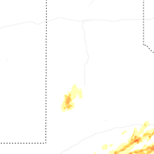


Connect with Interactive Hail Maps