

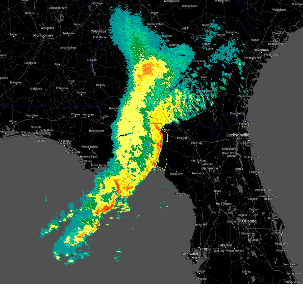
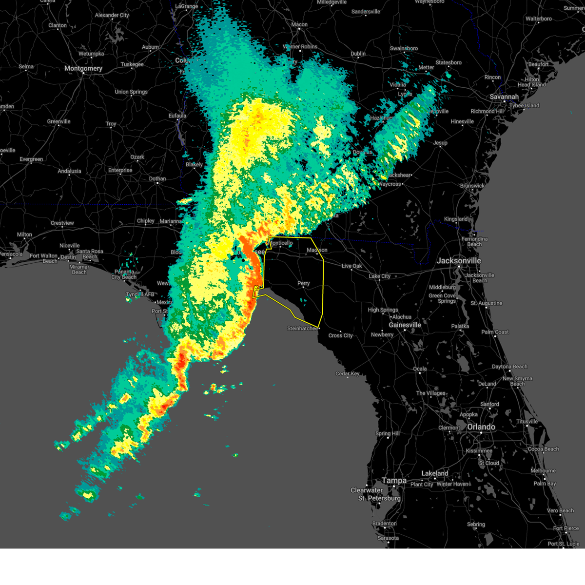
Hail Map for Steinhatchee, FL
The Steinhatchee, FL area has had 1 report of on-the-ground hail by trained spotters, and has been under severe weather warnings 2 times during the past 12 months. Doppler radar has detected hail at or near Steinhatchee, FL on 11 occasions.
| Name: | Steinhatchee, FL |
| Where Located: | 75.2 miles SE of Tallahassee, FL |
| Map: | Google Map for Steinhatchee, FL |
| Population: | 1047 |
| Housing Units: | 1555 |
| More Info: | Search Google for Steinhatchee, FL |
5
The Top Recent Hail Date for Steinhatchee, FL is Monday, July 16, 2012 (2nd out of 11)

Hail and Wind Damage Spotted near Steinhatchee, FL
| Date / Time | Report Details |
|---|---|
| 12/29/2024 9:32 AM EST |
 At 932 am est, severe thunderstorms were located along a line extending from 12 miles south of quitman to 6 miles southwest of madison to near perry, moving east at 40 mph (radar indicated). Hazards include 60 mph wind gusts and penny size hail. Expect damage to roofs, siding, and trees. Locations impacted include, madison, perry, greenville, pinland, jug island, ebb, hamburg, lovett, dekle beach, jack lee island, foley, salem, perry-foley airport, hampton springs, sirmans, shady grove, cedar island, fish creek, iddo, and howell place. At 932 am est, severe thunderstorms were located along a line extending from 12 miles south of quitman to 6 miles southwest of madison to near perry, moving east at 40 mph (radar indicated). Hazards include 60 mph wind gusts and penny size hail. Expect damage to roofs, siding, and trees. Locations impacted include, madison, perry, greenville, pinland, jug island, ebb, hamburg, lovett, dekle beach, jack lee island, foley, salem, perry-foley airport, hampton springs, sirmans, shady grove, cedar island, fish creek, iddo, and howell place.
|
| 12/29/2024 8:38 AM EST |
 Svrtae the national weather service in tallahassee has issued a * severe thunderstorm warning for, taylor county in big bend florida, jefferson county in big bend florida, madison county in big bend florida, * until 945 am est. * at 838 am est, severe thunderstorms were located along a line extending from near tallahassee to 7 miles east of woodville to 14 miles south of st. marks, moving east at 40 mph (radar indicated). Hazards include 60 mph wind gusts and penny size hail. expect damage to roofs, siding, and trees Svrtae the national weather service in tallahassee has issued a * severe thunderstorm warning for, taylor county in big bend florida, jefferson county in big bend florida, madison county in big bend florida, * until 945 am est. * at 838 am est, severe thunderstorms were located along a line extending from near tallahassee to 7 miles east of woodville to 14 miles south of st. marks, moving east at 40 mph (radar indicated). Hazards include 60 mph wind gusts and penny size hail. expect damage to roofs, siding, and trees
|
| 5/10/2024 8:10 AM EDT | Davis weather station gusted to 60 mp in dixie county FL, 1.1 miles NE of Steinhatchee, FL |
| 5/10/2024 7:30 AM EDT | Svrtae the national weather service in tallahassee has issued a * severe thunderstorm warning for, lafayette county in big bend florida, dixie county in big bend florida, eastern taylor county in big bend florida, * until 900 am edt. * at 730 am edt, severe thunderstorms were located along a line extending from near monticello to 13 miles southeast of st. marks, moving east at 65 mph (radar indicated). Hazards include 60 mph wind gusts. expect damage to roofs, siding, and trees |
| 4/11/2024 8:26 AM EDT |
 The storm which prompted the warning has weakened below severe limits, and no longer poses an immediate threat to life or property. therefore, the warning will be allowed to expire. a tornado watch remains in effect until 300 pm edt for big bend florida. The storm which prompted the warning has weakened below severe limits, and no longer poses an immediate threat to life or property. therefore, the warning will be allowed to expire. a tornado watch remains in effect until 300 pm edt for big bend florida.
|
| 4/11/2024 7:39 AM EDT |
 Svrtae the national weather service in tallahassee has issued a * severe thunderstorm warning for, lafayette county in big bend florida, northwestern dixie county in big bend florida, southeastern taylor county in big bend florida, * until 830 am edt. * at 739 am edt, a severe thunderstorm was located 15 miles northwest of steinhatchee, moving northeast at 50 mph (radar indicated). Hazards include 60 mph wind gusts. expect damage to roofs, siding, and trees Svrtae the national weather service in tallahassee has issued a * severe thunderstorm warning for, lafayette county in big bend florida, northwestern dixie county in big bend florida, southeastern taylor county in big bend florida, * until 830 am edt. * at 739 am edt, a severe thunderstorm was located 15 miles northwest of steinhatchee, moving northeast at 50 mph (radar indicated). Hazards include 60 mph wind gusts. expect damage to roofs, siding, and trees
|
| 3/27/2024 8:10 AM EDT |
 Svrtae the national weather service in tallahassee has issued a * severe thunderstorm warning for, dixie county in big bend florida, southeastern taylor county in big bend florida, * until 900 am edt. * at 809 am edt, severe thunderstorms were located along a line extending from near steinhatchee to near horseshoe point, moving east at 40 mph (radar indicated). Hazards include 60 mph wind gusts and nickel size hail. expect damage to roofs, siding, and trees Svrtae the national weather service in tallahassee has issued a * severe thunderstorm warning for, dixie county in big bend florida, southeastern taylor county in big bend florida, * until 900 am edt. * at 809 am edt, severe thunderstorms were located along a line extending from near steinhatchee to near horseshoe point, moving east at 40 mph (radar indicated). Hazards include 60 mph wind gusts and nickel size hail. expect damage to roofs, siding, and trees
|
| 1/9/2024 1:19 PM EST |
 At 119 pm est, severe thunderstorms were located along a line extending from 6 miles west of obrien to 14 miles south of horseshoe point, moving northeast at 65 mph (radar indicated). Hazards include 70 mph wind gusts. Expect considerable tree damage. Damage is likely to mobile homes, roofs, and outbuildings. At 119 pm est, severe thunderstorms were located along a line extending from 6 miles west of obrien to 14 miles south of horseshoe point, moving northeast at 65 mph (radar indicated). Hazards include 70 mph wind gusts. Expect considerable tree damage. Damage is likely to mobile homes, roofs, and outbuildings.
|
| 1/9/2024 1:03 PM EST |
 At 103 pm est, severe thunderstorms were located along a line extending from 9 miles northwest of needmore to 9 miles south of mayo, moving east at 45 mph (radar indicated). Hazards include 70 mph wind gusts and penny size hail. Expect considerable tree damage. damage is likely to mobile homes, roofs, and outbuildings. Locations impacted include, mayo, cross city, steinhatchee, horseshoe point, suwannee, horseshoe beach, tennille, shamrock, clara, cross city airport, shired island, old town, jonesboro, hatch bend, salem, san pedro junction, cooks hammock, howell place, guaranto springs, and carbur. At 103 pm est, severe thunderstorms were located along a line extending from 9 miles northwest of needmore to 9 miles south of mayo, moving east at 45 mph (radar indicated). Hazards include 70 mph wind gusts and penny size hail. Expect considerable tree damage. damage is likely to mobile homes, roofs, and outbuildings. Locations impacted include, mayo, cross city, steinhatchee, horseshoe point, suwannee, horseshoe beach, tennille, shamrock, clara, cross city airport, shired island, old town, jonesboro, hatch bend, salem, san pedro junction, cooks hammock, howell place, guaranto springs, and carbur.
|
| 1/9/2024 11:58 AM EST |
 At 1158 am est, severe thunderstorms were located along a line extending from 10 miles south of quitman to 32 miles southwest of perry, moving east at 45 mph (radar indicated). Hazards include 70 mph wind gusts and penny size hail. Expect considerable tree damage. Damage is likely to mobile homes, roofs, and outbuildings. At 1158 am est, severe thunderstorms were located along a line extending from 10 miles south of quitman to 32 miles southwest of perry, moving east at 45 mph (radar indicated). Hazards include 70 mph wind gusts and penny size hail. Expect considerable tree damage. Damage is likely to mobile homes, roofs, and outbuildings.
|
| 1/6/2024 5:23 AM EST |
 At 523 am est, severe thunderstorms were located along a line extending from 7 miles west of luraville to 19 miles west of steinhatchee, moving east at 40 mph. there are reports of trees and power lines down in the perry area with these storms (radar indicated). Hazards include 60 mph wind gusts. expect damage to roofs, siding, and trees At 523 am est, severe thunderstorms were located along a line extending from 7 miles west of luraville to 19 miles west of steinhatchee, moving east at 40 mph. there are reports of trees and power lines down in the perry area with these storms (radar indicated). Hazards include 60 mph wind gusts. expect damage to roofs, siding, and trees
|
| 1/6/2024 4:55 AM EST |
 At 455 am est, severe thunderstorms were located along a line extending from 7 miles northwest of blue springs to 37 miles west of steinhatchee, moving east at 30 mph (radar indicated). Hazards include 60 mph wind gusts. Expect damage to roofs, siding, and trees. locations impacted include, mayo, madison, perry, steinhatchee, lee, pinland, jug island, ebb, buckville, dekle beach, jack lee island, foley, salem, hanson, perry-foley airport, san pedro junction, hampton springs, sirmans, shady grove, and cedar island. hail threat, radar indicated max hail size, <. 75 in wind threat, radar indicated max wind gust, 60 mph. At 455 am est, severe thunderstorms were located along a line extending from 7 miles northwest of blue springs to 37 miles west of steinhatchee, moving east at 30 mph (radar indicated). Hazards include 60 mph wind gusts. Expect damage to roofs, siding, and trees. locations impacted include, mayo, madison, perry, steinhatchee, lee, pinland, jug island, ebb, buckville, dekle beach, jack lee island, foley, salem, hanson, perry-foley airport, san pedro junction, hampton springs, sirmans, shady grove, and cedar island. hail threat, radar indicated max hail size, <. 75 in wind threat, radar indicated max wind gust, 60 mph.
|
| 1/6/2024 4:29 AM EST |
 At 429 am est, severe thunderstorms were located along a line extending from 10 miles north of madison to 32 miles southeast of carrabelle, moving east at 40 mph (radar indicated). Hazards include 60 mph wind gusts. Expect damage to roofs, siding, and trees. locations impacted include, mayo, perry, steinhatchee, madison, greenville, lee, pinland, jug island, pinetta, scanlon, foley, hanson, perry-foley airport, san pedro junction, hampton springs, iddo, moseley hall, secotan, boyd, and smith. hail threat, radar indicated max hail size, <. 75 in wind threat, radar indicated max wind gust, 60 mph. At 429 am est, severe thunderstorms were located along a line extending from 10 miles north of madison to 32 miles southeast of carrabelle, moving east at 40 mph (radar indicated). Hazards include 60 mph wind gusts. Expect damage to roofs, siding, and trees. locations impacted include, mayo, perry, steinhatchee, madison, greenville, lee, pinland, jug island, pinetta, scanlon, foley, hanson, perry-foley airport, san pedro junction, hampton springs, iddo, moseley hall, secotan, boyd, and smith. hail threat, radar indicated max hail size, <. 75 in wind threat, radar indicated max wind gust, 60 mph.
|
| 1/6/2024 4:07 AM EST |
 At 407 am est, severe thunderstorms were located along a line extending from 6 miles east of monticello to 33 miles southeast of st george island, moving east at 30 mph (radar indicated). Hazards include 60 mph wind gusts. expect damage to roofs, siding, and trees At 407 am est, severe thunderstorms were located along a line extending from 6 miles east of monticello to 33 miles southeast of st george island, moving east at 30 mph (radar indicated). Hazards include 60 mph wind gusts. expect damage to roofs, siding, and trees
|
| 8/4/2023 8:35 PM EDT |
 At 834 pm edt, severe thunderstorms were located along a line extending from near williston highlands to near horseshoe point, moving southeast at 45 mph (radar indicated). Hazards include 60 mph wind gusts. Expect damage to roofs, siding, and trees. locations impacted include, cross city, steinhatchee, horseshoe point, suwannee, horseshoe beach, shamrock, cross city airport, shired island, old town, jena, eugene, yellow jacket and fanning springs. hail threat, radar indicated max hail size, <. 75 in wind threat, radar indicated max wind gust, 60 mph. At 834 pm edt, severe thunderstorms were located along a line extending from near williston highlands to near horseshoe point, moving southeast at 45 mph (radar indicated). Hazards include 60 mph wind gusts. Expect damage to roofs, siding, and trees. locations impacted include, cross city, steinhatchee, horseshoe point, suwannee, horseshoe beach, shamrock, cross city airport, shired island, old town, jena, eugene, yellow jacket and fanning springs. hail threat, radar indicated max hail size, <. 75 in wind threat, radar indicated max wind gust, 60 mph.
|
| 8/4/2023 7:47 PM EDT | Multiple trees reported down across the county. time for the southern half of the county estimated by rada in taylor county FL, 14.5 miles S of Steinhatchee, FL |
| 8/4/2023 7:43 PM EDT |
 At 742 pm edt, severe thunderstorms were located along a line extending from near bell to 16 miles northwest of steinhatchee, moving southeast at 40 mph (radar indicated). Hazards include 60 mph wind gusts. expect damage to roofs, siding, and trees At 742 pm edt, severe thunderstorms were located along a line extending from near bell to 16 miles northwest of steinhatchee, moving southeast at 40 mph (radar indicated). Hazards include 60 mph wind gusts. expect damage to roofs, siding, and trees
|
| 7/10/2023 11:56 AM EDT |
 At 1156 am edt, severe thunderstorms were located along a line extending from near obrien to 30 miles west of horseshoe point, moving east at 25 mph (radar indicated). Hazards include 60 mph wind gusts. Expect damage to roofs, siding, and trees. locations impacted include, cross city, steinhatchee, horseshoe point, suwannee, horseshoe beach, tennille, shamrock, clara, cross city airport, shired island, old town, jena, alton, hines, jonesboro, grady, hatch bend, eugene, fletcher and yellow jacket. hail threat, radar indicated max hail size, <. 75 in wind threat, radar indicated max wind gust, 60 mph. At 1156 am edt, severe thunderstorms were located along a line extending from near obrien to 30 miles west of horseshoe point, moving east at 25 mph (radar indicated). Hazards include 60 mph wind gusts. Expect damage to roofs, siding, and trees. locations impacted include, cross city, steinhatchee, horseshoe point, suwannee, horseshoe beach, tennille, shamrock, clara, cross city airport, shired island, old town, jena, alton, hines, jonesboro, grady, hatch bend, eugene, fletcher and yellow jacket. hail threat, radar indicated max hail size, <. 75 in wind threat, radar indicated max wind gust, 60 mph.
|
| 7/10/2023 11:36 AM EDT |
 At 1135 am edt, severe thunderstorms were located along a line extending from luraville to 7 miles northwest of steinhatchee, moving east at 35 mph (radar indicated). Hazards include 60 mph wind gusts. expect damage to roofs, siding, and trees At 1135 am edt, severe thunderstorms were located along a line extending from luraville to 7 miles northwest of steinhatchee, moving east at 35 mph (radar indicated). Hazards include 60 mph wind gusts. expect damage to roofs, siding, and trees
|
| 6/16/2023 2:12 PM EDT |
 The severe thunderstorm warning for lafayette and dixie counties will expire at 215 pm edt, the storms which prompted the warning have weakened below severe limits, and have exited the warned area. therefore, the warning will be allowed to expire. however residual wind gusts of 40 to 50 mph will continue through about 4 pm edt. a severe thunderstorm watch remains in effect until 300 pm edt for big bend of florida. The severe thunderstorm warning for lafayette and dixie counties will expire at 215 pm edt, the storms which prompted the warning have weakened below severe limits, and have exited the warned area. therefore, the warning will be allowed to expire. however residual wind gusts of 40 to 50 mph will continue through about 4 pm edt. a severe thunderstorm watch remains in effect until 300 pm edt for big bend of florida.
|
| 6/16/2023 1:22 PM EDT |
 At 122 pm edt, severe thunderstorms were located along a line extending from 12 miles south of madison to 16 miles southwest of mayo to near steinhatchee to 17 miles west of horseshoe point, moving east at 65 mph (radar indicated). Hazards include 60 mph wind gusts. expect damage to roofs, siding, and trees At 122 pm edt, severe thunderstorms were located along a line extending from 12 miles south of madison to 16 miles southwest of mayo to near steinhatchee to 17 miles west of horseshoe point, moving east at 65 mph (radar indicated). Hazards include 60 mph wind gusts. expect damage to roofs, siding, and trees
|
| 6/16/2023 12:54 PM EDT |
 At 1254 pm edt, severe thunderstorms were located along a line extending from 19 miles east of st. marks to 21 miles southwest of perry to 34 miles west of steinhatchee, moving east at 55 mph (radar indicated). Hazards include 60 mph wind gusts. expect damage to roofs, siding, and trees At 1254 pm edt, severe thunderstorms were located along a line extending from 19 miles east of st. marks to 21 miles southwest of perry to 34 miles west of steinhatchee, moving east at 55 mph (radar indicated). Hazards include 60 mph wind gusts. expect damage to roofs, siding, and trees
|
| 6/14/2023 11:43 PM EDT |
 The severe thunderstorm warning for southern lafayette, dixie and southeastern taylor counties will expire at 1145 pm edt, the storms which prompted the warning have weakened below severe limits, and no longer pose an immediate threat to life or property. therefore, the warning will be allowed to expire. however gusty winds and heavy rain are still possible with these thunderstorms. a tornado watch remains in effect until midnight edt for big bend of florida. to report severe weather, contact your nearest law enforcement agency. they will relay your report to the national weather service tallahassee. The severe thunderstorm warning for southern lafayette, dixie and southeastern taylor counties will expire at 1145 pm edt, the storms which prompted the warning have weakened below severe limits, and no longer pose an immediate threat to life or property. therefore, the warning will be allowed to expire. however gusty winds and heavy rain are still possible with these thunderstorms. a tornado watch remains in effect until midnight edt for big bend of florida. to report severe weather, contact your nearest law enforcement agency. they will relay your report to the national weather service tallahassee.
|
| 6/14/2023 10:51 PM EDT |
 At 1051 pm edt, severe thunderstorms were located along a line extending from near bell to 16 miles west of steinhatchee, moving southeast at 45 mph (radar indicated). Hazards include 60 mph wind gusts and quarter size hail. Hail damage to vehicles is expected. Expect wind damage to roofs, siding, and trees. At 1051 pm edt, severe thunderstorms were located along a line extending from near bell to 16 miles west of steinhatchee, moving southeast at 45 mph (radar indicated). Hazards include 60 mph wind gusts and quarter size hail. Hail damage to vehicles is expected. Expect wind damage to roofs, siding, and trees.
|
| 6/14/2023 9:46 PM EDT |
 At 946 pm edt, severe thunderstorms were located along a line extending from 6 miles west of madison to 18 miles east of st. marks to 12 miles south of crawfordville, moving southeast at 60 mph (radar indicated). Hazards include 60 mph wind gusts and quarter size hail. Hail damage to vehicles is expected. Expect wind damage to roofs, siding, and trees. At 946 pm edt, severe thunderstorms were located along a line extending from 6 miles west of madison to 18 miles east of st. marks to 12 miles south of crawfordville, moving southeast at 60 mph (radar indicated). Hazards include 60 mph wind gusts and quarter size hail. Hail damage to vehicles is expected. Expect wind damage to roofs, siding, and trees.
|
| 4/27/2023 8:20 PM EDT |
 The severe thunderstorm warning for lafayette, dixie and southeastern taylor counties will expire at 830 pm edt, the storms which prompted the warning have moved out of the area. therefore, the warning will be allowed to expire. a severe thunderstorm watch remains in effect until 900 pm edt for big bend of florida. to report severe weather, contact your nearest law enforcement agency. they will relay your report to the national weather service tallahassee. The severe thunderstorm warning for lafayette, dixie and southeastern taylor counties will expire at 830 pm edt, the storms which prompted the warning have moved out of the area. therefore, the warning will be allowed to expire. a severe thunderstorm watch remains in effect until 900 pm edt for big bend of florida. to report severe weather, contact your nearest law enforcement agency. they will relay your report to the national weather service tallahassee.
|
| 4/27/2023 7:04 PM EDT |
 At 704 pm edt, severe thunderstorms were located along a line extending from 10 miles southwest of dowling park to 47 miles southwest of horseshoe point, moving east at 60 mph (radar indicated). Hazards include 60 mph wind gusts. expect damage to roofs, siding, and trees At 704 pm edt, severe thunderstorms were located along a line extending from 10 miles southwest of dowling park to 47 miles southwest of horseshoe point, moving east at 60 mph (radar indicated). Hazards include 60 mph wind gusts. expect damage to roofs, siding, and trees
|
| 4/15/2023 10:40 PM EDT |
 At 1039 pm edt, severe thunderstorms were located along a line extending from 8 miles west of dowling park to near steinhatchee, moving east at 30 mph (radar indicated). Hazards include 60 mph wind gusts. Expect damage to roofs, siding, and trees. locations impacted include, steinhatchee, salem, carbur, howell place, athena and smith. hail threat, radar indicated max hail size, <. 75 in wind threat, radar indicated max wind gust, 60 mph. At 1039 pm edt, severe thunderstorms were located along a line extending from 8 miles west of dowling park to near steinhatchee, moving east at 30 mph (radar indicated). Hazards include 60 mph wind gusts. Expect damage to roofs, siding, and trees. locations impacted include, steinhatchee, salem, carbur, howell place, athena and smith. hail threat, radar indicated max hail size, <. 75 in wind threat, radar indicated max wind gust, 60 mph.
|
| 4/15/2023 10:19 PM EDT |
 At 1019 pm edt, severe thunderstorms were located along a line extending from 12 miles southwest of madison to 12 miles southwest of steinhatchee, moving east at 40 mph (radar indicated). Hazards include 60 mph wind gusts. Expect damage to roofs, siding, and trees. locations impacted include, steinhatchee, perry, pinland, fish creek, jug island, howell place, secotan, boyd, smith, carbur, adams beach, dekle beach, jack lee island, keaton beach, bird island, foley, salem, blue springs, perry-foley airport and bucell junction. hail threat, radar indicated max hail size, <. 75 in wind threat, radar indicated max wind gust, 60 mph. At 1019 pm edt, severe thunderstorms were located along a line extending from 12 miles southwest of madison to 12 miles southwest of steinhatchee, moving east at 40 mph (radar indicated). Hazards include 60 mph wind gusts. Expect damage to roofs, siding, and trees. locations impacted include, steinhatchee, perry, pinland, fish creek, jug island, howell place, secotan, boyd, smith, carbur, adams beach, dekle beach, jack lee island, keaton beach, bird island, foley, salem, blue springs, perry-foley airport and bucell junction. hail threat, radar indicated max hail size, <. 75 in wind threat, radar indicated max wind gust, 60 mph.
|
| 4/15/2023 10:17 PM EDT |
 At 1017 pm edt, severe thunderstorms were located along a line extending from 13 miles northeast of perry to 19 miles west of horseshoe point, moving east at 35 mph (radar indicated). Hazards include 60 mph wind gusts. expect damage to roofs, siding, and trees At 1017 pm edt, severe thunderstorms were located along a line extending from 13 miles northeast of perry to 19 miles west of horseshoe point, moving east at 35 mph (radar indicated). Hazards include 60 mph wind gusts. expect damage to roofs, siding, and trees
|
| 4/15/2023 9:54 PM EDT |
 At 954 pm edt, severe thunderstorms were located along a line extending from 17 miles northwest of perry to 30 miles west of steinhatchee, moving east at 30 mph (radar indicated). Hazards include 60 mph wind gusts. expect damage to roofs, siding, and trees At 954 pm edt, severe thunderstorms were located along a line extending from 17 miles northwest of perry to 30 miles west of steinhatchee, moving east at 30 mph (radar indicated). Hazards include 60 mph wind gusts. expect damage to roofs, siding, and trees
|
| 3/28/2023 6:05 PM EDT |
 The severe thunderstorm warning for southeastern taylor county will expire at 615 pm edt, the storm which prompted the warning has weakened below severe limits, and no longer poses an immediate threat to life or property. therefore, the warning will be allowed to expire. however gusty winds and heavy rain are still possible with this thunderstorm. to report severe weather, contact your nearest law enforcement agency. they will relay your report to the national weather service tallahassee. The severe thunderstorm warning for southeastern taylor county will expire at 615 pm edt, the storm which prompted the warning has weakened below severe limits, and no longer poses an immediate threat to life or property. therefore, the warning will be allowed to expire. however gusty winds and heavy rain are still possible with this thunderstorm. to report severe weather, contact your nearest law enforcement agency. they will relay your report to the national weather service tallahassee.
|
| 3/28/2023 5:38 PM EDT |
 At 538 pm edt, a severe thunderstorm was located 14 miles south of perry, moving southeast at 40 mph (radar indicated). Hazards include 60 mph wind gusts. expect damage to roofs, siding, and trees At 538 pm edt, a severe thunderstorm was located 14 miles south of perry, moving southeast at 40 mph (radar indicated). Hazards include 60 mph wind gusts. expect damage to roofs, siding, and trees
|
| 1/4/2023 11:53 AM EST |
 The severe thunderstorm warning for western lafayette, northwestern dixie, jefferson, taylor and madison counties will expire at noon est, the storms which prompted the warning have weakened below severe limits, and no longer pose an immediate threat to life or property. therefore, the warning will be allowed to expire. however gusty winds are still possible with these thunderstorms. a tornado watch remains in effect until 200 pm est for big bend of florida, and south central georgia. The severe thunderstorm warning for western lafayette, northwestern dixie, jefferson, taylor and madison counties will expire at noon est, the storms which prompted the warning have weakened below severe limits, and no longer pose an immediate threat to life or property. therefore, the warning will be allowed to expire. however gusty winds are still possible with these thunderstorms. a tornado watch remains in effect until 200 pm est for big bend of florida, and south central georgia.
|
| 1/4/2023 10:31 AM EST |
 At 1031 am est, severe thunderstorms were located along a line extending from near omega to 7 miles south of monticello to near carrabelle, moving northeast at 50 mph (radar indicated). Hazards include 60 mph wind gusts. expect damage to roofs, siding, and trees At 1031 am est, severe thunderstorms were located along a line extending from near omega to 7 miles south of monticello to near carrabelle, moving northeast at 50 mph (radar indicated). Hazards include 60 mph wind gusts. expect damage to roofs, siding, and trees
|
| 8/8/2022 6:36 PM EDT |
 At 636 pm edt, severe thunderstorms were located along a line extending from near madison to 13 miles northwest of steinhatchee, moving northwest at 20 mph (radar indicated). Hazards include 60 mph wind gusts. Expect damage to roofs, siding, and trees. locations impacted include, madison, perry, lee, pinland, jug island, dekle beach, jack lee island, foley, salem, perry-foley airport, hampton springs, cedar island, fish creek, howell place, moseley hall, secotan, boyd, smith, hopewell and carbur. hail threat, radar indicated max hail size, <. 75 in wind threat, radar indicated max wind gust, 60 mph. At 636 pm edt, severe thunderstorms were located along a line extending from near madison to 13 miles northwest of steinhatchee, moving northwest at 20 mph (radar indicated). Hazards include 60 mph wind gusts. Expect damage to roofs, siding, and trees. locations impacted include, madison, perry, lee, pinland, jug island, dekle beach, jack lee island, foley, salem, perry-foley airport, hampton springs, cedar island, fish creek, howell place, moseley hall, secotan, boyd, smith, hopewell and carbur. hail threat, radar indicated max hail size, <. 75 in wind threat, radar indicated max wind gust, 60 mph.
|
| 8/8/2022 6:09 PM EDT |
 At 609 pm edt, severe thunderstorms were located along a line extending from near luraville to near steinhatchee, moving northwest at 15 mph (radar indicated). Hazards include 60 mph wind gusts. expect damage to roofs, siding, and trees At 609 pm edt, severe thunderstorms were located along a line extending from near luraville to near steinhatchee, moving northwest at 15 mph (radar indicated). Hazards include 60 mph wind gusts. expect damage to roofs, siding, and trees
|
| 8/8/2022 5:48 PM EDT |
 At 547 pm edt, severe thunderstorms were located along a line extending from near steinhatchee to near mayo, moving northwest at 20 mph (radar indicated). Hazards include 60 mph wind gusts. Expect damage to roofs, siding, and trees. locations impacted include, mayo, cross city, steinhatchee, tennille, cooks hammock, shamrock, clara, cross city airport, carbur, jena, alton, hines, jonesboro, salem, eugene and san pedro junction. hail threat, radar indicated max hail size, <. 75 in wind threat, radar indicated max wind gust, 60 mph. At 547 pm edt, severe thunderstorms were located along a line extending from near steinhatchee to near mayo, moving northwest at 20 mph (radar indicated). Hazards include 60 mph wind gusts. Expect damage to roofs, siding, and trees. locations impacted include, mayo, cross city, steinhatchee, tennille, cooks hammock, shamrock, clara, cross city airport, carbur, jena, alton, hines, jonesboro, salem, eugene and san pedro junction. hail threat, radar indicated max hail size, <. 75 in wind threat, radar indicated max wind gust, 60 mph.
|
| 8/8/2022 5:16 PM EDT |
 At 516 pm edt, a severe thunderstorm was located near manattee road, or 8 miles southeast of cross city, moving northwest at 15 mph (radar indicated). Hazards include 60 mph wind gusts. expect damage to roofs, siding, and trees At 516 pm edt, a severe thunderstorm was located near manattee road, or 8 miles southeast of cross city, moving northwest at 15 mph (radar indicated). Hazards include 60 mph wind gusts. expect damage to roofs, siding, and trees
|
| 6/28/2022 9:28 PM EDT |
 At 928 pm edt, a severe thunderstorm was located near cross city, moving west at 15 mph (radar indicated). Hazards include 60 mph wind gusts. Expect damage to roofs, siding, and trees. locations impacted include, cross city, shamrock, hines, jonesboro, cross city airport, eugene, fletcher, jena and clara. hail threat, radar indicated max hail size, <. 75 in wind threat, radar indicated max wind gust, 60 mph. At 928 pm edt, a severe thunderstorm was located near cross city, moving west at 15 mph (radar indicated). Hazards include 60 mph wind gusts. Expect damage to roofs, siding, and trees. locations impacted include, cross city, shamrock, hines, jonesboro, cross city airport, eugene, fletcher, jena and clara. hail threat, radar indicated max hail size, <. 75 in wind threat, radar indicated max wind gust, 60 mph.
|
| 6/28/2022 8:53 PM EDT |
 At 853 pm edt, a severe thunderstorm was located near cross city, moving northwest at 15 mph (radar indicated). Hazards include 60 mph wind gusts. expect damage to roofs, siding, and trees At 853 pm edt, a severe thunderstorm was located near cross city, moving northwest at 15 mph (radar indicated). Hazards include 60 mph wind gusts. expect damage to roofs, siding, and trees
|
| 6/19/2022 4:00 PM EDT |
 At 359 pm edt, doppler radar indicated a severe thunderstorm capable of producing quarter size hail and damaging winds in excess of 60 mph. this storm was located 13 miles north of cross city, and moving northwest at 15 mph. At 359 pm edt, doppler radar indicated a severe thunderstorm capable of producing quarter size hail and damaging winds in excess of 60 mph. this storm was located 13 miles north of cross city, and moving northwest at 15 mph.
|
| 3/12/2022 4:35 AM EST |
 At 435 am est, severe thunderstorms were located along a line extending from 8 miles west of luraville to 68 miles south of st george island, moving northeast at 60 mph (radar indicated). Hazards include 60 mph wind gusts. expect damage to roofs, siding, and trees At 435 am est, severe thunderstorms were located along a line extending from 8 miles west of luraville to 68 miles south of st george island, moving northeast at 60 mph (radar indicated). Hazards include 60 mph wind gusts. expect damage to roofs, siding, and trees
|
| 1/16/2022 4:14 AM EST |
 At 414 am est, doppler radar indicated a line of severe thunderstorms capable of producing damaging winds in excess of 60 mph. these storms were located along a line extending from 19 miles southwest of perry to 16 miles west of steinhatchee to 21 miles west of horseshoe point, and moving northeast at 25 mph. At 414 am est, doppler radar indicated a line of severe thunderstorms capable of producing damaging winds in excess of 60 mph. these storms were located along a line extending from 19 miles southwest of perry to 16 miles west of steinhatchee to 21 miles west of horseshoe point, and moving northeast at 25 mph.
|
| 6/29/2021 3:11 PM EDT |
 At 311 pm edt, severe thunderstorms were located along a line extending from near mayo to 8 miles northwest of horseshoe point, moving northwest at 30 mph (radar indicated). Hazards include 60 mph wind gusts. expect damage to roofs, siding, and trees At 311 pm edt, severe thunderstorms were located along a line extending from near mayo to 8 miles northwest of horseshoe point, moving northwest at 30 mph (radar indicated). Hazards include 60 mph wind gusts. expect damage to roofs, siding, and trees
|
| 3/18/2021 1:39 PM EDT |
 At 139 pm edt, a severe thunderstorm capable of producing a tornado was located 8 miles east of steinhatchee, moving northeast at 35 mph (radar indicated rotation). Hazards include tornado. Flying debris will be dangerous to those caught without shelter. mobile homes will be damaged or destroyed. damage to roofs, windows, and vehicles will occur. tree damage is likely. Locations impacted include, cross city, shamrock, hines, jonesboro and cross city airport. At 139 pm edt, a severe thunderstorm capable of producing a tornado was located 8 miles east of steinhatchee, moving northeast at 35 mph (radar indicated rotation). Hazards include tornado. Flying debris will be dangerous to those caught without shelter. mobile homes will be damaged or destroyed. damage to roofs, windows, and vehicles will occur. tree damage is likely. Locations impacted include, cross city, shamrock, hines, jonesboro and cross city airport.
|
| 3/18/2021 1:21 PM EDT |
 At 121 pm edt, a severe thunderstorm capable of producing a tornado was located near steinhatchee, moving northeast at 35 mph (radar indicated rotation). Hazards include tornado. Flying debris will be dangerous to those caught without shelter. mobile homes will be damaged or destroyed. damage to roofs, windows, and vehicles will occur. tree damage is likely. This tornadic thunderstorm will remain over mainly rural areas of south central lafayette, northern dixie and southeastern taylor counties, including the following locations, shamrock, hines, jonesboro, cross city airport and jena. At 121 pm edt, a severe thunderstorm capable of producing a tornado was located near steinhatchee, moving northeast at 35 mph (radar indicated rotation). Hazards include tornado. Flying debris will be dangerous to those caught without shelter. mobile homes will be damaged or destroyed. damage to roofs, windows, and vehicles will occur. tree damage is likely. This tornadic thunderstorm will remain over mainly rural areas of south central lafayette, northern dixie and southeastern taylor counties, including the following locations, shamrock, hines, jonesboro, cross city airport and jena.
|
| 2/15/2021 6:40 PM EST |
 At 640 pm est, severe thunderstorms were located along a line extending from near steinhatchee to 27 miles southwest of horseshoe point, moving northeast at 60 mph (radar indicated). Hazards include 60 mph wind gusts and quarter size hail. Hail damage to vehicles is expected. Expect wind damage to roofs, siding, and trees. At 640 pm est, severe thunderstorms were located along a line extending from near steinhatchee to 27 miles southwest of horseshoe point, moving northeast at 60 mph (radar indicated). Hazards include 60 mph wind gusts and quarter size hail. Hail damage to vehicles is expected. Expect wind damage to roofs, siding, and trees.
|
| 2/15/2021 2:43 PM EST |
 At 243 pm est, a severe thunderstorm was located 17 miles west of steinhatchee, moving north at 55 mph (radar indicated). Hazards include 60 mph wind gusts and quarter size hail. Hail damage to vehicles is expected. Expect wind damage to roofs, siding, and trees. At 243 pm est, a severe thunderstorm was located 17 miles west of steinhatchee, moving north at 55 mph (radar indicated). Hazards include 60 mph wind gusts and quarter size hail. Hail damage to vehicles is expected. Expect wind damage to roofs, siding, and trees.
|
| 12/24/2020 5:00 PM EST |
 At 500 pm est, severe thunderstorms were located along a line extending from 14 miles northeast of steinhatchee to 21 miles southwest of horseshoe point, moving northeast at 30 mph (radar indicated). Hazards include 60 mph wind gusts. expect damage to roofs, siding, and trees At 500 pm est, severe thunderstorms were located along a line extending from 14 miles northeast of steinhatchee to 21 miles southwest of horseshoe point, moving northeast at 30 mph (radar indicated). Hazards include 60 mph wind gusts. expect damage to roofs, siding, and trees
|
| 12/24/2020 4:41 PM EST |
 At 440 pm est, severe thunderstorms were located along a line extending from near suwannee river state park to 23 miles southwest of steinhatchee, moving east at 45 mph (radar indicated). Hazards include 60 mph wind gusts. Expect damage to roofs, siding, and trees. Locations impacted include, mayo, steinhatchee, cooks hammock, howell place, chancey, smith, buckville, carbur, alton, mayo junction, townsend, grady, hatch bend, salem, san pedro junction and day. At 440 pm est, severe thunderstorms were located along a line extending from near suwannee river state park to 23 miles southwest of steinhatchee, moving east at 45 mph (radar indicated). Hazards include 60 mph wind gusts. Expect damage to roofs, siding, and trees. Locations impacted include, mayo, steinhatchee, cooks hammock, howell place, chancey, smith, buckville, carbur, alton, mayo junction, townsend, grady, hatch bend, salem, san pedro junction and day.
|
| 12/24/2020 4:10 PM EST |
 At 409 pm est, severe thunderstorms were located along a line extending from 12 miles south of madison to 46 miles southwest of steinhatchee, moving east at 45 mph (radar indicated). Hazards include 60 mph wind gusts. expect damage to roofs, siding, and trees At 409 pm est, severe thunderstorms were located along a line extending from 12 miles south of madison to 46 miles southwest of steinhatchee, moving east at 45 mph (radar indicated). Hazards include 60 mph wind gusts. expect damage to roofs, siding, and trees
|
| 7/21/2020 5:43 PM EDT |
 At 543 pm edt, severe thunderstorms were located along a line extending from 7 miles southwest of steinhatchee to near mayo, moving northwest at 25 mph (radar indicated). Hazards include 60 mph wind gusts. Expect damage to roofs, siding, and trees. Locations impacted include, perry, steinhatchee, pinland, tennille, jug island, clara, buckville, dekle beach, jack lee island, foley, salem, perry-foley airport, hampton springs, cedar island, fish creek, cooks hammock, howell place, secotan, boyd and smith. At 543 pm edt, severe thunderstorms were located along a line extending from 7 miles southwest of steinhatchee to near mayo, moving northwest at 25 mph (radar indicated). Hazards include 60 mph wind gusts. Expect damage to roofs, siding, and trees. Locations impacted include, perry, steinhatchee, pinland, tennille, jug island, clara, buckville, dekle beach, jack lee island, foley, salem, perry-foley airport, hampton springs, cedar island, fish creek, cooks hammock, howell place, secotan, boyd and smith.
|
| 7/21/2020 5:29 PM EDT |
 At 529 pm edt, a severe thunderstorm was located near steinhatchee, moving west at 25 mph (radar indicated). Hazards include 60 mph wind gusts. Expect damage to roofs, siding, and trees. Locations impacted include, cross city, horseshoe point, horseshoe beach, shamrock, hines, jonesboro and clara. At 529 pm edt, a severe thunderstorm was located near steinhatchee, moving west at 25 mph (radar indicated). Hazards include 60 mph wind gusts. Expect damage to roofs, siding, and trees. Locations impacted include, cross city, horseshoe point, horseshoe beach, shamrock, hines, jonesboro and clara.
|
| 7/21/2020 5:18 PM EDT |
 The national weather service in tallahassee has issued a * severe thunderstorm warning for. lafayette county in big bend of florida. taylor county in big bend of florida. until 645 pm edt. At 518 pm edt, a severe thunderstorm was located 8 miles northwest. The national weather service in tallahassee has issued a * severe thunderstorm warning for. lafayette county in big bend of florida. taylor county in big bend of florida. until 645 pm edt. At 518 pm edt, a severe thunderstorm was located 8 miles northwest.
|
| 7/21/2020 5:11 PM EDT |
 At 511 pm edt, a severe thunderstorm was located near cross city, moving west at 25 mph (radar indicated). Hazards include 60 mph wind gusts. Expect damage to roofs, siding, and trees. Locations impacted include, cross city, horseshoe point, horseshoe beach, shamrock, hines, jonesboro, cross city airport, shired island, eugene, fletcher, jena and clara. At 511 pm edt, a severe thunderstorm was located near cross city, moving west at 25 mph (radar indicated). Hazards include 60 mph wind gusts. Expect damage to roofs, siding, and trees. Locations impacted include, cross city, horseshoe point, horseshoe beach, shamrock, hines, jonesboro, cross city airport, shired island, eugene, fletcher, jena and clara.
|
| 7/21/2020 4:50 PM EDT |
 At 449 pm edt, a severe thunderstorm was located near cross city, moving west at 25 mph (radar indicated). Hazards include 60 mph wind gusts. expect damage to roofs, siding, and trees At 449 pm edt, a severe thunderstorm was located near cross city, moving west at 25 mph (radar indicated). Hazards include 60 mph wind gusts. expect damage to roofs, siding, and trees
|
| 4/24/2020 2:04 AM EDT |
 At 204 am edt, severe thunderstorms were located along a line extending from 6 miles east of perry to near horseshoe point, moving east at 60 mph (radar indicated). Hazards include 60 mph wind gusts. Expect damage to roofs, siding, and trees. Locations impacted include, mayo, perry, cross city, steinhatchee, horseshoe point, suwannee, horseshoe beach, pinland, tennille, shamrock, jug island, clara, cross city airport, shired island, old town, buckville, dekle beach, jonesboro, jack lee island and hatch bend. At 204 am edt, severe thunderstorms were located along a line extending from 6 miles east of perry to near horseshoe point, moving east at 60 mph (radar indicated). Hazards include 60 mph wind gusts. Expect damage to roofs, siding, and trees. Locations impacted include, mayo, perry, cross city, steinhatchee, horseshoe point, suwannee, horseshoe beach, pinland, tennille, shamrock, jug island, clara, cross city airport, shired island, old town, buckville, dekle beach, jonesboro, jack lee island and hatch bend.
|
| 4/24/2020 1:25 AM EDT |
 At 125 am edt, severe thunderstorms were located along a line extending from 17 miles southeast of st. marks to 53 miles southwest of horseshoe point, moving east at 50 mph (radar indicated). Hazards include 60 mph wind gusts. expect damage to roofs, siding, and trees At 125 am edt, severe thunderstorms were located along a line extending from 17 miles southeast of st. marks to 53 miles southwest of horseshoe point, moving east at 50 mph (radar indicated). Hazards include 60 mph wind gusts. expect damage to roofs, siding, and trees
|
| 4/23/2020 8:31 PM EDT |
 At 831 pm edt, severe thunderstorms were located along a line extending from near suwannee river state park to near steinhatchee, moving east at 35 mph (radar indicated). Hazards include 60 mph wind gusts. Expect damage to roofs, siding, and trees. Locations impacted include, mayo, cross city, steinhatchee, lee, tennille, shamrock, clara, cross city airport, old town, buckville, jonesboro, grady, hatch bend, salem, san pedro junction, cooks hammock, chancey, guaranto springs, carbur and jena. At 831 pm edt, severe thunderstorms were located along a line extending from near suwannee river state park to near steinhatchee, moving east at 35 mph (radar indicated). Hazards include 60 mph wind gusts. Expect damage to roofs, siding, and trees. Locations impacted include, mayo, cross city, steinhatchee, lee, tennille, shamrock, clara, cross city airport, old town, buckville, jonesboro, grady, hatch bend, salem, san pedro junction, cooks hammock, chancey, guaranto springs, carbur and jena.
|
| 4/23/2020 8:30 PM EDT | Downed powerline caught tree on fir in dixie county FL, 1.8 miles NW of Steinhatchee, FL |
| 4/23/2020 8:15 PM EDT | Tree dow in taylor county FL, 14.5 miles S of Steinhatchee, FL |
| 4/23/2020 8:08 PM EDT |
 At 808 pm edt, severe thunderstorms were located along a line extending from 11 miles south of madison to 18 miles west of steinhatchee, moving east at 30 mph (radar indicated). Hazards include 60 mph wind gusts. expect damage to roofs, siding, and trees At 808 pm edt, severe thunderstorms were located along a line extending from 11 miles south of madison to 18 miles west of steinhatchee, moving east at 30 mph (radar indicated). Hazards include 60 mph wind gusts. expect damage to roofs, siding, and trees
|
| 4/20/2020 7:09 AM EDT |
 At 642 am edt, a severe thunderstorm was located near mayo, moving east at 60 mph (radar indicated). Hazards include 60 mph wind gusts and penny size hail. Expect damage to roofs, siding, and trees. Locations impacted include, mayo, steinhatchee, tennille, jug island, clara, buckville, dekle beach, jonesboro, jack lee island, grady, hatch bend, salem, san pedro junction, cedar island, fish creek, cooks hammock, howell place, guaranto springs, carbur and jena. At 642 am edt, a severe thunderstorm was located near mayo, moving east at 60 mph (radar indicated). Hazards include 60 mph wind gusts and penny size hail. Expect damage to roofs, siding, and trees. Locations impacted include, mayo, steinhatchee, tennille, jug island, clara, buckville, dekle beach, jonesboro, jack lee island, grady, hatch bend, salem, san pedro junction, cedar island, fish creek, cooks hammock, howell place, guaranto springs, carbur and jena.
|
| 4/20/2020 6:42 AM EDT |
 At 642 am edt, a severe thunderstorm was located near mayo, moving east at 60 mph (radar indicated). Hazards include 60 mph wind gusts and penny size hail. Expect damage to roofs, siding, and trees. Locations impacted include, mayo, steinhatchee, tennille, jug island, clara, buckville, dekle beach, jonesboro, jack lee island, grady, hatch bend, salem, san pedro junction, cedar island, fish creek, cooks hammock, howell place, guaranto springs, carbur and jena. At 642 am edt, a severe thunderstorm was located near mayo, moving east at 60 mph (radar indicated). Hazards include 60 mph wind gusts and penny size hail. Expect damage to roofs, siding, and trees. Locations impacted include, mayo, steinhatchee, tennille, jug island, clara, buckville, dekle beach, jonesboro, jack lee island, grady, hatch bend, salem, san pedro junction, cedar island, fish creek, cooks hammock, howell place, guaranto springs, carbur and jena.
|
| 4/20/2020 6:35 AM EDT |
 At 635 am edt, a severe thunderstorm was located 37 miles west of steinhatchee, moving east at 55 mph (radar indicated). Hazards include 60 mph wind gusts. expect damage to roofs, siding, and trees At 635 am edt, a severe thunderstorm was located 37 miles west of steinhatchee, moving east at 55 mph (radar indicated). Hazards include 60 mph wind gusts. expect damage to roofs, siding, and trees
|
| 4/20/2020 6:13 AM EDT |
 At 613 am edt, a severe thunderstorm was located 9 miles south of perry, moving east at 60 mph (radar indicated). Hazards include 60 mph wind gusts and penny size hail. expect damage to roofs, siding, and trees At 613 am edt, a severe thunderstorm was located 9 miles south of perry, moving east at 60 mph (radar indicated). Hazards include 60 mph wind gusts and penny size hail. expect damage to roofs, siding, and trees
|
| 4/14/2020 10:20 PM EDT |
 The severe thunderstorm warning for southern lafayette, dixie and southeastern taylor counties will expire at 1030 pm edt, the storm which prompted the warning has weakened below severe limits, and no longer poses an immediate threat to life or property. therefore, the warning will be allowed to expire. however gusty winds are still possible with this thunderstorm. to report severe weather, contact your nearest law enforcement agency. they will relay your report to the national weather service tallahassee. The severe thunderstorm warning for southern lafayette, dixie and southeastern taylor counties will expire at 1030 pm edt, the storm which prompted the warning has weakened below severe limits, and no longer poses an immediate threat to life or property. therefore, the warning will be allowed to expire. however gusty winds are still possible with this thunderstorm. to report severe weather, contact your nearest law enforcement agency. they will relay your report to the national weather service tallahassee.
|
| 4/14/2020 9:41 PM EDT |
 At 940 pm edt, a severe thunderstorm was located 7 miles northeast of steinhatchee, moving east at 40 mph. another severe storm was located offshore about 25 miles west of horseshoe beach also moving east around 40 mph (radar indicated). Hazards include 60 mph wind gusts and penny size hail. Expect damage to roofs, siding, and trees. Locations impacted include, cross city, steinhatchee, horseshoe point, suwannee, horseshoe beach, tennille, shamrock, howell place, clara, cross city airport, shired island, old town, jena, hines, jonesboro, hatch bend, eugene, fletcher, yellow jacket and fanning springs. At 940 pm edt, a severe thunderstorm was located 7 miles northeast of steinhatchee, moving east at 40 mph. another severe storm was located offshore about 25 miles west of horseshoe beach also moving east around 40 mph (radar indicated). Hazards include 60 mph wind gusts and penny size hail. Expect damage to roofs, siding, and trees. Locations impacted include, cross city, steinhatchee, horseshoe point, suwannee, horseshoe beach, tennille, shamrock, howell place, clara, cross city airport, shired island, old town, jena, hines, jonesboro, hatch bend, eugene, fletcher, yellow jacket and fanning springs.
|
| 4/14/2020 8:59 PM EDT |
 At 859 pm edt, a severe thunderstorm was located 20 miles west of steinhatchee, moving east at 35 mph (radar indicated). Hazards include 60 mph wind gusts and penny size hail. expect damage to roofs, siding, and trees At 859 pm edt, a severe thunderstorm was located 20 miles west of steinhatchee, moving east at 35 mph (radar indicated). Hazards include 60 mph wind gusts and penny size hail. expect damage to roofs, siding, and trees
|
| 2/6/2020 8:00 PM EST | Several trees down in taylor count in taylor county FL, 14.5 miles S of Steinhatchee, FL |
| 2/6/2020 7:54 PM EST |
 At 753 pm est, doppler radar indicated a line of severe thunderstorms capable of producing damaging winds in excess of 60 mph. these storms were located along a line extending from near luraville to 70 miles southwest of horseshoe point, and moving northeast at 70 mph. At 753 pm est, doppler radar indicated a line of severe thunderstorms capable of producing damaging winds in excess of 60 mph. these storms were located along a line extending from near luraville to 70 miles southwest of horseshoe point, and moving northeast at 70 mph.
|
| 2/6/2020 7:15 PM EST |
 At 715 pm est, severe thunderstorms were located along a line extending from jennings to 7 miles northeast of perry to 20 miles northwest of steinhatchee to 61 miles southeast of st george island, moving northeast at 60 mph (radar indicated). Hazards include 60 mph wind gusts. Expect damage to roofs, siding, and trees. Locations impacted include, mayo, madison, perry, lee, pinland, jug island, clara, buckville, pinetta, dekle beach, jack lee island, foley, salem, hanson, perry-foley airport, san pedro junction, hampton springs, cedar island, fish creek and cooks hammock. At 715 pm est, severe thunderstorms were located along a line extending from jennings to 7 miles northeast of perry to 20 miles northwest of steinhatchee to 61 miles southeast of st george island, moving northeast at 60 mph (radar indicated). Hazards include 60 mph wind gusts. Expect damage to roofs, siding, and trees. Locations impacted include, mayo, madison, perry, lee, pinland, jug island, clara, buckville, pinetta, dekle beach, jack lee island, foley, salem, hanson, perry-foley airport, san pedro junction, hampton springs, cedar island, fish creek and cooks hammock.
|
| 2/6/2020 6:53 PM EST |
 At 653 pm est, severe thunderstorms were located along a line extending from near madison to 14 miles southwest of perry to 26 miles west of steinhatchee to 66 miles south of st george island, moving northeast at 60 mph (radar indicated). Hazards include 60 mph wind gusts. expect damage to roofs, siding, and trees At 653 pm est, severe thunderstorms were located along a line extending from near madison to 14 miles southwest of perry to 26 miles west of steinhatchee to 66 miles south of st george island, moving northeast at 60 mph (radar indicated). Hazards include 60 mph wind gusts. expect damage to roofs, siding, and trees
|
| 4/19/2019 9:47 AM EDT |
 At 947 am edt, severe thunderstorms were located along a line extending from 11 miles north of steinhatchee to 39 miles southwest of horseshoe point, moving northeast at 45 mph (radar indicated). Hazards include 60 mph wind gusts. expect damage to roofs, siding, and trees At 947 am edt, severe thunderstorms were located along a line extending from 11 miles north of steinhatchee to 39 miles southwest of horseshoe point, moving northeast at 45 mph (radar indicated). Hazards include 60 mph wind gusts. expect damage to roofs, siding, and trees
|
| 3/3/2019 10:22 PM EST |
 At 1022 pm est, a severe thunderstorm was located 11 miles northeast of steinhatchee, moving east at 50 mph (radar indicated). Hazards include 60 mph wind gusts. expect damage to roofs, siding, and trees At 1022 pm est, a severe thunderstorm was located 11 miles northeast of steinhatchee, moving east at 50 mph (radar indicated). Hazards include 60 mph wind gusts. expect damage to roofs, siding, and trees
|
| 3/3/2019 9:50 PM EST |
 At 950 pm est, a severe thunderstorm was located 11 miles northwest of steinhatchee, moving southeast at 40 mph (radar indicated). Hazards include 60 mph wind gusts. expect damage to roofs, siding, and trees At 950 pm est, a severe thunderstorm was located 11 miles northwest of steinhatchee, moving southeast at 40 mph (radar indicated). Hazards include 60 mph wind gusts. expect damage to roofs, siding, and trees
|
| 9/4/2018 4:41 PM EDT |
 The severe thunderstorm warning for southwestern lafayette, northwestern dixie and southeastern taylor counties will expire at 445 pm edt, the storm which prompted the warning has weakened below severe limits, and no longer poses an immediate threat to life or property. therefore, the warning will be allowed to expire. The severe thunderstorm warning for southwestern lafayette, northwestern dixie and southeastern taylor counties will expire at 445 pm edt, the storm which prompted the warning has weakened below severe limits, and no longer poses an immediate threat to life or property. therefore, the warning will be allowed to expire.
|
| 9/4/2018 4:26 PM EDT |
 At 425 pm edt, a severe thunderstorm was located 8 miles north of steinhatchee, moving northwest at 30 mph (radar indicated). Hazards include 60 mph wind gusts. Expect damage to roofs, siding, and trees. Locations impacted include, steinhatchee, tennille, fish creek, jug island, howell place, clara, carbur, dekle beach, jack lee island, keaton beach, bird island, salem, blue springs and cedar island. At 425 pm edt, a severe thunderstorm was located 8 miles north of steinhatchee, moving northwest at 30 mph (radar indicated). Hazards include 60 mph wind gusts. Expect damage to roofs, siding, and trees. Locations impacted include, steinhatchee, tennille, fish creek, jug island, howell place, clara, carbur, dekle beach, jack lee island, keaton beach, bird island, salem, blue springs and cedar island.
|
| 9/4/2018 4:06 PM EDT |
 The national weather service in tallahassee has issued a * severe thunderstorm warning for. southwestern lafayette county in big bend of florida. northwestern dixie county in big bend of florida. southeastern taylor county in big bend of florida. Until 445 pm edt. The national weather service in tallahassee has issued a * severe thunderstorm warning for. southwestern lafayette county in big bend of florida. northwestern dixie county in big bend of florida. southeastern taylor county in big bend of florida. Until 445 pm edt.
|
| 7/22/2018 10:40 PM EDT | Several trees dow in dixie county FL, 1.5 miles NNW of Steinhatchee, FL |
| 7/22/2018 10:30 PM EDT |
 At 1030 pm edt, a severe thunderstorm was located over steinhatchee, moving southeast at 20 mph (radar indicated). Hazards include 60 mph wind gusts and penny size hail. expect damage to roofs, siding, and trees At 1030 pm edt, a severe thunderstorm was located over steinhatchee, moving southeast at 20 mph (radar indicated). Hazards include 60 mph wind gusts and penny size hail. expect damage to roofs, siding, and trees
|
| 7/21/2018 3:33 PM EDT |
 At 332 pm edt, a severe thunderstorm was located near manattee road, or 10 miles west of chiefland, moving southeast at 40 mph (radar indicated). Hazards include 60 mph wind gusts and nickel size hail. Expect damage to roofs, siding, and trees. Locations impacted include, cross city, horseshoe point, suwannee, horseshoe beach, shamrock, cross city airport, shired island, old town, guaranto springs, jena, hines, jonesboro, grady, hatch bend, eugene, fletcher, yellow jacket and fanning springs. At 332 pm edt, a severe thunderstorm was located near manattee road, or 10 miles west of chiefland, moving southeast at 40 mph (radar indicated). Hazards include 60 mph wind gusts and nickel size hail. Expect damage to roofs, siding, and trees. Locations impacted include, cross city, horseshoe point, suwannee, horseshoe beach, shamrock, cross city airport, shired island, old town, guaranto springs, jena, hines, jonesboro, grady, hatch bend, eugene, fletcher, yellow jacket and fanning springs.
|
| 7/21/2018 2:39 PM EDT |
 At 238 pm edt, a severe thunderstorm was located 15 miles north of steinhatchee, moving southeast at 40 mph (radar indicated). Hazards include 60 mph wind gusts and nickel size hail. expect damage to roofs, siding, and trees At 238 pm edt, a severe thunderstorm was located 15 miles north of steinhatchee, moving southeast at 40 mph (radar indicated). Hazards include 60 mph wind gusts and nickel size hail. expect damage to roofs, siding, and trees
|
| 4/7/2018 3:35 PM EDT |
 At 334 pm edt, a severe thunderstorm was located 9 miles north of steinhatchee, moving east at 35 mph (radar indicated). Hazards include 60 mph wind gusts. expect damage to roofs, siding, and trees At 334 pm edt, a severe thunderstorm was located 9 miles north of steinhatchee, moving east at 35 mph (radar indicated). Hazards include 60 mph wind gusts. expect damage to roofs, siding, and trees
|
| 3/19/2018 5:27 AM EDT |
 At 527 am edt, a severe thunderstorm was located 9 miles southeast of perry, moving southeast at 55 mph (radar indicated). Hazards include 60 mph wind gusts. expect damage to roofs, siding, and trees At 527 am edt, a severe thunderstorm was located 9 miles southeast of perry, moving southeast at 55 mph (radar indicated). Hazards include 60 mph wind gusts. expect damage to roofs, siding, and trees
|
| 10/7/2017 5:46 PM EDT |
 At 545 pm edt, a severe thunderstorm was located 8 miles east of steinhatchee, moving north at 15 mph. some rotation was detected (radar indicated). Hazards include 60 mph wind gusts. expect damage to roofs, siding, and trees At 545 pm edt, a severe thunderstorm was located 8 miles east of steinhatchee, moving north at 15 mph. some rotation was detected (radar indicated). Hazards include 60 mph wind gusts. expect damage to roofs, siding, and trees
|
| 2/7/2017 9:21 PM EST |
 At 921 pm est, a severe thunderstorm was located near groves, or near worthington spring, moving east at 45 mph (radar indicated). Hazards include 60 mph wind gusts. Expect damage to roofs, siding, and trees. Locations impacted include, cross city, horseshoe point, suwannee, horseshoe beach, old town, guaranto springs, yellow jacket, tennille, cross city airport, shamrock, clara, fletcher, shired island, jonesboro, eugene, hines and fanning springs. At 921 pm est, a severe thunderstorm was located near groves, or near worthington spring, moving east at 45 mph (radar indicated). Hazards include 60 mph wind gusts. Expect damage to roofs, siding, and trees. Locations impacted include, cross city, horseshoe point, suwannee, horseshoe beach, old town, guaranto springs, yellow jacket, tennille, cross city airport, shamrock, clara, fletcher, shired island, jonesboro, eugene, hines and fanning springs.
|
| 2/7/2017 8:55 PM EST |
 At 854 pm est, a severe thunderstorm was located near ichetucknee spring, moving east at 45 mph (radar indicated). Hazards include 60 mph wind gusts. Expect damage to roofs, siding, and trees. Locations impacted include, cross city, steinhatchee, horseshoe point, suwannee, horseshoe beach, old town, guaranto springs, howell place, yellow jacket, jena, tennille, cross city airport, hatch bend, shamrock, clara, fletcher, shired island, jonesboro, cooks hammock and eugene. At 854 pm est, a severe thunderstorm was located near ichetucknee spring, moving east at 45 mph (radar indicated). Hazards include 60 mph wind gusts. Expect damage to roofs, siding, and trees. Locations impacted include, cross city, steinhatchee, horseshoe point, suwannee, horseshoe beach, old town, guaranto springs, howell place, yellow jacket, jena, tennille, cross city airport, hatch bend, shamrock, clara, fletcher, shired island, jonesboro, cooks hammock and eugene.
|
| 2/7/2017 8:39 PM EST |
 At 839 pm est, a severe thunderstorm was located near mayo, moving east at 45 mph (radar indicated). Hazards include 60 mph wind gusts. Expect damage to roofs, siding, and trees. Locations impacted include, mayo, cross city, steinhatchee, horseshoe point, suwannee, horseshoe beach, old town, howell place, yellow jacket, townsend, jena, tennille, keaton beach, blue springs, jack lee island, hatch bend, salem, day, clara and fish creek. At 839 pm est, a severe thunderstorm was located near mayo, moving east at 45 mph (radar indicated). Hazards include 60 mph wind gusts. Expect damage to roofs, siding, and trees. Locations impacted include, mayo, cross city, steinhatchee, horseshoe point, suwannee, horseshoe beach, old town, howell place, yellow jacket, townsend, jena, tennille, keaton beach, blue springs, jack lee island, hatch bend, salem, day, clara and fish creek.
|
| 2/7/2017 8:27 PM EST |
 At 826 pm est, severe thunderstorms were located 11 miles southeast of perry, moving east at 45 mph (radar indicated). Hazards include 60 mph wind gusts. expect damage to roofs, siding, and trees At 826 pm est, severe thunderstorms were located 11 miles southeast of perry, moving east at 45 mph (radar indicated). Hazards include 60 mph wind gusts. expect damage to roofs, siding, and trees
|
| 1/22/2017 4:57 PM EST |
 At 457 pm est, a severe thunderstorm was located 9 miles west of steinhatchee, moving northeast at 65 mph (radar indicated). Hazards include 60 mph wind gusts and quarter size hail. Hail damage to vehicles is expected. Expect wind damage to roofs, siding, and trees. At 457 pm est, a severe thunderstorm was located 9 miles west of steinhatchee, moving northeast at 65 mph (radar indicated). Hazards include 60 mph wind gusts and quarter size hail. Hail damage to vehicles is expected. Expect wind damage to roofs, siding, and trees.
|
| 9/1/2016 11:39 PM EDT |
 At 1139 pm edt, a severe thunderstorm capable of producing a tornado was located near steinhatchee, moving north at 55 mph (radar indicated rotation). Hazards include tornado. Flying debris will be dangerous to those caught without shelter. mobile homes will be damaged or destroyed. damage to roofs, windows, and vehicles will occur. tree damage is likely. this dangerous storm will be near, steinhatchee around 1145 pm edt. Other locations impacted by this tornadic thunderstorm include athena, jena, jonesboro, tennille, san pedro junction, cooks hammock, salem, carbur and clara. At 1139 pm edt, a severe thunderstorm capable of producing a tornado was located near steinhatchee, moving north at 55 mph (radar indicated rotation). Hazards include tornado. Flying debris will be dangerous to those caught without shelter. mobile homes will be damaged or destroyed. damage to roofs, windows, and vehicles will occur. tree damage is likely. this dangerous storm will be near, steinhatchee around 1145 pm edt. Other locations impacted by this tornadic thunderstorm include athena, jena, jonesboro, tennille, san pedro junction, cooks hammock, salem, carbur and clara.
|
| 9/1/2016 10:35 PM EDT |
 At 1034 pm edt, a severe thunderstorm capable of producing a tornado was located 7 miles southeast of steinhatchee, moving north at 50 mph (radar indicated rotation). Hazards include tornado. Flying debris will be dangerous to those caught without shelter. mobile homes will be damaged or destroyed. damage to roofs, windows, and vehicles will occur. tree damage is likely. This tornadic thunderstorm will remain over mainly rural areas of northwestern dixie, southeastern taylor and southern lafayette counties, including the following locations: jena, jonesboro, tennille, cooks hammock, salem, hines, shamrock, carbur and clara. At 1034 pm edt, a severe thunderstorm capable of producing a tornado was located 7 miles southeast of steinhatchee, moving north at 50 mph (radar indicated rotation). Hazards include tornado. Flying debris will be dangerous to those caught without shelter. mobile homes will be damaged or destroyed. damage to roofs, windows, and vehicles will occur. tree damage is likely. This tornadic thunderstorm will remain over mainly rural areas of northwestern dixie, southeastern taylor and southern lafayette counties, including the following locations: jena, jonesboro, tennille, cooks hammock, salem, hines, shamrock, carbur and clara.
|
| 9/1/2016 8:01 PM EDT |
 At 801 pm edt, a severe thunderstorm capable of producing a tornado was located near steinhatchee, moving north at 50 mph (radar indicated rotation). Hazards include tornado. Flying debris will be dangerous to those caught without shelter. mobile homes will be damaged or destroyed. damage to roofs, windows, and vehicles will occur. tree damage is likely. This tornadic thunderstorm will remain over mainly rural areas of southeastern taylor county, including the following locations: fish creek, adams beach, howell place, dekle beach, bird island, cedar island, keaton beach, blue springs, jack lee island and jug island. At 801 pm edt, a severe thunderstorm capable of producing a tornado was located near steinhatchee, moving north at 50 mph (radar indicated rotation). Hazards include tornado. Flying debris will be dangerous to those caught without shelter. mobile homes will be damaged or destroyed. damage to roofs, windows, and vehicles will occur. tree damage is likely. This tornadic thunderstorm will remain over mainly rural areas of southeastern taylor county, including the following locations: fish creek, adams beach, howell place, dekle beach, bird island, cedar island, keaton beach, blue springs, jack lee island and jug island.
|
| 5/20/2016 10:07 AM EDT | Tree down in the jena area in dixie county FL, 1.5 miles NNW of Steinhatchee, FL |
| 5/20/2016 9:39 AM EDT |
 At 939 am edt, severe thunderstorms were located along a line extending from 9 miles north of perry to 19 miles west of steinhatchee, moving southeast at 25 mph (radar indicated). Hazards include 60 mph wind gusts. Expect damage to roofs. siding. And trees. At 939 am edt, severe thunderstorms were located along a line extending from 9 miles north of perry to 19 miles west of steinhatchee, moving southeast at 25 mph (radar indicated). Hazards include 60 mph wind gusts. Expect damage to roofs. siding. And trees.
|
| 4/2/2016 4:54 AM EDT |
 At 453 am edt, a severe thunderstorm was located 20 miles west of steinhatchee, moving east at 45 mph (radar indicated). Hazards include 60 mph wind gusts. Expect damage to roofs. siding. And trees. At 453 am edt, a severe thunderstorm was located 20 miles west of steinhatchee, moving east at 45 mph (radar indicated). Hazards include 60 mph wind gusts. Expect damage to roofs. siding. And trees.
|
| 9/12/2015 10:55 AM EDT | A boat containing six people overturned near keaton beach. a sea tow and fisherman rescued the people. no significant injuries were reporte in taylor county FL, 16.4 miles SE of Steinhatchee, FL |
| 8/7/2015 9:36 PM EDT |
 The severe thunderstorm warning for central dixie and southeastern taylor counties will expire at 945 pm edt, the storm which prompted the warning has weakened below severe limits and exited the warned area. therefore the warning will be allowed to expire. The severe thunderstorm warning for central dixie and southeastern taylor counties will expire at 945 pm edt, the storm which prompted the warning has weakened below severe limits and exited the warned area. therefore the warning will be allowed to expire.
|
| 8/7/2015 8:53 PM EDT |
 At 853 pm edt, the national weather service has detected a severe thunderstorm capable of producing damaging winds in excess of 60 mph. this storm was located 9 miles northeast of horseshoe point, or 9 miles south of cross city, and moving southeast at 35 mph. At 853 pm edt, the national weather service has detected a severe thunderstorm capable of producing damaging winds in excess of 60 mph. this storm was located 9 miles northeast of horseshoe point, or 9 miles south of cross city, and moving southeast at 35 mph.
|
| 8/7/2015 8:17 PM EDT |
 At 817 pm edt, the national weather service has detected a severe thunderstorm capable of producing damaging winds in excess of 60 mph. this storm was located near steinhatchee, and moving southeast at 40 mph. At 817 pm edt, the national weather service has detected a severe thunderstorm capable of producing damaging winds in excess of 60 mph. this storm was located near steinhatchee, and moving southeast at 40 mph.
|
| 8/7/2015 6:10 PM EDT |
 The severe thunderstorm warning for northwestern dixie, southeastern taylor and southwestern lafayette counties will expire at 615 pm edt, the storm which prompted the warning has weakened below severe limits, and no longer poses an immediate threat to life or property. therefore the warning will be allowed to expire. The severe thunderstorm warning for northwestern dixie, southeastern taylor and southwestern lafayette counties will expire at 615 pm edt, the storm which prompted the warning has weakened below severe limits, and no longer poses an immediate threat to life or property. therefore the warning will be allowed to expire.
|
| 8/7/2015 5:47 PM EDT |
 At 547 pm edt, doppler radar indicated a severe thunderstorm capable of producing damaging winds in excess of 60 mph. this storm was located 13 miles southwest of mayo, moving southeast at 25 mph. locations impacted include, steinhatchee, fish creek, athena, howell place, bird island, jonesboro, tennille, blue springs, cooks hammock, salem, hines, carbur and clara. At 547 pm edt, doppler radar indicated a severe thunderstorm capable of producing damaging winds in excess of 60 mph. this storm was located 13 miles southwest of mayo, moving southeast at 25 mph. locations impacted include, steinhatchee, fish creek, athena, howell place, bird island, jonesboro, tennille, blue springs, cooks hammock, salem, hines, carbur and clara.
|
| 8/7/2015 5:36 PM EDT |
 At 536 pm edt, the national weather service has detected a severe thunderstorm capable of producing damaging winds in excess of 60 mph. this storm was located 10 miles southeast of perry, and moving southeast at 25 mph. At 536 pm edt, the national weather service has detected a severe thunderstorm capable of producing damaging winds in excess of 60 mph. this storm was located 10 miles southeast of perry, and moving southeast at 25 mph.
|
| 7/29/2015 3:54 PM EDT |
 At 354 pm edt, doppler radar indicated a severe thunderstorm capable of producing damaging winds in excess of 60 mph. this storm was located near steinhatchee, moving southeast at 15 mph. locations impacted include, hines, jena, jonesboro and clara. At 354 pm edt, doppler radar indicated a severe thunderstorm capable of producing damaging winds in excess of 60 mph. this storm was located near steinhatchee, moving southeast at 15 mph. locations impacted include, hines, jena, jonesboro and clara.
|
| 7/29/2015 3:45 PM EDT | Dispatch says numerous reports of trees and power lines down in dixie county with the storm in dixie county FL, 2.4 miles WNW of Steinhatchee, FL |
| 7/29/2015 3:37 PM EDT |
 At 336 pm edt, the national weather service has detected a severe thunderstorm capable of producing damaging winds in excess of 60 mph. this storm was located over steinhatchee, and moving south at 15 mph. At 336 pm edt, the national weather service has detected a severe thunderstorm capable of producing damaging winds in excess of 60 mph. this storm was located over steinhatchee, and moving south at 15 mph.
|
| 7/15/2015 11:03 AM EDT |
 At 1103 am edt, doppler radar indicated a line of severe thunderstorms capable of producing damaging winds in excess of 60 mph. these storms were located along a line extending from 12 miles northwest of cross city to 8 miles northwest of steinhatchee, moving southeast at 25 mph. penny size hail may also accompany the damaging winds. locations impacted include, steinhatchee, howell place, jena, tennille, keaton beach, blue springs, salem, clara, fish creek, dekle beach, jonesboro, hines, jug island, bird island and jack lee island. At 1103 am edt, doppler radar indicated a line of severe thunderstorms capable of producing damaging winds in excess of 60 mph. these storms were located along a line extending from 12 miles northwest of cross city to 8 miles northwest of steinhatchee, moving southeast at 25 mph. penny size hail may also accompany the damaging winds. locations impacted include, steinhatchee, howell place, jena, tennille, keaton beach, blue springs, salem, clara, fish creek, dekle beach, jonesboro, hines, jug island, bird island and jack lee island.
|
| 7/15/2015 10:36 AM EDT |
 At 1035 am edt, the national weather service has detected a line of severe thunderstorms capable of producing damaging winds in excess of 60 mph. these storms were located along a line extending from 14 miles southwest of mayo to 16 miles south of perry, and moving southeast at 25 mph. At 1035 am edt, the national weather service has detected a line of severe thunderstorms capable of producing damaging winds in excess of 60 mph. these storms were located along a line extending from 14 miles southwest of mayo to 16 miles south of perry, and moving southeast at 25 mph.
|
| 6/13/2015 5:59 PM EDT |
 At 559 pm edt, doppler radar indicated a severe thunderstorm capable of producing quarter size hail and damaging winds in excess of 60 mph. this storm was located 8 miles north of steinhatchee, moving northwest at 15 mph. locations impacted include, tennille, cooks hammock, hines, clara and jonesboro. At 559 pm edt, doppler radar indicated a severe thunderstorm capable of producing quarter size hail and damaging winds in excess of 60 mph. this storm was located 8 miles north of steinhatchee, moving northwest at 15 mph. locations impacted include, tennille, cooks hammock, hines, clara and jonesboro.
|
| 6/13/2015 5:24 PM EDT |
 At 523 pm edt, the national weather service has detected a severe thunderstorm capable of producing quarter size hail and damaging winds in excess of 60 mph. this storm was located 8 miles northwest of cross city, and moving northwest at 15 mph. At 523 pm edt, the national weather service has detected a severe thunderstorm capable of producing quarter size hail and damaging winds in excess of 60 mph. this storm was located 8 miles northwest of cross city, and moving northwest at 15 mph.
|
| 4/20/2015 12:35 PM EDT | At least 3 trees down on power lines in taylor county FL, 1.1 miles NE of Steinhatchee, FL |
| 4/20/2015 12:32 PM EDT | At 1232 pm edt, the national weather service has detected a severe thunderstorm capable of producing quarter size hail and damaging winds in excess of 60 mph. this storm was located over steinhatchee, and moving northeast at 35 mph. |
| 4/19/2015 3:29 PM EDT | At 328 pm edt, local law enforcement reported a line of severe thunderstorms producing damaging winds in excess of 60 mph. several trees have been blown down along highway 19 in taylor county near bill howell road. these storms were located along a line extending from near suwannee river state park to 16 miles south of horseshoe point, moving east at 35 mph. locations impacted include, mayo, cross city, suwannee, old town, yellow jacket, townsend, jena, hatch bend, tennille, day, clara, shired island, jonesboro, buckville, cooks hammock, guaranto springs, cross city airport, shamrock, alton and fletcher. |
| 4/19/2015 2:56 PM EDT | this alert has expired |
| 2/26/2015 12:40 AM EST | Trees down in the jena area in dixie county FL, 1.5 miles NNW of Steinhatchee, FL |
| 1/1/0001 12:00 AM | Quarter sized hail reported 11.6 miles S of Steinhatchee, FL, reported along highway 19 northwest of tennille |
| 1/1/0001 12:00 AM | Measured at ktnf1...keaton beach cman statio in taylor county FL, 16.4 miles SE of Steinhatchee, FL |
Hail Maps for Steinhatchee, FL


Connect with Interactive Hail Maps