

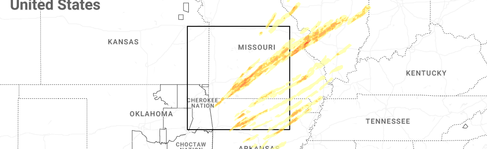
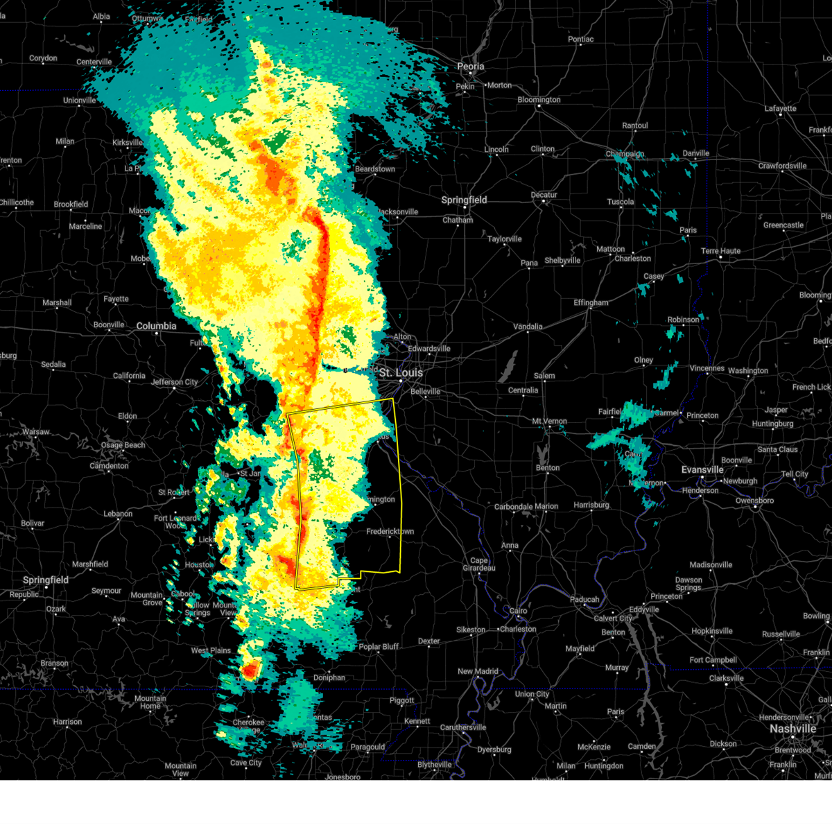
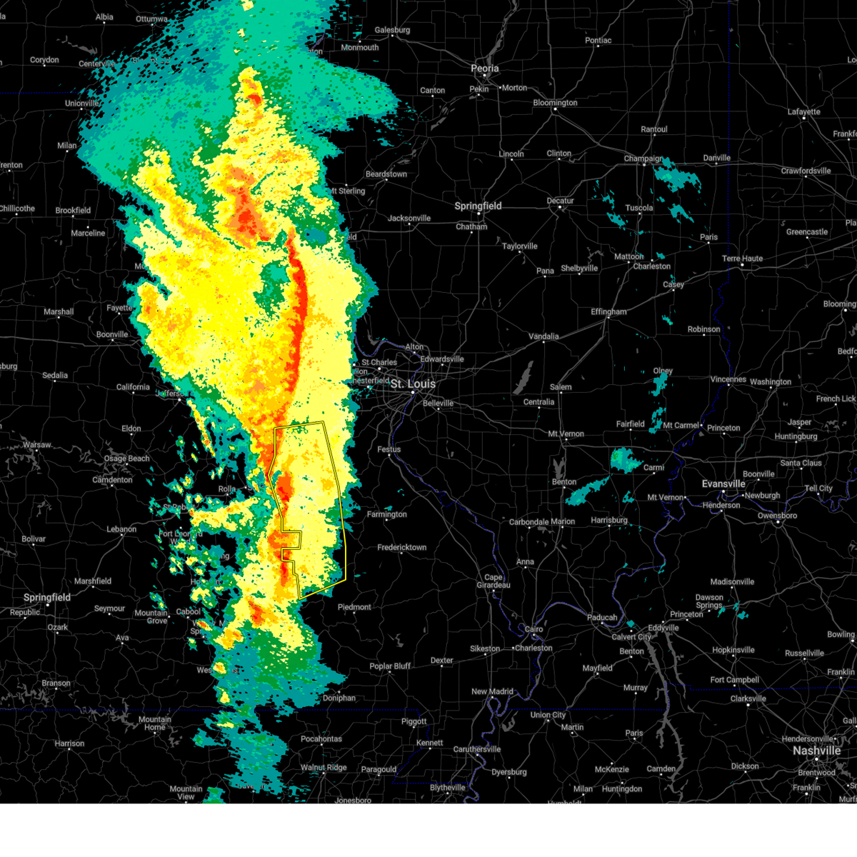
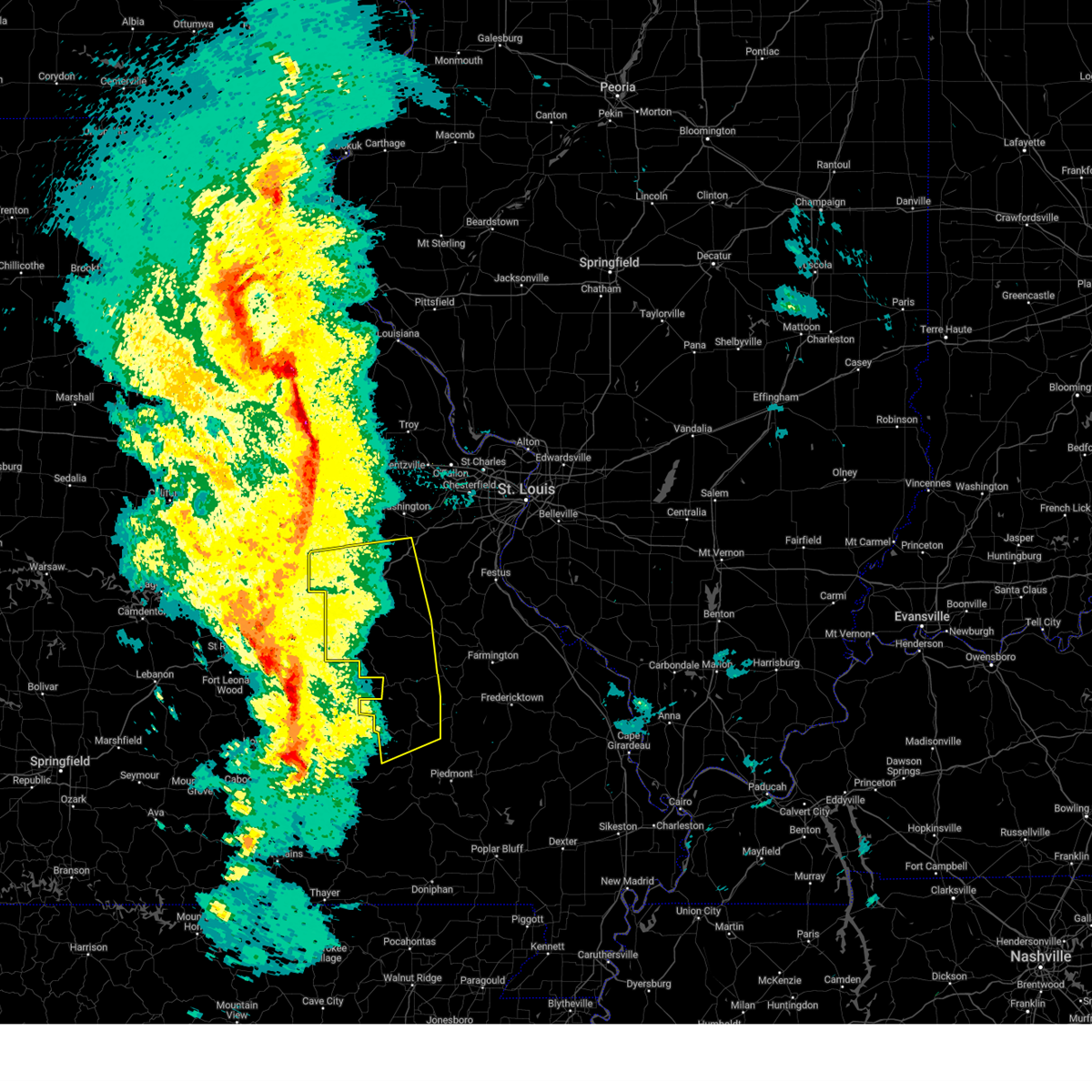
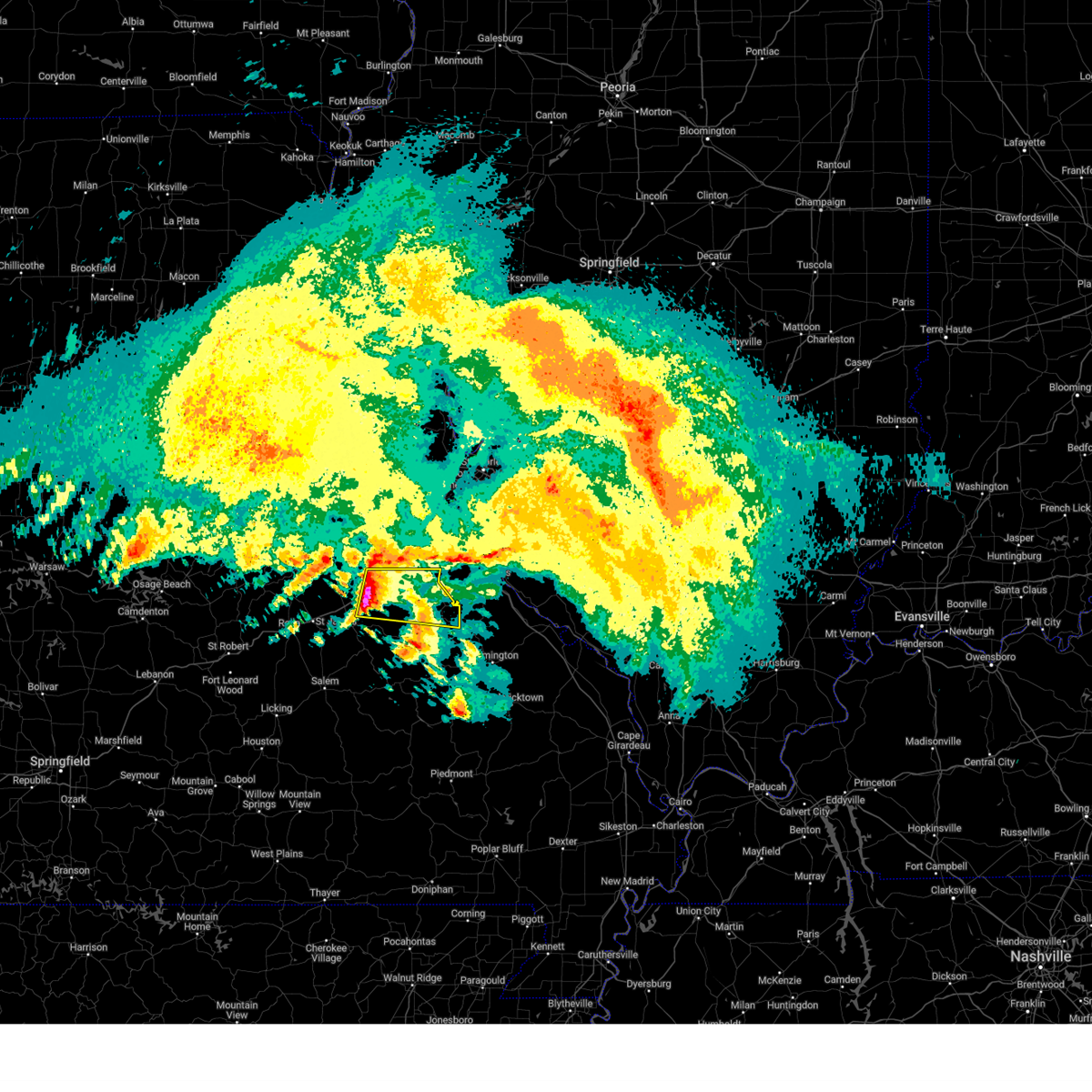
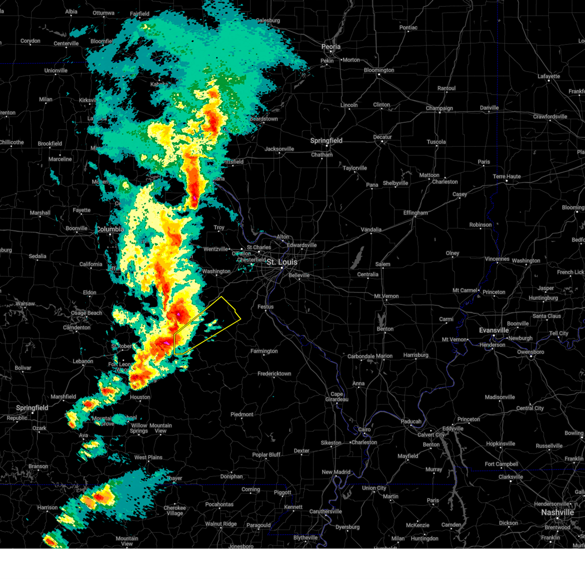
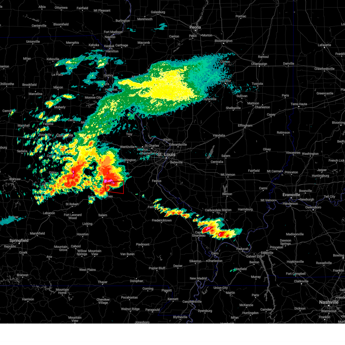
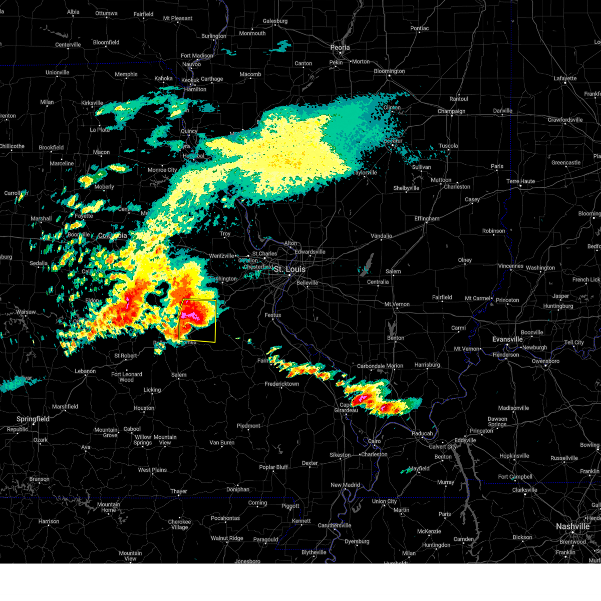
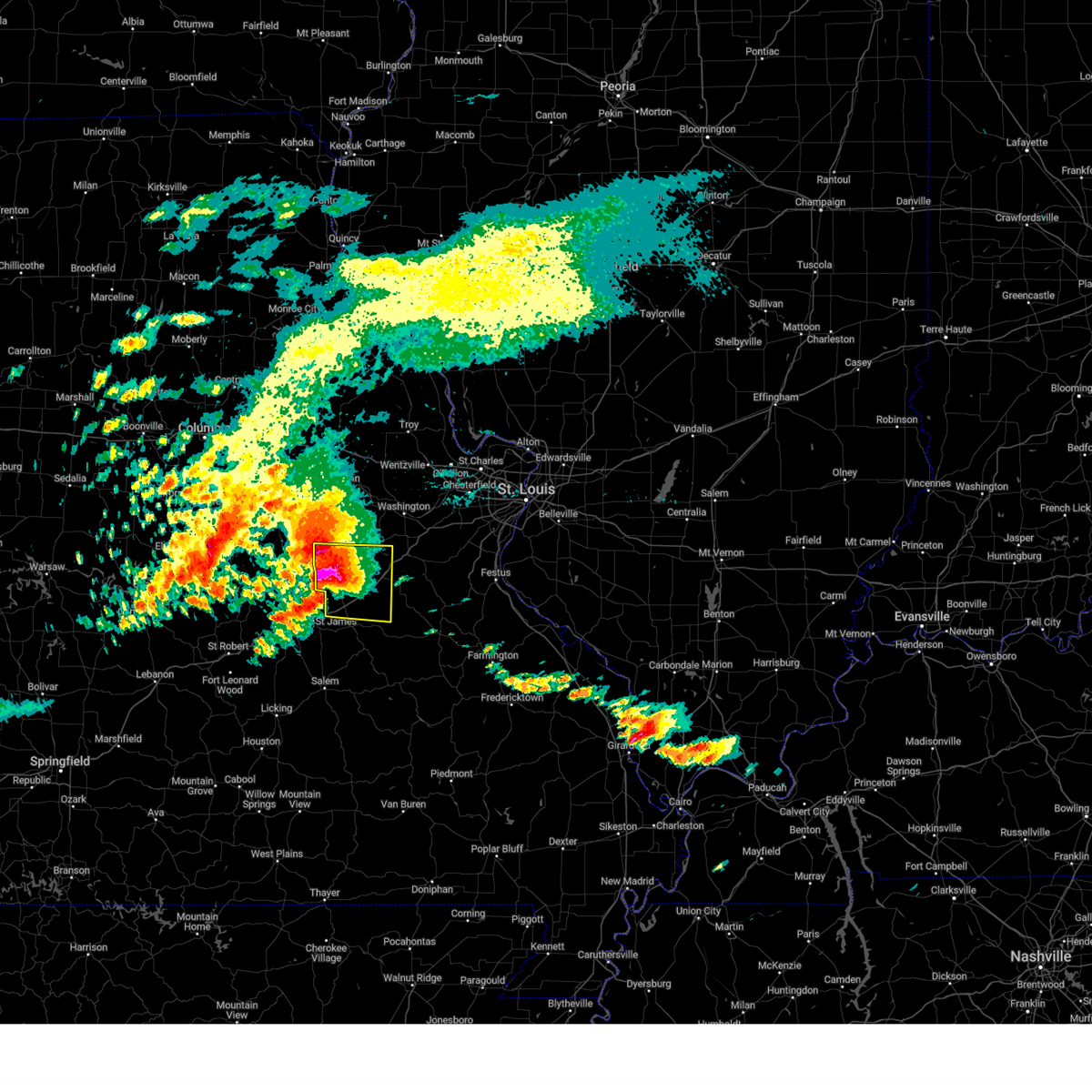
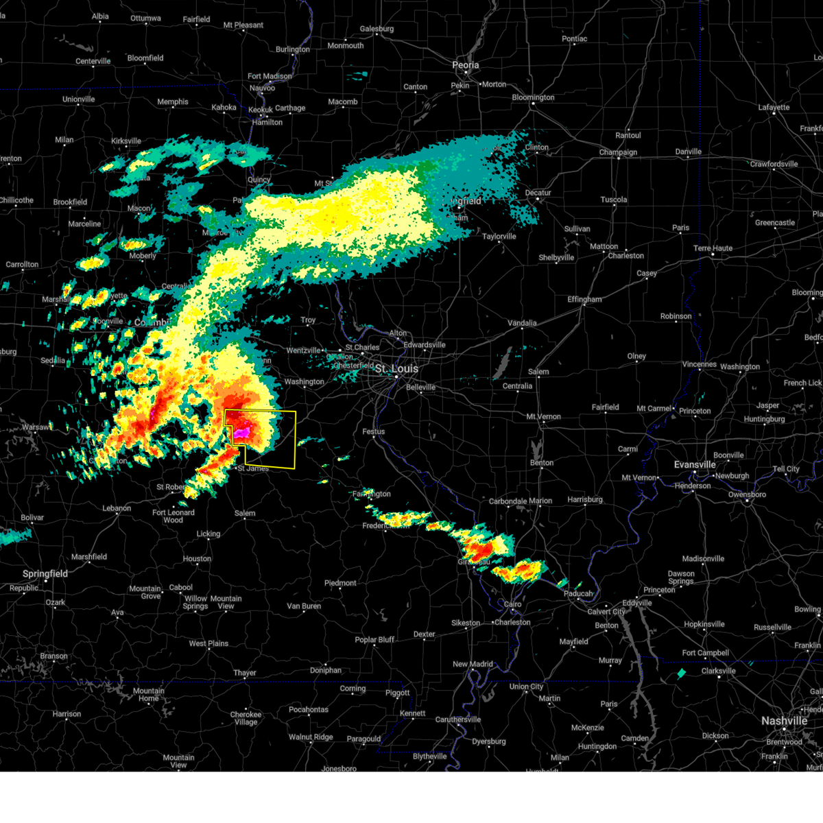
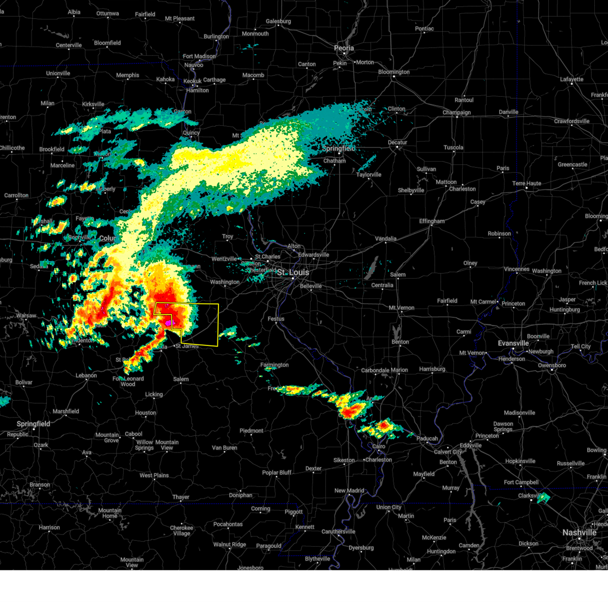
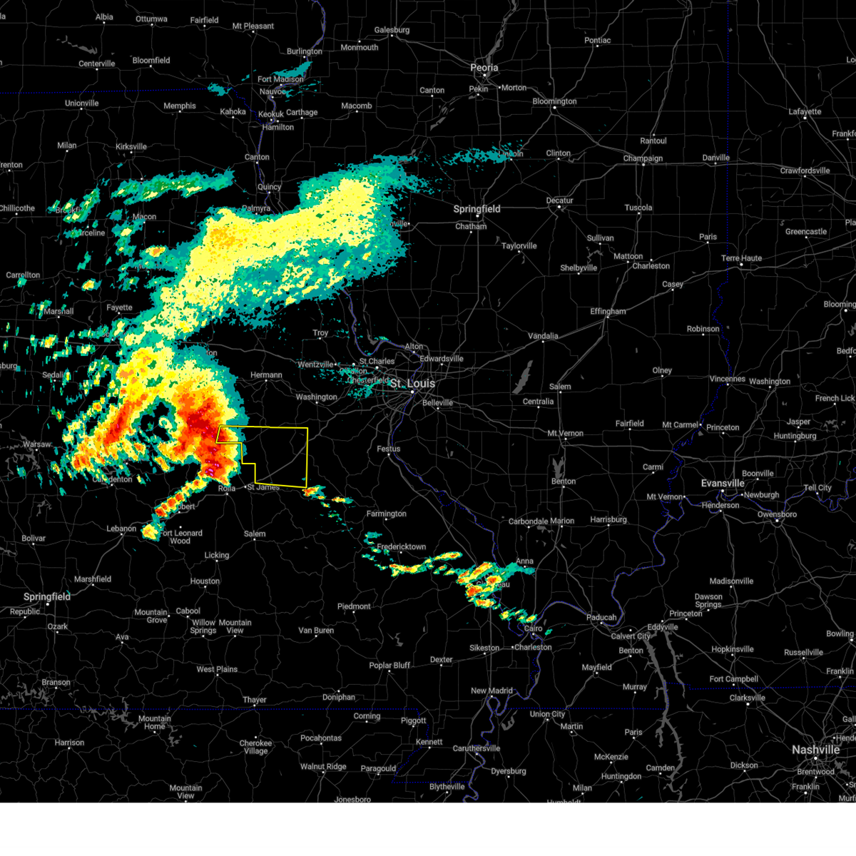
Hail Map for Sullivan, MO
The Sullivan, MO area has had 31 reports of on-the-ground hail by trained spotters, and has been under severe weather warnings 28 times during the past 12 months. Doppler radar has detected hail at or near Sullivan, MO on 72 occasions, including 3 occasions during the past year.
| Name: | Sullivan, MO |
| Where Located: | 45.2 miles NNE of Salem, MO |
| Map: | Google Map for Sullivan, MO |
| Population: | 7081 |
| Housing Units: | 3136 |
| More Info: | Search Google for Sullivan, MO |
4
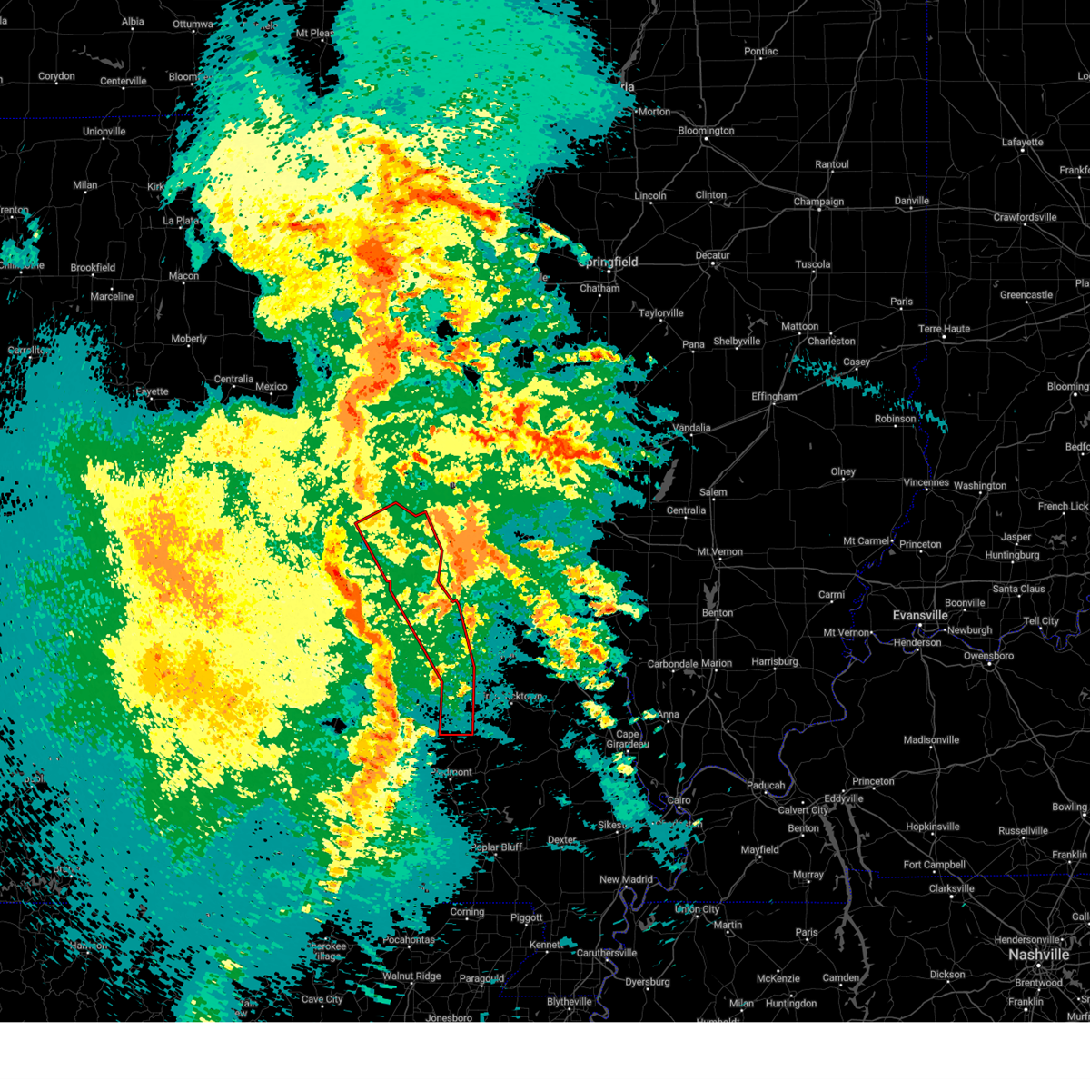
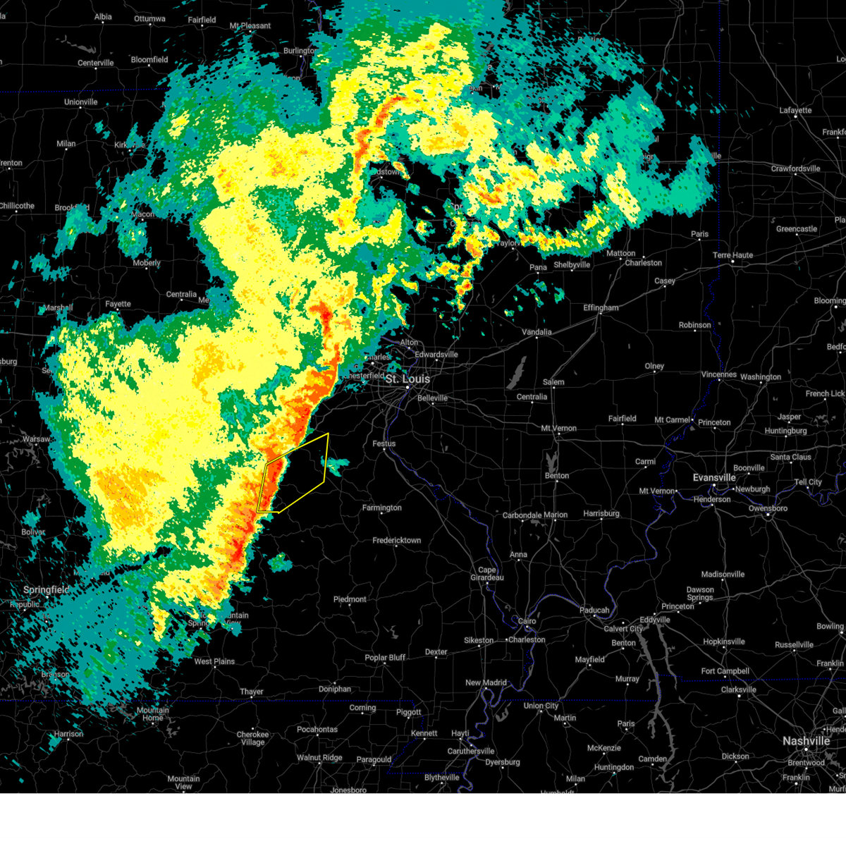
The Top Recent Hail Date for Sullivan, MO is Friday, March 14, 2025 (2nd out of 72)
Hail and Wind Damage Spotted near Sullivan, MO
| Date / Time | Report Details |
|---|---|
| 5/19/2025 11:28 PM CDT | The storms which prompted the warning have moved out of the area. therefore, the warning will be allowed to expire. |
| 5/19/2025 11:14 PM CDT | At 1114 pm cdt, severe thunderstorms capable of producing a tornado were located along a line from near beaufort to over anthonies mill, or along a line from 13 miles north of sullivan to over anthonies mill, moving northeast at 40 mph (radar indicated rotation). Hazards include tornado. Flying debris will be dangerous to those caught without shelter. mobile homes will be damaged or destroyed. damage to roofs, windows and vehicles will occur. tree damage is likely. locations impacted include, sullivan, gerald and japan. this includes the following state parks, meramec state park. This includes interstate 44 in missouri between exits 225 and 228. |
| 5/19/2025 11:14 PM CDT | the tornado warning has been cancelled and is no longer in effect |
| 5/19/2025 11:07 PM CDT |
 Torlsx the national weather service in st louis has issued a * tornado warning for, franklin county in east central missouri, washington county in east central missouri, northeastern iron county in southeastern missouri, western saint francois county in southeastern missouri, * until 1145 pm cdt. * at 1107 pm cdt, severe thunderstorms capable of producing a tornado were located along a line from 6 miles north of gerald to 7 miles north of ellington, or along a line from 11 miles southwest of new haven to 25 miles southwest of ironton, moving east at 40 mph (radar indicated rotation). Hazards include tornado. Flying debris will be dangerous to those caught without shelter. mobile homes will be damaged or destroyed. damage to roofs, windows and vehicles will occur. Tree damage is likely. Torlsx the national weather service in st louis has issued a * tornado warning for, franklin county in east central missouri, washington county in east central missouri, northeastern iron county in southeastern missouri, western saint francois county in southeastern missouri, * until 1145 pm cdt. * at 1107 pm cdt, severe thunderstorms capable of producing a tornado were located along a line from 6 miles north of gerald to 7 miles north of ellington, or along a line from 11 miles southwest of new haven to 25 miles southwest of ironton, moving east at 40 mph (radar indicated rotation). Hazards include tornado. Flying debris will be dangerous to those caught without shelter. mobile homes will be damaged or destroyed. damage to roofs, windows and vehicles will occur. Tree damage is likely.
|
| 5/19/2025 10:47 PM CDT |
 Torlsx the national weather service in st louis has issued a * tornado warning for, northern crawford county in east central missouri, southwestern franklin county in east central missouri, southern gasconade county in east central missouri, western washington county in east central missouri, * until 1130 pm cdt. * at 1047 pm cdt, severe thunderstorms capable of producing a tornado were located along a line from 6 miles south of owensville to over steelville, moving northeast at 40 mph (radar indicated rotation). Hazards include tornado. Flying debris will be dangerous to those caught without shelter. mobile homes will be damaged or destroyed. damage to roofs, windows and vehicles will occur. Tree damage is likely. Torlsx the national weather service in st louis has issued a * tornado warning for, northern crawford county in east central missouri, southwestern franklin county in east central missouri, southern gasconade county in east central missouri, western washington county in east central missouri, * until 1130 pm cdt. * at 1047 pm cdt, severe thunderstorms capable of producing a tornado were located along a line from 6 miles south of owensville to over steelville, moving northeast at 40 mph (radar indicated rotation). Hazards include tornado. Flying debris will be dangerous to those caught without shelter. mobile homes will be damaged or destroyed. damage to roofs, windows and vehicles will occur. Tree damage is likely.
|
| 5/16/2025 1:35 PM CDT |
 Svrlsx the national weather service in st louis has issued a * severe thunderstorm warning for, crawford county in east central missouri, southwestern franklin county in east central missouri, southern gasconade county in east central missouri, northwestern washington county in east central missouri, * until 215 pm cdt. * at 135 pm cdt, a severe thunderstorm was located 11 miles west of cuba, moving northeast at 60 mph (radar indicated). Hazards include 60 mph wind gusts and half dollar size hail. Hail damage to vehicles is expected. Expect wind damage to roofs, siding, and trees. Svrlsx the national weather service in st louis has issued a * severe thunderstorm warning for, crawford county in east central missouri, southwestern franklin county in east central missouri, southern gasconade county in east central missouri, northwestern washington county in east central missouri, * until 215 pm cdt. * at 135 pm cdt, a severe thunderstorm was located 11 miles west of cuba, moving northeast at 60 mph (radar indicated). Hazards include 60 mph wind gusts and half dollar size hail. Hail damage to vehicles is expected. Expect wind damage to roofs, siding, and trees.
|
| 4/20/2025 6:58 PM CDT |
 Svrlsx the national weather service in st louis has issued a * severe thunderstorm warning for, western monroe county in southwestern illinois, northeastern crawford county in east central missouri, southeastern franklin county in east central missouri, jefferson county in east central missouri, southwestern saint louis county in east central missouri, washington county in east central missouri, iron county in southeastern missouri, madison county in southeastern missouri, reynolds county in southeastern missouri, western sainte genevieve county in southeastern missouri, saint francois county in southeastern missouri, * until 800 pm cdt. * at 658 pm cdt, severe thunderstorms were located along a line from near st. clair to over ellington, or along a line from near st. clair to 33 miles southwest of ironton, moving east at 40 mph (radar indicated). Hazards include 60 mph wind gusts and small hail. expect damage to roofs, siding, and trees Svrlsx the national weather service in st louis has issued a * severe thunderstorm warning for, western monroe county in southwestern illinois, northeastern crawford county in east central missouri, southeastern franklin county in east central missouri, jefferson county in east central missouri, southwestern saint louis county in east central missouri, washington county in east central missouri, iron county in southeastern missouri, madison county in southeastern missouri, reynolds county in southeastern missouri, western sainte genevieve county in southeastern missouri, saint francois county in southeastern missouri, * until 800 pm cdt. * at 658 pm cdt, severe thunderstorms were located along a line from near st. clair to over ellington, or along a line from near st. clair to 33 miles southwest of ironton, moving east at 40 mph (radar indicated). Hazards include 60 mph wind gusts and small hail. expect damage to roofs, siding, and trees
|
| 4/20/2025 6:50 PM CDT |
 At 650 pm cdt, severe thunderstorms were located along a line from 6 miles northwest of miramiguoa park to 5 miles south of reynolds, or along a line from 7 miles north of sullivan to 30 miles southwest of ironton, moving northeast at 50 mph (radar indicated). Hazards include 60 mph wind gusts and small hail. Expect damage to roofs, siding, and trees. locations impacted include, union, sullivan, st. clair, bourbon, anthonies mill, reynolds, viburnum, parkway, miramiguoa park, courtois, bixby, oates, centerville, st. cloud, shirley, latty, belgrade, black, stanton and lesterville. this includes the following state parks, onondaga cave state park, johnsons shut-ins state park, taum sauk mountain state park and meramec state park. This includes interstate 44 in missouri between exits 218 and 242. At 650 pm cdt, severe thunderstorms were located along a line from 6 miles northwest of miramiguoa park to 5 miles south of reynolds, or along a line from 7 miles north of sullivan to 30 miles southwest of ironton, moving northeast at 50 mph (radar indicated). Hazards include 60 mph wind gusts and small hail. Expect damage to roofs, siding, and trees. locations impacted include, union, sullivan, st. clair, bourbon, anthonies mill, reynolds, viburnum, parkway, miramiguoa park, courtois, bixby, oates, centerville, st. cloud, shirley, latty, belgrade, black, stanton and lesterville. this includes the following state parks, onondaga cave state park, johnsons shut-ins state park, taum sauk mountain state park and meramec state park. This includes interstate 44 in missouri between exits 218 and 242.
|
| 4/20/2025 6:39 PM CDT |
 the severe thunderstorm warning has been cancelled and is no longer in effect the severe thunderstorm warning has been cancelled and is no longer in effect
|
| 4/20/2025 6:39 PM CDT |
 At 639 pm cdt, severe thunderstorms were located along a line from 6 miles north of bourbon to 5 miles southwest of oates, or along a line from 6 miles north of bourbon to 27 miles west of ironton, moving northeast at 50 mph (radar indicated). Hazards include 60 mph wind gusts and small hail. Expect damage to roofs, siding, and trees. locations impacted include, union, sullivan, st. clair, cuba, steelville, bourbon, anthonies mill, reynolds, gerald, viburnum, parkway, leasburg, miramiguoa park, courtois, bixby, cherryville, oates, centerville, st. cloud and davisville. this includes the following state parks, onondaga cave state park, johnsons shut-ins state park, dillard mill historic site, taum sauk mountain state park and meramec state park. This includes interstate 44 in missouri between exits 208 and 242. At 639 pm cdt, severe thunderstorms were located along a line from 6 miles north of bourbon to 5 miles southwest of oates, or along a line from 6 miles north of bourbon to 27 miles west of ironton, moving northeast at 50 mph (radar indicated). Hazards include 60 mph wind gusts and small hail. Expect damage to roofs, siding, and trees. locations impacted include, union, sullivan, st. clair, cuba, steelville, bourbon, anthonies mill, reynolds, gerald, viburnum, parkway, leasburg, miramiguoa park, courtois, bixby, cherryville, oates, centerville, st. cloud and davisville. this includes the following state parks, onondaga cave state park, johnsons shut-ins state park, dillard mill historic site, taum sauk mountain state park and meramec state park. This includes interstate 44 in missouri between exits 208 and 242.
|
| 4/20/2025 6:07 PM CDT |
 Svrlsx the national weather service in st louis has issued a * severe thunderstorm warning for, crawford county in east central missouri, southwestern franklin county in east central missouri, southern gasconade county in east central missouri, washington county in east central missouri, northwestern iron county in southeastern missouri, northern reynolds county in southeastern missouri, * until 700 pm cdt. * at 607 pm cdt, severe thunderstorms were located along a line from 17 miles west of cuba to 24 miles west of reynolds, or along a line from 17 miles west of cuba to 48 miles south of steelville, moving northeast at 50 mph (radar indicated). Hazards include 70 mph wind gusts and small hail. Expect considerable tree damage. Damage is likely to mobile homes, roofs, and outbuildings. Svrlsx the national weather service in st louis has issued a * severe thunderstorm warning for, crawford county in east central missouri, southwestern franklin county in east central missouri, southern gasconade county in east central missouri, washington county in east central missouri, northwestern iron county in southeastern missouri, northern reynolds county in southeastern missouri, * until 700 pm cdt. * at 607 pm cdt, severe thunderstorms were located along a line from 17 miles west of cuba to 24 miles west of reynolds, or along a line from 17 miles west of cuba to 48 miles south of steelville, moving northeast at 50 mph (radar indicated). Hazards include 70 mph wind gusts and small hail. Expect considerable tree damage. Damage is likely to mobile homes, roofs, and outbuildings.
|
| 3/23/2025 6:28 AM CDT |
 Svrlsx the national weather service in st louis has issued a * severe thunderstorm warning for, northeastern crawford county in east central missouri, southeastern franklin county in east central missouri, northern washington county in east central missouri, * until 700 am cdt. * at 628 am cdt, a severe thunderstorm was located over bourbon, moving east at 60 mph (radar indicated). Hazards include quarter size hail. Damage to vehicles is expected. this severe thunderstorm will be near, bourbon, sullivan and leasburg around 630 am cdt. anthonies mill and miramiguoa park around 635 am cdt. other locations impacted by the severe thunderstorm include st. cloud. this includes the following state parks, washington state park, onondaga cave state park and meramec state park. This includes interstate 44 in missouri between exits 218 and 228. Svrlsx the national weather service in st louis has issued a * severe thunderstorm warning for, northeastern crawford county in east central missouri, southeastern franklin county in east central missouri, northern washington county in east central missouri, * until 700 am cdt. * at 628 am cdt, a severe thunderstorm was located over bourbon, moving east at 60 mph (radar indicated). Hazards include quarter size hail. Damage to vehicles is expected. this severe thunderstorm will be near, bourbon, sullivan and leasburg around 630 am cdt. anthonies mill and miramiguoa park around 635 am cdt. other locations impacted by the severe thunderstorm include st. cloud. this includes the following state parks, washington state park, onondaga cave state park and meramec state park. This includes interstate 44 in missouri between exits 218 and 228.
|
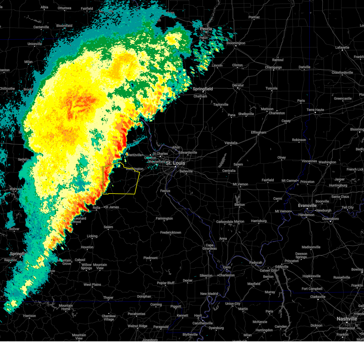
| 3/14/2025 9:14 PM CDT | The severe thunderstorm warning that was previously in effect has been reissued for franklin and washington counties and is in effect until 1000 pm cdt. please refer to that bulletin for the latest severe weather information. a tornado watch remains in effect until 1100 pm cdt for a portion of east central missouri. |
| 3/14/2025 9:02 PM CDT | Hen Egg sized hail reported 0.8 miles N of Sullivan, MO |
| 3/14/2025 9:01 PM CDT |
 At 901 pm cdt, a severe thunderstorm was located 9 miles southeast of leasburg, or 8 miles east of steelville, moving northeast at 65 mph (at 759 pm, trained spotters reported reported two inch hail in steelville). Hazards include golf ball size hail and 70 mph wind gusts. People and animals outdoors will be injured. expect hail damage to roofs, siding, windows, and vehicles. expect considerable tree damage. wind damage is also likely to mobile homes, roofs, and outbuildings. locations impacted include, sullivan, st. clair, steelville, bourbon, anthonies mill, parkway, leasburg, miramiguoa park, richwoods, st. cloud and piney park. This includes the following state parks, onondaga cave state park and meramec state park. At 901 pm cdt, a severe thunderstorm was located 9 miles southeast of leasburg, or 8 miles east of steelville, moving northeast at 65 mph (at 759 pm, trained spotters reported reported two inch hail in steelville). Hazards include golf ball size hail and 70 mph wind gusts. People and animals outdoors will be injured. expect hail damage to roofs, siding, windows, and vehicles. expect considerable tree damage. wind damage is also likely to mobile homes, roofs, and outbuildings. locations impacted include, sullivan, st. clair, steelville, bourbon, anthonies mill, parkway, leasburg, miramiguoa park, richwoods, st. cloud and piney park. This includes the following state parks, onondaga cave state park and meramec state park.
|
| 3/14/2025 8:49 PM CDT | Quarter sized hail reported 0.7 miles W of Sullivan, MO, quarter size hail... high wind... and street flooding. |
| 3/14/2025 8:44 PM CDT | At 844 pm cdt, a severe thunderstorm capable of producing a tornado was located 5 miles southeast of bourbon, moving northeast at 60 mph (radar indicated rotation). Hazards include tornado. Flying debris will be dangerous to those caught without shelter. mobile homes will be damaged or destroyed. damage to roofs, windows and vehicles will occur. tree damage is likely. locations impacted include, sullivan, cuba, steelville, bourbon, anthonies mill, leasburg, miramiguoa park, st. cloud and cook station. this includes the following state parks, onondaga cave state park and meramec state park. This includes interstate 44 in missouri near exit 218. |
| 3/14/2025 8:43 PM CDT |
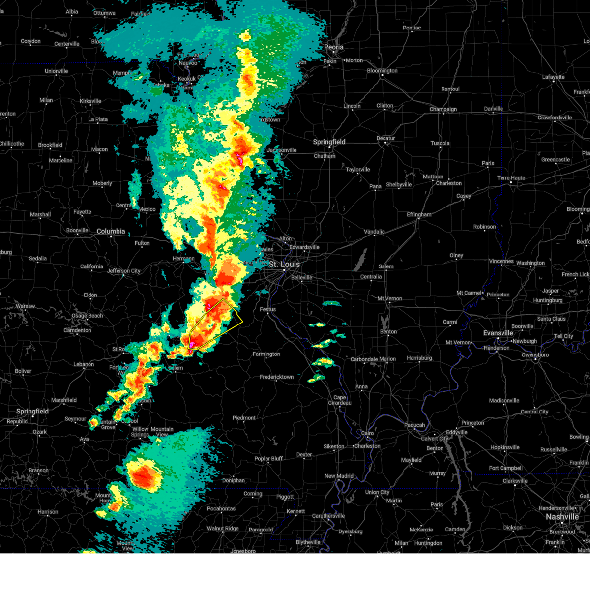
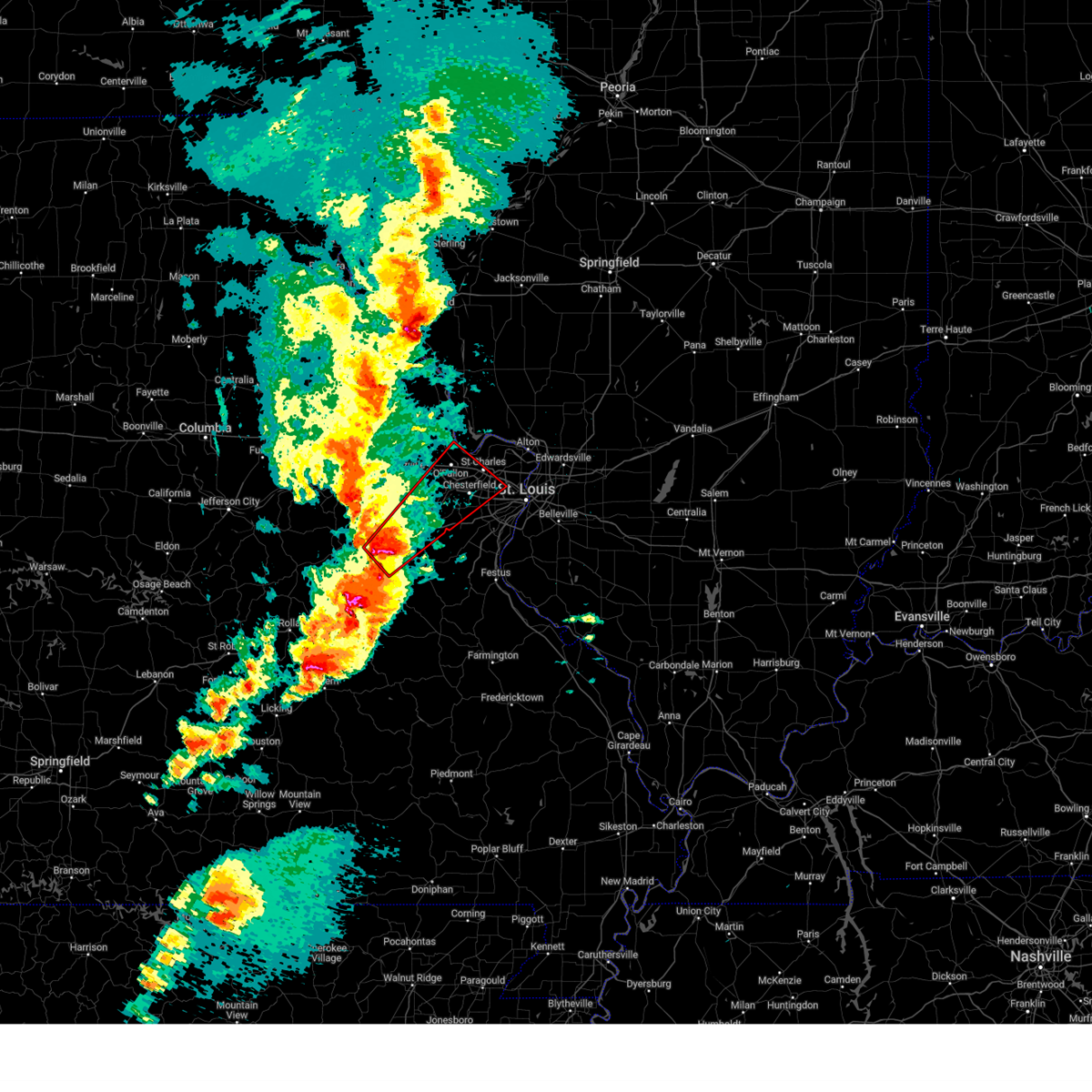 At 843 pm cdt, a tornado producing storm was located 6 miles southeast of beaufort, or 6 miles west of st. clair, moving northeast at 55 mph (radar confirmed tornado). Hazards include damaging tornado and quarter size hail. Flying debris will be dangerous to those caught without shelter. mobile homes will be damaged or destroyed. damage to roofs, windows and vehicles will occur. tree damage is likely. locations impacted include, o'fallon, st. charles, st. peters, chesterfield, wildwood, ballwin, wentzville, maryland heights, manchester, creve coeur, overland, lake st. louis, washington, st. ann, bridgeton, dardenne prairie, town and country, union, eureka and ellisville. this includes the following state parks, babler memorial state park, first missouri state capitol historic site and robertsville state park. this includes the following highways, interstate 70 in missouri between exits 212 and 231. Interstate 44 in missouri between exits 230 and 261. At 843 pm cdt, a tornado producing storm was located 6 miles southeast of beaufort, or 6 miles west of st. clair, moving northeast at 55 mph (radar confirmed tornado). Hazards include damaging tornado and quarter size hail. Flying debris will be dangerous to those caught without shelter. mobile homes will be damaged or destroyed. damage to roofs, windows and vehicles will occur. tree damage is likely. locations impacted include, o'fallon, st. charles, st. peters, chesterfield, wildwood, ballwin, wentzville, maryland heights, manchester, creve coeur, overland, lake st. louis, washington, st. ann, bridgeton, dardenne prairie, town and country, union, eureka and ellisville. this includes the following state parks, babler memorial state park, first missouri state capitol historic site and robertsville state park. this includes the following highways, interstate 70 in missouri between exits 212 and 231. Interstate 44 in missouri between exits 230 and 261.
|
| 3/14/2025 8:40 PM CDT |
 Torlsx the national weather service in st louis has issued a * tornado warning for, central franklin county in east central missouri, western saint charles county in east central missouri, northwestern saint louis county in east central missouri, southeastern warren county in east central missouri, * until 930 pm cdt. * at 840 pm cdt, a severe thunderstorm capable of producing a tornado was located 6 miles southeast of beaufort, or 8 miles west of st. clair, moving northeast at 55 mph (radar indicated rotation). Hazards include tornado and quarter size hail. Flying debris will be dangerous to those caught without shelter. mobile homes will be damaged or destroyed. damage to roofs, windows and vehicles will occur. Tree damage is likely. Torlsx the national weather service in st louis has issued a * tornado warning for, central franklin county in east central missouri, western saint charles county in east central missouri, northwestern saint louis county in east central missouri, southeastern warren county in east central missouri, * until 930 pm cdt. * at 840 pm cdt, a severe thunderstorm capable of producing a tornado was located 6 miles southeast of beaufort, or 8 miles west of st. clair, moving northeast at 55 mph (radar indicated rotation). Hazards include tornado and quarter size hail. Flying debris will be dangerous to those caught without shelter. mobile homes will be damaged or destroyed. damage to roofs, windows and vehicles will occur. Tree damage is likely.
|
| 3/14/2025 8:34 PM CDT |
 the tornado warning has been cancelled and is no longer in effect the tornado warning has been cancelled and is no longer in effect
|
| 3/14/2025 8:34 PM CDT |
 At 834 pm cdt, a severe thunderstorm capable of producing a tornado was located 5 miles north of sullivan, moving northeast at 65 mph (radar indicated rotation). Hazards include tornado and golf ball size hail. Flying debris will be dangerous to those caught without shelter. mobile homes will be damaged or destroyed. damage to roofs, windows and vehicles will occur. tree damage is likely. locations impacted include, sullivan, st. clair, bourbon, gerald, parkway, beaufort, leslie, st. cloud, noser mill, stanton and japan. This includes interstate 44 in missouri between exits 214 and 240. At 834 pm cdt, a severe thunderstorm capable of producing a tornado was located 5 miles north of sullivan, moving northeast at 65 mph (radar indicated rotation). Hazards include tornado and golf ball size hail. Flying debris will be dangerous to those caught without shelter. mobile homes will be damaged or destroyed. damage to roofs, windows and vehicles will occur. tree damage is likely. locations impacted include, sullivan, st. clair, bourbon, gerald, parkway, beaufort, leslie, st. cloud, noser mill, stanton and japan. This includes interstate 44 in missouri between exits 214 and 240.
|
| 3/14/2025 8:25 PM CDT | At 825 pm cdt, a severe thunderstorm capable of producing a tornado was located 9 miles south of rosebud, or 9 miles southeast of owensville, moving northeast at 60 mph (radar indicated rotation). Hazards include tornado and golf ball size hail. Flying debris will be dangerous to those caught without shelter. mobile homes will be damaged or destroyed. damage to roofs, windows and vehicles will occur. tree damage is likely. locations impacted include, sullivan, st. clair, bourbon, gerald, parkway, rosebud, beaufort, leslie, st. cloud, noser mill, japan, stanton and oak hill. This includes interstate 44 in missouri between exits 214 and 240. |
| 3/14/2025 8:22 PM CDT | Torlsx the national weather service in st louis has issued a * tornado warning for, central crawford county in east central missouri, south central franklin county in east central missouri, northwestern washington county in east central missouri, * until 900 pm cdt. * at 822 pm cdt, a severe thunderstorm capable of producing a tornado was located 10 miles southwest of steelville, moving northeast at 55 mph (radar indicated rotation). Hazards include tornado. Flying debris will be dangerous to those caught without shelter. mobile homes will be damaged or destroyed. damage to roofs, windows and vehicles will occur. Tree damage is likely. |
| 3/14/2025 8:13 PM CDT |
 Svrlsx the national weather service in st louis has issued a * severe thunderstorm warning for, central crawford county in east central missouri, south central franklin county in east central missouri, northern washington county in east central missouri, * until 915 pm cdt. * at 813 pm cdt, a severe thunderstorm was located 19 miles southwest of steelville, moving northeast at 55 mph (radar indicated). Hazards include golf ball size hail and 70 mph wind gusts. People and animals outdoors will be injured. expect hail damage to roofs, siding, windows, and vehicles. expect considerable tree damage. Wind damage is also likely to mobile homes, roofs, and outbuildings. Svrlsx the national weather service in st louis has issued a * severe thunderstorm warning for, central crawford county in east central missouri, south central franklin county in east central missouri, northern washington county in east central missouri, * until 915 pm cdt. * at 813 pm cdt, a severe thunderstorm was located 19 miles southwest of steelville, moving northeast at 55 mph (radar indicated). Hazards include golf ball size hail and 70 mph wind gusts. People and animals outdoors will be injured. expect hail damage to roofs, siding, windows, and vehicles. expect considerable tree damage. Wind damage is also likely to mobile homes, roofs, and outbuildings.
|
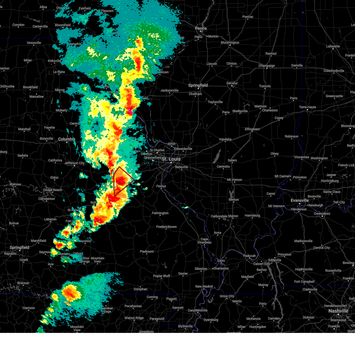
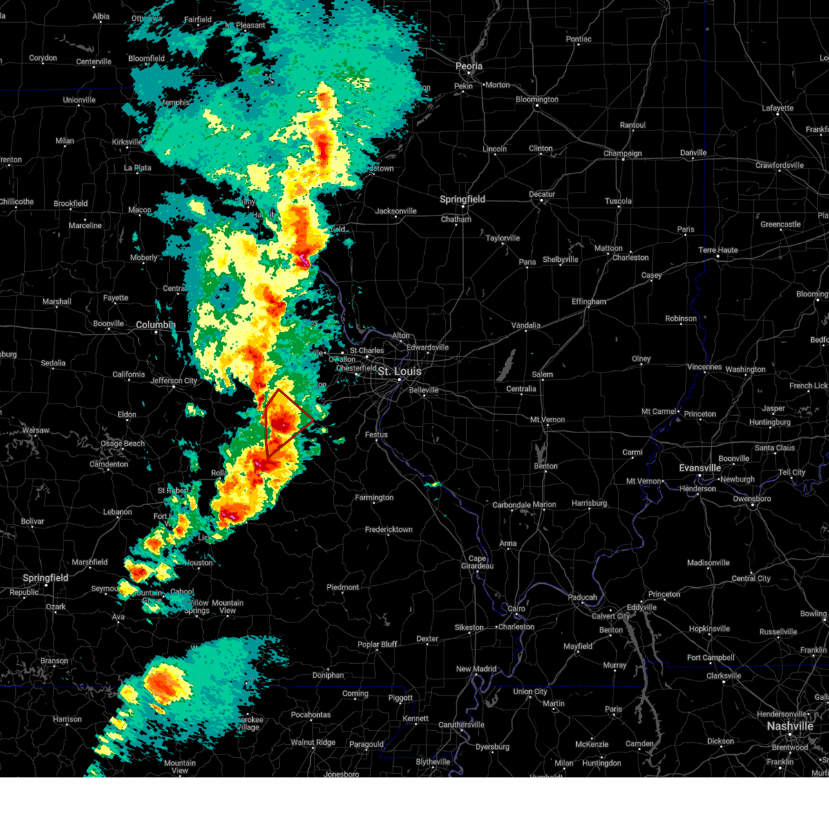
| 3/14/2025 8:07 PM CDT | Torlsx the national weather service in st louis has issued a * tornado warning for, northwestern crawford county in east central missouri, southwestern franklin county in east central missouri, southern gasconade county in east central missouri, * until 845 pm cdt. * at 807 pm cdt, a severe thunderstorm capable of producing a tornado was located 12 miles west of cuba, moving northeast at 60 mph. this storm produced a tornado in rolla, reported by the fire department (radar indicated rotation). Hazards include tornado and golf ball size hail. Flying debris will be dangerous to those caught without shelter. mobile homes will be damaged or destroyed. damage to roofs, windows and vehicles will occur. Tree damage is likely. |
| 11/4/2024 10:22 PM CST |
 The storms which prompted the warning have weakened below severe limits, and have exited the warned area. therefore, the warning will be allowed to expire. however, gusty winds and heavy rain are still possible with these thunderstorms. The storms which prompted the warning have weakened below severe limits, and have exited the warned area. therefore, the warning will be allowed to expire. however, gusty winds and heavy rain are still possible with these thunderstorms.
|
| 11/4/2024 10:12 PM CST |
 At 1012 pm cst, severe thunderstorms were located along a line from 5 miles south of miramiguoa park to 9 miles south of anthonies mill, or along a line from 6 miles north of anthonies mill to 9 miles south of anthonies mill, moving northeast at 45 mph (radar indicated). Hazards include 60 mph wind gusts and small hail. Expect damage to roofs, siding, and trees. this severe thunderstorm will be near, cherryville around 955 pm cst. other locations impacted by the severe thunderstorm include st. cloud. This includes the following state parks, onondaga cave state park and meramec state park. At 1012 pm cst, severe thunderstorms were located along a line from 5 miles south of miramiguoa park to 9 miles south of anthonies mill, or along a line from 6 miles north of anthonies mill to 9 miles south of anthonies mill, moving northeast at 45 mph (radar indicated). Hazards include 60 mph wind gusts and small hail. Expect damage to roofs, siding, and trees. this severe thunderstorm will be near, cherryville around 955 pm cst. other locations impacted by the severe thunderstorm include st. cloud. This includes the following state parks, onondaga cave state park and meramec state park.
|
| 11/4/2024 9:55 PM CST |
 At 955 pm cst, severe thunderstorms were located along a line from near bourbon to near cherryville, or along a line from near bourbon to 6 miles southeast of steelville, moving northeast at 35 mph (radar indicated). Hazards include 60 mph wind gusts and small hail. Expect damage to roofs, siding, and trees. this severe thunderstorm will be near, leasburg and steelville around 950 pm cst. cherryville and bourbon around 955 pm cst. other locations impacted by the severe thunderstorm include st. cloud. this includes the following state parks, onondaga cave state park and meramec state park. This includes interstate 44 in missouri near exit 218. At 955 pm cst, severe thunderstorms were located along a line from near bourbon to near cherryville, or along a line from near bourbon to 6 miles southeast of steelville, moving northeast at 35 mph (radar indicated). Hazards include 60 mph wind gusts and small hail. Expect damage to roofs, siding, and trees. this severe thunderstorm will be near, leasburg and steelville around 950 pm cst. cherryville and bourbon around 955 pm cst. other locations impacted by the severe thunderstorm include st. cloud. this includes the following state parks, onondaga cave state park and meramec state park. This includes interstate 44 in missouri near exit 218.
|
| 11/4/2024 9:49 PM CST |
 Svrlsx the national weather service in st louis has issued a * severe thunderstorm warning for, crawford county in east central missouri, south central franklin county in east central missouri, northwestern washington county in east central missouri, * until 1030 pm cst. * at 949 pm cst, severe thunderstorms were located along a line from over leasburg to near cherryville, or along a line from 5 miles south of bourbon to 7 miles south of steelville, moving northeast at 35 mph (radar indicated). Hazards include 60 mph wind gusts and small hail. Expect damage to roofs, siding, and trees. this severe thunderstorm will be near, leasburg, steelville and cuba around 950 pm cst. cherryville and bourbon around 955 pm cst. other locations impacted by the severe thunderstorm include cook station and st. cloud. this includes the following state parks, onondaga cave state park and meramec state park. This includes interstate 44 in missouri between exits 208 and 218. Svrlsx the national weather service in st louis has issued a * severe thunderstorm warning for, crawford county in east central missouri, south central franklin county in east central missouri, northwestern washington county in east central missouri, * until 1030 pm cst. * at 949 pm cst, severe thunderstorms were located along a line from over leasburg to near cherryville, or along a line from 5 miles south of bourbon to 7 miles south of steelville, moving northeast at 35 mph (radar indicated). Hazards include 60 mph wind gusts and small hail. Expect damage to roofs, siding, and trees. this severe thunderstorm will be near, leasburg, steelville and cuba around 950 pm cst. cherryville and bourbon around 955 pm cst. other locations impacted by the severe thunderstorm include cook station and st. cloud. this includes the following state parks, onondaga cave state park and meramec state park. This includes interstate 44 in missouri between exits 208 and 218.
|
| 10/31/2024 1:34 AM CDT |
 Svrlsx the national weather service in st louis has issued a * severe thunderstorm warning for, franklin county in east central missouri, gasconade county in east central missouri, * until 230 am cdt. * at 134 am cdt, severe thunderstorms were located along a line from near swiss to near bland, or along a line from 12 miles north of owensville to 5 miles southwest of owensville, moving east at 35 mph (radar indicated). Hazards include 60 mph wind gusts and small hail. expect damage to roofs, siding, and trees Svrlsx the national weather service in st louis has issued a * severe thunderstorm warning for, franklin county in east central missouri, gasconade county in east central missouri, * until 230 am cdt. * at 134 am cdt, severe thunderstorms were located along a line from near swiss to near bland, or along a line from 12 miles north of owensville to 5 miles southwest of owensville, moving east at 35 mph (radar indicated). Hazards include 60 mph wind gusts and small hail. expect damage to roofs, siding, and trees
|
| 5/8/2024 5:11 PM CDT |
 The storm which prompted the warning has weakened below severe limits, and no longer poses an immediate threat to life or property. therefore, the warning will be allowed to expire. however, heavy rain is still possible with this thunderstorm. a tornado watch remains in effect until midnight cdt for east central missouri. to report severe weather, contact your nearest law enforcement agency. they will relay your report to the national weather service st louis. The storm which prompted the warning has weakened below severe limits, and no longer poses an immediate threat to life or property. therefore, the warning will be allowed to expire. however, heavy rain is still possible with this thunderstorm. a tornado watch remains in effect until midnight cdt for east central missouri. to report severe weather, contact your nearest law enforcement agency. they will relay your report to the national weather service st louis.
|
| 5/8/2024 5:02 PM CDT |
 At 501 pm cdt, a severe thunderstorm was located near miramiguoa park, moving northeast at 40 mph (radar indicated). Hazards include 60 mph wind gusts and quarter size hail. Hail damage to vehicles is expected. expect wind damage to roofs, siding, and trees. locations impacted include, union, sullivan, st. clair, parkway, miramiguoa park, lonedell, stanton, and piney park. this also includes meramec state park. This includes interstate 44 in missouri between exits 225 and 242. At 501 pm cdt, a severe thunderstorm was located near miramiguoa park, moving northeast at 40 mph (radar indicated). Hazards include 60 mph wind gusts and quarter size hail. Hail damage to vehicles is expected. expect wind damage to roofs, siding, and trees. locations impacted include, union, sullivan, st. clair, parkway, miramiguoa park, lonedell, stanton, and piney park. this also includes meramec state park. This includes interstate 44 in missouri between exits 225 and 242.
|
| 5/8/2024 5:02 PM CDT |
 the severe thunderstorm warning has been cancelled and is no longer in effect the severe thunderstorm warning has been cancelled and is no longer in effect
|
| 5/8/2024 4:57 PM CDT |
 At 457 pm cdt, a severe thunderstorm was located over cherryville, moving east at 40 mph (radar indicated). Hazards include ping pong ball size hail and 60 mph wind gusts. People and animals outdoors will be injured. expect hail damage to roofs, siding, windows, and vehicles. expect wind damage to roofs, siding, and trees. locations impacted include, sullivan, cuba, steelville, bourbon, leasburg, cherryville, st. cloud, dillard, cook station, and davisville. this also includes onondaga cave state park and dillard mill historic site. This includes interstate 44 in missouri between exits 214 and 218. At 457 pm cdt, a severe thunderstorm was located over cherryville, moving east at 40 mph (radar indicated). Hazards include ping pong ball size hail and 60 mph wind gusts. People and animals outdoors will be injured. expect hail damage to roofs, siding, windows, and vehicles. expect wind damage to roofs, siding, and trees. locations impacted include, sullivan, cuba, steelville, bourbon, leasburg, cherryville, st. cloud, dillard, cook station, and davisville. this also includes onondaga cave state park and dillard mill historic site. This includes interstate 44 in missouri between exits 214 and 218.
|
| 5/8/2024 4:50 PM CDT |
 At 450 pm cdt, a severe thunderstorm was located over sullivan, moving northeast at 25 mph (radar indicated). Hazards include 60 mph wind gusts and quarter size hail. Hail damage to vehicles is expected. expect wind damage to roofs, siding, and trees. locations impacted include, union, sullivan, st. clair, parkway, miramiguoa park, lonedell, japan, stanton, and piney park. this also includes meramec state park. This includes interstate 44 in missouri between exits 225 and 242. At 450 pm cdt, a severe thunderstorm was located over sullivan, moving northeast at 25 mph (radar indicated). Hazards include 60 mph wind gusts and quarter size hail. Hail damage to vehicles is expected. expect wind damage to roofs, siding, and trees. locations impacted include, union, sullivan, st. clair, parkway, miramiguoa park, lonedell, japan, stanton, and piney park. this also includes meramec state park. This includes interstate 44 in missouri between exits 225 and 242.
|
| 5/8/2024 4:46 PM CDT |
 At 446 pm cdt, a severe thunderstorm was located near steelville, moving east at 40 mph (law enforcement). Hazards include tennis ball size hail and 60 mph wind gusts. People and animals outdoors will be injured. expect hail damage to roofs, siding, windows, and vehicles. expect wind damage to roofs, siding, and trees. locations impacted include, sullivan, cuba, steelville, bourbon, leasburg, cherryville, st. cloud, dillard, cook station, and davisville. this also includes onondaga cave state park and dillard mill historic site. This includes interstate 44 in missouri between exits 203 and 218. At 446 pm cdt, a severe thunderstorm was located near steelville, moving east at 40 mph (law enforcement). Hazards include tennis ball size hail and 60 mph wind gusts. People and animals outdoors will be injured. expect hail damage to roofs, siding, windows, and vehicles. expect wind damage to roofs, siding, and trees. locations impacted include, sullivan, cuba, steelville, bourbon, leasburg, cherryville, st. cloud, dillard, cook station, and davisville. this also includes onondaga cave state park and dillard mill historic site. This includes interstate 44 in missouri between exits 203 and 218.
|
| 5/8/2024 4:37 PM CDT |
 At 437 pm cdt, a severe thunderstorm was located 8 miles southeast of st. james, moving east at 40 mph (law enforcement). Hazards include tennis ball size hail and 60 mph wind gusts. People and animals outdoors will be injured. expect hail damage to roofs, siding, windows, and vehicles. expect wind damage to roofs, siding, and trees. locations impacted include, sullivan, cuba, steelville, bourbon, leasburg, cherryville, st. cloud, dillard, cook station, and davisville. this also includes onondaga cave state park and dillard mill historic site. This includes interstate 44 in missouri between exits 203 and 218. At 437 pm cdt, a severe thunderstorm was located 8 miles southeast of st. james, moving east at 40 mph (law enforcement). Hazards include tennis ball size hail and 60 mph wind gusts. People and animals outdoors will be injured. expect hail damage to roofs, siding, windows, and vehicles. expect wind damage to roofs, siding, and trees. locations impacted include, sullivan, cuba, steelville, bourbon, leasburg, cherryville, st. cloud, dillard, cook station, and davisville. this also includes onondaga cave state park and dillard mill historic site. This includes interstate 44 in missouri between exits 203 and 218.
|
| 5/8/2024 4:35 PM CDT |
 Svrlsx the national weather service in st louis has issued a * severe thunderstorm warning for, northeastern crawford county in east central missouri, northwestern washington county in east central missouri, southern franklin county in east central missouri, * until 515 pm cdt. * at 435 pm cdt, a severe thunderstorm was located over bourbon, moving northeast at 35 mph (radar indicated). Hazards include 60 mph wind gusts and quarter size hail. Hail damage to vehicles is expected. Expect wind damage to roofs, siding, and trees. Svrlsx the national weather service in st louis has issued a * severe thunderstorm warning for, northeastern crawford county in east central missouri, northwestern washington county in east central missouri, southern franklin county in east central missouri, * until 515 pm cdt. * at 435 pm cdt, a severe thunderstorm was located over bourbon, moving northeast at 35 mph (radar indicated). Hazards include 60 mph wind gusts and quarter size hail. Hail damage to vehicles is expected. Expect wind damage to roofs, siding, and trees.
|
| 5/8/2024 4:24 PM CDT |
 Svrlsx the national weather service in st louis has issued a * severe thunderstorm warning for, crawford county in east central missouri, * until 530 pm cdt. * at 423 pm cdt, a severe thunderstorm was located near rolla, moving east at 40 mph (radar indicated). Hazards include two inch hail and 60 mph wind gusts. People and animals outdoors will be injured. expect hail damage to roofs, siding, windows, and vehicles. Expect wind damage to roofs, siding, and trees. Svrlsx the national weather service in st louis has issued a * severe thunderstorm warning for, crawford county in east central missouri, * until 530 pm cdt. * at 423 pm cdt, a severe thunderstorm was located near rolla, moving east at 40 mph (radar indicated). Hazards include two inch hail and 60 mph wind gusts. People and animals outdoors will be injured. expect hail damage to roofs, siding, windows, and vehicles. Expect wind damage to roofs, siding, and trees.
|
| 5/8/2024 11:48 AM CDT | Golf Ball sized hail reported 9.4 miles W of Sullivan, MO, marble to golf ball sized hail. drifts of small hail with piles 10-12 inches deep. stripped vegetation. |
| 5/8/2024 11:45 AM CDT | Golf Ball sized hail reported 2.8 miles W of Sullivan, MO, meramec state park receiving quarter to golf ball sized hail. relayed from park ranger. |
| 5/8/2024 11:43 AM CDT |
 At 1142 am cdt, a severe thunderstorm was located over miramiguoa park, moving east at 30 mph (emergency management reported golf ball size hail in sullivan). Hazards include golf ball size hail and 60 mph wind gusts. People and animals outdoors will be injured. expect hail damage to roofs, siding, windows, and vehicles. expect wind damage to roofs, siding, and trees. locations impacted include, sullivan, st. clair, hillsboro, byrnes mill, cedar hill, parkway, cedar hill lakes, miramiguoa park, dittmer, lonedell, scotsdale, stanton, morse mill, oermann, moselle, grubville, and piney park. This includes interstate 44 in missouri between exits 225 and 240. At 1142 am cdt, a severe thunderstorm was located over miramiguoa park, moving east at 30 mph (emergency management reported golf ball size hail in sullivan). Hazards include golf ball size hail and 60 mph wind gusts. People and animals outdoors will be injured. expect hail damage to roofs, siding, windows, and vehicles. expect wind damage to roofs, siding, and trees. locations impacted include, sullivan, st. clair, hillsboro, byrnes mill, cedar hill, parkway, cedar hill lakes, miramiguoa park, dittmer, lonedell, scotsdale, stanton, morse mill, oermann, moselle, grubville, and piney park. This includes interstate 44 in missouri between exits 225 and 240.
|
| 5/8/2024 11:42 AM CDT | Quarter sized hail reported 0.7 miles W of Sullivan, MO, gas station attendant reported quarter sized hail. time estimated from radar. |
| 5/8/2024 11:40 AM CDT | Quarter sized hail reported 5.8 miles SW of Sullivan, MO, quarter sized hail on i-44 eb at mm 232. |
| 5/8/2024 11:39 AM CDT | Golf Ball sized hail reported 0.1 miles WNW of Sullivan, MO, relayed report of golf ball sized hail in sullivan. |
| 5/8/2024 11:35 AM CDT |
 Torlsx the national weather service in st louis has issued a * tornado warning for, northeastern crawford county in east central missouri, northern washington county in east central missouri, southeastern franklin county in east central missouri, * until 1215 pm cdt. * at 1135 am cdt, a severe thunderstorm capable of producing a tornado was located near sullivan, moving east at 30 mph (radar indicated rotation). Hazards include tornado and quarter size hail. Flying debris will be dangerous to those caught without shelter. mobile homes will be damaged or destroyed. damage to roofs, windows, and vehicles will occur. Tree damage is likely. Torlsx the national weather service in st louis has issued a * tornado warning for, northeastern crawford county in east central missouri, northern washington county in east central missouri, southeastern franklin county in east central missouri, * until 1215 pm cdt. * at 1135 am cdt, a severe thunderstorm capable of producing a tornado was located near sullivan, moving east at 30 mph (radar indicated rotation). Hazards include tornado and quarter size hail. Flying debris will be dangerous to those caught without shelter. mobile homes will be damaged or destroyed. damage to roofs, windows, and vehicles will occur. Tree damage is likely.
|
| 5/8/2024 11:33 AM CDT | Corrects previous tstm wnd dmg report from 1 e sullivan. large tree snapped at base and tree branches down in sulliva in franklin county MO, 0.1 miles WNW of Sullivan, MO |
| 5/8/2024 11:33 AM CDT | Corrects previous tstm wnd dmg report from 1 e sullivan. large tree snapped at base and tree branches down in sulliva in franklin county MO, 0.1 miles WNW of Sullivan, MO |
| 5/8/2024 11:31 AM CDT |
 At 1131 am cdt, a severe thunderstorm capable of producing a tornado was located over sullivan, moving east at 40 mph (radar indicated rotation). Hazards include tornado and quarter size hail. Flying debris will be dangerous to those caught without shelter. mobile homes will be damaged or destroyed. damage to roofs, windows, and vehicles will occur. tree damage is likely. locations impacted include, sullivan, bourbon, and st. cloud. this also includes meramec state park. This includes interstate 44 in missouri between exits 218 and 228. At 1131 am cdt, a severe thunderstorm capable of producing a tornado was located over sullivan, moving east at 40 mph (radar indicated rotation). Hazards include tornado and quarter size hail. Flying debris will be dangerous to those caught without shelter. mobile homes will be damaged or destroyed. damage to roofs, windows, and vehicles will occur. tree damage is likely. locations impacted include, sullivan, bourbon, and st. cloud. this also includes meramec state park. This includes interstate 44 in missouri between exits 218 and 228.
|
| 5/8/2024 11:27 AM CDT |
 Svrlsx the national weather service in st louis has issued a * severe thunderstorm warning for, northwestern jefferson county in east central missouri, southern franklin county in east central missouri, * until 1215 pm cdt. * at 1127 am cdt, a severe thunderstorm was located near sullivan, moving east at 50 mph (radar indicated). Hazards include golf ball size hail and 60 mph wind gusts. People and animals outdoors will be injured. expect hail damage to roofs, siding, windows, and vehicles. Expect wind damage to roofs, siding, and trees. Svrlsx the national weather service in st louis has issued a * severe thunderstorm warning for, northwestern jefferson county in east central missouri, southern franklin county in east central missouri, * until 1215 pm cdt. * at 1127 am cdt, a severe thunderstorm was located near sullivan, moving east at 50 mph (radar indicated). Hazards include golf ball size hail and 60 mph wind gusts. People and animals outdoors will be injured. expect hail damage to roofs, siding, windows, and vehicles. Expect wind damage to roofs, siding, and trees.
|
| 5/8/2024 11:21 AM CDT |
 At 1121 am cdt, a severe thunderstorm capable of producing a tornado was located near bourbon, moving east at 40 mph (radar indicated rotation). Hazards include tornado and golf ball size hail. Flying debris will be dangerous to those caught without shelter. mobile homes will be damaged or destroyed. damage to roofs, windows, and vehicles will occur. tree damage is likely. locations impacted include, sullivan, bourbon, and st. cloud. this also includes meramec state park. This includes interstate 44 in missouri between exits 214 and 228. At 1121 am cdt, a severe thunderstorm capable of producing a tornado was located near bourbon, moving east at 40 mph (radar indicated rotation). Hazards include tornado and golf ball size hail. Flying debris will be dangerous to those caught without shelter. mobile homes will be damaged or destroyed. damage to roofs, windows, and vehicles will occur. tree damage is likely. locations impacted include, sullivan, bourbon, and st. cloud. this also includes meramec state park. This includes interstate 44 in missouri between exits 214 and 228.
|
| 5/8/2024 11:11 AM CDT |
 At 1111 am cdt, a severe thunderstorm capable of producing a tornado was located near cuba, moving east at 40 mph (radar indicated rotation). Hazards include tornado and tennis ball size hail. Flying debris will be dangerous to those caught without shelter. mobile homes will be damaged or destroyed. damage to roofs, windows, and vehicles will occur. tree damage is likely. locations impacted include, sullivan, cuba, bourbon, leasburg, st. cloud, and oak hill. this also includes onondaga cave state park and meramec state park. This includes interstate 44 in missouri between exits 210 and 228. At 1111 am cdt, a severe thunderstorm capable of producing a tornado was located near cuba, moving east at 40 mph (radar indicated rotation). Hazards include tornado and tennis ball size hail. Flying debris will be dangerous to those caught without shelter. mobile homes will be damaged or destroyed. damage to roofs, windows, and vehicles will occur. tree damage is likely. locations impacted include, sullivan, cuba, bourbon, leasburg, st. cloud, and oak hill. this also includes onondaga cave state park and meramec state park. This includes interstate 44 in missouri between exits 210 and 228.
|
| 5/8/2024 11:09 AM CDT |
 At 1109 am cdt, a severe thunderstorm was located over bourbon, moving east at 45 mph (radar indicated). Hazards include tennis ball size hail and 60 mph wind gusts. People and animals outdoors will be injured. expect hail damage to roofs, siding, windows, and vehicles. expect wind damage to roofs, siding, and trees. locations impacted include, sullivan, cuba, owensville, bourbon, gerald, rosebud, leasburg, st. cloud, japan, stanton, oak hill, noser mill, and rosati. this also includes onondaga cave state park and meramec state park. This includes interstate 44 in missouri between exits 203 and 230. At 1109 am cdt, a severe thunderstorm was located over bourbon, moving east at 45 mph (radar indicated). Hazards include tennis ball size hail and 60 mph wind gusts. People and animals outdoors will be injured. expect hail damage to roofs, siding, windows, and vehicles. expect wind damage to roofs, siding, and trees. locations impacted include, sullivan, cuba, owensville, bourbon, gerald, rosebud, leasburg, st. cloud, japan, stanton, oak hill, noser mill, and rosati. this also includes onondaga cave state park and meramec state park. This includes interstate 44 in missouri between exits 203 and 230.
|
| 5/8/2024 11:06 AM CDT |
 At 1106 am cdt, a severe thunderstorm capable of producing a tornado was located near cuba, moving east at 25 mph (radar indicated rotation). Hazards include tornado and tennis ball size hail. Flying debris will be dangerous to those caught without shelter. mobile homes will be damaged or destroyed. damage to roofs, windows, and vehicles will occur. tree damage is likely. locations impacted include, bourbon, sullivan and oak grove. this also includes onondaga cave state park and meramec state park. This includes interstate 44 in missouri between exits 208 and 228. At 1106 am cdt, a severe thunderstorm capable of producing a tornado was located near cuba, moving east at 25 mph (radar indicated rotation). Hazards include tornado and tennis ball size hail. Flying debris will be dangerous to those caught without shelter. mobile homes will be damaged or destroyed. damage to roofs, windows, and vehicles will occur. tree damage is likely. locations impacted include, bourbon, sullivan and oak grove. this also includes onondaga cave state park and meramec state park. This includes interstate 44 in missouri between exits 208 and 228.
|
| 5/8/2024 11:06 AM CDT |
 the tornado warning has been cancelled and is no longer in effect the tornado warning has been cancelled and is no longer in effect
|
| 5/8/2024 11:02 AM CDT |
 the severe thunderstorm warning has been cancelled and is no longer in effect the severe thunderstorm warning has been cancelled and is no longer in effect
|
| 5/8/2024 11:02 AM CDT |
 At 1101 am cdt, a severe thunderstorm was located 7 miles northwest of leasburg, moving east at 45 mph (radar indicated). Hazards include tennis ball size hail and 60 mph wind gusts. People and animals outdoors will be injured. expect hail damage to roofs, siding, windows, and vehicles. expect wind damage to roofs, siding, and trees. locations impacted include, sullivan, cuba, owensville, bourbon, gerald, rosebud, leasburg, st. cloud, canaan, japan, stanton, oak hill, and rosati. this also includes onondaga cave state park and meramec state park. This includes interstate 44 in missouri between exits 203 and 230. At 1101 am cdt, a severe thunderstorm was located 7 miles northwest of leasburg, moving east at 45 mph (radar indicated). Hazards include tennis ball size hail and 60 mph wind gusts. People and animals outdoors will be injured. expect hail damage to roofs, siding, windows, and vehicles. expect wind damage to roofs, siding, and trees. locations impacted include, sullivan, cuba, owensville, bourbon, gerald, rosebud, leasburg, st. cloud, canaan, japan, stanton, oak hill, and rosati. this also includes onondaga cave state park and meramec state park. This includes interstate 44 in missouri between exits 203 and 230.
|
| 5/8/2024 10:58 AM CDT |
 Torlsx the national weather service in st louis has issued a * tornado warning for, northern crawford county in east central missouri, southwestern franklin county in east central missouri, southeastern gasconade county in east central missouri, * until 1145 am cdt. * at 1057 am cdt, a severe thunderstorm capable of producing a tornado was located near cuba, moving east at 40 mph (radar indicated rotation). Hazards include tornado and tennis ball size hail. Flying debris will be dangerous to those caught without shelter. mobile homes will be damaged or destroyed. damage to roofs, windows, and vehicles will occur. tree damage is likely. this dangerous storm will be near, cuba around 1100 am cdt. bourbon and leasburg around 1110 am cdt. this also includes onondaga cave state park and meramec state park. This includes interstate 44 in missouri between exits 208 and 228. Torlsx the national weather service in st louis has issued a * tornado warning for, northern crawford county in east central missouri, southwestern franklin county in east central missouri, southeastern gasconade county in east central missouri, * until 1145 am cdt. * at 1057 am cdt, a severe thunderstorm capable of producing a tornado was located near cuba, moving east at 40 mph (radar indicated rotation). Hazards include tornado and tennis ball size hail. Flying debris will be dangerous to those caught without shelter. mobile homes will be damaged or destroyed. damage to roofs, windows, and vehicles will occur. tree damage is likely. this dangerous storm will be near, cuba around 1100 am cdt. bourbon and leasburg around 1110 am cdt. this also includes onondaga cave state park and meramec state park. This includes interstate 44 in missouri between exits 208 and 228.
|
| 5/8/2024 10:50 AM CDT |
 At 1050 am cdt, a severe thunderstorm was located 7 miles southeast of bland, moving east at 25 mph (radar indicated). Hazards include tennis ball size hail and 60 mph wind gusts. People and animals outdoors will be injured. expect hail damage to roofs, siding, windows, and vehicles. expect wind damage to roofs, siding, and trees. locations impacted include, sullivan, cuba, owensville, bourbon, belle, gerald, bland, rosebud, leasburg, st. cloud, canaan, japan, stanton, oak hill, and rosati. this also includes onondaga cave state park and meramec state park. This includes interstate 44 in missouri between exits 203 and 230. At 1050 am cdt, a severe thunderstorm was located 7 miles southeast of bland, moving east at 25 mph (radar indicated). Hazards include tennis ball size hail and 60 mph wind gusts. People and animals outdoors will be injured. expect hail damage to roofs, siding, windows, and vehicles. expect wind damage to roofs, siding, and trees. locations impacted include, sullivan, cuba, owensville, bourbon, belle, gerald, bland, rosebud, leasburg, st. cloud, canaan, japan, stanton, oak hill, and rosati. this also includes onondaga cave state park and meramec state park. This includes interstate 44 in missouri between exits 203 and 230.
|
| 5/8/2024 10:41 AM CDT |
 At 1041 am cdt, a severe thunderstorm was located 7 miles south of bland, moving east at 40 mph (radar indicated). Hazards include golf ball size hail and 60 mph wind gusts. People and animals outdoors will be injured. expect hail damage to roofs, siding, windows, and vehicles. expect wind damage to roofs, siding, and trees. locations impacted include, sullivan, cuba, owensville, bourbon, belle, gerald, bland, rosebud, leasburg, st. cloud, canaan, japan, stanton, oak hill, and rosati. this also includes onondaga cave state park and meramec state park. This includes interstate 44 in missouri between exits 203 and 230. At 1041 am cdt, a severe thunderstorm was located 7 miles south of bland, moving east at 40 mph (radar indicated). Hazards include golf ball size hail and 60 mph wind gusts. People and animals outdoors will be injured. expect hail damage to roofs, siding, windows, and vehicles. expect wind damage to roofs, siding, and trees. locations impacted include, sullivan, cuba, owensville, bourbon, belle, gerald, bland, rosebud, leasburg, st. cloud, canaan, japan, stanton, oak hill, and rosati. this also includes onondaga cave state park and meramec state park. This includes interstate 44 in missouri between exits 203 and 230.
|
| 5/8/2024 10:25 AM CDT |
 Svrlsx the national weather service in st louis has issued a * severe thunderstorm warning for, northern crawford county in east central missouri, southwestern franklin county in east central missouri, southeastern osage county in central missouri, southern gasconade county in east central missouri, * until 1130 am cdt. * at 1025 am cdt, a severe thunderstorm was located near belle, moving east at 45 mph (radar indicated). Hazards include 60 mph wind gusts and half dollar size hail. Hail damage to vehicles is expected. Expect wind damage to roofs, siding, and trees. Svrlsx the national weather service in st louis has issued a * severe thunderstorm warning for, northern crawford county in east central missouri, southwestern franklin county in east central missouri, southeastern osage county in central missouri, southern gasconade county in east central missouri, * until 1130 am cdt. * at 1025 am cdt, a severe thunderstorm was located near belle, moving east at 45 mph (radar indicated). Hazards include 60 mph wind gusts and half dollar size hail. Hail damage to vehicles is expected. Expect wind damage to roofs, siding, and trees.
|
| 5/7/2024 3:50 AM CDT | Large tree uprooted. roof damage to a home... including damage to eaves and lifted shingles in one corner of the roo in franklin county MO, 1.2 miles NE of Sullivan, MO |
| 5/7/2024 3:49 AM CDT |
 Torlsx the national weather service in st louis has issued a * tornado warning for, northeastern crawford county in east central missouri, northwestern washington county in east central missouri, southeastern franklin county in east central missouri, * until 415 am cdt. * at 349 am cdt, a tornado producing storm was located near sullivan, moving northeast at 45 mph (radar confirmed tornado). Hazards include damaging tornado. Flying debris will be dangerous to those caught without shelter. mobile homes will be damaged or destroyed. damage to roofs, windows, and vehicles will occur. tree damage is likely. this tornadic storm will be near, miramiguoa park around 355 am cdt. this also includes meramec state park. This includes interstate 44 in missouri between exits 225 and 242. Torlsx the national weather service in st louis has issued a * tornado warning for, northeastern crawford county in east central missouri, northwestern washington county in east central missouri, southeastern franklin county in east central missouri, * until 415 am cdt. * at 349 am cdt, a tornado producing storm was located near sullivan, moving northeast at 45 mph (radar confirmed tornado). Hazards include damaging tornado. Flying debris will be dangerous to those caught without shelter. mobile homes will be damaged or destroyed. damage to roofs, windows, and vehicles will occur. tree damage is likely. this tornadic storm will be near, miramiguoa park around 355 am cdt. this also includes meramec state park. This includes interstate 44 in missouri between exits 225 and 242.
|
| 5/7/2024 3:41 AM CDT |
 Svrlsx the national weather service in st louis has issued a * severe thunderstorm warning for, franklin county in east central missouri, * until 430 am cdt. * at 340 am cdt, severe thunderstorms were located along a line extending from near gerald to near bourbon to near courtois, moving east at 50 mph (radar indicated). Hazards include 60 mph wind gusts. Expect damage to roofs, siding, and trees. severe thunderstorms will be near, oak grove, sullivan, miramiguoa park, and beaufort around 345 am cdt. st. clair around 350 am cdt. union and parkway around 355 am cdt. washington around 400 am cdt. other locations in the path of these severe thunderstorms include villa ridge, gray summit, lonedell and pacific. this includes interstate 44 in missouri between exits 225 and 257. This also includes robertsville state park and meramec state park. Svrlsx the national weather service in st louis has issued a * severe thunderstorm warning for, franklin county in east central missouri, * until 430 am cdt. * at 340 am cdt, severe thunderstorms were located along a line extending from near gerald to near bourbon to near courtois, moving east at 50 mph (radar indicated). Hazards include 60 mph wind gusts. Expect damage to roofs, siding, and trees. severe thunderstorms will be near, oak grove, sullivan, miramiguoa park, and beaufort around 345 am cdt. st. clair around 350 am cdt. union and parkway around 355 am cdt. washington around 400 am cdt. other locations in the path of these severe thunderstorms include villa ridge, gray summit, lonedell and pacific. this includes interstate 44 in missouri between exits 225 and 257. This also includes robertsville state park and meramec state park.
|
| 5/7/2024 3:24 AM CDT |
 the severe thunderstorm warning has been cancelled and is no longer in effect the severe thunderstorm warning has been cancelled and is no longer in effect
|
| 5/7/2024 3:24 AM CDT |
 At 324 am cdt, severe thunderstorms were located along a line extending from near swiss to near owensville to 7 miles southwest of steelville, moving northeast at 40 mph (radar indicated). Hazards include 60 mph wind gusts. Expect damage to roofs, siding, and trees. locations impacted include, cuba, hermann, gerald, rosebud, leasburg, bourbon, sullivan, new haven, beaufort, oak grove and miramiguoa park. this also includes onondaga cave state park, deutschheim historic site, and meramec state park. This includes interstate 44 in missouri between exits 203 and 230. At 324 am cdt, severe thunderstorms were located along a line extending from near swiss to near owensville to 7 miles southwest of steelville, moving northeast at 40 mph (radar indicated). Hazards include 60 mph wind gusts. Expect damage to roofs, siding, and trees. locations impacted include, cuba, hermann, gerald, rosebud, leasburg, bourbon, sullivan, new haven, beaufort, oak grove and miramiguoa park. this also includes onondaga cave state park, deutschheim historic site, and meramec state park. This includes interstate 44 in missouri between exits 203 and 230.
|
| 5/7/2024 2:59 AM CDT |
 Svrlsx the national weather service in st louis has issued a * severe thunderstorm warning for, northern crawford county in east central missouri, western franklin county in east central missouri, southeastern osage county in central missouri, gasconade county in east central missouri, * until 345 am cdt. * at 258 am cdt, severe thunderstorms were located along a line extending from near belle to 9 miles south of bland to 7 miles southeast of rolla, moving northeast at 50 mph (radar indicated). Hazards include 60 mph wind gusts. Expect damage to roofs, siding, and trees. severe thunderstorms will be near, bland around 305 am cdt. cuba, owensville, and mount sterling around 310 am cdt. other locations in the path of these severe thunderstorms include rosebud, leasburg, drake, bourbon, gerald, swiss, sullivan, beaufort and oak grove. this includes interstate 44 in missouri between exits 203 and 230. This also includes onondaga cave state park, deutschheim historic site, and meramec state park. Svrlsx the national weather service in st louis has issued a * severe thunderstorm warning for, northern crawford county in east central missouri, western franklin county in east central missouri, southeastern osage county in central missouri, gasconade county in east central missouri, * until 345 am cdt. * at 258 am cdt, severe thunderstorms were located along a line extending from near belle to 9 miles south of bland to 7 miles southeast of rolla, moving northeast at 50 mph (radar indicated). Hazards include 60 mph wind gusts. Expect damage to roofs, siding, and trees. severe thunderstorms will be near, bland around 305 am cdt. cuba, owensville, and mount sterling around 310 am cdt. other locations in the path of these severe thunderstorms include rosebud, leasburg, drake, bourbon, gerald, swiss, sullivan, beaufort and oak grove. this includes interstate 44 in missouri between exits 203 and 230. This also includes onondaga cave state park, deutschheim historic site, and meramec state park.
|
| 4/18/2024 5:26 PM CDT |
 At 526 pm cdt, severe thunderstorms were located along a line extending from bourbon to 9 miles southwest of steelville, moving east at 45 mph (trained weather spotters). Hazards include 60 mph wind gusts and quarter size hail. Hail damage to vehicles is expected. expect wind damage to roofs, siding, and trees. locations impacted include, sullivan, cuba, steelville, bourbon, leasburg, cherryville, st. cloud, cook station, and davisville. this also includes onondaga cave state park. This includes interstate 44 in missouri between exits 208 and 218. At 526 pm cdt, severe thunderstorms were located along a line extending from bourbon to 9 miles southwest of steelville, moving east at 45 mph (trained weather spotters). Hazards include 60 mph wind gusts and quarter size hail. Hail damage to vehicles is expected. expect wind damage to roofs, siding, and trees. locations impacted include, sullivan, cuba, steelville, bourbon, leasburg, cherryville, st. cloud, cook station, and davisville. this also includes onondaga cave state park. This includes interstate 44 in missouri between exits 208 and 218.
|
| 4/18/2024 5:14 PM CDT |
 At 514 pm cdt, a severe thunderstorm was located near st. james, moving east at 40 mph (trained weather spotters reported large hail and wind damage in rolla). Hazards include golf ball size hail and 60 mph wind gusts. People and animals outdoors will be injured. expect hail damage to roofs, siding, windows, and vehicles. expect wind damage to roofs, siding, and trees. locations impacted include, sullivan, cuba, steelville, bourbon, leasburg, cherryville, st. cloud, cook station, davisville, and rosati. this also includes onondaga cave state park. This includes interstate 44 in missouri between exits 203 and 218. At 514 pm cdt, a severe thunderstorm was located near st. james, moving east at 40 mph (trained weather spotters reported large hail and wind damage in rolla). Hazards include golf ball size hail and 60 mph wind gusts. People and animals outdoors will be injured. expect hail damage to roofs, siding, windows, and vehicles. expect wind damage to roofs, siding, and trees. locations impacted include, sullivan, cuba, steelville, bourbon, leasburg, cherryville, st. cloud, cook station, davisville, and rosati. this also includes onondaga cave state park. This includes interstate 44 in missouri between exits 203 and 218.
|
| 4/18/2024 5:12 PM CDT |
 Svrlsx the national weather service in st louis has issued a * severe thunderstorm warning for, southwestern st. charles county in east central missouri, northwestern jefferson county in east central missouri, southeastern franklin county in east central missouri, southwestern st. louis county in east central missouri, * until 600 pm cdt. * at 512 pm cdt, severe thunderstorms were located along a line extending from near augusta to near bourbon, moving east at 30 mph (radar indicated). Hazards include 60 mph wind gusts and quarter size hail. Hail damage to vehicles is expected. Expect wind damage to roofs, siding, and trees. Svrlsx the national weather service in st louis has issued a * severe thunderstorm warning for, southwestern st. charles county in east central missouri, northwestern jefferson county in east central missouri, southeastern franklin county in east central missouri, southwestern st. louis county in east central missouri, * until 600 pm cdt. * at 512 pm cdt, severe thunderstorms were located along a line extending from near augusta to near bourbon, moving east at 30 mph (radar indicated). Hazards include 60 mph wind gusts and quarter size hail. Hail damage to vehicles is expected. Expect wind damage to roofs, siding, and trees.
|
| 4/18/2024 5:10 PM CDT |
 At 509 pm cdt, a severe thunderstorm was located near st. james, moving east at 40 mph (trained weather spotters reported power lines down in rolla). Hazards include 60 mph wind gusts and half dollar size hail. Hail damage to vehicles is expected. expect wind damage to roofs, siding, and trees. locations impacted include, sullivan, cuba, steelville, bourbon, leasburg, cherryville, st. cloud, cook station, davisville, and rosati. this also includes onondaga cave state park. This includes interstate 44 in missouri between exits 203 and 218. At 509 pm cdt, a severe thunderstorm was located near st. james, moving east at 40 mph (trained weather spotters reported power lines down in rolla). Hazards include 60 mph wind gusts and half dollar size hail. Hail damage to vehicles is expected. expect wind damage to roofs, siding, and trees. locations impacted include, sullivan, cuba, steelville, bourbon, leasburg, cherryville, st. cloud, cook station, davisville, and rosati. this also includes onondaga cave state park. This includes interstate 44 in missouri between exits 203 and 218.
|
| 4/18/2024 5:04 PM CDT |
 Svrlsx the national weather service in st louis has issued a * severe thunderstorm warning for, crawford county in east central missouri, * until 600 pm cdt. * at 504 pm cdt, a severe thunderstorm was located near st. james, moving east at 40 mph (radar indicated). Hazards include 60 mph wind gusts and half dollar size hail. Hail damage to vehicles is expected. Expect wind damage to roofs, siding, and trees. Svrlsx the national weather service in st louis has issued a * severe thunderstorm warning for, crawford county in east central missouri, * until 600 pm cdt. * at 504 pm cdt, a severe thunderstorm was located near st. james, moving east at 40 mph (radar indicated). Hazards include 60 mph wind gusts and half dollar size hail. Hail damage to vehicles is expected. Expect wind damage to roofs, siding, and trees.
|
| 4/2/2024 1:23 AM CDT |
 The storm which prompted the warning has moved out of the area. therefore, the warning will be allowed to expire. a tornado watch remains in effect until 300 am cdt for east central missouri. The storm which prompted the warning has moved out of the area. therefore, the warning will be allowed to expire. a tornado watch remains in effect until 300 am cdt for east central missouri.
|
| 4/2/2024 1:14 AM CDT |
 the tornado warning has been cancelled and is no longer in effect the tornado warning has been cancelled and is no longer in effect
|
| 4/2/2024 1:02 AM CDT |
 Torlsx the national weather service in st louis has issued a * tornado warning for, crawford county in east central missouri, west central washington county in east central missouri, southwestern franklin county in east central missouri, * until 130 am cdt. * at 102 am cdt, a severe thunderstorm capable of producing a tornado was located near richwoods, moving east at 65 mph (radar indicated rotation). Hazards include tornado and quarter size hail. Flying debris will be dangerous to those caught without shelter. mobile homes will be damaged or destroyed. damage to roofs, windows, and vehicles will occur. tree damage is likely. this tornadic thunderstorm will remain over mainly rural areas of crawford, west central washington and southwestern franklin counties, including the following locations, st. cloud. this also includes onondaga cave state park. This includes interstate 44 in missouri between exits 203 and 228. Torlsx the national weather service in st louis has issued a * tornado warning for, crawford county in east central missouri, west central washington county in east central missouri, southwestern franklin county in east central missouri, * until 130 am cdt. * at 102 am cdt, a severe thunderstorm capable of producing a tornado was located near richwoods, moving east at 65 mph (radar indicated rotation). Hazards include tornado and quarter size hail. Flying debris will be dangerous to those caught without shelter. mobile homes will be damaged or destroyed. damage to roofs, windows, and vehicles will occur. tree damage is likely. this tornadic thunderstorm will remain over mainly rural areas of crawford, west central washington and southwestern franklin counties, including the following locations, st. cloud. this also includes onondaga cave state park. This includes interstate 44 in missouri between exits 203 and 228.
|
| 4/2/2024 12:54 AM CDT |
 Torlsx the national weather service in st louis has issued a * tornado warning for, northeastern crawford county in east central missouri, northern washington county in east central missouri, southeastern franklin county in east central missouri, * until 130 am cdt. * at 1253 am cdt, a severe thunderstorm capable of producing a tornado was located near miramiguoa park, moving northeast at 50 mph (radar indicated rotation). Hazards include tornado and quarter size hail. Flying debris will be dangerous to those caught without shelter. mobile homes will be damaged or destroyed. damage to roofs, windows, and vehicles will occur. tree damage is likely. this dangerous storm will be near, lonedell around 105 am cdt. this also includes meramec state park. This includes interstate 44 in missouri between exits 225 and 228. Torlsx the national weather service in st louis has issued a * tornado warning for, northeastern crawford county in east central missouri, northern washington county in east central missouri, southeastern franklin county in east central missouri, * until 130 am cdt. * at 1253 am cdt, a severe thunderstorm capable of producing a tornado was located near miramiguoa park, moving northeast at 50 mph (radar indicated rotation). Hazards include tornado and quarter size hail. Flying debris will be dangerous to those caught without shelter. mobile homes will be damaged or destroyed. damage to roofs, windows, and vehicles will occur. tree damage is likely. this dangerous storm will be near, lonedell around 105 am cdt. this also includes meramec state park. This includes interstate 44 in missouri between exits 225 and 228.
|
| 4/2/2024 12:48 AM CDT |
 Torlsx the national weather service in st louis has issued a * tornado warning for, eastern crawford county in east central missouri, northern washington county in east central missouri, franklin county in east central missouri, southeastern gasconade county in east central missouri, * until 130 am cdt. * at 1248 am cdt, severe thunderstorms capable of producing both tornadoes and extensive straight line wind damage were located along a line extending from 6 miles south of gerald to sullivan to 7 miles southwest of anthonies mill, moving northeast at 50 mph (radar indicated rotation). Hazards include tornado and quarter size hail. Flying debris will be dangerous to those caught without shelter. mobile homes will be damaged or destroyed. damage to roofs, windows, and vehicles will occur. tree damage is likely. these dangerous storms will be near, st. clair, anthonies mill, miramiguoa park, and beaufort around 1255 am cdt. parkway around 100 am cdt. union, lonedell, and richwoods around 105 am cdt. other locations in the path of these tornadic storms include villa ridge. this also includes washington state park, onondaga cave state park, robertsville state park, and meramec state park. This includes interstate 44 in missouri between exits 225 and 247. Torlsx the national weather service in st louis has issued a * tornado warning for, eastern crawford county in east central missouri, northern washington county in east central missouri, franklin county in east central missouri, southeastern gasconade county in east central missouri, * until 130 am cdt. * at 1248 am cdt, severe thunderstorms capable of producing both tornadoes and extensive straight line wind damage were located along a line extending from 6 miles south of gerald to sullivan to 7 miles southwest of anthonies mill, moving northeast at 50 mph (radar indicated rotation). Hazards include tornado and quarter size hail. Flying debris will be dangerous to those caught without shelter. mobile homes will be damaged or destroyed. damage to roofs, windows, and vehicles will occur. tree damage is likely. these dangerous storms will be near, st. clair, anthonies mill, miramiguoa park, and beaufort around 1255 am cdt. parkway around 100 am cdt. union, lonedell, and richwoods around 105 am cdt. other locations in the path of these tornadic storms include villa ridge. this also includes washington state park, onondaga cave state park, robertsville state park, and meramec state park. This includes interstate 44 in missouri between exits 225 and 247.
|
| 4/2/2024 12:43 AM CDT |
 Torlsx the national weather service in st louis has issued a * tornado warning for, eastern crawford county in east central missouri, northern washington county in east central missouri, franklin county in east central missouri, southeastern gasconade county in east central missouri, * until 130 am cdt. * at 1242 am cdt, severe thunderstorms capable of producing both tornadoes and extensive straight line wind damage were located along a line extending from 6 miles southeast of owensville to near bourbon to 6 miles east of steelville, moving northeast at 50 mph (radar indicated rotation). Hazards include tornado and quarter size hail. Flying debris will be dangerous to those caught without shelter. mobile homes will be damaged or destroyed. damage to roofs, windows, and vehicles will occur. tree damage is likely. these dangerous storms will be near, oak grove, sullivan, anthonies mill, and miramiguoa park around 1250 am cdt. st. clair and beaufort around 1255 am cdt. parkway around 100 am cdt. other locations in the path of these tornadic storms include union, lonedell, richwoods and villa ridge. this also includes washington state park, onondaga cave state park, robertsville state park, and meramec state park. This includes interstate 44 in missouri between exits 225 and 247. Torlsx the national weather service in st louis has issued a * tornado warning for, eastern crawford county in east central missouri, northern washington county in east central missouri, franklin county in east central missouri, southeastern gasconade county in east central missouri, * until 130 am cdt. * at 1242 am cdt, severe thunderstorms capable of producing both tornadoes and extensive straight line wind damage were located along a line extending from 6 miles southeast of owensville to near bourbon to 6 miles east of steelville, moving northeast at 50 mph (radar indicated rotation). Hazards include tornado and quarter size hail. Flying debris will be dangerous to those caught without shelter. mobile homes will be damaged or destroyed. damage to roofs, windows, and vehicles will occur. tree damage is likely. these dangerous storms will be near, oak grove, sullivan, anthonies mill, and miramiguoa park around 1250 am cdt. st. clair and beaufort around 1255 am cdt. parkway around 100 am cdt. other locations in the path of these tornadic storms include union, lonedell, richwoods and villa ridge. this also includes washington state park, onondaga cave state park, robertsville state park, and meramec state park. This includes interstate 44 in missouri between exits 225 and 247.
|
| 4/2/2024 12:25 AM CDT |
 At 1225 am cdt, a severe squall line capable of producing both tornadoes and extensive straight line wind damage was located along a line extending from 9 miles south of bland to near cuba to 8 miles southwest of steelville, moving northeast at 55 mph (radar indicated rotation). Hazards include tornado and quarter size hail. Flying debris will be dangerous to those caught without shelter. mobile homes will be damaged or destroyed. damage to roofs, windows, and vehicles will occur. tree damage is likely. these dangerous storms will be near, cuba and steelville around 1230 am cdt. other locations in the path of these tornadic storms include bourbon, leasburg, oak grove and sullivan. this also includes onondaga cave state park and meramec state park. This includes interstate 44 in missouri between exits 203 and 230. At 1225 am cdt, a severe squall line capable of producing both tornadoes and extensive straight line wind damage was located along a line extending from 9 miles south of bland to near cuba to 8 miles southwest of steelville, moving northeast at 55 mph (radar indicated rotation). Hazards include tornado and quarter size hail. Flying debris will be dangerous to those caught without shelter. mobile homes will be damaged or destroyed. damage to roofs, windows, and vehicles will occur. tree damage is likely. these dangerous storms will be near, cuba and steelville around 1230 am cdt. other locations in the path of these tornadic storms include bourbon, leasburg, oak grove and sullivan. this also includes onondaga cave state park and meramec state park. This includes interstate 44 in missouri between exits 203 and 230.
|
| 4/2/2024 12:12 AM CDT |
 Torlsx the national weather service in st louis has issued a * tornado warning for, crawford county in east central missouri, southwestern franklin county in east central missouri, southern gasconade county in east central missouri, * until 1245 am cdt. * at 1211 am cdt, severe thunderstorms capable of producing both tornadoes and extensive straight line wind damage were located along a line extending from 8 miles north of doolittle to near rolla to 13 miles west of salem, moving east at 60 mph (radar indicated rotation). Hazards include tornado and quarter size hail. Flying debris will be dangerous to those caught without shelter. mobile homes will be damaged or destroyed. damage to roofs, windows, and vehicles will occur. tree damage is likely. these dangerous storms will be near, cuba and steelville around 1225 am cdt. other locations in the path of these tornadic storms include bourbon and leasburg. this also includes onondaga cave state park and meramec state park. This includes interstate 44 in missouri between exits 203 and 230. Torlsx the national weather service in st louis has issued a * tornado warning for, crawford county in east central missouri, southwestern franklin county in east central missouri, southern gasconade county in east central missouri, * until 1245 am cdt. * at 1211 am cdt, severe thunderstorms capable of producing both tornadoes and extensive straight line wind damage were located along a line extending from 8 miles north of doolittle to near rolla to 13 miles west of salem, moving east at 60 mph (radar indicated rotation). Hazards include tornado and quarter size hail. Flying debris will be dangerous to those caught without shelter. mobile homes will be damaged or destroyed. damage to roofs, windows, and vehicles will occur. tree damage is likely. these dangerous storms will be near, cuba and steelville around 1225 am cdt. other locations in the path of these tornadic storms include bourbon and leasburg. this also includes onondaga cave state park and meramec state park. This includes interstate 44 in missouri between exits 203 and 230.
|
| 4/1/2024 11:16 PM CDT |
 At 1116 pm cdt, a severe thunderstorm was located near union, moving east at 35 mph (radar indicated). Hazards include 60 mph wind gusts and quarter size hail. Hail damage to vehicles is expected. expect wind damage to roofs, siding, and trees. locations impacted include, washington, union, sullivan, st. clair, villa ridge, gray summit, parkway, miramiguoa park, lonedell, stanton, moselle, and piney park. This includes interstate 44 in missouri between exits 228 and 251. At 1116 pm cdt, a severe thunderstorm was located near union, moving east at 35 mph (radar indicated). Hazards include 60 mph wind gusts and quarter size hail. Hail damage to vehicles is expected. expect wind damage to roofs, siding, and trees. locations impacted include, washington, union, sullivan, st. clair, villa ridge, gray summit, parkway, miramiguoa park, lonedell, stanton, moselle, and piney park. This includes interstate 44 in missouri between exits 228 and 251.
|
| 4/1/2024 10:53 PM CDT |
 Svrlsx the national weather service in st louis has issued a * severe thunderstorm warning for, southern franklin county in east central missouri, * until midnight cdt. * at 1053 pm cdt, a severe thunderstorm was located near gerald, moving east at 45 mph (radar indicated). Hazards include 60 mph wind gusts and quarter size hail. Hail damage to vehicles is expected. Expect wind damage to roofs, siding, and trees. Svrlsx the national weather service in st louis has issued a * severe thunderstorm warning for, southern franklin county in east central missouri, * until midnight cdt. * at 1053 pm cdt, a severe thunderstorm was located near gerald, moving east at 45 mph (radar indicated). Hazards include 60 mph wind gusts and quarter size hail. Hail damage to vehicles is expected. Expect wind damage to roofs, siding, and trees.
|
| 8/4/2023 11:58 PM CDT |
 The severe thunderstorm warning for southwestern st. charles, northwestern jefferson, southeastern franklin and southwestern st. louis counties will expire at midnight cdt, the storms which prompted the warning have weakened below severe limits, and no longer pose an immediate threat to life or property. therefore, the warning will be allowed to expire. however, gusty winds are still possible with these thunderstorms. a severe thunderstorm watch remains in effect until 100 am cdt for east central missouri. The severe thunderstorm warning for southwestern st. charles, northwestern jefferson, southeastern franklin and southwestern st. louis counties will expire at midnight cdt, the storms which prompted the warning have weakened below severe limits, and no longer pose an immediate threat to life or property. therefore, the warning will be allowed to expire. however, gusty winds are still possible with these thunderstorms. a severe thunderstorm watch remains in effect until 100 am cdt for east central missouri.
|
| 8/4/2023 11:47 PM CDT |
 At 1146 pm cdt, severe thunderstorms were located along a line extending from near new melle to near defiance to 6 miles north of lonedell to near miramiguoa park, moving east at 45 mph (radar indicated). Hazards include 60 mph wind gusts and quarter size hail. Hail damage to vehicles is expected. expect wind damage to roofs, siding, and trees. locations impacted include, chesterfield, wildwood, eureka, pacific, gray summit, spirit of st. louis airport, lonedell, defiance, ballwin, ellisville, weldon spring, byrnes mill, clarkson valley, cedar hill, weldon spring heights, dittmer, maryland heights, manchester, town and country, high ridge, winchester, cedar hill lakes and house springs. this also includes babler memorial state park, route 66 state park, castlewood state park, robertsville state park, and meramec state park. This includes interstate 44 in missouri between exits 225 and 269. At 1146 pm cdt, severe thunderstorms were located along a line extending from near new melle to near defiance to 6 miles north of lonedell to near miramiguoa park, moving east at 45 mph (radar indicated). Hazards include 60 mph wind gusts and quarter size hail. Hail damage to vehicles is expected. expect wind damage to roofs, siding, and trees. locations impacted include, chesterfield, wildwood, eureka, pacific, gray summit, spirit of st. louis airport, lonedell, defiance, ballwin, ellisville, weldon spring, byrnes mill, clarkson valley, cedar hill, weldon spring heights, dittmer, maryland heights, manchester, town and country, high ridge, winchester, cedar hill lakes and house springs. this also includes babler memorial state park, route 66 state park, castlewood state park, robertsville state park, and meramec state park. This includes interstate 44 in missouri between exits 225 and 269.
|
| 8/4/2023 11:22 PM CDT |
 At 1122 pm cdt, severe thunderstorms were located along a line extending from near treloar to near beaufort to 7 miles south of rosebud, moving east at 45 mph (radar indicated). Hazards include 60 mph wind gusts and quarter size hail. Hail damage to vehicles is expected. Expect wind damage to roofs, siding, and trees. At 1122 pm cdt, severe thunderstorms were located along a line extending from near treloar to near beaufort to 7 miles south of rosebud, moving east at 45 mph (radar indicated). Hazards include 60 mph wind gusts and quarter size hail. Hail damage to vehicles is expected. Expect wind damage to roofs, siding, and trees.
|
| 8/3/2023 5:06 AM CDT |
 At 506 am cdt, a severe thunderstorm was located 7 miles west of richwoods, moving southeast at 55 mph (radar indicated). Hazards include 60 mph wind gusts and nickel size hail. Expect damage to roofs, siding, and trees. locations impacted include, sullivan, de soto, st. clair, hillsboro, potosi, anthonies mill, parkway, miramiguoa park, richwoods, old mines, lonedell, morse mill, oermann, latty, fletcher, mapaville, grubville, and piney park. this also includes washington state park and meramec state park. this includes interstate 44 in missouri near exit 239. hail threat, radar indicated max hail size, 0. 88 in wind threat, radar indicated max wind gust, 60 mph. At 506 am cdt, a severe thunderstorm was located 7 miles west of richwoods, moving southeast at 55 mph (radar indicated). Hazards include 60 mph wind gusts and nickel size hail. Expect damage to roofs, siding, and trees. locations impacted include, sullivan, de soto, st. clair, hillsboro, potosi, anthonies mill, parkway, miramiguoa park, richwoods, old mines, lonedell, morse mill, oermann, latty, fletcher, mapaville, grubville, and piney park. this also includes washington state park and meramec state park. this includes interstate 44 in missouri near exit 239. hail threat, radar indicated max hail size, 0. 88 in wind threat, radar indicated max wind gust, 60 mph.
|
| 8/3/2023 4:52 AM CDT |
 At 452 am cdt, a severe thunderstorm was located near sullivan, moving southeast at 55 mph (radar indicated). Hazards include 60 mph wind gusts and nickel size hail. expect damage to roofs, siding, and trees At 452 am cdt, a severe thunderstorm was located near sullivan, moving southeast at 55 mph (radar indicated). Hazards include 60 mph wind gusts and nickel size hail. expect damage to roofs, siding, and trees
|
| 8/2/2023 10:01 PM CDT |
 At 1001 pm cdt, severe thunderstorms were located along a line extending from near bourbon to near leasburg to near steelville to 7 miles southeast of st. james, moving east at 45 mph (radar indicated). Hazards include 60 mph wind gusts and quarter size hail. Hail damage to vehicles is expected. expect wind damage to roofs, siding, and trees. locations impacted include, sullivan, cuba, steelville, bourbon, leasburg, cherryville, st. cloud, dillard, cook station, davisville, oak hill, and rosati. this also includes onondaga cave state park and dillard mill historic site. this includes interstate 44 in missouri between exits 203 and 218. hail threat, radar indicated max hail size, 1. 00 in wind threat, radar indicated max wind gust, 60 mph. At 1001 pm cdt, severe thunderstorms were located along a line extending from near bourbon to near leasburg to near steelville to 7 miles southeast of st. james, moving east at 45 mph (radar indicated). Hazards include 60 mph wind gusts and quarter size hail. Hail damage to vehicles is expected. expect wind damage to roofs, siding, and trees. locations impacted include, sullivan, cuba, steelville, bourbon, leasburg, cherryville, st. cloud, dillard, cook station, davisville, oak hill, and rosati. this also includes onondaga cave state park and dillard mill historic site. this includes interstate 44 in missouri between exits 203 and 218. hail threat, radar indicated max hail size, 1. 00 in wind threat, radar indicated max wind gust, 60 mph.
|
| 8/2/2023 9:42 PM CDT |
 At 941 pm cdt, severe thunderstorms were located along a line extending from 7 miles southeast of bland to 10 miles northwest of cuba to near st. james to 7 miles northwest of rolla to 7 miles north of doolittle, moving southeast at 35 mph (radar indicated). Hazards include 60 mph wind gusts and quarter size hail. Hail damage to vehicles is expected. Expect wind damage to roofs, siding, and trees. At 941 pm cdt, severe thunderstorms were located along a line extending from 7 miles southeast of bland to 10 miles northwest of cuba to near st. james to 7 miles northwest of rolla to 7 miles north of doolittle, moving southeast at 35 mph (radar indicated). Hazards include 60 mph wind gusts and quarter size hail. Hail damage to vehicles is expected. Expect wind damage to roofs, siding, and trees.
|
| 7/29/2023 3:02 PM CDT |
 At 302 pm cdt, severe thunderstorms were located along a line extending from near louisiana to 7 miles east of davis to near chain of rocks to wentzville to near marthasville to near gerald, moving southeast at 45 mph (trained weather spotters). Hazards include 70 mph wind gusts and quarter size hail. Hail damage to vehicles is expected. expect considerable tree damage. wind damage is also likely to mobile homes, roofs, and outbuildings. locations impacted include, o`fallon, st. peters, wentzville, lake st. louis, washington, dardenne prairie, union, weldon spring, cottleville, elsberry, chesterfield, wildwood, st. clair, villa ridge, gray summit, spirit of st. louis airport, weldon spring heights, st. charles, pacific, clarkson valley, parkway, harvester, ballwin, maryland heights, creve coeur, bridgeton, town and country, eureka, ellisville, hardin, champ, hazelwood, manchester and orchard farms. this also includes babler memorial state park, route 66 state park, cuivre river state park, first missouri state capitol historic site, and robertsville state park. this includes the following highways, interstate 44 in missouri between exits 230 and 265. interstate 70 in missouri between exits 193 and 231. thunderstorm damage threat, considerable hail threat, radar indicated max hail size, 1. 00 in wind threat, observed max wind gust, 70 mph. At 302 pm cdt, severe thunderstorms were located along a line extending from near louisiana to 7 miles east of davis to near chain of rocks to wentzville to near marthasville to near gerald, moving southeast at 45 mph (trained weather spotters). Hazards include 70 mph wind gusts and quarter size hail. Hail damage to vehicles is expected. expect considerable tree damage. wind damage is also likely to mobile homes, roofs, and outbuildings. locations impacted include, o`fallon, st. peters, wentzville, lake st. louis, washington, dardenne prairie, union, weldon spring, cottleville, elsberry, chesterfield, wildwood, st. clair, villa ridge, gray summit, spirit of st. louis airport, weldon spring heights, st. charles, pacific, clarkson valley, parkway, harvester, ballwin, maryland heights, creve coeur, bridgeton, town and country, eureka, ellisville, hardin, champ, hazelwood, manchester and orchard farms. this also includes babler memorial state park, route 66 state park, cuivre river state park, first missouri state capitol historic site, and robertsville state park. this includes the following highways, interstate 44 in missouri between exits 230 and 265. interstate 70 in missouri between exits 193 and 231. thunderstorm damage threat, considerable hail threat, radar indicated max hail size, 1. 00 in wind threat, observed max wind gust, 70 mph.
|
| 7/29/2023 2:47 PM CDT |
 At 246 pm cdt, severe thunderstorms were located along a line extending from near tarrants to 6 miles southwest of eolia to near wright city to near treloar to near owensville, moving east at 45 mph (trained weather spotters. at 240 pm, a wind gust of 68 mph was measured in warrenton). Hazards include 70 mph wind gusts and quarter size hail. Hail damage to vehicles is expected. expect considerable tree damage. wind damage is also likely to mobile homes, roofs, and outbuildings. severe thunderstorms will be near, wentzville, troy, warrenton, bowling green, wright city, owensville, new haven, moscow mills, gerald, and davis around 250 pm cdt. washington, fountain n` lakes, and beaufort around 255 pm cdt. lake st. louis, st. paul, new melle, josephville, chain of rocks, and dutzow around 300 pm cdt. o`fallon, dardenne prairie, union, elsberry, winfield, clarksville, and augusta around 305 pm cdt. other locations in the path of these severe thunderstorms include st. peters, weldon spring, cottleville, villa ridge, gray summit, defiance, st. charles, chesterfield, wildwood, pacific, st. clair, spirit of st. louis airport, hardin, parkway, weldon spring heights, belleview, maryland heights, eureka, clarkson valley, miramiguoa park and harvester. this includes the following highways, interstate 44 in missouri between exits 230 and 265. interstate 70 in missouri between exits 193 and 231. this also includes babler memorial state park, route 66 state park, cuivre river state park, first missouri state capitol historic site, and robertsville state park. thunderstorm damage threat, considerable hail threat, radar indicated max hail size, 1. 00 in wind threat, observed max wind gust, 70 mph. At 246 pm cdt, severe thunderstorms were located along a line extending from near tarrants to 6 miles southwest of eolia to near wright city to near treloar to near owensville, moving east at 45 mph (trained weather spotters. at 240 pm, a wind gust of 68 mph was measured in warrenton). Hazards include 70 mph wind gusts and quarter size hail. Hail damage to vehicles is expected. expect considerable tree damage. wind damage is also likely to mobile homes, roofs, and outbuildings. severe thunderstorms will be near, wentzville, troy, warrenton, bowling green, wright city, owensville, new haven, moscow mills, gerald, and davis around 250 pm cdt. washington, fountain n` lakes, and beaufort around 255 pm cdt. lake st. louis, st. paul, new melle, josephville, chain of rocks, and dutzow around 300 pm cdt. o`fallon, dardenne prairie, union, elsberry, winfield, clarksville, and augusta around 305 pm cdt. other locations in the path of these severe thunderstorms include st. peters, weldon spring, cottleville, villa ridge, gray summit, defiance, st. charles, chesterfield, wildwood, pacific, st. clair, spirit of st. louis airport, hardin, parkway, weldon spring heights, belleview, maryland heights, eureka, clarkson valley, miramiguoa park and harvester. this includes the following highways, interstate 44 in missouri between exits 230 and 265. interstate 70 in missouri between exits 193 and 231. this also includes babler memorial state park, route 66 state park, cuivre river state park, first missouri state capitol historic site, and robertsville state park. thunderstorm damage threat, considerable hail threat, radar indicated max hail size, 1. 00 in wind threat, observed max wind gust, 70 mph.
|
| 7/20/2023 9:09 AM CDT |
 The severe thunderstorm warning for northern crawford, southwestern franklin and southeastern gasconade counties will expire at 915 am cdt, the storm which prompted the warning has weakened below severe limits, and no longer poses an immediate threat to life or property. therefore, the warning will be allowed to expire. to report severe weather, contact your nearest law enforcement agency. they will relay your report to the national weather service st louis. The severe thunderstorm warning for northern crawford, southwestern franklin and southeastern gasconade counties will expire at 915 am cdt, the storm which prompted the warning has weakened below severe limits, and no longer poses an immediate threat to life or property. therefore, the warning will be allowed to expire. to report severe weather, contact your nearest law enforcement agency. they will relay your report to the national weather service st louis.
|
| 7/20/2023 9:03 AM CDT |
 At 902 am cdt, a severe thunderstorm was located 7 miles southeast of gerald, moving east at 40 mph (radar indicated). Hazards include 60 mph wind gusts. Expect damage to roofs, siding, and trees. locations impacted include, sullivan, st. clair, owensville, miramiguoa park, beaufort, st. cloud, noser mill, japan, stanton, and oak hill. this also includes meramec state park. this includes interstate 44 in missouri between exits 225 and 230. hail threat, radar indicated max hail size, <. 75 in wind threat, radar indicated max wind gust, 60 mph. At 902 am cdt, a severe thunderstorm was located 7 miles southeast of gerald, moving east at 40 mph (radar indicated). Hazards include 60 mph wind gusts. Expect damage to roofs, siding, and trees. locations impacted include, sullivan, st. clair, owensville, miramiguoa park, beaufort, st. cloud, noser mill, japan, stanton, and oak hill. this also includes meramec state park. this includes interstate 44 in missouri between exits 225 and 230. hail threat, radar indicated max hail size, <. 75 in wind threat, radar indicated max wind gust, 60 mph.
|
| 7/20/2023 8:48 AM CDT |
 At 847 am cdt, a severe thunderstorm was located near owensville, moving east at 35 mph (radar indicated). Hazards include 60 mph wind gusts. Expect damage to roofs, siding, and trees. locations impacted include, washington, union, sullivan, st. clair, owensville, gerald, bland, rosebud, miramiguoa park, beaufort, leslie, st. cloud, canaan, noser mill, japan, stanton, lyon, and oak hill. this also includes meramec state park. this includes interstate 44 in missouri between exits 225 and 230. hail threat, radar indicated max hail size, <. 75 in wind threat, radar indicated max wind gust, 60 mph. At 847 am cdt, a severe thunderstorm was located near owensville, moving east at 35 mph (radar indicated). Hazards include 60 mph wind gusts. Expect damage to roofs, siding, and trees. locations impacted include, washington, union, sullivan, st. clair, owensville, gerald, bland, rosebud, miramiguoa park, beaufort, leslie, st. cloud, canaan, noser mill, japan, stanton, lyon, and oak hill. this also includes meramec state park. this includes interstate 44 in missouri between exits 225 and 230. hail threat, radar indicated max hail size, <. 75 in wind threat, radar indicated max wind gust, 60 mph.
|
| 7/20/2023 8:36 AM CDT |
 At 836 am cdt, a severe thunderstorm was located over bland, moving east at 45 mph (radar indicated). Hazards include 60 mph wind gusts. expect damage to roofs, siding, and trees At 836 am cdt, a severe thunderstorm was located over bland, moving east at 45 mph (radar indicated). Hazards include 60 mph wind gusts. expect damage to roofs, siding, and trees
|
| 7/17/2023 3:08 AM CDT |
 The severe thunderstorm warning for crawford and washington counties will expire at 315 am cdt, the storms which prompted the warning have weakened below severe limits, and no longer pose an immediate threat to life or property. therefore, the warning will be allowed to expire. The severe thunderstorm warning for crawford and washington counties will expire at 315 am cdt, the storms which prompted the warning have weakened below severe limits, and no longer pose an immediate threat to life or property. therefore, the warning will be allowed to expire.
|
| 7/17/2023 2:49 AM CDT |
 At 249 am cdt, severe thunderstorms were located along a line extending from leasburg to 6 miles east of richwoods, moving southeast at 35 mph (radar indicated). Hazards include 60 mph wind gusts and quarter size hail. Hail damage to vehicles is expected. expect wind damage to roofs, siding, and trees. locations impacted include, anthonies mill, old mines, potosi and mineral point. this also includes washington state park and onondaga cave state park. this includes interstate 44 in missouri between exits 208 and 218. hail threat, radar indicated max hail size, 1. 00 in wind threat, radar indicated max wind gust, 60 mph. At 249 am cdt, severe thunderstorms were located along a line extending from leasburg to 6 miles east of richwoods, moving southeast at 35 mph (radar indicated). Hazards include 60 mph wind gusts and quarter size hail. Hail damage to vehicles is expected. expect wind damage to roofs, siding, and trees. locations impacted include, anthonies mill, old mines, potosi and mineral point. this also includes washington state park and onondaga cave state park. this includes interstate 44 in missouri between exits 208 and 218. hail threat, radar indicated max hail size, 1. 00 in wind threat, radar indicated max wind gust, 60 mph.
|
| 7/17/2023 2:29 AM CDT |
 At 229 am cdt, severe thunderstorms were located along a line extending from 7 miles north of cuba to near lonedell, moving southeast at 35 mph (radar indicated). Hazards include 60 mph wind gusts and quarter size hail. Hail damage to vehicles is expected. expect wind damage to roofs, siding, and trees. severe thunderstorms will be near, sullivan, cuba, bourbon, leasburg, and richwoods around 235 am cdt. anthonies mill around 240 am cdt. other locations in the path of these severe thunderstorms include old mines. this includes interstate 44 in missouri between exits 208 and 228. this also includes washington state park, onondaga cave state park, and meramec state park. hail threat, radar indicated max hail size, 1. 00 in wind threat, radar indicated max wind gust, 60 mph. At 229 am cdt, severe thunderstorms were located along a line extending from 7 miles north of cuba to near lonedell, moving southeast at 35 mph (radar indicated). Hazards include 60 mph wind gusts and quarter size hail. Hail damage to vehicles is expected. expect wind damage to roofs, siding, and trees. severe thunderstorms will be near, sullivan, cuba, bourbon, leasburg, and richwoods around 235 am cdt. anthonies mill around 240 am cdt. other locations in the path of these severe thunderstorms include old mines. this includes interstate 44 in missouri between exits 208 and 228. this also includes washington state park, onondaga cave state park, and meramec state park. hail threat, radar indicated max hail size, 1. 00 in wind threat, radar indicated max wind gust, 60 mph.
|
| 7/16/2023 3:27 PM CDT |
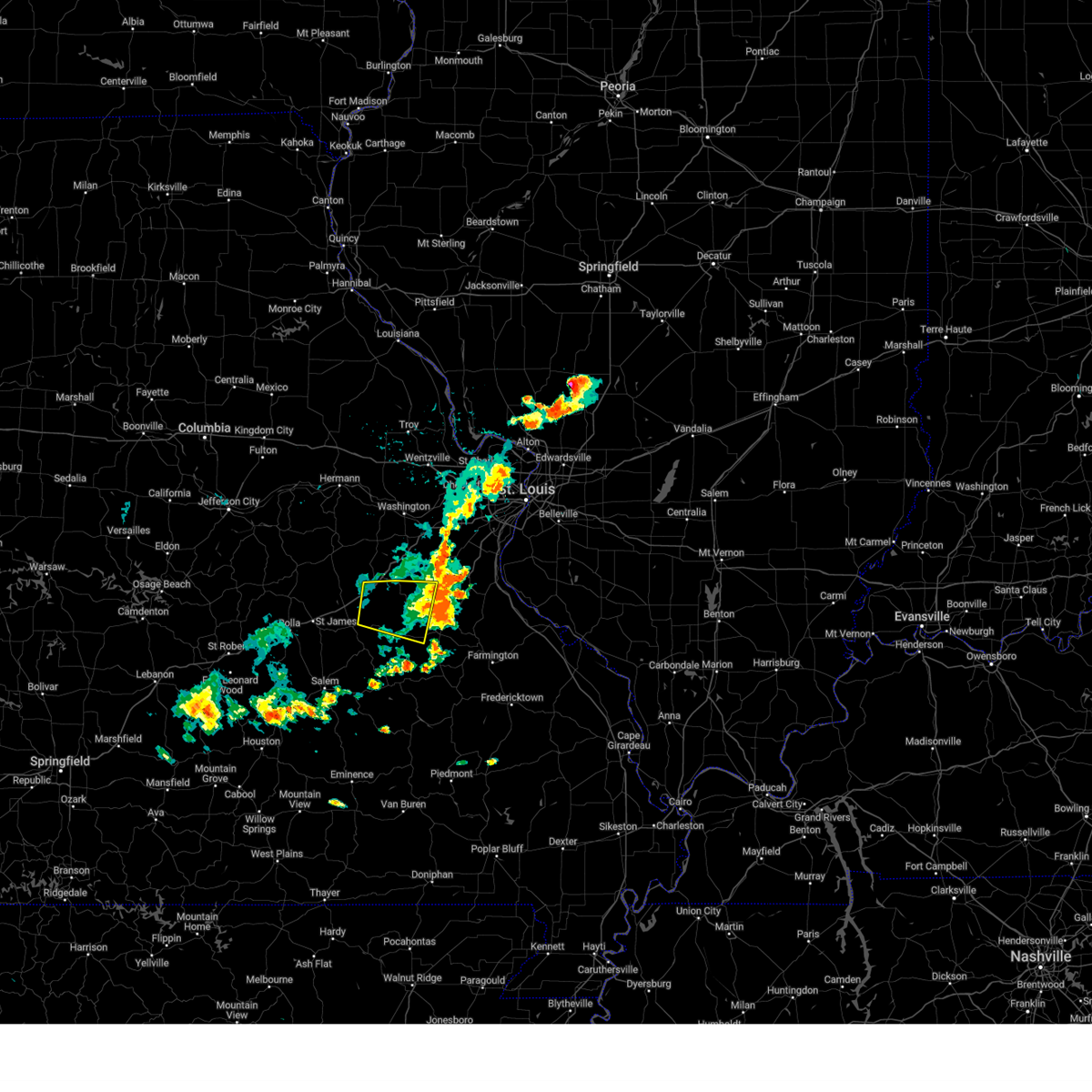 The severe thunderstorm warning for northeastern crawford and northwestern washington counties will expire at 330 pm cdt, the storm which prompted the warning has moved out of the area. therefore, the warning will be allowed to expire. a severe thunderstorm watch remains in effect until 900 pm cdt for east central missouri. The severe thunderstorm warning for northeastern crawford and northwestern washington counties will expire at 330 pm cdt, the storm which prompted the warning has moved out of the area. therefore, the warning will be allowed to expire. a severe thunderstorm watch remains in effect until 900 pm cdt for east central missouri.
|
| 7/16/2023 2:50 PM CDT |
 At 249 pm cdt, severe thunderstorms were located along a line extending from near marthasville to near sullivan, moving east at 40 mph (trained weather spotters). Hazards include 70 mph wind gusts and nickel size hail. Expect considerable tree damage. damage is likely to mobile homes, roofs, and outbuildings. locations impacted include, washington, union, warrenton, sullivan, pacific, st. clair, wright city, gray summit, villa ridge, marthasville, truesdale, innsbrook, parkway, miramiguoa park, beaufort, treloar, dutzow, lonedell, foristell, and leslie. this also includes robertsville state park and meramec state park. this includes the following highways, interstate 44 in missouri between exits 225 and 257. interstate 70 in missouri between exits 193 and 200. thunderstorm damage threat, considerable hail threat, radar indicated max hail size, 0. 88 in wind threat, radar indicated max wind gust, 70 mph. At 249 pm cdt, severe thunderstorms were located along a line extending from near marthasville to near sullivan, moving east at 40 mph (trained weather spotters). Hazards include 70 mph wind gusts and nickel size hail. Expect considerable tree damage. damage is likely to mobile homes, roofs, and outbuildings. locations impacted include, washington, union, warrenton, sullivan, pacific, st. clair, wright city, gray summit, villa ridge, marthasville, truesdale, innsbrook, parkway, miramiguoa park, beaufort, treloar, dutzow, lonedell, foristell, and leslie. this also includes robertsville state park and meramec state park. this includes the following highways, interstate 44 in missouri between exits 225 and 257. interstate 70 in missouri between exits 193 and 200. thunderstorm damage threat, considerable hail threat, radar indicated max hail size, 0. 88 in wind threat, radar indicated max wind gust, 70 mph.
|
| 7/16/2023 2:43 PM CDT |
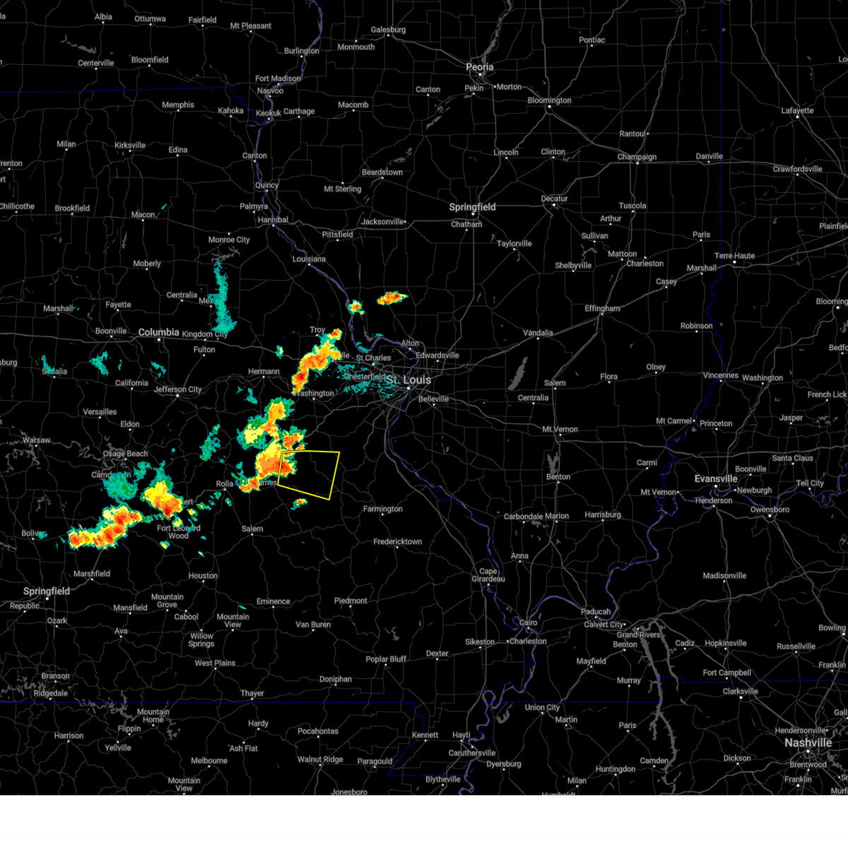 At 243 pm cdt, a severe thunderstorm was located near bourbon, moving east at 35 mph (radar indicated). Hazards include 60 mph wind gusts and nickel size hail. expect damage to roofs, siding, and trees At 243 pm cdt, a severe thunderstorm was located near bourbon, moving east at 35 mph (radar indicated). Hazards include 60 mph wind gusts and nickel size hail. expect damage to roofs, siding, and trees
|
| 7/16/2023 2:28 PM CDT |
 At 228 pm cdt, severe thunderstorms were located along a line extending from near treloar to near owensville, moving east at 35 mph (radar indicated). Hazards include 60 mph wind gusts and nickel size hail. expect damage to roofs, siding, and trees At 228 pm cdt, severe thunderstorms were located along a line extending from near treloar to near owensville, moving east at 35 mph (radar indicated). Hazards include 60 mph wind gusts and nickel size hail. expect damage to roofs, siding, and trees
|
| 7/12/2023 8:37 PM CDT |
 At 836 pm cdt, severe thunderstorms were located along a line extending from richwoods to near anthonies mill to near cuba, moving southeast at 40 mph (radar indicated). Hazards include 60 mph wind gusts and quarter size hail. Hail damage to vehicles is expected. expect wind damage to roofs, siding, and trees. locations impacted include, sullivan, cuba, steelville, bourbon, anthonies mill, leasburg, richwoods, st. cloud, oak hill, and rosati. this also includes onondaga cave state park. this includes interstate 44 in missouri between exits 203 and 218. hail threat, radar indicated max hail size, 1. 00 in wind threat, radar indicated max wind gust, 60 mph. At 836 pm cdt, severe thunderstorms were located along a line extending from richwoods to near anthonies mill to near cuba, moving southeast at 40 mph (radar indicated). Hazards include 60 mph wind gusts and quarter size hail. Hail damage to vehicles is expected. expect wind damage to roofs, siding, and trees. locations impacted include, sullivan, cuba, steelville, bourbon, anthonies mill, leasburg, richwoods, st. cloud, oak hill, and rosati. this also includes onondaga cave state park. this includes interstate 44 in missouri between exits 203 and 218. hail threat, radar indicated max hail size, 1. 00 in wind threat, radar indicated max wind gust, 60 mph.
|
| 7/12/2023 8:20 PM CDT | Tree partially over hwy 185 near the high school near meramec state park. time estimated by rada in franklin county MO, 1.2 miles W of Sullivan, MO |
| 7/12/2023 8:20 PM CDT | Spotter report a 1 ft diameter tree down on a trail northeast of sulliva in franklin county MO, 6.7 miles SW of Sullivan, MO |
| 7/12/2023 8:20 PM CDT | Corrected previous location of the report. report was relayed via email with photos including the location to be off springfield road outside sullivan mo. spotter repor in franklin county MO, 1.8 miles SW of Sullivan, MO |
| 7/12/2023 8:17 PM CDT |
 At 816 pm cdt, severe thunderstorms were located along a line extending from near parkway to near bourbon to 9 miles south of bland, moving southeast at 40 mph (radar indicated). Hazards include 60 mph wind gusts and quarter size hail. Hail damage to vehicles is expected. Expect wind damage to roofs, siding, and trees. At 816 pm cdt, severe thunderstorms were located along a line extending from near parkway to near bourbon to 9 miles south of bland, moving southeast at 40 mph (radar indicated). Hazards include 60 mph wind gusts and quarter size hail. Hail damage to vehicles is expected. Expect wind damage to roofs, siding, and trees.
|
| 7/1/2023 3:23 PM CDT | Trees down along highway k between st. clair and sullivan. time estimated from rada in franklin county MO, 10.8 miles WSW of Sullivan, MO |
| 7/1/2023 3:18 PM CDT |
 At 318 pm cdt, severe thunderstorms were located along a line extending from near miramiguoa park to 6 miles southwest of lonedell to 7 miles west of old mines, moving northeast at 60 mph (radar indicated). Hazards include 70 mph wind gusts and nickel size hail. Expect considerable tree damage. damage is likely to mobile homes, roofs, and outbuildings. locations impacted include, union, sullivan, pacific, st. clair, hillsboro, villa ridge, cedar hill, parkway, cedar hill lakes, miramiguoa park, richwoods, dittmer, lonedell, scotsdale, stanton, morse mill, oermann, robertsville, catawissa, and fletcher. this also includes sandy creek covered bridge historic site and robertsville state park. This includes interstate 44 in missouri between exits 230 and 251. At 318 pm cdt, severe thunderstorms were located along a line extending from near miramiguoa park to 6 miles southwest of lonedell to 7 miles west of old mines, moving northeast at 60 mph (radar indicated). Hazards include 70 mph wind gusts and nickel size hail. Expect considerable tree damage. damage is likely to mobile homes, roofs, and outbuildings. locations impacted include, union, sullivan, pacific, st. clair, hillsboro, villa ridge, cedar hill, parkway, cedar hill lakes, miramiguoa park, richwoods, dittmer, lonedell, scotsdale, stanton, morse mill, oermann, robertsville, catawissa, and fletcher. this also includes sandy creek covered bridge historic site and robertsville state park. This includes interstate 44 in missouri between exits 230 and 251.
|
| 7/1/2023 3:06 PM CDT |
 At 306 pm cdt, severe thunderstorms were located along a line extending from near bourbon to anthonies mill to 12 miles north of courtois, moving northeast at 70 mph (radar indicated). Hazards include 70 mph wind gusts and nickel size hail. Expect considerable tree damage. damage is likely to mobile homes, roofs, and outbuildings. locations impacted include, union, sullivan, pacific, st. clair, hillsboro, villa ridge, cedar hill, anthonies mill, parkway, cedar hill lakes, miramiguoa park, richwoods, dittmer, lonedell, scotsdale, stanton, morse mill, oermann, robertsville, and catawissa. this also includes sandy creek covered bridge historic site, robertsville state park, and meramec state park. this includes interstate 44 in missouri between exits 225 and 251. thunderstorm damage threat, considerable hail threat, radar indicated max hail size, 0. 88 in wind threat, radar indicated max wind gust, 70 mph. At 306 pm cdt, severe thunderstorms were located along a line extending from near bourbon to anthonies mill to 12 miles north of courtois, moving northeast at 70 mph (radar indicated). Hazards include 70 mph wind gusts and nickel size hail. Expect considerable tree damage. damage is likely to mobile homes, roofs, and outbuildings. locations impacted include, union, sullivan, pacific, st. clair, hillsboro, villa ridge, cedar hill, anthonies mill, parkway, cedar hill lakes, miramiguoa park, richwoods, dittmer, lonedell, scotsdale, stanton, morse mill, oermann, robertsville, and catawissa. this also includes sandy creek covered bridge historic site, robertsville state park, and meramec state park. this includes interstate 44 in missouri between exits 225 and 251. thunderstorm damage threat, considerable hail threat, radar indicated max hail size, 0. 88 in wind threat, radar indicated max wind gust, 70 mph.
|
| 7/1/2023 3:05 PM CDT |
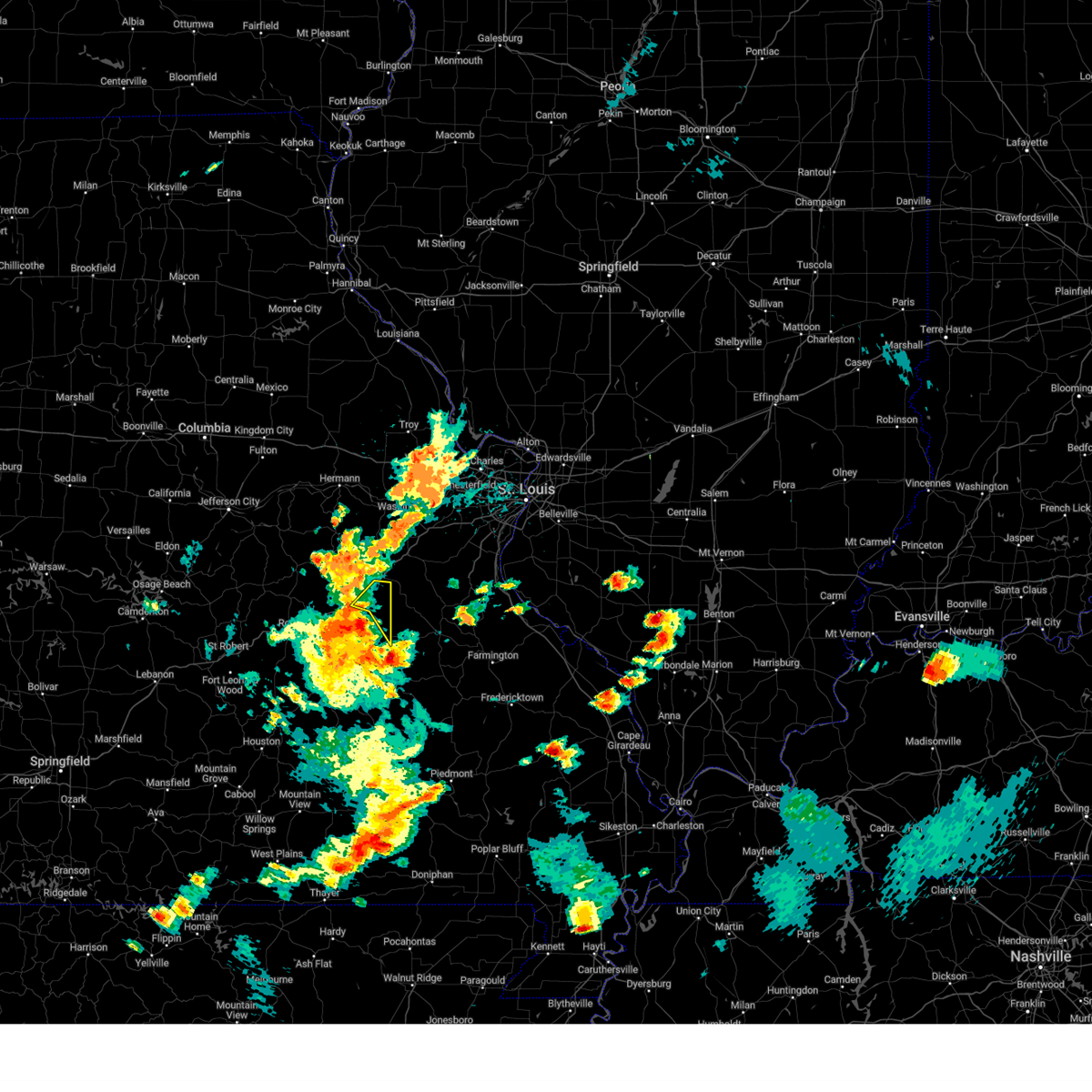 At 305 pm cdt, severe thunderstorms were located along a line extending from near bourbon to 6 miles west of anthonies mill to 11 miles north of courtois, moving northeast at 60 mph (radar indicated). Hazards include 70 mph wind gusts and nickel size hail. Expect considerable tree damage. damage is likely to mobile homes, roofs, and outbuildings. locations impacted include, sullivan, bourbon, leasburg, and st. cloud. this also includes onondaga cave state park. this includes interstate 44 in missouri near exit 218. thunderstorm damage threat, considerable hail threat, radar indicated max hail size, 0. 88 in wind threat, radar indicated max wind gust, 70 mph. At 305 pm cdt, severe thunderstorms were located along a line extending from near bourbon to 6 miles west of anthonies mill to 11 miles north of courtois, moving northeast at 60 mph (radar indicated). Hazards include 70 mph wind gusts and nickel size hail. Expect considerable tree damage. damage is likely to mobile homes, roofs, and outbuildings. locations impacted include, sullivan, bourbon, leasburg, and st. cloud. this also includes onondaga cave state park. this includes interstate 44 in missouri near exit 218. thunderstorm damage threat, considerable hail threat, radar indicated max hail size, 0. 88 in wind threat, radar indicated max wind gust, 70 mph.
|
| 7/1/2023 2:59 PM CDT |
 At 259 pm cdt, severe thunderstorms were located along a line extending from leasburg to near anthonies mill to 6 miles north of courtois, moving northeast at 65 mph (radar indicated). Hazards include 60 mph wind gusts and nickel size hail. expect damage to roofs, siding, and trees At 259 pm cdt, severe thunderstorms were located along a line extending from leasburg to near anthonies mill to 6 miles north of courtois, moving northeast at 65 mph (radar indicated). Hazards include 60 mph wind gusts and nickel size hail. expect damage to roofs, siding, and trees
|
| 7/1/2023 2:55 PM CDT |
 At 255 pm cdt, severe thunderstorms were located along a line extending from cuba to near steelville to near courtois, moving northeast at 65 mph (radar indicated). Hazards include 60 mph wind gusts and nickel size hail. Expect damage to roofs, siding, and trees. locations impacted include, sullivan, cuba, steelville, bourbon, leasburg, cherryville, st. cloud, dillard, and davisville. this also includes onondaga cave state park and dillard mill historic site. this includes interstate 44 in missouri between exits 214 and 218. hail threat, radar indicated max hail size, 0. 88 in wind threat, radar indicated max wind gust, 60 mph. At 255 pm cdt, severe thunderstorms were located along a line extending from cuba to near steelville to near courtois, moving northeast at 65 mph (radar indicated). Hazards include 60 mph wind gusts and nickel size hail. Expect damage to roofs, siding, and trees. locations impacted include, sullivan, cuba, steelville, bourbon, leasburg, cherryville, st. cloud, dillard, and davisville. this also includes onondaga cave state park and dillard mill historic site. this includes interstate 44 in missouri between exits 214 and 218. hail threat, radar indicated max hail size, 0. 88 in wind threat, radar indicated max wind gust, 60 mph.
|
| 7/1/2023 2:34 PM CDT |
 At 234 pm cdt, severe thunderstorms were located along a line extending from 8 miles southeast of rolla to 15 miles southwest of cherryville to near salem, moving northeast at 55 mph (radar indicated). Hazards include 60 mph wind gusts and penny size hail. expect damage to roofs, siding, and trees At 234 pm cdt, severe thunderstorms were located along a line extending from 8 miles southeast of rolla to 15 miles southwest of cherryville to near salem, moving northeast at 55 mph (radar indicated). Hazards include 60 mph wind gusts and penny size hail. expect damage to roofs, siding, and trees
|
| 5/8/2023 8:40 PM CDT |
 At 840 pm cdt, a severe thunderstorm was located over anthonies mill, moving east at 35 mph (radar indicated). Hazards include 60 mph wind gusts and quarter size hail. Hail damage to vehicles is expected. expect wind damage to roofs, siding, and trees. locations impacted include, sullivan, steelville, bourbon, anthonies mill, leasburg, old mines, richwoods, st. cloud, latty, and cadet. this also includes washington state park and onondaga cave state park. this includes interstate 44 in missouri between exits 210 and 218. hail threat, radar indicated max hail size, 1. 00 in wind threat, radar indicated max wind gust, 60 mph. At 840 pm cdt, a severe thunderstorm was located over anthonies mill, moving east at 35 mph (radar indicated). Hazards include 60 mph wind gusts and quarter size hail. Hail damage to vehicles is expected. expect wind damage to roofs, siding, and trees. locations impacted include, sullivan, steelville, bourbon, anthonies mill, leasburg, old mines, richwoods, st. cloud, latty, and cadet. this also includes washington state park and onondaga cave state park. this includes interstate 44 in missouri between exits 210 and 218. hail threat, radar indicated max hail size, 1. 00 in wind threat, radar indicated max wind gust, 60 mph.
|
| 5/8/2023 8:23 PM CDT |
 At 823 pm cdt, a severe thunderstorm was located over leasburg, moving east at 35 mph (radar indicated). Hazards include 60 mph wind gusts and quarter size hail. Hail damage to vehicles is expected. Expect wind damage to roofs, siding, and trees. At 823 pm cdt, a severe thunderstorm was located over leasburg, moving east at 35 mph (radar indicated). Hazards include 60 mph wind gusts and quarter size hail. Hail damage to vehicles is expected. Expect wind damage to roofs, siding, and trees.
|
| 5/8/2023 8:04 PM CDT |
 At 804 pm cdt, a severe thunderstorm was located near anthonies mill, moving east at 10 mph (radar indicated). Hazards include 60 mph wind gusts and quarter size hail. Hail damage to vehicles is expected. expect wind damage to roofs, siding, and trees. locations impacted include, sullivan, st. clair, anthonies mill, and miramiguoa park. this also includes meramec state park. this includes interstate 44 in missouri between exits 225 and 228. hail threat, radar indicated max hail size, 1. 00 in wind threat, radar indicated max wind gust, 60 mph. At 804 pm cdt, a severe thunderstorm was located near anthonies mill, moving east at 10 mph (radar indicated). Hazards include 60 mph wind gusts and quarter size hail. Hail damage to vehicles is expected. expect wind damage to roofs, siding, and trees. locations impacted include, sullivan, st. clair, anthonies mill, and miramiguoa park. this also includes meramec state park. this includes interstate 44 in missouri between exits 225 and 228. hail threat, radar indicated max hail size, 1. 00 in wind threat, radar indicated max wind gust, 60 mph.
|
| 5/8/2023 7:37 PM CDT |
 At 737 pm cdt, a severe thunderstorm was located near sullivan, moving east at 15 mph (radar indicated). Hazards include 60 mph wind gusts and quarter size hail. Hail damage to vehicles is expected. Expect wind damage to roofs, siding, and trees. At 737 pm cdt, a severe thunderstorm was located near sullivan, moving east at 15 mph (radar indicated). Hazards include 60 mph wind gusts and quarter size hail. Hail damage to vehicles is expected. Expect wind damage to roofs, siding, and trees.
|
| 4/15/2023 5:37 PM CDT | Quarter sized hail reported 0.1 miles WNW of Sullivan, MO, gusting winds as well. |
| 4/15/2023 5:35 PM CDT |
 At 534 pm cdt, a severe thunderstorm was located near miramiguoa park, moving northeast at 45 mph (radar indicated). Hazards include 70 mph wind gusts and ping pong ball size hail. People and animals outdoors will be injured. expect hail damage to roofs, siding, windows, and vehicles. expect considerable tree damage. wind damage is also likely to mobile homes, roofs, and outbuildings. locations impacted include, sullivan, st. clair, bourbon, gerald, parkway, miramiguoa park, richwoods, beaufort, leslie, st. cloud, noser mill, japan, stanton, and piney park. this also includes meramec state park. This includes interstate 44 in missouri between exits 218 and 240. At 534 pm cdt, a severe thunderstorm was located near miramiguoa park, moving northeast at 45 mph (radar indicated). Hazards include 70 mph wind gusts and ping pong ball size hail. People and animals outdoors will be injured. expect hail damage to roofs, siding, windows, and vehicles. expect considerable tree damage. wind damage is also likely to mobile homes, roofs, and outbuildings. locations impacted include, sullivan, st. clair, bourbon, gerald, parkway, miramiguoa park, richwoods, beaufort, leslie, st. cloud, noser mill, japan, stanton, and piney park. this also includes meramec state park. This includes interstate 44 in missouri between exits 218 and 240.
|
| 4/15/2023 5:30 PM CDT | Image on twitter shows large tree snapped at the base. time estimated from rada in franklin county MO, 0.1 miles WNW of Sullivan, MO |
| 4/15/2023 5:30 PM CDT | Portion of roof blown off building in downtown sullivan. time estimated by rada in franklin county MO, 0.8 miles N of Sullivan, MO |
| 4/15/2023 5:30 PM CDT | Social media report shows damage to a structure in sulliva in franklin county MO, 0.4 miles E of Sullivan, MO |
| 4/15/2023 5:24 PM CDT | Quarter sized hail reported 0.4 miles E of Sullivan, MO |
| 4/15/2023 5:13 PM CDT |
 At 512 pm cdt, a severe thunderstorm was located 7 miles northwest of bourbon, moving northeast at 35 mph (radar indicated. this storm has a history of producing damaging wind). Hazards include two inch hail and 70 mph wind gusts. People and animals outdoors will be injured. expect hail damage to roofs, siding, windows, and vehicles. expect considerable tree damage. Wind damage is also likely to mobile homes, roofs, and outbuildings. At 512 pm cdt, a severe thunderstorm was located 7 miles northwest of bourbon, moving northeast at 35 mph (radar indicated. this storm has a history of producing damaging wind). Hazards include two inch hail and 70 mph wind gusts. People and animals outdoors will be injured. expect hail damage to roofs, siding, windows, and vehicles. expect considerable tree damage. Wind damage is also likely to mobile homes, roofs, and outbuildings.
|
| 3/31/2023 5:16 PM CDT | Golf Ball sized hail reported 0.4 miles E of Sullivan, MO, also reported rotating wall cloud. |
| 3/31/2023 5:15 PM CDT | Half Dollar sized hail reported 0.4 miles E of Sullivan, MO, spotter called back with an update out of sullivan. largest hail the spotter observed was slightly larger than a quarter. time estimated by radar. |
| 2/22/2023 1:07 PM CST |
 The severe thunderstorm warning for eastern crawford, western washington and south central franklin counties will expire at 115 pm cst, the storms which prompted the warning have moved out of the area. therefore, the warning will be allowed to expire. a tornado watch remains in effect until 600 pm cst for southeastern and east central missouri. The severe thunderstorm warning for eastern crawford, western washington and south central franklin counties will expire at 115 pm cst, the storms which prompted the warning have moved out of the area. therefore, the warning will be allowed to expire. a tornado watch remains in effect until 600 pm cst for southeastern and east central missouri.
|
| 2/22/2023 12:51 PM CST |
 At 1251 pm cst, severe thunderstorms were located along a line extending from near st. clair to near anthonies mill to 7 miles north of courtois, moving east at 45 mph (radar indicated). Hazards include 60 mph wind gusts. Expect damage to roofs, siding, and trees. locations impacted include, union, sullivan, st. clair, anthonies mill, viburnum, parkway, miramiguoa park, courtois, stanton, dillard and davisville. this also includes dillard mill historic site and meramec state park. This includes interstate 44 in missouri between exits 225 and 240. At 1251 pm cst, severe thunderstorms were located along a line extending from near st. clair to near anthonies mill to 7 miles north of courtois, moving east at 45 mph (radar indicated). Hazards include 60 mph wind gusts. Expect damage to roofs, siding, and trees. locations impacted include, union, sullivan, st. clair, anthonies mill, viburnum, parkway, miramiguoa park, courtois, stanton, dillard and davisville. this also includes dillard mill historic site and meramec state park. This includes interstate 44 in missouri between exits 225 and 240.
|
| 2/22/2023 12:31 PM CST |
 At 1231 pm cst, severe thunderstorms were located along a line extending from 6 miles west of sullivan to near leasburg to near cherryville, moving northeast at 45 mph (radar indicated). Hazards include 60 mph wind gusts. Expect damage to roofs, siding, and trees. locations impacted include, bourbon, sullivan, anthonies mill, miramiguoa park, courtois, st. clair and parkway. this also includes onondaga cave state park, dillard mill historic site, and meramec state park. This includes interstate 44 in missouri between exits 210 and 240. At 1231 pm cst, severe thunderstorms were located along a line extending from 6 miles west of sullivan to near leasburg to near cherryville, moving northeast at 45 mph (radar indicated). Hazards include 60 mph wind gusts. Expect damage to roofs, siding, and trees. locations impacted include, bourbon, sullivan, anthonies mill, miramiguoa park, courtois, st. clair and parkway. this also includes onondaga cave state park, dillard mill historic site, and meramec state park. This includes interstate 44 in missouri between exits 210 and 240.
|
| 2/22/2023 12:08 PM CST |
 At 1208 pm cst, severe thunderstorms were located along a line extending from 10 miles west of cuba to 6 miles southeast of st. james to near salem, moving northeast at 40 mph (radar indicated). Hazards include 60 mph wind gusts. Expect damage to roofs, siding, and trees. severe thunderstorms will be near, cuba and steelville around 1225 pm cst. other locations in the path of these severe thunderstorms include leasburg, bourbon, cherryville, oak grove, sullivan, anthonies mill, miramiguoa park, st. clair, parkway and union. this includes interstate 44 in missouri between exits 203 and 240. This also includes onondaga cave state park, dillard mill historic site, and meramec state park. At 1208 pm cst, severe thunderstorms were located along a line extending from 10 miles west of cuba to 6 miles southeast of st. james to near salem, moving northeast at 40 mph (radar indicated). Hazards include 60 mph wind gusts. Expect damage to roofs, siding, and trees. severe thunderstorms will be near, cuba and steelville around 1225 pm cst. other locations in the path of these severe thunderstorms include leasburg, bourbon, cherryville, oak grove, sullivan, anthonies mill, miramiguoa park, st. clair, parkway and union. this includes interstate 44 in missouri between exits 203 and 240. This also includes onondaga cave state park, dillard mill historic site, and meramec state park.
|
| 6/8/2022 5:09 AM CDT | Several tree limbs down along route 185 north of sullivan. road crews on the way to clean the debri in franklin county MO, 3.3 miles SE of Sullivan, MO |
| 6/8/2022 5:01 AM CDT |
 At 500 am cdt, a severe thunderstorm was located 7 miles northwest of sullivan, moving northeast at 40 mph (radar indicated). Hazards include 60 mph wind gusts and quarter size hail. Hail damage to vehicles is expected. expect wind damage to roofs, siding, and trees. this severe thunderstorm will be near, beaufort around 510 am cdt. st. clair and parkway around 520 am cdt. other locations in the path of this severe thunderstorm include union and villa ridge. this includes interstate 44 in missouri between exits 218 and 247. this also includes meramec state park. hail threat, radar indicated max hail size, 1. 00 in wind threat, radar indicated max wind gust, 60 mph. At 500 am cdt, a severe thunderstorm was located 7 miles northwest of sullivan, moving northeast at 40 mph (radar indicated). Hazards include 60 mph wind gusts and quarter size hail. Hail damage to vehicles is expected. expect wind damage to roofs, siding, and trees. this severe thunderstorm will be near, beaufort around 510 am cdt. st. clair and parkway around 520 am cdt. other locations in the path of this severe thunderstorm include union and villa ridge. this includes interstate 44 in missouri between exits 218 and 247. this also includes meramec state park. hail threat, radar indicated max hail size, 1. 00 in wind threat, radar indicated max wind gust, 60 mph.
|
| 5/19/2022 4:04 PM CDT |
 At 403 pm cdt, severe thunderstorms were located along a line extending from near sullivan to 9 miles southeast of anthonies mill, moving northeast at 60 mph. this storm is associated with a bowing line, in addition to other individual cells running ahead of the main line (radar indicated). Hazards include 70 mph wind gusts. Expect considerable tree damage. damage is likely to mobile homes, roofs, and outbuildings. severe thunderstorms will be near, richwoods around 415 pm cdt. st. clair and parkway around 420 pm cdt. other locations in the path of these severe thunderstorms include lonedell, villa ridge, pacific and gray summit. this includes interstate 44 in missouri between exits 218 and 257. This also includes robertsville state park and meramec state park. At 403 pm cdt, severe thunderstorms were located along a line extending from near sullivan to 9 miles southeast of anthonies mill, moving northeast at 60 mph. this storm is associated with a bowing line, in addition to other individual cells running ahead of the main line (radar indicated). Hazards include 70 mph wind gusts. Expect considerable tree damage. damage is likely to mobile homes, roofs, and outbuildings. severe thunderstorms will be near, richwoods around 415 pm cdt. st. clair and parkway around 420 pm cdt. other locations in the path of these severe thunderstorms include lonedell, villa ridge, pacific and gray summit. this includes interstate 44 in missouri between exits 218 and 257. This also includes robertsville state park and meramec state park.
|
| 5/19/2022 3:09 PM CDT |
 At 307 pm cdt, a severe thunderstorm was located over steelville, moving northeast at 35 mph (spotters reported hail up to the size of nickels near cuba). Hazards include quarter size hail possible. Damage to vehicles is expected. this severe storm will be near, cuba around 320 pm cdt. leasburg around 325 pm cdt. bourbon around 335 pm cdt. sullivan around 345 pm cdt. other locations impacted by this severe thunderstorm include oak hill and st. cloud. This includes interstate 44 in missouri between exits 203 and 218. At 307 pm cdt, a severe thunderstorm was located over steelville, moving northeast at 35 mph (spotters reported hail up to the size of nickels near cuba). Hazards include quarter size hail possible. Damage to vehicles is expected. this severe storm will be near, cuba around 320 pm cdt. leasburg around 325 pm cdt. bourbon around 335 pm cdt. sullivan around 345 pm cdt. other locations impacted by this severe thunderstorm include oak hill and st. cloud. This includes interstate 44 in missouri between exits 203 and 218.
|
| 5/19/2022 2:55 PM CDT |
 At 254 pm cdt, a severe thunderstorm was located 8 miles west of cherryville, moving northeast at 35 mph (spotters reported peas to penny size hail near steelville). Hazards include quarter size hail. Damage to vehicles is expected. this severe storm will be near, steelville around 310 pm cdt. cuba around 320 pm cdt. bourbon and leasburg around 330 pm cdt. other locations impacted by this severe thunderstorm include oak hill, st. cloud and cook station. this also includes onondaga cave state park. This includes interstate 44 in missouri between exits 203 and 218. At 254 pm cdt, a severe thunderstorm was located 8 miles west of cherryville, moving northeast at 35 mph (spotters reported peas to penny size hail near steelville). Hazards include quarter size hail. Damage to vehicles is expected. this severe storm will be near, steelville around 310 pm cdt. cuba around 320 pm cdt. bourbon and leasburg around 330 pm cdt. other locations impacted by this severe thunderstorm include oak hill, st. cloud and cook station. this also includes onondaga cave state park. This includes interstate 44 in missouri between exits 203 and 218.
|
| 5/19/2022 2:49 PM CDT |
 At 249 pm cdt, a severe thunderstorm was located 10 miles west of cherryville, moving northeast at 35 mph (radar indicated). Hazards include quarter size hail. Damage to vehicles is expected. this severe thunderstorm will be near, steelville around 310 pm cdt. cuba around 320 pm cdt. bourbon and leasburg around 330 pm cdt. other locations impacted by this severe thunderstorm include oak hill, st. cloud and cook station. this includes interstate 44 in missouri between exits 203 and 218. this also includes onondaga cave state park. hail threat, radar indicated max hail size, 1. 00 in wind threat, radar indicated max wind gust, <50 mph. At 249 pm cdt, a severe thunderstorm was located 10 miles west of cherryville, moving northeast at 35 mph (radar indicated). Hazards include quarter size hail. Damage to vehicles is expected. this severe thunderstorm will be near, steelville around 310 pm cdt. cuba around 320 pm cdt. bourbon and leasburg around 330 pm cdt. other locations impacted by this severe thunderstorm include oak hill, st. cloud and cook station. this includes interstate 44 in missouri between exits 203 and 218. this also includes onondaga cave state park. hail threat, radar indicated max hail size, 1. 00 in wind threat, radar indicated max wind gust, <50 mph.
|
| 5/19/2022 10:51 AM CDT |
 At 1051 am cdt, a severe thunderstorm was located near beaufort, moving east at 45 mph (radar indicated). Hazards include 60 mph wind gusts and quarter size hail. Hail damage to vehicles is expected. expect wind damage to roofs, siding, and trees. locations impacted include, st. clair, union and parkway. this includes interstate 44 in missouri between exits 228 and 242. hail threat, radar indicated max hail size, 1. 00 in wind threat, radar indicated max wind gust, 60 mph. At 1051 am cdt, a severe thunderstorm was located near beaufort, moving east at 45 mph (radar indicated). Hazards include 60 mph wind gusts and quarter size hail. Hail damage to vehicles is expected. expect wind damage to roofs, siding, and trees. locations impacted include, st. clair, union and parkway. this includes interstate 44 in missouri between exits 228 and 242. hail threat, radar indicated max hail size, 1. 00 in wind threat, radar indicated max wind gust, 60 mph.
|
| 5/19/2022 10:37 AM CDT |
 At 1037 am cdt, a severe thunderstorm was located near gerald, moving east at 45 mph (radar indicated). Hazards include 60 mph wind gusts and quarter size hail. Hail damage to vehicles is expected. expect wind damage to roofs, siding, and trees. this severe thunderstorm will be near, beaufort around 1050 am cdt. other locations in the path of this severe thunderstorm include st. clair, union and parkway. this includes interstate 44 in missouri between exits 228 and 242. hail threat, radar indicated max hail size, 1. 00 in wind threat, radar indicated max wind gust, 60 mph. At 1037 am cdt, a severe thunderstorm was located near gerald, moving east at 45 mph (radar indicated). Hazards include 60 mph wind gusts and quarter size hail. Hail damage to vehicles is expected. expect wind damage to roofs, siding, and trees. this severe thunderstorm will be near, beaufort around 1050 am cdt. other locations in the path of this severe thunderstorm include st. clair, union and parkway. this includes interstate 44 in missouri between exits 228 and 242. hail threat, radar indicated max hail size, 1. 00 in wind threat, radar indicated max wind gust, 60 mph.
|
| 5/15/2022 1:40 PM CDT |
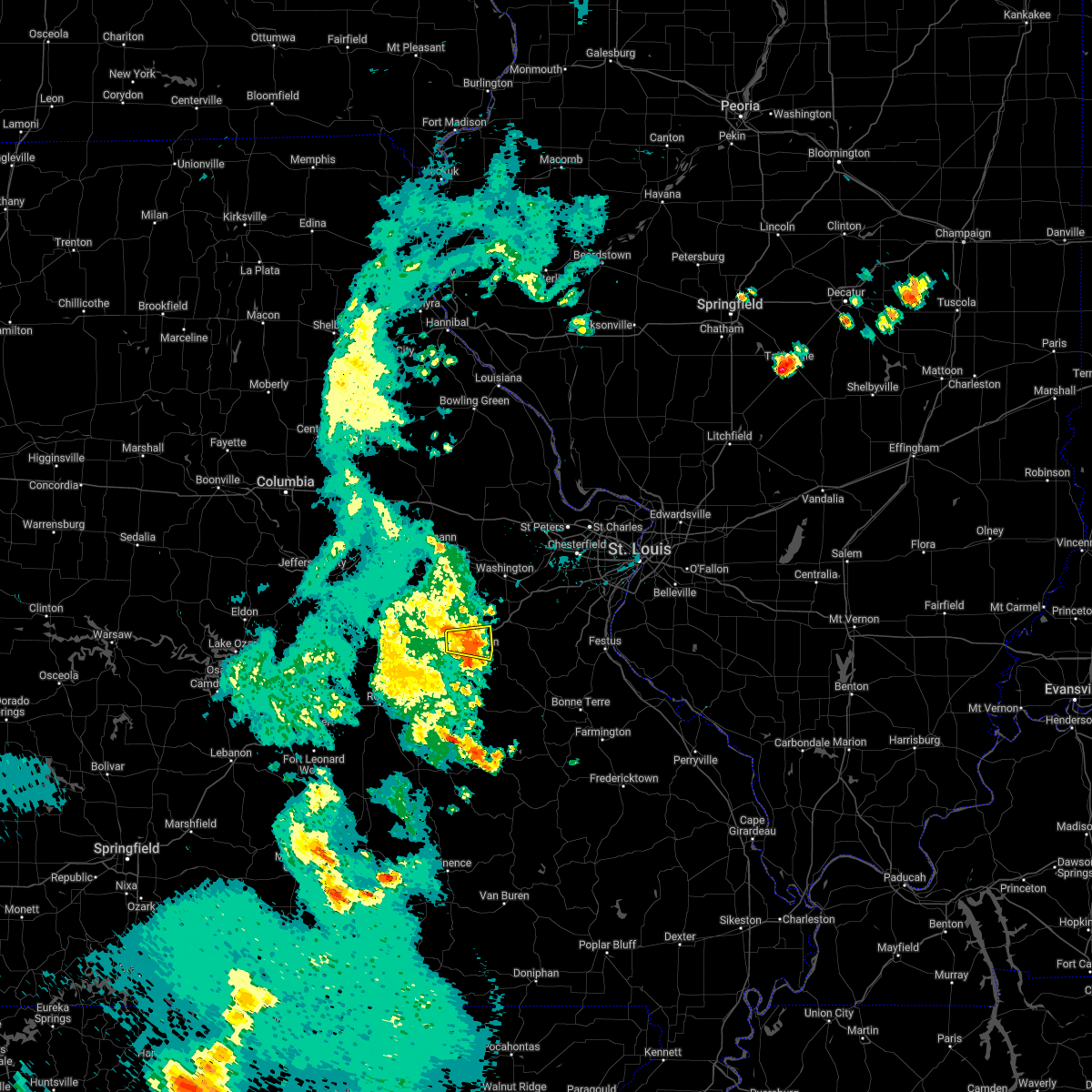 The severe thunderstorm warning for northeastern crawford and southwestern franklin counties will expire at 145 pm cdt, the storm which prompted the warning has weakened below severe limits, and no longer poses an immediate threat to life or property. therefore, the warning will be allowed to expire. however gusty winds are still possible with this thunderstorm. a severe thunderstorm watch remains in effect until 400 pm cdt for east central missouri. The severe thunderstorm warning for northeastern crawford and southwestern franklin counties will expire at 145 pm cdt, the storm which prompted the warning has weakened below severe limits, and no longer poses an immediate threat to life or property. therefore, the warning will be allowed to expire. however gusty winds are still possible with this thunderstorm. a severe thunderstorm watch remains in effect until 400 pm cdt for east central missouri.
|
| 5/15/2022 1:36 PM CDT | Part of tree down across rt. 185 west of sullivan. time estimated via radar... picture provided via faceboo in franklin county MO, 1.7 miles ENE of Sullivan, MO |
| 5/15/2022 1:33 PM CDT |
 At 133 pm cdt, a severe thunderstorm was located near sullivan, moving east at 45 mph (radar indicated). Hazards include 60 mph wind gusts and penny size hail. Expect damage to roofs, siding, and trees. locations impacted include, sullivan, st. cloud, japan and stanton. this also includes meramec state park. this includes interstate 44 in missouri between exits 225 and 230. hail threat, radar indicated max hail size, 0. 75 in wind threat, radar indicated max wind gust, 60 mph. At 133 pm cdt, a severe thunderstorm was located near sullivan, moving east at 45 mph (radar indicated). Hazards include 60 mph wind gusts and penny size hail. Expect damage to roofs, siding, and trees. locations impacted include, sullivan, st. cloud, japan and stanton. this also includes meramec state park. this includes interstate 44 in missouri between exits 225 and 230. hail threat, radar indicated max hail size, 0. 75 in wind threat, radar indicated max wind gust, 60 mph.
|
| 5/15/2022 1:23 PM CDT |
 At 123 pm cdt, a severe thunderstorm was located 8 miles northwest of bourbon, moving east at 40 mph (radar indicated). Hazards include 60 mph wind gusts and penny size hail. Expect damage to roofs, siding, and trees. locations impacted include, sullivan, bourbon, st. cloud, japan, stanton and oak hill. this also includes meramec state park. this includes interstate 44 in missouri between exits 218 and 230. hail threat, radar indicated max hail size, 0. 75 in wind threat, radar indicated max wind gust, 60 mph. At 123 pm cdt, a severe thunderstorm was located 8 miles northwest of bourbon, moving east at 40 mph (radar indicated). Hazards include 60 mph wind gusts and penny size hail. Expect damage to roofs, siding, and trees. locations impacted include, sullivan, bourbon, st. cloud, japan, stanton and oak hill. this also includes meramec state park. this includes interstate 44 in missouri between exits 218 and 230. hail threat, radar indicated max hail size, 0. 75 in wind threat, radar indicated max wind gust, 60 mph.
|
| 5/15/2022 1:11 PM CDT |
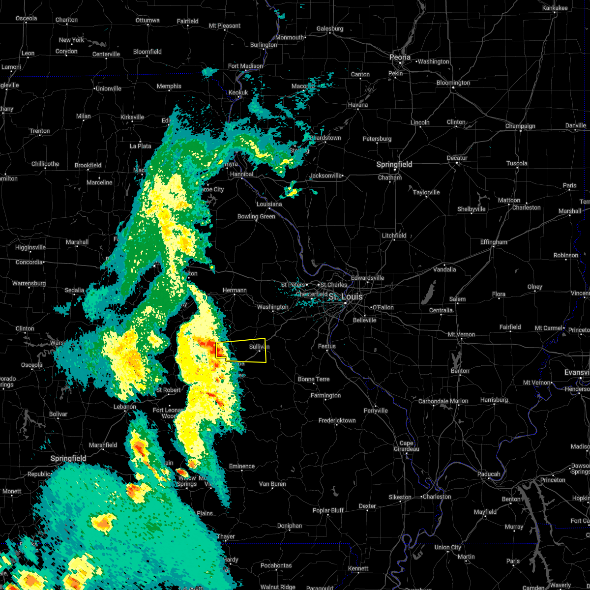 At 111 pm cdt, a severe thunderstorm was located 7 miles southeast of bland, moving east at 30 mph (radar indicated). Hazards include 60 mph wind gusts and penny size hail. Expect damage to roofs, siding, and trees. locations impacted include, sullivan, bourbon, st. cloud, japan, stanton and oak hill. this also includes meramec state park. this includes interstate 44 in missouri between exits 214 and 230. hail threat, radar indicated max hail size, 0. 75 in wind threat, radar indicated max wind gust, 60 mph. At 111 pm cdt, a severe thunderstorm was located 7 miles southeast of bland, moving east at 30 mph (radar indicated). Hazards include 60 mph wind gusts and penny size hail. Expect damage to roofs, siding, and trees. locations impacted include, sullivan, bourbon, st. cloud, japan, stanton and oak hill. this also includes meramec state park. this includes interstate 44 in missouri between exits 214 and 230. hail threat, radar indicated max hail size, 0. 75 in wind threat, radar indicated max wind gust, 60 mph.
|
| 5/15/2022 12:55 PM CDT |
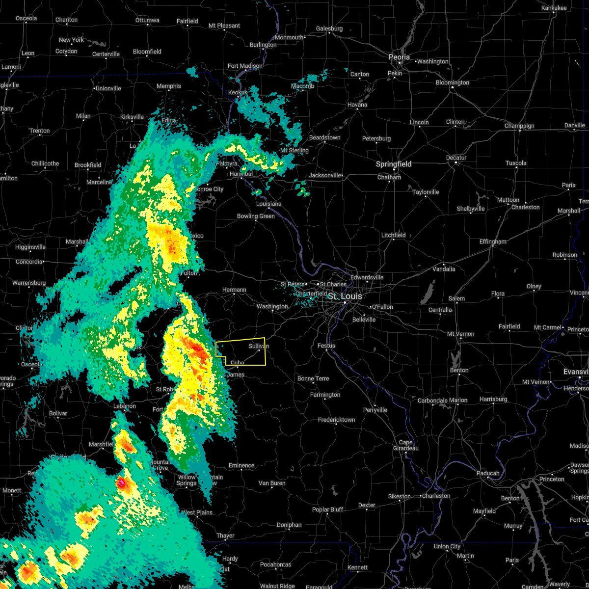 At 1254 pm cdt, a severe thunderstorm was located 7 miles south of belle, moving east at 45 mph (radar indicated). Hazards include 60 mph wind gusts and quarter size hail. Hail damage to vehicles is expected. Expect wind damage to roofs, siding, and trees. At 1254 pm cdt, a severe thunderstorm was located 7 miles south of belle, moving east at 45 mph (radar indicated). Hazards include 60 mph wind gusts and quarter size hail. Hail damage to vehicles is expected. Expect wind damage to roofs, siding, and trees.
|
| 5/14/2022 7:47 PM CDT |
 At 747 pm cdt, a severe thunderstorm was located over bourbon, moving southwest at 5 mph (radar indicated). Hazards include 60 mph wind gusts and quarter size hail. Hail damage to vehicles is expected. expect wind damage to roofs, siding, and trees. locations impacted include, bourbon. this includes interstate 44 in missouri near exit 218. hail threat, radar indicated max hail size, 1. 00 in wind threat, radar indicated max wind gust, 60 mph. At 747 pm cdt, a severe thunderstorm was located over bourbon, moving southwest at 5 mph (radar indicated). Hazards include 60 mph wind gusts and quarter size hail. Hail damage to vehicles is expected. expect wind damage to roofs, siding, and trees. locations impacted include, bourbon. this includes interstate 44 in missouri near exit 218. hail threat, radar indicated max hail size, 1. 00 in wind threat, radar indicated max wind gust, 60 mph.
|
| 5/14/2022 7:35 PM CDT | Quarter sized hail reported 0.8 miles N of Sullivan, MO, pictures of quarter-sized hail received on facebook. time estimated from radar. |
| 5/14/2022 7:30 PM CDT | Quarter sized hail reported 0.8 miles N of Sullivan, MO, hail and strong winds. time estimated from radar. |
| 5/14/2022 7:17 PM CDT |
 At 717 pm cdt, a severe thunderstorm was located over sullivan, moving southwest at 5 mph (radar indicated). Hazards include 60 mph wind gusts and quarter size hail. Hail damage to vehicles is expected. expect wind damage to roofs, siding, and trees. this severe thunderstorm will be near, oak grove around 720 pm cdt. other locations in the path of this severe thunderstorm include bourbon and anthonies mill. this includes interstate 44 in missouri between exits 218 and 228. this also includes meramec state park. hail threat, radar indicated max hail size, 1. 00 in wind threat, radar indicated max wind gust, 60 mph. At 717 pm cdt, a severe thunderstorm was located over sullivan, moving southwest at 5 mph (radar indicated). Hazards include 60 mph wind gusts and quarter size hail. Hail damage to vehicles is expected. expect wind damage to roofs, siding, and trees. this severe thunderstorm will be near, oak grove around 720 pm cdt. other locations in the path of this severe thunderstorm include bourbon and anthonies mill. this includes interstate 44 in missouri between exits 218 and 228. this also includes meramec state park. hail threat, radar indicated max hail size, 1. 00 in wind threat, radar indicated max wind gust, 60 mph.
|
| 5/14/2022 7:05 PM CDT |
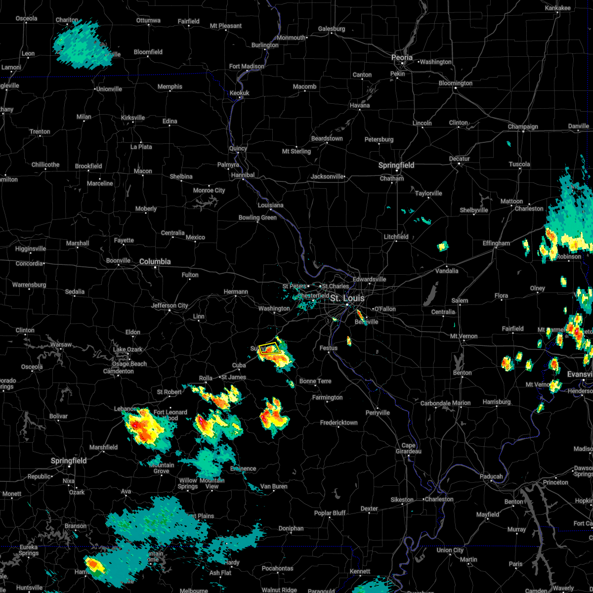 The severe thunderstorm warning for south central franklin county will expire at 715 pm cdt, the storm which prompted the warning has weakened below severe limits, and has exited the warned area. therefore, the warning will be allowed to expire. The severe thunderstorm warning for south central franklin county will expire at 715 pm cdt, the storm which prompted the warning has weakened below severe limits, and has exited the warned area. therefore, the warning will be allowed to expire.
|
| 5/14/2022 6:50 PM CDT |
 At 650 pm cdt, a severe thunderstorm was located over miramiguoa park, moving south at 5 mph (public). Hazards include 60 mph wind gusts and quarter size hail. Hail damage to vehicles is expected. expect wind damage to roofs, siding, and trees. locations impacted include, sullivan. this also includes meramec state park. this includes interstate 44 in missouri between exits 228 and 230. hail threat, radar indicated max hail size, 1. 00 in wind threat, radar indicated max wind gust, 60 mph. At 650 pm cdt, a severe thunderstorm was located over miramiguoa park, moving south at 5 mph (public). Hazards include 60 mph wind gusts and quarter size hail. Hail damage to vehicles is expected. expect wind damage to roofs, siding, and trees. locations impacted include, sullivan. this also includes meramec state park. this includes interstate 44 in missouri between exits 228 and 230. hail threat, radar indicated max hail size, 1. 00 in wind threat, radar indicated max wind gust, 60 mph.
|
| 5/14/2022 6:40 PM CDT | Ping Pong Ball sized hail reported 4.4 miles SW of Sullivan, MO, about 4 to 5 cm sized hail. |
| 5/14/2022 6:31 PM CDT |
 At 631 pm cdt, a severe thunderstorm was located near miramiguoa park, moving south at 5 mph (law enforcement). Hazards include ping pong ball size hail and 60 mph wind gusts. People and animals outdoors will be injured. expect hail damage to roofs, siding, windows, and vehicles. expect wind damage to roofs, siding, and trees. this severe thunderstorm will be near, sullivan around 640 pm cdt. other locations in the path of this severe thunderstorm include miramiguoa park. this includes interstate 44 in missouri between exits 225 and 230. this also includes meramec state park. hail threat, radar indicated max hail size, 1. 50 in wind threat, radar indicated max wind gust, 60 mph. At 631 pm cdt, a severe thunderstorm was located near miramiguoa park, moving south at 5 mph (law enforcement). Hazards include ping pong ball size hail and 60 mph wind gusts. People and animals outdoors will be injured. expect hail damage to roofs, siding, windows, and vehicles. expect wind damage to roofs, siding, and trees. this severe thunderstorm will be near, sullivan around 640 pm cdt. other locations in the path of this severe thunderstorm include miramiguoa park. this includes interstate 44 in missouri between exits 225 and 230. this also includes meramec state park. hail threat, radar indicated max hail size, 1. 50 in wind threat, radar indicated max wind gust, 60 mph.
|
| 5/14/2022 6:28 PM CDT | Golf Ball sized hail reported 4.4 miles SW of Sullivan, MO |
| 5/14/2022 6:27 PM CDT | Ping Pong Ball sized hail reported 4.9 miles SSW of Sullivan, MO, report from mping: ping pong ball (1.50 in.). |
| 5/14/2022 6:15 PM CDT | Large tree blown down across route jj and spring creek r in franklin county MO, 6.3 miles S of Sullivan, MO |
| 5/14/2022 6:05 PM CDT |
 At 605 pm cdt, a severe thunderstorm was located near miramiguoa park, moving south at 5 mph (radar indicated). Hazards include 60 mph wind gusts and quarter size hail. Hail damage to vehicles is expected. Expect wind damage to roofs, siding, and trees. At 605 pm cdt, a severe thunderstorm was located near miramiguoa park, moving south at 5 mph (radar indicated). Hazards include 60 mph wind gusts and quarter size hail. Hail damage to vehicles is expected. Expect wind damage to roofs, siding, and trees.
|
| 8/12/2021 6:15 PM CDT |
 At 615 pm cdt, severe thunderstorms were located along a line extending from near winfield to near augusta to near gerald, moving east at 40 mph (this line of storms has a history of producing wind damage). Hazards include 60 mph wind gusts and penny size hail. Expect damage to roofs, siding, and trees. locations impacted include, winfield, new melle, augusta, pacific, defiance, wildwood, sullivan, weldon spring heights, orchard farms, eureka, spirit of st. louis airport, ballwin, union, ellisville, st. clair, clarkson valley, parkway, portage des sioux, chesterfield, manchester, town and country, winchester, west alton, twin oaks, kirkwood, des peres, valley park, fenton, murphy, crystal lake park, westwood, country life acres, webster groves, creve coeur, overland, crestwood, ladue, sunset hills, brentwood, olivette, glendale and frontenac. this also includes babler memorial state park, route 66 state park, castlewood state park, first missouri state capitol historic site, and robertsville state park. this includes the following highways, interstate 44 in missouri between exits 228 and 277. interstate 70 in missouri between exits 200 and 231. hail threat, radar indicated max hail size, 0. 75 in wind threat, radar indicated max wind gust, 60 mph. At 615 pm cdt, severe thunderstorms were located along a line extending from near winfield to near augusta to near gerald, moving east at 40 mph (this line of storms has a history of producing wind damage). Hazards include 60 mph wind gusts and penny size hail. Expect damage to roofs, siding, and trees. locations impacted include, winfield, new melle, augusta, pacific, defiance, wildwood, sullivan, weldon spring heights, orchard farms, eureka, spirit of st. louis airport, ballwin, union, ellisville, st. clair, clarkson valley, parkway, portage des sioux, chesterfield, manchester, town and country, winchester, west alton, twin oaks, kirkwood, des peres, valley park, fenton, murphy, crystal lake park, westwood, country life acres, webster groves, creve coeur, overland, crestwood, ladue, sunset hills, brentwood, olivette, glendale and frontenac. this also includes babler memorial state park, route 66 state park, castlewood state park, first missouri state capitol historic site, and robertsville state park. this includes the following highways, interstate 44 in missouri between exits 228 and 277. interstate 70 in missouri between exits 200 and 231. hail threat, radar indicated max hail size, 0. 75 in wind threat, radar indicated max wind gust, 60 mph.
|
| 8/12/2021 5:58 PM CDT |
 At 557 pm cdt, severe thunderstorms were located along a line extending from near fountain n` lakes to near marthasville to near drake, moving east at 40 mph (this line of storms has downed trees and snapped power poles). Hazards include 70 mph wind gusts and penny size hail. Expect considerable tree damage. damage is likely to mobile homes, roofs, and outbuildings. these severe storms will be near, washington, marthasville and fountain n` lakes around 600 pm cdt. winfield, innsbrook and dutzow around 605 pm cdt. gerald around 610 pm cdt. other locations in the path of these severe thunderstorms include new melle, augusta, defiance, dardenne prairie, beaufort, o`fallon, wildwood, spirit of st. louis airport, weldon spring heights, st. peters, union, weldon spring, cottleville and clarkson valley. this also includes babler memorial state park, route 66 state park, deutschheim historic site, castlewood state park, first missouri state capitol historic site, and robertsville state park. this includes the following highways, interstate 44 in missouri between exits 228 and 277. interstate 70 in missouri between exits 188 and 231. thunderstorm damage threat, considerable hail threat, radar indicated max hail size, 0. 75 in wind threat, radar indicated max wind gust, 70 mph. At 557 pm cdt, severe thunderstorms were located along a line extending from near fountain n` lakes to near marthasville to near drake, moving east at 40 mph (this line of storms has downed trees and snapped power poles). Hazards include 70 mph wind gusts and penny size hail. Expect considerable tree damage. damage is likely to mobile homes, roofs, and outbuildings. these severe storms will be near, washington, marthasville and fountain n` lakes around 600 pm cdt. winfield, innsbrook and dutzow around 605 pm cdt. gerald around 610 pm cdt. other locations in the path of these severe thunderstorms include new melle, augusta, defiance, dardenne prairie, beaufort, o`fallon, wildwood, spirit of st. louis airport, weldon spring heights, st. peters, union, weldon spring, cottleville and clarkson valley. this also includes babler memorial state park, route 66 state park, deutschheim historic site, castlewood state park, first missouri state capitol historic site, and robertsville state park. this includes the following highways, interstate 44 in missouri between exits 228 and 277. interstate 70 in missouri between exits 188 and 231. thunderstorm damage threat, considerable hail threat, radar indicated max hail size, 0. 75 in wind threat, radar indicated max wind gust, 70 mph.
|
| 8/12/2021 5:51 PM CDT |
 At 551 pm cdt, severe thunderstorms were located along a line extending from near davis to near treloar to near mount sterling, moving southeast at 40 mph (this line of storms has a history of wind damage). Hazards include 60 mph wind gusts and penny size hail. Expect damage to roofs, siding, and trees. severe thunderstorms will be near, marthasville and fountain n` lakes around 600 pm cdt. washington, winfield, chain of rocks and dutzow around 605 pm cdt. gerald around 610 pm cdt. other locations in the path of these severe thunderstorms include augusta, villa ridge, defiance, beaufort, gray summit, st. charles, oak grove, sullivan, pacific, orchard farms, maryland heights, eureka, portage des sioux and miramiguoa park. this includes the following highways, interstate 44 in missouri between exits 228 and 277. interstate 70 in missouri between exits 188 and 231. this also includes babler memorial state park, route 66 state park, deutschheim historic site, castlewood state park, first missouri state capitol historic site, and robertsville state park. hail threat, radar indicated max hail size, 0. 75 in wind threat, radar indicated max wind gust, 60 mph. At 551 pm cdt, severe thunderstorms were located along a line extending from near davis to near treloar to near mount sterling, moving southeast at 40 mph (this line of storms has a history of wind damage). Hazards include 60 mph wind gusts and penny size hail. Expect damage to roofs, siding, and trees. severe thunderstorms will be near, marthasville and fountain n` lakes around 600 pm cdt. washington, winfield, chain of rocks and dutzow around 605 pm cdt. gerald around 610 pm cdt. other locations in the path of these severe thunderstorms include augusta, villa ridge, defiance, beaufort, gray summit, st. charles, oak grove, sullivan, pacific, orchard farms, maryland heights, eureka, portage des sioux and miramiguoa park. this includes the following highways, interstate 44 in missouri between exits 228 and 277. interstate 70 in missouri between exits 188 and 231. this also includes babler memorial state park, route 66 state park, deutschheim historic site, castlewood state park, first missouri state capitol historic site, and robertsville state park. hail threat, radar indicated max hail size, 0. 75 in wind threat, radar indicated max wind gust, 60 mph.
|
| 7/10/2021 12:31 AM CDT |
 At 1231 am cdt, severe thunderstorms were located along a line extending from near orchard farms to clarkson valley to near union to near beaufort, moving south at 30 mph (trained weather spotters). Hazards include 70 mph wind gusts. Expect considerable tree damage. damage is likely to mobile homes, roofs, and outbuildings. locations impacted include, st. louis, o`fallon, st. charles, st. peters, florissant, chesterfield, wildwood, university city, ballwin, granite city, alton, kirkwood, maryland heights, hazelwood, collinsville, edwardsville, webster groves, ferguson, arnold and manchester. this also includes babler memorial state park, scott joplin historic site, route 66 state park, castlewood state park, confluence state park, mastodon historic site, first missouri state capitol historic site, robertsville state park, and horseshoe lake state park. this includes the following highways, interstate 44 in missouri between exits 230 and 277. interstate 55 in missouri between exits 187 and 191. Interstate 70 in missouri between exits 220 and 231. At 1231 am cdt, severe thunderstorms were located along a line extending from near orchard farms to clarkson valley to near union to near beaufort, moving south at 30 mph (trained weather spotters). Hazards include 70 mph wind gusts. Expect considerable tree damage. damage is likely to mobile homes, roofs, and outbuildings. locations impacted include, st. louis, o`fallon, st. charles, st. peters, florissant, chesterfield, wildwood, university city, ballwin, granite city, alton, kirkwood, maryland heights, hazelwood, collinsville, edwardsville, webster groves, ferguson, arnold and manchester. this also includes babler memorial state park, scott joplin historic site, route 66 state park, castlewood state park, confluence state park, mastodon historic site, first missouri state capitol historic site, robertsville state park, and horseshoe lake state park. this includes the following highways, interstate 44 in missouri between exits 230 and 277. interstate 55 in missouri between exits 187 and 191. Interstate 70 in missouri between exits 220 and 231.
|
| 7/10/2021 12:19 AM CDT |
 At 1219 am cdt, severe thunderstorms were located along a line extending from orchard farms to weldon spring to near washington to near beaufort, moving southeast at 50 mph (trained weather spotters). Hazards include 70 mph wind gusts and penny size hail. Expect considerable tree damage. damage is likely to mobile homes, roofs, and outbuildings. locations impacted include, wildwood, ballwin, town and country, ellisville, clarkson valley, villa ridge, kirkwood, ferguson, manchester, st. ann, eureka, berkeley, des peres, valley park, black jack, st. clair, university city, creve coeur, overland, jennings, bellefontaine neighbors, ladue, sunset hills, olivette, sullivan, st. john, webster groves, clayton, richmond heights, brentwood, maplewood, glendale, frontenac, byrnes mill, warson woods, venice, arnold, crestwood, shrewsbury, oakland, affton, marlborough, grantwood village, brooklyn, wilbur park, mackenzie, cahokia, lakeshire, barnhart, antonia, lemay, mehlville, green park, st. george, bella villa, east carondelet and oakville. this also includes babler memorial state park, scott joplin historic site, route 66 state park, castlewood state park, confluence state park, mastodon historic site, first missouri state capitol historic site, robertsville state park, and horseshoe lake state park. this includes the following highways, interstate 44 in missouri between exits 230 and 277. interstate 55 in missouri between exits 187 and 191. Interstate 70 in missouri between exits 216 and 231. At 1219 am cdt, severe thunderstorms were located along a line extending from orchard farms to weldon spring to near washington to near beaufort, moving southeast at 50 mph (trained weather spotters). Hazards include 70 mph wind gusts and penny size hail. Expect considerable tree damage. damage is likely to mobile homes, roofs, and outbuildings. locations impacted include, wildwood, ballwin, town and country, ellisville, clarkson valley, villa ridge, kirkwood, ferguson, manchester, st. ann, eureka, berkeley, des peres, valley park, black jack, st. clair, university city, creve coeur, overland, jennings, bellefontaine neighbors, ladue, sunset hills, olivette, sullivan, st. john, webster groves, clayton, richmond heights, brentwood, maplewood, glendale, frontenac, byrnes mill, warson woods, venice, arnold, crestwood, shrewsbury, oakland, affton, marlborough, grantwood village, brooklyn, wilbur park, mackenzie, cahokia, lakeshire, barnhart, antonia, lemay, mehlville, green park, st. george, bella villa, east carondelet and oakville. this also includes babler memorial state park, scott joplin historic site, route 66 state park, castlewood state park, confluence state park, mastodon historic site, first missouri state capitol historic site, robertsville state park, and horseshoe lake state park. this includes the following highways, interstate 44 in missouri between exits 230 and 277. interstate 55 in missouri between exits 187 and 191. Interstate 70 in missouri between exits 216 and 231.
|
| 7/9/2021 11:59 PM CDT |
 At 1158 pm cdt, severe thunderstorms were located along a line extending from near grafton to near chain of rocks to innsbrook to near treloar, moving south at 30 mph (trained weather spotters). Hazards include 70 mph wind gusts and penny size hail. Expect considerable tree damage. damage is likely to mobile homes, roofs, and outbuildings. severe thunderstorms will be near, innsbrook and treloar around 1205 am cdt. new haven and josephville around 1210 am cdt. wentzville, lake st. louis and marthasville around 1215 am cdt. other locations in the path of these severe thunderstorms include dardenne prairie, dutzow, st. charles, florissant, washington, new melle, hazelwood, maryland heights, ferguson, bridgeton, berkeley, lambert-st. louis international airport, calverton park, st. ann, union, st. john, normandy, woodson terrace, bel-ridge, cool valley, kinloch, breckenridge hills and edmundson. this includes the following highways, interstate 44 in missouri between exits 230 and 277. interstate 55 in missouri between exits 187 and 191. interstate 70 in missouri between exits 199 and 231. This also includes babler memorial state park, scott joplin historic site, route 66 state park, castlewood state park, confluence state park, mastodon historic site, first missouri state capitol historic site, robertsville state park, pere marquette state park, and horseshoe lake state park. At 1158 pm cdt, severe thunderstorms were located along a line extending from near grafton to near chain of rocks to innsbrook to near treloar, moving south at 30 mph (trained weather spotters). Hazards include 70 mph wind gusts and penny size hail. Expect considerable tree damage. damage is likely to mobile homes, roofs, and outbuildings. severe thunderstorms will be near, innsbrook and treloar around 1205 am cdt. new haven and josephville around 1210 am cdt. wentzville, lake st. louis and marthasville around 1215 am cdt. other locations in the path of these severe thunderstorms include dardenne prairie, dutzow, st. charles, florissant, washington, new melle, hazelwood, maryland heights, ferguson, bridgeton, berkeley, lambert-st. louis international airport, calverton park, st. ann, union, st. john, normandy, woodson terrace, bel-ridge, cool valley, kinloch, breckenridge hills and edmundson. this includes the following highways, interstate 44 in missouri between exits 230 and 277. interstate 55 in missouri between exits 187 and 191. interstate 70 in missouri between exits 199 and 231. This also includes babler memorial state park, scott joplin historic site, route 66 state park, castlewood state park, confluence state park, mastodon historic site, first missouri state capitol historic site, robertsville state park, pere marquette state park, and horseshoe lake state park.
|
| 7/9/2021 11:08 PM CDT |
 At 1108 pm cdt, severe thunderstorms were located along a line extending from 7 miles north of buell to montgomery city to near mineola to 6 miles northeast of fulton, moving south at 40 mph (radar indicated). Hazards include 60 mph wind gusts and nickel size hail. Expect damage to roofs, siding, and trees. severe thunderstorms will be near, big spring around 1125 pm cdt. other locations in the path of these severe thunderstorms include chamois, hermann, swiss, linn, drake, mount sterling, owensville, treloar, new haven, gerald and rosebud. this includes the following highways, interstate 44 in missouri between exits 225 and 242. interstate 70 in missouri between exits 188 and 200. This also includes deutschheim historic site. At 1108 pm cdt, severe thunderstorms were located along a line extending from 7 miles north of buell to montgomery city to near mineola to 6 miles northeast of fulton, moving south at 40 mph (radar indicated). Hazards include 60 mph wind gusts and nickel size hail. Expect damage to roofs, siding, and trees. severe thunderstorms will be near, big spring around 1125 pm cdt. other locations in the path of these severe thunderstorms include chamois, hermann, swiss, linn, drake, mount sterling, owensville, treloar, new haven, gerald and rosebud. this includes the following highways, interstate 44 in missouri between exits 225 and 242. interstate 70 in missouri between exits 188 and 200. This also includes deutschheim historic site.
|
| 5/27/2021 2:27 PM CDT |
 The severe thunderstorm warning for eastern crawford, washington and southeastern franklin counties will expire at 230 pm cdt, the storms which prompted the warning have weakened below severe limits, and no longer pose an immediate threat to life or property. therefore, the warning will be allowed to expire. however gusty winds and heavy rain are still possible with these thunderstorms. a severe thunderstorm watch remains in effect until 700 pm cdt for southeastern and east central missouri. The severe thunderstorm warning for eastern crawford, washington and southeastern franklin counties will expire at 230 pm cdt, the storms which prompted the warning have weakened below severe limits, and no longer pose an immediate threat to life or property. therefore, the warning will be allowed to expire. however gusty winds and heavy rain are still possible with these thunderstorms. a severe thunderstorm watch remains in effect until 700 pm cdt for southeastern and east central missouri.
|
| 5/27/2021 2:13 PM CDT |
 At 213 pm cdt, severe thunderstorms were located along a line extending from st. clair to 6 miles southwest of richwoods to 7 miles east of cherryville, moving east at 45 mph (radar indicated). Hazards include 60 mph wind gusts and quarter size hail. Hail damage to vehicles is expected. expect wind damage to roofs, siding, and trees. locations impacted include, lonedell, richwoods, old mines and potosi. this also includes onondaga cave state park, dillard mill historic site, robertsville state park, and meramec state park. This includes interstate 44 in missouri between exits 225 and 242. At 213 pm cdt, severe thunderstorms were located along a line extending from st. clair to 6 miles southwest of richwoods to 7 miles east of cherryville, moving east at 45 mph (radar indicated). Hazards include 60 mph wind gusts and quarter size hail. Hail damage to vehicles is expected. expect wind damage to roofs, siding, and trees. locations impacted include, lonedell, richwoods, old mines and potosi. this also includes onondaga cave state park, dillard mill historic site, robertsville state park, and meramec state park. This includes interstate 44 in missouri between exits 225 and 242.
|
| 5/27/2021 1:51 PM CDT |
 At 151 pm cdt, severe thunderstorms were located along a line extending from 6 miles southeast of gerald to near leasburg to near cherryville, moving east at 25 mph (radar indicated). Hazards include 60 mph wind gusts and quarter size hail. Hail damage to vehicles is expected. expect wind damage to roofs, siding, and trees. severe thunderstorms will be near, oak grove, sullivan and anthonies mill around 210 pm cdt. other locations in the path of these severe thunderstorms include miramiguoa park, st. clair, courtois, parkway, lonedell and richwoods. this includes interstate 44 in missouri between exits 214 and 242. This also includes onondaga cave state park, dillard mill historic site, robertsville state park, and meramec state park. At 151 pm cdt, severe thunderstorms were located along a line extending from 6 miles southeast of gerald to near leasburg to near cherryville, moving east at 25 mph (radar indicated). Hazards include 60 mph wind gusts and quarter size hail. Hail damage to vehicles is expected. expect wind damage to roofs, siding, and trees. severe thunderstorms will be near, oak grove, sullivan and anthonies mill around 210 pm cdt. other locations in the path of these severe thunderstorms include miramiguoa park, st. clair, courtois, parkway, lonedell and richwoods. this includes interstate 44 in missouri between exits 214 and 242. This also includes onondaga cave state park, dillard mill historic site, robertsville state park, and meramec state park.
|
| 3/27/2021 5:46 PM CDT |
 At 546 pm cdt, a severe thunderstorm was located over cuba, moving northeast at 30 mph (radar indicated). Hazards include 60 mph wind gusts and quarter size hail. Hail damage to vehicles is expected. expect wind damage to roofs, siding, and trees. locations impacted include, sullivan, cuba, steelville, bourbon, anthonies mill, leasburg, richwoods and st. cloud. this also includes onondaga cave state park. This includes interstate 44 in missouri between exits 203 and 218. At 546 pm cdt, a severe thunderstorm was located over cuba, moving northeast at 30 mph (radar indicated). Hazards include 60 mph wind gusts and quarter size hail. Hail damage to vehicles is expected. expect wind damage to roofs, siding, and trees. locations impacted include, sullivan, cuba, steelville, bourbon, anthonies mill, leasburg, richwoods and st. cloud. this also includes onondaga cave state park. This includes interstate 44 in missouri between exits 203 and 218.
|
| 3/27/2021 5:36 PM CDT |
 At 536 pm cdt, a severe thunderstorm was located near cuba, moving northeast at 30 mph (radar indicated). Hazards include 60 mph wind gusts and quarter size hail. Hail damage to vehicles is expected. Expect wind damage to roofs, siding, and trees. At 536 pm cdt, a severe thunderstorm was located near cuba, moving northeast at 30 mph (radar indicated). Hazards include 60 mph wind gusts and quarter size hail. Hail damage to vehicles is expected. Expect wind damage to roofs, siding, and trees.
|
| 11/14/2020 8:56 PM CST |
 At 837 pm cst, a severe thunderstorm was located near st. james, moving east at 60 mph (radar indicated). Hazards include 60 mph wind gusts. expect damage to roofs, siding, and trees At 837 pm cst, a severe thunderstorm was located near st. james, moving east at 60 mph (radar indicated). Hazards include 60 mph wind gusts. expect damage to roofs, siding, and trees
|
| 11/14/2020 8:38 PM CST |
 At 837 pm cst, a severe thunderstorm was located near st. james, moving east at 60 mph (radar indicated). Hazards include 60 mph wind gusts. expect damage to roofs, siding, and trees At 837 pm cst, a severe thunderstorm was located near st. james, moving east at 60 mph (radar indicated). Hazards include 60 mph wind gusts. expect damage to roofs, siding, and trees
|
| 8/31/2020 12:15 PM CDT |
 At 1215 pm cdt, severe thunderstorms were located along a line extending from near beaufort to near sullivan to steelville to 11 miles north of salem, moving southeast at 40 mph (radar indicated). Hazards include 60 mph wind gusts. Expect damage to roofs, siding, and trees. locations impacted include, union, sullivan, cuba, steelville, bourbon, gerald, leasburg, miramiguoa park, beaufort, leslie, st. cloud, noser mill, japan, stanton, lyon, oak hill and rosati. this also includes onondaga cave state park and meramec state park. This includes interstate 44 in missouri between exits 203 and 230. At 1215 pm cdt, severe thunderstorms were located along a line extending from near beaufort to near sullivan to steelville to 11 miles north of salem, moving southeast at 40 mph (radar indicated). Hazards include 60 mph wind gusts. Expect damage to roofs, siding, and trees. locations impacted include, union, sullivan, cuba, steelville, bourbon, gerald, leasburg, miramiguoa park, beaufort, leslie, st. cloud, noser mill, japan, stanton, lyon, oak hill and rosati. this also includes onondaga cave state park and meramec state park. This includes interstate 44 in missouri between exits 203 and 230.
|
| 8/31/2020 12:00 PM CDT |
 At 1159 am cdt, severe thunderstorms were located along a line extending from near new haven to near gerald to near cuba to near st. james, moving southeast at 35 mph (radar indicated). Hazards include 60 mph wind gusts. Expect damage to roofs, siding, and trees. locations impacted include, union, sullivan, cuba, owensville, steelville, bourbon, gerald, rosebud, leasburg, miramiguoa park, beaufort, leslie, st. cloud, noser mill, japan, stanton, lyon, oak hill and rosati. this also includes onondaga cave state park and meramec state park. This includes interstate 44 in missouri between exits 203 and 230. At 1159 am cdt, severe thunderstorms were located along a line extending from near new haven to near gerald to near cuba to near st. james, moving southeast at 35 mph (radar indicated). Hazards include 60 mph wind gusts. Expect damage to roofs, siding, and trees. locations impacted include, union, sullivan, cuba, owensville, steelville, bourbon, gerald, rosebud, leasburg, miramiguoa park, beaufort, leslie, st. cloud, noser mill, japan, stanton, lyon, oak hill and rosati. this also includes onondaga cave state park and meramec state park. This includes interstate 44 in missouri between exits 203 and 230.
|
| 8/31/2020 11:41 AM CDT |
 At 1141 am cdt, severe thunderstorms were located along a line extending from 7 miles west of hermann to near owensville to 7 miles southeast of belle to 8 miles northwest of rolla, moving southeast at 35 mph (radar indicated). Hazards include 60 mph wind gusts. expect damage to roofs, siding, and trees At 1141 am cdt, severe thunderstorms were located along a line extending from 7 miles west of hermann to near owensville to 7 miles southeast of belle to 8 miles northwest of rolla, moving southeast at 35 mph (radar indicated). Hazards include 60 mph wind gusts. expect damage to roofs, siding, and trees
|
| 8/10/2020 5:50 PM CDT | Power poles down along the service roa in franklin county MO, 0.1 miles WNW of Sullivan, MO |
| 8/10/2020 5:35 PM CDT | 4-5 inch diameter limbs down... pea to small marble sized hai in franklin county MO, 0.4 miles E of Sullivan, MO |
| 8/10/2020 5:35 PM CDT |
 At 535 pm cdt, severe thunderstorms were located along a line extending from worden to chesterfield to near miramiguoa park, moving southeast at 45 mph (trained weather spotters reported power outages and roof damge in st. charles county). Hazards include 60 mph wind gusts. Expect damage to roofs, siding, and trees. locations impacted include, st. louis, st. charles, st. peters, florissant, chesterfield, belleville, wildwood, university city, ballwin, granite city, wentzville, o`fallon, alton, kirkwood, maryland heights, east st. louis, hazelwood, collinsville, edwardsville and webster groves. this also includes babler memorial state park, scott joplin historic site, route 66 state park, castlewood state park, confluence state park, mastodon historic site, sandy creek covered bridge historic site, gov. dunklin`s grave historic site, first missouri state capitol historic site, robertsville state park, and horseshoe lake state park. this includes the following highways, interstate 70 in illinois between exits 21 and 30. interstate 55 in illinois between exits 23 and 44. interstate 64 in illinois between exits 9 and 27. interstate 44 in missouri between exits 230 and 277. interstate 55 in missouri between exits 175 and 191. Interstate 70 in missouri between exits 212 and 231. At 535 pm cdt, severe thunderstorms were located along a line extending from worden to chesterfield to near miramiguoa park, moving southeast at 45 mph (trained weather spotters reported power outages and roof damge in st. charles county). Hazards include 60 mph wind gusts. Expect damage to roofs, siding, and trees. locations impacted include, st. louis, st. charles, st. peters, florissant, chesterfield, belleville, wildwood, university city, ballwin, granite city, wentzville, o`fallon, alton, kirkwood, maryland heights, east st. louis, hazelwood, collinsville, edwardsville and webster groves. this also includes babler memorial state park, scott joplin historic site, route 66 state park, castlewood state park, confluence state park, mastodon historic site, sandy creek covered bridge historic site, gov. dunklin`s grave historic site, first missouri state capitol historic site, robertsville state park, and horseshoe lake state park. this includes the following highways, interstate 70 in illinois between exits 21 and 30. interstate 55 in illinois between exits 23 and 44. interstate 64 in illinois between exits 9 and 27. interstate 44 in missouri between exits 230 and 277. interstate 55 in missouri between exits 175 and 191. Interstate 70 in missouri between exits 212 and 231.
|
| 8/10/2020 5:16 PM CDT |
 At 514 pm cdt, severe thunderstorms were located along a line extending from near bunker hill to near st. paul to beaufort, moving southeast at 45 mph (law enforcement). Hazards include 60 mph wind gusts. expect damage to roofs, siding, and trees At 514 pm cdt, severe thunderstorms were located along a line extending from near bunker hill to near st. paul to beaufort, moving southeast at 45 mph (law enforcement). Hazards include 60 mph wind gusts. expect damage to roofs, siding, and trees
|
| 7/21/2020 2:32 PM CDT |
 At 232 pm cdt, a severe thunderstorm was located near bourbon, moving northeast at 30 mph (radar indicated). Hazards include 60 mph wind gusts and quarter size hail. Hail damage to vehicles is expected. expect wind damage to roofs, siding, and trees. locations impacted include, sullivan, st. clair, bourbon, gerald, leasburg, st. cloud, noser mill, japan, stanton and oak hill. This includes interstate 44 in missouri between exits 214 and 230. At 232 pm cdt, a severe thunderstorm was located near bourbon, moving northeast at 30 mph (radar indicated). Hazards include 60 mph wind gusts and quarter size hail. Hail damage to vehicles is expected. expect wind damage to roofs, siding, and trees. locations impacted include, sullivan, st. clair, bourbon, gerald, leasburg, st. cloud, noser mill, japan, stanton and oak hill. This includes interstate 44 in missouri between exits 214 and 230.
|
| 7/21/2020 2:15 PM CDT |
 At 215 pm cdt, a severe thunderstorm was located near leasburg, moving northeast at 30 mph (radar indicated). Hazards include 60 mph wind gusts and quarter size hail. Hail damage to vehicles is expected. Expect wind damage to roofs, siding, and trees. At 215 pm cdt, a severe thunderstorm was located near leasburg, moving northeast at 30 mph (radar indicated). Hazards include 60 mph wind gusts and quarter size hail. Hail damage to vehicles is expected. Expect wind damage to roofs, siding, and trees.
|
| 7/19/2020 7:46 PM CDT |
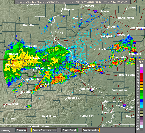 At 746 pm cdt, a severe thunderstorm was located near gerald, moving north at 10 mph (radar indicated). Hazards include 60 mph wind gusts and quarter size hail. Hail damage to vehicles is expected. Expect wind damage to roofs, siding, and trees. At 746 pm cdt, a severe thunderstorm was located near gerald, moving north at 10 mph (radar indicated). Hazards include 60 mph wind gusts and quarter size hail. Hail damage to vehicles is expected. Expect wind damage to roofs, siding, and trees.
|
| 7/19/2020 7:25 PM CDT | Multiple trees down in sullivan. time estimated from rada in franklin county MO, 0.4 miles E of Sullivan, MO |
| 6/27/2020 5:43 PM CDT |
 The severe thunderstorm warning for northwestern crawford and southern gasconade counties will expire at 545 pm cdt, the severe thunderstorm which prompted the warning has weakened. therefore, the warning will be allowed to expire. however small hail, gusty winds and heavy rain are still possible with this thunderstorm. The severe thunderstorm warning for northwestern crawford and southern gasconade counties will expire at 545 pm cdt, the severe thunderstorm which prompted the warning has weakened. therefore, the warning will be allowed to expire. however small hail, gusty winds and heavy rain are still possible with this thunderstorm.
|
| 6/27/2020 5:26 PM CDT |
 At 526 pm cdt, a severe thunderstorm was located 9 miles north of st. james, moving east at 25 mph (radar indicated). Hazards include 60 mph wind gusts and quarter size hail. Hail damage to vehicles is expected. expect wind damage to roofs, siding, and trees. locations impacted include, cuba, steelville, bourbon, leasburg, st. cloud, oak hill and rosati. This includes interstate 44 in missouri between exits 203 and 218. At 526 pm cdt, a severe thunderstorm was located 9 miles north of st. james, moving east at 25 mph (radar indicated). Hazards include 60 mph wind gusts and quarter size hail. Hail damage to vehicles is expected. expect wind damage to roofs, siding, and trees. locations impacted include, cuba, steelville, bourbon, leasburg, st. cloud, oak hill and rosati. This includes interstate 44 in missouri between exits 203 and 218.
|
| 6/27/2020 5:02 PM CDT |
 At 502 pm cdt, a severe thunderstorm was located 9 miles south of belle, moving east at 30 mph (radar indicated). Hazards include golf ball size hail and 60 mph wind gusts. People and animals outdoors will be injured. expect hail damage to roofs, siding, windows, and vehicles. Expect wind damage to roofs, siding, and trees. At 502 pm cdt, a severe thunderstorm was located 9 miles south of belle, moving east at 30 mph (radar indicated). Hazards include golf ball size hail and 60 mph wind gusts. People and animals outdoors will be injured. expect hail damage to roofs, siding, windows, and vehicles. Expect wind damage to roofs, siding, and trees.
|
| 4/28/2020 7:37 PM CDT |
 At 736 pm cdt, severe thunderstorms were located along a line extending from near marthasville to near st. clair to sullivan, moving east at 40 mph (radar indicated). Hazards include 60 mph wind gusts and penny size hail. Expect damage to roofs, siding, and trees. locations impacted include, washington, union, sullivan, st. clair, marthasville, parkway, miramiguoa park, beaufort, dutzow, leslie, noser mill, japan, stanton, lyon and piney park. This includes interstate 44 in missouri between exits 225 and 242. At 736 pm cdt, severe thunderstorms were located along a line extending from near marthasville to near st. clair to sullivan, moving east at 40 mph (radar indicated). Hazards include 60 mph wind gusts and penny size hail. Expect damage to roofs, siding, and trees. locations impacted include, washington, union, sullivan, st. clair, marthasville, parkway, miramiguoa park, beaufort, dutzow, leslie, noser mill, japan, stanton, lyon and piney park. This includes interstate 44 in missouri between exits 225 and 242.
|
| 4/28/2020 7:01 PM CDT |
 At 701 pm cdt, severe thunderstorms were located along a line extending from near hermann to near gerald to near owensville, moving east at 45 mph (radar indicated). Hazards include 60 mph wind gusts and penny size hail. expect damage to roofs, siding, and trees At 701 pm cdt, severe thunderstorms were located along a line extending from near hermann to near gerald to near owensville, moving east at 45 mph (radar indicated). Hazards include 60 mph wind gusts and penny size hail. expect damage to roofs, siding, and trees
|
| 10/21/2019 3:47 AM CDT |
 At 345 am cdt, severe thunderstorms were located along a line extending from 6 miles southeast of miramiguoa park to near glover, moving northeast at 65 mph (radar indicated). Hazards include 60 mph wind gusts. Expect damage to roofs, siding, and trees. locations impacted include, sullivan, cuba, potosi, bourbon, ironton, anthonies mill, pilot knob, arcadia, irondale, mineral point, annapolis, leasburg, old mines, glover, richwoods, belleview, roselle, des arc, caledonia and st. cloud. this also includes washington state park, onondaga cave state park, johnsons shut-ins state park, fort davidson historic site, elephant rocks state park, and taum sauk mountain state park. This includes interstate 44 in missouri between exits 208 and 218. At 345 am cdt, severe thunderstorms were located along a line extending from 6 miles southeast of miramiguoa park to near glover, moving northeast at 65 mph (radar indicated). Hazards include 60 mph wind gusts. Expect damage to roofs, siding, and trees. locations impacted include, sullivan, cuba, potosi, bourbon, ironton, anthonies mill, pilot knob, arcadia, irondale, mineral point, annapolis, leasburg, old mines, glover, richwoods, belleview, roselle, des arc, caledonia and st. cloud. this also includes washington state park, onondaga cave state park, johnsons shut-ins state park, fort davidson historic site, elephant rocks state park, and taum sauk mountain state park. This includes interstate 44 in missouri between exits 208 and 218.
|
| 10/21/2019 3:08 AM CDT |
 At 307 am cdt, severe thunderstorms were located along a line extending from 11 miles north of salem to near eminence, moving northeast at 65 mph (radar indicated). Hazards include 60 mph wind gusts. expect damage to roofs, siding, and trees At 307 am cdt, severe thunderstorms were located along a line extending from 11 miles north of salem to near eminence, moving northeast at 65 mph (radar indicated). Hazards include 60 mph wind gusts. expect damage to roofs, siding, and trees
|
| 8/30/2019 3:58 PM CDT |
 At 356 pm cdt, a severe thunderstorm was located near parkway, moving east at 30 mph (trained weather spotters. up to 2 inch diameter hail was reported in sullivan with this storm). Hazards include ping pong ball size hail and 60 mph wind gusts. People and animals outdoors will be injured. expect hail damage to roofs, siding, windows, and vehicles. expect wind damage to roofs, siding, and trees. locations impacted include, washington, union, sullivan, st. clair, gray summit, villa ridge, gerald, new melle, parkway, augusta, miramiguoa park, beaufort, dutzow, lonedell, leslie, noser mill, japan, stanton, lyon and robertsville. this also includes robertsville state park and meramec state park. This includes interstate 44 in missouri between exits 225 and 253. At 356 pm cdt, a severe thunderstorm was located near parkway, moving east at 30 mph (trained weather spotters. up to 2 inch diameter hail was reported in sullivan with this storm). Hazards include ping pong ball size hail and 60 mph wind gusts. People and animals outdoors will be injured. expect hail damage to roofs, siding, windows, and vehicles. expect wind damage to roofs, siding, and trees. locations impacted include, washington, union, sullivan, st. clair, gray summit, villa ridge, gerald, new melle, parkway, augusta, miramiguoa park, beaufort, dutzow, lonedell, leslie, noser mill, japan, stanton, lyon and robertsville. this also includes robertsville state park and meramec state park. This includes interstate 44 in missouri between exits 225 and 253.
|
| 8/30/2019 3:42 PM CDT |
 At 340 pm cdt, a severe thunderstorm was located near miramiguoa park, moving northeast at 25 mph (trained weather spotters. ping pong sized hail and 60 mph winds were reported in sullivan at 331 pm). Hazards include golf ball size hail and 60 mph wind gusts. People and animals outdoors will be injured. expect hail damage to roofs, siding, windows, and vehicles. expect wind damage to roofs, siding, and trees. locations impacted include, washington, union, sullivan, st. clair, gray summit, villa ridge, gerald, new melle, parkway, augusta, miramiguoa park, beaufort, dutzow, lonedell, leslie, noser mill, japan, stanton, lyon and robertsville. this also includes robertsville state park and meramec state park. This includes interstate 44 in missouri between exits 225 and 253. At 340 pm cdt, a severe thunderstorm was located near miramiguoa park, moving northeast at 25 mph (trained weather spotters. ping pong sized hail and 60 mph winds were reported in sullivan at 331 pm). Hazards include golf ball size hail and 60 mph wind gusts. People and animals outdoors will be injured. expect hail damage to roofs, siding, windows, and vehicles. expect wind damage to roofs, siding, and trees. locations impacted include, washington, union, sullivan, st. clair, gray summit, villa ridge, gerald, new melle, parkway, augusta, miramiguoa park, beaufort, dutzow, lonedell, leslie, noser mill, japan, stanton, lyon and robertsville. this also includes robertsville state park and meramec state park. This includes interstate 44 in missouri between exits 225 and 253.
|
| 8/30/2019 3:34 PM CDT | Tennis Ball sized hail reported 0.8 miles SE of Sullivan, MO |
| 8/30/2019 3:33 PM CDT | Four foot diameter tree snappe in franklin county MO, 0.1 miles WNW of Sullivan, MO |
| 8/30/2019 3:33 PM CDT | Trees uprooted or snapped; roof blown of in franklin county MO, 1 miles NW of Sullivan, MO |
| 8/30/2019 3:33 PM CDT | Hen Egg sized hail reported 0.4 miles E of Sullivan, MO |
| 8/30/2019 3:33 PM CDT | Hen Egg sized hail reported 1 miles NW of Sullivan, MO, report from mping: hen egg (2.00 in.). |
| 8/30/2019 3:32 PM CDT | 5-6 broken utility poles near h and 185. trees and power lines dow in franklin county MO, 2.6 miles E of Sullivan, MO |
| 8/30/2019 3:31 PM CDT | Ping Pong Ball sized hail reported 1.2 miles ESE of Sullivan, MO |
| 8/30/2019 3:31 PM CDT | Storm damage reported in franklin county MO, 0.4 miles E of Sullivan, MO |
| 8/30/2019 3:26 PM CDT |
 At 326 pm cdt, severe thunderstorms were located along a line extending from near gerald to sullivan, moving northeast at 30 mph (radar indicated). Hazards include golf ball size hail and 60 mph wind gusts. People and animals outdoors will be injured. expect hail damage to roofs, siding, windows, and vehicles. Expect wind damage to roofs, siding, and trees. At 326 pm cdt, severe thunderstorms were located along a line extending from near gerald to sullivan, moving northeast at 30 mph (radar indicated). Hazards include golf ball size hail and 60 mph wind gusts. People and animals outdoors will be injured. expect hail damage to roofs, siding, windows, and vehicles. Expect wind damage to roofs, siding, and trees.
|
| 8/30/2019 3:13 PM CDT |
 At 312 pm cdt, a severe thunderstorm was located 7 miles south of gerald, moving northeast at 25 mph (radar indicated). Hazards include 60 mph wind gusts and quarter size hail. Hail damage to vehicles is expected. expect wind damage to roofs, siding, and trees. locations impacted include, sullivan, gerald, beaufort, leslie, noser mill, japan, stanton and oak hill. This includes interstate 44 in missouri near exit 230. At 312 pm cdt, a severe thunderstorm was located 7 miles south of gerald, moving northeast at 25 mph (radar indicated). Hazards include 60 mph wind gusts and quarter size hail. Hail damage to vehicles is expected. expect wind damage to roofs, siding, and trees. locations impacted include, sullivan, gerald, beaufort, leslie, noser mill, japan, stanton and oak hill. This includes interstate 44 in missouri near exit 230.
|
| 8/30/2019 3:01 PM CDT |
 At 300 pm cdt, a severe thunderstorm was located 9 miles southeast of owensville, moving northeast at 25 mph (radar indicated). Hazards include 60 mph wind gusts and quarter size hail. Hail damage to vehicles is expected. expect wind damage to roofs, siding, and trees. locations impacted include, sullivan, gerald, beaufort, leslie, noser mill, japan, stanton and oak hill. This includes interstate 44 in missouri near exit 230. At 300 pm cdt, a severe thunderstorm was located 9 miles southeast of owensville, moving northeast at 25 mph (radar indicated). Hazards include 60 mph wind gusts and quarter size hail. Hail damage to vehicles is expected. expect wind damage to roofs, siding, and trees. locations impacted include, sullivan, gerald, beaufort, leslie, noser mill, japan, stanton and oak hill. This includes interstate 44 in missouri near exit 230.
|
| 8/30/2019 2:47 PM CDT |
 At 247 pm cdt, a severe thunderstorm was located 9 miles south of owensville, moving northeast at 20 mph (radar indicated). Hazards include 60 mph wind gusts and quarter size hail. Hail damage to vehicles is expected. Expect wind damage to roofs, siding, and trees. At 247 pm cdt, a severe thunderstorm was located 9 miles south of owensville, moving northeast at 20 mph (radar indicated). Hazards include 60 mph wind gusts and quarter size hail. Hail damage to vehicles is expected. Expect wind damage to roofs, siding, and trees.
|
| 8/26/2019 3:31 PM CDT |
 At 331 pm cdt, severe thunderstorms were located along a line extending from near miramiguoa park to near old mines to 8 miles west of belleview to 8 miles southwest of bunker, moving east at 55 mph (radar indicated). Hazards include 60 mph wind gusts. Expect damage to roofs, siding, and trees. locations impacted include, sullivan, bonne terre, de soto, desloge, hillsboro, potosi, bismarck, ironton, leadwood, anthonies mill, park hills, reynolds, ellington, pilot knob, iron mountain lake, arcadia, irondale, mineral point, annapolis and cedar hill lakes. this also includes washington state park, st. francois state park, johnsons shut-ins state park, fort davidson historic site, elephant rocks state park, taum sauk mountain state park, sandy creek covered bridge historic site, meramec state park, and clearwater lake recreational area. This includes interstate 44 in missouri near exit 230. At 331 pm cdt, severe thunderstorms were located along a line extending from near miramiguoa park to near old mines to 8 miles west of belleview to 8 miles southwest of bunker, moving east at 55 mph (radar indicated). Hazards include 60 mph wind gusts. Expect damage to roofs, siding, and trees. locations impacted include, sullivan, bonne terre, de soto, desloge, hillsboro, potosi, bismarck, ironton, leadwood, anthonies mill, park hills, reynolds, ellington, pilot knob, iron mountain lake, arcadia, irondale, mineral point, annapolis and cedar hill lakes. this also includes washington state park, st. francois state park, johnsons shut-ins state park, fort davidson historic site, elephant rocks state park, taum sauk mountain state park, sandy creek covered bridge historic site, meramec state park, and clearwater lake recreational area. This includes interstate 44 in missouri near exit 230.
|
| 8/26/2019 3:05 PM CDT |
 At 304 pm cdt, severe thunderstorms were located along a line extending from near owensville to leasburg to 6 miles southwest of cherryville, moving east at 55 mph (radar indicated). Hazards include 60 mph wind gusts. Expect damage to roofs, siding, and trees. locations impacted include, sullivan, cuba, owensville, steelville, bourbon, leasburg, cherryville, st. cloud, japan, stanton, davisville and oak hill. this also includes onondaga cave state park and meramec state park. This includes interstate 44 in missouri between exits 208 and 230. At 304 pm cdt, severe thunderstorms were located along a line extending from near owensville to leasburg to 6 miles southwest of cherryville, moving east at 55 mph (radar indicated). Hazards include 60 mph wind gusts. Expect damage to roofs, siding, and trees. locations impacted include, sullivan, cuba, owensville, steelville, bourbon, leasburg, cherryville, st. cloud, japan, stanton, davisville and oak hill. this also includes onondaga cave state park and meramec state park. This includes interstate 44 in missouri between exits 208 and 230.
|
| 8/26/2019 3:04 PM CDT |
 At 303 pm cdt, severe thunderstorms were located along a line extending from near rosebud to near leasburg to near cherryville to 8 miles east of licking, moving east at 55 mph (radar indicated). Hazards include 60 mph wind gusts. expect damage to roofs, siding, and trees At 303 pm cdt, severe thunderstorms were located along a line extending from near rosebud to near leasburg to near cherryville to 8 miles east of licking, moving east at 55 mph (radar indicated). Hazards include 60 mph wind gusts. expect damage to roofs, siding, and trees
|
| 8/26/2019 2:36 PM CDT |
 At 236 pm cdt, severe thunderstorms were located along a line extending from near linn to near rolla, moving east at 45 mph (radar indicated). Hazards include 60 mph wind gusts. Expect damage to roofs, siding, and trees. locations impacted include, sullivan, cuba, owensville, steelville, bourbon, gerald, bland, rosebud, leasburg, beaufort, cherryville, leslie, st. cloud, canaan, noser mill, japan, stanton, cook station, davisville and oak hill. this also includes onondaga cave state park and meramec state park. This includes interstate 44 in missouri between exits 203 and 230. At 236 pm cdt, severe thunderstorms were located along a line extending from near linn to near rolla, moving east at 45 mph (radar indicated). Hazards include 60 mph wind gusts. Expect damage to roofs, siding, and trees. locations impacted include, sullivan, cuba, owensville, steelville, bourbon, gerald, bland, rosebud, leasburg, beaufort, cherryville, leslie, st. cloud, canaan, noser mill, japan, stanton, cook station, davisville and oak hill. this also includes onondaga cave state park and meramec state park. This includes interstate 44 in missouri between exits 203 and 230.
|
| 8/26/2019 2:08 PM CDT |
 At 207 pm cdt, severe thunderstorms were located along a line extending from near westphalia to 8 miles southwest of vienna to near waynesville, moving east at 40 mph (radar indicated). Hazards include 60 mph wind gusts. expect damage to roofs, siding, and trees At 207 pm cdt, severe thunderstorms were located along a line extending from near westphalia to 8 miles southwest of vienna to near waynesville, moving east at 40 mph (radar indicated). Hazards include 60 mph wind gusts. expect damage to roofs, siding, and trees
|
| 8/13/2019 3:56 AM CDT |
 At 355 am cdt, severe thunderstorms were located along a line extending from near bland to near anthonies mill to 8 miles southwest of viburnum, moving east at 25 mph (radar indicated). Hazards include 60 mph wind gusts and quarter size hail. Hail damage to vehicles is expected. Expect wind damage to roofs, siding, and trees. At 355 am cdt, severe thunderstorms were located along a line extending from near bland to near anthonies mill to 8 miles southwest of viburnum, moving east at 25 mph (radar indicated). Hazards include 60 mph wind gusts and quarter size hail. Hail damage to vehicles is expected. Expect wind damage to roofs, siding, and trees.
|
| 8/13/2019 3:43 AM CDT |
 At 343 am cdt, a severe thunderstorm was located over steelville, moving east at 25 mph (radar indicated). Hazards include 60 mph wind gusts and quarter size hail. Hail damage to vehicles is expected. expect wind damage to roofs, siding, and trees. locations impacted include, sullivan, cuba, steelville, bourbon, anthonies mill, leasburg, cherryville, st. cloud, japan, cook station, davisville, oak hill and rosati. this also includes onondaga cave state park. This includes interstate 44 in missouri between exits 203 and 228. At 343 am cdt, a severe thunderstorm was located over steelville, moving east at 25 mph (radar indicated). Hazards include 60 mph wind gusts and quarter size hail. Hail damage to vehicles is expected. expect wind damage to roofs, siding, and trees. locations impacted include, sullivan, cuba, steelville, bourbon, anthonies mill, leasburg, cherryville, st. cloud, japan, cook station, davisville, oak hill and rosati. this also includes onondaga cave state park. This includes interstate 44 in missouri between exits 203 and 228.
|
| 8/13/2019 3:25 AM CDT |
 At 325 am cdt, a severe thunderstorm was located near cuba, moving east at 25 mph (radar indicated). Hazards include 60 mph wind gusts and quarter size hail. Hail damage to vehicles is expected. Expect wind damage to roofs, siding, and trees. At 325 am cdt, a severe thunderstorm was located near cuba, moving east at 25 mph (radar indicated). Hazards include 60 mph wind gusts and quarter size hail. Hail damage to vehicles is expected. Expect wind damage to roofs, siding, and trees.
|
| 6/26/2019 2:12 PM CDT | Reported at 321 watson rd sullivan: 2.5 inch tree limbs dow in franklin county MO, 1 miles NW of Sullivan, MO |
| 6/4/2019 5:37 PM CDT |
 At 536 pm cdt, a severe thunderstorm was located over beaufort, moving east at 40 mph (trained weather spotters). Hazards include 60 mph wind gusts and penny size hail. Expect damage to roofs, siding, and trees. locations impacted include, washington, union, sullivan, st. clair, gerald, parkway, miramiguoa park, beaufort, leslie, noser mill, stanton and lyon. This includes interstate 44 in missouri between exits 230 and 240. At 536 pm cdt, a severe thunderstorm was located over beaufort, moving east at 40 mph (trained weather spotters). Hazards include 60 mph wind gusts and penny size hail. Expect damage to roofs, siding, and trees. locations impacted include, washington, union, sullivan, st. clair, gerald, parkway, miramiguoa park, beaufort, leslie, noser mill, stanton and lyon. This includes interstate 44 in missouri between exits 230 and 240.
|
| 6/4/2019 5:26 PM CDT |
 At 525 pm cdt, a severe thunderstorm was located near beaufort, moving east at 40 mph (trained weather spotters). Hazards include 60 mph wind gusts and penny size hail. Expect damage to roofs, siding, and trees. locations impacted include, washington, union, sullivan, st. clair, new haven, gerald, parkway, rosebud, miramiguoa park, beaufort, drake, leslie, noser mill, japan, stanton and lyon. this also includes meramec state park. This includes interstate 44 in missouri between exits 225 and 240. At 525 pm cdt, a severe thunderstorm was located near beaufort, moving east at 40 mph (trained weather spotters). Hazards include 60 mph wind gusts and penny size hail. Expect damage to roofs, siding, and trees. locations impacted include, washington, union, sullivan, st. clair, new haven, gerald, parkway, rosebud, miramiguoa park, beaufort, drake, leslie, noser mill, japan, stanton and lyon. this also includes meramec state park. This includes interstate 44 in missouri between exits 225 and 240.
|
| 6/4/2019 5:09 PM CDT |
 The national weather service in st louis has issued a * severe thunderstorm warning for. franklin county in east central missouri. southern gasconade county in east central missouri. until 600 pm cdt. At 508 pm cdt, a severe thunderstorm was located over owensville,. The national weather service in st louis has issued a * severe thunderstorm warning for. franklin county in east central missouri. southern gasconade county in east central missouri. until 600 pm cdt. At 508 pm cdt, a severe thunderstorm was located over owensville,.
|
| 6/1/2019 10:53 PM CDT |
 At 1053 pm cdt, severe thunderstorms were located along a line extending from 7 miles south of dittmer to near richwoods to near leasburg, moving southeast at 40 mph (radar indicated). Hazards include 60 mph wind gusts and quarter size hail. Hail damage to vehicles is expected. expect wind damage to roofs, siding, and trees. locations impacted include, sullivan, de soto, hillsboro, bourbon, anthonies mill, cedar hill, olympian village, leasburg, cedar hill lakes, miramiguoa park, richwoods, old mines, dittmer, lonedell, st. cloud, japan, victoria, stanton, morse mill and oermann. this also includes washington state park, onondaga cave state park, and meramec state park. This includes interstate 44 in missouri between exits 214 and 230. At 1053 pm cdt, severe thunderstorms were located along a line extending from 7 miles south of dittmer to near richwoods to near leasburg, moving southeast at 40 mph (radar indicated). Hazards include 60 mph wind gusts and quarter size hail. Hail damage to vehicles is expected. expect wind damage to roofs, siding, and trees. locations impacted include, sullivan, de soto, hillsboro, bourbon, anthonies mill, cedar hill, olympian village, leasburg, cedar hill lakes, miramiguoa park, richwoods, old mines, dittmer, lonedell, st. cloud, japan, victoria, stanton, morse mill and oermann. this also includes washington state park, onondaga cave state park, and meramec state park. This includes interstate 44 in missouri between exits 214 and 230.
|
| 6/1/2019 10:38 PM CDT |
 At 1038 pm cdt, severe thunderstorms were located along a line extending from near dittmer to 7 miles northwest of richwoods to 7 miles south of gerald, moving southeast at 35 mph (radar indicated). Hazards include 60 mph wind gusts and quarter size hail. Hail damage to vehicles is expected. expect wind damage to roofs, siding, and trees. locations impacted include, union, sullivan, pacific, de soto, st. clair, hillsboro, bourbon, gray summit, villa ridge, cedar hill, anthonies mill, gerald, olympian village, parkway, leasburg, cedar hill lakes, miramiguoa park, old mines, richwoods and beaufort. this also includes washington state park, onondaga cave state park, robertsville state park, and meramec state park. This includes interstate 44 in missouri between exits 214 and 253. At 1038 pm cdt, severe thunderstorms were located along a line extending from near dittmer to 7 miles northwest of richwoods to 7 miles south of gerald, moving southeast at 35 mph (radar indicated). Hazards include 60 mph wind gusts and quarter size hail. Hail damage to vehicles is expected. expect wind damage to roofs, siding, and trees. locations impacted include, union, sullivan, pacific, de soto, st. clair, hillsboro, bourbon, gray summit, villa ridge, cedar hill, anthonies mill, gerald, olympian village, parkway, leasburg, cedar hill lakes, miramiguoa park, old mines, richwoods and beaufort. this also includes washington state park, onondaga cave state park, robertsville state park, and meramec state park. This includes interstate 44 in missouri between exits 214 and 253.
|
| 6/1/2019 10:24 PM CDT |
 At 1024 pm cdt, a line of severe thunderstorms were located along a line extending from near lonedell to near parkway to rosebud, moving southeast at 25 mph (radar indicated). Hazards include 60 mph wind gusts and quarter size hail. Hail damage to vehicles is expected. Expect wind damage to roofs, siding, and trees. At 1024 pm cdt, a line of severe thunderstorms were located along a line extending from near lonedell to near parkway to rosebud, moving southeast at 25 mph (radar indicated). Hazards include 60 mph wind gusts and quarter size hail. Hail damage to vehicles is expected. Expect wind damage to roofs, siding, and trees.
|
| 5/21/2019 5:22 PM CDT |
 The national weather service in st louis has issued a * severe thunderstorm warning for. southwestern st. charles county in east central missouri. northeastern crawford county in east central missouri. northwestern washington county in east central missouri. Franklin county in east central missouri. The national weather service in st louis has issued a * severe thunderstorm warning for. southwestern st. charles county in east central missouri. northeastern crawford county in east central missouri. northwestern washington county in east central missouri. Franklin county in east central missouri.
|
| 5/21/2019 4:42 PM CDT |
 The national weather service in st louis has issued a * severe thunderstorm warning for. crawford county in east central missouri. southwestern franklin county in east central missouri. southern gasconade county in east central missouri. Until 545 pm cdt. The national weather service in st louis has issued a * severe thunderstorm warning for. crawford county in east central missouri. southwestern franklin county in east central missouri. southern gasconade county in east central missouri. Until 545 pm cdt.
|
| 5/21/2019 12:59 PM CDT |
 The national weather service in st louis has issued a * severe thunderstorm warning for. iron county in southeastern missouri. eastern crawford county in east central missouri. jefferson county in east central missouri. west central ste. Genevieve county in southeastern missouri. The national weather service in st louis has issued a * severe thunderstorm warning for. iron county in southeastern missouri. eastern crawford county in east central missouri. jefferson county in east central missouri. west central ste. Genevieve county in southeastern missouri.
|
| 5/21/2019 12:22 PM CDT |
 At 521 pm cdt, severe thunderstorms were located along a line extending from near hermann to near bourbon, moving northeast at 45 mph (radar indicated). Hazards include 60 mph wind gusts and quarter size hail. Hail damage to vehicles is expected. Expect wind damage to roofs, siding, and trees. At 521 pm cdt, severe thunderstorms were located along a line extending from near hermann to near bourbon, moving northeast at 45 mph (radar indicated). Hazards include 60 mph wind gusts and quarter size hail. Hail damage to vehicles is expected. Expect wind damage to roofs, siding, and trees.
|
| 5/18/2019 7:08 PM CDT |
 The severe thunderstorm warning for western iron, crawford, reynolds, western washington, southwestern franklin and southern gasconade counties will expire at 715 pm cdt, the storms which prompted the warning have weakened below severe limits, and have exited the warned area. therefore, the warning will be allowed to expire. a severe thunderstorm watch remains in effect until midnight cdt for southeastern and east central missouri. The severe thunderstorm warning for western iron, crawford, reynolds, western washington, southwestern franklin and southern gasconade counties will expire at 715 pm cdt, the storms which prompted the warning have weakened below severe limits, and have exited the warned area. therefore, the warning will be allowed to expire. a severe thunderstorm watch remains in effect until midnight cdt for southeastern and east central missouri.
|
| 5/18/2019 6:46 PM CDT |
 At 646 pm cdt, severe thunderstorms were located along a line extending from 7 miles south of gerald to near leasburg to 7 miles northeast of courtois to near oates to near ellington, moving northeast at 40 mph (radar indicated). Hazards include 60 mph wind gusts. Expect damage to roofs, siding, and trees. locations impacted include, sullivan, cuba, steelville, bourbon, anthonies mill, reynolds, ellington, viburnum, bland, leasburg, bixby, cherryville, courtois, oates, garwood, centerville, st. cloud, canaan, corridon and black. this also includes onondaga cave state park, johnsons shut-ins state park, taum sauk mountain state park, meramec state park, and clearwater lake recreational area. This includes interstate 44 in missouri between exits 208 and 228. At 646 pm cdt, severe thunderstorms were located along a line extending from 7 miles south of gerald to near leasburg to 7 miles northeast of courtois to near oates to near ellington, moving northeast at 40 mph (radar indicated). Hazards include 60 mph wind gusts. Expect damage to roofs, siding, and trees. locations impacted include, sullivan, cuba, steelville, bourbon, anthonies mill, reynolds, ellington, viburnum, bland, leasburg, bixby, cherryville, courtois, oates, garwood, centerville, st. cloud, canaan, corridon and black. this also includes onondaga cave state park, johnsons shut-ins state park, taum sauk mountain state park, meramec state park, and clearwater lake recreational area. This includes interstate 44 in missouri between exits 208 and 228.
|
| 5/18/2019 6:26 PM CDT |
 At 624 pm cdt, severe thunderstorms were located along a line extending from 10 miles north of st. james to 6 miles southwest of cuba to near viburnum to bunker to near fremont, moving northeast at 60 mph (radar indicated). Hazards include 60 mph wind gusts and penny size hail. Expect damage to roofs, siding, and trees. locations impacted include, sullivan, cuba, steelville, bourbon, anthonies mill, reynolds, ellington, viburnum, bland, leasburg, bixby, cherryville, courtois, oates, garwood, centerville, st. cloud, canaan, corridon and black. this also includes onondaga cave state park, johnsons shut-ins state park, dillard mill historic site, taum sauk mountain state park, meramec state park, and clearwater lake recreational area. This includes interstate 44 in missouri between exits 203 and 228. At 624 pm cdt, severe thunderstorms were located along a line extending from 10 miles north of st. james to 6 miles southwest of cuba to near viburnum to bunker to near fremont, moving northeast at 60 mph (radar indicated). Hazards include 60 mph wind gusts and penny size hail. Expect damage to roofs, siding, and trees. locations impacted include, sullivan, cuba, steelville, bourbon, anthonies mill, reynolds, ellington, viburnum, bland, leasburg, bixby, cherryville, courtois, oates, garwood, centerville, st. cloud, canaan, corridon and black. this also includes onondaga cave state park, johnsons shut-ins state park, dillard mill historic site, taum sauk mountain state park, meramec state park, and clearwater lake recreational area. This includes interstate 44 in missouri between exits 203 and 228.
|
| 5/18/2019 6:10 PM CDT |
 At 609 pm cdt, severe thunderstorms were located along a line extending from near bland to 12 miles south of st. james to near salem to 6 miles west of bunker to 7 miles south of winona, moving east at 30 mph (radar indicated). Hazards include 60 mph wind gusts and penny size hail. expect damage to roofs, siding, and trees At 609 pm cdt, severe thunderstorms were located along a line extending from near bland to 12 miles south of st. james to near salem to 6 miles west of bunker to 7 miles south of winona, moving east at 30 mph (radar indicated). Hazards include 60 mph wind gusts and penny size hail. expect damage to roofs, siding, and trees
|
| 3/24/2019 4:22 PM CDT | Quarter sized hail reported 8.2 miles ESE of Sullivan, MO, via facebook report with picture. |
| 3/24/2019 4:12 PM CDT |
 At 412 pm cdt, a severe thunderstorm was located near owensville, moving northeast at 25 mph (radar indicated). Hazards include 60 mph wind gusts and quarter size hail. Hail damage to vehicles is expected. Expect wind damage to roofs, siding, and trees. At 412 pm cdt, a severe thunderstorm was located near owensville, moving northeast at 25 mph (radar indicated). Hazards include 60 mph wind gusts and quarter size hail. Hail damage to vehicles is expected. Expect wind damage to roofs, siding, and trees.
|
| 3/24/2019 4:04 PM CDT |
 At 404 pm cdt, a severe thunderstorm was located near cuba, moving northeast at 25 mph (radar indicated). Hazards include 60 mph wind gusts and quarter size hail. Hail damage to vehicles is expected. expect wind damage to roofs, siding, and trees. locations impacted include, cuba, steelville, bourbon, leasburg, st. cloud and rosati. this also includes onondaga cave state park. This includes interstate 44 in missouri between exits 203 and 218. At 404 pm cdt, a severe thunderstorm was located near cuba, moving northeast at 25 mph (radar indicated). Hazards include 60 mph wind gusts and quarter size hail. Hail damage to vehicles is expected. expect wind damage to roofs, siding, and trees. locations impacted include, cuba, steelville, bourbon, leasburg, st. cloud and rosati. this also includes onondaga cave state park. This includes interstate 44 in missouri between exits 203 and 218.
|
| 3/24/2019 3:43 PM CDT |
 At 343 pm cdt, a severe thunderstorm was located near st. james, moving east at 25 mph (radar indicated). Hazards include 60 mph wind gusts and quarter size hail. Hail damage to vehicles is expected. Expect wind damage to roofs, siding, and trees. At 343 pm cdt, a severe thunderstorm was located near st. james, moving east at 25 mph (radar indicated). Hazards include 60 mph wind gusts and quarter size hail. Hail damage to vehicles is expected. Expect wind damage to roofs, siding, and trees.
|
| 6/14/2018 5:14 PM CDT |
 At 513 pm cdt, a severe thunderstorm was located near drake, moving southeast at 10 mph. another severe thunderstorm was just northwest of washington (radar indicated). Hazards include 60 mph wind gusts and quarter size hail. Hail damage to vehicles is expected. Expect wind damage to roofs, siding, and trees. At 513 pm cdt, a severe thunderstorm was located near drake, moving southeast at 10 mph. another severe thunderstorm was just northwest of washington (radar indicated). Hazards include 60 mph wind gusts and quarter size hail. Hail damage to vehicles is expected. Expect wind damage to roofs, siding, and trees.
|
| 5/20/2018 10:11 PM CDT |
 The severe thunderstorm warning for crawford, western washington, western franklin and southeastern gasconade counties will expire at 1015 pm cdt, the storms which prompted the warning have weakened below severe limits, and no longer pose an immediate threat to life or property. therefore, the warning will be allowed to expire. however small hail, gusty winds and heavy rain are still possible with these thunderstorms. The severe thunderstorm warning for crawford, western washington, western franklin and southeastern gasconade counties will expire at 1015 pm cdt, the storms which prompted the warning have weakened below severe limits, and no longer pose an immediate threat to life or property. therefore, the warning will be allowed to expire. however small hail, gusty winds and heavy rain are still possible with these thunderstorms.
|
| 5/20/2018 9:36 PM CDT |
 At 936 pm cdt, severe thunderstorms were located along a line extending from 6 miles north of st. james to near salem, moving northeast at 65 mph (radar indicated). Hazards include 60 mph wind gusts and penny size hail. expect damage to roofs, siding, and trees At 936 pm cdt, severe thunderstorms were located along a line extending from 6 miles north of st. james to near salem, moving northeast at 65 mph (radar indicated). Hazards include 60 mph wind gusts and penny size hail. expect damage to roofs, siding, and trees
|
| 5/20/2018 10:12 AM CDT |
 At 1011 am cdt, a severe thunderstorm was located near miramiguoa park, moving east at 30 mph (radar indicated). Hazards include 60 mph wind gusts and quarter size hail. Hail damage to vehicles is expected. expect wind damage to roofs, siding, and trees. locations impacted include, sullivan, miramiguoa park, beaufort, leslie, noser mill and stanton. this also includes meramec state park. This includes interstate 44 in missouri between exits 225 and 230. At 1011 am cdt, a severe thunderstorm was located near miramiguoa park, moving east at 30 mph (radar indicated). Hazards include 60 mph wind gusts and quarter size hail. Hail damage to vehicles is expected. expect wind damage to roofs, siding, and trees. locations impacted include, sullivan, miramiguoa park, beaufort, leslie, noser mill and stanton. this also includes meramec state park. This includes interstate 44 in missouri between exits 225 and 230.
|
| 5/20/2018 10:00 AM CDT |
 At 944 am cdt, severe thunderstorms were located along a line extending from near swiss to 8 miles south of rosebud, moving northeast at 35 mph (trained weather spotters). Hazards include 60 mph wind gusts and quarter size hail. Hail damage to vehicles is expected. Expect wind damage to roofs, siding, and trees. At 944 am cdt, severe thunderstorms were located along a line extending from near swiss to 8 miles south of rosebud, moving northeast at 35 mph (trained weather spotters). Hazards include 60 mph wind gusts and quarter size hail. Hail damage to vehicles is expected. Expect wind damage to roofs, siding, and trees.
|
| 5/20/2018 9:44 AM CDT |
 At 944 am cdt, severe thunderstorms were located along a line extending from near swiss to 8 miles south of rosebud, moving northeast at 35 mph (trained weather spotters). Hazards include 60 mph wind gusts and quarter size hail. Hail damage to vehicles is expected. Expect wind damage to roofs, siding, and trees. At 944 am cdt, severe thunderstorms were located along a line extending from near swiss to 8 miles south of rosebud, moving northeast at 35 mph (trained weather spotters). Hazards include 60 mph wind gusts and quarter size hail. Hail damage to vehicles is expected. Expect wind damage to roofs, siding, and trees.
|
| 4/13/2018 9:56 PM CDT |
 The tornado warning for northeastern crawford. northwestern washington and southern franklin counties will expire at 1000 pm cdt. the immediate tornado threat has diminished and the tornado warning has been cancelled. However, damaging winds remain likely and a quick spin up tornado is still possible, therefore a severe. The tornado warning for northeastern crawford. northwestern washington and southern franklin counties will expire at 1000 pm cdt. the immediate tornado threat has diminished and the tornado warning has been cancelled. However, damaging winds remain likely and a quick spin up tornado is still possible, therefore a severe.
|
| 4/13/2018 9:31 PM CDT |
 At 930 pm cdt, a severe squall line capable of producing both tornadoes and extensive straight line wind damage was located along a line extending from 6 miles northwest of sullivan to near miramiguoa park to 8 miles northeast of anthonies mill, moving northeast at 55 mph (radar indicated rotation). Hazards include tornado. Flying debris will be dangerous to those caught without shelter. mobile homes will be damaged or destroyed. damage to roofs, windows, and vehicles will occur. tree damage is likely. locations impacted include, union, sullivan, st. clair, bourbon, anthonies mill, parkway, miramiguoa park, beaufort, lonedell, st. cloud, noser mill, japan, stanton and piney park. this also includes meramec state park. This includes interstate 44 in missouri between exits 218 and 242. At 930 pm cdt, a severe squall line capable of producing both tornadoes and extensive straight line wind damage was located along a line extending from 6 miles northwest of sullivan to near miramiguoa park to 8 miles northeast of anthonies mill, moving northeast at 55 mph (radar indicated rotation). Hazards include tornado. Flying debris will be dangerous to those caught without shelter. mobile homes will be damaged or destroyed. damage to roofs, windows, and vehicles will occur. tree damage is likely. locations impacted include, union, sullivan, st. clair, bourbon, anthonies mill, parkway, miramiguoa park, beaufort, lonedell, st. cloud, noser mill, japan, stanton and piney park. this also includes meramec state park. This includes interstate 44 in missouri between exits 218 and 242.
|
| 4/13/2018 9:21 PM CDT |
 At 921 pm cdt, a severe squall line capable of producing both tornadoes and extensive straight line wind damage was located along a line extending from 7 miles northwest of leasburg to bourbon to near anthonies mill, moving northeast at 50 mph (radar indicated rotation). Hazards include tornado. Flying debris will be dangerous to those caught without shelter. mobile homes will be damaged or destroyed. damage to roofs, windows, and vehicles will occur. tree damage is likely. locations impacted include, union, sullivan, st. clair, cuba, bourbon, anthonies mill, parkway, leasburg, miramiguoa park, beaufort, lonedell, st. cloud, noser mill, japan, stanton and piney park. this also includes onondaga cave state park and meramec state park. This includes interstate 44 in missouri between exits 208 and 242. At 921 pm cdt, a severe squall line capable of producing both tornadoes and extensive straight line wind damage was located along a line extending from 7 miles northwest of leasburg to bourbon to near anthonies mill, moving northeast at 50 mph (radar indicated rotation). Hazards include tornado. Flying debris will be dangerous to those caught without shelter. mobile homes will be damaged or destroyed. damage to roofs, windows, and vehicles will occur. tree damage is likely. locations impacted include, union, sullivan, st. clair, cuba, bourbon, anthonies mill, parkway, leasburg, miramiguoa park, beaufort, lonedell, st. cloud, noser mill, japan, stanton and piney park. this also includes onondaga cave state park and meramec state park. This includes interstate 44 in missouri between exits 208 and 242.
|
| 4/13/2018 9:13 PM CDT |
 At 913 pm cdt, a severe thunderstorm capable of producing a tornado was located over leasburg, moving northeast at 40 mph (radar indicated rotation). Hazards include tornado. Flying debris will be dangerous to those caught without shelter. mobile homes will be damaged or destroyed. damage to roofs, windows, and vehicles will occur. tree damage is likely. this dangerous storm will be near, bourbon around 925 pm cdt. oak grove around 935 pm cdt. sullivan and miramiguoa park around 940 pm cdt. st. clair and parkway around 955 pm cdt. union around 1000 pm cdt. other locations impacted by this tornadic thunderstorm include noser mill, japan, st. cloud, stanton and piney park. this also includes onondaga cave state park and meramec state park. This includes interstate 44 in missouri between exits 203 and 242. At 913 pm cdt, a severe thunderstorm capable of producing a tornado was located over leasburg, moving northeast at 40 mph (radar indicated rotation). Hazards include tornado. Flying debris will be dangerous to those caught without shelter. mobile homes will be damaged or destroyed. damage to roofs, windows, and vehicles will occur. tree damage is likely. this dangerous storm will be near, bourbon around 925 pm cdt. oak grove around 935 pm cdt. sullivan and miramiguoa park around 940 pm cdt. st. clair and parkway around 955 pm cdt. union around 1000 pm cdt. other locations impacted by this tornadic thunderstorm include noser mill, japan, st. cloud, stanton and piney park. this also includes onondaga cave state park and meramec state park. This includes interstate 44 in missouri between exits 203 and 242.
|
| 5/27/2017 4:06 PM CDT |
 At 406 pm cdt, severe thunderstorms were located along a line extending from near new florence to 9 miles southeast of owensville, moving east at 70 mph (radar indicated). Hazards include 60 mph wind gusts. Expect damage to roofs, siding, and trees. locations impacted include, washington, union, warrenton, sullivan, st. clair, wright city, owensville, hermann, new haven, gerald, marthasville, jonesburg, truesdale, innsbrook, parkway, rosebud, miramiguoa park, swiss, big spring and beaufort. this also includes deutschheim historic site. this includes the following highways, interstate 44 in missouri between exits 228 and 240. interstate 70 in missouri between exits 179 and 200. A tornado watch remains in effect until 700 pm cdt for east central missouri. At 406 pm cdt, severe thunderstorms were located along a line extending from near new florence to 9 miles southeast of owensville, moving east at 70 mph (radar indicated). Hazards include 60 mph wind gusts. Expect damage to roofs, siding, and trees. locations impacted include, washington, union, warrenton, sullivan, st. clair, wright city, owensville, hermann, new haven, gerald, marthasville, jonesburg, truesdale, innsbrook, parkway, rosebud, miramiguoa park, swiss, big spring and beaufort. this also includes deutschheim historic site. this includes the following highways, interstate 44 in missouri between exits 228 and 240. interstate 70 in missouri between exits 179 and 200. A tornado watch remains in effect until 700 pm cdt for east central missouri.
|
| 5/27/2017 4:04 PM CDT | Medium sized tree snappe in franklin county MO, 0.4 miles E of Sullivan, MO |
| 5/27/2017 3:35 PM CDT |
 At 335 pm cdt, severe thunderstorms were located along a line extending from 6 miles east of fulton to near vienna, moving east at 40 mph (trained weather spotters reported trees blown over in meta). Hazards include 60 mph wind gusts. expect damage to roofs, siding, and trees At 335 pm cdt, severe thunderstorms were located along a line extending from 6 miles east of fulton to near vienna, moving east at 40 mph (trained weather spotters reported trees blown over in meta). Hazards include 60 mph wind gusts. expect damage to roofs, siding, and trees
|
| 5/27/2017 1:02 PM CDT |
 At 101 pm cdt, severe thunderstorms were located over bourbon and stretched east to richwoods, moving east at 30 mph (radar indicated). Hazards include quarter size hail. Damage to vehicles is expected. locations impacted include, sullivan, bourbon, anthonies mill, leasburg, miramiguoa park, richwoods, lonedell, st. cloud, japan, stanton and piney park. this also includes onondaga cave state park and meramec state park. this includes interstate 44 in missouri between exits 210 and 230. A tornado watch remains in effect until 700 pm cdt for east central missouri. At 101 pm cdt, severe thunderstorms were located over bourbon and stretched east to richwoods, moving east at 30 mph (radar indicated). Hazards include quarter size hail. Damage to vehicles is expected. locations impacted include, sullivan, bourbon, anthonies mill, leasburg, miramiguoa park, richwoods, lonedell, st. cloud, japan, stanton and piney park. this also includes onondaga cave state park and meramec state park. this includes interstate 44 in missouri between exits 210 and 230. A tornado watch remains in effect until 700 pm cdt for east central missouri.
|
| 5/27/2017 12:52 PM CDT |
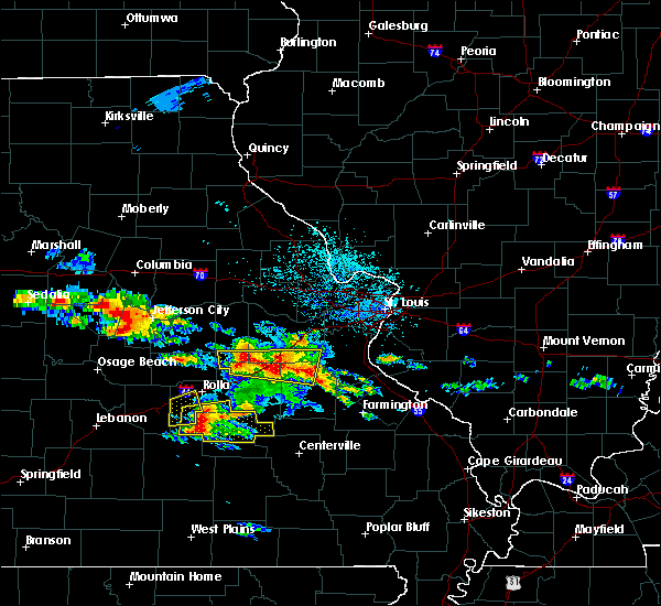 At 1251 pm cdt, severe thunderstorms were located near bourbon stretching east to near richwoods, moving east at 25 mph (radar indicated). Hazards include quarter size hail. Damage to vehicles is expected. locations impacted include, sullivan, bourbon, anthonies mill, leasburg, miramiguoa park, richwoods, lonedell, st. cloud, japan, stanton, oak hill and piney park. this also includes onondaga cave state park and meramec state park. this includes interstate 44 in missouri between exits 210 and 230. A tornado watch remains in effect until 700 pm cdt for east central missouri. At 1251 pm cdt, severe thunderstorms were located near bourbon stretching east to near richwoods, moving east at 25 mph (radar indicated). Hazards include quarter size hail. Damage to vehicles is expected. locations impacted include, sullivan, bourbon, anthonies mill, leasburg, miramiguoa park, richwoods, lonedell, st. cloud, japan, stanton, oak hill and piney park. this also includes onondaga cave state park and meramec state park. this includes interstate 44 in missouri between exits 210 and 230. A tornado watch remains in effect until 700 pm cdt for east central missouri.
|
| 5/27/2017 12:31 PM CDT |
 At 1231 pm cdt, a severe thunderstorm was located 9 miles southeast of bland, moving east at 30 mph (radar indicated). Hazards include half dollar size hail. damage to vehicles is expected At 1231 pm cdt, a severe thunderstorm was located 9 miles southeast of bland, moving east at 30 mph (radar indicated). Hazards include half dollar size hail. damage to vehicles is expected
|
| 5/27/2017 12:17 PM CDT |
 At 1217 pm cdt, a severe thunderstorm was located near owensville, moving east at 30 mph (radar indicated). Hazards include quarter size hail. Damage to vehicles is expected. locations impacted include, sullivan, owensville, bourbon, bland, st. cloud, canaan, japan and oak hill. this includes interstate 44 in missouri between exits 225 and 228. A tornado watch remains in effect until 700 pm cdt for central and east central missouri. At 1217 pm cdt, a severe thunderstorm was located near owensville, moving east at 30 mph (radar indicated). Hazards include quarter size hail. Damage to vehicles is expected. locations impacted include, sullivan, owensville, bourbon, bland, st. cloud, canaan, japan and oak hill. this includes interstate 44 in missouri between exits 225 and 228. A tornado watch remains in effect until 700 pm cdt for central and east central missouri.
|
| 5/27/2017 11:51 AM CDT |
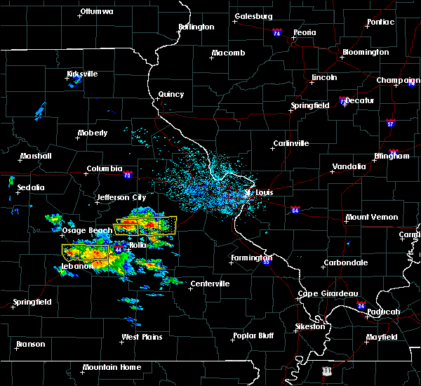 At 1151 am cdt, a severe thunderstorm was located near belle, moving east at 30 mph (radar indicated). Hazards include quarter size hail. damage to vehicles is expected At 1151 am cdt, a severe thunderstorm was located near belle, moving east at 30 mph (radar indicated). Hazards include quarter size hail. damage to vehicles is expected
|
| 5/19/2017 7:44 PM CDT |
 At 743 pm cdt, severe thunderstorms were located along a line extending from bellflower to near treloar to near gerald, moving east at 45 mph (radar indicated). Hazards include 60 mph wind gusts and penny size hail. Expect damage to roofs, siding, and trees. locations impacted include, washington, troy, union, warrenton, sullivan, st. clair, wright city, new haven, gerald, marthasville, jonesburg, truesdale, hawk point, innsbrook, parkway, bellflower, miramiguoa park, beaufort, treloar and dutzow. this also includes meramec state park. this includes the following highways, interstate 44 in missouri between exits 225 and 240. interstate 70 in missouri between exits 179 and 200. A tornado watch remains in effect until 1000 pm cdt for east central missouri. At 743 pm cdt, severe thunderstorms were located along a line extending from bellflower to near treloar to near gerald, moving east at 45 mph (radar indicated). Hazards include 60 mph wind gusts and penny size hail. Expect damage to roofs, siding, and trees. locations impacted include, washington, troy, union, warrenton, sullivan, st. clair, wright city, new haven, gerald, marthasville, jonesburg, truesdale, hawk point, innsbrook, parkway, bellflower, miramiguoa park, beaufort, treloar and dutzow. this also includes meramec state park. this includes the following highways, interstate 44 in missouri between exits 225 and 240. interstate 70 in missouri between exits 179 and 200. A tornado watch remains in effect until 1000 pm cdt for east central missouri.
|
| 5/19/2017 7:23 PM CDT |
 At 723 pm cdt, severe thunderstorms were located along a line extending from near williamsburg to near swiss to 8 miles southeast of bland, moving east at 50 mph (radar indicated). Hazards include 60 mph wind gusts. expect damage to roofs, siding, and trees At 723 pm cdt, severe thunderstorms were located along a line extending from near williamsburg to near swiss to 8 miles southeast of bland, moving east at 50 mph (radar indicated). Hazards include 60 mph wind gusts. expect damage to roofs, siding, and trees
|
| 5/19/2017 4:24 AM CDT |
 At 424 am cdt, severe thunderstorms were located along a line extending from 6 miles southeast of hermann to 8 miles southeast of anthonies mill, moving east at 60 mph (trained weather spotters). Hazards include 60 mph wind gusts. Expect damage to roofs, siding, and trees. locations impacted include, washington, union, warrenton, sullivan, st. clair, cuba, wright city, owensville, potosi, hermann, new haven, steelville, bourbon, anthonies mill, gerald, marthasville, truesdale, innsbrook, parkway and rosebud. this also includes onondaga cave state park, deutschheim historic site, and meramec state park. this includes the following highways, interstate 44 in missouri between exits 210 and 247. Interstate 70 in missouri between exits 193 and 200. At 424 am cdt, severe thunderstorms were located along a line extending from 6 miles southeast of hermann to 8 miles southeast of anthonies mill, moving east at 60 mph (trained weather spotters). Hazards include 60 mph wind gusts. Expect damage to roofs, siding, and trees. locations impacted include, washington, union, warrenton, sullivan, st. clair, cuba, wright city, owensville, potosi, hermann, new haven, steelville, bourbon, anthonies mill, gerald, marthasville, truesdale, innsbrook, parkway and rosebud. this also includes onondaga cave state park, deutschheim historic site, and meramec state park. this includes the following highways, interstate 44 in missouri between exits 210 and 247. Interstate 70 in missouri between exits 193 and 200.
|
| 5/19/2017 4:03 AM CDT |
 At 402 am cdt, severe thunderstorms were located along a line extending from near chamois to near steelville, moving east at 60 mph (trained weather spotters). Hazards include 60 mph wind gusts. expect damage to roofs, siding, and trees At 402 am cdt, severe thunderstorms were located along a line extending from near chamois to near steelville, moving east at 60 mph (trained weather spotters). Hazards include 60 mph wind gusts. expect damage to roofs, siding, and trees
|
| 4/5/2017 12:10 AM CDT |
 The severe thunderstorm warning for washington and southeastern franklin counties will expire at 1215 am cdt, the storms which prompted the warning have weakened below severe limits, and have exited the warned area. therefore, the warning will be allowed to expire. however gusty winds to 50 mph are still possible with these thunderstorms. The severe thunderstorm warning for washington and southeastern franklin counties will expire at 1215 am cdt, the storms which prompted the warning have weakened below severe limits, and have exited the warned area. therefore, the warning will be allowed to expire. however gusty winds to 50 mph are still possible with these thunderstorms.
|
| 4/4/2017 11:53 PM CDT |
 At 1152 pm cdt, severe thunderstorms were located along a line extending from near st. clair to 6 miles west of richwoods to 9 miles southeast of anthonies mill to 7 miles east of courtois, moving northeast at 45 mph (radar indicated). Hazards include 60 mph wind gusts and quarter size hail. Hail damage to vehicles is expected. expect wind damage to roofs, siding, and trees. locations impacted include, union, st. clair, potosi, irondale, parkway, mineral point, miramiguoa park, richwoods, old mines, caledonia, belgrade, stanton, cadet, latty, shirley and piney park. this also includes washington state park and meramec state park. This includes interstate 44 in missouri between exits 230 and 242. At 1152 pm cdt, severe thunderstorms were located along a line extending from near st. clair to 6 miles west of richwoods to 9 miles southeast of anthonies mill to 7 miles east of courtois, moving northeast at 45 mph (radar indicated). Hazards include 60 mph wind gusts and quarter size hail. Hail damage to vehicles is expected. expect wind damage to roofs, siding, and trees. locations impacted include, union, st. clair, potosi, irondale, parkway, mineral point, miramiguoa park, richwoods, old mines, caledonia, belgrade, stanton, cadet, latty, shirley and piney park. this also includes washington state park and meramec state park. This includes interstate 44 in missouri between exits 230 and 242.
|
| 4/4/2017 11:30 PM CDT |
 At 1129 pm cdt, severe thunderstorms were located along a line extending from near bourbon to 7 miles southwest of anthonies mill to 6 miles east of cherryville to near viburnum, moving northeast at 45 mph (radar indicated). Hazards include 60 mph wind gusts and quarter size hail. Hail damage to vehicles is expected. Expect wind damage to roofs, siding, and trees. At 1129 pm cdt, severe thunderstorms were located along a line extending from near bourbon to 7 miles southwest of anthonies mill to 6 miles east of cherryville to near viburnum, moving northeast at 45 mph (radar indicated). Hazards include 60 mph wind gusts and quarter size hail. Hail damage to vehicles is expected. Expect wind damage to roofs, siding, and trees.
|
| 4/4/2017 11:18 PM CDT |
 At 1117 pm cdt, severe thunderstorms were located along a line extending from 7 miles northwest of cuba to steelville to near cherryville to 10 miles west of viburnum, moving northeast at 45 mph (radar indicated). Hazards include 60 mph wind gusts and quarter size hail. Hail damage to vehicles is expected. expect wind damage to roofs, siding, and trees. locations impacted include, sullivan, cuba, steelville, bourbon, leasburg, cherryville, st. cloud, dillard, cook station, davisville and rosati. this also includes onondaga cave state park and dillard mill historic site. This includes interstate 44 in missouri between exits 203 and 218. At 1117 pm cdt, severe thunderstorms were located along a line extending from 7 miles northwest of cuba to steelville to near cherryville to 10 miles west of viburnum, moving northeast at 45 mph (radar indicated). Hazards include 60 mph wind gusts and quarter size hail. Hail damage to vehicles is expected. expect wind damage to roofs, siding, and trees. locations impacted include, sullivan, cuba, steelville, bourbon, leasburg, cherryville, st. cloud, dillard, cook station, davisville and rosati. this also includes onondaga cave state park and dillard mill historic site. This includes interstate 44 in missouri between exits 203 and 218.
|
| 4/4/2017 10:55 PM CDT |
 At 1054 pm cdt, severe thunderstorms were located along a line extending from 8 miles north of rolla to 14 miles south of st. james to near salem to 7 miles east of licking, moving northeast at 40 mph (radar indicated). Hazards include 60 mph wind gusts and quarter size hail. Hail damage to vehicles is expected. Expect wind damage to roofs, siding, and trees. At 1054 pm cdt, severe thunderstorms were located along a line extending from 8 miles north of rolla to 14 miles south of st. james to near salem to 7 miles east of licking, moving northeast at 40 mph (radar indicated). Hazards include 60 mph wind gusts and quarter size hail. Hail damage to vehicles is expected. Expect wind damage to roofs, siding, and trees.
|
| 3/7/2017 12:00 AM CST |
 At 1200 am cst, a severe thunderstorm was located near st. james, moving east at 55 mph (radar indicated). Hazards include 60 mph wind gusts and penny size hail. expect damage to roofs, siding, and trees At 1200 am cst, a severe thunderstorm was located near st. james, moving east at 55 mph (radar indicated). Hazards include 60 mph wind gusts and penny size hail. expect damage to roofs, siding, and trees
|
| 7/13/2016 3:15 PM CDT |
 At 314 pm cdt, severe thunderstorms were located along a line extending from near chapin to near richwoods, moving east at 55 mph (trained weather spotters. numeruus reports of trees down and winds in excess of 60 mph). Hazards include 70 mph wind gusts. Expect considerable tree damage. damage is likely to mobile homes, roofs, and outbuildings. locations impacted include, st. louis, o`fallon, st. charles, st. peters, florissant, belleville, wildwood, university city, ballwin, granite city, wentzville, alton, kirkwood, maryland heights, east st. louis, hazelwood, collinsville, edwardsville, webster groves and ferguson. this also includes babler memorial state park, scott joplin historic site, route 66 state park, castlewood state park, confluence state park, mastodon historic site, sandy creek covered bridge historic site, gov. dunklin`s grave historic site, first missouri state capitol historic site, robertsville state park, meramec state park, pere marquette state park, beaver dam state park, and horseshoe lake state park. this includes the following highways, interstate 64 in illinois between exits 9 and 12. interstate 44 in missouri between exits 230 and 277. interstate 55 in missouri between exits 174 and 191. Interstate 70 in missouri between exits 208 and 231. At 314 pm cdt, severe thunderstorms were located along a line extending from near chapin to near richwoods, moving east at 55 mph (trained weather spotters. numeruus reports of trees down and winds in excess of 60 mph). Hazards include 70 mph wind gusts. Expect considerable tree damage. damage is likely to mobile homes, roofs, and outbuildings. locations impacted include, st. louis, o`fallon, st. charles, st. peters, florissant, belleville, wildwood, university city, ballwin, granite city, wentzville, alton, kirkwood, maryland heights, east st. louis, hazelwood, collinsville, edwardsville, webster groves and ferguson. this also includes babler memorial state park, scott joplin historic site, route 66 state park, castlewood state park, confluence state park, mastodon historic site, sandy creek covered bridge historic site, gov. dunklin`s grave historic site, first missouri state capitol historic site, robertsville state park, meramec state park, pere marquette state park, beaver dam state park, and horseshoe lake state park. this includes the following highways, interstate 64 in illinois between exits 9 and 12. interstate 44 in missouri between exits 230 and 277. interstate 55 in missouri between exits 174 and 191. Interstate 70 in missouri between exits 208 and 231.
|
| 7/13/2016 2:58 PM CDT |
 At 258 pm cdt, severe thunderstorms were located along a line extending from naples to near miramiguoa park, moving east at 55 mph (trained weather spotters). Hazards include 70 mph wind gusts. Expect considerable tree damage. Damage is likely to mobile homes, roofs, and outbuildings. At 258 pm cdt, severe thunderstorms were located along a line extending from naples to near miramiguoa park, moving east at 55 mph (trained weather spotters). Hazards include 70 mph wind gusts. Expect considerable tree damage. Damage is likely to mobile homes, roofs, and outbuildings.
|
| 7/13/2016 2:53 PM CDT |
 At 252 pm cdt, severe thunderstorms were located along a line extending from near beaufort to 8 miles south of st. james, moving east at 30 mph (trained weather spotters. multiple trees and power lines down in cuba). Hazards include 60 mph wind gusts. Expect damage to roofs. siding. and trees. locations impacted include, sullivan, cuba, potosi, steelville, bourbon, anthonies mill, irondale, mineral point, leasburg, old mines, cherryville, courtois, richwoods, caledonia, st. cloud, dillard, cook station, davisville, belgrade and latty. this also includes washington state park, onondaga cave state park, and dillard mill historic site. This includes interstate 44 in missouri between exits 203 and 218. At 252 pm cdt, severe thunderstorms were located along a line extending from near beaufort to 8 miles south of st. james, moving east at 30 mph (trained weather spotters. multiple trees and power lines down in cuba). Hazards include 60 mph wind gusts. Expect damage to roofs. siding. and trees. locations impacted include, sullivan, cuba, potosi, steelville, bourbon, anthonies mill, irondale, mineral point, leasburg, old mines, cherryville, courtois, richwoods, caledonia, st. cloud, dillard, cook station, davisville, belgrade and latty. this also includes washington state park, onondaga cave state park, and dillard mill historic site. This includes interstate 44 in missouri between exits 203 and 218.
|
| 7/13/2016 2:38 PM CDT |
 At 237 pm cdt, severe thunderstorms were located along a line extending from near barry to troy to 8 miles northwest of bourbon, moving east at 40 mph (trained weather spotters). Hazards include 70 mph wind gusts and penny size hail. Expect considerable tree damage. damage is likely to mobile homes, roofs, and outbuildings. locations impacted include, st. louis, o`fallon, st. charles, st. peters, florissant, chesterfield, wildwood, university city, ballwin, granite city, wentzville, alton, kirkwood, maryland heights, east st. louis, hazelwood, webster groves, ferguson, arnold and manchester. this also includes babler memorial state park, scott joplin historic site, route 66 state park, cuivre river state park, castlewood state park, mastodon historic site, sandy creek covered bridge historic site, gov. dunklin`s grave historic site, first missouri state capitol historic site, robertsville state park, meramec state park, and pere marquette state park. this includes the following highways, interstate 72 between exits 20 and 35. interstate 44 in missouri between exits 225 and 277. interstate 55 in missouri between exits 170 and 191. Interstate 70 in missouri between exits 188 and 231. At 237 pm cdt, severe thunderstorms were located along a line extending from near barry to troy to 8 miles northwest of bourbon, moving east at 40 mph (trained weather spotters). Hazards include 70 mph wind gusts and penny size hail. Expect considerable tree damage. damage is likely to mobile homes, roofs, and outbuildings. locations impacted include, st. louis, o`fallon, st. charles, st. peters, florissant, chesterfield, wildwood, university city, ballwin, granite city, wentzville, alton, kirkwood, maryland heights, east st. louis, hazelwood, webster groves, ferguson, arnold and manchester. this also includes babler memorial state park, scott joplin historic site, route 66 state park, cuivre river state park, castlewood state park, mastodon historic site, sandy creek covered bridge historic site, gov. dunklin`s grave historic site, first missouri state capitol historic site, robertsville state park, meramec state park, and pere marquette state park. this includes the following highways, interstate 72 between exits 20 and 35. interstate 44 in missouri between exits 225 and 277. interstate 55 in missouri between exits 170 and 191. Interstate 70 in missouri between exits 188 and 231.
|
| 7/13/2016 2:33 PM CDT |
 At 232 pm cdt, severe thunderstorms were located along a line extending from near rosebud to near rolla, moving east at 30 mph (radar indicated). Hazards include 60 mph wind gusts. Expect damage to roofs. siding. And trees. At 232 pm cdt, severe thunderstorms were located along a line extending from near rosebud to near rolla, moving east at 30 mph (radar indicated). Hazards include 60 mph wind gusts. Expect damage to roofs. siding. And trees.
|
| 7/13/2016 2:06 PM CDT |
 At 206 pm cdt, severe thunderstorms were located along a line extending from near hannibal to bellflower to near belle, moving east at 50 mph (trained weather spotters). Hazards include 70 mph wind gusts and penny size hail. Expect considerable tree damage. Damage is likely to mobile homes, roofs, and outbuildings. At 206 pm cdt, severe thunderstorms were located along a line extending from near hannibal to bellflower to near belle, moving east at 50 mph (trained weather spotters). Hazards include 70 mph wind gusts and penny size hail. Expect considerable tree damage. Damage is likely to mobile homes, roofs, and outbuildings.
|
| 7/7/2016 8:54 AM CDT |
 At 853 am cdt, severe thunderstorms were located along a line extending from 6 miles west of alsey to st. peters to near anthonies mill, moving east at 50 mph (radar indicated). Hazards include 60 mph wind gusts. Expect damage to roofs. siding. and trees. locations impacted include, o`fallon, st. charles, st. peters, florissant, chesterfield, wildwood, university city, ballwin, wentzville, kirkwood, maryland heights, hazelwood, webster groves, ferguson, arnold, manchester, godfrey, creve coeur, overland and clayton. this also includes babler memorial state park, washington state park, route 66 state park, onondaga cave state park, cuivre river state park, castlewood state park, mastodon historic site, sandy creek covered bridge historic site, first missouri state capitol historic site, robertsville state park, meramec state park, and pere marquette state park. this includes the following highways, interstate 44 in missouri between exits 203 and 277. interstate 55 in missouri between exits 175 and 191. Interstate 70 in missouri between exits 203 and 231. At 853 am cdt, severe thunderstorms were located along a line extending from 6 miles west of alsey to st. peters to near anthonies mill, moving east at 50 mph (radar indicated). Hazards include 60 mph wind gusts. Expect damage to roofs. siding. and trees. locations impacted include, o`fallon, st. charles, st. peters, florissant, chesterfield, wildwood, university city, ballwin, wentzville, kirkwood, maryland heights, hazelwood, webster groves, ferguson, arnold, manchester, godfrey, creve coeur, overland and clayton. this also includes babler memorial state park, washington state park, route 66 state park, onondaga cave state park, cuivre river state park, castlewood state park, mastodon historic site, sandy creek covered bridge historic site, first missouri state capitol historic site, robertsville state park, meramec state park, and pere marquette state park. this includes the following highways, interstate 44 in missouri between exits 203 and 277. interstate 55 in missouri between exits 175 and 191. Interstate 70 in missouri between exits 203 and 231.
|
| 7/7/2016 8:36 AM CDT |
 At 835 am cdt, severe thunderstorms were located along a line extending from near pittsfield to wentzville to cuba, moving east at 30 mph (radar indicated). Hazards include 60 mph wind gusts. Expect damage to roofs. siding. and trees. locations impacted include, o`fallon, st. charles, st. peters, florissant, chesterfield, wildwood, university city, ballwin, wentzville, kirkwood, maryland heights, hazelwood, webster groves, ferguson, arnold, manchester, godfrey, creve coeur, overland and clayton. this also includes babler memorial state park, washington state park, route 66 state park, onondaga cave state park, cuivre river state park, castlewood state park, mastodon historic site, sandy creek covered bridge historic site, first missouri state capitol historic site, robertsville state park, meramec state park, and pere marquette state park. this includes the following highways, interstate 44 in missouri between exits 203 and 277. interstate 55 in missouri between exits 175 and 191. Interstate 70 in missouri between exits 188 and 231. At 835 am cdt, severe thunderstorms were located along a line extending from near pittsfield to wentzville to cuba, moving east at 30 mph (radar indicated). Hazards include 60 mph wind gusts. Expect damage to roofs. siding. and trees. locations impacted include, o`fallon, st. charles, st. peters, florissant, chesterfield, wildwood, university city, ballwin, wentzville, kirkwood, maryland heights, hazelwood, webster groves, ferguson, arnold, manchester, godfrey, creve coeur, overland and clayton. this also includes babler memorial state park, washington state park, route 66 state park, onondaga cave state park, cuivre river state park, castlewood state park, mastodon historic site, sandy creek covered bridge historic site, first missouri state capitol historic site, robertsville state park, meramec state park, and pere marquette state park. this includes the following highways, interstate 44 in missouri between exits 203 and 277. interstate 55 in missouri between exits 175 and 191. Interstate 70 in missouri between exits 188 and 231.
|
| 7/7/2016 8:11 AM CDT |
 At 811 am cdt, severe thunderstorms were located along a line extending from 6 miles southwest of barry to warrenton to 8 miles southeast of owensville, moving east at 40 mph (radar indicated). Hazards include 70 mph wind gusts. Expect considerable tree damage. damage is likely to mobile homes, roofs, and outbuildings. locations impacted include, o`fallon, st. charles, st. peters, florissant, chesterfield, wildwood, university city, ballwin, wentzville, kirkwood, maryland heights, hazelwood, webster groves, ferguson, arnold, manchester, godfrey, creve coeur, overland and clayton. this also includes babler memorial state park, washington state park, route 66 state park, onondaga cave state park, deutschheim historic site, cuivre river state park, castlewood state park, mastodon historic site, sandy creek covered bridge historic site, first missouri state capitol historic site, robertsville state park, meramec state park, and pere marquette state park. this includes the following highways, interstate 44 in missouri between exits 203 and 277. interstate 55 in missouri between exits 175 and 191. Interstate 70 in missouri between exits 175 and 231. At 811 am cdt, severe thunderstorms were located along a line extending from 6 miles southwest of barry to warrenton to 8 miles southeast of owensville, moving east at 40 mph (radar indicated). Hazards include 70 mph wind gusts. Expect considerable tree damage. damage is likely to mobile homes, roofs, and outbuildings. locations impacted include, o`fallon, st. charles, st. peters, florissant, chesterfield, wildwood, university city, ballwin, wentzville, kirkwood, maryland heights, hazelwood, webster groves, ferguson, arnold, manchester, godfrey, creve coeur, overland and clayton. this also includes babler memorial state park, washington state park, route 66 state park, onondaga cave state park, deutschheim historic site, cuivre river state park, castlewood state park, mastodon historic site, sandy creek covered bridge historic site, first missouri state capitol historic site, robertsville state park, meramec state park, and pere marquette state park. this includes the following highways, interstate 44 in missouri between exits 203 and 277. interstate 55 in missouri between exits 175 and 191. Interstate 70 in missouri between exits 175 and 231.
|
| 7/7/2016 7:59 AM CDT |
 At 758 am cdt, severe thunderstorms were located along a line extending from 9 miles southeast of hannibal to jonesburg to near bland, moving east at 65 mph (radar indicated). Hazards include 70 mph wind gusts. Expect considerable tree damage. Damage is likely to mobile homes, roofs, and outbuildings. At 758 am cdt, severe thunderstorms were located along a line extending from 9 miles southeast of hannibal to jonesburg to near bland, moving east at 65 mph (radar indicated). Hazards include 70 mph wind gusts. Expect considerable tree damage. Damage is likely to mobile homes, roofs, and outbuildings.
|
| 5/28/2016 8:54 PM CDT | Ping Pong Ball sized hail reported 4.4 miles SW of Sullivan, MO |
| 5/28/2016 8:51 PM CDT |
 At 850 pm cdt, a severe thunderstorm was located near miramiguoa park, moving east at 25 mph (trained weather spotters). Hazards include 60 mph wind gusts and quarter size hail. Hail damage to vehicles is expected. expect wind damage to roofs, siding, and trees. locations impacted include, sullivan, st. clair, bourbon, parkway, miramiguoa park, st. cloud, japan and stanton. this also includes meramec state park. This includes interstate 44 in missouri between exits 218 and 239. At 850 pm cdt, a severe thunderstorm was located near miramiguoa park, moving east at 25 mph (trained weather spotters). Hazards include 60 mph wind gusts and quarter size hail. Hail damage to vehicles is expected. expect wind damage to roofs, siding, and trees. locations impacted include, sullivan, st. clair, bourbon, parkway, miramiguoa park, st. cloud, japan and stanton. this also includes meramec state park. This includes interstate 44 in missouri between exits 218 and 239.
|
| 5/28/2016 8:35 PM CDT | Quarter sized hail reported 0.4 miles E of Sullivan, MO |
| 5/28/2016 8:24 PM CDT |
 At 824 pm cdt, a severe thunderstorm was located over sullivan, moving east at 10 mph (trained weather spotters). Hazards include ping pong ball size hail and 60 mph wind gusts. People and animals outdoors will be injured. expect hail damage to roofs, siding, windows, and vehicles. Expect wind damage to roofs, siding, and trees. At 824 pm cdt, a severe thunderstorm was located over sullivan, moving east at 10 mph (trained weather spotters). Hazards include ping pong ball size hail and 60 mph wind gusts. People and animals outdoors will be injured. expect hail damage to roofs, siding, windows, and vehicles. Expect wind damage to roofs, siding, and trees.
|
| 5/28/2016 8:17 PM CDT | Quarter sized hail reported 0.4 miles E of Sullivan, MO, quarter size hail at 185 south and i-44 |
| 5/28/2016 8:16 PM CDT |
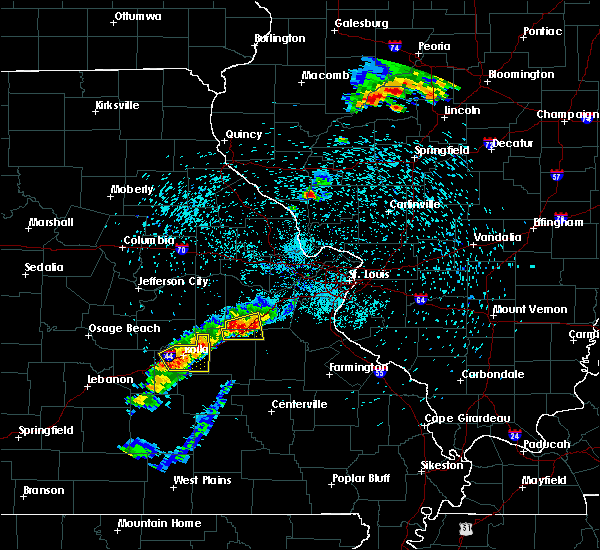 At 815 pm cdt, a severe thunderstorm was located over sullivan, moving east at 15 mph (trained weather spotters). Hazards include ping pong ball size hail and 60 mph wind gusts. People and animals outdoors will be injured. expect hail damage to roofs, siding, windows, and vehicles. expect wind damage to roofs, siding, and trees. locations impacted include, sullivan, bourbon, miramiguoa park, st. cloud, japan and stanton. this also includes meramec state park. This includes interstate 44 in missouri between exits 214 and 230. At 815 pm cdt, a severe thunderstorm was located over sullivan, moving east at 15 mph (trained weather spotters). Hazards include ping pong ball size hail and 60 mph wind gusts. People and animals outdoors will be injured. expect hail damage to roofs, siding, windows, and vehicles. expect wind damage to roofs, siding, and trees. locations impacted include, sullivan, bourbon, miramiguoa park, st. cloud, japan and stanton. this also includes meramec state park. This includes interstate 44 in missouri between exits 214 and 230.
|
| 5/28/2016 8:11 PM CDT | Ping Pong Ball sized hail reported 0.4 miles E of Sullivan, MO |
| 5/28/2016 8:07 PM CDT |
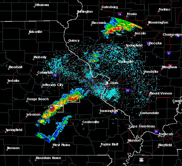 At 806 pm cdt, a severe thunderstorm was located over bourbon, moving east at 15 mph (radar indicated). Hazards include ping pong ball size hail and 60 mph wind gusts. People and animals outdoors will be injured. expect hail damage to roofs, siding, windows, and vehicles. expect wind damage to roofs, siding, and trees. locations impacted include, sullivan, bourbon, miramiguoa park, st. cloud, japan and stanton. this also includes meramec state park. This includes interstate 44 in missouri between exits 214 and 230. At 806 pm cdt, a severe thunderstorm was located over bourbon, moving east at 15 mph (radar indicated). Hazards include ping pong ball size hail and 60 mph wind gusts. People and animals outdoors will be injured. expect hail damage to roofs, siding, windows, and vehicles. expect wind damage to roofs, siding, and trees. locations impacted include, sullivan, bourbon, miramiguoa park, st. cloud, japan and stanton. this also includes meramec state park. This includes interstate 44 in missouri between exits 214 and 230.
|
| 5/28/2016 7:47 PM CDT |
 At 747 pm cdt, a severe thunderstorm was located near bourbon, moving east at 15 mph (radar indicated). Hazards include ping pong ball size hail and 60 mph wind gusts. People and animals outdoors will be injured. expect hail damage to roofs, siding, windows, and vehicles. expect wind damage to roofs, siding, and trees. locations impacted include, sullivan, bourbon, miramiguoa park, st. cloud, japan and stanton. this also includes meramec state park. This includes interstate 44 in missouri between exits 214 and 230. At 747 pm cdt, a severe thunderstorm was located near bourbon, moving east at 15 mph (radar indicated). Hazards include ping pong ball size hail and 60 mph wind gusts. People and animals outdoors will be injured. expect hail damage to roofs, siding, windows, and vehicles. expect wind damage to roofs, siding, and trees. locations impacted include, sullivan, bourbon, miramiguoa park, st. cloud, japan and stanton. this also includes meramec state park. This includes interstate 44 in missouri between exits 214 and 230.
|
| 5/28/2016 7:41 PM CDT |
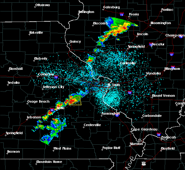 At 741 pm cdt, a severe thunderstorm was located near bourbon, moving east at 15 mph (radar indicated). Hazards include 60 mph wind gusts and quarter size hail. Hail damage to vehicles is expected. Expect wind damage to roofs, siding, and trees. At 741 pm cdt, a severe thunderstorm was located near bourbon, moving east at 15 mph (radar indicated). Hazards include 60 mph wind gusts and quarter size hail. Hail damage to vehicles is expected. Expect wind damage to roofs, siding, and trees.
|
| 5/28/2016 7:22 PM CDT |
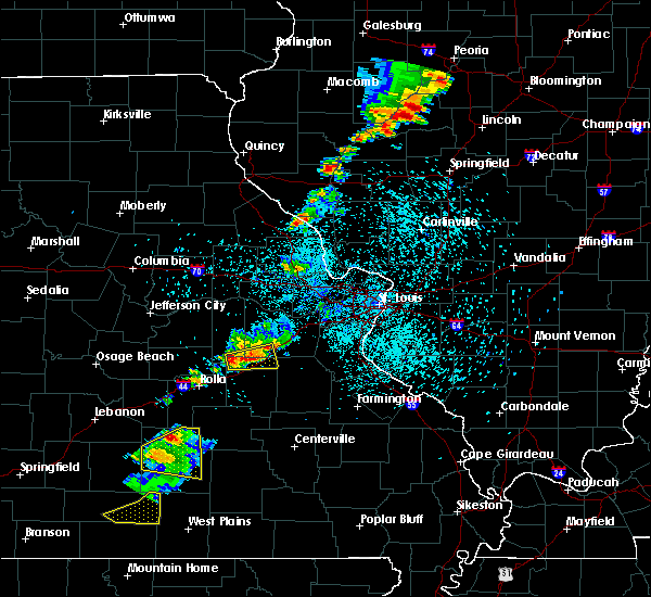 At 721 pm cdt, a severe thunderstorm was located 7 miles west of bourbon, moving east at 15 mph (radar indicated). Hazards include 60 mph wind gusts and quarter size hail. Hail damage to vehicles is expected. expect wind damage to roofs, siding, and trees. locations impacted include, sullivan, bourbon, st. cloud, oak hill and japan. This includes interstate 44 in missouri between exits 214 and 228. At 721 pm cdt, a severe thunderstorm was located 7 miles west of bourbon, moving east at 15 mph (radar indicated). Hazards include 60 mph wind gusts and quarter size hail. Hail damage to vehicles is expected. expect wind damage to roofs, siding, and trees. locations impacted include, sullivan, bourbon, st. cloud, oak hill and japan. This includes interstate 44 in missouri between exits 214 and 228.
|
| 5/28/2016 7:03 PM CDT |
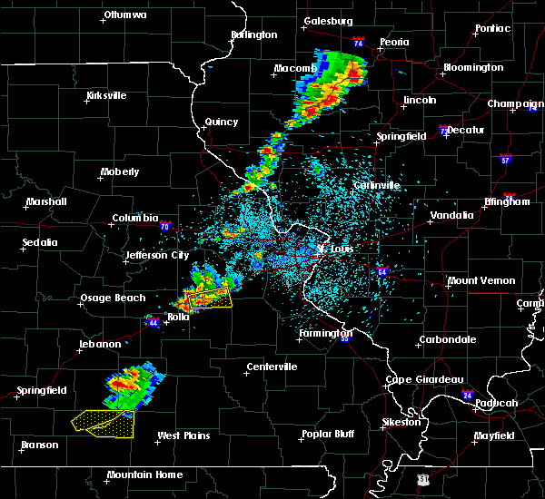 At 703 pm cdt, a severe thunderstorm was located near cuba, moving east at 15 mph (radar indicated). Hazards include 60 mph wind gusts and quarter size hail. Hail damage to vehicles is expected. Expect wind damage to roofs, siding, and trees. At 703 pm cdt, a severe thunderstorm was located near cuba, moving east at 15 mph (radar indicated). Hazards include 60 mph wind gusts and quarter size hail. Hail damage to vehicles is expected. Expect wind damage to roofs, siding, and trees.
|
| 5/11/2016 8:45 PM CDT |
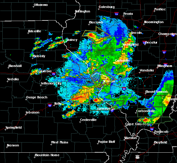 At 845 pm cdt, a severe thunderstorm was located near miramiguoa park, moving east at 35 mph (radar indicated). Hazards include 60 mph wind gusts and half dollar size hail. Hail damage to vehicles is expected. Expect wind damage to roofs, siding, and trees. At 845 pm cdt, a severe thunderstorm was located near miramiguoa park, moving east at 35 mph (radar indicated). Hazards include 60 mph wind gusts and half dollar size hail. Hail damage to vehicles is expected. Expect wind damage to roofs, siding, and trees.
|
| 5/11/2016 8:22 PM CDT |
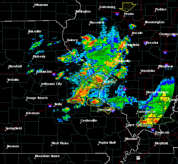 At 822 pm cdt, a confirmed tornado was located near bourbon, moving northeast at 20 mph (radar confirmed tornado). Hazards include damaging tornado and golf ball size hail. Flying debris will be dangerous to those caught without shelter. mobile homes will be damaged or destroyed. damage to roofs, windows, and vehicles will occur. tree damage is likely. this tornado will be near, sullivan around 835 pm cdt. miramiguoa park around 845 pm cdt. This also includes meramec state park. At 822 pm cdt, a confirmed tornado was located near bourbon, moving northeast at 20 mph (radar confirmed tornado). Hazards include damaging tornado and golf ball size hail. Flying debris will be dangerous to those caught without shelter. mobile homes will be damaged or destroyed. damage to roofs, windows, and vehicles will occur. tree damage is likely. this tornado will be near, sullivan around 835 pm cdt. miramiguoa park around 845 pm cdt. This also includes meramec state park.
|
| 5/11/2016 8:15 PM CDT |
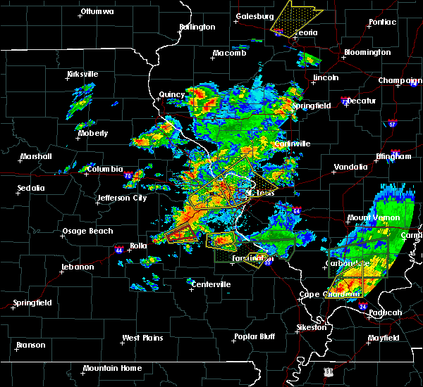 At 815 pm cdt, a severe thunderstorm capable of producing a tornado was located near bourbon, moving east at 25 mph (radar indicated rotation). Hazards include tornado and golf ball size hail. Flying debris will be dangerous to those caught without shelter. mobile homes will be damaged or destroyed. damage to roofs, windows, and vehicles will occur. tree damage is likely. this dangerous storm will be near, sullivan around 830 pm cdt. miramiguoa park around 840 pm cdt. This also includes meramec state park. At 815 pm cdt, a severe thunderstorm capable of producing a tornado was located near bourbon, moving east at 25 mph (radar indicated rotation). Hazards include tornado and golf ball size hail. Flying debris will be dangerous to those caught without shelter. mobile homes will be damaged or destroyed. damage to roofs, windows, and vehicles will occur. tree damage is likely. this dangerous storm will be near, sullivan around 830 pm cdt. miramiguoa park around 840 pm cdt. This also includes meramec state park.
|
| 5/11/2016 8:03 PM CDT |
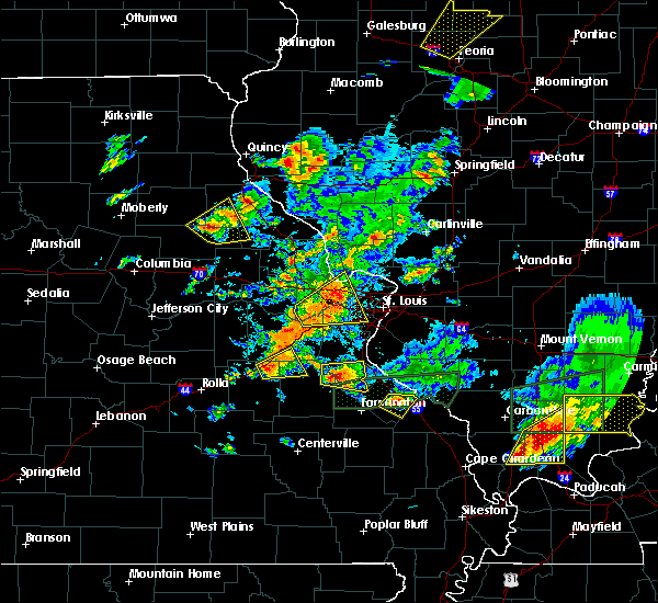 At 803 pm cdt, a severe thunderstorm was located over bourbon, moving east at 25 mph (radar indicated). Hazards include ping pong ball size hail and 60 mph wind gusts. People and animals outdoors will be injured. expect hail damage to roofs, siding, windows, and vehicles. Expect wind damage to roofs, siding, and trees. At 803 pm cdt, a severe thunderstorm was located over bourbon, moving east at 25 mph (radar indicated). Hazards include ping pong ball size hail and 60 mph wind gusts. People and animals outdoors will be injured. expect hail damage to roofs, siding, windows, and vehicles. Expect wind damage to roofs, siding, and trees.
|
| 5/11/2016 5:18 PM CDT |
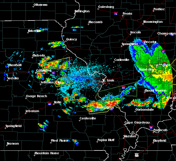 At 517 pm cdt, a severe thunderstorm was located near cuba, moving northeast at 25 mph (trained weather spotters reported half dollar size hail just north of cuba at 514 pm). Hazards include 60 mph wind gusts and half dollar size hail. Hail damage to vehicles is expected. Expect wind damage to roofs, siding, and trees. At 517 pm cdt, a severe thunderstorm was located near cuba, moving northeast at 25 mph (trained weather spotters reported half dollar size hail just north of cuba at 514 pm). Hazards include 60 mph wind gusts and half dollar size hail. Hail damage to vehicles is expected. Expect wind damage to roofs, siding, and trees.
|
| 4/27/2016 7:55 PM CDT |
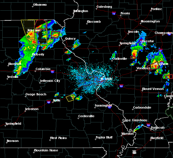 The severe thunderstorm warning for northeastern crawford county will expire at 800 pm cdt, the storm which prompted the warning has weakened below severe limits, and have exited the warned area. therefore the warning will be allowed to expire. The severe thunderstorm warning for northeastern crawford county will expire at 800 pm cdt, the storm which prompted the warning has weakened below severe limits, and have exited the warned area. therefore the warning will be allowed to expire.
|
| 4/27/2016 7:42 PM CDT |
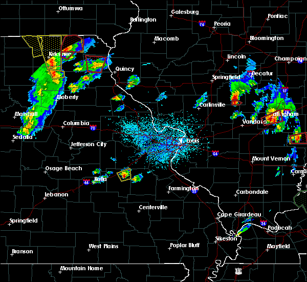 At 742 pm cdt, a severe thunderstorm was located near leasburg, moving northeast at 35 mph (radar indicated). Hazards include 60 mph wind gusts and half dollar size hail. Hail damage to vehicles is expected. expect wind damage to roofs, siding, and trees. locations impacted include, sullivan, bourbon, leasburg and st. cloud. this also includes onondaga cave state park and meramec state park. This includes interstate 44 in missouri between exits 214 and 218. At 742 pm cdt, a severe thunderstorm was located near leasburg, moving northeast at 35 mph (radar indicated). Hazards include 60 mph wind gusts and half dollar size hail. Hail damage to vehicles is expected. expect wind damage to roofs, siding, and trees. locations impacted include, sullivan, bourbon, leasburg and st. cloud. this also includes onondaga cave state park and meramec state park. This includes interstate 44 in missouri between exits 214 and 218.
|
| 4/27/2016 7:23 PM CDT |
 At 723 pm cdt, a severe thunderstorm was located near steelville, moving northeast at 30 mph (radar indicated). Hazards include 60 mph wind gusts and half dollar size hail. Hail damage to vehicles is expected. Expect wind damage to roofs, siding, and trees. At 723 pm cdt, a severe thunderstorm was located near steelville, moving northeast at 30 mph (radar indicated). Hazards include 60 mph wind gusts and half dollar size hail. Hail damage to vehicles is expected. Expect wind damage to roofs, siding, and trees.
|
| 4/26/2016 1:01 PM CDT |
 At 101 pm cdt, severe thunderstorms were located along a line extending from jonesburg to near gerald to 7 miles south of vienna, moving east at 40 mph (radar indicated). Hazards include 60 mph wind gusts and quarter size hail. Hail damage to vehicles is expected. Expect wind damage to roofs, siding, and trees. At 101 pm cdt, severe thunderstorms were located along a line extending from jonesburg to near gerald to 7 miles south of vienna, moving east at 40 mph (radar indicated). Hazards include 60 mph wind gusts and quarter size hail. Hail damage to vehicles is expected. Expect wind damage to roofs, siding, and trees.
|
| 8/9/2015 6:54 PM CDT |
 At 653 pm cdt, severe thunderstorms were located along a line extending from near miramiguoa park to 9 miles east of steelville, moving east at 45 mph (radar indicated). Hazards include 60 mph wind gusts. Expect damage to roofs. siding and trees. locations impacted include, sullivan, cuba, steelville, bourbon, anthonies mill, leasburg, richwoods, st. cloud and latty. this warning also includes onondaga cave state park. This includes interstate 44 in missouri between exits 208 and 218. At 653 pm cdt, severe thunderstorms were located along a line extending from near miramiguoa park to 9 miles east of steelville, moving east at 45 mph (radar indicated). Hazards include 60 mph wind gusts. Expect damage to roofs. siding and trees. locations impacted include, sullivan, cuba, steelville, bourbon, anthonies mill, leasburg, richwoods, st. cloud and latty. this warning also includes onondaga cave state park. This includes interstate 44 in missouri between exits 208 and 218.
|
| 8/9/2015 6:53 PM CDT |
 At 652 pm cdt, severe thunderstorms were located along a line extending from near washington to near miramiguoa park, moving east at 40 mph (radar indicated). Hazards include 60 mph wind gusts and penny size hail. 60 mph winds have been reported in the union area. Expect damage to roofs. siding and trees. locations impacted include, washington, union, sullivan, pacific, st. clair, gray summit, villa ridge, gerald, parkway, miramiguoa park, lonedell, beaufort, leslie, moselle, noser mill, stanton, japan, robertsville, catawissa and piney park. this warning also includes robertsville state park. This includes interstate 44 in missouri between exits 225 and 257. At 652 pm cdt, severe thunderstorms were located along a line extending from near washington to near miramiguoa park, moving east at 40 mph (radar indicated). Hazards include 60 mph wind gusts and penny size hail. 60 mph winds have been reported in the union area. Expect damage to roofs. siding and trees. locations impacted include, washington, union, sullivan, pacific, st. clair, gray summit, villa ridge, gerald, parkway, miramiguoa park, lonedell, beaufort, leslie, moselle, noser mill, stanton, japan, robertsville, catawissa and piney park. this warning also includes robertsville state park. This includes interstate 44 in missouri between exits 225 and 257.
|
| 8/9/2015 6:46 PM CDT | Trees down on highway ww in franklin county MO, 0.4 miles E of Sullivan, MO |
| 8/9/2015 6:38 PM CDT |
 At 638 pm cdt, a severe thunderstorm was located near bourbon, moving east at 40 mph (radar indicated). Hazards include 60 mph wind gusts. Expect damage to roofs. Siding and trees. At 638 pm cdt, a severe thunderstorm was located near bourbon, moving east at 40 mph (radar indicated). Hazards include 60 mph wind gusts. Expect damage to roofs. Siding and trees.
|
| 8/9/2015 6:34 PM CDT |
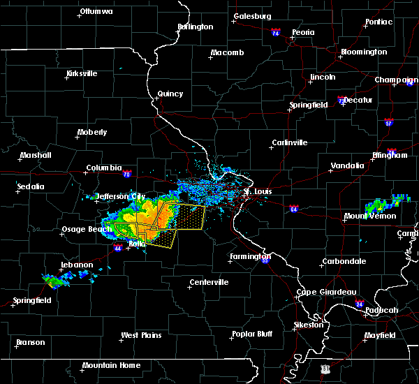 At 633 pm cdt, a severe thunderstorm was located near cuba, moving east at 40 mph (radar indicated). Hazards include 60 mph wind gusts. Expect damage to roofs. siding and trees. locations impacted include, sullivan, cuba, bourbon, leasburg, st. cloud, oak hill and rosati. this warning also includes onondaga cave state park. This includes interstate 44 in missouri between exits 203 and 218. At 633 pm cdt, a severe thunderstorm was located near cuba, moving east at 40 mph (radar indicated). Hazards include 60 mph wind gusts. Expect damage to roofs. siding and trees. locations impacted include, sullivan, cuba, bourbon, leasburg, st. cloud, oak hill and rosati. this warning also includes onondaga cave state park. This includes interstate 44 in missouri between exits 203 and 218.
|
| 8/9/2015 6:27 PM CDT |
 At 627 pm cdt, a severe thunderstorm was located near gerald, moving east at 45 mph (radar indicated). Hazards include 60 mph wind gusts and penny size hail. Expect damage to roofs. Siding and trees. At 627 pm cdt, a severe thunderstorm was located near gerald, moving east at 45 mph (radar indicated). Hazards include 60 mph wind gusts and penny size hail. Expect damage to roofs. Siding and trees.
|
| 8/9/2015 6:19 PM CDT |
 At 618 pm cdt, a severe thunderstorm was located near bland, moving east at 40 mph (radar indicated). Hazards include 60 mph wind gusts. Expect damage to roofs. Siding and trees. At 618 pm cdt, a severe thunderstorm was located near bland, moving east at 40 mph (radar indicated). Hazards include 60 mph wind gusts. Expect damage to roofs. Siding and trees.
|
| 8/9/2015 6:05 PM CDT |
 At 605 pm cdt, a severe thunderstorm was located over owensville, moving east at 40 mph (radar indicated). Hazards include 60 mph wind gusts and nickel size hail. Expect damage to roofs. siding and trees. locations impacted include, washington, sullivan, owensville, gerald, bland, rosebud, drake, swiss, mount sterling, beaufort, leslie, noser mill, stanton, japan, canaan, bay and lyon. This includes interstate 44 in missouri near exit 228. At 605 pm cdt, a severe thunderstorm was located over owensville, moving east at 40 mph (radar indicated). Hazards include 60 mph wind gusts and nickel size hail. Expect damage to roofs. siding and trees. locations impacted include, washington, sullivan, owensville, gerald, bland, rosebud, drake, swiss, mount sterling, beaufort, leslie, noser mill, stanton, japan, canaan, bay and lyon. This includes interstate 44 in missouri near exit 228.
|
| 8/9/2015 5:48 PM CDT |
 At 548 pm cdt, a severe thunderstorm was located 7 miles southwest of mount sterling, moving east at 45 mph (radar indicated). Hazards include 60 mph wind gusts and nickel size hail. Expect damage to roofs. Siding and trees. At 548 pm cdt, a severe thunderstorm was located 7 miles southwest of mount sterling, moving east at 45 mph (radar indicated). Hazards include 60 mph wind gusts and nickel size hail. Expect damage to roofs. Siding and trees.
|
| 7/8/2015 7:50 PM CDT |
 At 750 pm cdt, a severe thunderstorm capable of producing a tornado was located near sullivan, moving northeast at 45 mph (radar indicated rotation). Hazards include tornado. Flying debris will be dangerous to those caught without shelter. mobile homes will be damaged or destroyed. damage to roofs, windows and vehicles will occur. tree damage is likely. this dangerous storm will be near, miramiguoa park around 755 pm cdt. st. clair and parkway around 805 pm cdt. union around 810 pm cdt. lonedell around 815 pm cdt. other locations impacted by this tornadic thunderstorm include moselle, noser mill, stanton, japan and piney park. this warning also includes meramec state park. This includes interstate 44 in missouri between exits 225 and 247. At 750 pm cdt, a severe thunderstorm capable of producing a tornado was located near sullivan, moving northeast at 45 mph (radar indicated rotation). Hazards include tornado. Flying debris will be dangerous to those caught without shelter. mobile homes will be damaged or destroyed. damage to roofs, windows and vehicles will occur. tree damage is likely. this dangerous storm will be near, miramiguoa park around 755 pm cdt. st. clair and parkway around 805 pm cdt. union around 810 pm cdt. lonedell around 815 pm cdt. other locations impacted by this tornadic thunderstorm include moselle, noser mill, stanton, japan and piney park. this warning also includes meramec state park. This includes interstate 44 in missouri between exits 225 and 247.
|
| 7/8/2015 7:49 PM CDT |
 At 748 pm cdt, a severe thunderstorm capable of producing a tornado was located over bourbon, moving northeast at 35 mph (radar indicated rotation). Hazards include tornado. Flying debris will be dangerous to those caught without shelter. mobile homes will be damaged or destroyed. damage to roofs, windows and vehicles will occur. tree damage is likely. this dangerous storm will be near, sullivan around 805 pm cdt. other locations impacted by this tornadic thunderstorm include st. cloud. this warning also includes onondaga cave state park. This includes interstate 44 in missouri between exits 214 and 218. At 748 pm cdt, a severe thunderstorm capable of producing a tornado was located over bourbon, moving northeast at 35 mph (radar indicated rotation). Hazards include tornado. Flying debris will be dangerous to those caught without shelter. mobile homes will be damaged or destroyed. damage to roofs, windows and vehicles will occur. tree damage is likely. this dangerous storm will be near, sullivan around 805 pm cdt. other locations impacted by this tornadic thunderstorm include st. cloud. this warning also includes onondaga cave state park. This includes interstate 44 in missouri between exits 214 and 218.
|
| 7/8/2015 7:38 PM CDT |
 At 738 pm cdt, a severe thunderstorm capable of producing a tornado was located near bourbon, moving northeast at 45 mph (radar indicated rotation). Hazards include tornado. Flying debris will be dangerous to those caught without shelter. mobile homes will be damaged or destroyed. damage to roofs, windows and vehicles will occur. tree damage is likely. this dangerous storm will be near, sullivan around 750 pm cdt. miramiguoa park around 755 pm cdt. st. clair and parkway around 805 pm cdt. union around 810 pm cdt. lonedell around 815 pm cdt. other locations impacted by this tornadic thunderstorm include moselle, noser mill, stanton, japan and piney park. this warning also includes meramec state park. This includes interstate 44 in missouri between exits 225 and 247. At 738 pm cdt, a severe thunderstorm capable of producing a tornado was located near bourbon, moving northeast at 45 mph (radar indicated rotation). Hazards include tornado. Flying debris will be dangerous to those caught without shelter. mobile homes will be damaged or destroyed. damage to roofs, windows and vehicles will occur. tree damage is likely. this dangerous storm will be near, sullivan around 750 pm cdt. miramiguoa park around 755 pm cdt. st. clair and parkway around 805 pm cdt. union around 810 pm cdt. lonedell around 815 pm cdt. other locations impacted by this tornadic thunderstorm include moselle, noser mill, stanton, japan and piney park. this warning also includes meramec state park. This includes interstate 44 in missouri between exits 225 and 247.
|
| 6/28/2015 7:10 PM CDT |
 At 708 pm cdt, a severe thunderstorm was located near beaufort, and moving southeast at 25 mph (radar indicated). Hazards include 60 mph wind gusts and quarter size hail. Hail damage to vehicles is expected. expect wind damage to roofs, siding and trees. locations impacted include, union, sullivan, st. clair, parkway, stanton and moselle. This warning also includes, interstate 44 from exit 225 to exit 242. At 708 pm cdt, a severe thunderstorm was located near beaufort, and moving southeast at 25 mph (radar indicated). Hazards include 60 mph wind gusts and quarter size hail. Hail damage to vehicles is expected. expect wind damage to roofs, siding and trees. locations impacted include, union, sullivan, st. clair, parkway, stanton and moselle. This warning also includes, interstate 44 from exit 225 to exit 242.
|
| 6/28/2015 6:59 PM CDT |
 At 659 pm cdt, a severe thunderstorm was located near beaufort, and moving southeast at 25 mph (radar indicated). Hazards include 60 mph wind gusts and quarter size hail. Hail damage to vehicles is expected. expect wind damage to roofs, siding and trees. locations impacted include, union, sullivan, st. clair, beaufort, parkway, leslie, noser mill, stanton and moselle. This warning also includes, interstate 44 from exit 225 to exit 247. At 659 pm cdt, a severe thunderstorm was located near beaufort, and moving southeast at 25 mph (radar indicated). Hazards include 60 mph wind gusts and quarter size hail. Hail damage to vehicles is expected. expect wind damage to roofs, siding and trees. locations impacted include, union, sullivan, st. clair, beaufort, parkway, leslie, noser mill, stanton and moselle. This warning also includes, interstate 44 from exit 225 to exit 247.
|
| 6/28/2015 6:45 PM CDT |
 At 644 pm cdt, a severe thunderstorm was located 7 miles north of gerald, and moving southeast at 25 mph (radar indicated). Hazards include 60 mph wind gusts and quarter size hail. Hail damage to vehicles is expected. Expect wind damage to roofs, siding and trees. At 644 pm cdt, a severe thunderstorm was located 7 miles north of gerald, and moving southeast at 25 mph (radar indicated). Hazards include 60 mph wind gusts and quarter size hail. Hail damage to vehicles is expected. Expect wind damage to roofs, siding and trees.
|
| 4/9/2015 6:17 PM CDT | The national weather service in st louis has issued a * severe thunderstorm warning for. northern crawford county in east central missouri. southern franklin county in east central missouri. western jefferson county in east central missouri. northern st. Francois county in southeast missouri. |
| 4/8/2015 3:05 PM CDT | The national weather service in st louis has issued a * severe thunderstorm warning for. crawford county in east central missouri. southern franklin county in east central missouri. gasconade county in east central missouri. Iron county in southeast missouri. |
| 4/8/2015 2:51 PM CDT | Quarter sized hail reported 0.4 miles E of Sullivan, MO, hail continues to increase with winds up to 25 mph. |
| 4/8/2015 2:41 PM CDT | A severe thunderstorm warning remains in effect for northern washington. west central jefferson. southeastern franklin and northeastern crawford counties until 315 pm cdt. at 235 pm cdt. a severe thunderstorm was located 8 miles northeast of anthonies mill. and moving east at 30 mph. 3-4 inch diameter hail was reported with this storm in the sullivan area at 230 pm. |
| 4/8/2015 2:36 PM CDT | A severe thunderstorm warning remains in effect for southwestern franklin and northeastern crawford counties until 315 pm cdt. at 235 pm cdt. a severe thunderstorm was located near bourbon. and moving east at 30 mph. hazard. golf ball size hail and 60 mph wind gusts. source. Radar indicated. |
| 4/8/2015 2:30 PM CDT | Grapefruit sized hail reported 0.4 miles E of Sullivan, MO, 3-4 inch hail. largest hail was spiked... with diameter measured from spike-to-spike. |
| 4/8/2015 2:26 PM CDT | The national weather service in st louis has issued a * severe thunderstorm warning for. northeastern crawford county in east central missouri. southeastern franklin county in east central missouri. west central jefferson county in east central missouri. Northern washington county in east central missouri. |
| 4/8/2015 2:23 PM CDT | The national weather service in st louis has issued a * severe thunderstorm warning for. northern crawford county in east central missouri. southwestern franklin county in east central missouri. gasconade county in east central missouri. Until 315 pm cdt. |
| 4/8/2015 2:20 PM CDT | A severe thunderstorm warning remains in effect for northwestern washington. south central franklin and northeastern crawford counties until 230 pm cdt. at 218 pm cdt. a severe thunderstorm was located near sullivan. and moving east-southeast at 25 mph. This is a very dangerous storm. |
| 4/8/2015 2:18 PM CDT | Tea Cup sized hail reported 1.4 miles SSE of Sullivan, MO |
| 4/8/2015 2:15 PM CDT | Baseball sized hail reported 2.7 miles SW of Sullivan, MO, baseball size hail just busted observers windshield. |
| 4/8/2015 2:14 PM CDT | Golf Ball sized hail reported 1.4 miles SSE of Sullivan, MO |
| 4/8/2015 2:12 PM CDT | A severe thunderstorm warning remains in effect for northwestern washington. central franklin and northeastern crawford counties until 230 pm cdt. at 209 pm cdt. severe thunderstorms were located along a line extending from 6 miles south of new haven to sullivan. and moving east at 40 mph. Radar indicates the largest hail is just north of. |
| 4/8/2015 1:59 PM CDT | A severe thunderstorm warning remains in effect for northwestern washington. southeastern warren. western franklin and northeastern crawford counties until 230 pm cdt. at 157 pm cdt. severe thunderstorms were located along a line extending from 8 miles east of swiss to 7 miles northwest of bourbon. and moving east at 40 mph. Radar indicates the largest. |
| 4/8/2015 1:43 PM CDT | The national weather service in st louis has issued a * severe thunderstorm warning for. northern crawford county in east central missouri. western franklin county in east central missouri. gasconade county in east central missouri. Southeastern warren county in east central missouri. |
| 4/2/2015 10:58 PM CDT | A severe thunderstorm warning remains in effect for central franklin county until 1115 pm cdt. at 1055 pm cdt. a severe thunderstorm was located near beaufort. and moving east at 30 mph. hazard. 60 mph wind gusts and quarter size hail. source. Trained weather spotters reported wind damage 8 miles south. |
| 4/2/2015 9:45 PM CST | Several large tree limbs blown dow in franklin county MO, 6.6 miles SE of Sullivan, MO |
| 4/2/2015 10:30 PM CDT | The national weather service in st louis has issued a * severe thunderstorm warning for. southern franklin county in east central missouri. until 1115 pm cdt * at 1028 pm cdt. a severe thunderstorm was located near rosebud. And moving east at 30 mph. |
| 4/10/2013 7:15 PM CDT | Storm damage reported in franklin county MO, 0.6 miles S of Sullivan, MO |
| 4/10/2013 7:10 PM CDT | Storm damage reported in franklin county MO, 0.4 miles E of Sullivan, MO |
| 10/17/2012 4:55 PM CDT | Winds estimated up to 50 mp in franklin county MO, 0.4 miles E of Sullivan, MO |
| 10/17/2012 4:36 PM CDT | Winds estimated up to 50 mp in franklin county MO, 0.4 miles E of Sullivan, MO |
| 9/6/2012 3:50 PM CDT | Storm damage reported in franklin county MO, 0.6 miles S of Sullivan, MO |
| 9/6/2012 3:33 PM CDT | Several trees uprooted along and south of serice road of interstate 4 in franklin county MO, 0.4 miles E of Sullivan, MO |
| 9/6/2012 3:29 PM CDT | Two large trees down near intersection of highways j and h. time estimated from rada in franklin county MO, 6 miles ESE of Sullivan, MO |
| 1/1/0001 12:00 AM | Sullivan rgnl arpt in franklin county MO, 0.4 miles E of Sullivan, MO |
| 1/1/0001 12:00 AM | Quarter sized hail reported 10 miles NNW of Sullivan, MO |
| 1/1/0001 12:00 AM | Three trees blown down on highway jj between wild oak road and acid mine roa in franklin county MO, 4.4 miles SSW of Sullivan, MO |
Hail Maps for Sullivan, MO


Connect with Interactive Hail Maps