

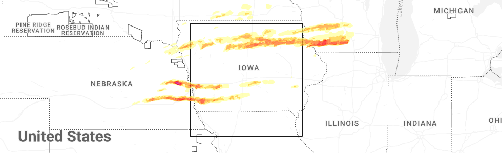
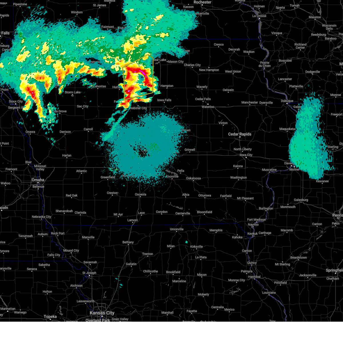
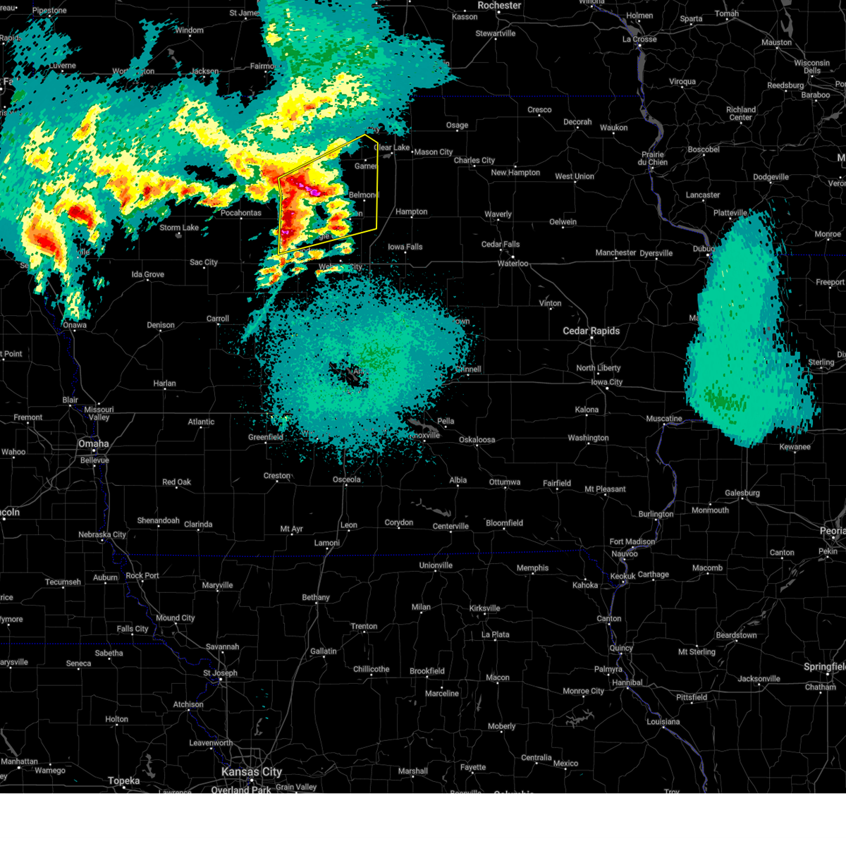
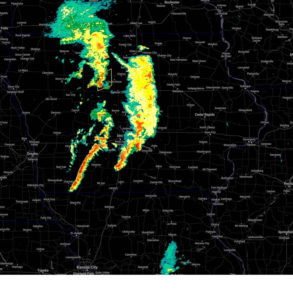
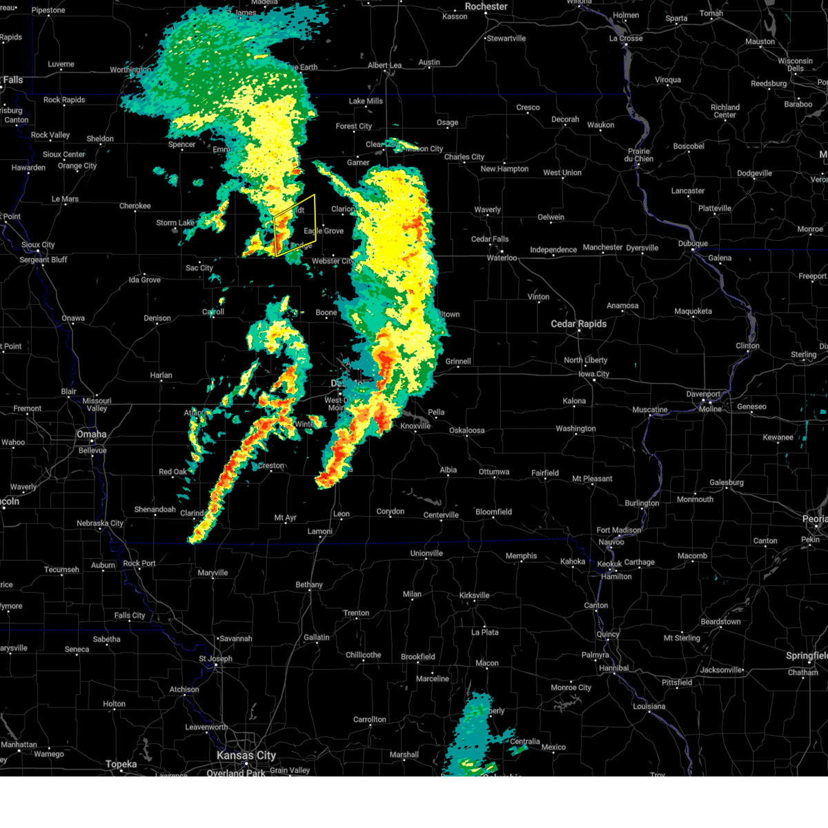
Hail Map for Thor, IA
The Thor, IA area has had 1 report of on-the-ground hail by trained spotters, and has been under severe weather warnings 8 times during the past 12 months. Doppler radar has detected hail at or near Thor, IA on 50 occasions, including 2 occasions during the past year.
| Name: | Thor, IA |
| Where Located: | 53.4 miles SW of Mason City, IA |
| Map: | Google Map for Thor, IA |
| Population: | 186 |
| Housing Units: | 80 |
| More Info: | Search Google for Thor, IA |
1
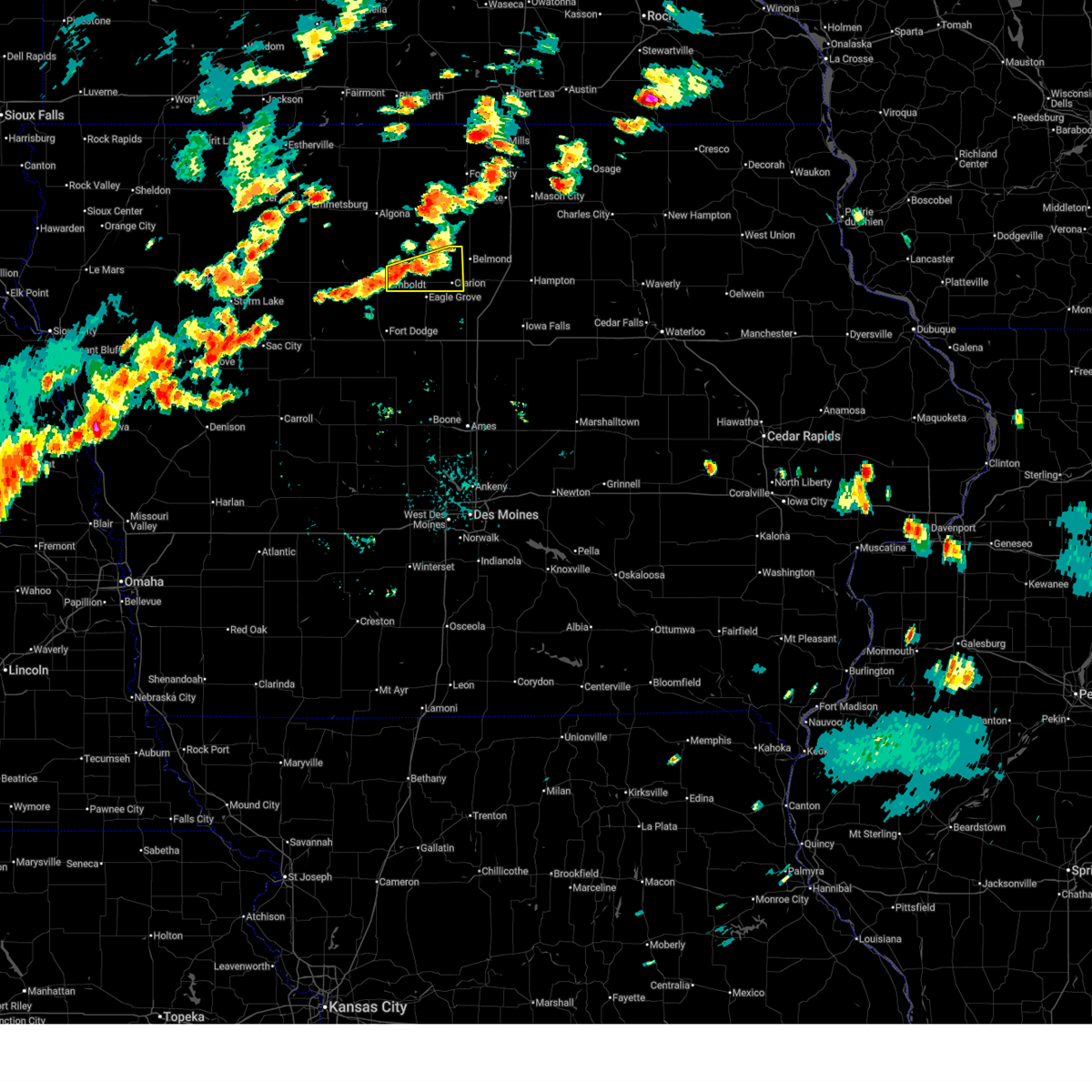
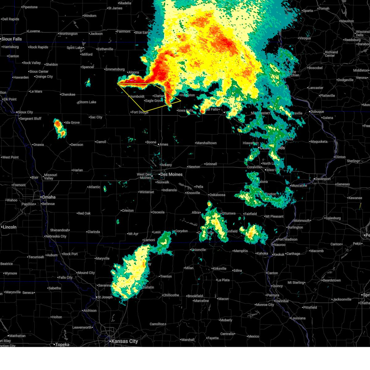
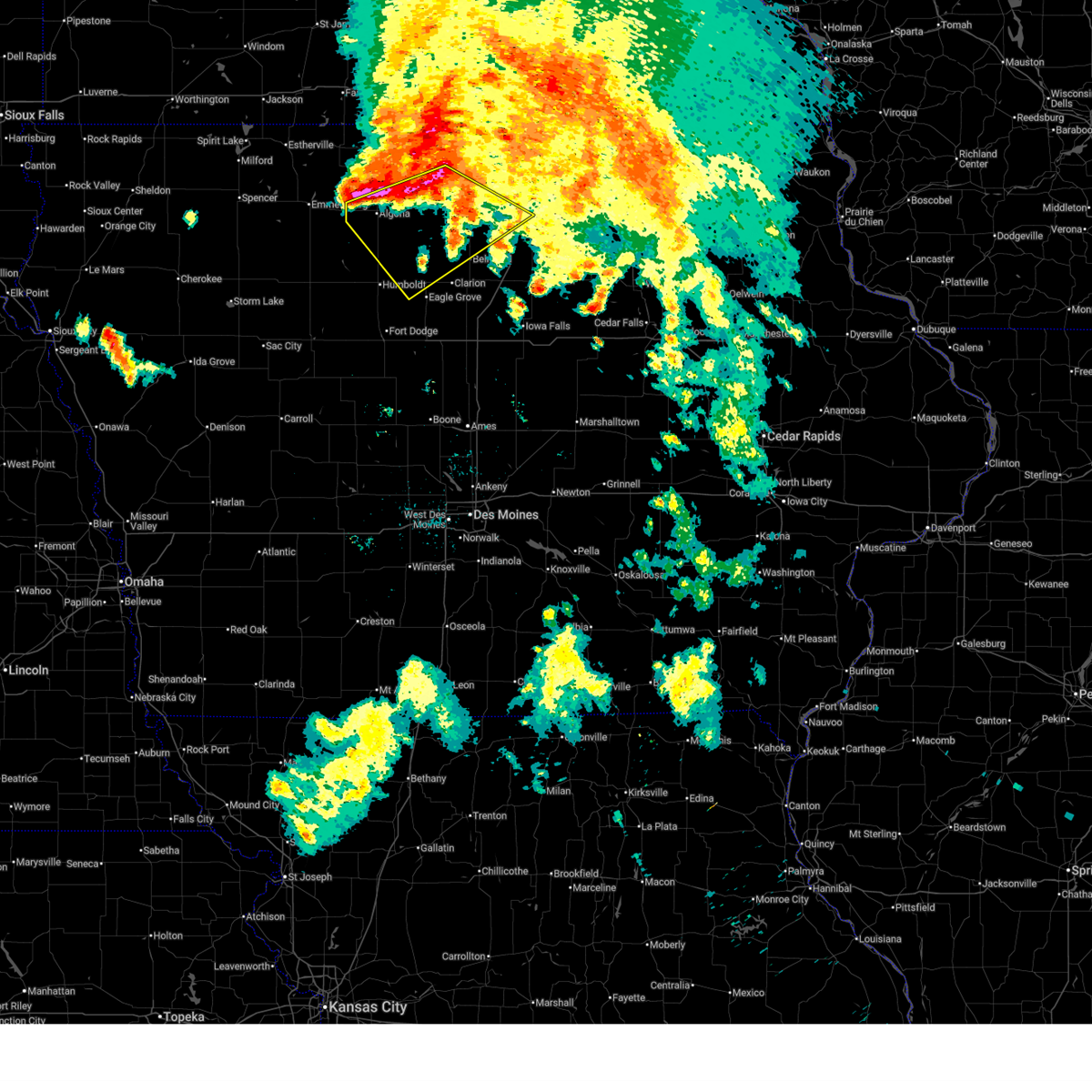
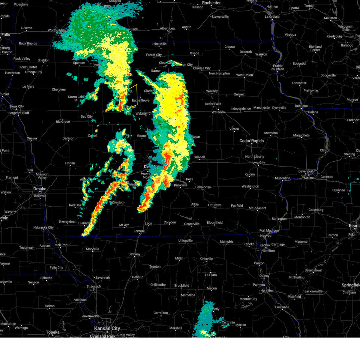
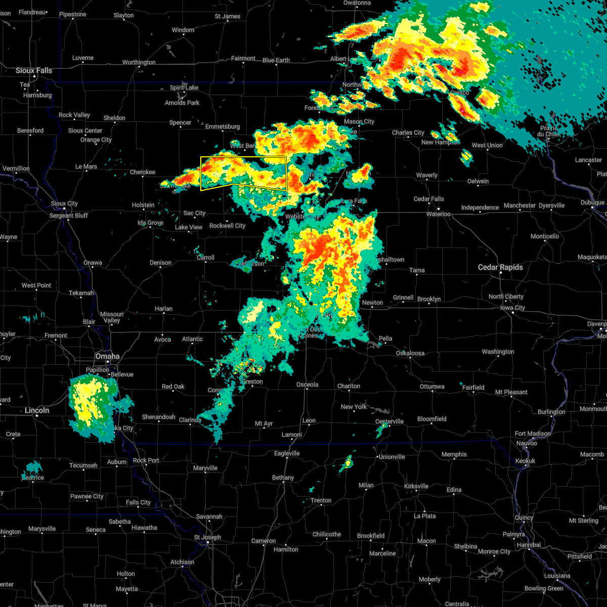
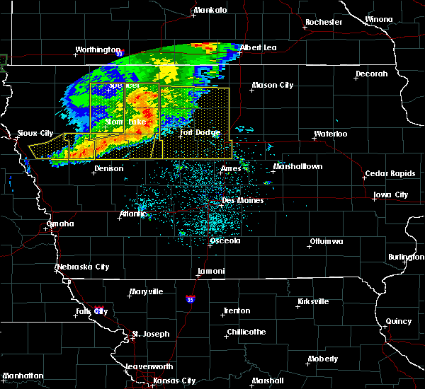
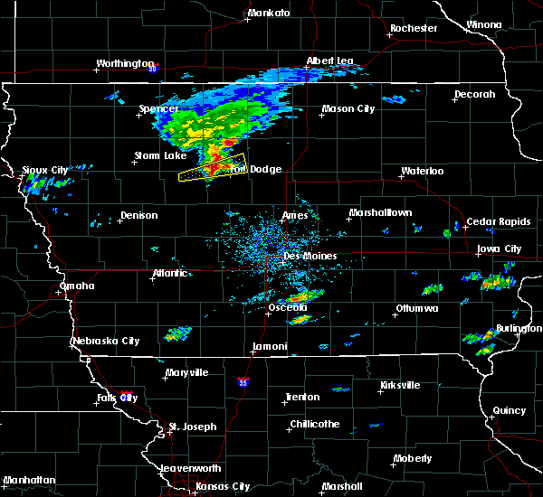
The Top Recent Hail Date for Thor, IA is Thursday, April 17, 2025 (3rd out of 50)
Hail and Wind Damage Spotted near Thor, IA
| Date / Time | Report Details |
|---|---|
| 6/25/2025 3:59 PM CDT |
 Svrdmx the national weather service in des moines has issued a * severe thunderstorm warning for, northwestern wright county in north central iowa, southeastern humboldt county in north central iowa, * until 445 pm cdt. * at 358 pm cdt, a severe thunderstorm was located near hardy, or 7 miles east of dakota city, moving east at 30 mph (radar indicated). Hazards include 60 mph wind gusts and nickel size hail. expect damage to roofs, siding, and trees Svrdmx the national weather service in des moines has issued a * severe thunderstorm warning for, northwestern wright county in north central iowa, southeastern humboldt county in north central iowa, * until 445 pm cdt. * at 358 pm cdt, a severe thunderstorm was located near hardy, or 7 miles east of dakota city, moving east at 30 mph (radar indicated). Hazards include 60 mph wind gusts and nickel size hail. expect damage to roofs, siding, and trees
|
| 6/20/2025 3:49 AM CDT |
 Svrdmx the national weather service in des moines has issued a * severe thunderstorm warning for, northeastern webster county in central iowa, wright county in north central iowa, southwestern franklin county in north central iowa, humboldt county in north central iowa, northwestern hamilton county in central iowa, * until 430 am cdt. * at 348 am cdt, a severe thunderstorm was located 5 miles northeast of renwick, or 12 miles northwest of clarion, moving southeast at 35 mph (radar indicated). Hazards include 70 mph wind gusts and penny size hail. Expect considerable tree damage. Damage is likely to mobile homes, roofs, and outbuildings. Svrdmx the national weather service in des moines has issued a * severe thunderstorm warning for, northeastern webster county in central iowa, wright county in north central iowa, southwestern franklin county in north central iowa, humboldt county in north central iowa, northwestern hamilton county in central iowa, * until 430 am cdt. * at 348 am cdt, a severe thunderstorm was located 5 miles northeast of renwick, or 12 miles northwest of clarion, moving southeast at 35 mph (radar indicated). Hazards include 70 mph wind gusts and penny size hail. Expect considerable tree damage. Damage is likely to mobile homes, roofs, and outbuildings.
|
| 6/20/2025 3:16 AM CDT |
 Svrdmx the national weather service in des moines has issued a * severe thunderstorm warning for, northern wright county in north central iowa, southern kossuth county in north central iowa, eastern humboldt county in north central iowa, hancock county in north central iowa, southwestern cerro gordo county in north central iowa, south central winnebago county in north central iowa, * until 400 am cdt. * at 314 am cdt, severe thunderstorms were located along a line extending from near crystal lake to 4 miles north of whittemore, moving southeast at 45 mph (radar indicated). Hazards include 60 mph wind gusts and nickel size hail. expect damage to roofs, siding, and trees Svrdmx the national weather service in des moines has issued a * severe thunderstorm warning for, northern wright county in north central iowa, southern kossuth county in north central iowa, eastern humboldt county in north central iowa, hancock county in north central iowa, southwestern cerro gordo county in north central iowa, south central winnebago county in north central iowa, * until 400 am cdt. * at 314 am cdt, severe thunderstorms were located along a line extending from near crystal lake to 4 miles north of whittemore, moving southeast at 45 mph (radar indicated). Hazards include 60 mph wind gusts and nickel size hail. expect damage to roofs, siding, and trees
|
| 4/18/2025 2:23 AM CDT |
 At 223 am cdt, severe thunderstorms were located along a line extending from sexton to 5 miles northeast of renwick to near vincent, moving northeast at 50 mph (radar indicated). Hazards include 60 mph wind gusts and half dollar size hail. Hail damage to vehicles is expected. expect wind damage to roofs, siding, and trees. locations impacted include, wesley, hutchins, forest city municipal airport, corwith, clarion municipal airport, goldfield, thor, rowan, kanawha, st. Benedict, eagle lake state park, garner, clarion, belmond, lu verne, belmond municipal airport, klemme, eagle lake, hayfield, and vincent. At 223 am cdt, severe thunderstorms were located along a line extending from sexton to 5 miles northeast of renwick to near vincent, moving northeast at 50 mph (radar indicated). Hazards include 60 mph wind gusts and half dollar size hail. Hail damage to vehicles is expected. expect wind damage to roofs, siding, and trees. locations impacted include, wesley, hutchins, forest city municipal airport, corwith, clarion municipal airport, goldfield, thor, rowan, kanawha, st. Benedict, eagle lake state park, garner, clarion, belmond, lu verne, belmond municipal airport, klemme, eagle lake, hayfield, and vincent.
|
| 4/18/2025 2:10 AM CDT |
 Svrdmx the national weather service in des moines has issued a * severe thunderstorm warning for, northern webster county in central iowa, wright county in north central iowa, southeastern kossuth county in north central iowa, humboldt county in north central iowa, hancock county in north central iowa, * until 300 am cdt. * at 210 am cdt, severe thunderstorms were located along a line extending from aa call state park to 5 miles south of corwith to 4 miles northwest of fort dodge regional airport, moving northeast at 50 mph (radar indicated). Hazards include 60 mph wind gusts and half dollar size hail. Hail damage to vehicles is expected. Expect wind damage to roofs, siding, and trees. Svrdmx the national weather service in des moines has issued a * severe thunderstorm warning for, northern webster county in central iowa, wright county in north central iowa, southeastern kossuth county in north central iowa, humboldt county in north central iowa, hancock county in north central iowa, * until 300 am cdt. * at 210 am cdt, severe thunderstorms were located along a line extending from aa call state park to 5 miles south of corwith to 4 miles northwest of fort dodge regional airport, moving northeast at 50 mph (radar indicated). Hazards include 60 mph wind gusts and half dollar size hail. Hail damage to vehicles is expected. Expect wind damage to roofs, siding, and trees.
|
| 3/14/2025 6:03 PM CDT |
 At 603 pm cdt, severe thunderstorms were located along a line extending from 6 miles northeast of varina to pioneer to near fort dodge regional airport to 6 miles north of ellsworth, moving north at 55 mph (radar indicated). Hazards include 60 mph wind gusts and quarter size hail. Hail damage to vehicles is expected. expect wind damage to roofs, siding, and trees. locations impacted include, ayrshire, curlew, corwith, whittemore, pomeroy, rinard, bradgate, brushy creek st recreation area, belmond, rolfe, havelock, galt, goodell, rutland, frank a gotch state park, eagle grove municipal airport, varina, coalville, laurens, and emmetsburg. This includes interstate 35 between mile markers 131 and 154. At 603 pm cdt, severe thunderstorms were located along a line extending from 6 miles northeast of varina to pioneer to near fort dodge regional airport to 6 miles north of ellsworth, moving north at 55 mph (radar indicated). Hazards include 60 mph wind gusts and quarter size hail. Hail damage to vehicles is expected. expect wind damage to roofs, siding, and trees. locations impacted include, ayrshire, curlew, corwith, whittemore, pomeroy, rinard, bradgate, brushy creek st recreation area, belmond, rolfe, havelock, galt, goodell, rutland, frank a gotch state park, eagle grove municipal airport, varina, coalville, laurens, and emmetsburg. This includes interstate 35 between mile markers 131 and 154.
|
| 3/14/2025 5:49 PM CDT |
 Svrdmx the national weather service in des moines has issued a * severe thunderstorm warning for, webster county in central iowa, pocahontas county in northwestern iowa, wright county in north central iowa, southern kossuth county in north central iowa, calhoun county in west central iowa, humboldt county in north central iowa, southern hancock county in north central iowa, hamilton county in central iowa, palo alto county in northwestern iowa, * until 645 pm cdt. * at 549 pm cdt, severe thunderstorms were located along a line extending from fonda to near knierim to near otho to randall, moving north at 55 mph (radar indicated). Hazards include 60 mph wind gusts and quarter size hail. Hail damage to vehicles is expected. Expect wind damage to roofs, siding, and trees. Svrdmx the national weather service in des moines has issued a * severe thunderstorm warning for, webster county in central iowa, pocahontas county in northwestern iowa, wright county in north central iowa, southern kossuth county in north central iowa, calhoun county in west central iowa, humboldt county in north central iowa, southern hancock county in north central iowa, hamilton county in central iowa, palo alto county in northwestern iowa, * until 645 pm cdt. * at 549 pm cdt, severe thunderstorms were located along a line extending from fonda to near knierim to near otho to randall, moving north at 55 mph (radar indicated). Hazards include 60 mph wind gusts and quarter size hail. Hail damage to vehicles is expected. Expect wind damage to roofs, siding, and trees.
|
| 7/30/2024 1:03 AM CDT | Svrdmx the national weather service in des moines has issued a * severe thunderstorm warning for, greene county in west central iowa, webster county in central iowa, southern pocahontas county in northwestern iowa, eastern sac county in west central iowa, calhoun county in west central iowa, southern humboldt county in north central iowa, carroll county in west central iowa, * until 145 am cdt. * at 103 am cdt, severe thunderstorms were located along a line extending from 5 miles northwest of newell to 4 miles north of sac city to near auburn to 4 miles west of carroll to near templeton, moving east at 65 mph (radar indicated). Hazards include 60 mph wind gusts. Expect damage to roofs, siding, and trees. severe thunderstorms will be near, carroll, lake city, glidden, fonda, auburn, lytton, dedham and lidderdale around 110 am cdt. rockwell city, coon rapids, south twin lake, north twin lake, pomeroy, twin lakes, ralston and twin lakes state park around 115 am cdt. manson, scranton, churdan, lohrville, palmer and rinard around 120 am cdt. Other locations in the path of these severe thunderstorms include jefferson, farnhamville, somers, knierim, gowrie, barnum, jefferson municipal airport, grand junction, callender, rippey, paton, moorland, clare and dana. |
| 7/6/2024 6:58 PM CDT |
 The storm which prompted the warning has moved out of the area. therefore, the warning will be allowed to expire. remember, a severe thunderstorm warning still remains in effect for portions of wright, humboldt, webster, and hamilton counties. The storm which prompted the warning has moved out of the area. therefore, the warning will be allowed to expire. remember, a severe thunderstorm warning still remains in effect for portions of wright, humboldt, webster, and hamilton counties.
|
| 7/6/2024 6:47 PM CDT |
 At 647 pm cdt, a severe thunderstorm was located over eagle grove, or 10 miles southwest of clarion, moving southeast at 35 mph (radar indicated). Hazards include 60 mph wind gusts and half dollar size hail. Hail damage to vehicles is expected. expect wind damage to roofs, siding, and trees. Locations impacted include, dakota city, eagle grove, goldfield, thor, vincent, hardy, eagle grove municipal airport, and sportsman park. At 647 pm cdt, a severe thunderstorm was located over eagle grove, or 10 miles southwest of clarion, moving southeast at 35 mph (radar indicated). Hazards include 60 mph wind gusts and half dollar size hail. Hail damage to vehicles is expected. expect wind damage to roofs, siding, and trees. Locations impacted include, dakota city, eagle grove, goldfield, thor, vincent, hardy, eagle grove municipal airport, and sportsman park.
|
| 7/6/2024 6:46 PM CDT |
 Svrdmx the national weather service in des moines has issued a * severe thunderstorm warning for, northeastern webster county in central iowa, southwestern franklin county in north central iowa, southern wright county in north central iowa, southeastern humboldt county in north central iowa, northern hamilton county in central iowa, * until 730 pm cdt. * at 645 pm cdt, a severe thunderstorm was located over eagle grove municipal airport, or 10 miles west of clarion, moving southeast at 30 mph (radar indicated). Hazards include 60 mph wind gusts and half dollar size hail. Hail damage to vehicles is expected. Expect wind damage to roofs, siding, and trees. Svrdmx the national weather service in des moines has issued a * severe thunderstorm warning for, northeastern webster county in central iowa, southwestern franklin county in north central iowa, southern wright county in north central iowa, southeastern humboldt county in north central iowa, northern hamilton county in central iowa, * until 730 pm cdt. * at 645 pm cdt, a severe thunderstorm was located over eagle grove municipal airport, or 10 miles west of clarion, moving southeast at 30 mph (radar indicated). Hazards include 60 mph wind gusts and half dollar size hail. Hail damage to vehicles is expected. Expect wind damage to roofs, siding, and trees.
|
| 7/6/2024 6:36 PM CDT |
 At 635 pm cdt, a severe thunderstorm was located near thor, or 8 miles east of dakota city, moving southeast at 25 mph (radar indicated). Hazards include 60 mph wind gusts and half dollar size hail. Hail damage to vehicles is expected. expect wind damage to roofs, siding, and trees. Locations impacted include, fort dodge, dakota city, humboldt, eagle grove, fort dodge regional airport, goldfield, badger, thor, vincent, rutland, hardy, frank a gotch state park, eagle grove municipal airport, sportsman park, and humboldt municipal airport. At 635 pm cdt, a severe thunderstorm was located near thor, or 8 miles east of dakota city, moving southeast at 25 mph (radar indicated). Hazards include 60 mph wind gusts and half dollar size hail. Hail damage to vehicles is expected. expect wind damage to roofs, siding, and trees. Locations impacted include, fort dodge, dakota city, humboldt, eagle grove, fort dodge regional airport, goldfield, badger, thor, vincent, rutland, hardy, frank a gotch state park, eagle grove municipal airport, sportsman park, and humboldt municipal airport.
|
| 7/6/2024 6:11 PM CDT |
 Svrdmx the national weather service in des moines has issued a * severe thunderstorm warning for, northeastern webster county in central iowa, southwestern wright county in north central iowa, humboldt county in north central iowa, * until 700 pm cdt. * at 610 pm cdt, a severe thunderstorm was located near humboldt municipal airport, or near dakota city, moving southeast at 25 mph (radar indicated). Hazards include 60 mph wind gusts and quarter size hail. Hail damage to vehicles is expected. Expect wind damage to roofs, siding, and trees. Svrdmx the national weather service in des moines has issued a * severe thunderstorm warning for, northeastern webster county in central iowa, southwestern wright county in north central iowa, humboldt county in north central iowa, * until 700 pm cdt. * at 610 pm cdt, a severe thunderstorm was located near humboldt municipal airport, or near dakota city, moving southeast at 25 mph (radar indicated). Hazards include 60 mph wind gusts and quarter size hail. Hail damage to vehicles is expected. Expect wind damage to roofs, siding, and trees.
|
| 7/6/2024 5:01 PM CDT |
 At 501 pm cdt, a severe thunderstorm was located over thor, or 8 miles east of dakota city, moving southeast at 15 mph (radar indicated). Hazards include 60 mph wind gusts and quarter size hail. Hail damage to vehicles is expected. expect wind damage to roofs, siding, and trees. Locations impacted include, clarion, eagle grove, goldfield, thor, woolstock, hardy, eagle grove municipal airport, sportsman park, and clarion municipal airport. At 501 pm cdt, a severe thunderstorm was located over thor, or 8 miles east of dakota city, moving southeast at 15 mph (radar indicated). Hazards include 60 mph wind gusts and quarter size hail. Hail damage to vehicles is expected. expect wind damage to roofs, siding, and trees. Locations impacted include, clarion, eagle grove, goldfield, thor, woolstock, hardy, eagle grove municipal airport, sportsman park, and clarion municipal airport.
|
| 7/6/2024 4:42 PM CDT |
 Svrdmx the national weather service in des moines has issued a * severe thunderstorm warning for, northeastern webster county in central iowa, southwestern wright county in north central iowa, eastern humboldt county in north central iowa, * until 530 pm cdt. * at 442 pm cdt, a severe thunderstorm was located near thor, or 5 miles east of dakota city, moving southeast at 15 mph (radar indicated). Hazards include 60 mph wind gusts and quarter size hail. Hail damage to vehicles is expected. Expect wind damage to roofs, siding, and trees. Svrdmx the national weather service in des moines has issued a * severe thunderstorm warning for, northeastern webster county in central iowa, southwestern wright county in north central iowa, eastern humboldt county in north central iowa, * until 530 pm cdt. * at 442 pm cdt, a severe thunderstorm was located near thor, or 5 miles east of dakota city, moving southeast at 15 mph (radar indicated). Hazards include 60 mph wind gusts and quarter size hail. Hail damage to vehicles is expected. Expect wind damage to roofs, siding, and trees.
|
| 6/18/2024 8:01 PM CDT |
 At 801 pm cdt, severe thunderstorms were located along a line extending from near ledyard to near wesley to 4 miles southwest of kanawha, moving northeast at 45 mph (radar indicated). Hazards include 60 mph wind gusts. Expect damage to roofs, siding, and trees. Locations impacted include, algona, forest city, garner, britt, eagle lake, union slogh, buffalo center, bancroft, kanawha, burt, klemme, thompson, titonka, wesley, livermore, corwith, leland, lu verne, lakota, and crystal lake. At 801 pm cdt, severe thunderstorms were located along a line extending from near ledyard to near wesley to 4 miles southwest of kanawha, moving northeast at 45 mph (radar indicated). Hazards include 60 mph wind gusts. Expect damage to roofs, siding, and trees. Locations impacted include, algona, forest city, garner, britt, eagle lake, union slogh, buffalo center, bancroft, kanawha, burt, klemme, thompson, titonka, wesley, livermore, corwith, leland, lu verne, lakota, and crystal lake.
|
| 5/24/2024 5:08 AM CDT |
 At 508 am cdt, severe thunderstorms were located along a line extending from near granada to bancroft to near lu verne, moving northeast at 55 mph (radar indicated). Hazards include 60 mph wind gusts and quarter size hail. Hail damage to vehicles is expected. expect wind damage to roofs, siding, and trees. Locations impacted include, algona, forest city, garner, clarion, dakota city, humboldt, belmond, britt, iowa lake, elm lake, union slogh, eagle lake, okamanpedan lake, armstrong, buffalo center, bancroft, kanawha, goldfield, swea city, and burt. At 508 am cdt, severe thunderstorms were located along a line extending from near granada to bancroft to near lu verne, moving northeast at 55 mph (radar indicated). Hazards include 60 mph wind gusts and quarter size hail. Hail damage to vehicles is expected. expect wind damage to roofs, siding, and trees. Locations impacted include, algona, forest city, garner, clarion, dakota city, humboldt, belmond, britt, iowa lake, elm lake, union slogh, eagle lake, okamanpedan lake, armstrong, buffalo center, bancroft, kanawha, goldfield, swea city, and burt.
|
| 5/24/2024 5:08 AM CDT |
 the severe thunderstorm warning has been cancelled and is no longer in effect the severe thunderstorm warning has been cancelled and is no longer in effect
|
| 5/24/2024 4:51 AM CDT |
 Svrdmx the national weather service in des moines has issued a * severe thunderstorm warning for, eastern emmet county in northwestern iowa, northwestern webster county in central iowa, eastern pocahontas county in northwestern iowa, northern wright county in north central iowa, kossuth county in north central iowa, humboldt county in north central iowa, hancock county in north central iowa, winnebago county in north central iowa, eastern palo alto county in northwestern iowa, * until 530 am cdt. * at 450 am cdt, severe thunderstorms were located along a line extending from 4 miles southeast of welcome to near fenton to near bode, moving northeast at 55 mph (radar indicated). Hazards include 60 mph wind gusts and quarter size hail. Hail damage to vehicles is expected. Expect wind damage to roofs, siding, and trees. Svrdmx the national weather service in des moines has issued a * severe thunderstorm warning for, eastern emmet county in northwestern iowa, northwestern webster county in central iowa, eastern pocahontas county in northwestern iowa, northern wright county in north central iowa, kossuth county in north central iowa, humboldt county in north central iowa, hancock county in north central iowa, winnebago county in north central iowa, eastern palo alto county in northwestern iowa, * until 530 am cdt. * at 450 am cdt, severe thunderstorms were located along a line extending from 4 miles southeast of welcome to near fenton to near bode, moving northeast at 55 mph (radar indicated). Hazards include 60 mph wind gusts and quarter size hail. Hail damage to vehicles is expected. Expect wind damage to roofs, siding, and trees.
|
| 4/26/2024 9:26 PM CDT |
 the severe thunderstorm warning has been cancelled and is no longer in effect the severe thunderstorm warning has been cancelled and is no longer in effect
|
| 4/26/2024 9:22 PM CDT |
 the severe thunderstorm warning has been cancelled and is no longer in effect the severe thunderstorm warning has been cancelled and is no longer in effect
|
| 4/26/2024 9:22 PM CDT |
 At 921 pm cdt, severe thunderstorms were located along a line extending from dakota city to near badger to lizard creek state recreation area, moving northeast at 40 mph (radar indicated). Hazards include 60 mph wind gusts. Expect damage to roofs, siding, and trees. Locations impacted include, fort dodge, dakota city, humboldt, fort dodge regional airport, badger, renwick, thor, vincent, hardy, frank a gotch state park, humboldt municipal airport, and lizard creek state recreation area. At 921 pm cdt, severe thunderstorms were located along a line extending from dakota city to near badger to lizard creek state recreation area, moving northeast at 40 mph (radar indicated). Hazards include 60 mph wind gusts. Expect damage to roofs, siding, and trees. Locations impacted include, fort dodge, dakota city, humboldt, fort dodge regional airport, badger, renwick, thor, vincent, hardy, frank a gotch state park, humboldt municipal airport, and lizard creek state recreation area.
|
| 4/26/2024 9:09 PM CDT |
 Svrdmx the national weather service in des moines has issued a * severe thunderstorm warning for, webster county in central iowa, northeastern calhoun county in west central iowa, southern humboldt county in north central iowa, * until 1000 pm cdt. * at 908 pm cdt, severe thunderstorms were located along a line extending from 4 miles southwest of frank a gotch state park to lizard creek state recreation area to near somers, moving northeast at 35 mph (radar indicated). Hazards include 60 mph wind gusts. expect damage to roofs, siding, and trees Svrdmx the national weather service in des moines has issued a * severe thunderstorm warning for, webster county in central iowa, northeastern calhoun county in west central iowa, southern humboldt county in north central iowa, * until 1000 pm cdt. * at 908 pm cdt, severe thunderstorms were located along a line extending from 4 miles southwest of frank a gotch state park to lizard creek state recreation area to near somers, moving northeast at 35 mph (radar indicated). Hazards include 60 mph wind gusts. expect damage to roofs, siding, and trees
|
| 4/16/2024 12:04 PM CDT |
 At 1203 pm cdt, severe thunderstorms were located along a line extending from near hardy to near kamrar to near roland to near nevada, moving northeast at 50 mph (radar indicated). Hazards include 60 mph wind gusts. Expect damage to roofs, siding, and trees. locations impacted include, ames, ankeny, fort dodge, johnston, boone, webster city, nevada, iowa falls, clarion, eldora, eagle grove, story city, polk city, huxley, belmond, slater, roland, jewell junction, gilbert, and elm lake. This includes interstate 35 between mile markers 98 and 171. At 1203 pm cdt, severe thunderstorms were located along a line extending from near hardy to near kamrar to near roland to near nevada, moving northeast at 50 mph (radar indicated). Hazards include 60 mph wind gusts. Expect damage to roofs, siding, and trees. locations impacted include, ames, ankeny, fort dodge, johnston, boone, webster city, nevada, iowa falls, clarion, eldora, eagle grove, story city, polk city, huxley, belmond, slater, roland, jewell junction, gilbert, and elm lake. This includes interstate 35 between mile markers 98 and 171.
|
| 4/16/2024 11:41 AM CDT |
 Svrdmx the national weather service in des moines has issued a * severe thunderstorm warning for, northwestern polk county in central iowa, story county in central iowa, northwestern marshall county in central iowa, hardin county in central iowa, eastern webster county in central iowa, wright county in north central iowa, western franklin county in north central iowa, eastern humboldt county in north central iowa, northeastern boone county in central iowa, hamilton county in central iowa, * until 1245 pm cdt. * at 1140 am cdt, severe thunderstorms were located along a line extending from near lehigh to 6 miles northeast of fraser to near kelley to alleman, moving northeast at 50 mph (radar indicated). Hazards include 60 mph wind gusts with brief tornadoes possible. expect damage to roofs, siding, and trees Svrdmx the national weather service in des moines has issued a * severe thunderstorm warning for, northwestern polk county in central iowa, story county in central iowa, northwestern marshall county in central iowa, hardin county in central iowa, eastern webster county in central iowa, wright county in north central iowa, western franklin county in north central iowa, eastern humboldt county in north central iowa, northeastern boone county in central iowa, hamilton county in central iowa, * until 1245 pm cdt. * at 1140 am cdt, severe thunderstorms were located along a line extending from near lehigh to 6 miles northeast of fraser to near kelley to alleman, moving northeast at 50 mph (radar indicated). Hazards include 60 mph wind gusts with brief tornadoes possible. expect damage to roofs, siding, and trees
|
| 9/23/2023 1:43 PM CDT |
 At 142 pm cdt, severe thunderstorms were located along a line extending from near hardy to dolliver memorial state park to 4 miles west of dana, moving northeast at 40 mph (radar indicated). Hazards include 60 mph wind gusts and quarter size hail. Hail damage to vehicles is expected. expect wind damage to roofs, siding, and trees. locations impacted include, fort dodge, webster city, dakota city, humboldt, eagle grove, manson, gowrie, fort dodge regional airport, dayton, stratford, kanawha, goldfield, coalville, badger, otho, gilmore city, lehigh, duncombe, churdan, and livermore. hail threat, radar indicated max hail size, 1. 00 in wind threat, radar indicated max wind gust, 60 mph. At 142 pm cdt, severe thunderstorms were located along a line extending from near hardy to dolliver memorial state park to 4 miles west of dana, moving northeast at 40 mph (radar indicated). Hazards include 60 mph wind gusts and quarter size hail. Hail damage to vehicles is expected. expect wind damage to roofs, siding, and trees. locations impacted include, fort dodge, webster city, dakota city, humboldt, eagle grove, manson, gowrie, fort dodge regional airport, dayton, stratford, kanawha, goldfield, coalville, badger, otho, gilmore city, lehigh, duncombe, churdan, and livermore. hail threat, radar indicated max hail size, 1. 00 in wind threat, radar indicated max wind gust, 60 mph.
|
| 9/23/2023 1:09 PM CDT |
 At 108 pm cdt, severe thunderstorms were located along a line extending from near gilmore city to near farnhamville to 6 miles southwest of ralston, moving northeast at 40 mph (radar indicated). Hazards include 60 mph wind gusts and quarter size hail. Hail damage to vehicles is expected. Expect wind damage to roofs, siding, and trees. At 108 pm cdt, severe thunderstorms were located along a line extending from near gilmore city to near farnhamville to 6 miles southwest of ralston, moving northeast at 40 mph (radar indicated). Hazards include 60 mph wind gusts and quarter size hail. Hail damage to vehicles is expected. Expect wind damage to roofs, siding, and trees.
|
| 7/23/2022 10:34 PM CDT |
 At 1034 pm cdt, a severe thunderstorm was located 10 miles northwest of humboldt, or 11 miles northwest of dakota city, moving east at 40 mph (radar indicated). Hazards include 60 mph wind gusts. Expect damage to roofs, siding, and trees. locations impacted include, pocahontas, dakota city, humboldt, laurens, rolfe, gilmore city, livermore, bode, lu verne, thor, havelock, rutland, bradgate, plover, varina, st. joseph, ottosen, hardy, pocahontas municipal airport and frank a gotch state park. hail threat, radar indicated max hail size, <. 75 in wind threat, radar indicated max wind gust, 60 mph. At 1034 pm cdt, a severe thunderstorm was located 10 miles northwest of humboldt, or 11 miles northwest of dakota city, moving east at 40 mph (radar indicated). Hazards include 60 mph wind gusts. Expect damage to roofs, siding, and trees. locations impacted include, pocahontas, dakota city, humboldt, laurens, rolfe, gilmore city, livermore, bode, lu verne, thor, havelock, rutland, bradgate, plover, varina, st. joseph, ottosen, hardy, pocahontas municipal airport and frank a gotch state park. hail threat, radar indicated max hail size, <. 75 in wind threat, radar indicated max wind gust, 60 mph.
|
| 7/23/2022 10:17 PM CDT |
 At 1017 pm cdt, a severe thunderstorm was located 10 miles west of humboldt, or 11 miles west of dakota city, moving east at 50 mph (radar indicated). Hazards include 60 mph wind gusts and penny size hail. Expect damage to roofs, siding, and trees. locations impacted include, pocahontas, dakota city, humboldt, laurens, fonda, rolfe, gilmore city, livermore, bode, lu verne, thor, palmer, havelock, rutland, bradgate, plover, varina, st. joseph, ottosen and hardy. hail threat, radar indicated max hail size, 0. 75 in wind threat, radar indicated max wind gust, 60 mph. At 1017 pm cdt, a severe thunderstorm was located 10 miles west of humboldt, or 11 miles west of dakota city, moving east at 50 mph (radar indicated). Hazards include 60 mph wind gusts and penny size hail. Expect damage to roofs, siding, and trees. locations impacted include, pocahontas, dakota city, humboldt, laurens, fonda, rolfe, gilmore city, livermore, bode, lu verne, thor, palmer, havelock, rutland, bradgate, plover, varina, st. joseph, ottosen and hardy. hail threat, radar indicated max hail size, 0. 75 in wind threat, radar indicated max wind gust, 60 mph.
|
| 7/23/2022 9:55 PM CDT |
 At 955 pm cdt, a severe thunderstorm was located near pocahontas, moving east at 50 mph (radar indicated). Hazards include 60 mph wind gusts and quarter size hail. Hail damage to vehicles is expected. Expect wind damage to roofs, siding, and trees. At 955 pm cdt, a severe thunderstorm was located near pocahontas, moving east at 50 mph (radar indicated). Hazards include 60 mph wind gusts and quarter size hail. Hail damage to vehicles is expected. Expect wind damage to roofs, siding, and trees.
|
| 7/5/2022 6:56 PM CDT |
 At 656 pm cdt, severe thunderstorms were located along a line extending from near belmond to 7 miles west of big wall lake to 11 miles southeast of fort dodge to near gowrie, moving east at 45 mph (radar indicated). Hazards include 60 mph wind gusts. expect damage to roofs, siding, and trees At 656 pm cdt, severe thunderstorms were located along a line extending from near belmond to 7 miles west of big wall lake to 11 miles southeast of fort dodge to near gowrie, moving east at 45 mph (radar indicated). Hazards include 60 mph wind gusts. expect damage to roofs, siding, and trees
|
| 7/5/2022 6:08 PM CDT |
 At 607 pm cdt, severe thunderstorms were located along a line extending from 8 miles west of algona to near pocahontas to 6 miles north of north twin lake to 7 miles east of sac city, moving southeast at 45 mph (radar indicated). Hazards include 60 mph wind gusts. expect damage to roofs, siding, and trees At 607 pm cdt, severe thunderstorms were located along a line extending from 8 miles west of algona to near pocahontas to 6 miles north of north twin lake to 7 miles east of sac city, moving southeast at 45 mph (radar indicated). Hazards include 60 mph wind gusts. expect damage to roofs, siding, and trees
|
| 6/5/2022 2:45 PM CDT |
 At 245 pm cdt, a severe thunderstorm was located near fort dodge regional airport, or 8 miles northeast of fort dodge, moving east at 25 mph (radar indicated). Hazards include 60 mph wind gusts and quarter size hail. Hail damage to vehicles is expected. expect wind damage to roofs, siding, and trees. this severe thunderstorm will be near, thor around 250 pm cdt. vincent around 255 pm cdt. sportsman park around 305 pm cdt. other locations in the path of this severe thunderstorm include eagle grove, eagle grove municipal airport, woolstock and clarion. hail threat, radar indicated max hail size, 1. 00 in wind threat, radar indicated max wind gust, 60 mph. At 245 pm cdt, a severe thunderstorm was located near fort dodge regional airport, or 8 miles northeast of fort dodge, moving east at 25 mph (radar indicated). Hazards include 60 mph wind gusts and quarter size hail. Hail damage to vehicles is expected. expect wind damage to roofs, siding, and trees. this severe thunderstorm will be near, thor around 250 pm cdt. vincent around 255 pm cdt. sportsman park around 305 pm cdt. other locations in the path of this severe thunderstorm include eagle grove, eagle grove municipal airport, woolstock and clarion. hail threat, radar indicated max hail size, 1. 00 in wind threat, radar indicated max wind gust, 60 mph.
|
| 4/23/2022 6:30 PM CDT |
 At 630 pm cdt, severe thunderstorms were located along a line extending from 11 miles northwest of elm lake to 6 miles north of ogden, moving northeast at 65 mph (radar indicated). Hazards include 60 mph wind gusts. Expect damage to roofs, siding, and trees. Locations impacted include, boone, webster city, clarion, eagle grove, boone speedway, elm lake, dayton, stratford, goldfield, coalville, stanhope, lehigh, duncombe, harcourt, boxholm, thor, vincent, pilot mound, woolstock and fraser. At 630 pm cdt, severe thunderstorms were located along a line extending from 11 miles northwest of elm lake to 6 miles north of ogden, moving northeast at 65 mph (radar indicated). Hazards include 60 mph wind gusts. Expect damage to roofs, siding, and trees. Locations impacted include, boone, webster city, clarion, eagle grove, boone speedway, elm lake, dayton, stratford, goldfield, coalville, stanhope, lehigh, duncombe, harcourt, boxholm, thor, vincent, pilot mound, woolstock and fraser.
|
| 4/23/2022 5:56 PM CDT |
 At 556 pm cdt, severe thunderstorms were located along a line extending from near dakota city to lake panorama, moving northeast at 35 mph (radar indicated). Hazards include 60 mph wind gusts. expect damage to roofs, siding, and trees At 556 pm cdt, severe thunderstorms were located along a line extending from near dakota city to lake panorama, moving northeast at 35 mph (radar indicated). Hazards include 60 mph wind gusts. expect damage to roofs, siding, and trees
|
| 4/23/2022 5:51 PM CDT |
 At 551 pm cdt, severe thunderstorms were located along a line extending from near elmore to 6 miles north of dakota city, moving northeast at 30 mph (radar indicated). Hazards include 60 mph wind gusts. Expect damage to roofs, siding, and trees. Locations impacted include, algona, dakota city, humboldt, britt, union slogh, buffalo center, bancroft, kanawha, badger, burt, thompson, titonka, wesley, livermore, corwith, bode, lu verne, lakota, crystal lake and renwick. At 551 pm cdt, severe thunderstorms were located along a line extending from near elmore to 6 miles north of dakota city, moving northeast at 30 mph (radar indicated). Hazards include 60 mph wind gusts. Expect damage to roofs, siding, and trees. Locations impacted include, algona, dakota city, humboldt, britt, union slogh, buffalo center, bancroft, kanawha, badger, burt, thompson, titonka, wesley, livermore, corwith, bode, lu verne, lakota, crystal lake and renwick.
|
| 4/23/2022 5:32 PM CDT |
 At 532 pm cdt, severe thunderstorms were located along a line extending from blue earth to 8 miles southwest of humboldt, moving northeast at 45 mph (radar indicated). Hazards include 60 mph wind gusts. Expect damage to roofs, siding, and trees. Locations impacted include, algona, dakota city, humboldt, britt, union slogh, buffalo center, west bend, bancroft, kanawha, badger, swea city, burt, whittemore, gilmore city, thompson, titonka, wesley, livermore, corwith and bode. At 532 pm cdt, severe thunderstorms were located along a line extending from blue earth to 8 miles southwest of humboldt, moving northeast at 45 mph (radar indicated). Hazards include 60 mph wind gusts. Expect damage to roofs, siding, and trees. Locations impacted include, algona, dakota city, humboldt, britt, union slogh, buffalo center, west bend, bancroft, kanawha, badger, swea city, burt, whittemore, gilmore city, thompson, titonka, wesley, livermore, corwith and bode.
|
| 4/23/2022 5:20 PM CDT |
 At 520 pm cdt, severe thunderstorms were located along a line extending from near elmore to near manson, moving northeast at 45 mph (radar indicated). Hazards include 60 mph wind gusts. Expect damage to roofs, siding, and trees. severe thunderstorms will be near, gilmore city around 535 pm cdt. dakota city, rutland, humboldt municipal airport and frank a gotch state park around 540 pm cdt. other locations in the path of these severe thunderstorms include humboldt, bode, livermore, st. joseph, hardy, lu verne, renwick, corwith, st. Benedict, wesley, sexton and hutchins. At 520 pm cdt, severe thunderstorms were located along a line extending from near elmore to near manson, moving northeast at 45 mph (radar indicated). Hazards include 60 mph wind gusts. Expect damage to roofs, siding, and trees. severe thunderstorms will be near, gilmore city around 535 pm cdt. dakota city, rutland, humboldt municipal airport and frank a gotch state park around 540 pm cdt. other locations in the path of these severe thunderstorms include humboldt, bode, livermore, st. joseph, hardy, lu verne, renwick, corwith, st. Benedict, wesley, sexton and hutchins.
|
| 4/12/2022 9:40 PM CDT |
 At 939 pm cdt, severe thunderstorms were located along a line extending from 9 miles northeast of dakota city to 9 miles northwest of gowrie, moving east at 45 mph (radar indicated). Hazards include 60 mph wind gusts. Expect damage to roofs, siding, and trees. severe thunderstorms will be near, fort dodge regional airport around 955 pm cdt. other locations in the path of these severe thunderstorms include fort dodge, webster city and belmond. hail threat, radar indicated max hail size, <. 75 in wind threat, radar indicated max wind gust, 60 mph. At 939 pm cdt, severe thunderstorms were located along a line extending from 9 miles northeast of dakota city to 9 miles northwest of gowrie, moving east at 45 mph (radar indicated). Hazards include 60 mph wind gusts. Expect damage to roofs, siding, and trees. severe thunderstorms will be near, fort dodge regional airport around 955 pm cdt. other locations in the path of these severe thunderstorms include fort dodge, webster city and belmond. hail threat, radar indicated max hail size, <. 75 in wind threat, radar indicated max wind gust, 60 mph.
|
| 4/12/2022 7:45 PM CDT |
 At 745 pm cdt, a severe thunderstorm was located 7 miles west of eagle grove, or 7 miles east of dakota city, moving northeast at 40 mph (radar indicated). Hazards include 60 mph wind gusts and quarter size hail. Hail damage to vehicles is expected. Expect wind damage to roofs, siding, and trees. At 745 pm cdt, a severe thunderstorm was located 7 miles west of eagle grove, or 7 miles east of dakota city, moving northeast at 40 mph (radar indicated). Hazards include 60 mph wind gusts and quarter size hail. Hail damage to vehicles is expected. Expect wind damage to roofs, siding, and trees.
|
| 4/12/2022 6:54 PM CDT |
 At 654 pm cdt, a confirmed large and extremely dangerous tornado was located 7 miles northeast of dakota city, moving northeast at 40 mph. this is a particularly dangerous situation. take cover now! (weather spotters confirmed tornado). Hazards include damaging tornado. You are in a life-threatening situation. flying debris may be deadly to those caught without shelter. mobile homes will be destroyed. Considerable damage to homes, businesses, and vehicles is likely and complete destruction is possible. At 654 pm cdt, a confirmed large and extremely dangerous tornado was located 7 miles northeast of dakota city, moving northeast at 40 mph. this is a particularly dangerous situation. take cover now! (weather spotters confirmed tornado). Hazards include damaging tornado. You are in a life-threatening situation. flying debris may be deadly to those caught without shelter. mobile homes will be destroyed. Considerable damage to homes, businesses, and vehicles is likely and complete destruction is possible.
|
| 12/15/2021 6:02 PM CST |
 At 601 pm cst, severe thunderstorms were located along a line extending from 6 miles north of union slogh to near webster city, moving northeast at 80 mph. these are destructive storms for portions of central and northern iowa (radar indicated). Hazards include 80 mph wind gusts. Flying debris will be dangerous to those caught without shelter. mobile homes will be heavily damaged. expect considerable damage to roofs, windows, and vehicles. extensive tree damage and power outages are likely. Locations impacted include, fort dodge, boone, algona, emmetsburg, dakota city, humboldt, madrid, ogden, gowrie, swan lake, five island lake, ingham lake, iowa lake, fort dodge regional airport, high lake, okamanpedan lake, boone speedway, armstrong, graettinger and dayton. At 601 pm cst, severe thunderstorms were located along a line extending from 6 miles north of union slogh to near webster city, moving northeast at 80 mph. these are destructive storms for portions of central and northern iowa (radar indicated). Hazards include 80 mph wind gusts. Flying debris will be dangerous to those caught without shelter. mobile homes will be heavily damaged. expect considerable damage to roofs, windows, and vehicles. extensive tree damage and power outages are likely. Locations impacted include, fort dodge, boone, algona, emmetsburg, dakota city, humboldt, madrid, ogden, gowrie, swan lake, five island lake, ingham lake, iowa lake, fort dodge regional airport, high lake, okamanpedan lake, boone speedway, armstrong, graettinger and dayton.
|
| 12/15/2021 5:52 PM CST |
 At 552 pm cst, severe thunderstorms were located along a line extending from near swan lake to near slater, moving northeast at 85 mph. these are destructive storms for portions of central and northern iowa (radar indicated). Hazards include 80 mph wind gusts. Flying debris will be dangerous to those caught without shelter. mobile homes will be heavily damaged. expect considerable damage to roofs, windows, and vehicles. extensive tree damage and power outages are likely. severe thunderstorms will be near, slater and iowa state center around 555 pm cst. ames, nevada and huxley around 600 pm cst. other locations in the path of these severe thunderstorms include state center. this includes interstate 35 between mile markers 102 and 178. thunderstorm damage threat, destructive hail threat, radar indicated max hail size, <. 75 in wind threat, radar indicated max wind gust, 80 mph. At 552 pm cst, severe thunderstorms were located along a line extending from near swan lake to near slater, moving northeast at 85 mph. these are destructive storms for portions of central and northern iowa (radar indicated). Hazards include 80 mph wind gusts. Flying debris will be dangerous to those caught without shelter. mobile homes will be heavily damaged. expect considerable damage to roofs, windows, and vehicles. extensive tree damage and power outages are likely. severe thunderstorms will be near, slater and iowa state center around 555 pm cst. ames, nevada and huxley around 600 pm cst. other locations in the path of these severe thunderstorms include state center. this includes interstate 35 between mile markers 102 and 178. thunderstorm damage threat, destructive hail threat, radar indicated max hail size, <. 75 in wind threat, radar indicated max wind gust, 80 mph.
|
| 12/15/2021 5:48 PM CST |
 At 547 pm cst, severe thunderstorms were located along a line extending from 9 miles east of five island lake to 10 miles east of gowrie, moving northeast at 80 mph. these are destructive storms for portions of central and northern iowa (radar indicated). Hazards include 80 mph wind gusts. Flying debris will be dangerous to those caught without shelter. mobile homes will be heavily damaged. expect considerable damage to roofs, windows, and vehicles. extensive tree damage and power outages are likely. These severe thunderstorms will remain over mainly rural areas of greene, emmet, webster, pocahontas, kossuth, eastern calhoun, humboldt, boone and palo alto counties, including the following locations, ayrshire, woodman hollow state park, kearney state park, curlew, whittemore, ottosen, pomeroy, jolley, jefferson municipal airport and swea city. At 547 pm cst, severe thunderstorms were located along a line extending from 9 miles east of five island lake to 10 miles east of gowrie, moving northeast at 80 mph. these are destructive storms for portions of central and northern iowa (radar indicated). Hazards include 80 mph wind gusts. Flying debris will be dangerous to those caught without shelter. mobile homes will be heavily damaged. expect considerable damage to roofs, windows, and vehicles. extensive tree damage and power outages are likely. These severe thunderstorms will remain over mainly rural areas of greene, emmet, webster, pocahontas, kossuth, eastern calhoun, humboldt, boone and palo alto counties, including the following locations, ayrshire, woodman hollow state park, kearney state park, curlew, whittemore, ottosen, pomeroy, jolley, jefferson municipal airport and swea city.
|
| 12/15/2021 5:19 PM CST |
 At 518 pm cst, severe thunderstorms were located along a line extending from sioux rapids to near coon rapids, moving northeast at 80 mph. these are destructive storms for portions of central iowa (radar indicated). Hazards include 80 mph wind gusts. Flying debris will be dangerous to those caught without shelter. mobile homes will be heavily damaged. expect considerable damage to roofs, windows, and vehicles. extensive tree damage and power outages are likely. severe thunderstorms will be near, silver lake and rush lake around 530 pm cst. jefferson around 535 pm cst. Other locations in the path of these severe thunderstorms include emmetsburg and five island lake. At 518 pm cst, severe thunderstorms were located along a line extending from sioux rapids to near coon rapids, moving northeast at 80 mph. these are destructive storms for portions of central iowa (radar indicated). Hazards include 80 mph wind gusts. Flying debris will be dangerous to those caught without shelter. mobile homes will be heavily damaged. expect considerable damage to roofs, windows, and vehicles. extensive tree damage and power outages are likely. severe thunderstorms will be near, silver lake and rush lake around 530 pm cst. jefferson around 535 pm cst. Other locations in the path of these severe thunderstorms include emmetsburg and five island lake.
|
| 6/5/2020 3:00 AM CDT |
 At 259 am cdt, a severe thunderstorm was located near fort dodge regional airport, or 7 miles northeast of fort dodge, moving southeast at 25 mph (trained weather spotters reported ping pong ball sized hail in humboldt with this storm). Hazards include ping pong ball size hail and 60 mph wind gusts. People and animals outdoors will be injured. expect hail damage to roofs, siding, windows, and vehicles. expect wind damage to roofs, siding, and trees. Locations impacted include, fort dodge, webster city, fort dodge regional airport, coalville, badger, otho, lehigh, duncombe, thor, vincent, woodman hollow state park, dolliver memorial state park, frank a gotch state park, brushy creek st recreation area and webster city municipal airport. At 259 am cdt, a severe thunderstorm was located near fort dodge regional airport, or 7 miles northeast of fort dodge, moving southeast at 25 mph (trained weather spotters reported ping pong ball sized hail in humboldt with this storm). Hazards include ping pong ball size hail and 60 mph wind gusts. People and animals outdoors will be injured. expect hail damage to roofs, siding, windows, and vehicles. expect wind damage to roofs, siding, and trees. Locations impacted include, fort dodge, webster city, fort dodge regional airport, coalville, badger, otho, lehigh, duncombe, thor, vincent, woodman hollow state park, dolliver memorial state park, frank a gotch state park, brushy creek st recreation area and webster city municipal airport.
|
| 6/5/2020 2:42 AM CDT |
 At 242 am cdt, a severe thunderstorm was located over dakota city, moving southeast at 25 mph (radar indicated). Hazards include 60 mph wind gusts and half dollar size hail. Hail damage to vehicles is expected. Expect wind damage to roofs, siding, and trees. At 242 am cdt, a severe thunderstorm was located over dakota city, moving southeast at 25 mph (radar indicated). Hazards include 60 mph wind gusts and half dollar size hail. Hail damage to vehicles is expected. Expect wind damage to roofs, siding, and trees.
|
| 6/5/2020 2:34 AM CDT |
 At 233 am cdt, severe thunderstorms were located along a line extending from 8 miles northeast of dakota city to near odebolt, moving southeast at 30 mph (radar indicated). Hazards include 60 mph wind gusts and quarter size hail. Hail damage to vehicles is expected. expect wind damage to roofs, siding, and trees. Locations impacted include, fort dodge, clarion, sac city, pocahontas, rockwell city, dakota city, humboldt, eagle grove, lake city, manson, lake view, odebolt, black hawk lake, elm lake, north twin lake, fort dodge regional airport, south twin lake, wall lake, schaller and pomeroy. At 233 am cdt, severe thunderstorms were located along a line extending from 8 miles northeast of dakota city to near odebolt, moving southeast at 30 mph (radar indicated). Hazards include 60 mph wind gusts and quarter size hail. Hail damage to vehicles is expected. expect wind damage to roofs, siding, and trees. Locations impacted include, fort dodge, clarion, sac city, pocahontas, rockwell city, dakota city, humboldt, eagle grove, lake city, manson, lake view, odebolt, black hawk lake, elm lake, north twin lake, fort dodge regional airport, south twin lake, wall lake, schaller and pomeroy.
|
| 6/5/2020 2:23 AM CDT |
 At 222 am cdt, severe thunderstorms were located along a line extending from 8 miles northeast of dakota city to near odebolt, moving southeast at 25 mph (radar indicated). Hazards include 60 mph wind gusts and quarter size hail. Hail damage to vehicles is expected. expect wind damage to roofs, siding, and trees. Locations impacted include, fort dodge, clarion, sac city, pocahontas, rockwell city, dakota city, humboldt, eagle grove, lake city, manson, lake view, odebolt, black hawk lake, elm lake, north twin lake, fort dodge regional airport, south twin lake, wall lake, west bend and schaller. At 222 am cdt, severe thunderstorms were located along a line extending from 8 miles northeast of dakota city to near odebolt, moving southeast at 25 mph (radar indicated). Hazards include 60 mph wind gusts and quarter size hail. Hail damage to vehicles is expected. expect wind damage to roofs, siding, and trees. Locations impacted include, fort dodge, clarion, sac city, pocahontas, rockwell city, dakota city, humboldt, eagle grove, lake city, manson, lake view, odebolt, black hawk lake, elm lake, north twin lake, fort dodge regional airport, south twin lake, wall lake, west bend and schaller.
|
| 6/5/2020 2:02 AM CDT |
 At 202 am cdt, severe thunderstorms were located along a line extending from near algona to near galva, moving southeast at 25 mph (radar indicated). Hazards include 60 mph wind gusts and quarter size hail. Hail damage to vehicles is expected. Expect wind damage to roofs, siding, and trees. At 202 am cdt, severe thunderstorms were located along a line extending from near algona to near galva, moving southeast at 25 mph (radar indicated). Hazards include 60 mph wind gusts and quarter size hail. Hail damage to vehicles is expected. Expect wind damage to roofs, siding, and trees.
|
| 6/4/2020 5:24 PM CDT |
 At 523 pm cdt, a severe thunderstorm was located near dakota city, moving east at 20 mph (trained weather spotters). Hazards include 60 mph wind gusts and penny size hail. Expect damage to roofs, siding, and trees. Locations impacted include, thor. At 523 pm cdt, a severe thunderstorm was located near dakota city, moving east at 20 mph (trained weather spotters). Hazards include 60 mph wind gusts and penny size hail. Expect damage to roofs, siding, and trees. Locations impacted include, thor.
|
| 6/4/2020 5:14 PM CDT |
 At 514 pm cdt, a severe thunderstorm was located over dakota city, moving east at 25 mph (trained weather spotters). Hazards include 60 mph wind gusts and penny size hail. Expect damage to roofs, siding, and trees. Locations impacted include, dakota city, humboldt, thor, frank a gotch state park and humboldt municipal airport. At 514 pm cdt, a severe thunderstorm was located over dakota city, moving east at 25 mph (trained weather spotters). Hazards include 60 mph wind gusts and penny size hail. Expect damage to roofs, siding, and trees. Locations impacted include, dakota city, humboldt, thor, frank a gotch state park and humboldt municipal airport.
|
| 6/4/2020 5:04 PM CDT |
 At 504 pm cdt, a severe thunderstorm was located near humboldt, or near dakota city, moving east at 20 mph (radar indicated). Hazards include 60 mph wind gusts and quarter size hail. Hail damage to vehicles is expected. Expect wind damage to roofs, siding, and trees. At 504 pm cdt, a severe thunderstorm was located near humboldt, or near dakota city, moving east at 20 mph (radar indicated). Hazards include 60 mph wind gusts and quarter size hail. Hail damage to vehicles is expected. Expect wind damage to roofs, siding, and trees.
|
| 8/20/2019 2:56 AM CDT |
 At 255 am cdt, a severe thunderstorm was located 11 miles northeast of dakota city, moving northeast at 25 mph (radar indicated). Hazards include two inch hail. People and animals outdoors will be injured. expect damage to roofs, siding, windows, and vehicles. locations impacted include, dakota city, humboldt, goldfield, livermore, lu verne, renwick, thor, rutland, st. Joseph, hardy and humboldt municipal airport. At 255 am cdt, a severe thunderstorm was located 11 miles northeast of dakota city, moving northeast at 25 mph (radar indicated). Hazards include two inch hail. People and animals outdoors will be injured. expect damage to roofs, siding, windows, and vehicles. locations impacted include, dakota city, humboldt, goldfield, livermore, lu verne, renwick, thor, rutland, st. Joseph, hardy and humboldt municipal airport.
|
| 8/20/2019 2:35 AM CDT |
 The national weather service in des moines has issued a * severe thunderstorm warning for. northwestern wright county in north central iowa. southeastern kossuth county in north central iowa. humboldt county in north central iowa. Until 315 am cdt. The national weather service in des moines has issued a * severe thunderstorm warning for. northwestern wright county in north central iowa. southeastern kossuth county in north central iowa. humboldt county in north central iowa. Until 315 am cdt.
|
| 8/5/2019 8:38 PM CDT |
 At 837 pm cdt, a severe thunderstorm was located over eagle grove, or 10 miles west of clarion, moving southeast at 45 mph (trained weather spotters. at 8:35pm, trained weather spotters 2 miles north of eagle grove reported a 60 mph wind gust). Hazards include 60 mph wind gusts. Expect damage to roofs, siding, and trees. locations impacted include, clarion, eagle grove, big wall lake, goldfield, duncombe, thor, vincent, woolstock, eagle grove municipal airport, sportsman park and clarion municipal airport. This includes interstate 35 between mile markers 150 and 153. At 837 pm cdt, a severe thunderstorm was located over eagle grove, or 10 miles west of clarion, moving southeast at 45 mph (trained weather spotters. at 8:35pm, trained weather spotters 2 miles north of eagle grove reported a 60 mph wind gust). Hazards include 60 mph wind gusts. Expect damage to roofs, siding, and trees. locations impacted include, clarion, eagle grove, big wall lake, goldfield, duncombe, thor, vincent, woolstock, eagle grove municipal airport, sportsman park and clarion municipal airport. This includes interstate 35 between mile markers 150 and 153.
|
| 8/5/2019 8:32 PM CDT |
 At 832 pm cdt, a severe thunderstorm was located 7 miles northwest of eagle grove, or 10 miles east of dakota city, moving southeast at 45 mph (radar indicated). Hazards include 60 mph wind gusts. expect damage to roofs, siding, and trees At 832 pm cdt, a severe thunderstorm was located 7 miles northwest of eagle grove, or 10 miles east of dakota city, moving southeast at 45 mph (radar indicated). Hazards include 60 mph wind gusts. expect damage to roofs, siding, and trees
|
| 6/27/2019 12:04 PM CDT |
 At 1203 pm cdt, a severe thunderstorm was located 8 miles east of belmond, or 13 miles northwest of hampton, moving east at 50 mph (radar indicated). Hazards include 60 mph wind gusts and quarter size hail. Hail damage to vehicles is expected. Expect wind damage to roofs, siding, and trees. At 1203 pm cdt, a severe thunderstorm was located 8 miles east of belmond, or 13 miles northwest of hampton, moving east at 50 mph (radar indicated). Hazards include 60 mph wind gusts and quarter size hail. Hail damage to vehicles is expected. Expect wind damage to roofs, siding, and trees.
|
| 9/20/2018 6:49 PM CDT |
 At 625 pm cdt, severe thunderstorms were located along a line extending from 7 miles south of algona to south twin lake, moving east at 35 mph (radar indicated). Hazards include 60 mph wind gusts. expect damage to roofs, siding, and trees At 625 pm cdt, severe thunderstorms were located along a line extending from 7 miles south of algona to south twin lake, moving east at 35 mph (radar indicated). Hazards include 60 mph wind gusts. expect damage to roofs, siding, and trees
|
| 9/20/2018 6:25 PM CDT |
 At 625 pm cdt, severe thunderstorms were located along a line extending from 7 miles south of algona to south twin lake, moving east at 35 mph (radar indicated). Hazards include 60 mph wind gusts. expect damage to roofs, siding, and trees At 625 pm cdt, severe thunderstorms were located along a line extending from 7 miles south of algona to south twin lake, moving east at 35 mph (radar indicated). Hazards include 60 mph wind gusts. expect damage to roofs, siding, and trees
|
| 8/28/2018 12:35 PM CDT |
 The severe thunderstorm warning for northeastern webster, northwestern wright, southeastern kossuth and eastern humboldt counties will expire at 1245 pm cdt, the storm which prompted the warning has moved out of the area. therefore, the warning will be allowed to expire. The severe thunderstorm warning for northeastern webster, northwestern wright, southeastern kossuth and eastern humboldt counties will expire at 1245 pm cdt, the storm which prompted the warning has moved out of the area. therefore, the warning will be allowed to expire.
|
| 8/28/2018 12:23 PM CDT |
 At 1223 pm cdt, a severe thunderstorm was located 8 miles east of dakota city, moving northeast at 45 mph (radar indicated). Hazards include quarter size hail. Damage to vehicles is expected. Locations impacted include, clarion, eagle grove, elm lake, goldfield, renwick, thor, hardy, eagle grove municipal airport, sportsman park and clarion municipal airport. At 1223 pm cdt, a severe thunderstorm was located 8 miles east of dakota city, moving northeast at 45 mph (radar indicated). Hazards include quarter size hail. Damage to vehicles is expected. Locations impacted include, clarion, eagle grove, elm lake, goldfield, renwick, thor, hardy, eagle grove municipal airport, sportsman park and clarion municipal airport.
|
| 8/28/2018 12:15 PM CDT |
 At 1215 pm cdt, a severe thunderstorm was located near dakota city, moving northeast at 45 mph (radar indicated). Hazards include quarter size hail. damage to vehicles is expected At 1215 pm cdt, a severe thunderstorm was located near dakota city, moving northeast at 45 mph (radar indicated). Hazards include quarter size hail. damage to vehicles is expected
|
| 8/26/2018 10:40 PM CDT |
 At 1039 pm cdt, a severe thunderstorm was located over fort dodge, moving east at 40 mph (radar indicated). Hazards include 60 mph wind gusts. expect damage to roofs, siding, and trees At 1039 pm cdt, a severe thunderstorm was located over fort dodge, moving east at 40 mph (radar indicated). Hazards include 60 mph wind gusts. expect damage to roofs, siding, and trees
|
| 8/26/2018 9:44 PM CDT |
 At 944 pm cdt, a severe thunderstorm was located near fort dodge regional airport, or near fort dodge, moving northeast at 45 mph (radar indicated). Hazards include 60 mph wind gusts and quarter size hail. Hail damage to vehicles is expected. Expect wind damage to roofs, siding, and trees. At 944 pm cdt, a severe thunderstorm was located near fort dodge regional airport, or near fort dodge, moving northeast at 45 mph (radar indicated). Hazards include 60 mph wind gusts and quarter size hail. Hail damage to vehicles is expected. Expect wind damage to roofs, siding, and trees.
|
| 8/5/2018 4:58 AM CDT |
 At 457 am cdt, severe thunderstorms were located along a line extending from 11 miles east of algona to near eagle grove to 9 miles northeast of gowrie, moving east at 60 mph (radar indicated). Hazards include 60 mph wind gusts. Expect damage to roofs, siding, and trees. locations impacted include, fort dodge, webster city, algona, garner, clarion, dakota city, humboldt, eagle grove, belmond, britt, jewell junction, gowrie, elm lake, fort dodge regional airport, big wall lake, eagle lake, dayton, stratford, kanawha and goldfield. This includes interstate 35 between mile markers 127 and 154. At 457 am cdt, severe thunderstorms were located along a line extending from 11 miles east of algona to near eagle grove to 9 miles northeast of gowrie, moving east at 60 mph (radar indicated). Hazards include 60 mph wind gusts. Expect damage to roofs, siding, and trees. locations impacted include, fort dodge, webster city, algona, garner, clarion, dakota city, humboldt, eagle grove, belmond, britt, jewell junction, gowrie, elm lake, fort dodge regional airport, big wall lake, eagle lake, dayton, stratford, kanawha and goldfield. This includes interstate 35 between mile markers 127 and 154.
|
| 8/5/2018 4:41 AM CDT |
 At 441 am cdt, severe thunderstorms were located along a line extending from near algona to near dakota city to 10 miles east of rockwell city, moving east at 60 mph (radar indicated). Hazards include 70 mph wind gusts. Expect considerable tree damage. damage is likely to mobile homes, roofs, and outbuildings. locations impacted include, fort dodge, webster city, algona, garner, clarion, dakota city, humboldt, eagle grove, belmond, britt, jewell junction, gowrie, elm lake, fort dodge regional airport, big wall lake, eagle lake, dayton, west bend, stratford and kanawha. This includes interstate 35 between mile markers 127 and 154. At 441 am cdt, severe thunderstorms were located along a line extending from near algona to near dakota city to 10 miles east of rockwell city, moving east at 60 mph (radar indicated). Hazards include 70 mph wind gusts. Expect considerable tree damage. damage is likely to mobile homes, roofs, and outbuildings. locations impacted include, fort dodge, webster city, algona, garner, clarion, dakota city, humboldt, eagle grove, belmond, britt, jewell junction, gowrie, elm lake, fort dodge regional airport, big wall lake, eagle lake, dayton, west bend, stratford and kanawha. This includes interstate 35 between mile markers 127 and 154.
|
| 8/5/2018 4:24 AM CDT |
 At 423 am cdt, severe thunderstorms were located along a line extending from five island lake to near pocahontas to near north twin lake, moving east at 60 mph. these are very dangerous storms (radar indicated). Hazards include 80 mph wind gusts and nickel size hail. Flying debris will be dangerous to those caught without shelter. mobile homes will be heavily damaged. expect considerable damage to roofs, windows, and vehicles. Extensive tree damage and power outages are likely. At 423 am cdt, severe thunderstorms were located along a line extending from five island lake to near pocahontas to near north twin lake, moving east at 60 mph. these are very dangerous storms (radar indicated). Hazards include 80 mph wind gusts and nickel size hail. Flying debris will be dangerous to those caught without shelter. mobile homes will be heavily damaged. expect considerable damage to roofs, windows, and vehicles. Extensive tree damage and power outages are likely.
|
| 7/25/2018 8:06 PM CDT |
 At 806 pm cdt, a severe thunderstorm was located 7 miles southeast of dakota city, moving southeast at 20 mph (radar indicated). Hazards include 60 mph wind gusts and quarter size hail. Hail damage to vehicles is expected. expect wind damage to roofs, siding, and trees. Locations impacted include, fort dodge, dakota city, humboldt, eagle grove, fort dodge regional airport, goldfield, badger, thor, vincent, eagle grove municipal airport, sportsman park and frank a gotch state park. At 806 pm cdt, a severe thunderstorm was located 7 miles southeast of dakota city, moving southeast at 20 mph (radar indicated). Hazards include 60 mph wind gusts and quarter size hail. Hail damage to vehicles is expected. expect wind damage to roofs, siding, and trees. Locations impacted include, fort dodge, dakota city, humboldt, eagle grove, fort dodge regional airport, goldfield, badger, thor, vincent, eagle grove municipal airport, sportsman park and frank a gotch state park.
|
| 7/25/2018 7:54 PM CDT |
 At 754 pm cdt, a severe thunderstorm was located over dakota city, moving southeast at 20 mph (radar indicated). Hazards include 60 mph wind gusts and quarter size hail. Hail damage to vehicles is expected. Expect wind damage to roofs, siding, and trees. At 754 pm cdt, a severe thunderstorm was located over dakota city, moving southeast at 20 mph (radar indicated). Hazards include 60 mph wind gusts and quarter size hail. Hail damage to vehicles is expected. Expect wind damage to roofs, siding, and trees.
|
| 7/13/2018 1:36 PM CDT |
 At 135 pm cdt, a severe thunderstorm was located near dakota city, moving northeast at 35 mph (radar indicated). Hazards include 60 mph wind gusts and quarter size hail. Hail damage to vehicles is expected. expect wind damage to roofs, siding, and trees. locations impacted include, dakota city, humboldt, fort dodge regional airport, rolfe, badger, gilmore city, livermore, bode, lu verne, barnum, thor, clare, rutland, bradgate, st. Joseph, ottosen, hardy, pioneer, frank a gotch state park and humboldt municipal airport. At 135 pm cdt, a severe thunderstorm was located near dakota city, moving northeast at 35 mph (radar indicated). Hazards include 60 mph wind gusts and quarter size hail. Hail damage to vehicles is expected. expect wind damage to roofs, siding, and trees. locations impacted include, dakota city, humboldt, fort dodge regional airport, rolfe, badger, gilmore city, livermore, bode, lu verne, barnum, thor, clare, rutland, bradgate, st. Joseph, ottosen, hardy, pioneer, frank a gotch state park and humboldt municipal airport.
|
| 7/13/2018 1:08 PM CDT |
 At 107 pm cdt, a severe thunderstorm was located 11 miles west of humboldt, or 12 miles east of pocahontas, moving northeast at 40 mph (radar indicated). Hazards include 60 mph wind gusts and quarter size hail. Hail damage to vehicles is expected. Expect wind damage to roofs, siding, and trees. At 107 pm cdt, a severe thunderstorm was located 11 miles west of humboldt, or 12 miles east of pocahontas, moving northeast at 40 mph (radar indicated). Hazards include 60 mph wind gusts and quarter size hail. Hail damage to vehicles is expected. Expect wind damage to roofs, siding, and trees.
|
| 6/30/2018 2:48 PM CDT |
 At 248 pm cdt, severe thunderstorms were located along a line extending from 10 miles south of britt to near belmond to near clarion, moving east at 45 mph (trained weather spotters). Hazards include 70 mph wind gusts and half dollar size hail. Hail damage to vehicles is expected. expect considerable tree damage. wind damage is also likely to mobile homes, roofs, and outbuildings. Locations impacted include, garner, clarion, belmond, elm lake, kanawha, goldfield, klemme, corwith, lu verne, renwick, thor, goodell, clarion municipal airport, eagle grove municipal airport and belmond municipal airport. At 248 pm cdt, severe thunderstorms were located along a line extending from 10 miles south of britt to near belmond to near clarion, moving east at 45 mph (trained weather spotters). Hazards include 70 mph wind gusts and half dollar size hail. Hail damage to vehicles is expected. expect considerable tree damage. wind damage is also likely to mobile homes, roofs, and outbuildings. Locations impacted include, garner, clarion, belmond, elm lake, kanawha, goldfield, klemme, corwith, lu verne, renwick, thor, goodell, clarion municipal airport, eagle grove municipal airport and belmond municipal airport.
|
| 6/30/2018 2:23 PM CDT |
 At 222 pm cdt, severe thunderstorms were located along a line extending from 13 miles southwest of britt to 15 miles north of eagle grove to 12 miles northeast of dakota city, moving northeast at 40 mph (trained weather spotters). Hazards include 70 mph wind gusts and half dollar size hail. Hail damage to vehicles is expected. expect considerable tree damage. Wind damage is also likely to mobile homes, roofs, and outbuildings. At 222 pm cdt, severe thunderstorms were located along a line extending from 13 miles southwest of britt to 15 miles north of eagle grove to 12 miles northeast of dakota city, moving northeast at 40 mph (trained weather spotters). Hazards include 70 mph wind gusts and half dollar size hail. Hail damage to vehicles is expected. expect considerable tree damage. Wind damage is also likely to mobile homes, roofs, and outbuildings.
|
| 6/20/2018 4:06 PM CDT |
 At 406 pm cdt, a severe thunderstorm was located 9 miles northwest of eagle grove, or 11 miles northeast of dakota city, moving northwest at 35 mph (radar indicated). Hazards include 60 mph wind gusts. expect damage to roofs, siding, and trees At 406 pm cdt, a severe thunderstorm was located 9 miles northwest of eagle grove, or 11 miles northeast of dakota city, moving northwest at 35 mph (radar indicated). Hazards include 60 mph wind gusts. expect damage to roofs, siding, and trees
|
| 6/20/2018 4:00 PM CDT | Corn has been flattene in humboldt county IA, 1.2 miles N of Thor, IA |
| 6/12/2018 8:22 PM CDT |
 The severe thunderstorm warning for northeastern webster, southwestern wright, southeastern humboldt and northwestern hamilton counties will expire at 830 pm cdt, the storm which prompted the warning has weakened below severe limits, and no longer poses an immediate threat to life or property. therefore, the warning will be allowed to expire. The severe thunderstorm warning for northeastern webster, southwestern wright, southeastern humboldt and northwestern hamilton counties will expire at 830 pm cdt, the storm which prompted the warning has weakened below severe limits, and no longer poses an immediate threat to life or property. therefore, the warning will be allowed to expire.
|
| 6/12/2018 8:09 PM CDT |
 At 808 pm cdt, a severe thunderstorm was located near fort dodge regional airport, or near fort dodge, moving east at 30 mph (trained weather spotters). Hazards include quarter size hail 3 miles north of fort dodge. Damage to vehicles is expected. Locations impacted include, fort dodge, eagle grove, fort dodge regional airport, goldfield, badger, duncombe, thor, vincent, woolstock, frank a gotch state park, eagle grove municipal airport, sportsman park and clarion municipal airport. At 808 pm cdt, a severe thunderstorm was located near fort dodge regional airport, or near fort dodge, moving east at 30 mph (trained weather spotters). Hazards include quarter size hail 3 miles north of fort dodge. Damage to vehicles is expected. Locations impacted include, fort dodge, eagle grove, fort dodge regional airport, goldfield, badger, duncombe, thor, vincent, woolstock, frank a gotch state park, eagle grove municipal airport, sportsman park and clarion municipal airport.
|
| 6/12/2018 8:03 PM CDT |
 At 802 pm cdt, a severe thunderstorm was located near fort dodge regional airport, or 7 miles north of fort dodge, moving east at 30 mph (radar indicated). Hazards include quarter size hail. Damage to vehicles is expected. Locations impacted include, fort dodge, humboldt, eagle grove, fort dodge regional airport, goldfield, badger, duncombe, thor, vincent, woolstock, clare, frank a gotch state park, eagle grove municipal airport, sportsman park and clarion municipal airport. At 802 pm cdt, a severe thunderstorm was located near fort dodge regional airport, or 7 miles north of fort dodge, moving east at 30 mph (radar indicated). Hazards include quarter size hail. Damage to vehicles is expected. Locations impacted include, fort dodge, humboldt, eagle grove, fort dodge regional airport, goldfield, badger, duncombe, thor, vincent, woolstock, clare, frank a gotch state park, eagle grove municipal airport, sportsman park and clarion municipal airport.
|
| 6/12/2018 7:45 PM CDT |
 At 745 pm cdt, a severe thunderstorm was located near humboldt, or near dakota city, moving east at 35 mph (radar indicated). Hazards include ping pong ball size hail. People and animals outdoors will be injured. Expect damage to roofs, siding, windows, and vehicles. At 745 pm cdt, a severe thunderstorm was located near humboldt, or near dakota city, moving east at 35 mph (radar indicated). Hazards include ping pong ball size hail. People and animals outdoors will be injured. Expect damage to roofs, siding, windows, and vehicles.
|
| 5/29/2018 6:10 PM CDT | Multiple tree limbs down around town. some limbs greater than 3 inches in diamete in humboldt county IA, 0.2 miles SE of Thor, IA |
| 5/29/2018 4:55 PM CDT | Several large tree limbs down throughout the town of thor. a few trees even snapped at the base. one tree roughly 18 inches in diameter and about 50 feet tall snapped a in humboldt county IA, 0.2 miles SE of Thor, IA |
| 5/2/2018 3:25 PM CDT |
 At 309 pm cdt, a severe thunderstorm was located near fort dodge regional airport, or 8 miles northwest of fort dodge, moving east at 55 mph (trained weather spotters). Hazards include quarter size hail. Damage to vehicles is expected. Locations impacted include, fort dodge, fort dodge regional airport, badger, barnum, thor, vincent, clare and frank a gotch state park. At 309 pm cdt, a severe thunderstorm was located near fort dodge regional airport, or 8 miles northwest of fort dodge, moving east at 55 mph (trained weather spotters). Hazards include quarter size hail. Damage to vehicles is expected. Locations impacted include, fort dodge, fort dodge regional airport, badger, barnum, thor, vincent, clare and frank a gotch state park.
|
| 5/2/2018 3:10 PM CDT |
 At 309 pm cdt, a severe thunderstorm was located near fort dodge regional airport, or 8 miles northwest of fort dodge, moving east at 55 mph (trained weather spotters). Hazards include quarter size hail. Damage to vehicles is expected. Locations impacted include, fort dodge, fort dodge regional airport, badger, barnum, thor, vincent, clare and frank a gotch state park. At 309 pm cdt, a severe thunderstorm was located near fort dodge regional airport, or 8 miles northwest of fort dodge, moving east at 55 mph (trained weather spotters). Hazards include quarter size hail. Damage to vehicles is expected. Locations impacted include, fort dodge, fort dodge regional airport, badger, barnum, thor, vincent, clare and frank a gotch state park.
|
| 5/2/2018 2:53 PM CDT |
 At 253 pm cdt, a severe thunderstorm was located over north twin lake, or 7 miles north of rockwell city, moving east at 55 mph (radar indicated). Hazards include quarter size hail. damage to vehicles is expected At 253 pm cdt, a severe thunderstorm was located over north twin lake, or 7 miles north of rockwell city, moving east at 55 mph (radar indicated). Hazards include quarter size hail. damage to vehicles is expected
|
| 6/28/2017 10:19 AM CDT |
 At 319 pm cdt, a severe thunderstorm was located over fort dodge regional airport, or over fort dodge, moving east at 35 mph (radar indicated). Hazards include 60 mph wind gusts and quarter size hail. Hail damage to vehicles is expected. expect wind damage to roofs, siding, and trees. locations impacted include, fort dodge, fort dodge regional airport, badger, duncombe, barnum, thor, vincent, clare, pioneer, frank a gotch state park and lizard creek state recreation area. A tornado watch remains in effect until 1000 pm cdt for central and north central iowa. At 319 pm cdt, a severe thunderstorm was located over fort dodge regional airport, or over fort dodge, moving east at 35 mph (radar indicated). Hazards include 60 mph wind gusts and quarter size hail. Hail damage to vehicles is expected. expect wind damage to roofs, siding, and trees. locations impacted include, fort dodge, fort dodge regional airport, badger, duncombe, barnum, thor, vincent, clare, pioneer, frank a gotch state park and lizard creek state recreation area. A tornado watch remains in effect until 1000 pm cdt for central and north central iowa.
|
| 6/28/2017 10:06 AM CDT |
 At 305 pm cdt, a severe thunderstorm was located 7 miles east of manson, or 11 miles west of fort dodge, moving east at 35 mph (radar indicated). Hazards include 60 mph wind gusts and quarter size hail. Hail damage to vehicles is expected. Expect wind damage to roofs, siding, and trees. At 305 pm cdt, a severe thunderstorm was located 7 miles east of manson, or 11 miles west of fort dodge, moving east at 35 mph (radar indicated). Hazards include 60 mph wind gusts and quarter size hail. Hail damage to vehicles is expected. Expect wind damage to roofs, siding, and trees.
|
| 5/17/2017 5:11 PM CDT |
 At 510 pm cdt, a severe thunderstorm was located over dakota city, moving north at 55 mph (radar indicated. at 500 pm...a 59 mph wind gust was reported by a weather station near fort dodge). Hazards include 60 mph wind gusts. expect damage to roofs, siding, and trees At 510 pm cdt, a severe thunderstorm was located over dakota city, moving north at 55 mph (radar indicated. at 500 pm...a 59 mph wind gust was reported by a weather station near fort dodge). Hazards include 60 mph wind gusts. expect damage to roofs, siding, and trees
|
| 5/16/2017 9:28 PM CDT |
 The severe thunderstorm warning for webster, southwestern wright, humboldt and western hamilton counties will expire at 930 pm cdt, the severe thunderstorm which prompted the warning has moved out of the warned area. therefore, the warning has been cancelled. a severe thunderstorm watch remains in effect until midnight cdt for central and north central iowa. a severe thunderstorm watch also remains in effect until 300 am cdt for central and north central iowa. remember, a severe thunderstorm warning still remains in effect for 1015 pm cdt. The severe thunderstorm warning for webster, southwestern wright, humboldt and western hamilton counties will expire at 930 pm cdt, the severe thunderstorm which prompted the warning has moved out of the warned area. therefore, the warning has been cancelled. a severe thunderstorm watch remains in effect until midnight cdt for central and north central iowa. a severe thunderstorm watch also remains in effect until 300 am cdt for central and north central iowa. remember, a severe thunderstorm warning still remains in effect for 1015 pm cdt.
|
| 5/16/2017 9:26 PM CDT |
 At 925 pm cdt, a severe thunderstorm was located 7 miles north of eagle grove, or 8 miles west of clarion, moving northeast at 50 mph (trained weather spotters). Hazards include 70 mph wind gusts and penny size hail. Expect considerable tree damage. Damage is likely to mobile homes, roofs, and outbuildings. At 925 pm cdt, a severe thunderstorm was located 7 miles north of eagle grove, or 8 miles west of clarion, moving northeast at 50 mph (trained weather spotters). Hazards include 70 mph wind gusts and penny size hail. Expect considerable tree damage. Damage is likely to mobile homes, roofs, and outbuildings.
|
| 5/16/2017 9:13 PM CDT |
 At 911 pm cdt, a severe thunderstorm was located near eagle grove, or 10 miles northwest of webster city, moving northeast at 55 mph (trained weather spotters). Hazards include 70 mph wind gusts and penny size hail. Expect considerable tree damage. damage is likely to mobile homes, roofs, and outbuildings. Locations impacted include, fort dodge, webster city, clarion, dakota city, humboldt, eagle grove, gowrie, fort dodge regional airport, big wall lake, dayton, stratford, goldfield, coalville, badger, otho, lehigh, duncombe, livermore, callender and harcourt. At 911 pm cdt, a severe thunderstorm was located near eagle grove, or 10 miles northwest of webster city, moving northeast at 55 mph (trained weather spotters). Hazards include 70 mph wind gusts and penny size hail. Expect considerable tree damage. damage is likely to mobile homes, roofs, and outbuildings. Locations impacted include, fort dodge, webster city, clarion, dakota city, humboldt, eagle grove, gowrie, fort dodge regional airport, big wall lake, dayton, stratford, goldfield, coalville, badger, otho, lehigh, duncombe, livermore, callender and harcourt.
|
| 5/16/2017 8:48 PM CDT |
 At 847 pm cdt, a severe thunderstorm was located near gowrie, or 11 miles southwest of fort dodge, moving northeast at 55 mph (70 mph wind gusts have been measured at several locations). Hazards include 70 mph wind gusts and quarter size hail. Hail damage to vehicles is expected. expect considerable tree damage. Wind damage is also likely to mobile homes, roofs, and outbuildings. At 847 pm cdt, a severe thunderstorm was located near gowrie, or 11 miles southwest of fort dodge, moving northeast at 55 mph (70 mph wind gusts have been measured at several locations). Hazards include 70 mph wind gusts and quarter size hail. Hail damage to vehicles is expected. expect considerable tree damage. Wind damage is also likely to mobile homes, roofs, and outbuildings.
|
| 5/15/2017 5:37 PM CDT |
 At 536 pm cdt, severe thunderstorms were located along a line extending from near rockford to eagle grove, moving east at 50 mph. at 528 pm cdt a trained spotter reported golf ball sized hail in goldfield (trained weather spotters). Hazards include two inch hail and 60 mph wind gusts. People and animals outdoors will be injured. expect hail damage to roofs, siding, windows, and vehicles. expect wind damage to roofs, siding, and trees. locations impacted include, hampton, clarion, eagle grove, belmond, sheffield, rockwell, big wall lake, elm lake, goldfield, dows, latimer, thornton, coulter, meservey, renwick, thor, alexander, swaledale, rowan and goodell. This includes interstate 35 between mile markers 151 and 188. At 536 pm cdt, severe thunderstorms were located along a line extending from near rockford to eagle grove, moving east at 50 mph. at 528 pm cdt a trained spotter reported golf ball sized hail in goldfield (trained weather spotters). Hazards include two inch hail and 60 mph wind gusts. People and animals outdoors will be injured. expect hail damage to roofs, siding, windows, and vehicles. expect wind damage to roofs, siding, and trees. locations impacted include, hampton, clarion, eagle grove, belmond, sheffield, rockwell, big wall lake, elm lake, goldfield, dows, latimer, thornton, coulter, meservey, renwick, thor, alexander, swaledale, rowan and goodell. This includes interstate 35 between mile markers 151 and 188.
|
| 5/15/2017 5:30 PM CDT | Tennis Ball sized hail reported 0.2 miles SE of Thor, IA, report via social media. delayed report. |
| 5/15/2017 5:26 PM CDT |
 At 524 pm cdt, a line of severe thunderstorms was located from near eagle grove to around mason city, moving east at 25 mph. most of the line is producing wind gusts to near 60 mph and quarter sized hail. however, a particularly strong thunderstorm moving from southeastern humboldt into wright county is producing hail up to the size of hen eggs (radar indicated). Hazards include two inch hail and 60 mph wind gusts. People and animals outdoors will be injured. expect hail damage to roofs, siding, windows, and vehicles. expect wind damage to roofs, siding, and trees. locations impacted include, mason city, hampton, clarion, dakota city, humboldt, eagle grove, belmond, sheffield, rockwell, big wall lake, elm lake, mason city municipal airport, kanawha, goldfield, dows, latimer, thornton, coulter, meservey and renwick. This includes interstate 35 between mile markers 151 and 194. At 524 pm cdt, a line of severe thunderstorms was located from near eagle grove to around mason city, moving east at 25 mph. most of the line is producing wind gusts to near 60 mph and quarter sized hail. however, a particularly strong thunderstorm moving from southeastern humboldt into wright county is producing hail up to the size of hen eggs (radar indicated). Hazards include two inch hail and 60 mph wind gusts. People and animals outdoors will be injured. expect hail damage to roofs, siding, windows, and vehicles. expect wind damage to roofs, siding, and trees. locations impacted include, mason city, hampton, clarion, dakota city, humboldt, eagle grove, belmond, sheffield, rockwell, big wall lake, elm lake, mason city municipal airport, kanawha, goldfield, dows, latimer, thornton, coulter, meservey and renwick. This includes interstate 35 between mile markers 151 and 194.
|
| 5/15/2017 5:19 PM CDT |
 At 518 pm cdt, severe thunderstorms were located along a line extending from near mason city to near eagle grove, moving east at 50 mph. this warning replaces severe thunderstorm warnings that were previously in effect (radar indicated). Hazards include 60 mph wind gusts and quarter size hail. Hail damage to vehicles is expected. Expect wind damage to roofs, siding, and trees. At 518 pm cdt, severe thunderstorms were located along a line extending from near mason city to near eagle grove, moving east at 50 mph. this warning replaces severe thunderstorm warnings that were previously in effect (radar indicated). Hazards include 60 mph wind gusts and quarter size hail. Hail damage to vehicles is expected. Expect wind damage to roofs, siding, and trees.
|
| 5/15/2017 5:13 PM CDT |
 At 512 pm cdt, a severe thunderstorm was located 13 miles southeast of algona, moving northeast at 45 mph (radar indicated). Hazards include 60 mph wind gusts and quarter size hail. Hail damage to vehicles is expected. expect wind damage to roofs, siding, and trees. Locations impacted include, dakota city, humboldt, gilmore city, livermore, bode, lu verne, renwick, thor, rutland, bradgate, hardy, frank a gotch state park and humboldt municipal airport. At 512 pm cdt, a severe thunderstorm was located 13 miles southeast of algona, moving northeast at 45 mph (radar indicated). Hazards include 60 mph wind gusts and quarter size hail. Hail damage to vehicles is expected. expect wind damage to roofs, siding, and trees. Locations impacted include, dakota city, humboldt, gilmore city, livermore, bode, lu verne, renwick, thor, rutland, bradgate, hardy, frank a gotch state park and humboldt municipal airport.
|
| 5/15/2017 4:53 PM CDT |
 At 453 pm cdt, a severe thunderstorm was located 9 miles northwest of humboldt, or 10 miles northwest of dakota city, moving northeast at 45 mph (radar indicated). Hazards include 60 mph wind gusts and quarter size hail. Hail damage to vehicles is expected. Expect wind damage to roofs, siding, and trees. At 453 pm cdt, a severe thunderstorm was located 9 miles northwest of humboldt, or 10 miles northwest of dakota city, moving northeast at 45 mph (radar indicated). Hazards include 60 mph wind gusts and quarter size hail. Hail damage to vehicles is expected. Expect wind damage to roofs, siding, and trees.
|
| 4/9/2017 8:30 PM CDT |
 At 830 pm cdt, a severe thunderstorm was located near eagle grove, or 9 miles east of dakota city, moving northeast at 55 mph (radar indicated). Hazards include quarter size hail. damage to vehicles is expected At 830 pm cdt, a severe thunderstorm was located near eagle grove, or 9 miles east of dakota city, moving northeast at 55 mph (radar indicated). Hazards include quarter size hail. damage to vehicles is expected
|
| 3/6/2017 5:37 PM CST |
 At 537 pm cst, severe thunderstorms were located along a line extending from 14 miles north of eagle grove to 8 miles west of webster city to 9 miles southeast of gowrie, moving east at 45 mph (radar indicated). Hazards include golf ball size hail and 60 mph wind gusts. People and animals outdoors will be injured. expect hail damage to roofs, siding, windows, and vehicles. Expect wind damage to roofs, siding, and trees. At 537 pm cst, severe thunderstorms were located along a line extending from 14 miles north of eagle grove to 8 miles west of webster city to 9 miles southeast of gowrie, moving east at 45 mph (radar indicated). Hazards include golf ball size hail and 60 mph wind gusts. People and animals outdoors will be injured. expect hail damage to roofs, siding, windows, and vehicles. Expect wind damage to roofs, siding, and trees.
|
| 3/6/2017 5:29 PM CST |
 At 528 pm cst, severe thunderstorms were located along a line extending from 7 miles southeast of algona to near dakota city to 6 miles south of fort dodge, moving northeast at 70 mph (radar indicated). Hazards include 60 mph wind gusts and half dollar size hail. Hail damage to vehicles is expected. expect wind damage to roofs, siding, and trees. locations impacted include, fort dodge, dakota city, humboldt, fort dodge regional airport, coalville, badger, otho, duncombe, wesley, livermore, callender, lu verne, renwick, thor, vincent, moorland, st. joseph, hardy, st. benedict and irvington. A tornado watch remains in effect until 1000 pm cst for central, north central and west central iowa. At 528 pm cst, severe thunderstorms were located along a line extending from 7 miles southeast of algona to near dakota city to 6 miles south of fort dodge, moving northeast at 70 mph (radar indicated). Hazards include 60 mph wind gusts and half dollar size hail. Hail damage to vehicles is expected. expect wind damage to roofs, siding, and trees. locations impacted include, fort dodge, dakota city, humboldt, fort dodge regional airport, coalville, badger, otho, duncombe, wesley, livermore, callender, lu verne, renwick, thor, vincent, moorland, st. joseph, hardy, st. benedict and irvington. A tornado watch remains in effect until 1000 pm cst for central, north central and west central iowa.
|
| 3/6/2017 5:25 PM CST |
 At 524 pm cst, severe thunderstorms were located along a line extending from 8 miles south of algona to near fort dodge regional airport, moving northeast at 60 mph (radar indicated). Hazards include 60 mph wind gusts and half dollar size hail. Hail damage to vehicles is expected. expect wind damage to roofs, siding, and trees. locations impacted include, fort dodge, dakota city, humboldt, fort dodge regional airport, coalville, badger, otho, gilmore city, duncombe, wesley, livermore, callender, bode, lu verne, renwick, barnum, thor, vincent, moorland and clare. A tornado watch remains in effect until 1000 pm cst for central, north central and west central iowa. At 524 pm cst, severe thunderstorms were located along a line extending from 8 miles south of algona to near fort dodge regional airport, moving northeast at 60 mph (radar indicated). Hazards include 60 mph wind gusts and half dollar size hail. Hail damage to vehicles is expected. expect wind damage to roofs, siding, and trees. locations impacted include, fort dodge, dakota city, humboldt, fort dodge regional airport, coalville, badger, otho, gilmore city, duncombe, wesley, livermore, callender, bode, lu verne, renwick, barnum, thor, vincent, moorland and clare. A tornado watch remains in effect until 1000 pm cst for central, north central and west central iowa.
|
| 3/6/2017 5:14 PM CST |
 At 514 pm cst, a severe thunderstorm was located 10 miles northwest of forest city, moving northeast at 60 mph (radar indicated). Hazards include 60 mph wind gusts and half dollar size hail. Hail damage to vehicles is expected. expect wind damage to roofs, siding, and trees. locations impacted include, algona, forest city, dakota city, humboldt, eagle grove, lake mills, britt, smith pool, eagle lake, rice lake, buffalo center, bancroft, kanawha, goldfield, badger, burt, thompson, titonka, wesley and livermore. A tornado watch remains in effect until 1000 pm cst for central and north central iowa. At 514 pm cst, a severe thunderstorm was located 10 miles northwest of forest city, moving northeast at 60 mph (radar indicated). Hazards include 60 mph wind gusts and half dollar size hail. Hail damage to vehicles is expected. expect wind damage to roofs, siding, and trees. locations impacted include, algona, forest city, dakota city, humboldt, eagle grove, lake mills, britt, smith pool, eagle lake, rice lake, buffalo center, bancroft, kanawha, goldfield, badger, burt, thompson, titonka, wesley and livermore. A tornado watch remains in effect until 1000 pm cst for central and north central iowa.
|
| 3/6/2017 5:00 PM CST |
 At 500 pm cst, severe thunderstorms were located along a line extending from near pocahontas to 6 miles east of rockwell city, moving northeast at 60 mph (radar indicated). Hazards include 60 mph wind gusts and quarter size hail. Hail damage to vehicles is expected. Expect wind damage to roofs, siding, and trees. At 500 pm cst, severe thunderstorms were located along a line extending from near pocahontas to 6 miles east of rockwell city, moving northeast at 60 mph (radar indicated). Hazards include 60 mph wind gusts and quarter size hail. Hail damage to vehicles is expected. Expect wind damage to roofs, siding, and trees.
|
| 3/6/2017 4:58 PM CST |
 At 457 pm cst, a severe thunderstorm was located near eagle grove, or 10 miles east of dakota city. a second severe storm was located near wesley. both storms were moving north at 70 mph (radar indicated. these storms have a history of producing golfball sized hail). Hazards include golf ball size hail and 60 mph wind gusts. People and animals outdoors will be injured. expect hail damage to roofs, siding, windows, and vehicles. Expect wind damage to roofs, siding, and trees. At 457 pm cst, a severe thunderstorm was located near eagle grove, or 10 miles east of dakota city. a second severe storm was located near wesley. both storms were moving north at 70 mph (radar indicated. these storms have a history of producing golfball sized hail). Hazards include golf ball size hail and 60 mph wind gusts. People and animals outdoors will be injured. expect hail damage to roofs, siding, windows, and vehicles. Expect wind damage to roofs, siding, and trees.
|
| 3/6/2017 4:50 PM CST |
 At 449 pm cst, a severe thunderstorm was located near fort dodge regional airport, or near fort dodge, moving north at 65 mph (trained weather spotters). Hazards include golf ball size hail and 60 mph wind gusts. People and animals outdoors will be injured. expect hail damage to roofs, siding, windows, and vehicles. expect wind damage to roofs, siding, and trees. locations impacted include, fort dodge, dakota city, humboldt, eagle grove, fort dodge regional airport, goldfield, badger, duncombe, thor, vincent, frank a gotch state park, eagle grove municipal airport, sportsman park and humboldt municipal airport. A tornado watch remains in effect until 1000 pm cst for central and north central iowa. At 449 pm cst, a severe thunderstorm was located near fort dodge regional airport, or near fort dodge, moving north at 65 mph (trained weather spotters). Hazards include golf ball size hail and 60 mph wind gusts. People and animals outdoors will be injured. expect hail damage to roofs, siding, windows, and vehicles. expect wind damage to roofs, siding, and trees. locations impacted include, fort dodge, dakota city, humboldt, eagle grove, fort dodge regional airport, goldfield, badger, duncombe, thor, vincent, frank a gotch state park, eagle grove municipal airport, sportsman park and humboldt municipal airport. A tornado watch remains in effect until 1000 pm cst for central and north central iowa.
|
| 3/6/2017 4:41 PM CST |
 At 441 pm cst, a severe thunderstorm was located near fort dodge, moving north at 65 mph (radar indicated). Hazards include golf ball size hail and 60 mph wind gusts. People and animals outdoors will be injured. expect hail damage to roofs, siding, windows, and vehicles. Expect wind damage to roofs, siding, and trees. At 441 pm cst, a severe thunderstorm was located near fort dodge, moving north at 65 mph (radar indicated). Hazards include golf ball size hail and 60 mph wind gusts. People and animals outdoors will be injured. expect hail damage to roofs, siding, windows, and vehicles. Expect wind damage to roofs, siding, and trees.
|
| 3/6/2017 4:29 PM CST |
 At 429 pm cst, a severe thunderstorm was located near fort dodge regional airport, or near fort dodge, moving northeast at 80 mph (trained weather spotters). Hazards include golf ball size hail and 60 mph wind gusts. People and animals outdoors will be injured. expect hail damage to roofs, siding, windows, and vehicles. Expect wind damage to roofs, siding, and trees. At 429 pm cst, a severe thunderstorm was located near fort dodge regional airport, or near fort dodge, moving northeast at 80 mph (trained weather spotters). Hazards include golf ball size hail and 60 mph wind gusts. People and animals outdoors will be injured. expect hail damage to roofs, siding, windows, and vehicles. Expect wind damage to roofs, siding, and trees.
|
| 7/17/2016 10:42 AM CDT |
 At 1042 am cdt, a severe thunderstorm was located over eagle grove, or 10 miles west of clarion, moving east at 35 mph (radar indicated). Hazards include 60 mph wind gusts and quarter size hail. Hail damage to vehicles is expected. Expect wind damage to roofs, siding, and trees. At 1042 am cdt, a severe thunderstorm was located over eagle grove, or 10 miles west of clarion, moving east at 35 mph (radar indicated). Hazards include 60 mph wind gusts and quarter size hail. Hail damage to vehicles is expected. Expect wind damage to roofs, siding, and trees.
|
| 7/17/2016 3:09 AM CDT |
 At 308 am cdt, severe thunderstorms were located along a line extending from near britt to eagle grove to 9 miles southwest of fort dodge, moving east at 70 mph (radar indicated). Hazards include 70 mph wind gusts. Expect considerable tree damage. damage is likely to mobile homes, roofs, and outbuildings. Locations impacted include, fort dodge, webster city, garner, clarion, dakota city, humboldt, eagle grove, belmond, britt, fort dodge regional airport, elm lake, big wall lake, kanawha, goldfield, coalville, badger, otho, klemme, lehigh and duncombe. At 308 am cdt, severe thunderstorms were located along a line extending from near britt to eagle grove to 9 miles southwest of fort dodge, moving east at 70 mph (radar indicated). Hazards include 70 mph wind gusts. Expect considerable tree damage. damage is likely to mobile homes, roofs, and outbuildings. Locations impacted include, fort dodge, webster city, garner, clarion, dakota city, humboldt, eagle grove, belmond, britt, fort dodge regional airport, elm lake, big wall lake, kanawha, goldfield, coalville, badger, otho, klemme, lehigh and duncombe.
|
| 7/17/2016 2:59 AM CDT | Large tree fell on top of a vehicl in humboldt county IA, 0.2 miles SE of Thor, IA |
| 7/17/2016 2:55 AM CDT |
 At 255 am cdt, severe thunderstorms were located along a line extending from 10 miles west of britt to near dakota city to north twin lake, moving east at 55 mph (radar indicated). Hazards include 60 mph wind gusts. Expect damage to roofs. siding. and trees. Locations impacted include, fort dodge, webster city, algona, garner, clarion, dakota city, humboldt, eagle grove, belmond, britt, manson, fort dodge regional airport, big wall lake, north twin lake, elm lake, west bend, pomeroy, kanawha, goldfield and fonda. At 255 am cdt, severe thunderstorms were located along a line extending from 10 miles west of britt to near dakota city to north twin lake, moving east at 55 mph (radar indicated). Hazards include 60 mph wind gusts. Expect damage to roofs. siding. and trees. Locations impacted include, fort dodge, webster city, algona, garner, clarion, dakota city, humboldt, eagle grove, belmond, britt, manson, fort dodge regional airport, big wall lake, north twin lake, elm lake, west bend, pomeroy, kanawha, goldfield and fonda.
|
| 7/17/2016 2:43 AM CDT |
 At 242 am cdt, severe thunderstorms were located along a line extending from near algona to 11 miles west of humboldt to 7 miles northwest of north twin lake, moving east at 70 mph (radar indicated). Hazards include 60 mph wind gusts. Expect damage to roofs. siding. And trees. At 242 am cdt, severe thunderstorms were located along a line extending from near algona to 11 miles west of humboldt to 7 miles northwest of north twin lake, moving east at 70 mph (radar indicated). Hazards include 60 mph wind gusts. Expect damage to roofs. siding. And trees.
|
| 6/22/2016 2:57 AM CDT |
 At 257 am cdt, severe thunderstorms were located along a line extending from 14 miles northwest of clarion to near fort dodge regional airport, moving southeast at 50 mph (radar indicated). Hazards include 60 mph wind gusts. Expect damage to roofs. siding. And trees. At 257 am cdt, severe thunderstorms were located along a line extending from 14 miles northwest of clarion to near fort dodge regional airport, moving southeast at 50 mph (radar indicated). Hazards include 60 mph wind gusts. Expect damage to roofs. siding. And trees.
|
| 6/22/2015 9:24 AM CDT |
 At 924 am cdt, a severe thunderstorm was located 5 miles southeast of dakota city, moving east at 35 mph (radar indicated). Hazards include 60 mph wind gusts and quarter size hail. Hail damage to vehicles is expected. Expect wind damage to roofs, siding and trees. At 924 am cdt, a severe thunderstorm was located 5 miles southeast of dakota city, moving east at 35 mph (radar indicated). Hazards include 60 mph wind gusts and quarter size hail. Hail damage to vehicles is expected. Expect wind damage to roofs, siding and trees.
|
| 6/22/2015 7:09 AM CDT |
 At 708 am cdt, severe thunderstorms were located along a line extending from 9 miles west of lake mills to 7 miles east of dakota city to 4 miles south of rockwell city, moving east at 60 mph (radar indicated). Hazards include 60 mph wind gusts and penny size hail. Expect damage to roofs. siding and trees. Locations impacted include, fort dodge, forest city, garner, clarion, pocahontas, rockwell city, dakota city, humboldt, eagle grove, britt, lake city, manson, fort dodge regional airport, north twin lake, eagle lake, south twin lake, pomeroy, kanawha, goldfield and fonda. At 708 am cdt, severe thunderstorms were located along a line extending from 9 miles west of lake mills to 7 miles east of dakota city to 4 miles south of rockwell city, moving east at 60 mph (radar indicated). Hazards include 60 mph wind gusts and penny size hail. Expect damage to roofs. siding and trees. Locations impacted include, fort dodge, forest city, garner, clarion, pocahontas, rockwell city, dakota city, humboldt, eagle grove, britt, lake city, manson, fort dodge regional airport, north twin lake, eagle lake, south twin lake, pomeroy, kanawha, goldfield and fonda.
|
| 6/22/2015 6:43 AM CDT |
 At 642 am cdt, severe thunderstorms were located along a line extending from 9 miles south of blue earth to 9 miles northeast of pocahontas to 4 miles west of sac city, moving east at 60 mph (emergency management). Hazards include 60 mph wind gusts and penny size hail. Expect damage to roofs. Siding and trees. At 642 am cdt, severe thunderstorms were located along a line extending from 9 miles south of blue earth to 9 miles northeast of pocahontas to 4 miles west of sac city, moving east at 60 mph (emergency management). Hazards include 60 mph wind gusts and penny size hail. Expect damage to roofs. Siding and trees.
|
| 5/3/2015 9:25 PM CDT | The severe thunderstorm warning for northeastern webster, southeastern humboldt and west central wright counties will expire at 930 pm cdt, the storm which prompted the warning has weakened below severe limits, and no longer pose an immediate threat to life or property. therefore the warning will be allowed to expire. |
| 5/3/2015 9:17 PM CDT | At 917 pm cdt, a severe thunderstorm was located 6 miles southeast of dakota city, moving east at 25 mph (radar indicated). Hazards include quarter size hail. Damage to vehicles is expected. this severe storm will be near, eagle grove around 930 pm cdt. other locations impacted by this severe thunderstorm include thor and vincent. 1. 00in. |
| 5/3/2015 9:05 PM CDT | At 905 pm cdt, a severe thunderstorm was located 4 miles south of humboldt, or 4 miles south of dakota city, moving east at 25 mph (radar indicated). Hazards include quarter size hail. Damage to vehicles is expected. this severe thunderstorm will be near, eagle grove around 930 pm cdt. other locations impacted by this severe thunderstorm include frank a gotch state park, vincent, thor, sportsman park and badger. 1. 00in. |
| 5/3/2015 7:33 PM CDT | At 732 pm cdt, a severe thunderstorm was located 8 miles northwest of eagle grove, or 8 miles east of dakota city, moving southeast at 35 mph (radar indicated). Hazards include 60 mph wind gusts and quarter size hail. Hail damage to vehicles is expected. Expect wind damage to roofs, siding and trees. |
Hail Maps for Thor, IA


Connect with Interactive Hail Maps