

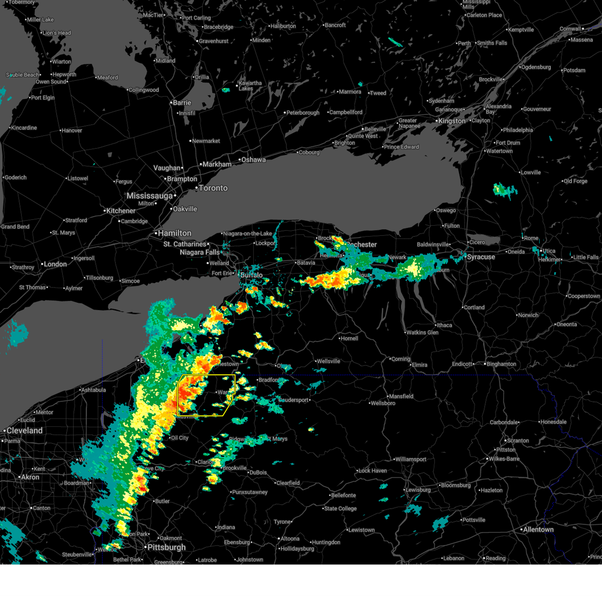
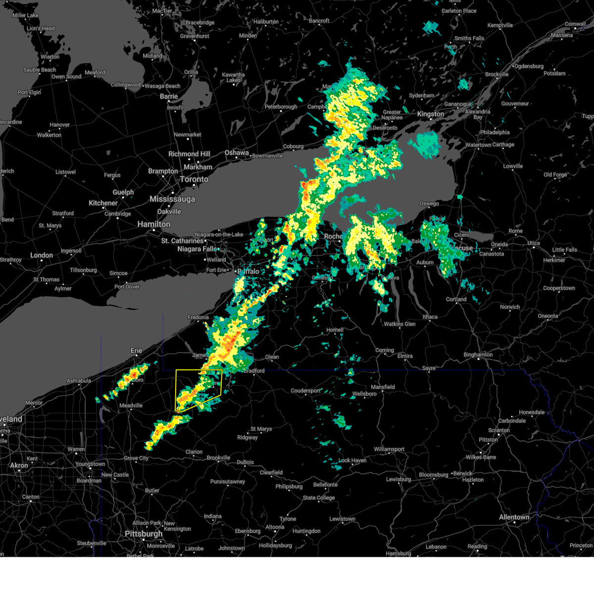
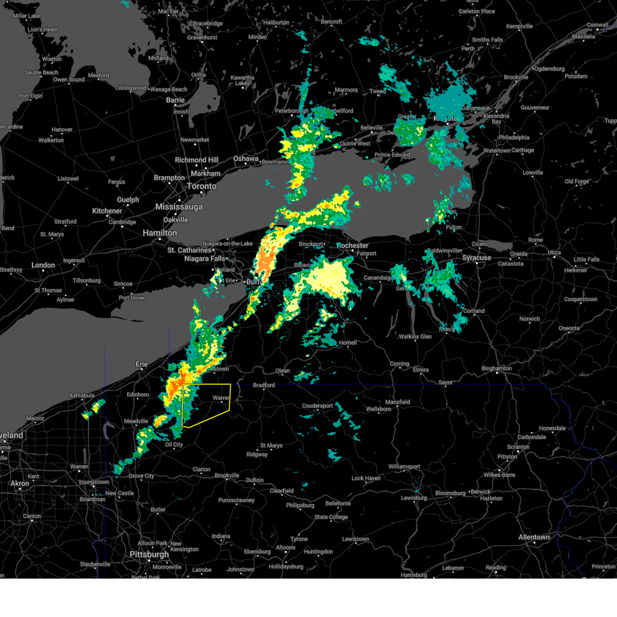
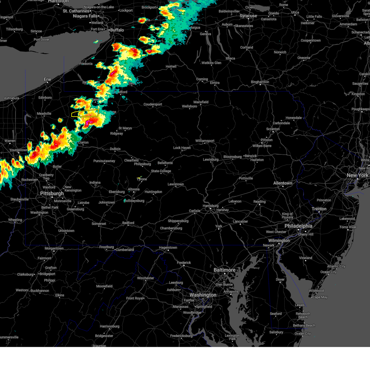
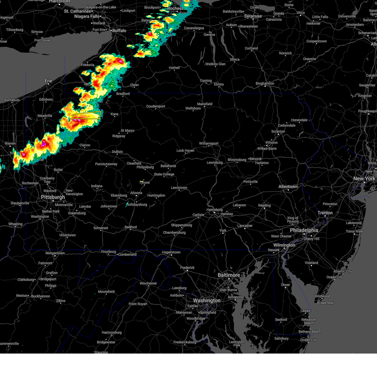
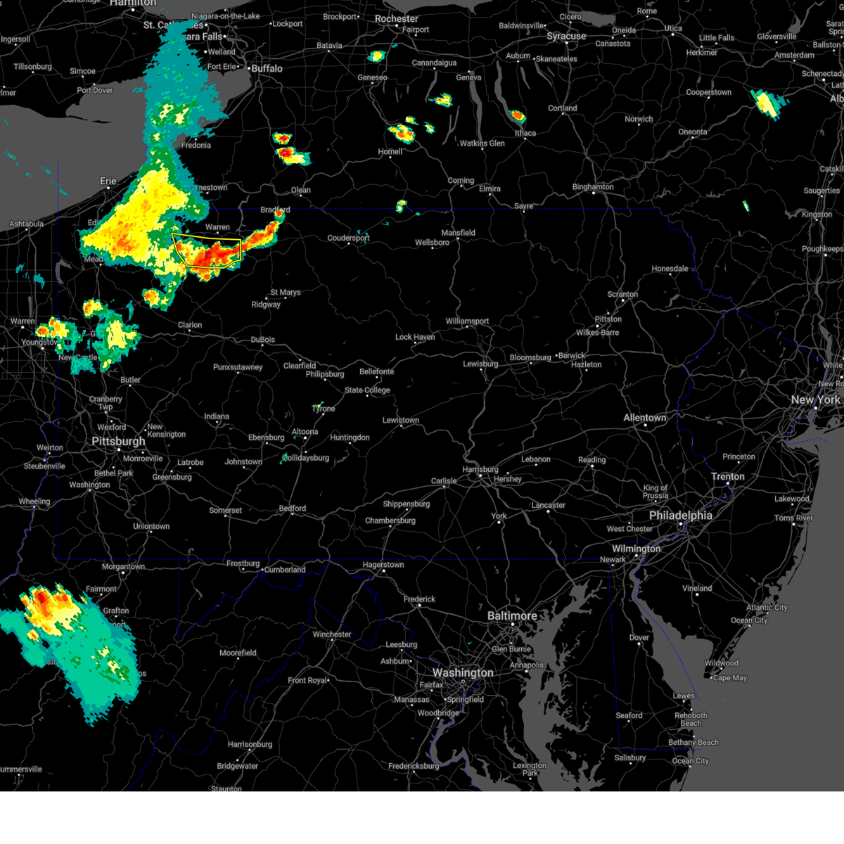
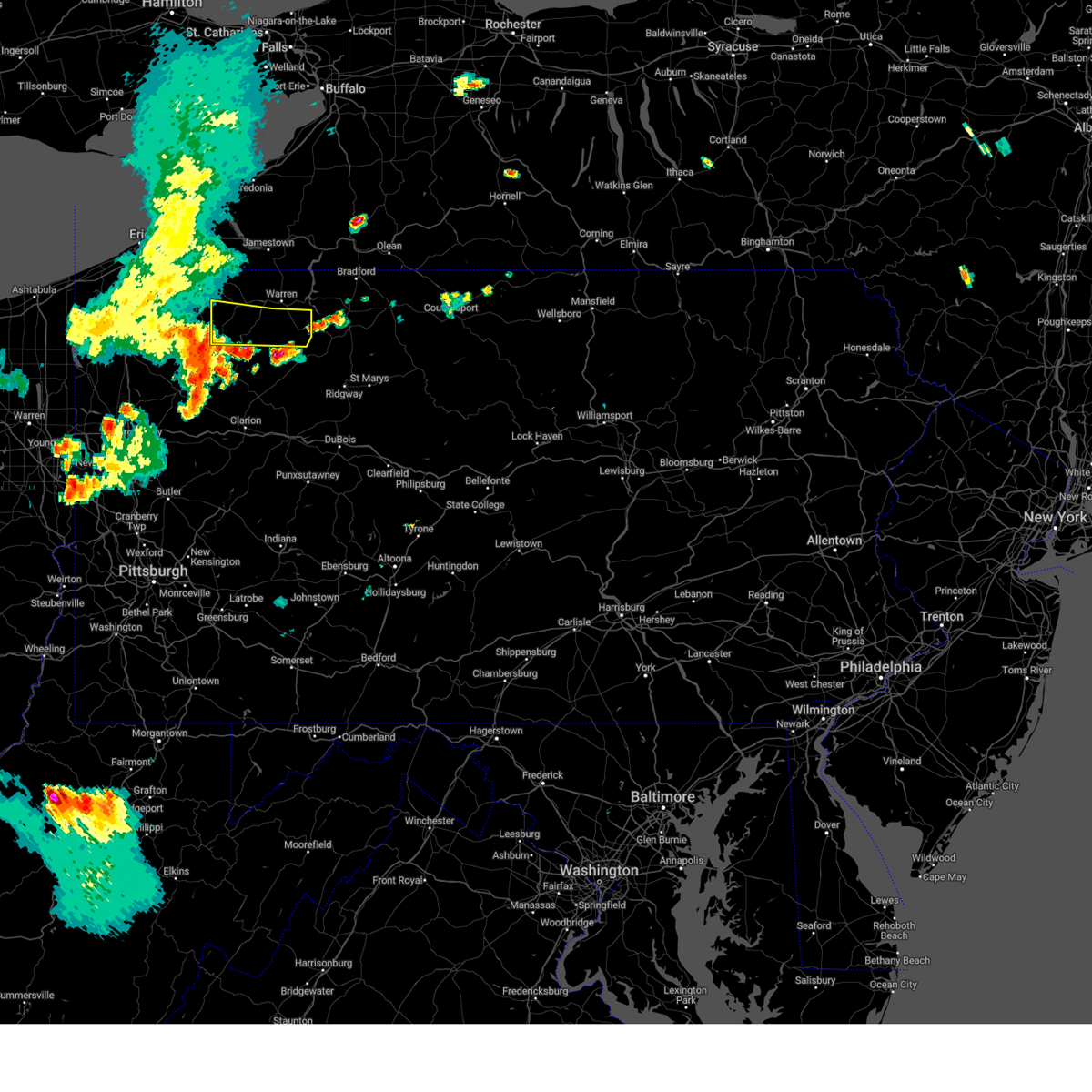
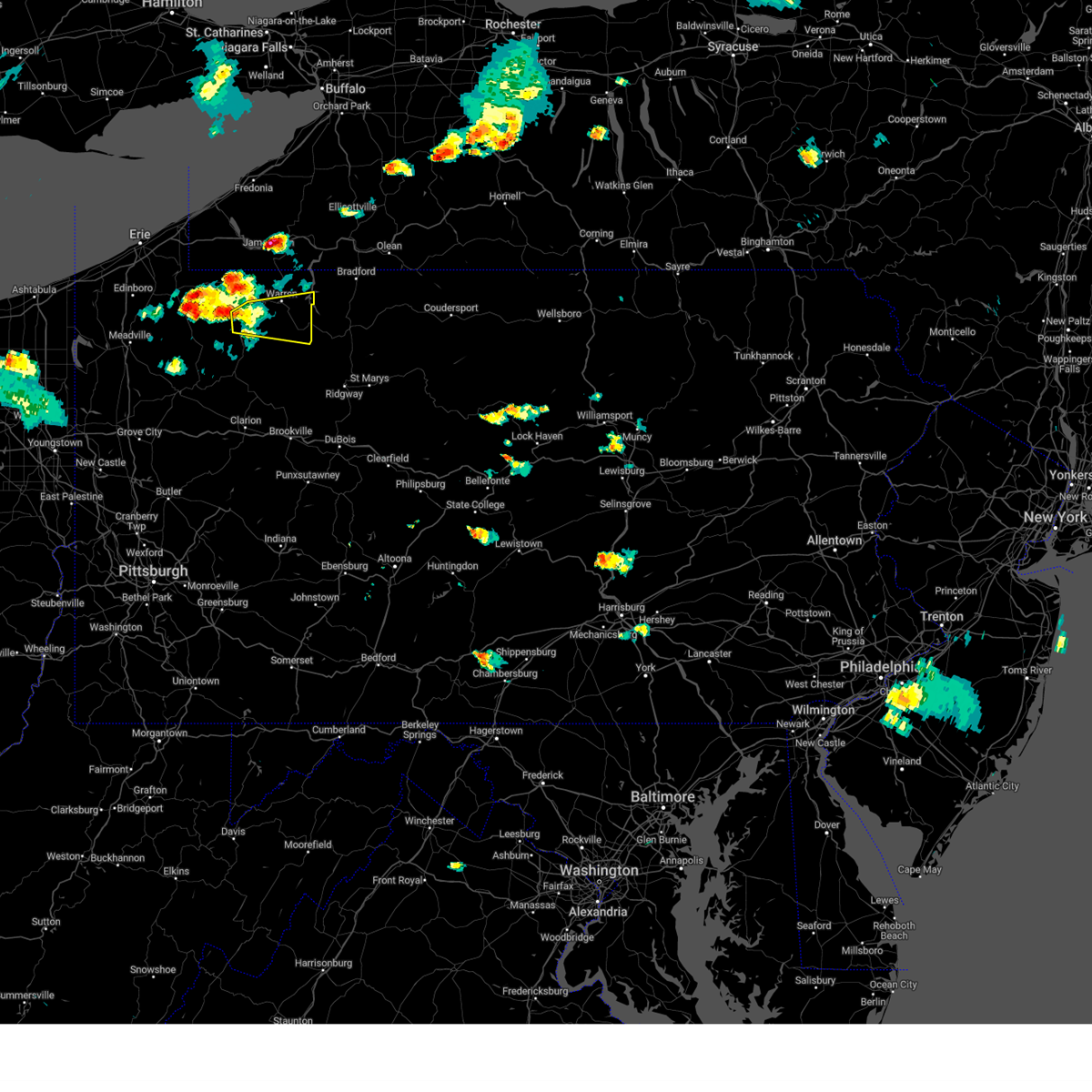
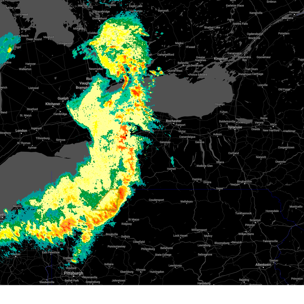
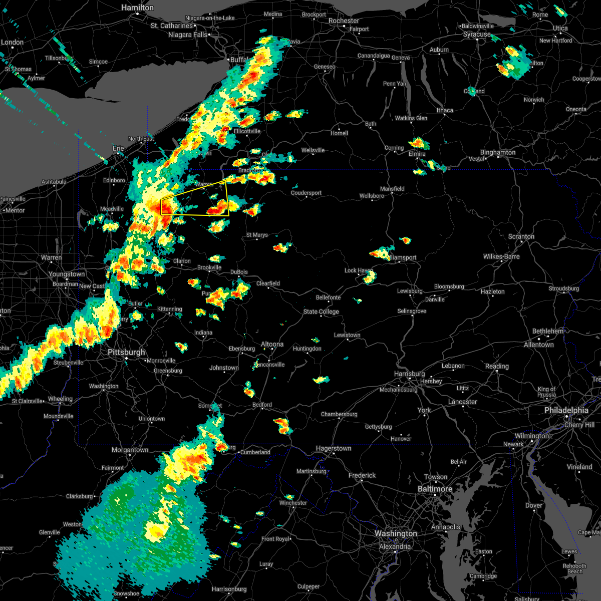
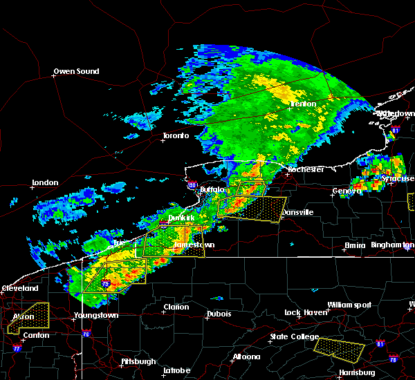
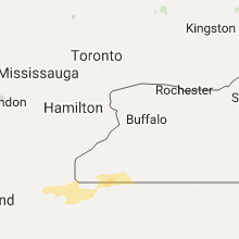
Hail Map for Tidioute, PA
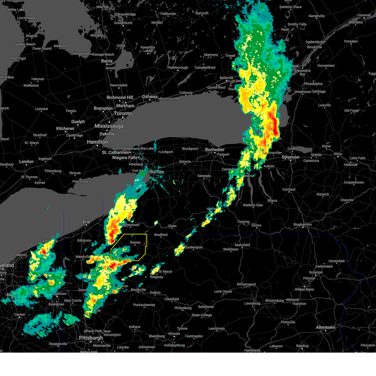
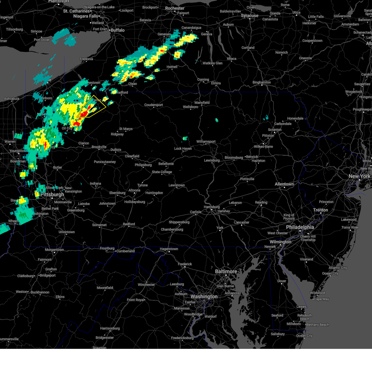
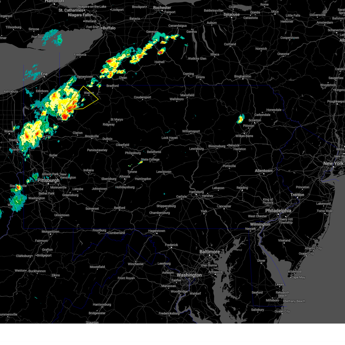
The Tidioute, PA area has had 1 report of on-the-ground hail by trained spotters, and has been under severe weather warnings 11 times during the past 12 months. Doppler radar has detected hail at or near Tidioute, PA on 25 occasions, including 4 occasions during the past year.
| Name: | Tidioute, PA |
| Where Located: | 87.2 miles SSW of Buffalo, NY |
| Map: | Google Map for Tidioute, PA |
| Population: | 688 |
| Housing Units: | 376 |
| More Info: | Search Google for Tidioute, PA |
3
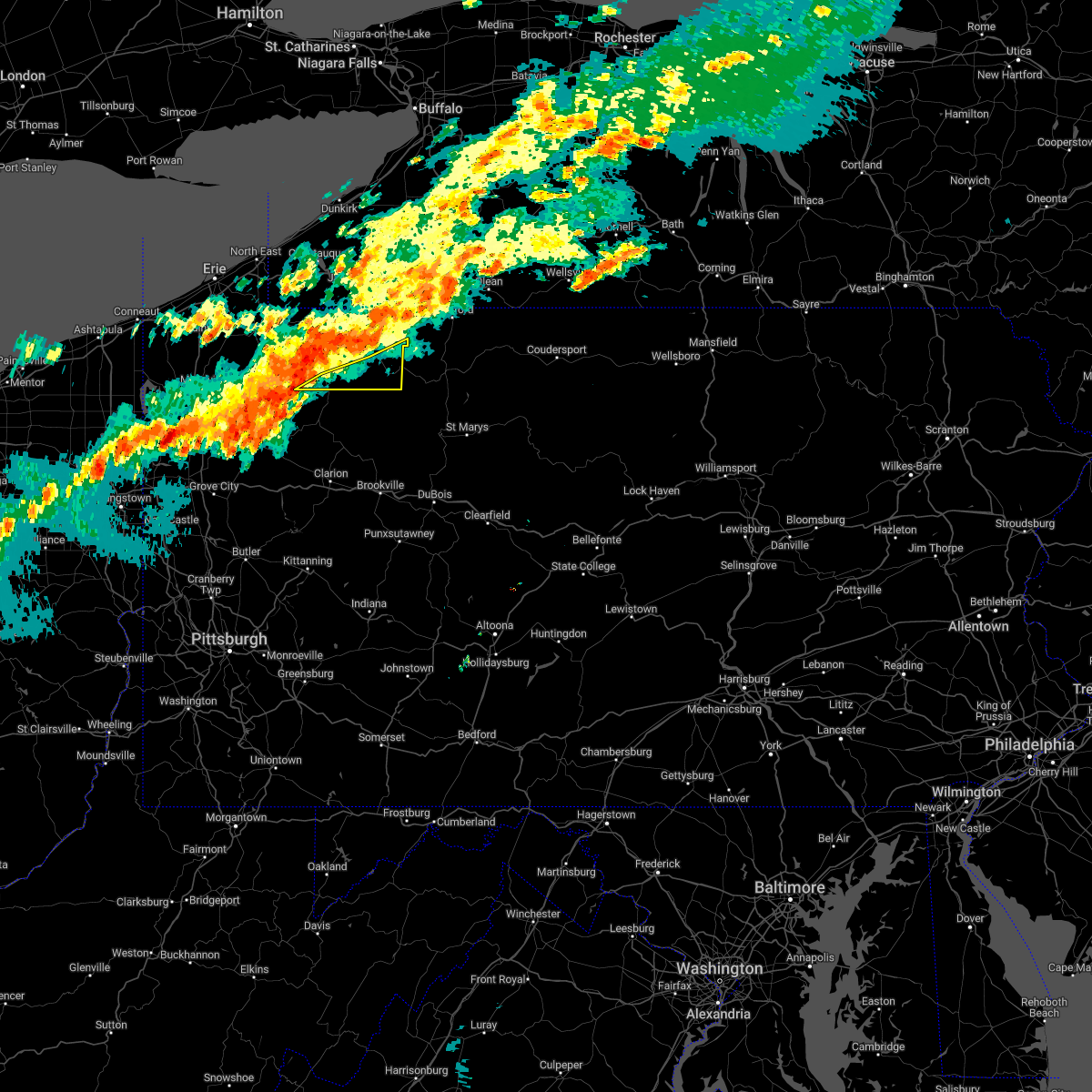
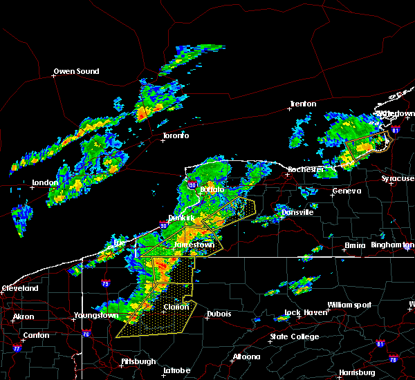
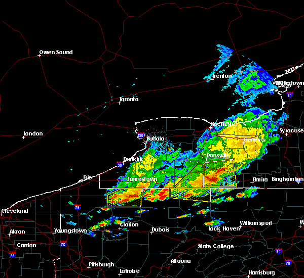
The Top Recent Hail Date for Tidioute, PA is Thursday, June 5, 2025 (5th out of 25)

Hail and Wind Damage Spotted near Tidioute, PA
| Date / Time | Report Details |
|---|---|
| 6/27/2025 4:29 PM EDT |
 Svrctp the national weather service in state college pa has issued a * severe thunderstorm warning for, warren county in north central pennsylvania, * until 530 pm edt. * at 428 pm edt, severe thunderstorms were located along a line extending from near jamestown west to grand valley, moving east at 20 mph (radar indicated). Hazards include 60 mph wind gusts and penny size hail. expect damage to roofs, siding, and trees Svrctp the national weather service in state college pa has issued a * severe thunderstorm warning for, warren county in north central pennsylvania, * until 530 pm edt. * at 428 pm edt, severe thunderstorms were located along a line extending from near jamestown west to grand valley, moving east at 20 mph (radar indicated). Hazards include 60 mph wind gusts and penny size hail. expect damage to roofs, siding, and trees
|
| 6/18/2025 4:58 PM EDT | Trees down on wire in warren county PA, 4.2 miles SE of Tidioute, PA |
| 6/18/2025 4:58 PM EDT | Trees down on wire in warren county PA, 1.7 miles SW of Tidioute, PA |
| 6/18/2025 4:55 PM EDT | Svrctp the national weather service in state college pa has issued a * severe thunderstorm warning for, southern warren county in north central pennsylvania, * until 600 pm edt. * at 455 pm edt, a severe thunderstorm was located near grand valley, moving east at 30 mph (radar indicated). Hazards include 60 mph wind gusts and penny size hail. expect damage to roofs, siding, and trees |
| 6/9/2025 4:12 PM EDT |
 Svrctp the national weather service in state college pa has issued a * severe thunderstorm warning for, warren county in north central pennsylvania, * until 515 pm edt. * at 411 pm edt, severe thunderstorms were located along a line extending from titusville to 11 miles southwest of chapman state park, moving northeast at 35 mph (radar indicated). Hazards include 60 mph wind gusts and nickel size hail. expect damage to roofs, siding, and trees Svrctp the national weather service in state college pa has issued a * severe thunderstorm warning for, warren county in north central pennsylvania, * until 515 pm edt. * at 411 pm edt, severe thunderstorms were located along a line extending from titusville to 11 miles southwest of chapman state park, moving northeast at 35 mph (radar indicated). Hazards include 60 mph wind gusts and nickel size hail. expect damage to roofs, siding, and trees
|
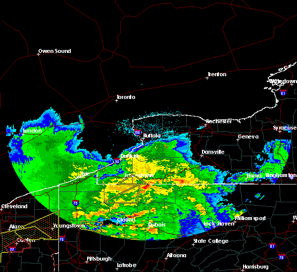
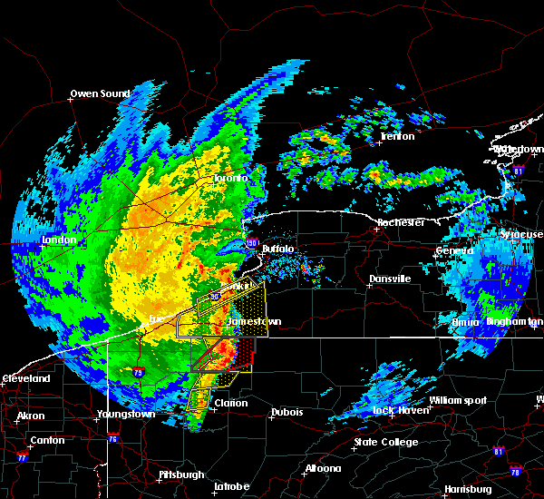
| 6/5/2025 3:57 PM EDT |
 At 357 pm edt, a severe thunderstorm was located near chapman state park, moving northeast at 30 mph (radar indicated). Hazards include 60 mph wind gusts and quarter size hail. Hail damage to vehicles is expected. expect wind damage to roofs, siding, and trees. Locations impacted include, warren, youngsville, warren south, chapman state park, tidioute, starbrick, and clarendon. At 357 pm edt, a severe thunderstorm was located near chapman state park, moving northeast at 30 mph (radar indicated). Hazards include 60 mph wind gusts and quarter size hail. Hail damage to vehicles is expected. expect wind damage to roofs, siding, and trees. Locations impacted include, warren, youngsville, warren south, chapman state park, tidioute, starbrick, and clarendon.
|
| 6/5/2025 3:49 PM EDT | Tree down on route 62 near the intersection of red house hill roa in warren county PA, 3.1 miles N of Tidioute, PA |
| 6/5/2025 3:46 PM EDT | Tree down blocking the roadway on route 6 in warren county PA, 1.8 miles W of Tidioute, PA |
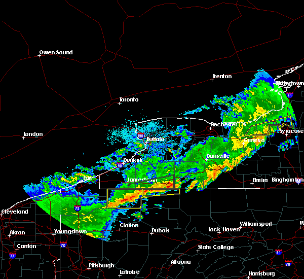
| 6/5/2025 3:41 PM EDT |
 Svrctp the national weather service in state college pa has issued a * severe thunderstorm warning for, central warren county in north central pennsylvania, * until 430 pm edt. * at 340 pm edt, a severe thunderstorm was located near grand valley, moving northeast at 35 mph (radar indicated). Hazards include 60 mph wind gusts and quarter size hail. Hail damage to vehicles is expected. Expect wind damage to roofs, siding, and trees. Svrctp the national weather service in state college pa has issued a * severe thunderstorm warning for, central warren county in north central pennsylvania, * until 430 pm edt. * at 340 pm edt, a severe thunderstorm was located near grand valley, moving northeast at 35 mph (radar indicated). Hazards include 60 mph wind gusts and quarter size hail. Hail damage to vehicles is expected. Expect wind damage to roofs, siding, and trees.
|
| 5/16/2025 7:48 PM EDT | At 746 pm edt, a severe thunderstorm was located near grand valley, moving northeast at 25 mph (radar indicated). Hazards include 60 mph wind gusts and quarter size hail. Hail damage to vehicles is expected. expect wind damage to roofs, siding, and trees. Locations impacted include, warren, columbus, youngsville, spring creek, lottsville, grand valley, warren south, garland, chapman state park, tidioute, sugar grove, and starbrick. |
| 5/16/2025 7:32 PM EDT | Svrctp the national weather service in state college pa has issued a * severe thunderstorm warning for, warren county in north central pennsylvania, * until 830 pm edt. * at 731 pm edt, a severe thunderstorm was located over enterprise, moving northeast at 25 mph (radar indicated). Hazards include 60 mph wind gusts and quarter size hail. Hail damage to vehicles is expected. Expect wind damage to roofs, siding, and trees. |
| 4/21/2025 6:39 PM EDT |
 The storms which prompted the warning have weakened below severe limits, and no longer pose an immediate threat to life or property. therefore, the warning will be allowed to expire. The storms which prompted the warning have weakened below severe limits, and no longer pose an immediate threat to life or property. therefore, the warning will be allowed to expire.
|
| 4/21/2025 5:57 PM EDT |
 Svrctp the national weather service in state college pa has issued a * severe thunderstorm warning for, warren county in north central pennsylvania, * until 645 pm edt. * at 556 pm edt, severe thunderstorms were located along a line extending from clymer to near guys mills, moving east at 45 mph (radar indicated). Hazards include 60 mph wind gusts and penny size hail. expect damage to roofs, siding, and trees Svrctp the national weather service in state college pa has issued a * severe thunderstorm warning for, warren county in north central pennsylvania, * until 645 pm edt. * at 556 pm edt, severe thunderstorms were located along a line extending from clymer to near guys mills, moving east at 45 mph (radar indicated). Hazards include 60 mph wind gusts and penny size hail. expect damage to roofs, siding, and trees
|
| 10/6/2024 6:37 PM EDT |
 the severe thunderstorm warning has been cancelled and is no longer in effect the severe thunderstorm warning has been cancelled and is no longer in effect
|
| 10/6/2024 6:19 PM EDT |
 Svrctp the national weather service in state college pa has issued a * severe thunderstorm warning for, southwestern warren county in north central pennsylvania, * until 700 pm edt. * at 618 pm edt, a severe thunderstorm was located over enterprise, moving east at 35 mph (radar indicated). Hazards include 60 mph wind gusts and quarter size hail. Hail damage to vehicles is expected. Expect wind damage to roofs, siding, and trees. Svrctp the national weather service in state college pa has issued a * severe thunderstorm warning for, southwestern warren county in north central pennsylvania, * until 700 pm edt. * at 618 pm edt, a severe thunderstorm was located over enterprise, moving east at 35 mph (radar indicated). Hazards include 60 mph wind gusts and quarter size hail. Hail damage to vehicles is expected. Expect wind damage to roofs, siding, and trees.
|
| 6/18/2024 7:49 PM EDT |
 At 748 pm edt, severe thunderstorms were located along a line extending from garland to chapman state park to ludlow, moving northeast at 20 mph (radar indicated). Hazards include 60 mph wind gusts and nickel size hail. Expect damage to roofs, siding, and trees. Locations impacted include, sheffield, garland, chapman state park, ludlow, tidioute, and clarendon. At 748 pm edt, severe thunderstorms were located along a line extending from garland to chapman state park to ludlow, moving northeast at 20 mph (radar indicated). Hazards include 60 mph wind gusts and nickel size hail. Expect damage to roofs, siding, and trees. Locations impacted include, sheffield, garland, chapman state park, ludlow, tidioute, and clarendon.
|
| 6/18/2024 7:13 PM EDT |
 Svrctp the national weather service in state college pa has issued a * severe thunderstorm warning for, southern warren county in north central pennsylvania, * until 815 pm edt. * at 712 pm edt, severe thunderstorms were located along a line extending from enterprise to near tionesta to near marienville, moving northeast at 15 mph (radar indicated). Hazards include two inch hail and 60 mph wind gusts. People and animals outdoors will be injured. expect hail damage to roofs, siding, windows, and vehicles. Expect wind damage to roofs, siding, and trees. Svrctp the national weather service in state college pa has issued a * severe thunderstorm warning for, southern warren county in north central pennsylvania, * until 815 pm edt. * at 712 pm edt, severe thunderstorms were located along a line extending from enterprise to near tionesta to near marienville, moving northeast at 15 mph (radar indicated). Hazards include two inch hail and 60 mph wind gusts. People and animals outdoors will be injured. expect hail damage to roofs, siding, windows, and vehicles. Expect wind damage to roofs, siding, and trees.
|
| 8/25/2023 12:15 AM EDT |
 At 1213 am edt, severe thunderstorms were located along a line extending from lottsville to near enterprise, moving east at 50 mph (radar indicated). Hazards include 60 mph wind gusts. Expect damage to roofs, siding, and trees. locations impacted include, warren, sheffield, columbus, youngsville, russell, spring creek, scandia, lottsville, grand valley, warren south, garland and kinzua dam. this includes the following highways, route 6 from columbus to near ludlow. route 62 from south of tidioute to the new york border. state road 59 from warren to east of kinzua dam. hail threat, radar indicated max hail size, <. 75 in wind threat, radar indicated max wind gust, 60 mph. At 1213 am edt, severe thunderstorms were located along a line extending from lottsville to near enterprise, moving east at 50 mph (radar indicated). Hazards include 60 mph wind gusts. Expect damage to roofs, siding, and trees. locations impacted include, warren, sheffield, columbus, youngsville, russell, spring creek, scandia, lottsville, grand valley, warren south, garland and kinzua dam. this includes the following highways, route 6 from columbus to near ludlow. route 62 from south of tidioute to the new york border. state road 59 from warren to east of kinzua dam. hail threat, radar indicated max hail size, <. 75 in wind threat, radar indicated max wind gust, 60 mph.
|
| 8/24/2023 11:56 PM EDT |
 At 1156 pm edt, a severe thunderstorm was located over clymer, moving southeast at 45 mph (radar indicated). Hazards include 60 mph wind gusts. expect damage to roofs, siding, and trees At 1156 pm edt, a severe thunderstorm was located over clymer, moving southeast at 45 mph (radar indicated). Hazards include 60 mph wind gusts. expect damage to roofs, siding, and trees
|
| 8/12/2023 1:55 PM EDT |
 At 154 pm edt, a severe thunderstorm was located over youngsville, moving east at 25 mph (radar indicated). Hazards include 60 mph wind gusts and nickel size hail. expect damage to roofs, siding, and trees At 154 pm edt, a severe thunderstorm was located over youngsville, moving east at 25 mph (radar indicated). Hazards include 60 mph wind gusts and nickel size hail. expect damage to roofs, siding, and trees
|
| 7/20/2023 8:09 PM EDT |
 At 809 pm edt, severe thunderstorms were located along a line extending from kinzua dam to wetmore to near tionesta, moving east at 35 mph (radar indicated). Hazards include 70 mph wind gusts and penny size hail. Expect considerable tree damage. damage is likely to mobile homes, roofs, and outbuildings. Locations impacted include, warren, sheffield, russell, scandia, warren south, kinzua dam, chapman state park, tidioute, starbrick and clarendon. At 809 pm edt, severe thunderstorms were located along a line extending from kinzua dam to wetmore to near tionesta, moving east at 35 mph (radar indicated). Hazards include 70 mph wind gusts and penny size hail. Expect considerable tree damage. damage is likely to mobile homes, roofs, and outbuildings. Locations impacted include, warren, sheffield, russell, scandia, warren south, kinzua dam, chapman state park, tidioute, starbrick and clarendon.
|
| 7/20/2023 7:40 PM EDT | Multiple trees and wires down in the tidioute are in warren county PA, 0.5 miles SE of Tidioute, PA |
| 7/20/2023 7:15 PM EDT |
 At 713 pm edt, severe thunderstorms were located along a line extending from clymer to near corry to meadville, moving east at 55 mph (radar indicated). Hazards include 70 mph wind gusts and penny size hail. Expect considerable tree damage. Damage is likely to mobile homes, roofs, and outbuildings. At 713 pm edt, severe thunderstorms were located along a line extending from clymer to near corry to meadville, moving east at 55 mph (radar indicated). Hazards include 70 mph wind gusts and penny size hail. Expect considerable tree damage. Damage is likely to mobile homes, roofs, and outbuildings.
|
| 4/1/2023 1:33 PM EDT |
 At 131 pm edt, severe thunderstorms were located along a line extending from northwest harborcreek to cambridge springs to near meadville, moving east at 70 mph (radar indicated). Hazards include 70 mph wind gusts. Expect considerable tree damage. Damage is likely to mobile homes, roofs, and outbuildings. At 131 pm edt, severe thunderstorms were located along a line extending from northwest harborcreek to cambridge springs to near meadville, moving east at 70 mph (radar indicated). Hazards include 70 mph wind gusts. Expect considerable tree damage. Damage is likely to mobile homes, roofs, and outbuildings.
|
| 7/25/2022 1:32 AM EDT |
 At 132 am edt, a severe thunderstorm was located over grand valley, moving east at 55 mph (radar indicated). Hazards include 60 mph wind gusts. expect damage to roofs, siding, and trees At 132 am edt, a severe thunderstorm was located over grand valley, moving east at 55 mph (radar indicated). Hazards include 60 mph wind gusts. expect damage to roofs, siding, and trees
|
| 7/25/2022 12:43 AM EDT |
 At 1243 am edt, a severe thunderstorm was located over corry, moving east at 45 mph (radar indicated). Hazards include 60 mph wind gusts. expect damage to roofs, siding, and trees At 1243 am edt, a severe thunderstorm was located over corry, moving east at 45 mph (radar indicated). Hazards include 60 mph wind gusts. expect damage to roofs, siding, and trees
|
| 7/24/2022 2:05 PM EDT | Trees dow in warren county PA, 6.8 miles SSE of Tidioute, PA |
| 7/24/2022 1:55 PM EDT | Three reports of trees down in tidiout in warren county PA, 0.5 miles SE of Tidioute, PA |
| 7/24/2022 1:51 PM EDT |
 At 150 pm edt, a severe thunderstorm was located near tidioute and grand valley, moving northeast at 45 mph (radar indicated). Hazards include 60 mph wind gusts and quarter size hail. Hail damage to vehicles is expected. expect wind damage to roofs, siding, and trees. this severe thunderstorm will be near, warren, chapman state park and warren south around 210 pm edt. kinzua dam and scandia around 220 pm edt. other locations impacted by this severe thunderstorm include tidioute, starbrick and clarendon. this includes the following highways, route 6 between youngsville and north of sheffield, and near near ludlow. route 62 from south of tidioute to near the new york border. state road 59 from warren to east of kinzua dam. hail threat, radar indicated max hail size, 1. 00 in wind threat, radar indicated max wind gust, 60 mph. At 150 pm edt, a severe thunderstorm was located near tidioute and grand valley, moving northeast at 45 mph (radar indicated). Hazards include 60 mph wind gusts and quarter size hail. Hail damage to vehicles is expected. expect wind damage to roofs, siding, and trees. this severe thunderstorm will be near, warren, chapman state park and warren south around 210 pm edt. kinzua dam and scandia around 220 pm edt. other locations impacted by this severe thunderstorm include tidioute, starbrick and clarendon. this includes the following highways, route 6 between youngsville and north of sheffield, and near near ludlow. route 62 from south of tidioute to near the new york border. state road 59 from warren to east of kinzua dam. hail threat, radar indicated max hail size, 1. 00 in wind threat, radar indicated max wind gust, 60 mph.
|
| 6/16/2022 3:58 PM EDT | Widespread trees down across tidiout in warren county PA, 0.4 miles NW of Tidioute, PA |
| 6/16/2022 3:47 PM EDT |
 At 347 pm edt, a severe thunderstorm was located over grand valley, moving east at 45 mph (radar indicated). Hazards include 70 mph wind gusts and quarter size hail. Hail damage to vehicles is expected. expect considerable tree damage. Wind damage is also likely to mobile homes, roofs, and outbuildings. At 347 pm edt, a severe thunderstorm was located over grand valley, moving east at 45 mph (radar indicated). Hazards include 70 mph wind gusts and quarter size hail. Hail damage to vehicles is expected. expect considerable tree damage. Wind damage is also likely to mobile homes, roofs, and outbuildings.
|
| 6/16/2022 3:46 PM EDT | Numerous trees down on wires around grand valle in warren county PA, 7.2 miles ESE of Tidioute, PA |
| 10/15/2021 4:12 PM EDT |
 At 412 pm edt, a severe thunderstorm was located near grand valley, moving northeast at 20 mph (radar indicated). Hazards include 60 mph wind gusts and penny size hail. expect damage to roofs, siding, and trees At 412 pm edt, a severe thunderstorm was located near grand valley, moving northeast at 20 mph (radar indicated). Hazards include 60 mph wind gusts and penny size hail. expect damage to roofs, siding, and trees
|
| 8/12/2021 5:12 PM EDT |
 At 512 pm edt, a severe thunderstorm was located near titusville, moving northeast at 25 mph (radar indicated). Hazards include 60 mph wind gusts and nickel size hail. expect damage to roofs, siding, and trees At 512 pm edt, a severe thunderstorm was located near titusville, moving northeast at 25 mph (radar indicated). Hazards include 60 mph wind gusts and nickel size hail. expect damage to roofs, siding, and trees
|
| 7/13/2021 4:35 PM EDT |
 At 434 pm edt, severe thunderstorms were located along a line extending from near wattsburg to 6 miles east of riceville to titusville to 6 miles west of tionesta to near oil city, moving northeast at 35 mph (radar indicated). Hazards include 70 mph wind gusts and penny size hail. Expect considerable tree damage. damage is likely to mobile homes, roofs, and outbuildings. severe thunderstorms will be near, grand valley, spring creek and columbus around 450 pm edt. lottsville around 500 pm edt. garland around 510 pm edt. youngsville around 520 pm edt. Other locations impacted by these severe thunderstorms include tidioute, starbrick, sugar grove and bear lake. At 434 pm edt, severe thunderstorms were located along a line extending from near wattsburg to 6 miles east of riceville to titusville to 6 miles west of tionesta to near oil city, moving northeast at 35 mph (radar indicated). Hazards include 70 mph wind gusts and penny size hail. Expect considerable tree damage. damage is likely to mobile homes, roofs, and outbuildings. severe thunderstorms will be near, grand valley, spring creek and columbus around 450 pm edt. lottsville around 500 pm edt. garland around 510 pm edt. youngsville around 520 pm edt. Other locations impacted by these severe thunderstorms include tidioute, starbrick, sugar grove and bear lake.
|
| 7/7/2021 6:29 PM EDT |
 At 629 pm edt, severe thunderstorms were located along a line extending from grand valley to 10 miles southwest of sheffield, moving northeast at 35 mph (radar indicated). Hazards include 60 mph wind gusts and quarter size hail. Hail damage to vehicles is expected. Expect wind damage to roofs, siding, and trees. At 629 pm edt, severe thunderstorms were located along a line extending from grand valley to 10 miles southwest of sheffield, moving northeast at 35 mph (radar indicated). Hazards include 60 mph wind gusts and quarter size hail. Hail damage to vehicles is expected. Expect wind damage to roofs, siding, and trees.
|
| 6/21/2021 3:21 PM EDT | Trees down on powerlines along youngsville r in warren county PA, 6.2 miles SSW of Tidioute, PA |
| 6/21/2021 2:43 PM EDT |
 At 243 pm edt, a severe thunderstorm was located near enterprise, moving east at 45 mph (radar indicated). Hazards include 60 mph wind gusts and quarter size hail. Hail damage to vehicles is expected. Expect wind damage to roofs, siding, and trees. At 243 pm edt, a severe thunderstorm was located near enterprise, moving east at 45 mph (radar indicated). Hazards include 60 mph wind gusts and quarter size hail. Hail damage to vehicles is expected. Expect wind damage to roofs, siding, and trees.
|
| 11/15/2020 3:15 PM EST | Roof blown off garag in warren county PA, 8.4 miles ESE of Tidioute, PA |
| 11/15/2020 3:15 PM EST | Tree down at 1394 sanford r in warren county PA, 8.3 miles SE of Tidioute, PA |
| 11/15/2020 2:49 PM EST |
 At 248 pm est, severe thunderstorms were located along a line extending from near wattsburg to near slippery rock, moving east at 60 mph (radar indicated). Hazards include 70 mph wind gusts and penny size hail. Expect considerable tree damage. Damage is likely to mobile homes, roofs, and outbuildings. At 248 pm est, severe thunderstorms were located along a line extending from near wattsburg to near slippery rock, moving east at 60 mph (radar indicated). Hazards include 70 mph wind gusts and penny size hail. Expect considerable tree damage. Damage is likely to mobile homes, roofs, and outbuildings.
|
| 5/29/2020 1:08 PM EDT | Trees and wires down on main st in tidiout in warren county PA, 0.4 miles NE of Tidioute, PA |
| 5/29/2020 12:45 PM EDT |
 At 1243 pm edt, a severe thunderstorm was located over riceville, moving northeast at 45 mph (radar indicated). Hazards include 60 mph wind gusts and penny size hail. expect damage to trees, roofs, and siding At 1243 pm edt, a severe thunderstorm was located over riceville, moving northeast at 45 mph (radar indicated). Hazards include 60 mph wind gusts and penny size hail. expect damage to trees, roofs, and siding
|
| 4/8/2020 12:37 AM EDT |
 The severe thunderstorm warning for southeastern warren county will expire at 1245 am edt, the storms which prompted the warning have weakened below severe limits, and have exited the warned area. therefore, the warning will be allowed to expire. to report severe weather, contact your nearest law enforcement agency. they will relay your report to the national weather service state college pa. The severe thunderstorm warning for southeastern warren county will expire at 1245 am edt, the storms which prompted the warning have weakened below severe limits, and have exited the warned area. therefore, the warning will be allowed to expire. to report severe weather, contact your nearest law enforcement agency. they will relay your report to the national weather service state college pa.
|
| 4/8/2020 12:22 AM EDT |
 At 1222 am edt, severe thunderstorms were located along a line extending from 6 miles south of allegany state park to 7 miles north of tionesta, moving east at 55 mph (radar indicated). Hazards include 60 mph wind gusts and quarter size hail. Hail damage to vehicles is expected. expect wind damage to trees, roofs, and siding. Locations impacted include, warren, sheffield, scandia, warren south, kinzua dam, chapman state park, tidioute, starbrick and clarendon. At 1222 am edt, severe thunderstorms were located along a line extending from 6 miles south of allegany state park to 7 miles north of tionesta, moving east at 55 mph (radar indicated). Hazards include 60 mph wind gusts and quarter size hail. Hail damage to vehicles is expected. expect wind damage to trees, roofs, and siding. Locations impacted include, warren, sheffield, scandia, warren south, kinzua dam, chapman state park, tidioute, starbrick and clarendon.
|
| 4/7/2020 11:44 PM EDT |
 At 1144 pm edt, a severe thunderstorm was located near lakewood, moving southeast at 60 mph (radar indicated). Hazards include 60 mph wind gusts and quarter size hail. Hail damage to vehicles is expected. Expect wind damage to trees, roofs, and siding. At 1144 pm edt, a severe thunderstorm was located near lakewood, moving southeast at 60 mph (radar indicated). Hazards include 60 mph wind gusts and quarter size hail. Hail damage to vehicles is expected. Expect wind damage to trees, roofs, and siding.
|
| 7/19/2019 6:06 PM EDT |
 At 605 pm edt, severe thunderstorms were located along a line extending from warren county to mckean county, moving east at 30 mph (radar indicated). Hazards include 60 mph wind gusts. Expect damage to trees, roofs, and siding. Locations impacted include, warren, kane, port allegany, sheffield, columbus, youngsville, smethport, wetmore, betula, james city, spring creek, crosby, ludlow, marshburg, kinzua bridge state park, lottsville, coryville, cyclone, grand valley and westline. At 605 pm edt, severe thunderstorms were located along a line extending from warren county to mckean county, moving east at 30 mph (radar indicated). Hazards include 60 mph wind gusts. Expect damage to trees, roofs, and siding. Locations impacted include, warren, kane, port allegany, sheffield, columbus, youngsville, smethport, wetmore, betula, james city, spring creek, crosby, ludlow, marshburg, kinzua bridge state park, lottsville, coryville, cyclone, grand valley and westline.
|
| 7/19/2019 5:10 PM EDT |
 At 509 pm edt, severe thunderstorms were located along a line extending from northern warren county to northern mckean county, moving east at 30 mph (radar indicated). Hazards include 60 mph wind gusts. expect damage to trees, roofs, and siding At 509 pm edt, severe thunderstorms were located along a line extending from northern warren county to northern mckean county, moving east at 30 mph (radar indicated). Hazards include 60 mph wind gusts. expect damage to trees, roofs, and siding
|
| 5/23/2019 10:16 AM EDT |
 At 1016 am edt, severe thunderstorms were located along a line extending from 6 miles northwest of silver creek to jamestown to near grand valley, moving east at 55 mph (radar indicated). Hazards include 60 mph wind gusts and quarter size hail. Hail damage to vehicles is expected. expect wind damage to trees, roofs, and siding. Locations impacted include, warren, sheffield, youngsville, russell, scandia, warren south, kinzua dam, chapman state park, tidioute, starbrick and clarendon. At 1016 am edt, severe thunderstorms were located along a line extending from 6 miles northwest of silver creek to jamestown to near grand valley, moving east at 55 mph (radar indicated). Hazards include 60 mph wind gusts and quarter size hail. Hail damage to vehicles is expected. expect wind damage to trees, roofs, and siding. Locations impacted include, warren, sheffield, youngsville, russell, scandia, warren south, kinzua dam, chapman state park, tidioute, starbrick and clarendon.
|
| 5/23/2019 9:56 AM EDT |
 At 936 am edt, severe thunderstorms were located along a line extending from 26 miles northwest of westfield to near north east to near meadville, moving east at 55 mph (radar indicated). Hazards include 60 mph wind gusts and quarter size hail. Hail damage to vehicles is expected. Expect wind damage to trees, roofs, and siding. At 936 am edt, severe thunderstorms were located along a line extending from 26 miles northwest of westfield to near north east to near meadville, moving east at 55 mph (radar indicated). Hazards include 60 mph wind gusts and quarter size hail. Hail damage to vehicles is expected. Expect wind damage to trees, roofs, and siding.
|
| 5/23/2019 9:37 AM EDT |
 At 936 am edt, severe thunderstorms were located along a line extending from 26 miles northwest of westfield to near north east to near meadville, moving east at 55 mph (radar indicated). Hazards include 60 mph wind gusts and quarter size hail. Hail damage to vehicles is expected. Expect wind damage to trees, roofs, and siding. At 936 am edt, severe thunderstorms were located along a line extending from 26 miles northwest of westfield to near north east to near meadville, moving east at 55 mph (radar indicated). Hazards include 60 mph wind gusts and quarter size hail. Hail damage to vehicles is expected. Expect wind damage to trees, roofs, and siding.
|
| 4/14/2019 8:35 PM EDT |
 At 833 pm edt, a severe thunderstorm capable of producing a tornado was located near warren and russell, moving northeast at 60 mph (radar indicated rotation). Hazards include tornado and quarter size hail. Flying debris will be dangerous to those caught without shelter. mobile homes will be damaged or destroyed. damage to roofs, windows, and vehicles will occur. tree damage is likely. This tornadic thunderstorm will be moving through warren and russell and then will mainly rural areas of eastern warren county, including the following locations, starbrick and clarendon. At 833 pm edt, a severe thunderstorm capable of producing a tornado was located near warren and russell, moving northeast at 60 mph (radar indicated rotation). Hazards include tornado and quarter size hail. Flying debris will be dangerous to those caught without shelter. mobile homes will be damaged or destroyed. damage to roofs, windows, and vehicles will occur. tree damage is likely. This tornadic thunderstorm will be moving through warren and russell and then will mainly rural areas of eastern warren county, including the following locations, starbrick and clarendon.
|
| 4/14/2019 8:23 PM EDT |
 At 822 pm edt, a severe thunderstorm was located over chapman state park, moving northeast at 65 mph (radar indicated). Hazards include 60 mph wind gusts and quarter size hail. Hail damage to vehicles is expected. expect wind damage to roofs, siding, and trees. locations impacted include, warren, sheffield, youngsville, russell, scandia, lottsville, warren south, kinzua dam, chapman state park, tidioute, sugar grove, starbrick and clarendon. A tornado watch remains in effect until 300 am edt for north central pennsylvania. At 822 pm edt, a severe thunderstorm was located over chapman state park, moving northeast at 65 mph (radar indicated). Hazards include 60 mph wind gusts and quarter size hail. Hail damage to vehicles is expected. expect wind damage to roofs, siding, and trees. locations impacted include, warren, sheffield, youngsville, russell, scandia, lottsville, warren south, kinzua dam, chapman state park, tidioute, sugar grove, starbrick and clarendon. A tornado watch remains in effect until 300 am edt for north central pennsylvania.
|
| 4/14/2019 8:03 PM EDT |
 At 803 pm edt, a severe thunderstorm capable of producing a tornado was located near grand valley, moving northeast at 60 mph (radar indicated rotation). Hazards include tornado and quarter size hail. Flying debris will be dangerous to those caught without shelter. mobile homes will be damaged or destroyed. damage to roofs, windows, and vehicles will occur. tree damage is likely. this dangerous storm will be near, garland around 810 pm edt. youngsville and chapman state park around 820 pm edt. warren, russell, scandia, warren south and kinzua dam around 830 pm edt. Other locations impacted by this tornadic thunderstorm include tidioute, starbrick and clarendon. At 803 pm edt, a severe thunderstorm capable of producing a tornado was located near grand valley, moving northeast at 60 mph (radar indicated rotation). Hazards include tornado and quarter size hail. Flying debris will be dangerous to those caught without shelter. mobile homes will be damaged or destroyed. damage to roofs, windows, and vehicles will occur. tree damage is likely. this dangerous storm will be near, garland around 810 pm edt. youngsville and chapman state park around 820 pm edt. warren, russell, scandia, warren south and kinzua dam around 830 pm edt. Other locations impacted by this tornadic thunderstorm include tidioute, starbrick and clarendon.
|
| 4/14/2019 7:52 PM EDT |
 At 751 pm edt, a severe thunderstorm was located near titusville, moving northeast at 65 mph (radar indicated). Hazards include 60 mph wind gusts and quarter size hail. Hail damage to vehicles is possible. Expect wind damage to roofs, siding, and trees. At 751 pm edt, a severe thunderstorm was located near titusville, moving northeast at 65 mph (radar indicated). Hazards include 60 mph wind gusts and quarter size hail. Hail damage to vehicles is possible. Expect wind damage to roofs, siding, and trees.
|
| 10/2/2018 4:11 PM EDT |
 At 408 pm edt, a severe thunderstorm capable of producing a tornado was located 8 miles southwest of chapman state park, moving east at 35 mph. several additional thunderstorms with strong rotation were noted over southeastern crawford county, and will impact southern warren county over the next 30 minutes (weather spotters reported a funnel cloud). Hazards include tornado and ping pong ball size hail. Flying debris will be dangerous to those caught without shelter. mobile homes will be damaged or destroyed. damage to roofs, windows, and vehicles will occur. tree damage is likely. Locations impacted include, sheffield, grand valley and tidioute. At 408 pm edt, a severe thunderstorm capable of producing a tornado was located 8 miles southwest of chapman state park, moving east at 35 mph. several additional thunderstorms with strong rotation were noted over southeastern crawford county, and will impact southern warren county over the next 30 minutes (weather spotters reported a funnel cloud). Hazards include tornado and ping pong ball size hail. Flying debris will be dangerous to those caught without shelter. mobile homes will be damaged or destroyed. damage to roofs, windows, and vehicles will occur. tree damage is likely. Locations impacted include, sheffield, grand valley and tidioute.
|
| 10/2/2018 3:38 PM EDT |
 At 337 pm edt, a severe thunderstorm capable of producing a tornado was located near titusville, moving east at 35 mph (weather spotters reported funnel cloud). Hazards include tornado and ping pong ball size hail. Flying debris will be dangerous to those caught without shelter. mobile homes will be damaged or destroyed. damage to roofs, windows, and vehicles will occur. Tree damage is likely. At 337 pm edt, a severe thunderstorm capable of producing a tornado was located near titusville, moving east at 35 mph (weather spotters reported funnel cloud). Hazards include tornado and ping pong ball size hail. Flying debris will be dangerous to those caught without shelter. mobile homes will be damaged or destroyed. damage to roofs, windows, and vehicles will occur. Tree damage is likely.
|
| 10/2/2018 3:11 PM EDT |
 At 308 pm edt, severe thunderstorms were located along a line extending from near lakewood to 6 miles southeast of wattsburg to 6 miles northeast of guys mills, moving east at 45 mph (radar indicated). Hazards include 60 mph wind gusts and quarter size hail. Hail damage to vehicles is expected. Expect wind damage to roofs, siding, and trees. At 308 pm edt, severe thunderstorms were located along a line extending from near lakewood to 6 miles southeast of wattsburg to 6 miles northeast of guys mills, moving east at 45 mph (radar indicated). Hazards include 60 mph wind gusts and quarter size hail. Hail damage to vehicles is expected. Expect wind damage to roofs, siding, and trees.
|
| 9/21/2018 7:23 PM EDT |
 The severe thunderstorm warning for warren county will expire at 730 pm edt, the storms which prompted the warning have have moved out of the warned area. the warning will be allowed to expire. a severe thunderstorm watch remains in effect until 1100 pm edt for north central pennsylvania. The severe thunderstorm warning for warren county will expire at 730 pm edt, the storms which prompted the warning have have moved out of the warned area. the warning will be allowed to expire. a severe thunderstorm watch remains in effect until 1100 pm edt for north central pennsylvania.
|
| 9/21/2018 6:49 PM EDT | Tree and wires down along davey hill roa in warren county PA, 5.1 miles SSW of Tidioute, PA |
| 9/21/2018 6:30 PM EDT |
 The national weather service in state college pa has issued a * severe thunderstorm warning for. elk county in north central pennsylvania. warren county in north central pennsylvania. north central clearfield county in central pennsylvania. Mckean county in north central pennsylvania. The national weather service in state college pa has issued a * severe thunderstorm warning for. elk county in north central pennsylvania. warren county in north central pennsylvania. north central clearfield county in central pennsylvania. Mckean county in north central pennsylvania.
|
| 9/21/2018 5:29 PM EDT |
 At 528 pm edt, severe thunderstorms were located along a line extending from near silver creek to near andover, moving east at 30 mph (radar indicated). Hazards include 60 mph wind gusts and brief downpours. expect possible damage to roofs, siding, and trees At 528 pm edt, severe thunderstorms were located along a line extending from near silver creek to near andover, moving east at 30 mph (radar indicated). Hazards include 60 mph wind gusts and brief downpours. expect possible damage to roofs, siding, and trees
|
| 7/16/2018 8:35 PM EDT | Uprooted tree near the intersection of tower lane and campbell hill rd in warren county PA, 3.9 miles E of Tidioute, PA |
| 7/16/2018 8:17 PM EDT |
 At 816 pm edt, severe thunderstorms were located along a line extending from clymer to lottsville to near youngsville to 10 miles southwest of chapman state park, moving northeast at 25 mph (radar indicated). Hazards include 60 mph wind gusts and nickel size hail. expect damage to roofs, siding, and trees At 816 pm edt, severe thunderstorms were located along a line extending from clymer to lottsville to near youngsville to 10 miles southwest of chapman state park, moving northeast at 25 mph (radar indicated). Hazards include 60 mph wind gusts and nickel size hail. expect damage to roofs, siding, and trees
|
| 7/5/2018 1:50 PM EDT |
 At 149 pm edt, severe thunderstorms were located along a line extending from 7 miles south of jamestown west to chapman state park to 10 miles northeast of tionesta, moving east at 25 mph (radar indicated). Hazards include 60 mph wind gusts and quarter size hail. Hail damage to vehicles is expected. expect wind damage to roofs, siding, and trees. these severe storms will be near, warren, chapman state park and warren south around 150 pm edt. russell around 200 pm edt. kinzua dam, sheffield and scandia around 210 pm edt. Other locations impacted by these severe thunderstorms include tidioute, starbrick, sugar grove and clarendon. At 149 pm edt, severe thunderstorms were located along a line extending from 7 miles south of jamestown west to chapman state park to 10 miles northeast of tionesta, moving east at 25 mph (radar indicated). Hazards include 60 mph wind gusts and quarter size hail. Hail damage to vehicles is expected. expect wind damage to roofs, siding, and trees. these severe storms will be near, warren, chapman state park and warren south around 150 pm edt. russell around 200 pm edt. kinzua dam, sheffield and scandia around 210 pm edt. Other locations impacted by these severe thunderstorms include tidioute, starbrick, sugar grove and clarendon.
|
| 7/5/2018 12:51 PM EDT |
 At 1248 pm edt, severe thunderstorms were located along a line extending from near columbus to near grand valley to near titusville, moving east at 15 mph (radar indicated). Hazards include 60 mph wind gusts and quarter size hail. Hail damage to vehicles is expected. expect wind damage to roofs, siding, and trees. severe thunderstorms will be near, columbus around 1250 pm edt. spring creek around 110 pm edt. garland and lottsville around 120 pm edt. grand valley around 130 pm edt. Other locations impacted by these severe thunderstorms include tidioute, starbrick, sugar grove, bear lake and clarendon. At 1248 pm edt, severe thunderstorms were located along a line extending from near columbus to near grand valley to near titusville, moving east at 15 mph (radar indicated). Hazards include 60 mph wind gusts and quarter size hail. Hail damage to vehicles is expected. expect wind damage to roofs, siding, and trees. severe thunderstorms will be near, columbus around 1250 pm edt. spring creek around 110 pm edt. garland and lottsville around 120 pm edt. grand valley around 130 pm edt. Other locations impacted by these severe thunderstorms include tidioute, starbrick, sugar grove, bear lake and clarendon.
|
| 7/2/2018 4:41 PM EDT |
 At 437 pm edt, severe thunderstorms were located along a line extending from 8 miles southwest of allegany state park to kinzua dam to near chapman state park to 9 miles southwest of warren south to 10 miles northeast of tionesta, moving east at 25 mph (radar indicated). Hazards include 60 mph wind gusts and penny size hail. Expect damage to roofs, siding, and trees. these severe storms will be near, kinzua dam and scandia around 440 pm edt. sheffield and wetmore around 500 pm edt. bradford, kane, ludlow, marshburg, westline and rew around 510 pm edt. Other locations impacted by these severe thunderstorms include tidioute, starbrick, lewis run, clarendon, university of pittsburgh - bradford and bradford airport. At 437 pm edt, severe thunderstorms were located along a line extending from 8 miles southwest of allegany state park to kinzua dam to near chapman state park to 9 miles southwest of warren south to 10 miles northeast of tionesta, moving east at 25 mph (radar indicated). Hazards include 60 mph wind gusts and penny size hail. Expect damage to roofs, siding, and trees. these severe storms will be near, kinzua dam and scandia around 440 pm edt. sheffield and wetmore around 500 pm edt. bradford, kane, ludlow, marshburg, westline and rew around 510 pm edt. Other locations impacted by these severe thunderstorms include tidioute, starbrick, lewis run, clarendon, university of pittsburgh - bradford and bradford airport.
|
| 7/2/2018 4:07 PM EDT |
 At 405 pm edt, severe thunderstorms were located along a line extending from near russell to near youngsville to near garland to near enterprise, moving east at 25 mph (radar indicated). Hazards include 60 mph wind gusts and penny size hail. Expect damage to roofs, siding, and trees. severe thunderstorms will be near, russell around 410 pm edt. warren and warren south around 420 pm edt. chapman state park and scandia around 430 pm edt. kinzua dam around 440 pm edt bradford and marshburg around 455 pm edt. Other locations impacted by these severe thunderstorms include tidioute, starbrick, lewis run, clarendon, university of pittsburgh - bradford and bradford airport. At 405 pm edt, severe thunderstorms were located along a line extending from near russell to near youngsville to near garland to near enterprise, moving east at 25 mph (radar indicated). Hazards include 60 mph wind gusts and penny size hail. Expect damage to roofs, siding, and trees. severe thunderstorms will be near, russell around 410 pm edt. warren and warren south around 420 pm edt. chapman state park and scandia around 430 pm edt. kinzua dam around 440 pm edt bradford and marshburg around 455 pm edt. Other locations impacted by these severe thunderstorms include tidioute, starbrick, lewis run, clarendon, university of pittsburgh - bradford and bradford airport.
|
| 6/18/2018 7:51 PM EDT |
 At 748 pm edt, severe thunderstorms were located along a line extending from near ashford to 6 miles north of scandia to near cambridge springs, moving southeast at 40 mph (radar indicated). Hazards include 60 mph wind gusts. downed trees or tree limbs are expected in some spots At 748 pm edt, severe thunderstorms were located along a line extending from near ashford to 6 miles north of scandia to near cambridge springs, moving southeast at 40 mph (radar indicated). Hazards include 60 mph wind gusts. downed trees or tree limbs are expected in some spots
|
| 5/4/2018 4:20 PM EDT |
 At 420 pm edt, severe thunderstorms were located along a line extending from near warren south to near sugarcreek, moving east at 50 mph (radar indicated). Hazards include 70 mph wind gusts. Expect considerable tree damage. damage is likely to mobile homes, roofs, and outbuildings. Locations impacted include, warren, scandia, lottsville, youngsville, grand valley, russell, sheffield, columbus, spring creek and warren south. At 420 pm edt, severe thunderstorms were located along a line extending from near warren south to near sugarcreek, moving east at 50 mph (radar indicated). Hazards include 70 mph wind gusts. Expect considerable tree damage. damage is likely to mobile homes, roofs, and outbuildings. Locations impacted include, warren, scandia, lottsville, youngsville, grand valley, russell, sheffield, columbus, spring creek and warren south.
|
| 5/4/2018 3:50 PM EDT |
 At 349 pm edt, severe thunderstorms were located along a line extending from near grand valley to near greenville, moving east at 50 mph (radar indicated). Hazards include 70 mph wind gusts. Expect considerable tree damage. Damage is likely to mobile homes, roofs, and outbuildings. At 349 pm edt, severe thunderstorms were located along a line extending from near grand valley to near greenville, moving east at 50 mph (radar indicated). Hazards include 70 mph wind gusts. Expect considerable tree damage. Damage is likely to mobile homes, roofs, and outbuildings.
|
| 11/5/2017 8:05 PM EST |
 At 803 pm est, severe thunderstorms were located along a line extending from russell to 7 miles southwest of chapman state park, moving east at 60 mph (radar indicated). Hazards include 60 mph wind gusts. Expect damage to trees and power lines. Locations impacted include, warren, scandia and sheffield. At 803 pm est, severe thunderstorms were located along a line extending from russell to 7 miles southwest of chapman state park, moving east at 60 mph (radar indicated). Hazards include 60 mph wind gusts. Expect damage to trees and power lines. Locations impacted include, warren, scandia and sheffield.
|
| 11/5/2017 7:50 PM EST | Tree down and blocking bush road in spring creek townshi in warren county PA, 8.2 miles SE of Tidioute, PA |
| 11/5/2017 7:27 PM EST |
 At 721 pm est, severe thunderstorms were located along a line extending from near waterford to 9 miles northwest of sugarcreek, moving east at 55 mph (radar indicated). Hazards include 60 mph wind gusts. Expect damage to trees and power lines. severe thunderstorms will be near, columbus and tidioute around 740 pm est. warren around 800 pm est. sheffield around 815 pm est. other locations impacted by these severe thunderstorms include starbrick, sugar grove, grad valley, bear lake and clarendon. this includes the following highways, route 6 from columbus to near ludlow. route 62 from south of tidioute to the new york border. State road 59 from warren to east of kinzua dam. At 721 pm est, severe thunderstorms were located along a line extending from near waterford to 9 miles northwest of sugarcreek, moving east at 55 mph (radar indicated). Hazards include 60 mph wind gusts. Expect damage to trees and power lines. severe thunderstorms will be near, columbus and tidioute around 740 pm est. warren around 800 pm est. sheffield around 815 pm est. other locations impacted by these severe thunderstorms include starbrick, sugar grove, grad valley, bear lake and clarendon. this includes the following highways, route 6 from columbus to near ludlow. route 62 from south of tidioute to the new york border. State road 59 from warren to east of kinzua dam.
|
| 10/15/2017 4:46 PM EDT |
 At 446 pm edt, severe thunderstorms were located along a line extending from near frewsburg to garland to 8 miles northwest of oil city, moving east at 40 mph (radar indicated). Hazards include 60 mph wind gusts. Expect damage to trees and power lines. severe thunderstorms will be near, garland and lottsville around 450 pm edt. youngsville around 500 pm edt. warren, warren south, chapman state park and russell around 510 pm edt. kinzua dam, scandia and sheffield around 520 pm edt. Other locations impacted by these severe thunderstorms include tidioute, ceres, starbrick, sugar grove, eldred, lewis run, mount jewett, clarendon, bradford airport and university of pittsburgh - bradford. At 446 pm edt, severe thunderstorms were located along a line extending from near frewsburg to garland to 8 miles northwest of oil city, moving east at 40 mph (radar indicated). Hazards include 60 mph wind gusts. Expect damage to trees and power lines. severe thunderstorms will be near, garland and lottsville around 450 pm edt. youngsville around 500 pm edt. warren, warren south, chapman state park and russell around 510 pm edt. kinzua dam, scandia and sheffield around 520 pm edt. Other locations impacted by these severe thunderstorms include tidioute, ceres, starbrick, sugar grove, eldred, lewis run, mount jewett, clarendon, bradford airport and university of pittsburgh - bradford.
|
| 9/5/2017 12:50 AM EDT |
 At 1249 am edt, severe thunderstorms were located along a line extending from near bradford to titusville, moving east at 30 mph (radar indicated). Hazards include 60 mph wind gusts and penny size hail. Expect localized damage to trees and power lines. Locations impacted include, warren, scandia, sheffield, warren south, kinzua dam, grand valley, chapman state park, tidioute, starbrick and clarendon. At 1249 am edt, severe thunderstorms were located along a line extending from near bradford to titusville, moving east at 30 mph (radar indicated). Hazards include 60 mph wind gusts and penny size hail. Expect localized damage to trees and power lines. Locations impacted include, warren, scandia, sheffield, warren south, kinzua dam, grand valley, chapman state park, tidioute, starbrick and clarendon.
|
| 9/5/2017 12:11 AM EDT |
 At 1209 am edt, severe thunderstorms were located along a line extending from 6 miles north of youngsville to 6 miles southwest of lincolnville, moving east at 45 mph (radar indicated). Hazards include 60 mph wind gusts. expect wind damage to trees and power lines At 1209 am edt, severe thunderstorms were located along a line extending from 6 miles north of youngsville to 6 miles southwest of lincolnville, moving east at 45 mph (radar indicated). Hazards include 60 mph wind gusts. expect wind damage to trees and power lines
|
| 9/4/2017 11:51 PM EDT |
 At 1150 pm edt, a severe thunderstorm was located near columbus, moving east at 50 mph. this thunderstorm is along a long line of storms moving through erie and crawford counties which are moving into warren county from the west (radar indicated). Hazards include 70 mph wind gusts. Expect considerable tree damage. damage is likely to mobile homes, roofs, and outbuildings. Locations impacted include, warren, scandia, lottsville, youngsville, grand valley, russell, enterprise, columbus, spring creek and warren south. At 1150 pm edt, a severe thunderstorm was located near columbus, moving east at 50 mph. this thunderstorm is along a long line of storms moving through erie and crawford counties which are moving into warren county from the west (radar indicated). Hazards include 70 mph wind gusts. Expect considerable tree damage. damage is likely to mobile homes, roofs, and outbuildings. Locations impacted include, warren, scandia, lottsville, youngsville, grand valley, russell, enterprise, columbus, spring creek and warren south.
|
| 9/4/2017 11:07 PM EDT |
 At 1106 pm edt, a severe thunderstorm was located over lottsville, moving northeast at 65 mph. a line of storms will then move through from the west, and will still be capable of producing severe wind gusts (radar indicated). Hazards include 60 mph wind gusts. expect damage to trees and power lines At 1106 pm edt, a severe thunderstorm was located over lottsville, moving northeast at 65 mph. a line of storms will then move through from the west, and will still be capable of producing severe wind gusts (radar indicated). Hazards include 60 mph wind gusts. expect damage to trees and power lines
|
| 8/4/2017 3:26 PM EDT |
 At 325 pm edt, severe thunderstorms were located along a line extending from near wattsburg to near tionesta to 6 miles south of rimersburg, moving north at 40 mph (radar indicated). Hazards include 60 mph wind gusts and quarter size hail. Hail damage to vehicles is possible. Expect wind damage to trees and power lines. At 325 pm edt, severe thunderstorms were located along a line extending from near wattsburg to near tionesta to 6 miles south of rimersburg, moving north at 40 mph (radar indicated). Hazards include 60 mph wind gusts and quarter size hail. Hail damage to vehicles is possible. Expect wind damage to trees and power lines.
|
| 6/18/2017 4:05 PM EDT |
 At 404 pm edt, severe thunderstorms were located along a line extending from near russell to near youngsville to 9 miles southwest of chapman state park, moving northeast at 50 mph (emergency management). Hazards include 70 mph wind gusts and penny size hail. Expect considerable tree damage. damage is likely to mobile homes, roofs, and outbuildings. these severe storms will be near, warren and warren south around 410 pm edt. scandia, russell and sheffield around 420 pm edt. kinzua dam around 430 pm edt. Other locations impacted by these severe thunderstorms include tidioute, starbrick, sugar grove, bear lake and clarendon. At 404 pm edt, severe thunderstorms were located along a line extending from near russell to near youngsville to 9 miles southwest of chapman state park, moving northeast at 50 mph (emergency management). Hazards include 70 mph wind gusts and penny size hail. Expect considerable tree damage. damage is likely to mobile homes, roofs, and outbuildings. these severe storms will be near, warren and warren south around 410 pm edt. scandia, russell and sheffield around 420 pm edt. kinzua dam around 430 pm edt. Other locations impacted by these severe thunderstorms include tidioute, starbrick, sugar grove, bear lake and clarendon.
|
| 6/18/2017 4:00 PM EDT | Several trees reported down in tidiout in warren county PA, 0.4 miles NW of Tidioute, PA |
| 6/18/2017 3:30 PM EDT |
 At 329 pm edt, a severe thunderstorm was located near titusville, moving northeast at 55 mph (emergency management). Hazards include 70 mph wind gusts and penny size hail. Expect considerable tree damage. damage is likely to mobile homes, roofs, and outbuildings. this severe thunderstorm will be near, grand valley around 340 pm edt. tidioute and garland around 350 pm edt. youngsville and chapman state park around 400 pm edt. warren, scandia, russell, kinzua dam around 410 pm edt. other locations impacted by this severe thunderstorm include tidioute, starbrick, sugar grove, bear lake and clarendon. this includes the following highways, route 6 from columbus to near ludlow. route 62 from south of tidioute to the new york border. State road 59 from warren to east of kinzua dam. At 329 pm edt, a severe thunderstorm was located near titusville, moving northeast at 55 mph (emergency management). Hazards include 70 mph wind gusts and penny size hail. Expect considerable tree damage. damage is likely to mobile homes, roofs, and outbuildings. this severe thunderstorm will be near, grand valley around 340 pm edt. tidioute and garland around 350 pm edt. youngsville and chapman state park around 400 pm edt. warren, scandia, russell, kinzua dam around 410 pm edt. other locations impacted by this severe thunderstorm include tidioute, starbrick, sugar grove, bear lake and clarendon. this includes the following highways, route 6 from columbus to near ludlow. route 62 from south of tidioute to the new york border. State road 59 from warren to east of kinzua dam.
|
| 5/1/2017 3:26 PM EDT |
 At 326 pm edt, severe thunderstorms were located along a line extending from near russell to 10 miles southwest of chapman state park, moving east at 45 mph (radar indicated). Hazards include 70 mph wind gusts. Expect considerable tree damage. damage is likely to mobile homes, roofs, and outbuildings. locations impacted include, warren, scandia, russell, youngsville, sheffield, warren south, kinzua dam, chapman state park, starbrick and clarendon. A tornado watch remains in effect until 1000 pm edt for north central pennsylvania. At 326 pm edt, severe thunderstorms were located along a line extending from near russell to 10 miles southwest of chapman state park, moving east at 45 mph (radar indicated). Hazards include 70 mph wind gusts. Expect considerable tree damage. damage is likely to mobile homes, roofs, and outbuildings. locations impacted include, warren, scandia, russell, youngsville, sheffield, warren south, kinzua dam, chapman state park, starbrick and clarendon. A tornado watch remains in effect until 1000 pm edt for north central pennsylvania.
|
| 5/1/2017 3:25 PM EDT | Numerous trees down along davey hill road in warren county PA, 1.8 miles WSW of Tidioute, PA |
| 5/1/2017 2:37 PM EDT |
 At 235 pm edt, severe thunderstorms were located along a line extending from erie to near meadville to franklin, moving east at 60 mph (radar indicated). Hazards include 70 mph wind gusts. Expect considerable tree damage. damage is likely to mobile homes, roofs, and outbuildings. severe thunderstorms will be near, columbus around 250 pm edt. lottsville, spring creek and grand valley around 300 pm edt. warren, chapman state park, warren south and sheffield around 320 pm edt. kinzua dam and scandia around 330 pm edt. other locations impacted by these severe thunderstorms include tidioute, starbrick, sugar grove, bear lake and clarendon. this includes the following highways, route 6 from columbus to near ludlow. route 62 from south of tidioute to the new york border. state road 59 from warren to east of kinzua dam. A tornado watch remains in effect until 1000 pm edt for north central pennsylvania. At 235 pm edt, severe thunderstorms were located along a line extending from erie to near meadville to franklin, moving east at 60 mph (radar indicated). Hazards include 70 mph wind gusts. Expect considerable tree damage. damage is likely to mobile homes, roofs, and outbuildings. severe thunderstorms will be near, columbus around 250 pm edt. lottsville, spring creek and grand valley around 300 pm edt. warren, chapman state park, warren south and sheffield around 320 pm edt. kinzua dam and scandia around 330 pm edt. other locations impacted by these severe thunderstorms include tidioute, starbrick, sugar grove, bear lake and clarendon. this includes the following highways, route 6 from columbus to near ludlow. route 62 from south of tidioute to the new york border. state road 59 from warren to east of kinzua dam. A tornado watch remains in effect until 1000 pm edt for north central pennsylvania.
|
| 9/10/2016 8:22 PM EDT |
 At 822 pm edt, severe thunderstorms were located along a line extending from near enterprise to titusville to near oil city, moving northeast at 70 mph (radar indicated). Hazards include 70 mph wind gusts. Expect considerable tree damage. Damage is likely to mobile homes, roofs, and outbuildings. At 822 pm edt, severe thunderstorms were located along a line extending from near enterprise to titusville to near oil city, moving northeast at 70 mph (radar indicated). Hazards include 70 mph wind gusts. Expect considerable tree damage. Damage is likely to mobile homes, roofs, and outbuildings.
|
| 7/25/2016 2:01 PM EDT |
 At 201 pm edt, severe thunderstorms were located along a line extending from near allegany state park to near grand valley, moving east at 25 mph (radar indicated). Hazards include 60 mph wind gusts and quarter size hail. Hail damage to vehicles is expected. Expect wind damage to roofs, siding, and trees. At 201 pm edt, severe thunderstorms were located along a line extending from near allegany state park to near grand valley, moving east at 25 mph (radar indicated). Hazards include 60 mph wind gusts and quarter size hail. Hail damage to vehicles is expected. Expect wind damage to roofs, siding, and trees.
|
| 7/25/2016 1:34 PM EDT |
 At 134 pm edt, severe thunderstorms were located along a line extending from near frewsburg to near titusville, moving east at 15 mph (radar indicated). Hazards include 60 mph wind gusts and quarter size hail. Hail damage to vehicles is expected. Expect wind damage to roofs, siding, and trees. At 134 pm edt, severe thunderstorms were located along a line extending from near frewsburg to near titusville, moving east at 15 mph (radar indicated). Hazards include 60 mph wind gusts and quarter size hail. Hail damage to vehicles is expected. Expect wind damage to roofs, siding, and trees.
|
| 6/5/2016 5:18 PM EDT |
 At 517 pm edt, severe thunderstorms were located along a line extending from allegany state park to kinzua dam to tionesta, moving east at 55 mph (trained weather spotters). Hazards include 70 mph wind gusts. Expect considerable tree damage. damage is likely to mobile homes, roofs, and outbuildings. these severe storms will be near, kinzua dam around 520 pm edt. allegany state park and marshburg around 530 pm edt. bradford, rew, sheffield, ludlow and cyclone around 540 pm edt. kane, wetmore, james city and coryville around 550 pm edt. Other locations impacted by these severe thunderstorms include lewis run, eldred, ceres, clarendon, mount jewett, tidioute, bradford airport and university of pittsburgh - bradford. At 517 pm edt, severe thunderstorms were located along a line extending from allegany state park to kinzua dam to tionesta, moving east at 55 mph (trained weather spotters). Hazards include 70 mph wind gusts. Expect considerable tree damage. damage is likely to mobile homes, roofs, and outbuildings. these severe storms will be near, kinzua dam around 520 pm edt. allegany state park and marshburg around 530 pm edt. bradford, rew, sheffield, ludlow and cyclone around 540 pm edt. kane, wetmore, james city and coryville around 550 pm edt. Other locations impacted by these severe thunderstorms include lewis run, eldred, ceres, clarendon, mount jewett, tidioute, bradford airport and university of pittsburgh - bradford.
|
| 6/5/2016 4:54 PM EDT |
 At 453 pm edt, severe thunderstorms were located along a line extending from near jamestown to youngsville to oil city, moving east at 55 mph (radar indicated). Hazards include 60 to 70 mph wind gusts. Expect considerable tree damage. Damage is likely to mobile homes, roofs, and outbuildings. At 453 pm edt, severe thunderstorms were located along a line extending from near jamestown to youngsville to oil city, moving east at 55 mph (radar indicated). Hazards include 60 to 70 mph wind gusts. Expect considerable tree damage. Damage is likely to mobile homes, roofs, and outbuildings.
|
| 7/19/2015 6:50 PM EDT | Trees down on rt 62 and also on main s in warren county PA, 0.4 miles NW of Tidioute, PA |
| 7/19/2015 6:38 PM EDT |
 At 638 pm edt, doppler radar indicated a severe thunderstorm capable of producing damaging winds of 60 to 70 mph. this storm was located near grand valley, and moving east at 45 mph. * this severe thunderstorm will remain over mainly rural areas of southern warren county, including the following locations, clarendon and tidioute. At 638 pm edt, doppler radar indicated a severe thunderstorm capable of producing damaging winds of 60 to 70 mph. this storm was located near grand valley, and moving east at 45 mph. * this severe thunderstorm will remain over mainly rural areas of southern warren county, including the following locations, clarendon and tidioute.
|
| 6/23/2015 5:50 AM EDT |
 At 549 am edt, doppler radar indicated a line of severe thunderstorms capable of producing damaging winds of 60 to 70 mph. these storms were located along a line extending from near allegany park to near marshburg to near kellettville, and moving east at 60 mph. * severe thunderstorms will be near, marshburg and westline around 550 am edt. bradford, cyclone, kinzua bridge state park and rew around 600 am edt. kane, coryville, crosby, james city and smethport around 610 am edt. johnsonburg, east branch dam, port allegany, roulette, shinglehouse and wilcox around 620 am edt. other locations impacted by these severe thunderstorms include austin, clarendon, eldred, lewis run, mount jewett, oswayo, starbrick, sugar grove, sweden valley and tidioute. At 549 am edt, doppler radar indicated a line of severe thunderstorms capable of producing damaging winds of 60 to 70 mph. these storms were located along a line extending from near allegany park to near marshburg to near kellettville, and moving east at 60 mph. * severe thunderstorms will be near, marshburg and westline around 550 am edt. bradford, cyclone, kinzua bridge state park and rew around 600 am edt. kane, coryville, crosby, james city and smethport around 610 am edt. johnsonburg, east branch dam, port allegany, roulette, shinglehouse and wilcox around 620 am edt. other locations impacted by these severe thunderstorms include austin, clarendon, eldred, lewis run, mount jewett, oswayo, starbrick, sugar grove, sweden valley and tidioute.
|
| 6/12/2015 5:02 PM EDT |
 At 459 pm edt, doppler radar indicated a line of severe thunderstorms capable of producing quarter size hail and destructive winds of up to 70 mph. these storms were located along a line extending from near scandia to near warren to near grand valley, moving east at 25 mph. the most intense storm in the line, with the greatest severe weather threat, was near grand valley. locations impacted include, bradford, warren, chapman state park, garland, grand valley, kinzua dam, ludlow, marshburg, russell, scandia, sheffield, south warren, westline, wetmore, youngsville, clarendon, lewis run, starbrick, tidioute and university of pittsburgh - bradford. At 459 pm edt, doppler radar indicated a line of severe thunderstorms capable of producing quarter size hail and destructive winds of up to 70 mph. these storms were located along a line extending from near scandia to near warren to near grand valley, moving east at 25 mph. the most intense storm in the line, with the greatest severe weather threat, was near grand valley. locations impacted include, bradford, warren, chapman state park, garland, grand valley, kinzua dam, ludlow, marshburg, russell, scandia, sheffield, south warren, westline, wetmore, youngsville, clarendon, lewis run, starbrick, tidioute and university of pittsburgh - bradford.
|
| 6/12/2015 4:28 PM EDT |
 At 427 pm edt, doppler radar indicated a line of severe thunderstorms capable of producing quarter size hail and damaging winds of 60 to 70 mph. these storms were located along a line extending from near russell to near garland to near titusville, and moving east at 25 mph. At 427 pm edt, doppler radar indicated a line of severe thunderstorms capable of producing quarter size hail and damaging winds of 60 to 70 mph. these storms were located along a line extending from near russell to near garland to near titusville, and moving east at 25 mph.
|
| 5/11/2015 9:35 PM EDT | Two trees dow in warren county PA, 0.4 miles NW of Tidioute, PA |
| 5/11/2015 9:26 PM EDT | At 926 pm edt, doppler radar indicated a severe thunderstorm capable of producing damaging winds around 60 mph. this storm was located near grand valley, and moving northeast at 50 mph. |
| 7/1/2014 3:58 PM EDT | Quarter sized hail reported 0.4 miles NW of Tidioute, PA |
| 7/23/2013 5:29 PM EDT | Trees down in warren county PA, 0.4 miles NW of Tidioute, PA |
| 6/25/2013 5:47 PM EDT | Trees reported down near tidiout in warren county PA, 0.4 miles NW of Tidioute, PA |
Hail Maps for Tidioute, PA


Connect with Interactive Hail Maps