

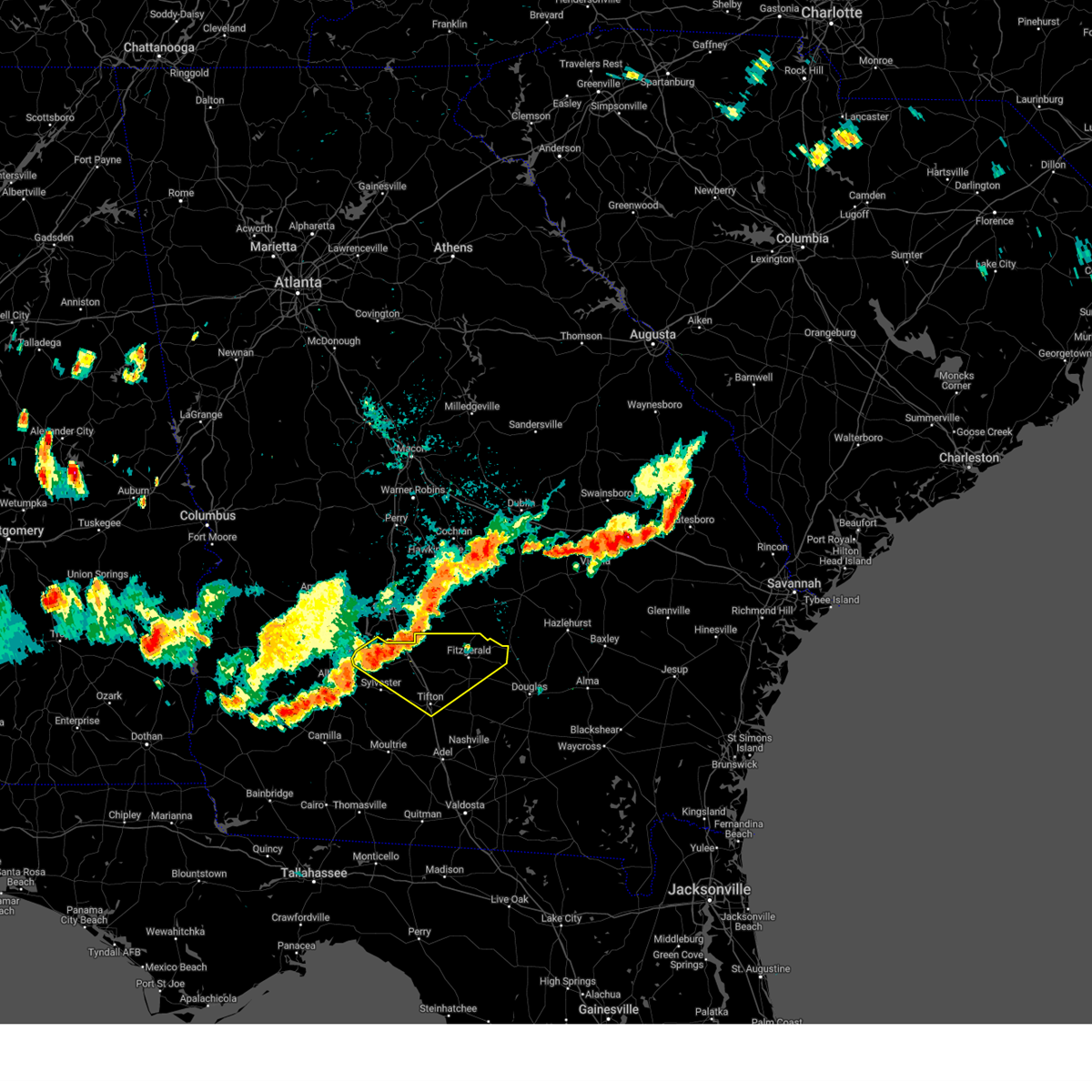
Hail Map for Tifton, GA
The Tifton, GA area has had 20 reports of on-the-ground hail by trained spotters, and has been under severe weather warnings 47 times during the past 12 months. Doppler radar has detected hail at or near Tifton, GA on 74 occasions, including 3 occasions during the past year.
| Name: | Tifton, GA |
| Where Located: | 39.6 miles W of Douglas, GA |
| Map: | Google Map for Tifton, GA |
| Population: | 16350 |
| Housing Units: | 6752 |
| More Info: | Search Google for Tifton, GA |
0
The Top Recent Hail Date for Tifton, GA is Sunday, April 27, 2025 (74th out of 74)

Hail and Wind Damage Spotted near Tifton, GA
| Date / Time | Report Details |
|---|---|
| 6/26/2025 5:57 PM EDT |
 the severe thunderstorm warning has been cancelled and is no longer in effect the severe thunderstorm warning has been cancelled and is no longer in effect
|
| 6/26/2025 5:39 PM EDT |
 At 539 pm edt, a severe thunderstorm was located near enigma, or 10 miles north of nashville, moving northwest at 10 mph (radar indicated). Hazards include 60 mph wind gusts. Expect damage to roofs, siding, and trees. Locations impacted include, tifton, enigma, alapaha, vanceville, brookfield, and gladys. At 539 pm edt, a severe thunderstorm was located near enigma, or 10 miles north of nashville, moving northwest at 10 mph (radar indicated). Hazards include 60 mph wind gusts. Expect damage to roofs, siding, and trees. Locations impacted include, tifton, enigma, alapaha, vanceville, brookfield, and gladys.
|
| 6/26/2025 5:39 PM EDT |
 the severe thunderstorm warning has been cancelled and is no longer in effect the severe thunderstorm warning has been cancelled and is no longer in effect
|
| 6/26/2025 4:56 PM EDT |
 Svrtae the national weather service in tallahassee has issued a * severe thunderstorm warning for, central cook county in south central georgia, berrien county in south central georgia, southeastern tift county in south central georgia, * until 630 pm edt. * at 456 pm edt, severe thunderstorms were located along a line extending from near adel to near willacoochee, moving north at 10 mph (radar indicated). Hazards include 60 mph wind gusts and quarter size hail. Hail damage to vehicles is expected. Expect wind damage to roofs, siding, and trees. Svrtae the national weather service in tallahassee has issued a * severe thunderstorm warning for, central cook county in south central georgia, berrien county in south central georgia, southeastern tift county in south central georgia, * until 630 pm edt. * at 456 pm edt, severe thunderstorms were located along a line extending from near adel to near willacoochee, moving north at 10 mph (radar indicated). Hazards include 60 mph wind gusts and quarter size hail. Hail damage to vehicles is expected. Expect wind damage to roofs, siding, and trees.
|
| 6/26/2025 2:37 AM EDT |
 The storms which prompted the warning have weakened below severe limits, and no longer pose an immediate threat to life or property. therefore, the warning will be allowed to expire. however, gusty winds are still possible with these thunderstorms. a severe thunderstorm watch remains in effect until 400 am edt for south central and southwestern georgia. to report severe weather, contact your nearest law enforcement agency. they will relay your report to the national weather service tallahassee. The storms which prompted the warning have weakened below severe limits, and no longer pose an immediate threat to life or property. therefore, the warning will be allowed to expire. however, gusty winds are still possible with these thunderstorms. a severe thunderstorm watch remains in effect until 400 am edt for south central and southwestern georgia. to report severe weather, contact your nearest law enforcement agency. they will relay your report to the national weather service tallahassee.
|
| 6/26/2025 2:32 AM EDT |
 the severe thunderstorm warning has been cancelled and is no longer in effect the severe thunderstorm warning has been cancelled and is no longer in effect
|
| 6/26/2025 2:32 AM EDT |
 At 232 am edt, severe thunderstorms were located along a line extending from 7 miles south of de soto to near willacoochee, moving southwest at 35 mph (radar indicated). Hazards include 60 mph wind gusts and penny size hail. Expect damage to roofs, siding, and trees. Locations impacted include, sylvester, tifton, ashburn, ocilla, nashville, enigma, poulan, ty ty, alapaha, mystic, unionville, phillipsburg, worth, terrell, sycamore, sumner, warwick, eldorado, gladys, and sylvester airport. At 232 am edt, severe thunderstorms were located along a line extending from 7 miles south of de soto to near willacoochee, moving southwest at 35 mph (radar indicated). Hazards include 60 mph wind gusts and penny size hail. Expect damage to roofs, siding, and trees. Locations impacted include, sylvester, tifton, ashburn, ocilla, nashville, enigma, poulan, ty ty, alapaha, mystic, unionville, phillipsburg, worth, terrell, sycamore, sumner, warwick, eldorado, gladys, and sylvester airport.
|
| 6/26/2025 1:36 AM EDT |
 Svrtae the national weather service in tallahassee has issued a * severe thunderstorm warning for, irwin county in south central georgia, berrien county in south central georgia, turner county in south central georgia, tift county in south central georgia, ben hill county in south central georgia, central worth county in south central georgia, * until 245 am edt. * at 136 am edt, severe thunderstorms were located along a line extending from 6 miles east of pinehurst to 8 miles northwest of alma, moving southwest at 35 mph (radar indicated). Hazards include 60 mph wind gusts and penny size hail. expect damage to roofs, siding, and trees Svrtae the national weather service in tallahassee has issued a * severe thunderstorm warning for, irwin county in south central georgia, berrien county in south central georgia, turner county in south central georgia, tift county in south central georgia, ben hill county in south central georgia, central worth county in south central georgia, * until 245 am edt. * at 136 am edt, severe thunderstorms were located along a line extending from 6 miles east of pinehurst to 8 miles northwest of alma, moving southwest at 35 mph (radar indicated). Hazards include 60 mph wind gusts and penny size hail. expect damage to roofs, siding, and trees
|
| 6/10/2025 6:05 AM EDT |
 The storms which prompted the warning have weakened below severe limits, and no longer pose an immediate threat to life or property. therefore, the warning will be allowed to expire. however, gusty winds are still possible with these thunderstorms. to report severe weather, contact your nearest law enforcement agency. they will relay your report to the national weather service tallahassee. The storms which prompted the warning have weakened below severe limits, and no longer pose an immediate threat to life or property. therefore, the warning will be allowed to expire. however, gusty winds are still possible with these thunderstorms. to report severe weather, contact your nearest law enforcement agency. they will relay your report to the national weather service tallahassee.
|
| 6/10/2025 5:33 AM EDT |
 At 533 am edt, severe thunderstorms were located along a line extending from near unionville to near adel, moving east at 40 mph (radar indicated). Hazards include 60 mph wind gusts. Expect damage to roofs, siding, and trees. Locations impacted include, nashville, lakeland, adel, tifton, sparks, enigma, ray city, lenox, alapaha, unionville, meigs, cecil, reed bingham state park, eldorado, new lois, massee, greggs, flat ford, glory, and wagon wheel. At 533 am edt, severe thunderstorms were located along a line extending from near unionville to near adel, moving east at 40 mph (radar indicated). Hazards include 60 mph wind gusts. Expect damage to roofs, siding, and trees. Locations impacted include, nashville, lakeland, adel, tifton, sparks, enigma, ray city, lenox, alapaha, unionville, meigs, cecil, reed bingham state park, eldorado, new lois, massee, greggs, flat ford, glory, and wagon wheel.
|
| 6/10/2025 5:33 AM EDT |
 the severe thunderstorm warning has been cancelled and is no longer in effect the severe thunderstorm warning has been cancelled and is no longer in effect
|
| 6/10/2025 5:00 AM EDT | Svrtae the national weather service in tallahassee has issued a * severe thunderstorm warning for, cook county in south central georgia, berrien county in south central georgia, northern lanier county in south central georgia, colquitt county in south central georgia, southern tift county in south central georgia, southeastern worth county in south central georgia, * until 615 am edt. * at 500 am edt, severe thunderstorms were located along a line extending from 8 miles northeast of doerun to near coolidge, moving east at 40 mph (radar indicated). Hazards include 60 mph wind gusts. expect damage to roofs, siding, and trees |
| 6/9/2025 3:56 PM EDT |
 The storm which prompted the warning has weakened below severe limits, and no longer poses an immediate threat to life or property. therefore, the warning will be allowed to expire. however, gusty winds to 40 mph and heavy rain are still possible with this thunderstorm. The storm which prompted the warning has weakened below severe limits, and no longer poses an immediate threat to life or property. therefore, the warning will be allowed to expire. however, gusty winds to 40 mph and heavy rain are still possible with this thunderstorm.
|
| 6/9/2025 3:20 PM EDT |
 Svrtae the national weather service in tallahassee has issued a * severe thunderstorm warning for, turner county in south central georgia, northeastern dougherty county in southwestern georgia, south central lee county in southwestern georgia, northwestern tift county in south central georgia, central worth county in south central georgia, * until 400 pm edt. * at 320 pm edt, a severe thunderstorm was located near marine corps logistics base, or 8 miles east of albany, moving east at 45 mph (radar indicated). Hazards include 60 mph wind gusts and penny size hail. expect damage to roofs, siding, and trees Svrtae the national weather service in tallahassee has issued a * severe thunderstorm warning for, turner county in south central georgia, northeastern dougherty county in southwestern georgia, south central lee county in southwestern georgia, northwestern tift county in south central georgia, central worth county in south central georgia, * until 400 pm edt. * at 320 pm edt, a severe thunderstorm was located near marine corps logistics base, or 8 miles east of albany, moving east at 45 mph (radar indicated). Hazards include 60 mph wind gusts and penny size hail. expect damage to roofs, siding, and trees
|
| 4/27/2025 11:39 PM EDT |
 At 1139 pm edt, a severe thunderstorm was located near ocilla, moving northeast at 35 mph (radar indicated). Hazards include 60 mph wind gusts and quarter size hail. Hail damage to vehicles is expected. expect wind damage to roofs, siding, and trees. Locations impacted include, vanceville, mystic, gladys, harding, pinetta, ocilla, and tifton. At 1139 pm edt, a severe thunderstorm was located near ocilla, moving northeast at 35 mph (radar indicated). Hazards include 60 mph wind gusts and quarter size hail. Hail damage to vehicles is expected. expect wind damage to roofs, siding, and trees. Locations impacted include, vanceville, mystic, gladys, harding, pinetta, ocilla, and tifton.
|
| 4/27/2025 11:12 PM EDT |
 At 1112 pm edt, a severe thunderstorm was located near enigma, or 9 miles southeast of tifton, moving northeast at 15 mph (radar indicated). Hazards include 60 mph wind gusts and half dollar size hail. Hail damage to vehicles is expected. expect wind damage to roofs, siding, and trees. Locations impacted include, vanceville, mystic, gladys, enigma, glory, harding, alapaha, pinetta, tifton, tift airport, phillipsburg, brookfield, unionville, and ocilla. At 1112 pm edt, a severe thunderstorm was located near enigma, or 9 miles southeast of tifton, moving northeast at 15 mph (radar indicated). Hazards include 60 mph wind gusts and half dollar size hail. Hail damage to vehicles is expected. expect wind damage to roofs, siding, and trees. Locations impacted include, vanceville, mystic, gladys, enigma, glory, harding, alapaha, pinetta, tifton, tift airport, phillipsburg, brookfield, unionville, and ocilla.
|
| 4/27/2025 11:12 PM EDT |
 the severe thunderstorm warning has been cancelled and is no longer in effect the severe thunderstorm warning has been cancelled and is no longer in effect
|
| 4/27/2025 10:58 PM EDT |
 Svrtae the national weather service in tallahassee has issued a * severe thunderstorm warning for, northwestern cook county in south central georgia, southern irwin county in south central georgia, northern berrien county in south central georgia, central tift county in south central georgia, * until midnight edt. * at 1057 pm edt, a severe thunderstorm was located near lenox, or 7 miles southeast of tifton, moving east at 15 mph (radar indicated). Hazards include 60 mph wind gusts and quarter size hail. Hail damage to vehicles is expected. Expect wind damage to roofs, siding, and trees. Svrtae the national weather service in tallahassee has issued a * severe thunderstorm warning for, northwestern cook county in south central georgia, southern irwin county in south central georgia, northern berrien county in south central georgia, central tift county in south central georgia, * until midnight edt. * at 1057 pm edt, a severe thunderstorm was located near lenox, or 7 miles southeast of tifton, moving east at 15 mph (radar indicated). Hazards include 60 mph wind gusts and quarter size hail. Hail damage to vehicles is expected. Expect wind damage to roofs, siding, and trees.
|
| 3/31/2025 4:56 PM EDT |
 The storms which prompted the warning have moved out of the area. therefore, the warning will be allowed to expire. a severe thunderstorm watch remains in effect until 600 pm edt for south central georgia. a severe thunderstorm watch also remains in effect until 900 pm edt for south central georgia. remember, a severe thunderstorm warning still remains in effect for eastern berrien county. The storms which prompted the warning have moved out of the area. therefore, the warning will be allowed to expire. a severe thunderstorm watch remains in effect until 600 pm edt for south central georgia. a severe thunderstorm watch also remains in effect until 900 pm edt for south central georgia. remember, a severe thunderstorm warning still remains in effect for eastern berrien county.
|
| 3/31/2025 4:25 PM EDT | Berrien county dispatch reported a powerline down along hall whitley road. timing estimated by rada in berrien county GA, 9.3 miles NW of Tifton, GA |
| 3/31/2025 4:21 PM EDT |
 the severe thunderstorm warning has been cancelled and is no longer in effect the severe thunderstorm warning has been cancelled and is no longer in effect
|
| 3/31/2025 4:21 PM EDT |
 At 421 pm edt, severe thunderstorms were located along a line extending from near lumber city to near enigma, moving east at 45 mph (radar indicated). Hazards include 60 mph wind gusts. Expect damage to roofs, siding, and trees. Locations impacted include, fitzgerald, mystic, eldorado, gladys, enigma, osierfield, glory, harding, pinetta, tifton, ashton, irwinville, wray, bowens mill, unionville, abba, vanceville, lulaville, alapaha, and tift airport. At 421 pm edt, severe thunderstorms were located along a line extending from near lumber city to near enigma, moving east at 45 mph (radar indicated). Hazards include 60 mph wind gusts. Expect damage to roofs, siding, and trees. Locations impacted include, fitzgerald, mystic, eldorado, gladys, enigma, osierfield, glory, harding, pinetta, tifton, ashton, irwinville, wray, bowens mill, unionville, abba, vanceville, lulaville, alapaha, and tift airport.
|
| 3/31/2025 3:52 PM EDT |
 Svrtae the national weather service in tallahassee has issued a * severe thunderstorm warning for, northern cook county in south central georgia, irwin county in south central georgia, northern berrien county in south central georgia, southeastern turner county in south central georgia, tift county in south central georgia, ben hill county in south central georgia, * until 500 pm edt. * at 352 pm edt, severe thunderstorms were located along a line extending from near milan to near omega, moving east at 45 mph (radar indicated). Hazards include 60 mph wind gusts and quarter size hail. Hail damage to vehicles is expected. Expect wind damage to roofs, siding, and trees. Svrtae the national weather service in tallahassee has issued a * severe thunderstorm warning for, northern cook county in south central georgia, irwin county in south central georgia, northern berrien county in south central georgia, southeastern turner county in south central georgia, tift county in south central georgia, ben hill county in south central georgia, * until 500 pm edt. * at 352 pm edt, severe thunderstorms were located along a line extending from near milan to near omega, moving east at 45 mph (radar indicated). Hazards include 60 mph wind gusts and quarter size hail. Hail damage to vehicles is expected. Expect wind damage to roofs, siding, and trees.
|
| 3/31/2025 3:35 PM EDT |
 At 335 pm edt, severe thunderstorms were located along a line extending from 7 miles south of pitts to near ashburn to near poulan, moving east at 55 mph (radar indicated). Hazards include 60 mph wind gusts and quarter size hail. Hail damage to vehicles is expected. expect wind damage to roofs, siding, and trees. Locations impacted include, mystic, sylvester, amboy, rebecca, sylvester airport, tempy, parkerville, harding, waterloo, pinetta, tifton, inaha, worth, red rock, terrell, irwinville, sumner, ty ty, crestwood, and hobby. At 335 pm edt, severe thunderstorms were located along a line extending from 7 miles south of pitts to near ashburn to near poulan, moving east at 55 mph (radar indicated). Hazards include 60 mph wind gusts and quarter size hail. Hail damage to vehicles is expected. expect wind damage to roofs, siding, and trees. Locations impacted include, mystic, sylvester, amboy, rebecca, sylvester airport, tempy, parkerville, harding, waterloo, pinetta, tifton, inaha, worth, red rock, terrell, irwinville, sumner, ty ty, crestwood, and hobby.
|
| 3/31/2025 3:35 PM EDT |
 the severe thunderstorm warning has been cancelled and is no longer in effect the severe thunderstorm warning has been cancelled and is no longer in effect
|
| 3/31/2025 2:54 PM EDT |
 Svrtae the national weather service in tallahassee has issued a * severe thunderstorm warning for, western irwin county in south central georgia, turner county in south central georgia, dougherty county in southwestern georgia, northeastern mitchell county in southwestern georgia, lee county in southwestern georgia, northeastern baker county in southwestern georgia, eastern calhoun county in southwestern georgia, tift county in south central georgia, southeastern terrell county in southwestern georgia, western ben hill county in south central georgia, worth county in south central georgia, * until 400 pm edt. * at 254 pm edt, severe thunderstorms were located along a line extending from 6 miles southeast of smithville to 9 miles west of albany to near leary, moving east at 45 mph (radar indicated). Hazards include 60 mph wind gusts. expect damage to roofs, siding, and trees Svrtae the national weather service in tallahassee has issued a * severe thunderstorm warning for, western irwin county in south central georgia, turner county in south central georgia, dougherty county in southwestern georgia, northeastern mitchell county in southwestern georgia, lee county in southwestern georgia, northeastern baker county in southwestern georgia, eastern calhoun county in southwestern georgia, tift county in south central georgia, southeastern terrell county in southwestern georgia, western ben hill county in south central georgia, worth county in south central georgia, * until 400 pm edt. * at 254 pm edt, severe thunderstorms were located along a line extending from 6 miles southeast of smithville to 9 miles west of albany to near leary, moving east at 45 mph (radar indicated). Hazards include 60 mph wind gusts. expect damage to roofs, siding, and trees
|
| 3/16/2025 7:26 AM EDT |
 the severe thunderstorm warning has been cancelled and is no longer in effect the severe thunderstorm warning has been cancelled and is no longer in effect
|
| 3/16/2025 7:26 AM EDT |
 At 725 am edt, severe thunderstorms were located along a line extending from near mystic to 6 miles southwest of ocilla to near enigma, moving northeast at 50 mph (radar indicated). Hazards include 60 mph wind gusts and quarter size hail. Hail damage to vehicles is expected. expect wind damage to roofs, siding, and trees. Locations impacted include, lenox, fitzgerald, mystic, eldorado, gladys, enigma, osierfield, rebecca, glory, harding, waterloo, pinetta, tifton, inaha, ashton, irwinville, turner co airport, irwinville airport, wray, and bowens mill. At 725 am edt, severe thunderstorms were located along a line extending from near mystic to 6 miles southwest of ocilla to near enigma, moving northeast at 50 mph (radar indicated). Hazards include 60 mph wind gusts and quarter size hail. Hail damage to vehicles is expected. expect wind damage to roofs, siding, and trees. Locations impacted include, lenox, fitzgerald, mystic, eldorado, gladys, enigma, osierfield, rebecca, glory, harding, waterloo, pinetta, tifton, inaha, ashton, irwinville, turner co airport, irwinville airport, wray, and bowens mill.
|
| 3/16/2025 7:01 AM EDT |
 Svrtae the national weather service in tallahassee has issued a * severe thunderstorm warning for, northwestern cook county in south central georgia, irwin county in south central georgia, northern berrien county in south central georgia, central turner county in south central georgia, northeastern colquitt county in south central georgia, tift county in south central georgia, ben hill county in south central georgia, southern worth county in south central georgia, * until 800 am edt. * at 701 am edt, severe thunderstorms were located along a line extending from near ty ty to near omega to near norman park, moving northeast at 55 mph (radar indicated). Hazards include 60 mph wind gusts and quarter size hail. Hail damage to vehicles is expected. Expect wind damage to roofs, siding, and trees. Svrtae the national weather service in tallahassee has issued a * severe thunderstorm warning for, northwestern cook county in south central georgia, irwin county in south central georgia, northern berrien county in south central georgia, central turner county in south central georgia, northeastern colquitt county in south central georgia, tift county in south central georgia, ben hill county in south central georgia, southern worth county in south central georgia, * until 800 am edt. * at 701 am edt, severe thunderstorms were located along a line extending from near ty ty to near omega to near norman park, moving northeast at 55 mph (radar indicated). Hazards include 60 mph wind gusts and quarter size hail. Hail damage to vehicles is expected. Expect wind damage to roofs, siding, and trees.
|
| 3/16/2025 6:13 AM EDT | Svrtae the national weather service in tallahassee has issued a * severe thunderstorm warning for, northeastern decatur county in southwestern georgia, southeastern miller county in southwestern georgia, northern grady county in southwestern georgia, mitchell county in southwestern georgia, southwestern baker county in southwestern georgia, northwestern thomas county in south central georgia, colquitt county in south central georgia, western tift county in south central georgia, southern worth county in south central georgia, * until 715 am edt. * at 612 am edt, a severe thunderstorm was located 7 miles west of pelham, moving northeast at 75 mph (radar indicated). Hazards include 60 mph wind gusts and quarter size hail. Hail damage to vehicles is expected. Expect wind damage to roofs, siding, and trees. |
| 3/5/2025 5:04 AM EST |
 At 504 am est, severe thunderstorms were located along a line extending from 9 miles north of fitzgerald to near pavo, moving east at 35 mph (radar indicated). Hazards include 60 mph wind gusts. Expect damage to roofs, siding, and trees. Locations impacted include, reed bingham state park, enigma, osierfield, greggs, waterloo, pinetta, tifton, moultrie municipal a/p, allenville, weber, vanceville, cottle, lulaville, berlin, nashville, sparks, tift airport, adel, fitzgerald municipal a/p, and phillipsburg. At 504 am est, severe thunderstorms were located along a line extending from 9 miles north of fitzgerald to near pavo, moving east at 35 mph (radar indicated). Hazards include 60 mph wind gusts. Expect damage to roofs, siding, and trees. Locations impacted include, reed bingham state park, enigma, osierfield, greggs, waterloo, pinetta, tifton, moultrie municipal a/p, allenville, weber, vanceville, cottle, lulaville, berlin, nashville, sparks, tift airport, adel, fitzgerald municipal a/p, and phillipsburg.
|
| 3/5/2025 5:04 AM EST |
 the severe thunderstorm warning has been cancelled and is no longer in effect the severe thunderstorm warning has been cancelled and is no longer in effect
|
| 3/5/2025 4:38 AM EST |
 At 438 am est, severe thunderstorms were located along a line extending from 8 miles south of rochelle to near coolidge, moving east at 35 mph (radar indicated). Hazards include 60 mph wind gusts. Expect damage to roofs, siding, and trees. Locations impacted include, funston, reed bingham state park, minton, scooterville, enigma, osierfield, greggs, waterloo, pinetta, tifton, inaha, moultrie municipal a/p, allenville, weber, turner co airport, irwinville airport, murphy, vanceville, cottle, and lulaville. At 438 am est, severe thunderstorms were located along a line extending from 8 miles south of rochelle to near coolidge, moving east at 35 mph (radar indicated). Hazards include 60 mph wind gusts. Expect damage to roofs, siding, and trees. Locations impacted include, funston, reed bingham state park, minton, scooterville, enigma, osierfield, greggs, waterloo, pinetta, tifton, inaha, moultrie municipal a/p, allenville, weber, turner co airport, irwinville airport, murphy, vanceville, cottle, and lulaville.
|
| 3/5/2025 4:03 AM EST |
 Svrtae the national weather service in tallahassee has issued a * severe thunderstorm warning for, cook county in south central georgia, irwin county in south central georgia, berrien county in south central georgia, turner county in south central georgia, colquitt county in south central georgia, tift county in south central georgia, ben hill county in south central georgia, eastern worth county in south central georgia, * until 530 am est. * at 403 am est, severe thunderstorms were located along a line extending from 7 miles west of arabi to pelham, moving east at 35 mph (radar indicated). Hazards include 60 mph wind gusts. expect damage to roofs, siding, and trees Svrtae the national weather service in tallahassee has issued a * severe thunderstorm warning for, cook county in south central georgia, irwin county in south central georgia, berrien county in south central georgia, turner county in south central georgia, colquitt county in south central georgia, tift county in south central georgia, ben hill county in south central georgia, eastern worth county in south central georgia, * until 530 am est. * at 403 am est, severe thunderstorms were located along a line extending from 7 miles west of arabi to pelham, moving east at 35 mph (radar indicated). Hazards include 60 mph wind gusts. expect damage to roofs, siding, and trees
|
| 2/16/2025 7:36 AM EST |
 Svrtae the national weather service in tallahassee has issued a * severe thunderstorm warning for, cook county in south central georgia, berrien county in south central georgia, lanier county in south central georgia, colquitt county in south central georgia, tift county in south central georgia, * until 900 am est. * at 736 am est, severe thunderstorms were located along a line extending from 6 miles north of tifton to 6 miles northwest of coolidge, moving east at 45 mph (radar indicated). Hazards include 60 mph wind gusts. expect damage to roofs, siding, and trees Svrtae the national weather service in tallahassee has issued a * severe thunderstorm warning for, cook county in south central georgia, berrien county in south central georgia, lanier county in south central georgia, colquitt county in south central georgia, tift county in south central georgia, * until 900 am est. * at 736 am est, severe thunderstorms were located along a line extending from 6 miles north of tifton to 6 miles northwest of coolidge, moving east at 45 mph (radar indicated). Hazards include 60 mph wind gusts. expect damage to roofs, siding, and trees
|
| 2/16/2025 7:21 AM EST |
 At 721 am est, severe thunderstorms were located along a line extending from 8 miles northwest of fitzgerald to 8 miles north of cairo, moving east at 40 mph (radar indicated). Hazards include 60 mph wind gusts. Expect damage to roofs, siding, and trees. Locations impacted include, tifton, moultrie, ashburn, pelham, camilla, sylvester, omega, norman park, poulan, doerun, ty ty, phillipsburg, unionville, riverside, terrell, schley, sycamore, berlin, funston, and sumner. At 721 am est, severe thunderstorms were located along a line extending from 8 miles northwest of fitzgerald to 8 miles north of cairo, moving east at 40 mph (radar indicated). Hazards include 60 mph wind gusts. Expect damage to roofs, siding, and trees. Locations impacted include, tifton, moultrie, ashburn, pelham, camilla, sylvester, omega, norman park, poulan, doerun, ty ty, phillipsburg, unionville, riverside, terrell, schley, sycamore, berlin, funston, and sumner.
|
| 2/16/2025 6:17 AM EST |
 Svrtae the national weather service in tallahassee has issued a * severe thunderstorm warning for, turner county in south central georgia, mitchell county in southwestern georgia, colquitt county in south central georgia, tift county in south central georgia, worth county in south central georgia, * until 745 am est. * at 616 am est, severe thunderstorms were located along a line extending from near leslie to 7 miles northwest of donalsonville, moving east at 45 mph (radar indicated). Hazards include 60 mph wind gusts. expect damage to roofs, siding, and trees Svrtae the national weather service in tallahassee has issued a * severe thunderstorm warning for, turner county in south central georgia, mitchell county in southwestern georgia, colquitt county in south central georgia, tift county in south central georgia, worth county in south central georgia, * until 745 am est. * at 616 am est, severe thunderstorms were located along a line extending from near leslie to 7 miles northwest of donalsonville, moving east at 45 mph (radar indicated). Hazards include 60 mph wind gusts. expect damage to roofs, siding, and trees
|
| 8/18/2024 9:31 PM EDT |
 At 931 pm edt, severe thunderstorms were located along a line extending from near snipesville to near broxton to 8 miles south of ambrose to near enigma, moving east at 45 mph (radar indicated). Hazards include 60 mph wind gusts. Expect damage to roofs, siding, and trees. Locations impacted include, tifton, ocilla, enigma, alapaha, phillipsburg, unionville, vanceville, gladys, osierfield, glory, harding, bannockburn, tift airport, weber, wray, brookfield, and red bluff. At 931 pm edt, severe thunderstorms were located along a line extending from near snipesville to near broxton to 8 miles south of ambrose to near enigma, moving east at 45 mph (radar indicated). Hazards include 60 mph wind gusts. Expect damage to roofs, siding, and trees. Locations impacted include, tifton, ocilla, enigma, alapaha, phillipsburg, unionville, vanceville, gladys, osierfield, glory, harding, bannockburn, tift airport, weber, wray, brookfield, and red bluff.
|
| 8/18/2024 9:30 PM EDT |
 At 930 pm edt, severe thunderstorms were located along a line extending from near tifton to near pelham, moving east at 30 mph (radar indicated). Hazards include 60 mph wind gusts. Expect damage to roofs, siding, and trees. Locations impacted include, moultrie, pelham, camilla, tifton, omega, norman park, riverside, schley, funston, sale city, minton, eldorado, scooterville, cotton, south moultrie, chastain, sigsbee, quality, poplar arbor church, and cool spring. At 930 pm edt, severe thunderstorms were located along a line extending from near tifton to near pelham, moving east at 30 mph (radar indicated). Hazards include 60 mph wind gusts. Expect damage to roofs, siding, and trees. Locations impacted include, moultrie, pelham, camilla, tifton, omega, norman park, riverside, schley, funston, sale city, minton, eldorado, scooterville, cotton, south moultrie, chastain, sigsbee, quality, poplar arbor church, and cool spring.
|
| 8/18/2024 9:14 PM EDT |
 the severe thunderstorm warning has been cancelled and is no longer in effect the severe thunderstorm warning has been cancelled and is no longer in effect
|
| 8/18/2024 9:14 PM EDT |
 At 914 pm edt, severe thunderstorms were located along a line extending from near ty ty to camilla, moving east at 30 mph (radar indicated). Hazards include 60 mph wind gusts. Expect damage to roofs, siding, and trees. Locations impacted include, moultrie, sylvester, pelham, camilla, tifton, omega, norman park, poulan, doerun, ty ty, riverside, schley, funston, sumner, sale city, minton, scooterville, anderson city, parkerville, and lester. At 914 pm edt, severe thunderstorms were located along a line extending from near ty ty to camilla, moving east at 30 mph (radar indicated). Hazards include 60 mph wind gusts. Expect damage to roofs, siding, and trees. Locations impacted include, moultrie, sylvester, pelham, camilla, tifton, omega, norman park, poulan, doerun, ty ty, riverside, schley, funston, sumner, sale city, minton, scooterville, anderson city, parkerville, and lester.
|
| 8/18/2024 9:13 PM EDT |
 At 913 pm edt, severe thunderstorms were located along a line extending from 7 miles east of fitzgerald to near tifton, moving east at 35 mph (radar indicated). Hazards include 60 mph wind gusts. Expect damage to roofs, siding, and trees. Locations impacted include, fitzgerald, tifton, ocilla, ty ty, mystic, unionville, phillipsburg, osierfield, harding, waterloo, pinetta, inaha, ashton, irwinville, irwinville airport, bowens mill, abba, vanceville, hillsdale, and chula. At 913 pm edt, severe thunderstorms were located along a line extending from 7 miles east of fitzgerald to near tifton, moving east at 35 mph (radar indicated). Hazards include 60 mph wind gusts. Expect damage to roofs, siding, and trees. Locations impacted include, fitzgerald, tifton, ocilla, ty ty, mystic, unionville, phillipsburg, osierfield, harding, waterloo, pinetta, inaha, ashton, irwinville, irwinville airport, bowens mill, abba, vanceville, hillsdale, and chula.
|
| 8/18/2024 9:10 PM EDT |
 Svrtae the national weather service in tallahassee has issued a * severe thunderstorm warning for, irwin county in south central georgia, northern berrien county in south central georgia, northeastern lanier county in south central georgia, tift county in south central georgia, ben hill county in south central georgia, * until 1000 pm edt. * at 909 pm edt, severe thunderstorms were located along a line extending from near jacksonville to 7 miles northwest of ambrose to near ocilla to near phillipsburg, moving east at 45 mph (radar indicated). Hazards include 60 mph wind gusts and penny size hail. expect damage to roofs, siding, and trees Svrtae the national weather service in tallahassee has issued a * severe thunderstorm warning for, irwin county in south central georgia, northern berrien county in south central georgia, northeastern lanier county in south central georgia, tift county in south central georgia, ben hill county in south central georgia, * until 1000 pm edt. * at 909 pm edt, severe thunderstorms were located along a line extending from near jacksonville to 7 miles northwest of ambrose to near ocilla to near phillipsburg, moving east at 45 mph (radar indicated). Hazards include 60 mph wind gusts and penny size hail. expect damage to roofs, siding, and trees
|
| 8/18/2024 8:58 PM EDT |
 At 858 pm edt, severe thunderstorms were located along a line extending from near fitzgerald to 6 miles north of ty ty, moving east at 35 mph (radar indicated). Hazards include 60 mph wind gusts. Expect damage to roofs, siding, and trees. Locations impacted include, fitzgerald, tifton, ashburn, ocilla, ty ty, mystic, unionville, phillipsburg, worth, terrell, sycamore, rebecca, amboy, osierfield, harding, waterloo, pinetta, inaha, ashton, and irwinville. At 858 pm edt, severe thunderstorms were located along a line extending from near fitzgerald to 6 miles north of ty ty, moving east at 35 mph (radar indicated). Hazards include 60 mph wind gusts. Expect damage to roofs, siding, and trees. Locations impacted include, fitzgerald, tifton, ashburn, ocilla, ty ty, mystic, unionville, phillipsburg, worth, terrell, sycamore, rebecca, amboy, osierfield, harding, waterloo, pinetta, inaha, ashton, and irwinville.
|
| 8/18/2024 8:56 PM EDT |
 Svrtae the national weather service in tallahassee has issued a * severe thunderstorm warning for, southeastern dougherty county in southwestern georgia, mitchell county in southwestern georgia, central baker county in southwestern georgia, northwestern thomas county in south central georgia, colquitt county in south central georgia, southwestern tift county in south central georgia, southern worth county in south central georgia, * until 1000 pm edt. * at 856 pm edt, severe thunderstorms were located along a line extending from near poulan to 6 miles south of newton, moving east at 25 mph (radar indicated). Hazards include 60 mph wind gusts. expect damage to roofs, siding, and trees Svrtae the national weather service in tallahassee has issued a * severe thunderstorm warning for, southeastern dougherty county in southwestern georgia, mitchell county in southwestern georgia, central baker county in southwestern georgia, northwestern thomas county in south central georgia, colquitt county in south central georgia, southwestern tift county in south central georgia, southern worth county in south central georgia, * until 1000 pm edt. * at 856 pm edt, severe thunderstorms were located along a line extending from near poulan to 6 miles south of newton, moving east at 25 mph (radar indicated). Hazards include 60 mph wind gusts. expect damage to roofs, siding, and trees
|
| 8/18/2024 8:26 PM EDT |
 Svrtae the national weather service in tallahassee has issued a * severe thunderstorm warning for, irwin county in south central georgia, turner county in south central georgia, tift county in south central georgia, ben hill county in south central georgia, central worth county in south central georgia, * until 930 pm edt. * at 826 pm edt, severe thunderstorms were located along a line extending from 6 miles south of pitts to 10 miles northwest of sylvester, moving southeast at 35 mph (radar indicated). Hazards include 60 mph wind gusts and quarter size hail. Hail damage to vehicles is expected. Expect wind damage to roofs, siding, and trees. Svrtae the national weather service in tallahassee has issued a * severe thunderstorm warning for, irwin county in south central georgia, turner county in south central georgia, tift county in south central georgia, ben hill county in south central georgia, central worth county in south central georgia, * until 930 pm edt. * at 826 pm edt, severe thunderstorms were located along a line extending from 6 miles south of pitts to 10 miles northwest of sylvester, moving southeast at 35 mph (radar indicated). Hazards include 60 mph wind gusts and quarter size hail. Hail damage to vehicles is expected. Expect wind damage to roofs, siding, and trees.
|
| 7/15/2024 7:50 PM EDT |
 The storm which prompted the warning has weakened below severe limits, and no longer poses an immediate threat to life or property. therefore, the warning will be allowed to expire. however, small hail and gusty winds are still possible with this thunderstorm. The storm which prompted the warning has weakened below severe limits, and no longer poses an immediate threat to life or property. therefore, the warning will be allowed to expire. however, small hail and gusty winds are still possible with this thunderstorm.
|
| 7/15/2024 7:36 PM EDT |
 Svrtae the national weather service in tallahassee has issued a * severe thunderstorm warning for, northeastern colquitt county in south central georgia, southwestern tift county in south central georgia, southeastern worth county in south central georgia, * until 800 pm edt. * at 736 pm edt, a severe thunderstorm was located 7 miles northeast of doerun, or 9 miles south of sylvester, moving east at 20 mph (radar indicated). Hazards include 60 mph wind gusts and penny size hail. expect damage to roofs, siding, and trees Svrtae the national weather service in tallahassee has issued a * severe thunderstorm warning for, northeastern colquitt county in south central georgia, southwestern tift county in south central georgia, southeastern worth county in south central georgia, * until 800 pm edt. * at 736 pm edt, a severe thunderstorm was located 7 miles northeast of doerun, or 9 miles south of sylvester, moving east at 20 mph (radar indicated). Hazards include 60 mph wind gusts and penny size hail. expect damage to roofs, siding, and trees
|
| 5/27/2024 7:03 PM EDT |
 At 703 pm edt, a severe thunderstorm was located near enigma, or 10 miles south of ocilla, moving east at 30 mph (radar indicated). Hazards include two inch hail and 70 mph wind gusts. People and animals outdoors will be injured. expect hail damage to roofs, siding, windows, and vehicles. expect considerable tree damage. wind damage is also likely to mobile homes, roofs, and outbuildings. Locations impacted include, tifton, nashville, enigma, omega, lenox, alapaha, unionville, phillipsburg, eldorado, gladys, massee, glory, flat ford, wagon wheel, weber, vanceville, cottle, hillsdale, cool spring, and staunton. At 703 pm edt, a severe thunderstorm was located near enigma, or 10 miles south of ocilla, moving east at 30 mph (radar indicated). Hazards include two inch hail and 70 mph wind gusts. People and animals outdoors will be injured. expect hail damage to roofs, siding, windows, and vehicles. expect considerable tree damage. wind damage is also likely to mobile homes, roofs, and outbuildings. Locations impacted include, tifton, nashville, enigma, omega, lenox, alapaha, unionville, phillipsburg, eldorado, gladys, massee, glory, flat ford, wagon wheel, weber, vanceville, cottle, hillsdale, cool spring, and staunton.
|
| 5/27/2024 7:02 PM EDT |
 At 702 pm edt, a severe thunderstorm was located near alapaha, or 9 miles south of ocilla, moving east at 35 mph (radar indicated). Hazards include two inch hail and 70 mph wind gusts. People and animals outdoors will be injured. expect hail damage to roofs, siding, windows, and vehicles. expect considerable tree damage. wind damage is also likely to mobile homes, roofs, and outbuildings. Locations impacted include, tifton, ocilla, enigma, alapaha, mystic, unionville, phillipsburg, vanceville, chula, gladys, glory, harding, waterloo, pinetta, irwinville, irwinville airport, brookfield, and sunsweet. At 702 pm edt, a severe thunderstorm was located near alapaha, or 9 miles south of ocilla, moving east at 35 mph (radar indicated). Hazards include two inch hail and 70 mph wind gusts. People and animals outdoors will be injured. expect hail damage to roofs, siding, windows, and vehicles. expect considerable tree damage. wind damage is also likely to mobile homes, roofs, and outbuildings. Locations impacted include, tifton, ocilla, enigma, alapaha, mystic, unionville, phillipsburg, vanceville, chula, gladys, glory, harding, waterloo, pinetta, irwinville, irwinville airport, brookfield, and sunsweet.
|
| 5/27/2024 7:00 PM EDT |
 Svrtae the national weather service in tallahassee has issued a * severe thunderstorm warning for, northern cook county in south central georgia, berrien county in south central georgia, northeastern colquitt county in south central georgia, southern tift county in south central georgia, * until 800 pm edt. * at 700 pm edt, a severe thunderstorm was located near unionville, or near tifton, moving east at 35 mph (radar indicated). Hazards include 60 mph wind gusts. expect damage to roofs, siding, and trees Svrtae the national weather service in tallahassee has issued a * severe thunderstorm warning for, northern cook county in south central georgia, berrien county in south central georgia, northeastern colquitt county in south central georgia, southern tift county in south central georgia, * until 800 pm edt. * at 700 pm edt, a severe thunderstorm was located near unionville, or near tifton, moving east at 35 mph (radar indicated). Hazards include 60 mph wind gusts. expect damage to roofs, siding, and trees
|
| 5/27/2024 6:33 PM EDT |
 At 633 pm edt, a severe thunderstorm was located 8 miles west of mystic, or 9 miles north of tifton, moving east at 25 mph (radar indicated). Hazards include 60 mph wind gusts and quarter size hail. Hail damage to vehicles is expected. expect wind damage to roofs, siding, and trees. Locations impacted include, tifton, ashburn, ocilla, enigma, ty ty, alapaha, mystic, unionville, sycamore, vanceville, hillsdale, chula, gladys, glory, harding, waterloo, pinetta, inaha, irwinville, and turner co airport. At 633 pm edt, a severe thunderstorm was located 8 miles west of mystic, or 9 miles north of tifton, moving east at 25 mph (radar indicated). Hazards include 60 mph wind gusts and quarter size hail. Hail damage to vehicles is expected. expect wind damage to roofs, siding, and trees. Locations impacted include, tifton, ashburn, ocilla, enigma, ty ty, alapaha, mystic, unionville, sycamore, vanceville, hillsdale, chula, gladys, glory, harding, waterloo, pinetta, inaha, irwinville, and turner co airport.
|
| 5/27/2024 6:33 PM EDT |
 the severe thunderstorm warning has been cancelled and is no longer in effect the severe thunderstorm warning has been cancelled and is no longer in effect
|
| 5/27/2024 6:30 PM EDT | Trees down near ferry lake road and us hwy 31 in tift county GA, 2.9 miles W of Tifton, GA |
| 5/27/2024 6:22 PM EDT | Trees down on a power line on nb side of i-75 at mm 71... causing power lines to catch on fir in tift county GA, 7.9 miles S of Tifton, GA |
| 5/27/2024 6:18 PM EDT | Numerous downed trees and power lines throughout irwin county... with greatest concentration in western county. power crews working to restore powe in irwin county GA, 9.6 miles SSW of Tifton, GA |
| 5/27/2024 6:04 PM EDT |
 Svrtae the national weather service in tallahassee has issued a * severe thunderstorm warning for, southern irwin county in south central georgia, northeastern berrien county in south central georgia, southern turner county in south central georgia, northern tift county in south central georgia, northeastern worth county in south central georgia, * until 730 pm edt. * at 603 pm edt, a severe thunderstorm was located 7 miles south of ashburn, moving east at 35 mph (radar indicated). Hazards include 60 mph wind gusts and quarter size hail. Hail damage to vehicles is expected. Expect wind damage to roofs, siding, and trees. Svrtae the national weather service in tallahassee has issued a * severe thunderstorm warning for, southern irwin county in south central georgia, northeastern berrien county in south central georgia, southern turner county in south central georgia, northern tift county in south central georgia, northeastern worth county in south central georgia, * until 730 pm edt. * at 603 pm edt, a severe thunderstorm was located 7 miles south of ashburn, moving east at 35 mph (radar indicated). Hazards include 60 mph wind gusts and quarter size hail. Hail damage to vehicles is expected. Expect wind damage to roofs, siding, and trees.
|
| 5/17/2024 7:02 PM EDT |
 Svrtae the national weather service in tallahassee has issued a * severe thunderstorm warning for, cook county in south central georgia, northeastern decatur county in southwestern georgia, northern grady county in southwestern georgia, southern irwin county in south central georgia, berrien county in south central georgia, southern mitchell county in southwestern georgia, northern thomas county in south central georgia, northwestern brooks county in south central georgia, colquitt county in south central georgia, tift county in south central georgia, southeastern worth county in south central georgia, * until 830 pm edt. * at 702 pm edt, severe thunderstorms were located along a line extending from near tifton to near ty ty to 7 miles northwest of norman park to near doerun to 9 miles northwest of riverside to 6 miles east of camilla to pelham to 12 miles northeast of bainbridge, moving east at 25 mph (radar indicated). Hazards include 60 mph wind gusts and penny size hail. expect damage to roofs, siding, and trees Svrtae the national weather service in tallahassee has issued a * severe thunderstorm warning for, cook county in south central georgia, northeastern decatur county in southwestern georgia, northern grady county in southwestern georgia, southern irwin county in south central georgia, berrien county in south central georgia, southern mitchell county in southwestern georgia, northern thomas county in south central georgia, northwestern brooks county in south central georgia, colquitt county in south central georgia, tift county in south central georgia, southeastern worth county in south central georgia, * until 830 pm edt. * at 702 pm edt, severe thunderstorms were located along a line extending from near tifton to near ty ty to 7 miles northwest of norman park to near doerun to 9 miles northwest of riverside to 6 miles east of camilla to pelham to 12 miles northeast of bainbridge, moving east at 25 mph (radar indicated). Hazards include 60 mph wind gusts and penny size hail. expect damage to roofs, siding, and trees
|
| 5/10/2024 6:27 AM EDT |
 Svrtae the national weather service in tallahassee has issued a * severe thunderstorm warning for, cook county in south central georgia, berrien county in south central georgia, lanier county in south central georgia, lowndes county in south central georgia, thomas county in south central georgia, brooks county in south central georgia, colquitt county in south central georgia, southern tift county in south central georgia, southern worth county in south central georgia, * until 800 am edt. * at 626 am edt, severe thunderstorms were located along a line extending from doerun to 11 miles south of cairo, moving east at 55 mph (radar indicated). Hazards include 60 mph wind gusts. expect damage to roofs, siding, and trees Svrtae the national weather service in tallahassee has issued a * severe thunderstorm warning for, cook county in south central georgia, berrien county in south central georgia, lanier county in south central georgia, lowndes county in south central georgia, thomas county in south central georgia, brooks county in south central georgia, colquitt county in south central georgia, southern tift county in south central georgia, southern worth county in south central georgia, * until 800 am edt. * at 626 am edt, severe thunderstorms were located along a line extending from doerun to 11 miles south of cairo, moving east at 55 mph (radar indicated). Hazards include 60 mph wind gusts. expect damage to roofs, siding, and trees
|
| 5/4/2024 4:14 PM EDT |
 the severe thunderstorm warning has been cancelled and is no longer in effect the severe thunderstorm warning has been cancelled and is no longer in effect
|
| 5/4/2024 3:57 PM EDT | Tree down at the intersection of highway 319 and kelly road in tift county georgi in tift county GA, 4.2 miles NNE of Tifton, GA |
| 5/4/2024 3:54 PM EDT |
 Svrtae the national weather service in tallahassee has issued a * severe thunderstorm warning for, northwestern cook county in south central georgia, northwestern berrien county in south central georgia, northeastern colquitt county in south central georgia, southern tift county in south central georgia, southeastern worth county in south central georgia, * until 430 pm edt. * at 354 pm edt, a severe thunderstorm was located over omega, or 7 miles southwest of tifton, moving southeast at 15 mph (radar indicated). Hazards include 60 mph wind gusts and quarter size hail. Hail damage to vehicles is expected. Expect wind damage to roofs, siding, and trees. Svrtae the national weather service in tallahassee has issued a * severe thunderstorm warning for, northwestern cook county in south central georgia, northwestern berrien county in south central georgia, northeastern colquitt county in south central georgia, southern tift county in south central georgia, southeastern worth county in south central georgia, * until 430 pm edt. * at 354 pm edt, a severe thunderstorm was located over omega, or 7 miles southwest of tifton, moving southeast at 15 mph (radar indicated). Hazards include 60 mph wind gusts and quarter size hail. Hail damage to vehicles is expected. Expect wind damage to roofs, siding, and trees.
|
| 5/4/2024 3:35 PM EDT |
 The storm which prompted the warning has weakened below severe limits, and no longer poses an immediate threat to life or property. therefore, the warning will be allowed to expire. however, gusty winds are still possible with this thunderstorm. The storm which prompted the warning has weakened below severe limits, and no longer poses an immediate threat to life or property. therefore, the warning will be allowed to expire. however, gusty winds are still possible with this thunderstorm.
|
| 5/4/2024 3:11 PM EDT |
 Svrtae the national weather service in tallahassee has issued a * severe thunderstorm warning for, tift county in south central georgia, southeastern worth county in south central georgia, * until 345 pm edt. * at 311 pm edt, a severe thunderstorm was located over ty ty, or 8 miles west of tifton, moving southeast at 25 mph (radar indicated). Hazards include 60 mph wind gusts and quarter size hail. Hail damage to vehicles is expected. Expect wind damage to roofs, siding, and trees. Svrtae the national weather service in tallahassee has issued a * severe thunderstorm warning for, tift county in south central georgia, southeastern worth county in south central georgia, * until 345 pm edt. * at 311 pm edt, a severe thunderstorm was located over ty ty, or 8 miles west of tifton, moving southeast at 25 mph (radar indicated). Hazards include 60 mph wind gusts and quarter size hail. Hail damage to vehicles is expected. Expect wind damage to roofs, siding, and trees.
|
| 4/3/2024 7:40 AM EDT |
 The storms which prompted the warning have moved out of the area. therefore, the warning will be allowed to expire. however, gusty winds are still possible with these thunderstorms. a tornado watch remains in effect until 800 am edt for south central georgia. a tornado watch also remains in effect until 100 pm edt for south central georgia. The storms which prompted the warning have moved out of the area. therefore, the warning will be allowed to expire. however, gusty winds are still possible with these thunderstorms. a tornado watch remains in effect until 800 am edt for south central georgia. a tornado watch also remains in effect until 100 pm edt for south central georgia.
|
| 4/3/2024 7:20 AM EDT |
 At 720 am edt, severe thunderstorms were located along a line extending from 7 miles southeast of ocilla to near coolidge, moving east at 55 mph (radar indicated). Hazards include 60 mph wind gusts. Expect damage to roofs, siding, and trees. Locations impacted include, tifton, moultrie, omega, norman park, unionville, phillipsburg, riverside, schley, berlin, funston, ellenton, reed bingham state park, eldorado, south moultrie, moultrie municipal a/p, murphy, vanceville, cool spring, pineboro, and autreyville. At 720 am edt, severe thunderstorms were located along a line extending from 7 miles southeast of ocilla to near coolidge, moving east at 55 mph (radar indicated). Hazards include 60 mph wind gusts. Expect damage to roofs, siding, and trees. Locations impacted include, tifton, moultrie, omega, norman park, unionville, phillipsburg, riverside, schley, berlin, funston, ellenton, reed bingham state park, eldorado, south moultrie, moultrie municipal a/p, murphy, vanceville, cool spring, pineboro, and autreyville.
|
| 4/3/2024 7:20 AM EDT |
 the severe thunderstorm warning has been cancelled and is no longer in effect the severe thunderstorm warning has been cancelled and is no longer in effect
|
| 4/3/2024 6:53 AM EDT |
 At 653 am edt, severe thunderstorms were located along a line extending from 7 miles north of tifton to near pelham, moving east at 40 mph (radar indicated). Hazards include 60 mph wind gusts. Expect damage to roofs, siding, and trees. Locations impacted include, tifton, moultrie, sylvester, pelham, camilla, omega, norman park, poulan, doerun, ty ty, phillipsburg, unionville, riverside, schley, berlin, funston, sumner, sale city, ellenton, and reed bingham state park. At 653 am edt, severe thunderstorms were located along a line extending from 7 miles north of tifton to near pelham, moving east at 40 mph (radar indicated). Hazards include 60 mph wind gusts. Expect damage to roofs, siding, and trees. Locations impacted include, tifton, moultrie, sylvester, pelham, camilla, omega, norman park, poulan, doerun, ty ty, phillipsburg, unionville, riverside, schley, berlin, funston, sumner, sale city, ellenton, and reed bingham state park.
|
| 4/3/2024 6:53 AM EDT |
 the severe thunderstorm warning has been cancelled and is no longer in effect the severe thunderstorm warning has been cancelled and is no longer in effect
|
| 4/3/2024 6:20 AM EDT |
 Svrtae the national weather service in tallahassee has issued a * severe thunderstorm warning for, southeastern dougherty county in southwestern georgia, mitchell county in southwestern georgia, colquitt county in south central georgia, tift county in south central georgia, worth county in south central georgia, * until 745 am edt. * at 620 am edt, severe thunderstorms were located along a line extending from near putney to 13 miles south of newton, moving east at 35 mph (radar indicated). Hazards include 60 mph wind gusts. expect damage to roofs, siding, and trees Svrtae the national weather service in tallahassee has issued a * severe thunderstorm warning for, southeastern dougherty county in southwestern georgia, mitchell county in southwestern georgia, colquitt county in south central georgia, tift county in south central georgia, worth county in south central georgia, * until 745 am edt. * at 620 am edt, severe thunderstorms were located along a line extending from near putney to 13 miles south of newton, moving east at 35 mph (radar indicated). Hazards include 60 mph wind gusts. expect damage to roofs, siding, and trees
|
| 3/27/2024 4:21 AM EDT |
 The storms which prompted the warning have moved out of the area. therefore, the warning will be allowed to expire. however, large hail is still possible with these thunderstorms in worth county. The storms which prompted the warning have moved out of the area. therefore, the warning will be allowed to expire. however, large hail is still possible with these thunderstorms in worth county.
|
| 3/27/2024 4:08 AM EDT |
 At 407 am edt, severe thunderstorms were located along a line extending from near doerun to near norman park, moving northeast at 50 mph (radar indicated). Hazards include 60 mph wind gusts and quarter size hail. Hail damage to vehicles is expected. expect wind damage to roofs, siding, and trees. Locations impacted include, sylvester, tifton, omega, norman park, poulan, doerun, ty ty, phillipsburg, sumner, bridgeboro, minton, scooterville, sylvester airport, anderson city, tempy, parkerville, pritchetts, crestwood, hillsdale, and gordy. At 407 am edt, severe thunderstorms were located along a line extending from near doerun to near norman park, moving northeast at 50 mph (radar indicated). Hazards include 60 mph wind gusts and quarter size hail. Hail damage to vehicles is expected. expect wind damage to roofs, siding, and trees. Locations impacted include, sylvester, tifton, omega, norman park, poulan, doerun, ty ty, phillipsburg, sumner, bridgeboro, minton, scooterville, sylvester airport, anderson city, tempy, parkerville, pritchetts, crestwood, hillsdale, and gordy.
|
| 3/27/2024 4:08 AM EDT |
 the severe thunderstorm warning has been cancelled and is no longer in effect the severe thunderstorm warning has been cancelled and is no longer in effect
|
| 3/27/2024 3:52 AM EDT |
 At 352 am edt, severe thunderstorms were located along a line extending from 8 miles southwest of doerun to near riverside, moving northeast at 50 mph (radar indicated). Hazards include 60 mph wind gusts and half dollar size hail. Hail damage to vehicles is expected. expect wind damage to roofs, siding, and trees. Locations impacted include, sylvester, moultrie, tifton, omega, norman park, poulan, doerun, ty ty, phillipsburg, riverside, schley, funston, sumner, sale city, bridgeboro, minton, scooterville, sylvester airport, anderson city, and tempy. At 352 am edt, severe thunderstorms were located along a line extending from 8 miles southwest of doerun to near riverside, moving northeast at 50 mph (radar indicated). Hazards include 60 mph wind gusts and half dollar size hail. Hail damage to vehicles is expected. expect wind damage to roofs, siding, and trees. Locations impacted include, sylvester, moultrie, tifton, omega, norman park, poulan, doerun, ty ty, phillipsburg, riverside, schley, funston, sumner, sale city, bridgeboro, minton, scooterville, sylvester airport, anderson city, and tempy.
|
| 3/27/2024 3:41 AM EDT |
 Svrtae the national weather service in tallahassee has issued a * severe thunderstorm warning for, eastern mitchell county in southwestern georgia, western colquitt county in south central georgia, southwestern tift county in south central georgia, southern worth county in south central georgia, * until 430 am edt. * at 341 am edt, severe thunderstorms were located along a line extending from near pelham to near coolidge, moving northeast at 50 mph (radar indicated). Hazards include 60 mph wind gusts and quarter size hail. Hail damage to vehicles is expected. Expect wind damage to roofs, siding, and trees. Svrtae the national weather service in tallahassee has issued a * severe thunderstorm warning for, eastern mitchell county in southwestern georgia, western colquitt county in south central georgia, southwestern tift county in south central georgia, southern worth county in south central georgia, * until 430 am edt. * at 341 am edt, severe thunderstorms were located along a line extending from near pelham to near coolidge, moving northeast at 50 mph (radar indicated). Hazards include 60 mph wind gusts and quarter size hail. Hail damage to vehicles is expected. Expect wind damage to roofs, siding, and trees.
|
| 3/15/2024 7:01 PM EDT |
 The storm which prompted the warning has moved out of the area. therefore, the warning has been allowed to expire. remember, a severe thunderstorm warning still remains in effect for southeastern tift county until 7:45 pm edt. The storm which prompted the warning has moved out of the area. therefore, the warning has been allowed to expire. remember, a severe thunderstorm warning still remains in effect for southeastern tift county until 7:45 pm edt.
|
| 3/15/2024 6:46 PM EDT |
 the severe thunderstorm warning has been cancelled and is no longer in effect the severe thunderstorm warning has been cancelled and is no longer in effect
|
| 3/15/2024 6:46 PM EDT |
 At 645 pm edt, a severe thunderstorm was located near unionville, or near tifton, moving east at 35 mph (radar indicated). Hazards include ping pong ball size hail and 60 mph wind gusts. People and animals outdoors will be injured. expect hail damage to roofs, siding, windows, and vehicles. expect wind damage to roofs, siding, and trees. Locations impacted include, tifton, omega, phillipsburg, unionville, vanceville, tift airport, eldorado, fender, and brookfield. At 645 pm edt, a severe thunderstorm was located near unionville, or near tifton, moving east at 35 mph (radar indicated). Hazards include ping pong ball size hail and 60 mph wind gusts. People and animals outdoors will be injured. expect hail damage to roofs, siding, windows, and vehicles. expect wind damage to roofs, siding, and trees. Locations impacted include, tifton, omega, phillipsburg, unionville, vanceville, tift airport, eldorado, fender, and brookfield.
|
| 3/15/2024 6:45 PM EDT | Tift county dispatch reported a tree down on the intersection of ty-ty sparks rd & salem church r in tift county GA, 8.6 miles ENE of Tifton, GA |
| 3/15/2024 6:39 PM EDT |
 At 639 pm edt, a severe thunderstorm was located near omega, or near tifton, moving east at 35 mph (broadcast media reported quarter sized hail in omega). Hazards include 60 mph wind gusts and half dollar size hail. Hail damage to vehicles is expected. expect wind damage to roofs, siding, and trees. Locations impacted include, tifton, omega, lenox, phillipsburg, unionville, vanceville, eldorado, staunton, scooterville, tift airport, fender, crosland, and brookfield. At 639 pm edt, a severe thunderstorm was located near omega, or near tifton, moving east at 35 mph (broadcast media reported quarter sized hail in omega). Hazards include 60 mph wind gusts and half dollar size hail. Hail damage to vehicles is expected. expect wind damage to roofs, siding, and trees. Locations impacted include, tifton, omega, lenox, phillipsburg, unionville, vanceville, eldorado, staunton, scooterville, tift airport, fender, crosland, and brookfield.
|
| 3/15/2024 6:29 PM EDT |
 At 629 pm edt, a severe thunderstorm was located over omega, or 9 miles southwest of tifton, moving east at 35 mph (radar indicated). Hazards include 60 mph wind gusts and half dollar size hail. Hail damage to vehicles is expected. expect wind damage to roofs, siding, and trees. Locations impacted include, tifton, omega, lenox, phillipsburg, unionville, vanceville, eldorado, staunton, scooterville, tift airport, fender, crosland, and brookfield. At 629 pm edt, a severe thunderstorm was located over omega, or 9 miles southwest of tifton, moving east at 35 mph (radar indicated). Hazards include 60 mph wind gusts and half dollar size hail. Hail damage to vehicles is expected. expect wind damage to roofs, siding, and trees. Locations impacted include, tifton, omega, lenox, phillipsburg, unionville, vanceville, eldorado, staunton, scooterville, tift airport, fender, crosland, and brookfield.
|
| 3/15/2024 6:13 PM EDT |
 Svrtae the national weather service in tallahassee has issued a * severe thunderstorm warning for, northeastern cook county in south central georgia, west central berrien county in south central georgia, northeastern colquitt county in south central georgia, southern tift county in south central georgia, southeastern worth county in south central georgia, * until 700 pm edt. * at 613 pm edt, a severe thunderstorm was located 7 miles northwest of norman park, or 12 miles north of moultrie, moving east at 35 mph (radar indicated). Hazards include 60 mph wind gusts and quarter size hail. Hail damage to vehicles is expected. Expect wind damage to roofs, siding, and trees. Svrtae the national weather service in tallahassee has issued a * severe thunderstorm warning for, northeastern cook county in south central georgia, west central berrien county in south central georgia, northeastern colquitt county in south central georgia, southern tift county in south central georgia, southeastern worth county in south central georgia, * until 700 pm edt. * at 613 pm edt, a severe thunderstorm was located 7 miles northwest of norman park, or 12 miles north of moultrie, moving east at 35 mph (radar indicated). Hazards include 60 mph wind gusts and quarter size hail. Hail damage to vehicles is expected. Expect wind damage to roofs, siding, and trees.
|
| 1/12/2024 5:31 PM EST |
 At 530 pm est, a severe thunderstorm was located near ty ty, or 9 miles east of sylvester, moving northeast at 70 mph (radar indicated). Hazards include 60 mph wind gusts and penny size hail. expect damage to roofs, siding, and trees At 530 pm est, a severe thunderstorm was located near ty ty, or 9 miles east of sylvester, moving northeast at 70 mph (radar indicated). Hazards include 60 mph wind gusts and penny size hail. expect damage to roofs, siding, and trees
|
| 1/9/2024 12:00 PM EST |
 At 1200 pm est, severe thunderstorms were located along a line extending from 8 miles south of rhine to near adel, moving east at 45 mph (radar indicated). Hazards include 70 mph wind gusts. Expect considerable tree damage. damage is likely to mobile homes, roofs, and outbuildings. Locations impacted include, nashville, adel, ocilla, fitzgerald, lakeland, tifton, sparks, enigma, ray city, lenox, alapaha, mystic, meigs, cecil, reed bingham state park, osierfield, greggs, pinetta, allenville, and weber. At 1200 pm est, severe thunderstorms were located along a line extending from 8 miles south of rhine to near adel, moving east at 45 mph (radar indicated). Hazards include 70 mph wind gusts. Expect considerable tree damage. damage is likely to mobile homes, roofs, and outbuildings. Locations impacted include, nashville, adel, ocilla, fitzgerald, lakeland, tifton, sparks, enigma, ray city, lenox, alapaha, mystic, meigs, cecil, reed bingham state park, osierfield, greggs, pinetta, allenville, and weber.
|
| 1/9/2024 11:42 AM EST | Storm damage reported in tift county GA, 1.6 miles NW of Tifton, GA |
| 1/9/2024 11:38 AM EST |
 At 1138 am est, severe thunderstorms were located along a line extending from 9 miles south of rochelle to 6 miles north of pavo, moving east at 35 mph (radar indicated). Hazards include 70 mph wind gusts. Expect considerable tree damage. damage is likely to mobile homes, roofs, and outbuildings. Locations impacted include, tifton, nashville, moultrie, adel, ocilla, fitzgerald, lakeland, sparks, enigma, omega, ray city, norman park, lenox, ty ty, alapaha, phillipsburg, mystic, unionville, riverside, and meigs. At 1138 am est, severe thunderstorms were located along a line extending from 9 miles south of rochelle to 6 miles north of pavo, moving east at 35 mph (radar indicated). Hazards include 70 mph wind gusts. Expect considerable tree damage. damage is likely to mobile homes, roofs, and outbuildings. Locations impacted include, tifton, nashville, moultrie, adel, ocilla, fitzgerald, lakeland, sparks, enigma, omega, ray city, norman park, lenox, ty ty, alapaha, phillipsburg, mystic, unionville, riverside, and meigs.
|
| 1/9/2024 11:05 AM EST |
 At 1105 am est, severe thunderstorms were located along a line extending from near arabi to 8 miles northeast of ochlocknee, moving east at 45 mph (radar indicated). Hazards include 70 mph wind gusts. Expect considerable tree damage. Damage is likely to mobile homes, roofs, and outbuildings. At 1105 am est, severe thunderstorms were located along a line extending from near arabi to 8 miles northeast of ochlocknee, moving east at 45 mph (radar indicated). Hazards include 70 mph wind gusts. Expect considerable tree damage. Damage is likely to mobile homes, roofs, and outbuildings.
|
| 1/9/2024 9:50 AM EST |
 At 949 am est, severe thunderstorms were located along a line extending from 6 miles south of weston to 6 miles southwest of colquitt, moving east at 50 mph (radar indicated). Hazards include 70 mph wind gusts. Expect considerable tree damage. Damage is likely to mobile homes, roofs, and outbuildings. At 949 am est, severe thunderstorms were located along a line extending from 6 miles south of weston to 6 miles southwest of colquitt, moving east at 50 mph (radar indicated). Hazards include 70 mph wind gusts. Expect considerable tree damage. Damage is likely to mobile homes, roofs, and outbuildings.
|
| 9/7/2023 9:47 PM EDT |
 At 947 pm edt, severe thunderstorms were located along a line extending from 9 miles south of rhine to near mystic to 8 miles northeast of ty ty, moving east at 20 mph (radar indicated). Hazards include 60 mph wind gusts and penny size hail. expect damage to roofs, siding, and trees At 947 pm edt, severe thunderstorms were located along a line extending from 9 miles south of rhine to near mystic to 8 miles northeast of ty ty, moving east at 20 mph (radar indicated). Hazards include 60 mph wind gusts and penny size hail. expect damage to roofs, siding, and trees
|
| 8/8/2023 6:20 PM EDT |
 At 620 pm edt, a severe thunderstorm was located near unionville, or near tifton, moving east at 25 mph (radar indicated). Hazards include 70 mph wind gusts. Expect considerable tree damage. damage is likely to mobile homes, roofs, and outbuildings. locations impacted include, tifton, omega, phillipsburg, unionville, vanceville, tift airport, eldorado, fender, harding and brookfield. thunderstorm damage threat, considerable hail threat, radar indicated max hail size, <. 75 in wind threat, radar indicated max wind gust, 70 mph. At 620 pm edt, a severe thunderstorm was located near unionville, or near tifton, moving east at 25 mph (radar indicated). Hazards include 70 mph wind gusts. Expect considerable tree damage. damage is likely to mobile homes, roofs, and outbuildings. locations impacted include, tifton, omega, phillipsburg, unionville, vanceville, tift airport, eldorado, fender, harding and brookfield. thunderstorm damage threat, considerable hail threat, radar indicated max hail size, <. 75 in wind threat, radar indicated max wind gust, 70 mph.
|
| 8/8/2023 6:08 PM EDT | Trees down on mount olive church road. one tree fell on a school bus. no injurie in tift county GA, 4.6 miles WSW of Tifton, GA |
| 8/8/2023 6:03 PM EDT |
 At 602 pm edt, a severe thunderstorm was located over unionville, or over tifton, moving east at 45 mph (trained weather spotters. a spotter measured a wind gust of 70 mph just north of tifton). Hazards include 70 mph wind gusts. Expect considerable tree damage. damage is likely to mobile homes, roofs, and outbuildings. locations impacted include, sylvester, tifton, omega, poulan, ty ty, unionville, phillipsburg, marine corps logistics base, terrell, sumner, bridgeboro, minton, eldorado, scooterville, sylvester airport, anderson city, tempy, parkerville, harding and red rock. thunderstorm damage threat, considerable hail threat, radar indicated max hail size, <. 75 in wind threat, radar indicated max wind gust, 70 mph. At 602 pm edt, a severe thunderstorm was located over unionville, or over tifton, moving east at 45 mph (trained weather spotters. a spotter measured a wind gust of 70 mph just north of tifton). Hazards include 70 mph wind gusts. Expect considerable tree damage. damage is likely to mobile homes, roofs, and outbuildings. locations impacted include, sylvester, tifton, omega, poulan, ty ty, unionville, phillipsburg, marine corps logistics base, terrell, sumner, bridgeboro, minton, eldorado, scooterville, sylvester airport, anderson city, tempy, parkerville, harding and red rock. thunderstorm damage threat, considerable hail threat, radar indicated max hail size, <. 75 in wind threat, radar indicated max wind gust, 70 mph.
|
| 8/8/2023 6:00 PM EDT | Numerous trees down countywid in tift county GA, 0.7 miles NW of Tifton, GA |
| 8/8/2023 5:59 PM EDT | Handheld anemometer measured 70 mph gus in tift county GA, 3.6 miles S of Tifton, GA |
| 8/8/2023 5:28 PM EDT |
 At 528 pm edt, a severe thunderstorm was located near albany, moving east at 25 mph (radar indicated). Hazards include 60 mph wind gusts. expect damage to roofs, siding, and trees At 528 pm edt, a severe thunderstorm was located near albany, moving east at 25 mph (radar indicated). Hazards include 60 mph wind gusts. expect damage to roofs, siding, and trees
|
| 8/6/2023 10:35 PM EDT |
 At 1035 pm edt, severe thunderstorms were located along a line extending from poulan to 10 miles west of riverside, moving east at 25 mph (radar indicated). Hazards include 60 mph wind gusts. Expect damage to roofs, siding, and trees. locations impacted include, sylvester, tifton, moultrie, omega, norman park, poulan, doerun, ty ty, unionville, phillipsburg, riverside, schley, berlin, funston, sumner, ellenton, reed bingham state park, minton, scooterville and anderson city. hail threat, radar indicated max hail size, <. 75 in wind threat, radar indicated max wind gust, 60 mph. At 1035 pm edt, severe thunderstorms were located along a line extending from poulan to 10 miles west of riverside, moving east at 25 mph (radar indicated). Hazards include 60 mph wind gusts. Expect damage to roofs, siding, and trees. locations impacted include, sylvester, tifton, moultrie, omega, norman park, poulan, doerun, ty ty, unionville, phillipsburg, riverside, schley, berlin, funston, sumner, ellenton, reed bingham state park, minton, scooterville and anderson city. hail threat, radar indicated max hail size, <. 75 in wind threat, radar indicated max wind gust, 60 mph.
|
| 8/6/2023 10:27 PM EDT |
 At 1027 pm edt, severe thunderstorms were located along a line extending from near ashburn to near camilla, moving east at 30 mph (radar indicated). Hazards include 60 mph wind gusts. Expect damage to roofs, siding, and trees. locations impacted include, tifton, moultrie, ashburn, sylvester, omega, norman park, poulan, doerun, ty ty, phillipsburg, unionville, riverside, terrell, schley, sycamore, berlin, funston, sumner, ellenton and reed bingham state park. hail threat, radar indicated max hail size, <. 75 in wind threat, radar indicated max wind gust, 60 mph. At 1027 pm edt, severe thunderstorms were located along a line extending from near ashburn to near camilla, moving east at 30 mph (radar indicated). Hazards include 60 mph wind gusts. Expect damage to roofs, siding, and trees. locations impacted include, tifton, moultrie, ashburn, sylvester, omega, norman park, poulan, doerun, ty ty, phillipsburg, unionville, riverside, terrell, schley, sycamore, berlin, funston, sumner, ellenton and reed bingham state park. hail threat, radar indicated max hail size, <. 75 in wind threat, radar indicated max wind gust, 60 mph.
|
| 8/6/2023 9:51 PM EDT |
 At 951 pm edt, severe thunderstorms were located along a line extending from 8 miles northeast of leesburg to 8 miles west of newton, moving east at 40 mph (radar indicated). Hazards include 60 mph wind gusts. expect damage to roofs, siding, and trees At 951 pm edt, severe thunderstorms were located along a line extending from 8 miles northeast of leesburg to 8 miles west of newton, moving east at 40 mph (radar indicated). Hazards include 60 mph wind gusts. expect damage to roofs, siding, and trees
|
| 8/6/2023 7:20 PM EDT | A tree was blown down near the intersection of madison ave and crescent d in tift county GA, 1.9 miles WSW of Tifton, GA |
| 8/6/2023 7:20 PM EDT | A tree was blown down near the intersection of madison ave and crescent d in tift county GA, 1.9 miles WSW of Tifton, GA |
| 8/6/2023 7:18 PM EDT | A tree was blown down on love av in tift county GA, 1 miles SSW of Tifton, GA |
| 8/6/2023 7:11 PM EDT |
 At 711 pm edt, severe thunderstorms were located along a line extending from 7 miles south of rochelle to tifton, moving east at 25 mph (radar indicated). Hazards include 60 mph wind gusts. expect damage to roofs, siding, and trees At 711 pm edt, severe thunderstorms were located along a line extending from 7 miles south of rochelle to tifton, moving east at 25 mph (radar indicated). Hazards include 60 mph wind gusts. expect damage to roofs, siding, and trees
|
| 7/22/2023 2:10 PM EDT |
 The severe thunderstorm warning for northwestern cook, irwin, northern berrien, southeastern dougherty, northeastern mitchell, northeastern baker, northern colquitt, tift and southern worth counties will expire at 215 pm edt, the storms which prompted the warning have moved out of the area. therefore, the warning will be allowed to expire. however gusty winds and heavy rain are still possible with these thunderstorms. a severe thunderstorm watch remains in effect until 800 pm edt for south central and southwestern georgia. remember, a severe thunderstorm warning still remains in effect for central and southern berrien, cook, colquitt, and southeast mitchell counties. The severe thunderstorm warning for northwestern cook, irwin, northern berrien, southeastern dougherty, northeastern mitchell, northeastern baker, northern colquitt, tift and southern worth counties will expire at 215 pm edt, the storms which prompted the warning have moved out of the area. therefore, the warning will be allowed to expire. however gusty winds and heavy rain are still possible with these thunderstorms. a severe thunderstorm watch remains in effect until 800 pm edt for south central and southwestern georgia. remember, a severe thunderstorm warning still remains in effect for central and southern berrien, cook, colquitt, and southeast mitchell counties.
|
| 7/22/2023 1:54 PM EDT |
 At 154 pm edt, severe thunderstorms were located along a line extending from near ambrose to near doerun, moving east at 35 mph (radar indicated). Hazards include 60 mph wind gusts and penny size hail. Expect damage to roofs, siding, and trees. locations impacted include, tifton, ocilla, camilla, moultrie, sylvester, enigma, omega, norman park, baconton, lenox, doerun, ty ty, alapaha, phillipsburg, unionville, poulan, schley, funston, sumner and sale city. hail threat, radar indicated max hail size, 0. 75 in wind threat, radar indicated max wind gust, 60 mph. At 154 pm edt, severe thunderstorms were located along a line extending from near ambrose to near doerun, moving east at 35 mph (radar indicated). Hazards include 60 mph wind gusts and penny size hail. Expect damage to roofs, siding, and trees. locations impacted include, tifton, ocilla, camilla, moultrie, sylvester, enigma, omega, norman park, baconton, lenox, doerun, ty ty, alapaha, phillipsburg, unionville, poulan, schley, funston, sumner and sale city. hail threat, radar indicated max hail size, 0. 75 in wind threat, radar indicated max wind gust, 60 mph.
|
| 7/22/2023 1:35 PM EDT | 911 call center reported trees down along zion hope r in tift county GA, 2.3 miles SSE of Tifton, GA |
| 7/22/2023 1:18 PM EDT |
 At 118 pm edt, severe thunderstorms were located along a line extending from mystic to near baconton, moving east at 35 mph (radar indicated). Hazards include 60 mph wind gusts and penny size hail. expect damage to roofs, siding, and trees At 118 pm edt, severe thunderstorms were located along a line extending from mystic to near baconton, moving east at 35 mph (radar indicated). Hazards include 60 mph wind gusts and penny size hail. expect damage to roofs, siding, and trees
|
| 7/22/2023 1:11 PM EDT |
 At 111 pm edt, severe thunderstorms were located along a line extending from 7 miles east of marine corps logistics base to near baconton to 10 miles south of leary to 8 miles south of arlington, moving southeast at 20 mph (radar indicated). Hazards include 60 mph wind gusts and penny size hail. Expect damage to roofs, siding, and trees. locations impacted include, colquitt, newton, albany, ashburn, sylvester, pelham, putney, camilla, tifton, baconton, poulan, doerun, ty ty, east albany, marine corps logistics base, turner city, walker, douglasville, terrell and sycamore. hail threat, radar indicated max hail size, 0. 75 in wind threat, radar indicated max wind gust, 60 mph. At 111 pm edt, severe thunderstorms were located along a line extending from 7 miles east of marine corps logistics base to near baconton to 10 miles south of leary to 8 miles south of arlington, moving southeast at 20 mph (radar indicated). Hazards include 60 mph wind gusts and penny size hail. Expect damage to roofs, siding, and trees. locations impacted include, colquitt, newton, albany, ashburn, sylvester, pelham, putney, camilla, tifton, baconton, poulan, doerun, ty ty, east albany, marine corps logistics base, turner city, walker, douglasville, terrell and sycamore. hail threat, radar indicated max hail size, 0. 75 in wind threat, radar indicated max wind gust, 60 mph.
|
| 7/22/2023 12:52 PM EDT |
 At 1252 pm edt, severe thunderstorms were located along a line extending from 7 miles northeast of marine corps logistics base to 8 miles northwest of baconton to 7 miles south of leary to 7 miles southwest of arlington, moving southeast at 20 mph (radar indicated). Hazards include 60 mph wind gusts and penny size hail. expect damage to roofs, siding, and trees At 1252 pm edt, severe thunderstorms were located along a line extending from 7 miles northeast of marine corps logistics base to 8 miles northwest of baconton to 7 miles south of leary to 7 miles southwest of arlington, moving southeast at 20 mph (radar indicated). Hazards include 60 mph wind gusts and penny size hail. expect damage to roofs, siding, and trees
|
| 7/22/2023 12:27 AM EDT |
 The severe thunderstorm warning for northeastern colquitt, tift and southeastern worth counties will expire at 1230 am edt, the storms which prompted the warning have moved out of the area. therefore, the warning will be allowed to expire. however gusty winds are still possible with these thunderstorms. The severe thunderstorm warning for northeastern colquitt, tift and southeastern worth counties will expire at 1230 am edt, the storms which prompted the warning have moved out of the area. therefore, the warning will be allowed to expire. however gusty winds are still possible with these thunderstorms.
|
| 7/21/2023 11:40 PM EDT |
 At 1140 pm edt, severe thunderstorms were located along a line extending from near poulan to 6 miles northeast of doerun, moving southeast at 25 mph (radar indicated). Hazards include 60 mph wind gusts. expect damage to roofs, siding, and trees At 1140 pm edt, severe thunderstorms were located along a line extending from near poulan to 6 miles northeast of doerun, moving southeast at 25 mph (radar indicated). Hazards include 60 mph wind gusts. expect damage to roofs, siding, and trees
|
| 7/15/2023 8:35 PM EDT |
 The severe thunderstorm warning for north central colquitt, tift and southeastern worth counties will expire at 845 pm edt, the storm which prompted the warning has weakened below severe limits, and no longer poses an immediate threat to life or property. therefore, the warning will be allowed to expire. to report severe weather, contact your nearest law enforcement agency. they will relay your report to the national weather service tallahassee. The severe thunderstorm warning for north central colquitt, tift and southeastern worth counties will expire at 845 pm edt, the storm which prompted the warning has weakened below severe limits, and no longer poses an immediate threat to life or property. therefore, the warning will be allowed to expire. to report severe weather, contact your nearest law enforcement agency. they will relay your report to the national weather service tallahassee.
|
| 7/15/2023 8:16 PM EDT |
 At 816 pm edt, a severe thunderstorm was located near ty ty, or 8 miles southeast of sylvester, moving southeast at 30 mph (radar indicated). Hazards include 60 mph wind gusts. Expect damage to roofs, siding, and trees. locations impacted include, sylvester, tifton, omega, norman park, poulan, ty ty, phillipsburg, unionville, sumner, minton, hillsdale, chula, scooterville, anderson city, tempy, powelltown, tift airport, crosland and sunsweet. hail threat, radar indicated max hail size, <. 75 in wind threat, radar indicated max wind gust, 60 mph. At 816 pm edt, a severe thunderstorm was located near ty ty, or 8 miles southeast of sylvester, moving southeast at 30 mph (radar indicated). Hazards include 60 mph wind gusts. Expect damage to roofs, siding, and trees. locations impacted include, sylvester, tifton, omega, norman park, poulan, ty ty, phillipsburg, unionville, sumner, minton, hillsdale, chula, scooterville, anderson city, tempy, powelltown, tift airport, crosland and sunsweet. hail threat, radar indicated max hail size, <. 75 in wind threat, radar indicated max wind gust, 60 mph.
|
| 7/15/2023 8:04 PM EDT |
 At 804 pm edt, a severe thunderstorm was located over sylvester, moving southeast at 30 mph (radar indicated). Hazards include 60 mph wind gusts. expect damage to roofs, siding, and trees At 804 pm edt, a severe thunderstorm was located over sylvester, moving southeast at 30 mph (radar indicated). Hazards include 60 mph wind gusts. expect damage to roofs, siding, and trees
|
| 7/10/2023 11:05 AM EDT |
 The severe thunderstorm warning for northern colquitt, southwestern tift and southern worth counties will expire at 1115 am edt, the storm which prompted the warning has weakened below severe limits, and no longer poses an immediate threat to life or property. therefore, the warning will be allowed to expire. to report severe weather, contact your nearest law enforcement agency. they will relay your report to the national weather service tallahassee. The severe thunderstorm warning for northern colquitt, southwestern tift and southern worth counties will expire at 1115 am edt, the storm which prompted the warning has weakened below severe limits, and no longer poses an immediate threat to life or property. therefore, the warning will be allowed to expire. to report severe weather, contact your nearest law enforcement agency. they will relay your report to the national weather service tallahassee.
|
| 7/10/2023 10:47 AM EDT |
 At 1047 am edt, a severe thunderstorm was located near doerun, or 9 miles northwest of moultrie, moving east at 40 mph (radar indicated). Hazards include 60 mph wind gusts. Expect damage to roofs, siding, and trees. locations impacted include, moultrie, tifton, omega, norman park, doerun, unionville, phillipsburg, schley, funston, ellenton, bridgeboro, minton, scooterville, anderson city, parkerville, sigsbee, pritchetts, poplar arbor church, cool spring and pineboro. hail threat, radar indicated max hail size, <. 75 in wind threat, radar indicated max wind gust, 60 mph. At 1047 am edt, a severe thunderstorm was located near doerun, or 9 miles northwest of moultrie, moving east at 40 mph (radar indicated). Hazards include 60 mph wind gusts. Expect damage to roofs, siding, and trees. locations impacted include, moultrie, tifton, omega, norman park, doerun, unionville, phillipsburg, schley, funston, ellenton, bridgeboro, minton, scooterville, anderson city, parkerville, sigsbee, pritchetts, poplar arbor church, cool spring and pineboro. hail threat, radar indicated max hail size, <. 75 in wind threat, radar indicated max wind gust, 60 mph.
|
| 7/10/2023 10:34 AM EDT |
 At 1033 am edt, a severe thunderstorm was located near doerun, or 11 miles southeast of putney, moving east at 40 mph (radar indicated). Hazards include 60 mph wind gusts. expect damage to roofs, siding, and trees At 1033 am edt, a severe thunderstorm was located near doerun, or 11 miles southeast of putney, moving east at 40 mph (radar indicated). Hazards include 60 mph wind gusts. expect damage to roofs, siding, and trees
|
| 7/1/2023 10:32 PM EDT |
 At 1032 pm edt, a severe thunderstorm was located near ty ty, or 7 miles northwest of tifton, moving south at 15 mph (radar indicated). Hazards include 60 mph wind gusts. Expect damage to roofs, siding, and trees. locations impacted include, sylvester, tifton, ashburn, omega, poulan, ty ty, unionville, phillipsburg, terrell, sycamore, sumner, minton, eldorado, scooterville, anderson city, tempy, harding, waterloo, inaha and irwinville. hail threat, radar indicated max hail size, <. 75 in wind threat, radar indicated max wind gust, 60 mph. At 1032 pm edt, a severe thunderstorm was located near ty ty, or 7 miles northwest of tifton, moving south at 15 mph (radar indicated). Hazards include 60 mph wind gusts. Expect damage to roofs, siding, and trees. locations impacted include, sylvester, tifton, ashburn, omega, poulan, ty ty, unionville, phillipsburg, terrell, sycamore, sumner, minton, eldorado, scooterville, anderson city, tempy, harding, waterloo, inaha and irwinville. hail threat, radar indicated max hail size, <. 75 in wind threat, radar indicated max wind gust, 60 mph.
|
| 7/1/2023 10:10 PM EDT |
 At 1010 pm edt, a severe thunderstorm was located 7 miles southeast of ashburn, moving south at 15 mph (radar indicated). Hazards include 60 mph wind gusts. expect damage to roofs, siding, and trees At 1010 pm edt, a severe thunderstorm was located 7 miles southeast of ashburn, moving south at 15 mph (radar indicated). Hazards include 60 mph wind gusts. expect damage to roofs, siding, and trees
|
| 6/22/2023 10:56 PM EDT |
 At 1056 pm edt, a severe thunderstorm was located near doerun, or 10 miles northwest of moultrie, moving east at 25 mph (radar indicated). Hazards include 60 mph wind gusts. Expect damage to roofs, siding, and trees. locations impacted include, tifton, moultrie, omega, norman park, doerun, ty ty, unionville, phillipsburg, riverside, schley, funston, ellenton, bridgeboro, minton, eldorado, scooterville, anderson city, south moultrie, sigsbee and pritchetts. hail threat, radar indicated max hail size, <. 75 in wind threat, radar indicated max wind gust, 60 mph. At 1056 pm edt, a severe thunderstorm was located near doerun, or 10 miles northwest of moultrie, moving east at 25 mph (radar indicated). Hazards include 60 mph wind gusts. Expect damage to roofs, siding, and trees. locations impacted include, tifton, moultrie, omega, norman park, doerun, ty ty, unionville, phillipsburg, riverside, schley, funston, ellenton, bridgeboro, minton, eldorado, scooterville, anderson city, south moultrie, sigsbee and pritchetts. hail threat, radar indicated max hail size, <. 75 in wind threat, radar indicated max wind gust, 60 mph.
|
| 6/22/2023 10:37 PM EDT |
 At 1037 pm edt, a severe thunderstorm was located near doerun, or 11 miles east of camilla, moving east at 30 mph (radar indicated). Hazards include 60 mph wind gusts. expect damage to roofs, siding, and trees At 1037 pm edt, a severe thunderstorm was located near doerun, or 11 miles east of camilla, moving east at 30 mph (radar indicated). Hazards include 60 mph wind gusts. expect damage to roofs, siding, and trees
|
| 6/19/2023 10:05 AM EDT |
 The severe thunderstorm warning for cook, southwestern berrien, southeastern thomas, brooks, eastern colquitt and southern tift counties will expire at 1015 am edt, the storms which prompted the warning have moved out of the area. therefore, the warning will be allowed to expire. The severe thunderstorm warning for cook, southwestern berrien, southeastern thomas, brooks, eastern colquitt and southern tift counties will expire at 1015 am edt, the storms which prompted the warning have moved out of the area. therefore, the warning will be allowed to expire.
|
| 6/19/2023 9:44 AM EDT |
 At 943 am edt, severe thunderstorms were located along a line extending from near adel to 10 miles south of boston to near monticello, moving southeast at 45 mph (radar indicated). Hazards include 60 mph wind gusts. Expect damage to roofs, siding, and trees. locations impacted include, tifton, adel, quitman, sparks, boston, omega, lenox, unionville, phillipsburg, morven, berlin, barwick, cecil, ellenton, reed bingham state park, grooverville, eldorado, massee, greggs and everett. hail threat, radar indicated max hail size, <. 75 in wind threat, radar indicated max wind gust, 60 mph. At 943 am edt, severe thunderstorms were located along a line extending from near adel to 10 miles south of boston to near monticello, moving southeast at 45 mph (radar indicated). Hazards include 60 mph wind gusts. Expect damage to roofs, siding, and trees. locations impacted include, tifton, adel, quitman, sparks, boston, omega, lenox, unionville, phillipsburg, morven, berlin, barwick, cecil, ellenton, reed bingham state park, grooverville, eldorado, massee, greggs and everett. hail threat, radar indicated max hail size, <. 75 in wind threat, radar indicated max wind gust, 60 mph.
|
| 6/19/2023 9:32 AM EDT |
 At 932 am edt, severe thunderstorms were located along a line extending from 8 miles west of sparks to 7 miles southwest of boston to 11 miles west of monticello, moving southeast at 45 mph (radar indicated). Hazards include 60 mph wind gusts. Expect damage to roofs, siding, and trees. locations impacted include, tifton, moultrie, adel, thomasville, quitman, sparks, boston, omega, norman park, lenox, ty ty, pavo, coolidge, phillipsburg, unionville, morven, berlin, barwick, cecil and ellenton. hail threat, radar indicated max hail size, <. 75 in wind threat, radar indicated max wind gust, 60 mph. At 932 am edt, severe thunderstorms were located along a line extending from 8 miles west of sparks to 7 miles southwest of boston to 11 miles west of monticello, moving southeast at 45 mph (radar indicated). Hazards include 60 mph wind gusts. Expect damage to roofs, siding, and trees. locations impacted include, tifton, moultrie, adel, thomasville, quitman, sparks, boston, omega, norman park, lenox, ty ty, pavo, coolidge, phillipsburg, unionville, morven, berlin, barwick, cecil and ellenton. hail threat, radar indicated max hail size, <. 75 in wind threat, radar indicated max wind gust, 60 mph.
|
| 6/19/2023 9:11 AM EDT |
 At 911 am edt, severe thunderstorms were located along a line extending from near riverside to 7 miles southwest of thomasville to 8 miles northeast of havana, moving southeast at 45 mph (radar indicated). Hazards include 60 mph wind gusts. expect damage to roofs, siding, and trees At 911 am edt, severe thunderstorms were located along a line extending from near riverside to 7 miles southwest of thomasville to 8 miles northeast of havana, moving southeast at 45 mph (radar indicated). Hazards include 60 mph wind gusts. expect damage to roofs, siding, and trees
|
| 6/15/2023 10:16 AM EDT |
 At 1015 am edt, severe thunderstorms were located along a line extending from 6 miles west of pridgen to near phillipsburg, moving southeast at 40 mph (radar indicated). Hazards include 60 mph wind gusts and penny size hail. expect damage to roofs, siding, and trees At 1015 am edt, severe thunderstorms were located along a line extending from 6 miles west of pridgen to near phillipsburg, moving southeast at 40 mph (radar indicated). Hazards include 60 mph wind gusts and penny size hail. expect damage to roofs, siding, and trees
|
| 6/14/2023 5:32 PM EDT |
 At 531 pm edt, a severe thunderstorm capable of producing a tornado was located 7 miles north of norman park, or 11 miles southeast of sylvester, moving southeast at 40 mph (radar indicated rotation). Hazards include tornado and ping pong ball size hail. Flying debris will be dangerous to those caught without shelter. mobile homes will be damaged or destroyed. damage to roofs, windows, and vehicles will occur. tree damage is likely. this dangerous storm will be near, norman park around 540 pm edt. omega around 545 pm edt. lenox around 600 pm edt. adel and sparks around 605 pm edt. Other locations impacted by this tornadic thunderstorm include cool spring, eldorado, fender, staunton, scooterville, barneyville, crosland, laconte, flat ford and wagon wheel. At 531 pm edt, a severe thunderstorm capable of producing a tornado was located 7 miles north of norman park, or 11 miles southeast of sylvester, moving southeast at 40 mph (radar indicated rotation). Hazards include tornado and ping pong ball size hail. Flying debris will be dangerous to those caught without shelter. mobile homes will be damaged or destroyed. damage to roofs, windows, and vehicles will occur. tree damage is likely. this dangerous storm will be near, norman park around 540 pm edt. omega around 545 pm edt. lenox around 600 pm edt. adel and sparks around 605 pm edt. Other locations impacted by this tornadic thunderstorm include cool spring, eldorado, fender, staunton, scooterville, barneyville, crosland, laconte, flat ford and wagon wheel.
|
| 6/13/2023 5:21 PM EDT |
 At 520 pm edt, severe thunderstorms were located along a line extending from near tifton to 8 miles west of adel, moving east at 50 mph (trained weather spotters. a trained spotter measured a 70 mph wind gust 1 mile north of fender in tift county). Hazards include 70 mph wind gusts. Expect considerable tree damage. damage is likely to mobile homes, roofs, and outbuildings. locations impacted include, tifton, nashville, adel, lakeland, moultrie, sparks, enigma, omega, ray city, norman park, lenox, alapaha, phillipsburg, unionville, meigs, berlin, cecil, ellenton, reed bingham state park and greggs. thunderstorm damage threat, considerable hail threat, radar indicated max hail size, <. 75 in wind threat, observed max wind gust, 70 mph. At 520 pm edt, severe thunderstorms were located along a line extending from near tifton to 8 miles west of adel, moving east at 50 mph (trained weather spotters. a trained spotter measured a 70 mph wind gust 1 mile north of fender in tift county). Hazards include 70 mph wind gusts. Expect considerable tree damage. damage is likely to mobile homes, roofs, and outbuildings. locations impacted include, tifton, nashville, adel, lakeland, moultrie, sparks, enigma, omega, ray city, norman park, lenox, alapaha, phillipsburg, unionville, meigs, berlin, cecil, ellenton, reed bingham state park and greggs. thunderstorm damage threat, considerable hail threat, radar indicated max hail size, <. 75 in wind threat, observed max wind gust, 70 mph.
|
| 6/13/2023 5:18 PM EDT | Portable anemometer measures 70 mile an hour wind gust in tift county GA, 5.6 miles NNW of Tifton, GA |
| 6/13/2023 5:14 PM EDT |
 At 514 pm edt, severe thunderstorms were located along a line extending from near ty ty to 6 miles southeast of moultrie, moving east at 45 mph (emergency management. trees have been blown down in northern colquitt county). Hazards include 60 mph wind gusts. Expect damage to roofs, siding, and trees. locations impacted include, tifton, nashville, moultrie, adel, lakeland, sparks, enigma, omega, ray city, norman park, lenox, ty ty, alapaha, phillipsburg, unionville, riverside, meigs, berlin, sumner and cecil. hail threat, radar indicated max hail size, <. 75 in wind threat, observed max wind gust, 60 mph. At 514 pm edt, severe thunderstorms were located along a line extending from near ty ty to 6 miles southeast of moultrie, moving east at 45 mph (emergency management. trees have been blown down in northern colquitt county). Hazards include 60 mph wind gusts. Expect damage to roofs, siding, and trees. locations impacted include, tifton, nashville, moultrie, adel, lakeland, sparks, enigma, omega, ray city, norman park, lenox, ty ty, alapaha, phillipsburg, unionville, riverside, meigs, berlin, sumner and cecil. hail threat, radar indicated max hail size, <. 75 in wind threat, observed max wind gust, 60 mph.
|
| 6/13/2023 5:13 PM EDT | Trees were blown down in tift count in tift county GA, 0.7 miles NW of Tifton, GA |
| 6/13/2023 4:55 PM EDT |
 At 455 pm edt, severe thunderstorms were located along a line extending from near arabi to near sylvester, moving east at 35 mph (radar indicated). Hazards include 60 mph wind gusts. expect damage to roofs, siding, and trees At 455 pm edt, severe thunderstorms were located along a line extending from near arabi to near sylvester, moving east at 35 mph (radar indicated). Hazards include 60 mph wind gusts. expect damage to roofs, siding, and trees
|
| 6/13/2023 4:34 PM EDT |
 At 434 pm edt, severe thunderstorms were located along a line extending from near putney to near pelham, moving east at 45 mph (radar indicated). Hazards include 60 mph wind gusts. expect damage to roofs, siding, and trees At 434 pm edt, severe thunderstorms were located along a line extending from near putney to near pelham, moving east at 45 mph (radar indicated). Hazards include 60 mph wind gusts. expect damage to roofs, siding, and trees
|
| 6/13/2023 4:21 PM EDT |
 At 421 pm edt, a severe thunderstorm was located near leesburg, moving east at 45 mph (law enforcement. numerous trees have been blown down in randolph county). Hazards include 70 mph wind gusts and quarter size hail. Hail damage to vehicles is expected. expect considerable tree damage. wind damage is also likely to mobile homes, roofs, and outbuildings. locations impacted include, fitzgerald, sylvester, ashburn, ocilla, tifton, poulan, mystic, worth, terrell, sycamore, sumner, warwick, rebecca, amboy, osierfield, sylvester airport, harding, waterloo, pinetta and inaha. thunderstorm damage threat, considerable hail threat, radar indicated max hail size, 1. 00 in wind threat, observed max wind gust, 70 mph. At 421 pm edt, a severe thunderstorm was located near leesburg, moving east at 45 mph (law enforcement. numerous trees have been blown down in randolph county). Hazards include 70 mph wind gusts and quarter size hail. Hail damage to vehicles is expected. expect considerable tree damage. wind damage is also likely to mobile homes, roofs, and outbuildings. locations impacted include, fitzgerald, sylvester, ashburn, ocilla, tifton, poulan, mystic, worth, terrell, sycamore, sumner, warwick, rebecca, amboy, osierfield, sylvester airport, harding, waterloo, pinetta and inaha. thunderstorm damage threat, considerable hail threat, radar indicated max hail size, 1. 00 in wind threat, observed max wind gust, 70 mph.
|
| 6/13/2023 3:30 PM EDT |
 At 329 pm edt, a severe thunderstorm was located near marine corps logistics base, or 8 miles east of albany, moving east at 30 mph (radar indicated). Hazards include 60 mph wind gusts and quarter size hail. Hail damage to vehicles is expected. Expect wind damage to roofs, siding, and trees. At 329 pm edt, a severe thunderstorm was located near marine corps logistics base, or 8 miles east of albany, moving east at 30 mph (radar indicated). Hazards include 60 mph wind gusts and quarter size hail. Hail damage to vehicles is expected. Expect wind damage to roofs, siding, and trees.
|
| 6/12/2023 6:15 PM EDT |
 At 615 pm edt, a severe thunderstorm was located near sylvester, moving east at 30 mph (radar indicated). Hazards include 60 mph wind gusts and penny size hail. expect damage to roofs, siding, and trees At 615 pm edt, a severe thunderstorm was located near sylvester, moving east at 30 mph (radar indicated). Hazards include 60 mph wind gusts and penny size hail. expect damage to roofs, siding, and trees
|
| 6/12/2023 5:54 PM EDT |
 At 554 pm edt, a severe thunderstorm was located over norman park, or 10 miles northeast of moultrie, moving east at 35 mph (radar indicated). Hazards include 60 mph wind gusts and quarter size hail. Hail damage to vehicles is expected. expect wind damage to roofs, siding, and trees. locations impacted include, tifton, moultrie, omega, norman park, phillipsburg, unionville, ellenton, cool spring, pineboro, scooterville and crosland. hail threat, radar indicated max hail size, 1. 00 in wind threat, radar indicated max wind gust, 60 mph. At 554 pm edt, a severe thunderstorm was located over norman park, or 10 miles northeast of moultrie, moving east at 35 mph (radar indicated). Hazards include 60 mph wind gusts and quarter size hail. Hail damage to vehicles is expected. expect wind damage to roofs, siding, and trees. locations impacted include, tifton, moultrie, omega, norman park, phillipsburg, unionville, ellenton, cool spring, pineboro, scooterville and crosland. hail threat, radar indicated max hail size, 1. 00 in wind threat, radar indicated max wind gust, 60 mph.
|
| 6/12/2023 5:37 PM EDT |
 At 537 pm edt, a severe thunderstorm was located over doerun, or 12 miles northwest of moultrie, moving east at 35 mph (radar indicated). Hazards include 60 mph wind gusts and quarter size hail. Hail damage to vehicles is expected. Expect wind damage to roofs, siding, and trees. At 537 pm edt, a severe thunderstorm was located over doerun, or 12 miles northwest of moultrie, moving east at 35 mph (radar indicated). Hazards include 60 mph wind gusts and quarter size hail. Hail damage to vehicles is expected. Expect wind damage to roofs, siding, and trees.
|
| 6/12/2023 6:08 AM EDT |
 At 608 am edt, severe thunderstorms were located along a line extending from near fitzgerald to near mystic to near phillipsburg to near norman park, moving east at 30 mph (radar indicated). Hazards include 60 mph wind gusts. Expect damage to roofs, siding, and trees. locations impacted include, fitzgerald, tifton, ocilla, omega, norman park, ty ty, mystic, unionville, phillipsburg, eldorado, scooterville, harding, waterloo, pinetta, ashton, irwinville, irwinville airport, bowens mill, abba and vanceville. hail threat, radar indicated max hail size, <. 75 in wind threat, radar indicated max wind gust, 60 mph. At 608 am edt, severe thunderstorms were located along a line extending from near fitzgerald to near mystic to near phillipsburg to near norman park, moving east at 30 mph (radar indicated). Hazards include 60 mph wind gusts. Expect damage to roofs, siding, and trees. locations impacted include, fitzgerald, tifton, ocilla, omega, norman park, ty ty, mystic, unionville, phillipsburg, eldorado, scooterville, harding, waterloo, pinetta, ashton, irwinville, irwinville airport, bowens mill, abba and vanceville. hail threat, radar indicated max hail size, <. 75 in wind threat, radar indicated max wind gust, 60 mph.
|
| 6/12/2023 5:43 AM EDT |
 At 542 am edt, severe thunderstorms were located along a line extending from 8 miles south of rochelle to near ashburn to near poulan to 6 miles north of doerun, moving southeast at 35 mph (radar indicated). Hazards include 60 mph wind gusts. expect damage to roofs, siding, and trees At 542 am edt, severe thunderstorms were located along a line extending from 8 miles south of rochelle to near ashburn to near poulan to 6 miles north of doerun, moving southeast at 35 mph (radar indicated). Hazards include 60 mph wind gusts. expect damage to roofs, siding, and trees
|
| 5/11/2023 10:24 PM EDT |
 The severe thunderstorm warning for northwestern berrien and southeastern tift counties will expire at 1030 pm edt, the storm which prompted the warning has weakened below severe limits, and no longer poses an immediate threat to life or property. therefore, the warning will be allowed to expire. however gusty winds are still possible with this thunderstorm. The severe thunderstorm warning for northwestern berrien and southeastern tift counties will expire at 1030 pm edt, the storm which prompted the warning has weakened below severe limits, and no longer poses an immediate threat to life or property. therefore, the warning will be allowed to expire. however gusty winds are still possible with this thunderstorm.
|
| 5/11/2023 10:20 PM EDT | Half Dollar sized hail reported 2.3 miles SW of Tifton, GA, nickel to quarter size hail along 40th street with a few pieces slightly larger than quarters. |
| 5/11/2023 10:20 PM EDT | Golf Ball sized hail reported 1.9 miles SW of Tifton, GA, report of golf ball size hail in the northern tifton city limits. |
| 5/11/2023 10:13 PM EDT | Quarter sized hail reported 1.6 miles SSW of Tifton, GA, report of quarter size hail in north tifton. |
| 5/11/2023 10:12 PM EDT | Ping Pong Ball sized hail reported 1.4 miles SW of Tifton, GA, video of hail estimated near ping pong ball size off 20th street in tifton. |
| 5/11/2023 10:08 PM EDT | Quarter sized hail reported 0.7 miles NW of Tifton, GA, multiple reports of quarter size hail in downtown tifton. |
| 5/11/2023 10:08 PM EDT | Multiple trees reported down along the highway in downtown tifto in tift county GA, 1.2 miles WNW of Tifton, GA |
| 5/11/2023 10:08 PM EDT |
 At 1008 pm edt, a severe thunderstorm was located over phillipsburg, or near tifton, moving north at 10 mph (radar indicated). Hazards include ping pong ball size hail and 60 mph wind gusts. People and animals outdoors will be injured. expect hail damage to roofs, siding, windows, and vehicles. expect wind damage to roofs, siding, and trees. locations impacted include, tifton, enigma, omega, phillipsburg, unionville, vanceville, tift airport, eldorado, fender and brookfield. hail threat, radar indicated max hail size, 1. 50 in wind threat, radar indicated max wind gust, 60 mph. At 1008 pm edt, a severe thunderstorm was located over phillipsburg, or near tifton, moving north at 10 mph (radar indicated). Hazards include ping pong ball size hail and 60 mph wind gusts. People and animals outdoors will be injured. expect hail damage to roofs, siding, windows, and vehicles. expect wind damage to roofs, siding, and trees. locations impacted include, tifton, enigma, omega, phillipsburg, unionville, vanceville, tift airport, eldorado, fender and brookfield. hail threat, radar indicated max hail size, 1. 50 in wind threat, radar indicated max wind gust, 60 mph.
|
| 5/11/2023 10:07 PM EDT | Quarter sized hail reported 0.7 miles ESE of Tifton, GA |
| 5/11/2023 9:55 PM EDT | Ping Pong Ball sized hail reported 4.2 miles NNE of Tifton, GA, picture of hail estimated around ping pong ball size from the kelltown area south of tifton. |
| 5/11/2023 9:46 PM EDT |
 At 945 pm edt, a severe thunderstorm was located near omega, or 7 miles south of tifton, moving north at 10 mph (radar indicated). Hazards include ping pong ball size hail and 60 mph wind gusts. People and animals outdoors will be injured. expect hail damage to roofs, siding, windows, and vehicles. Expect wind damage to roofs, siding, and trees. At 945 pm edt, a severe thunderstorm was located near omega, or 7 miles south of tifton, moving north at 10 mph (radar indicated). Hazards include ping pong ball size hail and 60 mph wind gusts. People and animals outdoors will be injured. expect hail damage to roofs, siding, windows, and vehicles. Expect wind damage to roofs, siding, and trees.
|
| 3/27/2023 4:30 PM EDT | Quarter sized hail reported 11.5 miles NW of Tifton, GA |
| 3/12/2023 2:31 PM EDT |
 At 231 pm edt, severe thunderstorms were located along a line extending from 6 miles northwest of norman park to riverside to near ochlocknee, moving east at 30 mph (radar indicated). Hazards include 60 mph wind gusts and penny size hail. Expect damage to roofs, siding, and trees. Locations impacted include, moultrie, omega, norman park, coolidge, riverside, schley, funston, minton, scooterville, anderson city, south moultrie, merrillville, chastain, sigsbee, moultrie municipal a/p, quality, murphy, pineboro, autreyville and powelltown. At 231 pm edt, severe thunderstorms were located along a line extending from 6 miles northwest of norman park to riverside to near ochlocknee, moving east at 30 mph (radar indicated). Hazards include 60 mph wind gusts and penny size hail. Expect damage to roofs, siding, and trees. Locations impacted include, moultrie, omega, norman park, coolidge, riverside, schley, funston, minton, scooterville, anderson city, south moultrie, merrillville, chastain, sigsbee, moultrie municipal a/p, quality, murphy, pineboro, autreyville and powelltown.
|
| 3/12/2023 2:10 PM EDT |
 At 209 pm edt, severe thunderstorms were located along a line extending from near doerun to 10 miles west of riverside to near pelham, moving southeast at 30 mph (radar indicated). Hazards include 60 mph wind gusts and penny size hail. expect damage to roofs, siding, and trees At 209 pm edt, severe thunderstorms were located along a line extending from near doerun to 10 miles west of riverside to near pelham, moving southeast at 30 mph (radar indicated). Hazards include 60 mph wind gusts and penny size hail. expect damage to roofs, siding, and trees
|
| 1/12/2023 8:29 PM EST |
 At 829 pm est, severe thunderstorms were located along a line extending from near fitzgerald to near norman park to 11 miles northwest of whigham, moving east at 35 mph (radar indicated). Hazards include 60 mph wind gusts and quarter size hail. Hail damage to vehicles is expected. Expect wind damage to roofs, siding, and trees. At 829 pm est, severe thunderstorms were located along a line extending from near fitzgerald to near norman park to 11 miles northwest of whigham, moving east at 35 mph (radar indicated). Hazards include 60 mph wind gusts and quarter size hail. Hail damage to vehicles is expected. Expect wind damage to roofs, siding, and trees.
|
| 1/12/2023 8:21 PM EST |
 At 821 pm est, a severe thunderstorm capable of producing a tornado was located near ty ty, or 9 miles southeast of sylvester, moving east at 50 mph (radar indicated rotation). Hazards include tornado and quarter size hail. Flying debris will be dangerous to those caught without shelter. mobile homes will be damaged or destroyed. damage to roofs, windows, and vehicles will occur. tree damage is likely. this dangerous storm will be near, ty ty around 825 pm est. Other locations impacted by this tornadic thunderstorm include scooterville and hillsdale. At 821 pm est, a severe thunderstorm capable of producing a tornado was located near ty ty, or 9 miles southeast of sylvester, moving east at 50 mph (radar indicated rotation). Hazards include tornado and quarter size hail. Flying debris will be dangerous to those caught without shelter. mobile homes will be damaged or destroyed. damage to roofs, windows, and vehicles will occur. tree damage is likely. this dangerous storm will be near, ty ty around 825 pm est. Other locations impacted by this tornadic thunderstorm include scooterville and hillsdale.
|
| 1/12/2023 8:08 PM EST |
 At 808 pm est, a severe thunderstorm capable of producing a tornado was located near doerun, or 10 miles southwest of sylvester, moving east at 50 mph (radar indicated rotation). Hazards include tornado and quarter size hail. Flying debris will be dangerous to those caught without shelter. mobile homes will be damaged or destroyed. damage to roofs, windows, and vehicles will occur. tree damage is likely. this dangerous storm will be near, ty ty around 825 pm est. Other locations impacted by this tornadic thunderstorm include bridgeboro, minton, hillsdale, pritchetts, scooterville, livingston, anderson city, tempy, powelltown and parkerville. At 808 pm est, a severe thunderstorm capable of producing a tornado was located near doerun, or 10 miles southwest of sylvester, moving east at 50 mph (radar indicated rotation). Hazards include tornado and quarter size hail. Flying debris will be dangerous to those caught without shelter. mobile homes will be damaged or destroyed. damage to roofs, windows, and vehicles will occur. tree damage is likely. this dangerous storm will be near, ty ty around 825 pm est. Other locations impacted by this tornadic thunderstorm include bridgeboro, minton, hillsdale, pritchetts, scooterville, livingston, anderson city, tempy, powelltown and parkerville.
|
| 1/4/2023 10:49 AM EST |
 At 1049 am est, severe thunderstorms were located along a line extending from 6 miles northeast of doerun to near riverside to near coolidge to 7 miles southwest of boston, moving northeast at 50 mph (radar indicated). Hazards include 60 mph wind gusts. Expect damage to roofs, siding, and trees. locations impacted include, moultrie, quitman, tifton, thomasville, boston, omega, norman park, doerun, pavo, coolidge, phillipsburg, riverside, schley, morven, berlin, funston, barwick, ellenton, reed bingham state park and minton. hail threat, radar indicated max hail size, <. 75 in wind threat, radar indicated max wind gust, 60 mph. At 1049 am est, severe thunderstorms were located along a line extending from 6 miles northeast of doerun to near riverside to near coolidge to 7 miles southwest of boston, moving northeast at 50 mph (radar indicated). Hazards include 60 mph wind gusts. Expect damage to roofs, siding, and trees. locations impacted include, moultrie, quitman, tifton, thomasville, boston, omega, norman park, doerun, pavo, coolidge, phillipsburg, riverside, schley, morven, berlin, funston, barwick, ellenton, reed bingham state park and minton. hail threat, radar indicated max hail size, <. 75 in wind threat, radar indicated max wind gust, 60 mph.
|
| 1/4/2023 10:31 AM EST |
 At 1030 am est, severe thunderstorms were located along a line extending from near baconton to 6 miles east of pelham to near ochlocknee to 8 miles southeast of cairo, moving northeast at 50 mph (radar indicated). Hazards include 60 mph wind gusts. expect damage to roofs, siding, and trees At 1030 am est, severe thunderstorms were located along a line extending from near baconton to 6 miles east of pelham to near ochlocknee to 8 miles southeast of cairo, moving northeast at 50 mph (radar indicated). Hazards include 60 mph wind gusts. expect damage to roofs, siding, and trees
|
| 7/24/2022 6:54 PM EDT |
 At 653 pm edt, severe thunderstorms were located along a line extending from near enigma to 7 miles southeast of moultrie, moving north at 15 mph (radar indicated). Hazards include 60 mph wind gusts and quarter size hail. Hail damage to vehicles is expected. Expect wind damage to roofs, siding, and trees. At 653 pm edt, severe thunderstorms were located along a line extending from near enigma to 7 miles southeast of moultrie, moving north at 15 mph (radar indicated). Hazards include 60 mph wind gusts and quarter size hail. Hail damage to vehicles is expected. Expect wind damage to roofs, siding, and trees.
|
| 6/14/2022 4:06 PM EDT |
 At 406 pm edt, severe thunderstorms were located along a line extending from 8 miles northeast of turner city to 6 miles northeast of nashville, moving south at 10 mph (radar indicated). Hazards include 60 mph wind gusts. Expect damage to roofs, siding, and trees. locations impacted include, sylvester, nashville, tifton, omega, norman park, lenox, poulan, doerun, ty ty, sumner, bridgeboro, minton, eldorado, scooterville, massee, sylvester airport, anderson city, flat ford, tempy and parkerville. hail threat, radar indicated max hail size, <. 75 in wind threat, radar indicated max wind gust, 60 mph. At 406 pm edt, severe thunderstorms were located along a line extending from 8 miles northeast of turner city to 6 miles northeast of nashville, moving south at 10 mph (radar indicated). Hazards include 60 mph wind gusts. Expect damage to roofs, siding, and trees. locations impacted include, sylvester, nashville, tifton, omega, norman park, lenox, poulan, doerun, ty ty, sumner, bridgeboro, minton, eldorado, scooterville, massee, sylvester airport, anderson city, flat ford, tempy and parkerville. hail threat, radar indicated max hail size, <. 75 in wind threat, radar indicated max wind gust, 60 mph.
|
| 6/14/2022 3:30 PM EDT |
 At 330 pm edt, severe thunderstorms were located along a line extending from 10 miles east of leesburg to near alapaha, moving south at 10 mph (radar indicated). Hazards include 60 mph wind gusts. Expect damage to roofs, siding, and trees. locations impacted include, tifton, nashville, sylvester, enigma, omega, norman park, lenox, poulan, doerun, ty ty, alapaha, phillipsburg, unionville, terrell, sycamore, sumner, minton, scooterville, sylvester airport and anderson city. hail threat, radar indicated max hail size, <. 75 in wind threat, radar indicated max wind gust, 60 mph. At 330 pm edt, severe thunderstorms were located along a line extending from 10 miles east of leesburg to near alapaha, moving south at 10 mph (radar indicated). Hazards include 60 mph wind gusts. Expect damage to roofs, siding, and trees. locations impacted include, tifton, nashville, sylvester, enigma, omega, norman park, lenox, poulan, doerun, ty ty, alapaha, phillipsburg, unionville, terrell, sycamore, sumner, minton, scooterville, sylvester airport and anderson city. hail threat, radar indicated max hail size, <. 75 in wind threat, radar indicated max wind gust, 60 mph.
|
| 6/14/2022 3:15 PM EDT | Report of tree down in mobile home park in tift county georgi in tift county GA, 3.3 miles N of Tifton, GA |
| 6/14/2022 3:09 PM EDT |
 At 309 pm edt, severe thunderstorms were located along a line extending from 12 miles east of leesburg to near alapaha, moving south at 10 mph (radar indicated). Hazards include 60 mph wind gusts. expect damage to roofs, siding, and trees At 309 pm edt, severe thunderstorms were located along a line extending from 12 miles east of leesburg to near alapaha, moving south at 10 mph (radar indicated). Hazards include 60 mph wind gusts. expect damage to roofs, siding, and trees
|
| 6/14/2022 2:27 PM EDT |
 At 226 pm edt, a severe thunderstorm was located near ambrose, moving southwest at 20 mph (radar indicated). Hazards include 60 mph wind gusts and penny size hail. expect damage to roofs, siding, and trees At 226 pm edt, a severe thunderstorm was located near ambrose, moving southwest at 20 mph (radar indicated). Hazards include 60 mph wind gusts and penny size hail. expect damage to roofs, siding, and trees
|
| 5/24/2022 4:49 PM EDT |
 At 448 pm edt, a severe thunderstorm was located near ty ty, or 9 miles east of sylvester, moving north at 25 mph (radar indicated). Hazards include 60 mph wind gusts and quarter size hail. Hail damage to vehicles is expected. expect wind damage to roofs, siding, and trees. locations impacted include, sylvester, tifton, omega, poulan, ty ty, phillipsburg, unionville, terrell, sumner, hillsdale, eldorado, chula, scooterville, inaha, tift airport, coverdale, fender, shingler and sunsweet. hail threat, radar indicated max hail size, 1. 00 in wind threat, radar indicated max wind gust, 60 mph. At 448 pm edt, a severe thunderstorm was located near ty ty, or 9 miles east of sylvester, moving north at 25 mph (radar indicated). Hazards include 60 mph wind gusts and quarter size hail. Hail damage to vehicles is expected. expect wind damage to roofs, siding, and trees. locations impacted include, sylvester, tifton, omega, poulan, ty ty, phillipsburg, unionville, terrell, sumner, hillsdale, eldorado, chula, scooterville, inaha, tift airport, coverdale, fender, shingler and sunsweet. hail threat, radar indicated max hail size, 1. 00 in wind threat, radar indicated max wind gust, 60 mph.
|
| 5/24/2022 4:30 PM EDT |
 At 430 pm edt, a severe thunderstorm was located near omega, or 7 miles southwest of tifton, moving north at 20 mph (radar indicated). Hazards include 60 mph wind gusts and quarter size hail. Hail damage to vehicles is expected. Expect wind damage to roofs, siding, and trees. At 430 pm edt, a severe thunderstorm was located near omega, or 7 miles southwest of tifton, moving north at 20 mph (radar indicated). Hazards include 60 mph wind gusts and quarter size hail. Hail damage to vehicles is expected. Expect wind damage to roofs, siding, and trees.
|
| 5/6/2022 2:54 PM EDT |
 At 253 pm edt, a severe thunderstorm was located near norman park, or 10 miles northeast of moultrie, moving northeast at 50 mph (radar indicated). Hazards include 60 mph wind gusts and quarter size hail. Hail damage to vehicles is expected. expect wind damage to roofs, siding, and trees. locations impacted include, tifton, adel, moultrie, sparks, omega, norman park, lenox, unionville, phillipsburg, ellenton, reed bingham state park, eldorado, scooterville, massee, flat ford, wagon wheel, vanceville, cottle, cook co a/p and cool spring. hail threat, radar indicated max hail size, 1. 00 in wind threat, radar indicated max wind gust, 60 mph. At 253 pm edt, a severe thunderstorm was located near norman park, or 10 miles northeast of moultrie, moving northeast at 50 mph (radar indicated). Hazards include 60 mph wind gusts and quarter size hail. Hail damage to vehicles is expected. expect wind damage to roofs, siding, and trees. locations impacted include, tifton, adel, moultrie, sparks, omega, norman park, lenox, unionville, phillipsburg, ellenton, reed bingham state park, eldorado, scooterville, massee, flat ford, wagon wheel, vanceville, cottle, cook co a/p and cool spring. hail threat, radar indicated max hail size, 1. 00 in wind threat, radar indicated max wind gust, 60 mph.
|
| 5/6/2022 2:45 PM EDT | Tree and powerlines down at 255 whitley r in berrien county GA, 9.1 miles WNW of Tifton, GA |
| 5/6/2022 2:36 PM EDT |
 At 235 pm edt, a severe thunderstorm was located near riverside, or near moultrie, moving northeast at 50 mph (radar indicated). Hazards include 60 mph wind gusts and quarter size hail. Hail damage to vehicles is expected. Expect wind damage to roofs, siding, and trees. At 235 pm edt, a severe thunderstorm was located near riverside, or near moultrie, moving northeast at 50 mph (radar indicated). Hazards include 60 mph wind gusts and quarter size hail. Hail damage to vehicles is expected. Expect wind damage to roofs, siding, and trees.
|
| 5/6/2022 1:36 PM EDT |
 At 134 pm edt, a severe thunderstorm was located near unionville, or near tifton, moving east at 35 mph (radar indicated). Hazards include 60 mph wind gusts and quarter size hail. Hail damage to vehicles is expected. expect wind damage to roofs, siding, and trees. locations impacted include, tifton, enigma, omega, ty ty, phillipsburg, unionville, vanceville, hillsdale, eldorado, harding, tift airport, fender and brookfield. hail threat, radar indicated max hail size, 1. 00 in wind threat, radar indicated max wind gust, 60 mph. At 134 pm edt, a severe thunderstorm was located near unionville, or near tifton, moving east at 35 mph (radar indicated). Hazards include 60 mph wind gusts and quarter size hail. Hail damage to vehicles is expected. expect wind damage to roofs, siding, and trees. locations impacted include, tifton, enigma, omega, ty ty, phillipsburg, unionville, vanceville, hillsdale, eldorado, harding, tift airport, fender and brookfield. hail threat, radar indicated max hail size, 1. 00 in wind threat, radar indicated max wind gust, 60 mph.
|
| 5/6/2022 1:07 PM EDT |
 At 107 pm edt, a severe thunderstorm was located 7 miles southwest of ty ty, or 10 miles southeast of sylvester, moving east at 35 mph (radar indicated). Hazards include 60 mph wind gusts and quarter size hail. Hail damage to vehicles is expected. Expect wind damage to roofs, siding, and trees. At 107 pm edt, a severe thunderstorm was located 7 miles southwest of ty ty, or 10 miles southeast of sylvester, moving east at 35 mph (radar indicated). Hazards include 60 mph wind gusts and quarter size hail. Hail damage to vehicles is expected. Expect wind damage to roofs, siding, and trees.
|
| 4/6/2022 11:20 PM EDT |
 At 1120 pm edt, a severe thunderstorm capable of producing a tornado was located near norman park, or 10 miles north of moultrie, moving east at 20 mph (radar indicated rotation). Hazards include tornado. Flying debris will be dangerous to those caught without shelter. mobile homes will be damaged or destroyed. damage to roofs, windows, and vehicles will occur. tree damage is likely. this dangerous storm will be near, norman park around 1130 pm edt. omega around 1145 pm edt. Other locations impacted by this tornadic thunderstorm include crosland, scooterville and cool spring. At 1120 pm edt, a severe thunderstorm capable of producing a tornado was located near norman park, or 10 miles north of moultrie, moving east at 20 mph (radar indicated rotation). Hazards include tornado. Flying debris will be dangerous to those caught without shelter. mobile homes will be damaged or destroyed. damage to roofs, windows, and vehicles will occur. tree damage is likely. this dangerous storm will be near, norman park around 1130 pm edt. omega around 1145 pm edt. Other locations impacted by this tornadic thunderstorm include crosland, scooterville and cool spring.
|
| 4/6/2022 11:06 PM EDT |
 At 1105 pm edt, a severe thunderstorm capable of producing a tornado was located near doerun, or 10 miles north of moultrie, moving east at 15 mph (radar indicated rotation). Hazards include tornado. Flying debris will be dangerous to those caught without shelter. mobile homes will be damaged or destroyed. damage to roofs, windows, and vehicles will occur. tree damage is likely. this dangerous storm will be near, norman park around 1130 pm edt. omega around 1145 pm edt. Other locations impacted by this tornadic thunderstorm include minton, sigsbee, cool spring, scooterville, anderson city, crosland, new elm and schley. At 1105 pm edt, a severe thunderstorm capable of producing a tornado was located near doerun, or 10 miles north of moultrie, moving east at 15 mph (radar indicated rotation). Hazards include tornado. Flying debris will be dangerous to those caught without shelter. mobile homes will be damaged or destroyed. damage to roofs, windows, and vehicles will occur. tree damage is likely. this dangerous storm will be near, norman park around 1130 pm edt. omega around 1145 pm edt. Other locations impacted by this tornadic thunderstorm include minton, sigsbee, cool spring, scooterville, anderson city, crosland, new elm and schley.
|
| 4/5/2022 5:21 PM EDT |
 At 521 pm edt, severe thunderstorms were located along a line extending from near lumber city to near ambrose to near alapaha to near sparks, moving east at 60 mph (radar indicated). Hazards include 70 mph wind gusts and penny size hail. Expect considerable tree damage. damage is likely to mobile homes, roofs, and outbuildings. Locations impacted include, nashville, adel, ocilla, fitzgerald, lakeland, tifton, moultrie, sparks, enigma, omega, ray city, norman park, lenox, alapaha, phillipsburg, mystic, unionville, meigs, berlin and cecil. At 521 pm edt, severe thunderstorms were located along a line extending from near lumber city to near ambrose to near alapaha to near sparks, moving east at 60 mph (radar indicated). Hazards include 70 mph wind gusts and penny size hail. Expect considerable tree damage. damage is likely to mobile homes, roofs, and outbuildings. Locations impacted include, nashville, adel, ocilla, fitzgerald, lakeland, tifton, moultrie, sparks, enigma, omega, ray city, norman park, lenox, alapaha, phillipsburg, mystic, unionville, meigs, berlin and cecil.
|
| 4/5/2022 5:07 PM EDT |
 The tornado warning for tift county will expire at 515 pm edt, the storm which prompted the warning has weakened below severe limits, and has exited the warned area. therefore, the warning will be allowed to expire. a tornado watch remains in effect until 700 pm edt for south central georgia. The tornado warning for tift county will expire at 515 pm edt, the storm which prompted the warning has weakened below severe limits, and has exited the warned area. therefore, the warning will be allowed to expire. a tornado watch remains in effect until 700 pm edt for south central georgia.
|
| 4/5/2022 4:48 PM EDT | Powerlines were reported down at ridge ave s and 13th street and mullis rd and alabama av in tift county GA, 0.7 miles NW of Tifton, GA |
| 4/5/2022 4:48 PM EDT | Powerlines were reported down at ridge ave s and 13th street and mullis rd and alabama av in tift county GA, 0.7 miles NW of Tifton, GA |
| 4/5/2022 4:48 PM EDT |
 At 448 pm edt, a severe thunderstorm capable of producing a tornado was located near omega, or 7 miles southwest of tifton, moving east at 35 mph (radar indicated rotation). Hazards include tornado. Flying debris will be dangerous to those caught without shelter. mobile homes will be damaged or destroyed. damage to roofs, windows, and vehicles will occur. tree damage is likely. this dangerous storm will be near, phillipsburg around 455 pm edt. unionville around 500 pm edt. tifton around 505 pm edt. Other locations impacted by this tornadic thunderstorm include vanceville, tift airport, harding, brookfield, eldorado and fender. At 448 pm edt, a severe thunderstorm capable of producing a tornado was located near omega, or 7 miles southwest of tifton, moving east at 35 mph (radar indicated rotation). Hazards include tornado. Flying debris will be dangerous to those caught without shelter. mobile homes will be damaged or destroyed. damage to roofs, windows, and vehicles will occur. tree damage is likely. this dangerous storm will be near, phillipsburg around 455 pm edt. unionville around 500 pm edt. tifton around 505 pm edt. Other locations impacted by this tornadic thunderstorm include vanceville, tift airport, harding, brookfield, eldorado and fender.
|
| 4/5/2022 4:40 PM EDT |
 At 440 pm edt, a severe thunderstorm capable of producing a tornado was located near ty ty, or 10 miles west of tifton, moving east at 45 mph (radar indicated rotation). Hazards include tornado. Flying debris will be dangerous to those caught without shelter. mobile homes will be damaged or destroyed. damage to roofs, windows, and vehicles will occur. tree damage is likely. this dangerous storm will be near, omega around 445 pm edt. unionville and phillipsburg around 455 pm edt. tifton around 500 pm edt. Other locations impacted by this tornadic thunderstorm include vanceville, tift airport, hillsdale, eldorado, fender, chula, scooterville, harding and brookfield. At 440 pm edt, a severe thunderstorm capable of producing a tornado was located near ty ty, or 10 miles west of tifton, moving east at 45 mph (radar indicated rotation). Hazards include tornado. Flying debris will be dangerous to those caught without shelter. mobile homes will be damaged or destroyed. damage to roofs, windows, and vehicles will occur. tree damage is likely. this dangerous storm will be near, omega around 445 pm edt. unionville and phillipsburg around 455 pm edt. tifton around 500 pm edt. Other locations impacted by this tornadic thunderstorm include vanceville, tift airport, hillsdale, eldorado, fender, chula, scooterville, harding and brookfield.
|
| 4/5/2022 4:39 PM EDT |
 At 438 pm edt, severe thunderstorms were located along a line extending from 6 miles southeast of rochelle to near tifton to near norman park to 8 miles north of ochlocknee, moving east at 55 mph (radar indicated). Hazards include 70 mph wind gusts and penny size hail. Expect considerable tree damage. Damage is likely to mobile homes, roofs, and outbuildings. At 438 pm edt, severe thunderstorms were located along a line extending from 6 miles southeast of rochelle to near tifton to near norman park to 8 miles north of ochlocknee, moving east at 55 mph (radar indicated). Hazards include 70 mph wind gusts and penny size hail. Expect considerable tree damage. Damage is likely to mobile homes, roofs, and outbuildings.
|
| 3/12/2022 5:11 AM EST |
 At 511 am est, severe thunderstorms were located along a line extending from 9 miles northeast of ty ty to near coolidge, moving east at 40 mph (radar indicated). Hazards include 60 mph wind gusts. expect damage to roofs, siding, and trees At 511 am est, severe thunderstorms were located along a line extending from 9 miles northeast of ty ty to near coolidge, moving east at 40 mph (radar indicated). Hazards include 60 mph wind gusts. expect damage to roofs, siding, and trees
|
| 1/2/2022 9:00 PM EST |
 At 900 pm est, severe thunderstorms were located along a line extending from enigma to 12 miles northeast of havana, moving east at 15 mph (radar indicated). Hazards include 60 mph wind gusts. Expect damage to roofs, siding, and trees. locations impacted include, tifton, nashville, adel, thomasville, quitman, moultrie, valdosta, hahira, sparks, boston, enigma, omega, lenox, ochlocknee, alapaha, pavo, coolidge, phillipsburg, unionville and morven. hail threat, radar indicated max hail size, <. 75 in wind threat, radar indicated max wind gust, 60 mph. At 900 pm est, severe thunderstorms were located along a line extending from enigma to 12 miles northeast of havana, moving east at 15 mph (radar indicated). Hazards include 60 mph wind gusts. Expect damage to roofs, siding, and trees. locations impacted include, tifton, nashville, adel, thomasville, quitman, moultrie, valdosta, hahira, sparks, boston, enigma, omega, lenox, ochlocknee, alapaha, pavo, coolidge, phillipsburg, unionville and morven. hail threat, radar indicated max hail size, <. 75 in wind threat, radar indicated max wind gust, 60 mph.
|
| 1/2/2022 8:25 PM EST |
 At 825 pm est, severe thunderstorms were located along a line extending from near unionville to 7 miles northeast of havana, moving east at 20 mph (radar indicated). Hazards include 60 mph wind gusts. Expect damage to roofs, siding, and trees. locations impacted include, tifton, nashville, moultrie, adel, thomasville, cairo, quitman, valdosta, hahira, sparks, boston, enigma, omega, norman park, lenox, ochlocknee, alapaha, pavo, coolidge and phillipsburg. hail threat, radar indicated max hail size, <. 75 in wind threat, radar indicated max wind gust, 60 mph. At 825 pm est, severe thunderstorms were located along a line extending from near unionville to 7 miles northeast of havana, moving east at 20 mph (radar indicated). Hazards include 60 mph wind gusts. Expect damage to roofs, siding, and trees. locations impacted include, tifton, nashville, moultrie, adel, thomasville, cairo, quitman, valdosta, hahira, sparks, boston, enigma, omega, norman park, lenox, ochlocknee, alapaha, pavo, coolidge and phillipsburg. hail threat, radar indicated max hail size, <. 75 in wind threat, radar indicated max wind gust, 60 mph.
|
| 1/2/2022 7:47 PM EST |
 At 747 pm est, severe thunderstorms were located along a line extending from near phillipsburg to 10 miles north of quincy, moving east at 35 mph (radar indicated). Hazards include 60 mph wind gusts. expect damage to roofs, siding, and trees At 747 pm est, severe thunderstorms were located along a line extending from near phillipsburg to 10 miles north of quincy, moving east at 35 mph (radar indicated). Hazards include 60 mph wind gusts. expect damage to roofs, siding, and trees
|
| 9/1/2021 7:27 PM EDT |
 The severe thunderstorm warning for northwestern cook, eastern dougherty, northeastern mitchell, northeastern baker, colquitt, southwestern tift and southern worth counties will expire at 730 pm edt, the storms which prompted the warning have weakened below severe limits, and no longer pose an immediate threat to life or property. therefore, the warning will be allowed to expire. however gusty winds are still possible with these thunderstorms. to report severe weather, contact your nearest law enforcement agency. they will relay your report to the national weather service tallahassee. The severe thunderstorm warning for northwestern cook, eastern dougherty, northeastern mitchell, northeastern baker, colquitt, southwestern tift and southern worth counties will expire at 730 pm edt, the storms which prompted the warning have weakened below severe limits, and no longer pose an immediate threat to life or property. therefore, the warning will be allowed to expire. however gusty winds are still possible with these thunderstorms. to report severe weather, contact your nearest law enforcement agency. they will relay your report to the national weather service tallahassee.
|
| 9/1/2021 6:46 PM EDT |
 At 646 pm edt, severe thunderstorms were located along a line extending from near east albany to 6 miles north of doerun to near ty ty, moving southeast at 20 mph (radar indicated). Hazards include 60 mph wind gusts. expect damage to roofs, siding, and trees At 646 pm edt, severe thunderstorms were located along a line extending from near east albany to 6 miles north of doerun to near ty ty, moving southeast at 20 mph (radar indicated). Hazards include 60 mph wind gusts. expect damage to roofs, siding, and trees
|
| 7/28/2021 7:22 PM EDT |
 At 722 pm edt, a severe thunderstorm was located near lenox, or 11 miles northwest of adel, moving southwest at 40 mph (radar indicated). Hazards include 60 mph wind gusts. expect damage to roofs, siding, and trees At 722 pm edt, a severe thunderstorm was located near lenox, or 11 miles northwest of adel, moving southwest at 40 mph (radar indicated). Hazards include 60 mph wind gusts. expect damage to roofs, siding, and trees
|
| 6/12/2021 7:46 PM EDT |
 At 745 pm edt, severe thunderstorms were located along a line extending from near lenox to 10 miles southwest of pearson, moving southeast at 55 mph (radar indicated). Hazards include 60 mph wind gusts. Expect damage to roofs, siding, and trees. Locations impacted include, tifton, nashville, lakeland, adel, sparks, enigma, ray city, lenox, alapaha, unionville, phillipsburg, meigs, cecil, eldorado, new lois, gladys, massee, greggs, glory and flat ford. At 745 pm edt, severe thunderstorms were located along a line extending from near lenox to 10 miles southwest of pearson, moving southeast at 55 mph (radar indicated). Hazards include 60 mph wind gusts. Expect damage to roofs, siding, and trees. Locations impacted include, tifton, nashville, lakeland, adel, sparks, enigma, ray city, lenox, alapaha, unionville, phillipsburg, meigs, cecil, eldorado, new lois, gladys, massee, greggs, glory and flat ford.
|
| 6/12/2021 7:36 PM EDT |
 At 735 pm edt, severe thunderstorms were located along a line extending from near unionville to 6 miles south of willacoochee, moving southeast at 50 mph (radar indicated). Hazards include 60 mph wind gusts. Expect damage to roofs, siding, and trees. Locations impacted include, tifton, nashville, lakeland, adel, sparks, enigma, omega, ray city, lenox, ty ty, alapaha, unionville, phillipsburg, meigs, cecil, ellenton, reed bingham state park, eldorado, new lois and gladys. At 735 pm edt, severe thunderstorms were located along a line extending from near unionville to 6 miles south of willacoochee, moving southeast at 50 mph (radar indicated). Hazards include 60 mph wind gusts. Expect damage to roofs, siding, and trees. Locations impacted include, tifton, nashville, lakeland, adel, sparks, enigma, omega, ray city, lenox, ty ty, alapaha, unionville, phillipsburg, meigs, cecil, ellenton, reed bingham state park, eldorado, new lois and gladys.
|
| 6/12/2021 7:15 PM EDT | 911 call center reported a tree was knocked dow in tift county GA, 6.7 miles WNW of Tifton, GA |
| 6/12/2021 7:13 PM EDT |
 At 713 pm edt, severe thunderstorms were located along a line extending from 7 miles north of ty ty to 7 miles northeast of alapaha, moving southeast at 55 mph (radar indicated). Hazards include 60 mph wind gusts. expect damage to roofs, siding, and trees At 713 pm edt, severe thunderstorms were located along a line extending from 7 miles north of ty ty to 7 miles northeast of alapaha, moving southeast at 55 mph (radar indicated). Hazards include 60 mph wind gusts. expect damage to roofs, siding, and trees
|
| 6/12/2021 7:10 PM EDT | 911 call center reported a tree was knocked dow in tift county GA, 5.5 miles SSW of Tifton, GA |
| 6/12/2021 7:10 PM EDT | 911 call center reported a tree was knocked dow in tift county GA, 7.8 miles S of Tifton, GA |
| 6/12/2021 7:04 PM EDT |
 At 704 pm edt, severe thunderstorms were located along a line extending from 7 miles northwest of ambrose to 10 miles northwest of sylvester, moving southeast at 25 mph (radar indicated). Hazards include 60 mph wind gusts and penny size hail. Expect damage to roofs, siding, and trees. Locations impacted include, tifton, ashburn, ocilla, fitzgerald, sylvester, enigma, omega, poulan, ty ty, alapaha, phillipsburg, mystic, unionville, worth, terrell, sycamore, sumner, minton, scooterville and osierfield. At 704 pm edt, severe thunderstorms were located along a line extending from 7 miles northwest of ambrose to 10 miles northwest of sylvester, moving southeast at 25 mph (radar indicated). Hazards include 60 mph wind gusts and penny size hail. Expect damage to roofs, siding, and trees. Locations impacted include, tifton, ashburn, ocilla, fitzgerald, sylvester, enigma, omega, poulan, ty ty, alapaha, phillipsburg, mystic, unionville, worth, terrell, sycamore, sumner, minton, scooterville and osierfield.
|
| 6/12/2021 7:02 PM EDT | A few trees were blown down in the waterloo are in irwin county GA, 9.6 miles SSW of Tifton, GA |
| 6/12/2021 6:50 PM EDT |
 At 650 pm edt, severe thunderstorms were located along a line extending from 6 miles northeast of fitzgerald to 6 miles northeast of marine corps logistics base, moving southeast at 30 mph (radar indicated). Hazards include 60 mph wind gusts and penny size hail. expect damage to roofs, siding, and trees At 650 pm edt, severe thunderstorms were located along a line extending from 6 miles northeast of fitzgerald to 6 miles northeast of marine corps logistics base, moving southeast at 30 mph (radar indicated). Hazards include 60 mph wind gusts and penny size hail. expect damage to roofs, siding, and trees
|
| 5/12/2021 11:47 AM EDT |
 At 1147 am edt, severe thunderstorms were located along a line extending from near sylvester to near pavo, moving northeast at 40 mph (radar indicated). Hazards include 60 mph wind gusts. expect damage to roofs, siding, and trees At 1147 am edt, severe thunderstorms were located along a line extending from near sylvester to near pavo, moving northeast at 40 mph (radar indicated). Hazards include 60 mph wind gusts. expect damage to roofs, siding, and trees
|
| 5/4/2021 10:46 PM EDT |
 At 1046 pm edt, severe thunderstorms were located along a line extending from 6 miles south of abbeville to near pelham, moving east at 55 mph (radar indicated). Hazards include 60 mph wind gusts. Expect damage to roofs, siding, and trees. Locations impacted include, tifton, ashburn, ocilla, fitzgerald, sylvester, enigma, omega, poulan, ty ty, alapaha, phillipsburg, mystic, unionville, terrell, sycamore, sumner, rebecca, minton, scooterville and osierfield. At 1046 pm edt, severe thunderstorms were located along a line extending from 6 miles south of abbeville to near pelham, moving east at 55 mph (radar indicated). Hazards include 60 mph wind gusts. Expect damage to roofs, siding, and trees. Locations impacted include, tifton, ashburn, ocilla, fitzgerald, sylvester, enigma, omega, poulan, ty ty, alapaha, phillipsburg, mystic, unionville, terrell, sycamore, sumner, rebecca, minton, scooterville and osierfield.
|
| 5/4/2021 10:07 PM EDT |
 At 1007 pm edt, severe thunderstorms were located along a line extending from 8 miles east of desoto to 10 miles east of leary, moving east at 65 mph (radar indicated). Hazards include 60 mph wind gusts. expect damage to roofs, siding, and trees At 1007 pm edt, severe thunderstorms were located along a line extending from 8 miles east of desoto to 10 miles east of leary, moving east at 65 mph (radar indicated). Hazards include 60 mph wind gusts. expect damage to roofs, siding, and trees
|
| 4/24/2021 8:37 PM EDT |
 At 837 pm edt, severe thunderstorms were located along a line extending from near ocilla to near doerun, moving east at 40 mph (radar indicated). Hazards include ping pong ball size hail and 60 mph wind gusts. People and animals outdoors will be injured. expect hail damage to roofs, siding, windows, and vehicles. Expect wind damage to roofs, siding, and trees. At 837 pm edt, severe thunderstorms were located along a line extending from near ocilla to near doerun, moving east at 40 mph (radar indicated). Hazards include ping pong ball size hail and 60 mph wind gusts. People and animals outdoors will be injured. expect hail damage to roofs, siding, windows, and vehicles. Expect wind damage to roofs, siding, and trees.
|
| 4/24/2021 8:26 PM EDT | Golf Ball sized hail reported 0.7 miles NW of Tifton, GA |
| 4/24/2021 8:10 PM EDT |
 At 810 pm edt, a severe thunderstorm capable of producing a tornado was located 7 miles northwest of norman park, or 11 miles southeast of sylvester, moving east at 55 mph (radar indicated rotation). Hazards include tornado and quarter size hail. Flying debris will be dangerous to those caught without shelter. mobile homes will be damaged or destroyed. damage to roofs, windows, and vehicles will occur. tree damage is likely. this dangerous storm will be near, ty ty around 815 pm edt. omega around 820 pm edt. phillipsburg and unionville around 825 pm edt. tifton around 830 pm edt. Other locations impacted by this tornadic thunderstorm include vanceville, tift airport, hillsdale, eldorado, fender, scooterville, powelltown, harding and brookfield. At 810 pm edt, a severe thunderstorm capable of producing a tornado was located 7 miles northwest of norman park, or 11 miles southeast of sylvester, moving east at 55 mph (radar indicated rotation). Hazards include tornado and quarter size hail. Flying debris will be dangerous to those caught without shelter. mobile homes will be damaged or destroyed. damage to roofs, windows, and vehicles will occur. tree damage is likely. this dangerous storm will be near, ty ty around 815 pm edt. omega around 820 pm edt. phillipsburg and unionville around 825 pm edt. tifton around 830 pm edt. Other locations impacted by this tornadic thunderstorm include vanceville, tift airport, hillsdale, eldorado, fender, scooterville, powelltown, harding and brookfield.
|
| 4/24/2021 8:05 PM EDT |
 At 805 pm edt, a severe thunderstorm was located near ty ty, or 9 miles southeast of sylvester, moving east at 55 mph (radar indicated). Hazards include 60 mph wind gusts and half dollar size hail. Hail damage to vehicles is expected. Expect wind damage to roofs, siding, and trees. At 805 pm edt, a severe thunderstorm was located near ty ty, or 9 miles southeast of sylvester, moving east at 55 mph (radar indicated). Hazards include 60 mph wind gusts and half dollar size hail. Hail damage to vehicles is expected. Expect wind damage to roofs, siding, and trees.
|
| 4/24/2021 7:41 PM EDT |
 At 740 pm edt, a severe thunderstorm was located near ocilla, moving northeast at 40 mph (radar indicated). Hazards include 60 mph wind gusts. expect damage to roofs, siding, and trees At 740 pm edt, a severe thunderstorm was located near ocilla, moving northeast at 40 mph (radar indicated). Hazards include 60 mph wind gusts. expect damage to roofs, siding, and trees
|
| 4/24/2021 6:15 PM EDT | Several trees down across the county this evenin in tift county GA, 0.7 miles NW of Tifton, GA |
| 4/24/2021 6:10 PM EDT |
 At 610 pm edt, severe thunderstorms were located along a line extending from near ocilla to 6 miles south of doerun, moving east at 30 mph (radar indicated). Hazards include 60 mph wind gusts and quarter size hail. Hail damage to vehicles is expected. Expect wind damage to roofs, siding, and trees. At 610 pm edt, severe thunderstorms were located along a line extending from near ocilla to 6 miles south of doerun, moving east at 30 mph (radar indicated). Hazards include 60 mph wind gusts and quarter size hail. Hail damage to vehicles is expected. Expect wind damage to roofs, siding, and trees.
|
| 4/24/2021 5:31 PM EDT |
 At 530 pm edt, severe thunderstorms were located along a line extending from ashburn to 8 miles south of poulan to near newton, moving east at 70 mph (radar indicated). Hazards include 60 mph wind gusts and quarter size hail. Hail damage to vehicles is expected. Expect wind damage to roofs, siding, and trees. At 530 pm edt, severe thunderstorms were located along a line extending from ashburn to 8 miles south of poulan to near newton, moving east at 70 mph (radar indicated). Hazards include 60 mph wind gusts and quarter size hail. Hail damage to vehicles is expected. Expect wind damage to roofs, siding, and trees.
|
| 4/24/2021 10:44 AM EDT | Quarter sized hail reported 0.7 miles NW of Tifton, GA, nickel to quarter size hail. |
| 4/24/2021 10:38 AM EDT |
 At 1037 am edt, severe thunderstorms were located along a line extending from 8 miles north of fitzgerald to 6 miles northwest of enigma to near lenox to 7 miles west of sparks, moving east at 45 mph (radar indicated). Hazards include 70 mph wind gusts and half dollar size hail. Hail damage to vehicles is expected. expect considerable tree damage. wind damage is also likely to mobile homes, roofs, and outbuildings. Locations impacted include, tifton, nashville, adel, ocilla, fitzgerald, lakeland, sparks, enigma, omega, ray city, lenox, ty ty, alapaha, phillipsburg, mystic, unionville, meigs, berlin, cecil and ellenton. At 1037 am edt, severe thunderstorms were located along a line extending from 8 miles north of fitzgerald to 6 miles northwest of enigma to near lenox to 7 miles west of sparks, moving east at 45 mph (radar indicated). Hazards include 70 mph wind gusts and half dollar size hail. Hail damage to vehicles is expected. expect considerable tree damage. wind damage is also likely to mobile homes, roofs, and outbuildings. Locations impacted include, tifton, nashville, adel, ocilla, fitzgerald, lakeland, sparks, enigma, omega, ray city, lenox, ty ty, alapaha, phillipsburg, mystic, unionville, meigs, berlin, cecil and ellenton.
|
| 4/24/2021 10:10 AM EDT |
 At 1009 am edt, severe thunderstorms were located along a line extending from 6 miles east of arabi to near ty ty to near moultrie to 8 miles northwest of coolidge, moving east at 60 mph (radar indicated). Hazards include 70 mph wind gusts and half dollar size hail. Hail damage to vehicles is expected. expect considerable tree damage. Wind damage is also likely to mobile homes, roofs, and outbuildings. At 1009 am edt, severe thunderstorms were located along a line extending from 6 miles east of arabi to near ty ty to near moultrie to 8 miles northwest of coolidge, moving east at 60 mph (radar indicated). Hazards include 70 mph wind gusts and half dollar size hail. Hail damage to vehicles is expected. expect considerable tree damage. Wind damage is also likely to mobile homes, roofs, and outbuildings.
|
| 12/24/2020 3:10 PM EST | Tift county 911 reports a tree down on love ave near e 22nd stree in tift county GA, 1.4 miles SW of Tifton, GA |
| 12/24/2020 3:02 PM EST |
 At 302 pm est, severe thunderstorms were located along a line extending from near omega to 9 miles southeast of boston, moving northeast at 35 mph (radar indicated). Hazards include 60 mph wind gusts. expect damage to roofs, siding, and trees At 302 pm est, severe thunderstorms were located along a line extending from near omega to 9 miles southeast of boston, moving northeast at 35 mph (radar indicated). Hazards include 60 mph wind gusts. expect damage to roofs, siding, and trees
|
| 4/23/2020 12:48 PM EDT |
 The national weather service in tallahassee has issued a * severe thunderstorm warning for. cook county in south central georgia. berrien county in south central georgia. south central irwin county in south central georgia. Lanier county in south central georgia. The national weather service in tallahassee has issued a * severe thunderstorm warning for. cook county in south central georgia. berrien county in south central georgia. south central irwin county in south central georgia. Lanier county in south central georgia.
|
| 4/23/2020 12:26 PM EDT | Trees dow in tift county GA, 0.5 miles WSW of Tifton, GA |
| 4/23/2020 12:25 PM EDT | Trees dow in tift county GA, 0.9 miles S of Tifton, GA |
| 4/20/2020 3:00 AM EDT |
 At 259 am edt, severe thunderstorms were located along a line extending from 8 miles southeast of rochelle to near enigma to near lenox to 9 miles west of sparks, moving east at 35 mph (radar indicated). Hazards include 70 mph wind gusts and quarter size hail. Hail damage to vehicles is expected. expect considerable tree damage. wind damage is also likely to mobile homes, roofs, and outbuildings. Locations impacted include, tifton, nashville, moultrie, adel, ocilla, fitzgerald, sparks, enigma, omega, norman park, lenox, alapaha, phillipsburg, mystic, unionville, ellenton, rebecca, reed bingham state park, osierfield and waterloo. At 259 am edt, severe thunderstorms were located along a line extending from 8 miles southeast of rochelle to near enigma to near lenox to 9 miles west of sparks, moving east at 35 mph (radar indicated). Hazards include 70 mph wind gusts and quarter size hail. Hail damage to vehicles is expected. expect considerable tree damage. wind damage is also likely to mobile homes, roofs, and outbuildings. Locations impacted include, tifton, nashville, moultrie, adel, ocilla, fitzgerald, sparks, enigma, omega, norman park, lenox, alapaha, phillipsburg, mystic, unionville, ellenton, rebecca, reed bingham state park, osierfield and waterloo.
|
| 4/20/2020 2:38 AM EDT |
 At 238 am edt, severe thunderstorms were located along a line extending from near pitts to near omega to norman park to near riverside, moving east at 30 mph (radar indicated). Hazards include 70 mph wind gusts and quarter size hail. Hail damage to vehicles is expected. expect considerable tree damage. Wind damage is also likely to mobile homes, roofs, and outbuildings. At 238 am edt, severe thunderstorms were located along a line extending from near pitts to near omega to norman park to near riverside, moving east at 30 mph (radar indicated). Hazards include 70 mph wind gusts and quarter size hail. Hail damage to vehicles is expected. expect considerable tree damage. Wind damage is also likely to mobile homes, roofs, and outbuildings.
|
| 4/20/2020 2:28 AM EDT |
 At 228 am edt, severe thunderstorms were located along a line extending from near cordele to 7 miles northeast of doerun to 6 miles west of riverside, moving east at 50 mph (radar indicated). Hazards include 70 mph wind gusts and quarter size hail. Hail damage to vehicles is expected. expect considerable tree damage. wind damage is also likely to mobile homes, roofs, and outbuildings. Locations impacted include, newton, tifton, albany, putney, ashburn, sylvester, leesburg, camilla, moultrie, sparks, omega, norman park, baconton, lenox, poulan, doerun, ty ty, phillipsburg, unionville and east albany. At 228 am edt, severe thunderstorms were located along a line extending from near cordele to 7 miles northeast of doerun to 6 miles west of riverside, moving east at 50 mph (radar indicated). Hazards include 70 mph wind gusts and quarter size hail. Hail damage to vehicles is expected. expect considerable tree damage. wind damage is also likely to mobile homes, roofs, and outbuildings. Locations impacted include, newton, tifton, albany, putney, ashburn, sylvester, leesburg, camilla, moultrie, sparks, omega, norman park, baconton, lenox, poulan, doerun, ty ty, phillipsburg, unionville and east albany.
|
| 4/20/2020 2:14 AM EDT |
 At 214 am edt, severe thunderstorms were located along a line extending from 6 miles east of desoto to 6 miles northwest of doerun to 7 miles east of camilla, moving east at 50 mph (radar indicated). Hazards include 70 mph wind gusts. Expect considerable tree damage. damage is likely to mobile homes, roofs, and outbuildings. Locations impacted include, newton, tifton, albany, putney, ashburn, sylvester, leesburg, camilla, moultrie, sparks, omega, norman park, baconton, lenox, poulan, doerun, ty ty, phillipsburg, unionville and east albany. At 214 am edt, severe thunderstorms were located along a line extending from 6 miles east of desoto to 6 miles northwest of doerun to 7 miles east of camilla, moving east at 50 mph (radar indicated). Hazards include 70 mph wind gusts. Expect considerable tree damage. damage is likely to mobile homes, roofs, and outbuildings. Locations impacted include, newton, tifton, albany, putney, ashburn, sylvester, leesburg, camilla, moultrie, sparks, omega, norman park, baconton, lenox, poulan, doerun, ty ty, phillipsburg, unionville and east albany.
|
| 4/20/2020 1:38 AM EDT |
 At 138 am edt, severe thunderstorms were located along a line extending from near plains to 8 miles east of leary to 7 miles west of newton, moving east at 50 mph (radar indicated). Hazards include 70 mph wind gusts. Expect considerable tree damage. Damage is likely to mobile homes, roofs, and outbuildings. At 138 am edt, severe thunderstorms were located along a line extending from near plains to 8 miles east of leary to 7 miles west of newton, moving east at 50 mph (radar indicated). Hazards include 70 mph wind gusts. Expect considerable tree damage. Damage is likely to mobile homes, roofs, and outbuildings.
|
| 4/13/2020 5:30 AM EDT |
 At 530 am edt, a severe thunderstorm capable of producing a tornado was located near poulan, or near sylvester, moving east at 50 mph (radar indicated rotation). Hazards include tornado. Flying debris will be dangerous to those caught without shelter. mobile homes will be damaged or destroyed. damage to roofs, windows, and vehicles will occur. tree damage is likely. this dangerous storm will be near, ty ty around 540 am edt. phillipsburg and unionville around 550 am edt. tifton around 555 am edt. Other locations impacted by this tornadic thunderstorm include vanceville, tift airport, hillsdale, eldorado, fender, chula, harding, brookfield and sunsweet. At 530 am edt, a severe thunderstorm capable of producing a tornado was located near poulan, or near sylvester, moving east at 50 mph (radar indicated rotation). Hazards include tornado. Flying debris will be dangerous to those caught without shelter. mobile homes will be damaged or destroyed. damage to roofs, windows, and vehicles will occur. tree damage is likely. this dangerous storm will be near, ty ty around 540 am edt. phillipsburg and unionville around 550 am edt. tifton around 555 am edt. Other locations impacted by this tornadic thunderstorm include vanceville, tift airport, hillsdale, eldorado, fender, chula, harding, brookfield and sunsweet.
|
| 4/13/2020 5:21 AM EDT |
 At 521 am edt, severe thunderstorms were located along a line extending from near arabi to near pelham, moving east at 45 mph (radar indicated). Hazards include 70 mph wind gusts. Expect considerable tree damage. Damage is likely to mobile homes, roofs, and outbuildings. At 521 am edt, severe thunderstorms were located along a line extending from near arabi to near pelham, moving east at 45 mph (radar indicated). Hazards include 70 mph wind gusts. Expect considerable tree damage. Damage is likely to mobile homes, roofs, and outbuildings.
|
| 3/31/2020 2:31 PM EDT |
 At 231 pm edt, a severe thunderstorm was located over lenox, or 10 miles south of tifton, moving east at 55 mph (radar indicated). Hazards include 60 mph wind gusts. expect damage to roofs, siding, and trees At 231 pm edt, a severe thunderstorm was located over lenox, or 10 miles south of tifton, moving east at 55 mph (radar indicated). Hazards include 60 mph wind gusts. expect damage to roofs, siding, and trees
|
| 3/31/2020 2:09 PM EDT |
 At 209 pm edt, a severe thunderstorm was located near doerun, or 7 miles northwest of moultrie, moving northeast at 45 mph (radar indicated). Hazards include 60 mph wind gusts. expect damage to roofs, siding, and trees At 209 pm edt, a severe thunderstorm was located near doerun, or 7 miles northwest of moultrie, moving northeast at 45 mph (radar indicated). Hazards include 60 mph wind gusts. expect damage to roofs, siding, and trees
|
| 2/6/2020 6:18 PM EST |
 At 618 pm est, a severe thunderstorm was located 7 miles southeast of norman park, or 10 miles northwest of adel, moving northeast at 55 mph (radar indicated). Hazards include 60 mph wind gusts. expect damage to roofs, siding, and trees At 618 pm est, a severe thunderstorm was located 7 miles southeast of norman park, or 10 miles northwest of adel, moving northeast at 55 mph (radar indicated). Hazards include 60 mph wind gusts. expect damage to roofs, siding, and trees
|
| 12/17/2019 11:40 AM EST | Tree down along highway 125 near tifto in tift county GA, 3.8 miles SSW of Tifton, GA |
| 12/17/2019 11:33 AM EST |
 At 1133 am est, a severe thunderstorm was located 8 miles west of mystic, or 11 miles north of tifton, moving east at 35 mph (radar indicated). Hazards include 60 mph wind gusts. expect damage to roofs, siding, and trees At 1133 am est, a severe thunderstorm was located 8 miles west of mystic, or 11 miles north of tifton, moving east at 35 mph (radar indicated). Hazards include 60 mph wind gusts. expect damage to roofs, siding, and trees
|
| 12/17/2019 11:09 AM EST |
 At 1109 am est, a severe thunderstorm was located near poulan, or near sylvester, moving east at 35 mph (radar indicated). Hazards include 60 mph wind gusts. expect damage to roofs, siding, and trees At 1109 am est, a severe thunderstorm was located near poulan, or near sylvester, moving east at 35 mph (radar indicated). Hazards include 60 mph wind gusts. expect damage to roofs, siding, and trees
|
| 8/14/2019 5:51 PM EDT |
 The national weather service in tallahassee has issued a * severe thunderstorm warning for. central cook county in south central georgia. berrien county in south central georgia. northeastern colquitt county in south central georgia. Tift county in south central georgia. The national weather service in tallahassee has issued a * severe thunderstorm warning for. central cook county in south central georgia. berrien county in south central georgia. northeastern colquitt county in south central georgia. Tift county in south central georgia.
|
| 7/19/2019 5:45 PM EDT | Tree down on waterloo rebecca hw in irwin county GA, 11.4 miles SSW of Tifton, GA |
| 6/20/2019 7:22 PM EDT |
 At 722 pm edt, severe thunderstorms were located along a line extending from 7 miles southwest of ambrose to doerun, moving southeast at 25 mph (radar indicated). Hazards include 60 mph wind gusts. Expect damage to roofs, siding, and trees. Locations impacted include, tifton, nashville, moultrie, adel, sparks, enigma, omega, norman park, lenox, doerun, ty ty, alapaha, phillipsburg, unionville, riverside, schley, funston, ellenton, reed bingham state park and minton. At 722 pm edt, severe thunderstorms were located along a line extending from 7 miles southwest of ambrose to doerun, moving southeast at 25 mph (radar indicated). Hazards include 60 mph wind gusts. Expect damage to roofs, siding, and trees. Locations impacted include, tifton, nashville, moultrie, adel, sparks, enigma, omega, norman park, lenox, doerun, ty ty, alapaha, phillipsburg, unionville, riverside, schley, funston, ellenton, reed bingham state park and minton.
|
| 6/20/2019 7:00 PM EDT |
 At 700 pm edt, severe thunderstorms were located along a line extending from 6 miles southwest of ambrose to near doerun, moving southeast at 30 mph (radar indicated). Hazards include 60 mph wind gusts. Expect damage to roofs, siding, and trees. Locations impacted include, tifton, nashville, sylvester, moultrie, ocilla, adel, sparks, enigma, omega, norman park, lenox, poulan, doerun, ty ty, alapaha, phillipsburg, unionville, riverside, schley and funston. At 700 pm edt, severe thunderstorms were located along a line extending from 6 miles southwest of ambrose to near doerun, moving southeast at 30 mph (radar indicated). Hazards include 60 mph wind gusts. Expect damage to roofs, siding, and trees. Locations impacted include, tifton, nashville, sylvester, moultrie, ocilla, adel, sparks, enigma, omega, norman park, lenox, poulan, doerun, ty ty, alapaha, phillipsburg, unionville, riverside, schley and funston.
|
| 6/20/2019 6:50 PM EDT |
 At 650 pm edt, severe thunderstorms were located along a line extending from near ambrose to 7 miles north of doerun, moving southeast at 25 mph (radar indicated). Hazards include 60 mph wind gusts. Expect damage to roofs, siding, and trees. Locations impacted include, tifton, nashville, ocilla, sylvester, moultrie, fitzgerald, adel, sparks, enigma, omega, norman park, lenox, poulan, doerun, ty ty, alapaha, phillipsburg, mystic, unionville and riverside. At 650 pm edt, severe thunderstorms were located along a line extending from near ambrose to 7 miles north of doerun, moving southeast at 25 mph (radar indicated). Hazards include 60 mph wind gusts. Expect damage to roofs, siding, and trees. Locations impacted include, tifton, nashville, ocilla, sylvester, moultrie, fitzgerald, adel, sparks, enigma, omega, norman park, lenox, poulan, doerun, ty ty, alapaha, phillipsburg, mystic, unionville and riverside.
|
| 6/20/2019 6:20 PM EDT |
 At 619 pm edt, severe thunderstorms were located along a line extending from 8 miles northeast of fitzgerald to 6 miles east of marine corps logistics base, moving east at 35 mph (radar indicated). Hazards include 60 mph wind gusts. expect damage to roofs, siding, and trees At 619 pm edt, severe thunderstorms were located along a line extending from 8 miles northeast of fitzgerald to 6 miles east of marine corps logistics base, moving east at 35 mph (radar indicated). Hazards include 60 mph wind gusts. expect damage to roofs, siding, and trees
|
| 6/12/2019 8:35 PM EDT |
 The severe thunderstorm warning for tift county will expire at 845 pm edt, the storm which prompted the warning has weakened below severe limits, and has exited the warned area. therefore, the warning will be allowed to expire. to report severe weather, contact your nearest law enforcement agency. they will relay your report to the national weather service tallahassee. The severe thunderstorm warning for tift county will expire at 845 pm edt, the storm which prompted the warning has weakened below severe limits, and has exited the warned area. therefore, the warning will be allowed to expire. to report severe weather, contact your nearest law enforcement agency. they will relay your report to the national weather service tallahassee.
|
| 6/12/2019 8:20 PM EDT | Multiple trees down according to the emergency manage in tift county GA, 1.4 miles SW of Tifton, GA |
| 6/12/2019 8:19 PM EDT |
 At 818 pm edt, a severe thunderstorm was located over tifton, moving east at 25 mph (radar indicated). Hazards include 60 mph wind gusts. Expect damage to roofs, siding, and trees. Locations impacted include, tifton, omega, ty ty, phillipsburg, unionville, vanceville, hillsdale, eldorado, chula, harding, tift airport, fender, brookfield and sunsweet. At 818 pm edt, a severe thunderstorm was located over tifton, moving east at 25 mph (radar indicated). Hazards include 60 mph wind gusts. Expect damage to roofs, siding, and trees. Locations impacted include, tifton, omega, ty ty, phillipsburg, unionville, vanceville, hillsdale, eldorado, chula, harding, tift airport, fender, brookfield and sunsweet.
|
| 6/12/2019 8:06 PM EDT |
 At 805 pm edt, severe thunderstorms were located along a line extending from 8 miles south of ashburn to 6 miles southwest of ty ty, moving east at 20 mph (radar indicated). Hazards include 60 mph wind gusts. expect damage to roofs, siding, and trees At 805 pm edt, severe thunderstorms were located along a line extending from 8 miles south of ashburn to 6 miles southwest of ty ty, moving east at 20 mph (radar indicated). Hazards include 60 mph wind gusts. expect damage to roofs, siding, and trees
|
| 5/11/2019 4:35 PM EDT | Tree down on power line at windmill and carpenter r in tift county GA, 5.6 miles WNW of Tifton, GA |
| 5/11/2019 4:01 PM EDT |
 The national weather service in tallahassee has issued a * severe thunderstorm warning for. western irwin county in south central georgia. turner county in south central georgia. tift county in south central georgia. South central ben hill county in south central georgia. The national weather service in tallahassee has issued a * severe thunderstorm warning for. western irwin county in south central georgia. turner county in south central georgia. tift county in south central georgia. South central ben hill county in south central georgia.
|
| 4/19/2019 10:10 AM EDT |
 At 1010 am edt, a severe thunderstorm was located over poulan, or near sylvester, moving northeast at 65 mph (radar indicated). Hazards include 60 mph wind gusts. expect damage to roofs, siding, and trees At 1010 am edt, a severe thunderstorm was located over poulan, or near sylvester, moving northeast at 65 mph (radar indicated). Hazards include 60 mph wind gusts. expect damage to roofs, siding, and trees
|
| 4/14/2019 3:12 PM EDT |
 At 311 pm edt, severe thunderstorms were located along a line extending from near unionville to near boston, moving northeast at 55 mph (radar indicated). Hazards include 60 mph wind gusts. expect damage to roofs, siding, and trees At 311 pm edt, severe thunderstorms were located along a line extending from near unionville to near boston, moving northeast at 55 mph (radar indicated). Hazards include 60 mph wind gusts. expect damage to roofs, siding, and trees
|
| 3/3/2019 7:38 PM EST |
 At 738 pm est, a severe thunderstorm was located over omega, or 7 miles southwest of tifton, moving east at 40 mph (radar indicated). Hazards include 60 mph wind gusts. expect damage to roofs, siding, and trees At 738 pm est, a severe thunderstorm was located over omega, or 7 miles southwest of tifton, moving east at 40 mph (radar indicated). Hazards include 60 mph wind gusts. expect damage to roofs, siding, and trees
|
| 3/3/2019 4:10 PM EST | Ping Pong Ball sized hail reported 6.6 miles SSE of Tifton, GA, accumulated quarter to ping pong size hail on interstate 75 between exits 67 and 69. hail accumulated up to an inch on the side of a road. |
| 3/3/2019 3:43 PM EST |
 At 343 pm est, a severe thunderstorm was located near poulan, or 8 miles southeast of sylvester, moving northeast at 40 mph (radar indicated). Hazards include 60 mph wind gusts and quarter size hail. Hail damage to vehicles is expected. Expect wind damage to roofs, siding, and trees. At 343 pm est, a severe thunderstorm was located near poulan, or 8 miles southeast of sylvester, moving northeast at 40 mph (radar indicated). Hazards include 60 mph wind gusts and quarter size hail. Hail damage to vehicles is expected. Expect wind damage to roofs, siding, and trees.
|
| 12/2/2018 9:29 AM EST |
 At 929 am est, a severe thunderstorm capable of producing a tornado was located near phillipsburg, or near tifton, moving northeast at 35 mph (radar indicated rotation). Hazards include tornado. Flying debris will be dangerous to those caught without shelter. mobile homes will be damaged or destroyed. damage to roofs, windows, and vehicles will occur. tree damage is likely. this dangerous storm will be near, unionville around 935 am est. tifton around 945 am est. Other locations impacted by this tornadic thunderstorm include crosland, vanceville, tift airport, brookfield, eldorado and fender. At 929 am est, a severe thunderstorm capable of producing a tornado was located near phillipsburg, or near tifton, moving northeast at 35 mph (radar indicated rotation). Hazards include tornado. Flying debris will be dangerous to those caught without shelter. mobile homes will be damaged or destroyed. damage to roofs, windows, and vehicles will occur. tree damage is likely. this dangerous storm will be near, unionville around 935 am est. tifton around 945 am est. Other locations impacted by this tornadic thunderstorm include crosland, vanceville, tift airport, brookfield, eldorado and fender.
|
| 12/2/2018 9:12 AM EST |
 At 912 am est, a severe thunderstorm capable of producing a tornado was located near norman park, or 11 miles northeast of moultrie, moving northeast at 35 mph (radar indicated rotation). Hazards include tornado. Flying debris will be dangerous to those caught without shelter. mobile homes will be damaged or destroyed. damage to roofs, windows, and vehicles will occur. tree damage is likely. this dangerous storm will be near, omega around 920 am est. unionville and phillipsburg around 935 am est. tifton around 945 am est. Other locations impacted by this tornadic thunderstorm include vanceville, tift airport, hillsdale, eldorado, fender, scooterville, crosland, harding and brookfield. At 912 am est, a severe thunderstorm capable of producing a tornado was located near norman park, or 11 miles northeast of moultrie, moving northeast at 35 mph (radar indicated rotation). Hazards include tornado. Flying debris will be dangerous to those caught without shelter. mobile homes will be damaged or destroyed. damage to roofs, windows, and vehicles will occur. tree damage is likely. this dangerous storm will be near, omega around 920 am est. unionville and phillipsburg around 935 am est. tifton around 945 am est. Other locations impacted by this tornadic thunderstorm include vanceville, tift airport, hillsdale, eldorado, fender, scooterville, crosland, harding and brookfield.
|
| 12/2/2018 8:51 AM EST |
 At 851 am est, a severe thunderstorm capable of producing a tornado was located near doerun, or 7 miles northwest of moultrie, moving northeast at 35 mph (radar indicated rotation). Hazards include tornado. Flying debris will be dangerous to those caught without shelter. mobile homes will be damaged or destroyed. damage to roofs, windows, and vehicles will occur. tree damage is likely. this dangerous storm will be near, norman park around 910 am est. omega around 915 am est. Other locations impacted by this tornadic thunderstorm include funston, minton, hillsdale, sigsbee, fender, scooterville, crosland, new elm, minnesota and powelltown. At 851 am est, a severe thunderstorm capable of producing a tornado was located near doerun, or 7 miles northwest of moultrie, moving northeast at 35 mph (radar indicated rotation). Hazards include tornado. Flying debris will be dangerous to those caught without shelter. mobile homes will be damaged or destroyed. damage to roofs, windows, and vehicles will occur. tree damage is likely. this dangerous storm will be near, norman park around 910 am est. omega around 915 am est. Other locations impacted by this tornadic thunderstorm include funston, minton, hillsdale, sigsbee, fender, scooterville, crosland, new elm, minnesota and powelltown.
|
| 12/2/2018 8:36 AM EST |
 At 836 am est, a severe thunderstorm capable of producing a tornado was located 9 miles southwest of doerun, or 10 miles northeast of pelham, moving northeast at 45 mph (radar indicated rotation). Hazards include tornado. Flying debris will be dangerous to those caught without shelter. mobile homes will be damaged or destroyed. damage to roofs, windows, and vehicles will occur. tree damage is likely. this dangerous storm will be near, doerun around 850 am est. norman park around 900 am est. omega and ty ty around 910 am est. Other locations impacted by this tornadic thunderstorm include funston, minton, hillsdale, eldorado, scooterville, anderson city, minnesota, powelltown, cotton and schley. At 836 am est, a severe thunderstorm capable of producing a tornado was located 9 miles southwest of doerun, or 10 miles northeast of pelham, moving northeast at 45 mph (radar indicated rotation). Hazards include tornado. Flying debris will be dangerous to those caught without shelter. mobile homes will be damaged or destroyed. damage to roofs, windows, and vehicles will occur. tree damage is likely. this dangerous storm will be near, doerun around 850 am est. norman park around 900 am est. omega and ty ty around 910 am est. Other locations impacted by this tornadic thunderstorm include funston, minton, hillsdale, eldorado, scooterville, anderson city, minnesota, powelltown, cotton and schley.
|
| 8/10/2018 8:32 PM EDT |
 A severe thunderstorm warning remains in effect until 915 pm edt for irwin. northern berrien. tift and southeastern worth counties. At 832 pm edt, severe thunderstorms were located along a line extending from near ocilla to 6 miles east of doerun, moving east at 20 mph. A severe thunderstorm warning remains in effect until 915 pm edt for irwin. northern berrien. tift and southeastern worth counties. At 832 pm edt, severe thunderstorms were located along a line extending from near ocilla to 6 miles east of doerun, moving east at 20 mph.
|
| 8/10/2018 8:20 PM EDT |
 A severe thunderstorm warning remains in effect until 830 pm edt for western irwin. tift. central ben hill and southeastern worth counties. at 820 pm edt, severe thunderstorms were located along a line extending from near fitzgerald to near ty ty, moving east at 25 mph. hazard. 60 mph wind gusts. A severe thunderstorm warning remains in effect until 830 pm edt for western irwin. tift. central ben hill and southeastern worth counties. at 820 pm edt, severe thunderstorms were located along a line extending from near fitzgerald to near ty ty, moving east at 25 mph. hazard. 60 mph wind gusts.
|
| 8/10/2018 8:12 PM EDT | A tree down on chula brookfield rd one mile east of 1-7 in tift county GA, 6.4 miles S of Tifton, GA |
| 8/10/2018 8:02 PM EDT |
 At 802 pm edt, severe thunderstorms were located along a line extending from 9 miles northwest of fitzgerald to 6 miles northeast of doerun, moving east at 25 mph (radar indicated). Hazards include 60 mph wind gusts. expect damage to roofs, siding, and trees At 802 pm edt, severe thunderstorms were located along a line extending from 9 miles northwest of fitzgerald to 6 miles northeast of doerun, moving east at 25 mph (radar indicated). Hazards include 60 mph wind gusts. expect damage to roofs, siding, and trees
|
| 8/10/2018 7:55 PM EDT |
 At 755 pm edt, severe thunderstorms were located along a line extending from 9 miles south of rochelle to near poulan, moving east at 25 mph (radar indicated). Hazards include 60 mph wind gusts. Expect damage to roofs, siding, and trees. Locations impacted include, fitzgerald, sylvester, tifton, ashburn, poulan, ty ty, mystic, unionville, phillipsburg, terrell, sycamore, sumner, rebecca, amboy, sylvester airport, tempy, parkerville, harding, waterloo and pinetta. At 755 pm edt, severe thunderstorms were located along a line extending from 9 miles south of rochelle to near poulan, moving east at 25 mph (radar indicated). Hazards include 60 mph wind gusts. Expect damage to roofs, siding, and trees. Locations impacted include, fitzgerald, sylvester, tifton, ashburn, poulan, ty ty, mystic, unionville, phillipsburg, terrell, sycamore, sumner, rebecca, amboy, sylvester airport, tempy, parkerville, harding, waterloo and pinetta.
|
| 8/10/2018 7:23 PM EDT |
 At 723 pm edt, severe thunderstorms were located along a line extending from near arabi to near marine corps logistics base, moving east at 25 mph (radar indicated). Hazards include 60 mph wind gusts. expect damage to roofs, siding, and trees At 723 pm edt, severe thunderstorms were located along a line extending from near arabi to near marine corps logistics base, moving east at 25 mph (radar indicated). Hazards include 60 mph wind gusts. expect damage to roofs, siding, and trees
|
| 8/6/2018 6:35 PM EDT |
 The severe thunderstorm warning for west central irwin, turner, tift and worth counties will expire at 645 pm edt, the storm which prompted the warning has weakened below severe limits, and no longer poses an immediate threat to life or property. therefore, the warning will be allowed to expire. to report severe weather, contact your nearest law enforcement agency. they will relay your report to the national weather service tallahassee. The severe thunderstorm warning for west central irwin, turner, tift and worth counties will expire at 645 pm edt, the storm which prompted the warning has weakened below severe limits, and no longer poses an immediate threat to life or property. therefore, the warning will be allowed to expire. to report severe weather, contact your nearest law enforcement agency. they will relay your report to the national weather service tallahassee.
|
| 8/6/2018 6:00 PM EDT |
 At 600 pm edt, a severe thunderstorm was located near ashburn, moving southwest at 10 mph (radar indicated). Hazards include 60 mph wind gusts. expect damage to roofs, siding, and trees At 600 pm edt, a severe thunderstorm was located near ashburn, moving southwest at 10 mph (radar indicated). Hazards include 60 mph wind gusts. expect damage to roofs, siding, and trees
|
| 8/6/2018 5:48 PM EDT |
 At 548 pm edt, severe thunderstorms were located along a line extending from near ambrose to near ashburn, moving southwest at 30 mph (radar indicated). Hazards include 60 mph wind gusts. Expect damage to roofs, siding, and trees. Locations impacted include, fitzgerald, tifton, ocilla, ashburn, enigma, alapaha, mystic, unionville, phillipsburg, sycamore, rebecca, gladys, amboy, osierfield, glory, harding, waterloo, pinetta, inaha and ashton. At 548 pm edt, severe thunderstorms were located along a line extending from near ambrose to near ashburn, moving southwest at 30 mph (radar indicated). Hazards include 60 mph wind gusts. Expect damage to roofs, siding, and trees. Locations impacted include, fitzgerald, tifton, ocilla, ashburn, enigma, alapaha, mystic, unionville, phillipsburg, sycamore, rebecca, gladys, amboy, osierfield, glory, harding, waterloo, pinetta, inaha and ashton.
|
| 8/6/2018 5:20 PM EDT |
 At 520 pm edt, a severe thunderstorm was located near fitzgerald, moving south at 10 mph (radar indicated). Hazards include 60 mph wind gusts. expect damage to roofs, siding, and trees At 520 pm edt, a severe thunderstorm was located near fitzgerald, moving south at 10 mph (radar indicated). Hazards include 60 mph wind gusts. expect damage to roofs, siding, and trees
|
| 7/27/2018 4:52 PM EDT |
 The severe thunderstorm warning for northeastern cook, berrien, northeastern colquitt and southeastern tift counties will expire at 500 pm edt, the storm which prompted the warning has weakened below severe limits, and no longer poses an immediate threat to life or property. therefore, the warning will be allowed to expire. however gusty winds and heavy rain are still possible with this thunderstorm. The severe thunderstorm warning for northeastern cook, berrien, northeastern colquitt and southeastern tift counties will expire at 500 pm edt, the storm which prompted the warning has weakened below severe limits, and no longer poses an immediate threat to life or property. therefore, the warning will be allowed to expire. however gusty winds and heavy rain are still possible with this thunderstorm.
|
| 7/27/2018 4:40 PM EDT |
 At 440 pm edt, a severe thunderstorm was located near unionville, or near tifton, moving east at 25 mph (radar indicated). Hazards include 60 mph wind gusts. Expect damage to roofs, siding, and trees. Locations impacted include, nashville, tifton, enigma, omega, lenox, alapaha, phillipsburg, unionville, vanceville, eldorado, berrien co a/p, gladys, glory, bannockburn, tift airport, fender, weber and brookfield. At 440 pm edt, a severe thunderstorm was located near unionville, or near tifton, moving east at 25 mph (radar indicated). Hazards include 60 mph wind gusts. Expect damage to roofs, siding, and trees. Locations impacted include, nashville, tifton, enigma, omega, lenox, alapaha, phillipsburg, unionville, vanceville, eldorado, berrien co a/p, gladys, glory, bannockburn, tift airport, fender, weber and brookfield.
|
| 7/27/2018 4:21 PM EDT |
 At 421 pm edt, a severe thunderstorm was located near ty ty, or near tifton, moving east at 25 mph (radar indicated). Hazards include 60 mph wind gusts. expect damage to roofs, siding, and trees At 421 pm edt, a severe thunderstorm was located near ty ty, or near tifton, moving east at 25 mph (radar indicated). Hazards include 60 mph wind gusts. expect damage to roofs, siding, and trees
|
| 6/3/2018 11:50 PM EDT | Several trees down and power lines down in tifton... g in tift county GA, 0.7 miles NW of Tifton, GA |
| 6/3/2018 11:41 PM EDT |
 At 1141 pm edt, a severe thunderstorm was located over tifton, moving southeast at 35 mph (radar indicated). Hazards include 60 mph wind gusts and quarter size hail. Hail damage to vehicles is expected. Expect wind damage to roofs, siding, and trees. At 1141 pm edt, a severe thunderstorm was located over tifton, moving southeast at 35 mph (radar indicated). Hazards include 60 mph wind gusts and quarter size hail. Hail damage to vehicles is expected. Expect wind damage to roofs, siding, and trees.
|
| 4/15/2018 10:10 AM EDT | Tree down on ferry lake roa in tift county GA, 5.9 miles W of Tifton, GA |
| 4/15/2018 10:03 AM EDT | Stop light blown off line on 319 on the east side of tifto in tift county GA, 2.6 miles WNW of Tifton, GA |
| 4/15/2018 10:03 AM EDT |
 At 1003 am edt, a severe thunderstorm was located near unionville, or near tifton, moving northeast at 60 mph (radar indicated). Hazards include 60 mph wind gusts. expect damage to roofs, siding, and trees At 1003 am edt, a severe thunderstorm was located near unionville, or near tifton, moving northeast at 60 mph (radar indicated). Hazards include 60 mph wind gusts. expect damage to roofs, siding, and trees
|
| 7/13/2017 5:38 PM EDT |
 At 537 pm edt, a severe thunderstorm was located over lenox, or 9 miles north of adel, moving northwest at 25 mph (radar indicated). Hazards include 60 mph wind gusts. expect damage to roofs, siding, and trees At 537 pm edt, a severe thunderstorm was located over lenox, or 9 miles north of adel, moving northwest at 25 mph (radar indicated). Hazards include 60 mph wind gusts. expect damage to roofs, siding, and trees
|
| 5/20/2017 9:15 PM EDT |
 At 915 pm edt, a severe thunderstorm was located near enigma, or 8 miles east of tifton, moving northwest at 40 mph (radar indicated). Hazards include 60 mph wind gusts and quarter size hail. Hail damage to vehicles is expected. Expect wind damage to roofs, siding, and trees. At 915 pm edt, a severe thunderstorm was located near enigma, or 8 miles east of tifton, moving northwest at 40 mph (radar indicated). Hazards include 60 mph wind gusts and quarter size hail. Hail damage to vehicles is expected. Expect wind damage to roofs, siding, and trees.
|
| 4/3/2017 2:13 PM EDT |
 At 212 pm edt, severe thunderstorms were located along a line extending from near cordele to near doerun, moving east at 40 mph (radar indicated). Hazards include 60 mph wind gusts. Expect damage to roofs, siding, and trees. Locations impacted include, sylvester, ashburn, tifton, poulan, ty ty, marine corps logistics base, worth, terrell, sycamore, sumner, warwick, bridgeboro, amboy, sylvester airport, tempy, parkerville, inaha, red rock, pritchetts and crestwood. At 212 pm edt, severe thunderstorms were located along a line extending from near cordele to near doerun, moving east at 40 mph (radar indicated). Hazards include 60 mph wind gusts. Expect damage to roofs, siding, and trees. Locations impacted include, sylvester, ashburn, tifton, poulan, ty ty, marine corps logistics base, worth, terrell, sycamore, sumner, warwick, bridgeboro, amboy, sylvester airport, tempy, parkerville, inaha, red rock, pritchetts and crestwood.
|
| 4/3/2017 1:54 PM EDT |
 At 153 pm edt, severe thunderstorms were located along a line extending from near desoto to 6 miles southeast of baconton, moving northeast at 45 mph (radar indicated). Hazards include 60 mph wind gusts. expect damage to roofs, siding, and trees At 153 pm edt, severe thunderstorms were located along a line extending from near desoto to 6 miles southeast of baconton, moving northeast at 45 mph (radar indicated). Hazards include 60 mph wind gusts. expect damage to roofs, siding, and trees
|
| 1/22/2017 4:47 AM EST |
 At 447 am est, a severe thunderstorm was located near tifton, moving east at 60 mph (radar indicated). Hazards include 60 mph wind gusts and quarter size hail. Hail damage to vehicles is expected. expect wind damage to roofs, siding, and trees. locations impacted include, fitzgerald, ocilla, tifton, ty ty, mystic, sycamore, irwinville airport, queensland, wray, pinetta, arp, inaha, fitzgerald municipal a/p, osierfield, coverdale, ashton, harding, irwinville, lulaville and hillsdale. A tornado watch remains in effect until 1000 am est for south central georgia. At 447 am est, a severe thunderstorm was located near tifton, moving east at 60 mph (radar indicated). Hazards include 60 mph wind gusts and quarter size hail. Hail damage to vehicles is expected. expect wind damage to roofs, siding, and trees. locations impacted include, fitzgerald, ocilla, tifton, ty ty, mystic, sycamore, irwinville airport, queensland, wray, pinetta, arp, inaha, fitzgerald municipal a/p, osierfield, coverdale, ashton, harding, irwinville, lulaville and hillsdale. A tornado watch remains in effect until 1000 am est for south central georgia.
|
| 1/22/2017 4:24 AM EST |
 At 424 am est, doppler radar indicated a severe thunderstorm capable of producing quarter size hail and destructive winds in excess of 70 mph. this storm was located near sylvester, and moving east at 60 mph. At 424 am est, doppler radar indicated a severe thunderstorm capable of producing quarter size hail and destructive winds in excess of 70 mph. this storm was located near sylvester, and moving east at 60 mph.
|
| 1/21/2017 11:55 PM EST | Golf Ball sized hail reported 9.6 miles SSW of Tifton, GA, golf ball sized hail reported in waterloo |
| 1/21/2017 11:42 PM EST |
 At 1142 pm est, a severe thunderstorm was located 8 miles southeast of ashburn, moving northeast at 45 mph (radar indicated). Hazards include two inch hail and 60 mph wind gusts. People and animals outdoors will be injured. expect hail damage to roofs, siding, windows, and vehicles. expect wind damage to roofs, siding, and trees. locations impacted include, tifton, ty ty, mystic, sycamore, irwinville airport, harding, irwinville, pinetta, hillsdale, arp, inaha, chula, abba, sunsweet and waterloo. A tornado watch remains in effect until 400 am est for south central georgia. At 1142 pm est, a severe thunderstorm was located 8 miles southeast of ashburn, moving northeast at 45 mph (radar indicated). Hazards include two inch hail and 60 mph wind gusts. People and animals outdoors will be injured. expect hail damage to roofs, siding, windows, and vehicles. expect wind damage to roofs, siding, and trees. locations impacted include, tifton, ty ty, mystic, sycamore, irwinville airport, harding, irwinville, pinetta, hillsdale, arp, inaha, chula, abba, sunsweet and waterloo. A tornado watch remains in effect until 400 am est for south central georgia.
|
| 1/21/2017 11:28 PM EST |
 At 1127 pm est, a severe thunderstorm was located over poulan, or near sylvester, moving northeast at 45 mph (radar indicated). Hazards include ping pong ball size hail and 60 mph wind gusts. People and animals outdoors will be injured. expect hail damage to roofs, siding, windows, and vehicles. Expect wind damage to roofs, siding, and trees. At 1127 pm est, a severe thunderstorm was located over poulan, or near sylvester, moving northeast at 45 mph (radar indicated). Hazards include ping pong ball size hail and 60 mph wind gusts. People and animals outdoors will be injured. expect hail damage to roofs, siding, windows, and vehicles. Expect wind damage to roofs, siding, and trees.
|
| 1/2/2017 10:54 PM EST |
 At 1054 pm est, severe thunderstorms were located along a line extending from 7 miles south of pitts to 9 miles west of adel, moving northeast at 55 mph (radar indicated). Hazards include 70 mph wind gusts. Expect considerable tree damage. Damage is likely to mobile homes, roofs, and outbuildings. At 1054 pm est, severe thunderstorms were located along a line extending from 7 miles south of pitts to 9 miles west of adel, moving northeast at 55 mph (radar indicated). Hazards include 70 mph wind gusts. Expect considerable tree damage. Damage is likely to mobile homes, roofs, and outbuildings.
|
| 1/2/2017 10:09 PM EST |
 At 1008 pm est, severe thunderstorms were located along a line extending from near leesburg to 10 miles southwest of thomasville, moving east at 50 mph (radar indicated). Hazards include 70 mph wind gusts. Expect considerable tree damage. Damage is likely to mobile homes, roofs, and outbuildings. At 1008 pm est, severe thunderstorms were located along a line extending from near leesburg to 10 miles southwest of thomasville, moving east at 50 mph (radar indicated). Hazards include 70 mph wind gusts. Expect considerable tree damage. Damage is likely to mobile homes, roofs, and outbuildings.
|
| 8/14/2016 8:50 PM EDT |
 The severe thunderstorm warning for berrien, cook, eastern colquitt, southeastern tift and southwestern irwin counties will expire at 900 pm edt, the storms which prompted the warning have weakened below severe limits, and no longer pose an immediate threat to life or property. therefore, the warning will be allowed to expire. to report severe weather, contact your nearest law enforcement agency. they will relay your report to the national weather service tallahassee. The severe thunderstorm warning for berrien, cook, eastern colquitt, southeastern tift and southwestern irwin counties will expire at 900 pm edt, the storms which prompted the warning have weakened below severe limits, and no longer pose an immediate threat to life or property. therefore, the warning will be allowed to expire. to report severe weather, contact your nearest law enforcement agency. they will relay your report to the national weather service tallahassee.
|
| 8/14/2016 8:34 PM EDT |
 At 834 pm edt, severe thunderstorms were located along a line extending from alapaha to 10 miles northeast of pavo, moving northwest at 30 mph. multiple trees have been blown down in berrien county (radar indicated). Hazards include 60 mph wind gusts. Expect damage to roofs. siding. and trees. Locations impacted include, moultrie, tifton, adel, nashville, ocilla, sparks, enigma, ome ga, norman park, lenox, alapaha, riverside, phillipsburg, unionville, berlin, cecil, ellenton, allenville, south moultrie and glory. At 834 pm edt, severe thunderstorms were located along a line extending from alapaha to 10 miles northeast of pavo, moving northwest at 30 mph. multiple trees have been blown down in berrien county (radar indicated). Hazards include 60 mph wind gusts. Expect damage to roofs. siding. and trees. Locations impacted include, moultrie, tifton, adel, nashville, ocilla, sparks, enigma, ome ga, norman park, lenox, alapaha, riverside, phillipsburg, unionville, berlin, cecil, ellenton, allenville, south moultrie and glory.
|
| 8/14/2016 7:53 PM EDT |
 At 753 pm edt, severe thunderstorms were located along a line extending from 8 miles north of lakeland to quitman, moving northwest at 30 mph (radar indicated). Hazards include 60 mph wind gusts. Expect damage to roofs. siding. And trees. At 753 pm edt, severe thunderstorms were located along a line extending from 8 miles north of lakeland to quitman, moving northwest at 30 mph (radar indicated). Hazards include 60 mph wind gusts. Expect damage to roofs. siding. And trees.
|
| 8/13/2016 7:46 PM EDT |
 At 746 pm edt, severe thunderstorms were located along a line extending from near ashburn to near tifton, moving north at 20 mph (radar indicated). Hazards include 60 mph wind gusts. Expect damage to roofs. siding. and trees. Locations impacted include, ashburn, tifton, worth, sycamore, rebecca, irwinville airport, sibley, harding, irwinville, arp, dakota, inaha, chula, hobby, amboy, coverdale, abba, turner co airport, sunsweet and waterloo. At 746 pm edt, severe thunderstorms were located along a line extending from near ashburn to near tifton, moving north at 20 mph (radar indicated). Hazards include 60 mph wind gusts. Expect damage to roofs. siding. and trees. Locations impacted include, ashburn, tifton, worth, sycamore, rebecca, irwinville airport, sibley, harding, irwinville, arp, dakota, inaha, chula, hobby, amboy, coverdale, abba, turner co airport, sunsweet and waterloo.
|
| 8/13/2016 7:35 PM EDT | Tree down on vehicle on hwy 82 in tift county GA, 3.3 miles ENE of Tifton, GA |
| 8/13/2016 7:32 PM EDT | Tree down on powerline on lee av in tift county GA, 1.9 miles WSW of Tifton, GA |
| 8/13/2016 7:30 PM EDT | Tree down on powerline ferry lake rd in tift county GA, 2.9 miles W of Tifton, GA |
| 8/13/2016 7:27 PM EDT |
 At 727 pm edt, severe thunderstorms were located along a line extending from 7 miles north of ty ty to unionville, moving north at 30 mph (radar indicated). Hazards include 60 mph wind gusts and quarter size hail. Hail damage to vehicles is expected. Expect wind damage to roofs, siding, and trees. At 727 pm edt, severe thunderstorms were located along a line extending from 7 miles north of ty ty to unionville, moving north at 30 mph (radar indicated). Hazards include 60 mph wind gusts and quarter size hail. Hail damage to vehicles is expected. Expect wind damage to roofs, siding, and trees.
|
| 7/6/2016 4:53 PM EDT |
 At 453 pm edt, severe thunderstorms were located along a line extending from 6 miles north of sylvester to near doerun, moving east at 20 mph (radar indicated). Hazards include 60 mph wind gusts. Expect damage to roofs. siding. And trees. At 453 pm edt, severe thunderstorms were located along a line extending from 6 miles north of sylvester to near doerun, moving east at 20 mph (radar indicated). Hazards include 60 mph wind gusts. Expect damage to roofs. siding. And trees.
|
| 6/29/2016 6:35 PM EDT | Trees and powerlines down on ferry lake road at robin cook roa in tift county GA, 6.5 miles W of Tifton, GA |
| 6/29/2016 6:27 PM EDT |
 At 627 pm edt, a severe thunderstorm was located near enigma, or near tifton, moving east at 25 mph (radar indicated). Hazards include 60 mph wind gusts. Expect damage to roofs. siding. And trees. At 627 pm edt, a severe thunderstorm was located near enigma, or near tifton, moving east at 25 mph (radar indicated). Hazards include 60 mph wind gusts. Expect damage to roofs. siding. And trees.
|
| 6/17/2016 10:23 PM EDT |
 At 1023 pm edt, severe thunderstorms were located along a line extending from near pearson to near lenox, moving southeast at 45 mph (radar indicated). Hazards include 60 mph wind gusts. Expect damage to roofs. siding. and trees. Locations impacted include, tifton, lakeland, adel, nashville, hahira, sparks, enigma, ray city, lenox, alapaha, unionville, phillipsburg, moody air force base, meigs, cecil, allenville, glory, eldorado, hansell and barretts. At 1023 pm edt, severe thunderstorms were located along a line extending from near pearson to near lenox, moving southeast at 45 mph (radar indicated). Hazards include 60 mph wind gusts. Expect damage to roofs. siding. and trees. Locations impacted include, tifton, lakeland, adel, nashville, hahira, sparks, enigma, ray city, lenox, alapaha, unionville, phillipsburg, moody air force base, meigs, cecil, allenville, glory, eldorado, hansell and barretts.
|
| 6/17/2016 9:56 PM EDT |
 At 955 pm edt, severe thunderstorms were located along a line extending from 6 miles southwest of ambrose to 7 miles northeast of ty ty, moving southeast at 45 mph (radar indicated). Hazards include 60 mph wind gusts. Expect damage to roofs. siding. And trees. At 955 pm edt, severe thunderstorms were located along a line extending from 6 miles southwest of ambrose to 7 miles northeast of ty ty, moving southeast at 45 mph (radar indicated). Hazards include 60 mph wind gusts. Expect damage to roofs. siding. And trees.
|
| 6/17/2016 9:45 PM EDT |
 At 944 pm edt, severe thunderstorms were located along a line extending from west green to 6 miles northeast of poulan, moving southeast at 30 mph (radar indicated). Hazards include 60 mph wind gusts and nickel size hail. Expect damage to roofs. siding. and trees. Locations impacted include, tifton, fitzgerald, ocilla, ashburn, enigma, ty ty, alapaha, unionville, mystic, phillipsburg, sycamore, irwinville airport, wray, pinetta, arp, inaha, fitzgerald municipal a/p, osierfield, ashton and harding. At 944 pm edt, severe thunderstorms were located along a line extending from west green to 6 miles northeast of poulan, moving southeast at 30 mph (radar indicated). Hazards include 60 mph wind gusts and nickel size hail. Expect damage to roofs. siding. and trees. Locations impacted include, tifton, fitzgerald, ocilla, ashburn, enigma, ty ty, alapaha, unionville, mystic, phillipsburg, sycamore, irwinville airport, wray, pinetta, arp, inaha, fitzgerald municipal a/p, osierfield, ashton and harding.
|
| 6/17/2016 9:31 PM EDT |
 At 930 pm edt, severe thunderstorms were located along a line extending from near west green to 6 miles southwest of ashburn, moving southeast at 30 mph (radar indicated). Hazards include 60 mph wind gusts and nickel size hail. Expect damage to roofs. siding. and trees. Locations impacted include, tifton, fitzgerald, ocilla, ashburn, enigma, ty ty, alapaha, unionville, mystic, phillipsburg, worth, terrell, sycamore, sumner, rebecca, irwinville airport, queensland, wray, pinetta and arp. At 930 pm edt, severe thunderstorms were located along a line extending from near west green to 6 miles southwest of ashburn, moving southeast at 30 mph (radar indicated). Hazards include 60 mph wind gusts and nickel size hail. Expect damage to roofs. siding. and trees. Locations impacted include, tifton, fitzgerald, ocilla, ashburn, enigma, ty ty, alapaha, unionville, mystic, phillipsburg, worth, terrell, sycamore, sumner, rebecca, irwinville airport, queensland, wray, pinetta and arp.
|
| 6/17/2016 8:56 PM EDT |
 At 855 pm edt, severe thunderstorms were located along a line extending from 7 miles northeast of jacksonville to 6 miles west of arabi, moving southeast at 30 mph (radar indicated). Hazards include 60 mph wind gusts and nickel size hail. Expect damage to roofs. siding. And trees. At 855 pm edt, severe thunderstorms were located along a line extending from 7 miles northeast of jacksonville to 6 miles west of arabi, moving southeast at 30 mph (radar indicated). Hazards include 60 mph wind gusts and nickel size hail. Expect damage to roofs. siding. And trees.
|
| 6/16/2016 6:01 PM EDT |
 At 559 pm edt, a severe thunderstorm was located near enigma, or 9 miles northwest of nashville, moving southeast at 20 mph (radar indicated). Hazards include 60 mph wind gusts. Expect damage to roofs. siding. and trees. Locations impacted include, tifton, nashville, enigma, alapaha, unionville, weber, tift airport, vanceville, brookfield, cottle and berrien co a/p. At 559 pm edt, a severe thunderstorm was located near enigma, or 9 miles northwest of nashville, moving southeast at 20 mph (radar indicated). Hazards include 60 mph wind gusts. Expect damage to roofs. siding. and trees. Locations impacted include, tifton, nashville, enigma, alapaha, unionville, weber, tift airport, vanceville, brookfield, cottle and berrien co a/p.
|
| 6/16/2016 5:38 PM EDT |
 At 537 pm edt, a severe thunderstorm was located near tifton, moving southeast at 25 mph (radar indicated). Hazards include 60 mph wind gusts and penny size hail. Expect damage to roofs. siding. And trees. At 537 pm edt, a severe thunderstorm was located near tifton, moving southeast at 25 mph (radar indicated). Hazards include 60 mph wind gusts and penny size hail. Expect damage to roofs. siding. And trees.
|
| 5/3/2016 5:27 PM EDT |
 At 527 pm edt, a severe thunderstorm was located over mystic, or 7 miles west of ocilla, moving northeast at 40 mph (radar indicated). Hazards include ping pong ball size hail and 60 mph wind gusts. People and animals outdoors will be injured. expect hail damage to roofs, siding, windows, and vehicles. expect wind damage to roofs, siding, and trees. Locations impacted include, fitzgerald, ocilla, tifton, mystic, irwinville airport, harding, irwinville, queensland, wray, lulaville, pinetta, arp, westwood, chula, fitzgerald municipal a/p, osierfield, bowens mill, abba, sunsweet and ashton. At 527 pm edt, a severe thunderstorm was located over mystic, or 7 miles west of ocilla, moving northeast at 40 mph (radar indicated). Hazards include ping pong ball size hail and 60 mph wind gusts. People and animals outdoors will be injured. expect hail damage to roofs, siding, windows, and vehicles. expect wind damage to roofs, siding, and trees. Locations impacted include, fitzgerald, ocilla, tifton, mystic, irwinville airport, harding, irwinville, queensland, wray, lulaville, pinetta, arp, westwood, chula, fitzgerald municipal a/p, osierfield, bowens mill, abba, sunsweet and ashton.
|
| 5/3/2016 5:18 PM EDT |
 At 518 pm edt, a severe thunderstorm was located 7 miles southwest of mystic, or 9 miles north of tifton, moving northeast at 40 mph (radar indicated). Hazards include 60 mph wind gusts and quarter size hail. Hail damage to vehicles is expected. Expect wind damage to roofs, siding, and trees. At 518 pm edt, a severe thunderstorm was located 7 miles southwest of mystic, or 9 miles north of tifton, moving northeast at 40 mph (radar indicated). Hazards include 60 mph wind gusts and quarter size hail. Hail damage to vehicles is expected. Expect wind damage to roofs, siding, and trees.
|
| 5/3/2016 5:00 PM EDT |
 At 459 pm edt, a severe thunderstorm was located over unionville, or near tifton, moving east at 25 mph (emergency management). Hazards include ping pong ball size hail and 60 mph wind gusts. People and animals outdoors will be injured. expect hail damage to roofs, siding, windows, and vehicles. Expect wind damage to roofs, siding, and trees. At 459 pm edt, a severe thunderstorm was located over unionville, or near tifton, moving east at 25 mph (emergency management). Hazards include ping pong ball size hail and 60 mph wind gusts. People and animals outdoors will be injured. expect hail damage to roofs, siding, windows, and vehicles. Expect wind damage to roofs, siding, and trees.
|
| 5/3/2016 4:59 PM EDT | Ping Pong Ball sized hail reported 2.9 miles W of Tifton, GA, ping pong ball size spiky hail reported near the intersection of highways 82 and 319. |
| 5/3/2016 4:55 PM EDT | Hen Egg sized hail reported 0.7 miles NW of Tifton, GA, oblong spiky hail stone picture posted to walb-tv facebook page...estimated to be approximately 2 inches lengthwise...but narrower in width. |
| 5/3/2016 4:55 PM EDT | Half Dollar sized hail reported 1.1 miles W of Tifton, GA, half dollar size hail reported at the tift county health department. |
| 5/3/2016 4:52 PM EDT |
 At 452 pm edt, a severe thunderstorm was located over tifton, moving northeast at 40 mph (radar indicated). Hazards include 60 mph wind gusts and quarter size hail. Hail damage to vehicles is expected. expect wind damage to roofs, siding, and trees. Locations impacted include, tifton, unionville, phillipsburg, chula, harding, tift airport, vanceville, hillsdale, brookfield and waterloo. At 452 pm edt, a severe thunderstorm was located over tifton, moving northeast at 40 mph (radar indicated). Hazards include 60 mph wind gusts and quarter size hail. Hail damage to vehicles is expected. expect wind damage to roofs, siding, and trees. Locations impacted include, tifton, unionville, phillipsburg, chula, harding, tift airport, vanceville, hillsdale, brookfield and waterloo.
|
| 5/3/2016 4:41 PM EDT |
 At 440 pm edt, a severe thunderstorm was located near doerun, or 12 miles south of sylvester, moving northeast at 30 mph (radar indicated). Hazards include ping pong ball size hail and 60 mph wind gusts. People and animals outdoors will be injured. expect hail damage to roofs, siding, windows, and vehicles. Expect wind damage to roofs, siding, and trees. At 440 pm edt, a severe thunderstorm was located near doerun, or 12 miles south of sylvester, moving northeast at 30 mph (radar indicated). Hazards include ping pong ball size hail and 60 mph wind gusts. People and animals outdoors will be injured. expect hail damage to roofs, siding, windows, and vehicles. Expect wind damage to roofs, siding, and trees.
|
| 4/1/2016 4:12 PM EDT |
 At 412 pm edt, severe thunderstorms were located along a line extending from near lenox to 7 miles northeast of thomasville, moving east at 35 mph (radar indicated). Hazards include 60 mph wind gusts. Expect damage to roofs. siding. And trees. At 412 pm edt, severe thunderstorms were located along a line extending from near lenox to 7 miles northeast of thomasville, moving east at 35 mph (radar indicated). Hazards include 60 mph wind gusts. Expect damage to roofs. siding. And trees.
|
| 2/24/2016 4:29 AM EST |
 At 429 am est, a severe thunderstorm was located over enigma, or 11 miles east of tifton, moving northeast at 55 mph (radar indicated). Hazards include 60 mph wind gusts. Expect damage to roofs. Siding and trees. At 429 am est, a severe thunderstorm was located over enigma, or 11 miles east of tifton, moving northeast at 55 mph (radar indicated). Hazards include 60 mph wind gusts. Expect damage to roofs. Siding and trees.
|
| 2/24/2016 2:12 AM EST |
 At 212 am est, severe thunderstorms were located along a line extending from near arabi to near newton, moving east at 50 mph (radar indicated). Hazards include 60 mph wind gusts. Expect damage to roofs. Siding and trees. At 212 am est, severe thunderstorms were located along a line extending from near arabi to near newton, moving east at 50 mph (radar indicated). Hazards include 60 mph wind gusts. Expect damage to roofs. Siding and trees.
|
| 7/29/2015 7:23 PM EDT |
 The severe thunderstorm warning for southern turner, northwestern tift and east central worth counties will expire at 730 pm edt, the storm which prompted the warning has weakened below severe limits, and no longer poses an immediate threat to life or property. therefore the warning will be allowed to expire. The severe thunderstorm warning for southern turner, northwestern tift and east central worth counties will expire at 730 pm edt, the storm which prompted the warning has weakened below severe limits, and no longer poses an immediate threat to life or property. therefore the warning will be allowed to expire.
|
| 7/29/2015 6:52 PM EDT |
 At 652 pm edt, the national weather service has detected a severe thunderstorm capable of producing damaging winds in excess of 60 mph. this storm was located over ashburn, and moving south at 15 mph. At 652 pm edt, the national weather service has detected a severe thunderstorm capable of producing damaging winds in excess of 60 mph. this storm was located over ashburn, and moving south at 15 mph.
|
| 7/19/2015 7:40 PM EDT | Tree down on ray taylor road in tift county GA, 4.9 miles E of Tifton, GA |
| 7/19/2015 7:17 PM EDT |
 At 717 pm edt, the national weather service has detected a severe thunderstorm capable of producing damaging winds in excess of 60 mph. this storm was located near poulan, or near sylvester, and moving east at 15 mph. At 717 pm edt, the national weather service has detected a severe thunderstorm capable of producing damaging winds in excess of 60 mph. this storm was located near poulan, or near sylvester, and moving east at 15 mph.
|
| 7/15/2015 5:20 PM EDT |
 At 520 pm edt, the national weather service has detected a line of severe thunderstorms capable of producing damaging winds in excess of 60 mph. these storms were located along a line extending from 6 miles southeast of marine corps logistics base to 8 miles southeast of ashburn, and moving southeast at 45 mph. At 520 pm edt, the national weather service has detected a line of severe thunderstorms capable of producing damaging winds in excess of 60 mph. these storms were located along a line extending from 6 miles southeast of marine corps logistics base to 8 miles southeast of ashburn, and moving southeast at 45 mph.
|
| 7/14/2015 7:01 PM EDT |
 At 700 pm edt, the national weather service has detected a severe thunderstorm capable of producing damaging winds in excess of 60 mph. this storm was located over ty ty, or 7 miles west of tifton, and moving northeast at 35 mph. At 700 pm edt, the national weather service has detected a severe thunderstorm capable of producing damaging winds in excess of 60 mph. this storm was located over ty ty, or 7 miles west of tifton, and moving northeast at 35 mph.
|
| 7/5/2015 1:05 PM EDT |
 At 105 pm edt, the national weather service has detected a line of severe thunderstorms capable of producing damaging winds in excess of 60 mph. these storms were located along a line extending from near enigma to near hahira, and moving east at 35 mph. At 105 pm edt, the national weather service has detected a line of severe thunderstorms capable of producing damaging winds in excess of 60 mph. these storms were located along a line extending from near enigma to near hahira, and moving east at 35 mph.
|
| 7/5/2015 1:05 PM EDT |
 The national weather service in tallahassee has issued a * severe thunderstorm warning for. southeastern tift county in south central georgia. cook county in south central georgia. berrien county in south central georgia. Lanier county in south central georgia. The national weather service in tallahassee has issued a * severe thunderstorm warning for. southeastern tift county in south central georgia. cook county in south central georgia. berrien county in south central georgia. Lanier county in south central georgia.
|
| 7/2/2015 4:36 PM EDT | Multiple trees and powerlines down across the count in tift county GA, 0.7 miles NW of Tifton, GA |
| 7/2/2015 4:09 PM EDT |
 At 409 pm edt, the national weather service has detected a line of severe thunderstorms capable of producing damaging winds in excess of 60 mph. these storms were located along a line extending from 10 miles south of pitts to tifton, and moving east at 35 mph. At 409 pm edt, the national weather service has detected a line of severe thunderstorms capable of producing damaging winds in excess of 60 mph. these storms were located along a line extending from 10 miles south of pitts to tifton, and moving east at 35 mph.
|
| 7/2/2015 3:58 PM EDT |
 At 358 pm edt, doppler radar indicated a line of severe thunderstorms capable of producing damaging winds in excess of 60 mph. these storms were located along a line extending from 12 miles southwest of arabi to near sylvester, moving east at 45 mph. locations impacted include, tifton, ashburn, sylvester, poulan, ty ty, unionville, phillipsburg, worth, terrell, sycamore, sumner, warwick, rebecca, isabella, crestwood, sylvester airport, dakota, inaha, tempy and amboy. At 358 pm edt, doppler radar indicated a line of severe thunderstorms capable of producing damaging winds in excess of 60 mph. these storms were located along a line extending from 12 miles southwest of arabi to near sylvester, moving east at 45 mph. locations impacted include, tifton, ashburn, sylvester, poulan, ty ty, unionville, phillipsburg, worth, terrell, sycamore, sumner, warwick, rebecca, isabella, crestwood, sylvester airport, dakota, inaha, tempy and amboy.
|
| 7/2/2015 3:46 PM EDT |
 At 346 pm edt, the national weather service has detected a severe thunderstorm capable of producing damaging winds in excess of 60 mph. this storm was located near moultrie, and moving east at 40 mph. At 346 pm edt, the national weather service has detected a severe thunderstorm capable of producing damaging winds in excess of 60 mph. this storm was located near moultrie, and moving east at 40 mph.
|
| 7/2/2015 3:28 PM EDT |
 At 328 pm edt, the national weather service has detected a line of severe thunderstorms capable of producing damaging winds in excess of 60 mph. these storms were located along a line extending from near leesburg to 7 miles southwest of albany, and moving east at 50 mph. At 328 pm edt, the national weather service has detected a line of severe thunderstorms capable of producing damaging winds in excess of 60 mph. these storms were located along a line extending from near leesburg to 7 miles southwest of albany, and moving east at 50 mph.
|
| 6/30/2015 5:23 PM EDT | Tree and power line down on cromer road in tift county GA, 7.1 miles SE of Tifton, GA |
| 6/30/2015 5:23 PM EDT |
 At 523 pm edt, the national weather service has detected a line of severe thunderstorms capable of producing damaging winds in excess of 60 mph. these storms were located along a line extending from 6 miles northwest of mystic to near ty ty, and moving east at 35 mph. At 523 pm edt, the national weather service has detected a line of severe thunderstorms capable of producing damaging winds in excess of 60 mph. these storms were located along a line extending from 6 miles northwest of mystic to near ty ty, and moving east at 35 mph.
|
| 6/30/2015 4:58 PM EDT |
 At 458 pm edt, doppler radar indicated a severe thunderstorm capable of producing damaging winds in excess of 60 mph. this storm was located near poulan, or near sylvester, moving east at 35 mph. locations impacted include, tifton, sylvester, poulan, ty ty, unionville, mystic, phillipsburg, terrell, sycamore, sumner, isabella, sylvester airport, pinetta, inaha, coverdale, harding, tift airport, vanceville, gammage and hillsdale. At 458 pm edt, doppler radar indicated a severe thunderstorm capable of producing damaging winds in excess of 60 mph. this storm was located near poulan, or near sylvester, moving east at 35 mph. locations impacted include, tifton, sylvester, poulan, ty ty, unionville, mystic, phillipsburg, terrell, sycamore, sumner, isabella, sylvester airport, pinetta, inaha, coverdale, harding, tift airport, vanceville, gammage and hillsdale.
|
| 6/30/2015 4:42 PM EDT |
 At 442 pm edt, the national weather service has detected a severe thunderstorm capable of producing damaging winds in excess of 60 mph. this storm was located near sylvester, and moving east at 35 mph. At 442 pm edt, the national weather service has detected a severe thunderstorm capable of producing damaging winds in excess of 60 mph. this storm was located near sylvester, and moving east at 35 mph.
|
| 6/30/2015 3:21 PM EDT |
 At 320 pm edt, doppler radar indicated a severe thunderstorm capable of producing damaging winds in excess of 60 mph. this storm was located 7 miles southwest of mystic, or 8 miles northeast of tifton, moving east at 40 mph. locations impacted include, tifton, ocilla, enigma, alapaha, unionville, mystic, irwinville airport, harding, irwinville, tift airport, vanceville, pinetta, brookfield, gladys and waterloo. At 320 pm edt, doppler radar indicated a severe thunderstorm capable of producing damaging winds in excess of 60 mph. this storm was located 7 miles southwest of mystic, or 8 miles northeast of tifton, moving east at 40 mph. locations impacted include, tifton, ocilla, enigma, alapaha, unionville, mystic, irwinville airport, harding, irwinville, tift airport, vanceville, pinetta, brookfield, gladys and waterloo.
|
| 6/30/2015 2:54 PM EDT |
 At 254 pm edt, the national weather service has detected a severe thunderstorm capable of producing damaging winds in excess of 60 mph. this storm was located near poulan, or 7 miles northeast of sylvester, and moving southeast at 35 mph. At 254 pm edt, the national weather service has detected a severe thunderstorm capable of producing damaging winds in excess of 60 mph. this storm was located near poulan, or 7 miles northeast of sylvester, and moving southeast at 35 mph.
|
| 6/30/2015 2:41 PM EDT |
 At 241 pm edt, doppler radar indicated a severe thunderstorm capable of producing damaging winds in excess of 60 mph. this storm was located 11 miles north of sylvester, moving east at 35 mph. locations impacted include, tifton, ashburn, sylvester, poulan, ty ty, phillipsburg, unionville, marine corps logistics base, worth, terrell, sycamore, sumner, warwick, rebecca, sylvester airport, arp, livingston, tempy, coverdale and powelltown. At 241 pm edt, doppler radar indicated a severe thunderstorm capable of producing damaging winds in excess of 60 mph. this storm was located 11 miles north of sylvester, moving east at 35 mph. locations impacted include, tifton, ashburn, sylvester, poulan, ty ty, phillipsburg, unionville, marine corps logistics base, worth, terrell, sycamore, sumner, warwick, rebecca, sylvester airport, arp, livingston, tempy, coverdale and powelltown.
|
| 6/30/2015 2:07 PM EDT |
 At 207 pm edt, the national weather service has detected a line of severe thunderstorms capable of producing damaging winds in excess of 60 mph. these storms were located along a line extending from 9 miles southeast of desoto to near putney, and moving east at 30 mph. At 207 pm edt, the national weather service has detected a line of severe thunderstorms capable of producing damaging winds in excess of 60 mph. these storms were located along a line extending from 9 miles southeast of desoto to near putney, and moving east at 30 mph.
|
| 6/17/2015 5:35 PM EDT |
 At 535 pm edt, the national weather service has detected a severe thunderstorm capable of producing damaging winds in excess of 60 mph. this storm was located near ocilla, and moving northwest at 20 mph. At 535 pm edt, the national weather service has detected a severe thunderstorm capable of producing damaging winds in excess of 60 mph. this storm was located near ocilla, and moving northwest at 20 mph.
|
| 6/12/2015 9:15 PM EDT |
 At 915 pm edt, doppler radar indicated a severe thunderstorm capable of producing damaging winds in excess of 60 mph. this storm was located over tifton, moving northeast at 20 mph. locations impacted include, tifton, omega, phillipsburg, unionville, harding, vanceville, tift airport, hillsdale, brookfield, crosland, excelsior, eldorado and fender. At 915 pm edt, doppler radar indicated a severe thunderstorm capable of producing damaging winds in excess of 60 mph. this storm was located over tifton, moving northeast at 20 mph. locations impacted include, tifton, omega, phillipsburg, unionville, harding, vanceville, tift airport, hillsdale, brookfield, crosland, excelsior, eldorado and fender.
|
| 6/12/2015 8:50 PM EDT |
 The national weather service in tallahassee has issued a * severe thunderstorm warning for. tift county in south central georgia. northwestern cook county in south central georgia. southeastern worth county in south central georgia. Northeastern colquitt county in south central georgia. The national weather service in tallahassee has issued a * severe thunderstorm warning for. tift county in south central georgia. northwestern cook county in south central georgia. southeastern worth county in south central georgia. Northeastern colquitt county in south central georgia.
|
| 6/3/2015 6:10 PM EDT | Golf Ball sized hail reported 8 miles WNW of Tifton, GA, golf ball size hail reported in brookfield via walb-tv social media |
| 6/3/2015 6:10 PM EDT | Quarter sized hail reported 4.7 miles W of Tifton, GA, quarter sized hail reported east of tifton |
| 6/3/2015 6:10 PM EDT | Hen Egg sized hail reported 8 miles WNW of Tifton, GA, social media picture of hail estimated at around hen egg size or 2 inches in diameter from brookfield |
| 6/3/2015 5:58 PM EDT | At 558 pm edt, doppler radar indicated a severe thunderstorm capable of producing quarter size hail and damaging winds in excess of 60 mph. this storm was located near enigma, or near tifton, moving southeast at 15 mph. locations impacted include, tifton, enigma, alapaha, unionville, phillipsburg, glory, tift airport, vanceville, brookfield, gladys and fender. |
| 6/3/2015 5:55 PM EDT | A couple of trees down around paulk road and highway 319 in tift county GA, 4.1 miles WSW of Tifton, GA |
| 6/3/2015 5:53 PM EDT | At 552 pm edt, the national weather service has detected a severe thunderstorm capable of producing quarter size hail and damaging winds in excess of 60 mph. this storm was located near unionville, or near tifton, and moving southeast at 15 mph. |
| 4/25/2015 8:00 PM EDT | Couple of trees down around tifton in tift county GA, 0.7 miles NW of Tifton, GA |
| 4/25/2015 7:57 PM EDT | At 756 pm edt, national weather service doppler radar indicated a line of severe thunderstorms capable of producing destructive winds in excess of 70 mph. these storms were located along a line extending from near fitzgerald to near doerun, moving east at 50 mph. locations impacted include, fitzgerald, ocilla, moultrie, tifton, sylvester, omega, norman park, poulan, doerun, ty ty, riverside, phillipsburg, unionville, mystic, schley, sycamore, funston, sumner, ellenton and south moultrie. |
| 4/25/2015 7:42 PM EDT | At 741 pm edt, national weather service doppler radar indicated a line of severe thunderstorms capable of producing destructive winds in excess of 70 mph. these storms were located along a line extending from 7 miles west of fitzgerald to 8 miles southeast of baconton, moving east at 50 mph. locations impacted include, newton, ocilla, tifton, ashburn, sylvester, fitzgerald, putney, moultrie, camilla, albany, omega, norman park, baconton, poulan, doerun, ty ty, phillipsburg, mystic, marine corps logistics base and riverside. |
| 4/25/2015 7:14 PM EDT | At 714 pm edt, the national weather service has detected a line of severe thunderstorms capable of producing destructive winds in excess of 70 mph. these storms were located along a line extending from near arabi to near newton, and moving east at 50 mph. |
| 10/3/2014 2:25 PM EDT | Multiple trees and power lines down. time estimated from rada in tift county GA, 0.7 miles NW of Tifton, GA |
| 6/22/2014 5:50 PM EDT | Trees down in tyty and chula. time estimated by rada in tift county GA, 6.6 miles SSE of Tifton, GA |
| 6/6/2014 10:51 PM EDT | Power lines down around tifton in tift county GA, 0.7 miles NW of Tifton, GA |
| 2/21/2014 8:35 AM EST | Trees down all across tifton with some on house in tift county GA, 1 miles SSW of Tifton, GA |
| 2/21/2014 8:33 AM EST | Tree damage in the city of tifton. a couple trees blown down on vehicles or residences. metal roofing off a building along beech street. a couple street signs blown dow in tift county GA, 1.6 miles NW of Tifton, GA |
| 2/21/2014 8:28 AM EST | Irrigation pivot flipped along isabella-nashville road to the southwest of the beginning of a tornado. more concentrated tree damage just east along salem church rd as in tift county GA, 5 miles ENE of Tifton, GA |
| 6/24/2013 7:00 PM EDT | Tift county em reports one house destroyed on highway 82e. em survey indicates straight line wind damage. pea size hail also reported in the are in tift county GA, 5 miles WNW of Tifton, GA |
| 1/30/2013 7:20 PM EST | Minor damage to four homes in tift county...not necessarily in the city of tifton. via georgia ema twee in tift county GA, 0.7 miles NW of Tifton, GA |
| 1/30/2013 7:15 PM EST | Trees and power lines down around tift count in tift county GA, 0.7 miles NW of Tifton, GA |
| 7/24/2012 7:31 PM EDT | Two trees down on bradley l in tift county GA, 5.4 miles NE of Tifton, GA |
| 7/24/2012 7:23 PM EDT | Tree down on wiley branch r in tift county GA, 5.3 miles SSW of Tifton, GA |
| 7/24/2012 7:14 PM EDT | Tree down near red oak rd. north of tifto in tift county GA, 8.1 miles SSE of Tifton, GA |
| 7/17/2012 1:15 PM EDT | Power lines and trees dow in tift county GA, 0.7 miles NW of Tifton, GA |
| 7/17/2012 1:15 AM EDT | Power lines and trees dow in tift county GA, 0.7 miles NW of Tifton, GA |
| 7/1/2012 9:45 PM EDT | One large tree dow in irwin county GA, 10.6 miles S of Tifton, GA |
| 5/22/2012 6:40 PM EDT | Quarter sized hail reported 6.9 miles NNW of Tifton, GA, estimated quarter size hail at the eldorado food market just east of i-75. |
| 5/22/2012 6:28 PM EDT | Quarter sized hail reported 7.9 miles NNE of Tifton, GA, quarter size hail estimated by deputy |
| 1/1/0001 12:00 AM | Tree down in tift county GA, 0.7 miles NW of Tifton, GA |
| 1/1/0001 12:00 AM | Multiple reports of trees and powerlines down across eastern half of count in tift county GA, 1 miles SSW of Tifton, GA |
Hail Maps for Tifton, GA


Connect with Interactive Hail Maps