

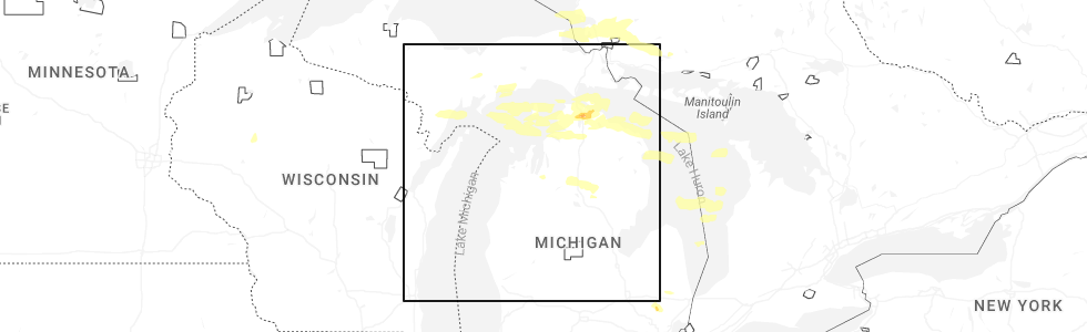
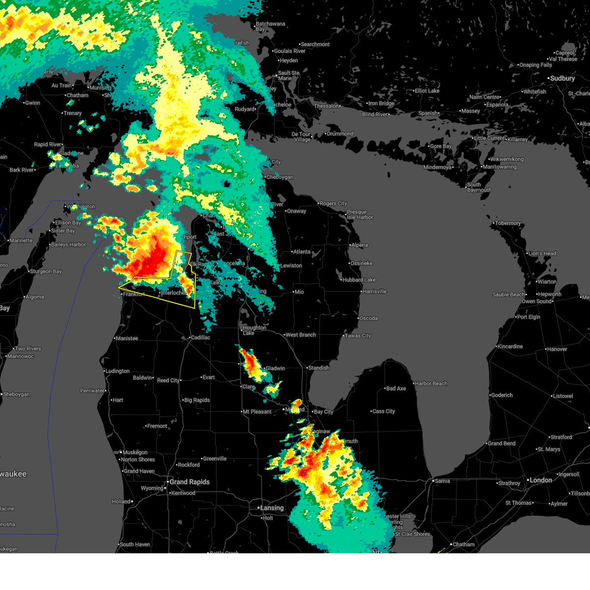
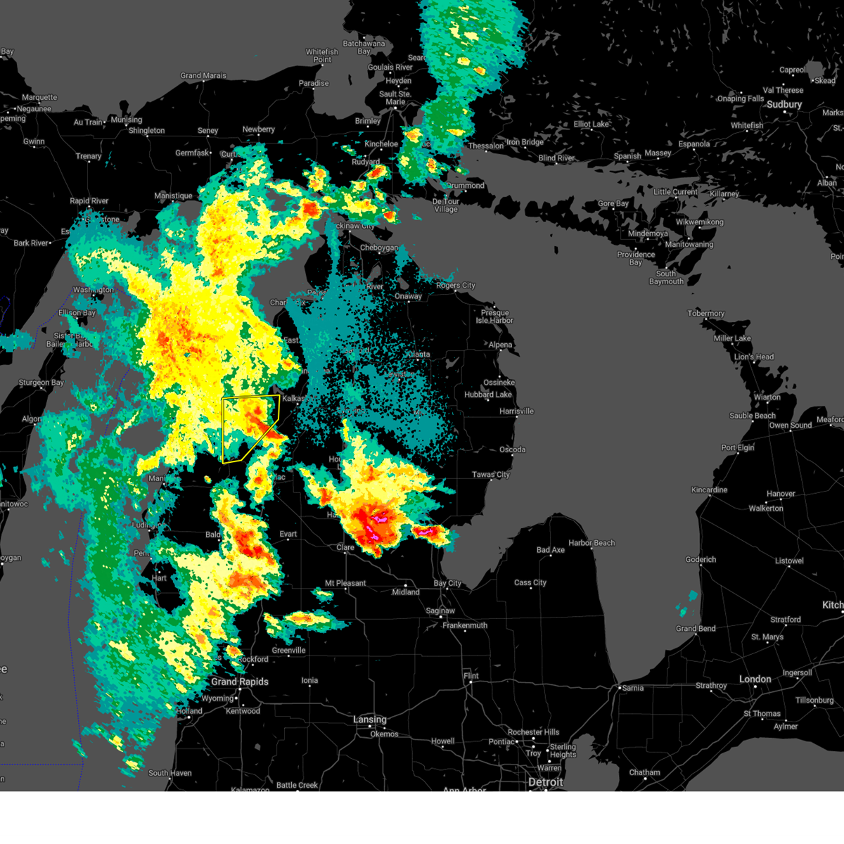
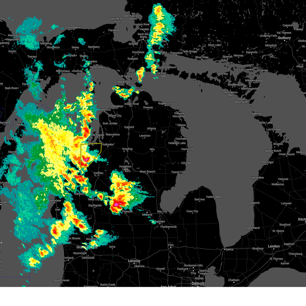
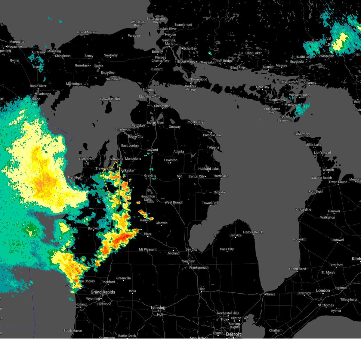
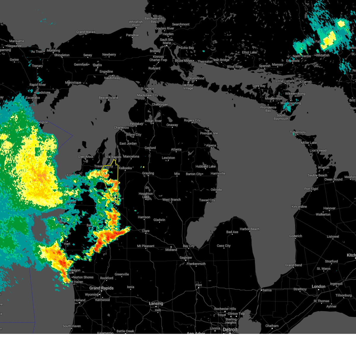
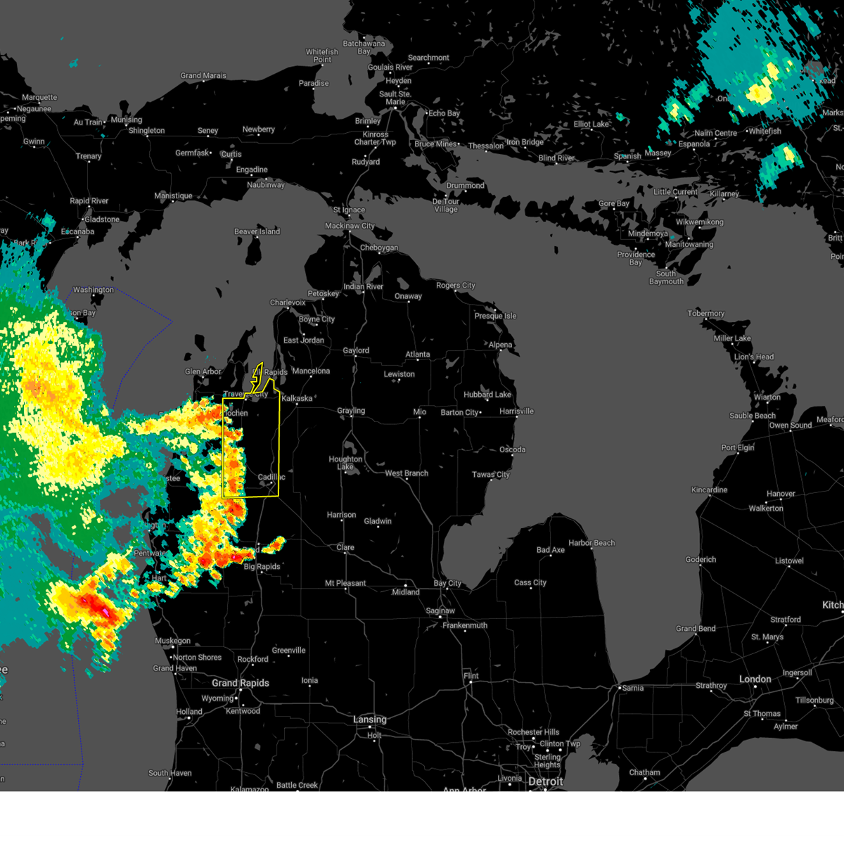
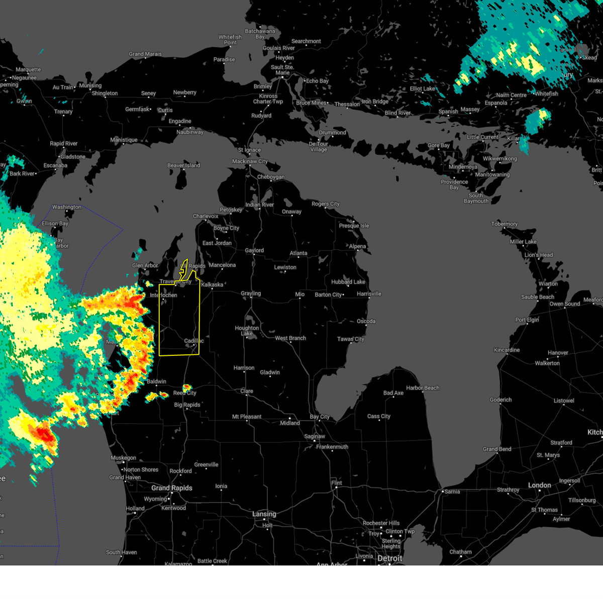
Hail Map for Traverse City, MI
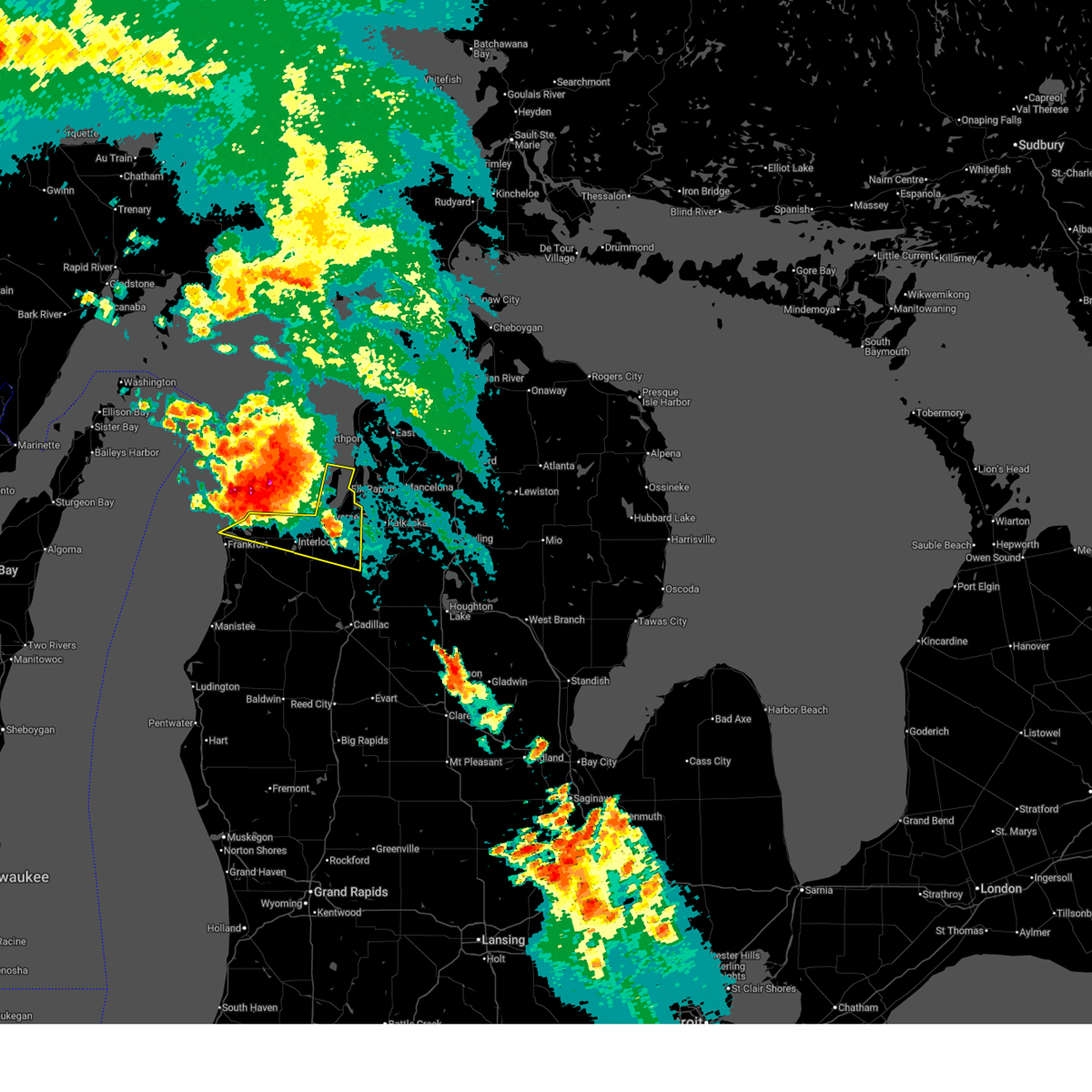
The Traverse City, MI area has had 11 reports of on-the-ground hail by trained spotters, and has been under severe weather warnings 17 times during the past 12 months. Doppler radar has detected hail at or near Traverse City, MI on 18 occasions, including 1 occasion during the past year.
| Name: | Traverse City, MI |
| Where Located: | 0.3 miles ENE of Traverse City, MI |
| Map: | Google Map for Traverse City, MI |
| Population: | 14674 |
| Housing Units: | 7358 |
| More Info: | Search Google for Traverse City, MI |
0
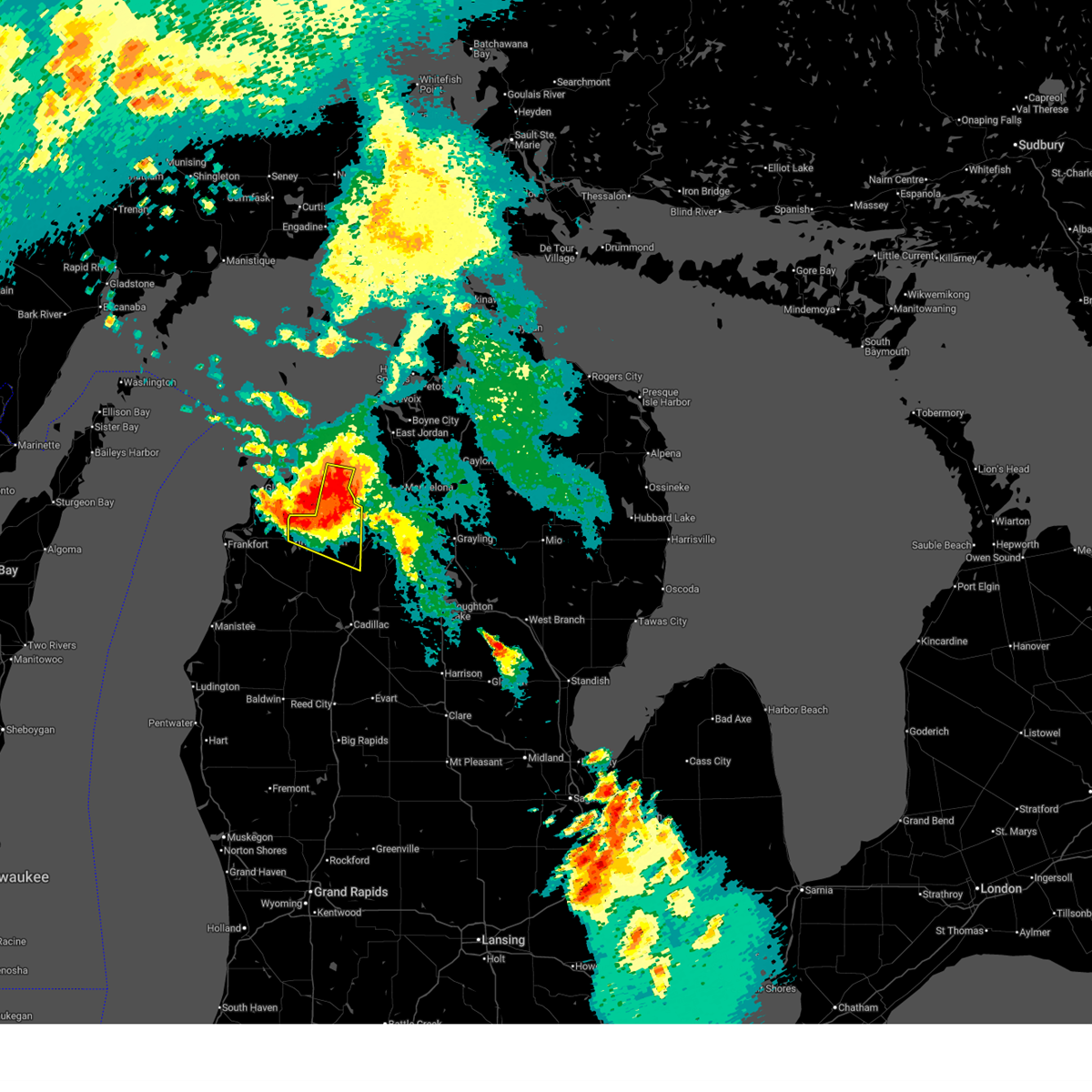
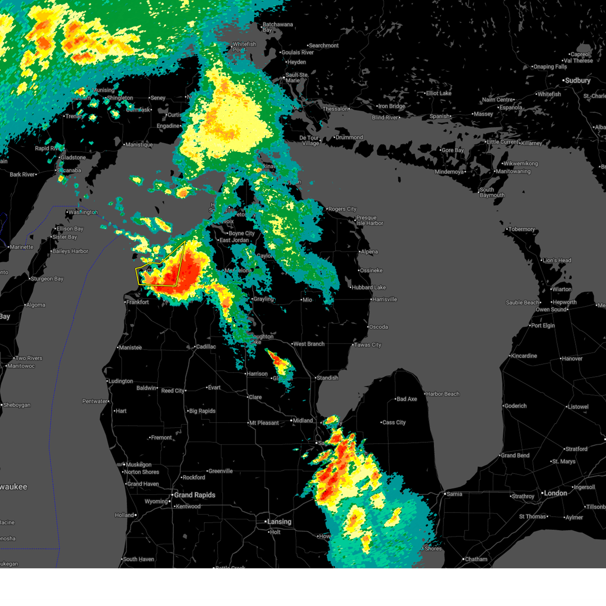
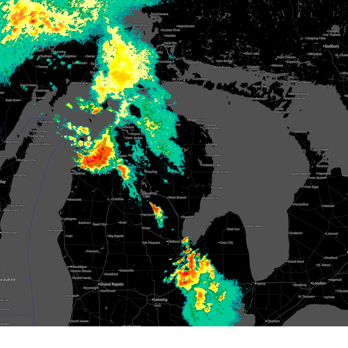
The Top Recent Hail Date for Traverse City, MI is Saturday, June 21, 2025 (16th out of 18)
Hail and Wind Damage Spotted near Traverse City, MI
| Date / Time | Report Details |
|---|---|
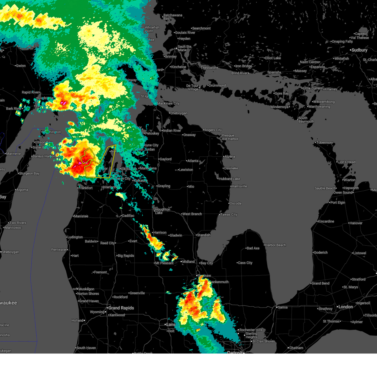
| 6/21/2025 8:00 AM EDT | Quarter sized hail reported 1 miles W of Traverse City, MI, picture of quarter sized hail just outside of tc. |
| 6/21/2025 7:44 AM EDT | Half Dollar sized hail reported 0.5 miles ENE of Traverse City, MI, half dollar sized hail in downtown tvc. |
| 6/21/2025 7:30 AM EDT | Quarter sized hail reported 1.5 miles ESE of Traverse City, MI, dime to quarter sized hail covering ground. |
| 6/21/2025 7:29 AM EDT |
 At 728 am edt, a severe thunderstorm was located over williamsburg, or 10 miles west of kalkaska, moving east at 45 mph (radar indicated). Hazards include 70 mph wind gusts and quarter size hail. Hail damage to vehicles is expected. expect considerable tree damage. Wind damage is also likely to mobile homes, roofs, and outbuildings. At 728 am edt, a severe thunderstorm was located over williamsburg, or 10 miles west of kalkaska, moving east at 45 mph (radar indicated). Hazards include 70 mph wind gusts and quarter size hail. Hail damage to vehicles is expected. expect considerable tree damage. Wind damage is also likely to mobile homes, roofs, and outbuildings.
|
| 6/21/2025 7:29 AM EDT |
 the severe thunderstorm warning has been cancelled and is no longer in effect the severe thunderstorm warning has been cancelled and is no longer in effect
|
| 6/21/2025 7:26 AM EDT |
 The storm which prompted the warning has moved out of the area. therefore, the warning will be allowed to expire. additional thunderstorms will be possible through the morning into the afternoon. to report severe weather, contact your nearest law enforcement agency. they will relay your report to the national weather service gaylord. The storm which prompted the warning has moved out of the area. therefore, the warning will be allowed to expire. additional thunderstorms will be possible through the morning into the afternoon. to report severe weather, contact your nearest law enforcement agency. they will relay your report to the national weather service gaylord.
|
| 6/21/2025 7:17 AM EDT |
 At 717 am edt, a severe thunderstorm was located near bingham, or 7 miles north of traverse city, moving east at 30 mph (radar indicated). Hazards include 70 mph wind gusts and ping pong ball size hail. People and animals outdoors will be injured. expect hail damage to roofs, siding, windows, and vehicles. expect considerable tree damage. wind damage is also likely to mobile homes, roofs, and outbuildings. This severe thunderstorm will remain over mainly rural areas of leelanau county, including the following locations, good harbor. At 717 am edt, a severe thunderstorm was located near bingham, or 7 miles north of traverse city, moving east at 30 mph (radar indicated). Hazards include 70 mph wind gusts and ping pong ball size hail. People and animals outdoors will be injured. expect hail damage to roofs, siding, windows, and vehicles. expect considerable tree damage. wind damage is also likely to mobile homes, roofs, and outbuildings. This severe thunderstorm will remain over mainly rural areas of leelanau county, including the following locations, good harbor.
|
| 6/21/2025 7:07 AM EDT |
 At 706 am edt, a severe thunderstorm was located over fouch, or 8 miles northwest of traverse city, moving east at 30 mph (radar indicated). Hazards include 70 mph wind gusts and ping pong ball size hail. People and animals outdoors will be injured. expect hail damage to roofs, siding, windows, and vehicles. expect considerable tree damage. wind damage is also likely to mobile homes, roofs, and outbuildings. this severe storm will be near, traverse city and traverse city state park around 710 am edt. spider lake and williamsburg around 725 am edt. Other locations impacted by this severe thunderstorm include bates. At 706 am edt, a severe thunderstorm was located over fouch, or 8 miles northwest of traverse city, moving east at 30 mph (radar indicated). Hazards include 70 mph wind gusts and ping pong ball size hail. People and animals outdoors will be injured. expect hail damage to roofs, siding, windows, and vehicles. expect considerable tree damage. wind damage is also likely to mobile homes, roofs, and outbuildings. this severe storm will be near, traverse city and traverse city state park around 710 am edt. spider lake and williamsburg around 725 am edt. Other locations impacted by this severe thunderstorm include bates.
|
| 6/21/2025 7:01 AM EDT |
 At 701 am edt, a severe thunderstorm was located over cedar, or 10 miles northwest of traverse city, moving southeast at 30 mph (radar indicated). Hazards include two inch hail and 70 mph wind gusts. People and animals outdoors will be injured. expect hail damage to roofs, siding, windows, and vehicles. expect considerable tree damage. wind damage is also likely to mobile homes, roofs, and outbuildings. this severe storm will be near, traverse city, bingham, greilickville, and fouch around 705 am edt. Other locations impacted by this severe thunderstorm include good harbor. At 701 am edt, a severe thunderstorm was located over cedar, or 10 miles northwest of traverse city, moving southeast at 30 mph (radar indicated). Hazards include two inch hail and 70 mph wind gusts. People and animals outdoors will be injured. expect hail damage to roofs, siding, windows, and vehicles. expect considerable tree damage. wind damage is also likely to mobile homes, roofs, and outbuildings. this severe storm will be near, traverse city, bingham, greilickville, and fouch around 705 am edt. Other locations impacted by this severe thunderstorm include good harbor.
|
| 6/21/2025 6:52 AM EDT |
 Svrapx the national weather service in gaylord has issued a * severe thunderstorm warning for, northern benzie county in northern michigan, grand traverse county in northern michigan, * until 800 am edt. * at 651 am edt, a severe thunderstorm was located near maple city, or 7 miles east of sleeping bear point, moving east at 30 mph (radar indicated). Hazards include ping pong ball size hail and 60 mph wind gusts. People and animals outdoors will be injured. expect hail damage to roofs, siding, windows, and vehicles. expect wind damage to roofs, siding, and trees. this severe thunderstorm will be near, traverse city around 705 am edt. mapleton around 710 am edt. elk rapids and traverse city state park around 720 am edt. williamsburg around 730 am edt. Other locations impacted by this severe thunderstorm include bates. Svrapx the national weather service in gaylord has issued a * severe thunderstorm warning for, northern benzie county in northern michigan, grand traverse county in northern michigan, * until 800 am edt. * at 651 am edt, a severe thunderstorm was located near maple city, or 7 miles east of sleeping bear point, moving east at 30 mph (radar indicated). Hazards include ping pong ball size hail and 60 mph wind gusts. People and animals outdoors will be injured. expect hail damage to roofs, siding, windows, and vehicles. expect wind damage to roofs, siding, and trees. this severe thunderstorm will be near, traverse city around 705 am edt. mapleton around 710 am edt. elk rapids and traverse city state park around 720 am edt. williamsburg around 730 am edt. Other locations impacted by this severe thunderstorm include bates.
|
| 6/21/2025 6:32 AM EDT |
 At 631 am edt, a severe thunderstorm was located near sleeping bear point, moving east at 30 mph (radar indicated). Hazards include two inch hail and 60 mph wind gusts. People and animals outdoors will be injured. expect hail damage to roofs, siding, windows, and vehicles. expect wind damage to roofs, siding, and trees. this severe storm will be near, glen arbor, glen haven, and burdickville around 635 am edt. maple city around 640 am edt. leland, cedar, and lake leelanau around 645 am edt. bingham and suttons bay around 650 am edt. fouch around 655 am edt. peshawbestown and greilickville around 700 am edt. Other locations impacted by this severe thunderstorm include good harbor. At 631 am edt, a severe thunderstorm was located near sleeping bear point, moving east at 30 mph (radar indicated). Hazards include two inch hail and 60 mph wind gusts. People and animals outdoors will be injured. expect hail damage to roofs, siding, windows, and vehicles. expect wind damage to roofs, siding, and trees. this severe storm will be near, glen arbor, glen haven, and burdickville around 635 am edt. maple city around 640 am edt. leland, cedar, and lake leelanau around 645 am edt. bingham and suttons bay around 650 am edt. fouch around 655 am edt. peshawbestown and greilickville around 700 am edt. Other locations impacted by this severe thunderstorm include good harbor.
|
| 6/21/2025 6:12 AM EDT |
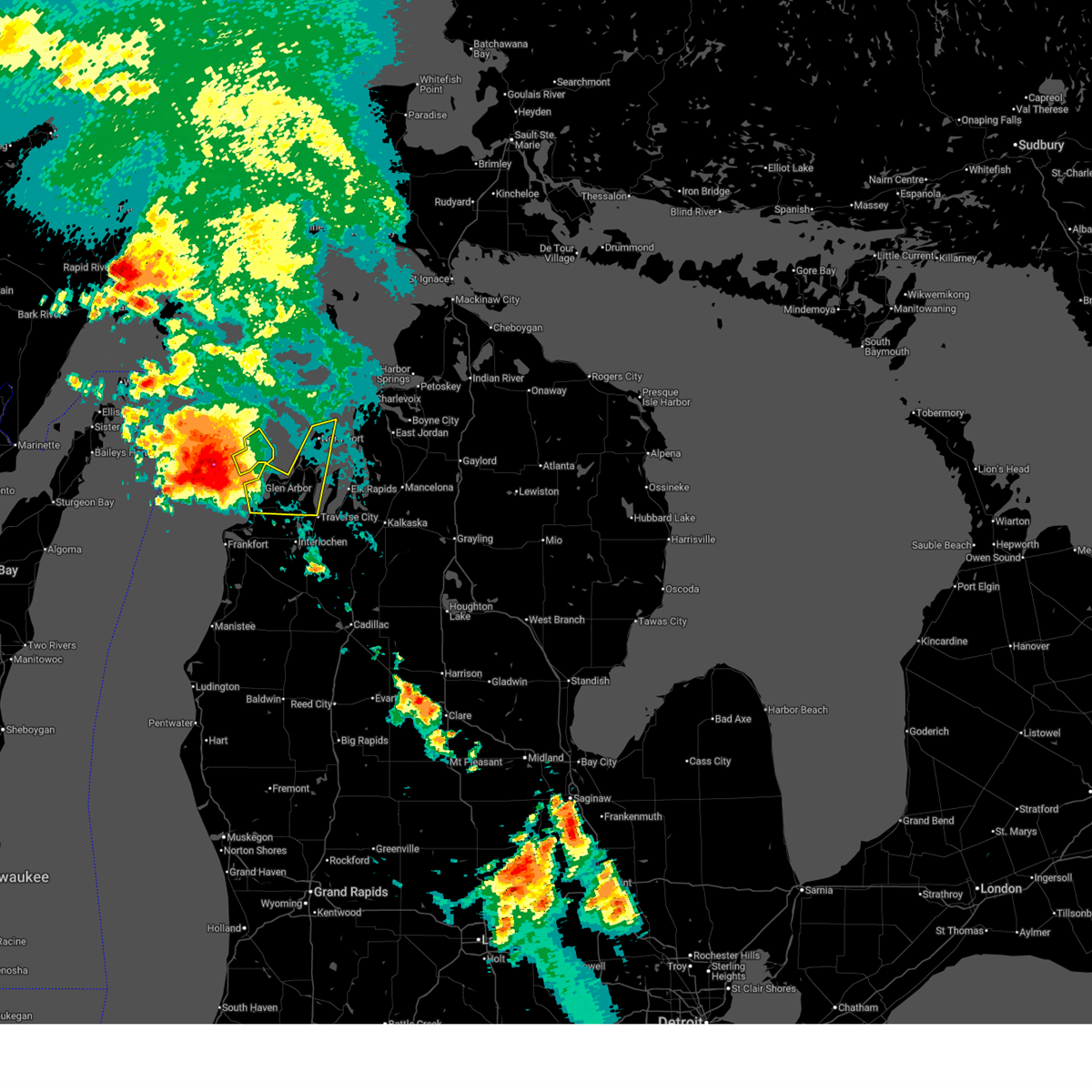 Svrapx the national weather service in gaylord has issued a * severe thunderstorm warning for, leelanau county in northern michigan, * until 730 am edt. * at 611 am edt, a severe thunderstorm was located 9 miles northwest of sleeping bear point, moving east at 35 mph (radar indicated). Hazards include 60 mph wind gusts and quarter size hail. Hail damage to vehicles is expected. expect wind damage to roofs, siding, and trees. this severe thunderstorm will be near, sleeping bear point and glen haven around 615 am edt. glen arbor around 620 am edt. leland around 630 am edt. lake leelanau around 635 am edt. suttons bay around 640 am edt. peshawbestown around 645 am edt. omena around 650 am edt. northport around 655 am edt. Other locations impacted by this severe thunderstorm include good harbor. Svrapx the national weather service in gaylord has issued a * severe thunderstorm warning for, leelanau county in northern michigan, * until 730 am edt. * at 611 am edt, a severe thunderstorm was located 9 miles northwest of sleeping bear point, moving east at 35 mph (radar indicated). Hazards include 60 mph wind gusts and quarter size hail. Hail damage to vehicles is expected. expect wind damage to roofs, siding, and trees. this severe thunderstorm will be near, sleeping bear point and glen haven around 615 am edt. glen arbor around 620 am edt. leland around 630 am edt. lake leelanau around 635 am edt. suttons bay around 640 am edt. peshawbestown around 645 am edt. omena around 650 am edt. northport around 655 am edt. Other locations impacted by this severe thunderstorm include good harbor.
|
| 5/16/2025 9:59 PM EDT |
 the severe thunderstorm warning has been cancelled and is no longer in effect the severe thunderstorm warning has been cancelled and is no longer in effect
|
| 5/16/2025 9:13 PM EDT |
 Svrapx the national weather service in gaylord has issued a * severe thunderstorm warning for, northwestern wexford county in northern michigan, grand traverse county in northern michigan, * until 1030 pm edt. * at 913 pm edt, a severe thunderstorm was located over buckley, or 11 miles east of thompsonville, moving north at 20 mph (radar indicated). Hazards include 60 mph wind gusts and half dollar size hail. Hail damage to vehicles is expected. expect wind damage to roofs, siding, and trees. this severe thunderstorm will be near, hannah, interlochen state park, buckley, and karlin around 920 pm edt. grawn, kingsley, and interlochen around 925 pm edt. traverse city around 940 pm edt. traverse city state park around 955 pm edt. Other locations impacted by this severe thunderstorm include bates. Svrapx the national weather service in gaylord has issued a * severe thunderstorm warning for, northwestern wexford county in northern michigan, grand traverse county in northern michigan, * until 1030 pm edt. * at 913 pm edt, a severe thunderstorm was located over buckley, or 11 miles east of thompsonville, moving north at 20 mph (radar indicated). Hazards include 60 mph wind gusts and half dollar size hail. Hail damage to vehicles is expected. expect wind damage to roofs, siding, and trees. this severe thunderstorm will be near, hannah, interlochen state park, buckley, and karlin around 920 pm edt. grawn, kingsley, and interlochen around 925 pm edt. traverse city around 940 pm edt. traverse city state park around 955 pm edt. Other locations impacted by this severe thunderstorm include bates.
|
| 5/16/2025 8:13 PM EDT | At 812 pm edt, a severe thunderstorm was located near lake leelanau, or near leland, moving north at 25 mph (radar indicated). Hazards include 70 mph wind gusts and quarter size hail. Hail damage to vehicles is expected. expect considerable tree damage. wind damage is also likely to mobile homes, roofs, and outbuildings. this severe storm will be near, suttons bay, lake leelanau, and leland around 820 pm edt. Other locations impacted by this severe thunderstorm include good harbor. |
| 5/16/2025 7:53 PM EDT | Svrapx the national weather service in gaylord has issued a * severe thunderstorm warning for, leelanau county in northern michigan, * until 845 pm edt. * at 753 pm edt, a severe thunderstorm was located over cedar, or 10 miles northwest of traverse city, moving north at 20 mph (radar indicated). Hazards include 60 mph wind gusts. Expect damage to roofs, siding, and trees. this severe thunderstorm will be near, lake leelanau and burdickville around 800 pm edt. leland around 805 pm edt. suttons bay around 810 pm edt. Other locations impacted by this severe thunderstorm include good harbor. |
| 8/27/2024 2:57 PM EDT |
 The storms which prompted the warning have weakened below severe limits, and have exited the warned area. therefore, the warning will be allowed to expire. a severe thunderstorm watch remains in effect until 800 pm edt for northern michigan. The storms which prompted the warning have weakened below severe limits, and have exited the warned area. therefore, the warning will be allowed to expire. a severe thunderstorm watch remains in effect until 800 pm edt for northern michigan.
|
| 8/27/2024 2:46 PM EDT |
 At 245 pm edt, severe thunderstorms were located along a line extending from near barker creek to near morey to near lucas, moving east at 45 mph (radar indicated). Hazards include 60 mph wind gusts and penny size hail. Expect damage to roofs, siding, and trees. These severe thunderstorms will remain over mainly rural areas of northeastern wexford and grand traverse counties, including the following locations, bates. At 245 pm edt, severe thunderstorms were located along a line extending from near barker creek to near morey to near lucas, moving east at 45 mph (radar indicated). Hazards include 60 mph wind gusts and penny size hail. Expect damage to roofs, siding, and trees. These severe thunderstorms will remain over mainly rural areas of northeastern wexford and grand traverse counties, including the following locations, bates.
|
| 8/27/2024 2:23 PM EDT |
 At 222 pm edt, severe thunderstorms were located along a line extending from near traverse city to near buckley to near hoxeyville, moving east at 50 mph (radar indicated). Hazards include 60 mph wind gusts and penny size hail. Expect damage to roofs, siding, and trees. these severe storms will be near, traverse city, cadillac, kingsley, manton, spider lake, meauwataka, mitchell state park, and traverse city state park around 230 pm edt. fife lake and williamsburg around 235 pm edt. Other locations impacted by these severe thunderstorms include bates. At 222 pm edt, severe thunderstorms were located along a line extending from near traverse city to near buckley to near hoxeyville, moving east at 50 mph (radar indicated). Hazards include 60 mph wind gusts and penny size hail. Expect damage to roofs, siding, and trees. these severe storms will be near, traverse city, cadillac, kingsley, manton, spider lake, meauwataka, mitchell state park, and traverse city state park around 230 pm edt. fife lake and williamsburg around 235 pm edt. Other locations impacted by these severe thunderstorms include bates.
|
| 8/27/2024 2:03 PM EDT |
 Svrapx the national weather service in gaylord has issued a * severe thunderstorm warning for, wexford county in northern michigan, grand traverse county in northern michigan, * until 300 pm edt. * at 203 pm edt, severe thunderstorms were located along a line extending from platte township to near copemish to 6 miles southwest of dublin, moving east at 45 mph (radar indicated). Hazards include 60 mph wind gusts and penny size hail. Expect damage to roofs, siding, and trees. severe thunderstorms will be near, karlin around 210 pm edt. sherman, buckley, mesick, harrietta, hoxeyville, yuma, interlochen state park, and interlochen around 215 pm edt. traverse city, grawn, and hannah around 220 pm edt. kingsley, boon, meauwataka, and traverse city state park around 225 pm edt. spider lake around 230 pm edt. cadillac, manton, mitchell state park, and williamsburg around 235 pm edt. fife lake around 240 pm edt. Other locations impacted by these severe thunderstorms include bates. Svrapx the national weather service in gaylord has issued a * severe thunderstorm warning for, wexford county in northern michigan, grand traverse county in northern michigan, * until 300 pm edt. * at 203 pm edt, severe thunderstorms were located along a line extending from platte township to near copemish to 6 miles southwest of dublin, moving east at 45 mph (radar indicated). Hazards include 60 mph wind gusts and penny size hail. Expect damage to roofs, siding, and trees. severe thunderstorms will be near, karlin around 210 pm edt. sherman, buckley, mesick, harrietta, hoxeyville, yuma, interlochen state park, and interlochen around 215 pm edt. traverse city, grawn, and hannah around 220 pm edt. kingsley, boon, meauwataka, and traverse city state park around 225 pm edt. spider lake around 230 pm edt. cadillac, manton, mitchell state park, and williamsburg around 235 pm edt. fife lake around 240 pm edt. Other locations impacted by these severe thunderstorms include bates.
|
| 8/3/2023 6:13 PM EDT |
 The severe thunderstorm warning for southwestern grand traverse county will expire at 615 pm edt, the storm which prompted the warning has moved out of the area. therefore, the warning will be allowed to expire. The severe thunderstorm warning for southwestern grand traverse county will expire at 615 pm edt, the storm which prompted the warning has moved out of the area. therefore, the warning will be allowed to expire.
|
| 8/3/2023 5:59 PM EDT | Corrects previous non-tstm wnd gst report from 4 w bates to tstm wnd gst report. mesonet station mc112 mdot sit in grand traverse county MI, 4.5 miles W of Traverse City, MI |
| 8/3/2023 5:48 PM EDT |
 At 548 pm edt, a severe thunderstorm was located over traverse city, moving southeast at 40 mph (radar indicated). Hazards include 60 mph wind gusts and quarter size hail. Hail damage to vehicles is expected. Expect wind damage to roofs, siding, and trees. At 548 pm edt, a severe thunderstorm was located over traverse city, moving southeast at 40 mph (radar indicated). Hazards include 60 mph wind gusts and quarter size hail. Hail damage to vehicles is expected. Expect wind damage to roofs, siding, and trees.
|
| 8/3/2023 5:47 PM EDT |
 At 546 pm edt, a severe thunderstorm was located over traverse city, moving southeast at 40 mph (radar indicated). Hazards include 60 mph wind gusts and quarter size hail. Hail damage to vehicles is expected. expect wind damage to roofs, siding, and trees. locations impacted include, traverse city, kingsley, grawn, interlochen, hannah and interlochen state park. hail threat, radar indicated max hail size, 1. 00 in wind threat, radar indicated max wind gust, 60 mph. At 546 pm edt, a severe thunderstorm was located over traverse city, moving southeast at 40 mph (radar indicated). Hazards include 60 mph wind gusts and quarter size hail. Hail damage to vehicles is expected. expect wind damage to roofs, siding, and trees. locations impacted include, traverse city, kingsley, grawn, interlochen, hannah and interlochen state park. hail threat, radar indicated max hail size, 1. 00 in wind threat, radar indicated max wind gust, 60 mph.
|
| 8/3/2023 5:46 PM EDT | Various reports of wind damage... including downed trees and power poles... from mping and social media in this area. time estimated from rada in grand traverse county MI, 3.3 miles SW of Traverse City, MI |
| 8/3/2023 5:46 PM EDT | Quarter sized hail reported 1.1 miles ESE of Traverse City, MI, delayed report of quarter size hail near front and division in traverse city. spotter also reported lots of tree damage in the area. time estimated from radar. |
| 8/3/2023 5:44 PM EDT | Corrects previous non-tstm wnd gst report from 1 se greilickville to tstm wnd gst report. mesonet station xelm elmwood township marin in lmz323 county MI, 2.2 miles SSE of Traverse City, MI |
| 8/3/2023 5:43 PM EDT | Corrects previous non-tstm wnd gst report from 2 se traverse city to tstm wnd gst report. asos station ktvc traverse city - cherry capital airpor in grand traverse county MI, 3 miles NW of Traverse City, MI |
| 8/3/2023 5:40 PM EDT | Picture relayed from broadcast media. trees down in vicinity of 500 block of 8th street in traverse city. broadcast media also relayed additional pictures of downed tre in grand traverse county MI, 1 miles E of Traverse City, MI |
| 8/3/2023 5:28 PM EDT |
 At 528 pm edt, a severe thunderstorm was located near lake ann, or 9 miles east of empire, moving southeast at 40 mph (radar indicated). Hazards include 60 mph wind gusts and quarter size hail. Hail damage to vehicles is expected. Expect wind damage to roofs, siding, and trees. At 528 pm edt, a severe thunderstorm was located near lake ann, or 9 miles east of empire, moving southeast at 40 mph (radar indicated). Hazards include 60 mph wind gusts and quarter size hail. Hail damage to vehicles is expected. Expect wind damage to roofs, siding, and trees.
|
| 6/25/2023 6:34 PM EDT |
 At 634 pm edt, a severe thunderstorm was located near mapleton, or 7 miles north of traverse city, moving east at 40 mph (radar indicated). Hazards include 60 mph wind gusts and penny size hail. Expect damage to roofs, siding, and trees. locations impacted include, traverse city and bates. hail threat, radar indicated max hail size, 0. 75 in wind threat, radar indicated max wind gust, 60 mph. At 634 pm edt, a severe thunderstorm was located near mapleton, or 7 miles north of traverse city, moving east at 40 mph (radar indicated). Hazards include 60 mph wind gusts and penny size hail. Expect damage to roofs, siding, and trees. locations impacted include, traverse city and bates. hail threat, radar indicated max hail size, 0. 75 in wind threat, radar indicated max wind gust, 60 mph.
|
| 6/25/2023 6:23 PM EDT |
 At 623 pm edt, a severe thunderstorm was located over traverse city, moving east at 40 mph (radar indicated). Hazards include 60 mph wind gusts and nickel size hail. Expect damage to roofs, siding, and trees. locations impacted include, traverse city, spider lake, traverse city state park and bates. hail threat, radar indicated max hail size, 0. 88 in wind threat, radar indicated max wind gust, 60 mph. At 623 pm edt, a severe thunderstorm was located over traverse city, moving east at 40 mph (radar indicated). Hazards include 60 mph wind gusts and nickel size hail. Expect damage to roofs, siding, and trees. locations impacted include, traverse city, spider lake, traverse city state park and bates. hail threat, radar indicated max hail size, 0. 88 in wind threat, radar indicated max wind gust, 60 mph.
|
| 6/25/2023 6:21 PM EDT |
 At 621 pm edt, severe thunderstorms were located along a line extending from near glen arbor to near elk rapids, moving north at 30 mph (radar indicated). Hazards include 60 mph wind gusts and penny size hail. expect damage to roofs, siding, and trees At 621 pm edt, severe thunderstorms were located along a line extending from near glen arbor to near elk rapids, moving north at 30 mph (radar indicated). Hazards include 60 mph wind gusts and penny size hail. expect damage to roofs, siding, and trees
|
| 6/25/2023 5:59 PM EDT |
 At 558 pm edt, a severe thunderstorm was located over leland, moving north at 30 mph (radar indicated). Hazards include 60 mph wind gusts. Expect damage to roofs, siding, and trees. locations impacted include, leland, bingham, suttons bay, cedar, greilickville, lake leelanau, fouch and good harbor. hail threat, radar indicated max hail size, <. 75 in wind threat, radar indicated max wind gust, 60 mph. At 558 pm edt, a severe thunderstorm was located over leland, moving north at 30 mph (radar indicated). Hazards include 60 mph wind gusts. Expect damage to roofs, siding, and trees. locations impacted include, leland, bingham, suttons bay, cedar, greilickville, lake leelanau, fouch and good harbor. hail threat, radar indicated max hail size, <. 75 in wind threat, radar indicated max wind gust, 60 mph.
|
| 6/25/2023 5:54 PM EDT |
 At 554 pm edt, a severe thunderstorm was located near hannah, or 15 miles south of traverse city, moving north at 35 mph (radar indicated). Hazards include 60 mph wind gusts and quarter size hail. Hail damage to vehicles is expected. Expect wind damage to roofs, siding, and trees. At 554 pm edt, a severe thunderstorm was located near hannah, or 15 miles south of traverse city, moving north at 35 mph (radar indicated). Hazards include 60 mph wind gusts and quarter size hail. Hail damage to vehicles is expected. Expect wind damage to roofs, siding, and trees.
|
| 6/25/2023 5:34 PM EDT |
 At 533 pm edt, a severe thunderstorm was located over fouch, or 8 miles northwest of traverse city, moving north at 25 mph (trained spotter. at around 510 pm, quarter size hail resulted in vehicle damage one mile north of chums corner). Hazards include 60 mph wind gusts and quarter size hail. Hail damage to vehicles is expected. Expect wind damage to roofs, siding, and trees. At 533 pm edt, a severe thunderstorm was located over fouch, or 8 miles northwest of traverse city, moving north at 25 mph (trained spotter. at around 510 pm, quarter size hail resulted in vehicle damage one mile north of chums corner). Hazards include 60 mph wind gusts and quarter size hail. Hail damage to vehicles is expected. Expect wind damage to roofs, siding, and trees.
|
| 6/25/2023 5:32 PM EDT |
 At 531 pm edt, a severe thunderstorm was located over fouch, or near traverse city, moving north at 15 mph (trained weather spotters. at around 510 pm, quarter size hail resulted in vehicle damage 1 mile north of chums corner). Hazards include 60 mph wind gusts and quarter size hail. Hail damage to vehicles is expected. expect wind damage to roofs, siding, and trees. locations impacted include, traverse city, greilickville and fouch. hail threat, radar indicated max hail size, 1. 00 in wind threat, radar indicated max wind gust, 60 mph. At 531 pm edt, a severe thunderstorm was located over fouch, or near traverse city, moving north at 15 mph (trained weather spotters. at around 510 pm, quarter size hail resulted in vehicle damage 1 mile north of chums corner). Hazards include 60 mph wind gusts and quarter size hail. Hail damage to vehicles is expected. expect wind damage to roofs, siding, and trees. locations impacted include, traverse city, greilickville and fouch. hail threat, radar indicated max hail size, 1. 00 in wind threat, radar indicated max wind gust, 60 mph.
|
| 6/25/2023 5:25 PM EDT | Delayed report relayed by broadcast media. pontoon boat flipped over on far south end of lake leelanau. time estimate in leelanau county MI, 8 miles SE of Traverse City, MI |
| 6/25/2023 5:24 PM EDT | Report of power lines down on hartman roa in grand traverse county MI, 3.2 miles NNE of Traverse City, MI |
| 6/25/2023 5:20 PM EDT |
 At 519 pm edt, a severe thunderstorm was located near greilickville, or near traverse city, moving north at 20 mph (radar indicated). Hazards include 60 mph wind gusts and quarter size hail. Hail damage to vehicles is expected. expect wind damage to roofs, siding, and trees. locations impacted include, traverse city, greilickville and fouch. hail threat, radar indicated max hail size, 1. 00 in wind threat, radar indicated max wind gust, 60 mph. At 519 pm edt, a severe thunderstorm was located near greilickville, or near traverse city, moving north at 20 mph (radar indicated). Hazards include 60 mph wind gusts and quarter size hail. Hail damage to vehicles is expected. expect wind damage to roofs, siding, and trees. locations impacted include, traverse city, greilickville and fouch. hail threat, radar indicated max hail size, 1. 00 in wind threat, radar indicated max wind gust, 60 mph.
|
| 6/25/2023 5:18 PM EDT | Grand traverse county central dispatch reports a tree downed on a house near fire station 12 at silver lak in grand traverse county MI, 4.9 miles NE of Traverse City, MI |
| 6/25/2023 5:10 PM EDT | Quarter sized hail reported 4.9 miles NNE of Traverse City, MI, trained spotter reports quarter sized hail and vehicle damage 1 mile north of chums corner in grand traverse county. time estimated by radar. |
| 6/25/2023 5:04 PM EDT |
 At 504 pm edt, a severe thunderstorm was located over grawn, or 7 miles southwest of traverse city, moving north at 20 mph (radar indicated). Hazards include 60 mph wind gusts and quarter size hail. Hail damage to vehicles is expected. Expect wind damage to roofs, siding, and trees. At 504 pm edt, a severe thunderstorm was located over grawn, or 7 miles southwest of traverse city, moving north at 20 mph (radar indicated). Hazards include 60 mph wind gusts and quarter size hail. Hail damage to vehicles is expected. Expect wind damage to roofs, siding, and trees.
|
| 6/15/2022 11:06 PM EDT | A few trees down near bates and sayler r in grand traverse county MI, 8.1 miles WSW of Traverse City, MI |
| 6/15/2022 11:06 PM EDT | A few trees down near bates and sayler r in grand traverse county MI, 8.1 miles WSW of Traverse City, MI |
| 6/15/2022 10:51 PM EDT |
 At 1051 pm edt, severe thunderstorms were located along a line extending from traverse city to buckley, moving east at 30 mph (radar indicated). Hazards include 60 mph wind gusts and penny size hail. Expect damage to roofs, siding, and trees. severe thunderstorms will be near, traverse city and traverse city state park around 1055 pm edt. kingsley around 1105 pm edt. williamsburg around 1110 pm edt. other locations in the path of these severe thunderstorms include barker creek, fife lake, rapid city, kalkaska, south boardman and antrim. hail threat, radar indicated max hail size, 0. 75 in wind threat, radar indicated max wind gust, 60 mph. At 1051 pm edt, severe thunderstorms were located along a line extending from traverse city to buckley, moving east at 30 mph (radar indicated). Hazards include 60 mph wind gusts and penny size hail. Expect damage to roofs, siding, and trees. severe thunderstorms will be near, traverse city and traverse city state park around 1055 pm edt. kingsley around 1105 pm edt. williamsburg around 1110 pm edt. other locations in the path of these severe thunderstorms include barker creek, fife lake, rapid city, kalkaska, south boardman and antrim. hail threat, radar indicated max hail size, 0. 75 in wind threat, radar indicated max wind gust, 60 mph.
|
| 5/20/2022 2:48 PM EDT |
 At 248 pm edt, severe thunderstorms were located along a line extending from near norwood to near grawn, moving east at 50 mph (radar indicated). Hazards include 70 mph wind gusts and quarter size hail. Hail damage to vehicles is expected. expect considerable tree damage. wind damage is also likely to mobile homes, roofs, and outbuildings. locations impacted include, traverse city, leland, bingham, suttons bay, northport, cedar, lake ann, greilickville, lake leelanau, mapleton, burdickville, maple city, grawn, traverse city state park, old mission, omena, peshawbestown, leelanau state park, fouch and good harbor. thunderstorm damage threat, considerable hail threat, radar indicated max hail size, 1. 00 in wind threat, radar indicated max wind gust, 70 mph. At 248 pm edt, severe thunderstorms were located along a line extending from near norwood to near grawn, moving east at 50 mph (radar indicated). Hazards include 70 mph wind gusts and quarter size hail. Hail damage to vehicles is expected. expect considerable tree damage. wind damage is also likely to mobile homes, roofs, and outbuildings. locations impacted include, traverse city, leland, bingham, suttons bay, northport, cedar, lake ann, greilickville, lake leelanau, mapleton, burdickville, maple city, grawn, traverse city state park, old mission, omena, peshawbestown, leelanau state park, fouch and good harbor. thunderstorm damage threat, considerable hail threat, radar indicated max hail size, 1. 00 in wind threat, radar indicated max wind gust, 70 mph.
|
| 5/20/2022 2:46 PM EDT |
 At 246 pm edt, severe thunderstorms were located along a line extending from grand traverse light to traverse city, moving northeast at 50 mph (radar indicated). Hazards include 60 mph wind gusts and quarter size hail. Hail damage to vehicles is expected. expect wind damage to roofs, siding, and trees. severe thunderstorms will be near, elk rapids, norwood, fishermans island state park and barker creek around 255 pm edt. charlevoix, rapid city, alden, ironton, clam river and kewadin around 300 pm edt. bayshore and horton bay around 305 pm edt. other locations in the path of these severe thunderstorms include petoskey, mancelona, harbor springs, antrim, bay view, conway, oden, petoskey state park, alba, alanson and brutus. hail threat, radar indicated max hail size, 1. 00 in wind threat, radar indicated max wind gust, 60 mph. At 246 pm edt, severe thunderstorms were located along a line extending from grand traverse light to traverse city, moving northeast at 50 mph (radar indicated). Hazards include 60 mph wind gusts and quarter size hail. Hail damage to vehicles is expected. expect wind damage to roofs, siding, and trees. severe thunderstorms will be near, elk rapids, norwood, fishermans island state park and barker creek around 255 pm edt. charlevoix, rapid city, alden, ironton, clam river and kewadin around 300 pm edt. bayshore and horton bay around 305 pm edt. other locations in the path of these severe thunderstorms include petoskey, mancelona, harbor springs, antrim, bay view, conway, oden, petoskey state park, alba, alanson and brutus. hail threat, radar indicated max hail size, 1. 00 in wind threat, radar indicated max wind gust, 60 mph.
|
| 5/20/2022 2:23 PM EDT |
 At 223 pm edt, severe thunderstorms were located along a line extending from 10 miles northwest of leland to near benzonia, moving northeast at 75 mph (radar indicated). Hazards include 70 mph wind gusts and quarter size hail. Hail damage to vehicles is expected. expect considerable tree damage. wind damage is also likely to mobile homes, roofs, and outbuildings. locations impacted include, northport, lake ann, leelanau state park, interlochen, grawn, interlochen state park, traverse city, greilickville, fouch, traverse city state park and mapleton. thunderstorm damage threat, considerable hail threat, radar indicated max hail size, 1. 00 in wind threat, radar indicated max wind gust, 70 mph. At 223 pm edt, severe thunderstorms were located along a line extending from 10 miles northwest of leland to near benzonia, moving northeast at 75 mph (radar indicated). Hazards include 70 mph wind gusts and quarter size hail. Hail damage to vehicles is expected. expect considerable tree damage. wind damage is also likely to mobile homes, roofs, and outbuildings. locations impacted include, northport, lake ann, leelanau state park, interlochen, grawn, interlochen state park, traverse city, greilickville, fouch, traverse city state park and mapleton. thunderstorm damage threat, considerable hail threat, radar indicated max hail size, 1. 00 in wind threat, radar indicated max wind gust, 70 mph.
|
| 5/10/2022 11:45 PM EDT |
 At 1144 pm edt, a severe thunderstorm was located near lake ann, or 9 miles southeast of empire, moving east at 25 mph (radar indicated). Hazards include 60 mph wind gusts and quarter size hail. Hail damage to vehicles is expected. expect wind damage to roofs, siding, and trees. locations impacted include, lake ann, bendon, interlochen, interlochen state park, karlin and traverse city. hail threat, radar indicated max hail size, 1. 00 in wind threat, radar indicated max wind gust, 60 mph. At 1144 pm edt, a severe thunderstorm was located near lake ann, or 9 miles southeast of empire, moving east at 25 mph (radar indicated). Hazards include 60 mph wind gusts and quarter size hail. Hail damage to vehicles is expected. expect wind damage to roofs, siding, and trees. locations impacted include, lake ann, bendon, interlochen, interlochen state park, karlin and traverse city. hail threat, radar indicated max hail size, 1. 00 in wind threat, radar indicated max wind gust, 60 mph.
|
| 5/10/2022 11:17 PM EDT |
 At 1116 pm edt, a severe thunderstorm was located near empire, moving east at 30 mph (radar indicated). Hazards include 60 mph wind gusts and quarter size hail. Hail damage to vehicles is expected. expect wind damage to roofs, siding, and trees. this severe thunderstorm will be near, empire and glen haven around 1125 pm edt. platte township around 1130 pm edt. honor and burdickville around 1135 pm edt. other locations in the path of this severe thunderstorm include maple city, lake ann, bendon, interlochen, interlochen state park and traverse city. hail threat, radar indicated max hail size, 1. 00 in wind threat, radar indicated max wind gust, 60 mph. At 1116 pm edt, a severe thunderstorm was located near empire, moving east at 30 mph (radar indicated). Hazards include 60 mph wind gusts and quarter size hail. Hail damage to vehicles is expected. expect wind damage to roofs, siding, and trees. this severe thunderstorm will be near, empire and glen haven around 1125 pm edt. platte township around 1130 pm edt. honor and burdickville around 1135 pm edt. other locations in the path of this severe thunderstorm include maple city, lake ann, bendon, interlochen, interlochen state park and traverse city. hail threat, radar indicated max hail size, 1. 00 in wind threat, radar indicated max wind gust, 60 mph.
|
| 9/7/2021 9:43 AM EDT |
 At 943 am edt, severe thunderstorms were located along a line extending from near spider lake to near fife lake to near kingsley to near yuma, moving east at 65 mph (radar indicated). Hazards include 60 mph wind gusts and quarter size hail. Hail damage to vehicles is expected. expect wind damage to roofs, siding, and trees. locations impacted include, fife lake, south boardman, cadillac, sharon, manton, jennings, lake city and morey. hail threat, radar indicated max hail size, 1. 00 in wind threat, radar indicated max wind gust, 60 mph. At 943 am edt, severe thunderstorms were located along a line extending from near spider lake to near fife lake to near kingsley to near yuma, moving east at 65 mph (radar indicated). Hazards include 60 mph wind gusts and quarter size hail. Hail damage to vehicles is expected. expect wind damage to roofs, siding, and trees. locations impacted include, fife lake, south boardman, cadillac, sharon, manton, jennings, lake city and morey. hail threat, radar indicated max hail size, 1. 00 in wind threat, radar indicated max wind gust, 60 mph.
|
| 9/7/2021 9:40 AM EDT |
 At 939 am edt, severe thunderstorms were located along a line extending from bellaire to near williamsburg, moving east at 50 mph (law enforcement. at 926 am edt, multiple down trees were reported at washington street and boardman avenue). Hazards include 60 mph wind gusts and penny size hail. Expect damage to roofs, siding, and trees. these severe storms will be near, bellaire around 945 am edt. other locations in the path of these severe thunderstorms include mancelona, kalkaska, alba, sigma and darragh. hail threat, radar indicated max hail size, 0. 75 in wind threat, radar indicated max wind gust, 60 mph. At 939 am edt, severe thunderstorms were located along a line extending from bellaire to near williamsburg, moving east at 50 mph (law enforcement. at 926 am edt, multiple down trees were reported at washington street and boardman avenue). Hazards include 60 mph wind gusts and penny size hail. Expect damage to roofs, siding, and trees. these severe storms will be near, bellaire around 945 am edt. other locations in the path of these severe thunderstorms include mancelona, kalkaska, alba, sigma and darragh. hail threat, radar indicated max hail size, 0. 75 in wind threat, radar indicated max wind gust, 60 mph.
|
| 9/7/2021 9:30 AM EDT | Power lines down on road. time of damage estimated from rada in grand traverse county MI, 8.9 miles NE of Traverse City, MI |
| 9/7/2021 9:29 AM EDT |
 At 928 am edt, severe thunderstorms were located along a line extending from interlochen state park to near norwalk, moving east at 45 mph (radar indicated. at 913 em edt, penny size hail was reported 1 mile east of beulah). Hazards include 60 mph wind gusts and quarter size hail. Hail damage to vehicles is expected. expect wind damage to roofs, siding, and trees. severe thunderstorms will be near, grawn, interlochen, interlochen state park and karlin around 935 am edt. traverse city, buckley and hannah around 940 am edt. kingsley around 945 am edt. other locations in the path of these severe thunderstorms include yuma, spider lake, sherman, mesick, harrietta, boon, fife lake, south boardman, meauwataka, cadillac, sharon, mitchell state park and jennings. hail threat, radar indicated max hail size, 1. 00 in wind threat, radar indicated max wind gust, 60 mph. At 928 am edt, severe thunderstorms were located along a line extending from interlochen state park to near norwalk, moving east at 45 mph (radar indicated. at 913 em edt, penny size hail was reported 1 mile east of beulah). Hazards include 60 mph wind gusts and quarter size hail. Hail damage to vehicles is expected. expect wind damage to roofs, siding, and trees. severe thunderstorms will be near, grawn, interlochen, interlochen state park and karlin around 935 am edt. traverse city, buckley and hannah around 940 am edt. kingsley around 945 am edt. other locations in the path of these severe thunderstorms include yuma, spider lake, sherman, mesick, harrietta, boon, fife lake, south boardman, meauwataka, cadillac, sharon, mitchell state park and jennings. hail threat, radar indicated max hail size, 1. 00 in wind threat, radar indicated max wind gust, 60 mph.
|
| 9/7/2021 9:26 AM EDT | Multiple trees dow in grand traverse county MI, 0.5 miles ENE of Traverse City, MI |
| 9/7/2021 9:25 AM EDT |
 At 924 am edt, severe thunderstorms were located along a line extending from near old mission to near grawn, moving east at 50 mph (law enforcement. at 920 am edt, trees down were reported by grand traverse law enforcement). Hazards include 60 mph wind gusts and quarter size hail. Hail damage to vehicles is expected. expect wind damage to roofs, siding, and trees. severe thunderstorms will be near, elk rapids, kewadin and alden around 930 am edt. clam river around 935 am edt. bellaire and williamsburg around 940 am edt. other locations in the path of these severe thunderstorms include mancelona, antrim, barker creek, kalkaska, alba, sigma and darragh. hail threat, radar indicated max hail size, 1. 00 in wind threat, radar indicated max wind gust, 60 mph. At 924 am edt, severe thunderstorms were located along a line extending from near old mission to near grawn, moving east at 50 mph (law enforcement. at 920 am edt, trees down were reported by grand traverse law enforcement). Hazards include 60 mph wind gusts and quarter size hail. Hail damage to vehicles is expected. expect wind damage to roofs, siding, and trees. severe thunderstorms will be near, elk rapids, kewadin and alden around 930 am edt. clam river around 935 am edt. bellaire and williamsburg around 940 am edt. other locations in the path of these severe thunderstorms include mancelona, antrim, barker creek, kalkaska, alba, sigma and darragh. hail threat, radar indicated max hail size, 1. 00 in wind threat, radar indicated max wind gust, 60 mph.
|
| 9/7/2021 9:23 AM EDT | Power lines down on road. time of damage estimated from rada in grand traverse county MI, 13.7 miles SSW of Traverse City, MI |
| 9/7/2021 9:20 AM EDT |
 At 919 am edt, severe thunderstorms were located along a line extending from old mission to fouch to lake ann, moving east at 40 mph (radar indicated. at 915 am edt, dime size hail was reported 2 miles south of lake leelanau). Hazards include 60 mph wind gusts and quarter size hail. Hail damage to vehicles is expected. expect wind damage to roofs, siding, and trees. locations impacted include, traverse city, bingham, suttons bay, cedar, lake ann, omena, interlochen, greilickville, peshawbestown and fouch. hail threat, observed max hail size, 1. 00 in wind threat, radar indicated max wind gust, 60 mph. At 919 am edt, severe thunderstorms were located along a line extending from old mission to fouch to lake ann, moving east at 40 mph (radar indicated. at 915 am edt, dime size hail was reported 2 miles south of lake leelanau). Hazards include 60 mph wind gusts and quarter size hail. Hail damage to vehicles is expected. expect wind damage to roofs, siding, and trees. locations impacted include, traverse city, bingham, suttons bay, cedar, lake ann, omena, interlochen, greilickville, peshawbestown and fouch. hail threat, observed max hail size, 1. 00 in wind threat, radar indicated max wind gust, 60 mph.
|
| 9/7/2021 9:10 AM EDT |
 At 910 am edt, severe thunderstorms were located along a line extending from suttons bay to cedar to near honor, moving east at 40 mph (radar indicated). Hazards include 60 mph wind gusts and quarter size hail. Hail damage to vehicles is expected. expect wind damage to roofs, siding, and trees. locations impacted include, suttons bay, fouch, peshawbestown, omena, lake leelanau, bingham, greilickville, interlochen and traverse city. hail threat, radar indicated max hail size, 1. 00 in wind threat, radar indicated max wind gust, 60 mph. At 910 am edt, severe thunderstorms were located along a line extending from suttons bay to cedar to near honor, moving east at 40 mph (radar indicated). Hazards include 60 mph wind gusts and quarter size hail. Hail damage to vehicles is expected. expect wind damage to roofs, siding, and trees. locations impacted include, suttons bay, fouch, peshawbestown, omena, lake leelanau, bingham, greilickville, interlochen and traverse city. hail threat, radar indicated max hail size, 1. 00 in wind threat, radar indicated max wind gust, 60 mph.
|
| 9/7/2021 8:40 AM EDT |
 At 839 am edt, severe thunderstorms were located along a line extending from 9 miles north of sleeping bear point to 6 miles west of empire to 9 miles northwest of frankfort, moving east at 40 mph (radar indicated). Hazards include 60 mph wind gusts and quarter size hail. Hail damage to vehicles is expected. expect wind damage to roofs, siding, and trees. severe thunderstorms will be near, empire and glen haven around 850 am edt. burdickville around 855 am edt. other locations in the path of these severe thunderstorms include leland, platte township, maple city, cedar, lake leelanau, suttons bay, peshawbestown, omena, lake ann, fouch, greilickville, traverse city and interlochen. hail threat, radar indicated max hail size, 1. 00 in wind threat, radar indicated max wind gust, 60 mph. At 839 am edt, severe thunderstorms were located along a line extending from 9 miles north of sleeping bear point to 6 miles west of empire to 9 miles northwest of frankfort, moving east at 40 mph (radar indicated). Hazards include 60 mph wind gusts and quarter size hail. Hail damage to vehicles is expected. expect wind damage to roofs, siding, and trees. severe thunderstorms will be near, empire and glen haven around 850 am edt. burdickville around 855 am edt. other locations in the path of these severe thunderstorms include leland, platte township, maple city, cedar, lake leelanau, suttons bay, peshawbestown, omena, lake ann, fouch, greilickville, traverse city and interlochen. hail threat, radar indicated max hail size, 1. 00 in wind threat, radar indicated max wind gust, 60 mph.
|
| 8/28/2021 12:49 AM EDT |
 At 1248 am edt, severe thunderstorms were located along a line extending from bendon to near free soil, moving east at 30 mph (radar indicated). Hazards include 60 mph wind gusts and quarter size hail. Hail damage to vehicles is expected. expect wind damage to roofs, siding, and trees. severe thunderstorms will be near, interlochen, interlochen state park, bendon and karlin around 1255 am edt. grawn around 105 am edt. other locations in the path of these severe thunderstorms include hannah, traverse city, kingsley, spider lake, hoxeyville and fife lake. hail threat, radar indicated max hail size, 1. 00 in wind threat, radar indicated max wind gust, 60 mph. At 1248 am edt, severe thunderstorms were located along a line extending from bendon to near free soil, moving east at 30 mph (radar indicated). Hazards include 60 mph wind gusts and quarter size hail. Hail damage to vehicles is expected. expect wind damage to roofs, siding, and trees. severe thunderstorms will be near, interlochen, interlochen state park, bendon and karlin around 1255 am edt. grawn around 105 am edt. other locations in the path of these severe thunderstorms include hannah, traverse city, kingsley, spider lake, hoxeyville and fife lake. hail threat, radar indicated max hail size, 1. 00 in wind threat, radar indicated max wind gust, 60 mph.
|
| 8/11/2021 6:40 PM EDT |
 At 639 pm edt, a severe thunderstorm was located over traverse city state park, moving east at 55 mph (radar indicated). Hazards include 70 mph wind gusts. Expect considerable tree damage. damage is likely to mobile homes, roofs, and outbuildings. this severe storm will be near, elk rapids and williamsburg around 650 pm edt. rapid city, barker creek and alden around 655 pm edt. kalkaska around 700 pm edt. mancelona, antrim and darragh around 705 pm edt. other locations impacted by this severe thunderstorm include blue lake township, bates and lake bellaire. thunderstorm damage threat, considerable hail threat, radar indicated max hail size, <. 75 in wind threat, radar indicated max wind gust, 70 mph. At 639 pm edt, a severe thunderstorm was located over traverse city state park, moving east at 55 mph (radar indicated). Hazards include 70 mph wind gusts. Expect considerable tree damage. damage is likely to mobile homes, roofs, and outbuildings. this severe storm will be near, elk rapids and williamsburg around 650 pm edt. rapid city, barker creek and alden around 655 pm edt. kalkaska around 700 pm edt. mancelona, antrim and darragh around 705 pm edt. other locations impacted by this severe thunderstorm include blue lake township, bates and lake bellaire. thunderstorm damage threat, considerable hail threat, radar indicated max hail size, <. 75 in wind threat, radar indicated max wind gust, 70 mph.
|
| 8/11/2021 6:24 PM EDT |
 At 623 pm edt, a severe thunderstorm was located over lake ann, or 10 miles east of empire, moving east at 65 mph (radar indicated). Hazards include 70 mph wind gusts. Expect considerable tree damage. damage is likely to mobile homes, roofs, and outbuildings. this severe thunderstorm will be near, traverse city and greilickville around 635 pm edt. elk rapids and williamsburg around 645 pm edt. rapid city, barker creek and alden around 650 pm edt. kalkaska around 655 pm edt. mancelona around 700 pm edt. other locations impacted by this severe thunderstorm include blue lake township, bates and lake bellaire. thunderstorm damage threat, considerable hail threat, radar indicated max hail size, <. 75 in wind threat, radar indicated max wind gust, 70 mph. At 623 pm edt, a severe thunderstorm was located over lake ann, or 10 miles east of empire, moving east at 65 mph (radar indicated). Hazards include 70 mph wind gusts. Expect considerable tree damage. damage is likely to mobile homes, roofs, and outbuildings. this severe thunderstorm will be near, traverse city and greilickville around 635 pm edt. elk rapids and williamsburg around 645 pm edt. rapid city, barker creek and alden around 650 pm edt. kalkaska around 655 pm edt. mancelona around 700 pm edt. other locations impacted by this severe thunderstorm include blue lake township, bates and lake bellaire. thunderstorm damage threat, considerable hail threat, radar indicated max hail size, <. 75 in wind threat, radar indicated max wind gust, 70 mph.
|
| 8/11/2021 5:46 PM EDT |
 At 546 pm edt, severe thunderstorms were located along a line extending from peshawbestown to near mapleton to greilickville, moving east at 55 mph (radar indicated). Hazards include 60 mph wind gusts. Expect damage to roofs, siding, and trees. these severe storms will be near, mapleton and old mission around 550 pm edt. other locations in the path of these severe thunderstorms include elk rapids, torch lake, clam river, kewadin, alden, barker creek, williamsburg, bellaire, central lake, rapid city, kalkaska, ellsworth, antrim, darragh and mancelona. hail threat, radar indicated max hail size, <. 75 in wind threat, radar indicated max wind gust, 60 mph. At 546 pm edt, severe thunderstorms were located along a line extending from peshawbestown to near mapleton to greilickville, moving east at 55 mph (radar indicated). Hazards include 60 mph wind gusts. Expect damage to roofs, siding, and trees. these severe storms will be near, mapleton and old mission around 550 pm edt. other locations in the path of these severe thunderstorms include elk rapids, torch lake, clam river, kewadin, alden, barker creek, williamsburg, bellaire, central lake, rapid city, kalkaska, ellsworth, antrim, darragh and mancelona. hail threat, radar indicated max hail size, <. 75 in wind threat, radar indicated max wind gust, 60 mph.
|
| 8/11/2021 5:30 PM EDT |
 At 530 pm edt, severe thunderstorms were located along a line extending from near leland to cedar to lake ann, moving east at 55 mph (radar indicated). Hazards include 60 mph wind gusts and quarter size hail. Hail damage to vehicles is expected. expect wind damage to roofs, siding, and trees. severe thunderstorms will be near, leland, bingham and fouch around 535 pm edt. suttons bay, lake leelanau and grawn around 540 pm edt. traverse city, peshawbestown, mapleton, omena, traverse city state park and greilickville around 545 pm edt. old mission around 550 pm edt. other locations in the path of these severe thunderstorms include elk rapids, torch lake, kewadin, williamsburg, clam river, rapid city, barker creek, alden, kalkaska, bellaire, ellsworth, central lake, mancelona, antrim and darragh. hail threat, radar indicated max hail size, 1. 00 in wind threat, radar indicated max wind gust, 60 mph. At 530 pm edt, severe thunderstorms were located along a line extending from near leland to cedar to lake ann, moving east at 55 mph (radar indicated). Hazards include 60 mph wind gusts and quarter size hail. Hail damage to vehicles is expected. expect wind damage to roofs, siding, and trees. severe thunderstorms will be near, leland, bingham and fouch around 535 pm edt. suttons bay, lake leelanau and grawn around 540 pm edt. traverse city, peshawbestown, mapleton, omena, traverse city state park and greilickville around 545 pm edt. old mission around 550 pm edt. other locations in the path of these severe thunderstorms include elk rapids, torch lake, kewadin, williamsburg, clam river, rapid city, barker creek, alden, kalkaska, bellaire, ellsworth, central lake, mancelona, antrim and darragh. hail threat, radar indicated max hail size, 1. 00 in wind threat, radar indicated max wind gust, 60 mph.
|
| 8/10/2021 10:56 PM EDT |
 At 1055 pm edt, severe thunderstorms were located along a line extending from near williamsburg to near spider lake to hannah, moving southeast at 45 mph (radar indicated). Hazards include 70 mph wind gusts and nickel size hail. Expect considerable tree damage. damage is likely to mobile homes, roofs, and outbuildings. these severe storms will be near, kalkaska, fife lake and south boardman around 1105 pm edt. other locations in the path of these severe thunderstorms include sharon, sigma, morey and moorestown. thunderstorm damage threat, considerable hail threat, radar indicated max hail size, 0. 88 in wind threat, radar indicated max wind gust, 70 mph. At 1055 pm edt, severe thunderstorms were located along a line extending from near williamsburg to near spider lake to hannah, moving southeast at 45 mph (radar indicated). Hazards include 70 mph wind gusts and nickel size hail. Expect considerable tree damage. damage is likely to mobile homes, roofs, and outbuildings. these severe storms will be near, kalkaska, fife lake and south boardman around 1105 pm edt. other locations in the path of these severe thunderstorms include sharon, sigma, morey and moorestown. thunderstorm damage threat, considerable hail threat, radar indicated max hail size, 0. 88 in wind threat, radar indicated max wind gust, 70 mph.
|
| 8/10/2021 10:45 PM EDT |
 At 1044 pm edt, severe thunderstorms were located along a line extending from near traverse city state park to near spider lake to interlochen, moving southeast at 50 mph (radar indicated). Hazards include 70 mph wind gusts and nickel size hail. Expect considerable tree damage. damage is likely to mobile homes, roofs, and outbuildings. severe thunderstorms will be near, spider lake and williamsburg around 1050 pm edt. barker creek around 1055 pm edt. kingsley and fife lake around 1100 pm edt. other locations in the path of these severe thunderstorms include kalkaska, south boardman, sharon, manton, sigma, morey and moorestown. thunderstorm damage threat, considerable hail threat, radar indicated max hail size, 0. 88 in wind threat, radar indicated max wind gust, 70 mph. At 1044 pm edt, severe thunderstorms were located along a line extending from near traverse city state park to near spider lake to interlochen, moving southeast at 50 mph (radar indicated). Hazards include 70 mph wind gusts and nickel size hail. Expect considerable tree damage. damage is likely to mobile homes, roofs, and outbuildings. severe thunderstorms will be near, spider lake and williamsburg around 1050 pm edt. barker creek around 1055 pm edt. kingsley and fife lake around 1100 pm edt. other locations in the path of these severe thunderstorms include kalkaska, south boardman, sharon, manton, sigma, morey and moorestown. thunderstorm damage threat, considerable hail threat, radar indicated max hail size, 0. 88 in wind threat, radar indicated max wind gust, 70 mph.
|
| 8/10/2021 10:40 PM EDT | Widespread tree and power line damage countywide between approximately 1030 pm and 1100 p in grand traverse county MI, 1 miles NNW of Traverse City, MI |
| 8/10/2021 10:37 PM EDT | Tree down across hartman road near us-31. from tv 7/ in grand traverse county MI, 3.5 miles NNE of Traverse City, MI |
| 8/10/2021 10:23 PM EDT |
 At 1022 pm edt, severe thunderstorms were located along a line extending from near cedar to near lake ann to benzonia, moving east at 40 mph (radar indicated). Hazards include 70 mph wind gusts and nickel size hail. Expect considerable tree damage. damage is likely to mobile homes, roofs, and outbuildings. locations impacted include, bingham, cedar, fouch, bendon, interlochen, greilickville, copemish, grawn, interlochen state park, traverse city, traverse city state park, mapleton, elk rapids, karlin, hannah, kingsley, williamsburg, spider lake, sherman, buckley and mesick. thunderstorm damage threat, considerable hail threat, radar indicated max hail size, 0. 88 in wind threat, radar indicated max wind gust, 70 mph. At 1022 pm edt, severe thunderstorms were located along a line extending from near cedar to near lake ann to benzonia, moving east at 40 mph (radar indicated). Hazards include 70 mph wind gusts and nickel size hail. Expect considerable tree damage. damage is likely to mobile homes, roofs, and outbuildings. locations impacted include, bingham, cedar, fouch, bendon, interlochen, greilickville, copemish, grawn, interlochen state park, traverse city, traverse city state park, mapleton, elk rapids, karlin, hannah, kingsley, williamsburg, spider lake, sherman, buckley and mesick. thunderstorm damage threat, considerable hail threat, radar indicated max hail size, 0. 88 in wind threat, radar indicated max wind gust, 70 mph.
|
| 8/10/2021 10:04 PM EDT |
 At 1003 pm edt, severe thunderstorms were located along a line extending from sleeping bear point to near empire to near frankfort, moving east at 40 mph (radar indicated). Hazards include 60 mph wind gusts and nickel size hail. Expect damage to roofs, siding, and trees. severe thunderstorms will be near, empire, sleeping bear point, glen arbor, glen haven and burdickville around 1010 pm edt. honor and platte township around 1015 pm edt. beulah, benzonia and maple city around 1020 pm edt. other locations in the path of these severe thunderstorms include cedar, lake ann, bingham, fouch, bendon, thompsonville, interlochen, greilickville, interlochen state park, copemish, grawn, mapleton, traverse city, kingsley, buckley, hannah, karlin, traverse city state park, williamsburg and spider lake. hail threat, radar indicated max hail size, 0. 88 in wind threat, radar indicated max wind gust, 60 mph. At 1003 pm edt, severe thunderstorms were located along a line extending from sleeping bear point to near empire to near frankfort, moving east at 40 mph (radar indicated). Hazards include 60 mph wind gusts and nickel size hail. Expect damage to roofs, siding, and trees. severe thunderstorms will be near, empire, sleeping bear point, glen arbor, glen haven and burdickville around 1010 pm edt. honor and platte township around 1015 pm edt. beulah, benzonia and maple city around 1020 pm edt. other locations in the path of these severe thunderstorms include cedar, lake ann, bingham, fouch, bendon, thompsonville, interlochen, greilickville, interlochen state park, copemish, grawn, mapleton, traverse city, kingsley, buckley, hannah, karlin, traverse city state park, williamsburg and spider lake. hail threat, radar indicated max hail size, 0. 88 in wind threat, radar indicated max wind gust, 60 mph.
|
| 9/26/2020 9:38 AM EDT |
 At 936 am edt, a severe thunderstorm was located near williamsburg, or near elk rapids, moving east at 40 mph (radar indicated. at 930 am edt, nickel sized hail was reported 4 miles nw of traverse city). Hazards include quarter size hail. damage to vehicles is expected At 936 am edt, a severe thunderstorm was located near williamsburg, or near elk rapids, moving east at 40 mph (radar indicated. at 930 am edt, nickel sized hail was reported 4 miles nw of traverse city). Hazards include quarter size hail. damage to vehicles is expected
|
| 9/26/2020 8:56 AM EDT |
 At 855 am edt, a severe thunderstorm was located over burdickville, or 7 miles east of empire, moving east at 30 mph (radar indicated). Hazards include quarter size hail. Damage to vehicles is expected. Locations impacted include, empire, bingham, suttons bay, cedar, lake leelanau, burdickville, maple city, platte township, peshawbestown, fouch, greilickville and good harbor. At 855 am edt, a severe thunderstorm was located over burdickville, or 7 miles east of empire, moving east at 30 mph (radar indicated). Hazards include quarter size hail. Damage to vehicles is expected. Locations impacted include, empire, bingham, suttons bay, cedar, lake leelanau, burdickville, maple city, platte township, peshawbestown, fouch, greilickville and good harbor.
|
| 9/26/2020 8:29 AM EDT |
 At 829 am edt, a severe thunderstorm was located 7 miles west of empire, moving east at 30 mph (radar indicated). Hazards include quarter size hail. damage to vehicles is expected At 829 am edt, a severe thunderstorm was located 7 miles west of empire, moving east at 30 mph (radar indicated). Hazards include quarter size hail. damage to vehicles is expected
|
| 7/19/2020 6:51 AM EDT |
 The severe thunderstorm warning for south central leelanau, northern wexford, grand traverse, western kalkaska and northwestern missaukee counties will expire at 700 am edt, the storms which prompted the warning have weakened below severe limits, and no longer pose an immediate threat to life or property. therefore, the warning will be allowed to expire. however gusty winds and heavy rain are still possible with these thunderstorms. The severe thunderstorm warning for south central leelanau, northern wexford, grand traverse, western kalkaska and northwestern missaukee counties will expire at 700 am edt, the storms which prompted the warning have weakened below severe limits, and no longer pose an immediate threat to life or property. therefore, the warning will be allowed to expire. however gusty winds and heavy rain are still possible with these thunderstorms.
|
| 7/19/2020 6:23 AM EDT |
 At 623 am edt, severe thunderstorms were located along a line extending from near barker creek to near buckley, moving east at 40 mph (radar indicated). Hazards include 60 mph wind gusts and quarter size hail. Hail damage to vehicles is expected. expect wind damage to roofs, siding, and trees. Locations impacted include, traverse city, kalkaska, sharon, kingsley, manton, sherman, buckley, fife lake, mesick, grawn, traverse city state park, karlin, morey, williamsburg, interlochen state park, fouch, barker creek, rapid city, hannah and greilickville. At 623 am edt, severe thunderstorms were located along a line extending from near barker creek to near buckley, moving east at 40 mph (radar indicated). Hazards include 60 mph wind gusts and quarter size hail. Hail damage to vehicles is expected. expect wind damage to roofs, siding, and trees. Locations impacted include, traverse city, kalkaska, sharon, kingsley, manton, sherman, buckley, fife lake, mesick, grawn, traverse city state park, karlin, morey, williamsburg, interlochen state park, fouch, barker creek, rapid city, hannah and greilickville.
|
| 7/19/2020 6:07 AM EDT |
 At 606 am edt, severe thunderstorms were located along a line extending from lake ann to near kaleva, moving east at 40 mph (radar indicated). Hazards include 60 mph wind gusts and quarter size hail. Hail damage to vehicles is expected. Expect wind damage to roofs, siding, and trees. At 606 am edt, severe thunderstorms were located along a line extending from lake ann to near kaleva, moving east at 40 mph (radar indicated). Hazards include 60 mph wind gusts and quarter size hail. Hail damage to vehicles is expected. Expect wind damage to roofs, siding, and trees.
|
| 7/15/2020 4:22 PM EDT |
 At 422 pm edt, a severe thunderstorm was located over williamsburg, or 8 miles east of traverse city, moving east at 30 mph (radar indicated). Hazards include 60 mph wind gusts. Expect damage to roofs, siding, and trees. Locations impacted include, traverse city, kalkaska, mancelona, antrim, barker creek, traverse city state park, rapid city, alden, spider lake, williamsburg, darragh and bates. At 422 pm edt, a severe thunderstorm was located over williamsburg, or 8 miles east of traverse city, moving east at 30 mph (radar indicated). Hazards include 60 mph wind gusts. Expect damage to roofs, siding, and trees. Locations impacted include, traverse city, kalkaska, mancelona, antrim, barker creek, traverse city state park, rapid city, alden, spider lake, williamsburg, darragh and bates.
|
| 7/15/2020 4:05 PM EDT |
 The national weather service in gaylord has issued a * severe thunderstorm warning for. central grand traverse county in northern michigan. southwestern antrim county in northern michigan. northwestern kalkaska county in northern michigan. Until 500 pm edt. The national weather service in gaylord has issued a * severe thunderstorm warning for. central grand traverse county in northern michigan. southwestern antrim county in northern michigan. northwestern kalkaska county in northern michigan. Until 500 pm edt.
|
| 7/20/2019 3:12 PM EDT |
 The severe thunderstorm warning for eastern benzie and grand traverse counties will expire at 315 pm edt, the storms which prompted the warning have weakened below severe limits, and no longer pose an immediate threat to life or property. therefore, the warning will be allowed to expire. however gusty winds to 40 mph are still possible with these thunderstorms as they track east out of grand traverse county and into kalkaska county and far northern portions of missaukee county. a severe thunderstorm watch remains in effect until 1000 pm edt for northern michigan. The severe thunderstorm warning for eastern benzie and grand traverse counties will expire at 315 pm edt, the storms which prompted the warning have weakened below severe limits, and no longer pose an immediate threat to life or property. therefore, the warning will be allowed to expire. however gusty winds to 40 mph are still possible with these thunderstorms as they track east out of grand traverse county and into kalkaska county and far northern portions of missaukee county. a severe thunderstorm watch remains in effect until 1000 pm edt for northern michigan.
|
| 7/20/2019 2:54 PM EDT |
 At 253 pm edt, severe thunderstorms were located along a line extending from near fouch to near hannah to mesick, moving east at 45 mph (radar indicated). Hazards include 60 mph wind gusts. Expect damage to roofs, siding, and trees. Locations impacted include, traverse city, thompsonville, kingsley, fife lake, lake ann, hannah, grawn, traverse city state park, karlin, interlochen, spider lake, williamsburg, bendon, interlochen state park, bates and wallin. At 253 pm edt, severe thunderstorms were located along a line extending from near fouch to near hannah to mesick, moving east at 45 mph (radar indicated). Hazards include 60 mph wind gusts. Expect damage to roofs, siding, and trees. Locations impacted include, traverse city, thompsonville, kingsley, fife lake, lake ann, hannah, grawn, traverse city state park, karlin, interlochen, spider lake, williamsburg, bendon, interlochen state park, bates and wallin.
|
| 7/20/2019 2:45 PM EDT |
 At 245 pm edt, severe thunderstorms were located along a line extending from near lake ann to karlin to near copemish, moving east at 50 mph (radar indicated). Hazards include 60 mph wind gusts. Expect damage to roofs, siding, and trees. Locations impacted include, traverse city, elk rapids, thompsonville, empire, bingham, kingsley, glen arbor, cedar, fife lake, honor, lake ann, mapleton, grawn, traverse city state park, karlin, williamsburg, bendon, interlochen state park, fouch and hannah. At 245 pm edt, severe thunderstorms were located along a line extending from near lake ann to karlin to near copemish, moving east at 50 mph (radar indicated). Hazards include 60 mph wind gusts. Expect damage to roofs, siding, and trees. Locations impacted include, traverse city, elk rapids, thompsonville, empire, bingham, kingsley, glen arbor, cedar, fife lake, honor, lake ann, mapleton, grawn, traverse city state park, karlin, williamsburg, bendon, interlochen state park, fouch and hannah.
|
| 7/20/2019 2:35 PM EDT |
 At 235 pm edt, severe thunderstorms were located along a line extending from burdickville to near bendon to copemish, moving east at 50 mph (radar indicated). Hazards include 60 mph wind gusts. expect damage to roofs, siding, and trees At 235 pm edt, severe thunderstorms were located along a line extending from burdickville to near bendon to copemish, moving east at 50 mph (radar indicated). Hazards include 60 mph wind gusts. expect damage to roofs, siding, and trees
|
| 7/20/2019 2:16 PM EDT |
 At 215 pm edt, severe thunderstorms were located along a line extending from 13 miles northwest of leland to near empire, moving east at 35 mph (radar indicated). Hazards include 60 mph wind gusts and nickel size hail. expect damage to roofs, siding, and trees At 215 pm edt, severe thunderstorms were located along a line extending from 13 miles northwest of leland to near empire, moving east at 35 mph (radar indicated). Hazards include 60 mph wind gusts and nickel size hail. expect damage to roofs, siding, and trees
|
| 7/20/2019 12:57 AM EDT |
 The severe thunderstorm warning for leelanau, benzie, wexford, grand traverse and manistee counties will expire at 100 am edt, the storms which prompted the warning have weakened below severe limits, and no longer pose an immediate threat to life or property. therefore, the warning will be allowed to expire. however gusty winds are still possible with these thunderstorms as they track into kalkaska and missaukee counties. a severe thunderstorm watch remains in effect until 600 am edt for northern michigan. The severe thunderstorm warning for leelanau, benzie, wexford, grand traverse and manistee counties will expire at 100 am edt, the storms which prompted the warning have weakened below severe limits, and no longer pose an immediate threat to life or property. therefore, the warning will be allowed to expire. however gusty winds are still possible with these thunderstorms as they track into kalkaska and missaukee counties. a severe thunderstorm watch remains in effect until 600 am edt for northern michigan.
|
| 7/20/2019 12:34 AM EDT |
 At 1232 am edt, severe thunderstorms were located along a line extending from 7 miles northwest of sleeping bear point to mesick to near dublin to near mears state park, moving east at 55 mph (radar indicated). Hazards include 70 mph wind gusts and penny size hail. Expect considerable tree damage. damage is likely to mobile homes, roofs, and outbuildings. several reports of downed trees have been reported across benzie county. wind gusts over 50 mph have also been reported with this line of thunderstorms. Locations impacted include, traverse city, cadillac, manistee, leland, elk rapids, frankfort, thompsonville, empire, beulah, grand traverse light, sleeping bear point, arcadia, bingham, kingsley, manton, sherman, glen arbor, buckley, boon and suttons bay. At 1232 am edt, severe thunderstorms were located along a line extending from 7 miles northwest of sleeping bear point to mesick to near dublin to near mears state park, moving east at 55 mph (radar indicated). Hazards include 70 mph wind gusts and penny size hail. Expect considerable tree damage. damage is likely to mobile homes, roofs, and outbuildings. several reports of downed trees have been reported across benzie county. wind gusts over 50 mph have also been reported with this line of thunderstorms. Locations impacted include, traverse city, cadillac, manistee, leland, elk rapids, frankfort, thompsonville, empire, beulah, grand traverse light, sleeping bear point, arcadia, bingham, kingsley, manton, sherman, glen arbor, buckley, boon and suttons bay.
|
| 7/20/2019 12:15 AM EDT |
 At 1214 am edt, severe thunderstorms were located along a line extending from 21 miles west of sleeping bear point to near copemish to near free soil to 12 miles southwest of ludington, moving east at 55 mph (radar indicated). Hazards include 70 mph wind gusts and penny size hail. Expect considerable tree damage. damage is likely to mobile homes, roofs, and outbuildings. at 1202 am, a 51 mph wind gust was reported in manistee. Locations impacted include, traverse city, cadillac, manistee, leland, elk rapids, frankfort, thompsonville, empire, beulah, grand traverse light, sleeping bear point, arcadia, bingham, kingsley, manton, sherman, glen arbor, buckley, boon and suttons bay. At 1214 am edt, severe thunderstorms were located along a line extending from 21 miles west of sleeping bear point to near copemish to near free soil to 12 miles southwest of ludington, moving east at 55 mph (radar indicated). Hazards include 70 mph wind gusts and penny size hail. Expect considerable tree damage. damage is likely to mobile homes, roofs, and outbuildings. at 1202 am, a 51 mph wind gust was reported in manistee. Locations impacted include, traverse city, cadillac, manistee, leland, elk rapids, frankfort, thompsonville, empire, beulah, grand traverse light, sleeping bear point, arcadia, bingham, kingsley, manton, sherman, glen arbor, buckley, boon and suttons bay.
|
| 7/19/2019 11:57 PM EDT |
 At 1156 pm edt, severe thunderstorms were located along a line extending from 18 miles southeast of newport state park to near arcadia to 7 miles west of manistee to 23 miles west of ludington state park, moving east at 50 mph (radar indicated). Hazards include 70 mph wind gusts and penny size hail. Expect considerable tree damage. damage is likely to mobile homes, roofs, and outbuildings. Locations impacted include, traverse city, cadillac, manistee, leland, elk rapids, frankfort, thompsonville, empire, beulah, grand traverse light, sleeping bear point, arcadia, bingham, kingsley, manton, sherman, glen arbor, buckley, boon and suttons bay. At 1156 pm edt, severe thunderstorms were located along a line extending from 18 miles southeast of newport state park to near arcadia to 7 miles west of manistee to 23 miles west of ludington state park, moving east at 50 mph (radar indicated). Hazards include 70 mph wind gusts and penny size hail. Expect considerable tree damage. damage is likely to mobile homes, roofs, and outbuildings. Locations impacted include, traverse city, cadillac, manistee, leland, elk rapids, frankfort, thompsonville, empire, beulah, grand traverse light, sleeping bear point, arcadia, bingham, kingsley, manton, sherman, glen arbor, buckley, boon and suttons bay.
|
| 7/19/2019 11:40 PM EDT |
 At 1139 pm edt, severe thunderstorms were located along a line extending from 7 miles southeast of newport state park to 16 miles west of frankfort to 20 miles west of manistee to 22 miles east of manitowoc, moving east at 55 mph (radar indicated). Hazards include 70 mph wind gusts. Expect considerable tree damage. Damage is likely to mobile homes, roofs, and outbuildings. At 1139 pm edt, severe thunderstorms were located along a line extending from 7 miles southeast of newport state park to 16 miles west of frankfort to 20 miles west of manistee to 22 miles east of manitowoc, moving east at 55 mph (radar indicated). Hazards include 70 mph wind gusts. Expect considerable tree damage. Damage is likely to mobile homes, roofs, and outbuildings.
|
| 7/10/2019 9:14 PM EDT | Picture sent of a tree limb down. time estimated via rada in grand traverse county MI, 0.5 miles ENE of Traverse City, MI |
| 5/25/2019 3:43 AM EDT |
 At 342 am edt, severe thunderstorms were located along a line extending from traverse city to near manton, moving northeast at 45 mph (radar indicated). Hazards include half dollar size hail. Damage to vehicles is expected. Locations impacted include, traverse city, kalkaska, elk rapids, sharon, kingsley, manton, fife lake, clam river, kewadin, sigma, mapleton, grawn, traverse city state park, morey, williamsburg, barker creek, rapid city, alden, hannah and south boardman. At 342 am edt, severe thunderstorms were located along a line extending from traverse city to near manton, moving northeast at 45 mph (radar indicated). Hazards include half dollar size hail. Damage to vehicles is expected. Locations impacted include, traverse city, kalkaska, elk rapids, sharon, kingsley, manton, fife lake, clam river, kewadin, sigma, mapleton, grawn, traverse city state park, morey, williamsburg, barker creek, rapid city, alden, hannah and south boardman.
|
| 5/25/2019 3:29 AM EDT |
 At 329 am edt, severe thunderstorms were located along a line extending from lake ann to near meauwataka, moving northeast at 40 mph (radar indicated). Hazards include ping pong ball size hail. People and animals outdoors will be injured. Expect damage to roofs, siding, windows, and vehicles. At 329 am edt, severe thunderstorms were located along a line extending from lake ann to near meauwataka, moving northeast at 40 mph (radar indicated). Hazards include ping pong ball size hail. People and animals outdoors will be injured. Expect damage to roofs, siding, windows, and vehicles.
|
| 8/28/2018 7:10 PM EDT |
 At 710 pm edt, a severe thunderstorm was located over grawn, or 8 miles southwest of traverse city, moving east at 50 mph (radar indicated). Hazards include 60 mph wind gusts. expect damage to roofs, siding, and trees At 710 pm edt, a severe thunderstorm was located over grawn, or 8 miles southwest of traverse city, moving east at 50 mph (radar indicated). Hazards include 60 mph wind gusts. expect damage to roofs, siding, and trees
|
| 8/28/2018 6:31 PM EDT |
 At 631 pm edt, severe thunderstorms were located along a line extending from empire to near elberta, moving east at 40 mph (radar indicated). Hazards include 60 mph wind gusts and penny size hail. expect damage to roofs, siding, and trees At 631 pm edt, severe thunderstorms were located along a line extending from empire to near elberta, moving east at 40 mph (radar indicated). Hazards include 60 mph wind gusts and penny size hail. expect damage to roofs, siding, and trees
|
| 8/28/2018 1:30 AM EDT | Law enforcement report of trees down near 7th street. power out in much of the city. time estimated from rada in grand traverse county MI, 1.4 miles E of Traverse City, MI |
| 8/28/2018 1:19 AM EDT |
 At 119 am edt, severe thunderstorms were located along a line extending from 6 miles northwest of fishermans island state park to greilickville to near norwalk, moving east at 60 mph (radar indicated. at 110 am, leland harbor reported a wind gust to 65 mph). Hazards include 70 mph wind gusts. Expect considerable tree damage. damage is likely to mobile homes, roofs, and outbuildings. Locations impacted include, traverse city, cadillac, kalkaska, elk rapids, mancelona, bellaire, lake city, ellsworth, antrim, sharon, kingsley, manton, torch lake, sherman, central lake, buckley, boon, mcbain, fife lake and mesick. At 119 am edt, severe thunderstorms were located along a line extending from 6 miles northwest of fishermans island state park to greilickville to near norwalk, moving east at 60 mph (radar indicated. at 110 am, leland harbor reported a wind gust to 65 mph). Hazards include 70 mph wind gusts. Expect considerable tree damage. damage is likely to mobile homes, roofs, and outbuildings. Locations impacted include, traverse city, cadillac, kalkaska, elk rapids, mancelona, bellaire, lake city, ellsworth, antrim, sharon, kingsley, manton, torch lake, sherman, central lake, buckley, boon, mcbain, fife lake and mesick.
|
| 8/28/2018 1:17 AM EDT |
 At 117 am edt, severe thunderstorms were located along a line extending from near grand traverse light to near fouch to near eastlake, moving east at 60 mph (radar indicated. at 110 am, leland harbor reported a wind gust of 65 mph). Hazards include 70 mph wind gusts. Expect considerable tree damage. damage is likely to mobile homes, roofs, and outbuildings. Locations impacted include, traverse city, manistee, frankfort, thompsonville, empire, beulah, sleeping bear point, arcadia, bingham, glen arbor, suttons bay, northport, eastlake, benzonia, kaleva, cedar, onekama, elberta, honor and lake ann. At 117 am edt, severe thunderstorms were located along a line extending from near grand traverse light to near fouch to near eastlake, moving east at 60 mph (radar indicated. at 110 am, leland harbor reported a wind gust of 65 mph). Hazards include 70 mph wind gusts. Expect considerable tree damage. damage is likely to mobile homes, roofs, and outbuildings. Locations impacted include, traverse city, manistee, frankfort, thompsonville, empire, beulah, sleeping bear point, arcadia, bingham, glen arbor, suttons bay, northport, eastlake, benzonia, kaleva, cedar, onekama, elberta, honor and lake ann.
|
| 8/28/2018 1:06 AM EDT |
 At 105 am edt, severe thunderstorms were located along a line extending from 12 miles northwest of leelanau state park to near platte township to 8 miles west of manistee, moving east at 45 mph (radar indicated). Hazards include 60 mph wind gusts. Expect damage to roofs, siding, and trees. Locations impacted include, traverse city, manistee, frankfort, thompsonville, empire, beulah, sleeping bear point, arcadia, bingham, glen arbor, suttons bay, northport, eastlake, benzonia, kaleva, cedar, onekama, elberta, honor and lake ann. At 105 am edt, severe thunderstorms were located along a line extending from 12 miles northwest of leelanau state park to near platte township to 8 miles west of manistee, moving east at 45 mph (radar indicated). Hazards include 60 mph wind gusts. Expect damage to roofs, siding, and trees. Locations impacted include, traverse city, manistee, frankfort, thompsonville, empire, beulah, sleeping bear point, arcadia, bingham, glen arbor, suttons bay, northport, eastlake, benzonia, kaleva, cedar, onekama, elberta, honor and lake ann.
|
| 8/28/2018 1:01 AM EDT |
 At 101 am edt, severe thunderstorms were located along a line extending from 14 miles northwest of grand traverse light to near empire to 9 miles west of manistee, moving east at 60 mph (radar indicated). Hazards include 70 mph wind gusts. Expect considerable tree damage. Damage is likely to mobile homes, roofs, and outbuildings. At 101 am edt, severe thunderstorms were located along a line extending from 14 miles northwest of grand traverse light to near empire to 9 miles west of manistee, moving east at 60 mph (radar indicated). Hazards include 70 mph wind gusts. Expect considerable tree damage. Damage is likely to mobile homes, roofs, and outbuildings.
|
| 8/28/2018 12:26 AM EDT |
 At 1224 am edt, severe thunderstorms were located along a line extending from 29 miles south of garden to 27 miles northwest of ludington sp, moving east at 65 mph (radar indicated). Hazards include 60 mph wind gusts. expect damage to roofs, siding, and trees At 1224 am edt, severe thunderstorms were located along a line extending from 29 miles south of garden to 27 miles northwest of ludington sp, moving east at 65 mph (radar indicated). Hazards include 60 mph wind gusts. expect damage to roofs, siding, and trees
|
| 7/1/2018 8:26 PM EDT | Two sail boats tipped over in thunderstorm wind gusts at elmwood marin in lmz323 county MI, 2.4 miles SE of Traverse City, MI |
| 7/1/2018 8:13 PM EDT |
 At 812 pm edt, severe thunderstorms were located along a line extending from near spider lake to near harrietta to 6 miles southwest of mitchell state park, moving northeast at 60 mph (radar indicated). Hazards include 60 mph wind gusts. Expect damage to roofs, siding, and trees. Locations impacted include, traverse city, cadillac, kingsley, manton, sherman, buckley, boon, fife lake, mesick, copemish, harrietta, wellston, meauwataka, hannah, dublin, hoxeyville, karlin, mitchell state park, spider lake and yuma. At 812 pm edt, severe thunderstorms were located along a line extending from near spider lake to near harrietta to 6 miles southwest of mitchell state park, moving northeast at 60 mph (radar indicated). Hazards include 60 mph wind gusts. Expect damage to roofs, siding, and trees. Locations impacted include, traverse city, cadillac, kingsley, manton, sherman, buckley, boon, fife lake, mesick, copemish, harrietta, wellston, meauwataka, hannah, dublin, hoxeyville, karlin, mitchell state park, spider lake and yuma.
|
| 7/1/2018 8:04 PM EDT |
 At 803 pm edt, severe thunderstorms were located along a line extending from alden to near yuma to hoxeyville, moving northeast at 35 mph (radar indicated). Hazards include 60 mph wind gusts. Expect damage to roofs, siding, and trees. Locations impacted include, traverse city, cadillac, kingsley, manton, sherman, buckley, boon, fife lake, mesick, copemish, harrietta, wellston, meauwataka, hannah, dublin, hoxeyville, karlin, mitchell state park, spider lake and yuma. At 803 pm edt, severe thunderstorms were located along a line extending from alden to near yuma to hoxeyville, moving northeast at 35 mph (radar indicated). Hazards include 60 mph wind gusts. Expect damage to roofs, siding, and trees. Locations impacted include, traverse city, cadillac, kingsley, manton, sherman, buckley, boon, fife lake, mesick, copemish, harrietta, wellston, meauwataka, hannah, dublin, hoxeyville, karlin, mitchell state park, spider lake and yuma.
|
| 7/1/2018 7:55 PM EDT |
 At 754 pm edt, severe thunderstorms were located along a line extending from copemish to near baldwin, moving northeast at 45 mph (radar indicated). Hazards include 60 mph wind gusts. expect damage to roofs, siding, and trees At 754 pm edt, severe thunderstorms were located along a line extending from copemish to near baldwin, moving northeast at 45 mph (radar indicated). Hazards include 60 mph wind gusts. expect damage to roofs, siding, and trees
|
| 7/1/2018 7:52 PM EDT |
 At 751 pm edt, severe thunderstorms were located along a line extending from near norwood to near mapleton to yuma, moving northeast at 45 mph (radar indicated). Hazards include 60 mph wind gusts. Expect damage to roofs, siding, and trees. Locations impacted include, traverse city, thompsonville, bingham, kingsley, manton, sherman, buckley, suttons bay, kaleva, cedar, mesick, honor, lake ann, copemish, harrietta, meauwataka, dublin, lake leelanau, mapleton and grawn. At 751 pm edt, severe thunderstorms were located along a line extending from near norwood to near mapleton to yuma, moving northeast at 45 mph (radar indicated). Hazards include 60 mph wind gusts. Expect damage to roofs, siding, and trees. Locations impacted include, traverse city, thompsonville, bingham, kingsley, manton, sherman, buckley, suttons bay, kaleva, cedar, mesick, honor, lake ann, copemish, harrietta, meauwataka, dublin, lake leelanau, mapleton and grawn.
|
| 7/1/2018 7:39 PM EDT |
 At 737 pm edt, severe thunderstorms were located along a line extending from near omena to near yuma, moving northeast at 45 mph (radar indicated. at 731 pm, a wind gust of 50 mph was reported 3 miles west of traverse city). Hazards include 60 mph wind gusts. Expect damage to roofs, siding, and trees. Locations impacted include, traverse city, thompsonville, bingham, kingsley, manton, sherman, buckley, suttons bay, kaleva, cedar, mesick, honor, lake ann, copemish, harrietta, meauwataka, dublin, lake leelanau, mapleton and grawn. At 737 pm edt, severe thunderstorms were located along a line extending from near omena to near yuma, moving northeast at 45 mph (radar indicated. at 731 pm, a wind gust of 50 mph was reported 3 miles west of traverse city). Hazards include 60 mph wind gusts. Expect damage to roofs, siding, and trees. Locations impacted include, traverse city, thompsonville, bingham, kingsley, manton, sherman, buckley, suttons bay, kaleva, cedar, mesick, honor, lake ann, copemish, harrietta, meauwataka, dublin, lake leelanau, mapleton and grawn.
|
| 7/1/2018 7:24 PM EDT |
 At 723 pm edt, severe thunderstorms were located along a line extending from near peshawbestown to wellston, moving northeast at 45 mph (radar indicated). Hazards include 60 mph wind gusts. Expect damage to roofs, siding, and trees. Locations impacted include, traverse city, thompsonville, bingham, kingsley, manton, sherman, buckley, suttons bay, kaleva, cedar, mesick, honor, lake ann, copemish, harrietta, meauwataka, dublin, lake leelanau, mapleton and grawn. At 723 pm edt, severe thunderstorms were located along a line extending from near peshawbestown to wellston, moving northeast at 45 mph (radar indicated). Hazards include 60 mph wind gusts. Expect damage to roofs, siding, and trees. Locations impacted include, traverse city, thompsonville, bingham, kingsley, manton, sherman, buckley, suttons bay, kaleva, cedar, mesick, honor, lake ann, copemish, harrietta, meauwataka, dublin, lake leelanau, mapleton and grawn.
|
| 7/1/2018 7:10 PM EDT |
 At 709 pm edt, severe thunderstorms were located along a line extending from near beulah to near brethren, moving northeast at 50 mph (radar indicated). Hazards include 60 mph wind gusts. expect damage to roofs, siding, and trees At 709 pm edt, severe thunderstorms were located along a line extending from near beulah to near brethren, moving northeast at 50 mph (radar indicated). Hazards include 60 mph wind gusts. expect damage to roofs, siding, and trees
|
| 6/14/2017 7:40 PM EDT |
 At 740 pm edt, a severe thunderstorm was located over interlochen, or 10 miles southwest of traverse city, moving northeast at 45 mph (radar indicated). Hazards include 60 mph wind gusts. expect damage to roofs, siding, and trees At 740 pm edt, a severe thunderstorm was located over interlochen, or 10 miles southwest of traverse city, moving northeast at 45 mph (radar indicated). Hazards include 60 mph wind gusts. expect damage to roofs, siding, and trees
|
| 6/14/2017 7:30 PM EDT | Trees down on power lin in grand traverse county MI, 9.8 miles E of Traverse City, MI |
| 6/12/2017 11:36 PM EDT | Tree down on s. garfield rd. near sharkey rd. time estimate in grand traverse county MI, 6.8 miles NNW of Traverse City, MI |
| 6/12/2017 11:30 PM EDT |
 At 1130 pm edt, severe thunderstorms were located along a line extending from near greilickville to near meauwataka, moving east at 45 mph (radar indicated). Hazards include 60 mph wind gusts. expect damage to roofs, siding, and trees At 1130 pm edt, severe thunderstorms were located along a line extending from near greilickville to near meauwataka, moving east at 45 mph (radar indicated). Hazards include 60 mph wind gusts. expect damage to roofs, siding, and trees
|
| 6/12/2017 11:20 PM EDT |
 At 1120 pm edt, severe thunderstorms were located along a line extending from 10 miles west of sleeping bear point to glen arbor to lake ann, moving northeast at 45 mph (radar indicated). Hazards include 60 mph wind gusts. expect damage to roofs, siding, and trees At 1120 pm edt, severe thunderstorms were located along a line extending from 10 miles west of sleeping bear point to glen arbor to lake ann, moving northeast at 45 mph (radar indicated). Hazards include 60 mph wind gusts. expect damage to roofs, siding, and trees
|
| 6/12/2017 11:08 PM EDT |
 At 1108 pm edt, severe thunderstorms were located along a line extending from 6 miles west of empire to honor to near kaleva, moving northeast at 45 mph (radar indicated). Hazards include 60 mph wind gusts. Expect damage to roofs, siding, and trees. Locations impacted include, traverse city, elk rapids, frankfort, thompsonville, empire, beulah, sleeping bear point, bingham, kingsley, sherman, glen arbor, buckley, suttons bay, benzonia, kaleva, cedar, fife lake, mesick, elberta and honor. At 1108 pm edt, severe thunderstorms were located along a line extending from 6 miles west of empire to honor to near kaleva, moving northeast at 45 mph (radar indicated). Hazards include 60 mph wind gusts. Expect damage to roofs, siding, and trees. Locations impacted include, traverse city, elk rapids, frankfort, thompsonville, empire, beulah, sleeping bear point, bingham, kingsley, sherman, glen arbor, buckley, suttons bay, benzonia, kaleva, cedar, fife lake, mesick, elberta and honor.
|
| 6/12/2017 10:34 PM EDT |
 At 1034 pm edt, severe thunderstorms were located along a line extending from 21 miles west of frankfort to 10 miles west of pierport to near manistee, moving east at 60 mph (radar indicated). Hazards include 60 mph wind gusts and nickel size hail. expect damage to roofs, siding, and trees At 1034 pm edt, severe thunderstorms were located along a line extending from 21 miles west of frankfort to 10 miles west of pierport to near manistee, moving east at 60 mph (radar indicated). Hazards include 60 mph wind gusts and nickel size hail. expect damage to roofs, siding, and trees
|
| 6/12/2017 4:23 AM EDT |
 The severe thunderstorm warning for southeastern leelanau, central grand traverse and western antrim counties will expire at 430 am edt, the storm which prompted the warning has weakened below severe limits, and has exited the warned area. therefore, the warning will be allowed to expire. The severe thunderstorm warning for southeastern leelanau, central grand traverse and western antrim counties will expire at 430 am edt, the storm which prompted the warning has weakened below severe limits, and has exited the warned area. therefore, the warning will be allowed to expire.
|
| 6/12/2017 3:55 AM EDT |
 At 354 am edt, a severe thunderstorm was located near peshawbestown, or 10 miles northwest of elk rapids, moving east at 40 mph (radar indicated). Hazards include 60 mph wind gusts. expect damage to roofs, siding, and trees At 354 am edt, a severe thunderstorm was located near peshawbestown, or 10 miles northwest of elk rapids, moving east at 40 mph (radar indicated). Hazards include 60 mph wind gusts. expect damage to roofs, siding, and trees
|
| 7/21/2016 11:34 AM EDT |
 At 1134 am edt, severe thunderstorms were located along a line extending from near williamsburg to near buckley to near yuma, moving east at 40 mph (radar indicated). Hazards include 60 mph wind gusts. Expect damage to roofs. siding. and trees. Locations impacted include, cadillac, kingsley, manton, sherman, buckley, boon, fife lake, mesick, harrietta, meauwataka, spider lake, yuma, williamsburg, hannah and bates. At 1134 am edt, severe thunderstorms were located along a line extending from near williamsburg to near buckley to near yuma, moving east at 40 mph (radar indicated). Hazards include 60 mph wind gusts. Expect damage to roofs. siding. and trees. Locations impacted include, cadillac, kingsley, manton, sherman, buckley, boon, fife lake, mesick, harrietta, meauwataka, spider lake, yuma, williamsburg, hannah and bates.
|
| 7/21/2016 11:23 AM EDT |
 At 1123 am edt, severe thunderstorms were located along a line extending from near traverse city to near karlin to near mesick, moving east at 40 mph (radar indicated). Hazards include 60 mph wind gusts. Expect damage to roofs. siding. And trees. At 1123 am edt, severe thunderstorms were located along a line extending from near traverse city to near karlin to near mesick, moving east at 40 mph (radar indicated). Hazards include 60 mph wind gusts. Expect damage to roofs. siding. And trees.
|
| 7/8/2016 11:08 AM EDT |
 At 1107 am edt, a severe thunderstorm was located near leland, moving east at 40 mph (radar indicated). Hazards include golf ball size hail and 60 mph wind gusts. People and animals outdoors will be injured. expect hail damage to roofs, siding, windows, and vehicles. expect wind damage to roofs, siding, and trees. this severe storm will be near, leland around 1115 am edt. suttons bay and lake leelanau around 1120 am edt. peshawbestown around 1125 am edt. omena around 1130 am edt. Other locations impacted by this severe thunderstorm include good harbor. At 1107 am edt, a severe thunderstorm was located near leland, moving east at 40 mph (radar indicated). Hazards include golf ball size hail and 60 mph wind gusts. People and animals outdoors will be injured. expect hail damage to roofs, siding, windows, and vehicles. expect wind damage to roofs, siding, and trees. this severe storm will be near, leland around 1115 am edt. suttons bay and lake leelanau around 1120 am edt. peshawbestown around 1125 am edt. omena around 1130 am edt. Other locations impacted by this severe thunderstorm include good harbor.
|
| 7/8/2016 10:55 AM EDT | Quarter sized hail reported 1 miles NNW of Traverse City, MI |
| 7/8/2016 10:53 AM EDT |
 At 1052 am edt, a severe thunderstorm was located over williamsburg, or 7 miles east of traverse city, moving northeast at 35 mph (report of quarter size hail grand traverse state park). Hazards include 60 mph wind gusts and quarter size hail. Hail damage to vehicles is expected. Expect wind damage to roofs, siding, and trees. At 1052 am edt, a severe thunderstorm was located over williamsburg, or 7 miles east of traverse city, moving northeast at 35 mph (report of quarter size hail grand traverse state park). Hazards include 60 mph wind gusts and quarter size hail. Hail damage to vehicles is expected. Expect wind damage to roofs, siding, and trees.
|
| 7/8/2016 10:51 AM EDT | Quarter sized hail reported 1 miles NNW of Traverse City, MI |
| 7/8/2016 10:33 AM EDT |
 At 1033 am edt, a severe thunderstorm was located 13 miles west of sleeping bear point, moving east at 35 mph (radar indicated). Hazards include golf ball size hail and 60 mph wind gusts. People and animals outdoors will be injured. expect hail damage to roofs, siding, windows, and vehicles. Expect wind damage to roofs, siding, and trees. At 1033 am edt, a severe thunderstorm was located 13 miles west of sleeping bear point, moving east at 35 mph (radar indicated). Hazards include golf ball size hail and 60 mph wind gusts. People and animals outdoors will be injured. expect hail damage to roofs, siding, windows, and vehicles. Expect wind damage to roofs, siding, and trees.
|
| 6/10/2016 9:18 PM EDT |
 At 917 pm edt, severe thunderstorms were located along a line extending from near norwood to near lake leelanau to elberta, moving east at 40 mph (radar indicated). Hazards include 60 mph wind gusts and quarter size hail. Hail damage to vehicles is expected. expect wind damage to roofs, siding, and trees. Locations impacted include, traverse city, leland, frankfort, thompsonville, empire, beulah, grand traverse light, sleeping bear point, arcadia, bingham, glen arbor, norwood, suttons bay, northport, benzonia, cedar, elberta, honor, lake ann and omena. At 917 pm edt, severe thunderstorms were located along a line extending from near norwood to near lake leelanau to elberta, moving east at 40 mph (radar indicated). Hazards include 60 mph wind gusts and quarter size hail. Hail damage to vehicles is expected. expect wind damage to roofs, siding, and trees. Locations impacted include, traverse city, leland, frankfort, thompsonville, empire, beulah, grand traverse light, sleeping bear point, arcadia, bingham, glen arbor, norwood, suttons bay, northport, benzonia, cedar, elberta, honor, lake ann and omena.
|
| 6/10/2016 8:52 PM EDT |
 At 851 pm edt, severe thunderstorms were located along a line extending from 12 miles northwest of grand traverse light to near sleeping bear point to 15 miles west of frankfort, moving east at 40 mph (radar indicated). Hazards include 60 mph wind gusts and quarter size hail. Hail damage to vehicles is expected. Expect wind damage to roofs, siding, and trees. At 851 pm edt, severe thunderstorms were located along a line extending from 12 miles northwest of grand traverse light to near sleeping bear point to 15 miles west of frankfort, moving east at 40 mph (radar indicated). Hazards include 60 mph wind gusts and quarter size hail. Hail damage to vehicles is expected. Expect wind damage to roofs, siding, and trees.
|
| 8/14/2015 2:57 PM EDT | Quarter sized hail reported 13.4 miles WNW of Traverse City, MI, time estimated from radar |
| 8/2/2015 4:44 PM EDT |
 At 440 pm edt, severe thunderstorms were located along a line extending from 18 miles northwest of sleeping bear point to 20 miles east of algoma, and are nearly stationary (radar indicated. at 426pm and later 60 mph winds were reported in leelanau and grand traverse counties). Hazards include 70 mph wind gusts and quarter size hail. Hail damage to vehicles is expected. expect considerable tree damage. wind damage is also likely to mobile homes, roofs and outbuildings. Locations impacted include, traverse city, cadillac, manistee, elk rapids, thompsonville, empire, beulah, sleeping bear point, bingham, kingsley, manton, sherman, glen arbor, buckley, boon, suttons bay, northport, eastlake, benzonia and kaleva. At 440 pm edt, severe thunderstorms were located along a line extending from 18 miles northwest of sleeping bear point to 20 miles east of algoma, and are nearly stationary (radar indicated. at 426pm and later 60 mph winds were reported in leelanau and grand traverse counties). Hazards include 70 mph wind gusts and quarter size hail. Hail damage to vehicles is expected. expect considerable tree damage. wind damage is also likely to mobile homes, roofs and outbuildings. Locations impacted include, traverse city, cadillac, manistee, elk rapids, thompsonville, empire, beulah, sleeping bear point, bingham, kingsley, manton, sherman, glen arbor, buckley, boon, suttons bay, northport, eastlake, benzonia and kaleva.
|
| 8/2/2015 4:40 PM EDT | Spotter reports multiple trees down on south airport roa in grand traverse county MI, 1.6 miles NNW of Traverse City, MI |
| 8/2/2015 4:16 PM EDT |
 At 416 pm edt, severe thunderstorms were located along a line extending from 18 miles northwest of sleeping bear point to 20 miles east of algoma, and are nearly stationary (radar indicated). Hazards include 70 mph wind gusts and penny size hail. Expect considerable tree damage. damage is likely to mobile homes, roofs and outbuildings. Locations impacted include, traverse city, cadillac, manistee, elk rapids, thompsonville, empire, beulah, sleeping bear point, bingham, kingsley, manton, sherman, glen arbor, buckley, boon, suttons bay, northport, eastlake, benzonia and kaleva. At 416 pm edt, severe thunderstorms were located along a line extending from 18 miles northwest of sleeping bear point to 20 miles east of algoma, and are nearly stationary (radar indicated). Hazards include 70 mph wind gusts and penny size hail. Expect considerable tree damage. damage is likely to mobile homes, roofs and outbuildings. Locations impacted include, traverse city, cadillac, manistee, elk rapids, thompsonville, empire, beulah, sleeping bear point, bingham, kingsley, manton, sherman, glen arbor, buckley, boon, suttons bay, northport, eastlake, benzonia and kaleva.
|
| 8/2/2015 3:57 PM EDT |
 At 356 pm edt, severe thunderstorms were located along a line extending from 18 miles northwest of sleeping bear point to 20 miles east of algoma, moving southeast at 45 mph (radar indicated). Hazards include 70 mph wind gusts and penny size hail. Expect considerable tree damage. Damage is likely to mobile homes, roofs and outbuildings. At 356 pm edt, severe thunderstorms were located along a line extending from 18 miles northwest of sleeping bear point to 20 miles east of algoma, moving southeast at 45 mph (radar indicated). Hazards include 70 mph wind gusts and penny size hail. Expect considerable tree damage. Damage is likely to mobile homes, roofs and outbuildings.
|
| 8/2/2015 12:09 PM EDT |
 The severe thunderstorm warning for leelanau county will expire at 1215 pm edt, the storms which prompted the warning have moved out of the area. therefore the warning will be allowed to expire. a severe thunderstorm watch remains in effect until 500 pm edt for northern michigan. The severe thunderstorm warning for leelanau county will expire at 1215 pm edt, the storms which prompted the warning have moved out of the area. therefore the warning will be allowed to expire. a severe thunderstorm watch remains in effect until 500 pm edt for northern michigan.
|
| 8/2/2015 11:21 AM EDT |
 At 1121 am edt, severe thunderstorms were located along a line extending from 21 miles northwest of leland to 7 miles north of sleeping bear point to 23 miles northwest of frankfort, moving east at 45 mph (radar indicated). Hazards include 60 mph wind gusts and quarter size hail. Hail damage to vehicles is expected. Expect wind damage to roofs, siding and trees. At 1121 am edt, severe thunderstorms were located along a line extending from 21 miles northwest of leland to 7 miles north of sleeping bear point to 23 miles northwest of frankfort, moving east at 45 mph (radar indicated). Hazards include 60 mph wind gusts and quarter size hail. Hail damage to vehicles is expected. Expect wind damage to roofs, siding and trees.
|
| 7/27/2014 3:15 PM EDT | Quarter sized hail reported 4.3 miles N of Traverse City, MI |
| 5/20/2013 1:51 PM EDT | Quarter sized hail reported 2.6 miles ENE of Traverse City, MI |
| 7/30/2012 10:20 PM EDT | Trees down in roa in grand traverse county MI, 4.5 miles E of Traverse City, MI |
| 5/3/2012 1:35 PM EDT | Quarter sized hail reported 6.5 miles W of Traverse City, MI, one inch diameter hail reported in acme |
Hail Maps for Traverse City, MI


Connect with Interactive Hail Maps